This is a digital document from the collections of the Wyoming Water ...
104
This is a digital document from the collections of the Wyoming Water Resources Data System (WRDS) Library. For additional information about this document and the document conversion process, please contact WRDS at [email protected] and include the phrase “Digital Documents” in your subject heading. To view other documents please visit the WRDS Library online at: http://library.wrds.uwyo.edu Mailing Address: Water Resources Data System University of Wyoming, Dept 3943 1000 E University Avenue Laramie, WY 82071 Physical Address: Wyoming Hall, Room 249 University of Wyoming Laramie, WY 82071 Phone: (307) 766-6651 Fax: (307) 766-3785 Funding for WRDS and the creation of this electronic document was provided by the Wyoming Water Development Commission (http://wwdc.state.wy.us )
-
Upload
khangminh22 -
Category
Documents
-
view
1 -
download
0
Transcript of This is a digital document from the collections of the Wyoming Water ...

This is a digital document from the collections of the Wyoming Water Resources Data System (WRDS) Library.
For additional information about this document and the document conversion process, please contact WRDS at [email protected] and include the phrase
“Digital Documents” in your subject heading.
To view other documents please visit the WRDS Library online at: http://library.wrds.uwyo.edu
Mailing Address: Water Resources Data System
University of Wyoming, Dept 3943 1000 E University Avenue
Laramie, WY 82071
Physical Address: Wyoming Hall, Room 249 University of Wyoming
Laramie, WY 82071
Phone: (307) 766-6651 Fax: (307) 766-3785
Funding for WRDS and the creation of this electronic document was provided by the Wyoming Water Development Commission
(http://wwdc.state.wy.us)
FINAL REPORT
SUNSET RANCH WATER SUPPLY LEVEL II STUDY
WYOMING WATER DEVELOPMENT COMMISSION
SEPTEMBER 2005
PREPARED BY: IN ASSOCIATION WITH: WESTERN GROUNDWATER SERVICES, LLC
ENGINEERING, INC. TETSON
Page i
Stetson Engineering, Inc. – Sunset Level II Study Page i
TABLE OF CONTENTS 1 INTRODUCTION.................................................................................................. 1
1.1 PURPOSE.......................................................................................................... 1 1.2 SUMMARY OF RECOMMENDATIONS ..................................................................... 1
1.2.1 WATER SUPPLY............................................................................................ 1 1.2.2 STORAGE..................................................................................................... 1 1.2.3 TRANSMISSION ............................................................................................. 1 1.2.4 DISTRIBUTION .............................................................................................. 2
1.3 EARLIER WORK................................................................................................. 2
2 WATER SUPPLY DEMAND ................................................................................ 2
2.1 POPULATION AND SERVICE AREA ....................................................................... 2 2.2 WATER USE RATES ........................................................................................... 3
2.2.1 STANDARD AVERAGE AND PEAK RATES.......................................................... 3 2.2.2 POTENTIAL PEAK BASED ON AWWA M22 MANUAL......................................... 4
2.3 SUPPLY REQUIREMENTS .................................................................................... 6
3 WATER SUPPLY ALTERNATIVES .................................................................... 7
3.1 EXISTING WELLS ............................................................................................... 7 3.2 EXISTING WATER SYSTEMS................................................................................ 8
4 SYSTEM DESIGN AND MODELING................................................................... 8
4.1.1 SYSTEM MODELING ...................................................................................... 9
5 STORAGE, TRANSMISSION AND DISTRIBUTION ......................................... 10
5.1.1 STORAGE REQUIREMENTS........................................................................... 10 5.1.2 TRANSMISSION AND DISTRIBUTION............................................................... 11
6 PREFERRED ALTERNATIVE CONCEPTUAL DESIGN & COST .................... 12
6.1 WATER SUPPLY AND STORAGE ........................................................................ 12 6.2 TRANSMISSION & DISTRIBUTION ....................................................................... 12
7 ECONOMIC ANALYSIS AND PROJECT FINANCING ..................................... 16
7.1 FUNDING AGENCIES......................................................................................... 16 7.2 ESTIMATED FEE IMPACT TO USERS................................................................... 17 7.3 FUNDING PLAN................................................................................................ 19 7.4 EQUIVALENT DWELLING UNITS ......................................................................... 20
8 ENVIRONMENTAL REVIEW............................................................................. 21
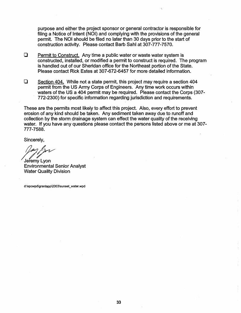
9 PERMITTING ..................................................................................................... 21
10 REFERENCES................................................................................................. 23
Page ii
Stetson Engineering, Inc. – Sunset Level II Study Page ii
LIST OF TABLES 2-1 Average Day Demand 2-2 Water Use Rates 2-3 AWWA Demand Estimates 2-4 Supply and Minimum Storage Requirements 3-1 Capacity of Existing Wells 6-1 Proposed Sunset System Transmission lines – Cost estimate 6-2 Proposed Sunset System Transmission lines – Cost estimate 6-3 Proposed Sunset Water System – Cost estimate 7-1 New Castle Area Water Systems 7-2 Various Wyoming Water Systems 7-3 Fee Impact to Users 7-4 Proposed Project financing LIST OF FIGURES 1-1 Sunset District Boundary & Proposed Water System Layout 2-1 Canyon and Sunset Service Area Boundaries 2-2 Sunset Population and Lot Size 2-3 Sunset Equivalent Dwelling Units 2-4 Sunset Projected Water Demand 3-1 Existing Well Locations LIST OF APPENDICES A Support Letters from Local Governmental
Agencies B WaterCAD Output C Environmental Report

Stetson Engineering, Inc. – Sunset Ranch Level II Study Page 1
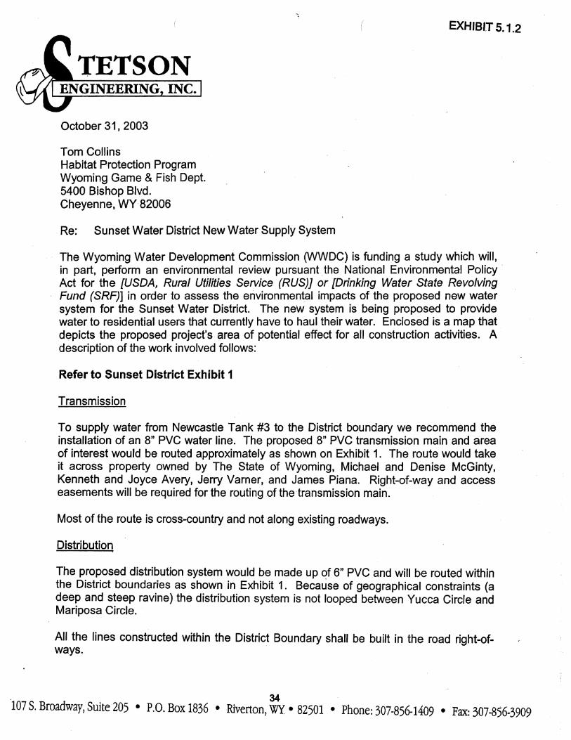
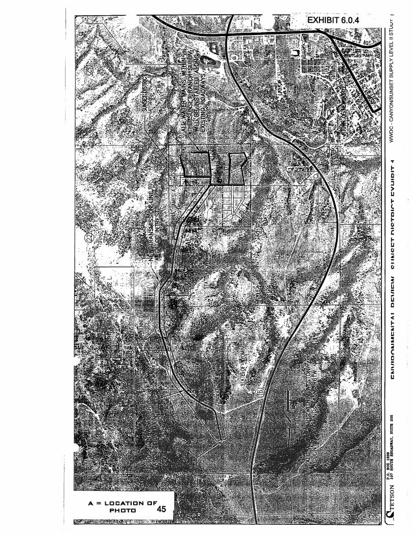
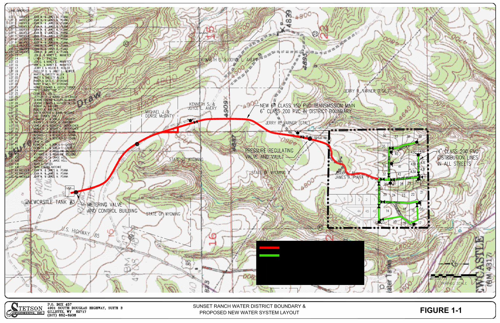
1 INTRODUCTION 1.1 Purpose The purpose of this study was to perform a Level II, Feasibility Study for the Sunset Ranch Water District. This included determining all pertinent aspects of required system infrastructure to meet the Districts short-term and long-term needs including sources of supply, storage, transmission, and distribution. This study provides a planning tool to help the Sunset Ranch Water District develop a new rural community water system. 1.2 Summary of Recommendations 1.2.1 Water Supply There is no new undeveloped source of water supply planned for the Sunset Water District. Sunset will obtain water supply through a connection to the City of Newcastle water system. The planned connection will be at the Newcastle Tank No.3. The tank is north of the District near the State of Wyoming Honor Farm. There are no improvements related to the City’s wells in relation to this water supply. 1.2.2 Storage No additional water storage facilities are recommended for the Sunset District at this time. The Newcastle water system tank No.3 will provide adequate storage to meet the District needs. 1.2.3 Transmission The proposed water system is being sized to provide water only. No fire protection is designed for the system. To supply water from Newcastle Tank #3 to the District boundary we recommend the installation of a 6” Class 150 PVC water line. The proposed 6” PVC transmission main would be routed approximately as shown on Figure 1-1. The route would take it across property owned by The State of Wyoming, Michael and Denise McGinty, Kenneth and Joyce Avery, Jerry Varner, and James Piana. Right-of-way and access easements will be required for the routing of the transmission main. The portion of the proposed system that runs along Musser Road (a County road) within the District would also be considered part of the transmission system. This portion of the system could possibly be extended in the future to serve other homes outside of the current district or possibly make an additional inter-tie to the City (if the City system ever expands into the area). It is recommended that this part of the

Stetson Engineering, Inc. – Sunset Ranch Level II Study Page 2
system be constructed of 6” Class 200 PVC because of the higher pressures in the portion system. This line should be constructed within the road right-of-way. 1.2.4 Distribution The proposed distribution system would be made up of 4” Class 200 PVC and be routed as shown in Figure 1-1. The higher rated pipe is used because of the higher pressures in the system. We recommend that the district uses the higher strength pipe in the system and regulates the pressures at each service connection with a service line pressure-reducing valve. However for purposes of the cost estimate we included a pressure-reducing valve in the transmission system. 1.3 Earlier Work There has not been any previous engineering evaluation for a new water system to serve the Sunset area. Two projects have been completed focusing on the adjacent areas, however, and are directly applicable to Sunset. These include:
• Level 1 Water Supply Project, Salt Creek Water District, Newcastle, Wyoming prepared by R.C.H. Associates and submitted to the Wyoming Water Development Commission, December 1996; and
• Newcastle Area Water Supply Master Plan – Level II prepared by Wester-
Wetstein & Associates, Inc. and submitted to the Wyoming Water Development Commission, April 2000 (Volumes 1 and 2).
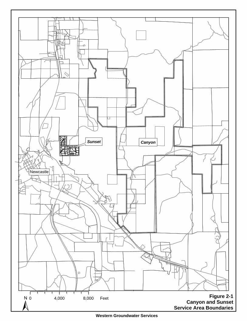
2 WATER SUPPLY DEMAND 2.1 Population and Service Area Figure 2-1 shows the locations of the Sunset service area in proximity to Newcastle, Wyoming. This section provides information concerning current and future population in the service area, the associated water demands, and the requirements for water system infrastructure. The existing Sunset service area is estimated to have the potential for about 51 lots over an area of 107 acres. Part of the subdivision was platted into 12-lots and then later merged. Assuming this type of subdivision reoccurs, the subdivision would grow to 51 lots. There are presently 37 owners, resulting in an effective average lot size of 2.9 acres. The estimated present population is 93 based on 2.5 people per dwelling unit. If all 51 lots were developed, the full build out population is estimated at 100, which is estimated to occur by year 2033. Sunset is presently developed to 72% of the estimated full build.
Newcastle
Sunset Canyon
Figure 2-1Canyon and Sunset
Service Area BoundariesWestern Groundwater Services
±0 4,000 8,000 Feet

Stetson Engineering, Inc. – Sunset Ranch Level II Study Page 3
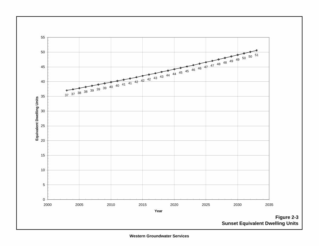
The Level II Study completed for the Newcastle area (Wester-Wetstein 2000) provides information on population that is used here. This study utilized U.S. Census Bureau and State of Wyoming data and analysis to determine an average growth rate for the area of 1.05% per year. This growth rate is applied here to estimate changes in population. Figure 2-2 shows the growth potential of the Sunset service area based on the 1.05% growth rate. In order to achieve the full build out population, owners of multiple lots would need to sell vacant parcels, and subdivision of the previously platted 12-lot area would need to occur. Sunset presently has an estimated 37 Equivalent Dwelling Units (EDUs). At full build out, a total of 51 EDUs may occur, as shown on Figure 2-3. 2.2 Water Use Rates Compilation of water use statistics for the Newcastle area has been completed for the City of Newcastle and surrounding water districts (Wester-Wetstein 2000). A summary of average day demand pertaining to the period from 1998 to 2000 is provided in Table 2-1.
TABLE 2-1 AVERAGE DAY DEMAND
Units Newcastle Salt Creek Blacktail West
End Cambria
Gallons per day 731,900 112,900 56,200 33,730 13,740 Gallons per minute (gpm) 508 79 39 24 10 Population 3,265 510 -- 300 130 Gallons per capita day (gpcd)
225 222 -- 112 106
Data of this table were obtained from Wester-Wetstein (2000) Table 2-8. 2.2.1 Standard Average and Peak Rates Of the data tabulated above, the unit water use rate pertaining to the West End Water District is considered most applicable to the Sunset service areas. West End Water District serves a residential population from a new water system constructed in 1985. The proposed Sunset system will also be new construction, and is expected to have similar or less leakage to that of the West End Water District. The Sunset service area presently does not include commercial use, or is likely to include significant commercial water use in the future. We used a 125 gpm average water use rate to meet the Wyoming Water Quality Rules and Regulations, Chapter 12, Section 8(a), requirement that states where water use records are not available to establish water use, the equivalent per capita water use shall be at least 125 gpd for the average daily water demand.

Western Groundwater Services
0
10
20
30
40
50
60
70
80
90
100
110
120
130
140
150
2000 2005 2010 2015 2020 2025 2030 2035
Year
Popu
latio
n
0
0.25
0.5
0.75
1
1.25
1.5
1.75
2
2.25
2.5
2.75
3
Ave
rage
Lot
Siz
e (a
cres
)
Population
Average Lot Size
Figure 2-2Sunset Population and Lot Size
Western Groundwater Services
37 37 38 38 39 39 39 40 40 41 41 42 42 42 43 43 44 44 45 45 46 46 47 47 48 48 49 49 50 50 51
0
5
10
15
20
25
30
35
40
45
50
55
2000 2005 2010 2015 2020 2025 2030 2035
Year
Equi
vale
nt D
wel
ling
Uni
ts
Figure 2-3Sunset Equivalent Dwelling Units

Stetson Engineering, Inc. – Sunset Ranch Level II Study Page 4
Maximum day demand and maximum hour demand are estimated from the average day demand by applying peaking factors. A peaking factor of 2.5 is used here in order to estimate maximum day demand from average day demand. This peaking factor is consistent with values tabulated for other Wyoming water systems, and was also used in the 2000 Newcastle Level II Study. The maximum hour demand has been estimated from the maximum day demand by applying a peaking factor of 1.5, as is commonly used for estimating this parameter in municipal water systems. Table 2-2 summarizes the estimated water use rates for Sunset under present conditions and for selected future years. Figure 2-4 shows the change in water use rate with increasing population.
TABLE 2-2 WATER USE RATES
Sunset Water Use
2003 2010 2020 2033 Average Day Demand (gpm) 8 9 10 11 Average Day Demand (gpd) 11,566 12,443 13,813 15,822 Maximum Day Demand (gpm) 20 22 24 27 Maximum Hour Demand (gpm) 30 32 36 41 Rates shown are based on present and projected population in the service area, a per capita average day demand of 125 gallons, and peaking factors described above.
Water use in the Sunset District is considered low rate and low volume over the planning period. Due to limited land area, these rates are controlled for the Sunset water system. 2.2.2 Potential Peak Based on AWWA M22 Manual The peak rates as discussed in the previous section are adequate to use in the modeling of a system as long as the system is being designed to provide fire flows. The fire flow sizing more then adequately accounts for the possible peak demands experienced in a water system that are sometimes well beyond the estimated peak hour demands. To determine the possible peak rates experienced in the system, methods described in the American Water Works Association, Sizing Water Service Lines and Meters – Manual of Water Practices M22, Second Edition (AWWA-M22) were used. Although water use in Sunset Ranch District is considered low rate and low volume over the planning period, the District’s potential service area has acreage that could be developed to higher density. For estimating the potential future peak that could occur in the proposed system, the private lands that are being crossed with the proposed waterline were broken into 40-acre parcels and then 5-acre lots. There was also 20 acres south of the District boundary that was included in this estimate.

Western Groundwater Services
0
5
10
15
20
25
30
35
40
2000 2005 2010 2015 2020 2025 2030 2035
Year
Wat
er U
se R
ate
(gpm
)
Average Day Demand
Maximum Day Demand
Maximum Hour Demand
Figure 2-4Sunset Projected Water Demand

Stetson Engineering, Inc. – Sunset Ranch Level II Study Page 5
These are also the lands that have been or are being annexed into the District. Based on this breakdown there is a potential forty-three additional 5-acre lots. Adding the existing 36 lots in the Subdivision gives a total of 79 potential lots in the district. Table 2-3 tabulates the peak demand data determined for both the year 2033 population and for the estimated full build out of 79 lots. It can be seen by this data that the potential peak in the system is much higher then was determined as the peak hour demand in the pervious section. For the 2033 estimated population the demands are 199 gpm (AWWA-M22) as compared to the 41 gpm standard peak hour determination.
Table 2-3 Demand Estimate based on
Data and Methods in the AWWA Manual- M22 Total Fixture
Fixture Number Fixture Value Value gpm gpm
Toilet (Tank) 2 4 8 Faucets (Lavatory) 2 1.5 3
Faucets (Kitchen Sink) 1 2.2 2.2 Faucets (Utility Sink) 1 4 4
Dishwasher 1 2 2 Clothes Washer 1 6 6
Bathtub 1 8 8 Shower Head 1 4 4
Hose Bibs (5/8") 2 9 18
TOTAL FIXTURE VALUE (TFV) (per lot) 55.2
Assume 51 lots (2033 Population) for total Fixture Value (51 x TFV)
Total Fixture Value for Subdivision = 2,815.2
Peak Demand (gpm) estimated from AWWA-M22 Manual Fig 4.3 = 170
Appling a pressure factor of 1.17 from table 4.1(AWWA-M22) to adjust to an average working pressure of 80 psi, The DEMAND (gpm) = 198.9
Assuming a full build out of 79 lots (79 x TFV)
Total Fixture Value for Subdivision = 4,360.8
Peak Demand (gpm) estimated from AWWA-M22 Manual Fig 4.3 = 210
Appling a pressure factor of 1.17 from table 4.1(AWWA-M22) to adjust to an average working pressure of 80 psi, The DEMAND (gpm) = 245.7

Stetson Engineering, Inc. – Sunset Ranch Level II Study Page 6
2.3 Supply Requirements Sunset is presently without a centralized water system. The entire demand must be satisfied by new supply. Table 2-4 summarizes the supply requirements for the proposed water system based on the year 2003 service population, and also the projected year 2033 service population. Sources of supply, such as wells, must provide a capacity equal to the maximum day demand. A two-well system is preferred for a public water system. In a two well system, the maximum day demand is satisfied by two wells, and the average day demand is satisfied with the largest well out of service. A one-well system is allowable when accompanied by storage equal to two times the maximum day demand (WDEQ-WQD, CH.12, Sec 9, (b)(i)). System infrastructure such as piping and booster pump stations, are based on maximum hour demand, and optionally, maximum hour demand plus fire flow. As shown in Table 2-3, a fire flow rate of 500 gpm is applicable to the Sunset District. This rate dominates the flow requirements for the water system, should fire flow provisions be included (fire flow requirements are discussed in detail in section 4 of this report). System storage reservoirs shown in Table 2-3 reflect the minimum requirement and are sized based on the criteria of the average day demand for the Sunset system. Neither of these storage reservoir sizes includes fire flow. The 500 gpm fire flow rate for a two hour period results in an additional 60,000 gallons of storage. If fire flow provisions are designed into the water system, the fire flow storage must be added to the minimum storage volumes shown in the Table.
TABLE 2-4 SUPPLY AND MINIMUM STORAGE REQUIREMENTS
Description
Sunset
Year 2003 Service Population Maximum day demand (gpm) 20 Maximum hour demand (gpm) 30 Fire flow (optional) (gpm)A 500 Storage (no fire flow) (gal)B 11,600D
Year 2033 Service Population Maximum day demand (gpm) 27 Maximum hour demand (gpm) 41 Fire flow (optional) (gpm)A 500 Storage (no fire flow) (gal)B 16,000D
Stetson Engineering, Inc. – Sunset Ranch Level II Study Page 7
A Fire flow rate is required for two hours from a storage reservoir. B Storage volumes do not include additional fire flow volume of 60,000 gallons. C Storage volume based on two times maximum day demand. D Storage volume based on average day demand applicable to small two-well systems.
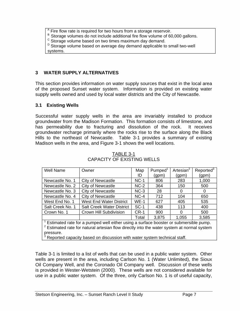
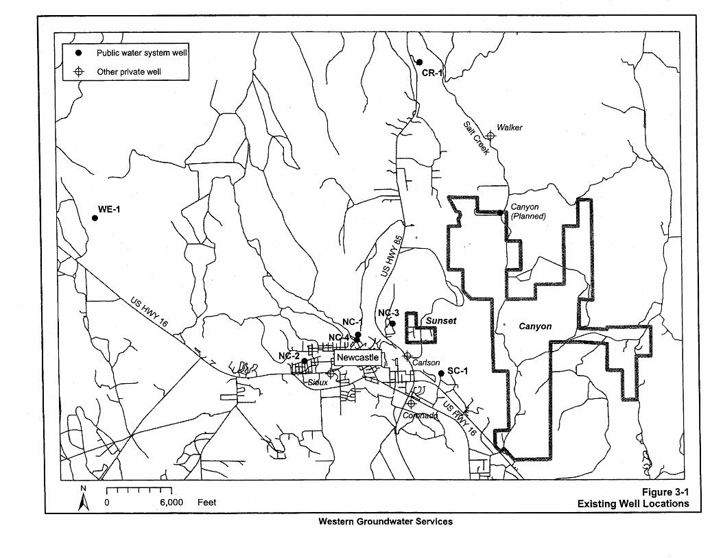
3 WATER SUPPLY ALTERNATIVES This section provides information on water supply sources that exist in the local area of the proposed Sunset water system. Information is provided on existing water supply wells owned and used by local water districts and the City of Newcastle. 3.1 Existing Wells Successful water supply wells in the area are invariably installed to produce groundwater from the Madison Formation. This formation consists of limestone, and has permeability due to fracturing and dissolution of the rock. It receives groundwater recharge primarily where the rocks rise to the surface along the Black Hills to the northeast of Newcastle. Table 3-1 provides a summary of existing Madison wells in the area, and Figure 3-1 shows the well locations.
TABLE 3-1 CAPACITY OF EXISTING WELLS
Well Name
Owner
Map ID
Pumped1
(gpm) Artesian2
(gpm) Reported3
(gpm) Newcastle No. 1 City of Newcastle NC-1 806 283 1,000 Newcastle No. 2 City of Newcastle NC-2 364 150 500 Newcastle No. 3 City of Newcastle NC-3 28 0 0 Newcastle No. 4 City of Newcastle NC-4 712 104 650 West End No. 1 West End Water District WE-1 627 405 535 Salt Creek No. 1 Salt Creek Water District SC-1 438 113 400 Crown No. 1 Crown Hill Subdivision CR-1 900 0 500 Total 3,875 1,055 3,585 1 Estimated rate for a pumped well either using a surface booster or submersible pump. 2 Estimated rate for natural artesian flow directly into the water system at normal system pressure. 3 Reported capacity based on discussion with water system technical staff.
Table 3-1 is limited to a list of wells that can be used in a public water system. Other wells are present in the area, including Carlson No. 1 (Water Unlimited), the Sioux Oil Company Well, and the Coronado Oil Company well. Discussion of these wells is provided in Wester-Wetstein (2000). These wells are not considered available for use in a public water system. Of the three, only Carlson No. 1 is of useful capacity,

Stetson Engineering, Inc. – Sunset Ranch Level II Study Page 8
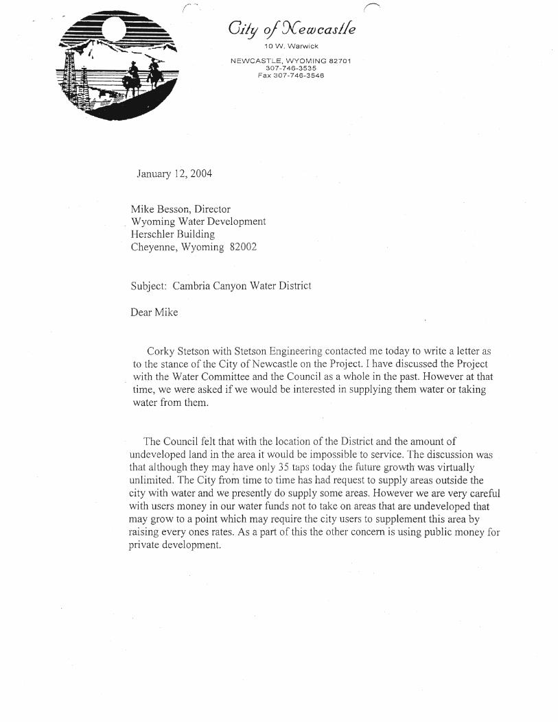
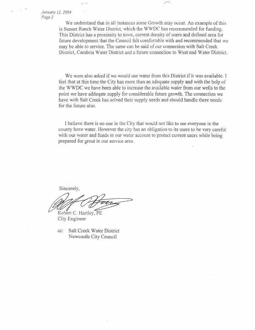
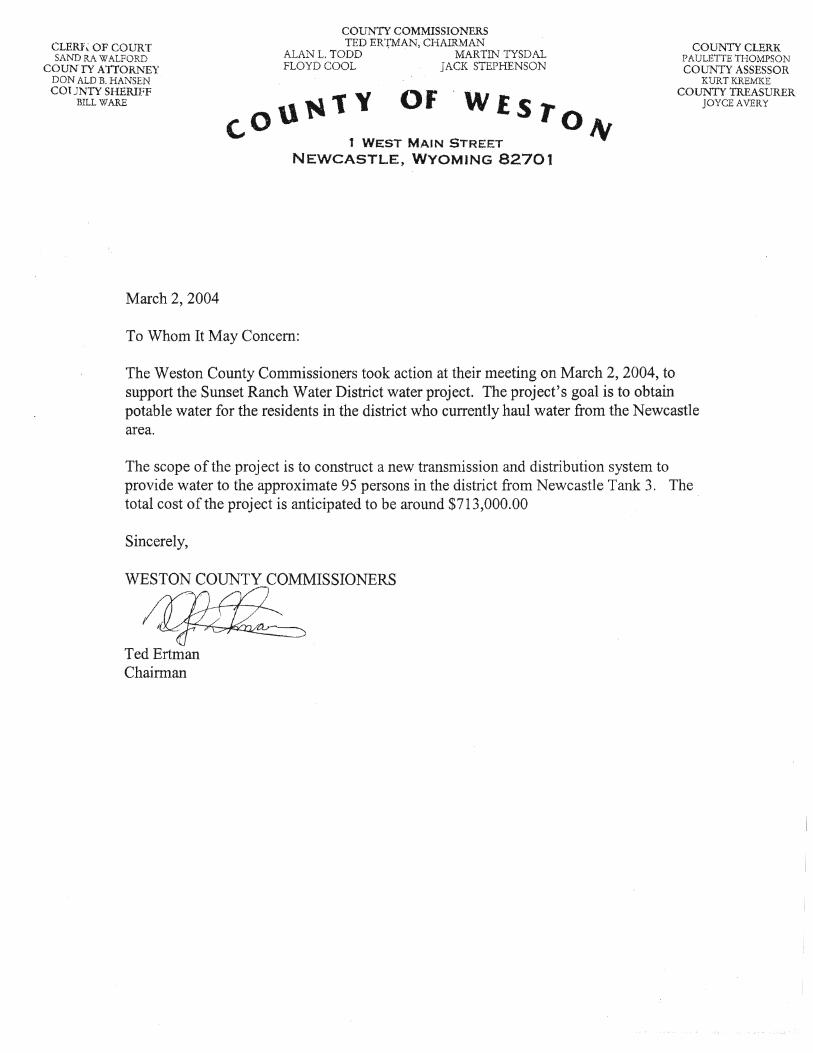
however, recently the Salt Creek Water District discontinued use of this well due to difficulty in negotiating a long-term contract with the owner. The Walker well shown on Figure 3-1 is another private well in the area that is not considered available for use in a public water system. This well is used for stock watering and is completed in the top of the Minnelusa Formation. State records indicate an estimated yield of 400 gpm. The well is flowing artesian at a low rate, as can be observed from the Salt Creek Road, which passes within 150 ft of the wellhead. The U.S. Geological Survey conducted water sampling in the well and determined a specific conductance of 2,800 µS/cm, which indicates substantially greater dissolved ion concentrations than occurs in the Madison aquifer (cf. 600-800 µS/cm). 3.2 Existing Water Systems The most feasible supply source for the Sunset District will be to connect to the existing City of Newcastle water system. The City of Newcastle was contacted to assess the feasibility of connecting the Sunset Water District to the City. Preliminary approval for a supply connection was given by the City council as related through the City Engineer. A copy of the letter sent to the WWDC from the City of Newcastle is included in Appendix A. A final agreement is required prior to the start of construction of the Sunset Water System and connection to the City System. 4 SYSTEM DESIGN AND MODELING The proposed system was designed to try and provide the Sunset District with the best solution to meet their current and future needs in regards to potable water delivery, fire flow capabilities, system expandability, and optimal financial investments. The system was also designed to meet the WDEQ Chapter 12 requirements. These requirements include the following:
• Section 14,b,i, “The system shall be designed to maintain a minimum pressure of 20 psi at ground level at all points in the distribution system under all conditions of flow. The normal working pressure in the distribution system shall be not less then 35 psi.”
• Section 14,b,ii, “The minimum size of a water main for providing protection
and serving fire hydrants shall be 6 inches in diameter when service is provided from 2 directions, or where the maximum length of 6 inch pipe serving the hydrant from 1 direction does not exceed 250 feet, or 8 inches where service is provided from 1 direction only.”
Stetson Engineering, Inc. – Sunset Ranch Level II Study Page 9
• Section 14,b,iv, “Any main smaller then 6 inches shall be justified by hydraulic analysis and future water use.”
• Section 14,b,v, “Dead ends shall be minimized by looping”.
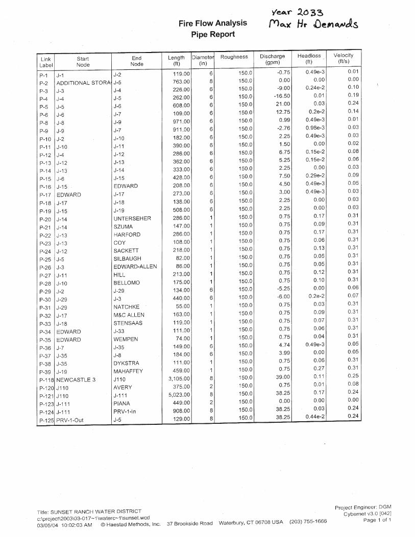
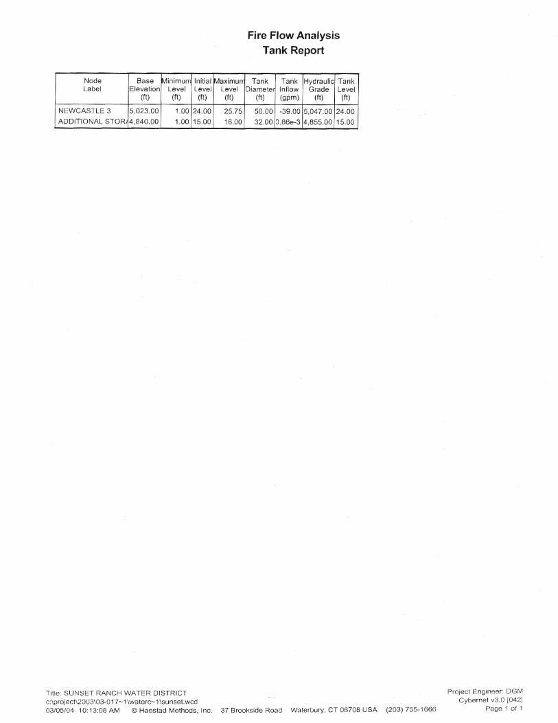
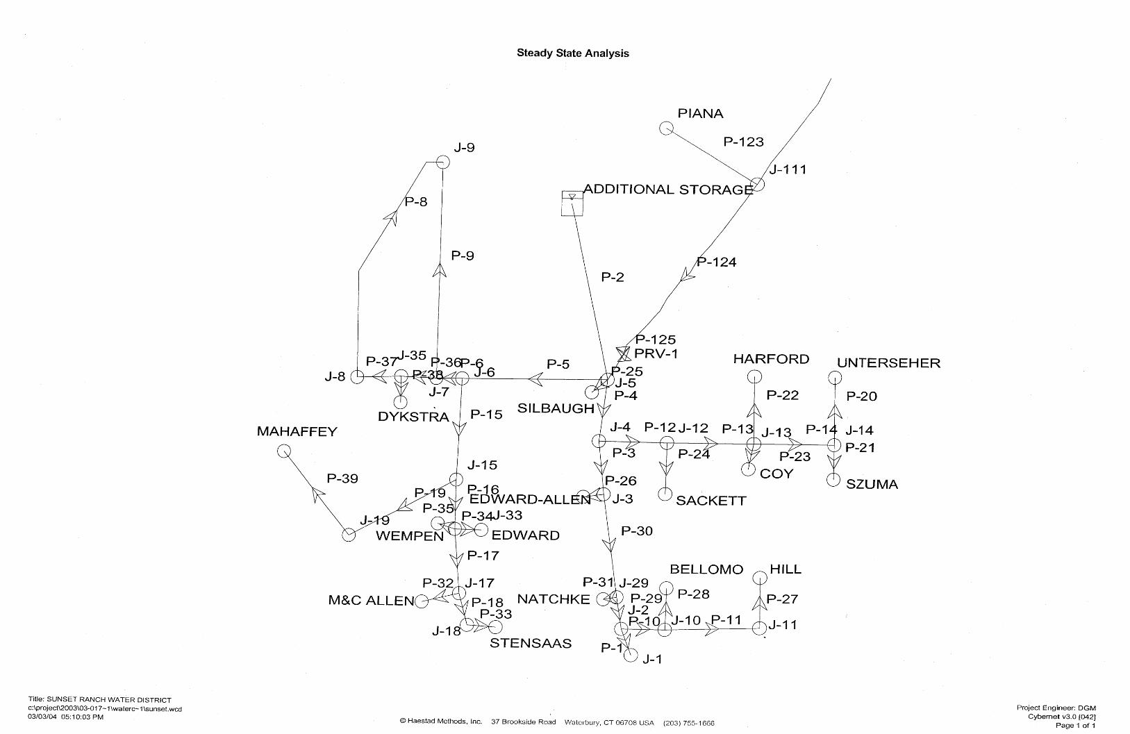
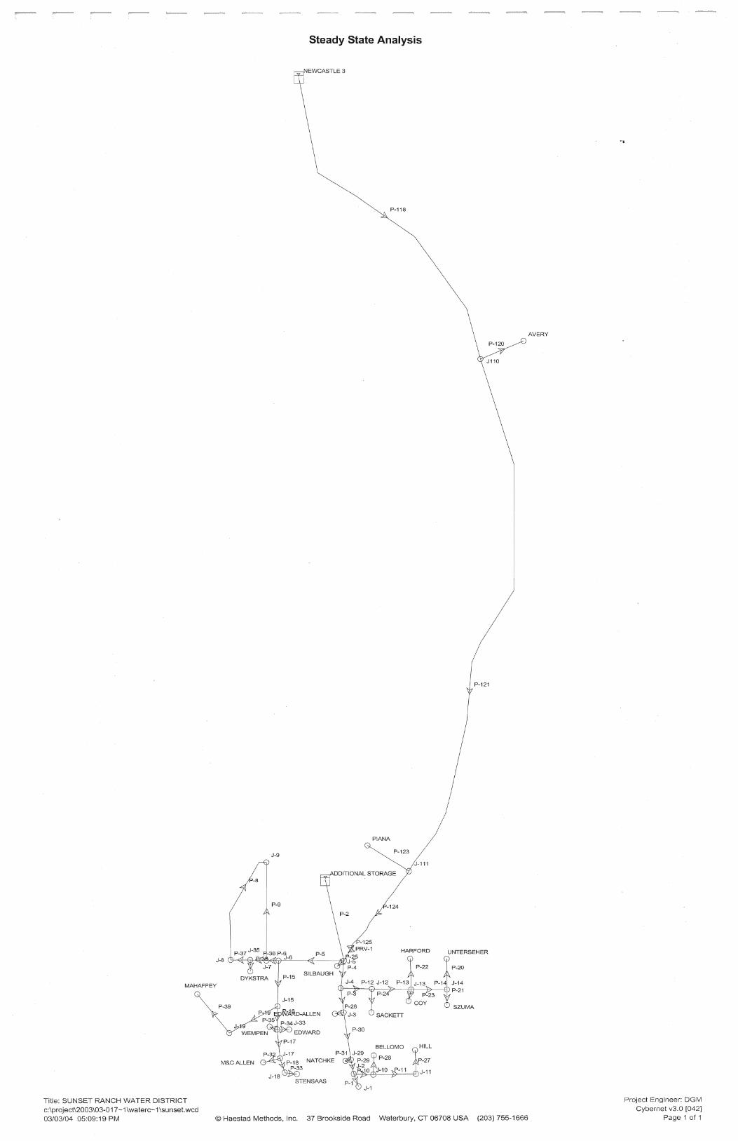
4.1.1 System Modeling Computer models were developed to investigate and refine the proposed system layout for the Sunset District. The modeling software used was Haestad Method’s, Cybernet Software – V3.0. Print outs of the modeling data is included in Appendix B. The model was used to investigate the water system’s behavior under varying conditions and demand scenarios. Because the system will be under the most stress during the peak demands (maximum day demands, peak hour demands, and AWWA peak demands), most of the investigative modeling conducted on the system used these demands. Investigation of the system included both static and dynamic modeling. Static modeling was done to investigate the immediate system responses (such as pressures and velocities) during a single additional operating condition such as a fire flow demand. Dynamic modeling was used to simulate the system responses during longer periods of operation (up to 24 hrs). The dynamic modeling simulates the expected changes to the system components such as tank level changes and well production demands. Model Setup A GPS field survey of all the existing homes in the District was done to provide vertical and horizontal data for the model. Additional vertical data required was taken from the USGS 7½ Minute Quad sheets for the area. The background used for the model to verify alignment of roads, streets and homes was a composite of the 1994 DOQQs from the WGIAC Spatial Data Clearing House. Fire flow Modeling of the System The model was used to simulate fire flow demands at the various locations throughout the proposed system. The data obtained from the fire flow simulations was used to ensure the proposed system designs had adequate capacity to meet the fire flow demands and maintain the WDEQ standards for minimum and normal working pressures. Fire protection is optional for the Sunset District. If the District elects to achieve fire flow, the basis for determining associated rate and volume is the Insurance Services Office (ISO) “Fire Suppression Rating Schedule”. In rural areas with a separation distance between dwellings of 100-ft or greater, ISO allows a rate of 500 gpm for the duration of two-hours.
Stetson Engineering, Inc. – Sunset Ranch Level II Study Page 10
5 STORAGE, TRANSMISSION AND DISTRIBUTION During the development of this report funding for the proposed new water system was pursued and obtained. Part of the funding for the project will be provided by the U. S. Dept. of Agriculture, Rural Development, Rural Utilities Services (RUS). The RUS will not fund new systems to include fire protection. Therefore the alternatives discussed hereafter is for a potable supply water system only. 5.1.1 Storage Requirements Storage requirements applicable to the Sunset water system are described in the State of Wyoming, Department of Environmental Quality, Water Quality Rules and Regulations Chapter 12. Section 9(b)(i) identifies that a one-well system is acceptable with finished water storage equal to twice the maximum day demand. Section 13(a)(i)(A) identifies that small water systems with average day demand less than 50,000 gallons shall provide storage volume equal to the average day demand. Section 13(D) identifies that storage is not required where two wells are available and the lower capacity well can provide maximum hour demand, or fire flow, whichever is greater. The Sunset water system will be most economically supplied from the City of Newcastle water system. Because the City operates a multiple well system, the storage requirement applicable to Sunset is the average day demand. The present population requires a minimum storage volume of 11,600 gallons. At the projected 2033 population, minimum storage volume increases to 16,000. This data was summarized in Table 2-3 of this report. The Newcastle water system tank No.3 will provide adequate storage to meet the District needs. The existing tank No.3 has a total capacity of 373,000 gallons. Because of this the Sunset District requires no additional water storage facilities at this time.

Stetson Engineering, Inc. – Sunset Ranch Level II Study Page 11
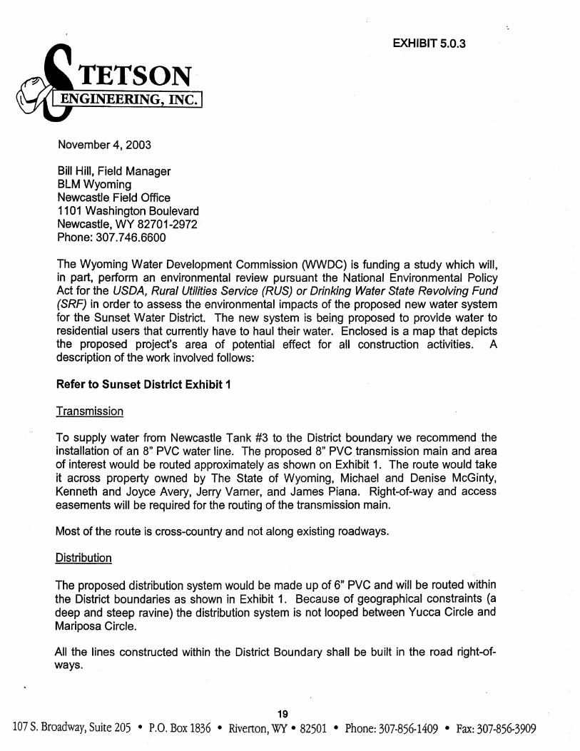
5.1.2 Transmission and Distribution By making a connection to the Newcastle system at Newcastle Tank #3, the pressures within the district boundary would range from about 124 psi to 175 psi. Refer to Figure 1-1, for the map of the proposed Sunset Water System. Transmission To supply water from Newcastle Tank #3 to the District boundary we recommend the installation of a 6” Class 150 PVC water line. The proposed 6” PVC transmission main would be routed approximately as shown on Figure 1-1. The route would take it across property owned by The State of Wyoming, Kenneth and Joyce Avery, Jerry Varner, and James Piana. Right-of-way and access easements will be required for the routing of the transmission main. The portion of the proposed system that runs along Musser Road (a County road) would also be considered part of the transmission system. This portion of the system could possibly be extended in the future to serve other homes outside of the current district or possibly make an additional inter-tie to the City if the City system ever expands into the area. It is recommended that this part of the system be constructed of 6” Class 200 PVC because of the higher pressures in the portion system. This line should be constructed within the road right-of-way. Distribution The proposed distribution system would be made up of 4” Class 200 PVC and be routed as shown in Figure 1-1. The higher rated pipe is used because of the higher pressures in the system. We recommend that the district uses the higher strength pipe in the system and regulates the pressures at each service connection with a service line pressure-reducing valve. Because of geographical constraints (a deep and steep ravine) the distribution system is not looped between Yucca Circle and Mariposa Circle. Although it is best to have a looped system a flushing program can be implemented on the dead end lines.
Stetson Engineering, Inc. – Sunset Ranch Level II Study Page 12
6 PREFERRED ALTERNATIVE CONCEPTUAL DESIGN & COST 6.1 Water Supply and Storage There are no water supply alternatives planned for the Sunset water system. The water system will be supplied from existing City of Newcastle wells, without modification. No additional water storage facilities are recommended for the Sunset District at this time. The Newcastle water system tank No.3 will provide adequate storage to meet the District needs. 6.2 Transmission & Distribution Transmission The follow table provides the cost estimate data for the proposed Sunset Water System Transmission Lines as discussed in Section 5.

Stetson Engineering, Inc. – Sunset Ranch Level II Study Page 13
Table 6-1
Proposed Sunset System Transmission Lines – Cost estimate
UNIT TOTAL NO. ITEM UNIT QUANTITY PRICE PRICE
1 Install new 8" Water Transmission Main LF 10500 $ 16 $ 168,000 2 Install 8" Water Valves EA 6 $ 1,000 $ 6,000 3 Tees, Bends, Etc. EA 3 $ 525 $ 1,575 4 Fire Hydrant Assembly/Blow Offs EA 4 $ 2,000 $ 8,000 5 AV/AR Valves and Vaults EA 1 $ 2,625 $ 2,625 6 Connect to Tank #3 LS 1 $ 3,150 $ 3,150 7 Vault and Meter LS 1 $ 21,000 $ 21,000 8 Pressure Reducing Valve and Vault LS 1 $ 10,500 $ 10,500 9 Seeding AC 13 $ 700 $ 9,100 10 R&R Road surfacing SY 580 $ 2 $ 1,160
11 Bonds and Mobilization LS 1 $ 25,000 $ 25,000
Construction Subtotal = $ 256,110
Construction Engineering (10%) = $ 25,611
Construction Subtotal = $ 281,721
Contingencies (15%) = $ 42,258
Total Construction Costs = $ 323,979
NON CONSTRUCTION COSTS 1 Final Designs and Specification $ 25,000 2 Permitting $ 2,500 3 Legal Fees $ 3,600 4 Acquisition of Property and Right of Way $ 20,000 5 Cost of Funding (.5% loan origination fee and the rest Admin expenses) $ 10,500
Total Non-Construction Costs = $ 61,600
TOTAL ESTIMATED TRANSMISSION PORTION PROJECT COST = $ 385,579 USE $386,000.00
Stetson Engineering, Inc. – Sunset Ranch Level II Study Page 14
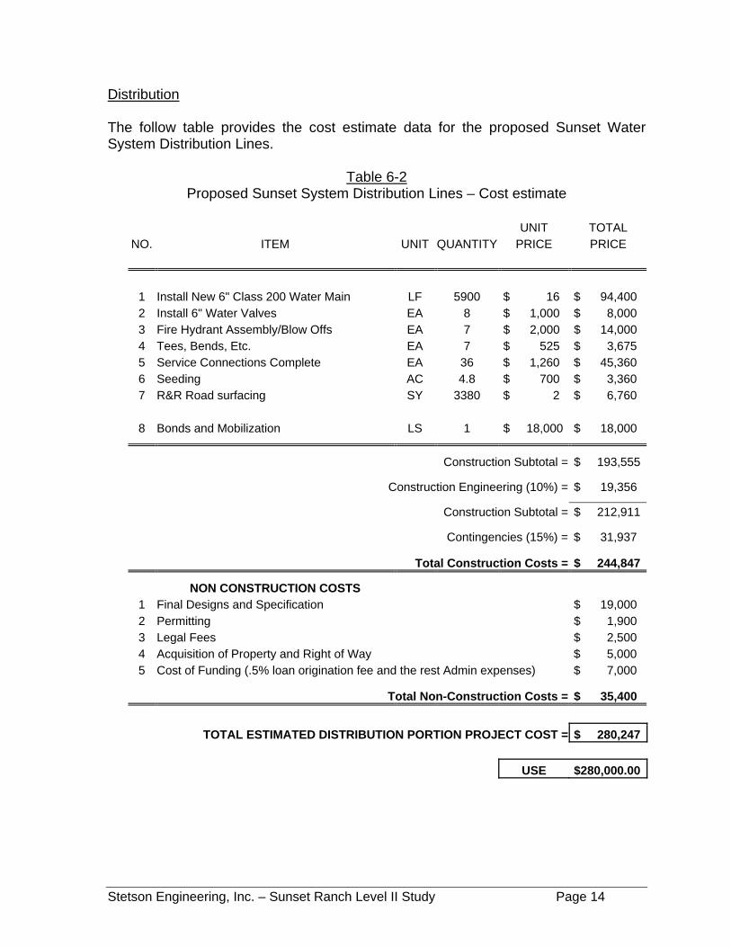
Distribution The follow table provides the cost estimate data for the proposed Sunset Water System Distribution Lines.
Table 6-2 Proposed Sunset System Distribution Lines – Cost estimate
UNIT TOTAL
NO. ITEM UNIT QUANTITY PRICE PRICE
1 Install New 6" Class 200 Water Main LF 5900 $ 16 $ 94,400 2 Install 6" Water Valves EA 8 $ 1,000 $ 8,000 3 Fire Hydrant Assembly/Blow Offs EA 7 $ 2,000 $ 14,000 4 Tees, Bends, Etc. EA 7 $ 525 $ 3,675 5 Service Connections Complete EA 36 $ 1,260 $ 45,360 6 Seeding AC 4.8 $ 700 $ 3,360 7 R&R Road surfacing SY 3380 $ 2 $ 6,760
8 Bonds and Mobilization LS 1 $ 18,000 $ 18,000
Construction Subtotal = $ 193,555
Construction Engineering (10%) = $ 19,356
Construction Subtotal = $ 212,911
Contingencies (15%) = $ 31,937
Total Construction Costs = $ 244,847
NON CONSTRUCTION COSTS 1 Final Designs and Specification $ 19,000 2 Permitting $ 1,900 3 Legal Fees $ 2,500 4 Acquisition of Property and Right of Way $ 5,000 5 Cost of Funding (.5% loan origination fee and the rest Admin expenses) $ 7,000
Total Non-Construction Costs = $ 35,400
TOTAL ESTIMATED DISTRIBUTION PORTION PROJECT COST = $ 280,247 USE $280,000.00
Stetson Engineering, Inc. – Sunset Ranch Level II Study Page 15
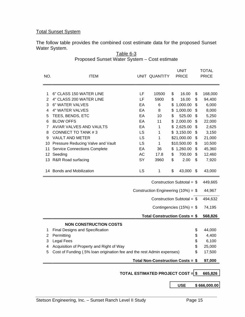
Total Sunset System The follow table provides the combined cost estimate data for the proposed Sunset Water System.
Table 6-3 Proposed Sunset Water System – Cost estimate
UNIT TOTAL
NO. ITEM UNIT QUANTITY PRICE PRICE
1 6" CLASS 150 WATER LINE LF 10500 $ 16.00 $ 168,000 2 4" CLASS 200 WATER LINE LF 5900 $ 16.00 $ 94,400 3 6" WATER VALVES EA 6 $ 1,000.00 $ 6,000 4 4" WATER VALVES EA 8 $ 1,000.00 $ 8,000 5 TEES, BENDS, ETC EA 10 $ 525.00 $ 5,250 6 BLOW OFFS EA 11 $ 2,000.00 $ 22,000 7 AV/AR VALVES AND VAULTS EA 1 $ 2,625.00 $ 2,625 8 CONNECT TO TANK # 3 LS 1 $ 3,150.00 $ 3,150 9 VAULT AND METER LS 1 $21,000.00 $ 21,000 10 Pressure Reducing Valve and Vault LS 1 $10,500.00 $ 10,500 11 Service Connections Complete EA 36 $ 1,260.00 $ 45,360 12 Seeding AC 17.8 $ 700.00 $ 12,460 13 R&R Road surfacing SY 3960 $ 2.00 $ 7,920
14 Bonds and Mobilization LS 1 $ 43,000 $ 43,000
Construction Subtotal = $ 449,665
Construction Engineering (10%) = $ 44,967
Construction Subtotal = $ 494,632
Contingencies (15%) = $ 74,195
Total Construction Costs = $ 568,826
NON CONSTRUCTION COSTS 1 Final Designs and Specification $ 44,000 2 Permitting $ 4,400 3 Legal Fees $ 6,100 4 Acquisition of Property and Right of Way $ 25,000 5 Cost of Funding (.5% loan origination fee and the rest Admin expenses) $ 17,500
Total Non-Construction Costs = $ 97,000
TOTAL ESTIMATED PROJECT COST = $ 665,826 USE $ 666,000.00

Stetson Engineering, Inc. – Sunset Ranch Level II Study Page 16
7 ECONOMIC ANALYSIS AND PROJECT FINANCING This section presents a recommended financial plan that is designed to allow the Sunset District to construct the recommended new water system. The financial plan assumes that the terms and availability of the outside funding will be as described in the following sub-sections. These assumptions are based on discussions and previous dealings with funding agencies including the Wyoming Water Development Commission (WWDC), The State Lands and Investment Board (WSLIB), the USDA Rural Development (RUS), and the Wyoming Department of Environmental Quality (WDEQ). 7.1 Funding Agencies Wyoming Water Development Commission (WWDC)
• 50% Grant funding is available for new wells, tanks, and transmission lines. U. S. Dept. of Agriculture, Rural Development, Rural Utilities Services (RUS)
• Based on the Medium Household income (HMI) for the Newcastle area, the district is eligible for RUS assistance of up to 55% grant funding of the total eligible project costs (All portions of the project are eligible).
• RUS loans are required to receive RUS grant funding. RUS loans are listed
at the current rate of 4.75% for 20 years. The loans are however adjustable in regards to term lengths. These determinations are decided during the funding process.
• The RUS does require that the district be indebted up to the maximum
determined they can payback prior to determining the amounts to be granted. Office of State Lands and Investments (WSLIB)
• 50% grant funding is available for all water projects.
• Loans are available from the WSLIB a current rate of 6% for 30 years.
• Grants are becoming difficult to obtain from the WSLIB unless it is an extreme situation.
Wyoming Department of Environmental Quality, Abandoned Mine Land Division (AML)
• All of Weston County is eligible for AML Grant funding.
Stetson Engineering, Inc. – Sunset Ranch Level II Study Page 17
• Funding applications submitted in year 2004 is for fiscal year 2006
• Applications submitted to the WSLIB for funding are forwarded to the AML.
No separate application is required. Drinking Water State Revolving (Loan) Fund (DWSRF)
• The Sunset District is eligible to receive funding through the DWSRF.
• The DWSRF loan current interest rate is 2.5% for 20 years.
• Sunset Ranch Water District is currently ranked 101 on the DWSRF Intended Use Plan.
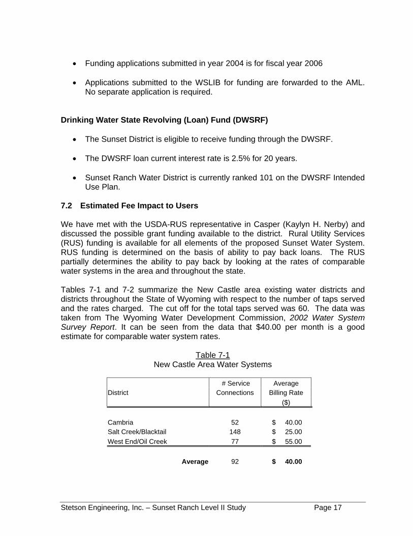
7.2 Estimated Fee Impact to Users We have met with the USDA-RUS representative in Casper (Kaylyn H. Nerby) and discussed the possible grant funding available to the district. Rural Utility Services (RUS) funding is available for all elements of the proposed Sunset Water System. RUS funding is determined on the basis of ability to pay back loans. The RUS partially determines the ability to pay back by looking at the rates of comparable water systems in the area and throughout the state. Tables 7-1 and 7-2 summarize the New Castle area existing water districts and districts throughout the State of Wyoming with respect to the number of taps served and the rates charged. The cut off for the total taps served was 60. The data was taken from The Wyoming Water Development Commission, 2002 Water System Survey Report. It can be seen from the data that $40.00 per month is a good estimate for comparable water system rates.
Table 7-1 New Castle Area Water Systems
# Service Average District Connections Billing Rate ($) Cambria 52 $ 40.00 Salt Creek/Blacktail 148 $ 25.00 West End/Oil Creek 77 $ 55.00
Average 92 $ 40.00
Stetson Engineering, Inc. – Sunset Ranch Level II Study Page 18
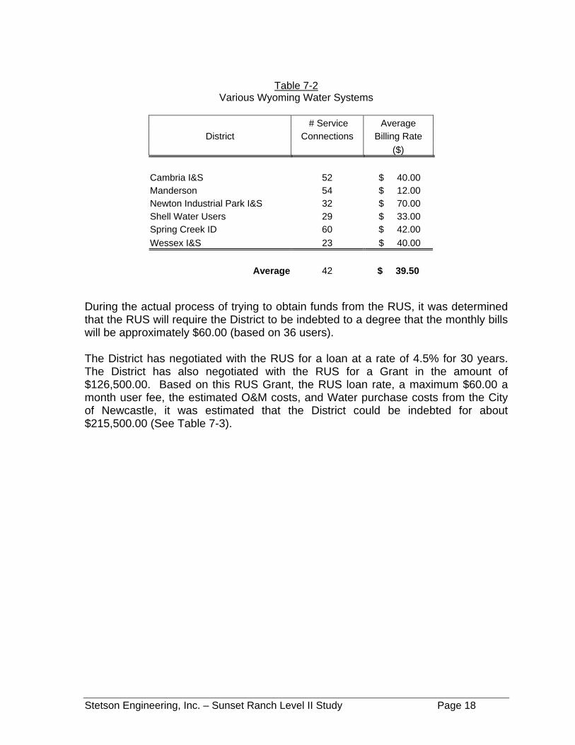
Table 7-2
Various Wyoming Water Systems
# Service Average District Connections Billing Rate
($) Cambria I&S 52 $ 40.00 Manderson 54 $ 12.00 Newton Industrial Park I&S 32 $ 70.00 Shell Water Users 29 $ 33.00 Spring Creek ID 60 $ 42.00 Wessex I&S 23 $ 40.00
Average 42 $ 39.50 During the actual process of trying to obtain funds from the RUS, it was determined that the RUS will require the District to be indebted to a degree that the monthly bills will be approximately $60.00 (based on 36 users). The District has negotiated with the RUS for a loan at a rate of 4.5% for 30 years. The District has also negotiated with the RUS for a Grant in the amount of $126,500.00. Based on this RUS Grant, the RUS loan rate, a maximum $60.00 a month user fee, the estimated O&M costs, and Water purchase costs from the City of Newcastle, it was estimated that the District could be indebted for about $215,500.00 (See Table 7-3).
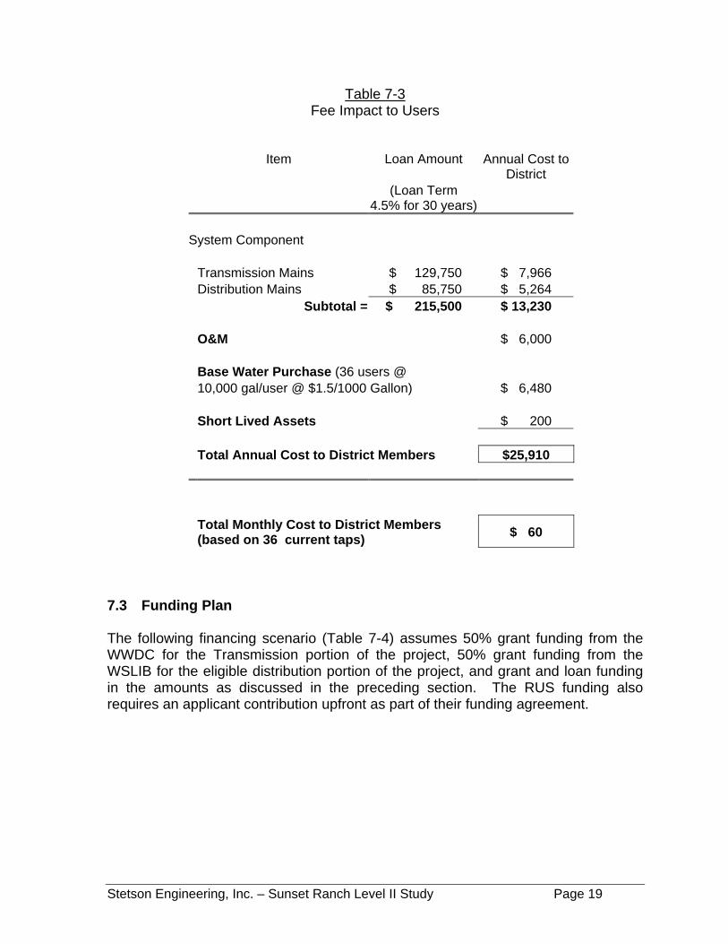
Stetson Engineering, Inc. – Sunset Ranch Level II Study Page 19
Table 7-3 Fee Impact to Users
Item Loan Amount
Annual Cost to
District (Loan Term
4.5% for 30 years) System Component Transmission Mains $ 129,750 $ 7,966 Distribution Mains $ 85,750 $ 5,264 Subtotal = $ 215,500 $ 13,230 O&M $ 6,000 Base Water Purchase (36 users @ 10,000 gal/user @ $1.5/1000 Gallon) $ 6,480 Short Lived Assets $ 200 Total Annual Cost to District Members $25,910 Total Monthly Cost to District Members
(based on 36 current taps) $ 60
7.3 Funding Plan The following financing scenario (Table 7-4) assumes 50% grant funding from the WWDC for the Transmission portion of the project, 50% grant funding from the WSLIB for the eligible distribution portion of the project, and grant and loan funding in the amounts as discussed in the preceding section. The RUS funding also requires an applicant contribution upfront as part of their funding agreement.

Stetson Engineering, Inc. – Sunset Ranch Level II Study Page 20
Table 7-4 Proposed Project Financing
Applicant RUS Loan
Cost WWDC WSLIB Contribution RUS Grant 4.5% rate
Description
(2006 $) Grant Grant Required by RUS Total Project (30 yr Term)
Sunset Water System Water Transmission $ 386,000 $193,000 $ 4,000 $ 63,250 $125,750 Water Distribution $ 280,000 $ 139,000 $ 4,000 $ 63,250 $ 73,750 TOTAL PROJECT COSTS $666,000 $193,500 $ 139,000 $ 8,000 $ 126,500 $ 199,500
Percent of Total Project
Costs 100% 29% 21% 1% 19% 30%
7.4 Equivalent Dwelling Units One EDU is equivalent to a typical family home served by a single ¾-inch connection to the water system. Presently, the Sunset service area will serve only single-family homes so each planned connection will be considered as 1 EDU. The district is currently estimated at 36 EDUs. Assuming the projected growth occurs, the service area will increase to 42 EDUs by 2015 and 51 EDUs by 2033. This can be seen graphically on Figure 2-3 of this report.
Stetson Engineering, Inc. – Sunset Ranch Level II Study Page 21
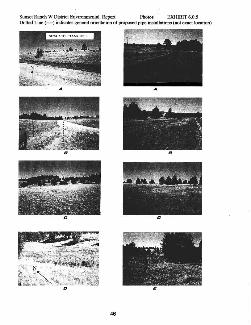
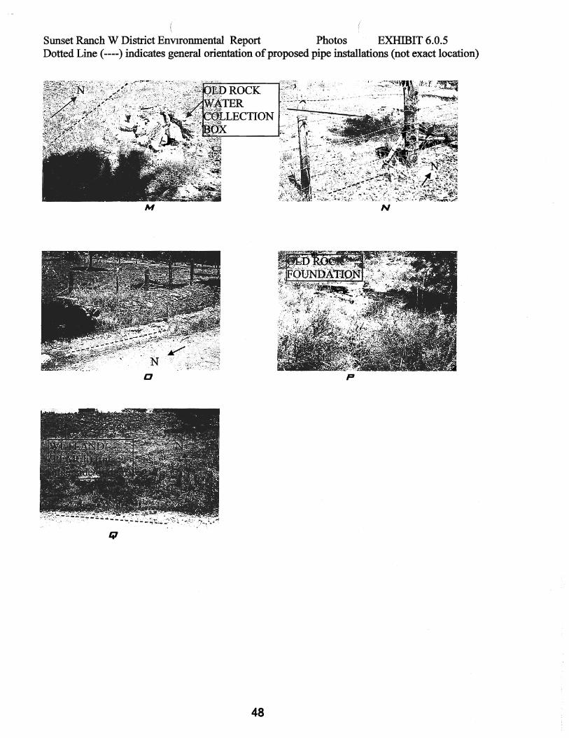
8 ENVIRONMENTAL REVIEW Environmental Review Process The State environmental review process requires USDA, Rural Utilities Service (RUS) and Drinking Water State Revolving Fund (SRF) loan applicants to send a letter to the agencies listed as Federal and State Contacts for Environmental Issues. Letters and maps were sent to the agencies requesting them to review the project recommendations (as discussed in this report) for compliance with environmental issues under the agency’s jurisdiction and authority. The Environmental Report (ER) for the proposed water system was completed by Dan Coughlin with Midwest Assistance Program, Inc. (MAP). The ER is on file with the Wyoming Department of Environmental Quality, Water Quality Division, SRF Coordination Office. (Brian Mark – Supervisor). A copy of the ER is included in Appendix C. 9 PERMITTING Permitting will be required as described for the following State and Federal Agencies.
Department of Environmental Quality
A DEQ Permit to Construct will be required for:
• All Construction of the new water mains – Both Transmission and Distribution
The project will disturb one or more acres. Therefore a “Storm Water Associated with Construction Activities” Permit will be required. There is a general permit established for this purpose. The sponsor or general contractor must file a Notice of Intent 30 days prior to construction to be covered under the permit.
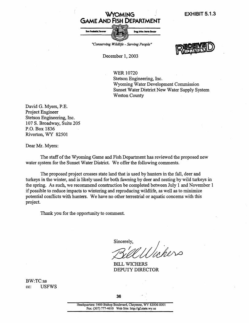
Wyoming Game and Fish Department
The WGFD requires no permits but recommended construction be done between July 1st and November 1st to reduce possible impacts to wintering and reproducing wildlife, as well as to minimize potential conflicts with hunters.
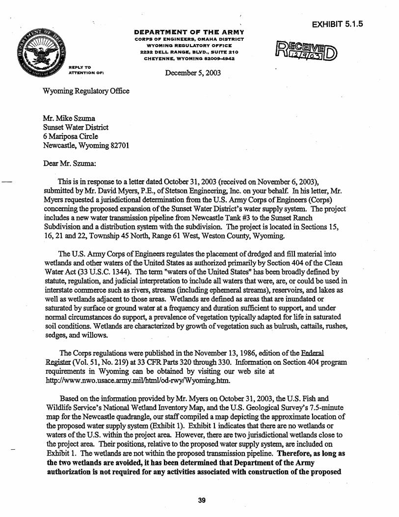
Department of the Army Corps of Engineers
Stetson Engineering, Inc. – Sunset Ranch Level II Study Page 22
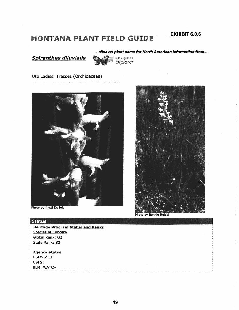
There are no wetlands or waters of the U.S. within the proposed project boundary. However, there are two jurisdictional wetlands close to the proposed project area. As long as the two wetlands are avoided Department of the Army authorization is not required for any activities associated with construction of the proposed Sunset water supply system.
Wyoming Department of State Parks and Cultural Resources – State
Historic Preservation Office
Prior to ground disturbing activity in areas outside of the existing street and utility right-of-ways, an on-site cultural resource survey meeting the Secretary of Interior’s Standards for Archaeology and Historic Preservation (48FR44716) should be conducted. The SHPO project control number for the Sunset Pipeline Project is #1103TLG044.

Stetson Engineering, Inc. – Sunset Ranch Level II Study Page 23
10 REFERENCES Bartos, T. T., L. L. Hallberg, and K. M. Ogle (2002) Potentiometric Surfaces, Altitudes of the Tops, and Hydrogeology of the Minnelusa and Madison Aquifers, Black Hills Area, Wyoming, U.S. Geological Survey, Hydrologic Investigations Atlas HA-748. Carter, J. M., D. G. Driscoll, and J. E. Williamson (2002) The Black Hills Hydrology Study, USGS Fact Sheet FS-046-02, June. Lisenbee, A. L. (1985) Tectonic Map of the Black Hills Uplift, Montana, Wyoming, and South Dakota, Geological Survey of Wyoming, Map Series 13 (MS-13), Laramie, WY. Love, J. D., A. C. Christiansen, L. W. McGrew (1987) Geologic Map of the Newcastle 1 x 2 degree Quadrangle, Northeastern Wyoming and Western South Dakota, Geological Survey of Wyoming, Map Series 25-I (MS 25-I), Laramie, WY. Mapel, W. J. and C. I. Pillmore (1963) Geology of the Newcastle Area, Weston County, Wyoming, U.S. Geological Survey Bulletin 1141-N, Washington, D.C. (MSU – I 19.3:1141/K-Q). Naus, C. A., D. G. Driscoll, J. M. Carter (2001) Geochemistry of the Madison and Minnelusa Aquifers in the Black Hills Area, South Dakota, U.S. Geological Survey Water-Resources Investigations Report 01-4129, Rapid City, SD. R.C.H. and Associates (1996) Final Report, Level I Water Supply Project, Salt Creek Water District, Newcastle, Wyoming, submitted to Wyoming Water Development Commission, R. C. H. and Associates, Glenrock, WY, December 1996. Robinson, C. S., W. J. Mapel and M. H. Bergendahl (1964) Stratigraphy and Structure of The Northern and Western Flanks of The Black Hills Uplift, Wyoming, Montana, and South Dakota, USGS Professional Paper 404, Washington, DC. (MSU – I 19.16). Williamson, J. E., G. J. Jarrell, R. M. Clawges, J. M. Galloway, and J. M. Carter (2000) Digital Data Sets for Map Products Produced as Part of the Black Hills Hydrology Study, Western South Dakota, U.S. Geological Survey Open-File Report 00-471, Rapid City, SD. Williamson, J. E. and J. M. Carter (2001) Water-Quality Characteristics in the Black Hills Area, South Dakota, U.S. Geological Survey Water-Resources Investigations Report 01-4194, Rapid City, SD. Wester-Wetstein & Associates, Inc., (2000) Newcastle Area Water Supply Master Plan – Level II, submitted to Wyoming Water Development Commission, Wester-Wetstein & Associates, Inc., Laramie, WY, April 2000. (Volumes 1 and 2). Wester-Wetstein & Associates, Inc. (2001) Summary Report for Crown No. 1 Well, report to The Weinreis Brothers by Wester-Wetstein & Associates, Inc., Laramie, WY, November 2001.