The water balance of an arctic lake and its dependence on climate change: Tvillingvatnet in...
7
This article was downloaded by: [Norges Landbrukshoegskole] On: 22 May 2014, At: 00:31 Publisher: Routledge Informa Ltd Registered in England and Wales Registered Number: 1072954 Registered office: Mortimer House, 37-41 Mortimer Street, London W1T 3JH, UK Norsk Geografisk Tidsskrift - Norwegian Journal of Geography Publication details, including instructions for authors and subscription information: http://www.tandfonline.com/loi/sgeo20 The water balance of an arctic lake and its dependence on climate change: Tvillingvatnet in Ny-Ålesund, Svalbard Sylvi Haldorsen , Michael Heim , Bernard Lefauconnier , Lars-Evan Pettersson , Morten Røros & Kjetil Sandsbråten Published online: 05 Nov 2010. To cite this article: Sylvi Haldorsen , Michael Heim , Bernard Lefauconnier , Lars-Evan Pettersson , Morten Røros & Kjetil Sandsbråten (2002) The water balance of an arctic lake and its dependence on climate change: Tvillingvatnet in Ny-Ålesund, Svalbard, Norsk Geografisk Tidsskrift - Norwegian Journal of Geography, 56:2, 146-151, DOI: 10.1080/002919502760056477 To link to this article: http://dx.doi.org/10.1080/002919502760056477 PLEASE SCROLL DOWN FOR ARTICLE Taylor & Francis makes every effort to ensure the accuracy of all the information (the “Content”) contained in the publications on our platform. However, Taylor & Francis, our agents, and our licensors make no representations or warranties whatsoever as to the accuracy, completeness, or suitability for any purpose of the Content. Any opinions and views expressed in this publication are the opinions and views of the authors, and are not the views of or endorsed by Taylor & Francis. The accuracy of the Content should not be relied upon and should be independently verified with primary sources of information. Taylor and Francis shall not be liable for any losses, actions, claims, proceedings, demands, costs, expenses, damages, and other liabilities whatsoever or howsoever caused arising directly or indirectly in connection with, in relation to or arising out of the use of the Content. This article may be used for research, teaching, and private study purposes. Any substantial or systematic reproduction, redistribution, reselling, loan, sub-licensing, systematic supply, or distribution in any form to anyone is expressly forbidden. Terms & Conditions of access and use can be found at http://www.tandfonline.com/page/terms-and-conditions
-
Upload
independent -
Category
Documents
-
view
4 -
download
0
Transcript of The water balance of an arctic lake and its dependence on climate change: Tvillingvatnet in...

This article was downloaded by: [Norges Landbrukshoegskole]On: 22 May 2014, At: 00:31Publisher: RoutledgeInforma Ltd Registered in England and Wales Registered Number: 1072954 Registered office:Mortimer House, 37-41 Mortimer Street, London W1T 3JH, UK
Norsk Geografisk Tidsskrift - NorwegianJournal of GeographyPublication details, including instructions for authors and subscriptioninformation:http://www.tandfonline.com/loi/sgeo20
The water balance of an arctic lakeand its dependence on climate change:Tvillingvatnet in Ny-Ålesund, SvalbardSylvi Haldorsen , Michael Heim , Bernard Lefauconnier , Lars-EvanPettersson , Morten Røros & Kjetil SandsbråtenPublished online: 05 Nov 2010.
To cite this article: Sylvi Haldorsen , Michael Heim , Bernard Lefauconnier , Lars-Evan Pettersson ,Morten Røros & Kjetil Sandsbråten (2002) The water balance of an arctic lake and its dependence onclimate change: Tvillingvatnet in Ny-Ålesund, Svalbard, Norsk Geografisk Tidsskrift - Norwegian Journal ofGeography, 56:2, 146-151, DOI: 10.1080/002919502760056477
To link to this article: http://dx.doi.org/10.1080/002919502760056477
PLEASE SCROLL DOWN FOR ARTICLE
Taylor & Francis makes every effort to ensure the accuracy of all the information (the “Content”)contained in the publications on our platform. However, Taylor & Francis, our agents, and ourlicensors make no representations or warranties whatsoever as to the accuracy, completeness, orsuitability for any purpose of the Content. Any opinions and views expressed in this publicationare the opinions and views of the authors, and are not the views of or endorsed by Taylor &Francis. The accuracy of the Content should not be relied upon and should be independentlyverified with primary sources of information. Taylor and Francis shall not be liable for anylosses, actions, claims, proceedings, demands, costs, expenses, damages, and other liabilitieswhatsoever or howsoever caused arising directly or indirectly in connection with, in relation to orarising out of the use of the Content.
This article may be used for research, teaching, and private study purposes. Any substantialor systematic reproduction, redistribution, reselling, loan, sub-licensing, systematic supply, ordistribution in any form to anyone is expressly forbidden. Terms & Conditions of access and usecan be found at http://www.tandfonline.com/page/terms-and-conditions

The water balance of an arctic lake and its dependence on climatechange: Tvillingvatnet in Ny-AÊ lesund, Svalbard
SYLVI HALDORSEN, MICHAEL HEIM, BERNARD LEFAUCONNIER, LARS-EVAN PETTERSSON, MORTEN RØROS & KJETIL SANDSBRAÊ TEN
Haldorsen, S., Heim, M., Lefauconnier , B., Pettersson, L.-E., Røros, M. & SandsbraÊ ten, K. 2002. The water balance of an arcticlake and its dependence on climate change: Tvillingvatne t in Ny-AÊ lesund, Svalbard. Norsk Geogra� sk Tidsskrift–Norwegian Jour-nal of Geography Vol. 56, 146–151. Oslo. ISSN 0029-1951.
Lake Tvillingvatne t is the water supply to the arctic research settlement Ny-AÊ lesund in Svalbard. In the period 1920–1930 it wasobserved that the lake received groundwater from a sandstone-aquifer underlying the lake. Recent water balance studies indicatethat there is no longer any groundwater � ow of that type into the lake. This change can be explained by a warmer climate resultingin a fast retreat of the glaciers after the Little Ice Age. Large amounts of melt water combined with a steep hydraulic gradient mayhave caused partial melting of permafrost along the front of the Brøggerbreen Glacier, which was situated c. 0.5 km west of LakeTvillingvatne t at that time. Today, the glacier front is more than a kilometre SW of the lake. The formation of new permafrost hasresulted in freezing of the previously active groundwater out� ow channels . The present � ow of water into Tvillingvatne t during theautumn is probably due to shallow groundwater in the active layer along the talus of the Zeppelinfjelle t Mountain .
Keywords: Arctic lake, global change, permafrost groundwater , polar hydrology
Sylvi Haldorsen, Michael Heim & Morten Røros, Department of Soil and Water Science, P.O. Box 5028, NO-1430 AÊ s, Norway.E-mail: [email protected] . Lars-Evan Pettersson, The Norwegian Water Resources and Energy Directorate (NVE), Mid-delthunsgate 29, P.O. Box 5091 Majorstua, NO-0301 Oslo, Norway. Bernard Lefauconnier , Le Mollard, FR-38700, Le Sappey enChartreuse, France. Kjetil SandsbraÊ ten, Statkraf t Grøner AS, Avdeling for Hydrologi og Vannressursforvaltning , Fornebuveie n11, NO-1327 Lysaker, Norway
IntroductionWater supply in areas with permafrost is often from lakesthat do not freeze to the bottom during the winter. Ground-water � ow into lakes from a subpermafrost or intra-permafrost talik is therefore of interest. The groundwatermay be the only water recharge during the winter and willalso add heat to the reservoir (see e.g. Haldorsen et al. 1997).However, permafrost groundwater � ow may be sensitive toclimate changes (Haldorsen & Heim 1999). The hydrologicalbalance of arctic lakes that receive groundwater can thereforevary over short time spans. In this paper, we present datafrom Lake Tvillingvatnet, which is the main water supplysource for the international research settlement Ny-AÊ lesundin western Svalbard (Fig. 1). We describe the lake hydrologyand discuss the water balance since the 1920s. We believethat the results are of interest for arctic lakes in general,because they demonstrate how a climate change over arelatively short time-span may have a major in� uence uponthe water balance of the lakes.
Topography and geology of LakeTvillingvatnetNy-AÊ lesund is situated on the Brøggerhalvøya Peninsula, onthe western coast of Svalbard. Lake Tvillingvatnet is locatedon the coastal plain c. 30 m a.s.l. and c. 1.5 km SSW ofKongsfjorden and the harbour of Ny-AÊ lesund (Fig. 1). Themain part of the catchment is situated S, E and N of the lake,with the SW water divide close to its shore. The steep slopeof Zeppelinfjellet Mountain forms the southern part of the
catchment. The N and E parts of the catchment are a gentlysloping hill from Kolhaugen towards the lake. The catchmentsize is under debate. The main problem is in determining howmuch of the water from the slope of Zeppelinfjellet drainsinto the lake. SandsbraÊ ten (1995) calculated the catchmentsize to be 0.31 km2, and suggested that only the lower part ofthe Zeppelinfjellet slope contributed to the lake waterbudget. Pettersson (2000) estimated it to be 0.36 km2. Fieldstudies during September 2001 concluded that some of thewater from the upper part of the mountain might also � owinto Tvillingvatnet (Fig. 1). If so, the catchment size might beclose to 0.4 km2.
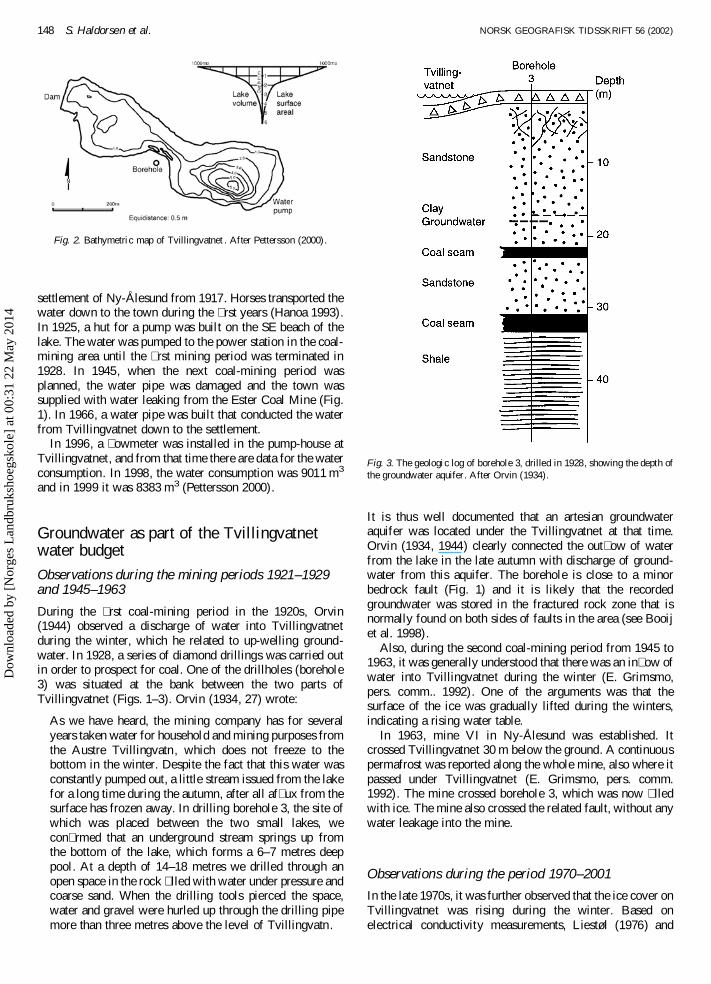
The lake surface is 35,000 m2 and consists of an easternand western basin. The threshold depth between the twobasins is 1 m below the normal lake level (Fig. 2). Maximumdepth is 6.3 m in the eastern basin, and 2.5 m in the westernbasin. The total lake volume is 49,000 m3 (Pettersson 2000),with 32,000 m3 for the eastern basin and 17,000 m3 for thewestern basin. Before the lake was dammed at the end of the1940s it consisted of two almost separated basins (thereforethe name Tvillingvatnet ‘Twin Lake’). The lake surface wasat that time c. 0.5 m lower than today. Using data fromPettersson (2000), the surface area in the early 1920s can beestimated to c. 30,000 m2 and the corresponding watervolume would have been c. 33,600 m3 (see also Fig. 4).
The stream draining Tvillingvatnet, Tvillingbekken, � owsthrough a shallow depression into the main river of Bayelva,which also drains most of the water from Austre and VestreBrøggerbreen Glacier (Fig. 1). The annual average precipita-tion in Ny-AÊ lesund is 403 mm. The highest precipitation is inFebruary–March and August–September.
Silicate sandstones of Tertiary age underlie Tvillingvatnet,
Norsk Geografisk Tidsskrift – Norwegian Journal of Geography Vol. 56, 146–151. Oslo. ISSN 0029-1951
# 2002 Taylor & Francis
Dow
nloa
ded
by [
Nor
ges
Lan
dbru
ksho
egsk
ole]
at 0
0:31
22
May
201
4

and compose the main lowland part of the catchment.Palaeozoic limestone and chert form the steep, south partof the catchment, up to the top of Zeppelinfjellet. The coastalplain is truncated by several faults. There is a thrust faultbetween the Palaeozoic chert unit and underlying Tertiarysandstones of the coastal plain (Haldorsen et al. 1996).
Lake Tvillingvatnet: water supply toNy-AÊ lesund
Tvillingvatnet is the only lake near Ny-AÊ lesund that does notfreeze to the bottom during the winter. Water from the lakewas therefore used as household water to the coal-mining
Fig. 1. Key map of the Ny-AÊ lesund area, showing Tvillingvatne t and its surroundings . The geology is simpli� ed from Thiedig & Piepjohn (1989). The retreat ofthe glaciers is based on Orvin (1934), Hagen (1989) and Norsk polarinstitut t (1966, 1977, 1990).
NORSK GEOGRAFISK TIDSSKRIFT 56 (2002) The water balance of an arctic lake in Svalbard 147
Dow
nloa
ded
by [
Nor
ges
Lan
dbru
ksho
egsk
ole]
at 0
0:31
22
May
201
4
settlement of Ny-AÊ lesund from 1917. Horses transported thewater down to the town during the � rst years (Hanoa 1993).In 1925, a hut for a pump was built on the SE beach of thelake. The water was pumped to the power station in the coal-mining area until the � rst mining period was terminated in1928. In 1945, when the next coal-mining period wasplanned, the water pipe was damaged and the town wassupplied with water leaking from the Ester Coal Mine (Fig.1). In 1966, a water pipe was built that conducted the waterfrom Tvillingvatnet down to the settlement.
In 1996, a � owmeter was installed in the pump-house atTvillingvatnet, and from that time there are data for the waterconsumption. In 1998, the water consumption was 9011 m3
and in 1999 it was 8383 m3 (Pettersson 2000).
Groundwater as part of the Tvillingvatnetwater budget
Observations during the mining periods 1921–1929and 1945–1963
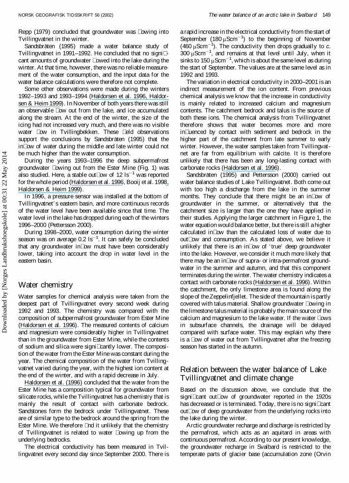
During the � rst coal-mining period in the 1920s, Orvin(1944) observed a discharge of water into Tvillingvatnetduring the winter, which he related to up-welling ground-water. In 1928, a series of diamond drillings was carried outin order to prospect for coal. One of the drillholes (borehole3) was situated at the bank between the two parts ofTvillingvatnet (Figs. 1–3). Orvin (1934, 27) wrote:
As we have heard, the mining company has for severalyears taken water for household and mining purposes fromthe Austre Tvillingvatn, which does not freeze to thebottom in the winter. Despite the fact that this water wasconstantly pumped out, a little stream issued from the lakefor a long time during the autumn, after all af� ux from thesurface has frozen away. In drilling borehole 3, the site ofwhich was placed between the two small lakes, wecon� rmed that an underground stream springs up fromthe bottom of the lake, which forms a 6–7 metres deeppool. At a depth of 14–18 metres we drilled through anopen space in the rock � lled with water under pressure andcoarse sand. When the drilling tools pierced the space,water and gravel were hurled up through the drilling pipemore than three metres above the level of Tvillingvatn.
It is thus well documented that an artesian groundwateraquifer was located under the Tvillingvatnet at that time.Orvin (1934, 1944) clearly connected the out� ow of waterfrom the lake in the late autumn with discharge of ground-water from this aquifer. The borehole is close to a minorbedrock fault (Fig. 1) and it is likely that the recordedgroundwater was stored in the fractured rock zone that isnormally found on both sides of faults in the area (see Booijet al. 1998).
Also, during the second coal-mining period from 1945 to1963, it was generally understood that there was an in� ow ofwater into Tvillingvatnet during the winter (E. Grimsmo,pers. comm.. 1992). One of the arguments was that thesurface of the ice was gradually lifted during the winters,indicating a rising water table.
In 1963, mine VI in Ny-AÊ lesund was established. Itcrossed Tvillingvatnet 30 m below the ground. A continuouspermafrost was reported along the whole mine, also where itpassed under Tvillingvatnet (E. Grimsmo, pers. comm.1992). The mine crossed borehole 3, which was now � lledwith ice. The mine also crossed the related fault, without anywater leakage into the mine.
Observations during the period 1970–2001
In the late 1970s, it was further observed that the ice cover onTvillingvatnet was rising during the winter. Based onelectrical conductivity measurements, Liestøl (1976) and
Fig. 2. Bathymetric map of Tvillingvatnet . After Pettersson (2000).
Fig. 3. The geologic log of borehole 3, drilled in 1928, showing the depth ofthe groundwater aquifer. After Orvin (1934).
148 S. Haldorsen et al. NORSK GEOGRAFISK TIDSSKRIFT 56 (2002)
Dow
nloa
ded
by [
Nor
ges
Lan
dbru
ksho
egsk
ole]
at 0
0:31
22
May
201
4
Repp (1979) concluded that groundwater was � owing intoTvillingvatnet in the winter.
SandsbraÊ ten (1995) made a water balance study ofTvillingvatnet in 1991–1992. He concluded that no signi� -cant amounts of groundwater � owed into the lake during thewinter. At that time, however, there was no reliable measure-ment of the water consumption, and the input data for thewater balance calculations were therefore not complete.
Some other observations were made during the winters1992–1993 and 1993–1994 (Haldorsen et al. 1996, Haldor-sen & Heim 1999). In November of both years there was stillan observable � ow out from the lake, and ice accumulatedalong the stream. At the end of the winter, the size of theicing had not increased very much, and there was no visiblewater � ow in Tvillingbekken. These � eld observationssupport the conclusions by SandsbraÊ ten (1995) that thein� ow of water during the middle and late winter could notbe much higher than the water consumption.
During the years 1993–1996 the deep subpermafrostgroundwater � owing out from the Ester Mine (Fig. 1) wasalso studied. Here, a stable out� ow of 12 ls¡1 was reportedfor the whole period (Haldorsen et al. 1996, Booij et al. 1998,Haldorsen & Heim 1999).
In 1996, a pressure sensor was installed at the bottom ofTvillingvatnet’s eastern basin, and more continuous recordsof the water level have been available since that time. Thewater level in the lake has dropped during each of the winters1996–2000 (Pettersson 2000).
During 1998–2000, water consumption during the winterseason was on average 0.2 ls¡1. It can safely be concludedthat any groundwater in� ow must have been considerablylower, taking into account the drop in water level in theeastern basin.
Water chemistryWater samples for chemical analysis were taken from thedeepest part of Tvillingvatnet every second week during1992 and 1993. The chemistry was compared with thecomposition of subpermafrost groundwater from Ester Mine(Haldorsen et al. 1996). The measured contents of calciumand magnesium were considerably higher in Tvillingvatnetthan in the groundwater from Ester Mine, while the contentsof sodium and silica were signi� cantly lower. The composi-tion of the water from the Ester Mine was constant during theyear. The chemical composition of the water from Tvilling-vatnet varied during the year, with the highest ion content atthe end of the winter, and with a rapid decrease in July.
Haldorsen et al. (1996) concluded that the water from theEster Mine has a composition typical for groundwater fromsilicate rocks, while the Tvillingvatnet has a chemistry that ismainly the result of contact with carbonate bedrock.Sandstones form the bedrock under Tvillingvatnet. Theseare of similar type to the bedrock around the spring from theEster Mine. We therefore � nd it unlikely that the chemistryof Tvillingvatnet is related to water � owing up from theunderlying bedrocks.
The electrical conductivity has been measured in Tvil-lingvatnet every second day since September 2000. There is
a rapid increase in the electrical conductivity from the start ofSeptember (180 mScm¡1) to the beginning of November(460 mScm¡1). The conductivity then drops gradually to c.300 mScm¡1, and remains at that level until July, when itsinks to 150 mScm¡1, which is about the same level as duringthe start of September. The values are at the same level as in1992 and 1993.
The variation in electrical conductivity in 2000–2001 is anindirect measurement of the ion content. From previouschemical analysis we know that the increase in conductivityis mainly related to increased calcium and magnesiumcontents. The catchment bedrock and talus is the source ofboth these ions. The chemical analysis from Tvillingvatnettherefore shows that water becomes more and morein� uenced by contact with sediment and bedrock in thehigher part of the catchment from late summer to earlywinter. However, the water samples taken from Tvillingvat-net are far from equilibrium with calcite. It is thereforeunlikely that there has been any long-lasting contact withcarbonate rocks (Haldorsen et al. 1996).
SandsbraÊ ten (1995) and Pettersson (2000) carried outwater balance studies of Lake Tvillingvatnet. Both come outwith too high a discharge from the lake in the summermonths. They conclude that there might be an in� ow ofgroundwater in the summer, or alternatively that thecatchment size is larger than the one they have applied intheir studies. Applying the larger catchment in Figure 1, thewater equation would balance better, but there is still a highercalculated in� ow than the calculated loss of water due toout� ow and consumption. As stated above, we believe itunlikely that there is an in� ow of ‘true’ deep groundwaterinto the lake. However, we consider it much more likely thatthere may be an in� ow of supra- or intra-permafrost ground-water in the summer and autumn, and that this componentterminates during the winter. The water chemistry indicates acontact with carbonate rocks (Haldorsen et al. 1996). Withinthe catchment, the only limestone area is found along theslope of the Zeppelinfjellet. The side of the mountain is partlycovered with talus material. Shallow groundwater � owing inthe limestone talus material is probably the main source of thecalcium and magnesium to the lake water. If the water � owsin subsurface channels, the drainage will be delayedcompared with surface water. This may explain why thereis a � ow of water out from Tvillingvatnet after the freezingseason has started in the autumn.
Relation between the water balance of LakeTvillingvatnet and climate changeBased on the discussion above, we conclude that thesigni� cant out� ow of groundwater reported in the 1920shas decreased or is terminated. Today, there is no signi� cantout� ow of deep groundwater from the underlying rocks intothe lake during the winter.
Arctic groundwater recharge and discharge is restricted bythe permafrost, which acts as an aquitard in areas withcontinuous permafrost. According to our present knowledge,the groundwater recharge in Svalbard is restricted to thetemperate parts of glacier base (accumulation zone (Orvin
NORSK GEOGRAFISK TIDSSKRIFT 56 (2002) The water balance of an arctic lake in Svalbard 149
Dow
nloa
ded
by [
Nor
ges
Lan
dbru
ksho
egsk
ole]
at 0
0:31
22
May
201
4

1944, Liestøl 1976) and restricted parts of the ablation areas(ØdegaÊ rd et al. 1992)). The glacier thermal regime istherefore a main controlling factor for the arctic groundwaterbudgets.
Studies of historic and present groundwater � ow from theEster Mine have brought new knowledge about arcticgroundwater systems (Haldorsen & Heim 1999). The waterfrom the Ester Mine is recharged under the Vestre Loven-breen glacier (Fig. 1). The considerable decrease in thegroundwater discharge during the last 100 years is mainlybecause of the continuous melting of the glacier, which hasresulted in a decreased groundwater recharge area. Ground-water springs at other places on Svalbard show a similarpattern (Haldorsen et al. 2000). We believe it likely that thechange in the water budget of Tvillingvatnet is also related tothe same climate change, since it has taken place during thesame period and resulted in a similar decrease in thegroundwater in� ow.
The end of the 19th century was the end of the Little IceAge on Svalbard, during which the glaciers had the largestextension since the Weichselian. We know nothing about thewater balance of Tvillingvatnet before 1920. It is thereforenot possible to conclude anything about the drainage ofgroundwater into the lake during the Little Ice Age itself. Weknow, however, that at the beginning of the 20th century theclimate changed abruptly from the cold Little Ice Age intothe warmer climate that has prevailed since. As a result ofthis warming the Equilibrium Line Altitude rose 200 m, theglacier fronts started to retreat and the glacier surfaces werelowered (Hagen 1989). During the � rst couple of decadesafter this marked climate change the glaciers were far out ofequilibrium with the new climatic condition. The periodmust have been associated with very high melting rates andlarge discharges in the glacial rivers. Hagen & Liestøl (1990)found that the melting of ice at Austre Brøggerbreen in theperiod 1920–1929 was 0.6 m/a, or about 1.5 times the presentannual precipitation. These were the years when Orvin(1934) made his observations.
Figure 4 shows the Quaternary geology around Tvilling-vatnet, and the front of Austre Brøggerbreen in 1921. Thefront of the glacier was situated only 500 m west of LakeTvillingvatnet. Some couple of hundred metres behind thefront of the glacier the glacier surface was 100 m higher thanTvillingvatnet. The front was therefore steep, and thehydraulic gradient from the glacier to the lake was probablyhigh. Temperate conditions probably prevailed along thebottom of the glacier lower down in the valley and closer tothe front than today. The in� ow of groundwater to theunderlying bedrock must have been high. It is likely thatthere was a high recharge into the major fault system alongthe east side of Austre Brøggerbreen (Figs. 1 and 4). Majormelt-water streams � owed from the glacier front towards theNW end of Tvillingvatnet (Fig. 4). The heat transfer from themeltwater and from groundwater under pressure must haveaffected the permafrost near the front of the glacier duringthe period of at least 30 years from the end of the Little IceAge until Orvin’s observations were terminated. Thesefactors must have resulted in a partial melting of the upperpermafrost between the lake and the glacier.
Icings are found downstream of the front of some of the
polythermal glaciers in other places on Brøggerhalvøya (seefor instance Orvin 1944). This is explained by the � ow ofshallow groundwater under the frozen glacier front. Thisgroundwater discharges and freezes at some distance outsidethe front. The groundwater reached at shallow depths duringthe drilling of borehole 3 might have been shallow ground-water of this kind, rather than discharge from a deepsubpermafrost aquifer.
Fig. 4. The Quaternary geology in the Tvillingvatne t area, and the front ofAustre Brøggerbreen in 1921. After Orvin (1934).
150 S. Haldorsen et al. NORSK GEOGRAFISK TIDSSKRIFT 56 (2002)
Dow
nloa
ded
by [
Nor
ges
Lan
dbru
ksho
egsk
ole]
at 0
0:31
22
May
201
4

From 1921 until today, the front of Austre Brøggerbreenhas retreated 1 km, and the gradient has decreased consider-ably. The boundary between temperate and cold basal glacierice has moved up-glacier, and the area of temperate basal icehas decreased. Permafrost is established in areas from whichthe glacier has retreated. We believe that this is the reason forthe termination of groundwater in� ow into Tvillingvatnet.
ConclusionsIn c. 1920 there was a documented in� ow of groundwaterinto Tvillingvatnet during the winter. In this paper, we arguethat there is no longer any signi� cant in� ow of water duringthe winter. We conclude that this is the result of the climatechange that took place at the end of the Little Ice Age. Thereseems to be an in� ow of water to Tvillingvatnet fromsummer to late autumn, probably because of shallowgroundwater that � ows into the lake from the SE. The winterconsumption therefore has to be based entirely on the waterreservoir established in the late autumn. The water balancecalculation is important for the planning of future winteractivities that require larger amounts of freshwater.
Acknowledgements.–Staff members from the Agricultural University ofNorway, Kings Bay AS, the Norwegian Water Resources and EnergyDirectorate (NVE) and the Norwegian Polar Institute have assisted in the� eld. The work has received � nancial support from the Norwegian ResearchCouncil . The paper was revised after we received some useful commentsfrom the two journal reviewers, J. O. Hagen and G. Vatne. To these personsand institutions we render our sincere thanks.
Manuscript submitted 3 December 2001; accepted 21 February 2002
References
Booij, M., Leijnse, A., Haldorsen, S., Heim, M. & RueslaÊ tten, H. 1998.Simulation of coupled water � ow and heat transport of a subpermafrostgroundwater aquifer in Svalbard. Nordic Hydrology 29, 385–396.
Hagen, J. O. 1989. Isbreer og permafrost som klimaindikatorer . Orheim, O. &Brekke, A. (eds.) Hva skjer med klimaet i polaromraÊ dene. NorskPolarinstitut t Report 53. 7 pp.
Hagen, J. O. & Liestøl, O. 1990. Long term glacier mass balanceinvestigation s in Svalbard 1950–1988. Annals of Glaciology 14, 102–106.
Haldorsen, S. & Heim, M. 1999. An arctic groundwater system and itsdependence upon climate changes: an example from Svalbard. Permafrostand Periglacial Processes 10, 137–149.
Haldorsen, S., Heim, M. & Lauritzen, S.-E. 1996. Subpermafrost ground-water, Western Svalbard. Nordic Hydrology 27, 57–68.
Haldorsen, S., Leibman, M., Nelson, G., van Everdingen, R. & Boike, J.1997. State-of-the-art report on water movement in frozen ground.Northern Research Basins. Eleventh Internationa l Symposium and Work-shop, Prudhoe Bay/Fairbanks, Alaska, August 18–221987. Proceedings 1,304–342.
Haldorsen, S., Heim, M., Dale, B., Banks, D., Sletten, R., Swensen, B. &Salvigsen, O. 2000. Abstract XV INQUA Congress: Arctic groundwatersystems and their dependence upon climatic change: examples fromSvalbard. Quaternary International 74, 155.
Hanoa, R. 1993. Kings Bay Kull Comp. A/S 1917–1992. Fra gruvedrif t tilforskningsservic e paÊ Svalbard . Schibsted, Oslo.
Liestøl, O. 1976. Pingos, springs and permafrost in Spitsbergen, NorskPolarinstitutt s AÊ rbok 1975, 7–29.
Norsk Polarinstitutt 1966. Vestre Lovenbreen: Topographica l map, scale1:10000 . Norsk Polarinstitutt , Ny-AÊ lesund.
Norsk Polarinstitut t 1977. Brøggerbreane, Vestre og Midtre Lovenbreen:Topographica l map, scale 1:20000. Norsk Polarinstitutt , Oslo.
Norsk Polarinstitut t 1990. Air photo, scale 1:15000: S905103. NorskPolarinstitutt , Oslo.
ØdegaÊ rd, R. R., Hamran, S. E., Bø, P. H., Etzelmuller, B., Vatne, G. & Sollid,J. L. 1992. Thermal regime of a valley glacier, Eriksbreen, northernSpitsbergen. Polar Research 11, 69–79.
Orvin, A. 1934. Geology of the Kings Bay region, Spitsbergen. Skrifter omSvalbard og Ishavet 57. 190 pp.
Orvin, A. 1944. Litt om kilder paÊ Svalbard. Norsk Geogra� sk Tidsskrift 10,16–38.
Pettersson, L.-E. 2000. Vannforsyning i Ny-AÊ lesund. Norges vassdrags- ogenergidirektora t (NVE), Oslo. Oppdragsrappor t 6/2000.
Repp, K. 1979. Breerosjon, glasio-hydrolog i og materialtransport i ethøyarktisk miljø. Brøggerbreene, Vest-Spitsbergen. Hovedoppgav e (mas-ter’s thesis), Department of Geography, University of Oslo.
SandsbraÊ ten, K. 1995. Vannbalanse i et lite, arktisk nedbørfelt. Tvillingvatn ,Svalbard. Hydrology, Department of Physical Geography, University ofOslo, Report 43. Oslo.
Thiedig, F. & Piepjohn, K. 1989. Geological map of the Brøggerhalvøya andBlomstrandhalvøya, NW Spitsbergen. University of Munster, Germany.
NORSK GEOGRAFISK TIDSSKRIFT 56 (2002) The water balance of an arctic lake in Svalbard 151
Dow
nloa
ded
by [
Nor
ges
Lan
dbru
ksho
egsk
ole]
at 0
0:31
22
May
201
4