the tract dealt with - MAHARASHTRA FOREST DEPARTMENT
300
-
Upload
khangminh22 -
Category
Documents
-
view
0 -
download
0
Transcript of the tract dealt with - MAHARASHTRA FOREST DEPARTMENT


1
PART-I
CHAPTER 1
THE TRACT DEALT WITH
SECTION 1. NAME AND SITUATION:
Location:
1.1.1. East Melghat Forest Division is situated in the North East of Amravati district of
Maharashtra State and administratively it is under Amravati Forest Circle. Geographical
coordinates are Latitude 210 13' 14" to 21
0 46' 6" North & longitude 77
0 10' 39" to 77
0 36'
East.
Area:
1.1.2. This plan covers an area of 56087.60 ha. The details are as under.
Area taken out from erstwhile East Melghat Division -- 30936.81. ha.
Area taken out from erstwhile South Melghat Division -- 14182.96 ha.
Area taken out from erstwhile West Melghat Division -- 10946.76 ha.
Areas of compensatory afforestation 21.07 ha.
----------------------
Total Area -- 56087.60 ha. ---------------------------
The above areas were finalized as a result of reorganization of various forest divisions
and Melghat Project Tiger in Amravati district in the year 1998. The head quarter of the
East Melghat Division was shifted from Amravati to Chikhaldara.
Boundaries:
1.1.3. Betul District of Madhya Pradesh lies to the north and to the east. It is bound by
West Melghat and Melghat Project Tiger on South and West. The Core area of Project
Tiger is on NorthWest side of the Division. Small section of SouthEast boundary is
shared with Amravati Forest Division.
1.1.4. The tract is situated on the branch of Satpuda range to the south of Tapti River,
known as the Gavilgarh hills of Melghat, Gavilgarh being the name of an old fortress and
Melghat being the name of confluence of Khapra and the Tapti rivers in the north.
Gavilgarh fort, now in ruins, is situated along the southern spurs of Gavilgarh hills in
compartment number 29 and is about 2km. from the Chikhaldara plateau to the
south.Entire tract lies in Chikhaldara taluqa and Chinchona-Nimkhera ‘C’ class forest
lies in Anjangaon taluqa.
2
SECTION 2. CONFIGURATION OF THE GROUND:
1.2.1. As the name implies, Melghat is literally a meeting place of Ghats. The tract is
very hilly and consists of succession of hills and valleys in a changing pattern with
constant and abrupt variations in altitude, aspect and gradient. Even within the limits of a
compartment of which the average area is slightly more than 2-sq. km., all the variations
are visible. In some compartments, the difference in elevation is as mush as 600 meters
but there is hardly any one in which the difference is less than 150 meters.
1.2.2. The prominent physical feature is the main ridge of the Gawilgarh hills which
enters the tract just north of Ghatang from the Betul district and runs westerly and south-
westerly directions through the southern part of the tract barely 15 km. Away from the
southern boundary leaving 4/5 of the area dealt with to the north of this ridge. After
running westerly direction from Ghatang for a short distance, it turns to southwest and
widens into Chikhaldara and Vairat plateau with summit levels of 1,100 meters. From
here, it continues north of Shahapur river as a flat topped ridge and after lowering at the
pass it again attains an elevation of 1, 101 meters along Akot-Harisal road just north-west
of Jhiri and then gradually descending with peaks of about 820 meters south of Golai, it
leaves the district boundary just west of Wan railway station. The conspicuous hump on
this ridge at Vairat is the highest point being 1,177.75 meters above sea level and lies in
the compartment No. 34.
1.2.3. The striking feature of this ridge is its almost flat-topped plateau descending in a
series of precipitous scarps on either side, one below the other separated by narrow steps
of lesser gradients and finally sloping down to the narrow steep valleys known as khoras.
These are most conspicuous on the slopes of the plateau of Vairat, Chikhaldara and
Gawilgarh fort area. Numerous spurs branch off from this main ridge towards north and
south, having narrow ridges known as ghors or dhars and flat tops known as ballas, a few
of which towards north are of considerable size such as Masondi, Vairat, Chikhaldara,
Makhala, Borkhedi etc., with an average height of about 1,100 meters. Between the
plateau and hills there are saddles known as Khandies, the prominent ones are Sirasban,
Amjhiri etc., used for crossing the ridge. These subsidiary ridges also usually have abrupt
scarped sides, which are ideal natural fortifications.
1.2.4. The area to the north of the main ridge, though interrupted with a series of hills and
valleys, gradually descends to the north-west with an altitude of about 480 meters in the
east and about 230 meters in the west near the Tapti river. The northeast portion is much
cut up by deep narrow valleys, while the northwest is characterized by shallow valleys
and low steep hills, the valleys just north of main ridge are very deep but later on they
gradually widen where the best forest of the region occurs.
1.2.5. From the main ridge to the south, the land slopes very steeply but irregularly
through several minor ridges to the Amravati plains. The altitudinal variation along the
boundary is from 300 meters in east to 150 meters in west. This main ridge forms a
natural hill barrier between the most valuable wooded part of the tract in the north, and
cultivated and populated plains in the south.

3
1.2.6. The main ridge of Gawilgarh hills forms the watershed of Tapti and Purna rivers,
which drain the tract of Melghat towards north and south, respectively. As the ridge is
situated in the southern part, the greater area of Melghat is a drained northwestward
towards the Tapti River. The more important among the tributaries of the Tapti River are
the Khursi, Tingria, Khandu and Sipna. The Khursi and Tingria rivers take their sources
in Katkumbh plateau. The former after a brief sojourn into the Betul district re-enters the
tract flowing close to the district boundary for some distance and then follows it for a
while till it leaves it to flow northwards to join the Tapti. The Kdhandu, Khapra and
Sipna rivers rise near Kukru and Khamla in Betul district, while the Dewal, Garga and
Darbar rivers have their sources in the tract itself. The Khandu and Khapra rivers have a
fairly long and sending courses in general northwesterly direction cutting their beds
deeply through several ranges of hills before joining the Tapti. Khandu River is just
outside the district and Khapra is along the district boundary. The Sipna River has a
longer course through the tract and with its tributaries including the Kuapati River, drains
a great area than other. Unlike the aforesaid rivers the Sipna has several flat stretches of
the land along its lower and middle course, supporting luxuriant forest growth. The
tributaries of Purna drain the southern slope of Gawligarh ridge. The chief rivers and
streams in this region are the Sapan, Chandrabhanga and Shahapur.
SECTION 3. GEOLOGY, ROCK AND SOIL:
1.3.1. The entire region consists of Deccan traps with occasional this trap soil. Deccan
traps are Deccan lava flows of basaltic composition and are emplaced through long
narrow fissures in the earth’s crust. They generally form flat-topped hills and display
step-like terraces. The lava flows are almost horizontal of with a very low dip (2 to 3
degrees) to the north.
1.3.2. In this region crest of the range attains an average elevation of 1,000 meters, the
highest point being Vairat at a height of 1,177.75 meters above m.s.1. A fault, which has
been responsible for exposing the Gondwanas sandstone at the foot of the Gawilgarh
hills, near Mukatagiri and Bairamghat is noticed to the north and NE of Achalpur at the
base of the hills, sedimentary beds crop out from beneath the traps.
1.3.3. At Bairamghat field sequence of the rocks is as follows: -
Deccan Trap
Lametas Sandstones
Unconformity Limestone
Upper Gondwanas Conglomerate and gritty sandstone
Sandstone-Inter bedded with clay.
1.3.4. Sedimentary rocks generally dip towards north and the dip varies from 15 degree to
28 degree. As these formations are dipping to north the outcrop is restricted by high hills
of Deccan trap. Sandstones are mainly fine to medium grained, dirty white to brownish in
colour. Brownish colour is due to ferrutinous matter. At Baiaramghat, length of
sandstones exposure is about 1.800 meters and the width is about 800 meters.

4
1.3.5. Due to weathering of sandstone soil in this area is sandy and clayey.
Lava Flows:
1.3.6. Two varieties are generally noticed, namely the hard compact and vesicular. The
most common is hard compact flow. This form occurs in thick layers and often shows
cracks and joints on the surface but with no preferred orientation. These cracks and joints
are filled up with secondary silica when thickness varies from a fraction of an inch to
nearly one inch. Columnar jointing is well seen. Some times in porphyritic basalts,
phenocrysts of plagioclase laths are clearly seen even in hand specimens, Vesicular and
amygdaloidal varieties are generally seen along the slopes. The vesicles are filled by
zaolite and secondary siliceous minerals.
1.3.7. Traps, particularly the soft, amygdaloidal and vesicular varieties on weathering and
alternation, give rise to a soft decomposed rock, known as murrum, which is seen
especially along the hill slopes. Spheroidal weathering is also common all around the
area.
Soil:
1.3.8. Decomposition of traps has given rise to either deep to rich red or black cotton soil.
The soils show a wide variation in their depth. The soils on the hills and slopes have
shallow to medium depth while in the low-lying areas and river valleys, deep soils are
formed due to the accumulation and deposition of the soils from uplands.
1.3.9. The run off is very quick and due to the shallowness of the soil on steeper slopes
and the impermeable rock, which is very near the surface, the moisture is drained off
completely and rapidly. In spite of a good rainfall in the Melghat, the soil for most of the
year is dry.
Different types of soils:
(i) Bouldery Soil: This type of soil covers the greater part of the Melghat division and is
generally confined to the slopes. It is dark brown in colour, clayey in texture and blocky
in structure. In most of the areas the drainage is very excessive which results in the soil
becoming absolutely devoid of its moisture content in dry season. Samples of this type of
soil were sent to the Forest Research Institute, Dehradun, for analysis. The report of the
Central Silviculturist reads as follows:
“Soils seem to be fairly well supplied with nutrients. The texture of the soil in case of
slopes area, is clay loam to clay and in valley it is clay in top and sandy loam or
sandy clay loam at the lower depth. The pH of soil is neutral to slightly acidic in
both the areas”.
The quality of the forest on this soil chiefly depends on its depth and drainage. The best
forests of Melghat grow on this type of the soil in the valleys and on lower gentle slopes.

5
(ii) Clayey Soil: This type of soil occurs in depression and level areas. It is very fertile
but is not suitable for teak because of lack of drainage. Most of the low-lying areas where
this type of soil occurs are liable to frost damage.
(iii) Lateritic Loam: Lateritic loam generally caps the Deccan trap plateau and is noticed
around Chikhaldara, Vairat and other parts of the division. It has a characteristics red
brown colour. The soil is very shallow and dry.
SECTION 4. CLIMATE:
Seasons:
1.4.1. Due to the rapid variations in altitude and aspect, the climate in Melghat is very
varying. The year however, may be divided into four periods as follows:
1.The monsoon of rainy season from the middle of June to the end of September.
2. The post-monsoon period from October to November.
3. The cold season from December to February.
4. The hot season from March to middle of June.
Rainfall:
1.4.2. A record of rainfall in the tract is available only for Chikhaldara and Dharni. The
rain gauges were installed at Dhulghat and Tarobanda but due to their faulty functioning
the recorded rainfall data is not reliable. However, from the records of rainfall from the
surrounding stations and past observations, it appears that there is a wide variation in
rainfall from place to place even within a short distance, with a change in latitude and
topography. The average annual rainfall is usually higher on the main ridge of Gawilgarh,
which amounts to 1784 mm. at Chikhaldara. The rainfall gradually decreases towards the
north and west, average annual rainfall at Dharni being 1373 mm. Some of the valleys
perhaps receive up to 2500 mm. rainfall in a year. It, however, abruptly decreases
towards the south of main ridge, the annual precipitation being only 770 mm. Although
the total annual rainfall in Melghat is good, it is not well distributed over the period of the
year. Almost entire rain i.e. 90 to 94 per cent is received during the rainy season while the
clod season received the least precipitation i.e. only 1 per cent. Occasionally a few
showers are received in the month of December, January, March and May. Except for the
months of rainy season the rest of the year is dry. The variation in rainfall from year to
year is large. The highest annual rainfall recorded at Chikhaldara is 2845 mm. in
1887,1432 mm. on August 19, 1886.
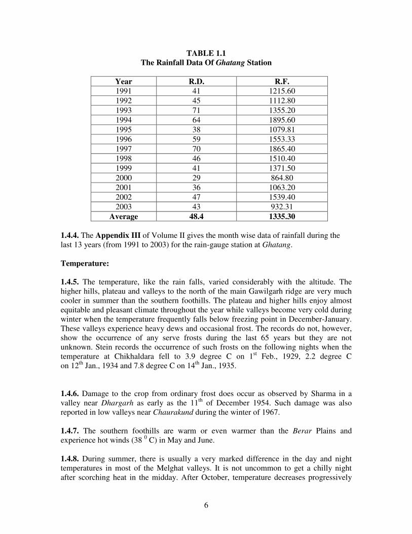
1.4.3. The rainfall data of Ghatang station of Irrigation Department was collected and is
given below. It shows that the number of rainy days is decreasing the annual rainfall is
also decreasing continuously, which is a worrying point.
6
TABLE 1.1
The Rainfall Data Of Ghatang Station
Year R.D. R.F.
1991 41 1215.60
1992 45 1112.80
1993 71 1355.20
1994 64 1895.60
1995 38 1079.81
1996 59 1553.33
1997 70 1865.40
1998 46 1510.40
1999 41 1371.50
2000 29 864.80
2001 36 1063.20
2002 47 1539.40
2003 43 932.31
Average 48.4 1335.30
1.4.4. The Appendix III of Volume II gives the month wise data of rainfall during the
last 13 years (from 1991 to 2003) for the rain-gauge station at Ghatang.
Temperature:
1.4.5. The temperature, like the rain falls, varied considerably with the altitude. The
higher hills, plateau and valleys to the north of the main Gawilgarh ridge are very much
cooler in summer than the southern foothills. The plateau and higher hills enjoy almost
equitable and pleasant climate throughout the year while valleys become very cold during
winter when the temperature frequently falls below freezing point in December-January.
These valleys experience heavy dews and occasional frost. The records do not, however,
show the occurrence of any serve frosts during the last 65 years but they are not
unknown. Stein records the occurrence of such frosts on the following nights when the
temperature at Chikhaldara fell to 3.9 degree C on 1st Feb., 1929, 2.2 degree C
on 12th
Jan., 1934 and 7.8 degree C on 14th
Jan., 1935.
1.4.6. Damage to the crop from ordinary frost does occur as observed by Sharma in a
valley near Dhargarh as early as the 11th
of December 1954. Such damage was also
reported in low valleys near Chaurakund during the winter of 1967.
1.4.7. The southern foothills are warm or even warmer than the Berar Plains and
experience hot winds (38 0 C) in May and June.
1.4.8. During summer, there is usually a very marked difference in the day and night
temperatures in most of the Melghat valleys. It is not uncommon to get a chilly night
after scorching heat in the midday. After October, temperature decreases progressively

7
till December, which is the coldest month. After February, temperature rises rapidly till
May, which is the hottest month of the year.
1.4.9. There is no meteorological observatory in any part of the Melghat. But the records
of temperature recorded at Kharya Station for the year 2004 are as follows:
TABLE 1.2
Table showing Mean Max. and Mean Min. Temperature at Kharya station
Cold season Mean Daily Maximum Temperature 22.970 C
Mean Daily Minimum Temperature 9.40C
Hot Season Mean Daily Maximum Temperature 39.880 C
Mean Daily Minimum Temperature 16.490 C
1.4.10. As no regular temperature record is maintained for the stations in the tract, the
monthly mean maximum and the minimum temperature for surrounding station Kharya is
given in the Appendix II of Volume II of this plan.
SECTION 5. WATER SUPPLY:
1.5.1. The whole of Melghat suffers very badly from water scarcity. The rainwater is
quickly drained off the steep slopes and through the hard-bedded hill streams. As a result,
there are very few perennial springs and not a single perennial river in the tract. Most of
the rivers are dry from December onwards and water is confined to stagnant small pools
called ‘doh’ which are usually the camping places of Gawalis who with their herds of
cattle held a nomadic life nearly eight months by shifting camp in search of water. It is
not uncommon in summer for the cattle of the villagers on the plateau or even the
inhabitants to walk about 5 km. To and from or to climb down and up at least 300 meters
every day to reach the pool or water. The plateaus have porous shallow soil with hard
impermeable strata. Thus there is no other possible source of water to local inhabitants
than to hold up the rainwater.
1.5.2. Chikhaldara Civil Station is, however, slightly better of having two underground
and one over surface tanks for storage of drinking water and three other surface tanks for
washing purposes. But this much water is hardly sufficient and in years of scanty rainfall,
scarcity of water greatly felt.
1.5.3. The B. and C. Department has constructed a tank at Ghatang and anicuts at Bori,
Silona, Behali, Sirashan, Jhira and Khatkali besides some wells for the convenience of
local population and travelers. Recently a tank at Tarobanda has been constructed by the
Forest Department. A regular programme of constructing anicuts, storage tanks and wells
is the urgent need to relieve the local population of this hardship. The existing wells and
tanks are listed in Appendix V and VI of Volume II respectively.

8
SECTION 6. DISTRIBUTION AND AREA:
1.6.1. The total area of East Melghat Division is 56,087.60 ha. classified as under:
(a) Reserved Forest is covering an area of 52,272.26 ha spread over 6 Reserves (2
Reserves completely 4 Reserves partly) ‘A’ Class forest area has been divided into
261 compartments.
(b) ‘C’ Class forest is 958.30 ha. The ‘C’ class area is still identified with survey
number.
(c) Ex-Jahagir forest 2835.97 ha.
(d) 21.07 ha of Unclassed Forest (Compensatory afforestation area)
The East Melghat Division consists of 4 Ranges. Their distribution on the Maps of
survey of India 1:50000 scale is given in the Appendix IX of Volume II of this plan.
1.6.2. The distribution of area, reserve-wise, compartment-wise is as below:
TABLE 1.3
Reserve wise compartment wise distribution of area in East Melghat Division
Sr. No. Name of the
Reserve
Included compartment no.
in Reserve
Total Area
(in ha) of
compartment
Total no. of compartments in
the reserve
1 Motha 1 to 23
Ex –Jahagir (Kulangana)
5027.44 23
2 Chikhaldara 24 to 33,38 to 40,43 to 51 5852.34 22
3 Kohana 52 to 73 3786.19 22
4 Bairagarh 74 to 91,194 to 205,
207,208,298,299,337,
339 to 397,401,404 to
417,421 to 456
25940.10 149
5 Gugamal 949 to 955 2641.18 07
6 Khirpani
1033 to 1070 9025.01 38
Ex-Jahagir
1) Tekada Nagzira
2) Jamoli
3) Girgati
4) Ambapati
5) Chouramal
6) Sakri-Chikhal Pati
7) Dharamdoj
8) Sattirui Patha
2835.97 -
Chinchona
‘C’ Class
Survey no. 5,6,7,8 958.30 -
Total 56066.53 261

9
SECTION 7. STATE OF BOUNDARIES:
1.7.1. The total length of the external boundary lines of the ‘A’ Class reserved forests of
East Melghat Division is 334.793 km. Of which 60.764 km. are natural features such as
rivers, streams, ridges. The length of the Internal Boundary lines are 697.08 Km., of
which 196.629 Km. are natural features. The external boundary along the State Madhya
Pradesh is clearly demarcated with 13 meters (40’) wide cleared lines with serially
numbered pillars of wooden posts embedded in cairn of stones. Since the Reserves are
spread over different divisions, it would be more appropriate to have demarcated
boundaries along Range, Round and Beats.
1.7.2. Internal boundary line of the reserve, though originally demarcated with a clear
line and pillars is not now maintained, so also the interdivisional boundary of these two
divisions.
1.7.3. The boundaries of ‘C’ Class reserved forests have total length of 32.0 km. and are
demarcated by warlies, the position of which is shown on the settlement maps of the
villages in which these forests are situated and which are maintained by the Revenue
Department.
SECTION 8. LEGAL POSITION:
1.8.1. The Bairagarh and Gugamal reserves were originally constituted in 1866 and
1876, respectively. These reserves and the remaining blocks of reserves were declared as
“State Forest, Class a, Division II” or as “State Forest. Class C Division II” by
notifications issued under rule 8 of the Berar Forest Rules of 1871 or section 40 © of the
Berar Forest Law of 1886, as amended by the Berar Forest Law Amendment Law of
1891, as shown below.
TABLE 1.4
Table showing Reserve wise gazette notifications of East Melghat Division.
Name of
reserve
No. and date of notification
issued under rule 8 of the
Berar Forest Rules of 1871
No. and date of notification
issued under section 40 © of
the Berar Forest Law of 1886
Particulars
(1) (2) (3) (4)
Bairagarh H.R.O. No. 14 of 18
January1889
- Declared as “
Demarcated State
Forest”
Gugamal - -
H.R.O. No. 184 of June 1892.
H.R.O. No. 440 of 12 December
1894.
Declared as “
State Forest Class
A”
Declared as “State
Forest Class A,
Division II”

10
Chikhaldara H.R.O. Nos. 205 of 15th
November1883 & 213 of
22 July 1891.
-
H.R.O. No. 14 0f 18
January1889
H.R.O. No. 14 0f 18
January1889
Constituted and
declared as
“Demarcated State
Forest”.
Declared as “State
Forest Class A”.
Declared as “State
Forest Class A,
Division II”.
4. Kohana H.R.O. No. 167 of 1 June 1892. -
H.R.O. No. 444 of
12December 1894.
H.R.O. No. 440 of
12 December 1894.
Declared as “State
Forest”.
Constituted and
declared as “State
Forest Class A”.
Declared as “State
Forest Class A,
Division II”.
Khirpani - C.P.G. No. 612 of 6 July 1911. Constituted and
declared as “State
Forest Class A,
Division II”.
Motha -
- C.P.G. No. 614 of 6 July 1911. Constituted as a
separate reserve of
“State Forest
Class A, Division
II”.
Dhamangaon
and
H.R.O. No. 156 of 1 June 1892. - Constituted and
declared as “State
Forest”.
Chichona-
Nimkhera
-- H.R.O. No. 194 of 6 June1892.
H.R.O. No. 440 of 12 December
1894.
Declared as “State
Forest Class C,
Division II”.
Declared as “State
Forest Class C,
Division III”.
1.8.2. Reserves Motha and Khirpani were formed partly by transfer of areas from the
previously constituted Bairagarh and Gugamal reserves, but mostly out of State forest of
Class C Division III.
1.8.3. Reserves 1 to 6 have been declared as “A Class State Forest” And reserves 7 and 8
as a “C Class State Forest” by the central Provinces Gazette Notification No. 2121 of
November 28, 1913 under section 75 (d) of the Indian Forest Act, VII of 1878, as
amended by Act XV of 1911, and as applied to Berar. At present the Dhamangaon
Reserve is attached with Amravati Division.
1.8.4. A number of alterations and adjustments affecting the area of the reserves have
subsequently taken place. Full details are recorded in Form No. 1, Register of Reserved
Forests, which also contains Notification No. Under which they have been affected. The
list of the notifications is given under Appendix VIII of Volume II of this plan.

11
SECTION 9. RIGHTS AND CONCESSIONS:
1.9.1. Prior to the reservation of the Melghat forests, the petty chiefs who resided in
Melghat exercised certain rights in the tract. These rights were commuted at the time of
reservation and certain annual allowances were granted to these Rajas. Under the M.P.
Abolition of Proprietary Rights Act of 1950 the payment of allowances to the Rajas were
discontinued with the effect from 14th
March, 1951 vide M.P. Forest Department No.
2240-2056-XI, dated 13th
July 1951 except in the case of Raja Aman Singh of Khatkali.
The continuance of payment of the annual compensation of Rs. 1,561-15-7 to Raja Aman
Singh of Khatkali was ordered by the M.P. Government vide the Forest Department
Memo No. 496-2971-XI-51, dated 16th
February 1952. From 1969-70, the payment of the
amount of compensation of Raja Aman Singh of Khatkali was, however, discontinued
under Government of Maharashtra, G.A.D. Resolution No. PPR-1070-62753-S, dated
15th
September 1970 under which the privileges and privy purses of the rules were
terminated with effect from September 6, 1970.
1.9.2. The forests are not burdened with any other rights.
1.9.3. The following concessions are, however, permitted:
(i) The grazing of cattle belonging to the agriculturists of certain villages in the vicinity
of reserved forests, in accordance with the grazing rules in force.
(ii) The villagers of newly constituted Revenue villages are allowed to enjoy the same
privileges and concessions regarding grazing to their cattle and obtaining timber and
other forest produce for their bona fide domestic use as were given to the erstwhile forest
Villagers.
(iii) Agriculturists of villages in the vicinity of the reserved forests are given certain
quantity of timber bamboos for their bona fide domestic use at concessional rates
from the coupes under working.
1.9.4. None of these concessions is a legal right and Government can withdraw these
concessions. The details of the Privileges and concessions are given in the Appendix
XXVI of Volume II of this plan.
---

12
CHAPTER II
FLORA AND FAUNA
CHAPTER II A
FOREST FLORA
SECTION 2A.1. GENERAL DESCRIPTION AND CONDITION OF THE FOREST
2A.1.1. The forests of Melghat are entirely dry deciduous and belong to the formation
‘Dry Tropical Forests’ of the Champion and Seth’s “Revised Survey of the Forest Types
of India” and fall under the sub-group 5-A ‘Southern Tropical Dry Deciduous Forests’.
2A.1.2. The tract being sparsely populated, the biotic factors like fires and grazing are
highly influential which along with general distribution of rainfall, aspect and changes in
depth and nature of soil are responsible in determining the local variations within the
above broad type. The area, north of main Gawilgarh ridge, which receives rainfall higher
than the part south of it, bears good growth. Within this area the better growth is confined
to the northern aspects of the lower gentle slopes and in valleys having good drainage.
Besides receiving less rainfall, the southern part of the region is also subjected to fires
frequently and bears more open forest with species rather resistant to fire.
2A.1.3. The forests in general are composed of a mixture of mostly deciduous species
having teak (Tectona grandis) in high proportion resulting in almost pure teak forest in
patches. Understorey is not well defined and shrubby undergrowth is rather sparse except
lantana, which is very dense in the moist localities where bamboos are absent. Bamboos
(Dendrocalamus strictus) occur extensively and form the chief undergrowth particularly
on moist slopes. The grasses form a thick ground cover throughout the area except where
latana and bamboos are present. Tikhadi (Cymbopogon martini), though scattered, is
found all over the tract but the motia variety contain about 80 to 90 per cent geraniol is
confined to southern part while elsewhere it is ‘Sofia’ variety which has only 38 to 66 per
cent geraniol.
2A.1.4. In general, the quality of the forest is III, which improves in patches on loamy
soil having good drainage, but degenerates into IV quality poorer and arid locality. Along
the lower slopes and in the valleys the density is good but the forests are generally open
in the upper steep slopes and plateau. The natural regeneration of tree species is mostly
deficient.
SECTION 2A.2. COMPOSITION OF THE CROP:
2A.2.1. For the purpose of description, these forests are distinguished into the following
local sub-types in the types as per Champion and Seth’s revised classification of forest
types.

13
Table No. 2.1
Table showing the classification of forest types of East Melghat Division
Champion and Seth’s Classification Local sub-type
1 2 3
Group 5- Tropical Dry Deciduous Forests
Sub-group 5A Southern Tropical Dry Deciduous Forests
I Climax type—
(1) 5A/Ci Dry Teak bearing forest
5A/Cib Dry Teak Forest (i) Teak forest
(2) 5A/C3 Southern Dry mixed deciduous forest (ii) Tiwas forest
(iii) Mixed forest
II Edaphic climax—
5/E2 Boswellia forests (iv) Salai forests
2A.2.2. The factors influencing the composition and condition of the crop are so variable
in Melghat that even the limited limits of a compartment it is not uncommon to find
abrupt changes in the crop representing all the above local sub-types.
Teak Forests:
2A.2.3. These forests are more extensive and cover major parts of Bairagarh, Gugamal,
parts of Kohana, Chikhalda and Motha reserves comprising of whole of Jarida range and
part of Ghatang, Chikhaldara and Anjangao ranges of East Melghat Division. It
generally occurs between the elevations ranging from 300 m to 900 m. The extent of the
forest is about 46,000 ha.
2A.2.4. The general quality of the forest is III. The better growth is found all along in
Bairagarh and Gugamal reserves except along bigger steep slopes and plateau, which are
covered with poor forests of IV-a or IV-b quality. Quality II forest is found in patches
confined to the valleys. The forests lying to the south of main ridge and parts of
Chikhalda reserves are mostly of IV-a and IV-b quality.
2A.2.5. The density of stocking is good throughout the area, being best in the valleys and
along the moderate slopes. However, it degenerates along the steep slopes having
southern aspect and on high elevation plateaus.
2A.2.6. So far, teak (Tectona grandis) is the most prominent species in the better quality
forests. It forms nearly 50 per cent of the growing stock. Teak (Tectona grandis) has
higher percentage along the lower gentle slopes and in valleys and in small patches it is
almost pure but the percentage decreases with the rise in altitude.
2A.2.7. Teak (Tectona grandis) is mostly of middle age to mature.
14
2A.2.8. Haldu (Adina Cordifolia), and dhaora (Anogeissus latifolia) are the main
associates of teak while saj (Terminalia tomentosa) forms a fair proportion in low-lying
areas. Other associates are lendia (Lagerstroemia parviflora), kekad (Garuga pinnata),
kasai (Bridelia squamosa), kalam (Mitragyna parvifolia), dobin (Dalbergia paniculata),
mokha (Schrebera swietenioides), kahu (Terminalia arjuna), bahera (Terminalia
bellerica), mahuwa (Madhuca latifolia), am (Mangifera indica), bhilwa (Semecarpus
anacardium), bija (Pterocarpus marsupium), kulu (Sterculia urens) and kusum
(Schleichera oleosa).
2A.2.9. The understorey consists of moyen (Lennea grandis), Tiwas (Ougeinia
oogeinensis), tendu (Diospyros melanoxylon), dudhi (Wrightia tinctoria), dhaman
(Grewia tiliaefolia), Aonla (Emblica officinalis), salai (Bosewllia serrata), achar
(Buchanania lanzan), siwan (Gmelina arborea), gongal (Cochlospermum religiosum),
ghot (Zizphus xylopyra), bhosa (Coix gigante), aran (Eleaeodendron glaucum), amaltas
(Cassia fistula), palas (Butea monosperma), rohan (Soymida febrifuga), hirda
(Terminalia chebula), khair (Acacia catechu) and ber (Zizyphus mauritiana).
2A.2.10. The shrub undergrowth is sparse except in the areas invaded by lantana, which
forms practically impenetrable dense mass throughout the moist locality. However, it is
rare or practically absent where bamboos are present as in Jarida range or where dense
growth of grass exists. Other shrubs that occur are marorphal (Helicteres isora), bhandar
(Colebrookia oppositifolia), Nirgudi (Vitex negundo), khirsali (Nyctanthes arbortristis),
bankapas (Thespesia lampas), baibarang (Emblica tsjeriamcottam), gokharu
(Acanthospermum hispidum) and pithondi (Fluggea microcarpa). The grassy
undergrowth is dense and forms main ground cover where bamboos and latana are
absent. The most common and abundant grasses are pochati (Heteropogan ritchei),
gondhali (Anthistiria ciliata), kusal (Heteropogan contortus), sainar (Ischaemum
sulcatum). Other grasses found area phuli (Apluda varia), tikhari (Cymbopogan martini),
Paonia (Ischaemum sulcatum), marvel (Dicanthium annulatum), sheda (Ischaemum
laxum), baru (Sorghum halepense) and Jungalikela (Musa superba).
2A.2.11. The climbers are few and generally confined to moist localities. These are
nagbel (Cryptolepis buchanani), palasbel (Butea superba), mahul (Bauhinia vahlii),
Chilati (Acacia pennata) and kaunchkhuri (Mucuna pruriens).
2A.2.12. Jungalikela is found very scattered along the rocky hillsides and on slopes along
the streams.
2A.2.13. Haldu (Adina cordifolia) is found where the crop is well stocked, generally at an
elevation above 600 m. trees of over 180 cm. girth are usually common as Haldu (Adina
cordifolia) was not exploited in the past. In compartment number 386 of Jarida range,
along the Kursi river upto Chuleta Doh Haldu forest is found as a local sub type. Salai
(Boswellia serrata) occurs along drier upper slopes, which are poorly stocked. The trees
are mostly crooked. Tiwas (Ougeinia oogeinensis) though common in occurrence,
increases its percentage with the rise in elevation, but does not attain big size. The trees
of 75c.m. girth are generally rare, and if present, are unsound and cranky. Semal

15
(Bombax ceiba), bija (Pterocarpus marsupium) and shisham (Dalbergia latifolia) form a
negligible proportion in the crop.
2A.2.14. Natural regeneration of teak (Tectona grandis) is somewhat deficient, though;
stray, very small patches of reproduction are sometimes observed in the fully stocked
forests. Regeneration of dhaora (Anogeissus latifolia), Tiwas (Ougeinia oogeinensis),
Haldu (Adina cordifolia) and saj (Terminalia tomentosa) is fair, while that of the other
species is generally scanty. The seedlings of Haldu (Adina cordifolia) are seen sometimes
concentrated in patches on flat raised ground.
2A.2.15. Comparatively poor and open teak forests of IV-a and IV-b quality having
composition of the crop almost the same as described under paras 2A.2.8. to 2A.2.10. are
found in parts of Kohana, Chikhaldara, Motha reserves and Dahegaon block, the
percentage of teak (Tectona grandis) in the crop is, however, not more than 45. The
density and quality of the crop improves in depressions on cooler aspects and along the
streams.
Tiwas Forests:
2A.2.16. This type is found on the top of the higher hills, plateau and terraces over almost
the whole of area at an altitude of over 1,000 m. The quality of the forest is poor, mostly
IV-b. These forests are generally very poorly stocked with stunted tree growth. There are
numerous blanks containing only grasses, lantata or bhandar (Colebroekia oppositifolia).
Tiwas (Ougeinia oogeinensis) is the most prominent species although it forms only 10-15
per cent of the growing stock. The remaining stock is made up by Dhaman (Grewia
tiliaefolia), Aonla (Emblica officinalis), kumbhi (Careya arborea), jamun (Schyzigium
cumini), gular (Ficus glomerata), semal (Bombax ceiba), arang (Eriolaena hookeriana),
amaltas (Cassia fistula), pakar (Ficus infactoria), phangra (Erythrina suberosa), kolsa
(Glochidion velutinum), dahipalas (Cordia macleodii), bahera (Terminalia bellexica),
ghatber (Zizyphus xylopyra), thur (Euphorbia nivulia) and maidalakri (Litsea glutinosa)
etc. Teak (Tectona grandis) occurs in this type of forests but is generally scattered. On
some of easy slopes on northern aspects, it reaches to fair dimensions but elsewhere it is
stunted and very poorly formed.
2A.2.17. Lantana and bhandar (Colebrookia oppositifolia) have invaded large areas to
the exclusion of other undergrowth. Most of the tops of ridges and plateau in the
Chikhaldara, Jarida and Ghatang ranges are under dense impenetrable lantana. It is
generally observed that grazing areas were invaded by lantana. Kusal (Heteropogon
contortus), sainar (Sehima sulcatum) and goudhali (Anthistiria ciliata) are the common
types of grasses found in this type. Tikhari (Cymbopogon martini) grass is also found
here and there and is generally of ‘sofia’ variety.
2A.2.18. Most of these high level plateaus were under shifting cultivation for a long time
and besides locality factors such as high winds, shallow soils, and lack of soil moisture,
this has been a very important factor responsible for the inadequate stocking of these
areas.

16
2A.2.19. Regeneration of teak (Tectona grandis) is absent but tiwas (Ougeinia
oogeinensis) seedlings and saplings are plentiful. Regeneration of Kunkum and Aola was
noticed.
Mixed Forests:
2A.2.20. This type of forest is found on the upper hills of Kohana, Chikhaldara and
southern-eastern part of Gugamal reserves and practically whole of Kirpani reserve. In
Bairagarh reserve, it occurs in patches interspersed with teak forest. The quality of the
forest is mostly IV-a and IV-b. But in shady places it touches to III. The forest is well
stocked, better stocking being obtained along the northern aspect. The composition of
crop is a mixture of variety of species, prominent being Tiwas (Ougeinia oogeinensis),
dhaman (Grewia tiliaefolia), moyen (Lannea coromandelica), salai (Boswellia serrata),
ghatbor (Zizyphus xylopyra), saj (Terminalia tomentosa), sewan (Gmelina arborea),
tendu (Diospyros melanoxylon), kunkum (Mallotus phillipensis), etc. Bhirra
(Chloroxylon swietenia) is very common along the hill near Behali. Teak (Tectona
grandis) is rare, however, it is found encroaching on the fringes where teak forest adjoins
this type. Bamboos are generally absent. The undergrowth varies considerably with the
density. Lantana has invaded this type at many places. Common grasses are gondhali
(Anthistiria ciliata) and pochati (Apluda varia). Regeneration of trees species is scanty.
2A.2.21. Flora Of Chikhaldara Plateau: The salient features of flora of Chikhaldara
plateau are given below.
i) The vegetation of Chikhaldara plateau has been influenced much by the interference
of biotic factors. Firstly, it is gradually expanding as a Hill station and secondly, a lot of
temperate exotic species have been inducted in this plateau. Chikhaldara and Vairat are
in the Melghat portion of Satpuda hill range with elevation of 1116.79 meter and 1178.85
meter respectively with higher rainfall and typical climate conditions.
ii) This led to the introduction mainly by the British officers and the missionaries, of
typical species, which need a temperate condition, especially conifers and others such as
Cupressus species, Pinus species, Thuja sp., Cryptomeria sp., Areaucaria sp., Grevillea
robusta and coffee plantations. All these species are growing well on the plateau. Some of
the trees among them have grown very old. The trees present in the plateau are Dillenia
indica, Ficus elastica, Prunus persicai, Cedrela toona, Magnolia sp. are growing in forest
garden. These trees are suggestive of the climatic and edaphic factors of Chikhaldara
plateau. There are certain indigenous species whose population has dwindled and need
multiplication. The species are Mallotus Phillipensis, Radermachera xylocarpa, Careva
elliptica, Casearia graveolan, Mangifera indica, Careya arborea, Syzigium cumini,
Terminalia sp., Embelia rubes, Stereospermum personatum, Litrea glutinyse, Trema
orientalis, Finsete superbum (wild banana).

17
Salai Forest:
2A.2.22. Forest of this type is mostly confined to Southern-Western parts of Gugamal
reserve in Anjangaon Range and also occurs along the lower slopes of Chikhaldara
range. The quality is mostly IV-a and IV-b. The crop is generally open. Full stocking is
found only on relatively small areas. Salai (Boswellia serrata) is the main species and in
many places grows almost pure. Its most usual associate is dhaora (Anogeissus latifolia),
other being lendia (Lagerstroemia parviflora), Tiwas (Ougeinia oogeinensis), moyen
(Lannea grandia), kekad (Gaurga pinnata), mokha (Schrebera swietenioides), palas
(Butea monosperma), aonla (Emblica officinalis), dhobin (Dalbergia paniculata), gongal
(Cochlospermum religiosum), etc. Teak (Tectona grandis) occurs only in small patches
particularly along the Nala banks and lower gentle slopes and is found invading sheltered
locations. Khair (Acacia catechu) and Hiwar (Acacia leucophloea) occur chiefly on the
plain areas at the foothills. Khair (Acacia catechu) is found to attain size not more than
45 cm. in girth. Lokhandi (Ixora parviflora) is common only along the streams.
2A.2.23. Natural regeneration is generally very scanty. Gongal (Cochlospermum
gossypium) regenerates profusely on some of the dry hills. Bamboos are generally absent.
Bushes of ber (Zizyphus mauritiana), Chilati (Acacia pennata), Bharati (Gymnosporia
montana), tarota (Cassia tora) and samalu (Vitex negundo) and grasses such as pochati
(Apluda varia), gondhali (Anthistiria ciliata), kusal (Heteropogon contortus) and sainar
(Sehima suicatum) form the undergrowth.
2A.2.24. In few patches of Chinchona ‘C; Class forest regeneration of chandan
(Santalum album) was observed while the host plant is lantana. Samalu (vitex negundo)
and lantana are competing to occupy the area
.
2A.2.25. Tikhari grass (Cymbopogon martini) both of ‘sofia’ and ‘motia’ varieties occur
in this forest. Motia variety is in abundance in almost the whole of Anjangaon range is
scattered on the southern foothills in Chikhaldara range.
2A.2.26. Climbers are very few and usually found in shady, moist situations along the
streams. The more common climbers are palasbel (Butea superba), nagbel (Cryptolepis
buchanani) and Chilati (Acacia pennata).
2A.2.27. Microclimate: Due to variation in the light, temperature, moisture, humidity and
soil different types of vegetation occur in the area. The compartments 51, 55, 56 of
Masaundi beat of Ghatang range are having Amba-Jamun vegetation particularly above
1000M altitutde. The regeneration of jamun is abundant both in the forest and nonforest
areas. These areas bear leaves even in the month of May indicating semi evergreen or
moist deciduous forest conditions. Similar vegetation type is found in Shirasban nala but
it is at a lower altitude. Here the variation is due to the prevailing moist conditions in the
valley as well as to the availability of moisture in the soil.

18
SECTION 2A3. INJURIES TO WHICH THE CROP IS LIABLE:
2A.3.1. The most significant menacing agency causing considerable damage to the forest
is grazing. Next to it is fire, followed by lantana, to some extent. Other injurious agencies
such as insect, wild animals etc. are very negligible. The offence cases registered during
the period from 1993 to 2004 are given in the Appendix No. XVI of Volume II of this
plan.
Fire:
2A.3.2. Fires, though not heavy, are of common occurrence in the recent past. Due to
highly combustible undergrowth consisting of dense grass and dry lantana, a tiny spark
can trigger off a conflagration in a short time. As the area is thinly populated the labour is
in short supply. The high hot winds during summer, combined with the hilly
configuration flames of the land-fires spread easily when it occurs and engulfs vast areas
before it can be brought under control only by counter firing. Owing to lantana
undergrowth, the fire rises to a height of 4-6 m. The height of the flame, thick lantana
undergrowth, steep slopes and distance of the villages are the main impediments in
putting off the fire. The fire spreads so rapidly before the arrival of the staff. It would be
dangerous to put off fire manually in such high-rise flames. With a long standing fire
protection measures and vigilance of the staff, the forests, in general, have been protected
against fires in spite of the handicaps. The cause of the fires is given below.
1.To get good flush of tendu leaves people set fire to the area after flushing tendu plants
to the ground level between Feb. 15 to March 15.
2.To collect Mahuwa flowers people burn the surface to make it black so that it becomes
easier to pick the flowers. Generally it is carried in the March month.
3.To get good growth of grasses the gaolis set fire to the forest in the month of May.
4. To trace the Sambhar horns the local people set fire to the forest in the month of May.
5. The night torches used in the night to travel from one village to other village also cause
fires in the forest.
6. To take revenge some times people set fire to the forest. Some times to prevent the
bear attacks also they set fire to the forest.
Grazing:
2A.3.3. The entire forests are liable to damage from grazing except the interior areas
away from the villages. The two ‘C’ class blocks of forests are very heavily grazed. In
fact, there is hardly any grass left in these blocks and they only serve as exercise grounds
for the cattle. These areas are very undulating and the soil is very poor and are therefore,
even unfit for cultivation. The ‘A’ class forests adjoining the Berar plains are very hilly,
and the upper slopes are steep. The grazing is, therefore, confined to the lower hills and
the calculated incidence does not give the true picture of the grazing pressure here, while
a large inaccessible area of the units remains ungrazed. A realistic calculation of grazing

19
incidence is required. No grazing incidence should be calculated for the slopes above 25
degree.
2A.3.4. The forests on the plateau in Chikhaldara range are heavily grazed only during
the few months of rainy season after which most of the cattle are shifted to lower ranges
on account of the shortage of grass and water on the plateau.
2A.3.5. The grazing incidence figures are misleading as the erstwhile forest village cattle
are grazed only in the immediate vicinity of the villages. The true grazing incidence in
the areas adjoining the villages is therefore, heavier than is shown by the figures.
2A.3.6. The animals, mostly buffaloes, from Chikhaldara and some rayatwari villages,
and some cattle from Berar plains are grazed from cattle camps, locally known as hettis
in the interior of forests in the hot season. During this hot weather grazing after the
depletion of grasses, grazers start lopping green foliage, especially of ain (Terminalia
tomentosa), bhosa (Bauhinia racemosa), kusum (Schleichera oleosa), karkha (Bridelia
retusa), Dhaman (Grewia tiliaefolia), kahu (Terminalia arjuna), salai (Boswellia serrata),
Ghatbor (Zyzypus xylocarpa) and bamboo (Dendrocalamus stictus). The lopping of trees
has led to degeneration of the forests. The seedlings are grazed and saplings of these
fodder tree species have been hacked to provide fodder to the cattle. Continuous and
heavy grazing not only prevents regeneration of tree species but also the young
regeneration obtained during the period of closure, is lost soon after the area is opened for
grazing. In areas with clayey soil, the trampling by cattle results in hardening of soil and
reduction in the soil aeration. In sandy soils, heavy grazing results in accelerated erosion
and denudation. The grazing on undulating lands loosens the soil, which results in the soil
erosion. The problem of migration of cattle is severe.
2A.3.7. According to the directives issued by the Government contained in the land
reforms Department Ex-Madhya Pradesh memorandum No. 1290-1227-XXVIII dated 4th
September 1953, sheep and goats are not allowed to graze in forests meant for production
of timber or in the forest areas where villagers generally exercise their nistar rights. But it
is not uncommon to see goats grazing in timber forests. The goat grazing is prohibited
because of their close level grazing in which the seedling or grass rhizome is uprooted.
Lantana:
2A.3.8. Lantana, which is indigenous to South America, was introduced into Ceylon in
1842 and thereafter into India as an ornamental garden shrub. It was brought to Melghat;
probably from South India by some misguided persons many years ago round about 1870
and certainly much before 1890. It is said by old forest villagers that when lantana first
appeared in Melghat, it was planted intentionally along roadsides in Sembadoh and
Raipur ranges. It is noticed that lantana is dense near the villages and it is quite likely that
it was planted as a hedge round the fields. It is the greatest menace to the Melghat forests
now, except for some of the drier salai forest in the Aanjangaon ranges there is hardly
any compartment where lantana is not found and in most of them it forms very dense
thickets. Its spread during the last half century is very alarming. Regarding lantana

20
menace in 1895, Bagshawe in his Working Plan for the area, mentioned, “At present the
only serious inroad is down the Ambadoh nadi”, and it was only found in considerable
quantities in higher altitudes which contain forest of comparatively little value. Similarly,
Dunbar Brander in his Working Plan in 1916 remarked, “Mr. Williamson”, in submitting
proposals for the revision of the Working Plan in 1901, considered climbers (including
lantana) need only be cut when found on teak and was of opinion that during his seven
years acquaintance with the Melghat, their tendency was to decrease. This is a most
remarkable statement in the light of the present condition of affairs and if, correct, shows
the very rapid increase which must have taken place during the last three decades”.
Lantana thrives both in the open and under shade. It has not, however invaded the area
occupied by bamboos. Besides forming a dense cover on the ground, which does not
permit any regeneration of trees species, lantana, when dry, is extremely combustible. It
throws up a huge flame, which scorches the leaves of trees completely. The splinters of
lantana go high up and are blown across wide area, which make fire fighting very
difficult.
2A.3.9. The damage from lantana was realized quite early and it is believed that efforts to
control the spread of lantana were made in the early nineties. The measures were relaxed
during the World War I, 1914-18 for reasons of economy. By 1921 lantana had invaded
extensive area. From 1921 to 1931 deliberate fires in the middle or later part of the hot
season were chief measures adopted to kill lantana. This drastic method had to be
abandoned in 1931, because fires were causing appreciable damage to the tree growth not
only in the lantana-infested areas but also in the adjoining forests where they would
spread. Since then, uprooting of lantana by hand and with the help of elephants in the
coupes under working started. The spread of lantana could not be checked either with
burning or by uprooting as its root suckers give rise to shoots again which restock the
area very soon. The areas around Chikhaldara, which were set to fire and the coupes in
which uprooting was tried for few years are as full of lantana as ever.
2A.3.10. The areas containing lantana were stock mapped to assess the spread under
different Plans revised from time to time viz. Stein’s Plan, Sharma’s Plan as well as P. P.
Joshi’s Plan for the area. Accordingly, it still covers the whole of Chikhaldara, Ghatang
and Jarida ranges.
2A.3.11. At present, lantana is being removed under EGS with a view to prevent further
spreading of lantana into deeper forests. It was observed that grazed areas are invaded by
lantana. After the invasion of lantana, cattle start grazing in a different area, leading to
fresh invasion of lantana in the newly grazed areas. So, grazing areas be restricted to the
surroundings of villages to prevent further spreading of lantana. It is also observed that
lantana fruits are the source of food to bears; its bushes are acting as hiding places to wild
animals, as a shade provider during the scorching summer season. It is also observed that
the lantana is providing the necessary breeding habitats.
2A.3.12. Lantana bushes are providing a very good cover to soil, acting as a soil Binder.
Rotational grazing has to be practiced in those areas, where lantana was removed
otherwise neither grasses nor any other undergrowth will come up leading to soil erosion.

21
Reducing/Controlling the grazing areas perhaps would be the best solution to prevent the
lantana spread, it was also noticed that man-animal encounters are few in number in the
lantana cleared areas compared to lantana covered dense areas.
Encroachments:
2A.3.13. In recent past tendency for encroaching forestland for cultivation has increased.
The actual encroached area is higher than the recorded one. The eligible encroachers
encroachment is yet to be finalized at the time of the preparation of the plan. The area
under dispute is not clearly demarcated. A few cases of clearance of the forest growth for
cultivation are booked in some parts of Anjangaon Range. Prosecution of offenders led to
bitter relationship between the forest staff and the local people. Samaj Kranti Aghadi an
organization based at Murtizapur is advocating the people to encroach the forestland.
Illicit Fellings:
2A.3.14. The forests are in a compact block and are sparsely inhabited by mostly
rayatwari villages, which were erstwhile forest villages. The markets for forest produce
are situated at a long distances and there is no local demand for forest produce. The
whole of the forests is worked departmentally. Occasionally illicit fellings are carried out
in the forests on outer fringes of Anjangaon Range and areas adjoining to M.P of Jarida
Range, where strict protection measures are required.
Frost:
2A.3.15. Frosts occur in the valleys. Frost damage is caused in the low areas which are
open, have either been once under cultivation or adjoin cultivation. No damage is caused
to the crop if it is well stocked unless a severe frost occurs, which is rare. Teak (Tectona
grandis) is the most susceptible species to frost damage. Other species usually occurring
in these areas viz., saj (Terminalia tomentosa), kahu (Terminalia arjuna), Dhaman
(Grewia tiliaefolia), baranga (Kydia calycina), ber (Zizyphus mauritiana), khair (Acacia
catechu) and palas (Butea monosperma) etc. are quite resistant to frost damage. In the
years of ordinary frost, the damage is confined to young growth when the leaves and
tender shoots are killed, but severe frost kills saplings and the leading shoots to poles and
sometimes even the crown of the old trees are affected. In some of the badly affected
areas, the teak trees are very forked and branchy and present in general an unhealthy
appearance. If such areas are clear felled, the tree growth is completely prevented from
coming up by frost and areas reduced to open grasslands. It is, therefore, indicated that
big gaps in canopy should not be created in the frost liable areas.
2A.3.16. The liability of particular area to frost damage is indicated by its low lying
situation, black cotton soil, the presence of dominant saj (Terminalia tomentosa) bushes
like dhi, samalu, pithondi, baibrang, etc., and karsali and baru grasses.

22
2A.3.17. The records show that there has not been any severe frost during the last 65
years. Small damage to young crop is noticed in some of the worked coupes here and
there, as per P.P.Joshi’s observations.
2A.3.18. The forests of Chikhaldara range lying to the south of the main ridge of
Gawilgarh hills do not experience frost damage.
Drought:
2A.3.19. The forests, especially in the drier parts in the south and west, are liable to
damage from drought only in or immediately after years of deficient rainfall. During the
famine in the year 1899, chiefly old and unsound trees died in such a large numbers that
in 1901 the prescriptions of Working Plan had to be held in abeyance to exploit these
trees. Mortality in small stray patches on rocky substrata during the year of less rainfall is
attributed to drought. The damage, however, is negligible. In the past 50 years severe
drought has not been recorded. In 1951-52 the rainfall was below normal, but no
appreciable damage was noticed to the crop except that few trees of teak dried here and
there.
Winds:
2A.3.20. The effects of winds are negligible. Occasionally, trees are uprooted and
branches broken by the high gusts, which accompany thunderstorms towards the end of
the hot season. The stunted nature of the forest in exposed situations at high elevations is
partly due to strong winds, which are frequent during the hot and rainy season.
Insects:
2A.3.21. Attacks of teak defoliator (Hyblea puera) and the leaf skeletoniser (Hapalia
macheralis) occur almost every year in teak stands but the damage is seldom on of a
severe nature. Much damage is done to bamboos by chrysomelid and curculioid beetles,
which make tunnels in young culms during the rains.
Animals:
2A.3.22. Sambhars are found all over the division although their number is not very
great. They rub their horns to the teak poles and debark them. These animals do some
damage to the young coppice shoots and poles by scratching their horns of side against
the poles. Occasionally some damage by porcupine is also noticed. They usually eat the
outer bark or cambium of haldu, mohwa, amaltas, bhilwa, etc., near the base of the trees.
2A.3.23. As mentioned by Dr. Schlich in 1883 rats had done great damage in the teak
plantations and their reappearance in large number is recorded in the annual reports of
1902.
2A.3.24. The damage by animals in Melghat forests, generally, is very little.

23
Chapter II B
FOREST FAUNA
SECTION 2B.1. DESCRIPTION OF FAUNA:
2B.1.1. The wild animals noticed in the tract are:
1) Carnivora:-Tiger (Panthera tigris) Panther (Panthera pardus), Hyena (Hyena hyena),
Jackal (Canis aureus), Indian Fox, (Vulpes bengalensis), Jungle cat (Felis chaus), Indian
wild dog (Cuon alpinus).
2) Herbivora:- Four horned antelope (Tetracerus quadricornis), Sambhar (Cervus
unicolor), Barking deer (Muntiacus muntjac), Spotted deer (Axis axis), Blue bull
(Boselaphus tragocamelus), Gaur (Bos gaurus), Common Langur (Presbytis pileatus),
Indian Hare (Lepus nigricollis), Black buck (Antilope cervicapra).
3) Omnivora:- Civet cat (Paradoxurus hermaphroditus), Sloth bear (Melursus ursinus),
Wild boar (Sus scrofa),
4) Aves: - Apart from the common birds the following avi-fauna are observed: -
Pea fowl (Pavo cristatus); grey jungle fowl (Gallus sonneratii); Painted partridge
(Francolinus pictus); Common quail (Conturnix); Crow pheasant (Centrupus sinensis);
yellow legged green pigeon; gray tit; pond heron; cattle egret; crested serpent eagle;
Golden backed woodpecker (Dinopium bengalensis); Black drongo (Discrurus
adsinillis); kingfisher; small kingfisher, Long billed and White backed Vultures etc.,
SECTION 2B.2. HISTORY OF THE WILD LIFE MANAGEMENT IN GENERAL:
2B.2.1. From time immemorial the wild animals have occupied a place of pride in the
folklore of Indian culture. They were respected and protected by the tribals who never
used to kill the animals for fun or pleasure. However, hunting became an important
pastime for the Rajas and Maharajas who used to hunt and kill the animals for meat as
well as for preparing trophies. In the Reserved Forests, hunting was restricted and
licenses were used to be issued for small game, big game, etc. and shooting blocks were
set apart, where the animals specified in the license only could be hunted.
However, after the enactment of the Wildlife (Protection) Act, 1972 and subsequent
amendments in this act particularly those in 1991 and 2002, no permission for hunting of
wild animals, as game or sport, can be granted. Hunting of wild animals however can be
allowed for special purposes but only in exceptional circumstances. This act also enjoins
on us the responsibility for wildlife conservation outside the protected areas. The wildlife,
which used to flourish in the forests of the division, is threatened due to various factors
like population explosion, encroachments, improved network of road and availability of
sophisticated weapons. Due to increase in demand for wildlife products all over the
world, poaching problems have increased over the years.
24
SECTION 2B.3. LEGAL POSITION:
2B.3.1. The first step towards the protection of wildlife was taken by including certain
provisions, in this regard, in the Berar Forest Act of 1886. Under Section (3) sub section
7, the definition of forest produce incorporated the 'skins, tusks, bones and horns' and as
per Section 10, sub section 4, The residency by orders may regulate any part of the state
Forests for hunting, shooting, fishing, poisoning water and setting up traps or snares."
The Berar Forest Act, 1886 amended in 1891 provided under section 7(b) that
forest produce includes the following when found in or brought from a forest:
"Wild animals, skins, tusks, horns, bones, silk cocoons, honey and wax and all
other parts or produce of animal."
Section 7(2)(b) of this act after this amendment provided that any one who hunts,
shoots, fishes, poisons water or sets traps or snares, shall be punishable with the fine
which may extend up to fifty rupees or, when the damage resulting from the offence
amounts to more than twenty five rupees, to double the amount of such damage. Section
10(4)(iii) of this act empowered the resident to frame the rules regarding regulation of
hunting, shooting, fishing, poisoning water and setting traps and snares.
2B.3.2. Vide Notification G.I.F.D. No. 2197-1-B, dated 13th October 1911, the Indian
forest Act, 1878 was also made applicable. The section 2(b)(iii) included wildlife in its
definition of the forest produce. Section 25 (i) provided that any person in contravention
of any rules, which the local Government may from time to time prescribe, kills or
catches elephants, hunts or shoots fishes, poisons water or sets traps or snares shall be
punishable with imprisonment for a term which may extend to six months or with fine
not exceeding five hundred rupees or with both in addition to compensation for damage
done to the forests.
2B.3.3. After the promulgation of the Indian Forest Act 1927, rules relating to wildlife
regulations were framed under section 26(l) and 76(d). These were essentially to regulate
hunting of wild animals and were given in the appendix VIII of MP Forest Manual Vol.
II. Wild Birds and Animal Protection Act 1912 as amended in 1935 also ensured
protection to certain animals and a check on hunting of others. Shooting block system of
hunting was started from 1927. Under the provisions of the two acts, the Conservator of
Forests in consultation with the DCF concerned used to declare areas having abundant
game as open to hunting. The DCF accordingly used to issue shooting permits, wherein
the type of game and their number allowed to be hunted together with other relevant
conditions were used to be mentioned.
2B.3.4. The Bombay Wild Animals and Wild Birds Protection Act, 1951 was extended to
Vidarbha region from 1.6.1961. Though this act did not propose a significant change in
the management of game in the Reserved and the Protected Forests, yet it incorporated
following significant provisions:
1. Its provisions were also applicable out side the Reserved and the Protected
Forests.

25
2. Arms license holders for sports were to register themselves with the Wildlife
Preservation Officer.
3. This Act prescribed a closed season for hunting and classified game into four
categories, viz. small game, big game, special big game, and pet animals.
4. It also sought to control transaction in trophies and other wildlife products.
5. Wildlife Advisory Board was constituted under this act to advise the government
on various important matters concerning wildlife.
DEVELOPMENTS AFTER 1972:
2B.3.5. At the national level, the Indian Board for wildlife was constituted in 1952. Its
main object was to devise ways and means for conservation of wildlife through co-
ordinated legislative and practical measures and setting up of National Parks and Wildlife
Sanctuaries. A comprehensive and unified National and State Park Act, 1971 was passed
which provided for appointment of an Advisory Committee to advise in regard to the
constitution and declaration of National Parks and Sanctuaries and formulation of policy
for their administration and management. The Parliament then enacted the Wildlife
(Protection) Act, 1972, which came into force in the State of Maharashtra with effect
from 1st June 1973. With this, other acts relating to any matter contained in this Act and
in force in the State stood repealed. This act as amended from time to time as well as the
various regulations made under this act and guidelines issued by the central and the state
govt. provide for establishment of a network of national parks and sanctuaries
representing various habitats and for giving protection to all type of wildlife in the state.
These provisions also address issues relating to the management of wildlife outside the
protected areas. Following rules have so far been enacted under the relevant sections of
this act.
i) The Wildlife (Stock Declaration) Rules, 1973 (became effective in Maharashtra with
effect from 1.6.1973).
ii) The Wildlife (Transactions and Taxidermy) Rules, 1973 (became effective in
Maharashtra w.e.f. 16.1973).
iii) Wildlife (Protection) (Maharashtra) Rules, 1975 (became effective from 6.3.1975).
iv) The Wildlife (Protection) Rules and Licensing (Additional matters for consideration)
Rules, 1983 (became effective from 13.4.1983).
v) Wildlife (Protection) Rules, 1995
vi) Wildlife (Specified Plants-Condition for Possession by License) Rules, 1995
vii) Recognition of Zoos Rules, 1992.
viii) Declaration of Wildlife Stock Rules, 2003.
2B.3.6. Besides the above specific legal framework available for wildlife management,
provisions contained in Indian Forest Act, 1927, Forest Conservation Act, 1980 and The
Environment (Protection) Act, 1986 may go a long way in protecting and conserving the
biodiversity of this division. Gugamal National Park is geographically located next to the
division. Clearance under the Environment Protection Act, 1986 from environmental
angle is required from the govt. of India for any project (other than those relating to
improvement of forests and particularly the projects relating to industrial activities

26
damaging the environment of these Protected Areas) including an industry located within
10 km from these PAs. Hence, such clearance is obligatory in case of many of the
projects involving forestland of this division because large part of its forests is located in
the vicinity of these protected areas.
SUMMARY OF WILDLIFE (PROTECTION) ACT. 1972
2B.3.7. The Wildlife (Protection) Act 1972 provides for effective protection and
conservation of wildlife, that is, fauna as well as flora, total ban on hunting of wild
animals and severe restrictions on wildlife related trade. The act has been amended from
time to time and its amendments done in 1991 and recently in 2002 have brought far-
reaching changes in it. Summary of salient features particularly the provisions regarding
ban on hunting, restrictions on trade, powers and duties of forest officers and
conservation of wildlife outside the protected areas is given below.
2B.3.8. The scope of the Wildlife (Protection) Act, 1972 has been widened appreciably,
which can be summarised as below.
(i) The objective of Wildlife (Protection) Act 1972 is Protection of Wild animals,
Birds and Plants with a view to ensuring the ecological and environmental
security of the country.
(ii) The words and phrases related to hunting like game and game reserve are now
totally removed from wildlife management.
(iii) New categories of PAs have been added. 'Chapter IV - Sanctuaries, National
Parks and Closed area', has been changed to 'Chapter IV - Protected Areas' and
Protected area has been defined under Section 2(24A). These categories are-
1) Sanctuary (Section 2(26) and 18)
2) National Park (Section 2(21) and 35)
3) Conservation Reserve (Section 36A)
4) Community Reserve (Section 36C)
(iv) The category of game reserve was deleted from this chapter by the 1991 amendment
and that of closed area has now been deleted through the 2002 amendment.
(v) The 1991 amendment brought zoos under its jurisdiction and the 2002 amendment
makes norms for proper upkeep of animals applicable to zoos, also applicable to circus
and rescue centers.
2B.3.9. A wild animal can be hunted only under special and exceptional circumstances
and that too after following elaborate procedure prescribed for the purpose.
2B.3.10. When an animal included in the schedule I becomes dangerous to human life or
is disabled/ diseased beyond recovery, it may be hunted but while doing so, it will be
killed only when it can not be captured, tranquillized or translocated and further such
captured animal shall not be kept in captivity unless it is established that it can not be
rehabilitated.

27
Animals belonging to other schedules however can be allowed to be hunted in cases
where they become dangerous to human property.
2B.3.11. Penalties for the wildlife offences have been made much more severe and
amendments done in the year 2002 have inserted a new chapter "V A- Forfeiture of
Property Derived from Illegal Hunting and Trade" containing 25 sections. These
provisions can be invoked if an illegal property has been acquired by carrying on
business involving animals included in schedule I and Part II of schedule II of Wildlife
Act.
2B.3.12. No one is allowed to carry on trade relating to any animal or animal article etc.
included in Schedule I and Part II of Schedule II and severe restrictions are put even on
the trade relating to other wild animals.
2B.3.13. The Wildlife (Protection) Act, 1972 does not allow acquiring of any wild
animal, animal article etc. now, yet a large number of individuals do possess the same
having owned it prior to promulgation of this act. The act therefore required such
individuals to declare these articles within 30 Days of coming into force of this act.
CWLW was to issue ownership certificate as per those declarations and after doing the
necessary scrutiny. This did not happen due to lack of publicity of the act and consequent
ignorance among the public in general about its relevant provisions
2B.3.14. The 2002 amendment to the act has identified this problem and a new section
'40A-Immunity in certain cases' has been inserted to provide another chance to such
holders of captive animal/animal article etc. Declaration of Wildlife Stock Rules, 2003
have been promulgated to prescribe the time, form and the manner through which such
declarations can be made and ownership certificates can be obtained even now.
According to these rules, declaration under Section 40A could be done within 180 days
from the date of coming into force of these rules. The CWLW shall, as far as possible,
decide such cases within 6 months from the date of declaration.
No animal except live elephant or animal article can now be acquired except by way of
inheritance.
Delegation of Powers to Forest Officers
2B.3.15. The CWLW of the state has been authorised to delegate his powers, except
those which authorised him to permit hunting of an animal under Schedule I that has
become dangerous to human life or is so disabled or diseased as to be beyond recovery,
under various sections of the act to various forest officers with previous approval of the
state government. Besides the state government has conferred powers of Wildlife
Wardens (Govt. Order No.WLP/1077/86854/F-1, dt.5.5.1977) as follows:
1) Chief Wildlife Warden (CWLW) PCCF(WL)
2) Addl. Chief Wildlife Warden CCF/CF/CF(WL)/RM
3) Dy. Chief Wildlife Warden DCF/DFO/DM
4) Wildlife Warden ACF
5) Asstt. Wildlife Warden RFO

28
2B.3.16. The present delegation under practice is the one which is in force from
18.8.1993 and was ordered vide CCF (Wildlife (Protection) Act 1972) letter No.D-22
(D)(1)/C.No.117/1180, dt. 18.8.1993. The delegation of power empowers the forest
officers in the field for the various purposes narrated in the act and the manner in which
they are to be achieved. This may be summarized as below:
1) Receive declaration of animal/ animal article and applications for different purposes
under the act. Also power to deal with matters ancillary to the above.
2) Deal with wildlife offences as well as their compounding.
3) Registration of arms license holder.
4) Power to make complaint in the court.
5) Power to grant permit for hunting of an animal other than specified in schedule I,
which has become dangerous to human life and property.
6) Power to deal with a wild animal live or dead, which is a government property.
2B.3.17. Any person (that is, common man) is authorised to make a complaint regarding
the commission of a wildlife offence and the competent court shall take cognisance of
such complaint provided complaint is made 60 days after such person must have given a
notice to wildlife warden concerned.
2B.3.18. The 1991 amendment introduced a provision for payment of a 50% of fine
(imposed under Section 51) or of compensation (accepted and paid while compounding
of a case under Section 54) as reward to a person who renders assistance in detection of
offence/apprehension of offenders and the amendment of 2002 has now introduced the
provision under Section 60B for arrangement of money to facilitate giving reward up to
Rs.10,000/- to the informer, that is, the person who renders assistance in detection of
offence or the apprehension of the offenders.
2B.3.19. Definition of livestock has been appreciably widened to include animals like
camel, donkey, horses, mules and pigs, and 2002 amendment has specifically made a
mention under this definition that livestock does not include any animal included under
Schedule I - V of the act.
2B.3.20. The 1991 amendment to the act also addressed to the conservation of floral bio-
diversity, although present scheduled plants (under the schedule VI) are not found in
Maharashtra.
2B.3.21 Zoos have been brought under the purview of the act. No zoo can operate
without being recognized by the Central Zoo Authority and no new zoo can be
established without obtaining prior approval of this authority. CZA has framed
regulations providing elaborate procedure, norms and set of conditions under which a zoo
can be established and run. A zoo under the act means a facility where captured animals
are kept for exhibition to the public and it also includes Circus (where such animals are
used wholly or mainly for performing tricks) and rescue centers.

29
2B.3.22. All the arms license holders within 10 km radius from the PA boundary are to
be registered with wildlife wardens and no new license in this area can be issued without
prior concurrence of the Chief Wildlife Warden.
2B.3.23. The Wildlife (Protection) Act, 1972 does not recognise rights and concessions
of local people over wild animals or articles made from them except things like peacock
feathers. In fact any wild animal found live or dead and or animal articles etc. are a
government property. However, State Wildlife Advisory Board may advise the state govt.
in regard to harmonising the needs of the tribals and other dwellers of the forest with
protection and conservation of wildlife. The act also provides that any forest produce
removed from a PA can be used for meeting the bonafide needs of people living in and
around the PA but the same cannot be sold for commercial purposes.
2B.3.24. Only Central Govt. can alter entries in the various schedules. However, the act
empowers the CWLW to state to take appropriate management measures including
hunting for an animal/group of animals (of schedule II, III, IV) as a part of scientific
management of such animals which have become abundant in a localised area. This may
include translocating such animal/group of animals for the purpose of population
management from a specified area to other suitable places.
2B.3.25. The Wildlife (Protection) Amendment Act, 2002 has inserted Section 36A to
36D for constitution and management of Conservation and Community Reserves. Thus,
the areas linking various PAs may be formed into a Conservation Reserve and private/
community lands, wherein the owner (individual/community) volunteers to conserve
wildlife, may be formed into a Community Reserve.
2B.3.26. Sanctuaries have been brought to almost same conservation status as of National
Parks through 1991 and now through the of 2002 amendment -
• There is a complete ban on sale of forest produce recovered from PAs;
• No construction of tourist facilities or establishment of Zoos etc. inside a PA
without prior approval of the National Board for Wildlife is allowed;
• Forest officers have been empowered to remove encroachments from PAs;
• Boundary of PAs cannot be altered without National Board's recommendation.
2B.3.27. Tourism is not recognised as an objective in this Act. Nor is it so under forest
acts, namely Indian Forest Act, 1927 and Forest Conservation Act, 1980. Tourism
facilities on the other hand within a PA can be established only after concurrence from
National Board for Wildlife. National Board for Wildlife is also expected to frame
policies on promoting wildlife conservation, impact assessment of various projects as
well as matters relating to resolution of disputes in PAs. The National Wildlife Action
Plan, 2002-2016 however discusses eco-tourism but in relation to PAs where it is
supposed to be subservient to conservation. However, tourism in forest areas outside the
PAs is also gathering momentum and hence the strategy and action plan developed under
this document (National Wildlife Action Plan, 2002-2016) may become a guideline for
forest tourism albeit with lesser restrictions.

30
SECTION 2 B 4: INJURIES TO WILDLIFE:
POACHING:
2B.4.1. In spite of stringent provisions as aforesaid, poaching for skin, bones and flesh
continues to be the most important reason for destruction of wildlife in the division.
Poachers usually shoot the animals when they (wild animals) come to waterhole.
Therefore the animals are particularly vulnerable during summer, when number of such
water holes is drastically reduced and also water in a water hole recedes to minimum.
2B.4.2. It has been recently noticed that a new and very dangerous method of poaching
through poisoning of drinking water by mixing urea in large concentration has been
innovated by the poachers. When an animal drinks such water, it dies within hours due to
intense gas formation in stomach and choking of breathing organs. The poachers then
remove skin or bones of the dead animal for trafficking. Setting of nets and traps for
catching birds, hares and sometimes small animals like deer has been employed in the
past but of late the poachers have been found using the improvised traps for killing the
large animals like tigers very effectively and regularly.
2B.4.3. Electrocuting the animals including tigers by laying electric wires on the tracks
followed frequently by wild animals and by drawing electric current from the high
tension lines passing through the forests is another new method which is proving to be a
potential threat to animals, besides sometimes being hazardous to local people.
2B.4.4. Use of pesticides rather than the plant poision, to catch the fish of water bodies,
by the tribals led to the death of wildlife which preyed upon the fish containing poisions.
This practice be discouraged to save the wildlife by bringing awareness and also by
providing the methodology to the tribes to extract plant based poisions.
DISEASES TO WHICH WILDLIFE IS LIABLE:
2B.4.4. The livestock from the villages in the forests regularly frequent the forests and
share the water holes used by wild animals. Therefore various diseases common in
domestic cattle, and which spread through contact and are water borne (contagious
diseases) are passed from livestock to wild animals. Most frequent is foot and mouth
disease. Other diseases which may occur are (1) Anthrax (2) Rabies (3) HS (4) Canine
distemper. FMD has a potential to wipe out large populations, while rinderpest, anthrax
and Rabies are highly infectious and lead to death
FIRES
2B.4.5. Fires are major culprit reducing food availability for the herbivores very
drastically. Thus, wild animal habitats are very adversely affected due to recurrence of
fires every year. Besides fires pose a major danger of wiping out of floral bio-diversity
from the region.
31
INJURIES DUE TO WILDLIFE
2B.4.6. The carnivores, tigers and panthers particularly sometimes kill domestic cattle
grazing in the forests. There are also cases of human injury and even death due to attacks
from wild animals. The villagers sometimes indulge in poisoning the carcass to show
vengeance and cases of electrocution of wild animals by the villagers to kill the animal
suspected to have killed the cattle have also been reported. In such cases the persons
involved in illegal killings of the wild animals do not have any intention of poaching or
trade but such activities on the part of local people pose grave danger to animal
populations in the forests. The govt. of Maharashtra therefore have evolved a policy of
compensating for the loss of livestock as well as for the injury to and loss of human life.
This is summarized below:
COMPENSATION FOR THE LOSS OF LIVESTOCK
2B.4.7. The scheme, which was introduced for the first time in 1971, covers the loss of
Cow, Buffalo, Bullock, Sheep, Goat and other livestock (as per definition given under
Section 2(18A)) due to attack of a Tiger, Panther or any other wild animal. The present
rates of compensation as per the GR No.WLP-1002/C.No.258/F-1 of 27.1.2003 are as
follows and compensation is to be paid within 3 months.
1 ] Cow , Buffalo, Bullock 75% of the market price or Rs.9000/-
and whichever is less
2 ] Sheep , Goat, other livestock 75% of the market price or Rs.3000/-
and whichever is less.
The conditions to be fulfilled are:
1) Death to be reported within 48 hours.
2) Carcass is not to be removed before case is made.
3) No death of any wild animal within 10 km radius area in the next 6 days.
4) Immediate investigation by forest officers as to the wild animal, which killed the cattle
as well as likely amount of compensation.
5) Compensation to be sanctioned by an officer not below DCF/DFO.
6) No compensation in case the livestock was grazing illegally.
COMPENSATION FOR THE INJURY TO AND LOSS OF HUMAN LIFE
2B.4.8. Introduced through GR dated 27.1.1986, the scheme covers death as well as
injury including minor injury caused to any individual in an attack by a wild animal. Any
such attack by Tiger, Panther, Sloth Bear, Bison, Wild Pigs, Wolf, Hyena, Jackal and
wild dogs is covered under the scheme. Present rates of compensation have been fixed
through GR No.WLP-1002/C.No.258/F-1, dt.17.1.2003 and dt.20.5.2003. These are as
follows:
1) Death or permanent disability Rs.2.00 lakhs to legal heir
(Adult as well as minor)
2) Major injury Rs.50000/- to the individual injured

32
3) Minor injury
Cost of medication preferably in govt. hospital but in case of unavoidable private
medication limit should be up to Rs.7500/- per individual.
Following are the conditions put for claiming and deciding above compensations:
1) Such attacks should not have occurred when the individual was indulging in
violating the Wildlife (Protection) Act 1972.
2) Relative/friend should report the attack within 36 hours.
3) Police/forest officer to investigate within 3 days.
4) Death/injury due to wild animal is to be certified by the govt. medical officer.
5) Compensation due to death is to be given only to a legal heir and compensation
due to injury is to be given to individual concerned.
6) Compensation is to be sanctioned by the officer not below the rank of DCF/DFO.
The details of year wise poaching of wild animals and the compensation paid towards
cattle kill/injury caused to human beings by wild animals is given below.
Table No. 2.2
Table showing the poaching of wild animals
Sr.
No Year Kind of
wildlife
POR and
Date
Place where
offence
occured
Reasons of
death
Name of
Offender Remarks
1 2 3 4 5 6 7 8
1 2000-01 Sambar - 1 113/20
Dt.7/4/00
Bihali Natural -Nil- -Nil-
2 2000-01 Tadas
(Hyena)-1
30/80
Dt.20/7/00
W.Madki Poaching S.Rahman
Sk.Kalu of
Salepur
Phandari
Case is
subjudice
3 2000-01 Sambar - 1 116/8
Dt.25/3/01
Salona Natural -Nil- -Nil-
4 2001-02 Peacock - 1 68/10
Dt.28/2/00
E.Chikh-
aldara
Natural -Nil- -Nil-
5 2002-03 Bibat
(Leopard)-1
963/20
Dt.10/2/03
Tembru-
sonda
Poaching Unknown Investiga-
tion is under
progress
6 2002-03 Bibat
(Leopard)-1
849/17
Dt.8/3/03
Satti Natural -Nil- -Nil-
7 2003-04 -- -- - Nil - -- -- --
8 2004-05 -- -- - Nil - -- -- --

33
Table No. 2.3 Table showing the compensation paid towards cattle kill/injury caused to
human beings by wild animals.
Sr.
No.
Year No. of
cattle
killed
Compensation paid
(Rs.)
No. of human
beings
attacked
Compensation paid (Rs.)
1 2 3 4 5 7
1 1999-00 59 1,38,550/- 03 6,000/-
2 2000-01 71 1,55,225/- 01 12,317/-
3 2001-02 42 91,350/- 07 24,500/-
4 2002-03 185 3,48,675/- 08 25,500/-
5 2003-04 91 1,54,055/- 03 2,01,500/-
SECTION 2 B 5: MEASURES ADOPTED FOR THE PROTECTION OF FAUNA:
2B.5.1. Until now silvicultural operations were given top priority compared to the
wildlife protection measures. It appears that the measures prescribed in the Shri Sinha’s
Working Plan for wildlife conservation have not been implemented in totality. However,
the following measures are adopted to protect the wildlife in the area.
1. Immediate payment of compensation to the villagers for the cattle kills cases and
towards the injury caused to human beings by wild animals.
2. Wildlife week celebrations to bring awareness amongst the masses regarding the
significance of wildlife in the ecosystem.
---
34
CHAPTER III
UTILIZATION OF THE PRODUCE
SECTION 1. AGRICULTURAL CUSTOMS AND WANTS OF PEOPLE
3.1.1. The entire population within the division consists of rayatwari villages, which
were forest villages till 1970. The tract is surrounded by Rayatwari areas in the
northeast and Berar plains adjoin the southern boundary. These villages are mostly
inhabited by Korkus except some villages in Chikhaldhara range, which are mostly
occupied by Gaowlis. There are 53 ex-forest villages of which Bilu is a deserted
village. In addition to this in 9 villages Ex.jahagir forest is spread. Only the Chinchona
village forest is situated in Anjangaon taluqa. These Ex-forest villages were converted
in to revenue villages. The process was started in 1969 and was completed by issue of
final notification in 1987. Korku, Hindi and Marathi are main languages spoken in the
area.
TRIBALS:
3.1.2. Traditionally ‘Korkus’ are chiefly dependent for their livelihood on trade in
forest produces in plains. They are good forest workers and even now their dependency
on forest work is high. Gonds generally work as herdsman for Korku livestock and are
poorer lot. Other small groups either make service sector or are dependent on forest in
one way or another. There is a good number of landless people. Land holdings are
small. All these people do practice subsistence level of agriculture. They raise inferior
grains like kodon, kutki and jagni on lighter soil and gram, jawar and wheat on clayey
soil. Cultivation of cotton is rare.
3.1.3 It is usual practice to fence the field with bamboo mats and to erect scarecrows.
They camp out in the open, till grain is taken out. To scare wild animals small pieces of
bamboo are tied with two logs of wood and worked by a rope making a clapping noise.
Harvested grain, if surplus, is normally stored on a platform upon stilts in field itself.
Irrigation is rare and crops are rain fed only.
3.1.4. Houses are made of mud, bamboos, mats, poles, timber and grasses. A typical
village has all houses arranged in two rows facing each other. Central place is common
and used by entire village. Cattle sheds are located on backside of these huts. Now a
days brick structures and tiles on roofs are becoming popular.
3.1.5. There is a system of weekly bazaar. In addition many big villages have one or
two shops. High interest rates and money lending is said to be common.
3.1.6. Their level of development demands higher consumption of firewood and timber.
As a practice they keep fire alive round the clock in their houses. They use poles and
timber for house building.

35
3.1.7. Though tribals do not use milk they raise cattle as draught animals. Perhaps use
of cattle for barter trade in the past, may also be a reason for their attachment to cattle.
NON-TRIBALS:
3.1.8. Gaoli: They enjoy high status. They are professional graziers and have large
herds of buffaloes and cows. During rainy season most of them cultivate some land.
Many of them take out their cattle in the adjoining area in nonagricultural season.
Grazing pressure from Gaoli’s cattle is perceived as detrimental to wildlife. It is
suspected that some of them set forest fire for getting better flush of palatable grasses.
3.1.9. In the Tribal sub-plan areas, as per the Maharashtra Tribal Economic Upliftment
Act. (1956), the Government has declared monopoly over the purchase of food grains
as well as the minor forest produce with the exception of Tendu. The Maharashtra
Government has recently passed an Act called Maharashtra Transfer of Ownership of
M.F.P in the Scheduled Areas and the Maharashtra M.F.P. (Regulation of trade)
(Amended) Act, 1997 as Act. No. XIX of 1997 on 10th
December 1997. According to
section 4 of the Ordinance the ownership of the M.F.P. found in the Government lands
in the scheduled area, excluding the National Parks and Sanctuaries, shall vest in the
Village Panchayats within whose jurisdiction such area fall. However, the ownership of
M.F.P. does not include the ownership of land or trees in that Panchayat area. The list
of M.F.P. covered under the ordinance is specified in the schedule. Tendu, Apata,
Bamboo have been excluded from the purview of this ordinance and still remain the
property of the State Government.
3.1.10. The rural population consists mainly of agricultural labourers and agriculturists.
The way of the life of the people in rural areas has direct bearing to the forests as they
depend on forests for timber, poles, firewood, bamboo and grasses for constructing
their houses and cattle sheds and making agricultural implements. They also require
fodder, flowers and fruits as well as variety of other non timber forest produce such as
moha, gum, lac, honey, tendu leaves, herbs, roots etc. for food and medical purposes.
Wants Of The People:
3.1.11. Teak is the most valuable species used for building purposes. However, due to
its prohibitive cost, other species like Bija, Ain, Tiwas, Haldu, Kalam, Siwan, Rohan,
Dhaora etc., are being used as timber for various household purposes.
3.1.12. Timber: Timber is required for construction purposes and for making furniture
for households and business enterprises. The most preferred timber species is Teak.
Other species used are Bija, Ain, Tiwas, Haldu, Kalam, Dhaora, Bhirra, Lendia, Siwan
and Bamboos.
3.1.13. For the construction of carts, teak is preferred for making the body, tiwas, ain,
dhaman, lendia, dhaora or tendu for shaft, dhaora for axles, tiwas, kusum or kahu for
naves, teak for spokes and shiwan for yokes; mowai and salai are also used if shiwan is

36
not available in the required quantity. For the purposes of agriculture implements such
as ploughs tiwas, shiwan, khair and babul are preferred.
3.1.14. Firewood: Dhaora is the most preferred firewood. In the absence of dhaora
they bring other miscellaneous wood. Generally they bring it on cartloads or on head
loads, on an average, a minimum of 5 cartloads of firewood is required for one family.
3.1.15. Bamboos: Bamboos are available in Jarida range and northern parts of
Ghatang range. The requirements of the burad people are met through nistar. However,
all the people collect the bamboo from the forests without passes.
SECTION 2. MARKETS AND MARKETABLE PRODUCTS:
3.2.1. Paratwada has a reputation of being a major timber market mainly because of
supplies from Melghat forests. Purchasers come from diverse places. Paratwada itself is
a good saw mill center. Amravati has a good number of sawmills.
3.2.2. Apart from timber mainly teak and fuelwood, important forest produces are
bamboos, tendu leaves, moha flowers and fruits, kulugum, aonla, hirda, musli. Charoli
etc. The tract has a number of important medicinal plants, which are not harvested
properly at present.
SECTION 3. LINES OF EXPORT:
3.3.1. It is well connected by road to Paratwada and Amravati. Though there is a
railhead at Achalpur it is rarely used for export of timber and minor forest produces.
SECTION 4. METHOD OF HARVESTING:
3.4.1. Firewood, bamboos and grasses for local consumption are harvested on rated
passes. Moha flowers and fruits, hirda and gum are being harvested through Tribal
Development Corporation. Material made available to the Tribal Development
Corporation is given below.
Table No.1 Statement showing collection of minor forest produce in East Melghat Forest Division
Sr.
No.
Season Gum Hirda Moha flowers
Quantity
(Qtl.)
Amount
(Rs.)
Quantity
(Qtl.)
Amount
(Rs.)
Quantity
(Qtl.)
Amount
(Rs.)
01 96-97 - - 1635.92 8180/- 572.34 2862/-
02 97-98 - - 27.28 136/- 17.25 471/-
03 98-99 135.26 676/- 8.10 41/- - -
04 99-00 - - 15.50 78/- 308.59 1543/-
05 00-01
06 01-02 -
07 02-03 -
08 03-04 -

37
No Collection was made during the period 2000-01 to 2003-04.
3.4.2. Departmental harvesting is carried out in case of timber and firewood in main
felling and thinning coupes. Bamboo harvesting has been carried out through
contractors. Presently timber coupes are harvested through FLCS.
3.4.3. Tendu was harvested through the contractors on standard bag basis with ceiling
on upper limit.
3.4.4. Integrated Unit: It was established to popularize the use of non-teak, in the
year1962-63. But the unit was not commercially successful as the people’s response
was poor. Hence the Govt. decided to close the unit.
3.4.5. Mechanized Logging Unit: After the reorganization of the Divisions the
mechanized logging unit at Paratwada was transferred from Timber and Marketing
Division to East Melghat Division. The following animals and machines are available
with the logging unit Paratwada.
Table No.2
Table Showing The Livestock, Equipments And Machineries Of M.L.U.
3.4.6. Tractors are used for dragging and local transport. Elephants are also used for
dragging in the inaccessible areas. Trucks are used for transport of timber to sale
depots. Felling of trees is carried out by using saws. The present list of equipments is
given below.
3.4.7. Machinery: Lathe machine, Drill machine, Grinder machine, Hand Drill
machine, Nozzle machine are available and are in good condition. Power Chain Saws
were used earlier but withdrawn from the service for want of Spare Chain Saws.
SECTION 5. TIMBER DEPOTS:
3.5.1. Paratwada is main depot for good quality timber. Small temporary depots are
made generally at range headquarters or some times at round headquarters for sale of
offence materials or small quantity of fuel wood.
Particulars Working Written off Under repair Total
01. Trucks 7 4 - 11
02. Tractors 4 - 3 7
03. Elephants 2 - - 2

38
SECTION 6. COST OF HARVESTING:
3.6.1. Wage board rates for harvesting of timber for the year 2006-07 are given in the
Appendix XIX of Volume II. The calculated average cost of harvesting of timber other
than depreciation is Rs.600/- per cubic-meter.
SECTION 7. PAST AND CURRENT PRICES:
Table No.3
Table Showing Average Price Obtained For
Teak Round Logs In Different Auctions(Rs.)
AVERAGE RATE OF
TEAK ROUND LOGS
0
5000
10000
15000
20000
25000
1990-
91
1991-
92
1992-
93
1993-
94
1994-
95
1995-
96
1996-
97
1997-
98
1998-
99
1999-
2000
2000-
2001
2001-
2002
2002-
2003
2003-
2004
YEAR
AV
ER
AG
E R
AT
E (
Rs.
/Cc.
M.)
3.7.1. Average prices obtained for teak during auction at Paratwada has been compiled
are shown as above. Over the years the price of teak has gone up. The downward trend
for the period 2002-2004 is attributed to the poor quality of timber. During the period
coupe material was not available. Grade wise rates obtained for the year 2003 are
given below to have a fair understanding on the teak quality wise rates.
Table No.4.
Average Price Obtained For Teak And Other Species Round Logs Per Cu.Mt. In
The 2003 Action At Paratwada Depot
Species Grade1 Grade2 Grade3 Grade4 Grade5 Grade6 Average
Teak - - 22796 16903 13013 9749 12675
Haldu - - - 5972 8403 7200 6940
Non Teak - - - 3411 2709 1978 3113
3.7.2. Scheduled rates for year 2006-2007 of Amravati Circle is given in the Appendix
No. XIX of Volume II.
---
Year Average
Rate
Year Average
Rate
1990-91 7721 1997-98 17767
1991-92 9406 1998-99 20115
1992-93 8084 1999-00 17791
1993-94 10606 2000-01 18248
1994-95 16899 2001-02 19443
1995-96 17089 2002-03 14582
1996-97 19153 2003-04 12675

39
CHAPTER IV
THE SOCIO ECONOMIC SURVEY REPORT
SECTION 1. FOREST DEVELOPMENT CORPORATION OF MAHARASHTRA:
4.1.1. The entire area of the East Melghat Division is vested with Forest Department of
Maharashtra. Forest area was neither handed over to FDCM nor earmarked to them.
SECTION 2. THE SOCIO ECONOMIC SURVEY REPORT:
4.2.1. The entire East Melgthat Division is spread over Chikhaldhara taluqa of Amravati
District except 1 village of Anjangaon taluqa. Hence, Socio-ecomomic Survey report of
Chikhaldhara taluqa is given. The total population of Chikhaldhara taluqa as per 2001
census is 95,568, of which 95.16% live in rural areas, only 4.93 % live in the urban areas.
The population is spread over 169 villages. The literacy rate of the area is 66.6%. The
census data shows that 40000 population was added in the last 20 years indicating the fast
growth of population. The Scheduled castes and Scheduled Tribe populations forms about
9.38 % and 90.6 % of the total population of the Chikhaldhara taluqa respectively as per
the census of 1991 (1991 census total population is 63,782).
4.2.2. The density of population of the taluqa is 38 per sq.km. which is far below the state
average (257 persons per sq. km.) as well as the national average (267 persons/ sq. km.).
As per census figures, there are 956 women for every 1000 men in the taluqa, which is
more than the state average of 922.
4.2.3. The 1997 livestock census estimated 87,797 domestic cattle in the Chikhaldhara
taluqa (Goats 22.6%, cows 33.11%, and bullocks 26.2%). The abstract of the cattle
census figures is given below. All the cattle graze in the forest area, in addition to them
the cattle of Parathwada and other taluqas come to the forest area for the grazing
purposes in the rainy season, leading to the degradation of the forests. The migratory
cattle number is not recorded.
Table No. 4.1
Cattle census of Chikhaldara Taluqa (1997)
Cattle Sheep Goats Horses Buffaloes Bulls Cows Bullocks Others Total
No. - 19888 424 9246 5757 29071 23042 369 87797 Percentage - 22.6 0.48 10.5 6.5 33.1 26.2 0.48 100
4.2.4. Land use pattern of the Chikhaldhara taluqa is as given below:
Table No. 4.2
Land use pattern of the Chikhaldhara taluqa
Year Geograph
ical area
(ha)
Forest
area (ha)
Non-
agricultural
area (ha)
Agri. Land
(ha)
Waste land
(ha)
Grazing
land (ha)
Others
(ha)
98-99 3,21,893 2,76,787 1,996 45,106 2,568 4,830 2,987

40
4.2.5. 84.41 % of the total geographical area is under forest. The Chikhaldhara taluqa
includes East Melghat Division area as well as Tiger project area (total 169 villages). The
average yield/ha. is very low compared to national average. (Paddy: 656kg.,
Wheat:1084kg., Jowar:1399kg., Bajra:513kg.,). Out of 45,106 ha. only 1791 ha is under
irrigation. Only 207 irrigation wells are present. Of them, some are not functioning. All
these indicate poor agricultural practices and poor productivity of the area. There are
14,000 families in the taluqa and the average land holding comes around 3.2 ha./family
which includes cultivable wasteland. Due to poor productivity, the agricultural produce is
not sufficient to feed the family members, hence they are forced to look for other
alternatives. The korkus go upto Bhopal, Akola and other far away places for
employment purposes. Few korkus do forestry works. Whereas the gaoli’s sell their milk
and milk products at Bhaisdehi, Akot, Akola, Parathwada and Barhanpur places. On an
average they obtain 60% of their income from milk and milk products itself. The rest of
income, comes from agriculture. In the rainy season their cattle graze in the forest areas
in camps called hetti’s, which are shifted for every 15 days. After rainy season they shift
their cattle to the plains or they graze in the forest by hacking poles and bamboos to
provide fodder to their cattle, and cause lot of damage to the natural regeneration.
Though gaoli’s maintain certain uncultivated wastelands as kurans, and collect the grass
in heaps in the month of November and December, they are not enough to feed their
cattle forcing them to look for other alternatives. Sometimes they do collect grass from
forest areas too. Originally the gaoli’s belong to the villages Motha, Masaundi, Alado,
Churni, Pasthalai, Shahpur and Amdari but now they have settled in the entire chikaldara
taluqa. Many of them maintain two houses one in plains and one in the forest areas.
4.2.6. In the Tribal sub-plan areas, as per the Maharashtra Tribal Economic Upliftment
Act-1956, the Government has declared monopoly over the purchase of food grains as
well as the minor forest produce with the exception of tendu. The Maharashtra
Government has recently passed an Act. called Maharashtra Transfer of Ownership of
M.F.P in the Scheduled Areas and the Maharashtra M.F.P. (Regulation of trade)
(Amended) Act, 1997 as Act. No. XIX of 1997 on 10th
December 1997. According to
section 4 of the Ordinance the ownership of the M.F.P. found in the Government lands in
the scheduled area, excluding the National Parks and Sanctuaries, shall vest with the
Village panchayats within whose jurisdiction such area fall. However, the ownership of
M.F.P. does not include the ownership of land or trees in that Panchayat area. The list of
M.F.P. covered under the ordinance is specified in the schedule. Tendu, Apata, Bamboo
have been excluded from the purview of this ordinance and still remain the property of
the State Government.
4.2.7. The rural population consists mainly of agricultural labourers and agriculturists.
The way of the life of the people in rural areas has direct bearing to the forests as they
depend on forests for timber, poles, firewood, bamboo and grasses for constructing their
housed and cattle sheds and making agricultural implements. They also require fodder,
flowers and fruits as well as variety of other non timber forest produce such as moha,
gum, lac, honey, tendu leaves, herbs, roots etc. for food and medical purposes.
---

41
CHAPTER V
FIVE YEAR PLANS
SECTION 1. IMPACT OF FIVE-YEAR PLANS ON ATTAINMENT OF
MANAGEMENT OBJECTIVES:
5.1.1. As the total forest area in the tract dealt with is to the tune of 66% of total
geographical area and has presence of very dense forests, silvicultural operations in the
tract were always at the top priority. Earlier forestry sector was the only sector providing
the employment to the people. All the silvicultural operations, timber extraction and
afforestation works were executed with the money made available in the non-plan.
Gradually the grants under nonplan were reduced hence proposals were submitted to obtain
contingency funds and the trend continued for the last four years. But even these funds
being less compared to the requirements and as they are released at the fag end of the
financial year all the working plan operations could not be carried out properly, hence the
management objectives could not be attained fully. The other EGS sources cannot be
utilized because most of the forestry operations were not recognized, as many of them are
not measurable one. There is a need to appraise the Government for the early release of
funds for forestry operations as they are time bound operations as well as revenue
generating activities. So that the health of the forest can be maintained in perpetuity.
5.1.2. First Five-Year Plan (1951 To 1956): East Melghat Forest Division was not a
separate unit during this period. The impact of implementation of the plan had little bearing
on the plantation activities. For the old reserve forests, A. H. Stein’s plan was operative till
1955. A. H. Stein’s plan operations started from July 1,1936. Due to lack of NR the
prescriptions of these plans were not strictly implemented. The prescriptions of this plan
did not suit Melghat conditions and were not strictly adhered to.
During this Five-Year Plan period Teak Plantation was taken up under General Utility
Timber Scheme.
Table No. 5.1
Table Showing Plantation Areas Covered During First Five Year Plan Under
Different Schemes:
Teak Plantations Bamboo Plantations Other Plantations
5.64 ha. - -
5.1.3. Second Five Year Plan (1956-1961): Just like the first five-year plan period the
tract dealt was not having separate identity. A. H. Stein’s plan for reserved forests was in
operation till 1956. Sharma’s plan for reserved forests was implemented in the tract.
Revised Stock Maps were prepared for the Melghat forest.
During Second Five-Year Plan period Plantations taken up are as under:

42
Table No. 5.2 Showing Plantation Areas Covered During Second Five Year Plan
Under Different Schemes:
Teak Plantations Bamboo Plantations Other Plantations
19.00 ha. 20.00 8.80
5.1.4. Third Five-Year Plan (1961-1966): East Melghat Forest Division was not a
separate unit till 1963-1964. It came into existence during 1964-1965. Sharma’s Plan
(1956-74) prescriptions were implemented from 1956 onwards. Forests lands were allowed
to be given to villagers for cultivation for getting agricultural crop. But fortunately the
population being low no major impact of disforestation was felt here. Silvicultural
operations were the main concern of management.
During Third Five-Year Plan period Teak Plantations were taken up under General Utility
Timber Scheme as under:
Table No. 5.3. Showing Plantation Areas Covered During Third Five Year Plan
Under Different Schemes:
Teak Plantations Bamboo Plantations Other Plantations
40.47 ha. - -
5.1.5. Post Third Five-Year Plan (1966-1969): Sharma’s plan continued during this Five
Year Plan. The tract was under severe drought condition and people were reeling under
deep poverty and the major concern was to provide work and civic amenities to the people.
Foresters were compelled to follow the dictum of nature vis. a vis. people’s demand.
During This period Teak Plantations under General Utility Timber Scheme were taken
up.
Table No. 5.4. Showing Plantation Areas Covered During 1966-69 Under Different
Schemes:
Teak Plantations Bamboo Plantations Other Plantations
48.56 ha. - 28.00
A quick communication system to combat fire menace was considered necessary
and scheme under the five-year plan was prepared for establishing wireless stations in
the Melghat.
According to the scheme, wireless network in West Melghat Division prepared
by the superintendent of Police Wireless, Pune in the year, 1964 this work was to be
completed in three phases. The wireless station is based permanently at Akot and
Chikhaldara.
Mobile units: These mobile units are on the vehicles of (1) CCFAC (2) DCF East
Melghat (3) DFO vigilance.
Besides this permission for installing another Twenty-Four permanent and Twelve
Mobile Sets for entire Melghat Forest was sought from the Government of India. It was
decided by a mutual understanding that Conservator of Forest, Amravati Circle and field

43
Director, Project Tiger, will manage the wireless network in Melghat jointly. The Repeater
station was started at Chikhaldara.
5.1.6. Fourth Five Year Plan (1969-1974): Sharma’s plan continued during this Five
Year Plan. Forest Villages were brought under Revenue Department and onus of
development of these villages shifted to revenue department. People began to alienate from
forest department. The perception about forest department changed over night. Forest
department was looked upon as an obstacle in the path of development as most of the land
was with forest department and enhanced the trend of encroachment upon forestland for
nonforestry purposes. It got momentum due to prevailed political and local conditions.
During Fourth Five-Year Plan period Teak Plantations and Bamboo Plantations were taken
up as under:
Table No. 5.5. Showing Plantation Areas Covered During Fourth Five Year Plan
Under Different Schemes:
Teak Plantations Bamboo Plantations Other Plantations
74.39 ha. 19.00 ha. 80.00 ha.
5.1.7. Fifth Five Year Plan (1974 - 1979): Shri P.P. Joshi`s plan from 1974-75 were in
operation for reserved forests.
During Fifth Five-Year Plan period Teak Plantations, under General Utility Timber
Scheme, Bamboo and other Plantations under various schemes were taken up as under:
Table No. 5.6. Showing Plantation Areas Covered During Fifth Five Year Plan Under
Different Schemes:
Plan Under EGS
Teak Plantations Bamboo Plantations MFP Plantations Bamboo Mix
48.00 ha. - 127.00 ha. 67.00 ha. 30.00 ha.
5.1.8. Annual Plan (1979-1980) And Sixth Five Year Plan (1980-85): After the Janata
Party rule in the Center in 1979, the Five-Year plan was followed by annual plan. The
impact was not appreciable. During this period, the decision was taken to regularize the
encroachments upon forestland from 1/4/1972 to 31/3/1978. It created an atmosphere that
encroachment on forestland is bound to be regularized in due course of time. P. P. Joshi’s
plan for reserved forests was implemented. During 1979-80 period Teak Plantation over
21 ha. area was taken up in the present East Melghat Division under General Utility
Timber Scheme. During Sixth Five-Year Plan period Teak Plantations under General
Utility Timber Scheme and Bamboo Plantations were taken up as under:
Table No. 5.7. Showing Plantation Areas Covered During Sixth Five Year Plan Under
Different Schemes:
Plan Under EGS
Teak Plantations Bamboo Plantations Other Plantations Bamboo Mix
85.00 ha. 245.00 ha. - - -

44
5.1.9. Seventh Five Year Plan (1985-90): During this Five year Plan there was no
Working Plan in force. New Working Plan was in process. In the absence of New Working
Plan P. P. Joshi’s Plan prescriptions continued till 1988. Felling was banned as Working
Plan period was expired. Other silvicultural operations and protection works continued
along with Massive Afforestation Program under E. G. S. This period experienced
tremendous development in case of infrastructure development. The remote areas were
begun to be connected through all weather roads. Various schemes under Special
Components scheme and Special Action plan were launched.
During Seventh Five-Year Plan period Teak Plantations under General Utility Timber
Scheme and Bamboo Plantations were taken up as under.
Table No. 5.8. Showing Plantation Areas Covered During Seventh Five Year Plan
Under Different Schemes:
Plan Under EGS
Teak Plantations Bamboo Plantations MFP Plantations Bamboo Mix
112.00 ha. 324.50 ha. 255.00 ha. 200.00 ha. 706.00 ha.
5.1.10. Eighth Five-Year Plan (1992-1997): During this Five-Year Plan new Working
Plan by V.K.Sinha and B.S.Thengdi's for East Melghat Division from1993-94 to 2002-03
came into force. The working plan for entire forest areas of the tract was under operation.
During Eigth Five-Year Plan period Bamboo Plantation and Miscellaneous Plantations
were taken up as under.
Table No. 5.9. Showing Plantation Areas Covered During Eighth Five Year Plan
Under Different Schemes:
Plan (including World Bank Forestry Project ) Plantations Under EGS
Teak Plantations Bamboo Plantations Other Bamboo Mix
- 1075.00 ha. 1748.70 ha. 150.00 ha. 49.00 ha.
5.1.11. Ninth Five-Year Plan (1997-2002): Further reorganization of the divisions took
place vide Maharashtra Govt. Resolution No.WLP/-1094/P.K.-211/(Part-3) F-1
dt.26/04/1999 separating wildlife sanctuary and National Park areas which were brought
under unified control of field Director and Conservator, Melghat Project Tiger H.Q.
Amravati and rest of the area was reorganized into East Melghat Division H.Q.
Chikhaldara and West Melghat Division H.Q. at Paratwada. South Melghat Division was
transferred to wildlife wing as Division III of Melghat Tiger Project along with the staff
and areas except Anjangaon Range (which is attached to East Melghat Division) and
some patches (which are attached to West Melghat Division).
Prescriptions of existing plans continued during ninth Five year Plan. [V.K.Sinha and
B.S.Thengdi's Plan for East Melghat Division (1993-94 to 2002-2003) for Ghatang and
Jarida Ranges, Shailendhra Bahadur and B.S. Thengdi's Plan for West Melghat (1993-
1994 to 2002-2003) for Chikhaldara Range B.S. Thengdi's Working Plan for South
Melghat Division (1993-94 to 2002-03) for Anjangaon Range]. State government had

45
started various schemes in consonance with central government schemes. Forest
Department was one of the implementing agencies. Forestry sector was also augmented
through World Bank added Forestry Project.
During ninth Five-Year Plan period Bamboo Plantation and Miscellaneous Plantations
were taken up as under:
Table No. 5.10. Showing Plantation Areas Covered During ninth Five Year Plan
Under Different Schemes
Plan (including World Bank Forestry Project) Plantations Under EGS
Teak Plantations Bamboo Plantations Other Bamboo Mix
- 2300.00 ha. 1622.00 ha. 250.00 ha. 25.00 ha.
5.1.12. Tenth Five-Year Plan (2002-2006): Prescriptions of existing plans continued
during Tenth Five year Plan. [V.K.Sinha and B.S.Thengdi's Plan for East Melghat
Division (1993-94 to 2002-2003) for Ghatang and Jarida Ranges, Shailendhra Bahadur
and B.S. Thengdi's Plan for West Melghat (1993-1994 to 2002-2003) for Chikhaldara
Range B.S. Thengdi's Working Plan for South Melghat Division (1993-94 to 2002-03)
for Anjangaon Range]. The New Working Plan for present East Melghat Division is
ready and its prescriptions will be implemented for ten years from the date of sanction.
There is shortage of funds for forest development activities with the state Government.
However some money is available under E.G.S. for lantana removal and c.c.t. works. In
2001-02 lantana uprooting was carried out over 9262 ha. forest area. There is very little
response to JFM as the local people think that they will be forced to vacate the
encroached forestland further debarred from making any fresh encroachment on forest
land.
----

46
CHAPTER - VI
STAFF AND LABOUR SUPPLY
SECTION 1. STAFF:
6.1.1. The Melghat forests were under the charge of the Deputy Commissioner of North
Berar for administrative purposes when Melghat tahsil along with the rest of Berar came
under British rule in 1883. The regular forest administration commenced with the
appointment of Assistant Conservator of Forests for Berar in 1865, under the supervision
of Conservator of Forests, Central Provinces. Even then the forests of Melghat continued
to be under the charge of revenue officer known as Assistant Commissioner, Melghat till
1868 when a professionally trained forester Mr. Ballantyne was employed. With the
appointment of a Deputy Conservator of forests for the whole of Berar forest in 1869, the
Assistant Commissioner, Melghat ceased to hold the charge of Melghat forests. In 1880,
further reorganization changes were effected and Elichpur division comprising entire
Melghat forest came into existence. Subsequently, it was renamed as Melghat division in
1906. In 1938 the Melghat division was abolished and a new Amravati division was
formed by adding Amravati and Morsi ranges of former Amravati division to Melghat
forests, with headquarters at Amravati where the divisional staff and office used to stay
while Divisional Forest Officers; headquarters was oscillating for 8 months during open
season at Chikhaldhara and 4 months in rainy season at Amravati. This arrangement, was
however, discontinued after 1952 and Divisional forest Officers’ headquarters were
permanently shifted to Amravati.
6.1.2. The administrative set up has again undergone a change in 1964. East Melghat
division, West Melghat division and independent Amravati sub Division with
headquarters at Amravati, Chikhaldhara and Amravati respectively were formed on April
1, 1964 by splitting the existing Amravati division. Amravati Sub-division comprised of
forests of Amravati district barring Melghat tehsil and ‘C’ class forests of Dhamangaon
and Chichona-Nimkhera, while as the names suggest, East Melghat division contains
forest east of a diagonal line passing through Melghat tehsil from south-east to north-west
and forest west of this diagonal line forms West Melghat division. At the same time
Integrated Unit at Paratwada was established and to this Unit Government timber depot
at Paratwada was transferred from East Melghat division in 1966.
6.1.3. The Divisional Forest Officers are usually assisted by Gazetted Officers. In the
post war development period the activities of the department increased considerably.
Besides, more and more forest areas, which were hitherto inaccessible, were brought
under working. Naturally the strength of staff has to increase to cope up with the pressure
of work. In 1935 the strength of Range Forest Officers was only 4 while in 1955 it
increased to 11 and Later it was 24 for both the divisions. The addition of Mechanized
logging units, one in each division, caused a sudden spurt in the strength of staff in
various categories.
6.1.4. In 1964, by the order of Government of Maharashtra, Agriculture, Food and
Forest Department Resolution No. FDM-1361/12464-111-J dated February 6,1964, the

47
administrative setup was again changed. The old Amravati Division was divided into
three administrative units (a) East Melghat (b) West Melghat, (c) Amravati Sub-Division.
This arrangement continued till 1983, when vide Government Resolution No.
FDM/1880/1F-2 dated August 29, 1983, a new division called South Melghat was created
by carving out area from East and West Melghat Division and Amravati Sub-Division
was upgraded as Amravati division vide aforesaid Govt. Resolution. Carving out areas
from the three divisions of Melghat Forests created proposed Gugamal National Park.
The responsibility of managing timber depot at Dharni and Akot was also transferred
from West Melghat by the creation of post of Deputy Conservator of Forests (Transport
and marketing) vide resolution no. FDM-1880/1-F-2 dated August 29,1983. After
reorganization, the name of this division was changed to Akot forest Division, which was
subsequently named as South Melghat vide FDM/1084/4577/F-2 dated February
25,1986.
6.1.5. The staff pattern underwent changes with the passage of time. Under the
supplementary rules framed on April 5,1872 under Berar Forest Rule 1871, a post of
District Forest Darogah was created, who was to be appointed and dismissed by Deputy
Conservator of Forests. However, since the management of forest was with The then
Deputy Commissioner, all the orders were routed through him only. The provision of
cadre of Forest Ranger, forester and Forest Guard was made under Berar Forest Law
1886.
6.1.6. A large number of staff was added to different cadre. 8 The post of Range Officer
(Mobile Squad) was created by TRS-1378/136915-F-6 dated August 23,1979. The
statistical wing was strengthened by the creation of post of Junior Statistician.
6.1.7. Two Assistant Conservator of Forest, who are Class-I officers, assists the
Divisional Forest Officer now known as Deputy Conservator of Forests. With the
elevation of Range Forest Officer to the gazetted level, the total gazetted assistant with
Deputy Conservator of Forests has increased considerably; this will go a long way in
improving the quality of the work.
6.1.8. East Melghat Division is reorganized vide Maharastra Govt. resolution no.
WALP-1094/PK.211/F-1 dated April 26,1999. The H.Q. of East Melghat Division was
shifted from Amravati to Chikhaldara w.e.f. May1, 1999.
6.1.9. The existing organization of ranges, rounds and beats showing distribution of
compartment is given in Appendix LII of Volume II.
6.1.10. The present strength of staff as on March 31, 2005 is given under Table No.6.1.
for East Melghat Division and Appendix No. XV of Volume II enlists the names of
Divisional Forest Officers who were in charge since 1964.

48
Table No. 6.1
Table Showing Staff Position in East Melghat Division:
Sr.
No. Name of Post
No. of Post/posts
Sanctioned Permanent Temporary Filled Vaccant
Class I-
1 Deputy
Conservator of
Forests
1 1 - 1 -
2 Assistant
Conservator of
Forests
2 2 - 2 -
Class I-Total 3 3 - 3 -
Class II-
3 Range Forests
Officer
8 5 3 6 2
4 Dy. Engineer
(Mech.)
1 1 - 0 1
Class II-Total 9 6 3 6 3
Class III
5 Deputy Workshop
Superintendent
1 1 - - 1
6 Foresters 25 20 5 18 7
7 Forest Guards 84 49 35 84 -
8 Chief Accountant 1 1 - 1 -
9 Accountant 8 3 5 8 -
10 Clerks 18 9 9 18 -
11 Store keeper 1 1 - 1 -
12 Welder 1 1 - 1 -
13 Steno Typist 1 1 - 1 -
14 Surveyor 2 2 - 2 -

49
15 Wireless Operator 5 - 5 5 -
16 Electrician 1 - 1 - 1
17 Statistician 1 1 - 1 -
18 Jeep Driver 3 1 2 3 -
19 Truck Driver 16 13 3 5 11
20 Tractor Driver 7 7 - 2 5
21 Mechanic 7 4 3 6 1
22 Assistant
Mechanic
4 - 4 4 -
23 Blacksmith 1 1 - - 1
24 Lethe man 1 1 - - 1
25 Mahavat 4 4 - - 4
26 Air Compressor
Operator
1 1 - - 1
27 Armed Police
Constable
1 - 1 1 -
Class III Total 194 121 73 161 33
Class IV -
28 Daftari 1 - 1 1 -
29 Peon 2 2 - 2 -
30 Watchman 7 6 1 7 -
31 Dak Runner 1 - 1 1 -
32 Mali 6 5 1 6 -
33 Waterman 1 - 1 1 -
34 Sweeper 1 - 1 1 -
35 Truck Cleaner 19 10 9 16 3
36 Tractor Cleaner 10 8 2 6 4
37 Khalashi 1 - 1 1 -
38 Chara Cutter 2 1 1 2 -
39 Driller 1 - 1 - 1
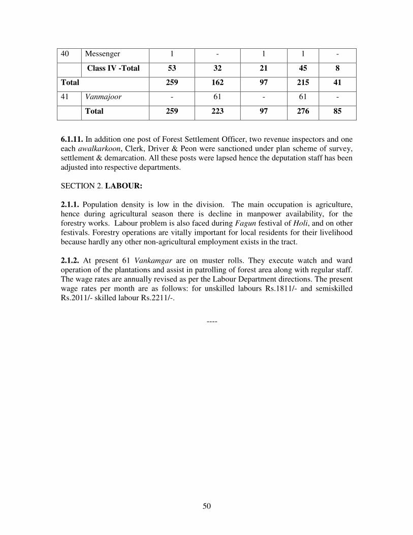
50
40 Messenger 1 - 1 1 -
Class IV -Total 53 32 21 45 8
Total 259 162 97 215 41
41 Vanmajoor - 61 - 61 -
Total 259 223 97 276 85
6.1.11. In addition one post of Forest Settlement Officer, two revenue inspectors and one
each awalkarkoon, Clerk, Driver & Peon were sanctioned under plan scheme of survey,
settlement & demarcation. All these posts were lapsed hence the deputation staff has been
adjusted into respective departments.
SECTION 2. LABOUR:
2.1.1. Population density is low in the division. The main occupation is agriculture,
hence during agricultural season there is decline in manpower availability, for the
forestry works. Labour problem is also faced during Fagun festival of Holi, and on other
festivals. Forestry operations are vitally important for local residents for their livelihood
because hardly any other non-agricultural employment exists in the tract.
2.1.2. At present 61 Vankamgar are on muster rolls. They execute watch and ward
operation of the plantations and assist in patrolling of forest area along with regular staff.
The wage rates are annually revised as per the Labour Department directions. The present
wage rates per month are as follows: for unskilled labours Rs.1811/- and semiskilled
Rs.2011/- skilled labour Rs.2211/-.
----

51
CHAPTER VII
PAST SYSTEMS OF MANAGEMENT
SECTION 1.GENERAL HISTORY OF THE FOREST:
7.1.1. The tahsil along with the rest of Berar came under British rule in 1853 by assignation
from the Nizam of Hydrabad. At that time, there was no forest administration in the tract and
aboriginal Korkus living in numerous scattered villages populated it, whose principle means of
live hood were Dahya cultivation and export of timber and bamboos to the Berar plains for sale.
There is reason to believe that many of the areas now under forest were under cultivation and
that tract supported a larger population than at the present day. Space cannot be given in the
report for a detailed account of the subsequent history, but a summary of the principle events
showing the gradual growth of forest administration in the tract is as follows.
7.1.2. In the year 1855 soon after Berar came under the British rule, the importance of forest
began to be realized. In 1855 the Dy. Commissioner of N. Berar reported the existence of teak
in the hills and recommended that felling should be prohibited so that a final selection of best
tracts could be made as special reserves.
7.1.3. In the year 1884 the Commissioner of Berar ordered that certain teak trees be selected
and conserved in the forests. The selected trees were marked with red paint and not allowed to
be felled by the local population. A small establishment costing Rs. 32.50 per month was
sanctioned for the purpose and a written report in 1964 shows that over 12,900 teak trees were
selected and marked by the year 1862 within the limits of 14 villages where the best Teak timber
was found. These villages were situated in the areas now comprising Semadoh Range and part
of old Raipur Range. These areas still contain best of teak forests, at present part of it is with
Project Tiger as per Government Notification dt. 26/04/1999.
7.1.4. In the year 1860-61 the topographical survey of was carried out under the charge of Mr.
James Mulheran on the map of scale 1" = 1 mile. The whole tract was then under the revenue
administration and they were following the Nizam's System of administration. The area under
cultivation was found to be 7,800 acre and the land revenue never exceed Rs.12, 000/-
7.1.5. In the year 1860 the Government of India called the attention of the Resident at
Hyderabad to the importance of preservation of the teak forests of Berar and directed that rules
be framed to this effect.
7.1.6. In the year 1863-64 Colonel Pearson, who was at that time Conservator of Forests of the
Central Provinces inspected and reported on the forests of Berar to the Government of India.
The instructions from G.O.I required Colonel Pearson to report firstly whether the forests, which
were Government Property were worth preserving and secondly whether they could be managed
by the Forest Department of the Central Provinces without undue additional expenses. The
report that was written by Colonel Pearson is of great interest as it contained the earliest known
description of the forest of the Melghat in addition to his conclusions and recommendations.
52
7.1.7. In the year 1865 as a result of Colonel Pearson's recommendations an Assistant
Conservator of Forests with an establishment of his own was appointed for Berar, under the
supervision of the Conservator of Forests of the Central Provinces. This appointment of ACF
marked the commencement of regular forest administration of Berar in the Forests.
7.1.8. Despite the appointment of the Assistant Conservator of Forests, the forests continued to
be under the revenue officer in charge of the tract who was known as the Assistant
Commissioner, till 1868. The first matter which received the attention was the selection and
demarcation of areas generally unsuitable for agriculture and suitable for reservation as
Permanent State Forests, and between 1865 and 1867, Captain Mackenzie, who was Assistant
Commissioner, at that time, demarcated an area of 425 square miles as suitable for reservation
which now forms the greater portion of the Bairagarh reserve. The remaining unalienated areas
of the taluqa were regarded as unreserved forests. From 1866 onwards teak, tiwas and shisham
were reserved, and indiscriminate felling of these species in the demarcated area was practically
stopped. Untill 1868 the major portion of the forest revenue was derived by leasing the rights to
levy dues at certain rates fixed by Government on all timber and bamboos exported from the
forests to the Berar plains for sale, but in 1868 this practice was discontinued and replaced by the
system of collecting dues by departmental agency at revenue stations on the forest produce
exported from the forests for sale. Partly as a result of Colonel Person's (foresters) suggestions
and partly owing to Captain Mackenzie’s enthusiasm, a forester trained in the Edinburgh, a
School of Forestry, Mr. Ballantyne was engaged for the purpose of forming teak plantations in
the demarcated area. He joined his appointment in October 1868.
7.1.9. In the year 1869 - the Conservator of Forests of the Central Provinces ceased to exercise
supervision over the forests of Berar, and a Deputy Conservator of Forests was appointed to the
independent Charge. With the appointment of the Deputy Conservator of Forests, the Assistant
Commissioner, ceased to hold charge of the forests of Melghat. The Deputy Conservator was in
charge of the northern of the two forest divisions into which Berar was divided at that time and
which included the forests of the Melghat. He in addition supervised the Assistant Conservator
of Forests who held charge of the southern division. In March 1869, Sir Dietrich Brandis, who
was then the Inspector General of Forests, paid a visit in Berar and made suggestions for the
future administration and management of the forests. He suggested that idea of forest
conservancy should be abandoned in the undemarcated forests. The only restriction suggested
was that dahya cultivation should be prohibited but grazing, cultivation and extraction of timber
and bamboos should be continued freely on payment of dues at revenue collection points.
7.1.10. In the year 1870-1875 - Sir Dietrich Brandi's visit to Berar bore speedy results. In 1871
the Berar Forest Rules were published. It defined, the status of the forests and made
prescriptions for their management and control. These prescriptions were in force until the
Berar Forest Law was passed and forest rules were issued under that law. In , area fire
protection was commenced near Raipur in 1870 and by 1872 it was extended to the whole
Bairagarh reserve. Mr. Ballantyne formed the Teak plantations over extensive areas formerly
under cultivation in the valley of the Sipna River. The Bairagarh reserve was divided into 40
blocks for working purposes and the cutting-back of unsound teak was commenced in the valley
of the Sipna River, the cutting of bamboos was also regulated. The general policy at that time
was, however, to leave the Bairagarh reserve unworked and give it a rest to recover it from past

53
ill-treatment, and to confine exploitation of timber to the unreserved forests only which
comprised the whole of the area of the taluqa other than the Bairagarh reserve and certain
alienated areas. This policy naturally resulted in heavier fellings as compared to past in the
unreserved forests. In 1872 an attempt was made by Mr. Drysdale, who was then Deputy
Conservator of Forests of Berar, to limit the destruction of the unreserved forests by dividing
them into 15 blocks, one block only to be opened annually for the felling of teak, tiwas and
shisham timber, though the felling of other species was allowed in all the 15 blocks, and cutting
of bamboos, was also regulated.
7.1.11.The restrictions imposed on the felling of timber and bamboos in the unreserved forests of
the led to discontent among population and gave rise to some apprehension that a considerable
portion of the population would migrate. To meet this situation therefore a tract of 300 square
miles containing the best of the unreserved forests was selected and demarcated in 1876-77 and
named as Gugamal reserve. The measures for protection including fire portection, similar to
measures that were in force in Bairagarh reserve were introduced in it, while the restrictions on
fellings of timber and bamboos in the remaining unreserved forests were entirely withdrawn.
7.1.12. Sir Dietrich Brandi's, the Inspector-General of Forests paid a second visit to Berar in
1877 and wrote a very interesting report containing a detailed description of the forests with
suggestions for their future administration. The taluqa at the time contained 725 square miles of
reserved forest and 927 square miles of unreserved forest. The Inspector-General, in addition to
making suggestions for the future management of the reserved forest, gave his opinion, that apart
from the prohibition of shifting cultivation, no other form of forest conservancy should be
attempted in the unreserved forest, the felling of timber and bamboos and grazing should be
permitted unrestricted, except for the payment of certain dues, and the extension of permanent
cultivation should be permitted. This recommendation largely determined the policy adopted for
the unreserved forests for the next thirty years. The chief burden of the demand for forest
produce was thus thrown upon the unreserved forests which resulted in their over-exploitation
7.1.13. In the year 1880 - grazing dues were charged on all the cattle other than plough bullocks
in actual use of their owner. Licences were issued by the various revenue stations. The villagers
in the C-III area were permitted to extract produce of all sorts by head-loads from the forests for
their own requirements, but were liable to pay royalty on all produce extracted in quantities
larger than head-loads and on produce exported outside the from that area. In practice, however,
no attempt was made to distinguish between extraction of head load, and larger quantities and the
residents of C-III was unrestricted free user of the C-III forests so long as they did not attempt to
export beyond. All produce extracted from the A class reserve together with all C-III produce
intended for sale outside the Melghat were asked to pay royalty at one or other of the 14 revenue
stations situated on the routes leading to out of the. The out come of this policy was that though
the Forest Department between 1880 and 1906 earned an income of 23 Lakhs of rupees from C-
III forests as against nearly 16 Lakhs of rupees from the reserved forests. Result was that the C-
III forests were almost completely destroyed in the process.
7.1.14. As a result of the Inspector-General's suggestions the reorganization of the forest of Berar
was effected during 1880, and the Ellichpur division or the division as it was subsequently
named in 1906, became selfcontained forest charge. A small area of unreserved forest in the

54
vicinity of Chikhaldra was demarcated as a reserve to provide for the requirements of the
inhabitants of Chikhaldara for firewood and grass.
7.1.15. Sir William Schlich, who was the Inspector-General of Forests paid a visit and made
suggestions for the future management of the forests, in continuation of his predecessor's
suggestions.
7.1.16. During the years 1883-1886 the whole of forest was surveyed by the Imperial Forest
Survey Department on the scale of 4"=1 or 2”= 1 mile in the more advanced parts where it
comprises a continued cadastral survey and on the scale of 2"=1 mile in the more backward
tracts where it comprised contour surveys. The separate villages of the C-III area were
demarcated and surveyed and some internal demarcation was also done, but this served no useful
purpose as the survey was not utilised as an aid to the assessment or to record of title.
7.1.17. The Berar Forest Law was passed in 1886 and rules for the constitution and management
of the various classes of State Forests were issued in 1892. The Bairagarh, Gugamal and
Chikhaldara reserves were constituted as State Forests of Class A, while the unreserved forests
of the taluqa were included in class-D (forests pending further classification).
7.1.18. After considerable discussion between the Revenue and Forest Departments the forests
included in class D in 1892 were reclassified in 1894. About 105 square miles were classified as
State Forests of class A (Forests reserved for the production of timber and fuel) and were added
to the existing areas of Bairagarh, Gugamal and Chikhaldara reserves, or were included in a new
reserve called the Kohana reserve; about 6 square miles were classified as State Forests of class
C Division III (forests in the Melghat reserved for pasture). The result of this classification was
as below.
A Class -- 475,967 Acre
B Class -- 3,529 Acre
C Class -- 485,115 Acre
-----------------------------------------------------
Total = 964,674 Acre
7.1.19. In the year 1892 Mr. Francis, the Director of Land Records in Berar submitted proposals
for a regular settlement of the greater part of the Melghat along with the preparation of the usual
village registers. The work was carried out in 79 villages but stopped by his successor Major
Carret. It was because of Korkus's unsettled nature of cultivation that no survey could be carried
out.
7.1.20. In the year 1894-1903 the State Forests of classes A and B were under the charge of the
Divisional Forest Officer but the State Forest of Class C Division III comprising the balance of
the State Forests of the taluqa were managed under a system of dual control by the Deputy
Commissioner of the district and the Divisional Forest Officer in charge of the division. The
Deputy Commissioner issued licenses for felling, the concurrence of the Conservator was
necessary in the case of certain trees, and in general the Deputy Commissioner was the
sanctioning authority for any acts done in the C-III forests under the rules controlling their

55
management. The Divisional Forest Officer was nominally the authority to see that the rules
were enforced and that the concessions permitted in C-III forests were not abused, but in
practice, as he had no staff in the C-III forests and had therefore no means of enforcing the rules,
additionally as his attentions were becoming more and more diverted towards the State Forest of
classes A and B under his control, the only concern of the Divisional Forest Officer in C-III
forests was to collect dues in respect of the forest produce exported for sale. This collection was
made at the revenue stations situated on the roads leading out, from the to the plains. The dual
system of control was not satisfactory; and the C-III forests continued to bear the burden of the
demand for forest produce from the Melghat and to become more and more depleted of forest
growth. But nothing was done to remedy the matters except the transfer of certain areas of C-III
forests aggregating 102 square miles, to State Forests of class A in 1895, 1878 and 1903, these
areas were added to the existing reserves of Bairagarh, Gugamal, Chikhaldara and Kohana. In
1898, a little over one square mile of Bairagarh reserve and a little under one square mile of
Kohana reserve were transferred to class C-III. In 1899 transfer of 8 square miles of the
Bairagarh reserve increased the area of Kohana reserve. An area of 799 acres of the Chikhaldara
reserve was deforested to form the Chikhaldara Civil Station area in the year 1902.
7.1.21. In the year 1903 the treaties under which Berar was assigned in 1853 were superseded by
an agreement under which the Nizam of Hyderabad leased Berar to the Government of India in
perpetuity in lieu of an annual rent. In consequence of this Berar ceased to be under the
administration of the Resident at Hyderabad and came under the administration of the
Government of the Central Provinces, due to which the forests of Berar, including the forests of
the, once again were merged with the forests of the Central Provinces for the purpose of forest
administration.
7.1.22. Between 1905-1914 by the year 1905 the C-III forests of the taluqa had reached a stage
where some portions had been entirely depleted of forest growth was been brought under the
cultivation, though certain portions still contained a fair amount of forest growth. In the forest
administration report of 1905-06 attention was called to this state of affairs and the need for a
proper revenue settlement was stressed. A revenue officer was appointed to enquire into the
conditions of the tract in 1906-07. As a result of his enquiry it was decided that the
disforestation of a large area of C III forest and introduction of some form of revenue settlement
in the disforested area were necessary. Settlement operation were carried out between 1907 and
1911, and as a result, 370 sq. miles of C III were disforested and brought under revenue
settlement as the Dharni- Bairagarh, Katkumbh and Wastapur-Gaulkhera Raiyatwari tracts, and
320 square miles of C-III forest were transferred to State Forests of class A in 1911. The
transferred areas were either added to the existing Bairagarh reserve or included in the new
reserves of Tapti, Chitri, Bod, Jhapnadeo, Dhulghat, Dabida, Wan, Rupagarh, Khirpani and
Motha. In 1911 a new reserve called Chikhli was also formed by the transfer of 8 square miles
of forest from Bairagarh reserve and 5 square miles from Gugamal reserve, and certain area,
aggregating 52 square miles of Gugamal reserve were transferred to the Jhapnadeo, Dhulghat,
Rupagarh and Khirpani reserves. About 2 square miles of Dhulghat and a small area of
Khirpani reserves were disforested in 1911. In 1913 the State Forests of Berar were reclassified
e.g. the existing State Forests of classes A and B as A class and the existing State Forests of class
C, Division III as C Class. So far as the Melghat division was concerned this reclassification
chiefly affected the block of State Forest of class B known as the Hattighat Ramna, which thus
became A class forest. In 1914, 8 square miles were afforested as ‘A’ class and added to the

56
Dhulghat reserve. After this afforestation the division consisted of 1,175 square miles of A
class forest all lying in the taluqa.
7.1.23. In the year 1909 - Chief Commissioner visited Melghat along with Commissioner and
Forest Officer. In Secretariat letter No.188-XI-21-11 dated 29th
March 1909, the Chief
Commissioner issued the orders regarding Melghat that large blocks of unculturable land in the
C-III area should be demarcated and reserved as A class forests to be managed with the object of
(1) Securing a continuous supply of bamboos, small timber, fodder etc. (2) protecting the forest
on the steep hill sides in order to secure a continuance or improvement of present meterological
condition, the small cultivation inside these forests were to be abolished so as to secure a
compactness or to be managed under the Forest village rules. The area thus transferred totalled
247,465.7 acre. The remaining areas of C-III was to be disforested; smaller blocks of un-
culturable lands being left as village waste over which inhabitants of C-III would be allowed free
grazing rights and nistars of all sorts except the right to gather Rusa grass and Myrabolans
7.1.24. During the year 1925 to 1931 the greater part of the Dhulghat and Rupagarh reserve and
the whole of the Wan and Dabida reserves were transferred to Akola division in 1925 for the
convenience of administration, but were again handed back to the Melghat division in 1931
when Buldhiana division for the sake of economy was incorporated within the Akola division as
part of the West Berar division.
7.1.25. With the introduction of Mr. Dunbar-Brander's working plan in 1915 the forests of
Melghat were distributed between eight Ranges namely, Chikhalda, Semadoh, Khandu, Butrum,
Chaurakund, Gugamal, Khirpani and Dhulghat. In 1925, certain transfers took place between
these eight Ranges, and the Dhulghat Range became part of Akola division. In 1931 the
Dhulghat Range was returned to the division. In 1932 further transfers took place between
Chikhaldara, Gugamal and Khirpani Ranges for convenience of management, and the Butrum
Range was abolished as a measure of economy, part of it went to Semadoh Range and part to
Khandu Range, thus reducing the number of Ranges to seven.
7.1.26. The changes which were made in the area of the division since 1914 were the transfer of
the Hattighat Ramna with an area of 3,592 acres to the Amravati division in 1917, the transfer of
the Dhamangaon and Chinchona, Nimkhera blocks of C Class forest with areas of 2,035 and
2,311 acres, respectively from the Amravati division in 1917, the afforestation and addition to
the Tapti reserve in 1919 of 964 acres of the Bhondilawa Rayatwari village, and the
disforestation of 188 acres in 1928 of Chikhaldara reserve to add to the Chikhaldara civil
station area and 46 acres of Chithri reserve to improve the boundary.
7.1.27. In the year 1927, the Indian Forest Act, 1927 was passed and it came into force vide
Government of India, Foreign and Political Department Notification No.719-1 dated 13/12/1927.
The previous enactment of 1878 was repealed. However these forests were continued as Reserve
Forests by virtue of section 24 of the General Clauses Act 1897.
7.1.28. The Division, which was constituted in 1906, was abolished and it was named as
Amravati Division. The areas of Amravati and Morshi Ranges were added to it. The head
quarter was kept at Amravati. The office staff used to stay at Amravati while D.F.O's
headquarter was for Eight months at Chikhaldara and for four months at Amravati. This

57
arrangement was however discontinued in 1952. Subsequently the reorganization took place in
1964. The increased activities during the 5-year plan periods intensive working of the forest and
bringing hitherto inaccessible area under working necessitated the change in the territorial limits
of the division as the then existing Amravati division was found unwieldy both in extent and
work. Hence, Govt. of Maharashtra, Agriculture, Food and Forest Department, Resolution no.
FDM-1361/12464-III-J, dated 6th
February 1964. It was divided into three administrative units,
Independent Amravati sub division, East Melghat Division and West Melghat Division and these
three units started functioning from 1st April 1964 with head quarter at Amravati. After a year,
head quarter of the West Melghat Division was shifted to Chikaldhara with the transfer of
chikaldhara round to West Melghat Division. This arrangement continued till 1983, when vide
Government Resolution No. FDM/1880/1F-2 dated August 29, 1983, a new division called
South Melghat was created by carving out area from East and West Melghat Division and
Amravati Sub-Division was upgraded as Amravati division vide aforesaid Govt. Resolution. The
responsibility of managing timber depot at Dharni and Akot was also transferred from West
Melghat by the creation of post of Deputy Conservator of Forests (Transport and Marketing)
vide resolution no. FDM-1880/1-F-2 dated August 29,1983. Further reorganization of the
divisions took place vide Maharashtra Govt. Resolution No.WLP/-1094/P.K.-211/(Part-3) F-1
dt.26/04/1999 separating wildlife sanctuary and National Park areas which were brought under
unified control of field Director and Conservator, Project Tiger H.Q. Amravati and rest of the
area was reorganized into East Division and West Division. South Division was transferred to
wildlife wing as Division III of Tiger Project along with the staff and areas except a few patches,
which were attached to West Division.
7.1.29. The Head Quarter of East Melghat was shifted from Amravati to Chikhaldara and Head
Quarter of West Melghat was shifted from Chikhaldara to Parathwada. The present East Melghat
Forest Division consists of Chikhaldara, Jarida, Ghatang and Anjangaon Ranges.
SECTION 2. PAST SYSTEMS OF MANAGEMENT AND THEIR RESULT:
(A) Period Before 1893:
7.2.1. Up till 1896, the management of the reserved forests was chiefly governed by giving them
a rest from past ill-treatment and by introduction of protection including fire protection The
Improvement fellings to remove the large unsound teak of preservations days were carried out
over a portion of Bairagrah reserve, principally the portion lying to the South of Sipna river near
Pilli and between 1871 and 1883, 117,906 trees were felled. In 1887-88 and 1888-89, 1000 first
class teak i.e. trees over 6 feet (180 cm) in girth, were felled annually in the Raipur and Makhla
block of the Bairagarh reserve under a working plan prepared by colonel Mr.Van-Someren,
Conservator of Forests in Berar which was based on a valuation survey but this plan was
cancelled in 1889 partly as the author of the plan was too much optimistic about the soundness of
the large teak, trees and partly as it was proposed to prepare a working plan to cover the whole of
the Bairagarh and Gugamal reserves. Improvement fellings were recommended and were
carried out over 29,685 acres (12,013.10 ha.) in Chaurakund, Semadoh and Butrum blocks of the
Bairagarh reserve between 1889 and 1893.
Result: The management of the Forests was mostly successful
58
(B) Bhagshawe Plan-1893-1915:
7.2.2. A working plan covering the whole of Bairagarh and Gugamal reserve as then constituted
was originally drown up by Mr. Dickinson, Conservator of Forests in Berar, which was revised
and completed by his successor Mr. Bhagshawe and introduced in 1893-94. Under this plan,
four felling series were formed in the more valuable forests of Bairagarh reserve, each felling
series with twenty annual coupes to be worked under improvement fellings. Fellings other
than selection fellings in forest village areas to meet the requirement of the villager were not
prescribed for the Gugamal reserves. Bamboo cutting was regulated in both the reserves on a
two year rotation, complete fire protection was prescribed for the entire area of the forest
eradication of Lantana and climber cutting were prescribed and grazing was confined to the
cattle of forest villages the cattle of Chikhaldra and Wastapur and the cattle of exporters.
Plantations were not considered necessary and therefore were not prescribed. The working of
the first ten coupes prescribed in that plan was sanctioned but as regular working was held in
abeyance in 1901-02 and 1902-03 to allow the exploitation of the large no. of trees that had
become top dried or had completely died owing to the drought of 1890-1900 and previous years,
the sanctioned working of ten years did not come to an end until 1904-1905.
7.2.3. A preliminary working plan report was drawn up in 1901 by Williamson, Deputy
Conservator of Forests, who was then in charge of the division, with the object of revising
Dickinson and Bhagshawe's plan and for introducing regular fellings in Gugamal reserve and
other additional areas. The preliminary working plan report was not sanctioned, but as a result of
it, one coupe of 684 acres (276.80 ha) in Chikaldara reserve of Chikhaldara Range and one coupe
of 567 acres (229.46 ha.) near Khatkali, now in Akot range were worked under the Coppice with
Standards CWS system between 1903 and 1909 and seven coupes, aggregating 11,320 acres
(4581.04 ha.) in the Koha block of the present Dhakna Range, were partially worked under
improvement fellings, between 1902 and 1909.
7.2.4. Sanction was obtained in 1905 to continue the prescription of Dickinson and Bagshawe's
plan for another ten years. As a result of this plan, therefore, improvement fellings were carried
out over the greater portion of the Bairagarh reserve during the period 1893-1894 to 1914-15.
Gugamal Reserve Working Scheme, 1910-15:
7.2.5. A working scheme was introduced in 1910-11 under which Gugamal reserve was divided
into six felling series, each with six annual coupes and the first five coupes in each felling series
were worked under improvement fellings between 1910-1911 and 1914-1915.
Tapti Reserve Working Scheme, 1912-15:
7.2.6. In 1912-13 as a result of a visit of Mr. Hart, the then Chief Conservator of Forests, the
fellings under the Coppice with Standards CWS system were commenced in the newly created
Tapti reserve. The reserve was divided into three felling series, and three coupes in each felling
series were partially worked according to demand, under the coppice with standards system
during the years 1912-13, 1913-14 and 1914-15.
(C) Dunbar Brander's Working Plan, 1915-16 To 1935-36:
59
7.2.7. A revised working plan covering the whole of the division was prepared by Dunbar
Brander, the then Deputy Conservator of Forests who was then in-charge of the division. The
plan was introduced with effect from 1st July 1915. This working plan divided the forests into
four working circles, namely, the High forests, the coppice with standards, the unregulated
and the Bamboo Working Circle.
7.2.8. The High Forest Working Circle consisted of the best forests considered suitable for
eventual treatment as high forest. It covered the whole of the Bairagarh, Gugamal and Kohana
reserves, - a total area of 724 sq. miles (1875.15 sq.km.). It was divided into ten felling series
each with twenty annual coupes, to be under worked improvement felling. The felling were
carried out in two distinct stages, namely the fellling of marketable trees by purchases of rated
prunes passes, and cutting back of unmarketable trees or cultural operations. The whole of the
working circle was completely protected from fires, and coupes were closed to grazing for five
years after working.
7.2.9. The Coppice with Standards CWS Working Circle consisted of the forests containing
irregular pole growth and a large number of young teak pollards requiring replacement by
coppice shoots as early as possible. It covered the whole of the Tapti reserve, and was divided
into three felling series, each with twenty annual coupes which were worked under the
Coppice with Standards System. As was in the high forest working circle, has also the fellings
were carried out in two distinct stages. The whole working circle was completely fire
protected and coupes were closed to grazing for ten years after working.
7.2.10. The unregulated working circle consisted of all the remaining reserves of the division-
a total area of 404 sq. miles (1046.36 km), and was divided into 14 blocks or units of working.
Regular fellings were not prescribed, but improvement fellings were permissible with the
conservator's sanction in Chandrabhaga, Memna and Khatkali block. The felling of green timber
species other than teak, tiwas, shisam or bija which was permitted in a part of Dhulghat block
and felling of green firewood was permitted in any block. Six blocks were completely fire
protected, early burning protected five blocks and the remaining three blocks were not protected
from fire.
7.2.11. The Bamboo working circle consisted of the best bamboo bearing tracts and overlapped
the other working circles. It was divided into sixteen felling series, eleven of which were
worked under felling cycle of three years and the remaining five under a cycle of two years.
7.2.12. In the year 1922-23, the Khatkali block of unregulated working circle was made into a
felling series with twenty annual coupes and was added to coppice with standard working circle.
7.2.13. The amendment of certain prescriptions of Dunbar Brander's plan became necessary by
1924-25 chiefly owing to alterations in Range boundaries, the transfer of four felling series of
the Coppice with Standards Working Circle to the High Forest Working Circle, change in the
method of felling in the protected area of the felling in the protected area of the felling series and
the coupes having been found to be inconvenient large under the amended prescriptions which
were brought into force with effect from 1924-25 the coppice with standard working circle was

60
incorporated in the High forest working circle and the latter was divided into twenty seven
felling series. Twenty six felling series, contained twenty annual coupes each to be worked
under improvement felling one more felling series, containing the teak plantations in the valley
of Sipna river in Semadoh Range Known as the Pili plantation felling series had five annual
coupes to be worked under thinnings. Early burning was prescribed as the method of fire
protection in such blocks of the unregulated working circles. The number of felling series in the
Bamboo working circle was increased to thirty one of which seventeen were worked under a
felling cycle of three years fourteen under a felling cycle of two years.
7.2.14. In the year 1927-28, the Bamboo circle was reorganized. The ‘Pili plantation bamboo
felling series’, was omitted and the remaining thirty felling series were worked under a felling
cycle of four years.
Result:- By the end of the period of Dunbar Brander's one cycle of light improvement fellings
had passed over the greater portions of Bairagarh, Gugamal, Kohana, Tapti and Bod reserves
during the twenty years period from 1915 to 1935, but owing to the rearrangement of felling
series and coupes in 1924-25 certain areas in Tapti reserve and in the Khatkali felling series in
Gugamal reserves and the teak plantation areas in the valley of the Sipna river in Semadoh
Range had been worked, somewhat heavily, the former under the coppice with standard system
and latter under the two cycles of thinning.
The important felling in the high forest working circle, greatly benefited the growing
stock, especially in the more accessible coupes where it was possible to carryout cultural
operations. Many of the unsound trees, most of which belonged to the older age classes were
removed and the forest were not exploited to their full capacity. Since 1931-32 and with the
introduction of departmental operations the fellings were distinctly heavier than earlier. On the
whole, the result was the gradual building up of large stocks of sound, healthy - young or middle
aged poles and trees.
The rest given to the forests of the unregulated working circle was recorded as beneficial.
The growing stock became denser; the percentage of teak increased and teak reproduction
became abundant.
Certain blocks, notably the Chandrabhaga and Memna blocks and part of Popatkheda
and Rupagarh block was considered fit for the introduction of regular working. The growing
stock improved in parts of Chitri, Chikhali and Japnadeo blocks and extensive growth of teak
pole crop was found to be regenerated.
(D) Stein's Working Plan 1935-1955:
7.2.15. Dunbar Brander's plan was revised by A.H. Stain, Deputy Conservator of Forest and this
revised plan came into force on 1st July 1936. This plan was originally sanctioned for a period of
ten years but was subsequently extended and it continued to be in force till 1955.
7.2.16. Under this plan the whole of the forest, except Dhulghat, Wan, Dabida and part of
Rupagarh block and two 'C' class blocks were divided into 1,086 compartments. These
compartments were stock mapped and a detailed description of each was written.
7.2.17. Under this plan, the following four working circles were formed:
1) Teak high forest working circle, area 4,18,625 (1,69,411.68 ha.)

61
2) Coppice working circle, area 1,36,862 acres (55,388.97 ha.)
3) Miscellaneous working circle, area 2,04,600 (82,798.75 ha.)
4) Bamboo working circle overlapping the above.
Teak high forest working circle - All most whole of the Bairagarh and Gugamal
reserves were allotted to this working circle. The siliviculture system prescribed was conversion
to uniform forest with a conversion rotation of 60 years. This period was divided into three
blocks of 20 years each. The compartments to be generated in the first 20 years formed Periodic
Block I.
7.2.18. The following felling rules were prescribed for P.B.I:
A) In areas where established seedlings and saplings of teak were sufficient to ensure
restocking:-
i) All teak with the exception of groups of unsuppressed established advance growth and
well grown poles upto 18 inches (subsequently amended to 30 inches) in girth which were
considered fit for retention to form a part of the new crop, was to be felled.
ii) All trees of other species, which were standing around or were close to teak reproduction,
were to be felled. In crops containing 70 percent or more of teak and no bamboo, all well grown
trees of other species between 12 inches (30 cm) and 24 inches (60 cm) girth were to be retained
even if interfering with teak reproduction. Wherever there was danger of frost, all miscellaneous
species, especially Ain, were usually to be retained even through interfering with teak.
i) Bamboo, the removal of which was necessary were to be cut.
B) In areas where established regeneration of teak was insufficient or absent:
i) In all teak forest of quality II and in teak forest of quality III where labour and funds
permitted, the old crop was to be Clearfelled and the area was to be regenerated artificially.
ii) In other forest areas only deteriorating and over mature trees were to be felled.
C) In areas of quality IV b where teak and mixed forest were established and
reproduction of teak and tiwas was adequate, conversion felling on the lines prescribed under 'A'
above was to carried out at the discretion of the Divisional Forest officer, otherwise only
deteriorating and over matured trees were to be felled.
D) Unworkable areas and steep coupes were ordinarily to be left untouched but the
Divisional Forest Officer was allowed to permit the felling of deteriorating and over matured
trees.
E) Frost Areas: Dominant trees of other species especially Saja (Ain) were to be retained.
Teak was only to be felled if the over wood of the miscellaneous species was sufficient to protect
the resultant teak coppice crop from the frost.
In periodic blocks II and III, the main object of felling prescribed was to exploit mature
and over matured teak likely to deteriorate and at the same time to carry out thinnings. The
minimum girth limits for fellings were different for the two P.B.s and different from quality to
quality. This ranged from 2 feet (60 cm) in quality IV b in P.B.III to 4 1/2 feet (135 cm) for
quality II or III in P.B.II
7.2.19. These prescriptions were recorded in 1945 and in the revised prescription the following
works were prescribed in these Periodic Blocks II and III:-
i) Crown thinnings.
ii) All dead and seriously diseased trees were to be felled.

62
iii) Such mature trees, which were not likely to survive 20 years, were to be felled.
iv) Matured trees of miscellaneous species and those having a disproportionately large crown
were to be felled in the interest of teak reproduction.
v) Thinning in young teak poles and samplings crop was to be heavy. Wherever well grown
poles of other species were present, they were to be encouraged.
vi) All malformed teak below 18' (45 cm) girth was to be cut back wherever there was a
reasonable chance of the resulting coppice shoots to grow free from suppression.
vii) All climbers were to be cut.
7.2.20. The forests allotted to teak High Forest Working Circle, which had not been worked
during Stein's Plan, contained generally young to middle aged teak crop with a few scattered old
and mature teak trees, dense undergrowth of lantana and grasses. The natural regeneration of
teak was very poor and scanty. The inspection of P.B. I. areas, which had already been worked
and the remaining areas which were not worked suggested that the condition of the crop in
Stein's P.B.I was also the same before working i.e. natural regeneration was definitely
deficient, there was hardly any area where the prescription of the plan succeeded therefore the
only recourse was either to clear fell the stock and regenerate the areas artificially or remove
only deteriorating and over matured trees as the plantations were not feasible because of acute
labour shortage and removal of only deteriorating and over matured teak trees could have been
an economic failure. The prescription of Stein's working plan, therefore, did not suit the Melghat
conditions and were not strictly adhered to.
7.2.21. The resume of work done in the P.B.I. areas of this plan was as follows;-
In the first six or seven coupes of Stein's plan all well stocked teak patches were
Clear felled and elsewhere also marketable teak trees were felled and also other trees were also
removed which could interfere with teak coppice. In the subsequent coupes, clear felling was
abandoned and the system of working was a sort of selection felling under which almost every
teak tree above 30" (75 cm) girth could be removed from the accessible areas.
Results: This system of working involved a great deal of unjustified sacrifice of young and
Middle aged trees which were still putting on valuable increment. Beside, the gaps that was
created in the canopy, especially by felling in patches during the earlier years of the plan, it also
encouraged the spread of dense undergrowth of lantana and grasses in the worked coupes.
No particular attention was paid to improvement felling or thinnings in the remaining
crop in the coupes. The cultural operations were badly neglected. The lantana was removed
from coupes, mainly once for the convenience of marking and coupe working but subsequently it
was not kept down to help to establish whatever little regeneration was there.
The strip fellings were carried out in Harisal and Chaurakund felling series upto 1946 but
as the method was very difficult to work and there was not any particular advantage against frost
damage, the prescriptions of the working plan for PBI areas of these two felling series were
suspended. No work was done in the PBI areas of these felling series except the removal of
marketable teak trees here and there from the easily accessible areas of the unworked strip.
The compartments allotted to P.B.II and III were worked haphazardly till 1947 when
works in these compartment were stopped because a no. of P.B.I coupes were in arrears. The
compartments, which were, worked especially those near the roadside, had very heavy fellings in
them and the trees, which should have been left for P.B.I, were removed. Improvement fellings

63
and thinning were carried out rather casually. The main object of working these areas apparently
being to supplement the yield.
7.2.22. Coppice Working Circle: Khirpani and Rupagarh reserves were allotted to this
working circle and the forests were generally situated near the market where small size timber
and fuel were saleable. These forests were also not capable of growing big size teak because of
poor soil and low rainfall. The percentage of teak in the growing stock was also generally
comparatively small. The silvicultural system prescribed was coppice with reserve. The
coppice shoots after the felling were the chief source of replacing the crop.
Results: Generally speaking this system was quite suitable in view of the condition of the
forest and the demand. Most of the worked areas were now well stocked with well grown young
poles of teak. There were, however large areas where this system was not suitable due to the
following reasons:
1) The country being too steep and the stocking was open with the result that the
replacement of crop with coppice was not certain.
2) There was practically no demand for small size timber.
7.2.23. Bamboo Working Circle: The exploitation of bamboo was generally done from
bamboo coupes of the year on rated passes expect for a few roadsides felling series in Gugamal,
Semadoh and Chaurakund ranges, where the coupes were auctioned. This auction of bamboo
coupes diverted the labour towards the contractor, therefore it was stopped subsequently.
Results: The clumps were very irregularly worked as they were left to the mercy of rated pass
holders.
7.2.24. Miscellaneous Working Circle: Forests which were unworkable due to poor quality or
stocking, remoteness or inaccessibility, forest village areas and also 'C' class forests all these
were allotted to this working circle. No work was done in these forests except the removal of
bamboos and firewood on rated passes.
Results: In spite of the long rest given to these forests they were not found to be improved
enough to be put under any working circle. One of the important reasons for the slow progress
must have been the fire which occurred frequently in these areas. This forest very sparsely
populated and with the abolition of Dhulghat Range most of the area allotted to this working
circle was neglected, especially so, for the fire protection concerned.
(E) Sharma's Working Plan, 1956-1974:
7.2.25. Stein's plan was revised by D.C. Sharma, Deputy Conservator of Forests and was
introduced in 1956.
7.2.26. This Working Plan covered the whole of the forest areas in but the prescribed the
working only for those forests which were practically under actual working during Stein's Plan.
The whole Dhulghat, Dabida, Wan, part of Rupagarh Reserves and 'C' class forests were
allowed rest by grouping them under Miscellaneous Working Circle. The stock mapping of the
remaining forest area, which was divided into 1086 compartments, was revised and fresh stock
maps were prepared showing teak forest with quality, mixed forest, unworkable areas and frost

64
prone areas. The description of these forests were written in detail for each compartment.
Occurrence of lantana was also indicated.
7.2.27. The following Working Circles were formed:
Table No 7.1
Table Showing The Distribution Of Area Under Various Working Circles
Sr.
No.
Name of the working circle Area
(Acres)
Area
(Hectares)
1. Selection Working Circle 4,38,885 1,77,610.61
2. Coppice With Reserve Working Circle 1,25,237 50,681.66
3. Miscellaneous Working Circle 1,51,066 61,134.20
4. Protection Working Circle 44,896 18,168.38
7.2.28. Selection Working Circle: All the good quality teak bearing forests were allotted to this
working Circle. Selection system was prescribed for teak, haldu, bija, Shisam, Saj and Tiwas
etc. Felling cycle was fixed as 20 years. Yield was regulated by area. Exploitable girth was
135 cm in good quality teak forest and 120 cm in comparatively poorer quality teak forest.
The coupe was completely protected against fire for 5 years and grazing closure was for 3 years
from the year of main felling.
7.2.29. Stump analysis of 223 stumps of teak trees was carried out. Out of these 163 stumps
were of mature trees growing in open and showed a faster rate of growth than those remaining 60
stumps which were selected in the forest having average stocking. At the age of 80 years, the
diameter growth over bark at breast height was 20.7" (52.57 cm) and 14.3" (36.32 cm)
respectively as computed from these two sets of readings, besides this local volume tables were
prepared. For the first time 5 percent enumerations were carried out in good quality forest.
Teak, Saj, Dhaora, tiwas, bija, shisham, Salai, haldu and bamboo clumps were enumerated
separately while remaining species were grouped under 'Miscellaneous' species. The total
growing stock of teak trees above 25" (63.5 cm) girth class as indicated by the enumeration was
235 cu. ft. (6.654 cum) per acre.
7.2.30. The method of treatment was aimed at the production of big sized timber. The natural
regeneration and advance growth of teak wherever present were to be helped to grow up and it
was to be supplemented by as much planting as possible. The area liable to frost damage were to
be approached and treated continuously.
7.2.31. Before marking all teak trees above 42" (105 cm) in girth at b.h. in good quality felling
series and above 36" (90 cm) in girth at b.h. in poor quality felling series were to be enumerated
in 6" (15 cm) girth class and were to be classified into classes I, II, III and IV based on the out
turns they would yield.
7.2.32. The following rules for working were prescribed.
(1) 25 percent of the enumerated teak trees above the exploitable girth were to be reserved
from class I and if needed from class II. The remaining 75 percent teak and haldu trees were to
be felled.

65
(2) All teak trees of class I, II and III of girth class below the exploitable girth were to be
reserved. Trees below exploitable girth of Class III and IV if growing within 5 feet (1.52 m) of a
reserved tree will be felled provided the crop density is not reduced below 0.5.
(3) Thinning was to be done in the lower girth classes.
(4) Suppressed trees of girth class below the reserved girth class were to be felled if saleable
and trees of class III and IV were to be felled provided these were not required for maintaining
the minimum stocking of 0.5.
(5) Compact groups of natural regeneration in areas not exceeding 1/2 acre (0.2 ha.) were to
be opened out by removing the over wood. Established but suppressed advance growth were to
be cutback.
(6) In lower storey, satkata species were to be retained to suppress grass and lantana.
(7) Teak plantation over 40 acres (16 ha) in the beginning and thereafter on increasing scale
were to be carried out.
7.2.33. Since their reservations, the forests allotted to this working circle were worked under
improvement fellings till the introduction of Stein's Plan when conservation to Uniform Forest
System was attempted, for a brief period of about 7 years. Therefore these prescriptions were
modified and forests were worked under a sort of selection system under which anything above
3' (90 cm) in girth could be removed. Sharma, while continuing this method of working for these
forests adopted a higher girth limit for exploitation and tried to build up the growing stock in all
girth classes by prescribing 25% reservation of trees in exploitable girth class and placing
restrictions on fellings in lower girth classes so much so that even an embargo was placed on the
removal of suppressed trees. The safeguard prescribed for maintaining the stock density, further
restricted the removal of trees even though belonging to class IV i.e. unsound trees having no
utilizable timber.
7.2.34. These safeguards in practice were, however difficult to implement. The advance growth
which was to be cut back in the compact groups of natural regeneration was not clearly defined.
Subsidiary cultural operations were not prescribed at all and no adequate attention was given to
encourage the regeneration. Main coupes were left to the nature care after the main working.
7.2.35. Reservation of 25% of trees of exploitable girth was not a sound economical proportion.
A teak tree of 135. Cm. (exploitable girth) having a volume of 0.700 cum. fetches Rs. 400. If it
was back for further 20 years its volume would increase to 0.780 cum and would fetch Rs. 455
thus showing an increase of Rs.55/- only over original value of Rs.400/- That increase of Rs.55/-
in 20 years correspond to a compound interest rate of 0.6% Accordingly during the revision in
the 1973-74 it was not considered justifiable.
Result: The execution of these rules was also found rather defective. It appears that the
emphasis was more on marking trees for revenue as trees even belonging to the reserved class
were found removed probably either under the pretext for thinning or freeing the reproduction.
Teak plantations though suggested, were not carried out. The prescription for the thinning was
also considered difficult.
Though these prescriptions helped in building up the teak growing stock, the teak
reproduction suffered very badly as no particular attention was paid to encourage the same.
Howover, in general considering the prevailing condition in Melghat the rules prescribed in

66
Sharma's plan with minor exceptions were suitable as these were essentially in the nature of a
compromise between the requirements of forests and the acute scarcity of labour.
7.2.36. Coppice With Reserve Working Circle: The working circle contained the remaining
comparatively poorer teak forests as was in Stein's Plan. Teak and Tiwas were to be favoured. A
rotation of 40 years was fixed with reference to the growth of teak. Fire protection and grazing
closure were prescribed for 5 years from the main felling. The felling rules were:-
A) Fully stocked (density 0.75 and above) areas were to be clear felled with the
following exception:
i) Groups of well-grown unsupressed saplings and poles up to 18 inches (45 cm) in girth.
ii) A strip of trees about 20 feet (6 m) along roads, rivers and streams.
iii) The fruit bearing trees.
iv) In frost liable areas with dense undergrowth of lantana only dead trees and teak trees
above 4 feet (120 cm) girth were to be removed.
B) In areas with density 0.6 to 0.7, improvement fellings were to be carried out. Teak trees
above 120 cm girth at b.h. height were felled. Young congested groups of teak and tiwas
were to be thinned.
C) Only teak trees of 4' (120 cm) girth were felled from areas with density below 0.6 and
steep slopes liable for erosion.
C) Bamboo likely to interfere with the coppice shoots was to be cut. Areas suitable for clear
felling being negligible, the working in the most of forest areas resembled to the
Selection-Cum-Improvement Fellings.
The young crop was to be kept clear of the climber and lantana continuously after the
main felling. Similarly, the cleaning and thinning operations were prescribed at the 11th
year of
the main felling in teak areas. But these prescriptions probably would not be carried out simply
because of labour shortage. Available labour was diverted to other operations as the Divisional
Forests Officer was allowed to use his descriptions regarding their implementation.
Result: The forest allotted to this working circle had under gone one complete rotation either
under coppice with standards system or coppice with reserve system. The C.W.R. system was
found ideally suited as the forest adjoining the cultivated plain was having demand for firewood
and small timber and most of the forest was capable of growing only small timber,
7.2.37. Miscellaneous Working Circle: This working circle included the remaining minor forest
and the two blocks of 'C' class forests. These forest were frequently subjected to fires. Hence
only fire protection measures were prescribed. Irregular exploitation, however was allowed at
the direction of the Divisional Forest Officer. The 'C' class forests were to be maintained as
grazing ground.
Result: The condition of the forests though it was allowed to rest for a considerable period, did
not improve much mostly owing to the unchecked fires which usually were found to sweep over
large areas once they broke out. However, in 1961 part of these forests in pockets were brought
under regular working with the introduction of the working scheme by Bhathena, in which
Coppice-with-Reserve system was introduced.
7.2.38. Protection Working Circle: The upper precipitous and very steep slopes of the main
ridge of Gawilgarh hill were included in this Working circle. As these forests were to be
maintained for the indirect benefits.

67
Result: No regular working was prescribed to this working circle.
7.2.39. Bamboo Working Circle: This was overlapping working circle containing bamboo-
bearing forest of the working circle. In all 36 cutting series formed with the cutting cycle of 4
years and bamboo were to be exploited only on rated passes. Simple bamboo fellings only were
prescribed.
In 1969, this working circle was reconstituted on cutting cycle of 3 years and 19 felling
series were formed to cover the areas of the division.
Result: Though the bamboo felling rules were simple, it was impossible to enforce it strictly
except in areas allotted to the paper mill as exploitation was stopped on rated passes.
7.2.40. Rusa grass Working Circle: All the Rusa grass areas overlapping other working circles
were allotted to this working circle and were mostly confined to Chikhaldara, Akot, Wan and
Dhulghat Ranges. With the object of allowing the grass to seed once in 4 years, the forest was
divided into 4 cutting sections. Each cutting section was given rest for one year after 3 year of
exploitation on rotation. Rusa grass plantations over 5 acres (2 ha.) in each Range every year
were prescribed.
Result: Old plantations, which were carried out near Bihali, were abandoned after their
exploitation. After a gap of few years, fresh plantations of Rusa grass were carried out near
Barukhedai in Wan Range from 1965. But no departmental distillation of grass for oil was done
With a view to start a systematic management in areas of Miscellaneous Working Circle
of Sharma's Plan, this working scheme was prepared and introduced in 1961. It covered all those
forests which included Dabida Dhulghat and Wan reserves and part of forest were divided into
178 compartments which were numbered serially from 1087 to 1264 in continuation to the
compartment numbers given in Sharma's Plan. No stock maps, however, were prepared.
(F) Bhatena's Working Scheme 1961-1974:
7.2.41. With a view to start a systematic management in areas of miscellaneous working circle of
Sharma's plan, this working scheme was prepared and introduced in 1961. These scheme
covered a large part of recent South Melghat Division, but the following compartments of South
Melghat were also covered -1192 to 1195, 1198 to 1214, 1140 to 1145, 1157 to 1167 of
Dhulghat reserve (at present in Dhakna range). No stock maps were prepared.
7.2.42. Having limited objects, in view this working scheme contained only two working circles
as below: -
i) Coppice With Reserve Working Circle
ii) Miscellaneous Working Circle
(i) Coppice With Reserve Working Circle: All exploitable teak forests found in this
tract were allotted to this working circle. The general quality is IV b. To suit the condition of
forest, the Coppice with Reserves System was adopted. Teak was the principal species while
tiwas, semal, ain and salai were to be favoured in the same order. The forest being of inferior
quality, teak was not expected to attain size more than 2' (60 cm.) in girth at b.h. over a greater
portion of the forest. The stump analysis carried out, indicated that the 2' (60 cm.) girth at b.h. is

68
attained at the age of 41 years. Hence a rotation of 40 years was adopted. Yield was regulated
by areas by laying out 40 approximately equiproductive coupes. Felling rules were:
1. Dead, dying and overmatured trees were to be felled from the unworkable and protection
areas.
2. Dense patches of well-grown poles were to be thinned.
3. Improvement fellings were to be carried out in areas having density 0.5 to 0.7.
4. In Salai forest teak reproduction were to be freed from other interfering trees.
5. The remaining areas were to be clear felled with the exception of well-grown advance
growth.
6. All climbers were to be cut.
7. Teak plantations were to be carried out on suitable sites.
Cleanings were prescribed in the 6th
year and thinnings were to be carried out in the 11th
year and another in the 21st year of main working.
Result:
Introduction of Bhathena's Working Scheme marked the beginning of systematic
working in these forests since their reservation. The tract is dry and soil is very poor. In spite of
the long period of rest, the forest has not shown any striking improvement except that in valleys
and shaded localities teak is found encroaching. Similarly, the tract being sparsely populated
there is very little demand for the timber and firewood. As such, these prescriptions did not suit
the forests. Most of the coupes remained in arrear either being unworkable or very little material
was available for extraction. The prescription of carrying out the teak plantation in each coupes
was not implemented. The forests in fact need further rest and strict protection form fire. This
period of rest was meant to nurse and encourage the valuable existing growth.
(ii) Miscellaneous Working Circle: The remaining forest was included in this working
circle, because of the poor condition of forest, no regular working was prescribed. To improve
the stocking of these forests, adequate protection form fire was suggested.
7.2.43. P. P. Joshi's Plan: After D.C. Sharma's Plan, P.P. Joshi's Plan was implemented. The
period of this plan was from 1975-76 to 1984-85. However it was extended till 1988, when the
working was prohibited by the orders from Government of Maharashtra vide No.TRS-1088/PK-
265-F-6 dated 7/6/1988. The order clarified that no harvesting of forests will be carried out for
which there was no plan. However it exempted the silvicultural removal of bamboo and
exploitation of grasses. The working plan prescribed the following working circles:
i) Selection Working Circle.
ii) Coppice With Reserve Working Circle.
iii) Improvement Working Circle.
iv) Protection Working Circle.
v) Miscellaneous Working Circle.
vi) Wildlife Working Circle (Over lapping).
Selection Working Circle: It covered area of this division except Ghatang area. In this division
17 Felling Series with 20 years Felling Cycle were prescribed. Harvestable girth was 120 cm
gbh, yield regulation was by area. All trees above 120 cm. gbh was to be felled if available
silviculturally. Improvement felling and thinning was to be carried out in rest of the crop. All
semal, kulu, moha, achar, tendu, aonla trees were to be reserved. No felling was prescribed in
seed production area, 100m from the perennial water holes and springs, site required for

69
protection from frost. Cutting back was prescribed in the following year. Plantation after clear
felling of 5 ha. in each coupe was prescribed. Clear felling was stopped by C. F. Amravati after
1978. Sixth year cleaning and eleventh year thinning was prescribed. Thinning of old plantations
were prescribed.
Table No 7.2
Result: Stocking has increased in almost all girth classes except 15u30 cm.
Stocking Before And After P.P. Joshi’s Plan
Enumeration
Period
Midvalue of 15 cm girth classes
22.50 37.50 52.50 67.50 82.50 97.50 112.50 127.50 > 135 Total
Before 86.41 58.97 39.99 31.27 26.32 18.02 11.03 5.89 10.57 288.9
After 83.00 61.12 43.13 36.49 29.52 25.60 18.62 11.11 11.07 318.9
Inc {-} 2.59 2.15 3.14 4.77 3.20 7.58 7.59 5.25 00.05 30.0
In general cultural operations have not been done meticulously.
Coppice With Reserve Working Circle: One felling series Ghatang was under this working
circle. Teak was to be main species, followed by shisham, bija, tiwas, saja and dhaors, semal and
kulu was not be felled. Rotation was fixed at 40 years and hence 40 coupes. Area fully stocked
was to be clear felled retaining well grown poles in group of advanced growth. Under stocked
area was not to be worked. Steep area and liable to erosion and/or frost were not to be worked.
Thinning in young pole crop was to be carried out. 6th
year cleaning and 21st year thinning was
prescribed. Spacing of regeneration was recommended.
Result:
Two felling series, Manbhang and Chandrabhaga should have been put under protection
working circle. The area belonging to these felling series are prescipitous and fragile. A large
no. of coupes remained unworkable in these felling series.
However the above prescriptions of CWR appears to have not been followed. The
marking was done more or less similar to that of Selection-Cum-Improvement which is clear
from the present statistics of growth and yield. In fact the comparison of growing stock of teak
before Joshi's Plan and after it showed improvement and increase in number of stems of teak
trees per hectare in all girth classes. And since, these areas are capable of producing large sized
timber, it was thought fit for working under Selection-Cum-Improvement System.
(iii) Improvement Working Circle: The areas are spread in Anjangaon range.
The prescription include climber cutting, canopy removal in the established natural regeneration,
cutback of malformed growth thinning of the crop, retention of all the trees upto a radius of 100
m from the perennial nalas, water holes, springs and marking of matured trees and afforestation
in the gaps.
Result: - Only the harvesting of trees was carried out under the pretex of improvement felling.
Hence the areas became open and the crop has not definitely improved. No plantations were
carried out in this working circle constituting deviation from the prescriptions.
(iv) Protection Working Circle: It contained upper precipitous and very steep slopes of the
main hill ridges. The area allotted to this working circle formed the net work of important water

70
course traversing the tract of Melghat. The forest of this working circle is mostly of quality IVa
and IV b and composed of species like Tiwas, Kumbhi, Dhaora, Jamun, Palas, etc. along with
teak.
No Silivicultural or management prescriptions were prescribed. The forest were
conserved, for the indirect benefits like checking erosion, water conservation etc. The irregular
exploitation was however permitted.
Miscellaneous Working Circle: The forests are unworkable due to remoteness the
situation. Hence no regular working was prescribed and areas will be given rest to reboise
naturally.
Bamboo Overlapping Working Circle: 6 cutting series with 3 years cutting cycle were
prescribed.
Rusa Grass Working Circle: There was one cutting series with 4 years cutting cycle.
One section in them was to be given rest every year. The availability of rusa grass has gone
down. It could be due to improper maintenance lack of rest, harvesting of the grass before
seeding and fire.

71
7.2.44. Oak's Scheme for erstwhile Protected Forests:
a) The oak's scheme covered only the protected forests situated in Old South Melghat
Division, now distributed between West Melghat Division and Tiger project area.
b) Pasture working circle: It contained the compartments 27-34, out of which 27 to 33 are
allocated to East Melghat Division.
The area was heavily grazed and it has resulted in soil erosion leading to the loss of
topsoil and exposure of rocks. Sites, at places had become refractory. The following treatments
were prescribed.
The grazing series were divided into four coupes A, B, C and D and each coupe was to
be closed for grazing for three years The patches with good soil was to be ploughed well before
the onset of monsoon and seeds of palatable grasses were to be sown just after the onset of the
monsoon.
It was also proposed to weed out obnoxious weeds in the grazing series along with the
climbers. This was to be done before the seeding started.
Result: The area has shown continuous deterioration in the soil condition. It is felt that soil
conservation works should have been proposed.
(G) (I) Shri. V.K.Sinha and B.S.Thengdi's Plan for East Melghat Division from
1993-94 to 2002-2003
In this plan the following ranges were included.
1) Ghatang 2) Semadoh 3) Raipur 4) Hatru 5) Jarida
Four working circles were prescribed in the Sinha and Thengdi's Working Plan.
1) SCI 2) PWC 3) Bamboo WC 4) Wildlife WC
1) Selection Cum Improvement Working Circle: -
There was emphasis on obtaining regeneration through selective fellings for recruitment.
One half of the trees of g.b.h. 120 cm and above if available in well stocked forests below 450
slope were prescribed for harvesting. Tending in the crop, inducement of natural regeneration,
subsidiary silvicultural operations were prescribed. Where N.R. is deficient it is to be
supplemented with A.R. protection from grazing and fire was prescribed after the main felling.
Results: The working plan prescribed very conservative fellings but under marking of coupe
was carried, in order to prevent silvicultural gaps in the canopy. Marking of trees was done in
those places where assured regeneration was available. So, fewer trees were marked than the
prescribed one. During marking, low value matured miscellaneous species were retained and
available matured teak trees were marked for felling. Tending in the crop was not carried as per
the prescriptions. It was also observed that N.R. inducement operations, subsidiary silvicultural
operations were not executed. A.R supplementation with bamboo in few patches were taken up,
but their growth is far from satisfactory. Guidelines, outlined in the plan for the treatment map
preparation were not followed properly. Comparative analysis of crop shows that middle and
mature girth classes are satisfactory but the stem numbers in lower girth classes upto 45-cm.
girth is deficient.

72
2) Protection Working Circle:
It included steep slopes and open forests of Ghatang Range. Soil and moisture
conservation works were prescribed.
Result: Due to heavy biotic interference like grazing the areas have further degraded. DCT
works were taken up on the slopes and it led to soil erosion.
3) Bamboo (Overlapping) Working Circle: -
Scientific harvesting of bamboo clumps was prescribed to obtain sustained yield. Over
exploitation of clumps led to lesser no. of bamboos in the clump. Clump formation in the
gregariously flowered areas of Ghatang Range is yet to take place for want of cleaning, thinning
of bamboo regeneration.
4) Wildlife (Overlapping) Working Circle: -
Water and soil conservation works were to be given highest priority. But no new water
hole was developed. The census report shows reduction in the number of herbivores and
carnivores.
(ii) Shailendhra Bahadur and B.S. Thengdi's Plan for West Melghat from to1993-1994
to 2002-2003.
This plan covered the following Rages:
1) Chikhaldara 2) Harisal 3) Dharni 4) Tarubanda 5) Dhakna.
This plan had following working circles:
1) Selection Cum Improvement W.C. 2) Protection WC 3) Bamboo Overlapping WC
4) Wildlife overlapping WC 5) Miscellaneous WC.
Chikhaldara Range of old West Melghat Division was merged with the East Melghat
Division. The area of Chikhaldara Range was managed as per the prescriptions of Working Plan
for West Melghat Division written by Shailendra Bahadur and B.S.Thengdi. Entire area of
Chikhaldara Range was allotted to Protection Working Circle.
Soil and moisture conservation works were prescribed. CCT and plantation works were
taken up in the area. Few plantations are successful. Soil erosion was observed at many places as
CCT works were taken up on the steep slopes.
(iii) B.S. Thengdi's Working Plan for South Melghat Division, (Akot) from 1993-94 to
2002-03 This plan covered the following Ranges:-
1) Akot 2) Anjangaon 3) Somthana 4) Wan 5) Dhulghat
Part of ex-South Melghat Division i.e. Anjangon Range was taken out and was merged
with the present East Melghat Division, during reorganization, which took place in 1998.
Total Five Working Circles were formed.
1) Selection Cum Improvement Working Circle
2) Improvement Working Circle.
3) Afforestation Working Circle
4) Wan catchment treatment Working Circle

73
5) Wildlife Overlapping Working Circle.
The area of Anjangaon Range was allocated to various Working Circles as under.
1) Selection Cum Improvement Working Circle 1551.68 ha. 10.9%
2) Improvement Working Circle 4795.75 ha. 33.8%
3) Afforestation Working Circle 7835.53 ha. 55.2%
--------------------------
Total = 14,182.96 ha.
---------------------------
Selection Cum Improvement Working Circle:
This working circle covered 10.9% of Anjangaon Range. It included Belkund F.S. of
Selection Cum Improvement Working Circle of the P.P. Joshi's Plan excluding the areas
allocated to Melghat Sanctuary. It prescribes harvesting of 50 percent of mature trees having
girth more than 120 cm., tending in the crop, NR inducement operations and subsidiary
silvicultural operations.
Result:
Overall the crop has improved in all girth classes except in the lower girth classes. The forest
yielded less timber compared to other SCI areas of Jarida and Ghatang Range.
2) Improvement Working Circle: -
The primary object was to improve the growing stock in these vulnerable areas for
protecting soil and conserving the moisture.
Only improvement fellings were prescribed.
Result: In all girth classes the number of trees has increased, however selective irregular
removal of matured salai trees is noticed.
3) Afforestation Working Circle: -
This working circle included part area of improvement working circle of the Anjangaon
Range as per the P.P.Joshi's Plan and A.G. Oak, Working Scheme. It included the degraded and
under stocked areas of Dahegaon felling series.
Under stocked area was proposed for planting and soil and moisture conservation works
were prescribed.
Result: - The success of the plantations raised under this working circle is far from satisfactory.
SECTION 3. SPECIAL WORKS OF IMPROVEMENT
7.3.1. Fire protection was introduced in Bairagarh Reserve in 1870. It was commenced in
Gugamal reserve and was extended to other reserves up to 1903. In the reserves created out of C
III forests, fire protection was introduced gradually to enable the surrounding population to
become accustomed to the new restriction imposed in the forest of the Tapti reserve in 1911 and
subsequently in Bod, Chitri, Chikhali and Motha Reserves in 1914.
7.3.2. After the introduction of Dunbar Branderi's Plan in 1915, the whole of the High Forest
and Coppice with Standard Working Circle and vulnerable areas of Chikhali, Hattighat, Motha,
Chandrabhaga and Dabida blocks were under rigid fire protection. The whole of Chithri and
74
Zapnadeo were fire protected by early burning and remaining areas were not protected owing to
the poor qualities of the forest.
7.3.3. As rigid fire protection was costly, it was replaced by early burning over large portion of
the tract in 1921-22 and 1922-23 and over the whole of area in 1923-24 and subsequent upto
1930-31. The system of early burning should have been stopped from 1927-28 as a result of the
Conservator's conference of 1926, but as the rules were not properly understood, early burning
continued in practice till 1930-1931.
7.3.4. From 1931-32 on wards early burning was stopped and standard fire protection system as
given under paragraph 89 of the MP Forest Manual was introduced.
7.3.5. Under Sharma's Plan the whole of the tract was completely protected as laid down in
paragraph 89 of the M.P. Forest Manual Volume III. During the period of Stein's Plan the
percentage of the area protected from fire ranged from 85-98%. During Sharma's Plan period the
range of success was about 77% to 99.9%.
7.3.6. During P.P. Joshi's Plan period the success of fire protection scheme came down.
7.3.7. Establishment of wireless station in the forest:
7.3.7.1. The incidence of fire in Chikhaldara, Ghatang and hilly parts of other ranges were
frequent. Fire spreads very fast in the hilly terrain as wind velocity was high. The dry deciduous
forests provide large amount of debris of leaf litter and dried branches, which are highly
inflammable. A quick communication system to combat fire menace was considered necessary
and scheme under the five-year plan was prepared for establishing wireless stations.
7.3.7.2. Government of Maharashtra Revenue and Forest Department decided in 1967 to set up
Wireless Communications in Melghat Forest where there were no Telephone or Telegraphic
Communication to carry out protection effectively from fire and illicit cuttings. Accordingly, it
was decided to establish and maintain wireless stations.
7.3.7.3. The Wireless Advisor to Government of India, New Delhi, has allotted frequency of
77.05 MC/S and 77.03 MC/s to forest department.
7.3.7.4. Assistant Wireless Advisor to the Government of India, Department of Communications
(W.P.C.Wing) in 1969, has granted permission to pass administrative type of traffic over the
proposed VHF Link work initially for a period of one year with condition that this will be
revised thereafter in the light of the prevailing land line pubic communication facilities in that
area for which the department was advised to keep in touch with the P.M.G of the area. The
secretary, standing advisory committee of Radio frequency allocation Monitoring station, Goari
Road, Borivali Bombay-92 has accepted the proposal for establishing wireless communication at
the above 3 places with the condition of providing identification marking on the masts.
7.3.7.5. According to the scheme of wireless network in West Melghat prepared by the
superintendent of Police Wireless, Pune in the year 1964 this work was to be completed in three
phases. The wireless station is based permanently at Akot and Chikhaldara

75
Mobile units: These mobile units are on the vehicles of (1) CCFAC (2) DCF East Melghat (3)
DFO vigilance.
7.3.7.6. Besides that the permission for installing another Twenty-Four permanent and Twelve
Mobile Sets for entire forest has been sought from the Government of India. It was decided that
the wireless network in the melghat would be managed jointly by Chief Conservator of Forest
(Territorial) Amravati Circle and Field Director, Project Tiger. The Repeater station has started
at Chikhaldara.
7.3.7.8. The wireless station works on hourly basis between 8.00 to 20.00 hours, however during
fire season, during March 1, to June15, work round the clock.
7.3.8. Plantations: Most of the plantations were raised around 100 years back in Sipna valley
in East Melghat Division. These plantations were mostly of teak. A no. of plantations were also
raised during Steins Plan. Under Sharma's Plan though plantation were prescribed but no
plantations were taken up. But under 5 years plan schemes of plantations of teak, bamboo and
pulpwood species were carried out in suitable areas scattered all over the tract. During the
period 1952 to 1972, plantations that were taken up are given in the Appendix No. XLII of Vol.
II of this plan.
7.3.9. During P.P. Joshi's Plan period, the following plantations were carried out:
Table No 7.3
Table Showing Area Of Plantations Raised During P.P. Joshi's Plan period
Sr. No. Species Area in hectare
1. Teak 558.00
2. Others 4346.50
Total 4904.50 ha.
7.3.10. Improvement Of Road Network:
No new forest road was constructed during the Sinha’s plan period.
7.3.11. Forest Rest House: All most all forest rest houses were constructed in the latter part of
the nineteenth century, however during Sharma's Plan, the major repairs to most of them were
carried out, by replacing their thatched roofs and provided sanitary fittings. No new rest house
was constructed. At present there are only two good rest houses in the division one at
Chikhaldara and Jarida.
7.3.12. Buildings: The list of buildings is given in Appendix No. X of volume II of the plan.
7.3.13. Water Sources: The list of existing wells, anicuts and tanks is given in Appendix No. V
of volume II.
SECTION 4: THE OUT TURN FROM THE FORESTS:
7.4.1. The Appendix No. XXV, XXXI showing outturn of major forest produce is given in the
volume II. The production quantities are not uniform over the period of years as the topography
of each coupe varies from one compartment to other. Maximum production was achieved in the

76
year1994-95 and minimum production was achieved in the year 1991-92 and 92-93. The area has
potential to produce large quantity of timber. The quantum of timber could be dependent upon
the maturity of the crop in the coupe and timely budget available for operations. The yield details
for the year 2000-01 SCI coupes are given below. It shows that teak yield of 2Cu.M./ha on an
average was obtained which is more than the prescribed assured yield of 0.53 Cu.M./ha for the
SCI areas.
Table No 7.4 Table Showing Coupe Wise yield of Teak And Non Teak For The SCI Coupes Of 2000-01
Sr.No. Coupe No. Area of
the
Coupe
Yield of
Teak
(Cu.M.)
Average
yield/Ha.
Yield of
Non Teak
(Cu.M.)
Average
yield/Ha.
1 VIII Sumita 330.03 762.112 2.309 314.704 0.954
2 VIII Butida 134.35 268.255 1.997 93.254 0.694
3 VIII Khari 341.15 1230.796 3.608 22.396 0.066
4 VIII Rahu 350.04 969.338 2.769 420.422 1.201
5 VIII Tawra 227.83 230.318 1.011 108.518 0.476
6 VII Belkund 141.42 67.867 0.480 51.216 0.362
Total 1524.82 3528.686 2.31 1004.510 0.658
SECTION 5: PAST REVENUE AND EXPENDITURE:
7.5.1. Major revenue source of the division is timber. The sales of tendu and bamboo are also
significant but not as much as of the timber. However, all these three operations provided
employment to the people for maximum period of the year. The details of Revenue and
expenditure for East Melghat Division are given in the Appendix No. XII of Volume II of this
plan.
-----
Year Revenue
(crores)
Expenditure
(crores)
1996-97 7.20 2.18
1997-98 9.52 2.22
1998-99 8.25 2.66
1999-00 4.06 4.55
2000-01 8.24 4.33
2001-02 11.00 3.62
2002-03 2.38 3.57
2003-04 1.25 3.23
72038443
95221945
82567026
40647287
82400632
110036163
23823950
12579547
21865865 2223523026654426
4550323943357213
36240468 3571980632343355
0
20000000
40000000
60000000
80000000
100000000
120000000
0 1 2 3 4 5 6 7 8 9
Year
Reven
ue /
Exp
en
dit
ure
Series1 Series2

78
CHAPTER -VIII
STATISTICS OF GROWTH AND YIELD
SECTION 1. STATISTICS OF RATE OF GROWTH OF TEAK:
8.1.1. Stem analysis: During revision of this plan stem analysis was carried out in
November 2001, by selecting a representative teak tree of site quality II/III in the
compartment no. 200 of Ghatang Range. The height of the tree is 21.7 M (22M). The
growth details are given below.
Table No.8.1
Table Showing Age Height Parameters Of Stem Analysis Of Teak(Tectona grandis)
Site Quality: II/III Division: E.Melghat
Age ht. of section in m.
0 1.37
13 4.24
22 7.24
33 10.24
36 13.24
59 16.24
79 19.48
The above table shows that till 13 years the growth in height is sluggish. There
afterwards it picked up and continued till 80 years. Later the growth was slowed down.
Between 33 to 36 years age it had put up the maximum height.
Table No.8.2
Table showing age volume parameters of Stem analysis of teak
Species: Teak (Tectona grandis)
Site Quality: II/III Division: E.Melghat Age Volume in Cum.
0 0.0000
10 0.0046
20 0.0329
30 0.0938
40 0.1854
50 0.3161
60 0.4932
70 0.6726
80 0.8768
90 1.0367
100 1.1720
110 1.3613
Volume growth is sluggish till 30 years. There afterwards it has picked up till 110 years.
Though the height growth slowed down at 80 years age, the growth in volume is steady.

79
Table No.8.3
Table Showing CAI/MAI Of Teak Stem Analysis
Species: Teak (Tectona grandis)
Site Quality: II/III Division: E.Melghat
Age MAI in cum.
0 000
10 0.0005
20 0.0016
30 0.0031
40 0.0046
50 0.0063
60 0.0082
70 0.0096
80 0.0125
90 0.0148
100 0.0167
110 0.0194
Age CAI in cum.
0 0
15 0.0028
25 0.0061
35 0.0092
45 0.0131
55 0.0177
65 0.0179
75 0.0204
85 0.0160
95 0.0135
105 0.0189
MAI is very low during the first decade, later it has increased during 20- 70 years at the
rate of 0.0016 cum./decade. During 70-110 years the growth is 0.0022cum/decade.
Similarly, CAI growth is very low during first decade; during 10-60 yrs the rate is 0.0030
cum./decade afterwards the rate has fallen down gradually.
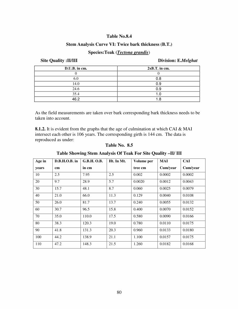
80
Table No.8.4
Stem Analysis Curve VI: Twice bark thickness (B.T.)
Species:Teak (Tectona grandis)
Site Quality :II/III Division: E.Melghat
D.U.B. in cm. 2xB.T. in cm.
0 0
6.0 0.8
14.0 0.9
24.6 0.9
35.4 1.0
46.2 1.8
As the field measurements are taken over bark corresponding bark thickness needs to be
taken into account.
8.1.2. It is evident from the graphs that the age of culmination at which CAI & MAI
intersect each other is 106 years. The corresponding girth is 144 cm. The data is
reproduced as under:
Table No. 8.5
Table Showing Stem Analysis Of Teak For Site Quality –II/ III
Age in
years
D.B.H.O.B. in
cm
G.B.H. O.B.
in cm
Ht. In Mt. Volume per
tree cm
MAI
Cum/year
CAI
Cum/year
10 2.5 7.95 2.5 0.002 0.0002 0.0002
20 9.7 28.9 5.7 0.0020 0.0012 0.0043
30 15.7 48.1 8.7 0.060 0.0025 0.0079
40 21.0 66.0 11.3 0.129 0.0040 0.0108
50 26.0 81.7 13.7 0.240 0.0055 0.0132
60 30.7 96.5 15.8 0.400 0.0070 0.0152
70 35.0 110.0 17.5 0.580 0.0090 0.0166
80 38.3 120.3 19.0 0.780 0.0110 0.0175
90 41.8 131.3 20.3 0.960 0.0133 0.0180
100 44.2 138.9 21.1 1.100 0.0157 0.0175
110 47.2 148.3 21.5 1.260 0.0182 0.0168

81
Stem Analysis: Curve I (Height/Age)
Species:Teak (Tectona grandis )
Site Quality:II/III Division :E.MELGHAT
1.37
4.24
7.24
10.24
13.24
16.24
19.48
0
2
4
6
8
10
12
14
16
18
20
22
24
0 10 20 30 40 50 60 70 80 90 100
Rings at breast height/Age
Hei
gh
t in
m.
ht.of section in m. Poly. (ht.of section in m.)
Stem Analysis
Curve II: Diameter u.b./ Height (First Curve) Species :Teak (Tectona grandis) Site Quality II/III
Division:E.Melghat
4.6
0
10.7
5.9
0
17.1
10.2
5.2
0
31.7
20.9 20.6
15.3
10.9
4.9
0
35.3
23 22.6
19.6
14.5
6.6
0
40.7
27.225.8
22.2
16.4
9.1
0.9
42.3
30.1 30
24
18
11
3.4
42.6
32.8 32.7
25.6
19.7
12.5
4.9
45.5
35.5 34.6
27.3
21.2
13.9
5.8
2.63
11.4
23
13.9
810
26.9
17.414.8
0
5
10
15
20
25
30
35
40
45
50
0 2 4 6 8 10 12 14 16 18 20
Height of section in m.
Dia
. in
cm
.
10 20 30 4050 60 70 8090 100 110

82
Stem Analysis
Curve IV: Diameter U.B./Height in m.(Final curve)
Species:Teak (Tectona grandis )
Site Quality:II/III Division :E.Melghat
4.24
5.9
10.2
5.2
0
13.9
10.2
4.52.6
0
17.4
7.4
1.9
31.7
20.919
15.3
10.9
4.9
0
35.3
23.8 22.619.6
14.5
6.6
0
40.1
27.225.8
22.2
16.4
9.1
0.9
42.3
30.128.7
24
18
11
3.4
42.6
32.8 31.8
25.6
19.7
12.5
4.9
45.5
35.5 34.6
27.3
21.2
13.9
5.84.6
10.7
0
17.1
22.5
26.9
14.8
10
0
5
10
15
20
25
30
35
40
45
50
0 2 4 6 8 10 12 14 16 18 20
Height in meters
Dia
met
er
in c
m.
10 20 30 40 50 60
70 80 90 100 110
Stem Analysis
Curve III:Diameter underbark /Height (Second Curve)
Species :Teak Site Quality II/III
Division: E.Melghat
10.7
17.1
22.5
26.9
31.735.3
40.142.3 42.6
45.5
10.213.9
17.420.9
23.827.2
30.132.8
35.5
10.2
14.819
22.625.8
28.731.8
34.6
4.5
10
15.3
19.622.2
24 25.6 27.3
2.6
7.410.9
14.516.4 18 19.7 21.2
4.9 6.69.1
11 12.5 13.9
0 0 0.93.4 4.9 5.84.6 5.9
0
5.2
01.9
0
5
10
15
20
25
30
35
40
45
50
0 20 40 60 80 100
Rings at Breast Height
Dia
met
er i
n c
.m.
1.37 4.24 7.24 10.24 13.24 16.24 19.24
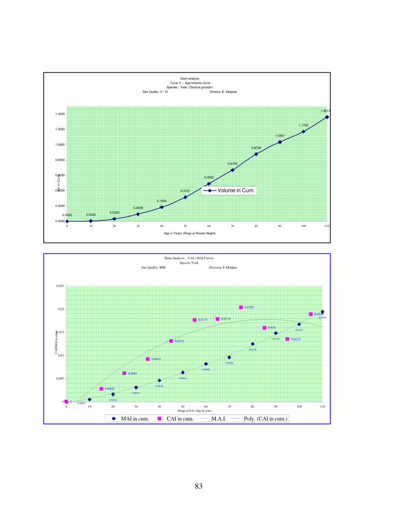
83
Stem analysis
Curve V :- Age/Volume Curve
Species : Teak (Tectona grandis )
Site Quality :II / III Division: E. Melghat
0.0000 0.00460.0329
0.0938
0.1854
0.3161
0.4932
0.6726
0.8768
1.0367
1.1720
1.3613
0.0000
0.2000
0.4000
0.6000
0.8000
1.0000
1.2000
1.4000
0 10 20 30 40 50 60 70 80 90 100 110
Age in Years (Rings at Breast Height)
Vol. in C
u.m
.
Volume in Cum.
Stem Analysis: CAI / MAI Curves
Species:Teak
Site Quality :II/III Division: E.Melghat
0.0016
0.0031
0.0046
0.0063
0.0082
0.0096
0.0125
0.0148
0.0167
0.0194
0
0.0028
0.0061
0.0092
0.0131
0.0177 0.0179
0.0204
0.016
0.0135
0.0189
0 0.00050
0.005
0.01
0.015
0.02
0.025
0 10 20 30 40 50 60 70 80 90 100 110
Rings at b.h./ Age in years
CA
I/M
AI
in c
um
.
MAI in cum. CAI in cum. M.A.I. Poly. (CAI in cum.)

84
Stem Analysis
Curve VIII:Diameter O.B./Age
Species :Teak (Tectona grandis )
Site Quality:II/III Division:E.Melghat
5
11.6
18
23.9
27.8
32.636.3
4243.8 44.1
47.2
0
y = -0.0025x2 + 0.715x - 1.0931
0
4
8
12
16
20
24
28
32
36
40
44
48
0 10 20 30 40 50 60 70 80 90 100 110
Age in years
Dia
. O
. b
.in
cm
.
Diameter O.B. cm. Diameter O.B.
Stem Analysis
Curve VI: Twice bark thickness (B.T.)
Species :Teak (Tectona grandis ) Site Quality :II/III
Division: E.Melghat.
0
0.8
0.9 0.9
1
1.8
0
0.2
0.4
0.6
0.8
1
1.2
1.4
1.6
1.8
2
0 5 10 15 20 25 30 35 40 45 50
DIAMETER U.B IN C.M.
BA
RK
TH
ICK
NE
SS
IN
C.M
. &
DE
CIM
AL
2xB.T. in cm.

85
Table No. 8.6
No. of years required to cross the Girth Class.
Girth Class cum Mid girth cm II
Age in years Years required to cross to the class
15-30 22.5 17 --
-- 8
30-45 37.5 25 --
-- 8
45-60 52.5 33 --
-- 8
60-75 72.5 41 --
-- 9
75-90 82.5 50 --
-- 11
90-105 97.5 61 --
-- 12
105-120 112.5 73 --
-- 13
120-135 127.5 86 --
-- 19
135-150 142.5 105
-- --
For the initial four girth classes the tree has taken on an average 8 years time to cross one
girth class to another girth class. Later on wards around 12 years on an average for the
next 3 girth classes. The period further increased to 20 years i.e. felling cycle period to
cross penultimate girth class to last girth class.
8.1.3 Stem Analysis Exercise was carried out in Dhulgat Range of adjoining West
Melghat Division for site quality III teak having an height of 20.30 M. The CAI and
MAI curves are drawn and results are shown as under:

86
Table No.8.7
Table Showing Age Height Parameters Of Stem Analysis
Species:Teak(Tectonagrandis) Site Quality III
Age ht. of section in m.
0 1.37
8 4.24
11 7.24
13 10.24
36 13.24
64 16.24
77 18.94
8.1.2 It is evident from the graphs that the age of culmination at which CAI & MAI
intersect each other is 88 years. The corresponding girth is 107 cm. The data is
reproduced as under.
Table No. 8.8
Table Showing Stem Analysis Of Teak For Site Quality – III
Age in
years
D.B.H.O.B. in
cm
G.B.H. O.B.
in cm
Ht. In Mt. Volume per
tree cm
MAI
Cum/year
CAI
Cum/year
10 6.3 19.8 2.4 0.0103
0.0010 0.0015
20 10.7 33.6 7.5 0.0400
0.0020 0.0041
30 13.9 43.7 10.8 0.0930
0.0031 0.0062
40 16.3 51.2 12.8 0.1640
0.0041 0.0080
50 19.2 60.3 13.6 0.2531
0.0051 0.0085
60 22.0 69.1 14.7 0.3539
0.0059 0.0126
70 26.1 82.0 16.3 0.5065
0.0072 0.0189
80 32.3 101.5 18.0 0.7313
0.0091 0.0198
90 34.0 106.9 18.8 0.7600
0.0100 0.0092

87
Stem Analysis CAI/MAI Curves Species: Teak Site Quality: III
0
0.0010
0.0020
0.0031
0.0041
0.0051
0.0059
0.0072
0.0091
0
0.0015
0.0041
0.0062
0.00800.0085
0.0126
0.0189
0
0.002
0.004
0.006
0.008
0.01
0.012
0.014
0.016
0.018
0.02
0 10 20 30 40 50 60 70 80 90
Age in years( Rings at b.h.)
CA
I/M
AI
MAI CAI Poly. (CAI) Poly. (MAI)
SECTION 2. STOCK MAPPING:
8.2.1. Reserved Forests of the division were stock mapped for the first time in the
year1935 at the time of revision of the working plan by A.H.Stein. The stock maps were
revised with each revision of the working plan. P.P.Joshi made the latest revision of
stock maps at the time of the revision of the working plan.
8.2.2. As per the directives from the Chief Conservator of Forests, Working Plan,
Nagpur the ocular and subjective stock mapping has been replaced with objective
inventory based on the systematic line-plot sampling on 600 meter grid. The standard size
of the sample plot is of 0.36 hectares and located at the grid intersections, in the NE
quadrant. Inventory work includes complete enumeration of all trees species in these
plots in 15cm girth classes. Regeneration counting is done in 0.04-hectare sup-plots.
Recording of forest type, site quality, density and nature of forest damage have been
included as an integral part of the enumeration exercise. Accordingly, SOFR (Survey of
Forest Resource) Unit, Amravati in collaboration with the field staff of Amravati
Working Plan division has carried out the comprehensive inventory in forests of East
Melghat Division. The Inventory Management System developed by Dhabekar was used
for analysis of the inventory data leading to provide the following statements for the
purpose of estimation of the growth stock for treatment under various working circle.

88
1. Girth class-wise estimated growing stock in respect of important 18-20 tree
species and rest of species together.
2. Estimated growing stock per hectare separately for ain, bija, lendia, shisham,
tiwas, teak, kalam, khair, salai, semal, dhaora, garari and rest of species
together.
3. Girth class-wise percentage distribution of each of the above species in the
growing stock.
The details are given in the Appendix LVII of Volume II of this plan.
8.2.3. The inventory data, so obtained, has been dynamically linked with compartment
maps in the GIS environment; showing the stocking and management related details. The
maps prepared in the GIS environment are cartographically more accurate than traditional
stock maps based on ocular estimation. The process has been fairly standardised in the
Forest GIS Cell Amravati.
8.2.4. The satellite imagery of LISS III of 22nd
December 2002 was used to classify the
forest patches according to density as revealed in the Normalized Density Vegetation
Index (NDVI) mapping. The extensive line plot sampling data were used for the
preparation of stock maps for those areas where stock maps were not prepared. The
results of stock mapping are given below.
Table No.8.9
Table Showing The Results Of Stock Mapping
Forest
Type
Site
Quality SCIWC IWC AWC PWC TPWC
Total Area in
ha.
% to the total
area
Teak II 5.5366 - - 9.6237 64.4797 79.64 0.14
III 13475.3737 - 56.5733 2307.0926 4492.3844 20331.422 37.10
IVa 1256.8493 157.5486 362.312 3990.5412 180.355 5947.6061 10.85
IVb 633.5228 1882.3981 2843.3393 5729.2641 121.4646 11209.988 20.45
Total 15371.2824 2039.9467 3262.2246 12036.5216 4858.6837 37568.6590 68.55
Mixed III 1778.5885 6.1271 255.772 341.4341 152.0659 2533.9876 4.62
IVa 211.9504 380.1958 62.6 82.1397 3.1106 739.9965 1.35
IVb 131.1419 1147.5834 2518.3033 699.5167 4.3695 4500.9148 8.21
Total 2121.6808 1533.9063 2836.6753 1123.0905 159.546 7774.8989 14.18
Salai III 4.8127 - - 10.0171 - 14.8298 0.03
IVa - 4.7374 11.1818 - - 15.9192 0.03
IVb 5.7152 718.6737 273.5164 0.8761 - 998.7814 1.82
Total 10.5279 723.4111 284.6982 10.8932 - 1029.5304 1.88
Old
Plantation - 210.0299 84.0846 545.0144 61.1476 13.4879 913.7644 1.67
Under
stocked - 1379.1207 269.4113 425.1214 3336.4953 268.3650 5618.5137 10.25
Not Stock
mapped - 411.5986 4.2008 229.2095 1214.9013 40.2684 1900.1786 3.47
Total 19504.2603 4654.9608 7582.9434 17783.0495 5340.3510 54805.542 100.000
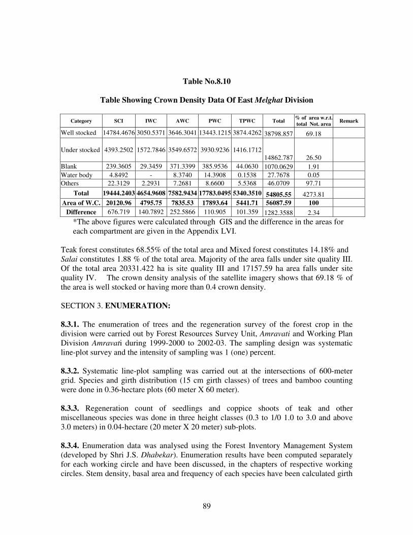
89
Table No.8.10
Table Showing Crown Density Data Of East Melghat Division
Category SCI IWC AWC PWC TPWC Total % of area w.r.t.
total Not. area Remark
Well stocked 14784.4676 3050.5371 3646.3041 13443.1215 3874.4262 38798.857 69.18
Under stocked 4393.2502 1572.7846 3549.6572 3930.9236 1416.1712
14862.787 26.50
Blank 239.3605 29.3459 371.3399 385.9536 44.0630 1070.0629 1.91
Water body 4.8492 - 8.3740 14.3908 0.1538 27.7678 0.05
Others 22.3129 2.2931 7.2681 8.6600 5.5368 46.0709 97.71
Total 19444.2403 4654.9608 7582.9434 17783.0495 5340.3510 54805.55 4273.81
Area of W.C. 20120.96 4795.75 7835.53 17893.64 5441.71 56087.59 100
Difference 676.719 140.7892 252.5866 110.905 101.359 1282.3588 2.34
*The above figures were calculated through GIS and the difference in the areas for
each compartment are given in the Appendix LVI.
Teak forest constitutes 68.55% of the total area and Mixed forest constitutes 14.18% and
Salai constitutes 1.88 % of the total area. Majority of the area falls under site quality III.
Of the total area 20331.422 ha is site quality III and 17157.59 ha area falls under site
quality IV. The crown density analysis of the satellite imagery shows that 69.18 % of
the area is well stocked or having more than 0.4 crown density.
SECTION 3. ENUMERATION:
8.3.1. The enumeration of trees and the regeneration survey of the forest crop in the
division were carried out by Forest Resources Survey Unit, Amravati and Working Plan
Division Amravati during 1999-2000 to 2002-03. The sampling design was systematic
line-plot survey and the intensity of sampling was 1 (one) percent.
8.3.2. Systematic line-plot sampling was carried out at the intersections of 600-meter
grid. Species and girth distribution (15 cm girth classes) of trees and bamboo counting
were done in 0.36-hectare plots (60 meter X 60 meter).
8.3.3. Regeneration count of seedlings and coppice shoots of teak and other
miscellaneous species was done in three height classes (0.3 to 1/0 1.0 to 3.0 and above
3.0 meters) in 0.04-hectare (20 meter X 20 meter) sub-plots.
8.3.4. Enumeration data was analysed using the Forest Inventory Management System
(developed by Shri J.S. Dhabekar). Enumeration results have been computed separately
for each working circle and have been discussed, in the chapters of respective working
circles. Stem density, basal area and frequency of each species have been calculated girth

90
class wise and presented in the Appendix No. LX and Species distribution in various
working circles is given in Appendix LVII of Volume II of this plan.
8.3.5. The analysis of enumeration data shows that the growing stock has improved
marginally in both the S.C.I. and Improvement Working Circle areas. In the S.C.I. areas,
teak in various higher girth classes (46-75 onward) has shown an increase in number due
to conservation efforts. Whereas lower girth classes has shown decrease in number as
compared to Sinha’s plan of S.C.I. W.C. areas. It is attributed to poor recruitment and
establishment of teak regeneration. The number of miscellaneous trees/ha has increased
marginally in all girth classes, compared to Shri Sinha’s plan period. Overall the growing
stock has improved from 290 trees/ha to 376.8 trees/ha. In the areas of Improvement
Working Circle Percentage of teak has increased from 27.86 to 40.11. Whereas the
percentage of miscellaneous species has come down from 72.14 to 59.89. The number of
miscellaneous species per hectare remained more or less same. Overall the growing stock
has improved marginally from 252.15 trees/ha of P.P.Joshi’s plan period to 315.98
trees/ha.
CROP GIRTH:
8.3.6. The crop girth, which has been calculated on the basis of the enumeration data, is
90cm. for the forest allotted to the Selection Working Circle. It corresponds to the age of
50 years. Following table shows crop girths, their corresponding ages and basal areas for
the enumerations taken up under various plans.
Table No. 8.11
Table Showing Crop Girth, Average Basal Area Under Various Plans Enumeration Period Crop Girth cm. Corresponding Age in
Years
Average Basal Area in
sq. m.
P. P. Joshi,s Plan 58.5 33 9.40
Sinha’s Plan 69 41 12.30
Current Plan 90 50 17.94
NORMAL GROWING STOCK:
8.3.7. A modest endeavor has been made below to find out how close is the existing
growing stock in Selection Working Circle to normal growing stock. This knowledge will
help in bringing the forest as close to the normal as possible by careful manipulation of
the crop over long periods.
8.3.8. The number of trees in each size class judges the normality of an uneven aged
selection forest. It must contain more small trees than big ones per hectare. There are two
ways of constructing a simple model of normal growing stock. One is by adopting the
plantation crop yield table figures and the second method is to follow F. De Liocourt’s
theory (1898) that the number of stems in a Selection forest lessens from one-size-class to
the larger class in a geometrical progression, so that the ratio of diminution is constant.
The better quality selection forest, which is comparable to the All-India quality, III/IV is
considered for the purpose of this exercise. The following normal growing stock model is

91
constructed for All-India plantation teak quality III/IV and Natural teak quality III and is
given under Table 8.12.
Table 8.12
Growing Stock Model Based On All-India Teak Yield (Plantation) Table And
Natural Teak
Plantation Teak Q. III/IV Natural Teak Q. III
Age No. of
trees
Reduced No. 50 percent
of (iii)
No. of trees Reduced No. 50 percent
of (vi)
(i) (ii) (iii) (iv) (v) (vi) (vii)
5 -- -- -- -- -- --
10 1,310 82 41 2,174 136 68
15 940 58 29 1,169 73 37
20 678 42 21 785 49 24
25 550 34 17 588 37 18
30 463 29 14 477 30 15
35 395 24 12 394 25 12
40 350 22 11 329 20 10
45 323 20 10 290 18 9
50 297 17.6 9 258 16 8
55 278 16.5 8.25 230 14 7
60 260 15.4 7.7 214 13 6.5
65 242 14.5 7.25 192 12 6
70 230 13.8 6.9 184 11 5.5
75 217 13.5 6.5 168 10.5 5.2
80 205 12.5 6 158 9.9 4.9
8.3.9. Column (ii) gives number of trees on one hectare of land for 16 ages. Each
represents five-age gradations. The total of this column represents what could be the crop
on 16 ha. of forestland if all the age classes are mixed together. Dividing each figure in
column (ii) by 16 gives the crop 1/16 ha. as in column (iii) and the total column (iii) the
crop of 1 ha. with age gradation from 1 to 80. These figures are for a fully stocked area.
Since Melghat areas have 50 per cent of the crop as teak, for the sake of comparability,
column (iii) figures have to be halved to obtain the number in each age class in a normal
selection forest with 50 per cent of the growth in teak.
8.3.10. Columns (v) to (vii) give similar information compiled from a yield table for
natural teak forests. The basis of information has been secured through the kindness of
Shri A.N. Chaturvedi, I.F.S., Mensuration Officer, FRI from an unpublished paper.
8.3.11. The four sets of figures (I) Existing growing stock (ii) Existing growing stock
modified on de Liocourt’s Theory (iii) Normal growing stock from natural teak yield
tables is given in the table 8.13. Existing growing stock figures are for size classes;
hence the average is also given.

92
Table No. 8.13
Table Showing No. Of Teak Trees Per Hectare In The Existing And Normal
Growing Stock
Existing Growing Stock Normal Growing Stock Model
Size-Class
(cm)
Age
(Yr.)
Actual
(No.)
De Liocourt
(No.)
Age
(Yr.)
(50) per cent stock
Plantation
teak yield
table
(No.)
Natural teak
yield table
(No.)
1 2 3 4 5 6 7
15 U 30 12 29.08 29.08 10
15
41
29
68
37
30 U 45 21 24.00 26.08 20
25
21
17
24
18
45 U 60 29 19.18 23.40 30
35
14
12
15
12
60 U 75 38 19.33 20.99 40
45
11
10
10
9
75 U 90 47 19.30 18.82 50
55
9
8.5
8
7
90 U 105 58 19.50 16.88 60
65
8
7.5
6.5
6
105 U 120 71 13.54 15.14 70
75
7.2
6.7
5.5
5.2
120 U 135 110 14.76 13.58 80 6.2 4.9
135 and over -- --- ---
Total -- 158.69 163.57 -- 208.1 236.1
8.3.12. From the above figures, it becomes evident that normal growing stock models
with 50 per cent stock have a larger number of trees per hectare. A sample plot showing
the existing tree numbers and number of trees /ha to be retained for a specific site quality
with its corresponding rotation and after careful intervention how the tree numbers are
distributed under various girth classes is given below to have a fair understanding of the
exercise to be carried out.

93
Table No. 8.14
Table Showing Management Intervention To Attain Number Of Trees As Per Yield
Table
Average Site quality II/III with rotation 150cm.
Range: Jarida Compartment No.: 410 Coupe No.:XI
Average top height in the grid 23M, Grid No.7
Girth class
(c.m.)
Existing
number of trees
No. of trees to be attained as per
yield table
difference No. to be
removed
No. after
thinning
0-15 200 236 -36 0 200
16-30 182 163 19 0 182
31-45 69 85 -16 0 69
46-60 45 48 -3 0 45
61-75 33 31 2 0 33
76-90 36 23 13 3 33
91-105 41 19 22 9 32
106-120 26 16 10 5 21
121-135 16 14 2 3 13
136-150 16 12 4 2 14
151-165 7 0 7 2 5
Total 671 647 24 24 647
Analysis of the crop:
Tending
200
182
69
45
33 3641
26
16 167
236
163
85
48
3123
19 16 14 12
0
200
182
69
45
33 33 32
2113 14
50
50
100
150
200
250
0-15 16-30 31-45 46-60 61-75 76-90 91-105 106-120 121-135 136-150 151-165
girth classes in cm.
nu
mb
er
of
tre
es
Existing number of trees No. to be attained as per yield table No. after thinning
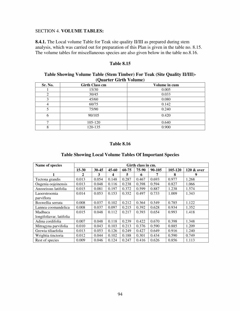
94
SECTION 4. VOLUME TABLES:
8.4.1. The Local volume Table for Teak site quality II/III as prepared during stem
analysis, which was carried out for preparation of this Plan is given in the table no. 8.15.
The volume tables for miscellaneous species are also given below in the table no.8.16.
Table 8.15
Table Showing Volume Table (Stem Timber) For Teak (Site Quality II/III)-
(Quarter Girth Volume) Sr. No. Girth Class cm Volume in cum
1 15/30 0.005
2 30/45 0.033
3 45/60 0.080
4 60/75 0.142
5 75/90 0.240
6 90/105 0.420
7 105-120 0.640
8 120-135 0.900
Table 8.16
Table Showing Local Volume Tables Of Important Species
Name of species Girth class in cm.
15-30 30-45 45-60 60-75 75-90 90-105 105-120 120 & over
1 2 3 4 5 6 7 8 9
Tectona grandis 0.013 0.054 0.148 0.287 0.467 0.693 0.977 1.268
Ougenia oojeinensis 0.013 0.048 0.116 0.238 0.398 0.594 0.827 1.066
Anooeissus latifolia 0.015 0.081 0.197 0.372 0.599 0.887 1.238 1.574
Laoerstroemia
parviflora
0.014 0.053 0.153 0.352 0.497 0.733 1.009 1.343
Boswellia serrata 0.008 0.037 0.102 0.212 0.364 0.549 0.785 1.122
Lannea coomandelica 0.008 0.037 0.097 0.215 0.392 0.628 0.934 1.352
Madhuca
longifoliavar, latifolia
0.015 0.048 0.112 0.217 0.393 0.654 0.993 1.418
Adina cordifolia 0.007 0.048 0.118 0.239 0.422 0.670 0.398 1.348
Mitragyna parvifolia 0.010 0.043 0.103 0.213 0.376 0.590 0.885 1.209
Grewia tiliaefolia 0.013 0.053 0.126 0.249 0.427 0.649 0.916 1.240
Wrightia tinctoria 0.012 0.044 0.102 0.188 0.301 0.434 0.590 0.749
Rest of species 0.009 0.046 0.124 0.247 0.416 0.626 0.856 1.113
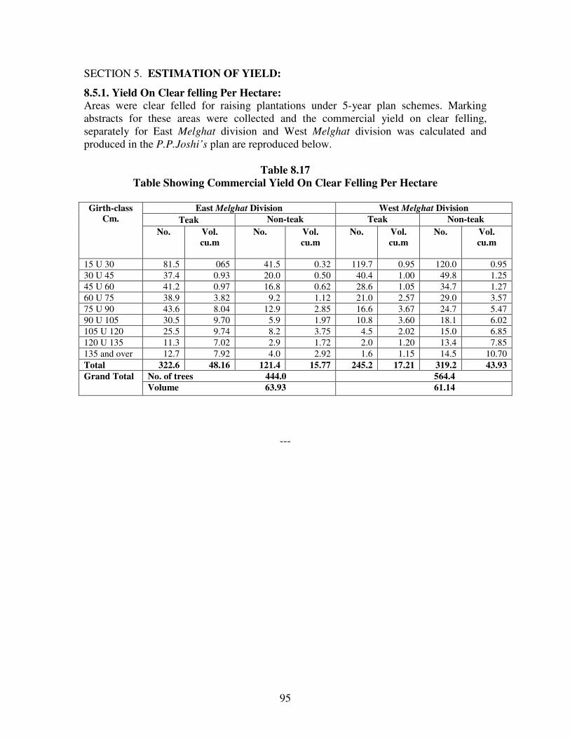
95
SECTION 5. ESTIMATION OF YIELD:
8.5.1. Yield On Clear felling Per Hectare:
Areas were clear felled for raising plantations under 5-year plan schemes. Marking
abstracts for these areas were collected and the commercial yield on clear felling,
separately for East Melghat division and West Melghat division was calculated and
produced in the P.P.Joshi’s plan are reproduced below.
Table 8.17
Table Showing Commercial Yield On Clear Felling Per Hectare
Girth-class
Cm.
East Melghat Division West Melghat Division
Teak Non-teak Teak Non-teak
No.
Vol.
cu.m
No.
Vol.
cu.m
No.
Vol.
cu.m
No.
Vol.
cu.m
15 U 30 81.5 065 41.5 0.32 119.7 0.95 120.0 0.95
30 U 45 37.4 0.93 20.0 0.50 40.4 1.00 49.8 1.25
45 U 60 41.2 0.97 16.8 0.62 28.6 1.05 34.7 1.27
60 U 75 38.9 3.82 9.2 1.12 21.0 2.57 29.0 3.57
75 U 90 43.6 8.04 12.9 2.85 16.6 3.67 24.7 5.47
90 U 105 30.5 9.70 5.9 1.97 10.8 3.60 18.1 6.02
105 U 120 25.5 9.74 8.2 3.75 4.5 2.02 15.0 6.85
120 U 135 11.3 7.02 2.9 1.72 2.0 1.20 13.4 7.85
135 and over 12.7 7.92 4.0 2.92 1.6 1.15 14.5 10.70
Total 322.6 48.16 121.4 15.77 245.2 17.21 319.2 43.93
Grand Total No. of trees 444.0 564.4
Volume 63.93 61.14
---

96
CHAPTER 1.
BASIS OF PROPOSAL
SECTION 1.1. THE NATIONAL FOREST POLICY:
1.1.1. The National Forest Policy was first enunciated in 1894 and was revised in 1952,
after independence. It was again revised in the shape of the National Forest Policy 1998,
which is presently in force.
1.1.2. The basic objectives and thrust areas enshrined in the National Forest Policy 1988
are given as under:
1. Maintenance of environmental stability through preservation and where necessary,
restoration of the ecological balance that has been adversely disturbed by serious
depletion of forest.
2. Conserving the natural heritage of the country by preserving the remaining natural
forest with the vast variety of flora and fauna, which represents the remarkable
biodiversity and genetic resources of the country.
3. Checking the soil erosion and denudation in the catchment area of the rivers, lakes and
reservoirs in the interest of soil and water conservation for mitigating flood and droughts
and for retardation of siltation of reservoirs.
4. Checking the extension of sand dunes in the desert areas and along the coastal tracts.
5. Increasing substantially the forest/tree cover in the country through massive
afforestation and social forestry programs, especially, on all denuded, degraded and
unproductive lands.
6. Meeting the requirements of fuel wood, fodder, minor forest produce and small timber
of the rural and tribal populations.
7. Increasing productivity of forest to meet essential needs.
8. Encouraging efficient utilization of forest produce and maximizing substitution of
wood.
9. Creating a massive people’s movement with the involvement of women, for achieving
these objectives and to minimize pressure on existing forests.
10. The principal aim of the Forest Policy must be to ensure environmental stability and
maintenance of ecological balance including atmospheric equilibrium, which are vital for

97
sustenance of all life forms, human, animal and plant. The derivation of direct economic
benefit must be subordinated to the principal aim.
1.1.3. Essentials of Forest Management embodied in the Nation Forest Policy 1988 are
given as follows:
1. Existing forest and forestland should be fully protected and their productivity be
improved. Forest and vegetal cover should be increased rapidly on hill slopes, in
catchment of the rivers, lakes and reservoirs and ocean shores and on semi arid, arid and
desert tracts.
2. For conservation of biodiversity networks of national parks, sanctuaries, and biosphere
reserves and other protected areas should be strengthened and extended adequately.
3. Provision of sufficient fodder, fuel and pasture, especially, in areas adjoining to forests
beyond sustainable limits.
4. Minor forest produce provides sustenance to the tribal population and to other
communities residing in and around the forests. Such produce should be protected,
improved and their production enhanced with due regard to generation of employment
and income.
5. Schemes and projects, which interfere with forests that clothe steep slopes, catchment
of rivers, lakes and reservoirs, geologically unstable terrain and other ecologically
sensitive areas should be severely restricted.
6. No forest shall be worked without the Government approved management plan, which
shall be tuned to the provisions of National Forest Policy.
7. The rights and concessions enjoyed by the tribal and other rural poor living within and
near the forests should be fully protected. Their domestic requirements of fuel wood,
fodder minor forest produce and construction timber should be the first charge on forest
produce.
8. Inculcate in the people, a direct interest in forest and make them conscious of the value
of trees, wildlife and nature in general through forest extension, education and training.
National Wildlife Action Plan (NWAP):
1.4.1. The first National Wildlife Action Plan (NWAP) was adopted in 1983
subsequently revised in the year 2002. The plan had outlined the strategies and action
points for wildlife conservation. Increased commercial use of natural resources,
continued growth in human and cattle populations and changes in consumption patterns
are causing greater demographic impacts. It also says that effective ecosystem
conservation is the foundation of long term ecological and economical stability. Natural
processes, forests, and other wild habitats recharge aquifers, maintain water regimes and
98
moderate the impact of floods, droughts and cyclones. Thereby they ensure food security
and regulate climatic change. They are also a source of food, fodder, fuel and other
products supplementing the sustenance of local communities.
1.4.2. India ranks sixth amongst the 12mega biodiversity countries of the world.
Conservation of biodiversity is directly linked with conservation of ecosystem and thus
with water and food security.
1.4.3. The NWAP proposes restoration and management of degraded habitats outside
protected areas to provide sufficient habitat for spatial movement of spill over species
outside PAs, and to provide biological resources needed by the local communities to
prevent their dependence on PA resources. Degraded habitats outside PAs and their needs
must urgently be identified for restoration, which would involve a combination of
protection, soil and water conservation and planting of local species coupled with the
removal of exotics.
NATIONAL FORESTRY ACTION PROGRAMME (NFAP):
1.5.1. To reverse the process of degradation and for sustainable development of forests,
the Government of India have prepared National Forestry Action Plan programme a
comprehensive strategic plan to address the issues underlying the major problems of the
forestry sector. The objective of NFAP is to enhance the contribution of forestry and tree
resources to ecological stability and people centered developmental through qualitative
and quantitative improvement in the forest resources.
1.5.2. Major Programmes of NFAP are given below:
1. Protect Existing forest resources: It has three main sub programmes. (1) Forest
protection (2) soil and water conservation and (3) protected areas and biodiversity
conservation. These include the works of forest survey, demarcation and mapping,
inventory, encroachment and fire etc., and other related issues.
2. Improve forest productivity: it has four main programmes (1) rehabilitation of
degraded forests (2) research and technology development (3) development of NTFPs,
(4) assisting private initiatives with community participation. These involve mainly
research, improvement in technology, enrichment planting soil and water conservation,
regeneration, rehabilitation and afforestation mainly in existing forests.
3.Reduce total demand: It has three main sub programmes for the efficient use of (1)
fuel wood and fodder, (2) timber (3) NTFP. This includes the programmes for
substitutions, and other measures for the efficient utilization of forest products and also
through extensive biomass plantations.
4. Strengthen Policy and Institutional Framework: It has three main sub programmes
of strengthening of (1) central forestry administration (2) central forestry institutions and
(3) state forestry administration and institutions
5. Expand forest area: It has two main sub programmes of (1) tree plantation on forest
and nonforest lands (2) peoples participation in plantations and its protection.

99
SECTION 1.2. FUNCTAIONAL CLASSIFICATION OF FORESTS:
1.2.1. The broad principles of classification of forest on functional basis have been
embodied in Resolution No. MRF-1365/132211-Y dated December 6, 1968 issued by
Government of Maharashtra. The following functional classes have been recognized by
the state.
1.2.2. Protection Forests: It includes forests on steep slopes (25 and above) or along
river banks and forest that have become depleted through maltreatment and further
exploitation of which will accentuate soil erosion and adversely affect the productivity of
agricultural lands in the region. The management should aim conserving these forests,
through soil and moisture conservation measures, so that they may exert beneficial
influence on the soil, the water regime and the physical and climatic factors of the
locality.
1.2.3. Tree Forests: These forests are situated in remote tracts that are mainly capable of
growing large sized timber and other products of commercial value.
1.2.4. Minor Forests: It includes forests that are interspersed with cultivated lands and
are capable of producing small timber and fuel wood and provided grazing which are
indispensable needs of adjoining agricultural works.
1.2.5. Pasture Lands: They are openly stocked forests of scrublands that have ceased to
yield even the small timber but are conveniently situated for providing grazing to the
cattle used for agricultural works.
Miscellaneous forests:
1.2.6. Grass reserves: These are small blocks of forest situated amidst cultivated tracts
carrying scrubby growth and capable of producing good fodder grasses.
1.2.7. Remaining areas needed for other purposes.
1.2.8. Taking into consideration the above aspects besides the growing stock and
condition of site has made the functional classification of the forests. The various types of
forests will be treated as follows.
1.2.9.Protection Forests: The category includes steep and precipitous slopes of Ghatang
and Chikhaldara Range. Stocking is good in the entire area except Chikhaldara
surroundings. It is proposed to treat the area with soil and moisture conservation works
and by gap planting.
1.2.10. Tree Forest: This type of forest includes the better quality forests, capable of
producing large sized timber having site quality III and IV, which are comparatively
away from local habitations. They have been worked under SCI and Improvement
Working Circle except areas under protected areas. They will be managed to produce

100
large sized timber. Steep slopes will be excluded from harvesting operations, but will be
covered for soil and moisture conservation works. The natural regeneration will be
tended and areas having inadequate natural regeneration will be induced for N.R.
simultaneously, the area will be planted with suitable valuable species. The percentage of
teak in the existing crop is nearly 50%. These areas will be worked under SCI working
circle and Teak Plantation Working Circle. The area with mature crop having scanty
regeneration will be worked under complete removal of over wood, followed by
Artificial Regeneration of genetically superior species. These areas will be worked under
Teak Plantation Working Circle. Part areas of Anjangaon Range will be managed to meet
the local needs of small timber, poles and fuel wood. The growing stock is mainly of site
quality IV a and IV b with patches of quality III. The density is 0.4 to 0.6. Natural
regeneration is deficient in open areas. These forests have been worked under
improvement and afforestaion W.C. under the previous plans. This forest will be
continued to be managed under Improvement W.C. and afforestation W.C. Large-scale
soil and moisture conservation works will be taken up in the open and eroded areas. NR
will be induced, tended and supplemented with AR of suitable species.
Table No. 1.1:
Table Showing Functional Categories of Forests in East Melghat Division
Category Area in ha. Percentage
R.F. (in ha.) P.F. Un classed Total
Tree Forest 38177.36 - 16.60 38193.96 68.09
Protection Forest 17889.17 - 4.47 17893.64 31.91
Total 56066.53 - 21.07 56087.60 100
SECTION 1.3. FACTORS INFLUENCING OBJECTS OF MANGEMENT:
1.3.1. The forests are primarily Teak Forests in the nature and good in quality, having
50% proportion of valuable species, like teak, and need regeneration of valuable species
in the stocking. A large chunk of forest tract is fully stocked, dense and needs proper
tending of the crop.
1.3.2. The natural generation of teak and miscellaneous is not up to the mark. Seedlings
and saplings, no doubt, were observed at places but far short of required numbers.
1.3.3. A bulk of forest of the division adjoins the Protected Areas, namely, Gugamal
National Park and Melghat Wildlife Sanctuary. Thereby, require treatment in conformity
with the wildlife and bio-diversity conservation. The hilly topography of Melghat, steep
slopes, species variation in the composition of crop with a change in the altitude is the
salient feature of theMelghat. The topographical and biological biodiversity need to be
taken care of while working these forests.
1.3.4. The bamboo is a most sought after forests produce in the division by local
communities especially the burads. The uncontrolled bamboo extraction and Bamboo

101
Flowering has resulted in shrinking of bamboo areas in the division. The bamboo areas
require special focus and treatment to reverse this trend.
1.3.5. The forests suffer heavy biotic pressure, especially, uncontrolled grazing, resulting
in trampled regeneration and compact soils, devoid of humus. Excessive grazing and
uncontrolled fires are the main adverse factors causing degradation of forests in the
division. The situation requires some bold measures like control of grazing beyond
carrying capacity and strict control measures for some areas for fixed periods on
rotational basis to minimize these adverse influences.
1.3.6. The NWFPs species form a substantial proportion of the forest crops that
contribute substantially to the livelihood of local tribal communities. The forest areas rich
in NWFPs require special thrust for their sustainable management and use in the interest
of local communities, by involving them through JFMCs. Malnourishment among Tribal
Children is a sensitive subject. Availability of NWFP will lead to nourishment of mothers
as well as children, thus reducing malnourishment among them.
1.3.7. The whole taract is very hilly and is responsible for moderating climate in the
region and brings rains to the plains down below. The tract contains valuable medicinal
and endangered, rare plants and wildlife, which need to be preserved on first priority.
STATEMENT OF SIGNIFICANCE:
1.3.8. forest is a typical representative of Central Indian Highland forming a part of the
Biogeographic zone ‘6 E-Deccan Peninsula’– Central Highlands (Rodgers and Panwar,
1988). This area constitutes forests, which are part of world’s fifth biologically richest
heritage country. The Reserve forms an important corridor between forest areas of
Madhya Pradesh and Maharashtra ensuring contiguity of forests in Satpuras. It beholds
one of the viable populations of tigers, the Royal Bengal Tiger, out of 5 surviving tiger
species including all the Tiger range countries. Out of 237– 240 Tigers in Maharashtra,
75 - 80 i.e. about 30 % occur in Melghat forest only.
Catchments to ‘Tapi ’ and ‘Purna ’ rivers:
1.3.9. The Reserve forms a very important catchment to Tapi and Purna river systems
with important tributaries like Dolar, Khandu, Sipna, Gadga, Khapra and Wan rivers.
The Chandrabhaga River, which originates from Chikhaldara has its watershed in the
reserve. The basic life support systems that the area beholds in terms of conserving soil,
water and clean air, it serves as lifeline for the people of Amravati, and Akola districts.
Unique habitats harbouring rare and endangered wildlife
1.3.10 The forest forms an important extension of the Satpura hills into the West with its
typical geological formations. It harbours a viable population of Tiger (Panthera tigris)
and of the endangered Gaur (Bos gaurus). It also harbours a number of other faunal
species some of which figure in the IUCN Red Data List. These are Wild dogs (Cuon

102
alpinus), Jackal,(Vulpes bengalensis), Sloth bear (Melurus ursinus),Leopard (Panthera
pardus), Caracal, ( Felis caracal) and Ratel, (Mellivora capensis). There are 37 species
of mammals and several species of reptiles, butterflies and insects. The reserve is also
very rich in avifauna with 264 species of birds including the recently rediscovered Forest
Spotted Owlet (Athene belwitii).
Rare endemic flora typical of Western Ghats and north Himalayas:
1.3.11 More than 718 naturalised species are listed in the flora of Melghat belonging to
about 400 genera representing 97 families. It includes 90 tree species, 66 shrub species,
316 herb species, 56 climbers, 23 sedges and 99 grass species. The flora shows a
combination of floristic elements from Western Ghat and Satpura, with many endemic
species. Some of the Himalayan plant species like Preistylus constrictus are also
reported here. The rare plants include Convolvulus flavus, Utricularia striatula, Drosera
indica and many species of orchids like Vanda tesselata and Aerides maculosum.
Evidences of temperate Flora:
1.3.12 Quite suprisingly, there are enough evidences of presence of even temperate flora
in the Reserve which are found in East and North East India, Himalayas, Jammu,
Kashmir and Hills of Uttar Pradesh. Peristylus constricts, Apium graveolens, Morchella
conica, Geranium mascatens, Senecio chryanthemoides are such examples. Species with
extremely restricted distribution, Achyranthes coynei or the species Ceropegia oculata
which is endemic to Maharashtra and is also endangered are speaking examples of the
rich and varied habitat this Reserve provides to a variety of plant species. The forests
also provide niche to insectivorous plant species like Drocera indica, rare species like
Sruithia bigemia, medicinally important plants like Habenaria and Senecio spp. A varied
and interesting orchid flora also inhabits forests of this Reserve.
Rich in avifauna:
1.3.13. The area has a diverse population of bird life with 265 species. Because of the
role it plays in conservation, it is categorized prominently under Global Important Bird
Area (IBA). Species like Lesser kestrel, Forest owlet, Green munia, White Backed
Vulture and Long Billed Vulture which are reported in. The congregative bird species
include Blossom Headed Parakeet, Rose Ringed Parakeet, Biome Restricted species
conforming to Biome 10:B24 Indian Peninsula Tropical Moist Forest include Crimson
Fronted Barbet and Malabar whistling thrush whereas the Biome 11: Indo Malayan Dry
Zone includes 39 bird species.
Home for Flying squirrel, hornbills, Forest owlet, vulture and otters:
1.3.14 There are many species of reptiles, butterflies, insects, and fish inhabiting this
Reserve. Ecologically sensitive animals like Flying Squirrel is abundantly seen here
which is an example of close canopied and dense forest of old growth. Inhabitation by
Grey Hornbills also supports this authentication. Pied hornbill is also reported in the
103
area. Forest owlet, once thought to be extinct, has reappeared here, in one of the
prominent forests of the Reserve, where it was rediscovered, after a significant gap of
many years. Long billed and White Backed Vultures which are fast disappearing
probably because of some mysterious microbial disease or indiscriminate use of
pesticides and insecticides is seen breeding in Panchbol and Bhimkund areas abutting the
Reserve area. The embankments of Tapi, Khapra and some ‘doh’ in ‘Koktu’ valley are
also reported to harbour Crocodiles and Otter.
Historical Vairat, Gavilgarh and Narnala forts in and around:
1.3.15 The Gavilgarh fort and Vairat points in the vicinity of Chikhaldara hill station,
which is on the fringe of the Melghat forest, have important historical significance. The
Nature Interpretation complex established at Semadoh in 1988 is unique in the country
and attracts large number of nature lovers and tourists, particularly in the open season.
The complex has museum, theatre, dormitory hutments, canteen and three buses for
wildlife observation, to cater the needs of tourists, all beautifully nestled in the scenic
landscape and ethnic surrounds of Semadoh forests and Sipna banks. Needless to mention
that the area has a viable population of Tiger, which has a global significance. Ratel,
Mouse deer and Forest owlet noticed in Melghat forest can be said to be of regional
significance. The Crested eagle and Hawk eagle’s presence in Melghat forest indicates
ecological sustenance of the area. These two birds have therefore state level significance.
Flying squirrels and Gaurs are flagship species of Melghat forest. Melghat forest, due to
effective protection and management from 1974 has become an ideal habitat for Tigers in
the state.
Topographical diversity and natural as abundance
1.3.16 Forest of this Reserve hold tremendous scope in recreation as well as education in
its lush green vegetation, diverse fauna and hilly and rugged terrain. The area is visited
by a number of tourists from all walks of life who try to fathom into the enticing realms
of these pristine forests. They try to quench their thirst of knowledge in Ethnobotany,
birds and butterfly identification, nature photography, wilderness experience and nature
awareness. They also get attracted towards trekking, nature trails, scenic landscapes,
culture of tribal people etc.
SECTION 1.4. GENERAL OBJECTS OF MANAGEMENT:
1.4.1. Following general objectives of forest management were identified in pursuance
of the National Forest Policy, 1988; and other directives issued by the state and the union
governments, from time to time.
1. To preserve forest cover on hill slopes, along streams, watercourses and water bodies
in order to prevent soil erosion and to check siltation in tanks; and to maintain their
essential protective and life support functions, including, regulation of the water regime
and to maintain ecological balance. To preserve the catchments of rivers originating from
Melghats, which forms the lifelines of the people of Amravati Akola and Wardha
districts.

104
2. To meet the expectations of wild life protection and biodiversity conservation with a
view to conserve and maintain the gene pools in the natural forests.
3. To restore and augment tree cover in under-stocked and degraded forests, and to
improve productivity and growing stock of natural forests using appropriate modes of
management and techniques with a view to enhance the carrying capacity of the forest.
4. To enhance the productivity of firewood, fodder, non-wood produce, small timber and
other construction wood required for meeting local household demands, particularly of
the tribal communities.
5. To improve the availability of fodder and grazing, to local communities.
6. To ensure optimum sustained yield of desirable forest produce and services consistent
with the objectives of National and State forest policies.
7. To protect the ecologically fragile and sensitive Melghat ecosystem and to maintain the
forests as a buffer to Tiger reserve, to preserve gene pool, endemic, medicinal, rare and
endangered plants and wildlife.
SECTION 1.5. TREATMENTS PRESCRIBED:
1.5.1. The following treatments have been prescribed for the forest dealt with.
1.5.2. Management treatment will depend upon requirements of environment stability,
protection of topography, biodiversity conservation, characteristics of growing stock in
the forest and forest produce utilization.
1.5.3. Existing protection forests will be preserved and augmented. Soil and moisture
conservation woks will improve moisture regime and prevent soil erosion and siltation in
the water bodies.
1.5.4. Suitable tending and soil working operations will be carried out to stimulate the
growth of the naturally regenerated seedlings.
1.5.5. Timber, if otherwise available, will be extracted from dense forests capable of
producing large timber on sustained basis.
1.5.6. Open forest areas and traditional pastures will be managed with active participation
of tribal and village communities for meeting local domestic needs.
1.5.7. The general approach of treatment has been described, as follows:
1.5.8. The entire forests on steep precipitous slopes will be protected from harvesting. 20-
meter wide strip on both sides of streams and watercourses will also be protected from
harvesting in the similar manner.

105
1.5.9. Forest areas susceptible to erosion and falling in catchements of rivers, which flow,
from the area shall be protected.
1.5.10. Recommended soil and moisture conservation works should restore ecological
balance and ensure biodiversity conservation.
1.5.11. Special habitat management for wildlife conservation will receive high priority.
Riparian zones and mesic sites, important for wildlife management, will receive added
protection and treatment. Adequate buffer will be provided to such sites while preparing
treatment maps for coupe extraction. Snag, den trees and down logs shall be sufficiently
protected, to meet the habitat requirement of birds and small animals. Wildlife
requirements shall be the most important consideration for water hole management in
forest areas.
1.5.12. The divisions will co-ordinate compilation of a comprehensive database of floral
and faunal resources as well as ecologically sensitive sites in the division.
1.5.13. Preference will be accorded to natural regeneration and rootstock management.
Natural regeneration and promising coppice growth will receive suitable tending and soil
working to stimulate growth and development. Areas having good natural regeneration of
valuable species shall be protected form fire and grazing. Artificial regeneration is
inadequate or is not likely to succeed.
1.5.14. Management of forests close to village will give priority to meeting demands of
local people for small timber, firewood, pasture, non-wood forest produce, etc. Local
people will be actively involved in forest management, forest protection, plantations and
development of natural resources in the village.
1.5.15. Non- timber forest produce (NTFP) has great potential for sustainable economic
improvement of local communities with conservation of forest resources. Sustainable
NTFP production will be given high priority in the forest management.
1.5.16. Sustainability of forest resources serves as the guiding principle for managing
demands for produce and services, various government and non-government agencies
will be engaged in identification and promotion of ecologically sound and economically
feasible alternatives like wood saving technology, stall-feeding and livestock
improvement.
1.5.17. Involving local people in managing forests and awareness in rural and tribal areas
is considered indispensable for the forest conservation.
1.5.18. Reducing biotic pressure on forest, particularly, illicit felling, unsustainable
grazing and encroachment near villages will be considered on priority basis.

106
1.5.19. Forests capable of producing large sized timber will be harvested under the
selection-cum-improvement management system.
1.5.20. Boundary demarcation will be carried out in time-bound manner for ensuring
territorial integrity of forest. The Revenue and Forest Departments shall ensure
maintaining forest boundaries, updating land records and reconciling revenue records in
accordance to forest notifications.
SECTION 1.6. ANALYSIS AND VALUATION OF THE CROP:
1.6.1. The first stage analysis of forest crop is based on the species and tree girth
distribution obtained form the enumeration data and density distribution observed in
satellite imageries. It shows that number of trees have increased marginally in all
working circles. A comparative statement of enumeration of sri Sinha’s plan and current
plan are given below, it shows that trees of 10 important species have shown increase in
number as well as volume except for bija. In addition to this it is observed that on an
average 1 Cu.m./ha./yr of increment was added.
Table No. 1.2
Table Showing Comparative Statement Of No. Of Trees/Ha.
And Their Volume In Cu.M.
Enumeration during Sinha’s plan Enumeration during Current plan
Sr.
No.
Name of
Species
No. of
Trees /ha.
Volume
in
Cu.Metre
No. of
Trees/ha.
Volume in
Cu.Metre
Difference
No. of
Trees
/ha.
Volume in
Cu.Metre
1 2 3 4 5 6 7 8
1 Ain /Sajad 6.42 2.944 8.20 4.497 1.78 1.553
2 Bija 1.10 0.656 0.69 0.184 0.41 0.472
3 Lendia 13.34 3.567 17.82 4.126 4.48 0.559
4 Sivan 0.13 0.012 0.45 0.055 0.32 0.043
5 Teak 157.74 29.317 156.59 34.222 0.95 4.905
6 Tiwas 8.96 1.229 7.68 1.184 1.28 0.055
7 Haldu 5.12 1.675 8.66 2.525 3.54 0.850
8 Kalam 2.80 0.827 4.75 1.570 1.95 0.743
9 Khair 0.56 0.030 2.58 0.344 2.02 0.314
10 Salai 0.20 0.076 1.85 1.035 1.65 0.959
Total 196.37 40.333 111.37 49.742 18.38 10.453
1.6.2. Areas susceptible to high erosion and falling in the catchments of large water
bodies are included in the Protection Working Circles (PRT).
1.6.3. Compartments having matured crop with little regeneration but potentially capable
of producing good teak plantations are included in the Teak Plantation Working Circle.

107
1.6.4. Compartments having sufficient dense tree cover and mature trees fit for harvesting
with adequate regeneration are allotted to the Selection-cum improvement Working
Circles (SCI). This working circle is expected to produce timber and firewood.
1.6.5. Compartments having preponderance of pole crop, dense tree cover with
inadequate mature trees are allotted to Improvement Working Circle (IWC). These
compartments are expected to produce poles, small timber and firewood.
1.6.6. Areas having sparse tree crop, open areas with tree growth and isolated small forest
patches are included in the Afforestation Working Circle (AWC). In such areas the focus
would be upon tending of existing rootstock supplemented by plantations, wherever
necessary. Involvement of the local community is considered focal for management of
such areas as well as Afforestation of open areas and isolated patches. The term
Afforestation includes reforestation and management of existing rootstock.
1.6.7. Bamboo patches are dispersed in the division, but mainly found in the northern
parts. Compartments having more than 10 bamboo clumps per hectare are included in the
Bamboo Overlapping) Working Circle (BMB).
SECTION 1.7. WORKING CIRCLES AND THEIR DISTRIBUTION:
1.7.1. For the purpose of formation of working circles, compartments have been used
as unit for distribution. The allocation of compartments is based on preponderance of
suitability to a specific working circle. Thus, five area-specific and five overlapping
working circles are prescribed. The details of the compartments allotted to working
Circle Range wise and their areas are given in the Appendix LIX of Volume II of this
plan.
Table No. 1.3
Table Showing Distribution of forest areas in various working circles
Area-specific Working Circles (Ha.)
1 Selection-cum-improvement
(SCI)
20104.36 - 16.60 20120.96 35.88
2 Teak Plantation Working
Circle
5441.72 - - 5441.72 9.70
3 Improvement Working Circle 4795.75 - - 4795.75 8.55
4 Afforestation Working Circle 7835.53 - - 7835.53 13.97
5 Protection Working Circle 17889.17 - 4.47 17893.64 31.90
Total 56087.60 100.00

108
Area-specific Working Circles
20120.96
5441.72
4795.75
7835.53
17893.64
Selection-cum-improvement (SCI) Teak Plantation Working Circle
Improvement Working Circle Afforestation Working Circle
Protection Working Circle
Overlapping Working Circles (Ha.)
6 Bamboo (Overlapping)
Working Circle
30936.81 - - 30936.81 55.16
7 Wildlife (Overlapping)
Working Circle
56066.53 - 21.07 56087.60 100
8 NTFP (Overlapping)
Working Circle
56066.53 - 21.07 56087.60 100
9 JFM (Overlapping) Working
Circle
56066.53 - 21.07 56087.60 100
10 Forest Protection
(Overlapping) Working
Circle
56066.53 - 21.07 56087.60 100
1.7.2. Owing to reorganization of the Forest areas, merging the part areas of erstwhile
East , West and South Divisions formed the Present East Melghat Division. However,
the areas are continued to be worked under the same Working Circles that were
prescribed in the earlier plans. Teak Plantation Working Circle is carved out from the
suitable SCI Working Circle areas.
1.7.3. The SCI areas are largely concentrated in Jarida Range, part in Ghatang Range
(Tawra F.S.) and part in Anjangaon Range (Khongda F.S.). Teak Plantation Working
Circle is distributed in Jarida and Ghatang Range. Bamboo overlapping Working Circle

109
is distributed in Jarida and Ghatang Ranges. Range wise Distribution of Working
Circles and their areas are given in the Appendix LIX of Vol. II of this plan.
Table 1.4. Selection-cum-improvement Working Circle
Range Reserved Forest
(ha.)
Un classed Forest
(ha.) Total (ha.)
Jarida 14186.81 16.60 14203.41
Ghatang 4365.87 - 4365.87
Chikhaldara - - -
Anjangaon 1551.68 - 1551.68
Total 20104.36 16.60 20120.96
Table 1.5. Teak Plantation Working Circle
Range Reserved Forest
(ha.)
Un classed Forest (ha.) Total (ha.)
Jarida 3941.16 - 3941.16
Ghatang 1500.56 - 1500.56
Chikhaldara - - -
Anjangaon - - -
Total 5441.72 - 5441.72
Table 1.6. Improvement Working Circle
Range Reserved Forest
(ha.)
Un classed Forest (ha.) Total (ha.)
Jarida - - -
Ghatang - - -
Chikhaldara - - -
Anjangaon 4795.75 - 4795.75
Total 4795.75 - 4795.75
Table 1.7. Afforestation Working Circle
Range Reserved Forest
(ha.)
Un classed Forest (ha.) Total (ha.)
Jarida - - -
Ghatang - - -
Chikhaldara - - -
Anjangaon 7835.53 - 7835.53
Total 7835.53 - 7835.53

110
Table 1.8. Protection Working Circle
Range Reserved Forest
(ha.)
Un classed Forest (ha.) Total (ha.)
Jarida - - -
Ghatang 6942.41 - 6942.41
Chikhaldara 10946.76 4.47 10951.23
Anjangaon - - -
Total 17889.17 4.47 17893.64
Table 1.9. Bamboo (Overlapping) Working Circle
Range Reserved Forest
(ha.)
Un classed Forest (ha.) Total (ha.)
Jarida 18833.94 - 18833.94
Ghatang 12102.87 - 12102.87
Chikhaldara - - -
Anjangaon - - -
Total 30936.81 - 30936.81
Table 1.10. Wildlife (Overlapping) Working Circle
Range Reserved Forest
(ha.)
Un classed Forest (ha.) Total (ha.)
Jarida 18127.97 16.60 18144.57
Ghatang 12808.84 - 12808.84
Chikhaldara 10946.76 4.47 10951.23
Anjangaon 14182.96 - 14182.96
Total 56066.53 21.07 56087.60
Table 1.11. JFM (Overlapping) Working Circle
Range Reserved Forest
(ha.)
Un classed Forest (ha.) Total (ha.)
Jarida 18127.97 16.60 18144.57
Ghatang 12808.84 - 12808.84
Chikhaldara 10946.76 4.47 10951.23
Anjangaon 14182.96 - 14182.96
Total 56066.53 21.07 56087.60

111
Table 1.12. Protection (Overlapping) Working Circle
Range Reserved Forest Un classed Forest Total
Jarida 18127.97 16.60 18144.57
Ghatang 12808.84 - 12808.84
Chikhaldara 10946.76 4.47 10951.23
Anjangaon 14182.96 - 14182.96
Total 56066.53 21.07 56087.60
Table 1.13. NTFP (Overlapping) Working Circle:
Range Reserved Forest Un classed Forest Total
Jarida 18127.97 16.60 18144.57
Ghatang 12808.84 - 12808.84
Chikhaldara 10946.76 4.47 10951.23
Anjangaon 14182.96 - 14182.96
Total 56066.53 21.07 56087.60
SECTION 1.8. BLOCKS AND COMPARTMENTS: The Reserved Forests of the
division is distributed in 261 compartments. In addition to this the Ex-Jahagir Forest of 9
villages and Chinchona ‘C’ Class Forests are with S. No’s. The areas transferred to forest
department, as part of compensatory afforestation are also bearing S. No. only. The
details of the Reserves and their areas are given in the Chapter 1 of part 1 of this draft
plan.
Table No. 1.14
Table Showing Distribution Of Forest Compartments Under Various Working
Circles
Area-specific
Working Circles
Reserved Forests Protected
Forests
Un classed
Forests
Total number of
Compartments
Selection-cum-
improvement
Working Circle
115 - Bamadehi
S. No. 133 115
Teak Plantation
Working Circle
28 - - 28
Improvement
Working Circle
20 - - 20
Afforestation
Working Circle
18
(Ex-Jahagir 9 villages)
(Chinchona ‘C’ class 1
village)
- - 18
Protection Working
Circle
80 - Bhilkheda S.
NO.20
80
Total 261 - - 261

112
SECTION 1.9. PERIOD OF PLAN:
1.9.1. This plan is for 10 years from the year of approval. The operations, however, have
been prescribed for a period of 20 years except for the areas allocated to Protection
Working Circle (10 years). Mid-term review of the prescriptions of the plan is proposed
in the 5th
year of its implementation, on receipt of the proposal from the CCF (Territorial)
Amravati Circle. The Additional Principal Chief Conservator of Forests (Production and
Management), Maharashtra State may issue necessary supplementary instructions on
aspects not covered in the plan.
---

113
CHAPTER-II
SELECTION CUM IMPROVEMENT WORKING CIRCLE
SECTION 1: GENERAL CONSTITUTION
2.1.1. The Selection Cum Improvement Working Circle includes areas of this division, which
were worked under SCI in the last plan. The area details are as under.
Table No 2.1
Table Showing The Distribution Of Areas Range wise
Sr.
No.
Range Total Area
(ha.)
Area allotted to SCI
(ha.)
Compt.
(Nos.)
Remarks
1 Chikhaldara 10,951.23 - - Bahadur’s plan
2 Ghatang 12,808.84 4,365.87 19 Sinha’s pan
3 Anjangaon 14,182.96 1,551.68 7 Thengdi’s plan
4 Jarida 18,144.57 14,203.41 89 Sinha’s plan
Total 56,087.60 20,120.96 115
Area allotted to SCI
4,365.87
1,551.68
14,203.41
Ghatang
Anjangaon
Jarida
The forests under SCI are capable of producing large size timber, poles and firewood. The
site quality of the forest is generally of site quality III, having crown density more than 0.4 .
SECTION 2: GENERAL CHARACTER OF VEGETATION:
2.2.1. The forests of East Melghat Division belong to "Southern Tropical Dry Deciduous
Forests" 5A/C1a type and mostly belonging to site quality III. Site Quality III occurs on hill

114
slopes whereas quality II/III occurs along the drainage of the valleys. The density and
quality is found to improve in valleys and along nallas.
2.2.2. Generally the crop is a mixture of all age classes with crop density varying 0.4 to 0.7.
The crop is mostly of seed origin, having straight and sound bole. Density wise (number of
stems per ha.) mature and middle girth classes predominate.
2.2.3. Teak is the dominant species constituting 50% of the forests. At places, patches of
pure teak can also be seen. The associates of teak are lendia, haldu, ain, tiwas, kalam, khair,
salai, dhawda, dhaman, tendu, mango, jamun, karu etc. Where moisture in the soil is high
species such as arjun, mango, jamun etc., have high proportion. Proportion of tiwas increases
on flat hill tops. Lantana as a weed is present in the entire tract. The shrubs in the area
consist of murudphal, bhandar, nirgudi, khirsali, baibarang, gurguti, gokharu, pithodi etc.
The grass species found are pochati, gondhali, kusal, sainar etc.
Status of Regeneration:
2.2.4. Forest Resources Survey Unit, Amravati, collected the regeneration data. The results
are tabulated as below.
Table No. 2.2
Table Showing The Status Of Regeneration of Teak And Miscellaneous Species
Species R1 R2 R3 Total r
Teak 16.98 46.40 8.92 54.93
Non teak 232.22 213.62 33.72 380.24
Total 250.20 260.02 42.64 435.17
R1= 0.3M to 1.0 M, R2 = 1.0 M to 3.0 M, R3= 3.0M and above (M-height of the plants
in Meters)
2.2.5. From the above data it is inferred as below.
1) Recruitment of Teak and Misc. species is 13% and 87% respectively.
2) 14% of the recruitment of teak is establishing. Whereas 7% that of Misc. species
is establishing.
2.2.6. Regeneration of Teak is scanty. Regeneration of miscellaneous species is moderate but
only 7% of miscellaneous species are establishing. The main reasons for the non-
establishment of natural regeneration appear to be fires and heavy uncontrolled grazing. Due
to fire, teak dies back and coppices next year. Hence its establishment is fairly better than
miscellaneous species. Due to hacking, trampling and grazing of miscellaneous species, few
plants are establishing. Because of lantana, regeneration of teak is scanty. In the valleys,
where moist conditions are occurring, Mahul climbers are noticed.
SECTION 3: SPECIAL OBJECTS OF MANAGEMENT:
The special objects of management are:
(i) To obtain big sized timber.
(ii) To increase the stocking of teak and other valuable species.

115
(iii) To promote and to tend the available teak reproduction and other valuable species and to
improve the condition of the growing stock by facilitating natural regeneration supplemented
by Artificial Regeneration.
(iv) To maintain and improve the adequate soil cover in the forest areas as a safeguard
against soil erosion and rapid run off of rainwater through soil and moisture conservation
measures taken up on the basis of watershed models and conservation of existing forests on
the fragile and ecologically sensitive slopes.
.
SECTION 4: COMPARTMENTS AND FELLING SERIES:
2.4.1. Total 115 compartments have been allotted to this working circle. They are divided
into 6 felling series having 20 coupes in each of them. The average area of the coupe is
170ha. Coupe boundaries will be mostly natural features, so that boundary demarcation
problems will be minimized.
Table No. 2.3
Table Showing Number Of Felling Series And Compartments And Their Areas Range
wise Range No. Of Compts SCI No. Of Felling Series Area under SCI(ha)
Ghatang 19 1 4,365.87
Anjangaon 7 1 1,551.68
Jarida 89 4 14,203.41
Total 115 6 20,120.96
Table No. 2.4
Table Showing The Distribution Of Area Felling Series wise
Range Name of
Felling series
Area of Felling
series
Compartments included
Ghatang Taora 4365.87 76,77,81 to 85, 90, 91, 194 to 203 (19 Compts)
Anjangaon Belkund 1551.68 949 to 955 (7 Compts)
Jarida Butida
4012.65
16.60
337, 339, 340 to 360, 363 to 366
(27 Compts)
Khari 3033.53 361, 362, 367 to 379, 384 to386, 388
(19 Compts)
Rahu
4031.80
395 to 397, 401,404 to 407,410,411, 414 to 417,
421 to 425, 429 to 431, 434.
(23 Compts)
Sumita 3125.43 389 to 392, 394, 437,438,440, 444,446 to 456
( 20 Compts)
Total 20120.96 115
SECTION 5: ANALYSIS AND VALUATION OF CROP
(i) Stock Mapping: The stock maps of the P. P. Joshi’s working plan were updated
by using satellite imageries, enumeration data and by ground truth verification. Table 2.5
shows the abstract of results of stock mapping for the areas allotted to this Working Circle.
Of the total forest allotted to this Working Circle Teak forest covers 79% of area. Teak
plantation forms only 1.1%. Mixed forest is 10.91%. Blanks, cultivation, under stocked and
not stock mapped areas are 8.9% of the total area.

116
(ii) III Quality is predominant in this forest. The extent of forest is 16,437 ha. Out of
this teak is 65.9% and Mixed forest is 7.7%. (iii) Age and Density: The crop is a mixture of all age classes. The middle and mature girth
classes predominate. The crop density varies from 0.4 to 0.7. Around 73.49% of area is
above 0.4 density. The blank and under stocked areas existing in the compartments have
also been included in the working circle.
(iv) Enumeration: 100 % enumeration was carried out in 1% of the total area by laying
sample plots of 60m x 60m i.e. 0.36 ha. size at the intersection of grids 600m apart. Each
sample plot represented corresponding area of .36ha. The results of enumeration are given
in the statements I, II, III and IV of Appendix No. LVII Volume II of this plan. Abstract of
growing stock under various girth classes is given in the table no.2.6 . The data reveals that
42% is teak and Lendia is 4.76%. tiwas, sajad and haldu having 2% each. Overall the
growing stock is less than the Normal growing stock, the details are shown in the table 2.7A.
Forest type wise site qualities and their area distribution are given in the table no.2.5a and
crown density wise area distribution is given in the table no. 2.5b.
Table No 2.5 a
Table Showing Stocking Details Site Quality Wise And Their Area
Forest Type Site quality Area in ha % area w. r. t. Total W.C.
Teak II 5.5366 0.03
III 13475.3737 69.30
IVa 1256.8493 6.46
IVb 633.5228 3.26
Total 15371.2824 79.05
Mixed III 1778.5885 9.15
IVa 211.9504 1.09
IVb 131.1419 0.67
Total 2121.6808 10.91
Salai III 4.8127 0.02
IVb 5.7152 0.03
Total 10.5279 0.05
Old Plantation - 210.0299 1.08
Grand Total 17713.521 91.10
Under stocked - 1319.1207 6.78
Not stock mapped - 411.5986 2.12
Total 19444.2403 100

117
Table No 2.5 b
Table Showing Crown density data obtained with the help of satellite imagery
Category Area in ha. % to the total area of the working
circle
Remark
Well stocked 14784.4676 73.49
Understocked 4393.2502 21.83
Blank 239.3605 1.23
Waterbody 4.8492 0.02
Others 22.3129 0.11
Total 19444.2403 96.63
Area of W.C. 20120.96 100
Difference 676.719 3.36
Table No. 2.6
Table Showing Enumeration Data Of Number Of Trees Per Ha In SCI
Period of Enumeration Oct 2002 to Jan 2003 Total area covered_25644.89 ha
Area enumerated_240.84 ha Intensity of Sampling_ 1%
Sr.
No.
Girth
Class
(cm.)
Teak Other Total
No. Percentage
of total
teak by no.
Percentage
of total
stock by no.
No. Percentage
of total
non teak by
no.
Percentage
of total
stock by no.
No. Percentage of
total stock by
no.
1 15/30 29.08 18.33 7.72 67.87 31.11 18.01 96.95 25.73
2 31/45 24.00 15.12 6.37 43.34 19.87 11.50 67.34 17.87
3 46/60 19.18 12.09 5.09 26.53 12.16 7.04 45.71 12.13
4 61/75 19.33 12.18 5.13 21.11 9.68 5.60 40.44 10.73
5 76/90 19.30 12.16 5.12 17.43 7.99 4.63 36.73 9.75
6 91/105 19.50 12.29 5.17 14.16 6.49 3.76 33.66 8.93
7 106/120 13.54 8.53 3.59 10.23 4.69 2.71 23.77 6.31
8 above120 14.76 9.30 3.92 17.48 8.01 4.64 32.24 8.56
Total 158.69 100.00 42.11 218.15 100.00 57.89 376.84 100.00
(v) Analysis of growing stock: Teak in various higher girth classes (46-75 onward) has
shown an increase in number due to conservation efforts. Whereas lower girth classes has
shown decrease in number as compared to Sinha’s plan. It is attributed due to poor
recruitment and no establishment of teak regeneration. The number of miscellaneous trees/ha
has increased marginally in all girth classes, compared to Shri Sinha’s plan period. Overall
the growing stock has improved from 290 trees/ha to 376.8 trees/ha. But around 32.2 trees/ha
are there in the harvestable girth class and above showing that excessive tree numbers than
the required one. By removing the surplus and better management practices shall yield
recruitment in the lower girth classes. Girth class wise distribution of basal area and its
graph also shows that lower girth classes are having less basal area and surplus in the higher
girth classes. The deficit of basal area in lower girth classes shall be improved by adopting
better management interventions.
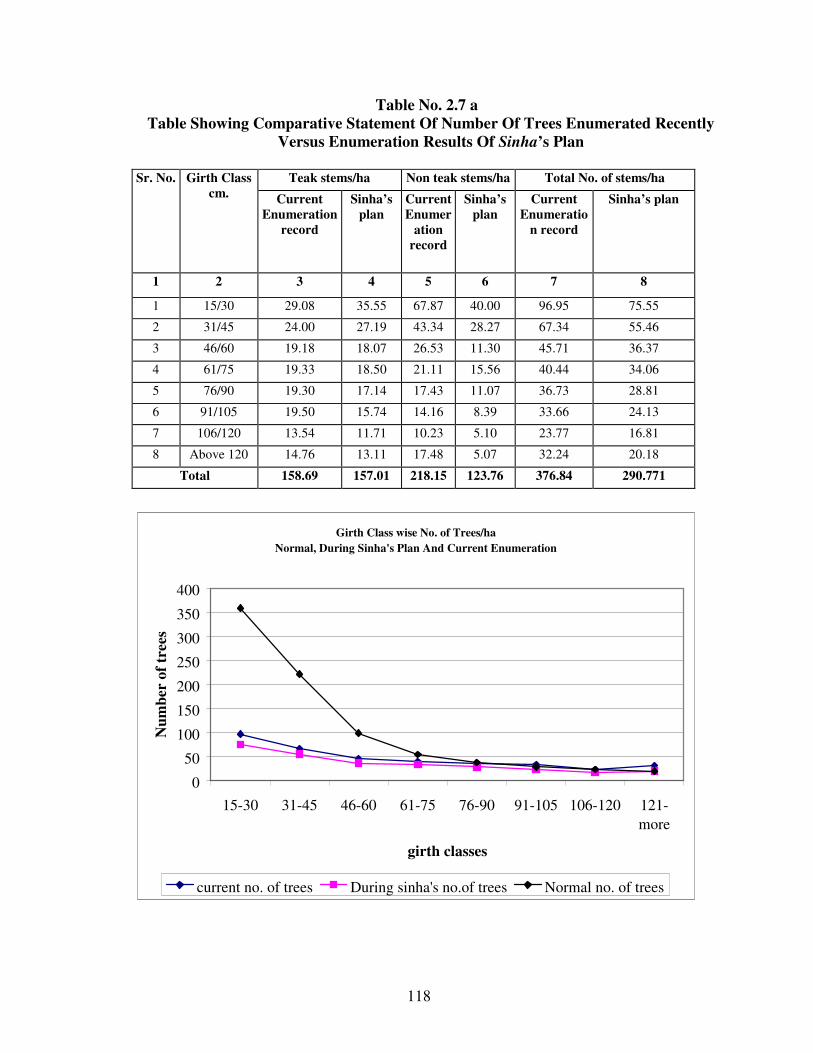
118
Table No. 2.7 a
Table Showing Comparative Statement Of Number Of Trees Enumerated Recently
Versus Enumeration Results Of Sinha’s Plan
Sr. No. Girth Class
cm.
Teak stems/ha Non teak stems/ha Total No. of stems/ha
Current
Enumeration
record
Sinha’s
plan
Current
Enumer
ation
record
Sinha’s
plan
Current
Enumeratio
n record
Sinha’s plan
1 2 3 4 5 6 7 8
1 15/30 29.08 35.55 67.87 40.00 96.95 75.55
2 31/45 24.00 27.19 43.34 28.27 67.34 55.46
3 46/60 19.18 18.07 26.53 11.30 45.71 36.37
4 61/75 19.33 18.50 21.11 15.56 40.44 34.06
5 76/90 19.30 17.14 17.43 11.07 36.73 28.81
6 91/105 19.50 15.74 14.16 8.39 33.66 24.13
7 106/120 13.54 11.71 10.23 5.10 23.77 16.81
8 Above 120 14.76 13.11 17.48 5.07 32.24 20.18
Total 158.69 157.01 218.15 123.76 376.84 290.771
Girth Class wise No. of Trees/ha
Normal, During Sinha's Plan And Current Enumeration
0
50
100
150
200
250
300
350
400
15-30 31-45 46-60 61-75 76-90 91-105 106-120 121-
more
girth classes
Nu
mb
er o
f tr
ees
current no. of trees During sinha's no.of trees Normal no. of trees

119
Table No. 2.7 b
Table Showing Growing Stock
(Current, Sinha’s Plan Enumeration Results And Normal Growing Stock for Site Quality III)
Girth
Class
in cm
Current
No. of
Trees
Sinha's
No. of
Trees
Normal
No. of
Trees
Mid-
girth
B. A. /
tree in
sq. m.
Volume
in
Cum./
tree
B. A.
(Current)
in sq. m.
Volume
in Cum
(Current)
B. A.
(Sinha's
Plan) in
sq. m.
Volume
in Cum
(Sinha’s
Plan)
B.A.
Normal
in sq. m.
Volume
in Cum
(Normal)
15-30 96.95 75.55 359 22.5 0.004 0.007 0.3905 0.6302 0.3043 0.4911 1.4461 2.3335
31-45 67.34 55.46 222 37.5 0.0112 0.029 0.7535 1.9529 0.6205 1.6083 2.484 6.4380
46-60 45.71 36.37 99 52.5 0.0219 0.059 1.0025 2.6740 0.7976 2.1276 2.1711 5.7915
61-75 40.44 34.06 55 67.5 0.0363 0.132 1.4661 5.3381 1.2348 4.4959 1.9939 7.2600
76-90 36.73 28.81 38 82.5 0.0542 0.231 1.9891 8.4663 1.5602 6.6407 2.0579 8.7590
91-105 33.66 24.13 29 97.5 0.0756 0.377 2.546 12.6898 1.8252 9.0970 2.1935 10.9330
106-
120 23.77 16.81 24 112.5 0.1007 0.549 2.3937 13.0378 1.6928 9.2203 2.4169 13.1640
The table for growing stock its graph shows that larger volume is accumulated in the higher
girth classes as compared to Normal distribution particularly above 90cm. girth classes. It
also clearly shows that there is a deficiency in the volume till the girth classes of 76-90 cm.
Girthwise Distribution Of Volume in cum
(Current : Sinha's Plan : Normal)
0.0000
5.0000
10.0000
15.0000
20.0000
25.0000
30.0000
0 1 2 3 4 5 6 7 8 9
Girth Class in cm.
Volu
me
in c
um
.
Volume in Cum (Sinha’s Plan) Volume in Cum (Current) Volume in Cum (Normal)

120
SECTION 6. SILVICULTURAL SYSTEM:
2.6.1. The Selection cum Improvement will be the Silvicultural System as was in the last
plan. The main object of SCI will be to produce big sized timber. Natural Regeneration will
be induced and encouraged through rigid fire protection, uprooting of lantana and grazing
control.
SECTION 7. FELLING CYCLE:
2.7.1. The working cycle has been fixed as 20 years from the year of working.
SECTION 8. HARVESTABLE GIRTH:
2.8.1. Stem Analysis for Teak has been carried out, for site quality II/III tree. The CAI and
MAI cuts at 106 years of age corresponding g.b.h. is 144cm. For quality III teak tree of
Dhulghat Range in West Melghat Division, the CAI and MAI cuts at 88 years of age
corresponding g.b.h. is 107 cm. Dhulghat area being close to East Melghat Division area, the
data is utilized for East Melghat Division. Most of the teak crop belongs to quality III.
Therefore to have conservative fellings, the harvestable girth shall be 120 cm. and 150 cm.
for site quality III, IV and II/III, II areas respectively. The harvestable girth for the
miscellaneous species bija, ain, haldu, kalamb, dhavda, and salai are fixed at 120cm. girth,
as their growth is comparable to that of teak. Harvesting of large sized trees will open the
canopy, this will help regeneration of teak and other valuable species to come up in the area.
SECTION 9. FORMATION OF THE FELLING SERIES:
2.9.1. There shall be 20 coupes in each Felling Series. The forests of this working circle have
been divided into 6 felling series. Total coupes will be 6 x 20 = 120 Coupes in SCI working
circle. Details are given in Appendix No. LXIII Volume II of this plan.
SECTION 10. REGULATION OF YIELD:
2.10.1. The annual yield shall be regulated by area. The coupes are neither equi-extent nor
equi-productive but this will not affect the market price or the revenue. The felling cycle
being 20 years the annual yield and revenue would not go down.
2.10.2. The boundaries of the coupes have been made to follow natural features as far as
possible, therefore the coupes could not be made equi-extent.
2.10.3. For yield regulation, the K.P. Sagariya's modification of Smithies formula has been
applied.
2.10.4 Enumeration: No. of teak trees as per the current enumeration are as under.

121
Table No 2.8
Girth class cm. No. of trees/ ha.
15/30 29.08
31/45 24.00
46/60 19.18
61/75 19.33
76/90 19.30
91/105 19.50
106/120 13.54
Above 120 14.76
2.10.5 Survival Percentage: The percentage of trees that will be reaching the harvestable
girth will be calculated on the basis of no. of trees that should have been in each girth class if
present stock was evenly distributed. The expected value of trees in an evenly balanced
stock will be obtained as per law of De-Liocourt.
Table No 2.9
Girth classes in cm Tree no./ ha (de liocourt) Survival percentage for reaching harvestable girth
VIII 15U30 29.08 55.74
VII 30U45 26.08 60.60
VI 45U60 23.40 65.87
V 60U75 20.99 71.60
IV 75U90 18.82 77.86
III 90U105 16.88 84.65
II 105U120 15.14 92.00
I Above 120 13.58 100.00
2.10.6. The ideal number of trees in different girth classes in an evenly balanced growing
stock is obtained by applying F-delicourt's law. This law states that in a fully
stocked Selection Forest i.e. in a normal growing stock of the uneven aged forest, the
number of stems fall off from one diameter girth class to the next higher girth class
in a geometrical progression with a constant ratio. In other words the percentage
reduction in the number of stems from one diameter girth to the next higher class is
constant.
Fraction Surviving while Reaching Next Class:
Table No 2.10 Girth classes I II III IV V VI VII VIII
Survival % 100 89.7 80.5 72.2 64.7 58.1 52.1 46.7
Proportionate
Initial Availability
100 108.69 118.13 128.44 139.66 151.81 165.02 179.40
Fraction Surviving
when reaching
next class
- 0.92 0.92 0.92 0.92 0.92 0.92 0.92

122
Table No. 2.11
Average Annual Recruitment (Rn)
Class Tree reaching class I Years in class Average Annual recruitment
(Rx) % No.
I 100 _ _ _ _
II 89.7 13.93 13 t2 1.07 (R2)
III 80.5 14.29 12 t3 1.19 (R3)
IV 72.2 14.65 11 t4 1.33 (R4)
V 64.7 15.03 9 t5 1.67 (R5)
VI 58.1 15.41 8 t6 1.93 (R6)
VII 52.1 15.80 8 t7 1.97 (R7)
VIII 46.7 16.21 8 t8 2.03 (R8)
v) Recruitment in Successive Cycle: -
Felling Cycle 20 years
Table No 2.12
Recruitment in Successive Cycle
Felling Cycle Total Total Recruitment During Felling Cycle
(fRn)
1 13R2 + 7R3 = 22.26
2 5R3 +11R4 + 4R5 = 27.26
3 5R5 + 8R6 + 7R7 = 37.58
vi) Realizable Recruitment in Successive Cycles: -
Rrn = ½[f Rn.
an (Rn-Rx)]
Ran = fRn
- Rrn
Where Rn
= Average recruitment in that felling cycle in the nth cycle
f = Felling cycle
Ran = Available Recruitment in that n th
felling cycle
Rx = Recruit in the class x
(a) 1st felling cycle: -
Rr1 = ½ [22.26 - 13 (22.26/20 – 1.07)]
= 10.87
Ran = fRn
- Rrn
Ra1 = 20 x 1.07 – 10.87
= 10.53
(b) 2nd felling cycle: -
Rr2 = ½ [27.26 - 12(27.26/20 – 1.19)]
= 12.59
Ran = fRn
- Rrn
Ra2 = 27.26 – 12.59
= 14.67

123
(c) 3rd
felling cycle: -
Rr3 = ½ [37.58 - 11 (37.58/20 – 1.33)]
= 15.77
Ran = Ran = fRn
- Rrn
Ra3 = 37.58 – 15.77
= 21.81
Table 2.13
Cycle Accruing 1. Realizable
2. Accumulating
Hence Available in Cycle
1 22.26 1. 10.87
2. 10.53 }2
10.87
2 27.26 1. 12.59 }2
2. 14.67 }3
23.12
3 37.58 1. 15.77 }3
2. 21.81
30.44
Stock in hands for next cycle
The availability in the first cycle is 16.21 + 10.87 = 26.99
(vii) Annual Realizable yield in cycle
Table No. 2.14 If stock in hand is liquidated in no of
Cycles
Annual Realizable yield in cycle
1 2 3
1 cycle 1.35 1.16 1.52
2 cycle 1.25 1.25 1.52
3 cycle 1.34 1.34 1.34
If stock in hand is liquidated in no of
Cycles
Annual Realizable yield in cycle
1 2 3
1 cycle 27.00 23.20 30.40
2 cycle 25.00 25.00 30.40
3 cycle 26.80 26.80 26.80
Liquidation in
cycle
At
hand
Accruing Total Realizable Total
liquidated
Percentage
liquidation
Balance
1 cycle 34.48 22.26 56.74 10.87 45.35 80% 11.39
2 cycle 34.48 49.52 84.00 33.99 68.47 82% 15.53
3 cycle 34.48 87.1 121.58 64.43 98.91 81% 22.67
Thus, if available stems at hand are liquidated in three felling cycles, sustainable yield will
be available for 81% i.e. 81 out of 100 silviculturally available trees above selection girth can
be marked for felling. On an average 26.87 trees/ ha. say 27 trees/ha will be available for
felling per coupe.
Yield of 1.34 trees per ha is definitely realizable for 3 cycles.
Total prescribed yield for teak trees per ha = 1.34 x 20 = 26.87
50% of the Yield = 0.5 x 26.27 (if 50% retained)

124
= 13.14 trees per ha
= 13.14 x 0.985 cum
= 12.94 cum / ha / felling cycle
50% of the Yield = 0.647 Cum/ ha / year
SECTION 11. AGENCY OF HARVESTING:
The coupes will be worked departmentally.
SECTION 12. DEMARCATION OF COUPES AND PREPARATION OF THE
TREATMENT MAP:
2.12.1. Demarcation: The main annual coupe will be demarcated one year in advance
along with the remaining coupes due for cleaning and thinning. The coupes will be divided
into four sections to control the various operations effectively.
2.12.2. Treatment Map: Soon after the demarcation of the coupes and sections a treatment
map will be prepared by R.F.O. and it will be verified by the A.C.F. and D.C.F. for the
purpose of raising plantations, fellings and protection. The trace of the coupe map will show
the contours along with important features like nala, streams.
The areas will be classified as below and shown in the map.
I) Area 'A': Protection Areas
It will include the following areas
(i) Areas with steep slopes i.e. more than 250
slope.
ii) Twenty meter wide strip on either side of the rivers or perennial watercourses or tanks.
iii) Highly eroded areas.
II) Area 'B': Blanks and Under stocked Areas: (In patches of 2 ha. or more)
This will include areas with crop density less than 0.4 up to the slope of 250
but exceeding 2
ha. in extent at a place.
III) Area ‘C’: Pole crops and Old Plantation Areas: (In patches of 1 ha. or more)
This will include patches of young well-grown pole crop of Teak and other valuable species
such as shisam, bija, ain, bhirra, dhaora, salai, etc. exceeding 1.0 ha in extent.
IV) Area 'D' - Well Stocked Areas:
This will include areas with crop density more than 0.4. The area D will be further
divided into D1 and D2
D1 = Areas having adequate natural regeneration, it will contain the areas with 625
seedlings or more per ha. Site quality wise patches will be shown in the entire area both on
the map as well as on the ground.
D2 = Areas without adequate regeneration.
. In the entire ‘D’ category area, tending of the crop shall be carried out up to pre harvestable
girth class by providing a spacement of 1/3rd
height of the tree to be retained to facilitate the
growth of standing trees. Preference for teak shall be given while retaining the trees in the
tending.

125
2.12.3. Treatments:
Area (A): (i) The soil and moisture conservation treatment shall be as given in
miscellaneous regulations.
(ii) Bamboo, jamun, arjun, agave, and grasses shall be planted along the nallah and river
banks.
iii) The area will be completely protected and felling of any kind shall not be permitted.
Area (B): (i) Soil and moisture conservation treatment shall be as given in miscellaneous
regulations.
(ii) Natural regeneration is protected and tended.
Area (C): This area does not need any planting, tending in the crop shall be carried out.
Area (D): (D1) This area does not need any planting, mature trees shall be harvested from
‘D1’ area only.
(D2) The N. R. of this area needs to be tended and tending in the crop shall be carried out.
2.12.4. Marking Technique And Marking Rules:
(a) Marking Technique: This has been discussed in the chapter "Miscellaneous
Regulations"
(b) Marking Rules: Marking will be undertaken one year in advance and will be carried out
by R.F.O.
I) Marking For Area ‘A’: No tree shall be marked for felling.
II) Marking For Area ‘B’: (In patches of 2 ha. or more)
(i) All dead trees after retaining 2 dead trees per ha. shall be marked for felling.
(ii) All live high stumps will be cut close to the ground as far as possible and dressed.
(iii) Malformed seedlings will be cut back to induce seedling coppice growth.
III) Marking For Area ‘C’: (In patches of 1 ha. or more)
The congested group of young poles will be marked for thinning so as to bring the
spacing between the plants to the 1/3 rd of the height of the trees retained.
IV) Marking For Area ‘D’:
(i) All climbers will be cut.
(ii) All dead, dying and malformed trees shall be marked for felling.
(iii) All pre-harvestable trees and harvestable trees will be enumerated separately.
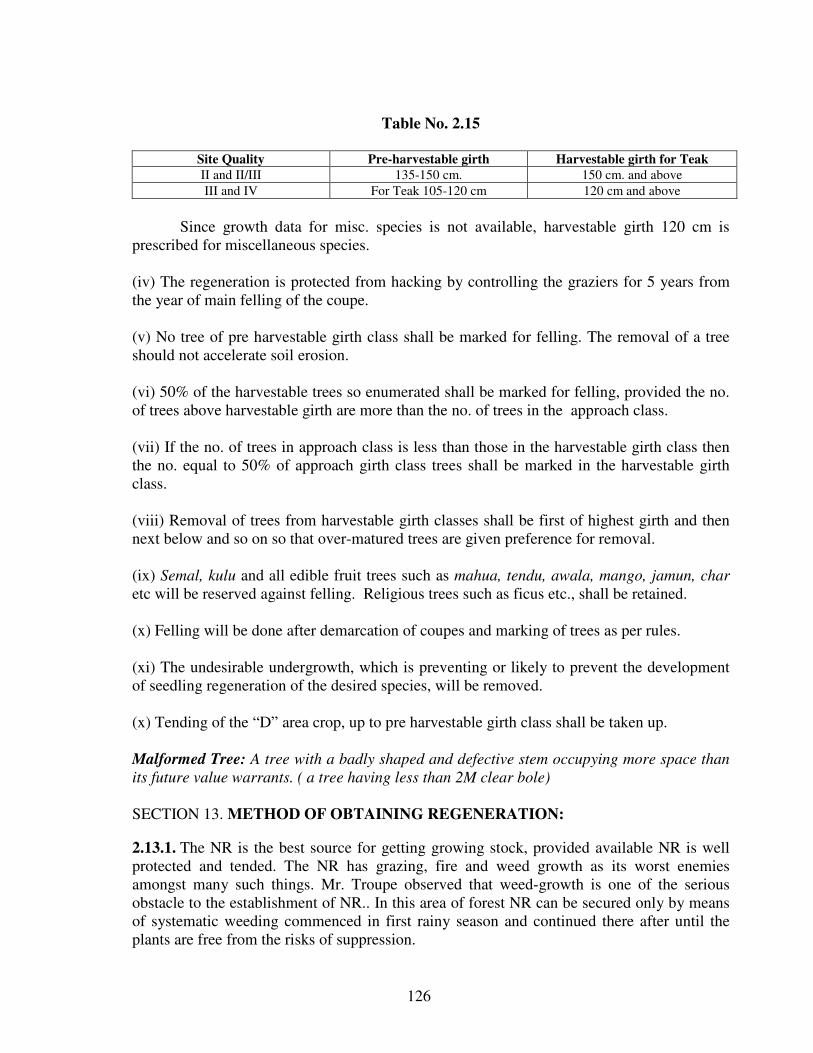
126
Table No. 2.15
Site Quality Pre-harvestable girth Harvestable girth for Teak
II and II/III 135-150 cm. 150 cm. and above
III and IV For Teak 105-120 cm 120 cm and above
Since growth data for misc. species is not available, harvestable girth 120 cm is
prescribed for miscellaneous species.
(iv) The regeneration is protected from hacking by controlling the graziers for 5 years from
the year of main felling of the coupe.
(v) No tree of pre harvestable girth class shall be marked for felling. The removal of a tree
should not accelerate soil erosion.
(vi) 50% of the harvestable trees so enumerated shall be marked for felling, provided the no.
of trees above harvestable girth are more than the no. of trees in the approach class.
(vii) If the no. of trees in approach class is less than those in the harvestable girth class then
the no. equal to 50% of approach girth class trees shall be marked in the harvestable girth
class.
(viii) Removal of trees from harvestable girth classes shall be first of highest girth and then
next below and so on so that over-matured trees are given preference for removal.
(ix) Semal, kulu and all edible fruit trees such as mahua, tendu, awala, mango, jamun, char
etc will be reserved against felling. Religious trees such as ficus etc., shall be retained.
(x) Felling will be done after demarcation of coupes and marking of trees as per rules.
(xi) The undesirable undergrowth, which is preventing or likely to prevent the development
of seedling regeneration of the desired species, will be removed.
(x) Tending of the “D” area crop, up to pre harvestable girth class shall be taken up.
Malformed Tree: A tree with a badly shaped and defective stem occupying more space than
its future value warrants. ( a tree having less than 2M clear bole)
SECTION 13. METHOD OF OBTAINING REGENERATION:
2.13.1. The NR is the best source for getting growing stock, provided available NR is well
protected and tended. The NR has grazing, fire and weed growth as its worst enemies
amongst many such things. Mr. Troupe observed that weed-growth is one of the serious
obstacle to the establishment of NR.. In this area of forest NR can be secured only by means
of systematic weeding commenced in first rainy season and continued there after until the
plants are free from the risks of suppression.

127
In these forest areas, NR of teak has suffered from fire as observed by die-back
phenomenon depending upon incidences and extent of fire occurrences. In deciduous forests
teak seedling suffer from desiccation, which needs mulching individually to reduce this
effect.
2.13.2. Inducement Of Natural Regeneration:
(i) Identified NR will be rigidly protected from grazing, trampling and fire incidences, by
resorting to rigid grazing control fire protection measures applicable to current coupe of
working.
(ii) Abundant natural reproduction, from teak seed lying dormant on the ground, could be
induced by opening canopy, cutting and burning undergrowth completely. The seedlings,
which spring up in abundance as a result of clearing and burning are to be weeded from the
beginning itself and weeding requires to be continued for three years, till the plants are
established. Hence, the weeding out of lantana will be carried out in favour of NR
successively up to third year.
Even after the above operations, if NR is not satisfactory, on the slopes saucer shaped
pits of 15x 15 x 15cm. will be prepared wherever light is available preferably on the
periphery of the crowns of the trees on the ground. Pits will have a baffle wall on the down
hill side to support the soil. Treated seeds of teak, germinated ain seeds and other misc.
species will be sown and will be weeded thrice and mulched twice in a year until they get
established. This work will be carried out during the CBO period and sowing will be done
just before the onset of rains. The no. of pits is restricted to the extent of the shortage of
NR.(625 seedlings/ha.)
(i) Coppice shoots interfering with NR when established should be removed.
(ii) The NR should be cleared off weeds within the diameter of 1 meter. Mulching
should be done by spreading the twigs and debris to the extent of six inches
layer, followed by a layer of leaves, burnt up material and a sufficient earth
over it (about a ghamela). This will facilitate protection from fire, drips from
the nearby overgrowth.
(iii) In case of NR of valuable miscellaneous species like ain, haldu, tiwas, etc.
protection, weeding and soil working shall be carried out.
SECTION 14: SUBSIDIARY SILVICULTURAL OPERATIONS:
2.14.1. The following Subsidiary Silvicultural Operations shall be carried out departmentally
(a) Cut Back Operations (CBO): It shall be taken up in the immediate year of main felling.
i) All standing trees marked for felling but not felled shall be felled.

128
ii) All damaged trees, which are not likely to recover, shall be cut back.
iii) All climbers in the plantation area shall be cut out.
iv) All malformed, suppressed or damaged advance growth of teak up to 15 cm.
girth shall be cut to ground level to obtain good seedling coppice.
(b) Cleaning: In the 6th
year commencing from main felling following operation shall be
carried out.
i) All climbers will be cut.
ii) Lantana and other growth of inferior species interfering or likely to interfere with
the reproduction of teak and other valuable species will be cut and removed.
iii) The established advanced growth of teak and other valuable species will be spaced
out suitably.
c) Thinning: Thinning will be carried out in the 11th
year.
i) All climbers shall be cut.
ii) All dead, badly damaged or uprooted trees shall be felled.
iii) In groups of young pole crop of teak, thinning shall be carried out so that the average
spacing between poles shall be left shall be 1/3 rd of the height of the trees retained.
iv) Lantana and other growth of inferior species interfering or likely to interfere with
the reproduction of teak and other valuable species will be cut back.
v) No tree of preharvestable girth shall be thinned.
SECTION 15: OTHER REGULATIONS:
2.15.1. Protection from Fire: Main-felling coupes will be fire traced and rigidly fire
protected for a period of Five years from the year of felling. In the month of October /
November after the demarcation is over all the undergrowth of lantana will be uprooted. The
cut material will be spread over the area to be planted in such a way that the cut material
remain sufficiently away from the stems of the trees and burning does not harm the trees.
The dry and cut bushes of unwanted species shall be burnt before the end of February to
avoid fire hazards to the forests.

129
2.15.1.1.The NR needs to be protected from the hazards of fire so that the regeneration
becomes future growing stock. Hence the main thrust should be on protection of
regeneration.
2.15.1.2. To ensure effective protection from fire the workable schemes of fire protection
should be prepared in which the due share to people’s participation shall be given. For
meaningful participation modalities shall be worked out to impart benefit to the people so
that they come forward. The village forest protection committees will be formed and fire
protection will be done through the Forest protection committee. Money earmarked for Fire
protection works should be given to the Forest Protection Committee.
2.15.1.3. The techniques of fire protection should be as per the paragraphs given in the
Section 11.4 of Forest Protection (Overlapping) Working Circle.
2.15.1.4. As such the area being prone to fire hazard and NR being the first and the biggest
causality, this economic source of regeneration should be rigidly protected from fire. It
causes damage to productive crop also. The comprehensive Fire Fighting Scheme should be
chalked out so that effective Fire Fighting force is created for, for the period 15th February to
15th June on 24 hour duty on suitable area basis.
Grazing Control: The areas of main felling shall remain closed for grazing, for a period of
5 years. Further, in the area of adjoining but with sufficient lag for working of coupe, seeds
of palatable grasses be sown and villagers be motivated to harvest the fodder. The method of
rotational grazing be followed. This will facilitate opening of area on rotational basis. The
closed areas should be specifically mentioned in the grazing licenses and villagers be
communicated of such closures by suitable means such as drum-beating, notices on
prominent places, village Panchayat officers etc. and by binding grass pullies or stacks along
the boundaries of closed coupes.
2.15.3. People’s Participation: The people’s participation is the need of the hour, to protect
the forest from fire, grazing, illicit cutting etc. Unless the villagers living nearby are made
aware of the material benefit from the forest, they would not feel associated with the well
being of the forest and may not visualize the distinct valuable utility of forests for their
material benefit they get or likely to get. Therefore it should be expedited through viable
measures.
2.15.3.1.Motivation efforts for making them aware about natural benefits of the forests for
providing them pure drinking water, bringing rain conserving top soil for boosting their
agricultural production and providing fodder for their milch cattle.
2.15.3.2. By ensuring regular employment to the FPC members on preference basis as they
associate themselves in protection, development and regeneration of forests.
2.15.3.3. Grazing and fodder as well as fuel wood should be related with their efforts for
protection and management of forests.

130
2.15.3.4. Incentives to FPC/Village committees in terms of cash awards/ free grants on
annual basis would be formalized.
These measures would help actively involve people in the forest management and
should benefit them in the longer run. The people should be made aware of their
responsibilities so that long lasting relations get strengthened and well being and sustenance
of forests along with people is ensured.
2.15.3.5. To achieve the above measures monthly meetings of the villagers/JFM committee
members shall be taken up in the village. The Dy. Conservator of Forests shall make
necessary budgetary provisions required for the meetings and extension activities.
---

131
CHAPTER -III
TEAK PLANTATION WORKING CIRCLE
SECTION 3.1. GENERAL CONSTITUTION:
3.1.1. Predominantly teak bearing areas, which are deficient in NR and having matured
crop have been put under this Working Circle. Part areas of the Rahu, Khari, Sumita, and
Tawra Felling Series of S. C. I. Working Circle of shri V. K. Sinha’s plan are included in
this Working Circle. Statement showing Range wise number of compartments and area
allotted to the Working Circle is given below.
Table No. 3.1
Table Showing Area Allotted To Teak Plantation Working Circle
S. No. Range Area (ha) Compartment Numbers.
1 Jarida 3941.16 22
2 Ghatang 1500.56 6
5441.72 28
Area Allotted To Teak Plantation Working Circle
3941.16
1500.56
Jarida
Ghatang
SECTION 3.2. GENERAL CHARACTER OF VEGETATION:
3.2.1. The tract dealt with under this Working Circle occurs on the slopes of hill ranges
and the forests are generally of site Quality III, but patches of site Quality II, II/III are
also occassionally noticed. Teak, Lendia, Haldu, Ain, Tiwas, Kalam, Khair, Dhawda,
Dhaman, Tendu are the main species occurring in the growing stock. The proportion of
Teak in the crop is nearly 50% and in patches it tends towards miscellaneous crop at
higher altitudes. A few pure patches of Teak are also observed, at some places. Stocking

132
is good. The crop is generally matured. The regeneration of all the species is poor and
deficient, probably due to repeated fires and heavy grazing. Trampling of young
seedlings by cattle, injuries due to fire and lantana infestation in the understorey have
caused poor regeneration. The crop has become irregular and unbalanced in the
distribution of age and diameter classes. Population of light demanders in lower girth
classes is very low and is likely to lead to domination of these high forests by Bhirra and
Dudhi and their conversion to low value forests. The percentage of miscellaneous
species has increased in the lower girth classes. The area is capable of clothing itself
with good quality even aged high forests of teak except on the ridges where soil erosion
has taken place.
SECTION 3.3. SPECIAL OBJECTS OF MANAGEMENT:
3.3.1. To enrich and improve the quality and value of the growing stock by planting teak
and tending natural regeneration of native species.
3.3.2. To introduce genetically superior plants of teak, by way of planting.
3.3.3. To convert the irregular forest into an even aged regular crop with all possible age
gradations essential for optimum growth of the crop and to ensure sustained yield.
3.3.4. To meet increasing demand of valuable timber and the local demands of firewood,
poles and bamboos.
SECTION 3.4. FELLING SERIES, BLOCKS AND COMPARTMENTS:
3.4.1. Since areas belong to erstwhile Selection Cum Improvement Working Circle, the
names of the Felling Series are retained as such. The area has matured crop with sparse
regeneration and the sites have enough potential to bear good teak crops. The forests are
highly irregular and unbalanced in the distribution of age and diameter classes. A total of
28 compartments have been allotted to this Working Circle. They are divided into 4
felling series having 20 coupes in each felling series. The average area of each coup is 68
ha. Coupe boundaries have been laid mostly along the natural features.
Table No. 3.2
Showing Distribution Of Compartments To Various Felling Series
S.No. Range Felling
Series
Compartment No. Area in
ha.
1 Jarida Rahu 408,409,412,413,426,427,428 1308.71
2 Jarida Sumita 393,432,433,435,436,439,441,442,443,445 1788.09
3 Jarida Khari 380,381,382,383,387 844.36
4 Ghatang Tawra 204,205,207,208,298,299 1500.56
Total 5441.72
3.4.2. Compartment wise and site quality wise areas are given in the Appendix No. LVIII
of Volume II of this plan.

133
SECTION 3.5. ANALYSIS OF CROP:
3.5.1. Stock maps of the P. P. Joshi’s plans are updated with the help of satellite imagery
and are verified with the enumeration data and ground truth verification. The abstract of
results of stock mapping for the area allotted to this Working Circle is shown in the table
3.3. Of the total forest allotted to this Working Circle teak forest covers 90.98%. Mixed
forest covers 2.99%. A total of 0.75% of the area is not stock mapped. 86.97% of the
area is having site quality III (teak: 84.12%, Mixed: 2.85%). Satellite Imagery shows that
71.2% of the area is having more than 0.4 density forest. The area having more than 25
degree slope and 20 meter wide strip area on both sides of the nala is 1781.5ha.
Table No. 3.3 a
Table Showing The Results Of Stock Mapping Forest Type Site quality Area in ha % of area w. r. t. Total
W.C.
Teak II 64.4797 1.21
III 4492.3844 84.12
IVa 180.355 3.38
IVb 121.4646 2.27
Total 4858.6837 90.98
Mixed III 152.0659 2.85
IVa 3.1106 0.06
Ivb 4.3695 0.08
Total 159.546 2.99
Old Plantation - 13.4879 0.25
Total 5031.7176 94.22
Under stocked - 268.3650 5.02
Not stock mapped - 40.2684 0.75
Total 5340.351 100
Table No. 3.3 b
Table Showing Crown density data obtained with the help of satellite imagery Category Area in ha. % to the total area of the
working circle
Remark
Well stocked 3874.4262 71.20
Understocked 1416.1712 26.02
Blank 44.0630 0.81
Waterbody 0.1538 0.003
Other 5.5368 0.10
Total 5340.3510 98.14
Area of W.C. 5441.71 100
Difference 101.359 1.86

134
3.5.2. Data collected from the enumeration showing the number of stems in various girth
classes is given below.
Table No. 3.4 Table Showing Average Number Of Trees Per Hectare And Their Volumes (Stem timber)
No. of Teak
Trees 13.22 10.71 8.22 8.32 8.55 7.19 6.39 3.90 3.10 1.25 70.68
Teak Vol. in
Cu.M. 0.07 0.35 0.66 1.18 2.05 3.02 4.09 3.51 3.29 1.70 19.92
No. of Non
Teak Trees 62.34 33.15 17.45 13.97 11.18 9.35 6.53 3.70 3.94 2.17 163.79
NonTeak Vol.
in Cu.M. 0.50 0.83 0.65 1.70 2.47 3.12 2.98 2.19 2.88 1.58 18.91
No. of Teak +
Non teak
Trees 77.88 45.28 26.47 23.55 21.60 19.02 15.44 9.96 9.01 4.21 252.28
Teak + Non
teak Volume 0.56 1.18 1.30 2.89 4.52 6.14 7.07 5.70 6.16 3.28 38.83
SECTION 3.6. SILVICULTURAL SYSTEM:
3.6.1. Consistent with the objects of the management cited earlier, silivicultural system is
removal of over wood, while retaining 20 fruit plants and 20 miscellaneous plants/ ha,
followed by artificial regeneration of genetically superior species.
SECTION 3.7. ROTATION AND CONVERSION PERIOD:
3.7.1. Average site quality of the forest included in this working circle is III. To avoid
any possibility of degradation of site, rotation not shorter than that of age of maximum
volume production is suggested. The area fit for working will be covered in the first
felling cycle i.e. 20 years.
SECTION 3.8. HARVESTABLE GIRTH:
3.8.1. Average crop girth of each grid in the coupe will be calculated based on the 100%
enumeration of all the trees standing in the area. Only such grids which have forests of
crop girths equal to or more than the value of Critical Crop Girth for that site quality and
composition of species shall be considered to be mature and would qualify for the
operation of removal of over wood for artificial regeneration by teak. The Critical Crop
Girth will be the harvestable girth for that grid and it varies with site quality and
composition of the crop.
Species 16/30 31/45 46/60 61/75 76/90 91/105 106/120 121/135 136/150 151/upn Total
Teak V/tree-
in Cu. M.
0.005
0.033
0.080
0.142
0.240
0.420
0.640
0.900
1.06
1.36
2.908
NonTeak
V/tree in
Cu.M.
0.008 0.025 0.037 0.122 0.221 0.334 0.457 0.593 0.730 0.730 3.257

135
SECTION 3.9. FELLING CYCLE:
3.9.1. The Felling cycle is fixed for 20 years.
SECTION 3.10. AGENCY FOR HARVESTING:
3.10.1. The coupes shall be worked departmentally.
SECTION 3.11. REGULATION OF YIELD:
3.11.1. The annual yield shall be regulated by area.
SECTION 3.12. SEQUENCE OF FELLING:
3.12.1. Year-wise by ranges, blocks and compartments for each felling series details are
given in the Appendix LXIII of Volume II of this plan.
SECTION.3.13. DEMARCATION OF COUPES, PREPARATION OF
TREATMENT MAPS AND MARKING TECHNIQUES:
Demarcation of Coupe:
3.13.1 The coupe shall be demarcated and marked one year in advance of its main
working. However, first coupe will be marked in the same year. Coupe due for working
shall be divided into suitable sections. The average size of a section shall be about 15
hectares. No section should be of less than 10 hectares or more than 20 hectares. The
sections so formed should be convenient from all aspects including transport. Full use of
existing roads, nallas, cart tracks should be utilized as far as possible in forming sections. Preparation of stock map:
3.13.2. After demarcation, the whole area of the coupe shall be thoroughly inspected by
the Deputy Conservator of Forest to ensure that the section lines have been properly laid
and the width of coupe line and section line is as per prescriptions. Stock map for the
entire coupe will be obtained in the 4” = 1 mile scale or other suitable scale from the
geo-referenced management map prepared by the GIS cell and the same will be verified
in the Coupe, for the features crown density, site quality, forest type and existence or
otherwise of bamboo, if any changes are there they will be updated showing their
boundaries on the map and the copy of updated map shall be sent to the GIS cell
Amravati.
3.13.3. Compartment and Section boundaries shall be distinctly shown in the Stock map.

136
Preparation of Treatment map:
3.13.4. After the stock map has been prepared, section wise treatment map of the entire
area will be prepared on graph paper in 1: 5000scale. The entire area of the coupe shall be
divided into grids of size of 100 m x 100 m (1 ha.) after taking base line that should, as
far as possible, run through the center of the section. The grids so made shall be duly
numbered and pegs shall be erected at the corners of the grid. The gridlines shall be
shown on the map. The following categories shall be demarcated grid wise.
I) Area 'A': Protection Areas
It will include the following areas.
i) Areas with slopes more than 250.
ii) Twenty meters wide strip of forest along both sides of main watercourse and well
defined nalas. (These may form coupe lines/ section lines wherever possible).
iii) Heavily eroded areas
The following areas shall be shown on the map if the extent of such area is 0.5 ha. or
more.
II) Area 'B': Blanks and Under stocked Area: This will include areas with crown
density less than 0.4 .
III) Area ‘C’: Old Plantations: This will include old Teak Plantations.
IV) Area 'D' - Well Stocked Areas found fit for teak plantations.
This will include areas with crown density more than 0.4 and with matured crop
fit for Teak plantations. Felling shall be carried out in these areas.
No felling shall be carried out in the areas mentioned above except D category.
Such areas shall be demarcated on the ground as well.
3.13.5. In the area of D category, the following information shall be recorded and
maintained for each grid.
i) Average height of dominant mature teak trees, and if teak is absent, then bija, haldu,
ain, kalam, semal, or dhawda.(In case a tree of none of the above species is found in a
quadrant, the quality class of the adjoining quadrant should be adopted.)
ii) 100 % species wise enumeration of the growing stock in uniform girth classes of 15
cm starting from 1 to15 cm. and classify each tree whether it is of coppice origin or seed
origin and prepare an abstract of numbers of Teak coppice, Non teak coppice, teak and
Non teak girth class wise for each grid.
iii) Average Basal area per hectare.
iv) Remarks about fitness of area for teak plantation (use symbol ‘F’, wherever the area is
fit for canopy removal and symbol ‘U’ Wherever the area is unfit for teak plantation).

137
Treatments:
3.13.6. The following treatments are prescribed for the various types of areas
Area ‘A’:
(i). No tree is marked for felling except dead, whose removal shall not cause soil erosion.
(ii). Nalla bunding works shall be taken up as given in the Miscellaneous regulations.
Area ‘B’:
(i). No tree is marked for felling except dead, whose removal shall not cause soil erosion
(ii). Nalla bunding works shall be taken up as given in the Miscellaneous regulations.
(iii). Planting of teak will be carried out in this area on suitable patches.
Area ‘C’: The old teak plantations shall be thinned as prescribed in the section 3.16 of
this chapter.
Area ‘D’: Fellings shall be limited to those grids which are found fit for removal,
followed by teak planting. In the other grids tending shall be carried out as explained in
the Para 13.7.50.
Determination of grids fit for Removal of Over wood:
3.13.7. First, average crop girth (o.b.) of the forest in the D category area referred to in
para 3.13.4. shall be determined for each grid separately according to the following
formula.
Crop girth = 2 x square root of (� x B/N)
Crop girth in cm = 250 x square root of (B/N)
Where “B” is average basal area per ha and “N’’ is average number of trees per
ha in the crop excluding advance growth. The basal area may be measured with the help
of wedge prism of suitable BAF (Basal Area Factor) or computed by summing up the
cross sectional areas of the individual trees based on over bark girth measurements. Trees
up to 30 cms, 45 cms, and 60 cms girth (o.b) in the Teak site quality up to III, II/III & II,
and I/II & I respectively shall be treated as advance growth for the purpose and would not
be considered for determining either the value of “B” or “N”.
3.13.8. The average Crop Girth so computed shall be compared with the Critical Crop
Girth (CCG) as given in the table below. No grid shall be selected for the purpose of
removal of over wood if its average Crop Girth (O.B.) is less than the Critical Crop
Girths as given in Col. 5 of the table in respect of areas of teak site quality mentioned
against them in Col. 3 which correspond to the average height of dominant mature teak
trees (and if teak is absent, then bija, haldu, ain, kalam or semal) in the crop as given in
Col.2. These Critical Crop Girths relate to high forests only. The proportion of teak, bija,
ain, haldu and kalam in the crop, as mentioned in Col. 4, will be calculated after
excluding the advance growth. Only such grids which have forests of crop girths equal
to or more than the value of Critical Crop Girth for that site quality and composition of
species shall be considered to be mature and would qualify for the operation of removal
of over wood for artificial regeneration by teak. The values of the C.C.G. for sites of
different site qualities and broadly classified compositions are given in the table 3.5.
Critical Crop Girth (CCG): Clear felling of a crop adversely affects the productivity of the site, if its crop
girth computed from the mean basal area is less than the value of crop girth unique to the site and that
composition. This unique crop girth is referred to Critical Crop Girth.
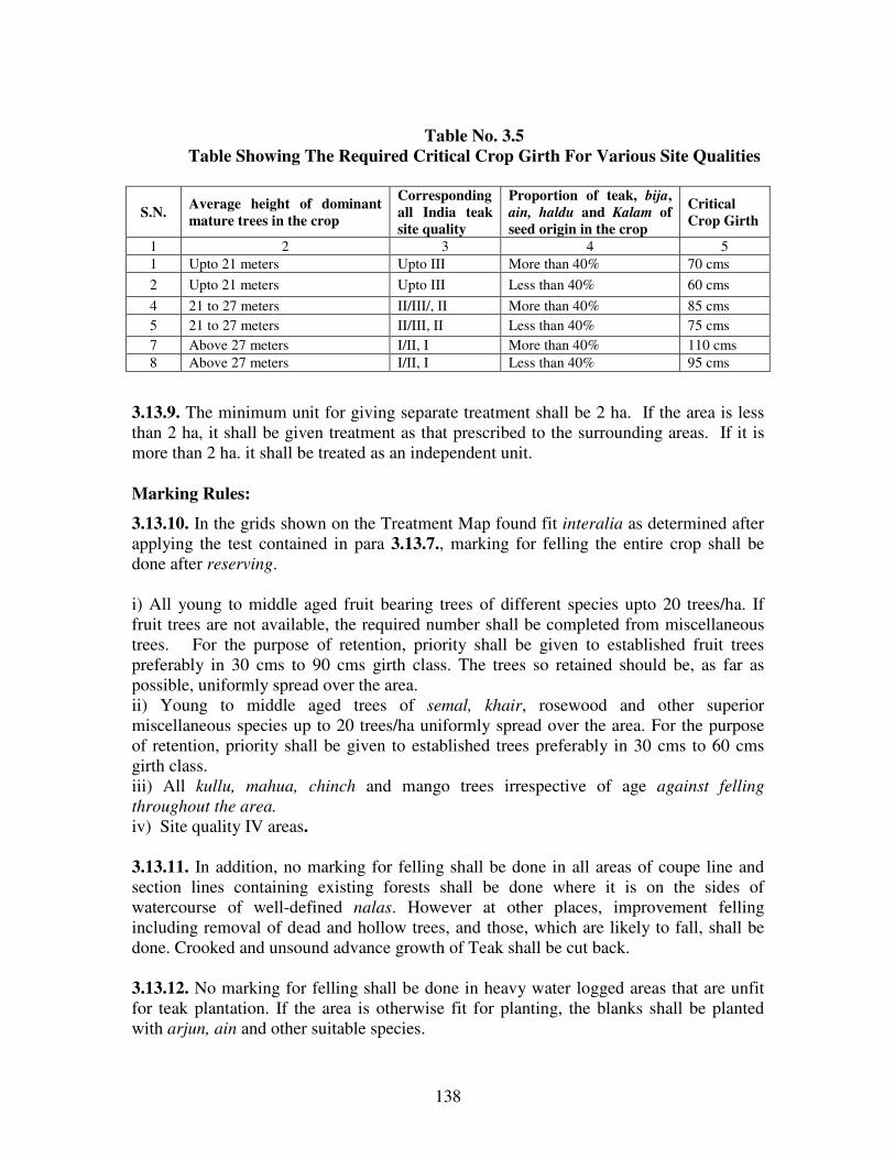
138
Table No. 3.5
Table Showing The Required Critical Crop Girth For Various Site Qualities
S.N. Average height of dominant
mature trees in the crop
Corresponding
all India teak
site quality
Proportion of teak, bija,
ain, haldu and Kalam of
seed origin in the crop
Critical
Crop Girth
1 2 3 4 5
1 Upto 21 meters Upto III More than 40% 70 cms
2 Upto 21 meters Upto III Less than 40% 60 cms
4 21 to 27 meters II/III/, II More than 40% 85 cms
5 21 to 27 meters II/III, II Less than 40% 75 cms
7 Above 27 meters I/II, I More than 40% 110 cms
8 Above 27 meters I/II, I Less than 40% 95 cms
3.13.9. The minimum unit for giving separate treatment shall be 2 ha. If the area is less
than 2 ha, it shall be given treatment as that prescribed to the surrounding areas. If it is
more than 2 ha. it shall be treated as an independent unit.
Marking Rules:
3.13.10. In the grids shown on the Treatment Map found fit interalia as determined after
applying the test contained in para 3.13.7., marking for felling the entire crop shall be
done after reserving.
i) All young to middle aged fruit bearing trees of different species upto 20 trees/ha. If
fruit trees are not available, the required number shall be completed from miscellaneous
trees. For the purpose of retention, priority shall be given to established fruit trees
preferably in 30 cms to 90 cms girth class. The trees so retained should be, as far as
possible, uniformly spread over the area.
ii) Young to middle aged trees of semal, khair, rosewood and other superior
miscellaneous species up to 20 trees/ha uniformly spread over the area. For the purpose
of retention, priority shall be given to established trees preferably in 30 cms to 60 cms
girth class.
iii) All kullu, mahua, chinch and mango trees irrespective of age against felling
throughout the area.
iv) Site quality IV areas.
3.13.11. In addition, no marking for felling shall be done in all areas of coupe line and
section lines containing existing forests shall be done where it is on the sides of
watercourse of well-defined nalas. However at other places, improvement felling
including removal of dead and hollow trees, and those, which are likely to fall, shall be
done. Crooked and unsound advance growth of Teak shall be cut back.
3.13.12. No marking for felling shall be done in heavy water logged areas that are unfit
for teak plantation. If the area is otherwise fit for planting, the blanks shall be planted
with arjun, ain and other suitable species.

139
3.13.13. In the balance area, the grids having forests which fail to qualify the test
contained in para. 3.13.7., or otherwise found unfit for overwood removal (site quality
IV area) but require tending shall be given the treatment as prescribed in the 13.7.50. of
Chapter on Miscellaneous Regulations. In addition to this badly grown and unsound trees
shall be marked for felling and the reproduction of intolerant species like teak, bija,
shisham, semal and other superior miscellaneous species shall be freed from shade of
Bamboo and other inferior trees. All climbers shall be cut.
3.13.14. Felling operations, removal of timber and firewood from the coupes shall be
completed before the end of March so that subsequent PMW operations in the area
can be started well in time as well as disturbance to wildlife can be minimized in the
pinch period.
SECTION 3.14. SUBSIDIARY CULTURAL OPERATIONS:
3.14.1. These operations shall be carried out departmentally and shall include.
3.14.2. Cut back operations: These operations will be carried out departmentally in the
following year of main felling .The following operations shall be carried out.
1) Climber cutting over entire area of the coupe.
2) Felling of all badly damaged or broken trees.
3) Cutting back of malformed advance growth of teak.
4) Freeing young growth of teak and other valuable species from interference of bamboos
and other inferior species.
5) All stools will be cleared of felling debris.
3.14.3. Cleaning: A cleaning operation will be carried out in the 6th
year commencing
from the year of planting.
1) All climbers will be cut over entire area of the coupe, if necessary.
2) Damaged, malformed saplings, and coppice shoots will be cutback.
3) Fast growing inferior species and bamboo interfering or likely to interfere with
reproduction of teak and other valuable species will be cut.
4) In thick patches of teak advance growth and established regeneration of other valuable
species a spacing between sapling to be retained, should vary from 2 meter to 2.59 meter
depending on the height of the sapling. Cleaning in plantation areas should be carried out
as and when required depending upon the crop condition.
3.14.4. Thinning: The first thinning will be mechanical and it is carried out in the 7th
year and second mechanical thinning is carried out in the 15th
year and the remaining
thinnings are carried out after every 10 years. During first mechanical thinning trees in
alternate diagonal lines will be removed. In the second mechanical thinning alternate
rows will be removed to provide 4 x 4 mts. Space. The subsequent thinnings will be
silvicultural.
140
SECTION 3.15. ARTIFICIAL REGENERATION:
3.15.1. The area where overwood is removed as above will be planted with teak stumps
(raised as far as possible from the seeds supplied by Maharashtra Forest Seed Center or
certified seed or from known source in order of priority)in the first rains after the main
felling. The technique of planting teak and the spacement shall remain the same as
followed in the past for raising teak plantations in the areas.
3.15.2. All sections shall be visited in the second rains after the felling to carry out
operations related to weeding, climber cutting and cleanings (Including removal of all
coppice growth originating from the old stumps.) as may be necessary. Casualty
replacement be carried after first weeding.
3.15.3. The plantation shall be visited in the fourth and seventh year and there after at
suitable interval after the main planting to carry out cleanings and thinnings as per
schedule.
SECTION 3.16. OLD TEAK PLANTATIONS:
3.16.1. The successful Teak Plantations taken up under various previous working plans
and the teak plantations to be taken under this plan are included in this section. Therefore
area of old Teak Plantations are not in a consolidated patch and they are spread over
entire division. The area under old Teak Plantations is as given below.
Table No.3.6
Table Showing Range wise Area under Old Teak Plantations
S. No. Range Area (in ha)
1 Jarida 155.50
2 Ghatang 262.20
3 Chikaldhara -
4 Anjangaon -
Total 417.70
General Character Of Vegetation:
3.16.2. Teak plantations taken up during previous plan periods are considered successful.
But due to non adherence to the prescriptions of cleaning and thinning schedules in the
past to these plantations, the overall health of the stand do not conform to the required
rate of growth in terms of girth/volume and the form of the stem. It needs immediate
management intervention to have timely operations of thinnings. Hence all the old teak
plantations shall be thinned in the first 3 years of working plan so that growth and volume
parameters can be brought to the levels mentioned in the stand and yield table. The year
wise schedule and plantations to be thinned is given in the Appendix LXVI of Vol. II.
The site quality of the plantation varies from II to III.

141
Blocks And Compartments:
3.16.3. The list of old teak plantations, its compartment number and Range is given in the
Appendix XLII of Volume II of this plan.
Special Objects Of Management:
3.16.4. The main objectives of Teak Plantation is to have the teak crop with growth
parameters comparable to those in the Yield Table for Teak Plantation and thus
producing maximum growth in volume and value of the stand. Due to non-compliance of
the prescriptions in the past, the objectives have not been achieved. So the objectives of
the management are:
(1) To maintain the density of stocking (measured in cubic volume) of the stand at such
levels which produces optimum annual increment and that the increment produced is
deposited on selected individuals.
(2) To improve the crop by carrying out required thinning operations so as to achieve
growth parameters comparable to those in the yield table for teak plantations.
Analysis And Valuation Of The Crop
3.16.5. Stock Maps: All old teak plantations have been shown on stock map.
3.16.6. Density:- crop is fully stocked in general.
3.16.7. Enumeration: 100 % enumeration shall be carried out to assess the extent of
thinning.
3.16.8. Age And Site Quality: Successful Plantations raised during 1950 to 2000are
included. The site quality varies from II to III.
Cleaning:
3.16.9. A cleaning in a younger crop is made to remove any growth that interfers with the
proper development of stems of the principal species. It is essential to remove the
undergrowth for better aeration and to facilitate the deposition of all accruable annual
increment only on the potential individuals. The cleaning of plantation shall include the
removal of bushes, invading species like dudhi, lendia except amaltas, damaged or badly
shaped poles/trees, climbers (climbers shall be cut at ground level and at breast height).
3.16.10. Site Quality Determination: The plantation shall be traversed by the marking
officer in parallel lines 20Mts. apart and the height of dominant trees along the lines of
every 20Mt. shall be estimated. Site Quality is determined with the help of table showing
Top height by the Site Quality and age, which was given in the miscellaneous
regulations. The Site Quality class boundaries are drawn on the map and demarcated on
the ground by putting a coal tar band at breast height.
3.16.11. Selection and demarcation of the sample plots: Sample plots as per following
rules shall be laid in each site quality area, and at least one sample plot shall be laid in

142
every section of the plantation. The sample plots shall be representative of the crop. The
following rules are followed.
1. No sample plot shall be selected on the edge of the crop.
2. On slopes presenting a wide range of elevation or in crops offering a variety of aspects
and soils, several sample plots judiciously distributed should be selected.
3. The shape of the sample plot should be a long rectangle.
4. The boundary of the sample plot should be clearly marked by blazing the trees.
5. The sampling intensity shall be a minimum of 3% of the total area.
Enumeration of the crop in the sample plots:
3.16.12. All the trees including coppice, miscellaneous and dead one, in the sample plot
are enumerated and tabulated girth class wise (girth classes shall be as per Stand Table).
3.16.13. Determine the basal area per hectare by using wedge prism at several points and
find out the average basal area per hectare.
Computation of Actual Growing Stock and Application of Yield and Stand Tables:
3.16.14. Compute the growing stock per hectare by using the local volume table and
enumeration data collected from the sample plots. The computed average basal area per
hectare shall be compared with the figures contained in the Yield Table in respect of that
site quality and age. If the actual basal area measured exceeds, then it would suggest the
need of thinning in the crop necessitating the removal of basal area to the extent that
exceeds the basal area given in the Yield table. If it equals or falls short, then it would
indicate that no thinning is needed to the crop.
3.16.15. Thinning shall be carried out keeping in view the distribution of stems per
hectare in various girth classes as contained in the stand table (main crop) for that
particular site quality and Notional age.
3.16.16. Prepare the comparative chart showing the girth class wise distribution of stems
of the sample plot for each site quality and stand table and identify the surplus or deficits
in the number of stems, in each girth class.
Marking:
3.16.17. The detailed procedure of marking and thinning is given in the section 13.7 of
miscellaneous regulations and the same is followed. All the old teak plantations shall
be thinned in the first 3 years of working plan so that growth and volume
parameters can be brought to the levels of Notional age of the stand and yield table
as early as possible. There afterwards, thinnings shall be carried out at an interval
of 10 years. If the age of any plantation is not known for any reason a suppressed
tree will be felled and age shall be determined by counting the annual rings and
accordingly thinning shall be carried. If any teak plantation is existing in the area
The term Notional age mentioned in clause 3.16.15 refers to the age rounded to next multiples of 5 years as contained in the stand table of
relevant teak site quality corresponding to the crop girth calculated from per tree mean basal area of the given crop.

143
and if it is not recorded in the working plan for any reason, thinning shall be carried
out in the first three years of working plan.
Inspection of Marking:
3.16.18. The inspecting officer shall measure the basal area per hectare of the crop by
point sampling method only for the retained trees in the plot (excluding the marked trees
for felling) and it is verified with the Yield table. If the residual basal area per hectare
tallies with the Yield table, it s considered that marking was done properly.
Maintenance of the Records:
3.16.19. All the data collected, tabulated is maintained separately in a register for every
plantation, which shall be used in the further thinnings. Thinnings are carried out in the
multiples of every ten years till the age of 60 years. Thinning is generally carried out
between November and February. The detailed procedures of thinning are given in the
Para 13.7.50 and proformas to tabulate the data are given in the Appendix No. LXXVII
of Volume II.
Agency For Execution:
3.16.20. All the operations will be carried out exclusively by the department under the
strict supervision of the Deputy Conservator of Forest.
SECTION 3.17. OTHER REGULATIONS:
3.17.1. Fire Protection Measures: All along the inner edge of the section line a strip of 5
mt. shall be left at the time of planting for maintaining it as fire line.
3.17.2. Grazing: The entire coupe including the coupe lines and section lines shall
remain closed to grazing for ten years from the year of planting. Fire protection and
Grazing control shall be done through FPC/JFMC subject to the condition that the
money assigned for fire protection will go to them after assuring that the area is
effectively protected. Proper strategy shall be worked out by DCF.
3.17.3. Collection of seed of any species shall not be permitted from the strip of forest
left standing in and around the coupe i.e. on the coupe lines and the section lines.
---

144
CHAPTER – IV
IMPROVEMENT WORKING CIRCLE
SECTION 4.1. GENERAL CONSTITUTION:
4.1.1. The areas, which are deficient in stocking and require improvement through
silvicultural operations and artificial regeneration, have been included in this working
circle. The main aim is to rehabilitate and improve the status of the degraded crop and
site. Therefore obtaining produce of any kind is neither expected nor desired. However,
through silvicultural operations, poles and firewood may be obtained in some quantities.
4.1.2. This Working circle also includes the areas belonging to the precipitous slopes. As
far as possible a continuous block of such forests have been included.
4.1.3. The areas included in this Working Circle were worked under Improvement
Working Circle in P.P. Joshi's Plan. The area details are given in the table below.
Table No. 4.1
Table Showing Area Allotted To Improvement Working Circle
Range Total area of
Range
Area under
IWC
% w. r. t.
Range Area
% w. r. t. W.
C. area
Comptts.
Nos.
Anjangaon 14182.96 4795.75 33.81 -- 20
Total = 14182.96 4795.75 33.81 100 20
SECTION 4.2. GENERAL CHARACTER OF VEGETATION:
4.2.1. In general, the forests of this Working Circle are inferior both in quality and
composition. The prevalent quality is IVb. The predominant species is teak, whereas in
refractory patches it is salai, which grew almost pure .The common associates are dudhi,
phansi, lendia, dhaora, palas, ain, bhirra, tiwas, moyen, kakad, khair, mokha etc. Patches
of teak were observed on the moderate slopes and in the valleys. The site quality
improves to III in deep valleys. Steep slopes, upper reaches are either under-stocked or
denuded, at many places underlying rock were exposed. The density is generally 0.4- 0.6.
Bamboo is by and large absent. Natural Regeneration of Teak is restricted to some
suitable places like gentle slopes, where soil depth is good. In few patches, NR of Kalam,
Dhaora, Bhirra, Dudhi and Palas is abundant. The general condition is very dry and the
crop is open and full stocking is found only on relatively small area. The natural
regeneration of salai is practically absent. Parijat, Sambalu (Nirgudi), Tarota and Ran-
Tulas undergrowth is common. Lantana occurs at some places in competition with other
undergrowth.

145
SECTION 4.3. FELLING SERIES:
4.3.1. 20 Compartments have been allotted to this working circle. The area has been kept
under Dahegaon Felling Series having 20 coupes.
Table No. 4. 2
Table Showing No. Of Compartments Allotted To Working Circle Range No. of Comptts. Area in ha.
Anjangaon 20 4795.75
Total 20 4795.75
SECTION 4.4. BLOCKS AND COMPARTMENTS:
4.4.1. The area of the working circle belongs to Dahegaon Block of Compartment no.
1033 to 1052. The areas of the compartment and their site qualities are given under
Appendix LVIII of Volume II of this plan.
SECTION 4.5. SPECIAL OBJECTS OF MANAGEMENT:
4.5.1. The special objects of management of the forests are:
i) To increase the proportion of valuable species in the growing stock.
ii) To increase the condition of the growing stock by appropriate tending.
iii) To preserve and improve the composition and density of the crop for progressively
increasing yield of timber and
iv) To check the soil erosion by creating and maintaining the vegetative cover.
SECTION 4.6. ANALYSIS AND VALUATION OF THE CROP
4.6.1. Age: The crop is generally young to middle aged.
4.6.2. Stock Mapping: Existing stock maps were updated with the help of satellite
imageries and verified with enumeration data.
Table No 4.3a
Table Showing Stocking Details Site Quality Wise And Their Area
Forest Type Site quality Area in ha % of area w. r. t. Total
W.C.
Teak IVa 157.5486 3.38
IVb 1882.3981 40.44
Total 2039.9467 43.82
Mixed III 6.1271 0.13
IVa 380.1958 8.17
IVb 1147.5834 24.65

146
Total 1533.9063 32.95
Salai IVa 4.7374 0.10
IVb 718.6737 15.44
Total 723.4111 15.54
Old Plantation - 84.0846 1.8
G. Total 4381.3487 94.12
Under stocked - 269.4113 5.79
Not stock mapped - 4.2008 0.09
Total 4654.9608 100
Table No 4.3a
Table Showing Crown density data obtained with the help of satellite imagery Category Area in ha. % to the total area of the
working circle
Remark
Well stocked 3050.5371 63.61
Under stocked 1572.7846 32.79
Blank 29.3459 0.61
Water body - 0.00
Other 2.2931 0.05
Total 4654.9608 97.06
Area of W.C. 4795.75 100.000
Difference 140.7892 2.94
4.6.3. Density: Generally it is more than 0.5 along with scattered natural blanks, barren
patches and under stocked areas. Of the total area allotted to this working circle 63.61%
of the area is having more than 0.4 density and 33% of the area is under stocked. The area
has thorny scrub vegetation intermingled with tree species in the ‘C’ class forest area.
4.6.4. Enumeration: The detailed results of enumeration are given in the appendix.
LVII of volume II of this plan. The comparative statement of tree numbers in various
girth classes of P. P. Joshi’s Plan and current plan are given in the table 4.4.
Table No. 4. 4
Table Showing Comparative Statement Of Number of Trees/Ha
Girth class Number of trees/ha as per P.P.
Joshi’s Plan enumeration
Number of trees/ha as per current
enumeration
Teak Miscellaneous Teak Miscellaneous
15u30 19.27 41.44 42.64 54.09
30u45 18.56 42.24 30.56 40.28
45u60 13.89 33.29 19.40 29.18
60u75 9.30 25.76 16.34 24.79

147
75u90 5.58 19.06 10.10 18.37
90u105 2.18 10.13 5.92 10.73
105u120 0.87 5.16 3.29 7.24
120u135 0.42 2.92 1.38 3.29
135 and above 0.20 1.92 1.08 1.96
Total 70.27 181.92 126.74 189.24
Percentage 27.86 72.14 40.11 59.89
4.6.5. Percentage of teak has increased from 27.86 to 40.11. Whereas percentage of
miscellaneous species has come down from 72.14 to 59.89. The number of miscellaneous
species per hectare remained more or less same. Overall the growing stock has
improved marginally from 252.15 trees/ha of P.P.Joshi’s plan period to 315.98
trees/ha.
SECTION 4.7. SILVICULTURAL SYSTEM:
4.7.1. The growing stock consists mostly of inferior miscellaneous species. Very few
matured trees are available in the growing stock for harvesting. Hence there is a need to
reserve all the trees of higher girth classes till the trees of lower girth classes graduate
into higher girth classes. To facilitate this, improvement fellings are suggested. Around
35-40% of the area is open. The upper reaches and steep slopes will be protected so that
grasses can come up in these areas.
SECTION 4.8. ROTATION AND CONVERSION PERIOD:
4.8.1. Since we are resorting to improvement fellings only, there is no need for fixing the
harvestable girth.
SECTION 4.9. FELLING CYCLE
4.9.1. Felling cycle is fixed as 20 years. Marking for improvement of the crop shall be
carried out.
SECTION 4.10. AGENCY OF HARVESTING:
4.10.1. The coupes shall be worked departmentally.
SECTION 4.11. REGULATION OF YIELD
4.11.1. As the felling is meant for improvement of the crop, it is not necessary to
prescribe yield regulation.

148
SECTION 4.12. SEQUENCE OF FELLING:
4.12.1. The sequence of coupes and compartment numbers is given in the Appendix No.
LXIII C of volume II.
SECTION 4.13. DEMARCATION OF COUPES, PREPARATION OF TEATMENT
MAP, TREATMENT PROPOSED AND MARKING RULES
4.13.1. Demarcation of Coupes: The main coupe shall be demarcated one year in
advance of working.
4.13.2. Preparation of Treatment Map: It will be prepared by RFO and verified by
ACF. The trace of the coupe map will show the contours along with important features
like nala, streams, old plantation, etc., the area will be classified as follows.
1. Type ‘A’- Protection Areas: the area consisting of patches over 250 slope or more and
20 meter strip on both sides of the rivers or nalas.
2. Type ‘B’- Under stocked Areas: Blanks and under stocked patches (crown density
below 0.4) exceeding 2 hectare in extent.
3. Type ‘C’-Old Plantations And Groups Of Young Poles: This will include patches of
well-grown poles suitable for retention as future crop in addition to old plantations. The
patch should not be less than one ha in extent.
4. Type 'D' -Well Stocked Areas: This will include areas with crop density more than
0.4. The area will be further divided into two classes:
Type - D1: Areas having adequate regeneration (625 seedlings or more per hectare)
Type - D2: Areas having inadequate regeneration.
4.13.3. Treatments Proposed: The various treatments proposed are as under:
1. Area 'A': (i) The soil and moisture conservation treatment shall be as given in
Miscellaneous Regulation.
(ii) No tree of any kind is permitted to fell.
2. Area 'B': (i) The soil and moisture conservation treatment shall be as given in
Miscellaneous Regulation.
(ii) Plantation of teak and miscellaneous species at a spacing of 2m. x 2m. shall be
followed on suitable sites.
3. Area 'C':
This area does not need any planting. But the crop is tended to provide a space of 1/3rd
height of the trees to be retained.
149
4. Area 'D':
D1 -This area does not need any planting.
D2- The natural regeneration of this area need to be supplemented by artificial
regeneration to the extent by which natural regeneration fall short of 625 per hectare.
Tending of the crop shall be carried out to provide a spacing of at least 1/3rd
height of the
tree retained to facilitate the growth of trees.
4.13.4. Marking Rules: The following marking rules are laid down.
1. Type 'A' Area:
No marking will be carried out.
2 Type 'B' Area:
(i) All dead, dying and diseased trees after retaining 2 dead trees per ha. shall be marked
for felling.
(ii) All live high stumps shall be cut as close to the ground as far as possible and dressed.
(iii) All Malformed advance growth of Teak up to 30 cm. shall be cut back
(iv) The established multiple coppice shoots will be reduced to one per stool retaining
the vigorous one, which is closer to the ground.
(v) The undesirable under growth, which is preventing growth of natural regeneration of
desired species, will be removed.
3. Type 'C' Area:
Thinning shall be carried out in these areas by providing a space of 1/3 rd height of trees
retained.
4. Type 'D' Area:
i) All dead, dying, diseased and malformed trees, all live high stumps and all except one
vigorously growing coppice shoot per stool will be marked for felling.
ii) In patches not less than 0.5 ha. in extent and having teak reproduction and valuable
NTFP reproduction in seedling stage, heavy openings will be made in the middle
canopy by cutting miscellaneous growth to induce the growth of Natural Regeneration..
iii) The existing established teak reproduction up to 20c.m., in girth at breast height will
be freed by marking over wood for removal
iv) Malformed advance growth of teak up to 30c.m. in girth will be cutback. The over
wood and inferior species likely to interfere with the coppice growth will be marked for
felling.
v) Thinning, marking will be carried out in favour of teak and other valuable species
vi) No fruit bearing tree shall be marked for felling.
SECTION 4.14. SUBSIDIARY SILVICULTURAL OPERATIONS:
4.14.1. The Subsidiary silvicultural operations include (1) Cleaning and (2)Thinnings.
4.14.2. Cleaning: cleaning shall be carried out in the sixth year of felling and the
operations will be as given in para. 3.15.1.2.
150
4.14.3. Thinning: Thinning shall be carried out in the eleventh year. Trees shall be
provided a space of 1/3 rd height of the trees retained.
SECTION 4.15. REGENERATION:
4.15.1. Natural Regeneration: The NR will be protected against fire and animals. TCM
or other kind of fencing may be established.
4.15.2. Choice of species: Teak 50% Misc. 50%, (Khair, Aonla, Sitaphal, Bhirra,etc.,)
will be planted. Soils suitable for bamboo plantation shall be taken up exclusively for
bamboo.
4.15.3. Method of Planting:
The planting model approved by the competent authority will be implemented
4.15.4. Pre-Planting And Planting Operations: The pre-planting and planting
operations as approved by the competent authority shall be carried out.
SECTION 4.16: OTHER REGULATIONS
4.16.1. Protection from Fire: Main-felling coupes will be fire traced and rigidly fire
protected for a period of Five years from the year of felling. In the month of October /
November after the demarcation is over all the undergrowth of lantana will be uprooted.
The cut material will be spread over the area to be planted in such a way that the cut
material remain sufficiently away from the stems of the trees and burning does not harm
the trees. The dry and cut bushes of unwanted species shall be burnt before the end of
February to avoid fire hazards to the forests.
4.16.2. The NR needs to be protected from the hazards of fire so that the regeneration
becomes future growing stock. Hence the main thrust should be on protection of
regeneration.
4.16.3. To ensure effective protection from fire the workable schemes of fire protection
should be carried out in which the due share to people’s participation shall be given. For
meaningful participation modalities shall be worked out to impart benefit to the people so
that they come forward. The village forest protection committees will be formed and fire
protection will be done through the village protection committee.
4.16.4. The techniques of fire protection should be as per the paragraphs given in
Miscellaneous Regulations.
4.16.5. As such the area being prone to fire hazard and NR of species being the first and
the biggest causality, this economic source of regeneration should be rigidly protected
from fire. It causes damage to productive crop also. The comprehensive Fire Fighting
Scheme should be chalked out so that effective Fire Fighting force is created for, for the
period 15 th
February to 15 th
June on 24 hour duty on suitable area basis.
151
4.16.6. Grazing Control: - The areas of main felling shall remain closed to grazing for a
period of 5 years. Further, in the area of adjoining but with sufficient lag for working of
coupe, seeds of palatable grasses be sown and villagers be motivated to harvest the
fodder. The method of rotational grazing be followed. This will facilitate opening of
area on rotational basis. The closed areas should be specifically mentioned in the grazing
licenses and villagers be communicated of such closures by suitable means such as drum-
beating, notices on prominent places, village Panchayat officers etc. and by binding grass
pullies or stacks along the boundaries of closed coupes.
4.16.7. Soil Conservation Works: Gully plugging and nala bunding works will be taken
up. Cement plugs or earthen bandhara be taken up on a large scale to preserve moisture
for a longer period simultaneously the catchments areas of the cement plugs/ earthen
bandhara be treated with loose boulder structures so as to prevent siltation in the dams.
The design is given in the Appendix No.LXXVIII. In addition to this contour stone
bunding 60 cm x 30 cm size will be taken up on the slopes to prevent soil erosion, where
boulders are not available agave suckers in 2 rows will be planted.
4.16.8. People’s Participation: The people’s participation is the need of the hour, to
protect the forest from fire, grazing, illicit cutting etc. Unless the villagers living nearby
are made aware of the material benefit from the forest, they would not feel associated
with the well being of the forest and may not visualize the distinct valuable utility of
forests for their material benefit they get or likely to get. Therefore it should be expedited
through viable measures like.
4.16.9. Motivation efforts for making them aware about natural benefits of the forests for
providing them pure drinking water, bringing rain conserving top soil for boosting their
agricultural production and providing fodder for their milch cattle.
4.16.10. By ensuring regular employment to the FPC members on preference basis as
they associate themselves in protection, development and regeneration of forests.
4.16.11. Grazing and fodder as well as fuel wood should be related with their efforts for
protection and management of forests.
4.16.12. Incentives to FPC/Village committees in terms of cash awards/ free grants on
annual basis would be formalized. These measures would help actively involve people in
the forest management and should benefit them in the longer run. The people should be
made aware of their responsibilities so that long lasting relations get strengthened and
wellbeing and sustenance of forests along with people is ensured.
---

152
CHAPTER -V
AFFORESTATION WORKING CIRCLE
SECTION 5.1. GENERAL CONSTITUTION:
5.1.1. Highly degraded and eroded areas with poor moisture ret ention capacity are
included in this working circle. In view of these factors dieback phenomenon is very
common and repeated measures to afforest these areas could not bring in desired results.
These areas were managed under Improvement Working Circle in the previous Working
Plans and Afforestation Working Circles during B. S. Thengdi’s Plan.
The details of Area are as under:
Table No. 5.1
Table showing Area of afforestation Working Circle
Sr. No. Name of the Range Total Area Area under
AWC ha.
% w.r.t.
Range area
% w.r.t W. C
area
1 Anjangaon 14182.96 7835.53 55.24%
Total 14182.96 7835.53 55.24% --
SECTION 5.2. GENERAL CHARACTER OF VEGETATION:
5.2.1. The ‘C’ Class forests of Chinchona block is almost devoid of tree-growth. In most
of the areas, sheet rock is exposed. There are some patches of open and stunted crop
consisting of species like bhirra, salai, dhaora, dudhi, lendia, khair, bhosa, Palas and
lokhandi. Bushes of bharati, nirgudi, and khirsali are found scattered. Whereas in Ex-
Jahagir forests southern aspect is devoid of tree growth but northern aspect is having fair
tree growth. The rest of the forests are also composed of deciduous species such as salai,
dhaora, moyen and with poor quality teak and saj. The forests are mostly understocked.
The under growth is formed by dense grasses usually pochati, sainar, kusal, gondhali,
rusa and jangli tulsi. Overall the crop is young to middle aged. In general site quality is
IV. Natural regeneration of bhirra and dudhi is satisfactory whereas it is deficient for
other species.
SECTION 5.3. FELLING SERIES:
5.3.1.The entire area of this Working Circle has been divided into five Felling Series. It
includes the Ex-Jahagir forests and erstwhile ‘C’ Class forest of Chinchona village.
5.3.2.Formation Of Coupes: There shall be 20 coupes nearly of equal Area in each
Felling Series. The details are given in Appendix LXIII of Volume II of this plan.
SECTION 5.4. BLOCKS AND COMPARTMENTS:
5.4.1. The compartments allotted to different Felling Series and their areas are shown as
below.

153
Table No. 5.2
Table Showing Compartments/S. No. Allotted to Different Felling Series
Sr. No. Range Name of Felling Series Compt. No./ S.No. /Village Name Area in ha.
1 Anjangaon Pipadari 1053 to1061 2027.38
Khirpani 1062 to 1070 2201.88
Chinchona S. No. 5 to 8 958.30
Girguti-Ambapati Tekadi, Nagziri, Jamli, Girguti,
Ambapati, Kundi
1580.55
Dharamdoh Chauryamal, Sakri, Chikhalpati,
Dharamdoh, Satti-Ruipatha
1067.42
Total 7835.53
SECTION 5.5. SPECIAL OBJECTS OF MANAGEMENT:
5.5.1.The special objectives of management of this Working Circle are as under:
1. To restore the vegetative cover of these degraded and open areas, primarily by tending
of existing natural regeneration and rootstock and supplementing it with plantations,
wherever necessary.
2. To check soil erosion by suitable soil and moisture conservation measures.
SECTION 5.6. ANALYSIS AND VALUATION OF THE CROP:
5.6.1. Stock Mapping: Crown density mapping of the area was carried with the help of
the satellite imageries and the same was verified with ground truth verification. Majority
of the area is under site quality IV.
5.6.2. Age and Density: Age varies from young to middle. Of the total area allotted to
this working circle 46.5% of the area is having more than 0.4 density and remaining area
is under stocked.
5.6.3. Enumeration: Since 50% of the area is well stocked, enumeration was carried out
in all compartments allotted to this Working Circle except the ‘C’ Class and Ex- Jahagir
forests. The results shows that young girth classes are predominant and teak is around
50% of the growing stock
Table No. 5.3
Table Showing No. Of Trees/Ha Girth Class Wise In The
Afforestation Working Circle (Pipadari F. S. And Khirpani F. S.)
Species 15/30 30/45 45/60 60/75 75/90 90/105 105/
120
120/
135
135/
150
>150 Total
Teak 79.4 49.2 28.9 14.3 6.1 2.9 1.2 0.3 0.4 0.1 170.9
Misc. 97.4 46.1 30.5 20.6 16.7 10.2 5.8 3.3 2.1 0.2 232.9
Total 176.8 95.3 59.4 34.9 22.8 13.1 7.0 3.6 2.5 0.3 403.8

154
Table No 5.4
Table Showing Stocking Details Site Quality Wise And Their Area
Forest Type Site quality Area in ha % of area w. r. t. Total
W.C.
Teak III 56.5733 0.75
IVa 362.312 4.78
IVb 2843.3393 37.50
Total 3262.2246 43.02
Mixed III 255.772 3.37
IVa 62.6 0.82
IVb 2518.3033 33.21
Total 2836.6753 37.41
Salai IVa 11.1818 0.15
IVb 273.5164 3.61
Total 284.6982 3.75
Old Plantation - 545.0144 7.19
Total 6928.6125 91.37
Under stocked - 425.1214 5.61
Not stock mapped - 229.2095 3.02
Total 7582.9434 100
Table No 5.5
Table Showing Crown density data obtained with the help of satellite imagery
Category Area in ha. % to the total area of the
working circle
Remark
Well stocked 3646.3041 46.54
Understocked 3549.6572 46.81
Blank 371.3399 4.74
Waterbody 8.3740 0.11
Other 7.2681 0.09
Total 7582.9434 96.78
Area of W.C. 7835.53 100.00
Difference 252.5866 3.22
SECTION 5.7. SILVICULTURAL SYSTEM:
5.7.1. The area will be regenerated with suitable species. No harvesting is prescribed in
this Working Circle. Tending of existing rootstock, saplings, coppice shoots and poles,
supplemented by plantations, are prescribed as the main activities in this Working Circle.

155
5.7.2. Old plantations, which have failed in the past, shall not be taken up again under
fresh plantation scheme unless reasons of failure are examined and addressed.
5.7.3. Since these areas are close to habitations fuel and fodder availability will be met
through plantation of fuel wood and fodder species and by involving people in their
management.
5.7.4. The areas of this Working Circle are, primarily, in bad shape. Inadequate subsoil
moisture, highly compact soil structure and heavy biotic pressure are the main limiting
factors for the establishment of seedlings in this area. Top soil has been washed away and
as a result vast areas do not have even adequate soil depth to support tree crop. As a
consequence a large chunk of these areas lay bare without any significant vegetation.
Hence, intensive soil and moisture conservation works and tending of existing rootstock
have been proposed to be give priority over to plantation. In addition, concept of
Ecological index has been proposed for deciding the number of seedlings to be planted
per hectare, over the traditional method of planting based only on soil depth zonation
approach. Ecological Index of a site gives us an idea as to number of plants which could
be sustained per hectare on a particular site depending upon the various locality factors of
the area. It is based upon the climatic and edaphic conditions prevailing in the area and is
determined by the formula, as follows.
P x D
Ecological Index =
Tr x EPT
Where P = Annual Precipitation in m.m.
D = Number of rainy days in a year
Tr = Range of maximum temperature averages
EPT = Potential evapo-transpiration in m.m.
There is no need for planting more seedlings per ha than those could be
sustained on a particular site. The emphasis is to grow the optimum number of seedlings
per hectare, which should grow into a healthy future stock with little mortality.
Ecological Index for these areas is proposed to calculate on the basis of data of
Ghatang station to determine the number of seedlings to be planted per hectare in these
areas. A sample calculation of the Ecological Index has been shown in Appendix No.
LXXIX. of Volume II of this plan.
SECTION 5.8. CHOICE OF SPECIES:
5.8.1. The choice of species will depend upon soil type, its depth, drainage and local
requirements. However, indigenous species of small timber, firewood and fodder will be
preferred. In suitable areas Khair, charoli, kullu, Moha, Bhirra, Lendia, teak and
indigenous edible fruit and flower yielding trees of local economic importance like
Sitaphal, Aola, Biba, Hirda, Beheda, bor will be planted. Ficus species shall be planted at
the rate of two trees per ha for wildlife. Bamboo shall be planted in suitable areas. Where
the local requirement is for fuel, short rotation species like Acacia senegal and Acacia
catechu etc. shall be considered in preference to other species. Grass development may

156
be taken up in areas where demand for grass or grazing is excessive. In such areas
plantation of tree species may be taken up only if the local people through JFM are
willing to protect it from fire and grazing.
SECTION 5.9. REGULATION OF YIELD:
5.9.1. Since most of the area is degraded, no yield is expected. However, the small timber
and firewood removed during the tending operations shall be given to the members of
Forest Protection Committee if they take up the responsibility of protection of the forest
area or as per the provisions contained in G.R. dated 25/4/2003.
SECTION 5.10. IMPLEMENTING AGENCY:
5.10.1. Coupes shall be worked departmentally.
SECTION 5.11. DEMARCATION OF COUPES AND PREPARATION OF
TREATMENT MAP AND TREATMENT PROPOSED:
5.11.1. Demarcation: Demarcation of first and second coupes shall be done in first year
of operation. Barring first coupe rest of coupes will be demarcated one year in advance.
5.11.2. Preparation of Treatment Map: Basic treatment map shall be obtained from
GIS, which will show steep areas having slopes more than 250, a 20 meter wide strip area
of nallas, eroded areas, the under stocked areas, old teak plantation & good dense forest
lands. The R.F.O. shall verify and update the Treatment Map and is again verified by
A.C.F. concerned.
1. ‘A’ Type of area-Protection Areas: It includes the following areas:
i). Areas with steep slopes i.e. more than 250 .
ii). Twenty meter wide strip on either side of the watercourse.
iii). Excessively eroded areas.
2. ‘B’ Type of area- Under stocked Areas: It includes areas with crown density less
than 0.4 but exceeding 2 ha. in extent at one place.
3. ‘C’ Type of area- Pole Crop: It includes patches of well-grown pole crop of teak and
other species suitable for retention as a future crop. The patch shall not be less than one
hectare in extent.
4. ‘D’ Type of area- Well Stocked Areas It includes areas with crown density more
than 0.4.
5.11.3. Treatments Proposed: The following treatments to various categories of the
areas are prescribed.

157
1. ‘A’ Type area-Protection Areas: The following operations shall be carried in the A-
type areas.
i) Gully plugging and loose boulder structures except continuous contour trenches shall
be taken up as described in the Appendix No. LXVIII of Vol. II of this plan.
ii) Seed sowing of Khair, Neem, Chandan and other local species shall be carried in the
bushes with the help of the regular forest staff.
iii) Stakes of Ficus, Pangra, and Salai shall be planted on suitable sites.
IV) No tree of any kind is permitted to fell and in suitable patches afforestation will be
taken up.
2. ‘B’ Type of area-Under stocked Areas: Measures shall be taken up to induce natural
regeneration supplemented by artificial regeneration.
i). Rooted stock will be tended.
ii). Seeds of suitable species like neem and Chandan will be sown in the bushes through
Vanmajoors and baramahi labourers available in the beat. In fact the beat guard shall
carry these seeds each day he visits forest at the onset of monsoon and carry out seed
sowing in bushes and degraded areas.
iii). Suitable area shall be planted with species as given in Para 5.8.
iv). Malformed trees shall be cut back.
v). Singling of multiple coppice shoots shall be carried out wherever needed.
vi). Soil shall be dug in the form of circular trenches around the periphery of crowns
encircling Salai, Dhawda, Tendu, Bhirra, Tiwas and Kulu trees, to encourage root
suckers.
vii) Soil and moisture conservation works shall be taken up in the area by constructing
cement plugs and loose boulders in the nallas.
viii) All high stumps shall be cut as close to the ground as possible and dressed.
3. ‘C’ Type of area: The pole crop shall be thinned to the 1/3rd of the height of trees to
be retained.
4. ‘D’ Type of area: Only hygienic felling shall be carried out. Dead, dying, suppressed,
crooked trees shall be marked for felling provided its removal shall not cause soil erosion
after retaining 2 dead trees/ha. and all other operations except planting shall be carried
out as given in the B type of area treatment.
SECTION 5.12: REGENERATION:
5.12.1. The artificial regeneration in suitable areas shall be resorted. Where reboisement
is resorted in an area, the factors responsible for the failure of plantations shall be
ascertained and addressed before planting. Main reasons for failure of plantations are
excessive grazing, improper choice of species, and poor soil depth. Natural regeneration
and coppice regeneration are supplemented by artificial regeneration. It is found that
plantations of Khair & Teak are doing much better than other species. Regeneration of
Bhirra is observed.

158
Artificial Regeneration:
5.12.2. The planting model shall be as per standard technique giving due consideration to
the ecological index and site requirements and it is prepared after calculating the
Ecological Index and approved by the C.C.F. (Territorial).
5.12.3. The planting shall be taken up in the next year of main working. Seeds used for
raising nursery should be collected from the known source or from seed unit of FDCM.
Seeds used should be of good quality.
5.12.4. For grass development area shall be ploughed and sown with seeds of grasses like
Paonia, Sheda, and Dinanath etc. Areas suitable for Rusa grass shall be identified and
plantations shall be raised by involving JFM Committees. In bushes seeds of neem and
chandan shall be sown before the on set of monsoon.
SECTION 5.13. SUBSIDIARY SILVICULTURAL OPERATIONS:
5.13.1. The following works shall be carried out in the next year of felling and in the
subsequent years.
5.13.2. Cut Back Operations: It shall be carried out in the next year of felling.
(i). All standing trees and live high stumps marked for felling but not felled shall be
felled.
(ii). All trees damaged, which are not likely to recover, shall be felled.
(iii). All climbers shall be cut.
(iv). Dressing of stumps shall be carried out.
5.13.3. Cleaning: In the 6th
year commencing from felling following operation shall be
carried out.
i) All climbers will be cut.
ii) Lantana and other growth of inferior species interfering or likely to interfere with
the reproduction of teak and other valuable species shall be cut and removed.
iii) Coppice shoots of teak shall be removed if NR and AR are successful, otherwise
coppicers are reduced to one well grown shoot.
iv) The established advanced growth of teak and other valuable species will be spaced
out suitably.
SECTION 5.14: OTHER REGULATIONS:
5.14.1. Fire protection measures and grazing protection measures shall be taken up as
given in the Section 16 of the SCI Working Circle.
159
5.14.2. Fire Protection: Main working coupes shall be rigidly fire protected for a period
of five years from the year of main felling. The local Forest Protection committee shall be
assigned this work.
5.14.3. Grazing: Areas of main working coupes shall remain closed for grazing for a
period of five years from the year of planting.
5.14.4. Soil Conservation Works: Gully plugging and nala bunding works shall be
taken up. Cement plugs or earthen bandhara be taken up on a large scale to preserve
moisture for a longer period, simultaneously the catchment areas of the cement plugs/
earthen bandhara shall be treated with loose boulder structures, so as to prevent siltation
in the dams. The design is given in the Appendix No. LXVIII. In addition to this contour
stone bunding 60 cm x 30 cm size shall be taken up on the slopes to prevent soil erosion,
where boulders are not available agave suckers in 2 rows will be planted, all along the
contours at a contour interval of 50 meters.
5.14.5 .Peoples Participation: Protection of planted area shall be assigned on sharing
basis of returns as per the Govt. G. R. to the JFM. The prescriptions given in the Para
2.16.3 are followed.
---

160
CHAPTER - VI
PROTECTION WORKING CIRCLE
SECTION 6.1. GENERAL CONSTITUTION:
6.1.1 This working circle includes the area belonging to the precipitous slopes of the
Chikhaldara and Ghatang Range. The main ridge of Gawilgarh hills, falling in
Chikhaldara Range and Behali area in Ghatang Range is included in this working circle.
Similarly areas with lesser slopes but prone to erosion due to poor stocking and biotic
pressure have also been included in this W.C. There are numerous other steep areas,
which could have been included in this Working Circle but had to be excluded, as they
are inextricably intermingled with compact blocks of other type of forests, demanding a
separate treatment. In the earlier plans these areas were worked under different working
circles.The areas allotted to this Working Circle are shown as below.
Table 6.1
Table Showing Area Allotted To Protection Working Circle
Sr.
No
Range. Area of Range ha. Area allotted to
P.W.C. ha.
% area w.r.t.
to Range area
% area w.r.t.
to W.C. area
1 Chikhaldara 10951.23 10951.23 100 61.36
2 Ghatang 12808.84 6942.41 54.20 38.64
Total 23760.07 17893.64 -- 100.00
Pie Diagram Showing Area Allotted To Protection Working Circle
10951.23
6942.41
Chikhaldara
Ghatang
SECTION 6.2. GENERAL CHARATER OF VEGETATION:
6.2.1. The site quality of the forest is generally IVa and IV b. In some parts quality III dry
teak forests with isolated small patches of mixed dry deciduous forests near water bodies
and springs are also observed. The density and quality increases on cooler aspect and
along the streams. Teak is the dominant species. The other species found with Teak are
dhaora, moyen, tiwas, kumbhi, lendia, kakad, mango, jamun, amaltas, pokar, bhirra etc.
Some old Eucalyptus plantations in small patches are also observed. The crop varies to a
large extent in composition. The tree growth is usually stunted and badly formed around
161
Chikhaldara area. Bamboos are generally absent but they are observed in the
compartments of northern part of Ghatang Range. Lantana is very common in the tract.
SECTION 6.3. SPECIAL OBJECTS OF MANAGEMENT:
6.3.1. The area allotted to this working circle form the headwork of important
watercourses, traversing the tract of Melghat. The need is to conserve these forests for
the indirect benefits they confer in the prevention of the denudation, the protection of
stands of commercial timber and the preservation of the water regime. Hence the special
objectives of the management are as given below.
1. To preserve and improve the existing growing stock in these vulnerable areas for
protecting soil and conserving moisture.
2. To preserve the habitat in its undisturbed form, and to study their population dynamics.
SECTION 6.4. ANALYSIS AND VALUATION OF THE CROP:
6.4.1. The density of the stocking is generally good. The areas between Chikhaldara and
Ghatang are understocked with intermittent patches of good forest. The regeneration is
very scanty in the areas of Chikhaldara Range. The under growth is mostly lantana. The
crop is middle aged. Bamboos are found in the compartments of northern Ghatang.
Southern parts of Ghatang Range and Chikhaldara Range are containing teak as main
species in the growing stock. The associates of Teak are ain, tiwas, dhawda, tendu etc.
Table No 6.2
Table Showing Stocking Details Site Quality Wise And Their Area
Forest Type Site quality Area in ha % area w. r. t. Total W.C.
Teak II 9.6237 0.05
III 2307.0926 12.89
IVa 3990.5412 22.44
IVb 5729.2641 32.22
Total 12036.5216 67.68
Mixed III 341.4341 1.92
IVa 82.1397 0.46
IVb 699.5167 6.31
Total 1123.0905 8.69
Salai III 10.0171 0.06
IVb 0.8761 0.004
Total 10.8932 0.064
Old Plantation - 61.1476 0.34
G. Total 13231.6529 74.41
Under stocked - 3336.4953 18.76
Not stock mapped - 1214.9013 6.83
Total 17783.0495 100

162
Table No 6.3
Table Showing Crown density data obtained with the help of satellite imagery
Category Area in ha. % to the total area of the
working circle
Remark
Well stocked 13443.1215 75.13
Under stocked 3930.9236 21.97
Blank 385.9536 2.17
Water body 14.3908 0.80
Other 8.6600 0.05
Total 17783.0495 99.38
Area of W.C. 17893.64 100.000
Difference 110.905 0.62
SECTION 6.5. COMPARTMENTS AND FELLING SERIES:
6.5.1. The areas allotted to Protection Working Circle has been divided into 5 felling
series each containing 10 coupes. The statement of compartments allotted to this
Working Circle and Felling Series is given below.
Table 6.4
Table Showing Compartments Allotted To Different Felling Series
Sr. No. Felling Series Comps/ Survey no.s allotted Total compt. allotted Area (ha)
1 Manbhang 4 to 8, 11 to 23, Bhilkhed 18 compts + 1s.no. 4070.98
+ 4.47=
4075.45
2 Chikhaldara 24 to 26,39,40,43 to 50 13 compts 3206.13
3 Bairat 27 to 33, 790 to 793
Survey No. 33 and 34
Kulangana Ex-Jahagir
12 compts+ 2 s. no’s 3669.65
4 Ghatang 51 to 57, 72 to 75, 78 to 80, 86 to89 18 compts. 3446.74
5 Bihali 1,3,9,10, 58 to 71 19 compts. 3495.67
Total 80 compts + 3 s. no.’s 17893.64
SECTION 6.6. SILVICULTURAL SYSTEM:
6.6.1. Improvement Fellings supplemented with artificial regeneration is prescribed.
SECTION 6.7. FELLING CYCLE:
6.7.1. The Felling Cycle is fixed for 10 years.
SECTION 6.8. REGULATION OF YIELD:
6.8.1. No yield regulation is prescribed.
SECTION 6.9. AGENCY FOR HARVESTING:
6.9.1. The coupes shall be worked departmentally.

163
SECTION 6.10. TREATMENT PROPOSED:
6.10.1. The main object of the management is to maintain and improve the adequate
vegetative cover and to preserve the soil on the slopes. However hygienic and
improvement fellings are prescribed in the areas to facilitate the growth of growing stock
as well as to meet the local needs of the people without causing soil erosion. Essential
cultural operations like climber cutting and removal of dead, dying and malformed trees
shall be carried out. Improvement fellings supplemented with artificial regeneration is
prescribed. Collection of minor forest produce like mahua flower and fruit, char, bel,
tendu, gum, etc is permitted to the local tribes/villagers for their bonafide use.
6.10.2.The forests under this working circle need special treatment in the form of soil and
moisture conservation works. Since the slope is steep, no CCT or DCT is stipulated. To
check the soil erosion, vegetal cover of the tract is to be increased through bush sowing
and dibbling of lendia, kusum, bhirra seeds in the under stocked and blank forest areas. It
shall be carried out on regular basis through the concerned vanmajoors, Beat Guards.
Where soil depth is poor, grass seeds shall be broadcasted followed by closure for
grazing.
SECTION 6.11. DEMARCATION OF COUPES AND PREPARATION OF
TREATMENT MAP:
6.11.1. Demarcation: Except for 1st coupe in the sequence of working of this draft plan
period, coupes will be demarcated one year in advance of the main felling as given in the
chapter XI, Miscellaneous Regulations of this plan. But 1st coupe will be demarcated in
the first year of operation and main felling work will be in the same year where as in
other coupes it will be in the following year.
6.11.2.Preparation Of Treatment Map: After demarcation of coupe, Range Forest
Officer will inspect the area and prepare a treatment map for the same and it shall be
thoroughly verified by the Assistant Conservator of Forests. The treatment maps will
show the following areas.
1. Type A - Protection Areas: It will include following areas:
(a) The area having steep slopes i.e. more than 25º.
(b) Eroded areas or areas liable to erosion.
(c) 20-meter wide strip on either side of water courses.
(d) The area shall be protected completely, no felling of any kind of live tree is permitted.
Soil Conservation works and seed sowings shall be taken up wherever possible.
2.Type B – Under stocked Areas: The forests areas having less than 0.4 density and 2
ha. more in extent are included in this category. The area is protected to encourage and
nurture the natural regeneration.
164
(i) All dead and malformed trees shall be marked for felling after retaining two dead
trees/ha.
(ii) All but one vigorously growing coppice shoot per stool provided seedling
regeneration of any tree species is absent.
(iii) All high stumps will be cut to the ground level and dressed.
3.Type C - Groups Of Young Poles: It includes patches of well grown pole crop of teak
and other miscellaneous species suitable for retention as a future crop. The patch shall
not be less than 1 ha in extent and the trees shall be spaced out to one third of the height,
of the trees retained. .
4.Type D - Well Stocked Areas: The forest areas having more than 0.4 density are
included in this category. The following operations will be carried out:
(i) All dead trees except two per ha will be marked for felling.
(ii) All high stumps shall be cut.
(iii) Coppice shoots shall be reduced to one per stool provided seedling regeneration
of any tree species is absent.
(iv) Tending of the growing stock shall be carried out to facilitate the growth of the
growing stock.
SECTION 6.12. REGENERATION:
6.12.1. Natural Regeneration: The treatment given in the para 2.13.2 of Chapter II be
followed to induce the natural regeneration. In addition to this soil is dug in circular
trenches around the periphery of the crowns of tiwas, tendu, dhaora, bhirra and salai to
obtain root suckers. This operation is carried out preferably before the onset of rainy
season. Area containing good natural regeneration will be identified in the coupe and
marked on the treatment map.
6.12.2. Artificial Regeneration: Areas, which are deficient in natural Regeneration, shall
be supplemented with seed sowing of native species. The choice of species will depend
upon site suitability. Species like ain, lendia, mowai, salai, kusum, char, aonla, beheda,
etc., shall be sown. Vanmazoors and Beat Guards shall carry out seed sowing.
SECTION 6.13. SUBSIDIARY SILVICULTURAL OPERATIONS:
6.13.1. Cut Back Operations: Cut Back Operations will be carried out in the next year
of the felling in the area. (a) All badly damaged trees not likely to recover will be cut. (b)
All climbers, which are not of ecological and economical values, will be cut.
6.13.2.Cleaning: Cleaning will be carried out, during the Sixth year of the felling. The
operations are as below.
(a) All climbers, which are not of ecological and economical value, shall be cut.
(b) Coppice shoots, if required, shall be reduced to one per stool.
(c) Inferior growth which may interfere with the teak or miscellaneous species of choice
will be removed.

165
(d) Damaged and malformed poles will be cut back.
SECTION 6.14. OTHER REGULATIONS:
6.14.1. Fire Protection: The prescriptions given in the SCI Working Circle shall be
followed.
6.14.2. Grazing Control: No grazing shall be allowed in protection forests. In case of
emergent situation the rotational grazing may be allowed. The grazing will be regulated
as per Govt. policy of the Govt. of Maharashtra dt.6th
Dec.1968 according to which the
grazing incidence in protected forests should not exceed one cattle unit for 10 acres.
Soil And Moisture Conservation Works:
6.14.3. On the steep slopes, neither CCT nor DCT works be carried out to prevent soil
erosion. Loose boulder structures wherever possible shall be taken up in nalas. On the
gentle slopes, cement bandharas and earthen bunds shall be taken up on a large scale to
provide moisture regime in the area. In addition to this contour stone bunds of the size -
60cm. x 30cm. at an interval of 50m. on the slopes shall be taken up to prevent soil
erosion.. Wherever boulders are not available agave suckers in two rows be planted along
the contours to prevent the soil erosion. The works shall be completed before the onset
of Monsoon. The quantum of work will depend upon the site requirement. b
--

166
CHAPTER – VII
BAMBOO (OVERLAPPING) WORKING CIRCLE
SECTION 7.1. GENERAL CONSTITUTION:
7.1.1. This is an overlapping working circle covers all bamboo bearing forests occuring in
other Working Circles. The Range wise distribution of the area is as under:
Table No.7.1
Table Showing Range wise Distribution of Area Allotted to Bamboo (O) Working
Circle
Sr. No. Range Area of
Range (ha)
Area allotted W.C. % w.r.t.
Range/
Division Area
% w.r.t. W.
C. Area Comptts Area(ha)
1 Ghatang 12808.84 59 12102.87 94.48% 40.03%
2 Jarida 18144.57 111 18127.97 95.65% 59.97%
3 Chikhaldara 10951.23 -- -- -- --
4 Anjangaon 14182.96 -- -- -- --
Total 56087.60 170 30230.84 53.89 100%
Compartments allotted to this Working Circle are given in the Appendix LXV of
Volume II of this plan.
SECTION 7.2: ANALYSIS AND VALUATION OF THE CROP
7.2.1. Stock mapping: Stock-mapping was not carried out during the current exercise of
the plan. However Stock-map details available with P. P. Joshi’s Plan have been used
after due verification through data available from enumeration. Density slicing of the
stocks and forest types had been verified through the data generated from the satellite
imagery of the period Dec.2003.
7.2.2. Enumeration: The enumeration of Bamboo was done along with the survey of
other species occurring in the area, as per Random Start Systematic Line Plot Sampling
Model. Clumps were counted in three categories, i.e.,
a) Healthy (having at least 8 mature culms)
b) Degraded (containing less than 8 mature culms),
c) Dead.
Few randomly selected live clumps were counted for culm analysis.
7.2.3. It was observed that bamboo clumps density per ha varies from compartment to
compartment and within the compartment number of culms varies from clump to clump.

167
Hence 1 % detailed survey for bamboo clumps and bamboo culm analysis was carried in
Ghatang Range. The results are as under.
Table No7.2
Table Showing No. Of Clumps In Sample Plot
Range Compt
No.
Felling
Series
Total No
of
Clumps
No. of
Mature
Clumps
Total
No of
Culms
Degraded
Clumps
Total
No of
Culms
Dead Total
No of
Culms
Ghatang 80 Ghatang 176 149 1201 27 103 -
89 Ghatang 61 48 229 6 15 7 52
83 Tawra 42 41 1685 1 5 -
75 Ghatang 41 11 287 30 103 -
200 Tawra 30 6 137 18 74 6
201 Tawra 60 18 222 37 131 5
Total 410 273 3761 119 431 18
% 67% * 29% * 4%
SECTION 7.3. SPECIAL OBJECTS OF MANAGEMENT:
7.3.1. The special objects of management constituting this working circle are
(i) To meet the local needs of the people.
(ii) To ensure sustained yield of bamboo.
(iii) To restore bamboo crop as under story on the principles of conservation of
ecosystem and optimum land use of forests.
SECTION 7.4. GENERAL CHARACTER OF THE VEGETATION:
7.4.1. The main species found here is Dendrocalamus Strictus, which occurs almost all
over the area. The good sites are located mostly on the riverbanks with alluvial deposits.
SECTION 7.5. SILVICULTURAL SYSTEM:
7.5.1. Culm Selection System: The silvicultural system adopted for the Working Circle
is selective removal of dead and mature culms from mature clumps will be the harvested
accordingly. Retention of at least 8 green mature culms per clump is prescribed.
SECTION 7.6. CUTTING CYCLE:
7.6.1. Harvesting will be carried out in three year cutting cycle; hence, each cutting series
is divided into three annual coupes. Coupe laying has been done keeping in view the
occurrence of bamboo area.

168
SECTION 7.7. CUTTING SERIES:
7.7.1. To make work centers well distributed so that disturbance is localized and
administrative control can be affected better six (6) series have been identified viz. Taora,
Butida, Khari, Sumita, Rahu, and Ghatang. Their boundaries are coterminous with those
of felling series of selection working circle and protection working circle. Bamboo area
of cutting series is given in Appendix LXV of Volume II.
Table No. 7.3
Table Showing Range wise Area Under Bamboo
Sr. No. Range Total area
allotted to
working circle
Range wise (ha)
Comptts
having
Bamboo
Area under
Bamboo
(ha)
% w.r.t.
Range area
% w.r.t
W.C. area
1 Ghatang 12808.84 59 2412.13 18.83% 25.18%
2 Jarida 18144.57 111 7167.00 39.53% 74.82%
Total = 30936.81 170 9579.13 58.36% 100%
SECTION 7.8. CALCULATION OF YIELD:
7.8.1. Since eight green mature culms are to be retained in first cutting cycle irrespective
of clump size, a difference, in the yield from first cutting cycle and that of rest of cutting
cycles is expected. Yield in first cutting cycle is calculated by the following formula.
Yf = n [{0.5 r (c + 1) + m + d – 8) + {m. D}]
Where
Yf = average Yield of culms per unit in first cycle;
n = number of healthy clumps per unit = 8.7;
r = rate of recruitment ( mean current year culms) = 3.04;
c = cutting cycle in years always an integer = 3;
m = mean mature culms = 8.84,
d = mean dead culms = 2.41, and
D = number of dead clumps per unit = 2.41.
In subsequent cutting cycles formula used is as follows:
Ys = r . c . (n + tw + T I )
Where
Ys = average yield of culms per unit in subsequent cutting cycles;
r, c, and n as noted above;
w = numbers of degraded clumps per unit;
t = transition fraction for degraded clumps;
I = number of immature clumps per unit = 12.34; and
T = Transition fraction for immature clumps = 0.3.
Average annual production
H = (A x c / P) [Yf + Ys (P/c – 1)]

169
Where P is period of plan =10 (years); and
A is area of current coupes.
For this plan above formula can be simplified as:
Yf = [n {2r + m + d – 8} + {m. D}]
Ys = 3r (n + 0.25 w)
H = 0.3 (Yf + 2.33 Ys)
7.8.2. Above formulae involve following assumptions. Some of them are questionable
but limited data on behaviour of crop does not allow better approximation.
1. Average rate of recruitment is not significantly different from assured rate of
recruitment, which is assumed to be equal to mean current year recruitment.
2. Enumeration data is from the year preceding start of harvesting.
3. Decay and loss of culms by natural or man made causes does not exceed the margin
left by harvesting factor.
4. Dead clumps in following cutting series are going to be negligible.
5. Dead clumps could retain only mature culms. Current year and dead culms decay out.
6. Number of first year culms will seldom exceed eight.
7. Transition fraction during the cycle is negligible. Almost all the transition will take
place in one cycle.
8. Once transition has taken place the culm production pattern will not be different from
other healthy clumps.
Table No. 7.4
Table Showing Average Annual Production (In No. Of Culms) Per Hectare Of
Coupe During Plan Period
No of
Plots
Mature
culms
Degraded
culms
Dead
culms
Counte
d no.of
clumps
1st yr Total
culms
Dead
culms
Yf
culms
Ys
culms
H
culms
105 8.84 12.34 4.14
361 3.38 13.51 2.41 399.57 116.86 201.55
9. It works out to 6.43 lakh culms per year. Out of which 1.28 lakh long bamboo and 0.85
lakh bamboo bundles.
10. Since the sampling intensity used here is 1% only and keeping in view previous yield
a general reduction of 50% in the yield has been prescribed.
Practical Yield (i) long bamboo = ½ x 1.28 = 0.64 lakh
(ii) Bamboo bundles = ½ x 0.85 = 0.42 lakh

170
SECTION 7.9. METHOD OF EXECUTING CUTTING:
7.9.1 Demarcation: The coupe due for working will be demarcated as prescribed in
Misc. Regulation. Each compartment will make one section and all recording will be
compartment wise unless the D. C. F. directs otherwise. No harvesting will be allowed
within 50 metres of special wildlife habitat zones such as caves, overhangs, springs and
perennial water holes other than flowing streams. Such areas shall be marked as
prescribed in Misc. Regulation. The coupe due for working will be demarcated by giving
three geru bands at 15 cm. intervals on the trees selected at suitable interval along the
periphery of the coupe. The lower band will be at the breast height.
7.9.2. Cutting Prescriptions: The following cutting prescriptions are prescribed.
1. No working shall be carried out at slope more than 45 degree.
2. Harvesting shall be limited to October to March i. e. by the end of winter when the
culms are almost devoid of starch and attracts less insect borer.
3. All dead clumps shall be clear felled. All flowered clumps after seed shedding
shall be clear felled.(dead clump means all culms are dead and current recruitment of
bamboo is not noticed).
4. Decaying, broken or damaged culms containing less than 3 meters of healthy part in
the lower portion as well as twisted and dead culms will be removed irrespective of the
size of the clump. All coppice shoots coming from earlier cut culms shall be removed.
These cleaning operations will be carried out irrespective of output of green culms.
5. The height above the ground level at which the culms are cut shall not be below
the second node and in any case higher than 30 cms. from ground level.
6. All debris and cut branches of culm shall be removed at least 2 meters away from
the clump.
7. All current year i.e. less than one year old culms shall be retained.
8. A mature clump consists of 8 mature culms. Culms in excess of eight will be
removed subject to retention of mature green culms, which include previous year culms
equal to current year culms. Removal shall take place in order of maturity. Harvestable
culms are exploited in such a way so that retained culms are evenly spread and spaced in
the clump.
9. Culms on the periphery of clump will not be removed except when absolutely
necessary to facilitate working in the interior portion of the clump. Working will be on
traditional horseshoe pattern. The leading exterior culms may not be cut under any
circumstances, even if these are malformed, as their retention is in the interest of outward
growth of rhizome and clump and to support new culms. In order to make all portion of
the clump accessible for marking the clear felling in the form of a wedge shall not be
more than one meter wide all around. The depth and width at the narrow end of the
wedge should be less than 2 meters wide all around. Working in this belt will be strictly
according to the above rules.

171
10. Height of cutting is of no importance for the further culm formation. However,
the height at which the culms shall be cut, must not be lower than 15 cm. and more than
45 cm. from the ground level., and in any case, not higher than second internode and
lower than first internode. In the wildlife rich area, two culms in each clump should be
cut at 3 rd to 4th
internodes to provide forage to wild animals.
11. A clump will be distinguished as an independent clump where its periphery is
easily discernible from adjacent clumps irrespective of its spacing. When differentiation
is not possible, two clumps within one-meter distance will be regarded as one.
12. A congested clump though rare, shall be cleared of congestion; the removal will
be carried out from one side in the interior portion.
13. Use of sharp instruments will be insisted upon during cutting to avoid splitting.
14. Climbers infesting bamboos shall be cut.
15. Removal of any part of bamboo clump or its rhizome is prohibited.
16. Whenever a coupe could not be worked in a particular year it may be worked in a
particular year it may be worked in the following year if urgent need of bamboo
production is felt. But retention of green mature culms shall be increased to minimum of
thirteen so that culms are available for working after two years only. Working shall never
be done when coupe is due for harvesting the following year.
17. No felling shall be carried out in flowered clumps. R. F. O will immediately report
bamboo flowering to the D. C. F.
18. In the event of gregarious flowering or patch flowering affecting more than half of the
clumps in a coupe regular harvesting shall be stopped. All dead clumps shall be clear
felled after they have shed their seeds. Disposal of such bamboos should be xpeditiously
arranged.
SECTION 7.10. IDENTIFICATION OF BAMBOOS:
7.10.1. Since the marking of bamboo is highly selective, it is essential to distinguish, a
current year or a previous year or a mature culm from each other.
7.10.2. Current Year: - Culm sheath is present on lower half of the culm, branches are
present throughout the length of the culm and bloom is present abundantly and comes off
easily.
7.10.3. Second Year: - Culm sheath is absent, branches are present practically at all
nodes, white bloom is patchy and comes off easily.
7.10.4. Third Year: - Culm sheath is absent, branches are present practically at all nodes,
white bloom is absent and replaced by blackish gray.

172
SECTION 7.11. BAMBOO FLOWERING:
7.11.1. Bamboo flowering has taken place during the year 1979-80 in an area of 18,487
ha of Jarida Range. Though Regeneration has established bamboo has not grown up to
the exploitable size due to high density of bamboo clumps. Hence there is a need to
reduce the no of clumps from the existing to 125 /ha.
7.11.2. Later in the year 1999-2000 patch flowering of bamboo was observed over an
area of 18444.74 ha of Ghatang Range of Tawra Cutting Series. At present exploitation
of dead bamboos is under progress at the time of preparation of the plan. Bamboo
regeneration was observed in patches restricting to inaccessible slopes only. Even in
those patches, clump formation is yet to take place. There is a need to protect these areas
from grazing and fire. Suitable Fire Scheme will be prepared and executed by the Deputy
Conservator of Forest, East Melghat Division, till clump formation takes place.
Regeneration patches will be shown in the maps compartment wise and their areas will be
recorded while preparing the Fire Protection Scheme.
SECTION 7.12: TREATMENT OF GREGARIOUSLY FLOWERED AREAS
7.12.1. After a gregarious flowering and subsequent death of old bamboos, the profuse
regeneration of bamboo comes up. It takes nearly 8 years for new regeneration to reach
the harvestable size, but often it takes considerably more time. Natural Regeneration of
bamboo will be dealt as below.
7.12.2. The areas where clump formation has not yet completed:
1. The area should be thoroughly gone over and 80 cm diameter foci at the rate of 250 per
ha should be formed distributed evenly over the whole area.
2. All the rank growth and even bamboo seedlings around the foci formed above and up
to a distance of 1.5 m all around from each focus should be cleared so that the growth of
the bamboo seedlings in the selected foci is not hampered. If this is not done, it will lead
to switchy growth.
3. All climbers within and around the foci up to 1.5 m should be completely removed.
4. The whole area should be strictly protected from fire and grazing.
5.In area where clump formation has commenced, but the crop is yet immature for
harvesting.
6.The 250 foci / ha initially established may be reduced to 125/ha well distributed over
the whole area retaining only foci containing promising switchy culms.
7. From the selected foci, all badly grown twisted and otherwise damaged culms should
be removed.

173
8. All climbers within and around the foci up to a distance of 1.5 m should be completely
removed.
9. The tree overtopping or likely to overtop the bamboo clump may be thinned.
10. The whole area should be strictly protected from fire and grazing.
7.12.3. Crop age above 8 years:
1. When the crop age is 8 years, the clump formation is normally completed and clumps
are mature enough for harvesting. The treatment during this period will be of the nature
of harvesting-cum- tending. The felling rules already prescribed in the earlier paragraph,
will be applied here.
SECTION 7.13. SEQUENCE OF CUTTING:
7.13.1 Sequence of cutting is shown by Cutting Series in the Appendix LXV of Volume
II of this plan.
SECTION 7.14. OTHER REGULATIONS:
7.14.1. Fire Protection: Bamboo bearing areas shall be protected against fire.
7.14.2. Grazing Control: Young recruits of bamboo shall be protected from grazing and
trampling by suitable method.
---

174
CHAPTER –VIII
WILDLIFE (OVERLAPPING) WORKING CIRCLE
SECTION 8.1.GENERAL CONSTITUTION OF THE WORKING CIRCLE:
8.1.1. National forest policy 1988 and National Wildlife Action Plan 2002 aims at
conserving and preserving the valuable natural forests with the vast variety of flora and
fauna, which represents the remarkable biological diversity and genetic resources of the
country. The action plan emphasizes the necessity for the restoration of degraded wildlife
habitats outside the protected areas in the following terms “Forest management should
take special care of the needs of wildlife conservation and forest management plans
should include prescriptions for this purpose. It is specially essential to provide for
‘corridor’ linking with the protected area in order to maintain genetic continuity
between artificially separated sub sections of migrant wildlife”. The Wildlife
(protection) Act 1972 also emphasizes protection of wildlife in general and rare and
endangered species in particular.
8.1.2. Further the areas outside the designated protected areas also harbour valuable and
also major wildlife populations and rare endemic and endangered flora and fauna, which
are many a times valuable storehouse of biodiversity and gene pools. These areas are
required to be managed with the specific focus on conservation and augmentation of the
valuable wildlife resources.
8.1.3. The tract dealt with is around Melghat Sanctuary and Gugamal National Park.
Melghat forests has at its heart the Melghat Tiger Reserve that harbours 75 tigers 90
leopards and a number of other species. This is the first Tiger Reserve declared in the
state in 1973 and is one of the prestigious wildlife areas of the country. Extending over an
area of about 2000 Sq. kms. It is the largest Tiger Reserve in the state and shelters 40% of
the tiger population of the state. The area also forms the base for the Satpuda landscape
and belongs to one of the biodiversity rich areas of the world. The Reserve is constituted
of a Gugamal National Park, Melghat sanctuary and the buffer area surrounding the
sanctuary. The tract covered under the present plan is around the Tiger Reserve area
bordering east of Melghat Sanctuary and Gugamal National Park, which are parts of the
Reserve. In order to ensure that a healthy and congenial buffer is available to the spillover
population of the Tiger Reserve and also to ensure that the local population and their
cattle do not trespass the tracts of the wildlife habitat meant for the wild animals in the
Reserve area which might result in increased man-animal conflict. It is essential that
suitable steps be taken up in the areas surrounding the Tiger Reserve to provide adequate
protection, food and shelter to the wildlife in the area as well as to take measures, which
reduce dependency of the local people on the resources of the protected areas. Keeping
this necessity in the mind, Wildlife (overlapping) Working Circle is constituted.
8.1.4. The wildlife is spread over the entire tract. Hence, an overlapping wildlife working
circle includes all the ranges as given in the table below.
175
Table No. 8.1
Showing Range wise area allotted to Wildlife (overlapping) Working Circle
Sr.No Range Range area in (ha.) Area in W.C. (ha.)
1 Jarida 18144.57 56087.60
2 Ghatang 12808.84
3 Chikhaldara 10951.23
4 Anjangao 14182.96
Total of Division 56087.60
SECTION8.2. GENERAL STATUS OF FLORA AND FAUNA:
8.2.1. The tract dealt with surrounds Melghat Tiger Reserve. It is in a continuous patch
except between Ghatang and Jarida Ranges, which is interspersed by multiple use area
of Melghat Tiger Reserve. Nevertheless, ample numbers of wild animals are found in
these forests. Now a days these forests areas are in proximity to human settlements and
forest areas are close to agricultural areas and also the approaches to these forest areas
have become more convenient due to network of roads both pucca and kaccha roads.
Before the reorganization of the divisions, most of the forest areas were under buffer
zone of Project Tiger. These areas also suffer from acute water scarcity during summer
season. Wildlife in these areas is under tremendous pressure because of biotic
interference such as lantana and grazing and resulting invasion of lantana. The use of
urea rather than plant poision, to catch the fish has become a major threat to the survival
of wildlife in the area. These factors have resulted in depletion of wildlife. Since
reorganization of the division has taken place in the year 1999, the census data earlier to
2001 cannot be compared.
Year Tiger Leopards
Male Female Cub Unknown Total Male Female Cub Unknown Total
2001 4 4 3 - 11 6 4 1 - 11
2005* 2 2 0 1 5 3 6 - 2 11
• Figures are tentative, subject to finalization by the expert committee.
8.2.2. The wild animals noticed in the tracts are:
1) Carnivora:-Tiger (Panthera tigris), Panther (Panthera pardus), Hyena (Hyena
hyena), Jackal (Canis aureus), Indian Fox, (Vulpes bengalensis), Jungle cat (Felis chaus),
Indian wild dog (Cuon alpinus).
2) Herbivora:- Four horned antelope (Tetracerus quadricornis), Sambhar (Cervus
unicolor), Barking deer (Muntiacus muntjac), Spotted deer (Axis axis), Blue bull
(Boselaphus tragocamelus), Gaur (Bos gaurus), Common Langur (Presbytis pileatus),
Indian Hare (Lepus nigricollis), Black buck (Antilope cervicapra).
3) Omnivora:- Civet cat (Paradoxurus hermaphroditus), Sloth bear (Melursus ursinus),
Wild boar (Sus scrofa),
4) Aves: - Apart from the common birds the following avi-fauna are observed: -

176
Pea fowl (Pavo cristatus); grey jungle fowl (Gallus sonneratii); Painted partridge
(Francolinus pictus); Common quail (Conturnix); Crow pheasant (Centrupus sinensis);
yellow legged green pigeon; gray tit; pond heron; cattle egret; crested serpent eagle;
Golden backed woodpecker (Dinopium bengalensis); Black drongo (Discrurus
adsinillis); kingfisher; small kingfisher, Long Billed Vulture and White Backed Vulture.
8.2.3. The floral species, with their botanical names found in the tract have been listed in
the Glossary of Terms of this Draft Plan. The tract dealt with has been the natural habitat
of a variety of wild animals. The numerical strength present has reduced mainly due to
excess biotic interference. The description of the flora of the tract is given in the Chapter
II of Part I.
SECTION 8.3. SPECIAL OBJECTS OF MANAGEMENT:
8.3.1. The conservation and protection measures are required to be taken through out the
forest areas. Keeping this aspect into view, the special objects of management decided
are as follows:
1. To provide suitable habitat and protection to the spillover population of neighboring
protected areas of Tiger Reserve.
2.To provide for better habitats and breeding environment for the wildlife population
occurring in the area.
3. To control the illegal trade and poaching in wildlife and their products.
4. To reduce biotic interference affecting growth of wildlife and to regulate cattle grazing
in prime wildlife areas.
5. To regulate traffic and reduce man-animal conflict.
6. To provide gainful employment to local people through encouraging eco-tourism and
capacity building on knowledge about wildlife and their habitat.
7. To develop infrastructure for the development of wildlife.
8. To educate and motivate people for protection and conservation of wild animals and
thereby providing an environment of security to the wild animals.
SECTION 8.4. LEGAL STATUS:
8.4.1. Wildlife (Protection) Act-1972 as amended up to 2002 is applicable to entire
Maharashtra state. Indian Forest Act-1927 also deals with wildlife. Maharashtra
Wildlife (Protection) Rules-1975 is also applicable. Hunting of wild animals has been
completely banned as per the amendments made to the Wildlife (Protection) Act, 1972 in
the year 2002.
SECTION 8.5. METHODS OF TREATMENT:
8.5.1. To address the needs of wildlife in the area, following methods of treatment are
recommended.

177
8.5.2. General: 1. Occurrence of all rare endemic and endangered wild animals as per schedules
appended to Wild Life Protection Act 1972, like Tigers, Leopards, Sloth bears, Black
bucks, Chousingha, Sambhar, Gaur, Pea fowl shall be listed beat wise, Round wise, and
Range wise and protected.
2. All waterholes (perennial, seasonal) will be listed beat wise and protected from
Poisoning unauthorized camping and trespassing by outsiders. The dates of drying of
waterholes shall be recorded and if necessary artificial supply of water be arranged.
3. Cases of wildlife particularly related to hunting of tigers, leopards, sloth bears
Will be dealt by the concerned officers on priority basis.
8.5.3. Protection:
1. Regular patrols and vigilance shall be carried out to prevent illegal snaring, trapping,
killing and hunting of wild animals and rare plants. It will be affected through protection
huts and squads of labour, mobile squads check nakas and inspecting officers and with
the active cooperation of the villagers.
2. Strict checking at the checking nakas shall be effected to check or prevent illicit
transport of forest produce and wildlife.
3. The rewards to the informer with respect to wildlife offence cases are given
immediately. Secret fund for the informers shall be established with the approval of the
Government.
4. Specific sites, which are frequented by wild animals, will be protected from biotic
interference. The waterholes, which are frequently visited by wild animals, will be
excluded from grazing by making a special mention of such areas in the grazing permit.
Such areas should be kept under constant vigilance and the ph of the water shall be
monitored weekly. The labour camps and transit depots will be established away from the
areas having high density of wild animals and waterholes.
5. The breeding sites of Long billed Vulture and White Backed Vulture at panchbol
and Bheemkund sites, access shall be prevented from tourists and their population
shall be monitored regularly and the breeding sites shall be kept free from noise
within a radius of 500Mts.
8.5.4. Habitat Development:
1. Existing waterholes will be desilted after the monsoon to augment the
water supply during the pinch period.
2. Suitable sites for the development of new waterholes, percolation tanks and
cement bandharas etc., should be located and developed.
3. Meadows, salt licks, dense caves, nests used by wild animals shall be identified

178
and given complete protection from biotic interference.
4. At the selected important places blocks of salt lick will be kept particularly near
waterholes.
5. Fruit bearing and shelter trees, which are necessary to the wildlife will be planted on
suitable sites. 1% of total planting stock may consist of species like ficus, Zizypus etc.
6. The prescriptions given for the wild life given in the sections for marking rules in other
Working Circles shall be followed.
8.5.5. Awareness:
1. Hoardings on the importance of wild animals and its protection will be exhibited at
strategic locations.
2. Mass awareness programs shall be taken up to explain the reasons of depletion of wild
animals and the ways to restore the status of wildlife in the tract to the people.
3. To highlight the necessity and importance of wildlife to the society are explained by
using stories of Panchatantra through audiovisual means.
4. People should be made aware of the Acts and rules for the protection of the wild
animals.
8.5.6. Estimation of wild animal populations:
1. Estimation of wildlife will be carried out every year by using water hole count method
for herbivores and omnivores and pugmark analysis method for tigers and leopards
during first week of May.
Permanent line transects shall be laid out and wildlife related incidences will be recorded
and monitored through these transects (a) One transect at least in every beat covering
different habitats will be laid. These transects should be visited at least once every year
and pellet counts, scat encounter rates be done on these transects.
These prescriptions shall be explained to the field staff and shall be followed strictly.
SECTION 8.6. OTHER REGULATIONS:
8.6.1. Area will be strictly and effectively fire protected.
8.6.2 Every person residing in or within 10 km of the protected area and possessing a
firearm shall register his name with the Deputy Conservator of Forests.
8.6.3. Rotational grazing in grazing areas of every village: Available grazing land of each
village will be divided into three parts and practice of Rotational grazing be practiced so
as to assure seeding of grasses in the area and rewards be given to those villages who
practice it. Vaccination of the village cattle will be carried to prevent the spread of
diseases to wildlife. Village wise cattle census will be carried out during winter season,
only those cattle will be given grazing permits. Outside cattle will not be allowed for
grazing.

179
8.6.4. Measures to reduce the cattle number are given top priority by encouraging the
stall feeding and by strict implementation of the grazing policy. The person, who comes
forward to reduce their unproductive cattle shall be encouraged by giving rewards and
also preference be given to him while selecting the beneficiaries of any Government
scheme.
8.6.5. Provide one set of tranquilizing equipment and capture and trapping equipment to
each Range within the first two years of the plan. Identify at least 10 members from the
field staff who would be trained and deputed to handle wildlife emergencies, wherever
these incidents occur in the Division.
8.6.7. Prepare a database in the occurrence and status of all the plants and animal species
with the help of the Botanical Survey of India and the Zoological Survey of India and
also with the tie-ups with Amravati University.
8.6.8. Centrally sponsored scheme “protection of wildlife outside protected area” be
implemented in the area by sending a proposal to the Central Government. The scheme
details are appended in Appendix No. LXXX of Volume II of this plan.
SECTION8.7. ECO TOURISM:
8.7.1. As mankind originated and thrived in the wilderness, the forest has always
beckoned him with enchanting realms of natural treasures. Now, even though man has
stepped out in the modern urbanite world, the once thought inexhaustible woods still
fascinate him, not only due to its eternal entertaining beauty, but also owing to their
tremendous conservation significance. Wilderness recreation has an important role to
play in support of management. It can directly benefit the cause of conservation, as
tourism exposes diverse categories of tourists to the process of conservation education,
which is achieved in this field. Conservation education and nature interpretation are
integral to wilderness tourism. Thus the need for evolving an appropriate policy for
wildlife tourism emerged at national level and beyond as an effective tool for
conservation of this natural heritage.
8.7.2. The IUCN Eco-tourism Programme defines ‘Eco-tourism’ as “Environmentally
responsible travel and visitation to relatively undisturbed natural areas in order to
enjoy and appreciate nature, that promotes conservation, has low visitor impact and
provides for beneficially active Socio economic involvement of local population”.
8.7.3. The eco-tourism, if controlled and regulated and keeps in tune with provisions of
Act and policies on wildlife conservation, it could prove to be an effective tool for
management for eliciting public support, and also, provide ample opportunities to people
for nature and wildlife viewing as well as enjoyment in sustainable manner. The tours
and programmes be organized jointly with the Melghat project Tiger for better
coordination and implementation.
180
8.7.4. Chikhaldara Wildlife Museum And Nature Viewing Area Near Vairat: tourism
area can be opened at Chikhaldara to cater increasing eco tourism needs in that area.
Extent of this area would be 6.67 sq km. This area would also be developed in order to
facilitate tourism visitation.
8.7.5. Eco-Tourism Attractions In Chikhaldara For Wildlife Viewing: Apart from
these, there exist places, which have tremendous tourist potential as well as great
conservation values. However, these happen to be outside the existing Melghat forest.
Nevertheless, visitors thronging these places may be tapped for motivating them about
nature conservation with special reference to Melghat forest by adopting suitable
interpretive strategies. Similarly, places like Bhimkund, Panchbol which have
tremendous conservation value with respect to Long billed Vultures, also sunset point,
Dharkhora, Devi point which is the origin of Chandrabhaga river all with East Melghat
Forest Division. The picturesque nature along Ghatang-Khamla-Kukru-Doma road is
quite enticing. Part of the stretch including the beautifully located Kukru forest rest
house lies in MP State. Well-designed eco-tourism routes may be worked out in
coordination with the counter parts in forest department of MP State. Such places need to
be given specialised attention by ensuring preservation of their originality and potential in
wildlife conservation as well as from eco-tourism point of view.
8.7.6.Trekking Programs: Melghat is a trekker’s paradise. Trekking routes are
available connecting each of the camping sites. It is advised to have trekking groups of up
to 15 persons only. The challenging trek routes are quite safe. However, services of at
least one guide (for a group of 5 person) should be compulsory. The guides will be paid
as per prevailing rates. He will be paid extra for night halt. Each trek route will have a
handout giving details of the important points en route.
8.7.7 Nature Trails: Small nature trails either guided or self-guided of 2 km to 10 km
length may be established near all camping sites and also near accommodation facilities.
The distance will depend upon the age class and interest of the tourist. Trails would be
laid along fascinating sites like waterfalls, (Bakadari near aad nadi), demonstration plots,
panoramic viewpoints etc. The guide service will be compulsory. Fee will be charged
for guide service. Forest staff members could also act as guides. Each nature trail will
have a handout with particulars of points of interest, en route etc.
8.7.8. Elephant Rides: Elephant ride has a great demand. These elephants are presently
used for protection activity in remote areas. Hence it will be improper to use them
wholly for tourism. Elephant rides can also be conducted for wildlife viewing. Charged
rides could be extended to nearby camping tourists.
8.7.9. Hides / Watch Towers/Machans: Hides and watch towers provide good wildlife
sighting experience Many hides and watch towers have been already established. Few
more can be established. Small groups of up to 6 persons could be permitted to use hides
and watch towers. Guide will be compulsory for a group of 3 or less persons. To and fro
charges for vehicle, if needed, will be charged separately. The tourists will be
responsible for their own safety. They should not litter the area with non-biodegradable
181
materials. Similarly, machans at few prospective and safe points would be offered for
stay for a limited duration during night hours.
8.7.10. Visits to Other Places of Tourist Interest: There are many places of tourist
interest like forts at Gawilgarh (Chikhaldara) and Narnala (Shahanur), Mahadeo temple
near Dhargad, ruins of Khatkali and demonstration plots. These could be organised from
camping sites with pre-arrangements. The services like vehicle or guides will be charged
accordingly. Handouts for each of the places of tourists may be prepared to enrich the
tourist experience.
---
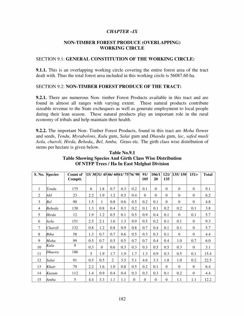
182
CHAPTER –IX
NON-TIMBER FOREST PRODUCE (OVERLAPPING)
WORKING CIRCLE
SECTION 9.1: GENERAL CONSTITUTION OF THE WORKING CIRCLE:
9.1.1. This is an overlapping working circle covering the entire forest area of the tract
dealt with. Thus the total forest area included in this working circle is 56087.60 ha.
SECTION 9.2: NON-TIMBER FOREST PRODUCE OF THE TRACT:
9.2.1. There are numerous Non- timber Forest Products available in this tract and are
found in almost all ranges with varying extent. These natural products contribute
sizeable revenue to the State exchequers as well as generate employment to local people
during their lean season. These natural products play an important role in the rural
economy of tribals and help maintain their health.
9.2.2. The important Non- Timber Forest Products, found in this tract are Moha flower
and seeds, Tendu, Myrabolons, Kulu gum, Salai gum and Dhaoda gum, lac, safed musli
Aola, charoli, Hirda, Beheda,, Bel, Amba, Grass etc. The girth class wise distribution of
stems per hectare is given below.
Table No.9.1
Table Showing Species And Girth Class Wise Distribution
Of NTFP Trees / Ha In East Melghat Division
S. No. Species Count of
Comptt.
15/ 30 31/ 45 46/ 60 61/ 75 76/ 90 91/
105
106/1
20
121/
135
135/ 150 151> Total
1 Tendu 175 6 1.8 0.7 0.3 0.2 0.1 0 0 0 0 9.1
2 Ahl 23 2.2 1.9 1.2 0.5 0.4 0 0 0 0 0 6.2
3 Bel 90 1.5 1 0.8 0.6 0.5 0.2 0.1 0 0 0 4.8
4 Beheda 138 1.3 0.8 0.4 0.3 0.2 0.1 0.1 0.2 0.2 0.1 3.8
5 Hirda 12 1.9 1.2 0.5 0.1 0.5 0.9 0.4 0.1 0 0.1 5.7
6 Aola 151 2.5 2.1 1.6 1.3 0.9 0.5 0.2 0.1 0.1 0 9.3
7 Charoli 132 0.8 1.2 0.8 0.9 0.8 0.7 0.4 0.1 0.1 0 5.7
8 Biba 58 1.3 0.7 0.7 0.6 0.5 0.3 0.3 0.1 0 0 4.4
9 Moha 99 0.5 0.7 0.5 0.5 0.7 0.7 0.4 0.4 1.0 0.7 6.0
10 Kulu 9 0.3 0 0.6 0.3 0.3 0.3 0.5 0.5 0.3 0 3.1
11 Dhaora 186 5 1.9 1.7 1.9 1.7 1.3 0.9 0.3 0.5 0.1 15.4
12 Salai 91 0.5 0.5 2 3.5 5.1 4.6 3.3 1.8 1.0 0.2 22.5
13 Khair 79 2.2 1.6 1.0 0.8 0.5 0.2 0.1 0 0 0 6.4
14 Kusum 112 1.4 0.9 0.4 0.4 0.3 0.3 0.3 0.1 0.2 0 4.4
15 Amba 5 4.4 3.3 1.1 1.1 0 0 0 0 1.1 1.1 12.2

183
SECTION9.3. SPECIAL OBJECTS OF MANAGEMENT:
9.3.1. As per the National Forest Policy-1988, the development of Non timber Forest
Produce is one of the basic objectives for the forest management. Consistent with the
above policy, the special objectives of management are as follows:
1. To monitor and improve stocking of NTFP species in the forest areas.
2. To enhance collection of NTFP through improved collection techniques.
3. To enhance economic returns to local communities by training them in value addition
techniques and marketability of various NTFPs in the Division.
SECTION 9.4: OWNERSHIP AND MONOPOLY PROCUREMENT OF THE
NTFP:
9.4.1 The statutory provisions have vested ownership rights over certain listed NTFP
species with the village communities in the Scheduled Areas without granting such rights
over the trees and the land. Presently, this list excludes Tendu, Apta and Bamboo. The
rules also affirm that the provisions of the working plan shall be applicable for the NTFP
harvesting.
9.4.2 The Seventy-third Amendment of the Constitution of India has brought the NTFP
under the management of the Village Panchayat. Procurement of NTFP as per Central
and State Govt. directives to this effect shall be followed.
SECTION 9.5. AGENCIES FOR COLLECTION:
9.5.1. The Maharashtra Tribals’ Economic Condition (Improvement) Act, 1976
empowers the state government to enforce monopoly procurement of certain goods
including the NTFP in the Tribal Sub-plan Areas. The Maharashtra Tribal Development
Corporation (TDC) serves as the Chief Procurement Agent. List of items covered under
the monopoly procurement vary among talukas and from year to year. This procurement
provision is binding and therefore to be carried out accordingly.
9.5.2. In case of the remaining NTFP, the Deputy Conservator of Forests shall decide the
agency for collection in accordance with the applicable rules and the policies of the
department. In view of the national policy directives, local village communities should
have the first charge over the NTFP collection.
SECTION 9.6. METHODS OF TREATMENT:
9.6.1. Modifications according to legal provisions: Since legal provisions are not very
explicit, it is recommended that treatments prescribed in the following paragraphs be

184
modified according to the legal directives issued by the state government from time to
time.
9.6.2. Fire Protection measures: Collection of NTFP is often associated with forest fire,
because the villagers set fire around the NTFP-yielding trees for clearance of leaf litter
and undergrowth. Fires are also caused by agents of tendu contractors to get better flush
of tendu leaves. If left unattended, such fires spread into forests as forest fires. To control
and prevent forest fires, following measures shall be adopted.
1. The village panchayats and JFMCs shall be involved in awareness generation program
to control forest fires. Villagers should be encouraged to ensure that such cleaning do not
end up as forest fire.
2. In case of forest fire, legal action should be taken up against the defaulters. Strict
vigilance is necessary during the months of March-April to check the spread of fires in
time during tendu season.
9.6.3. Training for NTFP collection: Training programs for proper NTFP collection,
value addition and marketing will be organized in each round to help ensure their
sustainable harvest and use. The education Circle should prepare and oversee the training
modules.
9.6.4. Documentation of NTFP collection: The Beat Guards shall send monthly reports
to the Range Forest Officer on the quantity of NTFP collected in their beats. The Range
Forest Officer shall compile and send the details to the division office. The division
office shall compile the figures for each species for the division with a view to monitor
their collection and harvest, to sustainable limits.
9.6.5. Non-destructive collection of NTFP: Unless detrimental to the wildlife
conservation and site conditions, sustainable harvesting of herbs, non-destructive removal
of flowers, fruit and other medicinal parts may be permitted by D.C.F. after the approval
of the C.C.F. territorial concerned.
9.6.6. Compartments having promising regeneration areas of NTFP species shall be
identified and tended to remove congestion in the crop.
9.6.7. Considering site suitability and local needs; NTFP species shall be given due place
(10 to 15%) in various plantation schemes.
9.6.8. Except dead, diseased and specifically provided for, no NTFP trees shall be marked
for felling during the coupe working under various working circles.
Management of Tendu:
9.6.9. Collection of tendu leaves: Tendu is the prominent revenue generating NTFP of
this tract. Tendu leaves are used for manufacturing bidis. The collection season of tendu

185
leaves is short, and is hardly a month, from the last week of April to the last week of
May.
9.6.10. This tract has potential to yield 3350 standard bags of tendu leaves amounting to
annual revenue of the division about Rs.33.3 lakhs (year 2003).
9.6.11. Tendu leaves collection is monopoly of the state government under the
Maharashtra Forest Produce (Regulation of Trade) Act, 1969. The tendu leaf collection
shall be carried out in the manner prescribed by the Principal Chief Conservator of
Forests and the government from time to time.
9.6.12. Tendu leaves collection is an income generating activity for most local and tribal
villages in the region. The local village communities shall be gainfully engaged on
priority in tendu collection in the division to support their livelihood.
9.6.13. Forests of the Protection Working Circle as well as A type areas in other working
circles shall be excluded from Tendu units. The Deputy conservator of Forests shall
accordingly organize the Tendu units.
9.6.14. Pruning of young Tendu plants does help in increasing the leaf yield. Pruning in
the compartments may be allowed at 3-year interval. However, felling of Tendu trees or
branch lopping for leaf collection shall be prohibited and dealt with firmly.
9.6.15. Tendu regeneration: In view of the importance of tendu to support the livelihood
of forest dwelling communities and its economic value for the region, sustainable
management and use of tendu is prescribed.
9.6.16. Maintainance and improvement of tendu in the forest crop composition is
proposed by ensuring regeneration of tendu and by protection.
9.6.17. Singling of shoots and soil working around tendu seedlings is prescribed in the
plantation and rootstock areas to promote the growth of tendu seedlings along with the
annual coupe working in the area-specific working circles.
9.6.18. Soil Working for tendu trees: Digging of 30 cm deep trench encircling tendu trees
of diameter matching tree crown has been found useful to regenerate the species from
root suckers. By doing so roots are injured and from which profuse suckers come out.
Singling and tending shall increase the population of this species. The practice is
proposed to regenerate areas deficient in tendu species in stocking.
Management of Moha:
9.6.20. Moha collection: Moha trees were found in 99 compartments during the
enumeration. The villagers in the tract have local system for allocation of collection
rights of moha flowers and fruits. In view of traditional approach of allocation of
collection rights by the local communities. It is advised to number the moha trees and
document the trees allocated to each moha collector.

186
9.6.21. Moha regeneration: NR of moha shall be provided by dibbling of moha seeds in
the plantaions and by carrying out weeding and soil working along with other planted
seedlings during coupe operations of area specific working circles.
9.6.22. Soil working of Moha trees: Digging of 30cm deep trench encircling moha trees
of diameter matching the tree crown has been found useful to regenerate the species from
root suckers; By doing so roots are injured and from which profuse shoots come out.
Singling and tending will increase the population of this species. The practice is proposed
to regenerate areas deficient of moha in stocking.
9.6.23. Moha is prescribed to be included in the list of species prescribed in various area
specific working circles.
Moha Flower:
9.6.24. i) Use And Nutritive Value: Moha flower is a rich source of sugar, vitamins and
calcium. The flower, in its ripe form, has almost 73% sugar and is, therefore, even a
better medium for fermentation than grapes. Moha flower is eaten raw or cooked. This is
also eaten after frying or baking into cakes. More usually, the corolla tubes, after
removing the stamens, are boiled for about 6 hours and left to simmer until water
evaporates completely. The odour disappears as a result of cooking and the material
becomes soft and jelly like. It is eaten with rice, tamarind, grains or other food or as
sweetmeat. Dried moha flower is also boiled with rice and mixed with wheat flour and
this provides a wholesome food. After drying, it becomes valuable food additive to diet.
Moha flower is largely used in the preparation of distilled liquor also. This liquor is
actually the beer of India having strong smoky foetid odour, which disappears on aging.
It is reported to excite gastric irritation and produce other adverse effects. Redistilled and
carefully prepared liquor is good quality without having adverse effects and closely
resembles to Irish Whisky. The corollas were in the past, exported, to France for
distillation of cheap brandy. However, the French Government in order to protect their
home industry prohibited the import of the same. Subsequently, it was imported by
Europe for feeding pigs.
ii). Moha spirit prepared by distillation of liquid containing fermented moha flowers is
the most important alcoholic drink in many of the areas. It makes a potent drink and
efforts are required to be made to refine it in modern distilleries. The flower is also used
for the preparation of certain kinds of non-alcoholic food drink by some tribes. The
flower is also used for the preparation of vinegar. Moha having appreciable proteins and
vitamins has valuable nutrition content.
iii) Syrup of good quality is prepared from the corollas by extraction with hot water
clarification with activated charcoal and evaporation under vacuum. The syrup with very
high sugar content (61%) has a golden yellow colour with the odour of fresh flower. It is
a substitute for honey. Apart from human consumption, moha flower offers an excellent
food to the livestock and wild animals as well.

187
iv) Nutrition analysis of flower showed digestible crude protein 3.08 %, total digestible
nutrients 73.7% and starch equivalent to 53.1 %. The flesh of animals particularly of pigs,
fed on moha flowers, acquires a delicate flavour.
Moha Fruit:
9.6.25. i) Use And Nutritive Value: A ripe fruit has cream coloured epicarp, which is
edible. Moha berries were eaten raw or cooked. Cattle, sheep, goats, monkey and parrots
also eat them. They have medicinal value as well. Fruit fallen on the ground are easily
attacked by insects and ants thus becomes unfit for human consumption.
ii) The moha seed oil. Forest tribes for cooking purpose, as illuminance and hair oil, use
a thick oil light yellow in colour and extracted from the seeds. It is also used in the
manufacture of soaps, particularly, laundry chips. In many areas it is also used as an
adulterant for ‘Ghee’ for which it is clarified with butter mark to mask the disagreeable
colour. The oil finds use in medicines also.
iii) Crude oil has a deep colour, high acidity, unpleasant odour and bitter taste. Refining
and hydrogenation yield product similar to mutton tallow or cocoa butters. Oil having
acid value below 13 may be refined by treatment with caustic soda and that with higher
acid value is extracted with alcohol and further treatment with alkali. Refined oil finds
use in the manufacture of lubricating grease and fatty alcohol. The oil is also used for
candles, as batching oil in Jute Industry and as a raw material for the production of stearic
acid.
iv) The yield of oil from the seeds depends on the efficiency of the equipment employed
for crushing them. It is 20-30% of the weight of the kernels when crushed in ‘ghanis’,
34-37% in expellers and 40-48% when extracted by solvents.
v) Moha oil shall have a set of characteristics. For this purpose ISI standards have been
prescribed which are as below.
Table No. 9.2
Table Showing Moha Oil Properties:
SrNo Characteristics Grade
I II III
1. Moisture and insoluble impurities% by mass max. 0.10 0.25 0.50
2. Color in a ¼ in a cell on the Loviband scale expressed are
Y + 5R not deeper than.
0.20
30
50
3. Refractive index at 40o C
1.459 to 1.460
4. Sp.gravity at 90oF /30
oC 0.862 to 0.875
3. Saponification value 187 to 196
6. Iodine value 58 to 70
7. Unsaponification matter % by mass 2.0 3 3.0
8. Acid value max 0.5 20.0 >20

188
9.6.26. Yield: The Moha yield data collected by the MVSS Chandrapur are given below.
i). Moha trees starts bearing flowers and fruits between 10th
to 15th
years of planting. A
study with reference to the yield of moha flowers and fruits has been conducted by the
MVSS, Chandrapur in comptt.No.195 in Tadgaon Range of Bhamragarh Forest Division
in the year 1992. The trees of different shapes and girths were selected for the purpose of
this study. Results obtained are given below.
Table No. 9.3
Table Showing Yield Of Moha Flower And Fruits
Weight in Kg.
Sr. No. G. B. H. in Cm Flower Seed
1.
2.
3.
4.
3.
6.
7.
076 - 090
091 - 105
106 - 120
136 - 150
151 - 175
176 - 190
206 - 220
06.00
10.00
11.25
13.30
13.00
13.00
20.00
1.20
1.00
2.00
2.75
3.80
4.00
4.30
Average 12.94 2.72
(Note:As year 1992 was not a good seed year, the average obtained above is on lower
side.)
ii). The rates of royalty in Rs/Qtl. Of Moha flower and seed as decided by the
Government for the years, 95-96 to 1999-2000 is Rs.3/quintol.
iii) As per the tree enumeration carried out by FRSS Amravati, the number of Moha
trees/ha having gbh > 45 cm is 4.9 . On the basis of the study mentioned above expected
yields of flower and seed come to 42.4 kg/ha and 8.55 kg/ha respectively. Estimated
yield for East Melghat Division forest area is 2377.19 tons and 955.92 tons respectively.
However, the phenological character of the species is that flowering and fruiting
generally occur alternate years or twice in three years.
9.6.27. Formation Of Units And Coupes: The range shall be the unit of working for the
purpose of this working circle. Since operation is to be carried annually throughout the
area and so the unit will be the coupe in this case. Individuals are presently doing the
collection of moha flowers and seeds. Normally they confine themselves around their
village only to collect moha flower and seeds. As per latest Amendment to Panchayati
Raj Act, the ownership of the minor forest produce in schedule areas is vested with gram
panchayat. The collection and disposal of produce is to be carried out by the gram
panchayat as decided by the concerned gram sabha. Most of the tract is under schedule
areas. Hence the collection and disposal of these minor forest produces will be governed
by the panchayat concerned. In the non-scheduled areas, for large-scale operation,
collection may be done either by FLCS or any other agency under terms and conditions
as decided by the Government.
9.6.28. Market: Moha flower and seed come under Monopoly Act and so the collection
of moha flower and seed is carried out by people and p urchased by the TDC. It would

189
be better to involve the industries using the moha in the procurement through FPC, so
that better price can be made available to the collectors.
9.6.29. Other Regulations:
i). Compartment wise list of Moha trees shall be prepared and maintained at beat, round
and range levels.
ii) One of the important reasons of forest fire is the burning of leaf litter on ground under
Moha trees by the people to collect moha flower. Therefore, before the start of flower
falling, the ground under the moha tree crown shall be cleaned with the cooperation of
villagers and chaukidars. This may be treated, as one of the most important duties of the
Beat Guard, failure in it and occurrence of fire shall be viewed seriously.
iii) The measures for enhancing the production and productivity by local means shall be
explored and taken up.
Gum:
9.6.30. Use And Value: Kulu (Sterculia urens), Dhawra (Anogeissus latifolia) and Salai
(Boswellia serrata) gums are the main sources of gum production in this tract. These are
used in medicines, chemicals, cosmetics and food industries. Salai gum is mostly used as
incense and is said to be used in the Indian medicines for rheumatism and nervous
diseases. It has the possibility of becoming an important substitute for imported Canada
balsam, used as mounting media in the preparation of microscopic slides. This gum is
very similar to turpentine oil. Varnish and paints prepared from it have been found to be
suitable. It may also be suitable in the manufacture of elastic adhesive, lacquers, oilcloth
compositions, ink and perfumery. Kulu gum is the costliest gum and is having export
potential. Dhawra gum is very good for the preparation of many food items. It is mostly
used in the preparation of sweets. So it is in great demand before Diwali. Jaipur, Udaipur
and Jodhpur are the big markets for consumption.
9.6.31. Regeneration of Gum Yielding Trees: NR of gum yielding trees such as kulu,
dhawra and salai shall be provided soil working along with other planted seedlings
during coupe operations of area specific working circles.
9.6.32. Soil Working of Gum Yielding trees:
i) Digging of 30cm deep trench encircling kulu, dhawra and salai trees of diameter
matching the tree crown has been found to be useful to regenerate the species from roots;
By doing so roots are injured and from which profuse shoots come out. Singling and
tending will increase the population of this species. The practice is proposed to regenerate
areas deficient of kulu, dhawra and salai in stocking.
ii) kulu, dhawra and salai is prescribed to be included in the list of species prescribed in
various area specific working circles.
9.6.33. Yield: The study of yield of gums has not been done in this tract. The production
is low. No scientific method for tapping has been used so far in this area. This is a very
190
potential field of employment generation and revenue earning. Besides, the regulations of
the collection are very important from protection of forest from the fire point of view.
9.6.34. Use Of Ethephone To Increase Exudate Gum Yield:
i) Experimental tapping of gum from Acacia Senegal was carried out at Central Arid
Zone Research Institute (CAZRI), ICAR India and study of the properties of the gum was
made. An important finding of the CAZRI Scientists has been the observation, that gum
exudation from most of the trees can be increased (nearly doubled), by injecting the plant
hormone ethephone (2- Chloroethyl Phosphonic acid) into the tree.
ii) Ethephone, a plant growth regulator has been known to be a precursor of ethylene,
which accelerates the ripening of the fruits and increases boll opening in cotton plants. It
was for the first time that the CAZRI Scientists have shown its effect on increasing gum
yield from trees.
iii) While using ethephone injection, it is not necessary to scar the tree trunk and
exudation starts due to abscission of cellulose tissues of various sites of the tree. Increase
in exudation of gum when ethephone is injected, suggests that the gum is a normal
metabolic product in certain plants, which is already present as sap in gum ducts. When
cellulose cells are broken due to ethephone, creating abscission of gum ducts at several
points, gum ooze out at such points.
iv) It has been observed that this method causes minimum injury to the tree and
exudation is not confined to a particular site (e.g. place of blazing of the stem) as in the
case of conventional method of gum tapping.
v) Similar experiments shall be carried out in the field to have a fair understanding on the
efficacy of Ethephone on gum yielding trees.
9.6.35. Tapping Rules: The rules for tapping, derived by the FRI, Dehradun, are as
follows:
i) The tapping season will commence from November to end of May each year. No tree
below 90 cm in girth will be tapped.
ii) Tapping will be confined to the main bole of trees between 15 cm from ground level to
the point from which first branch is given off.
iii) Only trees above 90 cm in girth at breast height will be tapped.
iv) Each tree will be tapped continuously for 3 years and will be given a rest for 3 years
thereafter. The second tapping cycle will begin in the 7th
year after the commencement of
tapping season and will continue for another period of 3 years.
v) The initial blaze of 20 cm wide and 30 cm in length or height may be made in the
month of November on trees at 15 cm above ground level with a sharp edge having 7.5
cm wide blade. The blaze is made 0.6 cm deep in the bark.
vi) Blaze may be made horizontally leaving approximately equal space between the
blazes. The blazes should not have any loose fiber. The lower surface of the blaze should
be slightly slopping outwards to avoid lodging of guggul in the blazed pocket in case
initial blazing is done by edge.
vii) The guggul starts oozing out soon after blazes are made and may be collected
initially after a month i.e. by about December when the blazes may also be freshened.
Subsequent collections and freshening may be done at fortnightly up to May. Thus 12
freshenings may be required to be made during the year.

191
viii) In each freshening, the lower surface is not to be freshened. The edges may be
scraped so that only 3.8 cm is increased on either side in width at the end of 12th
freshening. This means that about 0.3 cm should be scraped off either side in width in
each freshening.
ix) The lowest row of blazes will be at one meter above the ground level. The next row of
blazes will be made at the height of 60 cm from the lower i.e. at a total height of 1.6
meter from the ground level. The vertical portion of the blaze of upper row will alternate
with similar portion of the row and no two blazes of the two rows will be directly one
above the other.
x) The number of blazes to be made on each tree will depend on its girth at breast height
as given below:
Table No. 9.4
No Of Blazes On Each Tree
Sr. No. Girth at breast height Max. No. of blazes to be made on each tree 1.
2.
3.
4.
0.9 m to 1.3 m
1.3 m to 2.0 m
2.0 m to 3 m
Over 3 m
2
3
4
1 blaze for every 45 cm girth in addition to category 3
above
a) No fresh blaze will be made on the partially healed up surface or old wounds.
b) Each blaze will be in a shape of parabola with a 2.5 cm. wide base. The curved side of
the parabola will be upwards and of height not more than 7.50 cm and the depth of the
blaze will not exceed 0.6 cm in the wood.
c) At the end of the session, the height of the blaze shall not be greater than 12.50 cm.
Maximum permissible dimension of each blaze shall be 10 cm x 12.5 cm x 0.6 cm in
width, height and depth respectively.
d) Since the tapping is to be done continuously for three years the total height of the
blaze at the end of three years of tapping will be 37.5 cm, the width and depth remaining
the same.
e) In the second cycle i.e. in the 7th
year (after three years rest) new blazes will be made
in the same way in the unblazed portion, in between the blazed portions of the first cycle.
This blazing will continue for another three years in the manner described above and the
operation will be repeated till unblazed portion is fully covered.
f) The above measures shall be implemented in certain areas to imbibe new
techniques to the gum collectors by training the people and by monitoring the
progress periodically.
9.6.36. Grading: The collected gum is graded into three classes:
i) white, ii) yellowish, iii) Black coloured.
White coloured gum fetches higher price in the market compared to yellowish and
black gum. Yellowish gum fetches less price as compared to white one. Black gum
fetches the lowest price. When gum is collected it is a mixture of all the three grades. By
grading the gum the trader is able to assess correctly and offers correct price. So skill for
grading is provided to the people by organizing training to the gum collectors.
The colour of the gum is dependent upon the climatic conditions. It is said that clear
sky in the night will exude white coloured gum.

192
9.6.37. Formation Of Units And Coupes: Range is the unit. Each unit will be divided
into three annual coupes details of which will be given in Appendix No. LIII of Volume
II of this plan. The working cycle will be of three years.
9.6.38. Agency: As per latest amendment to Panchayati Raj Act, the ownership of the
minor forest produces in schedule areas is with gram panchayat. The collection and
disposal of that is to be carried out by the gram panchayat as decided by the concerned
gram sabha. Hence the collection and disposal of these minor forest produces will be
governed by the panchayat concerned. In the non-scheduled areas, for large-scale
operation, collection may be done either by FLCS or other agency under terms and
conditions as decided by the Government.
9.6.39. Market: There is monopoly purchase by TDC under the provisions of Monopoly
Act. Besides, the export of raw or finished goods shall be explored.
9.6.40. Other Regulations:
i) The compartment wise list of such trees shall be prepared and maintained at beat, round
and range levels.
ii) Cleaning around the trees to facilitate gum collection and to avoid fire, shall be done.
iii) Gum producing trees shall be reserved from felling.
iv) A strict watch is necessary to enforce tapping rules and check unauthorized collection
of gum and tapping during the period of rest.
9.6.41. MYRABOLONS USE: These NTFP is used in many ways. Hirda, Beheda and
Aonla are most common amongst Myrabolons. These are of high medicinal value and are
used in many Ayurvedic medicines. Hirda and Beheda are given to children in villages
invariably for cold, cough and stomach disorder.
9.6.42. YIELD: So far no study has been conducted to know the yield of fruits for trees
of such species.
9.6.43. FORMATION OF UNITS AND COUPES: The range shall be the unit. Since
working is annual and covers the entire area and so unit will also be the coupe.
9.6.44. AGENCY FOR HARVESTING: As per latest amendment to Panchayati Raj
Act, the ownership of the minor forest produces in schedule areas is with gram
panchayat. The collection and disposal of that is to be carried out by the gram panchayat
as decided by the concerned gram sabha. Hence the collection and disposal of these
minor forest produces will be governed by the panchayat concerned. In the non-
scheduled areas, for large-scale operation, the units shall be given on lease. The lessee
will collect the same as per the direction of the Deputy C.F. concerned. The lease period
should be from 1st July to 30
th June. Lease shall be given for one year by calling tender at
division or circle level. On failure of tender, departmental harvesting can be thought of,
provided marketing tie up is made with user industries.
193
9.6.45. Market: All probable industrial consumers shall be identified and quality grades
be fixed and department shall act as a facilitator between JFMC and consumer.
9.7.7.6. Other Regulations:
i) The detailed list of such species shall be prepared and maintained at beat, round and
range levels.
ii) These species shall be excluded from felling.
9.6.46. Management of lac: 1. Lac Collection: The lac collection is not in practice in
East Melghat Division. It has potential to add substantially to the returns of the local
inhabitants. Palas and kusum trees serve as good host for the lac insect, palas is in plenty
in degraded tracts of the division. The lac is collected by the people. It provides
additional source of income to the local farmers and provide employment opportunity to
landless poor in the area.
9.6.47. Formation of Lac units: The units for collection of lac are prescribed to be co-
terminus with the range boundaries to ensure effective monitoring and control. Each unit
prescribed to be sold for the period of five years.
i) The local JFMCs and FLCS and other village bodies shall be given first opportunity of
collection, failing which units may be sold on public auction.
ii) The training in collection, grading and preliminary value addition will multiply the
returns of people.
iii) Obtaining brood lac and growing them on the kusum trees in the first instance
shall be carried out departmentally.
9.6.48. Medicinal Plants: The important medicinal plants found in this division are
Asparagus racemosa, Chlorophytum tuberosum, Equisetum sp., , Hygrophila auriculata,
Bauhinia diffusa, Terminalia bellerica, Terminalia chebula, Emblica officinalis, Soymida
febrifuga, Solanum violaceum, Gloriosa superba, Plumbago xeylanica Cassia absus,
Holarrhena antidysenterica, Hemidesmus indicus, Helicteres isora, Evolvulus alsinoides,
Vernonia cineraria.
9.6.49. Management of Safed Musli: Safed musli (Chlorophytum Borivilianum Family
– Liliaceae): A herb with linear leaves appearing on the ground with the advent of
summer rains. Flowers are white in colour. It is a perennial with fleshy roots/root-tubers.
Common Name: Safed Musli.
Location: Basin of Khandu
Part Used: Tuberous Root
Safed musli is collected and sold to the local traders, which is dried and debarked and
sold in the Delhi market. Till 2 years back it used to fetch Rs. 600/kg. for dried material.,
Since it is an endangered species, all collections from the forest are illegal. People be
encouraged to prepare Nurseries and plantations. Safed musli contains an alkaloid
sapoginine, which is of medicinal value.

194
SECTION 9.7. RESEARCH WORKS:
9.7.1. There are so many Non Timber Forest Produce and Medicinal Plants in the forest
which are unidentified and untapped. The efforts of the department shall be to explore
them and manage them scientifically. Identification of medicinal plants in the field shall
be taken up for study immediately with the help of the ethno botanists.
SECTION 9.8. OTHER IMPORTANT PRINCIPLES AND PROCEDURES:
9.8.1. The following are important principles and procedures.
9.8.2. The annual estimates for collection of Non Timber Forest Produce and Medicinal
Plants shall be made based upon the experience.
9.8.3. The Chief Conservator of Forests shall approve the annual estimates for the
collection of NTFP.
9.8.4. The Range Forest Officer for the respective range shall issue the passes for
collection of NTFP to the lessees and keep record of the collection etc.
9.8.5. The Non Timber Forest Produce and Medicinal Plants lease units shall have
distinct boundaries.
9.8.6. NTFP collection estimates shall be based upon the inventories of forest resources.
9.8.7. Scheme shall be formulated for improving yield of Non Timber Forest Produce and
Medicinal Plants e.g. plantations, protection against disease etc.
9.8.8. Measures shall be taken to maintain and improve the present output of the Non
Timber Forest Produce and Medicinal Plants.
----

195
CHAPTER X
JOINT FOREST MANAGEMENT (OVERLAPPING) WORKING
CIRCLE
SECTION10.1. JOINT FOREST MANAGEMENT:
10.1.1. Background Of The Joint Forest Management:
The National Forest Policy 1988 envisages massive people’s movement for conservation
of forest resources. Thus, the government of India advised state governments in June
1990 to involve local people in protection and development of forests. Participatory
management strategy envisaged in forestry sector is known as Joint Forest Management
(JFM). Therefore, instructions have been issued for incorporation of prescriptions of joint
forest management in the working plan. Hence, separate Working Circle has been
constituted for this purpose.
10.1.2. Government resolution no. SLF-1091/199/F-11 dated 16th
March 1992, this
approach was adopted for degraded forest area of the state and new guidelines have been
issued vide GR No.MSC/2000/C.No.143/F-2, dt.25.4.03.
10.1.3. Villagers themselves are required to voluntarily participate in the programme.
Forest protection committee (FPC) is to be formed in each village. The members of the
committee will help in protection and development of forests and they will receive in turn
a share in the usufructs and output from the forest areas assigned to such committee. The
JFM area will be managed according to the micro-plans prepared jointly by the Deputy
Conservator of Forests and members of the FPC. These micro-plans shall contain the
details of forest and village development. This has to be sustainable, should cater to
aspirations of local communities and at the same time the silvicultural requirements of
the forests are to be met properly.
10.1.4. Later, the government of India advised the state governments to take up the Joint
Forest Management in well stocked forest areas on experimental basis and accordingly
guidelines dated 25.4.03 cited above have authorized the forest department in the state in
this respect. Summary of guidelines is as follows:
1. Good forests within 2 km from a village are to be covered under the programme on
experimental basis and stage-by-stage other villages containing good forests are to be
brought under it.
2. JFM is to be implemented with the help of gram panchayat and forest produce
available is to be provided on priority to meet bonafide local needs.
3. The village having non-forest land, which has agreed to participate in the programme,
may be brought under the scheme.

196
4. Help of the institutions of local self-govt., NGO, environmental expert, if any available
locally, may be solicited.
5. The scheme though does not intend to facilitate agriculture based professions but non-
irrigated horticulture schemes in (private) wastelands may be encouraged if approved in
the micro-plan.
6. The program underlines conservation of forests and wildlife and therefore any
activity/agreements etc. that is not consistent with Forest Conservation Act, 1980 should
not be incorporated in the micro-plan.
SECTION 10.2. SPECIAL OBJECTS OF MANAGEMENT:
The special objects of management are as given below.
1. To rehabilitate and regenerate the degraded forest areas.
2. To check soil erosion.
3. To protect the forests and to utilize the degraded forest areas for productive purposes in
order to meet the fuel, fodder and timber requirements of the people.
SECTION 10.3. COMPARTMENTS AND FELLING SERIES:
10.3.1: As the execution and implementation of the prescriptions under this working
Circle are totally dependent on the willingness of the villagers, neither the compartments
are allotted nor the felling series are formed. The micro plan prepared for the area
allotted to a particular village or joint forest management committee shall be in
consonance with prescriptions given for that area under this draft plan. Any deviation
from the plan requires sanction of the competent authority.
SECTION10.4.THE PRINCIPLES:
10.4.1. Following principles should be adhered to during the implementation of J.F.M. in
any village.
1. Eco system Protection.
2. Participatory Democratic structure.
3. Open communication.
4. Gender Equity.
5. Community Responsibility.
6. Effective Conflict Resolution.
7. Traditional Rights and use.
8. Effective Monitoring and Advocacy
SECTION10.5.STATUS OF JFM:
10.5.1. The JFM in East Melghat Division was started in the year 1998-99 under
Maharashtra Forestry Project. 9 Forest Protection Committee were formed in the phase-
I, for which Micro-plans were prepared, approved and implemented.

197
10.5.2. In the second phase F.P.C were formed in 25 villages and they were registered at
CCF, Amravati’s office. A scheme for F.D.A was prepared for the 25 villages and
submitted to government of India. The same was sanctioned vide Govt. of India’s
Authentication No.CSS/FDA/136/04-05, dated 1.2.2005 for an out lay of Rs.1,10,60,000.
The first installment of Rs. 32,68,000 was sanctioned by govt. of India vide letter cited
above. The activities to be taken up are as given in the table below.
Table No. 10.1
Table showing activities under FDA
Sr. No. Particulars Physical
(Area in ha.)
Financial
(Rupees in lakhs)
1. Aided Natural Regeneration 600 31.62
2. Bamboo 400 31.79
3. (GPA+S&M+
Overhead+Microplanning)
- 47.19
Total 1000 110.60
10.5.3. Further Govt. of Maharashtra decided to form FPCs in all the villages adjacent to
forest, accordingly 30 more FPC were formed. Thus, as against the target of 101, till to
date 64 FPCs were formed at the time of preparation of the plan. The remaining villages
will be covered soon under JFM. Out of 64 committees so far formed one FPC is
registered under Societies Act-1980 and the remaining are under process of registration.
The FDA for East Melghat Division was registered with Asst. Charity Commissioner
vide Reg. No.161/2002, dated28-3-2002.
.
10.5.4. JFM envisages involvement of people in the Protection, Regeneration and
Rehabilitation of degraded forests. However, evaluation reports shows that until now,
involvement of people in the management of forest is poor. Hence all the staff needs to
be trained in communication skills and work as a team to make the programme a
successful one.
10.5.5. It was observed that illicit felling, encroachments are the main problems in
Anjangaon Range, whereas fires and grazing are the main problems in the remaining
Ranges. Thrust on NTFP activities be given, so that attachment to the forest can be
increased.
SECTION10.6. POTENTIAL AREAS FOR THE JFM PROGRAM:
10.6.1. The forest areas closer to the villages are included in this Working Circle. It
includes the areas of Improvement Working Circle, Afforestation Working Circle and a
few areas of Selection cum Improvement Working Circle. It includes degraded as well as
good forest areas.

198
SECTION10.7.TREATMENT PRESCRIBED:
10.7.1. Based on the nature of work in the various Working Circles and local
requirements, role of a JFMC will have to be identified and defined in the micro-plan.
While doing that, following points may be taken into consideration:
10.7.2. While formulating micro-plans, silvicultural management, maintenance of forest
boundary, removal of forest encroachments and control over illicit cutting should receive
high priority and it should be ensured that the Micro Plan does not contain anything
which is contrary to the provisions of Working Plans and the existing guidelines and Acts
and rules for management and protection of forests.
10.7.3. The micro-plans should be prepared in such a manner so as to ensure meaningful
participation of all the stakeholders including disadvantaged groups like women,
scheduled tribes, scheduled casts and locally backward groups.
10.7.4. Participatory methods, that is, PRA shall be used to adequately assess the needs
and aspirations of the people. The FPCs should be used to address the concerns and
apprehensions of all the groups.
10.7.5. The forest department should play only co-ordinating and catalytic role for the
village development works recommended in the micro-plans and should also involve
other government agencies and non-government organizations for efficient and
effective execution of these works. The FPC should execute actual works.
10.7.6. The area kept under SCI, IWC, Afforestation Working Circle are essentially for
forest and bio-diversity conservation and for forest productivity. However, material
removed from the annual coupes from these working circles may be considered for its
diversion to meet the bonafide local needs. The local needs may be identified and
quantified on the basis of what has been allowed in the nistar patrak of the villages.
10.7.7. It will therefore be advisable to assign different categories of forests to a JFM
village and fix a scale for dependences on each category of forests. Such aspects will
have to be elaborated in each micro-plan and micro-plans so formulated shall be the basis
of implementation of JFM programme.
----

199
CHAPTER XI
FOREST PROTECTION
(FIRE, ILLICIT FELLING, ENCROACHMENT, ILLEGAL MINING,
POACHING, JHUMMING ETC.)
OVERLAPPING WORKING CIRCLE
SECTION11.1. GENERAL CONSTITUTION OF FOREST PORTECTION
(OVERLAPPING) WORKING CIRCLE:
11.1.1. This is an overlapping Working Circle covering the entire forest area of the tract
dealt with. Thus the total forest area included in this working Circle is 56087.60 ha.
The National Working Plan Code prescribed this Working Circle as a mandatory
Working Circle in the Working Plan. The activities of certain organizations are
encouraging the tribals to encroach the forestland leading to attacks on the staff
particularly in Anjangaon Range. The forests are burdened with heavy biotic
interferences, hence addressing of these problems in a systematic manner necessitated the
constitution of this Working Circle. Illicit felling, grazing, encroachments, poaching and
fires are the major causes for the damage of the forests.
SECTION 11.2. SPECIAL OBJECTS OF MANAGEMENT:
11.2.1. The special objectives of management are
1. To enforce the Indian Forest Act 1927, Wildlife Protection Act 1972 as amended till
2003 for the effective control of Illicit felling, grazing, encroachments poaching and fires.
2. To develop the database to monitor various offence cases in a systematic manner.
3. To raise the morale of staff and to strengthen their hands and capabilities to face the
challenge and threats from organized groups, which encourage encroachment and attack
forest staff on duty
SECTION 11.3. ILLICIT FELLING:
11.3.1. Illicit felling in the forest area is growing at an alarming rate. Illicit felling is
observed near rayatwari villages particularly in Anjangaon and Jarida Ranges. Mostly
teak trees are felled for the domestic purposes. However in Anjangaon Range the
graziers carried out heavy illicit felling of salai trees. Faster communication including
vehicle facilities, adequate defense capabilities, frequent training and establishment of
forest stations at strategic places are recommended to control illicit felling and wildlife
offences. Establishing intelligence network for this purpose is strongly recommended.
11.3.2. In addition to addressing supply-side management by augmenting wood
production on forest and other community land, the demand-side management should be
taken up like efficient wood utilization and energy efficient alternatives like Community
200
Kitchens of Hindustan Petroleum, Biogas, solar cookers, etc. The following general
Strategies are prescribed for the effective protection of the forest.
11.3.3. Review the offence cases beat wise, every month.
11.3.4. Review the varas, bevaras offence cases monthly; efforts are made to find out the
offenders in each bevaras case.
11.3.5. Every varas case having more than Rs.10,000/- worth forest produce/loss to the
forest invariably is submitted to the court within the prescribed time.
11.3.6. Delay in the submission of charge sheets in the courts is viewed seriously.
11.3.7. Use IPC provisions, for the effective control of the illicit felling.
11.3.8. The data related to offence cases shall be analyzed with the help of the computers
using the available software.
11.3.9. Monitor the occurrence of all the offence cases daily through wireless.
11.3.10. Reorganize the beats in such a way so that the average beat area shall be 500 ha.
11.3.11. Identify and list all the paths used for the transportation of illicit material.
11.3.12. Place effective patrolling squads at all-important routes to prevent the
transportation of illicit material.
11.3.13. Emphasis shall be made to arrest and prosecute the offenders rather than seizing
the material.
11.3.14. Use the provisions of rewards for gathering of information.
11.3.15. Provide regular training to the staff in submitting the charge sheets, preparation
of panchanamas etc.
11.3.16. Plan in such a way to have young guards in the hyper sensitive areas.
11.3.17. Patrolling squads shall be not less than 10 in number to over come the group of
offenders.
11.3.18. History sheets of all the offenders along with their photo and bio-data are
maintained at Round Level, Range and Division Level.
11.3.19. Prepare the list of offenders, showing the offence cases involved by him, against
the each offender.

201
11.3.20. Use Cr. P. C. 110 provisions with respect to habitual offenders.
11.3.21. Provisions of IPC 395 shall be used by registering the complaint in the police
station for the offences wherein five or more than five offenders are involved. The DCF
shall co-ordinate with the S.P. to see that stringent sections of IPC will be used in the
F.I.R.
11.3.22. The provisions of the G.R. dated 8/5/2003 shall be implemented. If any
difficulties are there be communicated to the Govt. with supporting data.
11.3.23. Sufficient funds for patrolling and honorarium of advocates be made available
on top priority.
11.3.24. Efforts be made to appoint the forest counsel as directed by PCCF office.
11.3.25. Every stump in the forest be numbered with digit nail set both on the top of the
stump as well as on the base.
11.3.26. Every beat guard shall maintain a register of stumps in the following proforma.
Every stump is registered by a serial number followed by/ and year, for example, if tree
number is 198/05. Here 198- is tree no. and 05- is year.
11.3.27. Every year from January 1, onwards start the new series.
11.3.28. After one year all the high stumps be dressed to ground level to obtain good
coppice.
11.3.29. The supervisory officers, during the beat inspection, verify the registered stumps
and unregistered stumps. The beat guard shall be held responsible for non-registering the
illicit stumps.
11.3.30. Every Range and Division office shall maintain the Xerox copies of the
judgments of all forest cases for the guidance and improvement purposes.
11.3.31. Sections of IPC having the trial jurisdiction of District Court be used in the
complaints and in the FIR
11.3.32. Court Guard duties be assigned to a special duty guard for each Range office and
as well as Division office to monitor the dates and for timely communication to the
witnesses.
11.3.33. Proposals for the wireless network shall be prepared in such a way that every
part of the division area becomes communicable.

202
11.3.34. Inter state co-ordination meetings with the authorities of M.P. Govt. shall be
made, to arrest and prosecute the offenders of M.P who are involved in the offences of
Maharashtra state.
11.3.35. Obtain the support of the local villagers in catching the offenders (JFM
Committees)
11.3.36. The RFO shall collect the beat khairiyat report from each forest guard and
Round officer monthly and shall submit Range khairiyat report to the DCF every month.
11.3.37.All cases of violation of the Forest Conservation Act, 1980 shall be referred to
the regional CCF, Bhopal through Nodal Officer for prosecution purposes with respect to
the government officers involved in the cases.
SECTION 11.4. FIRE PROTECTION:
11.4.1. Fire adversely affects natural regeneration, forest growth, ground Flora, soil
organisms and site productivity. Effective fire control as prescribed in the plan is
essential for the forest development. The division officials and local people shall be
sensitized about the need of effective fire control. All fire incidences must be
meticulously recorded and investigated to assess the damage caused.
11.4.2. Fires are of common occurrence. Due to highly combustible undergrowth
consisting of dense grasses and dry lantana, a tiny spark can trigger off a conflagration in
a short time. Lantana, when dry, is extremely combustible. It throws up a huge flame,
which scorches the leaves and bole of trees completely. The splinters of lantana go high
up and are blown across wide area, which make fire fighting very difficult. The high
speed of hot winds during summer, combined with the hilly configuration accelerates the
spread of fire easily when it occurs and engulfs vast areas before it can be brought under
control only by counter firing. Owing to lantana undergrowth the fires rise to a height of
4-6 m. The height of the flame, thick lantana undergrowth, steep slopes and distances of
the village are the main impediments in putting off the fire. The fire spreads rapidly
before the arrival of the staff. It would be dangerous to put off fire manually in such high-
rise flames. With a long standing fire protection measures and vigilance of the staff, the
forests, in general, have been protected against fires in spite of the handicaps.
Classification of fire control Areas:
11.4.3. Class-I (Complete Fire Protection): The Class-I fire control areas include all
felling coupes (six years) of SCI and Teak Plantation Working Circle, Improvement
Working Circle, thinning coupes (six years), plantations (five year), the A-type areas
(permanent), forest depots (permanent), forest nurseries (permanent), Special habitat
areas (permanent) and any other areas of special importance decided as such by the CCF
(T).
11.4.4. Class-II (General Fire Protection): The Class-II fire control areas include the
remaining areas of the Selection-Cum-Improvement and the Improvement Working
203
Circle as well as any other areas, which deserve the protection in the opinion of the CCF
(T).
11.4.5. Class-III (General vigilance): The remaining forest areas (that is, areas not
included in the above two classes) are identified as the Class-III fire control areas.
Special measures for the fire protection are not undertaken, but deliberate setting of fire
and burning the forest is prohibited.
Fire control measures:
11.4.6. A fire protection scheme for the entire division which would be consistent with
the instructions given in this working Plan shall be prepared before November each year,
identifying the watch points (including watch towers), strategic locations, and strength of
firewatchers at each location, deployment of vehicles, use of wireless sets, supervisory
forest staff and the co-ordination protocol.
11.4.7. Each location is proposed to have 5 to 10 persons including regular staff and
firewatchers. The staff shall be trained in the application of modern fire-fighting tools.
The fire prevention shall be trained as a high priority item. The scheme shall be
implemented sincerely during the fire season.
11.4.8. Areas deliberately burnt for silviclutural reasons under the sanction of the Chief
Conservator of Forests (T) shall be excluded from the fire protection scheme. Fire in such
areas need not be reported unless spreads beyond such area.
11.4.9. All the Class-I and Class-II areas will have external fire lines and internal fire
lines dividing the forest area into convenient blocks.
11.4.10. Fire Watchers and local forest staff shall constantly patrol the Class-I and Class-
II fire control areas. The directives require that fire in the Class-I areas be reported to the
Deputy Conservator of Forests immediately along with details of the area burnt and the
damage inflicted to the forest crop.
11.4.11. The group of firewatchers shall immediately rush to the site and extinguish fire
as soon the fire spot is located by upcoming smoke in their area of operation. Modern fire
fighting tools shall be used for extinguishing the fire. The supervising officials should
mobilize reinforcement in case of large fire. Utmost care will be taken to quench the
smouldering material. Providing a thick layer of soil over such material is generally
effective.
11.4.12. The fire lines shall be kept clear of all growth and combustible material during
the season. Leaf litter and other dry material on the fire lines shall be collected
periodically along the edge and burnt before the fire season starts. Firewatchers engaged
for this purpose will have a duty to sweep the fire lines continuously and keep them clean
of any debris or leaf litter. Depending upon the watchmen and other manpower available
in the area, suitable blocks may be identified around which regular clearing of the fire
lines should be ensured.

204
11.4.13. The cutting of fire lines shall be completed by December. Fire tracing (burning)
shall be completed by February15, and thereafter burning should require permission of
the Deputy Conservator of Forests and physical presence of a gazetted officer.
11.4.14. The division office shall maintain a “Register of fire lines” showing the length
and width of fire lines, and enter the period of cutting and burning of fire lines. The
register will be kept up to date and checked every year, in March. In addition, a map
showing the length and width of fire lines division wise and rage wise as far as possible
shall be prepared in the beginning of the fire season and the same shall be used to depict
the areas burnt every fortnight.
11.4.15. Negligence in the fire protection shall be taken as dereliction of duty. The
supervisory officers shall extensively verify fire control measures.
11.4.16. Efforts will be made to motivate the JFM committees to protect the forest
from fire by assigning them certain areas of forest, in case they agree and sincerely
protect the assigned forest from fire, the grants earmarked for protecting that area
should be given to JFM committees after verifying the area protected.
11.4.17. It was observed that the existing fire lines are not maintained in their prescribed
width for its full length. Hence their efficacy could not be assessed in the absence of
clearly laid fire lines. The committee formed by PCCF, based on its report, shall examine
the scheme submitted by CCF (T); the PCCF shall take decision for further
implementation of the scheme, if any.
11.4.18. Three rows of agave suckers in 1.5 m. wide strip along the contours shall be
planted during the monsoon season at the foothills of steep slopes to prevent the spread of
fire, as agave acts as a fire barrier. This activity shall be carried out along with regular
coupe work.
11.4.19. Standard widths of fire lines are prescribed in the Table 3.2.
Table 3.2
Table Showing Standard Widths Of Various Types Of Fire Lines:
S. No. Characteristics of the area Width of fire
line in meters 1 External boundaries of the forest 12
2 Naturally or artificially regenerated areas (For 5 years) (coupes) 6
3 Remaining coupe boundary 3
4 Both sides of road and cart tracks through the forests 6
5 Timber, bamboo and firewood depots 40
Daily monitoring of fire incidences and the areas burnt and the efforts taken by the staff
to control the fire shall be monitored through wireless on day-to-day basis by D.C.F. and
D.F.O. vigilance under the supervision of CCF Territorial.

205
SECTION 11.5. GRAZING REGULATIONS
11.5.1. The entire forests are liable to damage from grazing except the interior areas,
which are away from the villages. The ‘C’ class forest is heavily grazed. In fact, there is
hardly any grass left in this block and they only serve as exercise grounds for the cattle.
These areas are very undulating and the soil is very poor and are, therefore, even unfit for
cultivation. The ‘A’ class forests adjoining the Berar plains are very hilly, and the upper
slopes are steep. The grazing is, therefore, confined to the lower hills and the calculated
incidence does not give the true picture of the grazing pressure here, while a large
inaccessible area of the units remains un-grazed. A realistic calculation of grazing
incidence is required.
11.5.2. The forests on the plateau in Chikhaldara range are heavily grazed during the few
months of rainy season after which most of the cattle are shifted to lower ranges on
account of the shortage of grass and water on the plateau.
11.5.3. The grazing incidence figures are misleading as the erstwhile forest village cattle
are grazed in the immediate vicinity of the villages. The true grazing incidence in the
areas adjoining the villages is therefore, heavier than estimated.
11.5.4. The animals, mostly buffaloes, from Chikhaldara and some rayatwari villages,
and some cattle from Berar plains are grazed from cattle camps, locally known as hettis
in the interior of forests in the hot season. During this hot weather grazing after the
depletion of grasses, grazers start lopping green foliage, especially of ain (Terminalia
tomentosa), bhosa (Bauhinia racemosa), kusum (Schleichera oleosa), karkha (Bridelia
retusa), Dhaman (Grewia tiliaefolia), kahu (Terminalia arjuna), salai (Boswellia serrata),
Ghatbor (Zyzypus xylocarpa) and bamboo (Dendrocalamus stictus). The lopping and
hacking of trees has led to degeneration of the forests. The seedlings are grazed and
saplings of these fodder tree species have been hacked to provide fodder to the cattle.
Continuous and heavy grazing not only prevents regeneration of tree species but also the
young regeneration obtained during the period of closure, is lost soon after the area is
opened for grazing. In areas with clayey soil, the trampling by cattle results in hardening
of soil and reduction in the soil aeration. In sandy soils, heavy grazing results in
accelerated erosion and denudation. The grazing on undulating lands loosens the soil,
which results in the soil erosion. The problem of migrated cattle is severe in Anjangaon
Range, which needs utmost attention to control the grazing.
11.5.5. It is not uncommon to see goats grazing in timber forests. The goat grazing is
prohibited because of their close level grazing in which the seedling or grass rhizome is
uprooted.
11.5.6. The grazing shall be regulated as per guidelines of Grazing Policy 1968 of
Maharashtra State issued vide Resolution No. MFP-1365/132211-Y dated December
6,1968 and Grazing Rules issued vide No. MFP-1371/237035-Z dated November3, 1973.
However no grazing beyond carrying capacity shall be permitted.

206
11.5.7. Heavy cattle pressure adversely affects the forest regeneration and soil condition.
The present political economy of domestic animals in the area throws up strong
challenge, and implementation of the grazing regulations in its current form. Therefore
special efforts need to be taken up to ensure that no grazing is allowed beyond carrying
capacity.
11.5.8. The situation may be substantially improved by establishing effective
communication with the local people, awareness generation and efficient animal
husbandry program. The forest officers should take up these preventive measures in co-
ordination with the Animal Husbandry Officers.
11.5.9. Maximum admissible grazing incidence according to the current policy has been
shown for various working circles in Table 3.3. A systematic survey of fodder
availability is recommended during the plan period in each round.
11.5.10. The carrying capacity and period of closure should be calculated for the forest
area adjoining each village. The grazing passes, free or otherwise to individual families
are proposed to be distributed on the calculated carrying capacity basis. Village bodies
should also be actively be engaged in the implementation of grazing regulations.
11.5.11. The surplus cattle should be kept under regular watch, and villagers should be
encouraged to adopt stall-feeding or other means to address mismatch between cattle-
heads and fodder availability.
Table 3.3.
Table Showing Admissible Grazing Incidence In Various Working Circles:
Working Circle Functional
classification
Maximum
grazing
incidence
(ha per cattle
unit)
Period
Special areas(overlapping) Protection areas (A1 & A2) &
Special habitat areas
Protection forest Nil Permanent
Flowered bamboo area Protection forest Nil Till seventh year
Annual coupes Protection forest Nil Till six years
Plantations Protection forest Nil Till fifth year
Other area (under Working Circles)
Selection-cum-Improvement Tree forest 1.2
Improvement Tree forest 1.2
Afforestation Open forest 0.8 After plantations
Miscellaneous Minor forest 0.8 Except plantations
Protection Protection forest 4.0 Permanent

207
Note: Area required for wildlife population should be calculated accordingly, and
deducted from the available area for the domestic cattle. If relevant data is not
available 20% area should be marked for the wildlife.
11.5.12. Fodder development on the community lands and translocation of surplus cattle
may be encouraged.
11.5.13. Animal husbandry and Dairy Development Agencies should be motivated and
influenced to take up breed improvement program. Fodder in the plantation areas should
be made available free of cost on cut-and-carry basis.
11.5.14. The DCF shall carry out cattle census of each village during the winter season at
the beginning of the plan period to find out the local cattle once for all and maintain
record and passes shall be issued limited to those cattle subject to the availability of
carrying capacity.
11.5.15. The passes shall show the compartment numbers meant for the grazing by
writing clearly.
11.5.16. Hacking and felling of young plants and big trees be dealt seriously and
offenders shall be prosecuted.
11.5.17. The misuse of transit passes of cattle for grazing be strictly checked and if found
their passes be cancelled and be dealt according to law.
11.5.18. The Grazing Settlement Report for Melghat areas need revision since the
reorganization of the divisions and wildlife areas led to the distribution/splitting of the
then grazing units. Hence new Grazing Settlement Report shall be prepared as early as
possible to avoid conflicts among the villages for grazing purpose.
11.5.19. The carrying capacity of the forests is 39,566 cattle units. The cattle population
of chikadhara taluqa is 87,797. It requires 92,586 ha. of forest area for grazing purpose.
The cattle that migrate to forest in the rainy season from the plains and cattle surrounding
the chinchona ‘C’ class forest were not considered for the calculation purpose. It will
compensate the cattle population of 69 villages, which are outside the division but
included in the taluqa figure. Considering that 21,050 ha. area will be closed for grazing
at the 5th
year of the implementation of the plan, only 35,037 ha. will be available for
grazing, indicating the grazing pressure87,797 cattle. Hence it requires some urgent
measures to reduce the cattle number to save the regeneration of the forests.
SECTION 11.6. FOREST ENCROACHMENT:
11.6.1. Certain organizations like samaj kranti aghadi started encouraging the tribals to
encrozch upon the forestland leading to tensions between the staff and tribals.
The staff was attacked and the accused are also prosecuted leading to bitter animosity
between the tribals and staff. In recent past tendency for encroaching forestland for

208
cultivation has increased. The actual encroached area is higher than the recorded one. The
eligible encroachers encroachment is yet to be finalized at the time of the preparation of
the plan. The area under dispute is not clearly demarcated. A few cases of clearance of
the forest growth for cultivation are booked in some parts of Anjangaon Range.
11.6.2. The encroachment problem is more prevalent in the Anjangaon Range and Jarida
Range and mostly made for agricultural purposes. The eviction operations led to
animosity between the villagers and foresters.
11.6.3. The causes of forest encroachment shall be examined thoroughly and addressed in
a comprehensive manner. All the necessary support should be provided. And
encroachment should be evicted as early as feasible. The boundary management and
standard administrative guidelines will help to control encroachment.
11.6.4. The state government should be urged to finalize and complete the land grant in
all identified cases of encroachments to be regularized in accordance with the
government resolutions issued before 1980. Renewed and concentrated efforts on the part
of division staff for eviction of the encroachment is proposed on priority basis.
11.6.5. Small isolated patches of the forestland are often neglected and become
vulnerable to encroachment. Special care shall be taken to ensure protection of such
patches from encroachment.
11.6.6. The civil powers of eviction are entrusted with ACF and DCF vide Govt. Res. No.
R and F.D/PWR/1196/296/CR.No.17/LII, dated 30-1-97. The procedures laid out in the
Land Revenue Code shall be followed before the execution of eviction.
11.6.7. Habitual encroachers shall be prosecuted as per Indian Forest Act.
11.6.8. All external boundaries shall be demarcated with concrete pillars.
11.6.9. All sensitive and important boundaries and wherever disputes are there, be
surveyed with DILR and concrete pillars be laid immediately.
11.6.10. All encroachments be listed with their names, age, residence, profession whether
belongs to SC, ST, OBC/NT, extent of encroachment, S. No. and location of
encroachment, village/block.
11.6.11. A Detailed report of the case be prepared for each encroacher and be submitted
to ACF to obtain summary eviction orders, in a time bound program.
11.6.12. After the completion of due procedure of Land Revenue code and after giving a
reasonable opportunity of being heard to the encroacher, the ACF shall pass a summary
eviction order if he satisfies so, quoting the findings.
11.6.13. The concerned RFO shall execute the eviction order.

209
11.6.14. If the encroachments in a village are more in number police protection be
obtained for the operation.
11.6.15. Use of Cr. P. C. provisions like section 106 and 110 be used to obtain good
character of offenders before Tahsildar and SDO respectively to smoothen the eviction
operations as well as to prevent the tendency of future encroachments.
11.6.16. For the encroachments on the un-classed forests (though 7/12 shows clear
possession of the departments) FIR shall be lodged in the concerned police station for the
prosecution.
11.6.17. To prevent the tendency of encroachments, improved crop techniques be
propagated in the problem villages to enhance the crop productivity with the help of
Agricultural Department.
11.6.18. Regularization of the encroachments made earlier to 1980 be settled as early as
possible and proposals to that extent be submitted to the Central Govt.
11.6.19. After the listing of all encroachments, sample verification shall be carried out by
all supervisory officers to detect unregistered encroachments.
11.7.20. In the month of May, a drive for encroachment prevention be taken up in all the
sensitive areas by taking meetings in the villages by Dawandi and distribution of leaflets
and posters.
11.6.21. Keep a watch on all the sites meant for debris cleaning, ploughing etc., in the
month of May, so that encroachments are removed even before the sowings.
11.6.22. A total of 351.614 ha. of encroachment was registered by the East Melghat
Division, of which encroachments made earlier to 1978 are 177.44 ha. of 123 people. The
encroachments made after 1978 is 174.171 ha. of which 118.409 ha. were evicted and
still 55.965 ha. of balance encroachment on forestland is to be evicted, after getting
necessary orders from the Govt. The Govt. of Maharashtra decided to regularize the
encroachments made earlier to 1978 after scrutinizing the eligibility. Accordingly
encroachments of 44 people of 45.53 ha. had been decided for regularization. The
detailed list of encroachers is given in the Appendix No. LIV, LV of Volume II.
11.6.23. Mean while Govt. Maharashtra directed to form village, taluqa and District
Level Committees to find out the grievances of encroachers who have made
encroachments earlier to 1980 but whose names didn’t come up in the list. A Total of 462
encroachers of 762.26 ha, claimed that their encroachments are earlier to 1978. After
scrutinizing the claims the committees recommended to the Govt. for the regularization
of the encroachments of 170 people of 208.42 ha while rejecting the encroachments of
292 people of 463.84 ha.

210
11.6.24. From the above figures, it is clearly seen that recorded encroachments are less
than the actually existing one on the ground.
11.6.25. The DCF shall prepare the surveyed maps of all the eligible encroachers and
consolidate the proposals to bring the encroachments to one side of the forest for
effective management, like wise unsurveyed maps for the ineligible encroachers shall be
prepared and all such encroachments shall be removed through a time bound
Programme.
SECTION 11.7. POACHING:
11.7.1. The issues related with poaching has been dealt in detail under Chapter on
Wildlife (overlapping) Working Circle.
----

211
CHAPTER XII
FINANCIAL IMPLICATIONS
SECTION. 12.1. COST OF THE PLAN:
12.1.1. The cost of preparing this plan is worked out by summing the expenditure
incurred form 1999-00 to 2004-05 that amounts to 30.14 Lakhs, including the cost of
enumeration works carried out by SOFR unit, Amravati. The cost of plan per hectare
worked out is about 53.74 rupees, only.
SECTION. 12.2. COST-BENEFIT ANALLYSIS:
12.2.1. Intangible Benefits: It is an acknowledged fact that forest ecosystems have both
the tangible and the intangible benefits to the mankind. They contribute to a great extent
in terms of intangible benefits. However, it is not easy to assign economic value to the
intangible benefits of the forests ecosystems. Professor T M Das (1980) has quantified
the environmental services, provided by a medium sized tree of 50 tons over a period of
50 years, by assigning notional values by using surrogate market techniques, as given in
the Table 12.1 (Proceedings of the Indian Science Congress, 1980).
Table 12.1
Table Showing Environmental Benefits Derived From A Medium Sized Tree 50 Tons
During Its 50 Years Life Span (Excluding The Value Of Timber, Fruits And Flowers)
Sr.
No.
Environmental Benefits Single Tree
(Lakhs)
Forest Type
Tropical in
Lakhs/ha
Sub-tropical
in Lakhs/ha
1 Oxygen Production 2.50 22.50 20.50
2 Conversion to Animal protein 0.20 01.80 01.64
3 Control of Soil Erosion 2.50 22.50 20.50
4 Recycling of Water and control of humidity 3.00 27.00 24.60
5 Shelter for Birds, Squirrels, Insects, Plants 2.50 22.50 20.50
6 Control of Air Pollution 5.00 45.00 41.00
Total 15.70 141.30 128.74
12.2.2. Thus, according to Das, one hectare of subtropical forests accrues, environmental
benefits of worth Rs. 128.74 Lakhs over a period of 50 years i.e. benefits of worth Rs.
2.60 Lakhs per hectare per year.
12.2.3. Hence, intangible benefits accruing from East Melghat Division, having over
56087 ha of well-stocked forests @ of 2.60Lakhs per ha, are worth Rs.145827 Lakhs per
year.
12.2.4. Tangible Benefits: The tangible benefits accruing from forests is can be computed
in economic terms from various goods and services ensuring from forests. The
estimation/forecast of timber, poles, fuel wood, bamboo, tendu, gum and other non-wood

212
forest produce accruing from forests can be made with reasonable accuracy with the help
of yield regulating formulae and the available market trends.
12.2.5. In this Plan, major yield of wood will be obtained from the Teak Plantation
Working Circle and SCI Working Circle. Improvement Working Circle may contribute in
the form of small timber, fuel and teak beats, to some extent. In other Working Circles,
felling of mature trees has not been prescribed. The yield from thinning old plantations as
well as congested pole crop has not been considered.
12.2.6. Estimated future annual yield and revenue, as part of the tangible benefits derived
from the forests, has been given in Table 12.2. The abstract of tangible benefits and costs
as a result of this plan is given as follows:
Annual estimated expenditure for the prescribed operations = 197Lakhs
Annual estimated revenue from the forest, including, statutory taxes = 1126Lakhs
Annual intangible benefits as above = 145827Lakhs
Total benefits accrue from forests of E. Melghat Division per annum = 146953Lakhs
Cost-Benefit Ratio is 197Lakhs: 146953Lakhs
Or 1: 746
Thus, the above Cost-Benefit Ratio favors the scientific management of forests, as
prescribed, in this Working Plan.
SECTION. 12.3. FINANCIAL FORECAST
12.3.1. The norms used for the financial forecasting are given in Table 12.3. Forecast for
the implementation of this plan is given in the Appendix No. LXXXIII of Vol. II of the
plan.
Table12. 3.
Rates used for estimating expenditure for the working plan prescriptions
(Daily wage rate Rupees 70.00) Sr. No. Particulars of work Unit of
work
Man days/
unit
Labour
component in
%
Amount/
Rupees
1 Demarcation and Marking Hectare 4.50 90% 315.00
2 Singling of coppice shoots, etc. Hectare 1.00 96% 70.00
3 Soil and moisture conservation
Gully plugging (nala bunding) Cu.m. 0.92 96% 64.40
Long contour trenches (CCT) Meter 0.085 96% 5.95
4 Coupe working
Timber harvesting Cu.m. 9.50 75% 665.00
Firewood extraction Stacks 3.50 80% 245.00
Long Bamboo No. 0.06 80% 4.20
Bamboo bundles No. 0.12 80% 8.40
5 Removal of wind fallen

213
Timber Cu.m. 9.50 75% 665.00
Fuel Stacks 4.50 80% 315.00
6 Thinning Cu.m. 9.50 75% 665.00
7 Cutback Operations Hectare 6 96% 420.00
8 Cleaning Hectare 8 96% 560.00
9 Afforestation/plantation
Fencing including live hedge Hectare 43 85% 3010.00
Planting & sowing on fencing Hectare 2 75% 140.00
PPO/PYO (including fencing) Hectare 60 85% 4200.00
FYO (First year operations) Hectare 95.10 77% 6657.00
SYO (Second year operations) Hectare 40.90 92% 2863.00
TYO (Third year operations) Hectare 20.70 93% 1449.00
4th YO (Fourth year operation) Hectare 15.15 93% 1060.50
5th YO (Fifth year operations) Hectare 15.15 93% 1060.50
10 Bamboo planting
PPO/PYO (including fencing) Hectare 64.50 90% 4515.00
FYO (First year operations) Hectare 34.65 90% 2425.50
SYO (Second year operations) Hectare 20.77 93% 1453.90
TYO (Third year operations) Hectare 16.53 93% 1157.10
11 Maintenance
12 Road Km. 38 95% 2660.00
13 1/5th boundary demarcation Km. 7 80% 490.00
14 Fire protection length Km. 6.5 96% 455.00
Fire protection area Hectare 1 96% 70.00
15 Joint Forest Management
Awareness generation Village 12 20% 840.00
Micro plan preparation Village 88 50% 6160.00
Supplementary development Village 14.00 75% 98000.00
16 Training for NWFP collection Round 30.00 50% 2100.00
17 Wildlife habitat improvement Round 20.00 75% 1400.00
18 Fixing boundary pillars Km. 70.00 30% 4900.00
---

214
CHAPTER XIII
MISCELLANEOUS REGULATIONS
SECTION 13.1. PETTY FELLINGS (IRREGULAR HARVESTING):
13.1.1. Restriction on Petty Fellings (Irregular Harvesting): Irregular harvesting of
timber, firewood and other NTFPs is prohibited, except in the following cases:
13.1.2. Harvesting for the fire lines and the transmission line: The Deputy
Conservator of Forests shall permit felling of trees within the prescribed width of the
established fire lines and the approved power transmission line. The prescribed width in
the guidelines for the Forest (Conservation) Act, 1980 and rules, there under, shall be
applicable to the transmission lines. Creation of new fire lines shall require prior
permission of the Principal Chief Conservator of Forests, and if felling is involved,
permission from GOI shall be required for new fire lines.
13.1.3. Felling for the haulage roads: The Deputy Conservator of Forests shall permit
felling of trees for the purpose of haulage roads, which shall be aligned properly to ensure
minimum possible felling of trees.
13.1.4. Harvesting in forest areas diverted for non-forestry purposes: Felling of trees
on forest land required by the other departments such as Irrigation, PWD, etc., shall be
undertaken after the proposals for the use of forest land for non-forest purposes are
approved by the Government of India under the provisions of the Forest Conservation
Act, 1980. The Deputy Conservator of Forests shall permit felling of trees of forestland
diverted for the non-forestry purpose as approved under the provisions of the Forest
(Conservation) Act, 1980. The material obtained from such harvesting shall be brought to
the depots and shall be disposed off as regular coupe material.
13.1.5. Harvesting of dead fallen and uprooted trees in the storm: Removal of dead,
fallen firewood and trees uprooted by wind of storm from all parts of the forest, except
the coupes due for working, shall be carried out in the following manner. Every year in
the month of October each beat guard shall report the availability of dead, fallen firewood
and trees uprooted by wind or storm to the concerned Range office. The Range Forest
Officer shall estimate the availability of such material in each compartment and ACF
concerned shall verify the same. If more than 2 (two) such trees per hectare is estimated,
proper marking shall be carried out. Two dead and fallen trees are required for retention
for wildlife conservation. Wood removal shall be carried out from the compartment after
the approval of the Deputy Conservator of Forests. The details of material obtained from
each compartment and revenue realized from it shall be entered in the respective
Compartment History Form. Harvesting of dead and fallen firewood is governed by the
Nistar privileges as admitted in the Nistar Patrak or directed by the government from
time to time. The Nistar holders are allowed to collect such material directly from the
forests on rated passes or in the manner prescribed in the relevant directives.

215
No irregular harvesting, for the purpose of undertaking plantations/afforestation works
under scheme outside the scope of this working plan shall be taken up in any of the forest
areas under the working plan.
SECTION 13.2. DEVIATION:
13.2.1. The format of Deviation Statement is given below.
Table No. 13.1
Table Showing Deviation Form For Working Plan Prescriptions
Year -------------------- Division---------------------
Serial No. of
deviation
Control book
name, form no.
Page no.
Reference to working plan Nature of deviation
requiring PCCF’s
sanction Paragraph Nature of
Prescription
13.2.2. The DCF shall forward through the Territorial Chief Conservator of Forest typed
copies of this form in triplicate, yearly, with his coupe control forms. No explanatory
remarks are required on this form, but these should be given in the forwarding letter. One
copy of the statement will be returned to the DCF and another to the Territorial Chief
Conservator after the deviations have been sanctioned by the PCCF. If the PCCF or the
Working Plan Chief Conservator’s sanction has been obtained in advance, the sanction
number and date should be quoted in the last column.
13.2.3. All deviations, which permanently alter the basis of management laid down in a
working plan, will require prior sanction of the PCCF. All deviations, which do not
permanently alter the basis of management and with the necessity of which he agrees,
may be approved and sanctioned by the Working Plan Chief Conservator on behalf of the
PCCF. In case where there is difference of opinion between the Working Plan Chief
Conservator and the Territorial Chief Conservator, the former will refer them to the
PCCF for instructions. The PCCF/CCFWP, as the case may be will countersign the
deviation statement.
13.2.4. Minor deviations can be sanctioned at the level of the CCF Working Plan or the
PCCF as the case may be; but the PCCF, before sanctioning the major deviations of
following nature, will necessarily take prior approval of the Regional CCF of the
Ministry of Environment and Forests
(i) Change in Silvicultural System
(ii) Clear Felling of Natural forest
(iii) Formation of new Felling Series
(iv) Large scale felling due to natural calamities, which cannot be adjusted against
future yield.

216
Criteria And Indicators Of Sustainable Forest Management:
13.2.4.The government of India, the State Government, and IIFM-Bhopal are in the
process of finalizing the criteria and indicators for monitoring and evaluation of
Sustainable Forest Management. As and when these are finalized, the monitoring and
evaluation of implementation of the working plan will be done accordingly.
SECTION 13.3. PRIVILEGES AND CONCESSIONS FOR FOREST PRODUCE:
13.3.1. As per Forest policy of 1988, the first charge on the forest produce is that of tribal
and other villagers living in and around the forest. Accordingly the forest produce
obtained from the forest will first be supplied to the people living in the villages notified
for nistar purposes at the rate fixed by the Deputy Conservator of Forests in consultation
with the District Collector. Only the surplus forest produce, which is not required by the
local people, will be sold in open auction. The following forest produce to be given to the
local inhabitants as nistar as per due process.
13.3.2. Bamboo: There are large number of Burads families in the district who prepare
bamboo mats and other articles to earn their livelihood. Bamboo is required for
agriculture purposes as well. Taking into consideration their long pending demand for
supply of bamboo at nistar rates, Government of Maharashtra have issued resolution no.
ABS-1095/C/no. 128/f-9 dated 3-th May 1997 for the supply of bamboo to the above-
mentioned people at Nistar rates. As per this resolution 1500 bamboo per family per year
are to be given at Nistar rates, to be sanctioned by the Chief Conservator of Forest in
consultation with the District Collector, to the registered Burads families who depend on
bamboo for their livelihood as well as to the institutes which give training for preparing
articles out of bamboo. The bamboo depots will be increased as per the availability of
bamboo to meet the requirement of the people.
13.3.3. Small Timber, Poles And Fire Wood: Small timber and poles required for
agricultural purpose and repairs to houses as well as firewood for domestic use will be
supplied from the depots at concessional rates to the villagers living near the forests,
depending upon the availability of these produce. Depots will be opened at suitable
places, throughout the division, so that people have to traverse minimum possible
distance to procure these products. Range, round or beat head quarters are proposed for
this purpose, so that supervision and maintenance of these depots become convenient.
SECTION 13.4. RESEARCH PLOTS:
13.4.1. It is necessary to emphasize the fact that experimental and sample plots and their
demarcated surrounds are under the complete control of the Silviculturist and are thus
excluded from all operations prescribed in the Working Plan.
13.4.2. At present there is no experimental or sample plot within the territory of East
Melghat Division. But the research wing identified one plus haldu tree. It exists in the
compartment number 81 of Ghatang range. During the working of the coupe plus tree
and other five identified haldu trees for comparison purpose shall not be marked for
felling.

217
SECTION 13.5. ROADS, PATHS, BRIDGES AND BUILDINGS:
13.5.1. The division has a network of different types of roads as given Appendix No.
XIII of Volume II of this plan. The division shall maintain comprehensive records for
all roads passing through the forest area.
13.5.2. The Public Works Department of the state government of the Zilla Parishad
maintains large number of roads passing through the forest area. Some stretch has been
permanently transferred to the department. Proper records of these roads must be
maintained on priority basis.
13.5.3. Forestry operations and forest protection should determine the priority for
maintenance of the forest roads.
13.5.4. Unwarranted up-gradation of the forest roads shall be discouraged, but necessary
culverts shall be constructed for forest protection purpose.
13.5.5. The list of buildings in charge of the division is given in the Appendix X of
Volume II of this plan. The problem of accommodation is acute, as the existing buildings
are not sufficient to house all the staff, especially the field staff. Residential quarters for
many of the Forest Guards do not have residential facilities. The field staff is forced to
occupy private accommodation. Although a number of buildings were constructed under
the Maharashtra Forestry Project, more residential buildings are required in the field,
especially, in the interior locations. Sufficient funds should be made available for the
maintenance and construction of buildings in the field. Funds will also be required for
developing eco-centers and camping facilities for eco-tourists as prescribed in the chapter
of Wildlife Management (Overlapping) Working Circle.
SECTION 13.6. DEMARCATION AND PROTECTION:
13.6.1. In order to keep the integrity of forest areas intact, strict vigilance over the forest
boundary and periodic verification of demarcation on the ground for the entire forest area
has been prescribed. However, in view of the position of demarcation and boundary
pillars on the ground concrete boundary pillars, as prescribed by the PCCF, shall be
erected on the external boundary of the entire Reserved Forests and un classed forests, as
per 1/5th
boundary demarcation scheme. The 1/5th
boundary demarcation scheme is given
in Appendix LXX of Volume II, of this plan.
13.6.2. The Special Objective Of Management: Object of the demarcation and
protection is to maintain territorial integrity of forestlands in the division by clearly
delineating their boundaries by permanent pillar marks to act as psychological barrier.
Ensure effective protection of the forest resources of the entire division against adverse
influences.

218
Approach To The Forest Demarcation:
13.6.3. Forest areas vulnerable to boundary obliteration need to be identified for survey
and demarcation so that forest encroachment on the forest fringes can be detected
promptly. Presence of boundary marks also serves as psychological barrier against the
forest encroachment. Well-defined forest boundary is a prerequisite for effective forest
protection, but forest boundary marks are either missing or in poor state. Artificial
boundaries adjoining private land should receive the highest priority.
13.6.4. The land records such as maps of disforested areas and unclassed forests shall be
maintained and updated.
13.6.5. Lack of legal protection to the un classed forests shall be rectified by immediate
notification declaring such areas as the Protected Forests and initiating the reservation
process.
13.6.6. An extensive length of TCM (Trench-cum-mound) fencing has been dug up under
various schemes for providing employment. However, the alignment was generally
decided without proper survey and deviation from the forest boundary is quite common.
TCM around plantations also suffer form the same malady. Since field officials often
consider TCM as the forest boundary, it is imperative to rectify the mistakes by creating
boundary pillars at the actual boundary.
Survey And Demarcation Of Boundaries:
13.6.7. Demarcation of the external forest boundaries: The entire area shall be tackled
as per the 1/5th
boundary demarcation scheme. The external boundary of the division is
334.793 kilometers out of which natural boundary is 60.764 km. The external artificial
boundary will require permanent demarcation.
13.6.8. The Principal Chief Conservator of Forest has approved, on May 2001, a
demarcation model using a series of concrete pillars. This model as modified, till date
shall be followed for the external boundary demarcation.
13.6.9. Cement-concrete pillars at all bends and corners of the artificial boundaries
should be raised immediately after the boundary survey. This work will require
substantial fund allocation, as it will need sizeable manpower and resources.
13.6.10. Some of the forest staff shall be trained at the training institutes of the Land
Records Departments, and are engaged for boundary survey and demarcation work in
undisputed sections. The officials engaged in demarcation work should prepare
demarcation documents authenticated by the adjoining landholders in the presence of
local revenue officials and village leaders. If the adjoining landholder refuses to
authenticate the demarcation, an elaborate survey involving the Land Records
Department and the Land Cell will be warranted in such disputed sections. The
demarcation boundary will be checked once, in a 5-year cycle.

219
13.6.11. The protection staff shall continue with traditional demarcation using stone cairn
or earthen cairn of standard size till such permanent boundary marks are created or re-
established in the field. The specifications of a boundary cairn are given in the paragraph
13.6.20. The traditional demarcation work will be checked at least once a year.
13.6.12. Demarcation of the internal forest boundaries: Internal boundaries between
compartments shall be demarcated using traditional stones cairn, earthen cairn of
standard wooden pillar (Paragraph 13.6.20.). Fund allocation for this work is generally
discouraged because it is a part of the responsibilities entrusted to the protection staff.
This work shall not be unmanageable in light of the manpower available as Forest
Labourers.
13.6.13. Routine boundary maintenance: The Beat Guard after his inspection of the
entire compartment must submit the Compartment Inspection Certificates every month to
the RFO, before disbursement of the monthly salary. The certificate must record forest
encroachments, illicit cutting and condition of forest boundaries including pillar numbers
and inter-pillar visibility conditions. Separate certificate should be submitted for each
compartment.
13.6.14. The Round Officer should submit certificates for his inspections. Half of his
certification should involve checking of the work done during the previous month by the
Beat Guards in his jurisdictions, and the other half should involve checking of the
compartments not reported by the Beat Guards during the months. He should also submit
monthly report regarding the action taken on the forest offences recorded and the
progress of the forest enquiries entrusted to him.
13.6.15. The Range Forest Officer can allow the delay not exceeding 15 days for reasons
recorded in writing. Default on this account for 2 months should be viewed as dereliction
of duty and should attract disciplinary action.
13.6.16. The Range Forest Officer shall check the accuracy of the Compartment
Inspection Certificate according to the prescribed norms covering each round. He shall
personally check at least 1 (one) vulnerable compartment other than those covered by the
Beat Guards and the Foresters during the previous month.
13.6.17. The Range Forest Officer, Mobile Squad will co-ordinate cross-checking of
compartment inspection certificates.
13.6.18. These guidelines shall be applied along with other directives issued for the
forest protection from time to time. Other field officers shall carry out their field
inspections according to these guidelines as modified from time to time.
13.6.19. Specification of boundary pillars: The May 2001 instruction referred above
directs placing 1.40-meter long cement concrete pillars at roughly 50 meters interval on
the external forest boundaries. Wherever, the external boundary is shared with other

220
government land, the interval should be increased to 100 to 150 meters, and intermediate
pillars may be 0.90 meter long. Both types of pillars should be embedded to 0.40 meter
depth in the soil and the pillar is 0.10x0.15 meter at the top and 0.15x0.23 meter at the
base. The 0.90-meter pillars are parallel pipes with 0.15-meter width and thickness. The
prescribed design must be followed to carry out the task of fixing the boundary pillars as
prescribed.
13.6.20. Specification of a boundary cairn: Artificial boundaries should be marked with
a series of boundary cairn. A cairn should be made of loose stones upon excavated
foundation to a depth of 30 (thirty) centimeters and shaped like a truncated cone.
Interspace between the large stones should be filled in with small stones, and the outer
stones will be wedged with stone chips. A cairn will be 1.20 meter high, and have 1.20
meter top diameter and 1.80 meter base diameter, as described in the Central Province
and Berar Forest Manual. A slab (0.20x0.20x0.90 meter) of a timber stake projecting ½
(half) meter in the center will be fixed firmly on the top of the cairn, and marked with
cairn serial number. Each boundary mark (cairn) must be visible from its neighbouring
one on both sides. Distance between two consecutive boundary marks should not exceed
250 meters. The cairn stone or post should be colour washed white for the open forests
and red for the closed forest. The cairn tops should have direction of boundary lines
shown by the same colour lines radiating from the center. Such cairn can be made of
earthen mass, where boulders are not available.
13.6.21. Recording locations of the boundary pillars or Cairns: The location of the
boundary pillars and Cairns along with their numbers should be shown on the maps. The
numbering will follow the convention communicated by the Chief Conservator of Forests
in charge of the land matters. The numbers shown on the topo-sheets will be maintained
unless warranted by the compelling reasons. Such reasons must be reduced in writing and
entered as a note on the master set of the maps. This master set will be made available to
the Working Plan Division for updating the working maps and the digital database
13.6.22. Clearance of boundary line: Boundary line clearance on the artificial
boundaries will follow the standard width as described in the directives on the subject.
Trees should not be felled for the boundary line, but shrubby undergrowth should be
cleared. Norm for the external boundary line is 12 meters. The internal compartment
boundary lines should be 3 meter wide.
13.6.23. Compartment plates: Metal plates on the boundary trees at a height of 2.5 to
3.0 meters will be fixed on the corners and roughly at half-kilometer interval on the side
way from the compartment. The colour of the plate and lettering should agree with the
state-level general guidelines. Till such guidelines are available, red letters on white
plates will be used. Size of the plate and letters should not be less than 55 cm and 10 cm,
respectively. Strokes should be at least 2cm wide.
13.6.24. Colour wash on the boundary marks: The Beat Guard will be responsible for
annual freshening of the pillar numbers, the compartment plates and the colour-wash of
the boundary pillars shall be carried out in the month of September-October. He must

221
submit details of work done in each compartment in his Annual Colour-Wash Report.
The Round Officer will carry out sample checking of the report in the manner directed by
R.F.O. Only material cost should be admissible for this purpose.
SECTION 13.7. DEMARCATION, PREPARATION OF TREATMENT MAP AND
MARKING OF COUPES.
13.7.1. Demarcation OF Coupe: The annual coupes for the harvesting and tending
operations shall be demarcated in year in advance, and each coupe shall be subdivided
into four sections for effective management and control. The Range Forest Officer shall
inspect the coupe after demarcation and issue Coupe Demarcation Certificate in the
prescribed format, given in the following paragraph, which shall be verified by concerned
Assistant Conservator of Forest.
13.7.2. Format for the Coupe Demarcation Certificate is, as follows, (Form No. 3.1).
Form No. 3.1
I-------------------------------------------------------------------------------- R.F.O. -----------------
------------------------------------------------ certify that I have personally inspected the
demarcation of the coupe No. ------------- in Compartment No. ------------- of W.C.---------
---------------------------- on dated ----------------------------------- and found that the coupe
has been demarcated as prescribed in the working plan. The area of the coupe is -----------
hectares.
Date: Signature of the RFO C/s of the ACF
Date:
Demarcation Of Coupes:
13.7.3. Annual coupe shall be demarcated by cutting and clearing of bushy undergrowth
on 3 (three) meter wide line and by erecting pillars of posts up to 2 meter height in the
middle part of the cut line at suitable intervals, so that one pillar shall be visible from the
other one, except where the coupe boundary runs along streams, fire line or road. The
pillars shall bear the coupe number, name of the felling series and the working circle on
the side away form the coupe.
13.7.4. Selected trees above 45 cm gbh, at suitable intervals standing on the periphery of
the coupe shall be given two coal tar bands and a geru band in between after scrapping
the loose dead bark. The lower coal tat band shall be at B.H. and the other coal tar band
shall be 15 cm above it. Just below the lower coal tar band Tree serial number in Arabic
shall be given on the side away from the area of the coupe. The band and serial numbers
of such trees shall be maintained in the marking register, in the following table.

222
Table No. 13.2
Table Showing List of trees on the coupe boundary
S.N. Name of species GBH (OB) Remarks
1
2
3
13.7.5. No tree bearing coupe demarcation bands shall be marked for felling.
Demarcation Of Sections:
13.7.6. For effective monitoring and control of the harvesting operations, each coupe
marked for felling in SCI and Improvement Working Circles shall normally be divided
into four approximately equal sections. 1.5 m. wide cut lines shall demarcate sections by
clearing brushwood, unless the section lines runs along a permanent feature.
13.7.7. Trees above 45 cm girth, selected at suitable intervals on the inner edge of the 1.5
m wide cleared section line shall be given two coal tar band 15cm apart, the lower coal
tar band being at breast height, just below the lower coal tar band, section number shall
be given on the side away from the area they would denote.
Demarcation Of Protection Areas:
13.7.8. Selected trees, on the periphery of the Protection areas shall be given two-geru
bands 15-cm apart, lower band being at B.H. In addition, a cross in geru colour between
the bands will also be given on the side away from the protection areas. All those trees
will be serially numbered. The serial number will be given on the side away from the
protection area just below the lower geru band, on the side bearing the cross. All the
protection areas shall be numbered in Roman numerals and the trees standing on the
periphery of each protection area shall be numbered in Arabic, adopting separate series
for each areas, so that the trees on periphery of Protection Area No. I will be the Sr. no.
I/1,I/2,I/3, etc. and the similar trees on periphery of Protection Area No. II will bear the
Sr. no. II/1, II/2, II/3, etc.,
13.7.9. Demarcation of other areas given in the treatment map: Giving one geru band
at B.H. and one coal tar band 5 cm. above it shall mark the other categories of areas
shown in the treatment map.

223
Treatment Map:
13.7.10. Immediately, after completion of demarcation of the coupe, RFO shall prepare
the Treatment map of the coupe as prescribed earlier, clearly showing the various
Treatment-type areas in the coupe. The concerned ACF will verify the treatment map and
make corrections, if necessary, before the submission to the DCF for approval.
13.7.11. The compartment maps prepared in the Forest GIS Cell, Amravati shall serve as
the base maps, which would be used for making areas suitable for different treatment
types. Corrections in the base maps, if any, and observations on crop conditions in the
coupe shall be recorded and sent to the Working Plan Officer for verification and
updating the digital database.
13.7.12. Preparation of treatment map shall be preferably be done one year in advance of
the coupe working. Timely preparation would facilitate necessary checking and
corrections, if any, in time.
13.7.13. Immediately, after seeking the approval of the treatment map site specific Work
Plan for the entire coupe shall be prepared by RFO, incorporating all the prescribed
activities under various treatment-type areas marked on the map, entailing quantum of
work involved, estimated amount required and period of operation for each activity. The
Work Plan shall be verified by the ACF concerned and submitted to the DCF for
approval by the DCF. The work plan shall be approved sufficiently, in advance, i.e. the
before starting of coupe working in the respective coupes.
Marking Of Trees For Harvesting.
13.7.14. After the approval of treatment map, marking of trees for harvesting shall be
carried out as per prescriptions given in respective working circles. Marking of trees for
harvesting shall be done one year in advance of the coupe working. Timely marking
would facilitate necessary checking and corrections, if any, in time.
13.7.15. Marking shall be done under the close supervision of RFO and inspected by the
ACF concerned. The DCF shall himself inspect majority of coupes to ascertain proper
marking as per prescriptions of working plan as well as to guard against the excessive
marking, if any.
13.7.16. Trees marked for felling shall be given geru bands at breast height and will bear
marking hammer impression at the B.H. (breast height) and at the base on the blazes of
sizes 10 cm x 10 cm.
13.7.17. Following trees, in addition, will bear digit serial numbers both at BH (breast
height) and at the base.

224
i) All trees of Teak, bija, shisham, ain, tiwas, haldu, kalam, dhaora and siwan, of 45
cm and above girth at b.h (ob).
ii) Trees of all other species, of and above, 60 cm girth at b.h.
13.7.18. The remaining trees marked will bear serial numbers, which will be given by
coal tar. The digit and coal tar serial numbers will form separate series.
13.7.19. The number of the tree marked shall be written vertically on the blaze, shown as
under.
For Tree no. 210
XX (Hammer mark)
2
1
0
13.7.20. All trees bearing serial numbers shall be recorded in marking (recording)
register, in the following table. Serial number given in coal tar must be recorded in the
marking register.
Table No. 13.3
Table Showing Format for marking of trees for harvesting
Tree Digit
No.
Serial No. Coal tar Name of species GBH (OB) Remarks
13.7.21. Abstract of trees marked for felling will be made species wise in 15-cm girth
classes. Timber, poles and firewood trees shall be shown, separately. Malformed trees
alone shall be recorded as fuel trees, except that of teak. A tree shall be classified as fuel
tree only when it is incapable of yielding any useful sawn timber.
Soil And Moisture Conservation:
13.7.22. The areas adjoining the human habitation have become devoid of vegetation by
way of illicit cutting, heavy grazing and repeated fires. The compaction of soil reduces
percolation and water holding capacity of the soil. Due to these factors NR of teak and its
associates die back before being established.
13.7.23. The soil and moisture conservation is crucial to maintain and improve the site
conditions as well as water regime of a given tract. Moreover, extensive silvicultural
works have been prescribed in this working plan to regenerate the forests primarily
assisting and tending the existing NR and available rootstock. To ensure the success of

225
these operations in improving the forests, soil and moisture conservation works are of
utmost importance.
13.7.24. The soil and moisture conservation works would start along the marking of
coupe and be completed before the onset of monsoon. Wherever feasible, the material
obtained from climber cutting, bamboo cleaning and shrub clearance shall be used for
brushwood check dams to arrest the soil loss.
13.7.25. It is prescribed to follow watershed management approach viz. The ridge-to-
valley approach for carrying out soil and moisture conservation woks. The contour
trenching and gully plugging/check dams, as given under, have been prescribed to
constitute the major component of these works.
13.7.26. Continuous Contour Trenching:
i) The continuous contour trenching is prescribed in areas having density less than 0.4
and slope below 25. The size of the trench is 30 cm deep and 60 cm wide. Dug up soil
from the trenches will form a ridge on the downhill side, and pebbly material from the
trench will be neatly pitched on the lower side. Agave bulbils, and other suitable soil
binding species will be planted on the mound at one-meter interval in two staggered rows
set 20 centimeters apart on the downhill side. The mound will also have sowing of seeds
of khair, babhul and neem, etc. Chilati seeds may be preferred on refractory sites.
ii) Trenches near the nala are prescribed to be discontinued and curved upward at both
sides of the nala at 45o to prevent the run off of water stored. Contour trenches will
normally be not more than 10 meter in length, and two contour trenches will be spaced
based on the slope.
13.7.27. Nala Bunding and Check Dams:
i) The primary objective of nala bunding and check dams is to reduce the speed of run off
water and to arrest the silt. They are prescribed to be made from the loose boulders found
in and around the nala bed or from the dug up soil. No blasting shall be done for this
purpose. Where sufficient boulders are not available brushwood may be used. In this plan
check dams of both the loose rubble for arresting silt and soil loss and earthen gully
plugging (nala bunds) for moisture conservation and water harvesting are prescribed.
ii) The structure and quantum of work will depend upon various factors such as the
erosion status, ground conditions, local availability of suitable materials. The streambeds
more than 8 meters in width shall not be covered under the nala bunding. Nalas more
than 8 meter wide at the top should normally require elaborate engineering structures for
bunding, and therefore, such bunds should not be considered as part of the quantity
prescribed here. Each of such nala bunds, if required, should be treated as an independent
project.
iii) The forest tanks are proposed to be taken up in exceptional circumstances without
causing damage to the tree crop either during construction or due to submergence.

226
iv) To prevent the soil erosion on the slopes, contour stone bunding having the size of 60
cm x 30 cm shall be taken up at an interval of every 50 m. Where loose boulders are not
available agave suckers shall be planted in two rows along the contours.
Plantation Guidelines:
13.7.28. From the beginning of scientific forestry, the plantation has been recognized as
prominent activity to afforest and enrich denuded and under stocked forest tracts. It is
prescribed to supplement the activity at places where natural regeneration is inadequate
or is not likely to succeed. The following guidelines are, hereby, prescribed for adherence
for undertaking plantations under this plan.
13.7.29. Consistency in plantation schemes: Since plantation schemes providing the
funds may not exactly match with the prescriptions of this plan, all efforts will be made
to bring the discrepancies to the notice of the concerned authorities so as to bring the
scheme in consonance with the plan prescriptions.
13.7.30. Tending of natural regeneration: All seedling and saplings of valuable species
more than 60 cm in height will be treated on par with planted seedling; and tended as a
part of future crop. Spacing operations, if required, will be carried out to leave nearly 400
saplings per hectare at an average of 5-meter spacing. The natural regeneration present
shall be assisted and encouraged by soil working and mulching around them, as
prescribed in guidelines for rootstock management.
13.7.31. Plantation in working circles: Plantations in the working circles will be taken
up as under. The PPO/PYO (pre-planting operations) shall be taken up in the year of
coupe working, while the seedling planting and other FYO (first year operations)
activities shall be carried out in the following year. Other plantation works will follow in
the sequence. The cleaning and thinning operations in plantations will be done in the fifth
and eleventh year of plantations. The extent of plantation should not exceed the
prescribed staff norms.
13.7.32 Choice of species: Valuable local species suitable for the site and favoured by
the local village communities will be preferred in plantations. Seedlings of edible fruit
yielding forest species may constitute up to 20 percent and seedling of medicinal plants
up to 5 percent of the planting stock. Stakes or tall plants of suitable species, such as,
ficus, umbar, etc. useful to wildlife are also proposed in plantations, up to 5 percent of
planting stock. An officer not below the rank of namely Deputy Conservator of Forests
should approve the final choice of species and source nurseries.
13.7.33. Spacing in plantations: Teak stumps from root-shoot cuttings should be planted
on well-drained sites at 2m x 2m spacing. Teak seedlings raised in poly-pots or root
trainer containers can be used in special cases duly recording the reasons in the
prescribed register. Mixed species plantations should be carried out as per the technical
need of the species and site and bamboo seedlings should be planted at six-meter interval

227
(6m x 6m). Care should be taken to avoid planting of seedlings directly under the canopy
of existing trees or established saplings.
13.7.34. Fencing of Plantations: The plantation areas or the rootstock management
areas shall be fenced by TCM (Trench-cum-mound) fencing, live-hedge fencing or
suitable mechanical fencing for effective protection. TCM of the standard cross-section,
one-meter deep and 1.90 and 0.60 meter wide at top and bottom, respectively is
prescribed. Across the slope, however, rubble wall is proposed in place of TCM. Two
rows of Agave will be planted at the outer edge along with seed sowing of chilati, babul,
jatropha, and other local thorny species immediately before the onset of monsoon. The
mechanical fencing, if found financially viable, may be used in areas prone to heavy
biotic pressure, if the situation so demands. Justification for use of mechanical fencing
should be recorded in the prescribed plantation register.
13.7.35. Pit digging: Pits of size, preferably, 30 cm3 for planting of non-teak species and
45 cm3
sides for bamboo planting is prescribed. The dug up soil will be kept on the upper
side of the slope, and allowed to weather from March to the first week of May. Pit
refilling must be completed before the onset of monsoon. Pits for bamboo planting shall
be half filled during the refilling using topsoil from the heap.
Planting:
13.7.36. Planting of teak stumps: Crowbar planting of teak stumps shall be carried out
within one week after the first monsoon shower.
13.7.37. Poly-pot or root-trainer planting: Seedling planting shall be completed within
a fortnight after the first monsoon shower.
13.7.38. Bamboo planting:
i) Bamboo planting shall be completed within a fortnight after the first monsoon shower.
Preferably, two-year-old bamboo seedlings with well-developed rhizomes of thumb
thickness shall be planted. If stone mulching is feasible in the area, the pits should be
refilled up to the ground. Otherwise, the ball of the earth and rhizome of the seedling
shall be covered with soil and almost half of the pits should be left unfilled for reducing
wild boar damage.
ii) Clonal rhizome multiplication method is proposed for bamboo propagation.
Subsequent planting operations:
13.7.39. First year operations: All weeding and soil working operations should be
carried out in a circle of one-meter diameter around the seedlings or saplings. The first
scrape weeding shall be started immediately after completion of planting. Casualty
replacement should be done in the first weeding. The second scrape weeding shall be
carried out in the last week of August. The soil working and mulching shall be done in

228
the first week of October. In case of prolonged hot and dry season, it is desirable to carry
out one soil working in the month of January.
13.7.40. First year operations in bamboo plantations: The first weeding, casualty
replacement and the second weeding should be carried out as described in the preceding
paragraph. Stone mulching should also be carried out with the second weeding in bamboo
plantations as a safeguard against the wild boar damage.
13.7.41. Second year operations: In the second year of plantation, casualty replacement
should be done in the planting season. The first scrape weeding should be carried out in
the first week of August, and the soil working and mulching should be done in early
October. The first and second weeding should also be carried out around the seedling
coppice in the plantation area.
13.7.42. Second year operations in bamboo plantations: The first weeding should be
done in the first week of August, and it should include maintenance of the stone mulching
in the bamboo plantations.
13.7.43. Third year operations: One weeding in the third year should be done in July
and the soil mulching in September. Singling of coppice shoots, management of damaged
and malformed saplings, climber cutting and shrub clearance should be repeated as third
year operations.
Thinning Guidelines:
13.7.44. Definition: Thinning is defined as a felling made in an immature stand for the
purpose of improving the growth and form of the trees that remain, without permanently
braking the canopy. Thinning is chiefly concerned with promoting good growth in the
stems that are retained.
13.7.45. Special objectives in thinning: Plantations are made with various objects in
view and thinning methods have to be varied accordingly. The maximum volume
production (in a given form) is generally on objective. Plantation work is expensive and it
may be desired to get some return as soon as possible however, in this case, thinning will
aim at giving some of the trees the adequate room they can utilize, thus ensuring rapid
diameter growth. Plantations are all often made in an attempt to minimize a foreseeable
shortage of timber consequent to the rapid exploitation of the mature stock of natural
forests.
13.7.46. Observable Factors as the basis for thinning procedure
(a) Tree classification: To describe the nature and intensity of a thinning, there is a
choice between qualitative and quantitative methods, the former being almost inevitably
mainly subjective. The older procedures were all of former category, as would be
expected from the fact that the latter calls for standards of reference, which is still only
available for a few species. The individual tree in a crop was classified by height and

229
size of crown, while the thinning prescription lays down which classes are to be
removed. The standard adopted is as follows:
I). Dominant Trees (D): All trees which form the uppermost leaf canopy and have
their free crowns are usually subdivided as follows:
(1) Pre-dominant trees comprising all the tallest trees which determine the general top
level of the canopy, and
(2) Co-dominant trees which fall short of this, averaging about 5/6 of the height of
Predominant trees.
(a) Trees with normal crown development and good stem form.
(b) Trees with defective stems of crowns, e.g.:
(1) Trees with crown space cramped by neighboring trees,
(2) Badly shaped old advance growth,
(3) Trees with forked leader and similar defects
(c) Trees with every defective stems of crowns, i.e. with the same defects as (b) to such
an extent that they are of little or no present value of promise.
(d) Whips-Trees with very thin bole and very constricted crown incapable of existence
without the support of the neighboring tree
II) Dominated Trees (d): These trees do not form part of the upper most leaf canopy,
but the leading shoots of which are not definitely overtopped by the neighboring trees.
Their height is about ¾ that of the tallest trees
(a) Trees with normal crown development and good stem form.
(b) Trees with defective crowns or stems.
III) Suppressed Trees (s): which reach only about ½ to 5/8 of the height trees, with their
leading shoots definitely over-topped by their neighbors or at least shaded on all sides by
them.
IV). Dead And Moribund Trees (m): This class also includes bent over and badly
leaning trees usually of the whip type.
V). Diseased Trees (k): This class includes those trees which are infected with parasites
to such an extent the their growth is seriously affected or that they are a danger to their
neighbours.
(a) Dominant.
(b) Dominated and suppressed.
13.7.47. Thinning Methods:
General considerations: When a plantation is made, silvicultural requirements,
particularly, the restoration or creation of a tree cover to the soil, dictate spacing that
would be adopted if economy is not the immediate cause and number of plants required
had alone to be considered. Many of the original number of planted have to be cut out
when they are of little or no sale value to permit satisfactory development of those
retained. Even so, the number of stems still standing after the first thinning of two, will

230
be far greater than the final number at maturity, and somewhat irregular spacing is
relatively unimportant as it can be adjusted in later thinning.
(1) Mechanical Thinning: There may be little objection to provide extra growing space
by the mechanical removal of complete lines of plants, of every alternate plant subject
to provision to cover cases of local gaps. Where spacing is irregular, the “stick”
method used in natural regeneration is a possibility whereby one tree of every pair of
adjoining tree is removed if the distance between them is less than a prescribed
length.
(i) This method is followed in teak plantations for the first and less commonly for the
second thinning. Each operation removes 50% of the original planting lines reducing the
number of plants to ½ in each operation. For instance, in case of 2 x 2 spacing, number of
plants will reduce from 2500 to 1250 and then 625 per hectare and increasing the spacing
from 2 m x 2m to 4 m x 4 m. It is usually provided that where there is a gap in the
retained line an adjoining plant in the cleared line should be retained.
(ii) This method is only practicable where casualties are very few and growth is both
good and even under such conditions but it is out of question in poor or uneven
plantations.
(iii) It is not suitable for mixed plantations. However, in rare cases, similar operation
may be done in mixed plantations where one species has been introducing essentially to
help cover the ground quickly and its removal or cutting back is necessary in the interest
of the major species.
(2) Silvicultural Thinning: Alternatively, thinning may be selective, the case for
removal or retention being considered for each tree in turn, according to a set of rules
drawn up for the purpose. This is the most usual procedure even where additional checks
are applied, being often described as a “silvicultural” thinning.
(3) Thinning Schedule: The other possibility is to be guided by thinning schedule which
lay down the number of stems that should remain standing after thinning according to
various criteria of dimensions, site quality and age viz. Stand Tables and Yield Tables of
that locality. Such criteria should ideally be based on a wide range of growth studies to
reveal the development to be expected to take place under the conditions concerned.
13.7.48.Types Of Thinning:
(a) Ordinary Thinning:
(i) The mechanical thinning meets the initial requirements of plantations. It soon ceases
to be practical proposition owing to the unequal development of the trees and their
smaller numbers, and hence call for other methods for thinning operations.
(ii) The most usual method has been to view each tree in relation to its neighbours, and to
remove those trees which appears to have shown their inferiority by dropping behind,
taking first the suppressed trees, then the dominated ones, and finally some of the
dominants with restricted of, otherwise, inferior crowns. As the method begins with the
removal of the lowest canopy class and then works upward, it has been called Low
thinning, but it is now known, on account of its widespread application, as Ordinary
Thinning.

231
(iii) The smaller dominated and suppressed trees are usually removed, they may be
retained as soil cover and as insurance against casualties among the larger trees standing
over them.
(iv) Most foresters tend, at first, to thin very lightly corresponding to something
between B and C grades, after experience however they mark heavily up to a full C-grade
and D-grade. The term ‘heavy thinning’ implies the C-grade thinning.
(b) The standard grade of ordinary thinning:
(1) Light thinning (A-grade): This is limited to the removal of dead, dying, diseased
and suppressed trees i.e. classes V, IV and III of tree classification. Grade A is of no
practical use, it serves as the initial stage, especially, in comparative research on the
effect of thinning on increment.
(2) Moderate thinning (B-grade): It consists further removal of defective dominated
stems and whips. Branchy advance growth which it is impracticable or not desirable
to prune may also be taken, i.e. classes V, IV, III, II (b) and I (d) and an occasional
I(c). B-grade is also of little use in practice, due to its having little influence on the
increment of the remaining stems.
(3) Heavy thinning (C-grade): It consists further removal of the remaining dominated
stems and some defective dominants without making lasting gaps in the canopy, i.e.
classes V, IV, III, II and I (b), (c) and (d).
(4) Very heavy thinning (D-grade): It consists further removal of some of the good
dominants, subject to the condition of not making any lasting gap in the canopy. The
trees for removal are selected in such a way that the remaining crop consists of trees, with
good boles and crowns, well and evenly distributed over the area, and with space for
further development, i.e. classes V, Iv, III, II and I (b), (C), (d) and some I (a). If their
removal is of no economic or hygienic value, class V, IV and III trees are not removed, in
heavier grades.
(5) Very very heavy thinning (E-grade): For research purposes it has been found
desirable to make ordinary thinning even heavier than the standard D-grade. It prescribed
removal of more of the dominant stems even in class I (a), so that all retained have ample
room for further development. It goes as far as possible within the rule for avoiding
permanent gaps in the canopy.
13.7.49. Crown Thinning: This method of thinning looks first of all to the dominants,
and removes such of them, beginning with the least promising individuals, as are
hindering the development of the best individuals. Due regards are paid to obtaining as
even a distribution of good dominants over the area as possible. It requires special skill
and acumen in carrying it out.
(a) Grades of Crown Thinning: Only two grades of crown thinning have been
standardized; they are defined as follows:
(1) Light Crown Thinning (L C-grade): This consists in the removal of dead, dying

232
and diseased trees, with such of the defective, after them the better dominants, as are
necessary to leave room for the further development of the best available trees evenly
distributed over the area, i.e. classes V, IV, I (d), (c), many of I (b) and few of I (a) but
not III and II. This is similar to D-grade ordinary thinning, but retains all III and II, and is
not quite so heavy on I.
(2) Heavy Crown Thinning (H C-grade): This grade pays more attention to favour the
best selected stems by removing all the remaining I (b) which can be taken without
creating permanent gaps, and more of I (a), i.e. classes V, IV, I (d),(c), most of I (b),
some of I (a) but not III and II.
(3) Crown thinning is well adapted to moderately shade-tolerant species in which the
retention of the lower canopy presents no difficulty.
13.7.50. Tending Procedure for Old Plantations: For this, the figures from the Yield
Table and from the Stand Table in respect of relevant site quality and age shall be
reproduced as provided in the form 3 given in Appendix No. LXXVII of Volume II, and
girth class wise comparison of number of stems actually present with that required as per
Stand Table shall be done. Following principle should be followed for taking decision as
to how many stems in different girth classes would be retained after thinning in the crop.
(i) When in any girth class, actual population of stems is found to be equal or less than
that given in Stand Table, no removal in that girth class shall be affected and all existing
trees shall be retained irrespective of the fact whether they are of coppice origin or of
inferior miscellaneous species. However dead and top broken trees shall be removed as
they have special reasons.
(ii) If actual population of stems in a girth class is found to be more than that given in the
Stand Table, the excess number of stems in that girth class are liable to be removed
keeping the number of stems to be retained in that girth class equal to the population
given in the Stand Table. However, if shortage of stems in next higher girth classes were
found and as a result, less number of stems are being retained in those girth classes, the
number of stems to be retained in this girth class shall be increased by the number it is
falling short in the higher girth class. Thus, in short, total number of stems per hectare to
be retained shall be equal to that given in the Stand Table (of course, provided that the
actual total), but increasing equal number of stems in the lower girth classes where excess
population was found shall compensate the shortage in higher girth classes. There may
be instances where although actual total population per hectare is more than that desired,
shortage of stem is occurring in lower girth classes as well. In that case, the shortage of
lower girth classes shall be compensated by increasing the number in the next higher
girth classes to that extent.
(iii) After it is decided, as to how many number of trees per hectare are to be retained and
those to be removed in different girth classes, the marking for removal in that girth class
shall be effected in the following order.
1) First, non-teak coppice shall be marked irrespective of species till all are marked.
2) Then teak coppice shall be marked till all are marked.
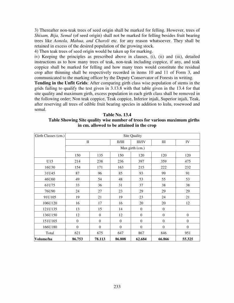
233
3) Thereafter non-teak trees of seed origin shall be marked for felling. However, trees of
Shisam, Bija, Semal (of seed origin) shall not be marked for felling besides fruit bearing
trees like Aonola, Mahua, and Charoli etc. for any reason whatsoever. They shall be
retained in excess of the desired population of the growing stock.
4) Then teak trees of seed origin would be taken up for marking.
iv) Keeping the principles as prescribed above in clauses, (i), (ii) and (iii), detailed
instructions as to how many trees of teak, non-teak including coppice, if any, and teak
coppice shall be marked for felling and how many trees would constitute the residual
crop after thinning shall be respectively recorded in items 10 and 11 of Form 3, and
communicated to the marking officer by the Deputy Conservator of Forests in writing.
Tending in the Unfit Grids: After comparing girth class wise population of stems in the
grids failing to qualify the test given in 3.13.8 with that table given in the 13.4 for that
site quality and maximum girth, excess population in each girth class shall be removed in
the following order; Non teak coppice, Teak coppice, Inferior injali, Superior injali, Teak,
after reserving all trees of edible fruit bearing species in addition to kulu, rosewood and
semal.
Table No. 13.4
Table Showing Site quality wise number of trees for various maximum girths
in cm. allowed to be attained in the crop
Girth Classes (cm.) Site Quality
II II/III III/IV III IV
Max girth (cm.)
150 135 150 120 120 120
U15 214 238 236 397 359 475
16U30 154 171 163 215 222 232
31U45 87 96 85 93 99 91
46U60 49 54 48 53 55 53
61U75 33 36 31 37 38 38
76U90 24 27 23 29 29 29
91U105 19 21 19 23 24 21
106U120 16 17 16 20 20 12
121U135 13 15 14 0 0
136U150 12 0 12 0 0 0
151U165 0 0 0 0 0 0
166U180 0 0 0 0 0 0
Total 621 675 647 867 846 951
Volume/ha 86.753 78.113 86.808 62.684 66.866 55.325

234
Harvesting And Disposal:
13.7.51.Agency for harvesting: The coupes shall be worked departmentally. However
bamboo coupes shall be worked as per the government decision. Estimation of bamboo
yield should be based on actual enumeration carried out a year prior to the beginning
bamboo harvesting.
13.7.52. Disposal at timber depots: Harvested timber and firewood shall be transported
to the established forest depots for sale by auction. The National Forest Policy, 1988
acknowledges the first charge on the forest produce to the local tribal and village
community living in and around the forest areas. Disposal of the forest produce should
meet the requirements of the first rights of the local village communities over the forest
produce, as enunciated in the policy. In view of this to facilitate nistar distribution
temporary bamboo depots shall be created at the Range Headquarters.
13.7.53. Stacking for the nistar supply: Each established or temporary depots is
prescribed to have designated areas for stacking small timber, poles, firewood and
bamboo for the nistar supply at the special low sanctioned rates to the local people
including agriculturists and artisans. The Deputy Conservator of Forests can approve
additional nistar depots at suitable places in the division, preferably the round or beat
headquarters, so that villagers may not be required to traverse long distance to procure
the nistar materials. The Deputy Conservator of Forests in consultation with the District
Collector fixes the nistar rate. Burads, the bamboo artisans, prefer green bamboo, and
hence, necessary arrangement shall be made to reduce the period between bamboo
cutting and delivery to the Burad communities. Each registered Burad family is entitled
up to 1,500 bamboos per year at the nistar rate fixed by the Chief Conservator of Forests
in consultation with the District Collector. Availability of the nistar material shall be
informed to the Nistar/Taluka Panchayats, and the material left unused for three months
will be sold through open auction.
Maintenance Of The Forest Land Record:
13.7.54. Maintenance of the land records and forest maps: The forestland records and
the forest maps will be brought up to date, and maintained as such. Certificate to this
affect will be recorded annually in the Form 1 Register during the month of June.
13.7.55. Forest notification: Un classed forests (non-forest areas) transferred to the
department for the compensatory afforestation shall be, immediately, proposed for
notification as the Protected Forests, and the reservation process shall be initiated with
the section notification.
13.7.56. Reconciliation of the revenue records: The revenue records will be reconciled
on the basis of the forest notifications. The Collector and the Deputy Conservator of
Forests will jointly ensure that the Revenue Records are brought up to date according to
the forest notifications. Since the Divisional Commissioner issues the forest notifications,

235
there is no apparent need to issue separate orders for the mutation entries. The Revenue
Department will provide a certified copy of the Records of Right to the East Melghat
Division to mark completion of the process.
13.7.57. Along with the reconciliation, the details of land grants (patta) issued on the
forest land will also be made available to the East Melghat Division. The Collector and
the Deputy Conservator of Forests shall send the details of all grants or occupancies
rights issued since 1980 to the Nodal Officer at Nagpur.
13.7.58. Digital Database: GIS Cell, Amravati has converted all the forest maps into the
digital format for analysis and quick retrieval. All primary land-related records digitized
by the MRSAC were collected and stored in the digital form on CDs (Compact Discs).
Copies of such CDs will be made available to the Chief Conservator of Forests and the
Deputy Conservator of Forests as well as the to the Chief Conservator of Forests,
Working Plans Nagpur. The DCF and RFO of the East Melghat Division will be
provided with Geomedia Viewer. The maps of GIS can be viewed, enlarged, analysed
and can be printed with the help of the Geomedia Viewer. The base maps for the coupe
demarcation and treatment map will be obtained from the GIS and verified on the ground
and if necessary updated and a fresh copy will be prepared. The updated coupe treatment
map will be supplied to the GIS cell Amravati for the necessary correction and updating
of maps.
13.7.59. Awareness Programmes: Working Plan prescriptions can be better
implemented if it’s provisions are made known to the people through awareness
programmes in the villages surrounding to the coupe due for working. So the following
strategies are prescribed.
1. Explain the provisions of the various working circles of the Working Plan to the
villagers and its implications.
2. Solicit cooperation of the people in protecting the regeneration in the coupes either by
deploying their cattle in other areas or some other means, which is acceptable to the
people. 3. Solicit the participation of the villagers in controlling injuries to the forest crop.
4. Organize periodic meetings monthly with the villagers for better understanding and to
solve the problems amicably.
5. The Deputy Conservator of Forests shall make necessary budgetary provisions to
implement the extension and awareness programmes, so that the objectives of the
working plan can be achieved.
6. The prescriptions given at the end of the each working circle with respect to peoples
participation and provisions related to grazing control and fire control shall be followed
scrupulously with the active participation of the villagers.
---

236
CHAPTER XIV
THE ESTABLISHMENT AND LABOUR
SECTION 14.1. THE ESTABLISHMENT:
14.1.1. The range, round and beat reorganization is proposed for reduction of present beat
average area from 1057 ha. to 675 ha. for better management, conservation and
protection of forests. A proposal incorporating 6 ranges, 25 rounds and 83 beats has been
submitted to the CCF (T) Amravati..
14.1.2. It has been observed that the division has inadequate staff for the implementation
of the provisions of this Plan.
Table No. 14.1:
Table Showing No. Of Ranges, Rounds And Beats At Present And Proposed In
The East Melghat Division
Particulars Existing No. Proposed No.
Ranges 4 6
Rounds 14 25
Beats 53 83
14.1.3. The details of existing Range, Round and Beats are given in Appendix No. LII of
Volume II. The division has ample number of vanmazoors, whose nature of duties
changes quite frequently. Since their posts are supernumerary in nature, expenditure on
their establishment does not reflect in routine budget. Hence, it is recommended that the
Deputy Conservator of forests should identify and assign their services to different
schemes for efficient utilization of their services. It is expected that a major proportion of
the Forest Labourers are engaged in the repairs of boundary pillars, maintenance of fire
lines, coupe demarcation, and marking and subsidiary silvicultural operations.
14.1.4. Adequate education and health facilities are usually not available at the beat and
round headquarters in the interior areas, and majority of the field staff keep their families
at a different station. These conditions necessiate special efforts for the staff welfare
programme. Sufficient facilities should be provided for quality education to the minor
children of the field staff.
14.1.5. Skill up-gradation training or exposures on various aspects of forest management
such as nursery management, plantations management and organizing and managing
coupe operations like marking, felling, logging, etc. are proposed for the staff to improve
their efficiency as well as keep them fully toned and abreast use of GPS and GIS be
encouraged.
14.1.6. Trainingof field staff and village communities, in collaboration with NGO’s, is
essential and will be proposed for NTFP’s collection, grading and value addition
mechanisms to upgrade their skill in NTFP’s management.

237
SECTION14.2. LABOUR AVAILIBILITY:
14.2.1. Most of the schemes have some amount on labour welfare. These amounts should
be pooled, and utilized for the community welfare program in concerned villages by
involving local communities. Labour skills shall be upgraded by organizing training
camps in gum collection and grading and bamboo harvesting etc.
14.2.2. Some scheduled adjustment should be sufficient for execution of the forestry
operations. Temporary manpower shortage is experienced during the crop sowing period.
14.2.3. Care should be taken to ensure adequate employment availability to the local
people. The Forest Labour Co-operative Societies (FLCS) often engage large manpower
of non-members in coupe working allotted to the Societies, and the proportion of the
work done by the non-members should be recorded.
Buildings:
14.2.4. The accommodation is not satisfactory, as the existing buildings are not
maintained properly, especially the field staff. Many residential quarters for the Forest
Guards do not have residential facilities. Although a number of buildings were
constructed under the Maharashtra Forestry Project, more residential buildings are
required in the field, especially, in the interior locations. Sufficient funds should be made
available for the maintenance and construction of buildings in the field. Funds will also
be required for developing eco-centers and camping facilities for eco-tourists as
prescribed in the chapter of Wildlife Management (Overlapping) Working Circle.
---
238
CHAPTER – XV
CONTROL AND RECORDS
SECTION 15. 1. CONTROL AND RECORDS:
15.1. The following records shall be maintained in the division office:
i) Control Form
ii) Compartment History
iii) Plantation and Nursery Registers.
iv) Divisional Note Book.
SECTION 15. 2. CONTROL FORMS:
15.2.1. Three permanent sets of these control forms will be prepared in the Working Plan
Conservator’s office and distributed one set each to working plan circle itself, the
Territorial Conservator, and the Deputy Conservator of Forest.
Formats Of Control Forms
15.2.2 Following are two formats of control forms:
15.2.3. Coupe Control Form-For the Control of all silvicultural operations such as
felling, subsidiary cultural operations, cleanings, thinning, burning, etc., prescribed to be
carried out in a given coupe for the duration of the working plan.
15.2.4. Felling Control form- for controlling and maintaining a record of all trees
marked for felling and trees retained as seed bearers or to safe guard future yield.
15.2.5. The prescribed proforma of the control forms mentioned above are given in
Appendix No LXXII of the Volume II of this plan.
15.2.6. The DCF will annually make entries in his copy of the control forms and send
them together with the deviation statement in triplicate to the working Plan Conservator
through the Territorial Conservator. After the entries have been checked and approved,
the Working Plan Conservator will first get his copy completed and then send the DCF’s
copy to the Territorial Conservator. The later will then complete his copy and finally
return the DCF’s set for deposit in the latter’s office till next year. the Working Plan
Conservator will send three copies of deviation statement to the PCCF for sanction. After
the sanction, one copy each will be sent to the Territorial Conservator and the DCF for
their record and the Working Plan Conservator will retain the third copy for his set of
control forms.
15.2.7. The control forms should be submitted by the DCF to the Territorial Conservator
on or before December 1 and the later should send them to the Working Plan conservator
concerned on or before January each year.

239
i) Coupe Control Form
The format of coupe control form is as given in Appendix No. LXXII of the Volume II of
this plan.
ii) Felling Control Form:
The format of felling control is given in the Appendix No. LXXII of the Volume II of
this plan.
SECTION15.3. COMPARTMENT HISTORY:
15.3.1. The following forms (in two sets, one each for range and the division) are used for
writing the compartment history for each compartment or sub-compartment:
CH Fom-1 Compartment Description to be filled by the WPO
CH Form-2 Compartment Enumeration to be filled by the WPO
CH Form-3 Trees Marked for Felling to be filled by the DCF
CH Form-4 Compartment Out-turn to be filled by the DCF
CH Form-5 Compartment History to be filled by the DCF
15.3.2. Compartment Description:
The format CH Form-1 is given in the Appendix LXXIII of Volume II of this plan.
15.3.3. The description will be signed and dated by the WPO.
15.3.4. Compartment Enumeration:
The format is as given in Appendix No LXXIII in the Volume II of this plan.
15.3.5. Trees Marked For Felling: This form is to be filled by the DCF from time to time as the markings take place. The
format is as given in Appendix No LXXIII in the Volume II of this plan.
15.3.6. Compartment Outturn:
The format is as given in Appendix No LXXIII in the Volume II of this plan.
15.3.7. Compartment History: The format is as given in as given in Appendix No LXXIII in the Volume II of this plan.
15.3.8. The compartment history with full entries already exists, past entries made
by the DCF will be sent to the WPO for scrutinization and editing if necessary.
15.3.9. The DCF is responsible for recording current events as they occur and will make
his entries on the separate sheet of the form and not on that prepared by the WPO. At the
next revision of the plan, the WPO will scrutinize these entries and edit them if
necessary.
15.3.10. The principal information, which the DCF should record, is as follows:

240
Felling, Subsidiary Silvicultural Operations, Slash Disposal with costs, Plantations,
Control Burning with costs, Fire incidences and damage caused, Damage by other factors
like Drought, Storm, Snow, Insect, Fungi, Grazing, etc., Remedial measures taken along
with costs, Good seed or seedling years of important species.
15.3.11. The entries should be brief and concise: whole or part compartment that was
involved should be made clear. For event timings- month or months- should be given.
15.3.15. Plantations Register and Nursery Register: The plantation Registers will be
maintained for all the areas regenerated artificially in the form Nos. 1 to 9 as given in
Appendix LLXXXXIIVV of Volume II. Plantation Registers must show dates of the rainy days
and survival count. The Nursery Registers will be maintained in Form No. 1 to 10 as
given in Appendix. LLXXXXVV of Volume II.
15.3.16. Divisional Note Book: The matters of the divisional importance will be
recorded in
the Divisional Note Book under standard heading for records and ready reference. The
standard format of the ‘Divisional Note Book’ is given in Appendix LLXXXXVVII of Volume
II of this plan.
MAPS:
Digital database:
15.3.17.The digital database described in the Chapter requires series of correction and
revision to make it accurate and bring it up to date. The Deputy Conservator of
Forests (Territorial), the Working Plan Officer shall jointly continue this work, and make
it accurate and complete in the first 5 years of this plan. Copies of this digital database
will be made available to the division and the circle officers.
15.318. Maps: Maps are essential ingredients of forest management. All maps are
updated, revised or new maps prepared.
15.3.19.The maps on the 4’’-1 Mile scale, have been prescribed to be prepared on the
1:15,000 scale for metric setting. In pursuance of the Standing Order No. 55 of the
Conservator of Forests, Working Plans, the following sets of maps have been prepared
for the distribution to the concerned offices.
15.3.20.Divisional maps: 6 sets of divisional maps on 1:15,000 scale, have been
prepared by GIS Cell, Amravati for distribution to divisional and Range officers as
follows:
Management maps: 4 sets (2 cut and mounted +2 uncut and mounted)
Stock maps : 2 sets (1 cut and mounted + 1 uncut and mounted)
These maps are proposed to be distributed, as follows:

241
15.3.21.Working Plan Office will retain 2 sets of uncut and mounted maps, as given
under, as the Master sets.
Management maps: 1 master set (uncut and mounted)
Stock maps : 1 master set (uncut and mounted)
The Stock Maps show the compartment boundaries, density, site quality, age classes,
regeneration and other stocking details, including nature and composition of crop.
The Management Maps show the boundary pillars with their numbers, the coupes,
compartments, felling series, Working Circle, ranges and other management details. The
management maps and stock maps are prepared on 1:15000 scale.
Working Plan map is prepared on 1;15000 scale showing all silvicultural units,
administrative and physiographic features.
15.3.22. East Melghat Division will be provided, the following, set of maps showing the
management details for office use.
Management maps: 3 sets (2 cut and mounted +1 uncut and mounted)
Stock maps : 1 set (1 cut and mounted)
Division office will retain 1 (one) set (cut and mounted) of Management maps for
office purpose, and provide 1 (one) set (cut and mounted) of Management maps to
the concerned Forest Range Office.
15.3.23.The conservator of Forests (Territorial) and the Conservator of forests, Working Plan each will be supplied 1 (one) set of the Management Maps on 1:50,000
scale, showing management details viz. Compartments, working circles, felling series,
range boundaries and other administrative details.
15.3.24.Reference maps: the reference map on 1:2,50,000 scale, is provided along with
the draft plan showing range boundaries, compartments, working circles, felling series,
roads and other prominent reference features have been enclosed with the working plan.
15.3.25.Grazing maps: Tow set of grazing maps showing grazing area/series have been
prepared on 1:2,50,000 scale. Working Plan division will retain one set, while other one
will be supplied to the East Melghat Division division.
---

242
CHAPTER XVI
SUMMARY OF PRESCRIPTIONS
SECTION 16.1. FORMATION OF VARIOUS WORKING CIRCLES:
16.1.1. Selection cum improvement working circle: It includes better-stocked areas of
Jarida, Ghatang and Anjangaon ranges. Felling cycle is 20 years. For yield regulation,
the K.P. Sagariya’s modification of Smithies formula has been applied. Harvestable girth
is 120c.m. for site quality III, IV areas and 150 cm. for site quality II and II/III areas. For
miscellaneous species harvestable girth is 120 cm. All the fruit bearing trees are reserved
against marking for felling. 80% of the available harvestable trees shall be harvested, as
indicated in the yield regulation. No felling shall be made in the unworkable areas. It
includes areas of more than 25degree slope, 20m wide strip of forest on either side of the
nala and eroded and erosion liable areas. At least 2 dead trees shall be left in the field for
wildlife purpose. In addition to this improvement fellings shall be carried out in all girth
classes up to pre-harvestable girth class to facilitate the growth of growing stock.
16.1.2. Teak Plantation Working Circle: Predominantly teak bearing areas with
matured crop and little regeneration are included in this working circle. Average crop
girth is calculated to assess the maturity of the crop grid wise and accordingly fit and
unfit grids will be identified. Such exercise shall be carried out only in ‘D’ category
areas. Under stocked, Site quality IV areas, eroded and liable to erosion areas shall be
excluded from the working. The average crop girth of a grid is compared to the Critical
Crop Girth of the corresponding site quality and rotation and composition of the crop and
if it exceeds then the grid is considered fit for canopy removal after retaining 20 fruit
bearing trees and 20 miscellaneous trees followed by teak plantation. The old teak
plantations were not thinned as per schedule resulting lot of congestion in the crop.
Hence it is suggested to thin all the old plantations in the first three years itself so that the
growth parameters of the plantations can be brought nearer to the figures of yield table.
Later onwards, the thinnings shall be carried out at the age of 25, 35,45,55,65 years.
16.1.3. Improvement Working Circle: The areas, which require Improvement fellings
have been included in this working circle. No main felling is prescribed, however
improvement fellings to remove the congestion in the crop is prescribed. The gaps in the
canopy shall be filled by taking up plantations in the area.
16.1.4. Afforestation Working Circle: These are the areas predominantly open or
blanks with intermittent well-stocked patches. Plantations shall be taken up in the area
simultaneously improvement fellings shall be carried in the well-stocked patches.
16.1.5. Protection Working Circle: The areas with steep slopes, which require
protection, have been included in this working circle. Plantations in the open patches,
seed sowings have been prescribed. There are certain well-stocked patches with gentle

243
slopes. In these areas improvement fellings shall be carried out and small timber and
poles obtained in the process shall be given to the villagers in the form of Nistar.
16.1.6. Bamboo (Overlapping) Working Circle: Compartments having good patches
of bamboo have been included in this working circle. Felling cycle is 3 years and
6cutting series have been formed and each series will have 3 annual coupes and one
coupe will be worked every year. Culm selection system is the silvicultural system in
which 8 matured bamboos will be left in each clump. In addition to this removal of
congestion in the gregariously flowered areas shall be taken up. The bamboo clumps
shall be protected from hacking by the graziers.
16.1.7. Wildlife (Overlapping) Working Circle: It is intended to protect the existing
wildlife in the area as its numbers are dwindling by adopting better management practices
like meadow development, anicut construction and maintenance de-silting of ‘dohs’ etc.,
It is also proposed to set up task group to tackle the man animal conflicts for tranquilizing
and capturing purpose.
16.1.8. NTFP (Overlapping) Working Circle: NTFP is the important livelihood to the
people of this tract particularly in the lean season. Hence its availability has to be
ensured so that income generation activities are continued. Increasing the regeneration of
NTFP either by root suckers or by seed sowing is suggested. Facilitation in the
marketing of NTFP, valued addition of NTFP is prescribed. Better tapping technique of
gums is prescribed to maintain the trees for perpetuity.
16.1.9. JFM (Overlapping) Working Circle: To involve the local people in the
protection and conservation of the forest this working circle has been constituted. JFM is
yet to pick up momentum in this division. Grazing and fires are the major biotic
interferences. It is suggested to address these problems by involving the local people to
prevent fire and hacking by the graziers. The FDA formed in the division shall supervise
the developmental activities taken up through JFM committees. It will ensure the smooth
relations between the forest department and local villagers.
16.1.10. Forest Protection (Overlapping) Working Circle: The forests are burdened
with heavy biotic interferences, hence addressing of these problems in a systematic
manner necessitated the constitution of this working circle. Grazing and Fires are the
major biotic interferences that are causing damage to the young regeneration. The
measures need to be adopted in the field to address the problems are discussed in the
relevant chapter. It will help to monitor and to assess the results in a more objective
manner.
SECTION 16.2. DEMARCATION AND MARKING:
16.2.1. The annual coupes for the harvesting, tending operations and site specific
treatment prescribed are to be demarcated, one year in advance, and each coupe shall be
subdivided into four sections. The demarcation of coupes is described in the chapter of
Miscellaneous Regulations.

244
16.2.2. Soon after the demarcation of annual coupe, the treatment maps as prescribed in
the following paragraph shall be prepared, verified and got approved. After seeking
approval of the treatment map marking of coupe shall be carried out. The detailed
technique of marking has been described in the chapter of Miscellaneous Regulations.
Preparation of treatment map and marking of coupe is prescribed to be done, preferably,
in the year of demarcation to facilitate necessary checking and corrections, if any, in
time.
SECTION 16.3. TREATMENT TYPES AND PREPARATION OF TREATMENT
MAP:
16.3.1. Each coupe for the purpose of annual coupe operations and site specific
silvicultural treatment prescribed is to be divided into various Treatment Types on the
basis of criteria, as given in Table 16.1.
Table 16.1. Treatment types for coupe operations and site-specific treatment:
Treatment areas Symbol Characteristics Minimum patch
size
Protection areas A1-type
A2-type
A3-type
Area having more than 25 degree slope
20 meter wide strip on both sides of streams
Area susceptible to excessive erosion
Any size
Open forests B1-type
Open forests (density<0.4) with rootstock
2 hectare
Pole Crop and Old
plantations
C1-type
C2-type
Pole crop of the identified valuable species, suitable
for retention as future crop, having density 0.4 or
more and old plantations.
Dense teak plantations.
1 hectare
Well-stocked area D-type Areas having density 0.4 and over 2 hectare
16.3.2. Distinct patches of the B, D-type areas shall have minimum area of 2 (two)
hectare in extent. The minimum extent prescribed for the C-type areas is 1 (one) hectare.
The A-type protection areas would be delineated irrespective of the patch size. Smaller
patches proposed to be merged with the adjoining larger areas having similar crop
conditions.
16.3.3. The treatment maps are proposed to show adequate natural regeneration areas
(625 or above saplings seedlings) in the D-type; and areas suitable for planting bamboo,
teak and mixed species in the B type area.
16.3.4. Delineation of various treatment type areas on treatment maps will adhere to the
following general guidelines:
16.3.4.1. An area having more than 25 degree slope and more than a quarter hectare in
extent must be shown on the map as the A1-type; steep Slope. Smaller areas of steep
slope, even if not marked on the map, will also receive the prescribed treatment.
245
16.3.4.2. 20-meter wide buffer along streams will be measured from the bank or the high
flood mark. Rivers or streams shown on the base maps of the compartments or on
toposheets of the Survey of India at 1:15,840 or smaller scales (such as 1:50,000) would
suffice the purpose. Similar buffer of the A2-type areas will be marked along water
bodies and tanks.
16.3.4.3. The A3-type (excessive erosion prone includes seasonally flooded areas and
such pockets marked on the land use maps.
16.3.4.5. Natural regeneration would be considered adequate if at least 625
saplings/seedlings per hectare are present. The same criteria will be applied for the
rootstock, and used for defining the B1-type.
16.3.4.6. The C-type areas would include groups of naturally grown poles, which are
trees having 15 to 45 cm GBH and old plantations. Scheduled cleaning and thinning
operations are expected in such areas.
16.3.5. The range forest Officer shall prepare Treatment Map of the coupe after a
thorough inspection of the coupe, showing the various Treatment Type areas, as given in
the above table, distinctively, on the compartment maps. The Assistant Conservator of
Forests will check the treatment map and will make corrections in the map, if necessary.
The Deputy conservator of forests will approve the treatment maps, after careful
examination.
16.3.6. The treatment map will bear date of inspection by the Range forest Officer and
the Assistant Conservator of forests under their signatures.
16.3.7. The compartment maps prepared in the Forest Geomatics Center, Amravati would
serve as the base maps, which would be used for marking areas suitable for different
treatment types.
SECTION 16.4. THE COMMON TREATMENT PRESCRIPTIONS FOR
VARIOUS TREATMENT TYPES:
16.4.1. The treatment prescriptions, proposed at the time of coupe operations, which are
common to different treatment-types, excluding A-type: protection areas are prescribed
as follows.
16.4.2. Soil and Moisture conservation works: Soil and moisture conservation works
such as check-dams, Gully plugging, etc. shall be carried out as prescribed in the chapter
of Miscellaneous Regulations.
16.4.3. Dressing of high stumps: All high stumps of valuable coppice species shall be
flushed close to the ground to ensure healthy coppice growth. Cutting should ensure that
rainwater would not collect on the cut surface, and height of the stumps is not more than
three inches away from the ground. Stump of more than 30 cm in height will be

246
considered as high stumps. Stumps with intermediate height will be fashioned to allow
growth of good coppice shoots. This operation will be repeated in the sixth year, eleventh
year and twentieth year of the coupe operation, along with cleaning and thinning
operations of the coupe.
16.4.4. Singling of coppice shoots: One healthy and promising coppice shoot will be
retained on the stumps and the rest be removed. However, coppice shoots interfering with
promising saplings of seed origin should be removed. Such coppice shoots should also be
close enough to the ground so that it would not topple after gaining volume and weight
and would be able to develop root system of its own subsequently.
16.4.5. Coppice management of damaged and malformed saplings: The saplings and
poles up to 30 cm GHB, having one third of the stem damaged and malformed shall be
coppiced by cutting flush to the ground. Such coppicing, however, should not expose the
ground, cause erosion and lead to soil loss. Poles having at least 2.50 meter of clean bole
will be not be treated as malformed.
16.4.6. Climber cutting and shrub clearance: Climber cutting of Chilati, Eruni,
Mahulbel, Palasbel, Nagvel and Gunj and shrub cutting of Lantana, Rantulsi, Bharati,
Nirgudi, Kuda, Kharasani and Phetra may be carried out wherever the operation is
warranted for the development of tree crop. Cutting of climbers and shrubs should
generally be avoided for 20 meters from the forest edge along the roads. However no
climber having medicinal value will be removed even if it is hindering tree growth.
16.4.7. Sixth-year cleaning: Cleaning operations are prescribed to be carried out in the
entire coupe in the sixth year of coupe working.
16.4.8. Retaining den, snag and down logs: Two standing den and snag trees as well as
two non-teak down logs per hectare will be retained in the annual coupes. Marketable
down logs and snag trees in excess of this norm may be removed. Non-teak trees away
from roads will be preferred for retention as snag trees.
16.4.9. Bamboo cleaning: Bamboo clumps in areas outside Bamboo (overlapping)
Working Circle shall be cleaned in the manner described in Bamboo harvesting under
Bamboo (overlapping) Working Circle.
16.4.10. Control data: Pre-treatment and the post-treatment basal areas as well as other
relevant parameters from the dispersed sample points using the wedge prism will be
recorded by an officer not below the rank of Range Forest Officer and be entered in the
divisional register.
16.4.11. Bias for regeneration: Tending operations should be integral parts of the coupe
working and the coupe estimates. Tree harvesting shall not be carried out, unless tending
operations prescribed in the annual coupes are also taken up.

247
16.4.12. The Prescribed Type-specific Treatment:In Addition to the common treatment
prescribed in the foregoing sections type-specific treatment is prescribed for various
types of areas in a coupe as below.
SECTION 16.5. TREATMENT IN A-TYPE AREAS:
16.5.1. Soil and moisture conservation: Gully plugging and other soil and moisture
conservation works (except contour trenching), as described in the chapter of
Miscellaneous Regulations shall be taken up.
16.5.2. Seed sowing: Sowing of Khair, Lendia, Kusum, Bhirra and other local seeds in
bushes is prescribed to be carried out to the extent possible with the help of regular forest
staff and the supernumerary forest labourers. Any one species should not constitute more
than one-third of the disseminated seeds.
16.5.3. Stake planting: In the A3-type areas, stakes of Ficus spc., Pangara, Salai or
other suitable species will be planted at six-meter interval, on suitable sites along nalas
and on riparian sites with the help of regular staff and forest labourers.
16.5.4. Harvesting prohibited: Harvesting of standing trees (live) is strictly prohibited in
the A-type areas. The marketable down logs of valuable species such as teak, Shisham
and Bija etc shall be extracted.
SECTION 16.6. TREATMENT IN B-TYPE AREAS:
16.6.1. Rootstock management: Tending of rootstock in the B-type will be carried out.
Necessary soil working and mulching will be carried out to promote rootstock growth.
16.6.2. Plantations: Suitable sites of the B-type areas shall be brought under the
plantations. The choice of bamboo planting, mixed species plantations or teak-stump
planting will depend upon objectives of the working circles and site suitability. All
planting operations and subsequent operations should follow the guidelines for planting
operations described in the chapter on Miscellaneous Regulations.
SECTION 16.7. TREATMENT IN C-TYPE:
16.7.1. Thinning: Thinning of old plantations and pole crop will be carried out
maintaining basal area per hectare and no. of stems per hectare. The post-thinning crop
should have basal area/ha and number of stems/ha as close to the relevant stand or yield
table for that site quality and age as far as possible. Detailed guidelines for thinning are
given in the chapter Miscellaneous Regulations. Poles of vigorously growing non-teak
species should be preferred for retention if teak is more than 20 percent of the crop in
stocking.
16.7.2. Cutback operation: The cutback operations of trees damaged during the coupe
felling, if available, shall be carried out in the year following the main felling. Trees
damaged during the coupe felling, shall be marked for felling as in paragraph 16.7.5.

248
16.7.3. Preference of girth class: Marking in the C-type areas for the purpose of spacing
out saplings and poles will be carried out from lower girth class upward.
SECTION 16.8. TREATMENT IN D-TYPE:
16.8.1. Enumeration in annual coupes: Species and girth-class of all trees above
harvestable girth and preharvestable girth are prescribed to be recorded for enumeration,
where as in Teak Plantation Working Circle all trees are enumerated.
16.8.2. Marking for harvesting: Mature trees above harvestable girth are prescribed for
harvesting to the extent defined by the marking prescriptions, described in the relevant
Working Circle. Well-formed and vigorous trees will be preferred for retention. Species
listed as valuable species given in the paragraph 16.8.1 will determine the order of
priority for retention.
16.8.3. B-grade Thinning: If the congestion is expected to persist in some patches after
the harvesting, the B-grade thinning will be carried out in such patches. B-grade or
moderate thinning is defined as removal of dead, dying, diseased, suppressed, defective
dominated stems and whips in this order. Removal of inferior individuals will start from
suppressed class and then to some of the dominant class of the crop. Advance growth
having too many branches not desirable to prune or lop may also be removed.
16.8.4. Tending of natural regeneration: Singling and spacing out will be carried out
among seedling/saplings of teak and other valuable species listed in the following section
for the rootstock management. Spacing operations should leave nearly 625
seedling/saplings per hectare. The existing natural regeneration should be encouraged by
soil working and mulching around them in accordance with the guidelines for the
rootstock management described in the relevant chapters.
16.8.5. Cutback operations: The cutback operations shall be carried out in the year
following main felling. Trees damaged during the coupe felling and marked trees not
felled during the coupe operations should be marked for felling as prescribed earlier.
16.8.6. Preference of girth class: Marking in the D-type areas for trees above
harvestable girth will be done from the higher girth class downwards.
SECTION 16.9. VALUABLE SPECIES FOR RETENTION:
16.9.1.Order of priority among desirable species for retention is prescribed as: Tiwas,
Shisham, Haldu, Teak, Bija, Saja, Kalam, Khair, Shiwan, Kasai, dhaora, Bhirra, Rohan,
Mowai, Salai, Mokha, Dhaman, Bhilawa, Chichwa, Bhorsal and Lendia.
16.9.2. Guidelines For The Rootstock Management:
In view of tending the available natural rootstock to grow as a prominent constituent of
the future crop, the rootstock management guidelines are prescribed, as follows.

249
16.9.3. Singling of coppice shoots: One healthy and promising coppice shoot will be
retained on the stump and the rest be removed. However, coppice shoots interfering with
promising saplings of seed origin should be removed. Such coppice shoots should also be
close enough to the ground so that it would not topple after gaining volume and weight
and would be able to develop root system of its own subsequently.
16.9.4. Coppice management of damaged and malformed saplings: The saplings and
poles of up to 30 cm GBH having one third of the stem damaged and malformed shall be
coppiced by cutting flush to the ground. Such coppicing, however, should not expose the
ground, cause erosion and lead to soil loss. Poles having at least 2.50 meter of clean bole
will be not be treated as malformed.
16.9.5. Tending of natural regeneration: All seedlings and saplings of valuable species
more than 60 centimeters in height to leave nearly 625 saplings/seedlings per hectare at
an average of 4 meter spacing. The natural regeneration present shall be assisted and
encouraged by soil working and mulching around them, in the following manner.
16.9.6. First year operations: Weeds in one-meter diameter around seedling/saplings of
valuable species should be cleared during the first week of July. Uprooted weed, grasses
and leaf-litter should be mixed in the upper layer of soil as the organic mulch and
facilitate loosening and aeration of the soil by worms and insects. One soil working
should be carried out in October.
16.9.7. Second year operations: The soil working in October will be repeated in the
following year. However, one scrape weeding of one-meter diameter should be carried
out in the first week of August around the shoots of seedling coppice within the rootstock
management area.
16.9.8. Third year operations: Singling of coppice shoots, management of damaged and
malformed saplings, climber cutting and shrub clearance should be repeated as third year
operations.
SECTION 16.10. CUT BACK OPERATIONS (CBO):
16.10.1. Cut back operations are prescribed to be carried out in the year following the
main felling, as per prescriptions given in subsequent paragraphs.
16.10.2. All the left over marked trees during the main coupe operations shall be
harvested. Such trees, if less than 2 percent of original marking, can be felled after
inspection of the Range Forest Officer. Deputy Conservator of forests may sanction
felling up to 5 percent of the original marking, and a higher proportion would require
prior permission of the Conservator of forests.
16.10.3. All trees damaged during the main coupe felling shall be marked for removal.

250
16.10.4. All left over multiple coppice shoots and poles shall be reduced to one per stool.
16.10.5. All newly risen coppice shoots shall be removed to encourage establishment of
seedling regeneration.
SECTION 16.11. GUIDELINES FOR CLEANING IN THE SIXTH YEAR:
16.11.1. Clearing shall be carried out in the sixth year of the coupe working and in
plantations in the sixth year of its formation. No cleaning is prescribed in the failed
plantation, which are treated so as per Evaluation code. Cleaning shall be carried as per
prescriptions given in the following paragraphs.
16.11.2. All inferior species including the unwanted undergrowth interfering or likely to
interfere with the growth of NR of teak and other valuable species shall be cut back.
16.11.3. It will include climber cutting, shrub clearance, dressing of high stumps.
Extraction of marketable down logs should be carried out in the entire coupe. Cleaning
of Bamboo clumps in areas outside Bamboo (overlapping) Working Circle shall be
carried out.
16.11.4. Coppicing of damaged and malformed saplings and singling of coppice shoots
shall be carried out. All newly risen teak coppice shoots shall be removed for the growth
of seed origin plants.
16.11.5. Establishment seedling regeneration of teak and other miscellaneous species
shall be spaced out suitably. Spacing of dense growth will follow the stand table of the
concerned species. In absence of the stand table, thumb-rule of keeping the spacing at
one-third of the average height will be followed.
.
---

i

ii
iii

iv

GOVERNMENT OF MAHARASHTRA
The Working Plan
For
East Melghat Division AMRAVATI CIRCLE
For the period
2006-07 To 2015-16
VOLUME – I
(Part I and II)
Vinod Kumar , IFS
Deputy Conservator of Forests,
G.P.Garad , IFS
Deputy Conservator of Forests,
M.K.Rao , IFS
Conservator of Forests,
Office of the Conservator of Forests,
Working Plans Division,
Amravati

Front cover photo : Jawhar Kund Water fall
Photo By Shri Nitin H. Kakodkar,
C.F. & F.D. MTR, Amravati.
Back cover photo : Gloriosa superba Medicinal Plant
Ceropegia oculata
Photo By Shri M.K.Rao.
Conservator of Forests,
Working Plans Division, Amravati.

Foreword
The present Working Plan for East Melghat Division authored by Shri M. K. Rao,
IFS, replaces the erstwhile Working Plans written by Shri Sinha and Shri Bahadur for the
major area and for the part by Shri Thengadi. As the division itself came into existence in
1999, after re-organization of the areas under erstwhile South Melghat, East And West
Melghat divisions, coupled with the unified control for the Melghat Tiger Reserve, the
provisions from the Working Plans of all three divisions have been revised and put in the
present form.
An overview of the results of past working and the data of statistics of growth and
yield reveals that the forest of the area have improved largely, particularly the areas
managed under Selection cum Improvement Working Circles and Protection Working
Circles. The rich and varied forests of Ghatang and Jarida Ranges have retained their
wealth to great extent despite increased biotic pressures and repeated fires. This appears
to be possible for the reason that adequate safeguards were provided in the earlier Plans
against over-felling and creation of openings. It is heartening to know that conservative
approach for forestry management followed scrupulously by the planners in the past,
keeping in view the fragility and sensitivity of Melghat forests in sustaining the unique
ecological system in the region has been continued by the present Working Plan Officer.
The added emphasis on management of N.T.F.P. and Wildlife in the area in the present
Plan is likely to add impetus to much needed conservation efforts in the area.
Though the P.W. P. R. of the plan was approved prior to issue of guidelines for
Working Plans by Government of India, in view of the directives of the Honourable
Supreme Court, the work of revision in the present Plan has been taken up keeping fully
in view the instructions contained in the guidelines and ensure that the Plan remains
updated as per recent policies and guidelines in letter and spirit. The mandatory chapters
on the Forests Protection, Wildlife, N. T. F. P. and J. F. M. would certainly bring more
objectivity and focus in the management of forest of the area. The chapter on Teak
Plantations and efforts to provide for suitable prescriptions for potential teak areas and
old teak plantations would add to the wealth of forestry and serve better purpose for the
local people in the area.
The present Plan has been prepared in the record time of about 12 months and that
too largely through use of satellite data and know-how from agencies outside the State
Forest Department. The ground truth verification of stock has also been attended to as far
as possible despite lack of staff and other assistance from the field. The enumeration data
has been analyzed adequately and compared with the data recorded in the previous plan,
which attach objectivity to the system for resource survey. The comparison speaks very
clearly about adequacy of the regeneration in areas where management has been
effective. The pressure of over grazing and increased biotic interference in and around
villages is also revealing and needs to be addressed adequately by the administration
through the J. F. M. tool which is yet to establish its roots in the division and that has
been highlighted in the relevant chapter.

Mr. M. K. Rao, Conservator of Forests (Working Plans), Amravati and his team
deserve compliments for bringing this work into reality. I wish all the success for their
efforts and I am sure that if the prescriptions given in the Plan are implemented properly,
the forest and wildlife in the tract would be able to thrive and sustain its glorious past and
the same would benefit the local people enormously.
(Ramanuj Choudhary, IFS)
Nagpur, Chief Conservator of Forests
Date: June27, 2005. (Working Plans), Nagpur.

INTRODUCTION
The working Plan for East Melghat Division is the first plan of the area, after the
reorganization of the divisions. It covers both Reserved Forests and Un classed Forests
(compensatory afforestation areas) in charge of East Melghat Division.
The present East Melghat Division is formed by drawing and merging the part
areas of erstwhile East Melghat division, West Melghat division, and South Melghat
Division. Accordingly Jarida and Ghatang Ranges were managed under V. K. Sinha and
B.S.Thengdi’s working plan till 2002-03. Chikaldara Range was managed under
Shailendra Bahadur and B.S.Thengdi’s plan till 2002-03. The Anjangaon Range was
managed under B. S. Thengdi’s working plan till 2002-03. The present plan replaces the
above three plans and will be in force till 2014-15.
The preliminary working plan was prepared by Shri G. P. Garad and Shri Vinod
Kumar and was approved by the state level committee on 10-3-2004, and communicated
vide letter no.1261, dated 8-2-05. On the basis of the approved PWPR, the current draft
plan has been prepared. The chapters of the draft plan have been prepared according to
the National working Plan Code-2004. Accordingly, 5 mandatory overlapping Working
Circles have been introduced. These are 1. Bamboo (Overlapping) Working Circle, 2.
Wildlife (Overlapping)Working Circle 3. N.T.F.P. (Overlapping) Working Circle 4. J. F.
M. (Overlapping) Working Circle 5. Forest Protection(Overlapping) Working Circle. In
addition to this, new chapters on Forest fauna, Socio Economic Survey Report, Five Year
Plans were added to the Draft Plan.
A new Chapter, Teak Plantation Working Circle has been introduced for the first
time in the Melghats and all the old Teak Plantations will be thinned as per the schedule
given in the appendix, irrespective of the coupe in which they are falling.
.
To preserve the Melghat ecosystem in perpetuity, conservative fellings have been
prescribed. Earlier working was prescribed up to 450
slope and the same has been
brought down to 25 0 slope.
The computerized inventory management system evolved by Shri Dhabekar ACF
has been extensively used in analyzing the enumeration data obtained from the field by
S.O.F.R. unit Amravati. The digitized maps have been generated in the office of C. C. F.
W.P. Nagpur Geo-media Cell. The Inventory Management System has been hyperlinked
to the digitized maps for easy accessibility of the data. Georeferenced Village Maps
showing survey numbers and village boundaries and Soil Maps were obtained from the
MRSAC and have been incorporated in the GIS. Slope maps were generated and have
been incorporated in the GIS as a separate feature-class, which can be used extensively in
the preparation of the treatment map of the coupes. In short, the entire coupe treatment
map can be obtained from the GIS, which will be verified on the ground. Ground truth
verification of the satellite Imagery of LISS III was carried out and crown density and
forest types were derived from it.
I express my deep sense of gratitude for the valuable guidance and advice
provided by Shri Jwala Prasad, Addl. P.C.C.F. (Production) and Shri Ramanuj
Choudhary C. C. F. W. P. Nagpur. This plan is an output of their continuous guidance.
Shri Ramanuj Choudhary C. C. F. W. P. Nagpur regularly reviewed and guided us to
make the plan in a presentable form and helped us in procuring geo-referenced village
maps. It was due to his continuous efforts, the plan was prepared in a short time. I also
express thanks to Shri Thapliyal R. F. O. for his valuable cooperation in the preparation
of G. I. S. Project of East Melghat Division.
I express my deep gratitude to R. R. S. S. C. Nagpur, especially Dr. Shri Y.V.N.
Krishna Murthy head, R. R. S. S. C., Shri S.S.Rao, Dr. Shri A.O.Varghiese and Dr.
Ashish Sharma who helped us in preparing the G.I.S. Project of East Melghat Division.
It would not have been possible to complete G.I.S. Project of East Melghat Division in 6
months, without their cooperation. They not only trained our officers in arc info but also
provided computer to prepare G.I.S. Project of East Melghat Division. In addition to this,
Head R.R.S.S.C. Nagpur advised us to procure Geo referenced village maps and to
register the village maps on panchromatic data for better accuracy of boundaries of the
survey numbers. In short the cooperation of R.R.S.S.C. Nagpur cannot be explained in a
few words. Similarly, I express my gratitude to Joint Director F.S.I. Nagpur and Shri V.
M. Naik Scientist F.S.I. for their valuable cooperation in the ground truth verification.
I express my gratitude to C. C. F. (Territorial) Amravati and D.C.F. East Melghat
Division and staff, for their cooperation in providing the data and assistance required in
the field.
Shri R.S. Bhawar R.F.O., Working Plans Division, Amravati contributed
immensely, in the analysis of inventory of enumeration data collected by the F. R. S. S.
Unit Amravati. He also contributed in the preparation of G.I.S. Project, ground truth
verification, typing and formatting of chapters and preparation of appendices. In short,
he worked very hard and deserve special appreciation. In addition to him, Sri S. B.
Dhabhade, Surveyor, Shri Satish Mohakar Surveyor, Shri A.S. Giri Surveyor worked
hard, day and night to prepare the appendices and G.I.S. Project. I acknowledge and
special appreciation to all the four officers for their contribution in the preparation of this
working plan. The entire staff of this office worked untiringly and zealously.
(M.K.RAO)
Conservator of Forests,
Working Plans Division, Amravati.

I
Table Of Contents
S. No. Subject Page No.
i Abbreviations Used In The Plan i-ii
ii Glossary Of Local Terms Used In The Plan iii
iii Botanical And Local Names Of Plants iv-xiii
Part- I
SUMMARY OF FACTS ON WHICH PROPOSALS ARE BASED
CHAPTER – I
THE TRACT DEALT WITH
Section 1 Name And Situation 1
Section 2 Configuration Of The Ground 2-3
Section 3 Geology, Rock And Soil 3-5
Section 4 Climate 5-7
Section 5 Water Supply 7
Section 6 Distribution And Area 8
Section 7 State Of Boundaries 9
Section 8 Legal Position 9-10
Section 9
Rights And Concessions 11
CHAPTER – II
FLORA AND FAUNA
CHAPTER – IIA
FOREST FLORA
Section 2A1 General Description And Condition Of The Forest 12
Section 2A2 Composition Of The Crop 12-17
Section 2A3
Injuries To Which The Crop Is Liable 18-22
CHAPTER – IIB
FOREST FAUNA
Section 2B1 Description Of Fauna 23
Section 2B2 History of The Wildlife Management in General 23
Section 2B3 Legal Position 24-29
Section 2B4 Injuries To Wild Life 30-33
Section 2B5 Measures Adopted For The Protection Of Fauna
33
CHAPTER-III
UTILIZATION OF THE PRODUCE
Section 1 Agricultural Customs And Wants Of The Population 34-36
Section 2 Markets And Marketable Products 36
Section 3 Lines Of Export 36
Section 4 Method Of Harvesting 36-37

II
Section 5 Timber Depots 37
Section 6 Cost Of Harvesting 38
Section 7
Past And Current Prices 38
CHAPTER IV
THE SOCIO ECONOMIC SURVEY REPORT
Section 1 Forest Development Corporation of Maharashtra 39
Section 2
The Socio Economic Survey Report 39-40
CHAPTER V
FIVE YEAR PLANS
Section 1 Impact of Five Year Plan on Attainment of Management
Objectives
41-45
CHAPTER VI
STAFF AND LABOUR SUPPLY
Section 1 Staff 46-50
Section 2
Labour 50
CHAPTER VII
PAST SYSTEMS OF MANAGEMENT
Section 1 General History of the Forests 51-58
Section 2 Past System of Management and their results 58-74
Section 3 Special Works of Improvement 74-77
Section 4 The Out Turn From The Forests 77
Section 5
Past Revenue And Expenditure 77
CHAPTER – VIII
STATISTICS OF GROWTH AND YIELD
Section 1 Statistics Of Rate Of Growth Of Teak 78-87
Section 2 Stock Mapping 87-89
Section 3 Enumerations 89-93
Section 4 Volume Tables 94
Section 5 Estimation of Yield 95
III
Part - II
FUTURE MANAGEMENT DISCUSSED AND PRESCRIBED
CHAPTER – I
BASIS OF PROPOSALS
Section 1 The National Forest Policy 96-98
Section 2 Functional Classification Of Forests 99-100
Section 3 Factors Influencing Objects Of Mangement 100-103
Section 4 General Objects Of Managenent 103-104
Section 5 Treatments Prescribed 104-106
Section 6 Analysis And Valuation Of The Crop 106-107
Section 7 Working Circles And Their Distribution 107-111
Section 8 Blocks And Compartments 111
Section 9
Period Of Plan 112
CHAPTER-II
SELECTION CUM IMPROVEMENT WORKING
CIRCLE
Section 1 General Constitution 113
Section 2 General Character Of Vegetation 113-114
Section 3 Special Objects Of Management 114-115
Section 4 Compartments And Felling Series 115
Section 5 Analysis And Valuation Of The Crop 115-119
Section 6 Silvicultural System 120
Section 7 Felling Cycle 120
Section 8 Harvestable Girth 120
Section 9 Formation Of The Felling Series 120
Section 10 Regulation Of Yield 120-124
Section 11 Agency Of Harvesting 124
Section 12 Demarcation Of Coupes And Preparation Of The
Treatment Map.
124-126
Section 13 Method Of Obtaining Regeneration 126-127
Section 14 Subsidiary Silvicultural Operations 127-128
Section 15 Other Regulations
128-130
CHAPTER – III
TEAK PLANTATION WORKING CIRCLE
Section 1 General Constitution 131
Section 2 General Character Of Vegetation 131-132
Section 3 Special Objects Of Management 132
Section 4 Felling Series, Blocks And Compartments 132
Section 5 Analysis Of Crop 133-134
Section 6 Silvicultural System 134
Section 7 Rotation And Conversion Period 134
Section 8 Harvestable Girth 134
Section 9 Felling Cycle 135
Section 10 Agency Of Exploitation 135

IV
Section 11 Regulation Of Yield 135
Section 12 Sequence Of Fellings 135
Section 13 Demarcation Of Coupes, Preparation Of Treatment Maps
And Marking Techniques
135-139
Section 14 Subsidiary Cultural Operations 139
Section 15 Artificial Regeneration 140
Section 16 Old Teak Plantations 140-143
Section 17 Other Regulations
143
CHAPTER – IV
IMPROVEMENT WORKING CIRCLE
Section 1 General Constitution 144
Section 2 General Character Of Vegetation 144
Section 3 Felling Series 145
Section 4 Blocks And Compartments 145
Section 5 Special Objects Of Management 145
Section 6 Analysis And Valuation Of The Crop 145-147
Section 7 Silvicultural System 147
Section 8 Rotation And Conversion Period 147
Section 9 Felling Cycle 147
Section 10 Agency Of Exploitation 147
Section 11 Regulation Of Yield 147
Section 12 Sequence Of Fellings 148
Section 13 Demarcation Of Coupes, Preparation Of Treatment map,
Treatment Proposed And Marking Rules
148-149
Section 14 Subsidiary Silvicultural Operations 149-150
Section 15 Regeneration 150
Section 16 Other Regulations 150-151
CHAPTER – V
AFFORESTATION WORKING CIRCLE
Section 1 General Constitution 152
Section 2 General Character of Vegetation 152
Section 3 Felling Series 152
Section 4 Blocks and Compartments 152-153
Section 5 Special Objects Of Management 153
Section 6 Analysis And Valuation Of The Crop 153-154
Section 7 Silvicultural System 154-155
Section 8 Choice Of Species 155-156
Section 9 Regulation Of Yield 156
Section 10 Implementing Agency 156
Section 11 Demarcation Of Coupes And Preparation Of Treatment
Maps And Treatment Proposed
156-157
Section 12 Regeneration 157-158
Section 13 Subsidiary Silvicultural Operations 158
Section 14
Other Regulations 158-159
V
CHAPTER – VI
PROTECTION WORKING CIRCLE
Section 1 General Constitution 160
Section 2 General Character Of Vegetation 160-161
Section 3 Special Objects Of Management 161
Section 4 Analysis And Valuation Of The Crop 161-162
Section 5 Compartments And Felling Series 162
Section 6 Silvicultural System 162
Section 7 Felling Cycle 162
Section 8 Regulation Of Yield 162
Section 9 Agency For Harvesting 162
Section 10 Treatment Proposed 163
Section 11 Demarcation Of Coupes And Preparation Of Treatment
Map
163-164
Section 12 Regeneration 164
Section 13 Subsidiary Silvicultural Operations 164-165
Section 14
Other Regulations 165
CHAPTER- VII
BAMBOO (OVERLAPPING) WORKING CIRCLE
Section 1 General Constitution 166
Section 2 Analysis And Valuation Of The Crop 166-167
Section 3 Special Objects Of Management 167
Section 4 General Character Of Vegetation 167
Section 5 Silvicultural System 167
Section 6 Cutting Cycle 167
Section 7 Cutting Series 168
Section 8 Calculation Of Yield 168-169
Section 9 Method Of Executing Cutting 170-171
Section 10 Identification Of Bamboos 171
Section 11 Bamboo Flowering 172
Section 12 Treatment Of Gregariously Flowered Areas 172-173
Section 13 Sequence Of Cutting 173
Section 14 Other Regulations 173
CHAPTER –VIII
WILDLIFE (OVERLAPPING) WORKING CIRCLE
Section 1 General Constitution Of The Working Circle. 174-175
Section 2 General Status Of Flora And Fauna 175-176
Section 3 Special Objects Of Management 176
Section 4 Legal Status 176
Section 5 Method Of Treatment 176-178
Section 6 Other Regulations 178-179
Section 7 Eco Tourism 179-181

VI
CHAPTER IX
NON TIMBER FOREST PRODUCE (NTFP)
OVERLAPPING WORKING CIRCLE
Section 1 General Constitution Of The Working Circle 182
Section 2 Non Timber Forest Produce Of The Tract 182
Section 3 Special Objects Of Management 183
Section 4 Ownership And Monopoly Procurement Of The NTFP 183
Section 5 Agencies For The Collection 183
Section 6 Methods Of Treatment 183-193
Section 7 Research Works 194
Section 8
Other Important Principles And Procedures 194
CHAPTER X
JOINT FOREST MANAGEMENT (OVERLAPPING)
WORKING CIRCLE
Section 1 Joint Forest Management 195-196
Section 2 Special Objects Of Management 196
Section 3 Compartments And Felling Series 196
Section 4 The Principles 196
Section 5 Status of JFM 196-197
Section 6 Potential Areas For The JFM Program 197
Section 7
Treatment Prescribed 198
CHAPTER XI
FOREST PROTECTION (FIRE, ILLICIT FELLING,
ENCROACHMENT, ILLEGAL MINING ,
POACHING, JHUMMING ETC. )
(OVERLAPPING)WORKING CIRCLE
Section 1. General Constitution Of Forest Protection (Overlapping)
Working Circle
199
Section 2 Special Objects of Management 199
Section 3 Illicit Cutting 199-202
Section 4 Fire Protection 202-204
Section 5 Grazing Regulations 205-207
Section 6 Forest Encroachment 207-210
Section 7 Poaching 210
CHAPTER XII
FINANCIAL IMPLICATIONS
Section 1 Cost Of The Plan 211
Section 2 Cost Benefit Analysis 211-212
Section 3
Financial Forecast 212-213
VII
CHAPTER-XIII
MISCELLANEOUS REGULATIONS Section 1 Petty Fellings (Irregular Harvesting) 214-215
Section 2 Deviations 215-216
Section 3 Privileges And Concessions For Forest Produce 216
Section 4 Research Plots 216
Section 5 Roads, Paths, Bridges And Buildings 217
Section 6 Demarcation And Protection 217-221
Section 7 Demarcation, Preparation Of Treatment Map , Marking
Of Coupes And Thinning Procedures
221-235
CHAPTER XIV
THE ESTABLISHMENT AND LABOUR
Section 1 The Establishment 236
Section 2
Labour Availability 237
CHAPTER – XV
CONTROL AND RECORDS
Section 1 Control and Records 238
Section 2 Control Forms 238-239
Section 3 Compartment History 239-241
CHAPTER XVI
SUMMARY OF PRESCRIPTIONS
Section 1 Formation Of Working Circles 242-243
Section 2 Demarcation And Marking 243-244
Section 3 Treatment Types and Preparation of Treatment Map 244-245
Section 4 Common Treatment Prescriptions For Various Treatment
Types
245-247
Section 5 Treatment In A- Type Areas 247
Section 6 Treatment In B- Type Areas 247
Section 7 Treatment In C- Type Areas 247-248
Section 8 Treatment In D- Type Areas 248
Section 9 Valuable Species For Retention 248-249
Section 10 Cut Back Operations 249-250
Section 11 Guidelines For Cleaning In The Sixth Year 250
*****

i
���
�

ii
�

iii
��������������� ���������������
�
�������� ������������ ��� ������ �����
������������������������
���������� ���������������� ��� ������ ������� ������������������
����� �����������
�����!�� ����� �������������� ������!�� �������
����"�� �� �������� �����
������ ���� ��� ������ ����
��������� ���������� ��� ������ ����
���������#����� ���������� ��� ������ �����#� $������
����� �����������
���� �������� �
�������� ���� �����
������ ��������
��������������� !����� ���� �������������� �� $�
!������������ !����� ���� �������������� �� $�
!������ !����%����� ��� ������ ����
!�� !�������
���&��'�� �� ����&����'�����
���&��(��(�� �� ����&���� ����(� ��%�(������
���(��� �������(� ����
���)�� �� ����)������
��������� *� ������ �����������
*��"��(�� *��� ��������� ������%�����
*�����(�� *��� �����������������%�����
*����� *��� ����
*�����"�� *��� �������"���
'�� '��� ��
"���� "�����
+�������� +������ �����������
,��� ,������� �
��� ��� ��
�-� �����.��� ��
������"�� �������� �����
���� ������������
/��� /���� �
/��0�������� /��0���� ��� ����� ������
���� � ��
��� �� �� ����������$�
������������ � ���������������� ��� ������ ����
��#����� � ��������#� $����� ����
&�������� &����� ���������� �
&��'�� &����������
&��� &������
(�����"�� (������������"�� ��������
(1�� (1� ��
2�� 2�� �
#����� #� $����� ����
#��3�� #��������
#����� #� $������
#�������� #� $������������ �
4 ��� 4� ��

iv
���
������������������������ ���������������
������ �� �����%� �������� ������ ��� ����� � �������� �� � �$��� ���� � ���$����
����� � ����� ��� ������� �� ��� �������� �� � ���� �� � ����5������ � ���� ������ ������������� �������
����� ������������ ���������������� ��������������������� �������� ��� ��
�� ����� ����� ������ �� ����%� ������� ������������� ��%������� ����
��!����% �������6%������������ (���������������������������� ����� �����������7���-8�������9:������� �������� �;�:�����������
��������������������� ���������������������
��������� �� �7� �����
���� ���������������� ���� � ��� ��
����� ������� �� ����� �� ������$��
������ ����� �����������
��������� ��<������� ��� ��
��� ����
�����
#����������� �� ������ ����� ������ � �� ������� %��� ������������
7������� �����
������� ��� �������� ��������
������ ����������
�� ��� ���������� ����� �������7�� ������� ���������������� ��6�� ���
������ �������������������
������ �� �����%������������������������ ����������� ��$����������������
�������������� ����� ������������ ������������������ %�7 ��
��0�� ������������� ������������������
������ ���� ��� ��� ����
������� ������������� �����
������ '������
������� ��� ��������������� ������ ������ ������� ������� �������
������ ������������%������ ����������������������������%�� ����7�������
)���6��������
��������� �� ������ ������ %��� ��
�����������������������������������������������������������������������������������������
������������������������������������������������
��

v
������5��=>��'5����� �?����.��������?��,�.� ���?��<5�<��������)���.�)� %�����?���5�
����������.�� �1���?����.��������?��&�5�& �?�)�&��)� %� �?��3��3����@�� ���6������%�����������������
��������
3�����/��� �������/���� &�� $��
=� ;� -�
������'���
��!������,����
�������� ����&�6��������� ��
���������'�� ����������������� ��
�"���������������������������� ����� �������3�$� ��
�������'����������������������<�����������������*� �� �
���������,������������������ (%����%������������������ )�����
��#�������'��,������������ ' �7��$�������&�6��������������������� 3������!���� ��� ���
�������,��������������������� ,%�����%���&�6���
< �����$� ���#��������
���
���'��,��
��!�������������������������
����� ��������3�� ��
����'����� �� �������� ���&�6�� 3����
��!� ���������������������
���������������������������
(���������������,� A��������������
(%��(����������� ��7����������
)��&��
������������������������������� 0� ��������������#��������������� ���
�$����'��������������������� ������A���� ���(%����
�������������&�6���
��
�!��%���'����,����������� ����� �����7������ &�
����'�����
�����,������������������������
�������� ���������� ������������������������
����%�,��������������������� ������ �������3�$��������������������
����������
�������!������,�����
�������������3������������������������������ ��
�
�����,�� (�������� ��������@�3�� ����$��
(%���(�������� �� �B����#�����
��
�������'�����,���������������� �6%����7�������!�����3���� �����%��������
�����'���
��� ��5�
�
< ����������$� ���#��������� ��
�
�������'������������������ �
���'���
�������<�������������������
����������������3��������������������������
�����������,�������������� '%�������%���6��������#������������� &�
������'��
������,�����������������������
,%�����%����&�6���������������������������� ��
vi
������'�����,���������� �������A�� ������3��� �)��&��
�#���'���������������������� ��� �� ����� �������&�6�������������� ��
�������'��
��!��������������������������
(���� ����� ������3������������� ��
�������'�����,���������� 0� ���������� ����&�6�������������������� ��
���'���
��%�'�����,����������������
C�A%�����B�B����3�$�(%���
C�A%������� ����3�$�����������������
��
��������,���
������,����������������������
* �7�������������)���*���������
����������#������������������������������������
)����3�������
&����� ����������������������������������
&��$��������
&��$������,������������������
����AA������ �������� �������������������
&��"�%��,�������������������� �����) ��������� ��3�����
&�����'��������������������� ������A��(� ���(%��
��������������&�6�����������������
��
&���������'��
�&�������,���������������������
'������������� �������D��������������� ��
&����#��,�������������������3�� �� ������ ����� ��&�6������������� )�����
&��� �����'�����,� (�����������3�������������������������)��&���*7��� ���� ���������������
&�������,�������������������� (���� ����� ������3���� ��
&���$�����
&��$����,��������������������
0� ��������������������������������������� ��
&�������,���
&�������,�������������������
(�� ��������� ���&�6����������������������� 3�����&����� ��
��������'�����,���������� �������������������#�����������������������)����
����'�"���������������������� �������������'�������0������������� 3�����
!�����'������������������ !��� �����������&�6������������������ ��
��������'�����,�������� * �7�������������)�������������������������� )�����
��������,������������������* �7��� ��������&���� �������������������� )��&�
�� ����'��������������������� '�� ������%��� ����#������������ ��
�� ����'�
�� ����,���������������������
# ����������� ����� ����������������������� )��&��
�� ���'��
�� ����%�,������������������
# ����������������&��������
(�������������������������
)��&��
� � �
�����������,���������������� ��� ��������&�6����������������������������� 3�������������������������������������������
&����� �%������%������������
��! �%�'���
����������������������
��������� ��������%������!������ ���������
�������,��������������������� < %�� ������ ����&�6���������������������3�����
�������'���������������������� ����������� ���&�6�����������������������������
�����������,���������������� ����� ���� ��������3�'� ��������������� ���

vii
�������,��������������������� &���������� ����3�$���������������������
���������,����������������� &������������!����� ���
����!�������,��
�������,��
C�A%�����6%���% ��#������������������������� ���
��� ����������������������� �� ��������������� ������������������������
(%���� ����%6��3������������������������
)��&�� �����
���������� ������������������7������������������������3�����
��� ���'�����,� ������ ��������'��$������������������������� ����3��)�����
���!�����,���������������� (����������������������'�����
��0���
���
�������'���
��� �����,��
���� ������,��
0� �������������&��A��������������������� 3�����
(�����'�������������������������0� ��������������������������������������� ���
)���������'�������������� <������ ������������ ��� ���
)������'���
)��!���%�����
)��!��,���������������������
<�������������3������! ���
�(%��(��%A��������������������������������
3�����
)���%�,����������������������� (�� ��� ��7������������&�6������������� ���
�������� ��'��������� &������������!��������������������������� ���
������'�����,�� �������������#������������������������������ 3��������� ������������������������������
"����� %������������������������������
�� ������� ������� �������������
���������,����������������������AA��� ��� �� ������������������������������
,����'��
����!���,�����������������
����������� ����&����� &��
�������'���
��������,��������������������
������� �� ���������������������������3�����
�$������'����������������� ������ ������3���������������������� 3�����
������������������������ ���6���� �����������(%��
���6�������3��������������������������
���
� � �
������'��
������������
, $���,�������������������
������ �������� �� ���
��!��%�'�����,� � �%� �� ���&�6��� �����3��������������������������������
0������� ��������������������������
���������
�����,����������������������� ��� �����������&�6�������������������� ���
���������,����������������� !������ ���� �����(������������������� &��

viii
,� ��7��,���������������� �����������'���������������������������������&��
���������,���������������� �������������3������������������������������� &��
�������������������������������� ��� ��������3�'� ���������������� <��
�����'��
� �*��������������������������
* ��������&�6�������������������������� ���
����%�,��
������,��
*������������������#������������������ 3�����&����� ������
�����������������������������������������������
�����%�,�������������������*����� �� ���&�6����������������������������
� ��������
�������,������������������
'�� ������%���� �������������������
#����
���
����#������,�������������'������������� ������������������������ ���
����,�������������������������������������������������������������� ���
���%��'�����,�����������������������������'������0���������������� ���
����%�����
������,��
����!��,���
��� �%�� ��������,� ����
(%�(������%���� ��������,� ����������
���
���%�'������������������������ (���������������������'������
0��������������������������������������������������������
���
�����'���������������������(�������� ���������3�� ������ �� ���
����!�������������������� (%��(�������� �� �B����#��������������������
����!���,����������������� �������������3�����,� A�����������
(%��(����������� ��#���������������
)��&����������������������������������������
����'������
�������'������������������
(�� ������� ����&�6��� ���
� ����,���
���� ���,��
��� ��������������&�6��� &��
���������,������������������(�� ����� �����6%��� ������������� 3����&����� �%��#����
�����'���
���%�,����������������������
0� ����� B��� ����������������������� 3����
�� ��!� �%�,�������������� 0 ���� �������� ���������������������������� ���
�����,����������������������� # ����������� ����� ����������������������� ���
���!���%�,������������������� �A�� �������������+������������������� �
��������'�������������������� �� �������������� ����
�(%���� ����%6�3����������������
)��&�� �����
������������,����������� �� ��������������'�����0������������� 3�����
����%�,���������������������� ����������� ���&�6�����������������������������
�����$�����,������������� "6� �� ����� ��)�������������������������� 3����
��� ���+��������������������3�� �� ������ ����� ����������������������)���������������������������������
������,����������������������� 3������������ ���� ���������������������� &��'���� �<���������

ix
������%�'�����
��������,�����������������
���������6������&�6����������������������� &��
�� ������'����������������!������ ����������(������������������ &��
�������'����,��
�������'���
����*�'�����,��������������
3��� �����<���
�(%������7����� ��&�6�������������������
���
��� ������'���������������� 3������������ ���� ������������������� &��'���� ��������������������������������
<�����������������
�����'�
������������
��%�������,����������������
���������������&�6����� ����
(%�� ����������������������������������������
����
�������<�������������������� ����� �������3������������������������� ���
���������'��
����"�����'����������������
&��������� ����3�$����������������������
�����'������������������� (�� ��� ��7������������&�6������������� ���
����'����� �A�� �������������+�����3�������� ���������� �������������
��+���#����,����������������� !������ ���������������������������� &��
����%�,������������������������ <������ ������������ ���������������� ���
/������,���������������� < %�� ������ ����&�6���������������������3�����
�������'�����
�������,���������������������
����� ������&�6��������������������������� 3�����
���������,������������������ ��������� ��������%������!����������� ���!��������
������%�����
�����%�,����������������������
!��� ����������&�6������������������� ���
�� ������� !������ ���� ����(�������������������� ���
�������%������������������� < %�� ������ ����&�6���������������������3�����
������% *� � �
������'������
��"����,������������������������
������������ ����&�6�����������������������������
��"���'���������������������� ������ ���������3��� �
��"�����,�� � �
���� ��������
����������
���"�����,�������������������
* ������� �����&�6����������������������� ���
�����������,���
���������������,��������
� �6%�������������������������������������&��
���"������,���������������� &������������!��������������������������� ���
�

x
���#%�������������������������� (�� ��������� ���&�6��������������������� )��&���&����� ���
�� ����'����,�� (�� ����� ���������������!����������� &��
�� ���'����,��� (�� ����� �������������!������������ ���
�����$��$���,����������� ������������ ����'��� �
����#����'�����������������������������������7�������������������������3�����
���#����,�� � �
��,����,��������������������������� ��� ���������!�A����������������������
�����*� �������������������������������������������
�����*�,��������������������� ����������� ��������� ���������������� )�����
���������������������������� (�%������� ��������"����� ���
����������,�� � �
��-� ��������'�������������� ����AA��� ��� �� �������������������������� �����
�������'��
(�������������
(����,����������������������
0������ �����3���������������������������)�����
��#�'��
(� ����������������������
0� ��������������#������������������
�������'��������������������� ����AA����� ������� ������������������� ���
����"����'��,�������������� ����1������3�������������������������3�������� ��� � ��������
�� ���"����&����
�����%�'���
(� ����,����������������������
���6����� ������!������������������ ���
��������'�����,������������ ��7������� ���&�6�� )�����
������,��������������������������� ��������������� ����
�(%���� ����%6���������������������������
)��&�� �����
���������'��������������� !��� �������������&�6���������������������� ���
� � �
�������,�� � �
������%��������������������*������ �� ����&�6��������������������������
�
���� ��%�������������������� �������������������������������������������
��#����'��,�������������������� ��������� ��3�$������������������������&��
�����#��������������������� �%����� ������ %����� ��� �
���� ��������
��� ����,��
�����6��%����� ����&�6����������������������� &��
����"��,���������������������� ������A���� ����
(%�� �������������&�6������������
���
�����'������������������������ ��� ��������&�6����������������������������� 3�����&����� �*������%�
������*���������������������������������
��� �%�'���
���!��%����,*�
���!����������,���
�!����% �������6%����&�6�� ������3�����
xi
������,������������������������ !������ ���� ������������������������� ���
���� ��'���,�� <���� ����������'�� �3�����&��$%���������
� �������������������
�����,������������������������� � �6%������������)����������������������� &��
������,������������������������ (�� ����� ����6%��� ����� ��������3�����&����� �%������*�
�����%�'��
�����������������������������
����������� ��������� ����(%���
���������������������������������������
)�����
�����%� *��������������������� (�� ������ ����&�6������������������������������
�����<����������������������� 0������ �����3���������������������������)�����
��������,���
�������,��
0 ���� �������� ���������������������������������
���� ��,���
�������,���
�������,����������������������
0 ���������� ������� ���
������%��'��,���������������#�������6�� ��!������������������������ )��&��
.�!������� ����������� ���&�6�����������������������������
����������
������,��
����������������3�� ��
������� !��
�
3����/��� ������/���� &�� $��
��� ����,������������������ ����� ��$����������������(��������������3�����
��!�������'��
��������,��
����������,���������������
<������ ������� �6������������������������� 3�����
������%�����,���������������*%����� ��������7���������������� 3�����
� � �
��������,���
��������'���������������������
"������ �����������&�6������������������� 3����
�� ���'��,����������������� 3� �������� ���������������������������&�
�� �%�'��,����������������� 3� ������������ ����!�� � &�
��� ����,������������������ ��������������� ��������!�����������3�����
��� ����,������������������ (� ����������������������������������� 3�)�����
���!����'���,�� 0��������������!�A���*�����������3�����
�������,����������������������C�A%����� ������������ 3�$� (%��
C�A%���������� ��#���������������
3�����
���������������������������������������������"#$!�����
3����/��� ������/���� &�� $��
&������%���� ������������ ��&�6�� 3�����
&������%�'�� +������ �� ������&�6�� 3�����
&�����������,�� ������ ����������3�$�� 3�����

xii
&�������,�� C�A%����� ������3�$�� �����3����
��������'��
������������
������,���
����%�,��
#����� ������ ������(�������
(%�#����� ���� ���������,� A��3�����
����'���'�����,�� �� ���� ���� �����3��� �
���������'���
���� ����������
* �7������������+����� ���
��������,�� '����������������� 3�����
)�����'����,�� 0� �6��������3��� 3�����
��������%�,�� !��������� �������0����� ���3�����
���#�����,�� '������ ������ ��3��� ���
������%�,�� /%������� �� � �������3���� 3�����
���������� 3� ������������ ����!�� �� &��
�������,�� /%������� �� � �������3��� 3�����
������$����'� 3����������3��� ���
������$���'���,� �� ���� ���� �����3��� ���
��� ��,� *%����� ������� ����� 3�����
���������'�� 3����������3��� )�����
�����"�����'�� '������ ������ ��3��� ���
���� �����%���� � �
������������ )���6������������ 3�����
� � �
������ �%����,�� ���������� �� ��� ��� 3�����
��������%�,�� 3����������3���(%��
3���� ��3��
)����
�������,�� (�������������3��� ���
��������,�� )���6��������3��� 3�����
�������,�� C�A%����� ������3�$�� �����3�����
��������,����� ������ �������3��� 3�����
��������!��
�
3����/��� ������/���� &�� $��
�!��%����,�� !����� �������%����3��� ����������'� ������
��$��� ���'�� !����� ��������&�6��� ����������'� ������
�,��%�,�� !����� ��������� ��3�� ����������'� �����
)������ �����'�� �������� ����&�6���3�������� ������&��$%�������������$������ ������������%������������������

xiii
�����,�� !����� ���������&�6�� ������������� �����
����%�,�� �������� ���&�6��� 3�����
������%����,�� ������� ��3���3��������� ���������%���������������� A����� ����������������������������������������
��� �!�������<�� �������� ���&�6��� 3�����
�����%����&���'(���%)'���%$!����
�
3����/��� ������/���� &�� $��
�!���)���%�,����������� '��� ������ �������������'��$�������� ���� �������3���������������������������
���
��!�����<��������������� ����� ������7�������������������� 3�����
��!��%�<��������'�����,����������
!�� ���������� ����������� �
����%�,������%�,��������������������
(� ���������������� ��������������������� 3���������� ����� ���� �����������)��������������
������%�,����������������� �%�� ������������&�6������������������������ 3��������� ��&��� ������������ ���7������������������������������������
� � �
� � �
��� ���%�,��
*������,���������������������� ���������3����������������������������3��������� �������0�������
����������� ����
� � �
�������,��������������������������� ����&�� ���������������� 3���������� ������ ���� ����������%���
3����/��� ������/��� &�� $�� ������!����'���,��
����� �������7������ 3��������� ��������(�������%����7�����������������������������(�����������������������������������#�� ���������������������������������"� ��������
����%�������������������� '��� ���������� ������3� �����<6�&��������(��������������������������������������(%���� ��������� ��������������������
���
�� ����'�������������������(� ���������������� �� 3��������������������������
������,�����������������$������,����������,�������������������
'��� ����� ���������'��$���� ���� �������3�������������������������������
���
��$'������,���������,���������������������
������� �����$������������������������������ ���
������'�����,������������%��������� ����������(%���� �����������������3����������
���07��� ��������������E�����F���E��-��F����� ��
��������,������������������ "�����������������'�$���������������� ���
�����������������������������������
(�� ���������� �����3�� ��%��<6�&������(����������������������������(%���� ��������� �����3��
���
��������'�����,���������%��������� �����(����(%��� ������(����������3����������������������������������������������������
���07��� ��������������E��-��F����E�����F����� ��

xiv
�
�
�
�
�
�
�
�
�
�
�
�
�
Local Name Botanical Names Remarks
Arhar, H. Cajanus indicus , Spreng. Betel vine, E. Piper betle, Linn. Channa H,M. Cicer arietinum, Linn. Cotton E. Gossypium herbaceum, Linn. Gram, E. Cicer arietinum, Linn. Jagni, K. Guizotia abyssinica, cass. Juari, H.M.K. Sorghum vulgare, pers. Kapas, H, M. Gossypium herbaceum, Linnn. Kodon,M.K. Paspalam scrobiculatum, Linn. Kutki, H.M.K Panicum miliare, Lamk. Masur, H.M. Ervum lens Linn. Pan, H. M. Piper betle Linn. Sawan, K. Pancium crus-galli-frumentaceum,
Roxb.
Tur, M. Cajanus indicus. Spr.
F - Plants grown as field crops
Part- I
SUMMARY OF FACTS ON
WHICH PROPOSALS ARE BASED

Part - II
FUTURE MANAGEMENT DISCUSSED
AND PRESCRIBED


Location of East Melghat Division
INDIA
MAHARASHTRA
AMRAVATI DISTRICT

Forest of Improvement W.C. of Dahegaon F.S.
of Anjangaon Range Showing Teak Forest
IMPROVEMENT WORKING CIRCLE
Dahegaon F.S. Showing Salai Forest On The Ridges

Forest of Afforestation W.C. of Khirpani F.S. of Anjangaon Range
Showing Ex-Jahagir Forests of Chauryamal
AFFORESTATION WORKING CIRCLE
Comptt. No.1067 Of A.W.C Showing Well Stocked Patches
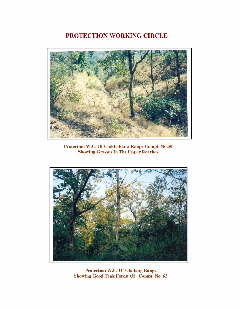
Protection W.C. Of Chikhaldara Range Compt. No.50
Showing Grasses In The Upper Reaches
PROTECTION WORKING CIRCLE
Protection W.C. Of Ghatang Range
Showing Good Teak Forest Of Compt. No. 62

TEAK PLANTATION WORKING CIRCLE
Matured Teak Forest of T.P.W.C. of Compt. No. 409
Congested Teak Plantation

SELECTION CUM IMPROVEMENT W.C.
Teak Forest of Taora F.S. of Ghatang Range of Compt. No.198
Teak Forest of Compt. No. 431
Showing The Best Site Quality Of East Melghat Division

Teak Forest With Bamboo in Compartment No. 81 of Ghatang Range

Tiger
White backed Vulture

Forest Owlet
Indian Gaur

Safed Musali
Amba , Jamun