Ancient Faiths embodied in Ancient Names (vol. 1) - Amazon S3
Upload
khangminh22Category
view
0download
0
The STudy of AncienT TerriTorieS
Chersonesos & south Italy
reporT for2006 – 2007
inSTiTuTe of clASSicAl ArchAeologyThe univerSiTy of TexAS AT AuSTin

ISBN 0-9748334-4-4
Front Cover: Abondoned farmhouse (Masseria Castellano) near Cozzo Parlante; Montescaglioso in the background, upper right. Photo: Cesare D'Annibale
www.utexas.edu/research/ica
Copyright © 2008 Institute of Classical Archaeology, The University of Texas at Austin
In Memorium
Dr. Henry LissBert Michelsen
Friends and supporters

i
The STudy of
AncienT TerriTorieS
Chersonesos&
south Italy
2006 – 2007 AnnuAl reporT
inSTiTuTe of clASSicAl ArchAeologyThe univerSiTy of TexAS AT AuSTin
Copyright © 2008 Institute of Classical Archaeology

For additional support, special thanks to:
Embassy of Ukraine in the United StatesEmbassy of the United States in UkraineThe National Preserve of Tauric ChersonesosThe National Scientific Research Restoration Center of Ukraine
The Brown FoundationDumbarton OaksThe James R. Dougherty, Jr.
Foundation
Non-profit OrganizationsThe Samuel H. Kress. FoundationThe Liss FoundationThe Trust for Mutual Understanding
Institute of Archaeology, Ukrainian NationalAcademy of Sciences
National Taras Shevchenko University of KyivTaurian National University, Simferopol The University of Kyiv Mohyla Academy
Educational InstitutionsThe University of Texas at Austin
College of Liberal ArtsDepartment of ClassicsCenter for Russian, East European, and
Eurasian Studies (CREEES)School of Information Humanities Research Center (HRC)School of ArchitectureKilgarlin Center for the Preservation of
the Cultural RecordLiberal Arts Instructional Technology
Services
Governmental InstitutionsMinistero dei Beni Culturali ed AmbientaliMuseo Archeologico Nazionale, MetapontoRegione BasilicataSevastopol City AdministrationSoprintendenza Archeologica della Basilicata, ItalySoprintendenza Archeologica della Calabria
Daniel & Nancy BalzJane BedichekL. Dayton BlanchardMary Leaphart CarterDr. William L. CarterJudy CokerSandra Heinrichs Mr. & Mrs. Marshall JohnsonWarren LarsonDr. & Mrs. Henry Liss
IndividualsMary MaloneVera MassaroBert MichelsenKathleen MonahanMr. & Mrs. John O’ConnorDr. Maconda Brown O’ConnorRalph S. O’ConnorDr. David & Mrs. Jeanne RenisonElizabeth H. TraceyMr. & Mrs. Ben F. Vaughan IIINancy C. York
ii
The director and staff ofThe Institute of Classical Archaeology
gratefully acknowledge the extraordinary support for operations and projects
provided byThe Packard Humanities Institute

3iii
Contents
1. 2006–2007 in Review ......................................................................................................1 Joseph Coleman Carter, Director, Institute of Classical Archaeology2. A Note from the Assistant Director .......................................................................5 Adam Rabinowitz, Assistant Director, Institute of Classical Archaeology3. Chersonesos 2006–2007 .................................................................................................7
Adam Rabinowitz The Polychrome Grave Monuments ...............................................................................20
Richard Posamentir4. Metaponto and Croton
Pottery Studies in Metaponto .........................................................................................21 Keith Swift
Figured Pottery from the Metaponto Survey ..................................................................26 Francesca Silvestrelli The Farmhouses ..............................................................................................................27 E. Vittoria, E. Lanza, D. Rizzello, A. Cavallo, O. T. Calvaruso Black Gloss Pottery .........................................................................................................30 Elisa Lanza, Eloisa Vittoria
Unguentaria ....................................................................................................................32 Donatella Rizzello Grey Ware ....................................................................................................................35 Eloisa Vittoria Table Ware ....................................................................................................................36 Anna Cavallo Transport Amphora ........................................................................................................38 O. T. Calvaruso Cookware and Metal Objects from Fattoria San Biagio .................................................39 E. Lapadula, A. Di Tursi, M. F. Blotti, L. Trivigno Greek and Indigenous Pottery from Incoronata ..............................................................42 L. Cossalter, C. De Faveri, S. Savelli Decorated Fine Wares from Pantanello ..........................................................................44
Nayla K. Muntasser Terracotta Figurines ........................................................................................................45 Rebecca Ammerman Loomweights from Pantanello ........................................................................................46 Lin Foxhall Coins ..............................................................................................................................48 Anna Rita Parente Biological Anthropology in Metaponto ..........................................................................49 Renata Henneberg
Continues next page

The Institute of Classical ArchaeologyMissionThe Institute of Classical Archaeology (ICA) is an Organized Research Unit of The University of Texas at Austin. In order to study, document, and preserve sites, monu-ments, and artifacts of past cultures for present and future generations, we conduct archaeological fieldwork and training in ancient Greek rural territories on the Black Sea and the Mediterranean. We engage in interdisciplinary research and publication and provide technical assistance and expertise for cultural heritage management.
Research FocusICA’s research focuses primarily on the chorai, or agricultural territories, that surrounded and supported ancient Greek colonial cities. Our two primary sites of research are the chora of Metaponto on the southern coast of Italy and the chora of Chersonesos on the northern coast of the Black Sea in Crimea, Ukraine. Both settings offer remark-ably well-preserved ancient rural landscapes, once densely occupied by farmers and still containing abundant evidence of their homes, burial grounds, and places of worship. Because their locations were strategically important, they also contain archaeological remains from the Roman through Byzantine eras.
Through its research, ICA seeks to contribute a fuller understanding of the settlement, economy, and culture of this previously neglected rural dimension of early western civilization. Metaponto and Chersonesos provide a unique chance to compare rural chorai at opposite ends of the colonial Greek world, as well as the opportunity to train students, foster exchange, and promote international collaboration and good will.
Adjunct organizationsThe Center for the Study of Ancient Territories (U.S.A.), Pidtrymka Chersonesu (Ukraine), and the Centro di Agroarcheologia Pantanello (Italy) are nonprofit organiza-tions founded to support the mission and goals of ICA. Their special focus is expand-ing international cooperation for ICA’s projects and ensuring cultural awareness and compliance with local laws.
iv
www.utexas.edu/research/ica
Interpretation of Animal Bones from the Chora of Metaponto ......................................50 Erika Gál Publication of the Neolithic Site at Capo Alfiere, Croton ...............................................52 John Robb Prehistoric Agriculture on the Ionian Coast of Calabria .................................................54 Lorenzo Costantini, Loredana Costantini Biasini Field Surveys in Metaponto and Crotone .......................................................................56
Joseph Carter, Albert Prieto, Cesare D'Annibale5. Exploration and Excavation of Two Deepwater Wrecks in the Black Sea .....75 Dan Davis4. Personnel & Publications ..........................................................................................85
Contents

1
Two years have passed since the last annual report of The Institute of Classical Archaeology (ICA). We now present a double issue, covering the ac-tivities of ICA during 2006 and 2007. Our regular readers may have wondered why the pause. The rare omissions of annual reports in previous years have usually been the result of the pressures of excavation and research outpacing the time available. That has certainly been so for the past two years. There is also a more specific reason for the increased intensity of work in the past two years. Beginning in 2006, a major shift has been taking place in the direction of our projects, from the production of new results that increase an already enormous volume of primary re-search, to the now more urgent task of reviewing, reflecting upon, and synthesizing those results in scientific publications. These publication projects involve a wide range of disciplines in the two ar-eas of the ancient Greek world where ICA has, for many years, been involved: the north coast of the Black Sea and the southern coast of Italy. Synthe-sizing and publishing will be ICA’s direction for the near future, with additional research limited to that
2006–2007 in ReviewJoseph Coleman Carter
Director, Institute of Classical Archaeology
needed to prepare these studies for publication. The results of ICA’s research from 1974 to the present will ultimately appear in four projected series: The Chora of Metaponto, The Chora of Croton, The Chora of Chersonesos, and Chersonesan Studies.
Readers of this report and supporters of our projects will soon see the results of the most advanced of the scheduled publications. These will include a volume on the excavation of the important Neolithic site of Capo Alfiere (1987–1991); one on the study of the fauna of the chora of Metaponto by a great pioneer archaeozoologist, Sándor Bökönyi (completed in 2007 by his younger Hungarian colleagues); and the two-volume synthesis of the results of the Metapon-to survey between the Bradano and Basento rivers, representing some of ICA’s most valuable work in southern Italy. From Chersonesos on the Black Sea, the long awaited study of the unique polychrome Greek grave stelai from the tower of Zeno, begun by myself in 1994 and expanded and completed in 2007 by a team led by Richard Posamentir, is being readied for publication.
Figure 1. The Packard Laboratory, January, 2006, view to the northwest.

2
Another important change is the shift in the geo-graphical emphasis that has also taken place since 2006. The major focus of ICA’s efforts until the early 1990s was on the agricultural territories, rath-er than the urban centers, of the Greek colonies of Metaponto (ancient Metapontion) and Croton in southern Italy. The discovery and illumination of the rural population of the Classical world remains ICA’s central mission. In 1992, with the independ-ence of Ukraine and the loosening of travel restric-tions in former territories of the Soviet Union, it became possible to extend that mission to the north coast of the Black Sea. Our work in the chora of Chersonesos was directly inspired by that in the ter-ritories of Croton and above all Metaponto.
At the outset of the new millennium, as a direct result of generous support by the Packard Hu-manities Institute (PHI), Chersonesos became the principal theater for our activities, though PHI also made possible ongoing research at Metaponto. The contributions of ICA and PHI to research at this premier Classical and Byzantine archaeological site in the Slavic (Russian/Ukrainian) world have been enormous, and have gone far beyond pure research, extending into the spheres of conservation, archival protection, cultural resources management, and in-frastructure building in a significant way. During this time, the projects in Italy moved forward in capable hands, albeit with less intensity and person-nel than the projects at Chersonesos. In late 2006, the emphasis began to shift from research and re-lated subjects to publication, and the ongoing stud-ies of a quarter century of research in the chora of Metaponto again came to the fore and were gener-ously supported by a major grant in 2007 from PHI. Last year, the team size in Metaponto increased by three times with a large participation by young Ital-ian archaeologists with outstanding credentials and a great desire to take part in the study of the excit-ing and still unpublished material generated by more than thirty years of excavation and intensive field surveys in the chorai of Metaponto and Croton.
This report reflects these recent developments. The first of the four main divisions of this report is a summary of Chersonesos-related projects, including
those on the site, in Austin, and elsewhere. It has been organized and written as two annual reports for 2006 and 2007 by Adam Rabinowitz, Assistant Director of ICA.
These Chersonesos projects include the completion and inauguration in 2006 of the Packard Labora-tory as a place for research, an exhibition space, and a much needed storage facility for the treasures of the National Preserve, especially the Greek and Ro-man sculptures and inscriptions on stone. Current projects at Chersonesos include the major excava-tion of the South Region of the ancient city and the preparations for its publication. ICA, though focusing on the relatively unknown chorai outside ancient cities, has never ignored the urban aspects of the Greek polis. At Chersonesos, beginning in 2001, we had a wonderful opportunity to learn about it first hand through excavation. The result of this excavation, directed by Larissa Sedikova of the Preserve staff and by Dr. Rabonowitz, is a major contribution. In keeping with ICA’s commitment to the whole process, the excavation was immediately followed by conservation and a program for pre-senting the site to visitors. It reveals almost a block of the medieval city, with its shops, residences and chapel, and its many varied activities. The program is aimed to educate and inform the public, with an eye also to the eventual nomination of Chersonesos to the UNESCO World Heritage List.
Conservation of the irreplaceable Archives and Library holdings of the National Preserve has been a special focus of PHI assistance to the Pre-serve, through the ICA-backed efforts of Ludmila Grinenko and the Megarika team and Preserve staff. In 2007 a significant portion of the early records of the Preserve were put on the World Wide Web through their efforts (www.kostsyushko.chersonesos.org and www.utexas.edu/research/ica). Dr. Rabinow-itz’s summary also discusses his constant efforts and those of the ICA team and its consultants to de-velop innovative ways of making the results of ICA’s research—from the present back to our beginnings in Metaponto in 1974—available to the scholarly world and the general public.

3
An event of notable importance for ICA was Dr. Rabonowitz’s acceptance in 2006 of an offer, from the UT Department of Classics, of a tenure track position in Classical Archaeology. All of us at ICA were delighted by his decision and that of his family to live in Austin and continue taking the lead in de-veloping new approaches, as well as assuming a big share of the responsibility for much of the work now being done at Chersonesos. This has freed me up, to a large extent, to turn my energies to the publication projects at Metaponto, as well as those at Croton which had been essentially on hold since 1991.
The second section of this report is devoted to illus-trating the two greatly expanded projects in south-ern Italy by introducing the team and the individual projects with which the talented young archaeolo-gists there are involved. The range, reflecting ICA’s multidisciplinary approach, is wide and ambitious. It includes detailed studies of the pottery, metal finds, and other inorganic materials, as well as the plant, animal, and human remains from twelve ex-cavations at Metaponto—five Greek farmsites (Fat-toria Fabrizio, San Biagio, Sant’Angelo Vecchio, Sant’Angelo Grieco, and Fattoria Stefan), two sanc-tuaries (Pantanello and Incoronata) a late Neolithic village (Pantanello), a mixed indigenous -Greek vil-lage (Incoronata), and a Roman ceramic production
site (Pantanello). (The first volume of the Chora of Metaponto series, published in 1998, dealt with the excavation of three necropoleis, including 350 buri-als, in the chora at Pantanello, Saldone, and Sant’ Angelo Vecchio). The same types of materials are being investigated at Croton, from the excavation of a middle Neolithic settlement at Capo Alfieri, and from a Greek farmhouse near Isola Capo Rizzuto.
Besides excavation material, results from two ma-jor surveys of the chorai of Metaponto and Croton (1981–present), have been studied since 2000 (the Metaponto Survey I, Bradano Basento), or are in the process of being studied (Croton Survey and Metaponto Survey II, Basento Cavone). These sur-veys are unique in southern Italy and in Western Greece (Magna Grecia). There are over a thousand sites ranging in date from the Neolithic period to the Medieval, but consisting predominantly of Greek farmhouses, necropoleis, and sanctuaries in the areas explored at Metaponto. About half that number, but with a higher proportion of prehistoric, Roman, and Medieval sites, has been documented so far in the Croton survey. The study of materials from the Croton survey, after a pause of nearly fif-teen years, was resumed in the second half of 2007 by a small team of local experts under the guidance of Cesare D’Annibale, who led the first surveys in
Figure 2. The excavation house at Pantanello serves as living quarters and office space for Metaponto team members.

4
Metaponto (1981) and Croton (1983) and has par-ticipated in many subsequent campaigns.
The first volumes on the Metaponto survey, Bradano to Basento, have been in preparation under the di-rection of Dr. Alberto Prieto and myself, and are nearing completion. This work involved many of the Metaponto team in 2007, but it does not figure in this report, because it has been detailed in a number of previous reports, and will be in our readers’ hands in about a year’s time. The study for publication of the pioneering surveys in Metaponto and Croton has been accompanied by ongoing field research, resumed again in the case of Croton in 2005 after a long pause. We are grateful to the authorities, the acting Soprintendente, Prof. Piero Guzzo, and the Ispettrice, Dottssa. Maria Grazia Aisa, for their en-thusiastic welcome for the renewed project in the chora of Croton.
Though the study seasons do not figure in this re-port (which had to be selective) the field work fig-ures here as its third major section. This primary research is one of the few exceptions to our decision to concentrate on the publication of past results. The decision to carry on the survey was dictated by one of the same considerations that first dictated under-taking the survey over 25 years ago: the rapid rate at which the south Italian landscape is being altered by modern, intensive agricultural operations. With these dramatic changes, the traces of ancient civi-lization in the Greek and Roman countryside (and those inhabitants preceding and following them) disappear forever. Areas of the fertile farmland and macchia-covered slopes of the Metapontino (the ancient chora and adjacent areas) and the more dramatic landscape of Croton are almost unrecog-nizable to veterans of the survey in just a quarter
century. The results of the survey are not just an ir-retrievable record of these past civilizations, but also a memorial to their uniquely beautiful settings.
In the fourth and final section of this report, ICA staff member and nautical archaeologist Dan Davis, who during the academic year serves as research as-sistant and co-editor of publications in Austin, has played responsible roles in several major underwa-ter projects in the Aegean and Black Sea during the summer months since joining ICA in 2003. The lat-est of these is the subject of his contribution to this annual report. We are grateful to Professor Robert Ballard of the University of Rhode Island, the Di-rector of the Aegean and Black Sea Projects, for al-lowing us to publish here a summary of his team’s exciting research off the north and south coasts of the Black Sea. ICA has been privileged to play a role, at the inception and through the participation of Dan and of Taissa Bushnell in the first two cam-paigns in 2006 and 2007. The two projects show great potential for illuminating trade and maritime contacts in the Black Sea.
Lastly, it is my pleasure to extend my gratitude to all our collaborators and donors for their hard work and loyal support in 2006 and 2007 and through-out past years. To the Packard Humanities Institute go special thanks for its extraordinary sponsorship, which is now making possible the publication and dissemination of our many years of research in the ancient Greek and Roman territories. As a result of this collaboration, Metaponto, Croton, and Cher-sonesos will, in the coming years, take their places among the best known and most fully published areas of the ancient world. We at ICA are grate-ful for this truly unparalleled opportunity to make a difference.
5
Regular readers of ICA’s annual reports may rec-ognize my name; I joined ICA as its Assistant Di-rector in 2004, and since then I have contributed several updates on our archaeological work at Cher-sonesos. It is perhaps appropriate, however, that I am making my first formal remarks only now. The last two years have marked a number of milestones and transitions for ICA, one of the lesser of which was my own appointment as a tenure-track Assist-ant Professor in the Department of Classics. More importantly, a number of long-standing projects were brought to completion, and we have begun to turn to new goals, including an ambitious slate of publications. It seems appropriate, therefore, to take this opportunity to reflect on what ICA has accomplished over the last three decades and what we hope to do in the future. Many of the regular readers of these reports have deep connections with ICA, and I hope that they take great pride in the innovative work that their support has allowed ICA to carry out. I myself am proud to be a part of this institution, and I am committed to its mission of revealing the past in new and exciting ways.
Dr. Joseph Carter established the Institute of Clas-sical Archaeology in 1974 in connection with his work in the rural landscapes of ancient Metapon-tum. Over the following three decades, ICA’s staff
and collaborators conducted innovative interdiscipli-nary research there and at Croton that has changed the way we look at rural populations in antiquity. The 1999 publication of the Metaponto Necropolis volumes further altered the way we write about ar-chaeological research, with its more comprehensive treatment of context and its incorporation of exten-sive scientific analysis. After an initial visit in 1992, shortly after Ukrainian independence, Professor Carter established a new collaboration with the Na-tional Preserve of Tauric Chersonesos in Crimea. From an interest in the same questions that spurred research at Metaponto, this collaboration has grown to encompass the full range of activities associated with the investigation of the past: our work there involves archaeological research, conservation, the digitization of archives, and the development of a cultural-resource management framework that we hope will lead to the nomination of the site to the World Heritage list. ICA’s work in both Italy and Ukraine has always been focused on cutting-edge interdisciplinary research, the protection of the trac-es of the past, and the presentation of both research results and physical remains to a broad public.
During my time here, I have come to recognize two great resources that this long tradition has created at ICA. The first is human: over the years, ICA has
A Note from the Assistant DirectorAdam Rabinowitz
Institute of Classical Archaeology
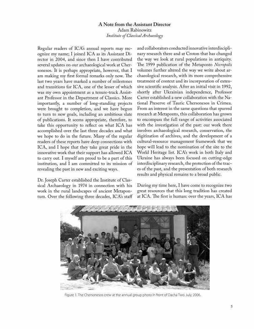
Figure 1. The Chersonesos crew at the annual group photo in front of Dacha Two. July, 2006.
6
built an extensive network of collaborators, scientif-ic specialists, students and professional consultants. The soprintendenze of Basilicata and Calabria have recognized its contributions, and its tireless efforts on behalf of Chersonesos have attracted the atten-tion of many members of the Ukrainian govern-ment. This international community, connected by a shared interest in the human past, now contributes greatly to our projects in South Italy and Ukraine, and it continues to grow. It has been especially im-portant for the development of both the students and the professionals who have had the opportunity to learn from each other in cooperative environments abroad and in the US. The second great resource is the natural product of more than three decades of archaeological research: in ICA’s offices in Austin, in both physical and digital form, is an extensive archive containing primary data from field survey, excavation, and the study of materials. Some of this material is unpublished, while other data published long ago could now be given new life through cur-rent digital technology.
This annual report will present some of the projects that we have completed in 2006 and 2007, placing them in the context of ICA’s longue durée. It will also focus, perhaps more than usual, on our plans for the future, the seeds of which can be seen in some of the work we have concluded this year. I hope the reader will pardon the brevity of the Chersonesos section, which takes a less scientific tone than in the past. It is our intention to satisfy the desire for detailed ar-chaeological information about this site with our up-coming publications, on which familiar contributors are now hard at work. The section on South Italy, on the other hand, reflects the study of old material that is being pursued with renewed vigor by many new scholars. To introduce our friends and support-ers to these new contributors and their work—and to remind them of the work of some longtime col-laborators—this section will provide more specific reports on the varied sites and materials from the Metapontino now moving toward publication.
Before turning to our work abroad, the reader may be interested in an update on developments at home over the last two years. At our offices in Austin, 2006 and 2007 were also years for ICA to take stock of its past and plan for the future. As our publica-tion program picks up its pace, we have begun to
think about ways to organize our own archives. For the last several years, graduate students from Clas-sics and Art History have been scanning and cata-loguing ICA’s slide collection; in 2006, however, we integrated this program with the Digital Archives Service of the College of Liberal Arts. DASe pro-vides an intuitive, easy-to-use image browser and organizer, and is already used for the image col-lections of the Classics and Art History depart-ments. Its developer, Peter Keane, is also working to expand it to different media and to allow it to generate dynamically web content. The digital im-age files from which it draws its content reside on servers in the UT library system, which guarantees curation far beyond what an individual research unit like ICA can offer. This seems like a natural starting point, therefore, for a broader program of archives digitization that will protect our large collection of primary data and make it accessible to research-ers inside—and eventually outside—the University community. We have also begun conversations with the Kilgarlin School for the Preservation of the Cul-tural Record, which requires a capstone internship for its students. We hope to attract students of pa-per, digital, and digitized archival material in 2008 to help us organize our material for both research and presentation.
Now more than ever, then, our efforts at home and abroad are coordinated toward the same well-defined goal: the protection and dissemination of the cultural record in all its forms. As we look to the future and plan for the increasing deployment of digital technology to meet this goal, we also look to the past and to the long history of ICA’s unique commitment to interdisciplinary archaeological re-search. By conserving and publishing the records of the research begun by Dr. Carter in 1974, by in-corporating digital delivery technologies into our current research and publication activities, and by fostering the protection of cultural heritage in Italy and Ukraine through international communication and collaboration, we hope to build a foundation for equally ambitious and innovative work in years to come. We have only been able to do this through the support of our donors, friends, and colleagues, and we hope that they are as excited by the results of their support and by future possibilities as we are at ICA.

7
Chersonesos 2006–2007Adam Rabinowitz
2006 Field SeasonWhen the Packard Humanities Institute began providing its generous support of Chersonesos in 2000, the National Preserve had gone almost a de-cade with little funding for research, conservation, or infrastructure. Buildings forming part of the 19th-century monastery that had been converted to storerooms were crumbling, and the rich collection of objects—acquired over one hundred and seventy years of excavation—was in increasing danger. At least one group of objects was stored in a coal shed, and in other storage areas damp conditions and en-vironmental instability were causing the surfaces of gravestones and inscriptions to flake and crumble. At the same time, the increasingly ambitious ar-chaeological collaboration between ICA and the Preserve required more computing power and more room for specialists and their material. By the early 2000s, therefore, when PHI asked what might fur-ther our work, additional workspace came to mind. Dr. Carter proposed the construction of a build-ing—the first new building at Chersonesos in more than a century—on the footprint of Fondi (Store) 4, originally the monastery bathhouse, recently declared structurally unsound. The new building
would provide up-to-date storage facilities with environmental monitoring capability, space and equipment for the specialized study of archaeologi-cal materials from pottery to carbonized seeds, and a computer lab to support innovative applications of digital technology to the archaeological record.
Packard Laboratory OpeningPlans for the Packard Laboratory were approved by the Preserve and local officials in 2002, and ground was broken in 2003. Construction was preceded by the systematic excavation of the underlying remains, which included a section of the city wall and ne-cropolis with a Late Classical Greek cremation bur-ial and a Late Byzantine residential complex. The finds from the latter included a rare piece of bronze Early Byzantine ecclesiastical decoration (discussed later). These earlier structures were incorporated into the design of the building itself and remain visible through windows beneath the Laboratory’s lowest floor.
Work on the Packard Laboratory was well advanced when the roof of the Preserve’s Ancient Hall began to leak and the ceiling of the main space threat-
Figure 1. Polychrome stelai and associated architectural elements displayed on the Packard Laboratory ground floor. This exhibit, opened in July 2006, was designed and constructed by Chris Cleere with a team of local conservators and students from Historic Preservation program at the UT School of Architecture.

8
ened to collapse, endangering many of the impor-tant Greek grave stelai that had been moved there from Fondi 4. To protect these unique monuments and present them to the public while the Ancient Hall was restored, Dr. Carter and Preserve Director Leonid Marchenko decided to set aside an exhibit space on the ground floor of the Packard Laboratory and arrange a display of the most interesting stelai (Fig. 1). The display would also feature the famous Oath of Chersonesos, an inscription that records the oath sworn by the citizens of the Greek city “to protect the democracy” (Fig. 6). This document has taken on special importance in light of the Orange Revolution and Ukraine’s ongoing efforts to realize its democratic potential.
Construction work on the Packard Laboratory was completed in 2005, at which point the upper floors of the building were fitted out with work tables, desks, and computers, and wired for access to both the internet and the local network, while the two spacious storage floors below were filled with high-quality shelving. Systems for both environmental monitoring and security were installed at the same time, and the long process of transferring heavy stone objects into the new stores began. Chris Cleere and his conservation team, which included both trained local workers and students from the Historic Pres-ervation program in UT’s School of Architecture, carried out this transfer over the winter and spring of 2006. At the same time they began to build the mounts for the stelai display on the ground floor. By June of 2006, when the excavation season began,
the building was ready for use. The numerous computers and comfortable workspaces were a far cry from the two tiny rooms in “Dacha 1” and the various verandas, terraces, and garden corners that the GIS team and the sci-entific specialists had previously occu-pied. This space changed completely our productive capacity and must take partial credit for the quality and speed of the work carried out by our special-ists in 2006. Even the noise of the last stages of work on the stelai display and the cleaning of the stone objects now housed in the building could not drown out the excavation team’s col-lective sigh of contentment.
The final touch was added in July 2006, when a plaque reading “Packard Laboratory” in English, Ukrainian, and Russian was affixed to the front of the building. On July 20, just after the city ad-ministration officially approved the building, ICA sponsored a long-awaited grand opening celebra-tion (Fig. 2). The celebration was attended by United States ambassador to Ukraine William Taylor, for-mer ambassador William Miller, the deputy mayor of Sevastopol, and a large and cheerful group of Preserve employees, ICA staff members, students, volunteers, foreign guests and well-wishers. Politi-cal circumstances in Kyiv prevented the attendance of representatives of the Ukrainian government, but Prime Minister Yury Yekhanurov (now Minister of Defense) sent a congratulatory telegram that com-mended the PHI’s generous donation and ICA’s deep commitment and long service to Chersonesos (Fig. 3). Both Ambassador Taylor and Ambassador Miller gave speeches recognizing the importance of this gift to the Preserve and of the international bonds it represents (Fig. 4), and a poem read by Alex Telenkova stirringly evoked Dr. Carter’s place in the rhythms of life at Chersonesos. Guests were treated to tours of the stelai display and the new storage facilities, and partook of a cake in the shape of the Packard Laboratory made, appropriately enough, by a member of the team that had excavated the area in 2003.
Speeches and poetry were presented in Russian, Ukrainian, or English and translated for the ben-
Figure 2. Preserve Director Leonid Marchenko and ICA Director Joseph Carter cut the ribbon to officially open the Packard Laboratory, July 20, 2006.

9
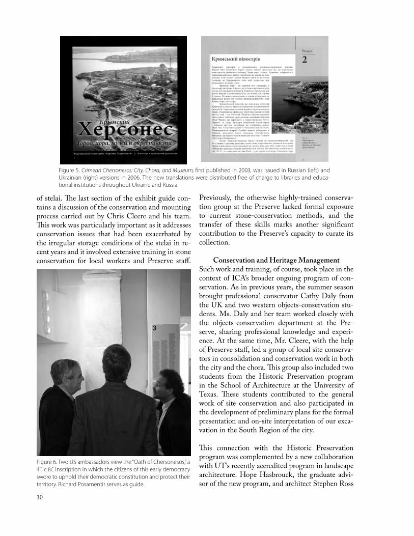
efit of the international audience. This inclu-sive multilingual approach, characteristic of our work at Chersonesos, was demonstrated by another achievement we celebrated during the opening of the Packard Laboratory: the formal presentation of Russian and Ukrainian versions of the guidebook, Crimean Chersone-sos: City, Chora, and Museum that ICA pub-lished in English in 2003 (Fig. 5). The English version of Crimean Chersonesos was already in high demand in Ukraine, and we realized that versions in both Russian and Ukrainian would give a new impetus to our efforts to raise popular awareness of this unique site in the post-Soviet world. The new editions, just printed, were presented as part of the opening ceremonies. Over the following months hun-dreds of copies were distributed free of cost to libraries and institutions of higher learning across Ukraine and Russia. This volume high-lights both the importance of the site and the contributions of ICA and its sponsors to its publication and protection.
Another multilingual publication directly related to the Packard Laboratory itself was written and produced especially for the open-ing. Richard Posamentir’s handsome full-color guide to the stelai exhibit presented this extraordinary collection in English, Ukrai-nian, and Russian. Not only does it explain the arrangement of the current display, but it also provides a preview for scholars around the world of Dr. Posamentir’s forthcoming academic publication of the entire collection
Figure 3. Although unable to attend the inauguration, Ukrainian Prime Minister Yury Yekhanurov —now Minister of Defense—sent this tele-gram (at top, in Ukrainian, with translation, below) thanking PHI and ICA for their support and commitment to the heritage of Ukraine.
Figure 4. William Taylor, U.S. ambassador to Ukraine (left), and former ambassador William Green Miller (right) gave heart-felt speeches recognizing the significance of the Packard Laboratory as a gift for the Preserve and Ukraine and for the international bonds that it represents.
10
of stelai. The last section of the exhibit guide con-tains a discussion of the conservation and mounting process carried out by Chris Cleere and his team. This work was particularly important as it addresses conservation issues that had been exacerbated by the irregular storage conditions of the stelai in re-cent years and it involved extensive training in stone conservation for local workers and Preserve staff.
Figure 6. Two US ambassadors view the “Oath of Chersonesos,” a 4th c BC inscription in which the citizens of this early democracy swore to uphold their democratic constitution and protect their territory. Richard Posamentir serves as guide.
Previously, the otherwise highly-trained conserva-tion group at the Preserve lacked formal exposure to current stone-conservation methods, and the transfer of these skills marks another significant contribution to the Preserve’s capacity to curate its collection.
Conservation and Heritage ManagementSuch work and training, of course, took place in the context of ICA’s broader ongoing program of con-servation. As in previous years, the summer season brought professional conservator Cathy Daly from the UK and two western objects-conservation stu-dents. Ms. Daly and her team worked closely with the objects-conservation department at the Pre-serve, sharing professional knowledge and experi-ence. At the same time, Mr. Cleere, with the help of Preserve staff, led a group of local site conserva-tors in consolidation and conservation work in both the city and the chora. This group also included two students from the Historic Preservation program in the School of Architecture at the University of Texas. These students contributed to the general work of site conservation and also participated in the development of preliminary plans for the formal presentation and on-site interpretation of our exca-vation in the South Region of the city.
This connection with the Historic Preservation program was complemented by a new collaboration with UT’s recently accredited program in landscape architecture. Hope Hasbrouck, the graduate advi-sor of the new program, and architect Stephen Ross
Figure 5. Crimean Chersonesos: City, Chora, and Museum, first published in 2003, was issued in Russian (left) and Ukrainian (right) versions in 2006. The new translations were distributed free of charge to libraries and educa-tional institutions throughout Ukraine and Russia.
11
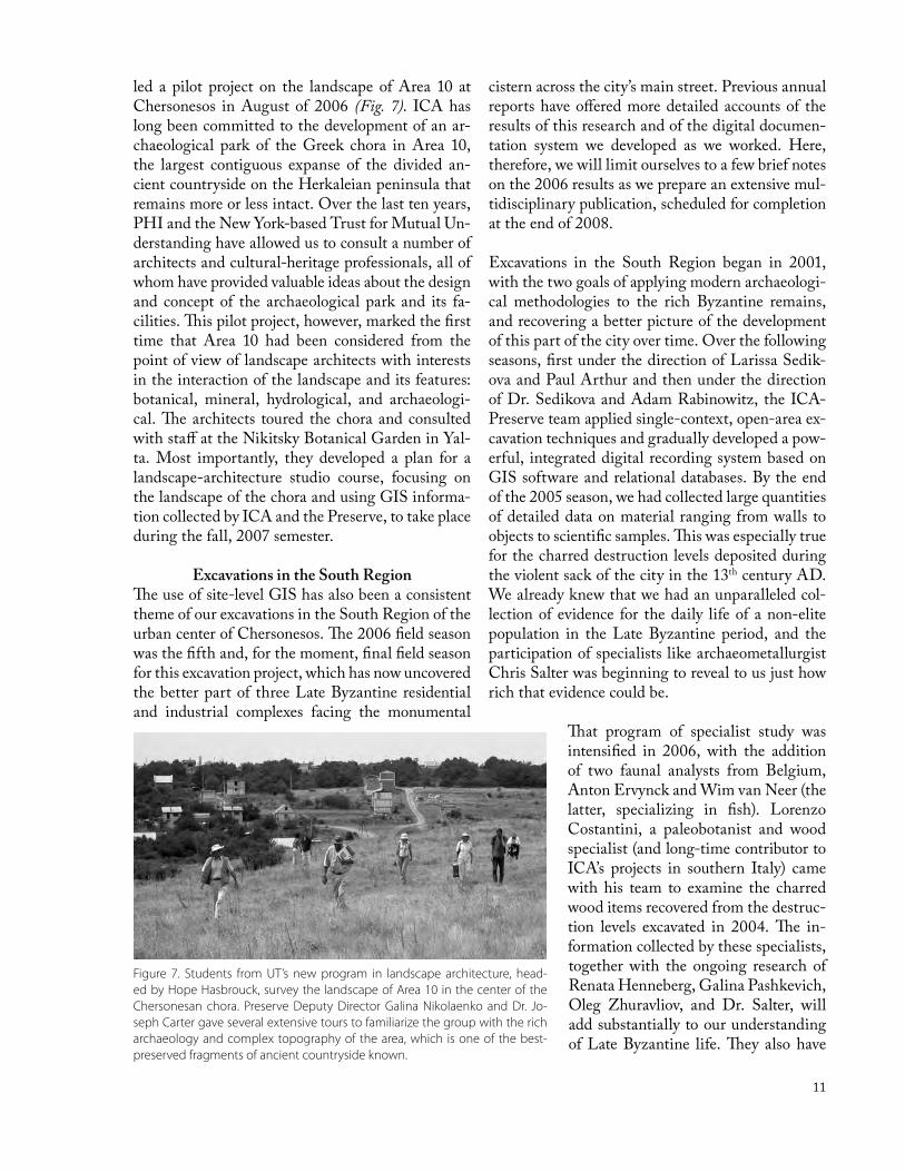
led a pilot project on the landscape of Area 10 at Chersonesos in August of 2006 (Fig. 7). ICA has long been committed to the development of an ar-chaeological park of the Greek chora in Area 10, the largest contiguous expanse of the divided an-cient countryside on the Herkaleian peninsula that remains more or less intact. Over the last ten years, PHI and the New York-based Trust for Mutual Un-derstanding have allowed us to consult a number of architects and cultural-heritage professionals, all of whom have provided valuable ideas about the design and concept of the archaeological park and its fa-cilities. This pilot project, however, marked the first time that Area 10 had been considered from the point of view of landscape architects with interests in the interaction of the landscape and its features: botanical, mineral, hydrological, and archaeologi-cal. The architects toured the chora and consulted with staff at the Nikitsky Botanical Garden in Yal-ta. Most importantly, they developed a plan for a landscape-architecture studio course, focusing on the landscape of the chora and using GIS informa-tion collected by ICA and the Preserve, to take place during the fall, 2007 semester.
Excavations in the South RegionThe use of site-level GIS has also been a consistent theme of our excavations in the South Region of the urban center of Chersonesos. The 2006 field season was the fifth and, for the moment, final field season for this excavation project, which has now uncovered the better part of three Late Byzantine residential and industrial complexes facing the monumental
cistern across the city’s main street. Previous annual reports have offered more detailed accounts of the results of this research and of the digital documen-tation system we developed as we worked. Here, therefore, we will limit ourselves to a few brief notes on the 2006 results as we prepare an extensive mul-tidisciplinary publication, scheduled for completion at the end of 2008.
Excavations in the South Region began in 2001, with the two goals of applying modern archaeologi-cal methodologies to the rich Byzantine remains, and recovering a better picture of the development of this part of the city over time. Over the following seasons, first under the direction of Larissa Sedik-ova and Paul Arthur and then under the direction of Dr. Sedikova and Adam Rabinowitz, the ICA-Preserve team applied single-context, open-area ex-cavation techniques and gradually developed a pow-erful, integrated digital recording system based on GIS software and relational databases. By the end of the 2005 season, we had collected large quantities of detailed data on material ranging from walls to objects to scientific samples. This was especially true for the charred destruction levels deposited during the violent sack of the city in the 13th century AD. We already knew that we had an unparalleled col-lection of evidence for the daily life of a non-elite population in the Late Byzantine period, and the participation of specialists like archaeometallurgist Chris Salter was beginning to reveal to us just how rich that evidence could be.
That program of specialist study was intensified in 2006, with the addition of two faunal analysts from Belgium, Anton Ervynck and Wim van Neer (the latter, specializing in fish). Lorenzo Costantini, a paleobotanist and wood specialist (and long-time contributor to ICA’s projects in southern Italy) came with his team to examine the charred wood items recovered from the destruc-tion levels excavated in 2004. The in-formation collected by these specialists, together with the ongoing research of Renata Henneberg, Galina Pashkevich, Oleg Zhuravliov, and Dr. Salter, will add substantially to our understanding of Late Byzantine life. They also have
Figure 7. Students from UT’s new program in landscape architecture, head-ed by Hope Hasbrouck, survey the landscape of Area 10 in the center of the Chersonesan chora. Preserve Deputy Director Galina Nikolaenko and Dr. Jo-seph Carter gave several extensive tours to familiarize the group with the rich archaeology and complex topography of the area, which is one of the best-preserved fragments of ancient countryside known.

12
led to more ambitious programs of scientific study such as a program of stable isotope analysis of faunal material, integrated with an isotopic analysis of hu-man remains by F. Donald Pate.
Dr. Henneberg’s summer was busier than antici-pated due to the discovery of several earlier burials under the floor of the small chapel belonging to the Late Byzantine block (Fig. 8). As we uncovered the layers below the Late Byzantine floors, we moved closer to the goal of understanding the changing use of the area across time. The burials helped to explain the well-built tomb under the chapel wall and the disarticulated skeletal material in the Late Byzan-tine tombs inside the chapel found during earlier seasons. Radiocarbon dating may help determine if the construction of the chapel disturbed a cemetery of the Middle Byzantine period in the same area. It is particularly interesting that this burial ground seems not to have respected the urban street grid, unlike structures in the periods both before and af-ter, and that there is no church in the vicinity with which it could have been associated. The remains of the Middle Byzantine period in this area seem generally to be tenuous, in marked contrast to the extensive deposit of pottery recovered from the fill of the public cistern during previous excavations. The only clear deposit we recovered from this pe-riod consisted of burnt destruction material lying on
Figure 8. One of the burials discovered underneath the chapel floor in the South Region. These burials help explain the well-built tomb found under the chapel wall as well as the large number of disarticulated skeletons from the Late Byzantine tombs in the chapel, which appear to have disturbed a Middle Byzantine cemetery in the same area.
Figure 9. Overhead photograph at the end of the 2006 excavation season in the South Region. A series of bedrock cuts were exca-vated beneath the courtyard and rooms comprising Complex 2, indicating a 5th or 6th century AD industrial area, possibly associated with wool processing or laundering. They were later filled in during the 6th or early 7th century, when the rooms were replaced by residential structures occupied by people involved with fishing.

13
an early surface of the alley beside the block. It is tempting to associate this pottery, tentatively dated to the 10th century, with the capture of the city by Volodymyr, Prince of Kyivan Rus’.
Evidence for the Early Byzantine period was much clearer. Beneath the courtyard and the northern rooms of Complex 2 were a series of bedrock cuts and beaten-earth surfaces that told the story of a 5th- or 6th-century industrial area—perhaps associated with wool processing or laundering—that had been filled in during the 6th or early 7th century. This was replaced with at least two modest residential struc-tures occupied by people involved in fishing. There is some evidence to suggest that activity associated with a few of the larger pits had begun even earlier, in the 4th century AD. If this is the case, we may be able to establish continuity of occupation in the area at least from the construction of the monumen-tal pavement, probably during the 2nd or 3rd century AD (Fig. 9). Before this, however, our research in-dicates a long hiatus in activity. The earliest material we uncovered was a large assemblage of Hellenistic pottery of the late 4th to the mid or late 3rd centuries BC. This pottery had been sealed beneath a layer of eroded limestone in a deep, regular trench cut in the bedrock. Although stamped amphora handles and fineware provided a clear date for the ceramic assemblage, the purpose of the trench in which it was found and its connection to activity in the sur-rounding area in the Hellenistic period remain un-clear (Fig. 10).
During this fifth season of excavation, we made some additional changes to our documentation system, fi-nalizing its various components after a long period
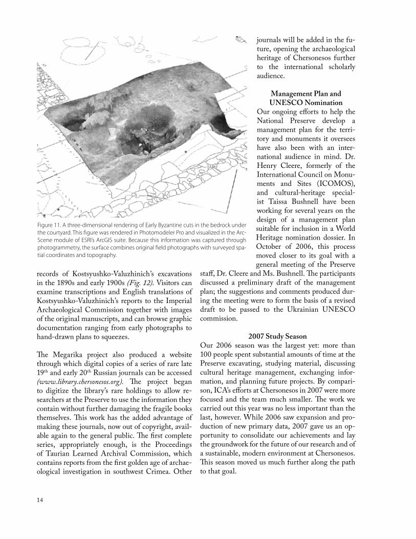
of experimentation. The most notable change was the substitution of photogrammetry for our previous reliance on georeferenced vertical photographs and micro-topographical surfaces created through total-station survey. Both of the latter proved useful for the recording of individual contexts, but despite the dimension they added to the information we col-lected, they created workflow problems in the field and interpretation difficulties during processing. (These issues were the focus of a paper we presented at the 2006 Computer Applications and Quantita-tive Methods in Archaeology Conference, now in press as conference proceedings.) Photogrammetry allowed us to use fewer photographs and points to create both surfaces and orthorectified photographic images for analysis in the GIS (Fig. 11). In addition, the results will be easier to present to both academic and lay audiences through the internet. It has always been our goal to publish most or all of our data in a digital medium, to complement the print publication of our excavations, and 2006 brought this intention closer to reality. During this year, preparations be-gan in earnest for the web-based presentation of our data through an on-line interface developed by L – P : Archaeology, a contract archaeology company that is responsible for the information architecture that underpins our documentation system. This in-terface can manage text, images, and GIS data, and we hope that it will allow our excavation to serve as a model for the on-line delivery of a comprehensive archaeological dataset.
The Megarika ProjectThe presentation of useful information for scholarly and lay audiences through new media is a corner-stone of our work in both Ukraine and South Italy. It is also a thread that ties our recent excavation to research carried our more than a century ago by Karl Kazimirovich Kostsyushko-Valuzhinich, an archae-ological pioneer at Chersonesos and the founder of the site’s first antiquarium. Since 2003, the Mega-rika project—a collaboration between ICA and the Library and Archives of the National Preserve—has carried out the digitization of large quantities of ar-chival records and rare books, under the leadership of librarian Ludmilla Grinenko. This initiative has also been developing a Preserve-wide database in-tended to facilitate the documentation of conserva-tion and curatorial activities. Fittingly, its first major on-line exhibit displays the archival and published
Figure 10. Stamped amphora handle from the earliest assem-blage of ceramic material uncovered in the South Region exca-vation. This Hellenistic pottery, from the late 4th to mid or late 3rd century BC, was sealed beneath a layer of eroded limestone in a deep trench cut into the bedrock.
14
records of Kostsyushko-Valuzhinich’s excavations in the 1890s and early 1900s (Fig. 12). Visitors can examine transcriptions and English translations of Kostsyushko-Valuzhinich’s reports to the Imperial Archaeological Commission together with images of the original manuscripts, and can browse graphic documentation ranging from early photographs to hand-drawn plans to squeezes.
The Megarika project also produced a website through which digital copies of a series of rare late 19th and early 20th Russian journals can be accessed (www.library.chersonesos.org). The project began to digitize the library’s rare holdings to allow re-searchers at the Preserve to use the information they contain without further damaging the fragile books themselves. This work has the added advantage of making these journals, now out of copyright, avail-able again to the general public. The first complete series, appropriately enough, is the Proceedings of Taurian Learned Archival Commission, which contains reports from the first golden age of archae-ological investigation in southwest Crimea. Other
journals will be added in the fu-ture, opening the archaeological heritage of Chersonesos further to the international scholarly audience.
Management Plan and UNESCO Nomination
Our ongoing efforts to help the National Preserve develop a management plan for the terri-tory and monuments it oversees have also been with an inter-national audience in mind. Dr. Henry Cleere, formerly of the International Council on Monu-ments and Sites (ICOMOS), and cultural-heritage special-ist Taissa Bushnell have been working for several years on the design of a management plan suitable for inclusion in a World Heritage nomination dossier. In October of 2006, this process moved closer to its goal with a general meeting of the Preserve
staff, Dr. Cleere and Ms. Bushnell. The participants discussed a preliminary draft of the management plan; the suggestions and comments produced dur-ing the meeting were to form the basis of a revised draft to be passed to the Ukrainian UNESCO commission.
2007 Study SeasonOur 2006 season was the largest yet: more than 100 people spent substantial amounts of time at the Preserve excavating, studying material, discussing cultural heritage management, exchanging infor-mation, and planning future projects. By compari-son, ICA’s efforts at Chersonesos in 2007 were more focused and the team much smaller. The work we carried out this year was no less important than the last, however. While 2006 saw expansion and pro-duction of new primary data, 2007 gave us an op-portunity to consolidate our achievements and lay the groundwork for the future of our research and of a sustainable, modern environment at Chersonesos. This season moved us much further along the path to that goal.
Figure 11. A three-dimensional rendering of Early Byzantine cuts in the bedrock under the courtyard. This figure was rendered in Photomodeler Pro and visualized in the Arc-Scene module of ESRI’s ArcGIS suite. Because this information was captured through photogrammetry, the surface combines original field photographs with surveyed spa-tial coordinates and topography.

15
Figure 12. Screen shot of the NPTC-Megarika web site featuring material from excavations of the late 19th to early 20th centuries. The first major online exhibit, pictured here, included archival and published records of Karl Kostsyushko-Valuzhinich’s excavations in the 1890s and early 1900s. (www.kostsyushko.chersonesos.org)
The most promising result involved substantial forward movement on the manage-ment plan. The new involve-ment of the Ukrainian gov-ernment encouraged prog-ress following productive meetings in October, 2006. Feedback from the members of the Preserve community were supplied in writing, and Dr. Cleere and Ms. Bushnell are currently editing the plan to incorporate this informa-tion. A Ukrainian version of the edited plan will soon be passed to the Ukrainian UNESCO committee. The Ukrainian state is committed to the nomination of Cher-sonesos (the deadline for the preparation of a dossier has now been formally set for 2009) and we are well positioned to help in this process. At a meeting with members of the Ukrai-nian UNESCO committee in October 2007, we saw first-hand the dedication of the government to this process, and we were able to make clear the aid we have to offer in the development of a persuasive nomination dossier.
Protecting and Conserving Rare Books and Archives in Ukraine
A UNESCO nomination requires the integration of local practices with international standards. Our work in 2007 focused on this idea on several fronts, from the practical level of database interoperability to large-scale attempts to foster a sense of profes-sional community among Ukrainians responsible for conservation and management of cultural resources. A generous grant from the Samuel H. Kress Foun-dation helped us make progress toward the latter goal: building on professional connections we have developed between the Harry Ransom Humanities Research Center at the University of Texas and the library and archives community in Ukraine, we car-ried out a program of international exchange related to the care of document collections. The first stage of this program involved a visit to the US by Dr.
Galina Novikova, the Deputy Director for Scien-tific Research of the National Scientific-Research Restoration Center of Ukraine. Dr. Novikova is currently one of the leaders in the development of collections-care standards in Ukraine, and her time at the HRC, at the Annual Meeting of the Ameri-can Institute of Conservation, and at major docu-ment collections such as the Library of Congress in Washington, D.C. has provided her with detailed knowledge of current American standards.
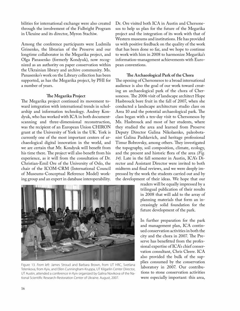
The second stage brought exchange in the opposite direction, when senior HRC staff James Stroud and Barbara Brown, and Kilgarlin Center Direc-tor Ellen Cunningham-Kruppa traveled to Kyiv at the end of August to participate in a conference organized by Dr. Novikova (Fig. 13). The confer-ence brought together the heads and senior staff of many of the most important libraries, archives, and document collections in Ukraine. The event was even more successful than we had hoped. Papers were presented, information shared by Ukrainian and US participants, and the conference resulted in a working group with a specific mandate to develop standards and training programs to criteria agreed upon by the conference participants. Future possi-
16
bilities for international exchange were also created through the involvement of the Fulbright Program in Ukraine and its director, Myron Stachiw.
Among the conference participants were Ludmila Grinenko, the librarian of the Preserve and our longtime collaborator in the Megarika project, and Olga Panasenko (formerly Kondyuk), now recog-nized as an authority on paper conservation within the Ukrainian library and archive community. Ms. Panasenko’s work on the Library collection has been supported, as has the Megarika project, by PHI for a number of years.
The Megarika ProjectThe Megarika project continued its movement to-ward integration with international trends in schol-arship and information technology. Andrey Kon-dyuk, who has worked with ICA in both document-scanning and three-dimensional reconstruction, was the recipient of an European Union CHIRON grant at the University of York in the UK. York is currently one of the most important centers of ar-chaeological digital innovation in the world, and we are certain that Mr. Kondyuk will benefit from his time there. The project will also benefit from his experience, as it will from the consultation of Dr. Christian-Emil Ore of the University of Oslo, the chair of the ICOM-CRM (International Council of Museums-Conceptual Reference Model) work-ing group and an expert in database interoperability.
Dr. Ore visited both ICA in Austin and Chersone-sos to help us plan for the future of the Megarika project and the integration of its work with that of Western museums and institutions. He has provided us with positive feedback on the quality of the work that has been done so far, and we hope to continue to work with him in 2008 to harmonize Megarika’s information-management achievements with Euro-pean conventions.
The Archaeological Park of the ChoraThe opening of Chersonesos to a broad international audience is also the goal of our work toward creat-ing an archaeological park of the chora of Cher-sonesos. The 2006 visit of landscape architect Hope Hasbrouck bore fruit in the fall of 2007, when she conducted a landscape architecture studio class on Area 10 and the potential archaeological park. The class began with a ten-day visit to Chersonesos by Ms. Hasbrouck and most of her students, where they studied the area and learned from Preserve Deputy Director Galina Nikolaenko, paleobota-nist Galina Pashkevich, and heritage professional Timur Bobrovsky, among others. They investigated the topography, soil composition, climate, ecology, and the present and historic flora of the area (Fig. 14). Late in the fall semester in Austin, ICA’s Di-rector and Assistant Director were invited to both midterm and final reviews, and we were deeply im-pressed by the work the students carried out and by the development of their ideas. We hope that our
readers will be equally impressed by a trilingual publication of their results in 2008 that will add to the array of planning materials that form an in-creasingly solid foundation for the future development of the park.
In further preparation for the park and management plan, ICA contin-ued conservation activities in both the city and the chora in 2007. The Pre-serve has benefitted from the profes-sional expertise of ICA’s chief conser-vation consultant, Chris Cleere. ICA also provided the bulk of the sup-plies consumed by the conservation laboratory in 2007. Our contribu-tions to stone conservation activities were especially important: this area,
Figure 13. From left: James Stroud and Barbara Brown, from UT HRC, Svetlana Telenkova, from Kyiv, and Ellen Cunningham-Kruppa, UT Kilgarlin Center Director, UT Austin, attended a conference in Kyiv organized by Galina Novikova of the Na-tional Scientific Research-Restoration Center of Ukraine. August, 2007.

17
Figure 14. Students participating in a studio class organized by Hope Hasb-rouck of the UT Landscape Architecture program. They spent several weeks consulting with Galina Nikolaenko, Deputy Director of the Preserve (center) and other local experts about possible plans for the development of an ar-chaeological park in the chora.
long missing from the repertoire of the Preserve, was taken up in 2007 by local workers Aleksandr Kuzmin and Dmitry Davydov. In the early summer of 2007, Mr. Davydov accompanied Mr. Cleere to Lviv, where Mr. Cleere offered a workshop in stone conservation. Later in the summer, Mr. Cleere and Inga Shvedova, the head of the Preserve’s conser-vation laboratory, supervised conservation students from Kyiv in conjunction with our ongoing program of collaboration with the conservation training in-stitute there. One of the high points of this work was the mounting of the unique lamna found during the excavations at the Packard Laboratory site. The lamna, an ornamental candle holder shaped to fit over an arched doorway, was expertly cleaned and restored over the last two years by Ms. Shvedova. It now takes its place as one of the most important objects in the Museum’s Medieval Hall (Fig. 15).
Conservation and Site InterpretationWe also continued our collaboration with the His-toric Preservation Program at UT’s School of Ar-chitecture. MA students Erin Tyson and Sarah Duffy returned again in 2007 to assist Mr. Cleere with the presentation of a site-interpretation plan for the South Region to the Scientific Committee of the Preserve. The plan, which includes surface-treatment conventions and an interpretive path for the visitor, was approved after a lively debate among the Preserve Scientific Committee. The application of the surfaces has already begun, and sign formats and material were tested for durability and resistance to vandalism through the summer and fall. Dr. Larissa Sedikova and Dr. Rabinowitz are now working on the production of text and graph-ics for signs that we hope to install on the site in the summer of 2008. At that time, we also plan to finalize surface treatments for the entire block, to de-lineate a tourist itinerary, and to con-struct a viewing platform from which both the block and the cistern across the street can be seen in their entirety.
South Region Publication Study2007 was an opportune time for the development of a site presentation pro-gram, since our work in the South Re-gion this year concentrated on the study
of material for publication and on the refinement of our ideas about the development of the site. A series of specialists visited Chersonesos over the summer to collect data, ensure that the documentation of their material was complete, and carry out programs of analysis. Among the latter, Dr. Henneberg, with the assistance of former Kyiv Mohyla student Yaro-slav Mikhailovsky, completed a program of occu-pational-stress analysis on the human remains (Fig. 16), and Dr. Salter examined metallurgical samples from the 2006 season. He also took samples of metal from copper-alloy objects for composition analysis at Oxford. His study will provide useful informa-tion about trade patterns and technology.
Oleg Zhuravliov completed his study of the fau-nal material from the South Region in 2007. His results are being enriched by several new scientific approaches. One of these is a technique for the mi-crowear analysis of animal dentition pioneered by Dr. Ingrid Mainland of the University of Bradford. Dr. Mainland’s student, Vicki Ewens, visited Cher-sonesos this summer to take casts of the teeth of sheep, goats, pigs and cattle. Dr. Mainland is cur-rently analyzing these casts. Her studies should pro-vide invaluable insights into the animal husbandry strategies of the residents of Late Byzantine Cher-sonesos. They might tell us, for example, whether animals were left to forage or raised in stalls. The comparison of these results with the age and sex profiles of the macro-level faunal remains will of-

18
fer new perspectives, as will attempts to reconstruct human diet through the stable isotope analysis of both animal and human bones. Stable isotope anal-ysis is not new, but it is rarely carried out on animal remains from Byzantine sites, and the results—al-ready complete—will influence the interpretation of the parallel results obtained from human skeletal material. Drs. Wim van Neer and Anton Ervynck have proposed the publication of the comparison in a scientific article to be coauthored by Dr. Mark Van Strydonck, who carried out the faunal isotope anal-ysis, along with Dr. Henneberg, and Dr. F. Donald Pate, who is providing the human isotope analysis. ICA is also engaged in preliminary discussions with colleagues from the Roemische-Germanische Mu-seum at Mainz, who are carrying out a large-scale research project with a substantial physical-anthro-pology component in the cave cities to the east of Chersonesos. The German anthropologists are in-terested in comparing their 13th century populations with ours. We have some ideas about collaborative projects involving DNA and strontium analysis which could provide us with a much more detailed picture of the interactions between the residents of various Late Byzantine towns of Crimea.
Digital DisseminationFinally, we continue to make progress on the trans-fer of ICA’s vast digital dataset into an on-line de-livery system developed by information-architecture consultants L – P : Archaeology, who have made great strides in the refinement of their Archaeo-logical Recording Kit (ARK), a version of which is already being used by the Villa Magna Project in Italy. As our specialists complete their studies, we have been integrating their data in the larger sets of
textual, graphic, and spatial information that have already been transferred (Fig. 17). This step takes place in preparation for the inclusion of a substan-tial digital component in our final publication: we wish to make our primary data available for brows-ing and querying in as complete a form as possible. We overcame the final hurdles in this work in 2007, and have also begun discussions with IT depart-ments at UT about hosting and archival curation. Few other field projects in the world have made as much progress toward the goal of digital presenta-tion and long-term curation as has ICA.
Publication and OutreachThis work all feeds into ICA’s primary academic goal at Chersonesos, which is the comprehensive publication of the results of research over the last 15 years. With specialist studies and organization of the materials from the South Region almost com-plete, we hope to have a preliminary manuscript ready for reviewers by the beginning of 2009, to-gether with complete and accessible on-line data. In the meantime, we have structured publication work to further ICA’s long-standing collaboration with the University of Kyiv Mohyla Academy and to dis-seminate information to Western scholars as well as to the archaeological community in Ukraine. We took two concrete steps to this end in 2007: first, we (A. Rabinowitz, L, Sedikova, J. Trelogan and S. Eve) wrote a detailed article on our methodol-ogy and its duplicability to be published in two in-stallments in the Ukrainian journal Archeologia; and second, we involved the six Kyiv Mohyla students as publication assistants in Chersonesos. The students
Figure 16. Renata Henneberg (right) and her assistant, Yaroslav Mikhailovsky, analyze human remains from the South Region excavation. They were among the team of specialists in the 2007 study season utilizing the new Packard Laboratory.
Figure 15. A unique lamna, found during excavations at the Pack-ard Laboratory site, was carefully conserved in 2006–07 by Inga Svedova. A custom mount, designed and built by Chris Cleere, allows for its display in the Preserve Museum’s Medieval Hall.

19
researched comparisons for objects in the library, created 3-D models of architectural fragments us-ing photogrammetry, and assisted with programs of faunal and anthropological analysis. The work helped to familiarize the students both with the digital side of our projects and with Western ap-proaches to archaeological study and publication.
Various other projects rounded out ICA’s increas-ingly ambitious publication program in 2007. Nikita Khrapunov completed his revisions to the second edition of the Russian-English/English-Russian Archaeological Field Dictionary. The pocket version of the dictionary (Fig. 18) is now available, distributed by David Brown Book Company. Mr. Khrapunov has also produced a short Ukrainian–English ar-chaeological dictionary that will soon follow. These dictionary projects further ICA’s long-standing commitment to an active dialogue between local and international scholars at Chersonesos.
Work is also proceeding on the publication of ICA’s earliest excavation project at Chersonesos, Site 151, a farmhouse in the chora of the ancient city. ICA’s second field project at the multi-period (Taurian, Greek, Roman and Early Byzantine) settlement at Bezymyannaya will also soon result in a monograph examining the ancient remains as well as the ar-
chaeology of the Crimean War. The publication of the unique collection of painted Greek grave stelai recovered from the fill of the Tower of Zeno is al-most complete: the final publication photographs of the painted grave stelai were taken this summer and will join the nearly finalized text of the manuscript.
PHI’s support has also allowed ICA to help Pre-serve staff compile a color catalog of several hundred Byzantine objects found at Chersonesos but now scattered between the Preserve, the Hermitage, and the State Historical Museum in Moscow.
Lastly, in conjunction with the publication of site 151 and the development of the archaeological park, 2007 also saw the execution of a program of geo-physical prospection in Area 10, under the supervi-sion of Mikhail Nikolaenko. This adds to our rich dataset of geophysical data for the chora, integrated into the increasingly detailed GIS that we have built for the Herakleian peninsula. It is our hope that this material will contribute to the formal publica-tion in 2008 of our program of GIS, remote sens-ing, and geophysical prospection at Chersonesos. These varied publications will provide Western au-diences for the first time in a hundred years a broad diachronic perspective on the city and countryside of this Greek, Roman and Byzantine community. They will also showcase the integration of the deep knowledge of Ukrainian researchers with the best of Western methodology and cutting-edge science and technology.
Figure 17. Screenshot of the online database (ARK) in develop-ment for the dissemination of data from the South Region exca-vation. This web-based, spatially enabled database will allow for the presentation of the entire set of digital data collected dur-ing the excavation and subsequent specialist study. This digital component will be a companion to the print publication.
Figure 18. The Russian-English Archaeology Field Dictionary, ed-ited by Nikita Khrapunov, is now available from David Brown Books. This second edition replaces the sold-out first version of the handy, pocket-sized dictionary.

20
The Polychrome Grave MonumentsRichard Posamentir
German Archaeological Institute (DAI), Istanbul
Early Hellenistic Necropolis:The Painted Grave Stelai
The first volume on archaeological materials from the cemeteries of Chersonesos, entitled Polychrome Grave Monuments from the Early Hellenistic Necropo-lis of Chersonesos Taurike I, concerns the gravestones, their bases, and related elements such as anthemia, anthropomorphic objects, and small naiskoi. In to-tal, these pieces comprise 361 catalog entries. Be-sides comprehensive technical analysis of surface, craftsmanship (the differentiation of workshops), and applied colors, the study emphasizes such prob-lems as dating, appearance, localization, and recon-struction of the necropolis (plundered in the 3rd cen-tury BC to strengthen the Tower of Zeno).
Similar gravestones from other sites along the Black Sea littoral play the main role in a compara-tive study and a short chapter (contributed by UT Classics professor Paula Perlman) concentrating on the epigraphy of the stelai. A conclusive synopsis in-vestigates the extent to which the grave monuments bear evidence progress of colonization, as well as the social and historical development of Tauric Cher-sonesos. These chapters, all now complete, comprise 160 pages. The catalog will add approximately 130 pages. The final effort to collect all the necessary photographs of various objects began in August, 2006. The deadline for the completed manuscript is December 31, 2007. At this point, book design and layout will begin, leading to the final publication.
The Polychrome Funerary ArchitectureThe second volume on archaeological material de-riving from the cemeteries of Chersonesos, entitled Polychrome Grave Monuments from the Early Helle-nistic Necropolis of Chersonesos Taurike II, will cover the sarcophagi, the painted panels, and the various architectural elements that were found in the fill of the Tower of Zeno. It will contain 164 catalog en-tries. In addition, a scientific analysis of binder and pigments will be included.
Substantial work has already been accomplished on the section dealing with the architectural elements. A manuscript focusing on the art-historical back-ground by A. Buyskykh has already been submit-ted, while the other half concentrating on techni-cal observations and reconstruction, by architect Christine Lippert, is nearing completion. This second part should be completed by summer 2008; the catalog of these pieces has been finished. The completion of work on the large scale naiskos panels by J.C. Carter, and the sarcophagi—a collaboration of the architects with J.C. Carter and including a scientific investigation of the painting materials by John Twilley—awaits completion. This manuscript will be ready for publication in 2010.
Figure 19. Painted stelai on display in the Ancient Hall Museum. These pieces have since been moved to storage and display in the Packard Laboratory while the Ancient Hall undergoes reno-vation.

21
ICA’s survey and excavations in the Metapontine chora have yielded substantial pottery assemblages from a diverse range of archaeological sites and contexts. Through their breadth and variety, these assemblages (pottery groups associated by context, site, chronology, or place of manufacture) provide a wider and more comprehensive regional perspec-tive of ceramics in the Metapontine chora than can be encompassed by material from single sites. With the study of the survey assemblages from the Bradano–Basento survey transect complete, studies of the diverse range of ceramic assemblages from the ICA projects in the Metapontine chora now encompass two main research trajectories: (1) the regional study of pottery forms and fabrics and (2) the study of substantial ceramic assemblages from ICA excavations in the Metapontine chora, includ-ing the ceramic assemblages from excavations of the multi-period farmhouses in the Metapontine chora, Archaic assemblages from excavations at Incoro-nata, and assemblages from the Archaic sanctuary and later Roman-period ceramic production site at Pantanello.
Regional StudiesIt is with the broader regional perspectives of the survey assemblages that studies of the ceramics from the ICA excavations now proceed, moving beyond the fundamental concerns of typologies and chronologies and working towards a regional syn-thesis of archaeological ceramics in the Metaponti-no through comparative studies of the assemblages from the ICA survey and excavations. Additionally, study of the late Roman and early medieval wares from survey in the area of Croton was initiated in 2007, dealing primarily with periods which are less well represented in the Metapontine chora. Togeth-er, the ceramic assemblages from these two regions will allow for a multi-regional approach and inter-regional comparisons of archaeological ceramics from two archaeologically rich and historically im-portant areas of southern Italy.
Regional Typologies and ChronologiesA major component of the study of the survey as-semblages has been the formulation of regional ty-pologies for the ceramic classes from the Bradano–
Basento survey transect by various specialists, from a corpus of approximately 20,000 sherds with readily identifiable forms, along with full quantification of the surface survey as-semblages from 525 sites in the transect. For the Classical period in particular, the typolo-gies and chronologies build upon and expand those from the Pantanello necropoleis to en-compass the wider range of wares and broader chronological and geographical scope evident in the survey assemblages. They represent a major step towards the formulation of com-prehensive regional typologies for the wide range of ceramic classes.
Regional Study of Ceramic Productionand Distribution
The unique range of assemblages from the ICA projects in this part of southern Italy provide direct sources of evidence for the production,
Metaponto and CrotonPottery Studies in Metaponto
Keith SwiftInstitute of Classical Archeology
Figure 1. Keith Swift analyzes thin section samples of pottery using a petrographic microscope.

22
distribution and use of ceramics in the Metapontine chora from the Archaic to Roman periods. Eco-nomic and cultural interaction with other regions of southern Italy and the wider Mediterranean can be examined through the identification and sourcing of extra-regional wares. The petrological identification, characterization and sourcing of ceramic clay fabrics at local, regional and inter-regional scales represent key research desiderata, complementing the regional typological and chronological framework provided by the class-specific studies of ceramics from the Bradano–Basento survey transect.
To this end, an ongoing petrological study, initiated in summer 2007, aims to identify and differentiate as far as possible the ceramic fabrics in southern Italy. Sampling of site assemblages for fabric analy-sis encompasses the entire range of ICA survey and excavation projects in southern Italy. Although the focus is on the Metapontine chora, this study in-cludes material from the Croton survey for the char-acterisation of fabrics from that part of Calabria. Of particular importance are ceramic production sites identified in the survey and ceramic production as-sociated with the later phases of activity at Panta-nello which are evidenced by substantial excavated assemblages.
Petrographic analysis of thin sections has so far concentrated for the most part on transport ampho-rae from the survey since these generally provide the broadest range of fabrics through intra-regional and maritime trade in amphora-borne commodi-ties. Together with representative samples of local fabrics from the excavated sites, along with samples from a ceramic production site in the chora identi-fied in survey, these have shown some promise for the characterisation and differentiation of regional fabrics and sourcing of extra-regional imports. For example, it is now possible to differentiate micro-scopically between some of the ceramic fabrics pro-duced in Calabria (e.g. Croton, Sybaris and Locri) and the range of fabrics produced in the Bradano Trough, including the territory of Metaponto (i.e. between the Calabrian uplands and massifs, the lowlands and marine terraces of Basilicata in the lower reaches of the Bradano Trough, and the lime-stone plateaus of Apulia), elucidating the inter-re-gional distribution of ceramics within and between the regions of southern Italy. (See page 33)
Petrographic analysis of transport amphorae from the survey has suggested the emulation of Archaic Corinthian A amphorae in local/regional produc-tion and points to the presence of a significant
Figure 2. The Biblioteca at Pantanello, June, 2007. Left to right: Elisa Lanza, Eloisa Vittoria, Keith Swift and Cesare Raho.

23
number of Archaic amphorae of probable Calabrian origin, to cite another important result of the work in summer 2007. Petrological study of the ampho-ra fabrics from the survey has also provided direct evidence for the production of “Corinthian” Type B and (more predictably) Greco-Italic amphorae on the marine terraces of the Metapontine chora in the later fourth or early third centuries BC. With a pro-duction site attested in the survey, there is now direct evidence for the production of this type in southern Italy, drawing into question assumptions about the (strictly) Corinthian/Corcyrean production of this type during the late Classical and early Hellenistic periods. Given the ubiquity of this amphora type in central Mediterranean regions, this has broad rang-ing implications for studies of amphora distribution and long-distance maritime trading networks.
As these examples suggest, further work is required, but quantification of the ceramic assemblages should allow for assessments of the relative propor-tions and long-term changes in the importance of imports in the Metapontine chora to be made. This kind of petrological study is well suited to the broad chronological span of the ICA’s projects in southern Italy, ranging from the Neolithic to post-Medieval periods, given that there are usually strong similari-ties between pottery fabrics of different periods as a consequence of the exploitation of similar source sediments. A broad chronological span is also desir-able for the study of long-term change in ceramic technologies, such as clay exploitation, manipula-tion, vessel forming and pyrotechnology, resulting in macro- and microscopic variation in pottery fab-rics. In this respect the ceramic assemblages from production sites identified in the survey of the chora and the excavated Roman period ceramic produc-tion site at Pantanello are particularly valuable, since they give both a geographic breadth and chronolog-ical depth.
At a more local scale, the wide range of ceramics from ICA’s survey and excavations permits the intra-regional study of ceramic fabrics. The regional pot-tery fabrics can be interpreted in terms of the kinds of clay sources exploited for pottery production. The distribution of these sediments can be related to var-iations apparent in pottery fabrics in the Metapon-tine chora, for which the combination of extensive ICA survey assemblages and substantial excavated
assemblages is ideally suited. The foundation for much of this work is provided by the geological and geomorphological studies of the Metapontine cho-ra, and southern Italy more generally, carried out by Folk and Abbott as part of the ICA’s Metaponto and Croton surveys. Together, their study of landscapes, soils and sediments in these Metapontine chora lays the foundation for relating ceramic fabrics to differ-ent kinds of sediments exploited for ceramic pro-duction in different periods, both within the region at a localized level and at a multi-regional scale for southern Italy as a whole.
Further, petrological comparisons of ceramic fabrics from the kerameikos of Metapontion are underway (in collaboration with Francesca Silvestrelli), with the aim of differentiating between ceramic fabrics produced in the chora and those produced in the ur-ban center (asty), focussing in particular on the red-figure (RF) and black gloss (BG) fine wares. This is especially important for the study of the organi-zation of ceramic production in the Metapontino, as it presents the possibility of identifying, and to some extent quantifying, the distribution of ceram-ics within the chora and from the asty. Comparisons involving wider collaborations are planned, with fabrics from other regions of the Mediterranean–particularly other parts of peninsular Italy, Sicily and Greece–to identify extra-regional imports.
In terms of breadth, size and chronological span, the survey and excavation assemblages from the Metapontine chora permit a petrological study of ceramic fabrics on a scale and scope not previously attempted for Greek and Roman southern Italy. This study will establish a ceramic fabric reference collection to facilitate the identification, charac-terisation, and sourcing of pottery fabrics from this area, involving hand-specimen and thin-section samples (accompanied by petrological microscope examinations), with full publication of results, in-cluding digital and web-based resources to facilitate the co-identification of inter-regionally traded ce-ramics. Such a resource will be important not only for the study of imports to the Metapontine chora but also the identification of exports from it. In this way, the pottery assemblages from Metaponto have a direct bearing on our understanding of economic and cultural interaction between southern Italy and the wider Mediterranean world.

24
Excavated AssemblagesIt is within these broader regional and methodolog-ical frameworks provided by the survey that study of the ceramic assemblages from the excavations of sites in the chora are currently taking place. Bulk quantification of the assemblages from survey sites identified (on the basis of non-ceramic criteria) as farmhouses, necropoleis/tombs, and sanctuaries has allowed for the characterisation of assemblages in terms of both the range and the relative proportions of different ceramic types.
Overall, this has suggested that it is in the relative proportions of different ceramic classes and form types, rather than the simple presence or significant absence of particular types of vessels (often thought to be ‘diagnostic’ of particular cultural contexts), that compositional differences can be seen in the ceramic survey assemblages from sites of different character. In addition to expanding regional typologies, the substantial excavated assemblages from farmhouses in the chora and the multi-period site at Pantanello provide points of comparison for the survey assem-blages and allow for a more detailed study of the composition of ceramic assemblages from examples of different types of site.
Farmhouses in the ChoraThe excavated assemblages from the farmhouses in the Metapontine chora—Sant’Angelo Vecchio, Sant’Angelo Grieco, Fattoria Fabrizio, Fattoria Ste-
fan and San Biagio—can now be seen within the wider context of the 312 sites identified as farm-houses in the Bradano–Basento survey transect. The farmhouse assemblages provide direct evidence for the nature of ceramic assemblages from farmhouses in the chora ranging in date from the Archaic (ca. 600 BC) to Roman imperial (1st–4th c AD) periods, allowing for inter-period comparisons and an assess-ment of long-term change in ceramic assemblages on the basis of the excavation of these sample sites together with the broader survey data.
Study of the pottery assemblages from these excava-tions is well under way with the bulk quantification and division of all ceramic assemblages by ware and class completed in the spring of 2007. These com-prise over 25,000 sherds from the four farmhouses dating from the Archaic to Hellenistic periods, not counting the Roman period assemblages from San Biagio. Class-specific specialist studies were initiat-ed in the spring and have progressed over the sum-mer and autumn (see summaries by the respective specialists, below). These will provide new perspec-tives on each of the classes of ceramics in assem-blages from farmhouses, seen primarily in terms of relative proportions of different ceramic types, though also in terms of their typological range and variation. They constitute important comparanda for further interpretation of the diverse ceramic as-semblages from the numerous survey sites identified as farmhouses in the Metapontine chora.
Figure 3. Kilns of the tile factory, a ceramic production center at Pantanello, during conservation in 2007. Roman period, 2nd c BC–1st c AD

25
PantanelloStudy of the ceramic assemblages from excavations at Pantanello, ranging in date from the Archaic to Roman imperial periods, will take place within the wider regional framework established by the survey, studies of the excavated assemblages from the nearby Pantanello necropolis, and of the farmhouses in the Metapontine chora. Material from the Archaic de-posits at Pantanello constitutes the only sizable ex-cavated assemblages from an extra-urban sanctuary of this period in the Metapontine chora, comprising some 600 crates of pottery. Material associated with the votive deposits is of particular interest in terms of the nature, composition and characterisation of ceramic assemblages from Greek sanctuaries in this part of southern Italy, which can be compared to quantifiable differences in the assemblages from survey sites identified as sanctuaries from those identified as farmhouses and tombs/necropoleis.
The late Archaic and Classical assemblages can be related to those of the nearby Pantanello necropolis. Considered together, the pottery assemblages from excavations of the necropolis and assemblages from the sanctuary and occupation site allow for the com-parison of sizable coeval assemblages from very dif-ferent types of archaeological contexts, both seen in the wider framework of the survey assemblages.
Petrological study of the ceramic fabrics from Pan-tanello will include over 90 thin section samples ac-companied by Neutron Activation Analyses. These are of fundamental importance for the characteri-zation of locally produced wares and identification of regional and extra-regional imports to the sanc-tuary. The intra- and inter-regional distribution of ceramics during this period is of particular impor-tance for the examination of the economic as well as cultural role played by rural sanctuaries in the Archaic period. Following on from this, a key re-search question for the assemblages from the Panta-nello sanctuary is the nature of the transition from sanctuary, to farmhouse, to agricultural-industrial complex, all on the same site, in the Archaic, Clas-sical, Hellenistic, and Roman periods. Close study of the ceramic assemblages will assess whether
there were continuous or discrete phases of activ-ity at Pantanello during this period, by drawing on the typological and chronological framework estab-lished for the survey ceramics. This transition will be examined within the wider context of changes in settlement patterns evident from the survey, relat-ing the evidence from the excavated deposits from Pantanello with those of the nearby necropolis and coeval farmhouse assemblages.
Quantification of the ceramic assemblages from Pantanello will permit a synthesis of previous stud-ies of assemblages, which have focussed on selected classes, types or groups of ceramics and provided working typologies (of, for example, Grey Ware, lamps, preliminary study of selected plain wares and cooking wares). As with the farmhouses, the substantial size of the assemblages from Pantanello allows for secure quantified analyses of the relative proportions of vessel types in different kinds of ar-chaeological deposits. This kind of study takes on a particular importance when we consider the survey assemblages and the characterization and attribution of sites of different function on the basis of smaller and generally more fragmentary surface survey as-semblages from sites in the Metapontine chora.
The later phases of occupation and activity at Panta-nello during the late Republican and early Imperial periods are characterized by ceramic production, in-cluding Grey Ware, plain wares, tiles and transport amphorae. Full study of this material will contribute significantly to the regional petrological knowledge of ceramic fabrics and technologies by providing not only direct evidence for locally-produced ceramics and related infrastructure at Pantanello (kiln and related structures) but also large quantities of Ro-man period ceramics which are otherwise generally scarce in this area. Along with the evidence for lo-cal production, the significant quantities of extra-regional wares from Pantanello, particularly the Roman sigillata fine wares and transport amphorae, constitute an unparalleled source of evidence for inter-regional distribution and economic interaction in this area during the Roman period.

26
Figured Pottery from the Metaponto SurveyFrancesca Silvestrelli
University of Lecce
An important dimension to the analysis of ceramic material from the intensive fields surveys between Bradano and Basento was added, in 2007, by the study of the fragments of the figured pottery (see color plate, p. 58). This sample has enormous potential because of the scarcity of systematic archaeological research in the Greek chorai of southern Italy, the distribu-tion patterns and functional range of figured pottery in the ancient countryside have never been explored in detail. Consequently, it is difficult to compare the evidence deriving from different contexts (urban and rural necropoleis, Greek and indigenous sanctuaries, indigenous settlements, etc.) to detect patterns in the selection of shapes and subjects. Metaponto is, from this point of view, an exception. The discovery of red-figure workshops of the end of the 5th–beginning of the 4th century BC and the third quarter of the 4th cen-tury (which provide valuable information about local production), the detailed knowledge from the Pan-tanello Necropolis, the recent excavations in urban necropoleis, and what is known from the sanctuar-ies all give us a varied picture, to which can now be added the evidence from a large area of the chora.
The corpus, composed primarily of Lucanian and Apulian Red-figured (Rf) fragments along with a few Attic Black- and Red-figured fragments and a
small amount of Gnathia pottery, is relatively small (273 fragments belonging to 240 vessels), and in most cases the sherds are very poorly preserved. The often worn or abraded surfaces and limited dimen-sions greatly restrict the range of information that can be obtained from study. A simple application of the traditional approach to the study of red-figured pottery, which is mainly concerned with the attribu-tion of a vessel to a peculiar painter or group and/or the understanding of the iconography, would have produced very limited results. Therefore, in accord-ance with the latest methodological developments, the attention of the study has been focused also on morphological and quantitative analyses.
The figured sherds cover the entire chronological range of south Italian production, but few fragments are preserved well enough to be attributed. Among the Lucanian fragments, a bell-krater by the Pis-ticci Painter (third quarter of the 5th century BC) has been recognized, as has a pseudo-panathenaic amphora by the Dolon Painter (end of the 5th–be-ginning of the 4th century BC). Most of the material can be dated to the second half of the 4th century BC and is Apulian in style. The decorative patterns and stylistic considerations allow us to attribute some of the fragments to painters of the Darius-Underworld circle, which we know was active also in the kera-meikos of Metaponto.
Little can be said about the iconographic subjects. Dionysiac scenes have been identified, while two fragments representing the tympanon of a build-ing suggest funerary naiskos scenes. The two fragments depicting horses probably belong to a mythological scene, which unfortunately cannot be reconstructed.
Analysis of the frequency of shapes is revealing. Nearly 43% of the fragments can be attributed to kraters, found also at sites where tombs have been found. Recent research has demonstrated that, even if this shape was not part of the Greek funerary as-semblage, fragments of kraters are frequently re-covered in the layers covering tombs, a result which suggests that they could be used as grave-markers or in libation rites. The evidence from Metaponto
Figure 4. South Italian Rf krater fragment, from Metaponto Survey Site 401, a necropolis in Avinella near the sanctuary at San Biagio. Late 4th c BC. [H: 10 cm]

27
Figure 5. South Italian Rf krater fragment with sphinx and pilaster. From Metaponto Survey Site 97, a farmhouse in Campagnolo, 11 km from the city. Third quarter of 4th c BC. [1:1]
The FarmhousesEloisa Vittoria, Elisa Lanza, Donatella Rizzello, Anna Cavallo, Oda Teresa Calvaruso
Institute of Classical Archeology
The first phase in the study of the pottery and other materials from five ancient farmhouses in the Cho-ra of Metaponto—Fattoria Stefan (1969), Fattoria Fabrizio (1980), Sant’ Angelo Vecchio (1979-1980), Sant’Angelo Grieco (1981)—was the quantification of all the pottery, loomweights, terracotta figurines, soft tiles, and the metal finds.
This delineation was collected in a database that is the basis for the detailed study of the various mate-rials. It has been divided by context and arranged so that the chronological range for all materials from each context can be quickly evaluated. The cur-rent location, inventory numbers of each item, and record for each item speeds the work for the indi-vidual specialists whose work is now well underway. Specialists in each major class of ceramics and in metal finds are now preparing detailed catalogs and topologies of the materials, accompanied by draw-ings and photographs.
The specialists are working independently, but with common criteria, in a collaborative effort. The ob-ject of this definitive publication of the farmsites—the first to have been undertaken in Greek occupied southern Italy—is to establish the periods of use of the farms from the study of the fine wares, which it is possible to determine to the nearest decade
in some cases, to determine the use of individual rooms from the study of the whole range of pot-tery, including coarse and cooking wares. The study of the amphorae reveals commercial exchange and the types of agricultural produce traded or stored at the farm. Cooking wares illustrate the diet and ali-mentation of the farm family, especially when con-sidered in relation to ICA’s studies of the plant and animal remains from early farmsites [and from the Pantanello sanctuary and Incoronata)]. Votive ob-jects, terracotta figurines [see Ammerman, below], and miniature vessels are testimony to the religious beliefs and practices of the rural family; loom-weights reveal much about the home-based industry of weaving and about the women whose sphere this was [see Foxhall, below]. The types of structure that sheltered the farm family are evident in the well-preserved plans of these structures, but also from the terracotta revetments and roof tiles. The ceramic study as a whole aims to discover the patterns of cir-culation of the various classes through, in part, the study of the clays from which they were made [see Swift, above]. A cumulative result with the creation of a useful database on ceramic production with in-formation about methods and techniques that will be a basic reference for those working with Greek and Roman pottery working in Southern Italy and beyond.
has until recently been very meager, but the corpus from the chora now allows us to extend the same behavioral pattern into this area as well. Most of the fragments belong to bell-kraters, but at least four large volute-kraters have been identified which likely functioned as grave-markers. The presence of a column-krater is curious, since this shape appears to have been produced in Metapontine workshops for the indigenous market.
The study will continue with the analysis of figured pottery from the Pantanello Sanctuary and the exca-vated farmsites. This new corpus of evidence, much better preserved than the survey material, will allow us to improve our knowledge of the red-figured pot-tery from the Metapontine chora and, together with the new evidence from recently excavated tombs, will give us enough material to attempt a synthesis
of the problems associated with the distribution of figured pottery at Metaponto and in its chora.

28
Le Fattorie
Figure 6. The Banca team, December 2007. Left to right: Luciana Vitelli, Sveva Savelli, Eloisa Vittoria, Lara Cossalter (behind), Elisa Lanza (seated), Cecilia De Faveri, Anna Cavallo, Cesare Raho.
Nei primi mesi del 2007 è stato avviato lo studio del materiale proveniente dagli scavi di fattorie condot-ti tra il 1969 ed il 1981 nella chora di Metaponto, durante i quali vennero portate alla luce le strutture rurali nelle località Lago del Lupo (la cd. fattoria Stefan dal nome di colui che nel 1969 ne ha diretto lo scavo, situata in proprietà Risimini, la più setten-trionale), Sant’Angelo Vecchio (1979, 1980 e 1981), Sant’Angelo Grieco (1981), Fattoria Fabrizio (1980) e San Biagio (1980), tutti con l’unica eccezione della fattoria Stefan, eseguiti dall’ICA.
Nella fase preliminare dell’indagine è stata prodotta una prima quantificazione per avere un quadro ge-nerale del materiale restituito da ogni contesto; tra i 27.000 frammenti esaminati emergono la ceramica e altre produzioni fittili (pesi da telaio e fusaiole, co-roplastica, laterizi, elementi architettonici) accanto alle quali sono documentate in numero significativo anche altre classi di rinvenimenti quali i metalli e le monete, i vetri, le macine e gli elementi in pietra, l’intonaco, la litica, gli indicatori di produzione (so-stegni di fornace, scorie), le ossa umane e animali, le conchiglie.
Le informazioni raccolte per ciascuna fattoria sono inizialmente confluite in un database che ha rappre-sentato il punto di partenza per gli studi dei singoli specialisti; dal documento è infatti possibile attin-gere dati relativi alla quantificazione di tutti i re-
perti conservati che sono stati suddivisi sulla base del contesto di rinvenimento (ambiente, quadra-to, livello, battuta, data) e distinti per classe di pertinenza. La struttura conferita alla tabella consente inoltre di visualizzare l’arco cronologico di riferimento di ogni contesto esaminato sulla base di una da-tazione preliminare attinta dai reperti maggior-mente significativi; a tal fine ci si è avvalsi delle informazioni che si possono ottenere dal materia-le ad impasto e dalla litica per il periodo pre-pro-tostorico; dalla ceramica figurata, a vernice nera e a pasta grigia, dalle anfore, unguentari, coropla-stica e dalle monete per il periodo arcaico-tardo-repubblicano; dalle ceramiche romane (ARSW e sigillata orientale) e invetriate, dai vetri e dalle monete per il periodo romano-medievale. Per completare le informazioni sono state aggiunte le indicazioni relative al luogo di conservazione (magazzino del museo o magazzino decentrato, la cd. ex-banca) e al numero di cassetta, al nume-ro assegnato al Lot di provenienza ed eventual-mente al numero di inventario assegnato dalla Soprintendenza c/o il museo di Metaponto; si è inoltre aggiunto un commento a scomparsa in cui sono indicati almeno i frammenti chiaramente riconoscibili per avere una prima indicazione del materiale contenuto all’interno di ogni Lot.

29
Figure 7. The 6th c BC–1st c AD farmhouse at Sant’Angelo Grieco during the 1981 excavation.
La raccolta dei dati più specifici per ogni classe di materiale, la creazione dei cataloghi dettagliati e la seriazione tipologica dei rinvenimenti spetterà ai singoli studiosi, anche attraverso il rilievo grafico e fotografico delle forme più rappresentative: la docu-mentazione così prodotta per tutti i contesti verrà digitalizzata, al fine di ottenere un repertorio il più possibile significativo delle forme documentate in ogni fattoria. Ciascuno studioso ha avviato il pro-prio lavoro in maniera indipendente, attenendosi tuttavia ai criteri di analisi adottati dall’intero team. In tale ottica ci si è orientati verso una descrizio-ne analitica dei frammenti diagnostici, arricchita da annotazioni relative alle caratteristiche tecnico-strutturali maggiormente significative.
ObiettiviLo studio delle singole classi di reperti è stato af-frontato con un approccio globale che consenta di ricavare il maggior numero di informazioni possi-bile da tale evidenza materiale. In particolare, l’esa-me dei reperti ceramici consente di determinare la cronologia delle diverse fattorie; l’analisi spaziale dei rinvenimenti, inoltre, permette di avanzare ipotesi sulla probabile destinazione d’uso di ogni ambien-te indagato. A questo scopo risulta utile anche il confronto di forme, funzioni e caratteristiche del-la produzione ceramica rinvenuta nelle fattorie con quella proveniente da contesti di natura differente, individuati nell’area urbana e nella chora, che vanno dall’ambito sepolcrale (esemplificato nelle numerose necropoli) a quello sacro (santuari e stipi votive) a quello artigianale (il kerameikos).
Alcune classi ceramiche (figure rosse, vernice nera, pasta grigia, unguentari, sigillata e invetriata, solo per citarne alcune) consentono di puntualizzare l’ambito cronologico di appartenenza, a volte con uno scarto di pochi decenni; altre, come le anfore, illustrano gli scambi commerciali intrattenuti dalla popolazione della chora ed eventualmente i tipi di colture presenti nel territorio; le ceramiche fini da mensa, unite alla ceramica comune e da fuoco, for-niscono alcuni spunti interessanti per la conoscenza del tipo di alimentazione degli occupanti di queste strutture rurali, alla quale concorre anche lo studio di alcuni oggetti metallici (falcetto, lame, forbici) nonché quello di eventuali resti di pasto (ossa ani-mali, conchiglie); i pesi da telaio aiutano a definire
la presenza di un’attività di tessitura svolta su un te-laio verticale di dimensioni più o meno grandi; altri oggetti (vasetti miniaturistici, coroplastica) possono essere indizio dell’esistenza di un ambiente dedicato allo svolgimento di rituali domestici; lo studio dei laterizi, delle terrecotte architettoniche, dei resti di intonaco e degli elementi di carpenteria (in partico-lare i chiodi) indirizza alla comprensione del tipo di struttura e di copertura adottati.
Altro obiettivo dello studio dei materiali è costituito dall’individuazione delle fabbriche locali e dei pro-dotti importati sia a breve che a lungo raggio. A tale scopo ci si avvale anche dell’analisi petrografica me-diante sezioni sottili; pertanto, attraverso un’analisi autoptica supportata dall’osservazione al microsco-pio, sono stati individuati campioni rappresentativi da fare analizzare.
L’obiettivo è inoltre quello di approfondire le nostre conoscenze sulle tecniche di produzione della cera-mica; di conseguenza all’interno della banca-dati

30
Black Gloss PotteryElisa Lanza and Eloisa VittoriaInstitute of Classical Archeology
Figure 8. Joseph Carter at Fattoria Fabrizio. Excavated in 1980, it is now covered with macchia. Study of the pottery showed this farmsite, thriving in the 4th century BC, was first occupied by the earliest settlers of the Chora, about 600 BC.
Figure 9. Misfired BG epichysis fragment, 4th c BC. Sant’Angelo Vecchio, 1979. 1:1
Black Gloss (BG) pottery was a fine ware used in the home and at the table, as well as other contexts such as votives or grave goods, While it was in eve-ryday use, it was still a valuable possession. The form, subject to relatively rapid alteration of style, is particularly valuable archaeological evidence, since it can be dated reliably to the half century, and often more closely (and even to particular decades in spe-cial cases). It has been studied extensively, but each area has its local peculiarities. The study of BG from the farmhouses aims to establish the chronology of these sites and add to the general study of this date-sensitive material, begun in ICA’s study of the ne-cropoleis in 1998 and in the forthcoming volumes on the survey.
The majority of the BG from Fattoria Fabrizio and Sant’Angelo Grieco (about 480 examples studied and 185 drawn as of December, 2007) are largely of the Late Classical and Early Hellenistic periods (Late-4th and 3rd centuries BC) and they are predom-inantly drinking cups (skyphoi) in the tradition of Corinth and Attica. Fattoria Fabrizio, however, was well represented by 47 “Ionic” cups and 16 “Panta-nello” skyphoi from the 6th century. Though drink-ing was by far the most common function of the BG objects, the plates (or dishes) are the second most common open form, followed by the closed vessels, the jugs, olpai, oinochoai, lebetes gamikoi, and le-
kythoi. Among the rarer shapes are lamps, with 36 examples from Fattoria Stefan, where the largest and best preserved ceramic assemblage was found, and 17 from Sant’Angelo Grieco. (None were found at Fattoria Fabrizio or San Biagio.) All the BG ap-pears to have been locally produced.
informatizzata vengono inserite anche voci specifi-che relative alle modalità di esecuzione dell’oggetto ceramico (lavorazione al tornio, manuale, a matrice; verniciatura ad immersione o a pennello; presenza di incisioni o impressioni eseguite prima o dopo la cottura) e all’osservazione di elementi rilevanti (bol-li, iscrizioni, fori rituali, cottura non eseguita cor-rettamente, restauri realizzati in antico, eventuali tracce di impronte digitali).
Risultati parziali ottenutiNell’autunno del 2007 è possibile avere i primi e parziali risultati ottenuti dallo studio preliminare degli oggetti recuperati in occasione dello scavo del-le fattorie in esame.

31
Ceramica a vernice nera
Figure 10. BG kantharos, 4th c BC. Fattoria Fabrizio, 1980. H: 8.7 cm
Sono stati studiati i materiali provenienti da fattoria Fabrizio e, in parte, da fattoria S. Angelo Grieco, per un totale, al momento, di circa 480 esemplari schedati (di questi, 185 sono stati disegnati). I fram-menti ascrivibili al periodo classico ed ellenistico costituiscono la presenza decisamente maggiore; tuttavia sono anche attestati alcuni manufatti arcai-ci (47 coppe ioniche e 16 “pantanello skyphoi”), in particolar modo rinvenuti a fattoria Fabrizio.
Per quanto riguarda il periodo classico ed ellenisti-co, tra le forme vascolari presenti predominano in entrambe le fattorie gli skyphoi di tradizione corin-zia (per un totale di 77 esemplari sui 481 indivi-dui totali sinora analizzati), che ricoprono un arco cronologico dalla fine del V all’inizio del III seco-lo a.C.. L’evoluzione tipologica di questa specifica morfologia si presta pertanto molto bene ad essere utilizzata per la puntualizzazione delle cronologie. Sono stati individuati inoltre 16 piatti (dish), ripar-titi uniformemente nelle due strutture rurali.
Al momento sono noti solo 11 esemplari di skyphoi di tradizione attica. Tra le forme chiuse si annove-rano 7 jugs, 4 olpai, 3 oinochoai, 3 lebetes gami-koi e 3 lekythoi. Allo stato attuale delle indagini pare presumibile che un alto numero dei prodotti a vernice nera venisse realizzato localmente. Si tratta di manufatti caratterizzati da un corpo ceramico di color arancio (Munsell 2000, 2.5YR e 5YR) molto depurato, con radi inclusi bianchi visibili ad occhio nudo (probabilmente quarzo-feldspati); la vernice
nera risulta di qualità media o medio-alta, piuttosto diluita, ma coprente, non molto lucente.
La fattoria Stefan, in corso di studio, ha restitui-to la quantità maggiore di materiale a vernice nera (2110 frammenti) alla quale si lega la possibilità di ampliare la già ricca tipologia del materiale pubbli-cato in Necropoleis e di quello delle ricognizioni tra Bradano e Basento. Al momento è stata analizzata più della metà dei reperti a vernice nera: sulla base di quanto finora visionato si evince una assoluta pre-valenza delle forme vascolari aperte, in prevalenza vasi potori (skyphos, cup-skyphos e cup) e piatti (soprattutto quelli con orlo estroflesso), ma anche contenitori di dimensioni ridotte (saltcellar, bowl e small bowl).
Le forme chiuse sembrano essere molto rare; si se-gnala qualche orlo di lekythos, un paio di orli di jugs e probabilmente uno di bottle (bombylios). Ri-sultano interessanti i frammenti di lucerne, non solo dal punto di vista tipologico ma anche in vista di un futuro esame in relazione alla loro distribuzione all’interno dei vani della fattoria; tra tutte le strut-ture esaminate, infatti, quella in proprietà Risimini ha restituito il maggior numero di esemplari (36, contro i 17 di Sant’Angelo Nuovo -di cui 11 in pasta grigia-, 3 di Sant’Angelo Vecchio e nessuno di fat-toria Fabrizio e San Biagio).
Anche in questa fattoria, tra gli skyphoi sono più numerosi quelli di tipo corinzio rispetto a quelli di tipo attico; in particolare le attestazioni più frequenti sono quelle del tipo C-S20/S28 già presente in Ne-cropoleis e databile all’ultimo quarto del IV–primo quarto del III secolo a.C., sebbene non manchino esempi dei tipi C-S34 e C-S67 di pieno IV secolo a.C.. Lo stesso arco cronologico si segnala per i tipi di tradizione attica, dal tipo A-S69 al tipo A-S75 (IV–primo quarto del III secolo a.C.). Anche il V secolo è rappresentato, seppur in forma ridotta, dai tipi C-S32 (seconda metà del V secolo a.C.) e A-S61 (prima metà–metà del V secolo a.C.).
Mentre per il periodo classico si segnala solo qual-che sporadica attestazione di kylikes (K5 e SK5), nel periodo ellenistico i vasi potori sono completati da numerosi cup-skyphoi, con il profilo a “esse” o con il labbro distinto, sia su alto piede generalmente

32
UnguentariaDonatella Rizzello
Figure 12. A fusiform type unguentarium. Sant’Angelo 1979. [1:1].
modanato che su semplice base ad anello (tipi C7, CS6, CS7, SC2 e SC3). A cavallo tra la fase classica e quella ellenistica si inseriscono le coppe monoan-sate, biansate o prive di anse (tipi CO1, CO3, CO4, CO5, CO6 e CO7).Forma intermedia tra cups e di-shes sono le bowls, contenitori non molto profondi
e privi di anse: queste sono rappresentate dal tipo B5 con orlo introflesso datato al III secolo a.C. e dal tipo B3 con orlo a sezione triangolare datato alla prima metà del II secolo a.C.
Nei dishes è possibile seguire l’evoluzione dell’orlo dal tipo indistinto (D11) o con risega interna (D22), entrambi del IV secolo a.C., a quello con orlo estro-flesso sempre più accentuato (D24, D25, D26 e D27), databili tra l’ultimo quarto del IV ed il III se-colo a.C..Tra le coppette ritroviamo le cd. saltcellar, in particolare il tipo SA3 (metà IV - primo quar-to del III secolo a.C.) mentre al momento è stato individuato un unico esemplare di concave/convex (tipo CC1), ascrivibile al IV secolo a.C.; abbastanza frequenti sono anche le small bowls soprattutto del tipo SB1, SB6 e SB12, con l’orlo progressivamente rientrante e databili alla fine del IV - III secolo a.C.
Figure 11. BG guttus spout fragment in shape of a lion’s head, end of 5th–beginning of 4th c BC. Fattoria Fabrizio, 1980. [1:1]
Unguentaria, small containers for scented oil, re-place the lekythoi of the classical period in many contexts. They are useful indicators of chronology as their shapes change predictably over time, from high shouldered in the late 4th century BC (“piriform”) to more drawn out and symmetrical in the 3rd cen-
tury and later (“fusiform”). The largest number and most complete examples come from Fattoria Stefan. Some are completely covered with BG. Those from Sant’Angelo are elongated and date from the 2nd
and 1st centuries BC.
Una buona parte degli esemplari studiati è confron-tabile con i tipi IV e V della tipologia Forti, diffusi dalla seconda metà del IV secolo a.C. fino a tutto il III secolo a.C. Dalla fattoria Sant’Angelo Grieco provengono esemplari dal piede più allungato e dal corpo presumibilmente più affusolato, diffusi nel II e I secolo a.C., e frammenti di unguentaria del tipo III della Forti, databili dalla seconda metà del IV secolo a.C.. Tuttavia si tratta di frammenti e non di esemplari interi.
Dalla fattoria Sant’Angelo Vecchio proviene un un-guentarium intero a vernice nera, del tipo IV,3 della Forti, datato al III secolo a.C. (dagli inizi al terzo quarto del secolo), anche sulla base di confronti più recenti. La maggior parte degli unguentaria è stata ritrovata nella fattoria Stefan; molti di essi sono in-teri o sono conservati in frammenti sufficientemente significativi per poter essere identificati.

33
Figure 1. Cross section (left) and 10x thin section (middle) show admixture of clays typical of Corinthian Type A amphorae. Note the greyish and reddish fired components and inclusions of argillaceous rock (mudstone fragments) indicating a Corinthian import.
Corinthian Type A amphorae from the archaic sanctuary at Pantanello (1:4).
Corinthian Type A amphorae with projecting rim from Metaponto survey site 349 (1:4).
Figure 2. Cross section (left) and 30x thin section (middle) show a range of rock fragments consistent with that of local, south Italian fabric, indicating this amphora is a local copy of the Corinthian model.
Metapontine Type B amphora rim from the Bradano–Basento Survey transect, Site 266 (1:4),
Metapontine “Greco-Italic” amphora rim from the Bradano–Basento Survey transect, Site 266 (1:4),
Figure 3. Cross section (left) and 30x thin section (middle), similar in form to Corinthian Type B but of local production. Note fre-quent inclusions in cross section and predominant quartz, grains of plagioclase feldspars, and rock fragments in thin section.
Figure 4. Cross section (left) and 30x thin section (middle). Note frequent inclusions and voids in cross section and predominant quartz inclusions with carbonate inclusions/voids, biotite, and plagioclase feldspar in thin section.

34
Arretine bowl fragment with erotic scene. Pantanello Sanctuary area, 1st c AD. [1:1]
Lucanian calyx-krater fragments. Pantanello Sanctuary, beginning of 4th c BC. [Upper fragment, W: 9.6 cm; lower fragment, W: 12.3 cm]
Locally produced Protocorinthian cup. Incoronata Greca, 7th c BC [H: 11.4 cm]
Fragment of conical oinochoe, Early to Middle Corinthian imitation, Pantanello Sanctuary Spring, ca. 575 BC. [W: 9.4 cm]
Fragment of indigenous bichrome ware. Incoronata, late geometric, 7th c BC. [1:1]

35
Grey wareEloisa Vittoria
Ceramica a pasta grigia
Figure 13. Moulded grey ware oil lamp, Sant’Angelo Grieco. 1st c BC. [1:1]
Grey ware is like BG, a fine ware that was widely used throughout the Chora in the 2nd and 1st cen-turies BC. Grey ware serves as a chronological key to the sites where it is found, much like BG does for earlier periods. The largest number of exam-ples—768 as of the end of 2007—comes from the farmsite Sant’Angelo Grieco, a site inhabited in the Archaic and Classical periods. A fine large Doric capital, comparable to those of Posidonia-Paestum, and a fragmentary inscription on marble of 5th or 4th
BC century date were reused in the later structure. Massive amounts of grey ware, amphorae, and sig-illata wares of the Early Imperial period date the structure securely to the late Hellenistic, late Re-publican period of the Chora. The forms most in use are again drinking cups and plates. The typol-ogy of grey ware developed for the survey publica-tion is being enlarged and extended with this study and for the study of the grey ware production site at Pantanello.
L’analisi dei reperti realizzati in pasta grigia è mol-to interessante nell’ottica dell’ampliamento della tipologia già avviata in occasione dello studio dei materiali delle ricognizioni tra Bradano e Basento. Tra le fattorie prese in esame, quella di Sant’Angelo Grieco ha restituito il numero maggiore di fram-menti (768). Si tratta di una struttura situata in una zona che certamente era frequentata già nel periodo arcaico e classico, come testimoniano in particolare i frammenti di coppe ioniche ascrivibili al VI e al V secolo a.C. e gli altri materiali a vernice nera per i quali si rimanda al paragrafo ad essi dedicato (vedi supra); a queste testimonianze fittili si aggiungono il frammento di capitello dorico della metà del V secolo a.C. ed il frammento di iscrizione su mar-mo con caratteri attici della fine dello stesso secolo. Allo stato attuale degli studi, tuttavia, il periodo di maggior fioritura sembra concentrarsi nell’età tar-do-repubblicana proprio per la massiccia presenza di ceramica a pasta grigia; tale datazione è confermata anche dalle anfore pertinenti a questo periodo (vedi infra) e dalla attestazione di ceramica sigillata (42 frammenti, per lo più pertinenti a pareti); lo stu-dio dei dati di scavo permetterà di chiarire meglio la relazione che intercorre tra questo materiale e le strutture di pertinenza.
In questa prima fase l’argilla è stata analizzata in maniera autoptica, ovvero valutando il colore e la consistenza rilevabili all’osservazione diretta; in ge-nere sembra trattarsi di un impasto ben depurato la cui gradazione di grigio varia dalla tonalità più scu-ra (Munsell 1973, 7.5YR N4/ e N5/ - 67 esempla-ri) a quella media (Munsell 1973, 7.5YR N6/ - 201 esemplari) fino a quella più chiara (Munsell 1973,
7.5YR N7/ - 315 esemplari) e raramente grigio-bianca (Munsell 1973, 7.5YR N8/). La vernice è per lo più opaca e diluita, di colore grigio antracite (Munsell 1973, N4/ e N5/ - 497 frammenti), a volte con sfumature di colore olivastro, più o meno chia-ro (Munsell 1973, 5Y 4/1 e 5/1 - 46 frammenti), molto raramente con sfumature bluastre (Munsell 1973, 5B 4/1 - 6 frammenti). Su alcuni esemplari è stato possibile individuare le gocciolature di colore che sono residuo della tipica verniciatura ottenuta per immersione (ad esempio un orlo di dish del Type GW-D2b in SG1.81-131PL).

36
Figure 14. A: Banded ware Kothoniksos. This vessel was possibly used as a ritual perfume container. B: Coarseware lekane, used to prepare and serve foods.
Table and Storage WareAnna Cavallo
Le forme aperte sono quelle più frequenti, in parti-colare vasi potori e piatti; la tipologia di riferimento è quella elaborata in occasione dello studio sui ma-teriali provenienti dalle ricognizioni. Questa, tutta-via, viene ampliata dall’inserimento di nuove forme, quali la coppa carenata, per la quale una tipologia simile è già nota a Metaponto, o i piatti con orlo modanato che nel precedente studio sono rappre-sentati solo da piccoli esemplari (GW-D5).
La decorazione a rotella che spesso ricorre sui ma-teriali a pasta grigia è del tipo ovale (in particolare
sull’orlo di piatti come quello in SG1.81-231PL), a triangoli (si veda il fondo di dish in SG1.81-275PL) o losanghe (fondo di dish in SG1.81-90+91PL) dis-posti in serie di file concentriche.
Le analisi che in futuro verranno realizzate sui cam-pioni scelti permetteranno forse di avere un quadro più chiaro sui luoghi di produzione e sulla “mobilità” di questi oggetti: la pasta grigia, sia essa prodotta nella chora o in città, era destinata al fabbisogno es-clusivo nella zona di pertinenza o poteva soddisfare le esigenze di altre aree?
Coarse wares, the most numerous class of pottery by far, were used for storage, preparation, and con-sumption of food. These wares are found both plain and decorated with bands. Over 7,000 fragments—from the farmsites Fattoria Stefan, Sant’Angelo Grieco, and Fattoria Fabrizio—have been analyzed and a catalogue prepared of the most representative and significant types. From Fattoria Stefan alone there are 3,225 plain and 526 decorated pieces of coarse ware with leka-nai, jars, and cups being the principal forms. There are also deinoi and fine fragments of louteria. The quality of the production is high and macroscopic
inspection of the clay indicates a single center of production. Besides this excellent collection, the assemblage included 75 large storage vessels—pithoi—which are comparable to examples of Hel-lenistic date found elsewhere. From Sant’Angelo, the plain coarse diagnostic fragments number 1,267 with only 165 decorated, and three fragments of louteria. The assemblage covers seven centuries, but the majority of the vessels date to the late Hellenis-tic, Late Republican era. Lekanai and one handled cups predominated among the 1,474 plain and 220 decorated coarse ware vessels from Fattoria Fabrizio, whose high quality also would indicate a single pro-duction center.
Figure 15. One-handled banded ware cup, used as a dipper or drinking vessel. [1:2].
A
B

37
Ceramica da mensa e da dispensa
Figure 16. Double-handled coarseware jar, used for storage and serving. Fattoria Fabrizio, 1980. [1:3]
A partire dal mese di maggio lo studio relativo alla plain ware proveniente dalle fattorie metapontine procede senza sostanziale soluzione di continuità. Il lotto, comprendente ceramica realizzata per lo stoccaggio, la preparazione e il consumo dei cibi, si rivela particolarmente cospicuo: finora sono stati analizzati circa 7000 frammenti provenienti dalle fattorie Stefan, Sant’Angelo Grieco e Fabrizio, al fine di produrre per ogni singolo sito un catalogo puntuale dedicato agli individui diagnostici e mag-giormente significativi.
La fattoria Stefan restituisce un numeroso lotto di ceramica comune da mensa, sia acromo che a deco-razione lineare (rispettivamente 3225 e 526 fram-menti), rappresentato soprattutto da lekanai, jars e coppe. Si segnala inoltre la presenza di numerosi frammenti di deinos a decorazione lineare e di 5 frammenti di louterion. La produzione si rivela di qualità molto buona, caratterizzata da una fattura raffinata e da un’ampia gamma di soluzioni morfo-logiche offerte per ciascuna forma attestata: le carat-teristiche macroscopiche dei reperti indicono inoltre a ritenere probabile la provenienza un comune con-testo produttivo.
Più standardizzate si rivelano le caratteristiche pre-sentate dall’opus doliare, rappresentato perlopiù da grossi pithoi ad orlo estroflesso (75 frammenti). I confronti individuati nell’ambito del lotto riportano
tra il V e il I secolo a.C., con una concentrazione di individui databili all’età ellenistica. La ceramica di uso comune restituita dalla fattoria Sant’Ange-lo Grieco è rappresentata soprattutto da frammen-ti acromi (1267 esemplari), a fronte di un numero molto esiguo di esemplari decorati a bande (165 frammenti).
Il numero delle forme attestate è decisamente ridot-to: emergono certamente jars e lekanai. Si segnala inoltre la presenza di anforette a collo stretto, as-senti nelle altre fattorie, e di 3 frammenti di lou-terion. I confronti reperiti riportano in alcuni casi a tipi diffusi per un arco cronologico molto esteso, compreso tra il VI secolo a.C. e il I d.C., ma talvol-ta rinviano più nello specifico al tardoellenismo e all’età tardorepubblicana.
La plain ware di fattoria Fabrizio è rappresentata so-prattutto da ceramica non decorata (1474 esemplari), accompagnata da un lotto piuttosto esiguo di 220 frammenti a decorazione lineare. Tra il repertorioanalizzato spicca indubbiamente il numero di leka-nai e di coppe monoansate, oltre che un buon novero di deinoi a bande. La produzione risulta omogenea e di buona qualità, segnalando anche per questo sito la possibile appartenenza ad un comune contesto produttivo. I confronti individuati rinviano a tipo-logie diffuse tra il VI e il III secolo a.C.
Il primo obiettivo da perseguire nel prossimo futuro è rappresentato dal completamento dell’analisi di-retta sui manufatti e in particolare della ceramica proveniente dalla fattoria Sant’Angelo Vecchio, di cui per ora è stato effettuato uno spoglio solo par-ziale. Sarà dunque avviato lo studio tipologico per ogni singolo sito: tale tipologia verrà ancorata alle cronologie fornite dalla ceramica fine individuatanelle medesime fattorie (vedi ricerche di Elisa Lanza e Eloisa Vittoria) insieme a quelle date dai confronti bibliografici.
Si intende inoltre confrontare gli esemplari esamina-ti soprattutto con quanto rinvenuto in am bito meta-pontino, sia urbano sia extra-urbano, con l’obiettivo di individuare eventuali differenze nella scelta del repertorio morfologico presentato dalle fattorie.

38
Anfore da Transporto
Transport AmphoraeOda Teresa Calvaruso
Figure 17. Transport amphorae types, from Sant’Angelo Grieco. A: Type B, late Archaic period; B: Corinthian Type A; C: Corinthian Type A, Archaic period.
Amphorae were produced specifically for the trans-portation of commodities such as wine and oil, al-though they could be adapted to uses such as grave markers or burial containers. Their development is closely linked to their contents and they reflect the nature and intensity of the agricultural economy of the site or area where they are found. They also re-veal the trade linkage within the region and beyond. Their presence helps to identify storage areas in the farm buildings.
In addition to these important diagnostic prop-erties, this investigation of amphorae is also con-cerned with establishing their centers of produc-tion [see Keith Swift, above]. At this point in the study, 220 fragments of amphorae—rims, feet, and body sherds—from Fattoria Fabrizio and 733 from Sant’Angelo Grieco have been examined. Most of
those from Fabrizio are late Classical or early Hel-lenistic in date (late 4th and 3rd centuries BC, the second great period of expansion in the chora), but there are numerous examples of Corinthian A and B of 6th and 5th century BC date (the mid-6th was the first period of Metapontion’s great agricultural prosperity). At Sant’Angelo Grieco, the amphorae are mostly late Republican (Lamboglia 3, Dressel 1c, Dressel 2/4) of the 2nd century BC and later. This farmhouse was occupied for the first time in the 6th century, and more or less continuously thereaf-ter until the mid-1st century BC. Its earlier periods are documented by the Greco-Italian amphorae of types A and B dating from the 4th to 3rd century BC, also present at many sites in the survey of the chora, as well as Corinthian B amphorae of the end of the 4th century BC.
Le anfore sono contenitori particolari, nati in ori-gine per il trasporto, differenti quindi dalla restante ceramica in quanto la loro produzione si sviluppa in funzione e come riflesso dei contenuti, dei fabbiso-gni e della situazione agricola delle varie aree; nel caso delle fattorie oggetto del nostro studio, le anfo-re possono apportare dati utili a delineare la funzio-ne di alcuni ambienti, quali ad esempio i magazzini.Altro obiettivo è costituito dall’individuazione dei caratteri di una produzione locale; per questo si in-dividueranno alcuni campioni rappresentativi per i quali ci si avvarrà di studi di tipo archeometrico, nello specifico di analisi petrografiche mediante se-zioni sottili.
Nell’analisi di questo materiale, la difficoltà mag-giore è collegata alla condizione dei resti al momen-to del rinvenimento; infatti non sono state trovate anfore intere, ma quasi sempre frammenti pertinenti a diversi tipi. Lo studio è partito dai materiali della fattoria Fabrizio e della fattoria Sant’Angelo Grie-co; sinora sono stati analizzati circa 220 frammenti per la prima e 733 per la seconda. L’elemento più significativo per questo studio e per le osservazioni che ne scaturiscono è sicuramente l’orlo, che è il più rappresentativo al fine dell’identificazione, seppure con tutte le incertezze che può comportare l’esame di questa sola parte.
A
B
C

39
Cooking Ware and Metal Objects from Fattoria San BiagioErminia Lapadula, Antonietta di Tursi, Maria Francesca Blotti, and Lorena Trivigno
Figure 18. Three common cooking ware types. [1:3]
Ovviamente, sono stati tenuti presenti i moltissimi frammenti di pareti e i meno numerosi esemplari di puntali e anse. Il numero di frammenti totale può essere ricondotto ad un numero di esemplari minori, vista la pertinenza di molte pareti alla stessa anfora. Per la definizione della tipologia e i confronti sono state utilizzate come riferimento sia la tipologia già elaborata per la pubblicazione delle ricognizioni e della necropoli di Pantanello sia le pubblicazioni ca-noniche per lo studio delle anfore che le pubblica-zioni di scavi del territorio. Per la fattoria Fabrizio la maggior parte dei frammenti si ascrive al periodo tardo classico ed ellenistico. Tuttavia si è riscontrata la presenza di frammenti del periodo arcaico (VI e V secolo a.C.); si tratta di anfore del tipo Corin-zio V secolo a.C.); si tratta di anfore del tipo Co-rinzio A (FF80-99PL, FF80-30PL), Corinzio B (FF80-2PL) e con orlo a cuscinetto (FF80-23PL,
FF80-249PL, FF80-250PL). Considerando i fram-menti nel complesso le più rappresentate sono le c.d. anfore magnogreche, le anfore Corinzie A e quel-le B.Per la fattoria Sant’Angelo Grieco la maggior parte dei materiali si ascrive al periodo tardo-re-pubblicano (Lamboglia 2, Dressel 1C, Dressel 2/4, Metapontina).
E’ iniziata anche la visione delle cassette provenienti da fattoria Stefan (proprietà Risimini); su un tota-le di 83 cassette ne sono state viste finora 36, del-le quali 12 contenevano frammenti di anfore, per un totale di 83 esemplari. Al momento la maggior parte dei frammenti è ascivibile al tipo A e B delle anfore greco-italiche, riscontrate anche nel survey, databili dalla fine IV - inizi III alla fine del III se-colo a.C., e al tipo B della corinzia della fine del IV secolo a. C.
The study of the cooking ware began with the largest and best preserved collection of pottery from a farm-house in the chora, Fattoria Stefan. A total of 2603 fragments of this ware, easily identified by its dis-tinctive fabric, was examined and catalogued, with drawings, and bibliography of the most significant and representative examples now being prepared for this site. Fattoria Fabrizio, and Sant’Angelo Grieco and Sant’Angelo Vecchio will follow in this sutdy.
The many variant forms still need to be defined and fully described, but already the major shapes are clear: there are vessels for boiling or stewing, the pentole olle (pots); the casseroles in different forms; those for frying and baking; sauce pans (tegami); baking pans (teglie); and frying pans (padelle). Cooking ware, in combination with studies of plant and animal remains, can give us a picture of ali-mentation in the chora, and the alteration and con-tinuity over time of this deeply imbedded aspect of culture.
The metal finds from Fattoria Fabrizio have been classified and catalogued (with description, draw-ings and photographs, and bibliography). A precise dating of the objects will be possible once study of the BG pottery found in context with the metal ob-jects has been completed.
Figure 19. Thimble of copper alloy, San Biagio, 4th c AD. [1:1]
Casserole (casseruola)
Cooking pot (pentola)
Baking pan (tegila)

40
Among the metal finds are a bronze grater, lead clamps for repairing the large storage vessels recov-ered from one room of the farmhouse, and a bronze coin [see “Coins” below]. Few metal objects were recovered from the farm at Sant’Angelo Vecchio and, strangely, none were reported from Fattoria Stefan, which yielded by far the largest quantity of ceramics. Sant’Angelo Grieco contained the great-est quantity and variety of metal objects: 113 iron nails (and one of bronze), parts of an iron horse bit, a bronze thimble (spotola), tweezers, parts of two bronze mirrors, a small iron sickle, a decorative bronze appliqué from a small box, an iron fibula, 3 iron keys, and lead clamps. Such objects help to cre-ate a picture of rural life, its routines and its level of sophistication, complementing that formed by the study of ceramics. The study of metal objects has been extended to the much larger and richer sites
of Incoronata, (the 9th–7th century BC village on the Basento) and Pizzica’s rural sanctuary (6th–3rd cen-tury BC), and Roman ceramic production center (2nd century BC–2nd century AD). This material is currently being conserved and catalogued.
The entire assemblage of all types of materials from the late Roman farmhouse of San Biagio (late 3rd
to early 4th centuries AD) has been studied by Er-minia Lapadula, a specialist in the Late Roman and Medieval periods in this region of south Italy. The farmsite, though preserved no higher than the foun-dation course, is unusually complete, its rich and varied finds offering a vivid glimpse of life at the end of the Greco–Roman era in the Metapontino.
The finds here include, besides fine imported Af-rican Red-slipped ware and a wide range of coarse wares, metal objects of domestic use and elements of decoration which bespeak an unexpected level of luxury such as glass window panes, marble floor tes-sae, and fragments of frescoed wall decoration. The hypocaust for the caldarium of a three-unit bath contained one of two coin hoards, of Diocletian and Constantine, in excellent condition. Other deeply buried features were two huge pithoi, mended with lead clamps, but otherwise intact.
Ceramica da fuoco, oggetti in metallo, San BiagioIl progetto ha previsto, come è stato osservato sopra, nella fase iniziale la realizzazione di un data base quantitativo di tutti i reperti presenti in ciascuna fattoria suddivisi per classi. Nella fase successiva è stato avviato lo studio di ciascuna classe. In partico-lare chi scrive si occupa della ceramica da fuoco (A. Di Tursi e M .F. Blotti) e dei metalli (L. Trivigno) delle fattorie greche mentre lo studio della fattoria imperiale di San Biagio è affidato complessivamente a un solo archeologo specialista di età romana (E. Lapadula).
Nel corso del 2007 è stato classificato (divisione per forme e tipi) il vasellame da fuoco di fattoria Fabri-zio, è attualmente in corso di classificazione e pros-simo al termine S. Angelo Grieco mentre lo studio di fattoria Stefan è stato avviato da poco. Tuttavia è
stato possibile verificare che le ceramiche di fattoria Stefan sono tra quelle meglio conservate nei profili e soprattutto presentano una varietà morfotipolo-gica ampia che permette di essere utilizzata come punto di partenza per la redazione di una sequen-za tipologica di tutte le fattorie. Per le forme finora individuate è stato affiancato allo studio tipologico la redazione del catalogo descrittivo, bibliografico e fotografico ma quest’ultimo esclusivamente fina-lizzato allo studio. Inoltre per gli esemplari degni di essere riconosciuti come esemplare, tipo è stato effettuato il profilo grafico.
La classificazione è integrata dallo studio, ancora in fase preliminare, degli impasti distinti al momentosolamente con un esame macroscopico, effettuatocon lente di ingrandimento, in attesa di condurre
Figure 20. A bronze plaque, probably used to decorate a wooden box. San Biagio. [1:1]

41
l’eventuale esame microscopico e forse anche arche-ometrico da concordare con lo specialista. Anche lo studio dei metalli delle fattorie è stato avviato ed è attualmente in corso. In particolare i metalli di fat-toria Fabrizio sono stati classificati ed è stato redatto il catalogo (scheda descrittiva, profili e confronti bi-bliografici) che sarà necessario puntualizzare e ve-rificare in alcune datazioni nel momento in cui sarà ultimato lo studio delle altre classi ceramiche egli stessi contesti di rinvenimento.
Se Fattoria Stefan non presenta alcun reperto in me-tallo e fattoria S. Angelo Vecchio solo pochi chiodi in ferro e uno strigile in bronzo restituito da una tomba al momento inseriti nel data base quantitati-vo, al contrario fattoria S. Angelo Grieco conservaun numero consistente di reperti in metallo distri-buiti tra diverse classi funzionali.
Questi ultimi reperti sono attualmente in corso di classificazione ma già ad una prima analisi sembra estremamente interessante la presenza di un di-screto numero di chiodi da carpenteria, conserva-ti anche in buono stato e già sottoposti a restauro conservativo, il cui studio di dettaglio potrà forse offrire dati utili per la comprensione del sistema di copertura della fattoria. Contemporaneamente allo studio dei reperti in metallo delle fattorie è in corso quello degli insediamenti di Pizzica Pantanello e di Incoronata per i cui reperti è in fase di realizzazione il data base quantitativo di entrambi e la scelta dei reperti, soprattutto quelli in ferro, da sottoporre ne-cessariamente a restauro precedentemente allo stu-dio in quanto necessitano di essere ricomposti per la realizzazione dei profili e per la ricerca dei confronti bibliografici.
Lo studio di fattoria San Biagio è stato anch’esso avviato con la redazione del data base quantitativo al cui interno i reperti sono suddivisi per conte-
sto di rinvenimento e quindi per classe funzionale (ARSW, oggetti da cucito, elementi di rivestimen-to) con indicazione della forma (coppa, ditale, tes-sera pavimentale), del tipo della parte conservata (orlo, ansa, fondo, parete) e del relativo numero di frammenti. Alla redazione del data base è seguito lo studio delle classi funzionali a partire dagli oggetti in metallo e vetro in quanto necessitanti di un inter-vento di restauro conservativo ai fini dello studio.
Contemporaneamente è stata avviata anche l’analisi delle ceramiche con la ricostruzione di alcuni esem-plari di ARSW e ceramica di uso domestico in buo-na parte ricomponibili. Per gli oggetti in metalloè stato redatto il catalogo suddiviso per classi fun-zionali (oggetti di ornamento e di uso personale,utensili) in cui ciascuna scheda descrittiva compren-de la descrizione e la indicazione di confronti, le misure, la materia, la tecnica di lavorazione, la pro-venienza, il numero di inventario, la datazione, la bibliografia dei confronti di riferimento.La classifi-cazione sia dei manufatti in metallo sia di quelli in vetro e ceramica, queste ultime attualmente in cor-so, è affiancata dalla realizzazione dei profili degli oggetti e della relativa acquisizione ed elaborazione informatizzata.
Inoltre per i reperti ceramici si è provveduto alla crea-zione di un repertorio di campioni di impasto, anco-ra in corso di arricchimento, da sottoporre ad analisi microscopiche ed eventualmente archeometriche.I campioni di impasto interessano esclusivamentele ceramiche da fuoco e da mensa prive di rivesti-mento e di probabile produzione locale e non il va-sellame da mensa rivestito di provenienza africana.Proprio al fine di ricondurre queste produzioni ad un ambito regiona le o interregionale di medio e corto raggio si ritiene opportuno sottoporre ad ana-lisi archeometrica una scelta mirata di campioni di impasto.
Figure 21. Metal objects from San Biagio. Left: bronze spatula (specillum) used for cosmetic and surgical purposes. Right: iron nail. [1:1]

42
Greek and Indigenous Pottery from IncoronataLara Cossalter, Cecilia De Faveri, and Sveva Savelli
IntroductionAnalysis of the archaeological finds from ICA’s ex-cavations at Incoronata “greca” began in October 2007. The site, located on a small, isolated plateau along the right bank of the Basento River, was ex-cavated in 1977–78. The work revealed a 7th c. BC
village of huts and small rectangular buildings. Ar-tifacts included some Greek ceramics and numerous pieces of Greek-inspired local pottery. This village was superimposed on a mature oenotrian hut village with Iron Age impasto pottery and local geometric wares, produced by an indigenous population of the 9th–7th centuries BC.
The aim of this analytical research is a systematic publication of the finds and the establishment of a typological classification of the indigenous and Greek ceramics dating between the Final Bronze age and the archaic period.
Preliminary ResultsThe material has been divided and the study organ-ized by three ceramic specialists: Lara Cossalter, who deals with painted Geometric pottery and un-decorated indigenous ware; Cecilia De Faveri, with impasto ware and large storage vessels (dolia); and Sveva Savelli, with fine and coarse Greek and colo-nial ware and transport amphorae.
The initial research began with preliminary classi-fication of the archeological finds from Incoronata “greca.” The finds were classified into broad catego-ries: impasto ware, dolia, painted ware, indigenous undecorated ware, Greek and colonial ware, trans-port amphorae, coarse ware, metals, coroplastics, revetment, laterizi, bones, and domestic wares. This categorization sought to establish a clear articula-tion between indigenous and Greek pottery that would make an efficient course of study.
Figure 23. Kotyle fragments, imitation Protocorinthian, colonial production. Incoronata Greca. [Left, 1:4, right 1:2]
Figure 22. Indigenous monochrome fragment with stylized human figure, sub-geometric, late 7th c BC [1:1].

43
For the elaboration of the data, a database was cre-ated in Microsoft Access. Cataloguing highlighted the different morphological and decorative fea-tures of the pots and, more importantly, facilitated a comparison of them. Following this initial phase of work, a process of further examination and clas-sification was established, starting with the material recovered from the pits. These are closed contexts that have yielded indigenous, Greek and colonial material and, for this reason, permit an evaluation and direct comparison of each class of material as a well-defined chronological and cultural contexts. The material was classified and recorded, and a selection of highly indicative and diagnostic frag-ments made in preparation for the second phase of examination. This work has been carried out for pits A–F, H, I and XII, for approximately 3500 sherds.
This examination revealed a predominance of locally produced ceramics with the Greek material almost exclusively of “colonial” production. The ceram-ics recovered in the pits are the basis for an ample chronology between the Final Bronze Age and the middle of the 7th c. BC.
The final aim of the research is to place the indig-enous and Greek wares found at Incoronata within the traditions of artisan production of the Ionian Sea region. Further analyses should continue to clarify the evolution of the material culture in the Enotrian area and contribute to the definition of processes of interaction between indigenous and Greek people in Magna graecia during the pre-colonial and colo-nial period.
Figure 24. Indigenous bi-conical olla with “tent” decoration. Late geometric, 8th c BC. Incoronata Pit B. [1:2]

44
The Roman Period in the Chora: Decorated Fine Wares from PantanelloNayla Kabazi Muntasser
Institute of Classical Archaeology
The period of Roman domination in this part of Magna Graecia is well documented in excavations at Metaponto and by ICA’s excavations in the chora at Sant’Angelo Grieco, San Biagio, and especially fully at Pantanello. The decorated fine ware which comes from the kiln deposit of the Roman Tile Factory consists of moulded gray ware bowls from the Republican period and table wares made from a fine red clay, terra sigillata. This particular group of wares covers a period from about 150 BC to about AD 70. The moulded gray ware bowls in the Pan-tanello collection consist of over fifty examples of vessels which are closely related in fabric and tech-nical characteristics with plain local gray wares. However, their decoration reveals that in the early part of this time-span, circa 150–50 BC, with over a century of Roman occupation in the region, the taste for fine objects was still essentially Greek, or more strictly speaking, Hellenistic. The motifs in our example below (Fig. 25) include bucrania, grif-fins, and trophies, all of which appear in moulded relief bowls from other areas of Greece. Though produced until the beginning of 1st century BC, the height of production of these wares was probably the previous century, making them contemporary with the workshops in Delos, Priene and Crimea. Among the fifty bowls in the Pantanello collection there is a wide variety of decorative compositions that strongly suggests a lively trade in individual punches imported from various sources in Greece and Italy. The mixing and matching of motifs using imported punches and the local nature of the clay
fabric strongly suggest the presence of workshops in the vicinity. The moulded gray ware bowls also reveal the presence of inhabitants in the chora who were using fine tablewares that imitated more costly silver vessels of, for example, Taranto.
In the Augustan period, the moulded gray ware bowls and cups were superseded by thin-walled ves-sels with a shiny red gloss made first in Arretium in central Italy and therefore known as Arretine ware. The inventory of terra sigillata from the Pantanello site consists of almost 300 entries, a small propor-tion of which is moulded with figural or vegetal forms. The Arretine ware differed in form from the gray ware but was strongly influenced by the same Hellenistic moulded relief repertoire including mo-tifs of Dionysiac scenes from which the maenad on one bowl fragment derives, and of scenes of erotica (page 34, bottom right).
Included among the Pantanello Sigillata are ex-amples imported from Gaul. A later terra sigillata known as African Red Slip which became the dom-inant table ware in the second century AD is pres-ent in substantial numbers as well. This is a plain ware the study of which will be incorporated into the study of the Roman period in general. The se-quence at Pantanello of moulded gray wares, Ar-retine wares and African Red Slip is evidence of continuous habitation in the immediate area from the mid-second century BC to the third century AD despite the purported devastation of the Social wars in the early first century BC. The overall picture pre-sented by this study is the possibility of households that used the finest local table wares and kept up with the changes in taste and fashion. While in the early period the influence came from the east with the Hellenistic-type moulded relief bowls, the Au-gustan period saw a change that brought influences from the north. As trade among the various areas of the growing empire expanded, the inhabitants of the Chora around Pantanello clearly kept pace with the changes. That one of these households owned the Roman Tile Factory as part of its landholding fits the pattern of Roman property ownership in the early Empire.Figure 25. Moulded grey ware relief bowl from the Kiln Deposit,
Pantanello, 2nd–1st c BC. H: 15.5 cm.

45
The long-term archaeological projects of field survey and excavation conducted by ICA at Metaponto have provided an extraordinary wealth of documentation regarding the production and use of figurines and plaques made of molded baked clay. These modest terracotta objects played a religious role in the lives of Metaponto’s inhabitants from the earliest days of the Greek colony in the later seventh century BC until the time of transition after the Roman con-quest in the third century BC. As such, they offer valuable insights to the evolving rituals and beliefs of the local population for a period of more than four hundred years.
My analysis of some 350 terracotta figurines and plaques collected by the ICA field survey points to a number of sites that were probably rural sanctuar-ies within the chora of Metaponto. More startling, however, is the large number of cases where terra-cottas were found at a farmstead. Of the 72 sites that yielded a terracotta figurine or plaque, 59 have been identified as farmhouses. Just as the remark-able pollen sequence from the sanctuary at Panta-nello analyzed by Don Sullivan has provided an un-precedented record for the study of plant life from the sixth to first centuries BC in southern Italy, this sample of terracotta figurines and plaques from the chora of Metaponto represents perhaps the largest database for domestic religion yet recovered from the classical Mediterranean world. In other words, it offers an exceptional opportunity for the study of the practice of individual rite at the level of the household. In the 2008–2009 academic year, I plan to investigate more fully the practice of domestic re-ligion at Metaponto.
Integral to this study are the assemblages of terra-cottas, not only from the farmsteads identified by the field survey, but also from those farmhouses ex-cavated by ICA in the territory of Metaponto. My work will thus also include preparation of the final publications of the 265 terracottas from the farm-houses of Fabrizio, Stefan, Sant’Angelo Grieco, and San Biagio. The excavated farmhouses provide a panorama of rural life ranging from the fourth cen-tury BC to the late Roman period. What the image-
ry of the terracotta figurines and plaques from these sites indicate about the changing nature of domestic religious practice from the period of the independ-ent Greek city to that under Roman domination will be an important focus of my research. During the current year, I have instead been concentrating on preparation of the publication of the 503 terracotta figurines and plaques that were dedicated as votive gifts at the rural spring sanctuary of Pantanello.
Terracotta FigurinesRebecca Ammerman
Colgate University
Figure 26. Late Classical terracotta plaque of female figure wear-ing a polos and holding a jug and offering tray of fruit. Sant’ An-gelo Vecchio. [1:2]

46
In the summer of 2007, I returned to Metaponto with student assistants from Colgate University. We were able in a short time to check the database , orig-inally compiled with the helpful guidance of Mary Malone, against the actual artifacts. I plan to have a descriptive catalogue of the assemblage of votive terracottas written by September 2008. Again the subjects portrayed by the terracottas may reflect the identities of the deities worshipped at the sanctuary (Artemis, Dionysus, and Pan have been suggested) as well as aspects characteristic of the actual prac-tice of the cult and its role in the community of the ancient city-state.
In closing it is worth noting that the kind of richly detailed documentation for life in the classical Med-iterranean that one observes in the votive terracot-tas is the fruit of ICA’s projects whose designs are extensive in range, but at the same time intensive in focus. The projects have moreover had the opportu-
Figure 27. Hellenistic figurine of young female wearing wreath of ivy. Metaponto Survey Site 342, a farm deep in the chora. [1:1]
Loomweights from PantanelloLin Foxhall
University of Leicester
Loom weights are sometimes considered trivial or boring objects, but my research has shown that the loom weights from Metapontion reveal much about the social life of the countryside. Thus far I have completed study and preparation for publication of 119 loom weights, collected during the Bradano–Basento survey of 2006–07.
By the 5th and 4th centuries BC, the chora of Metapontion was a settled landscape full of house-holds with resident women. There is evidence to suggest that households including women were set-tled in the countryside as far back as the early 7th century. Loom-weight styles changed over time: it seems likely that the pyramidal loom weights be-
Figure 28. Large pyramidal loom weights from Sant’ Angelo Grieco, possibly used for weaving heavyweight material. [1:2]
nity to develop thoughtfully over a long period. As I continue to collaborate with ICA, I appreciate the special context that ICA’s projects have created for my own specialized area of research.

47
long largely to the 5th century and a bit earlier, the disc loom weights to the 4th century and a bit later, and the pinched loom weights to somewhere in-be-tween, perhaps mid-5th to mid-4th century BC.
By the 4th century, a considerable number of these women must have been sufficiently prosperous to own a personal seal ring in metal or with a semi-precious seal stone. These were used, among other things, to mark their loom weights. They seem to have considered their loom weights and weaving equipment sufficiently precious that they abandoned them only reluctantly. The most interesting feature, however is that loom weights with identical stamps can be used to track relationships between women across the Metapontine landscape, as well as over time. It seems most likely that these relationships were kinship-based. There are several examples of identical loom weights with identical stamps ap-pearing on different sites. In some cases these were roughly contemporary but separated by some dis-tance geographically; in other cases, they are likely to have been separated in time by a generation or two. Examples of “heritage” stamps: 4th century BC loom weights with stamps from the 6th century oc-cur, suggesting that the rings themselves had been passed from mother to daughter. The stamps and other marks on the loom weights suggest that, as personal property, they played a key role in the per-sonal and familial identities of the women of the chora of Metapontion.
In the summer of 2007, I studied the loom weights from the excavated farm house assemblages, In-coronata, and the Pantanello sanctuary. I am now in the process of analysing and preparing these for publication. This research will permit us to obtain a fuller understanding of both their practical uses and symbolic significance. Loom weights were regularly deposited as votives in sanctuaries throughout the Greek world, most likely by women. This provides an important wider context into which the Panta-nello material fits. The assemblages from excavated farmhouses and Incoronata, and their taphonomy (where they appear, their quantity and type) serve as an important complement to the survey assem-blages. Will they tell a similar story? Already it appears that one of the farmhouses, Sant’ Angelo Grieco, might have served as the base for a specialist textile workshop, probably producing coarse “indus-trial” textiles (sacking, sailcloth, woven goathair or something similar), on the basis of the large number of exceptionally large and heavy pyramidal loom weights found there. Beyond the loom weights, there is much that can be done with the agricultural equipment recovered in both survey and excavation. Work with the collections last year revealed a large fragment of a rotary olive crusher among the Incor-onata finds: this could be the earliest documented in the Greek world.
Figure 29. Disk loom weight, 4th c BC with 6th stamp depicting a goddess restraining a double-headed horse. [1:1]

48
CoinsAnna Rita Parente
Università della Basilicata
Examination of coins recovered during the Metaponto survey reveals that the six examples dis-covered on the surface are exclusively low-denomi-nation bronzes from the Metapontine mint of the Early Hellenistic period (late 4th and 3rd centuries BC). This suggests a dynamic economy using small change for minor transactions. Though the minting of Metapontine silver coins ceases in the mid-3rd c, the usage of bronze coins continued for everyday business. (The tradition of placing coins in burials to pay the ferryman Charon was evidenced by two coins from a small necropolis at Pizzica, Site 736, discovered by the Survey team in 1999.)
A similar discovery of exclusively bronze coins comes from the excavated farms in the chora: Sant’Angelo grieco, Fattoria Stefan, and Fattoria Fabrizio.
This study of coins is evidence for a continuous oc-cupation of the Metapontino from the Roman to the Byzantine periods. These artifacts, together with other archaeological materials, will help us un-derstand the economic nature of life in the territory, bridging the gap left by the almost total absence of literary record of this time.
L’indagine sui dati numismatici rinvenuti nel corso delle prospezioni di superficie hanno rivelato una presenza esclusiva di monete di bronzo della zecca Metapontina di età ellenistica (fine IV-III sec. a.C.). Questo dato prova l’esistenza di una realtà economi-ca dinamica, che faceva uso corrente della moneta divisionale, ideale per i piccoli scambi. D’altra parte se le emissioni argentee di Metaponto cessarono di essere coniate intorno alla prima metà del III sec. a.C., a seguito della progressiva affermazione poli-tico-militare di Roma, il bronzo continuò a essere emesso ancora in grandi quantità per tutto o qua-si questo secolo, per essere impiegato nelle piccole transazioni quotidiane. In particolare, la presenza
di due esemplari bronzei in due differenti sepoltu-re, confrontato con quanto già documentato in al-tre necropoli (Crucinia, Casa Ricotta, Pantanello) denota la persistenza ancora nel III sec. a.C. del rituale dell’offerta detta dell’obolo di Caronte, sim-bolico pedaggio che secondo una credenza diffusa, il defunto tributava al traghettatore infernale per il superamento del fiume Stige.
Una documentazione analoga, con numerario esclu-sivamente eneo della zecca metapontina, proviene anche dalle fattorie identificate nella chora meta-pontina: Sant’Angelo, Stefan e Fabrizio. Lo studio delle monete ha evidenziato una continuità abitativa e di frequentazione del territorio anche in età ro-mana e bizantina. Dall’area di Pantanello (santuario e fattoria) provengono, oltre ai bronzi metapontini, anche assi della prua di età romano-repubblicana (II sec. a.C.), monete di epoca alto-imperiale (I sec. d.C.), fino ai folles bizantini (fine IX-inizio XII sec. d.C.)
Le monete rinvenute nella fattoria San Biagio deli-mitano un arco cronologico ben preciso e cronologi-camente circoscritto, probabilmente corrispondente alle fasi di vita e di frequentazione della struttura, con monete che vanno da Gallieno a Costantino/Licinio, relative quindi a un 50ennio di vita o poco più (seconda metà del III-inizi del IV secolo).
Figure 30. Bronze coin of Metapontion from tomb 20, Site 736 in Pizzica. (Left) a bearded male head and, on the reverse, an ear of barley. Late 5th–middle 4th c BC. [2:1]
Le Monete

49
Biological Anthropology in Metaponto. Renata Hennenberg
Institute of Classical Archeology
The purpose of my work in fall 2007 was the prepa-ration of material for a book on biological findings in the human skeletal material excavated within the area of the ancient Greek colony of Metapontion. The book will present the first multifocal biological study done on historical skeletal material, and cer-tainly the first broad anthropological study of skel-etal material from Greek classical period in Italy. In order to understand ancient society it is essen-tial to know something about the people themselves as physical and biological individuals. Their health and physical abilities have had direct impact on all other aspects of their lives. Changes observed on human skeletal and dental remains provide a direct evidence of diseases, type of diet, and workload and help quantify the impact of biological factors on life of the individual and the population. Observations of morphological characteristics allow comparisons between individuals and between populations, and can reveal family relationships, inform us about bio-logical interactions, migration, and changes within a population through time. This gives historians and archaeologists a better interpretation and under-standing of life within this cultural and historical context.
Many years of study of the human remains in Metaponto have resulted in the publication of sev-eral scientific articles, many conference presenta-
tions, numerous interviews in international and lo-cal media including National Geographic. My PhD thesis (dentition), MSc thesis (non-metric traits on skeleton) and the Honours thesis (histology of cra-nial bone) were all based on this material. The wide range of biological data collected for over 2000 individuals needed checking, organizing, sup-plementing with additional data to expand the sam-ple sizes for statistical analyses. Interesting speci-mens were photographed and relevant literature collected.The photographing of the new findings and some of the previously studied material was done with the help of Cesare Raho, to whom I am most grateful. I went to Florence in November 2007 in order to use the library of the Institute of An-thropology, University of Florence to search for the literature on Italian archaeological sites, published in sources not universally available. Luciana Vitelli helped with this task as well as with cleaning of the bones. The ongoing archaeological excavations con-ducted by the National Archaeological Museum of Metaponto gave us an opportunity to expand the data base on dental morphological traits, for a study of additional 4,000 teeth from approximately 200 individuals.
Several new discoveries, such as two clear cases of thalassemia major in small children from the urban area confirmed our hypothesis that this Mediter-
ranean anaemia was one of the major diseases in the colony. New cases suggesting treponemal dis-ease (syphilis) including charac-teristic dental hypoplasia (con-genital syphilis) were added. The discovery of two examples of a rare Stafne’s defect on mandibles of older males (salivary gland de-fect, probably sex-linked, recessive gene) (Fig. 31) and two new den-tal traits each present in groups of skeletons concentrated on a small burial area, confirmed a sugges-tion of family burial plots. The presence of such traits (also open
Figure 31. Mandible of a 40–50 year-old male with a healed wound on the left, probably from a sword or similar weapon. Pizzica..

50
metopic suture etc.) in unusually high frequency among the Metapontines also poses the question of the level of inbreeding in the colony as opposed to a heterogenous mixing with indigenous peoples. This issue will be partially addressed in the book, but a new study has been initiated to answer this ques-
tion in greater detail. Luciana Vitelli will compare populations of Pontecagnano and Medieval Florence with that of Metaponto using the same set of morphological traits as we used in our studies (a possible PhD topic for Luciana). In order to answer the ques-tion whether there is a general difference in the workload of Metapontines from rural and urban environments, gathering of data on robustness and remodelling of bones in areas of muscle and ligaments attachments also continued this year. This study was ini-tiated two years ago on the Pantanello and
Crucinia samples. For the best results, large sample of complete/near complete skeletons with well-pre-served bone surfaces is required. In the new mate-rial, initially only the most complete skeletons were selected for observation. This study will continue in 2008 along with other work on the book.
Figure 32. Mandible of a 60–x year old male from a burial in the chora of Metaponto, showing a salivary gland (or Stafne’s) defect.
The Interpretation of Animal and Avian Bones from the Chora of MetapontoErika Gál
Archeological Institute of the Hungarian Academy of Sciences
The late Sándor Bökönyi undertook an archaeozoo-logical study of animal bone remains from the chora of Metaponto during the 1980s and early 1990s. He visited Metaponto each summer and identified the animal bones originating from the excavated de-posits. By the end of his project he completed two manuscripts which, with minor revisions, will be published in 2009.
Bökönyi’s untimely death in 1994 ended his fun-damental contribution to a number of ongoing ar-chaeological projects. Several manuscripts were left unfinished. His scientific successor, László Bar-tosiewicz, has expended great effort in completing these studies during the last 15 years. ICA Direc-tor Joseph Carter asked him to prepare the final version of Bökönyi’s two archaeozoological papers for the forthcoming monograph on the chora of Metaponto.
Since the archaeological excavations continued in Pantanello during the 1990s, new finds —including animal bones—meant additional work was needed: identifying these new remains; revising the archaeo-zoological material; and preparing new illustrations.
László Bartosiewicz, invited four young Hungarian archaeozoologists to collaborate with him on this undertaking.
In 2004–2005, Éva Nyerges entered Bökönyi’s huge body of hand-written data into Excel spreadsheets with all the identifications and notes for over 10,000 items. I visited Metaponto twice during the spring and summer of 2007, attending to the yet-unstudied animal bones, reviewing assemblages, and selecting specimens for illustration. (Bökönyi had also se-lected a number of specimens to be photographed and drawn.) The new illustrations were completed by Anna Biller in the summer of 2007.
Since Bökönyi mainly concentrated on the histori-cal and faunal importance of the studied assem-blages, and because computer-based analyses were not yet common in Hungary at the time, the idea of writing a complementary study on the taphonomic characteristics of the assemblages was formulated. (This type of study looks at how and where bones were scattered after death and their state of presera-tion.) In addition, the identification of all avian re-mains to species level, their interpretation, as well as

51
the description and illustration of bone tools offered further opportunities for writing separate reports. Consequently, these new reports are to be combined with Bökönyi’s unabridged original work as comple-mentary studies for a more detailed understanding of the economic and cultural importance of animals hunted and kept in the chora of Metapontion from the Late Neolithic to the fall of the Roman Empire. These studies could not have been completed with-out the active and enthusiastic support of Professor László Bartosiewicz, who offered valuable advice and continuous help in collecting scientific litera-ture, providing metric data from his database, and reviewing all the manuscripts.
Bird remains from the chora of MetapontoThe impressive archaeozoological deposit (approxi-mately 12,000 remains, of which over 7,000 could be identified), including animal bones from several sites in the chora of Metaponto, yielded 62 avian bones. The majority of bird remains were found around the Late Roman farmhouse at San Biagio, principally occupied during the late 3rd and early 4th centuries AD. The twenty-seven avian remains from the site make up 4.7% of its identified animal bones. The other sites yielded only one to fifteen remains each (Table 1).
There may be several reasons for the under-repre-sentation of bird remains in these hand-collected assemblages from the Metapontine chora. First, the economic value of birds, especially in prehis-toric societies when only wild birds were available, is negligible in comparison with larger mammals. Secondly, the small and fragile bird bones, and es-pecially the porous skeletal parts of young individu-als, are more exposed to a number of taphonomic agents both during pre- and post-depositional proc-esses. (Dogs, cats and pigs are potential consumers of small and soft bones, for example.) Finally, the lack of fine-recovery techniques such as water siev-ing during the excavations tended to contribute to the under-representation of small finds.
The archaeological periods represented by the avian bones range from the Neolithic (the Neolithic pits of Pantanello) to the end of the Roman Period (the site of San Biagio). Given the chronological, pal-aeoecological, and cultural differences among the sites under study, a review on the identified bones and species as well the importance of fowling and/or poultry keeping has been provided for each site, following the chronological sequence established in the chora of Metaponto.
Site Period Bird % Total vertebrate %
Pantanello Neolithic 9 0.66 1,360 99.34
Termitito Bronze Age 1 0.14 692 99.86
Incoronata 7th–6th c BC 1 0.06 1,668 99.94
Pantanello Sanctuary Hellenistic–Roman 15 1.26 1,186 98.74
Pantanello Kiln Deposit 2nd c BC–1st c AD 7 0.44 1,598 99.56
Sant’ Angelo Grieco 1st c BC–1st c AD 1 0.80 125 99.20
San Biagio 4th c AD 27 4.75 568 95.25
Table 1. Bird remains by site.
Figure 33. Black vulture bones found in the Greek Period sanctu-ary of Pantanello. [1:2]
Figure 34. Bone modified for furniture ornamentation. From the Roman Period kiln deposit of Pantanello. [1:2]

52
Publication of the Neolithic Site at Capo Alfieri,CrotonJohn Robb
Cambridge University
Capo Alfieri, a Neolithic site on the south coast of Italy, just outside Crotone, lies on a low headland above the Ionian Sea, and was occupied principally in the 5th millennium BC. It was excavated by ICA, with Jon Morter as field director, in 1987 and 1990 as part of the “Chora of Croton” project. Capo Alfi-eri is an extremely important site for many reasons. First, it is the only Neolithic site on this stretch of the Italian coast that has been investigated through more than brief test soundings. Secondly, it is a unique site: Morter’s excavations uncovered a com-plex which included a monumental enclosure wall, several superimposed stone pavements, and a hut with hearth and mortars set into the floor. This architectural setting is unparalleled in the South-ern Italian and Sicilian Neolithic, and, unlike the domestic huts commonly found, it may have been a ritual or social gathering structure. Third, Capo Alfiere was spared damage from ploughing and construction activity that damaged many other such sites in Italy. And last, it was carefully excavated by a superb field archaeologist.
In 1992, Jon Morter wrote a description of Capo Alfieri for his doctoral thesis, but the site remains unpublished following his untimely death in 1997. In 2007, with the Director of ICA, we began a ma-jor collaborative effort to publish the site, not just as a memorial to a much-missed colleague and friend, but also to rescue this important site from oblivion as a significant contribution to Mediterranean pre-history. The site monograph on Capo Alfieri will be published by ICA, and the task of preparing docu-mentation and producing the volume is being under-taken principally by Deena Berg and Chris Williams at ICA. Dr. John Robb of Cambridge University is providing academic guidance, with assistance from Helen Farr, as the work falls in prehistoric rather than Classical archaeology and specialised knowl-edge of this period and region is essential. Robb worked on the site during the 1990 field season, and at the time of Jon Morter’s death was launching a new field project with him. Since then, he has been excavating sites contemporary with Capo Alfiere in nearby Southern Calabria. (His monograph, The
Figure 35. Excavation at Capo Alfiere Neolithic site, June, 1990.

53
Early Mediterranean Village, Cambridge University Press, 2007, is a comprehensive synthesis of the Ital-ian Neolithic which provides a broad background for interpreting the site.)
While the core of the ICA site monograph will be Morter’s doctoral thesis, it will add to Morter’s de-scription in three ways. First, it will provide substan-tial additional documentation, as befits the primary publication of such an important site, including many added photographs as well as inventories and a lengthy catalogue of excavated materials. Second, it will add specialist studies not complete in 1992, such as new faunal and palaeobotanical reports, (see below), and it will include several archived reports on the site’s geomorphology, pottery thin sections, stone tools, and ceramic tokens which were not pre-
viously available. Finally, much new material has come to light in Calabrian archaeology over the last 15 years, and, while respecting Morter’s authorita-tive text, the volume will contextualize it with a new introduction by Robb and Marino and with annota-tions by Robb bringing it up to date.
Work on the publication project began in 2006, with substantial progress continuing in 2007. Planning for the volume was done during a visit to Austin by Robb in April, 2007. Since then we have been col-lecting the specialist reports, combing the archives to prepare the illustrations and artifact catalogue, and preparing the introductory materials and an-notations. We anticipate completing the volume in 2008.
The archeozoological analysis of remains from Capo Alfieri shows that meat provision was largely based upon animal husbandry. Following the agricultural traditions of Early Neolithic people in the region, sheep and goat were the preferred species among the animals kept. Both the ecological requirements of the identified domestic animals and the natural environment in which most of the hunted mammals and birds lived indicate that the settlement was sur-rounded by extended grasslands spotted with sparse forests.
In addition to the food remains, bone tools were also identified. Their characteristics are congruent with the refuse bone assemblage both in terms of faunal composition and taphonomic preservation. Sheep and goats yielded the raw material for the majority of bone tools. Three objects were made from skel-etal parts of cattle or aurochs (wild cattle). Antler or tusk artifacts were completely absent. In view of the scarce representation of wild animal bones in both the food refuse and tool assemblages, it appears the easily-available small domestic ruminants were ex-ploited for these uses. Neither hunting nor antler gathering played a role in the life of Middle Neo-lithic inhabitants at Capo Alfieri.
Capo Alfieri FaunaErika Gál
Figure 36. A caprine bone tool from the Capo Alfiere Neolithic site. L: 35 cm

54
Prehistoric Agriculture on the Ionian Coast of Calabria:The Archaeobotanical Evidence from Capo Alfieri, Crotone
Lorenzo Costantini and Loredana Costantini BiasiniMuseo D’Arte Orientale, Rome
In 1987, ICA conducted its first campaign of ar-chaeological excavation at Capo Alfieri along with a parallel program of archaeobotanical research, continuing, in the summer of 1990, with a second campaign. The archaeobotanical component was designed to identify the main crops of the agrarian economy of the Neolithic community via the recov-ery of charred botanical macroremains.
Up to this time the data on the prehistoric agricul-ture of Calabria was limited to the evidence collect-ed at the Neolithic site of Piana di Curinga: a few grains of barley and indeterminate cereals, revealing little about ancient crops (Ammerman et al., 1976). As Tinè (2004) has emphasized in his survey of the Calabrian Neolithic, beginning in the early 1970s archaeological research in the central and southern areas of the region was limited to the surface sur-veys that covered large swathes of territory around Acconia, Crotone, and Stilo. This focus preceded the study of the plant remains for which controlled excavation is essential.
The site at Capo Alfieri with its abundance of mac-rofossil remains (seeds, etc.) and impressions, there-fore offered a unique opportunity to obtain precious data on the agriculture practiced by the populations that occupied the Ionian side of central Calabria between the Middle Neolithic (Stentinello facies) and the Later Neolithic (Diana facies). The well-known problems of conserving botanical remains from Neolithic deposits in southern Italy, as well as the considerable disturbance of the archaeological deposits at Capo Alfieri caused by years of intensive agricultural activity in the post-war period, dic-tated the adoption of an operating procedure which would allow the archaeobotanical project to proceed alongside the archaeological excavation.
Previous experiences at Pizzica Pantanello (Costan-tini and Costantini Biasini 2003) and at Scamuso (Costantini et al. 1997) had demonstrated that the results (in terms of the number of macroremains re-covered) were closely linked not only to the sam-pling strategy and the method of soil processing, but also to a direct and immediate comparison between the preliminary results and observations made dur-ing the flotation of the soil samples and the archaeo-logical evidence from the contexts from which the samples had been drawn. Capo Alfiere is one of the few Neolithic sites in Italy where the archeological excavation was accompanied by an archaebotanical
Figure 37. (Left) Washing soil sample in a flotation tank. (Right) Sieved botanical artifacts recovered from soil sample. Capo Alfiere, 1987.

55
research program designed to reconstruct the settle-ment’s environment and economy.
The systematic methodology allowed for an unusu-ally rich documentation of a Neolithic site, in terms of both quantity of finds and the variety of identi-fied species. The careful planning and linked work-flows in the field, moreover, maintained precise chronological and cultural controls that facilitated the reconstruction of the occupational context for the botanical remains. There are four absolute dates available for Capo Alfiere that fix the boundaries of the site’s occupation between the end of the 5th and the first half of the 6th and the middle of the 5th mil-lennium BC with absolute values, and between the end of the 6th and the middle of the 5th millennium BC with calibrated values.
The evidence recovered demonstrates that the ag-ricultural system at Capo Alfiere was already well-developed and followed two principal activities: the cultivation of legumes, which probably occupied the fields closest to the settlement, a necessary consider-ation for the daily labors associated with horsebean, pea, and lentil cultivation; and the cultivation of the cereals emmer, bread wheat, and barley. These three
Table 2. Number and proportion of plant species from the Middle–Late Neolithic site at Capo Alfiere.
cereals possess different qualities and environmental needs but provide temporally staggered harvest in fields with varying soil types, aspect, and moisture content. Emmer is, in fact, the typical hulled wheat which adapts well to the relatively unproductive soils of a technological poor agriculture, particularly on the hill slopes where the limited moisture does not permit the cultivation of other types of cereals. Emmer has a strong capacity for bunching which allows it to achieve a high density of cultivation, within certain limits; it is also very competitive with spontaneous and wild plants, as well as resistant to the main diseases affecting cereals.
Einkorn and (probably) spelt could grow in em-mer fields, but the archaebotanical evidence cur-rently available for the Italian Neolithc indicates that these were only accessory presences, rather than true dedicated cultivations. Bread wheat, on the other hand, is better suited for the heavy, well-drained soils of the plains and hills since it fares poorly in concentrated moisture and matures faster than emmer under identical conditions. Its cultiva-tion requires preparation of the soil: if the soil does not drain well naturally, ditches must be excavated around the perimeter of the fields to remove excess water. Barley was the other staple cereal of the Neo-lithic communities because it could be cultivated in loose, well-drained soils with a high degree of salin-ity that rendered them unsuitable for wheat. Among the cereals, barley is the most resistant to dry soil and environmental conditions due its early maturity, relatively modest moisture consumption, and toler-ance of high temperatures.
The wide geographic diffusion of the barley—it is present at all of the Italian Neolithic sites so far in-vestigated—demonstrates its central role in prehis-toric agriculture. The numerous seeds of legumes, recovered in very different contexts, are further proof of the advance level of development reached by the farmers of Capo Alfiere, who were able to control both the “full-field” crops such as the cere-als and the “garden” crops represented by the three species of legumes identified. The archaeobotanical research at Capo Alfiere depicts a well-organized Neolithic agricultural community that intelligently worked the territory to satisfy its dietary needs.

56
In 2006–2007, ICA conducted its fourteenth and fifteenth field surveys in the chora of the Greek colony of Metapontion. The general objective of the intensive field survey of 2007 was to identify as precisely as possible the point of contact between the Greek colonial settlement of the chora—on the coast and the urban center (asty) of Metapontion—and the indigenous settlements in the interior of Basilicata. Implicit in this effort was to answer the question of how far the Greeks penetrated inland. (Rather than Greeks, we should say the Greek ma-terial culture, since the biological identity of the occupants of Greek farmhouses remains in doubt). The contact zone must clearly have expanded and contracted over time, reflecting the changing politi-cal and economic realities of the area from the time the Greek colonists arrived in the 7th century BC through the Roman domination in the 3rd century BC. Our goal was to define these fluctuations. One preliminary result of the 2007 campaign determined the farthest penetration in the Archaic period, 6th century BC, at a point 28 kms from the seacoast.
A second goal of the 2007 survey was to fill out the transect from the Basento to Cavone rivers and ad-jacent areas. This survey was begun in the 1990s, in preparation for the publication of the survey Basen-to–Cavone volume. This area has a different story to tell from the Bradano–Basento area, especially in the period preceding Greek colonization. There are important Bronze Age sites in this survey area—at least one of which contained Mycenaean pottery—and major sites, Incoronata and San Teodoro, of the Iron Age (9th–8th centuries BC) that immediately preceded the Greeks.
The survey of 2006 and 2007 focused on three dif-ferent areas of the Metapontino (Fig. 38):
1. The hilly area between the Bradano and Ba-sento Rivers, delimited to the southwest by the indigenous settlement at Pomarico Vec-chio; to the southeast by the locality Gaud-ella (above the municipality of Bernalda); to
the northeast from the Bradano plain (at the height of the locality San Vito); and to the northwest by the locality Il Perito, which faces the Bradano river (see page 61, bottom).
2. The area of ample, flat terraces of marine ori-gin located between the Basento and Cavone rivers, delimited to the southwest by the lo-cality Feroleto, facing the Cavone river; to the southeast by the locality San Basilio; to the northeast by the locality Incoronata; and to the northwest by the locality Fronte San Pietro, near the municipality of Marconia.
3. The area of the plateau surrounding the ar-cheological site of Cozzo Presepe with a surface radius of about 1.5 km. The area also borders to the south the locality of Madon-na del Vetrano and to the west the locality of Serra Tratturro.
The methodology employed in the survey is essen-tially the same that the team has used since 1981. It is based on a complete documentation that includes:
Precise geographic recording of each plot and site position, identified through the use of a high precision GPS instrument;
Geomorphological and topographic description of each plot and site (topographic characteris-tics, land use, surface visibility, finds density of artifact scatter, and photographic documenta-tion of every site);
The gathering of a representative sample of all the existing artifact types for each site (mostly ceramics and worked stone or lithics), with a preference for chronologically and function-ally significant pottery fragments (handles, and decorated fragments among the histori-cal materials, projectile points, blades, razors, other sharpened tools, and impasto pottery among the prehistoric materials). All the data was entered in a large database and, managed through GIS software, then made available for display, analysis, and publication.
The Metaponto Field SurveyJoseph Carter

57
Georeferenced map of ICA surveys in the Metapontino through 2007.
The Il Perito area in Transect 5 along the valley of the Bradano River.

58
Attic black-figure fragment of a hydria or neck amphora depicting a Hoplite with raised arm. Metaponto Survey Site 50, a late 6th c BC necropolis. [1:1]
South Italian Rf lekythos fragments. Metaponto Survey Site 320, a 4th c BC farm. [1:1]
South Italian Rf lekanis lid fragment. Metaponto Survey Site 43, a 4th c BC farm. [1:1].
South Italian Rf lekythos fragment. Metaponto Survey Site 728A, 4th c BC. [1:1]
South Italian pseudo-Panathenaic amphora. Metaponto Survey Site 176, 4th c BC. [1:2]
South Italian Rf krater fragment. Metaponto Survey Site 326, 4th c BC. [1:1]

59
In close collaboration with the Soprintendenza Archeologica della Basilicata and il Museo Archeologico Nazionale di Metaponto, ICA opened a new survey area located in the rugged highlands 20 km inland from Metaponto in 2005. This area of high hills and fluvial valleys is located in line and at higher elevation than marine terraces previously investigated (see page 61, top). This area lies at about 14 km from the urban center of the Greek colony and had not been systematically explored. The survey area is located between the heart of the Greek
chora—documented since 1981 with numerous field surveys revealing hundreds of farms, tombs, sanctuaries, kilns, and other rural structures—and the well-known 4th–3rd century BC Italic settlement of Pomarico Vecchio. The new survey location is believed to represent the contact zone between the Greek-occupied chora and the indigenous world, between the Greek colonists and their Italic neighbors. ICA field surveys since 2005 aimed to investigate this hypothesis through a systematic examination of the upland area between the Bradano
Metaponto 2006Albert Prieto
Survey DirectorInstitute of Classical Archaeology
Figure. 38. Georeferenced survey map shows new sample strategy based on narrow, parallel areas between fluvial valleys.

60
and Basento Rivers. Given the expanse of the area, the total coverage strategy initiated in 1981 on the marine terraces—that is the examination of all the accessible areas within a large single-land strip of rectangular shape or transect—has been substituted by a sampling strategy based on a series of long and narrow parallel transects placed at a regular distances between fluvial valleys (Fig. 38).
The five new transects, each measuring 7 km x 0.5 km and separated by 1.5 km, have a perpendicular orientation compared to the two large transects of the previous survey, following the orientation of the fluvial valleys and the underlying geological struc-ture. This pattern covers a total of 10 km2. The long narrow transects or fascie are numbered 1–5 begin-ning north along the Bradano, to the Basento on the south, fascia 5.
In eleven days the team examined 61 plots with a total surface of 98 hectares in the five transects in which 11 new sites were identified (plots numbered 2006.001–2006.059 and 2006.090–2006.091 and sites numbered 966–975 and 999). They appear en-larged and identified in the sub-map surrounding
the central map (Fig. 38). A preliminary functional interpretation of the sites (a chronological analysis has not yet been attempted) suggests:
One settlement of prehistoric period, site 967; One site of prehistoric period, site 968; Eight farm sites of Greek period, sites 969–974
and 999; One circular stone structure, site 975, ca. 10 m in
diameter, probably dating to the Medieval pe-riod, perhaps a defensive tower for the nearby settlement of Montescaglioso, (Fig. 39); and
One small agro-pastoral stone structure of recent date, site 966.
From surface ceramic finds, it is possible to conclude that intense settlement of this area similar to that of the colonial Greek chora began in the late 7th or early 6th century BC and continued throughout the subse-quent four centuries. At the same time, the area was characterized by a strong, albeit minor, presence in the Neolithic and Bronze Age. Fewer traces exist of occupation in the Iron Age, Late Hellenistic, Ro-man, and Medieval periods.
Figure 39. Circular structure of dry-stacked stone, Site 975, in the Perito area near Montescaglioso, possibly serving as a Medieval-period defensive structure..
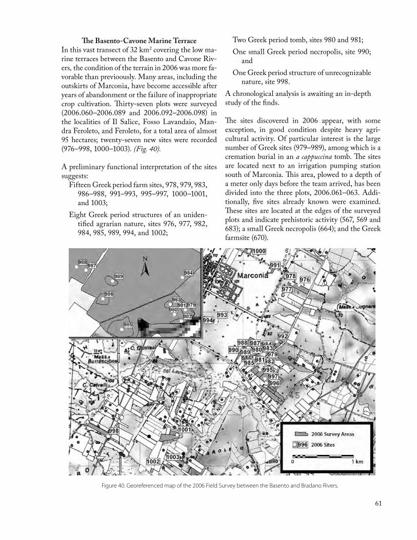
61
The Basento-Cavone Marine Terrace In this vast transect of 32 km2 covering the low ma-rine terraces between the Basento and Cavone Riv-ers, the condition of the terrain in 2006 was more fa-vorable than previoously. Many areas, including the outskirts of Marconia, have become accessible after years of abandonment or the failure of inappropriate crop cultivation. Thirty-seven plots were surveyed (2006.060–2006.089 and 2006.092–2006.098) in the localities of Il Salice, Fosso Lavandaio, Man-dra Feroleto, and Feroleto, for a total area of almost 95 hectares; twenty-seven new sites were recorded (976–998, 1000–1003). (Fig. 40).
A preliminary functional interpretation of the sites suggests:
Fifteen Greek period farm sites, 978, 979, 983, 986–988, 991–993, 995–997, 1000–1001, and 1003;
Eight Greek period structures of an uniden-tified agrarian nature, sites 976, 977, 982, 984, 985, 989, 994, and 1002;
Two Greek period tomb, sites 980 and 981; One small Greek period necropolis, site 990;
andOne Greek period structure of unrecognizable
nature, site 998. A chronological analysis is awaiting an in-depth study of the finds.
The sites discovered in 2006 appear, with some exception, in good condition despite heavy agri-cultural activity. Of particular interest is the large number of Greek sites (979–989), among which is a cremation burial in an a cappuccina tomb. The sites are located next to an irrigation pumping station south of Marconia. This area, plowed to a depth of a meter only days before the team arrived, has been divided into the three plots, 2006.061–063. Addi-tionally, five sites already known were examined. These sites are located at the edges of the surveyed plots and indicate prehistoric activity (567, 569 and 683); a small Greek necropolis (664); and the Greek farmsite (670).
Figure 40. Georeferenced map of the 2006 Field Survey between the Basento and Bradano Rivers.

62
For the 2006 season both of ICA’s geophysical in-struments, the Geoscan FM-36 fluxgate gradiom-eter and RM-15 resistance meter, were transported to Metaponto for evaluation of their potential con-tribution to the documentation of familiar features. The FM-36 had been used in the 2003 geophysical prospection campaign to document Iron Age pits and Greek farmhouses with promising results (see the contribution by Dan Davis in the 2003 Annual Report), but those results had been obtained using high-resolution, labor-intensive settings that lim-ited productivity in the field. The aim of the 2006 campaign was to test the low- and medium-resolu-tion settings of the FM-36, as well as those of the RM-15, on relatively obvious and easily detectable targets, Greek farmhouses and “division line” seg-ments, with the hope of determining whether great-er productivity could be gained via adjustment of the field methods.
Geophysical prospection of a sample of well-pre-served farmhouses has the potential to add more data to the discussion of farmhouse architecture and functionality at relatively low cost—an insignificant cost when compared to traditional excavation—in time for the publication of the farmhouses excavated by ICA between 1979 and 1981, which is currently in progress. The prospection of the division lines follows a research proposal outlined by the author in his 2005 PhD dissertation at UT: if the geophysi-cal instruments can in fact detect the division lines (which were discovered via aerial photography but have never been assayed with geophysics), as deter-mined by investigation of areas where their exist-
ence has been demonstrated by aerial photography or excavation, then the technique has the potential to add important new information by proving or disproving their existence in places where they do not appear in the aerial photographs.
The three-week campaign investigated three Greek farmhouses between Bradano and Cavone (Sites 296, 320, and 860) which, based on their prior documentation in the field survey and their current condition, appeared to be particularly large, artifact-rich, and potentially intact below the surface. Four segments of division line features were investigated between Bradano and Basento. Although the data still awaits final processing and formal presentation, preliminary processing and evaluation nevertheless have provided useful feedback. The resistance me-ter was found to be often unusable because of poor soil conditions (especially in moderately and deeply plowed fields, where the two metal probes cannot easily make contact with the ground to pass the electrical current), but it is able to detect the division lines clearly with even low resolution; it is largely indifferent to farmhouse foundations. The fluxgate gradiometer, on the other hand, is unable to dif-ferentiate the division lines from the surrounding soil matrix but can image farmhouse foundations, albeit only at high resolution (i.e., maximum 25-cm sample interval between measurements)—sample intervals of 1.0 m and 50 cm provide poor results, presumably because the stone foundations have a magnetic response that is only marginally stronger than that of the surrounding soil.
Geophysical Survey, Metaponto 2006Albert Prieto
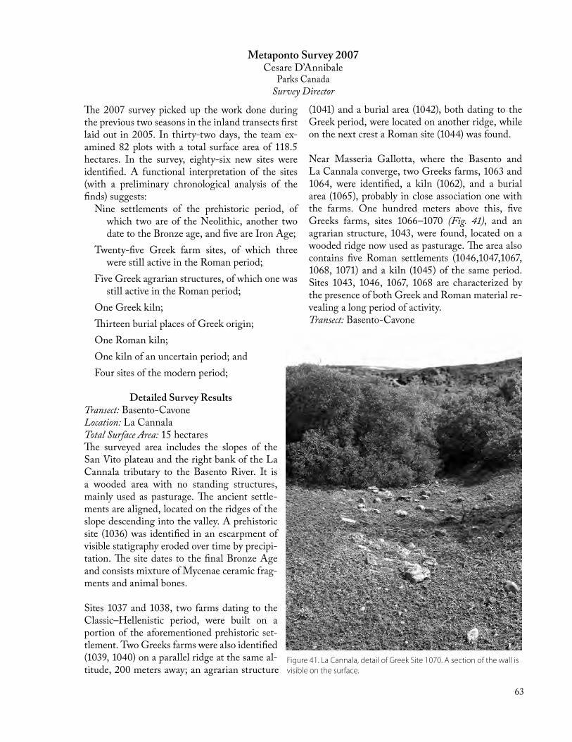
63
Metaponto Survey 2007Cesare D’Annibale
Parks CanadaSurvey Director
The 2007 survey picked up the work done during the previous two seasons in the inland transects first laid out in 2005. In thirty-two days, the team ex-amined 82 plots with a total surface area of 118.5 hectares. In the survey, eighty-six new sites were identified. A functional interpretation of the sites (with a preliminary chronological analysis of the finds) suggests:
Nine settlements of the prehistoric period, of which two are of the Neolithic, another two date to the Bronze age, and five are Iron Age;
Twenty-five Greek farm sites, of which three were still active in the Roman period;
Five Greek agrarian structures, of which one was still active in the Roman period;
One Greek kiln;Thirteen burial places of Greek origin;One Roman kiln;One kiln of an uncertain period; andFour sites of the modern period;
Detailed Survey ResultsTransect: Basento-Cavone Location: La Cannala Total Surface Area: 15 hectaresThe surveyed area includes the slopes of the San Vito plateau and the right bank of the La Cannala tributary to the Basento River. It is a wooded area with no standing structures, mainly used as pasturage. The ancient settle-ments are aligned, located on the ridges of the slope descending into the valley. A prehistoric site (1036) was identified in an escarpment of visible statigraphy eroded over time by precipi-tation. The site dates to the final Bronze Age and consists mixture of Mycenae ceramic frag-ments and animal bones.
Sites 1037 and 1038, two farms dating to the Classic–Hellenistic period, were built on a portion of the aforementioned prehistoric set-tlement. Two Greeks farms were also identified (1039, 1040) on a parallel ridge at the same al-titude, 200 meters away; an agrarian structure
(1041) and a burial area (1042), both dating to the Greek period, were located on another ridge, while on the next crest a Roman site (1044) was found. Near Masseria Gallotta, where the Basento and La Cannala converge, two Greeks farms, 1063 and 1064, were identified, a kiln (1062), and a burial area (1065), probably in close association one with the farms. One hundred meters above this, five Greeks farms, sites 1066–1070 (Fig. 41), and an agrarian structure, 1043, were found, located on a wooded ridge now used as pasturage. The area also contains five Roman settlements (1046,1047,1067, 1068, 1071) and a kiln (1045) of the same period. Sites 1043, 1046, 1067, 1068 are characterized by the presence of both Greek and Roman material re-vealing a long period of activity.Transect: Basento-Cavone
Figure 41. La Cannala, detail of Greek Site 1070. A section of the wall is visible on the surface.

64
Location: Cozzo Presepe Total Surface Area: 25 hectaresThe surveyed area relates to that portion of the pla-teau heading north toward Cozzo Presepe. Near-by, in the locality of Madonna del Vetrano, a large Greek farmhouse, 1077, was found. Two hundred meters from this site, three other farmhouses were discovered (1018, 1019, 1021). They were aligned at hundred-meter intervals from one another. In the proximity of the last farmhouse, was a kiln (1020). About 450 meters northeast, toward Casa Russo, is located the last Greek farm of the area (1017). In between site 1018 and 1017, a number of burial ar-eas were recognized, suggesting that the area was an extensive necropolis.
In some sites fragments of calcareous stone were recovered (1023–26, 1075, 1076). Northeast toward Cozzo Presepe along the edge of the plateau, three agrarian structures of the Greek period (1013–15), as well as a two burial areas (1016, were found. Near Madonna del Vetrano, eight Roman sites were dis-covered (1078–85). These probably belonged to a small rural village; some agrarian structures of the same period were also discovered in the area (1014, 1015, 1022).
Transect: Transect 1 (northernmost, Bradano side) Location: Santa Croce Total Surface Area: 22 hectaresAlong the south east ridge of the slope, closer to the modern village of Pomarico, two prehistoric sites appeared. One site, 1027, dates to the Bronze age, while the second, 1028, is Neolithic; from the first site it is possible to observe the statigraphy of the terrain, as it is located in an escarpment at the edges of the main road.
Serra Santa Croce–Serra San LorenzoThe Serra Santa Croce–Serra San Lorenzo area con-sists of a series of sloping terraces descending south-east from the plateau toward the Bradano River. The material retrieved mostly dates to the Roman period, with sporadic traces of an Iron Age occupa-tion. The sites were localized and grouped in two separate areas; the first, Serra Santa Croce, contains four small agrarian structures, 1029,1057, 1058, and 1059; the second, Serra San Lorenzo, had four simi-lar settlements, 1086–89 (Fig. 42).
Transect: Transect 2 Location: Cozzo Parlante Total Surface Area: 26 hectaresThe area surveyed relates to that portion of the pla-teau descending toward the Bradano River, with
Figure 42. Serra San Lorenzo, sites 1086–89, small, agrarian structures with traces of Iron Age and Roman-period occupation.

65
slopes characterized by ample terraces in elevation ranging from 200 to 390 meters above sea level. The surface can be divided into two areas: Mase-ria Castellano (Front cover), site 1049, with ruins of recent date, and Casa Laterza (Fig. 43), with ruins of a small Roman period village, sites 1052–56 and 1073–74. Near these sites is Masseria Castellano with five small indigenous sites, 1030–34, appar-ently an Iron age village.
ImperatoreThe surveyed area lies on the flat section of the pla-teau. A Greek farm, 1051, and a burial area, 1050, were identified. Between the two of transects, two sites were located near Iazzo Sivilia: a Greek farm, 1035, probably active from the Archaic to the Hel-lenistic period, and two modern engraved stones used to delimitate the area, 1054.
Transect: Transect 3Location: Tempe Rosse Total Surface Area: 1 hectaresThe surveyed area encompasses the edge of the plateau that overlooks the valley of the Fosso della Cannala to the west. A Greek farm, 1022, presum-ably in operation from the archaic to the classic pe-riod was located in this area together with a small agrarian structure of the same period (1011).
Figure 43. Casa Laterza. A small Roman-period village was found here. The city of Montescaglioso lies on the ridge at left.
Cassa Mesola del FinocchioThe surveyed terrain covers the portion of the area that descends from the plateau, with ample terraces, toward the valley of Fosso della Cannala. The high-est point in this area is 333 meters above sea level. Down the slope, at 260 meters, appeared a small Neolithic settlement, 1004, two small archaic farms with colonial Greek material, 1006 and 1008, a large farm in operation until the Hellenistic period, 1007, a burial area dating to the Greek period, 1005, and a trough from the present, 1009.
GaudellaThis surveyed area is located at the extreme of the plateau to the west, looking in the direction of Fosso della Cannala. In the area, three Greek farms, 1060, 1061, and1072, were in evidence. Two of them, 1060 and 1061, were likely associated, since the distancethat separates them is a mere 70 meters.
Transect: Transect 5 (southern-most, Basento side)Location: Trincinaro Total Surface Area: 2.5 hectaresThe terrain here is predominantly clay and it is lo-cated at the northeast of the Basento Valley. The ruins of an agrarian structure of the modern period were found.

66
Croton Survey 2006–2007Joseph Carter
In 2006–07, the Institute of Classical Archeology conducted its sixth and seventh field surveys in the Marchesato, the archeological area on the peninsula south of Crotone (ancient Croton), that includes the promontory of Capo Colonna with its Pantel-lenic Sanctuary of Hera and the promontory of Isola Capo Rizzuto. This was one of two principal areas of the chora of the Greek colony of Croton, the oth-er being the Neto valley, north of Crotone.
The Croton survey was begun in 1983 with the expressed purpose of removing doubt that the in-tensive settlement of Metaponto’s chora—with its myriad farmhouses, necropoleis, and numerous sanctuaries—was a unique phenomenon. The first season soon revealed a parallel situation, but with some interesting variation. The prehistoric period was much more in evidence, and many of the pot-tery assemblages recovered from sites that could be identified as Greek settlements had large prehistoric components. Similarly the Late Roman–Early Me-dieval periods, were much in evidence, in contrast to Metaponto.
The Croton and Metaponto survey provide a unique and highly detailed picture of life over many mil-lennia in areas that would become famous centers of Greek civilization in the south of Italy. These are now no longer seen in isolation but as part of the historical continuum.
In the first phase of the survey (1983–1986), the study area was divided into one-kilometer squares, a sample of which was randomly chosen for repre-sentative coverage. The grid stretched from Capo Colonna at the northeast to the Dragone River at the southwest. For each major period of occupation (from pre-history to the Middle Ages) twenty-eight squares were randomly selected to assess the nature of settlement. Each square was examined within the limits allowed by conditions of the terrain. Ad-ditionally, the area of Capo Colonna was surveyed in its entirety because of its exceptional historical interest. In the four field surveys, the project exam-ined 32 km2 of territory and documented 457 sites.The second phase of the survey was launched in 2005. It provided more extensive coverage with three large transects of 6–7 km each. These new transects provided a sample of continuous coverage over the full range of topographic and geomorpho-logical units in the landscape. Two transects are ori-ented horizontally, one from the Dragone to Capo Cimiti, the other from the Vattiato locality to Cam-pione locality. One transect runs vertically from the Micesi locality to Capo Rizzuto (see page 62, top). The three transects were appropriately designed to make use of the largest number of existing squares (with a minimum of three). In the course of the sur-vey, each square in the transects will be examined.
The methodology employed in the survey is essen-tially the same as the team used in the first phase as well as in the Metaponto surveys (see p. 56).

67
Capo Colonna. View of the Torre Lucifero promontory, loation of Bronze Age sites.
Georeferenced map of ICA field surveys in the Marchesato area (south of Crotone) through 2007.

68
Retouched Paleolithic point, rhyolite. Croton Survey Site 503. [1:2]
Late Neolithic trapezoidal bladlet, obsidian. Croton Survey Site 370. [1:1]
Stentinello Culture (Late Neolithic) ceramic bowl rim. Croton Survey Site 313. [1:2]
Black gloss skyphos base, Classical, 5th c BC. Croton Survey Farmstead Site 96. [1:1]
Terra Sigillata Italica cup base [1:2] with maker’s stamp, above left [1:1]. Early Imperial Roman. Croton Survey Farmstead Site 159.
Polychrome amphora handle effigy, post-Medieval, 18th c. Croton Survey Site 58. [H: 5 cm]
Terracotta female figurine head, Classical, 5th c BC. Croton Survey Farmstead Site 203. [1:1]
Polychrome bowl base, Medieval, 13th–15th c. Croton Survey Farmstead Site 56. [1:2]

69
Croton 2006Albert Prieto
Survey Director
Between September 4th and 14th, the team examined 27 plots for a total surface of 50 hectares (0.5 km2) in which 11 new sites were recorded. Additional-ly, Site 237 was revisited. (The plots are numbered 2005.001–2005.027 and the sites are numbered 479–489. See Fig. 3 and 6.). The field surveys took place exclusively in the upper horizontal transect. Only two plots (2006.026-027) were examined in the vertical transect, which is located in the Ronzino locality, about 4 km from the Island of Capo Rizzu-to; the only archeological presence recorded in that area was Site 237, a Greek farmhouse.A functional interpretation of the sites remains at a preliminary stage. More in-depth research must be carried out in preparation for the publications of the results (in-cluding typological chronological, functional, and statistical analyses of the recovered materials).
Villaggio Salica Area The Villaggio Salica area was briefly investigated at the end of the 2005 campaign and it was used as a springboard for the 2006 campaign. The area faces north and lies on the edge of barren slopes that overlook the city of Crotone. The area is character-ized by an elevated plain of considerable width. In this location, 16 micro-regions with a total surface area of 38 hectares have been examined (Fig. 44).
The area is subject to intensive mechanized farming (mainly maise, melons, eggplants, and wheat). As a result, the soil is ploughed at a depth of at least 70 cm, impacting the natural calcareous layer that lies at 70 cm below the surface. The disturbed state of the landscape and the almost constant presence of fragments of calcareous stone on the surface have obscured the archeological status of the area
All the sites investigated in 2006, ranging in date from prehistoric to the Greek periods, have been extensively disturbed in recent years. As a conse-quence, the physical dispersion of the finds and the visual interference caused by the calcareous frag-ments made recovering any evidence of rural life in the area extremely challenging (Fig. 45). Numerous sites were damaged by this modern agricultural ac-tivity- especially prehistoric settlements and activity areas-to the extent they can no longer be considered sites. Nonetheless they produced a large number of finds, for example the prehistoric materials in the plot 2006.003 and the remains of a Greek farm-house scattered in plot 2006.01.0. Of the 7 sites identified in the locality of Villaggio Salica (479-485) there are:
Four farmhouses of Greek origin (479, 480, 482, 484);
Three Greek period structures of unspecified agrarian characteristics (48, 483, 485).
Figure 44. Georeferenced map of field surveys near Villaggio Salica.

70
Figure 46. Georeferenced map of field surveys near Villaggio Sant’Andrea.
Two areas above the Perrotta torrent, to the east of Villaggio Salica, were surveyed in order to test an area obviously less suitable to agricultural set-tlement. The survey discovered only a few badly damaged fragments of pottery, which probably had washed down from a more populated location.
Location: Sant’Andrea In the Sant’Andrea locality, about 2 km west of Vil-laggio Salica, 9 plots were examined. The plots had a
Figure 45. Calcareous rock plowed up from layer ca. 70 cm below the surface makes surveying the terrain difficult.
total area of 11 hectares (Fig. 45) sown with annual crops. The archeological condition of Sant’Andrea is similar to the one observed in Villaggio Salica: the sites, numerous and well preserved until ten years ago, are now in disarray. The few identified sites represent a small fraction of the original number.
The area, belonging to a single landowner, is locat-ed east of the plot 2006.022. ICA investigated the area in the 1980s. Currently, the owner is building a conference center. He previously created a farm that produces fruit, vegetables and buffalo milk. The farm is located west of the plots 2006.018 and 2006.024. These changes seriously reduced the team’s ability to investigate the area freely. The area nonetheless is promising and we hope to return at a later date. The four sites in locality Saint Andrea are:
One farmhouse of the Greek period (488) Two undetermined structures of the Greek pe-
riod (486, 487); One structure, post-medieval, likely a house
or a farmhouse of which parts are still pre-served in dry-stacked rocks (489).

71
Croton Survey 2007Cesare D’Annibale
Survey Director
The area covered by the two fields survey, that took place during the months of July and September, 2007, encompassed 29 fields for a total surface area of 56 hectares. From the entire area, sixty-one sites were identified, dated, localized and delimited:
Bronze Age: 4 sites;Greek period: 6 farms, 16 agrarian struc-
tures, 7 burial areas, 1 quarry, 1 sanctu-ary;
Roman period: 5 farms, 8 agrarian struc-tures, 1 burial area;
Late Antiquity period: 3 farms, 8 agrarian structure, 1 burial area;
Modern Age: 1 kiln, 8 agrarian structure;Non-datable: 1 kiln, two quarries.
Location: Sant’Anna, Lago S. AnnaTotal Surface Area: 7 hectaresThe surveyed area extends from the peak of the plateau Marchesato to the slopes and terraces that descend from the promontory into the Vallone della Vozza. On two different terraces of the escarpment, near modern springs, two prehistoric sites dating to the Bronze Age were located (499–500). The scar-city of impasto pottery on both sites confirms a lim-ited use of the settlement.
Unusually numerous traces of Greek occupation were located on the flat edge of the plateau (Piano del Lago). Nine sites were located in this area: two farms, (493 and 498) six small agrarian structures (490–494, 496–497) and a burial area (495). The
Figure 47. Capo Colonna. A quarry site, probably the source of column stones for the nearby Sanctuary of Hera.

72
two farms, separated by the burial area, are 160 me-ters apart. They are both close to the current water source located in a terrace immediately below the summit of the plateau. The farms and the burial area date back to the archaic period. Only site 498 reveals continuous activity that stretches to the Ro-man Republican period.
Location: Cutro, Locality CeramedaTotal Surface Area: 8 hectaresThe area is characterized by the presence of exposed clay slopes with the Dragone River to the west. Given the instable nature of the terrain that would impede habitation, no signs of past human presence were noted.
Location: Villaggio Rosito, Locality PorcileTotal Surface Area: 8 hectaresThe area surveyed encompasses the outermost por-tion of the plateau and the adjacent area of the slope that joins the valley of Iannici. At the edge of the sloping plain, a farm (506) and an agrarian structure (503) were identified. They are 110 meters apart. Both date to the Archaic period and were ac-tive well into the Roman period. Site 502, located immediately below the aforementioned settlements and near a water source, included a typical kiln with slag on the surface. It is hard to define, with cer-tainty, the period of usage. Sites 501, 504, and 505 belong to a rural complex dating to the 19th century. They consist of ruins of an agrarian dwelling, a pig-sty and a well.
Location: Capo Colonna, Torre LuciferoTotal Surface Area: 4 hectaresThe surveyed area consists of the portion of coast between the baronial Casa Scifo and Torre Lucifero. The area is of great archeolog-ical relevance since much prehistorical mate-rial was found both below Torre Lucifero and along the escarpment. The findings date to the Bronze Age and mainly consist of impasto pottery fragments of daub, remains of mill-stones, and two fragments of copper, one raw and one finished (see page 62, bottom). Along the slope are the apparent ruins of walls dat-ing to the same period.
South of the prehistoric settlement, a quarry, site 517, (Fig. 47) was identified, now recognized as a source of calcareous stone used for making columns and blocks almost certainly employed in the nearby Sanctuary of Hera. Near Torre Lucifero, different materials were recovered, among them the frag-ments of votive cups. These finds presuppose the existence of a small sanctuary of the archaic period (518). Finally, site 519, which corresponds to the in-habited complex of Casa Scifo, was delimited. The site includes the baronial dwelling, walls, an old structure used for animal breeding, a trough and a well.
Location: FratteTotal Surface area: 10.5 hectaresFratte consists of a vast marine terrace, above which the calcareous height of Fratte Nuove rise. In this area two agrarian structures of Greek construc-tion (513, 515) and a large quantity of Roman pe-riod artifacts were found. At about 90 meters to the south, another agrarian structure (512) was recov-ered whose origin and use was specifically Roman. On the same rise, two burial areas (508, 514) were found. The first area is of a great archeological rel-evance as Archaic Corinthian pottery was recovered here.
To the northeast of this site is a modern quarry. In the flat portion at the bottom of the aforementioned ridge, a modern site (507) consisting of a series of
Figure 48. Il Telegrafo, Site 520. One of three rock-dug tombs, probably of Greek or Roman period.
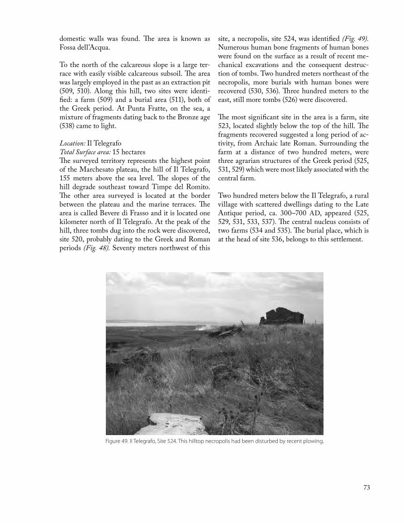
73
domestic walls was found. The area is known as Fossa dell’Acqua.
To the north of the calcareous slope is a large ter-race with easily visible calcareous subsoil. The area was largely employed in the past as an extraction pit (509, 510). Along this hill, two sites were identi-fied: a farm (509) and a burial area (511), both of the Greek period. At Punta Fratte, on the sea, a mixture of fragments dating back to the Bronze age (538) came to light.
Location: Il TelegrafoTotal Surface area: 15 hectaresThe surveyed territory represents the highest point of the Marchesato plateau, the hill of Il Telegrafo, 155 meters above the sea level. The slopes of the hill degrade southeast toward Timpe del Romito. The other area surveyed is located at the border between the plateau and the marine terraces. The area is called Bevere di Frasso and it is located one kilometer north of Il Telegrafo. At the peak of the hill, three tombs dug into the rock were discovered, site 520, probably dating to the Greek and Roman periods (Fig. 48). Seventy meters northwest of this
site, a necropolis, site 524, was identified (Fig. 49). Numerous human bone fragments of human bones were found on the surface as a result of recent me-chanical excavations and the consequent destruc-tion of tombs. Two hundred meters northeast of the necropolis, more burials with human bones were recovered (530, 536). Three hundred meters to the east, still more tombs (526) were discovered.
The most significant site in the area is a farm, site 523, located slightly below the top of the hill. The fragments recovered suggested a long period of ac-tivity, from Archaic late Roman. Surrounding the farm at a distance of two hundred meters, were three agrarian structures of the Greek period (525, 531, 529) which were most likely associated with the central farm.
Two hundred meters below the Il Telegrafo, a rural village with scattered dwellings dating to the Late Antique period, ca. 300–700 AD, appeared (525, 529, 531, 533, 537). The central nucleus consists of two farms (534 and 535). The burial place, which is at the head of site 536, belongs to this settlement.
Figure 49. Il Telegrafo, Site 524. This hilltop necropolis had been disturbed by recent plowing.

74
A semi-destroyed house of the modern period (512) is located on top of Il Telegrafo. Sloping down to-ward Timpe del Romito is a brickworks (528) and two agrarian structures (527, 532), the latter being near the Late Antique settlement. The area called Bevere di Fasso is characterized by the presence of Greek-origin settlements (541, 543, 545), the most important of which, 541, stands out for its dimen-sions and long period of activity (Fig. 50). The frag-
Figure 50. Bevere di Fasso, Site 541. Location of a large agricultural community dating from the Archaic Greek to late Roman periods.
ments recovered date this site from the Archaic Greek to the late Roman period. A conglom-eration of Roman-origin sites (544, 545, 546, 547), was found 230 meters from the large Greek-Roman farm (Fig. 51).
In the portion of flat terrain of Bevere di Fra-sso, a trough of modern date was located. Three hundred meters southwest, a rural village (542, 548, 549, 550) of Late Antique period was also identified. This village was characterized by the presence of a farm representing the nucleus of the settlement, and a series of dwellings scat-tered all around it.
Location: Villaggio SalicaTotal Surface area: 2 hectaresIn the area between the Marchesato and Tunolo
hill—from which Crotone is visible—an agrarian structure of the Greek-Roman period, site 540, was identified.
Location: Anastasi, Vallone VorgaThe area is part of the coast between the Capo Riz-zuto Island and Le Castella. Here a farm of the Ro-man period, site 539, was discovered.
Figure 51. Bevere di Fasso, Sites 544–547. A group of Roman sites, probably comprising a village, was found near the Greek-Roman farm, site 541 (Fig. 50).

75
The deep waters of the Black Sea, perhaps more than any other body of water on the planet, hold enormous promise for exciting archaeological dis-coveries. This is because the sea is uniquely stratified according to density and oxygen content. Down to 90 meters the sea resembles all others, but below that depth its waters become denser and less oxy-genated, such that by 180 meters the water is com-pletely lacking in dissolved oxygen. The result is an anoxic dead zone between that depth and 2,200 meters where there is hardly any life at all. Without the conditions necessary to support the organisms that typically feast on organics, there is an extraor-dinary preservation of cultural materials, including shipwrecks and the cargos they carried.
These conditions led oceanographer Willard Bas-com, in his book Deep Water, Ancient Ships (1976), to speculate on the existence of wonderfully preserved ancient wrecks at the bottom of the Black Sea. Bas-com’s ideas inspired renowned oceanographer and
Exploration and Excavation of Two Deepwater Wrecks in the Black SeaDan Davis
Institute of Classical Archaeology
explorer Dr. Robert Ballard—known best for his discovery of the Titanic—to embark on a series of deepwater surveys in the Black Sea off Turkey and Bulgaria beginning in 1999. By 2003 Ballard, head of the Institute of Archaeological Oceanography (IAO) at the University of Rhode Island (URI) and President of the non-profit Institute for Explora-tion, had several seasons of discoveries behind him, including a Hellenistic merchant ship off Bulgaria and four Late Roman and Early Byzantine ships off Sinop, Turkey. One of these, Sinop D, is a well-pre-served 5th to 6th-century Byzantine merchant ship found in the anoxic layer. In 2005 Ballard initiated a long-term collaboration with ICA and Ukraine’s Department of Underwa-ter Antiquities to explore the suboxic and anoxic layers of the Black Sea off southern Crimea in the search for shipwrecks associated with Chersonesos and Black Sea trade in all its historical phases. The Ukrainian team added their own research goals
Figure 1. Bathymetric map of the Black Sea. [Courtesy of the Institute of Archaeological Oceanography (IAO), University of Rhode Island]

76
of locating and investigating several noteworthy World II-era wrecks, including the Armenia, a So-viet hospital ship sunk by German aircraft off Yalta in November of 1941 while evacuating thousands of wounded soldiers from the battle at Sevastopol. The 2006 season included sonar surveys and target iden-tification resulting in several significant discoveries. The 2007 season concentrated on environmental monitoring and limited excavations of two ship-wrecks: the first, a small, 10th-century Byzantine merchant ship found during the 2006 season; the second, the Sinop D wreck found in 2000.
The 2006 Season In May a team of IAO, ICA and Ukrainian archae-ologists boarded URI’s Research Vessel Endeavor in Istanbul, made the crossing to southern Crimea, and began conducting a survey of the shelf, ledge, and slope of the seafloor between Chersonesos and Yalta (Fig. 1).
The first few days were spent towing (in lawn-mow-ing fashion) the sensor package Echo, a combined side-scan sonar and sub-bottom profiler. It acousti-cally mapped the bottom to reveal any anomalies that might be shipwrecks (Fig. 2). 650 square kil-ometers were surveyed and nearly 494 targets of interest compiled. The Hercules-Argus tandem ve-hicle system was then launched to investigate the most promising targets. The tow-sled Argus hangs from the stern of the ship on a long cable and uses thrusters to rotate the sled in order to aim its lights and cameras on the ROV Hercules. The workhorse Hercules is tethered to Argus, isolating it from the wave-generated heave (up-and-down motion) of the ship. This one-ton (but neutrally buoyant) electro-hydraulic robot moves by means of its thrusters and bristles with cameras, sonars, sensors, jets, vacuums and manipulators, all designed for exacting archae-ological work. Endeavor towed both vehicles from target to target.
A majority of the targets turned out to be geological formations whose sonar records closely re-sembled cultural features. In the end a total of ten manmade craft were discovered in wa-ters ranging from 100 to 1,650 meters. Nine of them date no earlier than the late nineteenth century: a ship tentatively iden-tified as the Russian pre-dread-nought battleship Ekaterina II (1888–1912, named after Cath-erine the Great), the cargo-ship Lenin (sunk in 1941), the Soviet Destroyer Dzherzynsky (sunk in 1942), two patrol boats, a barge,
Figure 2. Left: Echo, a deep-water tow body equipped with a sidescan sonar and subbottom profiler, being recovered on board R/V Endeavor. Middle: The optical tow sled Argus (pictured here on deck) is typically positioned below the stern of the ship and is equipped with attitude thrusters and high-definition video cameras for monitoring Hercules. Right: The remotely operated vehicle Hercules, here tooled for archaeological survey, is launched from R/V Endeavor. [Photos: Dan Davis]
Figure 3. Wreckage of a soviet military helicopter (Ka-25) discovered during the 2006 survey off Sevastopol. [Photo courtesy of IAO]
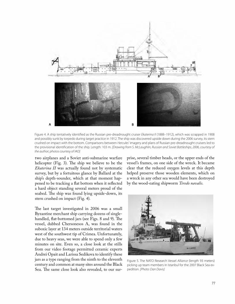
77
two airplanes and a Soviet anti-submarine warfare helicopter (Fig. 3). The ship we believe to be the Ekaterina II was actually found not by systematic survey, but by a fortuitous glance by Ballard at the ship’s depth-sounder, which at that moment hap-pened to be tracking a flat bottom when it reflected a hard object standing several meters proud of the seabed. The ship was found lying upside-down, its stern crushed on impact (Fig. 4). The last target investigated in 2006 was a small Byzantine merchant ship carrying dozens of single-handled, flat-bottomed jars (see Figs. 8 and 9). The vessel, dubbed Chersonesos A, was found in the suboxic layer at 134 meters outside territorial waters west of the southwest tip of Crimea. Unfortunately, due to heavy seas, we were able to spend only a few minutes on site. Even so, a close look at the stills from our video footage permitted ceramic experts Andrei Opait and Larissa Sedikova to identify these jars as a type ranging from the ninth to the eleventh century and common at many sites around the Black Sea. The same close look also revealed, to our sur-
prise, several timber heads, or the upper ends of the vessel’s frames, on one side of the wreck. It became clear that the reduced oxygen levels at this depth helped preserve those wooden elements, which on a wreck in any other sea would have been destroyed by the wood-eating shipworm Teredo navalis.
Figure 4. A ship tentatively identified as the Russian pre-dreadnought cruiser Ekaterina II (1888–1912), which was scrapped in 1908 and possibly sunk by torpedo during target practice in 1912. The ship was discovered upside down during the 2006 survey, its stern crushed on impact with the bottom. Comparisons between Hercules’ imagery and plans of Russian pre-dreadnought cruisers led to the provisional identification of the ship. Length: 103 m. [Drawing from S. McLaughlin, Russian and Soviet Battleships, 2006, courtesy of the author; photos courtesy of IAO]
Figure 5. The NATO Research Vessel Alliance (length 93 meters) picking up team members in Istanbul for the 2007 Black Sea ex-pedition. [Photo: Dan Davis]
BA

78
The 2007 SeasonIn August of 2007 ICA renewed its collaboration with Dr. Ballard and, along with his new deputy director, Dr. Bridget Buxton, returned to the Black Sea aboard the NATO Research Vessel Alliance (Fig. 5). Our goals were quite different from the year before. Whereas the 2006 season was oriented around sonar survey and target identification, 2007 included plans to conduct the first-ever deepwater excavations of two shipwrecks—Chersonesos A and Sinop D—to exacting archaeological standards us-ing remotely operated vehicles. This presented two major challenges. The first was technical. For two decades Ballard and his group have been develop-ing vehicle and imaging systems to conduct accurate archaeological surveys (acoustic and optical) down to full ocean depth. Their efforts paid off in the suc-cessful archaeological investigations of some eight ships found at Skerki Bank (between Sicily and Sar-dinia) beginning in 1989. Since then his team has engineered, and continues to develop, several tools that would facilitate excavations at and above stand-ards observed on shallow-water shipwreck excava-tions. The Argus-Hercules system is the culmination of those efforts. The second challenge was environmental. These two wrecks rest in environments quite unlike the Mediterranean where dissolved oxygen is rich and marine life plentiful throughout the water column,
conditions that result in sparse organic preservation. Chersonesos A (134 meters deep) lies in an interme-diate layer characterized by trace amounts of oxy-gen (suboxic) and hydrogen sulfide. Sinop D lies at a greater depth (325 meters) characterized by nearly completely anoxic conditions but with increasing levels of dissolved hydrogen sulfide (Fig. 6). The need for a scientific assessment of these complex hydro-chemical and sedimentary conditions was strongly felt, and so within our site management plans we developed sampling strategies and moni-toring techniques to learn more about the environ-ments in which these two wrecks lie. These include taking sedimentary cores around and within each wreck site and the use of artifact surrogates, some in the form of ‘kebabs’ which hold donuts of vari-ous species of wood, others in the form of weighted crates, or ‘twinkies,’ which contain samples of tex-tiles, metals and other materials (Fig. 7). The cores will be analyzed to determine site formation proc-esses using redox measurements and micromorpho-logical analysis. The kebabs and twinkies will be recovered at regular intervals to gauge the rates of microbial attack and the degree of wood hydration. The metals will be examined to determine their to-tal weight loss, as well as how their corrosion prod-ucts form. The results of all these experiments will then be used to aid in interpretation and long-term management of these two sites.
Figure 6. Schematic view of the Black Sea’s stratified layers showing the relative vertical positions of Chersonesos A and Sinop D. [Graphic: Dan Davis]

79
In addition to these vital oceanographic and con-servation issues we hoped to learn much about the two ships themselves: the technology behind their construction, the economies reflected in their car-goes, and their contexts within the rich backdrop of Byzantine history. These are considered just two of very few Byzantine wrecks found in the greater Mediterranean area, and the first to be systemati-cally documented and explored in the Black Sea.
Chersonesos A: Small Byzantine Trader from the 9th–11th centuries AD
Chersonesos A was the first site of the 2007 season. We quickly relocated the wreck, then set about cre-ating a photomosaic in order to obtain a pre-distur-bance record of its in situ remains. The wreck is ori-ented NE–SW on a level bottom composed mainly of beige surface sediment punctuated by white and dark sandy patches (Fig. 8). Two mounds of jars de-fine the wreck, with the northeasterly mound larger and slightly taller than the southwesterly. The total length of the visible remains was less than six me-ters. About eighty jars were visible initially, and that number rose to more than 200 by the end of our investigations. The jars themselves range between 40 and 51 cm in height and between 20 and 24 cm in width. All of them have a flat base and a single, elongated flat handle. The jars are of a type com-monly found at Byzantine sites around the shores of the Black Sea, including Chersonesos and one of the sites in its chora, Bezymyannaya (Fig. 9). As yet their place or places of manufacture have
not been identified, nor has this vessel type been studied comprehensively enough to distinguish sub-types. What they contained also remains a mystery, although wine is a possibility. One of the two jars recovered has what appears to be wax preserved near the mouth, presumably to seal a now-lost stopper; those found at Bezymyannaya were smeared with pitch. The jars are dated broadly to between the lat-ter half of the 9th and the end of the 11th centuries AD. To my knowledge this is the first wreck from antiquity to be found with this type of ceramic ves-sel as the main cargo. 23 jars and one amphora were tagged, mapped and then removed from the wreck to an off-site depot area for later recovery. The am-
Figure 7. Decay rate experiments (“twinkies” and “kebobs”) were deployed at both wreck sites in 2007 in order to understand site formation processes and to formulate new conservation strate-gies. [Image courtesy of IAO]
Figure 8. Predisturbance photomosaic of Chersonesos A (2007). [Image courtesy of IAO]

80
phora, found in Zone 1, is thought to have been the personal item of one of the crew members; since personal items were typically stored in the stern, its location suggests (but does not confirm) that this was the starboard side. Two jars were ultimately raised to the surface for sampling purposes and are currently undergoing conservation at the Ukrainian Department of Underwater Heritage in Kyiv.
What about the ship itself? One of the key ques-tions for scholars of ancient shipbuilding is how this vessel fits into the transition period in hull construc-tion. The 6th–11th centuries in the Mediterranean saw a dramatic shift in how shipbuilders designed and constructed vessels, from the labor- and mate-rial-intensive shell-first philosophy characterizing Greek and Roman ship building, to the frame-first method which required fewer materials and less specialized labor. Chersonesos A, it is hoped, will provide us with some crucial diagnostic informa-tion to help form a picture of Black Sea shipbuild-ing traditions–about which little of the pre-Otto-man period is known–and how they compare with Mediterranean traditions. Our brief investigation in 2007 gave us a glimpse at the potential this wreck holds for answering some of these questions.
The degree of wood preservation is striking. We already mentioned that several of the timber heads were visible in the 2006 survey, and they reappeared in the 2007 predisturbance mosaic. After map-ping, tagging and removing several jars from the site, we uncovered several more timber elements,
including more timber heads on the starboard side, side planking (strakes) and interior planks (ceiling planks) in Zones 3 and 5, possible deck plank-ing in the bow and stern, and what appears to be either a robust spar or wale. Despite their high degree of preservation, all of the timbers lack any of their original surfaces, either as a result of microbial attack or ship-worm (although there was very lit-tle evidence of their shell casings) or simple erosion. While we were unable to discern the type of joinery, we are certain that future seasons will yield some of this crucial information.
Figure 9. Jar AAB from Chersonesos A. Its find spot is marked on the wreck’s photomosaic (Fig. 8). [Photo courtesy of IAO]
Figure 10. Ukrainian President Yushchenko at the controls of ROV Hercules aboard the NATO research vessel Alliance, August 2007. [Photo courtesy of IAO]

81
Who may have owned the vessel? Surviving records from the medieval era strongly suggest that many, if not most, ships were owned by institutions, whether royal or ecclesiastical. Much of the contemporary evidence is found in the context of western and northern Europe. Patriarch Fortunatus of Grado (near Venice), for example, owned four ships that were exempt from tolls in Carolingian ports under Charlemagne, and he is recorded as having donated at least one of them to a monastery. The Bishop of Palermo in the early 9th century purportedly owned a ship that ranged as far as a Libyan port. Closer to our area, as one 9th-century saint’s biography relates, Black Sea coastal monasteries were known to receive merchant vessels, probably of ecclesiastical owner-ship. Could this vessel have been transporting wine from one monastery (such as one in Chersones) to another along the northern Black Sea coast? Or could it have been a boat belonging to a larger ship, such as the eight-meter long boat found accompa-nying the large 10th-century Agay ship found off southern France?
Clearly much more work remains to be done at Cher-sonesos A. With President Victor Yushchenko’s visit to the Alliance on the last day, we were assured fu-ture funding and equipment to continue our excava-tions, as well as to recover the hull for conservation, analysis and display (Fig. 10). Much of our analy-sis is ongoing, but for the moment we can say that the vessel was a small coastal trader manned by a small crew of perhaps three or four. It was carrying
Figure 11. ROV Hercules excavating the port side midships area of Sinop D. Note the pronounced forward rake of the mast and the low-visibility conditions caused by falling marine “snow.” [Photo courtesy of IAO]
Fig. 12. Predisturbance photomosaic of Sinop D, August 2007. [Photo courtesy of IAO; schematization by Dan Davis]
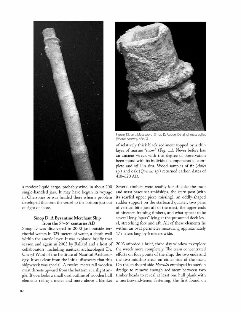
82
a modest liquid cargo, probably wine, in about 200 single-handled jars. It may have begun its voyage in Chersones or was headed there when a problem developed that sent the vessel to the bottom just out of sight of shore.
Sinop D: A Byzantine Merchant Ship from the 5th–6th centuries AD
Sinop D was discovered in 2000 just outside ter-ritorial waters in 325 meters of water, a depth well within the anoxic layer. It was explored briefly that season and again in 2003 by Ballard and a host of collaborators, including nautical archaeologist Dr. Cheryl Ward of the Institute of Nautical Archaeol-ogy. It was clear from the initial discovery that this shipwreck was special. A twelve-meter tall wooden mast thrusts upward from the bottom at a slight an-gle. It overlooks a small oval outline of wooden hull elements rising a meter and more above a blanket
of relatively thick black sediment topped by a thin layer of marine “snow” (Fig. 11). Never before has an ancient wreck with this degree of preservation been found with its individual components so com-plete and still in situ. Wood samples of fir (Abies sp.) and oak (Quercus sp.) returned carbon dates of 410–520 AD.
Several timbers were readily identifiable: the mast and mast brace set amidships, the stern post (with its scarfed upper piece missing), an oddly-shaped rudder support on the starboard quarter, two pairs of vertical bitts just aft of the mast, the upper ends of nineteen framing timbers, and what appear to be several long “spars” lying at the presumed deck lev-el, stretching fore and aft. All of these elements lie within an oval perimeter measuring approximately 17 meters long by 6 meters wide.
2003 afforded a brief, three-day window to explore the wreck more completely. The team concentrated efforts on four points of the ship: the two ends and the two midship areas on either side of the mast. On the starboard side Hercules employed its suction dredge to remove enough sediment between two timber heads to reveal at least one hull plank with a mortise-and-tenon fastening, the first found on
Figure 13. Left: Mast top of Sinop D. Above: Detail of mast collar. [Photos courtesy of IAO]

83
the wreck. This was followed by limited excavations around the stern post, then around the port mid-ships area where a transverse beam broke the sedi-ment surface. Here enough overburden was removed forward of the beam to reveal seven small transport amphoras stowed just as they were the day the ship sailed. Three of these, of the Demirci kiln type like-ly made near Sinop, were recovered to the surface and transported to the museum there for conserva-tion and study. Finally, the stempost was found at a depth of about 1 m, its upper timber, like that at the stern, presumably torn off during its sinking.
Despite these explorations, there remained several unanswered questions about the wreck: How was its hull constructed? Why is there very little evidence of hull planking? Was it a lateen-rigged vessel or a classic square-sailer? What kind of cargo was it carrying? How do these unusual bottom conditions affect its preservation?
The 2007 season was designed to obtain answers to at least some of these questions. Unfortunately, be-fore we arrived on site problems developed in the ship’s bow thruster, a critical component of the dy-namic positioning system which holds the ship sta-tionary in the water. The time spent in transiting to the Bosporus and waiting for the return of a fixed unit consumed much of our planned bottom time.
Once Alliance was running again, we set to work relocating the wreck site, planting the monitoring
and conservation experiments, taking several sedi-ment cores, then placing an artifact storage rack off site. This was followed by a survey of the entire site to derive a georeferenced photomosaic and micro-bathymetry map (Fig. 12). We then put Hercules’ suction dredge to work removing top sediments at several points around the site. We began first in the starboard bow and stempost area where several more timber heads and a stout plank were uncovered. We then located on the starboard side the opposite end of the transverse timber uncovered on the port side in 2003. Like the port end, it, too, revealed little information about the construction of the ship; the only plank located in this vicinity was that excavated and sampled during the 2003 season. We exposed more of the ship on the port side and stern area us-ing Hercules’ silt prop to remove top sediments gen-tly, layer by layer, and made a foray to the top of the mast to investigate the mortise and the apparent rope collar documented from a distance in 2000 and 2003 (Fig. 13). With time running out, we attempted to trace the outline of a long “spar” (labeled U6 in Fig. 12), roughly circular in cross-section, lying on the star-board quarter (Fig. 14). This turned out to be one of the most enigmatic timbers on the site. A flat, semicircular tongue was hewn on the inboard end and pierced by a small square hole. It extends aft toward the large rudder support, then continues un-der the seabed as it stretches outboard of the ship for a distance of several meters. We ran out of time
Figure 14. Forward end of unidentified timber U6 on the starboard quarter (labeled in photomosaic, Fig. 12). The two dots (circled) are Hercules’ laser line scale with a 10 cm spacing. [Image courtesy of IAO]

84
before reaching the end. Remarkably it maintains its diameter of ca. 30 cm along its entire exposed length. The function of U6 remains a puzzle. Was it a spar for a lateen-rigged vessel? It seems too heavy and bulky for that, and the square hole on its inboard end suggests that it was not designed to pivot around a pin in any way. Perhaps it served as an auxiliary mast, such as a slanting foremast that carried a foresail (artemon) on the classic, square-rigged ships of Greek and Roman antiquity. If so, its findspot could be explained by the ship’s violent wrecking event, during which rigging, yards, sail, and other elements would have become entangled and displaced on the way down to the seabed and on impact with the bottom (a scenario that may also explain how the upper side-planks appear to have sprung off). Sinop D has yet to reveal many secrets. Indeed, after three seasons on the wreck (amounting to about nine days), we are still unable to answer several questions with regard to the type of hull construction, the type of rigging (lateener or square-sail) and the con-tents of the hold (aside from seven small transport amphoras). The primary obstacle to answering these
questions lies in the great quantity of sediment in which the ship is buried. Its careful removal is pos-sible, but it is also time-consuming, so several more days and weeks are required to make any significant headway. Analyses of the sediments recovered in the cores are ongoing, and the conservation experi-ments promise to return an enormous amount of data with which to help manage future projects and create conservation protocols. As at Chersonesos A, much more work remains to be done.
With these two seasons of collaboration, ICA has extended its investigations to encompass the mari-time sphere profoundly influencing the economic vitality of Chersonesos and its chora in all its histor-ical phases. Three more seasons have been planned among all the collaborators. 2008 calls for a brief return to Chersonesos A and Sinop D to collect the one-year experiments, followed by an acoustic sur-vey of the southern Crimean shore in the search for more wrecks (including the Armenia) employing an autonomous underwater vehicle and a smaller ROV. More excavations on both wrecks are planned for 2009 and 2010.

85
Chersonesos 2006Fieldwork
Joseph Coleman Carter, Director, ICA, UT AustinAdam Rabinowitz, Assistant Director, ICA, and Classics, UT Austin
Chersonesos CoordinatorsTaissa Bushnell, Coordinator, ICA, and Director, Pidtrymka Chersonesu
Marina Krotova, Administrator, ICAKyiv Coordinator & Translator
Svetlana Telenkova
National Preserve of Tauric ChersonesosLeonid Marchenko, General Director
Galina Nikolaenko, Deputy Director for ResearchLarissa Sedikova, Deputy Director for Conservation
Ludmila Grinenko, Head LibrarianNonna Krasovskaya, Head Archivist
Stanislav Ryzhov, Head of Architecture & ArchaeologyTatiana Yashaeva, Head of Medieval DepartmentInga Shvedova, Head of Conservation Laboratory
Nikolai Alekseenko, Head of Cembalo & Kalamita BranchOleg Savelya, Deputy Director for Protection of Outlying Monument
Excavation-Ancient CityLarissa Sedikova, NPTCAdam Rabinowitz, ICA
(Co-directors)
Gordana Karovič, Assistant field directorLea Cline, Trench supervisorDmitry Davydov, Trench supervisorAleksandr Kuzmin, Trench supervisorShawn Marceaux, Trench supervisorAnton Smirnov, Trench supervisorRoger Sharp, RegistrarJessica Nowlin, Digitization and surveyAllison McDavid, Site architect
Caitlin Allday, StudentKarissa Basse, VolunteerIshan Chakrabarti, StudentEmily Curtin, VolunteerDmitriy Moiseev, StudentOlga Ivanova, StudentKhrystyna Klyuba, StudentAnton Makarevich, StudentYuriy Pugolovok, StudentStine Schierup, VolunteerIrina Fadeeva, Translator
Students and VolunteersField Staff
Architects-Chora ParkHope Hasbrouck, UT Austin
Scott BiehleSteve Ross
Survey and GISStuart Eve, L – P : Archaeology, London
Jessica Trelogan, ICA(Co-directors)
William Flint Dibble
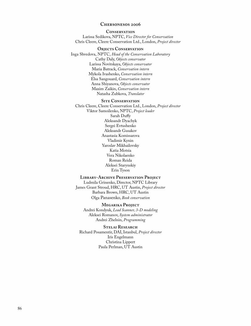
86
Chersonesos 2006Conservation
Larissa Sedikova, NPTC, Vice Director for ConservationChris Cleere, Cleere Conservation Ltd., London, Project director
Objects ConservationInga Shvedova, NPTC, Head of the Conservation Laboratory
Cathy Daly, Objects conservatorLarissa Novitskaya, Objects conservator
Maria Batrack, Conservation internMykola Ivashenko, Conservation intern
Elsa Sangouard, Conservation internAnna Shiyanova, Objects conservatorMaxim Zaikin, Conservation intern
Natasha Zubkova, Translator
Site ConservationChris Cleere, Cleere Conservation Ltd., London, Project director
Viktor Samoilenko, NPTC, Project leaderSarah Duffy
Aleksandr DyachykSergei EvtushenkoAleksandr Gusakov
Anastasia KomissarovaVladimir Kynin
Yaroslav MikhailovskyKatia Motsia
Vera NikolaenkoRoman Reida
Aleksei StarynskiyErin Tyson
Library-Archive Preservation ProjectLudmila Grinenko, Director, NPTC Library
James Grant Stroud, HRC, UT Austin, Project directorBarbara Brown, HRC, UT Austin
Olga Panasenko, Book conservation
Megarika ProjectAndrei Kondyuk, Lead Scanner, 3-D modeling
Aleksei Romanov, System administratorAndrei Zhelnin, Programming
Stelai ResearchRichard Posamentir, DAI, Istanbul, Project director
Iris EngelmannChristina Lippert
Paula Perlman, UT Austin

87
Chersonesos 2006
Ceramics AnalysisJoanita Vroom, University of Sheffield
Anna SmokotinaYuriy Utrobin, Assistant
Glass AnalysisLarissa Golofast, Moscow
Architectural AnalysisKostis Kourelis, Clemson University
ArchaeometallurgyChristopher Salter, Materials Archaeology Group, Oxford University
ZooarchaeologyAleksey Kasparov, Institute of History of Material Culture, St. Petersburg
Oleg Zhuravlev, Institute of Archaeology, National Academy of Sciences of Ukraine, KyivAnton Ervynck, University of Ghent
Wim Van Neer, Katholieke Universiteit LeuvenNatalia Rashevskaya, Assistant
Yuliya Miroshnichenko, Translator Karina Yakimets, Translator
PaleobotanyGalina Pashkevich, Institute of Archaeology, National Academy of Sciences of Ukraine, Kyiv
Lorenzo Costantini, Museo d’Arte Orientale, RomeMatteo Delle Donne
Giuseppe Lami, PhotographerLesya Kirichenko, Assistant
Physical AnthropologyRenata Henneberg, Department of Anatomical Sciences, University of Adelaide, Australia
Emily Rose McLachlan, Assistant
Objects AnalysisCamilla MacKay, Bryn Mawr College
Olga Andreeva, NPTCIrina Don, NPTC
Artifact PhotographyChris Williams, ICA
Iris Engelmann
IllustrationValerie Woelfel
Publications-Chora ParkInna Shtakser, Ph. D. , Lecturer, UT History
Logistical SupportMarina Krotova
Svetlana TelenkovaSergi Kosseykin
Vassiliy Kirichenko

88
Chersonesos 2007Study Season
Joseph Coleman Carter, Director, ICA, UT AustinAdam Rabinowitz, Assistant Director, ICA and Classics, UT Austin
Chersonesos CoordinatorsTaissa Bushnell, On-site Coordinator, ICA, and Director, Pidtrymka Chersonesu
Marina Krotova, On-site Administrator, ICA
Kyiv Coordinator & TranslatorSvetlana Telenkova
National Preserve of Tauric ChersonesosLeonid Marchenko, General Director
Galina Nikolaenko, Deputy Director for ResearchLarissa Sedikova, Deputy Director for Conservation
Ludmila Grinenko, Head LibrarianNonna Krasovskaya, Head Archivist
Stanislav Ryzhov, Head of Architecture & ArchaeologyTatiana Yashaeva, Head of Medieval DepartmentInga Shvedova, Head of Conservation Laboratory
Nikolai Alekseenko, Head of Cembalo & Kalamita BranchOleg Savelya, Deputy Director for Protection of Outlying Monuments
Excavation Publication StudiesOlga Andreeva, Finds analysisViktor Anokhin, NumismaticsIrina Don, Finds analysisVicki Ewens, ZooarchaeologyLarissa Golofast, Glass analysisKonstantinos Kourelis, Architecture Ludmila Kovalevskaya, Roman ceramicsCamilla MacKay, Finds analysisGalina Pashkevich, Paleobotany
Chris Salter, ArchaeometallurgyViktor Samoilenko, Tiles and tile stampsRoger Sharp, Finds analysisAnna Smokotina, CeramicsSvetlana Taikova, ZooarchaeologyYevgeniy Turovsky, Stamped amphora handlesJoanita Vroom, Byzantine ceramicsOleg Zhuravliov, Zooarchaeology
ConservationChristopher Cleere
Site ConservationDmitry DavydovSergi EvtushenkoFelix FilipenkoVladimir KhyninAleksander KuzminYaroslav Mikhailovsky
Katia MotsiaJulia Podol’skaiaRoman ReydaViktor SamoilenkoYuriy Zinchenko
Site PresentationErin TysonSarah Duffy
Objects ConservationInga ShvedovaLesia VasilinetćElens MelnikPetro Trotc

89
Chersonesos 2007
Survey-GIS-DatabaseStuart Eve, L – P : Archaeology, London
Jessica Trelogan, ICA
Architects-Chora ParkHope Hasbrouck, UT Austin, Instructor
Erin Leigh BernsteinCaroline CastelloThomas Elias CoxAshley Elizabeth HaganEli Pearson
Tyler Pierce PorterfieldTiffany PriceJane PuthaaroonChristine Trobenter
Kyiv-Mohyla AcademyVitaliy Zubar, InstructorNatalia Son, Instructor
Artem BorisovOlena DzneladzeIgor Kravchenko
Olena MakcimenkoOlena MelnikPetro Trotc
Archives Preservation-MegarikaLucy Grinenko, Director, NPTC Library
Nona Krasovskaya, Director, NPTC ArchivesChristian-Emil Ore Digial archives consultant
Zinaida AtayanNatalia BeskorovainayaNikita KhrapunovAndrei KondukAleksei Los´
Olga PanasenkoAleksei RomanovAleksandr SibirkoVika SibirkoViktoria Zhelnin
Stelai ResearchRichard Posamentir
Physical AnthropologyRenata J. Henneberg
Yaroslav Mikhailovsky, Assistant
IllustratrationValerie Woelfel
Olga Malinovskaya
PhotographyIris Engelmann
Logistical SuppoortMarina Krotova
Anastasia ZhorovaTranslation
Irina FadeevaEvgenia FominaLena Lukicheva
Yulia MiroshnichenkoKarina YakimetsNatasha Zubkova

90
AdministrationRosetta Torraco, Bernalda, Italy
Survey and Farmhouse ResearchCesare D’Annibale, Parks Canada, Lithics, Greek coarse ware
Gianna Ayala, University of Sheffield, Prehistoric potteryDr. Peter Dana, UT Austin, GIS and spatial analysis
Erminia Lapadula, University of Lecce, Roman and post-Roman ceramicsNayla Muntasser, UT Austin, Roman Ceramics
Cesare Raho, Photography and illustrationEloisa Vittoria, Greek ceramics
Field SurveysMetaponto
Cesare D’Annibale, Parks CanadaAlbert Prieto, ICA(Survey co-directors)
Michelle Belisle, UT AustinMaria Luisa D’Annibale
Angela Edwards, UT AustinEmily Hale, UT Austin
Micaela Obledo, UT AustinMelanie Radford, UT Austin
CrotonAlbert Prieto, ICA, Survey director
Maria Francesca Blotti, PisticciAntonella DiTursi, University of Basilicata
Justine Polts, Oxford UniversityLorena Trivigno, University of Basilicata
Physical AnthropologyRenata J. Henneberg, University of Adelaide
PaleobotanyLorenzo Costantini, Museo d’Arte Orientale, Rome
Loredana Costantini Biasini, Museo d’Arte Orientale, RomeÉva Nyerges, Archaeozoology
South Italy 2006

91
South Italy 2007Administration
Rosetta TorracoTiziana Ria, Librarian and administrative assistant
Field SurveyMetaponto
Cesare D’Annibale, Survey directorMaria Luisa Giuliani, University of Perugia
Adam Hyatt, SUNY BuffaloShonda Mace, UT Austin, Historic Preservation
Shawn Marceaux, UT Austin, AnthropologyJessica Nowlin, UT Austin, Classics
Caterina Pelazza, University of LecceAlessandro Rizzo, University of Lecce
Field SurveyCroton
Cesare D’Annibale, Survey directorMaria Luisa Giuliani
Adam HyattDomenico Liperoti
Shonda MaceShawn Marceaux
Jessica Nowlin
Physical AnthropologyRenata J. Henneberg, University of Adelaide
Luciana Vitelli, Assistant
PaleobotanyLorenzo Costantini, Museo d’Arte Orientale, Rome
Loredana Costantini Biasini, Museo d’Arte Orientale, Rome
ArchaeozoologyLázló Bartosiewicz, Institute of Archaeological Sciences, Loránd Eötvös University, Budapest, Coordinator
Erika Gál, Archaeological Institute of the Hungarian Academy of Sciences, Bones and bone artifactsZsófia Eszter Kovács, PhD. student, University of Debrecen, Small mammals
Anna Biller, Faunal drawings
Site Conservators for San Biagio and PantanelloGiuseppe di Taranto, Montescaglioso
Leonardo Castellaneta, Bernalda
Objects ConservatorsMaria Quattromini, BernaldaVitangela Giacovelli, Bernalda
Survey GIS Database ManagementAlbert Prieto, ICA
GIS InstructionJessica Trelogan, ICA
Alessandro Rizzo, Lecce3-D Landscape Rendering
Max Limoncelli, Lecce
Photography and IllustrationCesare Raho, Lecce
Giovanni Niccoli, Lecce

92
South Italy 2007Metaponto
Research Specialists
Pottery and FarmhousesKeith Swift, Oxford University, ICA, Coordinator
Maria Francesca Blotti, PisticciAnna Cavallo, University of Napoli
Oda Teresa Calvaruso, LecceLara Cossalter, University of Basilicata
Cecilia de Faveri, University of BasilicataNayla K. Muntasser, UT Austin Art History, ICA
Elisa Lanza, University of TorinoErminia Lapadula, Pisticci
Donatella Rizzello, University of LecceSveva Savelli, University of Naples
Francesca Silvestrelli, University of SalentoLorena Trivigno, University of Basilicata
Antonietta di Tursi, University of BasilicataEloisa Vittoria, Metaponto, Greek ceramics
Other MaterialRebecca Miller Ammerman, Colgate University, Teracotta figurines
Lin Foxhall, University of Leicester, LoomwieghtsAnna Rita Parente, University of Basilicata, Coins
Biological StudiesRenata J. Henneberg, University of Adelaide
CrotonResearch Specialists
John Robb, Cambridge University, Editor, Capo Alfiere MonographLorenzo Costantini, Paleobotany
Loredana Costantini Biasini, PaleobotanyErika Gál, Archaeozoology
Zsófia Eszter Kovács, Small mammals
Croton Survey StudiesCesare D´Annibale, Database coordinator
Maria Luisa Giuliani, Data entryMargherita Corrado, Roman and Medieval pottery
Domenico Marino, Soprintendenza archeologica della Calabria, Prehistoric pottery and lithicsAlfredo Ruga, Soprintendenza archeologica della Calabria, Greyware pottery

93
Neal Ascherson, Editor, Public Archaeology, LondonHenry Cleere, World Heritage Coordinator, ICOMOS, United Kingdom William Green Miller, Former US Ambassador to Ukraine, 1993–1997Brooke Shearer, Cultural Resource Management Consultant, Washington, D.C.Academician Petro Tolochko, Director, Institute of Archaeology, Vice President of the Ukrainian
National Academy of SciencesProf. Leonid Zaliznyak, the University of Kyiv Mohyla AcademyProf. Vitaly Zubar, The University of Kyiv Mohyla Academy
ICA Senior Advisors

94
Publications and Papers byICA Staff and Associates
2006–2007
Ammerman, R.M., “Children at Risk: Votive Terracottas and the Welfare of Infants at Paestum,” in Constructions of Childhood in the Ancient World, edited by A. Cohen and J. B. Rutter, 132–151. Hesperia Supplement 41, 2007.
Carter, J.C., Discovering the Greek Countryside at Metaponto. University of Michigan Press, 2006.
___, Archaeology at Kyiv-Mohyla Academy. Institute of Classical Archaeology and the Institute of Archaeology of the National Academy of Sciences in Kyiv, Ukraine, 2006.
___, “A bronze mirror from Pantanello” in Across Frontiers. Etruscans, Greeks, Phoenicians, and Cypriots, Studies in Honour of David Ridgeway and Francesca Romana Serra Ridgway, edited by E. J. Herring, I. Lemos, F. Lo Schiavo, L. Vagnetti, R. Whitehouse and J. Wilkins, 133–143. University of London: London, 2006.
___, “The Contributions of the Sciences to the Discovery of Ancient Rural Civilization,” Proceedings of the American Philosophical Society, Vol. 150.1 (2006): 15–61.
___, The Study of Ancient Territories, Chersonesos and Metaponto. 2005 Annual Report. Austin: Institute of Classical Archeology, Austin, 2006.
Carter, J.C., and Glenn Mack, eds., Крымскuŭ Херсонес. Тороб, хора, музеŭ u окресмносмu. Institute of Classical Archaeology, Austin, 20006. (In Russsian)
___, Крuмськuŭ Херсонес. Місмо, хора, музеŭ ма околuці. Institute of Classical Archaeology, Austin, 20006. (In Ukrainian)
Carter, J.C., ed., “Towards a comparative Study of Chorai West and East: Metapontion and Chersonesos,” in Guldager Bilde, P. and V. F. Stolba eds. Surveying the Greek Chora: The Black Sea Region in a Comparative Perspective. Black Sea Studies, no.4. Aarhus. (2006): 175–206
Calvaruso, T.O, “Gli abitanti più antichi,” Archeologia Urbana a Borgo Terra, Muro Leccese, edited by B. Bruno, 4–5. Officine Grafiche Meridionali: Mesagne, 2007.
Cavallo, A., “I thymiateria fittili da Francavilla di Sicilia: sulla pratica dell’incensamento sacrificale presso il san-tuario di Persefone,” Studi Liguri LXXI, (2007): 87–121
___, “Alabastron mú rou. Morfologia, uso e diffusione degli alabastra in alabastro calcareo nel mondo greco e greco-coloniale tra VI e IV secolo a.C.: i rinvenimenti di Locri Epizefiri,” in Studi Liguri LXX, (2006): 235–274.
Cavallo, A., and B. Carè, “La ceramica comune,” in AA.VV., Grammichele: archeologia di un sito della Sicilia interna. Campagne di scavo 2000–2001, 247–294. (2006).
Corrado M., “Bagnara-Martorano: Le produzioni ceramiche da località Martorano,” in R. Agostino (a cura di),
˘

95
Tasselli di storia di Bagnara Calabra, 43–55. Museo Angelo Versace: Reggio Calabria, 2006.
___, Agostino R., “Un’area cimiteriale bassomedievale nel monastero di S. Elia Speleota a Melicuccà (RC),” 401–405. Atti del IV Congresso Nazionale di Archeologia Medioevale, S. Galgano: Siena, 26–30 Settembre 2006.
___, “La ‘colomba’ e il leone. Fortuna e persistenza di alcune immagini del bestiario altomedievale nelle fibbie da cintura della Calabria bizantina,” 431–435. Atti del IV Congresso Nazionale di Archeologia Medioevale, S. Galgano: Siena, 26–30 Settembre 2006.
___, “Invetriate policrome bassomedieovali da Bagnara Calabra (RC),” 507–509 Atti del IV Congresso Nazionale di Archeologia Medioevale, S. Galgano: Siena, 26–30 Settembre 2006.
Corrado M. and R. Agostino, “Oppido Mamertina (RC), Oppido Vecchia, 2002–2003,” in Archeologia Postmedioevale, X, (2005): 214–215.
___, “Ceramiche graffite postemedioevali da Bagnara Calabra (RC),” in Azulejos, 3, (2006): 235–242.
Corrado M., F. A. Cuteri, M., et. al, “La Calabria fra Tarda Antichità e Alto Medioevo attraverso le indagini nei territory di Vibona Valentia, della Massa Nicoterana e di Sttilda–Stilo: ceramiche, commerci, strutture,” in Bonifay M., Trèglia J.C., (edd.), LRCW2. Late Roman Coarse Wares, Cooking Wares and Amphorae in Mediterranean: Archeology and Archeometry, BAR International Series 1662 (I), Oxford, (2007): 461–47.
Cossalter, L., “Il fico, Il mirto,” in Antica flora lucana edited by M. L. Nava, M. Osanna, C. De Faveri, Osanna Edizioni: Venosa, 2007. (Forthcoming)
Cossalter L., C. De Faver. “Ricerche sull’edilizia privata in Lucania sud-occidentale: il complesso domestico in località Castello di Cersosimo,” in Ostraka XV, 2, (2006):165–194.
Costantini L., Biasini L. Costantini, “Archeologia dell’agricoltura nella valle dello Swat (III–I millennio a. C.)” in Valli della Memoria – Antiche genti Luoghi ed Immagini dello Swat – 50 anni dalla missione Archeologica Italiana dell ’IsIAO in Pakistan, a cura di Calmieri P., et.al., 16–18. Catalogo della mostra. Roma IsIAO 2006.
Costantini L., E. Kvavadze, N. Rusishvili, “The Antiquity of Grapevine Cultivation in Georgia,” Vazi da ghvino, n 1–2 (25–26), 62–80. 2005–2006.
Daly, C and Cadbury, “X-pect the Unexpected: X-radiographic Investigations of Power Bundles from Central Africa,” in The Conservator n. 30, (2007): 39–48.
De Faveri, C. and L. Cossalter, “Ricerche sull’edilizia privata in Lucania sud-occidentale: il complesso domestico in località Castello di Cersosimo,” in Ostraka XV, 2, (2006): 165–194.
De Faveri, C., M. L. Nava, M. Osanna, M. (eds.) Antica flora lucana, Osanna Edizioni: Venosa ,2007.
Foxhall Lin, “Environments and landscapes of Greek culture,” in A Companion to the Classical Greek World, edited
˘

96
by Konrad H. Kinzl, 245–80. Oxford: Blackwell, 2006.
___, Olive Cultivation in Ancient Greek Farming: Seeking the Ancient Economy. Oxford: University Press, 2006.
___, “House clearance: unpacking the ‘kitchen’ in classical Greece,” in Building Communities: House, Settlement and Society in the Aegean and Beyond, edited by. N. Fisher, J. Whitley and R. Westgate, 233–42. London: British School at Athens Studies, 2007.
___, “The changing landscapes of Bova Marina, Calabria,” in Understanding the Uplands: interdisciplinary inves-tigations of Sicily and southern Italy, edited by M. Fitzjohn, 19–34. Accordia Research Centre, University of London: London 2007.
Foxhall, Lin, Graham Shipley, John Vanderspoel, and David Mattingly: The Cambridge Dictionary of Classical Civilization, Cambridge: Cambridge University Press, 2006.
Foxhall, Lin, Martin Jones and Hamish Forbes “Classical archaeology and human ecology,” in Classical Archaeol-ogy, edited by S. Alcock and R. Osborne, 89–117. Oxford: Blackwell, 2006.
Gál, Erika, “Fowling in lowlands. Neolithic and Copper Age bird bone remains from the Great Hungarian
Plain and South–East Romania” in Archaeolingua Series Minor. Vol. 24. (2007): 149.
___, “Bird remains,” in The Early Neolithic on the Great Hungarian Plain: investigations of the Körös culture site of Ecsegfalva 23, County Békés, edited by A. Whittle, 361–375. Varia Archaeologica Hungarica 21, Archaeological Institute of the Hungarian Academy of Sciences: Budapest 2007.
___, “Bird remains from archaeological sites around Lake Balaton,” in Environmental archaeology in Transdanubia, edited by Cs. Zatykó, I. Juhász & P. Sümegi, 79–96. Varia Archaeologica Hungarica 20, Archaeological Institute of the Hungarian Academy of Sciences: Budapest 2007.
___, “ The role of archeo-ornithology in the environmental and animal history studies” in Archaeological and Cultural Heritage Preservation. Within the Light of New Technologies. Selected papers from the joint Archaeolingua-EPOCH workshop, edited by E. Jerem, Zs. Mester & R. Benczes, 48–61. Archaeolingua, 27th September – 2nd October 2004, Százhalombatta: Hungary, Budapest.
___, “Bird bone double pipe from the Avar cemetery of Szegvár–Szőlőkalja,” in Das awarenzeitliche Gräberfeld in Szegvár-Szőlőkalja, edited by Bende, L. & Lőrinczy, G., 145–147. A Móra Ferenc Múzeum Évkönyve – Monographia Archaeologica 2, 2006. Forthcoming
Gál, E. Állatcsontleletek a Zamárdi–Kútvölgyi dűlő (M7-es autópálya-ásatás) 370-es objektumából [Animal bone remains from the Feature 370 of the site Zamárdi–Kútvölgyi dűlő – M7 Highway Project], in Falvak és sírok az autópálya alatt. Megelőző régészeti feltárások az M7-es autópálya nyomvonalának balatoni szakaszán Somogy megyében (Zamárdi-Ordacsehi) [Villages and graves under the motorway. Preceding archaeological excavations on the Balaton lake of the M7 motorway in Somogy county (Zamárdi-Ordacsehi: K. Belényesy, Sz. Honti & V. Kiss (eds.), 299–308, 2007.

97
Gál, E. & Kessler, E. “Songbird remains from the Miocene (Middle Sarmatian) site Credinţa (Dobrugea, South-east Romania),” in Mesozoic and Cenozoic Vertebrates and Paleoenvironments. Tributes to the carrier of Prof. Dan Grigorescu, 117–125, edited by Z. Csiki (Bucarest: Ars Docendi, 2006).
Gál, E., Bartosiewicz, L. “Sample size and taxonomic richness in mammalian and bird bone assemblages from archaeological sites” Archeometriai Műhely vol.1 (2007): 37–44.
Henneberg, M. and R. E. Candy, “Demography from an archeological skeletal sample: Roonka Flat Lower River Murray, South Australia, 10,000 BP–100 BP,” Homo, vol. 57 (2006): 220–221.
Henneberg M. and M. Domaracki, “Huma hairline variation in the Australian population for the purpose of identification,” Homo vol. 57 (2006): 224.
Henneberg M. and B.Gutnik, “Manual asymmetry–view towards peripheral approach,” Homo Vol. 57 (2006): 228–229.
Henneberg R.J. and M. Henneberg, “The ‘Gladiator’ from Pompeii (79 AD, Italy),” Homo Vol. 57 (2006): 230–231.
Henneberg M., R. B. Eckhardt R.B., et.al., “More than meets the eye: LB1 the transforming hominim,” American Journal of Physical Anthropology, Supplement 44, (2007): 89.
Henneberg M., A. J. Kuperavage, et. al., “Binary cranial contrasts and hypothetical species demarcations versus sources of real intra-population variation: LB1 and other test cases,” American Journal of Physical Anthropology, Supplement 44, (2007): 148–149.
Henneberg M., R. M. Norris, et. al., “Morphological variation within primate and non-primate mammalian species: papionines versus koalas,” American Journal of Physical Anthropology, Supplement 44, (2007): 178.
Hennberg M. and L. Walker, “Writing with the non-dominant hand: cross-handedness trainability in adult individual,” in Laterality: Asymmetries of Body, Brain and Cognition, Vol. 12, Issue 2, (2007): 121–130.
Henneberg M., and R. J. Henneberg, “Human Skeletal Material from Pompeii: A Unique Source of Information About Ancient Life,” Automata, 2006.
Henneberg M., R. J. Henneberg, A. Ciarallo, “Twins with probable congenital syphilis from Oplontis near Pompeii, victims of 79 AD volcanic eruption,” Paleopathology Newsletter, Association Meeting Report, 2006.
Henneberg R.J., D. Ponomarev, A. Rabinowitz, L. Sedikova, “Possible scurvy in subadults from Byzantine Chersonesos (Crimea, Ukraine), 8th–13th century AD,” Paleophatology Newsletter, Association Meeting Report, 2006.
Henneberg R.J., D. Ponomarev, A. Rabinowitz, L. Sedikova, “Studies of skeletal remains from Chersonesos (Crimea, Ukraine), 12th–13th century AD. demography and health status–anthropological and paleopathological account,” Proceedings of the International Congress of Byzantine Studies, London, Abstracts, 2006.

98
Henneberg R.J., D. Ponomarev, A. Rabinowitz, L. Sedikova, “Hyperthrophic oseoarthropathy in Byzantine Chersonesos (Crimea, Ukraine), 8th–13th century AD.,” Paleopathology Association Meeting Report, 2007.
Henneberg R.J., M. Henneberg, T. Albrecht T, A. Ciarallo, “A possible amputation of a forearm in an individual from Pompeii (79 CE),” Paleophatology Association Meeting Report, 2007.
Kourelis, K., “Byzantium and the Avant-Garde: Excavations at Corinth, 1920s–1930s,” Hesperia 76:2 (2007): 391–442.
________, review of A Byzantine Settlement in Cappadocia, Robert Ousterhout, in Journal of the Society of Archi-tectural Historians 66 (2007): 395–397.
________, “The Archaeology of Immigration: Greek-American Material Culture, 1873–1924,” in Methods and Meaning in Medieval and Post-Medieval Greece: A Tribute to Timothy E. Gregory, Linda J. Hall, William R. Caraher, and R. Scott Moore, ed. (Aldershot: Ashgate, 2008), pp. 411–453. (Forthcoming)
Lanza, E. “La tecnica della decorazione sovraddipinta: analisi di alcuni vasi in stile di Gnathia del Museo di Antichità di Torino,” Antenor 5 (2006): 113–125.
___, “Financial features, work organization and building technologies in Classical Athens. New data from a re-examination of the Parthenon Accounts,” in Festschrift in honour of Professor Michael John Osborne, ed. by the National Centre for Hellenic Studies and research, La Trobe University (accettato per la pubblicazione, in corso di stampa, previsto per dicembre 2007).
___, “Intervento alla tavola rotonda finale,” in Passato e futuro dei Convegni di studio sulla Magna Graecia, 205–206. Atti del XLVI Convegno di Studi sulla Magna Grecia, Taranto, 29 Settembre – 1 Ottobre 2006.
Lapadula, E. “Accessori dell’abbigliamento e oggetti di uso personale” in P.Arthur et al., “La chiesa di Santa Maria della Strada, Taurisano (Lecce). Scavi 2004”, in Archeologia Medievale XXXII Firenze (2005):199–201.
Lapadula, E., E. Giannichedda, R. Giuliani, and F. Vona, “Attività fusoria medievale a Canosa (Ba)”, in Archeologia Medievale XXXII, Firenze. (2005): 157, 159–169.
Lapadula, E., A. De Siena, “Basilicata (MT) Stigliano, loc. Fosso dell’Eremita. 2004–2005”, scheda in Notiziario di Archeologia Medievale XXXII, Firenze (2005): 249–250.
___, “Recensione di M. Saracino, Prima del tornio, Bari 2005,” in Archeologia viva, XXV, n. 118, luglio/agosto (2006): 71.
___, “Accessori dell’abbigliamento e oggetti di ornamento di età bassomedievale dal cimitero di Torre di Mare (Mt),” in Atti del IV Congresso Nazionale di Archeologia Medievale, Firenze (2006): 436–439.
___, “Melendugno, località Roca Vecchia,” in Archeologia Postmedievale 9, Firenze (2005): 214.
___, “Ruffano, chiesa della Natività di Santa Maria Vergine, 2004”, in Archeologia Postmedievale 9, Firenze, (2005): 213–214.
___, “Le ceramiche di uso comune di produzione locale,” in Nuovi appunti sulla circolazione della ceramica

99
nella Puglia meridionale tra tardo antichità e altomedioevo a cura di Paul Arthur, Carlo De Mitri, Erminia Lapadula. Atti del III incontro di studio Cer.Am.Is sulle ceramiche tardoantiche e altomedievali. La circolazione delle ceramiche nell’Adriatico tra tarda antichità ed altomedioevo Venezia, Giugno 2004.
Lapadula, E., A. De Siena, “Abbazia di San Michele Arcangelo, 2006,” scheda in Notiziario di Archeologia Medievale XXXIII, Firenze. (2007): 423–424.
Lapadula, E., A. De Siena, et. al., “L’insediamento dell’Eremita (Stigliano, Mt) tra Tardoantico e Medioevo. Dati preliminari”, in Archelogia Medievale XXXIII, Firenze. (2007): 343–358.
Mackay, C, review of Great Moments in Greek Archaeology, Panos Valavanis, ed., Los Angeles, 2007. ___, review of Meals and Recipes from Ancient Greece, Eugenia Salza Prina Ricotti, Los Angeles, 2007
___, “The Byzantine and Post-Byzantine Pottery” and “Late Byzantine and Post-Byzantine Frescoes from Ayios Spyridon” in Art of Antiquity: Piet de Jong and the Athenian Agora, J. K. Papadopoulos, ed. Athens, 2006, 275–294.
Mackay, C and J. Anderies, “Digital Asset Management in Cooperation: One Size May Not Fit All”. Paper delivered at the NITLE Conference “Managing Digital Collections,” Northampton, Massachusetts, 11–13 March, 2007
Muntasser, K. Nayla, Review: Duncan Fishwick, The Imperial Cult in the Latin West Studies in the Ruler Cult of the Western Provinces of the Roman Empire. Volume III (Provincial Cult), Part. 2: The Provincial Priesthood. Brill: Leiden, 2002 in Bryn Mawr Classical Review. 2006.09.18
___, Review of Mosaics as History: The near East from Late Antiquity to Islam, G.W. Bowersock, 2006, in Bryn Mawr Classical Review, 2007.07.09
A. Opait, “A Weighty Matter: Pontic Fish Amphorae,” in The Black Sea in Antiquity: Regional and Interregional Economic Exchanges, V. Gabrielsen, and J. Lund, eds., Black Sea Studies, vol.6. Forthcoming.
___, “From DR 24 to LR 2?”, in Late Roman Coarse Wares, Cooking Wares and Amphorae in the Mediterranean: Archaeology and Archaeometry, M. Bonifay and J. C. Tréglia, eds. BAR International Series 1662 (II), 627–42.
___, “Provisioning the Pontic Settlements with Olive Oil at the End of the Hellenistic and Beginning of the Roman periods.” Paper delivered at Production and Trade of Amphorae in the Black Sea conference. April 27–29, 2006, Batumi and Trabzon, Turkey.
___, “Supplying Wine and Olive Oil to a Remote Settlement in the Chersonesan Chora During Early Byzantine Times.” Paper delivered at EAA 13th Annual Meeting, Zadar, Croatia, 18–23 September 2007.
___, “Supplying Wine and Olive Oil to a Remote Settlement in the Chora of Crimean Chersonesos.” Paper delivered at Texas A & M University, College Station, Texas, USA. 2–4 November 2007.
Parente A.R., Aghion I., Zambon A., “Le comte de Caylus (1692–1765). La reception de l’antique entre archèologie et collectionnisme,” Les nouvelles de l ’ INHA 25 Juin (2006): 5–7.

100
___, “La tradizione delle origini di Roma nell’età degli Antonini: la documentazione numismatica, “ in Arte e memoria culturale nell ’età della Seconda Sofistica a cura di O.D. Cordovana, Galli M., 109–115. Catania: Edizioni del Prisma, 2007.
___, “Caylus et l’archèologie en Italie au XVIII siècle: Herculanum et Veleia en perspective,” in Archives de l ’archèologie europènne (AREA), Les Nouvelles de l ’ archèologie, 110, (Novembre 2007): 17–23.
___, “Caylus e Paciandi. La ricezione dell’antico tra archeologia e collezionismo nella seconda metà del XVIII secolo a Parma,” in Collezioni, musei, identità fra XVIII e XIX secolo, a cura di R. Balzani, 29–67. Bologna: Il Mulino 2006.
Pashkevich G., “Modern Condition of Palaeoethnobotanical Research in Chersonesos,” in Chersonesskii sbornik, n. ХУ. (2006): 165–179. (in Russian)
___, “Palaeoethnobotanical Research in 2005,” in Archaeological Research in Ukraine 2003–2005, n. 8, Kiev, Institute of Archaeology National Academy of Sciences of Ukraine. (2006): 444–446 ( in Ukrainian).
___, “Palaeoethnobotanical Analyses of Settlement and Burial: Obuhov 1 and 1a of Cherniahovskaya Culture,” in Late Roman Archaeological Monuments at Kievzchina. Kiev. (2007): 432–433. (in Ukrainian)
___, “Traditional Roof Covering in the Poltavskaya District,” in Vidlunnya Vikiv, Kiev. (2007): 53–57. ( in Ukrainian)
___, “Hulled Wheat: Evidence of Ancient Agriculture,” in Praci centru pam’yatkoznavstva, n. 11, Kiev. (2007 ): 79–89. (in Ukrainian)
___, “Environment and Economic Activities of Tripolyan Population,” paper delivered at Eurasian Perspectives on Environmental Archaeology, 2007 AFA Annual Conference, September 12–15, 2007, Poznan’, Poland. Published in Bogucki Widawnictwo Naukowe, Poznan’ 2007. (2007 ):119–120.
___, “Analysis of Weeds at Ancient Greek Settlements on Northern Pontos,” paper delivered at the 14th Symposium of the International Work Group for Palaeoethnobotany, Kraków, Poland, 17–23 June 2007. Published in Programme and Abstracts.(2007): 150.
Posamentir R., “Bemalte attische Grabsteine Klassicher Zeit”; Studien zur antiken Malerei und Farbgebung, Band VII (2006).
___, “The Greeks in Berezan and Naukratis: A Similar Story?” in Naukratis: Greek Diversity in Egypt edited by U. Schlotzhauer and A. Villing, 159–168. Proceedings of the 28th British Classical Colloqium 16–18 December 2004. London: British Museum Press, 2007.
Posamentir R., and J. C. Carter, The Gravestones of Chersonesos , Research and Conservation. Exhibition catalog, 2006.
Posamentir R., and Sergey Solovyov, “Zur Herkunftsbestimmung archaisch-ostgriechisher Keramik: die Funde aus Berezan” in der Eremitage von St. Petersburg, IstMitt 57 (2006): 103–128.
Rabinowitz, Adam, Jessica Trelogan, and Stuart Eve, “Precision, Accuracy and the Fate of the Data: Experiments

101
in Site Recording at Chersonesos, Ukraine.” Presentation at the Annual Meeting of Computer Applications and Quantitative Methods in Archaeology, Fargo, North Dakota. 18–23 April 2006. (Proceedings in press).
Robb J., The Early Mediterranean Village: Agency, Material; Culture and Social Change in Neolithic Italy. (Cambridge: Cambridge University Press 2007).
___, Armit, I., Knusel C., and Schulting R., “Warfare and Violence in prehistoric Europe: An Introduction.” Journal of Conflict Archeology vol. 2 (2006): 1–11.
___, “Burial treatment as transformation of bodily ideology,” in Performing Burial, edited by N. Laneri, 287–298. Oriental Institute, University of Chicago: Chicago 2007.
Posamentir, R, and Ege Yayinlari, The Gravestones of Chersonesos. Research and Conservation, edited by J.C. Carter. Istanbul, 2006.
Robb, J., Lin Foxhall, et. al., “Upland landscapes: the Bova Marina Survey,” in Upland landscapes in Sicily and Southern Italy, edited by M. Fitzjohn. Accordia Research Centre, University of London: London 2007.
Robb J., M. Preston, “Beyond ‘migration’ versus ‘acculturation’: new models for the spread of agriculture,” in Go-ing over: the Mesolithic-Neolithic transition in Western Europe, edited by A. Whittle, Proceedings of the British Academy, 114:90–113 (London: British Academy, 2007).
Robb, J., J. Beckett, “Neolithic burial taphonomy, ritual and interpretation in Britain and Ireland: a Review,” in The Social Archeology of Funerary Remains edited by R. Gowland and C. Knusel, 57–80. Oxford, Oxbow 2006.
Savelli, S., “L’epinetron e la vergine: la tomba 44 della necropoli di età classica a Efestia (Lemno),” in ASAtene 1, 2006. forthcoming
___, “Le anfore da trasporto di eta’ arcaica rinvenute nelle fortificazioni di Cuma,” in Cuma II, I Materiali, a cura di Cuozzo, M.A., Del Verme, L., d’Agostino, B., 103–126, 188–202. Napoli, 2006.
Silvestrelli F., “La distribuzione della ceramica a figure rosse dei Pittori di Creusa, di Dolone e dell’anabates,” in Le perle e il filo. A Mario Torelli per i suoi settanta anni, 279–300. Potenza: Osanna Edizioni, 2008.
___, “Il Ninfeo dei Tritoni (Regio II): le fasi di età bizantina e postbizantina. Relazione preliminare delle campagne di scavo 1994–2001,” in Hierapolis I. Le campagne di scavo e restauro 2000–2003, a cura di D’Andria F., Caggia M.P., 333.358. Istanbul, 2007.
Van Neer, W., and A. Ervynck, “Fish Processing and Consumption at the Ancient City of Chersonesos,” in “Archéologie du poisson. 30 ans d’archéo-ichtyologie au CNRS. Hommage aux travaux de Jean Desse et de Na-thalie Desse-Berset,” Philippe Béarez, Sandrine Grouard and Benoît Clavel (eds). Proceedings of the 14th ICAZ Fish Remains Working Group Meeting. (Forthcoming)
Vroom J., “Lunch at the Topkapi Palace: The Archaeology of the Table During Ottoman Times,” in Consuming

102
Passions: Dining from Antiquity to the Eighteenth Century, M. Carroll, D. Hadley and H. Willmott (eds.). Stroud, Gloucestershire. (2006): 143–161.
___, “Byzantine Garbage and Ottoman Waste,” in Fouilles de la Cadmée II.2. Les tablettes en linéaire B de la ‘Odos Pelopidou, E. Androkou, V.L. Aravantinos, L. Godard, A. Sacconi and J. Vroom, Thèbes. La céramique de la Odos Pelopidou et la chronologie du Linéaire B, Pisa and Rome. (2006): 181–233.
___, “Corfu’s Right Eye: Venetian Pottery in Butrint (Albania),”in The Heritage of the Serenissima. The Presenta-tion of the Architectural and Archaeological Remains of the Venetian Republic, Izola and Venice, M. Guštin, S. Gelichi and K. Spindler, eds. (2006): 229–236.
___, “Some Byzantine Pottery Finds from Kaman–Kalehöyük: A First Observation,” Anatolian Archaeological Studies 15. (2006): 163–169.
___, “Kütahya Between the Lines: Post-Medieval Ceramics as Historical Information,” in “Between Venice and Istanbul. Colonial Landscapes in Early Modern Greece,” S. Davies and J. Davis, eds. Hesperia supplement 40, Athens, (2007): 71–93.
___, “The Changing Dining Habits at Christ’s Table’, in Eat, Drink, and Be Merry (Luke 12:19) - Food and Wine in Byzantium, L. Brubraker and K. Linardou, eds. Aldershot (2007): 191–222.
___, “Durrës Amphitheatre’s Afterlife: The Medieval and Post-Medieval Ceramics,” in Current Developments and Future Directions in Albanian Archaeology, L. Bejko, ed., Tirana, 2007.
___, “Limyra in Lycia: Byzantine/Umayyad Pottery Finds from Excavations in the Eastern Part of the City,” in Les produits et les marches. Céramique antique en Lycie (VIIe s. av. J.-C. – VIIe s. ap. J.-C.), S. Lemaître, ed., Poitiers. (2007): 261–292.
Zubar V. M., “Tauric Chersonesos : Aspects of Romanization,” in Une Koinè Pontique. Bordeaux. (2007): 342–347.
___, “Classical States of the Northern Black Sea Coastland in the Third Through the Sixth Centuries A.D. and the Arrival of Christianity,” Akten des XIV. Internationalen Kongresses für christliche archäologie . Österreichische Akademie der Wissenschaften. Wien. (2006): 809–813

inSTiTuTe of clASSicAl ArchAeology
AustinJoseph Coleman Carter, Director
Adam Rabinowitz, Assistant DirectorCarol K. Cook, Administrator
Pat Irwin, Office ManagerPublications
Alberto Prieto, ICA, Italian publications editorEsmeralda Moscatelli, ICA, Italian publications coordinator
Dan Davis, ICA, UT Classics, Chersonesos publications coordinatorChristopher Williams, ICA, Production editor
Deena Berg, ICA, Publication designArtifact Research
Nayla Muntasser, Roman pottery, MetapontoRemote Sensing, GIS, and Database Research
Jessica Trelogan, ICAArchives
Jessica Nowlin, UT ClassicsLeticia Rodriguez, UT Art History
Mark Warren, UT ClassicsWeb site Design
Deena BergComputer Support
Jason Irwin, IT Professionals
SevastopolChersonesos
Marina Krotova, AdministratorPidtrymka ChersonesuTaissa Bushnell, Director
AdministrationLex Service, Ltd
KyivSvetlana Telenkova, Publications coordinator
MetapontoCentro di Agroarcheologia Pantanello
Rosetta Torraco, AdministratorTiziana Ria Librarian and administrative assistant
OperationsCosimo D’Anzi, Cooperativa Pantanello, Archaeological site maintenance
Rocco Torraco, Azienda Pantanello, Technical support

Copyright © 2022 FDOKUMEN