The Stones of The Pyramids - Harvard University
40
DE GRUYTER Dietrich Klemm, Rosemarie Klemm THE STONES OF THE PYRAMIDS Provenance of the Building Stones of the Old Kingdom Pyramids of Egypt German Archaeological Institute Cairo Department
-
Upload
khangminh22 -
Category
Documents
-
view
1 -
download
0
Transcript of The Stones of The Pyramids - Harvard University

D E G R U Y T E R
Dietrich Klemm, Rosemarie Klemm
THE STONES OF THE PYRAMIDS
Provenance of the Building Stones of the Old Kingdom Pyramids of Egypt
German Archaeological Institute Cairo Department

Dietrich Klemm, Rosemarie Klemm THE STONES OF THE PYRAMIDS

mkisala
Typewritten Text
[This page is intentionally blank.]
mkisala
Typewritten Text

German Archaeological Institute Cairo Department
Dietrich Klemm, Rosemarie Klemm
THE STONES OF THE PYRAMIDS Provenance of the Building Stones of the Old Kingdom Pyramids of Egypt
DE GRUYTER

ISBN 978-3-11-022123-7
Library of Congress Cataloging-in-Publication Data
Klemm, Dietrich D., 1933-The stones of the pyramids : provenance of the building stones of the Old
Kingdom pyramids of Egypt / by Dietrich Klemm and Rosemarie Klemm. p. cm.
Includes bibliographical references and index. ISBN 978-3-11-022123-7 (hardcover : alk. paper) 1. Pyramids-Egypt. 2. Pyramids-Egypt-Design and construction. 3.
Building stones-Egypt-History. 4. Building stones-Egypt-Analysis. 5. Limestone-Egypt-Analysis. 6. Petrology. 7. Geochemistry 8. Quarries and quarrying-Egypt-History. 9. Egypt-Antiquities. 10. Egypt-History-To 332 B.C. I. Klemm, Rosemarie. II. Title.
DT63.K58 2010 932'.012-dc22
2010002750
Bibliographic information published by the Deutsche Nationalbibliothek The Deutsche Nationalbibliothek lists this publication in the Deutsche Nationalbibliografie; detailed bibliographic data are available in the Internet at http://dnb.d-nb.de.
© 2010 Walter de Gruyter G m b H & Co. KG, Berlin/New York Cover image: R. Klemm/D. Klemm „Gizeh plateau, pyramid of Khafre with pyramid temple" Printing: NEUNPLUS1 GmbH, Berlin © Printed on acid-free paper Printed in Germany www.degruyter.com

Content
PREFACE 1
A C K N O W L E D G E M E N T S 3
I N T R O D U C T I O N 4
I. The Step Pyramid of Djoser 12
II. The "Buried Pyramid" of Sekhemkhet 27
III. The Pyramids of Zawiyet el-Aryan 33
IV. The Meidum Pyramid 38
V. The Pyramids of Snofru at Dahshur 48
VI. The Gizeh Pyramids 69
VII. The Pyramid of Djedefre at Abu Roash 102
VIII. The Mastabat el-Faraoun of Shepseskaf 107
IX. The Pyramid of Userkaf at Saqqara-North 113
X. The Sun Temples of Userkaf and Niuserre at Abu Gurob 117
XI. The Pyramids of Abusir 120
XII. The Pyramid of Djedkare-Isesi at Saqqara-South 135
XIII. The Pyramid of Unas at Saqqara-North 140
XIV. The Pyramid of Teti 146
XV. The Pyramid of Pepi I at Saqqara-South 150
XVI. The Pyramid of Merenre I 5 3
XVII. The Pyramid of Pepi II I 5 5
XVIII. Concluding Remarks I 5 9
NOTES 1 6 0
REFERENCES 1 6 1
V

VI. The Gizeh Pyramids
The pyramids of Khufu, Khafre and Menkaure on the Gizeh plateau (Fig. 71) are listed here together due to their close vicinity and mutual geology of the quarry sites, for both core and casing material. The pyramid of Djedefre at Abu Ro-ash is described separately, even when this does not correspond to the general chronological line followed so far.
Geolog ica l e n v i r o n m e n t
In contrast to the lack of detailed geological investigation of the pyramid environments at Dahshur, Meidum and to some extent at Saqqara, numerous but unfortunately also contradictory publications exist for the Gizeh plateau. Of these, only the more important will be mentioned in order to offer the reader selected information.
Fig. 71: Aerial photograph of the Gizeh plateau with the Great Pyramids, their archaeological environments and main quarry sites next to the monuments.
69

Detailed references will, however, be made to the more recent papers of a research group of the Ain Shams University, Cairo and of the American Research Centre in Egypt (ARCE), as they deal with questions directly concerning the provenance of the pyramids' building stones.
First a short historical overview: The first systematic attempt to stratigraphically subdivide the Gizeh plateau was made by VON ZlTTEL, who was mainly concerned with the classification of the Eocene fossil groups occurring there 5 2 . In his handbook on the regional geology of Egypt, B L A N K E N H O R N 5 3 dealt intensively with the geology of the Gizeh plateau. CuviLLlER revised the Egyptian nummulites and proposed new stratigraphic divisions 5 4. HUME, in contrast, did not extensively discuss the Gizeh plateau in his first volume of the "Geology of Egypt" 5 5 . Interesting geological observations were given by W A G N E R 5 6 . K N E T S C H also contributed to the geological situation around the Gizeh area 5 7 . A detailed stratigraphic division was given by S A I D 5 8 , which he later modified 5 9.
Detailed contributions to the geology of the Gizeh plateau were given by STROUGO together with the group from the Ain Shams University 6 0 . They presented a well-differentiated stratigraphic division, which Y E H I A 6 1 correlated convincingly with the Eocene limestone sequences of the Eastern Desert south of Cairo. Concerning the building stones, the tectonic details and the special geological map given by YEHIA are of special interest. In his map, geological details and specifications are marked, which must have been apparent to the builders of the pyramids, as not only the exact layout of the pyramids but also the arrangement of the quarry sites were carefully chosen, integrating these aspects into the architectural conception.
Apart from this group of modern Egyptian geologists, international geoscientists have also presented excellent geological contributions concerning the Gizeh plateau. Here, the work of AlGNER 6 2 , which partly deals with topics of geoarchaeology, of G A U R I 6 3 , who was also involved in the conservation of the Sphinx, and of L E H N E R 6 4 from the American Research Centre in Egypt (ARCE) should be mentioned with great respect. Especially LEHNER exposed interesting connections between the local geology and the selection of the pyramid positions, the quarry sites, the layout of the entire necropolis, and the port installations. In the case of Khufu's pyramid, he portrayed the development of the whole construction process on the Gizeh plateau from its earliest occupation onwards 6 5 . Not all of his conclusions can be confirmed in the present monograph. Nevertheless, his careful consideration of the geological and archaeological evidence for the ancient constructions is impressive.
Both LEHNER and the present authors regard the limestone formations that dominate the Gizeh region as Middle to Upper Eocene and the actual limestone of the Gizeh plateau at the pyramid bases as part of the Middle Eocene Mokattam formation.
Concerning the geological classification of the main quarry areas south of the Khufu, east of the Khafre and southeast of the Menkaure pyramid (see below), the two research groups differ somewhat. The ARCE group categorizes the rock units of these quarries into the Mokattam formation (not to be confused with the Mokattam Group), whereas the Ain Shams group classifies them as part of the Observatory formation. In both cases, the Middle Eocene period is accepted. The only discrepancy lies in a facies difference. This "controversy" could only be regarded as an academic divergence, if it did not concern the building materials of the great pyramids and their provenance.
Originally, the stratigraphic classification goes back to AlGNER 6 6 , who understood the hard nummulitic limestones that form the pyramid plateau as a special shallow marine facies, precipitated upon an up-doming zone of the Cretaceous series below. Within a protected area in the flank of this submarine dome, coral reefs could develop; they occur for example as isolated stocks in the hard limestones at the base of the Sphinx. Further, AlGNER observed that landwards lagoon sediments follow, poorer in nummulites, but richer in fossils, with continental influx, forming in parts low,
70

sandy, thick banks of a limestone/marl sequence, which is also observable on the body of the Sphinx. The ARCE group classifies the entire sequence below the head of the Sphinx as the Mokattam formation, which was then subdivided by G A U R I 6 7 into three members: The base is formed out of the Rosetau Member (named after the ancient Egyptian designation of the 18th dynasty enclosure wall of the Sphinx). These rocks consist mainly of bio-detritus that fill up the interstitial space between the above-mentioned isolated coral stocks, giving the sediment surface an irregular relief. Above it follows the Seteped Member (named after the New Kingdom name of the Sphinx sanctuary). This almost 10 m thick series is formed of about six 1-2 m thick limy and more marly layers that show a gradual decrease in salt content from 3.5 % to only 1.5 % at the top. The salt mainly consists of halite (NaCl), whereas gypsum and various potassium salts are rare 6 8 .
According to the ARCE group, the uppermost part of the Mokattam formation in the Gizeh area is the Akhet Member (named after the ancient Egyptian word for horizon; Akhet-Khufu was also the name for the entire pyramid plateau). This Akhet Member forms the upper dorsum and especially the neck and head of the Sphinx. It is roughly 9 m thick and consists in its lower part of a rather soft limestone, rich in clastic material. The geological properties of this member, particularly as it unfortunately occurs in the neck area of the Sphinx, cause the well-known problem of instability.
In contrast, the Ain Shams group is of the opinion that the stratigraphy of the Sphinx is analogous to the Observatory formation of the Eastern Desert mountain range, which extends from the south-eastern area of Cairo to Helwan.
The Ain Shams group has the advantage of a clear stratigraphic division of the Gizeh banks, dipping slightly about 6° towards the south-east. A similar stratigraphy is also given by AlGNER 6 9 , however with some facies interfingering, which could, to some extent, explain the above-mentioned discrepancies.
Basic information on the subdivision of the Eocene in Egypt is given by STROUGO 7 0 . YEHIA'S geological map 7 1
shows a more detailed differentiation of the Mokattam formation at the Gizeh plateau, especially its western continuation. According to him, the actual basement of the pyramids is formed by sequences of the Upper Mokattam formation. Below them, dark grey, hard dolomite limestones of the Middle Mokattam formation overlay white to yellowish limestones with nummulites belonging to the Lower Mokattam formation.
The Upper Eocene of the Gizeh area belongs, according to the ARCE group, to the Maadi formation, which is rather heterogeneous and which AlGNER 7 2 describes genetically as a marine regression, starting in the Upper Mokattam and continuing until the Upper Eocene Maadi formation. The rocks of this unit consist of fossil-poor to fossil-free marly limestones, marl and sandstone horizons, and shell beds. The Maadi formation generally changes in facies and thickness over short distances, as is usual for a very shallow marine environment. Prominent banks in the Upper Maadi formation are the Ain Musa beds with their hard and fossil-rich limestone banks. Later, during the Pliocene marine transgression, the softer Maadi beds were washed away, causing a collapse of the Ain Musa beds. Today, these collapsed beds form the hill-large blocks to the south and west of the Islamic cemetery situated south of the Sphinx, and were given the local name Hitan el-Gurob.
Finally, YEHIA mentions sediments of the sandy-conglomeratic Oligocene Gebel Ahmar formation occurring west of the Mena House hotel and west of the Fayum road 7 3 . In contrast with the type locality, the sediments do not contain silicified quartzite, which makes the stone suitable for use in construction.
The tectonical history of the Gizeh plateau was most probably of great significance to the decision of where to build the Great Pyramids. This becomes obvious by the field investigations of Y E H I A 7 4 , who mapped and interpreted the main fault lineaments, yet without discussing the possible consequences for the choice of pyramid site.
71

Fig. 72: Fl-fault system running NNE-SSW through the Gizeh plateau, here towards the Khufu pyramid.
According to him, a (geologically) young Fl-fault system runs in a NNE-SSW direction for approx. 250 m behind the western side of the Mena House towards the Khafre pyramid without reaching it, but replacing a Quaternary Nile terrace. A number of other smaller faults run in that direction, directly into the rock base of the Khufu pyramid (Fig. 72). This feature had certainly been recognized by the pyramid engineers, as steps were taken to incorporate it into the planning: It seems that the base length of the Khafre pyramid was reduced from the originally planned 60 cubits (274 m). Further, the shift of the entrance of more than 14 m from the central axis could be regarded as a consequence of this geological situation. If the entrance passage would be constructed along the real symmetric middle axis, the burial chamber would come dangerously close to this fault system, thus resulting most probably in problems concerning static. A drastic increase of the pyramid's weight, on a base of 60 cubits in length, was of course far too risky.
The second F2-fault system was of great importance to the architects in charge of the Menkaure pyramid, as it runs diagonally, almost directly through the pyramid's rock base. This might be the reason that the project's volume was kept to a minimum and was most probably originally planned to be even smaller. The position of the Menkaure pyramid at its present site, however, was determined by the overall planning of the Gizeh plateau 7 5 . Further, the construction of the pyramid towards the south-west away from the fault system would have made the addition of
72

satellite pyramids problematic, as one would have left the southern limit of the hard nummulitic limestone units of the Upper Mokattam formation within the Gizeh plateau.
The other fault systems mentioned by YEHIA are of no direct influence to the Gizeh monuments and must not be discussed here in detail. Furthermore, AlGNER observed the special tectonic feature that the northern edge of the Gizeh plateau was controlled tectonically and later eroded by Pliocene marine erosion 7 6 . Incidentally, this edge runs parallel to YEHIA'S fault systems F2-F6 7 7 .
The G i z e h Q u a r r i e s
1. The main quarry area, supplying the core masonry of the Khufu pyramid, was situated some 500 m south of the pyramid's southern edge (Fig. 73, 73a-b). Modern satellite images show evidence of a drag ramp running from the western part of this quarry area towards the south-western corner of the Khufu pyramid (Fig. 74). In fact, recently, while laying an electrical cable, the remains of two parallel narrow ramps were discovered that lead to the southwestern corner 7 8 . This ramp was later overbuilt by the Khafre causeway, which was then used as a drag ramp during the construction of his pyramid. Studying Fig. 74, a second drag ramp runs from the eastern side of the Khufu pyramid, bending slightly to the west into the quarry area. This second ramp was also overbuilt by the Khafre causeway, which is thus younger than the ramp. In accordance with L E H N E R 7 9 , this site is referred to as the Khufu quarry in the
73
Fig. 73: Sketch map of the Gizeh plateau with the sampled quarry sites.

Fig. 73a: Main quarry site of Khufu and of Khafre. The excavation is still visible at the rims, but the filling of the large open pit with blown sand made an early identification as a quarry difficult.
Fig. 73b: Western part of the main quarry site preferently worked by Khufu. Dark openings are later excavated rock tombs.
74

present monograph and is regarded as the western part of the central quarry field. Later, rock tombs of Khafre's family and of the 5th dynasty were cut into the quarry walls 8 0 . The more eastern parts of this central quarry field were generally exploited by Khafre to gain core material for his pyramid. This quarry was then extended up to the area where the Great Sphinx was formed 8 1 .
R E I S N E R identified this main quarry on the Gizeh plateau as belonging to Khufu and Khafre 8 2 . It also includes the area of Khentkaus' mastaba, which is built over and around a block of massive stone left by the quarrymen.
Macroscop ica l ly , these limestones are of a grey-beige to yellow-brown colour, mostly compact but also porous in places, and they feel chalky due to marly components. Many of small-sized fossil remains are detectable but hard to identify. Occasionally, small nummulites up to 5 mm in length could be recognized at polished surfaces. During storage over a longer period, various salts effloresce at the surface, which can be washed off easily with the finger.
Wi th a hand lens , the fossils appear mostly as small nummulites, shells and other fossil remains, all irregularly imbedded and mostly secondarily calcified within the limestone matrix.
U n d e r m i c r o s c o p e , the rich variations of fossils and fossil fragments dominate the typical bioclastic rock structure. In spite of the macroscopic colour variation, under microscope all the rock specimens are similar. Apart from the main fossils as represented in Figs. 75-78, many other fossil remains such as oyster shells, echinoderms, sponges, and
Fig. 74: Drag ramps running from Khufu main quarry site towards the south-west and south-east pyramid corners
(mapped after Google satellite image 2006).
75

^ 3
Fig. 75: Micro-photo (QS 1381a). Nummulites in microsparitic Fig. 76: Micro-photo (QS 1381b). Gastropode in fossil-rich clay rich (dark) matrix. Main quarry of Khufu, south of his microsparitic matrix. Main quarry of Khufu south of his
pyramid in Gizeh (1 pol. filter). pyramid in Gizeh (1 pol. filter).
Fig. 77: Micro-photo (QS 1379). Dyscocyclina with nummulites and algaes in microsparitic-clay ish matrix. Main quarry of Khufu south of his pyramid in Gizeh (1 pol. filter).
76
nano-fossils occur in the clay-rich limestone matrix and characteristically darken the optical impression. Rare, mostly sharp-edged quartz sand grains indicate a not too distant coastal line.
2. The steep escarpment east and north-east of the Khufu pyramid, close to the village of Nazlet es-Saman, was partly formed artificially by quarrying the rock there. The rectangular block characteristic of quarry structures can be recognized clearly in the upper parts, and appears on aerial photographs in an abnormally straight line along the

Fig. 78: Micro-photo (QS 1368). Algae with fossil Fig. 78a: Detail of Khufu s eastern escarpment quarry with rock fragments in microsparitic matrix. Main quarry of tombs from the 5th and 6th dynasties. The causeway was used first as Khufu south of his pyramid in Gizeh (1 pol. filter). a drag ramp for blocks gained from here.
escarpment's border. Presumably, part of the eastern rock slope was completely quarried away and the drag ramp was later used as causeway. A number of small rock tombs from the 5th and 6th dynasties that were cut into the remaining quarry walls can still be found there (Fig. 78a).
This geological unit continues until the base of the Khufu pyramid, where it crops out at various points of the entire platform. It was incorporated into the pyramid's body to quite an extent as can be observed at the southern side and in its internal chambers and corridors.
3. Further, the rocks obtained during the leveling of the rocky plateau were also used for the core masonry. Abundant traces of this quarry-type work are still clearly recognizable around the pyramids (Fig. 79-79a), and blocks of a considerable height can still be seen cut into the bedrock at the south-west corner of the Khufu pyramid (Fig. 79b).
According to REISNER8 3, the bedrock of the eastern and western mastaba fields were also used as quarries. However, HAWASS doubts that these mastaba fields were originally used for quarrying as the tombs had already been established during the reign of Khufu. Nevertheless, traces of quarries can be found around the mastaba fields and even between the (individual) mastabas 8 4 .
REISNER also regarded the plateau to the west of the Khafre pyramid as a major quarry site. This is hard to confirm today.
Further, according to REISNER, "just north of the First Pyramid the edge of the rock platform can be followed roughly and appears to have been quarried back, but the scarp is now covered with a mass of masons' debris thrown out when the pyramid enceinte was cleaned up after the construction of the First Pyramid". This is partly in contrast to AlGNER 8 5 , who regards this part of the escarpment as natural Pliocene marine cliff erosion.
Finally, the rock-cut trench west and north of the Khafre pyramid yielded an enormous amount of stone material, which was incorporated directly into the core masonry.
77

Fig. 79: Northern plateau of Khufu pyramid with traces of Fig. 79 a: Plateau east of Khafre pyramid. The stone material quarry-type leveling. gained by leveling the plateau was used for pyramid masonry.
Fig. 79b: Remaining quarry structures at the south-west corner Fig. 79c: Menkaure quarry south-east of his pyramid, of Khufu pyramid caused by leveling the plateau. Note the block Well recognizable is the average height of the blocks
sizes and the wedge holes at the base to take off gained from here, the separated blocks.
4. In addition, clear evidence of quarry workings can be found at the southern edge of the Gizeh pyramid field along the northern flank of the modern Sphinx road, known as the Route Touristique (see Fig. 73).
5. To the south-east of the Menkaure pyramid lies an isolated quarry area, which was always regarded as the quarry for the Menkaure complex. The rock tombs there date mainly to the 5th dynasty, and, as will be shown later, this quarry is the only site from where the core material for the Menkaure pyramid was extracted (Fig. 79c).
The samples from these last sites differ to some extent from those of the great central quarry field, even when they belong geologically to the same unit. They appear coarser-grained and consist of highly calcified bioclastic to fossil-rich
78

Fig. 80: Nummulite-rich limestone from the southern core of Khufu pyramid.
Fig. 81: Micro-photo (QS 1548) of limestone from escarpment quarry east of Khufu pyramid. The well formed dolomite
crystals (arrow) in the relative fine-grained matrix are striking. Further, the small nummulites appear almost as ghost
structures due to diagenetic dissolution (1 pol. filter).
limestones of grey to greyish-beige colour. Some specimens even contain large Nummulites gisebensis, pored together, and various large shell fragments. After a period of storage, these limestones tend to effloresce mainly with halite.
Macroscop ica l ly , large nummulites are embedded in a groundmass comprised of smaller examples (Fig. 80). Herodotus reported this specific stone type as petrified lentil meals of the workers.
Wi th a hand lens , the rich bioclastic debris and small nummulitic fossils in addition to the large Nummulites gise-hensis are clearly recognizable. Approx. 0.5 mm-sized calcite crystal grains reflect the light with their cleavage planes.
79
pig. 81a: Hitan el-Gurob, a prominent hill southeast of the pyramid plateau, which was also a
source for core material of Khufu and Khafre pyramids.
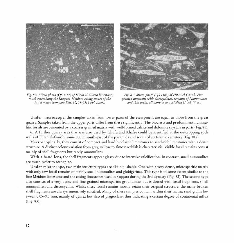
Fig. 82: Micro-photo (QS 1587) of Hitan el-Gurob limestone, much resembling the Saqqara-Meidum casing stones of the
3rd dynasty (compare Figs. 10, 34-35; 1 pol. filter).
Fig. 83: Micro-photo (QS 1583) of Hitan el-Gurob. Finegrained limestone with discocyclinae, remains of Nummulites
and thin shells, all more or less calcified (1 pol. filter).
U n d e r m i c r o s c o p e , the samples taken from lower parts of the escarpment are equal to those from the great quarry. Samples taken from the upper parts differ from these significantly: The bioclasts and predominant nummu-litic fossils are cemented by a coarser grained matrix with well-formed calcite and dolomite crystals in parts (Fig. 81).
6. A further quarry area that was also used by Khufu and Khafre could be identified at the outcropping rock walls of Hitan el-Gurob, some 800 m south-east of the pyramids and south of an Islamic cemetery (Fig. 81a).
Macroscop ica l ly , they consist of compact and hard bioclastic limestones to sand-rich limestones with a dense structure. A distinct colour variation from grey, yellow to almost reddish is characteristic. Visible fossil remains consist mainly of shell fragments but rarely nummulites.
Wi th a hand lens , the shell fragments appear glassy due to intensive calcification. In contrast, small nummulites are much easier to recognize.
U n d e r m i c r o s c o p e , two main structure types are distinguishable: One with a very dense, microsparitic matrix with only few fossil remains of mainly small nummulites and globigerinae. This type is to some extent similar to the fine Meidum limestone and the casing limestones used in Saqqara during the 3rd dynasty (Fig. 82). The second type also consists of a very dense and fine-grained microsparitic groundmass but is dotted with fossil fragments, small nummulites, and discocyclina. Whilst these fossil remains mostly retain their original structure, the many broken shell fragments are always intensively calcified. Many of these samples contain within their matrix sand grains between 0.05-0.5 mm, mainly of quartz but also of plagioclase, thus indicating a certain degree of continental influx (Fig. 83).
80

R e m a r k s on the d i scuss ion a b o u t p y r a m i d s bui l t of p o u r e d conc re t e b locks
At this point a few remarks are necessary about a number of recent publications concerning the building material of the pyramids. DAVIDOVITS/MORRIS 8 6 published a passionately discussed book "The Pyramids: An Enigma Solved", where they concluded that the building stones of the pyramids were formed by using artificial concrete. According to this publication, the blocks consist of a cement mixture of a geopolymere and natural limestone aggregate, poured into moulds. From a petrographical point of view, they came to their conclusions based on one rock specimen, the so-called "Lauer sample", and a few rock specimens from the Gizeh pyramids. Despite the arguments proposed to substantiate their hypothesis, they could not convince Egyptologists and geoscientists who investigate Egyptian stones. Especially in the USA, DAVIDOVITS/MORRIS' thesis gave rise to a vehement scientific discussion. A critical response started with articles from internationally renowned geologists specializing in the sedimentology of limestones, who seriously doubted the geopolymeric hypothesis 8 7. They give convincing sedimentological and structural arguments for a natural character and source of the pyramid building stones. HARRELL/PENROD came to the same conclusion 8 8, comparing the "Lauer sample" with samples from Gebel Mokattam, Tura, and Maasara. M O R R I S 8 9 responded excitedly, discriminating HARRELL'S results and declaring CAMPBELL/FOLK ignorant of the cast-in-place theory and the chemistry of geopolymerization.
After an intensive but fruitless discussion during the Cairo International Congress of Egyptology in 1988, the present author (D.D. KLEMM) invited JOSEPH DAVIDOVITS to the laboratory of the Department of Geosciences of the University of Munich. Here, a suitable collection of pétrographie thin sections was mutually scrutinized under a polarizing microscope and the identity of stone samples from the pyramids and from the corresponding quarries was discussed. This demonstration seems to have ended the debate.
Nevertheless, BARSOUM/GANGULY/HUG 9 0 recently published a paper on the "Microstructural evidence of reconstituted limestone blocks in the Great Pyramids of Egypt", wherein they reopened the geopolymere-concrete discussion that has been debated so heatedly in the past few decades. BARSOUM/GANGULY/HUG introduced the term "microconstituents" (uc's), a term which denotes structural components that are impossible to detect with pétrographie microscopy and visible only by applying scanning electron and transluminescent electron microscopy. Further, they presented a series of energy dispersive spectrometric (EDS) chemical analyses. The results show that the quarry samples contain natural minerals, for example calcite, dolomite, and silica. They also present very unconventional formulas of Si-Mg-Ca-C-oxy-hydroxy and in other cases Ca-K-Al-Si-C-oxy-hydroxy compositions from samples of casing stones from several Gizeh pyramids and declare them as artificial cast-in-place concrete-type stones. In contrast to DAVIDOVITS/MORRIS 9 1 , they regard the core stones as natural in origin without giving additional arguments. Even though their analytical methods are explained correctly in an appendix, their results are hard to follow and are completely in contrast to observations of the present authors. Most probably, these unusual compositions have a simple explanation: The used acceleration voltage of 12 kV creates a volume of about 1-2 um 3 at a well-polished surface orthogonal to the electron beam. However, within a broken granular volume with grain sizes below 1 um, the electron beam also excites the submicroscopic fine-organic coatings of bituminous matter, always present in the various Egyptian limestones that are rich in organic fossil remains, like those from Gebel Mokattam, Tura, and Maasara. The structures analysed by BARSOUM/GANGULY/HUG are of this submicron size. Thus, the danger of a measurement contamination is very likely and would explain the exceptional results. Yet, these results are insufficient to prove the presence of geopolymere, as postulated by the authors.
In the present investigation, around 1500 samples from pyramids and quarry sites were studied using various petrographical and geochemical methods and, with the exclusion of only a few cases, the samples from the pyramid
81

stones and respective quarry sites matched very well for both core and casing. A number of samples were analysed with scanning electron microscopy and EDS and compositions comparable to B A R S O U M / G A N G U L Y / H U G ' S findings could only be found in the cases of well-known minerals such as calcite, dolomite, quartz, feldspar, clay minerals, bituminous matter etc. Further, the volume of the detected quarry sites corresponds well with the volume of the pyramids constructed with this material. More importantly, natural rocks crushed down to aggregate size and then mixed with a binder to form a kind of concrete loose their original internal orientation. Nothing of that could be observed by the present authors, only well-preserved bedrock bedding and undisturbed secondary diagenetic structures with, if present, well-sorted fossils or their remains, in many cases calcified but free of any artificial binder. Most probably, the discussion about whether pyramids were constructed using geopolymere will continue. However, it should be clearly emphasized that such theories are nonsense.
Fig. 84: Khufu pyramid from southwest, seen from top of Khafre pyramid.
82
1. The Pyramid of Khufu (2604-2581 BC)
Geographical position (present entrance): 29°58'48.3" N, 31o08'3.58" E
Height: 146.6 m I Base: 230.38 m I Slope: 51° 50'
Khufu most probably abandoned the royal necropolis at Dahshur because there was no longer enough limestone nearby and because of the low stability of the subsoil, which consists of slate clay. Instead, he decided to build his pyramid on a massive rocky plateau in the western desert near modern Gizeh (Fig. 84), where the subsoil was much

Fig. 85: Integrated spiral ramp for the construction of large pyramids in limited areas like the Gizeh plateau, thus avoiding enormous amounts of material commonly claimed for a separated
outside construction ramp. Drawing by S. UHL.
more stable, and an abundant supply of high-quality limestone was available. In terms of size, technical accomplishment, and organization required for its construction, this new pyramid represents a phenomenal building.
The limestone used in the construction of the pyramid came from different quarries to the east and south of the building and, as demonstrated above, from the construction site itself. The limestone blocks were without doubt transported via drag ramps to the construction site. The pyramid was then probably erected by means of a system of ramps (a selection of potential models is presented by A R N O L D 9 2 ) .
A new model of spiral construction ramp at large pyramids such as the Khufu pyramid has been proposed by the present authors 9 3 . This spiral-type ramp is integrated into the pyramid's outer body, simultaneously leaving unfilled space of a suitable width while erecting the pyramid, and thus avoiding tremendous amounts of secondary materials like Nile mud, gravel, wood etc. to form a separate outer ramp.
When studying the Gizeh plateau and its surroundings by means of field observations, stereoscopic aerial photos, and satellite images, it is remarkable that there are no visible traces of waste dumps produced by such enormous constructions. This cannot be neglected, when postulating separately constructed ramps, as is often the case. An integrated ramp, however, which was later filled up with additional core and casing blocks while finishing the pyra-
83

Fig. 86: Block sizes of Khufu pyramid. They differ slightly in width hut they are equalized in height.
Fig. 87: Casing and hacking blocks of Khufu pyramid, western side.
mid, has the advantage that large amounts of debris were not in the way at the construction site, nor did they have to be deposited elsewhere after the pyramid's completion. In addition, an integrated ramp allows a clear view on the angles for exact measurements during construction and enables the use of two opposite ramps for transport up to and down from the pyramid, thereby considerably accelerating the whole building process (Fig. 85).
The outer walls of the core are built with blocks laid in horizontal layers. The height of the blocks varies between 0.80 and 1.20 m in average (Fig. 86). Between the core and the casing, another layer of somewhat smaller stones was bound with mortar, which increased the cohesion of both the two materials and the two masonry structures. In archaeological terminology, this intermediate layer is known as "backing stones" (Fig. 87).
84

The casing was made of large blocks of fine, white limestone, but few blocks are still in place, mostly at the base. As in the case of the older Red Pyramid, slightly concave walls were intended to increase the stability of the pyramid's mantle.
A possible valley temple and an adjacent harbour have been located beneath the village of Nazlet es-Saman. Pieces of basalt pavement and limestone walls, most probably belonging to these structures, were unearthed in this area 9 4 . A causeway from Nazlet es-Saman leads up to the mortuary temple that was situated on the eastern side of the pyramid. A cult pyramid and three small queens' pyramids also stand at the south-eastern side.
All that remains of the mortuary temple east of the pyramid is a black basalt pavement, sockets for granite pillars of the surrounding colonnade, and a number of limestone bedrock cuttings for the outer walls.
Analytical data does not enable the differentiation of the various basalt outcrops in northern Egypt (i.e. Haddadin flow 9 5), but on the basis of archaeological findings 9 6, it is most likely that the basalt slabs from the Khufu temple come from Widan el-Faras north of the Fayum lake. It is the first time in Egyptian architecture that basalt was used on such a large scale for paving. From this point on, this innovation was repeated by the following pharaohs 9 7 . Traces of sawing the basalt slabs using a drag saw can be seen on several pavement blocks 9 8 .
The walls of the temple were of fine limestone and they must have been carved in relief, but only few decorated fragments have been found. Some blocks were later reused as building material in Amenemhet I's pyramid complex at Lisht 9 9 .
The mortuary temple had a rectangular plan some 52.5 m wide. Hence, it was much larger than the small temples adjacent to earlier pyramids.
The original entrance with the descending corridor is about 17m high starting on the level of the 13th layer at the north side of the pyramid.
In the burial chamber, a red granite sarcophagus is still in situ, oriented north-south. It is 2.24 m long and 0.96 m wide. The lid of the sarcophagus is missing. This large sarcophagus was installed during the construction of the granite chamber. Pressure-relieving chambers above the burial chamber are also made of large granite blocks.
Recently, SALAH E L - N A G G A R 1 0 0 presented a compilation of all granite components of the Gizeh pyramids and localized them all to the large granite and granodiorite occurrences south of Aswan.
M A R A G I O G L I O / R I N A L D I 1 0 1 measured the pyramid of Khufu and most of the other Old Kingdom pyramids, and presented their results in detailed plans.
G e o c h e m i c a l p r o v e n a n c e d e t e r m i n a t i o n of the core mater ia l
The correlation diagrams of Figs. 88-91, showing the geochemical distribution fields of the samples taken from the Khufu pyramid and surrounding quarry areas, attest to the fact that the main core material mainly derived from the quarry areas to the south and south-east of the pyramid. This is astonishing, as mainly rock tombs established during Khafre's reign are exposed in this area 1 0 2 . However, it should be remembered that Khufu granted his family members and high officials the privilege to build mastaba tombs to the west and east of his pyramid. Thus, the excavation of rock tombs in the walls of his main pyramid quarry was unnecessary. For the first time under Khafre, the necropolis organization with regards to the high nobility changed, obviously due to the better-exposed quarry walls that had been created in the meantime and also due to the proximity of his pyramid.
85

Fig. 88: Mg/Fe-diagram of core masonry from Khufu pyramid. A relatively wide distribution field indicates various sources of the block material.
O Khufu quarry X causeway north
• Khentkaus A basement
X Route Touristique O Hitan el-Gurob
Fig. 89: Mg/Fe-diagram of the Gizeh quarry sites assumed to be the sources of Khufu's core masonry. The maximum of the block material derived from the quarries south of the pyramid and from the bedrock of the pyramid plateau (see sketch map Fig. 73).
86

Fig. 90: Mg/Sr-diagram of core masonry from Khufu pyramid. Again, the core data cluster within a limited
field, corresponding with the southern quarries, but other sites like Hitan el-Guroh and the pyramid basement are
obviously also source candidates.
Further, the Mg/Fe-values of samples from the basal core masonry (Fig. 88) cluster in a similar field as the basement rocks (Fig. 89). This may indicate that quite a large amount of the material gained during basement leveling (see Figs. 79-79a) was directly used for the pyramid's construction. As a relatively large amount of samples was taken at the lower levels of the pyramid to achieve a statistical average, this correspondence is not surprising.
The geochemical diagrams for the core material (Figs. 88, 90) and quarry samples (Figs. 89, 91) also indicate that the area of Hitan el-Gurob served to some extent as a source for the material of the core masonry. This source had not been considered hitherto, but both the geochemical and petrographical investigations unambiguously come to the same result.
Quite an amount seems to derive from a quarry area that forms the escarpment north of the present Route Touristique and from the quarries at the escarpment south of the Khufu causeway.
Geochemica l p r o v e n a n c e d e t e r m i n a t i o n of the casing and back ing mater ia l
Concerning the casing masonry of the Khufu pyramid, a fundamental problem arises in that only a small number of actual casing blocks exists at the pyramid's base along with a few scattered blocks on the pyramid's plateau. Nevertheless, it is possible that these blocks did not originally belong to the structure but to the material of other pyramid complexes. Consequently, they were not sampled systematically.
8 7

The casing material consists of a whitish-grey to whitish-yellow, very fine-grained and dense appearing limestone and can be easily distinguished even by a less petrographically trained observer from the heterogeneous core masonry with its much coarser structure.
The material of the so-called backing masonry, which normally forms the two blocks behind the casing, is similar in both appearance and macroscropically to the remains of the casing blocks. However, the number of layers of backing blocks is irregular and can constitute up to four courses between the casing and the core masonry.
The uppermost 10 stone layers of the remaining structure seem to consist exclusively of backing masonry, and the core masonry there is not exposed. Thus, from 75 samples of casing and backing masonry, only about 10 are from the actual casing itself.
The geochemical correlation diagrams Figs. 92-93 display the plotted data from samples of the Khufu pyramid's casing and backing material with the quarry samples of Tura, Maasara, and Mokattam. At first glance, the Khufu casing and backing stones can be geochemically attributed to the Tura-Maasara limestones. An attribution to the upper layers of the Mokattam quarry district is also possible. The petrographical study shows that Maasara is a less likely source. The diagrams show that all casing and backing samples from the Khufu pyramid correspond well with these three provenance areas. Particularly when analysing the Sr-data, a number of the samples derive from Mokattam, but the greater part corresponds better with the Tura-field.
Finally, a second analysis of the sample protocols showed, in accordance with the sample collection, that there is no significant difference between the provenance of casing and backing material for the Khufu pyramid.
Fig. 91: Mg/Sr-diagram of the Gizeh quarry sites, assumed to he the sources of Khufu core masonry. Predominantly the great quarry sites south of Khufu pyramid and the pyramid basement turn out as the main sources for the core masonry.
88

Fig. 92: Mg/Fe-diagram of casing and backing masonry from Khufu pyramid and the assumed quarry sites.
Fig. 93: Mg/Sr-diagram of casing and backing masonry from the Khufu pyramid and the assumed quarry sites.
89

2 . The Pyramid of Khafre (2572-2546 BC)
The pyramid (Fig. 94) is 10 m higher in relation to the Khufu monument and thus, depending on the viewing position, seems to be bigger. The geological environment is almost identical to that of Khufu and does not need further discussion, all the more, as the slight geological variations in stratigraphy are of no significant importance. This is especially the case for the core material, which derives from the same geological level as the greater part of the building stones of the Khufu pyramid. Nevertheless, there is some material variation at the base of the Khafre pyramid, which is cut into an outcropping slope of the bedrock that forms the highest point of the nearby hilly landscape.
Like the pyramid of Khufu, the Khafre pyramid also takes advantage of outcropping rock, which increased the stability of its core and decreased the amount of building material. The bedrock surface to the north-west had to be cut down some 10 m, while the south-east corner had to be built up using huge blocks of masonry.
During the New Kingdom, the north-west corner of the original precinct was enlarged by a quarry, which was cut into the original rock most probably for restoration purposes. The traces of ancient quarrying can still clearly be seen there (Fig. 95). The rock walls in that corner are significantly less deteriorated than the original wall of the western side. A rock inscription of Maja on its northern face dates this quarry to the reign of Ramses II.
90
Geographical position (present entrance): 29°58y36.67" N, 31°07y50.59" E
Original height: 147.5 m I Base: 215.25 m I Slope: 53° I Length of causeway: 494.6 m
Fig. 94: Khafre pyramid with its cap of remaining casing, seen from top of Khufu pyramid.

The lower levels of the pyramid's casing were lined with pink granite, while the higher layers, which become smaller towards the top, are of fine limestone. At the top of the pyramid a small portion of the original casing remains in place, which allows us to see how the final blocks were laid and bound to the pyramid core (Fig. 96).
The pyramid is surrounded by a stone perimeter wall, encompassing an open courtyard around the pyramid. This courtyard is paved with limestone slabs of irregular form.
A small cult pyramid stands on the structure's central axis at the southern side of the pyramid. The older of the two entrances into the subterranean rooms of the pyramid is located about 30 m north of the py
ramid and carved completely out of the subsoil rock. The second entrance is located in the north side of the pyramid about 12 m above ground level. It meets a corridor lined with red granite that first descends into the pyramid before running horizontally at the structure's base. The burial chamber, east-west oriented, was excavated completely out of the bedrock. Near its west wall stands a black granodiorite sarcophagus that was originally covered by a sliding lid. The lid was found nearby in two pieces.
Finally, an enclosure wall may have extended around the entire Khafre pyramid complex, even including the Great Sphinx.
The valley temple of the Khafre complex, which is one of the best-preserved Old Kingdom temples, was fronted on the east by a large terrace paved with limestone slabs. The temple was laid out in an almost square ground plan and is situated next to the Great Sphinx and its associated temple. Its core wall was built of huge blocks of limestone, extracted from the nearby quarries around the Sphinx 1 0 3 . This inner core was then covered by granite slabs of various types, giving the temple the name "granite temple"(Fig. 97). All of the granite varieties used in the valley temple derive from the Aswan area. Between the two entrances of the valley temple was a vestibule with walls of red and greyish-red granite that were originally polished. Its floors were paved with white calcite-alabaster. A door then led into a hall, which was covered with polished red granite and paved also with white alabaster. It was adorned with sixteen
Fig. 95: New Kingdom enlargement of Khafre northern enclosure trench, most probably for gaining stone material for
restoration purposes. Seen from top of the pyramid.
91

red granite pillars, many of which are still in place today. The pillars supported architrave blocks of the same material. Again, this granite material also comes from Aswan. Statues of the king made from anorthosite, schist, and calcite-alabaster once stood here. The famous "Khafre with the falcon" is now exhibited in the Cairo Museum. Its stone material, whose petrological nomenclature is anorthosite gneiss, was commonly called "Khafre Gneiss" according to the gneiss-like appearance of this statue. This type of stone comes from the remote Gebel el-Asr area, some 30 km west of Toshka and around 250 km south of Aswan.
The mortuary temple, unlike in later pyramid complexes, did not directly border the pyramid but was separated from it by a courtyard. Its walls are built of local limestone cased with fine limestone, a technique newly introduced in this building. Inside, it was almost completely lined with granite (Fig. 98).
In contrast to the Khufu pyramid, which was most probably entirely covered with limestone blocks, the Khafre pyramid's base layers were cased with blocks of various granite types from the large quarry area south of Aswan. A more precise localization of the remaining granite casing blocks to defined quarries in the Aswan area is possible with the Aswan map of K L E M M / K L E M M 1 0 4 , which is based on structure and colour differentiation. According to this map, block sizes similar to the Khafre casing stones were obtained at least until the New Kingdom exclusively from large granite boulders that covered the entire granite exposure there. Consequently, all of the different granite types of that area were incorporated into the various buildings of the Khafre complex. This can be best observed in the Khafre valley temple, where the internal structures offer an almost complete spectrum of the granite types of the Aswan granite plain. Expensive investigations for an exact localization of the granite casing and temple blocks in the Aswan area would only result in a more or less statistical distribution pattern of the entire plain, but such a result might be also achieved by a simple macroscopic correlation of samples with the respective colour plates in the appendix of K L E M M / K L E M M 1 0 5 .
Granite quarry work was performed rather primitively until the New Kingdom. After the selection of a suitably loose boulder, only the weathered outer coat had to be knocked off. This was done with 10-15 cm large dolerite hammers. Using the same method, the required block size was then roughly cut down to size and transported by
92
Fig. 96: Khafre pyramid. Remaining casing and hacking blocks at the cap. Fig. 97: Detail of the valley temple of Khafre, entirely faced with different granite varieties
from Aswan.

Fig. 98: Mortuary temple of Khafre mainly constructed of local limestone and mud bricks (back). It is cased with fine Tura limestone (foreground) and in inner
parts with granite from Aswan.
boat to the building site, where they were finally dressed. An example of this can be seen at the base of the Men-kaure pyramid (see Fig. 105).
However, it should be emphasized that only the coarse-grained porphyric granite types were selected for Khafre's buildings. Other granitoid stone types that also occur in the Aswan region, such as granodiorite or the fine-to middle-grained Koror-granite were avoided.
G e o c h e m i c a l p r o v e n a n c e d e t e r m i n a t i o n of the core mate r ia l
The core masonry samples from the Khafre pyramid correspond well with the samples of the various quarries in the Gizeh area (Figs. 99-101). It further becomes evident that the majority of the core masonry used for the Khafre pyramid is almost identical to the masonry of the Khufu pyramid and must, therefore, have derived from the same sources. This is especially the case for the large quarry area, which encompasses the area from the asphalt road between the Sphinx and the Khufu pyramid (Route Touristique) in the north to the Menkaure causeway in the south. But it seems that during the construction of Khafre's pyramid the majority of the stone material was procured from the more eastern parts of the main quarry area known today as the "Central Field". It was used after Khafre's reign in the 5th and 6th dynasties as a necropolis. In this case, it is logical that the later causeway was used originally as a drag ramp that ran directly into the eastern part of the quarry area (see Fig. 73).
93

Fig. 99: Mg/Fe-diagram of Khafre pyramid core and the assumed quarries. Most of the samples plot into the main quarry sites east of the pyramid, the pyramid basement and to some extent Hitan el-Gurob.
Fig. 100: Mg/Sr-diagram of Khafre pyramid core and the assumed quarries. Again, most of the samples plot into the main quarry sites, like those of Khufu and Khentkaus, the pyramid basement and to some extent Hitan el-Gurob.
94

• Khafre pyramid x Khufu-Khafre quarry • Khentkaus A basement o Hitan el-Gurob
Fig. 101: Fe/Mn-diagram ofKhafre pyramid core and the assumed quarries. A good coincidence of
most of the pyramid samples with the main quarry sites at the Gizeh plateau is obvious.
Geochemical and petrographical investigations do not lead to a differentiation between the Khufu and the Khafre quarry areas, which both occur more or less in the same geological horizon of dolomitic and marly limestones of the Observatory formation 1 0 6 .
Finally, the geochemical data indicate that at least a part of the building stones derived from the hill group of Hitan el-Gurob, south-east of the pyramid, and south of the present day Islamic cemetery.
G e o c h e m i c a l p r o v e n a n c e d e t e r m i n a t i o n of the casing and back ing mate r ia l
At least 90 % of the Khafre pyramid was originally covered with a fine limestone quality. Only a fraction of the original casing remains on the uppermost parts of the building. Fragments of the original casing can still be found in the surrounding area; especially the remains of backing blocks allow sufficient sampling of the fine uniform white-grey limestone quality that was used for both casing and backing.
The correlation diagrams Figs. 102-103 show a confined distribution field for the analysed samples. Comparing it with the field of the Tura-Maasara samples, the localization to a well-defined part of this quarry area is unquestionable. An attribution to the Mokattam area may also be excluded due to the micro-facies of the rock structure.
95

Fig. 102: Mg/Fe-diagram ofKhafre pyramid casing and quarries of Tura and Maasara. It turns out that
the Tura quarries are the more likely sources.
Fig. 103: Mg/Sr-diagram of Khafre pyramid casing and quarries of Tura and Maasara. Again, the close
affinity to the Tura sites is obvious.
3. The Pyramid of Menkaure (2539-2511 BC)
Geographical position (present entrance): 29°58'22"N, 31°07y41" E
Original height: 66.45 m I Base: 104.6 m I Slope: 51° I Length of causeway: 608 m
The Menkaure pyramid is built at the far end of the Gizeh diagonal on the edge of the Mokattam formation (Fig. 104), where it dips down to the south and disappears into the younger Maadi formation (see Fig. 73). The complex includes a valley temple, a causeway, and a mortuary temple on the east side of the pyramid.
The pyramid's base lies 2.5 m higher than Khafre's pyramid and occupies only a quarter of the area used by the Khafre and Khufu pyramids. With its original height of 66 m, Menkaure's pyramid represents only about a tenth of the mass in comparison to the Khufu pyramid.
96

Again, the core consists of local limestone blocks. Approx. the bottommost 15 m of the pyramid were cased with granite blocks from Aswan. Further up, the casing was made of fine limestone. The final dressing of the granite casing was not completed until the end of the construction process (Fig. 105).
An entrance on the north side provided original access to the inner chambers, about 4 m above ground level. An inclined passage, more than 30 m long, leads to the subterranean chambers. One of them, the proper burial chamber, was constructed entirely with granite, and housed a dark grey sarcophagus, which was found to be empty. After its discovery, the sarcophagus was transported to Europe by ship but was lost when the ship sunk.
The valley temple was built predominantly in mud brick. Some parts of the pavement and column bases were made of limestone. In the inner chambers, the famous greywacke and siltstone triads and fragments of other statues of Menkaure were found.
The causeway leads into the mortuary temple on its eastern side and directly into the central court.
Fig. 105: Detail of Menkaure pyramid. Granite casing blocks at its northern site in various states of smoothing.
97
Fig. 104: Menkaure pyramid with subsidiary pyramids, view from south-east.

The whole building gives the impression that it was finished in haste, most probably by Menkaure's successor Shepseskaf, who made extensive use of mud bricks instead of stone masonry. Some parts were cased with granite and granodiorite. Limestone was used as casing in only a few cases.
Three small pyramids stand to the south of Menkaure's monument. The eastern one was probably the true subsidiary pyramid. It was partly cased with red granite, and a sarcophagus of the same material was sunk into the floor of the burial chamber.
REISNER 1 0 7 excavated the entire complex between 1906 and 1924. Recent excavations around the pyramid of Menkaure have been conducted by the SCA.
Geochemica l p r o v e n a n c e d e t e r m i n a t i o n of the bu i ld ing mater ia l
The geochemical correlation diagrams of the Menkaure pyramid's core material unequivocally assign the stones to the quarry area, situated south-east of the pyramid (see Fig. 73).
Of course, this is not really new information: As rock tombs contemporary to Menkaure were cut into the quarry walls, this site was always regarded to be his quar ry 1 0 8 . This can now be confirmed because of the good geochemical correlation between the quarry samples and the samples from the core blocks (Figs. 106-109). This result corresponds well with petrographical observations and confirms a former attribution resulting from a smaller database 1 0 9 .
The limited quarry area to the south-east of the pyramid (Fig. 79c) belongs stratigraphically to the same unit as the great quarry area used by Khufu and Khafre but lies at a higher level. Thus, slight petrographical and geochemical variations from these were expected. Comparing the geochemical data from the Menkaure quarry with data from the more western parts of the central quarry, a significant difference is not really recognizable.
Fig. 106: Mg/Fe-diagram of Menkaure pyramid core material.
Fig. 107: Mg/Fe-diagram of Menkaure quarry material. Both core and quarry limestones plot in
almost identical distribution fields.
98

Fig. 108: Mg/Sr-diagram of Menkaure pyramid core material.
Fig. 109: Mg/Sr- diagram of Menkaure quarry material. Both core and quarry limestones plot in almost identical
distribution fields.
Fig. 110: Micro-photo (QS 1361) of an average thin section of Menkaure quarry limestone with Nummulites gisehensis
(1 pol. filter).
Fig. Ill: Micro-photo (QS 1356) of an average sample of Menkaure quarry limestone with Nummulites gisehensis
and discocyclinae (1 pol. filter).
Macroscop ica l ly , the quarry limestone positively correlates to the pyramid's core material, and it is hard to differentiate it from the Khufu quarry in the western part of the great quarry area.
U n d e r m i c r o s c o p e , studying thin sections of both the Menkaure quarry and the core masonry, a somewhat higher porosity can be observed, which is due to the many open fossil interspaces (Fig. 110). Further, a denser structure of the
99

Fig. 112: Mg/Fe-diagram of Menkaure pyramid casing material and limestones from Tura and Maasara. The closer affinity to the Tura samples is conspicuous.
Fig. 113: Mg/Sr-diagram of Menkaure pyramid core material and Tura limestones. Even the only low sample
population plots closely together with the Tura field.
100

many small nummulites, discocyclinae, and other fossil remains is evident (Fig. 111). Generally, a differentiation from the other quarry sites of the Gizeh plateau seems unrealistic.
The casing material of the Menkaure pyramid is again of bimodal composition: Remains of apparently in situ granite casing blocks indicate that at least the lower 16 stone layers of the monument were covered with Aswan granite, which roughly corresponds to the first third of the lateral face. On the northern face, the granite casing is still intact until the 7th layer. Similar to the Khafre complex, granite blocks of various qualities of the Aswan granite were incorporated into the casing, but in the case of the Menkaure pyramid it seems that more homogeneity of colour was desired and that pinkish red rock qualities were preferred.
In addition, fine limestone was also used as casing material, but it remains only as backing stones. The use of this limestone is proved in situ at the pyramid but also by individual blocks that can be found around the pyramid. The original height of the limestone casing can no longer be determined. In the frame of the present sampling program, the main emphasis was laid on the backing blocks that remain in their original position rather than on the individual loose blocks, which were sampled only for control.
Once more, the geochemical data plotted in the correlation diagrams of Figs. 112 and 113 show close concordance. A comparison of the casing and backing limestone values with the Tura limestone data allows the conclusion that Menkaure extracted these stones from a very limited area of the Tura quarry region, most probably from one distinct gallery quarry. In Fig. 112 the Maasara quarry samples correlate poorly with the Menkaure casing and backing stones, to such an extent that this area can be excluded as a possible material source. Further, comparing data with the corresponding field of Khafre it is clear that the fine quality building material extracted in Tura derived from different quarries there, a procedure that is repeated for the later Old Kingdom pyramids.
101

The Stones of the Pyramids presents a detailed investigation into the stone material of the ancient Egyptian pyramids built during the 3rd to 6th dynasties of the Old Kingdom (ca. 2700-2216 BC). It aims at a provenance determination of these stones by comparing them to rock samples from quarries of the surrounding areas. Well understandable and illustrated with more than 170 colour photographs, microscopic sections and diagrams, this study makes an important contribution to the often discussed topic of the Egyptian stone pyramids. In addition, it gives new insight into the enormous logistic and technical demands of their construction.
The authors Rosemarie and Dietrich Klemm are renowned for their extensive archaeological and geological research on ancient Egyptian materials. Their main field concerns stones and quarries as well as the investigation into gold mining sites in the Eastern Desert and in Nubia/Sudan. They are based at Ludwig-Maximilians-Universitat, Munich.
www.degruyter.com ISBN 978-3-11-022123-7