reconstruction of prehistoric diet in british columbia - CORE
Upload
khangminh22Category
view
2download
0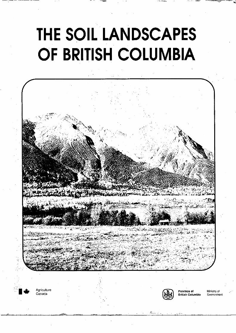
, .•
THE SOIL LANDSCAPES OF BRITISH COLUMBIA
Agriculture Canada
~ Province of ~ British Columbia
Ministry of Environment
/

COVER PHOTO: HUDSON BAY MOUNTAIN NEAR SMITHERS, B.C. GOV'T PHOTO 3764.

THE SOIL LANDSCAPES OF BRITISH COLUMBIA
Edited by
K.W.G. Valentine, P.N. Sprout,
.T.E. Baker and L.M. Lavkulich
Victoria, B.C. 1978
Reprinted August 1986
Canadian Cataloguing in Publication Data Main entry under title: The Soil landscapes of British Columbia
Includes bibliographies. ISBN 0-7718-8265-3
1. Soils - British Columbia. 2. Landforms - British Columbia. I. Valentine, K. W. G. II. British Columbia. Ministry of Environment. Resource Analysis Branch.
S599.l.B7S64
LA.."I\J 991571. 394
631. 4 I 9711 CP78-83284-l
© Copyright 1978. B.C. Ministry of Environrrent First Printing 1978 Second Printing 1981 Third Printing 1986 Fourth Printing 1994
LI ST OF FIGURES
LI ST OF PLATES
CONTENTS
LIST OF CONTRIBUTORS AND EDITORS
PREFACE
PART 1.
1.1
1.2
1.3
1.4
PART 2.
2.1
2.2
2.3
2.4
PART 3. 3.1
3.2
3.3
3.4
3.5
3.6
3.7
THE ENVIRONMENTAL FACTORS INTRODUCTION
T.E. Baker
CLIMATE D.G. Schaefer
GEOLOGY~ LANDFORMS AND SURFICIAL MATERIALS June M. Ryder
VEGETATION R,K, Jones and R. Annas
THE MAJOR SOILS AND SOIL PROCESSES OF BRITISH COLUMBIA
INTRODUCTION L.M. Lavkuliah
SOIL AND SOIL PROCESSES L.M. Lavkulich and K.W.G. Valentine
THE CANADIAN SYSTEMS OF SOIL AND SOIL CLIMATE CLASSIFICATION
L.M. Lavkuliah and K.W.G. Valentine
THE SOIL ORDERS OF BRITISH COLUMBIA K.W.G. Valentine and L.M. Lavkulich
THE SOIL LANDSCAPES OF BRITISH COLUMBIA INTRODUCTION
K.W.G. Valentine
THE SOIL MAP OF BRITISH COLUMBIA T.M. Lord and K.W.G. Valentine
THE COAST MOUNTAINS AND ISLANDS J.R. Jungen and T. Le~is
THE INTERIOR PLATEAU K.W.G, Valentine and A.B. Da~son
THE COLUMBIA MOUNTAINS AND SOUTHERN ROCKIES U. Wittneben and L. Lacelle
THE NORTHERN AND CENTRAL PLATEAUS AND MOUNTAINS G.K. Young and N.F. Alley
THE GREAT PLAINS A.J. Green and T.M. Lord
PAGE V
vi
vii
viii
l
3
11
35
47
49
59
67
97
99
101
121
135
149
161

iv
PAGE
PART 4. THE DEVELOPMENT AND USE OF SOIL AND TERRAIN SURVEYS IN BRITISH COLUMBIA
4.1 I Nr.RODUCTI ON 173 P. N. Sprout
4.2 SOIL AND LAND UTILIZATION SURVEYS PRIOR TO 1965 175 L. Farstad and N.T. Drewry
4.3 THE CANADA LAND INVENTORY PERIOD 1965-1975 183 P.N. Sprout
4.4 SOIL AND TERRAIN SURVEYS FROM 1975 193 T. M .. Lord
1.1. l
1. 3.1
1. 3. 2
1. 4.1
1. 4. 2
2.2.l
2.2.2
2.3.l
3.2.l
3.3.l
3.3.2
3.3.3
3.3.4
3.4.l
3.4.2
3.5.l
3.5.2
3.6.l
3.7.l
4.2.l
4.3.l
V
LIST OF FIGURES
Physiographic Regions of British Columbia
Generalized Geology of British Columbia
Glacial Features of British Columbia
Biogeoclimatic Zones across British Columbia along latitude 490 30' N
Biogeoclimatic Zones of British Columbia
Diagrammatic representation of additions, losses, translocations and t-ransformations involved in soil formation
Common soil horizons in a mineral soil profile
The Soil Climates of British Columbia
The Soil Map of British Columbia
The Soil Landscapes across the Southern Coast along latitude 490 30' N
The Soil Landscapes across the Northern Coast
The Ferro-Humic Podzol Soil Landscape showing associated soils
The Humo-Ferric Podzol Soil Landscape showing associated soils
The Soil Landscapes of the Northern Interior Plateau along latitude 54o 27' N
The Soil Landscapes of the Southern Interior Plateau along latitude 500 00' N
The Soil Landscapes of the Columbia Mountains
The Soil Landscapes in Southeastern British British Columbia along latitude 49° 38' N
The Soil Landscapes across an asymmetrical valley in Northern British Columbia
The Soil Landscapes from Fort Nelson to Dawson Creek
Soil and Land Utilization Surveys: field work prior to 1965
Soil and Terrain Surveys 1965-1975
PAGE
between land 3
13
between 22 and 23
between 36 and 37
between 38 and 39
52
55
63
between 99 and 101
102
104
105
111
123
125
136
138
152
166
178
184

2.4.1 - 2.4.6
2.4.7 - 2.4.12
2.4.13 - 2.4.18
3.3.1
3.3.2
3.3.3
3.4.1
3.4.2
3.5.1
3.5.2
3.6.1
3.7.1
3.7.2
vi
LIST OF PLATES
Profiles and Landscapes of soils from the Brunisolic, Chernozemic and Cryosolic orders
Profiles and Landscapes of soils from the Gleysolic, Luvisolic and Organic orders
Profiles and Landscapes of soils from the Podzolic, Regosolic and Solonetzic orders
Soil Landscapes on the west coast of Vancouver Island
Soil Landscapes in and adjacent to the Fraser River Lowland looking southwest to Sumas Mountain
Soil Landscapes of the Alpine Tundra in the Coast Mountains west of Tatlayoko Lake
Soil Landscapes in the Quesnel Highlands
Soil Landscapes in the southern Interior Plateau near Merritt
Soil Landscapes in the southern Rocky Mountain Trench looking east towards Elko
Soil Landscapes in the Columbia Mountains from Goldstream River looking up Mcculloch Creek.
Soil Landscapes on the Klastline Plateau looking southwest from the Stikine River
Soil Landscapes in the Peace River lowlands around Fort St. John
Soil Landscapes near Boudreau Lake in the Peace River lowlands looking south to Moberly River
PAGE
73
83
93
106
114
118
128
132
140
144
156
164
170

1.2.l
1.2.2
1.3.1
1.3.2
2.3.1
2.4.1
2.4.2
2.4.3
2.4.4
2.4.5
2.4.6
2.4.7
2.4.8
2.4.9
vii
LIST OF TABl£S
Selected Climatic Data for Major Soil Landscape Regions:
Conparative Climatic Data for Selected Pairs of Stations at IDW and High Elevations: Annual Maans
Geology and structure of the major physiographic regions
Geological t:iire scale and events related to the developnent of landforrrs in British ColU!lbia
Soil 'l'elTperature Classes
Chemical and Physical Analyses of a Eutric Brunisol (Whipsaw Series)
Chemical and Physical Analyses of a Black Chernozemic Soil
Chemical and Physical Analyses of an Organic Cryosol (Klua Col'lplex) ·
Chemical and Physical Analyses of a Luvic Greysol (Cowichan Series)
Chemical and Physical Analyses of a Gray Luvisol (Tyee Series)
Chemical and Physical Analyses of a Mesisol (Rail Series)
Chemical and Physical Analyses of a HUirO-Ferric Podzol
Chemical and Physical Analyses of a Humic Regosol (Chenainus Soils)
Chemical and Physical Analyses of a Solod ( Murdale Series)
PAGE
5
6
14
20
62
69
74
76
79
81
85
88
89
94

N.F. Alley
R. Annas
T.E. Baker
A.B. Dawson
N.T. Drewry
L. Farstad
A.J. Green
R.K. Jones
J.R. Jungen
L. Lacelle
L.M. Lavkulich
T. Lewis
T.M. Lord
June M. Ryder
D.G. Schaefer
P.N. Sprout
K.W.G. Valentine
U. Wittneben
G.K. Young
viii
LIST OF CONTRIBUTORS AND EDITORS
Resource Analysis Branch, Ministry of the Environment, Victoria.
Research Division, B.C. Forest Service, Victoria.
Research Division, B.C. Forest Service, Victoria.
B.C. Ministry of Agriculture, Kelowna.
B.C. Assessment Authority, Victoria.
Soil Research Institute, Agriculture Canada, Vancouver, (retired).
Soil Research Institute, Agriculture Canada, Vancouver.
Lands Directorate, Environment Canada, Vancouver.
Resource Analysis Branch, Ministry of the Environment, Kelowna.
Resource Analysis Branch, Ministry of the Environment, Kelowna.
Soil Science Department, University of British Columbia, Vancouver.
Private consultant, Burnaby.
Soil Research Institute, Agriculture Canada, Vancouver.
Resource Analysis Branch, Ministry of the Environment, Victoria.
Atmospheric Environment Service, Environment Canada, Vancouver.
Resource Analysis Branch, Ministry of the Environment, Victoria.
Soil Research Institute, Agriculture Canada, Vancouver.
Resource Analysis Branch, Ministry of the Environment, Kelowna,
Private consultant for Resource Analysis Branch, Uinistry of the Environment, Kelowna.

ix
PREFACE
For a number of years now those of us working with soils in British
Columbia have been approached with such questions as "where can I get a book
on soils?" .or "is there a book on the soils of British Columbia?" The
problem was that people like foresters or engineers were trying to use soil
survey reports and maps with no background information other than that which
could be extracted from the very technical manual on the Canadian System of
Soil Classification. Then in about the fall of 1975--it became obvious that
we needed similar background information for all the tours.through British
Columbia that were to be run in conjunction with the XIth Congress of the
International Society of Soil Science (Edmonton, Alberta, June 1978). So in
the spring of 1976 there was a collective drawing in of breath and the work
for this book was started. It is the product of a group effort on the part
of many people over the following two years.
Throughout we have adopted a pedological landscape approach. The aim
was to describe and explain the variety of soils that are found in the
different parts of the province. To do this it was first necessary to des
cribe the regional variation in climate, geology and vegetation because all
these factors contribute to the present form of the soil. This has been done
in Part l. Then in Part 2 there is a discussion of what soil is, how it
develops, how it is classified, and then a description of the nine main types
of soil. Throughout the publication we have followed the 1978 Canadian
System of Soil Classification. The principal descriptions of the geographical
variation of soil are included in Part 3. For this purpose the province was
divided into five regions based on physiography from Holland's 1964 publica
tion on the Landforms of B~itish Columbia. The soil unit that has been
described is a "soil landscape". This has been defined as the total eco
system with which a soil is associated, with emphasis placed on the soil itself. It could be used at any level of classification but here we have
used it at the great group level. Lastly in Part 4 there is a brief history
of soil survey in British Columbia. This has been included because it is
often confusing to someone using soil survey reports and maps why work done
in the 1950s does not correspond to work done in the 1960s or 1970s. It is
because our survey methods and soil classification have changed through the
years. Why and how they have changed is explained here.
We have tried to make the whole publication as readable as possible.
Technical discussion has been kept to a minimum. However, some level of
knowledge ha<." to be assumed if the writers were to avoid defining every
technical word they used. Therefore, we have aimed at the level of a second
year undergraduate in earth sciences. This may mean that some parts are a

X
little simple for soil scientists attending the I.s.s.s. Congress in Edmonton.
Nevertheless, we hope that they will find something to interest them in the
descriptions of the soil landscapes of a very varied and beautiful part of
Canada.
A brief conunent is also necessary regarding the plant names used. We
wrestled with this one for a long while. The problem is that across Canada
there is often no single accepted common name for a plant. We decided in the
end to follow the recently published inventory of the Vascular Plants of
British Columbia by Roy Taylor and Bruce MacBryde {UBC Press, 1977). The
section on vegetation includes the scientific name as well as the common name,
when it is first mentioned. All other sections use common names only.
This book is the product of a truly cooperative effort. The editors
would like to thank the contributors for accepting with patience and respond-
ing with alacrity to all the badgering and modifications {suggested and dictated!)
that were made over the two year period. There are also many other people who
contributed but whose names do not appe·ar on the Contents page. Their efforts
are gratefully acknowledged now. Mariette Klassen and Jackie Scales did the
typing. Bob Bierman drafted Figure 1.4.1, Alison Brookfield and Angus Weller
drafted Figure 3.2.1 and Janet Etzkorn drafted all the other Figures and the
black and white Plates. Boyd Porteous supervised the drafting and acted as
a coordinator for the final stages. Crenagh Redmond proof read the final
typing and located the oblique aerial photographs. Alex McKeague and Jack
Shields made constructive suggestions on Part 2, and John Day arranged for
the coloured Plates to be produced by the Graphics Unit, Agriculture Canada,
Ottawa. Tony Blicq and Bert Farley arranged for UBC Press to provide the
soil map of British Columbia from the Atlas of British Columbia {Figure 3.2.1).
Roy Taylor checked the plc1.nt names and "Mac" Maccarthy undertook the agonizing
task of giving the whole thing a final edit to attain some uniformity of
english usage. The following agencies are also to be thanked for allowing
their personnel to work on the project in addition to their normal duties:
the Ministries of the Environment, Agriculture and Forests, Victoria,
Agriculture Canada and the Department of the Environment, and the Soil Science
Department, University of British Columbia.
Lastly we would like to provide a grain of salt with which to digest
the information contained within these covers. Remember it represents only a
stage in our knowledge of the soils of British Columbia. As more information
becomes available in future years this publication will have to be revised.
We look forward to receiving that information, and hope any future editors
find it as interesting producing the revised publication as we did in
producing this one~
K.W.G.V., P.N,S., T.E.B. and L.M.L.
Victoria, October 1977.
Part 1
The Envi ran mental
Factors

1.1 INTRODUCTION T.E. Baker
Soils and man are products of their environment. Man inherits many
of his characteristics from his parents and soils also reflect in their
appearance and in the way they function the influence of the parent materials
from which they have developed. Changes in the environment also cause
differences to develop. All these factors result in the different soils and
people we find. Therefore, we can think of soils as individuals. It is
important to know what they are like and how they behave within a given
environment.
To gain this understanding it is best to consider separately the
components which make up the soil environment. Part 1 of this report gives
basic information about climate, geology, physiography and vegetation. The
remainder of the text describes the types of soils and regional soil land
scapes that are found within British Columbia. The province has been
divided into five regions based primarily on physiographic divisions as
defined by S.S. Holland in a 1964 publication on the Landforms of British
Columbia {B.C. Dept. Mines and Pet. Res. Bull. 48). These five physiographic
regions are shown in Figure 1.1.1.
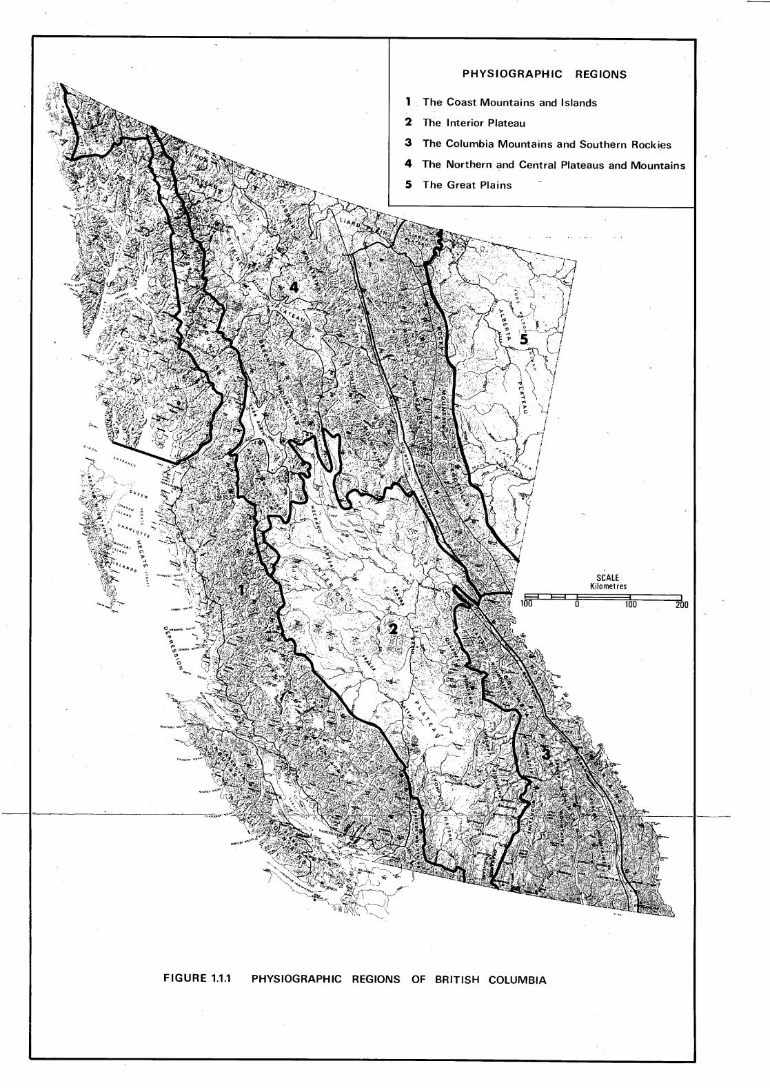
FIGURE 1.1.1
PHYSIOGRAPHIC REGIONS
1 The Coast Mountains and Islands
2 The Interior Plateau
3 The Columbia Mountains and Southern Rockies
4 The Northern and Central Plateaus and Mountains
5 The Great Plains
SCALE Kilometres
&3F-31 I 100 0 100
PHYSIOGRAPHIC REGIONS OF BRITISH COLUMBIA
I 200
1. 2 CLIMATE D.G. Schaefer
The climate of British Columbia varies enormously from place to
place. On the macro-scale, climates associated with the major soil land
scape regions (Part 3) are a product of geographical location and large
scale topography. On the micro-scale, conditions at the earth's surface are
modified by local physiographic factors such as slope, aspect and elevation.
Micro-scale climates are also affected by vegetation and the condition of
the soil itself through influences on the processes of evaporation and heat
exchange.
The latitude of British Columbia places the province squarely in the
zone of the westerly atmospheric circulation of the northern hemisphere.
Its position on the western side of North America places it in proximity to
the vast Pacific Ocean which is an immense reservoir of heat and moisture.
The Pacific plays the dominant role in determining the climates of the
province.
Innumerable winter storms born over the North Pacific Ocean develop
rapidly, move in a northeasterly direction to the Gulf of Alaska and there
weaken and die. Frontal systems which break away from the ·storm centres
impinge upon the coastline and there face another major determinant of
British Columbia climates; successive large-scale mountain barriers aligned
in a northwest to southeast direction. Since these are roughly perpendicular
to the mean winds aloft, they determine to a major extent the overall dis
tribution of precipitation and the degree of dominance of Pacific air masses
in relation to continental air masses in the various regions of the province.
Weather systems carried by the prevailing westerly winds aloft drop consider
able moisture as rain or, at higher elevations, as snow, when the air is
forced up the west-facing slopes of Vancouver Island, the Queen Charlotte
Islands and the Coast Mountains. The wettest climates of British Columbia
are found in this zone. On the eastern slopes, the air descends and is
heated by compression, causing the clouds to dissipate. The driest climates
of the province lie in the valley bottoms in the lee of the massive coastal
barrier. As the air again ascends the Monashee and Purcell Mountains, the
Cariboo and Cassiar Ranges, and finally the Rocky Mountains, additional
moisture is released with the heaviest precipitation falling on the west
facing slopes of each successive mountain barrier.
The mountain ranges are effective barriers to prevailing westerly
winds, with particular emphasis on low-level moisture supply; they also
block the westward passage of frigid continental Arctic air masses which

4
dominate the winter season east of the Rocky Mountains. While the Great.
Plains region of northeastern British Columbia lacks this protection, other
parts of the province experience varying degrees of shielding from the onslaught of Arctic air, increasingly so as one moves from east to west and
from north to south.
In summer, the prevailing westerlies weaken. The climate then comes
under the dominance of the large, semi-permanent Pacific anti-cyclone or high
pressure centre which expands northward, greatly diminishing the frequency
and intensity of Pacific storms and coastal precipitation. In the interior,
spring is a season of decreased precipitation. About June, precipitation
again increases as an interplay of factors, which include high rates of
insolation and late spring surges of cool unstable air, produces ~trengthened
convective activity, resulting in showers and thundershowers. In addition,
a number of so-called "cold low" storms normally cross the province en route
to the Great Plains. By mid-summer, these normally decline as the Pacific
anti-cyclone develops its dominance over western North America.
Having described some of the macro-scale climatic controls at work
over British Columbia, the question remains as to the characteristics of the resulting climates of the various soil landscape regions and, more
particularly, how these are modjfied by physiography to produce the meso
and micro-climates that directly influence soil processes. Further, there is the question of the temperature and moisture conditions that exist within
the soil layer itself. These are directly related to climatic conditions
experienced above ground.
Temperature cycles near the soil surface follow those in the air with
only slight lag. Deeper layers experience a much smaller range or amplitude
of change with a lag of one or two months at depths of a few metres. Temperature changes penetrate more deeply in rock and wet sand than in wet
clay and least of all in dry sand. In any case, temperatures below 5 or 6 m
are essentially constant throughout the year. Soil moisture conditions are a function of gains through precipitation or snowmelt waters and losses by
runoff and evapotranspiration. A discussion of the classification of soil temperatures and moisture regimes is included in Part 2.3 below.
The following sections deal separately with the five major regions
of British Columbia. Table 1.2.1 provides selected climatic data for sites typifying those regions. Table 1.2.2 presents some contrasting values for stations at low and high elevations in certain regions.
5
TABLE 1. 2 .1
Selected Cli,matic Data for Major Soil Landscape Regions: Annual Means
Annual Precipi- Evapotrans- Range Bright tation pi ration* Snowfall Temp. of Temp. Sunshine
Region Stations (mm) (mm) (cm) (oC) ,oc)
Coast Vancouver 1068 490 , 52 9.8 15 Mountains Internat'l and Airport Islands
Pr. Rupert 2415 613 113 7.8 12
Interior Summerland 296 295 74 8.9 25 Plateau Pr. George 620 439 233 3.3 27
Airport
-Columbia Cranbrook 438 337 178 5.1 27 Mountains Airport and Revel stoke 1096 485 412 7.2 25 Southern Rockies
Northern Dease 394 347 187 -1.2 32 and Lake Central "
Plateaus Germans en 525 332 257 0.4 31
and Landing
Mountains
Great Fort St. 450 383 206 1. 3 33 Plains John
Airport
Fort 446 380 192 -1. ~ 40 Nelson Airport
*Mean actual evapotranspiration from Phillips (1976), computed using the Thornthwaite water balance method, asswning a soil storage capacity of 100 millimetres of water.
E-Indicates values of sunshine in hours estimated from climatic maps.
THE COAST MOUNTAINS AND ISLANDS
(Hrs.)
19 30
1035
1990
1865
1800 E
1600 E
1750 E
1755
2130
1900 E
The marine west coast climates of British Columbia have a relative
lack of sunshine, moderate temperatures year round and heavy precipitation,
with a maximum in the fall on the North Coast and in the winter on the South
Coast. Extensive areas, particularly westerly exposures and higher elevations,
Region
Coast Mountains and Islands
Columbia Mountains and Southern Rockies
Northern and Central Plateaus and Mountains
6
TABLE 1. 2. 2
Comparative Climatic Data for Selected Pairs of Stations
at Low and High Elevation: Annual Means
Precipi-Elevation tation Snowfall Temperature
(oC) Stations (ml (mm) (cm)
Hollyburn 46 1917 66 10.0
Hollyburn 951 2939 811 5.1 Ridge
Trail 433 664 167 8.7
Old Glory 2348 735 558 -1. 9 Mountain
Golden 788 472 204 4.8
Glacier 1248 1493 970 2.1
McLeod 704 629 334 1. 8 Lake
Pine 933 2057 1322 0.6 Pass
receive in excess of 2500 mm of precipitation, making them by far the wettest
Darts of Canada. East-facing slopes and lowlands receive substantially less.
Snowfall accounts for a small fraction of the annual precipitation near sea
level. The mean annual range of temperature (i.e. the mean temperature of
the warmest month minus that of the coldest month) in the outer coastal zone
is the smallest in Canada at 10°c.
A distinct climatic zone must be recognized over the southeastern
lowlands of Vancouver Island, the islands of the Strait of Georgia and the
Fraser River estuary. These areas which lie in the rainshadow of the
Vancouver Island Ranges and Olympic Mountains have climates approaching the
Mediterranean type in that summers are normally dry and warm with a high
number of hours with bright spnshine, defined by a condition in which no
cloud screens the instrument from the direct rays of the sun. Mean annual
temperatures are the highest in Canada at just over 10°c. The annual range
of temperature of 15°c indicates a slightly greater continental influence
than on the outer coast. Precipitation amounts at sea level are as low as
650 mm, making this the driest region of the British Columbia coast.

7
Very different climates are encountered close to those described
simply by moving to higher elevations. A transition takes place between
moderate, rainy climates and colder, snowy climates. Mean temperatures
decline s 0 c for every 1000 m increase in elevation. Summers become cool and
short. Heavy snowpacks form in the winter and linger into mid-summer. In
the extreme case extensive glaciers cover the higher peaks of the Coast
Mountains.
The large amount of precipitation on the outer coast ensures that
soils there are constantly moist. The small annual range of temperature
implies slowly changing conditions within these moist soils. Frost is
absent in any but extreme surface layers. Heavy snowpacks insulate soils
from frost at higher elevations. In the lowlands surrounding the Strait
of Georgia, warming and drying of the soil normally results in a mid- to late
summer moisture deficit estimated to range from less than 100 to about 200 mm
depending on the site. Again, winter temperatures are moderate with frost
penetration slight and infrequent.
THE INTERIOR PLATEAU
The Interior Plateau lies in the rainshadow of the towering Coast
Mountains a;1d Cascades. Precipitation in the semiarid valleys of the south
averages as little as 250 to 350 mm annually. In the more open valleys to
the north, amounts reach 400 to 600 mm. Over the rolling uplands, precipita
tion is considerably greater, reaching 750 mm or more. Precipitation is well
distributed throughout the year with both a winter and a summer peak.
The continental nature of the thermal climate of the region is
revealed by an annual range of temperature of 2s0 c, double that on the coast.
In southern valleys, this is a reflection of hot summers and moderate winters.
In the uplands and in the north, it is more.a reflection of cold winter
conditions. Mean annual temperatures range from 10°c in southern valleys
to about 3°c in the north and at higher elevations elsewhere. More than
1800 hr of bright sunshine are received annually over most of the Interior
Plateau.
Aridity and summer heat are significant factors affecting the soil
in southern parts of the region. Strong insolation makes this particularly
true of south-facing slopes where very high soil temperatures can result.
Further north and over higher ground, more moisture is available and summer
heating is less pronounced. Summer moisture deficits are estimated to range
from 400 mm in southern valleys to about 200 mm near Williams Lake and to
only 100 mm near Prince George. The season of moisture deficit includes
8
most of April to October in southern valleys, May to September near Williams
Lake and June to August near Prince George. Moisture deficits are reduced
and the season of deficit is shortened at higher elevations throughout the
Interior Plateau. In winter, frost penetrates the soil to varying depths
depending on location, depth of snow cover and type of material. In colder
areas, frost penetration to a depth of 50 cm is common.
THE COLUMBIA MOUNTAINS AND SOUTHERN ROCKIES
Southeastern British Columbia is an area of great vertical relief
with strong climatic gradients. Mountain slopes over which westerly winds
must rise receive annual precipitation totals of 1500 to 2000 mm, second
only to amounts on coastal slopes. About half of this precipitation falls
as snow, leading to the maintenance of.glaciers on higher peaks. The narrow
valleys of the area are semiarid, receiving 500 to 750 mm, only slightly more than the parched valleys of the southern Interior Plateau.
Mean annual temperatures in the valleys of southeastern British
Columbia are close to s0 c in contrast to values of 10°c for valleys further
to the west. This is because the main valley bottoms are at progressively
higher elevations as one moves from the Okanagan Valley to the Rocky
Mountain Trench (this is illustrated incidentally in Figure 1.4.l) and
because Arctic air readily invades valleys close to the Great Plains. Cold
winters and cool summers lead to a mean annual range of 25°c, similar to that over the Interior Plateau. With around 1800 hr of bright sunshine per year,
southeastern valleys are less sunny than those to the west which receive in excess of 1900 hr. Fewer hours of bright sunshine are received on higher terrain due to increased amounts of cloud. Sunlight is also significantly reduced on steep, north-facing slopes.
The great range of climatic conditions from the valleys to the
mountain slopes of southeastern British Columbia dictate a similarly wide
range of temperature and moisture conditions in the soils found there.
Moisture deficits of 200 mm or more occur in valley bottoms in the south
western part of the region. The season of deficit extends from.June to
September. Further east and north, valley bottom deficits of 100 to 150 mm
are common. Over higher terrain, deficits are limited to a few tens of
millimetres in July and August.
THE NORTHERN AND CENTRAL PLATEAUS AND MOUNTAINS
The northern interior has long, cold winters and short, cool summers
with moderate precipitation which is well distributed throughout the year. Mean annual temperatures below o0 c in the northern valleys with even lower

9
values on the slopes indicate the severity of the climate. Precipitation
in the valleys averages 400 to 500 mm per year. Up to 900 mm fall on much
of the mountainous terrain, with more than half in the form of snow.
Precipitation increases from west to east, culminating in a distinctly wet
area in the Rocky Mountains northeast of Prince George. There the annual
precipitation averages from 1500 to 2000 mm, including over 1000 cm of
snowfall. It is estimated that an average of 1700 to 1800 hr of bright sun
shine occurs over much of the northern interior.
Due to the short summer and the harsh winter, the soils in the region
are frozen to considerable depth from late October to mid-April or May.
Scattered permafrost exists in some of the most northerly areas. Although
evapotranspiration rates are relatively low, the modest amounts of precipi
tation lead to summer moisture deficits of 100 mm in soils at low elevation
sites removed from the Rocky Mountains.
THE GREAT PLAINS
The Great Plains region lies to the east of the Rocky Moutains and,
therefore, has the most contine~tal climate of any part of the province.
What has already been said of the long, cold winters and short summers of the
northern interior also applies here. Since the summers are somewhat warmer
east of the Rockies, the mean annual range of temperature exceeds 30°c over
most of the area and reaches 40°c in the extreme northeast, which is only
slightly less than the greatest range observed in Canada. Annual temperatures
average just above o0 c in the Peace River basin and a few degrees lower in
the Fort Nelson basin and over higher terrain. Precipitation over the
Great Plains is moderate, averaging only 400 to 500 mm per year. Maximum
rates occur during the mid-summer growing season, another continental feature
of the climate of the area. Solar radiation is plentiful. Fort St. John
has an annual average of over 2000 hr of bright sunshine, closely rivalling
Victoria as the sunniest location in British Columbia.
Despite the peaking of the distribution of precipitation in summer
months, high insolation and relatively high temperatures in that season
produce sufficient demand for water for evapotranspiration to lead to a
significant.water deficit. Exposed soil surfaces tend to be warm and dry
during mid to late summer, particularly on south-facing slopes. Estimated
summer moisture deficits of 150 mm occur in the lower elevation terrain of
the region. However, the summer is short. As in other parts of northern
British Columbia, cold winter temperatures soon lead to frost penetration to
depths of several metres, particularly in the Fort Nelson basin where
scattered permafrost exists.

10
FURTHER READING
Atmospheric Environment Service, Canada Department of Fisheries and the
Environment - numerous publications including climatic maps, normals
and data summaries.
Details regaPding these VaPious data soUPces aPe available fPom the AtmosphePic
EnviPonment SePVice.
Bryson, R.A. and F.K. Hare, Editors, 1974. World Survey of Climatology:
Volume 11, Climates of North America, Elsevier, New York. 420 pp.
An in-depth volwne including descPiptive matePial but with considePable technical
detail.
Chapman, J.D., 1952. The Climate of British Columbia, paper presented to
the Fifth British Columbia Natural Resources Conference, University
of British Columbia, February 27, 1952. 47 pp.
A readable papeP pPesenting basic infor'171ation on climatic contPols but with
emphasis on a descPiption of the climates of the pegions of BPitish Columbia.
Hare, F.K. and M.K. Thomas, 1974. Climate Canada, Wiley, Toronto. 256 pp.
This text contains sections dealing with basic theoPy, Pegional climates,
applications and meteoPological sePVices along with nume.l"Ous tables of data.
A Peadable and useful PefePence.
Phillips, D.W., 1976. Monthly Water Balance Tabulations for Climatological
Stations in Canada, DS No. 4-76, Atmospheric Environment Service,
Toronto. 6 pp plus tables.
A bPief papeP descPibes the method. The complete set of tables (only a
selection aPe included in the papeP) pr'Ovides a valuable soUPce of information
on soil moisture surplus and deficit conditions acr'Oss Canada. Details can be
obtained fPom the AtmosphePic EnviPonment SePVice.
r Williams, G.P. and L.W. Gold, 1976. Ground Temperatures, Canadian Building
Digest, Division of Building Research, National Research Council
of Canada, Ottawa. 4 pp.
A bPief papeP oPiented tOWaPd building design which also pPovides basic
info:r'171ation on the behavioUP of the sub-sUPface tempemture regime.
12
The mineralogical composition of a rock determines its susceptibility
to chemical weathering, since minerals differ in their resistance to chemical
attack.
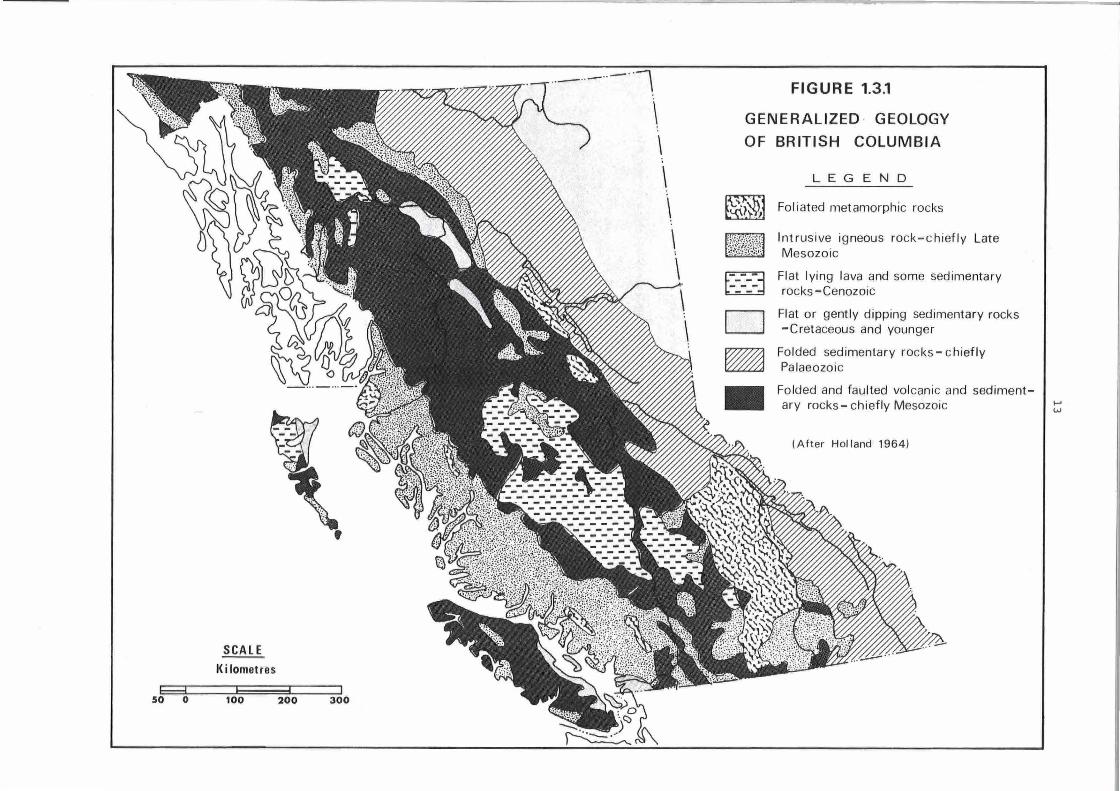
A geological map of the province (see: Douglas, R.J.W. in Further
Reading) shows many different rock types arranged in an intricate pattern.
Even on a simplified map (Figure 1.3.1) the outcrop distribution is complex
and does not correspond very closely with physiographic regions. Accordingly,
in order to avoid duplication, the following descriptions are arranged by
rock type rather than by physiographic region. The geology of each physio
graphic region is shown in Figure 1~3.1 and Table 1.3.1.
HITRUSIVE IGNEOUS ROCKS (PLUTONIC)
These are typically coarse crystalline rocks that in British Columbia
range from syenite, through granitic types, to diorite. They occur in a
variety of'forms ranging from simple stocks, where outcrop area may be tens
or hundreds of square metres, to the hug.:!, complex batholi th of the Coast
Mountains.
Despite variations in mineralogical composition, plutonic rocks tend
to be associated with a particular type of terrain. They are relatively
resistant to weathering since they are composed largely of durable minerals
(quartz, hornblende, feldspar) arranged as a cohesive fabric of interlocking
crystals. As a result, slopes on these rocks are generally steep and topo
graphy is rugged. Spectacular, glacially formed cliffs survive with little
modification, especially in massive or sparsely jointed rocks. Joints, and
less commonly, faults, constitute lines of weakness and are followed by
cliffs, gullies and major depressions.
However, despite their relative resistance to weathering, some
disintegration and decomposition of plutonic rocks inevitably occurs.
Mechanical breakdown due to processes such as frost shattering tends to
produce relatively large fragments due to the wide joint spacing. Extremely
coarse rubble on colluvial slopes and large boulders in till are charac
teristic of this terrain type. A combination of physical and chemical
weathering typically causes granular disintegration. Olivine, pyroxene and
calcic feldspar are most susceptible to attack by chemical weathering: crystals
of quartz and potash and sodic feldspar are released to form a sandy or
gritty residue. Although in most parts of the province the span of post
glacial time is too short for much chemical weathering to have occurred,
weathered rock residue of long interglacial periods forms a major portion
of the tills and other drift of the last glaciation. Sandy and gritty tills
and much sandy outwash are thus associated with areas of coarse crystalline
rocks.

1.3. GEOLOGY~ LANDFORMS AND SURFICIAL MATERIALS June M. Ryder
INTRODUCTION
The physical landscape of British Columbia is composed of a great
variety of landforms and materials. It ranges from spectacular, soaring
peaks in the Rocky Mountains, to alluvial plains in the Lower Fraser Valley
and lava plateaus in the central interior. This section describes, and to
some extent attempts to explain, the distribution of bedrock types, land
forms and surficial materials - unconsolidated sediments that have been
deposited in geologically recent time.
The present landforms of British Columbia and the nature and
distribution of surficial materials have resulted from the interaction of
three factors - rock type, tectonic history arid climate. The reaction of
bedrock to weathering and erosion influences the character of associated
landforms and surficial materials. Tectonic history is the sequence of
earth movements that have brought about the gross arrangement and relative
elevation of major topographic elements. Climate controls weathering,
erosion and deposition (geomorphic processes) and the rates at which they
operate. The history of climatic change is also recorded in the landscape.
To discuss the resulting complex physical landscape, physiographic
regions are delimited. Each of these consists either of a relatively
uniform landscape or a repeated pattern of associated landforms. The land
forms within such regions are commonly underlain by related bedrock types
and have undergone the same geomorphic history. British Columbia, has been
divided into five physiographic regions as shown on Figure 1.1.1.
GEOLOGY
The landforms that develop upon a particular kind of bedrock are
related to its structural features such as bedding planes, joints, folds
and faults, ahd to its mineralogical composition. Rock structure determines
both major landforms and details of the landscape. For example, the straight,
steep-sided section of Fraser Valley between Boston Bar and Lillooet is fault
controlled, or the size of rock fragments on a talus slope is related to the
spacing of joints and bedding planes on the cliff above. The rate of phy
sical weathering or mechanical disintegration of a rock, is influenced by
the presence.of lines of weakness and pore spaces that allow water; air and
temperature changes to penetrate beneath the surface. Thus, densely jointed
rocks such as basalt, or very porous material such as sandstone, are more
readily fractured than massive, sparsely jointed granites.

14
TABLE 1.3.1 Geology and structure of the major physiographic regions.
MAJOR PHYSIOGRAPHIC
I PHYSIO- GEOLOGY AND STRUCTURE GRAPHIC SUBDIVISIONS (HOLLAND) REGIONS
Outer Saint Elias Mountains ~r_anitic and metasedimentory racks __ Queen Charlotte Mountains -
····- - --- ------- ---------~ Mountain granitic and volcanic (basic and intermediate) rocks
COAST Area -----·-·-·-·-· ··-------------- ----- -----·-··----------·--- ---- - ------------- -Vancouver Island Mountains folded sedimentary and metamorphic rocks with granitic batholiths
MOUNTAIN~ Hecate Depression flat or gently dipping basaltic lavas and sedimentary rocks; a few granitic
Coastal intrusions AND ------·---------·· -- - - - -- r---·· ·-·- -·-------- - ·- - - ---- -··------------------------·--- --------------
Trough Georgia Depression sedimentary rocks with scattered volcanic rocks and Quaternary sediments
ISLANDS in F roser and Nanoimo lowlands; granitic rocks in northeast
Coast Coast Mountains granitic (chiefly granodiorite and quartz diorite) rocks with minor gneiss
Mountain and schist 1----------------------- --·-· ----- ------··---------·---------------·--
Area Cascade Mountains folded metasedimentary and volcanic rocks with granitic batholiths
Nechako Plateau flat_ or gently dipping volcanic rocks_ with a few granitic stocks -------- -
INTERIOR Fraser Plateau and Basin flat or gently dipping basaltic flaws Interior ---------------------------------------
Thompson Plateau flat or gently dipping lavas; sedimentary and volcanic rocks, granitic stocks
Plateau ond batholiths PLATEAU ------- --------------- -----------·-------------
Quesnel HLg!lland _______ ~histose metamorphic rocks with minor volcanic and sedimentary rocks
2huswop Highland gneiss and schistose metamorphic rocks ----------------------------- ---
Okanagan Highland metamorphic racks (chiefly gneiss) with granitic intrusions
Rocky Mountains (south) folded and faulted sedimentary and metasedimentary (chiefly limestone,
COLUMBIA quartzite, schist and slate) rocks ----------~ -----------
MOUNTAINS Rocky Mountain Trench (south) chiefly Quarternary sediments
AND Purcell Mountains folded sedimentary and metamorphic rocks (chiefly quartzite, argillite
SOUTHERN Columbia and limestone) with granitic intrusions - - --------
ROCKIES Selkirk Mountains folded sedimentary and metamorphic rocks with granitic stocks and batholiths
Mountains --Monashee Mountains folded sedimentary and metamorphic (chiefly gneiss) rocks with intrusions ------ ---- -----------·------·· Cariboo Mountains folded sedimentary and metamorphic rocks
Rocky Mountain Foothills folded sedimentary rock (limestone, siltstone, sandstone and shale)
NORTHERN Rocky Mountains (north) folde_d and faulted sedimentary and metasedimentary racks (chiefly
limestone, quartzite, schist and slate) -AND Liard Plateau folded sedimentary rocks
CENTRAL Rocky Mountain Trench (north) chiefly Quaternary sediments Northern Liard Plain sedimentary rocks
Plateau and - -----·
M_ountain Area Yukon Plateau folded sedimentary and volcanic rocks with granitic intrusions PLATEAUS Cassiar Mountains granitic core surrounded by folded metamorphic and sedimentary rocks
Central Omineca Mountains granitic core surrounded by folded sedimentary, metamorphic and granitic rack
AND Stikine Plateau folded and non-folded sedimentary and volcanic rocks with minor intrusions Plateau ---
Skeena Mountains folded sedimentary and metasedimentary rocks (argillite, shole and and greywacke) MOUNTAINS ------
Mountain Nass Basin sedimentary and volcanic rocks
A re a Hazelton Mountains sedimentary and volcanic rocks intruded by small granitic stocks and
batholiths
THE Interior Wit Nelson L~wlands flat and gently dipping shale and sandstone
GREAT PLAINS Plains berta Plateau flat and gently dipping shale and sandstone
..
SCALE
IC i lometres
100 200 300
--··--·· - ··1 \ \ \ \ \ \
FIGURE 1.3.1
GENERALIZED · GEOLOGY
OF BRITISH COLUMBIA
D --D ~
•
LEGEND
Foliated metamorphic rocks
Intrusive igneous rock-chiefly Late Mesozoic
Flat lying lava and some sedimentary rocks-Cenozoic
Flat or gently dipping sedimentary rocks -Cretaceous and younger
Folded sedimentary rocks- chiefly Palaeozoic
Folded and faulted volcanic and sedimentary rocks- chiefly Mesozoic
(After Holland 1964)

15
SEDIMENTARY ROCKS
The resistance of sedimentary rocks to weathering and erosion depends
upon many factors, but of prime importance are mineralogical composition,
degree of induration, i.e. the hardening due to cementation, pressure and
heat, and the spacing of bedding planes and joints. Poorly indurated rocks,
such as clay, mudstone and shale, disintegrate readily and are easily eroded.
Well indurated, massive sandstones, particularly quartz sandstones, and con
glomerates are relatively resistant to erosion. Limestones generally form
upstanding topography and also appear to be relatively resistant.
Horizontally bedded, alternating resistant and less resistant strata
give rise to plateau and escarpment, or mesa-like topography. Stepped slopes
are also characteristic, with steep "risers" of resistant rock, and gently
sloping or flat "treads" of non-resistant strata. Terrain of these types
occurs in the Great Plains region of northeastern British Columbia. Where
the strata are dipping, asymmetric ridges (cuestas) are formed where the
harder rock outcrops. Ridges and intervening valleys run parallel to the
strike of the rocks and thus topography has a pronounced "grain" or linearity.
Terrain of this type is found in the foothills of the Rocky Mountains.
Physical disintegration of sedimentary rocks produces fragments of a
size related to the spacing of lines of weakness in the bedrock. Thus shales,
which are thinly bedded, produce small, platy particles that readily disin
tegrate further. At the other extreme, massive conglomerates may shed huge
blocks which survive intact during glacial transport.
Weathering of sedimentary rocks also results from chemical removal
by solution or other means, of the cementing agent. Simple disintegration
o_f the rock then occurs, forming a residue that is texturally similar to the
original sediment. In British Columbia, products of weathering are mixed
with products of glacial abrasion in the surficial materials. Thus, for
example, clay tills overlie shales, and sandy tills overlie sandstones and
conglomerates. Silica-cemented rocks such as sedimentary quartzites resist
this effect and a.re extremely hard and durable.
In terrain developed upon faulted, folded and steeply dipping
sedimentary rocks, there is a strong relationship between rock type, struc
ture, and the ensuing topography. In belts of intense folding and faulting
such as the Rocky Mountains, structures are expressed as strongly linear
topography. Individual ridges or mountains are commonly asymmetric with
steeper scarp and gentler dip slopes; dips of over 45° produce extremely
jagged ridges. Prominent cliffs commonly coincide with fault planes or
steep bedding planes.
16
VOLCANIC ROCKS
Topography upon these rock types tends to be similar to that
developed upon sedimentary rocks of similar structure. Flat-lying lava
flows form plateaus bounded by escarpments and stepped hillsides. Terrain
of this type is widespread in south-central British Columbia.
Most of the relatively undeformed volcanic rocks in the province were erupted from fissures and shield volcanos during Tertiary time.
Basalts, andesites and pyroclastic rocks (air-fall deposits) are probably
most common. The lavas are fine textured and closely jointed. Basalt
typically displays regular columnar jointing.
Mechanical weathering of lavas and pyroclastic rocks proceeds in
accordance with the arrangement of fracture planes. The presence of open
vesicles or spaces left by gas bubbles in many lavas, gives additional
opportunities for weathering attack. The physical weaknesses which augment
mechanical disintegration also affect chemical weathering. Basalt, consist
ing of plagioclase feldspar, pyroxene and olivine, is most susceptible, and
rhyolite (quartz and feldspar) least susceptible to decomposition. With
sufficient time, basalt breaks down completely to clay minerals. The
weathering products of lavas are generally fine textured and result from
the combined effects of chemical and mechanical weathering.
METAMORPHIC ROCKS
No particular type of terrain can be ascribed to metamorphic rocks in general. Their resistance to weathering and erosion depends upon their individual characteristics.
Many metamorphic rocks such as gneiss and schist are foliated, that is, the minerals are segregated into bands within the rock. As a result,
differential weathering may produce linear topographic features as in the Omineca Mountains and Finlay Ranges. Metamorphosed sedimentary rocks such
as marble and quartzite commonly retain their original bedding and fold
structures which control their topographic expression. Metamorphic quart
zites are extremely resistant to weathering and form some of the highest
peaks in the Columbia Mountains.
Gneissic terrain occurs in the highlands along the southeastern
margin of the Interior Plateau. Weathering products are similar to those
of coarse textured igneous rocks of the same composition. Schists occur
in the Quesnel Highlands, and elsewhere in association with plutonic rocks1
they are broken down relatively rapidly by weathering, and produce strongly
linear or stepped topography.

17
TECTONIC HISTORY
A brief account of tectonic history is necessary here, since the
major topographic features of the province are tectonically controlled and
many mountainous areas owe their present high elevation to recent uplift,
rather than resistance to erosion.
The mountain systems of the province have been built during several
episodes of mountain building since late Precambrian time. Successive
episodes have tended to emphasize already established structural trends.
Two great crystalline belts, the Coast-Cascade Mountains and the Cassiar
Omineca-Columbia Mountains, have been the sites of repeated uplift, deforma
tion and igneous intrusion.
The features of the present landscape emerged during the Cenozoic
Era (Table 1.3.2). Folding and thrusting of geosynclinal sediments to form
the Rocky Mountains occurred roughly 70 to 35 million years ago. The Coast
and Omineca belts also experienced re-elevation at this time. During mid
Eocene time, fissure and shield volcano eruptions produced the first of the
two sets of lavas that cover much of the Interior Plateau.
The mid-Tertiary was an erosional interval during which the general
outline of present day drainage began to emerge. An erosion surface of
450 to 600 m relief was formed over most of the area lying west of the
Rockies. During Miocene time the second phase of vulcanism occurred. There
were renewed fissure and shield volcano eruptions and lava spread over parts
of the mid-Tertiary erosion surface. The Plateau Basalts, now a prominent
landscape feature of the Thompson Plateau, date from this time.
General uplift followed, resulting in differential elevation of
the erosion surface and its superposed lavas. It was upwarped along the old
Coast and Omineca axes and along the Insular Mountains. The erosion surface
constitutes the oldest landform that is preserved today. Over large portions
of the Interior Plateau it was modified only slightly by glacial processes.
However dissection by rivers has been severe around the plateau margins,
whilst in bordering mountains, isolated remnants of flat or gently sloping
terrain and accordant summit levels are all that remain. Parts of the up
land surface survive on interfluves in the Insular Mountains of central
Vancouver Island.
QUATERNARY HISTORY
The geomorphic and climatic history of British Columbia during the
Quaternary Period is of greatest significance with regard to present day
18
landforms and surficial materials. Climatic fluctuations during the
Pleistocene brought about alternating glacial and longer nonglacial inter
vals {Table 1.3.2). There is geological evidence for up to four glaciations
in British Columbia. However, it is likely that there were additional
glaciations for which no local evidence is available, since more complex
Pleistocene sequences are preserved in other parts of northern North
America.
In British Columbia, sediments that predate the final deglaciation
do not outcrop over sufficiently extensive areas to warrant attention here.
Accordingly, the following description is restricted to the effects of the
last, the Fraser or late-Wisconsin, glaciation and postglacial geomorphic
processes. During the-Fraser Glaciation ice accumulated in the high mountains
of .the Cordillera. Glaciers that were several kilometres wide and over a
thousand metres deep occupied the main valleys in the mountains. An unbroken
ice-sheet covered interior plateaus and thick glacier tongues coalesced
along the coast. The Keewatin part of the Laurentide ice-sheet extended into
the Great Plains region of northeastern British Columbia. Figure 1.3.2 shows
ice-flow directions and other features of the Fraser Glaciation.
The effects of total erosion by all Pleistocene glaciers are widespread,
and most apparent on high plateaus and mountains. Several distinct modes of
erosion and associated landforms can be identified. True alpine glacial topo
graphy is found in mountains that contained glaciers, but were not totally
covered by ice; horns, aretes, and cirques are diagnostic features of this
type of terrain. Where mountainous topography was overridden by ice, glacial
erosion produced typically rounded summits and ridge crests. Landscapes are
commonly found which consist of a combination of these two terrain types where
cirques and glacial troughs exist below rounded ridges and summits. Grooved
and fluted terrain occurs on plateaus and plains· and usually results from
both glacial erosion and deposition. In valley and trough areas, erosion was
greatest where the valleys were aligned parallel to the direction of ice flow.
This was the case in the Okanagan Valley for example, where the bedrock valley
floor now lies as much as 200 m below present day sea level.
Fraser ice reached its maximum about 15,000 years ago, when it
extended south to 47°N. latitude in Washington State. The subsequent retreat
of the ice margin was relatively rapid. The Strait of Georgia and parts of
the Fraser Lowland were ice free by 13,000 years ago. Minor readvances of
ice into the eastern part of the Fraser Lowland occurred until 11,000 years
ago. Major valleys in southern interior British Columbia were ice-free by
11,000 years ago. A Carbon-14 date from peat near a modern glacier terminus
in the Coast Mountains shows that ice cover had shrunk to approximately its
present extent by 9500 years ago. Sea-level was relatively high at the end

19
of the Fraser Glaciation. As ice retreated from the Vancouver area, for
example, sea-level stood at +175 m, and in the Kitimat-Terrace area it was
at +230 m during deglaciation. Sediments deposited during the Fraser
Glaciation and during the retreat are described below.
HOLOCENE CLIMATE AND GEOMORPHIC PROCESSES
A comprehensive climatic record for Holocene (postglacial) time in
British Columbia has not yet been assembled. The information presently
available has been obtained chiefly by analysis of pollen from Carbon-14
dated bog and lake sediments. Climatic changes are deduced from the vegeta
tion succession recorded by pollen stratigraphy. Most information comes from
the southwest coastal area and adjacent parts of Washington State. No studies
have been reported from British Columbia north of a line through the Skeena
and Pine Rivers.
Climatic warming occurred rapidly either just before or during
deglaciation, and vegetation quickly colonized the newly exposed surfaces.
A cold climate, i.e. colder than at present, of one or two thousand years
duration is indicated only at sites where the pollen record extends back to
the time when ice was still present. There is no record of tundra vegetation.
Trees were everywhere a part of the immediate postglacial flora.
There was a relatively warm and dry interval during Holocene time,
but its time of occurrence and duration have not yet been precisely deter
mined. There is some evidence for a mid-Holocene "xerothermic" or "Hypsi
thermal" interval, approximately 3000 to 8000 years ago, which was preceded
by cool, moist conditions. However, most recent investigations have indicated
that the relatively warm and dry conditions of the Hypsithermal prevailed
during the first half of Holocene time, roughly from 10,000 to 6500 years
ago (Table 1.3.2).
Cooler and wetter conditions followed the Hypsithermal and lasted
until the present time. During this period, minor climatic fluctuations
have occurred, and short-lived cool and moist intervals have coincided with
temporary expansions of mountain glaciers (referred to as "neoglaciation").
Although these periods of activity are somewhat irregular, in general three
episodes of glaciation have been identified at 5800 to 4900 years and 3300
to 2300 years ago and during the last 1000 years (Table 1.3.2). In fact,
many glaciers appear to have reached their greatest Holocene extent within
the last few centuries.
Geomorphic processes during the Holocene period have been controlled
in part by the effects of Fraser Glaciation and in part by Holocene climatic

YEARS before 1978 (logarithmic
scale) 50
100
500
1.000
ER A PERIOD and EPOCH
HOLOCENE
IREC ENTJ
>
a:
et
A I
i' l !1
20
EVENTS IN BRITISH COLUMBIA
River downcutling
and terracing; alluvial
Ian and floodplain
development;
colluviaf ac1iv1ty
-.
!
]f !!'
- Aiyansh lava llow
-Bridge Riverashlall
-saint Helen·sv ashfiilll
5,000- z ~i 10,000
50.000
100.000
500,000
1 MILLION
5 MILLION
10 MILLION
50MILLION
100 MILLION
500 MILLION
u
C)
N
C)
z
LU
u
a:
w
... et
::,
0
..... - -
>
a:
et
... a: w
...
~
PLEISTOCENE
PLIOCENE
MIOCENE
OLIGUCENE
tHYPS1THERMAL(7 I I Eolian
I activity - Manma ash fall
FRASER GLACIATION
Coqmllam ice
OLYMPIA INTERGLACIATION
---------------------- - -G lACIATION
several glaciations
and inlergla iations \
ti;tilt'"and ;;a,ping -
of erosion surface
Entrenchment of
major rivers
t Erosion:
devel~pment of drainage
pattern
• ~
eposilionol lastic sediments in
majorvalleys and long coasl
---------- -
tPlateau Saults u1rudedllnte.rior Plateaul earliest Edziza, level Mountain. west Fraser Plateau flows and others
Chilliwack Batholith and other small intrusions
:~
laratide EOCENE Orogeoy Kamloops and other volcanics extruded
PALEOCENE (Rocky Mountaiasl J-------+----....L.--'-'__;_:_::...+-----==-"::;:;:;,==------- ~\:~~!~ ::r~;:~,~~onn ~:;:s;rai~~wlands.some -
MESOZOIC
PALEOZOIC
J-------i PRE CAMBRIAN
CRETACEOUS
JURASSIC TRIASSIC
TABLE 1.3.2 = Geological time scale and events related to the development of landforms and soils in
British Columbia.
21
conditions. Immediately following deglaciation there was a period of intense
activity when much glacial drift was reworked and redistributed by streams
and rivers, and mass wastage processes modified drift deposits o~ slopes.
Aggradation along rivers, alluvial fan deposition, and lacustrine sedimenta
tion occurred at this time. This activity gradually diminished as the supply
of easily erodible drift became exhausted. In many valleys postglacial
aggradation was succeeded by a phase of downcutting by streams and rivers.
Terraces were cut into moraine, fluvial and lacustrine sediments.
With one or two exceptions, the effects of Holocene climatic change
are hard to discern in the Brit1sh Columbia landscape. Increased warmth and
dryness during the Hypsithermal period in south-central British Columbia
appears to have induced aeolian processes by causing reduction in vegetative
cover. Sand dunes in Okanagan Valley and other aeolian deposits have been
attributed to this origin. In alpine areas, periglacial and glacial activity
seems to have increased during the neoglacial events described earlier.
SURFICIAL MATERIALS AND ASSOCIATED LANDFORMS
Surficial materials that form the parent material of soils were
formed during and since the Fraser Glaciation. Drift of this glaciation
includes till and fluvioglacial, glaciolacustrine and glaciomarine sediments
that were deposited during the ice retreat. Throughout Holocene time,
colluvial materials have accumulated on or at the foot of slopes, and fluvial,
lacustrine and organic sediments have been deposited on valley floors and in
depressions. The physical properties of these materials, their distribution,
and the landforms with which they are typically associated are described
here.
Morainal materials were deposited directly from glacier ice. They
include Pleistocene till and the rubbly deposits of Holocene glaciers. Till
is probably the most extensive of all surficial materials in the province.
It covers level to moderately sloping surfaces that lie above valley floor
areas affected by recent fluvial aGtivity and below rock and colluvial slopes
of the alpine zone.· Till plains occur where till has infilled irregularities
in the underlying surface or covered level surfaces of structural or erosional
origin. Drumlins and fluted till sheets are common on plateaus and plains.
particularly the Interior and Alberta Plateaus.
Till is a compact, non-sorted and non-stratified sediment which
contains a heterogeneous mixture of particle sizes. However, it can vary
abruptly from place to place with changes in the nature of source material.
Where till was derived from bedrock, its mineralogical composition is related
to the local rock (as described earlier). Where till was derived from un-

22
consolidated sediments, it reflects their texture and mineralogy. For
example, in valleys of the Thompson Plateau, till consists of rounded pebbles
and cobbles in a matrix of sandy silt. The stones come from older fluvial
gravels and the fines from older lacustrine silt.
Sandy tills are porous and so water passes rapidly through them. At
the other extreme, clay tills tend to be impervious and poorly drained. In
addition, impeded drainage may occur where a thin cover of till overlies
impervious bedrock.
Fluvioglacial materials are deposited by meltwater either in contact
with glacier ice or beyond the ice margin as outwash. Ice-contact deposits
vary from well defined kames, kame terraces and eskers to irregular and dis
continuous spreads of gravel overlying till. They consist of gravels and
sand that may be sorted and stratified. Where bedding is present, it is
typically distorted as a result of partial collapse when the supporting ice
melted. Karnes and eskers tend to be well drained and often constitute the
driest, or most xeric, sites within a landscape.
Within British Columbia, ice-contact materials have a wide distribution
and are found in most areas with the general exceptions of narrow glacial
tr6ughs and the higher terrain of alpine glaciation. Major eskers and esker
complexes are found on the Nechako Plateau, Fraser Plateau and Liard Plain.
Karnes and eskers typically occur in association with meltwater channels on
the surface of the Interior Plateau. In areas of higher relief, kames occur
in cols or high-altitude through-valleys. Kame terraces form the highest
terraces within most valleys.
Proglacial outwash deposits constitute gravel plains or terraces that
may be kettled. The material ranges from sand to boulders and is sorted and
poorly bedded. Outwash gravels originated as floodplains occupied by braided
rivers. In Holocene time.old outwash plains have been modified due to
changing river regimes and have undergone terracing or have been occupied by
meandering rivers. Outwash gravels are~forming in present-day proglacial
situations along valleys draining from .glaciers in the Coast, Columbia and
Rocky Mountains.
Outwash gravels are porous and permeable and generally constitute
well drained areas unless the water-table lies close to the surface.
G'laciolacustrine materials collected in proglacial lakes during or
shortly after deglaciation (Figure 1.3.2 shows the major lakes). They consist
of sediment brought into the lakes by meltwater streams. Silt and fine sand
are most common but coarser sand and gravel occur close to points of inflow.
0
• Mountains
D Highlands and Foothil Is
I~ 1
::::::1 ~
Plateaus
Basins. Plains and Lowlands
afte r
Holland
1964
LEGEND
areas not covered by Fraser ice . · . ·. · · . . . . . . . . . . . . . [ -:·"?>j late-glacial lakes· ·· · · · · · · · · · · · · · t - ~
possible offshore I imit of Fraser ice·
southern limit of Fraser ice ····· ·
eastern limit of Fraser-Cord11ieran ice sheet
~ --------------, western I imit of Keewatin ice sheet .
limits of marin e submergence !not shown for all areasl
major troughs transecting Coast Mountains .. .... ~
generalized ice flow directions · · · · · · · . . . .
(Information generali zed from Glacial Map of Canada 1967 and ot her sourcesl
y I
I
E-3 I 0
FIGURE 1.3.2 GLACIAL FEATURES OF BRITISH COLUMBIA
SCALE Ki lometres
100 200

23
Clay-sized sediment can occur locally. Bedding in lacustrine silts and sands
ranges from massive to laminated. Where materials were deposited in contact
with glacier ice, slumping and settling ensued during melting giving rise to
irregular undulating or kettled topography.
In general, the nature of terrain associated with glaciolacustrine
sediments depends upon their thickness. In many basins sediments are
sufficiently thick that all former irregularities have been masked and the
old lake bed now forms a level or slightly undulating surface. Scarps in
lacustrine silts tend to be steep with vertical upper sections. Headward
erosion of gullies in lacustrine silt is rapid, and where this material
occupies large areas, extensive dendritic gully systems may have developed,
as for example in the South Thompson Valley near Kamloops.
Near-surface drainage and groundwater movement within glacio
lacustrine materials depeng upon their texture. Fine silt and clay beds
form impervious layers which will reduce infiltration rates if near the sur
face or cause lateral migration of groundwater in perched water tables at
depth. In the latter situation, high pore pressures may develop and cause
loss of cohesion resulting in slump and flow failures along slopes. Steep
scarp slopes are particularly susceptible to this process. In some places
this has been man-induced by addition of extra water, for example from
irrigation, on the surface above the scarp.
Glaciomarine materials {"marine drift") were formed during the time
of high sea-level at the end of the Fraser Glaciation by the accumulation of
particles released from floating, melting ice. It consists of stony, silty
clay which is non-sorted and may show faint, irregular stratification. The
material is superficially similar to till, but in places contains the shells
of Pleistocene marine molluscs. As sea-level fell, the areas mantled by
marine drift gradually emerged and were systematically worked over by wave
action to form a thin covering of beach sands and gravels.
Water percolation through unmodified marine drift is slow due to its
high clay content. Drainage is rapid through beach gravels and sands.
Pluvial materials are transported and deposited by streams and rivers.
They consist of gravel, sand, or silt and are generally well-sorted by
comparison with most other surficial materials.
In general, floodplains of rivers that have steep gradients and high
sediment loads {bedload) tend to have shallow, braided channels and to be
underlain by gravelly material. A thin cover of flood-deposited sand may
occur away from active channels. Streams of this type occur within steep,

24
mountainous terrain. Floodplains of low-gradient rivers that are transporting
fine textured sediment have meandering channels, levees and backwater or back
swamp areas. They are underlain by sand and silt resulting from overbank
deposition. Rivers of this kind are found on deltaic floodplains and upstream
from lakes, rock sills and other local base-level controls.
Fluvial terraces are underlain by materials similar to those underlying
floodplains, but gravels usually predominate and overbank fines are less
common.
Alluvial fans are formed where streams emerge from steep, narrow
valleys onto flatter ground. Material is deposited here due to reduced gradient
and widening of the channel. Material is coarsest, commonly boulder gravel,
close to the fan apex, and becomes systematically finer outwards, grading to
fine gravels, sand or silt at the periphery. Many alluvial fans are relict
features in the present landscape and date from the early post-glacial phase
of geomorphic activity.
A delta is simply an extension of a floodplain. Texture of the
material within a delta is relatively uniform and depends to a gre·at extent
upon the gradient of the river upstream. The delta of a steep mountain torrent
will consist of boulder gravels whereas the delta of a low-gradient river will
be formed of silt or sand, as for example the delta of the Kootenay River near
Creston.
Percolation of water through sand and gravel is potentially rapid due
to their coarse texture. Drainage of fluvial surfaces thus depends chiefly
upon the depth of the groundwater table. Where this is high, as in the case
of deltas and floodplains, areas of impeded drainage will occur, and slightly
elevated areas, such as levees, will be relatively dry. The water table is
also close to the surface in places on alluvial fans, particularly near the
stream and at the fan toe where seepage zones may be present. Seasonal
fluctuations in the levels of lakes and rivers will induce variations in the
level of the water table in related landforms. Terraces and dissected fans
are well drained sites.
Colluvial materials are the products of mass wastage. They include
an}' unconsolidated materials that have lost their original form due to
downhill movement, as well as distinctive types of colluvium such as mudflows,
landslide deposits and the debris of shattered bedrock.
Mudflows consist of clasts of various sizes surrounded by a "mud"
matrix of silt and clay. This mass flows as a viscous liquid when saturated
and is capable of transporting large boulders. Colluvial fans consist of
25
stratified sequences of thin mudflows. They tend to be moderately well
drained as a result of surface slopes of 5 to 15°, although water percolation
through mudflow material is usually slow due to its high silt and clay content.
Landslide deposits vary from fine textured masses of slumped lacustrine
silt to huge blocks and rubble of rockslides. They generally form hummocky
topography below a steep landslide scar. Fine textured slide deposits are
poorly drained and may contain pockets of standing water. There may be seep
age zones near the foot of the slide scar. Rockslides are usually very well
drained, xeric sites.
Bedrock fragments loosened individually by frost shattering and other
weathering processes accumulate as talus slopes or sheets on hillsides. As a
result of its coarse texture and steep surface gradients, material of this
type is generally very well drained, although seepage sites may occur at the
foot of slopes.
Solifluction deposits are widespread in high alpine areas. They
consist of water-saturated masses of weathered rock or drift that flow slowly
downhill. The high moisture content is derived from melting snow and summer
precipitation, and in addition, drainage may be impeded due to underlying
permafrost or impervious bedrock.
Eolian materials are wind deposited sands and silts. They form dunes
where abundant material is blown along the ground surface and heaped up by
the wind, and they form thin layers over older landforms by the settling of
airborne particles. Dunes consist of medium to fine sand, whilst eolian
mantles consist of fine sand and silt. These materials occur throughout the
province, even in the alpine zone, but they are thickest and most extensive
on terraces, fans, floodplains and outwash surfaces.
Dunes are generally well drained. The drainage of eolian mantles
depends to some extent on the permeability of the materials that they overlie
and the associated landform.
Marine materials consist of off-shore deposits of stratified and
locally fossiliferous clays and silts that settled from suspension, and
shoreline materials of beach sands and gravels that formed by wave action
and longshore drift. Terrain underlain by marine clays and silts is usually
very gently sloping. Beach gravels and sands occur as low ridges. Drainage
on the fine textured off-shore materials is restricted; beach materials are
generally well drained.

26
Organic materials consist of peat that has accumulated in depressions
and other areas of high water table. They are most abundant in the northern
part of the province in areas such as the Liard Plain, Fort Nelson Lowland,
and Queen Charlotte Lowlands. Elsewhere, they are restricted to relatively
small areas in rock basins, kettles, floors of glacial spillways, and old
channels and backswamps on floodplains and deltas.
CHARACTERISTICS OF THE PHYSIOGRAPHIC REGIONS
For information regarding the geology of these physiographic regions
and the relationships between rock type and weathering products, texture of
surficial materials, and landforms, the reader is referred to Figure 1.3.1,
Table 1.3.1 and the preceding "Geology" section.
COAST MOUNTAINS AND ISLANDS
This region consists of two parallel mountain belts (the discontinuous
St. Elias - Insular Mountains and the Coast-Cascade Mountains) and the inter
vening, largely submerged Coastal Trough. In the mountain belts, summits are
highest in the St. Elias Mountains (4600 to 5500 m), Coast Mountains (2500
to 4000 m), and the central part of Vancouver Island (2000 m). The mountain
topography is extremely rugged, even in the relatively low Queen Charlotte
Mountains (1100 m).
Terrain typical of intrusive igneous rocks and mountain glaciation,
both alpine and overridden types, is especially well developed in the Coast
and Cascade Mountains. Major linear structures have been excavated by
glacial and fluvial processes to form striking alignments and grid-like
patterns of valleys and fjords. Ice flowing westwards from the Interior
,Plateau and northern mountains excavated major low-level troughs across the
Coast Mountains. These are now occupied by rivers such as the Taku, Stikine,
Iskut, Nass, Skeena, Dean, Bella Coola and Homathko (Figure 1.3.2).
Glacial landforms dominate the St. Elias and Queen Charlotte
Mountains. On many islands and coastal areas of the Insular belt, cirques
occur at all elevations down to sea-level. Remnants of the Tertiary erosion
surface occur as level or gently sloping ridge crests on both island and
mainland along the Coastal Trough. The surface lies below 600 m elevation
here, but it rises gradually eastwards and westwards towards the mountains.
Erosion surface remnants and landforms of mountain glaciation (both alpine
and overridden types) constitute much of the Vancouver Island landscape.
The St. Elias Mountains and parts of the northern and southern
Coast Mountains still have extensive icefields and glaciers. Rivers draining
27
from these areas have broad gravel floodplains that are free of vegetation
and crossed by shifting, braided channels.
Within the mountains, thick drift deposits are restricted to the
margins of the floors of major valleys and adjacent hillsides. Floodplains,
and in some valleys river terraces, occupy the central part of the valley
floor. On most slopes there are extensive bedrock outcrops and accumulations
of rubbly colluvium. Relatively gentle mountain slopes may have a thin till
mantle. Avalanching is the dominant geomorphic process operating today on
steep slopes at intermediate and high elevations. Nivation, solifluction
and other periglacial processes are locally important in the alpine areas.
Neoglacial moraines occur adjac~nt to modern glaciers.
Within the lowlands and islands of the Coastal Trough, summit levels
are generally below 600 m. Drift deposits are thickest and most continuous
here, although there are some large areas of glacially abraded rock surfaces
and outcrops of resistant rock types. A uniformly low glaciated rock plain
(Milbanke Strandflat) borders the mainland coast along Hecate Strait. Marine
drift and associated beach materials cover hilly areas and gentle slopes in
the western part of the Fraser Lowland and other coasfal areas (Figure 1.3.2).
Till and fluvioglacial gravels also form extensive hilly and undulating areas
in the lowlands and islands. Pluvial gravels and sands occur as terraces
and floodplains along major rivers that cross the coastal lowlands. In
Holocene time the Fraser River has formed a major floodplain and delta com
posed chiefly of sand and silt.
INTERIOR PLATEAU
The Tertiary erosion surface, in places capped by lava flows, is the
dominant landscape feature of this region. The degree of dissection of the
plateau surface varies from place to place. In the northern two-thirds of
the region (Fraser and Nechako Plateaus), large tracts are undissected and
comprise flat to gently rolling terrain at elevations of 1200 to 1500 m.
The surface is interrupted however, by the entrenched Fraser River and its
major tributaries which occupy channels that are 100 to 200 m lower than the
plateau surface. Near Anahim Lake, several smail mountain ranges (2500 m)
are the dissected remnants of late-Miocene shield volcanoes. The Fraser
Basin is a low-lying part of the plateau in the vicinity of Prince George,
from 600 to 900 m a.s.l.
The southern part of the Interior Plateau (Thompson Plateau) is
dissected by the Fraser and Thompson Rivers and their tributaries which flow
in steep-sided valleys 600 to 900 m below the plateau/surface. Extensive
areas of rolling upland surface remain at 1200 to 1500 m, and in places
higher hilly areas up to 2000 mare located upon relatively resistant bedrock.
28
Uplift of the Tertiary erosion surface was relatively great along
the eastern margin of the Interior Plateau in the Shuswap, Quesnel and
Okanagan Highlands. Subsequently, severe dissection has occurred here, pro
ducing relatively rugged terrain with gently sloping erosion surface remnants
on ridge crests and summits. Summit levels lie between 1500 and 2000 m, and
local relief of 600 to 900 m is typical. Glacial erosion produced rounded
ridge crests and steep valley sides. Drift occurs on valley floors and on
gentle slopes.
The surface of the whole Interior Plateau is mantled with drift
which chiefly consists of drumlins and fluted till. Rock outcrops are not
extensive on the plateau surface, although the plateau is bounded by lava
cliffs or steep rocky slopes adjacent to the entrenched rivers. Eskers,
kames and meltwater channels are numerous. Glaciolacustrine silts occur in
many valleys and basins (Figure 1.3.2). Drift is over 100 m thick in some
major valleys such as the Fraser and Okanagan. In many valleys this Pleisto
cene fill has been dissected and terraced during post-glacial downcutting by
major rivers.
COLUMBIA MOUNTAINS AND SOUTHERN ROCKIES
This region comprises several parallel mountain belts and intervening
valleys. The four mountain belts.which together constitute the Columbia
Mountains are lithologically and structurally complex (Table 1.3.1). In
general, summit elevations range from 2500 to 3500 m, and are lowest south
of latitude so0 N. Where summits are high, the mountains are extremely rugged,
and where deep valleys flank high peaks, local relief of over 2000 m is not
uncommon. Ridges and peaks above 2000 to 2500 m were not overridden by ice
and are serrated. Lower summits and crests are subdued and rounded and may
have a thin covering of till. Drift is present on valley floors (along with
fluvial materials) and on gentler mountain slopes at relatively low elevations.
Steeper slopes consist of rock outcrops and rubbly colluvium. Avalanching
occurs on steep valley sides at all elevations. Nivation is proceeding in
alpine areas, and both active and relict periglacial features occur, such as
patterned ground and rock glaciers. The modern glaciers are bounded by one
or more strands of neogl_acial moraine.
The Monashee, Selkirk and Purcell Mountains are separated by major
glacially-enlarged trenches which now contain Arrow and Kootenay Lakes and
part of the Columbia River. Drift materials, chiefly till and fluvioglacial
gravels, are widespread on the floors and lower slopes of these valleys and
alluvial terraces occur along rivers.

29
The Rocky Mountain Trench is a steep-sided structural depression
which lies between mountains of strongly contrasting structures and rock
types. It is largely floored with Quaternary sediments. Glacial deposits
include till as drumlins, outwash terraces and glaciolacustrine silt. However,
Holocene fluvial sediments occupy extensive areas and consist of terrace gra
vels and floodplain silts, sands and gravels.
In the southern Rocky Mountains, the topography reflects the structural
control of underlying folded and faulted sedimentary rocks. Erosional land
forms of alpine and valley glaciation such as cirques, troughs and horns are
commonly asymmetric where they are cut in moderate to steeply dipping strata.
The broadest troughs are located along zones of 'soft' rock. Summit elevations
range up to 3600 m and local relief is typically 1200 to 1500 m. The distribu
tion of drift in the Rockies is similar to that in the Columbia Mountains.
However, rapid disintegration of the well jointed sedimentary rocks of the
Rockies has given rise to much talus development, and to the formation of
mantles of rubbly debris over bedrock slopes above timberline. Where bedding
is nearly horizontal and along valley sides that parallel the strike of the
bedrock, alternating cliff bands and shelves containing talus slopes are a
typical landscape feature.
NORTHERN AND CENTRAL PLATEAUS AND MOUNTAINS
This physiographic region consists of a miscellaneous collection
of mountains, plateaus and plains, but some generalizations can be made.
The plateaus (Yukon, Stikine, and small plateaus within mountain regions)
are Tertiary erosion surface remnants displaying varying degrees of dissec
tion by streams with various depths of entrenchment. Plateau surfaces are
generally between 1500 and 1800 m, and flat or gently rolling. Where they
are warped up to higher elevations, dissection has been more severe. Ice
overrode virtually all plateau areas and produced drumlinoid and fluted
topography in both bedrock and till. Drift is widespread, and deranged
drainage and numerous lake basins provide sites for organic accumulation.
Many centres of late-Tertiary and Quaternary vulcanism occur within the
plateaus, especially on the Stikine Plateau where the shield volcano of Mt.
Edziza (2700 m) and Level Mountain (2100 m), and other volcanic cones are
located.
The mountain areas (Skeena, Cassiar and Omineca Mountains) are
subdued by comparison with the Coast and southern Rocky Mountains. Summit
elevations range between 1800 and 2700 m, and local relief is 900 to 1200 m.
Surfaces below 1800 m were overridden by ice and consequently the lower
summits are rounded and commonly bear a thin drift cover. Higher areas
have all the features of alpine glaciation. Drift is widespread in broad
valleys.

30
The Liard Plain and Nass Basin are areas of low relief and flat
or gently rolling topography at elevations of 750 to 1000 m, and below 750 m
respectively. There is extensive drift cover with numerous lake basins.
Drumlins and fluted terrain in both drift and bedrock are common. Several
major esker systems cross the Liard Plain.
The northern Rocky Mountains and Rocky Mountain Trench are essentially
similar to their southern counterparts, although there are large areas of
relatively subdued mountain topography, for example, in the Hart Ranges. In
both the Rockies and the Rocky Mountain Foothills to the east, a strongly
linear topography reflects geologic control. The foothills have landforms
typical of dipping sedimentary strata with little glacial modification other
than a drift cover.
GREAT PLAINS
This area comprises structurally controlled topography with mesas and
cuestas, developed on flat-lying or gently dipping sandstones and shales •.
The sandstones are relatively resistant to erosion and underlie the uplands.
Surfaces are generally flat to gently rolling at elevations of 900 to 1200 m
on the Alberta Plateau, and below 600 m in the Fort Nelson Lowland. The Peace
and Liard Rivers and their tributaries are incised, producing a low relief
along valleys of 600 m in the plateau and 150 m in the lowland.
This region was glaciated chiefly by Keewatin ice from the east.
Cordilleran ice from the Rocky mountains extended only a short distance
eastwards beyond the Foothills (Figure 1.3.2). Drift was deposited over most
of the_ region, although it is thin or absent from some uplands and ridge
crests. Drumlins and fluted till plains are common throughout the area, and
a variety of moraine features, pitted outwash and meltwater channels occur in
the lowland. Large areas of outwash gravels and sands were deposited by
meltwaters draining eastwards and northwards from the Cordilleran ice. These
materials now occupy plateau margins adjacent to incised rivers, such as the
Fort Nelson and the Hay. Lacustrine sediments of proglacial lakes occur in
the Peace Riv~r basin and in parts of the Fort Nelson Lowland (Figure 1.3.2).
They consist mainly of clay and silt, but grade locally to sands and deltaic
gravels.
31
FURTHER READING
Alley, N.F., 1976. The palynology and palaeoclimatic significance of a dated
core of Holocene peat, Okanagan Valley, southern British Columbia.
Can. Jour. Earth Sciences 13, pps. 1131-1144.
Describes changes of climate and vegetation that occurred in the dry interior> of
British Columbia during post-glacial. time.
Armstrong, J.E., 1976. Quaternary geology, stratigraphic studies and
revaluation of terrain inventory maps, Fraser Lowland, British
Columbia. Geol. Surv. Can. Paper 75-1, Part A, pps. 377-380.
An update and swrvnary of AY'T71strong's work which covers absolute ages, strati
graphy and chronology of Quaternary sediments.
Armstrong, J.E. and W.L. Brown, 1954. Late Wisconsin marine drift and
associated sediments of the Lower Fraser Valley, British Columbia,
Canada. Bull. Geol. Assoc. Amer., 65, pps. 349-364.
Describes in detail the fossiliferous, till-like stoney clays that cover much of
the Lower Mainland. Several hypotheses for the origin of marine drift are
discussed and illustrated.
Birkeland, P.W., 1974. Pedology, Weathering and Geomorphological Research.
Oxford Univ. Press, 285 pp.
Focuses on the use of soils and rock and mineral weathering to solve problems in
Quaternary research that are C01711lon to the fields of pedology, geomorphology,
sedimentoZogy and stratigraphy.
Clague, J.J., 1976. Late Quaternary sea-level fluctuations, Pacific coast
of Canada and adjacent areas. Geel. Surv. Can. Paper 75-1, Part C,
pps. 17-21.
Provides an excellent summary and discussion of previously published accounts.
Douglas, R.J.W. (Ed.), 1970. Geology and Economic Minerals of Canada. Econ.
Geel. Rept. No. 1, Dept. Energy, Mines and Resources, Canada.
Major work on the geology of Canada. Includes useful chapter on Quaternary
geology.
Fulton, R.J., 1969. Glacial lake history, southern Interior Plateau, British
Columbia. Geel. Surv. Can. Paper 69-37, 14 pp.
Describes pattern of degZaciations and related development of glacial Zakes in
the Nicola, Thompson and Okanagan basins.
32
Fulton, R.J., 1971. Radiocarbon geochronology of southern British Columbia.
Geol. Surv. Can. Paper 71-37, 28 pp.
A description of the radiocarbon-dated Quaternary history of southern British
Colwnbia over the past 52,000 yrs.; includes a compilation of dates related to
glaciations, post-glacial sea-levels, volcanic ash-falls and post-glacial climate.
Fulton, R.J., 1975. Quaternary geology and geomorphology, Nicola-Vernon
area, British Columbia. Geol. Surv. Can. Memoir 380, 50 pp.
An account of Quaternary landforms and sediments in area covered by NTS maps 92I/
SE, 92I/NE, 82L/NW, 82L/SW, and accompanied by surficial geology maps at 1:26,720.
Prest, V.K., D.R. Grant, and V.N. Rampton, 1967. Glacial Map of Canada.
Geol. Surv. Can.
1:5,000,000 map depicting glacial landfo1'171s.
Reusser, C.J., 1960. Late-Pleistocene environments of north Pacific North
America. Amer. Geog. Soc. Spee. Pub. 35, 308 pp.
Describes late-glacial and post-glacial climatic, and biotic changes that occurred
in coastal regions as interpreted from peat and pollen stratigraphy.
Holland, S.S., 1964. Landforms of British Columbia, a physiographic outline.
B.C. Dept. Mines and Pet. Res. Bull. 48, 138 pp.
Physiographic regions are defined and described in terms of their topography,
geology, landfo1'171s and glacial history.
Mathewes, R.W., 1973. A palynological study of postglacial vegetation changes
in the University Research Forest, southwestern British Columbia.
Can. Jour. Bot. 51, pps. 2085-2103.
Pollen analysis is used to investigate post-glacial vegetation and climate
changes.
Mathews, W.H., 1968. Geomorphology, southwestern British Columbia, pps. 18-
24 in Guidebook to Geological Field Trips in Southwestern British
Columbia, ed. W.H. Mathews, Dept. Geology, Univ. of British Columbia.
A swrmary account of Tertiary and Quaternary landfo1'171 development.
Nasmith, H., W.H. Mathews, and G.E. Rouse, 1967. Bridge River ash and some
other recent ash beds in British Columbia. Can. Jour. Earth Science
4, pps. 163-170.
Describes the distribution and time of eruption of post-glacial volcanic ashes.

33
Tipper, H.W., 1971. Glacial geomorphology and Pleistocene history of central
British Columbia. Geol. Surv. Can. Bull. 196, 89 pp.
Describes glacial landforms and Pleistocene history of area covered by NTS maps
92N, 920, 92P, 938, 9JC, 93F, 93G, 9JJ, Accompanied by maps of selected glacial
features at 1:250,000.

1.4 VEGETATION R.K. Jones and R. Annas
INTRODUCTION
There is a wide range of vegetation in British Columbia. Along the
humid west coast, mid- to high-latitude coniferous "rain forests" occur,
whereas many dry interior valleys, in the lee of mountain ranges, have open
woodlands and steppe (grassland) communities. In the north, with its cold
continental climate, are high latitude northern boreal forests, characteris
tic of Continental North America and Euro-Siberia. Small areas in south
western British Columbia in the rainshadows of the Olympic Peninsula and
Vancouver Island, have a mild, mediterranean climate which supports open
grassy deciduous forests of Garry oak. The mountains provide environments
that range from relatively favourable for plant growth at low elevations to
most severe and hostile at high elevations. As implied by these few examples
the vegetation pattern varies vertically as well as horizontally across the
province. Some specific examples of such variations are shown in Figure 1.4.1,
and the province-wide pattern of vegetation is shown in Figure 1.4.2.
Although vegetation changes spatially in response to differing
environmental and historical conditions, it is possible to discern areas of
vegetation which are relatively homogeneous in species composition and
physical structure. Such homogeneous areas, which are called plant communities,
can be classified and mapped in a fashion similar to soils. On a macro-scale,
distribution patterns of plant communities can also be distinguished. It is
useful to discuss these vegetation patterns within the framework of some
classification system.
several classification schemes have been developed for the vegetation
of British Columbia, each one suiting a particular purpose. This section will
use the Biogeoclimatic Zone classification as developed by Dr. V.J. Krajina
and his colleagues and students since the early 19SO's in the Department of
Botany, University of British ColUtnbia.
THE CONCEPT OF BIOGEOCLIMATIC ZONATION
A biogeoclimatic zone is a geographic area having characteristic
vegetation with associated animals, soils and climate. Each forested zone is
under a broadly homogeneous macro-climate and is characterized and usually
named by one or more of the dominant shade-tolerant tree species which are
often capable of self regeneration on most of the habitats. Generally, each
zone can be broken into subzones which are distinguished by the climax plant

36
association (groupings of several similar plant communities) on a rnesic site.
This site is the mid-point of the nutrient and moisture range occurring
within the subzone; it is therefore not subject to excessive drainage nor to
seepage waters and hence the vegetation best reflects the macro-climate.
Each subzone will have a series of communities developed in habitats
which are strongly influenced by factors other than macro-climate. These
factors may be the result of different soils, drainage, moisture regimes,
slope, aspect, and micro-climate to name a few. Thus a subzone may include
sites from nutrient-poor ones on sand dunes, to nutrient-rich seepage sites
on alluvial floodplains. Additionally, plant communities will often be kept
from their climatic or other types of climaxes (edaphic) by such factors as
fire, logging, grazing, and flooding._ All these factors result in a range of
vegetation for subzones and zones. 'The following.discussion is, however,
limited to the broader characteristics of the twelve biogeoclirnatic zones as
proposed by Krajina (Figure 1.4.2).
THE BIOGEOCLIMATIC ZONES OF BRITISH COLUMBIA
THE ALPINE TUNDRA ZONE (AT)
The AT zone consists of treeless meadows, slopes, windswept ridges,
snowfields, and icefields at high elevations in mountainous terrain. This
zone starts at an elevation of 2250 rn in southeastern British Columbia but in
the cool, moist climate of the northwest, it occurs as low as 900 rn. The
harsh climate in most alpine environments is a response to increasing
elevation or increasing latitude. Thus, alpine and arctic vegetation are
very similar.
The alpine is a cold, windy, snowy environment with a very short
frost-free period. ,Many alpine species show specific adaptations for these
conditions. Abrasion from wind-blown snow particles damages vegetation by
breaking leaf or stern surfaces which compounds the desiccating effect of wind.
These are two of the main factors which limit the distribution of trees at
treeline. Occasional straggling, prostrate trees, of krurnrnholz form, can be
found in relatively protected areas high above treeline.
Adaptations for abrasion and desiccation vary from dwarf forms of
woody plants such as the arctic and alpine willows, which are only a few
centimetres high, to the development of cushion or mat-like forms of growth
which protect most of the plant colony from the wind. Many species on wind
swept slopes and ridges such as moss campion (Silene acaulis)and entire-leaved
white mountain-avens (Dryas integrifolia) grow in cushion or mat form.
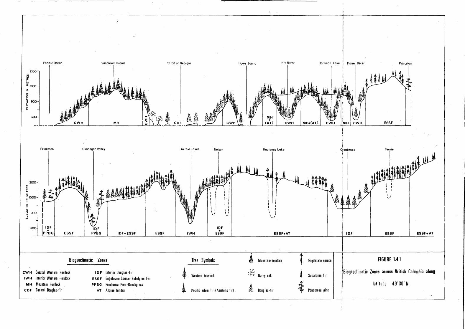
2100 VJ L\J a: 1-1.\J
:::E 1500 !: z 0
~ 900 L\J ..J L\J
300
2100 VJ L\J a: 1-1.\J
:::E 1500 z z 0 ~ j L\J ..J L\J
Pacific Ocean
Princeton
IDF +
PPBG ESSF
Vancouver Island
I
Okonogon Volley
IDF +
PPBG IDF+ ESSF
Biogeoclimatic Zones
CWH Coastal Western Hemlock ID F Interior Douglas-fir I w H Interior Western Hemlock ESSF Engelmann Spruce -Subalpine Fir
MH Mountain Hemlock PPBG Ponderosa Pine-Bunchgrass CDF Coastal Douglas-fir AT Alpine Tundra
ESSF
Strait of Georgia
Arrow Lakes Nelson
• 4
IWH
Tree Symbols
Western hemlocl1
I
I I I I I I I I I \ I ,J
IDF +
ESSF
Pacific silver fir IAmabilis fir)
Howe Sound Pitt River
CWH
Kootenoy Lake
i I I I I I I I I I I I I I I I I I I J \ I ,_J
ESSF+AT
' Mountain hemlock
~ Garry oak
t Douglas-fir
Harrison Lake
MH+(AT) I II i: I
Fraser River
I Cron brook
'/ !1
ESSF
Fernie
I \ A l it t ~/ I I / ......
'.I IDF ESSF ESSF+AT
' Engelmann spruce I ·I FIGURE 1.4.1
$ Subalpine fir I I Biogeoclimatic Zones across British Columbia a long
i I !I latitude 49°30' N. Ponderosa pine
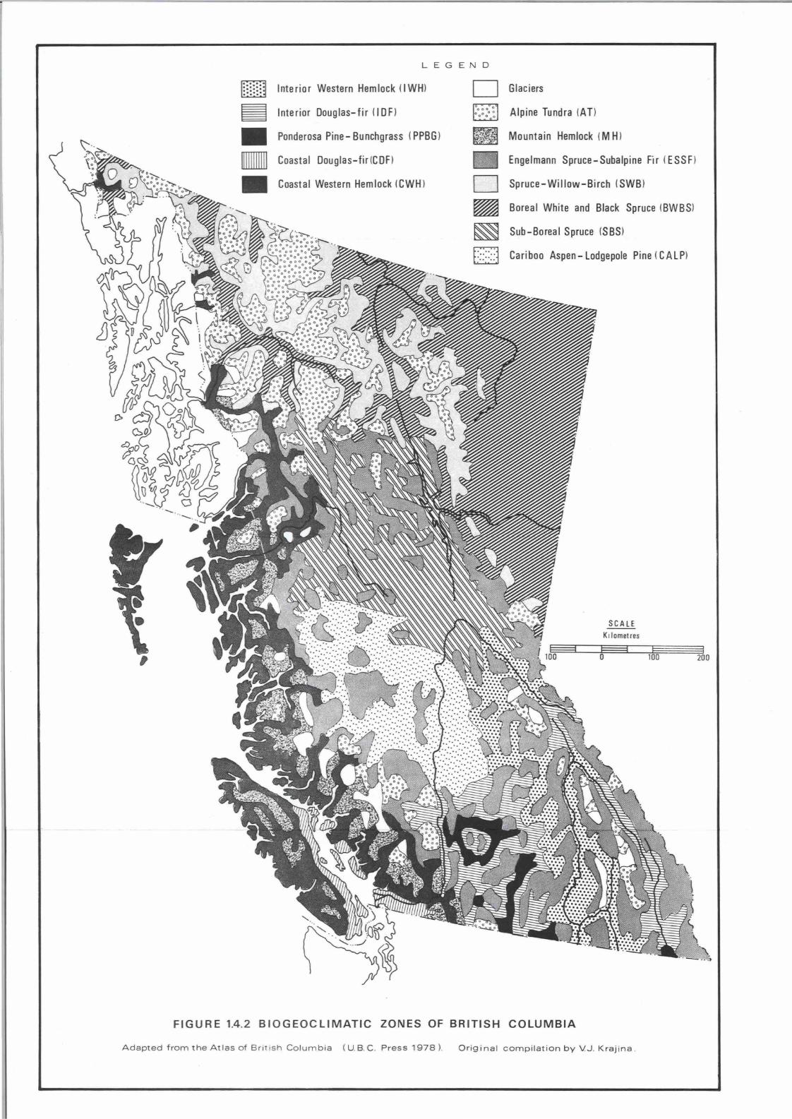
,
LEGEND
mmrn Interior Weslern Hemlock ( I WHl
~ Interior Douglas-fir ( I OF)
• Ponderosa Pine- Bunchgrass ( PPBG)
• Coastal Douglas-fir(COF)
• Coastal Western Hemlock (CWH)
D Glaciers
Alpine Tundra IA T)
lilJ Mountain Hemlock (M Hl
Engelmann Spruce-Subalpine Fir (ESSF)
D Spruce-Willow-Birch (SWB)
~ Boreal White and Black Spruce (BWBS)
~ Sub-Boreal Spruce (SBS)
[J Cariboo Aspen- Lodgepole Pine ( GALP)
SC A LE
K, lometres
l=====1 0 100
FIGURE 1.4.2 BIOGEOCLIMATIC ZONES OF BRITISH COLUMBIA
Adapted from the Atlas o f Br itish Co lu mbia ( U. B. C . Press 1978 ). Original compilation by VJ. Krajina .
200

37
Alpine "meadows" occur under moister conditions on flat or gently
sloping topography where snow cover lasts the longest. Their vegetative
season is short and colourful. A few conspicuous alpine meadow species are
Indian paintbrush (~astilleja spp.), lupines (Lupinus spp.), Sitka valerian
(Valeriana sitchensis), anemones (Anemone spp.), and arnicas (Arnica spp.).
Meadows, especially where dense grass and sedge communities are present,
give a very turfy top to the soils.
Alpine heath communities, composed of "mountain heathers" (Phyllodoce
spp. and Cassiope spp.) and other members of the heath family such as alpine
azalea (Loiseleuria procumbens) and crowberry (Empetrum nigrum) are very
common and sometimes occupy exte_nsive areas.
Under extreme conditions at the highest elevations, only lichens and
a few mosses can survive. In certain lower elevation environments of the
zone, vascular plants may have difficulty becoming established due to the
frequent churning of soils by solifluction.
MOUNTAIN HEMLOCK ZONE (MH)
The MH zone occurs along the Pacific Coast Mountains in a climate of
cool, short summers and cool, long, wet winters, with snow cover for several
months. At low elevations, up to 900-1100 m in south coastal regions and up
to 300 m further north, the forests are characteristically dense and produc
tive. Tree growth becomes progressively poorer with elevation due to the
shorter growing season, increased duration of snow cover, and cooler
temperatures. The subalpine forests become more open with increasing eleva
tion resulting in discontinuous parkland forests adjacent to the AT zone.
In the lower subzone of the MH zone, mesic habitats are on benches
and upper slopes which receive temporary seepage during the early summer.
The generally high moisture content and low temperature of the soils result
in slow decomposition of litter and a relatively high proportion of organic
matter in most soils. Mountain hemlock (Tsuga mertensiana), the most common
tree, is particularly well adapted for such conditions, since its roots are
shallow and occur principally in organic soil horizons. Pacific silver fir
(amabilis fir) (Abies amabilis) and yellow cedar (Chamaecyparis nootkatensis)
are the other major trees of th~ zone, with the yellow cedar generally
confined to habitats with abundant moisture.
Dominant shrubs on mesic sites are the blueberries (Vaccinium
alaskaense and~- membranaceum) and Pacific menziesia (false azalea)
(Menziesia ferruginea). The herb layer is usually not well developed with
only five leaved creeping raspberry (Rubus pedatus) and blue-bead Clintonia
38
(Queen's cup) (Clintonia uniflora) being common. Dicranum spp. and
Rhytidiopsis robusta dominate the usually well developed moss layer of mesic
sites. On lower and middle slope positions, seepage water is rather plenti
ful as expressed by a robust understory of small twisted-stalk (Streptopus
roseus), deer fern (Blechnum spicant), false hellebore (Veratrum eschscholtzii)
and unifoliate-leaved foamflower (mitrewort) (Tiarella unifoliata).
In the parkland subzone, a mosaic of plant communities occurs which
grades into the alpine. In basins and depressions, where snow cover remains
the longest, a dominant sedge community of Carex nigricans occurs on soils
with characteristically turfy surface horizons. Heath communities, typical
of the alpine, are also extensive.
THE SUBALPINE ENGELMANN SPRUCE - SUBALPINE FIR ZONE (ESSF)
The ESSF zone lies between the alpine tundra and the lowland forests
throughout much of the interior of British Columbia. It is the most widely
distributed zone in the province, occurring between latitudes 49 to 57 N and
at elevations ranging from 950-1550 m in the northwest to 1260-2250 m in the
southeast. The climate is colder, drier, and more continental than that of
the MH zone. Trees occurring in the ESSF zone must be able to tolerate
relatively severe winters with frozen ground.
Engelmann spruce (Picea en~elmannii) and subalpine fir (Abies
lasiocarpa) which is also known as alpine fir, are characteristically the
dominant climax trees throughout the entire zone. Seral species, such as
lodgepole pine (Pinus contorta var. latifolia), are common over large areas
after fires, especially in drier regions.
Northern regions of the ESSF zone have boreal and sub-boreal
influences; eastern regions haye Cordilleran qualities, western portions
have coastal transitions, and southern localities have dry continental
variants. Not unlike the MH zone, the ESSF zone has elevational gradients in
forest cover distribution whereby there are closed forest stands at lower
elevations and tree "islands" or parklands in the upper limits of the zone.
Unlike the MH zone, it is believed that the clumped tree distribution in the
interior subalpine parkland, at least in'the drier areas results from heavy
snow accumulatton which provides favorable moisture for tree growth. Areas
between the tree clumps are open and exposed resulting in dry grassland
communities.
In the lower elevations of the wetter subzones of the ESSF zone,
forests have closed canopies. Even though precipitation is sufficiently high
for Podzolic soils (see Part 2.4), productive seepage sites are very frequent.
39
These have plant species typical of soils containing high moisture and
nutrients (e.g.· mountain alder (Alnus incana), oak fern (~mn~caEpium
dryopteris), Sitka valerian and false hellebore).
In the drier, less productive parts of the zone where Brunisolic
soils are common, many species characteristic of dry conditions occur
frequently (e.g. kinnikinnick (Arctostaphylos ~va-ursi), pine grass
(Calamagrostis rubescens), and showy aster (Aster ~pie~~~)).
THE SPRUCE - WILLOW - BIRCH ZONE (SWB)
This is the third and most northerly subalpine zone in the province.
It extends from a latitude of roughly 57° N and stretches well into the Yukon
Territory and Mackenzie District of the Northwest Territories. Subalpine and
subarctic climates (at higher latitudes) are characterized by severe winters.
Moderate snow cover occurs over frozen ground in the southern part of this
zone and over ground with permafrost in the northern part. The elevational
ranges of the zone in the southeast occur between 1100 and 1700 m and in the
northwest between 900 and 1500 m.
The plant communities found in this zone have yet to be studied in
British Columbia. Detailed studies in the Yukon region (Ogilvie Mountains)
commonly found white sprucJ (Picea glauca) on rich, well drained soils and
black spruce (Picea mariana) on poor, imperfectly drained soils in the lower
elevations of the zone. Persistent frosts, common at elevations above 1200 m,
strongly affect the continuance of the coniferous trees. In their place,
.deciduous willow and birch shrubs predominate. The willows, mainly Salix
barclayi, ~- planifolia, ~- pulchra, and~- glauca, prefer habitats with favo~rable nutrient regimes; habitats with poor drainage and less nutrients
are characterized by bog glandular birch (Betula glandulosa). In some valleys
subject to cold air drainage from adjacent mountains, the shrub willows and
birches will occupy the valley floor as well as the upper elevations of the
zone. The spruce forests are therefore bounded both above and below by a
shrub subzone.
THE BOREAL WHITE AND BLACK SPRUCE ZONE (BWBS)
The largest occurrence of the boreal forest occurs on an extension of
the Great Plains into northeastern British Columbia. It occurs also at the
lower elevations of the main valleys west of the Rocky Mountains. The
northern continental climate, with its frequent arctic air masses, produces
short growing seasons and long cold winters. Discontinuous permafrost is
common in northern parts of this zone. This area is situated approximately
north of latitude 54° N and at elevations between 165 and 850 m. Forest
fires are frequent throughout the zone, maintaining nearly all the forests in
an early successional stage.

40
White spruce, black spruce, lodgepole pine, tamarack (Larix laricina),
balsam poplar (Populus balsamifera), common paper birch (Betula papyrifera),
and Alaska paper birch (Betula neoalaskana) are the major tree species in the
forested regions of the zone. Grassland communities occur along the rivers
in the southern Peace River area, and on the steep slopes above the Stikine
River in the lee of the coastal mountains. Other than these drier grasslands,
the remaining boreal forest is a mosaic of forest and bog communities.
In the gentle topography of the Fort Nelson Lowland of the Alberta
Plateau, productive forests of trembling aspen (Populus tremuloides) and to a
lesser extent white spruce characterize the mesic habitats as a "fire climax".
It is believed that biogenic cycling of calcium by trembling aspen helps to
maintain the Luvisolic soils of the area in a relatively high productive
state by retarding acid leaching of the soils. Black spruce, a theoretical
climatic climax species, produces acid litter which has the opposite effect.
Relatively open pine-lichen forests occur on the driest sites which
are generally situated on rapidly drained outwash deposits, but dense black
spruce-moss conununities develop on imperfectly drained habitats. The most
productive forests of this zone occur on rich alluvial sites where white
spruce and balsam poplar may reach heights of over 50 m. These sites are
among the most productive forests in the Canadian boreal forest.
Northeastern bog communities develop on poorly drained organic soils,
characteristic of the gentle topography of the Alberta Plateau. The buildup
of organic matter from the bog vegetation tends to insulate ground frozen
in the winter, which results in discontinuous permafrost being characteristic
of the northerly areas of the zone. Sphagnum fuscum is the dominant peat
moss in this terrain.
Black spruce and occasionally tamarack are the main trees occurring
on organic terrain, however, they are much reduced in size. Tamarack forms
pure stands only in nutritionally rich fen types of environments.
THE SUB-BOREAL SPRUCE ZONE (SBS)
The SBS zone is located roughly in the centre of British Columbia
where the climate is slightly less continental than that of the BWBS zone.
The winters are shorter in the SBS zone, giving a slightly longer growing
season. The elevational range of the zone is between 330 and 950 m in the
northwest and up to 1100 m in the northeast.
Upland coniferous forests, composed mainly of white spruce and
lodgepole pine, as well as deciduous forests of trembling aspen, dominate the

41
landscape. Although white spruce is the dominant mesic climax species, fire
and other disturbances result in a variety of vegetation in circum-mesic
sites, including overstocked stands of lodgepole pine or stands of trembling
aspen. Subalpine fir (alpine fir) is common in the understory, particularly
in the shrub layer.
Lodgepole pine-lichen sites are common on dry, well drained
outwash materials and these sometimes cover extensive areas. Subalpine fir
and white spruce grow best on seepage and alluvial sites. Black spruce bogs,
although fairly common, are never as extensive as they are in the boreal forest.
THE CARIBOO ASPEN - LODGEPOLE PINE ZONE (CALP)
The CALP zone contains a wide variety of habitats from treeless
grasslands along the Fraser River to fairly dense forests in upland areas of
the Fraser Plateau. With a climate of cold winters and warm dry summers, the
CALP zone occurs at elevations between 510 and 1070 m.
The driest habitats of the zone occur as belts along the Fraser and
Chilcotin Rivers where grasses, with their fibrous root system, are able to
compete successfully with trees for moisture, resulting in extensive grass
lands along these rivers. Adjacent to the grasslands, open forests are
frequent, mainly of Rocky Mountain Douglas-fir (Pseudotsuga menziesii var.
glauca). The remainder of the zone is characterized by more closed forests
of Douglas-fir, white spruce, lodgepole pine, and trembling aspen.
The open range, on the slopes along the Fraser and Chilcotin Rivers,
has bluebunch wheat grass (Agropyron spicatum) as the dominant climax grass
species. In many areas, bluebunch wheat grass is reduced through overgrazing
and is replaced by less desirable species. At the lower elevations big basin
sagebrush (Artemisia tridentata) is especially favoured by overgrazing. The
addition of organic matter to the upper soil horizons, through the decay of
grass roots, is a major factor in the development of the Chernozemic soils
characteristic of these grasslands.
Much of the zone, where Douglas-fir is the climax species, has a well
developed herb layer dominated by pine grass which is a major forage species
for grazing. Although Douglas-fir is a climax species in the southern part
of the CALP zone, extensive areas are dominated by stands of lodgepole pine
and trembling aspen which have originated from fire. In the northern part
of the zone white spruce becomes the climatic climax species, indicating
characteristics very similar to the SBS zone.

42
THE INTERIOR WESTERN HEMLOCK ZONE (IWH)
This zone occurs mostly in southern British Columbia between the
Monashee and Rocky Mountains at elevations between 360 and 1260 m. It is
often referred to as the "interior wet belt" since it experiences the highest
precipitation of all the interior regions. Its climate makes it the most
productive forest zone in the interior. Western hemlock (Tsuga heterophylla),
with lesser amounts of western red cedar (Thuja plicata), dominate the few
remaining mature forests.
The most common forest association in the IWH zone is a western
hemlock-moss association, this also being the mesic or climatic climax
association for the zone. In the southern and drier part of the zone, Douglas
fir and, to a lesser extent, western white pine (Pinus monticola) are fre
quently dominant after fires. On sites subject to permanent seepage waters,
western red cedar-western hemlock stands are very common, sometimes
occupying large areas. Where the seepage water is close to the surface,
cedar-hemlock-devil's club communities are present. Generally Podzolic soils
dominate the landscape of the zone. In many respects, the IWH zone is similar
to the Coastal Western Hemlock (CWH) zone.
THE INTERIOR DOUGLAS-FIR ZONE (IDF)
The IDF zone occurs in the southern third of the province in the
rainshadow of the Coast, Cascade, and Columbia Mountains. Typically, this
zone occupies the middle position in the vertical sequence of zones common
to dry interior valleys - the Ponderosa pine-Bunchgrass (PPBG) zone
occurring at lower and the ESSF zone at higher elevations. The IDF zone
lies between 300 and 1350 m in the southeast and 450 and 900 m in the north.
Both open and closed forests characterize the zone. Ponderosa pine
(Pinus ponderosa), a seral species, and Douglas-fir, a climax species, form
open forests at lower elevations. Here bluebunch wheat grass is one of the
most important range species in the steppe-like understory vegetation. Many
species characteristic of the lower grassland and arid shrub communities of
the PPBG zone occur in these open forests. Grazing activity and fire history
tend to determine the composition and pattern of present day vegetation. In
general, it is believed that grassland communities are promoted by fire and
shrub communities by intensive grazing.
At higher elevations of the zone, the climate is moister and forests
become more closed. Pine grass becomes a dominant understory species,
replacing bluebunch wheat grass. Closed forest species such as Oregon boxwood
(Paxistima myrsinites) and common pipsissewa (Chimaphila umbellata) are more
frequent in the wetter parts of the zone with the abundance of pine grass
43
being reduced. Western larch (Larix occidentalis), western red cedar, white
spruce, Engelmann spruce, and lodgepole pine are other species frequently
found in the zone. Brunisols and Luvisols comprise the major soils of the
zone.
THE PONDEROSA PINE - BUNCHGRASS ZONE (PPBG)
This is the driest and warmest zone in British Colwnbia. (In certain
locations it is semiarid.) Located in the southern third of the province, the
PPBG zone is distributed along valley floors, the lower slopes of many of the
dry interior valleys and in local areas scattered across the interior plateau.
The elevational range of the zone varies with aspect but generally occurs
between 270 and 750 m. It occupies the lowest position in the vertical
sequence of zones common to dry interior valleys (see Figure 1.4.1).
The PPBG zone is believed to be the northernmost extension of the
Palouse Prairie found in the intermontane regions of the northwestern United
States. Like the IDF zone, the influence of fire and grazing is expressed
in the present day vegetation patterns. The vegetative cover consists of a
mosaic of treeless bunchgrass steppe and parkland forest.
The high frequency of ground fire in the dry subzone helps to maintain
a grassland vegetation including bluebunch wheat grass, needle-and-thread
grass (Stipa comata), sand dropseed (Sporobolus cryptandrus) and rough fescue
(Festuca scabrella). Most of these species provide good forage for cattle
and other livestock. Overgrazing frequently causes a shift from productive
grassland communities to communities dominated by sagebrush and other less
palatable weed species such as common rabbit brush (Chrysothamnus nauseosus),
low pussytoes (Antennaria dimorpha), and brittle prickly-pear cactus (Opuntia
fragilis).
The ponderosa pine parkland, the wet subzone, is a discontinuous belt
of open forest interspersed with the open grasslands. Ponderosa pine and, to
a lesser extent, Douglas-fir are the dominant trees in the subzone. For the
most part plant species characteristic of the open grassland form the dominant
ground cover.
Alluvial communities along streamsides and on floodplains throughout
the PPBG zone are characterized by black cottonwood (Populus balsamifera spp.
trichocarpa) and various willows.

44
THE COASTAL DOUGLAS-FIR ZONE (CDF)
The CDF zone is situated along the south coastal region in the
rainshadow of the Olympic Peninsula and Vancouver Island mountains. It
ranges in elevation from sea level to 450 m on the east coast of Vancouver
Island and from sea level to 150 m on the mainland and Gulf Islands. The
zone has a relatively humid, mediterranean climate with warm, dry summers,
and moderate, wet winters. Coast Douglas-fir (Pseudotsuga menziesii var.
menziesii) is the main climatic climax species on mesic sites.
Under the most extreme coastal rainshadow effects, a dry subzone
occurs where Garry oak (Quercus garryana) communities are common on rich
sites with Pacific madrone (Arbutus rnenziesii) communities being common on
poor, rocky, dry sites. The open and colourful grasslands of the Garry oak
subzone have interesting soils as a result of the climate and vegetation.
Most of the CDF zone belongs to the wet subzone where Douglas-fir is
the most common species, especially on mesic sites. However, many other
coniferous species are present. On mesic sites, salal (Gaultheria shallon)
dominates the shrub layer. The most characteristic soils of mesic sites of
the zone are Dystric Brunisols and Hume-Ferric Podzols.
THE COASTAL WESTERN HEMLOCK ZONE (CWH)
The CWH zone is the wettest and most productive forest, zone in British
Columbia. The humid conditions prevalent in this coastal zone are primarily
the result of the continual eastward movement of Pacific air masses.
Depending ~pon the occurrence of a coastal rainshadow, the CWH zone can
occupy either the.middle or lowest position in the vertical sequence of
zones common to coastal British Columbia. The MH zone occurs at upper eleva
tions and the CDF (if it is present) at lower elevations. The zone ranges
up to 900 m on windward slopes in the south, up to 1050 m on leeward slopes
in the south, and up to 300 m in the north coastal region.
The most characteristic plant associations are hemlock-moss
communities. In the drier subzone, coast Douglas-fir is a common successional
tree species to the climax western hemlock. In the wetter subzone, Pacific
silver fir (amabilis fir) is very common on mesic sites along with the dominant
western hemlock.
Plant communities within the CWH zone vary with local topography and
slope position. Rock outcrops and areas with well drained, shallow soils,
particularly those with southerly aspects, commonly support Douglas-fir,
salal, and a carpet of mosses and lichens. Depressional areas and lower

45
slopes, where there is permanent seepage water, maintain a mixed forest of
western hemlock and western red cedar with a vigorous understory of ferns.
One of the characteristics of the ecosystems of this zone is the
buildup of organic matter in the soils, especially in the wetter subzone.
In north coastal regions and on the Queen Charlotte Islands, there is a net
accumulation of organic matter resulting from the dampness of the soils and
the cool temperatures. This often leads to the development of organic soils
and ultimately bogs, even on mesic sites. These bog ecosystems are charac
terized by poorly growing western hemlock, lodgepole pine, red cedar, and
yellow cedar.
FURTHER READING
Biel, Charles E., Roy L. Taylor, and Geraldine A. Guppy, 1976. The Biogeo
climatic Zones of British Columbia. Davidsonii, 7 (4), 45-55.
An acaount of the biogeoclimatic classification of V.J. Krajina and a short
description of each zone •.
Krajina, V.J., 1969. Ecology of Forest Trees in British Columbia. Ecology
of Western North America, 2 (1), 1-146.
The biogeoclimatic classification with technical descriptions and definitions of
each zone and subzone.
Rowe, J.S., 1959. Forest Regions of Canada. Dept. Northern Affairs and
National Resources, Forestry Branch, Ottawa. Bull. 123, 71 pp.
A descriptive classification of forests across the whole of Canada.
Taylor, Roy L. and Bruce MacBryde, 1977. Vascular Plants of British Columbia.
Botanical Garden, University of British Columbia, Tech. Bull. 4,
University of British Columbia Press, Vancouver, 754 pp.
An inventory which has been followed for plant names in this publication.
Part 2
The Major Soils and Soil Processes
of British Columbia

2.1 INTRODUCTION L.M. Lavkulich
In Part 1, the climate, physiography, geology and vegetation ecology
of British Columbia were described separately. However, they do not occur
separately. They occur together in the landscape and it is their interaction
that produces soil on the surface layer of the earth. In fact, pedologists
believe that a soil is the result of the so called factors of soil formation,
namely parent material, climate, biota (vegetation and animals), topography
and time. Every time a factor of soil formation changes so does the soil.
It is only through this appreciation that soils can be used to their best
advantage to serve mankind. In order to understand and interpret soils, it
is necessary to have concepts of processes and classification schemes. In
this way soils can be identified, sampled, characterized, mapped and evaluated
for specific uses.
The processes resulting from this interaction and the general nature
of the soil formed by these processes will be described in Part 2.2. Many
different kinds of soils are produced across the landscape of British
Columbia as a result of the different intensities of soil-forming processes.
An orderly method of labelling each type of soil is necessary so that it can
be described, discussed, studied or mapped. For this purpose the Canadian
Soil Classification System has been developed over many years. Since climate
is so important in the understanding of soils and their properties and manage
ment, a Soil Climate Classification has also been evolved over the past several
years. The principal features of these two classification systems are des
cribed in Part 2.3.
In order to understand and illustrate the processes of soil formation,
the relationship among the factors of soil formation, and the application of
classification systems to the soils of British Columbia, Part 2.4 provides
descriptions, pictures and representative laboratory analyses of the nine
main groups of soils (soil orders) found in the province. In this manner
soils are related to the landscape, the environment in which they are found
and some of their characteristics are described.
) 2.2 SOIL AND SOIL PROCESSES L.M. Lavkulich and K.W.G. Valentine
Soil is the naturally occurring unconsolidated mineral or organic
material at the surface of the earth which is capable of supporting plant
growth. The particular type of soil at any position on the earth is a result
of the geologic or parent material, climate, biota, topography and time.
These factors of soil formation do not act singly but together in various
ways to produce a particular soil. The soil must not be regarded as a
passive, inert body on the earth's surface. It is a continually changing
system within the total environment.
Soils possess properties that have been inherited from the parent
material, for example the amount of stones, mineralogy and thickness. They
also have properties and features that are the result of soil processes,
including such things as the kind and amount of organic matter, the formation
of horizons (layers), new minerals and changes in porosity. For instance
the features of a valley bottom soil will be largely inherited from the
conditions of sediment accumulation in that part of the valley, whereas the
humus content of the topsoil will be the result of the amount of organic
litter added to the surface and the balance of the constructive and des
tructive processes acting on this litter.
Soils have both internal and external properties. The internal
properties are often shown as various layers or horizons that are exposed
in a vertical cross-section of the soil body. External properties include
such attributes as slope and aspect. Soils often grade imperceptibli from
one kind to another and occur as a relatively continuous blanket on the land
surface of the earth. This continuous blanket is divided into soil classes
defined upon the basis of soil properties, many of which reflect processes
of soil genesis. Local changes in slope, elevation or aspect are dominant
factors in determining changes in soil properties. It is on the basis of
the soil's internal and external properties that soil resource inventories
are prepared.
SOIL COMPONENTS
Soils are multiphase systems, composed of a mixture of numerous kinds
and sizes of mineral grains, organic fragments, air and water. The propor
tions of these components vary from point to point on the surface of the
earth, and from time ~o time, depending upon the factors of soil formation
and the influence of man's activity.

50
Soil air plays an important role in plant growth and the activity
of soil organisms. Its main constituents, as in the atmosphere, are nitrogen,
oxygen and carbon dioxide. Various organisms use the oxygen and give off
.carbon dioxide. The supply of oxygen has to be constantly replenished and
this is the importance of adequate pore spaces or aeration within the soil.
For adequate aeration approximately 10% by volume of the soil should be
occupied by air.
The importance of soil water lies in its roles in plant growth and
in the chemical and physical reactions that occur in soils. Water provides
the medium by which plants take up their nutrients in solution through their
root systems; it may also be considered a plant nutrient itself. Thus water
is crucial to plant growth. Molecules of water also play a central role in
the chemical weathering processes of hydration, hydrolysis, oxidation,
reduction and solution. In physical weathering soil particles and rock
fragments are disrupted by the expansion of ice in cycles of freezing and
thawing and during wetting and drying. Wetting and drying cycles play an
important role in the production of soil structure and in the physical trans
location of material such as clay within a soil.
Air.and water in the soil have a reciprocal relationship since both
compete for the same pore spaces. For example, after a rain or if the soil
is poorly drained, the pores are filled with water and air is excluded.
Conversely, as water moves out of a moist soil, the pore space is filled with
air. Thus the relationship between air and water in soils is continually
changing.
The mineral portion of soils is composed of a wide variety of
inorganic compounds. The minerals are commonly referred to as primary or
secondary. Primary minerals originate from the geologic substrata. They
include quartz, feldspar, mica, amphibole and pyroxene. They respond to the
environmental factors and in the presence of water and air are altered or
weathered. As a result of chemical weathering processes the primary minerals
become secondary minerals such as illite, vermiculite, chlorite, montmorillo
nite and kaolinite (often called the clay minerals) and the hydrous oxides
of iron and aluminum. Particle size of the mineral fraction varies widely,
from stones (over 250 mm in diameter), through cobbles (250-75 mm), gravel
(75-2 mm), sand (2-0.05 mm), silt (0.05-0.002 mm) to clay (less than 0.002 mm).
All combinations of these particle sizes can occur in soils, and the ex
pression of the amounts of the various size fractions is called soil texture.
Although coarse fragments and sand sized particles play but a small role in
chemical processes occurring in soils, they are very important in soil drain
age and in the engineering uses of soils. Silts and clays play the most
51
important role in water and nutrient retention as well as the swelling and
shrinking properties of soils.
The organic portion of soils results from the accumulation of animal
and plant residues added to the mineral soil. It is this organic portion
that differentiates soil from geological material occurring below the earth's
surface which otherwise may have many of the properties of a soil. Organic
compounds undergo decomposition by soil flora and fauna. This process
produces humus, the most active and important form of organic matter for
crop growth and soil formation. Organic matter is an extremely important
constituent of soils, as it is the source of many nutrients necessary for
plant growth, it enhances the soil's water holding capacity and its presence
favours good soil structure especially in the topsoil.
SOIL PROCESSES
There are four basic processes that occur in the formation of soils,
namely additions, losses, translocations and transformations. The two driving
forces for these processes are climate (temperature and precipitation) and
organisms, (plants and animals). Parent material is usually a rather passive
factor in affecting soil processes because parent materials are inherited
from the geologic world. Topography (or relief) is also rather passive in
affecting soil processes, mainly by modifying the climatic influences of
temperature and precipitation.
The various types of additions, losses, translocations and
transformations that occur within the soil may be seen in Figure 2.2.1.
Most additions occur at the surface. The most obvious ones include solar
energy, water controlled by climate, and organic material derived principally
from the vegetation.
Losses occur both from the surface and from the deep subsoil. For
instance, water is lost by evapotranspiration and carbon dioxide by diffusion
at the surface and, on a more catastrophic level, large masses of soil can
be stripped by erosion. Materials suspended or dissolved in water are the
main forms of ·losses from the subsoil.
Translocation refers to the physical movement of material within
soil. The material can be in the solid, liquid or gaseous form, the movement
can be in any direction from and to any horizon. For instance clay, organic
matter and iron and aluminum hydrous oxides are commonly moved from the sur
face horizon to a subsurface horizon. Conversely, in very dry climates salts

TRANSLOCATIONS ll Cloy,otgonic matter, salts sesquio~ides by water Nutrien,s by plants Total soil by animals
52
ADDITIONS Atmosphere and Sun
Water Oxygen, carbon dioxide,
nitrogen Organic matter Sediments Energy
Weathering of primary minerals to cloy and hydrous oxides Humificotion of organic matter
FIGURE 2.2.1 Diagrammatic representation of additions. losses. translocations and transformations involved in soil formation (after Millar, Turk and Foth 1965).
are moved upwards in solution by capillarity, and in very cold climates solid
mineral fragments are moved upwards by frost action.
Additions, losses and translocations all involve movement. Figure
2.2.1 shows this movement in two dimensions. Since a soil is three dimen
sional and most soils occur on slopes, it must be remembered that these
movements can occur laterally as well as vertically. Water can carry clay
in suspension laterally through a subsurface horizon, or topsoil can move
slowly en mass from a surface horizon upslope to form a new surface downslope.
Transformations involve the change of some soil constituent without
any physical displacement. Chenticai and physical weathering and the decom
position of organic matter are included here.

53
All these processes occur to a greater or lesser extent in all soils.
The properties that characterize one soil are the result of a particular
balance among all the processes. Other soils will be different because they
have been formed by groups of processes having different balances.
SOIL FORMING FACTORS
Soils are a product of the environment. Often this is illustrated
in the form of a mathematical expression, namely:
soil f (parent material, climate, biota, topography, time)
Although the above expression shows soils to be the function of a number of
individual factors, the factors are not mutually exclusive but interdependent.
For example, the kind of vegetation found at any one location on the earth's
surface is dependent on climate, parent material, topography, time and, in
fact, soil. It is obvious that numerous combinations of the factors are
possible. This leads to many different kinds of soils, each representing a
certain combination of the factors of soil formation. Parent material,
topography and time are sometimes referred to as the passive factors of soil
formation, as they do not form soils without the active factors of climate
and biota.
Parent material may be of two general kinds, organic or mineral.
Organic parent materials are formed by biological action where plant and
animal tissue is produced faster than it is decomposed. This occurs in cold
and wet regions where biological decomposition is very slow. Soil inherits
many properties from the parent material from which it forms, for example,
the kinds of minerals, particle size and the chemical elements. Thus,
parent materials are the building blocks upon which the other factors of
soil formation manifest their effects.
Climate is an active factor of soil formation because it governs·
the amount, distribution and kind of precipitation as well as the amount
and distribution of solar energy available at any point on the earth's
surface. Biological, physical and chemical processes take place in water,
thus the amount of water available leaches the soil, allows nutrients to be
obtained by plants and governs the kind of vegetative cover. The form of
precipitation, whether rain or ·snow, is also important in relation to
processes which take place in soils. Solar energy, usually expressed as
temperature, is an important part of climate because it controls the form
of water falling onto the soil surface as well as in the soil. Also as
temperature, it increases the rate of reactions, such as chemical reactions,
evapotranspiration and biological processes.' Wide fluctuations in temperature,
especially in the presence of water cause shrinking and swelling, frost action
54
and general weathering in soils. It can be seen that both water and
temperature complement each other in changing parent material and affecting
the biota on any soil landscape.
Biota is another active factor in soil formation. The kind and
amount of plants and animals that exist bring organic matter into the soil
system as well as nutrient elements. This has a great effect on the kind of
soil that will form. For example forest vegetation tends to accumulate organic
matter on top of the mineral soil where it decomposes and adds organic acids
to the soil below. This aids in weathering mineral soil particles. Soils
under grassland, however, accumulate organic matter within the mineral soil
as a result of the extensive root system which dies back periodically. Animals
play an important part in soils~ in some cases animals ingest soil particles
and mix the mineral and organic portions, e.g. earthworms. Other animals
tunnel through soils mixing the various components. Similarly, microorganisms
have great effects on soils in decomposing organic matter, fixing nitrogen
from the atmosphere, and making other soil nutrients available for plant growth.
Biota, in conjunction with climate, modify parent material to produce soil.
Topography is often considered a passive factor modifying the effects
of climate. Everyone is aware of the effect that aspect, or orientation of
the soil surface to the sun, has on the type of vegetation. South-facing
slopes tend to be drier than north-facing slopes as the result of higher
temperatures. Similarly, as one goes from the valley bottom to the tops of
mountains or plateaus the climate becomes cooler. Topography also redis
tributes the water reaching the soil surface. Runoff from uplands creates
wetter conditions on the lowlands, in some cases saline sloughs or organic
soils. Thus as a redistributor of the climate features, topography affects
soil processes, soil distribution and the type of vegetation at the site.
Finally it must also be remembered that soils develop over long
periods and the balance between processes is liable to change in that time.
For instance, chemical weathering is likely to be a very important form of
transformation when a river sediment is first exposed. But as vegetation
slowly becomes established the addition and decomposition of organic matter
will become more important and chemical weathering less so.
SOIL HORIZONS
The effect of the processes described acting within the soil is to
form different horizontal layers or horizons down a vertical section. Soil
horizons run roughly parallel to the surface of the earth and may be composed
of mineral or organic material. They differ from adjacent horizons in such
properties as colour, structure, texture and consistence. A soil profile is
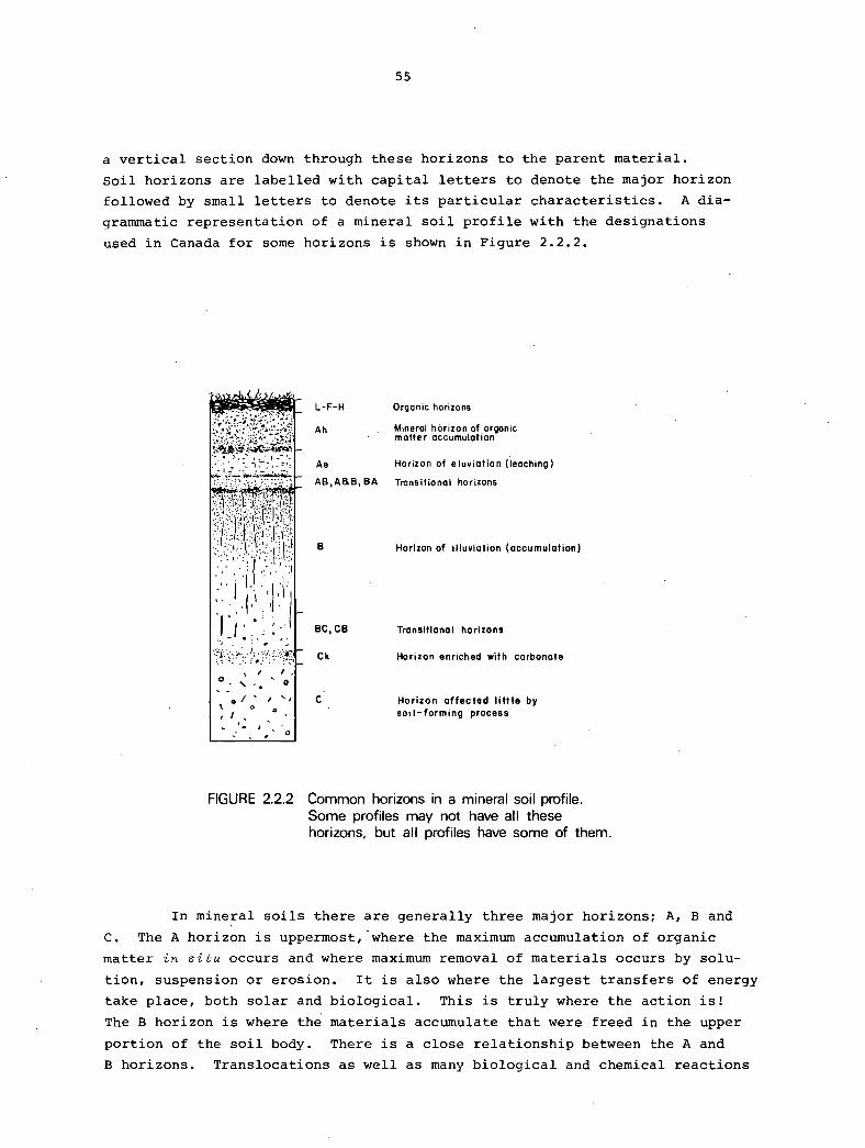
55
a vertical section down through these horizons to the parent material.
Soil horizons are labelled with capital letters to denote the major horizon
followed by small letters to denote its particular characteristics. A dia
grammatic representation of a mineral soil profile with the designations
used in Canada for some horizons is shown in Figure 2.2.2.
I ' • • "
Yf:/'.~:=:·~:~y~t .. :}? , I I .
... 0 _· ' ,, • 0
0 / .. / ' ' \ 0 0
' I , . ' ' ' .
L-F-H
Ah
Ae
AB,ASB, BA
B
BC,CB
Ck
C
Organic horizons
Mineral horizon of organic matter accumulation
Horizon of eluviation (leaching)
Transitional horizons
Horizon of illuviation (accumulation)
Transitional horizons
Horizon enriched with carbonate
Horizon affected little by soil-forming process
FIGURE 2.2.2 Common horizons in a mineral soil profile. Some profiles may not have all these · horizons, but all profiles have some of them.
In mineral soils there are generally three major horizons; A, Band
c. The A horizon is uppermost, where the maximum accumulation of organic
matter in situ occurs and where maximum removal of materials occurs by solu
tion, suspension or erosion. It is also where the largest transfers of energy
take place, both solar and biological. This is truly where the action is!
The B horizon is where the materials accumulate that were freed in the upper
portion of the soil body. There is a close relationship between the A and
B horizons. Translocations as well as many biological and chemical reactions
56
take place between them. The B horizon, however, tends to be more stable
than the A for short term differences. The C horizon is often termed the
parent material. The effects of soil processes have not manifested them
selves appreciably and thus the material is little modified.
Small letters are used to modify the major mineral soil horizon
letters A, Band c. These small letters denote the predominant properties
of the major horizon. Thus h indicates a horizon enriched with organic
matter and t indicates a horizon where clay has accumulated. Small letters
can be combined; for example, a horizon labelled Bhf indicates that it is a
layer within the soil where organic matter, iron and aluminum have accumu
lated.
Major organic soil horizons are found in two distinctive kinds of
environments, well aerated or poorly aerated. In well aerated environments
leaves, needles, twigs and branches fall to the earth, accumulate and begin
to decompose on top of the mineral soil. The degree of decomposition is
important in understanding soil processes, and it is the criterion for
distinguishing three horizons L, F and H. L has the least decomposition and
H the most with F denoting moderate decomposition. In poorly aerated
environments (wet areas) the organic materials also accumulate but their
character is different because of the saturated condition. In these areas
the horizons are denoted O. They will be composed mainly of mosses, rushes
and woody material.
Small letters are used in organic soils to denote the degree of
decomposition of the organic material. They are used only with O for soils
of wet environments. For instance Of would be a horizon with little decom
position and Oh would be one of advanced decomposition. Moderate decomposition
is indicated by m.
A full description of major and minor horizon and layer designations
may be found in the Canadian System of Soil Classification (see Further
Reading).

57
FURTHER READING
Canada Soil Survey Committee, 1978. The Canadian System of Soil Classification,
Agriculture Canada, Queen's Printer, Ottawa.
This puhZication describes the most recent revision of the system of classifying
soiZs used in Canada.
Millar, C.E., L.M. Turk. and H.D. Foth, 1965. Fundamentals of Soil Science,
4th ed., Wiley, New York. 491 pp.
An introductory soiZ science text, oriented mainZy towards agronomy.
Simonson, Roy W., 1959. Outline of a generalized theory of soil genesis.
Soil Sci. Soc. Amer. Proc., 23: 152-156.
The paper upon which the section on soil processes is ZargeZy based.
2,3 THE CANADIAN SYSTEM OF SOIL AND SOIL CLIMATE CLASSIFICATION L.M. Lavkulich and K.W.G. Valentine
A classification system is an arrangement of things made by man to
help him remember them and to arrange his knowledge of them into some logical
order. A system is needed because a large number of unordered objects cannot·
be remembered individually and the logical arrangement is needed for refer
ence. A system is also required so that relationships between the various
objects can be deduced or inferred, and so that predictions can be made about
the objects' properties and behaviour.
SOIL CLASSIFICATION
The Canadian System of Soil Classification which has developed
gradually over more than 60 years, attempts to arrange the soils of Canada
according to their properties. It is, therefore, a natural or taxonomic
system. The different categories are based as much as possible on properties
that can be seen in the field. Where this is not possible, or where definite
limits of field properties must be set, laboratory measurements are made.
For instance the percent carbon content of the A horizon and the percent iron
plus aluminum content of the B horizon are both used as criteria for particular
soils within the classification. But even where laboratory tests are ulti
mately necessary, there is usually a field property that can be used as an
indication. In the above two cases the blackness of the A horizon would
give a clue to the carbon content and the redness of the B horizon can indicate
the iron plus aluminum content.
The particular properties that are chosen to differentiate categories
are for the most part connected with particular groups of processes because
this is the way we think about soils. In effect, therefore, soils are
grouped according to how they were formed, that is according to their genesis,
because it is the different balances of soil-forming processes that produce
the different properties. Although soils are defined on their inherent
properties, various groups of soils throughout the system will also be
associated with particular environments. Such a taxonomic classification is
essential in understanding soil systems as well as in making resource inven
tories.
Soil varies in thickness over the earth's surface from a few
millimetres to several metres, and different soils grade imperceptibly into
one another. The minimum depth of soil material that is classified is 10 cm
and the smallest three-dimensional unit at the surface of the earth that is
considered as a soil is called a "pedon". By definition a pedon is between

60
1 and 2 m deep and its lateral extension is between 1 and 3.5 m. The actual
dimensions depend on the lateral and vertical variability of the soil horizons
and upon some other factors such as the depth to bedrock.
The System of Soil Classification for Canada has six levels of
generalization or categories as outlined below:
Order - This is the highest level of generalization. The pedons
are grouped according to their properties that reflect the nature of the
soil forming processes. For example, the total effect of soil processes in
the soils of the Chernozemic order leads mainly to the accumulation of organic
matter in the topsoil under a grassland vegetation. The number of specific
statements that can be made about this category are few; only general state
ments are possible. Nine orders are recognized, seven for mineral soils, one
for organic soils, and one which can contain both.
Great Group - This class is a subdivision of the order and is,
therefore, more specific and more precise statements can be made about it.
Great groups are based on properties that reflect differences in the strength
of the dominant processes or a major contribution of a process in addition
to the dominant one. In the Chernozemic order the great groups are differen
tiated on the basis of the colour of the topsoil. This is an indication of
the amount of organic matter that has accumulated. The Brown soils in the
driest areas have the least and the Black soils in the coolest and wettest
areas have the most. The Dark Gray soils occur near the forest-grassland
transition where a secondary process of the leaching of organic matter and
clay from the topsoil becomes important. It is the great group that will be
used to describe the soil landscapes of British Columbia in Part 3. The
classification system down to this level is as follows:
Order
Brunisolic
Chernozemic
Cryosolic
Gleysolic
Luvisolic
Organic
Great Group
Melanie Brunisol Eutric Brunisol Sombric Brunisol Dystric Brunisol Brown Dark Brown Black Dark Gray Turbic Cryosol Static Cryosol Organic Cryosol Humic Gleysol Gleysol Luvic Gleysol Gray Brown Luvisol Gray Luvisol Fibrosol Mesisol Humisol Folisol

Podzolic
Regosolic
Solonetzic
61
Humic Podzol Ferro-Humic Podzol Hume-Ferric Podzol Regosol Humic Regosol Solonetz Solodized Solonetz Solod
Below these first two levels there are three more subdivisions as follows:
Subgroup - A subdivision of the great group that defines the central
concept of the great group (Orthic) or certain variations from that concept
which are grading towards other orders, e.g. a Gleyed Brown Chernozemic or a
Solonetzic Brown Chernozemic; where the normal features of a Brown Chernozemic
soil are being modified by the occurrence of excessive water or soluble salts
respectively. Special features of the soil profile such as thin iron pans
(Placic) or repeated organic layers (Cumulic) are also used to classify sub
groups. The subgroup is visualized as having a particular assemblage of
horizons and the Canadian System of Soil Classification specifies the horizons
that each subgroup category must have, along with others that it may have.
Family - A subdivision of the subgroup which identifies a group of
soils that are relatively homogeneous. in mineralogy, texture and soil climate
as well as genetic soil horizons. Because of the more precise nature of this
class many statements can be made about the use and management of the soils
in relation to plant growth, hydrology and engineering characteristics.
Series - A subdivision of the family, this is a group of pedons (a
polypedon) with horizons whose features such as colour, texture, structure
and thickness fall within a narrow range. The pedons have all been developed
from similar parent material. This is probably the most important category
of soils for consideration of use and management since it applies to real
soil bodies - polypedons.
There used to be a further category called a~ based on the
texture of the topsoil. This has now been dropped but may be found in some
early reports.
The higher classes of the Soil Classification (order, great group,
subgroup and family) are especially important in studying genetic relation
ships, drawing inferences and allowing correlations which are often required
for regional studies. The two lower categories are more suited to local and
site specifi6 studies and to land utilization programs.
The nomenclature used for the four higher categories is descriptive
of either the soil morphology or the kinds of environments in which the soils
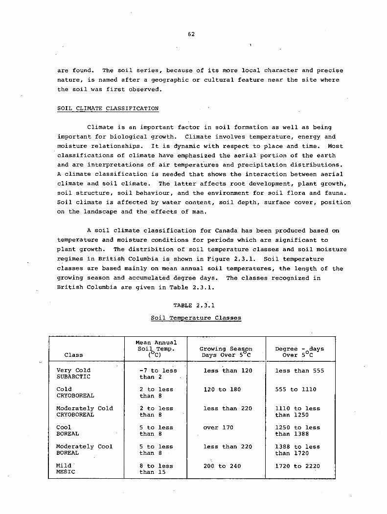
62
are found. The soil series, because of its more local character and precise
nature, is named after a geographic or cultural feature near the site where
the soil was first observed.
SOIL CLIMATE CLASSIFICATION
Climate is an important factor in soil formation as well as being
important for biological growth. Climate involves temperature, energy and
moisture relationships. It is dynamic with respect to place and time. Most
classifications of climate have emphasized the aerial portion of the earth
and are interpretations of air temperatures and precipitation distributions.
A climate classification is needed that shows the interaction between aerial
climate and soil climate. The latter affects root development, plant growth,
soil structure, soil behaviour, and the environment for soil flora and fauna.
Soil climate is affected by water content, soil depth, surface cover, position
on the landscape and the effects of man.
A soil climate classification for Canada has been produced based on
temperature and moisture conditions for periods which are significant to
plant growth. The distribition of soil temperature classes and soil moisture
regimes in British Columbia is shown in Figure 2.3.1. Soil temperature
classes are based mainly on mean annual soil temperatures, the length of the
growing season and accumulated degree days. The classes recognized in
British Columbia are given in Table 2.3.1.
TABLE 2.3.1
Soil Temperature Classes
Mean Annual Soil Temp. G;ao;sinJv;rea5s0°cn Degree - days
Class (oC) Over 5°c
Very Cold -7 to less less than 120 less than 555 SUBARCTIC than 2
Cold 2 to less 120 to 180 555 to lllO CRYOBOREAL than 8
Moderately Cold 2 to less less than 220 lllO to less CRYOBOREAL than 8 than 1250
Cool 5 to less over 170 1250 to less BOREAL than 8 than 1388
Moderately Cool 5 to less less than 220 1388 to less BOREAL than 8 than 1720
Mild. 8 to less 200 to 240 1720 to 2220 MESIC than 15.
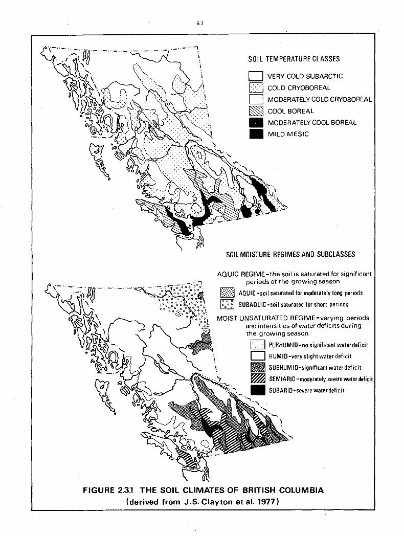
63
SOIL TEMPERATURE CLASSES
D VERY COLD SUBARCTIC
D COLD CRYOBOREAL
D MODERATELY COLD CRYOBOREAL
~ COOL BOR EAL
• MODERATELY COOL BOREAL
• MILD MESIC
SOIL MOISTURE REGIMES AND SUBCLASSES
AQUIC REGIME-the soil is saturated for significant periods of the growing season
~:~~:~~:~ AQUIC-soil saturated for moderately long periods ~ ~ SUBAOUIC-soil saturated for short periods
MOIST UNSATURATED REGIME-varying periods and intensities of water deficits during the growing season
I l PERHUMID-no significant waterdeficit
D HUMID-veryslightwaterdeficit
• SUBHUMID-significant water deficit
~ SEMIARID-moderately severe water deficit
• SUBARID-severe water deficit
FIGURE 2.3.1 THE SOIL CLIMATES OF BRITISH COLUMBIA
(derived from J.S. Clayton et al. 1977)
64
Moisture classes are recognized on the basis of whether the soil is
saturated or not for long periods. For aquic regimes subclasses are separated
on the length of time the soil is saturated during the growing season. For
moist and submoist regimes the subclasses are based on calculations of inten
sity and degree of water deficits during the growing season. For a more
complete description of soil climates the publication Soils of Canada should
be consulted (Clayton et al. 1977 in Further Reading).
SOIL CLASSIFICATION AND SOIL MAPPING
One of the principal uses to which the soil classification has been
put is the mapping of soils in the field. The classification system is used
to define and label the types of soils that are found in the landscape, and
then lines are put on the map to show the boundaries between these different
soil landscapes.
Maps can be made to show the geographical distribution of soils
classified at any level of the system from order to series. The higher
categories will be used on small scale maps where generalizations about large
areas are necessary. The lower categories will be more applicable to large
scale maps where it will be possible to draw lines round areas which contain
soils with a narrow range of properties. In fact, the great group, subgroup
and the series have been the categories of classification most often used in
mapping. In addition, a special mapping unit called an "association" has
also been commonly used.
An example of a small scale map of the soils of British Columbia is
that portion of the Soils of Canada map published at a scale of 1:5 million
or the map shown in Figure 3.2.1 for British Columbia. Map units delineate
areas within which the predominant soils would belong to one great group.
Special symbols are overprinted to show areas where excessive water or stones
and shallow bedrock cause modifications in the profile typical of that great
group.
Formerly, more detailed soil survey maps were published at a scale
of 1 or 2 inches to the mile (1:63,360 or 1:31,680). Soil series were used
as the mapping unit either singly or in two- or three-fold combination.
More recently, soil surveys have been published regularly at a scale of
1:126,720 or 1:125,000 and a special mapping unit that is not a classification
category has been used. This is the soil association, made up of a group of
soils that occur together in the landscape. Each of these soils will belong
to a series but they will differ due to slightly different combinations of
soil forming factors. For example, in a rolling landscape there may be a
shallow, dry soil on the ridge crests, a well drained, moist soil on the mid-

65
slopes, and a deep, wet soil in the hollows. These would be three series but
they could be mapped together as a single soil association. To be grouped
as an association, a soil series must have developed from the same parent
material under the same climatic regime and usually within the same vegetation
zone.
The distinction between a classification category and a mapping unit
is important and often causes confusion. A soil association is a mapping
unit not a taxonomic category. Great groups, subgroups and series on the
other hand are taxonomic categories which may be used as specific mapping
units or as components. As formal classification categories they are concepts
with specific definitions and limits to their properties. As mapping units
they are used to label the range of properties that the predominant soils
will have in that area. But it must be remembered that some soils in the
map unit will not fit the particular great group or series classification
used. The soil mapper or surveyor, will usually try to keep these different
soils down to about 15 or 20 percent of ,the map unit area.
A discussion in greater detail of the types of soil maps and reports
that have been produced in British Columbia is included in Part 4.
FURTHER READING
Canada Soil Survey Committee, 1978. The Canadian System of Soil Classification,
Agriculture Canada, Queen's Printer, Ottawa.
A aompZete desaription of the System of SoiZ CZassifiaation as used in Canada.
The puhZiaation des~ibes the system as weZZ as giving iZZustroations of the major soiis.
Clayton, J.S., W.A. Ehrlich, D.B. Cann, J.H. Day, and I.B. Marshall, 1977.
Soils of Canada. Research Branch, Agriculture Canada, Ottawa.
An aaaount of the major soiZs in Canada, their aharaateristias, distroibution
and extent. InaZuded are desariptions of soiZ aZimate as weZZ as maps of SoiZs
of Canada and SoiZ CZimates of Canada.

2.4. THE SOIL ORDERS OF BRITISH COLUMBIA K.W.G. Valentine and L.M. Lavkulich
The two previous sections have described the ways in which soils have
formed and the method of classifying them in Canada. These discussions have
been largely theoretical. It is now time to describe more specifically the
types of environment, processes and properties that are associated with the
nine major soil groupings - the soil orders - as they occur in British
Columbia.
THE BRUNISOLIC ORDER
Soils of the Brunisolic order have undergone only moderate development
from the original parent material. Physical, chemical and biological weather
ing has proceeded far enough to change the morphology of the parent material.
There are no drastic translocations or transformations of the material that
characterize many of the other orders.
There are a number of reasons for this sort of soil occurring in
British Columbia. Firstly in many areas the climate has restricted the
progression of soil weathering. Long winters and low temperatures restrict
the rate of many of the transformations which constitute soil weathering.
This is the reason why Brunisolic soils cover much of the high plateaus of
northern British Columbia. Lack of soil moisture also limits transformations
such as chemical weathering. Thus Brunisolic soils are also found in the
subhumid to semiarid zones of the southern interior.
Secondly, some Brunisolic soils have developed on very coarse
textured materials such as fluvioglacial sands and gravels in areas where
the climate is not normally a limiting factor in soil development. Because
clay-sized particles, the principal active fraction in chemical transformations,
make up only a small volume of the total mineral soil, little weathering has
taken place. Most of the soil is relatively inert gravel and quartz sand.
Moreover the parent material has a low water-holding capacity, so that soil
water content is low and thus chemical transformations are further restricted.
The droughtiness of these soils means that the vegetation is often limited to
open lodgepole pine and pinegrass. Therefore, organic matter additions to
the topsoil are limited, and well-structured Ah horizons are thin or absent.
Thirdly, Brunisolic soils are found on very young geological sediments.
In this case the time available for soil development since deposition has not
been sufficient for anything more than a moderate amount of weathering to
have taken place. Many of the soils on the Recent alluvium of the Fraser
Valley fall into the Brunisolic order.

68
Soils of the Brunisolic order are often regarded as being in a
transitional stage of development. We think that given time translocations
of weathering products will begin within the soil to produce Podzols or
possibly Luvisols. The Brunisolic soils on Fraser River alluvium are a
probable example. However, there are many areas in British Columbia where
Brunisolic soils occur on sediments that have been exposed to subaerial
weathering since the ice melted about 11,000 years ago; for example the soils
in the semiarid southern interior valleys. In other words it is necessary
to decide whether transitional is to mean in the short or in the long term.
The main processes involved in the formation of Brunisolic soils are
the removal by leaching of soluble salts and carbonates, the in situ weathering
of the mineral fraction to form secondary minerals and hydrated iron and
alurninum oxides, and the development of soil structure in the finer textured
materials that is different from the original structure of the parent material.
These are the processes that form the Bm horizon which is diagnostic of Bruni
solic soils. In the field it is recognized by its browner or redder colour
as compared with the parent material, by its structure and by its lack of
major accumulations of any materials translocated from the A horizon, such
as clay. A common horizon sequence for these soils would be LFH, Bm, c or
Ck.
The great groups of the Brunisolic order are separated on the basis
of the presence or absence of an A horizon in which the mineral and organic
fractions have been mixed together by soil fauna (an Ah horizon), and on the
base status of the soils as shown by the pH. The Ah horizon indicates that
there is a net addition of organic matter to the soil and that organic
nutrients are available. A high base status shows that the soil can retain
inorganic nutrients such as calcium and potassium, or that leaching is
limited. The specific characteristics of the four great groups are as
follows:
Melanie Brunisol: Thick Ah horizon+ high base status (pH
over 5.5)
Eutric Brunisol: No or thin Ah horizon+ high base status
(pH over 5.5)
Sombric Brunisol: Thick Ah horizon+ low base status (pH
less than 5.5)
Dystric Brunisol: No or thin Ah horizon+ low base status
(pH less than 5.5)
The Whipsaw soils are an example of a Eutric Brunisol. They have
developed on coarse textured fluvioglacial deposits in the southern interior
69
of British Columbia near Pri~ceton. The following abbreviated description
is from a profile on a southerly aspect at approximately 600 m elevation east
of Wolfe Lake (49° 26'N, 120° 18'W).
LF 1 cm of moss, partially decomposed grass and pine
needles.
Ah 5 cm of black sandy loam; granular structure; slightly
stony.
Bm 20 cm of dark brown sandy loam; coarse granular
structure; slightly stony.
BC 15 cm of dark brown gravelly sandy loam; weak blocky
structure; very stony.
IIC loose sand and gravel.
Photographs of a Brunisolic soil profile and landscape are included
as Plates 2.4.1 and 2.4.2. Chemical and physical analyses from a Whipsaw
profile are given in Table 2.4.1. The important points to note from the
analyses are the approximately neutral pH all the way down the profile, the
lack of clay or Fe+ Al accumulation in the Bm horizon versus the Ah and the
high percent base saturation dominated by calcium cations.
Horizon
Ah Bml Bm2 BC IIC
Horizon
Ah Bml Bm2 BC IIC
TABLE 2.4.1
Chemical and Physical Analyses of a Eutric Brunisol
Whipsaw Series
Particle Size % % Distribution%
Depth pH Org. Total C:N Fine (cm} (H20} C N Ratio Sand Silt Clay Clay
o-s .6. 5 12.0 0.24 29.1 64.7 29.5 5.8 0.9 5-15 6.4 2.9 0.07 24.2 64.6 30.3 5.1 LS
15-25 6.5 1. 9 0.05 20.4 70.2 24.5 5.3 1. 9 25-40 6.4
40+ 6.5 0.6 0.02 15.7 93.1 6.2 0.7 0.8
Base Sat'n Fe% Al% Cation exchan9:e, me9/lOO 9: soil
Capacity Ca Mg K Na % (Oxalate}
28.6 16.6 1.9 1.1 0.1 70.0 0.29 0.45 12.1 8.6 1.5 0.4 0.1 87.3 0.28 0.20 11.6 8.4 2.0 0.4 0.1 93.1 0.35 0.18
6.2 s.o 1. 3 0.1 0.1 100+ 0.48 0.19
These data are taken from Green, A.J. and T.M. Lord. The soils of the
Princeton area. B.C. Soil Survey Rept. No. 14, Agriculture Canada, Queens
Printer, Ottawa (in press).

70
THE CHERNOZEMIC ORDER
Soils that belong to the Chernozemic order are associated with a
grassland vegetation and a climate which ranges from subarid to subhumid.
Some grasslands have shrubs and forbs, and in some areas the soils extend
into the forest-grassland transition. The mean annual temperature is usually
less than s.s0 c and some part of the soil will be frozen for some time during
the winter. However, the most important characteristics of the climate as a
soil forming factor are low rainfall, high summer temperatures and high
evapotranspiration rates. This inhibits tree growth, limits soil leaching
and leads to the accumulation of the decomposition products of the grasses
in the topsoil.
The principal areas of Chernozemic soils in Canada are found in the
Prairie provinces. But there are also significant expanses of such soils in
the valleys and some adjacent plateau areas of the south central interior of
British Columbia. The distribution of Chernozemic soils is mainly a result
of the climatic limitations to tree growth. These soils are therefore found
on a wide variety of parent materials. In valleys they occur on fluvial
deposits or terraced lake silts as in parts of the southern Okanagan valley.
On plateaus they may occur on till as in the Chilcotin region, and in the
very dry interior near Ashcroft they can be found on the colluvium of hill
slopes. Local factors such as aspect that affect evapotranspiration are also
important. In many areas Chernozemic soils occur on south- and west-facing
slopes, with forested soils (usually either Brunisolic or Luvisolic) on
north- and east-facing slopes.
The dominant process in the development of Chernozemic soils is the
accumulation in the topsoil of organic matter derived from the decomposition
of the leaves and roots of the grasses. The organic matter is intimately
mixed with the mineral material by its repeated ingestion and excretion by
soil fauna. This gives a dark colored surface Ah horizon with well-developed
granular structure. The low rainfall means that there is only a limited
movement of water down through the soil profile and very little leaching.
This means that there will be little movement of clay down the profile
and carbonates will tend to accumulate in the C and lower B horizons due to
high soil evaporation rates. There will be weathering of primary to secondary
minerals in the A and B horizons but there will be little translocation of
the products within the soil. A typical but simplified sequence of horizons
would therefore be Ah, Bm, 'Cea.
The four great groups within the Chernozemic order - Brown, Dark Brown,
Black and Dark Gray - are differentiated on the color of the surface Ah horizon.
71
This is associated with organic matter conterit which is itself a reflection
of the aridity of the environment. In a study of a toposequence of Cherno
zemic soils near Kamloops (see van Ryswyk et al., 1966 in Further Reading}
the Brown soils in a subarid environment with a big basin sagebrush plant
community had an organic carbon content-of 1.12% in the Ah horizon. The
Dark Brown soils in a semiarid environment with a needle-and-th'read grass -
Sandberg's blue grass plant community had a carbon content of 1.75%, and
the Black soils in a subhurnid environment with a rough fescue plant community
had 3.88% organic carbon in the Ah. Dark Gray soils are soils of the forest
grassland transition. They show some characteristics of forest soils such
as the Luvisolics. The net accumulation of organic matter is less and there
is some translocation of clay from the A horizon to the B.
The Black soils from the above mentioned study near Kamloops are
taken as an example of soils from the Chernozemic order. They have developed
on moderately coarse textured glacial till at about 950 m above sea level.
An abbreviated profile description follows.
Ah 25 cm of black sandy loam, which is friable with
platy structure.
Bm 65 cm of dark brown gravelly sandy loam, friable
with blocky structure.
Ck 30 cm of grayish brown gravelly sandy loam which
is friable with blocky structure and contains
carbonates.
C Grayish brown gravelly sandy loam which is slightly
friable with blocky structure but does not contain
significant carbonates.
Photographs of a Chernozemic soil profile and landscape are included
as Plates 2.4.3 and 2.4.4. Some chemical and physical analyses of the Black
soils near Kamloops are given in Table 2.4.2 (page 74). The significant
features to note are the high pH throughout the profile, the high cation ex
change capacity (C.E.C.}, the high organic carbon content of the Ah horizon, " and the low C:N ratio. This is a very fertile soil.
THE CRYOSOLIC ORDER
Cryosolic soils contain permafrost close to the surface. This is
the feature that sets them apart from all other soil orders. Permafrost,
or perennially frozen ground, is found where the temperature of the soil
remains below o0 c continuously for a number of years. Under these conditions
soil water in the lower part of the profile will remain frozen throughout the
summer months, but the upper part (the "active layer"} will be thawed. For
2.4.1
2.4.2
2.4.3
2.4.4
2.4.5
2.4.6
72
PLATES 2.4.1 TO 2.4.6
PROFILES AND LANDSCAPES OF SOILS
FROM THE BRUNISOLIC, CHERNOZEMIC AND CRYOSOLIC ORDERS
Profile of a Brunisolic soil developed in sandy loam over beach sands
and gravels in the Nig Creek valley, northern Peace River area
(photo A.J. Green).
Brunisolic landscape on a fluvioglacial terrace in the Wapiti River
valley, northeastern British Columbia. The very coarse gravelly
parent materials can be seen in the overturned tree stump. The
vegetation is very open lodgepole pine and pine grass.
Profile of a Chernozemic soil developed on moderately fine glacial
till near Douglas Lake, southern British Columbia (Photo A.J. Green).
Chernozemic soil landscape at the junction of the Fraser and Chilcotin
Rivers, central British Columbia. Dark Brown soils are found on the
terrace flats with a needle-and-thread grass community. Brown soils
occur on the terrace slopes with bluebunch wheat grass and big basin
sagebrush.
Profile of a Cryosol developed in deep organic matter on the flat very
poorly drained Fort Nelson lowland of northeastern British Columbia.
The soil was frozen below about 50 cm. Note the scale is in feet.
Cryosolic (Organic Cryosol) landscape in the Fort Nelson lowland.
The vegetation cover of these very poorly drained bogs is sphagnum
and hypnum mosses, common Labrador tea, bog glandular birch and
occasional stunted black spruce and willows. This is the landscape
of the profile shown in Plate 2.4.5.

73

74
the purpose of soil classification Cryosolic soils either have permafrost
within one metre from the surface or if they are cryoturbated (disrupted by
frost heaving), they must have permafrost within two metres from the surface.
TABLE 2.4.2
Chemical and Physical Analyses of a Black Chernozemic Soil
pH % % Bulk Depth (Sat'd Org. Total C:N Derisity
Horizon (cm) Paste) C N Ratio (g/cc)
Ah 0-25 7.2 3.9 .49 8 0.97 )3m 25-92 7.3 (). 8 .01 8 Ck 92-122 8.3 0.3 C 122-142 8.2 0.1
Cation exchange, meg/100 soil Base g: Sat'n
Horizon Capacity Ca Mg K Na %
Ah 26.4 16.4 5.9 1.9 0.2 92
L Bm 16.1 8.1 6.2 1. 2 0.1 97
These data arc taken from van Ryswyk et al., 1966 (see Further Reading).
The principal areas of Cryosolic soils in Canada are in the far north.
British Columbia has two types of landscapes which contain them: firstly the
drier peatlands in the extreme northeast within the "discontinuous zone" of
permafrost, and· secondly the high mountains.
Th~ northeastern corner of British Columbia lies on the southern
fringe of the discontinuous permafrost zone. The -1°c mean annual air iso
therm ifu approximately the southern limit of this zone. Permafrost in this
area occurs as small isolated patches, usually in peat bogs. The peat moss
acts as an insulation and keeps the lower layers frozen in the summer.
Permafrost can also occur on north facing slopes and in heavily shaded
areas. The peatlands must not be too wet since water effectively melts
permafrost.
The occurrence of permafrost in the mountains of British Columbia
south of the discontinuous permafrost zone is far less predictable. The
principal control is still climatic, but aspect, exposure, vegetation, soil
or rock type and the extent of snow cover are also important. The distribu
tion of permafrost is.therefore very patchy, but is most common on high north
facing slopes which have little or no snow cover. In the mountains and
plateaus of northern British Columbia the lower limit is about 1200 m where-

75
as at the 49th parallel it is at about 2000 m above sea level. In the
mountains permafrost will be found in mineral as well as in organic soils.
Cryosolic soils have very cold subartic or cold cryoboreal soil
temperature regimes. Under such cold environments the rates of chemical and
microbiological reactions are slow and transformations within the soils are
limited. Mineral soils often have deep organic surface horizons because the
low soil temperatures inhibit microbial decomposition of organic matter rather
than plant growth. Organic soils are raw and poorly decomposed but trans
formations and translocations due to physical weathering are prevalent. This
is especially true in the active layer above the permafrost where freezing
and thawing occurs. As water freezes in cracks it expands. Therefore rock
fragments and individual minerals can be broken apart. Also particles are
moved within a soil by frost heaving, and in extreme cases horizons can be
disrupted and churned.
There are three great groups in the Cryosolic order. They are
separated on the degree of disruption of the profile and the type of parent
material as follows:
Turbic Cryosol:
Static Cryosol:
Organiri Cryosol:
mineral soils with disrupted horizons and
displaced material, due to cryoturbation.
mineral soils with no disruption of horizons.
organic soils with no disruption of horizons.
Cryosolic soils in mountainous areas of British Columbia will be
mainly Turbic Cryosols with a few Organic Cryosols in the depressions. Little
is known about these soils in British Columbia but a description of a soil on
a north facing slope at an elevation of 2350 m just north of Banff, Alberta
taken in September showed 15 cm of fibric (Of) organic matter and fine humus
(Oh) over 25 cm of unfrozen loose fine colluvial rubble over large colluvial
fragments which were frozen together (see Ogilvie and Baptie, 1967, in
Further Reading).
The Cryosolic soils within the zone of discontinuous permafrost in
British Columbia will be principally Organic Cryosols in the peatlands. One
of the soils from the Klua complex east of Fort Nelson is taken as an example.
It was described and sampled on an exposed road cut north of Clarke Lake (58° 0 44'N, 122 29'W). In the bog away from the road cut permafrost was at about
50 cm in late July. An abbreviated description follows:
Ofl 30 cm of yellowish brown partially decomposed sphagnum
and hypnum moss remains.
Orn 55 cm of dark brown semidecomposed moss and leaf remains.

76
Of2 65 cm of dark brown partially decomposed moss and
sedge remains.
Ofz frozen, partially decomposed moss and sedge remains.
Photographs of the profile and soil landscape are included as Plates
2.4.5 and 2.4.6. Some chemical and physical analyses are given in Table 2.4.3.
Points to note are the very low pH values, the high organic carbon contents
and low bulk densities.
Horizon
Ofl Orn Of2 Ofz
Horizon
Ofl Orn Of2 Ofz
TABLE 2.4.3
Chemical and Physical Analyses of an Organic Cryosol
(Klua Complex)
Depth pH (cm) (CaC1 2 )
0-30 3.9 30-85 4.3 85-150 5.4
150+ 5.9
Bulk Density (g/cc)
0.16 0.28 0 .16
% Org.
C
54.8 47.2 52.8 52.9
Water Holding
Capacity%
1656 696
1060
% Total
N
0.89 0.88 1.68 2.42
C:N Ratio
61. 6 53.6 31. 4 21. 9
Fibre %
87 54 73 82
These data are taken from Valentine, K.W.G., 1971. Soils of the Fort Nelson
area of British Columbia. B.C. Soil Survey Rept. No. 12, Canada Dept. Agric.,
Ottawa.
THE GLEYSOLIC ORDER
Soils of the Gleysolic order are saturated with water for long periods
of the year and their profiles show evidence of reducing conditions. Reduc
tion in the chemical sense is caused by a lack of oxygen. The water excludes
air from the pore spaces, and the microorganisms rapidly use up any oxygen in
the water, causing anaerobic reducing conditions. The transformations of the
mineral fraction by chemical oxidation and the decomposition of the organic
fraction by aerobic microorganisms are severely curtailed. For the rest of
the year Gleysolic soils may be well aerated and aerobic weathering proceeds.
Only in the extreme cases of almost permanent saturation are the soils raw
77
and relatively unweathered with deep accumulations of organic matter on their
surfaces.
These soils occur throughout the province wherever water is retained
in the soil profile for long periods. They are associated with a wide variety
of other soils and there is a continuous gradation from the Gleysolics to the
well drained soils with which they are associated. The principal reason for
their occurrence is restricted drainage due to topography. Wherever water is
added to the soil faster than it drains away Gleysolic soils develop. This
may be in depressions, on very flat plains or at the foot of slopes. For
example, many depressions in the hummocky topography of the Cariboo plateau
contain Gleysolic soils. There are also large flat plains in northern British
Columbia that are covered with Gleysolic soils, and in mountain regions these
soils tend to occur on the lower sections of many slopes in what is known as
the receiving position. Other factors also contribute to their development.
Fine textured parent materials will restrict soil drainage. For example,
much of the northeastern plains is underlain by very fine marine shales which
further restrict soil water movement on this flat landscape. In many of the
large river floodplains in British Columbia saturation from a prolonged high
groundwater table causes Gleysolic soils to develop. Heavy rainfall especially
in the coastal region produces Gleysolic soils even on gentle slopes that
elsewhere in the province would be better drained. Frozen layers or imper
meable soil horizons can also lead to saturated soil conditions.
The lower·portion,of the profile of a Gleysolic soil is saturated for
most of the time. Consequently the lower Band C horizons often have a dull
gray colour derived from reduced ferrous iron compounds. Above this the soil
is seasonally aerated and patches of ~right reddish brown mottling occur where
ferrous compounds have been oxidized to ferric iron. The surface horizons
often have an accumulation of poorly decomposed organic matter because the
action of microorganisms is restricted by the low temperature and lack of
aeration.
A typical Gleysolic soil profile has LFH, Bg, Cg or LFH, Ah, Bg, and
Cg horizons. Under conditions of prolonged saturation the drier organic LFH
surface horizons of leaves, twigs and grasses will be replaced by an O horizon
of mosses and sedges derived from wetland vegetation.
The great groups of the Gleysolic order are separated upon the basis
of the presence or absence of an Ah horizon with organic matter accumulation,
or upon the presence or absence of a Bt horizon with clay accumulation. The
names of the great groups and the details of their properties are as follows:
Burnie Gleysol: thick Ah and no Bt horizon.
I
Gleysol:
Luvic Gleysol:
78
thin or no Ah and no Bt horizon.
Btg horizon.
The Cowichan soils from southern Vancouver Island are an example of
soils from the Gleysolic order. They have developed on fine textured marine
deposits in the depressions of a gently undulating landscape. They are poor
ly drained and the marine clay is only very slowly permeable. The following
is an abbreviated description of a Cowichan soil.
L 3 cm of undecomposed grass, leaves and needles.
H 3 cm of dark brown well decomposed organic matter.
Ah 20 cm of very dark brown clay loam with granular structure.
Ae 15 cm of brown silt loam, with faint mottling and blocky
structure.
Btg 25 cm of pale brown, hard, prominently mottled silty clay.
Cg pale brown silty clay, prominently mottled with a blocky
structure.
The Cowichan soils ·are Luvic Gleysols because they have a Btg
horizon with clay accumulation (see Table 2.4.4). Other features to be
noted are the high organic carbon content of the Ah horizon and the presence
of the Ae horizon from which clay and bases have evidently been translocated.
A Gleysolic soil profile and landscape are illustrated in Plates 2.4.7 and
2.4.8.
THE LUVISOLIC ORDER
Soils that belong to the Luvisolic order are formed under deciduous,
mixed deciduous-coniferous, boreal forest or under mixed forest in the forest
grassland transition zone. Their parent materials are generally neutral to
slightly alkaline and they usually occur in areas having more effective
precipitation than do the Chernozemic or Brunisolic soils. In other words
they are found in areas which either have higher rainfall or lower temperatures
with less evapotranspiration. Therefore leaching of soil constituents and
weathering are more intense than they are in Chernozemic or Brunisolic soils.
Luvisolic soils cover a large portion of the province. They are
found over much of the south and central interior in areas of humid or sub
humid soil moisture regime. This region is in the lee of the perhumid coast
mountains with their Podzolic soils, and is further north or at higher elev
ations than the semiarid or subarid areas of the Chernozemic and Brunisolic
soils. Another large area of Luvisolic soils occurs east of the Rocky

79
Mountains in the northeast of the province. They are formed on a wide
variety of fine to medium textured sediments, but not often on coarse textured
materials.
Horizon
H Ah Ae Btg Cg
Horizon
Ah Ae Btg Cg
TABLE 2.4.4
Chemical and Physical Analyses of a Luvic Gleysol
(Cowichan Series)
Depth (cm)
% Org.
% Total
N C:N
Ratio
Particle Size%
3-0 0-20
20-35 35-60
60+
5.0 5.2 5.2 4.9 5.8
C
29.2 6.4 0.5 0.9 0.4
0.89 0.36 0.05 0.06 0.03
32.8 17.8 10.0 15.0 13.3
Cation exchange, meq/100 g soil
Capacity
33.5 9.9
23.7 24.8
Ca
8.1 2.0 9.2
13. 3
Mg
5.5 2.2 7.5 8.2
K
0.7 0.2 0.3 0.2
Sand
27.9 25.1 11.1 13.1
Na
0.4 0.2 0.6 0.9
Silt
41. 0 50.0 43.1 49.9
Base Sat'n
%
43.7 46.4 73.5 91.1
Clay
31. 0 24.9 45.8 37.0
Bulk Density (g/cc)
0.84 1.59 1.52 1.47
These data are taken from Day, J.H., L. Farstad, and D.G. Laird, 1959. Soil
Survey of Southeast Vancouver Island and Gulf Islands, British Columbia.
B.C. Soil Survey Rept. No. 6, Canada Dept. of Agric., Ottawa.
The dominant process in Luvisolic soils is the translocation of clay
sized mineral particles in suspension from the A to the B norizon. These
form thin shiny layers of clay on crack faces and down pores. They are called
clay skins and it is this Bt horizon which distinguishes Luvisolic soils from
the soils of other orders. It can be an important horizon. in the soil since
the clay can accumulate so much that root and water penetration is restricted.
These soils can be very wet in the spring. Other processes are the addition
of organic matter to form LFH horizons on the mineral soil surface, the weather
ing of the mineral fraction in the A and B horizon and the leaching of soluble
salts and calcium carbonate into the C horizon. This gives an accumulation in
the C horizon which may be detected in the field by applying a few drops of
hydrochloric acid and observing the effervescence. A common horizon sequence
for these soils would be LFH, Ae, Bt, Cea, Ck.
There are two great groups within the order; the Gray Brown Luvisol
and the Gray Luvisol. The Gray Luvisol is the one most common in British
80
Columbia. There is little or no incorporation of organic matter into the
top of the mineral soil so that it does not have an Ah horizon. It occurs in
cool subhumid climates. The Gray Brown Luvisol has so far been recognized l
only in parts of the. lower Fraser Valley. It has an Ah horizon and is most
commonly found in the mild, humid climate of the St. Lawrence Lowlands in
eastern Canada.
The Tyee soils are an example of a Gray Luvisol. They have developed
on loam to clay loam glacial till on the Cariboo plateau near Williams Lake.
The following abbreviated description is from a profile near Williams Lake
airport at about 920 m above sea level (52° 13'N, 122° 3'W).
LFH 3 cm of partially and well decomposed grass, needles
and roots.
Ae 15 cm of light gray sandy loam with weak granular
structure.
Bt 38 cm of brown loam with strong blocky structure and
clay skins on peds.
BC 25 cm of pale brown gravelly loam with weak blocky
structure.
Ck greyish brown gravelly loam with calcium carbonate.
Photographs of a Luvisolic soil profile and landscape are included
as Plates 2.4.9 and 2.4.10. Table 2.4.5 contains chemical and physical
analyses of the above profile. The points to note from the analyses are the
moderately acid pH of the A and B horizons and the alkaline pH of the Ck
horizon, the low organic carbon content, the low clay content of the Ae and
the build up of fine clay in the Bt horizon.
THE ORGANIC ORDER
Soils in the Organic order are composed mainly of organic matter.
Most of them have developed under highly saturated conditions. They are
different from mineral soils because they develop by being built up through
the progressive accumulation of organic material as plants die and are
succeeded by others. Under these saturated conditions the action of the
microorganisms and macro soil fauna that chew up organic matter and help in
the production of humus is severely restricted. This results from low
temperatures and a lack of oxygen. Once aga~n we have an example of a parti
cular soil formed by a particular balance of processes. Organic soils occur
where dead vegetation accumulates faster than it is decomposed. Where the
soil is saturated for, only part of the year organic soils will grade into
mineral Gleysolic soils with only a thin surface accumulation of organic
matter.

I
81
TABLE 2.4.5
Chemical and Physical Analyses of a Gray Luvisol
(Tyee Series)
Particle Size % % Dis tr ib·u ti on %
Depth pH* Org. Total C:N Fine Horizon (cm) (CaC1 2 ) C N Ratio Sand Silt Clay Clay
L-H 3-0 4.7 0.43 Ae 0-15 4.5 0.5 0.04 12.5 48.7 44.8 6.5 1. 6 Bt 15-48 5.6 0.4 0.03 13. 3 38.0 46.4 15.6 12.6 BC 48-73 6.2 0.2 0.03 6.7 42.5 33.1 24.4 6.0 Ck 73+ 7.3 0.1 0.02 5.0 44.7 33.2 22.1 5.7
Base Cation exchange, meg/100 9: soil Sat'n Horizon Capacity Ca Mg K Na
L-H 48.0 23.9 5.0 1. 4 0.2 Ae 8.2 3.0 1. 0 0.2 0.1 Bt 24.0 14. 2 7.8 0.6 0.1 BC 19.4 12.2 6.5 0.5 0.1 Ck 15.4 22.9 4.3 0.3 0.1
* For the details of the analytical methods used see McKeague, 1976, in
Further Reading.
%
63.5 52.2 94.5 99.4 100+
These data are from the unpublished soil survey of National Topographic Sheet
93 B SE by W. Scott.
The most common type of organic soil throughout British Columbia is
one that has developed in depressions in the landscape. Water drains into
these depressions and the soil is saturated for most of the year. In most
cases these hollows in the landscape were lakes immediately after the ice
melted. They have gradually filled in with vegetation and their surfaces
have built up. The characteristics of organic soils are controlled by the
hydrology of the area (the amount and quality of the water) and the vegetation
that is or has been growing on them. Over much of the central interior the
surrounding mineral subsoil is highly calcareous. Water in the depressions
is thus neutral to alkaline. The organic soils are relatively nutrient-
rich and the vegetation is mainly sedges, willows and bog glandular birch.
The organic material is moderately well decomposed.
On the coast the mineral materials are more acid and there is a
higher rainfall. The organic soils are also acid; they are poorly decomposed
and consist mainly of moss peat.
Another form of raw acid peat is found on the plains of northeastern
British Columbia. The flat topography and fine textured parent materials
lead to saturated surface conditions. The cold climate produces subarctic
or cryoboreal soil temperatures and a very slow rate of decomposition of
2.4.7
2.4.8
2.4.9
82
PLATES 2.4.7 TO 2.4.12
PROFILES AND LANDSCAPES OF SOILS
FROM THE GLEYSOLIC, LUVISOLIC AND ORGANIC ORDERS
Profile of a Gleysolic soil developed on clay loam glacial till in
the Nig Creek valley in.the northern Peace River area of British
Columbia (photo A.J. Green).
Gleysolic landscape in the Bridge River valley near 100 Mile House,
central British Columbia. The Gleysolic soils occur on the imper
fectly drained floodplain below the terrace. Sedges, sea-side arrow
grass and willows grow on them.
Profile of a Luvisolic soil developed on clay loam glacial till near
Fort Nelson, northeastern British Columbia (photo J.H. Day).
2.4.10 Luvisolic landscape west of Quesnel, cen~ral British Columbia.
Douglas-fir and lodgepole pine form a relatively open tree cover.
Soopolallie and pine grass form the groundcover. White spruce is
regenerating under the main tree canopy (photo T.M. Lord).
2.4.11 Profile of an Organic soil developed on a deep accumulation of
organic matter in a depressional meadow south of 100 Mile House,
central British Columbia.
2.4.12 Organic soil landscape on the Cariboo plateau south of 100 Mile House,
central British Columbia. These organic meadows develop in the very
poorly drained depressions of the hummocky plateau surface. Sedges,
sea-side arrow-grass and mosses are the main plants growing on them.
This is the landscape of the profile shown in Plate 2.4.11.

83
84
organic matter. Much of the soil water is from snow melt and few nutrients
drain from the surrounding mineral soil. Hence there are vast areas of
poorly decomposed acid sphagnum peat or muskeg. Black spruce, tamarack and
soopolallie also grow on these soils.
Finally, a rather different form of organic soil is found on the
west coast mountains under the dense forests. In this case an enormous
amount of needles, twigs, wood and bark accumul.ates over the very thin soils
or directly on bedrock. This material is not quickly broken down and forms
a thick spongy organic surface. These organic soils are different from the
others because they are not saturated, they can occur on slopes and ridge
crests and are composed of forest debris, not bog debris.
The great groups within the Organic order are separated on the degree
of decomposition and the kind of plant material, and the degree of saturation,
as follows:
Fibrisols:
Mesisols:
Humisols:
Folisols:
saturated, poorly decomposed. These soils are
found in the northeast and on the coast.
saturated, moderately decomposed. These soils
are found in the central interior.
saturated, well decomposed. These soils are
occasionally found in the central interior and
on the coast.
rarely saturated, forest debris over thin mineral
layers or rock. These soils are found in the doast
mountains.
The frozen soil from the Klua complex described under the Cryosolic (
order is made up of fibric organic matter. The upper horizons would be
typical of the unfrozen Fibrisols of northeastern British Columbia.
The Rail soils are a Mesisol from the central interior. They have
formed from the gradual infilling of lakes that occupied the depressions in
the hummocky surface of the plateau. The following is an abbreviated des
cription of such a soil taken in a meadow just south of 100 Mile House (51°
33'N, 121° 18'W). The vegetation is principally sedges and sea-side arrow
grass with some moss. The meadow had been partially drained and the water
table was at about 40 cm in July.
Of 3 cm of poorly,decomposed moss and sedge remains.
0ml 76 cm of brown fairly well decomposed sedge and
moss remains.
85
Cm 3 cm of light gray volcanic ash.
Om2 55 ,cm of dark brown moderately well decomposed
sedge and moss remains.
Photographs of the profile and the meadow forming the organic soil
landscape are included as Plates 2.4.11 and 2.4.12. Some chemical and
physical analyses are given in Table 2.4.6. Note the lower fibre content
and higher pH values and higher total nitrogen values than the Klua soils.
The Rail soils will be more productive.
Horizon
0ml C Om2
Horizon
0ml C Om2
TABLE 2.4.6
- Chemical and Physical Analyses of a Mesisol
(Rail Series)
% % Depth pH Org. Total C:N % %
(cm) (CaC12 ) C N Ratio Fibre Ash
3-79 '6.9 50.9 2.94 17.3 57.7 12.2 79-82 7.3 1. 7 0.35 4.8 97.1 82-147 7.0 47.1 2.77 17.0 67.4 18.8
Cation exchange, meq./lOOg soil Base Sat'n
Capacity Ca Mg K Na %
163.2 61. 7 103.5 1. 5 6.0 100+ 2.6 9.0 2.2 1. 3 2.2 100+
102.8 46.4 64.8 1. 5 6.5 100+
Bulk Density (g/cc)
0.118
0.129
Water Holding
Capacity %
930.6
1113.9
These data are taken from Sneddon, J .I. and H.A. Luttmerding, 1967. Organic
Soils Tour, British Columbia section, mimeo rept. 48 pp.
THE PODZOLIC ORDER
Soils of the Podzolic order have been formed under subarctic to
cryoboreal and perhumid to humid soil climates. Their parent materials are
mostly coarse textured and well drained. They contain much silica and few
bases such as calcium or magnesium carbonate. The vegetation growing on them
is usually coniferous forest, but some Podzolic soils develop under heather.
Under these conditions there is an abundance of water moving through
the soil during the year. Chemical and biological transformations are intense
in the upper horizons. Organic matter is decomposed and primary minerals are
86
broken down releasing iron and aluminum in the non-calcareous soil environment.
These three weathering products are readily moved out of the A horizon and
into the Bin the porous parent materials. It is the accumulation, in various
combinations, of organic matter, iron and aluminum in the B horizon that is
the distinguishing characteristic of Podzolic soils.
Podzolic soils have a striking appearance. There is a black LFH
organic litter layer on the surface under which the top of the mineral soil
is light gray. This is the Ae horizon from which bases, organic matter, iron
and aluminum have been translocated. There is little left apart from silica
silt and sand. The B horizon is in sharp contrast: a reddish brown layer
enriched with organic matter, iron and aluminum, the colour becoming more
yellow with depth. A typical horizon sequence would therefore be LFH, Ae,
Bhf, Bf, BC, C.
There are some variations of this classic podzol profile in British
Columbia. In many areas of coastal forest there is no bleached Ae horizon
in the profile. The addition of organic matter to, and the weathering of
iron and aluminum in, the upper mineral horizon is so great that despite the
heavy leaching there is no net depletion to form an Ae horizon. In other
areas the organic matter simply masks the Ae horizon under moist field
conditions.
Many of the Podzolic soils of the west coast mountains have compacted
horizons in the subsoil. These may be at various depths, have varying thick
nesses and contain different cementing agents. They are given different
names - ortstein, placic, duric or fragic - according to their morphology and
mode of origin. They have the common effect of restricting root penetration
and permeability.
Over much of southern British Columbia, especially in the mountains,
volcanic ash makes up a significant proportion of the topsoil. As it weathers
the ash releases large amounts of iron and especially of aluminum. When the
iron and aluminum are translocated into the B horizon a Podzolic soil profile
is produced. This can happen in areas that do not have a typically high rain
fall, nor dense conifers nor a generally acid bedrock. The profile has
been formed because the parent material was able to supply large quantities
of moveable iron and aluminum. The result is an example of comparable soils
being formed in two different environments where the lack of one factor is
compensated for by the excess of another.
There are three great groups in the Podzolic order. They differ
according to the relative amounts of organic matter and iron plus aluminum
)

87
that have acclimul·a ted in the upper B horizon as fol lows:
Humic Podzol: accumulation of organic matter and little
Fe to give a Bh 'horizon. These soils occur
in wet environments such as the coastal forests
or at high elevations inland.
Ferro-Humic Podzol: accumulation of organic matter and Fe plus
Al to give a Bhf horizon. These soils occur
under humid coniferous forest conditions on
the west coast where there is often a thick
ground cover of moss.
Humo-Ferric Podzol: accumulation of Fe plus Al and little
organic matter to give a Bf horizon. These
soils occur in less humid or cooler areas than
the other two great groups such as the eastern
side of Vancouver Island or the subalpine
forests of the interior.
The following soils from the east side of Vancouver Island are used
as an example of a Humo-Ferric Podzol. They have developed from glacial
moraine derived from granodiorite bedrock. The vegetation cover is Douglas
fir, western hemlock and western red cedar with a dense ground cover of salal.
The following abbreviated description is of a well drained soil on a 20%
slope at an elevation of 730 m above sea level in the Dunsmuir Creek valley
(49° 02'N, 124° 16'W).
LFH 8 cm of reddish black semidecomposed needles, leaves
and roots.
Ae 10 cm of brownish gray sandy loam, very friable with
no structure.
Bfcc 15 cm of yellowish red sandy loam with blocky structure
and small concretions.
Bm 40 cm of yellowish brown sandy loam with blocky structure
and faint mottling.
C Olive gray sandy loam, massive and hard.
Table 2.4.7 contains chemical and physical analyses of the above
profile. The points to note are the low pH and base saturation values and
the differences in Fe plus Al content of the Ae and Bf horizons. Plates
2.4.13 and 2.4.14 show a Humo-Ferric podzol and a Podzolic soil landscape
respectively.
Horizon
Ae Bfcc Bm C
Horizon
Ae Bfcc Bm C
88
TABLE 2.4.7
Chemical and Physical Analyses of a Humo-Ferric Podzol
% % Depth pH* Org. Total
(cm) (CaC1 2 ) C N
0..:10 3.6 1. 6 .02 10-25 4.7 1. 8 .03 25-65 4.9 1. 0 .02
65+ 5.2. 0.8
Cation exchan9:e, meg/100 2 Capacity Ca Mg K
6.7 • 7 . 2 . 2 10.9 .2 .1 .1
8.1 . 2 • 1 3.9 • 2 • 1
C:N Ratio
76.2 51. 5 48.l 45.0
soil
Na
.1
Parti.cle Size %
Sand
66.9 53.0 65.6 59.9
Base Sat'n
%
15.5 3.4 3.8 8.1
Silt Clay
30.1 3.0 45.4 1. 6 32.3 2.2 37.7 2.4
Fe% Al% (pyrophosphate)
.03
.20
. 09
.01
.04
.so
.40
. 09
* For details of the analytical methods used see McKeague, 1976, in Further
Reading.
These data are from an unpublished Ph.D. thesis - personal communication, D.
Moon, Dept. of Soil Science, University of British Columbia
THE REGOSOLIC ORDER
Soils of the Regosolic order do not have a B horizon and may lack
even an A horizon. They occur in all parts of the province, but rarely,
except in the high mountains, do they extend over large areas.
Regosolic soils are very weakly developed for a variety of reasons.
They may have developed on very young geological materials such as river
alluvium or coastal beaches. They may be found in unstable situations such
as constantly eroding slopes or shifting sand dunes. But probably their
most common occurrence, and the one about which we know least, is in the
mountains. In the very cold and sometimes relatively dry regions above the
well-vegetated alpine meadows but below the snowline there are large expanses
of rock debris. Little vegetation grows here and frost action continually
disrupts the surface materials. There is little chance for strong soil
horizons to develop and Regosols abound.
Two great groups are recognized in the Regosolic order according to
whether or not there is an accumulation of organic matter at the surface to
form an Ah horizon.
Regosol: little or no organic matter, only a C horizon.
Humic Regosol: significant accumulation of organic matter to
give Ah, C horizon sequence.

89
The Chemainus soils on Vancouver Island are an example of a Humic
Regosol. They have developed on very young fluvial deposits in the flood
plains of river valleys. Their texture and drainage vary according to their
position on the floodplain. These floodplains were the first areas to be
logged so the vegetation is mixed, with western hemlock and western red cedar
in some areas and second growth maple, red alder, western sword fern and
willows in others. The following is an abbreviated description of a Chemainus
soil:
H 3 cm of very dark brown well decomposed leaf litter.
Ah 10 cm of black silt loam with granular structure.
C 50 cm of grayish brown stratified silt loam.
IIC stratified sands and gravels.
Some chemical and physical analyses for the Chemainus soils are
given in Table 2.4~8. These analyses are typical of a young, fertil~, flood
plain soil but must not be regarded as typical for Regosolic soils as a whole.
Since these soils can develop in a wide variety of environments, their -:-
chemical and physical characteristics may also vary widely. Their diagnostic
feature is a lack of profile development, rather than a particular combination
of chemical and physical characteristics.
A profile of a Humic Regosol from the San Juan River valley on
Vancouver Island is shown in Plate ?..4.15. This is on a gravel bar associated
with the Chemainus soils. A Regosolic landscape in the valley of the Fraser
River is shown in Plate 2.4.16.
Horizon
Ah C
Horizon
Ah C
TABLE 2. 4. 8
Chemical and Physical Analyses of a Humic Regosol
(Chemainus Soils)
% % Depth pH Org. Total C:N
(cm) (H 20) C N Ratio
0-10 6.2 10.8 0.75 14.4 10-60 5.9 1. 4 0.09 15.1
Cation exchange, meq/100 g soil
Capacity Ca Mg K Na
49.44 30.00 8.40 0.66 0.18 13.37 7.60 1. 40 0.32 0.28
Bulk Density (g/cc)
0.76 1.02
Base Sat'n
%
79.5 71. 9
These data are taken from Day, J.H., L. Farstad, and D.G. Laird, 1959. Soil
Survey of Southeast Vancouver Island and Gulf Islands, British Columbia. B.
c. Soil Survey Rept. No. 6, Canada Dept. of Agric., Ottawa.

90
THE SOLONETZIC ORDER
These soils contain a high proportion of exchangeable sodium or sodium
and magnesium salts in their B horizon. This distinguishes them from all the
other orders, gives their profile a particular appearance, often limits
vegetation to the most salt tolerant plants only and restricts their use con
siderably.
Solonetzic soils are found in two separate areas of British Columbia
for two different reasons. In the southern part of the province they occur
in semiarid to subarid areas where there is high·evaporation and restricted
drainage in the depressions of rolling topography. This situation is usually
found in valleys for instance near Merritt ~nd Kamloops or on the lower parts
of the plateaus such as around 70 Mile House. Soil water drains into these
depressions from the surrounding country bringing with it calcium, sodium and
magnesium salts in solution. The water evaporates instead of draining away
into the groundwater, leaving an accumulation of these salts in the soil.
In the northern part of the province is an area of saline soils in the Peace
River region. Here the saits result not from the interaction of climate and ,·
topography but from residual salinity in the parent materials. Many of the
shales, siltstones and mudstones that form the bedrock were originally laid
down in a sea and consequently have retained a high salt content. The
vegetation cover is usually restricted to salt tolerant grasses and forbs.
Trees sometimes grow on marginally saline soils which are beginning to lose
their salts through leaching.
The dominant process then is the accumulation of sodium and magnesium
salts in the B horizon. It must be emphasized that in most saline soils
calcium is still the predominant cation in the soil but the increase of
sodium and magnesium from negligible to moderate amounts causes them to
affect the soil morphology. When the soil gets wet the sodium causes the
soil aggregates to break down into individual particles. The clods are not
stable and there are no structural cracks down which water can move. The
soil, especially the B horizon, becomes an impermeable sticky mass. On
drying the B horizon becomes extremely hard and columnar structural blocks
develop. The production of these distinctive columns is probably also
enhanced by the expansion of water in the cracks when it freezes in the
winter. In most Solonetzic soils there is also a translocation of salts,
and to some extent, organic matter from the A to the B horizon. The A horizon
therefore becomes less saline and more acidic with time and dark clay and or
ganic matter coatings are deposited on the outside of the structural columns
in the B horizon.
91
There are three great groups in the Solonetzic order. They differ
according to the degree of leaching of salts and clay from the A to the B
horizon as follows:
Solonetz: very little leaching, clear boundary between
the Ah and Bn horizons.
Solodized Solonetz: leaching of salts and clay has produced an
Ae horizon between the Ah and Bnt.
Salad: leaching is very advanced. There is a loss of
salts from the Bas well as the A horizon so
that the columnar structure is breaking up, and
the Bnt reverts to a Bt horizon.
Most saline soils in British Columbia have undergone a considerable
amount of leaching and are Solodized Solonetz or Salads. The Murdale soils
in the Peace River area are an example. They are classified as a Solod
developed on saline and calcareous clayey glacial moraine. The vegetation
cover is trembling aspen, willow, rose, saskatoon and grasses. The following
abbreviated description is from a soil 13 km north of Fort. St. John (56° 2l'N,
120° 49 'W).
LFH 4 cm of partially and well decomposed organic matter.
Ah 7 cm of very dark brown gravelly clay loam with granular
structure, very friable.
Ahe 5 cm of dark gray gravelly clay loam with granular
structure, friable.
Ae 7 cm of pale brown gravelly loam with platy structure.
AB and BA 16 cm of transition horizons of pale brown gravelly
clay with blocky structure.
Bt 25 cm of very dark gray gravelly clay with coarse blocky
structure that breaks down into very hard smaller blocks.
BC 24 cm of a transition horizon of dark gray gravelly clay.
Csk dark gray gravelly saline clay with carbonate accumula
tion and gypsum concretions.
Chemical and physical analyses of this profile are included in Table
2.4.9. There are a number of features of this soil that mark it off from
any of the other soils listed in this section. In the Csk horizons the pH
value, sodium and magnesium content and electrical conductivity are all high.
The magnesium content remains high throughout the profile. The sodium con-

92
PLATES 2.4.13 TO 2.4.18
PROFILES AND LANDSCAPES OF SOILS
FROM THE __ PODZOL_I~ REGOSOLIC AND SOLONETZIC ORDERS
2.4.13 Profile of a Podzolic soil developed on glacial till in the West
Kootenay area of southeastern British Columbia (photo J. Jungen).
2.4.14 Podzolic soil landscape in the Nanaimo Lake area of eastern Vancouver
Island. The main trees are western hemlock, Douglas-fir and western
red cedar. Sala! and vaccinium form the main shrub cover (photo J.
Jungen).
2.4.15 Profile of a Regosolic soil developed on fluvial s~nds and gravels in
the floodplain of the San Juan River valley on Van~ouver Island,
British Columbia.
2.4.16 Two examples of a Regosolic landscape in the Fraser River valley near
Dog Creek, central British Columbia. There are Regosolic soils on
the steep banks in the middle distance (1) because erosion constantly
strips away surface horizons as they develop. The gravel bar in the
centre of the photograph (2) contains Regosolic soils, because the
materials are very young. They have only just been laid down by the
river.
2.4.17 Profile of a Solonetzic soil developed in silty lacustrine deposits
in the Bridge Creek valley near 100_ Mile House central British
Columbia.
2.4.18 Solonetzic soil landscape in a·depression of hummocky glacial till
near Osoyoos, southern British Columbia •. The centre of the depression
is so saline that no vegetation grows and a white salt crust accumu
lates (1). Desert salt grass grows round the edges of the depression
(2) (photo R.K. Jones).


I
94
tent of the B horizons is high but it is low in the A horizons and the pH
and electrical conductivity drop markedly in the Band A horizons. Plates
2.4.17 and 2.4.18 show a Solod profile and a Solonetzic soil landscape
respectively.
Horizon
,Ah Ahe Ae Bt BC Csk
Horizon
Ah Ahe Ae Bt BC Csk
TABLE 2.4.9
Chemical and Physical Analyses of a Solod
(Murdale Series)
Particle Size % % Distribution %
Depth pH* Org. Total C:N (cm) (CaC1 2) C N Ratio Sand Silt Clay
0-7 5.9 8.1 0.88 9.2 15 50 35 7-12 4.9 2.7 0.30 9.0 16 52 32
12-19 4.4 1. 0 0.11 9.1 21 54 25 35-60 4.7 1.1 0.11 9.1 15 36 49 60-84 5.8 16 38 46
84+ 7.0 14 42 44
Cation exchange, meq/100 soil Base 9: 3at'n
Capacity Ca Mg K Na %
34.0 26.4 8.7 1. 4 o.o 100+ 26.7 9.8 6.7 0.7 0.1 64.8 15.3 3.1 3.3 0.2 0.3 45.1 28.9 5.3 14.3 0.5 2.5 78.2 24.5 6.8 16.1 0.5 2.4 100+ 21. 8 29.6 17.5 0.5 3.0 100+
Fine Clay
14 14
7 23 20 19
E.C. mmho
0.4 1. 4 5.2
*For the details of the analytical methods used see McKeague, 1976, in Further
Reading:.
T):lese data are derived from a profile sampled and described for Soil Tours
Nos. 7 and 15 {Peace River Region) 11th Congress, International Soil Science
Society, Edmonton, 1978 - personal communication, T.M. Lord, Soil Research
Institute, Vancouver.
95
FURTHER READING
Brown, R.J.E., 1967. Permafrost in Canada. Map 1246A, Geol. Surv. Canada,
Ottawa.
This map shows the distribution of aontinuous and disaontinuous permafrost in
Canada, and disausses its aauses.
Canada Soil Survey Committee, 1978. The Canadian System of Soil Classification.
Agric. Canada, Queen's Printer, Ottawa.
There are introduatory desariptions of the envirorunent and genetia aonaepts
assoaiated with eaah order in this alassifiaation.
McKeague, J.A., 1976. Manual on Soil Sampling and methods of analysis. Soil
Research Institute, Agric. Canada, Ottawa, mimeo, 212 pp.
This gives details of the methods of laboratory analyses.
Ogilvie, R.T. and B. Baptie, 1967. A Permafrost Profile in the Rocky Mountains
of Alberta. Can. J. Earth Sci. 4, 744-745.
This is a short note desaribing a aolluvial soil profile with a frozen layer at
2350 m in Banff National Park.
Ryswyk, A.L. van., McLean, Alistair, and L.S. Marchand, 1966. The climate,
native vegetation and soils of some grasslands at different elevations
in British Columbia. Can. J. Soil Sci., 46, 35-50.
An elevational transeat through Brown, Dark Brown and Blaak Chernozemia soils
near KamZoops.

Part 3
The Soil Landscapes
of British Columbia

\
3.1 INTRODUCTION K.W.G. Valentine
The land of British Columbia is almost infinite in its variety. It
contains many minerals and fossil fuels. Its vegetation ranges from rain
forest to sagebrush and cactus. Parts of the south are subarid with hot
summers and parts of the north have permafrost. So it is with the soils.
Those of us who have attempted to map and describe the soils of British
Columbia through the years have debated long and hard how best to express
this complexity in a simple way in our maps and ~eports. The problem is
compounded when a description of the soils of the whole province is attempted
instead of the soils of the map sheet, which covers only a small area.
Actually there are two problems here. Firstly how can the province
be divided into sections of manageable size within which the soil forming
factors produce a particular and unique pattern of soils? Secondly what soil
unit should be described? The problems were solved in this publication - if
the reader agrees that they have indeed been solved! - partly by borrowing
from previous work (to delineate physiographic regions) and partly by
developing a concept of a large soil area (the "soil landscape").
Physiography in British Columbia influences climate, hydrology,
vegetation and thereby soils. Five large physiographic regions were there
fore defined as described in the Introduction to Part 1 and shown in Figure
1.1.1. They have been used periodically throughout this publication, but it
is within Part 3 that they will be used most extensively as the initial
divisions within which the soil landscapes are described.
A soil landscape is thought of as the total ecosystem with which a
particular soil is associated, with emphasis placed on the soil itself. It
could be used at any level of the soil classification, but here it is used
as a great group. For instance the morphology and chemistry of the Ferro
Humic Podzol soils on the west coast are described within the context of
coarse textured acid parent materials, high rainfall, a dense coniferous
forest and rugged topography.
There may appear to be some duplication. Many soil landscapes occur
in more than one physiographic region, but they usually have a different
combination of the soil forming factors in the two regions. For instance
Gray Luvisols in the Interior Plateau have developed on calcareous til~ and
98
lacustrine deposits derived from basic lavas under a forest cover of Douglas
fir. In the Great Plains similar soils have developed from acid, calcareous
or saline sandstones and shales under a forest of trembling aspen and white
spruce.
The province-wide distribution of the soil great groups is shown
initially by the soil map of British Columbia derived from the Atlas of
British Columbia (Part 3.2). The soil landscapes of the five physiographic
regions are then described by pedologists or geologists who have worked in
those areas. In most cases it was possible to describe a single soil land
scape that occupies the major portion of a large area. However, in other
cases individual soil landscapes were so intimately mixed within an area (as
in floodplains) or combinations of soils formed such a distinctive type of
country (as in the grasslands or the alpine tundra) that it was more
convenient or logical to discuss them together. The pattern of soil land
scapes in each region is illustrated by cross sections and oblique air
photographs. The vegetation associated with each soil landscape is also
described using Krajina's biogeoclimatic zones and Rowe's forest regions (see
Further Reading in Part 1.4 for references).

3.2 THE SOIL MAP OF BRITISH COLUMBIA T.M. Lord and K.W.G. Valentine
The soil map of British Columbia (Figure 3.2.1) incorporates
information collected over a long period of time by many people. Very few
attempts have been made to produce such a map, probably because pedologists
in British Columbia have always been conscious of the vast expanses of soil
about which they know very little. An early map appeared in the 1956 British
Columbia Atlas of Resources. The next published soil map of British Columbia
appeared as part of the Soils of Canada map in 1972. Much of the present map
is derived from that 1972 map, but changes were made based on information
supplied by pedologists throughout British Columbia.
Many changes have been made. Ferro-Humic. Podzols and Folisols have
been mapped on the west coast, and Cryosolic soils have been mapped in the
north and northeast using recent survey information. Field work in alpine
areas has enabled us to identify specific soils there. There is no longer
the alpine "Rockland" map unit which pedologists used in the same way that
Medieval cartographers used "Here be Dragons" for areas they knew nothing
about.
Not all of the map is equally reliable so a small inset map was
added showing areas that had been surveyed. These areas contain the most
accurate information. Elsewhere the soil units have been mapped from field
information derived from special projects.
The map legend includes correlations with the United States
Department of Agriculture soil classification following "Soil Taxonomy"
(U.S.D.A., Agriculture Handbook 436, 1975). This allows correlation of the
soils of British Columbia with the rest of North America.
The map will change again. It represents the present state of our
imperfect knowledge of the distribution of soils in British Columbia.
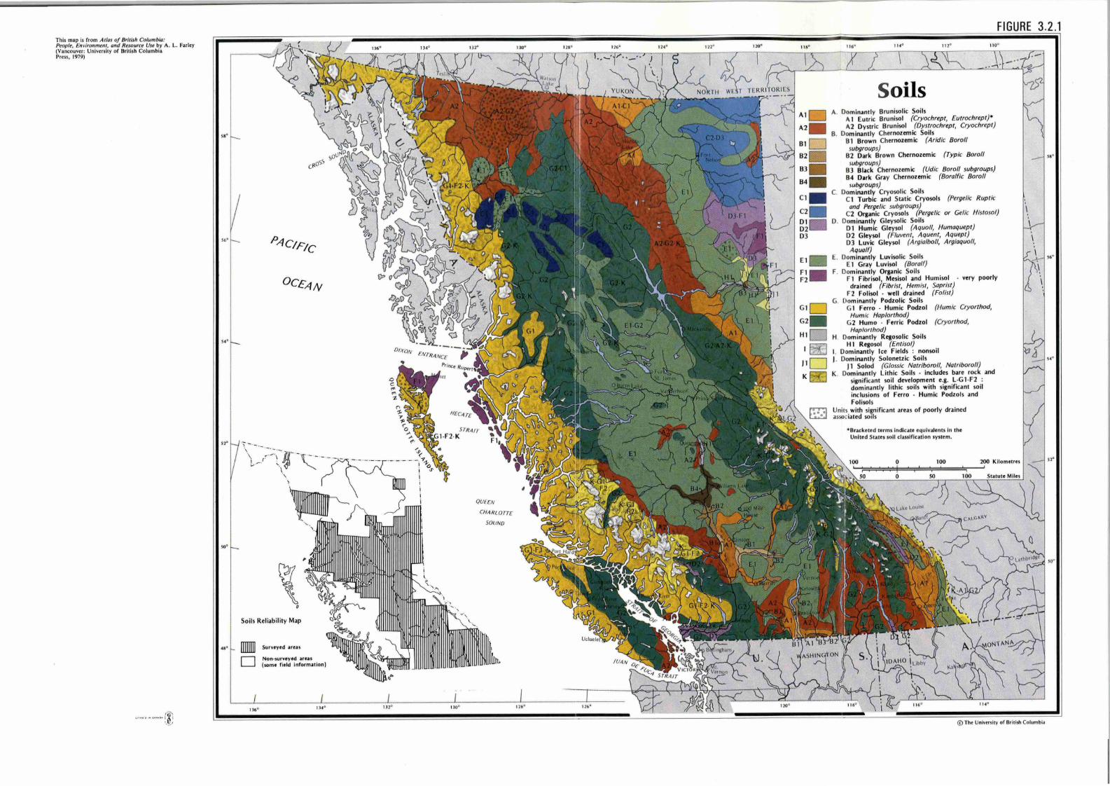
This map is from Ar/as of British Columbia: People, Environment, and Resource Use by A. L. Farley (Vancouver: University or British Columbia Press, 1979)
...... .. ...... (9' ,J},
ss•
56°
54•
,,.
so•
•••
cil-oss
P,4CIF1c
OCE,4N
\ ~ --~,~ ~~;-~---i--·-------,--1 ~ - ... ~ ,... \
-,. )
~ ·, . ,_
\ 0
Soils Reliability Map
136° 1]40
··,
112° 1300
QUEEN
CHA RLOTTE
SOUND
\...._ _
tlllL
1280 126°
FIGURE 3.2.1
A2 .
01 0
83 .
84 .
Cl .
C2 . Dl D2 DJ
Soils A. Dominantly Brunisolic Soils
A 1 Eutric Brunisol (Cryochrept, Eutrochrept)• A2 Dystric Brunisol (Dystrochrept, Cryochrept)
B. Dominantly Chernozemic Soils 8 1 Brown Chernozemic (Aridic Boroll
subgroups) 82 Dark Brown Chernozemic (Typic Boroll
subgroups) 83 Black Chernozemic {Udic Boro/1 subgroups) 8 4 Dark Gr~y Chernozemic (Bora/fie Boro/1
subgroups) C. Dominantly Cryosolic Soils
Cl Turbic and Static Cryosols (Pergelic Ruptic and Perge/ic subgroups)
C2 Organic Cryosols (Pergelic or Gelic Histosol} 0 . Dominantly Gleysolic Soils
Dl Humic Gleysol (Aquo ll, Humaquept} D2 Gleysol {Fluvent, Aquent, Aquept) DJ Luvic Gleysol (Argia/bo /1, Argiaquo/1, Aqualf)
E. Dom inantly Luvisolic Soils E 1 Gray Luvisol (Boroff)
Fl • F. Dom inantly Organic Soils F2 F 1 Fibrisol, Mesisol and Humisol very poorly
G1 D G2 .
H1 D I BJ
11 D K
drained {Fibrist, Hemist, Saprist) F2 Folisol · well drained (Folist}
G. Dominantly Podzolic Soils G 1 Ferro . Humic Podzol (Humic Cryorthod,
Humic Hap/orthod} G2 Humo . Ferric Podzol (Cry orthod,
Haplorthod} H. Dominantly Regosolic Soils
HI Regosol (Entisol} I. Dominantly Ice Fields : nonsoil J. Dominantly Solonetzic Soils
J 1 Solod {Glossic Natriboroll, Natriboroll) K. Dominantly Lithic Soils · includes bare rock and
significant soil development e.g. L-G1 -F2 : dominantly lithic soils with significant soil inclusions of Ferro · Humic Podzols and Folisols
Uni ts with si~nificant areas of poorly drained associated soils
*Bracketed terms indicate equivalenu in the United States soil classific ation system.
0 100
. . \
I -r
\
© The University of British Colum bia
,..
S6°
, ..

3.3 THE COAST MOUNTAINS AND ISLANDS J.R. Jungen and T. Lewis
The Coast Mountains and Islands occupy an area along the extreme
western part of British Columbia stretching from the 49th parallel to the
borders of Alaska and the Yukon. The area is large, about 1200 km in length,
and is relatively narrow but variable in width. It is dominated by two
parallel mountain ranges - the Coast Mountains and the St. Elias-Insular
Mountains. These ranges are separated by a largely submerged lowland.
Numerous major rivers from the interior flow across the Coast Mountains on
their way to the Pacific Ocean. Notable features include, large mountain
snowfields and glaciers, and well developed fjords.
The features of climate, geology and vegetation have been described
in Parts 1.2, 1.3 and 1.4. These soil forming factors in combination with
topography and surficial material give rise to the distinctive soil landscapes
found in the region.
THE FACTORS OF SOIL FORMATION
The region has high precipitation and generally moderate to cool
temperatures, including, particularly in the south, a short dry period in
summer. In winter, the moisture-laden air of a succession of low pressure
systems rises in contact with the coastal slopes, to produce very cloudy and
wet conditions. The soils are generally very wet. The upper elevations
receive vast quant,i ties of snow which protects the ground from freezing. In
the summer there are frequent spells of fine sunny weather as the North
Pacific high-pressure cells extend over the coast. The resultant dry period
influences the type of soils found over the wide range of landforms in the
region, particularly in the south at low elevations.
The terrain is underlain mainly by intrusive igneous rock with minor
but significant areas, mainly on Vancouver Island and the Queen Charlotte
Islands, of folded and faulted volcanic and sedimentary rocks, flat lying
lavas, folded metamorphic rocks, and flat or gently dipping sedimentary rocks.
The intrusive rocks are relatively resistant to weathering. The residue from
prolonged physical and chemical weathering provides a coarse textured, acid
parent material.
In general the vegetation is a coniferous forest blanket. The forest
regions (see Rowe in Further Reading of Part l. 4) which occur are "Coastal",
and "Subalpine". The biogeoclimatic zones include Coastal Western Hemlock,
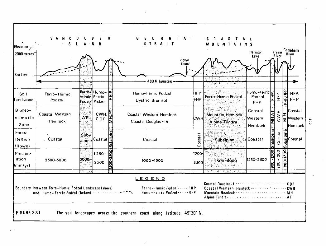
... Elevation ,., ..
V
2000metres
Sea Level I
Soil
Landscape
Biogeo-
climatic
Zone
Forest
Reg ion
(Rowe)
VAN CO UV ER S L A N 0
- Ii .. ,.,,,,::c:;::I 1.>1
Ferro-Humic t:t;H.l·V"'.:'· 11u111u- -~i~I Ferric ::t
Podzol L.L Podzol
~ Coasta I Western CWH, .'··,
CDF J: Hemlock ~
:~ ~ttt \
Coastal Coastal I ·~\:'·..':'·./:"');,. (/'J
G E O R G S T R A I T
400 Kilometres
Humo- Ferric Podzol
Dystric Brunisol
Coastal Western Hem lock
Coastal Douglas-fir
Coastal
A
HFP
FHP
CWH
cii +-' CJ)
ro 0 u
t O A S T A L M O U N T A I N S
Humo-Ferric ,fer? oLHumi~, Pooio1 . PodzoL
FHP
Coastal
Western
Hi>mlnrk
Coastal
Ci. :r: i..L
""" <( :r;' :?!
-~ ·-! .:, (/'J
0
0... Cl. ~, HFP, u..
.I o... FHP J: i.&..
J: Coastal
$ :r :?! Western I § u
Hemlock
co Q) C:
+-'
~Coastal CJ)
ro 0 .D u :::,
(/'J
0 0 Precipit- 1 250- ·~ 1700·. ~ 0 0
" at ion N 2500-5000 . 1
2500 § (mm/yr)
Boundary between Ferro-Humic Podzol Landscape (above) and Humo- Ferric Podiol (below) · · · · · · · · · · · · · · · • • • ·,
1000-1500
LEGEND
Ferro-Humic Podzol-···· FHP Humo-Ferric Podzol - · · · · HFP
FIGURE 3.3.1 The soil landscapes across the southern coast along latitude 49°30' N.
N
1250-2500 - - -• I '·
~ 8 0
i co
Coastal Douglas-fir······· · · · · · · · · · · · · · · ·CD F Coastal Western Hemlock-····· ··· · · · · · · · · · CWH Mountain Hemlock············ · · · · · · · · · · · · · MH Alpine Tundra-· · · · · · · · · .............. AT
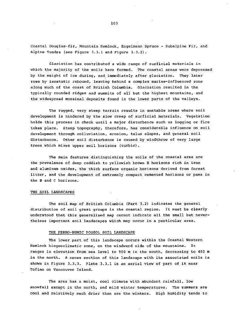
103
Coastal Douglas-fir, Mountain Hemlock, Engelmann Spruce - Subalpine Fir, and
Alpine Tundra {see Figure 3.3.1 and Figure 3.3.2).
Glaciation has contributed a wide range of surficial materials in
which the majority of the soils have formed. The coastal areas were depressed
by the weight of ice during, and immediately after glaciation. They later
rose by isostatic rebound, leaving behind a complex marine-influenced zone
along much of the coast of British Columbia. Glaciation resulted in the
typically rounded ridges and summits of all but the highest mountains, and
the widespread morainal deposits found in the lower parts of the valleys.
The rugged, very steep terrain results in unstable areas where soil
development is hindered by the slow creep of surficial materials. Vegetation
holds this process in check until a major disturbance such as lo~ging or fire
takes place. Steep topography, therefore, has considerable influence on soil
development through colluviation, erosion, talus slopes, and general soil
disturbance. Other soil disturbance is caused by windthrow of very large
trees which mixes upper soil horizons {turbic).
The main features distinguishing the soils of the coastal area are
the prevalence of deep reddish to yellowish brown B horizons rich in iron
and aluminum oxides, the thick surface organic horizons derived from forest
litter, and the development of extremely compact cemented horizons or pans in
the Band C horizons.
THE SOIL LANDSCAPES
The soil map of British Columbia {Part 3.2) indicates the general
distribution of soil great groups in the coastal region. It must be clearly
understood that this generalized map cannot indicate all the small but never
theless important soil landscapes which may occur in a particular area.
THE FERRO-HUMIC PODZOL SOIL LANDSCAPE
The lower part of this landscape occurs within the Coastal Western
Hemlock biogeoclimatic zone, on the windward side of the mountains. It
ranges in elevation from sea level to 900 m in the south, decreasing to 450 m
in the north. A cross section of this landscape with its associated soils is
shown in Figure 3.3.3. Plate 3.3.1 is an aerial view of part of it near
Tofino on Vancouver Island.
The area has a moist, cool climate with abundant rainfall, low
snowfall except in the north, and mild winter temperatures. The summers are
cool and relatively much drier than are the winters. High humidity tends to

Elevation (Metres)
2000
1000
Sea Level
SOIL LANDSCAPE
BIOGEOCLIMATIC ZONE
FOREST REGION · (ROWE)
PRECIPITATION mm/vr
Elevation (Metres)
2000
1000
Sea Level
SOIL LANDSCAPE
BIOGEOCLIMATIC ZONE
WEST
~,F,!IF
Exchamsiks
FOREST REGION lr~ndr~I$ (ROWE) ··< ' ···
Graham Island
Humo-Ferric Podzol. Ferro-Humic Podzol
Exstew
Mesisol
Coastal
Hecate Strait
l 200 Kilometres
Stephens Island
l Mesisol. Folisol
Western Hemlock
Coastal
1300 - 2400
Kitsumkalum Skeena
Work
2500 - 4250
EAST Seven Sisters Mountains
Humo- Ferric Podzol
Engelmann SpruceSubalpine Fir
Montane
PRECIPITATION (mm/yr) 2500-4250 1000 - 2500 750-1500 500-1000
Ferro-Humic Podzol · · · · · · · · · · · · FHP L E G E N D Humo-Ferric Podiol · · · · · · · · · · · · HFP
Fibrisol · · · · · · · · · · · · · · · · · · · · · F
Mountain Hemlock · · · · · · · · · · · · · · · MH Coastal Western Hemlock· · · · · · · · · CWH Alpine Tundra· · · · · · · · · · · · · · AT
FIGURE 3.3.2 The soil landscapes across the northern coast.
Subalpine - · · · · ...... · · · · . · -S Coastal · · · · · · · · · · · · · · · · · · · · C
· Tundra· · · · · · · · · · · · · · · · · T
I-' 0 ,I>,
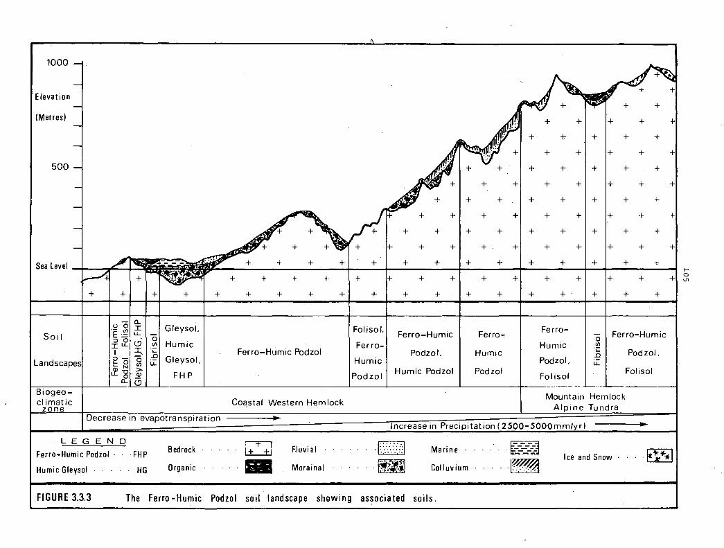
1000
Elevation
(Metres) i
500 ~
Sea Level I
Soil I
Landscapes!
Biogeocl imatic
ZQ_n_e
+
.,P" I - - -
I +I I +I --+
0 a.. -~ (/) I Gleysol. I ·- u.. -::JO - 0 :r: u.. <.9 (/) Humic
I ·-I -- .n I O o o ·- Gleysol t= CJ) LL I
Q) N > u..-g~ FHP
a.. (.9
(\
+ +~ + /~ I}
T + + + +
+ + + + +
I + + + + + +
FolisoL
Ferro-Humic Podzol Ferro-
Humic
Podzol
Co~stal Western Hemlock
Al+
fl , + +
+ +I+
+ + +
I+ + +
+ + +
+ + +
+ + +
Ferro-Humic
Podzol.
Humic Podzol
. V +
+
+
+
+
+
+
+
+
Ferro-,
Humic
Podzol
r1+ + + +
+ + +
+
+
+
+
+
+
+
+
+
+
+ + + +
+ + + +
+ + + +
+ + + +
+ + + +
+ + + +
+ +I+
I+
+ +
+ +
+ + + +
+ + + +
+ + + +
Ferro-0 I Ferro-Humic
Humic (/)
~I Podzol. Podzol, L.L
Folisol I Folisol
Mountain Hemlock Alpine Tundra
+
+
+
+
+
+I~
Decrease in evapotranspiration Tncrease in Precigitation ( 2500-SOOOmm/yr)
LEGEND
Ferro-Humic Podzol · · · FHP
Humic Gleysol · · · · · HG
Bedrock
Organic
LI - Fluvi al ·
Morainal
[TI .. . . . ... . ··,··
.f;t;~ ,.-,..~!J
Marine ·
Col luvium
FIGURE 3.3.3 The Ferro-Humic Podzol soil landscape showing associated soils.
-k=-~ -~
Ice and Snow .. · .. ri•*j
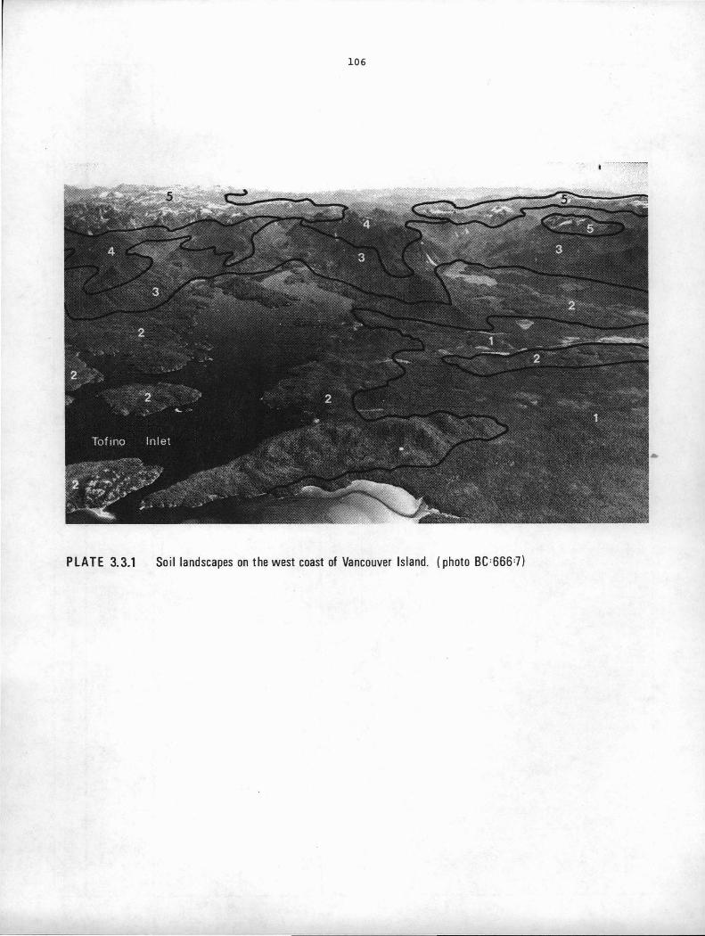
106
PLATE 3.3.1 Soil landscapes on the west coast of Vancouver Island. I photo BC=666=7)
107
PLATE 3.3.1
SOIL LANDSCAPES ON THE NEST COAST OF VANCOUVER ISLAND
1. Ferro-Humic Podzol, Humic Gleysol and Fibrisol landscapes on the marine
and fluvioglacial sediments of the coastal plain. The Ferro-Humic
Podzols will occur only on the coarse textured materials or on the
better drained sites. There are Humic Gleysols and organic Fibrisols
on the level to depressional topography of the marine clays.
2. Ferro-Humic Podzol soil landscape on the morainal deposits that blanket
the lower mountain slopes in the Coastal Western Hemlock biogeo
climatic zone.
3. Ferro-Humic Podzol soil landscape on the colluvial materials of the upper
mountain slopes in the Coastal Western Hemlock biogeoclimatic zone.
There are also exposures of organic Folisol landscapes over bedrock.
4. Ferro-Humic Podzol soil landscape on thin colluvial materials in the
Mountain Hemlock biogeoclimatic zone. Organic Folisols and Fibrisols
also occur.
5. Alpine soil landscapes with shallow rubbly Regosols, exposed bedrock,
snow and ice.
108
restrict evapotranspiration rates. The soils are moist to wet over most of
the year and rarely freeze to any significant depth. The soil temperature
regime is mainly cold to moderately cold cryoboreal and the moisture regimes
are dominantly perhumid. Excess moisture and a high incidence of associated
poorly drained soils typify this landscape.
The upper part of this landscape occurs at elevations ranging
between 900 to 1400 m in the Mountain Hemlock biogeoclimatic zone. ·This area
is cooler, and receives more total precipitation than the lower part, much of
it as snow. The soils rarely freeze due to the insulating effect of the deep
snow. The soil temperature class is predominantly cold cryoboreal and the
soil moisture regime is perhumid.
The main soil proces·ses are the accumulation of complexes of amorphous
organic matter, iron and aluminum producing soils with exceptionally strong
podzol B horizons. In fact, most pedologists would agree that podzols have
reached their maximum development in British Columbia within this landscape
zone. The soils may or may not have thin eluvial (Ae) horizons; are dominated
by thick dark reddish B horizons of ±1 m rich in iron, aluminum and organic
matter; have strong indications of turbic activity; are medium to coarse
textured, and generally lack horizons in which clay has accumulated (Bt).
Leaching is intense in these soils.
Much of the Ferro-Humic Podzol soil landscape is subject to continuous
seepage. This excess moisture is not apparent in the soil in the usual form
of gleying and mottling but rather is shown by a higher organic matter content
and generally duller profile colours. The distribution of organic matter is
typically uneven, and often reaches a maximum near the lower part of the solum.
The organic matter content may reach or even exceed 30 percent.
This landscape supports some of the most productive forest land in
British Columbia. Mean annual increments exceeding 20 m3/ha/yr are common on
the best sites. Coastal western hemlock and Pacific silver fir (amabilis fir)
are the dominant species. Sitka spruce occurs on coastal sites.
Forest production in the Mountain Hemlock biogeoclimatic zone is much
lower. Extremely heavy snowfall and a short growing season limit forest
growth.
Because the terrain is rugged and s.teep, the most common parent
material in this landscape is colluvium, deposits of which are often shallow
veneers overlying bedrock. These soils are deep (often between 1 and 2 m),
well to moderately well drained, loose to friable, and do not contain any
sign of cemented horizons.

109
Morainal deposits also mantle significant areas. These deposits
typically flank the lower valley walls as a blanket or veneer. Thick organic
mats of 20-50 cm which overlie the mineral soils are common, with Bf- (Fe plus
Al accumulation), and Bhf (Fe plus Al plus organic matter accumulation) hori
zons immediately underneath. The Bhf horizon is frequently most pronounced
just above an indurated pan that occurs in the uppermost till. The Bhf and
Bf horizons are together usually less than 1 m thick; the boundary between
them varies from smooth to very irregular with tongues indicating turbic
activity. The main distinction between morainal and colluvial soils is the
presence of a tough, indurated pan (Be horizon) in most morainal soils.
Cementation is strongest near the upper boundary of the pan. Penetration is
nearly impossible with normal hand tools. The average thickness is 20-50 cm;
structure is coarse platy or massive; and texture is medium to coarse. Air
dry clods do not slake when immersed in water, and the porosity is low.
Gravelly fluvial materials have soil profiles similar to those on
rnorainal deposits with respect to colour and cementation. These soils are
mostly imperfectly to poorly drained.
Chemically the soils of the Ferro-Humic Podzol soil landscape have
very low ba.se saturation; low pH values (less than 5.0 is common); high
organic carbon; and high Fe and Al contents. The upper part of the landscape
is chemically and morphologically similar to the lower areas, except that the
horizons contain somewhat greater amounts of Fe, Al, and organic matter.
THE FOLISOL LANDSCAPE
Folisols are organic soils that consist of shallow organic material
overlying bedrock. Folisols require a relatively high precipitation and low
evapotranspiration in.order to develop over otherwise dry, sterile bedrock.
They are, however, not continuously saturated. Folisol landscapes are
forested and the organic mat is derived from leaves, twigs, roots, branches,
and mosses that accumulate over the bedrock. Folisols rarely occur as large,
continuous units except in the north, but rather, as minor associates within
the Ferro-Humic Podzol soil landscape (see Figure 3.3.3). They are most
widespread at high elevations and on the windward outer coast. Without the
wet, cool, perhumid moisture regime, the organic matter would not accumulate
rapidly enough and outcrops would remain as bare bedrock. Unlike wet,
organic soils, Folisols occur on a variety of slopes - crests of ridges, steep
well drained positions, gently rolling to undulating bedrock areas.
This landscape is treed, and includes species such as western hemlock,
western red cedar, and yellow cedar. Forest productivity is relatively low.
Folisols are much more restricted along the east coast of Vancouver Island
where the climate is warmer and drier.

llO
THE HUHO-FERRIC PODZOL SOIL LANDSCAPE
The Humo-Ferric Podzol soil landscape occurs predominantly within
the Coastal Western Hemlock and Coastal Douglas-fir biogeoclimatic zones,
on the eastern side of Vancouver Island, and in all low valleys away from
the outer coast. The vegetation usually consists of a moderately dense
Douglas-fir and western hemlock forest with a moderately dense understory
layer. Upper elevation limits range from above 900 m on the east coast of
Vancouver Island to below 450 m in the lower Fraser Valley (see Figure 3.3.4).
In the north this landscape can be found only in the lower parts of valleys
such as the Skeena and the Nass. Rapid gradation to the Ferro-Humic Podzol
soil landscape takes place with increasing effective moisture.
The principal climatic features are relatively mild winters, cool to
warm summers, and moderate to high precipitation. Summers are somewhat warmer
and drier than in the Ferro-Humic Podzol soil landscape and evapotranspiration
is correspondingly higher. Abundant precipitation occurs during the winter.
The soil temperature classes include mild mesic, cool boreal, anc cold cryo
boreal while the soil moisture regime is dominantly humid. The snowfall is
low to moderate, depending on elevation and latitude.
The major lowlands, including the Fraser and Nanaimo lowlands, the
Alberni Basin, the Nass River and numerous low valley systems have Humo-Ferric
Podzols. These areas are predominantly gently sloping to moderately rolling,
but include areas of steeply sloping, rugged terrain along the mountain sides.
The whole landscape has been glaciated resulting in a wide variety of glacial
deposits. Morainal, colluvial, fluvial, and marine materials comprise the
main surficial deposits in this landscape. Morainal deposits are probably
the most extensive parent material.
The above combination of climatic, topographic, and landform factors
has resulted in well to moderately well drained podzolic soils with dark
reddish colours, low pH values of 4.0 to 5.0, moderate to high Fe+ Al content,
with low base saturations. Textures are predominantly coarse to medium.
Where long term seepage occurs, levels of organic matter are sufficiently high
to classify the soil as a Ferro-Humic Podzol. The interplay among the
various environmental factors produces a boundary zone of considerable inter
fingering of the Humo-Ferric and Ferro-Humic Podzol soil landscapes.
The soil profiles have a sequence of organic surface horizons (L-F-H),
possibly an incipient eluvial horizon (Ae), and a thick Bf horizon. An
indurated pan (Be and BCc horizons) is found in gravelly fluvial and morainal
material wherever suitable textures and stable conditions exist. The degree
of cementation of these pans varies from weak to strong; usually it is
Elevation (Metres)
1000
500
+ +
+
+ +
+ +
+
+ +I I
+t + +
+ +
+
+ +
+ +
+ + +
I+ I +
+ + +
+ +!
t +
+
I+ +
+ +
+ +
+ + +
+ +
+ + l I +I I T + I :t FI + l t t- t I +
+ + + + + +
+ +
Soil
Land-
scape
Biogeo
climatic
Zone
Dystric I Bruni sol.
Regosol I
+ +I +
0 (/)
C: Humo-Ferric :, u
a..· ... a.. C: Ial LI.. co u. -~ I a,
I ~ ...
Podzol 0
0
Coastal Douglas-fir
Decrease in evapotranspirat ion
LEGEND
Ferro-Humic Podzol · · -FHP Humo-Ferric Podzol · · · HF P
Mountain Hemlock · · -MH Humic Gleysol HG
Gleysol · · · · · · · · · G
+ + + t- - + + + + + +
Gleysol, Humo-
· Humic (:J u cj I Ferric a.. Gleysol, C: a..
LI.. Humo-Ferric Podzol co LI.. I I Dystric C: I a..· I Podzol, ...
LI..
Bruni sol 0 I
I FHP
Coastal Western Hemlock
Increase in precipitation (900-2500m m/ yr)-----
Bedrock E::J Fluvial . ··CJ Marine· · ....... I
......
Organic - Morainal · ·f~%1 Colluvium
FIGURE 3.3.4 The Humo-Ferric Podzol soil landscape showing associated soils.
+ +1 ~ +
Ferro-Humic
Podzol,
Folisol
-MH.
Alpine Tundra
~ -·[Elj ......

112
strongest near the top of the horizon. These horizons are massive; they do
not soften or slake in water, and can be chipped only with difficulty using
a geology hammer. Sometimes it is difficult to distinguish the pan from the
original parent material because the underlying unweathered morainal material
is also compact. Bulk densities are high, greater than 1.8. The pan is
streaked with reddish brown colours and often contains mottles and black
manganese oxide coatings, in contrast to the more uniform olive greyish
colour of the C horizon. Moderate to fine textured soils generally contain
concretions in the illuvial Bf horizon.
Colluvial deposits within this landscape are deep to shallow veneers
overlying bedrock. The B horizons are deeply weathered, usually extending
down from 1 to 2 m to the bedrock contact. Colluvial soils are loose to
friable, well to rapidly drained, and contain no indurated pans.
This landscape has been the basis of the forest industry of the
southern coastal area over the past century. It contained in vast quantities
some of the most magnificent mature stands of Douglas-fir in British Columbia.
Today these stands are mostly logged. Forest productivity is lower than in
the Ferro-Hurnic Podzol soil landscape, but is reasonably high in receiving
seepage sites where mean annual increments exceed 12 m3/ha/yr.
THE DYSTRIC BRUNISOL AND SOMBRIC BRUNISOL LANDSCAPES
These landscapes occupy a minor part of the region; since they occur
only in southeastern Vancouver Island and the adjacent Gulf Islands, with a
minor pocket on the Skagit River next to the international border.
The climate approaches the Mediterranean type having dry warm summers
with high moisture deficits and relatively low rainfall. Precipitation ranges
from about 650 mm to about 1250 mm. Water deficits during the growing season
are considerable, ranging from 140 to 270 mm. The soil temperature class is
mild mesic and the moisture regime is semiarid.
The landscapes occur within the Coastal Douglas-fir biogeoclimatic
zone. Major tree species include Douglas-fir, Garry oak, Pacific madrone
(arbutus}, and grand fir, which prefers the sites with impeded drainage.
Major parent materials include medium to coarse textured compact
glacial till or colluvium and fine textured marine. The soils are Dystric
and Sornbric Brunisols. Of the two, the Sombric Brunisol occurs in the driest
sites and is associated with an open Garry oak-grass community. It is usually
found below elevations of 50 m where effective moisture is lower than it is
113
in the Dystric Brunisol landscape. The soils of both landscapes are
moderately to slightly acidic in reaction, and have low to moderate base
saturations.
SOIL LANDSCAPES OF FLOODPLAIN AND MARINE DEPOSITS
The soil landscapes in these areas include Eutric Brunisol, Melanie
Brunisol, Gray Luvisol, Regosol, Gleysol, and Humic Gleysol. The complexity
of soil landscapes occurring on floodplains is readily apparent when one
considers the variability which occurs. Textures range from extremely coarse
to fine, soil drainage ranges from rapid to very poor, and soil reaction
from slightly acid to slightly alkaline. Important industries related to
agriculture, forestry and recreation occur, and many towns and cities have
been built, causing much conflict at present between urban and agricultural
land use. Plate 3.3.2 illustrates some of these floodplain landscapes in
the Fraser Valley.
The Eutric Brunisol, Melanie Brunisol and Gray Luvisol landscapes
are restricted to large floodplains such as that of the Fraser River. These
soils are often neutral to alkaline, and are imperfectly to moderately well
drained.
The vegetation cover is largely deciduous, consisting of red alder,
broad leaf maple and cottonwood, with grasses, shrubs, and sedges, whose
decomposition products contribute to the dark Ah horizons. The parent
materials are youthful and fine textured. Many soil' characteristics depend
on sedimentation, and flooding rather than soil processes. The slightly acid
to neutral reaction and moderate to high base saturation of the soil reflects
the underlying water table and little-weathered nature of the alluvium.
Illuviation of clay is weak to moderate, illuviation of Fe and Al is weak,
and organic matter content is variable. Significant areas of poorly drained
Gleysolic and Organic soil landscapes also occur.
The Regosol landscape occurs on the most recent fluvial deposits.
It is commonly found on all river floodplains including those of the Fraser,
Skeena, and Nass, as well as along most smaller streams and rivers. The
vegetation is normally deciduous including such species as black cottonwood,
red alder, and willow or the landscape may be devoid of vegetation.
Regosols are dependent on the fluvial process of continual lateral
stream migration. This process is clearly evident on all major streams and
rivers in the coastal areas. New areas are continually being eroded and
deposited, changing soils from possibly an older more strongly developed
soil back to a young Regosol. This cycle repeats itself over and over again

PLATE 3.3.2 Soil landscapes in and adjacent to the Fraser River Lowland looking southwest to Sumas Mountain.
(photo BC:498'114)
I-' I-' ,i,.
115
PLATE 3.3.2
SOIL LANDSCAPES IN AND ADJACENT TO THE FRASER RIVER LOWLAND
1. Floodplain soil landscapes including Humic Gleysols, Gray Luvisols and
scattered Mesisols and Humisols on fine to medium textured vertically
accreting sediments. The complex pattern of these individual soil
landscapes depends on soil drainage on the flat to gently sloping
topography. The main tree species are Douglas-fir, Sitka spruce,
red alder and black cottonwood.
2. Floodplain soil landscapes including Eutric Brunisols, Melanie Brunisols,
and Regosols on medium to coarse textured laterally accreting sedi
ments. The topography is undulating and the trees are mainly black
cottonwood and red alder with some Douglas-fir and Sitka spruce.
3. Humo-Ferric Podzol soil landscapes on shallow and deep colluvial and
morainal deposits. The main trees are Douglas-fir and western
hemlock.
4. Upper mountain slopes and peaks with Ferro-Humic Podzol and Folisol
landscapes and bedrock. Mountain hemlock and Pacific silver fir
(amabilis fir) are the main trees.
116
as the streams and rivers meander back and forth across their valley floors.
Climate over the whole watershed controls the amount of stream flow and the
frequency and severity of flooding, both factors which produce constructive
fluvial landforms on which Regosols are found. Low gradient streams common
to most large rivers in this area have natural levees which usually occur
close to the stream and somewhat higher than the surrounding terrain. During
flood periods considerable erosion takes place and when the floodwaters over
top riverbanks and spread across the floodplain quantities of sediments are
dropped on the levees and on the surrounding plain producing a Regosolic or
Gleysolic soil.
Regosols, Gleysols and Organic soil landscapes occur side by side
depending on the soil drainage with the Regosols on the better drained sites,
the Gleysols in the poorly drained sites and Organic soils in very poorly
drained sites.
The Gleysol and Humic Gleysol landscapes occur on very gently sloping
to flat terrain which is often associated with marine and fluvial deposits
(see Plate 3.3.2). The main locations of Gleysolic landscapes are the Estevan
Coastal Plain, the Nahwitti Lowland, Suquash Basin, the Milbanke Strandflat
and the Hecate Lowland.
Poor soil drainage is largely responsible for Gleysolic soil formation.
The fine textured marine lowlands are particularly suited for the development
of Gleysolic soils. Humic Gleysols have an Ah horizon and underlying horizons
that are strongly gleyed and mottled. Weakly developed eluvial and illuvial
horizons may be present. Typical vegetation includes red alder, black cotton
wood, willows, skunk cabbage and sedges. The wet coastal climate with its
predominantly perhumid soil moisture regime leads to Gleysolic soils on low
lying receiving areas. The wet conditions of a high or fluctuating water
table result in rapid chemical reduction and the production of typical bluish
or grayish coloured horizons. Gleysolic soils are less dependent on climate
than other soils. For example, much of the Nanaimo Lowland receives consi
derable water from the mountains to the west. This source of groundwater
helps to sustain the water table throughout the lowland and, as a result,
contributes to the formation of Gleysols in depressions surrounded by the much
drier Brunisolic landscapes.
SOIL LANDSCAPES OF THE ALPINE TUNDRA
These landscapes occur at high elevations (generally over 1500 m on
windward slopes, and over 1800 m on leeward slopes) where environmental condi
tions are severe, with rock, ice, snow and minimal soil development on shallow
colluvium. High ridges and mountain peaks where cirques, tarns, horns,

117
ar@tes, rock bars, and intervening basins with glaciers and snowfields
abound represent a significant part of the coastal region. The landscape
includes such notable areas as Mt. lvaddington, Silverthrone Mountain and
the Homathko Icefield. The terrain is extremely rough and the vegetation
and micro-climate changes rapidly over short distances. The soil temperature
classes range from cold cryoboreal to subarctic. The area is nearly treeless
except for scattered dwarf clumps of Pacific silver fir {amabilis fir), sub
alpine fir, and yellow cedar. Plate 3.3.3 illustrates some typical alpine
tundra soil landscapes in the coast mountains just west of Tatlayoko Lake.
The high elevations make the climate colder, increase the amount of
snowfall, and drastically shorten the growing season. Soil development is
often absent or weak, occurring only in stable pockets where stunted trees,
shrubs and heather, in combination with the harsh climate, have managed to
develop a soil.
The processes of solifluction, nivation, and cryoturbation are all
active. These processes have a strong effect on any soil development by
disrupting and dislocating horizons, displacing and incorporating materials
from other horizons, and mechanically sorting soil particles. Such effects
in combination with the cold climate, which slows weathering, greatly retard
soil development.
Alpine meadows are relatively small and are usually found in gently
sloping to flat moisture receiving sites. This type of terrain in combination
with large winter snow accumulations support nivation hollows which may or
may not be permanently frozen depending on aspect and altitude. Shallow to
deep Humic Gleysols and Organic soils are common in the alpine zone due to
cold soil temperatures with low microbial activity. Organic matter accumu
lates. In the northern section of this region and on exposed north aspects
Turbic Cryosols and Organic Cryosols are expected to occur. Regosols and
Humic Regosols occur in relative abundance. Large areas of stones and boul
ders exist where cryoturbation and colluviation are common processes. In
other well drained areas where tree islands and heather vegetation are found
Ferro-Humic Podzols develop.
Because of its scenic beauty this landscape has tremendous potential
for recreational activities such as hiking, rock climbing, and skiing.
THE SATURATED ORGANIC SOIL LANDSCAPES
Organic soils occur where the decay of organic residues is inhibited
by a lack of oxygen caused by submersion or saturation. Fibrisols, Mesisols
and Humisols all occur in the coastal region. Fibrisols are the most common,

118
N co N
:.;;: .-u aJ 0
0 ..c c. a,;
..:.:: ctJ
......J
0 ..:.:: 0 >ctl
~ 0
Cl)
·= ctJ -c:: ::, 0
~ -Cl) co 0
(_)
a, ..c -·=
--0 Cl) a, c. co u Cl)
-r::, c:: co
M M
M
w 1-<t ......J D..

119
.PLATE 3.3.3
ALPINE TUNDRA SOIL LANDSCAPES
IN THE COAST MOUNTAINS WEST OF TATLAYOKO LAKE
1. Ferro-Humic Podzol soil landscape on shallow colluvial deposits over
bedrock on steep upper valley slopes.
2. Upper mountain slopes and alpine meadows with a very complicated pattern
of soil landscapes. They include rubbly Regosols, Humic Gleysols,
Organic soils and possibly Organic Cryosols.
3. High ridges and mountain peaks with snow patches and glaciers. Soils
are rocky, weakly developed and subject to frost action giving
Regosols and probably Turbic Cryosols. Bedrock exposures are common
with classic features of mountain glaciation such as cirques, horns
and ar~tes.

120
and occur in the wet outer coast region, on some floodplains, and at upper
elevations where undecomposed sphagnum and forest peat are the dominant or
ganic source. The main trees are yellow cedar and shore pine with Labrador
tea as the common shrub. The soils are extremely acid {pH values less than
4.0). Mesisols have a vegetation cover composed of sedges, hardhack, mosses,
willows, grasses, and reeds •. Numerous bogs of this type occur on the drier
east coastal plain of Vancouver Island. The water comes from seepage inflow
from adjacent mineral soils rather than from precipitation only, as is the
case with Fibrisols, and is thus richer in nutrients. Humisols occur only
rarely and appear to be restricted to the southernmost part of the region.
Organic soils occur as small pockets in the southern coastal region,
ranging up to fairly widespread areas on the flat to concave lands of the
outer coast and Queen Charlotte Islands. Many in the south are found
surrounding small lakes and were originated by the continuous encroachment of
vegetation around the margins of what were once much larger lakes. Humisols
and Mesisols are widely used for agriculture in the south.

3.4. THE INTERIOR PLATEAU K.W.G. Valentine and A.B. Dawson
The interior plateau occupies the whole of the southern and central
part of the province lying between the coast mountains to the west and the
Columbia and Rocky Mountains to the east. It is a very large area approxi
mately 900 km in length and 376 km at its maximum width. Almost all of it
is drained by the Fraser River or its tributaries.
The features of the climate, geology and vegetation have been
described in Parts 1.2, 1.3 and 1.4. These "factors of soil formation" have
combined to give a number of highly distinctive soil landscapes, whose
principal features are well known. The terms Okanagan, Cariboo, Chilcotin
or Blackwater evoke an immediate picture of distinctive typ~s of country.
The main aspects of the environment that have produced the soils of these
landscapes are discussed in the next few paragraphs.
THE FACTORS OF SOIL FORMATION
The interior plateau lies in the rain shadow of the coast mountains.
Precipitation is therefore low in the west and south and increases eastward
towards the Quesnel, Shushwap and Okanagan highlands and northward to Prince
George. Effective precipitation is influenced by temperature through evapo
ration rates. Mean annual temperature decreases from south to north and with
any increase in elevation. Most of the soils are frozen in the winter so it
is the temperature and precipitation regimes through the spring, summer and
fall that influence soil development. Soil temperature classes vary a great
deal. Southern valleys around Osoyoos or Ashcroft are classed as moderately
cool boreal with hot summers, whereas the plateau northwest of Prince George
falls in the cold cryoboreal class. The same areas have soil moisture regimes
that range from subarid with a severe moisture deficit to humid with only a
slight moisture deficit, respectively.
Most of the plateau lies between 1200 and 1500 m above sea level.
The topography is rolling with few high peaks. The main types of soil are
homogeneous over large areas. The rugged topography in the east and the
steep sides of some large valleys produce colluvial soil parent materials
and sharp changes in soil types due either to the influence of elevation or
aspect.
The basic basalt lavas of the centre and north contribute to the high
base status of many soils. In the south and east the rocks are much more
varied. The volcanics and limestones provide base-rich parent materials in

122
parts of the Quesnel Highlands, while metamorphic rocks such as quartzites
and gneiss give more acidic parent materials in the Shuswap Highlands.
Most of the parent materials are unconsolidated materials which were
deposited during the last phase of glaciation andthe subsequent wasting of
the ice, or during post glacial time. Most of the plateau surface and the
mountain slopes are covered with glacial till which usually bears a close
association mineralogically with the underlying bedrock. Drumlins and glacial
grooves are common and there are large areas of hummocky till where the ice
stagnated and melted. The plateau surface therefore is rolling with many
enclosed depressions. These depressions contain organic soils in the cooler
and wetter north and often saline soils in the hotter and drier south. As
the ice melted a large amount of water was released and often accumulated as
huge lakes impounded by temporary ice dams. Throughout the interior plateau
there are the remnants of lacustrine basins with stratified silty and clayey
soils. The largest are around Fort St. James, Vanderhoof, Prince George,
Kamloops and in the Okanagan valley. Very coarse materials were deposited
by the meltwaters before they reached the lakes. So in many valleys or on
the lower parts of the plateau there are gravelly and sandy terraces, plains,
esker complexes and occasionally large deltas. All these deposits have thin
draughty soils. Lastly, over much of the land, the wind deposited a thin
layer of silt and fine sand. This material probably originated from the
exposed shores of lakes or river floodplains, but some is volcanic in origin
being derived from the Mazama, St. Helens~ and Bridge River ash falls. This
volcanic ash can become quite thick close to the source (i.e. Bridge River).
There are a number of quite different biogeoclimatic zones in this
large and varied plateau country. At the lowest elevations of the southern
valleys are the open grasslands and sparse trees of the Ponderosa Pine -
Bunchgrass zone. At higher elevations and further north is the Interior
Douglas-fir zone. The parkland of the Cariboo Aspen - Lodgepole Pine zone is
found from Clinton to the Bulkley River, and north of this is the Sub-Boreal
Spruce zone. Throughout the region the Engelmann Spruce - Subalpine Fir zone
occurs above about 1200 m and on the high mountain tops is the Alpine Tundra
zone.
THE SOIL LANDSCAPES
The soil map of British Columbia (Part 3.2) shows the distribution
of the main soil great groups in the interior plateau. The features of each
great group landscape are described on the following pages. The map is very
general and cannot show some of the soil landscapes which may cover small
areas in total but are nonetheless important members of the whole soil pic
ture. The organic, saline and alpine soils are examples. The geographical
Elevation HAZELTON MOUNTAINS (Metres)
2000~
1500
1000
SOIL LANDSCAPE
BIOGEOCLIMATIC Lt ,.
ZONE
FOREST REGION (ROWE)
PRECIPITATION (mm/yr)
Elevation (Metres)
500-1000
Nechako Plateau
Nechako Plateau
,2s·oo' 75lrnometre_s
Gray Luvisol, Oystric Brunisol
Sub- Boreal Spruce
Montane Transition
450-500
Fraser Basin and minor Nechako Plain
1500 Stuart Lake Fort St.James Great Beaver Lake
1000
500
SOIL LANDSCAPE
BIOGEOCLIMATIC ZONE
FOREST REGION (ROWEi
PRECIPITATION (mm/yr)
... .. _
G L IDBI OB. GL
! J i 124"00'
175 Kilometres
G L I EB. GL Gray Luvisol
Sub - Bo real Spruce
Montane Transition
450-500
GL
L E G E N D Engelmann Spruce- Humo-Ferric Podzol · · · · · · · · · ·HFP Interior Subalpine ....... ·. IS Subalpine Fir · · · · · · · · · -ESSF Gray Luvisol · · · · · · · · · · · · · · GL Montane Transition · · · · · · MT Sub-Boreal Spruce······ · · -SBS Alpine Soils · · · · · · · · · · · · · · AS
· FIGURE 3.4.1 The soil landscapes of the north~_r_n_ ll'l!_e_rio_l"_ _!)lateau along_ latitude 54°27'
Mc Gregor Plateau
Shass Mountain
I . i:esstl~ . . . .. :.: Cl)
'I~ IS ; ::E
Mount Beauregard ............
500-1000
Oystric Brunisol · · · · · · · · · 0 Eutric Brunisol · · · · · · · · · · E B Gleysol - · · · · · · · · · · · · · · · · G
I-' N w
124
relationships of all the soi) landscapes are shown by two east-west cross
sections; one across the humid northern portion of the plateau (Figure 3.4.1)
and one across the south (Figure 3.4.2).
THE GRAY LUVISOL LANDSCAPE
This is by far the most extensive of all the soil landscapes. In the
south Gray Luvisols occur on the medium to moderately fine textured glacial
till of the plateau slopes. Most of the till is calcareous being derived
from base rich volcanics or limestone, but some in the east is more acid.
The vegetation is·a moderately dense Rocky Mountain Douglas-fir forest with
bluebunch wheat grass and pine grass. The elevation range of these soils in
the south can extend from about 1000 m to over 1800 m above sea level. Fur
ther north the elevation range becomes lower because the cooler temperatures
and higher precipitation result in greater moisture effectiveness at lower
elevations. Thus in the Williams Lake area Gray Luvisols· are found on the
calcareous till of the plateau and on the calcareous lacustrine silts in the
valleys down to 800 m above sea level. In the Fort St. James and Vanderhoof
area Gray Luvisols occur down to about.600 m on the lacustrine silts and do
not extend much above 1100 m on the till of the plateau. Here the trees are
mainly white spruce and lodgepole pine. Gray Luvisols rarely occur on collu
vium, possibly because the material is too unstable for a definite horizon
of clay accumulation to be formed.
The vegetation cover does not add a very large amount of organic
matter to the soil so that the surface litter layer of needles and grass (L,
F horizons) is thin and poorly decomposed. The uppermost mineral horizon is
typically 10-25 cm of grayish brown silt and fine sand (Ae horizon), much of
which is wind blown loess and volcanic ash. Below this there is a much finer
textured layer 15-30 cm thick (Bt horizon) which has strong angular blocky
structure. This horizon, in which clay has accumulated, tends to restrict
water percolation, so that these soils can become extremely wet in the spring.
The carbonates of the original parent material have been washed out of the
A and B horizons, but the intensity of leaching is not great enough to wash
them through the C horizon and away via the groundwater. Therefore, there is
often a white powdery layer of carbonate accumulation at depth to give a Cea
horizon. In the semiarid south this accumulation will be less than one metre
below the surface. In the humid north it may be as deep as two metres.
These are the soil landscapes that support much of the extensive
logging industry of the interior plateau. Timber productivity is especially
high in humid areas bordering the Hume-Ferric Podzol landscapes. In the sub
humid and semiarid areas associated with the Brunisolic landscapes the forest
is more open and provides important summer grazing for the interior cattle
ranching industry.
WEST
THOMPSON PLATEAU
EAST
OKANAGAN HIGHLAND
Elevation (Metres) .
2000
1500
1000
500
Sea Level I I I I L:
SOIL
.LANDSCAPE
BIOGEOCLIMATIC
ZONE
FOREST REGION;
Gray LLivisol,
Dystric Brunisol
Interior Douglas-fir
Montane.
SECTIONS (ROWE) I Ponderosa Pine and Douglas-fir
PRECIPITATION-mm/yr
MEAN ANNUAL TEMP.
Shallow soils and rocks
Humo-Ferric Podzol • ·
600-650
re LEGEND
. Ro
· HFP Dark Brown Chernozemic · · . . . . . . . . . . D BC
Okanagan Lake Kettle River
E Eutric Brunisol 1u
CCI
Gray Luvisol C
G,
R . DBC I BC
E B,
G L
Interior Douglas-fir Ponderosa Pine-I Interior
Montane. Ponderosa Pine
and Douglas-fir
550-600
4·c
Black Chernozemic · · · · · -BC
Gray Luvisol . . G L
Dystric Brunisol . . DB Eutric Bruni sol ........... E B
Bunch grass Douglas-fir
Grassland Montane.
Ponderosa Pine and Douglas-fir
IFF'::'i/F'i\:.0/,··'·
300- 600
5·c 600-1000
2°C
Gleysol · · · · · · · · · · · · · ·G Regosol . . . . . . . . . . . . -R
Interior Douglas-fir · · · · · · IDF
Southern Columbia · · · · · - · - · -Cl.1
FIGURE 3.4.2 The soil landscapes of the southern Interior Plateau along latitude 50°00'
I-'
"' l1l
126
THE HOMO-FERRIC PODZOL SOIL LANDSCAPES
In broad terms this soil landscape borders the Gray Luvisols on the
higher elevations of the Nechako, McGregor, Fraser and Thompson plateaus and
the Quesnel, Shushwap and Okanagan highlands. The soil temperature class is
mainly cold cryoboreal and the moisture regimes are humid to subhumid. The
soil parent materials are usually coarse to moderately coarse textured very
permeable glacial till or colluvium derived mainly from igneous and metamor
phic rocks such as granodiorites, gneisses and schists. In the more humid
northern portion similar soils also occur at much lower elevations on very
coarse textured fluvioglacial materials. The vegetation is usually a dense
subalpine fir and Engelmann spruce forest with moderately dense shrub, forb
and moss layers. It is the basis for the logging industry of the central
interior. In the south this soil landscape occurs above about 1200 m but
lower on northerly aspects. In the north its elevation range is approximately
from 750 m to 1500 m above sea level. Plate 3.4.1 illustrates the occurrence
of this soil landscape in the Quesnel Highlands.
The dense vegetation cover provides a thick organic surface litter
of needles, twigs and moss (L-F-H horizons) which is acid and poorly decom
posed. Below this usually occurs a bleached sandy Ae horizon and then a
reddish brown Bf horizon in which iron, aluminum and some amorphous organic
matter has accumulated. Leaching of bases is intense in these soils and
there is no trace of carbonates throughout the profile.
On its drier and warmer margins the Humo-Ferric Podzol soil landscape
borders the Gray Luvisol and Dystric Brunisol landscapes. At higher eleva
tions it extends into the subalpine from continuous tree line to the limit of
tree growth. Here there is an accumulation of amorphous organic matter in
the surface mineral horizons, a significant accumulation of volcanic ash in
the topsoil and a shrub cover of grouseberry. In the extreme south its upper
limit is about 2100 m above sea level.
THE DYSTRIC BRUNISOL AND EUTRIC BRUNISOL LANDSCAPES
These soi 1 landsc,apes occur in a wide variety of environments. They
may be found in areas of low precipitation, high temperatures and coarse
textured acidic or calcareous parent materials. Whatever the particular
conditions are in one place they lead to soils whose main feature is in situ
weathering with little translocation of soil materials. Morphologically,
Dystric and Eutric Brunisols are quite similar. Their difference lies in
precipitation effectiveness. The Eutric Brunisol landscape has the lower
effective precipitation; there is less leaching of bases than in the Dystric
Brunisol landscape and it has higher pH values and'higher base saturation.

127
The soil map (Part 3.2) shows that the Dystric Brunisol is the most
common. It occurs mainly in the southern portion of the interior plateau.
The parent materials are acid till and colluvium on the plateau and mountain
slopes, with a forest cover of Rocky Mountain Douglas-fir or Engelmann spruce.
There are some expanses in the northern portion either because the parent
material is not calcareous or fine textured enough for Gray Luvisols to
develop, or because leaching is too efficient for Eutric Brunisols to develop.
Thus, north and west of Prince George, Dystric Brunisols occur on fluvio
glacial gravels or on neutral and shallow glacial till and colluvium over
bedrock, and southwest of Prince George they occur·in the humid Blackwater
River country.
The Eutric Brunisol landscape is mainly in the southern valleys.
The most common parent materials are slightly alkaline fluvioglacial sands
and gravels. The vegetation is an open forest of ponderosa pine or Rocky
Mountain Douglas-fir with bluebunch wheat grass or lodgepole pine and pine
grass.
The soils of both landscapes have relatively thin, poorly decomposed
organic surface layers, little incorporation of the organic matter in the
mineral soil and brown Bm horizons. The Eutric Brunisols have pH values
above 5.5, high base saturation and may have white powdery calcium carbonate
accumulations less than one metre below the surface. They are associated
with Chernozemic and Gray Luvisol landscapes. The Dystric Brunisols have pH
values below 5.5 and calcium carbonate accumulations usually do not occur
within one metre from the surface. They are associated with Gray Luvisol and
Hume-Ferric Podzol soil landscapes.
THE GRASSLAND SOIL LANDSCAPES
The grasslands of the central interior have Brown, Dark Brown, Black
and Dark Gray Che?lozemic soils and some small exposures of Solonetzic soils.
They are a very well known part of the British Columbia scene. The cattle
ranching industry depends on them for much of its grazing land. Most of the
orchards of the southern valleys have been developed on them under irrigation.
They also form an integral part of the parkland scenery with lakes, trembling
aspen and coniferous trees that attracts thousands of campers, fishermen and
hunters each year.
The Brown, Dark Brown and Black Chernozemic soil landscapes form a
sequence from drier to moister grassland environments. The Dark Gray Cherno
zemic soil landscape is a transition zone between the grassland Dark Brown
or Black Chernozemic soils and the forest Luvisolic or Brunisolic soils.

PLATE 3.4.1 Soil landscapes in the Quesnel Highlands. (photo BC=487 =45)
t--' Iv CX)

129
PLATE 3.4.l
SOIL LANDSCAPES IN THE QUESNEL HIGHLANDS
1. Hume-Ferric Podzol soil landscape on gravelly moderately coarse glacial
till derived from quartz-mica schist and quartzite. Bedrock is
close to the surface in some areas. The vegetation is the interior
western hemlock forest.
2. Hume-Ferric Podzol soil landscape on gravelly moderately coarse textured
colluvium and glacial till derived from quartz-mica schist and
quartzite. Bedrock is close to the surface in many areas. The
vegetation is the Engelmann spruce - subalpine fir forest.
3. Alpine soil landscapes on acid metamorphic bedrock (quartz-mica schist
and quartzite). Mainly Dystric and Sombric Brunisol and cryoturbated
Humic Regosol landscapes. Treeless alpine tundra vegetation.
4. Alpine soil landscapes on massive marble bedrock. Mainly Melanie Brunisol and cryoturbated Humic Regosol landscapes. Treeless alpine tundra vegetation.
130
Solonetzic soils can be associated with any of the Chernozemic soils
wherever restricted drainage and high evapotranspiration rates lead to the
accumulation of soluble salts.
There are three main areas of the Brown Chernozemic soil landscape:
the southern Okanagan valley, the valley of the Thompson near Kamloops and
the Fraser valley near Lillooet. All have semiarid to subarid moisture
regimes and the soil temperature class is moderately cool boreal. This is
the driest and warmest environment occupied by any of the soil landscapes.
It occurs at the low elevations of the terraced river valleys (below about
600 mat Kamloops) and especially on south facing aspects where evapotrans
piration is highest. The soil parent materials are typically lacustrine
silts, fluvial sands and gravels and glacial tills that occupy the valley
bottoms. In such a dry environment the vegetation is sparse; mainly big
basin sagebrush, brittle prickly pear cactus and bluebunch wheat grass.
There is little or no surface litter layer on these soils. The
uppermost horizon is usually a light brown friable sandy loam 15 cm deep with
quite a high organic matter content and granular structure (Ah horizon).
Below this will be about 25 cm of a brown Bm horizon. Carbonates are preci
pitated at a shallow depth in such a dry soil to give a Cea horizon. Soil
reaction will be alkaline with pH values approaching or exceeding 8. Base
saturation will be at or near 100%, and the organic matter is well humified
giving C/N ratios of 10 or less.
The Dark Brown soil landscape is found in a slightly cooler and more
moist environment than the Brown soil landscape. Hence it is either slightly
further north or at a higher elevation. The three areas shown on the soil
map are: the central Okanagan valley; Nicola Lake to around Kamloops; and
near Clinton. The soil temperature classes are moderately cool to cool
boreal and the moisture regime is semiarid. The range of soil parent materials
is similar to that on which the Brown soils have formed. However, as the
Dark Brown soil landscape occurs at higher elevations (from 600 m to 825 m
near Kamloops) a greater proportion of these soils occur on the glacial till
of the higher valley and lower plateau slopes. The vegetation is commonly a
continuous grass cover dominated by needle-and-thread grass and Sandberg's
blue grass.
These soils will have a similar horizon sequence to that of the Brown
soils but the Ah horizon is a darker brown and all the horizons tend to be
thicker. Their chemical characteristics are similar too, except for a higher
organic carbon content in the Ah horizon.

131
The Black soil landscape lies at the upper elevations of the
grasslands (from 825 m to 975 m near Kamloops). At this height on the
plateau most of the parent material is glacial till. The soil temperature
classes are moderately cool to cool boreal and the moisture regime is sub
humid to semiarid. The Black soil landscapes have many more plant species,
especially forbs, than the other two lower landscapes. The principal grass
is rough fescue and clumps of trembling aspen are common. The horizon
sequence is similar to the Brown and Dark Brown soils but the Ah horizon
will be thicker with a darker colour and a greater organic carbon content,
and carbonates will have been precipitated at a greater depth in the C hori
zon.
The grassland-forest transition of the Dark Gray soil landscape is
the furthest north or highest of all the Chernozemic landscapes. It is found
in the cool boreal and subhumid to semiarid zone around the junction of the
Chilcotin and Fraser rivers and in the Nicola, Kamloops, Okanagan and Kettle
valley areas. Soil parent materials are mainly medium to moderately fine
textured glacial till, but they also include sandy and gravelly fluvioglacial
deposits on many of the lower valley terraces. The vegetation is typically
a continuous grass cover dominated by Kentucky blue grass with many tree
islands of trembling aspen, lodgepole pine and Rocky Mountain Douglas-fir.
The morphology of the soils shows the transition to Luvisolic soils,
since below the dark gray Ah horizon there is a horizon from which clay and
organic matter has been leached (Ahe or Ae). Below this is a brown, blocky,
finer textured horizon (Bm or Bt). Greater leaching is also evident in the
greater depth to carbonate accumulation which is often more than one metre
from the surface. Similarly pH values and base saturation percentages will
be lower and C:N ratios higher than in the other Chernozemic soils.
Wherever high rates of evapotranspiration and restricted drainage
occur together soluble salts will accumulate to produce a saline Solodized
Solonetz or Solodic soil landscape. This can occur in association with any
of the described Chernozemic soil landscapes. Sodium and magnesium salts
dominate the soil chemistry.
If the soil drainage is restricted by an enclosed depression there
may be a muddy saline slough in the centre. Surrounding this there is an
area bare of vegetation which usually has a white salt efflorescence on the
surface. Towards higher ground salt tolerant vegetation such as desert salt
grass, alkali grass, or common silverweed gradually covers the surface, until
the normal grass vegetation of the particular Chernozemic soil typical of the
area is reached.

PLATE 3.4.2 Soil landscapes on the southern Interior Plateau near Merritt . ( photo BC=651 =33)
I-' w "'
133
PLATE 3. 4. 2
SOIL LANDSCAPES ON THE SOUTHERN PLATEAU NEAR MERRITT
1. Humic Regosol and Humic Gleysol landscapes on the present river f.loodplain,
with medium textured parent materials. The vegetation consists of
sedges, and willows.
2. Dark Brown soil landscape on lacustrine silts with grassland vegetation.
There are some pockets of the Solodized Solonetz soil landscape with
salt tolerant vegetation.
3. Dark Brown soil landscape on gravelly medium textured glacial till with
grassland vegetation.
4. Black soil landscape on gravelly medium textured glacial till. The
vegetation is mainly grassland with tree islands of trembling aspen
and Rocky Mount.ain Douglas-fir.
5. Eutric Brunisol landscape on gravelly medium textured glacial till and
colluvium with an open Rocky Mountain Douglas-fir - pinegrass vege
tation cover.
6. Gray Luvisol landscape on gravelly medium textured glacial till. There
is a relatively dense Rocky Mountain Douglas-fir - pinegrass vege
tation cover.

134
The sequence of all these grassland soil landscapes and their
bordering forest soils is shown in Plate 3.4.2 which illustrates the country
around Merritt.
THE ORGANIC MESISOL AND FIBRISOL LANDSCAPES
Organic soils occur wherever soil drainage is very restricted in
depressions or. on floodplains throughout the humid to subhumid and cold to
mode.rately cold cryoboreal portions of the interior plateau. In the south
they are limited to the higher elevations of the plateau and to the low flood
plains. They are not found in intermediate positions. Towards the north
they are found at progressively lower elevations on the plateau. Thus they
can be associated with all types of terrain and have been mapped on flood
plains, on terraces, in lacustrine basins, on the plateau and into the alpine
country.
The nature of these organic soils depends to a large extent on the
quality of the water draining into them. On the calcareous till plateau the
water is neutral to slightly alkaline and rich in nutrients. Sedges, bog
glandular birch, willows and sometimes black spruce and lodgepole pine grow
on them. The organic material is relatively well decomposed. The soil is a
Mesisol. In some of the southeastern highlands and on the plateau northwest
of Prince George the surrounding mineral landscape is more acid. There the
organic soils have a lower pH, a lower nutrient status, support more mosses
and £.ewer shrubs and trees and the organic materials are poorly decomposed.
They are Fibrisols.
THE ALPINE SOIL LANDSCAPES
The alpine soil landscapes cover only a minor portion of the central
interior. They often have large amounts of volcanic ash in their surface
horizons and in this respect they are quite different from most of the other
alpine soil landscapes of the province. The pattern of individual soils is
exceedingly complicated. The topography, vegetation and mesa- and macro
climates change drastically over short distances. In addition the geomorpho
logical processes typical of cold environments often disrupt the soil forming
processes. Only a few studies of these soils have been carried out but there
seem to be two main soil landscapes depending primarily upon elevation and
aspect. Above the limit of tree growth to about 2400 m in the south, acid
Dystric and Sombric Brunisol landscapes are found with deep turfy topsails
which contain much volcanic ash. The vegetation is an alpine tundra plant
community of grasses, sedges, willows and lupins. Between here and the high
est rock peaks are the poorly developed stony soils that show extreme dis
ruption due to cryoturbation and solifluction. They have patchy alpine tundra
vegetation communities and are mainly Regosol and Humic Regosol landscapes.

3.5 THE COLUMBIA MOUNTAINS AND THE SOUTHERN ROCKIES u. Wittneben and L. Lacelle
The Columbia and Southern Rocky mountains are in southeastern
British Columbia, separated by the Rocky Mountain Trench. These highly
faulted, folded and glaciated mountain ranges lie between the Interior
Plateau to the west and the Great Plains to the east. The Columbia and
Rocky Mountains trend in a northwest to southeast direction and have high
relief, with rugged mountainous ranges separated by narrow valleys. The
Columbia, Kootenay and Fraser Rivers and their tributaries, as well as
several long, narrow lakes, occupy the floors of these valleys.
THE FACTORS OF SOIL FORMATION
Since many of these mountain ranges rise to heights above 3000 m,
they form barriers across the eastward movement of moist Pacific air masses.
The forced rising of the air results in increased precipitation on western
slopes and drier climates in the rainshadow of the mountains. Thus, major
valleys such as the Rocky Mountain Trench are relatively dry, especially on
their east-facing slopes. Abrupt changes in climate and relief mean that
soil temperature and moisture regimes vary a great deal in this area. The
drier main valleys have moderately cool boreal soil temperature classes
while higher elevation valleys and mountain slopes have cold to very cold
cryoboreal classes. Similarly, the dry main valleys have semiarid soil
moisture regimes but higher elevation areas have humid to subhumid regimes.
A variety of soil landscapes has developed in response to local climate
effects.
The high relief, rugged topography and complex geology affects,soil
formation through the soil parent material found in differing topographic
situations. Common parent materials include: rubbly deep and shallow
colluvium, fine and coa:r;se textured morainal materials (glacial till), and
fine and coarse textured fluvial terraces, fans and floodplains. Remnants of
silty lacustrine terraces occur in mountain valleys. Organic soil parent
materials occur sparsely in localized depressional areas. In the higher
mountain areas volcanic ash is an important component of the soil parent
material. In the dry valleys thin cappings of wind-blown sands and silts
are common on morainal and fluvial parent materials.
Soil and soil parent material textures bear a strong relationship to
the types of bedrock from which they were derived. The common occurrence,
especially in the Southern Rocky Mountains, of sedimentary limestones and
dolomites results in the presence of large areas of soils developed on

Elevation (Metres) ·
2000
WEST
15001 Grand Forks
1000-l l 500 1---- . r'
0
EAST
COLUMBIA MOUNTAINS
Castle Mountain
Christina Lake ! 1
11s·20·
-4--I--HHf----------j-----==== 2 3 Km. I I I I I I I; " I I ~
SOIL
LANDSCAPE
BIOGEOCLIMATIC
ZONE
FOREST REGION (ROWE)
PRECIPITATION (mm/yr)
u DBC I EB I (.!J
0
Ponderosa Pine
Bunchgrass
435-470
LEGEND
Eutric Brunisol
Dark Brown Chernozemic · · · · · · · · · · 0 BC Dark Gray Chernozemic · · · · · : · . · · D G C
Dystric Brun isol
· Interior Douglas-fir
Montane
500- 600
E ut r i c
Bruni sol
Dystric Bruni sol · •............. DB Humo- Ferric Pod zol · · · · · ·HF P Eutric Brunisol · · · · · · · · · · · · · · · · E B
FIGURE 3.5.1 The soil landscapes in the Columbia Mountains.
DB ~,~1~1 EB 00
PPBG I IDF
435-4 70 I i~~-1 /0°0°0~ IJ~~o:r.1,i~~-
OB
Interior Western Hemlock
Columbia
750-1200
Engelmann Spruce-Subalpine Fir· · · · .. -ESSF Interior Western Hemlock · · · · · ·. · · · · -IWH Interior Douglas-fir · · · · · · · · . · · · · ·IDF Ponderosa Pine - Bunchgrass · · · · · · . · · · PPBG
I-' c.,., er,
137
calcareous parent materials. Soft, readily weathered sedimentary and
metamorphic rocks such as shales, siltstones and argillites result in the
formation of fine textured soil parent materials, that are prone to mass
wasting. Coarse textured, and more stable soils are derived from sandstone,
quartzite and conglomerate bedrocks.
The variety in relief and climate in the Columbia and Southern
Rocky Mountains results in the existence of a number of biogeoclimatic zones.
The Interior Western Hemlock zone occurs on the mountain slopes receiving the
heaviest precipitation. Acidic Dystric Brunisols and Podzolic soils
develop in this. zone. In the rainshadow of the mountains the semiarid
Ponderosa Pine - Bunchgrass zone occurs. Grassland Chernozernic soils and
Eutric and Dystric Brunisols commonly develop. At higher elevations the
colder and wetter climate results in the occurrence of the Subalpine
Engelmann spruce - Subalpine fir zone. Humo-Ferric Podzols develop under
the dense forest canopy and the humid to subhumid soil moisture regimes in
this zone. The highest mountain peaks reach the Alpine Tundra zone where
severe climate ·plus variable relief result in the development of Regosols,
Melanie and Sombric Brunisols, and Gleysols.
THE SOIL LANDSCAPES
The soil map of British Columbia shows the distribution of many of
the soil great groups in the area. Because the map is very general, some
soil landscapes found in this region are not specifically identified, but are
grouped with other soil great groups.
THE GRASSLAND SOIL LANDSCAPES
The Chernozernic soils of these landscapes occur in the dry valleys of
the Grand Forks area, Creston Flats and the southern Rocky Mountain Trench
(Figures 3.51, 3.52 and Plate 3.5.1). Because of their relatively gentle
topography and surface horizons enriched with dark organic matter, these
soils are often farmed. In addition,. because they are open with grass cover,
they are an important range area for cattle and big game animals.
Soil moisture classes are generally semiarid and the soil temperature
regimes moderately cool boreal. The vegetation is an open grassland with
scattered ponderosa pines.
The Dark Brown Chernozemic soil landscape is most common at lower
valley elevations, on west and south ·aspects and on coarse textured fluvial
and morainal deposits. Soil parent materials are often highly calcareous.
The moderately high temperatures and low precipitation results in incompiete
COLUMBIA MOUNTAINS
Elevation (Metres)
3000
2500
2000
1500
1000
500
SOIL
LANDSCAPE
BIOGEOCLIMATIC
ZONE
FOREST
REGION
(ROWE)
PRECIPITATION
(mm/yr.)
Saint Mary River
750-1250
LEGEND
Regosol · · Gleysol - · Organic· -Dark Brown Chernozemic ·
600-750
... ·R
.•. G
.... 0 - - DBC
ROCKY MOUNTAIN TRENCH ROCKY
MOUNTAINS
Marysville
116°00'
70 Km
Kootenay River
Mount Fisher
-~
EAST
(
R. II G L, I I
E B. Eutr i c Brunisol E B. E B. EB HFP ' EB DBC E B EB GL DB C.
G, G L G L "1B
0 SB.
IDF Ponderosa Pine - Bunchgrass IDF
Montane
soo~ 600
435-470
Humo- Ferric Podzol ..... · · · · · · · -HF P Dystric Brunisol · · DB Gray Luvisol · · · · · · · · · · · · · · · · · · G L E utric Brunisol · · · · · · · · · · · · · · · · E B Melanie Brunisol- · · · · - MB Sombric Brunisol · · · - · - · · · · · · · SB
Subalpine · · · · · · · · · ·
500-600
600-750
...... s Interior Douglas-fir · · · · · · · · · · · · ID F Alpine Tundra···· · · · · · · · · · · · ·AT Engelmann Spruce-Subalpine Fir · · · · · E SSF Interior Western Hemlock· · · · · · · · - IWH
FIGURE 3.5.2 The soil landscapes in southeastern British Columbia along latitude 49°38'N.
I-' w 00
139
soil leaching and a somewhat hardened carbonate layer develops at a shallow
depth. The pH of the soil is mostly alkaline and base saturation is high.
The Ah horizon capping these soils is enriched with organic matter and well
humified.
Dark Gray Chernozemic soil landscapes occur in the grassland -
forest transition area and often grade into the Eutric Drunisol soil land
scape. Black Chernozemic soil landscapes occur sporadically at higher
elevations wherever soil moisture effectiveness is greater and the thick
black Ah horizons characteristic of this landscape can develop.
THE EUTRIC BRUNISOL LANDSCAPE
Eutric Brunisols are usually found in areas of greater precipitation
and cooler temperatures than those of the grassland soil landscapes. Soil
moisture classes are generally semiarid to subhumid and the soil temperature
regime varies from moderately cool boreal to cold cryoboreal. In this soil
climate Eutric Brunisols develop under fairly open stands of Rocky Mountain
Douglas-fir and ponderosa pine. At higher elevations they are also found
under more dense stands that include lodgepole pine and Engelmann spruce.
Thus they occur within three biogeoclimatic zones; the Ponderosa Pine -
Bunchgrass, the Interior Douglas-fir and the lower part of the Subalpine
Engelmann Spruce - Subalpine Fir.
The Eutric Brunisol landscape is common in the relatively dry
rainshadow valleys such as the Rocky Mountain Trench. It occurs in the valley
bottoms and on lower mountain slopes in areas with calcareous parent materials
(Figures 3.5.1, 3 .•. 5.2 and Plate 3.5.1). It is common on coarse textured
parent materials and may grade into the Gray Luvisol landscape in areas where
fine textured materials occur. Coarse textured fluvial, morainal and
colluvial deposits derived from limestones and dolomites commonly have Eutric
Brunisol soil developments. Sandy or silty eolian cappings are frequent on
morainal and fluvial materials. Volcanic ash may make up part of the solum.
Eutric Brunisols in the region are shallow with a hardened carbonate
layer, having developed from calcareous parent materials. Surface organic
layers (L-F) are thin and poorly incorporated with the mineral soil. Leached
Ae horizons or organic Ah horizons are usually thin or absent and the Bm
horizons are pale brown and usually very shallow. The pH of the soil is
generally above 6.0, and that of the parent material is usually greater than
7.0. These soils are either too coarse, or the soil moisture regime is too
dry, for significant leaching of clays to have taken place.
140
PLATE 3.5.1 Soil landscapes in the southern Rocky Mountain Trench looking east towards Elko.
( photo BC= 577 =46)
141
PLATE 3.5.l
Soil Landscapes in the Southern Rocky Mountain Trench
1~ Floodplain soil landscapes with Regosols and Gleysols on active silty to
gravelly floodplain areas. Vegetation varies from aspen groves to
grassland.
2. Grassland soil landscapes with Dark Brown Chernozemic soils on open
grassy areas and Eutric Brunisols in areas with open forests of ponderosa pine and Rocky Mountain Douglas-fir. Parent materials
are mostly fluvioglacial gravels and morainal deposits.
3. Eutric Brunisol landscape with an open canopy stand of ponderosa pine and Rocky Mountain Douglas-fir. Dark Brown Chernozemic soils may occur on shallow coarse textured deposits or on south and west aspects. Parent materials include morainal, fluvioglacial and colluvial deposits.
4. Eutric Brunisol landscape on the lower mountain slopes with a Rocky Mountain Douglas-fir forest and colluvial parent materia~s.
5. Hume-Ferric Podzol soil landscape with closed canopy stands of Engelmann spruce and subalpine fir. Shallow and deep colluvium are the most conunon parent materials.
6. Alpine soil landscapes with steep bedrock and Regosolic soils on shallow colluvial materials. These mountain peaks have little or no vegetation cover.

142
THE DYSTRIC BRUNISOL.LANDSCAPE
Dystric Brunisols may be found in the same topographic position as
Eutric Brunisols but where the parent materials are non-calcareous. More
commonly, however, they occur in an elevational sequence between the Eutric
Brunisol landscape in dry valley bottoms and the Humo-Ferric Podzol soil
landscape at higher elevations (Figure 3.5.2). Dystric Brunisols are better
for forestry than are Eutric Brunisols because of their non-calcareous parent
materials and greater soil moisture. Being at middle elevations and on steep
terrains, they are not often used for agriculture. They are common in the
Columbia Mountains in areas with acidic parent materials or where precipitation
is sufficient to leach carbonates out of the soil.
Soil moisture classes are subhumid to humid and soil temperature
regimes are moderately cold to cold cryoboreal. Characteristic tree species
in this environment include: Rocky Mountain Douglas-fir, western red cedar,
western hemlock and Engelmann spruce. Dystric Brunisols occur in the
Interior Douglas-fir, the Interior Western Hemlock and the Subalpine Engelmann
Spruce - Subalpine Fir biogeoclimatic zones.
Soil parent materials are medium to coarse colluvial and fluvial
deposits derived from non-calcareous sandstones, quartzites and argillites.
Volcanic ash is often a component of the topsoil. In areas of fine textured
materials the Dystric Brunisol landscape grades into the Gray Luvisol land
scape. At high elevations or in wet areas, it is associated with the Humo
Ferric Podzol soil landscape.
These soils have brown Bm horizons that are more reddish than the Bm
horizons of Eutric Brunisols. The whole soil is much deeper and the carbonate
layer is absent. Surface litter layers (L-F-H) are shallow and poorly incor
porated in the mineral soil. An eluviated Ae horizon may or may not be
present. The pH of the soil is acidic (4.5-5.5) and compared with Eutric
Brunisols and Chernozemic soils, the base status is low.
THE GRAY LUVISOL LANDSCAPE
This soil landscape frequently occurs on finer textured parent
materials than the Eutric or Dystric Brunisol landscapes. In this region it
is found in a broad elevational range from valley bottoms to high on the
mountain slopes (see Figure 3.5.1). It is one of the most common soil land
scapes in the region. The fine texture of the parent materials and their
instability when wet must be considered when planning logging, road
construction, agricultural or urban land uses.
143
Soil moisture conditions vary from subhumid to humid and soil
temperature regimes from moderately cool boreal to very cold cryoboreal. At
low elevations this soil landscape is associated with the Eutric Brunisol
landscape and at high elevations with the Dystric Brunisol or the Burno-Ferric
Podzol soil landscape. Because it occurs over a broad elevational range, its
vegetation is variable. Tree species range from ponderosa pine at low
elevations, through Rocky Mountain Douglas-fir, western red cedar, western
hemlock and Engelmann spruce at middle elevations, to subalpine fir at high
elevations. Therefore, this soil landscape can occur in the Interior Douglas
fir, the Interior Western Hemlock and the Subalpine Engelmann Spruce -
Subalpine Fir biogeoclimatic zones (Figure 3.5.1)
The soil parent materials are fine textured morainal, fluvial and
lacustrine deposits, generally derived from readily weathered siltstones,
shales and argillites.
In the Southern Rocky Mountains Gray Luvisols develop on calcareous
parent materials. They have a relatively shallow clay-enriched Bt horizon,
in which carbonates are often still present. The blocky structure and clay
skins that are characteristic of Bt horizons are not always strongly developed.
In fact, the structure of the parent Ck horizon often closely resembles that
of the Bt horizon.
In the Columbia Mountains Gray Luvisols develop on non-calcareous
parent materials which often contain wind blown silt or volcanic ash. They
have deeper profiles than those developed from calcareous parent material.
However, even these non-calcareous soils often do not have strongly structured
Bt horizons with prominent clay skins. Base saturation, pH and cation
exchange capacity are lower in the Columbia Mountain Gray Luvisols.
THE HUMO-FERRIC PODZOL SOIL LANDSCAPE
This soil landscape is found at high elevations (1000-2300 m). In an
elevational sequence, they are found above the Dystric Brunisol landscape and
below the alpine soil landscapes (Figure 3.5.1 and Plate 3.5.2). They occupy
large areas in the Columbia Mountains, especially in the "interior wet belt".
With their increased moisture and cooler climate these soils are among the.
most productive in the whole region for tree growth.
Soil moisture classes are humid to subhumid while soil temperature
regimes range from cold to very cold cryoboreal. In general, the climate~of
this soil landscape is much colder and wetter than that of the Eutric Brunisol
landscapes.
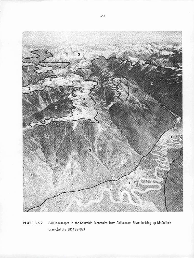
144
PLATE 3. 5.2 Soil landscapes in the Columbia Mountains from Goldstream River looking up McCulloch
Creek.(photo BC=489 =92)
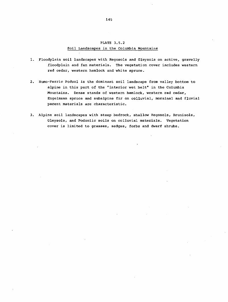
145
PLATE 3.5.2
Soil Landscapes in the Columbia Mountains
1. Floodplain soil landscapes with Regosols and Gleysols on active, gravelly
floodplain and fan materials. The vegetation cover includes western
red cedar, western hemlock and white spruce.
2. Burno-Ferric Podzol is the dominant soil landscape from valley bottom to
alpine in this part of the "interior wet belt" in the Columbia
Mountains. Dense stands of western hemlock, western red cedar,
Engelmann spruce and subalpine fir on colluvial, morainal and fluvial
parent materials are characteristic.
3. Alpine soil landscapes with steep bedrock, shallow Regosols, Brunisols,
Gleysols, and Podzolic soils on colluvial materials. Vegetation
cover is limited to grasses, sedges, forbs and dwarf shrubs.
146
Hume-Ferric Podzols develop under dense tree stands that include
Engelmann spruce, subalpine fir, western red cedar and western hemlock in the
Interior Western Hemlock and Subalpine Engelmann Spruce - Subalpine Fir bio
geoclimatic zones (Figure 3.5.1 and Plate 3.5.2).
They develop on medium to coarse textured morainal, colluvial and
fluvial parent materials derived from non-calcareous bedrock such as quart
zite, sandstone and argillite. Even on calcareous parent materials, the soil
leaching in this environment is sufficient to allow shallow podzols to
develop. The topsoil often contains considerable volcanic ash •
. The dense coniferous forest cover, plus the colder climate at this
elevation result in the build-up of thick organic surface horizons. This
material is acidic, relatively undecomposed and poorly incorporated with the
mineral soil. Eluviated Ae horizons are present and podzolic Bf horizons are
readily evident, but these are not so red as those on the coast. Heavy
leaching ensures that the soils are carbonate free even on calcareous parent
materials. By comparison.with the lower elevation Eutric Brunisols, the pH,
base status and cation exchange capacities are low.
At higher elevations, or in wetter areas, considerable amounts of
organic matter can accumulate in the B horizon of podzols, giving the horizon
a darker colour (Bhf): These soils are called Ferro-Humic Podzols and are
found in the transitional krummholz area between the Hume-Ferric Podzol soil
landscape and the alpine soil landscapes.
THE ALPINE SOIL LANDSCAPE
Found at the highest elevations (2300-3600 m) in the Columbia and
Southern Rocky Mountains (Figure 3.5.1 and Plates 3.5.1 and 3.5.2), these
soil landscapes are portrayed on the soil map of British Columbia as contain
ing dominantly lithic soils. Since they are rugged and have panoramic scenic
views, the alpine soil landscapes have important potential for recreational
uses.
Soil moisture classes at alpine elevations are generally humid while
soil temperature regimes are very cold cryoboreal. In general the climate
at these elevations is very severe and growing seasons very short. The harsh
climate limits vegetation cover to non-forest species including alpine grasses,
sedges, lupine and willows. Trees do not occur in the Alpine Tundra biogeo
climatic zone.
A variety of soils occur as a result of variations in topography,
local climate, parent materials and drainage. Because of active processes
147
such as colluviation, cryoturbation and solifluction, Regosols with disrupted
horizons are common. Areas with impeded drainage have Gleysolic soils while
under alpine grass vegetation Melanie and Sombric Brunisols with turfy Ah
horizons develop. Because of the steepness of the topography, exposed bed
rock or unconsolidated rock slopes make up much of the land surface.
Soil parent materials are rubbly colluviurn of varying depth, and
youthful morainal deposits associated with recent deglaciation. Volcanic ash
is commonly found in the alpine soils surface horizons. Soil developments in
the alpine soil landscape are often obscured because of the activity of
geological processes in the landscape. Surface and subsurface soil horizons
are often churned and intermixed due to cryoturbation and solifluction.
THE FLOODPLAIN SOIL LANDSCAPES
The largest areas of floodplain soil landscapes occurs in the major
interrnountain valley bottoms such as the upper Columbia River and the Creston
flats (Figure 3.5.1 and Plates 3.5.1 and 3.5.2). Regosolic, Gleysolic and
Organic soils are common. These floodplain soils are often used for agri
culture because they are flat and accessible. Marshy areas on the floodplains
are important habitat for waterfowl.
Soil moisture classes are generally subaquic to peraquic on flood
plains while soil temperature regimes resemble those of other soil landscapes
in the valley. On these wet soils the vegetation consists primarily of water
tolerant species such as grasses, sedges, trembling aspen, black cottonwood
and Engelmann spruce.
Because of regular flooding, floodplain soils are commonly Regosols
with some mottling in lower horizons. Gleysols, Hurnic Gleysols and Organics
are common in areas that are more or less continuously wet. In the major
valleys floodplain soil textures are silty. In the narrow, steep, high
elevation valleys, floodplain soil textures are often gravelly and sandy.
The texture of floodplain soils depends on the velocity of the river and the
type of bedrock in the upper drainage basin.
In the Rocky Mountains and in major valleys floodplain soils are
generally calcareous. Soil development is often limited to surface organic
matter accumulation, gleying and mottling.

3.6 THE NORTHERN AND CENTRAL PLATEAUS AND MOUNTAINS G.K. Young and N.F. Alley
The Northern and Central Plateaus and Mountains region occupies
the north half of the province and is bounded by the Coast Mountains on the
west, and the Rocky Mountains on the east. The centre of this vast area
comprises the westernmost portion of the continental divide, and the Omineca
and Cassiar Mountains. Here the tributaries of the MacKenzie River rise,
including the Dease, Liard, Finlay and Parsnip Rivers. To the west numerous
large streams wind their way across the Yukon and Stikine Plateaus to the
Pacific Ocean. Some of these include the Taku, Stikine, Iskut, Bell-Irving,
Nass and Skeena Rivers, most of which have their headwaters in the Skeena
Mountains.
Although the factors which generally affect soil formation anywhere
in the province have been described in Part 1, some of these in the study
area operate to produce a distinctive ~et of soil landscapes. These factors
include the geology and climate which together produce a predominance of
periglacial, geomorphic processes not found in other parts of British Columbia.
THE FACTORS OF SOIL FORMATION
This region lies in the rain shadow of the Coast Mountains. As a
consequence, precipitation is low, especially in the area adjacent to the
mountains such as the Tagish and Tahltan highlands. Precipitation increases
eastward across the Yukon-Stikine Plateaus towards the Cassiar and Omineca
Mountains.
In the southern portion of the region, the large valley of the Nass
River permits westerly winds to penetrate the Coast Mountain barrier, resulting
in increased precipitation locally in the Skeena Mountains. Similar.moderation
of climate occurs along the Stikine River in the vicinity of Telegraph Creek
although, in contrast to the Nass River area, the climate is warmer and drier.
These two micro-environments are discussed later. With the exception of micro
climates and edaphic situations, moisture deficiencies during the short growing
season are rare in these dominantly humid to subhumid soil moisture regimes.
Generally, the northern plateau has a very cold, subarctic climate
resulting from its elevation ~nd the southward penetration of arctic air
masses into the area. The west, south and east facing slopes of the NNW-SSE
trending valleys of highlands and mountains peripheral to the plateaus range
from cold cryoboreal to very cold subarctic. Thus, on the plateaus and

150
adjacent uplands climate produces an environment in which frost plays an
important part in geomorphic processes and soil formation.
Perhaps the most important factors influenced by the cold climate
are the rate and operation of geomorphic processes. The periglacial processes
which contribute most to the distribution and character of the soils in the
area include frost shattering, cryoturbation, solifluction (and related
processes), nivation, permafrost development and snow avalanches. Together
these processes have produced large masses of colluviurn which mantle the
plateaus and mountain slopes, and an environment in which the materials are
constantly in motion either downslope or by churning. Consequently, the
dominant soil landscapes in the area are pedogenically youthful and have
evidence of cryoturbation such as broken or buried horizons, and displaced
materials.
The periglacial activity and turbic soils extend virtually from ridge
and plateau tops to valley bottoms. Probably cold air, draining from the
plateaus down into lower elevations, contributes strongly to periglacial
activity in valley bottoms at an altitude where frost action is normally
insignificant (see "Cold valley floors" in "Other soil landscapes").
The north-northwest orientation of major valleys and their asymmetry
in transverse profile also influence the distribution and operation of peri
glacial processes in the plateau area. Gentler west-southwest-facing valley
sides are dominated by deep blankets of colluviurn produced mainly by nivation
and solifluction. In contrast, east-northeast-facing slopes are steeper and
have snow avalanches and rockfalls. These slopes often consist of bare rock
or thin colluviurn in their upper reaches, where mass-wasting predominates,
whereas blankets, fans and aprons of colluviurn occur on the lower levels
where deposition predominates.
Geology influences the soil landscapes of the region in a variety of
ways. First, the geological materials affect the texture and chemistry of
soils. Intrusive plutonic and low grade metamorphic rocks in the Omineca
and Cassiar Mountains weather to produce generally medium to coarse grained
acidic soils whereas the volcanic rocks in the western part of the region
weather to fine and medium textured soils of higher base status. Sedimentary
rocks in the Skeena Mountains and Stikine Plateau are variable, although the
predominance of fine grained strata commonly produces fine textured soils
which are normally acidic except in the vicinity of calcareous rocks.
Second, the western portion of the area is composed of flat-lying or
gently folded rocks which form broad plateaus high enough to be in the alpine-

151
subalpine zone. This has created extensive areas in which periglacial
processes dominate, producing thick mantles of colluvial debris which form
solifluction terraces and lobes, that often lead up to nivation hollows,
patterned ground, block-fields, stone streams and rock glaciers in the valleys.
The soils are obviously youthful and dominantly of the Cryosolic order or have
been influenced by cryoturbation.
Third, glacial deposits exposed at the surface were formed largely
during the Fraser Glaciation; only small remnants of ice now remain either
as cirque or short valley glaciers. Advances of these glaciers during the
Neoglaciation formed the moraines now found in close proximity to the ice.
Regosols or Cryosols have formed on these moraines. More important, however,
is that the colder climatic conditions which produced the Neoglacial advances
also leg to an expansion of the periglacial zone well into what is now the
subalpine. The features, such as talus, patterned ground, solifluction
lobes, nivation hollows, block streams and even rock glaciers, which formed
as a consequence of the colder climate are now relict.
THE SOIL LANDSCAPES
The soil map of British Columbia (Part 3.2) shows the distribution of
the main soil great groups in region. However, the map is very general and
does not show some of the soil landscapes which may cover only small areas.
An idealized diagram illustrating the vertical sequence of soil landscapes
is presented in Figure 3.6.l and the main features of each soil landscape
are described in the following pages.
GRAY LUVISOL LANDSCAPE
This soil landscape occurs on well drained morainal deposits below
1200 rn in broad valleys of the Sub-Boreal Spruce and Boreal White and Black
Spruce zones. Parent material texture, colour and mineralogy are closely
related to bedrock. Texture varies from medium to coarse and colours vary
from dark brown to dark gray on moraine derived from basalt and sedimentary
rocks, to gray or light gray on moraine derived from granitic and plutonic
rocks. Parent materials formed from limestones are calcareous. Basalts and
other sedimentary rocks produce mildly calcareous or neutral materials, and
granitic materials are acidic. The soil solum, however, is affected by
leaching resulting from the humid and subhumid soil moisture regime and
organic acids formed by decomposition of vegetation. Consequently the soils
are neutral to slightly acid on limestones, basalts and sedimentary rocks,
and acidic on granites and plutonic rocks.
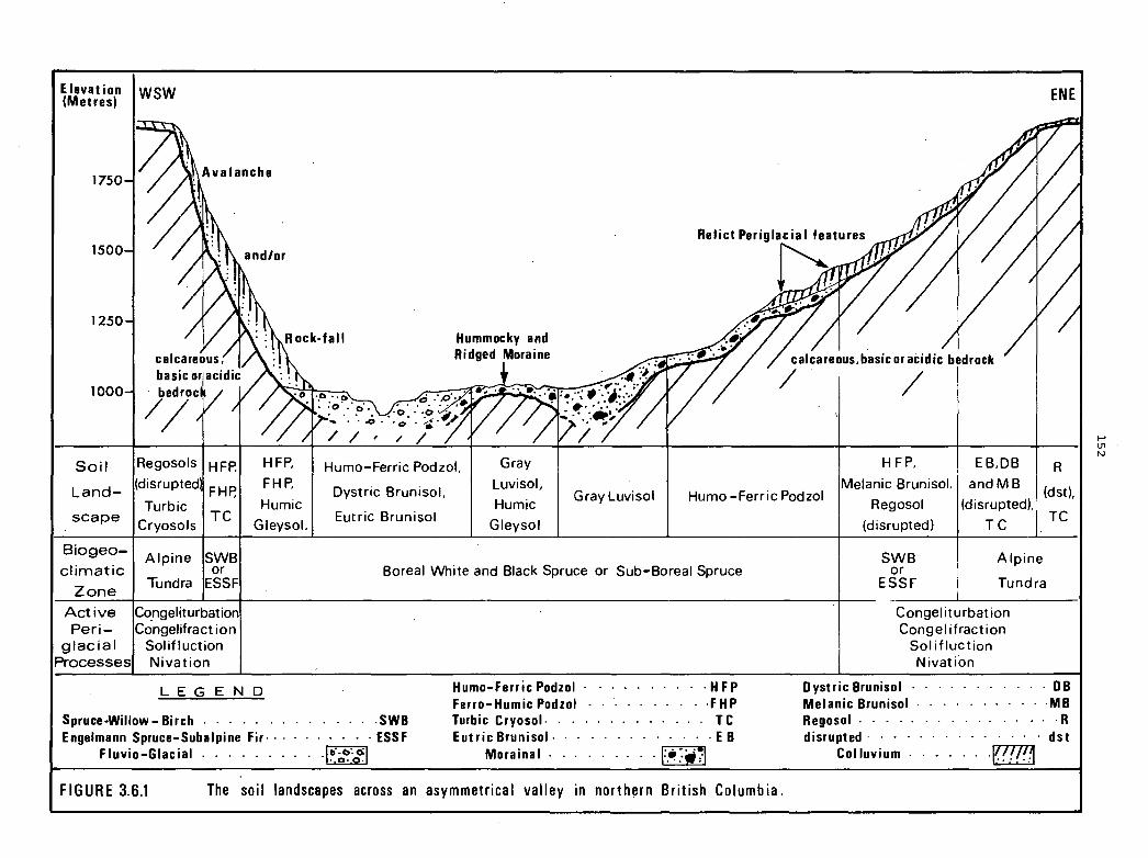
Elevation I WSW (Metres)
1750
1500
1250
1000
Soil IRegosols L d (disrupted
an -Turbic
HFP. HFP.
FHP, FHP.
Humic
ENE
calcareous.basic or acidic bedrock
/ I / .
Humo-Ferric Podzol, Gray HFP. EB.DB I R
Dystric Brunisol, Luvisol, Melanie Brunisol. and MB (dst),
Gray Luvisol Humo-Ferric Podzol Humic Regosol (disrupted).·
scape I Cryosols TC
Gleysol. Eutric Brunisol
Gleysol (disrupted) TC I TC
Biogeo
climatic
Zone
Active Peri
glacial Processes
Alpine ISWB or
Tundra ESSF
Congeliturbation Congelifract ion
Sol if I uction Ni vat ion
LEGEND
Spruce-Willow- Birch . Engelmann Spruce-Subalpine Fir·· ·
Fluvio-Glacial
Boreal White and Black Spruce or Sub-Boreal Spruce
..... . swe · · · · · · ESSF .. jti-e.::1
• O• ,
Humo-Ferric Podzol · · · - · · · H FP Ferro-Humic Podzol - · · · · · ·FHP Turbic Cryosol. . . . . . . . . . . . . TC Eutric Brunisol - · · · · · E B
Morainal ........ · !=.4!~-~! FIGURE 3.6.1 The soil landscapes across an asymmetrical valley in northern British Columbia.
SWB or
ESSF
Alpine
Tundra
Congeliturbation Congel ifraction
Sol ifluction Nivation
Dystric Brunisol . · · · · · · · · · · DB Melanie Brunisol · . · · · · · · · · ·MB Regosol .. - . . . . . . . . . · - · · R disrupted · · · · · · · · · · · · · dst
Col luvium . . . . . . ·!mB
I-' l.11 N

153
The moraine has a rolling, ridged or hummocky topography with a
repetitive pattern of soil drainage conditions. Slope position, gradient,
and slow permeability of morainal parent materials result in a range from
well drained to very poorly drained soils. Organic soils occupy enclosed
depressions, whereas Humic Gleysols occur where seepage accumulates along
extensive gentle slopes, or at the base of steep slopes.
DYSTRIC AND EUTRIC BRUNISOL LANDSCAPES
Broad valleys within the Sub-Boreal Spruce and Boreal White and Black
Spruce biogeoclimatic zones often contain extensive deposits of fluvioglacial
deposits, which range in texture from coarse cobbles and stones to gravels and
fine sands. As a result of coarse texture the soils are characterized by
rapid percolation and iron accumulation, especially on acidic parent materials.
The preponderance of lodgepole pine on these soils, the lack of minor vegeta
tion elements, and the presence of charcoal in the litter and upper mineral
soil indicates a relatively high frequency of fires. These edaphically dry
acidic landscapes result in Dystric Brunisol soils with highly coloured B
horizons.
Brown coloured soils of Eutric Brunisol landscapes also occur here on
calcareous, coarse textured parent materials, especially on well drained
fluvioglacial and colluvial deposits. In other areas they are commonly
restricted to climatically or edaphically drier sites such as southern ex
posures and along the lower terrac~s of the Stikine River, in the extreme
rain shadow of the Coast Mountains. As a consequence of frequent burning in
the rain shadow, vegetation is commonly reduced to trembling aspen, lodgepole
pine, shrubs and grasses, representing early stages of secondary plant
succession.
HUMO-FERRIC PODZOL SOIL LANDSCAPE
This landscape is corranon between elevations of 1200 to 1500 m on
steep, moist slopes in the Boreal White and Black Spruce biogeoclimatic zone.
Surficial deposits are mainly colluvium and moraine covered by a veneer of
coarse colluvial debris. Humo-Ferric Podzols are the main soils on these
sites, but Dystric Brunisols are associated with them due to locally dry
environments produced by the combined influence of aspect and shallow
colluvium. Other associated soils receiving considerable seepage water
along the base of slopes are Humic Gleysols.
Since the vegetation consists primarily of white spruce the resulting
litter is acidic and tends to accumulate as thin, distinct Land F horizons
but thicker H horizons, as a result of the cold climate and slow rates of
decomposition. With the exception of some soil creep and avalanche tracks on
154
steep slopes, periglacial processes are virtually absent. However, relict
periglacial features are common but have been covered by vegetation and are
not readily visible.
THE SUBALPINE SOIL LANDSCAPES
Subalpine vegetation occurs between elevations of 1350 m and 1800 m.
There are extensive areas of subalpine fir in mountain valleys (notably on
northern exposures) and willow and glandular birch on plateaus. The Hume
Ferric Podzol soil landscape is the most common throughout this subalpine
area. Relict periglacial materials, including solifluction lobes, and other
well to moderately well drained sites on colluvial and morainal parent
materials, allow subalpine fir to grow in pure stands. Here, the brightly
reddish brown podzolic B horizons occur under thin litter layers.
At higher elevations in the krummholz subzone, solifluction and
nivation become active in the moist openings between the clumps of trees.
On gentle slopes shallow nivation hollows have permanently frozen subsoils
and shallow organic surfaces. Thus, in the upper subalpine area Turbic
Cryosol landscapes occur with the Hume-Ferric Podzols.
Drier, more exposed plateau areas, such as the Spatsizi, are
dominated by subalpine willow and glandular birch with occasional white
spruce trees, and small openings occupied by alpine vegetation. Fire appears
to be frequent here, and in combination with a cold relatively dry climate,
it retards plant succession. The most common soil landscape is again that
of the Hume-Ferric Podzol. However, as a result of slow decomposition and
humification of litter from the deciduous shrub vegetation, a significant
depth of organic matter accumulates at the soil surface. The Podzolic soils
are best developed along well drained portions of glacial and relict peri
glacial features where shrub vegetation is present. In open depressions
along gentle slopes, on the leeward sides of ridges, the vegetation ranges
from stable alpine plants to an increasingly sparse cover as periglacial
activity increases. Soil development is determined by the severity of the
dominant geomorphic processes and other soil landscapes include Humic Regosols
and Melanie Brunisols.
THE ALPINE SOIL LANDSCAPES
The alpine tundra occurs above 1500-1800 m. It has a very cold
subarctic soil climate with a subhumid moisture regime. Within this environ
ment windswept ridge-tops are often desiccated, because there is a lack of
snow cover in winter and relatively dry conditions during the short growing
season.

155
Cryoturbation is very active, churning the soil materials and
developing patterned ground features including block fields, sorted and
unsorted circles, and stone stripes. Regosol landscapes are the most common
with disrupted horizons resulting from this strong periglacial activity.
Constant churning of surface and subsoil particles results in poor horizon
differentiation and the prevalence of buried and fractured bands of organic
rich materials resembling former A horizons. Parent material, commonly
derived from local bedrock, is mixed directly with the A horizon resulting
in an AC horizon sequence.
Turbic Cryosol landscapes with permanently frozen horizons are found
on fine textured materials, such as thin moraine, where subsurface drainage
is impeded by topographic location. Patterned ground features associated
with these soils are prevalent but not as conspicuous as they are with
adjacent shallow colluvial soils. However, on sloping landscapes, features
associated with solifluction and nivational activity are enhanced by the
better water holding capacity of the fine textured parent materials. Such
sites form a Melanie Brunisol landscape marked by disrupted and buried hori
zons. Ah horizons attain greatest thicknesses along the downslope edges of
solifluction lobes with buried organic horizons often occurring under the
solifluction material. The surface horizon thins from the front of one lobe
to the leading edge of the next lobe upslope. Permanent and intermittent
snow patches occupying nivation hollows provide a continuous supply of melt
water to solifluction lobes lying immediately downslope. Sometimes melting
snow patches reveal that the bottom of nivation hollows are bare of vegetation,
creating an environment in which patterned ground is readily formed. Regosols
with disrupted horizons predominate in these hollows. Gleying is usually c
absent since aerated seepage water percolates through soil parent materials
throughout all or most of the growing season. The topographic position of
these alpine soil landscapes in addition to some of .the others is shown in
Plate 3.6.1.
In addition to the generalized vertical zonation of soil landscapes
described in the previous paragraphs there are numerous other variations.
A few of the more important are described here.
COLD VALLEY FLOORS
The most extensive of the variations that occur throughout the
region is the phenomenon that can best be described as "the inverted alpine
subalpine valley". Narrow and broad upland valleys with limited air drainage
form collecting basins for extremely cold air flowing southward across the
plateaus and mountains from the arctic or merely flowing down from the cold
adjacent uplands. The cold air trapped in the lowlands forms a strong atmos-

'\
PLATE 3.6.1 Soil landscapes on the l(lastline Plateau looking southwest from the Stikine River. (photo BC:538 :20)
.... V, a,

157
PLATE 3.6.1
SOIL LANDSCAPES ON THE KLASTLINE PLATEAU
LOOKING SOUTHWEST FROM THE STIKINE RIVER
1. Alpine Tundra soil landscape. Regosols with disrupted horizons. Unit
comprised of cirques with active alpine glaciation and nivation
patches. A large percentage of this mountainous upland unit is
dominated by bare rock, talus and other products of active peri
glacial processes.
2. Alpine Tundra soil landscape. Melanie Brunisol forms the most common
landscape on morainal blankets or morainal veneer. Cryosols may
occur in depressions.
3. Subalpine soil landscapes (willow and glandular birch). Hume-Ferric
Podzol is most common soil landscape. Moist depressions are either
Humic Gleysol or Cryosols.
4. Humo-Ferric Podzol soil landscape on coarse textured colluvial (steep
slopes) and fluvial materials. Humic Gleysols occur in depressions.
5. Aspect as factor of soil formation. Shallow colluvial materials
accentuate the effects of aspect. Soils range from dry Dystric
Brunisol to moister Hume-Ferric Podzol.
6. Humo-Ferric Podzol 'and Gray Luvisol Landscapes. Deep post-Ple'istocene
colluvial fan material overlying and dissecting the morainal blanket.
Within the Boreal White and Black Spruce biogeoclimatic zone Humo
Ferric Podzols occur on coarse parent materials and Gray Luvisols on
fine textured substrate.
7. Hume-Ferric Podzol soil landscape occurring within the Boreal White and
Black Spruce biogeoclimatic zone on fluvial and fluvioglacial deposits.
8. Subalpine soil landscape. Gently sloping areas of moraine extend from
subalpine conditions to lower elevations. Soil landscapes are a
complex of Hume-Ferric Podzols, Humic Gleysols and Organic Fibrisols.
Sporadic permafrost probably occurs.
158
pheric inversion and thus induces periglacial activity, growth of permafrost
and delays snowmelt along the valley bottoms. The floors of the valleys are
occupied by vegetation that is normally considered alpine or subalpine,
although the normal vertical zonation from subalpine fir to willow and glandu
lar birch to alpine tundra occurs on the slopes above.
Soil landscapes are varied and reflect the harsh characteristics of
the alpine micro-environment. On well to rapidly drained coarse textured
fluvioglacial deposits, deep Ah horizons develop under a dominantly grass
vegetation comprised of alpine fescue producing Black .Chernozemic soil land
scapes. On finer textured colluvial and fluvial parent materials, Melanie
and Sombric Brunisol landscapes predominate but on well drained medium
textured moraine deposits under the subalpine vegetation in the broader up
land valleys, Hume-Ferric Podzol soil landscapes occur.
VALLEY ASYMMETRY
As discussed above, the north-northwest orientation of many major
valleys and their asymmetrical transverse profiles profoundly influence the
distribution and operation of the geomorphic processes. The asymmetry and
the strong orientation of the valleys is a result of glacially modified bed
rock structure. The gentler west-southwest-facing valleysides are commonly
dip-slopes and, since the slopes are gentle, nivation, solifluction and deep
seated rockslides are dominant subaerial processes. The steeper east-north
east-facing slopes are escarpments eroded through the bedding planes; on
these slopes snow-avalanches and rock-falls are common.
Vegetation is also affected by the orientation of the valleysides.
The vertical zonation from subalpine fir through willow and glandular birch
to alpine tundra is most common on north-facing slopes. These zones are often
dissected by avalanche tracks. However, south-facing slopes may have only a
sparsely treed subalpine fir zone, or the subalpine and alpine vegetation of
the cold valley bottoms may continue up the valleyside to the mountain tops.
Soil landscapes follow the pattern described earlier for these
environments with the addition of soils characteristic of the snow and debris
avalanche tracks. The latter are most commonly Melanie Brunisols with deep
Ah horizons developed under lush vegetation. These landscapes are associated
with the Hume-Ferric Podzol soil landscapes where they extend in forested
areas.

159
WARM COAST VALLEYS
In the western part of the region where major river systems breach
the Coast Mountain barrier, a small but significant micro-environment exists.
warm, moist air from the Pacific Ocean fingers up the Stikine and Nass Rivers
moderating the predominantly continental climate of the region. The extent
of this influence diminishes rapidly eastwards and with increasing elevation.
At Telegraph Creek (300 m a.s.l.) on the Stikine River, other factors
such as steep south-facing slopes, coarse textured, basic colluvial and flu
vial soil parent materials, and copious amounts of coarse grained volcanic
ash deposits from Mt. Edziza combine with the warmer climate to produce a
Eutric Brunisol landscape with minor inclusions of Dark Gray Chernozemic soil
landscapes. As a result of the microclimate and the soils a variety of
agricultural crops can be grown.
Further south, the Nass River and its major tributary, the Bell-Irving
River provide a similar opportunity for warm, moisture-laden air flow to
penetrate the Coast Mountains. Here, however, the Skeena Mountains form a
northern and eastern barrier to the air-flow thus intensifying the orographic
effect and resulting in heavy annual precipitation including deep snow accu
mulations. The mountain systems also block out arctic air from the north,
to produce a markedly different environment from that along the Stikine River.
Indeed, vegetation is lush and dominated by conifers, including western hem
lock, Sitka spruce and balsam fir in the lower zone with subalpine fir in the
upper zone, giving way to extensive alpine tundra on the mountain tops. Ferro
Humic Podzol and Hume-Ferric Podzol soil landscapes dominate the lower forest
zones with the varied soils common to the alpine occurring above tree-line.
THE SOIL LANDSCAPES OF VOLCANIC TERRAIN
Volcanic features ranging in age from 15 million years right up to
180 years dot the landscape in an area extending from the Mt. Edziza -
Spectrum Range uplands to the western Spatsizi Plateau. Although most of the
volcanic deposits have been modified by glaciation, some post Pleistocene
volcanic activity has added volcanic ash and cinders, and subaerial lava flows
to the original surface.
The Mt. Edziza plateau is flanked by recent volcanic ash deposits,
fluvio-aeolian material, recent moraine, lava flows and cinder cones. Soil
landscapes on these youthful materials are disrupted Regosols and Turbic
Cryosols. In contrast, Level Mountain to the north of Mt. Edziza, takes the
form of a large inverted saucer. A series of shallow ridges across the slope
of the mountain obstructs lateral surface and subsurface drainage. This,
along with the cold environment, results in poorly drained soil landscapes,
160
mainly Organic and Burnie Gleysols. At higher elevations where periglacial
conditions prevail, soil landscapes include Organic Cryosols and Fibrisols.
Turfy, moderately well drained solifluction lobes and hummocks permit develop
ment of Burno-Ferric Podzol soil landscapes within the unusually extensive
subalpine area.
LAND USE
Traditional resource activities such as hunter and guide outfitting
and fur trapping are the most common. This pattern of use extends over the
broad upland subalpine and alpine terrain where many species of wildlife,
including caribou, mountain sheep, mountain goat, moose, grizzly and black
bear and many smaller fur bearers; abound. Because of the remoteness of much
of this region and because there are no alternative land uses over large
areas, the importance of the wildlife resource cannot be overstated. However,
regardless of the vastness of the area involved, the sensitivity of the
terrain and its inherently low productivity of food and cover impose con
straints on animal populations not encountered in southern regions thus
demanding careful management.
Within the Gray Luvisol and Hume-Ferric Podzol soil landscapes there
is a limited potential for forest harvesting. It is estimated that forest
capabilities range from classes 4 to 7. The Nass River Basin, in the extreme
southwestern corner of the region, is an exception and contains moderate and
high capability forests especially at lower elevations in the Ferro-Humic
Podzol soil landscape of the coastal environment.
Mineral potential in the region remains relatively unexploited with
some notable exceptions such as the asbestos at Cassiar. Exploration
activity is flourishing in areas of mineralization. Within the Skeena
Mountains in the Ground Hog Range an extensive area of coal has been found
but as yet has not been developed.
Transportation is provided by air, and by road. The Stewart-Cassiar
Highway is currently being upgraded as an alternative route to the Yukon. It
leaves Highway 16 at New Hazelton in the south and joins the Alaska Highway
just west of Watson Lake in the Yukon Territory.
3.7 THE GREAT PLAINS A.J. Green and T.M. Lord
In British Columbia somewhat more than 10 percent of the province
lies east of the Rocky Mountain Foothills and within the high plains division
of the Great Plains of North America.
The term "Great Plains" brings to mind that part of Canada lying
between the Rocky Mountain Foothills and the Canadian Shield, known as "the
Prairies". However, no part of the British Columbia Great Plains is semiarid
grassland, and only a relatively small portion can be described as subhumid
aspen parkland. Most of the area is forested.
The region is drained by two major rivers and their tributaries, the
Peace and the Liard. The Peace River is formed at the confluence of the
Findlay and Parsnip Rivers which is now part of Lake Williston Reservoir.
The Peace River leaves the lake near Hudson Hope, flowing to the east onto
the plains, where it is joined by its tributaries the Halfway, Moberly, Pine,
Beatton and Kiskatinaw Rivers. The Liard drains northwest with its major
tributaries the Fort Nelson and Prophet Rivers. Most of these rivers origin
ate in the Rocky Mountains and have cut deep postglacial valleys through the
plains. Rivers such as the Chinchaga and Fontas which originate on the plains
are not deeply entrenched and have meandering stream courses. There are very
few large lakes in the region. The two largest are Moberly Lake in the south
and Kotcho Lake in the north.
THE FACTORS OF SOIL FORMATION
The geology, vegetation and climate combine to produce a soil forming
environment that is different from the rest of the province in several ways.
The Cretaceous sedimentary bedrock has a great influence on the
landscape. It is composed of sandstones and shales which are horizontally
bedded or dip gently to give low asymmetrical ridges. The sandstone tends
to form low rolling uplands. The more easily erodible shales usually under
lie the flat lowlands. The sediments can be acid, neutral or alkaline and
calcareous. Some marine shales of the Peace River Lowland are saline, others
in the Fort Nelson Lowland are not.
The surficial deposits are closely related mineralogically to the
bedrock, and this is reflected in the soils. The area was glaciated by
Cordilleran ice from the west and Keewatin ice from the north east. The
Cordilleran till is medium textured, stony, calcareous and often less than

162
3 m thick. The Keewatin till is fine to medium textured, has few stones and
can be saline, slightly calcareous or acid. In the north around Fort Nelson
it is quite thin and difficult to distinguish from the underlying bedrock.
Lacustrine materials border many of the large river valleys. They are fine
textured, have few stones and are generally saline and somewhat calcareous.
The upper limit of these deposits in the Peace River lowland is at about 810
m, but they do occur in areas of local ponding up to 850 m. The large rivers
flowing from the Rocky Mountains have carried coarse textured 3ediments out
onto the plains. Sandy and gravelly fluvioglacial and fluvial deposits are
found in and adjacent to the valleys in a broad zone bordering the Rocky
Mountain Foothills.- They have often been reworked by the wind into dunes and
ridges. A rather different but important surficial material is the organic
"muskeg" that blankets much of the plains in the northeast forming organic
soils.
The important features of the climate that influence soil formation
are the long cold winters that severely restrict many soil forming processes,
the short warm summers and the moderate precipitation with a summer maximum,
including many thunderstorms. Winter frost penetrates deeply into many soils
and some organic bogs in the north have permafrost. Paradoxically, high rates
of evapotranspiration lead to water deficits and very dry soils in late summer,
especially in the lowlands.
The whote of this area lies within the Boreal White and Black Spruce
biogeoclimatic zone. The lowlands have a mixedwood forest of trembling aspen,
white spruce and black poplar. This adds a less acid litter to the soil
surface than the coniferous forests of white spruce, lodgepole pine and sub
alpine fir of the uplands and the north. In the driest parts of the south
there is an attractive open parkland of trembling aspen and grass much of
which was probably burnt periodically. The very wet parts of the north have
stunted black spruce, tamarack, willows, Labrador tea and mosses.
The shape or form of the land in the great plains is also important
in determining soil quality. The influence of aspect is seen in many large
river valleys. Dry, south facing slopes in the Peace River lowlands have
dry soils with trembling aspen, open grassland and even plains prickly-pear.
Cool, moist north facing slopes have white spruce. The combination of steep
slopes and fine textured materials along many of the entrenched river valleys
leads to very unstable soils and in extreme cases huge landslides, such as
the Halfway slide that completely blocked the Peace River for 12 hours in
May 1973. On the flatter plains and uplands the long smooth slopes of this
plateau-country are susceptible to sheet erosion and gullying. The combina
tion of soft materials, slow percolation, long slopes and summer thunder-

163
showers makes any slope over 5% susceptible. Finally, there are peculiar
topographic features, known as "humpies", bordering the main rivers and their
tributaries in the Peace River lowlands (see Plate 3.7.1). They are earth
mounds of variable composition and orientation up to 12 m high. They change
rapidly in soil profile characteristics from their crest to their base.
THE SOIL LANDSCAPES
The arrangement and distribution of the main soil great groups in
the great plains is shown in the soil map of British Columbia (Part 3.2).
A single soil great group landscape may predominate in one area as does for
example the Gray Luvisol. However, combinations of soil landscapes are
common in areas where slopes, vegetation and parent materials change within
short distances. This sort of situation can be seen' in Plate 3.7.1 around
Fort St. John, and it is also typical of the large area mapped as Organic
Cryosol-Luvic Gleysol in the northeast. Other soil landscapes are quite
limited in extent, as is for instance the Soled soil landscape within the
trembling aspen parkland of the Peace River lowland. The general pattern of
soil landscapes is shown as a diagrammatic cross section in Figure 3.7.1,
which runs from Fort Nelson to Dawson Creek.
THE GRAY LUVISOL LANDSCAPE
The Gray Luvisol landscape occupies about 40 percent of the Great
Plains and extends in a broad zone east of the Rocky Mountain Foothills from
the southern Peace River lowlands-to the Yukon border. It occurs under pure
or mixed stands of coniferous and deciduous trees with a humid to subhumid
cryoboreal soil climate. It has gently to strongly rolling topography on the
till uplands and long, smooth, gentle slopes on the lacustrine plains. The
soils on the till are well to moderately well drained but on the lacustrine
plains, with subdued topography and fine textured layered sediments, they
are wet for part of the year. This is shown by mottling and dull soil colours
in the upper horizons. Typically, the Gray Luvisols have a thin layer of
decaying leaves, needles and grasses accumulated on the soil surface; a gray
or grayish brown, distinctly platy Ae horizon, 10-30 cm thick; and light
brownish gray or dark grayish brown B horizons, 50-100 cm thick. The C
horizon is often similar in texture and colour to the B horizons but lacks a
well developed structure. The peds in the B horizons frequently have strong
subangular blocky structure and clay films can be detected on the surface of
the peds. The Bt horizon of the Gray Luvisols in the Great Plains is often
much more difficult to detect visually and texturally than the Bt horizon of
the Gray Luvisols in the Interior Plateau. The latter are markedly different
in texture and colour from the horizons above and below them, whereas in the
Great Plains the difference is one of soil structure.
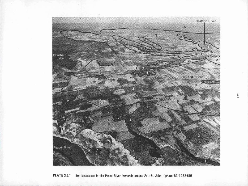
PLATE 3.7.1 Soil landscapes in the Peace River lowlands around fort St. John . ( photo BC =1952=60)
...... "' ""'

165
PLATE 3.7.1
SOIL LANDSCAPES IN THE PEACE RIVER LOWLAND AROUND FORT ST. JOHN
1. Steep sides of river valleys entrenched into the plateau. Disrupted
Regosols on the slumping fine textured shales and lacustrine sedi
ments. The Peace River is 240 m below the plateausim.
2. Salad soil landscape on the lacustrine clay plain, with "humpy" topography
near the breaks to the river valleys.
3. Salad soil landscape on the gently undulating lacustrine clay plain.
The Salads are on the well drained sites with Gray Luvisols in lower
positions and organic Mesisols in the depressions - 3(0).
4. Salad soil landscape on the gently to moderately sloping ridges of clay
till over sandstone with trembling aspen and grass vegetation.
s. Gray Luvisol landscape on clay till over sandstone under a mixed forest
of trembling aspen and white spruce. It is about 90 m higher than
the Salad soil landscape on similar till (4).

Elevation (Metres)
1200
600
SOIL
LANDSCAPE
BOREAL FOREST
SECTION (ROWE)· Precipitation (mm/yr) Mean Annual Temo. ·c
Elevation (Metres)
1200
600
SOIL
LANDSCAPE
BOREAL FOREST SECTION ( ROWE)
Precipitation (mm/yr) Mean Annual Temo. ·c LEGEND
FIGURE 3.7.1
NW
I Fort Nelson Lowland Alberta Plateau I Peace River lowland
Muskwa River Milligan Hills Beatton River
_t ~very thin till
! lacustrine ti 11
/eroded / I ,- --..... --:W, acid shale - ---sandstone
I I
I Gray LuvisoL Luvic GleysoL Gray Organic Cryosol,I I Gray Luvisol Gray GL R I Luvic GleysoL Mesi sol. Regosol
Luvisol Luvic Gleysol I I Mesi sol Gray Luvisol Luvic Gleysol Luv i sol
Upper Upper I I
l I I Nort hem Footh i I ls Mixed wood Aspen Grove
Mackenzie Liard I I t . 446 FortNelson _1
'B R. A. 415 eatton 1ver 1rport _,.5
Peace River SE lowland
Peace River KiskatinawRiver
lacustrine slumTgl t i 11 l ti 11 t i 11 t i 11 lacustrine
I L J I I I -- - I - t:"K~1P -"' shale sandstone sandstone shale
sandstone
Solod. Regosol. S olod. Black Chernozemic. Gray Luvisol. Eutric Gray Luvisol. Luvic Gleysol
Gray Luvisol. Luvic Gleysol LuvicGleysol Bruni sol
Aspen Grove Mixedwood Aspen Grove
t 450 Fort St. John 1
t 432 Dawson Creek 0.5
Gray Luvisol . . . . . . . GL The whole cross section is within the BorealWhite and Black Spruce biogeoclimatic zone. Regosol .......... -R
The soil landscapes from Fort Nelson to Dawson Creek
f-' O'I O'I
167
Although the Gray Luvisols of the Great Plains have developed under
much the same forest cover and climate (see Figure 3.7.1), they do vary
structurally and chemically because of the nature of their parent materials.
Those soils that have developed on till, lacustrine or fluvial deposits de
rived from slightly calcareous, somewhat saline sandstones and shales usually
have strongly developed columnar and subangular blocky structure.in the B
horizons. Those soils developed on· deposits derived from acid or calcareous
materials usually lack this strongly developed soil structure.
Where climate and topography are suitable, Gray Luvisols have been
used for agriculture, particularly forages and seed production. They require
the addition of nitrogen and organic matter. They also have an inherently
weak structure in the upper horizons that makes them susceptible to puddling
and crusting and to wind and water erosion. About 25 percent of them are
moderately to strongly acid in re~ction and they may need liming to counteract
aluminum and manganese toxicity, particularly for such crops as alfalfa and
barley.
THE LUVIC GLEYSOL LANDSCAPE
This soil landscape occurs on the wetter margins of the Gray Luvisol
landscape. The moisture regime is humid for most of the year, but there are
short periods of complete saturation (subaquic regime). The landscape is
found most commonly on the northern border of the lowlands where fine textured,
nearly impervious materials occupy poorly drained level to depressional areas
with sedge, willow and other moisture loving forms of vegetation.
A typical Luvic Gleysol has a thin layer of raw organic litter on the
soil surface; a bleached, gray, mottled, platy Aeg horizon, 5 to 10 cm thick;
a dark gray, mottled Btg horizon with rounded or subangular blocky structure
(when dry), 10 to 15 cm thick; and a mottled light olive brown C horizon.
Although saturated for short periods they are well enough aerated for
clay translocation to have occurred. Since they occupy areas that receive
runoff from surrounding higher areas, they usually have more bases than the
Gray Luvisols. However, like the Gray Luvisols they need the addition of
nitrogen and organic matter for crop production. Poor natural drainage and
the promotion of poor physical condition if worked when too wet are also
important factors limiting the agricultural productivity of Luvic Gleysols.
THE ORGANIC SOIL LANDSCAPES
The Fibrisols and Mesisols that make up these landscapes occupy
extensive tracts of level or depressional ground in the Peace River and Fort
Nelson lowlands as wetter associates of the Luvic Gleysols. A typical portion

168
is illustrated in Plate 3.7.2. They ar~ saturated for moderately long
periods of time (aquic regime), and organic matter accumulates on the surface
of the mineral soil. These landscapes (with the Organic Cryosol discussed
below) are the "muskeg" that is such a fascinating but perplexing part of
northern Canada. It has been perplexing mainly to engineers who have had to
build roads, railways or pipelines through this very wet, very cold and often
very unstable land. The organic surface is usually quite thin, commonly less
than 1 m. Rut it acts as a huge sponge that regulates stream flow by holding
and slowly transmitting vast quantities of water. If the sponge is disturbed
by route construction the water may be released quickly to cause extensive
erosion.
The peat is moderately (Mesisol) or poorly (Fibrisol) decomposed
plant residues, mainly mosses and sedges. It is usually reddish to yellowish
brown in colour and below it there will be strongly gleyed sands, silts or
clays. It is moderately to very strongly acid and very low in nutrients.
This is because most of the soil water is derived from precipitation; it has
not accumulated as runoff from surrounding uplands from which it would have
carried dissolved nutrients, as is the case with the organic soils of the
Interior Plateau. Mesisol~ .1ave a vegetation cover of sedges, hypnum mosses,
blueberries and bog glandular birch. Fibrisols have sphagnum mosses, common
Labrador tea and stunted black spruce and tamarack.
THE ORGANIC CRYOSOL LANDSCAPE
This soil landscape which occurs in the Fort Nelson Lowland consists
of· organic soils that have permafrost within 1 m of the surface. The southern
limit of discontinuous permafrost is just south of the -1°c mean annual iso
therm which crosses the region at about ss0 N latitude. From.here to the 60th
parallel parts of the organic terrain will have layers that do not thaw in
the summer, because they are effectively insulated by the surface peat. Not
all the peatland will be frozen, neither will all of it have a thick organic
cover. Therefore, there is a very complicated pattern of Organic Cryosol,
Organic and Luvic Gleysol landscapes in the Fort Nelson lowland.
The surface of these soils is poorly decomposed reddish or yellowish
brown fibric peat. Below this the frozen peat looks very similar. It just
feels hard. There are no large ice lenses only ice coatings on all the
organic fibres that bind them together. The vegetation cover is also similar
to the Fibrisol landscape with sphagnum mosses, Labrador tea, stunted black
spruce and tamarack.
With the unfrozen Organic soil landscape this forms part of the muskeg
terrain of the north. It presents all the same problems of use as the un-
169
frozen soils with the added difficulty of a frozen layer whose upper surface
fluctuates in depth throughout the year.
THE EUTRIC AND DYSTRIC BRUNISOL LANDSCAPES ~
The principal difference between these two landscapes is.the nature
of the fluvioglacial parent material. The Eutric Brunisol has developed on
calcareous materials, the Dystric on acid materials.
The Eutric Brunisol landscape commonly occurs on the coarse textured
calcareous fluvioglacial deposits on the terraces of major rivers such as the
Peace and the Liard. The vegetation is a mixed forest cover of trembling
aspen and white spruce~ Because of the coarse texture, low water holding
capacity and rapid drainage characteristics of the materials many sites are
very dry and subject to forest fires. In these areas the forest trees are lodge
pole pine and trembling aspen. The profile characteristics are similar to the
typical soils that were described in Part 2.4, apart from very weak structure.
The Dystric Brunisol landscape has developed on fluvioglacial deposits
that are acid in reaction and low in bases. Such deposits are found along
streams such as the Doig River and Milligan Creek that have their sources in
the acid peatlands of the Great Plains, or they are found bordering the
sections of the Rocky Mountain Foothills that have less ~alcareous bedrock.
The forest is composed of white spruce and trembling aspen. The soil profile
is similar to the Eutric Brunisol except that the horizons are less calcareaus.
Under suitable climatic conditions the soils of these two landscapes
can be used to grow forage crops. Moisture deficiencies in the growing season
are the main limiting factor.
THE GRASSLAND SOIL LANDSCAPES
The Black Chernozemic, Solodized Solonetz and Soled soil landscapes
that form the grasslands of the Peace River lowlands are of limited extent.
But they form a part of the larger aspen parkland of the Prairies. It was
this landscape that first attracted white settlers to the Peace River lowland
and formed the basis of the agricultural economy that sustained them there.
The limited Black Chernozemic soil landscapes occur mainly on the
gently to strongly sloping fans along the south facing wall of the Peace
River valley between Hudson Hope and the Alberta border. They are young
shallow soils (often having only an Ah, C horizon sequence) developed on
young geological deposits. Other small patches occur on the lacustrine de
posits of the shale lowlands. The vegetation is gras~es with occasional
clumps of trembling aspen.

PLATE 3:7.2 Soil landscapes near Boudreau Lake in the Peace River lowlands looking south to Moberly River. (photo BC=1951=34)
I-' -.J 0

171
PLATE 3. 7. 2
SOIL LANDSCAPES NEAR BOUDREAU LAKE
IN THE PEACE RIVER LOWLANDS LOOKING SOUTH
1. Fibrisol landscape. Deep fibrous spahgnum peat occurring around the
periphery of lakes and along drainage ways.
2. Gray Luvisol landscape on the moderately well drained low ridges on the
till plain. There are some Luvic Gleysols in depressions.
3. Luvic Gleysol and.Gray Luvisol landscapes on the "fluted" till plain.
Luvic Gleysols occur in the depressions and nearly level topography.
Gray Luvisols are limited to the moderately well. drained slopes of
the low ridges, which have a forest cover of white spruce, trembling
aspen and white birch with a ground cover of reindeer moss.
4. Luvic Gleysol and Mesisol landscapes on nearly level topography. Luvic
Gleysols occur in imperfectly and poorly drained sites with Mesisols
in the slight depressions that are very poorly drained. The vege
tation cover is sphagnum moss, common Labrador tea, willows, tamarack
and black spruce.
172
The saline soil landscapes contain two soil great groups; the
Solodized Solonetz and Soled. They are found in the subhumid aspen parkland
of the Peace River lowland where the parent materials contain considerable
quantities of residual soluble salts. They occur mainly on the lacustrine
deposits overlying the marine shales in the lowlands. But they are also
found on the adjacent till deposits.
Both types of soil have B horizons that contain relatively large
amounts of Na and Mg salts, and a strong columnar structure that breaks to
subangular blocks. There are large accumulations of calcium carbonate at
depth and below this accumulations of gypsum.
THE REGOSOL LANDSCAPES OF THE FLOODPLAINS
The soils of the recent fluvial deposits on the floodplains and
terraces of the Peace River, the Liard and their tributary streams are
Regosols. They are formed from sediments deposited with each flood. They
do not have distinct horizons, although they may have an organic surface
litter or a weakly developed Ah horizon. Distinct layers may be found in
Regosolic soils but they are due to variation in sediments rather than to
soil horizon development. Sometimes buried Ah or L-F horizons are encoun
tered in the soil profile. They result from repeated burial by flooding.
The frequency of flooding is va~iable since it is often caused by
unpredictable ice jamming in the spring. Depth to water table is also
variable both from place to place and through the year. In the spring the
soils can be saturated, later in the summer.they are liable to moisture
deficits. The vegetation cover is a dense forest of black poplar and white
spruce with mountain alder, willows and red-osier dogwood forming a dense
understory.
Regosols also occur on the steep valleysides above the floodplains.
These slopes are extremely unstable. The soft fine textured materials are
constantly moving downslope. What soil horizons do occur are disrupted.
The soils are well drained but unstable.
These floodplain soils are very productive i_f not flooded. With the
suitable climate of the Peace River valley good crops of potatoes, corn and
other vegetables may be grown on many suitable sites in the floodplains.
Large populations of deer, moose and domestic cattle graze the vegetation on
the terrace and adjacent slope soils.
Part 4
The Development and Use of Soil
and Terrain Surveys
in British Columbia
4.1 INTRODUCTION P.N. Sprout
Soils do not uniformly cover the earth's surface. They vary from
place to place and can be thick or thin, wet or dry, fertile or infertile.
The proper use of soils with such diverse properties calls for prior knowledge
of their location and characteristics. Part 4 deals with the survey activ
ities which have taken place over the years to acquire such knowledge. It
outlines the methods which have evolved to identify, map, and report on the
different soils of British Columbia, and on how they can be used. This
procedure of identifying soils in the field was initiated in 1926, but even
today not all of the province has been covered; large areas in the northern
and coastal sections are still to be done.
The first section of Part 4 describes the pioneering efforts of a
few individuals who persisted in spite of difficult conditions and meagre
support. The second section deals with the heady days of the Canada Land
Inventory programme when support and funding for soil surveys reached un
precedented levels. The final section summarises these accomplishments and
gives a glimpse of things to come.

4.2 SOIL AND LAND UTILIZATION SURVEYS PRIOR TO 1965
THE BEGINNING OF SYSTEMATIC SOIL SURVEYS (1920 TO 1935)
Soil surveys were started in 1926 by the B.C. Forest Service. The
first survey was carried out in the central interior along the Canadian
National Railway route between Fraser Lake and Smithers. The soils were
classified according to surface texture and slope. Foot traverses were made
at .8 km intervals to cruise the timber and examine the soil. Slopes were
plotted on the base maps from Abney readings. From 1927 to 1929 soil surveys
were also carried out in the environs of Prince George, Sicamous and in the
North Thompson valley from Kamloops to Barriere. F.D. Mulholland of the
British Columbia Forestry Service, directed the study. His assistants were
all agricultural graduates. They had no precedents of soil survey techniques,
and had to develop their own methods and classification to suit the parti
cular area in which they were working.
The purpose of these early soil surveys was to separate arable land
from non-arable land, as part of the program to establish permanent Forest
Reserves within which alienation would be denied. The results of these
surveys formed the basis for Mulholland's report "The Forest Resources of
British Columbia" in which he attempted to determine the 'allowable cut' from
area and growth ratios. Later this concept was further developed into the
first 'sustained yield' policy in Canada, and for that matter in North
America. Lack of financial support in 1929-30 brought these surveys to an
abrupt end.
In 1931 soil surveys were revived in response to a recommendation of
the W. Sanford Evans Royal Commission of 1930 which was appointed to inves
tigate the problems of the tree fruit industry in the Okanagan Valley. C.C.
Kelley, a district agriculturist from Prince George, was appointed to direct
the work from headquarters in Kelowna. Like many of the pioneer soil sur
veyors he had no previous experience in the work. The Experimental Farms
Service of the Federal Department of Agriculture agreed to participate in the
programme on a 50:50 basis and R.H. Spilsbury who had been one of Mulholland's
original assistants joined Kelley as the representative of the federal staff.
The first survey in the Okanagan on a scale of 1:40,800 was a
detailed survey of the irrigation districts north of Kelowna. The soils were
mapped on the basis of soil series. The survey contributed to the solution
of dieback problems in apples and other tree fruits by showing that these and
other problems were confined to the poorly and somewhat poorly drained soils.
176
Later, the plant pathologists found that the corky core disease of apples
was due to a boron deficiency in the soil materials. In 1935 the demand for
detailed soil surveys diminished and turned to reconnaissance surveys in the
Lower Fraser, Okanagan and Similkameen Valleys.
THE_CO-OPERATIVE FEDERAL __ - PROVINCIAL_SOIL SURVEY PROGRAM (1935-1965)
This period saw the expansion of soil survey activities from detailed
mapping projects for special purposes by a few individuals to more general
surveys of the major valleys and lowland areas in central and southern British
Columbia by groups of soil surveyors.
During the 1935-36 field seasons reconnaissance soil surveys were
carried out by Kelley and Spilsbury in the Okanagan, Similkameen and the
Lower Fraser Valleys where intensive agriculture was practised and some high
priced crops were grown. The scale of mapping was 1:63,360. The map units
consisted of soil zones, series, types and phases (see Soil Survey Reports
Nos. 1 and 3 in Further Reading).
During this time some preliminary soil mapping was done on Vancouver
Island to assist the Forest Service in their tree planting project by design
ating the location of arable lands.
In 1939 L. Farstad replaced R.H. Spilsbury as the federal soil
surveyor, and started work in the Prince George area. The survey had begun
in 1938 in an area where agricultural development was limited and where soil
information was needed in connection with land settlement. Traverses were on
foot following compass lines at one to two mile intervals. Due to the heavy
forest cover, lack of roads and inadequate base maps the amount of detail
was much less than that obtained in the open agriculturally developed area
in southern British Columbia (Soil Survey Report No. 2).
The purpose of.these early surveys was to classify and map soils,
examine their physical and chemical nature, and determine as far as possible
their agricultural possibilities. The information also provided an inventory
of the soil resources and served as a guide to land use for government depart
ments concerned with land and agricultural policies.
In 1941 differences in policies between the federal and provincial
governments developed and L. Farstad's headquarters were moved to Vancouver
where he established an informal co-operative agreement with the Department
of Soil Science at the University of British Columbia. Farstad was placed
in charge of surveys in the north, the central interior and the Peace River

177
Block. Later, he completed the soil survey of the southeast portion of
Vancouver Island. The University of British Columbia provided the Federal
group with office space, laboratory facilities, and stenographic services.
In addition, Dr. D.G. Laird assisted in the field work in the Central
Interior and the Peace River Block.
Soil surveying in the sparsely populated areas of British Columbia
in the late 30's and early 40's was not only interesting but difficult and
often hazardous. Base maps consisted of information compiled from British
Columbia Land Surveys (BCLS) and Dominion Land Surveys (DLS) supposedly
locating lands "topographically suitable" for agriculture. The soil survey
ors followed survey cut lines, compass lines and game trails. In the spring
sow bears with cubs challenged our right to traverse their terrain and in the
fall amorous bull moose claimed the right of way. We travelled by team and
wagon, horseback, canoe, and on foot and dined on bannock, beans, bacon,
grouse, venison and berries.
From the late 40's until the early 60's soil surveys were completed
over most of the potentially agricultural land in British Columbia (see
Figure 4.2.1). There also developed a gradual distinction between those
areas that were to be handled by provincial surveyors and those that the
federal unit would survey. However, this distinction should not be over
emphasized. There long remained a bewildering interchange of personnel and
financing that would turn.a modern administrative officer gray.
During the first part of this period Kelley worked alone in Kelowna
doing detailed soil surveys of small irrigation projects associated with the
Veteran's Land Act. The first expansion of the provincial soil survey unit
was associated with the need for soil information by the International Joint
Commission Investigation which lead to the Columbia Treaty. The Upper
Kootenay and Elk (Report No. 5), the Upper Columbia (Report No. 7) and the
Kettle (Report No. 9) river valleys were all surveyed under this programme.
In addition there was an irrigation capability survey of the Okanagan valley.
The purpose of all these surveys was to gauge the irrigation potential and
the total water requirements of the soils. Then an estimate could be made
of how much water should be withheld in Canada. The field mapping was
carried out at a scale of 1:31,680. Soil zones, series, types and phases
were mapped. In addition to soil surveying the provincial group provided an
extension service to advise farmers on irrigation, drainage and.other soil
related problems in southern British Columbia.
Meanwhile the federal unit with the help of provincial personnel
undertook the mapping of soils in the north central interior (Reports 4 and
10), on Vancouver Island (Report 6) and in the Peace River area (Report 8).

=- · -- - ~ .
<''~ .. ~11',._ ~· ·~:....::.g.~ ::3f·?f ~- ")~ .-'>-~-.-;, , FIGURE 4.2.1
__ -_ ,. .. ~ .. ~ ' --._~: . SOIL and LAND UTILIZATION
lc:7*~~~-P~~J-:J~ill4~~-}L\\--~ ...... ifre~"-=-1-_ \_ z _l!,-,ey r )_ SURV~YS = field work II I ,aJ ..
,·•
...,,
.,.
l ~-· t<'
"'·J
'.)J'•~:., . ..
7 :),1f(N
. 0 --7 ..
S?<''' "'
I
-- D·{', . l \
"- \'1~:::( '\ - i..--' ...... -
+'."..:a,;- hl • ..:.... ;,, v:\ " t1,..-,,.,,,.,.
•-~1Q21 I "°"" T ;,,:.'h,~,'.~~.l,,1
I
1 l [ .,f: .
II j_: I I ' I I t I ' lh "'' --- ,,r=-*~ ,W 13?'. ---.l-J.,o-· · .. ~ .. 1:18•
"i.....il i.t i..t•01 11<t o. • .- s. ...... ,. JN""'""'"' ····~Dt114 .it~f-ull.,Mld "•tH lt-cu, 'fll"IGl<l. tC
· · -1> · '_" :\ p r I or to 19 6 5 i \ r...,_.._
-,, ;j - LEG E N D
{ 9 ·,, >J· Soil Survey Areas······ · · ·, . .
~_;" . .....-! •• Report Numbers (for titles and I
dates see Further Read ing) ·· ···· 6
Pr inc ipal Land Utilization Surveys ~ I
~ Boundaries of Soil
Survey areas ····
SCALE Ki l o metres
~ ~, '"•J
,,' , .,
J 300 /
" 11,_~~,(~
\ ).•
'\'
\'
-e
'] ~11
I ' \ • "''~t- j \...-·, "' ., """ne1~, , - \ ._-..( \ ,. \t< I'! ~ .. t r \ A.:' i , ,.,) .~ J. - J ·- I 1 ,.. .. .-, /. 1 'ii
U ' ~-/ 'i, \~ [~---~\ ~4
I
. I v''' • .:(_ - . , " '"'' ''· '1' ,.__, , ' " ' ,r"-.r--'~ ~~ . "" ] ,.,,,,,., <T . [ ' . ~~-:. • .
-- -.~ .. - -,~-=--~;- I~ 11\d -lJro !/• iiQ: ::1, - MAP NO I SNT
..... -.J 00
179
The purpose of these surveys was to determine where the actual or potential
agricultural la_nds were. Soil types, series and complexes were mapped at a
scale of l:G3,360 or 1:126,720 and slope classes were usually mapped by super
imposed symbols. The area mapped was determined by the road access along the
valley bottoms or how far up the valleysides you could walk in a day. Aerial
photographs were first used in the Vanderhoof area in 1943. But there were
no stereoscopes available, so only every second photograph was supplied
(they had 60% overlap) from Ottawa. Stereoscopes and stereo pairs were not
used until 1946 in the Peace River survey.
LAND UTILIZATION SURVEY 1942-1953
The British Columbia Department of Lands in 1942 started a programme of
systematic land classification surveys under the direction of F.D. Mulholland
who had previously been in charge of forest surveys, making inventories of
forest resources. The object of the Land Utilization Division was to class
ify the Crown lands of the Province according to their present land use and,
from the available land considered suitable for settlement, to make recommend
ations regarding the development of economic farm units.
After World War II the programme expanded with the appointment of a
new director, D. Sutherland, a conservation officer and a soils specialist.
The survey method was broadened to include both land use and soil capability
standards. To the present-use classification developed by Mulholland was
added an adaptation of the land-use capability system employed by the U.S.
Soil Conservation Service. The capability classification system closely
resembled the soil capability for agriculture approach subsequently used by
the Canada Land Inventory {see section 4.3). Eight land-use capability
classifications were recognized. Classes 1 to 3 were arable, class 4 was
arable with special practices, classes 5 to 7 were suited to increasingly
restricted use of the natural vegetation because of their susceptibility
to erosion and ecological damage. Class 8 was land suited only for wildlife
production, recreational use or watershed protection.
Field surveys, employing supplementary summer help from the University
of British Columbia, were conducted in the principal settlement areas from
1947 to 1953 when the work was suspended due to a change in government prio
rities. Extensive surveys were carried out in the Peace River, Prince George,
Terrace, Creston and East Kootenay areas. The Peace River project was the
largest, with over a million acres of land classified and mapped (see Figure
4. 2 .1).
Numerous special projects were undertaken to meet special government
or community needs. The Pemberton Valley was studied to assist in determining

180
the feasibility of dyking the Lillooet River. A detailed study was made of
the Doukhobor lands to assist in resolving land use and ownership problems
involving the Doukhobor sect and the Province of British Columbia (see Rowles
in Further Reading). These projects, and others, demonstrated the applic
ability of the land capability classification approach to dealing with
problems having both social and technical implications. The capability
classification has proven to be an effective vehicle of communication between
the technician and the general public which makes use of the technical infor
mation.
FURTHER READING
Farley, A.L., 1950. Summary and Map of Soil Surveys and Land-Utilization
Surveys in British Columbia. Annual Rept. Br. Col. Lands Service,
II 49-57, 1 map.
This canto.ins a brief description and a detailed table of many of the early
surveys.
Rowles, C.A., 1955. Soil, Agriculture and Rehabilitation. in Hawthorn,
Harry B. (editor). The Doukhobors of British Columbia, Univ. British
Columbia and J.M. Dent (Canada) Ltd. pps. 221-245.
A study of the soils of Doukhobor lands with recorrunendations for their future
use.
All the following are soil reports for the areas which were surveyed prior to
1965. They are arranged according to report nwnber.
Kelley, C.C •. and R.H. Spilsbury, 1939. Soil Survey of the Lower Fraser
valley. Br. Col. Dept. Agric. and Exp. Farms Service, Dominion
Dept. Agric., Publ. 650.
Kelley, C.C. and L. Farstad, 1946. Soil Survey of the Prince George Area,
British Columbia. B.C. Soil Survey Rept. No. 2, Br. Columbia Dept.
Agric. and Exp. Farms Service, Dominion Dept. Agric.
Kelley, C.C. and R.H. Spilsbury, 1949. Soil Survey of the Okanagan and
Similkameen Valleys, British Columbia: B.C. Soil Survey, Rept. No.
3, B.C. Dept. Agric. and Exp. Farms Service, Dominion Dept. Agric.
181
Farstad, L. and D.G. Laird, 1954. Soil Survey of the Quesnel, Nechako,
Francois Lake and Bulkley-Terrace Areas. B.C. Soil Survey, Rept. No.
4, Exp. Farms Service, Can. Dept. Agric.
Kelley, C.C. and P.N. Sprout, 1956. Soil Survey of the Upper Kootenay and
Elk River valleys. B.C. Soil Survey Rept. No. 5, B.C. Dept. Agric.
and Exp. Farms Service, Can. Dept. Agric.
Day, J.B., L. Farstad, and D.G. Laird, 1959. Soil Survey of Southeast
Vancouver Island and Gulf Islands, British Columbia. B.C. Soil
Survey, Rept. No. 6, Can. Dept. Agric.
Kelley, C.C. and W.D. Holland, 1961. Soil Survey of the Upper Columbia
River Valley. B.C. Soil Survey, Rept. No. 7, B.C. Dept. Agric. and
Can. Dept. Agric.
Farstad, L., T.M. Lord, A.J. Green, and H.J. Hortie~ 1965. Soil Survey of
the Peace River Area in British Columbia. B.C. Soil Survey; Rept.
No. 8, Univ. British Columbia, B.C. Dept. Agric. and Can. Dept. Agric.
Sprout, P.N. and C.C. Kelley, 1964. Soil Survey of the Kettle River Valley,
B.C. Soil Survey, Rept. No. 9, B.C. Dept. Agric. and Can. Dept Agric.
Hortie, H.J., A.J. Green, and T.M. Lord, 1970. Soils of the Upper Part of
the Fraser Valley in the Rocky Mountain Trench of British Columbia.
B.C. Soil Survey, Rept. No. 10, Can. Dept. Agric. and B.C. Forest
Service.

4.3 THE CANADA LAND INVENTORY PERIOD 1965 - 1975 P.N. Sprout
INTRODUCTION
The period 1965 to 1975 was the corning-of-age of soil and terrain
surveys in British Columbia. It was the period when soil surveys changed
from being mainly agriculturally oriented to providing basic information for
a wide variety of resource uses. It was the period of large increases in
the resources allocated to soil and terrain inventories and to the area
covered annually by such surveys. It was the period when soil survey act
ivities changed from being primarily fact gathering missions to programmes
whose objectives were to supply information relevant to land-use planning and
management.
The result of these changes was a de-emphasis on classifying soils
and an emphasis on developing methods of mapping soils quickly and inter
preting the gathered data for a wide range of uses.
The changed emphasis came early in the period and was spurred by the
Canada Land Inventory programme (referred to as the CLI programme). This
fostered interagency communication and promoted the assessment of the natural
capability of land. The activities in British Columbia were part of a Canada
wide inventory of land capability which was designed to provide a basis for
resource and land-use planning. They were undertaken as a cooperative
federal-provincial programme and initially were administered under A.R.D.A.
(Agricultural Rehabilitation and Development Act, later changed to Agricultural
and Rural Development Act).
At first the CLI programme was oriented toward multiple-use areas of
the province in which agriculture was one of the main users. Later it was
expanded to include a much larger part of the province which included
considerable multiple-use land and a much higher forestry potential (see
Figure 4.3.1).
To meet the administrative and coordinative demands of the programme,
a "Soil Capability for Agriculture and Forestry Committee" was formed in 1964.
The committee was active until 1972 and administered most of the soil survey
activities during the 1965-1972 period. Subsequently this was done through
the B.C. Land Inventory Group in cooperation with the Canada Agriculture Soil
Survey Unit.
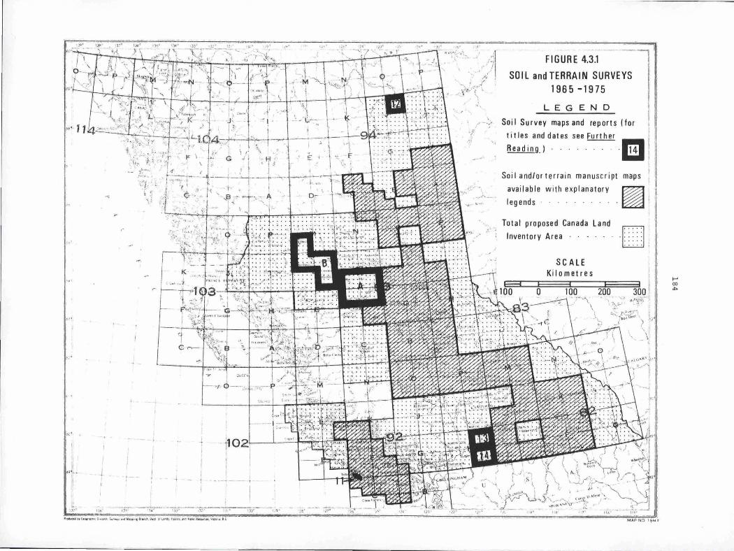
.,.,
,.
-<>
.": .~ I
111
'
11,.
.-e"
,,. .:·
_ _.. ---~
,,,,. .. I ~ \ f.,{
.2 . · i;_,..- I ·-1 •
J .··~l . }~::, ''_}7' 1. ~ -
"' \ t..:t \ ; t}'il;, - , .... ___ ~ >11 .~ i ,f . {
,. ?°-•-""--.,.;-... _ _..,,. ;• • , ·~:- f ft_t :
\ -<-'.
'.' ,k ';I ' ~ : \ ' £ e
0
\ ~-L-:._+-~rtll ' ~_,..., _\,-,,-.p""')""P>-~".I 1 •' I •
-\ r· . •,· '-.J3 -,. ~t·. -. f!.. ~. o~ ' I ...... ~~ .!I//,,
I i,. , , , , ~ f .,,,~ _r/v1,/~ '·l
'\} 1 !i
r
. -~, . •.;,,. r-
,?<~!!,_ ' {1'.5~lt1 .. '1 •
C -.----1~ ";. 63 ---+ \'f;...,r -
"'!' I \JF·
r~,1.-• ..,, :]<1i£11
t102J i I
/_ I I I
I [----·- . - - ·----· -~---1,.a " I}.!~ ) :"~ 1 I ' '.J0° . . --"*-,_,,;~ ... ,._' - =~ --;.i;o · ;_-, •
, .. _,' ._,.11
) .,, ••• _I
,• , •',, -- . ,,. .
r: ,~~~.J'"\ ~
,, .......... ..
·l
_A __ ,.
~-.=,ill FIGURE 4.3.1 I !
SO IL and TERRAIN SURVEYS 1
1
,,
1 9 6 5 - 1 9 7 5 I,
LEGEND
Soil Survey maps and reports (for ! titles and dates see Further El I_
Reading ) · · · · · 14 --· I •
Soil and/or terrain manu sc ript maps I
available with explanatory
l~gends
Total proposed Canada Land
Inventory Area
SC ALE Kilometres
.
~ [J .
I 100
- ''""\ \
200 . -- 30_Q : 11, ..._,, ll ' '' "',\ ~ '
t .l-;:-;
'. '.G"' . ·, ~:· i r-u: ~.(~::\ ; j ... ? ,,
' \,
r~ ~
r' 00 ~

185
By 1972 there was less emphasis on land capability assessments
sponsored by the CLI programme and more on meeting specific requests generated
within the province. This general interest in the use of soils information
was partly a reflection of the success of the CLI programme, and partly due
to an increase in competition for the province's natural resources. Soil
survey information was in demand as an aid to making decisions on land-use,
in preparing impact assessments prior to development, and in preparing
resource folios. Information on other related land-based resources was also
being requested, and a more holistic approach to inventorying land was
required. This led to the concept of integrated resource or biophysical
surveys whereby terrain features, vegetation, aquatic systems and climate
were surveyed along with the soils.
Until this time soil surveys in Canada had traditionally been
sponsored by Agricultural Departments, and this was also the case in British
Columbia. But with integrated resource surveys and the broad application of
soils information for other resource uses, a new sponsoring agency was needed
with a broader mandate. This resulted in 1974 in the shift of soil survey
responsibilities from the B.C. Department of Agriculture to the Resource
Analysis Unit of the Environment and Land Use Committee Secretariat, the
staff arm of Environment and Land Use Committee. This Committee is a provin
cial cabinet committee comprised of Ministries whose activities affect the
natural resources of British Columbia. The shift encouraged and solidified
the concept of integrated resource surveys in British Columbia. It also
encouraged the process of using soil and terrain information in the land-use
planning process.
SOIL SURVEY TECHNIQUES
In 1965 the sudden widespread demand for information generated by the
CLI programme required new survey techniques. Reconnaissance surveys were
emphasized having a field scale of 1:50,000 or l:63~360, and a publication
scale of 1:125,000 or 1:126,720. The surveys had to cover terrain which
varied in accessibility from good to non-existent. This meant the old
approach of going from the specific to the general, that is, the process of
digging numerous holes to identify soil series and as a means of establishing
mapping boundaries was not practical. Instead an approach was applied which
was nearly the reverse. Map boundaries were established first by using
stereoscopic pairs of air photos to identify landforms that were distinguished
by their surface form and shape. Lines were drawn where distinctive and
repeated patterns could be distinguished. Since certain shapes and patterns
are characteristic of certain depositional and erosional processes, inferences
could be drawn about the materials making up the landform. The landforms and
position of the boundaries were then checked in the field and the soil units

186
occurring on the landforms were identified. Where access by road was
possible this checking was done by ground transportation; where road access
was not possible, spot checks were made by helicopter.
In general, the pattern of soils occurring on the landforms was too
complex to permit the identification of all the soil series which occurred
(see definition Part 2.2). Such an approach would have retarded the progress
of the surveys and would have resulted in the final maps being unduly
cluttered and complex. Instead, in 1967 the use of soil associations was
instituted. As indicated in Part 2.2, a typica~ soil association consists of
a number of soils, generally soil series, which may vary from well drained to
poorly drained. However, not all of the soils making up an association will
occur together. So various combinations of them are mapped in different
"soil association map units". For example one map unit may contain only the
well drained soil, while a second map unit may contain the well drained and
the poorly drained soil. Being able to identify the soil in any particular
place is important when land-use interpretations and recommendations are
being made. This method of mapping proved very successful and was still
being applied at the end of the. 1975 period.
The soil series has always played a key role in detailed soil mapping
at scales larger than 1:30,000. During the period when the CLI programme
was demanding most of the resources of soil survey agencies, a number of
special projects were conducted at these detailed scales. The largest of
these was the survey of the Lower Fraser Valley (scale 1:24,000), but a number
of smaller surveys were also completed, some related to irrigation districts,
ARDA sponsored community pasture projects and Indian Reserves. Some of these
were carried out at scales as large as 1:6,000. In all cases, soi~ series
and complexes of soil series comprised the map units. Their identification
required an intensive field examination of the soils and landscape, and this
in turn ensured good definition of the various soil properties and an
accurate placement of the soil boundaries. The information collected depended
upon the objective of the survey, but typically characteristics such as
texture, drainage, structure, reaction, salinity and nutrient content were
identified in considerable detail. This detailed definition allowed the user
to apply the information easily an.a confidently. However, increased precision
is costly and detailed surveys are restricted to situations where the impact
and the benefits in relation to the cost are high.
With the expansion of reconnaissance soil surveys into forested and
mountainous areas, a number of technical soil classification problems were
encountered. Inadequacies were most evident in the Brunisolic, Podzolic and
Organic orders (see Part 2.3) and in high elevation or alpine soils.

187
Increasingly precise morphological and chemical criteria had resolved many of
the problems by 1974 and allowed for a better fit between the classification
system and the natural environment. More specific but important from the
standpoint of soil use and biological productivity was the occurrence of
surface churning and the downslope movement of seepage water on the long
steep slopes so prevalent in much forested terrain in British Columbia.
Similarly, the presence of hard and nearly impenetrable pans was noted in
the subsoil of many coastal and some interior soils. The identification and
characterization of such features during this period allowed the surveys to
proceed in a uniform, precise manner.
When dealing with lands in their natural state, one is mainly
concerned with characterizing and manipulating the total ecosystem. It
became evident quite early in our attempts to inventory forest lands that
the information collected by traditional soil surveys, however important,
comprised only one aspect of the total resources. To obtain the complete
picture also required inventories of climate, vegetation, aquatic systems
and landforms. Thus the concept of biophysical or integrated resource
surveys began to take shape in the mid-1960s, to be applied generally from
about 1970 onward. The application was in some respects forced by the in
creased demand for multi-resource information. However, the need was
anticipated several years earlier as evidenced by a meeting convened in 1962
by R. Spilsbury {B.C. Forest Service), .and the resultant pilot projects at
Minnie and McGillivray Lakes. These projects were primarily concerned with
developing a method of classifying and mapping soils through the integration
of information on soils, landforms and vegetation. Valuable data were gained
from these projects: they introduced the principle of aiiphoto interpretation
as a means of pre-mapping forested terrain. The biophysical mapping concepts
were finally formalized and documented in 1967 under the auspicies of the
National Committee on Forest Land.
CLI PROGRAMME
The impetus for conducting reconnaissance soil surveys over large
areas of British Columbia was initially supplied by the CLI programme in 1965.
The objectives of the programme were firstly to undertake a country-wide
assessment of resource supplies which could be set against a long term assess
ment of resource needs, and secondly to make possible systematic studies of
problems of resource management and development in all fields. The programme
sponsored assessments of land capability for agriculture, forestry, recreation,
wildlife, waterfowl and present land use. In British Columbia, soil survey
information was used as the underpinning for agriculture and forestry
capability ratings and subsequent discussion of the programme will be res
tricted to these aspects.

188
Both the Agriculture and Forestry Capability Classification systems
rated the soils into seven classes. In the Agriculture system the mineral
soils were ranked according to their capability for producing a range of common
field crops. In the Forestry system, all mineral and organic soils were
rated on their inherent capability for growing commercial timber. Capability
for Forestry was therefore based on productivity. Agriculture Capability
ratings were initially applied only to previously surveyed areas, but the
first Forest Capability investigations consisted of pilot projects in the
Prince George, Princeton and East Kootenay areas. This initial work resulted
in adjustments to both rating systems, the better to depict conditions in
British Columbia. Once these problems were solved the work proceeded rapidly
with survey activities reaching a high level by 1968 of nearly 3 million
ha, increasing gradually to 1975 with 5.9 million ha. The programme ended in
1975. In spite of these efforts, not all of the target area was covered (see
Figure 4.3.1). Notable exceptions were the west Chilcotin, the area.north of
the Peace River block, and the east-central part of the province. For those
areas which were surveyed, maps showing capability ratings for agricuiture
and forestry were published at a scale of 1:126,720. This contrasts with
other resource capability maps which were published at 1:250,000 for the
total of the Canada Land Inventory area.
One of the earliest uses of the CLI information were broad regional
land-use recommendations based on a comparative analysis of the capability
ratings for each resource. This procedure was termed a Land Capability
Analysis and was undertaken for seven regions in the Central, Southern and
Peace Rivers areas. The product was a map at a scale ,of 1:250,000 showing
the land's best use capability following an examination of the individual
capabilities for agriculture, big game, forestry, recreation and waterfowl,
and for special uses such as native range. The information was used for a
short period as a guide in setting land alienation policies.
An example of the use of CLI data for planning was the designation of
Agricultural Land Reserves in British Columbia. A Farm Land Preservation
Policy was introduced by Order-in-Council in December 1972, followed by the
Land Commission Act in April 1973. This policy placed a moratorium on the
subdivision of all farmland as defined by the Taxation Act, and on all lands
with Agriculture Capability Classes 1 to 4. The moratorium was in effect
only until the lands were permanently designated as Agricultural Reserve
after a complex review and referral procedure. A basic prerequisite of the
review process was the production of maps for all of the province indicating
the location of lands which were proposed to be reserved for agricultural
use. Compilation of the maps was based on lands with a capability for
agriculture rating of Classes 1 to 4. In ranching areas where grazing lands

189
were an integral part of the operation, Class 5 and 6 lands capable of use
for spring and fall grazing were also included. More than 300 map sheets
at 1:50,000, encompassing more than 4 million ha of land proposed for
Agricultural Reserve were prepared within a few months. Without the basic
information provided by the CLI programme, the task would have been impossible.
The CLI programme was a success in many ways. Besides the main
objective of producing a broad scale assessment of soil and ldnd capability,
there were desirable spin-offs: it gave a much needed impetus to the federal
and provincial soil survey programmes; it created a large data base on soil
and terrain which could be used for other purposes; it fostered communication
and cooperation in relation to resource management and planning; and it cre
ated an awareness of the value of soil interpretations and of the need to
integrate the components of the ecosystem. The capability data produced by
the programme are still the main sources of information available for
management and planning over large areas of British Columbia. The major
drawback is the broad scale on which the surveys were conducted. They were
designed to provide an input to regional land-use planning and are well
suited for the purpose; but the data are too general for most management
activities although many agencies have used them with varying success in the
absence of more relevant information.
SPECIAL PURPOSE SURVEYS AND APPLICATIONS
To make soil survey data useful for land-use planning and management,
the information must be reliable, readily available, and in an easily under
standable form. The capability maps produced by the CLI programme were only
the beginning of the kinds of practical applicatjons which .could be made.
The soil survey reports which were produced from 1965 to 1975 illustrate the
gradual transition from very technical reporting on soils to publications
which emphasize use and management for multi-resource purposes. The report
format was itself simplified and made more appealing by eliminating or
appending much of the technical data.
Besides making the report user-oriented, a major effort was made to
shorten the period between completing the inventory and reporting the results.
One means of accomplishing this was to produce interim copies of both maps
and reports. Computer storage of data facilitated the manipulation of the
data and its accessibility to other agencies.
Many of the requests received could not be met from the data
accumulated in the CLI programme. This generated the 'need for more specialized
surveys, often at detailed scales, and for new ways of applying the information.

190
Some of the demand could be met by the traditional soil survey organizations
of the Federal and Provincial governments. Some could not, and this led to
the hiring of pedologists by private companies and other government agencies.
Some large forest companies undertook their own soil and terrain surveys and
initiated specialized applications for them. The Federal and Provincial soil
survey units meanwhile became more specialized. The Federal unit undertook
an increased correlation function to ensure standardization and integrity of
the information being collected by the various agencies. Its role in
research was also strengthened.
The Provincial unit concurrently geared up to conduct more special
purpose surveys and to make more sophisticated interpretations. By the end
of the 1965 to 1975 period, the interpretations covered not only the tradi
tional resource fields of agriculture, forestry, recreation and wildlife,
but also included engineering, urban development and regional planning.
Their preparation used not only soils data, but also the related aspects of
climate, terrain systems, aquatic systems and vegetation. Truly, soil
surveys had come of age and were in a strong position to meet the demands of
the next decade.
FURTHER READING
Anonymous, 1970. The Canada Land Inventory: Objectives, Scope and
Organization, Report No. 1, second. edition, 61 pp.
This report describes the Inventory, with brief eUJm1ariee of the alassifiaatione used.
National Committee on Forest Land, 1969. Guidelines for Bio-Physical Land
Classification. Canadian Forestry Service Publication No. 126.4.
A description of the methods to be used in the mapping of land using the Bio
Physical Land Classification.
Staff of the Resource Analysis Unit, 1976. Terrain Classification System,
E.L.U.C. Secretariat, Victoria.
Descriptions and definitions of a mapping system for terrain.
The foUOliJing are all soil suweys [)Ublished during the period, which inalude
teahniaal soil desariptions and chapters on soil capability for various uses.
191
Valentine, K.W.G., 1971. Soils of the Tofino-Ucluelet Lowland of British
Columbia, B.C. Soil Survey Report No. 11, Canada Dept. of Agri
culture, Ottawa, 29 pp.
Valentine, K.W.G., 1971. Soils of the Fort Nelson Area of British Columbia,
B.C. Soil Survey Report No. 12, Canada Dept. of Agriculture, Ottawa,
60 pp.
Lord, T.M. and A.G. Green, 1974. Soils of the Tulameen Area of British
Columbia. B.C. Soil Survey Report No. 13, Canada Dept. of Agri
culture, Ottawa, 163 pp.
Cotic, I., 1974. Soils of the Nechako-Francois Lake Area. Interim Report.
British Columbia Dept. of Agriculture, Victoria, 218 pp. (A)
Runka, G.G., 1974. Soil Resources of the Smithers-Hazelton area. Interim
Report, British Columbia Dept. of Agriculture, Victoria, 234 pp. (B)
Green, A.J. and T.M. Lord. Soils of the Princeton Area. B.C. Soil Survey
Report No. 14, Canada Dept. of Agriculture, Ottawa, (in press).
4.4 SOIL AND TERRAIN SURVEYS FROM 1975 T.M. Lord
The preceding sections introduce the reader to the beginnings of soil
surveys in the province and carry him through the development and use of soil
and terrain surveys as a base for the Canada Land Inventory (CLI) mapping
programme, which ended officially in British Columbia in the spring of 1975.
Apart from completing the publication of land capability maps and the fundin9
of special projects, the resource analysis was completed of a vast area
comprising some 96 million ha. Coincidental with the progress of the land
inventory programme was an increased expertise in the mapping of_soil and
terrain units, refinements in technology, and a sharp rise in the volume of
requests by land managers for basic resource information. These "spinoffs"
from the CLI program have' important ramifications for the present and future
direction of soil and landform surveys in British Columbia.
Although the soil surveyor has traditionally made use of other
natural sciences, he was sometimes forced, in remote, unclassified areas, to
rely entirely on his own judgement in describing terrain units, plant
communities and geological structures. Today he is part of a resource team
that comprises specialists in hard rock geology, terrain analysis, vegetation,
climate, hydrology, etc.
Upon completion of the CLI field programme in 1975, a large amount of
survey information was available. This included new knowledge of the soils
and landforms of the province, particularly in the northern half and within
the mountain ranges. Already the application of this fresh information has
altered the soils picture of British Columbia as depicted on the recently puplished soil map. For example we now recognize a more-extensive distribu
tion of Hume-Ferric Podzols within the interior plateau, and have mapped
Ferro-Humic Podzols and Folisols within the mild rainforest belt of the outer
coast. Recent surveys in the mountains and through the northern plateaus have
enabled us to map more accurately areas formerly labelled as "dominantly
rockland".
This new information on our soils is closely related to the
development of more refined systems for classifying and mapping terrain and
vegetation. Although practically all resource. mapping under the CLI programme
was done at a scale of 1:50,000, the principles involved apply equally to any
scale of mapping. That is, the terrain or landform units are first iden
tified by stereoscopic photo interpretation and then delineated on airphotos.
The soils and vegetation are next described within this established frame
work. Reconnaissance soil surveys, covering a range of scale from about
194
1:30,000 to 1:125,000, differ from detailed surveys (<l:30,000) mainly in
degree of intensity. That is, although each map delineation must be identi
fied, the range of soils within a map unit will be wider and more complexes
may occur under a reconnaissance survey. The value and practical use of any
soil-terrain survey, at any level of intensity, depends on the composition
of its mapping units and their relationship to the soil map legend. Soil
mapping units must not only accommodate the natural landscape pattern of soils,
they must be mappable, and they must meet the objectives of the particular
survey. Although mapping units may be described at the level of soil series,
complexes or associations they are defined by taxonomic classes.
Only recently have soil surveyors been forced to take a critical look
at how they map soils and why they show soils on maps in certain ways. This
assessment has resulted largely from a rapidly growing awareness and critical
evaluation of soil information by concerned users. In British Columbia,
resource managers require a wide range of basic soil and related landscape
data. This information includes soil descriptions, soil classification, soil
moisture regime, landforrn types, texture and depth of materials, and vegeta
tion associations. Although most of these data have been included in the
traditional soils report and soil map and legend, the mode of presentation
has often left something to be desired.
Even though "soil is soil" whether under a wheatfield or supporting
a stand of Douglas-fir trees, a mapping system used for agricultural needs
would not necessarily be the same as one designed for forestry purposes.
Soil surveys of rugged forested terrain, carried out primarily to provide a
range of soil interpretations for forestry and engineering, are of recent
origin in British Columbia. They grew out of the need for soil and land-
form information to provide a sound base for making land capability ratings
under the CLI programme. Even while the soil maps were in the early stages of
drafting, land managers, particularly those in private and government sectors
of forest management, requested the use of this provisional soils information.
It is now our task in this post-CLI period to explore some of the ways in
which present and future surveys may best meet these needs.
Even while there were strong pressures from some resource managers
for the basic soil and landform information in CLI maps, there was a growing
awareness that these broadly-based maps did not always meet the needs of the
user. With the rapid opening up of new areas to the travelling public, the
importance of good resource management has become obvious. The effects of
poor soil management practices that result in the scarring of a mountain
side, the fouling of a stream, the loss of a new generation of trees, or the
195
bulldozing of a grassland range are not readily hidden from view. The
managers of our resources are actively trying to prevent such losses in
productivity and to avoid confrontation with public pressure groups. Public
and private agencies engaged in soil and terrain mapping must provide not
only the basic map information but must show how to interpret clearly the
survey data for any resource use.
Before getting into the uncertain area of prophecy a brief review of
the present relationship of soil and terrain surveys to the natural resources
of the province is in order. Soil and terrain mapping is now being done not
only by federal and provincial agencies but also, and to an increasing ex
tent, by surveyors in some of the larger forest companies. The current trend in surveys of forest land is to map at a number of levels within the detailed
intensity range i.e. at scales of 1:30,000 or larger. But even if a mature
forest stand growing on a steep mountain slope were mapped at the same inten
sity of survey as a cleared tract of level alluvial bottomland, say 1:15,000, the resulting soil and terrain information would be markedly different.
Accurate photo interpretation of terrain and surficial materials, viewed
through a dense tree cover, is extremely difficult even at high levels of
intensity. The validity of many map unit boundaries and the components of
each mapping unit must be closely field checked if dependable soil maps are
to result. Soil maps produced at reconnaissance scales of 1:30,000, or
smaller have limited use for forest land managers at an operational scale.
Mapping units must be defined at a more detailed level for interpretive use
by foresters and engineers.
The current review of present and projected developments in resource
surveys is timely for a number of reasons. An important aspect of the CLI programme was the introduction of new or revised classification systems for
three of the basic resources - soils, landforms, and vegetation. The year 1976 saw a major revision in the Canadian System of Soil Classification (to
be published 1978) under the Canada Soil Survey Committee aided by pedologists from across Canada. Some of the more important changes were: the addition of a new category - Cryosolic Order, the revision of definitions in the
Brunisolic and Podzolic orders, a reduction in the number o_f subgroups, and
the use of a more readable style and format. Included in the revised publi
cation is a chapter on landform classification. This system is closely
related to the provincial scheme of terrain classification and was developed
jointly by pedologists and surficial geologists. A great deal of progress
has been made by plant ecologists and botanists in devisin·g compatible means
of mapping plant communities and associ.ations.
196
There have been advances in the use of Landsat remote sensing
imagery and the development of the orthophoto. These and other mapping aids,
including the helicopter; are helping to speed up field mapping. Computer
technology in the form of data banks for the storage, analysis and display of
soils information will permit more uniform classification and correlation of
soil units within and between surveys.
Permanent retention and ease of recovering field data for new
interpretations will enable response to questions unanswerable at present.
Further, the ability to correlate statistically data for soils, terrain,
climate, vegetation and water, should enhance and support land management and
planning decisions.
The development of autocartography should speed up the production of
flexible soil interpretation maps tailored to the specific needs of users.
By 1976 it was clear that the traditional reconnaissance soil survey
had evolved into, and become part of a broad land resource programme. Such
programmes are drawn up to meet specific objectives within a rigid time
frame. The soil surveyor and terrain specialist provide field data at what
ever levels of intensity are required to meet the needs of the study.
Detailed mapping of soils and landforms may be required to locate
townsites and communication routes through corridors while less intensive
surveys may meet the needs in the plateau and r,1ountain sections. The pedologists and surficial geologists will be responsible for interpreting the basic resource data such as airphotos, geological and old soil reports
and land surveys. Preliminary field legends will be drawn up. The format
of the mapping units will be establish.ed prior to field survey. During the
preliminary stages and throughout the field programme, the supervisory soil
and landform specialists work closely with representatives of other sectors,
such as vegetation, climate, wildlife and recreation. The duties of the soil
and landform specialists involve correlation of the soil and terrain mapping programme, classification and sampling of soil units, and revisions in the map
legend to deal with new information.
Interpretations of soil mapping units for selected uses are an
integral and important part of any modern soil survey report. A rating
system is generally used expressing relative degrees of risk or limitations
for potential uses. A knowledge of soil behavior based on field observations
and generally a limited amount of analytical data, form the basis for most
suitability ratings. Although interpretations cover a wide range of uses
such as recreational parks, or assessment for septic tank fields, interpreta-

197
tions for forestry are of major importance in British Columbia. Foresters
in particular are concerned with the stability of forestry roads and how
they relate to soil characteristics, bedrock geology, soil water, and forest
productivity.
We can expect the new technology that is rapidly developing for
computer-assisted resource planning to have far reaching effects on forest
management {for example in the folio system of the.British Columbia Forest
Service and in similar programmes in other agencies). With the development and
use of federal {CanSIS) and provincial data banks there will be greater
opportunities for exchanging soil information and maintaining standards for
surveys by private companies and public agencies. Programmes that deal with
materials for highways cut and fill and topsoil criteria, could be adapted
for mine reclamation. Much more.than in the past, survey data must be linked
to fertility and productivity analysis for agriculture and for other resources.

81-2000-19
Copyright © 2022 FDOKUMEN