the significance of choice in the late dorset technology of
600
THE SIGNIFICANCE OF CHOICE IN THE LATE DORSET TECHNOLOGY OF DOMESTIC ARCHITECTURE by Karen Ryan A thesis submitted in conformity with the requirements for the Degree of Doctor of Philosophy Graduate Department of Anthropology © Copyright by Karen Ryan (2009)
-
Upload
khangminh22 -
Category
Documents
-
view
1 -
download
0
Transcript of the significance of choice in the late dorset technology of

THE SIGNIFICANCE OF CHOICE IN THE LATE DORSET TECHNOLOGY OF
DOMESTIC ARCHITECTURE
by
Karen Ryan
A thesis submitted in conformity with the requirements
for the Degree of Doctor of Philosophy
Graduate Department of Anthropology
© Copyright by Karen Ryan (2009)

ii
The Significance of Choice in the Late Dorset Technology of Domestic
Architecture
Karen Ryan
Doctor of Philosophy
Department of Anthropology, University of Toronto (2009)
ABSTRACT
This dissertation investigates the domestic architecture produced by the Late Dorset, an Arctic-adapted
hunter-gatherer society which occupied much of the Eastern North American Arctic between circa 1500
B.P. and 500 B.P.
Architecture, like any artefact class, is a dynamic and socially constructed technology that is produced,
maintained, and transmitted by its practitioners. It is replicated via series of learned actions or techniques;
patterns accordingly result from adherence to cultural standards while differences represent instances of
technological divergence. Such departures are typically ignored or suppressed in closed systems, although
they can be tolerated or even widely adopted in more flexible ones.
In order to identify and explore patterning, a methodological strategy using the chaîne opératoire is
adopted. This approach is invaluable because, when properly implemented, it links the static
archaeological record with the dynamic architect-agents whose meaning-laden technical acts are visible
archaeologically.
Viewed through the lens of chaîne opératoire, I examine domestic architecture as a conduit for informing
on Late Dorset structure and social organisation. As part of this investigation, a multi-scalar research
design was implemented. The first analytical scale examined architecture across the Eastern Arctic to
determine regional patterns of behavioural variability. Large-scale behavioural trends were recognised
and demonstrated the range of behaviours enacted by Dorset architects as they designed, reproduced, and
altered dwellings.

iii
The second stage of analysis focused on the micro-scale analysis of dwellings from three locations, each
presented as fully contextualised case studies. Analysis at this level allowed for the investigation of how
idiosyncratic behaviours and localised knowledge (reflecting an agent’s awareness of local conditions)
was manifested and ‘fit’ within the overall technology.
This strategy, which combined structure-specific analysis with purposefully broad regional patterning,
suggests that Late Dorset architectural technology was comparatively open and flexible and that architects
could adapt technological practise to suit local conditions and housing needs. This flexibility contrasts
with other aspects of Late Dorset culture that appear more constrained and standardised.

iv
ACKNOWLEDGEMENTS
Dissertations are often as much about perseverance as they are about the analysis underpinning
the whole effort. This is certainly the case with the present study, which could never have been
completed without the many people who gave their unfailing support (academically, socially,
and financially) through the eight years needed to finish.
A great deal of gratitude must be directed to my supervisor, Dr. T. Max Friesen, whose guidance
and faith ensured that he would (eventually) be rid of me as a student. Max patiently overlooked
my many self-imposed and usually missed deadlines with good humour while providing thought-
provoking comments on the chapters (getting each back to me much sooner than I generally
wanted to see them!). Under Max’s tutelage, and following his example, I have hopefully learned
to be a better researcher and to think critically, but not overly so, about things.
Thanks are also extended to my dissertation committee – the ‘core’ of Drs. Michael Chazan and
Gary Coupland, as well as Drs. Heather M.-L. Miller (internal-external) and Susan Rowley
(external, University of British Columbia) – for their willingness to read and provide feedback
on my research. Dr. Andrew Clement (Faculty of Information) sat through two hours of
archaeology on a sunny Friday afternoon as my defense chair. Dr. Patricia Sutherland (Canadian
Museum of Civilization) was a firm believer that Dorset architecture deserved a closer look and
my research benefitted from her support. I appreciate the contributions of all!
Excavations on Victoria and Baffin Islands – and anywhere in the North – could not be possible
without the logistical support of the Polar Continental Shelf Project. Financial support for the
fieldwork came from the Social Science and Humanities Research Council (Friesen), Canadian
Museum of Civilization (Sutherland), and the Northern Scientific Training Program. Additional
funding derived from Ontario Graduate Scholarships, University of Toronto Open Fellowships,
and the William E. Taylor Research Award.
My time on and off campus was made much more enjoyable thanks to a merry band of friends,
particularly Andrew Deane, Sue Lofthouse, Carla Parslow, Kate Reedy-Maschner, and Alex
Sumner. Julie Ross was my office mate for 4 years and while we periodically commiserated
about research and writing, we also got to celebrate each other’s achievements. Mariam
Nargolwalla was a wonderful and much appreciated source of all sorts of non-academic fun.
My parents were enthusiastic cheerleaders and financiers throughout my university career. My
mom read all of my undergrad papers and helped make me a better writer, while my dad
provided much needed care packages full of the treats and surprises that kept me going. Special
thanks to Chester and Fergus for their company during those long days and nights in front of the
computer, and for knowing that throwing a bear sometimes is the best option!
This dissertation may not have been finished without the unwavering support of Matthew Betts,
who never for a moment thought that I wouldn’t get it done. His constant encouragement (even
when progress forced him to resort to bribery), faith, and love make everything possible.
This dissertation is dedicated to my dad, who would have been so proud.

v
Table of Contents
ABSTRACT ii
ACKNOWLEDGEMENTS iv
TABLE OF CONTENTS v
LIST OF FIGURES xiii
LIST OF TABLES xviii
CHAPTER 1: INTRODUCTION TO THE RESEARCH
1.1 Introduction 1
1.2 Alternate Strategies for Exploring Architectural Remains 2
1.2.1 Structuralism, Habitus, and Structuration 3
1.2.2 Proxemic 5
1.2.3 Dramaturgical 5
1.2.4 Grammatical 6
1.2.5 Ergonomic 7
1.2.6 Behavioural Archaeology 7
1.2.7 Summary of Alternate Frameworks for Architectural Analysis 10
1.3 Framework of Research 11
1.4 Research Goals and Data Sources 13
1.5 Organisation of the Dissertation 15
CHAPTER 2: AN ANALYTICAL AND METHODOLOGICAL APPROACH
FOR EXPLORING ARCHITECTURAL TECHNOLOGY 2.1 Introduction to the Analytical Perspective 18
2.1.1 The Technological Approaches to the Archaeological Record 20
2.1.2 The Chaîne Opératoire 23
2.1.3 The Chaîne Opératoire and the Style Versus Function Debate 25
2.1.4 The Chaîne Opératoire - A Non-Binary Approach 30
2.1.5 The Chaîne Opératoire as an Analytical Strategy: Summary 32
2.2 Outlining the Analytical Framework 33
2.2.1 Implementing the Chaîne Opératoire 33
2.2.2 Applying the Chaîne Opératoire to Architectural Remains 35
2.2.3 Macro and Micro Scales: tracing technological behaviours through 38
connaissance and savoir-faire knowledge

vi
2.2.4 The Influence of Anticipated Mobility, Seasonality, and Sedentism 40
on the Interpretation of Architectural Remains
2.3 Chaîne Opératoire as a Structuring Framework for Analysis: Summary 43
CHAPTER 3: THE ARCTIC ENVIRONMENT AND ITS INFLUENCE ON
ARCHITECTURE
3.1 Introduction 46
3.2 Characterising the Arctic Environment 47
3.2.1 Temperature and Architecture 49
3.2.2 Wind and Architecture 51
3.2.3 Precipitation and Architecture 53
3.2.4 Relative Humidity and Architecture 55
3.2.5 The Sea Ice Environment 56
3.3 Resources Available for Architectural Use 60
3.3.1 Snow 60
3.3.2 Wood 62
3.3.3 Whale Bone 65
3.3.4 Sod 66
3.3.5 Antler 68
3.3.6 Ivory 69
3.3.7 Stone and Gravel 70
3.3.8 Skin 71
3.3.9 Discussion 71
3.4 The Arctic Environment in the Period 1500 B.P. and 500 B.P. 72
3.5 Summary 77
CHAPTER 4: THE CULTURAL SETTING – LATE DORSET PREDECESSORS
4.1 Introduction 79
4.2 The Western Origins of the Eastern Arctic Palaeoeskimo 80
4.3 Pioneers: The Earliest Eastern Palaeoeskimos 83
4.3.1 Independence I (circa 4500 B.P. – 4000 B.P.) 84
4.3.2 Saqqaq (circa 4500 – 2000 B.P.) 86
4.3.3 Pre-Dorset (circa 4200 B.P. – 2800 B.P.) 89
4.3.4 Early Palaeoeskimo Summary 90
4.4 The Transition: Early to Late Palaeoeskimo, Continuity or Population 92
Replacement?

vii
4.4.1 Independence II (circa 3000 B.P. – 2600 B.P.) 94
4.4.2 Groswater (circa 2800 – 2100 /1900 B.P.) 96
4.4.3 Lagoon (circa 2800 B.P. – 2300 B.P.) 98
4.4.4 Transitional Period Summary 99
4.5 Late Palaeoeskimos: The Dorset 100
4.5.1 Early Dorset (circa 2500 B.P. – 2000 B.P.) 102
4.5.2 Middle Dorset (circa 2000 B.P. – 1500 B.P.) 105
4.5.3 Late Palaeoeskimo Summary: Early and Middle Dorset 108
4.6 Discussion 110
CHAPTER 5: THE LATE DORSET
5.1 Introduction 113
5.2 Late Dorset Chronology 113
5.3 Characterising Late Dorset 117
5.3.1 Identifying Late Dorset Origins and Spread 117
5.3.2 The Late Dorset Toolkit 120
5.3.3 Subsistence and Settlement Patterns 122
5.3.4 Ideological and Social Life 126
5.4 Late Dorset and the Question of Contact 130
5.4.1 Inuit tales of the Tunit 131
5.4.2 Genetic and Osteological Investigations 132
5.4.3 The Sadlermiut and Ammassalimmiut 134
5.4.4 The Brooman Point and Qeqertaaraq Sites 136
5.4.5 Technological Transfers? 137
5.4.6 Dating the Thule Inuit Migration into the Eastern Arctic 141
5.4.7 The Dorset and Norse 144
5.4.8 Summarising the Question of Contact 148
5.5 Summary 149
CHAPTER 6: LATE DORSET DOMESTIC STRUCTURES
6.1 Introduction 151
6.2 Constraints of the Analysis 151
6.3 Architectural Terminology 152
6.3.1 Semi-Subterranean and Surface Structures 153
6.3.2 Axial and Central Features 153
6.3.3 Box Hearths, Hearths, and Hearth Areas 157

viii
6.3.4 Pot Supports and Platforms 159
6.3.5 Entrance Passages and Cold-Traps 159
6.3.6 Qarmat 162
6.3.7 Snow Structures 164
6.4 Late Dorset Architectural Remains from the Low Arctic 165
6.4.1 Tikilik / Arnaquaaksaat, Foxe Basin (NiHf-4) 165
6.4.2 NiHf-45, Foxe Basin 166
6.4.3 Newell Sound-4, Frobisher Bay (KgDl-4) 167
6.4.4 Cordeau / DIA.1, Diana Bay (JfEl-1) 168
6.4.5 Tuvaaluk, Diana Bay (JfEl-4) 168
6.4.6 Gulf Hazard-1, Richmond Gulf (HaGd-4) 169
6.4.7 Gulf Hazard-8, Richmond Gulf (HaGd-11) 169
6.4.8 Summary 171
6.5 Late Dorset Architectural Remains from the High Arctic 171
6.5.1 Franklin Pierce, Franklin Pierce Bay, Ellesmere Island (SiFi-4) 171
6.5.2 Longhouse, Knud Peninsula, Ellesmere Island (SgFm-3) 173
6.5.3 Oldsquaw , Little Skraeling Island, Ellesmere Island (SgFk-18) 173
6.5.4 Piper, Johan Peninsula, Ellesmere Island (SfFk-39) 174
6.5.5 Snowdrift Village, Dundas Island (RaJu-1) 175
6.5.6 RaJu-2, Dundas Island 177
6.5.7 Maze Village, Dundas Island (RaJu-3) 177
6.5.8 RaJu-4, Dundas Island 178
6.5.9 McCormick Inlet, Melville Island (QkPa-1) 178
6.5.10 Tote Road, North Devon Lowlands, Devon Island (QkHn-37) 179
6.5.11 Arvik, Little Cornwallis Island (QjJx-1) 179
6.5.12 Tasiarulik, Little Cornwallis Island (QiLf-25) 181
6.5.13 Brooman Point, Bathurst Island (QiLd-1) 182
6.5.14 Summary 183
6.6 Late Dorset Architectural Remains from Greenland 183
6.6.1 Qeqertaaraq, Inglefield Land 184
6.6.2 Snowdrift, Inglefield Land 186
6.6.3 Qallunatalik / Polaris, Inglefield Land 187
6.6.4 Summary 189
6.7 Late Dorset Architectural Remains from Labrador 190
6.7.1 Avayalik-1 (JaDb-10) 190
6.7.2 Peabody Point (IiCw-1) 192
6.7.3 Big Head 6 (IiCw-8) 192
6.7.4 Beacon Island 5 (IiCv-6) 192
6.7.5 Shuldham Island 9 (IdCq-22) 193
6.7.6 Okak 3 (HjCl-3) 195
6.7.7 Summary 196

ix
6.8 Discussion 197
6.8.1 Chronological Developments? 197
6.8.2 Regional Patterns and Anomalies? 205
6.9 Setting the Stage for the Case Studies 212
CHAPTER 7: CASE STUDY 1 – HOUSE 6, BELL SITE (NiNg-2),
SOUTH-EASTERN VICTORIA ISLAND 7.1 Introduction 215
7.2 The Physical Environment of South-eastern Victoria Island 215
7.3 Potential Range of Resources at Iqaluktuuq 217
7.3.1 Terrestrial Resources 220
7.3.2 Avian Resources 223
7.3.3 Lacustrine and Riverine Resources 223
7.3.4 Marine Resources 226
7.3.5 Organic and Inorganic Materials Suitable for Architectural Purposes 227
7.3.6 Summary and Discussion of Available Resources 230
7.4 The Bell Site (NiNg-2) 231
7.4.1 Physical Setting 232
7.4.2 Cultural Setting 237
7.5 Excavation of House 6 239
7.5.1 Late Dorset Architectural Forms Present at the Site 241
7.5.2 Selecting the Structure 241
7.5.3 Appearance of the Structure Prior to Excavation 242
7.5.4 Excavation Strategy and Methodology 242
7.5.5 Feature Stratigraphy 243
7.5.6 Previous Archaeological Activity at House 6 247
7.5.7 Defining the Peripheral Boundaries of House 6 248
7.5.8 Northwest Corner and Rear Wall Construction 250
7.5.9 The Entrance 252
7.5.10 Identifying the Living Surface and Activity Areas Inside the 255
Structure
7.5.11 House 6 Superstructure 256
7.5.12 The Abandonment and Post-Occupation Life of House 6 257
7.5.13 Discussion 260
7.6 Making Sense of House 6 261
7.6.1 The House 6 Faunal Sample 261
7.6.2 The House 6 Artefact Assemblage 262
7.6.3 Suggested Season of Occupation 265
7.6.4 Suggested Length of Occupation 268

x
7.7 Summary 269
CHAPTER 8: CASE STUDY 2 – N72, NUNGUVIK (PgHb-1), NAVY
BOARD INLET, NORTHERN BAFFIN ISLAND 8.1 Introduction 271
8.2 The Physical Environment of North-eastern Baffin Island 271
8.3 Potential Range of Resources Near Nunguvik 276
8.3.1 Terrestrial Resources 279
8.3.2 Avian Resources 281
8.3.3 Lacustrine and Riverine Resources 282
8.3.4 Marine Resources 282
8.3.5 Organic and Inorganic Materials Suitable for Architectural Purposes 284
8.3.6 Summary and Discussion of Available Resources 289
8.4 Nunguvik (PgHb-1) 290
8.4.1 Physical Setting 291
8.4.2 Cultural Setting 296
8.4.3 Dorset Architectural Forms Identified at Nunguvik 298
8.4.3.1 Structure N46 (Early Dorset) 298
8.4.3.2 Structure N76 (Early Dorset?) 300
8.4.3.3 Structure N82 (Dorset) 301
8.4.3.4 Structure N71 (Late Dorset) 302
8.4.3.5 Structure N72 (Late Dorset) 304
8.4.4 Unusual Artefacts and Architectural Features at Nunguvik 306
8.5 Excavation of N72 312
8.5.1 Identification and Context of N72 312
8.5.2 Appearance of the Structure Prior to Excavation 313
8.5.3 Excavation Strategy and Methodology 314
8.5.4 Identification of Occupation and Hiatus Periods 319
8.5.4.1 N72 Description of Depostional Phases 320
8.5.5 Central Feature 326
8.5.6 Internal Organisation and Living Surface 331
8.5.7 Perimeter Wall Berms 333
8.5.8 Entrance 334
8.5.9 Superstructure 336
8.5.10 Abandonment and Post-Use Life 337
8.5.11 Summary 339
8.6 Interpreting N72 340
8.6.1 The Faunal Sample 340
8.6.2 The Artefact Assemblage 342

xi
8.6.2.1 Occupation 1 342
8.6.2.2 Occupation 3 344
8.6.3 Suggested Season and Length of Occupation 348
8.7 Summary 351
CHAPTER 9: CASE STUDY 3 – KdDq-7-4, TANFIELD VALLEY, NORTH
BAY, SOUTH-EASTERN BAFFIN ISLAND 9.1 Introduction 353
9.2 The Physical Environment of South-eastern Baffin Island 353
9.3 Potential Range of Resources in North Bay 357
9.3.1 Terrestrial Resources 359
9.3.2 Avian Resources 361
9.3.3 Lacustrine and Riverine Resources 362
9.3.4 Marine Resources 363
9.3.5 Organic and Inorganic Materials Suitable for Architectural Purposes 365
9.3.6 Summary and Discussion 369
9.4 The Tanfield Valley and KdDq-7-4 369
9.4.1 Physical Setting 370
9.4.2 Cultural Setting 375
9.4.3 Dorset Architectural Forms Identified or Inferred in the Tanfield 377
Valley
9.4.4 Something Different: “Anomalous” Finds in the Valley 380
9.5 Excavation Activities at KdDq-7-4 384
9.5.1 Identification and Context of KdDq-7-4 385
9.5.2 Excavation Strategy and Methodology 386
9.5.3 Under the Surface 388
9.5.4 Stratigraphy Identified During the Excavation 390
9.5.5 Summary 394
9.6 Interpreting KdDq-7-4 394
9.6.1 The Faunal Sample 395
9.6.2 The Artefact Assemblage 396
9.6.2.1 The Level 5 Occupation 397
9.6.2.2 The Level 3 Occupation 400
9.6.3 Understanding the Architecture with the Aid of Stratigraphy and 403
Artefacts
9.6.4 Who is Responsible for KdDq-7-4? 408
9.6.5 Suggested Season and Length of Occupation for Level 3 410
9.7 Summary 412

xii
CHAPTER 10: IDENTIFYING AND UNDERSTANDING THE LATE
DORSET TECHNOLOGY OF ARCHITECTURE
10.1 Introduction 415
10.2 Searching for Technological Traditions Using a Macro-Scale Approach 417
10.2.1 The Architectural Attributes 418
10.3 Recognising Late Dorset Architectural Traditions: technology at the 442
macro-scale
10.3.1 Patterns of Behaviour and Technical Connaissance Knowledge 443
10.3.2 Organisation of Late Dorset Domestic Architecture: a macro-scale 449
view
10.4 Investigating Architectural Technology Using a Micro-scale Approach 450
10.4.1 Insights from House 6, Bell Site, Victoria Island 450
10.4.2 Insights from N72, Nunguvik, North Baffin Island 456
10.4.3 Insights from KdDq-7-4, Tanfield Valley, Southern Baffin Island 459
10.5 Discussion: architecture and agency; micro-scale behaviours and macro-scale 461
technologies
CHAPTER 11: CONCLUSIONS
11.1 Introduction 465
11.2 Late Dorset Architectural Technology and Social Organisation 466
11.3 Directions for Future Work 468
11.4 Final Thoughts 471
REFERENCES CITED 473
APPENDIX: PALAEOESKIMO DOMESTIC ARCHITECTURE REMAINS, 557
CIRCA 4500 B.P. – 1500 B.P.

xiii
LIST OF FIGURES
Figure 1.1 – Geographic range of Late Dorset culture. 14
Figure 3.1 – Various ways in which the “Arctic” has been defined. The 10° 48
Celsius July isotherm is used in this dissertation.
Figure 3.2 – Location of major polynyas and leads in the Eastern Arctic. 54
Figure 3.3 – Tidal variations near Kimmirut, southern Baffin Island. 59
Figure 6.1 – Illustration of an 18th century Saami dwelling (from Leem 1767). 155
Compare this midline axial feature containing a central hearth and storage
compartments with the Palaeoeskimo example shown in Figure 6.2a.
Figure 6.2 – Axial features and central feature. A) 'Classic' box hearth axial feature 156
with a double row of uprights defining the hearth area (Knuth 1967: Plate 7a),
B) Paved central feature (Schledermann 1990: Figure 71), C) 'Negative'
midline consisting of pit features (Harp 1976: Figure 8a).
Figure 6.3 – Variants of the defined hearth. A) Freestanding 3-sided box hearth 158
(adapted from Badgley 1980: Figure 4), B) Box hearth with boiling stones
(Grønnow and Jensen 2003: Figure 5.65), C) Boulder-defined hearth (Renouf
1994: Figure 12).
Figure 6.4 – Pot supports and lamp platforms. A) Stand-alone pot support inside 160
dwelling (photo by author), B) Pot support inside axial feature, note left upright
support’s notched top (Rowley and Rowley 1997: Figure 4), C) Lamp platform
with pecked base (Hinnerson Berglund 2003: Figure 6).
Figure 6.5 – Plan of the Late Dorset structure at NiHf-45 (Murray 1996: Figure 4.9). 161
Note entrance passage to right and rear wall expansion to left.
Figure 6.6 – Reconstructed Thule Inuit house at the M-1 site (QeJu-1) showing the 162
cold-trap entrance.
Figure 6.7 – Low Arctic Late Dorset sites discussed in the text. 166
Figure 6.8 – House 1 from Gulf Hazard-8 (HaGd-11) (Harp 1976: Figure 8b). 170
Harp (1976:132) referred to this structure as “a thing of beauty”.
Figure 6.9 – High Arctic and Greenland Late Dorset sites discussed in the text. 172
Figure 6.10 – Feature 1 from the Oldsquaw site (SgFk-18) (Schledermann 1990: 174
Figure 103). A possible unstructured hearth area was identified in the

xiv
structure’s north-western corner.
Figure 6.11 – D-shaped Structure 1 from the Snowdrift Village site (RaJu-1) 176
(McGhee 1981a: Figure 24). Note the large terminus or end stone placed
immediately north of the axial feature.
Figure 6.12 – Structure 1 from the Qallunatalik / Polaris site, Greenland (Grønnow 188
1999: Figure 44). Note the concentric burnt blubber mark on the lamp platform
which indicates the size and shape of the vessel.
Figure 6.13 - Labrador Late Dorset sites discussed in the text. 191
Figure 6.14 – Shuldham Island 9 (IdCq-22) House 2 (Thomson 1988: Figure 11). 194
Figure 6.15 – Semi-subterranean structure with heavily built axial feature at 196
Okak 3 (HjCl-3). Note paving stones bordering the axial feature’s outer edge.
Figure 6.16 – Calibrated (CALIB 5.0.1) radiocarbon dated Late Dorset structures 200-201
by region.
Figure 7.1 – Victoria Island and area, showing locations mentioned in the text. 216
Figure 7.2 – Iqaluktuuq sites mentioned in the text. 224
Figure 7.3 – Looking from the rear of House 6 toward Ferguson Lake. 233
Figure 7.4 – View of House 6 looking north. Only the high ground north of the 234
Ekalluk River (right background) is visible from this area of the site.
Figure 7.5 – Aerial view of the Bell site showing House 6 under excavation (left 238
foreground). Four Thule Inuit semi-subterranean structures (recognisable by
their stone architecture) are visible along the terrace edge toward the river.
Figure 7.6 – Map of the Bell site indicating the position of House 6. 240
Figure 7.7 – Plan drawing of House 6. 244
Figure 7.8 – Stratigraphic profiles of House 6. 246
Figure 7.9 – Detail of the north-western corner and rear (western) wall of House 6. 251
Figure 7.10a – Cribbing stones in unit N54W56 added to reinforce the rear wall and 252
prevent slumpage.
Figure 7.10b – Another view of the cribbing stones lining part of the rear alcove area 253
in units N54W56 (foreground) and N55W56 (rear).

xv
Figure 7.11 – Section of the rear wall that was built up using layers of sod and small 254
stones (the foreground floor area has already been taken to sterile subsoil).
Figure 8.1 – Map of Baffin Island showing locations mentioned in the text. 272
Figure 8.2 – Location of the May floe edge along eastern Lancaster Sound and 274
northern Baffin Island.
Figure 8.3 – Mountainous north Baffin Island terrain. 275
Figure 8.4 – Broad inland plain stretching westward away from the coast and the 276
Nunguvik site.
Figure 8.5 – Typical Thule Inuit semi-subterranean structure at Nunguvik (note 286
bowhead whale crania inside the house and outside the wall berms).
Figure 8.6 – Modern stones caches along Nunguvik (PgHb-1) shoreline near N72. 291
Figure 8.7 – Nunguvik site map (based on Mary-Rousselière 1976: Figure 3). 294
Figure 8.8 – N46 and N71 (adapted from Mary-Rousselière 1976: Figures 303
4 and 7).
Figure 8.9 – View of N72 under excavation looking southwest (open N71 305
excavations visible at top of picture, N73 excavations in right forefront).
White line indicates raised outer edge of perimeter wall berm, inner wall
slope visible in unit in the centre of the picture.
Figure 8.10 – Field sketch of N72 and N73 compiled from illustrations made after 308
the 1984 and 1987 field seasons at Nunguvik (Mary-Rousselière n.d.a and
n.d.d).
Figure 8.11 – Surface appearance of N72 in 2000 (based on sketch by Martin Appelt). 315
Mary-Rousselière’s excavations in N72 and N73 are shown. Inset picture
(Mary-Rousselière 2002: Figure 4) with N72 (approximate centre of photo) in
relation to N73 and N71.
Figure 8.12 – South to north cross-section of N72 (using west facing walls) showing 321
naturally defined stratigraphic levels.
Figure 8.13 – East to west cross-section of N72 (using south facing walls) showing 321
naturally defined stratigraphic levels.
Figure 8.14 – Unit D2 (east-facing wall) and unit F5 (north facing wall) showing 322
cultural deposits at different depths.

xvi
Figure 8.15 – Schematic representation of occupations and presumed hiatuses at 326
N72 (not to scale).
Figure 8.16 – Plan of N72 architecture. 328
Figure 8.17 – Detail of N72 interior showing central feature and associated items 330
of material culture.
Figure 9.1 – Map of Baffin Island showing locations mentioned in the text. 354
Figure 9.2 – Map of the North Bay region showing locations mentioned in the 356
text, as well as the approximate location of the winter floe edge.
Figure 9.3 – Map of the ‘Tanfield Valley’ showing the identified sites (note 374
contour lines are in feet).
Figure 9.4 – Looking southwest to KdDq-7-4, indicated by the metal excavation 386
pegs in the centre of the photo. The ridge to the right demarcates the
eastern limit of the Nanook site (KdD-9), while Site 18 (KdDq-18) is located
behind the white excavation tent. The Tanfield site complex (including
Morrison, KdDq-7-3, and Tanfield, KdDq-7-1), are located to the left of the
shot.
Figure 9.5 – Looking east to KdDq-7-4. The de-vegetated area in the centre-left of 387
the photo is where sod was removed in preparation for a core sample (not
taken). The largest of the tundra ponds present in this area of the Tanfield
Valley (refer to Figure 9.3) is visible in the upper left of the photo.
Figure 9.6 – Level 3 plan drawing of the 2003 excavations at KdDq-7-4. 389
Figure 9.7 – KdDq-7-4 north-south stratigraphic profiles of rows W51, W52, and W53. 391
Figure 9.8 – KdDq-7-4 west-east stratigraphic profiles for rows N53, N52, and N51. 392
Figure 9.9 – Plan drawing of the bottom of Level 5 deposits in units N53W53 (top) 399
and N52W53 (bottom) showing the position of possible paving stones.
Figure 9.10 – Photograph of the eastern baulk of unit N53W52 showing the 405
patterning of dark organic and light (sterile) sand which may represent the
remains of sod blocks used in wall construction.
Figure 9.11 – Position of hold-down stones associated with a possible surface 407
habitation feature. Three hearth areas are indicated in units N51W51, N51W53,
and N52W53.
Figure 10.1 – Architectural attributes (and associated elements) used in analysis. 418

xvii
Figure 10.2a – Dwelling floor type. 420
Figure 10.2b – Dwelling floor type and season of occupation. 421
Figure 10.3 – Identified floor treatment. 422
Figure 10.4 – Number of identified sleeping areas. 424
Figure 10.5a – Dwelling floor shape. 425
Figure 10.5b – Dwelling floor shape and season of occupation. 426
Figure 10.6 – Interior dwelling size. 429
Figure 10.7 – Occurrence of isolated internal features. 431
Figure 10.8 – Types of midline feature. 432
Figure 10.9 – Orientation of midline feature to water / shoreline. 433
Figure 10.10 – Midline feature alignment to dwelling axis. 435
Figure 10.11 – Occurrence of axial features with border stones. 436
Figure 10.12 – Occurrence of paving stones inside axial features. 437
Figure 10.13 – Occurrence of end / terminus stones in axial features. 438
Figure 10.14 – Occurrence of heat / light sources inside axial features. 440
Figure 10.15 – Identified occupation length for the Late Dorset dwellings. 441

xviii
LIST OF TABLES
Table 6.1 – Radiocarbon dates from structures discussed in Chapter 6, calibrated 202-204
using CALIB 5.0.1 (* marine / terrestrial origin not determined).
Table 6.2 – Late Dorset dwellings by region (S = surface, SS = semi-subterranean, 207-211
SSS = shallowly semi-subterranean).
Table 7.1 – Climatic information for Cambridge Bay, Nunavut, 1971 – 2000 218
(compiled from The Atlas of Canada n.d.; Canadian Ice Services n.d.;
and Environment Canada n.d.).
Table 7.2 – Artefacts from the Level 4 deposits inside House 6 (* flakes not included 263
in artefact totals).
Table 8.1 – Climatic information for Pond Inlet, Nunavut, 1971 – 2000 (compiled 278
from The Atlas of Canada n.d.; Canadian Ice Services n.d.; and Environment
Canada n.d.).
Table 8.2 – Dorset and early Thule radiocarbon dates from Nunguvik (calibrated 299
using CALIB 5.02).
Table 8.3 – Artefacts arranged by occupation phase (L =lithics, WW/O = worked 343
wood or organics, UW =unworked wood, F =flakes). As noted in Section
8.5.4, excavation levels were arbitrary and do not match events preserved in
the dwelling. Because of this, use phases were defined to better represent the
dwelling’s history and this table follows the phases previously described.
Table 8.4 – Artefacts from the 2001 season of excavation (* flakes not included in 345
final totals).
Table 9.1 – Climatic information for Cape Dorset, Nunavut, 1971 – 2000 (compiled 371
from The Atlas of Canada n.d.; Canadian Ice Services n.d.; and Environment
Canada n.d.).
Table 9.2 – KdDq-7-4 artefacts by category (all levels; flakes are shown in Table 9.4). 398
Table 9.3 – KdDq-7-4 artefacts by occupation level. 401
Table 9.4 – Flakes from KdDq-7-4, by unit and material. 402
Table 10.1 – Occurrence of architectural attributes in the Late Dorset dwellings 445
used in analysis.
Table 10.2 – Occurrence of architectural elements in midline features. 448

1
CHAPTER 1 – INTRODUCTION TO THE RESEARCH
1.1 Introduction
Architecture and culture are intimately associated and, as noted by numerous researchers (e.g.
Rapoport 1969a, 1980; McGuire and Schiffer 1983; Hillier and Hanson 1984; Kamp 1993), it is
impossible to examine one without considering the influence of the other. Indeed, as Rapoport
(1969a:46) has remarked, “building a house is a cultural phenomenon, its form and organization
are greatly influenced by the cultural milieu to which it belongs”. This statement highlights the
importance of recognising that dwellings are not simply passive physical spaces but are in fact
meaning-laden places where individuals interact socially on a daily basis. When the architect who
designs the dwelling is also its inhabitant, the form and design of that structure can be expected to
closely embody the builder’s ideologies and social relationships in a way not always apparent in
other forms of material culture. Given this relationship, this dissertation explores how the
domestic architectural remains built and occupied by people known archaeologically as the Late
Dorset, a prehistoric arctic-adapted hunter-gatherer group, can be used to inform on their larger
socio-cultural world.
In order for domestic dwellings to be truly useful for understanding social organisation, I
adopt two theoretical and methodological standpoints at the outset of this study: the first is that
architectural remains are and must always be considered as artefacts, manufactured objects that
formed one aspect of a culture’s overall adaptive system. Although this may seem to be an
obvious point, it is clear that architectural remains are not always thought of or interpreted in this
manner (Gilman [1987] first noted this, and the situation remains largely unchanged). By
deliberately viewing architecture as one kind of artefact, associated with its own production
sequence and life history, research can more naturally move to investigate the social and
functional influences which acted on the artefact-dwelling as it was designed, built, and used.
The second position taken is that architecture is a socially constructed and mediated form
of technology. Because technological systems are inseparable from the socio-cultural context in
which they were designed and propagated, it is possible to link the archaeologically-visible actions
and behaviours responsible for all artefacts with the more elusive social and symbolic constructs
of which they were an intimate part (e.g. Lemonnier 1989; Lechtman 1993; Dobres 1995a). By

2
grounding these action sequences materially, we can begin to identify, at all stages of production,
where decisions were made, how those choices were expressed archaeologically, and ultimately,
the determining role played by social and / or environmental factors in a dwelling’s creation. This
approach is invaluable because it consciously ties changes and continuities identified in the
material culture record with the people who actively produced them (see discussion in Dobres and
Robb [2005]).
It is important to note the view of technology taken here is purposefully broad and follows
closely that first defined by Lechtman (1977, 1984, 1993, 1999; see also discussion in Miller
[2006]). She suggests that technologies are “part and parcel of the mainstream of cultural
inclinations and are irrevocably bound to the social setting in which they arise” (Lechtman and
Steinburg 1979:136-137). This standpoint stresses the learned aspect of technology and draws
attention to the less visible, but certainly not unrecognisable, processes or techniques of creation
while purposefully avoiding an over-emphasis on the end product or ‘hardware’ as encountered
archaeologically. Following this perspective, artefacts are not seen as the be all and end all of
analysis, rather, they become a venue through which culturally-guided and socially dynamic
actions were physically manifested (Dobres and Hoffman 1994:222-226).
1.2 Alternate Strategies for Exploring Architectural Remains
The approach I use to investigate architectural remains is not a standard analytical approach for
exploring dwellings. While the theoretical and methodological perspectives that I apply are
discussed briefly in this chapter and are more fully expounded in the following, this section briefly
outlines several alternate models that have been used by others to examine the ‘built
environment’, an expansive and inclusive term referring to any purposeful alteration of the natural
world (e.g. Lawrence and Low 1990:454). The approaches which are summarised below all seek
to understand how artificially created spaces (i.e. structures) influence, and are influenced by,
those who work and live within their confines. Much of this theory has been developed by
researchers who are interested in understanding why particular spaces are used in one manner but
not another, as well as how aspects of architecture including spatial design can influence
interpersonal relations.
Anthropologists have been aware of the inter-relatedness of architecture and culture since

3
at least the turn of the 20th century (e.g. Morgan 1881), and most early studies focussed on how
social space can be used to discover aspects of social structure (e.g. Durkheim 1893; Mauss
1906). Ethnographic work has been instrumental in shaping our perceptions of architecture and
the built environment, although as noted by Lawrence and Low (1990:457), most of these studies
were directed from a ‘salvage’ perspective and generally did not actively seek to explain any
variations observed between architectural forms. Beginning in the 1920s, however, several
ethnographers working amongst various aboriginal societies adapted and developed some of the
ideas first discussed by Mauss and Durkheim. Dubbed structural-functionalists, practitioners
realised that architecture must not be isolated from its socio-cultural surroundings but instead
should be recognised as a key component of each society’s unique social and symbolic ordering
(see Lawrence and Low 1990:457).
Conceiving of architecture in this way was crucial as it allowed researchers to not only
physically ‘see’ the social and symbolic perceptions held by the culture they were examining, but
to also observe the manner in which the built environment affected the enactment of various social
relationships on a daily basis. Taking an interest in explaining, not merely describing, variation
along multi-causal lines (following Mauss [1906], who rejected monocausation), such studies
examined the influence of a variety of factors and recognised that negotiations were often
involved which could lead to compromises between wants or desires and basic needs (refer to
Lawrence and Low 1990:458-460). Conflict and negotiation were most commonly identified as
occurring with reference to a structure’s anticipated function and use life, number and
composition of occupants, and building material availability and use (e.g. Alexander 1964;
Rapoport 1969a, 1969b, 1980; McGuire and Schiffer 1983). The intentions of the designer(s)
during construction were therefore viewed as key to understanding how and why a structure took
the form that it did (see Ward 1996:40).
1.2.1 Structuralism, Habitus, and Structuration
The anthropological application of structuralism was originally outlined by Levi-Strauss (1949,
1958, 1969, 1970), who, following de Saussure (1983 [1916]), advocated the idea of binary
oppositions in all aspects of daily life (i.e. matrilineal / patrilineal, conscious / subconscious, raw /
cooked). Carsten and Hugh-Jones (1995:8-10) have observed that Levi-Strauss viewed dwellings

4
as the place in which the dichotomies defining a cultural group, which he identified as a potential
source of tension, were harmonised and deliberately naturalised or made acceptable. The spatial
relationships present within dwellings were seen as an almost direct representation of group social
structure (Levi-Strauss 1963:534) and, equally, as an allegory for social and symbolic
relationships (Lawrence and Low 1990:457). Levi-Strauss also fetishised dwellings, viewing them
as encoded metaphors whose form and manner of construction embodied a variety of complex
social relationships already present in the society in question (Carsten and Hugh-Jones 1995:2).
The idea of dwelling as metaphor or anthropomorphisation, representing (most commonly) an
animal is a relatively widespread interpretation (e.g. Ackerman 1990; Fienup-Riordan 1983, 1994;
Plumet 1989; Lowenstein 1993); although the main problem with such analyses is that they are
innately untestable and cannot be readily proved or disproved.
The form of structuralism promoted by Levi-Strauss has been criticised on several levels,
most notably for its over-reliance on cultural diffusion as the explanatory mechanism for variation
(i.e. Kroeber 1939). Researchers including Bourdieu (1977) and Giddens (1984) have also been
critical of the fact that Levi-Strauss’ brand of structuralism does not allow any room for free will.
In response to this latter critique, both have proposed a reformulation of the original model (these
approaches are often referred to as ‘neo-structuralism’, see Hodder [2003] for discussion) by
introducing the concepts of praxis / habitus and structuration.
Bourdieu (1977, 1984) has suggested that the binary oppositions which characterised the
original concept of structuralism should be re-conceptualised as mnemonic devices. According to
Bourdieu, such devices are developed to guide culture members in the proper ways to act and
respond in a variety of social settings. Working from the idea of habitus (systems of dispositions
or schemes which define and perpetuate group strategies); Bourdieu considers architecture to be a
physical manifestation of those schemes. In his classic analysis of Berber houses, Bourdieu drew a
link between the organisation of the dwellings, classified into lower / darker areas and higher /
brighter locations, with socially defined concepts of nature and culture (Bourdieu 1977:99).
According to this interpretation, the socially-constructed oppositions of nature and culture, which
are fully unconscious, were manifested in the dwelling in a physical sense so that its occupants
could be constantly and subconsciously reminded of how the physical and social worlds around

5
them should be conceived and distinguished.
Giddens’ (1979, 1984, 1993) approach considers the routinisation of daily behaviours, and
specifically the rules that dictate various activities, to be the way in which the relationship between
material space and immaterial social behaviours are understood. Routines of daily activity,
principally the association between specific activities and interactions with particular locations
within the built environment, practised over long periods of time, are what define a society’s
social organisation and internal structure and are referred to as structuration. Unlike Bourdieu’s
approach, which has been criticised (e.g. Kronenfeld and Decker 1979) for giving structure pre-
eminence and virtually negating the role of agency and innovation, Giddens envisions a level of
‘practical consciousness’ whereby individual members of a group possessed “non-discursive, but
not unconscious, knowledge of social institutions” (Giddens 1979:24). This view specifically
makes linkages between individual agents and the larger social composition (Lawrence and Low
1990:489). The relationship between these approaches and the chaîne opératoire are further
discussed in Chapter 2.1.4.
1.2.2 Proxemic
The proxemic approach advocates the idea that the creation and maintenance of boundaries
influences spatial behaviour and that different societies can develop their own unique rules or
codes of acceptable behaviour (Hall 1959, 1966). Spatial behaviour is seen as a form of non-
verbal transmission which communicates to both participants and observers, through the use and
organisation of space, what are acceptable and unacceptable cultural behaviours. The obvious
problem with this theory is that it attributes all behaviour to a single cause, boundary maintenance,
and limits the ways in which those boundaries are defined and expressed.
1.2.3 Dramaturgical
This model interprets the use of space by means of theatrical concepts and language, relying on
notions of backstage (private) and frontstage (public) to recognise social concepts and rules of
behaviour (Goffman 1959, 1974). According to Goffman, where in a structure a particular
behaviour is enacted in a socially acceptable manner is determined by these basic boundaries (or
“frames”); deeply located spaces are associated with greater power, while locations positioned

6
closer to the ‘frontstage’ are seen as less significant. Actions and behaviours taking place in
inappropriate locations are referred to as ‘breaking frame’ (Goffman 1974:345).
While the dramaturgical model is certainly a novel application of theory, Hillier and
Hanson (1984:151) have noted that a major fault with the concept is its lack of universality. They
point out that the association between ‘deep’ and ‘power’ has only limited applicability, citing the
case of modern hospitals where ‘powerless’ patients are located more deeply than are the
‘powerful’ doctors who traverse front and rear areas.
1.2.4 Grammatical
The grammatical approach dictates that the analysis and interpretation of space be conducted by
reducing it into its basic components, with the understanding that spatial behaviour, like language,
follows a series of syntactic rules (or grammars). Its main advocates are Glassie (1975) and Hillier
and Hanson (1984), who both consider changes in architectural plan and spatial design to be
indicators of alterations to the underlying social structure. Hillier et al. (1978:348) portray spatial
organisation and social structures as ‘morphic languages’ understandable only by discovering the
“principles of pattern generation in both”. Using this doctrine, Glassie (1975) examined changing
styles of vernacular architecture in Virginia beginning in the 17th century and continuing into the
18th century. He concluded that a shift from open concept spatial designs (typical of 17
th century
architecture) to more enclosed interiors as the 18th century progressed was tied to a parallel rise in
individualism (and a reduction in communalism) in the region.
Hillier and Hanson (1984; also Hillier et al. 1978) support a grammatical approach which
attempts to apply more mathematical methods (although its mathematical reliability has been
challenged by Ratti [2004; see also Hillier and Penn 2004]). Their use of the grammatical
approach operates from the premise that architecture and language are governed by similar rules
and that architecture is in fact a pseudo-grammar. Hillier and Hanson (1984:145) see architecture
as being dominated by solidarities: transpatial, where spatial organisation is based upon exclusion
of non-residents and the control of access to others; and spatial, where the organisation of space
is based upon inclusive ideas of meetings and a lessening of control over movement.
Understanding which solidarity was in operation provides a means to understand how and why
designs were or were not employed.

7
However, Leach (1978) and Parker-Pearson and Richards (1994) have both criticised this
approach for its assumption that similar strategies and concepts of space were in operation
amongst all societies. They also question the ability of the model to make reliable or informed
inferences on spatial behaviour without using ethnographic data to ‘prove’ those suggestions.
1.2.5 Ergonomic
The ergonomic model considers spatial efficiency, or the uses to which a space can potentially be
put, as the key determinant of architectural organisation (Oswald 1984). This approach has been
used in several ethnoarchaeological studies (e.g. Binford 1978a; Kent 1984; Gould and Yellen
1987) which all argued that the physical or mechanical properties of a given space determined
how and when it was used. Mechanical properties identified in these studies include the number of
times an activity is practised (and for how long), the size of any associated equipment or
necessary materials, and the number of people required for the activity to be successfully
undertaken.
A serious criticism of the model is its total dismissal of social factors as influences on the
determination of space use (both Binford and Kent deny the influence of social segregation).
Binford (1978:354) is clear in his rejection of social considerations, noting that “we can build a
theory of space use and we can understand spatial patterning without recourse to vague notions
of social context”. A focus only on efficiency and mechanics makes this model strongly
monocausal, which weakens any conclusions regarding the design and use of space its advocates
claim to identify. This is exemplified by the differing deductions reached by Whitelaw (1983) and
Gould and Yellen (1987) concerning the spatial organisation of hunter-gatherer campsites. Both
sought to understand why camps in areas with large predators are typically arranged in a circle
and with dwelling entrances oriented inward. Whereas Gould and Yellen (1987) concluded that
such an arrangement was solely a response to fear of predation, Whitelaw argued that social
mechanisms, designed to prevent the hoarding of resources by any one household, were also at
play.
1.2.6 Behavioural Archaeology
This approach was developed chiefly by Michael Brian Schiffer (1976, 1992, 1995, 2001, 2002,

8
2004; Schiffer and Skibo 1987, 1997; Skibo and Schiffer 2001; Schiffer et al. 2001) and is
intended to be a broadly applicable technique for analysing all aspects of material culture. By
defining archaeology as “the study of the relationships between human behavior and material
culture” (Reid et al. 1975:864), behavioural archaeology proponents clearly favour examining the
connections between people and the material culture that they produced. A key part of the
approach is a conscientious distinction between the systemic (living) context in which various
pieces of material culture were produced and the archaeological context in which those artefacts
are discovered (Schiffer 1972). In order to understand the relationship between the two contexts,
as well as to appreciate why material culture variability can occur, Schiffer (1995:24) has argued
that researchers must begin by identifying regularities or patterns as a means to establish a general
science of behaviour. Viewing the archaeological record as a distorted representation of the living
world in which objects were produced, supporters of this approach argue that the intervening
stages which occurred as artefacts moved between systemic and archaeological contexts must be
identified and understood in order to minimise misrepresentations and sharpen subsequent
interpretations.
Given this concern, Schiffer (1987) has devoted considerable attention to investigating the
roles played by cultural (c-transforms) and non-cultural (n-transforms) formation processes in
creating the archaeological record as a way to identify how the original systemic context was
‘distorted’. As a part of this approach, the life histories of the objects being studied (represented
in behavioural chains) are examined (Schiffer 1975). Schiffer contends that it is only by first
defining these correlates (specific processes which occur again and again given particular
circumstances) that inferences regarding the interactions between people and their associated
material culture can be recognised and specific behaviours isolated. Behaviouralists suggest that
once specific inferences, derived from known environmental situations, are made, they can then be
related back to the systemic context in which all recovered material culture items were produced,
continuing a search for cultural universalities first initiated during the processual movement
(Trigger 2006:426).
By attempting to discover patterns and variability in the archaeological record through
examination of causal behaviours, behavioural archaeology forces attention to be focused on the

9
people who produced, used, and discarded the objects, thereby “emphasizing the study of
relationships between people and their artefacts” (Schiffer 1996:644). Schiffer (1995:24) holds
that the study of modern populations (via ethnographic and ethnoarchaeological methods), as well
as the use of experimental archaeology, can help to reveal the presence of generalised patterns of
behaviour (see also Reid et al. 1975:864-866). He suggests that it is only by observing what
individuals actually did in systemic situations that inferences can be drawn concerning events
represented archaeologically. The most notable application of this strategy is probably William
Rathje’s Garbage Project (e.g. Rathje 1974; Wilk and Rathje 1982; Rathje et al. 1992; Rathje and
Murphy 1992). This project attempted to trace patterns of use and discard behaviour in a modern
urban population in order to develop generally applicable correlates which could help account for
behavioural patterns and variations (although, as Hodder and Hutson [2003:35] note, this denies
historical particularity).
However, while some of the methodology of the approach (especially that concerning
formation processes) has been more-or-less widely accepted in archaeological circles, behavioural
archaeology is not without its critics. The most vocal opponents tend to be evolutionary
archaeologists (e.g. O’Brien et al. 1998; Broughton and O’Connell 1999), although Binford’s
(1981) assessment of the approach remains perhaps the most damning. In Binford’s view,
behavioural archaeology is an unsuitably inductive approach that focuses on identifying, rather
than understanding, the formation processes at work on assemblages. He takes utter exception to
Schiffer’s view of the archaeological record as a ‘distortion’ of the original cultural system,
arguing that the “archaeological record can only be considered a distortion relative to some a
priori set of expectations; certainly it is not a distortion of its own reality” (Binford 1981:200).
Binford (1981:203-204) also notes that the methodology cannot distinguish deposits resulting
from ‘successional’ usage of a site, when all or part of a previously abandoned area is reused as
part of a distinct event, from so-called ‘de facto deposits’ (Schiffer 1987) laid down at the close
of a single horizon occupation. Although Schiffer (1985) attempts to refute Binford’s opinion,
Binford is correct in pointing out that any such confusion would result in significant ‘distortions’
of the sort that the behavioural approach seeks to avoid.
In terms of the research undertaken as part of this dissertation, behavioural archaeology

10
has other shortcomings which contribute to its unsuitability for the research questions I pose.
Significantly, while behavioural archaeologists recognise that culture is learned and can influence
technology (e.g. Schiffer and Skibo 1987:33-34), they generally do not consider culture to play an
active or causative role in any variations or changes identified in those traditions (e.g. Schiffer
1996:647). Further, as typified in Schiffer and Skibo (1997), behavioural archaeology most
frequently explains material culture variability as the result of a desire for greater optimisation in
artefact performance. While Schiffer (1999) has more recently retreated from the idea of
optimisation, the significance of symbolism and meaning, including consideration of the artisan’s
intentions or beliefs, are still considered epiphenomenal and are completely discounted (see
discussion in Hodder and Hutson [2003:33-34]). Finally, Schiffer et al. (2001:731; also Skobo
and Schiffer 2008:10) suggest that their approach is more suitable than the chaîne opératoire
technique because, as they contend, the latter only considers operational sequences occurring
during actual manufacture. As discussed in Section 1.3 and extensively in Chapter 2, this is clearly
not the case as the chaîne opératoire strategy can and is applied to all identifiable phases of a
dwelling’s use life.
1.2.7 Summary of Alternate Frameworks for Architectural Analysis
The models included in this discussion share a number of features, although significant differences
in scope and emphasis clearly indicate that each enjoys a unique theoretical vantage point. In all
cases, day-to-day activities and routines of behaviour are viewed as important considerations
which greatly affect the design and organisation of architecture and space usage. All models are
also centred on the recognition that rules (or ‘frames’) exist which condition the behaviour and
beliefs of a given society’s members; these rules are closely interlinked with specific spaces (i.e.
what is deemed to be ‘appropriate’ behaviour varies based upon how that space is defined).
Further, each acknowledges that architecture is designed and organised so that restrictions or
rules imposed on the use of space are culturally meaningful and defined, but that those meanings
can change so that what was inappropriate in one social setting might be considered acceptable in
another.
At the same time, each of the approaches outlined in the preceding sub-sections is not
without its own unique shortcomings. None was developed to specifically examine architecture,

11
its design, creation, and modification, in its own right (most models have been used to examine
spatial and activity areas only), and none, to my knowledge, has been successfully adapted to
examine variability and consistency within the form of the actual structural remains. This is not to
say that such a modification is not possible (certainly, in its broadest sense, the concept of the
built environment can include the actual creation process); simply that it has not been previously
attempted and reported. Additional shortcomings, as outlined on a model-by-model basis, include
a tendency to look for single causes to explain behaviours, a lack of consideration directed
towards the role of agency and choice, a predilection towards minimising or discounting the
influence of more esoteric concerns, and a propensity to look for patterns only on a large scale.
As discussed in the following sections (and again in Chapter 2.2.3 and throughout Chapter
10), in order to understand patterns of architectural variability and constancy, a multi-scaled
analytical approach is required to first identify patterns before exploring the reasons for their
existence, as well as their overall socio-cultural significance. As highlighted in the remainder of
this chapter, and more fully discussed in the following, the analytical and methodological
approach employed in this study views architecture as a socially meaningful technology. In order
to parse this meaning, the choices and options available to and selected by architect-builders must
first be identified, in this case through application of the chaîne opératoire. Only by tracing and
contextualising architectural choices and decisions, which underlie all material culture remains, is
it possible to explore and appreciate the potential factors which influenced the design and use of
domestic architecture.
1.3 Framework of Research
Lemonnier’s (1992a:1-2) observation that technologies are “not only things and means used by
societies to act upon their physical environment ... [but] are – like myths, marriage prohibitions,
or exchange systems – social productions in themselves” echoes Lechtman’s (1977, 1984) earlier
statements on the social underpinnings of technology. Because all technological products are
created using socially learned techniques that are themselves based upon generally held mental
schemas or templates (technological knowledge) incorporating social, symbolic, and functional
knowledge, the identification of patterned behaviours within a society should indicate universally
held traditions of production. Likewise, variations away from these norms, representing instances

12
where more unconventional options were chosen, can be recognised and reasons for their use
(e.g. unavailability of a preferred choice, functional equivalency, experimentation, or an indicator
of inexperience or inadequate knowledge) more fully investigated.
Identifying the points during the creation process where such decisions were made
requires a methodological technique capable of the necessarily finely-scaled analysis through
which behavioural patterns and irregularities can be recognised. As discussed in the following
chapter, the approach used in this dissertation is based upon the concept of the chaîne opératoire.
Literally translated as operational sequence, this approach advocates that the complete
technological process leading to the production of an artefact be identified as fully as possible. As
originally envisioned by Mauss (1935, 1979a), reconstructed chaînes should include the social
contexts of actions as well as their physical results, an aspect of the concept underplayed by
Leroi-Gourhan (1964, 1965a, 1993), who adapted the strategy for archaeological use (see
Edmonds 1990 and Lemonnier 1992b).
In this study, the chaîne opératoire is employed as a methodology useful for discovering
in detail the actions taken to create an object, in this case a domestic dwelling. By examining
domestic architectural remains according to this technique, patterns of similarity and variability in
behaviour can be identified; these behavioural patterns (as well as more anomalous actions) are
what are then used to infer social organisation and group structure. Considering all technical
actions as socially meaningful, even if that meaning is largely unconscious to its practitioners (see
Lemonnier 1993:6), means that the sequence of production, once identified, allows researchers to
better explore and understand the social world in which those strategies and choices were
developed.
In particular, we should be able to see, in the widely held behaviours and strategies which
occur again and again through time and across space, something of the prehistoric mind-view in
which the technology was embodied and enacted by its agents (Lechtman 1977, 1984). It is these
actions, which reveal aspects of prehistoric society including identity, social relationships, world-
view, and social ordering, that are often more difficult to discover using purely processual
approaches. By partnering a methodology based upon the chaîne opèratoire with a theoretical
framework that envisions architecture as a socially meaningful technology, it is possible use

13
patterns of architectural variability to better ‘see’ the social agents who conceived and
constructed the dwellings. Application of the chaîne opératoire and its suitability for my research
questions are discussed more fully in the subsequent chapter.
1.4 Research Goals and Data Sources
This dissertation focuses on the domestic architectural remains of the Late Dorset. Dorset culture,
subsumed under the more general rubric of Late Palaeoeskimo, appeared in the Eastern Arctic at
approximately 2500 B.P. and is typically distinguished from earlier Palaeoeskimo societies on the
basis of larger and more intensively occupied sites, a reduction in overall mobility, alteration of
hunting and processing technologies, a greater reliance on stored resources, and much more
widespread use of semi-subterranean and often rectilinear dwellings (refer to Chapter 4.5). While
details of their development from earlier Dorset remains unclear, it appears that Late Dorset
developed in situ at circa 1500 B.P. in and around Foxe Basin and spread rapidly from there
across much of the Eastern Arctic, including north-western Greenland (Figure 1.1). Despite this
immense territory, most aspects of Dorset technology are very similar in form and style
(McGhee 1996:200-201), although dwelling remains are a recognised exception (e.g. M.S.
Maxwell 1980a:505).
Late Dorset continued in most regions until about 800 B.P., however, populations in some
isolated areas may have persisted until as recently as 500 B.P. (Chapter 5). Even though changes
in site use and architectural form are frequently used to demarcate Dorset from earlier
populations, M.S. Maxwell (1985:217) remarked that “Too few Late Dorset sites have been
excavated, and of these, few have been published in more than preliminary fashion”. Although this
assessment was made almost 25 years ago, it remains valid as researchers have pursued other
avenues of Dorset technological development. Despite more recent interest directed at
aggregation sites where large communal ‘longhouse’ structures, unique to Late Dorset, were used
(e.g. Appelt 1999; Damkjar 2000, 2005; Park 2003, Ryan 2003a; Friesen 2007), domestic remains
represent a remarkably underutilised resource which has until quite recently been almost
completely neglected.
Given such an oversight, this dissertation has three chief research goals: 1) to provide a
synthesis of domestic architectural remains associated with the entire Eastern Arctic Early and

14
Late Palaeoeskimo sequence (circa 4500 – 500 B.P.); 2) to document patterns of variability and
similarity in form between Late Dorset dwelling features throughout the Eastern Arctic; and, 3) to
begin to explore the underlying causes for those behavioural patterns and discover how they can
be used to infer details of Late Dorset social structure and group order.
Figure 1.1 Geographic range of Late Dorset culture.
In order to achieve these objectives, data from two related sources are employed. The first
and largest data class is derived from previously published information on dwelling remains from
areas throughout the Eastern Arctic. As this data necessarily relied upon secondary sources of
information, inclusion of individual dwellings was entirely dependent upon the quality of available

15
descriptions; for this reason, some structures whose architectural attributes were poorly depicted
had to be excluded (this issue is discussed in more depth in Chapters 6.2 and 11.3). Although such
disqualifications were frustrating and limited the number of dwellings from certain areas, the
analysis conducted in this study required that architectural remains be well described and / or
illustrated, as well as unambiguous. Evaluation of the published sources allowed over 50 domestic
structures to be compiled for this work; this database constitutes the most comprehensive macro-
scaled source of architectural information possible and helped me to identify architectural
behaviours which occurred broadly across Late Dorset space and time.
The second data source consists of architectural information gathered from the careful
interpretation of three dwellings whose excavation I either participated in or directed. These
habitation features, each described and analysed separately as case studies (see Chapters 7 – 9),
were meticulously recorded so that a very finely focussed site-specific interpretation of
technological behaviour could be conducted. These micro-scale analyses permitted me to not only
recognise when the architect-agents who constructed these habitations followed wider patterns of
behaviour (identified during the macro-scale study), but to also identify and understand where in
the creation process more unusual or idiosyncratic options were chosen. Only by considering
those actions within the unique context of each dwelling’s specific environmental and social
settings was this analysis able to explore why such seemingly peculiar options were chosen and
what (if any) significance should be attached to them.
1.5 Organisation of the Dissertation
This dissertation is composed of 11 chapters and one appendix. Chapter 2 presents a detailed
synthesis of the methodological premises upon which this dissertation is based. The chapter begins
by reintroducing the value of a technological approach to the archaeological record before
addressing the concept of the chaîne opératoire and how it was originally developed and applied
in archaeology. Following this, the remainder of the chapter discusses how the chaîne opératoire
is used as a tool for understanding variability before concluding with an examination of how the
concept can be applied to the study of architectural technology.
Chapter 3 presents an overview of the Eastern Arctic physical environment, together with
the major biogeographical influences expected to affect dwelling performance. Building materials

16
which would have been available to the Late Dorset are identified, and a brief consideration of
climatic conditions in the region during the period from 1500 B.P. until 500 B.P. is included.
Discussion of the ‘core area’ concept is also presented.
Chapters 4 and 5 review the main culture-historical events of the Eastern Arctic’s
Palaeoeskimo history. Chapter 4 begins with a discussion of the origin of the Palaeoeskimos in the
Bering Strait region and their move into the Eastern Arctic sometime before 4500 B.P. Cultural
developments from Early through Transitional Palaeoeskimo are traced before the chapter moves
to examine the cultural developments and relevant socio-economic conditions which lead to the
appearance of the Late Palaeoeskimos. Chapter 5 focuses on the Late Dorset period, from its
apparent origins through to its ultimate collapse. Included are details of subsistence, settlement
patterns, and social organisation. The chapter closes by considering the possibility of extra-
cultural contacts between Late Dorset and other immigrating populations.
Chapter 6 continues the focus on Late Dorset, first defining the architectural terms used in
this study before introducing the 52 dwellings selected for the macro-scale study of architectural
technology. Constraints imposed on the analysis are highlighted, and some basic interpretation of
the dwellings along temporal and geographic lines is attempted.
Chapters 7 through 9 present the case studies. Each chapter focuses on a single structure
and details the specific cultural and physical environment of the relevant dwelling. Also included is
a thorough consideration of the resources available to the inhabitants in each area. Excavation
methodologies are outlined and the architectural attributes and elements recognised in the
dwelling features are presented and interpreted in detail. Seasonality and length of occupation are
inferred using the architectural remains in conjunction the faunal and artefact assemblages.
Chapter 10 begins by presenting the macro-scale analysis of Late Dorset architectural
technology using the dwellings first described in Chapter 6. Each of those structures was
evaluated according to its architectural attributes and elements, and the presence or absence of
specific traits was used to identify the broad technological patterns used by most or all
architectural practitioners. Once these large-scale action sequences were recognised, analysis
shifted to re-examine the case studies in light of those broader behavioural traditions. Interpreting
these small-scale activities and decisions within the dual contexts of the architect’s local

17
environment and as part of the overall group strategy permits us to better understand why
individual agents, working within specific parameters, chose to do what we see archaeologically.
Chapter 11 summarises the results of the analysis, discusses how Late Dorset architectural
technology reveals that there was some openness and fluidity in a society usually portrayed as
behaviourally inflexible, and concludes with recommendations for future study. Architectural
remains from periods earlier than Late Dorset are presented in Appendix A.

18
CHAPTER 2 – AN ANALYTICAL AND METHODOLOGICAL APPROACH FOR
EXPLORING ARCHITECTURAL TECHNOLOGY
2.1 Introduction to the Analytical Perspective
The analytical and methodological framework upon which this research is based adopts the
fundamental view that all technologies are constituted in a socially meaningful manner (see
discussion in Dobres [2000]). Further, it is held that the organisation and process of production /
manufacture, not only the ‘things’ produced, reveal vital information on a given society including
their conceptions of how things should or should not be done (Lechtman 1984). While the idea
that technology is more than its finished product has been around for some time (e.g. Childe 1956;
Hodges 1976; Lechtmann 1977; Lechtman and Steinberg 1979; Lemonnier 1986; Schiffer and
Skibo 1987), a methodology capable of moving from the study of finished artefacts and towards a
more holistic exploration of the technical and social processes which contributed to their creation
has been slower to develop.
However, one approach has been increasingly adapted and employed by English-speaking
researchers interested in moving beyond a simple examination of the static artefact and towards a
contextualisation of the material culture within its dynamic socio-cultural system. This
methodology, referred to as the chaîne opératoire or operational sequence, has a long history in
the French tradition (see Pelegrin et al. 1988), where it was initially adapted for archaeology by
André Leroi-Gourhan (1964, 1965a, 1993). Leroi-Gourhan envisioned all behaviours, whether
they leave direct archaeological traces or not, as being composed of gestures which can be studied
systematically so that the entire life history of an item of material culture, from conception to use
and on to final discard, can be investigated. This is possible because the approach’s methodology
considers actions (or gestures) to be the primary building blocks underlying the complete process
of manufacture, and that series of actions (chaînes opératoires) come about “as a result of
interaction between experience, which conditions the individual by a process of trial and error
identical to that of animals, and education” (Leroi-Gourhan 1993:230).
As such, the chaîne opératoire offers a link between the physicality of the static artefact
and the dynamic social environment within which it was produced and used, taking into account
both the ‘fixed’ and the ‘flexible’ of artefact production (see also Sellet 1993; Dobres and

19
Hoffman 1994; Schlanger 1994). By considering the ‘flexible’ or socially meaningful suite of
cultural options and choices available to a population, chaîne opératoire analyses can be
differentiated from more processual behavioural archaeology (see Schiffer 1972, 1976, 1995).
Unlike the latter, which identifies minimal analytical units based on observed alterations to the
sequence of production, the chaîne opératoire offers a finer scale of analysis because it considers
individual actions and sequences to be the minimal unit of analysis. However, as demonstrated by
the range of approaches evident in several recent edited volumes (e.g. Lemonnier 1993; Renfrew
and Zubrow 1994; Stark 1998a; Chilton 1999; Dobres and Hoffman 1999; Dobres and Robb
2000; Schiffer 2001), increasing numbers of researchers are taking elements from both strategies
to create new interpretative frameworks to suit the particular range of questions that they are
addressing.
Audouze (1999:168-169) credits this, at least in part, to the ‘fuzzy’ nature of the chaîne
opératoire approach, noting that Leroi-Gourhan’s vaguely defined concepts have allowed
researchers to approach their subject matter from very different perspectives that at the same time
can be traced directly to his theories. In particular, this concerns an emphasis on the sequence of
decisions and actions made by a technician that were either enabled or constrained by the person’s
external physical world and more internal cultural world. When any technological system is
viewed in this manner, the complete strategy of a group can be understood from a cognitive
standpoint (Lemonnier 1992:82-85). In the case of domestic architecture, analysis would begin
with the choice of an appropriate building site and move through the use of curated or newly
procured building materials, the selection of building techniques, the manner in which the interior
is organised, if and how the structure is maintained, how and when the dwelling is abandoned, and
the potential of the structure for reuse or remodelling.
Significantly, since the chaîne opératoire involves determining, in sequence, the choices
that were made by manufacturers from a group of available options when creating or modifying
an object, it is possible to speculate on a cognitive level why particular decisions were or were not
made (see Kopytoff 1986:84; van der Leeuw 1993:241). The selection of one option from a series
of alternatives leads to the variability observable in the archaeological record (Stark1998a:6,
1998b:27), such that “the mere comparison between the possibilities which are available to people

20
and those elements which are actually used yields critical information on the technological
knowledge or social representation of technologies shared by the members of this society”
(Lemonnier 1992:26).
2.1.1 The Technological Approach to the Archaeological Record
The French school of technologie explores the relationship between the technique, the culturally
relative schema which produces an object of material culture, and the cognitive process (Stark
[1998a:3-7] and Bleed [2001:105-114] offer concise summaries of the differences between the
French and American approaches to technology). The French technological school has its roots in
ethnology and sociology, particularly in the teachings of Marcel Mauss (1935, 1979a), who first
developed the notion that social and technical elements combine to form a complete technological
system when discussing his concepts of “body techniques” and the “total social fact” (refer also to
Goffman [1998]). By conceiving of a technological system as an engendered amalgam of social
and technical elements and not only as a series of physical movements, Mauss defined a technique
as “an action which is effective and traditional” (Mauss 1979a:104, emphasis in original). Mauss
is explicit in his view that actions must be learned and / or established, and give the result for
which the action was intended. Furthering this point, Mauss (1979a:104) stated that “There is no
technique and no transmission in the absence of tradition”, illustrating that any analysis of
technology and techniques must not only consider the material or physical results of a given set of
activities, but should also involve the social relations and experiences through which people learn
to operate (Mauss 1979a:101-102). As Ingold (1990:7) remarks, “technique is embedded in, and
inseparable from, the experience of particular subjects in the shaping of particular things” (see also
Lemonnier 1993:2-3).
Mauss’s view of technology was first practically applied to archaeology by Leroi-Gourhan
(1964, 1965a, 1993), who extended the applicability of Mauss’s “techniques du corps” (best
thought of as ways of doing something) via the addition of le geste. Following Leroi-Gourhan
(1993:114, 230-232), it is only through the gesture, which is the archaeologically visible action
linking the technique to the material acted upon, that the artefact is given its context. The
technique meanwhile designates the socially conditioned or learned process through which energy

21
is transferred from the body to act upon the physical world (see Lemonnier 1993:2-3; Chazan
1997:721; Dietler and Herbich 1998:235). The chaîne opératoire, which is composed of
sequences of such gestures, emphasises the idea that underlying all technical acts is the culturally
constructed knowledge of how and why objects are created in the manner in which they are. Such
technological knowledge is always learned and can be acquired via one of two processes: as
connaissance, or general technical knowledge (Mauss [1935] refers to this concept as part of his
actes efficaces); or as savoir-faire, or know-how, usually gained through experience (see also
Lemonnier 1992:6, 82-85).
Connaissance knowledge is abstract knowledge that is possessed by most or all members
of a society and is linked to the general mental template or representation each person shares
about a given technical act (Lemonnier 1992:81-85). In the case of the present study,
connaissance knowledge might involve such things as what building materials are needed to
construct a structure, as well as the properties of those various materials. In comparison, savoir-
faire is more particular or practical knowledge that has been acquired as the result of learning,
experience, observation, and / or repetition (Pelegrin 1991; Lemonnier 1992:6; Roux et al. 1995),
and can include the evaluation of various technical processes (Schlanger 1994:148). Regarding
architectural behaviour, savoir-faire knowledge might encompass issues such as the best way to
situate a structure in relation to site topography or predominant wind direction, or the most
efficient way to put structural elements together given available materials and the particular
environmental setting. Identifying innovations (most expediently considered as savoir-faire
knowledge) and their associated techniques, and then determining whether they shift to become
more widely known connaissance knowledge (Mauss’s actes efficaces traditonnel or traditional
efficacious acts) or remain isolated behavioural events can be determined through examination
and comparison of the chaînes opératoires from a number of examples (Lemonnier 1992:11;
Leroi-Gourhan 1993:233; Dobres and Hoffman 1994:245-247).
Lemonnier (1993:4-6) has noted that the technological questions researchers can address
using a chaîne opératoire approach in ethnographic (and archaeological) situations can be quite
variable and often depend upon the particular circumstances. Several ethnographic investigations
(see for example Akrich 1993; Latour 1993) demonstrate that, when asked, a manufacturer’s

22
original intention regarding an item of material culture can be quite different from that which is
reported after the technique has been accepted and adopted by the larger population. Therefore,
the choice to adopt and use a certain technique might superficially appear to have been done for
physical or functional reasons, however, other (social) motivations which can be difficult or
impossible to discern archaeologically may have been equally or more important (see, for
example, Govoroff [1993]). More relevant to archaeology are considerations of what can and
cannot be said about an artefact when it is not possible to question the manufacturer about such
things as their original intentions for creating the object, how various social and physical
considerations influenced the production process, and why the techniques traditionally used to
fabricate a tool type changed. In the latter case, identifying how manufacturers adapt their
connaissance knowledge concerning the production of a traditional artefact form to create a new
type of artefact (involving savoir-faire knowledge) can reveal the manner in which the new
technology was transmitted.
As an example, during the Neolithic period in the European Alps a particular type of flat-
bottomed ceramic vessel was introduced as a finished product into a region where round-
bottomed vessels were traditionally made (see Pétrequin [1993] for details). However, the
manufacturing sequence (an example of savoir-faire knowledge) required to successfully
reproduce the flat-bottomed design was not transmitted. Pétrequin (1993:51, 69) believes this was
purposefully withheld so that the makers of the flat-bottomed design could control production, as
well as maintain cultural boundaries. According to Pétrequin (1993), this situation led to two
possible alternatives; either the new technology would be rejected out of hand because the
manufacturing techniques required to replicate the flat-bottomed vessels were not known, or a
period of trial and error would be initiated, ending with the discovery of the proper, or at least
functionally successful, operational sequence. Pétrequin (1993:48-49, 69) argued that the latter
scenario occurred. This opinion was based on examination of pottery techniques, which clearly
showed an extended period during which potters experimented with different chaînes opératoires
before discovering the correct (or minimally serviceable) manufacturing process to create flat-
bottomed vessels.
While it is not clear why those who traditionally made round-bottomed ceramics chose to

23
switch to a flat-bottomed design (Pétrequin [1993:48-49] notes that this switch involved not only
the invention and adoption of new techniques for ceramic production, but also alterations to
cooking techniques and perhaps reorganisation of the hearth), the fate of a technology introduced
with its required replicative techniques versus one that comes without the necessary reproductive
steps (whether these were purposely withheld or not) should be recognisable archaeologically via
a chaîne opératoire analysis.
Investigating the process by which a newly developed or introduced technology undergoes
a transition from the savoir-faire knowledge held by a limited number of people to a more widely
held connaissance knowledge familiar to larger groups can be achieved by examining multiple
chaînes opératoires from different contexts. Such adoptions are an example of what Leroi-
Gourhan (1993:230-232) considered purposefully lucid, or fully conscious, behaviour (see the
following sub-section). Instances when people intentionally retain or preserve traditional practises
rather than adopt new technologies, as at social or ethnic boundaries where there is a desire for
separation, are also an example of a lucid action (Lemonnier 1986:161).
2.1.2 The Chaîne Opératoire
As noted previously, Leroi-Gourhan (1964, 1965a, 1993) first introduced the term chaîne
opératoire into archaeological literature, envisioning technical acts as socially conscious
behaviours based on individual and collective knowledge. He insisted that consideration of any
artefact involve the identification and evaluation of the gestures relating to its creation, use,
modification, and discard (see Lemonnier 1992:1). Leroi-Gourhan (1993:114, 230-234) also
recognised that innumerable individual gestures make up a single chaîne opératoire, and that
groups of chaînes opératoires themselves combine to create a single technique. As the gesture is
formed by both individual memory and a kind of group tradition, le geste functions as the link
between the archaeologically visible technique and a group’s social behaviour. By incorporating
gesture into the analytical framework, archaeological research has been able to move beyond the
metaphysical sphere of Mauss’s enchaînement organique and consider the chaîne opératoire as
the means to link people and their decision-making processes to the material culture remains
contained in the archaeological record.

24
In its most basic form, the chaîne opératoire chronologically identifies and describes the
complete series of technological operations or stages that begins with the selection of a raw
material(s) and traces the production steps involved in the manufacture of an object (Lemonnier
1992:26; Sellet 1993:106; Boëda 1995:43). Part of this reconstruction involves an attempt to
identify the cognitive processes associated with artefact production, particularly as this concerns
the consideration of social and cultural knowledge, in addition to the strictly physical limits of the
raw material or the functional requirements demanded of the artefact (Dobres and Hoffman
1994:213-214; Julien and Julien 1994:15). Cleuziou et al. (1991:96) point out that it is this
strategy that can offer the greatest contribution to archaeological research, particularly regarding
its emphasis on examining an object’s total life history from initial creation through use, alteration,
and eventual loss or discard (see also Kopytoff 1986:84; Lemonnier 1986:147). Chaîne
opératoire approaches have most commonly been used in the study of lithic manufacture (see,
among many others, Pelegrin et al.1988; Boëda et al. 1990; Bar-Yosef 1991; Jelinek 1991; Karlin
et al.1991; Bar-Yosef et al.1992; Karlin and Julien 1994; Schlanger 1994; Chazan 1997, as well
as various papers in Dibble and Bar-Yosef [eds.], 1995), although its use is certainly not restricted
to these types of analyses (refer to Lemonnier 1986, 1992, 1993; Dobres 1992, 1995, 2000;
Mahias 1993; van der Leeuw 1993; Karlin and Julien 1994; Roux et al. 1995; Gamble 1998;
Gosselain 1998).
Indeed, Leroi-Gourhan felt no such research restrictions, as a cursory inspection of
Gesture and Speech illustrates. In this book, and others, he employed a multi-disciplinary
approach which incorporated ideas from the fields of palaeontology, social anthropology,
philosophy, and biology to address topics as diverse as the origins and evolution of hominids, the
hidden meanings of Upper Palaeolithic cave art, the relationship between people and machinery
during the Industrial Revolution, and worker behaviours on modern assembly lines (Leroi-
Gourhan 1993:253-254). In each of these wide-ranging studies, the chaîne opératoire was always
the key analytical medium for understanding adaptation in human culture, testifying to its
flexibility. In terms of archaeological utility, Leroi-Gourhan (1993:230-233) divided the chaîne
opératoire into three parts; automatic (or unconscious), mechanical (or unplanned), and fully
conscious (or lucid) behaviour. Of these, the first and last are generally less useful for

25
archaeologists because the automatic portion of the sequence is typically subsumed (though not
completely negated) by learned societal responses, while an operational sequence based upon fully
conscious behaviour is, practically speaking, impossible as it would require all cultural actions to
be constantly and purposefully changed so that all behaviour appears completely new. Leroi-
Gourhan instead viewed fully conscious behaviour as functioning primarily “to rectify the
operational process by adjusting the appropriate links of the chain”, most commonly through
invention or innovation (Leroi-Gourhan 1993:233).
Mechanical behaviours, however, are inherently valuable for archaeologists as these
operational sequences are acquired through education and experience and thus take place in the
area between conscious and unconscious awareness. Because they form the basis for individual
actions and techniques, they have the most value for understanding human behaviour (Leroi-
Gourhan 1993:230). Leroi-Gourhan (1993:305, 319) believed that once the process or technique
was understood, the factors that shaped decisions concerning, for example, the construction of
structures and the day-to-day organisation of space can be revealed. Alterations in structural form
can consequently be understood in terms of technological decisions and choices (as distinct from
‘technical choices’, which Schiffer and Skibo (1987, 1997] and Schiffer [2003] define as applying
only to a craftsperson’s decisions), where the addition or exclusion of particular gestures within a
chaîne opératoire resulted in a recognisably different manifestation.
2.1.3 The Chaîne Opératoire and the Style Versus Function Debate
The choice of a chaîne opératoire approach for the analysis of architectural variability is useful in
that it escapes the machinations of the style versus function debate that has often polarised
archaeological discussions of artefacts (refer to Deetz 1965; Longacre 1970; Sackett 1977, 1982,
1986a, 1986b, 1990; Wobst 1977, 1999; Dunnell 1978; Plog 1978, 1980, 1983, 1995; Hodder
1979, 1982; Wiessner 1985; Tilley 1989; Dietler and Herbich 1998). This is because while,
generally speaking, researchers agree that style is more than simply decoration and that style is
also internally constructed and subject to interpretation by members and non-members of a social
group, there is little other common ground.
The concept of anthropological ‘style’ has been variously defined as a means to express or

26
inform on social organisation (Deetz 1965; Longacre 1970; Wiessner 1983, 1985; Tilley 1989),
“as a way of doing things” (Hegmon 1992:518), or as a mode to communicate symbolic meanings
to those outside of one’s immediate social group (Wobst 1977, 1999; Plog 1978, 1983, 1995;
Hodder 1979). Hodder (1982:125-184), while attempting to incorporate aspects of social and
symbolic behaviour in his interpretations in an effort to situate people as active agents in the past,
fails to give full recognition to the impact of intra-societal action and looks for the pattern rather
than the process (or technique). Tilley (1989) has gone so far as to say that researchers cannot
assign any sort of function to an artefact and should therefore deal only with stylistic
considerations. Despite (or perhaps due to) this diversity of approaches and definitions, no one
has thus far managed to satisfactorily reconcile the style / function debate, for as pointed out by
Dietler and Herbich (1998:239), many of these concepts ascribe an unchanging and undynamic
character to cultural groups.
Addressing the style / function dichotomy, Binford (1989:209) has observed that
archaeologists “have always either implicitly or explicitly recognised that both style and function
can be manifest in the same artefacts” but that problems ensue when researchers try to decide
“how to cope analytically with the distinct possibility that style may have ‘causes’ of variation that
are different and operate independently of properties that have more direct ‘functional causes’ or
conditioners”. Taking aim specifically at Sackett’s (1986a, 1986b) concept of “isochrestic
variation”1, Binford states that “a greater knowledge of technology and techniques of production”
demonstrates that an archaeologist can never truly isolate a choice made solely because it is
functionally equivalent to another option. He (Binford 1989:211) notes that these seemingly
innocuous variations were often meaningful to those whose behaviour is being studied, and that
the observed differences resulted from decisions made on the basis of considerations not
immediately apparent to the researcher. He concluded that it is impossible to isolate individual
decisions that were made purely because the option chosen was the functional equivalent of the
one that was not selected and that Sackett’s argument that ‘style’ is little more than the result of a
1Isochrestic variation is, according to Sackett (1986a:630) “equivalent in use”. This view argues that, essentially, much
of the variation in the archaeological record results from the selection of a functionally equivalent or neutral material for
a task or purpose (e.g. the use of moss rather than willow branches for bedding material).

27
functional selection is incorrect. Instead, Binford (1989:213) argues that we should “explore an
approach that was not dependent on our a priori and, certainly, limited ability to isolate “neutral”
or functionally equivalent classes of artefacts”. He remarks (Binford 1989:213-214, emphasis in
original) that:
If style can result from unconscious phenomena, then rational choices
would not condition stability in the results of such unconsciously learned
or habitually acquired characteristics, and we might be able to develop a
means of identifying actors independently of what might be conditioning
what they did when consciously coping with a dynamic world. It was this
shift in approach that prompted my suggestion that we seek traits reflecting
motor habits and other learned, habitual actions that could be expected to
cross-cut or to appear on functionally different classes of phenomena.
The idea that habitual or formally redundant actions could be used to inform on social
concerns was earlier discussed by Lechtman (1977). She argues that style results from patterns
and choices of behaviour, and that technological style is one of the ways in which more intangible
cultural patterns can be manifested archaeologically (Lechtman 1977:5-7). Such patterns allow
researchers to recognise technological style “by virtue of its repetition which allows us to see the
underlying similarities in the formal arrangements of the patterns of events” (Lechtman 1977:7).
She further suggests (Lechtman 1993:273, 1999:223-228) that differences in the way in which
physical and therefore less mutable materials are handled can be explained as a result of culturally
or politically significant considerations, with style functioning as a non-verbal mode of
communication.
In this sense, style is intended to communicate what is and is not appropriate according to
the rules defined by a particular group of people, with the repetition seen archaeologically taken
to indicate the degree to which the particular behaviour(s) was accepted (Lechtman 1977:7, 12).
Technological style is thus not passive (a significant difference between Lechtman’s and Sackett’s
view), but is, rather, recursive in that it involves choices which can challenge and / or reaffirm the
structuring norms and practices from which it comes (see summary by Dobres and Hoffman
[1994:217-218]). These choices should be readily identifiable by examining an artefact’s
operational sequences.
The very impossibility researchers have had distinguishing where the physical function of

28
an object ends and its communicative style begins has led Gamble (1999:84-85) to state that the
continuing debate concerning style and function is unnecessary. He points out that all objects are
both symbolic and functional because they were created as part of a chaîne opératoire which
incorporates functional or fixed considerations in tandem with cultural memories and traditions,
generally subsumed under style. Lemonnier (1992:98) has remarked that the lack of agreement
concerning style and function should guide archaeology towards “the basic question of an
anthropology of technology – the problem of the relation between the physical function of
material culture and the social (symbolic) representations of which it is a materialization”. Both
views have been clearly shaped by Leroi-Gourhan’s concept of the chaîne opératoire, given that
all chaînes opératoires are based on both technological and social considerations so that
technological actions and decisions are also socially motivated.
It is clear from Leroi-Gourhan’s discussion of form, particularly as this regards his ideas of
functional aesthetics, that he considered the fixed elements of the chaîne opératoire to be of
primary consideration, with style working as a secondary concern more closely aligned with issues
of ethnicity (Leroi-Gourhan 1993:302-309). Lemonnier (1992:85-86) follows this basic
framework, distinguishing between two kinds of technological traits; those that are intended to
communicate, either consciously or unconsciously, information (which can be tied to style and
relates to the ‘flexible’ nature of an artefact), and traits whose primary purpose is to fulfil some
physical or functional role (analogous to the fixed element of an artefact). These traits are often
based on unconscious social choices, rather than strictly utilitarian concerns, which dictate which
materials should or should not be associated with a particular task or purpose.
When trying to distinguish the meaning or information an artefact is intended to
communicate via style from the physical purposes that the artefact is meant to perform (its
function), it is imperative that researchers assess how that meaning is meant to be transmitted. As
discussed by Lemonnier (1992:86-87; also Grøn [1991:100]; Carr [1995a,b]; Cameron
[1998:192-194]), sight is the chief medium through which meaning is conveyed so that the
visibility of a particular technological choice may have some bearing on both what is being
expressed and to whom that information is being directed. While Sterner (1989) suggests that
objects that were not intended to be seen could be more heavily charged with symbolic meaning

29
than less restricted items (contra Wobst 1977), Lemonnier (1992:87) points out that an object’s
visibility (or “domain of validity”) must be evaluated in terms of its function in order to determine
whether the differences were meant to express distinctions between various groups.
As an example of this approach, van Dyke (1999:483, 495-498), in a study of Bonito-style
architecture in and adjacent to Chaco Canyon, uses low visibility (internal) and high visibility
(external) architectural elements as a means to understand how building styles may have diffused
between locations. She contends that low visibility interior features would be familiar only to
cultural members who had the proper social connections to regularly access such spaces; in
comparison, exterior elements are highly visible and could be seen by members and non-members
alike. Based on this premise, she suggests that pueblos whose internal plan and design deviated
from known Bonito patterns were not actually Bonito, even though their external architectural
elements might appear to be following that building tradition. In such cases, van Dyke argues for
emulation by non-members who did not share tightly controlled (savoir-faire) knowledge
pertaining to hidden internal structural organisation, but who nonetheless wished to imitate
aspects of Bonito architectural technology by copying its more highly visible elements.
Lemonnier (1992:79-91, 1993:1-16) further distinguishes between communication and
representation in technological actions. He notes that while ‘communication’ implies a direct
transmission of information, ‘representations’ can involve the explicit or implicit opinions or
beliefs that are shared by the larger society, but which are completely unconscious (Lemonnier
1992:79-80). Three representational types exist: 1) unconscious mental representations (Leroi-
Gourhan’s automatic or unconscious behaviours); 2) verbally communicable know-how (savoir-
faire) that is automatic but learned (Leroi-Gourhan’s mechanical behaviours) and, 3) the
“immediate informational content of technological actions” (Lemonnier 1992:81) which aligns
with ‘symbols’. Lemonnier (1992:82) remarks that the first two kinds of representation only
“differ by the degree of consciousness of the control involved”, alluding to actions that are
completely automatic or instinctive, versus gestures which involve a period of learning before
making the transition into automatic behaviour. The second and third forms of representation are
similarly interlinked in that savoir-faire knowledge may not have been intended to immediately
communicate information, however, that knowledge may still “belong to wider systems of

30
meaning” (Lemonnier 1992:82) of which symbolic actions are a key component. From this, it is
apparent that technology should be viewed as a derivative of various social productions and
conceived as operating within a larger social sphere of activities, rather than being associated
solely with physical constraints (Lemonnier 1993:2-3; Lechtman 1977:12-13, 1993:247, 273;
Dobres and Hoffman 1994:215-216). Specifically, this evokes the idea that technological
knowledge is incorporated into the group’s symbolic ideology so that the physical artefact can
inform on the technological choices and social ideology shared by members of a group.
Because prehistoric archaeologists rely on differences in the techniques used to create
artefacts to distinguish between different groups (especially as this relates to issues of culture-
historical significance), such technological alterations reveal “the relations between technological
performance and the shared cultural expectations that render the world intelligible” (Lechtman
1999:228). Accordingly, style can be seen as the end product of a series of mechanical responses,
traceable through the technique or process. Understanding shifting styles in the archaeological
record can therefore be accomplished by viewing change as the end result of a process of
innumerable individual decisions made at all points along the chaîne opératoire (Schiffer and
Skibo [1987, 1997; see also Skibo and Schiffer 2001] present a similar argument regarding the
use of correlate matrixes, design theory, and behavioural chains).
2.1.4 The Chaîne Opératoire – A Non-Binary Approach
Although often associated with the structuralist paradigm, Leroi-Gourhan did not consider himself
a practitioner of structuralism (although, as Trigger [1989:351] and Lévi-Strauss [1988] note, he
is admired by structuralists). In his introduction to the English translation of Gesture and Speech,
Randall White (1993:xiv) remarks that such “views of Leroi-Gourhan result from a certain
hostility in America [and locations outside of France] to structuralism and an almost total
ignorance of his preceding landmark works in which he constructed a synthetic model of human
thought, communication, and action”. Chazan (1997:728) also suggests that the limited access
researchers outside of France have to most technologie publications has created a situation where
misunderstandings and mistrust are common (Audouze [1999:167] alludes to the same).
The impression of Leroi-Gourhan as a structuralist was no doubt formed by the fact that

31
his only large-scale work available in English until 1993, Treasures of Prehistoric Art (Préhistoire
de l’Art Occidental, originally published in 1965[b] and translated into English in 1967), used a
binary approach to interpret Upper Palaeolithic art. Yet Audouze and Leroi-Gourhan (1982:173)
observe that “Though looking for obvious or hidden structures among data ... this position was
quite distinct from Lévi-Strauss’s structuralism”. Indeed, Audouze and Schnapp (1992:10) note
that Leroi-Gourhan was famous for “ses refus furieux d’être rattaché à une école (structuraliste en
l’occurrence)”2, instead advocating the study of “the human phenomenon in its totality” (Leroi-
Gourhan 1993:141).
Regardless of whether Leroi-Gourhan followed a structuralist paradigm in his analysis of
art, it is clear that the chaîne opératoire approach is fundamentally different from structuralism.
Unlike structuralism, which dictates a synchronic approach based in part on binary oppositions (in
the case of architectural remains this is typically between inside and outside, see as examples
Bourdieu’s [1973] examination of Berber houses in France, Glassie’s [1975] study of 18th century
houses from Virgina, Fienup-Riordan’s [1983, 1994] analysis of Alaskan Yu’pik houses, or
Hodder’s [1997] investigation of Neolithic domestic and mortuary structures), Leroi-Gourhan
preferred a multi-disciplinary or diachronic program that considered the long term and short term
through la tendance technique (technical tendencies, the meaning of which remains open to
interpretation [see Audouze 1999:168]) and les faits techniques (technical facts).
While this approach, which superficially appears to follow the Annales school (Braudel
1972, 1980; Le Roy Ladurie 1979; Clark 1985; Duke 1991; Knapp 1992, as well as papers in
Hodder [ed.] 1987) by setting temporally restricted facts in opposition to longer-term tendencies
might appear programmatic of the structuralist approach, as Audouze (2002:283) points out,
Leroi-Gourhan was interested in the process which guided the developmental sequence of the
artefact or behaviour through time, thus favouring longer term analyses over single events or
individuals. Indeed, the chaîne opératoire offers a dynamic tool that can be adapted to answer
specific research questions related to individual research goals.
2 his passionate refusal to be linked to a school (in this case structuralism)
Another major difference between Leroi-Gourhan and the early structuralists (as
represented most clearly by Lévi-Strauss [1958, 1963, 1967]) is the inability of the latter to

32
adequately explain social and cultural change (Kronenfeld and Decker 1979). As noted in Chapter
1.2.1, post-structuralists including Bourdieu (1977) and Giddens (1979, 1984, 1993) have
attempted to move beyond this shortcoming by incorporating habitus, praxis (practice, or use),
and agency into their interpretations (for example, Hodder and Cessford 2004). Both approaches
improve upon the structuralist methodology initially outlined by Lévi-Strauss in that they position
social actors within a general interpretative framework from which human agents can alter social
structures via praxis (see Lawrence and Low 1990:489; Pauketat 2001). However, both
approaches are not without their weaknesses (see Dornan 2002:306, 308), particularly in terms of
intentionality and choice, and neither accommodates the heterodoxic (or unorthodox) approach
(Cleuziou et al. 1991:97) advocated by Leroi-Gourhan.
2.1.5 Chaîne Opératoire as an Analytical Strategy: Summary
The chaîne opératoire is not a glorified reduction sequence. While the analysis of lithic artefacts
does proceed by examining an artefact’s stages as it becomes progressively smaller (moving from
a core to a blank or preform through to the finished object), most other analyses, whether
involving the mechanics of pottery manufacture, the fabrication of a meal, or the construction of a
dwelling, involve the creation of artefacts via the addition of materials. This is an important
distinction when one considers that the fabrication of many artefacts (including architectural
remains) entails a series of interrelated decisions along the chaîne opératoire that must consider,
amongst other things, which materials can and should be combined, which materials work well
together and which do not, alternates in case one or more materials are unavailable, and the
performance of the individual parts of a composite object given various circumstances.
In terms of the research questions addressed in this dissertation, it is then possible to
identify at what point in the chaîne opératoire various elements (both social and physical) acted to
constrain or broaden the choices available to the Late Dorset as they planned, built, occupied,
modified, and abandoned their dwellings. Given such diverse considerations, organising the
ensuing analysis using the chaîne opératoire approach is beneficial because it permits researchers
to identify which parts of the sequence do not or cannot change from case to case (the invariants),
versus those which are more mutable and allow individuals some choice, potentially resulting in

33
deviations (Lemonnier [1980], as discussed in van der Leeuw [1993:240-241]). The following
sections will outline the research structure and expound on how the chaîne opératoire is used in
an attempt to explore the research goals presented in the previous chapter.
2.2 Outlining the Analytical Framework
The final portion of this chapter examines how the chaîne opératoire is used in this study as the
primary analytical framework for investigating architectural remains. As discussed previously,
reconstructing the operational sequences responsible for the appearance of a structure can reveal
the choices that were made during the creation and use of domestic architectural remains.
Significantly, by identifying the most commonly made choices, it is possible to recognise the
technological traditions or rules associated with the construction and use of architectural features.
Identifying where along the chaîne opératoire different options were available makes it possible
to discern choices made on the basis of cultural considerations from those that were made based
on external (i.e. environmental) factors (Rapoport [1980:286-288] has also differentiated between
these types of choices as part of an overall decision-making process without employing the chaîne
opératoire). In the following sections, I will first outline how the chaîne opératoire is applied to
architectural remains before moving to discuss how concepts including architectural techniques
and technologies, as well as operational sequences, are treated in the course of this research.
The primary focus of this portion of the chapter is therefore to outline a strategy or
methodology by which the chaîne opératoire can be applied to architectural remains. This
includes defining in terms specific to this study how connaissance and savoir-faire knowledge
and behaviours can be identified, as well as discussion of individual chaînes opératoires and
techniques, and the role of both in producing the larger technology of domestic architecture. The
advantages of using a multi-scaled approach to document and understand architectural variation
will also be reviewed, while the final portion of the chapter discusses additional factors that may
affect the appearance of architectural remains.
2.2.1 Implementing the Chaîne Opératoire
As previously noted, most archaeological applications of the chaîne opératoire have concerned
lithic analyses. This is probably due to the fact that gestures enacted on stone are particularly

34
evident and frequently permit analysts to reconstruct more complete chaînes opératoires (refer to
Schlanger 1994:145). However, despite the obvious differences between lithic knapping and
dwelling construction, the manufacture of each involves four basic stages: procurement of
necessary raw materials, the processing of those materials to form an object of material culture,
the utilisation and possible refurbishment of that item, and its ultimate discard or abandonment.
Each of these stages is composed of a myriad series of actions and decisions, traceable through a
chaîne opératoire methodology, during which options are evaluated and choices made based
upon the unique social and environmental circumstances that the producer operated within.
Like any technology, the creation of an architectural structure involves a series of more-
or-less consistently employed strategies and decisions that take into account a number of variables
and regularities that result in a recognisable product. Understanding how these decisions were
made, and particularly how they were impacted by numerous internal and external considerations
including broadly defined connaissance knowledge, social and technical considerations, and
situation-specific factors allows a greater understanding of how and why some techniques were
selected over others. Accordingly, the techniques chosen to construct a structure will depend in
large measure on the dwelling’s intended overall function (i.e. was it meant to be occupied for a
long or short period, was it used during the warm or cold season, how many people was it
intended to accommodate), raw material availability, as well as choices centring on social
organisation and relations between occupants and other individuals.
As observed by Lemonnier (1992:7-9), it can be difficult to isolate a single technique and
examine it on its own terms given that most techniques are connected. Additional difficulties may
be encountered when attempting to determine the scale at which various techniques can be
defined and compared. Lemonnier (1992:5-6) has identified five inter-related parts to every
technique: matter (the raw material to be acted upon), energy (the force transforming the matter),
objects (artefacts or “means of work” acting upon matter), gestures (the movement of the object
engaged in the action), and specific knowledge (know-how or savoir-faire). If one of these is
altered, it is likely that the others must also change (Lemonnier 1992:8). But if this is the case,
how then does one define and delimit a technique? This cuts to the heart of any chaîne opératoire
analysis and Lemonnier (1992:7-9) advises that this be done on a case by case basis by individual

35
researchers addressing specific research questions. Given this ambiguity, it is imperative that a
chaîne opératoire analysis be explicit in terms of how it is employed.
In the case of the present study, ‘architecture’ is considered the general technology and
the chaîne opératoire is the basic procedure used to identify in as detailed a manner as possible
the physical sequence of steps comprising the life cycle of the structure. Following from this,
every dwelling is viewed as an amalgam of innumerable individual techniques (e.g. the technique
of wall construction or the technique of creating a floor), each of which is composed of sets of
operational sequences. Recognising and documenting how each of these techniques was altered
can allow inferences to be drawn on not only functional grounds, but also regarding the potential
impact of structural and technical changes on social organisation and relations (and vice versa, as
discussed by Bourdieu [1973] and Hillier and Hanson [1984]).
At the same time, Dobres and Hoffman (1994:213-216; also Lechtman [1993] and Bar-
Yosef and van Peer [2009]) warn that a detailed description of the physical sequences resulting in
the creation of an object should not be the final goal of a chaîne opératoire study (although, in my
opinion, this tends to be the consistent failing amongst researchers claiming to conduct this kind
of analysis). They point out that technical decisions rarely occur in a vacuum removed from social
considerations, meaning that any examination or interpretation of a group’s motivations for
producing a technology must consider the influence exerted on that technology by a variety of
often less visible considerations.
In order to fully explore interactions between the two spheres, Dobres and Hoffman
(1994:213) suggest the use of multiple analytical scales as a means to better account for variability
on the local and regional level. The advantages of a multi-scaled study are more fully discussed in
Section 2.2.3, while the results of the micro and macro scale analysis are presented in Chapter 10.
2.2.2 Applying the Chaîne Opératoire to Architectural Remains
Schiffer (1987) suggests that there are between three and five stages identifiable in the life cycle
of a structure: three constants including initial construction, occupation, and final abandonment;
as well as two more variable stages involving modification during use and refurbishment for
reoccupation. Looking specifically at domestic dwellings, Sanders (1990:44, Table 5.1) has

36
proposed seven factors, divided amongst three categories, which help determine a structure’s
form and influence how its internal space may be used. Included in this list are the fixed elements
of any chaîne opératoire, climate and topography (although, as Rapoport [1969a:18-45] has
noted, builders may disregard these), as well as more flexible considerations including the
technology’s degree of complexity, accessibility of building, and the availability of various
economic resources (primarily energy, funding, and time). The third division includes more rigid
cultural behaviours such as the structure’s intended function and assorted cultural standards.
Despite their division amongst three categories, the factors listed by Sanders are inter-
related so that none can be regarded as truly independent, although it is expected that more
emphasis can and has been given to the flexible cultural aspects of construction than to the impact
of physical (unchanging) determinants (refer to Rapoport 1969a, 1969b, 1980). Sanders
(1990:44, 71) notes that while the final category, fixed cultural conventions (traditions of
behaviour), is probably the most influential in terms of architectural variability, it is the first two
groupings (ecologically fixed and naturally / culturally flexible) that are more commonly
identifiable and therefore accessible to researchers. However, I would argue that it is possible to
investigate the critical role played by fixed cultural practise on the design and use of architectural
technology if a chaîne opératoire approach is employed. Adopting this analytical strategy, it
becomes possible to recognise and compare individual chaînes opératoires and larger
technological sequences from a number of architectural remains, increasing the likelihood that we
can identify those actions that were consistently made so that “identification of the most
frequently recurring of these choices enables the archaeologist to characterise the technological
traditions of the social group” (Bar-Yosef et al. 1992:511; see also Rapoport 1980:284-285).
Concomitantly, detecting where variations within a technological system occur may allow
researchers to determine the causes, whether social or physical, for deviations (Lemonnier
1992:19-20).
Nonetheless, archaeologists should anticipate that not all information related to the
creation of a domestic structure will be preserved and available for analysis. This represents an
important point of departure between archaeological research and work conducted in
ethnographic and ethnoarchaeological settings, given the latter’s focus on contemporary

37
populations. In these venues, where direct observation and access to informants are possible, the
probability that all actions and operational sequences associated with a technology can be
recorded (including available options which were not selected, as Lemonnier [1992:25-27]
recommends) is greatly enhanced. However, in archaeological settings where informants are no
longer available and extant deposits are unlikely to represent a complete and unaltered record of
past events due to a variety of taphonomic processes (see Binford [1981] and Schiffer [1985] for
discussion of the ‘Pompeii Premise’), a similarly complete picture is not always possible. This is
especially true in the case of hunter-gatherers given their tendency to build using combinations of
permanent and portable (typically curated) architectural elements when creating dwellings (e.g.
Rapoport 1980; Kent 1992; Whitelaw 1994; Steadman 1996). Such behaviours (e.g. dismantling
and curation of building materials), while normal and expected, will invariably obscure or
eradicate individual chaînes opératoires and general techniques of construction.
Despite this issue, the chaîne opératoire remains the best methodology for recovering
details of a feature’s architecture given the approach’s interest in tracing the process of actions
and choices which contributed to the design of the dwelling. By examining each of the
architectural stages and influences identified by Schiffer (1987) and Sanders (1990), decisions
regarding the care and investment with which each of a dwelling’s components was created can be
carefully studied. Was the amount of effort, time, and energy invested at each step merely
sufficient to make the structure able to meet the predetermined functional needs of its builders /
inhabitants (as Mathiassen [1927a:133-134] suggests for Inuit qarmat [see Chapter 6.3.6]), or
does it appear that more than straightforward functional considerations went into each of the
steps? Because each technical stage of the structure had a life history and a related chaîne
opératoire, by examining all of the chaînes opératoires that contributed to the total structure,
researchers can identify which architectural elements were consistently used (the more widely held
connaissance knowledge), which were used infrequently (perhaps reflecting regionally or even
site specific savior-faire knowledge or behaviour), and which were rarely or never employed. And
because each of these steps can be quantified, inferences concerning the variations and similarities
within each chaîne opératoire can be made.
Furthermore, examination of the complete life history of the dwelling can inform on

38
questions regarding the physical form and function of the structure as it was found
archaeologically, given that in many cases modifications to the dwelling resulting from its repair
or reuse should be evident. Analysis of any such empirically recognised and described variability
can then assist in the delineation and discussion of behaviours which are more flexible (or
variable) from the immutable actions which may help define an overall tradition. Variations from
what is seen as the behavioural norm will thus no longer be dismissed as ‘noise’, with the
variability instead being recognised as a possible result of context-specific environmental and / or
cultural considerations. Research can then progress to questioning the underlying reasons for
behaviours and gestures which are fixed or normalised, from those which may be the result of
other, more localised, factors.
2.2.3 Macro and Micro Scales: Tracing Technological Behaviours through Connaissance
and Savoir-Faire Knowledge
The questions that are the focus of this research must be addressed on two scales. The first is at
the macro-scale, where architectural technology is examined in broad temporal and geographic
terms. This stage of analysis is accomplished by analysing the architectural remains of 52
previously excavated and relatively well-reported structures with an eye to identifying the trends
or recurrent choices, considered connaissance knowledge, made by Late Dorset populations.
These routinised actions were selected by individuals and household groups from a shared pool of
knowledge, possessed by most or all people as a result of a common cultural heritage, who may
otherwise have been living in disparate ecological conditions. By starting with the larger macro-
scale picture, it will be possible to understand in a general manner how architectural technology
was conceived, organised, and practised. At this stage of research, the influence of larger scale
structuring contexts can be assessed, including, as identified by Dobres (1995:28), environmental
conditions, limitations of the raw materials being employed, as well as the requirements demanded
of the item being created and used (see also Marquardt 1992).
Dobres and Hoffman (1994:213) make a point worth reiterating, namely that macro and
micro scales “refer not only to physical levels of analysis, but also to scales at which past social
action occurred and to which archaeological explanation is directed”. By stressing the social
aspect of technology, the authors direct focus to the process underlying the creation of the object

39
as found archaeologically, and to the micro-scale negotiations which contributed to its creation.
While such micro-scale decisions and practices can be constrained by larger macro-scale entities,
micro-scale interactions can influence the larger social, political, and economic body, making the
micro-scale key to understanding the overall technological system (Dobres and Hoffman
1994:213-215). In turn, understanding micro-scale developments requires that the technological
sequence itself be identified, most expeditiously through a chaîne opératoire approach.
Once the initial macro-scale phase of analysis has been completed, variations or other
otherwise discrete behaviours should be recognisable within the overall range of architectural
technology. Such activity loci, whether the connaissance knowledge of a particular time or of a
particular geographic region, or the more restricted / limited savoir-faire knowledge of a small
number of individuals within the larger socio-political world, can be addressed using a more finely
tuned micro-scale analysis. This approach gets down to the level of the people involved in the
given set of behaviours being investigated (Dobres 1999:19), and offers a complementary
approach to the macro-scale (Dobres and Hoffman 1999:8). The ‘moment in time’ aspect of the
micro-scale, representing a single or series of choices made at a site, and which may have been
made on the basis of savoir-faire knowledge, are often the cause of the variation identifiable
archaeologically. Such apparently aberrant behaviours have often been labelled as “noise” and
dismissed because they do not conform to the overall patterns of the macro-scale (Hodder
2000:26). This is despite the fact that micro-scale differences can be indicators of socially
significant actions (Dobres and Hoffman 1994, 1999; Dobres 1995a, 1999, 2001; Wobst 2000).
As both Brumfiel (2000) and Dobres (1995) have argued, it is the amount of variation
within a given activity set that can reveal the degree to which social actors were permitted to
deviate away from what was considered acceptable or appropriate behaviour. This is largely
because variability typically represents an instance where a choice was made between options;
these choices are conditioned both by how people perceived the world around them, and what
was considered an appropriate response to that perception (Brumfiel 2000:253). Where variation
is high, both Brumfiel and Dobres suggest that the amount of latitude cultural members were
permitted was great enough not to severely constrain their choices. Conversely, if it appears that
there was little variation from a typical or standard of behaviour, then it is likely that the society in

40
question required its members to adhere to a much more narrow range of ‘suitable’ activities, and
likely resulted in a more homogenised natural and cultural environment.
Variation could have occurred in one of three ways (refer to Cowgill 2000:57 and Dobres
and Robb 2000:13): 1) via purposeful action; 2) as a result of external exogenous influences; or,
3) by chance, whereby the standard is intended to be followed but is altered through time because
it is not precisely replicated with each use (aka divergence; see Eerkens and Lipo [2005]). The
correspondence between these causes of variability and Leroi-Gourhan’s (1993:230-233) fully
planned or lucid behaviour, mechanical or unplanned actions, and automatic or unconscious
behaviour is compelling and makes use of the chaîne opératoire approach natural. By using the
chaîne opératoire to first establish the range of behaviour or connaissance knowledge at the
macro-scale, research will progress to identifying and interpreting variability at the micro-scale.
Understanding the variations that are evident through the first stage of analysis enables the chaîne
opératoire strategy to be concentrated on identifying the sources of that variation, and,
subsequently, the factors which caused it. Ultimately, the questions asked should determine the
analytical scales employed (Dobres 1999:19).
Of course, maintaining that culturally dictated concerns largely prescribed the design and
use of architectural remains does not mean that the physical world can or should be eliminated as
a strong influence on the decisions made concerning architecture. Indeed, the environment, as
perhaps the ultimate macro-scale structuring agent, will always act to constrain human behaviour,
especially in regions such as the Arctic where extreme conditions are often present. While people
certainly were not passive beings at the mercy of the world around them (Duke 1991, 1992),
without question factors including raw material availability and long-term climatic and short-term
weather conditions made some options more or less attractive (Cowgill 2000:56-57).
Nonetheless, as discussed by Dobres (2000:133), culture does act to condition what is and is not
an appropriate response, and can even cause seemingly illogical choices to be made, as many ill-
equipped European expeditions of exploration in the Arctic have highlighted (e.g. Berton 1988).
2.2.4 The Influence of Anticipated Mobility, Visibility, and Sedentism on the
Interpretation of Architectural Remains
No matter what methodology is employed to examine architecture, there should be some
41
consideration given to concepts including anticipated mobility, archaeological visibility, and
sedentism. With regard to the first, ethnographic work carried out by Kent and Vierich (1989;
also Kent 1991) on contemporary hunter-gatherer groups suggests that structures intended for
longer occupation should be more substantial than those for which only a brief tenancy was
planned. McGuire and Schiffer (1983) have reached similar conclusions, pointing out that there is
a direct relationship between the length of time that a structure was planned to be used and the
durability of materials employed in its construction.
They devised two categories of shelters; low-cost / high maintenance and high-cost / low
maintenance (McGuire and Schiffer 1983:282). McGuire and Schiffer (1983:284) note that
mobile groups are much more likely to create circular domed structures given their comparatively
low cost of construction, which generally results in a relatively shorter life span (also Faegre
1979). Off-setting the cost efficiency of the former type of structure is the need for higher
maintenance, an important trade-off that groups intending to occupy a location for an extended
period would have to consider (see also Rapoport 1969a, 1980). For this reason, cheaper circular
domed dwellings, typically made with perishable materials, are usually associated with shorter-
term occupations; in comparison, costlier rectilinear structures using more substantial materials
are usually built by more sedentary populations planning an extended residency (Whitling and
Ayres 1968; Rapoport 1969a, 1969b; Faegre 1979; Lyons 1996).
While an inherently logical conclusion, the problem with this premise is that it is based on
the assumption that archaeological visibility and obtrusiveness (see Schiffer et al. 1978) can serve
as a direct proxy for architectural investment. In most temperate regions this assumption may not
be all that problematic, however, in arctic regions this becomes a significant issue given the
architectural utility of sod (peat) and snow (refer to Chapter 3), two materials which are highly
perishable and can effectively disappear into the underlying site substrate after dwelling
abandonment. Both sod and snow were used extensively by Inuit groups (e.g. Boas 1901-07:400-
401; Jenness 1922:59-75; Mathiassen 1928:118-131; Birket-Smith 1929:83-84; Balikci 1970:5;
Dumond 1977:24-25, 147; Auger 1994; Burch 1998; Stefansson 2001; Lee and Reinhardt 2003;
Savelle and Habu 2004), and, although the archaeological identification of these materials can be
difficult (see discussion by M.S. Maxwell [1980a] and Savelle [1984]), both were used by at least

42
some Palaeoeskimos (e.g. Meldgaard 1960a:70; M.S. Maxwell 1980a:506, 514-515, 1985:153,
167, 221; Ramsden and Murray 1995; Renouf 2003; Ryan 2003a).
Given the tendency of both materials to ‘melt’, it can be expected that many structures
made of either substance will become much less substantial as time passes, creating an impression
that their construction costs were much lower than they truly were. This situation is made even
more problematic when one considers Reinhardt’s (1986) conclusion that winter occupations
should only be associated with more complex structures containing greater numbers of
“technounits”, or layers of features (also Harp 1964, 1976; Jensen 1993; Olsen 1998; contra Nagy
1994b). Yet snow structures, which have few of Reinhardt’s technounits, were obviously
occupied during the cold season, demonstrating that the uncritical correlation of ‘big’ architecture
with ‘cold season / longer occupation’ and ‘small’ architecture with ‘warm season / shorter
occupation’ is naïve. It also indicates that architecture alone should not be used to determine
seasonality.
The question of sedentism in the arctic has been addressed by both M.S. Maxwell
(1985:197) and Nagy (2000b), who suggest (based in part on structural remains) that the start of
the Dorset era coincided with more intensive resource exploitation by larger and decreasingly
mobile populations who may have been adopting a collector-oriented subsistence economy.
Murray (1999) and Friesen (2007), citing more substantial architecture and midden deposits in
some areas, suggest that this trend continued into Late Dorset (although see Stein et al. [2003]
for discussion of the problems associated with equating deep site deposits with long and / or
uninterrupted occupations). However, it is difficult to assess interpretations of hunter-gatherer
residency because ‘sedentism’ as a concept is frequently not explicitly defined, even though it has
been of interest to archaeologists for decades (e.g. Service 1966; Lee and DeVore 1968). While
there have been attempts to quantify mobility (e.g. Kelly 1983, 1992, 1995) and open discussion
on the theoretical issues surrounding the term (e.g. Rafferty 1985), the general lack of clarity
concerning the concept means that residential variability (see Binford 1980) can be masked if
‘sedentism’ is linked only to a contemporary Western association with generational occupation in
sizeable dwellings (Higgs and Vita-Finzi 1972:29; Rafferty 1985:114-115; Byrd 1989:80;
Edwards 1989:9).

43
But as discussed by Kent (1991:35-37, 1992), few historic groups, and even fewer
prehistoric ones, could be classified as sedentary using such a narrowly defined standard. She
points to various Northwest Coast (Mitchell and Donald 1988; Matson 1985, 1992) and sub-
Saharan groups (Hitchcock 1982; Silitshena 1983; Oswald 1987) who often occupied sites for 30
years or more but eventually relocated, as examples of settled groups that do not fit such a
definition. Kent’s (1986, 1991; Kent and Vierich 1989; see also Kelly et al. 2005) research has led
her to argue that the standards used to identify sedentism are unrealistic and that groups who
occupied a single location for greater than six months should be considered sedentary (or
seasonally / semi-sedentary, see Binford [1980]) for the simple reason that they stayed in one
location long enough for the basic characteristics of sedentism (see below) to be manifested.
Ethnoarchaeological research indicates that sites occupied by sedentary groups can be
differentiated from those of mobile groups on the basis of greater overall size, increased evidence
for non-portable formal storage facilities, and larger and more substantially built structures
(Testart 1982; Rafferty 1985; Kent and Vierich 1989; Kent 1991; although refer to Smith 2003).
This research also indicates that while low-cost structures were constructed regardless of whether
occupation was anticipated to be long or short, high-cost structures were only built when long-
term occupation was intended. Some prehistorians (e.g. Binford 1967; Crawford 1982) have
questioned the utility of these studies, arguing that researchers are compelled to accept a base
correlation between extant groups and prehistoric populations. However, Kent (1991:56; also
Wylie 2002) argues that analogy, if used judiciously, has remained the only recourse for
researchers in the absence of cross-cultural studies that can identify meaningful (and universal)
patterns in the archaeological record.
2.3 Chaîne Opératoire as a Structuring Framework for Analysis: Summary
The primary goal of the second portion of this chapter was to outline how the chaîne opératoire
can be used to first identify architectural constancies and variations and then explore their
underlying causes. As the primary analytical framework for this research, the chaîne opératoire
employs concepts of connaissance or group knowledge, represented in this study by general
methods for organising and constructing domestic structures, and savoir-faire knowledge,

44
indicated by unique or localised behaviours of architectural design and use. By considering
architecture as a technology on par with more hardware-oriented activities (refer to Lechtman
[1977, 1993] for discussion of the limitations often attached to the concept of technology), it is
possible to consider dwellings as the product of a variety of diverse activities, each of which may
have significantly influenced their planning and arrangement.
As a part of this approach, a multi-scaled research strategy is employed to take advantage
of the complementary nature of the macro and micro scales. By beginning with the larger question
of architecture across temporal and geographic scales, it is possible to first recognise how the
technology was organised. It is only after the larger picture is drawn that smaller scale questions
exploring architectural changes and similarities can be addressed. As argued previously, deviations
from more typical behaviours represent instances where, for whatever reason, choices were made
which produced a recognisably different architectural element. Such decisions were often based
on experience, necessity, overall functionality, and how the structure should look (Marquardt
1992:105; Cowgill 2000:55-56). In order to explore those influences and their effects, the range
of macro-scale connaissance behaviours must first be established, before moving to interpret
localised savoir-faire knowledge at the scale of the site and dwelling.
As noted previously, although a chaîne opératoire methodology is not typically chosen to
study structural remains, the broadly defined concepts Leroi-Gourhan developed make such an
application quite appropriate (Audouze 1999:168-169). However, whereas many chaîne
opératoire studies focus on delineating the most minute of gestures as part of that artefact’s
overall chaîne opératoire, this is neither practical nor possible in this study due to the nature of
domestic dwelling remains. Given this, my analysis tends to conceive of architecture in terms of
chaînes opératoires, representative of architectural elements and attributes (see discussion
throughout Chapter 10), rather than focussing on individual gestures (see Bleed 2001; Bar-Yosef
and van Peer 2009). However, unlike Bleed, who advocates the study of sequences in their own
right, gestures retain their key position here as only the gesture can link the socially-learned
process or technique for creating a dwelling (by guiding architects, enabled by their own
experience and ability, in how a dwelling ‘should’ look) with the static archaeological record.
In sum, a study of architectural technology that uses the chaîne opératoire represents one

45
avenue through which adaptability and tradition can be explored. Examining immobile
architectural technology, as opposed to other more portable artefacts, provides an invaluable
glimpse into how a group of people envisioned their dwellings, and how this idea may have been
altered by the constraints and opportunities of the social and physical worlds around them. While
the study of architecture is not without its difficulties, dwelling remains are unique in that they
offer, within a single location, the almost total suite of decisions and behaviours that were made
regarding production, usage, possible alteration, and abandonment of one form of socially
meaningful artefact. The acts associated with their construction and use provide a tangible link to
the social and symbolic constructs in which they were defined (e.g. Lemonnier 1989; Lechtman
1993; Dobres 1995a; Dobres and Robb 2005).

46
CHAPTER 3 – THE ARCTIC ENVIRONMENT AND ITS INFLUENCE ON
ARCHITECTURE
3.1 Introduction
The Arctic climate affects the design and construction of architecture in two keys ways. On the
one hand, architects must consider the influence of extreme temperatures, wind, and extended
darkness (at least in some areas); challenging conditions against which any structure would be
reasonably intended to mediate. The environment can also influence the design and construction
of a dwelling through the availability of possible building materials. Such resources can be primary
(‘home-grown’) or secondary (exotic materials brought into an area by natural or artificial
processes) and the accessibility of both may fluctuate depending upon any number of variables
including seasonal considerations, short and longer term weather changes, as well as
overexploitation. In this way, the environment acts to both constrain and facilitate architectural
options and choices (see Olgyay 1963), although whether a particular material can be obtained
will not automatically guarantee its use or influence the form that a structure may take. As
observed by Rapoport (1969a:83), “the impact of the climatic factor will depend on its severity
and forcefulness, hence the degree of freedom it allows”.
The purpose of this chapter is to therefore review the physical factors that may have
shaped the design, construction, function, and performance of northern architectural technology.
These consist of shorter-term phenomena such as wind and precipitation that, though invisible to
both palaeoclimatologists and archaeologists, can play a key role in cultural adaptations. The
properties and attainability of potential construction materials are also evaluated. By outlining this
baseline, its influence on architecture can be explored. At the same time, this chapter is not
intended to provide an exhaustive overview of research pertaining to past or contemporaneous
climatic and biogeographic conditions. Rather, the information included here is intended to frame
discussion of Late Dorset architectural technology by placing structural remains in their physical
context. As such, environmental information deemed peripheral or not directly relevant to
decisions regarding the design and construction of dwellings has been omitted.

47
3.2 Characterising the Arctic Environment
For most Canadians, the idea of “The Arctic” typically invokes one of three basic responses: one
in which knowledge of the land, its people, and their key issues is barely perceptible; a politically
motivated ‘knee-jerk’ reaction to actual or perceived threats to Canadian sovereignty in “The
North”; or with a sort of northern Orientalism (refer to Said [1978] for the classic discussion of
this concept) that sees northern regions as an exotic and remote land where humanity’s ability to
adapt and survive is constantly challenged (for discussion, see, amongst many others, Mowat
1951; Berton 1988; Gould 1992; Damas 1995; Rowley 1996; Henry et al. 1998; England 2000;
Pyc 2000; Grace 2001; Grant 2002; McGhee 2004; Mandel-Campbell 2004; as well as Spufford
1997 for an English viewpoint on the Arctic).
The natural sciences have had an equally difficult time determining what, exactly, should
comprise a scientific definition of “Arctic”. Various criteria have been used, of which the most
prevalent are the northern limit of the tree line (Hare and Thomas 1974), the distribution of
continuous or discontinuous permafrost (Price 1972), and the 10° Celsius July isotherm (Sater
1969; Przybylak 2003). The latter seems to be the most commonly used (Stager and McSkimming
1984:27), creating a geographic region which includes much of coastal Labrador, Ungava,
Keewatin (to just south of Chesterfield Inlet), and the mainland coast extending westward to
Alaska (Figure 3.1). The picture is less clear-cut if one uses the distribution of human populations
adapted to life in the Arctic given that both Early and Late Palaeoeskimo populations lived for
centuries in sub-arctic locations including Newfoundland (Renouf 1994, 1999), the French island
of Saint-Pierre off Newfoundland’s south coast (LeBlanc 2000), and the Lower North Shore of
Québec (Pintal 1994).
These issues aside, as discussed by Bird (1967:13) and others (Sater et al. 1971; Bliss et
al. 1973; J.B. Maxwell 1980, 1981, 1982; Edlund and Alt 1989), most areas of the Canadian
Arctic and contiguous Greenland experience limited precipitation, have low overall relative
humidity, and are largely reliant upon solar radiation for the main source of energy. In the High
Arctic, polar desert or fell field (stone) dominate the landscape, with almost 95% of the area
characterised in this manner (Bliss et al. 1973; J.B. Maxwell 1980:13). Elsewhere, vegetation is

48
Figure 3.1 Various ways in which the “Arctic” has been defined. The 10° Celsius July
isotherm is used in this dissertation.
generally dependent upon latitude and altitude, although as noted by J.B. Maxwell (1980:13,
1982:477), a high degree of variation exists and exceptions often occur.
During the summer months, areas above 66° 33' north latitude experience 24 hours of
sunlight, the polar day, with the total number of days of continuous daylight increasing with
latitude (Stager and McSkimming 1984:27). Conversely, these locations do not experience a
sunrise for the same length of time during the winter, although light is visible on the horizon
(actual Polar Night only occurs north of 72° 33' N latitude). Despite the extended period of

49
sunlight in the summer months, however, the region still experiences a negative energy balance
given the sun’s rays reach the ground surface at an angle (never more than 47°) that minimises the
total amount of radiation received. Because of this, much of the sun’s energy arrives in the Arctic
second-hand, imported from the south via atmospheric circulation that brings warm air into the
Arctic (J.B. Maxwell 1980:5-6, 137; Przybylak 2003:14). Contributing to this net energy loss is
the high albedo of much of the region’s surface (Przybylak 2003:91; Rasmussen et al. 2003:60).
Albedo refers to the reflectivity of a given surface to the sun’s radiation, and certain surfaces have
a higher reflectivity than others (refer to J. B. Maxwell 1980: Table 1.7). Highest amongst those
are light-coloured surfaces, such as snow and ice, which cover many areas for between 8 and 10
months of the year (J. B. Maxwell 1980:6, 139).
Other environmental elements, notably marine currents, the distribution and extent of sea
ice (see Section 3.2.5), local geography, and cyclonic and anticyclonic activities, all contribute to
short and longer-term physiological conditions (J.B. Maxwell 1982; Rasmussen et al. 2003:53). In
terms of the role of architecture in mitigating these circumstances, several physical variables are of
key consideration: temperature, humidity, wind, and precipitation (following Rapoport 1969a:89;
Zrudlo 1975; Strub 1996). How the Late Dorset responded to these changing conditions forms a
major component of this dissertation.
3.2.1 Temperature and Architecture
The 10° Celsius isotherm (Figure 3.1) is used in this dissertation to set the approximate
geographic boundaries of the Arctic. Despite popular perception, the Arctic is characterised by
persistent cold, rather than extreme or periodic cold (J.B. Maxwell 1980:141). The annual
temperature range varies depending upon geographic classification, with areas identified as
maritime undergoing the smallest difference at approximately 10° Celsius (Przybylak 2003:67).
Coastal sites experience an annual temperature range of 20° Celsius, while continental locations
have the greatest variance at about 40° Celsius. Such a relatively low temperature deviation at
maritime and coastal locations results from the moderating affects of larger water bodies which
act as heat sinks in the warm season and heat sources during cold periods, although local
physiography can create micro-climatic zones (J.B. Maxwell 1980:7; Jacobs et al. 1997). Other

50
factors influencing the annual temperatures in the Arctic include changes in atmospheric
circulation (particularly cyclonic and anticyclonic systems) and differences in the composition of
the land and sea surface (Przybylak 2003:65).
Most arctic meteorological stations (J.B. Maxwell [1980: Figure 1] shows their locations)
support the idea that July is both the warmest and wettest month (J.B. Maxwell 1982:381), while
February is most often the coldest, though this can differ based on cyclonic activity (J.B. Maxwell
1980:139-141; Przybylak 2003:68-70, 76, Figures 4.1 – 4.4). In general terms, the warmest
temperatures occur along southern Baffin Island and in Baffin Bay, while the coldest region is the
uninhabitable Greenland Ice Cap, followed by the islands of the Canadian Arctic Archipelago and
coastal Greenland. Winter is also the period when temperature inversions, periods when
atmospheric circulation is impaired and very cold air occurs near ground surface, are most
common. These are especially common in areas experiencing extended periods of winter darkness
and are clearly associated with times when the landscape is covered in snow and ice (J.B. Maxwell
1982:303; Przybylak 2003:91-92).
There are four keys ways in which air temperature affects architecture (following Strub
1996:45): heat loss, phase changes of water, freeze-thaw cycles, and dimensional changes
(contraction and expansion of materials). Heat loss is a passive process where interior heat is lost
through the superstructure or building envelope and occurs with greater rapidity as the difference
in temperature between interior and exterior environments increases. Zrudlo (1972:85) further
notes that angular buildings lose significantly more energy when compared to streamlined
curvilinear designs because of the right angles, where various materials meet, used in the former.
Significantly, the temperature differential between the interior living space and outside
world creates a situation where water vapour (introduced in to a structure most commonly by
way of breath exhalation, evaporation from damp clothing, cooking, and / or thawing of the
underlying matrix) condenses into a liquid form. Because water is a poor insulator (Strub
1996:45), as it works itself into crevices in the building envelope it can compromise the ability of
the structure to maintain a comfortable internal temperature. If this water then freezes, it will
expand and potentially increase the size of cracks and other structural faults, further decreasing
the insulating abilities of the entire structure with time. As noted by J.B. Maxwell (1980:148), low

51
temperatures are the single most important consideration impacting human health and activity in
arctic regions, and it would be imperative that a structure possess at least minimal insulating
abilities.
Although decomposition is slowed at temperature below 5° Centigrade, freeze-thaw
cycles pose the greatest threat to building materials (Strub 1996:46), particularly as this relates to
permafrost’s active layer (defined as the approximately one metre layer of uppermost ground
which thaws annually [J.B. Maxwell 1980:16]). Structures built before the active layer re-freezes
may be adversely impacted when the ground hardens if roof supports or struts sunk into then
unfrozen ground warp or are shifted when the frost level reaches their base. If this occurs,
problems relating to poor fits or joins between different structural elements within the overall
structure can be created and / or exacerbated. Related to freeze-thaw are the dimensional changes
that occur in some materials as they are subjected to very cold temperatures. In regions like the
Arctic, where extended and extreme cold occurs, building materials may first weaken and crack
during the cold season before expanding with potentially catastrophic results as temperatures
begin to rise. A structure’s building envelope may be irreparably damaged.
3.2.2 Wind and Architecture
As noted by J.B. Maxwell (1980:150), the “effects of wind in the Arctic cannot be
overemphasized”. Wind controls the movement of sea ice, dictates surface conditions on marine
and freshwater bodies, is a major influence on surface vegetation, and can create wind chills that
severely affect biological organisms. Despite the key role played by wind, however, few studies
have been conducted on local wind conditions in the Arctic. On a regional scale, wind speeds and
direction relate to cyclonic and anticyclonic activities. Also referred to as mesoscale cyclones or
arctic hurricanes (Turner et al. 2003:10-12), winter cyclonic systems typically move into the
Arctic from the Barents Sea and North Atlantic and are often associated with severe weather
including high winds, rain, and heavy snow (J.B. Maxwell 1992). Cyclones occur in generally the
same frequency in the summer months, despite a widespread decrease in atmospheric pressure
during this period, with the result that high winds can also occur at this time (J.B. Maxwell
1980:157; Przybylak 2003:25). In broad terms, low atmospheric pressure and high cyclonic

52
activity occur in areas bordered by the Pacific and Atlantic oceans, as well as Baffin Bay, and
these areas can be expected to experience high wind levels, with the most severe winds occurring
between December and March (J.B. Maxwell 1982:380). Conversely, in areas including much of
the Arctic Archipelago and western mainland, high atmospheric pressure and low level cyclonic
activity combine to produce the lowest surface wind speeds (Przybylak 2003:25, Figure 2.6).
Beyond these generalisations, it is difficult to speak of a pan-arctic pattern of wind speeds
or predominant direction given that local wind conditions are dictated in large degree by an area’s
topography (Petterssen et al. 1956; J.B. Maxwell 1980:151, Table 2.39; Przybylak 2003:25). At
the same time, while Barry and Chorley (1992) have found that there is no relationship between
wind direction and latitude, some recording stations indicate that a predominant wind direction
may occur during certain times of the year, although readings from other locations demonstrate
that wind directions can shift dramatically with the seasons (J.B. Maxwell [1980:155] likens such
marked seasonal wind shifts with monsoon conditions typically occurring in more temperate
locations). Additionally, stronger winds are more likely to occur in coastal regions given the
strong thermal gradient between land and sea, off of glaciers and down slopes (bora and katabatic
winds), and in locations where air is funnelled by restricted landforms (J.B. Maxwell 1980:150-
155).Therefore, in some locations the winds may blow from a predominant direction for much of
a season or even a year as a result of channelling, but at other locations the winds may shift
considerably with the seasons.
Surprisingly, many arctic locations experience extended periods during which no
measurable wind blows at all (J.B. Maxwell 1980:157, Table 2.39). Therefore, when wind speeds
for the entire year are calculated, such periods of calm contribute to a situation where arctic wind
speeds fall close to the median recorded at locations further south. However, this superficial
comparability is misleading given that the occurrence of winds greater than 25 km/h is also
relatively common, especially during the cold season when wind chills can be deadly and must be
considered (J.B. Maxwell 1980:159). The speed at which many arctic winds blow also vary
seasonally and geographically and are tied to cyclonic activities so that while the most extreme
wind conditions occur in the east, particularly along southern Baffin Bay, the highest wind speeds
occur north of Parry Channel in the summer months, south of Parry Channel in the fall, and along

53
south-eastern Baffin Island during the winter (Przybylak 2003).
In terms of how wind impacts the design and comfort of a structure, Strub (1996:51)
notes that the side of the dwelling against which the predominant wind blows loses the most heat
and is also subjected to the severest wind erosion and wind-driven precipitation (see also Lee and
Reinhardt [2003:44]). As regards the overall building envelope, the wind’s impact on the
windward and leeward surfaces can be significant, particularly considering the damage that can be
caused if the wind catches on any junctures of the structure. Wind drag may then increase and
cause additional strain on the dwelling, eventually weakening and perhaps even destroying the
superstructure (Strub 1996:48-49).
3.2.3 Precipitation and Architecture
As is true of other locations, precipitation in the Arctic is dependent in large measure on the
amount of moisture in the air, the patterning of weather systems, and local terrain (J.B. Maxwell
1980:343). In areas where the air’s moisture content is higher, typically around areas of open
water including polynyas (see Figure 3.2 for the location of major polynyas and leads), the
amount of precipitation that falls during cold seasons can be relatively significant, especially where
onshore winds (blowing from the water onto the land) occur.
Precipitation, whether it falls as rain or snow over the Arctic Archipelago, is strongly
influenced by cyclonic patterning and it is largely because of this that much of the total
precipitation falling in that region occurs during the summer and fall periods (although
precipitation is not confined to any particular period in some areas). This pattern is accentuated in
the fall due to increased areas of open water which supply additional moisture to the air, although
heavy precipitation is generally unusual in the Arctic (J.B. Maxwell 1980:344, 348). As is the case
elsewhere, the windward sides of elevated regions receive more rainfall than do leeward locations
(Hare and Thomas 1974:36).
Snow in the Arctic Archipelago is the main source of freshwater and varies in amount
from year to year, with the highest average snowfall (approximately 300 cm) falling along south-
eastern Baffin Island (J.B. Maxwell 1980:355, 359). Once on the ground, the final position of
snow is dependent upon a number of factors including topography, wind speed and direction, and

54
vegetation cover. In general, the more rugged the terrain is, the less consistent the snow cover
will be, with deeper snow deposits occurring in swales and against leeward slopes (due in part to
Figure 3.2 Locations of major polynyas and leads in the Eastern Arctic.

55
its movement by wind; refer to J.B. Maxwell [1980: Figure 3.125]). Snow typically begins to fall
in mid-August. From there, ‘winter’ moves progressively southward until the entire arctic returns
to the cold season by the middle-end of September (J.B. Maxwell [1980:139], refer to Figures
3.129 - 3.138 for a month-by-month record of snowfall for various locations). The end of the
snow cover season is also correlated to latitude: areas north of Parry Channel begin to lose their
snow cover in late June and early July (some locales, such as Eureka Sound, have a warmer
microclimate that sees the snow melt begin two weeks earlier). South of Parry Channel the melt
begins in the middle part of June, while some western and eastern locations do not see a
dissipation of snow until mid-July (J.B. Maxwell 1980:364).
3.2.4 Relative Humidity and Architecture
Absolute humidity in the Arctic is low (J.B. Maxwell 1980:150), with only three main moisture
sources: melting permafrost, evapotranspiration from plants, and fresh and marine water bodies
(Hare and Thomas 1974:36). Although varying somewhat, the lowest amounts of precipitation
and atmospheric moisture occur during February and March, when most water-bodies are covered
by ice, with the total amount of precipitation and relative humidity decreasing as latitude increases
(Hare and Thomas 1974:36).
Despite the low overall humidity, however, moisture is an important consideration for
arctic inhabitants. This is because air-borne water condenses quickly once it has been exposed to
warmer air, such as that found inside a dwelling. As such, the movement of people into and out of
structures, as well as the breathing of those remaining inside for longer periods, leads to a
situation where water evaporates and then condenses onto building surfaces. If the water re-
condenses into spaces between building materials, it can seriously undermine the ability of the
structure to insulate its occupants from external conditions (Strub 1996:53). If a dwelling is built
mostly or completely from snow, elevated humidity can have a disastrous impact, condensing
within the snow and filling the naturally insulating air pockets with water. With time, the
moisture-laden snow will cause the dwelling to become less thermally efficient and, eventually,
uninhabitable (Kershaw et al. 1995:334; Lee and Reinhardt 2003:48, 50).
However, steps could be taken to reduce this problem and extend the use-life of a

56
structure. The historic Inuit typically cut a vent hole into a snow structure’s dome in order to
release warm moist air and introduce cool dry air into the interior. Even so, these features
operated on a thin edge of necessity: too much airflow meant that precious heat was also lost,
while too little ventilation might allow humidity and carbon dioxide to build to unsafe levels. If
any Palaeoeskimos sheltered within snow dwellings (refer to Chapter 6.3.7), a similar design
component would presumably also have been used.
3.2.5 The Sea Ice Environment
The final environmental consideration to play an indirect, though important, role in how
architectural structures were planned, designed, and used is the duration, extent, and type of sea
ice found within different regions of the Eastern Arctic. Sea ice is the essential component of the
North, directly influencing the behaviours and survival successes of most marine, terrestrial, and
avian species which live either seasonally or year-round in the region (e.g. Dunbar 1984; Tynan
and DeMaster 1997). Human survival and longevity in the Arctic is also deeply connected with
the sea ice environment. As highlighted throughout Nelson (1969), Brody (1987), and Berton
(1988), knowledge of how ice moves, where it forms or breaks first, and the types of animals
attracted to its particular features are key pieces of knowledge that make ice a barrier or a boon to
human life in the region.
There are three major non-exclusive classes of sea ice: land-fast ice, multi-year ice, and
moving pack ice. The formation of land-fast ice (which remains attached to the land) is dictated
by atmospheric and water temperatures and is the first substantial ice to develop. Marine ice can
only begin to form when the ocean’s surface temperature reaches -1.8° C (Jacobs et al. 1975:524;
also Chapman and Walsh 1993), although the consolidation of individual ice fragments into larger
pans is subject to wind and wave action. Land-fast ice is often composed of first-year ice (ice
which forms and melts within the same year) and its formation and duration is, given its location
adjacent to the land, strongly tied to changes in the tide, the shape of the coast and any offshore
islands, sea currents, and wind patterns (Jacobs et al. 1975; Jacobs and Stenton 1985:60). In
general, more complicated coastlines (containing numerous inlets and sheltered bays) are the first
areas to freeze over, while areas that are more open to the effects of ocean and wind currents

57
freeze later.
The surface of first year land-fact ice is typically smooth, although pressure ridges and
open leads can form where wind or currents push less sheltered ice fields together. First year ice is
generally the most ecologically productive as it is thin enough to permit the penetration of
sunlight to the underlying water, allowing the growth of algae and photoplanckton which in turn
support the fish upon which seals depend (Stirling et al. 1981:54). First-year land-fast ice also
dictates the distribution of ringed seals (a staple of the Late Dorset diet in many areas, see
Chapter 5.3.3), with juvenile and immature seals largely restricted to the open water of the ice
edge (sina) and leads, while the mature breeding seals maintain breathing holes under the ice
(McLaren 1962:171; Smith 1973:19-21; Kemp 1976:134). Ringed seals of all ages tend to avoid
areas with multi-year ice, as well as ice that is uneven or hummocky (Boas 1888:471).
First-year ice which does not melt in the summer following its formation becomes
increasingly thick (reaching 3 m or more) and is termed multi-year. Multi-year ice is also denser
than first-year ice and is less able to support marine animal species because its additional mass
makes the maintenance of breathing holes very difficult (refer to McLaren 1958; Banfield 1974:
Maps 108, 109, 158, and 161). The impassable multi-year ice plug north-east of Victoria Island
(covering McClintock Channel, Melville Sound, and M’Clure Strait) typifies this situation as that
ice forms a barrier separating the Pacific and Atlantic populations of walrus and bowhead whales
(Banfield 1974: Map 128; Dyke et al. 1996), as well as smaller mammals. Morrison (1999:145)
has dubbed this area the “great ice desert”.
An ‘intermediary’ form of ice is pack ice, which can be composed of first-year and multi-
year ice. Pack ice, as its name suggests, is ice that is packed together but also moves around at the
whim of water and wind currents. This dynamic situation results in pack ice presenting some of
the most diverse ice conditions, with large ice fields sometimes forced together (similarly to the
movement and meeting of the earth’s tectonic plates) creating huge pressure ridges reported in
excess of 35 m in height (e.g. Stefansson 1921:145). Such ridges can become more-or-less
permanent and extend for kilometres, presenting serious complications for anyone attempting to
travel on the sea ice. Extensive areas of pack ice are avoided by bowhead and beluga whales, as
well as ringed seals, although it is essential to the survival of sympagic harp, grey, and bearded

58
seals, as well as walrus, which all use pack ice for moulting and birthing / nursing young (Banfield
1974).
In a reversal of the process through which pressure ridges are created is the formation of
leads, or linear cracks, within fast ice and large pack ice fields. Created by wind and / or wave
action, leads open when an ice field is either pulled apart or when land-fast ice is torn from the
shore. Such cracks can open and then re-freeze within the space of a couple of hours, or they can
become permanent areas of open or recurring water throughout the remaining ice season (Figure
3.2). Ice leads are often used by seals and walrus as hauling out locations (McLaren 1962:123;
also Smith 1973:29-30), and, where they open on to non-consolidated ice, by narwhals travelling
north to their summering grounds in the spring (Banfield 1974:255). If these leads should
unexpectedly close, or if the southward migration ahead of the reforming ice is delayed, huge
pods of narwhals can become trapped (such events are referred to in Inuktitut as savssat) and
present an easy target for human hunters (e.g. Porsild 1918). As further discussed in Section 3.4,
the distribution of many other marine and terrestrial mammals is directly impacted by the duration,
extent, and type of sea ice present in a region.
How sea ice conditions may have impacted the planning and location of Late Dorset
architectural technology is still unclear considering the extent and manner in which they exploited
the ice platform is not certain (see Chapter 5.3.3). The diverse locales occupied by Late Dorset
imply that populations in some areas may have had to adopt localised strategies based on more
restricted conditions (refer to the case studies in Chapters 7-9, as well as Chapter 10). For
example, a pronounced tidal range of 10 m (Sabo 1981:51) along the southern coast of Baffin
Island is a consideration for anyone living near the shore (Figure 3.3), particularly those interested
in exploiting offshore marine resources. During the ice season, these twice-daily fluctuations
pulverise ice caught in the tidal zone and prevent the formation of land-fast ice at the next high
tide. This results in wide bands of broken, uneven, and semi-frozen slob ice (essentially a deep
slush that cannot be crossed by foot or boat) that is treacherous at the least and certainly does not
present an easy path of access to the resources further away from the shore. It might have been
the case that the Palaeoeskimos along these coasts, like the Neoeskimos, moved onto the sea ice
at least periodically during the winter in part to avoid such dangerous crossings (e.g.. Cox

59
Figure 3.3 Tidal variations near Kimmirut, southern Baffin Island.

60
and Spiess 1980). Conversely, Dorset occupying the southern coast of Newfoundland (e.g. Rast
1999) where sea ice never occurs must have used a very different economic strategy.
Another important feature of the sea ice environment is the polynya. Powerful wind and
wave currents, in combination with atmospheric synoptic patterns and ocean up-welling, work to
create permanent or semi-permanent areas of open water in regions that are otherwise completely
covered with ice. These areas of open water act as beacons for marine and avian species
throughout the cold season and the period leading up to break-up, and can be incredibly rich
ecological locations (refer to papers in Stirling and Cleator [1981]). Polynyas can range in size
from small open water areas involving only a few kilometres², to the North Water in northern
Baffin Bay, which covers an area in excess of 50000 km² (Barber et al. 2001; also Figure 3.2).
Recurring polynyas, those which form in approximately the same location year after year, have
proven to be focal places not only for the migratory and resident animal species that depend on
their presence for survival, but also for human groups throughout the prehistoric and historic
occupation of the Eastern Arctic (Schledermann1980; Cooke 1984; Freeman 1984; Wenzel 1984;
Henshaw 2003).
3.3 Resources Available for Architectural Use
This section identifies the main resources which could have been employed in dwelling
construction. Where possible, ethnographic observations are used to demonstrate a material’s
advantages or disadvantages, as well as to highlight where and when particular resources were
selected.
3.3.1 Snow
The insulating properties of snow are well known (Strub 1996:50) and deposits in excess of 15
cm are able to insulate the underlying ground surface from solar radiation and absolutely halt the
thawing of permafrost. While it is difficult to say conclusively whether or not any Palaeoeskimos
used snow shelters as most evidence would have disappeared in the spring (but refer to Savelle
[1984] and Labrèche [2003:172, 174, 177]), their use by Pre-Dorset (Schledermann 1990:113;
Ramsden and Murray 1995) and Middle and Late Dorset groups has been proposed (Meldgaard
1960a:70; M.S. Maxwell 1985:167).

61
Several researchers (e.g. Dumond 1977:145; M.S. Maxwell 1984:368; McGhee 1996:232,
see also Taylor 1965) have suggested that the first Thule Inuit migrants into the Canadian Arctic
may have learned how to build snow shelters from resident Dorset populations. Lee and Reinhardt
(2003:39) support this notion, observing that the spiral technique of construction, where the first
layer of snow blocks is cut to create a diagonal surface upon which subsequent tiers sit and angle
inward (creating the self-supporting dome or arch), was not known west of the Mackenzie Delta
(where no Dorset sites have been reported). While intriguing, a Dorset origin for the igloo is not
required as Jenness (1922:60-61) has pointed out that knowledge of the spiral technique was not
a prerequisite for the successful construction of a snow shelter. His observations indicate that,
even amongst groups who used snow dwellings regularly, marked differences in skill and know-
how (as well as other considerations, including the length of time the structure was intended to be
occupied) can be commonplace.
Snow structures, if employed, would have provided many of the same benefits to the
Dorset that they did to the historic Inuit: to be near food sources, to participate in communal
hunts, and to facilitate movement when resources in one area were exhausted. Significantly, snow
structures provide a form of shelter that is easy and relatively efficient to construct (Freeman
1984; Lee and Reinhardt 2003:38). Relying on snow for dwelling construction also meant that
architect-inhabitants did not have to carry the accoutrements of a more ‘permanent’ structure
(particularly the roof supports and covering skins) from location to location. Dwellings located on
the sea ice were advantageous in that people did not have to repeatedly traverse the dangerous
band of broken and semi-frozen ice near the shoreline that was created as tides rise and fall (tidal
amplitude). While this may not have been a key consideration in areas of the Central Arctic and
Queen Elizabeth Islands where tidal fluctuations average 1 m or less (J.B. Maxwell 1982:3),
groups on the coast of Hudson Strait, where tidal variations greater than 12 m are known (M.S.
Maxwell 1985:17, Figure 2.11; Figure 3.3), would certainly have factored such events into their
choice of site location and structural type.
During the historic era, the construction and location of snow structures by the Inuit was
closely tied to the availability of adequate quality snow, which must be neither too hard nor too
soft (Jenness 1922:59-64, 76-77; Birket-Smith 1929:78-83; Lee and Reinhardt 2003:38-40). The

62
search for this type of snow could be long and tedious (Schwatka 1884:218), particularly in
regions where snow was compacted by strong or persistent winds (J.B. Maxwell 1980:359-360;
see also Dery and Tremblay 2004). Ethnographic reports (e.g. Jenness 1922:61) indicate that once
the dwelling’s shell was completed, women went into the structure, which was then sealed, and lit
oil lamps to raise the internal temperature sufficiently for the inner snow surface to melt. Once this
was accomplished, the lamps were extinguished so that the water could re-freeze, forming a wind-
proof ice coating (Lee and Reinhardt 2003:41-42). Historically-observed snow structures could
be completed very rapidly (Boas [1888:541-542] reports less than two hours), with smaller
examples often finished within an hour. Their final form varied significantly between regions (Lee
and Reinhardt 2003:42, Figures 44-49). These structures could be used for one or several nights,
or be used for an entire winter, depending upon the outside temperature, wind, and the use of a
skin liner to prolong the structure’s use life (Lee and Reinhardt 2003:44).
Snow could also be used as one component of a structure. For example, in transitional
seasons when snow was either not plentiful enough for larger-scale snow structures or air
temperatures had risen to the point where dwellings made completely of snow were no longer
practical, snow was used only for lower walls, or to anchor tent skirts. Such dwellings, referred to
as qarmat, were quite common historically (e.g. Jenness 1922:78-79, Figure 27) and were most
frequently built after winter structures were abandoned but before people moved into skin
dwellings. Qarmat are discussed in Chapter 6.3.6.
3.3.2 Wood
With the exception of north-central Labrador, all Late Dorset populations lived north of the tree-
line (Stager and McSkimming 1984: Figure 1c) and the only architecturally-suitable wood
available was that carried into the area by river and ocean currents. While certain regions, notably
around the Mackenzie River (see Eggertsson 1994a) and northern and southern Ellesmere Island
(Blake 1972; M.S. Maxwell 1985:16; Schledermann 1996:5), receive quantities of wood, many
areas of the Eastern Arctic in fact receive little or none. This is because they are either not in the
path of driftwood-bearing river and ocean currents, or because their shores are choked by near-
continuous ice coverage (M.S. Maxwell 1985:15). Much of the wood that does wash onto beach

63
strands does so only after a long and often circuitous journey during which it was either ice-bound
or subject to wind and water currents (refer to Dyke and Morris 1990; Dyke et al. 1997;
Tremblay et al. 1997).
As discussed by Eggertsson and Laeyendecker (1995), Dyke et al. (1997), Tremblay et al.
(1997), and Dyke and Savelle (2001), most driftwood carried to the Eastern Arctic was
transported by one of two chief transport systems; the Beaufort Gyre and Transpolar Drift Stream
(including both the Eastern and Western Greenland currents), or the Mackenzie Current. Because
of these two delivery mechanisms, driftwood found on the beaches of the Queen Elizabeth
Islands, as well as the islands and mainland areas east of the Mackenzie Delta, could have
ultimately originated in the forests of Eurasia or North America (Dyke and Savelle 2001:113).
Further to the east, Lancaster Sound and eastern Baffin Island receive driftwood from both
northern (Greenlandic) and eastern (Baffin Bay) sources. No matter its point of origin, wood
washed into the Arctic Ocean can only float for a limited period of time before becoming water-
logged and sinking, typically between 10 and 17 months (Eggertsson and Laeyendecker 1995;
Tremblay et al. 1997). However, it can take a piece of driftwood as much as 10 years to travel
from the Beaufort Sea to Baffin Bay, a journey that can only be accomplished with the aid of sea
ice (Dyke et al. 1997; Tremblay et al. 1997). A balance must therefore exist in which there is
sufficient ice to trap and transport wood without the wood melting free and then sinking, but also
enough open water for the wood to be released and deposited on a shoreline (Eggertsson and
Laeyendecker 1995:180).
An extreme historic example of the ability of pack ice to transport objects across the polar
sea is Nansen’s (1897) account of the voyage of the Fram. Following reports that wreckage from
the Jeannette, an American ship crushed in ice off of Siberia in 1881, was found on a south-
western Greenland beach in 1884, Nansen realised that pack ice could be used to aid, rather than
hinder, polar exploration. In 1893 he purposely froze the Fram in ice off of the New Siberian
Islands, believing the Transpolar Drift Stream would eventually carry his ship safely across the
Arctic Ocean to the ice-free waters of south-western Greenland. In 1896, following three years
spent locked in the ice (and failing to sledge to the North Pole), Nansen, the Fram, and her crew
returned safely to Norway. The participants on this journey may have benefited from an unusually

64
rapid passage along this route, as Rigor (1992) reports the Transpolar Drift Stream typically takes
between five and six years to move ice (and any entrapped wood) from the Chukchi Sea into
Fram Strait.
It is difficult to assess, based on published literature, the size and condition of the
driftwood that eventually washes ashore in the Eastern Arctic. It appears that some of this wood
was relatively large (e.g. Eggertsson and Laeyendecker 1995: Figure 3; Schledermann 1996:5;
Dyke and Savelle 2000:114) and would certainly seem substantial enough for architectural
purposes, but whether such pieces were the norm or atypical is unclear. Dyke and Savelle (2000)
describe wood on beaches in the path of the eastward flowing Mackenzie Current, from which
much of the driftwood on the western arctic islands derives, as being as much as 5 m in length,
although most pieces average under 1 m (also Dyke et al. 1997). It seems probable that beaches
not directly in the path of driftwood-bearing currents would receive fewer, and smaller, pieces
(e.g. Gronnøw 1996a; Eggertsson 1994b), while beaches oriented the ‘wrong’ way would receive
even less wood (Stewart and England 1983).
Structural wood was highly valued amongst most ethnographically observed populations,
particularly those in regions where wood was not commonly found (as amongst the Polar Inuit
[see Steensby 1910:314-315] and Plains Indians [Vickers and Peck 2004]). Given this shortage,
several arctic populations seem to have altered the design of their dwelling superstructures in an
attempt to compensate for a scarcity of suitable tent poles (Lee and Reinhardt 2003:55, 56, 63).
Some groups, including the Central Inuit, resorted to lashing multiple smaller pieces of wood
together in order to create lengths sufficient to function as tent poles (Boas 1888:551). In cases
where wood was in extremely short supply, antler, narwhal tusks, or whale bones may have been
substituted as supports in the superstructure (Lyon 1824:229; Peary 1894:44; Boas 1901-07:
Figure 183; Damas 1984:405; Gordon 1988, 1994; Lee and Reinhardt 2003:63).
Considering the potentially lengthy period of time necessary for driftwood to move
through the Arctic, it is not necessarily in optimal condition when it washes ashore, particularly in
regions where it spent an extended period in the water (Dyke et al. 1997). It is likely that wood of
an appropriate size and shape for construction could still be unsuitable because its condition was
too poor. Even solid driftwood weathers quickly once it has beached (Dyke and Savelle

65
2000:115), with the result that architects would exercise a strong preference for newly arrived
pieces, rather than the older wood often found on higher beach levels.
The influence of wood availability on the design and form of dwellings is most clearly
demonstrated by the Mackenzie Inuit, whose territory was centred where the Mackenzie River
flowed into the Beaufort Sea. The Mackenzie River carries huge quantities of construction-quality
wood downstream to the coast and local populations used this virtually inexhaustible supply to
create large timber structures. These dwellings contrast markedly with the whale bone, stone, and
sod dwellings built in the comparatively driftwood-poor east (refer to Jenness 1922:56]; McGhee
[1969/70]; Schledermann [1976a]; Arnold [1994]; and Lee and Reinhardt [2003:73-92] for
overviews). Intermediary areas, such as the south-western coast of Victoria Island, are at the
outer limits of the Mackenzie Current’s influence and receive only limited quantities of often
poorer-quality wood. Because driftwood is less reliable on this coast, the best and largest pieces
of wood were used by the earliest Thule Inuit occupants, who were therefore better able to
maintain more traditional building practices and construction styles (LeMouël and Le Mouël
2002:183). In contract, more recent groups were forced to use the poorer-quality and less
desirable wood avoided by their predecessors, with the result that the size, shape, and
organisation of the later dwellings were adversely affected.
Alix (2001) reports a similar scenario in the typically wood-poor Eastern Arctic, where
techniques of tool manufacture during Thule Inuit times indicate craftspeople were concerned
with conserving raw materials and maximising their serviceability.
3.3.3 Whale Bone
Whale bone, whether from large baleen whales such as the bowhead (Balaena mysticetus) or
smaller species including the narwhal (Monodon monoceros) and beluga (Delphinapterus leucas),
is another material which can be used in dwelling construction. Bones from the larger baleen
whales are the most useful given their size; bowheads range between seven and nine metres in
length for juveniles (George et al. 1990), and between 18 and 20 metres for adults (Reeves 1991).
In comparison, adult male narwhals and belugas reach a maximum size of 4.7 m and 4.9 m,
respectively, with females being somewhat smaller (Reeves et al. 2002:318-325).

66
Extensive survey programs directed to identify sites in which whale bone was used have
clearly demonstrated that this material was only used within the natural range of the bowhead
(McCartney 1979a:30, 54, Figure 9). Obviously, given their great size and weight, pieces suited
to construction were too large and cumbersome to be transported between regions. Whale bone
would have been available through two key means: direct hunting, or opportunistic scavenging of
beached whales. Although debate concerning the ability of Dorset to hunt large whales continues
(see Mathiassen 1958; Mary-Rousselière 1976; Whitridge 1999a), the fact that bowheads tend to
float after death means that even naturally deceased whales would occasionally beach (Dyke and
Savelle 2001:375), becoming a feasible building material for Dorset builders. The characteristics
of whale bone (density and thickness) means that it decays very slowly (McCartney 1979a:27) and
will, unlike driftwood, retain its integrity for extended periods.
In practical terms, Savelle (1997:870) has identified three considerations relevant to the
use of bones from large whales: weight, size, and shape. Savelle (1997:870-871) further notes
that whale bone could be used in two primary ways: as a structural roof support or piling (a
column driven into the ground as a support piece), for which a bone’s length and shape were
primary considerations; or as ‘bulk’ or a structural brace, in which case shape, weight, and
compactness were most important. Examination of Thule structures indicates that there appears
to have been no upper or lower size limit for bones (ribs, maxillae, and mandibles) used as roof
supports. There also appears not to have been a lower size limit for bones functioning in a ‘bulk’
role, although an upper limit based on weight (400-500 kilograms) was noted (Savelle 1997:880-
881). Given these observations, it appears that essentially any bowhead bone could be
incorporated in construction, although both Dawson (1997, 2001) and Whitridge (2002) discuss
factors, including the availability of specific whale bones and social considerations, which may
have influenced the design and construction of some structures. Savelle (1997:870) notes that
bone must be exposed for several years before it can be used in dwelling construction.
3.3.4 Sod
Peat (or sod) is also available in many areas of the Arctic. Developing most readily in cooler
climates and in areas where drainage is limited or blocked (Edlund and Alt 1989:15), peat is

67
formed when plants (typically vascular mosses in the Arctic) die and begin to decompose. The
ensuing matrix is anoxic, with the result that the vegetation only partially decomposes, resulting in
a dense vegetative mat that can be cut and divided into turves or blocks and then used for fuel or
as a building material. Peat deposits are especially common in regions which were previously
glaciated and have disrupted drainage, in coastal locations with low elevation, and in higher
elevations with poor drainage and high rainfall (Butzer 1964:186-187). Kevan et al. (1999) have
also documented the pronounced plant and peat growth that occurs where human activities have
introduced additional nutrients into the ground, a process that Collins (1952:51-52) had already
observed attracted Thule Inuit to previously settled locations. My own observations made in
several locations throughout the Arctic also clearly indicate that most substantial peat deposits are
located near freshwater sources (ponds, streams, or areas of melt water runoff), clefts between
bedrock outcrops, and at the base of slopes underlain by permafrost (see also Pielou 1994).
Architectural techniques incorporating significant amounts of peat are widely practised in
some regions of the world (especially western and northern Europe), and are particularly common
in locations where trees are rare, absent, or too expensive (e.g. Buckland 2000). In terms of
architectural utility, peat functions as an excellent insulating material given that it (like snow)
contains numerous air pockets which trap air to create a barrier between internal and external
environments. This quality also means that peat ‘breathes’, allowing some measure of air
exchange whereby moist internal air could be slowly exchanged for fresher external air, while the
structure itself remains windproof (Arge 2000:157-158). Peat, unlike more solid materials, can
also be easily cut to a desired shape and size by builders, many of whom created sod turves of a
standardised type for construction purposes.
This characteristic was an important advantage when building walls of layered stone and
sod given that the sod conformed to the often irregular shapes of the stones, ensuring a wind and
water-tight arrangement that, with proper care, could last for decades. As with other construction
materials, the builder could, and often did, choose the material based on its intended use. Roussell
(1941:24-25) describes the types of turf that were available to Norse builders, noting that specific
kinds were selected based on where in the structure they were intended to be used. For example,
builders may have chosen sod that contained more grass roots for its durability, peatier sods for

68
roofs, and drier sods for walls.
Working against the large-scale use of sod in construction is the huge quantity required if
a structure is to be composed primarily of the material (Wallace [2000:210] notes that each of the
Norse structures at L’Anse aux Meadows in northern Newfoundland required 35,000 cubic feet /
1,000 cubic metres of sod, in addition to 86 large trees for supports). Cutting and collecting sod is
also quite labour-intensive (e.g. Noble 1983-4:76-77), a consideration that may have deterred
more mobile hunter-gatherers. Certainly unless builders were able and willing to locate and
transport sods from different locations to a central building location, structures using significant
amounts of sod would of necessity have to be located where sufficient sods were at hand. Sod
also has a low load-bearing capacity, meaning that sod walls cannot support a heavy roof without
the addition of crucks (support arches or frames) which shift the roof’s weight to the foundation
(Noble 1983-4:69-72). Finally, sod can only be reasonably worked before it freezes, or at least
before it becomes solid (see Bennett and Rowley 2008:229-230), as it becomes increasingly
uncomfortable, and eventually impossible, to work as temperatures drop (Noble 1983-4:77, 80).
3.3.5 Antler
Both male and female caribou have antlers, although the greater overall body size of males (barren
ground caribou, Rangifer tarandus groenlandicus, average 102-108 kilograms for males, versus
68-78 kilos for females, while woodland caribou, Rangifer tarandus tarandus, males range
between 115-275 kg and females between 64-135 kg) is reflected in their larger antlers (Kelsall
1968:291, 298; Banfield 1974:305). The form and size of antlers also varies between the
subspecies: Peary caribou (Rangifer tarandus pearyi) have the smallest antlers and woodland
caribou the largest, while the mid-sized barren ground caribou have antlers that are more rounded
and have fewer lobes (Gordon 1996:9). Male barren ground caribou begin to develop their antlers
in March, the velvet begins to shed in mid-September and the antlers harden shortly thereafter
(Banfield 1974:384). Males shed their antlers between November and February. Females develop
antlers between June and September; the antlers begin to harden in late October and are not shed
until after calving in April-May. Male antlers are much larger than those of the females, often
averaging between 90 cm and 120 cm in length.

69
The local distribution of caribou is controlled by a number of factors including the depth
and hardness of snow and icing events (Hoffman 1974:484-506; Freeman 1984:44; Jacobs 1989;
Kohler and Aanes 2003), although specific migration routes can be followed over many
generations (Kelsall 1968:108ff). Various arctic groups were aware of these routes and hunters
often intercepted the caribou at bottle-necks (e.g. Fitzhugh 1981; Brink 2005) where large
numbers could be harvested over short periods of time. Other groups developed a strategy of
exploitation that has been likened to ‘herd following’ (see Burch 1972, 1991; Gordon 1975, 1996;
Spiess 1979).
Because the Arctic presents a limited number of alternatives for roof supports, options
were undoubtedly assessed and experiments made in an attempt to create structurally solid
shelters. Gordon (1988, 1994) has described an unusual case where massive quantities of caribou
antler (well over 2,500) were used by Thule and / or Copper Inuit groups to create habitation
structures at the Nadlok site (MbNs-1). As noted by Gordon (1994:335), such antler walled and
roofed structures are only possible where massive amounts of the material are available, such as at
caribou water-crossings, and would only be made in areas where wood was rare or absent. The
antler used in the Nadlok structures was not modified (other than being separated from the
cranium), although historic groups such as the Sadlermiut and Iglulingmiut typically straightened
antler (via soaking and steaming) before integrating it into a dwelling’s superstructure (Lee and
Reinhardt 2003:47, 56). Taylor (1960:80-81) also suggests that antler was used by the Sadlermiut
to create a lattice-like support frame. Both fresh and old (shed) antler was used in tool production
(LeMoine 2005:138) and either could presumably be used in dwelling construction.
3.3.6 Ivory
Similar to antler, ivory from both walrus (Odobenus rosmarus) and narwhal was also available to
Late Dorset in many regions and may have been used in dwelling construction. The tusks of male
walruses can grow to 1 m (3 feet) in length (LeMoine and Darwent 1998:75), while narwhal tusks
can reach 2.7 metres (9 feet) in length and weigh over 20 pounds, or 44 kilograms (Martin 2003).
Both species are gregarious, are restricted to areas of open water or discontinuous ice, and are
often procured by modern hunters at ice leads (Oswalt 1979; Freeman 1984:78-79), a technique

70
most likely also employed by the Late Dorset (LeMoine and Darwent 1998:75).
Historic accounts describe narwhal ivory as being used to support tent coverings where
wooden poles were unavailable (e.g. Lyon 1824:229; Peary 1894:44; Rasmussen 1927:168),
although details of its use are lacking. Builders may have lashed shorter pieces of walrus ivory (or
even walrus baculum [Bennett and Rowley 2008:241]) together in order to create longer
segments, or used individual sections as cross-pieces. Walrus skulls have also been used
historically in wall construction (e.g. Lee and Reinhardt 2003: Figure 12.3).
3.3.7 Stone and Gravel
Stone is perhaps the most ubiquitous construction material and is often the most commonly
identified piece of site furniture (see Binford 1978a, 1979). Given the minimal vegetation cover in
many areas, stone and gravel are typically highly visible and readily available (the former often in
boulder and slab form) for use as anchors, in walls, as paving (or underlying padding), and for
various internal features. How extensively stone and gravel were used in construction is probably
at least partly a reflection of a builder’s ingenuity and necessity, combined with know-how. For
example, while many Inuit groups used stone extensively to create walls in excess of 1 m in height
(e.g. Clark 1980), the masters of dry masonry are probably the Polar Inuit in wood-poor north-
western Greenland. Here, architects used only self-supporting stone to build their dwelling’s walls
and cantilevered roofs (e.g. Holtved 1967: Figure 8; Steensby 1910:314-315).
However, in locations where access to suitable stones was restricted, architectural design
and construction may have been impacted in both obvious and subtle ways. For example, a
scarcity of the large stone slabs necessary to pave the tops of sleeping platforms in Thule
structures at one site resulted in the recycling of stones from unoccupied homes into newer
dwellings (Park 1997:279-280). The decision to ‘mine’ old dwellings not only allows researchers
to infer which structures were the most recently occupied, but also provides insight into how
some architects chose to maintain their building traditions and solve a supply shortage. While
Dorset known domestic structures do not contain features for which such large stones were
necessary, it is possible that comparable recycling strategies occurred.
Similarly, gravel was frequently used as a building material in Thule Inuit dwellings (e.g.

71
Lee and Reinhardt 2003) and would also have been available to Dorset builders in many locations.
The gravel used in Thule dwellings was typically obtained from in situ deposits encountered
during excavation of semi-subterranean floors (e.g. Maxwell 1981), but could also be imported
from other areas of the site (e.g. Savelle and Habu 2004). This gravel usually served to insulate
the dwelling’s floor and sleeping areas from underlying permafrost and ground moisture (e.g. Le
Mouël and Le Mouël 2002), and also provided a stable base upon which paving stones were
positioned. If used, gravel probably functioned similarly in Dorset structures.
3.3.8 Skin
The final building material available to hunter-gatherers in the Arctic is animal skin. In the absence
of other materials (e.g. birch bark, branches, woven textiles, or large boughs), and precluding the
use of sod and stone to roof dwellings, skin is the only covering available in seasons when snow is
not present (gut could have been used, although at least during the historic period it was very
unusual to cover a structure completely in this material [Lee and Reinhardt 2003]). Various
accounts list the skins of a range of species of seal, as well as caribou, musk ox, walrus, and even
fish (Faegre 1979:108), as roof coverings (Lee and Reinhardt 2003:56), although Labrèche
(2005:165) suggests that seal skin is better suited than caribou.
Numerous historic accounts (e.g. Hughes 1984: Figure 12; Saladin d’Anglure 1984:482;
J.G. Taylor 1984:514) describe tents as being covered with skins that may or may not have been
split, de-haired, or scraped until they were translucent (to admit light into the interior, see Lee and
Reinhardt [2003: Figure 151]). Some dwellings also incorporated sections of semi-transparent
sewn seal gut (Steensby 1910:354). The number of skins required to cover a structure varies
based on the size of the dwelling to be covered, as well as the size of each individual skin. For
example, Gabus (1961:108) notes 13 caribou skins were required to cover a large Caribou Inuit
dwelling, while 10-15 bearded seal (Erignathus barbatus) skins were necessary for tents on the
Ungava Peninsula (Saladin d’Anglure 1984:482; see also Labrèche 2005:166).
3.3.9 Discussion
The Arctic provides a limited choice of building materials with a diverse range of performance
properties. Being able to identify the general advantages and disadvantages of each, recognising

72
when one material is better for a particular time and purpose than another, and knowing where to
find the required materials are invaluable pieces of technical information that can only be learned
through shared group knowledge and personal know-how. As will be discussed in subsequent
chapters, some of the materials described previously (e.g. stone and sod), seem to have been quite
commonly employed by Dorset groups, while the use of others (e.g. snow and fresh water ice)
can only be guessed. Whether Dorset architects were willing or able to experiment with different
dwelling forms and techniques of construction, based upon the availability of local building
resources and environmental conditions, forms a key question pursued throughout this study.
3.4 The Arctic Environment in the Period 1500 B.P. – 500 B.P.
This section outlines, in general terms, the climatic conditions which are believed to have
predominated in the Eastern Arctic during the Late Dorset period. Climatic changes are often
called upon as the major force directing cultural development and change in the region (e.g.
Larsen and Meldgaard 1958; M.S. Maxwell 1960a, 1973, 1976a, 1976b, 1985:81; W.E. Taylor
1963, 1968; McGhee 1969/70, 1972, 1976; Dekin 1972; Fitzhugh 1972, 1976a, 1997;
Schledermann 1976a, 1976b, 1978a, 1978b, 1979, 1980; Barry et al. 1977; Helmer 1981, 1987;
Jacobs 1986; Sutherland 1992), and most researchers accept, either explicitly or implicitly, the
existence of a climatically-driven Palaeoeskimo ‘core area’.
In essence, the core area concept views the Arctic to be an inherently unstable and
marginal place which frequently pushed the ability of its human occupants to, and occasionally
past, their limits of survival. During periods of climatic amelioration, groups were able to expand
outward from the ecologically stable and continuously occupied core (identified as the Foxe Basin
– Hudson Strait – Baffin Island area) into peripheral regions which were previously uninhabitable.
After varying lengths of time, the climate once more began to deteriorate so that the always
marginal hinterlands again became uninhabitable, causing local populations to either retract to the
core area or die. Given the inherent instability of the outlying areas, the Foxe Basin core area was
considered to be the location where all (or at least most) significant cultural developments took
place. These technological innovations were then either carried directly to peripheral areas by
emigrating Foxe Basin populations, or were secondarily transmitted to outlying groups after they

73
had already departed.
This reconstruction considers climate and environmental change to be the main impetus
for cultural developments in most of the Eastern Arctic, an ahistoric vantage point that has fallen
out of favour with a number of researchers (e.g. Bielawski 1988; Schledermann 1990; Helmer
1991; Sutherland 1992, 1997; Appelt and Gulløv 1999). These dissenters prefer to attach at least
some measure of agency to the human groups in question, although the more conventional
environmentally-driven mode of thought is still prevalent (Hood 2002:242). The core-periphery
model is especially problematic in that it cannot satisfactorily explain why areas far removed from
the centre of the Palaeoeskimo world, notably the eastern subarctic (e.g. Renouf 1994, 1999), saw
their largest and most widespread occupations in periods when all peripheral zones were
supposedly abandoned. The possibility of multiple geographic core areas (M.S. Maxwell 1976a:4;
Cox 1978:112; Schledermann 1978, 1990; Fitzhugh 1984, 1997:403-404, 409; Tuck and Fitzhugh
1986; Bielawski 1988; Helmer 1991) has been suggested as one avenue of explanation, although
this proposal must be evaluated further.
Leaving aside the issue of the core area for now (it will be briefly revisited in the following
chapter), what can be said about the environment during the Late Dorset period? A major
problem with investigating past climatic conditions is that there is a relative paucity of data
recording locations in the Canadian Arctic (refer to J.B. Maxwell 1981, 1982 for the locations), a
situation which is compounded by the short length of time over which they have been in operation
(Barry et al. 1977:201). Because of these disadvantages, the ability of researchers to infer past
conditions on the basis of current ones has been compromised, particularly if data from localised
areas are applied to larger regions (Jones and Kelly 1983). As a result, some researchers have
argued that a longer-term record of data concerning contemporary conditions is needed before
researchers can begin to understand past climates (e.g. Bradley 1985; Smol 1988).
Perhaps more serious is the fact that the different proxy data used to reconstruct the
climates of diverse regions can produce contradictory results, particularly regarding the start and
end date for different climatic episodes (Barry et al. 1977:205-206). As a result, data from one
region may indicate a warming event, while data on the same period but from a different area may
suggest a cooling phase (as for Labrador and western Greenland at circa 2500 B.P.). Given this

74
variability and uncertainty, characterisation of a time period as ‘warm’ or ‘cool’ may be true for
much of the Arctic, but may not reflect the conditions of a particular location, or vice versa (as an
example, compare the results of three different reconstructions summarised in Barry et al. [1977:
Table 1], or Dyke and England [2003] in the Queen Elizabeth Islands).
An additional problem associated with attempts to link climate irregularities with culture
change is that cultures (i.e. people) tend to react to immediate circumstances and not only to the
longer-term climatic variations that researchers can identify (Tuck 1975:191). This is an important
realisation that must be kept in mind when efforts to draw linkages between environment and
culture change are undertaken. Additionally, whereas climatic trends can be identified through the
study of a variety of proxy indicators (refer to Douglas and Smol [1999] for discussion of the
significance of such data) including ice cores (e.g. Dansgaard et al. 1982) and peat studies (e.g.
Grove 1988), shorter-term weather conditions cannot usually be pinpointed temporally (see
Ovenden 1988). This is despite the fact that the latter can be exceptionally significant in terms of
cultural adaptations as they impact such key socio-economic considerations as the duration and
extent of sea ice and snow cover, as well as the predictability of animal behaviours (Tuck 1976a;
Fitzhugh 1997). For this reason, any attempt to tie cultural developments with changing
environmental conditions in an uncritical manner is foolhardy, as is an overly-simplistic blanket
assumption that sees warming events as universally good for human populations and cooling
episodes as universally bad (see Barry et al.1977:199, 205-206; see also Helmer 1987).
Keeping these problems in mind, most palaeoclimatologists agree that the Holocene has
been a time of relative worldwide climatic stability (e.g. Smol et al. 1991; Dahl-Jensen et al.
1998), although ice core data indicates there has been an overall trend towards increasingly cold
temperatures (Bradley 1990). However, because higher latitudes are especially sensitive to
climatic fluctuations (see Andrews et al. 1981; Bradley and Miller 1972; Barry et al. 1977; Roots
1989; Smol and Douglas 1996; Douglas and Smol 1999), the Eastern Arctic has undergone
several more localised periods of warming and cooling within the past 10000 years. In that time,
between four and six cold periods have been identified, including the period from 3000 B.P. to
1500 B.P., when large regions of the Arctic were affected (Barry et al. 1977:199; Przybylak
2003:167). After a phase of warmer than present conditions, a final cold period, the Little Ice Age

75
(650 B.P. to 150 B.P.) occurred (Nichols 1974; Dahl-Jensen et al. 1998; Przybylak 2003:174).
Cold conditions increase the scope and duration of sea ice coverage throughout the
region, a generally beneficial situation for sympagic species including ringed seals, whose average
body size is larger in areas with longer periods of ice coverage because pups are able to nurse for
extended periods (McLaren 1962; also Stanford 1976). However, too much ice, brought on by
protracted and / or severe cold, can be a problem as Stirling et al. (1981) have identified a 50%
drop in the total population of ringed and bearded seals in the Beaufort Sea during a season of
heavy ice. They further reported that the overall productivity of neighbouring polynyas decreased
by 90%. These reductions resulted in large measure from the accumulation of ice that was thicker
and harder than average, limiting the ability of ice-dependent mammals to maintain breathing holes
(Stirling et al. 1981:54).
At least four periods of warmer than present temperatures, referred to as climatic
optimums, have also been identified. While the dating and intensity of these events varies based on
regional evidence, the first episode is believed to have generally occurred sometime between 6000
B.P. and 5000/4000 B.P. (Barry et al. 1977:198; Przybylak 2003:165; Mudie et al. 2005: Figure
6). A second warming period has been identified, in at least some areas of the Arctic, between
approximately 4500 B.P. and 3500 B.P., and a third between 3200 B.P. and 2800 B.P. (Barry et
al. 1977:198, 205). The final major warming event is known as the Mediaeval Warm Period and
dates between 1100 B.P. and 800 B.P. Current evidence indicates that the start and end of the
Late Dorset period occurred when the climate was warmer (Barry et al. 1977:206).
Although the Medieval Warm Period has arguably received the greatest amount of
research, the earlier periods of ameliorating conditions are believed to have produced
temperatures between 2.5° and as much as 4° Celsius warmer than at present, in comparison to
temperatures during the Mediaeval Warm Period which only averaged about 1° Celsius warmer
(Barry et al. 1977:200; Przybylak 2003:166, 173, Figure 10.4c). Given the impact that the
warmer conditions of the Mediaeval Warm Period had on the Arctic environment, particularly a
reduction in sea ice which was so marked that prehistoric Inuit could travel by umiak to the
currently ice-locked Pearyland region of extreme northern Greenland (Knuth 1952; Jordan 1984:
Figure 5), periods of even greater warmth must have radically impacted arctic plant and animal

76
species, and commensal human groups (refer to Furgal et al. [2002] for discussion in reference to
contemporary global warming).
For example, modern anthropogenic warming of the Arctic has demonstrated that rising
temperatures have negatively impacted both terrestrial (e.g. Post and Forchhammer 2002; Miller
and Gunn 2004) and marine (e.g. Alexander et al. 1993; Tynan and DeMaster 1997; Stirling and
Smith 2004) species. Contemporary Inuit, dependent upon these species in large measure for their
cultural and economic survival, are clearly dealing with the adverse effects caused by a
temperature increase of only one or two degrees, comparable to the Mediaeval Warm Period (e.g.
Riedlinger 2001; Jolly et al. 2002; Thorpe et al. 2002; Nichols et al. 2004) and less than that of
earlier periods. Later freeze-up and earlier break-up of land-fast and pack ice can curtail the ability
of people to travel and access various fuels, locate building materials, and exploit food sources
(Barry et al. 1977:195; Sabo and Jacobs 1980:500; McGhee 1996:116-118). Warmer conditions
also detrimentally impact caribou as icing events, which seal off the tundra, are more frequent, as
are spring rains that can raise calf mortality (Fitzhugh 1976a:142; Burch 1978:22). Late-forming
ice will also affect the timing of caribou migrations (e.g. Vibe 1967:163; Bergerud 1974;
Reidlinger 1999) and potentially alter migration routes.
On the other hand, a warming climate should favour bearded seals and walrus, which
prefer open water or unconsolidated ice (although they will sometimes maintain breathing holes or
break through unbroken ice [Mansfield 1975:135; Reeves et al. 2002:111]). Increased areas of
open water might also cause belugas, which typically winter near the floe edge, to expand their
range into regions which previously experienced greater ice coverage (Tynan and DeMaster
1997). Earlier ice break-up can also encourage greater and earlier penetration of narwhals into
previously ice-covered regions given the tendency of this species to use ice leads to move into
inland waters as quickly as possible (Reeves et al. 2002:323-324).
Geographically and temporally extended periods of open water, as brought on by warmer
conditions, would also influence the distribution of bowhead whales and driftwood. Supplies of
driftwood and bowhead bone are both directly controlled by the extent and longevity of sea ice,
such that regions experiencing heavy multiple year ice conditions will not see significant
penetrations of whales or wood (Dyke and Morris 1990; Dyke et al. 1996; Dyke et al. 1997).

77
However, ringed seals, a staple prey species throughout the Eastern Arctic, are adversely affected
by warming conditions and reduced ice coverage as they use the ice platform to pup, nurse,
moult, and rest (Tynan and Demaster 1997).
Warmer conditions will also influence the position of the tree-line, encouraging a
northward advance of forests into regions whose soils were previously locked in permafrost
(Nichols 1967, 1974, 1975; Short and Nichols 1977). Such movements should increase the
wooded watersheds of such driftwood-bearing rivers as the Mackenzie, although it is unclear how
long warmer conditions would need to persist in order for the tree-line to move substantially. This
is because there appears to be a time-lag between the disappearance of permafrost and the
appearance of trees which, at least in the Russian boreal forest, was about 400 years (Kultti et al.
2004). Warmer and wetter conditions should also increase the accumulation rate and extent of
peat deposits (Bartley and Matthews 1969; Miller 1973; Nichols 1975:64).
3.5 Summary
Current information indicates that Late Dorset coincided with a warming period, although some
areas may have been influenced by localised conditions which resulted in discrete microclimates.
Generally warmer than present temperatures would have resulted in increased precipitation and
also would have contributed to an overall reduction in sea ice. These conditions presumably
caused walrus and large and small whales to increase in number and expand their range, while at
the same time detrimentally impacting sympagic species. The clearing of land-fast and pack ice
earlier in the season may have allowed resources including driftwood to infiltrate inter-island
channels more often, although the relationship between driftwood and sea ice is complex. Warmer
and wetter weather would also accelerate the growth of more extensive peat deposits.
Variability in the availability of potential building materials, as well as prey species, is
expected to have been a major influence on architectural design. Uncertainty about either must
have led architects to constantly re-evaluate their building needs and construction techniques,
especially if a change in subsistence focus or alteration of a settlement pattern (on a large or small
scale) was required. Mobility strategies in particular impact decisions regarding site placement,
dwelling investment, and site and structural sedentism, considerations which can all directly affect

78
how architectural technology is expressed (see discussion in Chapter 2.2.5).
Observations made amongst the ethnographically observed Inuit indicate that groups dealt
with variability in their local and regional environments, particularly the occurrence of resource
shortfalls and boons, by investing greater or lesser amounts of effort in their domestic structures.
Although Inuit life-ways cannot be considered as analogous for the Dorset adaptation (the use of
Inuit analogy is discussed in Chapters 7.3 and 8.3; refer also to Wylie [2002]), the choices made
by various Inuit groups in the face of similar environmental constraints and allowances do provide
one example of how people can adapt to changes in their biogeographical setting. Consistently
throughout the prehistoric and historic Inuit occupation of the Canadian Arctic, local conditions
and environments encouraged the development of regional entities (e.g. Yesner 1985; Savelle and
McCartney 1988; Andrews 1994; Betts 2005), although the search for counterparts in
Palaeoeskimo society has not been seriously investigated.

79
CHAPTER 4 – THE CULTURAL SETTING: LATE DORSET PREDECESSORS
4.1 Introduction
Late Dorset is part of a larger cultural grouping referred to collectively as ‘Palaeoeskimo’, a term
first used by H.P. Steensby to refer to an extinct arctic-adapted culture he believed occupied the
Arctic at some undetermined point in the past. Although their relationship to the historically
known Inuit (and their immediate Thule ancestors, defined by Mathiassen [1927a, 1927b] a
decade later) was unknown, Steensby (1917) reasoned that since his mysterious population must
have been older than the contemporary Inuit, they should receive the de facto designation of
“Palaeo” Eskimos.
While Steensby’s rationalisation has been proven generally correct (even if the details were
not), his proposition was based on conjecture and not on physical proof. It was not until 1925 that
Diamond Jenness, working with a large group of artefacts collected from sites in northern Hudson
Bay and Hudson Strait, found actual evidence to support the existence of a pre-Thule population
in the Eastern Arctic. Using the donated collections as a guide, Jenness was able to identify
several key artefact characteristics which indicated to him that temporal and cultural divisions
were present amongst the materials he was studying. Jenness divided the collection into three
broad groups: one which was clearly associated with the ethnographically known Inuit and their
prehistoric Thule ancestors; a second group involving materials of uncertain cultural affiliation,
although he noted these were most probably crafted by Thule Inuit individuals; and a third group
of “strange and unfamiliar” artefacts (Jenness 1925:434) that he linked with a previously unknown
cultural tradition which he termed “Cape Dorset”.
This division was guided in part by the dark brown patina present on many of the Dorset
artefacts, a staining which suggested to Jenness that they were older than the materials made by
the Inuit. Jenness’ argument that the Thule Inuit and Dorset materials should be considered
distinct was made stronger when he observed that none of the Dorset organic artefacts were
pierced using a bow drill, an instrument used to create drilled holes (compare Jenness 1925:
Figure 5 with Figure 6). Instead, “Cape Dorset” organic artefacts were perforated by scratching
the object from both sides with a sharp tool, creating the narrow linear holes which are now
considered a hallmark of Dorset material culture. The significance of this was not lost on Jenness

80
(1925:435), who noted
the most remarkable feature about all the 500 [Dorset artefacts in
the collection] is that not one of them shows the mark of a drill: every
hole was made by gouging. The inference seems certain. The makers,
unlike all other Eskimos, were not acquainted with the bow drill; they
belong to an old culture, hitherto unknown. I shall name it, temporarily,
the Cape Dorset culture.
While some researchers remained sceptical of his findings (notably Mathiassen [1930]),
artefacts associated with the Dorset culture continued to be identified throughout the Eastern
Arctic and subarctic, including locations in Newfoundland (Jenness 1932, 1933 [although in a
1929 publication, Jenness identified Dorset artefacts as Beothuck under Dorset influence];
Wintemburg 1939, 1940), Labrador (Leechman 1939; Harp 1951), the Foxe Basin (Rowley
1940), and western Greenland (Holtved 1944). However, it was not until Henry Collins (1950)
excavated the Crystal II site in Frobisher Bay that stratigraphic proof was finally found to support
Jenness’ theory that his Cape Dorset collection belonged to a population both separate from and
earlier than the Thule Inuit (this was further corroborated at the Greenlandic sites of Sermermiut
[Larsen and Meldgaard 1958; Mathiassen 1958] and Comer’s Midden [Holtved 1944]).
Jenness’ final insight gleaned from the Hudson Bay collections was that Dorset culture,
although more “primitive” than the subsequent Thule, were not themselves the earliest settlers of
the region (Jenness 1925:437). As will be discussed below, this theory was eventually proven
correct as researchers working in Greenland, Canada, and Alaska first demonstrated the existence
of a pre-Dorset population in the Eastern Arctic (Meldgaard 1952), before establishing that they
had moved into the region by at least 4500 B.P. While the exact relationship of these early
populations to the Dorset continues to be debated (e.g. Meldgaard 1960a, 1960b, 1962; Taylor
1968; M.S. Maxwell 1985; Nagy 1994a, 2000a), it is now apparent to most researchers that the
earlier populations, referred to collectively as the Early Palaeoeskimos, were ancestral to the Late
Palaeoeskimo Dorset groups.
4.2 The Western Origins of the Eastern Arctic Palaeoeskimo
Many of the artefacts, particularly the harpoon heads upon which Diamond Jenness based his
interpretations, can on stylistic grounds be associated with the final Palaeoeskimo group to have

81
inhabited the Arctic, the Late Dorset. This is not all that surprising when one considers that many
of the artefacts given to Jenness were surface collected, or found within the ruins of Thule and
early historic Inuit houses that had been built directly on Late Dorset deposits. But, as Jenness
(1925, 1933) suspected based on his preliminary study and identification, the Dorset were not the
first occupants of the region.
Researchers working in Alaska have, since Jenness’ work, identified and defined the
Arctic Small Tool tradition, or ASTt (Irving 1957), and the Denbigh Flint Complex (Giddings
1964). While the earliest Arctic Small Tool tradition groups are probably the parent population of
all subsequent Palaeoeskimo groups, ASTt does not represent the earliest human presence in the
North American Arctic. An ill-known population often called the Paleo-Arctic Tradition
(Anderson 1968, 1970; also known as the Denali Complex [West 1967], amongst others) has
been reported from sites throughout Alaska and as far east as north-western Yukon (Dumond
1977:36-46, Figure 15, 1984:95-95; Cinq-Mars 1979; Morlan and Cinq-Mars 1982; Anderson
1984:81-82; Cinq-Mars and Morlan 1999; Wright 2001:53). Most radiocarbon dates place this
occupation between 10000 B.P. and 7000 B.P., although there are (potential) dates older than
13500 B.P. (Cinq-Mars 1990). The limited number of sites definitively associated with this period
has meant that researchers are unable to firmly establish if the Paleo-Arctic Tradition is ancestral
to other Bering Sea-Alaskan groups (Anderson 1984), although on current evidence it appears
unlikely that it was related to later Arctic Small Tool tradition populations, including the Denbigh
Flint Complex (M.S. Maxwell 1980b:165-166; Harritt 1998; Wright 2001).
The Arctic Small Tool tradition, so named because of the diminutive size of its artefacts,
was first identified in the Cape Denbigh area of Norton Sound, in Alaska (Giddings 1951). While
initially meant to include only the Denbigh Flint assemblage (Irving 1964), the Arctic Small Tool
tradition is now widely held to include all Palaeoeskimo complexes up to the Ipiutak culture
(Giddings and Anderson 1986:314). The Alaskan Denbigh Flint Complex lithic toolkit (few non-
lithics have been preserved) includes finely flaked endblades and arrowpoints (both bi-pointed and
edge serrated), sideblades (intended to be inserted into the sides of lances and harpoon heads),
true burins and burin spall tools, microblade technology, endscrapers, and flake knives (Anderson
1984:84; Giddings and Anderson 1986:273-291).

82
Considered the earliest of the Arctic Small Tool tradition manifestations, the Denbigh Flint
Complex is still relatively poorly known (Odess 2005:14) but is thought to have spawned the
remaining ASTt cultures, including those which eventually moved eastward to colonise much of
arctic Canada and Greenland. However, the earliest radiocarbon dates on Alaskan Proto-Denbigh
Flint Complex materials are only circa 4200 B.P. (Anderson 1988:89), implying that this cultural
manifestation is too young to be the progenitor of the Eastern Arctic Palaeoeskimos, whose sites
on Ellesmere Island and Greenland have produced dates of circa 4500 B.P. (Knuth 1984;
Schledermann 1990; Møberg 1999; Grønnow and Jensen 2003; CARD). This rather strongly
suggests one of three alternatives: the earliest Alaskan sites have yet to be located (sites may have
been drowned during coastal subsidence); that problems exist with the methods used to date the
known Alaskan sites (as is the case in the Eastern Arctic, see Chapter 5.2 and 5.4.6); or that a
different point of origin for the earliest eastern populations should be sought.
Regarding the final possibility, McGhee (1983) has entertained the idea that the first
migrants into the Eastern Arctic actually moved there from the north and east, across Siberia and
into Greenland and the adjacent Queen Elizabeth Islands (via a route over the North Pole), rather
than westward from Alaska. This suggestion, which is difficult to assess since much of the
proposed migration route would have taken place over the shifting Polar ice cap, is based on the
contemporaneity of radiocarbon dates from western Alaskan and Greenlandic sites, as well as
stylistic similarities shared between artefacts of the two areas. Given the lack of evidence for a
polar migration route, however, most researchers accept that the initial movement of Arctic Small
Tool tradition people into the Canadian Arctic and Greenland took place from Alaska (Irving
1968; Dumond 1984; M.S. Maxwell 1985:37; contra Meldgaard 1962).
Whatever the route (or routes) that were followed, many researchers concur that the
Palaeoeskimo migration into the Canadian Archipelago and Greenland was a rapid one (M.S.
Maxwell 1980b:166, 1984:359, 1985:49-50; Bielawski 1982:41; McGhee 1978, 1996:73; Murray
and Ramsden n.d.), an opinion based on both the near contemporaneity of dates from Alaskan and
Greenlandic sites, and the preponderance of ephemeral (and therefore briefly occupied) sites
between the two areas. Understanding the mechanics of this move, and why Palaeoeskimo groups
first migrated into the Eastern Arctic, is unclear. Some researchers have suggested that the

83
warming periods (Chapter 3.4) which affected the Arctic between 6000 B.P. and 5000/4000 B.P.
and 4500 B.P. and 3500 B.P. (Barry et al. 1977:198; Przybylak 2003:165) could have played a
role. Such warming events may have encouraged populations who previously appear to have
hunted sea mammals only during the open water season (Dumond 1972:314; Anderson 1984:84-
85; M.S. Maxwell 1985:46) to spend increasing amounts of time on the coast, and to eventually
adopt a more marine-oriented subsistence strategy.
Others suppose that the eastward migration was incidental, motivated by the lure of
previously un-hunted animal species in what M.S. Maxwell (1985:49-50) has likened to a hunter’s
paradise (Steensby [1917] was probably the first to draw such a conclusion, arguing his Paleo-
Eskimos pursued musk-ox eastward to Greenland). Whatever its ultimate cause, the consequence
of this migration was an uninterrupted occupation of the Eastern Arctic by Palaeoeskimos that
lasted at least 4000 years.
4.3 Pioneers: The Earliest Eastern Palaeoeskimos
Like their western forebearers, the eastern ASTt Palaeoeskimos, with only a few exceptions (e.g.
Meyer 1977), maintained a tradition of crafting exceptionally small and finely worked lithic tools.
Although differences do exist, such as the often low frequency of microblades in some Saqqaq
sites on western Greenland and eastern Ellesmere Island (Larsen and Melgaard [1958] initially
thought microblades were completely absent), populations in the two regions retained a large
amount of similarity. Within the Early Palaeoeskimo tradition, three complexes have been
identified: the Independence I inhabitants of north-eastern Greenland (Pearyland) and High Arctic
Canada, dating between 4500 B.P. and 4000 B.P.; a more widespread Pre-Dorset population
which occupied much of the Canadian Arctic Archipelago and mainland from Banks Island to
Labrador between 4500/4200 B.P. and 2800 B.P.; and the Saqqaq complex, 4500 B.P. to 2000
B.P., which is currently only known in western Greenland and the Bache Peninsula of Ellesmere
Island (sites in the Foxe Basin were initially identified as Saqqaq by Meldgaard [1960a,
1960b,1962], but this designation has been changed in favour of Pre-Dorset).
A fourth grouping, Old Nûgdlît (or Nuulliut), has been suggested by Knuth (1977/1978;
see also Fitzhugh 1984:533-534) based on his work on the Nûgdlît (Nuulliut) Peninsula in north-

84
western Greenland. Three very early radiocarbon dates ranging between 6000 B.P. and 4100
B.P. were obtained from structures at the site, however all were on sea mammal material and are
therefore probably too old (see McGhee and Tuck 1976; also Elling 1996). Recovered artefacts
included several typologically atypical forms that, in combination with the seemingly early
radiocarbon dates, prompted Knuth (1977/1978:40) to suggest that Old Nûgdlît was the earliest
culture in the Eastern Arctic. Knuth (1977/1978) further suggested the site’s occupants had closer
ties to Alaskan Denbigh Flint Complex than to eastern ASTt Independence I and Saqqaq
populations. Despite the potential significance of this site, no other evidence of an Old Nûgdlît
migration has been located.
Much more information has been collected from the remaining three groups, although how
Independence I, Saqqaq, and Pre-Dorset relate to one another is debated (Larsen and Meldgaard
1958; Tuck 1975:187, 1976a; Møberg 1986:52-53; Bielawski 1988; Helmer 1994; Elling 1996;
Appelt 1997:34; Ryan 2000; although refer to Helmer [1991:308] and Sutherland [1996] for
interpretations of cultural continuity between these defined groups). The core area model (see
Chapter 3.4) is commonly called upon to help explain the perceived population patterns identified
during this period and it is often cited in theories seeking to understand the role played by the
Early Palaeoeskimos in the development of the Late Palaeoeskimo Dorset. Putting aside issues
such as the often strong regionalism which existed between some of these populations, and the
question of where in the cultural sequence Saqqaq fits given that it is largely unrepresented
outside of Greenland (although see Tuck [1976a:98] and Schledermann [1990]), it is clear that all
three populations retain traits indicative of their Alaskan heritage. Each is discussed in more detail
below.
4.3.1 Independence I (circa 4500 B.P. – 4000 B.P.)
The first of these groups to be recognised by archaeologists was the High Arctic Independence I
complex, named for the Independence Fjord region of northern Greenland (Knuth 1952, 1954,
1958, 1966/67, 1967, 1977/78, 1981, 1983; Grønnow and Jensen 2003). Although archaeological
sites were observed earlier (e.g. Bendix Thostrup 1911), their proposed antiquity was dismissed
following the publications of the Fifth Thule Expedition, which argued that no group predated the

85
Thule in the region. In fact, the absolute manner in which the Fifth Thule Expedition researchers
(particularly Therkel Mathiassen, the expedition archaeologist) dismissed the idea of a stone-using
culture predating the Thule resulted in a “goodbye to all notions of a stone age ... the very
existence of the Paleo-Eskimo” (Meldgaard 1996:14) until Eigil Knuth’s work in Pearyland
almost 50 years later.
Supporting Steensby’s (1917) “musk-ox way” theory was Knuth’s (1967:30-32) analysis
of Independence I midden deposits, which indicated that groups subsisted mainly on musk-ox and
lake-bound char, exploiting these limited resources during a brief climatic warming event that
permitted musk-ox, their human predators, and large amounts of driftwood to move into northern
Greenland (Knuth 1983:24-25; McGhee 1996:110). Schledermann (1990:318-319; also Darwent
1994) has more recently called this almost exclusive dependence on musk-oxen into question
based on his work on the central coast of eastern Ellesmere Island, although his sites are located
near a polynya (Schledermann 1980) and, as such, would provide more opportunity for the
exploitation of marine resources.
In general, examination of Independence I economic strategies across its geographic range
indicates that while occupants of interior sites were focussed on terrestrial resources
(e.g. Sutherland 1996), those situated at coastal sites (especially those near polynyas) pursued a
more marine focus (e.g. McGhee 1979:34; Schledermann 1978a). In short, Independence I people
adopted “diverse and flexible subsistence economies, likely based on the relative abundance of
certain species in specific geographical locales ... [and] hunters were opportunistic and obtained
animals more or less in proportion to their availability” (Darwent 2003:343). Darwent’s (2003)
analysis of Knuth’s Pearyland fauna also suggests that groups in that area may have possessed a
more diversified economy than was initially believed.
Although there is some variation in the tool kit and site structure of different
Independence I populations based on region and presumed subsistence focus (Knuth 1967:34;
Sutherland 1996; see also McGhee [1980] for assemblage variability resulting from the skill of
individual craftspeople), lithics are typically exceptionally finely worked (if sometimes larger than
those associated with other ASTt groups) and include edge-serrated arrow and lance points,
bipoints, sideblades, adzes, several forms of scrapers, burins and burin spalls, microblades, and a

86
variety of bifaces. Organic artefacts include lance heads, harpoon heads, bone needles with round
drilled eyelets, a variety of handles, and arrow fragments (Knuth 1967; McGhee 1979). Use of
box hearths and the total absence of soapstone vessels in Independence I led Knuth (1967:34,
1977/78:21-22) to argue that a close relationship existed between Independence I and Denbigh
Flint Complex groups given that box hearths, rather than soapstone vessels, were also used by the
Alaskan population. Other categories of artefacts are also shared between Independence I and
Denbigh Flint Complex populations in the two regions (Dumond 1977:83; M.S. Maxwell
1985:66; Giddings and Anderson 1986:84). However, ties to contemporary Eastern Arctic
Palaeoeskimos may also be inferred based on the identification in some Independence I sites of
hearth structures containing boiling stones (e.g. Knuth 1967; Schledermann 1990:51), a feature
most often linked with Saqqaq populations (see Section 4.3.2).
The Independence I population density appears to have been quite low, with an estimated
total in Pearyland of between 200 and 334 people (M.S. Maxwell 1985:62). McGhee (1996:65)
places the population much lower in High Arctic Canada, suggesting that only two or three
hundred people existed at any one time over the entire one million square kilometre area from
which their sites have been reported. Even on the relatively resource rich Bache Peninsula region
of central Ellesmere Island, Schledermann (1990:316) considers the Independence I occupation to
have been brief, perhaps less than a single century.
4.3.2 Saqqaq (circa 4500 B.P. – 2000 B.P.)
Following on the heels of Eigil Knuth’s work in northern Greenland, work further south, in and
adjacent to Disko Bay, resulted in the recognition of another Early Palaeoeskimo complex termed
Saqqaq. While a pre-Thule presence in this area had been previously suspected (Solberg 1907;
Holtved 1944), it was not until a collection from the community of Saqqaq was studied by Jørgen
Meldgaard (1952) that a separate and clearly pre-Thule occupation with ties to the Denbigh Flint
Complex in Alaska was confirmed in the area (Larsen and Meldgaard [1958:68-69] initially
believed Saqqaq predated the Denbigh occupation, although it is now known that the start date
for Saqqaq is contemporary with Independence I). Shortly after Meldgaard (1952) demonstrated
that Saqqaq was older than Thule, it was also shown (on a stratigraphic basis) to predate Dorset

87
(Larsen 1956; Larsen and Meldgaard 1958:12-15).
Unlike the situation further north around Independence Fjord, the Saqqaq subsistence base
in Disko Bay and elsewhere was very broadly based and flexible, with numerous marine mammals,
birds, and some caribou represented in the deposits (Grønnow 1994:217-218, Table 1, 1996b:27;
Andreasen 1996:180-181; Kramer 1996a:42-43; Møberg 1999:457; Meldgaard 2004). Most
known Saqqaq sites are in fact coastally situated (Møberg 1986:21), with midden deposits that
indicate a strong focus on marine species (Larsen and Meldgaard 1958:66; Møberg 1986:21, 50;
Meldgaard 2004). Although coastal site locations are the most commonly recorded, several
researchers (e.g. Larsen and Meldgaard 1958:31; Grønnow et al. 1983; Meldgaard 2004) have
suggested that Saqqaq populations moved seasonally between inland summer caribou hunting
locations and cold period sea mammal stations located along the coast (Milne and Donnelly
[2003] suggest a similar inland / coastal subsistence cycle was used by Pre-Dorset groups on
Baffin Island, who spent some portion of the warm season in the interior exploiting avian and
lithic resources).
Saqqaq was a particularly long-lived cultural manifestation, by arctic standards, and was
initially viewed as largely homogenous throughout its entire period (M.S. Maxwell 1985:103;
Grønnow 1994:232, 1996b:29-30). However, it is now believed that the first six or seven hundred
years of the Saqqaq period saw the most intense occupations (Kramer 1996b:86), followed by
widespread changes in material culture and subsistence strategies at circa 3500 B.P. (e.g. Kramer
1996a, 1996b; Møberg 1999:456; Meldgaard 2004). For example, the important Disko Bay site of
Qeqertasussuk, which was initially occupied year-round beginning at circa 3900 B.P., became a
summer-only locality starting at circa 3500 B.P. (Grønnow 1994:218; Meldgaard 2004). This
shift may relate to climatic instability considering the period around 3500 B.P. is bracketed by
warmer than present temperatures (refer to Chapter 3.4). Warmer temperatures would have
adversely affected ringed and harp seal populations and may have necessitated groups adopt a
more mobile existence (Møberg 1986, 1999; Olsen 1998:218). Climatic change may also be
implicated in cultural events in Alaska, where during the same period Choris culture replaced the
Denbigh Flint Complex (Giddings and Anderson 1986).
The Saqqaq lithic tool kit includes burins, burin spalls, small triangular bifaces (some of

88
which are edge serrated), sideblades, bipoints, adze blades, endscrapers, and (apparently)
arrowpoints (Larsen and Meldgaard 1958:51; Møberg 1986; Grønnow 1994, 1996b). It was
initially thought by Larsen and Meldgaard (1958) that Saqqaq lacked microblade technology,
although this has since been proven incorrect (Møberg 1986:38, 1999:154; Appelt and Pind 1996;
Elling 1996:196). The frozen Qeqertasussuk site produced an astounding array of organic tools,
including several forms of harpoon heads, lances, atlatls, bow and arrow fragments, pieces of
what are thought to be watercraft, spoons, and numerous other household items (see Grønnow
1994, 1996a, 1996b, 1997).
The oldest Saqqaq occupations lack soapstone vessels, a trait shared with Independence I
and Denbigh Flint Complex sites (Knuth 1967; McGhee 1976; Dumond 1977:83; Giddings and
Anderson 1986:84). In place of soapstone pots and lamps, all three populations share box hearths,
and abundant evidence of boiling stones (rounded fist-sized stones, as opposed to fire-cracked
rock, which is typically composed of shattered stone) have been found at many Saqqaq
occupations (Larsen and Meldgaard 1958:35-36). An alternate function for these stones has been
suggested by Odgaard (2003:360), who remarks that many rocks were probably used to heat the
dwelling rather than to boil liquids. It is not until after 3500 B.P. that soapstone vessels are found
in Saqqaq sites (Møberg 1999:461-462), prompting Kramer (1996b:86) to note this “might
indicate that lamps and vessels of soapstone were not common elements in the artefact inventory
of the initial Saqqaq inhabitants”, but that they might have been employed periodically
(Schledermann [1990:318] echoes this viewpoint).
Kramer’s suggestion is quite plausible considering that the typically small assemblages
usually recovered from the earliest sites make it unlikely that evidence for vessel usage (probably
involving only one or two pots per family) would be recovered (see also Schledermann
1990:318). As in later Dorset and Thule Inuit societies (M.S. Maxwell 1985:149; LeMoine
2003:128), it is also conceivable that vessels were highly valued and subject to special treatment /
curation, making their incorporation into a site assemblage likely only after their use life had been
completely spent.

89
4.3.3 Pre-Dorset (circa 4200 B.P. – 2800 B.P.)
When Collins (1956b) originally used the term ‘pre-Dorset’, he was referring to all populations
prior to the start of the Dorset period. However, the classification ‘Pre-Dorset’ now mainly refers
to a specific temporally restricted group which inhabited much of the Arctic in the period 4200
B.P.– 2800 B.P. McGhee (1976) was the first to use the term in this way, in order to separate
occupations he excavated at Port Refuge, Devon Island (and which he associated with sites
reported from the Foxe Basin [see McGhee 1976:18, 1979:104]) from nearby sites that he linked
with the Pearyland Independence I manifestation reported by Knuth. The Port Refuge sites were
separated into Independence I and Pre-Dorset ‘cultures’ based on differences in structural form,
site layout, and variations in lithic organic artefact styles (McGhee 1976, 1979). There was also
presumed to be a temporal break or discontinuity between the two sets of sites (although all date
were run on driftwood or sea mammal bone [McGhee 1979:121], which typically returns dates
that are too early).
As the most geographically widespread of the Early Palaeoeskimos, Pre-Dorset sites are
now known as far west as Banks and Victoria islands (Taylor 1964a, 1967a, 1972; McGhee
1970a, 1970b, 1971; Müller-Beck 1977; Dyke and Savelle 2000; Savelle and Dyke 2002), the
Queen Elizabeth Islands and northern Baffin Island (Mary-Rousselière 1976, 2002; McGhee
1976; Helmer 1991; Schledermann 1978a, 1990; Sutherland 1996), the Low Arctic islands and
mainland (Mary-Rousselière 1955a, 1964; Taylor 1962, 1968; Nash 1969, 1972, 1976; M.S.
Maxwell 1973; Dekin 1976; Meyer 1977; Ramsden and Murray 1995; Harp 1997), coastal and
interior areas of Keewatin (Gordon 1975, 1976, 1996; Harp 1958, 1961), and the Ungava
Peninsula and Labrador (Fitzhugh 1972, 1976a, 1980a, 1980b; Tuck 1975 [although he later
refers to this occupation as Saqqaq-like (1976a:98) or Independence I-like (n.d.:100-104)]; Cox
1978; Plumet 1994; Gendron and Pinard 2000; Nagy 2000a, 2000b). The sites which have
produced the oldest radiocarbon dates are in the east, and it appears based on current radiocarbon
assays that Pre-Dorset did not move westward into the Coronation Gulf-Victoria Island-Banks
Island area until after 3500 B.P. (Taylor [1967a:221]; M.S. Maxwell [1985:99]; although the
dates recently reported by Savelle and Dyke [2002] indicate parts of this area may have been
populated much earlier than was initially believed). As might be suspected given this huge

90
geographic expanse, subsistence economies varied from predominantly terrestrial in focus (e.g.
Taylor 1967a, 1972; Müller-Beck 1977; M.S. Maxwell 1985:99; Sutherland 1996), to a mixed
marine-terrestrial economy (e.g. McGhee 1979:93, Faunal Tables 1, 7, and 9; McCartney and
Helmer 1987), to one that was predominantly based on marine resources (e.g. Schledermann
1990).
The Pre-Dorset toolkit shares a number of artefact types in common with the other Early
Palaeoeskimo complexes: burins (of which later examples may be ground), burin spalls,
microblades, endblades, arrowpoints, sideblades, endscrapers, sidescrapers, adzes, variously
shaped bifaces, and a very small number of ground slate knives (McGhee 1970a; M.S. Maxwell
1985:95). Unlike the other Early Palaeoeskimo groups, however, edge serration is less common
and the overall quality of workmanship is sometimes lower. Informal hearth areas consisting of
flat stones with burnt fat deposits largely replace the structured box hearth arrangement more
common in Independence I, although Pre-Dorset box hearths have been reported from sites in
Labrador (Cox 1978; Thomson 1981, 1982; Tuck n.d.) and Igloolik (Meldgaard 1962).
Ties with the Saqqaq manifestation are suggested on the basis of several shared attributes
between the Saqqaq Sermermiut site and the Hudson Strait Pre-Dorset site of Arnapik (JlGu-9),
including the occurrence of thermally altered ‘boiling’ stones at both sites (Taylor 1968:41). An
unusual structure with a box hearth and boiling stones, reminiscent of Saqqaq, has also been
reported from Labrador (Fitzhugh 2002:140). Soapstone vessels, though rare in early sites, are
present throughout the Pre-Dorset period (M.S. Maxwell 1985:91). Organic artefacts include
harpoon heads (only self-bladed examples have been found, though M.S. Maxwell [1985:86]
notes slotted examples must also have been used given the number of lithic endblades), needles
with drilled eyelets, awls, self-bladed or slotted lance heads, and various pieces of fishing
equipment (M.S. Maxwell 1985:90-91).
4.3.4 Early Palaeoeskimo Summary
The Early Palaeoeskimo period is currently subdivided between three groups; Independence I,
Saqqaq, and Pre-Dorset. Excavators initially argued that the three, although sharing a number of
common traits indicative of their Alaskan origins, should be considered as discrete cultural units

91
(M.S. Maxwell 1980b:167). However, the differences in material culture which were initially used
to justify segregation were later minimised by Bielawski (1988:54), who noted that “Pre-Dorset is
defined as much by the absence of distinctive attributes ... as by the presence of specific traits”.
Bielawski (1988:56-59) further suggested that division of the Early Palaeoeskimo period into
culturally separate units was artificial and that the differences seen archaeologically may have
resulted from intra-cultural variation caused by factors such as seasonality and the specifics of the
local environment, rather than from separate cultural traditions.
Taxonomic problems and confusion persist in some regions, such as Labrador, where sites
which are attributed to the Pre-Dorset have also been described by their excavators as being more
closely akin to High Arctic Independence I or Saqqaq than to Low Arctic Pre-Dorset (e.g. Tuck
1976a:98). Cox (1978:102-103) has suggested that these apparent similarities may be a result of
the fact that the Labrador environment and resource base more closely resembles the High Arctic
than it does more southerly regions, resulting in a situation where similar environments were
selected for similar adaptive strategies. Until such parallels can be explained, it is clear that the
Early Palaeoeskimo cultural sequence cannot be satisfactorily reconciled (e.g. Tuck n.d.:100-104,
1975:137-147, 1976a:98; Cox 1978:102-103), although as Appelt (1997) has pointed out,
previous attempts at taxonomic revision (e.g. Helmer 1994) have been rejected or ignored.
While culture-historical relationships await clarification, the longevity, or lack there of,
shown during the Early Palaeoeskimo period may be explained, at least partly, by the economic
opportunities afforded to different groups in diverse areas. For example, Independence I lasted for
only 400 years in Pearyland, where a predominantly terrestrial adaptation was practised (although
see Darwent [2003]). Knuth (1967) believed the focus on musk-oxen in Pearyland resulted in the
apparently high mobility practised by groups in there, and was also responsible for the
occupation’s relatively short duration. Tuck and Pastore (1985) examined sub-arctic populations
in Newfoundland, concurring with the opinion that terrestrially-focussed economies are short-
lived. In both regions, human groups were made vulnerable by their reliance on musk-ox or
caribou, which are prone to over-hunting and natural population crashes (McCartney and Helmer
1987; McGhee 1996:65-66), so that when their availability declined, human populations also
crashed (although Sutherland [1996] argues some terrestrial economies can be relatively stable

92
through time).
McGhee (1976:37-39) also saw a combination of resource instability and eventual over-
harvesting, in connection with climatic change, as underlying the pattern of settlement and
abandonment during the Port Refuge Independence I occupation, which lasted only a few
centuries (McGhee 1979:124). In contrast, the much more diversified Saqqaq economy (Grønnow
1994, 1996b, 1997; Godfredsen 1996) appears to have enabled groups to occupy south-western
portions of Greenland for a much longer period. A similar combined marine-terrestrial economy
practised in many areas by the Pre-Dorset may also help to explain their longevity.
4.4 The Transition: Early to Late Palaeoeskimo, Continuity or Population Replacement?
The approximately 500 year period during which at least some of the Early Palaeoeskimo
complexes developed toward Late Palaeoeskimo Dorset culture is not well understood by
archaeologists. Since Meldgaard (1960a:73, 75, 1962:92-93, 1977) first suggested a period of
ecological stress brought on a transition from pre-Dorset to Dorset in the Igloolik region,
researchers have struggled to understand if the period of cultural change which led to Dorset
should be viewed as a ‘break’ or a ‘transition’. Those favouring the latter viewpoint argue for an
in situ development across the Arctic from Pre-Dorset through a transitional population into
Dorset (e.g. Taylor 1968; Cox 1978; Schledermann 1978a, 1990; Helmer 1980, 1994; M.S.
Maxwell 1985:167; Nagy 1994a, 2000a). In opposition are those who contend that a large-scale
population break occurred throughout the Arctic, with only Foxe Basin core area populations
continuing to develop into Dorset (McGhee 1976: Figure 7; Tuck and Fitzhugh 1986; Tuck and
Ramsden 1990, 2001; Fitzhugh 1997).
In between these two diametrically opposed views are those (e.g. Cox 1978;
Schledermann 1990; Helmer 1991; Le Blanc 1994a:115; also M.S. Maxwell 1980b:169) who
propose the existence of multiple geographic cores in which Dorset culture first developed before
expanding to re-colonise much of the Arctic. Implicated to one degree or another in all of these
scenarios is climate change, which affected both the marine and terrestrial environments upon
which human groups were dependent (Fitzhugh 1976a, 1997; M.S. Maxwell 1976a, 1985:107). It
remains unclear which (if either) scenario best fits the archaeological record as it is currently

93
understood (see Nagy [1994a] for a summary of the difficulties associated with the ‘transitional’
designation).
There is general agreement, especially in comparison to later populations, that this period
involved population declines and the abandonment of some regions (although see Tuck and
Fitzhugh [1986]; and Schledermann [1978a, 1990] for local exceptions), decreased sedentism, a
reduction in overall site size (related to smaller group size), a continuation of the dual terrestrial-
marine generalist economy (see Binford 1980, also Savelle and McCartney 1988) practised by
many of the Early Palaeoeskimos, and seemingly rapid technological changes (Meldgaard 1960a,
1962; M.S. Maxwell 1973, 1985; Fitzhugh 1976a; Schledermann 1978a, 1990; Møberg 1986,
1999; McGhee 1996).
The general confusion with which most researchers regard the period between
approximately 2800 B.P. and 2300 B.P. (start and end dates vary by region and cultural
terminology) is indicated by the inconsistent manner in which nomenclature has been applied to
the cultural deposits. For example, Independence II, Early Dorset, Dorset I, and Greenlandic
Dorset have all been used by those working in Greenland to refer to sites ascribed to the same era
(see Andreasen 1996, 1997, 2000, 2003; Jensen 1996; Knuth 1965, 1966/1967, 1967; Appelt
2003: Fn. 1). The situation is not improved in Canada, where High and Low Arctic transitional
sites may be referred to as Transitional Pre-Dorset to Dorset, Early Dorset, or Independence II
(Meldgaard 1960a, 1960b, 1962; Helmer 1980, 1991; McGhee 1981a; M.S. Maxwell 1985;
Schledermann 1990; Nagy 1994a, 2000a; Sutherland 1996). On the mainland coasts of Nunavik
and Labrador, as well as on the Island of Newfoundland, the terms Transitional, Early Dorset,
Groswater Dorset, and Groswater have all been employed (Fitzhugh 1972, 1976a, 1976b, 1980a;
Tuck 1976a; Bishop 1977; Cox 1978; Auger 1986; Tuck and Fitzhugh 1986; Pintal 1994; Plumet
1994; Le Blanc 2000, 2001; Renouf 1994, 1999, 2003; Ryan accepted). To further complicate
matters, two apparently distinct (or at least western-influenced) Palaeoeskimo sites have been
located on the western edge of the Eastern Arctic Palaeoeskimo world and have been termed the
Lagoon Complex (Arnold 1980, 1981a, 1981b; Le Blanc 1994a, 1994b).
While these terms are not used in a synchronous manner, they all do (at least) fit within a
larger transitional cultural horizon (see Helmer 1994; Nagy 2000a). The following subsections

94
will not delve into the reasons underlying the use of different taxonomic classifications (unless
directly relevant to the questions of this dissertation), but will attempt to summarise and
characterise each designated cultural group.
4.4.1 Independence II (circa 3000 B.P. – 2600 B.P.)
First identified in the same region of Greenland where earlier Independence I groups were found
(Knuth [1967, 1968]; although he refers to it as Dorset in his 1952 publication), Independence II
or Independence II-like occupations have been reported outside of Greenland’s Pearyland region
at sites on Devon Island (McGhee 1976, 1981a; Helmer 1991:313-314), northern Ellesmere
Island (Knuth 1965; Sutherland 1996), Somerset Island (Damkjar 2003), the Hudson Strait coast
of Nunavik (Gendron and Pinard 2000), and Labrador (Tuck 1976a, n.d.; Cox 1978).
The culture-historical relationship of these occupations to earlier High Arctic groups and
contemporaneous Low Arctic populations is not well understood, in part because of the limited
number of affiliated sites. There appears to have been as much as a 1000 year hiatus of occupation
between Independence I and II in northern Greenland (Grønnow and Jensen 2003:332), making a
direct ancestral relationship between the two tenuous, at least in Greenland (although Knuth
[1967:26] does not discount the possibility). At Port Refuge, McGhee (1976:21) observed that
there are several apparent differences between the Pearyland Independence II populations and
contemporary groups on Devon Island, although both populations would best be considered part
of the same cultural tradition (McGhee 1981a:36). As did Knuth (1967:26) in Greenland,
McGhee (1976:26-27, 1981a:37) recognised that Independence I and II populations on north-
western Devon Island shared several common traits. He offered three alternatives, explaining the
presence of shared attributes as the result of: 1) a small number of archaeologically invisible
Independence I people who, remaining in the High Arctic to be influenced by emerging Dorset in
the Low Arctic, developed into Independence II (M.S. Maxwell [1976a] also suggests this); 2) a
small Low Arctic population that continued to use supposedly High Arctic traits and eventually
moved to re-colonise the High Arctic, or; 3) that Independence I persisted in Pearyland, where
they evolved into Independence II and moved into the Canadian High Arctic (Knuth [1977/78]
suggests High Arctic Independence II may have played a role in Dorset development to the

95
south).
Presumably similar mechanisms could have contributed to the appearance of Independence
II or Independence II-like culture-bearers in other regions, including the Bache Peninsula of
Ellesmere Island. However, Schledermann (1990:325-329) refuses to use the Independence II
moniker for sites dating to this period, arguing instead that any similarities between this
transitional manifestation and Independence I are due to a Saqqaq influence on late stage Pre-
Dorset (and not the result of a lingering Independence I presence in the area).
Whatever their point of cultural origin, Independence II people in Greenland were, based
on site distributions and faunal remains, more marine-oriented than Independence I groups in the
same area (Darwent 2003:346; Grønnow and Jensen 2003:339), perhaps due to a warmer than
present climate (see Chapter 3.4) which resulted in decreased ice coverage. The small amount of
faunal bone from Port Refuge (McGhee 1981a:31, Table 2) is dominated by ringed seal,
suggesting a similar marine focus by people who spent most of the year on the sea ice, coming
onto the land only for brief periods during the warm season (McGhee 1981a:39). A comparable
settlement pattern appears to have been practised in north-eastern Greenland (Knuth 1967, 1968),
although the large Independence II site of Kap Sankt Jacques on Île de France, far north-eastern
Greenland, implies a different subsistence strategy and / or social strategy was possible there
(Grønnow and Jensen 2003:296). It should be noted that although this site does contain hundreds
of features (Andreasen 2003:293), Grønnow and Jensen (2003:279, 280) note that Knuth was
uncertain whether many of them should be associated with Independence II or Dorset groups.
Cultural materials from Independence II sites are, in general, quite similar to those found
in contemporary late Pre-Dorset/transitional/Early Dorset occupations to the south (M.S.
Maxwell 1985:117, 119), implying a level of contact or influence between these distant locations.
This affinity has prompted Schledermann (1978a:56, 1978b:473, also 1990) to suggest that the
“Independence II” designation should be abandoned in favour of a late Pre-Dorset/early Dorset
term (the ‘Transitional’). Following a comparable line of analytical thought, Elling (1996) and
Jensen (1998) both advocate treating Independence II and Dorset I (i.e. Early Dorset outside
Greenland) as part of the same cultural tradition (Møberg’s [1997] interpretation of a transitional
Saqqaq to Dorset site appears to support this).

96
The Independence II tool assemblage includes side-notched endblades and bifaces, oval
sideblades, burin-like tools (specialised engraving tools resembling burins, excepting they are
ground on all surfaces), microblades, stone lamps, and large eared endscrapers, as well as organic
tools including needles with gouged eyelets and pointed heads, harpoon heads with open sockets
and endblade slots, and lance heads designed for side-blades (Knuth 1967:39; McGhee 1976:27,
1979:36; M.S. Maxwell 1985:118-121).
4.4.2 Groswater (2800 B.P. – 2100 /1900 B.P.)
At approximately the same time as Independence II appeared in the High Arctic, occupations
associated with Groswater people first appeared in Newfoundland (Auger 1984, 1986; Kennett
1990; Renouf 1994, 2005), the Lower North Shore of Québec (Martijn 1974; Taylor 1964c;
Pintal 1994; Le Blanc 1996, 2001), much of coastal Labrador (Fitzhugh 1972, 1976b,1980a; Cox
1978; Tuck and Fitzhugh 1986), and the Hudson Strait area of Nunavik (Gendron 1990, 1999;
Plumet 1994). Initially defined as a variant of Dorset culture on the basis of work conducted at
sites in the Groswater Bay area of central Labrador (Fitzhugh 1972:148-151), ‘Groswater Dorset’
was later re-defined by Tuck and Fitzhugh (1986) as a late pre-Dorset transitional population with
a dual marine-terrestrial subsistence economy. While Fitzhugh (1976b:115) initially argued that
Groswater’s closest cultural relative was High Arctic Independence II and not other
contemporary Low Arctic groups (also Tuck n.d.:112), Cox (1978:106) notes increased research
has diminished the impression of clear cultural differences between this region and the Central
Arctic (including the Foxe Basin). The earliest dates for Groswater indicate this group emerged at
approximately 2800 B.P. in Labrador, disappearing from the archaeological record by about 2100
B.P. in Labrador (Loring and Cox 1986:66; Tuck and Fitzhugh 1986:164; Tuck n.d.:112),
although a remnant group appears to have existed in Newfoundland until circa 1900 B.P. (Bell
and Macpherson 2003; Renouf 2005; Ryan accepted).
Like other contemporary transitional groups, it is not clear if Groswater contributed
culturally or genetically to the ensuing Dorset, given that Early Dorset populations (2500 B.P. –
2400 B.P.) were restricted to northern Labrador while Groswater populations occupied more
southerly areas (Tuck n.d.; Cox 1978; Fitzhugh 1980a; Stopp 1997). In between these two

97
population bases were Intermediate and Recent Indians, with whom the Groswater appear to have
had little or no archaeologically visible contact (Tuck n.d.:138; Nagle 1978; Fitzhugh 1980a:23,
27-28). Such Indian – Inuit avoidance is reminiscent of that which occurred between the Pre-
Dorset and Maritime Archaic Indians in Labrador, both of whom shared similar economic and
settlement patterns yet appear not to have directly interacted (e.g. Tuck n.d.:127-128, 1976:5,
102; Hood 2000)1. As with other transitional populations, Groswater also appear to have
maintained a high degree of mobility and most sites are small and lack significant cultural deposits
(Fitzhugh 1976a:114; Schledermann 1978a:48; Loring and Cox 1986; McGhee 1981a:39; M.S.
Maxwell 1985:121; Le Blanc 1996:121).
Given the apparent climatic instability that characterised at least the start of the period
(Barry et al. 1977; refer to Chapter 3.4), Groswater populations employed a generalised marine-
terrestrial economic strategy (Fitzhugh 1972:149, 1980a:24; Tuck and Fitzhugh 1986:176) that
permitted their expansion onto the Island of Newfoundland, as well as the French islands of Saint-
Pierre and Miquelon. Despite this elongated north-south settlement region, regular and extensive
contact does appear to have been maintained between southerly and northerly Groswater groups.
This is indicated by the presence of relatively large amounts of a distinctive fine-grained mottled
chert (Fitzhugh 1972:126; Cox 2003:423), now recognised to have derived largely from the Cow
Head chert beds on Newfoundland’s west coast (Tuck 1978; Nagle 1986) and adjacent locales
(Loring and Cox 1986:71), that has been found at Groswater sites throughout Labrador (Cox
1978; 2003; Tuck and Fitzhugh 1986). Confirming that this exchange was not a one-way affair,
Ramah chert from northern Labrador regularly occurs in Groswater sites from Newfoundland
(Gramly 1978; Auger 1986; Tuck and Fitzhugh 1986; Renouf 1994).
In terms of material culture, a variety of side-notched plano convex ‘box-based’
endblades, oval or circular sideblades, spalled burins (apparently restricted to the earliest
occupations), ground burins and burin-like tools, sidescrapers, ‘eared’ or expanded edge
endscrapers, large quantities of microblades (many of which were stemmed and/or notched), and
1 Tuck (1976b:87; also Nagle 1978) suggests that Labrador Early Palaeoeskimos adopted Maritime Archaic Indian
toggling harpoon heads and that the Indians adopted Palaeoeskimo bows and arrows. The identification of Labrador as
the point of transfer has however been questioned (e.g. Noble 1971:107; Fitzhugh 1978a:70; Wright 2001:444).

98
round or oval soapstone vessels characterise the toolkit (Tuck n.d.:107-109; Fitzhugh 1972:148-
151, 1976a:109; Cox 1978:104; Loring and Cox 1986). Lithics of the terminal Groswater
occupation of Newfoundland differ stylistically from this broad overview, but fall within the range
of Groswater material culture (Renouf 1994; Ryan 1997, 2003c, accepted).
Organic preservation is generally quite poor at Groswater sites and only Newfoundland
occupations have yielded non-lithic artefacts. At the Phillips Garden East site (EeBi-1e) there is
great variation within the harpoon heads (although Tuck [n.d.:112] notes they are virtually
identical to those from Independence II sites): specimens can either have a blade slot or be self-
bladed, many have an open-socket base, and have gouged line holes (Kennett 1990; Renouf 1994:
Figure 6).
4.4.3 Lagoon (circa 2800 B.P. – 2300 B.P.)
The Lagoon complex is the western-most Transitional period occupation related to events in the
Eastern Arctic. It is known from only two sites: the Lagoon (OjRj-3) type site on southern Banks
Island (Arnold 1980, 1981a, 1981b); and the Crane site (ObRv-1) on the Cape Bathurst Peninsula
(Le Blanc 1994a, 1994b). Contemporary with the Independence II and Groswater complexes
discussed previously, Lagoon also overlaps temporally with late stage Pre-Dorset on the
Keewatin Barrengrounds (Gordon 1975: Table 12), Early Dorset in the Foxe Basin (M.S.
Maxwell 1985: Table 7.1), as well as Choris (Giddings and Anderson 1986) and Norton
(Giddings 1964; Dumond 1977) populations in north-western Alaska. Because of this overlap,
and considering the location of the Lagoon complex sites midway between the western (Alaskan)
and eastern centres of Arctic Small Tool tradition development, Arnold (1981a: Figure 21) and Le
Blanc (1994a:113-114) have both interpreted the Lagoon assemblages as displaying dual western
and eastern influences (see also M.S. Maxwell 1985:139-140).
The subsistence activities of the Lagoon site occupants appear to have been directed to
procuring a variety of birds, with significant amounts of ringed seal, musk-oxen, and other
terrestrial species also present (Arnold 1980:419-420, Table 1). Occupants of the Crane site, an
interior location thought to have been occupied in the spring through late summer period (Le
Blanc 1994a:98-99), focussed on caribou, supplemented with large numbers of snow geese and

99
seals (Le Blanc 1994a:91-99). Lithic artefact forms fall within the reported range of late or
terminal Pre-Dorset, and include endscrapers, several forms of sidescraper, burins and burin
spalls, burin-like tools, multiple forms of sideblades, adzes (reflecting the abundant supply of
driftwood carried to the site), side-notched endblades, stemmed endblades, and sandstone lamps.
Several types of organic artefacts (including awls and composite points with vestigial
barbs) indicate that the Lagoon site occupants were influenced by or had contact with Alaskan
Norton populations (Arnold 1980:423). In support of this, Arnold (1980:423-424) further cites
analogies between Norton and Lagoon stone lamps, decorative motifs, and the use of lashing slots
on harpoon heads. Le Blanc (1994a, 1994b) reached similar conclusions concerning the affiliation
of the Crane site assemblage, noting that “the differences are overwhelmed by the compelling
range of specific similarities” (Le Blanc 1994a:114) shared by the two sites. Le Blanc further
suggests the possibility that Choris, a component of the larger Alaskan Norton Tradition
(Giddings and Anderson 1986; Dumond 1977), also influenced the Lagoon Complex. From a
geographic standpoint this is conceivable given that Choris-like finds are known as far east as the
Tukoyaktuk and Cape Bathurst peninsulas (Le Blanc 1988, cited in Le Blanc 1994a:116), while
an apparent Choris site has been tested in the Mackenzie Delta (Sutherland 2006).
Whether Lagoon developed within a western secondary ‘core area’ out of earlier Pre-
Dorset groups in the Banks Island-Amundsen Gulf-Victoria Island region with minimal input from
contemporary populations to the east (as Le Blanc [1994a:115] suggests) is unclear. It is equally
uncertain if Lagoon populations interacted to any degree with contemporary Early Dorset who
are now known to have reached as far west as western Victoria Island (McGhee 1970b) and
Melville Island (Henoch 1964; Taylor 1964b) (although Fitzhugh [1997:408] suspects they did).
No sites have been found to suggest Lagoon groups persisted significantly into the Late
Palaeoeskimo Dorset era.
4.4.4 Transitional Period Summary
As noted in Section 4.4, this period appears to have been one of relatively rapid change as
populations throughout the Arctic altered their technology and settlement-subsistence foci in
reaction to apparently widespread environmental instability (M.S. Maxwell 1985:122). Given the

100
uncertainty and risk probably brought on by such conditions, Fitzhugh (1997:395) has argued that
increased long-distance trade networks were created as one means to insure that contact and
interaction (as a means of risk reduction) were maintained between oftentimes isolated regional
populations. This appears to have been borne out as seemingly highly mobile groups throughout
the Arctic shared a number of stylistic similarities in such material culture items as side-notched
endblades, harpoon heads, some architectural traits (Appendix A, also the following chapter), and
other lithic materials (refer to Sections 4.4.1 - 4.4.3). Such experimentation and adaptation no
doubt contributed to the archaeologically apparent inter-regional variation evident today,
variability which encouraged the definition of multiple cultural traditions.
However, although this period was originally conceived as one involving rapid cultural
shifts in response to the stresses of a deteriorating climate (e.g. Renouf 1993a), it is also clear, as
pointed out by both Helmer (1991) and Schledermann (1990:166), that this time was not one of
smooth and uniform change. In some areas it is quite difficult to clearly distinguish between the
latest transitional and earliest Dorset sites (e.g. M.S. Maxwell 1984:363; Schledermann
1990:327), while in other locations sites of the two can be easily separated (e.g. Fitzhugh 1972),
indicating that while close contact and diffusion occurred in some areas, groups in other locations
appear to have developed largely in isolation from their closest neighbours. Such an assessment is
echoed by McGhee (1981a:38-39), who notes that “Many of the defining characteristics of Early
Dorset technology probably originated at different times in different areas, and were adopted over
wide areas” by some combination of Transition-era people who, through such an amalgamation of
traits, became Dorset.
This judgment may help to explain the impression gathered from various arctic locations
that some Transitional cultural traits (often traceable directly to earlier populations) continued
into the Late Palaeoeskimo period, suggesting continuity, while other Transitional traits did not,
suggesting replacement (e.g. Schledermann 1990; Helmer 1991, 1992).
4.5 Late Palaeoeskimos: The Dorset
While the precise developmental sequence which saw the Late Palaeoeskimos develop, via an
intervening Transitional period, from the Early Palaeoeskimos remains uncertain, it is clear that

101
Dorset were derived from pre-Dorset ancestors. Whether this involved continuity throughout the
entire arctic (as Taylor [1968] argued in his groundbreaking study), or involved localised
developments which resulted in larger-scale population replacement or acculturation (e.g.
McGhee 1976:15; Fitzhugh 1997:406) is open to discussion (see M.S. Maxwell 1985:121-125).
As Nagy (1994a) has highlighted, two major problems in understanding the origins of the Late
Palaeoeskimos exist. The first is that most researchers are unsure what such a transition involved
in terms of social, economic, and technological (re-) organisation; the second issue centres on
how the mechanisms of such a transition can be identified at the site level.
Understanding that the process of Dorset development is, for the moment, largely
unknown, what behavioural adjustments mark the beginning of the period researchers label Late
Palaeoeskimo? As discussed in Chapter 3.4, the period around 2500 B.P. was a time of relative
climatic cooling (Barry et al. 1977:199; Przybylak 2003:167). Most probably linked to this event,
early Late Palaeoeskimo assemblages point to the fact that many Dorset groups were focussing
more on sea mammal hunting from the sea ice (e.g. Spiess 1978; Cox and Spiess 1980; Darwent
1994), as attested by the appearance of ice creepers (or crampons) for walking on snow and ice,
snow-knives for cutting snow for presumed snow structures (Meldgaard [1962:Plate 5] reports
snow-knives from the Early Dorset levels in the Foxe Basin), and sled runners for small hand-
drawn sleds. Mary-Rousselière (1976) also found ice chisels and ice scoops, supporting the
suggestion that Late Dorset were breathing hole hunting (although refer to Cox and Spiess [1978]
for an alternate opinion). There is also a marked increase in the use of soapstone lamps fuelled
with sea mammal blubber, rather than the continued use of open hearths with fires sustained by
wood, bone, and / or dung (although the efficiency of the later source has been called into
question by Holland [1984], who discovered dung gives less than half the heat of wood. Dung
fires also require excellent ventilation to ensure combustion [Brink et al. 1986]).
The identification of 27 Dorset ‘art’ objects, interpreted as model kayaks (Taçon 1983:
Table 1), and full-sized pieces identified as kayak parts in Saqqaq and Dorset sites (e.g. Mary-
Rousselière 1979a: 25-26, Figures 4-6; M.S. Maxwell 1985:137; Grønnow 1994:216, Figures 23
and 24) indicate that watercraft may have been present and were probably used in hunting.
Furthermore, site locations also suggest the importance of easy access to the sea ice (Cox

102
1978:111-113; M.S. Maxwell 1973, 1985:167; Møberg 1986; Nagy 2000b), and the middens of
these sites are dominated by sea mammals (Murray [1996, 1999]; Schledermann [2000]; Darwent
[2001]; although exceptions do occur [e.g. Devereaux 1965; Mary-Rousselière 1984a; Howse
2005, 2008]).
The archaeological remains found at many Late Palaeoeskimo sites indicate that at least
some locations were used more frequently and intensively, over longer time periods, than were
most preceding Early Palaeoeskimo settlements (Harp 1976:132; Pastore 1986; Renouf
1994:190-191; McGhee 1996:130; Murray 1999; Nagy 2000a, 2000b; Hodgetts et al. 2003:114-
116). Perhaps most surprising, however, is the apparently complete abandonment of key
technologies including the bow drill and bow and arrow (M.S. Maxwell 1985:128; McGhee
1996:142-144; although McGhee [1970b:163-164] and Holtved [1944- II:63] report arrow shafts
from, respectively, western Victoria Island and north-western Greenland). No economic rationale
can be attached to the abandonment of such important equipment, indeed Jenness (1925:435)
asserted that “No tribe that had once known the bow drill would have forgotten its use”. We
know that bow technology was an ancestral trait for Dorset, but one that was consciously and
purposely abandoned for some as yet undetermined, possibly ideological, reason (McGhee
1996:143-144; Ryan and Betts 2005).
The probable arrow shafts found by McGhee (1970b:163-164, 165, 169, Plate II, l, Plate
V, i) at two Dorset sites on western Victoria Island may in this light be significant. McGhee
(1970b:163-164) notes that the style of at least one of the shafts is similar to an example reported
from the Norton culture (Giddings 1964: Plate 36, figure 10), suggesting that an Alaskan
influence on the Palaeoeskimos of the western Eastern Arctic may have continued at least
sporadically since the Lagoon period (Arnold 1980:423).
4.5.1 Early Dorset (circa 2500 B.P. – 2000 B.P.)
There is some debate as to whether the Early Dorset period should really be viewed as part of the
Late Palaeoeskimo Dorset culture, or be considered as a terminal expression of the Pre-Dorset
period (e.g. Ramsden and Tuck 1990, 2001; also Schledermann 1990:174-175, 327). Those
arguing for the latter viewpoint believe that there are more similarities between Early Dorset and

103
the preceding Early Palaeoeskimos (including those of the Transitional period) in terms of artefact
styles and frequencies, subsistence foci, and architectural traditions than there are between Early
and Middle Dorset (e.g. M.S. Maxwell 1985:195; Schledermann 1990:167). Based on this
observation, they contend that there is little evidence to support a continuum from Early into
Middle Dorset, instead preferring to categorise Early Dorset as the terminal expression of pre-
Dorset (following Collins’ [1956b] usage).
Helmer (1994) has attempted to circumvent this issue by proposing a taxonomic re-
classification of the entire Palaeoeskimo period. According to his plan (Helmer 1994:17, Figure
1), the groups currently designated as Transitional and Early Dorset would be placed within the
same broad ‘Late Palaeoeskimo’ Dorset cultural tradition based on both shared geographical
patterns and patterns of variability across time (he notes that this intentionally suppresses intra-
regional ‘noise’). In this way, Helmer’s proposal does attempt to answer the call by Ramsden and
Tuck (1990, 2001) that interpretations of cultural-historical relationships based on similarities and
differences must be made more consistent. While Helmer’s (1994) revisions have not been widely
accepted by arctic researchers (most of whom continue to use the traditional, if flawed,
taxonomy), terms such as “Early Dorset” are still consistently defined and used by researchers
(Helmer 1994:22), no matter their culture-historical accuracy. With this in mind, this section will
be devoted to discussing the main developments associated with the period 2500 B.P. to 2000
B.P. without involving itself with questions of taxonomic validity.
Early Dorset sites are distinguished from preceding pre-Dorset assemblages on the basis of
such changes as an increase in the production of burin-like tools (accompanied by a decrease in
the use of spalled burins), nephrite adzes, increased use of quartz crystal for microblades, and
small flat-sided rectangular soapstone lamps and pots (M.S. Maxwell 1985:176-178). Ground
slate knives, which M.S. Maxwell (1976a:69) notes are the best tool to separate blubber from
meat and skin, are particularly common during this period (also Helmer 1980:438), and the
pronounced increase in use of this tool type is probably related to the increased dependence upon
sea mammals. Some endblades are tip-fluted, while others are side-notched and may have
functioned as lances (Tuck n.d.:115; M.S. Maxwell 1985:110, 121). Sidescrapers and endscrapers
were frequently used, and bipointed bone needles with gouged oval eyes are common throughout

104
the Early Dorset range.
Whale bone and ivory sled shoes, lances, and harpoon heads (predominantly of the ‘sliced’
kind, see M.S. Maxwell 1985:197, Figure 7.1) become very widespread. Art objects, known
sporadically during the preceding Early Palaeoeskimo era (e.g. Meldgaard 1960a; Mary-
Rousselière 1964: Plate 1, 15; Helmer 1986), increase in both overall number and geographic
extent during the Early Dorset period (e.g. Taylor 1967b, 1968: Plate 243; M.S. Maxwell
1985:95-96).
The start of the Early Dorset period coincides with an increased reliance on sea mammals
and the related technological developments associated with expanded used of the sea ice
environment (as highlighted in Section 4.5). Many Early Dorset sites are more substantial than
those left by earlier populations, suggesting a degree of sedentism in some locations that was not
previously possible (Dumond 1977:97; M.S. Maxwell 1985:197; Murray 1999; Nagy 2000b). At
many of these larger and more intensively used sites are found caches and storage pits, indicative
of longer term occupations (Kelly and Todd 1988:239; see also Smith 2003) that attest to the
ability of the Early Dorset to regularly create a dependable surplus based on a stable resource base
(Binford 1983:332). This capacity to procure surplus may be related to the capability of Early
Dorset hunters in at least the Foxe Basin to procure larger prey species (particularly the walrus)
than their ancestors apparently were able to (Murray 1999:473, Figure 5).
In fact, Dyke et al. (1999: Table 5) note that only 0.36% of food bone from Early
Palaeoeskimo sites (representing a total of 72949 bones) is walrus. In contrast, Dorset sites
consistently show that walrus formed a significant portion of the diet (Dyke et al. 1999: Table 5).
In support of the faunal evidence indicating increased exploitation of large mammals is the
recognition that two varieties of the same type of harpoon, a larger and smaller form, were
produced (M.S. Maxwell 1985:197, Figure 5.17). The larger specimen, known as Dorset Parallel
Sliced (M.S. Maxwell 1976a:61), is believed to have been intended for bigger prey including
walrus (Taylor 1968:52; M.S. Maxwell 1976a:61; Murray 1999:474), with some very large
examples thought to have been used on beluga whales (Meldgaard 1955, cited in M.S. Maxwell
1976a:63). The smaller and more ubiquitous types were used to hunt seals (although Meldgaard
[in M.S. Maxwell 1985:222] suggests one later type was developed specifically for fishing).

105
Early Dorset sites have been reported from Victoria Island (Taylor 1964a, 1967a, 1972;
McGhee 1970b), across much of the High Arctic (Schledermann 1978a, 1978b, 1990; Helmer
1980, 1991, 1992), northern and southern Baffin Island (M.S. Maxwell 1973, 1980a, 1985:168-
178; Mary-Rousselière 1976), Igloolik (Meldgaard 1960a, 1960b, 1962; Rowley and Rowley
1997), Ungava (Taylor 1968; Plumet 1986, 1994; Nagy 2000a), Hudson Strait and Hudson Bay
(Collins 1956a, 1956b, 1957; Nash 1969, 1972, 1976; Bibeau 1984, 1986), and Labrador (Tuck
1975, 1976a; Fitzhugh 1972, 1980a, 1980b; Cox 1978; Jordan 1980). Although Early Dorset
were originally believed not to have inhabited Greenland (M.S. Maxwell 1985:187-189), their
sites have now been reported from western and, possibly, north-eastern areas, although it is
variously known as Dorset I or Greenlandic Dorset (Meldgaard 1977; Møberg 1986; Jensen 1998,
2005; Appelt 2003).
4.5.2 Middle Dorset (2000 B.P. – 1500 B.P.)
The beginning of the Middle Dorset period coincides with massive demographic shifts that saw
the near or complete abandonment of the High Arctic (Fitzhugh 1976a; McGhee 1976; M.S.
Maxwell 1985:198; Schledermann 1990) and Greenland (Appelt 2003; Jensen 2005:100; contra
M.S. Maxwell 1985:210), and a similarly monumental population expansion from northern
Labrador southward to Newfoundland and Quebec’s Lower North Shore (Tuck n.d.:116-125;
Linnamae 1975; Cox 1978:107; Fitzhugh 1980a; Tuck and Fitzhugh 1986; Renouf 1999). The
rarity of Middle Dorset sites in central and southern Labrador, as well as the Lower North Shore
of Quebec, is not well understood, although the presence of Indian groups may have discouraged
substantial Middle Dorset occupations (Tuck n.d.:116; Cox 1978:113; Fitzhugh 1980a:25; Stopp
1997). In the High Arctic, the absence of Middle Dorset has been linked with the major period of
climatic cooling that occurred at the start of the Dorset era and culminated in an episode of
extreme cold at circa 2100 B.P. (see Chapter 3.4, also Fitzhugh 1976a; McGhee 1976; Barry et
al. 1977; M.S. Maxwell 1985:198).
Such exceptional cooling probably caused many of the High Arctic’s polynyas (both
perpetually open primary ones, as well as secondary polynyas which clear of ice earlier than
surrounding waters) to freeze over, severely restricting the northern range of many marine

106
mammals, as well as migratory and resident bird species (Schledermann 1980). Schledermann
(1980, 1990:314) has established the existence of a strong relationship between the presence of
polynyas and the location of human settlements, and has convincingly argued that the climate-
induced closure of many of the High Arctic polynyas detrimentally impacted human settlement of
the High Arctic. Coincident with the decreased reliability of polynyas, the duration, thickness, and
extent of both land-fast and pack ice was probably also greatly expanded (particularly in the High
Arctic) further limiting the ability of even sympagic species to continue in numbers sufficient to
sustain human predation.
Even in more southerly locations, the cold conditions appear to have caused an overall
reduction in the size and longevity of Dorset sites (M.S. Maxwell 1985:198), and may have made
Middle Dorset populations more isolated, or regionalised, than earlier and later groups (Fitzhugh
1980a:262, 1997:393; Tuck n.d.:120-121). While the preceding synopsis may seem quite
environmentally deterministic, it does appear to more-or-less accurately represent the cultural
sequence for this period.
In terms of material culture, M.S. Maxwell (1985:196, 198; contra Ramsden and Tuck
2001) notes that there is not a great deal to separate early Middle Dorset populations from late
Early Dorset ones, other than the production of a distinct set of harpoon heads. These harpoons,
dubbed ‘sliced’ because of a triangular-shaped piece removed from the proximal end of an
otherwise closed socket (M.S. Maxwell 1976a:61-63, 1985:Figure 7.1), were believed to have
been made only by the Early Dorset (M.S. Maxwell 1985:179). However, more recent work by
Odess (1998, 2002, 2005; see also Desrosiers et al. 2006) has demonstrated that these harpoons
were actually made well into the Middle Dorset period (confirming M.S. Maxwell’s suspicions
[1976a:61] that they might have been produced for a longer period in the Foxe Basin), certainly
questioning the utility of these artefacts as meaningful horizon markers.
2 It should be noted that Fitzhugh’s (1980a) view of an isolated Dorset population appears to have been based primarily
on the occurrence of a suite of artefacts now known to be Groswater (Renouf 1994, 2005; Ryan 1997, 2003c, accepted).
Eliminating these artefacts may call the idea of a distinct ‘Newfoundland Dorset’ culture (Harp 1964; Linnamae
1975:91-93) exhibiting a “remarkable six century changelessness of style and technology” (M.S. Maxwell 1976b:5) into
question (also Jordan 1986; Robbins 1986; S. Le Blanc 2000). Holly (2003) has recently reviewed how the
interpretation of Newfoundland populations as regionally isolated and culturally primitive may have developed.

107
As reported by numerous researchers (Collins 1957; Harp 1964; Linnamae 1975; Mary-
Rousselière 1976; Cox 1978:107-111; Fitzhugh 1980a; Jordan 1980, 1986; M.S. Maxwell
1985:198-216; Robbins 1986; Tuck and Fitzhugh 1986; Renouf 1994, 1999), Middle Dorset can
be characterised by a suite of additional organic and lithic artefacts. These include tabular burin-
like tools, tip-fluted endblades (with a greater percentage being concave-based [Cox 1978:107]),
rectangular and oval soapstone lamps and pots, triangular endscrapers, sidescrapers, a reduction
in the use of ground slate tools, bifaces made in a variety of forms (including asymmetric and
symmetric forms that may have been notched, unnotched, or stemmed), and a decrease in the
overall percentage of microblades compared to earlier periods.
Organic artefacts include a range of handles, sockets, and foreshafts; and the continued
use of ice-related objects including ice creepers and whalebone or ivory sled runners indicate
Middle Dorset continued to extensively use the sea ice environment. Unlike the bipointed sewing
needles used by Early Dorset, Middle Dorset needles have rounded proximal ends. The Dorset
Parallel harpoon head (Taylor 1968:52, Figure 22,b), first made in Early Dorset to hunt larger
marine mammals (M.S. Maxwell 1976a:61; Murray 1999:474), continued to be used in this
period. Finally, art objects became increasingly common during this time (Meldgaard 1960c:24;
Taçon 1983, 1993), although attempts to establish whether the subjects portrayed and styles used
also followed a temporally defined developmental sequence have not been successful (e.g.
Meldgaard 1960a; Taylor 1967b:40).
Interestingly, unlike their Pre-Dorset predecessors who appear to have had little or no
contact with contemporary Indian populations, Middle Dorset groups along the coast of Labrador
and Island of Newfoundland appear to have had some level of cross-cultural interaction with their
neighbours. Initial claims of contact had been based on two lines of evidence: similarities between
Dorset Type F and G harpoon heads (refer to M.S. Maxwell 1985:Figure 7.23) and one illustrated
by Howley (1915:330, Plate 24, no. 32) as being Beothuck in origin; and analogies in form and
style between Dorset and Beothuck engraved pendants (Marshall 1978). While these claims have
been largely dismissed (e.g. Fitzhugh 1980a:28-31), it is apparent that the two populations were
at least aware of one another in Labrador (see Fitzhugh 1978b:152). Indeed, some form of direct
or indirect contact must have occurred between Hamilton Inlet and northern Labrador as

108
Intermediate and Recent Indian groups regularly entered Dorset territory to access the Ramah
chert quarries in Ramah Bay (Fitzhugh 1978b). Recently, Renouf et al. (2000) have argued for
direct contact between Middle Dorset and Cow Head Indian populations at Port au Choix, on the
north-west coast of Newfoundland. Such inter-cultural contact adds a new dimension to a cultural
group often viewed as isolated at the top of the world.
Middle Dorset sites are best known from Newfoundland (Harp 1964; Linnamae 1975;
Renouf 1993a, 1994, 1999), where, as M.S. Maxwell (1985:216) remarks, “These more southerly
coastal inhabitants have provided us with the best picture of Middle Dorset culture”. Middle
Dorset sites have also been identified in northern Labrador (Fitzhugh 1972, 1978b; Tuck 1975;
Cox 1978; Jordan 1980), the Hudson Strait coast of Nunavik (Bibeau 1984, 1986; Nagy 2000a),
and the northern Foxe Basin (Meldgaard 1954, 1960a).
4.5.3 Late Palaeoeskimo Summary: Early and Middle Dorset
While the earliest Dorset groups may not have differed markedly from their pre-Dorset
predecessors, it is clear that as time went on the Dorset developed a distinct cultural adaptation to
life in the Arctic. While climatic change has often been employed as a causative factor dictating an
‘adapt or die’ response from human groups, Nagy (2000b) has offered a different explanatory
scenario that gives human agency perhaps the pre-eminent role in the cultural changes identifiable
in the Dorset period. In this way, while using Binford’s (1980) collector and forager model, she
considers “the degree of knowledge of the land” (Nagy 2000b:143) to be most important in terms
of determining how an area’s resources are exploited, suggesting that the differential rate at which
knowledge was obtained influenced when a collector-based economy (typically associated with
Dorset) was adopted (Nagy 2000b:146).
Following her argument, those new to an area (i.e. Pre-Dorset) would naturally adopt a
forager strategy as they gathered knowledge of the area and its resources. Only after such
knowledge had been acquired could people in some but not necessarily all areas then focus on
specific locations and resources, becoming (through intervening transitional populations) more
logistically-oriented collectors. While Nagy’s interpretations are based on her work in the Ivujivik
area of Nunavik, her explanation is also applicable elsewhere in the Arctic. For example, a similar

109
occupational sequence appears to have occurred in Newfoundland, albeit on a much shorter
timescale, during the Middle Dorset period. Here, lacking cultural predecessors from whom to
inherit knowledge of the land and its resources (although I have elsewhere suggested pioneering
Middle Dorset groups in Newfoundland were in some limited contact with terminal Groswater
populations [Ryan 2007]), Dorset first employed a mobile forager strategy of short-term site
occupations before quickly identifying and focussing on key resource locations where increasingly
longer-term and intensive collector-oriented occupations were possible (Harp 1976; Winterhalder
and Smith 1981; Pastore 1986; Erwin 2003a).
Murray (1999), working with collections from Igloolik Island in the Foxe Basin, has made
a similar case that at least some Dorset groups can be considered more like sedentary collectors,
whereas pre-Dorset populations functioned more as foragers. Differing from Nagy however,
Murray (1996, 1999) argues that environmental changes at the start of the Dorset period
(specifically isostatic rebound in the Foxe Basin which increased walrus habitat) were a necessary
prelude to Dorset development. Unlike many other arctic locations, Murray (1999:476) points out
that walrus in the northern Foxe Basin would have been available all year, presenting something of
an irresistible lure for human hunters.
Once walrus became available in sufficient numbers at the close of the Pre-Dorset period,
Murray argues that resident Early Dorset populations rapidly intensified their exploitation of this
resource (see Murray 1999: Figure 5). This activity produced large surpluses which supported
increased human populations, but which also necessitated the use of storage (see LeMoine and
Darwent 1998) and limited the mobility of those dependent upon those stored goods (Testart
1982; Kelly and Todd 1988). Another consequence of this hunting intensification was that more
and more hunters and their families would be required within a relatively concentrated area to
successfully kill, land, butcher, and process walrus carcasses, creating a situation where larger and
more intensively used sites, associated with numerous feature types (indicative of long term
occupation) resulted (Murray 1999: Table 3).
With a richer resource base as a result of year-round access to walrus, Murray (1999)
interprets the Dorset adaptation around Igloolik as more stable and productive than that seen in
other locations (this is, in essence, the crux of the entire ‘core area’ hypothesis, see Chapter 3.4).

110
As with historically known Inuit groups living in the northern Foxe Basin (e.g. Mary-Rousselière
1984b), Murray (1999) hypothesises that the Igloolik-area Dorset garnered prestige over
surrounding groups by extensively hunting and then trading walrus products (Mary-Rousselière
[1976:56] notes walrus hunting was the most dangerous activity of the historic period and earned
its participants the most respect). According to Murray (1999:476-477), the less economically
advantaged Dorset outside the Foxe Basin may have attempted to counter the Igloolik Dorset’s
presumed economic and social prestige by a process of aggregation and architectural
aggrandisement3 (although this interpretation is not widely accepted, see Damkjar [2000:177] and
Friesen [2007]).
These two competing but not necessarily mutually exclusive paradigms for the
development of the Dorset exemplify the debate surrounding the emergence of Dorset culture at
circa 2500 B.P.; on the one hand is a model driven by social considerations, while the other uses
environmental change as its impetus. Whatever the ultimate cause or causes of its development,
the Dorset period ultimately involved a significantly different socio-economic adaptation than that
inferred amongst its presumed Early Palaeoeskimo ancestors.
4.6 Discussion
This summary of the first 3000 years of arctic occupation in many ways reveals the incomplete
knowledge archaeologists have regarding the cultural events and developments leading up to the
Late Dorset period. As both Bielawski (1988) and Elling (1996) have noted, much of the early
work on culture history in the Arctic was and continues to be conducted by researchers focussing
on specific regions, which, as M.S. Maxwell (1980b:163) has observed, has made the synthesising
of knowledge on an intra-regional scale difficult and therefore uncommon. As a result, a
considerable amount of the Arctic’s culture history has been constructed based on information
gathered from particular areas (e.g. southern Baffin Island or Igloolik) and then applied to the
region as a whole. Often this has been done without clear knowledge of whether such an
3 Such architectural aggrandisement in less ecologically rich regions would appear to reverse Trigger’s (1990; refer also
to Neiman 1998) model of conspicuous consumption. According to Trigger, it is the social and economic elite (not
disadvantaged) who direct the creation of large-scale monuments as a means to display their wealth and dominance over
others.

111
application is appropriate.
Compounding the potential problem of this ‘snapshot’ approach to arctic prehistory is the
fact that many of the intervening areas, including the huge expanse of Baffin Island’s east coast,
remain largely terra incognita from an archaeological viewpoint. This makes it nearly impossible
to reliably establish if the events which took place at one time and in one location are relevant to
those in another. This is exemplified by Helmer’s (1991, 1992) excavations on northern Devon
Island. Unlike the core-fringe model which states that all innovations originate in the core and
move outward, Helmer (1991:316) envisions a series of changing cultural alignments through
time as the populations he was studying fell under different cultural and regional influences while
all the while experiencing their own localised developments. Similarly, research on the Bache
Peninsula led Schledermann (1990:324-325) to conclude that Greenlandic Saqqaq contributed to
the in situ development of Dorset from earlier pre-Dorset groups, contradicting the traditional
view that Dorset developed in the Low Arctic without input from other regions (Møberg [1997]
and Jensen [1998] have also suggested late Saqqaq populations may have influenced Dorset
groups in Greenland).
This should not be taken to mean that the definition of different cultural traditions based
on limited work is unnecessary or unwarranted for establishing culture historical sequences.
However, the continued use of cultural designations without meaningful introspection in the face
of ongoing research can make their use increasingly untenable if they cannot be adjusted to allow
for the inclusion of new data (e.g. Cox 1978; Schledermann 1978a, 1990; Helmer 1991, 1992).
This problem has been highlighted by both Helmer (1994) and Hood (1998), who observe that
archaeological theory and the interpretation of material culture remains run the risk of becoming
dogmatic if they exclude or dismiss new research which does not easily fit within the pre-existing
framework. Helmer (1991:316) has gone so far as to state that “the broad regional models ...
proposed in the past are empirically inadequate and should be abandoned in favour of more
particularistic local reconstructions”.
Underlying much of this discussion is the issue of continuity versus discontinuity of
populations within various regions, and the related questions of how much influence different
areas exerted on one another and the extent of that diffusion. For example, while Fitzhugh

112
(1997:407) continues to support the original core area model premise that ‘fringe’ populations did
not influence ‘core’ groups, he does acknowledge that populations located on the periphery could
exercise some influence on one another through lateral trait diffusion. However, as the idea of a
single core region of development gradually cedes to a model incorporating multiple
developmental areas (e.g. Cox 1978), how archaeologists are supposed to first identify a mini-
core and then pinpoint its periphery becomes much more complicated (Fitzhugh [1997:409]
acknowledges tracing these demographic trends has become increasingly difficult).
Finally, in locations such as the High Arctic, where human occupations are supposed to be
punctuated by periods of absence (see McGhee 1976), how does the fact that at least some areas
appear to have been continuously occupied during phases when the larger region was supposedly
abandoned (e.g. Schledermann [1978a] and Helmer [1980] working in, respectively, central
Ellesmere Island and Karluk Island) fit the cultural historical scheme as it currently stands?
At the moment, what is certain is that the rate and extent of cultural change within the
Arctic has at times occurred at an astonishing rate, almost as though “everyone in the Eastern
Arctic had informational contact with everyone else through the interlocking systems of a
multitude of contiguous bands” (M.S. Maxwell 1985:4).
The following chapter presents an overview of Late Dorset material culture development.
Discussion also focuses on chronological issues and reviews the evidence which suggests that the
Eastern Arctic after 1500 B.P. may no longer have been the sole domain of Palaeoeskimo
populations.

113
CHAPTER 5 – THE LATE DORSET
5.1 Introduction
Many of the artefacts used by Diamond Jenness (1925) to define the Dorset period were in fact
produced by the Late Dorset during the final phase of Palaeoeskimo occupation of the Arctic.
Archaeologists now know that Late Dorset emerged around 1500 B.P. and disappeared
archaeologically between 1000 B.P. and 500 B.P. (M.S. Maxwell 1985:239). The Late Dorset
period has been likened to a cultural fluorescence by several researchers (e.g. Taçon 1983:43;
McGhee 1996:202) and is characterised by pronounced population movements and trade
networks, the widespread appearance of artistic and (inferred) ideological behaviours, and the
periodic occurrence of large-scale social gatherings (M.S. Maxwell 1985:216-245; McGhee
1996:200-234). The abrupt disappearance of Late Dorset culture has been described by Tuck
(1975:198) as “perhaps the most perplexing problem in Canadian prehistory” and highlights the
fact that Late Dorset is still poorly known across much of its range (Helmer 1981:165-171;
McGhee 1981a:76; Schledermann 1990:330). Late Dorset sites are known from Melville Island
(Taylor 1964b) and western Victoria Island (McGhee 1970b; Savelle and Dyke 2002) east to
northern Labrador (Fitzhugh 1976b; Tuck 1976a) and from north-western Greenland (Appelt and
Gulløv 1999) south to Richmond Gulf in south-eastern Hudson Bay (Harp 1976). Late Dorset
sites are, conspicuously, absent from south-central Labrador and Newfoundland (Tuck and
Fitzhugh 1986).
5.2 Late Dorset Chronology
The beginning of the Late Dorset period is traditionally placed between 1500 B.P. and 1400 B.P.
(most published dates favouring the former). There has been much less agreement concerning
when the Late Dorset period ended. For the past 50 years many researchers have agreed that the
majority of Late Dorset disappeared at around 1000 B.P., perhaps relating to the appearance of
immigrating Thule Inuit or climatic changes, but also held that so-called ‘remnant’ populations
persisted in some regions (notably the Hudson Strait area) until as late as the 12th or even 15
th
centuries A.D. (M.S. Maxwell 1985:218, 239-245). Support for the existence of very late Dorset
populations was based primarily on a large suite of radiocarbon dates derived mainly from sites on

114
the Ungava and Labrador peninsulas (M.S. Maxwell 1985:217, 239-241; refer also to CARD), as
well as the belief that Dorset people interacted with Thule Inuit groups who did not arrive in the
Eastern Arctic until after 1000 A.D. (see Section 5.4.6).
However, more recently Park (1993, 2000) has disputed the validity of post-1000 B.P.
Dorset radiocarbon dates (indeed, he suggests that the Eastern Arctic was completely abandoned
by humans between 1200 B.P. and 850 B.P.), arguing that samples producing dates younger than
1000 B.P. are either anomalous or do not relate to actual Dorset activities, and are therefore
misinterpreted. Consequently, Park (1993:206-208) believes post-1000 B.P. results should be
rejected on three grounds: 1) late dates actually derive from non-Dorset (i.e. Thule Inuit)
occupations; 2) late dates are not statistically valid as they are the only assays for a feature or site;
and, 3) late dates are artificial because they have been contaminated by young carbon.
Beginning with the first of these reasons, Park (1993:208-211, 2000:196-200) states that
researchers dealing with mixed cultural sites have frequently misinterpreted complex or shallow
stratigraphy and assigned levels to Dorset when they should have been identified as Thule.
According to Park (1993:210), these stratigraphic misidentifications have perpetuated the idea
that Late Dorset culture persisted past 1000 B.P. As a result, any assays earlier than 600 B.P. are
automatically assigned to Late Dorset, when, Park (1993:213) argues, they should more
accurately be associated with the Thule. A Thule ascription should even be made at what appear
to be single component Dorset sites because those assessments are “probably more compatible
with a Thule occupation that is poorly visible archaeologically” (Park 1993:213) than with the
Dorset (i.e. Thule were present at these sites but evidence of this was not preserved). However,
Plumet (1994:135, 138), who excavated several of the sites dismissed in such a fashion, has taken
strong issue with this contention, noting that it is impossible to address the idea of a ‘phantom’
Thule presence being responsible for the post-1000 B.P. dates and states that this point weakens
Park’s entire case. Plumet notes that the interpretation of an arctic hiatus between 1200 B.P. and
850 B.P. cannot be taken on faith, stating that “Park fait valoir que l’inflexion de la distribution
bimodale des dates attribuées au Dorsétien dans l’Arctique canadien ... refléterait la disparition

115
du Paléoesquimau, les dates postérieures étant en réalité thuléennes”1 (Plumet 1994:138).
He continues by remarking that the cultural sequence from northern Nunavik “aucun
indice ne permet d’attribuer les dates récentes à une réoccupation discrète de sites dorsétiens
par des Thuléens, comme le croit Park”2 (Plumet 1994:139). Park would presumably level a
similar argument against the post-1000 B.P. Dorset dates from northern Labrador, where
Fitzhugh (1994:244; see also Kaplan 1983:215-230) notes that radiocarbon results indicate that
six of ten known Late Dorset sites overlap chronologically with the Thule era (after 1250 A.D. in
Labrador) yet have no Neoeskimo presence.
The second of Park’s reasons for rejecting all Dorset dates younger than 1000 B.P. is that
many assessments represent the only date obtained from a structure or site, and as such are
statistically invalid. Park (2000:194) suggests that only contexts with multiple dates should be
regarded as legitimate given all radiocarbon dates are actually radiocarbon estimates which
produce a date range rather than a precise date. Because of this characteristic of the radiocarbon
dating method, Park (1993:206-213, 2000:194-195) notes that it is probable that some samples
will yield results which are younger (i.e. post-1000 B.P.) than the actual age of the material
tested, just as it is possible that results older than the same material will also be obtained. To
avoid such a problem, Park (2000:195) advocates that all Dorset sites thought to date after 1000
B.P. be subjected to multiple radiocarbon assessments in order for a date range and central dating
tendency to be identified, prior to making any interpretations of that site’s occupational age.
1 Park has to earn his assertion that the bimodal distribution of dates attributed to Dorset in the Canadian Arctic ...
reflects the disappearance of Dorset, and that the latest dates are really Thule
2 does not permit the attribution of recent dates to a discrete reoccupation of Dorset sites by Thule as Park believes
However, a number of sites have now been subjected to multiple radiocarbon estimates,
weakening Park’s criticism. For example, Friesen (2004) has recently run and reported on a series
of radiocarbon results he has obtained from three Late Dorset sites on south-eastern Victoria
Island. Nine calibrated results clearly show that Dorset in the Iqaluktuuq area were present until
at least 800 B.P., if not later (Friesen 2004: Table 1). Given these results, Friesen (2004:688)
notes that it is logical to assume that at least some of the contemporaneous dates from Dorset

116
sites elsewhere in the Eastern Arctic questioned by Park should also be valid. These include the
suites of radiocarbon dates reported by Plumet (1979, 1994: Figure 17) from several sites on the
northern Ungava coast. These dating results suggest Dorset on their eastern range may have
persisted until as late as 500 B.P., overlapping with Thule Inuit in the area for approximately 200
years (Fitzhugh 1980; 1994: Figure 1). Additional support for pushing the Late Dorset cultural
period past 1000 B.P. comes from a series of eighteen calibrated radiocarbon results from three
sites in the Thule District of north-western Greenland that indicate Late Dorset occupied this area
between 1150 B.P. and 650 B.P. (Appelt et al. 1998; Appelt and Gulløv 1999:19-20; Lund-
Rasmussen et al. 1999:71). Several additional Late Dorset sites from the High and Low Arctic
have also been dated using multiple samples and indicate a post-1000 B.P. Dorset occupation
(refer to CARD).
The final rationale offered by Park for rejecting all Dorset dates younger than 1000 B.P. is
the possibility that these samples were contaminated with young carbon from later activities at a
site. The vast majority of arctic archaeologists are aware of the difficulties associated with the
radiocarbon dating method in this region, and the most obvious sources of contaminants (refer to
McGhee and Tuck 1976; Arundale 1981; Tuck and McGhee 1981; Morrison 1989; Nelson and
Møhl 2003; as well as Nelson and McGhee 2002). Old carbon is probably the most pervasive
source of contamination in arctic contexts and comes primarily from sea mammal products (this is
why most researchers avoid dating materials derived from the marine environment, although a less
obvious contamination mechanism involves the impregnation of terrestrial-derived materials with
sea mammal oils [Morrison 1989:61]), driftwood (which might have died long before being used),
and the peat matrix which often encases archaeological deposits (this process is less well
understood, although it is known that peat can act as a carbon ‘sink’, trapping carbon and later
releasing it via the freeze-thaw process; refer to Olsson [1985], Damon et al. [1996] and
Waelbroeck et al. [1997]).
While each of these concerns represents a valid mechanism in which a radiocarbon sample
can be contaminated, it is possible to minimise such an occurrence so that the accidental
incorporation of younger carbon within a sample can be avoided. Obviously this entails ensuring
that samples selected for dating do not contain sea mammal products or driftwood (although the

117
introduction of old carbon is less of a concern as regards the end of the Late Dorset period), and
only dating samples collected from deposits that were sealed from earlier and later activities so
that the results are not compromised. If this is done, then it should not be necessary to adopt
Park’s (1993:208) “most conservative interpretation” that all Dorset radiocarbon assays resulting
in post-1000 B.P. dates be summarily rejected.
In sum, sites yielding multiple radiocarbon dates between 1000 B.P. and 500 B.P. have
been obtained from western and south-eastern Victoria Island, Somerset Island, Little Cornwallis
Island, Ellesmere Island, Nunavik, northern Labrador, and Greenland (CARD), and many of these
are assessments for which “no specific objections can be raised” (Park 1993:206). Given that the
criticisms offered by Park for rejecting dates younger than 1000 B.P. are at least as tenuous as the
reasons for accepting them, I have adopted the position for this dissertation that while Late
Dorset in many regions of the Arctic may have disappeared around 1000 B.P., populations
continued to persist in some locations until at least 800 B.P., and most probably until 500 B.P. on
their eastern and southern limits.
5.3 Characterising the Late Dorset Period
As mentioned in the introduction to this chapter, Late Dorset is the first recognised and generally
best known (see Schledermann [1990:330]) Eastern Arctic Palaeoeskimo group. The period is
marked by a proliferation of carvings on bone, ivory, antler, soapstone, and wood (Lyons 1983;
Taçon 1983), which McGhee (1996:202) and LeMoine (2005:140-141) speculate may be related
to the wider use of metal (copper and iron) tools by Late Dorset carvers. While it remains difficult
to extrapolate Late Dorset behaviour given that many of their sites are still unpublished (M.S.
Maxwell 1985:217), it is clear that many aspects of the Late Dorset adaptation were very different
from their Palaeoeskimo ancestors.
5.3.1 Identifying Late Dorset Origins and Spread
The mechanisms which drove the rapid development and spread of Late Dorset after the major
depopulation events of the preceding Middle Dorset period are still largely unknown. Most
researchers concur with M.S. Maxwell (1985:217), who saw a causal relationship between the
ameliorating climates immediately preceding the appearance of Late Dorset (see Chapter 3.4) and

118
the development and spread of this cultural group throughout most of the Eastern Arctic. As
discussed in Chapter 4, the end of the Middle Dorset period is marked by large-scale regional
abandonment and the apparently total disappearance of human groups from the High Arctic and
Greenland as populations either died out or retracted to more southerly and presumably
ecologically stable regions. Even in some parts of the ‘core area’, including the southern coast of
Baffin Island, local conditions appear to have been such that Dorset populations of a sufficient
size and intensity to be visible archaeologically could not be supported (M.S. Maxwell 1985:216,
233-237; Odess 1998:421, 2005:85 [Odess argues Middle Dorset were present, contra M.S.
Maxwell]). A drop in population in the Foxe Basin itself may also have occurred in this period
(M.S. Maxwell 1985:212).
Given such marked demographic changes, it is unclear whether Late Dorset developed
locally from resident Middle Dorset populations whose sites remain to be located, or represent
new population movements and re-colonisation events after some period of regional
abandonment. The latter scenario has been the predominant view (e.g. McGhee 1976:37-39; M.S.
Maxwell 1985:81; Fitzhugh 1997:406) since Meldgaard (1954a, 1954b, 1960a, 1960b, 1962) first
reported unbroken occupational sequences from earliest Pre-Dorset to latest Dorset in the Foxe
Basin (the identification of this area as the heartland of Palaeoeskimo development was based
largely on this). However, as with other investigations during the early years of arctic archaeology
(see Helmer 1996:306), complete site descriptions, including those for several critical cultural
‘type’ locales, have never been fully published by Meldgaard. As a result, information on the Foxe
Basin occupations must be pieced together from a variety of disparate sources (for example,
Meldgaard’s [n.d.] harpoon head typology is widely cited despite not being published, and copies
of the manuscript are difficult to obtain). Despite this, the Foxe Basin sites have taken on an
almost mythological status in Eastern Arctic archaeology as the region became synonymous with
the ‘core area’ of Palaeoeskimo development (refer to Fitzhugh [1997:400-403], also Chapter
3.4) and changes there used to relatively date other locations (see Odess [2005:87] for the
dangers of doing this).
Hood (1998:15) notes that as a result of this, the Foxe Basin area has become ensconced
within interpretive “black boxes” that obscure, through repeated citation, the preliminary state of

119
the analysis on these occupations. For example, with the exception of the Pre-Dorset to Dorset
transition (Meldgaard 1962), there is very little discussion (other than basic chronology) of how
each Foxe Basin phase fits within the overall Palaeoeskimo developmental sequence. A single
plate (Meldgaard 1962: Plate 5) is the only place where differences and similarities between
groups are presented, and the changes identified between Dorset III (Middle Dorset) and Dorset
IV (Late Dorset) are vague and difficult to pinpoint. Nowhere in the presentation are the
profound changes between Middle and Late Dorset that Meldgaard (in M.S. Maxwell [1985:217])
identified as rivalling that seen during the transition from Pre-Dorset to Dorset implied.
Archaeologists have attempted to amend this situation with new research in the Foxe
Basin (e.g. Murray 1996, 1999; Odess 2002), and although their work has met with varying
degrees of success, it does appear that Meldgaard’s interpretation of the Foxe Basin occupations
as more intense and long-lived than elsewhere is generally correct (see Harp 1976, 1997; McGhee
1976:34; M.S. Maxwell 1985:216, 233-237; Schledermann 1990:201; Helmer 1991:314,
1996:305; Odess 1998:421, 2005:85). Therefore, despite the serious problems posed by the
scarcity of Foxe Basin publications, and recognising the problems associated with inter-regional
comparisons (refer to Odess 2005), particularly when these regions are often poorly dated
(Schledermann 1990:331), this area remains the most probable point of origin for Late Dorset
culture.
However, while the Foxe Basin appears to have played the predominant role in Late
Dorset development, the process is complicated by indications that Palaeoeskimos outside the
region also contributed to Late Dorset culture. Although the mechanics of this influence are still
poorly understood, Schledermann (1978a) suggests that some regions, including the High Arctic,
were more continuously occupied than generally acknowledged, and that they played a role in
Late Dorset development. Whether this influence, indicated by the presence in Late Dorset
assemblages of traits rare or absent in the Foxe Basin, was exerted via long distance trade and
communication links, or resulted from an amalgam of local traits as Foxe Basin populations
spread into other regions and encountered resident populations, is not clear (refer also to McGhee
[1976:28] and Schledermann [1990:331]). Similar conclusions have been reached in Labrador,
where subtle stylistic similarities between Middle and Late Dorset suggest that some level of

120
cultural continuity existed (Tuck 1975:179-183, 186; Fitzhugh 1980a:25, 1980b:600; Thomson
1988:89-91, 145), despite an apparent occupational hiatus of 400 or 500 years (Cox 1978:99;
Fitzhugh 1980b:600, 1994:243). A scenario such as Jordan (1980:626) envisions for Early to
Middle Dorset development in Labrador (in situ development with significant Foxe Basin
influence) may also apply to Late Dorset development. However, much additional work is needed
in Labrador and other such ‘sub-core’ locations (Cox 1978:114-116; Fitzhugh 1997:404, 407), as
well as in areas that remain terra incognita archaeologically (e.g. the west coast of Baffin Island,
as well as its eastern part north of Cumberland Sound), before issues of Late Dorset evolution and
spread can be resolved.
5.3.2 The Late Dorset Tool-Kit
In most regards, Late Dorset equipment follows the general themes developed by their Early and
Middle Dorset predecessors. Various forms of bifaces, scrapers, and burin-like tools continued to
be used, as were bone needles with rounded heads, and handles for stone tools. Soapstone vessels
are common, with small thin-walled round or oval examples dominating, although rectangular
thicker-walled vessels reminiscent of earlier periods continued to be manufactured in some areas
(McGhee 1976:21-23; Cox 1978:111). Microblades, which were less common in the Middle
Dorset era than in the Early Dorset period, become even less common in some regions, as are
ground slate knives (Cox 1978:111; M.S. Maxwell 1985:224-225, Table 7.6). Gear associated
with life on the sea ice (e.g. snow-knives, ice creepers, and ice picks) continues to be widely
found (M.S. Maxwell 1985:216-239). Other artefact types also persist from earlier Dorset, but
their form and intended function were altered (e.g. the Dorset Parallel harpoon head becomes
longer and narrower, and has more sharply defined basal spurs in Late Dorset [M.S. Maxwell
1985:221, 227]).
Stylistic seriation of Late Dorset assemblages has been attempted, although few
temporally sensitive attributes have been identified thus far (M.S. Maxwell 1985:227). M.S.
Maxwell (1985: Table 7.7) provides a list of those artefacts he posits change through time, of
which the most useful and widespread (because of their resilient material) are triangular stone
endblades. These tools continue from Middle Dorset (without the characteristic Middle Dorset

121
tip-fluting technique) and are straight-based or very minimally concave in the earliest Late Dorset
sites, but become increasingly basally concave (and frequently exhibit edge serration) as time
passes (M.S. Maxwell 1985:223-224, 227). There are also indications that side-notched slate
knives become less common with time, possibly being replaced by functionally equivalent and
increasingly numerous transverse-edge bifaces (also referred to as oblique-edged) (M.S. Maxwell
1985: Table 7.7). In Labrador, Fitzhugh (1976b:112) posits the development of a unique lithic
macro-industry during Late Dorset that might have been related to the availability of Ramah chert.
Bone and antler lance heads are also increasingly rare at later Late Dorset sites, while the
frequency of stemmed chert or ground slate specimens increases.
The distribution of organic artefact types is directly related to preservation conditions and
their occurrence in Late Dorset sites is highly variable. Thus, while organic artefacts are generally
poorly known from areas such as Labrador, which is notorious for its poor preservation
conditions in all but the extreme north, they are well represented at sites in the High Arctic where
permafrost preservation is almost complete. For this reason, the regional distribution of organic
tool types should not be interpreted as showing where specific tool categories were or were not
manufactured. Instead, it should simply be taken as an indicator of the types of tools that were
produced and preserved. Of the harpoon heads recovered from Late Dorset sites, only the Dorset
Parallel type continues (with stylistic alterations) from earlier periods, while five new forms
(Types F, G, Ha1, Ha2, and J) were developed after 1500 B.P. and are illustrated in M.S. Maxwell
(1985:Figure 7.26). A variant of the Type G is equipped with distal rivet holes for presumed iron
or copper endblades, and its appearance may relate to the increased availability of these metals in
the Late Dorset period (McGhee 1996:202). All of these harpoon heads could be interchanged on
a Dorset-style thrusting harpoon foreshaft that was suited to hunting at the floe-edge (or sina), on
pack ice, or in open water conditions (M.S. Maxwell 1985:132-133, 136). Whether any part of
the Late Dorset harpoon kit was particularly well-suited to breathing hole hunting is unclear (see
Section 5.3.3).
The development of a second style of foreshaft in later Dorset that was thrown is probably
causally related to the increasing periods of open water brought on by the rising temperatures
leading up to the Mediaeval Warm Period (McGhee 1981a:76; M.S. Maxwell 1985:136, 223,

122
231; Schledermann 1990:332). McGhee (1981a:76) in fact does not believe that any of the
Palaeoeskimo groups preceding the Late Dorset practised open water hunting. Damkjar
(2005:162-163) thinks that even if Late Dorset populations developed harpoon technology that
was better suited to open water hunting, the ecological and related economic impacts of a
protracted warming episode placed populations under serious stress given that they appear not
have developed other useful open water hunting technology (e.g. floats).
The technological evidence for fishing is less direct. A limited number of leister parts and
fish spears have been recovered from Late Dorset sites (Rowley 1940: Figure 1j, Figure 2h), and
Meldgaard (in M.S. Maxwell 1985:222) links the Type J harpoon head with fishing activities. But
no artefacts have been identified which demonstrate that Late Dorset groups fished through lake
or sea ice (M.S. Maxwell 1985:141), nor has direct evidence for Dorset construction of fishing
weirs been located (although as Savelle [1987:Plate 2c, 3a, 3b] notes, such evidence can be
completely erased over a single year). However, while M.S. Maxwell (1985:141-142) reports that
Dorset fishing equipment was not as efficient as that of the Thule Inuit for taking large numbers of
fish, they were obviously still capable of landing huge numbers (for example, Friesen [2000b:24]
notes that over 70% of the fauna from one Late Dorset site was composed of char remains).
5.3.3 Subsistence and Settlement Patterns
Although the faunal assemblages from a number of sites have, with varying degrees of detail, been
presented, only two comprehensive large-scale studies of Late Dorset subsistence have been
conducted; the first by Maribeth Murray (1996, 1999) in the Foxe Basin, and the second in the
High Arctic by Christyann Darwent (2001). While dealing with markedly different environmental
circumstances, both studies concurred on several points regarding the Late Dorset subsistence
economy: that the Late Dorset economy was more diversified or broadly based when compared to
earlier populations in the same areas (Murray 1996:94-95; Darwent 2001: Table 5.7, 117-118);
that Late Dorset increasingly relied on so-called ‘second-tier’ or ‘buffer’ species to guard against
failures in their preferred prey choices (Murray 1996:94; Darwent 2001:117-121); and, based on
the first two findings, that Late Dorset groups were less mobile than previous Palaeoeskimo
groups (Murray 1996:94; Darwent 2001:120, 129 [although, as discussed below, the universality

123
of this last point is debatable]).
Murray’s and Darwent’s analyses confirm the importance of sea mammals (particularly
ringed seals) to the Late Dorset diet, but also contradict previous assumptions regarding Dorset
subsistence (best summarised by M.S. Maxwell [1985: Table 6.1, 131]). According to M.S.
Maxwell, arctic hare and fox formed a minor part of most faunal assemblages, however, in all of
the High Arctic sites analysed by Darwent (2001:115, 129), fox and hare were both heavily
exploited whereas artiodactyls (caribou and musk-ox) were virtually absent (Schledermann
[1990:223] reports a similar situation on the Bache Peninsula). Fox also appear in high numbers at
sites in north-western Greenland (Bendix 2000), and even in the Foxe Basin, where fox and
caribou form an often significant percentage of the faunal remains (Murray 1999: Figure 2).
Darwent (2001:117-118) feels that the broad resource base exploited by High Arctic Late Dorset
probably reflects true diversification and intensification, although she notes the use of ‘alternate’
species may also be related to diminishing numbers of ringed seals caused by a warming climate
and related decreases in sea ice. Late Dorset may also have intensified their use of fox because
caribou, whose skins are usually used for winter clothing (Stenton 1991a,1991b) but who are also
prone to over-hunting (McCartney and Helmer 1989), were absent from the area (Savelle and
McCartney [1988:29-30] note fox exploitation rises in such situations, since fox fur can be
substituted for caribou). Morten Meldgaard (1997) and Bendix (2000), working (respectively) at
Saqqaq and Late Dorset sites in Greenland, also relate the high number of fox to their possible use
in clothing.
Previous faunal work had also suggested that geese and ducks were rarely exploited by
Dorset (M.S. Maxwell 1985:131-132), yet despite the fact that these birds do vary in occurrence
(see Darwent [2001:117], although she does not infer seasonality from this), goose and duck
species are present, and indeed dominate some faunal assemblages. Schledermann (1990:201-
269), Bendix (2000), Damkjar (2005:163), and Howse (2008) report moderate to large numbers
of ducks and geese from Late Dorset sites, indicating that earlier perceptions of these species as
relatively unimportant may have been skewed by the fortuitous analysis of sites where these
species were either not used or were unavailable. Certainly Damkjar’s (2005: Figure 10) summary
of faunal assemblages based on site type indicates a great deal of variation exists in species

124
exploited. It is probable that much of this variation in faunal assemblages within and between
regions and times resulted from regional and seasonal variations in the resource base, as Dorset
hunters exploited the resources accessible to them (refer to Robbins [1985] for regional
subsistence variations amongst Middle Dorset on the island of Newfoundland).
The location of the overwhelming majority of Dorset sites on the coast, and often in
association with polynyas, clearly attests to a focus on marine resources (Schledermann 1978a;
M.S. Maxwell 1985:136). Even sites not positioned directly near the shoreline (i.e. near-interior,
see Rowley-Conwy [1990]) have marine resources present in their faunal assemblages (although
the number of truly terrestrially-oriented sites is under-reported [but not unknown, e.g. Michea
1950; Taylor 1958; Lee 1966; Stenton 1989:235-237] as inland surveys are rare). Surveys
indicate, with the exception of some areas of higher then normal ecological productivity (i.e. the
Foxe Basin, see Murray 1999), that Late Dorset population density was relatively low
(Schledermann 1990:101; Odess 1998:420), with the population of an ‘average’ Dorset winter
village suggested to comprise 20 to 30 inter-related individuals (McGhee 1996:204).
Perhaps relating to the massive population shifts that coincided with the appearance of
Late Dorset are settlement and subsistence changes that seem to include more intense use of the
sea ice environment (Fitzhugh 1980b:600; M.S. Maxwell 1980a:514-515, 1985:110; Tuck and
Fitzhugh 1986:166; Thomson 1988:63, 149 [who suggests in northern Labrador that this change
was related to the presence of Thule Inuit]; McGhee 1996:197). Although various pieces of
equipment (refer to Chapter 4.5) have been used to secondarily infer Dorset use of the sea ice,
identifying the extent of this adaptation is complicated by the fact that most direct evidence is lost
annually during the break-up, with the result that “the best evidence for ... use of the sea-ice
environment is no evidence at all” (Wenzel 1984:45). The rarity or absence of Late Dorset winter
settlements in areas including Labrador (Thomson 1988:63) and southern Baffin Island (M.S.
Maxwell 1980a) implies these groups, whether breathing hole hunting or focussing on the sina,
spent more time on the sea ice (Fitzhugh 1980b:600; M.S. Maxwell 1980a:508; McGhee
1996:197), periodically relocating, as did some historic Inuit groups (Morrison 1983:65; Damas
1984), when local seal populations were exhausted. A switch away from longer-term land-based
structures at some locations is further suggested by the generally thin cultural deposits and poorly

125
developed middens of even the most substantial-looking Late Dorset structures (M.S. Maxwell
1980a; Fitzhugh 1980b:600; Tuck and Fitzhugh 1986:166).
Determining how the Dorset acquired the animals they subsisted on during the ice season
is also a subject of contention. The presence of toggling harpoon heads (harpoons that, having
pierced an animal’s skin, twist horizontally in the wound as the attached line pulls tight, making it
difficult to slip back out) in Early and Transitional Palaeoeskimo assemblages (e.g. Knuth
1967:36-40, 76; McGhee 1976:13-23, 27) suggests that later Dorset groups had become
progressively more efficient and adept sea ice hunters. Toggling harpoons become increasingly
common in assemblages from southern Baffin Island (Meldgaard n.d.; M.S. Maxwell 1974/1975,
1976a), prompting M.S. Maxwell (1985:223) to conclude that the Late Dorset were capable of
taking seals directly through their breathing holes. However, Spiess (1976, 1978) and Cox and
Spiess (1980) have come to a different conclusion based on their examination of seal and walrus
remains from middens in Labrador. They concluded, based on age of death and tooth sectioning
analyses, that there was a “de-emphasis” on breathing hole hunting during the period from 2000
B.P. – 1500 B.P. (late Middle Dorset / early Late Dorset). Instead, Spiess (1978) and Cox and
Spiess (1980) argue that Dorset focussed on hunting seal and walrus from the floe edge and ice
leads from freeze-up until spring break-up (as indicated by the high percentages of juvenile seals,
an age group typically restricted to open water areas, with the presence of foetal and newborn
remains further supporting winter hunting).
Murray (2005) has recently reached similar conclusions based on her analysis of ringed
seal remains from several Pre-Dorset sites, likening the Palaeoeskimo pattern of sea ice
exploitation to that of the polar bear, which concentrates its hunting efforts at the ice edge and
along leads. Although additional analyses of the age categories of hunted seals has been
conducted for the Middle Dorset period (e.g. Hodgetts 2004, 2005), none (to my knowledge) has
been attempted on Late Dorset faunal assemblages in order to further address Late Dorset sea ice
/ open water hunting capabilities (Wenzel [1984:47] notes that a similar problem plagues
Neoeskimo research). Regarding hunting strategies, M.S. Maxwell (1985:132-134, 136-137)
examined harpoon technologies throughout Dorset and concluded that equipment was better
suited for thrusting (i.e. sina and breathing hole) than for throwing (open water) situations,

126
although later Dorset populations had made design adjustments to harpoon foreshafts suggesting
that greater flexibility and suitability for open water was desired (M.S. Maxwell 1985:134). At
least some Dorset harpoon did function well in open water, as evidenced in an experiment carried
out by Cornelius Nutarak and Father Guy Mary-Rousselière (Nutarak 2002). Using a replica
Dorset harpoon in an open water setting, Nutarak struck and landed a seal, subsequently
retrieving the harpoon head which had clearly twisted (or toggled) sideways inside the wound.
Finally, based in part on a lack of substantial Late Dorset structures in areas that had
previously seen more intense occupations, some researchers believe that later Dorset was more
mobile than earlier populations were. For example, in both northern Labrador and southern Baffin
Island most Late Dorset sites are composed of relatively insubstantial middens and cultural
deposits that indicate that although sites may have been revisited multiple times, each of the
occupations was brief (Fitzhugh 1980b:600; M.S. Maxwell 1980:513; 1985:234). This pattern
stands in contrast to the preceding Middle Dorset, for whom a settlement pattern similar to that of
the seasonally sedentary Thule and historic Labrador Inuit is supposed (Fitzhugh 1976c:140;
Spiess 1978:55, 59; Cox and Spiess 1980:660). This indicates that a certain amount of variability
exists in at least some parts of the overall Late Dorset territory. With this in mind, the significance
of Cox and Spiess’ (1980:667) observation that Dorset settlement-subsistence patterns vary even
within Labrador should not be underplayed, for it is key to remember that Dorset adapted to their
environment, and as that environment varied from region to region across the Eastern Arctic, so
too did the Dorset economic system. Dorset regionalism is a fact, whether in economics (Robbins
1985), style of tool manufacture (LeBlanc 2000), or art (Lyons 1983), therefore variability in
architectural form and preferred settlement locations should also be expected, precluding
sweeping generalities of the Dorset socio-economic system and its relation to all other aspects of
Dorset life as homogeneous.
5.3.4 Ideological and Social Life
Most researchers agree that the Late Dorset employed a shamanic religious or belief system
(Saladin d’Anglure 1962; Swinton 1967; Taylor 1967b; McGhee 1996:155; Plumet 1997;
Odgaard 2001; Sutherland 2001). This view is based primarily on the study of Late Dorset art,

127
which consists largely of small portable carvings, as well as a petroglyph site northwest of Ungava
Bay (Arsenault et al. 1998; Arsenault et al. 2005). This locale was earlier attributed to the Dorset
by Taçon (1993) on the basis of similarities between the faces carved there and other, more
transportable, Dorset art recovered throughout the Eastern Arctic (M.S. Maxwell 1985:165). This
affiliation has since been confirmed with the recovery of diagnostic Dorset artefacts (Arsenault et
al. 2005; Langlais and Gagnon 2006).
Swinton (1967) and Taylor (1967b) both believed that most art was created by specialist
shaman carvers because of the close stylistic similarities between pieces found hundreds of
kilometres apart, leading to suggestions of a “shamanistic fraternity” (M.S. Maxwell 1985:165)
linked together by trade networks that controlled the style and form of the representations (Lyons
1983; M.S. Maxwell 1985:227; Schledermann 1990:332). Such a system is possible given that the
Late Dorset appear to have maintained elaborate trade and information networks, probably
depending upon them to a much larger extent than had earlier Palaeoeskimos (Odess 1998; Odess
et al. 2000:194). However, the recovery of additional carvings shows that a much wider range of
styles and skill levels are recognisable (McGhee 1974/75, 1996:155, 172; Taçon 1983:57;
Sutherland 1997:291-292), implying that carving activities were much more widespread and
involved both skilled and unskilled artisans. Based on this, Taçon (1983:50) argues that art
fulfilled (after Pasztory 1982:27) both a shamanic (‘shamanic equipment’ produced by and for a
shaman specialist for group purposes) and shamanistic (produced by individuals for their own
personal use) role.
Approximately 70% of known Palaeoeskimo art was produced during the Late Dorset
period (Taçon 1983:52), confirming Meldgaard’s (1960c:24) opinion that representational objects
were more common in later Dorset, although carvings are known from the Pre-Dorset and Early
Dorset periods (Taylor 1968: Figure 24a-i; M.S. Maxwell 1973: Figure 56; Helmer 1986).
Numerous explanations have been proposed to account for the apparent proliferation of art in the
Late Dorset period, with most focussing on cultural stressors related to environmental changes
and the infringement of Thule Inuit on Dorset territory (McGhee 1981b:51, 1996:203; Thomson
1982:9; Taçon 1983:57, 60; Sutherland 2001). However, as Taçon (1983:43) notes, no single
cause is likely to be responsible for the sudden increase in carvings.

128
Human and bear representations are the most common subjects (Taçon 1983:48-49, Table
1), and there are suggestions that many of the bears, portrayed as either skeletonised or ‘flying’,
are the spirit helpers of shamans (e.g. McGhee 1996:164). For a particular class of carvings,
depicting humans and bears with holes or gouges carved into their chests or throats, the
conclusion of magic or ritual killing is virtually inescapable (e.g. Thomson 1988:109, 110, 111,
112; McGhee 1996:Plate 7). Various other animal species are represented, with their frequency
possibly relating to their availability in particular regions (Sutherland 1997:291). Mary-
Rousselière (M.S. Maxwell 1985:228) recovered multiple examples of bears, humans, and seals
from the Button Point site on Bylot Island that were covered in ‘paints’ made of red ochre and
graphite, suggesting special significance was attached to these colours (M.S. Maxwell [1985:227]
reports objects treated in a similar fashion at sites in the Foxe Basin). Application of red ochre
washes on soapstone vessels was particularly common in Late Dorset (M.S. Maxwell 1985:149),
and some locations have been suggested as spiritual centres because they contain relatively
numerous traces of inferred shamanic activities (e.g. M.S. Maxwell 1985:228; Plumet 1997).
Plumet (1989) has addressed the issue of Dorset symbolism in the archaeological record
most directly. He interprets the axial, or midpassage, structure common in Dorset structures as
serving two very important roles. From a functional perspective, he notes the contiguous stones
and central hearth setup of the axial meant that energy generated by small fires was quickly
transferred through the entire feature, whose stones would release this heat slowly, requiring
fewer fires to heat a dwelling than would be the case in a stand-alone hearth (Plumet 1989:320;
also Odgaard 2003). With the development of more efficient and smokeless oil-burning lamps at
the start of Dorset, Plumet (1989:320-321) argues that the axial feature should no longer have
been necessary from a functional perspective. Nonetheless they continued to be used, albeit in less
standardised (and less thermally efficient) forms, throughout Dorset (Plumet 1989:321), and
particularly during the Late Dorset period (M.S. Maxwell 1980a:507). The persistence of the
axial arrangement, and the bilateral symmetry it imposes, suggests to Plumet that the axial had
taken on a symbolic role in society, standing for the axial skeleton. Representations of the
vertebral column and bilateral symmetry are also seen in Dorset art

129
souligner le squelette axial du gibier avec sa symétrie bilatérale,
indique sans doute l’importance symbolique qui lui est attachée et
qui peut-être était transférée par analogie à l’habitation: les structure
de la zone axiale ... constituent le système nerveux central et la colonne
vertébrale qui réunit les membres de la famille ou de la bande à un
niveau d’intégration supérieur et assure la cohérente de son
fonctionnement (Plumet 1989:324)3.
Communal longhouse structures in the Ungava area also repeat the central axial spine and
bilateral symmetry Plumet considers to be the fundamental aspect of Dorset symbolism. Here the
structure’s (and group’s?) backbone is interpreted as being represented by rows of fire pits or
boxes (Plumet 1989:322, Figure 5), and the areas adjacent to these features were where
community members participated in symbolic and social activities. Thus, in much the same way as
the central nervous system works, the axial area functioned as a channel for communication and
exchange between the entire band as it gathered in the structure (Plumet 1989:323). Individual
family spaces, with a private hearth situated in a niche built into the peripheral wall, branched off
of the vertebral column in a manner reminiscent of ribs (Schledermann [1996:93] concurs with the
identification of individual family space within the communal structure).
Whether the elongated design of longhouses permitted the level of communication
envisioned by Plumet is unclear. Both Park (2003) and Friesen (2000a:214) have remarked that
the layout of a longhouse must have constrained group interactions within the confines of the
structure, although both concur that ritualised activities involving aggregated groups of people
were likely (see also M.S. Maxwell 1985:157; McGhee 1996:204-207; Schledermann 1996:100;
Appelt 1999:35; Damkjar 2000:177). Park (2003:247-248) has suggested that this linear
arrangement reflected a Dorset worldview that was focussed on linearity (this is a variation on
Plumet’s [1989] axial skeleton theme), a subject that has also been noted by others (e.g. Taçon
1983; M.S. Maxwell 1985:128; McGhee 1996:142, 144). Ryan and Betts (2005) have attempted
to take this Dorset focus on linearity one step further, suggesting that non-linear forms were in
3 underlines the prey’s axial skeleton with bilateral symmetry, indicating without doubt the symbolic importance
attached to it, and that it may have been transferred by analogy to the dwelling: the structure of the axial zone ...
constituting the central nervous system and vertebral column that unite members of the family or band on a superior
level of integration and assure the coherence of its function

130
fact tabooed by Dorset as part of an overall social ideology. The absence of curvilinear design in
artwork (Taçon 1983) despite the widespread use of metal engraving tools, the absence of bow
technology (see Chapter 4.5), and neurobiological research involving form constants (Oster 1970;
Lewis-Williams and Dowson 1988; Bressloff et al. 2000, 2002; Lewis-Williams 2002) and binary
oppositions (or Hodder’s [1986] structured sets of difference) are used to support this idea.
In general, however, M.S. Maxwell’s (1985:165) assessment that artwork provides the
chief avenue for exploring Dorset ideology and symbolism appears to be true. There are
suggestions that Dorset ideology shaped the selection of organic materials for some technologies
(Lemoine 2005), and that these choices may have been influenced by seasonal taboos (M.S.
Maxwell 1985:165-166). Despite suggestions of seasonal prohibitions, however, there are no
archaeological indications that Dorset limited their use of marine or terrestrial animal products
based on whether they were located on and using the resources of the sea or land, as the Thule
Inuit had (McGhee 1977).
5.4 Late Dorset and the Question of Contact
Relating directly to the question of when Late Dorset culture disappeared is the issue of whether
Late Dorset populations were in extra-cultural contact with any other populations. It has been
long thought that the so-called remnant Late Dorset who occupied the Hudson Strait, as well as
other areas, were probably in some contact with newly arrived Alaskan Thule Inuit and were
ultimately either assimilated into or out-competed by them (e.g. Rowley 1940; O’Bryan 1953;
Meldgaard 1960b:589; Taylor 1963:462; Dumond 1977:145; Bielawski 1979; Jordan 1979,
1984:548; Plumet 1979:116; Thomson 1982; Fitzhugh 1994; Gulløv 1997; McGhee 1997; Shields
and Jones 1998; Morrison 1999:150-151; Friesen 2000a; Ossenberg 2005). However, the
evidence used to support this hypothesised interaction, presented below, is scanty, mostly indirect,
and controversial. Coupled with the issue of potential Dorset-Thule Inuit contact is the possibility
of contact between the Late Dorset and mediaeval Norse who, based on historical records, were
plying the Baffin Bay – Gulf of St. Lawrence region between approximately 1000 A.D. and the
mid-14th century A.D. (Jones 1964:96), and who recorded encounters with indigenous North
American populations. Below is an overview of the information cited in support of Late Dorset /

131
Thule Inuit and Late Dorset / mediaeval Norse interaction.
5.4.1 Inuit tales of the Tunit
The earliest, and perhaps most evocative, evidence for extra-cultural interaction comes from Inuit
oral history. When Jørgen Meldgaard (1960a:71-72, 1960b:594) heard tales of the ‘Tunit’ from
local Inuit while excavating Dorset sites in the Foxe Basin during the 1950s, he saw similarities
between the Tunit of legend and the archaeological remains of the Dorset that he was excavating.
To Meldgaard, the fact that the Inuit reported the Tunit possessed such ‘Dorset’ traits as square
semi-subterranean structures, the use of rounded stone lamps, stone tools, and an absence of dog
traction, amongst other characteristics, made a conclusion that “the Tunit had nothing to do with
the Thule Culture – they were the Dorset people” (Meldgaard 1960b:594) inescapable. Meldgaard
was thus the first to observe that these legends might in fact be a record of encounters between
the Early Thule Inuit and Dorset (although Kleivan [1996:225] notes that Meldgaard credits
Diamond Jenness with the suggestion that Dorset be called Tunit) and that Inuit oral history might
be a source of information on the Dorset people. Although the descriptions of the Tunit vary
between regions (for example, while working at the community of Resolute Bay on Cornwallis
Island I was told the Tunit were small black or green mischievous people who could disappear
down cracks in the sea ice, while in comparison, the Tunit living at the Nunguvik site on northern
Baffin Island were described as giant in stature, possessing almost superhuman strength), most
Inuit stories concur that the Tunit were very strong but avoided conflict (e.g. Boas 1888:634-635;
Hawkes 1916:143-146; Rasmussen 1931:425; also Rowley 1994:370-371), and that
It was the Tunit who made our country inhabitable, who discovered
where the caribou crossed the water and made hunting grounds there,
found the fish in the rivers and built salmon dams, built fences here and
there and forced the caribou to follow certain paths.
(Told to Rasmussen and reported by Mathiassen [1927b:187])
With the acceptance by a number of researchers (e.g. Fitzhugh 1985:48; M.S. Maxwell
1985:128; McGhee 1996:135) that the Tunit might be Dorset, and that the stories told may have
resulted from actual contact between the two populations, it was quickly assumed that clear
archaeological proof of extensive interactions would be found (M.S. Maxwell 1985:239-240).

132
However, unequivocal evidence of this predicted contact remains to be identified, and in this
absence a number of theories have been proposed about how the Dorset and Thule might have
acted upon encountering one another (these are summarised in Friesen [2000a]).
However, Robert Park (1993:219-220) has called into question archaeologists’ acceptance
that the Tunit were in fact Dorset, noting that Tunit stories could have developed without
requiring the Thule to have met anyone at all. Park correctly observes that archaeological remains
in the Arctic are often highly visible and that Late Dorset ruins would have been even more
apparent when the ancestors of the Inuit first arrived in the Eastern Arctic. He suggests that
stories about the people who had occupied these sites would have developed naturally as the Inuit
attempted to explain whose physical traces they saw and where they might have gone, and that
these tales would naturally agree to some degree with the archaeological remains. With time, Park
(1993:220) suggests, such stories might also incorporate evidence of their own Thule ancestors,
negating the need for the Inuit to have actually met the Dorset (or earlier Thule) to invent tales of
Tunit people. Hawkes (1916:147) has observed a similar point, noting that in areas where Tunit
might not have been directly encountered, stories would nonetheless be developed and told, but
that in these areas the stories would take on a more mythological quality that many of the Tunit
legends lack. While Park’s caution should be considered, it is nonetheless tempting to view
elements of these stories as tales that could only have been learned and passed down through
direct contact or observation. For example, Boas (1888:635) records that the Tunit “made neither
kayaks nor bows”, a point thus far been borne out by modern archaeological work, but which
would not be obviously apparent to the avocational Thule archaeologist.
5.4.2 Genetic and Osteological Investigations
Evidence of Dorset-Thule contact has also been sought through both genetic and osteological
means (e.g. Oschinsky 1960, 1964; Anderson and Tuck 1974; Utermohle 1984; Shields and Jones
1998; Lynnerup et al. 2003; Hayes et al. 2005; Ossenberg 2005), although these approaches have
yielded contradictory results. Complicating interpretations of Dorset physiology is the fact that
the skeletal remains of less than 30 Palaeoeskimo individuals (all incomplete and fragmented) are
known from the Eastern Arctic and Sub-Arctic, of which only 24 can be linked to the entire

133
Dorset period (Lynnerup et al. 2003: Table 1). Such a small sample frustrates any investigation of
whether Dorset and Thule contributed biologically to each other if only morphological attributes
are used. This is particularly true if Ossenberg (2005:52) is correct in arguing that Dorset and
Thule Inuit populations shared a common ‘Paleoarctic’ ancestry (it had previously been thought
[e.g. Dumond 1977:92] that the Thule Inuit derived solely from a distinct and later ‘Neoarctic’
migration event). Because of this potential shared genetic heritage, Ossenberg (2005:52) contends
that skeletal morphometrics alone cannot confirm or refute the possibility of gene flow between
the two populations. Nevertheless, Ossenberg (2005:53) references Dumond (1977:145), who
suggests that migrating low density populations moving into an area whose resident population
was also low in density might choose to interact with, rather than simply outright displace, those
that they encountered (Kelly [1995:222] notes arctic populations are amongst the lowest in
density of any area). Such a relationship should ensure that while technologies might be altered,
the genetic material of both groups could be expected to contribute to future generations. While
her analogy involves ‘Paleoarctic’ and migrating ‘Neoarctic’ populations in Alaska’s Aleutian
Islands, it is clear she intends the reader to extrapolate to a scenario involving Thule Inuit and
Dorset populations in the Eastern Arctic.
In contrast, Hayes et al. (2005) use ancient and mitochondrial DNA from three
populations (Dorset, Thule Inuit, and Sadlermiut) to establish each groups’ haplogroup,
concluding that the Dorset did not contribute to Thule Inuit populations, noting that there was
“little evidence of gene flow across the Dorset-Thule transition ... [supporting] ... the hypothesis
that a genetic replacement accompanied the cultural replacement of the Palaeo-Eskimos by the
Neo-Eskimos” (Hayes et al. 2005:24). Somewhat surprising, however, were the DNA results
obtained from the remains of the prehistoric Sadlermiut.
As will be outlined in Section 5.4.3, the Sadlermiut have played a key role in
archaeological interpretations of Dorset-Thule contact and the physical remains of these people
were selected for DNA analysis given their ambiguous cultural position. When Hayes et al.
(2005:26) analysed the Sadlermiut DNA , they found that while the marker frequencies for Dorset
and Thule were distinct, the Dorset and Sadlermiut could not be distinguished statistically (Hayes
et al. 2005:23-24). In fact, the Sadlermiut haplogroup polymorphic marker was intermediate

134
between those of the Thule and Dorset (Hayes et al. 2005: Table 4), leading the authors to
conclude that the Sadlermiut might represent a remnant Dorset population that had subsequently
been influenced genetically by the Thule (Hayes et al. 2005:26). This scenario may be supported
by Shields and Jones (1998), who measured Sadlermiut teeth and noted they were unusual in
comparison to those of other Inuit groups, but contradicts Utermohle (1984:334-351).
5.4.3 The Sadlermiut and Ammassalimmiut
As noted above, the Sadlermiut remain something of an archaeological mystery. The Sadlermiut
(Sallirmiut / Sagdlermiut) lived on Southampton, Walrus, and Coats islands, at the north-western
entrance to Hudson Bay. But for one adult woman and four children, the Sadlermiut died out
during the winter of 1902/1903, probably as a result of a disease (typhus, typhoid, and dysentery
have all been suggested) introduced by European whalers over-wintering on Southampton Island
(Ross 1977; Rowley 1994:326-363). The origins of the Sadlermiut have been disputed (refer to
Rowley 1994: Table 1), as has their cultural position in the Eastern Arctic. Henry Collins (1955,
1956a, 1956b, 1957), who conducted extensive excavations at Sadlermiut sites, was convinced
they were the final remnant Dorset population, as was Frederica de Laguna (1979:21). Therkel
Mathiassen (1927a:283, 287) considered the Sadlermiut to be Thule and therefore Tunit
(Mathiassen differentiated the Thule from the Inuit), while Clark (1980) envisioned them as Thule
influenced by Dorset.
History records several meetings between Europeans, predominantly whalers and
explorers (Lyon 1825; Paton 1825; Comer 1906, 1910, 1921; Ferguson 1938; Ross 1984; Clark
1986), and the Sadlermiut, and their ‘strangeness’ in comparison to other Inuit groups was widely
noted. Contemporary Inuit appeared not to have a great deal of respect for the Sadlermiut, whom
they considered to be dirty and inferior (Collins 1956c; Rowley 1994:370-371). Although both
the Sadlermiut and neighbouring Inuit groups denied they were Tunit (Mary-Rousselière 1955b;
Pitseolak and Eber 1975), archaeologists have cited a number of material culture traits which have
been taken to suggest otherwise. Rowley (1994) notes that chief amongst these were that the
Sadlermiut used primarily chipped (rather than ground) stone tools, generally lacked metal or
other trade materials, were self-isolating and refused to trade with other Inuit, and spoke an

135
unfamiliar dialect. M.S. Maxwell (1985:245) also identified hints of Dorset influence in the use of
vertical slab stone construction in Sadlermiut dwellings, as well as the production of flaked stone
side-notched endblades (traits more often seen with the Dorset).
However, Rowley (1994:376) argues against these and other traits being used to ascribe a
Dorset cultural affiliation to the Sadlermiut. Instead, she notes that the characteristics which made
the Sadlermiut so different from their Inuit neighbours were traits that resulted from isolation
caused by changes to traditional trade routes (a result of European whaling/trading stations, see
Ross [1993] for the extent of whaling in Hudson Bay and Hudson Strait), and adaptations made
to the specific and relatively resource constrained environment of Southampton Island. For
example, she notes that the use of limestone, rather than soapstone, lamps by the Sadlermiut was
not a reflection of their Dorset status (disregarding that Dorset were not known to have even used
such lamps), but was a result of a lack of soapstone on the island (she notes a similar solution was
found by the Thule at Brooman Point [McGhee 1984a:70]). Despite Rowley’s treatise, however,
the results reported by Hayes et al. (2005) would seem to call into question her conclusion that
the Sadlermiut were unrelated to the Dorset. Instead, the admixture of Dorset and Thule genes
that appears to have produced the Sadlermiut people calls to mind Ossenberg’s (2005) suggestion
that cultural transformations can occur without necessitating total genetic transformations.
Further to the northeast, the Ammassalimmiut of eastern Greenland have also been
suggested as a surviving Dorset population (Meldgaard 1960c:31, 1977:34; Taylor 1965:8),
largely on the basis of carving styles incorporating transformational ‘flying’ bears and ‘tupilaks’
(or tupilaqs, representing magical spiritual creatures) that were thought to derive from Dorset
traditions (e.g. Mathiassen 1933; Meldgaard 1967:56; Swinton 1972:111; Jordan 1984:546).
However, Petersen (1964:73) has suggested that this style of carving was not produced by the
Ammassalimmiut until the beginning of the 19th century and hence could not have been learned
through Dorset contact. However, elements of the Dorset carving tradition have been suggested
to continue into the Thule and historic Inuit periods in Labrador (e.g. Swinton 1967; Martijn
1968; Vastokas 1971/72; Blodgetts 1978), suggesting that the influences identified as Dorset-
related in the Ammassalimmiut may not be so easily dismissed. No genetic research has been
conducted on the Ammassalimmiut to ascertain their ancestral lineage.

136
5.4.4 The Brooman Point and Qeqertaaraq Sites
The Brooman Point site on Bathurst Island provides perhaps more direct evidence of Dorset-
Thule geographic and temporal proximity, as well as a suggestion of contact between the two
populations (McGhee 1981b, 1984a, 1996:213, 218-221, 1997). The site consists of a Thule
winter village with a small number of insubstantial Late Dorset summer structures located nearby
(the majority of Dorset structures are believed to have been destroyed when the Thule dwellings
were constructed, as evidenced by the Dorset artefacts recovered from that area of the site)
(McGhee 1984a). Whereas both the Late Dorset and Thule organic artefacts from the Thule
component of the site were almost perfectly preserved in the thick frozen middens, the Dorset
artefacts excavated from the thin Dorset house deposits had all undergone severe weathering. The
markedly different preservation in the two areas indicated to McGhee (1984a:86-87, 1997:211)
that the Thule must have occupied the site very shortly after it was abandoned by the Dorset
because if the Dorset artefacts recovered from the Thule deposits had been exposed for any length
of time, they would have shown at least minimal evidence of weathering. That they did not
indicated they had been quickly buried in the Thule occupation layers and protected by
permafrost. Such close sequential occupation made it improbable to McGhee (1997:211-212) that
the two groups were not at least aware of one another’s existence, whether direct contact
occurred at this site or not.
In addition, the presence of a Thule bone knife handle on the living floor of one of the
Dorset dwellings is used to support the premise that Dorset and Thule had either face-to-face
contact and perhaps trade, or that Dorset visited an abandoned Thule site and collected the object
(McGhee 1984a:86-87, 1997:211). Dorset knowledge of Thule technology is further suggested at
this site, as well as several others, based on the identification of a small number of Dorset artefacts
with circular holes, rather than the elongated gouged holes Dorset typically produced (McGhee
1997:211). Such perforations were not produced with the aid of a bow drill as the Thule did, but
through the use of a twisting motion of the hand (interestingly, the copper amulet discovered by
Harp [1975:39] and discussed in Section 5.4.7 was perforated in this manner). This limited
evidence suggests a situation of “ephemeral or hostile interaction between two groups whose
occupation of the local area slightly overlapped in time” (McGhee 1997:211). Such meetings

137
“might have continued over several centuries without leaving significant archaeological evidence
of contact” (McGhee 1997:212).
Similarly, the recovery of two Thule artefacts, a musk-ox horn doll and an antler
arrowhead, from a Late Dorset semi-subterranean structure at the Qeqertaaraq site (see Section
6.6.1) in Hatherton Bay suggests additional contact was possible between Late Dorset and Thule
Inuit in north-western Greenland (Appelt and Gulløv 1999: Figure 7). The excavators believe that
Dorset and Early Thule populations in the Thule District overlapped for between 50 and 100
years, although they think the area immediately surrounding the Qeqertaaraq site to be Dorset
territory while adjacent regions to the north and south were held by the Thule (Appelt and Gulløv
1999:65-66). Like McGhee (1997), they note that the Thule artefacts in the structure at the
Qeqertaaraq site could have arrived there as a result of either direct contact or Dorset curation,
further agreeing with McGhee that, while occasional contact was likely, Dorset and Thule actively
avoided one another and had no substantive cultural impact on each other. In northern Labrador a
similar pattern of awareness but avoidance is proposed based on the recovery of carvings thought
to represent ritually killed Thule people (Thomson 1988:139-140; Fitzhugh 1994).
5.4.5 Technological Transfers?
A number of additional pieces of technology have been cited as indicators of interaction between
Dorset and Thule Inuit. Of these, breathing hole sealing, snow-knives and snow structures, the
use of soapstone, sled shoes and iron, and the adoption of a particular style of harpoon head have
been suggested as Dorset technologies that were adopted by the Thule Inuit when they arrived in
the Eastern Arctic. Conversely, Thule Inuit traits suggested to have been passed to the Dorset
include use of entrance passages with cold-traps and rear sleeping platforms.
The Inuit practice of hunting ringed seals at their breathing holes on the sea ice has been
widely documented during the historic period (e.g. Stefansson 1913; also papers in Freeman
1976). Yet despite the prevalence of this behaviour historically, David Morrison (1983:276)
believes, based on work at Early Thule sites in the Coronation Gulf area, that the earliest Thule in
the Eastern Arctic did not know how to hunt seals through their breathing holes and that this
practice was most probably learned from neighbouring Dorset populations (Morrison 1983:279;

138
also Bielawski [1979:154]). This interpretation has been questioned (e.g. Park 1993:219; also see
Cox and Speiss [1978:661]) on the basis that the Palaeoeskimos appear never to have used dogs
in great numbers (Dumond 1977:92, 97; although both Møhl [1986] and Morey and Aaris-
Sørensen [2002] note dogs were more common in the pre-Dorset period than during the Dorset
era), unlike the Inuit who relied to varying degrees on dogs to locate breathing holes and dens in
the ice. Park (1993:219) further argues that the Dorset sea ice hunting toolkit appears to have
been markedly less complex than that known for the Neoeskimo period, implying the two used
very different strategies to accomplish the same goal, making it unlikely that the Thule Inuit
learned this activity from the Dorset.
However, other researchers (e.g. M.S. Maxwell 1985:85) question the key role assigned
to dogs during the hunt, noting that dogs are not required for a hunt to meet with success
(although whether the large numbers of people usually required for a productive breathing hole
hunt would have been present in a typical Dorset winter camp is not clear). Contemporary Inuit
also appear to have differing opinions on the importance of dogs for successful breathing hole
hunting (see, for example, Pelly 2001:49). It remains unclear when and where the Thule Inuit
developed the ability to hunt in fast ice, and if the Dorset had developed the means to hunt seal
through their breathing holes (refer to Cox and Spiess 1978).
A similar debate surrounds the question of whether ‘snow-knives’, designed to cut snow
into regularly shaped blocks for snow structures, were passed to the Thule Inuit from the Dorset.
Bone, antler, and ivory objects identified as snow-knives (e.g. Meldgaard 1962: Plate 3 extreme
right; M.S. Maxwell 1973: Figure 65b, 1985: Figure 7.24q) are known throughout the Dorset era
(Meldgaard 1962:93; Dumond 1977:97; although McGhee [1983:22] cautions against assuming
the function of these artefacts), and their appearance, along with settlement patterns and site
stratigraphy, are used to support the idea that snow structures (which can be difficult but not
impossible to locate archaeologically [Savelle 1984]), were used by the Pre-Dorset and Dorset
(e.g. Dumond 1977:97; Cox and Spiess 1980; Ramsden and Murray 1995; M.S. Maxwell 1980a,
1985:153).
Because snow-knives were believed to have been absent in early Alaskan assemblages but
are found in Eastern Arctic Thule sites, various researchers (e.g. Ford 1959:143; Dumond

139
1977:145; M.S, Maxwell 1984:368; McGhee 1984d:372, 1996:232; Gulløv and Appelt 2001:146,
see also Taylor 1965:7) have proposed that snow structures and their associated technology were
passed from the Dorset to the Thule Inuit, who then transmitted this knowledge westward to
Neoeskimo populations remaining in Alaska. However, snow probes pre-dating the Thule
migration into the Eastern Arctic are now known from at least one region of Alaska (Stanford
1976:39), prompting suggestions that snow-knives will also eventually be recovered there
(Stanford 1976:96). Regardless, it remains an intriguing fact that the spiral technique of snow-
house construction was not known during the early historic period west of the Mackenzie Delta
(Lee and Reinhardt 2003:39), outside of what was Dorset territory (although Alaskan groups did
build temporary rectangular snow structures [Stefansson 1914:61]).
Dorset-Thule Inuit contact had also been suggested based on the appearance in Eastern
Arctic Thule Inuit assemblages of bone sled shoes, soapstone vessels, and iron (de Laguna
1947:14; Dumond 1977:145; Bielawski 1979; Jordan 1979; M.S. Maxwell 1985:240; McGhee
1996:221; 2000), materials thought to be rare or absent from Alaskan Thule sites. However,
probable bone sled shoes are now known from Alaskan sites (e.g. Giddings and Anderson
1986:71, 84, Plate 28a, b), while the switch from pottery to soapstone vessels in the Eastern
Arctic relates to both a lack of suitable clay sources east of Alaska for vessel-making and the use
of driftwood, rather than greenwood, which burns for an inadequate length of time to properly
fire ceramics (Arnold and Stimmel 1983; Arnold 1994:274-275). Furthermore, although
rectangular Dorset and Thule soapstone pots are reminiscent of one another, McGhee
(1984d:372) notes that the large crescent-shaped Thule lamps have no counterpart in Dorset.
The lure of iron may provide a more provocative indicator of contact. McGhee (1984c;
1996:201; 2000:182) has suggested that western Thule populations might have learned of eastern
iron sources, available from meteors in the Cape York area of Greenland (as well as possibly from
the Norse), through contact with Dorset groups. Iron was a key component of the Late Dorset
tool-kit (LeMoine 2005:143), and its value was known to Alaskan Thule groups as well (Dumond
[1977:118, 125] notes that iron of Asiatic origin has been found at several Alaskan sites). It is
possible that entrepreneurial Thule groups viewed the Greenland source as a more accessible
resource and were drawn eastward to exploit it. This migration is typically envisioned as quite

140
rapid (e.g. McGhee1969/70; McCullough 1989; Stimmel 1994; Morrison 1999, 2000), with the
earliest currently known Thule sites found in the Lancaster Sound – Smith Sound area, adjacent
to the Cape York region (see McGhee 1984c; Morrison 1989). Given the rapid and apparently
focussed nature of this movement, the most straightforward explanation would seem to involve
some level of communication with resident Late Dorset populations
The final hypothesised technological transfer between Dorset and Thule Inuit is based on
stylistic similarities between Dorset and Thule Inuit harpoons. Henry Collins (1937:315-316,
1940:571) first noted that the Thule Type 5 and the Dorset Parallel / Dorset Parallel Sliced type
harpoon heads (refer to M.S. Maxwell 1985: Figure 7.1a and Figure 7.23a for illustrations of the
Dorset type and Figure 8.14l-p for the Thule versions) were similar in form, suggesting on this
basis that the two populations had come in to contact.4 While it is clear that the Thule harpoon is
based on the Dorset form, it does not appear in Early Thule sites as one would expect if the Thule
learned of this style through contact with the Dorset (Jordan 1984:542; M.S. Maxwell 1985:272).
Rather, the Thule Type 5 only shows up during the Modified or Post-Classic Thule Period (after
500 B.P.), after all cultural traces of Dorset had vanished. Given this, it appears that this type of
Thule artefact was indeed modelled on Dorset prototypes, but from examples (or ‘souvenirs’ after
McCartney [1977:343-346]) collected from abandoned sites and not via face-to-face meetings.
Conversely, the Dorset in Foxe Basin are suggested to have altered aspects of their
architecture as a result of contact with the Thule (Meldgaard 1960b:589). Operating on the
assumption that the oldest dwellings are located on the highest fossil beach ridges, Meldgaard
(1960b:589) compared Dorset structures nearest the present shoreline with ones higher up. He
noted two differences between the earlier and later Dorset dwellings and ascribed this to contact:
the first was that the latest/lowest structures had sleeping benches positioned at their rear, as did
the Thule dwellings; while the second sign of influence was the occurrence of cold-trap entrances
in the latest Dorset structures. However, as noted previously, it is difficult to evaluate
Meldgaard’s work in the Foxe Basin since it has only been rudimentarily published. Nonetheless,
Middle and Late Dorset dwellings with entrance passages (some with rudimentary cold-traps) and
4 Leroi-Gourhan (1946:404-412) also saw similarities between Dorset and Thule types, but he argued that this was due
to trait diffusion and not an actual Thule migration into the area.

141
rear sleeping platforms are known elsewhere (e.g. Harp 1964; Fitzhugh 1976c, 1980b:600; Cox
1978; Fogt 1998; Ryan 2003b), bringing into question Meldgaard’s conclusion of Thule Inuit
influence (the question of Thule influence on Late Dorset architectural remains will be discussed
in the following chapter). It has also been suggested that a particular type of rectangular stone
structure found in Labrador might also reflect interaction between Dorset and Thule (Fitzhugh
1980b:601; Kaplan [1983: Figure 56] refers to these as Sculpin Island-1 type structures), although
most researchers concur they are Thule in origin.
5.4.6 Dating the Thule Inuit Migration into the Eastern Arctic
In order for Dorset-Thule Inuit contact to be possible, both groups had to have been present in
the Eastern Arctic at the same time. Any temporal gap between occupations, no matter how
slight, immediately negates the possibility that the two groups could have met. Unfortunately,
while multiple radiocarbon dates indicating contemporaneous occupations of the same or adjacent
sites would represent persuasive evidence that contact was possible (Park 1993), such tight
chronological control has been largely absent in the Eastern Arctic (M.S. Maxwell 1985:240).
This lack of precision can in part be explained by the radiocarbon dating method itself, which has
produced several dates on Late Dorset and Early Thule samples whose standard deviations are
greater than the period in which contact has been realistically proposed as possible (refer to
CARD), making it impossible to determine whether occupations were contemporaneous or not
(Park 1993:194-195; McGhee 1997:210).
In terms of when the Thule arrived in the Eastern Arctic, McGhee (2000:188) has
suggested that the hundreds of radiocarbon dates collected from Thule Inuit sites produce a time
range placing Thule groups in the Eastern Arctic generations before they actually appeared. He
attributes the apparent discrepancy between radiocarbon results and the ‘real’ occupation to
systemic problems with the radiocarbon dating technique, arguing that many radiometric results
are between one and two centuries earlier than when the first Thule Inuit actually entered the
Eastern Arctic (McGhee 2000:188, 189). Such inaccurately early results could be an outcome of
the selection and comparison of different terrestrial materials (i.e. locally grown wood, grasses,
various tundra vegetation, and terrestrial mammals) whose absorption rates of 13
C and 14
C vary,

142
complicating comparisons and making inconsistent results possible in some circumstances
(McGhee and Tuck 1976:14; Schledermann and McCullough 1980:840; Olsson 1985; McGhee
2000:188; Park 1994, 2000:197). Based in part on these considerations, McGhee (2000) suggests
that archaeologists push the initial appearance of the Thule in the Eastern Arctic forward by two
or three centuries from the traditional start date of 1000 AD originally proposed by Mathiassen
(1927a:7).
Advancing the Thule migration in such a manner concurs with dendrochronological
analyses conducted in Alaska, with Norse historic records of contact in Baffin Bay (McGhee
2000:190), and with McCullough’s (1989:258) placement of the stylistically early Ruin Island
Thule phase in the 12th century A.D. A 12
th or 13
th century A.D. migration also has some serious
repercussions for questions of Late Dorset – Thule Inuit contact. Although Thule colonisation has
(with the exception of Mathiassen [1927a:194]) been viewed as rapid (e.g. McGhee 1984c;
McCullough 1989; Morrison 1999), it is still assumed that the areas closest to Alaska contain the
earliest Thule sites, with progressively younger sites occurring as the distance from Alaska
increases. This assumption in turn supports a second implicit premise, namely that eastern Late
Dorset populations, separated from Alaska and its invading Thule Inuit culture-bearers by
thousands of kilometres, survived past 1000 B.P. because they were the last to come in to contact
with the Neoeskimos (M.S. Maxwell 1985:240-243).
In order for this scenario to work, it requires not only a pattern wherein Late Dorset
progressively vanished from west to east, but also a reverse situation where Thule Inuit would
first appear in the west and move eastward, mirroring the Dorset disappearance. This scheme
appeared to be partly justified when three radiocarbon dates from the Nelson River site (OhRh-1)
on southern Banks Island indicated a Thule occupation at circa 1000 B.P. (Arnold 1994; CARD),
seeming to confirm Mathiassen’s (1927a) date for the start of the migration. However, a new
series of dates from Nelson River and the almost coeval site of Washout (NjVi-2) obtained by
Friesen and Arnold (2008) has revealed that Thule probably did not appear in the western
Canadian Arctic before the 13th century A.D, supporting McGhee’s (2000:186-187) earlier
contention that dates near to 1000 A.D. are at least one or two centuries too early. These new
assays, which underline the fact that Early Thule sites on either side of the Eastern Arctic are

143
virtually coeval (refer to CARD), indicate that the Thule migration did not occur over a span of
centuries but, rather, occurred with amazing rapidity as groups moved to exploit resources in the
Lancaster Sound area (Morrison 1999). Of significance for the question of Dorset-Thule contact
is the fact that when the beginning of the Thule migration is advanced two-hundred years, support
for a semi-gradual west-to-east replacement of Dorset groups by the Thule (possibly permitting
some measure of contact and interaction) is considerably undermined.
However, Labrador represents one area where a linkage may be drawn between the
advance of Thule Inuit settlement and the disappearance of Dorset. As Fitzhugh (1994:244)
notes, of the ten known Late Dorset sites in the region, six date to the period in which the Thule
Inuit are believed to have begun their move down the Labrador coast (refer to Kaplan [1983:216-
230] for the dates). The earliest Thule Inuit sites date to 1250 A.D. (circa 700 B.P.) and are on
Killinek Island at the top of the Labrador peninsula (Fitzhigh 1994:259). However, a significant
southern spread of Thule Inuit down the Labrador coast did not occur for another 200 years
(between 500 B.P. and 300 B.P., or the 15th to 17
th centuries A.D.). Both Fitzhugh (1980b:600)
and Kaplan (1983:219, 220) believe that this comparatively late expansion was probably caused
by the presence of a relatively significant Late Dorset population between Killinek Island and
Nain. Fitzhugh (1994:259) notes that although the two cultural groups appear to have shared the
area for several generations, evidence of interaction is minimal as the two groups appear to have
lived “separate lives”.
The possibility that late and abbreviated opportunities for contact between immigrant
Thule Inuit and resident Late Dorset groups, as identified in Labrador, may have been more
widespread than originally predicted is possible if McGhee (2000) is correct in arguing against a
large scale Thule Inuit presence in the Eastern Arctic until the 12th or 13
th centuries A.D. It is then
no longer a question of whether or not the Late Dorset remained a viable cultural entity after
1000 B.P. when the Thule were thought to have entered their territory (see Park 1993), but
becomes one of when the Thule themselves moved far enough east to have entered the Dorset
homeland. If Thule groups did not intrude into Dorset territory until after 700 B.P., then the
period of overlap and potential interaction shrinks from half a millennium to less than 200 years,
perhaps offering one reason for the apparent lack of large-scale acculturation between the two

144
populations (McGhee 2000:190; although Helgason et al. [2006] suggests interaction between
Late Dorset and Thule Inuit groups was much more widespread than is generally suspected).
5.4.7 The Dorset and Norse
There have also been some indications that the Late Dorset may have come into contact with the
mediaeval Norse. Despite Vilhjamur Stefansson’s claim to have discovered a race of so-called
“Blond Eskimos” on Victoria Island that he believed to be the descendants of Inuit and Norse
(Stefansson [1928]; refer to Jenness [1921] for an argument against this theory), the most likely
location for Norse contact with indigenous North Americans would be along the Atlantic coast of
North America. This region is closest to the Norse homeland and includes areas (e.g. Helluland
[Baffin Island], Markland [Labrador], and Vinland [Newfoundland and the Gulf of Saint
Lawrence], see Sigurdsson [2000:233]) that were known to the Norse and where they recorded
meeting ‘skraeling’ (alternately, wretched or weaklings), probably a combination of Dorset, Inuit,
and ancestral Innu (McGhee 1984b:9-10; Odess et al. 2000).
Evidence of Dorset interaction with the Norse has come from four locations: Hudson Bay,
Labrador/Newfoundland, north-western Greenland, and the Hudson Strait area. At Gulf Hazard,
an inlet connecting Richmond Gulf with south-eastern Hudson Bay, Elmer Harp (1975:Figure 2)
located a copper amulet of “typical Dorset form” within a Late Dorset structure dated to 795±160
B.P. (Harp 1976: Table 5). Metallurgic analysis demonstrated that the copper was in all likelihood
not from North America, that it had been smelted, and that it had been worked into its final form
sometime after it was smelted by cold hammering (Harp 1975:42). Harp (1975:37) is quite clear
to report that the context within which the amulet was found was undisturbed and sealed, and that
the object derived from an undoubtedly Dorset cultural layer.
Given both the radiocarbon date on the structure and the trace analysis results on the
copper, Harp (1975:42) concluded the sheet copper comprising the amulet was Norse in origin.
Although he believes the material originated in Europe and was transported to the Eastern Arctic
by the Norse, Harp (1975:43-44) does not believe that the Dorset and Norse actually met in
southern Hudson Bay, but more probably to the north along southern Hudson Strait. He also
notes the possibility that the copper could have arrived at the site through Thule Inuit

145
‘middlemen’ who were in actual contact with the Norse in Greenland. Two additional pieces of
sheet copper have been identified in an apparently mixed Dorset-Thule assemblage from the
nearby Belcher Islands (Mathiassen 1927a:290-292). These pieces were examined by Jørgen
Meldgaard, who reported to Harp (1975:43) his belief that they were also Dorset amulets. To the
north, a fourth fragment of sheet copper has been recovered from a Late Dorset longhouse
structure in northern Ungava (Plumet 1982:262). Analysis of its metal composition demonstrated
that its percentages of trace elements are comparable to the European-derived Gulf Hazard piece.
Unfortunately, it has been impossible to obtain reliable radiometric dates on this site, making it
difficult to assess whether it is contemporaneous with the Richmond Gulf occupations.
Even further north, a single piece of smelted iron has been reported from an apparent Late
Dorset component on Axel Heiberg Island (Sutherland 2000a:160), while a fragment of a Norse
bronze vessel has been recovered from the Qeqertaaraq site on north-western Greenland (Appelt
et al. 1998; Appelt and Gulløv 1999). The Norse pot fragment is from a cultural layer dating to
circa 550 B.P., which the excavators note is very close to the time when this style of vessel was
produced. Such a narrow temporal window between its manufacture and incorporation in the site
suggests that the pot could only have arrived at the site on a Norse ship, indicating a possible
trading relationship between the two groups (Appelt and Gulløv 1999:66; although earlier the
excavators [Appelt et al. 1998] suggest it was possible the pot fragment could have been traded
by the Thule Inuit to the Dorset). In exchange for European goods, Appelt and Gulløv (1999:66)
suggest the Late Dorset traded musk-ox hair which they might have collected during hunting trips
to nearby Ellesmere Island (M.S. Maxwell 1960b) and which has been identified in a Norse site to
the south (Arneborg 1998:81), as well as walrus ivory (the excavators noted that quantities of
walrus bone were excavated at the site).
The recovery of a complete Late Dorset-style soapstone vessel (pictured in Wallace
[2000: Figure 12.20]) from the Norse site of L’Anse aux Meadows on Newfoundland’s Great
Northern Peninsula also points to Norse-Dorset interaction (Ingstad 1977:216-217). The lamp
derives from what is thought to be roof-fall, strongly suggesting that it post-dates the building of
the Norse structure, and its presence has been used as evidence of Norse-Late Dorset contact
further north (most likely Labrador, where Late Dorset are not known south of Nain) (Ingstad

146
1977:217, 1985:92, 217; Fitzhugh 1980a:30; McGhee 1984b:14). It is of course unclear whether
the Norse removed the lamp from an abandoned Dorset site or obtained it via a face-to-face
meeting, but McGhee (1984b:14) favours a scenario involving contact given the lamp is
undamaged. His rationale for exchange rather than curation is that lamps like the one from L’Anse
aux Meadows are fragile (it is small and quite thin-walled [Wallace2000: Figure 12.20]) and are
very rarely found complete as the Dorset would not readily abandon undamaged vessels.
Unlike previous researchers, who suggest that contact between the Norse and Late Dorset
was largely unplanned and secondary to other pursuits (e.g. McGhee 1984b:14), more extensive
interaction over a larger geographic area has been proposed by Patricia Sutherland (2000a,b,
2002). She uses three primary artefact categories found at Dorset sites in support of this
interpretation: spun cordage or yarn; woodworking technology; and carved images of people
(Sutherland 2000a). Comparison of cordage from Baffin Island and Labrador with examples from
Greenland indicates that the technology employed was comparable between regions, as was the
material used (some examples from Greenland are made from arctic hare and goat, whereas a
piece from Baffin Island is made from arctic hare and had probable goat hairs attached
[Sutherland 2000a:161]). Sutherland (2000a:161) argues that the cordage is indicative of a Norse
presence as the Dorset would have no practical reason to develop this technology given their own
skin clothing would be much better suited to arctic conditions than Norse textile cloth. Instead,
she suggests that much of the cordage found in Dorset sites was obtained from the Norse as a
curiosity or scavenged from their abandoned sites.
Woodworking techniques are cited as further evidence of a Norse presence at several
sites. It is suggested that woodworking techniques, including mortise and tenon joinery, are
atypical of Dorset but characteristic of Norse craftsmanship, while square holes (some with
oxidisation marks thought to be the remains of iron nails) and sawing marks are also considered to
be outside the Dorset woodworking repertoire (Sutherland 2000a:162, Figure 100a-e). The third
major category of evidence used to support more extensive Dorset-Norse interaction are carvings
(presumably crafted by Dorset artisans) of people with ‘European-type’ faces (M.S. Maxwell
1985:163-164; Odess et al. 2000:197; Sutherland 2000a:163, 2000b:241). Potential European
features, in contrast to the more Inuit-styles Dorset faces, are indicated by “a distinctive long and

147
narrow face with a prominent straight nose and occasional hints of a beard” (Sutherland
2000b:242), however, the usefulness of these criterion have been questioned by Park (2004), who
notes that the identification of one image as having European features and another as having non-
European features is inconsistent (Gulløv [1983] has also attempted to differentiate with varying
success how Europeans are represented in carvings by Inuit).
As with claims of Dorset-Thule Inuit contact, a significant criticism of Dorset-Norse
contact has been the radiocarbon dates, which Park (2004, 2008) notes have produced results that
are too early to accord with a mediaeval Norse presence (Sutherland [2000a:163] also notes the
results have been contradictory). As Park (2004, 2008) recognises, many of the dates on materials
from the proposed contact sites predate the Norse settlement of both Iceland (securely dated to
870 A.D.) and Greenland (thought to have begun circa 985 A.D.), making it impossible in his
view for the Norse to have been present in the Eastern Arctic at this time. As a result, Park (2004,
2008) suggests that many of the traits named as Norse or Norse-influenced might in fact have
been developed independently by the Dorset without a Norse influence (Park also suggests that
contact with other indigenous North American groups might have led to the introduction of
spinning techniques). In contrast, Sutherland (2000a:162-163) suggests that the dates are early
because they have been contaminated by their environment (Wallace [2000:210] notes a similar
problem at the L’Anse aux Meadows site), maintaining on stylistic grounds that the identified
cordage, wood, and carvings were made by or influenced through contact with the Norse during
the late 13th and early 14
th centuries A.D.
However, given our poor understanding of radiometric dating procedures and the
potential causes of anomalies in the Arctic, it seems certain that radiocarbon assessments alone
will not settle the question of Dorset-Norse contact in the Eastern Arctic. In order to determine
whether contact took place between Dorset and Norse (or other early mediaeval Europeans) in
the Eastern Arctic, and if so, to determine the extent of such interaction on both the Dorset and
Norse, the extent and duration of these meetings must be investigated. If, as McGovern (1979:80)
suggests, all the materials identified at the point of his assessment resulted from a single episode
of friendly or acrimonious contact, then minimal cross-cultural influence is implied. However, if
multiple meetings occurred over more geographically extensive areas (McGhee 1984b), or if they

148
involved more intensive episodes of interaction (Sutherland 2000a,b, 2002), then a greater
cultural impact on one or both populations might have been the result.
5.4.8 Summarising the Question of Contact
One of the problems in assessing claims of contact has been that most researchers are unsure of
what such a meeting might actually entail, as well as how to identify it archaeologically. Initially,
researchers assumed that the Dorset would have been rapidly and completely assimilated into a
Thule society that was far more advanced, adopting all aspects of their technology and social
organisation (e.g. Bielawski 1979). At the opposite end of this debate were those who argued that
contact between the two populations was unlikely given radiocarbon dates (e.g. Park 1993), or
very limited because the Dorset might have avoided the Thule, successively abandoning more
ecologically productive locations and retreating to less attractive areas as the Thule Inuit spread
eastward (Thomson 1988:148-151; M.S. Maxwell 1984:368, 1985:240-241; Friesen 2000).
Ultimately, most proposals regarding the disappearance of the Dorset culture identify, as their
core causal factors, an inability on the part of the Dorset to adapt to climatic change and
presumed resource failure, exacerbated by an influx of competing Thule migrants (M.S. Maxwell
1985:239-241). Rather than the abundant archaeological evidence of interaction some expected,
virtually all sites or areas where contact is suggested to have taken place indicate that, if contact
occurred, it was irregular, unplanned, and did not affect the contacting groups in a definitive way
(e.g. McGhee 1997).
As regards Dorset interaction with mediaeval Norse populations, interpretations have also
met with less than universal agreement. While Norse objects in Dorset sites have been
documented at several locations throughout the Eastern Arctic, interpretations of how they
arrived in their final contexts range from direct contact and trade with Norse, to trade through
Thule Inuit middlemen, or, alternately, that these materials were scavenged, are intrusive, or have
been misinterpreted. However, although many artefacts have long been recognised as European in
origin, the idea that such apparent meetings played any sort of significant role in cultural
developments in the Eastern Arctic has only recently been put forth. That these encounters might
have resulted in cultural and biological catastrophe for the Dorset, in the form of European

149
contagions to which they had no immunity (Thomson 1988:153; Agger and Maschner 2004;
McGhee 1996:223; see also McGhee [1994] for discussion of the potential role of introduced
disease amongst early Inuit in the Eastern Arctic), remains to be determined.
Finally, a consistent theme running through the discussion of whether Late Dorset
contacted other populations, whether they be Thule Inuit, mediaeval Norse, or even Amerindians
(refer to Fitzhugh [1980a:29, 1978b], Tuck and Fitzhugh [1986:166], and Bourque and Cox
[1981]), is the undependable nature of the radiocarbon dating method in the Arctic and Sub-
Arctic. The issues of unreliable radiocarbon results and sample contamination are serious ones and
have no simple solution. Furthermore, as both M.S. Maxwell (1985:253) and Morrison (1989:48)
have noted, these difficulties are compounded by a tendency on the part of researchers to pick and
choose dates that agree with typologically-driven age estimates for an occupation, while rejecting
apparently good dates simply because they do not fit within that same age estimate (e.g. M.S.
Maxwell 1985:200; refer to McGhee [2000:184] for discussion of the exceptionally high rejection
rates in Thule archaeology).
Odess (2005) warns that this problem is being exacerbated by the misuse and over-
dependence on typological cross-dating between regions as a means to compensate for the
shortcomings of radiometric dating techniques. Until archaeologists find a satisfactory means to
overcome problems with absolute and relative dating methods, the issue of Late Dorset
contemporaneity with other populations can never be resolved to the satisfaction of all concerned.
At the same time, artefactual evidence from sites throughout the Eastern Arctic does strongly
support Fitzhugh’s (1994:241) assessment that “the meeting and mixing of Inuit ancestors with
earlier peoples in the Eastern Arctic must have been more complex than Park’s isolationist
reconstruction permits”.
5.5 Summary
As noted by Helmer (1996:305), the period between 1500 B.P. and 500 B.P. is often “considered
to be one of the most intrinsically interesting periods in Eastern Arctic prehistory”. No doubt this
opinion has been shaped by the series of marked changes preserved archaeologically that can only
hint at the profound social, ideological, and technological changes that occurred during the Late

150
Dorset era. The proliferation of art, the widespread occurrence of periodic large community
aggregations, the potential for extra-cultural contacts with at least two other very different
cultures, and the apparently widespread changes in economic and settlement patterns together
suggest that this was one of the most dynamic periods in Eastern Arctic human history. Further
contributing to the hold Late Dorset has on the mind of many researchers is the fact that this
culture disappeared under circumstances that remain to be fully clarified.
As should be apparent through the course of this chapter, while Late Dorset culture is the
best generally known Palaeoeskimo culture, it is also surprisingly poorly known in many key
respects. The mechanisms which underlay the development and exceptionally rapid spread of this
cultural group, whether they met other populations, the possible impact of these meetings, and the
ultimate causes of the disappearance of Late Dorset all remain to be satisfactorily identified. Of
particular relevance to this dissertation are questions concerning the influences that may have been
operating upon Late Dorset culture. For example, whether Late Dorset developed in relative
isolation in the Foxe Basin without the influence of other contemporary groups, as has been
traditionally thought, can be questioned based on the presence of traits that are more often
associated with earlier High Arctic occupations. Similarly, the impact of potential meetings
between the Late Dorset and Thule Inuit and / or mediaeval European Norse must also be
addressed, particularly as this concerns how the introduction of new ways of construction,
organisation of space, and perhaps building materials might have influenced Late Dorset
architecture, which I have elsewhere identified as the most varied of any of the Eastern Arctic
Palaeoeskimo groups (Ryan 2003a).

151
CHAPTER 6 – LATE DORSET DOMESTIC STRUCTURES
6.1 Introduction
This chapter reviews available information on Late Dorset domestic structures with the intent of
recognising the general range of technological behaviour present during the period. In order to
adequately investigate Late Dorset dwellings the majority of the chapter is concerned with
presenting normative descriptions of previously excavated structures in order to begin to identify
the basic mind-set or general strategy underlying their design and use. It is necessary (and well
advised) to begin with an overview of the available information on Late Dorset dwelling
structures to allow any routine steps – sequences of actions repeated time and again when an
‘appropriate’ home was built – to be established. Such recurring behaviours create the patterning
we can see in the archaeological record and are direct evidence for habitual practices or habitus.
Recognising repetitive sequences of actions is also important for defining the scale and scope of
the collective connaissance knowledge relating to dwellings (Chapters 2.2.3 and 10.3.1) and may
ultimately help to explain continuity and change in their forms.
At the same time, this overview will also highlight architectural elements which appear
atypical. Such idiosyncrasies may be the anticipated end products resulting from actions and
choices anchored in savoir-faire knowledge, or they may represent the inadvertent consequences
of unconscious or unplanned decisions (e.g. Eerkens and Lipo 2005). Dwellings are presented by
geographic region (Low Arctic, High Arctic, Greenland, and Labrador). Discussion of possible
chronological developments among directly dated dwellings is included at the end of this chapter,
as is consideration of potential geographic developments. Reference to earlier Palaeoeskimo
architectural remains is made where appropriate and specific data are included in Appendix A.
6.2 Constraints of the Analysis
As discussed in Chapter 2.3, analysis of architectural remains using a chaîne opératoire approach
is contingent upon a number of factors which necessarily restrict the utility of some previously
excavated structures for the overall study. Paramount amongst those limitations is the quality of
the architectural description; if insufficient information is available on a given structure, no matter
how unusual or ‘interesting’ it might appear, it must be omitted from further consideration. Many

152
of the structures excluded from this study were investigated during the initial phase of
archaeological activity when dwellings were often perfunctorily recorded as most research was
focussed on building culture histories. Structures in a poor state of preservation, such as those
suffering significant natural or human-caused disturbance, are also left out even in cases where
they are well reported. Dwellings which were minimally tested are of varying utility and usually
not used, although less well described architectural remains associated with plan drawings and / or
photographs are included.
The architectural data shown in Appendix A and discussed in this chapter relies primarily
on published sources, with additional information taken from unpublished Masters and PhD theses
where available. I attempt to standardise descriptions and feature identifications as much as
possible, however the excavator’s original feature designations are maintained to avoid
unnecessary confusion. The following section defines several architectural terms which are
commonly used but which may be a source of confusion for those unfamiliar with Palaeoeskimo
architecture. In instances where multiple descriptors appear in the literature to denote the same
basic architectural feature, the most appropriate designation is used for the sake of consistency.
Subsequent to this, a region by region synthesis of Late Dorset dwelling remains is presented.
6.3 Architectural Terminology
Researchers working in the Eastern Arctic have tended to somewhat arbitrarily divide structures
into five categories: tents, houses, qarmat, longhouses (or megalithic structures, e.g. Gulløv and
Appelt 2001), and undetermined. While longhouses are defined using generally accepted criteria
(Damkjar 2000), the four others are usually assigned using a process of elimination. Above
ground or surface dwellings, frequently bounded by a berm or ring of stones, are usually referred
to as ‘tents’ whereas structures appearing more substantial (typically semi-subterranean) are often
called ‘houses’ and frequently linked with longer-term or more intensive usage. Dwellings falling
between these two classes can be referred to as ‘heavy’ tent rings (Nagy 2000a), ‘tent houses’
(Knuth 1952), or equated with the Inuit qarmat (Ryan 2003b). Features not accommodated by
the above terms are placed within the undetermined category if they are still considered dwellings.
Each category brings its own terminological baggage of which researchers may not be

153
aware. The relation between length of stay and architectural cost has received the most attention
and many researchers agree with Binford (1990:120) “that all else being equal, there is a very
general inverse relationship between mobility and investment in housing”. However, in the Arctic
the blanket correlation of substantial construction with cold weather (e.g. Reinhardt 1986) must
be questioned in light of the role of snow structures which leave little archaeological trace (see
Section 6.4.3) but were a key part of the Inuit adaptive strategy. Conversely, the sparse remains
left by Independence I groups (Knuth 1966/1967, 1967a, 1967b) testify that structures now
appearing quite underwhelming could be used for substantial periods in cold seasons. Given this
situation I avoid terms such as tent and house, instead preferring neutral classifications such as
dwelling or structure which do not relay unintended interpretations of function and seasonality.
6.3.1 Semi-Subterranean and Surface Structures
Semi-subterranean structures, sometimes called pit houses, are dwellings whose living floors have
been excavated into the subsoil. In the majority of cases such structures can be visually identified
based on surface examination, although it is possible that living floors appearing to be below
ground are not (e.g. raised perimeter berms create the impression of a depressed interior). The
reverse can also be true if the interior was very shallowly dug. In this study a dwelling is
considered to be semi-subterranean if any intentional excavation of the floor below the natural
ground surface has been undertaken.
Surface structures are features not excavated into the ground and include those whose
floors are sunken because of unintentional compaction caused by daily use. The dimensions of
surface structures are usually defined by a peripheral border of hold-down stones, sods, or other
materials. In cases where such a perimeter is not defined, it may be possible to approximate the
dwelling’s size and shape if a vegetation patch or concentration of cultural remains is present. It is
likely that this latter dwelling form is under-reported (or classified as undetermined or a
palimpsest feature) because they can be difficult to isolate, even when not covered by plants or
sods, and often lack definable architectural elements.
6.3.2 Axial and Central Features
The axial feature has also been referred to as a mid-passage feature, mid-passage hearth, hearth

154
passage, axial pavement, axial arrangement, negative or pit axial, or central passage. Eigil Knuth
(1952) was the first to describe midline linear stone features, which he called mid-passages, based
on his Independence I (Chapter 4.3.1) work in the Peary Land region of north-eastern Greenland.
However, the term mid-passage feature is not used in this study as it may misleadingly give the
impression that these features actually served as passageways; the term axial feature is preferred.
There is general agreement that axial features probably fulfilled many of the same roles as did
similarly designed features inside Saami kåhtes (Figure 6.1).
As originally described (Knuth 1952, 1954, 1966/1967, 1967a, 1967b), Independence I
axial features consist of two parallel rows of thin upright stone slabs set end to end across the
short axis of an elliptical tent ring. The rows were often oriented to a water source if one was
present; the space between the rows varied between 40 cm and 80 cm in width and was carefully
and fully paved with flagstones. Small stone cobbles or slabs laid along the outer edge of the
uprights functioned as supports. In the middle of the axial was set a true box hearth (see Section
6.3.3) constructed of four slab uprights. These stones were distinct from those used to create the
double row, hence two of the hearth’s four sides were actually double-walled (Figure 6.2a), a
form apparently restricted to the High Arctic (Appendix A). Inside the box was a paving slab
which was usually covered with a layer of burnt wood and / or bone. By Independence II times
(Chapter 4.4.1) the axial feature had been modified to include lateral expansions or ‘wings’ at
both ends, the use of thicker slabs or cobbles, and the disappearance of the true box hearth.
Since Knuth’s work researchers have further expanded the definition using “rather flexible
criteria” (Olsen 1998:103) with the result that a diverse number of forms are currently referred to
as axial features (e.g. Figure 6.2a-c). Such a broad definition can be problematic as it makes the
axial feature, possibly invested with symbolic properties (e.g. Plumet 1989; Odgaard 2003), the
most variable architectural element found at Palaeoeskimo sites. Given this variability, all axial
features herein are given detailed descriptions so that their precise form is apparent.
The term central feature is used for less defined or informally constructed midline features and
therefore includes a broader range of forms. Notably, central features lack many of the elements
which help define the more structured axial feature, particularly the architectural elements (e.g.
uprights and paving stones) which lend the latter a more planned appearance (see as examples

155
Figures 8.12 and 8.17). Also included in this designation are ‘negative’ central features. Negative
central features essentially reverse the elements of axial features and central features in the sense
that they are defined by a conspicuous absence of readily visible architectural elements.
Figure 6.1 Illustration of an 18th century Saami dwelling (from Leem 1767). Compare this
midline axial feature containing a central hearth and storage compartments with the
Palaeoeskimo example shown in Figure 6.2a.
An excellent example of this kind of feature was found in an Early Dorset dwelling in west
Greenland (Jensen 1998:66-68, Figure 4). The dwelling was described as a 5 m by 2.5 m / 3 m

156
Figure 6.2 Axial features and central feature. A) 'Classic' box hearth axial feature with a double
row of uprights defining the hearth area (adapted from Knuth 1967: Plate 7a),
B) 'Negative' midline consisting of pit features (adapted from Harp 1976: Figure 8a),
C) Paved central feature (adapted from Schledermann 1990: Figure 71).

157
pavement which actually consisted of two circular-to-oval paved areas separated by an unpaved
linear section measuring 2.5 m in length and 70 cm in width. Soapstone vessel fragments and
burnt fat concentrations in the unpaved area indicated the central part of the dwelling formerly
contained pot supports and / or boiling locales. A similar feature, defined by a series of midline
pits, was identified in Newfoundland at the Middle Dorset Phillips Garden site (Harp 1976; also
Figure 6.2b).
6.3.3 Box Hearths, Hearths, and Hearth Areas
Box hearths, as the name indicates, are hearths which are shaped like a box or square. The most
readily identifiable form consists of four tabular stone slabs arranged so they are perpendicular to
one another, this form can occur in isolation (Figure 6.3a) or in association with axial and central
features (see below). Stand-alone three-sided box hearths have also been reported and both the
three and four-sided forms may or may not surround a horizontal paving stone. Some box hearths
are associated with boiling stones and / or fire-cracked rocks (Figure 6.3b), suggesting indirect
heating methods were practised to warm dwellings and food.
Hearths located inside an axial feature are only considered true box hearths if, as shown in
Figure 6.2a, the four stones forming the box perform only that duty and do not also help form the
axial feature’s rows (i.e. the box hearth is double-walled on the two sides parallel to the feature’s
long axis). In cases where the hearth inside an axial feature is formed simply by setting two stones
perpendicular to the long axis of the axial feature (e.g. Figure 6.4a), it is referred to as a central or
lateral hearth. If the two transverse stones supported a fat burning stone vessel, the feature is
categorised as a pot support (see Section 6.3.4).
In contrast to the slab or tabular stone hearths described previously, fireplaces enclosed by
variously numbered cobblestones are simply termed hearths. Hearths often occur near the centre
of a dwelling but can also be asymmetrically positioned and typically appear more circular in plan
view, probably due to the rounded cobblestones used to create them (Figure 6.3c). The final
hearth form is the hearth area, which refers to discrete areas inside a dwelling where evidence for
the controlled use of heat or fire has been identified but where associated structural elements
cannot be localised. Usually correlated with defined concentrations of burnt materials (including

158
Figure 6.3 Variants of the defined hearth. A) Freestanding 3-sided box hearth (adapted from
Badgley 1980: Figure 4), B) Box hearth with boiling stones (adapted from Grønnow
and Jensen 2003: Figure 5.65), C) Boulder-defined hearth (adapted from Renouf 1994:
Figure 12).

159
bones, blubber, and wood), reddened or otherwise heat-damaged stones or subsoil, or
deposits of melted and hardened fat, the majority of reported hearth areas are probably best seen
as unstructured fireplaces that were not used intensively or for an extended period.
6.3.4 Pot Supports and Platforms
Pot supports (also referred to as lamp stands) can be found as separate architectural elements
(Figure 6.4a) and also as part of axial features (Figure 6.4b). As implied by the name, pot
supports were constructed to support soapstone or graphite stone vessels and were typically
formed by placing one or two upright notched or un-notched slabs, sometimes referred to as
andirons, on either side of a horizontally-placed stone (although this base rock is not always
present). The space created underneath the supports was probably occupied by a second vessel
which provided the heat for the cooking pot above (see Odgaard [2003: Figure 8] for one
possible reconstruction). The form and size of this second and lower vessel can sometimes be
isolated by the occurrence of a vessel-shaped deposit of burnt fat on the face of the underlying
basal stone (e.g. McGhee 1981a: Figures 30 and 31). As described in LeMoine et al. (2003:274),
the stone uprights could be very carefully situated to insure maximum stability and reduce the
chances that valuable vessels might be damaged, while in other instances (e.g. Zimmermann 1999:
Figure 18) an andiron might be impermanently fixed.
Lamp platforms differ from pot supports in that the platform is formed by only a single
horizontal stone. Frequently, but not always, this support stone was pecked to create a shallow
hollow in which the lamp was evidently placed when lit (Figure 6.4c). Lamp platforms have been
identified as integral parts of the axial feature and can co-occur with pot supports, but isolated
examples are also known, implying they were a less fixed element of the dwelling’s furniture.
6.3.5 Entrance Passages and Cold Traps
In most Palaeoeskimo dwellings an entrance, where identifiable, is usually recognised based on a
break in a wall berm or a larger gap between hold-down stones. In some cases however, a more
structured or formal entryway was evidently constructed and took the form of a discrete passage
attached to the front of a dwelling. Such passages are usually identified based on the presence of

160
Figure 6.4 Pot supports and lamp platforms. A) Stand-alone pot support inside dwelling (photo
by author), B) Pot support inside axial feature, note left upright support’s notched
top (adapted from Rowley and Rowley 1997: Figure 4), C) Lamp platform with
pecked base (adapted from Hinnerson Berglund 2003: Figure 6).

161
a two-sided berm or line of stones extending outward from the dwelling’s front wall (Figure 6.5).
Probably functioning similarly to a wind porch, such passages varied between 1 m and 3 m in
length and were no doubt constructed in order to limit the ability of cold outside air and wind
from directly enter the dwelling’s interior. Such extensions would also reduce snow incursions
and probably also served as a convenient storage area for a variety of items. It is unclear if or how
these features were roofed and it is also possible that some were created partially or totally with
snow, making them more difficult to identify archaeologically.
Figure 6.5 Plan of the Late Dorset structure at NiHf-45 (Murray 1996: Figure 4.9). Note
entrance passage to right and rear wall expansion to left.
Cold trap entrances are an elaboration of the more straightforward entrance passage and
worked to further protect the interior of a dwelling from cold air. Cold traps are ingeniously
simple and work by blocking cold air (which sinks) along the low points of the entrance passage
(typically in a more deeply dug section nearest the living area) and preserving warm air within the

162
upper living area. The best known and best developed cold traps occur in Neoeskimo semi-
subterranean dwellings (Figure 6.6) and snow structures, although less developed forms have also
been identified in some Palaeoeskimo dwellings (Appendix A and following sections). Use of cold
traps, always less then 15 cm below the interior floor’s depth, during the Late Palaeoeskimo
period is now widely accepted by researchers (e.g. Park 1993:217) who acknowledge that such
entrances developed without Neoeskimo influence.
Figure 6.6 Reconstructed Thule Inuit dwelling at the M-1 site (QeJu-1) showing the cold-trap
entrance in lower left.
6.3.6 Qarmat
Qarmat is an Inuit term for structures occupied during the fall and / or spring which came into
widespread use as Inuit in many parts of the Eastern Arctic abandoned large scale whaling based
out of semi-permanent semi-subterranean whale bone structures for a more mobile seal-based
economy using snowhouse villages on the sea ice (M.S. Maxwell 1985:286). Therkel Mathiassen
(1927b:133) first linked the appearance of qarmat with this transition, envisioning such structures

163
as relatively lightly built short-term dwellings intended for use in “the unpleasant period in the fall
from the time when the tent becomes too cold until the snow becomes firm enough to be suitable
for building snow houses, a period that is rarely longer than a month or so”. Both Mathiassen
(1927b:132-133, see also 1928:136-138) and Schledermann (1976a:42-45) argued that qarmat,
because they were typically roofed only with skin and not sods and whale bone, could be
distinguished from earlier and more heavily roofed cold season Thule dwellings.
However, both historic sources and archaeological data indicate that such a clear
distinction between qarmat and sod and whale bone dwellings is not so easily made. Many qarmat
must be considered semi-subterranean because they were often situated within the depressions of
old Thule winter houses (Boas 1888:448-449; Mathiassen 1928:136-138), while archaeological
work (e.g. Park 1988; Sabo 1991) has demonstrated that some were substantially roofed. These
findings are supported by historic observations of inhabited qarmat, described as being built with
“stones and the bones of whales ... the roof being formed of skins, turf and snow” (Parry
1845:545). Others were “entirely constructed of the bones of whales, unicorns [narwhal tusks],
walruses and smaller animals, the interstices being filled with earth and moss” (Lyon 1824:235).
Parry (1824:545; also Schledermann 1976a:41-42) further notes that some of the qarmat he
observed were occupied for extended periods, up to five months, before being abandoned. Given
this, it is clear that not all qarmat were intended, or functioned, as short-term low-cost dwellings.
Similarly, the fact that not all Thule winter dwellings were roofed using whale bone and copious
amounts of sod (Mathiassen 1927b:132) suggests that their universal association with elaborate
and costly architecture is not always warranted.
Instead, the qarmat appears to represent a cool and / or cold season dwelling type which
actually occurred in several varieties and ‘costs’, with the final form probably being determined at
least in part by considerations including local snow conditions and economic pursuits, availability
and quantity of building materials, and the length of time builders anticipated remaining in a
particular area (see Chapter 2.2.5). Although less effort has been invested in examining seasonal
variation in Palaeoeskimo dwellings, it is logical to assume that a similarly flexible building
tradition existed and that correlates of the Inuit qarmat existed then as well.

164
6.3.7 Snow Structures
Identifying the archaeological traces of snow dwellings is notoriously difficult. Researchers
attempting to examine the role of snow structures in arctic cultures are immediately confronted
with two inescapable problems; the first is that snow melts, removing with it almost all signs that a
structure was formerly present. As observed by Savelle (1984), the annual thaw also causes
horizontal and vertical displacement of artefacts and affiliated materials, further complicating
analysis by obscuring the original size and shape of any dwelling. The second issue relates to
where snow dwellings were built, for at least during the historic era most were located on the sea
ice whose yearly melt would completely remove all signs of a structure’s presence.
Researchers interested in reconstructing Dorset subsistence rounds have used indirect
evidence from settlement pattern analyses to suggest at least some groups had incorporated the
sea ice into their cold season settlement system where they may have lived in low-cost snow
shelters (see Chapter 5.3.3). For example, M.S. Maxwell (1980:514, 1985:153) argued that there
were insufficient cold season sites and dwellings on south-eastern Baffin Island to accommodate
all of the people who seem to have lived there. He reasoned that Dorset households moved onto
the sea ice soon after it stabilised to be close to the productive floe edge (or sina) located along
the area’s outer islands (see Chapter 9.2 and 9.3.4, also Figure 9.2). A similar scenario may have
occurred in northern Labrador where distance between land and floe edge expands markedly as
the cold season progresses (Fitzhugh 1980b). As noted by Spiess (1978) and Cox and Spiess
(1980), travel time between the land and sina would soon become impractical, making an ice base
logical. In both scenarios the adoption of a mobile winter round using ‘cheap’ dwellings on the
sea ice is a natural development. It is also likely that structures made partially or completely from
snow were built on the land at least periodically, perhaps in tandem with other more visible
dwelling types (e.g. Park 1988), further accounting for the paucity of obvious cold season sites.
However, only Savelle (1984) has suggested a methodology for identifying the actual
traces of land-based snow structures, although his investigation was restricted to a known snow
structure site and aided by an informant who lived in the structures (Labrèche [2003] was
similarly assisted). There are currently no positively identified snow structures recognised solely
on archaeological remains; although their use has been inferred at some sites from the Pre-Dorset

165
period on (refer to Chapter 3.3.1). Proxy data used to support such a deduction most commonly
includes the identification of snow knives for cutting snow blocks (e.g. M.S. Maxwell 1973:
Figure 57d, 1985: Figure 6.4; Helmer 1980: Plate 2a) and the interpretation of faunal and sparse
architectural remains (e.g. Ramsden and Murray 1995).
Current information, based on secondary data sources and analogy with Inuit groups,
suggests that snow was probably used as a cold season building material by at least some pre-
contact Inuit and Palaeoeskimos. However, problems associated with identifying such dwellings
means that it is difficult to assess the role and importance of snow structures amongst the Dorset.
6.4 Late Dorset Architectural Remains from the Low Arctic
Our current understanding of the Eastern Arctic’s prehistory suggests that Late Dorset developed
from groups who continued to occupy central parts of the Low Arctic while many outlying areas
were depopulated during the Middle Dorset period (refer to Chapter 5.3.1). Given the central role
often assigned to the Foxe Basin in this development, it is fitting that the “three or four scarcely
visible hollows” excavated by Graham Rowley (1940:491) at Abverdjar (NiHg-1) in the Foxe
Basin were the first recognised Late Dorset structures to have been formally investigated. In the
intervening years, Late Dorset dwellings have been encountered and excavated at disparate
locations throughout the Low Arctic, although the number that has been adequately described in
publications is surprisingly low. The following sections summarise the available information on a
site by site basis (locations are indicated in Figure 6.7).
6.4.1 Tikilik / Arnaquaaksaat, Foxe Basin (NiHf-4)
Murray (1996:73-78, Figure 4.11) presents a synopsis of Susan Rowley’s (1992, 1993a, 1993b)
largely unpublished work on Late Dorset Feature 4 (see also G. Rowley and S. Rowley 1997).
Although partially built over by a Thule semi-subterranean sod structure, the visible part of
Feature 4 (Figure 6.4b) was reported as being largely unaffected by the later structure.
Information on Feature 4's size and perimeter type are not provided, although the dwelling was
rectangular in shape and semi-subterranean in nature. A well-defined axial feature (refer to
Murray 1996: Figure 4.11 and Rowley and Rowley 1997: Figure 4) defined by a double row of
slab uprights (some of which were missing) measured 4 m in length by 1 m in width. The axial

166
feature’s interior was carefully paved with flagstones and a single large upright lamp support with
a notched top was located at one end of the axial feature. A matching support, suggested by a
space in the flagging on the other side of an intervening basal slab, had been removed. It also
appears that a lateral sleeping area composed of a fine gravel mattress under a layer of cushioning
moss was positioned adjacent to the axial feature (refer to Figure 6.4b). The caption
accompanying Rowley and Rowley’s photograph also noted that a fire pit was located at the
opposite end of the axial feature from the pot support. Murray (1996) examined the food bone
and suggested the structure was occupied between late summer and mid-winter, although year-
round use was possible.
Figure 6.7 Low Arctic Late Dorset sites discussed in the text.
6.4.2 NiHf-45, Foxe Basin
Information regarding Feature 1 comes from Murray (1996:68-73) and is based on excavations by
Susan Rowley (1991a, 1991b; also Rowley and Rowley 1997). Described as a shallow rectangular
semi-subterranean structure (Figure 6.5), Murray (1996:68) lists the features dimensions as 9.45

167
m x 8.1 m. However, the affiliated structural plan (Murray 1996: Figure 4.9) indicates the actual
interior dimensions are only approximately 6.75 m by 7 m. It seems likely that the numbers
reported by Murray were taken from the outer edges of two extensions projecting from the main
living area (an entrance passage and a rear alcove). Using these points artificially inflates the
amount of actual living space, thus the smaller dimensions more accurately reflect the dwelling’s
internal size. Feature 1 was virtually carpeted with stones, although only those in a small area
(about 1 m by 1.5 m) of the rear were identified as paving stones.
A paved entrance passage / porch measuring 1.5 m in width and 2.25 m in length (Murray
reports 1.1 m and 2.3 m) extended from the dwelling’s front wall at a slightly oblique angle. A
paved semi-circular lobe measuring 1.2 m deep by 1.5 m in width extended from the rear wall and
appears to have formed a shallow niche of unknown purpose (a similar feature was present in
House 6 at the Bell site; see Chapter 7.5.8 and 7.5.10). Murray’s faunal analysis suggests a
minimum use from late summer through early fall, but year-round occupation was also possible.
6.4.3 Newell Sound-4, Frobisher Bay (KgDl-4)
Odess (1996:200) reports that this site is the latest in the Palaeoeskimo sequence for Frobisher
Bay and is also the most recent known site outside of the Ungava and Labrador peninsulas
(although the latter claim is incorrect, see Table 6.1). Two structures (Houses 1 and 2) were
excavated, however House 2 appears to have been significantly disturbed by the builders of House
1 (Odess 1996:177-178) and only the latter structure is used in this study.
House 1 (Odess 1996:174-177) was semi-subterranean and semi-elliptical (D-shaped),
measuring 4 m by 6 m. The floor was excavated between 15 cm and 40 cm into the ground and
the fill from the excavation was used to create the structure’s wall berms. Cribbing stones lined
the inner wall surfaces to minimise slumping. A large area of paving, measuring approximately 2.5
m by slightly over 6 m, was built in the central part of the dwelling and an axial feature was
present in the middle of the pavement (these elements are not illustrated). The axial feature is
described as being approximately 3 m in length and varying in width from 70 cm at one end to 1.2
m at the other. The feature was defined by a double row of upright stones and while it is unclear
from the description if the feature was paved, two pot support hearths (each with two upright

168
notched blubber-encrusted stones) were located at either end of the axial feature. An entrance was
not identified. A short occupation was inferred based on the small amount of material culture and
a late fall – early winter occupation was suggested (apparently based on the architectural
remains).
Interpretation of the dwelling’s stratigraphy indicated that, at or near the time of
abandonment, several large boulders were moved into the structure. Although the excavator does
not make the association, it is possible that these represent ‘closing stones’, rocks purposefully
moved to cover a dwelling when its occupants abandon it, as appears to have occurred at the Eigil
Knuth site in north-eastern Greenland (Andreasen 2003:293, 295). Alternately, these might
represent hold-down stones which were haphazardly moved into the interior when the
superstructure was being dismantled.
6.4.4 Cordeau / DIA.1, Diana Bay (JfEl-1)
Structure B is described as a rectangular semi-subterranean dwelling that had been excavated no
more than 50 cm into the ground (Plumet 1976:197, Figure 24, 1994:125). The internal axial
feature was described as similar in plan to one at Okak 3 in Labrador (Figure 6.15) in being
defined by a double row of slab uprights which framed an interior area that was paved with large
and medium-sized flagstones. A centrally-located but unstructured hearth area was identified in
the axial feature, although it is unclear from Plumet’s description if flagging stones were present
along the outside edge of the uprights (as reported in the Okak 3 dwelling). Covering one half of
the axial was a large horizontal slab that seemed out of position and was difficult to interpret;
Plumet suggests this stone was originally supported by a wooden post which had subsequently
decomposed (why is unclear), although it may have been an entrance ‘jamb’ (see Section 6.6.3).
6.4.5 Tuvaaluk, Diana Bay (JfEl-4)
Badgley (1980) describes structures C, E, and G as semi-subterranean dwellings whose perimeter
walls may have been constructed at least partially of sod blocks. In addition to the possible use of
sod, each was defined by a gravel berm whose interior wall margins were lined with crib stones to
curtail slumping. Structures C (measuring 3.6 m by 3 m) and E (3.2 m x 3 m) were both
rectangular in outline, while Structure G (built against a bedrock outcrop) was oval and measured

169
3.3 m by 2.25 m. Badgley inferred single nuclear family occupancy based on dwelling size.
Structure C (Figure 6.3a) had two distinct areas of paving on either side of a central open
space (possibly representing a negative central feature, see Section 6.3.2, also Figure 6.2c) and a
three-sided box hearth was located in one corner. An unidentified stone cluster is indicated on the
interior margin of Structure E (Badgley 1980: Figure 4) although this feature is only vaguely
identified as cultural in origin. Structure G appears not to have had any internal features.
6.4.6 Gulf Hazard-1, Richmond Gulf (HaGd-4)
House 1 was identified as a summer dwelling by Harp (1976:130, Figure 7) although he notes that
the form of the structure was unlike that encountered at other Dorset sites (he does not specify in
what way). Defined by a circular to rectangular perimeter of hold down stones with a diameter of
approximately 6.1 m, the structure appears to have been minimally excavated into the subsoil.
Half of the interior was paved with large flagstones while the remainder was more-or-less free of
stones and may have been the sleeping area. A small pit (partially lined with stones) in the paved
half of the dwelling was thought to be for food storage, a possible hearth area was nearby. Harp
concluded this was a multi-family dwelling based on its large size. Notably, this dwelling
produced the reworked amulet of smelted copper used by Harp (1975; also Chapter 5.4.7) to infer
primary or secondary contact between the Late Dorset and Norse.
6.4.7 Gulf Hazard-8, Richmond Gulf (HaGd-11)
House 1 (Figure 6.8) was circular, approximately 4.5 m in diameter, and excavated about 15 cm
into the ground (Harp 1976:132, 134, Figure 8). The perimeter of the feature was defined by a
low sod berm and a carefully laid axial feature divided the interior between two lateral cleared
sleeping areas. Harp (1976:132), in describing the axial feature’s construction, called attention to
“the smooth lines of the outer edges, and the careful selection of slabs which fit together like a
jigsaw puzzle, with smaller pieces to plug the gaps”. This feature lacked upright border stones,
ended approximately 75 cm before the perimeter berms and was 2.9 m in length. It was 1.14 cm
wide at one end and 1.37 cm at the other. Two pot supports were located at either end of the
axial, each was equipped with paired notched upright supports which flanked a horizontal
blubber-encrusted stone approximately 30 cm in length. The care with which the structure was

170
constructed led Harp to speculate that an expert, perhaps the head of an extended family, was
responsible for directing its meticulous planning and construction. The total area of the structure
is 15.9 m2, which (according to Cook [1962, as reported in Hassan 1981:73]) is theoretically large
enough to shelter an extended family, making Harp’s interpretation feasible.
Figure 6.8 House 1 from Gulf Hazard-8 (HaGd-11) (Harp 1976: Figure 8b). Harp (1976:132)
referred to this structure as “a thing of beauty”.

171
6.4.8 Summary
A total of nine Late Dorset dwellings have been published in sufficient detail to be of use in this
study. All were semi-subterranean, although some seem to have been minimally dug into the
subsoil. Internal dimensions range from the very small Structure G at Tuvaaluk (5.83 m2) to over
47 m2 at NiHf-45 (mean 19.77 m², median 13.35 m²). Rectangular-shaped dwellings predominate
(n = 5), with the remainder reported as circular / oval or D-shaped (as discussed in Chapter 10.3,
this is significant as there is a direct relationship between a dwelling’s footprint and the form of
the superstructure). Cribbing stones were laid in four dwellings to reduce the likelihood of internal
wall slumpage.
A possible central feature was encountered in one dwelling while four axial feature
structures were recorded; all axial features were paved (two also had external lateral paving
stones) and three included a double row of stone uprights. Formal pot support arrangements were
present in three of the axial features (one axial feature also contained a fire pit), while the fourth
axial contained evidence for an undefined hearth area. A single 3-sided box hearth was
encountered and there is a single example of an entrance passage coupled with a small expansion
or niche extending outward from the rear wall.
6.5 Late Dorset Architectural Remains from the High Arctic
As noted in Chapter 5.3.1, the Late Dorset colonisation of the High Arctic marked the
reappearance of Palaeoeskimos in a region of the Eastern Arctic that had not seen a sustained
human presence since the close of the Early Dorset era. Available information on Late Dorset
domestic architecture in the region derives from the Bache Peninsula on eastern Ellesmere Island,
Dundas Island, Devon Island, Little Cornwallis Island, and Bathurst Island (Figure 6.9).
6.5.1 Franklin Pierce, Franklin Pierce Bay, Ellesmere Island (SiFi-4)
A single sod and gravel walled rectangular structure was identified at this site (Schledermann
1990:261-265, 1996: third colour plate following page 110). The dwelling was outlined by a
variably preserved perimeter berm measuring approximately 1 m in width, interior measurements
were about 3.8 m by 3.5 m, of which approximately half (focussing on the central area) was
excavated. Two lateral raised gravel sleeping areas about 1 m in width were located to either side

172

173
of a midline axial feature oriented along the structure’s long axis. The axial feature appears to
have had a double row of stone uprights (although many of those were missing) which defined a
paved interior about 80 cm wide. The rather substantial architectural remains and the (apparently)
plentiful faunal remains led Schledermann to suggest the structure may have been occupied for an
extended period, possibly in the late fall and / or winter based on the absence of bird bones in the
recovered faunal assemblage. Schledermann (1990:265) notes this feature is very similar to
Feature 3 at the Oldsquaw site. While neither is specifically described as surface or semi-
subterranean, photos indicate both were either surface or very minimally sunken dwellings.
6.5.2 Longhouse, Knud Peninsula, Ellesmere Island (SgFm-3)
The Dorset House 1 Component represents the only known domestic structures in the vicinity of
the large 45 m long longhouse which lends the site its name (Schledermann 1990: Figure 65).
Two shallow semi-subterranean structures surrounded by low gravel berms form this component,
although only House 1 was investigated (Schledermann 1990:220-224, Figures 83 and 84).
Interior measurements of House 1 were 4 m x 2.8 m and the dwelling’s long axis is perpendicular
to a nearby polynya. A faint break in the berm wall facing the water likely represented an
entrance. Boulders and other stones encountered inside the dwelling appear random and are
apparently in secondary position, possibly displaced from the berms (where they may have
functioned as hold-down stones) when the dwelling was disassembled. No internal features were
identified and the occupation was interpreted as short and probably warm season.
6.5.3 Oldsquaw, Little Skraeling Island, Ellesmere Island (SgFk-18)
Two rectangular semi-subterranean structures, Features 1 and 3, were excavated at the site
(Schledermann 1990:253-261). Feature 1 (Figure 6.10) measured 5.5 m by 4.5 m and was defined
by a low gravel wall, a probable storage pit was located near the dwelling’s centre and a small
charcoal concentration suggests a likely hearth area near one corner (Schledermann 1990: Figure
103). The floor may have been partially paved when occupied although there was no obvious
pattern to the stones. A short occupation was suggested.
Feature 3 measured 5.5 m x 5 m and was similarly outlined by a low gravel wall. The
utility of the feature for this study is somewhat compromised given only 40% of the interior

174
(predominantly along the central axis) was excavated (Schledermann 1990: Figures 104 and 105).
An axial feature 65 cm wide and at least 1.5 m in length was encountered, it was paved with large
flat slabs and at least one long side was defined by large upright stone slabs. Evidence for an
unstructured hearth area inside the axial feature was suggested by a small amount of burnt willow
material. The dwelling contained few cultural materials (although an associated midden yielded a
large quantity of lithic flakes) and a short occupation was suggested.
Figure 6.10 Feature 1 from the Oldsquaw site (SgFk-18) (adapted from Schledermann 1990:
Figure 103). A possible unstructured hearth area was identified in the structure’s
north-western corner.
6.5.4 Piper, Johan Peninsula, Ellesmere Island (SfFk-39)
The possible dwelling feature is represented by an axial feature measuring 4 m in length by 1 m in
width (Schledermann 1990:265-267). At one end of the axial feature is a “typical Late Dorset
hearth” (Schledermann 1990:265-266) or pot support consisting of two upright supports flanking
a horizontal paving stone (the vessel would be positioned parallel to the axial feature’s long axis)
(Schledermann 1990: Figure 109). A number of smaller stones were located around the pot
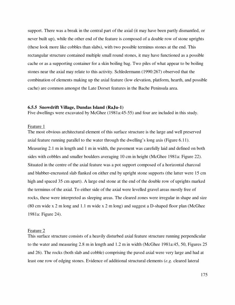
175
support. There was a break in the central part of the axial (it may have been partly dismantled, or
never built up), while the other end of the feature is composed of a double row of stone uprights
(these look more like cobbles than slabs), with two possible terminus stones at the end. This
rectangular structure contained multiple small round stones, it may have functioned as a possible
cache or as a supporting container for a skin boiling bag. Two piles of what appear to be boiling
stones near the axial may relate to this activity. Schledermann (1990:267) observed that the
combination of elements making up the axial feature (low elevation, platform, hearth, and possible
cache) are common amongst the Late Dorset features in the Bache Peninsula area.
6.5.5 Snowdrift Village, Dundas Island (RaJu-1)
Five dwellings were excavated by McGhee (1981a:45-55) and four are included in this study.
Feature 1
The most obvious architectural element of this surface structure is the large and well preserved
axial feature running parallel to the water through the dwelling’s long axis (Figure 6.11).
Measuring 2.1 m in length and 1 m in width, the pavement was carefully laid and defined on both
sides with cobbles and smaller boulders averaging 10 cm in height (McGhee 1981a: Figure 22).
Situated in the centre of the axial feature was a pot support composed of a horizontal charcoal
and blubber-encrusted slab flanked on either end by upright stone supports (the latter were 15 cm
high and spaced 35 cm apart). A large end stone at the end of the double row of uprights marked
the terminus of the axial. To either side of the axial were levelled gravel areas mostly free of
rocks, these were interpreted as sleeping areas. The cleared zones were irregular in shape and size
(80 cm wide x 2 m long and 1.1 m wide x 2 m long) and suggest a D-shaped floor plan (McGhee
1981a: Figure 24).
Feature 2
This surface structure consists of a heavily disturbed axial feature structure running perpendicular
to the water and measuring 2.8 m in length and 1.2 m in width (McGhee 1981a:45, 50, Figures 25
and 26). The rocks (both slab and cobble) comprising the paved axial were very large and had at
least one row of edging stones. Evidence of additional structural elements (e.g. cleared lateral

176
areas) were lacking and the possible dwelling’s size and shape could not be determined.
Figure 6.11 D-shaped Structure 1 from Snowdrift Village (RaJu-1) (adapted from McGhee
1981a: Figure 24). Note the large terminus or end stone directly north of the axial
feature.
Feature 3
This feature was also a surface structure and consisted of a well preserved axial feature running
parallel to the shoreline and measuring 3.8 m by 1 m (McGhee 1981a:50, Figures 27 and 28). The
axial feature was paved using medium and large slabs and had a double row of rounded boulders.
Two offset pot supports, each consisting of upright lamp supports flanking a horizontal blubber-
encrusted flat stone, were located. Levelled gravel areas to either side of the feature (90 cm in
width) were probably sleeping areas, a moss mattress was laid overtop of the gravel and was
preserved by the almost perennial snow-bank at the site (this deposit was supplemented by
additional modern moss growth). The edges of this vegetation were used to suggest the
outermost limits of the structure as no other signs of a perimeter (e.g. hold-down stones) were
present. A storage pit was found in one of the lateral sleeping areas. Possible stone guy wire
anchors, represented by piled stones, were located approximately 1 m from the northern and

177
southern ends of the axial feature.
Feature 4
This structure was also a surface dwelling and contained a paved axial feature with lateral border
stones, all constructed with slabs and cobblestones and measuring 2 m x 1 m (McGhee 1981a:50,
Figures 29-31). The comparatively short axial in this feature may be the result of stone scavenging
some time after the dwelling was abandoned as suggested by an asymmetrically located pot
support and amorphous scattering of stones near the west end of the axial (the side of which
appears to have been disturbed). The pot support was composed of a substantial horizontal slab
covered with a large amount of burnt fat (2 cm thick) and two flanking upright lamp supports
spaced 35 cm apart. The built-up fat layer on the hearth stone was covered by a small flagstone,
“perhaps by the housewife who hoped to preserve it for later use” (McGhee 1981a:50, Figure
30). Lateral sleeping areas, represented by cleared and level gravel areas measuring 1.2 m and 1.4
m in width, were present and each had a covering layer of moss and willow twigs that formed a
mattress. Similarly to Feature 3, many of the artefacts from this dwelling were found in close
association with the axial, and no peripheral marker was recognised.
6.5.6 RaJu-2, Dundas Island
Dwellings at the site involve two surface structures with axial features running perpendicular to
the water (McGhee 1981a:55-56, Figure 33). Only one axial was well preserved and measured 4
m by 60 cm, it was paved with slabs but lacked the edging stones found at the Snowdrift Village
site. At least one pot support was identified in the western part of the feature and consisted of two
upright lamp supports (it is unclear if these flanked a horizontal slab). A second hearth or pot
support may have been present in the eastern part of the axial, although there is no description.
Lateral sleeping areas consisting of levelled gravel were located on either side of the axial, these
each measured approximately 1.2 m in width.
6.5.7 Maze Village, Dundas Island (RaJu-3)
The site consists of three dwellings with axial features, as well as an isolated area of square paving
measuring 3 m on each of its sides with a possible hearth (indicated by a burnt blubber

178
concentration) located in one corner (McGhee 1981a:56, Figure 34). The largest of the three axial
structures ran parallel to the shoreline and measured 3 m by 80 cm, it was paved and lined with
stones (some of which had been displaced). At least one centrally-located hearth was located in
the axial (associated with one standing lamp support) and a second hearth may also have been
present at one end of the feature. Sleeping areas were present but were not as clearly marked as at
Snowdrift Village. A second axial feature was perpendicular to the coast and was apparently
identical to that described previously, except it had a large terminus stone at either end of the axial
arrangement. A third axial structure was poorly preserved and pointed to the water.
6.5.8 RaJu-4, Dundas Island
Three surface structures with axial features were located, two of which ran parallel to the shore
while the third and smallest example was perpendicular to the water (McGhee 1981a:56). No
excavation was conducted at the site although the lack of vegetation meant that below ground
probing was not necessary to record the architectural information. The smaller perpendicular axial
measured 3 m x 1 m and was carefully paved with horizontal slabs and lined by two rows of
rectangular cobbles. Two pot supports were identified (the supports for each were about 30 cm
apart) and a single terminus stone was present at one end of the axial. The second axial was 4 m
by 80 cm and also had pot supports, although these were spaced 50 cm apart to presumably
accommodate larger vessels. As with the first axial, a single end stone was placed at one end of
the feature. The third axial was 5 m x 90 cm and constructed similarly to the other at the site (this
feature also had pot supports placed 50 cm apart for larger vessels) and there was only one end
stone present.
6.5.9 McCormick Inlet, Melville Island (QkPa-1)
Discovered and described by geologists (Henoch 1964; Taylor 1964b), the structure represents
the most north-westerly Late Dorset site currently known. The rectangular surface structure
measured 4.5 m by 5.2 m and was defined by a low gravel berm. Inside was an axial feature 1.2 m
in width which ran along the short axis of the dwelling; it was paved with non-contiguous stones
and set off by a double row of slab stone uprights (Henoch 1964: Figures 3 and 4). Two areas of
fire were recorded, the first was near the centre of the axial and appears to involve a lamp

179
platform (a 5 cm deep depression in the stones was noted, although it is unclear from the
description if this was natural or artificial), and an offset hearth area indicated by “smoke” stained
(burnt blubber?) stones. On either side of the axial were sleeping zones, one radiocarbon date on
material from the lamp platform (Table 6.1) confirmed a Late Dorset affiliation.
6.5.10 Tote Road, North Devon Lowlands, Devon Island (QkHn-37)
A buried axial pavement 2.5 m in length and 50 cm in width was located via test pitting (Figure
6.2b). The axial feature (Helmer 1991:313, Figure 15) was fully excavated and made with large
and small slabs, there are no indications that vertically-placed stones were used to define its long
axis, nor does it seem that internal divisions, hearths, or other elements were present. Using
apparent hold-down stones as a guide it appears that the axial feature was situated along the short
axis of a sub-rectangular dwelling (presumably a surface structure as no signs of a sunken living
floor are mentioned) measuring approximately 3.5 m by 4.5 m. A radiocarbon date on driftwood
suggests the structure belongs to the Transitional period (see Chapter 4.4), although its elevation
and artefacts indicate a Late Palaeoeskimo (i.e. Late Dorset) affiliation.
6.5.11 Arvik, Little Cornwallis Island (QjJx-1)
The site has a very thin vegetation cover making most architectural features clearly visible without
necessitating excavation (LeMoine et al. 2003). Radiocarbon dates suggest occupation early in
Late Dorset (Table 6.1), although some diagnostically later Late Dorset artefacts also indicate the
site, containing both surface (equated with warm season use by the authors) and semi-
subterranean structures (cold season structures), also saw use at the end of the period.
Feature 9
This structure was defined by a low gravel berm enclosing a vegetated shallow semi-subterranean
interior measuring about 5 m by 4 m (LeMoine et al. 2003:269, Figure 12). Some kind of central
feature positioned at a 90° angle to the water had evidently been built at the time the dwelling was
occupied, however most of the stones had been removed for probable recycling at another
structure. Although not identified as such in the excavation plan (LeMoine et al. 2003: Figure
12), a break in the northern wall berm may represent an entrance (if this is the case, it would

180
rather unusually not provide a waterfront view, refer to Chapter 10.2.1).
Feature 12
This feature was a surface structure defined by a broken ring of hold-down stones with an
approximate diameter of 4 m (LeMoine et al. 2003:260, 263, Figure 6). No internal features were
present and the recovered faunal assemblage (predominantly seal and fox) suggests a cold season
resource base, although a warm season occupation was assumed based on the architecture.
Figure 49
Unlike Feature 9, the only other semi-subterranean structure excavated at this site, Feature 49
was very well preserved and was subsequently reconstructed (LeMoine et al. 2003:269, 271, 273-
275, Figures 13-15). Feature 49 was surrounded by a low gravel berm outlining a relatively
heavily vegetated and shallowly depressed interior measuring 4.5 m by 4 m. It is believed that this
abundant vegetation cover resulted from the breakdown of the structure’s sod walls, which
subsequently ‘melted’ into the interior depression (some formed turves were still identifiable in the
interior). The axial feature was laid along the dwelling’s short axis and was framed by a double
row of upright slabs (the only axial at the site to include this element) measuring 4 m x 1 m. The
interior of this feature was carefully paved with horizontal flagstones and contained two evenly
spaced pot supports, each comprised of two uprights with notched tops. A large flat anvil stone
complete with its cobble hammerstone was also built into the axial feature.
Direct evidence concerning the superstructure’s roof framework was identified, as whale
bones occurred both in situ, as a post near the rear of the dwelling, as well as in secondary
position (represented by fragmentary rib sections) inside and behind the structure. A dome-shaped
roof was indicated, possibly created by angling rib bones upward to a horizontal ridge pole which
would have given the structure a broad and flat shape (LeMoine et al. 2003:275) similar to a
Thule whale bone structure reconstructed at Brooman Point (McGhee 1984a:21, Figures 14 and
15). Reconstruction efforts also revealed that the structure’s construction had involved significant
energy and time (LeMoine et al. 2003:273-275). The reconstructed entrance was positioned at
the front (shoreward) end of the axial feature. A single radiocarbon date (Table 6.1) indicated this
structure was constructed during the earliest occupation of the site.

181
Feature 53
A lightly constructed surface structure was interpreted as a warm season tent ring defined by a
discontinuous oval of hold-down stones measuring 4 m by 3 m (LeMoine et al. 2003:260, Figures
4, 5a, and 5b). Internal features consisted of two lamp platforms, one each in the northern and
southern halves of the structure, each marked by a slightly concave surface with reddening from
heat exposure. Affiliated with the southern lamp platform, whose surface was pecked to create a
shallow concave top, were two hearths made of small flat stones. Each hearth was composed of
two slabs set on end to create a V shape around one end of a horizontally-laid smooth stone. The
excavators suggest that the two upright stones may have acted as windbreaks. At least one hearth
contained burnt blubber and other materials.
6.5.12 Tasiarulik, Little Cornwallis Island (QiLf-25)
Excavated structures include a number of surface tent rings and shallow semi-subterranean
structures equated with longer-term cold season use (LeMoine et al. 2003:258, 267).
Feature 30
This dwelling is believed to be a warm season surface tent ring with peripheral hold-down stones
indicating an oval interior measuring 5 m by 5.5 m (LeMoine et al. 2003:263, Figure 7). A
possible cache (represented by a rectangular group of slabs) and a centrally located hearth area
(suggested by a fire-reddened stone and cluster of cobbles) were identified, and a large number of
flakes and other cultural materials were excavated from the interior and affiliated midden.
Feature 59
This structure was defined by low gravel berms surrounding a shallowly excavated rectangular
interior measuring approximately 4.5 m by 4 m (LeMoine et al. 2003:267, Figure 10). An
entrance could not be identified although an axial feature running along the dwelling’s long axis
and perpendicular to the shoreline was present and made of medium-sized boulders. LeMoine et
al. (2003:276) note the axial in this feature was fairly typical of those at the site in that it lacked a
double-row of flanking border stones. However, the feature was unique in that the stones used
were discontinuous so that they created an interrupted and seemingly less functional pavement
about 1 m wide. Three hearth areas, located at the approximate centre and near the ends, were

182
recognised based on the presence of heat-altered stones and some burnt bone and blubber.
Feature 74
The dwelling was defined by low gravel berms framing a shallow interior depression measuring 4
m by 4 m, a cobble axial feature was located inside (LeMoine et al. 2003:267, 269, Figure 8). The
axial feature, which measured 4.5 m x 70 cm and pointed to the water, was more continuously
paved than Feature 59 and contained at least two hearths and perhaps as many as three. The
structure had suffered some post-abandonment disturbance, both natural and human-caused, and
it is apparent that some architectural stones had been removed for reuse elsewhere.
Feature 90
Although perimeter hold-down stones were completely absent from this surface feature (size
could not be determined), it is interpreted as the remains of a tent ring (LeMoine et al. 2003:263,
266, Figure 9) on the basis of vegetation cover, the presence of a slab hearth, and an artefact
concentration. The excavators suggested the remains did not represent those of a snow structure
given that the feature contained an internal hearth. They observe that such features would be of
little practical or functional use in a snow dwelling (refer to Section 9.4.3) and that architecturally
similar structures interpreted as snow structures do not contain immobile heat sources
(e.g. Ramsden and Murray 1995).
Feature 91
This is the smallest semi-subterranean structure excavated at the site, with interior measurements
of only 2.5 m by 3 m (LeMoine et al. 2003:269, Figure 11). As with Features 59 and 90, Feature
91 was surrounded by a low gravel wall, was shallowly excavated into the subsoil, and contained
a midline axial feature running along the shorter axis. The feature was oriented at a right angle to
the water and made of large boulders with two hearth areas. Architectural stones had evidently
also been removed from this dwelling for use elsewhere on the site.
6.5.13 Brooman Point, Bathurst Island (QiLd-1)
It appears that the majority of the Late Dorset occupation at this site was disturbed by the
construction of 20 large Thule Inuit semi-subterranean sod and whale bone structures and

183
associated features beginning early in the Neoeskimo occupation of the Eastern Arctic and
continuing for several generations (McGhee 1984a). Five shallow semi-subterranean Late Dorset
structures were identified away from the main locus of Thule activity and were excavated
(McGhee 1996:213-229, 1997), their contents were subsequently used to support the possibility
of direct Late Dorset – Thule interaction at or near the site (refer to Chapter 5.4.4). The
structures themselves are described by McGhee (1997:210-211) as sub-rectangular, shallowly
excavated (10 cm – 15 cm), and lacking identifiable internal features. Relatively few artefacts
were located in the dwellings, their associated middens were thin and poor, and a short-term
summer season of occupation was proposed (McGhee 1996:213).
6.5.14 Summary
Well over half of the structures reported from the High Arctic are surface dwellings. Visibility
may partially explain the prevalence of surface dwellings in this region as the vast majority of the
High Arctic is classified as Polar Desert and supports very limited vegetation (see Bliss et al.
1973; J.B. Maxwell 1980:13) that would otherwise reduce site and structural visibility (although
other factors may also be at work). The dimensions and shape of a number of these surface
dwellings could not be determined as perimeter markers were often absent or too heavily
disturbed. Rectangular and square forms dominated the semi-subterranean structures while all of
the circular or oval dwellings were identified as warm season occupations. Axial features were
frequently located in the dwellings and exhibit a range of forms including the use of slabs or
cobblestones and the variable occurrence of a double row of upright stones, internal paving,
hearth areas, pot supports, and terminus or end stones. Other than the axial feature, the most
frequently identified internal element were cleared lateral zones interpreted as sleeping areas.
Where internal dimensions could be established, liveable interior space most commonly ranged
between 12 m2 and 22 m
2 (although some features were considerably smaller, see Figure 10.6).
No entrance passages were described and no interior paving (outside of the axial feature) was
reported from any structure.
6.6 Late Dorset Architectural Remains from Greenland
The known geographic distribution of Late Dorset sites in Greenland is quite restricted in

184
comparison to earlier occupations, some of which covered virtually the entire coast (see Chapter
4). Late Dorset sites are thus far only reported from north-western Greenland (Inglefield, Hall,
and Washington lands) where it is separated from Ellesmere Island by narrow stretches of water
(Figure 6.9). This distribution is not surprising considering current evidence indicates Greenland,
like the Canadian High Arctic, was depopulated throughout the preceding Middle Dorset era.
Late Dorset in Greenland undoubtedly represents an expansion eastward from Canada as a part of
the general post-1500 B.P. repopulation of the High Arctic (see Chapter 5.3.1).
Architectural information on the Late Dorset remains located in Washington Land are
currently only available in Danish (Andreasen and Lange 2000). Andreasen (2003:297) notes they
are comparable to those excavated in Inglefield Land but does not provide further detail. The Hall
Land sites were all recorded or revisited by Eigil Knuth and reported in Grønnow and Jensen
(2003). Only one dwelling feature is illustrated (Kap Buddington; Grønnow and Jensen 2003:
Figures 2.2 and 2.3), however other than an axial feature set off by a double line of stone
uprights, no architectural information can be discerned. Given this situation, only the Inglefield
Land features can be included in this discussion of Late Dorset architecture.
6.6.1 Qeqertaaraq, Inglefield Land
Two Late Dorset domestic structures were excavated at the main Qeqertaaraq site as part of the
Gateway to Greenland project (Appelt and Gulløv 1999:7-20). A third structure, Snowdrift, is
located on the south-western extreme of Qeqertaaraq and is treated in the subsequent sub-section.
Structure 1
Appelt and Gulløv (1999:7-11) describe the dwelling’s pre-excavation appearance as sub-
rectangular and semi-subterranean. The depression, which was excavated 40 cm into the subsoil,
measured 4 m by 5 m when encountered and was outlined by a slight gravel berm. Three discrete
occupation horizons (Phases 1 – 3) were identified during excavation, with each episode of use
slightly modifying the structure’s architecture (none of these phases are illustrated).
Phase 1 is the oldest occupation (Table 6.1) and is associated with three internal features:
a semi-circular platform of gravel approximately 2 cm thick and measuring 2.2 m x 1.1 m along
the western long axis; a fat concentration in the central area of the dwelling associated with an

185
upright stone lamp support (its probable mate was found 80 cm away); and a turf wall 20 cm in
height and between 11 cm and 12 cm in width along the north-western and western walls. Using
the remnants of this wall as a guide, it appears that the dwelling measured approximately 3.6 m by
3 m during Phase 1. The excavators felt that the entrance located in the southern wall was a cold-
trap variety that was positioned between 10 cm and 15 cm below the interior floor level (Appelt
and Gulløv 1999:8). A presumed workspace was identified in the eastern half of the dwelling,
where there was no gravel cushion, based in part on a higher density of artefacts.
Structure 1 was enlarged during Phase 2 to the size (4 m by 5 m) observed at excavation.
Expansion appears to have occurred along the south-eastern part of the structure as this area did
not have a sod wall. Rather than rebuilding the sod wall along the dwelling’s new limits it
appears that the structure’s occupants instead constructed a stone wall. A possible sleeping area
may have been present in the western part of the structure given an overall lack of artefacts. This
phase of use was not radiocarbon dated.
The Phase 3 occupation, which was reported as being difficult to distinguish from earlier
uses, appears to have been brief. The only recognised architectural alteration was the addition of
an area of paving (in several layers) in the north-western interior. This phase was not dated.
Structure 4
Appelt and Gulløv (1999:11-20) describe this 4.75 m x 5.25 m feature as an almost square semi-
subterranean dwelling between 30 cm and 40 cm below the modern ground level and surrounded
by a low gravel berm (Appelt and Gulløv 1999: Figures 4 and 8). As with Structure 1, multiple
occupation horizons were identified (Upper, Lower, and Lowest level, although the Lowest level
may not represent a separate occupation episode, refer to Appelt and Gulløv 1999: Figure 13).
Subsequent to its abandonment a Thule tent ring was built over the western part of the dwelling,
although it caused minimal disturbance.
The Upper level is the most recent and was suggested by Appelt and Gulløv (1999:19) to
date near the close of the 13th century AD (the excavators question the accuracy of the
radiocarbon dates, listed in Table 6.1, which were obtained from these deposits). The dwelling’s
perimeter walls were made of gravel displaced when the structure was excavated and an entrance
was positioned on the western wall, which was much less robust than the others. A turf deposit up

186
to 1 m in width and containing large stones and bones extended inward from the north and
especially eastern walls (Appelt and Gulløv 1999: Figure 5), the directions from which the
predominant winter winds blow. The excavators believe this sod deposit was purposefully placed
here to help insulate the dwelling from these winds (refer to Chapter 3.3.4 for discussion of sod’s
insulation value). Near the northern wall was a three-sided paved stone box that may have
anchored a roof support, while an intermittent area of paving near the sod / bone / stone wall liner
hosted an activity area. In the western part of the dwelling, where there was no flagging, was a
sleeping area. A fragment of a European bronze bowl and a Thule ivory doll and arrowhead
(Appelt and Gulløv 1999: Figure 7) hint at extra-cultural contacts between Late Dorset and newly
arrived populations (see Chapter 5.4.7).
The Lower level of Structure 4 is suggested to date to the 11th century AD (Appelt and
Gulløv 1999:20; Table 6.1), when a series of pits 10 cm – 20 cm deep and filled with dark and
greasy soil were dug along the west-east long axis of the dwelling (Appelt and Gulløv 1999:
Figure 8). Although the excavators do not propose this, the linear midline pit feature is suggestive
of a ‘negative’ central feature (see Section 6.3.2 and Figure 6.2c). To the north of the pit feature
was an activity area, while a sleeping area measuring about 1 m by 4 m was situated to the south
of the midline row of pits. The excavators indicate the perimeter walls associated with the Lower
level occupation may have been lined with sods, although this was not definitive.
The linear arrangement of pits was still present in the lowest and oldest level (Appelt and
Gulløv 1999: Figure 10), as was the southern sleeping area. A small number of artefacts were
located; all diagnostic specimens were Late Dorset.
6.6.2 Snowdrift, Inglefield Land
Located at the southern limit of the Qeqertaaraq site was a single structure, so named for the
nearby snowdrift which helped preserve its organic component (Zimmermann 1999:20-23). The
structure was square and measured 3.5 m x 3.5 m from the interior of the turf walls which still
defined the dwelling (Zimmermann 1999: Figure 17). These walls, ‘melted’ to 5 cm in height and
40 - 100 cm in width when observed, are thought to have been around 15 cm - 20 cm in height
and approximately 30 cm wide when first built. The structure was oriented to the water and an

187
axial feature with thick upright stone slabs defined a 70 cm wide paved interior. Photographs of
the axial indicate it was not particularly carefully made and the upright stones seem to have been
laid onto, rather than set into, the ground (Zimmermann 1999: Figures 17 and 18). Near the
centre of the axial was a horizontal lamp platform with a 30 cm by 40 cm circular depression,
rimmed in burnt blubber, pecked into its surface (Zimmermann 1999: Figure 18).
Two blubber encrusted stone lamp supports were also located. Neither was in primary
position (these may have originally flanked the lamp platform); one was leaning against the outer
face of the axial near the lamp platform while the other was found some distance from the axial.
The form of the illustrated support (Zimmermann 1999: Figure 18) differs from those reported
elsewhere as its top was ‘horned’, possibly due to the narrow width of this particular support
stone (which cause the notch to extend completely across its top, rather than ending in the middle
as is more common, e.g. Figure 6.4b). The areas to either side of the axial were cleared of stones
and were probably sleeping zones.
6.6.3 Qallunatalik / Polaris, Inglefield Land
Four or five rectangular to square structural depressions outlined by low gravel berms are visible
at the site and Feature 1 was excavated and very well described by Grønnow (1999:42-62).
Feature 1 was semi-subterranean and excavated approximately 20 cm below the top of low broad
wall berms (depth below ground surface was not noted). The perimeter berms measured 50 cm in
width and were still remarkably intact, as indicated by their interior margins which still formed a
sharp angle from their top down to the floor. The dwelling’s internal dimensions were 3.6 m by
5.1 m and it seems likely that a turf wall, at least partially composed of cut ‘bricks’, had been
constructed along the edge of the living floor against the inner wall of the depression.
Although partially disturbed, an axial feature measuring 1 m in width and running along
the long axis from wall to wall was present. It is difficult to determine how much of the axial was
framed with stone uprights as some appear to be missing, although it seems that most of the
southern edge of the axial was so lined (Grønnow 1999: Figures 43 and 44). Nearest to the
apparent entrance (in the west of the structure) the axial was heavily built with uprights (including
a terminal end stone) and carefully fitted horizontal paving stones. A large flat slab set

188
Figure 6.12 Structure 1 from the Qallunatalik / polaris site, Greenland (adapted from Grønnow
1999: Figure 44). Note the concentric burnt blubber mark on the lamp platform
which indicates the size and shape of the vessel.
in this part of the feature served as the lamp platform and had a shallow depression measuring 20
cm by 40 cm pecked on to its surface, the edge of the hollow was encrusted with burnt fat (see
Figure 6.12). A stone pot support of a form similar to that from the Snowdrift site (above) was
found near the lamp platform. The central area of the axial was either not paved or had many of
Figure 6.12 Feature 1 from the Qallunatalik / Polaris site, Greenland (adapted from Grønnow
1999: Figure 44). Note the concentric burnt blubber mark on the lamp platform which
indicates the size and shape of the vessel.

189
its stones moved after abandonment, while further down the feature was a single fire-cracked
paving stone around which a 1 m diameter concentration of small and medium-sized gravel had
been spread (Grønnow 1999: Figure 48). The rear part of the axial was paved with thin friable
paving stones and lined with the remains of stone uprights (including an end stone).
Outside of the axial were two lateral zones which had been cleared of larger stones. A layer of
small and mid-sized gravel had been evenly spread over the southern area; no gravel was present
north of the axial feature although numerous twigs suggest a mattress had once been present and
that this space was the sleeping area. The structure’s entrance was in the western wall facing the
water so that people entered directly into the northern part of the structure where the matrix was
somewhat compacted. Two large (50 cm - 60 cm) stone slabs found in secondary context on top
of the axial feature near the entrance may represent ‘jambs’ (stones which were originally set
vertically to frame the door). Two shallow pits located in the northern sector of the dwelling near
the entrance were thought to be inadvertently caused by unintentional wear and tear as people
entered / exited the structure.
6.6.4 Summary
Four Late Dorset domestic structures, all from Inglefield Land, have been reported in sufficient
detail to be incorporated into this study. With the exception of the dwelling from the Snowdrift
component of the Qeqertaaraq site, all of the dwellings are semi-subterranean, whereas the
Snowdrift structure was defined by raised sod walls. All of the structures were rectangular or
square in plan view, while two (Snowdrift and Qallunatalik Structure 1) had well defined stone
axial features formed with both upright and paving stones. Interestingly, the Qallunatalik
dwelling’s axial feature also had an end stone, similar to examples from the Canadian High Arctic
(see previous section). Both stone axial features also possessed lamp platforms with pecked
depressions, as well as at least one pot support. Structure 4 at the Qeqertaaraq site may have
contained a ‘negative’ central feature defined by a linear group of pits. All of the dwellings
contained lateral cleared areas, some of which were interpreted as sleeping areas. Sod was used in
all of the dwellings to create or supplement the wall berms (or to form the wall in the case of the
Snowdrift structure). The three semi-subterranean dwellings also exhibited definable entrances,

190
and the one located at Qeqertaaraq Structure 1 could function as a cold trap. Dwelling size varied
between 12 m² and 25 m² (mean 18.55 m², median 19.18 m²).
6.7 Late Dorset Architectural Remains from Labrador
Much of the archaeology done in Labrador was conducted during the 1970s and was primarily
oriented to defining the region’s basic cultural sequence (e.g. Fitzhugh 1972, 1976b, 1976c,
1978a; Tuck 1975, 1976a; Cox 1977, 1978; McGhee and Tuck 1975; Kaplan 1983). While this is
an important first step in the archaeological investigation of any region and laid the framework for
subsequent work in Labrador, this approach has meant that much of that archaeology was not
conducted using strategies effective for investigating architectural remains. Specifically, large-
scale horizontal excavations useful for exposing most or all of a dwelling’s architectural elements
were not always a priority, with the result that a limited sample of structures from seven sites are
described in sufficient detail to be used in this analysis (Figure 6.13).
6.7.1 Avayalik-1 (JaDb-10)
This site is located on the easternmost of the three islands making up the Avayalik Islands, which
are located approximately 25 km south of the tip of the Labrador Peninsula (Figure 6.13).
Multiple depressions were visible on the vegetated terrace and the most clearly defined was
chosen for excavation, revealing a Late Dorset dwelling that had been dug into an earlier Middle
Dorset structure and midden (Jordan 1980; Fitzhugh et al. 2006).
Once cleared of vegetation and stones moved about due to post-occupancy caching
activities, a rectangular semi-subterranean structure measuring 3 m by 3.75 m was revealed.
Perimeter walls consisted of layers of sods and stones and the superstructure was apparently
framed with driftwood (Jordan 1980:616) although none is shown in a plan photograph (Jordan
1980: Figure 6). The covering was suggested to have consisted of skins and / or sods, however
the relatively thin vegetative overburden would seem to argue against the extensive use of sod. An
axial feature constructed with heavy (15 cm – 20 cm thick) upright slabs and boulders ran along
the long axis from wall to wall and measured about 80 cm in width (Jordan 1980: Figure 6). The
axial feature was paved with large and small slabs but there was no evidence of a hearth or
internal subdivisions. Outside of these uprights, and running the full length of the axial feature,

191

192
was a narrow strip of paving stones; beyond this pavement were areas of gravel and small stones
interpreted as sleeping areas. A cache built of stone uprights was constructed near one of the
walls and held lithic raw materials. An entrance was not located and a comparatively short
occupation was inferred given the small number of artefacts and thin cultural layer.
6.7.2 Peabody Point (IiCw-1)
The site is located in Seven Islands Bay near the mouth of Komaktorvik Fjord (Figure 6.13).
Nagle (1984:242-244) reports a single semi-subterranean sub-rectangular structure defined by a
sod wall berm measuring 4 m by 4 m. An axial feature composed of paving stones but without a
double row of stone uprights was reported; no evidence of hearths was identified. A fall and / or
winter occupation was suggested based on the use of sod walls and the sunken floor, as well as
the site’s protected location. Two dates from the structure (Table 6.1) are thought to be about
300 years too old for the recovered artefact assemblage.
6.7.3 Big Head 6 (IiCw-8)
Three semi-subterranean depressions were identified at this site, located 5 km west of Peabody
Point in Seven Islands Bay (Nagle 1984:244-246). Houses 1 and 2 were excavated and revealed
to be 4 m circular dwellings containing undescribed axial features. Nagle (1984:245) suggests that
the two structures were contemporary based on similarities in the style of artefacts and
architecture, although two radiocarbon dates (Table 6.1) do not support this interpretation. A fall
/ winter occupation was inferred based on the site’s sheltered location.
6.7.4 Beacon Island 5 (IiCv-6)
Located approximately 6 km east of Peabody Point and Big Head 6, this site contained three
cobblestone pavements measuring about 2 m on each side (Nagle 1984:246-248). Structures 2
and 3 were excavated and a thin 5 cm cultural deposit was encountered within and under the
paving. Nagle was unsure of the function of the pavements, suggesting they might have formed a
platform for either skin tents or snow structures. A mid-winter or early spring occupation was
suggested based on site location, which differed from the supposed fall / winter Peabody Point
and Big Head 6 sites. The single date from Structure 2 (Table 6.1) is on sea mammal fat and is

193
probably too early, although it does indicate the structure was occupied late the Late Dorset era.
Nagle suggests all three structures were contemporaneous given their proximity to one another.
6.7.5 Shuldham Island 9 (IdCq-22)
The site is located on the south-western corner of Shuldham Island, at the head of Saglek Bay
(Figure 6.13). Three Late Dorset structures were excavated, although House 1 is not considered
further given that it was heavily disturbed during construction of a later Thule Inuit dwelling.
House 2
House 2 (Thomson 1988:72, 86-89; Figure 6.14) was visible prior to excavation as a 20 cm deep
oval depression measuring 4.75 m by 4 m, with the longer axis pointed to the water (Thomson
1988:72). Raised sod walls were present along the rim of the depression, although it is unclear if
these relate to House 2 or to a later Thule Inuit qarmat or tent which was constructed overtop of
the Dorset dwelling (the Neoeskimos probably also cut sod from inside House 2 for their own
structure). However, unlike House 1, House 2's architecture was not affected by this later use.
House 2 contained a paved axial feature with a double row of stone uprights measuring 4 m by 1
m which divided the interior into two lateral paved zones measuring 2 m and 1 m in width
(Thomson 1988: Figure 11). Two distinct paving layers were actually located (refer to Figure
6.14), suggesting that the structure had been renovated at least once, probably soon after it was
originally constructed (remnants of an axial feature 1 m south of the intact axial may relate to this
earlier usage). The axial feature was constructed of thick upright slabs and evidence was located
for two hearth areas in the form of concentrations of burnt fat and charcoal.
A heavy horizontal slab was laid on the outermost (eastern) side of the southern paved
area facing the water and may mark the location of the entrance (see Figure 6.14). There was a 30
cm vertical difference between this slab and a smaller area of paving extending outward from the
main part of the structure which Thomson (1988:74) suggests may represent the beginning of a
cold-trap entrance or, alternately, a food cache. To the east of the small secondary area of paving
was a large overturned slab (not illustrated in Thomson [1988: Figure 11]) that Thomson suggests
may have supported part of the roof and a lintel or threshold stone when upright.

194
Tent Ring 1
Tent Ring 1 was reported as D-shaped and was very large, measuring 9 m in length and between
4 m and 8 m in total width (Thomson 1988:77-79). The structure, which was not illustrated, was
defined by one row of anchoring stones and the central interior area appears to have been at least
partially paved with stones that were decomposing when excavated. An entrance facing the water
was identified by a 1 m long double row of stones extending outward from the main line of the
structure (this suggests some form of covered, or at least walled, entrance passage). The presence
of several hearths inside the dwelling was noted but these were generally not described, although
Thomson (1988:79) does mention at least one notched stone indicative of a pot support. Multi-
Figure 6.14 Shuldham Island 9 (IdCq-22) House 2 (adapted from Thomson 1988: Figure 11).

195
family use in the spring or fall immediately before or after more substantial dwellings were
required was suggested (Thomson 1988:79) based on the structure’s large size (estimated to be
between 55 m2 and 60 m
2) and the presence of multiple hearth areas. This suggests that Tent Ring
1 may represent the Palaeoeskimo equivalent of a qarmat-type dwelling. One radiocarbon date
from inside the feature places the occupation early in the Late Dorset period (Table 6.1).
6.7.6 Okak 3 (HjCl-3)
The structure on Okak Island is currently the most southerly known Late Dorset dwelling in
Labrador (Figure 6.13) and is located just south of the tree-line. The rectangular semi-
subterranean structure was excavated 50 cm into the subsoil and was relatively large, measuring 7
m – 8 m in length and 6 m in width (Cox 2003:429, 432, Figures 11-13; Figure 6.15). The north
and west margins were well defined by sod and stone walls with an acute interior angle.
Cox (2003:429; Figures 11 and 13) refers to the dwelling’s axial arrangement, oriented
along the long axis, as the most elaborate of any thus far seen in the Labrador Late Dorset period.
Defined by upright slabs varying in thickness between 8 cm and 15 cm, the axial ranged between 2
m and 2.5 m in width and was approximately 5 m in length (ending 1 m – 2 m before the walls).
Its interior was paved with flat slabs and the floor outside of the stone uprights was also paved
along the length of the feature to a maximum width of almost 1 m (Figure 6.15). On either side of
the axial feature and extending from the outer paved strip was a 1 m wide area of sand and pea
gravel containing few rocks, both areas were interpreted as lateral sleeping platforms.
Two hearths were recognised inside the axial feature. The southern pot support was
composed of an upright notched stone abutting a horizontal stone. A V-shaped deposit of burnt
blubber was located on this base and probably reflects the lamp’s approximate size and shape. In
the northern part of the axial feature was a second pot support created by flanking a base stone
(covered with charcoal) with two stone uprights at either end (only one of these was notched on
its top). A third pot support, consisting of a single upright and base stone, was located outside of
the axial feature and to its east (Figure 6.15). The density of tools and range of radiocarbon dates
(Table 6.1) suggests that the structure had been occupied repeatedly over a relatively long period.

196
Figure 6.15 Semi-subterranean structure with heavily built axial feature at Okak 3 (HjCl-3)
(adapted from Cox 1978: Figure 7a). Note paving stones bordering the axial
feature’s outer edge.
6.7.7 Summary
The majority of described Late Dorset structures from Labrador are semi-subterranean (n = 6).
Three of the dwellings for which shape could be determined were rectangular or sub-rectangular,
three others were round or oval, and one was D-shaped (the shape of the other features could not
be identified or was not reported). Axial features were present in six semi-subterranean dwellings;
the four which were described in detail were reported as being internally paved. Three of the four
axial features also possessed a double row of stone uprights, although the presence of hearth areas
and / or pot supports within the axial features was quite variable. Paving and / or cleared lateral
areas were relatively common amongst the structures, and two probable entrance passages (one
possibly a cold-trap) were located. The use of sod and stone in wall construction appears to have
been a regular technique and dwelling size varied from about 11.25 m² to over 55 m² (mean 28.38
m², median 14.92 m²).

197
6.8 Discussion
The following sections attempt to interpret the architectural remains summarised in the preceding
sections and begin to set the stage for a more holistic analysis of this technology using elements of
the chaîne opératoire approach outlined in Chapter 2. By producing a multi-regional synthesis of
Late Dorset architectural technology it is possible to better understand the extent and nature of
the variability and patterning seen therein (and discussed in the following subsections). Once this
has been achieved, the study changes focus for the next three chapters (Chapters 7 – 9) to present
the in-depth analysis of three Late Dorset dwellings from three different areas of the Eastern
Arctic. These case studies, which consciously integrate details of the local and regional
environment and resource base into the interpretation of architectural remains, are intended to aid
in understanding on a more detailed scale how people were influenced by their surroundings (both
physical and social) when operating within their overall technology of architecture.
6.8.1 Chronological Developments?
It is difficult to assess whether the various dwelling forms and architectural elements produced
and used during the Late Dorset span can be linked in any meaningful way to chronological
developments. In addition to the usual radiocarbon issues in the Arctic (see Chapter 5.2), there is
another very real problem which complicates our ability to arrange the Late Dorset dwellings
described previously in a chronological sequence. This relates directly to the fact that complete
Late Dorset sites (e.g. all of the sites on Dundas Island), not merely individual structures located
therein, lack even a single radiocarbon date. In the absence of absolute dates, artefact styles have
been used to suggest a general range of occupation for some of the sites although such relative
methods, which are not without their difficulties and chronological assumptions (e.g. Odess
1998:421-422), require diagnostic artefacts such as harpoon heads be present. The general lack of
temporal control within Late Dorset is especially severe in the High Arctic where only seven
structures included in this analysis were directly dated (Table 6.1).
Issues of chronological control and temporal placement are further exacerbated by the fact
that the age of only nine structures has been determined using more than one radiocarbon date
(Table 6.1). Relying on single dates to order dwellings is risky because an unknown number of
these estimates may be unrecognisably ‘off’. This can occur if, for example, a result falls within

198
the Late Dorset range but erroneously places occupancy at the end of the period instead of at the
beginning, or vice versa. This situation appears to have happened when Structure 4 at the
Qeqertaaraq site (Section 6.6.1) was radiocarbon dated. Eight samples, collected from distinct
occupation phases, were submitted for radiocarbon dating and all of the results fell within the
expected Late Dorset time-frame. Results from the earliest phase of use indicated occupation
during the early-middle part of the period, circa 1300 B.P. – 1100 B.P., and the more recent
occupation was dated between about 900 B.P. and 550 B.P. (Table 6.1).
However, several of these dates did not agree with the interpreted stratigraphy, nor with
the occurrence of three foreign artefacts (two Thule and one Norse) found in the upper deposit.
Facing a discrepancy between absolute and relative dating methods, the excavators (Appelt and
Gulløv 1999:19-20) disputed the radiometric results, suggesting instead that the oldest occupation
probably occurred around 1100 AD or 850 B.P. (corresponding with dated samples AAR-3221
and K-6706, Table 6.1), and the second use of the structure occurred at the end of the 13th
century AD, circa 650 B.P. (agreeing with samples AAR-3218a and AAR-3218b, Table 6.1).
This is a significant inconsistency and indicates how dating imprecision within the Late Dorset
period can potentially undermine attempts to explore architectural variations and consistencies
from a chronological perspective.
Considering these issues, it is prudent to speak only very generally of chronological
developments and the results are by no means conclusive. Shown in Figure 6.16 are all of the
directly dated dwellings described in the previous sections, these are subdivided into regions. The
oldest structures are located in the Low Arctic, where Late Dorset is thought to have developed
and where the oldest occupations are expected to have been located. The High Arctic and
Labrador appear to have been occupied shortly thereafter, consistent with a rapid population
spread outward from the core area (refer to Chapter 5.2 and 5.3.1). In Greenland, the pre-1000
B.P. dates have been challenged and the dwellings are suggested to have been occupied from 850
B.P., coincident with the Oldsquaw (SiFk-18) site on Ellesmere Island (Table 6.1). Looking first
at the early end of the period (excluding Qeqertaaraq Structure 4), three structures from three
different regions of the Arctic date to around 1400 B.P. These are Structure C from the Tuvaaluk
site in the Low Arctic, Feature 49 from the Arvik site in the High Arctic, and Tent Ring 1 from

199
the Shuldham Island-9 site in Labrador. Despite the possibility that they were occupied
contemporaneously they share little in common and all described architectural elements are known
throughout Late Dorset, as well as during earlier periods (Appendix A). Even the axial features,
which frequently receive so much attention that Jensen (1998:60) has referenced a “tyranny of the
mid-passage”, show little conclusive variance regarding orientation to / from the coast, a
preference for extending fully across a structure versus ending partway, or possessing or lacking a
double row of stone uprights.
At the other end of the Late Dorset period are eight post-800 B.P. dwellings (Figure 6.16)
which are the latest directly dated structures currently recorded. These structures hail only from
Greenland, the Low Arctic, and Labrador; there are no post-800 B.P. dwellings known from the
islands of the Arctic Archipelago and it seems that much of that region was depopulated. The
exclusive use of slabs to form the axial feature stood in marked contrast to later examples at the
Tasiarulik site, where rounded cobblestones were employed (even though slab stones were also
available, though slightly less so) to form features the authors noted would have been less
practically functional than those made with slabs. Other than time, the authors could not speculate
on what might have motivated this changing preference. However, while LeMoine et al.’s
observations are interesting, the utility of using slab versus cobblestone axial features as a means
to establish dwelling chronology appears to be limited as very late structures elsewhere in the
Eastern Arctic, including those at Gulf Hazard and in Labrador, continued to be formed with slab
stones.
A second example of an axial feature that may be chronologically sensitive is a form
whose width increases along its length so that it is asymmetric in plan (e.g. Figure 6.8). Only three
semi-subterranean structures containing this kind of axial feature have been identified in the
literature and include two Low Arctic examples represented by Newell Sound House 1 and Gulf
Hazard-8 House 1, as well as Okak-3 in Labrador. Excepting Gulf Hazard-8 House 1, each axial
feature was defined by a double row of upright slabs and had a strip of paving which ran down the
axial feature’s full length outside of the rows of uprights (e.g. Figure 6.15). All four dwellings
date to or after 800 B.P. (Table 6.1) and it is possible, considering the standard deviation for
each, that they were contemporaneously occupied (Figure 6.16). However, as with Arvik Feature

200
Figure 6.16 Calibrated (CALIB 5.0.1) radiocarbon dated Late Dorset structures by region.

201
Figure 6.16 Calibrated (CALIB 5.0.1) radiocarbon dated Late Dorset structures by region.

202
Site Name Borden
Number Location Feature
Lab
Number
Material
Dated
Normalised
Date (B.P.)
Calibrated
Age (2 δ)
Reference
(if not on
CARD)
Tuvaaluk JfEl-4 Diana Island, Diana Bay Structure C Qc-632 charcoal 1660±95 1811-
1360
Tuvaaluk JfEl-4 Diana Island, Diana Bay Structure C Qc-633 Moss 1470±100 1592-
1178
Arvik QjJx-1 Little Cornwallis Island Feature 49 TO-4916 Antler 1580±60 1530-
1407
Nunguvik PgHb-1 Navy Board Inlet, Baffin
Island N71
GaK-
2339 burnt bone * 1370±120
1527-
1006
Tuvaaluk JfEl-4 Diana Island, Diana Bay Structure C Qc-631 charred
plants 1380±100
1516-
1068
Shuldham
Island 9 IdCq-22 Saglek Bay, Labrador Tent Ring 1
Beta-
9439 charcoal 1520±60
1514-
1346
Nunguvik PgHb-1 Navy Board Inlet, Baffin
Island N72 S-478 burnt bone * 1380±95
1514-
1070
Tasiarulik QjJx-10 Little Cornwallis Island Feature 30 TO-4532 caribou
bone 1450±60
1386-
1300
Qeqertaaraq n/a Inglefield Land,
Greenland
Structure 4
(lower?) Ka-6972
burnt
blubber 1455±40
1371-
1308
Appelt and
Gulløv
1999:Table 5
McCormick Inlet QkPa-1 Melville Island n/a GSC-148 Moss 1150±160 1336-741
Peabody Point 1 IiCw-1 Komaktorvik Fjord,
Labrador House 1 SI-3372 charcoal 1315±95
1313-
1092
Peabody Point 1 IiCw-1 Komaktorvik Fjord,
Labrador House 1 SI-3869 charcoal 1335±70
1308-
1178
Qeqertaaraq n/a Inglefield Land,
Greenland
Structure 4
(upper?)
AAR-
3217b burnt bone * 1320±40
1293-
1185
Appelt and
Gulløv
1999:Table 5
Franklin Pierce SiFi-4 Franklin Pierce Bay,
Ellesmere Island Feature 1 TO-5474
muskox
bone 1280±50
1277-
1177
Big Head 6 IiCw-8 Komaktorvik Fjord,
Labrador House 2 SI-3894 charcoal 1225±65
1255-
1069
Bell NiNg-2 Iqaluktuuq, Victoria Island House 6 S-3038
bone
collagen 1035±125 1239-698
Ta
ble 6
.1 R
adio
carbon
dates fro
m stru
ctures d
iscussed
in C
hap
ter 6, calib
rated u
sing C
AL
IB
5.0
.1 (*
marin
e / terrestrial orig
in n
ot d
etermin
ed).
20
2

203
Site Name Borden
Number Location Feature
Lab
Number
Material
Dated
Normalised
Date (B.P.)
Calibrated
Age (2 δ)
Reference
(if not on
CARD)
Qeqertaaraq n/a Inglefield Land,
Greenland
Structure 4
(upper)
AAR-
3217a burnt bone * 1190±40
1171-
1064
Appelt and
Gulløv
1999:Table 5
Beacon Island 5 IiCv-6 Seven Islands Bay,
Labrador Structure 2 SI-3373 seal fat
1160±60 /
730±60
1170-986
728-572
Cordeau / DIA.1 JfEl-1 Diana Bay, Nunavik Structure B Gif-1954 charcoal 1090±90 1167-924
Newell Sound 4 KgDl-4 Frobisher Bay, Baffin
Island House 1
Beta-
61069
sea
mammal 1130±50 1118-964
Tasiarulik QjJx-10 Little Cornwallis Island Feature 59 TO-4533 musk ox
horn 1060±80 1068-833
Big Head 6 IiCw-6 Komaktorvik Fjord,
Labrador House 2 SI-3893 charcoal 1045±60 1053-918
Okak 3 HjCl-3 Okak Bay, Labrador n/a SI-2154 charcoal 1005±95 1047-794
Oldsquaw SfFk-18 Skraeling Island,
Ellesmere Island Feature 3 TO-1557 charcoal 990±50 958-799
Qeqertaaraq n/a Inglefield Land,
Greenland
Structure 1
(Phase 1) K-6703
muskox
bone 985±45 953-799
Appelt and
Gulløv 1999:
Table 5
Tuvaaluk JfEl-4 Diana Island, Diana Bay Structure C Qc-625 charcoal 815±110 936-557
Qeqertaaraq n/a Inglefield Land,
Greenland
Structure 1
(Phase 1) K-6702
muskox
bone 950±45 924-797
Appelt and
Gulløv 1999:
Table 5
Cordeau / DIA.1 JfEl-1 Diana Bay, Nunavik Structure B Gif-1956 charcoal 920±90 923-744
Qeqertaaraq n/a Inglefield Land,
Greenland
Structure 4
(upper?)
AAR-
3221 willow twigs 940±45 918-796
Appelt and
Gulløv
1999:Table 5
Nunguvik PgHb-1 Navy Board Inlet, Baffin
Island N71 S-766 plant 860±70 917-681
Tasiarulik QjJx-10 Little Cornwallis Island Feature 91 TO-4534 muskox
bone 920±50 910-790
Qeqertaaraq n/a Inglefield Land,
Greenland
Structure 1
(Phase 1) K-6704
muskox
bone 920±45 909-791
Appelt and
Gulløv 1999:
Table 5
Tab
le 6.1
Rad
iocarb
on d
ates from
structu
res discu
ssed in
Chap
ter 6, calib
rated u
sing C
AL
IB
5.0
.1 (*
marin
e / terrestrial orig
in n
ot d
etermin
ed).
203

204
Site Name Borden
Number Location Feature
Lab
Number
Material
Dated
Normalised
Date (B.P.)
Calibrated
Age (2 δ)
Reference
(if not on
CARD)
Okak 3 HjCl-3 Okak Bay, Labrador n/a SI-2506 charcoal 895±85 908-737
Qeqertaaraq n/a Inglefield Land, Greenland Structure 4
(lower) K-6706
muskox
bone 925±38 907-794
Appelt and
Gulløv
1999:Table 5
Qallunatalik /
Polaris n/a Inglefield Land, Greenland Feature 1 Ka-6969 twigs 900±45 905-744
Grønnow
1999:60
Gulf Hazard 1 HaGd-4 Richmond Gulf, Hudson
Bay House 1 GX-2065 charcoal 795±120 903-654
Newell Sound
4 KgDl-4
Frobisher Bay, Baffin
Island House 1
Beta-
61068 pine wood 800±70 780-673
Qeqertaaraq n/a Inglefield Land, Greenland Structure 4
(upper)
AAR-
3219 arctic hare 770±40 725-675
Appelt and
Gulløv
1999:Table 5
Gulf Hazard 8 HaGd-
11
Richmond Gulf, Hudson
Bay House 4 GX-2066 charcoal 695±90 722-556
Qeqertaaraq n/a Inglefield Land, Greenland Structure 4
(upper)
AAR-
3218a burnt bone * 695±35 678-570
Appelt and
Gulløv
1999:Table 5
Qeqertaaraq n/a Inglefield Land, Greenland Structure 4
(upper)
AAR-
3218b burnt bone * 680±55 678-562
Appelt and
Gulløv
1999:Table 5
Avayalik Island
1 JaDb-10 Avayalik Islands, Labrador SI-3864 charcoal 670±60 675-560
Shuldham
Island 9 IdCq-22 Saglek Bay, Labrador House 2
Beta-
2411 charcoal 600±60 648-546
Shuldham
Island 9 IdCq-22 Saglek Bay, Labrador House 2
Beta-
9437 charcoal 470±120 634-324
Qeqertaaraq n/a Inglefield Land, Greenland Structure 1
(Phase 1) K-6705 walrus bone 545±50 630-520
Appelt and
Gulløv
1999:Table 5
Shuldham
Island 9 IdCq-22 Saglek Bay, Labrador House 2
Beta-
3817 charcoal 470±60 550-345
Ta
ble 6
.1 R
adio
carbon
dates fro
m stru
ctures d
iscussed
in C
hap
ter 6, calib
rated u
sing C
AL
IB
5.0
.1 (*
marin
e / terrestrial orig
in n
ot d
etermin
ed).
204

205
49, the traits characterising the axial features of these four dwellings were not present in other
similarly dated structures.
Finally, it should be noted that this examination of directly dated dwellings has revealed no
evidence in support of the theory, first put forth by Meldgaard (1960b) and echoed by others (see
Chapter 5.4.5), that there was a “Thule influence” on Dorset architecture. Based on his work at
the Kapuivik site on Jens Munk Island in the Foxe Basin, Meldgaard had stated that the cold-trap
entrances and raised rear sleeping areas associated with structures he identified as very late Late
Dorset were evidence that Dorset groups had contacted pioneering Thule populations and
adopted aspects of their material culture. Although it is difficult to fully evaluate the validity of
Meldgaard’s interpretations considering illustrations or photographs of the Kapuivik structures
have never been published, we do know that entrance passages have been used since at least
Middle Dorset times (Appendix A). At least one of those entrances (from House 1 at the
Koliktalik 1, HdCg-2) was characterised as having a clearly defined sunken, or cold-trap,
component (Appendix A; Fitzhugh 1976c:130-131), demonstrating that their use by Late Dorset
was not necessarily a result of contact with Thule Inuit.
Furthermore, other than Kapuivik, there are no published descriptions of Dorset dwellings
containing a rear raised sleeping platform, indicating that this architectural element is not a feature
of terminal Late Dorset architecture (note that Renouf [2003:400-401] incorrectly ascribed a
dwelling containing this feature with Labrador Dorset. The dwelling she cites [House 1 at
Shuldham Island-9] was heavily reworked by Thule Inuit and the rear platform and cold trap
entrance relate to that secondary occupation [see Thomson 1988]).
In conclusion, at the moment we are left with little to indicate concretely that the form and
organisation of Late Dorset domestic structures is linked in any meaningful way to temporal
developments. However, as additional structures are investigated and more precise date ranges
are obtained, it may prove possible to better arrange dwellings chronologically, perhaps allowing
for the recognition of architectural elements and features possessing chronological significance.
6.8.2 Regional Patterns and Anomalies
There does appear to be some association between architectural remains and the region in which

206
they are located, although as with attempts to trace developments chronologically, the results are
less than overwhelming. Table 6.2 itemises the architectural elements associated with each of the
dwellings discussed previously (note these are presented by region and there has been no attempt
to subdivide dwellings chronologically).
Perhaps the most obvious regionally limited architectural trait is the occurrence of end or
terminal stones in association with some axial features (see Figures 6.11 and 6.12). Thus far the
presence of end stones, large rocks placed at one or both ends of an axial feature, has only been
reported from sites in the High Arctic, as well as within a single structure from Greenland (refer
to Table 6.2). The purpose of these stones is unclear, certainly their placement was quite
deliberate, however, they seem to have performed no readily apparent function and may relate to
more symbolic considerations. For example, it is possible such stones were situated to ‘close off’
an axial feature’s interior, although the circumstances governing the decision to use a single stone
versus a pair cannot be identified. In cases where one end stone was present there seems to be no
relationship between the end of the axial feature at which it was located and any obvious
environmental features (e.g. the position of the shoreline).
It is also apparent that the use of sod as a building material was quite restricted in the High
Arctic. In fact, excepting Feature 49 at the Arvik site (Section 6.5.11), not a single structure with
sod berms has been reported from the region (Table 6.2). However, this may most expediently be
explained by practical considerations relating to the classification of much of the High Arctic as
Polar Desert (J.B. Maxwell 1980:13). Vegetation in such locations is highly restricted and in most
areas would not be adequate to permit the development of sufficient peat for construction
purposes (though exceptions do occur, such as at Nunguvik on northern Baffin Island, see
Chapter 8). The generally discontinuous and under-developed plant communities found in the
High Arctic are probably also a contributing factor underlying the relative abundance of surface
dwellings (typically associated with shorter term warm seasons usage by their excavators) in
comparison with other regions (20 in the High Arctic, versus 3 in the other regions). The lack of
more deeply excavated structures in the High Arctic (the five semi-subterranean dwellings
recorded were all described as quite shallowly dug) may relate to a settlement pattern where less
archaeologically visible structural types (e.g. snow structures) were preferred, perhaps due to a

207
Site Name Type Shape
Size in m
(m²) Entrance Pavement
Axial
Feature
Axial Elements
Sleeping
Areas
Other
Features Season
Length of
Occupation Orientation
to Shore
Long
/
Short
Axis
Paved Uprights Internal
Features
Axial
Span
Low Arctic
Tikilik F.4 SS rect cannot
determine yes ? yes double
Pot
support,
hearth, fire
pit
lateral
(2)
late
summer
- late
winter
long
NiHf-45 SSS rect 6.75 x 7.0
(47.25)
paved
passage
1.5 x
2.25
partly in
rear 1.0m
x 1.5m
no rear
alcove
late
summer
- early
fall
moderate
Newell
Sound-4
House 1
SS D-
shaped
4.0 x 6.0
(n.d.)
around
axial
2.5m x
6.0m
yes ? short yes double
asymmetri
c width, pot
supports
(2), crib
stones
partial
late fall -
early
winter
moderate
Cordeau
Structure
B
SS rect around
axial yes ? yes double
central
hearth area unknown
Tuvaaluk
Structure
C
SS rect 3.6 x 3.0
(10.8)
lateral
areas
paved
Central
feature ? short
central
feature?
Defined by
lateral
pavements
box
hearth,
crib
stones,
sod
walls
unknown
Tuvaaluk
Structure
E
SS rect 3.2 x 3.0
(9.6) no
stone
cluster,
sod
walls
unknown
Tuvaaluk
Structure
G
SS oval 3.3 x 2.25
(5.83) no
sod
walls unknown
Gulf
Hazard 1
House 1
SSS circular
to rect
6.1
(29.21)
half
paved no
unpaved
area
hearth
area, pit warm unknown
Gulf
Hazard 8
House 4
SS circular 4.5
(15.9) yes ? short yes no
Pot
supports
(2),
asymmetri
c width
sod
berm unknown
High Arctic Franklin
Pierce
Feature 1
S rect 3.8 x 3.5
(13.3) yes ? long yes double
lateral
(2)
late fall
or winter moderate
Longhouse SSS rect 4.0 x 2.8
(11.2)
berm
break no warm
short
207
Tab
le 6.2
Late D
orset d
wellin
gs b
y reg
ion
(S =
surface, S
S =
semi-su
bterran
ean, S
SS
= sh
allow
ly sem
i-sub
terranean
).

208
Site
Name Type Shape
Size in
m (m²) Entrance Pavement
Axial
Feature
Axial Elements
Sleeping
Areas
Other
Features Season
Length of
Occupation Orientation
to Shore
Long
/
Short
Axis
Paved Uprights Internal
Features
Axial
Span
Oldsquaw
F.1 SS rect
5.5 x
4.5
(24.75)
remnant
possible no
storage
pit,
hearth
area
unknown
Oldsquaw
F.3 S square
5.5 x
5.0
(27.5)
yes perpend long yes one
(min.)
hearth
area partial unknown
Piper S ? ? yes ? no
end
stones?
(2), pot
support,
boiling
container
(with
boiling
stones)
unknown
Snowdrift
Village
F.1
S D-
shaped ? yes perpend long yes double
Pot
support,
end
stone
lateral
(2)
mid-
summe
r
short
Snowdrift
Village
F.2
S ? ? yes perpend yes one
(min.)
mid-
summe
r
short
Snowdrift
Village
F.3
S ? ? yes parallel long yes double
lamps
stands
(2)
lateral
(2)
mid-
summe
r
short
Snowdrift
Village
F.4
S ? ? yes perpend yes double Pot
support
lateral
(2)
mid-
summe
r
short
RaJu-2 S rect
4.0 x
3.0
(12.0)
yes perpend yes none
Pot
supports
(2)
lateral
(2)
summe
r short
Maze
Village
F.1
S ? ? yes parallel yes double
Pot
support,
hearth
area?
summe
r short
Maze
Village
F.2
S ? ? yes perpend yes double
Pot
support,
hearth
area?,
end
stone
lateral
(2)
summe
r short
208
Ta
ble 6
.2 L
ate Do
rset dw
elling
s by
regio
n (S
= su
rface, SS
= sem
i-sub
terranean
, SS
S =
shallo
wly
semi-su
bterran
ean).

209
Site Name
Type Shape Size in
m (m²) Entrance Pavement
Axial
Feature
Axial Elements
Sleeping
Areas
Other
Features Season
Length of
Occupation Orientation
to Shore
Long
/
Short
Axis
Paved Uprights Internal
Features
Axial
Span
Maze
Village F.3 S ? ? yes perpend ? ?
end
stone
summe
r short
Maze
Village F.4 S square
3.0 /
side
(12.0?)
fully
paved no
hearth
area
summe
r short
RaJu-4 F.1 S ? ? yes perpend yes double
Pot
supports
(2), end
stone
summe
r short
RaJu-4 F.2 S ? ? yes parallel yes double
Pot
supports
(2), end
stone
summe
r short
RaJu-4 F.3 S ? ? yes parallel yes double
Pot
supports
(2), end
stone
summe
r short
McCormick
Inlet S rect
4.5 x
5.2
(23.4)
yes ? short double
lamp
platform,
hearth
area
full lateral
(2) unknown
Tote Road S? ? ? yes ? short yes no none partial unknown
Arvik F.9 SSS oval?
5.0 x
4.0
(20.0)
Central
feature perpend no unknown
Arvik F.12 S circula
r
4
(12.56) no unknown
Arvik 49 SS rect
4.5 x
4.0
(18.0)
yes perpend short yes double
Pot
supports
(2), anvil
stone
full cold unknown
Arvik F.53 S oval
4.0 x
3.0
(9.42)
no
hearth
(2),
lamp
platform
(2)
warm short
Tasiarulik
F.30 S oval
5.0 x
5.5
(21.59)
no
cache,
hearth
area
warm unknown
Tasiarulik
F.59 SSS rect
4.5 x
4.0
(18.0)
yes perpend long yes no
hearth
areas
(3)
full cold unknown
209
Tab
le 6.2
Late D
orset d
wellin
gs b
y reg
ion
(S =
surface, S
S =
semi-su
bterran
ean, S
SS
= sh
allow
ly sem
i-sub
terranean
).

210
Site
Name
Type Shape Size in
m (m²) Entrance Pavement
Axial
Feature
Axial Elements
Sleeping
Areas
Other
Features Season
Length of
Occupation Orientation
to Shore
Long
/
Short
Axis
Paved Uprights Internal
Features
Axial
Span
Tasiarulik
F.74 SSS rect
4.0 x
4.0
(16.0)
yes perpend yes
hearth
areas (2,
perhaps
3)
cold unknown
Tasiarulik
F.90 S ? ? no
slab
hearth warm unknown
Tasiarulik
F.91 SSS rect
2.5 x
3.0
(7.5)
yes ? short yes no hearth
areas (2) cold unknown
Brooman
Point SSS subrect ? no cold unknown
Greenland
Qeqertaaraq
Str.1
(Phase 1)
SS subrect
3.6 x
3.0
(10.8)
cold trap
Central
feature
?
?
gravel
platform
(1)
work
space,
sod wall,
pot
support
year-
round long
Qeqertaaraq
Str.1
(Phase 2)
SS subrect
4.0 x
5.0
(20.0)
Central
feature
?
? west
end
sod,
stone
walls
year-
round long
Qeqertaaraq
Str.4 (upper) SS square
4.75 x
5.25
(24.94)
berm
break
possible,
unpatterned
stones
Central
feature perpend
west
end
3-sided
box, sod
wall liner
long
Qeqertaaraq
Str.4 (lower) SS square
4.75 x
5.25
(24.94)
Central
feature perpend long
central
feature
(negative)
made of
linear pits
in south
north
activity
area
long
Qallunatalik
Polaris
Feature 1
SS rect
3.6 x
5.1
(18.36)
berm
break,
jambs?
yes perpend long some double
lamp
platform,
pot
support,
end stone
full lateral
(2)
sod wall
liner short
Snowdrift S square
3.5x
3.5
(12.25)
yes ? yes double
lamp
platform,
pot
support
lateral
(2) sod wall short
210
Tab
le 6.2
Late D
orset d
wellin
gs b
y reg
ion
(S =
surface, S
S =
semi-su
bterran
ean, S
SS
= sh
allow
ly sem
i-sub
terranean
).

211
Site
Name Type Shape
Size in
m (m²) Entrance Pavement
Axial
Feature
Axial Elements
Sleeping
Areas
Other
Features Season
Length of
Occupation Orientation
to Shore
Long
/
Short
Axis
Paved Uprights Internal
Features
Axial
Span
Labrador
Avayalik-1 SS rect
3.0 x
3.75
(11.25)
around
axial yes ? long yes double long
lateral
(2)
stone
&sod wall,
cache
short
Peabody
Point-1
House 1
SS subrect
4.0 x
4.0
(16.0)
yes ? ? yes ? ? sod berm fall-winter moderate
Big Head-
6 House
1
SS circular 4
(12.56) yes ? ? ? ? ? ? fall-winter moderate
Big Head-
6 House
2
SS circular 4
(12.56) yes ? ? ? ? ? ? fall-winter moderate
Beacon
Island-5 S ?
2.0 /
side
(8.0?)
paved
areas
(n=3)
no ?
midwinter
-early
spring
moderate
Shuldham
Island-9
House 2
SS oval
4.75 x
4.0
(14.92)
cold
trap?
Lintel?
yes perpend long yes double
hearth
areas
(2)
sod walls
(Thule?) unknown
Shuldham
Island-9
Tent Ring
1
S D-
shaped
9.0 x
4.0/8.0
(55-
60)
passage?
1m
length
centre
partly
paved
no ?
Pot
support,
hearth
areas
spring or
fall short
Okak-3 SS rect
7/8 x
6.0
(42-
48)
around
axial yes parallel long yes double
Pot
supports
(3)
partial? lateral
(2)
Pot
support,
stone&sod
walls
unknown
211
Ta
ble 6
.2 L
ate Do
rset dw
elling
s by
regio
n (S
= su
rface, SS
= sem
i-sub
terranean
, SS
S =
shallo
wly
semi-su
bterran
ean).

212
less settled lifestyle, although this suggestion requires much additional settlement-subsistence
work to be properly evaluated.
Turning to the Low Arctic and Labrador, it is possible that the occurrence of paving
outside of the axial feature is an architectural trait more commonly found in dwellings located in
these regions. As shown in Table 6.2, only three structures in the High Arctic and Greenland have
evidence for paving stones (and in only one case is this evidence definitive), whereas nine
dwellings in the Low Arctic and Labrador have some portion of their floor paved. Given the
number of structures reported from the High Arctic and Greenland, this does not appear to be an
issue of sample size, instead the higher frequency of paving in the Low Arctic and Labrador may
relate to more functional purposes reflecting environmental conditions. Specifically, while many
high latitude structures are located on well-drained substrate, dwellings located in more southerly
locales are often situated in vegetated areas where sub-soils are more organic and generally
wetter. The decision to partially or fully pave a dwelling’s interior might be a reflection of these
conditions, as builders knew (or could anticipate) that paving stones might act as a partial barrier
to the moisture in the underlying soil and decrease the likelihood that living floors would become
uncomfortable.
Other than these architectural tendencies, no other aspects of Late Dorset behaviour can
be related to regional differences or peculiarities of local behaviour. This includes traits such as
overall dwelling size (Labrador has a very high mean dwelling area, however, its median size is
the second smallest of the four regions), axial features made with cobblestones versus slab stones,
number of internal hearths (correlated with number of resident families), and orientation of the
axial feature (i.e. perpendicular versus parallel to the coast or other major landmark). This latter
point is somewhat surprising as the manner in which the axial feature is laid out would presumably
affect such aspects of dwelling design as entrance placement and interior organisation and use
(refer to Figure 6.1).
6.9 Setting the Stage for the Case Studies
The macro-scale analysis begun in this chapter and continued in Chapter 10 establishes that there
is a great deal of constancy and variability in Late Dorset architecture. The continuation of certain

213
behaviours in tandem with the introduction or reappearance of others suggests that the Late
Dorset technology of architecture existed both as a static expression of underlying cultural ideals
and knowledge, and an inherently flexible and sensitive body of knowledge responsive to the
needs and goals of builders in various situations. As such, the dwellings discussed in this chapter
represent the products of countless series of decisions and choices made by Late Dorset builders
operating in a variety of situations where available options were assessed through the dual lenses
of cultural preference and fixed environmental practicality. These sequences of actions constitute
the underlying technological traditions, identified and discussed in Chapter 10.2.1, that guided the
design, construction, use, possible remodelling, and dismantling of domestic dwellings.
Identifying the general technological traditions directing the creation of domestic
dwellings is the first step in understanding why some elements of Late Dorset architecture were
altered while others remained essentially unchanged through time and space. As discussed in
Chapter 2.2.4, in order to fully appreciate how these changes and continuities came about, it is
necessary to reconstruct each operational sequence and retrace the techniques responsible for the
individual elements which combined to form that dwelling. Because, as noted in Chapter 2.2.2 and
2.3, precise chaînes opératoires of previously excavated dwellings are difficult to reconstruct
without detailed field observations, micro-scale analysis of the case studies becomes an invaluable
addition to the overall examination of Late Dorset architectural technology.
By reconstructing the operational sequences which created the case study dwellings, it is
possible to identify precisely where choices were made which caused the structures to conform to
or deviate from the identified general way of doing things. As Dobres (1999) notes, this brings
analysis and understanding down to the scale of the craftsperson who balanced innumerable
considerations when creating what we encounter archaeologically. A better understanding of
small-scale technological choices makes it possible to extrapolate individual choices, strategies,
and sequences of behaviours as influenced by social and environmental factors back to the larger
techno-social world. In a sense, we are looking for variations in the patterning and then
attempting to make sense of that ‘noise’ by placing it within its larger social milieu.
Detailed information regarding the dwellings forming the case studies is presented in the
next three chapters. Following this, analysis moves in Chapter 10 to fully integrate the general

214
range of behaviours practised by Late Dorset (macro-scale) with the much more finely scaled
analysis permitted by the case studies. As argued by Marquardt (1992), using multiple analytical
scales is an important technique as the larger and smaller scale are often able to inform on one
another, permitting us to discover aspects of cultural behaviour whose significance might not
otherwise be apparent. This is done largely by examining the process leading to the final product,
not focussing solely on the finished artefact.

215
CHAPTER 7 – CASE STUDY 1 - HOUSE 6, BELL SITE (NiNg-2), SOUTH-EASTERN
VICTORIA ISLAND
7.1 Introduction
The primary purpose of this chapter is to present, in as comprehensive a manner as possible, the
analysis of a Late Dorset domestic structure from the Bell site (NiNg-2), located on south-eastern
Victoria Island (Figure 7.1). This dwelling was excavated with the theoretical and analytical
approaches employed in this dissertation kept firmly in mind so that the processes leading to its
planning and design, construction, use, and abandonment could be identified and investigated.
Every attempt was made to collect as much information on the feature’s architecture as possible,
remembering that inadequate recording methods could result in the potential loss of critical data.
Fieldwork at the site was conducted as part of the Iqaluktuuq Archaeology Project, a
cooperative venture between Dr. T.M. Friesen of the Department of Anthropology at the
University of Toronto and the Kitikmeot Heritage Society, based in the community of Cambridge
Bay on Victoria Island. House 6 was excavated in 2002 by a crew consisting of students from the
towns of Cambridge Bay, Kugluktuk, and Gjoa Haven, as well as the University of Toronto.
7.2 The Physical Environment of South-eastern Victoria Island
Victoria Island is the second largest island in the Canadian Arctic Archipelago and is classified as
part of the Arctic Lowlands physiographic group. South-eastern Victoria Island, including both
Iqaluktuuq and the modern community of Cambridge Bay, fall within the Victoria Lowlands, a
geological formation characterised as having fairly flat sedimentary bedrock, generally low relief,
and numerous large and small tundra ponds and lakes (Bostock 1970, 1972). Overtop of the
bedrock is unconsolidated glacial till, underlying this are Palaeozoic limestone, sandstone,
dolomite, and shale bodies (Thorsteinsson and Tozer 1962; Fyles 1963).
During the last glacial maximum, southern Victoria Island was covered by the Laurentian
Ice Sheet, which, once melted, left much of the area near or under water (Wilson et al. 1958).
While Johnson (1962) believes that the land has risen at a more-or-less standard rate since de-
glaciation, he notes that the rate of uplift around Cambridge Bay, which he places at between 1.16
m and 1.96 m per century, may be somewhat slower than the average for the entire island.

216
Figure 7.1 Victoria Island and area, showing locations mentioned in the text.

217
Andrews et al. (1980), using archaeological site elevation data gathered from locations
throughout the Eastern Arctic, developed a series of emergence curves for four periods: 4000 –
3200 B.P.; 3200 – 2400 B.P.; 2400 – 1600 B.P.; and 1600 – 800 B.P. Speaking generally, they
remarked that land emergence was most rapid in the centuries immediately following de-glaciation
and that the rebound rate slowed during each subsequent period (Andrews et al. 1980: Table 1).
However, a major discrepancy in the authors’ calculated rebound rates occurs at Iqaluktuuq,
where several marine-oriented sites representing the Pre-Dorset – Neoeskimo periods are
consistently located at elevations higher than predicted by the models (Andrews et al. 1980:
Tables 3-6). No easy explanation for this difference (which contradicts Johnson’s [1962] findings
at nearby Cambridge Bay) could be offered.
The area around Wellington Bay, including Ferguson Lake and the intervening portion of
the Ekalluk River, lies at the interface of two vegetation zones, sub-polar desert and tundra
(Tedrow 1977:141-142). Vegetation cover today is discontinuous and includes dwarf shrub
sedge, heath, willow, and various species of moss and lichen (Tedrow 1977:380). Ferguson Lake,
measuring 75 km in length and covering 740 km² (Kristofferson 2002:19), is the largest water-
body on Victoria Island. The Ekalluk River, which flows into the eastern end of the lake before
re-emerging at its western side to drain into Wellington Bay, has a huge watershed, draining
approximately 5835 km² of south-eastern Victoria Island (Kristofferson 2002:15). The resources
of the Iqaluktuuq area in particular are seasonally abundant (refer to Section 7.3) and consist
primarily of barren ground caribou, a variety of summer-resident bird species, and arctic char
(Salvelinus alpinus).
As indicated in Table 7.1, southern Victoria Island experiences a total of 42 days without
a sunrise (as opposed to true polar night, which only occurs north of 72° 33' N latitude, see
Chapter 3.2), and an equal number of days in which the sun is continuously over the horizon.
7.3 Potential Range of Resources at Iqaluktuuq
Early 20th century ethnographic observations indicate that the Inuit of south-eastern Victoria
Island had developed a dual subsistence economy to deal with the region’s marked seasonal
availability of marine and terrestrial resources (Jenness 1922:111). Coupled with data from

January February March April May June July August September October November December
Daily Average
Temperature
(°C)
-32.8 -33 -29.7 -21.4 -9.2 2.4 8.4 6.4 -0.3 -11.5 -23 -29.6
Days Below
O°C
(Maximum)
31 28.3 31 29.7 25.6 3.6 0 0 9.3 29.2 30 31
Days Above
0°C
(Maximum)
0 0 0 0.3 5.4 26.4 31 31 20.7 1.8 0 0
Total
Precipitation
(mm)
4.6 5.1 6 6.5 9.4 12.5 21.7 26.7 19.3 14.6 7.2 5.3
Total Rainfall
Amount (mm) 0 0 0 0.1 1.6 9.8 21.7 24.5 11.4 0.4 0 0
Total Snowfall
Amount (cm) 5.6 6.4 7.4 7.5 9.3 2.8 0 2.2 8.9 16.2 9.3 6.3
Average
Snow Depth
(cm)
21 24 28 31 30 7 0 0 1 7 14 18
Days with
Snow Depth
Greater Than
10cm
30.3 28.3 31 30 29.1 8.2 0 0 0.03 9.5 22.8 27.2
Snow Depth
at Month End
(cm)
22 26 30 32 22 0 0 0 2 12 16 20
Average Wind
Speed (km/h) 22.4 21.6 21.2 20.4 20.7 19.6 19.7 21.5 22.4 23 20.9 21.2
Predominant
Wind
Direction
NW NW NE NE NE N W NW NW NW NW NW
Maximum
Wind Speed
(km/h)
89 89 84 80 80 93 71 79 87 101 82 97
Wind
Direction N NW NW NE NW NW SE NW NW NE NW NW
Ice Coverage
Out of 10,
Weekly
10, 10, 10,
10, 10
10, 10, 10,
10
10, 10, 10,
10
10, 10, 10,
10
10, 10, 10,
10
10, 10, 10,
10
10, 10, 9-
9+, 7-8, 0-
1
0-1, 0-1,
0-1, 0-1
0-1, 0-1, 0-
1, 0-1
0-1, 1-3,
9-9+, 10,
10
10, 10, 10,
10
10, 10, 10,
10, 10
Days Without
a Sunrise December 1 - January 11 (n=42)
Tab
le 7.1
Clim
atic info
rmatio
n fo
r Cam
brid
ge B
ay, N
un
avut, 1
97
1 - 2
000
(com
piled
from
T
he A
tlas of C
anad
a n.d
.; Can
adian
Ice Serv
ices n.d
.; and E
nviro
nm
ent C
anad
a n.d
.).
218

219
archaeological research, it is clear that most Inuit spent the winter on the sea ice, hunting seals
through their breathing holes and relocating as local populations were exhausted (Morrison
1983:65; Damas 1984). In the spring, inland resources along lakes and rivers were exploited, as
were resident musk ox herds and the returning caribou (Jenness 1922:119-121). These mobile
inland camps were maintained throughout the summer, while large numbers of arctic char and
caribou, the latter migrating south to their winter territories, were exploited during the autumn
(Morrison 1983:65-66). Surplus food was stockpiled at this time, and this was also a period of
group aggregation as people awaited the formation of a stable ice platform (Jenness 1922:110-
111). Cached summer foods no doubt helped supplement winter sealing (Morrison 1983:65-66).
While it is not difficult to envision a similar economic system during the Late Dorset era,
the appropriateness of using late prehistoric and early historic Inuit land use patterns as a guide
for interpreting Late Dorset archaeological remains is unclear. As both Hood (1998) and Friesen
(2002) note, the recorded Inuit socio-economic system has, either implicitly or explicitly, shaped
many archaeological reconstructions of life in the Palaeoeskimo period. Friesen (2002:339)
stresses that “the recent Inuit pattern ... can stand as a sort of ‘null hypothesis’ of one way to
incorporate the Iqaluktuuq region into the economic, social and ideological annual cycle of a
hunter-gatherer group” (emphasis in original), but that it should not be “considered the ‘best’ way
or the ‘only’ way to live”.
Transposing historic patterns on to the prehistoric past can be tricky, even when the group
in question has a direct historical link to the prehistoric archaeological record. For example,
although modern Inuit in nearby Cambridge Bay consider the Iqaluktuuq fishery to be a very
important economic pursuit, Friesen (2002:340) remarks that there is little evidence that this was
the case archaeologically. Echoing this conclusion is Whitridge’s (2001) finding that, for at least
the Classic Thule period (circa A.D. 1000 – 1400); fishing was actually of minimal economic
importance, despite the fact that fishing technology is extremely well represented in
archaeological assemblages. As these observations should illustrate, any study attempting to use
analogy between historically known and archaeologically encountered groups should be aware
that one cannot function as a ‘window’ on the other (see also Morrison [1987]). Nonetheless, it is
also true that the choices and decisions made by an extant population can provide useful insights

220
and comparisons against which past populations may be interpreted (Friesen 2002).
For example, there is no apparent reason to reject the idea that the Late Dorset did not
face the same fall scheduling conflicts as the Copper Inuit, who had to balance two key autumn
procurement activities, the caribou hunt and the char fishery. Both species typically appear at
approximately the same time each year but do not necessarily arrive at the same place, meaning
that the Copper Inuit often had to alternate their use of each species (Farquharson 1976). Because
of this, places where caribou and char reliably appear and can be exploited sequentially or
simultaneously become very important to a population’s socio-economic round. As one location
where such an overlap occurs, Iqaluktuuq must have been as significant to the Late Dorset, at
least at some points, as it was to the historic Inuit who lived in the area (Jenness [1922:246] refers
to this group as the Ekaluktomiut, whose root name refers to the Ekalluk River area).
7.3.1 Terrestrial Resources
Two large ungulate species, non-migratory musk oxen and migratory caribou, comprise the chief
terrestrial resource base at Iqaluktuuq. Both can experience radical population changes, with
massive decreases probably linked to a combination of adverse weather events (Mech 2005) and
over-hunting (Barr 1991). However, researchers working on Banks Island have discovered that
musk ox populations are capable, given appropriate conditions, of substantial population
resurgences (e.g. Larter and Nagy 1997). A similar recovery seems to have occurred at
Iqaluktuuq considering the contrast between the numerous sightings made in 2002 and the very
few individuals described by Taylor (1972:53) in the mid-1960s. Banfield (1974:411) records that
musk oxen typically occur in groups of between three and 100, with an average group numbering
15 animals. Musk oxen normally seek out more sheltered areas where vegetation tends to be
relatively lush (such as the willow and sedge meadows found around the Bell site), feeding in
these areas throughout the spring and summer before moving to windswept areas for the winter
months (Banfield 1974:412).
Caribou move through the Ferguson Lake – Wellington Bay area twice yearly, on their
northward migration from the Arctic mainland (via the still frozen Dease Strait) to summer
foraging areas in the spring, and during their return journey to the mainland in the fall (Jenness

221
1922:125; Kelsall 1968; Jakimchuk and Carruthers 1980). Although herd numbers have decreased
during the 20th century (see Banfield 1954:68-69), Stefansson (1951:224; also Banfield 1954:10)
reported herds estimated in the hundreds of thousands, or even millions, moving south across
Dease Strait from south-eastern Victoria Island during the fall. However, despite these huge
numbers, Blehr (1990:310) notes that the importance of knowing where the herds will regularly
and predictably appear cannot be underestimated, particularly considering that caribou density
(outside of the migration period) is typically not more than two animals per single km² (Hall 1989;
also Banfield 1974:385).
Even when caribou populations crash, as they periodically do (Burch 1972; Grønnow et
al. 1983; Meldgaard 1986; Minc 1986; Sabo 1991:75), human groups who know where
traditional migration routes are and are able to access them would be able to procure at least
some animals considering it is unlikely an entire region’s caribou population would disappear.
This is particularly true along major migration routes (Banfield 1954), such as between Ferguson
Lake and Wellington Bay where geography and topography tightly constrain the movements of
the herds, making it unlikely that caribou would completely fail to appear there. This does not
mean that crashes, when they occurred, did not stress groups depending on caribou for essential
products including skins for clothing (Blehr 1990:320; Stenton 1991) and antler for tools (Stenton
1986:67-74; 1991:19), in addition to meat and bone. But it almost certainly made such shortfalls
less frequent and severe.
Historically, fall was the preferred time for hunting caribou (Jenness 1922:102; Birket-
Smith 1929:110; Stefansson 1951:337; Balikci 1970:43; Blehr 1990:309; Gordon 1990). There
are a number of reasons for this, chief amongst them being that the animals’ meat and fat content
are highest (Reimers and Ringberg 1983; Adamczewski et al.1987), while the skins are neither
warble fly-infested (as they are in the summer) nor have hair that has grown too long to be
suitable for clothing (as it is later in the fall and winter) (Stefansson 1951:337; Balikci 1970:42;
Arnold 1981a:124-125; Blehr 1990:320). These same considerations were presumably relevant to
the Late Dorset seasonal round and procurement schedule, and groups must have been concerned
with obtaining at least some caribou while they were in optimal condition. The concentrated
presence of peak health caribou along the Ekalluk River in the fall is therefore expected to have

222
been, at least periodically, a major draw for groups in the general region.
Little is known concerning Late Dorset methods for hunting caribou, although the
Neoeskimos sometimes used drive systems consisting of inuksuit and shooting blinds / pits to kill
large numbers of animals during organised communal hunts (e.g. Stefansson 1914:58; Jenness
1922:124; Birket-Smith 1929:108-109). At least four systems are now known from the north side
of the Ekalluk River; two northeast of the river and closer to the ocean (Taylor 1972: Figure 22a;
also Figure 7.2), and two more to the northwest, nearer Ferguson Lake (Brink 2005: Figure 2;
also Figure 7.2). As Brink (2005:2) points out, drive systems are difficult to date because they
usually contain very few artefacts and datable faunal material, although at least parts of the north-
western system are believed to be of “considerable antiquity” (Brink 2005:15-16). Taylor
(1972:76; also McGhee 1996:114-115) used variations in the amount of vegetation within the
shooting pits of the north-eastern system to suggest that this drive was used during the
Neoeskimo period, and probably earlier. Brink (2005:15-16, 18) agrees that any of the people at
Iqaluktuuq could have begun to construct the drives, with elaborations made by later groups.
It seems likely that the Late Dorset, who were present in relatively large numbers at
Iqaluktuuq in some seasons, may have been responsible for parts of these communal systems.
However, the absence of associated artefacts or faunal remains suitable for dating makes it
difficult to confirm a Dorset link, although the discovery of a probable Late Dorset drive system
from Labrador (Fitzhugh 1981) indicates this hunting technique was not unknown. Regardless of
whether Dorset groups used the Iqaluktuuq drive systems, the caribou-dominated middens from
the Bell site in general (Friesen 2002:340), and House 6 in particular (Howse 2008; also Section
7.6.1), strongly imply some sort of successful hunting strategy was employed.
The final terrestrial species of note to the Dorset economy is the arctic fox (Alopex
lagopus) (see Chapter 5.3.3). Fox remains appear in modest but consistent numbers in
Palaeoeskimo sites throughout the Arctic and make up a small portion of the faunal remains from
House 6 (see Section 7.6.1). Unlike other areas of the Eastern Arctic (refer to Chapter 5.3.3), it is
improbable that the Ekalluk River Late Dorset were targeting fox specifically as a primary fur
source given the obvious availability of caribou. Instead, fox procurement may tie into Darwent’s
(2001:117-118) suggestion that Late Dorset were broadening their resource base in response to

223
the decreased availability of ringed seals, as well as an apparent tendency for some Late Dorset
populations to remain sedentary for longer periods of time (this issue is discussed further in
Chapter 10.3.2). Fox traps, the most common means for capturing fox, are known on the south
side of the Ekalluk River (Friesen pers comm. 2005).
7.3.2 Avian Resources
A variety of resident and migratory bird species are present on south-eastern Victoria Island
(Parmalee et al. 1967). Resident species include willow ptarmigan (Lagopus lagopus), rock
ptarmigan (Lagopus mutus), and common ravens (Corvus corax), as well as numerous species of
marine birds, dominated by gulls (particularly glaucous, Larus hyperboreus, and Thayer’s, L.
thayeri). Migratory sea ducks (e.g. common eider, Somateria mollissima, king eider, Somateria
spectabilis, and oldsquaw, Clangula hyemelis) are resident in the area during the open water
period. In regions of the Eastern Arctic where polynyas occur, seabirds are much more plentiful in
both total number and species diversity (Le Page et al. 1998:126). However, polynyas are not
found anywhere along the south coast of Victoria Island (Smith and Rigby 1981; also Figure 3.2),
delaying the influx of many species until after lakes and ponds begin to clear of ice.
Once arrived, large and small tundra ponds, as well as wet willow and sedge meadows or
marshes, appear to be favoured by many migratory species (Parmalee et al. 1967), including
Canada geese (Branta canadensis), snow geese (Chen caerulescens), sandhill cranes (Grus
canadensis canadensis), various jaegars (pomarine, Stercorarius pomarinus, parasitic, S.
parasiticus, and long-tailed, S. longicaudus), and arctic loons (Gavia arctica). The many small
tundra ponds and wet meadows dotting the Iqaluktuuq area, as well the foreshore areas of
Ferguson Lake, present suitable breeding and staging areas for many of the species listed, as well
as others (refer to Parmalee et al. 1967).
7.3.3 Lacustrine and Riverine Resources
Two species dominant the available fish species in the Ekalluk River and Ferguson Lake system;
arctic char and lake trout (Salvelinus namaycush). Unlike arctic char, lake trout is a strictly
freshwater species and resides year-round in lakes and streams (Pielou 1994:302). However, there
is no evidence anywhere in the Eastern Arctic that Late Dorset fished for lake trout through

224
Figure 7.2 Iqaluktuuq sites mentioned in the text.
winter lake ice (M.S. Maxwell 1985:141) and all individuals identified in Late Dorset contexts
were presumably caught in the open water season.
On the other hand, arctic char are anadromous and can be found in marine, brackish, and
fresh waters (where they spawn), although Johnson (1980) reports that some populations are
strictly non-anadromous. Analysis of the char stocks at Freshwater Creek (comparable to the
Ekalluk River system) near the community of Cambridge Bay indicate that non-spawning char
leave lakes and rivers for the ocean to feed as soon as the ice breaks and rivers are passable,
continuing this run until approximately July 15th (DFO 2004:10). Generally speaking, sea run char
return to freshwater anywhere between September and October at many Eastern Arctic locations,
although the Freshwater Creek run generally lasts from August 15th until September 15
th (DFO
2004:10). However, char that will spawn during the summer do not leave their home lake during

225
that spring’s break-up (Dutil 1986), instead spending an entire year within the comparatively poor
freshwater ecosystem (McCart and Den Beste 1979:4). When these spawners travel to the ocean
the following spring, they are much thinner than the non-spawning char (who made the feeding
run the previous year), and partly because of this, the spring char fishery produces a lower yield
than the fall migration (Brice Bennett 1976:68). Historically, Inuit who depended upon the spring
char run fared poorly compared to those who exploited the fall return migration (e.g. Rasmussen
1931:62, 65-66). This situation mirrors the spring versus fall caribou hunt (see Section 7.4.1).
The Ekalluk River has historically supported a massive char population, although as noted
in Section 7.3, Friesen (2002:340) is unsure how far into prehistory this historically noted reliance
extended. A highly productive commercial char fishery (DFO 2004) has taken place at Iqaluktuuq
intermittently since 1962 (Barlishen and Webber 1973) and one of the processing facilities near
the outlet of the river leant its name to the nearby Late Dorset Freezer site. There is no reason to
suspect the river system did not maintain a similarly high carrying capacity in the past, at least
once the Wellington Bay – Ekalluk River – Ferguson Lake drainage system approached its current
configuration. The fact that Late Dorset groups were able to acquire large amounts of arctic char,
as indicated by the number of char bones recovered from the Freezer site (over 9000 in a single 1
m x 1 m unit [Friesen 2002:340]) and House 6 (Howse 2008: Table 1), indicates the fishery was
flourishing. Even the warmer than present temperatures which occurred during the Late Dorset
era (see Chapter 3.4) should not have seriously impacted the overall productivity of the
Iqaluktuuq char stocks (Johnson 1980:67).
It is unclear what kinds of technology Late Dorset fishing on the Ekalluk River may have
employed. The Inuit often utilised large stone weirs to trap and spear fish, although weirs appear
not to have been used here within living memory (Friesen 2002:340). It is extremely unlikely that
evidence of prehistoric weirs would survive given Savelle’s (1987: Plates 2c, 3a, 3b) report that
ice and water currents can completely remove all traces of these features from rivers within a
single year. While Inuit legends (e.g. McGhee 1996:135) suggest that the Dorset constructed
some weirs (and caribou drive systems) that were later used and / or modified by the Inuit, it
seems unlikely that this will ever be corroborated archaeologically. Dorset leister parts have been
found at some sites in the Eastern Arctic and were conceivably used on the Ekalluk River,

226
although none have been identified in the Iqaluktuuq sites thus far.
Small harpoon heads may also have been employed in fishing, as suggested by both M.S.
Maxwell (1985:141) and Jørgen Meldgaard (in M.S. Maxwell 1985:222); although Taylor
(1967:223) felt they were more probably used to spear caribou. Noteworthy is M.S. Maxwell’s
(1985:142) observation that inflexible harpoon heads are both less efficient and more labour
intensive than more elastic tridents (or kakivaks) when large quantities of fish are being acquired.
Net sinkers have been identified in some Palaeoeskimo assemblages (e.g. Renouf 1994: Figure 10)
and it is possible that netting technology may have been used for fishing at Iqaluktuuq, although
there is no evidence to support this.
7.3.4 Marine Resources
As discussed in Chapter 3.2.5, the extent and longevity of sea ice is the determining factor
controlling the distribution and availability of marine resources. Ice formation and break-up in
Wellington and Cambridge Bays are tied to conditions in adjacent Amundsen and Coronation
Gulfs, as well as Queen Maud Gulf. The Canadian Ice Service Ice Archive (n.d. a; Table 7.1)
indicates that conditions in Wellington and Cambridge Bays are broadly comparable, averaging 41
weeks with 70% or greater coverage and 11 weeks of open water (30% or less coverage).
However, the two water-bodies do differ regarding the timing of ice formation and break-
up. In Wellington Bay, July and October are considered to be the ‘transitional’ periods when there
is either too much ice for the use of boats or the ice is too thin to support a person’s weight. In
comparison, the ice does not begin to break up in Cambridge Bay until the fourth week of July (a
week later than Wellington Bay) and has reformed much more than in Wellington Bay by the
second week of October. The earlier development of a stable ice platform over Cambridge Bay
may at least partly explain why Inuit hunters (as reported by Taylor [1972:53]) consider this area
to be a better sealing location than Wellington Bay. Neither Wellington nor Cambridge Bays
contain polynyas (Smith and Rigby 1981; also Figure 3.2).
Relatively heavy ice conditions such as those typically found in Wellington Bay mean that
the only year-round marine residents are sympagic ringed seals, as well as smaller numbers of
bearded seals that sometimes make and maintain breathing holes (e.g. Reeves et al. 2002:116;

227
Bengtson et al. 2005). The area is currently outside the range of walrus and large baleen whales
(Dyke et al. 1996; Savelle et al. 2000); although smaller beluga whales do occasionally visit the
south-eastern shores of Victoria Island (Banfield 1974:251). Polar bears, usually considered a
marine mammal, are also not typically found in the Wellington Bay – Cambridge Bay areas,
although the northern range of grizzly bears has been moving northward within recent years to
include Victoria and Melville Islands (e.g. Doupé et al. 2007; Friesen [pers comm. 2008] also
notes a small amount of grizzly bone has been identified at the Late Dorset Cadfael site, as well as
possibly from a separate context at Bell). There is little to suggest that any prehistoric population
exploited marine fish to any degree (Whitridge 2001).
Recovered faunal remains from sites along the Ekalluk River indicate that, with the
exception of the Pre-Dorset Wellington Bay site (NiNg-7) and Late Dorset Cadfael site (NiNg-
17), marine resources typically played a secondary role to those of the terrestrial environment in
local Palaeoeskimo economic pursuits. While fish were of obvious importance to those at the
Freezer site (Figure 7.2), where 67% of the fauna was comprised of fish (Friesen 2002:340),
Howse’s (2008) analysis of Late Dorset faunal remains from the Bell site indicates that terrestrial
resources (primarily caribou) were the main economic focus of those inhabitants. At the same
time, her analysis demonstrates that the Bell site House 6 occupants at least occasionally visited
the coast, given the presence of small amounts of ringed and bearded seal (Howse 2008: Table 1).
Damkjar (2005:162-163) has previously suggested that sites with small amounts of seal, such as
in Bell House 6, may be evidence of a general inability on the part of Late Dorset to efficiently
hunt in open water; although he also suggests that lower frequencies of marine animals may relate
to localised considerations (see Section 7.6).
7.3.5 Organic and Inorganic Materials Suitable for Architectural Purposes
There are eight basic materials available for architectural use in the Arctic: snow, wood, whale
bone, sod, antler, ivory, stone, and skin (see Chapter 3.3). Two of those, bowhead whale bone
and ivory, appear to have been unavailable along south-eastern Victoria Island for at least the past
3000 years due to sea ice coverage through McClintock Channel - Larsen Sound - Queen Maud
Gulf - Coronation Gulf - Dolphin and Union Strait (Reeves et al. 1993; Dyke et al. 1996; Savelle

228
et al. 2000; Dyke and England 2003). The six other materials suitable for use in architecture are
obtainable in the region and are discussed below.
Snowfalls have been recorded in every month at Cambridge Bay except July, however
there no snow cover (excepting localised permanent or semi-permanent patches) in either July or
August (Table 7.1). In fact, as shown in Table 7.1, so little snow is on the ground by the end of
October that it is unlikely that enough would have been available for any sort of architectural
purpose before the middle or end of November (Jenness [1922:59] notes that a minimum of 30
cm of snow is required). The rapid spring snow melt that takes place during June also makes it
probable that snow would be less and less available (and probably an increasingly unattractive
building material) as the warm season progressed. The remaining months, December through
May, have greater than 10 cm of snow on the ground for most or all of their days, and represent
the period for which the use of snow in construction should be expected to have been greatest.
Sod or peat is available in relatively good quantity at several locations along the Ekalluk
River, with the Bell site being perhaps one of the best. From a practical perspective, the site is
well located for people interested in using the material architecturally as the amount of time and
energy needed to collect and transport it from other locations may have made its use prohibitive
(Noble 1983-4:76-77). An additional consideration pertaining to the use of sod in construction
would be local conditions. Even where sod is present in sufficient quantity, it can only be
collected and used during a limited period of time given the material becomes increasingly difficult
to gather and process as temperatures drop (Noble 1983-4:77, 80). Sod that is frozen in
permafrost is completely unusable as it has the consistency of stone and fractures in a similar
manner if removal is attempted (this is also true of any attempt to excavate into it to create a
sunken living floor). In such circumstances, sod would be most easily collected when both the rate
of thawing and the depth of permafrost below ground surface are increased. This occurs only after
the albedo (reflectivity) of the ground surface is reduced as the snow melts and the earth begins to
warm, from the late spring (mid-June) until early fall (September).
Antler is only available at Iqaluktuuq ‘on the hoof’, that is, from caribou that remain
resident along the coast of Wellington Bay throughout the spring and summer (at which point the
still developing antlers are smaller and less mature), or from individuals migrating south through

229
the area in the fall. Any animals successfully hunted at this point would yield larger antlers given
the growth period has almost ended (see Chapter 3.3.5). Gordon’s (1988, 1994:335) research on
the Keewatin Barren Grounds indicates that it is possible to create a dwelling’s supporting
framework using only antler, although he remarked that such a construction method is only
feasible in areas where huge number of caribou are available, typically at water crossing on
migration routes (Iqaluktuuq is one such location). As noted in Chapter 3.3.5, some historic
populations, including the Sadlermiut and Caribou Inuit, steam-straightened antler for a variety of
uses, including use in dwelling construction when wood was unavailable.
Stone is readily available to any Bell site occupant, despite the fact that the site is covered
in a fairly thick mat of vegetation. Stones are occasionally visible through the undergrowth
directly on the site and many more could easily have been obtained by walking to the shore of
Ferguson Lake, or to the bank of the river (both are less than a 10 minute walk from House 6).
The abundance of stone in the Thule dwellings and caches certainly indicates that distance and
availability of stone alone were not considerations effecting whether the material was used.
Dorset dwellings, like traditional Inuit structures, must have been covered at some points
during the year with animal skins, mainly seal and caribou, although other species could also be
employed (see Chapter 3.3.8). Both seal and caribou are found in the Ekalluk River area; however
the skins would be more or less suited for architectural use depending upon when in the year they
were harvested. For example, bearded and ringed seals moult, respectively, between March – June
and mid-May – mid-June (Banfield 1974:366, 372) and may not have been desirable, while
Jenness (1922:79) notes that the winter coat of the caribou were used by the Copper Inuit to
cover shelters as the hair was too long to be useful for clothing. For Late Dorset awaiting the fall
caribou migration along the Ekalluk River, the acquisition of skins must have been as much a goal
as was the procurement of meat, antler, and bone (Stenton 1991). Like the Inuit, Late Dorset may
have spent much of the time after the fall hunt industriously processing and sewing skins into new
clothing and tent coverings (Jenness 1922:142; also McGhee 1977). The presence of ringed and
bearded seal bones in the faunal assemblage from House 6 (Howse 2008) suggests that the skins
of these animals could also have been used in a similar manner.
Finally, although antler was used in some circumstances for framing Inuit structures

230
(Gordon 1988, 1994), wood was much more commonly employed in the construction of a
dwelling’s superstructure. During the Thule Inuit phase in eastern Amundsen and Coronation
Gulfs, where (as previously mentioned) whale bone is rare; wood was much more frequently used
(Taylor 1972:9; Morrison 1983, 1999; Le Mouël and Le Mouël 2002) and appears to have been a
highly valued material. This value was no doubt attached to its relative rarity in the region, as
suggested by its removal and recycling in at least one Thule site (Morrison 2000:224; also
Slaughter 1982:141). This behaviour has been reported historically as the Polar, Netsilik, and
Copper Inuit frequently curated and recycled appropriately sized wood for their dwellings
(Steensby 1910; Jenness 1922; Rasmussen 1931). Interestingly, Balikci (1970:19) reports that in
the absence of large pieces of wood, the Netsilik often used a blood glue to secure small pieces of
wood together to create lengths that were of sufficient size for use as tent poles.
Late Dorset in Coronation Gulf probably collected their wood in the same manner as the
Inuit: as drift carried to the area via the Mackenzie Current (see Chapter 3.3.2); via trade with
mainland groups who could more easily access wood from the tree line or river transport; or by
travelling to the mainland themselves to directly procure it (Jenness [1922:20-22] notes the
Copper Inuit required upwards of six months to complete such journeys). However it was
acquired, wood was obviously highly valued by the Dorset as very few structural components
have been identified in the Eastern Arctic (M.S. Maxwell 1980: Figure 1 is a notable exception).
7.3.6 Summary and Discussion of Available Resources
The brief resource analysis presented above indicates that the Iqaluktuuq area was a very
ecologically rich place during at least two periods of the year. The massive spring and fall caribou
and char migrations concentrated two economically important species within a geographically
limited area, and the predictability with which these movements occurred must have helped make
the region an attractive (irresistible?) place that became an important central scheduling point. The
location of a major seasonal aggregation locale at the Cadfael site (Friesen 2007) on the north side
of the Ekalluk River indicates that the Iqaluktuuq area functioned at least periodically in this
capacity for regional Late Dorset groups. The presence of additional animal species broadens the
area’s economic potential and may have made year-round occupation at or in the vicinity of

231
western Ferguson Lake possible at times, as has been suggested in other areas of the Eastern
Arctic (e.g. Murray 1996, 1999; Darwent 2001).
In the face of apparent environmental degradations associated with the Medieval Warm
Period (see Chapter 3.4), which would adversely impact sympagic species (due to delayed
formation, extent, and duration of sea ice cover) and terrestrial herbivores (whose forage could be
restricted due to increased icing events), predictability at Iqaluktuuq might have made it seem an
ecological haven. As Brink (2005) notes in the case of caribou, Iqaluktuuq’s geography and
topography work to the hunter’s advantage, funnelling animals (fish as well as caribou) through
known channels with the result that even if the overall population was depleted, at least some of
the animals essential for human survival would appear. Furthermore, the presence of additional
resident species (e.g. musk oxen and ringed seals), perhaps viewed as lower-ranked ‘fall back’
species when other resources were in the area, offered hunters and their families some insurance if
more valuable animals were delayed or came in lower than expected numbers.
Finally, unlike much of Victoria Island, which Damas (1972:7) has characterised as
“virtual wasteland”; Iqaluktuuq, and the Bell site in particular, contain comparatively richly
vegetated areas suitable for the construction of structures (Chapter 3.3.4) using thermally
efficient peat (although it is not clear when the vegetation mantle was established at Iqaluktuuq).
Edible plants, which M.S. Maxwell (1985:129) notes are often overlooked in dietary
reconstructions, are found in sheltered areas around the site and may have formed a much
appreciated warm season addition to an apparently overwhelmingly meat-based diet. The presence
of a variety of building materials, a southerly facing placement to maximise exposure to the sun,
and a well drained substrate offer obvious attractions to which, judging by the number of
structures, the Late Dorset took advantage. Such a confluence of resources no doubt allowed
Late Dorset to gather at Iqaluktuuq (Friesen 2003), as they could do only at other similarly rich
locations in the Eastern Arctic where the environment was sufficiently productive to support more
numerous populations (e.g. Damkjar 2000, 2005).
7.4 The Bell Site (NiNg-2)
The Bell site was first visited by archaeologists in the summer of 1963 when William E. Taylor,

232
Jr., accompanied by a small crew, visited the Ferguson Lake – Wellington Bay area on the
recommendation of Diamond Jenness (Taylor 1972:53). Jenness, who travelled southern Victoria
Island extensively as part of his ethnographic work with the Copper Inuit, had heard of the
Iqaluktuuq area from his informants (refer to Jenness 1922) and had made note of the area’s
excellent resource base. He recognised, based on this, that the region had a high potential for
archaeological sites and reasoned that the area’s rich resource base must have stretched into an
undetermined portion of the pre-contact era. Taylor returned to the Ekalluk River again in 1965
and 1988, testing and excavating sites of the Pre-Dorset, Early/Middle and Late Dorset, and
Thule cultures (Taylor 1964, 1967, 1972; Taylor et al. 1988).
The Bell site, located by Taylor in 1963, is one of three Late Dorset sites known between
Ferguson Lake and Wellington Bay (Figure 7.2). The others; Freezer (NiNg-8), a char fishing
occupation located near where the river flows into Wellington Bay, and Cadfael (NiNg-17), a
large aggregation site north of the river that contains four communal longhouse structures and 24
associated hearth rows; have also been investigated (see Taylor 1967, 1972; Friesen 2002, 2004,
2007). There are no Dorset domestic structures currently known on the north side of the Ekalluk
River, probably because, as Taylor (1967:227) recognised, the area is more suited for hunting and
less so for habitation. It seems probable that at least some of the inuksuit caribou drive fences
visible on the north side of the river, as well as the associated hunting pits and processing areas,
also date to this period (Taylor 1972; Brink 2005).
7.4.1 Physical Setting
The Bell site is situated in an area referred to by the local Inuit as “Iqaluktuuq”, or “place of many
char”. Approximately 50 km northwest of the modern community of Cambridge Bay (69° 06’ N,
105° 03’ W), Iqaluktuuq refers specifically to a roughly 3 km meandering stretch of the Ekalluk
River that flows from Ferguson Lake into Wellington Bay. The Bell site is located at the head of
the lake near the river’s outlet, on the southern side of the westward flowing river (Figure 7.2).
The site is positioned on the northern side of a gently sloping elongated bowl-like vale whose long
axis angles south-eastward to the shore of the lake (Figure 7.3). Given this topography, the site
has some protection from the predominant northwest wind (Table 7.1) and offers an excellent

233
view up Ferguson Lake, although the higher ground present between the site and river obscures
the view of both the river’s channel and the land north of it to the occupants living on the south-
western area of the site, where House 6 is positioned (Figure 7.4).
Figure 7.3 Looking from the rear of House 6 toward Ferguson Lake.
Similarly, animals and people moving on the northern side of the river would be unable to
clearly see this area of the Bell site, an advantage the Late Dorset were no doubt aware of as the
activities associated with a habitation site could disrupt the movements of migrating animals and
adversely affect hunting success (Brink 2005:15). People living at the Bell site were also unable to
see Wellington Bay, although the ocean can be viewed by walking to higher ground immediately
south of the site, where the Early/Middle Dorset Ballantine site is located (Figure 7.2), or by
following the riverbank downstream for 10 or 15 minutes. It took the field party, walking at a
normal pace and carrying day packs, approximately one hour to walk from the Bell site to
Wellington Bay.
As noted, Bell is located on the northern slope of a three-sided vale so that it enjoys a
southern exposure to the sun; the fourth ‘side’ opens onto Ferguson Lake (Figure 7.5). At lower

234
elevations, particularly in the direction of the lake, the ground is somewhat swampy and should be
considered generally unsuitable for occupation in the warmer months. As elevation and distance
from the lake increases, the land becomes better drained and vegetation changes from a ground
cover predominated by thick mosses and various species of grass and sedge to also include
increased clumps of low-growing (< 1m) arctic willow shrubs and other deciduous plants. Away
from the immediate shoreline of the lake, large stones and crumbled bedrock occasionally break
through this vegetation cover. Larger boulders and wind-eroded denuded pockets (‘blowouts’)
occur along the northern terrace bordering the site, where boulder caches and more recent tent
rings also occur.
Figure 7.4 View of House 6 looking north. Only the high ground north of the Ekalluk River
(right background) is visible from this area of the site.
The area encompassed by the Bell site is the most lushly vegetated part of the Iqaluktuuq
area. This is due in part to the concentration of nutrients, particularly nitrates, which were
deposited here since the site was first occupied (refer to Kevan et al. 1999), probably by the Early
Dorset, whose apparently in situ artefacts have been found at various locations on the site,

235
including outside of House 6. Considering the cumulative effect of such occupations, it seems
logical to assume that the Late Dorset who first settled at the Bell site encountered an area that
might have been slightly less ‘green’ than it appears today, although the peat into which House 6
was constructed was fully humified, suggesting that the area was already relatively verdant by the
Late Dorset era. Today the thick and often hummocky vegetation cover at Bell consists of several
species of moss, grass and sedge, a variety of flowering species including arctic willow (Salix
arctica), arctic heather (Cassiope tetragona), arctic fireweed (Chamaenerion latifolium),
Labrador tea (Ledum groenlandicum), and either yellow arnica (Arnica alpina) or yellow marsh
saxifraga (Saxifraga hirculus). Wetter areas in the more southerly (lower) parts of the vale
support small colonies of cotton grass (Eriophorum sp.), in addition to grass / sedge / moss
mixes. Low-growing berry-bearing plants such as crowberry (Empetrum nigrum) and arctic
cranberry or partridgeberry (Vassinium vitis-idaea), both of which are very high in Vitamin C, can
also be identified. It should also be noted that the northern side of the vale, upon which the site is
situated, is much more heavily vegetated than the southern slope.
In terms of climatic conditions, environmental data compiled from the Environment
Canada (n.d. a) weather station in the community of Cambridge Bay over the past 30 years (1971-
2000) are used as a proxy for Iqaluktuuq. Table 7.1 has been created based on data selected from
the larger Environment Canada charts (available on their website) and shows those longer-term
weather factors that would most directly impact the design and use of domestic structures. As
noted in Chapters 3.4 and 5.3.1, the archaeological appearance of Late Dorset culture coincides
with a trend to warming conditions at circa 1500 B.P. which culminated in warmer than present
temperatures between 1100 B.P. and 500 B.P., generally referred to as the Mediaeval Warm
Period. While temperatures recorded by Environment Canada can be expected to be lower than
the temperatures during the latter part of the Late Dorset period, this temperature difference is
thought to have been only on the order of 1° Celsius (Barry et al. 1977:200; Przybylak 2003:166,
173, Figure 10.4c). For this reason, contemporary data serve as a useful and relevant point of
comparison for climatic conditions between 1500 B.P. and 500 B.P.
As indicated in Table 7.1, only three months, June – August, experience monthly average
temperatures above the freezing mark, while September temperatures average just below 0°

236
Celsius. At either end of this warmer period are temperatures which are, on average, 11° Celsius
colder. Such rapid thermal shifts very clearly delineate what can be considered the ‘warm’ or
above freezing season (later June, July, August, and perhaps early September), from the cold or
below freezing season (later September through the middle of May). ‘Transitional’ spring and fall
periods can be roughly correlated with late May through early-middle June, and late August
through mid-September, although of course the actual timing of seasonal changes is subject to
more variables than air temperature alone and these monthly markers can serve as estimates only.
Annual thawing of permafrost is expected to proceed most rapidly between June and mid-
September, when temperatures are consistently above freezing and most snow has melted.
July and August are on average the wettest months in Cambridge Bay (Table 7.1) and this
is no doubt the same at nearby Wellington Bay. In contrast, due to the extremely cold and dry air
mass that dominates the region between November and May, less than 10 mm of precipitation fall
during each of these months. This means that the total amount of snow needed for use in housing
(measured as total snow depth per month) is generally not widely available until November or
December, when average depth of snow cover is greater than 15 cm, and continues in an average
year until May. However, wind patterns and local topography can result in some locations
(particularly the leeward side of slopes) having deeper deposits earlier than more exposed locales,
where sufficient snow might never accumulate (refer to Savelle 1984).
Average wind velocities recorded in Cambridge Bay indicate that speeds are fairly
consistent through the year, ranging between slightly less than 20 km/h and 23 km/h (Table 7.1).
These relatively low average wind speeds are consistent with Przybylak’s (2003:25, Figure 2.6)
findings, which indicate that the islands in the middle of the Arctic Archipelago, removed from the
large marine water-bodies where storm systems develop (J.B. Maxwell 1992), usually experience
low surface wind speeds. However, J.B. Maxwell (1980:150) emphasises that even minimal winds
can cause significant physiological stress when combined with low temperatures. For this reason,
he notes that while average wind speeds may appear comparable to those in more temperate
regions, wind speeds in the Arctic can be quite variable even within a short period of time (J.B.
Maxwell 1980:159). Given this variability, the actual effects of wind (and wind chill) can be
masked in this cold climate, especially when one considers its potential effect as it approaches the

237
maximum recorded speeds (refer to Table 7.1).
In terms of direction, winds in Cambridge Bay are fairly uniform, blowing from the
northwest for most of the winter months (Table 7.1). As spring approaches, the winds shift to
blow from the northeast, and are at their most variable during the warmer summer months when
winds typically blow from the west and northwest. At Iqaluktuuq, winds blow down across
central Victoria Island and Wellington Bay for most of the year, travelling eastward up the
Ekalluk River and into the Ferguson Lake basin.
An important consideration for the Late Dorset at Iqaluktuuq must also have been the
condition of the sea ice. Late Dorset across the Arctic were highly dependent upon marine
resources, particularly ringed seals (Murray 1999; Darwent 2003), and hunters and their families
would have paid particular attention to ice conditions in their vicinity. According to data collated
and presented by both The Atlas of Canada (n.d.) and Canadian Ice Services (n.d. a) for the years
1971 through 2000 and shown in Table 7.1, sea ice in Wellington Bay does not begin to break up
until early or mid-July and is almost completely gone by the last week of that month in an average
year. It will not begin to re-form until the middle of October and typically does not present a
stable platform until late October. This means that, in an average year and under contemporary
weather conditions, Wellington Bay experiences approximately 11 weeks with less than 30% sea
ice coverage and 41 weeks when ice covers greater than 70% of the water surface.
7.4.2 Cultural Setting
The most obvious cultural features at Bell are those associated with the Thule Inuit occupation of
the site (Figure 7.5). Easily visible from the air, these large semi-subterranean sod and stone
structures confirmed to Taylor (1964a, 1967, 1972) that Jenness had been correct in his
assessment of the area’s archaeological potential. Taylor’s initial work at the site identified, in
addition to the Thule component, the presence of in situ Late Dorset deposits, as well as Early
Dorset artefacts that he suggested indicated either an actual Early Dorset occupation or curation
by ensuing Late Dorset occupants (Taylor 1967:223).
Taylor (1967:54) describes the site as containing 16 semi-subterranean structures and associated
stone caches situated along a sloping ridge that varies between 5 m and 7 m above Ferguson

238
Lake, or between 14 and 16 m asl. The five “stone house ruins” all appear to be Thule, while the
remaining features, marked by rectangular or oval depressions, may be Thule or Dorset. Near the
northern edge of the site, closest to the river, several other dwellings were observed. Structures
recorded as House 1, House 2 and House 3 on Taylor’s site map (1967: Figure 16) were partially
excavated. The site was revisited in 1988 (Taylor et al. 1988), at which time a large stone Thule
structure (House 4), located approximately midway between Houses 1 and 3, was completely
excavated. As well, a structure referred to as House 2 and described as a “5 x 4.5m shallow sub-
rectangular depression NW of House 3 and near the S [south] end of Bell site” was partially
excavated (Taylor et al. 1988:1). It should be noted that the House 2 of the 1988 excavations
does not refer to the House 2 of the 1965 excavations, as shown in Taylor (1967: Figure 16). This
point will be elaborated upon in Section 7.5.6.
Figure 7.5 Aerial view of the Bell site showing House 6 under excavation (left foreground).
Four Thule Inuit semi-subterranean structures (recognisable by their stone
architecture) are visible along the terrace edge toward the river.
Renewed archaeological work in the Ferguson Lake – Wellington Bay area by the

239
Iqaluktuuq Project has confirmed and expanded upon many of Taylor’s initial findings. At least
eleven Late Dorset and six Thule dwellings are now known to have been constructed at the site
(Friesen pers. comm. 2002), in addition to a number of other structures of uncertain cultural
affiliation (Figures 7.3 and 7.6). Numerous late prehistoric and historic tent rings and caches are
also present. On the northern side of the river, at least two (and perhaps three) hunting systems
consisting of inuksuit and shooting pits (Brink 2005) have added to the number of drive systems
first reported by Taylor (1967, 1972) closer to the sea coast (refer to Figure 7.2). Further to the
west, the longhouse structures initially located by Taylor have been mapped and partially
excavated (Friesen 2000, 2007), providing additional information on the Late Dorset occupation.
It is unclear, based upon current information, what (if any) relationship existed between the Bell
site and the other Late Dorset occupations at Iqaluktuuq.
At least three other Late Dorset locales have been reported on south-eastern Victoria
Island. Two longhouse aggregation sites were located during helicopter survey in 1988: Oxford -
II (NgNg-2) in Oxford Bay (near Starvation Cove), midway between Wellington and Cambridge
Bays; and Jamesee-1 (NkLx-3) near Jamesee Lake on the Jayco River, about 5 km inland from
Albert Edward Bay, which opens onto Victoria Strait (Figure 7.1). Both sites appear to have
multiple domestic structures nearby (Taylor et al. 1988). A third Late Dorset longhouse site was
located at the close of the 2002 field season near Freshwater Creek, just outside of the town of
Cambridge Bay (Friesen pers comm. 2002), but unlike the Oxford II and Jamesee-1 longhouse
sites, the Ekvana site (NgNc-19) appears not to have had associated Late Dorset domestic
habitations. Based on current knowledge of the region’s archaeology, it appears based on sheer
number of architectural remains that the Bell site was the favoured location for Late Dorset.
7.5 Excavation of House 6
House 6 is located at the south-eastern end of the site, furthest from where the Ekalluk River
emerges from Ferguson Lake (Figure 7.6). It is one of a group of six shallow semi-subterranean
Late Dorset structures which occur in a rough arc that follows the edge of gently sloping ground
that rises up to a northern vegetated terrace separating the Bell site from more recent and largely

240
Figure 7.6 Map of the Bell site indicating the position of House 6 (map adapted from Friesen
2000b).

241
historic occupations (NiNg-18) along the southern bank of the Ekalluk River. This area of the site
is farthest removed from the main visible locus of Thule Inuit occupation, which appears to have
been centred largely along the north-eastern part of the terrace leading towards the water.
7.5.1 Late Dorset Architectural Forms Present at the Site
Late Dorset structures at the site can be divided into two gross categories based on surface
inspection. The first of these, appearing as semi-rounded and relatively deep depressions up to 1
m deep, seem to be the smaller of the two types of dwelling and have diameters of approximately
2.5 m (it is possible that they were larger but have been reduced in area by post-occupation
slumping of the sharply-angled walls). Alternately, these depressions, which have not been
excavated, might have served as large storage pits (it is also conceivable that they may represent
very small single-roomed Thule dwellings lacking entrance tunnels). The second dwelling type, of
which House 6 is a member, appear as shallow (< 50cm) rectangular depressions in the surface
vegetation.
7.5.2 Selecting the Structure
House 6 was selected for excavation largely because of the apparent separation between this area
of Late Dorset activity and the subsequent Neoeskimo occupations closer to the lake (Figures 7.3
and 7.6). While the robust stone and sod dwellings in that area were obvious Thule features,
several comparatively ephemeral structures were more ambiguous and could not be assigned a
cultural affiliation without first recovering diagnostic artefacts. By comparison, the shallow
rectangular dwellings found in the southern part of the site not only gave the impression of a
physical separation from the Thule presence at the site, but also compared most favourably with
Late Dorset architectural remains reported elsewhere in the Eastern Arctic.
House 6 was also selected because of its well-drained appearance, which suggested
excavation could progress without prohibitive delays caused by permafrost. In comparison, the
deeper Late Dorset dwellings, with their apparently thick mantle of moss and wet interiors,
suggested an environment less conducive to the goals of the research, which was the complete
and careful excavation of one Late Dorset structure. Finally, visual inspection of House 6’s
surface indicated that architectural elements were present beneath the vegetation overburden.

242
7.5.3 Appearance of the Structure Prior to Excavation
Surface inspection of House 6 showed a shallowly excavated rectangular structure partially built
into the sloping ground to grid north (Figures 7.3 and 7.4). Oriented northeast so that its long axis
pointed to the lake, an asymmetrically-placed entrance was suggested by a break in the eastern
wall. The raised terrace immediately north of House 6 offers some protection from the north-
westerly winds that dominate from late summer to late winter (Table 7.1).
Preliminary inspection of House 6 indicated the structure measured approximately 5.25 m
by 4.25 m (excavation increased these dimensions to approximately 5.75 m by 4.5 m, or 25.9 m²),
with a northwest-southeast long axis pointed toward Ferguson Lake (Figure 7.3). The depression
defining the interior of the structure was most apparent along the northern perimeter of the house
where builders had dug into a small natural embankment when excavating their dwelling. Several
rocks, most situated on or near the dwelling’s peripheral berm, were visible through the overlying
vegetation. No internal features were indicated.
7.5.4 Excavation Strategy and Methodology
An excavation grid consisting of 50 one meter ² units was situated over the depression and its
associated berm using a theodolite, and a total of 33 m² were excavated to sterile. This grid was
not oriented to magnetic north, rather, it was set in relation to the dwelling itself so that the
structure’s long axis and that of the grid corresponded. Because of this arrangement, all
discussion of direction in the following sections refers to grid north and not to the cardinal point
(i.e. grid north is in actuality northeast when magnetic north is used). Elevations were taken for
each of the excavation units using each square’s south-eastern corner before excavation began.
Once this was completed, all of the squares (with the exception of those in the most
southerly grid row, which appeared to be outside of the dwelling) were de-sodded. Ten
centimetre baulks were left in place along the edges of all units, and once sterile substrate was
reached stratigraphic profiles were drawn of the baulks and they were then removed. Prior to
excavation it was determined, in order to most clearly expose the complete chaîne opératoire of
the structure, that a horizontal excavation strategy would be used so that each level could be
exposed throughout the structure in its entirety before the next level was removed. In addition, all
units were excavated according to natural levels. Within each unit, flakes and faunal materials

243
were recorded and catalogued according to level and flakes were piece-plotted onto the unit
drawing. Artefacts were recorded in three-dimensions referencing the south-eastern excavation
peg of each unit and their positions indicated on unit drawings. With the exception of Levels 2
and 3, whose mixed cultural deposits could not be differentiated, 100% of all deposits were dry
screened through 3 mm mesh.
At the start and end of every excavation level a 1:10 scale drawing was made in each unit.
On these sketches were indicated the positions of all flakes and artefacts recovered, and all
structural features were marked (those which were not yet fully exposed were indicated by a
dashed line), as were any other notable features. Stones and other elements thought to have
structural significance were left in situ, or, where this was not possible, removed only after they
had been drawn on to the unit plan and their elevation taken using the theodolite. Stones that
were clearly not associated with the house occupation, or that appeared to be out of context,
were mapped and then removed so that a less ambiguous view of the dwelling’s architecture
could be recognised. Upon its completion, a short written description of each level was made by
the given excavator; particular note was made of the matrix’s composition and characteristics,
associated finds, and apparent relationship to neighbouring units and / or the dwelling’s overall
architectural form. Stratigraphic profiles were drawn of the north and east baulk walls of all units
as sterile substrate was reached, while profiles of all four walls were recorded in units along the
margins of the excavation. The baulks were then removed.
All excavations were conducted using trowels. A plan drawing is shown in Figure 7.7.
7.5.5 Feature Stratigraphy
Six stratigraphic levels were identified during the excavation of House 6 and north-south and
west-east profiles of House 6 are shown in Figure 7.8 (using the north and east baulk of each
unit). These levels are described below.
Level 1 post-dates the Late Dorset occupation of House 6 and overlay the entire gridded
area. Composed of active sod and loose brown humus, on average this layer was approximately 4
cm deep. A very small amount of faunal material was recovered during removal of the sod cover
and remainder of this level; it is probable that the material relates to Neoeskimo activities.

24
4
Fig
ure 7
.7 P
lan d
rawin
g o
f House 6
.

245
Also post-dating the Late Dorset occupation of the structure is Level 2. As with Level 1,
this deposit overlay the entire grid area. It can be characterised as darker in colour than Level 1,
with less root activity and an increasingly peaty humic content. Averaging 7 cm in depth, it
contained slightly higher numbers of faunal remains, and also produced cut or worked caribou
antler, as well as several formal Neoeskimo artefacts.
Level 3 was more variable in terms of both its depth and composition throughout the
excavated units. The uppermost part of the level, designated as Level 3a, appeared as a dark
brown sod and peat deposit with abundant faunal and artefactual materials, all probably associated
with Neoeskimo activities. As excavation of this level continued it gradually changed in
appearance to a very dark brown colour, Level 3b, and became slightly oilier in texture. This dark
and comparatively greasy deposit was only found within the interior of House 6; near the bottom
of this level several rocks associated with the Late Dorset occupation of the dwelling were
revealed. The lower part of this level produced faunal materials which were more darkly stained
than those higher up, suggesting they had been encapsulated in the peat deposits for a longer
period. Additionally, a small number of apparently in situ Late Dorset artefacts were also
excavated. Unfortunately it was not possible to clearly distinguish between Level 3a, where both
Thule and Dorset materials were located, and Level 3b, where in situ materials almost assuredly
associated solely with the Late Dorset were found. For this reason Level 3 in its entirety is
considered a culturally mixed deposit. This level was thickest near the peripheral walls, sometimes
reaching 15 cm in depth, and was as little as 8 cm deep in the centre of the structure.
An almost pure Late Dorset occupation is associated with Level 4, where the majority of
Late Dorset materials and structural features were recorded. This level was only associated with
the dwelling’s interior and is characterised as a greasy and very dark brown or black stratum
containing small water-worn pebbles (< 2 cm diameter). The depth of this level varied depending
upon where in the dwelling interior the measure was made; the layer was thickest (15 cm) at the
rear of the structure, while the shallowest deposits occurred closer to the front of dwelling and
were less than 5 cm. The originally excavated depression defining the structure became very
apparent in this level and a number of architecturally significant cobblestones, flagstones,
postholes, artificially-placed sods, and discrete areas of tiered stones were present, in addition to

Fig
ure 7
.8 S
tratigrap
hic p
rofiles o
f Ho
use 6
.
246

247
numerous diagnostic Late Dorset artefacts.
Level 5 was identified in a limited number of locations. As shown in Figure 7.8, this
deposit most commonly occurred at the edges of the dwelling depression and normally appeared
as a looser and less organically-rich version of Level 4. This stratum varied between 3 cm outside
of the northern perimeter of the structure and 25 cm along the southern wall berm. Deposits
identified as Level 5 contained a number of stones and gravel which were not in situ, although
their origins (either natural or cultural) could not be absolutely determined. The deposit also
included a small number of flakes, faunal bones, and other cultural materials, but no diagnostic
objects were recovered that could be used to establish its cultural affiliation. Given its context,
Level 5 is interpreted to be Late Dorset in origin and presumably represents remnants of an earlier
structure. This apparent dwelling was largely eradicated by the architect-builders who cleaned and
refurbished the location early in the creation process of the House 6 feature.
The final level identified during excavation is Level 6, a pre-occupational sterile
substratum characterised by light brown beach sand, small stones, and gravel. It occurred in direct
contact with either Level 5 (outside of the dwelling interior), or Level 4 (inside the feature
depression). No cultural materials were present in the approximately 10 cm of deposit excavated.
7.5.6 Previous Archaeological Activity at House 6
As work proceeded it became apparent, based on close examination of matrix and stratigraphy,
that parts of the northern interior near the peripheral wall, as well as some contiguous portions
stretching into the structure’s interior, were not comparable with other parts of the dwelling.
Comparison revealed that, despite containing small fragments of faunal material, flakes, and
artefacts, the identified stratigraphic levels recognised elsewhere in the feature (see Section 7.5.5)
could not be followed into these sections where the matrix presented as a looser and more
mottled medium. The source of this disturbance was initially unclear because there had been no
obvious or visible evidence of damage to the structure’s vegetated surface.
Careful examination of the field notes taken by William E. Taylor, Jr., James W. Helmer,
and Jack W. Brink during their work along both sides of the Ekalluk River finally provided the
clues needed to solve the mystery of this disturbance. In these notes are recorded the partial

248
excavation of a structure identified in 1988 as House 2. Prior to arriving at Iqaluktuuq I had read
those notes and Taylor’s (1964a, 1967, 1972) publications on the area’s sites, assuming that the
House 2 investigated in 1988 was the same House 2 identified by Taylor in his 1972 publication.
Seeming to confirm the veracity of this assumption is the fact that the House 2 marked on the
1972 site map is located in the same general area as one of the deep circular pits mentioned
previously, a feature which bore evidence of archaeological activity in its interior. However, when
I compared the field sketch of House 2 made in 1988 with the pattern of disturbance already
identified within House 6, the two agreed. Armed with this knowledge, and using the sketch as a
guide, activities first focussed on delineating the edges of the 1988 units so that this disturbed fill
could be removed (some areas of undisturbed deposit were identified in this process and left in
situ, to be excavated in accordance with the rest of the structure).
The feature was then left with something of an identity crisis. As noted, Taylor had already
designated a structure partly investigated in 1965 as House 2 (Taylor 1972), reusing that identifier
for the Dorset feature tested in 1988. The reason for this mix-up will never be known with
certainty, although it is likely that the 23 years which elapsed between site visits, in combination
with a site sketch which indicated only basic information on feature locations, caused the 1965
House 2 to be confused with the one discussed in this dissertation. The exact location of the
House 2 tested in 1965, which based on examination of collections housed at the Canadian
Museum of Civilization was a Thule feature, remains to be determined.
In an effort to avoid added additional misunderstandings it was decided that the 2002
dwelling would be referred to as House 6, following the sequential numbering system employed at
the site by Taylor and continued by Friesen. Mystery solved, work resumed on newly christened
House 6.
7.5.7 Defining the Peripheral Boundaries of House 6
Prior to laying out an excavation grid and removing surface vegetation, a preliminary examination
of House 6 indicated that the peripheral wall berms of the structure were largely indistinct. Only
the northern long wall, which was built into the natural bank and terrace separating the main part
of the Bell site from the river, had a clearly defined vertical relief, approximately 20 cm, between

249
‘inside’ and ‘outside’ areas. Conversely, the southern long wall was more diffuse, as were
contiguous portions of the western and eastern walls, and it was at times difficult to trace inner
and outer margins (Figures 7.7 and 7.8). A frost crack cutting through the southern wall and part
of the south-eastern section of the structure’s interior, caused by an ice wedge located some 35
cm beneath the surface, further complicated delineation of the wall along this length before (and
during) excavation.
Upon excavation, the southern wall and the southern half of the western wall proved to be
composed of a banked amalgam of old beach material and peat that was first thrown aside during
the original construction excavation of the dwelling’s depression before being later massed against
the structure’s outer wall. Sod and fill were also used inside the dwelling, where displaced
materials were piled along the inner edges of the boundary to presumably anchor the structure’s
covering, as well as to provide added insulation. As described in Chapter 3.3.4, sod has a natural
tendency to decay and lose form with time, resulting in greater deterioration of architectural
elements made predominantly of this material. In House 6, this resulted in the ‘melting’ of the low
berm marking the southern limit of the interior, which was formed primarily of sod with some
gravel, as the sod flowed outward from its original location after the structure’s final
abandonment. As a result of this normal process, the berms identified in 2002 were likely much
wider and lower than they were when originally created. Stratigraphic analysis indicates that some
of this material slumped into the interior of the house depression after the structure was
abandoned, partially covering adjacent occupation deposits.
Conversely, the dwelling’s northern perimeter was most clearly defined. As indicated
previously, this wall had been created as the house builders dug into the naturally sloping ground
immediately north of House 6. While only approximately 2 m of this perimeter had been
untouched by the 1988 work (field-notes hold little architectural information), enough of the
section remained for our investigations in 2002 to establish that parts of the northern and western
walls were created using techniques that were more complex than those employed elsewhere in
the structure. These are discussed in the following sub-section.

250
7.5.8 Northwest Corner and Rear Wall Construction
Creation of the north-western ‘corner’ and rear wall of House 6 involved a comparatively greater
architectural investment on the builders’ part in terms of time, care, and materials than was seen in
any other part of the dwelling (Figure 7.9). As discussed in Section 7.5.10, the decision to
combine building techniques and materials in a novel manner to produce these unique
architectural elements appears to have been based upon functional and practical considerations.
From a construction perspective, the initial production step taken to create the north-
western corner of House 6 involved the sharp down-cutting of the bank into which the northern
part of the dwelling was set. Although, as noted earlier (Section 7.5.6), much of the northern
dwelling perimeter had been removed previously, the intact section shows that this down-cutting
created a north-western dwelling perimeter defined by a relatively acute angle as the newly
created wall travelled downward to the floor (see B1 in Figure 7.8). While this action took
advantage of a natural variance in site topography to create an effective divide between house
interior and exterior, the occupants of House 6 appear to have been aware that the steeply-angled
earth cut might unexpectedly slump while the structure was being occupied. For this reason,
architects added a tiered section of small palm-sized flat stones and sods, both probably derived
from construction excavation, along the northern wall where it intersects with the rear western
wall; the addition measured approximately 90 cm in length, 30 cm in maximum height,
and had a mean width of 25 cm (Figures 7.7 and 7.9). This area was in direct association with a
somewhat recessed area of the structure that, as will be argued below (Section 7.5.10), was an
activity area probably associated with food preparation activities.
Concerns regarding lateral pressure also appear to have directed the construction of two
reinforced sections of the western rear wall (Figures 7.7 and 7.9). As a first step, seemingly meant
to offset slumping concerns, a series of cribbing stones (with an average height of 15 cm - 20 cm)
were placed in a line along the western perimeter of the excavated house depression for a length
of about 80 cm (Figures 7.10a and 7.10b). This section of the western rear wall was further
strengthened by the addition of a 90 cm long sod and stone tiered wall (refer to Figure 7.11). This
construction was created by layering, in four alternating courses, small (<10 cm) horizontally
placed flat stones and small blocks of peat, although this elaboration appears not to have been

251
Figure 7.9 Detail of the north-western corner and rear (western) wall of House 6.

252
Figure 7.10a Cribbing stones in unit N54W56 added to reinforce the rear wall and prevent
slumpage.
associated with any other internal features or identifiable activity areas. The more southerly
section of the rear wall was less carefully built, involving only the removal and repositioning of
peat and gravel as the house depression itself was dug. Given the lack of obvious architectural
distinctions, stratigraphy alone was used to separate natural matrix from artificial dwelling interior
along much of the southern structural boundary.
7.5.9 The Entrance
A probable entrance was identified during initial surface inspection of House 6 based on a break in
the front (eastern) wall of the structure. Although situated to one side of the front wall, rather
than in its centre, the entry’s placement was otherwise characteristic of relatively poorly known
Palaeoeskimo doors (see discussion in Chapter 10, also Appendix A) in that it provided its
occupants with an immediate view of the water.
However, excavation of the entrance proved that this feature was more sophisticated than
initially suspected, involving both a short (1.25 m) passageway extending from the main living
area of the dwelling, as well as what is interpreted as a rudimentary cold trap. The passage portion

253
Figure 7.10b Another view of the cribbing stones lining part of the rear alcove area in units
N54W56 (foreground) and N55W56 (rear).
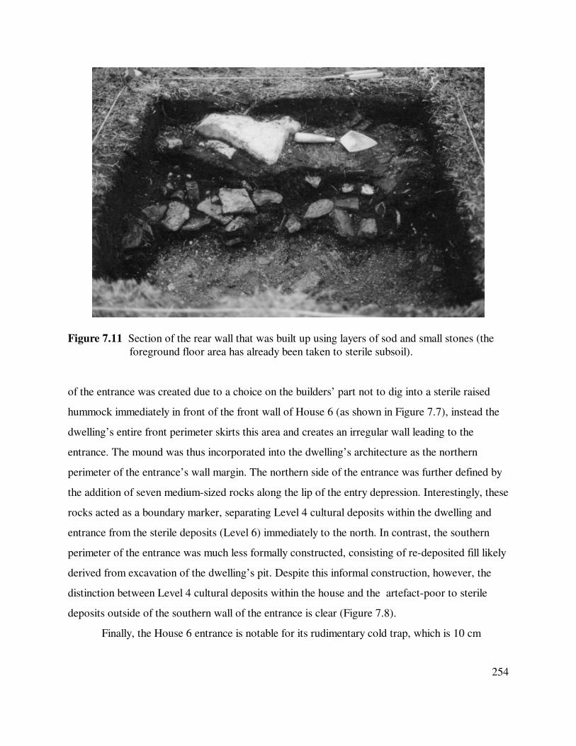
254
Figure 7.11 Section of the rear wall that was built up using layers of sod and small stones (the
foreground floor area has already been taken to sterile subsoil).
of the entrance was created due to a choice on the builders’ part not to dig into a sterile raised
hummock immediately in front of the front wall of House 6 (as shown in Figure 7.7), instead the
dwelling’s entire front perimeter skirts this area and creates an irregular wall leading to the
entrance. The mound was thus incorporated into the dwelling’s architecture as the northern
perimeter of the entrance’s wall margin. The northern side of the entrance was further defined by
the addition of seven medium-sized rocks along the lip of the entry depression. Interestingly, these
rocks acted as a boundary marker, separating Level 4 cultural deposits within the dwelling and
entrance from the sterile deposits (Level 6) immediately to the north. In contrast, the southern
perimeter of the entrance was much less formally constructed, consisting of re-deposited fill likely
derived from excavation of the dwelling’s pit. Despite this informal construction, however, the
distinction between Level 4 cultural deposits within the house and the artefact-poor to sterile
deposits outside of the southern wall of the entrance is clear (Figure 7.8).
Finally, the House 6 entrance is notable for its rudimentary cold trap, which is 10 cm

255
lower than the floor surface of the main living area (refer to Figure 7.8 ‘C’). As discussed in
Chapter 6.3.5, cold traps are one means through which cold outer air (which sinks) can be kept
out of a structure’s interior as people pass into and out of the dwelling. This design would also
reduce the severity of drafts entering the structure through gaps in the door and is akin to one,
also identified as a cold-trap, in Structure 1 at the Qeqertaaraq site in Greenland (Appelt and
Gulløv 1999:8; Chapter 6.6.1). The addition of this form of entrance suggests rather strongly that,
no matter how perfunctory it might seem, it was selected because the House 6 occupants intended
to inhabit the dwelling for some part of the cold season.
7.5.10 Identifying the Living Surface and Activity Areas Inside the Structure
An activity area of uncertain function was identified in the north-western corner of the structure.
This part of the dwelling had a somewhat concave expansion that extended outward
approximately 25 cm beyond the rest of the western margin (Figures 7.7 and 7.9), creating a
slightly recessed interior area. The extension seems to be associated with areas of more complex
construction identified on the western and northern walls (see Section 7.5.8), as well as with a
discontinuously paved area (the only instance where paving stones were used within House 6).
The cultural deposits within this alcove area were particularly thick and black, being
greasy and pungent in composition. Adjacent units excavated in 1988 (falling within the 2002 grid
units of E10 and E9) were similarly described (Taylor et al. 1988) and yielded three pieces of a
soapstone vessel, probably from a context comparable to Level 4 (the main occupation layer).
While no vessels or parts thereof were found in this area in 2002, the presence of the previously
recovered pieces, in combination with the greasy matrix and small quantity of burned fat and
bone, implies that some sort of cooking or food preparation activity likely occurred here.
In comparison, cultural deposits associated with the remaining floor area were
comparatively thin, dry, and hard packed. While the floor of the dwelling was levelled and most
rocks removed when the depression was excavated (before the main occupation appears to have
occurred), it does not appear that the builders specifically ‘created’ or purposefully tamped down
the living surface; the compaction noted during excavation most probably resulted from the day-
to-day activities of the structure’s occupants as they went about their daily lives within the

256
dwelling. No localised activities could be identified in the dwelling’s central area, which yielded a
comparatively meagre quantity of material culture and contained no special-purpose architectural
features. The small amounts of occupational residue excavated from the central area may
therefore be a reflection of periodic cleaning episodes (Schiffer 1987:58-71), which would remove
or otherwise displace obvious or ‘in the way’ items. Binford (1983:177) also suggests that such
activities can be recognised archaeologically through the “presence of a drop zone composed of
debris biased toward the smallest bone splinters [which] indicates that regular cleaning of the area
took place”.
However, when Howse (2008) examined bone refuse from four contexts within the
structure (north-west corner, south-west corner, central floor area, and entrance), she noted a
consistently low degree of bone fragmentation throughout the dwelling interior (Howse 2008:
Table 2). It is hard to imagine that House 6 in its entirety was cleaned so meticulously that little
fragmented faunal material remained, and the lack of differentiation suggests an alternate
explanation: that some sort of floor covering, which limited the ability of bone and other materials
to become incorporated into the floor deposits, was used inside House 6. The thin organic deposit
(< 5 cm) encountered in the presumably intensively used central area suggests a covering is at
least conceivable, although in the absence of more definitive proof, little further can be said
concerning the effects of maintenance and floor covering on the assemblage.
Finally, Howse’s study found little in the faunal distribution to support the idea that the
dwelling’s occupants carried out activities in a spatially discrete or localised manner. The lack of
obvious patterning in the bone sample is not unsurprising given the relative lack of architectural
differentiation or activity-specific loci within the dwelling (with the possible exception of the
probable food preparation area in the north-western part of the structure, which yielded the
highest NISP [Howse 2008: Table 1]).
7.5.11 House 6 Superstructure
Little remained to suggest how the architects of House 6 had designed and built the covering for
their home and it was difficult to make inferences about the materials which groups in this region
might have favoured given the lack of excavated Late Dorset domestic dwellings west of

257
Somerset Island. House 6 was obviously roofed – occupations of any length in the Arctic require
some sort of covering, even if that consists of only the most basic bivouac. Three postholes were
provisionally associated with House 6 and a 15 cm length of wood may be a fragment of a pole
(refer to Figure 7.7 for their locations). The postholes (ranging between 5 cm and 10 cm in
diameter and averaging 6 cm in depth) were all located within the inner boundaries of the
structure and were set so they ran roughly parallel to the western rear wall. None was associated
with supporting stones or other secondary braces. The possible post fragment was also located
inside the dwelling, at the inner boundary of the southern perimeter wall. There can be no doubt
that other posts were used to create a supporting framework for the superstructure (see various
diagrams in Faegre [1979]), however no others were located 1988 or 2002.
Remains of a roof covering were not identified and there was no stratigraphic evidence for
a roof fall, which typically occurs when sod is used in roof construction. However, a slightly
deeper sod deposit was recognised along parts of the dwelling’s outer berms (Figure 7.8),
suggesting peat was repositioned there once the superstructure was in place to help anchor the
covering and / or provide additional insulation. The small amount of Level 5 material identified
immediately outside of the north-western perimeter of the dwelling (refer to Figure 7.8) may be a
remnant of such action. The bank into which House 6 was built is otherwise culturally sterile and
Level 5 materials located there could only be deposited through human agency.
7.5.12 The Abandonment and Post-Occupation Life of House 6
There is no stratigraphic evidence that House 6 was reoccupied by the Late Dorset once it was
abandoned and the recovered technologies contained in Level 4 are, unless otherwise noted,
considered to be those manufactured and used by the dwelling’s inhabitants.
While little attention has been directed to the process by which Palaeoeskimos vacated
dwellings, there is no reason to believe that they did not weigh the same basic sets of
considerations as other groups when leaving a structure. Stevenson (1982) has proposed five
general kinds of abandonment based on analysis of historic mining encampments and suggests that
each can be identified archaeologically by examining the associated artefact assemblages.
Abandonment categories include: 1) planned, where few objects in the process of use /

258
maintenance / manufacture are encountered; 2) unplanned, where high frequencies of artefacts and
/ or features in the process of use / maintenance / manufacture are located; 3) planned with
intended return, when items are deposited in areas separated from where they were typically used;
4) unplanned with intended return, similar to the previous except items might be cached near
where they were used; and 5) planned final, for which rare, valued, or personal items, as well as
un-exhausted materials, are not left behind (excluding lost items). Abandonment that was planned
and intended to be final might also include the discard of large amounts of food bone refuse and
other detritus in concentrated areas as cleaning activities were curtailed.
Recognising the type of abandonment which occurred at a structure can help to establish
not only the inhabitants’ intentions at the time of departure but can also inform on why some
materials were left behind while others were not. While Stevenson’s argument is not without
problems, as Binford’s (1981; see Chapter 1.2.6) commentary has indicated (see especially his
discussion concerning the difficulty of distinguishing between successional and de facto deposits),
the study remains a useful guide for investigating abandonment processes. Using Stevenson’s
criteria, the abandonment of House 6 does not seem unplanned, for although there is evidence of
tool manufacture in the form of flakes, worked antler, and bone fragments (see Section 7.6.2), the
great majority represent minimally invested detritus or items that were lost, broken, or not worth
transporting. House 6 also seems not to have been abandoned with the intent of return as there is
no evidence that surplus materials were cached for later retrieval (although it is possible that items
were stored outside the dwelling in undiscovered features).
It therefore appears likely that a planned or planned final abandonment strategy was
implemented by the House 6 occupants, although it is unclear from the excavations which actually
took place. Stenton and Park (1994:413) argue it is possible to distinguish between planned and
planned final abandonment at Neoeskimo sites, suggesting that structures intended for reuse were
not completely dismantled when vacated. However, Freuchen (1961:40) noted that Polar Inuit
structures were “each spring ... left by the inhabitants and automatically become public property
next fall”, demonstrating that the materials left behind when a dwelling was vacated could be
claimed by others and were not held in trust until the original builders returned.
Freuchen’s observations suggest, at least in this one instance, that the degree to which a

259
dwelling was dismantled should not necessarily be viewed as a correlate of its occupants’ future
intentions regarding refurbishment / reoccupation. Indeed, there are numerous reports throughout
the Eastern Arctic of Neoeskimos mining older dwellings for building materials (e.g. McCartney
1979b; McGhee 1984a; Park 1988, 1997; Dawson 2001), indicating useable materials were
frequently left behind and claimed by others. Considering the widespread nature of this behaviour,
it seems probable that valuable materials were removed wherever possible, regardless of whether
the dwelling was intended to be reoccupied, to insure that they remained in the custody of the
original builders. This may also have been true of the Late Dorset, or at least those who built
House 6, where the only elements left in situ were those which were difficult to transport (e.g.
sod), could be easily obtained elsewhere (e.g. stone), or were presumably otherwise judged non-
essential.
After House 6 was abandoned by its Late Dorset occupants, stratigraphic and artefactual
evidence indicates that the general area hosted undetermined but apparently non-intensive
activities associated with the Thule Inuit. It is difficult to determine the length of time which
elapsed between the Dorset and Neoeskimo uses of this area, although two scenarios can be
suggested. One possibility involves Thule Inuit groups entering the Iqaluktuuq area and settling at
Bell very shortly after the Late Dorset occupation of House 6 ended (there are no indications in
the recovered assemblage of direct contact between the two groups, although, as discussed in
Chapter 5.4, such signs would not necessarily be expected). However, the single radiocarbon date
derived from House 6 (collected by William Taylor and calibrated to 2-sigma by Friesen [2004:
Table 1]) of 1035±125 B.P. (S-3038) suggests a near overlap was unlikely. This is because the
ancestors of the Inuit do not appear to have moved into the Eastern Arctic until between 950 B.P.
and 750 B.P. (Park 1994; Morrison 1999; McGhee 2000), not settling south-eastern Victoria
Island until after 750 B.P. (Friesen 2004: Figure 2). If the single radiocarbon assay from House 6
and the estimate of the Neoeskimo arrival in the area are both accurate, then the two periods of
activity at House 6 were separated by over 250 years, precluding interaction.
The second possibility, and the one considered to be more likely, is that House 6 fell into
disuse and sufficient time elapsed for a thin topsoil layer to develop before the site was occupied
by Thule Inuit groups. How long this hiatus was required to last is uncertain as Forbes (1996) has

260
noted that it can take generations for vegetation to recolonise areas disturbed by human activities,
while Kevan et al. (1999) remark that the most intensely vegetated areas are often those which
have experienced some level of human occupation. Whatever the timeline involved, stratigraphic
analysis indicates that the Late Dorset deposits were already covered by some depth of
overburden when Neoeskimo activities, perhaps related to the large stone caches positioned
directly north of the dwelling (see Figures 7.5 and 7.6), took place in the area. During this use of
the locale, some Thule artefacts and associated faunal materials were incorporated onto and into
the thin sod layer covering the in situ Dorset deposits, perhaps as a result of foot traffic or similar
generally non-invasive activities, resulting in the formation of a culturally mixed Level 3 stratum.
7.5.13 Discussion
The preceding portion of this chapter was intended to provide a detailed description of the
archaeological remains encountered during the excavation of House 6, as well as the physical
setting in which the structure was found. As should be evident from this discussion, the
Iqaluktuuq area is the scene of a biannual ecological explosion, mainly due to the spring and fall
migration of caribou and char, but also from a range of secondary resources including numerous
avian, terrestrial, and marine species. The abundance of predictable resources is undoubtedly the
reason why the area has been occupied, at least intermittently, since Pre-Dorset groups first
entered south-eastern Victoria Island.
Evaluation of the architectural technology employed to construct House 6 indicates that
those who designed the dwelling considered their tenure at the site to be worth the investment of
a certain amount of time, effort, and resources to create a shallowly semi-subterranean sod and
earth-banked structure whose internal architecture was minimally elaborated. As will be discussed
below, these remains indicate that House 6 was more than a simple tent dwelling, but that it was
not as substantially built as some Late Dorset remains. It does not appear that the architectural
elements left in House 6 when it was abandoned by its occupants were recycled or reclaimed
during subsequent Dorset occupations. Consequently, keeping in mind the effects of various
taphonomic processes, it appears likely that all of the architectural components not removed
during dismantling and abandonment should be represented archaeologically.

261
Analysis of the architectural technology used to create House 6 points to a dwelling that
was intended to have a relatively low cost, a strategic choice which undoubtedly led to the careful
evaluation of construction and necessary maintenance expenses against the anticipated use(s) and
length of occupation of the structure. Such planning resulted in what McGuire and Schiffer
(1983:282) term a low-cost / high maintenance building strategy (see also Kent 1991; Kelly et al.
2005). The adoption of this technical approach meant that, as seen elsewhere in the Eastern Arctic
(e.g. Park 1997; Dawson 2001), the Late Dorset may, at times, have opted for a minimalist
architectural strategy that resulted in less elaborate architectural remains.
7.6 Making Sense of House 6
The previous sections of this chapter presented House 6 as it was found archaeologically, with
little in the way of interpretation offered regarding questions including when it was occupied, for
how long, and how its design and use might inform on Late Dorset social organisation. The
following sections of this chapter will attempt to address some of these issues.
7.6.1 The House 6 Faunal Sample
Analysis of the House 6 faunal sample was undertaken by Lesley Howse (2005, 2008), who
examined bone refuse from different areas of the structure’s interior and compared that
assemblage with one excavated from a nearby midden deposit. She confirmed field observations
which indicated that caribou and fish were key components of the occupants’ diet (Howse 2008:
Table 1), and she also identified the presence of smaller quantities of fox and resident and
migratory bird species. Marine resources, represented by ringed and bearded seals (each with an
MNI of one), formed a very small component of the overall diet, although Howse (2008:30) notes
seal bones were more common in the presumably associated midden. Within the structure there
was little to indicate differential consumption / disposal of mammal, bird, or fish.
Howse also examined body part frequencies for caribou, the most common species, by
both NISP and MNI inside House 6 (Howse 2008: Table 1), in order to establish whether
economic practises may have influenced the distribution of various elements within the feature.
She concludes there was little to suggest that caribou representations were impacted by food
utility and transport, nor does she believe it likely that element distributions reflect differential

262
treatment of body parts (such as drying, although she notes it was possible that meat was dried on
site but transported away for later consumption). Instead, Howse (2008:33-35) proposes that
caribou element distributions within both House 6 and the midden were most likely a result of
differential preservation, or density mediated attrition, where bones with greater structural density
survive more often than do less dense (‘softer’) elements.
Based upon the faunal remains, Howse (2008:35) suggests House 6 was occupied during
the late summer and fall period, when fish, birds, and caribou could all be found in great numbers
near the site (see also Section 7.3). Speaking only of the House 6 assemblage (Howse 2008:
Table 1), the second-ranked mammal after caribou was fox (MNI of three, NISP of 103), while
ptarmigan (MNI three, MNI 11) are also present but rank below various summer resident goose
and duck species. Fox and ptarmigan have been cited by various researchers in support of cold
season occupation (e.g. Burch 1998; Murray 1999; Darwent 2001), and their presence in House 6
may support a view that the dwelling was occupied from the summer / fall period into some
portion of the cold season (see Section 7.6.3).
7.6.2 The House 6 Artefact Assemblage
Only artefacts from the unmixed Level 4 deposit excavated in 2002 are included in Table 7.2. Of
that assemblage, five artefacts (four harpoon heads and one needle) were excluded from these
totals as they were identified as intrusive Early Dorset artefacts. Bearing in mind that three of
these tools were found in close proximity to one another outside the western perimeter of the
dwelling, it seems likely that they represent the in situ remnants of an Early Dorset deposit which
was largely eradicated by the construction excavation of House 6. While it is possible that other
non-diagnostic Early Dorset artefacts are included in Table 7.2, I believe this possibility is minor
and unlikely to seriously influence interpretation of the Late Dorset occupation.
Examination of the artefact categories shown in Table 7.2 indicates that a major activity
conducted inside House 6 appears to have been the initial processing of antler and terrestrial
mammal (caribou) bone. As noted in Section 7.3.5, caribou do not normally shed their antler
while on Victoria Island (see also Chapter 3.3.5) and any antler found in the House 6 assemblage
was most probably obtained ‘on the hoof’ from successfully hunted animals. While swimming

263
caribou might have been taken by individual hunters operating from boats as the latter crossed the
Ekalluk River / Ferguson Lake (M.S. Maxwell 1985:138), the most efficient way to capture large
numbers of animals would be via a cooperative hunt. As evidence for watercraft is sporadic
Artefact Category Number
Identified
Percentage of Total
Assemblage
Worked Antler 41 32.03
Needle 18 14.06
Microblade 18 14.06
Worked Bone 16 12.50
Antler Box Piece 4 3.13
Harpoon Head 4 3.13
Biface or Fragment 3 2.34
Unworked Copper 3 2.34
Chert Point 3 2.34
Vessel Fragment 2 1.56
Endblade 2 1.56
Ground Slate
Fragment 2 1.56
Adze Socket 1 0.78
Antler Point 1 0.78
Barbed Point 1 0.78
Bone Shaving 1 0.78
Copper Endblade 1 0.78
Decorated Bone 1 0.78
Foreshaft 1 0.78
Handle 1 0.78
Microblade Core 1 0.78
Notched Point 1 0.78
Red Ochre 1 0.78
Worked Wood 1 0.78
Flakes 695* n/a
Total 128 100.00
Table 7.2 Artefacts from the Level 4 deposits inside House 6 (* flakes not included in artefact
totals).

264
throughout the Palaeoeskimo period (e.g. M.S. Maxwell 1985:137; Grønnow 1996a), it is more
probable that Dorset hunters speared caribou using the inuksuit drive systems located north of the
Ekalluk River (refer to Figure 7.2). Taylor (1972:76), McGhee (1995:114-115), and Brink (2005)
all suggest that the oldest parts of the Ekalluk systems date to the Dorset era, and a less elaborate
drive system from Labrador (Fitzhugh 1981) indicates that such features were used by Dorset
hunters elsewhere in the Eastern Arctic.
Cooperative hunts require comparatively large numbers of participants to succeed, and
although it is currently impossible to assess contemporaneity between different dwelling features,
the overall size of the Bell site Late Dorset occupation suggests that sufficient populations were at
least periodically present in the area for such hunts to occur. As the largest Dorset living site at
Iqaluktuuq, the Bell site was probably the region’s residential base and, as Binford (1980:343) has
observed in such cases, functioned as “the hub of subsistence activities, and the locus out of which
foraging parties originate, and where most processing, manufacturing, and maintenance activities
take place”. The large amount of modified antler and bone identified in the House 6 assemblage
can thus be taken as evidence of “direct relationships between the quantity of debris remaining
from food consumption [predominantly caribou, see Section 7.6.1] and both the quantity of tools
and the quantity of tool-making debris” (Binford 1977:35). The particular emphasis given to
processing raw antler, preferred by Dorset for a range of tools and in optimal condition in the fall
(LeMoine 2005:136-137, Figure 2), implies that the House 6 occupants were “gearing-up”
(Whitridge 2001:37), producing complex and frequently curated tools in anticipation of future
use. That the vast majority of antler recovered from House 6 is detritus indicates processing was
mainly primary as craftspeople began to reduce recently procured antler into more readily useable
blanks and preforms, most of which appear to have been removed when the dwelling was
abandoned.
Also well represented in the assemblage are microblades and needles, implements which
have been associated with the preparation of skin clothing. M.S. Maxwell (1985:90) alludes to
several studies that have established a positive correlation between the occurrence of microblades,
which he believes were used to cut skin patterns for clothing, and the bone needles used to sew
the pieces together (see also McGhee 1980:445). The advantages of caribou skin clothing were

265
well known to the historic Inuit, who had a variety of techniques for processing skins depending
upon the specific use for which they were intended (e.g. Balikci 1970:8-10). As reported by
Balikci (1970:52), Inuit seamstresses preferred to use fall skins when making clothing as the
animal’s hair had not grown too thick and long, and it is probable that a similar preference was
shared by the Dorset. Amongst the Inuit, all clothing was produced in the fall from land-based
camps before groups moved onto the sea ice (refer to McGhee [1977] for discussion of taboos
concerning land and sea-based animal products); although it is unclear if similar considerations
operated amongst Dorset populations.
Other artefacts appear in lesser quantities. Notable amongst this more diverse group are
pieces of unworked native copper, presumably obtained from sources on either western Victoria
Island or the Coppermine River (Jenness 1922:19, 41, 52; see Morrison [1987], who suggests
such nuggets were carefully curated by Neoeskimos, accounting for their rarity in assemblages of
that era). Also represented are sherds of soapstone from two, or perhaps three, vessels.
Not included in Table 7.2 are a whale bone sledge shoe and an antler snow knife. Both are
Dorset in style and form but were recovered from the lower part of Level 3 (Level 3b, refer to
Section 7.5.5), the mixed Dorset – Thule Inuit deposit directly above the main Dorset layer (Level
4). Soapstone vessels, snow knives, and sledge shoes are all usually associated with occupation
during colder seasons (e.g. M.S. Maxwell 1985).
7.6.3 Suggested Season of Occupation
While no one indicator can be used to definitively identify a season(s) of occupation for House 6,
a number of clues suggest the late summer – fall – early winter period as the time when the
structure was built and occupied.
Looking first at the architectural remains, arctic archaeologists have traditionally
correlated semi-subterranean structures with cold weather occupations and surface structures with
warmer seasons (e.g. M.S. Maxwell 1985; Reinhardt 1986). Such an a priori assumption rests on
the principle that larger and more substantial architectural remains are associated with longer
occupations during more challenging parts of the year (e.g. Reinhardt 1986). However, this
relationship can be overly-simplistic, particularly when one considers the snow structure or igloo,

266
the quintessential arctic winter dwelling which will appear archaeologically as a surface structure
(relative to the underlying ground surface, although they were built into the snow’s surface) and
built using a material (snow) that leave little or no trace and hence appears quite insubstantial
archaeologically (Savelle 1984; Ramsden and Murray 1995; Labrèche 2005).
The cold / warm season dichotomy runs into further trouble when one bears in mind that
the historic Inuit sometimes occupied robust semi-subterranean structures throughout the warm
season (Park 1988; Nagy 1994b), while the Early Palaeoeskimos typically lived in insubstantial
surface structures throughout the year (Appendix A). As noted by Park, associating winter
occupations only with deep, elaborately constructed, and complex structures excludes the qarmat
from consideration and downplays the architectural variation that is actually present within and
between sites. As discussed in Chapter 6.3.6, qarmat were often used by the Inuit and are usually
equated with the time between seasons when it was too cold for skin tents but there was
insufficient snow to build snow structures, or in the spring when it became impractical to use
snow dwellings. However, Park (1988) cites several ethnographic and historic accounts which
indicate that qarmat could be used throughout the winter months and not only at transitional
season sites as has often been suggested. These findings not only highlight the fact that shallowly
semi-subterranean qarmat and deeply semi-subterranean pit structures can be used at times other
than expected, but also indicate that more variation exists amongst dwelling remains than may
have been supposed.
Moving to the Late Dorset period, the idea of mutually exclusive summer and winter
structures is further questioned by House 6 itself, a dwelling that, while semi-subterranean, is
more shallowly excavated than other Late Dorset structures; including some probable Late Dorset
features at the Bell site (see Section 7.5.1). That House 6 is semi-subterranean to any degree
indicates that its occupants were present at the site during the latter part of the warm season,
when permafrost was low enough to permit builders to excavate into the ground. Habitation
extending into the cold season is indicated by the occupant-architect’s decision to create a ‘porch’
and simple cold-trap entrance, indicating they were concerned with reducing the flow of outside
air into the living space. Further, the use of thermally efficient sod in wall construction suggests
that the builders may have expected a significant temperature difference between the inside and

267
outside worlds. The inference that some sort of floor covering was used in the central parts of the
dwelling also tends to reinforce the idea that House 6’s occupants were concerned with the
overall thermal efficiency of their home.
Faunal remains associated with House 6 are highly biased towards taxa that are available
at seasonally specific points in time. As indicated in Section 7.3, char, caribou, and migratory
birds are species that are present at Iqaluktuuq in great numbers twice yearly in the spring and fall.
While some caribou may remain resident in the general area throughout the year, Dorset, who
lacked bow and arrow technology, were probably only able to take large numbers of animals
when they were concentrated for migration. Similarly, although char (and lake trout) could be
caught through the ice, there is no evidence that this was done anywhere in the Late Dorset realm.
It is therefore likely that most of the animals represented in the faunal assemblage from House 6
were killed during the spring and / or fall migration period, although analysis to determine a more
precise season of death has not been conducted (Howse [2008] suggests a fall hunt / fishery). The
small amount of ringed and bearded seal bone in the faunal assemblage can be interpreted in
support of an early winter hunt on newly-formed land-fast ice by hunters based in House 6,
although assignation of a precise season of death has not been attempted.
The artefact assemblage recovered from House 6 provides subtle hints consistent with the
suggested seasons of occupation. As discussed in Section 7.6.2, the abundance of minimally
processed antler suggests dwelling occupants had a plentiful supply of this material, a finding that
is consistent with the fall migration period (refer to discussion of antler development in Section
7.3). As noted previously, the presence of numerous needles, combined with an abundance of
multi-purpose microblades, suggests that sewing was a key activity within House 6 and one that
could only be accomplished on a larger scale after sufficient skins had been acquired and
processed (such work was a major fall preoccupation of Inuit seamstresses). Finally, the presence
of vessel fragments and the diagnostically Dorset sled shoe and snow knife (both from the mixed
Level 3 deposit) are consistent with an occupation during the cold season.
Based on these interlinked sources, it is argued that the House 6 occupation began in the
late summer and continued into the fall period, coinciding with the arrival of large numbers of
caribou and char in the area. Several lines of evidence indicate that the House 6 occupation

268
continued into some part of the cold season. It seems probable that this structure functioned
similarly to a qarmat, an interpretation also made for Dorset dwellings on south-eastern Ellesmere
Island (Helmer, in Taylor et al. 1988), southern Baffin Island (Odess 1996:175), and northern
Labrador (Fitzhugh 1994:258). Where Late Dorset went when the qarmat-like structures were
abandoned is unclear, although a move onto the sea ice is possible (see Chapter 5.3.3).
7.6.4 Suggested Length of Occupation
Stratigraphic evidence indicates that the area in which House 6 was located was occupied on at
least three separate occasions. The earliest occupation involved an Early Dorset component of
unknown size and extent, as evidenced by the diagnostic artefacts found in situ immediately
beyond House 6’s western perimeter (see Section 7.6.2). Based on available evidence, it would
appear that this occupation was largely destroyed by the construction of House 6 and little more
can be said concerning this period (Taylor [1967:223] also identified evidence for an Early Dorset
presence at several locations at the Bell site).
The presence of a sporadic culture-bearing Level 5 deposit underneath some parts of the
main House 6 occupation (as represented by Level 4) suggests an earlier Late Dorset use of the
House 6 location. These deposits were most commonly identified at the edges of the House 6
depression where they typically extended from Level 4 into sterile Level 6 substrate and appeared
as a less organic version of the former. Although no diagnostic materials were recovered from
Level 5 (the level did contain some faunal and lithic matter; see Section 7.5.5), its position
between Levels 4 and 6 and occurrence at points along the edges of the dwelling depression
suggest the deposit represents the remnants of an earlier habitation which was largely eradicated
by refurbishment activities associated with the Level 4 occupation. The best preserved use of the
House 6 area is associated with the Level 4 deposits, within which are contained all architectural
elements and most cultural materials. This occupation is the one discussed throughout this chapter
and its duration is considered below.
From an architectural standpoint, the amount of time and energy invested in the
construction of House 6 was not extensive and it is obvious that it was planned and constructed
using a low cost building strategy. This is evidenced by a number of factors including a decision to

269
skirt the raised natural hillock in the front wall of the structure instead of removing it, a choice
which resulted in a rather atypically placed asymmetric entrance. Minimal architectural investment
is also indicated by the lack of a formal floor paving or other internal structural features, aside
from the activity area associated with the more invested north-western corner construction. Such
behaviours strongly suggest that the Late Dorset who planned and built the structure expected
their tenure to be a short to moderate one, a belief reflected in the architecture.
Stratigraphy further supports the interpretation of a late summer – early winter timeline.
As Kent (1991) and Kent and Vierich (1989) note, occupation of a low-cost structure can still be
proportionally lengthy, despite the occupants’ original intentions, if other factors work to make a
more extensive stay possible or necessary. Even considering the probable use of a floor cover, the
dwelling’s floor deposits are thin and support the view that the actual length of occupation
matched the planned tenancy. The comparatively small number of recovered artefacts (Table 7.2)
further indicates that the dwelling was not used long enough for additional cultural debris to
accumulate. Food bone inside the structure implies that the house occupants subsisted primarily
on resources harvested in the fall, with additional sources (e.g. fox and seal) supplementing the
focal species. At the same time, if the occupation had extended into a significant part of the cold
season, the faunal assemblage might be expected to show a greater reliance on animals other than
caribou and char (which it does not).
Taken together, these four lines of evidence (architecture, stratigraphy, artefact
assemblage, and faunal remains) indicate that the occupation of House 6 was relatively limited. It
is impossible to say exactly when the decision to abandon the structure and move elsewhere was
made; however, I believe abandonment occurred early in the winter when a stable sea ice platform
had developed.
7.7 Summary
House 6 was planned, built, occupied, and abandoned by a group of Late Dorset who came to the
Iqaluktuuq area to exploit the area’s seasonally abundant fall resources. As such, they travelled
into the area armed with an idea of how the structure they intended to build ‘should’ look, several
architectural elements (i.e. tent poles) which they knew were unavailable in the area, and

270
knowledge of both what Iqaluktuuq could offer and how they could exploit those offerings. The
Bell site was undoubtedly selected for a number of reasons, not the least of which involved the
availability of abundant building materials, as well as its strategic position on the Ferguson Lake –
Ekalluk River bottleneck.
The Bell site dwellings were positioned to take advantage of the southern exposure along
the northern rim of the vale descending to Ferguson Lake, an especially important consideration
as daylight waned and average daily temperatures approached and then slipped below the freezing
mark. In anticipation of this development, architects selected a location for their dwelling which
reduced the amount of effort required to create a semi-subterranean floor, sheltered them from the
predominant wind, and also minimised the dwelling’s (and camps) visibility to observers located
on the north side of the river.
The architectural remains represent the strongest and most persuasive evidence for a
habitation that was not intended to be long-term or particularly intensive. If, as suggested,
occupation of House 6 began in the late summer just prior to the arrival of caribou and char,
occupants would have been anticipating the start of an intense period of work related to the
procurement and processing of large numbers of animals for food, clothing, and tools before those
resources passed through Iqaluktuuq and became unavailable. Given the likely pre-eminence given
to these tasks, it is unsurprising that the House 6 architects appear to have been largely
uninterested in creating an elaborate or technically impressive dwelling. Rather, all signals point to
a habitation feature which was intended to be functionally capable of sheltering its occupants
through the last part of the warm season, into the cooling fall period, and probably into some
portion of the cold season. Abandonment likely occurred at some point during the early winter.

271
CHAPTER 8 – CASE STUDY 2 – N72, NUNGUVIK (PgHb-1), NAVY BOARD INLET,
NORTHERN BAFFIN ISLAND
8.1 Introduction
Structure N72 at the Nunguvik site (NiNg-2) forms the subject of the second case study.
Nunguvik is located on the eastern coast of Baffin Island’s Borden Peninsula, on the western
shore of Navy Board Inlet, a narrow (approximately 11 km) strait separating Baffin Island from
Bylot Island (Figure 8.1). While published coordinates for Nunguvik (e.g. Mary-Rousselière
2002:17) place the site at 73°01'30" N 80°38' W, these appear well to the southwest of the site’s
actual location which is closer to 73°05' N 80°30' W. Structure N72 had been previously tested by
Father Guy Mary-Rousselière (n.d. a-d), and the remainder was excavated during August 2000
and July 2001 by the Helluland Archaeology Project, based at the Canadian Museum of
Civilization and directed by Dr. Patricia D. Sutherland. Dr. Sutherland kindly granted permission
to use the data gathered as a result of that work in this dissertation.
8.2 The Physical Environment of North-Eastern Baffin Island
As the largest island in the Canadian Arctic Archipelago, Baffin Island presents a number of
disparate environments whose conditions, in terms of comparative severity or mildness, can be
roughly equated with their latitude, although the distribution of landforms and marine water-
bodies (especially proximity to polynyas) play a major mitigating role (Stager and McSkimming
1984:29). The presence of large cold water-bodies on all sides of this relatively long and narrow
island (1600 km in length, versus a maximum of only 675 km in width, see Soper [1928:2])
further means that Baffin Island experiences long-term climatic and shorter-term weather
conditions that are generally much more dynamic than those evidenced elsewhere in the Canadian
Arctic where a more continental climate predominates (J.B. Maxwell 1981).
Baffin Island is traditionally divided into northern and southern areas at 66º 32' N latitude
(e.g. Polunin 1948:131), the approximate position of the Arctic Circle. This line crosses Nettilling
Lake, the largest lake on Baffin Island, as well as the Great Plain of the Koukdjuak, a low-lying
marshland between Nettilling Lake and Foxe Basin (Figure 8.1). Unlike much of southern Baffin
Island, which can be classed as low-lying and relatively sheltered (refer to Chapter 9.2), the

272
Figure 8.1 Map of Baffin Island showing locations mentioned in the text.

273
convoluted eastern coast of Baffin Island immediately north of the Great Plain of the Koukdjuak-
Nettilling Lake-Cumberland Sound region is part of the Arctic Cordillera mountain chain and is
fully exposed to Davis Strait and Baffin Bay. This landscape is typified by rugged and often ice-
capped 2000+ m asl mountains, deeply incised fjords, areas of sheer coastline, and inter-montane
glaciers (Figure 8.1). This topography not only limits areas where comfortable habitation is
possible but can also cause very rapid and significant weather changes along the entire east coast
(J.B. Maxwell 1982:389-390). While Navy Board Inlet (and Nunguvik) is not immune to the
effects of severe systems travelling up the Davis Strait-Baffin Bay channel, the high mountains of
adjacent Bylot Island do tend to afford the area some shelter (J.B. Maxwell 1981:233).
Nunguvik is located at the juncture of two climatic sub-regions (IV-a and IV-b) as defined
by J.B. Maxwell (1982:232, Figure 7). North Baffin-Lancaster Sound (IV-a), because of its
proximity to both the permanently open North Water polynya (refer to Figure 8.2) and Lancaster
Sound (whose ice is late to form and early to break), is considered to be more maritime in its
climate composition than other arctic localities at similar latitude (J.B. Maxwell 1981:232;
although, as shown in Table 8.1, the mean annual temperature range is great at approximately 40°
Celsius). The cyclonic systems which regularly push into this region from Davis Strait can also
introduce warm and moist southerly air to the area, resulting in abundant precipitation in some
locations. The Gulf of Boothia-Foxe Basin-Western Interior Baffin Island sub-region (IV-b) is
characterised by fog and low-cloud in the summer, but is shielded from the Baffin Bay-Davis
Strait storm belt and otherwise has generally good weather by arctic standards (J.B. Maxwell
1981:232). As a result of its intermediate location between these two climatic zones, western
Navy Board Inlet and Nunguvik usually experience climatic elements characterising one or both
of the sub-regions defined by J.B. Maxwell (1981). Particularly noteworthy features are the area’s
relatively high precipitation (especially during the open-water period) and semi-frequent storm
conditions, although the latter is not as pronounced as in less sheltered areas immediately to the
east and north.
As described by Jackson and Berman (2000: Figures 1 and 3), the Navy Board Inlet area
of Baffin Island and adjacent Bylot Island falls within a geological block referred to as the
Committee Belt (2.9 - 2.5 billion years ago), itself part of the Archean eon (3.8 - 2.5 billion years

274
Figure 8.2 Location of the May floe edge along eastern Lancaster Sound and northern Baffin
Island (from regional ice charts, Canadian Ice Service n.d. a).
ago). These deposits are dominated by metamorphosed rocks (predominantly granites, as well as
greenstones and some gneiss), although isolated areas of chert-bearing sedimentary deposits are
also present (Jackson and Berman 2000: Figure 2). While much of this landscape (particularly
nearer to the coast) has been extensively sculpted by glacial activity into deep valleys and high-
sided slopes (Figure 8.3), the near interior of Baffin Island (immediately west of, or behind,
Nunguvik) presents a less dramatic sloping plateau-like terrain averaging 200 - 300 m asl (Figure
8.4). Limestone predominates here, and within this matrix are nodules of iron pyrites and high
quality chert (Mathiassen 1928:9). My inspection of extant lithic assemblages from Nunguvik and
nearby sites indicates that lustrous and fine-grained cherts, presumably from these local sources,
were consistently favoured by resident Palaeoeskimo groups.
Vegetation in and around Nunguvik consists of fairly typical arctic heathers, willows, and

275
Figure 8.3 Mountainous north Baffin Island terrain.
mosses. As with its position at the juncture of two climatic zones, Nunguvik is located near the
boundary of two vegetation zones. Central Navy Board Inlet falls within the Mid Arctic zone, but
is very near to the southern limit of where High Arctic vegetation begins (refer to Polunin 1951;
also Porsild 1964; Edlund 1984). Polunin (1951) characterises the Mid Arctic zone as having less
species diversity than found in the Low Arctic but more than is found further north (see also
Edlund 1984). Diverse species of grasses, sedges, and herbaceous tundra plants dominate. Woody
shrubs, especially Salix and Ericaceae, occur near their northern limit in this area, particularly
where there are pockets of better developed soils (Porsild 1964). The High Arctic vegetation zone
begins immediately north of Nunguvik where polar deserts typified by bare rock or lichen and
moss cover predominate (Bliss and Matveyeva 1992). Woody shrubs include species of willow
(e.g. Salix herbacea, S. arctica, and S. reticulata) and heather (e.g. Cassiope tetragona and
Rhododendron lapponicum), and occur only in protected areas with deeper soil accumulation,
although they seldom surpass 10 cm in height (Aiken et al. 2003).

276
At 73º05' N, Nunguvik is located approximately 650 km north of the Arctic Circle (66º 32'
N), the latitude above which seasonally continuous daylight and darkness exists. Because
of its comparatively high latitude, this area of Baffin Island experiences marked seasons of
prolonged or continuous daylight and darkness, including 11 days of true Polar Night when the
sun does not rise (Table 8.1). Such extreme conditions must have impacted the day-to-day
activities of the Late Dorset as much as they have the Inuit (e.g. Boas 1888; Steensby 1910).
Figure 8.4 Broad inland plain stretching westward away from the coast and the Nunguvik site.
8.3 Potential Range of Resources Near Nunguvik
Ethnographic observations of early historic Inuit adaptations in the Arctic are quite useful as a
means to understand one way in which people adapted to their local surroundings (with the
caveats noted in Chapter 7.3 applying here equally well). Excellent ethnographic information
exists portraying late 19th and early 20
th century Inuit life-ways on Coronation Gulf (Chapter 7.3)
and along the southern coast of Baffin Island (Chapter 9.3). Ethnographic and historical
information pertaining to the Iglulingmiut (the Inuit of the eastern Foxe Basin and north coast of
Baffin Island) is also relatively extensive (e.g. Lyon 1824; Parry 1824; Steensby 1910; Mathiassen

277
1928), although it is fairly sparse for the northern limit of their range in the Navy Board Inlet-
Pond Inlet area of north-eastern Baffin Island (where they referred to themselves as Igluamiut; see
Mary-Rousselière [1984b:446]). This is because the European ships which visited northern Baffin
Island were primarily occupied with searching for either the Northwest Passage or signs of the
lost Franklin expedition (Berton 1988) and rarely interacted with local Inuit populations. For this
reason, Mathiassen (1928:5) notes that the surviving logs and journals of such voyages contain
little useful information on the Inuit living in and around Pond Inlet.
Considering the limited specifics available on the Inuit of this area of Baffin Island it is not
a direct process to present particulars of the Inuit adaptation here, as it was for the other two
cases studies (Chapters 7 and 9). Nevertheless, below is information on the modern Navy Board
Inlet environment and its resources, as well as accounts concerning how the historically-known
Inuit (who appear to have been little impacted by extra-cultural contacts at the time these
observations were made, see Wordie [1935:312-313] and Mary-Rousselière [1984:443]) adapted
to the dynamic resource base of this area of the eastern Canadian Arctic. As noted by Wylie
(2002:137), analogical inferences between modern and prehistoric populations “can play a
legitimate, constructive role in archaeological inquiry within certain guidelines”. Keeping in mind
the limitation of such inferences, Inuit practices can serve as a useful analogy for reconstructing
one way in which the local environment and its resources could be exploited.
The seasonal round typically pursued by the Igluamiut has been described by both
Mathiassen (1928:23-36, 53) and Mary-Rousselière (1984b:432-433). Mathiassen noted that
before a trading post was set up at Pond Inlet, many Inuit (especially young married families)
were very mobile in the summer, travelling inland to hunt caribou and fish for char until autumn,
although he remarked that at the time of his observations increasing numbers were settling at the
post during the open-water season to hunt seals and narwhals. As the weather began to cool,
north Baffin Inuit (like those in several other Arctic regions, e.g. Jenness [1922:142]; Taylor
[1974:52]) gathered in sewing camps near the shore to prepare equipment for the winter period
while awaiting the formation of a stable sea-ice platform. Mathiassen (1928:13) notes that the
Iglulingmiut, like their Thule forbearers (McGhee 1977), maintained careful taboos restricting the
intermixing of land and sea products at this time. As the cold season progressed, villages of snow

January February March April May June July August September October November December
Daily Average
Temperature
(°C)
-32.4 -34.1 -30.3 -22.1 -9.9 1.8 6 4.2 -1.4 -11.4 -22.4 -28.3
Days Below
O°C
(Maximum)
30.9 28.3 31 29.9 26.4 2.9 0 0.11 11.4 29.6 30 31
Days Above
0°C
(Maximum)
0.13 0.05 0.04 0.14 4.7 27.1 31 30.9 18.6 1.5 0 0
Total
Precipitation
(mm)
5.7 4.3 8 10.7 9.6 15.8 31.1 36.9 20.8 23.4 16.1 8.4
Total Rainfall
Amount (mm) 0 0 0 0 0.2 11.7 30.5 32.9 8.4 1.3 0.4 0
Total Snowfall
Amount (cm) 7.3 5.6 10.1 13.9 14.2 5.3 0.5 3.9 16.7 32.8 22.4 11.8
Average
Snow Depth
(cm)
19 18 20 22 23 6 0 0 2 10 16 17
Days with
Snow Depth
Greater Than
10cm
27.5 26.3 28.1 27.5 29.5 8.2 0 0 1.3 13.1 21.9 25.5
Snow Depth
at Month End
(cm)
20 19 21 24 22 0 0 0 5 15 20 18
Average Wind
Speed (km/h) 7.1 6.4 7.1 7.8 8.6 8.6 9.7 10.3 11.7 13.8 9.5 7.8
Predominant
Wind
Direction
S S S S S SW NE NE SE SE S S
Maximum
Wind Speed
(km/h)
76 70 65 74 70 63 70 70 74 74 91 93
Wind
Direction W N NE NE NE NE NE SW NE W E NE
Ice Coverage
Out of 10,
Weekly
10, 10, 10,
10, 10
10, 10, 10,
10
10, 10, 10,
10
10, 10, 10,
10
10, 10, 10,
10
10, 10, 10,
10
10, 10, 10,
9-9+, 7-8
0-1, 0-1, 0-
1, 0-1
0-1, 0-1,
0-1, 0-1
1-3, 9-9+,
9-9+, 9-
9+, 10
10, 10, 10,
10
10, 10, 10,
10, 10
Days Without
a Sunrise November 15 - January 28 (n = 75) ---- Days of 24-hour Polar Night: December 17 - December 27 (n=11)
Ta
ble 8
.1 C
limatic in
form
ation fo
r Po
nd In
let, Nunav
ut, 1
971
- 2000 (co
mpiled
from
Th
e Atlas
of C
anad
a n.d
.; Can
adian
Ice Serv
ices n.d
.; and E
nviro
nm
ent C
anad
a n.d
.).
27
8

279
structures were established both on thesea ice and at land-based sites like Qilalukan (PeFs-1), just
west of Pond Inlet. With regards to the use of snow dwellings, it is interesting to remember
Mathiassen’s (1928:24) comment regarding those he visited in this area. In his experience,
Mathiassen discovered that such dwellings were quite difficult to re-locate almost immediately
after they were abandoned and melted, despite the fact that some had been used for significant
periods of time. While methods to locate archaeological signs of these widely used structures have
subsequently been offered (e.g. Savelle 1984; see also Chapter 6.3.7), their lack of visibility will
continue to pose problems for researchers interested in reconstructing the full seasonal round of
the Thule and Inuit, as well those Palaeoeskimo groups who also appear to have used snow as a
building material.
The advent of spring, with its slow rise in temperature, caused aggregated Inuit groups to
disperse as hunters and their families (either individually or in small groups) increasingly relied on
the stalking of basking seals. Some groups also gathered along the sina edge at sites such as
Sannirut / Button Point (PfFm-1, on western Bylot Island) to exploit the variety of marine and
avian species feeding in the newly open waters. The lengthening days and excellent snow and ice
conditions of early spring were also when short and large scale migrations occurred, with some
families occasionally crossing Lancaster Sound to Devon Island in order to hunt polar bear (Ursus
maritimus) and musk oxen (Ovibus moschatus) (Mary-Rousselière 1976:55).
8.3.1 Terrestrial Resources
Banfield (1974:413) reports that there is no evidence to support the presence of musk oxen on
Baffin Island. However, a small and isolated population may have been formerly present on the
western Foxe Basin coast as suggested by Hone (1934:133; see also Jacobs [1989] and Urquhart
[1982]). Mary-Rousselière (2002:100) has more recently suggested the species’ range may have
extended to northern Baffin Island following the identification of hairs excavated from structure
N46 at Nunguvik as musk ox, stating that
il importe de noter que, si la présence du boeuf musqué n'a pas été
historiquement constatée sur la Terre de Baffin, on ne peut par contre
en conclure qu'il n'y a jamais été présent ... deux anciens dignes de foi
nous ont affirmé avoir trouvé chacun un crâne de beouf musqué à deux
endroits très éloignés l'un de l'autre sur la Péninsule de Borden ... Un

280
troisème crâne nous a été également signalé au sud d'Eclipse Sound 1
Discounting for the moment these claims, the barren ground caribou (Rangifer tarandus
groenlandicus) is currently the only large-bodied terrestrial mammal on Baffin Island and their
range and population density are determined mainly by the availability of adequate forage (Kelsall
1968:67-79; Banfield 1974:385-386). Unlike caribou populations along southern Baffin Island,
which are usually found along the coast in the summer and at higher inland locations in the winter
(Soper 1928:63), caribou in the more mountainous areas of north-eastern Baffin Island and nearby
Bylot Island reverse this pattern, moving to interior elevated areas during the summer and
returning to low-lying coastal zones in the winter (Banfield 1974:385).
1 it is important to note that, if musk ox were not historically recorded on Baffinland, one cannot conclude that they were
never present ... two trustworthy elders asserted to us that they had each found musk ox skulls in two very distant places
on the Borden Peninsula ... The location of a third skull was indicated south of Eclipse Sound
Outside of the migratory periods, caribou generally occur in small and highly mobile
groups. No caribou were observed at Nunguvik during the excavation period, although the large
numbers of shed antlers behind the site indicate caribou can be found here at least seasonally
(males shed their antlers between early November and February, females soon after they calve in
mid-May [Banfield 1974:384-386]). Mary-Rousselière (2002:10) reports caribou were formerly
more abundant in the vicinity and may have occupied both coasts of Navy Board Inlet for more
protracted periods than currently evidenced (Miller [1955] notes the resident Bylot Island herd
was extirpated in the mid-1940s). Mathiassen (1928:34) also identified a major open water
crossing point between Baffin and Bylot islands several kilometres northwest of Nunguvik, at
what is probably Nallua / Nadlua (PgHb-6). Although Mary-Rousselière (1976:54) questions
whether caribou crossed Navy Board Inlet here during the open water period, he translates the
site’s name as “the place where caribou swim across” (Mary-Rousselière 2002:10; see also Mary-
Rousselière 1984a). He (1976:48) describes the site as having been used by both Thule and
historic Inuit hunting parties, and probably also by Dorset who may have lived in a small number
of shallow semi-subterranean dwellings near the larger Thule and Inuit sod features.
The other main terrestrial species in this area are the arctic fox (Alopex lagopus) and arctic
hare (Lepus arcticus). Arctic foxes can be particularly common (and active) in the area

281
throughout the year and are considered a resident species. Foxes are especially abundant around
the greater snow goose (Chen caerulescens atlantica) breeding grounds on western Bylot Island
(see Section 8.3.2) where they prey on moulting adults, flightless sub-adults, and eggs (Bêty et al.
2002). Fox populations fluctuate in direct relation to those of lemmings (Lemmus sibiricus
[brown] and Dicrostonyx torquatus [collared]) and other prey species (Banfield 1974:185, 196,
296), and are known to form a significant proportion of the bone in some High Arctic Late Dorset
middens (Schledermann 1990:223; Bendix 2000; Darwent 2001:115, 129). However, in general it
appears that foxes were not a major prey species for any Palaeoeskimo group (M.S. Maxwell
1985:131, Table 6.1). Arctic hares are also resident to this area and, as with arctic foxes, can
appear in some frequency in Late Dorset middens (Darwent 2001). Lepus arcticus arcticus
(found primarily on northern Baffin Island; refer to Banfield [1974: Map 39]) can be gregarious
and may be found in groups exceeding 100 in number (Banfield 1974:86). They do not migrate,
maintaining the same range throughout the year.
8.3.2 Avian Resources
There is a great diversity of bird species along Navy Board Inlet (e.g. LePage et al. 1998; Mary-
Rousselière 2002:10), especially on the western coast of Bylot Island. The Bylot Island Bird
Sanctuary contains the best studied breeding and nesting colonies (e.g. van Tyne and Drury 1954;
Tuck and Lemieux 1959; Kempf et al. 1978) and include vast numbers of greater snow geese
(Chen caerulescens atlantica) and thick-billed murres (Uria lomvia), amongst others. Snow
geese are particularly vulnerable to predation from early/mid-June through early/mid August,
when adults not only lay and hatch their eggs but become flightless as they undergo their yearly
moult (Soper 1928:91-95). The southbound migration of adults and newly fledged individuals
begins early in September.
Although birds seem to have fulfilled a minor dietary role for the historic Iglulingmiut
(Mathiassen 1928:37, 48, 64), migratory waterfowl have been targeted by populations in other
areas and periods during the late spring and summer (e.g. Milne and Donnelly 2004). At
Nunguvik, small numbers of flightless Bylot Island geese crossed the still frozen Navy Board Inlet
to the site while we were present and 36% of the faunal assemblage from Dorset structure N71
was avian (Mary-Rousselière 2002: Table 7), prompting Mary-Rousselière (2002:75) to suggest

282
that this dwelling was occupied in the warm season.
8.3.3 Lacustrine and Riverine Resources
The somewhat misleading-named Salmon River, near the community of Pond Inlet (Figure 8.1),
was a historically important char (Salvelinus alpinus) fishing area (Mathiassen 1928) and some of
the rivers of Eclipse Sound also support char runs (e.g. Munn 1922:270). However, there are no
large or small lakes on the eastern drainage of Baffin Island and adjacent Bylot Island, meaning
that many of the region’s waterways (e.g. the Mala River, approximately 10 km south of
Nunguvik) are glacially sourced and cannot act as char hatcheries. The only major char stream
near Nunguvik is at Saatut (PeHa-1; 35 – 40 km to the south), where some local Dorset groups
settled in the summer and autumn months (Mary-Rousselière 2002). Limited excavation at this
rapidly eroding site located a shallow semi-subterranean structure and an associated midden with
a faunal assemblage dominated by seal, with smaller quantities of caribou and various bird species
(Mary-Rousslière 2002: Table 9).
While fish accounted for less than 1% of the excavated bone, Mary-Rousslière (2002:79)
felt fishing was an important activity at the site and based this opinion partially on the fact that the
presumed front of the dwelling was oriented to an old river channel running perpendicular to the
shoreline. The lack of char bones in the excavated midden and dwelling might therefore be
explained by suggesting Dorset, like the historic Inuit (e.g. Boas 1888:577), processed fish at or
near the river bank so that few bones were available to be incorporated into the site’s deposits
(although this was certainly not the case for House 6 at the Bell site, refer to Chapter 7.6.1). An
alternate explanation for the absence of small bones from Mary-Rousselière’s excavation
considers a variety of taphonomic factors, in combination with excavation techniques which did
not include screening procedures (Cannon 1999; Zohar and Belmaker 2005).
As the closest char river to Nunguvik, Mary-Rousselière (2002:85) considered it plausible
that some of the same people who lived at Saatut in the summer and fall sealing, fishing, and
probably sewing winter clothes moved north to settle at Nunguvik during the cold season.
8.3.4 Marine Resources
Mathiassen (1928:11) notes that sea ice along the northern coast of Baffin Island is generally flat

283
and there are few, if any, of the exceptionally rough pressure ridges that form in other areas where
tides and currents are more pronounced. The smooth single-year ice presents excellent conditions
for sympagic ringed seals (Phoca hispida), which the Inuit either harpooned at their breathing
holes or stalked while basking on the ice in the increasing temperatures of late winter and early
spring. Ringed seals (and their breathing holes) were clearly visible from the air as we travelled
across Navy Board Inlet to Nunguvik in early July, and numerous individuals could be seen from
the site basking in the sunlight until the ice broke later that month.
The solitary and non-migratory bearded seal (Erignathus barbatus) is found throughout
the waters adjacent to Baffin Island where it is closely associated with moving pack ice (Miller
1955: Table 3; Banfield 1974:366). Bearded seals are capable of making and maintaining
breathing holes, however in contrast to the ringed seal, bearded seals prefer the broken or loose
ice that tends to be located in less protected areas (e.g. Reeves et al. 2002:116; Bengtson et al.
2005). It is for this reason that bearded seals are found in very low numbers (if at all) along Navy
Board Inlet during the period when it is covered in consolidated land-fast ice (generally early-mid
October until mid-late July, see Table 8.1). Instead, the larger part of the north-eastern Baffin
Island population occurs along the floe edge and within the moving pack ice of Lancaster Sound
to the north of Navy Board Inlet (Miller 1955:172; refer also to Figure 8.2).
Narwhals were, and continue to be, very economically important to Inuit groups on
northern Baffin Island (Mathiassen 1928:50). As Miller (1955:175, Table 3) and Banfield
(1974:255) note, narwhals penetrate northward as soon as ice conditions permit, utilising newly
opened leads and smaller cracks in the otherwise solid ice. Narwhals first appear along north-
eastern Baffin Island in the North Water polynya (e.g. Dietz et al. 2001), which clears ice from
the Bylot Island coast (and therefore both northern Navy Board Inlet and eastern Pond Inlet) in
late winter (Figure 8.2). During 2001, large pods of narwhal swam north and south along Navy
Board Inlet soon after the ice broke and some were taken by hunters operating at Nallua. Several
skeletons, probably from narwhals killed but not recovered by those hunters in previous years, had
stranded along the shoreline immediately in front of Nunguvik. It seems likely that this shore,
which projects slightly into Navy Board Inlet, functions as a natural strand point for narwhals and
other dead and drifting sea mammals (as well as possibly driftwood).

284
At least one bowhead whale (Balaena mysticetus) also passed by the site while we were
excavating, although they would have been much more common in the region prior to the advent
of large-scale European commercial hunts beginning early in the 1820s. As discussed in Chapter
5.3.3, researchers do not agree on whether any Palaeoeskimo group hunted large whales,
although Mary-Rousselière (1976:54-56) has suggested, based on the presence of bowhead baleen
in some Dorset structures at Nunguvik, that Late Dorset at this site were at least exploiting dead
animals if not hunting them outright. However, other than the baleen, no bowhead products have
been located in Dorset contexts at Nunguvik, in marked contrast to the nearby Thule Inuit
structures where copious amounts of whale bone (both structural and artefactual) have been
located. It therefore seems that the absence of bowhead whale bone from the Dorset features had
less to do with availability of the former and more to do with other socioeconomic factors.
Other large-bodied sea mammals available in Navy Board Inlet include the walrus
(Odobenus rosmarus) (Banfield 1974: Map 158). Like bearded seals, walrus are most commonly
associated with moving pack ice (Mansfield 1967), and the recovery of walrus in geological
contexts from numerous locations around Lancaster Sound indicates walrus have occurred here in
large numbers since the last glacial maximum (Dyke et al. 1999). However, Dyke et al.
(1999:165) make specific mention of the fact that walrus remains from non-archaeological
contexts are exceptionally rare in both Navy Board Inlet and neighbouring Admiralty Inlet. While
they do not present reasons to account for this distribution, it is probable that ice conditions in
both areas (presently covered by consolidated land-fast ice for much of the year, see Table 8.1)
preclude the presence of species which do not habitually make and maintain breathing holes.
The final large-bodied marine mammal found in the area is the polar bear, which
Mathiassen (1928:13, 61) notes was common only in the Lancaster Sound area and was taken
historically using dogs and spears (Mathiassen 1928:61-62). From this account it seems likely that
bears would only be reasonably common for most of the year near the northern end of Navy
Board Inlet, where it opens onto Lancaster Sound and where the floe edge and unconsolidated ice
it favours for hunting are located (Figure 8.2).
8.3.5 Organic and Inorganic Materials Suitable for Architectural Purposes
The eight materials previously identified in Chapter 3.3 as being useful in construction are snow,

285
sod, antler, ivory, whale bone, wood, stone, and skin. All of these materials are available in Navy
Board Inlet today, although their present and past accessibility and quantity are determined largely
by short and long term weather and climate conditions.
J.B. Maxwell (1980:141) has identified the Davis Strait-Baffin Bay area as a region that
experiences a high level of cyclonic activity, which permits warm and moist air from the south to
penetrate far into the north. As discussed in Chapter 3.2.5, this circulation pattern is partly
responsible for the North Water polynya, which, along with wave and wind patterns, helps
account for the area’s extensive open water, thin ice, and early break-up. The polynya’s presence
puts additional moisture into the air and results in the region’s moderate level of precipitation,
although the Pond Inlet climatic station records far less rain and snow fall than does the Cape
Dorset-Kimmirut station on Baffin Island’s south-eastern coast (compare Tables 8.1 and 9.1).
Climatic records kept by Environment Canada (Table 8.1) for a 30 year period between 1971 and
2000 at Pond Inlet indicate that while snow can occur in any month, most falls in the period
between October and May. On average there is greater than 10 cm of snow on the ground for
eight months of the year (mid-October until the end of May), an amount sufficient for its potential
incorporation into dwelling structures. The melt occurs very rapidly during June, no doubt making
dwellings made with substantial quantities of snow unattractive, and no snow remains in most
exposed locations by the end of this month (Table 8.1).
Sod or peat is available in abundance at Nunguvik’s lower elevations and was extensively
used for dwelling construction by the Thule Inuit (see Figure 8.5). Palaeoeskimos also used this
resource in construction, as evidenced by the low sod berms which outline some of their
unexcavated dwellings at the site, as well as N72 (Figure 8.9). As noted by Noble (1983-84:76-
80; also Chapter 3.3.4), sod can be labour-intensive to gather and can only be fruitfully collected
once it has sufficiently thawed in the warm season. Speaking in practical terms, any person
wishing to use sod for construction purposes would have to insure they were in the location
where this material was at a time when it could be harvested (i.e. while it was unfrozen) and while
a living surface, if semi-subterranean, could be excavated. This is because large quantities of sod
are required for building, even for structures that only have lower walls composed of sod, and it is
both time and energy-consuming to move about (Chapter 3.3.4). This would be a particular

286
Figure 8.5 Typical Thule Inuit semi-subterranean structure at Nunguvik (note bowhead whale
crania inside the house and outside the wall berms).
consideration for the Dorset, who appear to have had a limited range of transportation options at
their disposal (see Chapter 5) and who would surely prefer to temporarily stockpile sod for
construction purposes near where a dwelling was intended to be built. For these reasons, any
group planning on building with sod, or willing to incorporate it into their design, would have
viewed the abundance of this resource at Nunguvik as an attractive incentive for settlement.
The use of antler in the construction of dwellings was previously detailed in Chapter 3.3.5
and may have been one option available to the inhabitants of Nunguvik given the seasonally high
concentrations of caribou in the vicinity. Historically, the Sadlermiut and Caribou Inuit were both
known to straighten antler via steaming for many purposes, including use in architecture (e.g. Lee
and Reinhardt 2003:47, 56). Although there is no evidence that Dorset groups at Nunguvik did
the same, there is no reason to suppose that they could not have prepared antler in this way.
Similarly, long straight ivory narwhal tusks or segments may have provided Dorset groups with an
alternate material with which to create a superstructure, as was the case amongst the Polar Inuit

287
(Peary 1894:44; Rasmussen 1927:168). A wide range of antler and ivory artefacts (including sled
shoes, ice creepers, harpoon heads, and lances) have been excavated from Early and Late Dorset
structures at Nunguvik (see Mary-Rousselière 2002), indicating both materials were procurable
and that artisans were very familiar with their properties. None, however, has been found in a
context indicative of its use in dwelling construction.
The bone from bowhead whales was used extensively by many Inuit groups in the Eastern
Arctic to construct their cold season structures (e.g. McCartney 1979b; Savelle 1997; Dawson
2001; Savelle and Habu 2004), and, as noted previously, was theoretically available to Late
Dorset groups living along Navy Board Inlet. Mary-Rousselière (1979a) entertained the
possibility that some Dorset at Nunguvik hunted bowheads, noting they were probably safer to
hunt than the more aggressive walrus. However, there is no evidence that their bones, whether
derived from hunted or scavenged whales, were used for architectural purposes at this site. In
only one instance has bowhead bone been confirmed as a structural element in a Late Dorset
structure anywhere in the Eastern Arctic (LeMoine et al. 2003: Figure 15), although the use of
bones from large whales in architecture has been inferred for earlier Dorset (Renouf 1993a:200).
Driftwood is a valuable commodity anywhere north of the tree-line and ethnographers
report that the historic Inuit were very judicious in their use of structural wood and carefully
recycled it from structure to structure (refer to Steensby 1910; Jenness 1922; Rasmussen 1931).
The amount of driftwood entering the Canadian Arctic Archipelago has varied with time (Blake
1975) and is very irregular in terms of its distribution within and between regions. For example,
Dyke et al. (1997) note that ancient wood is quite common on the shores of Wellington Channel
and Barrow Strait but is much rarer in nearby Prince Regent Inlet (immediately west of Baffin
Island’s Borden Peninsula). As detailed by Blake (1972), the amount of wood that becomes
stranded on a specific shoreline is determined by a number of local factors including direction of
ocean currents, the orientation of a particular beach, and perhaps most critically, the amount and
duration of land-fast ice adjacent to a given locale (see Chapter 3.3.2).
Ice coverage at Pond Inlet (the closest location to Nunguvik for which records have been
kept, see Table 8.1) is greater than 70% for 43 weeks of the year. Ice coverage in the centre of
the Inlet is even greater as ice must first move from Lancaster Sound and / or Eclipse Sound-Pond

288
Inlet before it can clear off of the site. The likelihood of driftwood penetrating this far into Navy
Board Inlet is thus greatly reduced although, perhaps counter-intuitively, too little ice during the
warmer than present Late Dorset period (see Chapter 3.4) would have had a similar effect (Dyke
et al. 1997). While a direct relationship between ice extent and driftwood penetration cannot be
irrefutably established (see Dyke et al. 1997), it is apparent that too little ice is bad for driftwood
distributions because in such conditions the wood entering the Arctic Ocean or neighbouring
water-bodies becomes waterlogged and either sinks or become unusable before travelling to most
shores (refer to Haggblom [1982], also Chapter 3.3.2). Given this situation, local sources of
driftwood of suitable size and durability for use in architecture should generally be expected to
have become increasingly uncommon throughout the Dorset era as the climate warmed and sea
ice diminished. The availability of suitable pieces of wood was a major constraint for the
Iglulingmiut, who altered the design of their dwellings based largely on the amount of wood
on-hand (Mathiassen 1928:133). A similar situation must have influenced Dorset construction.
Stone is rarely difficult to locate in most arctic environments, although stones of the right
size and shape for architectural purposes can sometimes be more difficult to find. While much of
the Nunguvik site area is presently covered with sod and tundra vegetation to varying degrees of
thickness, stone is available both from the water’s edge immediately in front of N72 and from old
beach terraces located behind the site. Stone might also be taken from abandoned structures (e.g.
Park 1997). Additionally, a 12 m asl rocky ridge running perpendicular to the shoreline, and
approximately 150 m from N72 (Figure 8.7), is an excellent source of stone. Considering the
relative ease with which architecturally suitable stone could be procured, the decision to use it in
construction was likely not based solely on its availability and ease of procurement.
Animal skin is the final material that could reasonably have been expected to be used by
Late Dorset when planning and building their structures. Historically, north Baffin Island Inuit
used seal skin to cover their homes, sacrificing the greater insulating warmth of caribou skin for
the increased durability of the seal (Mathiassen 1928:135). Indeed, sealskin appears to have been
the favoured material for covering shelters throughout the historic Arctic, although the hides from
a range of other species were sometimes used by modern populations (see Chapter 3.3.8). Some
variation in the frequency with which specific species were used is expected given seasonal

289
variations in the quality of the pelt, as well as the overall availability of animals and the time
required to process their skins into coverings. The presence of large and small seals, as well as
large quantities of caribou in the N72 faunal assemblage, suggests that a range of species were
available as candidates for tent coverings.
8.3.6 Summary and Discussion of Available Resources
Eustatic and / or isostatic fluctuations are evident south of Nunguvik, where sites such as Saatut
are being actively eroded at a rate of about 65 cm per year (Mary-Rousselière 1987, 2002: Figure
7). However, Mary-Rousselière (1979b:55, 2002:17) reports that there has been no notable
change in the sea level around Nunguvik since at least the beginning of the Thule period, and
probably not since the middle part of the Dorset era (circa 2000 B.P.). Given this, it appears that
the area’s resources would have been virtually the same between the Late Dorset and Thule Inuit
periods, with open water probably occurring for somewhat longer periods than in the 20th century
due to the warmer than present temperatures (see Chapter 3.4).
Despite the reduced duration of ice coverage, the sheltered waters off of the site would
provide excellent habitat for ringed seals and must have attracted groups of Late Dorset who, by
the latter part of the period, were increasingly focussed on exploiting sea ice environments
(Fitzhugh 1980b:600; M.S. Maxwell 1980a:514-515, 1985:110). Whether part of this adaptation
involved breathing hole hunting remains unclear (e.g. M.S. Maxwell 1985:223; Spiess 1978; Cox
and Spiess 1980; Murray 2005) given the apparent absence of efficient toggling harpoon
technology (M.S. Maxwell 1985:132-133). The proximity of Nunguvik to the major caribou
crossing at Nallua, combined with the frequency with which caribou is found in the Nunguvik
middens (Section 8.4.2), further indicates prehistoric hunters focussed successfully on caribou,
similarly to the historically known Iglulingmiut (Mathiassen 1928:55). The long-term stability of
the Nunguvik environment in combination with a resource base whose structure may have
allowed some measure of diversification in situations when the intense procurement of primary
species was not viable (refer to Morrison 1994), stands in contrast to the Bell site (Chapter 7), but
is similar to conditions on southern Baffin Island (Chapter 9).
Because of this broadly-based resource structure (see preceding sections), a perception of
the site area as dependable, predictable, and productive may have developed. The sheer size of

290
Nunguvik, and the intensity of the occupations there (see Section 8.4.2), strongly indicates that
the area consistently attracted human groups for multiple generations. The area’s diversity must at
times have pulled human groups to the area, similarly to the historic era when Inuit groups often
strategically selected settlement locations that offered fall-back options if target species did not
appear (e.g. Gubser 1965). The non-food resources present at the site, particularly those which
could be incorporated into dwellings, was an obvious plus in addition to the food resources found
along this area of Navy Board Inlet.
8.4 Nunguvik (PgHb-1)
The name ‘Nunguvik’ translates as either ‘the place at the end’ or ‘the place where it all ends’,
and refers to an oral tradition account of an old woman who cursed the site’s inhabitants (Mary-
Rousselière 2002:17). The curse was apparently successful, for despite the large Thule presence
evidenced at the site, Neoeskimos ceased using it in the late prehistoric period and Nunguvik
continued to be shunned by Inuit throughout the early historic era. Instead, groups settled at sites
to the north and south of Nunguvik, including Nallua and Saatut, as well as large Thule and Inuit
sites closer to or in the modern community of Pond Inlet including Mittimatalik (PeFr-1). At
Nunguvik itself, more recent Inuit use is limited to small stone food caches placed immediately
above the high tide mark (Figure 8.6).
Nunguvik was first reported in 1927 by Therkel Mathiassen (1927:199, 203), who was
shown the site by local Inuit when he visited north-eastern Baffin Island during the Danish Fifth
Thule Expedition. It was reassessed in 1965 by Father Guy Mary-Rousselière, who travelled to
the site with Inuit living at Pond Inlet where he ran a mission. He spent 19 summers excavating
Dorset and Thule features (Mary-Rousselière 1976, 1979a, 1979b, 1984, 2002), although many of
his excavation notes and other records (as well as transcripts and recordings of the area’s oral
history) were lost in the same late-night fire which took his life in Pond Inlet in 1994. Despite this
loss, the artefacts he excavated (and previously shipped to the Canadian Museum of Civilization)
point to a diverse and long-standing occupation of the site by Palaeoeskimo and Neoskimo
inhabitants, and also suggest ties with other northern populations (see Section 8.4.2).
Interestingly, based on the diverse assemblages he studied near Igloolik (where he earlier ran a

291
Figure 8.6 Modern stones caches along Nunguvik (PgHb-1) shoreline near N72.
mission) and Pond Inlet, Mary-Rousselière (2002:ix, 1-2) tried unsuccessfully to involve Andre
Leroi-Gourhan in arctic archaeology. While this did not occur, Leroi-Gourhan did write the
preface to Mary-Rousselière’s (1980) book recounting the mid-19th century migration of an Inuit
shaman (Qitdlarssuaq) and his followers from Baffin Island to northern Greenland.
8.4.1 Physical Setting
Nunguvik, located approximately 100 km northwest of the modern town of Pond Inlet, is situated
on the eastern side of the Borden Peninsula, separated from adjacent Bylot Island by Navy Board
Inlet (Figure 8.1). The site runs along a slightly projected head of land which commands an
excellent view both north and south along the inlet. The land begins to rise in a series of vegetated
beach terraces within and immediately behind the area of occupation, ultimately leading to an
inland plateau with average heights of 700 m - 800 m asl. This plateau extends westward across
the Borden Peninsula, eventually meeting the Borden Basin, which continues north-westward to
Admiralty Inlet (Jackson and Morgan 1978).
Climatic records kept by Environment Canada (n.d. a) between 1971 and 2000 for Pond

292
Inlet, the closest recording station, are used to approximate conditions at Nunguvik during the
Late Dorset period (Table 8.1). This modern information cannot be expected to mirror the
circumstances prevalent during the Late Dorset era when the climate was warmer than at present
(Chapter 3.4), although presumably the availability and distribution of some animal and plant
resources were affected. However, in the absence of more detailed palaeoclimatic reconstructions
for the site area (refer to Barry et al. 1977:200), the modern record is taken as the best available
source of proxy information for conditions between 1500 B.P. and 500 B.P.
The data compiled by Environment Canada indicate that the mean monthly temperature at
Pond Inlet remains below 0° Celsius for nine months of the year, only approaching the melting
point at the end of May. The annual temperature range is 40° Celsius, with the lowest recorded
marks typically occurring during January and February and the highest average daily temperatures
during July (Table 8.1). Late May and early June can best be considered the spring period
(although there are other factors besides air temperature that determine this transition), while
early-mid September marks the shift back to the cold season. On average, late June through the
beginning of September constitute the warm season, when average temperatures remain above 0°
Celsius. At Nunguvik, water released from snow banks and permafrost collected in several small
melt-water ponds on terraces immediately above the site as the ground warmed, although these
had shrunk markedly by the end of July.
Northern Baffin Island experiences its highest average precipitation during the open-water
period, which runs from late July through early October (Table 8.1). At this time winds are
consistently blowing onto northern Baffin Island from either the northeast or southeast, bringing
with them high levels of moisture picked up from Baffin Bay. The months of lowest average
precipitation are January and February when air temperatures reach their coldest point and the
atmosphere is least able to carry substantial moisture. This pattern conforms to that described by
J.B. Maxwell (see Chapter 3.2.3), who has noted that the extent and duration of ice cover, in
combination with air temperatures, directly impacts the amount of precipitation that a specific
region can be expected to receive, as well as when it falls. Snow does not accumulate to any
significant depth around Pond Inlet until mid-October, with greater than 10 cm of snow remaining
on the ground until at least the middle/end of May (Table 8.1). Depth in any area is, however,

293
determined by a number of factors extraneous to the actual amount of fallen snow. Chief amongst
these are wind speed and direction, topography, and vegetation cover (J.B. Maxwell 1980:355,
359). These conditions also determine the character of the fallen snow so that, as recorded
amongst the historic Inuit (refer to Chapter 3.3.1), a great deal of time might be required to locate
snow that was of an appropriate depth and neither too hard nor too soft to be used in
construction.
Table 8.1 shows that, over the course of a year, the predominant wind direction at Pond
Inlet is from the south, funnelled into the area by the region’s narrow mountain-lined inlets.
Monthly average wind speeds of 13.8 km/h at Pond Inlet appear low when compared with
Cambridge Bay and Cape Dorset / Kimmirut (Tables 7.1 and 9.1), perhaps erroneously implying
that wind conditions would be less of a consideration at Nunguvik. However, this is incorrect
because, as noted by J.B. Maxwell (1980:150, 159), average monthly speeds take into account
both conditions where there is little or no wind, as well as days when winds in excess of 25 km/h
occur. Wind speeds are especially perilous in the cold season when the effects of already frigid
still air can be exacerbated by even minimal winds, leading to increased physiological stress from
wind chill (see Chapter 3.2.2). Considering that winds greater than 60 km/h have been noted for
all months in the region, the residents of Nunguvik must always have been aware of, and planned
for, the potential of high and damaging winds when designing their homes. Given the nature of
arctic winds, N72 and its neighbours may have been located at such a low elevation and north of a
raised boulder crest (see Figure 8.7) because this area offered some protection from the
predominant southerly winds.
N72 was constructed in an area of the site which faces northeast up Navy Board Inlet,
immediately behind the site are a series of beach terraces extending inland towards a stony hill
slightly over 20 m asl in height (Figure 8.7). Except for the elevated rocky ridge which travels
perpendicularly away from the shoreline and divides Nunguvik into two large components, the
site and its hinterland are covered by virtually continuous tundra vegetation (Figures 8.3 and 8.4).
The boulder ridge interrupts the north-south line of sight so that the more northerly concentration
of semi-subterranean structures, in which N72 is included, cannot be seen south of the rise (and
vice versa). However, both areas have excellent and unrestricted views of the water and shoreline

294
Figure 8.7 Nunguvik site map (adapted from Mary-Rousselière 1976: Figure 3).

295
looking away from the ridge to the north and south, respectively. As ground height increases
landward, visibility becomes unfettered up and down the inlet. The 20 m asl hill half a kilometre
inland from N72 offers an excellent view of the inlet and inland plain for several kilometres.
As shown in Figure 8.7, most of the identified Palaeoeskimo structures at Nunguvik are
located at or below 5 m asl. At this level, and stretching to the current high tide mark, the site is
solidly vegetated by low-lying ground cover that does not surpass 10 cm in total height. Species
of grasses, mosses, and sedges predominate, as well as some stunted arctic willow (Salix arctica)
and heather (Cassiope tetragona). Unlike the other two case studies, no berry producers (e.g.
arctic cranberry [Empetrum nigrum] or partridgeberry [Vassinium vitis-idaea]) were observed
around N72. N72 and its neighbouring structures were not discernibly greener or more vegetated
than seemingly uninhabited areas of the site, a situation somewhat at odds with that described by
Kevan et al.(1999) who note that archaeological features in the Arctic are usually pinpointed by
more verdant plant growth (due to the underlying nitrate-rich cultural deposits). It is unclear why
N72 and adjacent structures did not support notably heavier vegetation, although the pseudo High
Arctic environment, in combination with the comparatively recent stabilisation of this area of the
site, which at 0.5 - 1.5 m asl is quite close to the water (seaweed strandlines indicate the highest
tides reach to and within recent stone caches built 5 - 8 m shoreward of N72), may be factors.
Locating N72 near the active beach assured its occupants immediate and easy access to
the shoreline, but the structure’s down slope placement also meant that ground moisture would be
a consideration outside of the cold season. Certainly the interior and adjacent exterior terrain of
N72 could be quite wet while excavations were ongoing, especially after precipitation had fallen.
Even when it had not rained, the seasonal melting of permafrost and snow cover up-slope of the
structure meant that the surface vegetation and underlying matrix within and outside N72 felt
spongy and quite moist. This often made the area uncomfortably damp and certainly suggested an
unappealing warm season campsite, although such conditions do favour damp-loving plants
(especially mosses) and resultant peat deposits. Thus, while the area might seem an unattractive
living site when not frozen (explaining the lack of recognised warm season features), the well-
developed sod deposits may have made it a more appealing cold season location.

296
8.4.2 Cultural Setting
Nunguvik has been settled intermittently since at least the Early Dorset period (circa 2500 - 2000
B.P.) and appears, based on radiocarbon dates and artefact styles, to have been one of the earliest
sites established by the Thule Inuit when they moved into this area of Baffin Island (Mary-
Rousselière 1979b:55-56; CARD). Mary-Rousselière (2002:26) notes that an earlier Pre-Dorset
occupation, suggested by the occurrence of mini-burins in N46, is also possible although no other
in situ evidence has been found to support an Early Palaeoeskimo presence.
Nunguvik is one of the largest prehistoric sites in the Eastern Arctic, running over 1 km in
length and containing a minimum of 80 dwelling features, of which at least 50 are Thule (Mary-
Rousselière 1976:42, 1979b:55, 2002:17). The site, as noted in the previous section, can be
divided into two zones of occupation partitioned by a raised rocky outcrop or ridge that runs
through the site from the coast inland (refer to Mary-Rousselière 1979b: Figure 2; Figure 8.7).
North of the outcrop, the structural depressions which have been identified to culture are
predominantly Palaeoeskimo (only N52 and N56 are Neoeskimo), while south of the rocky area
the structures are mainly Thule. Mary-Rousselière conducted extensive excavations in both the
Thule and Dorset features, with much of his latter work concentrating on N71, N72, and N73.
The majority of Dorset structures are located at lower elevations (i.e. closer to the active
shoreline) than later Thule Inuit features (Mary-Rousselière 1976:42, 1979b:55); the earliest
Thule dwellings are at 11 m asl while those of the latest Dorset at or below 1.5 m asl. Two
overlapping radiocarbon dates, one each from a Dorset and Thule structure (see Section 8.4.3.4),
were used by Mary-Rousselière (1979b:55-56) to suggest Dorset were still present on the site
when the Thule arrived. The discovery of several Dorset artefacts in other Thule structures might
also be taken as a sign of interaction (refer to Chapter 5.4), although Mary-Rousselière
(1979b:56) notes their presence was probably not due to Dorset-Thule interaction. Aside from the
two radiocarbon dates, there is no other evidence to indicate co-habitation of the site.
However, while evidence of direct contact between Dorset and Thule groups at Nunguvik
is lacking, Inuit stories of a Tunit occupation at the site survive in oral tradition. Despite the fact
that researchers are divided on who exactly the Tunit were (see overview in Rowley [1994]),
Dorset are often proffered as a leading candidate (Chapter 5.4.1). Direct contact with Dorset
populations would not even have been necessary in order for Thule Inuit groups to develop

297
stories about a mysterious non-Inuit people in view of the fact that signs of earlier habitation
would have been visible virtually everywhere the Neoeskimos ventured, including Nunguvik.
Such evocative signs of past human life remain at Nunguvik and no doubt inspired Tunit
tales. Near the site’s northern extreme are a series of human footprints, impressed into the tundra
at a time when the ground was soft enough for a person to sink with each step. According to
Cornelius Nutarak and Samuel Arnakallak, two elders from Pond Inlet who visited Nunguvik
while excavations were proceeding, the imprints were left by a Tunit hunter who was returning to
the site and his waiting wife while single-handedly carrying a walrus or narwhal. The hunter,
though very strong and capable of bearing the carcass’s great weight by himself, grew tired as he
approached his home (the tracks appear to suggest the person stumbled) but, compelled by love
of his wife, was able to continue to her with his burden. This account echoes those told elsewhere
which portray Tunit as very strong and possessing great love for their wives (Rowley 1994:370).
In terms of recent disturbance at the site, Nunguvik has suffered relatively little damage as
compared to some other sites situated near modern communities. The pilfering of whale bone
from the site’s large Thule winter houses, a problem which has become very widespread at some
locations (McCartney 1979a; McCartney and Savelle 1985), is minimal here. Similarly, the
investigation of abandoned ruins by early historic Inuit in search of tools, particularly valuable
items such as soapstone lamps and cooking pots that could be reused, appears slight (Mary-
Rousselière 2002:17), perhaps due to the site’s widely known curse (Section 8.4). The Dorset
structures at Nunguvik have further benefited from their near-invisibility to the untrained eye and
have not been obviously disturbed since being vacated by their owners, although it is possible that
some building materials (e.g. flagstones and sods) were removed and recycled after they were
deserted, a post-abandonment activity that can only be identified via excavation.
The recognised Dorset structures range in elevation from approximately 1.5 to 11 m asl,
although proximity to the shoreline cannot be considered a reliable indicator of relative age
considering most Thule houses are located above the Palaeoeskimo features (Figure 8.7),
presenting “another apparent example of aboriginal disregard for cherished modern notions about
beachridge dating” (Harp 1976:120).

298
8.4.3 Dorset Architectural Forms Identified at Nunguvik
Mary-Rousselière (1976, 1979a, 1984a, 1987, 2002) reports on four Early to Late Dorset
structures which he partially or completely excavated at Nunguvik. Based on the incomplete
nature of its description, a fifth structure, N73, currently falls outside of the range of known
Palaeoeskimo architectural remains (Ryan 2003a) and is discussed in more detail in Section 8.4.4.
The four demonstrably Dorset structures are N46 (Early Dorset), N71 (Late Dorset), N72 (Late
Dorset), N76 (Early Dorset?), and N82 (Dorset). Their positions are shown in Figure 8.7 and
architectural descriptions are presented below in an order approximating their believed period of
construction and occupation. Radiocarbon dates are listed in Table 8.2.
8.4.3.1 Structure N46 (Early Dorset)
The earliest dated structure, N46, is located at 11 m asl (Mary-Rousselière 1976; 2002:21-26).
Prior to excavation it appeared as a shallow rectangular depression measuring 5 m by 4.5 m and
was covered by moss and other thin vegetation (Figure 8.8). Mary-Rousselière (2002: Table 2)
obtained four dates on samples from the structure but rejected the oldest (S-672, 2815±80 B.P.,
from sea mammal bone) and youngest (S-1207, 1360±65 B.P., from outside the structure) results.
The two other dates (S-880, 1960±90 B.P. and S-1613, 2400±55 B.P.) are both on caribou bone
and suggest the structure was occupied on at least two occasions, although there were no clear
stratigraphic separations. Deposits within the feature generally varied in depth between 10 cm and
25 cm, but reached 35 cm in some places. Sections of small flagstones, interpreted as the remains
of paved areas, were located at two separate depths and traces of fire were variously identified
inside the structure, mostly against the perimeter walls (Mary-Rousselière 1976:42-43). Based on
his discussions of artefact positions, it is seems that the entrance faced the water. The occurrence
of spalled burins in the excavated assemblage, chiefly from the feature’s lower levels and / or
outside its perimeters (see Mary-Rousselière 1976: 43, Figure 4), led Mary-Rousselière (2002:26)
to conclude that the architect builders of N46 had dug their dwelling into an earlier in situ Early
Palaeoeskimo occupation, largely eradicating the latter.
Bone and baleen were found throughout the matrix, although bones sufficiently preserved
for analysis were largely confined to areas under the sod wall berms. Almost 55% of the identified
faunal assemblage is caribou (caribou dominates all middens from Early Dorset to Thule times

299
Feature Cultural
Affiliation Lab
Number Material Dated
Estimated Date (B.P.)
Normalized Date (B.P.)
Calibrated Age (2 δ)
N46 Dorset (Early) S-672 sea mammal collagen 2700 - 2600 2815 ± 80 3158-2762
N71 Dorset S-767 bone 1600 2360 ± 90 2741-2156
N46 Dorset (Early) S-1613 caribou collagen 2300 2400 ± 55 2702-2340
N76 Dorset (Middle) S-1202 charcoal 1300 - 1250 2090 ± 50 2299-1927
N73 Dorset / Other S-1444 caribou antler 2000 1940 ± 120 2295-1569
N46 Dorset (Early) S-880 caribou collagen 2350 1960 ± 90 2143-1705
N73 Dorset / Other S-1203 willow & heather 1550 1940 ± 100 2143-1625
N82 Dorset (Middle?) S-847 caribou collagen 2200 1770 ± 150 2036-1350
N73 Dorset / Other S-1614 plant remains 1500 1740 ± 130 1945-1371
N73 Dorset / Other S-1445 plant remains 1800 1770 ± 100 1922-1418
N71 Dorset (Late) S-848 caribou collagen 1500 1670 ± 100 1818-1368
N76 Dorset (Middle) S-849 caribou collagen 2300 1600 ± 75 1692-1342
N76 Dorset (Middle) S-883 heather 2000 - 1900 1530 ± 100 1691-1279
N73 Dorset / Other S-1204 willow & heather 1500 1470 ± 90 1555-1184
N73 Dorset / Other S-1206 heather 1550 1550 ± 60 1551-1316
N73 Dorset / Other S-1443 plant remains 1600 1510 ± 70 1534-1298
N73 Dorset / Other S-1940 plant remains 1500 1440 ± 90 1531-1178
N71 Dorset (Late) GaK-2339 burned bone collagen 1200 - 1000 1370 ± 120 1527-1006
N73 Dorset / Other S-846 heather 800 1490 ± 70 1525-1293
N73 Dorset / Other S-879 caribou collagen 1500 1400 ± 90 1521-1094
N72 Dorset (Late) S-478 sea mammal collagen 1200 - 1000 1380 ± 95 1514-1070
N52 Thule Inuit S-673 bone collagen 800 1260 ±135 1477-914
N46 Dorset (Early) S-1207 caribou collagen 2200 1360 ± 65 1399-1099
N76 Dorset (Middle) S-845 heather / plant 1900 1310 ± 90 1382-1005
N73 Dorset / Other S-1941 willow twigs 1700 1320 ± 80 1370-1060
N73 Dorset / Other S-1205 caribou collagen 1200 - 1250 1170 ± 90 1273-934
N52 Thule Inuit S-882 caribou collagen 625 930 ± 100 1052-676
N42 Thule Inuit S-477 plant remains 800-600 860 ±90 935-662
N71 Dorset (Late) S-766 plant remains 750 860 ± 70 917-681
N42 Thule Inuit S-516 plant remains 800-600 715 ± 60 740-552
Table 8.2 Dorset and early Thule radiocarbon dates from Nunguvik (calibrated using CALIB
5.02).
[Mary-Rousselière 2002:25], excepting Thule N42 [Mary-Rousselière 1979b:59]), followed by
small seals, walrus, and bearded seal (Mary-Rousselière 2002: Table 1). The placement of a
caribou skull, some of whose antler tines were symmetrically removed, in a side wall of N46 was
particularly significant to Mary-Rousselière, who proposed that it “may have been used for
hunting or ceremonial purposes” (1976:43). Mary-Rousselière considered narwhal (4.4%) to be

300
underrepresented in the faunal assemblage, postulating that most bone remained at the shoreline
where carcasses were butchered (Inuit groups followed a similar processing strategy, e.g. Hall
[1866:500]).
8.4.3.2 Structure N76 (Early Dorset?)
The next dwelling occupied at Nunguvik appears to be N76, located 6 m asl and 110 m east of
N46 (Figure 8.7). Mary-Rousselière (2002:36) has suggested that the structure was occupied at
least twice based upon an apparent hiatus in the radiocarbon dates, although a corroborating
stratigraphic break was not identified. The dating of this feature has proven to be problematic as
three of four radiocarbon assays (1600±75 B.P., S-849, on caribou bone; 1530±100 B.P., S-883,
on heather; and 1310±90 B.P., S-845, on heather) suggest an occupation late in the Dorset
period, results which are at odds with the associated artefacts. Included in the excavated
assemblage are typologically diagnostic objects such as sliced harpoon heads, bipointed needles,
polished slate knives, and angular soapstone vessels, all of which suggest an Early Dorset
occupation ending before 2000 B.P. (Mary-Rousselière 2002:35-36; also Chapter 4.5.1). While
the fourth date, 2090±50 B.P. (S-1202, on wood), better fits with the style of the artefacts, even
this estimate appears centuries more recent than comparable Early Dorset sites further to the
south including Tyara (KbFk-1) and T-1 (KkHh-1) (Mary-Rousselière 2002:36) .
Moving from the issue of N76's cultural placement to the feature’s appearance, Mary-
Rousselière (2002:27) reports that there were no surface indications that a buried structure was
present at the location. Instead, N76 was found by testing what appeared to be a promising
location. The dwelling’s perimeter boundaries could not be identified during excavation, and while
the long axis of the structure was initially assumed to run north-south (entrance pointing south
down Navy Board Inlet), a paved surface 35 cm below ground surface was discovered indicating
that the feature was actually oriented northwest-southeast (with a view up the inlet). This
pavement is described as “une large surface dallée oblongue bordée de pierres et portant des
traces de carbonisation; orientée dans un axe nord-ouest – sud-est, elle se trouvait apparemment
dans la partie postérieure de la maison dont, malheureusement les limites demeurent

301
incertaines”2 (Mary-Rousselière 2002:27).
2 a broad paved surface edged with stones and bearing traces of burning; oriented north-west – south-east, it was
apparently located in the rear part of the house whose borders, unfortunately, remain unclear
The majority of the associated Dorset deposit was above this feature (to within 10 cm of
the surface) and occurred as thin layers of fine gravel and organic material; typologically earlier
materials were found below the paved stone feature, between glacial erratics and rough bedrock
that formed the original surface. Faunal remains associated with N76 are dominated by caribou, in
this case accounting for almost 75% of the identified bone (Mary-Rousselière 2002: Table 3). An
unusual caribou bone industry (Mary-Rousselière 1984a), currently identified at only Saatut and
Nunguvik, as well as in some sites in the Foxe Basin and Hudson Strait (including Abverdjar
[Rowley 1940:192, Figure 1f] and Tyara [Taylor 1968:55, Figure 23m]), is well represented in
the N76 assemblage (Mary-Rousselière 2002:31). Mary-Rousselière (1984a:42) refers to this tool
technology as “l’instrument en métatarse de caribou” or IMC, noting it is characterised by
longitudinally cut caribou metatarsal bones which he suggests functioned as daggers or foreshafts.
This industry was also recognised in N71 and N73.
8.4.3.3 Structure N82 (Dorset)
N82, which appeared as a faint depression in the sod cover, is located 2.4 m asl (Figure 8.7) and
is in an area of the site that is more prone to flooding / wet conditions than other locations,
particularly after periods of rain (Mary-Rousselière 2002:39). The feature in fact became so wet
during the 1977 field season that excavations were abandoned partway through and were never
resumed so that only 6.5m² were investigated over the course of two seasons (1973 and 1977).
All of the recovered artefacts, including the harpoon heads, indicate the feature best fits within the
Early Dorset period. However, the single radiocarbon date from the feature (erroneously reported
as being from N76 on CARD) of 1770±150 (S-847, on caribou bone) is, as with N76, too recent
for such a cultural ascription. Faced again with the dilemma of contradictory artefact styles and
radiometric assessments, Mary-Rousselière (1976:54, 2002:41) suggested that perhaps northern
Baffin Island Dorset groups persisted in using some artefact styles and forms far longer than did
groups to the south. Such a delay or ‘lag’ in adopting new styles might account for the

302
discrepancy between the absolute and relative assessments for N82 (and N76), although this
possibility must be investigated more fully.
There is little information available about the architectural technology used at N82. This
area of the site has been used relatively intensively, as indicated by a 50 cm thick cultural deposit
whose stratigraphy indicates few interruptions in occupation. While dwellings of some kind were
presumably associated with these usages, Mary-Rousselière (2002:39) describes only one
architectural feature, “Une surface dallée assez importante fut découverte à une profondeur de
24 cm”3. Little else can be said concerning the occupation of N82.
8.4.3.4 Structure N71 (Late Dorset)
When first identified, N71 presented as a rectangular depression with rounded corners. Two
probable caches appear to be associated with it: a 2 m diameter cache about 1 m outside the north
perimeter wall; and a second feature slightly further back from the western perimeter wall (Mary-
Rousselière 1976:44). When the main depression was excavated it was discovered that two semi-
subterranean features had actually been constructed at the location (Figure 8.8). The more recent
dwelling measured 5.5 m by 4.5 m, while the earlier structure (also rectangular with rounded
corners) measured about 1 m more in length (Mary-Rousselière 1976: Figure 7, 2002:71-77).
Both features also seem to have had their long axes oriented to the sea in a west-north-west –
east-south-east direction. The entrance was placed in the short wall facing the water.
3 An important paved surface was discovered 24 cm below surface
With the exception of the front (seaward) portion, the earlier structure’s footprint could
easily be traced by the presence of a culturally derived gravel layer which had been spread over
the natural ground surface at the time of construction or shortly thereafter (Mary-Rousselière
1976:44). The later structure’s boundary was defined by its bilateral flagstone paving (interpreted
as probable sleeping areas) and low perimeter wall (Mary-Rousselière 1976: Figure 7), the latter
being less apparent on the south-eastern side where the entrance was identified (refer to Figure
8.8). The south-eastern pavement measured approximately 1.5 m in width and 4.25 m in length
while the north-western pavement was more discontinuous, with two distinct paved areas (each
measuring 1 m x 1m) occurring at two different depths. It is possible that the lower paved areas

303
Figure 8.8 N46 (A) and N71 (B), adapted from Mary-Rousselière (1976: Figures 4 and 7).
were associated with the earlier structure (Mary-Rousselière 1976:44). Each of these paved areas
was built over a base of gravel and subsequently covered with a ‘mattress’ of gravel and (in
places) heather and others plant materials, as well as wood chips.
Two possible hearth areas were also identified. A deeper one, found between the entrance
and pavement (but below the latter) is presumably associated with the older of the two structures.
The second potential hearth area was located about 2 m inside of the entrance, along and within
the northern wall berm of the later structure. Also located in N71, just south of its centre, was a
deep pit whose bottom is recorded as being 40 cm below floor level (most likely referring to the
more recent floor), or 90 cm below the wall berm (Mary-Rousselière 1976:44; Figure 8.8). It
contained a mix of bone, artefacts, gravel, and other cultural materials. Mary-Rousselière stated
that the pit might predate the structure, although it is unclear if he meant only the more recent
(upper) structure, or both occupations. A second deep cache pit, smaller than the first, was built
into the north side wall and was contemporaneous with the latest use of the structure.
The majority of artefacts were found at the rear of the dwelling where the deepest cultural

304
deposits occurred (Mary-Rousslière [1976:45] notes that the floor was only 10 cm below ground
surface at the front). Most of the diagnostic artefacts reflect a Late Dorset origin, although several
finds indicate an earlier Palaeoeskimo presence as well (Mary-Rousselière 1976:45-47). Mary-
Rousselière viewed the dwelling’s semi-subterranean nature as a sign it was used in the cold
season, although he notes it also appears to have extended into part of the warm period
(1976:48). His belief in an extended warm season occupation was based on the presence of large
amounts of bird bone (36.2%), as well as harp seals (Mary-Rousselière 2002: Table 7).
Four radiocarbon dates were obtained from N71: the earliest date of 2360±90 B.P. (S-
767, on bone collagen) was from the base of the deep pit and appears to predate the main
occupation. A second date of 1670 ±100 (S-848, on caribou collagen) was also earlier than
expected. The two remaining dates, 1370 ±120 B.P. (GaK-2339, burned bone collagen) and 860
±70 B.P. (S-766, plant material from the ‘mattress’), fall within the Late Dorset period. The latest
result, S-766, overlaps with an assay of 860±90 B.P. (S-477, on plant remains) from Thule Inuit
structure N42 (refer to Figure 8.7), prompting Mary-Rousselière (2002:76) to suggest the site
may have been occupied for a time by both populations. However, N42 was built on an area of
the site which had previously seen Dorset occupation (Mary-Rousselière 1979b:55) and it is
conceivable that this date was contaminated by the earlier Dorset occupation. A single diagnostic
Thule artefact (a wooden fire drill) from N71 (Mary-Rousselière 2002:75) also suggests the
possibility that the area in which N71 was located may have been used in some fashion by the
Neoeskimos. Finally, while M.S. Maxwell (1985:241) says that there was a “paved tunnel
entryway” associated with N71, referencing Mary-Rousselière (1979a), such a feature is never
mentioned in that or any of Mary-Rousselière’s published works.
8.4.3.5 Structure N72 (Late Dorset)
N72 forms the main focus of this chapter and the majority of the structure was excavated in 2001
as part of the Helluland Archaeology Project. Mary-Rousselière (n.d. a) had initially tested N72 in
1969 in order to investigate any relationship between it and the adjacent N73 complex (Section
8.4.4). At that time, one 1 m x 75 cm unit was excavated just south of the structure’s centre and a
smaller 25 cm x 25 cm unit was placed in the southern corner of the dwelling against and into the
berm. (The smaller unit was significantly larger when recorded in 2001, probably because it was

305
left open and was host to at least one lemming tunnel). More substantial excavations in the north-
western part of N72 were conducted in the mid-1980s as part of Mary-Rousselière’s focussed
work on N73. In 2000, three additional areas in the western half of the structure were tested by
the Helluland Archaeology Project (one 1 m x 1 m unit, one 50 cm x 50 cm unit, and one 1 m x
50 cm unit). The remainder of the structure was excavated in 2001.
Like N71, N72 is rectangular with rounded corners and is defined by low earthen berms
averaging 1 m in width (Figure 8.9). One date of 1380±95 B.P. (S-478, on carbonised bone) from
a “fireplace” in the small southern corner unit was reported (calibration to 2δ [using CALIB
5.0.1] gives a date range of 1540 – 1070 B.P.). While the single radiocarbon assessment agrees
with the Late Dorset ascription of the feature and post-dates the majority of dates from the
underlying N73 feature (Table 8.2 and Section 8.5), the date is on sea mammal bone (Mary-
Rousselière n.d. d) and should be viewed as several centuries too early. Mary-Rousselière
Figure 8.9 View of N72 under excavation looking southwest (open N71 excavations visible at
top of picture, N73 excavations in right forefront). White line indicates raised outer
edge of perimeter wall berm, inner wall slope visible in unit in the centre of the
picture.

306
(2002:68) applied a correction factor of 400 years to the original result (following Tuck and
McGhee 1976), suggesting an occupation circa A.D. 970 (980 B.P.) as appropriate. If correct,
the calibrated date for N72 is very close in time to Late Dorset N71 and Thule N42 and N52
(Table 8.2). Mary-Rousselière (2002:44, 68) suggested N72 was built a lengthy period after N73
was abandoned and thought it was used for a short time (an opinion probably based on
stratigraphy).
8.4.4 Unusual Artefacts and Architectural Features at Nunguvik
Aspects of the artefact assemblage and architectural remains found at Nunguvik have been used to
suggest extra-cultural interaction between Late Dorset populations and both the Thule Inuit and
mediaeval Norse (Mary-Rousselière 1979a, 2002; Sutherland 2000a, 2000b, 2002). However, it
has proven difficult to fully evaluate and reconcile these discoveries as most of the field
documentation relating to Mary-Rousselière’s excavations was lost in the same fire that claimed
his life in Pond Inlet in 1994. Given this situation, the following discussion must rely heavily on
Mary-Rousselière’s published reports, as well as more recent research.
Based on his surviving work, it is clear that Mary-Rousselière suspected at least some of
the artefacts and related technologies he was unearthing at Nunguvik might not have originated
with the Dorset. Pieces he thought were especially indicative of interaction between Dorset and
Thule groups included a wooden fire drill discovered in structure N71 (see Mary-Rousselière
1979a). The drill, which has been scorched on one end and could have been turned either by hand
or with the assistance of a bow drill, was presumably used in tandem with a fire board (although
none was located). As previously noted, the N71 dwelling has produced one date indicating
chronological overlap between the two groups at Nunguvik was possible, meaning that contact
and cultural transmission was theoretically possible. As there is no known analogue to the fire drill
in other Dorset assemblages, Mary-Rousselière (1979a:26) proposed the piece originated with the
Thule and was either given to or scavenged by the Dorset occupants of N71.
Mary-Rousselière saw suggestions of Dorset-to-Thule technological transfers amongst
additional components of the site’s wood assemblage, including a 40 cm long sled runner
fragment (Mary-Rousselière 1979a: 24-25, Figure 2) from N73, which he noted was akin to the
modern Inuit qamutik (komatik). On a smaller scale, structures N71 and N76 yielded a number of

307
bent or otherwise shaped pieces of wood interpreted as parts of a model kayak or umiak (Mary-
Rousselière 1979a: Figures 4-6) of a style similar to that made by historic northern Baffin Island
Inuit. These parallels were, in Mary-Rousselière’s view, significant because they indicated a level
of diffusion suggesting that “more traits inherited by the modern Eskimo culture were already
present in the Dorset culture than was hitherto known” (1979a:26).
The Nunguvik excavations have also produced materials which hint at Dorset interaction
with another group, the Norse. The N73 complex, an enigmatic and artefact-rich feature partially
underlying N72, has yielded six wooden models that Mary-Rousselière (1979a: 26-28, Figures 7
and 8; 2002: 62, Figure 14c) convincingly argued were fashioned after Scandinavian-style skis. If
these pieces were intended to represent skis then they are the only evidence indicating that the
Palaeoeskimos were aware of this equipment, although Palaeoeskimo transportation technology is
quite poorly known (M.S. Maxwell 1985:152-153). As Mary-Rousselière (1979a:28, 2002:62)
remarks, the nearest geographic location where skis were used prehistorically is northern
Scandinavia, where 3500 year old examples associated with the Saami have been found (a
comparable form was also used in Eurasia). While Mary-Rousselière (1979a:28) notes that a basic
similarity exists between the Nunguvik specimens and full-sized Inuit snow shoes from the
Keewatin and Coronation Gulf areas (as well as Amerindian examples from the Great Lakes and
eastward), he contends that the models are most similar to Scandinavian forms. How and why this
form of ski came to be depicted by Dorset groups on northern Baffin Island is unclear. As Mary-
Rousselière points out, both absolute and relative dates from contexts in close association with
the wooden pieces indicate they were deposited before it is conventionally thought that the Norse
(the most obvious source for Scandinavian-style skis) began to visit the Eastern Arctic.
Two pieces of cut wood with what appear to be nail holes were also found in N73. These
were located approximately 55 cm deep at the bottom of a north-south running frost crack which
developed after the feature was abandoned (Figure 8.10). While Park (2004, 2008) has suggested
these fell into the crack and actually post-date the feature, Mary-Rousselière (2002:105) was
quite explicit that the two pieces were found under a large in situ rock. If this is correct, the wood
in question should be in primary context and is not intrusive. Mary-Rousselière directly dated one
piece, which yielded a date of 670±50 B.P. (S-1615), and also analysed traces of red residue

308
Figure 8.10 Field sketch of N72 and N73 compiled from illustrations made after the 1984 and
1987 field seasons at Nunguvik (adapted from Mary-Rousselière n.d.a and n.d.d).

309
observed within and around a small perforation on one end (Mary-Rouseelière 2002:105). The
residuum was found to have traces of lead and iron, suggesting the perforation was in fact a hole
made by a smelted metal nail.
This piece, plus two others in close association, was further identified as white pine (either
Pinus strobus [eastern white pine] or P. cembra [Arolla or Swiss stone pine]) (see Mary-
Rousselière 2002:105). Most Pinus sp. grows in Siberia and western Russia and is relatively
uncommon in the driftwood of Baffin Bay, with Scotch pine (Pinus sylvestrus) comprising most
of what can be identified to species (Eggertsson and Laeyendecker 1995:183-184, Table 1).
Given both the metal residue and the rarity of Pinus in the area, Mary-Rousselière (2002:105)
concludes “Il semble donc que la probabilité soit très forte que les morceaux de bois trouvés à
N73 soient d’origine européenne et vraisemblablement viking”4.
4 It therefore seems highly probable that the wooden pieces found in N73 are European, and probably Viking in origin.
Extra-Palaeoeskimo contact has also been inferred based on the methods of craftsmanship
observed on some of the worked wood from the N73 complex. Mary-Rousselière (1979a) had
previously recognised that the feature yielded a notable amount of worked and unworked wood,
which he credited to excellent on-site preservation conditions. Re-examination of several of the
pieces (Sutherland 2000a, 2000b) has shown they were shaped by employing techniques
(e.g. mortise and tenon joinery, scarfing, and the aforementioned use of metal nails) not reported
by Grønnow (1996a) at the Qeqertasussuk site in Disko Bay, Greenland, the only other
Palaeoeskimo site whose wood industry has been analysed and reported in detail. Additionally, the
recovery of several wooden sculptures depicting people with a “distinctive long and narrow face
with a prominent straight nose” (Sutherland 2000a:163) has been suggested to represent
Europeans observed by Dorset (see Chapter 5.4.7).
N73 also produced two lengths of spun cordage or yarn, the longer measuring 3 m, made
from arctic hare fur (Mary-Rousselière 2002:67, 100, Plate 21). The biggest piece was recovered
in 1984 from a square where deeper N73 deposits were overlain by the north-western section of
the N72 feature (this area of N72 was excavated at that time). Analysis of part of the 3 m length,
which was spun using a technique comparable to that found at the Norse West Settlement site of
Gården Under Sandet (GUS) in Greenland, identified goat hairs on its outer surface (Sutherland

310
2000a:161, 2000b). Sutherland (2001a) drew a second similarity between the Baffin Island and
Greenland textiles, namely that two pieces from the final occupation phase at GUS (late 13th to
mid 14th century AD), like the Nunguvik examples, were made from either arctic hare fur or a
combination of arctic hare fur and goat hair (Østergård 1998). Sutherland (2000a, 2000b)
attaches special significance to the presence of cordage in N73, proposing that textiles, unlike
other Norse materials (refer to Chapter 5.4.7), would have held little utilitarian interest for the
Dorset, who may have acquired pieces as a novelty. Further, she argues (2000a:161) that spun
fibres are comparatively fragile and that the lengths from Nunguvik could only have arrived there
through direct contact between Dorset and Norse at or close to where they were deposited.
In addition to the unusual artefact assemblage from Nunguvik are architectural elements
identified in the N73 feature which do not easily fit within the range of Palaeoeskimo architectural
technology reported elsewhere in the Eastern Arctic (Andreasen 2003; Renouf 2003; Ryan 2003a;
Sutherland 2003). As with the artefacts, it has proven difficult to contextualise the architectural
elements in order to better understand their significance for Eastern Arctic prehistory given the
destruction of most of Mary-Rousselière’s fieldnotes and photographs. Despite this loss however,
it is apparent from the surviving descriptions that this feature appeared quite unusual even before
it was tested, appearing as a confused grouping of depressions and trenches overlain by a layer of
active sod and turf (Mary-Rousselière 2002:43, Figure 3).
N73 became a major excavation focus near the end of Mary-Rousselière’s career at
Nunguvik (Mary-Rousselière 2002:43), and a total of 133 m² were excavated. The central part of
the feature consisted of a large ‘room’ whose middle area was slightly depressed and left open
(Mary-Rousselière 2002:43-69). In this open area the cultural deposits were thin (12 cm) and lay
on top of a 25 cm layer of fine gravel that contained discontinuous lines of humus and cultural
debris suggestive of past occupation. Given the feature’s elevation only 1 m asl, this gravel layer
was initially interpreted to have been laid down through natural processes such as storm or wave
actions, although Mary-Rousselière (2002:68) subsequently reconsidered this opinion and
concluded it was laid down intentionally by the feature’s builders. Surrounding the open central
area were much deeper cultural deposits testifying to an intensive use of this zone through some
length of time. Included in these deposits were layers of willow or heather branches, earth that

311
was either packed or skin-covered, and abundant instances of clumped animal hair or fur. Near to
the central area was a paved and rock-lined feature that was originally interpreted as the remains
of a semi-subterranean entrance based on surface examination (Mary-Rousselière [1979a:24]; see
Figure 8.10, “A” in lower middle of N73 excavations). Additional work indicated the feature,
which also contained several signs of fire, more probably functioned as a larder or food
preparation area. Three similarly constructed structures were subsequently uncovered
(presumably near the first) and may also have functioned as food preparatory areas (Figure 8.10).
A more precise idea of the size and shape of N73 could not be established during Mary-
Rousselière’s excavation and the form (or forms) of the complex during its use life remains a
mystery. Variously-sized pieces of wood were quite abundant in the feature, although no post
moulds or other organic structural supports were recognised. Similarly, while certain elements of
the stone architecture were relatively robust (e.g. the stone-lined larders), their relation to one
another and to the overall design of the complex were not clear. Given the depth of the deposits in
parts of N73, Mary-Rousselière interpreted the structure as having been used discontinuously
over several centuries, probably with multiple modifications, by several Dorset families. However,
if N73 was a communal Dorset structure, it is quite different from multi-family and communal
structures known from other locations (e.g. Damkjar 2000, 2003, 2005; Ryan 2003a).
Both relative dating techniques (primarily using the changing form of various harpoon
heads) and 13 radiocarbon dates (refer to Table 8.2) support Mary-Rousselière’s interpretation of
a lengthy occupation extending throughout the Middle and Late Dorset eras, or between circa
2000 - 1000 / 500 B.P. (one date indicates the complex might also have been used in the 14th
century AD). At some unknown period post-occupation, the frost crack mentioned previously
developed in N73, travelling north-south and disturbing or destroying a number of small
secondary structures constructed within the feature (Mary-Rousselière 2002:44).
The final use of the N73 area occurred at some lengthy time after the feature fell into
disuse, when a square to rectangular semi-subterranean structure designated as N72 was
constructed near and over the southern edge of the larger complex (Mary-Rousselière 2002:44).
As noted in Section 8.4.3.5 (also Section 8.5), Mary-Rousselière felt N72 was occupied for a
relatively brief period several centuries following the abandonment of N73.

312
8.5 Excavation of N72
Mary-Rousselière first visited Nunguvik in 1965 (Mary-Rousselière n.d. e) and both N72 and N73
are clearly visible in an aerial photograph taken in 1969 (Mary-Rousselière 2002: Figure 3).
Measurements of the surviving part of N72 indicate the complete feature was approximately 5.8
m by 6 m from outside berm to outside berm. Measures taken from the interior walls, more
accurately reflecting the amount of actual living space within the feature, were 4.2 m by 3.5 m,
providing approximately 15 m² of interior space. Mary-Rousselière’s (n.d. b) field sketch indicates
his maximum exterior measurement was 5.75 m by 5.25 m, with an interior measure of 5.1 m by
4.5 m (total liveable space of approximately 23 m²). The discrepancy between his measurements
(calculated from his field sketch) and those made for this analysis are likely the result of
differences in how the wall berms were defined, as well as the less exact nature of the earlier
sketch. Roughly 3.75 m² of the interior was removed by Mary-Rousselière (Figure 8.10).
8.5.1 Identification and Context of N72
Features at Nunguvik were numbered sequentially by Mary-Rousselière from south to north
through the site. North of the rocky ridge dividing the site into southern and northern parts
(Figure 8.7) structures were recorded from the 11 m asl beach ridge down to the shoreline. N72 is
positioned approximately 1 m asl.
The 1969 aerial photo of Nunguvik shows N71, N72, and N73 prior to excavation (Mary-
Rousselière 2002: Figure 3) and N72's squarish depression and raised perimeter wall berms are
unmistakable. Using the photograph’s scale bar as a guide, the north-western part of N72
(subsequently removed by Mary-Rousselière) was separated by about 6 m from the above-ground
limits of N73; a more deeply buried part of the feature apparently continued to and below the
north-western part of N72 (Mary-Rousselière 2002:68), although detailed stratigraphic
descriptions are not available. What can be discerned from unpublished site reports is that two
culture-bearing deposits were recognised during excavations in 1969 and the 1980s, leading
Mary-Rousselière to conclude on this basis that “house N72 was dug into the remains of the older
house [N73], as indicated by a difference of about 25 cm” (Mary-Rousselière n.d. c:2). He also
noted that the later occupation was thin and relatively artefact poor and that most cultural
material came from N72's walls or below the floor. Mary-Rousselière concluded on this basis that

313
N72 had not been occupied for long and that the artefacts he found in the wall berms were
probably in secondary position [possibly due to dwelling refurbishment].
In 2001, two discrete occupation zones broadly similar to those described by Mary-
Rousselière were sporadically recognised where an intervening thin sandy sterile layer was present
(refer to Section 8.5.4). However, the absence of a sterile stratum in some units, particularly those
in the northern part of the gird, frequently made it impossible to identify or differentiate strata
within the thick culture-bearing deposit. A third deeply buried but discontinuous humus,
containing scattered artefacts and faunal material, was also located in 2001 and is thought to
represent an earlier use of the dwelling area (Section 8.5.4).
8.5.2 Appearance of the Structure Prior to Excavation
N72 and its vicinity are today dominated by the open excavations of Mary-Rousselière, who
previously removed 133 m² of deposits during his investigation of N73 (Mary-Rousselière
2002:43). Part of the north-western berm and interior of N72 were also removed, however, Mary-
Rousselière’s published opinions on the feature are restricted to contexts where he is discussing
the larger and more complex N73 feature (Mary-Rousselière 2002:68):
Quant à la petite maison dorsétienne (N72) construite plus tarde sur
les ruines de la structure [N73], un échantillon d’os carbonisés nous
donne une date de 570 de notre ère (S-478:1380±95) à laquelle il faut
presque certainement ajouter la correction de 400 ans pour les
ossements de mammifères marins; l’année 970 la place toute proche
dans le temps de N71. Elle ne semble pas avoir été occupée longtemps.5
Comparing Mary-Rousselière’s descriptions of the various Dorset features at Nunguvik, it
is evident that N72’s surface appearance was different from neighbouring N71 and N73 in that the
former’s footprint could not be identified before excavation, while N73 was unusual in that “ne se
présentait nullement comme une maison dorsétienne classique, c’est-à-dire de forme
rectangulaire”6 (Mary-Rousselière 2002:43). In contrast, N72 was defined by a semi-
subterranean interior bounded by a low broad perimeter berm indicating a square form with
5 As for the small Dorset house (N72) constructed later on the ruins of the structure [N73], a sample of charred bones
gives a date of 570A.D., to which it is necessary to add a correction of 400 years due to the marine mammals; the year
970 [A.D.] is very close in time to N71. It does not seem to have been occupied for a long time.

314
somewhat rounded corners. The berm was better defined on the inside of the structure (due to the
latter’s semi-subterranean nature) than on its external edges, making a precise distinction between
external berm edge and outlying surface matrix somewhat variable. The N72 berm averaged about
1 m in width (Figure 8.11), except on the side facing the water (northeast), where the berm
widened to almost 2 m immediately before a narrow interruption which probably represents the
entrance. No other architectural features were immediately apparent through the overburden and
vegetation (comprised of grasses, sedges, mosses, and willows).
8.5.3 Excavation Strategy and Methodology
6 it by no means presented in the form of a traditional Dorset house, that is to say a rectangular form
Unlike the other two case studies, N72 was not excavated specifically for inclusion in this
dissertation. Instead, this feature was selected by Dr. Patricia Sutherland (director of the
Helluland Archaeology Project) as a part of her ongoing work regarding potential European –
Dorset interaction in the Eastern Arctic (Sutherland 2000a, 2000b). Descriptions of what
appeared to be unusual architectural features and categories of artefacts (see Section 8.4.4) led
her to identify Nunguvik, and specifically N73, as one location where a meeting or meetings might
have taken place. As the site had not been inspected by archaeologists since Mary-Rousselière’s
final visit in 1992, limited excavations were done in 2000 to assess the integrity of the N73 area.
While surface examination indicated the main part of N73 was largely exhausted (though
remnants do continue north and south of Mary-Rousselière’s grid), N72 was surprisingly intact
and was tested in a limited fashion to determine the extent and cohesiveness of surviving deposits.
Finding the matrix to be undisturbed, she returned in 2001 to completely excavate the remainder
of the feature. I was a member of the 2001 field crew and Dr. Sutherland offered me the data
garnered from these two seasons of excavation for use in this dissertation.
Before excavation began, a grid consisting of 36 1 m² units was established overtop of and
slightly beyond the visible remains of N72 as indicated by the outer boundary of the raised
perimeter berm. Because the intact part of N72 abutted or was very close to the edge of Mary-
Rousselière’s open excavations, parts of this grid overlay previously excavated areas (refer to
Figures 8.10 and 8.11). An attempt was made to orient our grid so that its northern perimeter

315
Figure 8.11 Surface appearance of N72 in 2000 (based on sketch by Martin Appelt). Mary-
Rousselière’s excavations in N72 and N73 are shown. Inset picture (Mary-Rousselière
2002: Figure 4) with N72 (approximate centre of photo) in relation to N73 and N71.

316
followed the edge of the open excavation; however, the somewhat irregular nature of the latter
meant that it was impossible to make the two grids match completely. In 2001, grid north was
chosen as the side of the excavation facing inland (geographic west), and both the field notes and
associated catalogue use this bearing when describing / recording artefact and feature locations.
However, this orientation immediately becomes problematic when one attempts to describe N72
within the context of the larger site, a result of the fact that both Mary-Rousselière and the 2000
Helluland Archaeology Project had previously used geographic north (‘up’ the inlet) as grid north.
Given this discrepancy and its inconsistency with previous work on the site, all discussion of
direction as it relates to both the site and N72 has and will continue to use geographic north as the
orientation.
Once excavation began, activities were focussed on those units located within the interior
of the structure (as defined by the perimeter berms) and grid units falling outside of the berm
were, with one exception, not excavated. In each unit, 10 cm baulks were left in place until sterile
substrate was reached, at which point wall profiles were drawn and the baulks also excavated.
The provenience of artefacts was measured using each unit’s southwest corner peg (northwest in
the field notes), while flakes and faunal remains were collected by level (these were not piece-
plotted). Although none of the excavated deposits were screened, this is not expected to have
detrimentally impacted recording and interpretation of the preserved architectural information.
A 1:10 cm excavation plan was kept for each 5 cm artificial level in each excavated unit.
Formal and informal artefacts, as well as pieces of unworked baleen and wood, were recorded in
three dimensions. Elements relating to N72’s architecture, including stones, sod berms, and other
attributes were noted in level descriptions and drawn onto the level plan; incompletely exposed
objects were drawn using a broken line to indicate they had not been completely revealed in that
level. In situ stones and other features were left in position as long as was feasible to establish
their structural role, these were removed only after they had been fully exposed and drawn onto
the excavation plan. All excavators recorded a short description in their field book of each 5 cm
level as it was finished and were instructed to particularly note information regarding unit contents
and matrix characteristics.
In terms of the actual excavation of N72, there was one main difference in comparison to

317
Bell House 6 (Chapter 7) and KdDq-7-4 in the Tanfield Valley (Chapter 9). While the two latter
features were excavated following natural stratigraphic levels, N72 was excavated using
artificially defined ones. While extensive discussion of the advantages and disadvantages of using
arbitrary versus natural levels is beyond the scope of this chapter, brief discussion of these two
methodological techniques is warranted.
As discussed by multiple authors (see, amongst many others, Fladmark [1978]; Barker
[1982]; Hester et al. [1987]; Roskam [2001]), there are several reasons why one excavation
strategy might be adopted over the other. Excavating by natural stratigraphic level requires that
deposits be clearly distinguishable on a consistent basis and that excavators dig, from start to
finish, a single deposit in its entirety before moving to a new stratigraphic level. Each layer is
usually defined visually, most commonly on the basis of colour or texture changes, and all
encapsulated cultural materials are associated with that level, creating assemblages which are
assumed to share some sort of relationship (cultural, temporal, activity, etc.). This is generally
viewed as the preferable strategy as it precludes all of the disadvantages associated with arbitrary
level excavation, outlined below. However, such a strategy relies on the excavator’s experience
and ability to distinguish sometimes subtle changes in the matrix, as well as requiring relatively
stable post-depositional conditions where actions such as solifluction and cryoturbation are
minimal (refer to Schiffer 1987). Even the most skilled excavator requires that strata be
consistently differentiated for a natural approach to be feasible.
Excavation using arbitrarily defined levels is often selected when natural strata cannot be
discerned, and / or when deposits are the result of either multiple activity episodes or have
accumulated over long periods. Arbitrary levels can be measured using one of two protocols,
often referred to as simple and contoured strategies. In the first, depths are measured from the site
or feature datum (itself an arbitrary marker) regardless of site topography, layout, or features.
Using the datum as the marker from which to measure depth, all excavated strata are correlated to
the same base measure and there is little consideration given to on-site conditions or depositional
contexts. Not surprisingly, this technique typically results in a very artificial-looking appearance as
all levels in all units start and end at the same depth, no matter their site position.
A better alternative is the contoured arbitrary approach, which uses the contour of the

318
ground surface as the baseline measurement for defining a level of pre-determined depth.
Following this method, depth is measured down from the contemporary ground surface with the
top of each stratum mirroring the ground surface at the time excavation began. Unlike the simple
strategy outlined above, contoured levels at least generally preserve the natural process through
which deposits on the site were laid down so that high and low points (e.g. walls and ditches)
apparent on the surface are maintained throughout the ensuing excavation. As levels are removed,
they should approximate, in reverse, the manner by which the archaeological deposits were
originally covered (note that this technique will fail when natural and / or man-made features have
been obscured by overburden and no topographic traces remain on the surface).
Both arbitrary approaches can be beneficial at sites where natural or human agents have
complicated stratigraphic integrity so that cultural deposits are no longer clearly distinguished.
Arbitrary levels may also be used in combination with natural stratigraphic layers when those
layers are thick in order to provide additional vertical control. Further, use of an arbitrary measure
is very beneficial when excavators lack the experience necessary to trace natural strata across a
unit, feature, or site, or when strata cannot be visually fixed. There are, however, some negative
aspects to using arbitrary levels which makes this approach less than ideal in all situations. If, for
example, a site consists of a palimpsest of shallow or thin cultural deposits, discrete occupation or
activity episodes such as reuse or reclamation may be missed or obscured when these traces are
combined within a larger single arbitrary level. The creation of artificial strata that do not
necessarily relate to a site or feature’s life history may also mislead analysts examining the
artefacts excavated using such a strategy. This is because the use of arbitrary levels can group
cultural materials away from features that they should actually be associated with, or associate
artefacts with structures to which they have little or no relation.
Finally, as a relevant example, using artificial or arbitrary levels rather than following
natural stratigraphy can complicate interpretation of a site when the defined levels cross-cut
features, such as wall and floor deposits, and subdivide them unnaturally. As will be seen in the
following section, this occurred in N72 as we sliced away deposits in 5 cm intervals so that
several of the arbitrarily defined levels actually comprise an amalgam of one or more cultural
deposits, overburden, and / or substratum. Given these complications, and as further discussed in

319
Section 8.5.4, the arbitrary levels defined during excavation are not used to interpret the dwelling
(in contrast to Chapters 7.5.4 and 9.5.4, when levels were recognised and described with specific
attention to the structure’s life history). Instead, an interpretation of the stratigraphy is presented
in which artificial levels are amalgamated or divided as appropriate in order to create ‘phases’ of
use and disuse so that a more realistic sequence of events at N72 can be presented.
The decision to dig N72 using contoured arbitrary 5 cm levels depths, rather than
following each natural stratum, was made for one key reason. The 2001 field crew consisted of a
mix of experienced excavators as well as those for whom N72 was their first archaeological work.
By defining levels at 5 cm intervals, it could be insured that some measure of stratigraphic control
was maintained in case interpretative errors were made while excavation was ongoing.
Accordingly, before excavation began, five interrelated surface measurements were taken for each
unit (four corners and centre) using the grid’s northwest pin (geographic southwest) to determine
depth below ground surface (bgs). Five centimetre contoured levels were then removed from each
unit using hand trowels.
8.5.4 Identification of Occupation and Hiatus Periods
Because N72 was excavated using contoured arbitrary levels, each layer was defined solely upon
its depth below contemporary ground surface and not by using the sorts of matrix changes that
generally indicate when a feature was being used in a different way. Considering that these levels
were not defined based upon context and characteristics; they are not considered to relate directly
to the sequence of occupation and abandonment of the N72 area and cannot be automatically
used to investigate N72’s use history. This is because, as noted, multiple horizons sometimes
occurred within the same preordained 5 cm deposit but were recorded as one stratum due to the
selected excavation strategy. Alternately, a single discrete natural deposit that continued into two
or more arbitrary levels, given the latter’s relation to the modern ground surface (e.g. depth and
degree of undulation), had to be unnaturally divided into multiple levels. Given this variability, the
characteristics of the identified artificial levels can and do vary markedly across the excavated
area, as well as between individual units, making it impossible to create a comprehensive and
meaningful excavation-wide review of each.
For this reason, stratigraphic levels are not defined or discussed individually, as they are

320
for the naturally excavated Bell House 6 (Chapter 7.5.5) and KdDq-7-4 (Chapter 9.5.4), whose
levels correspond to those feature’s histories of use. Instead, the following sub-section uses the
arbitrary levels as an interpretive base from which to create a phased sequence of occupations and
hiatuses. This was accomplished by analysing and comparing individual unit excavation notes and
descriptions of matrices and contents, and coupling that information with data relating to the
natural strata as recognised using baulk profiles (each square’s west and south baulk face was
recorded and north-south and west-east cross-sections of the dwelling are shown in Figures 8.12
and 8.13). The artefact assemblage was similarly treated; catalogued pieces were first sorted by
individual unit and then by level within that unit. Section drawings were subsequently used to
correlate deposits and their contents with one of the identified occupation periods.
8.5.4.1 N72 Description of Depositional Phases
Seven phases (including three probable occupation episodes) can be distinguished based on
stratigraphic analysis and examination of the various architectural elements located within N72.
The profile drawings shown in Figures 8.12 through 8.14 indicate the natural levels recorded from
the unit baulk faces, and specific discussion of matrices are included where appropriate as each
phase is defined below. Figure 8.15 presents a schematic diagram of occupations and hiatuses at
N72 (this is intended to clarify the phases described below and is not to scale).
Phase 1: Sterile Substrate
Beige and brown sand, pea and larger gravel underlay the entire excavation (and presumably
much of the site). The deposit was predominantly water-lain, typically frozen in permafrost when
first revealed, and was quite damp when thawed. This pre-occupancy deposit was as high as 25
cm below ground surface in some places (typically in the eastern grid units), or as deeply buried as
50 cm below ground surface (as amongst several western units). It was culturally sterile.
Phase 2: Occupation 1
The earliest identifiable occupation episode at N72, labelled Occupation 1, was deeply buried. It
consisted of a non-continuous thin black organic deposit that varied between 1 cm and 4 cm in
thickness and rested on top of a gravel and stone matrix (Phase 1). This substrate caused the

32
1
Fig
ures 8
.12 (left) a
nd
8.1
3 (rig
ht). F
igu
re 8.1
2 sh
ow
s a south
to n
orth
cross-sectio
n o
f the
natu
rally d
efined
levels p
resent in
N72. F
igu
re 8.1
3 p
resents an
east to w
est cross-sectio
n
of th
e natu
ral levels.

Fig
ure 8
.14
Un
it D2 (east-facin
g w
all) and u
nit F
5 (n
orth
facing w
all) show
ing cu
ltural
dep
osits at d
ifferent d
epth
s.
322

323
Occupation 1 deposit to be uneven, undulating between approximately 35 cm and 45 cm below
ground surface (Figures 8.12 and 8.13). The black organic level yielded only seven undiagnostic
artefacts and a small number of flakes (Table 8.3), indicating that the occupation was relatively
short-lived and ephemeral. Twelve additional artefacts were located at comparable depths in other
squares (Table 8.3), however little or no organic residue appears to have been associated with
them (although the absence of an identified deposit may reflect excavator inexperience). Despite
the lack of a clear stratigraphic relationship, it seems probable that 11 of the artefacts (all non-
diagnostic) were incorporated into the N72 area contemporaneously with the black Occupation 1
matrix because they share a similar depth and were both located beneath intact sterile deposits
(Phases 3 and / or 5).
The twelfth artefact, and the only diagnostic one from this depth, is a concave-based Late
Dorset endblade from unit E3. However, the endblade, one of the 12 not associated with an
organic deposit, is considered to be out of context for several reasons. It was the only artefact
found at this depth in square E3 (where a cultural layer relatable to Occupation 1 was absent), and
was located on the baulk’s face as it was being removed by an experienced excavator. The
endblade was also separated from the only confirmed Late Dorset occupation deposit (Phase 6:
Occupation 3, discussed below) by a sealed sterile deposit (Phase 3: Sterile I) whose presence
required the endblade to have been deposited before the sterile layer began to form. These factors
suggest that the endblade was in secondary context when it was collected, probably having fallen
unnoticed from an upper Late Dorset stratum, after which it was integrated into the baulk.
No radiocarbon dates have been run on materials from Occupation 1 and it is not possible
to date the deposit relatively. However, the depth at which the earliest occupation was buried
suggests that it may be related to the deeper parts of the neighbouring N73 complex, which
reached 85 cm below ground surface (bgs) in some areas (Mary-Rousselière 2002:43).
Phase 3: Sterile I
Sterile I and Sterile II (below) were culturally barren deposits that separated different occupation
layers. Sterile I, consisting of beige sand, pea gravel, and small rocks, overlay Occupation 1
everywhere in the excavated area and formed the surface on which the subsequent habitation
stratum rested. The thickness of this unproductive level depth varied depending upon whether an

324
Occupation 2 level was present: where Occupation 2 could be recognised, the Sterile I layer was
slightly more than 5 cm thick; when an Occupation 2 deposit was not present, the sterile deposit
could be greater than 25 cm and contacted the Occupation 3 matrix (Figures 8.14 and 8.16).
Phase 4: Occupation 2
At the time of excavation, the deposits now associated with a second use of the N72 area were
only identified between 15 cm and 20 cm below ground surface in unit F5. The Occupation 2
deposit in this square was thin (generally less than 5 cm) and contained no identifiable
architectural features or diagnostic artefacts. However, examination of baulk walls near the close
of excavation revealed that the Occupation 2 deposit was more extensive than previously thought
and had been present in other squares (where it was apparently overlooked by unit excavators). It
was possible to associate a limited number of artefacts with Occupation 2 post-excavation by
matching recorded arbitrary levels with the natural levels recorded in unit profile drawings,
although the context of a number of artefacts and flakes remain uncertain (Table 8.3). As shown
in Figures 8.12 – 8.14, the Occupation 2 stratum was more substantial than Occupation 1.
Although it is impossible to fully assess the continuity of this occupation across the
excavated area, it appears, based upon presence / absence in the baulk faces, to have been a
discontinuous and somewhat amorphous stratum. Its proximity to the overlying Occupation 3
horizon (refer to Figures 8.12 – 8.14) suggests that not a great amount of time had elapsed
between the occupation events represented by the two distinct culture-bearing layers, although the
intervening sterile layer indicates occupations were not immediately sequential. While the
Occupation 2 deposit has not been dated, it appears to have been associated with an earlier use of
the N72 area, perhaps representing the first occupation of the dwelling proper. If correct, the
Occupation 2 deposit is best interpreted as a remnant of an earlier Late Dorset occupation of N72
whose traces were incompletely removed during the dwelling’s subsequent refurbishment.
Phase 5: Sterile II
This phase involved a thin (< 2 cm to 6 cm) naturally deposited layer of small-grained sand
granules sandwiched between Occupation 2 and 3 strata. Sterile II was only isolated from Sterile I
where an intervening Occupation 2 layer was present. If Occupation 2 was not distinguished,

325
Sterile II was not defined (Sterile I continuing uninterrupted from Occupation 1 to Occupation 3).
Phase 6: Occupation 3
Occupation 3 represents the main and most recent use of the N72 dwelling. The matrix associated
with this phase is the most substantial of the three which were recognised in the course of
excavation and contains all of the architectural remains described in Sections 8.5.5 - 8.5.10.
Characterised as a black and greasy matrix with abundant artefacts and faunal materials (Table
8.3), the Occupation 3 horizon was demarcated by a broad u-shaped cavity (the semi-
subterranean dwelling depression) and varied between 10 cm and just under 30 cm below modern
ground surface. It was approximately 15 cm thick, although the depth of the deposit did fluctuate
based upon position within the feature. For example, it was often difficult to distinguish between
‘wall’ and ‘floor’ deposits along the interior perimeter wall margins, most probably due to sod
slumping which occurred during and after abandonment. As a result of this process, primary floor
and secondary wall materials were sometimes superimposed in a way that was impossible to
separate stratigraphically. For this reason, some localised areas within the dwelling structure
contained somewhat thicker Occupation 3 deposits (e.g. Figure 8.14).
Although Occupations 2 and 3 were generally not distinguished during excavation, the
thin and less continuous nature of the Occupation 2 deposit (as reconstructed from baulk faces)
strongly implies that most recovered material culture derived from the Occupation 3 stratum.
Stratigraphic analysis supports this belief (refer to Table 8.3).
Phase 7: Post-Occupancy
There are signs that N72 may have been minimally disturbed shortly after its final abandonment.
Such post-abandonment disturbance (explored more fully in Section 8.5.10) seems to be restricted
to the possible removal of paving stones from the central area of the structure, where one or more
stones appear to be ‘missing’ from the northern part of unit D4 (refer to Figures 8.16 and 8.17).
While the disturbance of D4's northern area does not appear substantial (because the modern sod
overburden otherwise appeared uninterrupted), a small amount of stratigraphic mixing may have
occurred considering only one occupation layer was identifiable in the unit’s north baulk wall.
This contrasts with neighbouring baulks, where two discrete habitation levels, separated by an

326
intervening sterile deposit (Sterile II), could be seen.
Near where paving stones appear to have been taken is a break in a line of small stacked
rocks forming the dwelling’s central feature (Section 8.5.5). These stones may have been removed
and recycled in another dwelling feature, or were simply displaced when the adjoining paving
stones were taken. Such disturbance must have occurred relatively shortly after final abandonment
as the feature’s vegetative overburden was not obviously impacted.
Figure 8.15 Schematic representation of occupations and presumed hiatuses at N72 (not to
scale).
8.5.5 Central Feature
Analysis of N72's interior organisation must always remain somewhat incomplete given the prior
removal of much of the north-western part of the structure by Mary-Rousselière, a situation
exacerbated by the subsequent destruction of most associated field notes and related materials
(Sections 8.4 and 8.5.2). Fortunately, the majority of the interior was not affected by this activity
and many clues regarding the dwelling’s internal architectural organisation remain.
The most obvious structural feature inside N72 is the concentration of rocks and
flagstones in the approximate centre of the interior that marks the dwelling’s central feature
(Figures 8.16 and 8.17; see Chapter 6.3.2 for discussion of this architectural element). Although
parts of the northern edge of the feature may have been adversely affected by Mary-Rousselière’s

327
prior work, most of the central feature appears to have been untouched. As uncovered, the central
feature was created using stacked stones and lesser quantities of sod; the feature appears to be
associated with a small number of paving stones located under and adjacent to it (Figure 8.17).
The stones making up the feature are generally small (10 cm or less in length) but some were
quite thick (approaching 15 cm). These were stacked one on top of the other, sometimes with a
thin sod layer juxtaposed between, to a maximum of three tiers. None of the stones used to create
the central feature were slabs (i.e. evenly shaped with smooth surfaces), even though such stones
were available in the vicinity of the structure and were employed for other functions (e.g. as
flagstones). Rather, those used to construct the central feature were generally angular, a trait
which apparently necessitated the use of sod as a stabilising medium between the tiers of stones.
The alignment seems to have cross-cut the dwelling’s interior, probably running from west
to east across the shorter of the structure’s two axes, and ended approximately one metre before
the wall berms (Figure 8.16). However, as the northwest section of the structure was previously
excavated, an absolute determination of orientation is impossible and it is conceivable that a
bearing other than west to east is possible, although that alignment seems most probable. Such an
arrangement would divide the dwelling interior into almost equal halves with the entrance
(Section 8.5.8) falling north of the feature. This design is consistent with that recorded in the
majority of other Palaeoeskimo dwellings, from the earliest period (e.g. Knuth 1967a, 1967b)
until late in Late Dorset (e.g. LeMoine et al. 2003; information on Early Palaeoeskimo – Middle
Dorset is shown in Appendix A). Other than a linear arrangement, it is difficult to determine how
the central feature was originally designed as it is fairly unstructured and there may be a minor
amount of post-abandonment disturbance (Section 8.5.10).
The matrix associated with this area of the dwelling was generally thick and greasy, except
for directly overtop the associated flagstones where a shallow layer of sand and fine gravel had
been laid just prior to occupation (culturally-associated humus accumulated overtop of that this
area was more intensively used than other loci where deposits were thinner. Signs of fire were
present amongst and around the stones constituting the feature, including excavation units D3,
E3, D4, and E4 (Figure 8.17), where numerous burnt or charred wood fragments and the sand
layer but was not found below). The thicker matrix around the central feature suggests

328
Figure 8.16 Plan of N72 architecture.

329
shavings, burnt fat, a small amount of charcoal, and soapstone vessel fragments were discovered.
A worked wooden stick with charring on one end was recovered in 2000 from test unit HAP 2-
00, which borders the northern part of the central feature (Figures 8.16 and 8.17). This object was
interpreted as a wick trimmer for adjusting an oil lamp’s flame7. It is almost certainly associated
with the central feature, and probably also with joinable sherds from at least one soapstone vessel
found less than a metre away in the middle of the feature. The vessel fragments were found on top
of a deposit of fat-cemented sand which, together with nearby burnt materials and the
aforementioned wick trimmer indicates the presence of at least one centrally positioned but
architecturally amorphous hearth area (Figure 8.17). The decision not to build a more formal
feature is in keeping with M.S. Maxwell’s (1985:149) observation that structured hearths were
not typical of Dorset dwellings on Baffin Island. Certainly the low visibility of the N72 hearth area
resulted from a decision not to create a more ‘built’ feature; it was not obfuscated by a variety of
day-to-day activities or post-abandonment disturbances (Sergant et al. 2006).
The excavation units containing the central feature (Figure 8.17) also yielded large
quantities of primary debris consisting mostly of worked and unworked wood (excavators noted
wood was often far more common than other materials), but also lithic reduction flakes and
baleen. Some of the wood found near the central feature was burnt and / or scorched, possibly a
result of manufacturing techniques, including fire-hardening, used to create wooden tools. The
rate at which wood manufacturing detritus occurs is quite high in relation to finished / formal
tools and suggests that finished implements were curated or cached outside of the dwelling
feature at abandonment (see Table 8.4 and Sections 8.5.10 and 8.6).
From a pragmatic perspective, the apparent concentration of wood and lithic production
activities in the immediate vicinity of the central feature makes sense considering the limited
amount of heat and light that a small oil lamp could provide. The central feature and its lamp
would naturally function as a focal point for dwelling inhabitants considering the availability of
adequate light is a controlling factor for many domestic activities, a situation recently investigated
by Dawson et al. (2007). They note that oil lamps actually produce a very restricted
7
As discussed in Section 8.6.2, this artefact is not included in Table 8.4, nor is it included in discussion of the N72
artefact assemblage because it proved impossible to reliably reconcile the natural levels defined during the 2000 test
excavations with the artificial levels used in 2001.

330
Figure 8.17 Detail of N72 interior showing central feature and associated items of material
culture.

331
amount of useable light: a lamp measuring 30 cm in length produced as much light as an 11-watt
light bulb, while a 60 cm lamp was equal to a 15-watt bulb (Dawson et al. 2007:24). Dorset
lamps, which according to M.S. Maxwell (1985:149) range between 8 cm and 50 cm in length
(with most falling towards the lower end), would provide much less light than the replicas used in
Dawson et al.’s experiments.
Dawson et al. (2007) concluded that activities requiring visual acuity ought to occur
within range of a lamp’s light (a few feet for the larger lamp), creating a tightly constrained
activity area that should be reflected archaeologically. The decreased light potency of Dorset
lamps make Dawson et al.’s implicit link between intensity / range of activity and density / variety
of material culture remains all the more potent for investigating internal dwelling organisation. In
a dwelling lit by a small lamp capable of throwing a very restricted amount of useable light, it
stands to reason that many household tasks would occur within that narrow radius. Under such
conditions, it is expected that (precluding total removal via cleaning actions) there should be a
marked concentration of cultural debris near the light source, located in the central feature. Other
researchers have reached similar conclusions regarding the axial / central feature as dwelling focal
point (e.g. McGhee 1990:68) and excavations inside N72 confirm this. Here, the units containing
the central feature (primarily D3, D4, E3, and E4) produced 113 of the 270 total artefacts
excavated from Occupation 3/2 (or 41.85% of the total, see Table 8.3). These same units yielded
39.47% of all flakes collected (178 of 451 flakes, see Table 8.3).
8.5.6 Internal Organisation and Living Surface
In addition to the hearth area identified in the central feature, a second hearth area may have been
present in the south-eastern section of the structure in the smaller of the two test pits excavated
by Mary-Rousselière in 1969 (labelled “E” in Figure 8.10). This test unit, falling within units B6
and C6 (Figure 8.16), was purposefully placed where the wall berm and living floor met as Mary-
Rousselière (n.d. d:2) considered it to be a likely location for a hearth feature. While descriptions
of the stratigraphy and architectural features encountered during the 1969 work have not survived
(and no architectural traces were located in 2001), he remarked that charred (sea mammal) bones
were collected from a “fireplace” located 25 cm deep (Section 8.4.3.5); these bones provided the
single radiocarbon date on the structure (Table 8.2). Possibly associated with this fireplace or

332
hearth were three soapstone vessel fragments listed in the 1969 artefact catalogue (regrettably it is
not specified from which of the two test units they derive). A metal nodule, apparently an iron
pyrite common to the area’s bedrock (Section 8.2), was collected in 2001 from unit C5. It may
have been part of a fire-starting kit and could be associated with the potential subsidiary hearth
encountered by Mary-Rousselière.
Aside from the central feature and associated flagstones described in the previous section,
the interior of N72 is relatively open and free of stones, particularly to the rear (south) of the
dwelling and near the entrance in the northeast (Section 8.5.8). The lack of rocks at the rear of
the dwelling, farthest from the drafty entranceway, indicates that this area might have functioned
as a sleeping area (Faegre [1979:7-8] also notes this is a place of honour amongst many cultures
given its sheltered location). If the structure’s sleeping area was located at the dwelling’s rear, the
possible hearth identified in 1969 may have functioned as a bedside lamp of the sort commonly
maintained by the Inuit in winter structures (e.g. Boas 1888:134; Birket-Smith 1924:149-150; de
Poncins 1943:78; Saladin d’Anglure 1967: Figure 4.2 - 4.5), although the N72 example would
have been located at the rear of the sleeping area and not the front as with the Inuit.
If N72 was organised so that the sleeping area was to the rear, this arrangement differs
from nearby Late Dorset N71 (Section 8.4.3.4), where Mary-Rousselière identified lateral
sleeping pavements. Given the lack of formality in their construction, it is difficult to suggest how
large a space in N72 was devoted to this purpose, although the paving stones in units D4 and D5
may be a guide to its outer limit. Measuring from the inner edge of the southern (rear) wall berm
northward to the edge of the D4 / D5 paving stones produces a width of approximately 1.5 m;
using the inner edges of the western and eastern wall berms yields a length of about 4 m. These
numbers produce an overall size that is analogous with the sleeping areas reported from nearby
N71 (Figure 8.8). Cultural deposits in the rear area of N72 are relatively shallow (less than 10
cm), implying that the area was used predominantly for activities which did not produce many
material by-products, although some varied work was undertaken. The apparent lack of an
interior area used exclusively for sleeping is consistent with how some modern hunter-gatherers
arrange their dwellings in order to maximise space usage (e.g. Binford 1983:163).
It is unclear if a symmetrically placed sleeping area was present on the opposite

333
(northwest) side of the house given its earlier removal by Mary-Rousselière (as discussed in
Chapter 10.2.1, unilateral and bilateral sleeping areas are a variable element in Late Dorset
domestic architecture). Also uncertain is the prevalence of paving in N72's interior given the now
isolated nature of the flagstones in unit E5 (Figure 8.16). It seems possible that these stones may
have been part of a larger paved area involving the central part of the dwelling, unfortunately the
larger test unit excavated by Mary-Rousselière in 1969 (“D” in Figure 8.10) has eliminated the
possibility of establishing their relationship (if indeed there was one).
Other than the flagstones found in 2001, there no are no obvious signs that the living floor
was specially prepared for use. No storage facilities were identified inside N72, although a
possible cache represented by five closely associated objects (unworked wood, flake knife, burin,
concave base endblade, and biface) was tentatively identified in unit E3 (Figure 8.17).
8.5.7 Perimeter Wall Berms
N72 could be easily identified on the surface due to its semi-subterranean interior and low sod
berms. However, parts of the wall boundary, especially along the western perimeter, were
somewhat difficult to clearly distinguish from the neighbouring natural ground surface. This
blurring was most apparent on the outer berm edges and in all probability resulted from several
factors including the partial dismantlement of the piled sods at abandonment in order to facilitate
removal of the superstructure, as well as post-abandonment ‘melting’ of the turf walls onto
adjacent turf-covered areas (Chapter 3.3.4). Given these processes, the berm dimensions recorded
in 2001 (Figures 8.11 and 8.16) undoubtedly vary somewhat from their original position when the
dwelling was in use. However, the occasional inability to absolutely distinguish the outer
perimeter berm does not significantly obscure the feature’s true shape or interior size because the
inner wall margins, more important for determining both dwelling characteristics, were much
clearer. These inner edges may have maintained a more cohesive structure at least partially
because of the manner in which the architect-inhabitants of N72 dismantled their dwelling: surface
and sub-surface examination of the berms indicates that wall sods were displaced outward during
deconstruction, rather than being thrown or pushed inside the dwelling (thus preserving the inner
wall margins).
The berms themselves were expediently created largely by using materials removed from

334
the dwelling interior as the semi-subterranean floor was re-excavated (it appears that an earlier
use of the dwelling, correlated with Occupation 2, also involved a semi-subterranean floor). As
part of this large-scale refurbishment, the underlying in situ Occupation 2 deposits were largely
displaced to the dwelling’s outer margins, from which they were presumably moved again when
some of this material was re-positioned to help anchor the structure’s covering to the ground.
Signs of this process could be identified in the feature’s stratigraphy, where perimeter berms were
typically comprised of unconsolidated black cultural soils with occasional sterile lenses and un-
humified vegetation (refer Section 8.5.4.1). A final but less extensive mixing of deposits, almost
certainly involving secondary materials in the berms and primary materials from the interior
dwelling, likely occurred at abandonment when the anchoring wall sods were repositioned as the
superstructure was dismantled.
Measuring from the defined inner wall boundaries, and extrapolating the size and shape of
the berm in the missing north-western section, there would have been approximately 15 m² of
liveable space inside N72, dimensions which fall within the average size for Late Dorset dwellings
reported elsewhere in the Eastern Arctic (refer to Chapter 6, also Chapter 10.2.1). No signs of
hold-down stones or anchors for guy wires were identified, although these were probably placed
beyond the excavation limits.
8.5.8 Entrance
The entrance was placed near the north-eastern corner of the structure, where a 25 cm wide break
in the wall berm was visible prior to excavation (Figure 8.16). The entry was probably wider when
the dwelling was inhabited; however it appears that its breadth was subsequently diminished due
to decomposition and slumping of the sod perimeter walls after abandonment. As was
characteristic of both Palaeoeskimo and Neoeskimo dwellings (e.g. Boas 1888:134; McGhee
1984a; Fitzhugh 1994; refer also to Chapter 10.2.1 and Appendix A), the N72 entrance was
positioned on the dwelling’s north-eastern side so that it opened onto the shoreline.
In addition to providing a water view, the entryway to N72 appears to have been situated
with some reference to the region’s dominant winds, which blow from the south (Table 8.1, also
Section 8.2). A southerly wind direction means that the dwelling’s southern face is the windward
side, the surface that experiences the greatest wind loads and velocity; in contrast, the northern

335
part of the dwelling is classified as the lee side and should typically receive the smallest wind
loads. Because wind is a critical consideration for structural performance and durability in the
Arctic (see Chapter 3.2.2), it is reasonable to assume that Late Dorset architects knew of its
potential affects when designing dwellings. Certainly both Rapoport (1969:98-99) and Strub
(1996:110-111) observed that, where entryways are concerned, builders are keenly aware of
position in relation to the wind as poorly located windward entryways are often excessively drafty
and allow snow to enter whenever the door is opened. Conversely, leeward access points can be
equally problematic as lee winds tend to slow and drop their snow-load, with the result that
entrances can be frequently snowed-in. Given these concerns, both authors conclude the best
place to locate a door is where a crosswind occurs as such winds will sweep away snow before it
can accumulate, without blowing it directly into a dwelling’s interior.
The prevailing wind direction at Nunguvik means that crosswinds would only regularly
occur along N72’s north-western and north-eastern sides. Bearing in mind the Palaeoeskmo
preference for entrances with a water view (Appendix A), the Late Dorset architect-inhabitants of
N72 may have thought that they had no real option in situating their entrance, other than placing
it on the northeast side, if they wished to satisfy both concerns. It is also clear that the builders
understood that architectural allowances had to be made in order for the door to function
satisfactorily and not compromise the dwelling’s overall building envelope by unnecessarily
placing undue stress on the dwelling’s components as the entranceway was repeatedly accessed.
This awareness can most clearly be seen when the perimeter berms approaching and
contacting the entrance are examined. Windward of the entrance, the perimeter wall berm is quite
substantial, measuring between 1.25 m and 1.5 m in width, while in contrast the leeward berm
averages approximately 75 cm (compare in Figure 8.16). The markedly bigger berm south of the
entrance cannot simply be explained as happenstance or due to the repositioning of sod during the
partial or complete dismantling of the dwelling, particularly since the southern sod berm is a
cohesive unit and not the sort of helter-skelter deposit one would expect to result from post-
abandonment processes. Instead, the most rationale explanation sees the differently sized berms as
the result of behaviours carried out by builders who were active and knowledgeable about their
environment and the technologies best suited to their particular situation. Anticipating the

336
conditions that the dwelling would likely experience, the architects planned accordingly by
purposefully employing a technology which was able to meet the demands of their surroundings.
Equipped with knowledge of the area’s predominant wind direction, and understanding
the repercussions of a poorly-placed entrance, the architects of N72 employed a design strategy
which not only insured that the entry was properly placed, but also invested greater effort and
materials in adjacent areas of the dwelling so that the dwelling was better able to withstand
potentially volatile wind conditions. Whether the entrance was further augmented by a cold-trap
(Chapter 6.3.5) or walled and / or roofed snow passage (as was sometimes done historically, e.g.
Boas [1888:550]) is unclear and requires additional excavation beyond the 2001 grid limits.
8.5.9 Superstructure
No signs of the framework used to support N72’s cover were located. This is not surprising as
most excavated Palaeoeskimo structures contain little direct evidence reflecting how they were
roofed. Even researchers investigating Thule Inuit structures, which often contain much more
robust traces of the roof structure, disagree on how those dwellings were covered (e.g. McGhee
1984a; M.S. Maxwell 1985; Le Mouël and Le Mouël 2002). At some Thule sites, the absence of
moveable roofing elements may be explained by processes such as that recorded by Freuchen
(1961:40), who described how all materials, including structural elements, become public property
and could be freely taken when a dwelling was abandoned. A similar situation might have
governed the Dorset use (and reuse) of old structures so that valuable and transportable items
such as tent poles and other roofing materials were carefully curated from site to site.
Sod does not appear to have been used to create or supplement the N72 roof as the
vegetation overburden was too thin. There are also no stratigraphic signs that a double-walled
cover with a heather or willow branch fill, of the sort sometimes used amongst the historic Inuit
(e.g. Boas 1888:549), was employed, although essentially unaltered branches thrown away from
the interior during disassembly would be difficult to identify archaeologically. Snow may have
been used to insulate the base of the structure and could also have been stacked or piled to some
undetermined height on the outside of the walls. However, snow was likely not used exclusively
to roof N72 as insufficient amounts would have been available when it was still warm enough to
dig the semi-subterranean floor (see Table 8.1). Further, all known snow structures were

337
associated with surface (not semi-subterranean) floors (Chapter 3.3.1). In the absence of other
possibilities, N72 was most probably covered with sewn skins.
No post-moulds or braces useful for determining the shape and design of the roof were
identified in the interior of N72. It is possible that some associated roofing elements (e.g. stays for
guy lines) were used but lie beyond the excavation grid as anchor points set further out from the
dwelling are better able to handle sudden and / or strong winds (Faegre 1979:20).
8.5.10 Abandonment and Post-Use Life
As noted in Chapter 7.5.12, Stevenson (1982) proposed five types of abandonment behaviour
(planned, unplanned, planned with intended return, unplanned with intended return, and planned
final) which provide a useful framework against which to compare the N72 assemblage. Using
these observations to guide interpretations, it is possible to suggest that the abandonment of N72
was planned (and probably intended to be final) and was directed to minimise negative
repercussions for its inhabitants. Supporting evidence for this interpretation is derived from the
number and kinds of material culture left in the feature, the distribution of faunal remains, and the
state of the architectural features. These are investigated in the remainder of this section.
Examination of the artefacts excavated in 2001 and associated with Occupation 3 reveal
that the N72 assemblage was dominated by objects that held little utilitarian value or had
otherwise reached the end of their practical use life (refer to Section 8.6.2.2). The wooden
material exemplifies this point. Unworked and worked wood fragments (the latter typically
bearing basic signs of craftsmanship including grooving and cut marks) are the most common
artefact categories and represent, respectively, 41.11% and 10.74% of the total assemblage (Table
8.4). As more fully detailed in Section 8.6.2.2, the majority of this wood is interpreted as a by-
product of manufacturing or maintenance activities and contrasts sharply with the small number of
formal or recognisable wooden objects located (totalling only three, or 1.11%: a handle, a handle
preform, and a small human figurine).
The difference between the amount of essentially worthless wood detritus and formed
objects retaining some value is significant and suggests that virtually all items made, rejuvenated,
or not completely exhausted were carefully collected and removed from the dwelling before it was
abandoned. The small quantity of remaining de facto material (Schiffer 1972:160) is notable

338
because it indicates the inhabitants of N72 did not leave the dwelling in a sudden or unexpected
manner, as would be more likely were the departure unplanned (Stevenson 1982:241). Instead,
occupants had sufficient time to gather their belongings and ensure that little of importance was
overlooked. Following Binford (1977, 1979; also Whitridge 2001), the prevalence of processing
debris and the dearth of usable tools further implies that people were producing and stockpiling
items (removed at abandonment) that may not have been immediately required but whose need
could be foreseen in the near future. The fact that the inhabitants of N72 appear to have been
altering their behaviours and adjusting their toolkits strongly suggests that they had been
anticipating a move from the dwelling for an unknown period, and that this move was planned.
Further, there is little to suggest that a return to N72 was intended. As discussed by
Stevenson (1982:252-255), people planning to return to a location often cache valuable but not
immediately necessary items in areas where they can be easily relocated (see for example Jordan
[1980:613]). The only evidence for this behaviour at N72 is somewhat dubious and involves the
discovery of five closely associated but random artefacts near the central feature (Figure 8.17 and
Section 8.5.6). These may or may not represent a true caching episode.
Although the faunal remains from N72 have not been analysed in depth (Section 8.6.1),
they too suggest that abandonment of the structure was expected. Much of the bone from inside
the dwelling came from the western half of unit F5, which lies near both the central feature and
the entrance (Figures 8.16 and 8.17). Given its convenient location near the central feature’s
hearth area (a presumed food preparation locus) and the door, it appears that the area may have
become a convenient repository for food refuse that was awaiting removal to an outside midden.
Similar behaviours have been reported amongst the Inuit (e.g. Boas 1888:156; Stefansson
1914:130; Birket-Smith 1924:150; Mathiassen 1928:130), although areas of lower traffic are
usually chosen (Schiffer 1987:63, 65). In the case of N72, abandonment may have followed so
closely upon the heels of this deposition event(s) that Dorset occupants were insufficiently
inconvenienced by its presence to transport the material outside.
Alternately, it is possible that the debris left near the central feature represents a temporary
storage solution for materials whose worth had not been fully determined. Ethnoarchaeological
work by Hayden and Cannon (1983) found that materials of uncertain value can be provisionally

339
kept until a final decision regarding its fate has been made. However, it seems that animal bones
stripped of edible materials (and which cannot easily be transformed into tools) would have no
real value and do not fit Hayden and Cannon’s criteria. The material in this area is therefore
probably best viewed as the result of a general relaxation and cessation of cleaning activities
preceding the close of occupation (Stevenson 1982:246). Called abandonment stage refuse by
Schiffer (1987:98), the debris left in the central part of the dwelling may represent the last meals
consumed in N72 (e.g. Stenton and Park 1994:413).
A similar breakdown in cleaning protocols is indicated by the failure to remove sections of
a soapstone vessel which appears to have shattered during use in the central feature (Figure 8.17).
As the main source of heat and light in the dwelling, it would be logical to assume that great care
would be devoted to the smooth operation of the lamp and the more general hearth area. Broken
pieces of a vessel left in the middle of the central feature must have compromised the utility of the
immediate area and would need to be removed before the hearth area could be used again. The in
situ vessel shatter suggests either a new short-term hearth area was created elsewhere (perhaps
the secondary hearth discussed in Section 8.5.6), or that abandonment of the dwelling occurred
close to when the vessel broke, making cleanup unnecessary.
In summary, several lines of evidence suggest that the abandonment of N72 was a known
and planned event. The lack of cached items further suggests that abandonment was intended to
be final, although it is possible that objects were stored beyond our excavation limits, or
recovered without reoccupation.
8.5.11 Summary
Section 8.5 presented a detailed description and overview of the physical environment in which
Nunguvik is located and also attempted to place the N72 dwelling within the context of both the
site and its larger ecological setting. However, the palaeo-environment of Navy Board Inlet
contemporary with the Late Dorset occupation is not as well known as for the other case studies
(Chapters 7 and 9) and this lack of specific information may make the picture of how N72 fit
within the larger north Baffin Island Late Dorset world less clear in comparison.
Our current understanding of the past environment indicates Nunguvik did not host the
same sort of seasonal economic bonanza which occurred elsewhere in the Arctic (e.g.

340
Iqaluktuuq); instead it seems Nunguvik was periodically reoccupied because of the variety of
resources that could be exploited from the site (Section 8.3). Probably included as part of this
resource hinterland was the floe edge at the head of Navy Board Inlet (Figure 8.2), accessible by
either special hunting trips or via large-scale move to the sina if and when stored and local foods
became scarce. While our somewhat ill-defined understanding of the region’s past resource base
may make it more difficult to understand why Nunguvik itself became such an important long-
term occupation location, the rationale underlying decisions regarding the design and creation of
N72 are more easily identifiable and are discussed in Sections 8.6 and 8.7, as well as Chapter 10.
The N72 feature itself is unquestionably Late Dorset. All diagnostic artefacts from
Occupation 3 point to this cultural affiliation and demonstrate that the dwelling was last used and
occupied at some point during that period (Section 8.6.2.2). The single radiocarbon date on the
structure (Table 8.2), although on sea mammal material and hence too old, still falls within the
Late Dorset range. The structure was probably located where it was on the site because of the
rich and plentiful sod deposits resulting from the large N73 complex immediately adjacent to N72
(Figures 8.10 and 8.11). The practise of selecting well-vegetated locations for house construction
is well known from the later Thule Inuit period (e.g. Collins 1952:51-52; McGhee 1983a:26; M.S.
Maxwell 1985:241) and sod was clearly use in N72 for construction of the perimeter wall berms,
as well as in the central feature which formed the active heart of the dwelling.
The following section presents details of the recovered faunal and artefact assemblages
and uses these to further interpret the feature.
8.6 Interpreting N72
Some basic interpretation of N72 has been presented in previous sections during description of
the architectural features. I will now address additional points relevant to the occupation of N72
including its season and duration of use. The answers suggested in the following section are useful
for further locating the N72 building and its occupants within the general Late Dorset cultural and
economic sphere.
8.6.1 The Faunal Sample
Faunal remains from N72 await detailed analysis and the following discussion reflects general field

341
observations made as the assemblage was being collected.
Excluding deposits near Mary-Rousselière’s open N73 excavations, where protective
permafrost was severely limited, organic preservation inside N72 was generally excellent.
Mammal bone dominated the assemblage, with caribou forming the majority of that class,
although small and large pinnipeds were also represented. The dominance of caribou in N72 was
unsurprising considering it was the most commonly reported species in all Palaeoeskimo and
Neoeskimo features at Nunguvik, with the exception of Thule structure N42 (refer to Section
8.4.3). Other taxa from N72 include bird, what is probably fox, and pieces of variously sized
baleen from a limited number of units (how the latter was acquired is unclear).
Although greater analysis of the faunal material is needed before it can be better used to
help establish the structure’s season(s) of occupation, some basic information can be gleaned from
the field observations. As discussed in Section 8.3.1, caribou on northern Baffin Island spend
most of the late fall and winter periods near the coast, meaning that they should be accessible to
hunters based in that area. While caribou are not especially common in the region today, they
appear to have been much more abundant in the past (Mary-Rousselière 2002:10) and may have
crossed Navy Board Inlet between Bylot and Baffin islands near Nallua (Mathiassen 1928:34;
contra Mary-Rousselière 1976:54), north of the Nunguvik site (Figure 8.1). If this crossing was
used prehistorically, it is reasonable to assume caribou would have been present in more
concentrated numbers near Nunguvik during the spring and fall migratory periods (and in lesser
numbers throughout the cold season). As noted in Chapter 7.3.1, Inuit preferred to hunt caribou
during the fall, when hides and meat were in optimal condition (e.g. Stenton 1991a), and it is
likely that Dorset shared this preference for similar reasons.
The predominance of caribou indicates groups at Nunguvik were taking animals in
significant numbers, suggestive of migration period hunting, perhaps by hunters newly returned
from warm season locations such as Saatut (Mary-Rousselière 2002:85). However, while it seems
likely that the caribou consumed at N72 were killed in the fall, the probability that at least some
were killed in other seasons and / or stored for later consumption (i.e. Binford 1978b) cannot be
ignored and limits the usefulness of the species for more accurate determinations of seasonality.
Other taxa present in the food bone assemblage are equally ambiguous as seal and fox, while

342
perhaps more easily or likely to be taken in the cold period (refer to Chapter 5.3.3), could have
been procured throughout the year. Similarly, while a moderate amount of bird bone was
excavated from N72, it has not been identified to species and thus represents an unknown
percentage of presumably migratory and resident species. No fish bone was recovered.
8.6.2 The Artefact Assemblage
Only artefacts excavated in 2001 are discussed in this section. Issues of stratigraphic control and
uncertainty regarding the materials recovered by Mary-Rousselière make comparisons between his
artefacts and those excavated in 2001 foolhardy, especially given the three distinct periods of
occupation now identified in the N72 area. Material derived from the 2000 field season of the
Helluland Archaeology Project is also excluded because it has proven difficult to fully reconcile
the natural levels recorded in that season with the artificial ones used in 2001. Additional issues
(e.g. the lack of profile drawings for two of three test units and the use of differing grid
orientations) have confused attempts to harmonise descriptions and amalgamate the two
catalogues, make it prudent to exclude all material from the earlier work. However, a very small
number of artefacts recovered in 2000 are mentioned where warranted (specific note is made in
each instance, and those objects do not appear in Tables 8.3 and 8.4). Unit D1, excavated in
2001, is also omitted from consideration as it fell completely outside N72 perimeter’s berm.
Discounting the materials excluded for the aforementioned reasons, 270 artefacts
excavated in 2001 and of certain unit and level provenience are shown in Tables 8.3 and 8.4.
Table 8.3 presents gross artefact and flake numbers by unit, level, and occupation phase. Table
8.4 shows the artefacts by category; the table is divided to indicate a smaller collection (n = 19)
associated with Occupation 1 and a much larger collection (n = 270) derived from Occupation 3.
8.6.2.1 Occupation 1
Only 19 artefacts were firmly associated with the earliest and deepest use of the N72 area (two
lithic flakes were also collected). The greater majority of that total, 78.95%, are composed of
pieces of worked (n= 7, or 36.84%) and unworked (n=8, 42.11%) wood. Three microblades and
one endblade (viewed as intrusive and out of primary context, see Section 8.5.4.1) round out the

Ta
ble 8
.3 A
rtefacts arrang
ed b
y o
ccup
ation
ph
ase (L =
lithics, W
W/O
= w
ork
ed w
oo
d o
r org
anics, U
W =
un
wo
rked
wo
od
,
F =
flakes). A
s no
ted in
Sectio
n 8
.5.4
, excav
ation
levels w
ere arbitrary
and
do
no
t match
even
ts preserv
ed in
the
dw
elling
. Becau
se of th
is, use p
hases w
ere defin
ed to
better rep
resent th
e dw
elling
’s histo
ry an
d th
is table fo
llow
s
the p
hases p
revio
usly
describ
ed.
343

344
total. Excepting the endblade, none of the objects is diagnostic of a particular period.
However, vessel fragments excavated from a similar depth outside of the N72 feature in
unit D1 may provide a clue to the affiliation and age of the Occupation 1 stratum. Here, in
association with a thin irregular black organic deposit 30 cm – 40 cm bgs were three soapstone
fragments that are thicker than typical for Late Dorset examples. One sherd may also represent
the corner of a rectangular-shaped vessel. Thicker-walled rectangular lamps and pots are usually
associated with earlier parts of the Dorset era (refer to Chapter 4.5.1 and 4.5.2, as well as
Linnamae [1975]) and it may be that the deeply buried black humus in unit D1 and the
Occupation 1 horizon found underneath N72 were laid down in the same period. Little else can
presently be said of Occupation 1 given its uncertain cultural and chronological position.
8.6.2.2 Occupation 3
A total of 270 formal and informal artefacts, as well as 451 lithic flakes, were excavated from the
Occupation 3 deposit. While it was possible to distinguish between Occupation 2 and 3 strata
post-excavation in most areas (refer to Table 8.3), it is conceivable that a small number of
Occupation 2 artefacts are included in this total. However, any mixing is considered to have been
minimal as most artefacts (82%) were collected from arbitrary Level 4 or higher (<20 cm bgs,
totals from Table 8.3), layers associated solely with Occupation 3. Considering this situation,
blending of the two occupations is believed to be nominal and will not affect interpretations of the
architectural technology used to create the Occupation 3 dwelling.
The most numerous artefact category, excluding flakes, is unworked wood, totalling 111
catalogue entries or 41% of the assemblage (Table 8.4). This number reflects the minimum
absolute amount of wood recovered as it was standard procedure to collect small scraps and
slivers occurring in close association as one collection event. The majority of the unworked wood
excavated from N72 consists of small fragments 5 cm in length or less and probably represents
detritus related to manufacture and maintenance activities (Section 8.5.10). It is possible that this
material was purposefully laid down in the dwelling’s interior to form a cushioning and insulating
surface, as was suggested for nearby Late Dorset N71 (Mary-Rousselière 1976:44), although one
would expect a thicker layer would be required to improve overall comfort and thermal efficiency

345
Artefact
Category
Occupation 3 Occupation 2 or 3 Uncertain
Context
Occupation
1
Number % of
Assemblage
% of Assemblage
(excluding unworked
wood)
Number % of
Assemblage Number Number
Flakes 451* 8* 79* 2*
wood, unworked 111 41.11 n/a 3 60.00 24 8
microblade 30 11.11 18.87 1 20.00 5 3
wood, worked 29 10.74 18.24 0 0.00 3 7
biface 22 8.15 13.84 0 0.00 1 0
endblade 12 4.44 7.55 0 0.00 1 1
flake, modified 10 3.70 6.29 0 0.00 0 0
burin-like tool 7 2.59 4.40 0 0.00 0 0
core, flake 6 2.22 3.77 1 20.00 0 0
flake knife 5 1.85 3.14 0 0.00 0 0
baleen 4 1.48 2.52 0 0.00 0 0
raw material 4 1.48 2.52 0 0.00 2 0
vessel,
soapstone 4 1.48 2.52 0 0.00 4 0
ground slate
fragment 3 1.11 1.89 0 0.00 0 0
burin spall 2 0.74 1.26 0 0.00 0 0
endscraper 2 0.74 1.26 0 0.00 0 0
ground slate
knife 2 0.74 1.26 0 0.00 0 0
handle preform,
wood 1 0.37 0.63 0 0.00 0 0
handle, wood 1 0.37 0.63 0 0.00 0 0
microblade core 2 0.74 1.26 0 0.00 0 0
sideblade 2 0.74 1.26 0 0.00 0 0
whetstone 2 0.74 1.26 0 0.00 0 0
adze blade 1 0.37 0.63 0 0.00 0 0
bone, worked 1 0.37 0.63 0 0.00 0 0
burin 1 0.37 0.63 0 0.00 0 0
human figurine,
wood 1 0.37 0.63 0 0.00 0 0
lump, ochre 1 0.37 0.63 0 0.00 0 0
nodule, metal 1 0.37 0.63 0 0.00 0 0
scraper, end /
side 1 0.37 0.63 0 0.00 1 0
sidescraper 1 0.37 0.63 0 0.00 0 0
uniface 1 0.37 0.63 0 0.00 1 0
ARTEFACT
TOTAL 270 100.00 100.00 5 100.00 42 19
Table 8.4 Artefacts from the 2001 season of excavation (* flakes not included in final totals).

346
Wood analysis by the Helluland Archaeology Project is ongoing, although it appears that the
pieces from N72 involve both local material (willow and heather) as well as larger and / or
straight grained examples signalling more exotic origins. A broken nephrite adze blade found near
the rear of the house may have been used to rough out specimens.
Worked wood represents 10.74% of the total Occupation 3 assemblage, although in no
case could any of the pieces included in this group be more specifically classified by function (only
three objects found in 2001 could be categorised in such a way, see Table 8.4). Wood in this
rather generic category involves examples upon which a variety of modifications could be
identified, including grooving, slicing, and shaving. The fragmentary nature of the wood was an
important factor contributing to the large number of unidentifiable worked specimens and
supports the contention that production and refurbishment were primary occupations of the
feature’s occupants. A focus on woodworking is further implied by the recovery of lithic tools
(including the adze blade, burin-like tools, and various scrapers) that have been linked to the
creation and repair of wooden artefacts (e.g. Grønnow 1996a; Fitzhugh et al. 2006). The marked
numerical disparity between unidentifiable and recognisable wooden objects supports the
interpretation, first put forth in Section 8.5.10, that wooden implements in a more advanced state
of manufacture were removed from N72 when it was abandoned (or before the sod overburden
had developed). The N72 wood industry has no direct correlates in the region outside of Button
Point (Figure 8.1), a site that has yielded numerous finished or otherwise recognisable wooden
tools and ‘art’ pieces (M.S. Maxwell 1985:220).
The ubiquitous microblade was also well represented in Occupation 3, with 30 examples
totalling just over 11% of the excavated assemblage (or close to 19% if the unworked wood
category is omitted). Including unmodified, retouched, and hafted examples, the prevalence of this
tool type testifies to its great utility and overall practicality for a range of purposes including
butchery (Renouf 1994:188-189), precision cutting (M.S. Maxwell 1985:90), and final shaping of
organic tools (Fitzhugh et al. 2006). Bifaces in a variety of forms were also common (8%) and
would have been indispensable for heavier jobs. Present in somewhat smaller numbers are
categories typically associated with hunting activities (e.g. endblades), as well as more expedient

347
tools such as modified flakes, flake knives, and unifaces. Lithic production and rejuvenation are
also suggested by the flakes, cores and chunks (classed as raw material), and whetstones found in
the structure. Almost all of the flakes are small retouch examples that often show multiple dorsal
arrises, typical of maintenance or rejuvenation rather than primary production (Andrefsky 1998).
It is possible a lithic toolkit was being produced by craftspeople who expected that the necessary
materials might become less available (Kelly 1988).
Another notable artefact class includes soapstone vessels, or at least the pieces from a
minimum of two different lamps or pots. Three fragments from the same vessel were found in the
central feature (Section 8.5.5, Figure 8.17) and are from a relatively thin-walled and elliptical
vessel type typical of Late Dorset (refer to Chapter 5.3.2). As with other Dorset structures at the
site (see Mary-Rousselière 1976), multiple large pieces of cut baleen (25 cm - 50 cm in length)
were found close together inside N72. While both Mary-Rousselière (1976:54) and Mathiassen
(1958) have suggested Dorset actively hunted baleen whales, the mere presence of baleen within
N72 cannot be used uncritically as evidence for hunting when scavenging from naturally deceased
whales is as likely an explanation (see recent discussion in Losey and Yang [2007] regarding how
the two may be distinguished).
Perhaps significantly, harpoon heads were not found, nor, with the exception of a single
worked bone (a rib from a large non-cetacean sea mammal) was any sign of a Late Dorset bone or
antler industry identified. This was somewhat unexpected given evidence for Mary-Rousselière’s
(1984a) “IMC” caribou bone industry was located in both N71 and N73 (Section 8.4.3.2), hinting
that a different production focus, centred on wood, was favoured in N72.
The artefact assemblage also includes a burin, a burin spall, and two sideblades diagnostic
of the preceding Early Palaeoeskimo period (Chapter 4.3 and 4.4). Mary-Rousselière (1976:53-
54) had previously suggested that, due to poor communication, a cultural lag existed between
Dorset populations at Nunguvik and those further to the south in the Foxe Basin core area. Based
upon this premise, he proposed that the more isolated populations located on northern Baffin
Island continued to reproduce some technologies after they had been discontinued by their
southern brethren. However, as Mary-Rousselière himself noted (1976:54-55), the idea of a
cultural ‘lag’ between northern and southern groups becomes problematic when one considers

348
that populations further north of Nunguvik, who should have been even more isolated, appear to
have modified their material culture in step with southern trends.
A different explanation, and the one considered more likely, is that the anomalous tools
are intrusive into the Occupation 3 stratum. Mary-Rousselière (2002:26) had suspected that an
occupation pre-dating the Dorset had taken place at Nunguvik but could never isolate an intact
stratum to support this belief. It is possible that the thin black layer identified as Occupation 1
represents some remnant of this earlier site use (although, as noted, no diagnostic artefacts or
materials suitable for chronometric dating were located). If an in situ Early Palaeoeskimo
occupation occurred in and around what would eventually become N72, it is conceivable that
subsequent uses of the site disturbed these deposits and resulted in the secondary deposition of
some earlier artefacts within the Late Dorset strata.
8.6.3 Suggested Season and Length of Occupation
There is a tendency amongst researchers to correlate semi-subterranean structures with cold
season use and surface features with occupations during other periods (e.g. M.S. Maxwell 1985;
Reinhardt 1986; LeMoine et al. 2003). As noted in Chapter 6.6.3, determination of a particular
season of occupation based solely on the basis of whether a structure’s floor is above or below
ground is problematic and should be avoided if other sources of information are present, although
this is not to say that seasonal indicators are not represented in various elements of architecture.
As the analysis of Bell House 6 (Chapter 7) demonstrated, and as consideration of the Inuit
qarmat further established (Chapter 6.3.6), it is foolhardy to conceive of dwellings as occurring
only in two discrete seasonal types: warm ( = surface) and cold ( = semi-subterranean).
Fortunately, multiple lines of evidence at N72, including faunal, artefactual, and
architectural, exist upon which to suggest the most likely season of occupation. As highlighted in
Section 8.6.1, the food bone assemblage excavated from N72 is dominated by caribou. Caribou,
although formerly present around Nunguvik in dispersed groups throughout the year, should have
been most numerous during their spring and fall migrations across Navy Board Inlet. Although
Mary-Rousselière (1976) and Mathiassen (1928) disagree on whether Nallua was a crossing point
for herds, the quantity of caribou remains from virtually all habitation features and associated
middens at Nunguvik indicates a migration route was near to the site. Without more detailed

349
examination of the faunal remains (e.g. tooth eruption patterns as conducted by Morrison and
Whitridge [1997]), specific season of death cannot be determined. In the absence of such studies
it is difficult to understand if a relationship existed between Dorset economic patterns and
seasonal subsistence activities, and the architectural technology represented at N72. For the
present, an analogy extending the Neoeskimo preference for fall-killed caribou (Chapter 7.3.1)
back to Dorset is not illogical. Whether the N72 occupants stored surplus meat for consumption
later in the cold season is unclear as storage compartments were not located inside the dwelling
(although modern caches in the immediate area may have disturbed earlier external features).
There is little in the lithic and organic assemblages recovered from N72 to suggest season
of occupation. Bone needles and other organic skin-working equipment, often correlated with fall
skin clothing production in the historic period (e.g. Jenness 1922:142) were absent from N72. The
complete lack of sewing equipment in a structure with excellent bone preservation and abundant
evidence of caribou suggests this activity was either not practised inside N72 (perhaps the
majority of sewing had already been completed before the Late Dorset occupied the feature), was
accomplished outside, or that all traces were removed during cleaning episodes. In fact, the only
artefact category found in N72 that might reliably inform on season of occupation is the soapstone
vessel fragments recovered in the central feature’s hearth area. The presence / absence of
soapstone lamps and pots has previously been used to infer seasonality (e.g. Renouf 1994:188)
and the pieces associated with Occupation 3, representing at least two vessels, suggest occupation
at a time when exterior hearths were not desirable.
Elements of N72's surviving architecture also guide interpretations of seasonality. The
dwelling’s floor had been excavated between approximately 10 cm and 30 cm into the substratum
to create a semi-subterranean floor, a construction step often associated with a colder season of
occupation (although a straight-forward correlation should not be made). This excavation could
only be reasonably accomplished when permafrost was sufficiently low, as during the middle and
end of the warm season, indicating Late Dorset were at least present on site in this period.
Thermally efficient turf (Chapter 3.3.4) was piled around the edges of the excavation to create
perimeter walls and anchor a presumed skin tent skirt, creating thick and stable berms well suited
to insulating the interior from winds and cold temperatures. By itself the semi-subterranean living

350
floor is not conclusive evidence of cold season use; however, as discussed in Section 8.5.8, the
carefully positioned entrance, oriented to avoid dominant winds and the creation of a leeward
snow trap, reinforces the probability of cold period use.
Finally, the structure’s interior organisation is useful for assigning season of occupation.
As discussed by Dawson et al. (2007), visibility within a dwelling plays a major role in
determining the types of activities which occur, where they take place, and how they are
executed. Semi-subterranean structures are dimly lit at best with the only light sources coming
from oil lamps, gut or ice windows (where present), and open doorways when the sun is above
the horizon. Doorways in particular might be expected to be favoured workspaces, permitting
craftspeople to enjoy natural lighting while experiencing some protection from weather and / or
insects. The fact that little cultural material was found close to the door (eastern part of unit F5)
indicates that activities were generally not located in front of the entrance. The low frequency of
material near the entry (only 11 flakes and 18 artefacts, including 10 of unworked wood) can be
partially explained through a desire to keep the entrance clear, a situation possible with careful
cleaning, although this practice was curtailed near the end of occupation elsewhere (see Section
8.5.5). Two alternate but speculative reasons suggest themselves to account for this
underutilisation: the area was poorly lit (because the doorway was kept shut), and the location
may have been too drafty for comfort given exterior temperatures.
The comparatively shallow cultural deposits affiliated with N72 confirm Mary-
Rousselière’s (2002:44) original view that the structure had not been used for an extended period.
The cultural materials contained inside the perimeter wall berms seem all the more shallow when it
is considered that two uses of the structure, Occupations 2 and 3 (Section 8.5.4.1), are
represented. Little can be said of Occupation 2 as it was largely unrecognised at the time of
excavation, although it presumably reflected a similar adaptive strategy and use of the N72 area as
did the subsequent Occupation 3 phase.
In sum, the available evidence suggests that N72 was probably first occupied at some
point in the fall, either coincident with or slightly after its occupants had accumulated the caribou
present in the dwelling’s faunal assemblage (Section 8.6.1). The days were still sufficiently warm
for excavation of the living floor to be carried out, and also too warm for sufficient snow useful

351
for construction to have accumulated (Table 8.1). As the cold season progressed, temperatures
dropped and snow depths began to increase; almost certainly this architectural resource was piled
on the turf berms and against the skin superstructure to increase the structure’s overall thermal
performance. At the same time, activities probably became more focussed around the central
feature, as attested by the density of wood fragments and stone tools. Seal bones indicate sea
mammal hunting was practised, although again seasonality studies on the remains have not been
conducted to determine season of death. Given these sources of information, it seems logical to
assume that, in the absence of resource or structural failure, occupation of N72 followed a pattern
similar to that recorded amongst the Polar Inuit (Rasmussen 1908:29), who remained in winter
quarters through the darkest period of the year when true polar night conditions were present.
8.7 Summary
Mary-Rousselière’s (2002:85) seasonal reconstruction of life for Late Dorset along Navy Board
Inlet is persuasive and there was nothing encountered in the 2001 excavations that seriously
questions his view of how Nunguvik fit into the Late Dorset settlement and subsistence round.
According to his view, local Dorset groups spent the warm season at sites such as Saatut (Figure
8.1), primarily fishing but also taking seals when possible and replenishing their bone tool kit. Fall
saw a move northward to Nunguvik where caribou were intensively exploited and cached for
some part of the fall and winter period. N72 was presumably built or rejuvenated at this point in
the seasonal round and woodworking appears to have been a regular activity based upon the
quantities of worked and unworked wood in the excavated assemblage (Table 8.4).
Where groups spent the remainder of the cold season and spring is presently unknown,
though food availability must have been a prime factor dictating where and when moves occurred.
It is possible that some households settled onto the ice of Navy Board Inlet to exploit ringed seal
populations given the stable ice of this waterway (Section 8.3.4) is an excellent environment for
sympagic species (although, as noted in Chapter 5.3.3, whether Dorset could effectively breathing
hole hunt is unclear). Dorset groups may have migrated to the floe edge (Figure 8.2), perhaps
occasionally even venturing as far as Button Point, a spring aggregation locale with at least one
communal longhouse structure (Damkjar 2000: Figure 106) that appears also to have been an
important ritual / ceremonial location (M.S. Maxwell 1985:228).

352
If this scenario is plausible, then Late Dorset groups probably came at least periodically to
Nunguvik as part of a larger adaptive strategy which was closely tuned to exploitation of the
region’s seasonally available resources. Armed with knowledge of the area and its socioeconomic
options, Late Dorset built N72 with the intention of occupying it for a specified amount of time
during a known season of the year. This proposed reconstruction of one way in which N72 and
the Late Dorset who built it adapted to and functioned within the context of their local
environment, while also belonging to a larger Eastern Arctic society with which it shared common
socio-culturally defined technological beliefs and ideas.

353
CHAPTER 9 – CASE STUDY 3 – KdDq-7-4, TANFIELD VALLEY, NORTH BAY,
SOUTH-EASTERN BAFFIN ISLAND
9.1 Introduction
This chapter presents the results of excavations carried out during July and August of 2003 in the
Tanfield Valley, near the community of Kimmirut (formerly Lake Harbour), in North Bay, south-
eastern Baffin Island (Figures 9.1 and 9.2). As with the other two case studies in this dissertation
(Chapters 7 and 8), this work focussed on addressing how a society’s broader architectural
technology influences and can be influenced by both socio-cultural considerations (including
individual and group experience and know-how) and the local environment in which the
architectural feature is situated.
Work in the Tanfield Valley was conducted in association with the Helluland Archaeology
Project, based at the Canadian Museum of Civilization and under the direction of Dr. Patricia D.
Sutherland. The author’s work at KdDq-7-41 was made possible only though the support of the
Helluland Archaeology Project. The research findings and research questions posed by this work
are presented below.
9.2 The Physical Environment of South-Eastern Baffin Island
1 KdDq-7-1 refers to the Tanfield site. As is the case for KdDq-7-2 (Bare Rock) and KdDq-7-3 (Morrison), the KdDq-
7-4 component cannot be spatially separated from other occupations in the area and is therefore not considered a distinct
site requiring a separate Borden designation (following justifications in M.S. Maxwell [1963]).
As mentioned in the previous chapter, Baffin Island is the largest island in the Canadian Arctic
Archipelago, as well as the third largest island in the world. Because the island is long and
relatively thin (Figure 9.1) and bordered on all sides by large marine water-bodies, it presents a
complex arrangement of physiographic, climatic, and geological zones. As will become apparent
in the following discussion, conditions on southern Baffin Island differ markedly from those along
the northern part of the island (compare with Chapter 8.2).
The north-south axis of Baffin Island runs for almost 1600 linear kilometres, although the
landmass attains a maximum west – east extension of only 675 km, with a minimum west-east
distance of 240 km along south-central Baffin Island (Soper 1928:2). The Arctic Circle (66° 32'
N) has traditionally (e.g. Polunin 1948:131) been used to divide the island into southern and

354
Figure 9.1 Map of Baffin Island showing locations mentioned in the text.

355
northern sectors. At this latitude, the mountainous and rugged terrain typifying the northern part
of the island is replaced by the low relief plains of the large interior lakes (Nettilling, Amadjuak,
and Mingo) and the Great Plain of the Koukdjuak (Soper 1928:2). Further south, the terrain once
again rises in elevation and becomes broken and irregular, meeting Hudson Strait in a highly
complex coastline containing deep protected inlets, exposed headlands, and groups of small to
large outer islands (Soper 1928:2). This landscape made travel between regions difficult during
the historic period for the Inuit, who generally made such journeys only in the late winter and
spring (Boas 1888:574-575).
Southern Baffin Island is part of the Canadian Shield, a large expanse of Precambrian-age
granite and gneiss bedrock which dominates much of north-eastern Canada (Bird 1967:63). Both
the Meta Incognita and Hall peninsulas are part of a formation referred to as either the Southern
Upland (Dunbar and Greenway 1956:98-99) or Baffin Uplands (Bird 1958:148) group; geological
formations in the North Bay-Big Island area date to the Archean and Palaeoproterozoic ages,
falling in the earlier part of the Precambrian period (Copeland 1999:7-23). Surface rock in much
of the North Bay area, including Cape Tanfield, is composed largely of metasedimentary rocks
(metamorphosed sands) which are typically friable and crumble when handled. Some quartzitic
stone also occurs, while chert primarily occurs as beach cobbles.
Unlike much of the Eastern Arctic, the present-day topography of the Meta Incognita
Peninsula is thought to have resulted from substantial coastal erosion which took place prior to
the end of the last major glacial event (Bird 1967:285). The peninsula appears to have been de-
glaciated by at least 8000 B.P., a much earlier date than is proposed for the neighbouring Foxe
and Hall peninsulas where glacial conditions continued for millennia (Falconer et al. 1965:148-
149; Bird 1967:131). Free of its ice overburden, the Meta Incognita Peninsula began to rebound
while sea levels remained at a glacially-induced low, a process that created an extensive series of
foreshore zones which were subjected to wave erosion until they were lifted beyond the active
beach. This prolonged period of coastal emergence resulted in the creation of a waterworn
hinterland reaching several kilometres into the interior; although most low-lying areas were
drowned at the end of the glacial maximum as eustatic rise outpaced isostatic uplift. Also resulting
from this process was the creation of numerous deep fjords, inlets, and offshore islands which

356
Figure 9.2 Map of the North Bay region showing locations mentioned in the text, as well as the
approximate location of the winter floe edge (information on floe edge location from
regional ice charts, Canadian Ice Service n.d. a).

357
now dominate the contemporary shoreline (Figure 9.2). Inland, a 5 km to 10 km band of wave-
eroded hills uplifted shortly after de-glaciation extend into the interior before un-eroded
terrain rising in excess of 700 m asl is finally encountered (Jacobs and Stenton 1985:60).
The North Bay area represents a transitional vegetation zone between the Low Arctic,
which usually contains the richest vegetation, and the Middle Arctic, which is generally less fertile
and has lower overall productivity (Jacobs 1988). As a result, more exposed areas (particularly
headlands and seaward coasts) often have only low-growing and stunted plants while better
sheltered areas have vegetation more similar to that found in the Low Arctic zone. In general,
tundra-heath vegetation, including a variety of mosses, herbs, lichens, sedges, and grasses,
dominate (Jacobs 1988:79). Along the south-eastern Baffin Island coast, arctic heather (Cassiope
tetragonna), Labrador tea (Ledum groenlandica), and fruit-bearing plants including bilberry
(Vaccinium uliginosum) and crowberry (Empetrum nigrum) are found in more restricted areas,
while dwarf birch (Betula nana) only occurs today in isolated pockets. Arctic willow (Salix
glacialis) can reach heights of 1.8 m along the sheltered and lushly vegetated Soper River Valley
(see Figure 9.2), forming a so-called ‘willow forest’.
As shown in Table 9.1, unlike south-eastern Victoria Island and northern Baffin Island
(Chapters 7 and 8), the southern shore of Baffin Island experiences neither days without a sunrise
nor true polar day / night.
9.3 Potential Range of Resources in North Bay
Ethnographic accounts detailing the economic and social activities of the southern Baffin Island
Inuit are generally restricted to the 19th century and describe a way of life that may have been
significantly altered from that of the prehistoric period by centuries of sporadic contact with
European explorers, whalers, and traders. While earlier contacts with the Norse (e.g. Sabo and
Sabo 1978) do not appear to have significantly altered the Thule Inuit way of life (e.g. McGhee
1984b; Schledermann 2000; although see McGhee 1994), more intense interactions beginning
with the 1576-1578 voyages of Martin Frobisher and escalating during the 1850s appear to have
greatly affected Inuit lifeways (Henshaw 2000:21). The late 19th century observations made by
Franz Boas (1888 [1964]) and others (e.g. Hall 1865; Mauss 1906 [1979b]) describe Inuit who

358
were familiar with firearms, who had at least intermittent access to other trade goods, and who
may have altered their settlement-subsistence patterns to suit the requirements of the European
trading system (refer to Henshaw [2000:20-37] and Barr [1994]; although Kemp [1984:464] does
not believe overall settlement patterns were greatly influenced by this European presence).
Despite this enculturation, however, the ethnographic accounts of 19th century Inuit life do
reveal one way in which a human population adapted to the resources and environment of south-
eastern Baffin Island. These descriptions can serve as a baseline (with the same set of caveats
noted in Chapter 7.3) for understanding how the Late Dorset, as their immediate predecessors,
might also have exploited the area. This is because both groups presumably took advantage of the
same sets of resources and dealt with many of the same logistical constraints as they went about
the day-to-day business of life on the Hudson Strait. It is apparent that the Palaeoeskimos and
Neoeskimos followed similar adaptive strategies throughout the region’s 4000 years of human
occupancy, a situation which M.S. Maxwell (1979:80) credits to the relatively early onset of
modern environmental conditions in the North Bay area (although some sea level change has
occurred, as M.S. Maxwell [1973:63-64] had previously observed).
Ethnographic, historic, and archaeological evidence compiled from locations between the
south coast and Cumberland Sound help reconstruct a basic pattern of socio-economic activity.
Along south-eastern Baffin Island, Kemp (1971, 1976) has noted that a diverse range of
terrestrial, riverine, avian, and marine animal species were exploited, although those from the
inherently more stable marine environment were and continue to be the most critical (see also
Wenzel 1981:59). Much the same pattern was noted by Boas (1888:471-516) in Cumberland
Sound. In both areas, Baffin Island Inuit, like those in many other Eastern Arctic locations, spent
much of the winter on the sea ice hunting ringed seals at both the floe edge and through breathing
holes, also taking walrus and beluga whales from the floe edge (Boas 1888:498-550; Hall
1865:459). In late winter and early spring, as the sea ice began to show signs of breaking up,
hunters focussed on open-water leads where seals and walrus hauled out to bask in the returning
sun. Just before the ice finally broke, families moved on to the land where they fished for char at
major rivers and captured migrating birds, also collecting their eggs as these became available
(Boas 1888:510-513). As summer progressed, some families moved inland to the large interior

359
lakes to hunt congregating caribou herds (Boas 1888:421-423) while others focussed on caribou
remaining on the coast. Char continued to be fished, while large and small whales moving
between summer feeding grounds and over-wintering areas were also pursued (Boas 1888:501).
9.3.1 Terrestrial Resources
There is some debate concerning whether or not musk oxen were ever present on Baffin Island.
While both M.S. Maxwell (1979:80) and Banfield (1974:412) report that they have never lived on
the island, Hone (1934:13) records that individuals were observed on the Foxe Basin coast of
Baffin Island during the early 19th century, although these reports have never been substantiated
by further sightings. Urquhart (1982) and Jacobs (1989) also report an unverified sighting in the
central part of the island, while Taylor (1967a) notes a single field-identified musk ox bone from
the Crystall II site (KkDn-1) in Frobisher Bay (also Mary-Rousselière 2002:100).
The musk oxen question not withstanding, the most important, and largest, regularly
available land species on Baffin Island is the barrenground caribou. Two populations of caribou
are identified on southern Baffin Island; a migratory herd which moves between the coast and
interior, and a resident non-migratory herd found on the Hall Peninsula (Banfield 1974). As
several researchers have noted (e.g. Soper 1928:63; Kelsall 1968:67-79; Banfield 1974:385-386),
caribou distributions fluctuate based on the availability of forage; summers are generally spent at
lower and more protected elevations where a range of browse can be found, while in winter small
herds and individuals congregate at higher windswept locations where vegetation is exposed.
Although North Bay is located outside the main migration route (M.S. Maxwell
1980:510), local Dorset groups probably focussed their efforts on the migratory herd given the
greater distance involved in travelling to the Hall Peninsula. However, as Soper (1928) has
observed, this population is unevenly distributed along south-eastern Baffin Island, tending to be
found in higher numbers where foliage is more plentiful. The migratory population typically begins
its spring migration to the interior lakes (Nettilling, Amadjuak, and Mingo) around the middle of
May, although some do remain on the coast (Elliott 1972: 41-43, 77-80). Pregnant cows continue
to the rugged highlands, where both food and predators are scarce, to calve before returning to
lower elevations where forage is more abundant (Elliott 1972:42). Most caribou, individually or in

360
small groups, remain in the interior for the summer (Soper 1928:64; Banfield 1974:385) before
returning to the coast in the autumn, although Soper (1928:64) notes that these migrations are not
on the scale reported at many other locations including south-eastern Victoria Island. The rut
begins shortly thereafter and lasts until the end of November (Harper 1955:101), after which
herds move to exposed wintering grounds (Soper 1928:63).
During the historic period, Stenton (1989, 1991b:21-27) has identified two patterns of
caribou exploitation practised by the Inuit. The first, referred to as “interior lake”, involved the
movement of multiple family groups to the inland lakes for the duration of the spring and / or
summer, where fish and caribou were heavily exploited before the families returned to the coast in
the fall and winter (Stenton 1991b:25). The second model, “coast-upland”, was more frequently
practised and entailed the positioning of family groups at the heads of deep bays near char rivers
following the spring break-up of sea ice. From these locations, hunting trips to the caribou
summering grounds were made as required (Stenton 1991b:21; also Boas 1888:421-423). These
dual access camps were occupied until the fall, after which people moved to the outer coast with
stores of caribou skins for clothing, meat, as well as bone, antler, and sinew for tool production
(Stenton 1991a). Stenton (1991b:25) notes that Inuit on the Meta Incognita Peninsula, as well as
on the Foxe and Hall peninsulas, fared quite poorly when caribou numbers crashed.
It is impossible, in the absence of dedicated inland surveys, to assess the degree to which
the Late Dorset and other Palaeoeskimos used the interior resources of Baffin Island. Inland sites
relating to the Late Dorset (Stenton 1989:235-238) and Pre-Dorset (Milne 2003a, 2005; Milne
and Donnelly 2003) are known, however, the vast majority of recorded Palaeoeskimo sites on
southern Baffin Island, as elsewhere in the Eastern Arctic, are coastally situated (e.g. Arundale
1980; Collins 1950; Dekin 1972; M.S. Maxwell 1973, 1985; Schledermann 1975; Odess 1996,
1998). For this reason, it is unclear whether any of the Dorset on southern Baffin Island could or
did practice the level of transhumance evident amongst some Neoeskimo groups.
While barrenground caribou are the largest terrestrial mammal on Baffin Island, other
small-bodied animals are also present and were exploited. Of these, arctic fox and arctic hare are
the most notable. Foxes are solitary outside of the breeding season and usually nocturnal. As with
caribou, fox populations fluctuate and periodically crash, typically the year following the collapse

361
of their chief prey, lemmings (Macpherson 1969:21, 43; Banfield 1974:296). Arctic foxes are
however omnivorous, subsisting largely on scraps from polar bear kills and other carrion, as well
as a range of opportunistically encountered prey, chiefly ringed seal pups in their birth lairs
(Banfield 1974:297-298). Arctic foxes can be relatively easily trapped as they are unsuspicious
(Banfield 1974:298), and were quite common around Kimmirut (Soper 1928), partially
accounting for the establishment of the first Hudson’s Bay Company post on Baffin Island there in
1911. As noted in Chapter 5.3.3, arctic fox were exploited by Dorset populations throughout the
Eastern Arctic.
Arctic hares vary in size and weight, usually averaging between 4.8 kg and 5.5 kg, or
seven to twelve pounds (Banfield 1974:85). The well-known snow-white coat comes in between
mid-September and late October and lasts until late May or early June (Banfield 1974:85). Arctic
hares are nocturnal and are somewhat communal along the southern margins of Hudson Bay and
Strait, where they tend to follow well-travelled paths (Banfield 1974:86). Hares have been
reported to eat a wide range of willows, grasses, sedges, and other tundra plants, as well as sea
weed, and, surprisingly, meat (Banfield 1974:86). Arctic hares are most common in mountainous
areas and particularly in sheltered southward-facing valleys near the coast (Soper 1928:61). Like
caribou, hares favour areas cleared of snow by the wind in winter and can be found where
vegetation is abundant in summer (Soper 1928:59-61). Arctic hare drive systems (akin to the
caribou drives described in Chapter 7) are known from Ellesmere Island (Sutherland, pers. comm.
2004) and hares can form a significant portion of a High Arctic Late Dorset faunal assemblage
(e.g. Schledermann 1990). Although their fur is dense and soft, the thinness of hare skin limits its
use in clothing (Banfield 1974:87).
9.3.2 Avian Resources
A wide variety of large and small migratory and resident birds can be found along southern Baffin
Island. Resident species include willow ptarmigan, thick-billed murres (Uria lomvia), black
guillemots (Cepphus grylle), northern eiders (Sometaria mollissima borealis), northern fulmars
(Fulmaris glacialis), black-legged kittiwakes (Rissa tridactyle), and a variety of gulls (Larus sp.),
amongst others (Soper 1928). Migratory waterfowl, which spend varying amounts of time on the

362
Hudson Strait coast but are generally restricted to the period from June until September, include
snow geese (Stenton [1989:94] estimates a million can gather on the great inland lakes in the fall
in preparation for the southward migration), Canada geese, oldsquaw ducks, and common, arctic,
and red-throated (Gavia stellata) loons. Boas (1888:512) notes that, historically, most birds were
taken during the summer moult when they are unable to fly. In addition, numerous species of
pelagic and offshore birds remain in the area throughout the year, congregating around an
extensive floe edge south of North Bay (Figure 9.2) that also serves as a staging area for
migratory bird species in the summer. Many of these birds, particularly murres and guillemots,
nest in large rookeries on the rocky islands in the vicinity of Cape Tanfield and can form a
substantial component of some Palaeoeskimo midden assemblages (Arundale 1976, in M.S.
Maxwell 1985:131, Table 6.2). However, migratory species appear not to have been a focal
species for any Dorset group in the area (M.S. Maxwell 1980:510).
9.3.3 Lacustrine and Riverine Resources
The fish species of greatest importance to the historic and modern south Baffin Island Inuit is the
arctic char (Boas 1888:513). Major spawning rivers include the Sylvia Grinnell in Frobisher Bay
and the Koukdjuak River, which drains Nettilling Lake into the Foxe Basin (Figure 9.1). While
there are several good char rivers along the Hudson Strait coast, none approaches the
productivity of those rivers and, perhaps for this reason, riverine resources were and continue to
be secondary to the marine and terrestrial zones (Kemp 1971:110).
As highlighted in Chapter 7.3.3, the movement of char between freshwater lakes and the
much more ecologically productive marine environment is dictated by ice conditions. As on
Victoria Island (Chapter 7.3.3), the feeding run begins as soon as the freshwater ice begins to
break (typically in late June) and the return migration from the sea occurs between late July and
September, usually coinciding with high tide (Grainger 1953:368). Many modern Inuit travel to
outpost camps between Markham Bay and Shaftsbury Inlet (Figure 9.2) where several char rivers
are located to fish during the open water season (M.S. Maxwell 1973:13; Kemp 1976:136; Sabo
1981:80-81). In addition to char, lake trout are found in several of the larger ponds and lakes in
the area (those which do not freeze to the bottom in winter), although the importance of this

363
species to historic groups is far below that of arctic char.
9.3.4 Marine Resources
The marine environment is by far the most productive of all Baffin Island’s ecozones. Classified as
sub-Arctic (Dunbar 1968:43-49), the Hudson and southern Davis Straits area is ecologically
richer than true Arctic waters and can support a greater variety of species, the majority of which
are closely tied to the occurrence or absence of sea ice. While Hudson Strait itself does not freeze
(sizeable fields of drifting pack ice do occur), land-fast ice is present and extends into the strait
from the northern and southern coasts. Development of near shore ice is however delayed by
strong ocean currents and the extreme tidal amplitudes present along the channel (tides in North
Bay range between 9 m and almost 13 m [M.S. Maxwell 1979:82]; also Figure 3.3). Ice
conditions are also affected by wind speed and direction, as well as by the presence of a synoptic
mid-tropospheric trough that is permanently centred over Baffin Bay (Bradley 1973; Williams and
Bradley 1985).
Land-fast ice first forms along the eastern part of Baffin Island’s south coast and gradually
extends westward (Sabo 1984:65). Ice formation begins in earnest around North Bay in mid-
November, although a thin ice layer may cover sheltered inner bays by October (Sabo 1981:63).
Break-up does not typically begin until late June (Table 9.1). While the duration and extent of sea
ice varies (e.g. Jacobs et al. 1975; Crane 1978; Jacobs and Newell 1979), Canadian Ice Services
(n.d. a) observations indicate that ice coverage involving 70% or more of the ocean’s surface
occurs in the North Bay area for 30 weeks of the year (Table 9.1). Ice coverage of less than 30%,
considered open water in this dissertation (Canadian Ice Services [n.d. b] holds open water as
10% or less coverage) occurs for 20 weeks. The latter part of November (also late June through
early July) is considered a transitional period, when ice is too plentiful for the use of boats but too
thin to support a person or sled’s weight reliably. Although it can safely support a dog team’s
weight once passed 10 cm, the Inuit consider ice to be most dangerous during these intermediary
periods (Freeman 1984:76).
Boas (1888:462-463) notes that contact between south Baffin Island Inuit and populations
along the Nunavik coast was rare during the historic period, due in part to the treacherous

364
conditions present on Hudson Strait. Formation and break-up of the North Bay ice platform is
directly tied to conditions in Hudson Strait, as well as the Labrador Sea and southern Davis Strait.
The southward-flowing West Greenland Current meets the Labrador Current off of south-eastern
Baffin Island (Dunbar 1951) and in addition to producing a rich biotic zone as the result of
oceanic upwelling, this heightened water action serves to keep much of the Davis Strait /
Labrador Sea area, as well as the entrance to Hudson Strait, free of ice.
The most influential feature of the North Bay sea ice is the presence of an extensive floe
edge (sina) where the land-fast ice of the bay stretches out into Hudson Strait (Figure 9.2). The
most extensive floe edge occurs between Big Island and Juet Island (approximately 5 - 7 km
southeast of Cape Tanfield); while a second floe edge occurs further to the west in White Strait,
situated between Big Island and the Baffin Island mainland (Sabo 1981:66). Both sinas exist due
to strong ocean currents that enter the relatively constricted waters of Hudson Strait from Davis
Strait and flow westward into Hudson Bay and Foxe Basin. The Hudson Strait current travels in
an unimpeded fashion along the south Baffin Island coast until it reaches the Big Island area,
where it splits into a northern and southern stream. The northern current continues into the Foxe
Channel while the southern flow dips markedly south and crosses to Nunavik, subsequently
exiting into the Labrador Sea. Because these currents are believed to have followed the same
route since the area was first inhabited (M.S. Maxwell 1979), contemporary ice conditions in
North Bay should have been very similar during the Late Dorset period, although it is possible
that the warmer conditions which occurred during the Mediaeval Warm Period (refer to Chapter
3.4) reduced the ice’s longevity and extent.
The presence of an extensive, predictable, and ecologically rich floe edge in the North Bay
area is an important economic consideration for any human population located in its vicinity. As
McLaren (1958:41) and Freeman (1984:80) note, floe edge hunting is more productive than
breathing hole (fast ice) hunting and can be accomplished by individual hunters as well as by
cooperative teams. Open water mammals, including bearded and harp seals, walrus, and small and
large whales, as well as sympagic species, congregate along the floe edge as these waters contain
abundant prey species. Significant from an archaeological perspective is the fact that while ringed
seals of all ages linger near the floe edge as the ice platform becomes more extensive, only mature

365
adults construct breathing holes in areas of fast ice as it begins to consolidate (Smith et al.
1991:127). Immature and juvenile seals, which are less wary and thus more easily hunted, are
restricted to the floe edge throughout the winter and can be stalked when they haul out to rest and
bask (McLaren 1958; Smith 1973; Stirling and McEwan 1975).
This natural age distribution provides one potential avenue for determining where and
when animals in middens were taken (e.g. Speiss 1976, 1978; Cox and Speiss 1980; Murray
2005), although travel time from sina to land-based site undoubtedly affected how species were
being exploited. Nonetheless, understanding whether Palaeoeskimos were targeting specific age
sets (or were at least focussing on particular hunting conditions) is critical to appreciating larger
socio-economic behaviours given the importance of ringed seals to virtually all Palaeoeskimo
groups (Murray 1999; Darwent 2001). M.S. Maxwell (1979:84-85) had begun this process,
concluding based upon identified age sets that the winter-killed seals present in Dorset middens on
south-eastern Baffin Island were taken chiefly from areas of open water.
9.3.5 Organic and Inorganic Materials Suitable for Architectural Purposes
The availability of the eight architecturally useful materials identified in Chapter 3.3 (snow, sod,
antler, ivory, whale bone, wood, stone, and skin) in the North Bay area is discussed below.
Warm southerly air penetrates much further into this area of the Eastern Arctic than it
does anywhere else due to the high level of cyclonic activity which occurs in Davis Strait and
Baffin Bay (J.B. Maxwell 1980:141). This incursion is partly responsible for the existence of the
North Water polynya (refer to Chapter 3.2.5) and also contributes to the extended open water
found in much of the Labrador Sea and Davis Strait. The late formation and early break-up of sea
ice permits large amounts of moisture that would otherwise be sealed beneath the sea ice to enter
the atmosphere; this moisture subsequently falls in the region as precipitation. South-eastern
Baffin Island in fact receives more annual precipitation than most other regions of the Canadian
Arctic, with an annual snow depth averaging 300 cm (J.B. Maxwell 1980:343). At Cape Dorset,
the nearest community for which long-term (30+ years) records have been kept, precipitation is
particularly abundant between August and November (Table 9.1) with snow and rain recorded in
all months (also J.B. Maxwell 1980:351). Greater than 20 cm of snow falls in each month

366
between October and May, ensuring that abundant snow would be available for architectural
purposes starting in October or November. Snow dwellings could conceivably be occupied until
June, after which temperatures gradually near and then pass the freezing mark.
Sod constitutes another potential building material for the Late Dorset, although the harsh
weather, winds, and waves of the Hudson Strait region limit lush vegetation growth (and peat
development) to more protected areas. Cape Tanfield, which is colder year-round than better-
sheltered adjacent areas (M.S. Maxwell 1985:200), projects into North Bay (Figure 9.2) and
seems an unlikely area for relatively extensive peat development to have occurred. However, the
shelter afforded the Tanfield Valley by high flanking hills and nearby inner islands has allowed
dense and thick peat deposits to accumulate, presenting any person looking for a likely camping
spot with a well-vegetated and relatively shielded location. Surveys between Big Island and
Pritzler Harbour (Figure 9.2) have shown that similar areas affording access to the ocean are fairly
rare in a region typified by rugged and steep topography. M.S. Maxwell (1973, 1980, 1984,
1985), who has conducted the most wide-ranging and intensive archaeological reconnaissance of
south-eastern Baffin Island, repeatedly commented on the thick and abundant vegetation cover
found in the valley and speculated that most or all of the groups who lived there used sod blocks
extensively in architecture. He and his crew even built two sod-walled and tarp-roofed structures
in the valley (Figure 9.3) to investigate the qualities of the material for habitation.
Caribou antler, as noted in Chapter 3.3.5, has also been used in architecture and could
potentially be employed when available in sufficient quantities. However, as noted in Section
9.3.1, caribou are not plentiful along this area of Baffin Island, although they can occur in higher
numbers in the Soper River Valley (Soper 1928). It therefore seems unlikely that people in North
Bay would be able to create dwellings like the rather spectacularly engineered examples reported
on the Barrengrounds (Gordon 1988). However, it is conceivable that antler roof supports similar
to those described by Taylor (1960) in Sadlermiut (Inuit) dwellings were used by the Dorset.
Ivory could also be used to create supports for a dwelling’s superstructure, although it
seems unlikely that walrus and narwhals were prevalent enough for their tusks to be used in
construction. While Banfield (1974) describes walrus as being common east of North Bay and
amongst the islands of northern Hudson Bay, the immediate North Bay area is beyond the normal

367
range of walruses and they are viewed as an occasional visitor at best. This seems to be the case
prehistorically as well, as indicated by Arundale’s (1976) analysis of one Dorset site which
suggested that most ivory arrived in the area through trade. Narwhals do not frequent southern
Baffin Island today (Banfield 1974) and would probably have always been unavailable.
Bowhead bone had been used for generations to construct Thule Inuit dwellings (e.g.
McCartney 1979b; Savelle 1997; Dawson 2001). While northern Hudson Strait is a major
bowhead whale migration route, the capability or desire of Dorset hunters to take them is debated
(M.S. Maxwell 1985:131). If Dorset groups did not hunt bowheads, as seems to be the case, most
or all whale bone must have been collected from naturally stranded carcasses, a strategy similar to
that proposed by Freeman (1979) for some Neoeskimo contexts. However, no in situ whale bone
elements have been found in association with Palaeoeskimo architectural remains anywhere on
Baffin Island and it seems, based on current knowledge, that it was not incorporated into any
Baffin Island Palaeoeskimo group’s architectural strategy (but refer to Chapter 6.5.11).
The final material suitable for creating a dwelling’s superstructure is wood. Driftwood
enters Hudson Strait on a fairly regular basis, carried into the region by the West Greenland
Current, which is part of the Beaufort Gyre - Transpolar Drift Stream (refer to Chapter 3.3.2).
Eggertsson and Laeyendecker (1995) studied the origins of modern driftwood stranded in
Frobisher Bay, on the other side of the Meta Incognita Peninsula, and suggested based on species
identifications that most wood travelled to Baffin Island via a northern route through the Arctic
Ocean, rather than through the Canadian Arctic Archipelago. They observed that the majority of
driftwood was found on the exposed and subsiding (Stravers et al. 1992) outer coast of Frobisher
Bay, an area which experiences strong tide and wave patterns, as well as frequent storm
conditions which combine to drive drifting wood on to the shore.
Most driftwood in North Bay seems to be of modern origin (the result of activities
associated with nearby communities and camps), a situation which makes it difficult to sense how
much wood may have been available prehistorically. M.S. Maxwell (1973:228) determined, based
on the quantity and quality of wood from archaeological contexts, that little of the material found
in North Bay arrived there naturally via the drift. Instead, he felt that most was imported from the
south via human action, a conclusion that appears to contradict observations made by Franz Boas.

368
Boas (1888:529) considered the dog sleds produced by Inuit in the Hudson and Davis straits area
to be the best because builders could access the large quantity of good quality driftwood
occurring in the area. This contradiction cannot be easily reconciled, and it is unfortunate that
Eggertsson and Laeyendecker did not extend their study southward to include the Hudson Strait
coast.
Stone is widely available and was used in Palaeoeskimo architecture throughout the
Eastern Arctic. A variety of boulder longhouses are found in the North Bay – Middle Savage
Islands region (Figure 9.2), indicating that Late Dorset were not averse to using this material in
large scale construction projects. However, within the Tanfield Valley stone architecture was
quite restricted (M.S. Maxwell 1973, 1980), despite the presence of broad expanses of bedrock,
stone outcrops, and lightly vegetated bordering hills. The dearth of stone architectural elements
may in part be due to the fact that, as strange as it may seem in such a landscape, suitable building
stone can be difficult to locate (most visible stone is either bedrock or highly friable
metasedimentary rock). Suitable and easily obtained stones were often challenging to locate in
2003 when setting up our own tents and M.S. Maxwell (1973:9-10) noted similar issues. Dorset
groups must also have experienced the same problem, ensuring that appropriate and conveniently
located rocks were used and reused numerous times in the valley. The apparent absence of stone
architecture in the valley will be discussed further later in this chapter.
Finally, as noted in Chapter 3.3.8, with the exception of snow, skin is the only substance
that Palaeoeskimos can be expected to have regularly used to cover their shelters. Skins from a
range of animals, including several seal species and caribou, could have been used by the North
Bay Dorset for roofing their dwellings. However, the suitability of skins as a roofing substance
varies seasonally: seals moult in the spring and summer period with the result that their skins are
rather patchy and thin, therefore using the skins of animals killed at this time for coverings may
have been avoided. Likewise, caribou are infested with warble flies (which bore holes through the
skin) throughout the summer and their skins may have also been undesirable. While less ideal
skins may have sufficed to mend a cover, or become the main material when no other option was
available, there was probably a preference to use fall and winter skins for coverings.

369
9.3.6 Summary and Discussion
As previously observed by M.S. Maxwell (1979), the North Bay area is remarkable largely
because of its stable and predictable resource base (also Kemp 1971, 1975). M.S. Maxwell (1979)
felt it was this predictability that first drew people to the region almost 4000 years ago, and the
moderate abundance and diversity of marine (including open water, floe edge, and fast ice
species), terrestrial, avian, and lacustrine-riverine resources permitted groups to successfully
occupy the area for millennia. A similar range of options would not have been available to groups
west and east of North Bay where the floe edge and fast ice were either highly localised, very
unstable, or completely absent (M.S. Maxwell 1979:82-84). For this reason, the North Bay area
generally, and the Cape Tanfield area particularly, may have been a central area for human
occupation, an appraisal borne out by the repeated and intense occupations identified there.
The Tanfield Valley, when first revisited in 2001 (more than 30 years after M.S.
Maxwell’s latest excavations), appeared almost as a lush Garden of Eden in a landscape of rocky
and exposed coastline. Tucked behind several small islands that take the brunt of the weather
blowing in from Hudson Strait, the gently sloping if poorly drained valley is protected on three
sides by low to high escarpments that create a microclimate in which sedges, grasses, mosses,
low-growing willows, several berry-producing plants, and a variety of other tundra species thrive.
This vegetation growth has resulted in the development of a thick humified peat deposit which
covers much of the valley floor, both concealing evidence of past occupations and attracting the
eye of prehistorians drawn to the area’s favourable physical appearance.
9.4 The Tanfield Valley and KdDq-7-4
KdDq-7-4 is located near the southern end of the Tanfield Valley in a well-drained area where sod
deposits are thin and overlie sand and bedrock. Although intense archaeological activities
associated with the fieldwork of Moreau S. Maxwell (1961-1963, 1966, 1970) occurred near
KdDq-7-4 over the space of several field seasons, KdDq-7-4 was not discovered until renewed
fieldwork in the valley, associated with the Helluland Archaeology Project, occurred in 2003. As
with the majority of other sites located in the Tanfield Valley and along the south-eastern coast of
Baffin Island (M.S. Maxwell 1980:506), there were no visible indications suggesting that a feature
lay beneath the surface.

370
9.4.1 Physical Setting
Cape Tanfield is located immediately south of Itivirk Bay on the eastern shore of North Bay
(Figure 9.2). The cape projects out into the latter bay and most known archaeological sites have
been identified on its north-western corner. Coastal areas can be characterised as generally low,
although the northern and north-eastern shores can be quite abrupt and make access to the water
difficult or impossible. Coastal topography again becomes gradual along the south-western shore,
where a number of small sheltered coves, occasionally with moderately well developed sand
beaches, are found. Pieces of driftwood (most of obvious modern origin) and other jetsam of
contemporary life are often visible there, as are traces of historic Inuit camps. Small tundra ponds
and areas of low-lying marshy ground are common in the Tanfield Valley, where bedrock lies
close to the surface. Various tundra plants thrive in the sediment traps between bedrock outcrops,
many of which also contain evidence of past human occupancy (M.S. Maxwell 1973:73).
As with the case studies presented in Chapters 7 and 8, climatic records compiled between
1971-2000 by Environment Canada (n.d. a) are used to approximate environmental conditions
during the Late Dorset period in North Bay. Unfortunately, the closest weather station with 30+
year records is located in Cape Dorset, just under 400 km to the west. While not ideal, data from
this location are considered representative of general conditions along southern Baffin Island and
serve the needs of this dissertation concerning the Late Dorset era. Select environmental data
from Environment Canada (n.d. a) are presented in Table 9.1.
When temperature data from the Cape Dorset weather station (Table 9.1) are compared to
the information gathered from the Cambridge Bay (Table 7.1) and Pond Inlet (Table 8.1) stations,
it is evident that the southern Baffin Island coast experiences a much less marked annual
temperature range. Because of the moderating effects of nearby ocean waters which give this
region of the Eastern Arctic a distinctly maritime climate (J.B. Maxwell 1992), abrupt
temperatures shifts between the warm and cold season are greatly reduced. The warm season,
considered to be the time during which average monthly temperatures are above the freezing
mark, runs from June until September (inclusive), although early to mid June and the latter part of
September / early October should more accurately be considered part of the transitional spring
and fall periods. Average monthly temperatures for the remainder of the year are below the

January February March April May June July August September October November December
Daily Average
Temperature
(°C)
-25 -26 -21.6 -14.1 -5.5 2.3 7.4 5.7 1.5 -3.9 -11.7 -20.2
Days Below O°C
(Maximum) 31 28.3 30.8 29.2 23.8 2.4 0 0 3.8 23 29.1 31
Days Above 0°C
(Maximum) 0 0 0.24 0.77 7.2 27.6 31 31 26.2 8.1 0.94 0
Total
Precipitation
(mm)
22.3 17.3 21.8 30.1 31.1 23.7 34.4 56 46.7 44.3 42.4 33.1
Total Rainfall
Amount (mm) 0 0 0 0.1 3.1 14.7 34.4 54.7 32.5 4.3 0 0
Total Snowfall
Amount (cm) 25.5 20.4 25.7 34.6 30.7 9.3 0.4 1.4 14.1 42.8 50.2 41.5
Average Snow
Depth (cm) 48 46 52 59 56 19 0 0 0 6 22 36
Days with Snow
Depth Greater
Than 10cm
31 28.4 31 30 n/a 14.9 0 0 0.15 7.9 26 30.9
Snow Depth at
Month End (cm) 48 47 55 58 41 1 0 0 1 13 28 40
Average Wind
Speed (km/h) 14.9 14.1 14.7 16.5 17.7 16.5 15.5 17.3 18.8 21.6 19.1 15.8
Predominant
Wind Direction W W W W W E E W W W NE W
Maximum Wind
Speed (km/h) 83 72 70 70 70 76 65 70 89 93 96 85
Wind Direction E W SE W E W NE W W E SE E
Ice Coverage
Out of 10,
Weekly Record
10, 10,
10, 10,
10
10, 10,
10, 10
10, 10,
10, 10
10, 10,
10, 10
9-9+, 9-
9+, 9-9+,
9-9+
9-9+, 9-
9+, 7-8, 1-
3
1-3, 0-1,
0-1, 0-1,
0-1
0-1, 0-1,
0-1, 0-1
0-1, 0-1, 0-
1, 0-1
0-1, 0-1,
0-1, 1-3,
1-3
1-3, 3-5,
5-7, 9-9+
9-9+, 9-
9+, 10, 10,
10
Days Without a
Sunrise n/a
Ta
ble 9
.1 C
limatic in
form
ation fo
r Cap
e Do
rset, Nun
avut, 1
97
1 - 2
000
(com
piled
from
The A
tlas
of C
anad
a n.d
.; Can
adian
Ice Serv
ices n.d
.; and E
nv
ironm
ent C
anad
a n.d
.).
371

372
freezing mark (Table 9.1) and constitute the cold period.
Hudson Strait is the chief west-east conduit connecting Hudson Bay and the eastern
Arctic Archipelago to the Atlantic Ocean, permitting the major currents of the latter (chiefly the
West Greenland and Baffin Currents [Melling et al. 2001]) to influence weather and
environmental conditions as far west as western Hudson Bay and the Foxe Channel. The massive
amount of water than moves through Hudson Strait not only creates a rich ecological zone within
the southern Baffin Bay – Davis Strait – Hudson Strait area but also ensures that much of the area
is kept completely ice-free, or that any ice coverage is discontinuous and relatively short-lived.
One of the consequences of this extended open water is the high amount of precipitation that falls
along the southern Baffin Island coast (see Section 9.4.1). As indicated in Table 9.1, total
precipitation is heaviest between August and November, with the least precipitation falling in
February and March. Not surprisingly, snow coverage greater than 10 cm occurs between the end
of October and the beginning of June (subject to local conditions of terrain and wind patterning),
presenting an extended period during which snow could have been incorporated into the design
and construction of dwellings.
Winds along southern Baffin Island can be extreme. This is caused in large measure by the
high level of cyclonic activity present in Davis Strait and Baffin Bay throughout much of the year
(see Chapter 3.2.2), a situation which brings both heavy precipitation and high winds to
neighbouring landmasses (J.B. Maxwell 1980:157; Przybylak 2003:25). Generally, damaging
winds along the south coast are most common from December to March (J.B. Maxwell
1982:380), blow predominantly from the west for eight or nine months of the year, and range in
speed between 14.1 km/h and 21.6 km/h, although maximum recorded wind speeds for all months
are high (Table 9.1). However, wind direction and speed are affected to some degree on the
Tanfield Valley floor (see description below) due to the presence of high hills which run
northwest-southeast and flank the valley. While these hills often funnelled winds through the
valley in July and August (offering much appreciated relief from mosquitoes), they also blocked
the worst of the westerly and easterly winds that can ravage other parts of Cape Tanfield.
In terms of ice coverage, North Bay provides a much more stable sea ice platform than
many areas of south-eastern and south-western Baffin Island (data taken from The Atlas of

373
Canada [n.d.] and Canadian Ice Services [n.d. a.]). As indicated in Figure 9.2, the floe edge
between the Middle Savage Islands and Markham Bay closely parallels the shore, except along
North Bay where M.S. Maxwell (1979:82) notes an extensive sea ice platform averaging 187 km2
(72 miles2) is present. Sea ice does not begin to form in North Bay in earnest until late November
and can be considered consolidated ice until early-mid June. Break-up is swift and near open
water conditions (considered less than 30% coverage, contra Canadian Ice Services [n.d. b]
which considers 10% to be open water) occur for approximately 20 weeks, from the end of June
until the middle of November. Greater than 70% ice coverage occurs for 30 weeks (Table 9.1).
Distance from Cape Tanfield to the floe edge would be expected to increase as the extent of
landfast ice increased, although the warmer than present temperatures of the Late Dorset period
may have caused a reduction in sea ice and an attendant decrease in travel time to the sina.
The “Tanfield Valley” is the unofficial name M.S. Maxwell applied to the broad valley
which runs in a north to northwest direction across the south-eastern part of Cape Tanfield
(Figure 9.3). M.S. Maxwell (1973:87) records the valley as being approximately 326 m in length
(southeast - northwest), with a maximum width of 107 m. At its southern end the valley opens
onto a small cove that is sheltered from North Bay by a number of small near-shore islands. As
noted in Section 9.3.4, tidal ranges in the area are extreme (8 m – 14 m) with the result that
access to the valley from this cove varies based on whether low or high tide conditions are
occurring. Regardless of tidal height, beyond the littoral zone the valley appears as a relatively
level and lushly vegetated expanse beginning approximately 61 m inland from the strand line. At
the southern end of the valley is a level and comparatively well-drained plateau varying between
5.5 m asl and 6.7 m asl (M.S. Maxwell 1973:89), to the north the valley rises gradually in
elevation to over 15 m asl. The southern plateau was intensively occupied throughout the Dorset
era, with earlier occupations occurring to the north (see Section 9.4.2).
The Tanfield Valley is defined on its western and eastern limits by rocky hills which reach
slightly more than 60 m asl (M.S. Maxwell 1973:87). The western side of the valley is leeward to
the prevailing winds and should therefore accumulate the greatest depths of snow during the cold
season (e.g. Li and Sturm 2002). The valley’s western margin also has a more pronounced
vertical rise than does the eastern limit, with a series of linear rock outcrops stretching in

374
Figure 9.3 Map of the ‘Tanfield Valley’ showing the identified sites (note contour lines are in
feet). Figure adapted from M.S. Maxwell (1973: Figure 15).

375
progressively higher levels northward into the valley (the largest of these extends into the valley
for almost 61 m). In between these oftentimes poorly drained troughs, peat has accumulated and
several sites have been identified (Section 9.4.2). The eastern limit of the valley behind the plateau
slopes sharply downward and is very poorly drained with several tundra ponds (the smaller of
which almost completely evaporate by the end of summer) and a braided stream which eventually
drains into the sheltered southern cove. The areas adjacent to and north of the tundra ponds once
again rise in elevation to a saddle approximately 15 m asl (M.S. Maxwell 1973:90) at the end of
the valley, before finally sloping down to Itivirk Bay at its northern end.
As can be seen in Figure 9.3, KdDq-7-4 is located immediately north of where the rock
outcrops defining a secondary northwest-southeast swale on the western limit of the valley slip
below ground surface. Southwest of KdDq-7-4 is a larger swale in which the Nanook (KdDq-9)
site is located; while to the south (seaward) are Site 18 (KdDq-18), Site 16 (KdDq-16), Tanfield
(KdDq-7-1), Bare Rock (KdDq-7-2), and Morrison (KdDq-7-3). To the north are Kemp (KdDq-
8-2), Avinga (KdDq-8-1), Kakela (KdDq-8-3), and Loon (KdDq-10). With the exception of the
Kakela site, which is located at approximately the midpoint of the valley’s west-east width, all of
the sites are placed along the western margins of the valley in the lee of the western high hills
(Figure 9.3), an area M.S. Maxwell (1973:89) had previously recognised as particularly sheltered
from north-westerly, south-westerly, and westerly winds.
9.4.2 Cultural Setting
The Cape Tanfield and Tanfield Valley sites are amongst the most widely reported, cited, and
comparatively analysed occupations anywhere in the Eastern Arctic (e.g. M.S. Maxwell 1962,
1973, 1974/1975, 1976a, 1979, 1980a, 1981, 1984, 1985; Arundale 1976; Dekin 1976). Evidence
of a pre-Inuit presence was first found on the exposed inner islands and outer coast in the vicinity
of Juet Island, where lithic scatters in denuded areas pointed to numerous Palaeoeskimo
occupations (M.S. Maxwell 1962). Subsequent archaeological work has demonstrated that
eastern North Bay has been occupied at least intermittently since the early Pre-Dorset period
(M.S. Maxwell 1973, 1976b, 1984, 1985). The relatively intense Palaeoeskimo presence on Cape
Tanfield, and particularly in the Tanfield Valley, was found due to purposive test excavations in

376
promising areas as the overlying vegetative cover completely masked signs of archaeological
deposits beneath the ground surface (M.S. Maxwell 1962).
Cape Tanfield was first occupied during the early Pre-Dorset period based on artefact
typologies and two normalised uncalibrated sea mammal dates from the Closure site (KdDq-11)
of 4690±380 B.P. (GSC-1382) and 4480±105 B.P. (GaK-1281). Given the problems of dating
sea mammal materials, these assays are undoubtedly at least a couple of centuries too early,
although they remain amongst the earliest sea mammal-derived dates anywhere in the Eastern
Arctic (CARD). The majority of known Dorset-era sites in this region have been recorded in the
Tanfield Valley, while the latest known prehistoric occupation, a Thule-age sod and whale bone
dwelling at the Shorty site (KdDq-24) on the west side of Cape Tanfield, represents the only
obvious Neoeskimo occupation thus far identified.
In the Tanfield Valley itself, twelve Borden designations have been assigned; although
M.S. Maxwell (1973:197; 1985:155, 169-170) notes that several of these designations artificially
subdivide large and more-or-less continuous occupations (e.g. the Tanfield [KdDq-7-1], Bare
Rock [KdDq-7-2], and Morrison [KdDq-7-3] ‘sites’). KdDq-7-4, while located on the same
southern plateau as Tanfield-Bare Rock-Morrison (Figure 9.3, hereafter referred to simply as the
Tanfield site), is approximately 25 m to the northwest and its relationship to the larger component
is, as will be discussed in Sections 9.5 and 9.6, not fully understood. What, if any, relationship
exists between KdDq-7-4 and the Nanook site, situated 12 m to the southeast of KdDq-7-4, is
equally ambiguous.
Based on his multi-season excavations in the Tanfield Valley, M.S. Maxwell (1985:170)
argues that the large Tanfield site was occupied primarily during the Early Dorset period, while
the neighbouring Nanook and Kemp sites date to the Middle Dorset era. The Kemp site in
particular appears to have been located to take advantage of the shelter offered by the high
western hills bordering the valley (Figure 9.3) and its sloping topography and poorly-drained
matrix suggest that it could only have been habitable in the cold season (M.S. Maxwell
1985:200). A similar rationale is offered regarding the Nanook occupation. Late Dorset is
believed to be represented in the valley by Site 16 (KdDq-16), the lowest occupation (2 m asl)
thus far found in the valley and consisting of a small tent ring structure containing four artefacts

377
(M.S. Maxwell 1985:174, 1973: Figure 15). Late Dorset deposits have also been identified
outside of the valley on the north-western part of Cape Tanfield where diagnostic artefacts were
found beneath the Thule Inuit winter dwelling at the Shorty site. A number of other small and
shallow Late Dorset loci, suggestive of short-term / repeated occupations, are also known in the
North Bay area (M.S. Maxwell 1985: Figure 7.29).
A more substantial Late Dorset occupation, possibly occurring during the cold season,
may be found at the Talaguak (KeDq-2) site on the southern coast of McKellar Bay (M.S.
Maxwell 1973:253-258). As with the Shorty site, the Late Dorset occupation is beneath a larger
Thule Inuit one. This site was briefly visited in 2003 and it is possible that several depressions
situated slightly apart from more obvious Thule Inuit structures may be Palaeoeskimo given their
rectangular shape (the Thule structures have round footprints), lack of entrance passages, and
absence of whale bone structural elements. Diagnostic Late Dorset artefacts (in secondary
position) found inside excavated Thule Inuit features further suggest a possible Dorset affiliation
for the nearby rectangular dwellings. Plans to test one of these depressions in 2003 were cancelled
given the high number of polar bears in the area.
M.S. Maxwell (1985: Figure 7.29, 234) also briefly reports upon a longhouse, 14 m in
length, on the landward side of Juet Island, although attempts to relocate this structure as part of
helicopter surveys in 2003 and 2005 were unsuccessful. However, the discovery of a large
number of previously unreported longhouse structures between Big Island and Pritzler Harbour
strongly indicates that a significant Late Dorset population was periodically aggregating along this
area of south-eastern Baffin Island.
9.4.3 Dorset Architectural Forms Identified or Inferred in the Tanfield Valley
There are very few architectural remains identified in the Tanfield Valley, despite the location’s
relatively intense human presence. Potential reasons for the paucity of structures may relate to
several factors including poor site visibility caused by the valley’s sod mantle, the use of
perishable structural materials in construction, reoccupation of sites with related reuse of site
furniture (a problem also identified elsewhere [e.g. Renouf and Murray 1999:119]), and the
possibility that structural remains are preserved in areas not investigated by archaeologists.

378
The Tanfield Valley falls within the Low Arctic vegetation zone (Section 9.2), meaning
that vegetation cover and diversity in this area is more abundant than in most parts of the Eastern
Arctic. Active vegetation and its underlying peat blanket restrict site visibility and can impede the
recognition of specific site elements (including architecture), adversely impacting interpretation of
site size and occupational intensity. In simple terms, ecological conditions along south-eastern
Baffin Island can acutely influence “the extent to which an observer can detect the presence of
archaeological materials at or below a given place” (Schiffer et al. 1978:6) particularly when
“practically all of the pre-Dorset and Dorset habitation sites are now buried beneath four to
twelve inches of sod, and not discernible from the surface” (M.S. Maxwell 1973:8). When
combined with other factors, such as observer experience and potential biases (e.g. Banning 2002;
Hawkins et al. 2003), it should not be surprising that sites consisting of large or conspicuous
elements are the ones most readily identified while the traces of less obtrusive occupations may be
undetectable solely via surface examination (Schiffer 1987:257-259).
Outside of the Arctic, buried or obstructed deposits have been successfully investigated
using various non-invasive geophysical surveying techniques (see Banning 2002). For example,
magnetometer readings can be used to distinguish between modified matrix layers and are
especially useful for discerning episodes of fire use (involving a minimal temperature of 565° C)
(Clark 1990:64-65) which oftentimes occur in association with dwelling remains. Even when
definite structural boundaries cannot be recognised, Eastaugh (2002:25) notes that the cultural
debris associated with an occupation may be sufficiently distinct for features to be identified
without actual subsurface excavation. While geophysical surveying has been used profitably on
two Dorset sites in Newfoundland (Eastaugh 2002), these sites are outside the zone of continuous
permafrost, which cannot be penetrated to any depth by geophysical surveying methods (e.g.
Hauck et al. 2003), making them ineffective in most arctic environments. Other techniques have
been suggested for identifying low visibility sites (e.g. Milne 2003b); however, the required
investment of skill and time can be prohibitive.
Surface indicators of underlying archaeological remains were visible at only two sites
(Nanook and Tanfield) in the Tanfield Valley (M.S. Maxwell 1973:171, 200); the remaining loci
were identified exclusively via subsurface test excavations at likely spots. Architectural remains

379
have only been definitively identified at four locations (M.S. Maxwell 1973, 1980; Appendix A):
the Early Dorset Morrison and Bare Rock components of the Tanfield site, the Nanook site, and
Site 16. The remains of what may be disturbed or incomplete stone tent rings have been located at
the Pre-Dorset Loon, Avinga, Kakela, and Site 13 locations, while the use of structures made
with perishable construction materials (snow or sod) has been inferred at the Early-Middle Dorset
Kemp and Tanfield sites. The Morrison Early Dorset feature (M.S. Maxwell 1980:507-508,
Figure 1; Appendix A) was an oval semi-subterranean feature measuring approximately 6 m x 7 m
with two lateral sleeping areas (one of layers of stone and the other of gravel). A number of
driftwood pieces are thought to be part of the roof and cold season usage was suggested. The Site
16 tent ring was identified as a short-term single use warm season Late Dorset structure based on
its low (2 m asl) elevation and ‘late-looking’ assemblage (M.S. Maxwell 1973:238). Correlating
the feature with the warm season is consistent with M.S. Maxwell’s (1980:514) later statement
that only warm season Late Dorset structures are known along south-eastern Baffin Island.
M.S. Maxwell (1979) suggested the total population along this part of Baffin Island during
each of the Dorset periods was between 100 and 200 people. However, the marked dearth of
structural remains throughout the Dorset era (M.S. Maxwell 1980:506) implies that the complete
Dorset settlement-subsistence round may not be fully represented by the known array of sites.
This situation led M.S. Maxwell (1980:506) to suggest many Dorset groups spent the cold season
either on the sea ice, possibly in snow dwellings, or on the land in sod or snow features. However,
as discussed in Chapter 5.3.3, direct evidence for sea ice occupations does not exist (sea ice
occupations may be recognised using indirect indicators), while snow dwellings have proven
equally problematic to define (see Chapter 3.1.1). If sod dwellings were used in the area they
appear to have ‘melted’ back into the natural sod stratum with little sign that they once existed,
although M.S. Maxwell’s (1973:125, 202, 207-208, 1985:153) rationale for suggesting sod
dwellings were used by Palaeoeskimos in the Tanfield Valley is discussed below.
The idea that sod structures were used is based primarily on two pieces of evidence: the
lack of architectural remains in the North Bay area in general and in the Tanfield Valley in
particular; and the identification of what are believed to be deteriorated sod blocks (consisting of
compacted sod deposits with few to no stones) in the deep humus of several sites. As an example,

380
the sheer size of the Tanfield site deposit, estimated to be at least 1860 m2 and averaging 60 cm in
depth (M.S. Maxwell 1985:179), implies that shelters of some form must have been used even
though none has been located. In the absence of more obvious signs, M.S. Maxwell (1984:366)
contends that perishable sod dwellings were created which gradually graded back into the sod
substratum when they were abandoned. Maxwell (1973:207) described the thick stratigraphy of
this site as being “full of fibers ... [with] an apparent horizontal bedding, with no possibility of
intrusions ... and no signs of pits or depressed floor levels” (M.S. Maxwell 1973:207). He
contends that sod-walled dwellings “would leave undulations of fiberous layers of moss and grass.
Since these undulations do not appear in any of the profiles, we have to assume that if the shelters
were made of sod they were temporary shelter, frequently knocked down and rebuilt” (M.S.
Maxwell 1973:207). Maxwell was unable to determine what shape and size such habitations might
have taken, although their use is suggested at the Kemp, Kakela, Nanook, and Tanfield sites
(M.S. Maxwell 1973:125, 145, 158, 171-173, 202).
The uncertainty associated with isolating dwellings at these places captures the difficulty
inherent in investigating architectural remains assumed to have been built using the natural
substrate as a primary building material. As highlighted during discussion of Bell House 6, which
was also made with substantial amounts of sod (Chapter 7.5), the ability to distinguish naturally
occurring sods from those which were intentionally moved to or within a site is critical if an
accurate understanding of an occupation is to be achieved. The importance of this issue inspired
Maxwell to build two sod-walled and tarp-roofed features, one at the Loon site and the other near
Tanfield (see Figure 9.3), to evaluate what archaeological traces such occupations might leave.
The Tanfield reconstruction was used for lunches by six adults over a period of 100 days, after
which the interior was excavated, revealing “a profile of horizontally bedded moss fibers, with
interspersed artifacts very much like the prehistoric midden” (M.S. Maxwell 1973:208).
9.4.4 Something Different: “Anomalous” Finds in the Valley
Not only have the Tanfield Valley sites shaped how prehistoric cultural developments are viewed
on southern Baffin Island, but these sites have also become the standard through which we
interpret events across the Eastern Arctic. This is due largely to M.S. Maxwell’s (1985)

381
Prehistory of the Eastern Arctic, the pre-eminent regional reference book which relies heavily on
the North Bay area for its interpretations. However, as with the Nunguvik site discussed
previously (Chapter 8), renewed research has focussed on several Tanfield Valley sites in an effort
to investigate previously unsuspected cultural events which may have occurred there.
Using an approach similar to that applied to the Nunguvik assemblage, the Helluland
Archaeology Project has focussed on specific classes of material culture (primarily cordage,
wooden objects, and architectural remains) from the multi-component Tanfield and Nanook sites
(Figure 9.3) to support the idea of some form of communication and interaction between Dorset
and mediaeval European Norse (Sutherland 2000a, 2000b, 2002). As noted in Chapter 5.4.7, the
idea that early Europeans were present in the Canadian Arctic and may have met the Dorset (as
well as the Thule Inuit) had been previously suggested (e.g. Sabo and Sabo 1978; McGhee 1984b;
Schledermann 2000), however Sutherland envisions a much greater level of interaction than had
previously been anticipated (e.g. Jones 1964).
Sutherland’s reanalysis began with the spun and plied cordage recovered from the Nanook
and Tanfield sites2 by Maxwell, who originally identified the pieces as being made from musk ox
hair. As musk oxen are not indigenous to Baffin Island (Section 9.3.1), the presence of supposed
musk oxen at the sites was used as proof of long distance trade networks between geographically
widely spaced Dorset populations (M.S. Maxwell 1985:131, 206; also Odess 1998:429).
However, new analysis of these fragments has determined that the cordage contains no musk oxen
hair and that most, similarly to Nunguvik, were made from arctic hare fur and other native species
(Sutherland 2000a:165, pers comm. 2006). Additional study revealed that the Tanfield Valley
cordage was created using techniques commonly employed by the Norse (Sutherland 2002:115),
albeit virtually all known Norse examples are made from plant fibres (Østergård 2004). Sutherland
(2000a:161) has noted that spinning animal hair into cordage would have offered very few
advantages for the Dorset, who might have valued the material more as a curiosity, and that the
Norse (who had a long tradition of spinning) were more likely to have produced the pieces and
then exchanged them with Dorset groups.
2 Cordage is now known from Nunguvik (Chapter 8), Avayalik-1 (JaDb-10) in Labrador (Jordan 1980), Cape Ray
(CjBt-1) in Newfoundland (Linnamae 1975), and Willows Island-4 (KeDe-14) in Frobisher Bay (Odess 1996, 1998).

382
Like Nunguvik, the Tanfield and Nanook sites have also yielded abundant examples of
worked wood; M.S. Maxwell (1973:228) reports Nanook alone produced 266 pieces (excluding
woodworking detritus). Not only was much of that wood, as well as the smaller sample from the
Tanfield site, in excellent condition (as noted in Chapter 3.3.2, driftwood is often of inferior
quality), several of the pieces are described as “fine, [and] straight-grained”, suggesting that such
“wood may have been imported from the south rather than collected through the vagaries of wind
and current” (M.S. Maxwell 1985:228). While trade in green wood between different Dorset
populations may have taken place elsewhere (e.g. between Victoria Island and the mainland, see
Chapter 7.3.5), it is less likely that Dorset living on southern Baffin Island participated in such
networks given the navigational challenges posed by Hudson Strait. Furthermore, the tree-line in
the Labrador-Ungava area (the closest direct option) is currently over 500 km south of North Bay
and has not moved significantly since before 4500 years ago (Short and Nichols 1977; Fitzhugh
and Lamb 1985; Lamb 1985). In the absence of direct procurement or trade with neighbouring
groups, it is unclear how south-eastern Baffin Island Dorset were able to access an apparently
regular supply of good-quality wood.
Sutherland (2000a, 2000b) has examined wood from the Tanfield Valley sites and has
concluded that some of it was worked using techniques which are atypical of the Palaeoeskimos.
As at Nunguvik (Sutherland 2000a:162; Chapter 8.4.4), wooden pieces from the Tanfield Valley
show signs of having been sawn, nailed (possibly with metal nails), and scarfed, while mortise
holes and tenon joinery are also apparent (e.g. M.S. Maxwell 1985: Figure 6.5; Sutherland 2000a:
Figure 105a). It is difficult to appreciate exactly how widespread these practices might have been
given the rarity of reports detailing Palaeoeskimo organic technologies (e.g. Grønnow 1996;
LeMoine and Darwent 1998; LeMoine 2005), although it does seem that these technical attributes
are only known from Dorset sites along the Baffin Bay-Davis Strait-Hudson Strait-Labrador Sea
coast (Sutherland 2000a).
Of particular interest are the architectural remains uncovered at the Nanook site. The
feature(s) created there are, as noted by M.S. Maxwell (1985:156), “very difficult to interpret”
within the known range of Palaeoeskimo architectural technology (Appendix A and Chapter 6).
M.S. Maxwell (1973:157, Figure 36A) first uncovered a coursed stone and sod wall running

383
north-south and paralleling a bedrock outcrop in the north-eastern part of the site, in an area
initially designated as Component 1. The line of this wall, which defined the eastern margin of the
site, seems to have been altered and may have been constructed over at least two episodes.
Roughly intersecting the northern end of the wall is a much less substantially built west-east stone
wall, while a third discontinuous north-south line of stones on the site’s western limit may
represent the western edge of a structure. A layer of cut sod was found lying between the western
and eastern walls and was suggested to function as the liner for a floor or sleeping area (M.S.
Maxwell 1973:158). However, if the interrupted north-south line of rocks positioned on the
feature’s western boundary is a wall, it demarcates a feature just 1.85 m wide (M.S. Maxwell
1973:157); this space is further reduced due to a large glacial erratic in the feature’s north-
western ‘corner’. Given the narrow space thus created, it was suggested that the actual western
wall lay somewhere beyond the excavation limits. Charred seal fat and skin from the feature
yielded a date (undoubtedly too old) of 2410±120 B.P. (M-1535).
In the south-western area of the site, originally designated as Component 2, a second
architectural element was identified. Unlike the Component 1 feature, the remnants of this poorly
defined structure indicate it was probably made mainly of sod and it appeared on the surface as a
slightly raised area (M.S. Maxwell 1973:171). As at the Kemp and Tanfield sites, where sod
structures were also thought to have been used, dense and thick mats of fibrous sod were
encountered and used to infer the limits of a structure (see below). On the feature’s eastern limit
was a small pavement of medium and small stones measuring approximately 40 cm x 29 cm,
apparently in association with a shallowly depressed rectangular area measuring 28 cm x 13 cm,
itself bounded by a north-south line of stones (M.S. Maxwell 1973:171, Figure 41).
Two periods of occupation were again inferred. The distribution of small artefact-rich
gravel lenses in the upper deposit suggest the remains of decomposed sod blocks used to
construct a structure (M.S. Maxwell 1973:171). The older and deeper deposit was immediately
below the gravel-included upper sod and was also associated with deposits of cut turf.
Encapsulated within this second sod level were a layer of willow branches, possibly purposefully
cut, and a deposit of caribou skins which might represent cushioning for a sleeping area, perhaps
similar to one noted by Mary-Rousselière (2002) at the Nunguvik N73 feature. Further east,

384
caribou skins overlay the willow branches (M.S. Maxwell 1973:172). A sample of willow
branches from this feature produced an uncorrected date of 1840±53 B.P. (P-706).
Subsequent excavations linking Components 1 and 2 revealed a coursed stone and sod
block wall or bench that measured 15 m x 1 m (averaging 30 cm in height) and ran roughly north-
south (M.S. Maxwell 1980: Figure 3). This construction appears to connect the features
associated with the two site components described above, although it is not at all clear what, if
any, relationship might be shared between them. On top of or immediately adjacent to the long
coursed wall are a series of four burned areas, roughly 1.6 m apart, which were identified as
kitchen areas due to the presence of burned sticks and rocks coated with charred sea mammal fat
(M.S. Maxwell 1980:509-510, 1985:156). Because caribou and seal skins were periodically found
on top of the long wall/bench, M.S. Maxwell (1980:510) interpreted the feature as the remains of
a skin-covered “communal dwelling with a single, long sleeping bench divided into separate family
enclosures”. Additional work at the Nanook site by the Helluland Archaeology Project has
revealed other unusual architectural features including part of a rubble-filled boulder wall and
what appears to be a stone-lined floor drain (Patricia Sutherland, pers comm. 2005).
These structural remains are presently unique in the Eastern Arctic in terms of the known
Palaeoeskimo architectural repertoire (Appendix A). They also have no counterpart amongst the
Palaeoeskimo architectural remains excavated from Newfoundland and Labrador (Renouf 2003),
Greenland (Andreasen 2003), or the High Arctic (Sutherland 2003). As noted by Sutherland (pers
comm., 2005), they do however share certain aspects of their construction and appearance with
non-indigenous populations, including the Norse. Research is ongoing to understand how the
architectural and artefactual remains present at Nanook, as well as other Tanfield Valley sites,
relate to the Dorset and other potentially non-Palaeoeskimo groups. What is clear is that the
materials and architecture present here appear to lie outside of the typical range of behaviours and
adaptations currently attributed to the Eastern Arctic Dorset.
9.5 Excavations at KdDq-7-4
Work on KdDq-7-4 began July 23rd
and ran until the close of the 2003 excavation season on
August 10th. Prior to this start date I had been occupied with activities at two other sites in the

385
Tanfield Valley: a sod house reconstruction built by M.S. Maxwell at the Loon Pre-Dorset site on
the valley’s northern end; and the Kemp Middle Dorset site, located midway up the valley on its
western side (Figure 9.3). Plans to investigate a possible feature near Site 16 (previously
suggested by M.S. Maxwell as Late Dorset based on its elevation) were cancelled after repeated
visits by bears made solitary work close to the shore ill-advised.
9.5.1 Identification and Context of KdDq-7-4
KdDq-7-4 was inadvertently located in 2003 during core sampling operations by Charles
Schweger of the University of Alberta. Nothing on the surface indicated an archaeological feature
existed below ground cover and it was not until vegetation was removed in order to take the core
that archaeological remains, in the form of a darkened ashy matrix, were noted. The area is
situated at approximately 12 m asl, roughly equal to that of the nearby Nanook site, while the
Tanfield site is between 5 and 6 m lower (Figure 9.4).
KdDq-7-4, assigned a temporary field designation of Site Locality 25 as it was the twenty-
fifth location of human activity identified in the valley, is in an area of relatively level ground and
has an unobstructed view of the sheltered cove and small islands immediately offshore, as well as
a portion of North Bay. The feature is located within the limits of the secondary western swale
described in Section 9.4.1, although the parallel outcrops dip just below the surface approximately
two metres to the south. The valley begins to slope downward about 5 m north of the feature into
a marshy low-lying area containing tundra ponds (Figure 9.3). The ground surface at KdDq-7-4
consists of a thin covering of dried sphagnum moss and lichen, as well as grass and sedge species,
arctic poppy, arctic cranberry, and cotton grass.
KdDq-7-4 is located in one of the better areas of the valley in which to camp during the warm
season. Its position on the western side of the valley in the lee of high hills protects it from the
westerly winds which predominate in the region for nine months of the year (Table 9.1). The
locus is also well placed to avoid the wet conditions found further north in the valley, as well as in
the nearby bedrock swales where melt-water accumulates and warm season camping conditions
are poor. Nearby occupations (see Figures 9.3 and 9.4) include the Nanook site (approximately
15 m to the southwest), Site 18 (about 12 m to the south), the Morrison-Bare Rock-Tanfield

386
components (25 m – 40 m to the southeast), and Site 16 (90 m to the southeast).
Figure 9.4 Looking southwest to KdDq-7-4, indicated by the metal excavation pegs in the centre
of the photo. The ridge to the right demarcates the eastern limit of the Nanook site
(KdD-9), while Site 18 (KdDq-18) is located behind the white excavation tent. The
Tanfield site complex (including Morrison, KdDq-7-3, and Tanfield, KdDq-7-1), are
located to the left of the shot.
9.5.2 Excavation Strategy and Methodology
An excavation grid consisting of 16 one metre2 units was centred over the previously uncovered
cultural deposits (Figures 9.5 and 9.6). This grid was oriented to the northwest in order to
accommodate as much of the previously de-vegetated area as possible within a single 1 m
excavation unit (N52W52 on the excavation grid). The north-western boundary of the grid was,
for the sake of convenience, designated as grid north throughout excavation. The grid’s four
outer corners were tied into the larger Tanfield Valley map being produced by the Helluland
Archaeology Project using a total station, however that map has not been finalised and the map
produced by M.S. Maxwell (1973: Figure 15) is used in its stead (Figure 9.3).
After mapping the excavation grid, eight of the 16 units were de-sodded, with 10 cm baulks left

387
between squares. The ninth unit, N52W52, had no baulks as it had been completely de-vegetated
previously and the cultural deposits revealed (Section 9.5.4). The remaining grid units were left
undisturbed so that they could be investigated if required. Excavation proceeded following natural
strata and each identified level was removed throughout all units prior to the excavation of the
next layer. As sterile substrate or bedrock was reached in each square, profile drawings were
created for the northern and western walls showing the visible stratigraphy. The eastern baulks of
two north-eastern units (N53W52 and N53W53) were also recorded as these profiles preserved
additional stratigraphic information (Figure 9.10).
Figure 9.5 Looking east to KdDq-7-4. The de-vegetated area in the centre-left of the photo is
where sod was removed in preparation for a core sample (not taken). The largest of
the tundra ponds present in this area of the Tanfield Valley (refer to Figure 9.3) is
visible in the upper left of the photo.
All identified levels were drawn at the start and end of excavation by the present author
onto graph paper using a 1:10 scale. In addition to showing the position of all cultural materials,
these drawings also marked the position of rocks greater than 10 cm in length (the margins of

388
incompletely exposed stones were indicated by dashed lines), recorded changes in the appearance
of the matrix, and also indicated any other notable qualities. Initially, all stones greater than 10 cm
were left in place; however, as excavation proceeded it became clear that some stones had been
deposited on top of the occupation levels after they had been abandoned. These stones were
mapped, their elevation taken relative to the ground surface, and they were then removed. As
levels were completed, short descriptions were written of their general appearance and character,
as well as any relationship thought to exist with the larger excavation. Flakes and faunal materials
were collected by unit and level, the former were also piece-plotted onto unit level drawings.
Artefacts were recorded in three dimensions with reference to each unit’s south-eastern
excavation peg and their position indicated on unit level drawings.
After their exposed faces were lined with plastic, all baulks were left in situ at the close of
excavation. The rationale for this decision was two-fold: first, it is believed that two of the
northernmost squares (N53W52 and N53W53) overlie what is thought to be the southern
boundary of an earlier and possibly semi-subterranean sod structure (see Sections 9.5.3, 9.5.4,
and 9.5.5). Given the aforementioned issues surrounding the delineation of this type of dwelling,
preservation of a complete stratigraphic sequence for that possible feature (contained in the
baulks) was desired in case additional excavations took place at KdDq-7-4. A secondary and
more pragmatic consideration reflected the need to finish excavation activities as the end of the
field season approached. Figure 9.6 shows a plan drawing of KdDq-7-4.
9.5.3 Under the Surface
As previously noted, there were no surface signs of underlying cultural deposits at KdDq-7-4
(e.g. unusually green or thick vegetation, or stones penetrating the surface cover). Following the
unexpected discovery of archaeological remains at this location it was anticipated that culture-
bearing strata would be relatively thin as bedrock outcrops emerge from the tundra quite close to
the grid, limiting the accumulation of substantial sub-surface deposits. Poor organic preservation
was also expected given other thin near-surface sites in North Bay yielded only lithic remains
(M.S. Maxwell 1973). As excavation began, numerous rocks were encountered almost
immediately below ground cover, an unusual situation in view of the fact that most sites in the

389
Figure 9.6 Level 3 plan drawing of the 2003 excavations at KdDq-7-4.

390
valley contain few or no stones. These rocks were not obviously patterned in a way suggestive of
individual episodes of use, implying that if these were brought to the site by human hands, they
had either been moved substantially during abandonment or were all not used contemporaneously
(cultural deposits under some stones support both possibilities). Because KdDq-7-4 presented
immediately as a palimpsest, secondary information pertaining to the architectural remain(s) are
employed more extensively here than in the other case studies to aid interpretation and determine
the type of architectural remains hidden in the deposits.
9.5.4 Stratigraphy Identified During the Excavation
Seven stratigraphic levels were identified during excavation and point to at least two separate
periods of use. North-south and west-east baulk drawings are shown in Figures 9.7 and 9.8.
Level 1 post-dated the activities which took place at the location and was present in all of
the excavated units. This level was composed of active vegetation and its associated roots, as well
as thin deposits of loose brown humus occurring amongst and immediately below the roots. This
level varied in thickness between 2 cm and 15 cm, with the deepest deposits occurring in the
westernmost squares. This level was culturally sterile.
Level 2 also accumulated after KdDq-7-4 was last occupied and consisted of a thin (< 5
cm) brown organic deposit extending from the lowermost part of Level 1. Intermittently present
in the units, it was distinguished from Level 1 by its more compacted and peaty composition. This
level contained a very small amount of material culture in its lowermost part.
Level 3 occurred either directly below the active Level 1 vegetation zone or beneath Level 2
where that deposit was identified. Level 3 ranged between approximately 8 and 18 cm in depth,
with the deepest deposits found along the western and northern limits of the excavation. The
bases of virtually all stones present were located in this layer, which consisted of a dark black-
brown to black greasy deposit. While inter-level stratigraphy could not clearly be distinguished,
the presence in several units of very thin sand bands interspersed at various depths, and
occasionally as larger areas of mottled sandy black (refer to Figures 9.7 and 9.8), indicates that
Level 3 resulted from multi-episodic but largely indistinguishable use. The vast majority of
cultural material was recovered from this layer.

Fig
ure 9
.7 K
dD
q-7
-4 n
orth
-south
stratigrap
hic p
rofiles o
f row
s W51, W
52
, and W
53.
391

Fig
ure 9
.8 –
KdD
q-7
-4 w
est-east stratigrap
hic p
rofiles fo
r row
s N53, N
52, an
d N
51
.
392

393
Level 4 was not labelled as a discrete deposit in the field. Rather, the thin (1 - 3 cm) layer
of essentially continuous sand found only in units N53W53 and N53W52 was noted in the field
records, measured for depth below surface, and dug through. Sand deposits encountered at
similar depths in the eastern grid units occurred immediately above bedrock; therefore it was
initially thought that the appearance of sand in the north-western units heralded the imminent
approach of similar sterile deposits (Level 7). However, it quickly became clear that the sand
deposits encountered in N53W53 and N53W52 were different from those found elsewhere when
a second deeper and very greasy black cultural layer was revealed (Level 5). Level 4 was
culturally barren, unlike the artefact-rich sand deposits found at Nanook, which M.S. Maxwell
(1973:171) interpreted as marking the remains of sod blocks brought in for use in construction.
The Level 4 sand layer here is instead interpreted as representing a hiatus in occupation.
Level 5 was only definitively identified in units N53W53 and N53W52 (almost certainly
also extending into N52W53) and occurred approximately 20 cm below modern ground surface
(Figures 9.7 and 9.8). Equally deep and greasy deposits continued into N52W53 and the western
and northern quadrants of N52W52, however, an intervening Level 4 layer was not noted
(perhaps due to the inexperience of the excavators who arrived during the last few days of
excavation work and dug the lowermost parts of these units) and the deposit in those units are
treated as Level 3. As implied, Level 5 occurred immediately below Level 4 and was markedly
less sandy than Level 3. Indeed, no sand deposits, bands, or inclusions were recognised anywhere
in the level, with the exception of one localised area isolated in the eastern baulks of N53W53,
N52W52 and the northern baulk of N52W51 (Figures 9.8 and 9.10) where horizontal and vertical
sand ‘lines’ suggest sod blocks may have been used. Level 5 contained a number of artefacts, as
well as probable paving stones which were placed immediately upon underlying sterile Level 7
sand (see Figure 9.9). Level 5 varied between approximately 8 cm and slightly less than 20 cm in
total thickness. The Level 5 and Level 3 artefact assemblages are compared in Section 9.6.2.
Level 6 consisted of localised deposits of sterile sand, often intermixed with black organic
material that had apparently percolated down from overlaying cultural layers. These pockets of
sand, usually 3 cm - 5 cm in total depth, are directly associated with the bedrock which rises near
the surface on the grid’s eastern units. Level 6 most often occurred in shallow natural depressions

394
in the bedrock, as well as on the bedrock’s downward slope where it had leached from upper
levels.
Level 7 is sterile substrate. Unlike sterile Level 6 which contained some secondary organic
matter, Level 7 bore no trace of human occupation. The level variously consisted of either sterile
beach sand and gravel or bedrock.
9.5.5 Summary
A total of nine 1 m2 units were excavated at KdDq-7-4. Where bedrock was not present, units
generally reached a total depth between 30 cm and 40 cm below ground surface. The deepest and
most complex deposits were in the western and northern units where at least two distinct episodes
of habitation were stratigraphically distinguishable. Shallower deposits occurred in the southern
and eastern squares where subsurface bedrock was very close to the surface. Unlike most other
localities in the Tanfield Valley, KdDq-7-4 contained numerous large to small rocks which now
form an occupational palimpsest. As discussed in the following section, these stones and
associated cultural debris most probably represent the remains of several successively reworked
low-cost surface structures that were intended for short-term use.
9.6 Interpreting KdDq-7-4
Unlike the two case studies presented previously (Chapters 7 and 8), architectural details of the
feature at KdDq-7-4 are not clearly defined and its interpretation is therefore more complicated.
The remains uncovered in 2003 are ephemeral and are, to some degree, in secondary context due
to reuse of this area of the Tanfield Valley. Because of this history of reoccupation, even relatively
simple attributes such as dwelling shape and size are impossible to determine with any degree of
certainty. Further complicating analysis is the fact that most Palaeoeskimo occupations in the
Tanfield Valley in particular and the North Bay area in general are equally poorly defined, with
structural remains inferred from secondary signals as much as they are based upon easily apparent
architectural elements (see Section 9.4.3). The current situation, where we simply do not know a
lot about building traditions along this section of south-eastern Baffin Island, means that we lack a
base knowledge of how the Late Dorset might have accommodated the ‘fixed’ physical
environment within their ‘flexible’ cultural world (Chapter 2.2.2). On the other hand, the fact that

395
most structures in the area are equally poorly defined may be an important piece of information
for understanding the Dorset technological strategy in this area.
In this regard, the use of an interpretive method employing the chaîne opératoire proves
instrumental because it permits any one technological product (in this case the dwelling structure)
to be compared with the larger technological world in which it operated (the entire Eastern
Arctic, not simply southern Baffin Island). This type of analysis allows recurring actions and
choices to be recognised as a ‘tradition’, or connaissance knowledge, while also identifying where
and when people diverged from these broader conventions of behaviour by applying savoir-faire
knowledge (Chapter 2.2.3). Ultimately, such an approach may help us understand the reasons and
motivations for such variations (Rapoport 1980:284-285; Lemonnier 1992:19-20). By adopting
this perspective, even the most ephemerally preserved architectural remains are useful for
understanding technology as a whole because some of the actions underlying the creation (and
destruction) of the architectural artefact are still identifiable and their place within the larger
technological scheme recognisable. The following sub-sections present information collected and
recorded at KdDq-7-4, in addition to that described in Section 9.5, in order to create as complete
a picture as possible of the events responsible for the production of that feature, and ultimately to
situate it within the larger Palaeoeskimo architectural world.
9.6.1 The Faunal Sample
The faunal materials recovered from KdDq-7-4, which await formal analysis, are not what one
typically envisions when thinking of an arctic setting. No ivory, antler, or baleen was found, and
only a very small amount of fish and seal bone was collected. Instead, the faunal sample was
dominated by numerous clumps of fur (arctic hare, seal, and caribou) and feathers, as well as
keratin sheaths from seal claws (also common at the Tanfield site [M.S. Maxwell 1973:201]). A
small amount of spun and plied cordage, made from local animals, represents a less traditional
source of information on animal exploitation. Small seal bone, from either ringed or harbour seal
(Phoca vitulina, currently a summer visitor to the area) dominates the field-identified sample,
indicating (along with the claw sheaths, whose size suggests they are also from small seals) that
these were a primary food source for the site occupants.

396
Curiously, the overwhelming majority of recognisable seal bones are from the extremities,
particularly the flippers. Savelle (1984:520) has suggested that faunal assemblages dominated by
limb bones may represent early winter occupations where cached body elements (particularly
cranial, lower axial, and limb bones) are consumed. However, in the case of the Dorset, who may
have been less proficient at open water sea mammal hunting (Chapter 5.3.3), the reverse might be
true in that animals captured from the floe edge may have been cached for the potentially lean
time following break up of the ice platform. This latter scenario may be more likely as suggested
by Murray’s (2005) recent examination of body part representations at Dorset sites, which led her
to draw similarities between the hunting strategies (and success rates) of Dorset hunters and polar
bears (whose lean season coincides with the ice-free period).
A small sample of fish bone, presumably from either arctic char or lake trout (formal
identification is needed), was also excavated from Level 3 of unit N51W51 (it is thought the
bones are not from marine species as Palaeoeskimos appear not to have exploited fish from this
zone [M.S. Maxwell 1985:141]). The fish could not have been caught at Cape Tanfield as local
lakes are too shallow to permit over-wintering by fish, and there are no spawning rivers.
More indirect evidence for the exploitation of animal species has been identified in the
form of clumps of feathers and animal fur, the latter representing mainly arctic hare (possibly
relating to the hare fur cordage found at KdDq-7-4, as well as in nearby sites, Sutherland pers
comm. 2005). Fur from seal and caribou was also identified. The feathers have not been identified
to species, although considering the great number and variety of birds present in the summer
period (Section 9.3.2); it may be that the feathers are from individuals captured then. The feathers
and fur were distributed throughout all excavated units and in both occupational levels (Level 3
and 5), while cordage fragments were collected from the lower part of Level 3 (n = 3) and Level 5
(n = 6) in units N53W53, N53W52, N52W52, and N51W52.
9.6.2 The Artefact Assemblage
KdDq-7-4 was excavated following natural stratigraphy so that all recorded levels relate directly
to the depositional sequence identified at the locality. In total, 651 flakes and 302 artefacts were
collected and are shown in Tables 9.2 – 9.4. As was also the situation with Nunguvik N72

397
(Chapter 8), the assemblage from KdDq-7-4 resulted from multiple occupations (two), each
contained in a single layer that was largely separated from the other by a sterile intervening
deposit (Section 9.5.4 describes the stratigraphy). Table 9.2 displays all artefacts collected from
KdDq-7-4 by category, Table 9.3 shows those artefact classes according to specific occupation
level, while Table 9.4 presents information on the flake assemblage.
Organic implements were not found; probably a result of the acidic peat environment
which encapsulated the cultural layers and preserved keratin substances like hair and claws while
dissolving skeletal materials (see Painter 1991, 2000). The relatively shallow deposits at KdDq-7-
4 precluded the development of permafrost and also contributed to poor organic preservation.
9.6.2.1 The Level 5 Occupation
This occupation represents the oldest identifiable use of the KdDq-7-4 area and lies on top of
sterile substrate (Section 9.5.4). A total of 76 catalogued items were found (Table 9.3).
Tufts of unmodified fur dominate, representing almost 41% of the total recovered
assemblage (Table 9.3). Visual inspection demonstrated that most is arctic hare, with lesser
quantities of caribou and what is probably seal; the fur occurred in small bunches throughout the
deposit and did not give the impression of being from any one complete carcass or isolated
processing event. The high frequency of arctic hare fur probably reflects the former prevalence of
this species in the Tanfield Valley area given its warm season preference for southward-facing and
well-vegetated valleys (Soper 1928:59-61).
The distribution of hare fur throughout the level is not easily understood, although it may
relate in some as yet unknown manner to the six fragments of spun and plied cordage also found
in Level 5. With one exception, all cordage pieces were small (< 10 cm in length) and give every
indication of occurring randomly within the stratum. In only one instance did a palm-sized bundle
of cordage seem to be in association with an architectural feature, a remnant section of floor
paving which is shown in Figure 9.9 and is further discussed in the following sub-section. Other
artefact categories from this stratum include microblades, which totalled almost 16% of the
assemblage (Table 9.3). Microblades are usually quite common at Palaeoeskimo sites

398
Artefact Classification Total Percentage
Fur 73 22.6
Microblade 52 16.09
Endscraper 28 8.67
Endblade 21 6.5
Faunal materials 21 6.5
Biface 14 4.33
Fur and feathers 12 3.72
Ground slate knife 12 3.72
Burin-like tool 10 3.1
Feathers 10 3.1
Cordage 9 2.79
Sidescraper 7 2.17
Leather(?) and skin fragments 6 1.86
Unidentified organic 6 1.86
Vessel fragment 6 1.86
Core 4 1.24
Burin 3 0.93
Burnt fat and cinders 3 0.93
Ground slate fragment 3 0.93
Microblade core 3 0.93
Wood, unworked 3 0.93
Birch Bark 2 0.62
Flake, retouched 2 0.62
Slate, worked 2 0.62
Endblade, preform 1 0.31
Core rejuvenation flake 1 0.31
Fur or skin 1 0.31
Fur and seal claw 1 0.31
Linear flake 1 0.31
Microblade core, retouched 1 0.31
Raw material, lithic 1 0.31
Skin, stitched? 1 0.31
Stone with burnt fat 1 0.31
Unidentified lithic tool 1 0.31
Uniface 1 0.31
Total 323 100.03
Table 9.2 KdDq-7-4 artefacts by category (all levels; flakes are shown in Table 9.4).

399
Figure 9.9 Plan drawing of the bottom of Level 5 deposits in units N53W53 (top) and N52W53
(bottom) showing the position of possible paving stones.
and some researchers (e.g. M.S. Maxwell 1973, 1976a, 1985; Tuck 1975; McGhee 1979; Renouf
1994; Sutherland 1996) have used their frequency to infer season of occupation and the probable
range of activities undertaken, often linking microblades with butchery and clothing production
during the summer and fall. Five triangular endblades were found and suggest hunting activities.

400
Also located in the level were scrapers (both end and side), burin-like tools, and a burin
(presumably in secondary context, although M.S. Maxwell [1973:311-335] reports burin
technology continued along south-eastern Baffin Island into the Late Dorset period); all are
associated with the production of organic tools and the processing of animal carcasses.
Surprisingly, not a single piece of lithic detritus was identified in Level 5.
9.6.2.2 The Level 3 Occupation
Unmodified fur packets also dominated the Level 3 deposit, although not to the extent seen in
Level 5 (Table 9.3). As in Level 5, the distribution of the fur is unpatterned and it occurs
throughout the level and in all squares. Equally scattered masses of feathers were collected from
Level 3 and while additional examination is required, it stands to reason that some of the feathers
are from birds killed during the warm season when a variety of migratory and resident birds nest
on and near Cape Tanfield (refer to Section 9.3.2). Other organic classes include small pieces of
unworked skin, what is either naturally dried skin or perhaps untanned leather, small pieces of
birch bark, and a piece of animal skin with possible stitching holes along one edge (Table 9.3).
Occurring with greater frequencies in the Level 3 occupation layer (as compared to the
earlier deposit) are microblades, which account for almost 18% of the assemblage. Endscrapers
are also markedly better represented, accounting for 11.5% of the total (as opposed to only
2.63% in Level 5); sidescrapers too were more frequent (n= 6, 2.65%). In general, processing
equipment (including not only scrapers but also bifaces n=14, 6.19%; slate knives n=10, 4.42%;
and burin-like tools n=8, 3.54%) form a large part of the recovered tool-kit. A variety of other
tools occur in smaller numbers. The represented categories together create an impression of an
assemblage that was generalised and intended to fulfill a number of pursuits including hunting,
processing, and organic tool production (Table 9.3).
All chipped stone detritus at KdDq-7-4 was associated with the Level 3 occupation. The
flakes are dominated by quartz crystal, which makes up over 45% of the collection. Low quality
non-lustrous beige, blue-grey, and grey cherts, which M.S. Maxwell (1973:10-11) reports are
native to south-eastern Baffin Island, account for an additional 38% of the total. The remaining
chert flakes (see Table 9.4) are also low quality and, although more variable in colour, are

401
Artefact Classification All
Levels
% of
Assemblage
Level 3 % of
Assemblage
Level 5 % of
Assemblage
Fur 73 24.17 42 18.58 31 40.79
Microblade 52 17.22 40 17.70 12 15.79
Endscraper 28 9.27 26 11.50 2 2.63
Endblade 21 6.95 16 7.08 5 6.58
Biface 14 4.64 14 6.19 0 0.00
Ground slate knife 12 3.97 10 4.42 2 2.63
Fur and feathers 12 3.97 11 4.87 1 1.32
Feathers 10 3.31 10 4.42 0 0.00
Burin-like tool 10 3.31 8 3.54 2 2.63
Cordage 9 2.98 3 1.33 6 7.89
Sidescraper 7 2.32 6 2.65 1 1.32
Vessel fragment* 6 1.99 4 1.77 2 2.63
Leather(?) and skin
fragments 6 1.99
3 1.33
3 3.95
Unidentified organic 6 1.99 5 2.21 1 1.32
Core 4 1.32 3 1.33 1 1.32
Burin 3 0.99 2 0.88 1 1.32
Burnt fat cinders 3 0.99 3 1.33 0 0.00
Wood, unworked 3 0.99 1 0.44 2 2.63
Ground slate fragment 3 0.99 2 0.88 1 1.32
Microblade core 3 0.99 3 1.33 0 0.00
Flake, retouched 2 0.66 2 0.88 0 0.00
Birch bark 2 0.66 1 0.44 1 1.32
Slate, worked 2 0.66 2 0.88 0 0.00
Endblade, preform 1 0.33 1 0.44 0 0.00
Core rejuvenation flake 1 0.33 1 0.44 0 0.00
Linear flake 1 0.33 0 0.00 1 1.32
Microblade core,
retouched 1 0.33
1 0.44
0 0.00
Raw material, lithic 1 0.33 1 0.44 0 0.00
Unidentified lithic tool 1 0.33 1 0.44 0 0.00
Uniface 1 0.33 1 0.44 0 0.00
Fur or skin 1 0.33 1 0.44 0 0.00
Fur and seal claw 1 0.33 0 0.00 1 1.32
Skin, stitched? 1 0.33 1 0.44 0 0.00
Stone with burnt fat 1 0.33 1 0.44 0 0.00
Total 302 100.00 226 100.00 76 100.00
Table 9.3 KdDq-7-4 artefacts by occupation level.

Unit Total
flakes
Quartz
Crystal
Chert,
beige
Quartzite,
white
Chert,
blue-grey
Chert,
grey
Chert,
brown-red
Chert,
grey-
brown
Quartzite,
brown
Flint,
brown
Chert,
brown Slate
Chert,
white
Chert,
black
Unknown
material
N53W53 15 6 0 4 0 4 0 0 0 0 1 0 0 0 0
N53W53 14 9 3 2 0 0 0 0 0 0 0 0 0 0 0
N53W52 16 4 10 2 0 0 0 0 0 0 0 0 0 0 0
N53W52 1 1 0 0 0 0 0 0 0 0 0 0 0 0 0
N53W52 9 3 2 2 2 0 0 0 0 0 0 0 0 0 0
N53W51 11 6 0 5 0 0 0 0 0 0 0 0 0 0 0
N53W51 11 10 1 0 0 0 0 0 0 0 0 0 0 0 0
N52W53 24 10 7 4 0 2 0 0 0 0 0 0 0 1 0
N52W53 36 10 15 0 10 0 0 0 0 0 0 0 0 1 0
N52W53 1 0 0 0 0 0 0 0 0 0 1 0 0 0 0
N52W53 23 10 10 0 0 0 0 0 0 0 0 0 3 0 0
N52W53 97 39 25 0 6 2 8 9 7 0 0 1 0 0 0
N52W53 24 12 5 0 6 0 0 0 0 0 0 0 0 0 1
N52W52 27 11 6 4 6 0 0 0 0 0 0 0 0 0 0
N52W52 30 13 4 2 9 1 0 0 0 1 0 0 0 0 0
N52W52 53 19 13 14 4 0 0 0 0 1 0 2 0 0 0
N52W51 18 5 3 6 2 2 0 0 0 0 0 0 0 0 0
N52W51 12 7 0 5 0 0 0 0 0 0 0 0 0 0 0
N52W51 38 19 3 11 0 3 0 0 0 0 2 0 0 0 0
N52W51 1 1 0 0 0 0 0 0 0 0 0 0 0 0 0
N51W53 44 18 3 5 8 7 0 0 0 3 0 0 0 0 0
N51W53 11 7 0 3 0 1 0 0 0 0 0 0 0 0 0
N51W52 15 8 3 3 0 1 0 0 0 0 0 0 0 0 0
N51W52 35 16 2 6 3 0 8 0 0 0 0 0 0 0 0
N51W52 29 23 3 2 0 1 0 0 0 0 0 0 0 0 0
N51W51 23 18 5 0 0 0 0 0 0 0 0 0 0 0 0
N51W51 33 10 13 5 5 0 0 0 0 0 0 0 0 0 0
651 295 136 85 61 24 16 9 7 5 4 3 3 2 1
% of
Total 45.16 20.89 13.21 9.37 3.69 2.46 1.38 1.08 0.77 0.61 0.46 0.46 0.31 0.15
Table 9.4 Flakes from KdDq-7-4, by unit and material.
402

403
probably also from local sources. No exotic materials were identified in the sample. Examination
of the flake assemblage reveals that no large or medium-sized flakes (>7 mm in length) were
recovered, suggesting that primary production of new tools was not conducted within the area of
KdDq-7-4 excavated in 2003. There is very little evidence of cortex and the overwhelming
majority of flakes are small (<5 mm) secondary or tertiary examples suggestive of late stage
reduction and maintenance, rather than primary production. Two concentrations of very small (<
2 mm) flakes, all of quartz crystal, were located in the upper deposits of Level 3 and support the
idea that final shaping and rejuvenation were carried out in the excavated area.
9.6.3 Understanding the Architecture with the Aid of Stratigraphy and Artefacts
As with other sites excavated in the Tanfield Valley and on Cape Tanfield (Section 9.4.2),
stratigraphy indicates that KdDq-7-4 was occupied multiple times. While only two periods of
occupation could be definitively discerned (represented by Levels 3 and 5), it was previously
argued that more than one occupational event is probably contained within Level 3. This opinion
is based primarily on two pieces of stratigraphic evidence: small discontinuous horizontal sand
lenses signifying periodic abandonment between occupation events; and the occurrence of stones
that were completely encapsulated by cultural deposits, a result of their repositioning by
successive site occupants through an undetermined period of use. A longer hiatus, represented by
a more-or-less continuous sand layer (Level 4) in units N53W53 and N53W52, separates Level 3
from a deeper and older Level 5 occupation.
Two distinct types of architectural remain appear to have been built during the
occupations (to facilitate discussion, Level 3 will be treated as a single occupation).
The Level 5 Occupation
This is the earliest identifiable use of KdDq-7-4 and is composed of a deeply buried deposit (now
more than 20 cm below ground surface) that is both darker and greasier than the overlying
occupation. Sand inclusions akin to those observed in Level 3 (see below) were absent and it is
believed that the Level 5 occupation was either uninterrupted or that is was reoccupied with
sufficient rapidity for stratigraphic signs of disuse to not be preserved.
Based on stratigraphy, Level 5 predates the Level 3 deposits. Most obviously, the Level 5

404
deposit is the lowest occupation layer, and in the absence of signs that the stratigraphy was
‘reversed’ or subjected to the “Law of Upward Migration” (Schiffer 1977; Rathje and Schiffer
1982:123) where earlier deposits overlie later ones, it must have been laid down first. The greater
antiquity of Level 5 is further indicated by the presence of a horizontal sterile Level 4 deposit
which clearly indicates that some period of time elapsed between the end of the occupation
preserved in Level 5 and the start of the one(s) represented by Level 3 (see Figures 9.7 and 9.8).
Although the 2003 excavations only appear to have touched its outer limits, it is
hypothesised that the earlier occupation involved a semi-subterranean feature that may have had a
partially paved floor (additional testing is required to investigate this possibility). The tentative
identification of a completely buried feature is based largely on stratigraphic profiles which, as
shown in Figure 9.7, show the Level 5 deposit angling down into the underlying sterile Level 7 in
units N53W53 and N53W52; this sloping cut continues beyond the northern limits of the 2003
grid. Future excavation will confirm or refute whether the edge of an architectural feature is truly
represented in the baulk stratigraphy of N53W53 and N53W52. However, examination of those
units indicates the creation of some form of sunken-floored feature was an intentional decision on
the part of the Level 5 inhabitants, who had to invest some quantity of time and effort in the
removal of extant ground surface and underlying sterile Level 7 substrate in order to create the
observed profile.
The east wall baulks of units N53W53 and N53W52 also preserved evidence of what may
best be interpreted as the use of sod blocks (Figure 9.10). The appearance of the blocks,
suggested by the occurrence of darkened sod or peat capsules ringed by thin deposits of sand, is
consistent with M.S. Maxwell’s description of probable sod features elsewhere in the Tanfield
Valley (refer to Section 9.4.3), although no artefacts were found in the sandy periphery of each
decomposed block. These apparent turves were slightly larger than hand-sized and may relate to a
possibly paved surface, described below.
Finally, at a depth of between 17 cm and 26 cm below current ground surface in units
N53W53 and N52W53 are a group of carefully laid flat stones (see Figure 9.9). These stones are
clearly not associated with the Level 3 occupation as the two occupation levels are separated by
the Level 4 sterile deposits; the stones themselves are further isolated from Level 3 by between 7

405
Figure 9.10 Photograph of the eastern baulk of unit N53W52 showing the patterning of dark
organic and light (sterile) sand which may represent the remains of sod blocks used
in wall construction.
cm (unit N52W53) and 14 cm (unit N53W53) of intervening Level 5 accumulations. The
flagstones are provisionally interpreted as the remains of a partially dismantled floor pavement,
although insufficient investigation of this inferred structure were undertaken in 2003 to discuss
details of the presumed feature’s size, shape, or function. Its cultural affiliation is also unknown.
The Level 3 Occupation
As described in Section 9.5.4, the Level 3 deposit contains several thin and discontinuous sand
lenses at varying depths; these inclusions are thought to be aeolian in origin and are interpreted as
evidence for periodic episodes of abandonment followed by subsequent reoccupation. There are
no signs that any occupation involved intentional excavation into the surface, nor were areas of
compressed ground (associated with habitation) identified. Instead, available evidence points to
brief site usages that likely involved ground-level surface dwellings; these structures in all
likelihood employed many of the larger rocks (Figure 9.6) as anchors for skin-coverings.
As already discussed, Level 3 activities clearly post-date those associated with Level 5. It

406
appears that the earliest Level 3 occupation took place when the bedrock outcrops along the
eastern part of the excavated area (Figure 9.6) were covered by only a thin vegetation layer. As
indicated in the figure, several of the stones in unit N53W51 rest directly on this bedrock. The
limits of the habitation zone are clearly marked in N51W51 by the distribution of the Level 3
cultural deposit which ends rather abruptly midway through the unit (see Figure 9.6).
The greatest concentrations of stones occur in units N51W52, N51W53, N52W52, and
N52W53 (Figure 9.6) where 449 of the 651 flakes (or 68.97% of the total) were found (Table
9.3). This is also where the Level 3 deposits are thickest, implying that the most intense activities
occurring in the portion of KdDq-7-4 investigated in 2003 took place there (and probably
continued into the unexcavated zone west of the grid). Today there is no readily apparent pattern
to the rocks, although the eastern arc of a possible structure may be indicated by a number of
neighbouring stones of the same approximate size and depth (see Figure 9.11). It is impossible to
determine whether these probable structural stones were positioned inside or outside of the
presumed feature (refer to Dekin [1976:82-84] for determining the placement of covering skirts)
because repeated use of the locality has resulted in the deposition of cultural materials above and
below many rocks. If the stones forming the arc are more-or-less in situ, then a small 1.5 m
diameter tent, involving an internal area of only 1.77 m², may have formerly been present. It is
improbable that this represented the entire area of a structure, unless the most basic short-term
usage was intended, and it is presumed the hold-down stones comprising the partial arc were
moved in such a way that the actual size of the feature has been minimised. There are no signs
that nearby rocks were arranged into any kind of recognisable internal feature.
However, a raised sandy area rising up from Level 3 to contact the Level 1 active sod was
identified in the eastern quadrants of unit N52W53 (Figure 9.11) and is probably the remains of an
informal hearth area. This feature falls within the confines of the suggested dwelling. The
composition of this deposit was comparatively loose and the matrix can be characterised as
possessing a crumbly organic quality; the mix consisted largely of burnt fat, burnt or oil-soaked
peat, dried fragments of skin, and very small bone fragments; it left a sooty residue when handled.
Several fat-encrusted stones and two rim sherds from what appears to have been a more
rectangular-shaped graphite vessel (a form common during earlier Dorset, although it was also

407
Figure 9.11 Position of hold-down stones associated with a possible surface habitation feature.

408
made infrequently in later Dorset; see McGhee [1976:21-23] and Cox [1978:111]) were also
associated and support the suggestion that this spot may have been a hearth area.
A second possible hearth area was identified in the north-western quadrant of N51W51
where it extended into the unexcavated baulk (Figure 9.11). The matrix of this slightly raised area
was exceptionally dense and fatty and was associated with several mendable fragments of a round
to oblong thin-walled soapstone vessel. This form was common amongst Late Dorset (Chapter
5.3.2) and the vessel was probably hand-sized when complete. The hearth feature may have been
contemporary with the inferred dwelling structure considering that both occur at a similar depth
(in which case it was an external feature), or it may have been used during a separate episode.
However, more diagnostic materials, or samples suitable for chronometric dating, were not
present and this suggestion remains otherwise poorly supported. Finally, a fire-reddened stone in
the upper part of the Level 3 deposit in N51W53 suggests a third informal hearth area (Figure
9.11), demonstrating that multiple cooking or hearth areas were present at KdDq-7-4.
Unfortunately it proved impossible to clearly establish whether these features were related
in any manner to each other, or to the possible surface dwelling feature (other than the fact that all
occurred in Level 3). Considering the lack of an obvious connection, and given their un-patterned
distribution in relation to the many exposed stones, these architectural elements cannot clearly be
related and it is likely that they were used at different times (although the hearth area identified in
N52W53 may be linked to the possible surface dwelling).
9.6.4 Who is Responsible for KdDq-7-4?
While excavated materials are, with the exception of the cordage fragments, consistent with a
Palaeoeskimo occupation, determining precisely which group or groups were present at KdDq-7-
4 is less obvious. This is because the assemblages from Levels 5 and 3 consist largely of
undiagnostic objects which make a precise identification of cultural affiliation difficult. Given the
dearth of temporally sensitive materials found in 2003, secondary lines of evidence must be
employed in order to include or exclude specific Palaeoeskimo periods from consideration.
A sea level reconstruction developed by M.S. Maxwell (1973: Figure 16) for the Tanfield
Valley indicates that the southern part of the valley was inundated during the Early Palaeoeskimo

409
period. While this sea level model should be further evaluated, its findings show that the area in
which KdDq-7-4 is located (Figure 9.3) was uninhabitable until after 3000 B.P., suggesting that
the burins in Levels 5 and 3 may have been introduced as intrusive elements. It also seems
improbable that KdDq-7-4 is associated with the ‘Transitional’ populations which occupied much
of the Eastern Arctic prior to the Dorset era (Chapter 4.4) considering no sites dating between
2800 B.P. and 2500 B.P. have been recognised and no diagnostic materials were found.
Instead, the overwhelming majority of materials indicate that it was Dorset groups who
left the occupation debris at KdDq-7-4. However, artefacts diagnostic of a particular period
within Dorset (Chapters 4.5 and 5.3.2) are disappointingly rare. Equally unsatisfactory are the low
number of artefacts recovered from Level 5 (n=76, of which 31 were fur clumps; Table 9.4).
Because the Level 5 sample is so small, it proved impossible to compare it with the one from
Level 3 in order to help determine how the two deposits might relate chronologically (e.g. Koetje
1991). While a basic assessment of the assemblages shows a number of similarities amongst the
lithic tools (e.g. the preponderance of microblades, endscrapers, and endblades in the toolkits of
both levels, when fur bunches are discounted), there are also several differences. Most obviously,
as indicated in Table 9.3, bifaces, burin-like tools, and ground slate knives are much less common
(or completely absent) in Level 5. Other more temporally sensitive traits (including Late Dorset-
style endblades with concave bases and rectangular vessels associated with earlier Dorset) are
contradictory. Whether any significance should be attached to the fact that Level 5 produced no
flaked debris (almost unheard of at Palaeoeskimo sites) is unclear.
The Level 3 deposit was dominated by organics; particularly clumps of fur, feathers, and
mixed bunches of fur and feathers (Table 9.3). As with the earlier occupation, organic tools were
not present and lithic artefacts useful for determining chronology were rare, although M.S.
Maxwell (1985:227) has remarked that there are few obvious temporal markers within the Dorset
era. The only chronologically sensitive objects (M.S. Maxwell 1985:223-224, 227) were four Late
Dorset-style concave-based endblades (out of 16 recovered from Level 3), as well as the sherds of
a thin-walled oblong or round soapstone vessel also typical of Late Dorset. However, the
relatively high number of ground slate knives and pieces of a rectangular graphite vessel in Level
3 (Table 9.3) suggest an earlier Dorset affiliation.

410
Understanding the origins of the nine pieces of cordage excavated from KdDq-7-4 is even
less clear. The bundle of cordage located in Level 5 appears to be associated with an area of
deeply buried flagstone paving (Figure 9.9), although the nature of the cordage’s relationship to
the tentatively identified feature is unclear. How or why the remaining eight lengths (five
additional fragments from Level 5, along with three from Level 3) came to be incorporated into
KdDq-7-4 is unclear. The Level 3 cordage fragments (from N53W53, N53W52, and N52W52)
were rather deeply buried in that level (> 15 cm bgs) and were located away from the main rock
concentration previously suggested to represent a badly disturbed surface dwelling (Figure 9.10).
Whether the deposition of these pieces in Levels 5 and 3 resulted from a single common
denominator cannot be determined based solely on the work thus far conducted at KdDq-7-4. Nor
is it clear how the occupations at KdDq-7-4 relate to the other sites in the Tanfield Valley where
cordage and other unusual artefacts have been identified (Sutherland 2000a, 2000b; Section
9.4.4). Sutherland has proposed that components of the assemblages recovered from the Nanook
and Tanfield sites result from a European presence in the area which dates after the 10th century
A.D. If she is correct, the presence of cordage in both levels of KdDq-7-4 suggests that the
occupations occurred quite late in the Dorset era.
9.6.5 Suggested Season and Length of Occupation for Level 3 `
Available information supports the identification of the KdDq-7-4 Level 3 occupation as a short-
term warm season habitation. Stratigraphic evidence indicates that Level 3 was occupied
intermittently for short periods of time; occupational hiatuses were sufficiently long for trace
deposits of windborne sand to accumulate, however, these inclusions were not extensive enough
for separate occupation events within the general deposit to be isolated. The depth of the cultural
material indicates the inhabitants did not use sod and that activities were not as intense as at other
sites (Section 9.4.2 and 9.4.3). Interpretation of the locality as a warm season habitation is based
upon several interconnected pieces of evidence discussed below.
First are the archaeological remains themselves. As discussed in Section 9.4.3, much of the
southern Tanfield Valley is unsuitable for habitation during the warm season considering that
partly thawed tundra, surface run-off, and standing water make it uncomfortably wet.

411
Nonetheless, many of the most intensely occupied sites are located in areas that in the summer are
uninviting or completely uninhabitable, clearly indicating that they could only have been
reasonably used when the ground was frozen (use of snow dwellings has been inferred at multiple
places, see Section 9.4.3). In comparison, KdDq-7-4 is positioned on one of the best drained and
levels spots in the valley, suggesting rather strongly that a different site location strategy was in
operation which clearly involved avoidance of areas that transform into boggy morasses as the
warm season progresses. Repeated summer use of KdDq-7-4 was unquestionably guided by the
awareness that it remains one of the few places to stay dry during the warm period.
Warm season habitation is further implied by the rather ephemeral stone architecture (refer
to Figures 9.6 and 9.11). While the presence of insubstantial to virtually negligible architectural
remains has occasionally been taken as a sign of cold season occupation involving some form of
snow dwelling (see Chapter 3.3.1), the architecture found at KdDq-7-4 does not support a similar
interpretation. As pointed out by ethnoarchaeological and ethnographic sources, snow dwellings
are not associated with quantities of stone because this material is generally hidden and rendered
unavailable for much of the snow season (e.g. Jenness 1922; Mathiassen 1928; Savelle 1984;
Labrèche 2003).
Even if stones were found and brought to KdDq-7-4 for cold season use, these would be
covered and rendered unavailable by snowfalls in subsequent years, necessitating collection of a
new set of rocks at each reoccupation. This seems to be an unnecessary and fairly redundant
amount of work, especially when a comparable building material (snow) should have been
immediately at-hand if occupation occurred when snow was present. Rather than this improbable
scenario, the use of stone in construction suggests that snow was not available for building
purposes and that another construction material, stone, was collected and transported to the area.
These stones were shuffled about during reuse of the area, accounting for the occurrence of
cultural material above and below some rocks. The presence of multiple hearth areas resting
directly onto the ground surface (Figure 9.11) further negates the odds that dwellings constructed
at KdDq-7-4 were built of snow.
The location of the habitation site in relation to the valley’s topography also points to a
non-cold season occupation. In addition to being very well-drained, KdDq-7-4 is also in a

412
relatively exposed part of the valley where the window in which sufficient snow cover exists for
building purposes is comparatively short. Chapter 3.3.1 briefly reviewed the Inuit quest for
suitable building snow, revealing they usually settled in lee areas where long-lasting drifts rapidly
form into cohesive masses; in comparison, the tundra around KdDq-7-4 is lightly scarred by
skidoo tracks, suggesting this part of the valley is thinly covered and / or loses snow
comparatively early. Both Labrèche (2003) and Savelle (1984) further note that Inuit preferred to
situate snow dwellings on sloping ground to aid construction. Although Dorset and Thule Inuit
adaptations differ in many respects, both would likely select locations offering similar benefits if
snow dwellings were built.
While small, the faunal sample from Level 3 yielded a small number of fish ribs. As
outlined in Chapter 5.3.3, there is no evidence that Late Dorset utilised marine fish species, nor do
they appear to have fished for freshwater species through lake ice. No Cape Tanfield lake is deep
enough to allow fish to over-winter, although char rivers are present in Shaftsbury Inlet (Section
9.3.3; Figure 9.2) and it is possible fish found at KdDq-7-4 were captured there. While it is
feasible that the fish were taken during the warm season and stored for later cold period use, the
small numbers found were more likely eaten almost immediately after being caught.
Finally, evidence of animal processing, if not direct consumption, is represented by the
quantities of feathers and fur found throughout Level 3. While some bird species are resident
around Cape Tanfield throughout the year, the greatest number and diversity of birds occur in the
warm season when large colonies gather throughout North Bay for breeding and nesting (Section
9.3.2). Although birds appear not to have been a major economic focus for any Palaeoeskimo
group in the vicinity of Cape Tanfield, they were exploited in small numbers when available and
the feathers found in KdDq-7-4 suggest that some birds were captured and consumed, perhaps
during their summer moult when they were easiest to obtain (Section 9.3.2).
9.7 Summary
The KdDq-7-4 deposits are best interpreted as the result of at least two different occupations by
groups who were no doubt exploiting the diversity of resources located on and adjacent to Cape
Tanfield. The earliest recognisable use of the locale, contained in Level 5, was very minimally

413
investigated in 2003 and appears, based on limited excavation, to have been a possible semi-
subterranean structure (possibly with sod wall berms) whose main area extends north of the 2003
excavations. Little more can be said of it, other than that it predates Level 3.
The occupations contained within Level 3, where at least one surface structure lacking
identifiable internal organisation has been suggested (Figure 9.11), appear to be short-term warm
season camps occupied by small Dorset groups that returned to the same camping spot
intermittently over a period of years. For how many years people revisited this area cannot be
known with certainty, nor can it be said if it was the same group of people travelling between
hunting or aggregation areas that chose the well-situated valley as their layover point.
A lack of clearly diagnostic artefacts and / or suitable materials for absolute dating has
meant that it is impossible to say with certainty that those people were Late Dorset, although
signs point to an occupation late in the Dorset era. No matter their chronological place, those who
camped, however briefly, at KdDq-7-4 (and possibly at nearby Site 16, see Section 9.4.3)
occupied this part of the Tanfield Valley during the warm season, possibly as they were
journeying to or from one of the communal longhouse sites identified on the offshore islands
between Big Island and the Middle Savage Islands (refer to Figure 9.2). Other Late Dorset
aggregation sites have been correlated with warm season use (Damkjar 2000, 2005) and there is
no reason to suspect that people on south-eastern Baffin Island deviated from this pattern.
The presence of spun and plied arctic hare cordage, manufactured using techniques
comparable to those reported from Norse Greenland (Patricia Sutherland, pers comm. 2005) is
puzzling. At least one large hand-sized bundle of cordage was found directly on top of the
remnant flagstones at the base of the Level 5 cultural deposit and appears to be associated with
that feature. Five other fragments from Level 5 are not as clearly linked to this possible structure,
although similar processes may have been responsible for their presence. Explaining the origins of
the three cordage pieces excavated from Level 3 is even less clear. None were found within the
perimeter of the possible tent ring (Figure 9.11), and their depth suggests that they may be
associated with an earlier use of Level 3 which can no longer be isolated. It is equally feasible that
the lengths were inadvertently dropped or otherwise transported to KdDq-7-4 as a result of
activities unrelated to the locality’s chief use.

414
What is more certain, based on the evidence outlined in Section 9.6.4, is that the Level 3
component of KdDq-7-4 was used by Dorset groups multiple times for short-term warm season
occupation. Where these people went following the abandonment of the area is unknown, as is
their relationship to the other sites in the region.

415
CHAPTER 10 – IDENTIFYING AND UNDERSTANDING THE LATE DORSET
TECHNOLOGY OF ARCHITECTURE
10.1 Introduction
Analysis can now return to the methodological and analytical strategies discussed in Chapter 2
which centre on the chaîne opératoire approach first introduced by Leroi-Gourhan (1964, 1965,
1993). Leroi-Gourhan’s concept of the chaîne opératoire was heavily influenced by the writings
of Marcel Mauss (1935, 1979), particularly Mauss’s recognition that technical actions
(techniques) are also social acts which are learned within the context of specific cultures. Key for
archaeological research was Leroi-Gourhan’s appreciation of the existence of an intrinsic link
between the ‘gesture’ visible archaeologically and the individual who directed that action. He
further understood that most goals or tasks could be achieved using a variety of steps but that the
choice to use one sequence of actions rather than another was influenced by the dynamic social
environment in which those technological activities took place. As discussed in detail by
Lechtmann (1977), Lemonnier (1986), and Pfaffenberger (1992), all technologies are at their root
composed of chaînes opératoires, operational sequences which are learned within, and directly
reflect, various social relationships, ideologies, and knowledge bases shared by members of a
given cultural group. Identifying how a technology is organised and used should, at least in
theory, inform on the socio-cultural world in which it was developed and propagated.
In this chapter I attempt to define and interpret the Late Dorset technology of domestic
architecture using the complementary frameworks of technology and chaîne opératoire. As
domestic dwellings operated within two worlds, the social and the physical, one might expect
them to reflect elements of both realms. One of the goals of this chapter is therefore to investigate
the degree to which the design and use of Late Dorset homes was influenced by the local physical
environment and, concomitantly, whether domestic architecture may have also reflected Late
Dorset social organisation and belief systems. The question of whether Dorset society was ‘open’
or ‘closed’ is also addressed from a technological vantage point. As highlighted below, it is not
always possible to recognise the more esoteric aspects of Dorset society which presumably
existed using available architectural attributes. However, architectural remains do provide one
important avenue for exploring how Late Dorset actively integrated the fixed nature of their

416
physical environment with their own (potentially) more fluid or flexible social world, in the
process creating a technology of architecture preserving some of those decisions and practices.
As first outlined in Chapter 2.2.3, two complementary scales of analysis, macro and micro,
are employed in this investigation. On the broader level, the 52 dwellings presented in Chapter 6
are used as the basis for constructing a general technological framework of architecture across the
Eastern Arctic. Analysis begins at this level in order to evaluate the architectural attributes (see
Section 10.2.1) found in these structures as a means of assessing how the dwellings’ basic
operational sequences contributed to the variation and patterning identifiable in Late Dorset
architectural technology. As more fully discussed in Chapter 2 and noted below, each time Late
Dorset designers weighed their options and chose between alternatives there existed an
opportunity, whether purposeful or unintentional (see Cowgill 2000; Dobres and Robb 2000;
Eerkens and Lipo 2005), for variability or conformity. Where particular strategies and sequences
of actions were selected for regularly, we see behavioural patterning indicative of technological
traditions, widely shared action strategies viewed as appropriate by Late Dorset culture members.
Conversely, as noted by Hodder (2000:26), more irregular activities, frequently overlooked or
dismissed as ‘noise’ because they seem anomalous and are potentially more difficult to
understand, become readily apparent when architecture is examined on this broad scale. By
throwing the analytical net as widely as possible during this first investigative step it is possible to
distinguish practises which were commonly used from those that were not, as well as determine
the influence of various factors (i.e. raw material availability and effectiveness, environmental
conditions, and the intended function of the dwelling – long-term versus short-term, cold season
versus warm season) on the design of architecture.
Once the organisation of the technological system is better understood, analysis can move
to examine architectural technology on a more focused and agent-centred scale (see Dobres and
Hoffman 1994:214) using the three case studies presented in Chapters 7 – 9. Each of these
structures were previously described in great detail and placed, as fully as possible, within their
social and environmental contexts in order to facilitate identification of those factors which
influenced how the dwellings were designed and used. As will be subsequently shown,
understanding how the social and natural worlds were considered by the people who designed and

417
used these specific dwellings makes it possible to formulate general hypotheses accounting for
some of the marked norms and deviations identified during the macro-scale analysis of
architectural technology.
From an analytical perspective, macro-scale interpretations naturally precede micro-scale
ones much as the horse should always go before the cart; the failure to first conduct a macro-scale
examination makes it very difficult to see generally recurrent actions (or patterns) and to
understand how a technological system was arranged. Equally problematic, neglecting the micro-
scale may mean that the idiosyncratic behaviours which preserve the gestures of the individual
agent archaeologically can go unseen. Only by combining the two scales can we reinsert the
dynamic individuals whose knowledge and decisions produced the material culture into the static
archaeological record, resulting in a more comprehensive treatment of past technological systems
(Dobres 1999:19; Dobres and Hoffman 1999:8).
10.2 Searching for Technological Traditions Using a Macro-Scale Approach
As noted in Chapter 2 and reiterated in Chapter 6, publications dealing with the domestic
structural remains of the Late Dorset seldom include more than basic information and
observations on structures and sites. The vast majority do not provide the detailed background
information necessary to fully reconstruct a dwelling’s chaîne opératoire or provide the
perspective needed to identify and understand the rationale underlying various decisions.
The structures included in Chapter 6 have been published in sufficient detail for their basic
chaînes opératoires to be explored and a general range of behaviours to be recognised. In this
section they are analysed using a number of readily identifiable architectural attributes and
associated elements (listed in Figure 10.1 and presented in detail below). Each time one of these
attributes, or a variant of it, was or was not used marked an occasion where a choice was made
and where behavioural patterns and / or anomalies occurred. Investigating the architecture on a
component by component basis brings a much more meaningful and informative study into being
than was possible in Chapter 6.8, when architectural remains were considered along only
geographic and temporal lines.
As was apparent from my general lack of success in linking architectural consistencies and

418
changes with chronological or regional developments, other considerations seem to have
exercised a larger influence on the design of domestic structures. As will be demonstrated through
the course of this chapter, while overall variability seems to have been the ‘rule’ of form
suggesting a flexible technological system, there are also indications that some basic design
processes regularly recurred. The repetition of these actions points to the existence of culture-
wide technological traditions which were implemented where possible or practical. These
technical traditions are identified and discussed in the following sub-sections.
Figure 10.1 Architectural attributes (and associated elements) used in analysis.
10.2.1 The Architectural Attributes
Figure 10.1 lists the attributes used to evaluate the 52 Late Dorset dwellings as part of the macro-
scale analysis of domestic architecture. Considering that central and axial features tend to be more
complex, they are further subdivided into six elements in order to better identify where in the
process of creation these features conformed to or strayed from the ‘standard’ form generally
agreed upon by researchers (see Chapter 6.3.2). During discussion of each of these components,
stages where preferences appear to have been expressed are identified, as are occasions where
more unusual or atypical decisions were made. The importance of these traditions for increasing

419
our understanding of architecture is discussed in Section 10.5.
Dwelling Floor Type
Once a particular location had been selected for occupancy, the first decision faced by Late
Dorset builders concerned the type of floor to be used. Two options were available: a surface
structure necessitating little or no modification of the natural ground surface; or a semi-
subterranean floor which required digging into the substrate to a satisfactory depth. Obviously a
surface floor would require the least amount of time and energy investment; progressively more
would be needed to create semi-subterranean floors of increased depth.
Surface dwellings are often equated with both short-term (whether real or anticipated) and
warm season occupations, situations where there is generally less concern with formal site
structure and overall thermal efficiency (see Kent 1991, 1992; Chapter 2.2.5). Surface dwellings
are usually recognised as areas from which stones were removed or beach gravel levelled to create
a cleared zone approximating the structure’s interior size and shape; these structures may be
further defined by perimeter markers, usually hold-down stones, piled sods, or a gravel berm. In
cases where such markers are absent or otherwise unrecognisable, the size and shape of a
dwelling can be approximated using other data (e.g. artefact or vegetation concentrations),
although this is not always possible (see discussions in Savelle [1984] and Milne [2003b]).
Dwellings with sunken floors were created by removing vegetation and underlying soils
and stones to create a flat-bottomed pit which became the interior living floor. Total depth of
excavation varied and would be limited by a number of physical factors including height of
permafrost (which constrains the rate of excavation beyond a certain depth) and the presence of
bedrock beneath ground surface. The effort and time investment required to create a semi-
subterranean floor would vary based upon the aforementioned local conditions, as well as the
depth and size of the required dwelling footprint. Archaeologists typically equate semi-
subterranean dwellings with longer-term occupations and / or those occurring in colder periods
(Chapter 2.2.5). No special-purpose digging equipment suitable for excavating semi-subterranean
floors, such as the mattock heads known from the Thule Inuit period, has been identified at Late
Dorset sites although presumably hand tools of some form were used.

420
Figure 10.2a Dwelling floor type.
Fifty-one of the dwellings described in Chapter 6 include information on floor type (Figure
10.2a). Of those, 28 (or 54.9%) were semi-subterranean (8 were described as very minimally so),
whereas 23 (45.1%) were recorded as surface features. There was no clear preference for one
floor type over the other and it is probable that the selection of a surface or semi-subterranean
floor was a pragmatic decision related to season of use and anticipated length of occupation. In
order to explore if a relationship existed between floor type and season of use, I subdivided the
surface and pit features according to identified season(s) of use, although 19 dwellings for which
no season of occupation was reported were necessarily excluded (Figure 10.2b). Analysis of the
remaining 33 dwellings indicated that the time of year was a determining factor in the selection of
surface or sunken living floors as all structures identified as cold season (including cold season,
year-round, and summer through winter periods) employed a semi-subterranean floor, although
pit dwellings were also employed in non-cold season periods. McGhee (1996:206) for example,

421
Figure 10.2b Dwelling floor type and season of occupation.
describes warm season tents as being excavated 10 cm – 20 cm into the ground. However, while
the floor type associated with warm season dwellings is more variable than is the case for those
used in colder seasons, the overwhelming majority of warm season occupations occurred in
surface features (Figure 10.2b). Transitional season occupations did not have a clear association
with surface or semi-subterranean dwelling forms.
Floor Preparation
Living floors were sometimes further elaborated using supplementary construction steps. One
such embellishment was the use of vegetation (usually mosses and willows) as floor padding
inside dwellings (e.g. McGhee 1981a:50; Grønnow 1999). However, the identification of organic
mattresses is only possible where preservation conditions allowed those materials to remain
recognisable (e.g. in close proximity to or under near-permanent snow banks on Dundas Island,
refer to Chapter 6.5). Because identification can be documented only in cases of exceptional
organic preservation and does not necessarily reflect the scope of this behavioural step, the use of

422
organic padding will not be considered further in this chapter, although instances were noted on a
case by case basis in Chapter 6 and in Table 6.2. Similarly, while the use of skin floor linings is
inferred in several Palaeoeskimo dwellings, the lack of in situ examples and the potential impact
of preservation conditions on their identification mean that floor liners will not be further dealt
with.
Differential preservation of inorganic materials is much less of an issue (aside from the
potential removal of materials for recycling) and represents a more impartial and useful attribute.
Reviewing the descriptions published for the 52 Late Dorset dwellings (Chapter 6), it seems that
additional elaboration of living floors, whether surface or semi-subterranean, was not a common
design activity (Figure 10.3). The most frequently occurring step was to bring small and medium-
sized flat stones into a structure to create paved areas, although this procedure appears not to
have been viewed as widely necessary by Late Dorset builders. In fact, only three of 52 structures
had floors with significantly paved areas; although small paved areas did occur in some dwellings,
typically near an entrance or associated with an axial or central feature (Figure 10.3).
Figure 10.3 Identified floor treatment.

423
Floor preparation might also involve the careful clearing of angular stones and other
offending materials from portions of a structure; these areas were sometimes also intentionally
levelled and are typically identified by excavators as sleeping areas. Only 18 of the 52 dwellings
presented in Chapter 6 had such zones: 13 were formed by clearing / levelling and two were
created by importing gravel to create slightly raised mattress pads (details of the remaining three
were not specified). No distinct sleeping zones were recognised in the other 34 Late Dorset
structures, implying either special steps were not taken to create such areas, or that sleeping areas
were present but cannot be recognised. The relatively small amount of useable space inside a
typical Late Dorset dwelling (see discussion below on dwelling size) implies that interior space
was at a premium and full-time sleep-dedicated places may not have been practical. Instead, as
amongst the Nunamiut (see Binford 1983:163), sleeping areas were probably used throughout the
day for a range of actions other than sleeping, a scenario which resulted in a mixed assemblage
difficult to distinguish archaeologically. Janes (1983:60) reports a similar situation amongst the
Dene where dwellings contained “generalized activity centers rather than clusters of spatially
distinct and mutually exclusive activity areas”. If Late Dorset use of space is akin to these historic
cases, it seems unlikely that the use of dedicated and recognisable single-purpose sleeping areas
was a widespread phenomenon (number and placement of identified sleeping areas is discussed
below).
Sleeping Areas
In cases where defined sleeping areas were recognised, they were always located on a structure’s
lateral margin (Figure 10.4). This is consistent with earlier Palaoeskimo square and rectangular
dwellings where rear sleeping platforms were very rare (refer to Appendix A). Only Meldgaard
(1960b:589) has reported rear sleeping platforms or benches from Late Dorset based on his work
at the Alarnerk site (NhHd-1) in Foxe Basin. Meldgaard considered those structures to be
noteworthy for their cold-trap entrances, long and narrow footprints, separate alcoves for storage
and fires, and rear raised benches. As these architectural traits were all thought to have been
exclusively Thule Inuit traits (although refer to Chapter 6.3.5), Meldgaard explained their use in
supposed Dorset contexts as an indication of Thule contact with and influence on remnant Late
Dorset populations. However, Savelle et al. (forthcoming), based on work at the nearby Kapuivik

424
site (NjHa-1), have suggested that such structures are actually Thule qarmat. Their findings
indicate researchers should be critical of the idea that Thule-influenced Late Dorset groups used
rear sleeping areas, at least until the Alarnerk dwellings are fully described and photographs or
plans published (the Alarnerk features were excluded from Chapter 6 given their poorly reported
nature).
Figure 10.4 Number of identified sleeping areas.
Discounting the Alarnerk structures, recognised sleeping areas typically occur in pairs
whereas single lateral loci are more rarely found (Figure 10.4). If the Thule and historic Inuit
pattern of a single family per sleeping area (e.g. Steensby 1910; Taylor 1974; Damas 1969;
Kaplan 1983) was also a valid arrangement for Dorset, then it seems probable that structures with
two sleeping zones housed two families while dwellings with a solitary sleeping locus were single
family structures. The question of single versus multi-family dwellings is revisited as part of the
discussions of dwelling size and use of multiple heat / light sources below.

425
Floor Shape and Inferred Superstructure
Unlike their Early Palaeoeskimo forbearers who favoured dwelling footprints that were circular,
oval, or bilobate (refer to Appendix A), Dorset builders preferred floors with a square or
rectangular shape, although other forms were also employed (Figure 10.5a). Speaking in general
terms, the switch from round to quadrangle dwellings has long been tied to increased sedentism as
groups reduced their mobility and became more settled (e.g. Whitling and Ayres 1968; Flannery
1972; Rapoport 1980; Rafferty 1985; Saidel 1993; Lyons 1996). Researchers (e.g. Dawson 2001,
2002; LeMoine 2003) have also noted that a dwelling’s shape directly influences the spatial
organisation of interior activities and affects social interactions by facilitating or restricting contact
between individuals located in different areas of the dwelling.
Figure 10.5a Dwelling floor shape.
As was noted in Chapter 5.3.3, Late Dorset in many parts of the Eastern Arctic seem far
less mobile than their predecessors, becoming seasonally sedentary at some locations and possibly
year-round residents at a limited number of sites where they exploited a much broader range of

426
resources than earlier groups. Figure 10.5a shows the variety of floor shapes identified during the
Late Dorset era and it is apparent that a preference for square and rectangular footprints existed,
although rectilinear and rounded dwellings were used almost equally during the warmer months
(Figure 10.5b). This contrasts with the historic Inuit, whose high summer mobility resulted in the
almost exclusive use of lower-cost circular dwellings (McCartney 1977:132). It may be that the
frequent use of higher-cost dwellings throughout the year by Late Dorset is an indication that at
least some groups were practising higher structural sedentism enabled by a broadening of the diet
and economy (see Chapter 5.3.3).
Figure 10.5b Dwelling floor shape and season of occupation.
Round and rectangular floor plans have several functional weaknesses and advantages
over the other. Key amongst them is the relationship between building and maintenance costs, as
synthesised by McGuire and Schiffer (1983). As those authors note, rectilinear dwellings, which
are often domed, require a higher initial investment of labour, time, and materials but necessitate

427
far less upkeep / maintenance over their use-life than less expensive conical (tepee-type)
structures which are also easier to roof (see Whitling and Ayres 1968:124; Rapoport 1969a:25;
Swanson 1981: vii – viii). On the other hand, domed dwellings have increased wind-resistance
(Keiser 1978:21; McGuire and Schiffer 1983:284) and are more easily and economically heated
thanks to better air circulation against the domed roof (Evans 1980:50; Odgaard 2003). Square or
rectangular floored structures can also be efficiently subdivided (Whitling and Ayres 1969:122)
and that space more fully used because, in comparison to the sharply sloping walls of conical
dwellings, a dome’s less acute arch reduces the amount of space lost near the margins due to
diminished headroom (Kahn 1978:200-201).
It is impossible to determine the angle of the roofs used in Late Dorset dwellings in the
absence of direct evidence (e.g. preserved post moulds, which are very rarely identified in arctic
Dorset settings). In a treeless environment it can only be assumed that Dorset used a variety of
materials as roof supports (refer to Chapter 3.3) in the same manner as did the later Neoeskimos,
who can serve as a useful analogy in that the latter had similar dwelling requirements and faced
many of the same environmental constraints and allowances. As summarised by Thøvald Faegre
(1979:125-135), the historic Inuit used three main tent types (ridge, conical, and domed), with the
final form of each determined largely by the number of poles available for construction.
According to Faegre, the ridge tent required the smallest number of tent poles (as few as
three) and was formed by setting the main ridge pole at an angle with one end resting on the
ground at the dwelling’s rear and the other sloping upward above the entrance. Secondary poles
were laid out laterally from the main support. Of note, the supporting stones (or similar) used to
anchor the covering skirt to the ground formed a D-shape with the curved line positioned at the
rear of the dwelling. Although the walls of the resultant dwelling were quite sloped and an adult
could only stand near the centre, the minimalist construction technique would have clear
advantages for households practising a high degree of mobility. The conical tent, secured by a
circle of hold-down stones, required more and longer poles than the ridge form, as well as a larger
number of covering skins. Faegre describes these tents as having their skirts rolled outward so
that the anchors were on the outside of the structure, although Dekin (1976) suggests the skirt
and hold-down stones of a Palaeoeskimo dwelling he excavated were located inside the structure.

428
The domed tent, associated with square, rectangular, or elongated oval floor plans, clearly
represented a high cost building strategy (McGuire and Schiffer 1983) as it called for the largest
number of poles and skins, but resulted in a sturdy structure that minimised heat loss because its
surface to volume ratio was the lowest (Strub 1996:99-100). In contrast to the other types,
Faegre notes that only domes were used in the cold season and were often covered with two
layers of skins, with willow branches filling the intervening space for added insulation (e.g. Boas
1888:578).
While a similar dwelling typology cannot be reconstructed for Late Dorset given the lack
of direct evidence for roof form, it is possible to make inferences regarding the superstructure
using what has survived archaeologically: the floor-plan. As detailed in Chapter 6 and shown in
Figure 10.5a, Late Dorset dwellings fall into three broad shapes: D-shaped, oval / circular, and
square / rectangular. These perimeter outlines agree with those associated with Faegre’s tent
types, where each kind of tent was associated with a distinct footprint. Thus, the three D-shaped
Late Dorset structures (Figure 10.5b) may represent lightly-roofed dwellings, similar to Inuit
ridge tents that were occupied for relatively short periods in the warm and transitional seasons
(this by and large agrees with interpretations given by the excavators of those Dorset features).
Late Dorset structures with round or oval footprints were probably similar to the Inuit conical
tent (Mathiassen [1927b:128-129] was surprised that these tents were used by the Thule on
wood-poor Southampton Island, although he does remark that the historic Sadlermiut had
adopted a form requiring less wood), while rectangular dwellings would almost certainly have
been covered with a domed superstructure. While the high number of Late Dorset structures not
identified to season makes any link between floor shape and season spurious, it may prove
significant that none of the circular structures has been associated with cold season usage whereas
ten of the square / rectangular forms were occupied during the late fall and / or winter periods
(refer to Figure 10.5b).
Dwelling Size
Interior dwelling sizes were only calculated where a clearly defined perimeter marker (hold-down
stones, gravel / sod berm, semi-subterranean depression, etc.) was present. Thirty-six of the 52

429
dwellings discussed in Chapter 6 were so marked, and as shown in Figure 10.6, the range of sizes
is relatively broad. Somewhat surprisingly, internal size does not seem to be associated with
geographic location or season of use as both small and large structures were employed in similar
areas and at similar seasons. As shown in Figure 10.6, 16 dwellings (44.45%) are less than 14.99
m², 17 (47.22%) fall between 15 m² and 29.99 m², while three large structures (8.34%), two of
which are located in Labrador, are greater than 45 m².
Figure 10.6 Interior dwelling size.
Archaeologists have previously tried to link dwelling size with number of occupants (e.g.
Hassan 1981) with mixed results that have not been universally embraced. While such links
typically rely on analogy and assumptions regarding acceptable versus unacceptable amounts of
space per person, interior size probably does correlate, to a degree, with the number of occupants
residing in a structure. Ethnographic work amongst the Netsilik indicates that dwellings
containing a single nuclear family (involving between four and six people) were common; as were
multi-family structures housing extended and related groups (e.g. Damas 1968). Hassan (1981:73;

430
referencing Cook [1972]) reports that nuclear family dwellings containing up to six people should
be expected to be about 14 m² in total area (allowing 2.32 m² / person), with each extra person
requiring an additional 9.29 m² of interior space. Using this calculation as a guide suggests that
the majority of reported Late Dorset dwellings, those falling between 10 m² and 25 m² (Figure
10.6), would have housed a single nuclear family, with a smaller number of larger dwellings
possibly sheltering an extended family or multiple nuclear groups.
However, the identification of most Late Dorset structures as single family dwellings using
Hassan’s size criteria is at odds with interpretations of Dorset household size based upon number
of sleeping areas (see above) and heat / light sources located in midline features, discussed below.
Given this apparent contradiction (and the problems inherent with assuming that a universal
hunter-gatherer standard of appropriate personal space existed), Damkjar’s (2000:176, 2005:149)
investigation of the relationship between the size of Late Dorset longhouses and the number of
people associated with each is of great utility. Damkjar’s calculations attempted to specify how
many individual families (he does not denote the size of these units) were connected with
longhouse features by using the number of hearths present in neighbouring hearth rows as a guide.
Working from the assumption that the number of hearths reflected the number of family units in
the associated longhouse, Damkjar calculated that the average communal site (with a longhouse
measuring between 14 m and 15 m in length and 4.5 m in interior width) sheltered 12 families, or
approximately 50 people. Based on these numbers, he (2000:176) suggested each family group
had approximately 7 m² to 8 m² of space inside the longhouse structure (or the area of a 3 m² –
3.3 m² circle).
Damkjar’s numbers are much smaller than the figures produced by Hassan and Cook but
probably more accurately reflect living conditions amongst the Late Dorset if similar space
allowances were made by Dorset architects for communal and domestic living conditions.
Adopting these calculations, it seems probable that a number of the 20 Late Dorset dwellings
greater than 15 m² were multi-family structures.
Isolated Internal Features
Presented in Figure 10.7 are the range and frequency of features identified inside Late Dorset

431
dwellings (sleeping areas and axial / central features are dealt with separately and are not included
in this tally). Construction of dwelling ‘furniture’ that preserved archaeologically appears to have
been a relatively rare occurrence, with most instances (n = 12) involving heat / light sources. Of
these, the most common architectural element was the unstructured hearth area (refer to Chapter
6.3.3) which sometimes co-occurred with axial / central features but was chiefly used when more
formally-built features were absent (refer to Table 6.2).
Figure 10.7 Occurrence of isolated internal features.
Midline Feature Type
The midline feature was brought into the Eastern Arctic with the first Palaeoeskimos at circa
4500 B.P. and continued to be constructed throughout the Late Dorset period. Of the 52 Late
Dorset dwellings listed in Table 6.2, only 14 lack any indications of a midline arrangement (Figure
10.8). Axial features, clearly laid out and demarcated by stones (whether slabs or cobbles), were
much more commonly built than ephemeral central features, although it is possible that the latter
are underrepresented because their less robust characteristics can make them harder to identify
(see Chapter 6.3.2). Given that axial features, and central features to a lesser degree, were

432
relatively complex features, their elements are individually discussed below.
Figure 10.8 – Type of midline feature.
Orientation of Axial / Central Feature
Thirty-eight dwellings contain evidence for axial or central features. The orientation of these
features has only been reported in 55% of cases (n=21), usually because the excavator specifically
described dwelling features according to an easily identified point on the landscape (usually a
water-body / shoreline, but sometimes also a beach terrace), or an associated map or photograph
allowed me to identify direction. As indicated in Figure 10.9, both central and axial features were
most commonly laid out so that they ran perpendicular to the shoreline (n=16), whereas only five
features (23.8%) were oriented parallel to the water's edge. There are no obviously apparent
functional reasons for orienting midline features to the water, suggesting that the strong
preference for ‘pointing’ such features at the shoreline was an intentional and perhaps
ideologically important decision on the part of Late Dorset designers. Such a practice would be

433
consistent with the view put forth by some researchers (see Chapter 5.3.4) that midline features
played a deeply symbolic role reflective of Dorset cosmology and / or belief systems.
Beyond their possible social significance, the manner in which the axial or central feature
was aligned has to have affected the internal organisation and spatial structuring of dwellings.
While evidence for entrances is not preserved in most structures (only seven were identified
amongst 52 Late Dorset dwellings), those with recognised doors are almost universally situated
so they faced the nearest water-body (only one dwelling from the entire Eastern Arctic
Palaeoeskimo sequence, at a Saqqaq site in west Greenland, faces away from the water, see
Appendix A). Speaking in general terms, there is a strong tendency amongst northern hunters and
gatherers for placing doorways so they provided a good view of any nearby water (e.g. Tanner
1979:102-105). Given this situation, it seems highly probable that most or all Late Dorset
dwellings had entrances, whether we can see them archaeologically or not, that faced the water.
Extrapolating from this, a logical deduction is that if the front wall of Dorset dwellings was the
one facing the water, and if most midline features also pointed in that direction, then axial and
Figure 10.9 Orientation of midline feature to water / shoreline.

434
central features had to have intersected the dwelling’s front wall at or near its midpoint (although
the door is always to one side of the midline feature). This means that, unless the entrance opened
directly onto the midline feature, one of the cleared areas lateral to the dwelling’s midline
functioned as both a living space and a foyer.
If, as seems likely, multi-family dwellings were at least occasionally used by Late Dorset,
and if each lateral space hosted a family, then one group’s living area was impacted by the door’s
location. How the entrance was positioned in relation to the dwelling’s interior layout has
potential to inform about social relations inside the structure considering many hunter-gatherer
groups associate the area immediately next to the entrance with lower status individuals (Flannery
1953; Rapoport 1969a; Bourdieu 1973; Tanner 1979, 1991; Yates 1989). It might be that in Late
Dorset society a junior member’s family (perhaps a son or younger brother) was relegated to the
side of the dwelling where the entrance was located, while higher status or more senior people
(e.g. fathers, elder brothers, or perhaps more successful hunters) occupied the part of the dwelling
furthest from the door. However, such a supposition cannot be proven using architectural
information alone and further data (e.g. spatial analyses of artefact distributions) are required to
fully evaluate this possibility.
Axial and Central Feature Alignment
Axial and central features were, with the exception of symmetric round and square dwellings, laid
out along either the long or short axis of a structure (i.e. they were not placed on a diagonal line).
Alignment could therefore only be recognised when perimeter outlines were clearly visible. The
requirement that a dwelling’s footprint be plainly identifiable resulted in the exclusion of 21
structures whose form could not be determined with certainty, leaving 17 midline features to be
used in this analysis. Information is summarised in Figure 10.10.
As indicated by the figure, there seems to have been a slight preference for midline
features (nine axial and one central feature) to be associated with the structure’s longer axis,
forming two long and narrow lateral living spaces. In those 10 cases, six central / axial features
were perpendicular to the shore, two were parallel to it, and two were not described (refer to
Table 6.2 for particulars). In contrast, seven features (six axial and one central feature) were
aligned along the short axis to create two relatively narrow but deep zones (the orientation of only

435
one midline feature was noted, it was perpendicular to the water). However, the large number of
dwelling features necessarily excluded from this study makes attempts to infer underlying
behavioural significance for the alignment of midline features inadvisable.
Figure 10.10 Midline feature alignment to dwelling axis.
Use of Border Stones (Axial Feature only)
Because no central features have been associated with border stones, only axial features are
considered in this section. More than half of the axial features described in Chapter 6 possessed a
double row of stones which helped define the lateral margins (Figure 10.11). The form of the
border stones selected varied in terms of type (e.g. cobbles or slabs exclusively, or a mix of the
two) and there are also differences in thickness, overall size, and height above any paving stones
inside the axial (refer to Table 6.2). However, whether any significance should be attached to the
choice of stones selected for construction (particularly in locations where multiple types were
available) could not be determined.

436
Figure 10.11 Occurrence of axial features with border stones.
The use of stone rows makes sense from a functional point of view considering such
dividers, as first noted by Knuth (1967), would serve to keep materials inside the axial feature
from migrating into the living quarters while also ensuring that objects in the lateral areas (e.g.
bedding) did not stray into the central workspace (a critical consideration given the fire sources
often present there, see below). Utilisation of lateral rows is also consistent with a more esoteric,
although fundamentally un-testable, interpretation put forth by Plumet (1989) and Odgaard
(1998) that sees the axial feature as the dwelling’s symbolic spinal column, focussing and directing
activities within the structure (also Chapter 5.3.9). A smaller number of axial features had only a
single row of lateral stones (Figure 10.11), while bordering stones were completely absent from
five features (such forms are sometimes referred to as axial pavements).
Interior Pavement (Axial Feature only)
As indicated in Figure 10.12, over 84% of the axial features included in this study were paved.

437
Figure 10.12 Occurrence of paving stones inside axial features.
There is however a great deal of variation between axial features in terms of how carefully and
fully those interiors were lined (refer to Table 6.2). At one end of the range were axial features
whose interiors were completely overlain with carefully selected stones that were modified to
ensure close fits and a level surface. At the other end of the spectrum are those features whose
interiors were composed of non-contiguous stones which produced an interrupted and seemingly
non-functional pavement. As an example of the former, LeMoine et al. (2003; also Chapter
6.5.11) reconstructed a well-preserved axial feature with a double row of stone uprights and a
fully paved interior. They noted that the original architects had devoted considerable time and
care to the construction of the arrangement, which resulted in a workspace that appeared highly
functional; it is also likely that the care with which this feature was built was an intentional display
on the part of the architects of their “technical know-how” (Dobres 1995a:40). But the same site
also contained dwellings whose axial arrangements were invested with minimal effort with the

438
result that the interior pavement was irregular and uneven, producing a far less suitable work
station. In such cases the axial feature may have been expediently created to fulfil spatial needs
(i.e. to subdivide the dwelling) or other non-functional obligations (e.g. Plumet 1989).
End or Terminus Stone(s) (Axial Feature only)
In Chapter 6.8.2 I noted that the use of end or terminus stones to close off axial features is
currently restricted geographically to the High Arctic and Greenland (n=8). As shown in Figure
10.13, only 25% of all axial features exhibit this added building step, and within that small group
there are examples that are closed off at both or only one end. In cases where a single end stone
was present there is no discernable pattern whereby the ‘front’ or the ‘rear’ of the feature was
sealed. While their use and position seems meaningful, a ready explanation for why terminus
stones were added to axial features is not evident, nor is it apparent what circumstances might
have made the use of one, two, or no stones appropriate.
Figure 10.13 Occurrence of end / terminus stones in axial features.

439
Number of Heat and / or Light Sources (Axial Features only)
Definite evidence for the controlled use of fire was not reported amongst the six central features
discussed in Chapter 6 and only axial features are included in this discussion. Fully 75% of axial
features contained evidence for heat sources (n=24) and 19 of those had more than one locus
(Figure 10.14). Pot supports are the most commonly used element when multiple fire sources
were identified, where they were either matched with another lamp stand or combined with a
different heat / light source. Informal hearth areas, recognised by deposits of ash, charcoal, and /
or other burnt fuels, were employed in 25% of axial features where a fire source was identified. A
variety of other heat / light sources were used less frequently (Figure 10.14).
As described in Chapter 6.3.4, lamp stands and platforms are locations where vessels
burning comparatively clean burning sea mammal fat requiring minimal ventilation (see Dawson et
al. 2007) were positioned. Slightly over half (n = 14) of the axial features containing a recognised
heat / light source used oil-burning lamps exclusively (based on actual vessel remains, or
secondary indications such as fat encrustations); a pyro-technology that Odgaard (2003) observed
to be more efficient than indirect heating methods (e.g. cooking and heating stones). Of the
remaining 10 axial features, four used a lamp stand or hearth in combination with an alternate heat
/ light source (either an informal hearth area or a fire pit). While it is unclear precisely what fuels
may have been burned in the open hearths, six axial features contained only this form of heat /
light (Figure 10.14) and their use does not appear to correlate with a particular time of year as
they were identified in both cold and warm season structures (refer to Table 6.2).
It may be useful to return again to the historically recorded Inuit as an analogy for Late
Dorset household organisation. Amongst the Inuit, each wife owned and was responsible for her
own soapstone vessel with whose flame the family’s food was cooked, its clothes dried, and its
dwelling lit and heated (e.g. Boas 1888; Jenness 1922; Balikci 1970). Archaeologists assume that
the same held true for the prehistoric Thule Inuit and typically calculate the number of families
represented in a dwelling based upon the number of lamps present so that one lamp represents one
family, two lamps equals two families, and so forth (LeMoine 2003:128). This practice has been
further extended into antiquity, whether implicitly or explicitly, where similar correlations are
made for the Palaeoeskimo period (e.g. McGhee 1981; Plumet 1985; LeMoine 2003). Assuming

440
an Inuit analogy is appropriate for Late Dorset, it seems realistic to believe that the 19 Dorset
dwellings containing axial features with two loci of heat / light can be linked with two family
groups, and that two (or perhaps three) axial features with three fire sources may have been used
by three cohabitating family units.
Figure 10.14 Occurrence of heat / light sources inside axial features.
At the same time, there is no clear relationship between the number of heat / light sources,
the inferred number of occupants, and the overall size of a given dwelling. As noted in the
previous discussion of dwelling size, calculations produced by Hassan (1981) were intended to
create a generalised gauge of dwelling size for all hunter-gatherer populations, these suggest that
most Late Dorset dwellings (including those with multiple heat and light sources) were single
family homes. However, using Damkjar’s (2000) calculation of family space inside Late Dorset
communal structures as a guide, it seems that a far greater number of dwellings potentially
sheltered more than one family unit. It appears likely that the relatively small size of Late Dorset
dwellings, when compared to those in more temperate climates referenced by Clark and Hassan, is
actually a reflection of the extreme northern climate in which the Late Dorset were located. Under
such conditions it should be expected that Late Dorset builders must have had to negotiate
compromises between acceptable personal and work space and a need to minimise the fuel

441
required to heat dwellings, resulting in structures which were smaller and more thermally efficient
than those in more moderate environments.
Length of Occupation
While duration of use is not an architectural element in the same sense as the above attributes,
length of occupancy (both anticipated and real) would nonetheless have been a significant
influence on Late Dorset architectural design, as it was for hunter-gatherers the world over (refer
to Chapter 2.2.5), and must be considered.
Figure 10.15 Identified occupation length for the Late Dorset dwellings.
However, it is difficult to fully appreciate the role played by anticipated residency in the
creation of a Late Dorset dwelling when 22 of the 52 included in this study must be excluded
because insufficient information was provided concerning their period of occupancy. Further
complicating matters is the fact that there is no explicit definition of what constituted a ‘short’
occupation and what was considered to be a ‘long’ one. Occupations were often described in
terms of seasons (or parts thereof) without any indication of whether the reader should consider

442
that season to be short or long. Conversely, occupations were sometimes described in terms of
length without any indication of their season(s) of use. In an effort to introduce some
standardisation, I examined all structures for which both length and season(s) of occupation were
specifically noted as a means to more precisely mark out the occupancy period of the less
precisely defined dwellings. As a result, I suggest that three broad periods of use can be defined:
short, involving less than a single season; moderate, entailing one full season plus some part of
another; and long, where occupation stretches through at least two full seasons. The dwellings
were sub-divided using these criterion (see Table 6.2), and the results are shown in Figure 10.15.
Somewhat surprisingly, given the general interpretation of the Late Dorset period as a
time of greater structural and site sedentism (Chapter 5.3.3), the majority of dwellings (60%)
were short-term structures occupied for less than one full season. Slightly more than 23% of the
structures were used over a moderate period of time, while less than 17% can be considered
longer term using the definitions proposed above. It is likely that some of the moderate and long
term dwellings were reused because it is often cheaper to refurbish, rather than build from scratch,
with the result that occupations of these lengths may be under-represented because they can be
more difficult to distinguish. Each of the five long-term structures had a rectilinear floor shape,
while three of the dwellings correlated with moderate length occupations had this floor plan.
10.3 Recognising Late Dorset Architectural Traditions: technology at the macro-scale
The seven attributes and six elements examined in the preceding section were each the product of
a sequential ordering of individual gestures which were implemented to meet at least one strategic
goal, the creation of a dwelling capable of sheltering its inhabitants from the outside world. In all
cases the use of these attributes necessitated the weighing of options before only one was
selected, whether that choice involved picking the form an attribute might take (e.g. floor shape)
or determining if it would be created at all (e.g. a midline feature). As previously noted by Dobres
and Hoffman (1994), the selection of a given behaviour from a number of options will either
perpetuate or alter a technological system. Such choices are typically guided by personal and
group knowledge and reflect not only the physical environment in which the artefact was created
and used, but also aspects of the society’s social structure including various inter-group

443
relationships and overall adaptive flexibility (see Lechtmann 1977, 1984).
Deconstructing the 52 dwellings according to their component parts in this manner is the
most fruitful way of recognising how the Late Dorset technology of architecture was organised at
a multi-regional level. By beginning at the macro-scale and using comparative observations,
commonly practised strategies and decisions indicative of general technological traditions are
immediately apparent, as are situations where alternate strategies were employed less intensively.
Once this identification is complete, research can advance to understand the significance of the
similarities and differences and investigate why they might be present.
10.3.1 Patterns of Behaviour and Technical Connaissance Knowledge
When looking for indications of technical traditions or tendencies it is most useful to compare the
frequency with which the various attributes and elements identified previously were used (these
are summarised in Tables 10.1 and 10.2). Patterns of design which commonly occur are
interpreted as representing widely shared and / or agreed upon production steps, whereas
construction practises used relatively rarely are viewed as less well known or generally applied.
Throughout the comparative analysis which follows, architectural technology is upheld as an
active and dynamic part of Late Dorset culture and a means through which social identities and
relationships could be expressed.
The first attribute considered in the preceding section, dwelling floor type, clearly
demonstrates that a habitual operational strategy existed which guided the selection of a surface
or semi-subterranean floor design. That choice was undoubtedly influenced by local environmental
conditions and season(s) of use, as it was for virtually all foraging societies including those who
preceded the Late Dorset in the Eastern Arctic (see Appendix A and discussion in Chapter 3.2).
The logic underlying the use of a sunken floor in a cold season dwelling is clear: such floors are
better able to curtail drafts blowing between the skin covering and ground surface; sunken floors
also benefit from the “heat sink” (Gilman 1987:542) created when heat energy trapped in the
ground during the warm season is released into the dwelling as the cold season progresses (this is
akin to the land–ocean dynamic, see Chapter 3.2.1). That Late Dorset architects were aware of
the advantages of semi-subterranean floors cannot be doubted considering all known cold season

444
structures are semi-subterranean (Figures 10.2a and 10.2b), a strong indicator that this option was
always selected when cold season structures were built.1
Interestingly, three shallow semi-subterranean structures, believed to have been used
during the summer – early fall period (NiHf-45; see Table 6.2), have also been recognised. The
occurrence of non-cold season sunken-floor dwellings suggests that a straightforward (and often
implicit) associative dichotomy between cold season semi-subterranean habitations and warm
season surface dwellings is an oversimplification. Considerations other than season of use (refer to
Chapter 2.2.5) must have played a role in the selection of a particular floor type, however, the
contextual information necessary to determine what those other factors may have been is not
evident in the published materials and these additional influences remain unknown.
Examination of Late Dorset floor shapes has also proven to be potentially informative. As
indicated in Table 10.1, there is an overwhelming tendency for Late Dorset dwellings to be square
to rectangular in outline. Use of this shape amongst hunter-gatherers is, as noted previously, often
associated with longer-term occupations and would seem to fit interpretations (see Chapter 5.3.3)
of Late Dorset in many regions as seasonally sedentary foragers occupying sites for longer periods
than their predecessors, who typically built dwellings with round, oval, or elliptical floor plans
(Appendix A). Unfortunately, as noted in Section 10.2.1, descriptions of the Late Dorset
dwellings used in this analysis generally do not contain information on the specific length of time
each was thought to have been inhabited. Because of this, it is impossible to conclusively
determine if mobility associated with particular rectilinear dwellings was reduced or, to phrase the
problem slightly differently, to evaluate whether the use of rectangular / square structures (rather
than round / elliptical ones) indicates individual occupations of longer duration. Speaking
generally and using secondary lines of evidence including analogy with other hunter-gatherers, it
does however seem likely that dwellings with more efficient rectilinear floor plans and sturdier but
expensive roofs (Section 10.2.1) were built by people planning to live in them during the cold
season (Gulf Hazard-1 House 1 and Longhouse; refer to Table 6.2) or for comparatively longer
1 The lack of cold season surface features may more accurately reflect low visibility and not a lack of use (also an issue
in Neoeskimo research, see Chapter 6.3.7). The effect of archaeologically invisible building materials on seasonal
interpretations is a further complication (i.e. surface structures on Dundas Island were first interpreted as warm
dwellings [Chapter 6.5.5 – 6.5.8], but more recently described as cold occupations [McGhee 1996:206]).

445
Architectural Attribute
(n = total number of dwellings)
Number of Dwellings
with Attribute Percent of Total
Floor Type
(n=51)
Semi-subterranean 28 54.90%
Surface 23 45.10%
Floor Preparation
(n=52)
None identified 31 59.62%
Cleared lateral area (sleeping areas) 18 34.62%
Paving stones 3 5.77%
Sleeping Areas
(n=18)
Double 13 72.22%
Single 5 27.78%
Floor Shape
(n=39)
Square / rectangular 26 66.67%
Round / oval 10 25.64%
D-shaped 3 7.69%
Dwelling Size
(n=36)
15 m² - 29.99
m²
15 m² - 19.99 m² 8 22.22%
20 m² - 24.99 m² 6 16.67%
25 m² - 29.99 m² 3 8.33%
< 14.99 m² 10 m² - 14.99 m² 10 27.78%
< 9.99 m² 6 16.67%
> 30 m² 45 m² - 50 m² 2 5.56%
55 m² - 60 m² 1 2.78%
Isolated Internal
Feature
(n=21)
Hearth area 6 28.57%
Lamp stand 3 14.29%
Cache 2 9.52%
Crib stones 2 9.52%
Slab hearth 2 9.52%
Storage pit 2 9.52%
Sod wall liner 2 9.52%
Lamp platform 1 4.76%
Box support 1 4.76%
Midline Feature
Type (n = 38)
Axial feature 32 84.21%
Central feature 6 15.79%
Length of
Occupation
(n=30)
Short (less than one season) 18 60%
Moderate (full season + part of another) 7 23.33%
Long (multi-season / year-round) 5 16.67%
Table 10.1 Occurrence of architectural attributes in the Late Dorset dwellings used in analysis.

446
periods of time.
There are also indications that the use of multi-family dwellings, for which we have some
evidence amongst earlier populations (Appendix A), was a widespread phenomenon in Late
Dorset. Earlier in this analysis I noted that dwelling size and shape, the presence of dual cleared
zones (or sleeping areas), and the occurrence of multiple heat and light sources inside axial
features indicate that a majority of dwellings were home to two (or possibly more) family units.
The co-occurrence of some or all of these often inter-linked architectural attributes and elements
indicates the choice to cohabitate was a decision that was reached prior to the beginning of
construction (especially when one considers it would be difficult to alter some of a dwelling’s
features once the structure was erected).
Examination of internal features identified in the habitation structures signals the presence
of further technological traditions, although variability in form indicates that considerable leeway
existed in terms of how some of the attributes and elements were used and combined. Midline
features typify both the apparent inflexibility and fluidity of Late Dorset architectural technology.
Perhaps the most inviolate rule that can be identified in Late Dorset architecture was that axial
and central features were always placed in the centre of the dwelling to create two essentially
equal lateral zones (although, as observed earlier, positioning of an entrance in one of these
‘equal’ zones suggests status differences in the use and organisation of these two spaces may be
identifiable). Amongst other probable benefits associated with locating midline features centrally
was ease of access to the feature and its contents as occupants in both lateral zones could use the
feature in an unimpeded manner (refer also to LeMoine 2003). Central positioning of midline
features is a clear holdover from earlier periods (Appendix A) and would seem to represent a
‘rule’ from which little or no deviation was acceptable. Apparently equally clear was a tenet that
these features were laid along either the long or short axis of the dwelling and not on a diagonal
line. In no case was a midline feature laid in a line which was not 90° to the perimeter walls
(features might diverge slightly, but in all cases this was minimal and probably inadvertent). Again
this is also true of earlier Palaeoeskimo dwellings (Appendix A).
There is also a clear tendency to orient midline features so they were perpendicular to a
major water source, whether freshwater or marine. As indicated in Table 10.2, 76% of midline

447
features whose orientation was identifiable were pointed to the water, a frequency which indicates
the landscape played an important role in the design and layout of many dwellings. Less strongly
expressed was a preference for midline features to follow the longer axis of asymmetrically-
floored structures (almost 59% were so positioned). However, this attribute was often not noted
when dwelling features were described (the alignment of more than half of the midline features in
unknown), limiting the interpretative value of this trait. Late Dorset architects also appear to have
favoured axial features with a dual row of upright bordering stones (refer to Table 10.2), rather
than only a single row or none at all. As previously observed (Section 10.2.1), both functional and
symbolic interpretations can be tied to this element.
From a more clearly functional perspective, the addition of a number of architectural
elements to many axial features testifies to their important role as the central workspace of the
home. Many artefacts are usually found in the immediate vicinity of midline features (refer to
Chapter 6.3.2), no doubt due in part to the fact that most activities requiring visual acuity had to
take place near the lamps located inside 75% of axial features (see Dawson et al. [2007] for a
similar interpretation of the importance of the lamp stand amongst the Thule Inuit). Further
suggesting axial features functioned as the dwelling’s focal point is that fact that almost 90% of
such features are fully or predominantly paved (a further 6.9% are intermittently flagged, see
Table 10.2), creating a stable and flat surface upon which a variety of activities could occur. In
combination with these other elements, the focal position of the axial feature, particularly in
features containing more than one light / heat source and which were thus probably multiple
family dwellings, must have been great. It is unclear if the role played by the less formally
constructed central feature, lacking fire sources and other structural elements, was decreased in
comparison.
A final trait shared by most Late Dorset dwellings, as well as their communal longhouse
cousins, is that total structural widths (measured from the interior) do not exceed 6 m.
Schledermann (1990:205-206; also Damkjar 2000:172, 2005:148) first noted this amongst the
longhouses he investigated on Ellesmere Island and suggested that dimensions did not surpass this
measure because architects were constrained by the roofing materials available to them.

448
Midline Feature Element (n
= total number of features)
Number of Features
with Element Percent of Total
Orientation of
Midline Feature
(n=21)
Perpendicular to water 16 76.19%
Parallel to water 5 23.81%
Midline Feature
Alignment
(n=17)
Dwelling long axis 10 58.82%
Dwelling short axis 7 41.18%
Border Stones
(Axial Feature
only) (n=26)
Double row 17 65.38%
No rows 5 19.23%
Single row 4 15.39%
Interior Pavement
(Axial Feature
only) (n=29)
Yes 26 89.66%
No 2 6.90%
Intermittent 1 3.45%
End / Terminus
Stones
(Axial Feature
only) (n=8)
One end 6 75%
Both ends 2 25%
Number of Heat /
Light Sources
(Axial Feature
only) (n=32)
0 sources Empty / None Identified 8 25%
1 source
1 hearth area 2 6.25%
1 lamp stand 2 6.25%
Lamp stand
(+ boiling container) 1 3.13%
2 sources
2 lamp stands 8 25%
Lamp stand + platform 2 6.25%
Lamp stand + hearth
area 2 6.25%
2 hearth areas 2 6.25%
Lamp platform + hearth
area 1 3.13%
3 sources
3 lamp stands 1 3.13%
Lamp stand + hearth
+ fire pit 1 3.13%
3 hearth areas 1 3.13%
2 or 3 sources 2 or 3 hearth areas 1 3.13%
Table 10.2 Occurrence of architectural elements in midline features.

449
As indicated in Table 6.2, most Late Dorset domestic structures range between 4 m and 6
m in total width and very rarely exceed that upper measure, indicating that whatever constraint
operated to restrict the size of communal structures was also in operation for the domestic
dwellings. Whether limited by building materials or some other consideration, it seems clear that
Late Dorset craftspeople were unable or unwilling to surpass this standard breadth.
Other aspects of Late Dorset architecture occur far less frequently, either because they did
not preserve as readily, or because the actions were practised far less often (refer to Tables 10.1
and 10.2). Such activities included the augmentation of living floors and the creation of internal
furniture distinct from the midline features. Whether these less commonly used architectural
choices represent failed attempts to modify existing building practises or suggest the existence of
discrete regional or temporal traditions which have not yet been isolated is uncertain.
10.3.2 Organisation of Late Dorset Domestic Architecture: a macro-scale view
If patterned or recurrent actions can be taken as an indication of widely-held technological
strategies, the most persistent pattern of behaviour evident in Late Dorset domestic architecture is
that there was no one chaîne opératoire guiding the construction of a dwelling. Instead, it seems
clear from the variability with which architectural attributes and elements were created that a
range of actions and techniques were employed as particular architectural features were or were
not incorporated into a dwelling structure. Attributing a flexible technological strategy to Late
Dorset domestic architecture accounts for much of the variability evident archaeologically, for
while widely occurring patterns of actions (refer to Tables 10.1 and 10.2) suggest that some basic
architectural norms were present; it is clear that alternative decisions were often made.
The variability in form and design further implies, at least where domestic architecture was
concerned, that Late Dorset technology could be fairly open and malleable as architect-builders
adapted and adopted widely held connaissance knowledge in ways that suited their specific goals
and desires (savoir-faire). The choice to include or exclude certain steps when manufacturing a
structure would certainly be affected by considerations including length of anticipated occupation,
season(s) of use, and number of occupants to be sheltered, amongst others. This further suggests
a responsive technological system where adjustable chaînes opératoires created the range of

450
dwelling forms identified and analysed in the previous sections. This stands in marked contrast
with other forms of Late Dorset technology, where production appears to have been much more
constrained in terms of manufacturing steps and form of final product (e.g. McGhee 1996:136-
145). The rationale underlying this apparent divergence may relate to simple practicality: in
matters of dwelling function and efficiency, which directly influences the household’s survival,
architectural technology was structured so that its practitioners were not proscribed from using
various combinations of attributes and elements in order to increase that structure’s overall
performance.
The following section examines three well-recorded and contextualised Late Dorset
structures, previously presented in Chapters 7 – 9 as case studies, in light of the conclusions
reached based on the broader scale analysis. Adopting a micro-scale approach at this stage helps
to illuminate the reasons, primarily linked to the differential application of both general
connaissance and particular savoir-faire knowledge, for why at least some of the variability and
continuity of form evident in Late Dorset domestic architecture may have been present.
10.4 Investigating Architectural Technology Using a Micro-Scale Approach
The case studies represent detailed micro-scale reconstructions of the events and conditions which
may have influenced the design and form of each dwelling. By considering the three structures
within the context of their local cultural and environmental settings, the rationale behind the
choices made by the individual builder(s) can be framed within each dwelling’s individual social
and physical world. Approaching interpretation of the structures in this manner enables Late
Dorset architects to be introduced directly into the interpretation as vibrant agents who operated
within dynamic worlds and responded to known and novel situations by making choices based
upon both their general (connaissance) and specific (savoir-faire) knowledge and abilities. By
paying attention to the micro-scale, the potential significance and repercussions of such decisions,
both for the overall technological system and for our understanding of it, are not as easily
overlooked.
10.4.1 Insights from House 6, Bell Site, Victoria Island
As detailed in Chapter 7.6.3, House 6 was interpreted as a shallow semi-subterranean dwelling

451
that was built during the late summer / early fall period, coincident with the region’s caribou and
char migrations, and occupied into some unknown portion of the ensuing cold season. Several of
the architectural attributes discussed in Chapter 7.5 (i.e. the asymmetrically placed entrance, the
relatively shallow floor, and the lack of interior elaboration) indicate that a relatively lower-cost
construction strategy, a tactic often associated with reduced occupancy (see Chapter 2.2.5), was
chosen by the builders. Based on the architectural remains (Chapter 7.5), I argued that House 6
likely represents a ‘between-seasons’ qarmat-type structure of the sort used by the historic Inuit
(Ryan 2003b). This interpretation was supported both by the fall-dominated faunal material
associated with the dwelling (Chapter 7.6.1) and by an artefact assemblage in which worked
antler, presumably obtained during the fall hunt, was the most common category (Chapter 7.6.2).
Further evidence for fall occupancy comes from the high percentage of needles and microblades,
the second and third most common tool classes (see Table 7.2), which are often associated with
the production of skin clothing (many Inuit groups sewed clothing at fall land-based camps prior
to moving onto the sea ice as this is the best season to sew skin clothing [Jenness 1922:142]).
The architectural traits identified in House 6 reflect many of the technological trends
identified earlier in this chapter as part of the larger Late Dorset technology of domestic
architecture. House 6 adheres to what seem to be standard Late Dorset design strategies in
orienting the front of the structure to the water (in this case, Ferguson Lake), by using a
rectangular floor plan, and in having little internal architectural elaboration (i.e. lacking floor
paving or other interior features). Although shallow (no more than 20 cm deep), the structure’s
floor was also semi-subterranean, an attribute consistent with the Late Dorset habit of building
sunken floors in cool and cold season dwellings. Further, the internal area of House 6 (25.88 m²)
falls within the most commonly reported size range of 15 m² – 29.99 m² (Table 10.1) for domestic
dwellings. The structure’s internal width is less than 6 m, a measure very rarely exceeded in
domestic and communal features (Section 10.3.1).
House 6 also follows what I consider to be a hallmark of Late Dorset domestic
architectural technology in that the dwelling was probably a multi-family structure. Whereas
multiple family dwellings were infrequently used in earlier periods (refer to Appendix A),
previously in this chapter (Section 10.3.1) I used several architectural attributes and elements (e.g.

452
the presence of multiple heat / light sources, dual sleeping areas, and overall dwelling size) to
suggest multi-family structures were much more commonly designed and built by the Late Dorset.
While many of the architectural clues used to suggest shared living space could not be identified in
any form inside House 6 (see Chapter 7.5), the sheer size of the dwelling (25.88 m²) makes it
likely that the structure was designed to house at least two families. The probability that House 6
was occupied by two or more families gains support when one considers that Damkjar (2000:176)
calculated families within communal structures had between 7 m² and 8 m² of space.
From an economic perspective, joining two (or more) families inside House 6 would have
created a household in which the costs of dwelling construction and maintenance (including fuel)
could be shared and where the labour of its occupants could be combined more effectively.
Although this cannot be absolutely determined; it is likely, considering that the economy of the
House 6 occupants was based largely on caribou (Friesen 2002:341; Howse 2005, 2008), that at
least some of the inuksuit drive systems located on the north side of the river (Brink 2005) were
utilised by those living at the Bell site. Use of this hunting strategy may have had significant socio-
economic repercussions considering caribou drive systems can only be successfully operated (and
the proceeds processed with less waste) if the efforts of many individuals are combined. The
necessarily communal nature of this hunt distinguishes it from the char fishery, which can be
cooperative but could also be effectively conducted by a single fisher and their partner-processor
(e.g. Friesen 2002:340). The decision to amalgamate two (or more) families into caribou-focussed
House 6 as a single larger household may therefore have been at least partially a result of the
occupants’ economic pursuit, which necessitated higher levels of cooperation and labour sharing
than could be provided by a smaller single family unit (Damas [1969:51, 1984:400] similarly
suggested this was one of the primary reasons why Inuit congregated on the winter sea ice). The
close proximity of House 6 to another apparent Late Dorset semi-subterranean structure of
comparable size (House 7) further implies, if the two are contemporaneous, that site occupants
knew the advantages of joining into larger cooperative groups at some points in their seasonal
round.
However, while House 6 fits generally within the macro-scale framework of Late Dorset
architectural behaviour highlighted previously, it also diverges from more widely practised

453
technical activities. Potentially the most significant departure involves the absence of an axial or
central feature inside House 6. While it is possible that a midline feature was built but was later
obfuscated, either through time or by previous archaeological work on the dwelling (refer to
Chapter 7.5.6), this seems unlikely. Signs of this kind of feature were not located in 2002 and no
mention of a formally designed and constructed axial feature was noted in 1988 (refer to Taylor et
al. n.d.); despite the fact that such architectural elements always attract the archaeologist’s
attention. In fact, Helmer (in Taylor et al. n.d.) specifically remarked on the lack of formal
architectural attributes associated with the dwelling. Although central features can be less
apparent and therefore more easily overlooked when compared to axial arrangements, it seems
unlikely that those involved in the 1988 excavations (all having previous experience excavating
Dorset sites) completely failed to detect a midline feature of any sort, implying that there was not
one there to be noted.
The absence of a midline feature (and its resultant lateral lobes) is, as indicated in Figure
10.8, unusual amongst Late Dorset habitations. The majority of previously reported dwellings
lacking axial or central features seem to have been shorter term structures where, for reasons of
mobility, such architectural constructions were presumably deemed unnecessary (or were so
lightly built that no trace preserved). However, while House 6 was not occupied for an extended
period, it was used for a sufficiently long time that decisions regarding the inclusion of various
architectural embellishments should not have been based solely on the dwelling’s anticipated
length of occupation. The presence of other architectural investments in House 6, including a
sunken floor, rear alcove expansion, and shallow cold trap entrance, imply that occupation of at
least moderate duration was planned from the start. It remains unclear why the builder-occupants
of House 6 chose not to construct a midline feature when such arrangements were so widely
employed by many Late Dorset groups and their predecessors.
Another architectural anomaly recognised in House 6 was the creation of a small alcove in
the rear wall of the dwelling (Figure 7.7), suggested to have functioned as a food preparation or
kitchen area (Chapter 7.5.10).2 Assuming that Late Dorset women were responsible for cooking
2 Only one structure, from NiHf-45 in Foxe Basin, has a similar expansion (Chapter 6.4.2 and Figure 6.5). The function
of this alcove was not given and it is unclear whether any significance should be attached to the fact that the dwelling

454
and lamp care (as was the case amongst the Neoeskimos, see discussion in LeMoine [2003]), the
location of a probable kitchen area in the rear of House 6 and adjoining an area invested with
some degree of architectural elaboration (see Chapter 7.5.8 and 7.5.10) permits inferences
concerning the position of women in the household to be suggested. As has been pointed out for
several hunter-gatherer groups (see Tanner 1979:75-82; Yates 1989; Whitelaw 1994; Oetelaar
2000), the locations occupied by people in a dwelling are determined by considerations including
age, sex, and social position, so that lower-ranked individuals typically find themselves in less
desirable locations (e.g. nearer the entrance) while higher status persons are located in more
advantageous or prestigious spots, typically located along the rear wall. Amongst arctic dwellers,
who must deal with prolonged periods of winter dark and cold (refer to Chapter 3.2), position
relative to the heat / light source was no doubt also significant as these features were focal points
for social and work-related purposes (e.g. Dawson et al. 2007).
Presuming Late Dorset women tended the flame, it appears that those living in House 6
occupied and controlled perhaps the most desirable place in the dwelling. By building a rear
kitchen area that was discretely different yet architecturally integrated into the overall dwelling,
those who occupied that space and operated the flame – the resident women – could restrict (or at
least monitor) who else accessed the area and its contents. Control of the fire and any associated
kitchen equipment (including food) must have provided those individuals with a potent means of
empowering themselves within their household (see Bodenhorn [1990:65] and Dawson [1995:78]
for discussion in historic Inuit / Iñupiat society; contra Whitridge [1999b:118-119]).
Finally, House 6 possessed an entrance of a form that has not been reported elsewhere. As
is apparent from Chapter 6, researchers have generally been quite unsuccessful in identifying clear
signs of entryways in Late Dorset domestic dwellings as only seven other features have been
confirmed (Table 6.2). In three instances the access point was indicated by a break in the
perimeter wall, while in two cases each the entrances were marked either by a small extension (or
‘porch’) or by a vertical drop between the structure’s interior and exterior (interpreted as a cold-
trap). All entryways were situated at the centre of the front wall and provided a view of the water.
At first glance, the fact that House 6 (and the other seven dwellings with doors) had
also lacked a midline feature and was interpreted as a caribou-focussed qarmat-like dwelling (Murray 1996:71).

455
clearly defined entrances seems remarkable enough. While entryways are an obvious functional
requirement of any dwelling, it seems clear that the Late Dorset method for incorporating them
into domestic structures involved techniques which typically did not leave traces archaeologically.
In the case of House 6, however, Late Dorset architects chose to build a relatively elaborate
entrance comprised of a 1.25 m long extension, partially defined by a row of small rocks (see
Figure 7.7), with a base approximately 10 cm below the floor of the main living space forming a
cold trap. The combination of these features distinguishes the House 6 entry from two dwellings
with entries from Greenland (see Chapter 6.6.1) and Labrador (see Chapter 6.7.5) that were only
sunken; as well as the ground-level extension entrances associated with structures at NiHf-45
(Chapter 6.4.2) and Avayalik Island-9 (Chapter 6.7.5). Based on published information, House 6
appears unique in pairing a ‘porch’ with a sunken cold-trap, suggesting that its designers were
experimenting architecturally, perhaps refining an entrance form that was thermally efficient and
worked to reduce air flow into the dwelling.
Finally, while the House 6 entrance conforms to Late Dorset practice by opening onto the
water, it differs from custom in that it was asymmetrically situated to one side of the structure’s
front wall (refer to Figure 7.7). This decision seemed quite odd until the ground in front of the
dwelling was more closely examined (refer to Chapter 7.5.9), at which point a practical rationale
for an apparently aberrant building step was made obvious. Located immediately in front of and
adjacent to the structure’s front wall was a natural sterile hummock; in order to position the
dwelling’s entrance symmetrically, builders would have had to dig through and remove much of
this deposit. Considering the dwelling was not intended for long-term use, and further supposing
that its occupants were quite engaged in exploiting (i.e. hunting and processing) the area’s
localised caribou and char resources, they may have decided that added architectural investment
was not warranted. Instead, the peculiarities of the structure’s immediate environment were
accommodated in the dwelling’s design by diverging slightly from the norm.
In summary, analysis of House 6 indicates that Late Dorset near the western limits of their
geographic range adhered to most facets of the larger technology of domestic architecture while
modifying some aspects to suit their own purposes. Habitation density (at least 11 Late Dorset
semi-subterranean dwellings), extent and depth of midden deposits, and proximity to the large

456
Cadfael aggregation area indicate that Bell was a favoured locale, probably a focal point, for
groups throughout the region. However, determining precisely how House 6 fits within the larger
site and regional picture is difficult to fully envision given that the structure remains the only
domestic feature thoroughly investigated in the south-eastern Victoria Island area.
10.4.2 Insights from N72, Nunguvik, North Baffin Island
The dwelling designated as N72 was square-shaped (with rounded corners), semi-subterranean,
and defined by a low broad perimeter sod wall (Figure 8.12). Three cultural strata were identified,
although the oldest (Occupation 1) pre-dates construction of the dwelling and is not related to the
feature (refer to Chapter 8.5.4.2 and 8.6.2.2). Occupation 3 encompasses the final recognised use
of the structure and is the one directly associated with the architectural remains and the majority
of cultural materials (see Table 8.3). An intervening Occupation 2 horizon probably represents an
earlier use of the feature; although most traces seem to have been removed when the dwelling was
renovated at the start of Occupation 3 (refer to Chapter 8.5.4.2 and 8.6.2.1).
Construction and refurbishment of N72 is suggested to have begun before the onset of the
cold period, when permafrost was still low enough to allow the sunken floor to be created and
modified, with the main period of residency occurring during the winter months. N72’s role as a
cold season shelter was inferred based on its thick and thermally efficient sod walls, its semi-
subterranean living surface (although sunken floors were used in other seasons, see Section
10.2.1), the presence of moderate amounts of soapstone vessel shatter, and its location and
orientation within the larger site (refer to Chapter 8.6.3). The cultural deposits excavated in 2000
and 2001 were relatively shallow, confirming Mary-Rousselière’s (2002:44) earlier assessment
that the dwelling had not been used for an extended period.
In terms of the technology used to create the dwelling, the Late Dorset occupants of N72
employed a number of strategies which were widely used throughout the period (Tables 10.1 and
10.2). These include the choice of a square floor (possibly associated with a domed roof),
dwelling orientation to the shoreline, creation of a midline feature (a poorly-defined central
feature which was probably also oriented to the water), an interior size slightly under 15 m², and
construction of a sunken floor. As was the case amongst most reported Late Dorset domestic

457
dwellings (Table 10.1), that floor underwent minimal preparation and was simply cleared of
offending stones and other debris before occupation began (a limited number of paving stones
were present but were associated only with the central feature). At least one laterally-situated
sleeping area appears to have been present in the southern or rear area of the dwelling’s interior,
although whether a matching one (as was commonly the case in Late Dorset, see Table 10.1)
existed in the structure’s northern area could not be determined due to earlier excavations
(Chapter 8.5.2).
The architects who designed and built N72 appear to have deviated from the more widely
practised Late Dorset tradition of domestic architecture only where the entrance was concerned.
An entry was located prior to the start of excavation in the structure’s north-eastern corner where
a slight 25 cm break in the perimeter berm was identified (Chapter 8.5.8, Figure 8.12). It was
presumably wider when the structure was in use but narrowed as the sod walls deteriorated; it
was not invested with any obvious building elaborations (i.e. it was not a cold-trap, nor was it
defined by stones or flagstones). As observed earlier in this chapter (Section 10.2.1 and Table
10.1), access points have not typically been recognised in Late Dorset domestic structures (45 of
52 dwellings analysed summarised in Table 10.1 lack indications of an entry way), and the
presence of one in any form in N72 is somewhat remarkable. Further distinguishing the entrance
was its location in the dwelling. All known Late Dorset doors were positioned at or very near the
centre of the front wall (see Section 10.2.1), however, the one incorporated into N72, while
providing the requisite water-view, was located in the north-eastern corner of the structure at the
juncture of two walls (Figure 8.12).
This atypical placement seems to have been the result of two local considerations: a desire
to have the door facing the shoreline (to the east), and a need to accommodate the prevailing
southerly winds which dominate this area of northern Baffin Island (Chapter 8.4.1 and Table 8.1).
Strub (1996:111) has discussed the effects of wind and snow on the performance of doors, noting
that the position of the opening is critical to the structure’s overall performance. He remarks that
doors positioned on a structure’s windward side permit chilling winds to enter whenever the
access point is opened, while doors positioned on the leeward side can be frequently snowed-in as
winds travelling over this area lose speed and drop much of their snow load. To avoid both

458
problems, he advocates the placement of entrances so that they receive a crosswind which more
readily sweeps snow away from the door without blowing cold and snow-laden air into the
dwelling as people enter and exit. This rationale appears to have underlain the choice to locate
N72’s door at the juncture of two walls as this location provides a view of the shoreline and is
neither on the lee where snow would accumulate, nor on the windward side where chilling wind
incursions would be more frequent.
Concern for the effects of the prevailing wind on the dwelling’s performance probably also
helps account for the difference in size between the wall berms ringing the structure. The leeward
northern berm averaged about 75 cm in width, whereas the one located on the windward
(southern) side was much more robust, measuring between 1.25 m and 1.5 m in width (Figure
8.12). This size disparity was not the result of differential preservation (the southern berm was a
cohesive feature and not representative of a helter-skelter dismantling tied to abandonment) but
denotes a real difference in the amount of material that was used in construction. In lieu of any
other logical explanation, the most succinct explanation is that Dorset builders, knowing the
dominant winds travelled up Navy Board Inlet from the south, built a heavier wall on the
windward side where the greatest average wind loads would occur in order to both insure that the
structure’s interior was insulated from cooling winds, and to anchor the covering skins and door
flap more securely.
By examining each of the attributes present in this particular dwelling and then situating it
within the broader realm of Late Dorset behaviour, it can be shown that N72 closely followed
many of the architectural attributes which help to define a general Late Dorset technology of
domestic architecture. In almost all respects the architects of N72 demonstrated building
techniques which conformed to commonly practised (connaissance) methods while at the same
deviating from those practises in a way which illustrates that these practitioners knew their
landscape and how best to design dwellings to function in an optimal manner (savoir-faire
knowledge). This again indicates that, where domestic architecture was concerned, Late Dorset
practises and traditions were amenable to change while generally adhering to many core
behavioural plans (see Section 10.5).

459
10.4.3 Insights from KdDq-7-4, Tanfield Valley, Southern Baffin Island
The dwelling feature identified at KdDq-7-4 is the most ephemeral of the three case studies used
in this analysis. As described in Chapter 9.5, two broad occupational stages were identified at the
locality based on stratigraphy: an earlier period which may have involved a possible semi-
subterranean dwelling (Level 5); and an upper culture-bearing deposit (identified as Level 3)
whose contents indicate multiple short-term occupations by people living in lightly-built surface
shelters. Evidence relating to the more deeply buried feature was uncovered at the extreme
margins of the excavation grid (see Figure 9.9) and additional work is required to evaluate if a
dwelling is in fact present there. Given this situation, analysis is focussed on the upper deposit.
The uppermost cultural level contained a number of small and discontinuous sterile sand
lenses interspersed through the black organic humus. These were interpreted as evidence for
occupational hiatuses between periodic episodes of reuse (see Chapter 9.5.2) and indicated that
many of the stones and other materials located in this level should not be expected to be in situ. In
fact, the partial remains of only a single dwelling could be isolated in the deposits. This feature is
represented by a half ring of hold-down stones indicative of a circular surface dwelling measuring
approximately 1.5 m in diameter, or 1.77 m² (see Figure 9.11). A raised sandy deposit near the
northern limit of the stone arc appears to have functioned as an amorphous hearth area (see
discussion in Chapter 6.3.3). A small number of fat-encrusted stones and two soapstone vessel
fragments were located on or adjacent to this sand and the associated matrix was rather crumbly
and full of fat cinders, burnt and oil-soaked peat, and small bone fragments (Chapter 9.5 and 9.6).
Two additional fire localities were also identified (Figure 9.6): one consisting of a fire-reddened
stone; and the other composed of a slightly raised blubber-soaked consolidation upon which a
number of pieces of a thin-walled round / oblong soapstone vessel were located. Both were
located outside of the dwelling perimeter and their relationship to it is unclear.
With regards to the single habitation feature, its configuration is probably what M.S.
Maxwell (1985:153) had in mind when he noted that some structures were “simply clusters of
rocks ... difficult to interpret”. Everything about the feature’s architecture indicated that it was not
intended to be more than a temporary shelter to be used for a relatively short amount of time
during the warm months (see Chapter 9.6.5). This interpretation was based upon the fact that the

460
structure was built on the surface (refer to Section 10.2.1), did not use sod in construction (unlike
the deeper dwelling tentatively identified in Level 5), and was located in a well-drained part of the
Tanfield Valley that is sheltered from the westerly winds which prevail during the warmer months.
The recovery of small amounts of fish bone and larger quantities of feathers further imply warm
season use (Chapter 9.6.1).
In terms of its place within the larger technology of domestic architecture, the feature at
KdDq-7-4 demonstrates that groups building even the most ephemeral of dwellings can still
display their knowledge of, and adherence to, general rules of technical behaviour. When
compared with the attributes listed in Table 10.1, this dwelling followed custom in lacking
obvious signs of a prepared floor and in having no obvious signs of sleeping areas (34 of 52
dwellings also lack this trait). Like the majority of warm season dwellings (refer to Figure 10.2b),
it was constructed on top of the ground surface and comprised a short (i.e. less than one full
season) occupation period (Table 10.1). Although isolated internal fixtures occur in less than half
of the structures considered in Chapter 6, the feature defined in this dwelling (a hearth area) is the
most commonly recognised form added to a dwelling’s interior (Figure 10.7).
The dwelling diverged from the larger trends identified in domestic architecture in not
having a midline feature (38 of 52 structures discussed in Chapter 6 and analysed in Section
10.2.1 had evidence for either an axial or central arrangement). It may be that the dwelling was
occupied for such a short period of time that its occupants deemed it unnecessary to construct
one and instead created the hearth area (or, alternately, that a lightly constructed feature was
created but was too lightly built to survive). It is unclear if the arc of hold-down stones
highlighted in Figure 9.11 can be used to accurately trace the dwelling’s size, especially
considering such a small area (1.77 m²) is represented. Only six other structures fall below 9.99
m² (refer to Table 10.1) and it is difficult to imagine that this structure was capable of sheltering
more than one small nuclear family or special-purpose group for any extended period.
However, the Tanfield Valley currently functions as a shortcut for hunters travelling
between the community of Kimmirut and the floe-edge, situated just off of this part of the coast
(see Figure 9.2), and it is conceivable that the sheltered valley was treated in a similar fashion by
the Late Dorset and their predecessors commuting between different hunting areas (see Chapter

461
9.4.2). In a related fashion, and as I suggested in Chapter 9.7, the dwelling may have been used by
people who stopped here on their way to or from one of the many longhouse aggregation sites
(presumably used in the warm season) present elsewhere in the area and as such wanted only an
improvised shelter.
10.5 Discussion: architecture and agency; micro-scale behaviours and macro-scale
technologies
In this chapter, as throughout this study, technology has been conceived as a dynamic system of
practises whose actions resulted in the creation of a given object. Although the item produced is
physical, and while the particulars of its manufacture can often be recognised, the rules dictating
that one technique or material was preferred over another (especially if functionally equivalent
alternatives were available) are not as easily defined. One way that these rules of conduct can be
recognised archaeologically is by identifying behaviours which appear again and again; traditions
of action that reveal how people believed an object should be created. Such habitual actions are
directed by communal knowledge that is shared between members of a society and it is these
customs of behaviour, represented by their resultant material products, which have customarily
been used to recognise and define discrete cultural groups (e.g. Childe 1929:v-vi).
Attribute and element analysis of Late Dorset domestic architecture indicates the presence
of technological traditions with clear roots in the earlier Palaeoeskimo period, although it is
equally obvious that this technology was re-organised at the start of Late Dorset as new socio-
economic directives emerged. While the process remains poorly understood, it is logical to
presume that both environmental and cultural forces had a hand in shaping Late Dorset society
and its associated technologies, including those related to the design of dwellings. As described in
Chapter 3.4, the start of Late Dorset coincides with the onset of the Mediaeval Warm Period, a
time of general climatic warming and instability, and M.S. Maxwell (1985:217) has suggested a
causal relationship between the two (although the process was certainly more complex). Current
evidence indicates Late Dorset developed in the Foxe Basin core region and spread rapidly to re-
colonise much of the Eastern Arctic, many parts of which had been abandoned centuries earlier.
While these emigrants were certainly equipped with connaissance knowledge developed
from generations of experience in and around the core area, aspects of this knowledge base may

462
have been less appropriate in the new and ecologically disparate areas being resettled, often after
centuries of abandonment. This presumably necessitated the re-evaluation and revision of various
operational sequences as people encountered conditions for which traditional methods were less
suited, encouraging the development of new strategies using acquired savoir-faire knowledge.
Such was the case for the Thule Inuit, who radically re-worked winter dwellings as groups
moving east from Alaska adapted to the loss of one building mainstay (driftwood) by adopting
another (whale bone) (see discussion in LeMouël and LeMouël [2002]). Determining if a similar
geographic and temporal development occurred in Late Dorset has proved impossible, due largely
to the poorly described nature of many dwellings which makes such evaluations difficult.
Sample size also undermines efforts to determine whether differing social statuses
influenced where dwellings were located on site, or who could access various building materials.
Although Dorset society has long been correlated with an egalitarian social order, Friesen (2007)
has recently questioned the universality of that view, suggesting that some populations
(particularly those in the more densely occupied Foxe Basin) had developed an incipient form of
social ranking. In contrast to the core area, Friesen (2007) suggests that ‘peripheral’ populations
may have attempted to retain a more egalitarian social ordering by actively mediating and resisting
inegalitarian influences through the construction of large-scale communal features at aggregation
sites (such constructions have not been identified in the Foxe Basin).
If groups in and around Foxe Basin were increasingly inegalitarian, it is possible that
domestic architectural technology may have been altered in subtle and not necessarily purposeful
ways to reflect this. However, the lack of well-reported dwellings from the region, the most likely
place for complexity to develop, makes it imprudent to assess whether social differentiation did
exist and was manifested in domestic dwellings. Outside of the core area, all available information
indicates that social differentiation, if present, was not expressed through domestic architecture.
Moving on from what the architectural remains cannot tell us (or can currently only
suggest), what can the domestic structures reveal about Late Dorset society? From a strictly
pragmatic perspective, the reorganisation of Late Dorset economic strategies, particularly the
prevalence of the multi-family household, was a significant influence on domestic architecture (see
also LeMoine 2003). As was made clear from the macro-scale analysis of dwellings conducted at

463
the start of this chapter, architectural considerations including overall dwelling size, number of fire
sources, and number of lateral ‘sleeping’ zones appear directly related to whether a dwelling was
intended to be used by one family group, or more than one. It is likely that the multi-family
household, given its apparent pervasiveness, was the natural or de facto choice as builders moved
about the landscape and designed their shelters. Equally important were considerations of
seasonality, which dictated (especially regarding colder season structures) whether a surface or
sunken floor was required. Related to season of occupation was the selection of building
materials, which in a number of cool and cold season structures (including Bell House 6 and
Nunguvik N72) incorporated the use of thermally efficient sods and probably also snow. In
contrast, warm season and short-duration structures (such as that present at KdDq-7-4) dictated a
minimalist approach in which the absence of more elaborate features, notably the midline feature,
was deemed acceptable.
Season and length of occupation were also, as expected, major influences on the form of
Late Dorset dwellings. While there are instances where the presence or absence of one or more
architectural attributes contradicts expectations (e.g. the use of a sunken floor in a warm season
dwelling), the larger trend indicates architectural choices were guided by concerns of dwelling
comfort and performance. However, one can also find in Late Dorset architectural technology the
signs of deeper and more spiritual ties to a system of ideology suggested to stretch into the
Siberian Neolithic (refer to Chapter 5.3.4) and which governed at least some aspects of domestic
design. The clear preference for an axial or central feature within the dwelling (73% of structures
contained a midline feature) has been suggested by numerous researchers to have had both
functional and symbolic purposes. For example, Gulløv and Appelt (2001) and Odgaard (2003)
link the axial feature with mythological representations of a shamanic river as reported amongst
many arctic hunter-gatherer groups. The preference to orient these features to the shoreline or
nearest water-body, when no obviously functional rationale could be discerned, further suggests
Late Dorset may have been creating a physical manifestation of their ideological beliefs each time
a midline feature was created within a structure (Gulløv and Appelt 2003:157-159).
In conclusion, the analysis presented in this chapter indicates that there was in fact a
general strategy or technological system of domestic architecture designed and put into operation

464
by the Late Dorset. Many aspects of this system are rooted in the practises of the earlier
Palaeoeskimos, with whom the Late Dorset technological system originated and which provided a
basic system of knowledge and a requisite set of responses from which to choose. These traditions
of behaviour are evident in the actions and choices which were selected again and again across the
Late Dorset period. At the same time there exists a great amount of variation in form and design,
some resulting from environmental circumstances and some undoubtedly a consequence of more
culturally-driven forces. It is this variability in form and design which seems to have acted as a
hindrance or obstacle discouraging research on Late Dorset domestic architecture, as the ‘noise’
dissuaded attempts to better understand how architecture varied and what the underlying causes
for the patterns of similarity and difference might be.
However, rather than treating variation as either insignificant or an impediment, the
adoption of a chaîne opératoire methodology allowed variations and parallels in the design
strategy to be organised and then explored in terms of their overall significance to the culturally
defined technological system. By breaking dwellings down in to their core attributes and elements,
it was possible to identify patterns where certain choices were or were not made and correlate
them with influences including seasonality, household size, and group ideology. The case studies
illustrate the importance of contextualising dwellings within their local and regional environments
in order to appreciate how and why particular decisions were made, whether they followed or
deviated from what might be considered general ‘standards’ of behaviour.

465
CHAPTER 11 – CONCLUSIONS
11.1 Introduction
In this dissertation I attempted to identify and explore the range of dwelling forms present in
domestic architecture so that patterns of similarities and differences informing on Late Dorset
society could be identified. Throughout this study, structures were first and foremost regarded as
products of a technological system of architecture, a socially-defined and learned way of
building dwellings in a particular manner in order to produce a desired product. Rather than
envisioning dwellings as monolithic predetermined types, this approach emphasised the fact that
structures were created through a process of actions and choices on the part of individual
architects. At all stages of construction those agents chose materials and selected particular
techniques, based upon their knowledge of how they would perform under anticipated
conditions, while operating within a culturally-conditioned concept of how dwellings should
appear.
In order to identify where and when those decisions were made, and what forces were
operating to influence them, I employed a chaîne opératoire approach. This methodology
emphasises that the design and creation of any artefact is a process involving sequences of
identifiable actions and preferences; it is a strategy which intentionally avoids a more traditional
and often implicit view of artefacts as finished products lacking an underlying production story.
By examining the dwellings included in this study according to their component parts, I was able
to determine the frequency with which various architectural attributes were selected, as well as
suggest underlying reasons that may have influenced those decisions. These discoveries were
made possible through the use of a multi-scalar approach that first investigated Late Dorset
architectural remains at the broadest macro level in order to locate persistent behavioural trends,
before focussing on micro-scale analysis of a small number of dwellings where the influence of
more idiosyncratic or localised know-how, reflecting individual agents, could be recognised (see
Dobres 1999a:19; Dobres and Hoffman 1999:8).
By adopting this analytical strategy, dwellings became information conduits leading to
their architects, revealing not only patterning or norms of architectural technology (communal
knowledge, or traditions), but also more unusual actions and strategies reflecting a builder’s
specific experiences and economic pursuits, as well as the influence of localised environmental

466
conditions. The technology of domestic architecture was in turn used to make inferences
regarding the larger technological and social organisation of Late Dorset society.
11.2 Late Dorset Architectural Technology and Social Organisation Late Dorset domestic architecture can be characterised as quite flexible or open. Although there
existed a general plan, a technological system, of architectural design associated with a basic set
of strategies and options (or connaissance knowledge) shared by all members of Late Dorset
society, there was also great variation in terms of the actions taken to make a dwelling suitable
(or acceptable) for a particular time, in a set place, and for a specific purpose. While the
circumstances under which given options were or were not exercised are often difficult to
determine, factors including structural sedentism, seasonality, household size, and general group
structure were all common considerations.
Before this study, researchers were aware of the variations in form found amongst Late
Dorset domestic structures, although the extent and range of similarities and differences (and
where in the dwelling those tend to occur) had not been established. It was also quite difficult to
determine how specific dwellings ‘fit’ within the overall range of architectural forms given the
rather haphazard nature of most descriptions. Establishing whether particular behaviours were
widely practised or were more limited in scope was virtually impossible, as was any attempt to
appreciate how Dorset groups adapted to varied environmental conditions via their architectural
technology. In addition to rectifying at least some of these shortfalls, the current study has
hopefully shown that the careful documentation of architectural remains, in combination with
consideration of each structure’s context (physical and socioeconomic), can enable
archaeologists to identify patterns of constancy and variability in the technology, in the process
treating “people as if they mattered” (Dobres 2000:97). This was accomplished in large measure
by adjusting the methodological approach to better suit the variously published data, permitting
the compilation of a comprehensive bank of information on Late Dorset society that had not been
previously exploited.
The results of my analysis indicate that Late Dorset domestic architecture was open to
some degree of technological interpretation by its practitioners, a somewhat surprising finding
considering the longstanding view of Late Dorset material culture as constrained and often
uniform in design and form (e.g. M.S. Maxwell 1985:227; McGhee 1996:200-201). Gulløv and

467
Appelt (2001), echoing an idea first put forth in M.S. Maxwell (1985:227), have gone so far as to
suggest that this uniformity was upheld by travelling shamans who moved between regions at
least in part to maintain and perpetuate material culture traditions and standards.
This pattern of emulation is echoed even in some aspects of Late Dorset communal
architecture, as recently noted by Friesen (2007). He reports that at one longhouse site with
multiple hearth rows, there exists a great deal of intra-row variability but a very high degree of
consistency in form between hearths within the same feature. Friesen infers from this that the
architects of each fireplace within a row took careful note of how their neighbour’s feature was
constructed, conscientiously emulating those techniques when adding their own hearth to the
communal row. Because of the high level of consistency recognised within rows, Friesen
(2007:206) suggests each was probably used during a single aggregation event (with new rows
constructed during successive site uses) and that the act of creation and replication was at least as
important to the aggregated individuals as was the actual functionality of the hearths.
The meticulous replication of the technical steps evidenced in these hearth rows suggests
that social relations were quite constrained in communal settings (see Dobres 1995a:41) and that
the form of the hearths may have served as a visual indicator of group cohesion. This may be due
to a tendency for populations who are normally dispersed to participate in a variety of
interactions for which adherence to broadly held social constructs was demanded as a means to
reinforce group unity. Such formalised interaction is often tied to ritual or socially-imbued
activities, a commonly identified feature of hunter-gatherer aggregation events (e.g. Damas
1969:52; Lee 1979:447; McGhee 1996:207-208; Appelt 1999:35; Damkjar 2000:175; Park
2003:245). The remarkable consistency in hearth row architecture may have been one way in
which these agreed upon standards of action were expressed. Careful examination of hearth row
architecture from other sites is needed to establish whether the behaviour (and related social
inferences) noted by Friesen (2007) was restricted to the Iqaluktuuq area or occurred at
communal sites throughout the Late Dorset range, although indications are that this behaviour
may have been widely practised (e.g. Appelt 1999). But at least at this one gathering site, it
seems clear that a level of technological rigidity was enforced that is not evident in any domestic
setting.
In contrast, as groups disbanded and scattered into smaller inter-related units, the need for
visible reminders of cultural cohesiveness might not have been viewed as necessary. In these

468
more typical dispersed social settings, a variety of technical strategies for the production of
domestic architecture were permissible, indicative of an increasingly open social structure where
small groups of friends and family were not as tightly constrained in their technical options.
While much work remains to be done before domestic and communal sites can be fully
compared (especially as this regards non-longhouse features at the latter), the contrast in
architectural technology strongly implies that strictly enforced standards of conduct were in
effect when otherwise scattered populations gathered together, and that these principles were
relaxed once groups dispersed. In this light, Rapoport’s (1969a:26) advice that “We should look
for what a cultural or physical setting makes impossible, rather than for what it makes
inevitable”, seems even more apropos.
11.3 Directions for Future Research As with all studies, the present project began with a set of questions around which the research
was structured. Some of these issues remain unresolved, or are only partially explained, because
the data are simply not available. Others await further exploration because they are an outgrowth
of the original research questions and extend beyond the scope of this dissertation. While the
ideas which follow are commonly posited at a dissertation’s close, I also stress what I believe are
necessary methodological changes required before architectural remains can be fully integrated
into analysis of the Late Dorset socio-economic system.
The first point, and one which cannot be over-stressed, is that architectural analysis
suffers tremendously when excavation strategies are poor or recording methods inadequate. The
very practise of archaeology destroys sites and nowhere is this truer than with architectural
remains, a class of artefact that is unique because it usually must be totally demolished in order
for excavation to be complete. Because these artefacts are actually being destroyed, rather than
collected for curation, excavation strategies should not simply involve the unsystematic
recording of basic information about a feature with little regard for its formation processes.
These processes contain the operational sequences enacted by architects to produce the dwelling,
and while it is not absolutely necessary to interpret such sequences while excavation is ongoing,
information must be recorded in sufficient detail so that they can be reconstructed and interpreted
at a later date.

469
This reliance on what is essentially documentary information contrasts architectural
studies with more traditional forms of analysis, which typically rely on first-hand examination of
extant tools. For example, every biface or harpoon head now residing in a museum’s collection,
even those with poor provenience, preserves a record of its life history that is directly available
for interested researchers to examine and interpret. On the other hand, the associated formation
processes that created a dwelling survive only until it is excavated, as deposits are scraped away
so too is the feature’s story. Unlike the biface or harpoon head, all that remains of architectural
remains at the close of excavation are the photographs, drawings, and any matrix samples taken
while work was progressing. The success of any new research question or analytical goal
developed subsequent to that excavation is entirely dependent on the clarity and detail of the
recordings made during the initial on-site work. If needed information was not noted, either
because it was overlooked or was considered irrelevant to the original research goals, the study
of that feature has effectively hit a dead-end because the artefact and its related technological
strategies no longer physically exist.
This is the key difference between the technology of architecture and the products of
most other technological systems, and a point starkly illustrated by Dobres’ (1995b) success in
examining Magdalenian organic technology using materials excavated decades previously.
Dobres was forced to exclude very few artefacts from her analysis because, even though they
were not considered when initially collected, she could still see the chaînes opèratoires that
formed the tools and constituted the technology. In contrast, in my own study I was required to
eliminate a disheartening number of dwellings because they had not been reported in sufficient
detail to permit the sorts of analysis I was attempting. The exclusion of structures had two
consequences: the creation of regional and chronological data gaps; and the formation of
sometimes small attribute datasets. As was noted in Chapters 6 and 10, this meant that some of
my interpretations had to remain relatively coarse-grained or were otherwise qualified in a way
that limited their overall interpretative scope and impact. Although unavoidable, this was
unfortunate and particularly affected examination of factors including seasonality, structural
sedentism, regional style differentiation, and temporal change. It is obvious that, if architectural
technology is to be integrated into the overall study of Late Dorset society (and hunter-gatherers
more generally), excavators must recognise the valuable role of these remains and strive to
record data before it is lost through excavation.

470
On a more general and hopefully less pessimistic note, domestic architecture provides an
invaluable starting point for investigating other aspects of Dorset society. Architectural remains
may help determine whether or not some Late Dorset populations were beginning to develop an
incipient social hierarchy (as has been suggested by Murray [1999] and Friesen [2007]). Hayden
(1998) has remarked on the fact that social status differences amongst some hunter-gatherer
societies can be expressed (or purposefully repressed) in a number of ways, including through
structural design and the overall size of domestic dwellings (see Coupland 1985; Blanton 1994;
Hayden 1997; Whitridge 2002; Maschner and Bentley 2003). I have previously noted that Dorset
domestic dwellings do differ in size, construction material, and internal organisation, linking
those differences to factors including overall household size. However, further investigation may
demonstrate that some of those differences may also reflect the varying social positions of
dwelling inhabitants within sites and / or regional contexts (examination of house contents,
especially concerning identification of exotic ‘riches’, may help in this exploration).
However, in order for intra-dwelling comparisons to be truly meaningful, greater control
of dwelling and site chronology is needed, something Brumfiel (2000:252) stresses is necessary
in order for variability through time and across space to be recognised. This is an important
point, particularly because, as Marquardt (1992:106-107) notes, people can act independently or
concurrently at both scales. Finally, it will undoubtedly prove productive to examine the interior
architectural layout of Late Dorset dwellings in an effort to isolate evidence for gendered or age-
related divisions. LeMoine (2003) has begun this process with her analogy-based study of Late
Dorset interior organisation. My analysis of Bell House 6 suggests that gender-based spatial
arrangements may have been present in that dwelling as well (see Chapter 10.4.1), but the
connotations of these inferences on the broader Late Dorset system must be further investigated
before more general statements and interpretations can be made.
Ultimately, we will learn more about the social organisation and relations of Late Dorset
society if we integrate architectural technology into the larger study of Late Dorset culture. It
appears that the social processes which defined one technology (architecture) were ordered in a
somewhat different manner than other aspects of that culture, if my view of domestic
architectural technology as flexible and responsive to internal and external influences is correct.
It is equally possible that detailed examination of other forms of Late Dorset technology may
demonstrate that those too were more open or malleable than is currently supposed.

471
11.4 Final Thoughts Late Dorset domestic architecture was enacted and responded to a variety of context-specific
situations that do not appear to be related to geographic or temporal considerations, although the
addition of more dwellings from under-represented areas, as well as greater chronological
control, may alter this opinion. What is certain is that sweeping generalisations (as had been
employed previous to this study) do not work. Not only do overly-broad explanations remove the
actual people who built and lived in these dwellings from the picture, but they also hide the fact
that individuals actively manipulate their surroundings for their own benefit. Adopting an Arctic-
wide approach without also integrating a smaller scale of analysis further hides the fact that Late
Dorset culture was a dynamic system which demanded its members function within certain
boundaries while also allowing them the freedom to alter their behaviours so that they could
design the best solution (a shelter) for their physical, social, spiritual, and economic needs. As I
have argued throughout this dissertation, the careful examination of dwellings on a structure-by-
structure basis is the most informative way in which to discover how and why patterns of
technological variability and continuity came about.
Finally, we should begin to examine the forces which may have been operating in the
Eastern Arctic leading up to the appearance of Late Dorset culture and which ultimately
influenced the design of their dwellings. As Leroi-Gourhan (1945:255-257) has remarked,
dwelling styles and forms tend to evolve quite slowly. This is partially because of the local
environment, which tends to influence or constrain structural design, and also because, to a
certain extent, architects are likely to be reluctant to alter the design of architectural attributes
which have performed satisfactorily for generations. Given this conservatism, the changes in
architectural form coincident with the appearance of Late Dorset culture indicate that something
significant enough to warrant a redesign of that technology had occurred.
Our goal should be to identify and understand those changes by adopting methodological
and analytical strategies which force us to keep in mind that the people we are studying were not
exclusively concerned only with getting enough to eat, or procuring an adequate amount of raw
materials and resources. These people were also thinking about things that we find harder to
locate archaeologically: the social, ritual, and ideological aspects of day-to-day living. In short,
they were preoccupied with being Late Dorset. We can begin to locate and address these aspects
of society by remembering that domestic architecture, like other technologies, was created by

472
negotiating abstruse concerns with more practical considerations as space was transformed into
meaningful place.
To this end, conceiving of a dwelling as the product of an entire chain of culturally and
environmentally influenced choices highlights the fact that there was in fact an underlying
technology responsible for its creation. This technology was developed, enacted, and maintained
by agent architects who knew their needs and met them through sequences of actions which
reproduced the cultural atmosphere in which they originally arose. As this study has hopefully
demonstrated, considering all artefacts as the products of a process of human agency, practice,
and innovation allows us to see them not only as functional entities but also as social productions
in their own right.

473
REFERENCES CITED
Ackerman, L.
1990 Gender studies in Yu’pik society. Études / Inuit / Studies 14(1):209-221.
Adamczewski, J.Z., C.C. Gates, R.J. Hudson, and M.A. Price
1987 Seasonal changes in body composition of mature female caribou and calves (Rangifer
tarandus groenlandicus). Canadian Journal of Zoology 65:1149-1157.
Agger, W.A. and H.D.G. Maschner
2004 Medieval Norse and the bi-directional spread of epidemic disease between Europe and
Northeastern North America. Paper presented at the 69th Annual Meeting of the Society
for American Archaeology. Montréal, Québec.
Aiken, S.G., M.J. Dallwitz, L.L. Consaul, C.L. McJannett, L.J. Gillespie, R.L. Boles, G.W.
Argus, J.M. Gillett, P.J. Scott, R. Elven, M.C. LeBlanc, A.K. Brysting, and H. Solstead
2003 Flora of the Canadian Arctic Archipelago: descriptions, illustrations, identification, and
information retrieval (Version 29; http://www.mun.ca/biology/delta/arcticf/).
Akrich, M.
1993 A gazogene in Costa Rica: an experiment in techno-society. In Technological Choices:
transformations since the Neolithic, edited by P. Lemonnier, pp. 289-337. Routledge.
New York.
Alexander, C.
1964 Notes on a Synthesis of Form. Harvard University Press. Cambridge.
Alexander, V., I. Stirling, and A.E. Derocher
1993 Possible impacts of climatic warming on polar bears. Arctic 46(3):240-245.
Alix, C.
2001 Exploitation du Bois par les Populations Néo-Eskimo Entre le Nord de l’Alaska et le
Haut Arctique Canadien. Unpublished Ph.D. dissertation, University Paris I - Panthéon
Sorbonne. Paris.
Anderson, D.D.
1968 A Stone Age campsite at the gateway to America. Scientific American 218(6):24-33.
1970 Akmak: an early archeological assemblage from Onion Portage, northwest Alaska. Acta
Arctica 16. Copenhagen.
1984 Prehistory of North Alaska. In Handbook of North American Indians: Volume 5, Arctic,
edited by D. Damas, pp. 80-93. Smithsonian Institution, Washington, D.C.
1988 Onion Portage: an archaeological site on the Kobuk River, northwestern Alaska.

474
Anthropological Papers of the University of Alaska, 20(1-2).
Anderson, D.D., and J.A. Tuck
1974 Osteology of the Dorset people. Man in the Northeast 8(1):89-97.
Andreasen, C.
1996 A survey of Palaeoeskimo sites in northern Eastgreenland. In The Paleo-Eskimo Cultures
of Greenland, New Perspectives in Greenlandic Archaeology, edited by B. Grønnow and
J. Pind, pp. 177-189. Danish Polar Centre Publication 1. Copenhagen.
1997 Independence II in northeast Greenland: some new aspects. In Fifty Years of Arctic
Research, Anthropological Studies from Greenland to Siberia, pp. 23-32. National
Museum of Denmark Publications of the National Museum Ethnographical Series 18.
Copenhagen.
2000 Paleo-Eskimos in northwest and northeast Greenland. In Identities and Cultural Contacts
in the Arctic, edited by M. Appelt, J. Berglund, and H.C. Gulløv, pp. 82-92. National
Museum of Denmark and Danish Polar Centre Publication 8. Copenhagen.
2003 Palaeoeskimo dwellings in Greenland: a survey. Études / Inuit / Studies 27(1-2):283-306.
Andreasen, C. and H. Lange
2000 Arkæologiske undersøgelser på Washington Land, vestlige Nord-Grønland, sommeren
1999. Unpublished report on file at the Greenland National Museum and Archives. Nuuk.
Andrefsky, W.
1998 Lithics: macroscopic approaches to analyses. Cambridge University Press. Cambridge.
Andrews, E.
1994 Territoriality and land use among the Akulmiut of Western Alaska. In Key Issues in
Hunter-Gatherer Research, edited by E.S. Burch, pp. 65-93. Berg. Oxford.
Andrews, J.T., P.T. Davis, W.N. Mode, H. Nichols, and S.K. Short
1981 Relative departures in July temperatures in northern Canada for the past 6,000 years.
Nature 289(1):164-167.
Anton, E.
2003 St. John’s Harbour 5 (HeCi-30) and an Examination of Groswater and Early Dorset
Relationships in Labrador. Unpublished M.A. Thesis, Department of Anthropology,
Memorial University of Newfoundland. St. John’s.
Appelt, M.
1997 Construction of an archaeological ‘culture’: similarities and differences in early Paleo-
Eskimo cultures of Greenland. In Fifty Years of Arctic Research, Anthropological Studies
from Greenland to Siberia, pp. 33-40. National Museum of Denmark Publications of the
National Museum Ethnographical Series 18. Copenhagen.

475
1999 The David Site. In Late Dorset in High Arctic Greenland: final report on the Gateway to
Greenland Project, edited by M. Appelt and H.C. Gulløv, pp. 24-41. Danish Polar Centre
Publication 7. Copenhagen.
2003 Palaeo-Eskimo gathering site architecture: an example from Godthåb Fjord, Greenland.
Études / Inuit / Studies 27 (1-2):309-328.
Appelt, M. and J. Pind
1996 Nunnguaq: a Saqqaq site from Godthåbsfjord. In The Paleo-Eskimo Cultures of
Greenland, New Perspectives in Greenlandic Archaeology, edited by B. Grønnow and J.
Pind, pp. 129-142. Danish Polar Centre Publication 1. Copenhagen.
Appelt, M., H.C. Gulløv, and H. Kapel
1998 The Gateway to Greenland. Report on the Field Season 1996. In Man, Culture, and
Environment in Ancient Greenland: report on a research programme, edited by J.
Arneborg and H.C. Gulløv, pp. 136-153. Danish Polar Center Publications 4. The Danish
National Museum and Danish Polar Centre. Copenhagen.
Appelt, M., and H.C. Gulløv (editors)
1999 Late Dorset in High Arctic Greenland: final report on the Gateway to Greenland Project.
Danish Polar Centre Publication 7. Copenhagen.
Arge, S.V.
2000 Vikings in the Faroe Islands. In Vikings: the North Atlantic saga, edited by W.W.
Fitzhugh and E. I. Ward, pp. 154-163. Smithsonian Institute Press. Washington D.C.
Arneborg, J.
1998 Artefacts from rooms XVII (the hall), XIII, XXVII and XIX (stratigraphical analyses). In
Man, Culture, and Environment in Ancient Greenland - Report on a Research
Programme, edited by J. Arneborg and H.C. Gulløv, pp. 37-44. Danish Polar Center
Publications 4. The Danish National Museum and Danish Polar Centre. Copenhagen.
Arnold, C.D.
1980 A Paleoeskimo occupation on southern Banks Island, N.W.T. Arctic 33(3):400-426.
1981a The Lagoon Site (ObRi-3): implications for Paleoeskimo interactions. National Museum
of Man Archaeological Survey of Canada Mercury Series Paper 107. Ottawa.
1981b Demographic processes and cultural change: an example from the western Canadian
Arctic. In Networks of the Past. Proceedings of the Twelfth Annual Chacmool Conference
of the University of Calgary Archaeological Association, edited by P.F. Kense and P.
Duke, pp. 311-326. University of Calgary. Calgary.
1994 The importance of wood in the Early Thule culture of the Western Canadian Arctic. In
Threads of Arctic Prehistory: papers in honour of William E. Taylor, Jr., edited by D.
Morrison and J.-L. Pilon, pp. 269-279. Canadian Museum of Civilization Archaeological
Survey of Canada Mercury Series Paper 149. Hull.

476
Arnold, C.D. and C. Stimmell
1983 An analysis of Thule pottery. Canadian Journal of Archaeology 7(1):1-21.
Arsenault, D., L. Gagnon, and D. Gendron
1998 Le projet des pétroglyphes de Kangirsujuaq: les deux premières campagnes de terrain.
Études / Inuit / Studies 22(2):77-115.
Arsenault, D., L. Gagnon, D. Gendron, and C. Pinard
2005 Kiinatuqarvik: a multidisciplinary archaeological project on Dorset petroglyphs and human
occupation in the Kangirsujuaq area. In Contributions to the Study of the Dorset Palaeo-
Eskimos, edited by P.D. Sutherland, pp. 105-120. Canadian Museum of Civilization
Archaeological Survey of Canada Mercury Series Paper 167. Gatineau.
Arundale, W.H.
1976 The Archaeology of the Nanook Site: an explanatory approach. Unpublished Ph.D.
dissertation, Department of Anthropology, Michigan State University. Ann Arbor.
1980 Functional analysis of three unusual assemblages from the Cape Dorset area, Baffin Island.
Arctic 33(4):464-486.
1981 Radiocarbon dating in Eastern Arctic archaeology: a flexible approach. American
Antiquity 46(2):244-271.
Atlas of Canada
n.d. http://atlas.nrcan.gc.ca/site/english/index.html
Audouze, F.
1999 New advances in French prehistory. Antiquity 73(279):167-175.
2002 Leroi-Gourhan, a philosopher of technique and evolution. Journal of Archaeological
Research 10(4):277-306.
Audouze, F. and A. Leroi-Gourhan
1982 France: a continental insularity. World Archaeology 13(2):170-189.
Audouze, F. and A. Schnapp
1992 Un homme ... une oeuvre: André Leroi-Gourhan. Les Nouvelles de l’Archéologie 48-
49:5-54.
Auger, R.
1984 Factory Cove: recognition and definition of the Early Palaeo-Eskimo period in
Newfoundland. Unpublished M.A. thesis, Department of Anthropology Memorial
University of Newfoundland. St. John’s.
1986 Factory Cove: an Early Palaeo-Eskimo component from the west coast of Newfoundland.
In Palaeo-Eskimo Cultures in Newfoundland, Labrador and Ungava, pp. 111-118.
Memorial University of Newfoundland Reports in Archaeology 1. St. John’s.

477
1994 Le maison en tourbe dan le détroit de Belle Isle (1760-1850). Recherches Amérindiennes
au Québec 24(1-2):3-17.
Badgley, I.
1980 Stratigraphy and habitation features at DIA.4 (JfEl-4), a Dorset site in Arctic Quebec.
Arctic 33(3):569-584.
Balikci, A.
1970 The Netsilik Eskimo. Natural History Press. Garden City.
Banfield, A.W.F.
1954 Preliminary Investigation of the Barren Ground Caribou: former and present
distribution, migration, and status. Wildlife Management Bulletin Series 1:10A. Ottawa.
1974 The Mammals of Canada. University of Toronto Press. Toronto.
Banning, E.B.
2002 Archaeological Survey. Kluwer Academic / Plenum Publishers. New York.
Bar-Yosef, O.
1991 The search for lithic variability among Levantine Epi-Paleolithic industries. In 25 Ans
d’Etudes Technologiques en Préhistoire. Bilan et Perspectives. Centre National la
Recherche Scientifique (CNRS), pp. 319-336. Juan-les-Pins. Paris.
Bar-Yosef, O., B. Vandermeersch, B. Arensburg, A. Belfen-Cohen, P. Goldberg, H. Laville, L.
Meignen, Y. Rak, J.D. Speth, E. Tchernov, A.M. Tillier, and S. Weiner
1992 The Excavations at Kebara Cave. Current Anthropology 33(5):497-550.
Bar-Yosef, O. and P. van Peer
2009 The chaîne opératoire approach in Middle Palaeolithic archaeology. Current
Anthropology 50:(1):103-132.
Barber, D.G., J.M. Hanesiak, W. Chan, and J. Piwowar
2001 Sea-ice and meteorological conditions in Northern Baffin Bay and the North Water
Polynya Between 1979 and 1996. Atmosphere Ocean 39(3):343-359.
Barker, P.A.
1982 Techniques of Archaeological Excavation. Batsford. London.
Barlishen, W.J. and T.N. Webber
1973 A History of the Development of Commercial Fishing in the Cambridge Bay Area of the
Northwest Territories. Report for the Federal / Territorial Task Force Report on Fisheries
Development in the Northwest Territories. Ottawa.

478
Barr, W.
1991 Back from the Brink: the road to muskox conservation in the Northwest Territories.
Komatik Series Number 3. Arctic Institute of North America. Calgary.
Barr, W.
1994 The Eighteenth Century trade between the ships of the Hudson’s Bay Company and the
Hudson Strait Inuit. Arctic 47(3):236-246.
Barry, R.G., W.H. Arundale, J.T. Andrews, R.S. Bradley, and H. Nichols
1977 Environmental change and cultural change in the Eastern Canadian Arctic during the last
5000 years. Arctic and Alpine Research 9(2):193-210.
Barry, R.G. and R.J. Chorley
1992 Atmosphere, Weather and Climate. Routledge. London and New York.
Bartley, D.D. and B. Matthews
1969 A palaeobotanical investigation of post-glacial deposits in the Sugluk area of northern
Ungava, Quebec. Review of Palaeobotany and Palynology 9(1):45-61.
Bell, T. and J. Macpherson
2003 Environmental Context and Impacts of Prehistoric Occupation at Port au Choix,
Northwest Newfoundland. Paper presented at the 36th Annual Meeting of the Canadian
Archaeological Association, Hamilton.
Bendix, B.
2000 Aspects of Late Dorset faunal analysis from sites in Hatherton Bay, Thule District,
Greenland. In Identities and Cultural Contacts in the Arctic, edited by M. Appelt, J.
Berglund and H.C. Gulløv, pp. 77-81. Proceedings from a Conference at the Danish
National Museum, Copenhagen. The Danish National Museums and Danish Polar Center.
Copenhagen.
Bendix Thostrup, C.
1911 Ethnographic Description of the Eskimo Settlements and Stone Remains in North-East
Greenland. Meddelelser om Grønland 44(4).
Bengtson, J.L., L.M. Hiruki-Raring, M.A. Simkins, and P.L. Boveng
2005 Ringed seal and bearded seal densities in the eastern Chukchi Sea, 1999-2000. Polar
Biology 28(11):833-845.
Bergerud, A.T.
1974 The role of the environment in the aggregation, movement and disturbance of behavior of
caribou. In The Behavior of Ungulates and its Relation to Management, edited by V.
Geist and F. Walthers, pp. 552-584. IUCN Publication 24, International Union of

479
Conservation, National and Natural Resources. Morges, Switzerland.
Berton, P.
1988 The Arctic Grail: the quest for the North West Passage and the North Pole 1818-1909.
McClelland and Stewart. Toronto.
Betts, M.W.
2005 Seven focal economies for six focal places: the development of economic diversity in the
Western Canadian Arctic. Arctic Anthropology 42(1):47-87.
Bêty, J., G. Gauthier, E. Korpimäki and J.-F. Giroux
2002 Shared predators and indirect trophic interactions: lemming cycles and arctic-nesting
geese. Journal of Animal Ecology 71(1):88-98.
Bibeau, P.
1984 Établissements Paléoesquimaux du Site Diana 73, Ungava. Paléo Québec 16.
1986 Presence paléoesquimaudes au site Gagnon. In Palaeo-Eskimo Cultures in
Newfoundland, Labrador and Ungava, pp. 27-38. Memorial University of Newfoundland
Reports in Archaeology 1. St. John’s.
Bielawski, E.
1979 Contactual transformation: the Dorset-Thule succession. In Thule Eskimo Culture: an
anthropological retrospective, edited by A.P. McCartney, pp. 100-109. National Museum
of Canada Archaeological Survey of Canada Mercury Series Paper 88. Ottawa.
1982 Spatial behaviour of Arctic hunters: analysis of the site distribution on Aston Bay,
Somerset Island, N.W.T. Canadian Journal of Archaeology 6(1):33-45.
1985 Paleoeskimo Archaeology at Roche Bay, N.W.T.: 1984 field work and preliminary
analysis. Unpublished report on file at the Prince of Wales Northern Heritage Centre.
Yellowknife.
1988 Paleoeskimo Variability: the Early Arctic Small Tool tradition in the Central Canadian
Arctic. American Antiquity 53(1):52-74.
1989 Tasealuk: corridor through time. Final Report of the Northern Cultural Heritage Project,
Stanwell-Fletcher Lake, Somerset Island, Northwest Territories, Canada, 1979-1983.
Unpublished report on file at the Prince of Wales Northern Heritage Centre. Yellowknife.
Binford, L.R.
1967 Smudge pits and hide smoking: the use of analogy in archaeological reasoning. American
Antiquity 32(1):1-12.
1977 Forty-seven trips: a case study in the character of archaeological formation processes. In
Stone Tools as Cultural Markers: change, evolution and complexity, edited by R.V.
Wright, pp. 24-38. Humanities Press, Inc. New Jersey.
1978a Dimensional analysis of behavior and site structure: learning from an Eskimo hunting
stand. American Antiquity 43(4):330-361.

480
1978b Nunamiut Ethnoarchaeology. Academic Press. New York.
1979 Organization and formation processes: looking at curated technologies. Journal of
Anthropological Research 35(2):172-197.
1980 Willow smoke and dogs’ tails: hunter-gatherer settlement systems and archaeological site
formation. American Antiquity 45(1):14-20.
1981 Behavioral archaeology and the “Pompeii Premise”. Journal of Anthropological Research
37(3):195-208.
1983 In Pursuit of the Past. Thames and Hudson. London.
1989 Styles of style. In Debating Archaeology, pp. 209-222. Academic Press, Inc. San Diego.
1990 Mobility, housing, and environment: a comparative study. Journal of Anthropological
Research 46(2):119-151.
Bird, J.B.
1967 The Physiography of Arctic Canada. The Johns Hopkins Press. Baltimore.
Birket-Smith, K.
1924 Ethnography of the Egedesminde District with Aspects of the General Culture of West
Greenland. Bianco Lunos Bogtrykkeri. Copenhagen.
1929 The Caribou Eskimos: material and social life and their cultural position, 1-2. Report of
the Fifth Thule Expedition 1921-1945, edited by K. Rasmussen. Gyldeddalske Boghandel,
Nordisk Forlag. Copenhagen.
Bishop, P.
1977 Final Report: 1973 Excavation at Norris Point, Gros Morne National Park. Manuscript
on file with Archaeology Division, Canadian Parks Service. Halifax.
Blake, W., Jr.
1972 Climatic implications of radiocarbon-dated driftwood in the Queen Elizabeth Islands,
Arctic Canada. In Climatic Changes in Arctic Areas during the Last 10,000 Years, edited
by Y. Vasari, H. Hyvarinen, and S. Hicks, pp. 77-104. Acta Universitatis Ouluensis, Series
A, Geologica No. 1.
Blanton, R.
1994 Houses and Households: a comparative study. Plenum Press. New York.
Bleed, P.
2001 Trees or chains, links or branches: conceptual alternatives for consideration of stone tool
production and other sequential activities. Journal of Archaeological Method and Theory
8(1):101-127.
Blehr, O.
1990 Communal hunting as a prerequisite for caribou (wild reindeer) as a human resource. In
Hunters of the Recent Past, edited by L.B. Davis and B.O.K. Reeves, pp. 304-326. Unwin

481
Hyman. London.
Bliss, L.C., G.M. Courtin, D.L. Pattie, R.R. Riewe, D.W.A. Whitfield, and P. Widden
1973 Arctic tundra ecosystems. Annual Review of Ecological Systems 4:359-399.
Bliss, L.C. and N.V. Matveyeva
1992 Circumpolar arctic vegetation. In Arctic Ecosystems in a Changing Climate: an
ecophysiological perspective, edited by F.S. Chapin, III, R.L. Jefferies, J.F. Reynolds,
G.R. Shaver, and J. Svoboda. pp. 59-89. Academic Press. New York.
Blodgetts, J.
1978 The Coming and Going of the Shaman: Eskimo shamanism and art. Winnipeg Art
Gallery. Winnipeg.
Boas, F.
1888 The Central Eskimo. Smithsonian Institution Bureau of Ethnology. Washington, D.C.
1901-07 The Eskimo of Baffin Land and Hudson Bay: from the notes collected by Captain
George Comer, Captain James S. Mutch, and Reverend E.J. Peck. Bulletin of the
American Museum of Natural History Volume 15, Parts I-II. AMS Press. New York.
1964 The Central Eskimo. University of Nebraska Press. Lincoln.
Bodenhorn, B.
1990 I’m not the great hunter, my wife is: Inupiat and anthropological models of gender. Études
/ Inuit / Studies 14(1-2):55-74.
Boëda, E.
1995 Levallois: a volumetric construction, methods, a technique. In The Definition and
Interpretation of Levallois Technology, edited by H.L. Dibble and O Bar-Yosef, pp. 41-68.
Prehistory Press. Madison.
Boëda, E., J.M. Geneste, and L. Meignen
1990 Identification de chaînes opératoires lithiques du Paléolithique ancien et moyen. Paléo
2:43-80.
Bostock, H.S.
1970 Physiographic regions of Canada. In Geology and Economic Minerals of Canada, edited
by R.J.W. Douglas, pp. 10-30. Geological Survey of Canada Economic Geology Report
Number 1. Geological Survey of Canada. Ottawa. (includes Map 1254A).
1972 Physiographic regions. In The National Atlas of Canada, pp. 5-6. Department of Energy,
Mines, and Resources. Ottawa.
Bourdieu, P.
1973 The Berber house. In Rules and Meanings, edited by M. Douglas, pp. 98-110. Penguin

482
Press. Baltimore.
1977 Outline of a Theory of Practice. Cambridge University Press. Cambridge.
1984 Distinction: a social critique of the judgement of taste. Harvard University Press.
Cambridge.
Bourque, B.J. and S.L. Cox
1981 Maine State Museum investigation of the Goddard site, 1979. Man in the Northeast
22(1):3-27.
Bradley, R.S.
1973 Recent freezing level changes and climatic deterioration in the Canadian Arctic
Archipelago. Nature 243:398-400.
1985 Quaternary Paleoclimatology: methods of paleoclimatic reconstruction. Chapman and
Hall. London.
1990 Holocene paleoclimatology of the Queen Elizabeth Islands, Canadian High Arctic.
Quaternary Science Review 9(4):365-384.
Bradley, R.S. and G.H. Miller
1972 Recent climatic change and increased glacierization in the eastern Canadian Arctic. Nature
237:385-387.
Braudel, F.
1972 The Mediterranean and the Mediterranean World in the Age of Phillip II. Collins.
London.
1980 On History. University of Chicago Press. Chicago.
Bressloff, P., J. Cowan, M. Golubitsky, P. Thomas, and M. Wiener
2000 Geometric visual hallucinations, Euclidean symmetry and the functional architecture of the
striate cortex. Philosophical Transactions of the Royal Society of London 356:299-330.
2002 What geometric visual hallucinations tell us about the visual cortex. Neural Computation
14:473-491.
Brice Bennett, C.
1976 Inuit land use in the East-Central Canadian Arctic. In Inuit Land Use and Occupancy
Project Volume 1: land use and occupancy, edited by M.M.R. Freeman, pp. 63-82.
Department of Indian and Northern Affairs. Ottawa.
Brink, J.W.
2005 Inukshuk: caribou drive lanes on southern Victoria Island, Nunavut, Canada. Arctic
Anthropology 42(1):3-28.
Brink, J.W., M. Wright, B. Dawe, and D. Glaum
1986 Final Report of the 1984 Field Season at Head-Smashed-In Buffalo Jump, Alberta.

483
Archaeological Survey of Alberta Manuscript Series No. 9. Edmonton.
Brody, H.
1987 Living Arctic: hunters of the Canadian North. Douglas and McIntyre. Vancouver.
Broughton, J.M. and J.F. O’Connell
1999 On evolutionary ecology, selectionist archaeology, and behavioral archaeology. American
Antiquity 64(1):153-165.
Brumfiel, E.M.
2000 On the archaeology of choice: agency studies as a research stratagem. In Agency and
Archaeology, edited by M.-A. Dobres and J. Robb, pp. 249-255. Routledge. New York.
Buckland, P.C.
2000 The North Atlantic environment. In Vikings: the North Atlantic saga, edited by W.W.
Fitzhugh and E. I. Ward, pp. 146-153. Smithsonian Institute Press. Washington D.C.
Burch, E.S., Jr.
1970 The Eskimo Trading Partnership in North Alaska: a study in ‘balanced reciprocity’.
Anthropological Papers of the University of Alaska 15(1):49-80.
1972 The caribou / wild reindeer as a human resource. American Antiquity 37(3):339-368.
1978 Caribou Eskimo origins: an old problem reconsidered. Arctic Anthropology 15(1):1-35.
1991 Herd following reconsidered. Current Anthropology 32(4):439-444.
1998 The Iñupiaq Eskimo Nations of Northwest Alaska. University of Alaska Press. Fairbanks.
Butzer, K.W.
1964 Environment and Archeology: an introduction to Pleistocene geography. Aldine
Publishing Company. Chicago.
Byrd, B.
1989 The Natufian: settlement variability and economic adaptations in the Levant at the end of
the Pleistocene. Journal of World Prehistory 3(2):159-197.
Cameron, C.
1998 Coursed adobe architecture, style, and social boundaries in the American Southwest. In
The Archaeology of Social Boundaries, edited by M. T. Stark, pp. 183-207. Smithsonian
Institute Press. Washington.
Canadian Ice Services
n.d. a Regional Median of Ice Concentration. http://ice-glaces.ec.gc.ca
n.d. b Fact Sheet: Sea Ice Symbols.
http://ice-glaces.ec.gc.ca/content_contenu/seaicefactsheetdec2004.pdf?Lang=eng&lnid=3
8&ScndLvl=no

484
Cannon, M.D.
1999 A mathematical model for the effects of screen size on zooarchaeological relative
abundance measures. Journal of Archaeological Science 26(2):205-214.
CARD - Canadian Archaeological Radiocarbon Database
n.d. www.canadianarchaeology.com/radiocarbon/card/card.htm
Carr, C.
1995a Building a unified middle-range theory of artifact design. In Style, Society, and Person:
archaeological and ethnological perspectives, edited by C. Carr and J. Neitzel, pp. 151-
170. Plenum Press. New York.
1995b A unified middle-range theory of artifact design. In Style, Society, and Person:
archaeological and ethnological perspectives, edited by C. Carr and J. Neitzel, pp. 171-
258. Plenum Press. New York.
Carsten, J. and S. Hugh-Jones
1995 Introduction. In About the House: Levi-Strauss and Beyond, edited by J. Carsten and S.
Hugh-Jones, pp. 1-47. Cambridge University Press. Cambridge.
Chapman, W.L. and J.E. Walsh
1993 Recent variations of sea ice and air temperature in high latitudes. Bulletin of the American
Meteorological Society 74(1):33-47.
Chazan, M.
1997 Redefining Levallois. Journal of Human Evolution 33(6):719-735.
Childe, V.G.
1929 The Danube in Prehistory. Oxford University Press. Oxford.
1956 Society and Knowledge. Harper and Brothers. New York.
Chilton, E.S. (editor)
1999 Material Meanings: critical approaches to the interpretation of material culture.
University of Utah Press. Salt Lake City.
Cinq-Mars, J.
1979 Bluefish Cave I: a Late Pleistocene eastern Beringian cave deposit in the northern Yukon.
Canadian Journal of Archaeology 3(1):1-32.
1990 La place des Grottes du Poisson-Bleu dans la préhistorie Beringienne. Revista de
Arqueología Americana 1(1):9-32.
Cinq-Mars, J., and R.E. Morlan
1999 Bluefish Caves and Old Crow Basin: a new report. In Ice Age Peoples of North America,
edited by R. Bonnichsen and K.L. Turnmire, pp. 416-431. Center for the Study of the

485
First Americans, Oregon State University. Corvallis.
Clark, A.
1990 Seeing Through Soil. Batsford Press. London.
Clark, B.
1980 The Lake site (KkHh-2), Southampton Island, N.W.T., and its position in Sadlermiut
prehistory. Canadian Journal of Archaeology 4(1):53-81.
Clark, G.
1986 The Last of the Whaling Captains. Brown, Son and Ferguson. Glasgow.
Clark, S.
1985 The Annales historians. In The Return of Grand Theory to the Social Sciences, edited by
Q. Skinner, pp. 177-198. Cambridge University Press. Cambridge.
Cleuziou, S., A. Coudary, J.-P. Demoule, and A. Schnapp
1991 The use of theory in French archaeology. In Archaeological Theory in Europe: the last
three decades, edited by I. Hodder, pp. 91-128. Routledge. London.
Collins, H.B.
1937 Archaeology of Saint Lawrence Island, Alaska. Smithsonian Miscellaneous Collections
Volume 96. Smithsonian Institution. Washington. D.C.
1940 Outline of Eskimo prehistory. In Smithsonian Institution Miscellaneous Collections
Volume 11, pp. 533-592. Smithsonian Institution Press. Washington, D.C.
1950 Excavations at Frobisher Bay, Baffin Island, N.W.T. Annual Report of the National
Museum of Canada, Bulletin 118:18-43, Ottawa.
1952 Archaeological excavations at Resolute, Cornwallis Island, N.W.T. Annual Report of the
National Museum of Canada, Bulletin 126:48-63. Ottawa.
1955 Archaeological work on Southampton and Walrus Islands, Hudson Bay. Year Book of the
American Philosophical Society, 1955:341-344.
1956a Archaeological investigations on Southampton and Coats Islands, N.W.T. Annual Report
of the National Museum of Canada for 1954-55. National Museum of Canada Bulletin
142:82-113.
1956b The T-1 site at Native Point, Southampton Island, N.W.T. Anthropological Papers of the
University of Alaska 4:63-89.
1956c Vanished mystery men of Hudson Bay. National Geographic 110:669-687.
1957 Archaeological investigations on Southampton and Walrus Islands, N.W.T. Annual Report
of the National Museum of Canada for 1956. National Museum of Canada Bulletin
147:22-61.
Comer, G.
1906 Whaling in Hudson Bay with notes on Southampton Island. In Boas Anniversary Volume:

486
anthropological papers written in honor of Franz Boas, pp. 475-484. G.E. Stewart & Co.
New York.
1910 A geographical description of Southampton Island and notes upon the Eskimo. American
Geographical Society of New York Bulletin 42:94-100.
1921 Notes by G. Comer on the Natives of the northwestern shores of Hudson Bay. American
Anthropologist 23(2):243-244.
Cook, S.F.
1962 Prehistoric Demography. McCaleb Module in Anthropology. Addison-Wesley. Reading,
Massachusetts.
Cooke, A.
1984 Historical evidence for Inuit use of the sea-ice environment. In Sikumiut: the people who
use the sea ice, edited by A.C. Cooke and E. Van Alstine, pp. 61-72. Canadian Arctic
Resources Committee. Ottawa.
Copeland, D.A.
1999 The Structural and Metamorphic Geology of Big Island, Southwest Baffin Island,
Nunavut Territory, Canada. Unpublished Masters thesis, Department of Geology,
University of New Brunswick.
Coupland, G.
1985 Household variability and status differentiation in Kitselas Canyon. Canadian Journal of
Archaeology 9(1):36-56.
Cowgill, G.L.
2000 ‘Rationality’ and contexts in agency theory. In Agency and Archaeology, edited by M-.A.
Dobres and J. Robb, pp. 51-60. Routledge. New York.
Cox, S.L.
1977 Prehistoric Settlement and Culture Change at Okak, Labrador. Unpublished Ph.D.
dissertation, Department of Anthropology, Harvard Universiry. Cambridge,
Massachusetts.
1978 Palaeo-Eskimo occupations of the north Labrador coast. Arctic Anthropology 15(2):96-
118.
1988 Pre-Dorset occupations in Okak Bay, Labrador. The Northern Raven 7(3):1-3.
2003 Palaeoeskimo structures in the Okak region of Labrador. Études / Inuit / Studies 27(1-
2):417-433.
Cox, S.L. and A. Spiess
1980 Dorset settlement and subsistence in northern Labrador. Arctic 33(3):659-669.

487
Crane, R.G.
1978 Seasonal variations of sea ice extent in the Davis Strait – Labrador Sea area and
relationships with synoptic-scale atmospheric circulation. Arctic 31(4):437-447.
Crawford, G.W.
1982 Late Archaic plant remains from west-central Kentucky: a summary. Midcontinental
Journal of Archaeology 7(2):205-224.
Dahl-Jensen, D., K. Mosegard, N. Gundesrup, C.D. Chow, S.J. Johnson, A.W. Hansen, and N.
Balling
1998 Past temperatures directly from the Greenland Ice Sheet. Science 282:268-271.
Damas, D.
1968 The diversity of Eskimo societies. In Man the Hunter, edited by R.B. Lee and I. DeVore,
pp. 111-117. Aldine. Chicago.
1969 Environment, history, and Central Eskimo society. In Ecological Essays: Proceedings of
the Conference on Cultural Ecology, Ottawa 1966. National Museum of Canada Bulletin
230:40-64.
1972 The Copper Eskimo. In Hunters and Gatherers Today, edited by M.G. Bicchieri, pp. 3-
50. Holt, Rinehart, and Winston. New York.
1984 Copper Eskimo. In Handbook of North American Indians 5: Arctic, edited by D. Damas,
pp. 397-414. Smithsonian Institute Press. Washington, D.C.
1995 Relocating Eden: the image and politics of Inuit exile in the Canadian Arctic. University
Press of New England. Hanover and London.
Damkjar, E.
2000 A survey of Late Dorset longhouses. In Identities and Cultural Contacts in the Arctic,
edited by M. Appelt, J. Berglund, and H.C. Gulløv, pp. 170-180. National Museum of
Denmark and Danish Polar Centre Publication 8. Copenhagen.
2003 Transitional occupations of southeastern Somerset Island, Nunavut. Études / Inuit /
Studies 27(1-2):213-238.
2005 Late Dorset longhouses: a look inside. In Contributions to the Study of the Dorset
Palaeo-Eskimos, edited by P.D. Sutherland, pp. 147-165. Canadian Museum of
Civilization Archaeological Survey of Canada Mercury Series Paper 167. Gatineau.
Damon, P.E., G. Burr, A.N. Peristykh, G.C. Jacoby, and R.D. D’Arrigo
1996 Regional radiocarbon effect due to thawing of frozen earth. Radiocarbon 38(3):597-602.
Dansgaard, W., H.B. Clausen, N. Gundestrup, C.U. Hammer, S.F. Johnsen, P.M. Kristinsdottir,
and N. Reeh
1982 A new Greenland deep ice core. Science 218(4578):1273-1277.

488
Darwent, C.M.
1994 Zooarchaeological analysis in the Canadian Arctic. Canadian Zooarchaeology 5(1):2-15.
2001 High Arctic Paleoeskimo Fauna: temporal changes and regional differences.
Unpublished Ph.D. dissertation, Department of Anthropology, University of Missouri-
Columbia.
2003 The zoo-archaeology of Peary Land and adjacent areas. In The Northernmost Ruins of the
Globe: Eigil Knuth’s archaeological investigations in Peary Land and adjacent areas of
High Arctic Greenland, pp. 342-347. Meddelelser om Grønland Man and Society 29.
Copenhagen.
Dawson, P.C.
1995 “Unsympathetic users”: an ethnoarchaeological examination of Inuit responses to the
changing nature of the built environment. Arctic 48(1):71-80.
1997 Variability in Traditional and Non-Traditional Inuit Architecture, AD. 1000 to Present.
Unpublished Ph.D. dissertation, Department of Archaeology, University of Calgary.
Calgary.
2001 Interpreting variability in Thule Inuit architecture: a case study from the Canadian High
Arctic. American Antiquity 66(3):453-470.
2002 Space syntax analysis of Central Inuit snow houses. Journal of Anthropological
Archaeology 21(4):464-480.
Dawson, P., R. Levy, D. Gardner, and M. Walls
2007 Simulating the behaviour of light inside Arctic dwellings: implications for assessing the
role of vision in task performance. World Archaeology 39(1):17-35.
de Laguna, F.
1947 The Prehistory of Northern North America as Seen from the Yukon. Memoirs of the
Society for American Archaeology 3. Salt Lake City.
1979 Therkel Mathiassen and the beginnings of Eskimo archaeology. In Thule Eskimo Culture:
an anthropological retrospective, edited by A.P. McCartney, pp. 10-53. National Museum
of Man Archaeological Survey of Canada Mercury Series No. 88. Ottawa.
Deetz, J.F.
1965 The Dynamics of Stylistic Change in Arikana Ceramics. Illinois Studies in Anthropology
No. 4. University of Illinois Press. Urbana.
Dekin, A.
1972 Climatic change and culture change: a correlative study from Eastern Arctic Prehistory.
Polar Notes 12(1):11-31.
1976 Elliptical analysis: an heuristic technique for the analysis of artifact clusters. In Eastern
Arctic Prehistory: palaeoeskimo problems, edited M.S. Maxwell, pp. 79-88. Memoirs of
the Society for American Archaeology, No. 31.

489
Dery, S.J. and L.-B. Tremblay
2004 Modelling the effects of wind redistribution on the snow mass budget of Polar Sea ice.
Journal of Physical Oceanography 34(1):258-271.
Desrosiers, P.
1986 Pre-Dorset surface structures from Diana-1, Ungava Bay (Nouveau-Quebec). In Palaeo-
Eskimo Cultures in Newfoundland, Labrador and Ungava, pp. 3-26. Memorial University
of Newfoundland Reports in Archaeology 1. St. John’s.
Desrosiers, P.M., D. Gendron, and N. Rahmani
2006 Harpoon head seriation and the Dorset phases: about the Tayara sliced and other types. In
Dynamics of Northern Societies. Proceedings of the SILA/NABO Conference on Arctic
and North Atlantic Archaeology, Copenhagen, May 10th - 14
th, 2004, edited by J.
Arneborg and B. Grønnow, pp. 131-144. Publications from the National Museum Studies
in Archaeology and History Volume 10. Copenhagen.
Desrosiers, P. and N. Rahmani
2003 Analyse spatiale et architeture du site dorsétien GhGk-63 (Kuujjuarapik, Nunavik). Études
/ Inuit / Studies 27(1-2):131-154.
Devereaux, H.
1965 The Pope’s Point site (DfBa-1), Newfoundland. Unpublished manuscript on file at the
Canadian Museum of Civilization, Gatineau.
DFO (Department of Fisheries and Oceans)
2004 Cambridge Bay Arctic Char. DFO Canadian Science Advisory Section Stock Status
Report 2004/010.
Dibble, H. and O. Bar-Yosef (editors)
1995 The Definition and Interpretation of Levallois Technology. Prehistory Press. Madison.
Dietz, R., M.P. Heide-Jørgensen, P.R. Richard, and M. Aquarone
2001 Summer and fall movements of narwhals (Monodon monoceros) from northeastern Baffin
Island towards northern Davis Strait. Arctic 54(3):244-261.
Dietler, M. and I. Herbich
1998 Habitus, techniques, style: an integrated approach to the social understanding of material
culture and boundaries. In The Archaeology of Social Boundaries, edited by M.T. Stark,
pp. 232-263. Smithsonian Institution Press. Washington, D.C.
Dobres. M.-A.
1992 Reconstructing Venus figurines: a feminist inspired re-analysis. In Ancient Images,
Ancient Thoughts: the archaeology of ideology. Proceedings of the 23rd
Annual Meeting

490
of the Chacmool Conference, University of Calgary, edited by A. Goldsmith, S. Selin, and
J. Smith, pp. 245-262. University of Calgary. Calgary.
1995a Gender and prehistoric technology: on the social agency of technical strategies. World
Archaeology 27(1):25-49.
1995b Gender in the Making: Late Magdalenian social relations of production in the French
Midi-Pyrénées. Unpublished Ph.D. dissertation, Department of Anthropology, University
of California at Berkeley. Berkeley.
1999 Of paradigms and ways of seeing: artifact variability as if people mattered. In Material
Meanings: critical approaches to the interpretation of material culture, edited by E.S.
Chilton, pp. 2-23. University of Utah Press. Salt Lake City.
2000 Technology and Social Agency. Blackwell. London.
2001 Meaning in the making: agency and the social embodiment of technology and art. In
Anthropological Perspectives on Technology, edited by M.B. Schiffer, pp. 47-76.
University of New Mexico Press. Albuquerque.
Dobres, M.-A. and C.R. Hoffman
1994 Social agency and the dynamics of prehistoric technology. Journal of Archaeological
Method and Theory 1(3):211-258.
1999 Introduction: a context for the present and future of technology studies. In The Social
Dynamics of Technology: practice, politics, and world views, edited by M.-A. Dobres and
C. R. Hoffman, pp. 1-19. Smithsonian Institute Press. Washington.
Dobres, M.-A., and C.R. Hoffman (editors)
1999 The Social Dynamics of Technology: practice, politics, and world views. Smithsonian
Institute Press. Washington.
Dobres, M.-A. and J. Robb
2000 Agency in archaeology: paradigm or platitude? In Agency and Archaeology, edited by M.-
A. Dobres and J. Robb, pp. 3-17. Routledge. New York.
2005 “Doing” agency: introductory remarks on methodology. Journal of Archaeological
Method and Theory 12(3):159-166.
Dobres, M.-A., and J. Robb (editors)
2000 Agency and Archaeology. Routledge. New York.
Dornan, J.L.
2002 Agency and archaeology: past, present, and future directions. Journal of Archaeological
Method and Theory 9(4):303-328.
Douglas, M.S.V. and J.P. Smol
1999 Freshwater diatoms as indicators of environmental change in the High Arctic. In The
Diatoms: applications for the environment and earth sciences, edited by E.F. Stoermer
and J.P. Smol, pp. 227-244. Cambridge University Press. Cambridge.

491
Doupé, J.P., J.H. England, M. Furze, and D. Paetkau
2007 Most northerly observation of a grizzly bear (Ursus arctos) in Canada: photographic and
DNA evidence from Melville Island, Northwest Territories. Arctic 60(3):271-276.
Duke, P.D.
1991 Points in Time: structure and event in a late Northern Plains hunting society. University
Press of Colorado. Niwot.
1992 Braudel and North American archaeology: an example from the Northern Plains. In
Annales, Archaeology, and Ethnohistory, edited by A. B. Knapp, pp. 99-111. Cambridge
University Press. Cambridge.
Dumond, D.E.
1972 Prehistoric population growth and subsistence change in Eskimo Alaska. In Population
Growth: anthropological implications, edited by B. Spooner, pp. 311-328. MIT Press,
Cambridge.
1977 The Eskimos and Aleuts. Thames and Hudson. London.
1984 Prehistory of the Bering Sea region. In Handbook of North American Indians: Volume 5,
Arctic, edited by D. Damas, pp. 94-105. Smithsonian Institution, Washington, D.C.
Dunbar, M.J.
1951 Eastern Arctic waters. Fisheries Research Board of Canada Bulletin No. 88. Ottawa.
1968 Ecological Development of Polar Regions. Prentice-Hall. Englewood Cliffs, New Jersey.
1984 The biological significance of arctic ice. In Sikumiut: the people who use the sea ice,
edited by A.C. Cooke and E. Van Alstine, pp. 7-30. Canadian Arctic Resources
Committee. Ottawa.
Dunbar, M.J. and K. Greenway
1956 Arctic Canada from the Air. Defence Research Board. Ottawa.
Dunnell, R.
1978 Style and function: a fundamental dichotomy. American Antiquity 43(2):192-202.
Durkheim, E.
1893 De la Division du Travail Social. Les Presses Universitaires de France. Paris.
Dutil, J.-D.
1986 Energetic constraints and spawning interval in the anadromous Arctic charr (Salvelinus
alpinus). Copeia 4:945-955.
Dyke, A.S. and T.F. Morris
1990 Postglacial history of the bowhead whale and of driftwood penetration: implications for
paleoclimate, Central Canadian Arctic. Geological Survey of Canada Paper 89-24:1-17.

492
Dyke, A.S., J. Hooper, and J.M. Savelle
1996 A history of sea ice in the Canadian Arctic Archipelago based on postglacial remains of
the bowhead whale (Balaena mysticetus). Arctic 49(3):235-255.
Dyke, A.S., J. England, E. Reimnitz, and H. Jetté
1997 Changes in driftwood delivery to the Canadian Arctic Archipelago: the hypothesis of
postglacial oscillations of the transpolar drift. Arctic 50(1):1-16.
Dyke, A.S., J. Hooper, C.R. Harrington, and J.M. Savelle
1999 The Late Wisconsinan and Holocene record of walrus (Odobenus rosmarus) from North
America: a review of new data from Arctic and Atlantic Canada. Arctic 52(2):160-181.
Dyke, A.S. and J.M. Savelle
2000 Holocene driftwood incursion to southwestern Victoria Island, Canadian Arctic
Archipelago, and its significance to paleoceanography and archaeology. Quaternary
Research 54(1): 113-120.
2001 Holocene history of the Bering Sea Bowhead whale (Balaena mysticetus) in its Beaufort
Sea summer grounds off southwestern Victoria Island, western Canadian Arctic.
Quaternary Research 55(3):371-379.
Dyke, A.S. and J. England
2003 Canada’s most northerly postglacial bowhead whales (Balaena mysticetus): Holocene sea-
ice conditions and polynya development. Arctic 56(1):14-20.
Eastaugh, E.J.H.
2002 The Dorset Palaeoeskimo Site at Point Riche, Newfoundland: an intra-site analysis.
Unpublished Masters thesis, Department of Anthropology, Memorial University of
Newfoundland. St. John’s.
Edlund, S.A.
1984 High Arctic plants: new limits emerge. Geoscience 13(1):10-13.
Edlund, S.A. and B.T. Alt
1989 Regional congruence of vegetation and summer climate patterns in the Queen Elizabeth
Islands, Northwest Territories, Canada. Arctic 42(1):3-23.
Edmonds, M.
1990 Description, understanding and the chaîne opératoire. Archaeological Review from
Cambridge 9(1):55-70.
Edwards, P.C.
1989 Problems of recognising earliest sedentism: the Natufian example. Journal of
Mediterranean Archaeology 2(1):5-48.

493
Eerkens, J.W. and C.P. Lipo
2005 Cultural transmission, copying errors, and the generation of variation in material culture
and the archaeological record. Journal of Anthropological Archaeology 24(4):316-334.
Eggertsson, Ó.
1994a Mackenzie River driftwood: a dendrochronological study. Arctic 47(2):128-136.
1994b Driftwood as an indicator of relative changes in the influx of Arctic and Atlantic water into
the coastal areas of Svalbard. Polar Research 13(2):209-218.
Eggertsson, Ó. and D. Laeyendecker
1995 A dendrochronological study of the origin of driftwood in Frobisher Bay, Baffin Island,
N.W.T. Canada. Arctic and Alpine Research 27(2):180-186.
Elling, H.
1996 The Independence I and Old Nuulliut cultures in relation to the Saqqaq culture. In The
Paleo-Eskimo Cultures of Greenland, edited by B. Grønnow and J. Pind, pp. 191-198.
Danish Polar Centre. Copenhagen.
Elliott, R.C.
1972 Summer Ecology of Barren-Ground Caribou on Central Baffin Island. Unpublished
M.Sc. thesis, Department of Zoology, University of Toronto. Toronto.
England, J.H.
2000 An urgent appeal to the Government of Canada to proclaim our northern identity. Arctic
53(2):204-205.
Environment Canada
n.d. a National Climate Archive. http://climate.weatheroffice.ec.gc.ca/index.html
n.d. b Floe Edge Information Service.
http://ice-glaces.ec.gc.ca/app/WsvPageDsp.cfm?ID=10201&Lang=eng
Erwin, J.
2003a The Changing Nature and Function of Phillips Garden: a diachronic perspective on a
Dorset Palaeoeskimo site from Port au Choix. Paper presented in a special session,
Archaeology at Port au Choix, Northwestern Newfoundland, at the 36th Annual Meeting
of the Canadian Archaeological Association, Hamilton ON, May.
2003b A Groswater Palaeoeskimo feature from Coachman’s Cove, Newfoundland. Études / Inuit
/ Studies 27(1-2):435-450.
Evans, C.
1981 Field report of Frenchman’s Island Project. In Archaeology in Newfoundland and
Labrador 1980, Annual Report 1, edited by J.Sproull Thomson and B. Ransom, pp. 88-
94. St. John’s.

494
Evans, M.
1980 Housing, Climate, and Comfort. The Architecture Press. London.
Faegre, T.
1979 Tents: architecture of the nomads. Anchor Press. New York.
Falconer, G., J.D. Ives, O.H. Løken, and J.T. Andrews
1965 Major end moraines in eastern and central Arctic Canada. Geographical Bulletin 7:137-
153.
Farquharson, D.R.
1976 Inuit land use in the West-Central Canadian Arctic. In Inuit Land Use and Occupancy
Project, Volume 1: land use and occupancy, edited by M.M.R. Freeman, pp. 33-62.
Department of Indian and Northern Affairs. Ottawa.
Ferguson, R.
1938 Arctic Harpooner: a voyage on the schooner Abbie Bradford 1878 – 1879. University of
Philadelphia Press. Philadelphia.
Fienup-Riordan, A.
1983 The Nelson Island Eskimo: social structure and ritual distribution. Alaska Pacific
University Press. Anchorage.
1994 Boundaries and Passages: rule and ritual in Yu’pik Eskimo oral tradition. University of
Oklahoma Press. Norman.
Fitzhugh, W.W.
1972 Environmental Archaeology and Cultural Systems in Hamilton Inlet, Labrador.
Smithsonian Contributions to Archaeology, No. 16, Smithsonian Institute. Washington.
1976a Environmental factors in the evolution of Dorset culture: a marginal proposal for Hudson
Bay. In Eastern Arctic Prehistory: paleoeskimo problems, edited by M.S. Maxwell, pp.
139-149. Memoirs of the Society for American Archaeology, No. 31.
1976b Paleoeskimo occupation of the Labrador coast. In Eastern Arctic Prehistory: paleoeskimo
problems, edited by M.S. Maxwell, pp. 103-118. Memoirs of the Society for American
Archaeology, No. 31.
1976c Preliminary culture history of Nain, Labrador: Smithsonian fieldwork for 1975. Journal of
Field Archaeology 3(2):123-145.
1978a Maritime Archaic cultures of the central and northern Labrador coast. Arctic
Anthropology 15(2):61-95.
1978b Winter Cove 4 and the Point Revenge occupation of the central Labrador coast. Arctic
Anthropology 15(2):146-174.
1980a A review of Paleo-Eskimo culture history in southern Quebec-Labrador and
Newfoundland. Études / Inuit / Studies 4(1):21-31.
1980b Preliminary report on the Torngat Archaeological Project. Arctic 33(3):585-606.

495
1981 A prehistoric caribou fence from Williams Harbour, northern Labrador. In Megaliths to
Medicine Wheels: boulder structures in archaeology. Proceedings of the Eleventh Annual
Chacmool Conference of the University of Calgary Archaeological Association, edited by
M. Wilson, K.L. Road, and K.J. Hardy, pp. 187-206. University of Calgary. Calgary.
1984 Paleo-Eskimo cultures of Greenland. In Handbook of North American Indians: Volume 5,
Arctic, edited by D. Damas, pp. 528-539. Smithsonian Institution, Washington, D.C.
1985 Early contacts north of Newfoundland before A.D. 1600: a review. In Cultures in
Contact: the impact of European contacts on Native American cultural institutions,
edited by W.W. Fitzhugh, pp. 23-43. Smithsonian Institute Press. Washington, D.C.
1994 Staffe Island 1 and the northern Labrador Dorset-Thule succession. In Threads of Arctic
Prehistory: papers in honour of William E. Taylor, Jr., edited by D. Morrison and J.-L.
Pilon, pp. 239-268. Canadian Museum of Civilization Archaeological Survey of Canada
Mercury Series Paper 149. Hull.
1997 Biogeographical archaeology in the Eastern North American Arctic. Human Ecology
25(3):385-418.
2002 Nukasusutok 2 and the Paleoeskimo transition in Labrador. In Honoring Our Elders: a
history of Eastern Arctic archaeology, edited by W.W. Fitzhugh, S. Loring, and D.
Odess, pp. 133-162. Arctic Studies Center, National Museum of Natural History,
Smithsonian Institute, Washington D.C.
Fitzhugh, W.W. and H. Lamb
1985 Vegetation history and culture change in Labrador prehistory. Arctic and Alpine Research
17(4):357-370.
Fitzhugh, W.W., R. Jordan, J. Adovasio, and D. Laeyendecker
2006 Cordage and wood from the Avayalik Dorset site in northern Labrador. In Dynamics of
Northern Societies. Proceedings of the SILA/NABO Conference on Arctic and North
Atlantic Archaeology, Copenhagen, May 10th
- 14th, 2004, edited by J. Arneborg and B.
Grønnow, pp. 153-176. Publications from the National Museum Studies in Archaeology
and History Volume 10. Copenhagen.
Fladmark, K.R.
1978 A Guide to Basic Archaeological Field Procedures. Simon Fraser University. Burnaby.
Flannery, R.
1953 The Gros Ventres of Montana. The Catholic University of America Press. Washington,
D.C.
Flannery, K.R.
1972 The origins of the village as a settlement type in Mesoamerica and the Near East: a
comparative study. In Man, Settlement and Urbanism, edited by P.J. Ucko, R. Tringham,
and G.W. Dimbleby, pp. 23-53. Duckworth. London.

496
Fogt, L.M.
1998 The Excavation and Analysis of a Dorset Palaeoeskimo Dwelling at Cape Ray,
Newfoundland. Unpublished Masters thesis, Department of Anthropology, Memorial
University of Newfoundland. St. John’s.
Forbes, B.C.
1996 Plant communities of archaeological sites, abandoned dwellings and trampled tundra in the
eastern Canadian Arctic: a multivariate analysis. Arctic 49(2):141-154.
Ford, J.A.
1959 Eskimo Prehistory in the Vicinity of Point Barrow, Alaska. American Museum of Natural
History Anthropological Papers Volume 47. New York.
Freeman, M.M.R. (editor)
1976 Report: Inuit Land Use and Occupancy Project (3 volumes). Department of Indian and
Northern Affairs. Ottawa.
Freeman, M.M.R.
1979 A critical review of Thule Eskimo culture and ecological adaptation. In Thule Eskimo
Culture: an anthropological perspective, edited by A.P. McCartney, pp. 278-285.
National Museum of Man Archaeological Survey of Canada Mercury Series No. 88.
Ottawa.
1984 Contemporary Inuit exploitation of the sea-ice environment. In Sikumiut: the people who
use the sea ice, edited by A.C. Cooke and E. Van Alstine, pp. 73-96. Canadian Arctic
Resources Committee. Ottawa.
Freuchen, P.
1961 Book of the Eskimos. Foster and Scott, Ltd. Ottawa.
Friesen, T.M.
2000a The role of social factors in Dorset-Thule interaction. In Identities and Cultural Contacts
in the Arctic, edited by M. Appelt, J. Berglund, and H.C. Gulløv, pp. 206-220. National
Museum of Denmark and Danish Polar Centre Publication 8. Copenhagen.
2000b The Iqaluktuuq Project: archaeology on the Ekalluk River near Cambridge Bay,
Nunavut. Archaeology Permit 00-009. Report on file at the Canadian Museum of
Civilization, Gatineau.
2002 Analogues at Iqaluktuuq: the social context of archaeological inference in Nunavut, Arctic
Canada. World Archaeology 34(2):330-345.
2003 The Cadfael Site Longhouses: Late Dorset Aggregations on Victoria Island. Paper
presented at the 36th Annual Meeting of the Canadian Archaeological Association,
Hamilton ON.
2004 Contemporaneity of Dorset and Thule cultures in the North American Arctic: new
radiocarbon dates from Victoria Island, Nunavut. Current Anthropology 45(5):685-691.

497
2007 Hearth rows, hierarchies, and Arctic hunter-gatherers: the construction of equality in the
Late Dorset period. World Archaeology 39(2):194-214.
Friesen, T.M. and C.D. Arnold
2008 The timing of the Thule migration: new dates from the western Canadian Arctic.
American Antiquity 73(3):527-538.
Furgal, C.M., D. Martin, and P. Gosselin
2002 Climate change and health in Nunavik and Labrador. In The Earth is Moving Faster Now:
indigenous observations of Arctic environmental change, edited by I. Krupnik and D.
Jolly, pp. 266-299. Arctic Research Consortium of the United States. Fairbanks.
Fyles, J.G.
1963 Surficial Geology of Victoria and Stefansson Islands, District of Franklin. Department of
Mines and Technical Surveys, Geological Survey of Canada Bulletin 101. Ottawa.
Gabus, J.
1961 La Maison des Esquimaux: aspects de la maison dans le monde. Memoirs du Centre
International de la Maison dans le Monde. Brussels.
Gamble, C.
1998 Palaeolithic society and the release from proximity: a network approach to intimate
relations. World Archaeology 29(3):426-449.
1999 The Palaeolithic Societies of Europe. Cambridge University Press. Cambridge.
Gendron, D.
1990 The JgEj-3 site: a Groswater occupation in northwestern Ungava Bay. Paper presented at
the 23rd
Annual Meeting of the Canadian Archaeological Association, Whitehorse.
1999 The Early Palaeo-Eskimo Boulder Field Sites: methodological and interpretative issues.
Paper presented at the 32nd
Annual Meeting of the Canadian Archaeological Association,
Whitehorse.
Gendron, D. and C. Pinard
2000 Early Palaeo-Eskimo occupations in Nunavik: a re-appraisal. In Identities and Cultural
Contacts in the Arctic, Proceedings from a conference at the Danish National Museum,
Copenhagen, November 30 to December 2 1999, edited by M. Appelt, J. Berglund, and
H.C. Gulløv, pp. 129-142. The Danish National Museum and Danish Polar Centre
Publication 8. Copenhagen.
George, J.C., L.M. Philo, and G.M. Carroll
1990 Observations on weights of subsistence harvested bowhead whales. In Fifth Conference
on the Biology of the Bowhead Whale (Balaena mysticetus), edited by T.F. Albert, pp.
89-93. North Slope Borough. Barrow.

498
Giddens, A.
1979 Central Problems in Social Theory: action, structure, and contradiction in social
analysis. University of California Press. Berkeley.
1984 The Constitution of Society. Polity Press. Cambridge.
1993 New Rules of Sociological Method. Stanford University Press. Stanford.
Giddings, J.L.
1951 The Denbigh Flint Complex. American Antiquity 16(3):193-202.
1964 The Archaeology of Cape Denbigh. Brown University Press. Providence.
Giddings, J.L. and D.D. Anderson
1986 Beach Ridge Archeology of Cape Krusenstern: Eskimo and Pre-Eskimo settlements
around Kotzebue Sound, Alaska. Publications in Archeology 20, National Park Service,
U.S. Department of the Interior, Washington, D.C.
Gilman, P.A.
1987 Architecture as artifact: pit structures and pueblos in the American Southwest. American
Antiquity 52(3):538-564.
Glassie, H.
1975 Folk Housing in Middle Virginia: a structural analysis of historical artefacts. University
of Tennessee Press. Knoxville.
Godfredsen, A.B.
1996 The fauna from the Saqqaq site of Nipisat I, Sisimiut District, west Greenland: preliminary
results. In The Paleo-Eskimo Cultures of Greenland, edited by B. Grønnow and J. Pind,
pp. 97-110. Danish Polar Centre. Copenhagen.
Gofman, A.
1998 A vague but suggestive concept: the ‘total social fact’. In Marcel Mauss: a centenary
tribute, edited by W. James and N. J. Allen, pp. 63-70. Berghahn Books. Providence,
Rhode Island.
Goffman, E.
1959 The Presentation of Self in Everyday Life. Doubleday Garden City. New York.
1974 Frame Analysis: an essay on the organization of experience. Harper and Row Publishers.
New York.
Gordon, B.C.
1975 Of Men and Herds in Barrenground Prehistory. National Museum of Man Mercury Series
Archaeological Survey of Canada No. 28. Ottawa.
1976 Migod: 8,000 Years of Barrenland Prehistory. National Museum of Man Archaeological
Survey of Canada Mercury Series No. 56. Ottawa.

499
1988 Nadlok and its unusual antler dwellings. Arctic 42(2):161-162.
1990 World Rangifer communal hunting. In Hunters of the Recent Past, edited by L.B. Davis
and B.O.K. Reeves, pp. 277-303. Unwin Hyman. London.
1994 Nadlok and the origin of the Copper Inuit. In Threads of Arctic Prehistory: papers in
honour of William E. Taylor, Jr., edited by D. Morrison and J.-L. Pilon, pp. 325-340.
Canadian Museum of Civilization Archaeological Survey of Canada Mercury Series Paper
149. Hull.
1996 People of Sunlight, People of Starlight: Barrenland Archaeology in the Northwest
Territories of Canada. Canadian Museum of Civilization Archaeological Survey of
Canada Mercury Series No. 154. Hull.
Gosselain, O. P.
1998 Social and technical identity in a clay crystal ball. In The Archaeology of Social
Boundaries, edited by M. S. Stark, pp. 78-106. Smithsonian Institute Press. Washington.
Gould, G.
1992 The Idea of North. From Glenn Gould’s Solitude Trilogy (electronic resource): three
sound documentaries. CBC Records. Toronto.
Gould, R. and J. Yellen
1987 Man the hunted: determinants of household spacing in desert and tropical foraging
societies. Journal of Anthropological Archaeology 7(1):77-103.
Govoroff, N.
1993 The hunter and his gun in south-eastern Provenance. In Technological Choices:
transformations since the Neolithic, edited by P. Lemonnier, pp. 227-237. Routledge.
New York.
Grace, S.E.
2001 Canada and the Idea of North. McGill – Queen’s University Press. Montreal and
Kingston.
Grainger, E.H.
1953 On the age, growth, migration, reproductive potential and feeding habits of the arctic char
(Salvelinus alpinus) of Frobisher Bay, Baffin Island. Journal of the Fisheries Research
Board of Canada 10(3):326-370.
Gramly, R.M.
1978 Lithic source areas in northern Labrador. Arctic Anthropology 15(2):36-47.
Grant, S.D.
2002 Arctic Justice: on trial for murder, Pond Inlet, 1923. McGill – Queen’s University Press.
Montreal and Kingston.

500
Grøn, O.
1991 A method for reconstruction of social structure in prehistoric societies and examples of
practical application. In Social Space: human space behaviour in dwellings and
settlements, edited by O. Grøn, E. Engelstad, and I. Lindblom, pp. 100-117. Odense
University Press. Odense.
Grønnow, B.
1994 Qeqertasussuk - the archaeology of a frozen Saqqaq site. In Threads of Arctic Prehistory:
papers in honour of William E. Taylor, Jr., edited by D. Morrison and J-.L. Pilon, pp.
197-238. Canadian Museum of Civilization Archaeological Survey of Canada Mercury
Series Paper 149. Ottawa.
1996a Driftwood and Saqqaq culture woodworking in West Greenland. In Cultural and Social
Research in Greenland 95/96: essays in honour of Robert Petersen, edited by B.
Jacobsen, C. Andreasen, and J. Rygaard, pp. 73-89. Illisimatusarfik / Atuakkiorfik.
1996b The Saqqaq tool kit - technological and chronological evidence from Qeqertasussuk,
Disko Bugt. In The Paleo-Eskimo Cultures of Greenland, edited by B. Grønnow and J.
Pind, pp. 17-34. Danish Polar Centre. Copenhagen.
1997 The Saqqaq harpoon head: an analysis of Early Paleo-Eskimo harpoon heads from
Qeqertasussuk, west Greenland. In Fifty Years of Arctic Research, Anthropological
Studies from Greenland to Siberia, edited by R. Gilberg and H.C. Gulløv, pp. 119-130.
National Museum of Denmark Publications of the National Museum Ethnographical Series
18. Copenhagen.
1999 Qallunatalik / Polaris site. In Late Dorset in High Arctic Greenland: final report on the
Gateway to Greenland Project, edited by M. Appelt and H.C. Gulløv, pp. 42-62. Danish
Polar Centre Publication 7. Copenhagen.
Grønnow, B., M. Meldgaard, and J.B. Nielsen
1983 Aasivissuit - the great summer camp: archaeological, ethnographical, and
zooarchaeological studies of a caribou-hunting site in west Greenland. Meddelelser om
Grønland Man and Society 5. Copenhagen.
Grønnow, B. and J.F. Jensen
2003 The Northernmost Ruins of the Globe: Eigil Knuth’s archaeological investigations in
Peary Land and adjacent areas of High Arctic Greenland. Meddelelser om Grønland
Man and Society 29. Copenhagen.
Grove, J.
1988 The Little Ice Age. Methuen. London.
Gubser, N.
1965 The Nunamiut Eskimo: hunters of caribou. Yale University Press. New Haven.

501
Gulløv, H.C.
1983 The Eskimo’s view of the European: the so-called Norse dolls and other questionable
carvings. Arctic Anthropology 20(2):121-129.
1997 In search of the Dorset culture in the Thule culture. In Fifty Years of Arctic Research:
Anthropological Studies from Greenland to Siberia, edited by R. Gilberg and H. C.
Gulløv, pp. 201-214, Vol. 18. Department of Ethnography, The National Museum of
Denmark, Copenhagen.
Gulløv, H.C. and M. Appelt
2001 Social bonding and shamanism among Late Dorset groups in High Arctic Greenland. In
The Archaeology of Shamanism, edited by N. Price, pp. 146-162. Routledge. London and
New York.
Haggblom, A.
1982 Driftwood in Svalbard as an indicator of sea ice conditions. Geografiska Annalet 64A:81-
94.
Hall, C.F.
1865 Arctic Researches and Life with the Eskimeauxs: being the narrative of an expedition in
search of Sir John Franklin in the years 1860, 1861, 1862. Harper and Brothers
Publishers. New York.
Hall, E.
1959 The Silent Language. Doubleday Garden City. New York.
1966 The Hidden Dimension. Doubleday Garden City. New York.
1989 Caribou and Climate in the Northwest Territories. Government of the Northwest
Territories. Yellowknife.
Hare, F.K. and M.K. Thomas
1974 Climate Canada. Wiley Publishers of Canada. Toronto.
Harp, E., Jr.
1951 An archaeological reconnaissance in the Straits of Belle Isle area. American Antiquity
16(3):203-221.
1958 Prehistory of the Dismal Lake area, N.W.T., Canada. Arctic 11(4):219-249.
1961 The Archaeology of the Lower and Middle Thelon, Northwest Territories. Arctic Institute
of North America Technical Paper No. 8.
1964 The Cultural Affinities of the Newfoundland Dorset Eskimo. National Museum of Canada
Bulletin 200, Ottawa.
1975 A Late Dorset copper amulet from southeastern Hudson Bay. Folk 16-17:33-44.
1976 Dorset settlement patterns in Newfoundland and southeastern Hudson Bay. In Eastern
Arctic Prehistory: palaeoeskimo problems, edited by M.S. Maxwell, pp. 119-138.
Memoirs of the Society for American Archaeology, No. 31.

502
1997 Pioneer settlements of the Belcher Islands, N.W.T. In Fifty Years of Arctic Research:
Anthropological Studies from Greenland to Siberia, edited by R. Gilberg and H. C.
Gulløv, pp. 157B168, Vol. 18. Department of Ethnography, The National Museum of
Denmark, Copenhagen.
Harper, F.
1955 The Barren Ground Caribou of Keewatin. University of Kansas Museum of Natural
History Miscellaneous Publication No. 6. Lawrence.
Harritt, R.K.
1998 Paleo-Eskimo beginnings in North America: a new discovery from Kuzitrin Lake, Alaska.
Études / Inuit / Studies 22(1):61-81.
Hartery, L.J. and T.L. Rast
2003 A Middle Dorset Palaeoeskimo structure at Peat Garden North, northwest Newfoundland.
Études / Inuit / Studies 27(1-2):473-492.
Hassan, F.A.
1981 Demographic Archaeology. Academic Press. New York.
Hauck, C., D. Vonder Mühll, and H. Maurer
2003 Using DC resistivity tomography to detect and characterize mountain permafrost.
Geophysical Prospecting 51(4):273-284.
Hawkes, E.W.
1916 The Labrador Eskimo. Geological Survey of Canada Memoir 91 Anthropological Series
14. Ottawa.
Hawkins, A.L., S.T. Stewart, and E.B. Banning
2003 Interobserver bias in enumerated data from archaeological survey. Journal of
Archaeological Science 30(11):1503-1512.
Hayden, B.
1997 The Pithouses of Keatley Creek. Harcourt Brace College. Fort Worth, Texas.
1998 Practical and prestige technologies: the evolution of material culture. Journal of
Archaeological Method and Theory 5(1):1-55.
Hayden, B. and A. Cannon
1983 Where the garbage goes: refuse disposal in the Maya Highlands. Journal of
Anthropological Archaeology 2(2):117-163.
Hayes, M.G., J.B. Coltrain, and D.H. O’Rourke
2005 Molecular archaeology of the Dorset, Thule, and Sadlermiut: ancestor-descendant

503
relationships in Eastern North American Arctic prehistory. In Contributions to the Study
of the Dorset Palaeo-Eskimos, edited by P.D. Sutherland, pp. 11-32. Canadian Museum
of Civilization Archaeological Survey of Canada Mercury Series Paper 167. Gatineau.
Hegmon, M.
1992 Archaeological research on style. Annual Review of Archaeology 21:517-536.
Helgason, A., G. Pálsson, H.S. Pederson, E. Angulalik, E.D. Gunnarsdóttir, B. Yngvadóttir, and
K. Stefánnson
2006 mtDNA variation in Inuit populations of Greenland and Canada: migration history and
population structure. American Journal of Physical Anthropology 130(1):123-134.
Helmer, J.W.
1980 Early Dorset in the High Arctic: a report from Karluk Island, N.W.T. Arctic 33(3):427-
442.
1981 Climate Change and Dorset Culture Change in the Crozier Strait Region, N.W.T.: a test
of the hypothesis. Unpublished Ph.D. dissertation, Department of Archaeology, University
of Calgary.
1986 A face from the past: an early Pre-Dorset ivory maskette from Devon Island, N.W.T.
Études / Inuit / Studies 10(1-2):179-202.
1987 Climate change and Paleoeskimo culture change: fact, fiction, or feasible? In Man and the
Mid-Holocene Climatic Optimum. Proceedings of the Seventeenth Annual Chacmool
Conference of the University of Calgary Archaeological Association, edited by N.
McKinnon and G. Stuart, pp. 211-233. University of Calgary. Calgary.
1988 The 1987 Jones Sound Archaeology Project. Manuscript No. 3064, Volume 1.
Unpublished manuscript on file at the Canadian Museum of Civilization. Hull.
1991 Palaeo-Eskimo prehistory of the North Devon Lowlands. Arctic 44(4):301-317.
1992 Prehistoric site location strategies in the North Devon Lowlands, High Arctic Canada.
Journal of Field Archaeology 19(3):291-313.
1994 Resurrecting the spirit(s) of Taylor’s ‘Carlsberg Culture’: cultural traditions and cultural
horizons in Eastern Arctic prehistory. In Threads of Arctic Prehistory: papers in honour
of William E. Taylor, Jr., edited by D. Morrison and J-.L. Pilon, pp. 15-34. Canadian
Museum of Civilization Archaeological Survey of Canada Mercury Series Paper 149.
Ottawa.
1996 A tale of three villages: assessing the archaeological potential of three Late Dorset
settlements on Little Cornwallis Island, N.W.T. In The Paleo-Eskimo Cultures of
Greenland, edited by B. Grønnow and J. Pind, pp. 295-308. Danish Polar Centre.
Copenhagen.
Henoch, W.E.S.
1964 Preliminary geomorphological study of a newly discovered Dorset culture site on Melville
Island, N.W.T. Arctic 17(2):119-124.

504
Henry, G.H., A.S. Dyke, and J.H. England
1998 Canada’s crisis in arctic science: the urgent need for an arctic science and technology
policy, or, ‘Why work in the arctic? No one lives there?’. Arctic 51(2):183-184.
Henshaw, A.
2000 Central Inuit Household Economies: zooarchaeological, environmental, and historical
evidence from outer Frobisher Bay, Baffin Island, Canada. British Archaeological Reports,
International Series No.871. Archaeopress. Oxford.
2003 Polynyas and ice edge habitats in cultural context: archaeological perspectives from
southeast Baffin Island. Arctic 56(1):1-13.
Hester, T.N., H.J. Shafer, and R.F. Heizer
1987 Field Methods in Archaeology. Mayfield. Palo Alto.
Higgs, E.S., and C. Vita-Finzi
1972 Prehistoric economies: a territorial approach. In Papers in Economic Prehistory: studies
by members and associates of the British Academy Major Research Project in the early
history of agriculture, edited by V.E. Higgs, pp. 27-36. Cambridge University Press.
Cambridge.
Hillier, B. and J. Hanson
1984 The Social Logic of Space. Cambridge University Press. New York.
Hillier, B., A. Leaman, P. Stansall, and M. Bedford
1978 Space syntax. In Social Organization and Settlement, edited by D. Green, C. Haselgrove,
and M. Spriggs, pp. 343-384. BAR International Series 47(ii). Oxford.
Hillier, B. and A. Penn
2004 Rejoinder to Carlo Ratti. Environment and Planning B: Planning and Design 31(4):501-
511.
Hinnerson Berglund, M.
2003 The architecture at three Saqqaq sites in the Nuuk Fjord, Greenland. Études / Inuit /
Studies 27(1-2):329-348.
Hitchcock, R.K.
1982 Patterns of sedentism among the Basarwa of eastern Botswana. In Politics and History in
Band Societies, edited by E.R. Leacock and R.B. Lee, pp. 223-267. Cambridge University
Press. Cambridge.
Hodder, I.
1979 Economic and social stress and material culture patterning. American Antiquity 44(4):446-
454.

505
1982 Symbols in Action: ethnoarchaeological studies of material culture. Cambridge
University Press. Cambridge.
1986 Reading the Past. Cambridge University Press. Cambridge.
2000 Agency and individuals in long-term processes. In Agency and Archaeology, edited by M.-
A. Dobres and J. Robb, pp. 21-33. Routledge. New York.
Hodder, I. (editor)
1987 Archaeology as Long-Term History. Cambridge University Press. Cambridge.
Hodder, I. and C. Cessford
2004 Daily practice and social memory at Çatalhöyük. American Antiquity 69(1):17-40.
Hodder, I. and S. Hutson
2003 Reading the Past: current approaches to interpretation in archaeology. Cambridge
University Press. Cambridge.
Hodges, H.
1976 Artifacts: an introduction to early materials and technology. John Baker. London.
Hodgetts, L.M.
2004 Using bone measurements to determine the season of harp seal hunting at Phillips Garden.
Newfoundland Studies 20(1):91-106.
2005 Dorset Paleoeskimo harp seal exploitation at Phillips Garden (EeBi-1), northwestern
Newfoundland. In The Aboriginal Exploitation and Cultural Importance of Sea
Mammals, edited by G. Monks, pp. 62-76. Oxbow Books. Oxford.
Hodgetts, L.M., M.A.P. Renouf, M.S. Murray, D. McCuaig-Balkwill, and L. Howse
2003 Changing subsistence practices at the Dorset Paleoeskimo site of Phillips Garden,
Newfoundland. Arctic Anthropology 40(1):106-120.
Hoffman, R.S.
1974 Terrestrial vertebrates. In Arctic and Alpine Environments, edited by J.D. Ives and R.G.
Barry, pp. 484-506. Methuen. London.
Holland, T.D.
1984 A pilot study in the thermal properties of buffalo chips. Plains Anthropologist 29
(104):161-166.
Holly, D.H., Jr.
2003 A historiography of an ahistoricity: on the Beothuk Indians. History and Anthropology
14(2):127-140.

506
Holtved, E.
1944 Archaeological Investigations in the Thule District, I-II. Meddelelser om Grønland
141(1-2). Copenhagen.
1967 Contributions to Polar Eskimo Ethnography. Meddelelser om Grønland 182 (2).
Copenhagen.
Hone, E.
1934 The Present Status of the Muskox. Special Publication of the American Committee for
International Wild Life Protection No. 5. Cambridge, Massachusetts.
Hood, B.
1986 Nukasusutok-12: Early/Middle Dorset axial structures from the Nain region, Labrador. In
Palaeo-Eskimo Cultures in Newfoundland, Labrador and Ungava, pp. 49-64. Memorial
University of Newfoundland Reports in Archaeology 1. St. John’s.
1998 Theory on ice: the discourse of Eastern Canadian Arctic Paleo-Eskimo archaeology. Acta
Borealia 15(2):3-58.
2000 Pre-Dorset / Maritime Archaic social boundaries in Labrador. In Identities and Cultural
Contacts in the Arctic. Proceedings from a conference at the Danish National Museum,
Copenhagen, November 30 to December 2 1999, edited by Appelt, J. Berglund, and H.C.
Gulløv, pp. 120-128. The Danish National Museum and Danish Polar Centre publication
8. Copenhagen.
2002 Days of future past: pluralizing Eastern Arctic / Subarctic archaeology. In Honoring Our
Elders: a history of Eastern Arctic archaeology, edited by W.W. Fitzhugh, S. Loring, and
D. Odess, pp. 239-252. Arctic Studies Center, National Museum of Natural History,
Smithsonian Institute, Washington D.C.
Howley, J.P.
1915 The Beothucks or Red Indians. Cambridge University Press. Cambridge.
Howse, L.
2005 Faunal Variability and the Function of Space in a Late Dorset House from Victoria
Island, Nunavut. Unpublished Masters paper, Department of Anthropology, University of
Toronto. Toronto.
2008 Late Dorset caribou hunters: zooarchaeology of the Bell site, Victoria Island. Arctic
Anthropology 45(1):22-40.
Hughes, C.C.
1984 Saint Lawrence Island Eskimo. In Handbook of North American Indians 5: Arctic, edited
by D. Damas, pp. 262-277. Smithsonian Institute Press. Washington, D.C.
Ingold, T.
1990 Society, nature, and the concept of technology. Archaeological Review from Cambridge
9(1):5-17.

507
Ingstad, A.Stine
1977 The Discovery of a Norse Settlement in America: excavations at L’Anse aux Meadows
1961-1968. Universitetsforlaget. Oslo.
1985 The Norse Discovery of America. The Norwegian University Press. Oslo.
Irving, W.
1957 An archaeological survey of the Susitna Valley. Anthropological Papers of the University
of Alaska, Vol. 6(1):37-52.
1964 Punyik Point and the Arctic Small Tool tradition. Unpublished Ph.D. dissertation,
Department of Anthropology, University of Wisconsin. Madison.
1968 The Arctic Small Tool tradition. Proceedings of the 8th Annual International Congress of
Anthropological and Ethnological Sciences, Volume 3:340-342. Tokyo and Kyoto.
Jaskson, G.D. and W.C. Morgan
1978 Precambrian metamorphism on Baffin and Bylot Islands: metamorphism in the Canadian
Shield. Geological Survey of Canada Paper 78-10:249-267.
Jackson, G.D. and R. G. Berman
2000 Precambrian metamorphic and tectonic evolution of northern Baffin Island, Nunavut,
Canada. The Canadian Mineralogist 38(3):399-421.
Jacobs, J.D.
1986 Climate change and indigenous peoples of the Eastern Canadian Arctic. In Climate
Change Impacts in the Canadian Arctic, edited by H.M. French, pp. 137-144.
Environment Canada. Ottawa.
1988 Climate, Vegetation, and Resources in Southern Baffin Island. Occasional Paper No.
3:75-91. Prince of Wales Northern Heritage Centre. Yellowknife.
1989 Spatial representativeness of climatic data from Baffin Island, N.W.T., with implications
for musk-oxen and caribou distribution. Arctic 42(1):50-56.
Jacobs, J., R. Barry, and R. Weaver
1975 Fast ice characteristics, with special reference to the Eastern Canadian Arctic. Polar
Record 17(110):521-536.
Jacobs, J.D. and J.P. Newell
1979 Recent year-to-year variations in seasonal temperatures and sea ice conditions in the
Eastern Canadian Arctic. Arctic 32(4):345-354.
Jacobs, J., and D.R. Stenton
1985 Environment, resources, and prehistoric settlement in upper Frobisher Bay, Baffin Island.
Arctic Anthropology 22(2):59-76.

508
Jacobs, J.D., A.N. Headley, L.A. Maus, W.N. Mode, and E.L. Simms
1997 Climate and vegetation of the interior lowlands of southern Baffin Island: long-term
stability at the Low Arctic limit. Arctic 50(2):167-177.
Jakimchuk, R.D. and D.R. Carruthers
1980 Caribou and Muskoxen on Victoria Island, N.W.T. Report prepared for Polar Gas
Project. Yellowknife.
Janes, R.R.
1983 Archaeological Ethnography Among Mackenzie Basin Dene, Canada. The Arctic
Institute of North America Technical Paper No. 28. Calgary.
Jelinek, A.
1991 Observation on reduction patterns and raw materials in some Middle Paleolithic industries
in the Périgord. In Raw Material Economies Among Prehistoric Hunter-Gatherers, edited
by A. Montet-White and S. Holen, pp. 7-31. University of Kansas, Publications in
Anthropology 19, Lawrence, Kansas.
Jenness, D.
1921 The ‘Blond’ Eskimos. American Anthropologist 23(3):257-267.
1922 The Life of the Copper Eskimos. Report of the Canadian Arctic Expedition, 1913-1918.
F.C. Ackland. Ottawa.
1925 A new Eskimo culture in Hudson Bay. Geographical Review 15(3):428-437.
1929 Notes on the Beothuk Indians of Newfoundland. Annual Report for 1927, Department of
Mines Bulletin No. 56:36-39. Ottawa.
1932 The Indians of Canada. National Museum of Canada. Ottawa.
1933 The problem of the Eskimo. In The American Aborigines: their origin and antiquity,
edited by D. Jenness, pp. 373-396. University of Toronto Press. Toronto.
Jensen, J.F.
1993 Intra-Site Analysis of Palaeo-Eskimo Campsites. Unpublished Masters thesis. Institut for
Forhistorisk og Klassisk Arkaeologi. University of Copenhagen. Copenhagen.
1996 Paleo-Eskimo sites in Skjoldungen District, south east Greenland. In The Paleo-Eskimo
Cultures of Greenland, edited by B. Grønnow and J. Pind, pp. 143-160. Danish Polar
Centre. Copenhagen.
1998 Dorset dwellings in West Greenland. Acta Borealia 15(2):59-80.
2005 Palaeo-Eskimo continuity and discontinuity in West Greenland. In Contributions to the
Study of the Dorset Palaeo-Eskimos, edited by P.D. Sutherland, pp. 93-104. Canadian
Museum of Civilization Archaeological Survey of Canada Mercury Series Paper 167.
Gatineau.
Johnson, L.
1962 The relict fauna of Greiner Lake, Victoria Island, N.W.T., Canada. Journal of the

509
Fisheries Research Board of Canada 19:1105-1120.
1980 The Arctic charr, Salvelinus alpinus. In Charrs: salmonid fishes of the genus Salvelinus,
edited by E.K. Balon, pp. 15-98. Dr. W. Junk Publishing. The Hague.
Jolly, D., F. Berkes, J. Castleden, T. Nichols, and the Community of Sachs Harbour
2002 We can’t predict the weather like we used to: Inuvialuit observations of climate change,
Sachs Harbour, western Canadian Arctic. In The Earth is Moving Faster Now: indigenous
observations of Arctic environmental change, edited by I. Krupnik and D. Jolly, pp. 92-
125. Arctic Research Consortium of the United States. Fairbanks.
Jones, G.
1964 The Norse Atlantic Saga. Oxford University Press. London.
Jones, P.D. and P.M. Kelly
1983 The spatial and temporal characteristics of Northern Hemisphere air temperature
variations. Journal of Climatology 3(3):243-252.
Jordan, R.
1979 Inugsuk revisited: an alternative view of Neo-Eskimo chronology and culture change. In
Thule Eskimo Culture: an anthropological perspective, edited by A.P. McCartney, pp.
149-170. National Museum of Man Archaeological Survey of Canada Mercury Series No.
88. Ottawa.
1980 Preliminary results from archaeological investigations on Avayalik Island, extreme
northern Labrador. Arctic 33(3):607-627.
1984 Neo-Eskimo prehistory of Greenland. In Handbook of North American Indians 5: Arctic,
edited by D. Damas, pp. 540-548. Smithsonian Institute Press. Washington, D.C.
1986 Palaeo-Eskimos in Atlantic Canada: a regional comparison of Newfoundland and
Labrador Middle Dorset. In Palaeo-Eskimo Cultures in Newfoundland, Labrador and
Ungava, pp. 135-150. Memorial University of Newfoundland Reports in Archaeology 1.
St. John’s.
Julien, C.K. and M. Julien
1994 Prehistoric technology: a cognitive science? In The Ancient Mind: elements of cognitive
archaeology, edited by C. Renfrew and E. Zubrow, pp. 152-163. Cambridge University
Press. Cambridge.
Kahn, L., Jr.
1978 Shelter II. Shelter Publications. Bolinas.
Kamp, K.
1993 Towards an archaeology of architecture: clues from a modern Syrian village. Journal of
Anthropological Research 49(4):293-317.

510
Kapel, H.
1996 Angujaartorfik – a Paleo-edskimo caribou hunting camp. In The Paleo-Eskimo Cultures of
Greenland: new perspectives in Greenlandic archaeology, edited by B. Grønnow and J.
Pind. Danish Polar Center Publication 1:19-28. Danish Polar Center. Copenhagen.
Kaplan, S.
1983 Economic and Social Change in Labrador Neoeskimo Culture. Unpublished Ph.D.
dissertation, Department of Anthropology, Bryn Mawr College.
Karlin, C., P. Bodu, and J. Pelegrin
1991 Processes, techniques et chaînes opératiores. Comment les préhistoriens s’approprient un
concept elaboré par les ethnologues. In Observer l’Action Technique. des Chaînes
Opératoires, Pourquoi Faire?, edited by H. Balfet, pp. 101-117. Centre National la
Recherche Scientifique (CNRS). Paris.
Karlin, C. and M. Julien
1994 Prehistoric technology: a cognitive science? In The Ancient Mind: elements of cognitive
archaeology, edited by C. Renfrew and E.B.W. Zubrow, pp. 152-164. Cambridge
University Press. Cambridge.
Keiser, M.B.
1978 Housing: an environment for living. MacMillan Press. New York.
Kelly, R.L.
1983 Hunter-gatherer mobility strategies. Journal of Anthropological Research 39(3):277-306.
1988 Three sides of a biface. American Antiquity 53(4):717-734.
1992 Mobility / sedentism: concepts, archaeological measures, and effects. Annual Review of
Anthropology 21:43-66.
1995 The Foraging Spectrum: diversity in hunter-gatherer lifeways. Smithsonian Institute
Press. Washington, D.C.
Kelly, R.L. and L.C. Todd
1988 Coming into the country: early Paleoindian hunting and mobility. American Antiquity
53(2):231-244.
Kelly, R.L., L. Poyer, and B. Tucker
2005 An ethnoarchaeological study of mobility, architectural investment, and food sharing
among Madagascar’s Mikea. American Anthropologist 107(3):403-416.
Kelsall, J.P.
1968 The Migratory Barren Ground Caribou of Canada. Canadian Wildlife Services
Monograph 3. Ottawa.

511
Kemp, W.B.
1971 The flow of energy in a hunting society. Scientific American 225:104-115.
1975 The Harvest Potential of Inuit Camps: a quantitative summary of findings from research
carried out in an isolated camp of Inuit hunters on southern Baffin Island. McGill
University Department of Geography. Montreal.
1976 Inuit land use in south and east Baffin Island. In Inuit Land Use and Occupancy Project
Volume 1: land use and occupancy, edited by M.M.R. Freeman, pp. 125-152. Department
of Indian and Northern Affairs. Ottawa.
1984 Baffinland Eskimo. In Handbook of North American Indians 5: Arctic, edited by D.
Damas, pp. 463-475. Smithsonian Institute Press. Washington, D.C.
Kempf, C., X. Harmel, and A. Piantanida
1978 Notes géomorphologiques, ornithologiques et mammalogiques sur l’île Bylot et la région
de Pond Inlet - Canada. Rapport d’expédition 1977. Groupe de recherche en écologie
arctique. Scheltigheim, France.
Kennett, B. L.
1990 Phillips Garden East: a new perspective on Groswater Palaeo-Eskimo. Unpublished
Master’s thesis, Department of Anthropology, Memorial University of Newfoundland, St.
John’s.
Kent, S.
1984 Analyzing activity areas: an ethnoarchaeological study of the use of space. University of
New Mexico Press. Albuquerque.
1986 The influence of sedentism and aggregation on porotic hyperostsis and anaemia: a case
study. Man 21:605-636.
1991 The relationship between mobility strategies and site structure. In The Interpretation of
Archaeological Spatial Patterning, edited by E. M. Kroll and T. D. Price, pp. 33-57.
Plenum Press. New York.
1992 Studying variability in the archaeological record: an ethnoarchaeological model for
distinguishing mobility patterns. American Antiquity 57(4):635-659.
Kent, S. and H. Vierich
1989 The myth of ecological determinism – anticipated mobility and site spatial organization. In
Farmers as Hunters: the implications of sedentism, edited by S. Kent, pp. 96-130.
Cambridge University Press. Cambridge.
Kershaw, P., P. Scott, and H.E. Welch
1995 The shelter characteristics of traditional-styled Inuit snow houses. Arctic 49(4):328-338.
Kevan, P., A.M. Derry, and S.D. Rowley
1999 Soil nutrients and vegetation characteristics of a Dorset/Thule site in the Canadian Arctic.
Arctic 52(2):204-213.

512
Kleivan, I.
1996 Inuit traditions about Tunit in Greenland. In The Paleo-Eskimo Cultures of Greenland,
edited by B. Grønnow and J. Pind, pp. 215-235. Danish Polar Centre. Copenhagen.
Knapp, A.B.
1992 Archaeology and Annales: time, space, and change. In Archaeology, Annales, and
Ethnohistory, edited by A.B. Knapp, pp. 1-22. Cambridge University Press. Cambridge.
Knuth, E.
1952 An outline of the archaeology of Peary Land. Arctic 5(1):17-33.
1954 The Paleo-Eskimo culture of northeast Greenland elucidated by three new sites. American
Antiquity 19(4):367-381.
1958 Archaeology of the furthest north. Proceedings of the International Congress of
Americanists, 1956. Copenhagen.
1965 Report on Arctic Archaeological Research, Summer 1965 (Ellesmere Island). Report on
file with the Archaeological Survey of Canada, Canadian Museum of Civilization. Hull.
1966/67 The ruins of the Musk-Ox Way. Folk 8-9:192-219.
1967 Archaeology of the Musk-Ox Way. Contributions de Centre d’Études Arctiques et Finno-
Scandinaves, No. 5. Sorbonne. Paris.
1977/78 The ‘Old Nûgdlît Culture’ site at Nûgdlît Peninsula, Thule District and the ‘Mesoeskimo’
site below it. Folk 19-20:15-47.
1981 Greenland news between 81Ε and 83Ε north. Folk 23(1):91-112.
1983 The northernmost ruins on the globe. Folk 25(1):5-21.
1984 Reports from the Musk-Ox Way. Compilation of previously published articles, including
a slightly altered radiocarbon dating list. Unpublished manuscript. Copenhagen.
Koetje, T.A.
1991 Simulated archaeological levels and the analysis of Le Flageolet II, the Dordogne, France.
Journal of Field Archaeology 18(2):187-198.
Kohler, J. and R. Aanes
2003 Effect of winter snow and ground-icing on a Svalberd reindeer population: results of a
simple snowpack model. Arctic, Antarctic, and Alpine Research 36(3):333-341.
Kopytoff, I.
1986 The cultural biography of things: commoditization as process. In The Social Life of
Things: commodities in cultural perspective, edited by A. Appaduri, pp. 69-91.
Cambridge University Press. Cambridge.
Kramer, E.
1996a The Paleo-Eskimo cultures in Sisimiut District, west Greenland: aspects of chronology. In
The Paleo-Eskimo Cultures of Greenland, edited by B. Grønnow and J. Pind, pp. 39-64.
Danish Polar Centre. Copenhagen.

513
1996b Akia and Nipisat: two Saqqaq sites in Sisimiut District, west Greenland. In The Paleo-
Eskimo Cultures of Greenland, edited by B. Grønnow and J. Pind, pp. 65-96. Danish
Polar Centre. Copenhagen.
Kristofferson, A.H.
2002 Identification of Arctic Char Stocks in the Cambridge Bay Area, Nunavut Territory, and
Evidence of Stock Mixing During Overwintering. Unpublished Ph.D. dissertation,
Department of Zoology, University of Winnipeg. Winnipeg.
Kroeber, A.L.
1939 Cultural and Natural Areas of Native North America. University of Califronia Press
University of California Publications in American Archaeology and Ethnology, Volume
38. Berkeley.
Kronenfield, D.B. and H.W. Decker
1979 Structuralism. Annual Review of Anthropology 8:503-542.
Kultti, S., P. Oksanen, and M. Väliranta
2004 Holocene tree line, permafrost, and climatic dynamics in the Nenets Region, east
European Arctic. Canadian Journal of Earth Sciences 41(10):1141-1158.
Labrèche, Y.
2003 Habitations, camps et territoires des Inuit de la région de Kangiqsujuaq-Salluit, Nunavik.
Études / Inuit / Studies 27(1-2):155-190.
2005 Appropriation et Conservation des Ressources Alimentaires Chez les Inuit de
Kangiqsujuaq-Salluit, Québec Arctique: perspective ethno-archéologique. Unpublished
Ph.D. dissertation, Department of Anthropology, Université de Montréal. Montréal.
Lamb, H.
1985 Palynological evidence for post-glacial change in the position of the tree limit in Labrador,
Eastern Canada. Ecological Monographs 55:241-258.
Langlais, A. and L. Gagnon
2006 Qajartalik: the place where the stone speaks for faces that have lost their voices. In
Dynamics of Northern Societies: proceedings of the SILA / NABO conference on Arctic
and North Atlantic Archaeology, Copenhagen, May 10th – 14
th, 2004, edited by J.
Arneborg and B. Grønnow, pp. 145-152. Publications from the National Museum Studies
in Archaeology and History Volume 10. Copenhagen.
Larsen, H.
1956 Paleo-Eskimos in Disko Bay, west Greenland. In Men and Cultures: selected papers of
the Fifth International Congress of Anthropological and Ethnological Sciences, edited by
A.F.C. Wallace, pp. 574-579. University of Pennsylvania Press. Philadelphia.

514
Larsen, H. and J. Meldgaard
1958 Paleo-Eskimo Culture in Disko Bugt, West Greenland. Meddelelser om Grønland 161(2).
Copenhagen.
Larter, N.C. and J.A. Nagy
1997 Peary caribou, muskoxen and Banks Island forage: assessing seasonal diet similarities.
Rangifer 17(1):9-16.
Latour, B.
1993 Ethnography of a high-tech case: about Aramis. In Technological Choices:
transformations since the Neolithic, edited by P. Lemonnier, pp. 372-398. Routledge.
New York.
Lawrence, D.L. and S.M. Low
1990 The built environment and spatial form. Annual Review of Anthropology 19:453-505.
Le Blanc, R.J.
1988 Archaeological Research in the Mackenzie Delta Region. Report on file with the
Archaeological Survey of Canada, Canadian Museum of Civilization. Hull.
1994a The Crane Site and the Palaeoeskimo Period in the Western Canadian Arctic. Canadian
Museum of Civilization, Archaeological Survey of Canada Mercury Series, Paper No.
148. Ottawa.
1994b The Crane site and the Lagoon complex in the Western Canadian Arctic. In Threads of
Arctic Prehistory: papers in honour of William E. Taylor, Jr., edited by D. Morrison and
J-.L. Pilon, pp. 87-102. Canadian Museum of Civilization Archaeological Survey of
Canada Mercury Series, Paper 149. Ottawa.
Le Blanc, S.
1996 A Place with a View: Groswater subsistence-settlement patterns in the Gulf of St.
Lawrence. Unpublished Masters thesis, Department of Anthropology, Memorial
University of Newfoundland. St. John’s.
2000 Middle Dorset (1900 – 1100 B.P.) regional variability on the Island of Newfoundland and
in Saint-Pierre et Miquelon. In Identities and Cultural Contacts in the Arctic, edited by
M. Appelt, J. Berglund, and H.C. Gulløv, pp. 97-105. Danish National Museum and
Danish Polar Centre. Copenhagen.
2001 Groswater technological organization: a decision-making approach. Arctic Anthropology
37(2):23-37.
2003 A Middle Dorset dwelling in Trinity Bay, Newfoundland. Études / Inuit / Studies 27(1-
2):493-514.
Leach, E
1978 Does space syntax really constitute the social. In Social Organization and Settlement,
Part 2, edited by D. Green, C. Haselgrove, and M. Spriggs, pp. 385-401. BAR

515
International Series 47(ii). Oxford.
Lechtman, H.
1977 Style in technology: some early thoughts. In Material Culture: styles, organization, and
dynamics of technology, edited by H. Lechtman and R. S. Merrill, pp. 3-20. West. St.
Paul.
1984 Andean value systems and the development of prehistoric technology. Technology and
Culture 15(1):1-36.
1993 Technologies of power: the Andean case. In Configurations of Power in Complex
Societies, edited by J. Henderson and P. Netherley, pp. 244-280. Cornell University Press.
Ithaca.
1999 Afterword. In The Social Dynamics of Technology: practice, politics, and world views,
edited by M.-A. Dobres and C. R. Hoffman, pp. 223-232. Smithsonian Institution Press.
Washington.
Lechtman, H. and A. Steinberg
1979 The history of technology: an anthropological perspective. In History and Philosophy of
Technology, edited by G. Bugliarello and D.B. Doner, pp. 135-160. University of Illinois
Press. Urbana.
Lee, M.A. and G.A. Reinhardt
2003 Eskimo Architecture: dwelling and structure in the early historic period. University of
Alaska Press and University of Alaska Museum. Fairbanks.
Lee, R.B. and I. DeVore
1968 Problems in the study of hunters and gatherers. In Man the Hunter, edited by R.B. Lee
and I. DeVore, pp. 3-12. Aldine. Chicago.
Lee, T.E.
1966 Payne Lake, Ungava Peninsula, Archaeology 1964. Travaux divers Centre d’études
nordiques, Université Laval. Travaux divers 12.
Leechman, D.
1939 Two new Cape Dorset sites. American Antiquity 8(4):363-375.
Leem, K.
1767 Beskrivelse over Finmarkens Lapper. G.G. Galifarb. Copenhagen.
LeMoine, G.
2003 Woman of the house: gender, architecture, and ideology in Dorset prehistory. Arctic
Anthropology 40(1):121-138.
2005 Understanding Dorset from a different perspective: worked antler, bone and, ivory. In
Contributions to the Study of the Dorset Palaeo-Eskimos, edited by P.D. Sutherland, pp.

516
133-145. Canadian Museum of Civilization Archaeological Survey of Canada Mercury
Series No. 167. Gatineau.
LeMoine, G. and C.M. Darwent
1998 The Walrus and the Carpenter: Late Dorset ivory working in the High Arctic. Journal of
Archaeological Science 25(1):73-83.
LeMoine, G., J.W. Helmer, and B. Grønnow
2003 Late Dorset architecture on Little Cornwallis Island. Études / Inuit / Studies 27(1-2):255-
282.
Lemonnier, P.
1980 Les Salines de l’Ouest: logiquetechnique, logique sociale. Editions de la Maison de
Sciences de l’Homme. Paris.
1986 The study of material culture today: towards an anthropology of technical systems.
Journal of Anthropological Archaeology 5(2):147-186.
1989 Bark capes, arrowheads, and concorde: on social representations of technology. In The
Meaning of Things: material culture and symbolic expressions, edited by I. Hodder, pp.
156-171. Unwin Hyman. London.
1992a Elements for an Anthropology of Technology. Anthropological Papers of the Museum of
Anthropology, University of Michigan. Ann Arbor.
1992b Leroi-Gourhan: ethnologie des techniques. Les Nouvelles de l’Archéologie 48-49:13-17.
1993 Introduction. In Technological Choices: transformations since the Neolithic, edited by P.
Lemonnier, pp. 1-35. Routledge. New York.
Lemonnier, P. (editor)
1993 Technological Choices: transformations since the Neolithic. Routledge. New York.
Le Mouël, J.-F. and M. Le Mouël
2002 Aspects of Early Thule culture as seen in the architecture of a site on Victoria Island,
Amundsen Gulf area. Arctic 55(2):167-189.
Le Page, D., D.N. Nettleship, and A. Reed
1998 Birds of Bylot Island and adjacent Baffin Island, Northwest Territories, Canada, 1979 to
1997. Arctic 51(2):125-141.
Leroi-Gourhan, A.
1945 Milieu et Techniques. Albin Michel. Paris.
1946 Archéologie du Pacifique-Nord. Travaux et Ménoires de l’Institute de l’Ethnologie No.
47. Paris.
1964 Le Geste et la Parole I - Techniques et language. Albin Michel. Paris.
1965a Le Geste et le Parole II - La mémoire et les rythmes. Albin Michel. Paris.
1965b Préhistoire de l’Art Occidental. Éditions d’Art Lucien Mazenod. Paris.

517
1967 Treasures of Prehistoric Art. Harry N. Abrams, Inc. New York.
1993 Gesture and Speech. Translated from French by A. Bostock Berger. MIT Press.
Cambridge, Massachusetts.
LeRoy Ladurie, E.
1979 The Territory of the Historian. University of Chicago Press. Chicago.
Lévi-Strauss, C.
1949 Les Structures Élementaires de la Parenté. Presses Universitaires de France. La Haye ;
Mouton.
1958 Anthropologie Structurale. Plon. Paris.
1963 Do dual organizations exist? In Structural Anthropology, pp. 132-165. Basic Books. New
York.
1967 The Scope of Anthropology, translated by C.O. Paul and R.A. Paul. Johnathon Cape.
London.
1969 The Elementary Structures of Kinship, edited by R. Needham (translated by J.H. Bell, J.R.
von Sturmer, and R. Needham). Beacon Press. Boston.
1970 The Raw and the Cooked, translated by J. Weightman and D. Weightman. Harper and
Row. New York.
1988 Nous avons lui et moi essayé de faire à peu prés le même chose. In André Leroi-Gourhan
ou les Voies de l’Homme, pp. 201-206. Albin Michel. Paris.
Lewis-Williams, D.
2002 The Mind in the Cave: consciousness and the origins of art. Thames and Hudson.
London.
Lewis-Williams, D., and T.A. Dowson
1988 The signs of all times: entopic phenomena in Upper Palaeolithic art. Current Anthropology
29(2):201-246.
Li, S. and M. Sturm
2002 Pattern of wind-drifted snow on the Alaskan arctic slope, detected with ERS-1
interferometric SAR. Journal of Glaciology 48(163):495-504.
Lund-Rasmussen, J. Heinemeier and M. Appelt
1999 Appendix 1: Radiocarbon datings from fieldwork 1996-1997. In Late Dorset in High
Arctic Greenland: final report on the Gateway to Greenland Project, edited by M. Appelt
and H.C. Gulløv, pp. 71-72. Danish Polar Centre Publication 7. Copenhagen.
Linnamae, U.
1975 The Dorset Culture: a comparative study in Newfoundland and the Arctic. Newfoundland
Museum Technical Papers 1. St. John’s.

518
Longacre, W.A.
1970 Archaeology as Anthropology: a case study Anthropological Papers of the University of
Arizona, No. 17. Tucson.
Loring, S.G. and S. Cox
1986 The Postville Pentecostal Groswater site, Kaipokok Bay, Labrador. In Palaeo-Eskimo
Cultures in Newfoundland, Labrador and Ungava, pp. 65-95. Memorial University of
Newfoundland Reports in Archaeology 1. St. John’s.
Losey, R. J. And D.A. Yang
2007 Opportunistic whale hunting on the southern Northwest Coast: ancient DNA, artifact, and
ethnographic data. American Antiquity 72(4):657-676.
Lowenstein, T.
1993 Sacred Land, Sacred Whale: the Inuit hunt and its rituals. Farrar, Strauss, and Giroux.
New York.
Lynnerup, N., J. Meldgaard, J. Jakobsen, M. Appelt, A. Koch, and B. Frølich
2003 Human Dorset remains from Igloolik, Canada. Arctic 56(4):349-358.
Lyon, G.F.
1824 The Private Journal of Captain G.F. Lyon of H.M.S. Hecla, During the Recent Voyage of
Discovery Under Captain Parry. John Murray. London.
1825 A Brief Narrative of an Unsuccessful Attempt to Reach Repulse Bay, Through Sir
Thomas Rowe’s “Welcome”. J. Murray. London.
Lyons, D.
1983 Regionalism of Dorset Art Styles: a comparative analysis of stylistic variability in five
Dorset art samples. Unpublished Masters thesis, Department of Archaeology, University
of Calgary. Calgary.
1996 The politics of house shape: round vs rectilinear domestic structures in Déla compounds,
northern Cameroon. Antiquity 70(3):351-367.
McCart, P.J. and J. Den Beste
1979 Aquatic Resources of the Northwest Territories. Science Advisory Board of the
Northwest Territories. Yellowknife.
McCartney, A.P.
1977 Thule Eskimo Prehistory Along Northwestern Hudson Bay. National Museum of Man
Archaeological Survey of Canada Mercury Series No. 70. Ottawa.
1979a Whale bone assessment. In Archaeological Whale Bone: a northern resource. First
Report in the Thule Archaeology Conservation Project Sponsored by the National
Museums of Canada and Department of Indian and Northern Affairs. University of

519
Arkansas Anthropological Papers No. 1. Fayetteville.
1979b A processual consideration of Thule whale bone houses. In Thule Eskimo Culture: an
anthropological retrospective, edited by A.P. McCartney, pp. 301-323. National Museum
of Man Archaeological Survey of Canada Mercury Series No. 88. Ottawa.
McCartney, A.P. and J.M. Savelle
1985 Thule Eskimo whaling in the Central Canadian Arctic. Arctic Anthropology 22(1):37-58.
McCartney, P.H. and J.W. Helmer
1989 Marine and terrestrial mammals in High Arctic Paleoeskimo economy. Archaeozoologia
3(1-2):143-160.
McCullough, K.M.
1989 The Ruin Islanders: Early Thule culture pioneers in the Eastern High Arctic. Canadian
Museum of Civilization Archaeological Survey of Canada Mercury Series No. 141.
Ottawa.
McGhee, R.
1969/70 Speculations on climatic change and Thule culture development. Folk 11-12:173-184.
1970a Excavations at Bloody Falls, N.W.T. Canada. Arctic Anthropology 6(2):53-65.
1970b An archaeological survey of western Victoria Island, N.W.T., Canada. National Museum
of Man Bulletin 232:157-191.
1972 Climatic change and the development of Canadian Arctic cultural traditions. In Climatic
Changes in Arctic Areas during the Last Ten Thousand Years, edited by Y. Vasari, H.
Hyvärinen, and S. Hicks, pp. 39-60. Acta Universitatus Oulensis Series A3 Geology 1.
1974/75 Late Dorset art from Dundas Island, Arctic Canada. Folk 16-17:133-145.
1976 Paleoeskimo occupations of Central and High Arctic Canada. In Eastern Arctic
Prehistory: paleoeskimo problems, edited by M.S. Maxwell, pp. 15-39. Memoirs of the
Society for American Archaeology, No. 31.
1977 Ivory for the sea woman: the symbolic attributes of a prehistoric technology. Canadian
Journal of Archaeology 1(1):141-149.
1978 Canadian Arctic Prehistory. Van Nostrand Reinhold. Toronto.
1979 The Palaeoeskimo Occupations at Port Refuge, High Arctic Canada. National Museum
of Man Archaeological Survey of Canada Mercury Series No. 92. Ottawa.
1980 Individual stylistic variability in Independence I stone tool assemblages from Port Refuge,
N.W.T. Arctic 33(3):443-453.
1981a The Dorset Occupations in the Vicinity of Port Refuge, High Arctic Canada. National
Museum of Man Archaeological Survey of Canada Mercury Series, No. 105. Ottawa.
1981b A tale of two cultures: a prehistoric village in the Canadian Arctic. Archaeology 34(4):44-
51.
1983 Eastern Arctic prehistory: the reality of a myth? The Musk-Ox 33:21-25.
1984a The Thule Village at Brooman Point, High Arctic Canada. National Museum of Man
Archaeological Survey of Canada Mercury Series No. 125. Ottawa.

520
1984b Contact between Native North Americans and the Medieval Norse: a review of the
evidence. American Antiquity 49(1):4-26.
1984c The timing of the Thule migration. Polarforschung 54(1):4-26.
1984d Thule prehistory of Canada. In Handbook of North American Indians: Volume 5, Arctic,
edited by D. Damas, pp. 369-376. Smithsonian Institution, Washington, D.C.
1990 Canadian Arctic Prehistory. Canadian Museum of Civilization. Hull.
1994 Disease and the development of Inuit culture. Current Anthropology 35(5):565-594.
1996 Ancient People of the Arctic. UBC Press. Vancouver.
1997 Meetings between Dorset culture Palaeo-Eskimos and Thule culture Inuit: evidence from
Brooman Point. In Fifty Years of Arctic Research, Anthropological Studies from
Greenland to Siberia, pp. 209-213. National Museum of Denmark Publications of the
National Museum Ethnographical Series 18. Copenhagen.
2000 Radiocarbon dating and the timing of the Thule migration. In Identities and Cultural
Contacts in the Arctic, edited by M. Appelt, J. Berglund and H.C. Gulløv, pp. 181-191.
Proceedings from a Conference at the Danish National Museum, Copenhagen. The Danish
National Museums and Danish Polar Center. Copenhagen.
2004 The Last Imaginary Place: a human history of the Arctic world. Key Porter Books /
Canadian Museum of Civilization. Toronto.
McGhee, R. and J.A. Tuck
1975 An Archaic Sequence from the Strait of Belle Isle, Labrador. National Museum of Man
Archaeological Survey of Canada Mercury Series No. 34. Ottawa.
1976 Undating the Canadian Arctic. In Eastern Arctic Prehistory: paleoeskimo problems,
edited by M.S. Maxwell, pp.6-14. Memoirs of the Society for American Archeology, 31.
McGovern, T.
1979 Thule-Norse interaction in southwest Greenland: a speculative model. In Thule Eskimo
Culture: an anthropological perspective, edited by A.P. McCartney, pp. 171-188.
National Museum of Man Archaeological Survey of Canada Mercury Series No. 88.
Ottawa.
McGuire, R.H. and M.B. Schiffer
1983 A theory of architectural design. Journal of Anthropological Archaeology 2(3):227-303.
McLaren, I.A.
1958 The Biology of the Ringed Seal (Phoca hispida Schreber) in the Eastern Canadian
Arctic. Fisheries Research Bulletin of Canada Number 118. Ottawa.
1962 Population dynamics and exploitation of seals in the Eastern Canadian Arctic. In The
Exploitation of Natural Animal Populations: a symposium of the British Ecological
Society, edited by E.D. LeCren and M.W. Holdgate, pp. 168-183. Blackwell. Oxford.
Macpherson, A.H.
1969 The Dynamics of Canadian Arctic Fox Populations. Canadian Wildlife Service Report

521
Series No. 8. Canadian Wildlife Service. Ottawa.
Mahias, M.C.
1993 Pottery techniques in India: technical variants and social choice. In Technological
Choices: transformations in material culture since the Neolithic, edited by P. Lemonnier,
pp. 157-180. Routledge. New York.
Mandel-Campbell, A.
2004 Who controls Canada’s Arctic? Spies, submarines, and foreign ships may signal that our
claim to the North is melting. The Walrus December / January 2005:52-61.
Mansfield, A.W.
1966 The walrus in Canada’s Arctic. Canadian Geographical Journal 73(1):88-95.
1975 Marine Ecology in Arctic Canada. In Proceedings of the Circumpolar Conference on
Northern Ecology. National Research Council of Canada. Ottawa.
Marquardt, W.
1992 Dialectical archaeology. Archaeological Method and Theory 4:101-140.
Marshall, I.
1978 The significance of Beothuck carved bone pendants. Canadian Journal of Archaeology
2(1):139-154.
Martijn, C.A.
1968 Canadian Eskimo carvings in historical perspective. In Eskimos of the Canadian Arctic,
edited by V.F. Valantine and F.G. Vallee, pp. 67-75. McClelland and Steward. Toronto.
1974 Archaeological Research on the Lower North Shore, Quebec. In Archaeological Salvage
Projects in 1972, edited by D. Byrne, pp. 112-130. National Museum of Man Mercury
Series Paper 15. Ottawa.
Martin, T.
2003 The World of Whales, Dolphins, and Porpoises. Voyageur Press. Stillwater, Minnesota.
Mary-Rousselière, G.
n.d. a Preliminary Report on Archaeological Excavations in Navy Board Inlet (North Baffin
Island) During the Summer 1984. Unpublished manuscript on file, Canadian Museum of
Civilization. Gatineau.
n.d. b Preliminary Report on Archaeological Excavations at the Nunguvik and Arnakadlak
Sites (Navy Board Inlet), 1985. Unpublished manuscript on file, Canadian Museum of
Civilization. Gatineau.
n.d. c Preliminary Report on Archaeological Excavations in Navy Board Inlet (Summer 1986).
Unpublished manuscript on file, Canadian Museum of Civilization. Gatineau.
n.d. d Preliminary Report on Archaeological Investigations in Navy Board Inlet During the

522
Summer 1987. Unpublished manuscript on file, Canadian Museum of Civilization.
Gatineau.
n.d. e Reconnaissance Archéologiques dans la Région de Pond Inlet, T.N.O [1965].
Unpublished manuscript on file, Canadian Museum of Civilization. Gatineau.
1955a Report on Archaeological Excavations at Baker Lake and Chesterfield Inlet, Summer
1955. Unpublished manuscript on file at the Canadian Museum of Civilization, Hull.
Gatineau.
1955b The ‘Tunit’ according to Igloolik traditions. Eskimo 35:14-20.
1964 Palaeo-Eskimo remains in the Pelly Bay region, N.W.T. National Museum of Canada
Bulletin No. 193 Anthropological Series No. 61. Contributions to Anthropology 1961-62
Part 1, pp.162-183. Ottawa.
1968 Reconnaissance archeologique dans la region de Pond Inlet, Territories du Nord-Ouest.
Travaux Divers 21. Université Laval. Quebec City.
1976 The Paleoeskimo in north Baffinland. In Eastern Arctic Prehistory: paleoeskimo
problems, edited by M.S. Maxwell, pp.40-57. Memoirs of the Society for American
Archeology, 31.
1979a A few problems elucidated and new questions raised by recent Dorset finds in the North
Baffin region. Arctic 32(1):22-32.
1979b The Thule culture on north Baffin Island: early Thule characteristics and the survival of
the Thule tradition. In Thule Eskimo Culture: an anthropological retrospective, edited by
A.P. McCartney, pp. 54-75. National Museums of Canada Archaeological Survey of
Canada Mercury Series Paper 88. Ottawa.
1984a Une remarquable industrie dorsétienne de l’os de caribou dans le nord de Baffin. Études /
Inuit / Studies 8(2):41-59.
1984b Iglulik. In Handbook of North American Indians: Volume 5, Arctic, edited by D. Damas,
pp. 431-446. Smithsonian Institution, Washington, D.C.
1987 How old Monica Ataguttaaluk introduced me to arctic archaeology. Inuktitut 66:6-24.
2002 Nunguvik et Saatut: sites paléoeskimaux de Navy Board Inlet, îsle de Baffin. Canadian
Museum of Civilization Archaeological Survey of Canada Mercury Series No. 162. Hull.
Maschner, H.D.G. and R.A. Bentley
2003 The power law of rank and household on the North Pacific. In Complex Systems and
Archaeology, edited by H.D.G. Maschner and R.A. Bentley, pp. 47-60. University of Utah
Press. Salt Lake City.
Mathiassen, T.
1927a Archeology of the Central Eskimos: descriptive part. Report of the Fifth Thule Expedition
1921-24 Vol. 4(1). Copenhagen.
1927b Archeology of the Central Eskimos: The Thule culture and its position within the Eskimo
culture. Report of the Fifth Thule Expedition 1921-24 Vol. 4(2). Copenhagen.
1928 Material culture of the Iglulik Eskimos. Report of the Fifth Thule Expedition 1921-24
6(1).
1930 The question of the origin of Eskimo culture. American Anthropologist 32(4):591-607.

523
1933 Prehistory of the Angmagssalik Eskimos. Meddelelser om Grønland 92(4).
1958 The Sermermiut excavations, 1955. Meddelelser om Grønland 161(3). Copenhagen.
Matson, R.G.
1985 The relationship between sedentism and status inequalities among hunter-gatherers. In
Status, Structure, and Stratification: current archaeological reconstructions, Proceedings
of the 16th Annual Chacmool Conference of the University of Calgary Archaeological
Association, edited by M. Thompson, M.T. Garcia, and F.J. Kense, pp. 245-252.
University of Calgary. Calgary.
1992 The evolution of Northwest Coast subsistence. In Research in Economic Anthropology,
Supplement 6 (Long-Term Subsistence Change in Prehistoric North America), edited by
D.E. Croes, R.A. Hawkins, and B.L. Isaac,, pp. 367-430. JAI Press. Greenwich,
Conneticut.
Mauss, M.
1906 Essai sur les variations saisonnieres des socities Eskimos. L’Annee Sociologique 9:39-130.
1935 Les techniques du corps. Journal de Psychologie 32(3-4):271-293.
1979a Sociology and Psychology Essays. Routledge and Kegan Paul. London, Boston, and
Henley.
1979b Seasonal Variation of the Eskimo: a study in social morphology. Routledge and Kegan
Paul. London.
Maxwell, J.B.
1980 The Climate of the Canadian Arctic Islands and Adjacent Waters, Volume 1.
Environment Canada Climatological Studies Number 30. Ottawa.
1981 Climatic regions of the Canadian Arctic Islands. Arctic 34(3):225-240.
1982 The Climate of the Canadian Arctic Islands and Adjacent Waters, Volume 2.
Environment Canada Climatological Studies Number 30. Ottawa.
1992 Arctic climate: potential for change under global warming. In Arctic Ecosystems in a
Changing Climate: an ecophysical perspective, edited by F.S. Chapin III, R.L. Jefferies,
J.F. Reynolds, G.R. Shaver, and J. Svobada, pp. 11-34. Academic Press. San Diego.
Maxwell, M.S.
1960a The movement of cultures in the Canadian High Arctic. Anthropologica 2(1):1-13.
1960b An Archaeological Assessment of Eastern Grant Land, Ellesmere Island, Northwest
Territories. Anthropological Series 49, National Museum of Canada Bulletin 170. Ottawa.
1962 Pre-Dorset and Dorset sites in the vicinity of Lake Harbour, Baffin Island, N.W.T.
National Museum of Canada Contributions to Anthropology 1960, Bulletin 180, Part 1.
Ottawa.
1973 Archaeology of the Lake Harbour District, Baffin Island. National Museum of Man
Archaeological Survey of Canada Mercury Series No. 6. Ottawa.
1974/1975 An Early Dorset harpoon complex. Folk 16-17:125-132.
1976a Pre-Dorset and Dorset artifacts: the view from Lake Harbour. In Eastern Arctic

524
Prehistory: paleoeskimo problems, edited by M.S. Maxwell, pp. 58-78. Memoirs of the
Society for American Archeology, 31.
1976b Introduction. In Eastern Arctic Prehistory: paleoeskimo problems, edited by M.S.
Maxwell, pp. 1-5. Memoirs of the Society for American Archeology, 31.
1979 The Lake Harbour region: ecological equilibrium in sea coast adaptations. In Thule
Eskimo Culture: an anthropological retrospective, edited by A.P. McCartney, pp. 76-88.
National Museums of Canada Archaeological Survey of Canada Mercury Series Paper 88.
Ottawa.
1980a Dorset site variation on the southeastern coast of Baffin Island. Arctic 33(3):505-516.
1980b Archaeology of the Arctic and Subarctic zones. Annual Review of Anthropology 9:161-
185.
1981 A southeastern Baffin Thule house with Ruin Island characteristics. Arctic 34(2):133-140.
1984 Pre-Dorset and Dorset prehistory of Canada. In Handbook of North American Indians 5:
Arctic, edited by D. Damas, pp. 359-368. Smithsonian Institute Press. Washington, D.C.
1985 Prehistory of the Eastern Arctic. Academic Press. Orlando.
Mech, L.D.
2005 Decline and recovery of a High Arctic wolf-prey system. Arctic 58(3):305-307.
Meldgaard, J.
n.d. Dorset Culture Harpoon Head Chronology. Unpublished manuscript.
1952 A Paleo-Eskimo culture in west Greenland. American Antiquity 17(3):222-230.
1954a Report on the Archaeological Work Performed in the Igloolik Area, N.W.T., May 19th -
Sept. 21st 1954, Volume 1. Manuscript Number 601, on file at the Prince of Wales
Northern Heritage Centre, Yellowknife, N.W.T.
1954b Plates to Report on the Archaeological Work Performed in the Igloolik Area, N.W.T.,
May 19th - Sept. 21
st 1954, Volume 2. Manuscript Number 601, on file at the Prince of
Wales Northern Heritage Centre, Yellowknife, N.W.T.
1955 Dorset kulturen: der Dansk-Amerikanske ekspedition til Arktisk Canada 1954. Kuml
1955:158-177. Jysk Arkaeologisk Selskab. Århus.
1960a Origin and evolution of Eskimo cultures in the Eastern Arctic. Canadian Geographical
Journal 60(2):64-75.
1960b Prehistoric culture sequences in the Eastern Arctic as elucidated by stratified sites at
Igloolik. In Men and Cultures: selected papers of the Fifth International Congress of
Anthropological and Ethnological Sciences, edited by A.F.C. Wallace, pp. 588-595.
University of Philadelphia Press. Philadelphia.
1960c Eskimo Sculpture. Methuen. London.
1962 On the formative period of the Dorset culture. In Prehistoric Cultural Relations Between
the Arctic and Temperate Zones of North America, edited by J.M. Campbell, pp. 92-95.
Arctic Institute of North America Technical Paper No. 11.
1967 Traditional sculpture in Greenland. The Beaver 298(Autumn):54-59.
1977 The prehistoric cultures in Greenland: discontinuities in a marginal area. In Continuity and
Discontinuity in the Inuit Culture of Greenland, edited by A.D. Klystra, pp. 19-52. Arctic

525
Centre, University of Groningen, The Netherlands.
1996 The pioneers: the beginning of Paleo-Eskimo research in west Greenland. In The Paleo-
Eskimo Cultures of Greenland, edited by B. Grønnow and J. Pind, pp. 9-16. Danish Polar
Centre. Copenhagen.
Meldgaard, M.
1986 The Greenland Caribou-Zoogeography, Taxonomy, and Population Dynamics.
Meddelelser om Grønland. Bioscience 20. Copenhagen.
1997 Sisikasiit: the place with the fox holes. In Fifty Years of Arctic Research: Anthropological
Studies from Greenland to Siberia, edited by R. Gilberg and H. C. Gulløv, pp. 215-220,
Vol. 18. Department of Ethnography, The National Museum of Denmark, Copenhagen.
2004 Ancient Harp Seal Hunters of Disko Bay: subsistence and settlement at the Saqqaq
culture site Qeqertasussuk (2400 – 1400 BC), West Greenland. Meddelelser om
Grønland, Man and Society 30. The Danish Polar Center. Copenhagen.
Melling, H., Y. Gratton, and G. Ingram
2001 Ocean circulation within the North Water Polynya of Baffin Bay. Atmosphere - Ocean
39(2):301-325.
Meyer, D.A.
1977 Pre-Dorset Settlements at the Seahorse Gully Site. National Museums of Canada,
Archaeological Survey of Canada Mercury Series Paper No. 57. Ottawa.
Michea, J.P.
1950 Exploration in Ungava Peninsula. In Annual Report of the National Museum for the
Fiscal Year 1948-1949, National Museum of Canada Bulletin 123:54-58. Ottawa.
Miller, G.H.
1973 Late Quaternary glacial and climatic history of northern Cumberland Peninsula, N.W.T.,
Canada. Quaternary Research 3(4):561-583.
Miller, H.M.-L.
2006 Archaeological Approaches to Technology. Academic Press / Elsevier. New York.
Miller, R.S.
1955 A survey of the mammals of Bylot Island, Northwest Territories. Arctic 8(3):166-176.
Miller, F.L. and A. Gunn
2004 Catastrophic die-off of Peary caribou on the western Queen Elizabeth Islands, Canadian
High Arctic. Arctic 56(4):381-390.
Milne, S.B.
2003a Peopling the Pre-Dorset Past: a multi-scalar study of early arctic lithic technology and

526
seasonal land use patterns on southern Baffin Island. Unpublished Ph.D. dissertation,
Department of Anthropology, McMaster University. Hamilton.
2003b Identifying Pre-Dorset structural features on southern Baffin Island: challenges and
considerations for alternate sampling strategies. Études / Inuit / Studies 27(1-2):67-90.
2005 Palaeo-eskimo novice flintknapping in the Eastern Canadian Arctic. Journal of Field
Archaeology 30(3):329-345.
Milne, S.B. and S.M. Donnelly
2003 Going to the birds: examining the importance of avian resources to Pre-Dorset subsistence
strategies on southern Baffin Island. Arctic Anthropology 41(1):90-112.
Minc, L.
1986 Scarcity and survival: the role of oral tradition in mediating subsistence crisis. Journal of
Anthropological Archaeology 5(1):39-113.
Mitchell, D., and L. Donald
1988 Archaeology and the study of Northwest Coast economies. In Research in Economic
Anthropology, Supplement 3 (Prehistoric Economies of the Northwest Coast), edited by
B. Isaac, pp. 293-351. JAI Press. Greenwich, Conneticut.
Møberg, T.
1986 A contribution to Paleoeskimo archaeology in Greenland. Arctic Anthropology 23(1-
2):19-56.
1997 New aspects of Saqqaq culture in West Greenland. In Fifty Years of Arctic Research:
Anthropological Studies from Greenland to Siberia, edited by R. Gilberg and H. C.
Gulløv, pp. 227-236, Vol. 18. Department of Ethnography, The National Museum of
Denmark, Copenhagen.
1999 New adaptive strategies in the Saqqaq culture of Greenland, c. 1600 – 1400 B.C. World
Archaeology 30(3):452-465.
Møhl, J.
1986 Dog remains from a Palaeoeskimo settlement in West Greenland. Arctic Anthropology
23(1-2):81-89.
Moore, S.E. and R.R. Reeves
1993 Distribution and movement. In The Bowhead Whale, edited by J.J. Burns, J.J. Montague,
and C.J. Cowles, pp. 313-407. Allen Press. Lawrence, Kansas.`
Morey, D.F. and K. Aaris-Sørensen
2002 Paleoeskimo dogs of the Eastern Arctic. Arctic 55(1):44-56.
Morgan, L.H.
1881 Houses and House-Life of the American Aborigines. Government Print Office.

527
Washington.
Morlan, R. and J. Cinq-Mars
1982 Ancient Beringians: human occupation in the late Pleistocene of Alaska and the Yukon
Territory. In Paleoecology of Beringia, edited by D.M. Hopkins, J.V. Matthew, Jr., C.E.
Schweger, and S.B. Young, pp. 353-381. Academic Press. New York.
Morrison, D.
1983 Thule Culture in Western Coronation Gulf, N.W.T. National Museums of Canada
Archaeological Survey of Canada Mercury Series Paper No. 116. Ottawa.
1987 Thule and historic copper use in the Copper Inuit area. American Antiquity 52(1):3-12.
1989 Radiocarbon dating Thule culture. Arctic Anthropology 26(2):48-77.
1999 The earliest Thule migration. Canadian Journal of Archaeology 22(2):139-156.
2000 The arrival of the Inuit: Amundsen Gulf and the Thule migration. In Identities and
Cultural Contacts in the Arctic, edited by M. Appelt, J. Berglund and H.C. Gulløv, pp.
221-228. Proceedings from a Conference at the Danish National Museum, Copenhagen.
The Danish National Museums and Danish Polar Center. Copenhagen.
Morrison, D. and P. Whitridge
1997 Estimating the age and sex of caribou from mandibular measurements. Journal of
Archaeological Science 24(12):1093-1106.
Morrison, K.
1994 The intensification of production: archaeological approaches. Journal of Archaeological
Method and Theory 1(2):111-159.
Mowat, F.
1951 People of the Deer. Little Brown. Boston.
Mudie, P.J., A. Rochon, and E. Levac
2005 Decadal-scale sea ice changes in the Canadian Arctic and their impacts on humans during
the past 4,000 years. Environmental Archaeology 10(2):113-126. Müller-Beck, H.J. (editor) 1977 Excavations on Banks Island, N.W.T., 1970 and 1973 Preliminary Report.
Urgeschichtliche Materialhefte 1. Tübingen. Munn, H.T. 1922 The economic life of the Baffin Island Eskimo. The Geographical Journal 59(4):269-273. Murray, M.S. 1996 Economic Change in the Palaeoeskimo Prehistory of the Foxe Basin, NWT. Unpublished
Ph.D. dissertation, Department of Anthropology, McMaster University. Hamilton. 1999 Local Heroes: the long-term effects of short-term prosperity – an example from the
Canadian Arctic. World Archaeology 30(3):466-483. 2005 Prehistoric use of ringed seals: a zooarchaeological study from Arctic Canada.

528
Environmental Archaeology 10(1):19-38. Murray, M.S. and P. Ramsden n.d. Short-term sedentism as a pioneering exploratory strategy in Arctic Canada. In Ancient
Travellers. Proceedings of the 27th Annual Chacmool Conference. University of Calgary.
Calgary.
Nagle, C.L.
1978 Indian occupations of the Intermediate Period on the central Labrador coast: a preliminary
synthesis. Arctic Anthropology 15(2):119-145.
1984 Lithic Raw Material Procurement and Exchange in Dorset Culture Along the Labrador
Coast. Unpublished Ph.D. dissertation, Department of Anthropology, Brandeis University.
Waltham.
1986 Flaked stone procurement and distribution in Dorset culture sites along the Labrador
coast. In Palaeo-Eskimo Cultures in Newfoundland, Labrador and Ungava, pp. 95-110.
Memorial University of Newfoundland Reports in Archaeology 1. St. John’s.
Nagy, M.
1994a A critical review of the Pre-Dorset / Dorset transition. In Threads of Arctic Prehistory:
papers in honour of William E. Taylor, Jr., edited by D. Morrison and J-.L. Pilon, pp. 1-
14. Canadian Museum of Civilization Archaeological Survey of Canada Mercury Series
Paper 149. Ottawa.
1994b Interpretation in Arctic archaeology: lessons from Inuvialuit oral history. In Bridges
Across Time: the NOGAP Archaeology Project, edited by J.-L. Pilon. Canadian
Archaeological Association Occasional Paper 2:30-38.
2000a Palaeoeskimo Cultural Transition: a case study from Ivujivik, Eastern Arctic. Nunavik
Archaeology Monograph Series 1. Avataq Cultural Institute, Montreal.
2000b From Pre-Dorset foragers to Dorset collectors: Palaeo-Eskimo cultural change in Ivujivik,
Eastern Canadian Arctic. In Identities and Cultural Contacts in the Arctic, edited by M.
Appelt, J. Berglund and H.C. Gulløv, pp. 143-148. Proceedings from a Conference at the
Danish National Museum, Copenhagen. The Danish National Museums and Danish Polar
Center. Copenhagen.
Nansen, F.
1897 Farthest North: being the record of a voyage of explorations of the ship ‘Fram’, 1893-
96, and of a fifteen month sleigh journey. 2 volumes. Macmillan. London.
Nash, R.J.
1969 The Arctic Small Tool Tradition in Manitoba. Occasional Paper No. 2, Department of
Anthropology, University of Manitoba, Winnipeg.
1972 Dorset culture in northeastern Manitoba, Canada. Arctic Anthropology 9(1):10-16.
1976 Cultural systems and culture change in the Central Arctic. In Eastern Arctic Prehistory:
palaeoeskimo problems, edited M.S. Maxwell, pp. 150-155. Memoirs of the Society for
American Archaeology, No. 31.

529
Neiman, F.
1998 Conspicuous consumption as wasteful advertising: a Darwinian perspective on spatial
patterns in Classic Maya terminal monument dates. In Rediscovering Darwin:
evolutionary theory in archaeological explanation, edited by C.M. Barton and G.A.
Clark, pp. 267-290. American Anthropological Association. Arlington.
Nelson, R.K.
1969 Hunters of the Northern Ice. University of Chicago Press. Chicago.
Nelson, D.E. and R. McGhee
2002 Aberrant radiocarbon dates on an Inuit arrowhead. Arctic 55(4):345-347.
Nelson, D.E. and J. Møhl
2003 Radiocarbon dating caribou antler and bone: are they different? Arctic 56(3):262-265.
Nichols, H.
1967 The post-glacial history of vegetation and climate at Ennadai Lake, Keewatin, and Lynn
Lake, Manitoba. Eiszeitalter und Gegenwart 18(1):176-197.
1974 Arctic North American paleoecology: the recent history of vegetation and climate. In
Arctic and Alpine Environments, edited by J.D. Ives and R.G. Barry, pp. 637-668.
Methuen. London.
1975 Palynological and Paleoclimatic Study of the Late Quaternary Displacement of the
Boreal Forest-Tundra Ecotone in Keewatin and Mackenzie, N.W.T., Canada. Institute of
Arctic and Alpine Research, University of Colorado Occasional Paper No. 15. Boulder.
Nichols, T., F. Berkes, D. Jolly, and N.B. Snow
2004 Climate change and sea ice: local observations from the Canadian Western Arctic. Arctic
57(1):68-79.
Noble, R.R.
1983-4 Turf-walled houses of the central highlands: an experiment in reconstruction. Folk Life
122:68-83.
Noble, W.
1971 Archaeological surveys and sequences in central District of Mackenzie, N.W.T. Arctic
Anthropology 8(1):102.135.
Nutarak, C.
2002 Akulik. In Nunguvik et Saatut: sites paléoeskimaux de Navy Board Inlet, Îsle de Baffin,
pp.121-122. Canadian Museum of Civilization Archaeological Survey of Canada Mercury
Series No. 162. Hull.

530
O’Brien, M.J., R.L. Lyman, and R.D. Leonard
1998 Basic incompatibilities between evolutionary and behavioral archaeology. American
Antiquity 63(3):485-498.
O’Bryan, D.
1953 Excavation of a Cape Dorset house site, Mill Island, West Hudson Strait. Annual Report
of the National Museum of Canada for 1951-52, Bulletin No. 128, pp. 40-57. Ottawa
Odgaard, U.
1998 The Arctic midpassage and its religious aspects. In The Kaleidoscope Past, edited by A.
Anderson, pp. 462-468. Göteborg University Department of Archaeology Gotarc Serie C,
Volume 16.
2001 Palaeo-Eskimoic shamanism. North Atlantic Studies 4(1-2):25-30. Special issue
Shamanism and Traditional Beliefs, edited by T.A. Vestergaard.
2003 Hearth and home of the Palaeo-Eskimos. Études / Inuit / Studies 27 (1-2):349-374.
Odess, D.
1996 Interaction, Adaptation, and Culture Change: lithic exchange in Frobisher Bay Dorset
society, Baffin Island, Arctic Canada. Unpublished Ph.D. dissertation, Department of
Anthropology, Brown University. Providence, RI.
1998 The Archaeology of Interaction: views from artifact style and material exchange in Dorset
society. American Antiquity 63(3):417-435.
2002 Demography and interaction: an appraisal of the Core Area concept in Paleoeskimo
studies. In Honoring Our Elders: a history of Eastern Arctic archaeology, edited by
W.W. Fitzhugh, S. Loring, and D. Odess, pp. 113-120. Arctic Studies Center, National
Museum of Natural History, Smithsonian Institute, Washington D.C.
2005 One of these things is not like the other: typology, chronology, and the concept of Middle
Dorset. In Contributions to the Study of the Dorset Palaeo-Eskimos, edited by P.D.
Sutherland, pp. 81-92. Canadian Museum of Civilization Archaeological Survey of Canada
Mercury Series Paper 167. Gatineau.
Odess, D., S. Loring, and W.W. Fitzhugh
2000 Skraeling: first peoples of Helluland. In Vikings: the North Atlantic Saga, edited by W.W.
Fitzhugh and E.I. Ward, pp. 193-205. Smithsonian Institute Press. Washington, D.C.
Oetelaar, G.A.
2000 Beyond activity areas: structure and symbolism in the use of space in tipis. Plains
Anthropologist 45(171):35-61.
Olgyay, V.
1963 Design with Climate: bioclimatic approaches to architectural regionalism. Princeton
University Press. Princeton.

531
Olsen, B.
1998 Saqqaq housing and settlement in southern Disko Bay, west Greenland. Acta Borealia
2(1):81-128.
Olsson, I.U.
1985 A study of errors in C14 dates of peat and sediment. Radiocarbon 28(3):429-435.
Oschinsky, L.
1960 Two recently discovered human mandibles from Cape Dorset sites on Sugluk and Mansel
Islands. Anthropologica 2(2):212-227.
1964 The Most Ancient Eskimos: the Eskimo affinities of Dorset cultural skeletal remains. The
Canadian Research Centre for Anthropology, University of Ottawa. Ottawa.
Ossenberg, N.S.
2005 Ethnogenesis in the Central and Eastern Arctic: a reconstruction based on cranial
nonmetric traits. In Contributions to the Study of the Dorset Palaeo-Eskimos, edited by
P.D. Sutherland, pp. 33-56. Canadian Museum of Civilization Archaeological Survey of
Canada Mercury Series Paper 167. Gatineau.
Oster, G.
1970 Phosphenes. Scientific American 222(2):83-87.
Østergård, E.
1998 The Textiles: a preliminary report. In Man, Culture, and Environment in Ancient
Greenland: research on a research programme, edited by J. Arneborg and H.C. Gulløv
pp. 55-65. The Danish National Museum and Danish Polar Centre. Copenhagen.
2004 Woven into the Earth: textiles from Norse Greenland. Aarhus University Press. Denmark.
Oswald, D.
1984 The use of site structure to infer social and technological organization from the
archaeological record. In Frontiers: Southern African archaeology today, edited by M.
Hall, G. Avery, D.M. Avery, M.L. Wilson, and A.J.B. Humphreys, pp. 297-309. BAR
International Series 207. Oxford.
1987 The organization of space in residential buildings: a cross-cultural perspective. In Method
and Theory for Activity Area Research: an ethnoarchaeological approach, edited by S.
Kent, pp. 295-344. Columbia University Press. New York.
Oswalt, W.H.
1979 Eskimos and Explorers. Chandler and Sharp. Novato.
Ovenden, L.
1988 Holocene Proxy-Data from the Canadian Arctic. Geological Survey of Canada Paper 88-
22. Department of Mines, Energy, and Resources. Ottawa.

532
Painter, T.J.
1991 Preservation in peat. Chemisty and Industry:421-424.
2000 Preservation in Sphagnum-dominated peat bogs. In Palaeobiology II, edited by D.E.G.
Briggs and P.R. Crowther, pp. 321-325. Blackwell Science. Oxford.
Park, R.W.
1988 ‘Winter houses’ and qarmat in Thule and Historic Inuit settlement patterns: some
implications for Thule studies. Canadian Journal of Archaeology 12(1):163-175.
1993 The Dorset-Thule succession in Arctic North America: assessing claims for culture
contact. American Antiquity 58(2):203-234.
1994 Approaches to dating the Thule culture in the Eastern Arctic. Canadian Journal of
Archaeology 18(1):29-48.
1997 Thule winter site demography in the High Arctic. American Antiquity 62(2):273-284.
2000 The Dorset-Thule succession revisited. In Identities and Cultural Contacts in the Arctic,
edited by M. Appelt, J. Berglund, and H.C. Gulløv, pp. 192-205. National Museum of
Denmark and Danish Polar Centre Publication 8. Copenhagen.
2003 The Dorset culture longhouse at Brooman Point, Nunavut. Études / Inuit / Studies 27(1-
2):239-253.
2004 All Quiet on the Eastern Arctic Front? Paper Presented at the 69th Annual Meeting of the
Society for American Archaeology, Montréal, Québec.
2008 Contact between the Norse Vikings and the Dorset culture in Arctic Canada. Antiquity
82(315):189-198.
Parker-Pearson, M. and C. Richards
1994 Ordering the world: perceptions of architecture, space and time. In Architecture and
Order: approaches to social space, edited by M. Parker-Pearson and C. Richards, pp. 1-
37. Routledge. London.
Parmalee, D.F., H.A. Stephens, and R.H. Schmidt
1967 The Birds of Southeastern Victoria Island and Adjacent Small Islands. National Museum
of Canada Bulletin No. 222, Biological Series No. 78. Queen’s Printer. Ottawa.
Parry, W.E.
1824 Journal of a Second Voyage for the Discovery of a North-West Passage from the Atlantic
to the Pacific: performed in the years 1821-22-23, in His Majesty’s Ships Fury and
Hecla. John Murray. London.
1845 Three Voyages for the Discovery of a Northwest Passage from the Atlantic to the Pacific
and Narrative of an Attempt to Reach the North Pole. Harper. New York.
Pastore, R.T.
1986 The spatial distribution of Late Palaeo-Eskimo sites on the Island of Newfoundland. In
Palaeo-Eskimo Cultures in Newfoundland, Labrador and Ungava, pp. 125-134.
Memorial University of Newfoundland Reports in Archaeology 1. St. John’s.

533
Pasztory, E.
1982 Shamanism and North American Indian art. In Native North American Art History:
selected readings, edited by Z.P. Matthews and A. Jonaitis, pp. 7-30. Peek Productions.
Palo Alto.
Paton, J.
1825 A Journal of a Voyage of Discovery to the Polar Regions, in the Year 1824, in His
Majesty’s Ship Griper. J. Fraser. Paisley.
Pauketat, T.
2001 Practice and history in archaeology. Anthropological Theory 1(1):73-98.
Peary, R.E.
1894 Northward over the ‘Great Ice’. Frederick A. Stokes Company. New York.
Pelegrin, J.
1991 Les savoires-faires: une très longue histoire. Terrain. March:106-113.
Pelegrin, J.C., C. Karlin, and P. Bodu
1988 Chaînes Opératoires: un outil pour le préhistorien. In Technologie Préhistorique, edited
by J. Tixie, pp. 55-62. Centre National la Recherche Scientifique (CNRS), Notes et
Monographies Techniques No. 25. Paris.
Pelly, D.F.
2001 Sacred Hunt: a portrait of the relationship between seals and Inuit. Greystone Books.
Toronto.
Petersen, R.
1964 The Greenland Tupilak. Folk 6(2):73-101.
Petréquin, P.
1993 North wind, south wind: Neolithic technical choices in the Jura Mountains, 3700 – 2400
BC. In The Archaeology of Social Boundaries, edited by M.T. Stark, pp. 36-76.
Smithsonian Institution Press. Washington, D.C.
Petterssen, S., W.C. Jacobs, and B.C. Hayness
1956 Meteorology of the Arctic. Washington, D.C.
Pfaffenberger, B.
1992 Social anthropology of technology. Annual Review of Anthropology 21:491-516.
Pielou, E.C.
1994 A Naturalist’s Guide to the Arctic. University of Minnesota Press. Minnesota.

534
Pintal, J.-Y.
1994 A Groswater site at Blanc-Sablon, Quebec. In Threads of Arctic Prehistory: papers in
honour of William E. Taylor, Jr., edited by D. Morrison and J-.L. Pilon, pp. 145-164.
Canadian Museum of Civilization Archaeological Survey of Canada Mercury Series Paper
149. Ottawa.
Pitseolak, P., and D.H. Eber
1975 People from Our Side. Hurtig. Edmonton.
Plog, S.
1978 Social interaction and stylistic similarity: a reanalysis. In Advances in Archaeological
Method and Theory, vol. 1, edited by M.B. Schiffer, pp. 143-182. Academic Press. New
York.
1980 Stylistic Variation in Prehistoric Ceramics: design analysis in the American Southwest.
Cambridge University Press. Cambridge.
1983 Analysis of style in artifacts. Annual Review of Anthropology 12:125-142.
1995 Approaches to style: complements and contrasts. In Style, Society, and Person:
archaeological and ethnoarchaeological perspectives, edited by C. Carr and J.E. Neitzel,
pp. 369-392. Plenum Press. New York.
Plumet, P.
1976 Archéologie du Noveau-Québec: habitats paléo-esquimaux à Poste-de-la-Baleine,
Québec. Université Laval. Centre d’études nordiques, Paléo-Québec 7.
1979 Thuleens et Dorsétiens dans l’Ungave (Nouveau-Québec). In Thule Eskimo Culture: an
anthropological perspective, edited by A.P. McCartney, pp. 110-121. National Museum
of Man Archaeological Survey of Canada Mercury Series No. 88. Ottawa.
1982 Les maisons longues dorsétiennes de l’Ungave. Géographie Physique et Quaternaire
36(3):253-289.
1986 Questions et réflexions concernant la préhistoire de l’Ungave. In Palaeo-Eskimo Cultures
in Newfoundland, Labrador and Ungava, pp. 151-160. Memorial University of
Newfoundland Reports in Archaeology 1. St. John’s.
1989 Le foyer dans l’Arctique. In Nature et Fonction des Foyers Préhistoriques, edited by M.
Olive and Y. Taborin, pp. 303-312. Actes du Colloque International de Nemours 1987.
Memoirs du Musée de Préhistoire d’Ile de France Nombre 2. Nemours.
1994 Le Paléoesquimau de la baie Diana (Arctique québécois). In Threads of Arctic Prehistory:
papers in honour of William E. Taylor, Jr., edited by D. Morrison and J-.L. Pilon, pp.
103-144. Canadian Museum of Civilization Archaeological Survey of Canada Mercury
Series Paper 149. Ottawa.
1997 L’importance archéologique de la région de Kangirsujuaq au Nunavik (Arctique
québécois); un centre chamanique dorsétien? In Fifty Years of Arctic Research:
anthropological studies from Greenland to Siberia, edited by R. Gilberg and H. C.
Gulløv, pp. 249-260. Department of Ethnography, The National Museum of Denmark,

535
Copenhagen Vol. 18.
Polunin, N.
1948 Botany of the Canadian Eastern Arctic, Part III, Ecology and Vegetation. National
Museum of Canada Bulletin 104. Ottawa.
1951 The real Arctic: suggestions for its delimitation, subdivision and characterization. Journal
of Ecology 39(2):308-315.
de Poncins, G.
1943 Kabloona. Garden City Publishing. New York.
Porsild, A.E.
1964 Illustrated Flora of the Canadian Arctic Archipelago (second edition). National Museum
of Canada Bulletin No. 146. Ottawa.
Porsild, M.P.
1918 On ‘savssats’: a crowding of arctic animals at holes in the ice. Geographical Review
6(3):215-228.
Post, E. and M.C. Forchhammer
2002 Synchronization of animal population dynamics by large-scale climate. Nature 420(6912):
168-171.
Price, L.W.
1972 The Periglacial Environment, Permafrost, and Man. Association of Geographers.
Washington, D.C.
Przybylak, R.
2003 The Climate of the Arctic. Kluwer Academic Press. Boston.
Pyc, C.
2000 An Arctic science policy? All we need is a sovereignty crisis. Arctic 53(1):iii – iv.
Rafferty, J.E.
1985 The archaeological record on sedentariness: recognition, development, and implications. In
Advances in Archaeological Method and Theory 8, edited by M.B. Schiffer, pp. 113-156.
Ramsden, P. and J.A. Tuck
1990 A Comment on the Pre-Dorset/Dorset Transition in the Eastern Arctic. Paper presented at
the 23rd
Annual Meeting of the Canadian Archaeological Association, Whitehorse.
2001 A comment on the Pre-Dorset/Dorset transition. Anthropological Papers of the University
of Alaska, New Series 1(1):7-12.

536
Ramsden, P. and M.S. Murray
1995 Identifying seasonality in Pre-Dorset structures at Back Bay, Prince of Wales Island,
NWT. Arctic Anthropology 32(2):106-117.
Rapoport, A.
1969a House Form and Culture. Foundations of Cultural Geography Series. Prentice-Hall, Inc.
Englewood Cliffs, New Jersey.
1969b Facts and models. In Design Methods in Architecture, edited by G. Broadbent and A.
Ward, pp. 136-146. Lund Humphries. London.
1980 Vernacular architecture and the cultural determinants of form. In Buildings and Society:
essays on the social development of the built environment, edited by A.D. King, pp. 283-
305. Routledge and Kegan Paul. London, Boston, and Henley.
Rasmussen, K.
1908 The People of the Polar North: a record. Kegan Paul, Trench, Trübner, and Company.
London.
1927 Across Arctic America. G.S. Putnam and Sons. New York.
1931 The Netsilik Eskimos: social life and spiritual culture. Report of the Fifth Thule
Expedition 1921-1924, 8(1-2). Gyldendal. Copenhagen.
Rasmussen, E.A., K. Ninomiya, and A.M. Carleton
2003 Climatology. In Polar Lows: mesoscale weather systems in the polar regions, edited by
E.A. Rasmussen and J. Turner, pp. 52-149. Cambridge University Press. Cambridge.
Rast, T.L.
1999 Investigating Palaeo-Eskimo and Indian Settlement Patterns along a Submerging Coast
at Burgeo Newfoundland. Unpublished Masters thesis, Department of Anthropology,
Memorial University of Newfoundland. St. John’s.
Rathje, W.L.
1974 The Garbage Project: a new way of looking at the problems of archaeology. Archaeology
27:236-241.
Rathje, W.L., W.W. Hughes, D.C. Wilson, M.K. Tani, G.H. Archer, R.G. Hunt, and T.W. Jones
1992 The archaeology of contemporary landfills. American Antiquity 57(3):437-447.
Rathje, W.L. and C. Murphy
1992 Rubbish! The archaeology of garbage. University of Arizona Press. Tucson.
Ratti, C.
2004 Space syntax: some inconsistences. Environment and Planning B: Planning and Design.
31(3):487-499.

537
Reader, D.
1997 Archaeological Excavations at Parke’s Beach, Bay of Islands, 1996: Groswater and
Dorset Palaeoeskimo and Beothuk components. Unpublished report on file at the
Provincial Archaeology Office, Department of Tourism, Culture, and Recreation. St.
John’s.
1998 Archaeological Excavations at Parke’s Beach (DgBm-1), 1996: Groswater Palaeoeskimo
House 1 and Beothuk House 1. Unpublished report on file at the Provincial Archaeology
Office, Department of Tourism, Culture, and Recreation. St. John’s.
Reeves, R.R.
1991 The Bowhead Whale. Department of Fisheries and Oceans. Ottawa.
Reeves, R.R., B.S. Stewart, P.J. Clapham, and J.A. Powell
2002 National Audubon Society Guide to Marine Mammals of the World. Alfred A. Knopf.
New York.
Reid, J.J., M.B. Schiffer, and W. Rathje
1975 Behavioral archaeology: four strategies. American Anthropologist 77(4):864-869.
Reimers, E. and T. Ringberg
1983 Seasonal changes in body weight of Svalbard reindeer from birth to maturity. Acta
Zoologica Fennica 175:69-72.
Reinhardt, G.A.
1986 The Dwelling as Artifact: analysis of ethnographic Eskimo dwellings, with archaeological
implications. Unpublished Ph.D. dissertation, Department of Anthropology, University of
California. Los Angeles.
Renfrew, C., and E.B.W. Zubrow (editors)
1994 The Ancient Mind: elements of cognitive archaeology. Cambridge University Press.
Cambridge.
Renouf, M.A.P.
1987 Archaeological Excavations at the Port au Choix National Historic Park: report of 1986
field activities. Unpublished report on file at Parks Canada, Archaeology Division, Atlantic
Region, Halifax.
1993a Palaeoeskimo seal hunters at Port au Choix Northwestern Newfoundland. Newfoundland
Studies 9(2):185-212.
1993b The 1992 Archaeological Field Season, Port au Choix National Historic Park: report of
archaeological excavations. Unpublished report on file, Parks Canada, Halifax.
1994 Two transitional sites at Port au Choix, northwestern Newfoundland. In Threads of Arctic
Prehistory: papers in honour of William E. Taylor, Jr., edited by D. Morrison and J-.L.
Pilon, pp. 165-196. Canadian Museum of Civilization Archaeological Survey of Canada

538
Mercury Series Paper 149. Ottawa.
1999 Prehistory of Newfoundland hunter-gatherers: extinctions or adaptations? World
Archaeology 30(3):403-420.
2002 Archaeology at Port au Choix: 1990-1992 Excavations. Copetown Press Occasional
Papers in Northeastern Archaeology 12. St. John’s.
2003 A review of Palaeoeskimo dwelling structures in Newfoundland and Labrador. Études /
Inuit / Studies 27(1-2):375-416.
2005 Phillips Garden West: a Newfoundland Groswater variant. In Contributions to the Study of
the Dorset Palaeo-Eskimos, edited by P.D. Sutherland, pp. 57-80. Canadian Museum of
Civilization Archaeological Survey of Canada Mercury Series Paper 167. Gatineau.
2006 Re-investigating a Middle Phase Dorset dwelling at Phillips Garden, Port au Choix,
Newfoundland. In Dynamics of Northern Societies: Proceedings of the SILA/NABO
Conference on Arctic and North Atlantic Archaeology, Copenhagen, May 10th - 14
th,
2004, edited by J. Arneborg and B. Grønnow, pp. 121-130. Publications from the National
Museum Studies in Archaeology and History Volume 10. Copenhagen.
Renouf, M.A.P., T. Bell and M. Teal
2000 Making contact: Recent Indians and Paleo-Eskimos on the Island of Newfoundland. In
Identities and Cultural Contacts in the Arctic, edited by M. Appelt, J. Berglund and H.C.
Gulløv, pp. 106-119. Proceedings from a Conference at the Danish National Museum,
Copenhagen. The Danish National Museums and Danish Polar Center. Copenhagen.
Renouf, M.A.P. and M.S. Murray
1999 Two winter dwellings at Phillip’s Garden, a Dorset site in northwestern Newfoundland.
Arctic Anthropology 36(1-2):118-132.
Reynolds, P.E.
1998 Dynamics and range expansion of a reestablished muskox population. Journal of Wildlife
Management 62(4):734-744.
Riedlinger, D.
1999 Climate change and the Inuvialuit of Banks Island, NWT: using traditional environmental
knowledge to complement western science. Arctic 52(4):430-435.
2001 Responding to climate change in northern communities: impacts and adaptations. Arctic
54(1):96-98.
Rigor, I.
1992 Arctic Ocean buoy program. ARCOS Newsletter 44:1-3.
Robbins, D.T.
1985 Stock Cove, Trinity Bay: The Dorset Eskimo occupation of Newfoundland from a
southeastern perspective. Unpublished Masters thesis, Department of Anthropology,
Memorial University of Newfoundland. St. John’s.

539
1986 ‘Newfoundland Dorset’ Culture? In Palaeo-Eskimo Cultures in Newfoundland, Labrador
and Ungava, pp. 119-123. Memorial University of Newfoundland Reports in Archaeology
1. St. John’s.
Roots, E.F.
1989 Climate change: high latitude regions. Climate Change 15(3):223-235.
Roskams, S.
2001 Excavation. Cambridge University Press. Cambridge.
Ross, W.G.
1977 Whaling and the decline of Native populations. Arctic Anthropology 14(2):1-8.
1984 An Arctic Whaling Diary: the journal of Captain George Comer in Hudson Bay 1903-05.
University of Toronto Press. Toronto.
1993 Commercial whaling in the North Atlantic sector. In The Bowhead Whale, edited by J.J.
Burns, J.J. Montague, and C.J. Cowles, pp. 511-561. Society for Marine Mammology,
Special Publication No. 2. Allen Press. Lawrence, Kansas.
Roussell, A.
1941 Farms and Churches in the Mediaeval Norse Settlements of Greenland. Bianco Lunos
Bostrykkeri AIS. Copenhagen.
Roux, V., B. Bril, and G. Dietrich
1995 Skills and learning difficulties involved in stone knapping: the case of stone-bead knapping
in Khambhat, India. World Archaeology 27(1):63-87.
Rowley, G.
1940 The Dorset culture in the Eastern Arctic. American Anthropologist 42(3):490-499.
1996 Cold Comfort: my love affair with the Arctic. McGill – Queen’s University Press.
Montreal and Kingston.
Rowley, G. and S. Rowley
1997 Igloolik Island before and after Jørgen Meldgaard. In Fifty Years of Arctic Research:
anthropological studies from Greenland to Siberia, edited by R. Gilberg and H. C.
Gulløv, pp. 269-276. Department of Ethnography, The National Museum of Denmark,
Copenhagen Vol. 18.
Rowley, S.
1991a Final Report: Lyon Hill (NiHf-2) Igloolik Archaeology Project. Unpublished manuscript
on file at the Canadian Museum of Civilization. Hull.
1991b Igloolik Archaeology Field School: Report for 1991. Unpublished manuscript on file at
the Canadian Museum of Civilization. Hull.
1992 1991 Igloolik Field Survey. Unpublished manuscript on file at the Canadian Museum of

540
Civilization. Hull.
1993a Report of the 1992 Field Season. Unpublished manuscript on file at the Canadian Museum
of Civilization. Hull.
1993b Archaeological Work on Igloolik Island -1993. Unpublished manuscript on file at the
Canadian Museum of Civilization. Hull.
1994 The Sadlermiut: mysterious or misunderstood? In Threads of Arctic Prehistory: papers in
honour of William E. Taylor, Jr., edited by D. Morrison and J-.L. Pilon, pp. 361-384.
Canadian Museum of Civilization Archaeological Survey of Canada Mercury Series Paper
149. Ottawa.
1995 Report on the Impacts of Proposed Developments in the Vicinity of the Igloolik Airport
on the Cultural Heritage of Igloolik. Unpublished Report on file at the Canadian Museum
of Civilization. Gatineau.
Rowley-Conwy, P.
1990 Settlement patterns of the Beothuk Indians of Newfoundland: a view from away.
Canadian Journal of Archaeology 14(1):13-32.
Ryan, K.
1997 Groswater Palaeoeskimo Toolmakers: Phillip’s Garden West and beyond. Unpublished
Honours thesis, Department of Anthropology, Memorial University of Newfoundland, St.
John’s.
2000 The Early Palaeoeskimo Period in the Eastern Arctic and the Labrador Early Pre-Dorset
Period: a reassessment. Unpublished Masters thesis, Department of Anthropology,
McMaster University, Hamilton, Ontario.
2003a An overview of Palaeoeskimo architectural remains in the Central Low Canadian Arctic.
Études / Inuit / Studies 27(1-2):29-65.
2003b A Late Dorset Semi-Subterranean Structure from the Bell Site (NiNg-2), Ekalluk River,
Victoria Island. Études / Inuit / Studies 27(1-2):91-110.
2003c Mobility, Exchange, and Curation as Factors in the Distribution of the Phillips Garden
West Tool-Kit. Paper presented in a special session, Archaeology at Port au Choix,
Northwestern Newfoundland, at the 36th Annual Meeting of the Canadian Archaeological
Association, Hamilton ON, May.
2007 What Happens When You’re Last? The disappearance of Groswater in Newfoundland.
Paper presented at the 40th Annual Meeting of the Canadian Archaeological Association,
St. John’s NL.
accepted Mobility, Exchange, and Curation as Factors in the Distribution of the Phillips Garden
West Toolkit. In Cultural Landscapes of Port au Choix: prehistoric coastal occupations
of northwestern Newfoundland, edited by M.A.P. Renouf. Plenum Press.
Ryan, K. and M.W. Betts
2005 Straight Minds and Bowed Taboos: material culture and the reconstruction of Dorset
social ideology. Paper presented at the 70th Annual Meeting of the Society for American
Archaeology, Salt Lake City, Utah.

541
Sabo, G.
1981 Thule Culture Adaptations on the South Coast of Baffin Island, N.W.T. Unpublished
Ph.D. dissertation, Department of Anthropology, Michigan State University. East Lansing.
1991 Long Term Adaptations among Arctic Hunter-Gatherers: a case study from southern
Baffin Island. Garland Publishing Incorporated. New York.
Sabo, G. and J.D. Jacobs
1980 Aspects of Thule culture adaptations in southern Baffin Island. Arctic 33(3):487-504.
Sabo, D. and G. Sabo
1978 A possible Thule carving of a Viking from Baffin Island, N.W.T. Canadian Journal of
Archaeology 2(1):33-42.
Sackett, J.R.
1977 The meaning of style in archaeology: a general model. American Antiquity 42(3):369-380.
1982 Approaches to style in lithic archaeology. Journal of Anthropological Archaeology
1(1):59-112.
1986a Style, function and assemblage variability: a reply to Binford. American Antiquity
51(4):628-634.
1986b Isochrestism and style: a clarification. Journal of Anthropological Archaeology 5(3):266-
277.
1990 Style and ethnicity in archaeology: the case for isochrestism. In The Use of Style in
Archaeology, edited by M.W. Conkey and C.A. Hastorf, pp. 32-43. Cambridge University
Press. Cambridge.
Said, E.W.
1978 Orientalism. Pantheon Books. New York.
Saidel, B.A.
1993 Round house or square? Architectural form and socio-economic organization in the
PPNB. Journal of Mediterranean Archaeology 6(1):65-108.
Saladin d’Anglure, B.
1962 Découverte de pétroglyphes à Qajartalik sur l’îsle de Qikertaluk. North 9(6):34-39.
1967 L’Organisation Sociale Traditionelle des Esquimaux de Kangirsujuaaq (Nouvea
Québec). Centres d’Études Nordiques, Travaux Divers 17. Université Laval, Québec.
1984 Les masques de Boas: Franz Boas et l’ethnographie d’Inuit. Études / Inuit / Studies
8(1) :165-179.
Sanders, D.
1990 Behavioral conventions and archaeology: methods for the analysis of ancient architecture.
In Domestic Architecture and the Use of Space: an interdisciplinary cross-cultural study,
edited by S. Kent, pp. 43-72. Cambridge University Press. Cambridge.

542
Sater, J.E. (ed.)
1969 The Arctic Basin. The Arctic Institute of North America. Washington, D.C.
Sater, J.E., A.G. Ronhovde, and L.C. VanAllen
1971 Arctic Environment and Resources. The Arctic Institute of North America. Washington.
de Saussure, F.
1916 Cours de Linguistique Générale. Lausanne et Paris. Payot.
1983 Course in General Linguistics, edited by C. Bally and A. Sechehaye (with A. Reidlinger).
Translated by R. Harris. Duckworth. London.
Savelle, J.M.
1984 Cultural and natural formation processes of a historic Inuit snow dwelling site, Somerset
Island, Arctic Canada. American Antiquity 49(3):508-524.
1987 Collectors and Foragers: subsistence-settlement change in the Central Canadian Arctic
1000 - 1960. British Archaeological Reports, International Series No. 235. Archaeopress.
Oxford.
1997 The role of architectural utility in the formation of zooarchaeological whale bone
assemblages. Journal of Archaeological Science 24(10):869-885.
Savelle, J.M. and A.P. McCartney
1988 Geographic and temporal variation in Thule Eskimo subsistence economies: a model.
Research in Economic Anthropology 10:1-72.
Savelle, J.M., A.S. Dyke, and A.P. McCartney
2000 Holocene bowhead whale (Balaena mysticetus) mortality patterns in the Canadian Arctic
Archipelago. Arctic 53(4):414-421.
Savelle, J.M. and A.S. Dyke
2002 Variability in Palaeoeskimo occupation on south-western Victoria Island, Arctic Canada:
causes and consequences. World Archaeology 33(3):508-522.
Savelle, J.M., and J. Habu
2004 A processual investigation of a Thule whale bone house, Somerset Island, Arctic Canada.
Arctic Anthropology 41(2):204-221.
Savelle, J.M., A.S. Dyke, and M. Poupart
forthcoming Kapuivik revisited: preliminary interpretation of the Paleoeskimo core area. In The
Northern World, 900 – 1400 AD. Edited by H.D.G. Maschner, O. Mason, and R.
McGhee. University of Chicago Press. Chicago.
Schiffer, M.B.
1972 Archaeological context and systemic context. American Antiquity 37(2):157-165.

543
1975 Behavioral chain analysis: activities, organization, and the use of space. Fieldiana
Anthropology 65:103-119.
1976 Behavioral Archaeology. Academic Press. New York.
1977 Toward a unified science of the cultural past. In Research Strategies in Historical
Archaeology, edited by S. South, pp. 13-50. Academic Press. New York.
1985 Is there a “Pompeii Premise” in archaeology? Journal of Anthropological Research
41(1):18-41.
1987 Formation Processes of the Archaeological Record. University of Utah Press. Salt Lake
City.
1992 Technological Perspectives on Behavioral Change. University of Arizona Press. Tucson.
1995 Social theory and history in behavioral archaeology. In Expanding Archaeology, edited by
J.M. Skibo, W.H. Walker, and A.E. Nielsen, pp. 22-35. University of Utah Press. Salt
Lake City.
1996 Some relationships between behavioral and evolutionary archaeologies. American
Antiquity 61(4):643-662.
1999 Behavioral archaeology: some clarifications. American Antiquity 64(1):166-168.
2001 The explanation of long-term technological change. In Anthropological Perspectives on
Technology, edited by M.B. Schiffer, pp. 215-235. University of New Mexico Press.
Albuquerque.
2002 Studying technological differentiation: the case of 18th century electrical technology.
American Anthropologist 104(4):1148-1161.
2003 Comments II: properties, performance characteristics and behavioural theory in the study
of technology. Archaeometry 45(1):169-172.
2004 Studying technological change: a behavioral perspective. World Archaeology 36(4):579-
585.
Schiffer, M.B. (editor)
2001 Anthropological Perspectives on Technology. University of New Mexico Press.
Albuquerque.
Schiffer, M.B. and J.M. Skibo
1987 Theory and experiment in the study of technological change. Current Anthropology
28(5):595-622.
1997 The explanation of artifact variability. American Antiquity 62(1):27-50.
Schiffer, M.B., J.M. Skibo, J.L. Griffitts, K.L. Hollenback, and W.A. Longacre
2001 Behavioral archaeology and the study of technology. American Antiquity 66(4):729-738.
Schiffer, M.B., A.P. Sullivan, and T.C. Klinger
1978 The design of archaeological surveys. World Archaeology 10(1):1-28.
Schlanger, N.
1994 Mindful technology: unleashing the chaîne opératoire for an archaeology of mind. In The

544
Ancient Mind: elements of cognitive archaeology, edited by C. Renfrew and E.B.W.
Zubrow, pp. 143-151. Cambridge University Press. Cambridge.
Schledermann, P.
1975 Thule Eskimo Prehistory of Cumberland Sound, Baffin Island, Canada. National Museum
of Man Archaeological Survey of Canada Mercury Series No. 38. Ottawa.
1976a The effects of climate / ecological changes on the style of Thule culture winter dwellings.
Arctic and Alpine Research 8(1):37-47.
1976b Thule culture communal houses in Labrador. Arctic 29(1):27-37.
1978a Prehistoric demographic trends in the Canadian High Arctic. Canadian Journal of
Archaeology 2(1):43-58.
1978b Preliminary results of archaeological investigations in the Bache Peninsula region,
Ellesmere Island, N.W.T. Arctic 31(4):459-474.
1979 The ‘Baleen Period’ of the Arctic Whale Hunting Tradition. In Thule Eskimo Culture: an
anthropological perspective, edited by A.P. McCartney, pp. 134-148. National Museum
of Man Archaeological Survey of Canada Mercury Series No. 88. Ottawa.
1980 Polynyas and prehistoric settlement patterns. Arctic 33(2):292-302.
1990 Crossroads to Greenland. Arctic Institute of North America Komatik Series No. 2.
Calgary.
1996 Voices in Stone: a personal journey into the Arctic past. Arctic Institute of North America
Komatik Series No. 5. University of Calgary. Calgary.
2000 Ellesmere: Vikings in the Far North. In Vikings: the North Atlantic Saga, edited by W.W.
Fitzhugh and E.I. Ward, pp. 232-237. Smithsonian Institute Press. Washington, D.C.
Schledermann, P. and K. McCullough
1980 Western elements in the Early Thule culture of the Eastern High Arctic. Arctic 33(4):833-
842.
Schwatka, F.
1884 The igloo of the Innuit. Science 2(29):216-218.
Sellet, F.
1993 Chaine Operatoire: the concept and its applications. Lithic Technology 18(1&2):106-112.
Sergant, J., P. Crombé, and Y. Perdaen
2006 The ‘invisible’ hearths: a contribution to the discernment of Mesolithic non-structured
surface hearths. Journal of Archaeological Science 22(7):999-1007.
Service, E.B.
1966 The Hunters. Prentice-Hall. Englewood Cliffs.
Shields, E.D. and G. Jones
1998 Dorset and Thule divergence from East Central Asian roots. American Journal of

545
Physical Anthropology 106(1):207-218.
Short, S.K. and H. Nichols
1977 Holocene pollen diagrams from subarctic Labrador-Ungava: vegetational history and
climate change. Arctic and Alpine Research 9(2):265-290.
Sigurdsson, G.
2000 The quest for Vinland in saga scholarship. In Vikings: the North Atlantic Saga, edited by
W.W. Fitzhugh and E.I. Ward, pp. 232-237. Smithsonian Institute Press. Washington,
D.C.
Silitshena, R.M.K.
1983 Intra-rural migration and settlement changes in Botswana. Research reports No. 20.
African Studies Centre. Leiden.
Skibo, J.M. and M.B. Schiffer
2001 Understanding artifact variability and change: a behavioral approach. In Anthropological
Perspectives on Technology, edited by M.B. Schiffer, pp. 139-150. University of New
Mexico Press. Albuquerque.
2008 People and Things: a behavioral approach to material culture. Springer. New York.
Slaughter, D.C.
1982 The Point Barrow House Type: an analysis of archaeological examples from Siraagruk and
other sites in north Alaska. Anthropological Papers of the University of Alaska 20(1-
2):141-158.
Smith, C.S.
2003 Hunter-gatherer mobility, storage, and houses in a marginal environment: an example from
the mid-Holocene of Wyoming. Journal of Anthropological Archaeology 22(2):162-189.
Smith, M. and B. Rigby
1981 Distribution of polynyas in the Canadian Arctic. In Polynyas in the Canadian Arctic,
edited by I. Stirling and H. Cleator, pp. 7-28. Canadian Wildlife Service Occasional Paper
No. 45. Ottawa.
Smith, T.G.
1973 Population Dynamics of the Ringed Seal in the Canadian Eastern Arctic. Fisheries
Research Board of Canada Bulletin 181. Ottawa.
Smith, T.J., M.O. Hammill, and G. Taugbøl
1991 A review of the developmental, behavioural and physiological adaptations of the ringed
seal, Phoca hispida, to life in the Arctic winter. Arctic 44(2):124-131.

546
Smol, J.P.
1988 Paleolimnology: paleoclimate proxy data from freshwater arctic diatoms. Verhandlungen
der Internationalen Vereinigung von Limnologen 23(4):837-844.
Smol, J.P., I.R. Walker, and P.R. Leavitt
1991 Paleolimnology and hindcasting climatic trends. Verhandlungen der Internationalen
Vereinigung von Limnologen 24(6):1240-1246.
Smol, J.P. and M.S.V. Douglas
1996 Long-term environmental monitoring in arctic lakes and ponds using diatoms and other
biological indicators. Geoscience Canada 23(4):225-229.
Solberg, O.
1907 Beiträge zur vorgeschichte der Osteskimo. Steinerne schneidegeräte und waffenschärfe aus
Gronland. Videnskabsselskabets Skrifter II, Hist.-Fil. Klasse 2. Chrisitiania.
Soper, J.D.
1928 A Faunal Investigation of Southern Baffin Island. Department of Mines Bulletin No. 53.
National Museum of Canada. Ottawa.
Spiess, A.S.
1976 Determining season of death of archaeological fauna by the analysis of teeth. Arctic
29(1):53-55.
1978 Zooarchaeological evidence bearing on the Nain area Middle Dorset subsistence-
settlement cycle. Arctic Anthropology 15(2):48-60.
1979 Reindeer and Caribou Hunters: an archaeological study. Academic Press. New York.
Spufford, F.
1997 I May be Some Time: ice and the English imagination. St. Martin’s Press. New York.
Stager, J.K. and R.J. McSkimming
1984 Physical environment. In Handbook of North American Indians 5: Arctic, edited by D.
Damas, pp. 27-35. Smithsonian Institute Press. Washington, D.C.
Stanford, D.J.
1976 The Walakpa Site, Alaska: its place in the Birnirk and Thule Cultures. Smithsonian
Contributions to Anthropology Number 20. Smithsonian Institute Press. Washington, D.C.
Stark, M.T.
1998a Technological choices and social boundaries in material culture patterning: an
introduction. In The Archaeology of Social Boundaries, edited by M.T. Stark, pp. 1-11.
Smithsonian Institution Press. Washington, D.C.
1998b Social dimensions of technical choice in Kalinga ceramic traditions. In The Archaeology of

547
Social Boundaries, edited by M.T. Stark, pp. 24-43. Smithsonian Institution Press.
Washington, D.C.
Stark, M.T. (editor)
1998 The Archaeology of Social Boundaries. Smithsonian Institution Press. Washington, D.C.
Steadman, S.R.
1996 Recent research in the archaeology of architecture: beyond the foundations. Journal of
Archaeological Research 4(1):51-93.
Steensby, H.
1910 Contributions to the ethnology and anthropogeography of the Polar Eskimos.
Meddelelser om Grønland 34(7):253-405.
1917 An Anthrogeographical Study of the Origin of the Eskimo Culture. Meddelelser om
Grønland 53(2):37-228.
Stefansson, V.
1913 My Life with the Eskimo. The Macmillan Company. London.
1914 The Stefansson-Anderson Arctic Expedition of the American Museum: preliminary
ethnological report. Anthropological Papers of the American Museum of Natural History
14(1).
1921 The Friendly Arctic: the story of five years in Polar regions. Macmillan. New York.
1928 The ‘Blond’ Eskimos. Harper’s Magazine 156:191-198.
1951 My Life With the Eskimo. The Macmillan Company. New York.
2001 Writing on ice: the ethnographic notebooks of Vilhjalmur Stefansson. University Press of
New England. Hanover.
Stein, J.K., J.N. Deo, and L.S. Phillips
2003 Big sites / short time: accumulation rates in archaeological sites. Journal of
Archaeological Science 30(3):297-316.
Stenton, D.R.
1989 Terrestrial Adaptations of Neo-Eskimo Coastal-Marine Hunters on Southern Baffin
Island. Unpublished Ph.D. dissertation, Department of Anthropology, University of
Alberta. Edmonton.
1991a Adaptive significance of caribou winter clothing for arctic hunter-gatherers. Études / Inuit
/ Studies 15(1):3-28.
1991b Caribou population dynamics and Thule culture adaptations on southern Baffin Island,
N.W.T. Arctic Anthropology 28(2):15-43.
Stenton, D.R. and R.W. Park
1994 Formation processes and Thule archaeofaunas. In Threads of Arctic Prehistory: papers in
honour of William E. Taylor, Jr., edited by D. Morrison and J-.L. Pilon, pp. 409-422.

548
Canadian Museum of Civilization Archaeological Survey of Canada Mercury Series Paper
149. Ottawa.
Sterner, J.
1989 Who is signalling whom? Ceramic style, ethnicity and taphonomy among the Sirak
Bulahay. Antiquity 63(4):451-459.
Stevenson, M.G.
1982 Toward an understanding of site abandonment behavior: evidence from historic mining
camps in the southwest Yukon. Journal of Anthropological Archaeology 1(3):237-265.
Stewart, T.G. and J.England
1983 Holocene sea-ice variations and paleo-environmental change, northernmost Ellesmere
Island, N.W.T., Canada. Arctic and Alpine Research 15(1):1-17.
Stimmell, C.
1994 Going to pot: a technological overview of North American ceramics. In Threads of Arctic
Prehistory: papers in honour of William E. Taylor, Jr., edited by D. Morrison and J.-L.
Pilon, pp. 35-56. Canadian Museum of Civilization Archaeological Survey of Canada
Mercury Series Paper 149. Ottawa.
Stirling, I., and E.H. McEwan
1975 The caloric value of whole ringed seals (Phoca hispida) in relation to polar bears (Ursus
maritimus) ecology and hunting behaviour. Canadian Journal of Zoology 53(8):1021-
1027.
Stirling, I., and H. Cleator (editors)
1981 Polynyas in the Canadian Arctic. Canadian Wildlife Service, Environment Canada
Occasional Paper Number 45. Ottawa.
Stirling, I., H. Cleator, and T. Smith
1981 Marine mammals. In Polynyas in the Canadian Arctic, edited by I. Stirling and H. Cleator,
pp. 45-58. Canadian Wildlife Service, Environment Canada Occasional Paper Number 45.
Ottawa.
Stirling, I. and T.G. Smith
2004 Implications of warm temperatures and an unusual rain event for the survival of ringed
seals on the coast of southeastern Baffin Island. Arctic 57(1):59-67.
Stopp, M.
1997 Long-term coastal occupancy between Cape Charles and Trunmore Bay, Labrador. Arctic
50(2):119-137.

549
Stravers, J.A., G.H. Miller, and D.S. Kaufman
1992 Late glacial ice margins and deglacial chronology for southern Baffin Island and Hudson
Strait, eastern arctic Canada. Canadian Journal of Earth Sciences 29:1000-1017.
Strub, H.
1996 Bare Poles: building design for high latitudes. Carleton University Press. Ottawa.
Sutherland, P.D.
1992 Environmental change and prehistory in Arctic Canada. In Arctic Environment: past,
present, and future, edited by M.K. Woo and D.J. Gregor, pp. 139-153. McMaster
University. Hamilton.
1996 Continuity and change in the Palaeo-Eskimo prehistory of northern Ellesmere Island. In
The Paleo-Eskimo Cultures of Greenland, edited by B. Grønnow and J. Pind, pp. 271-
294. Danish Polar Centre. Copenhagen.
1997 The variety of artistic expression in Dorset culture. In Fifty Years of Arctic Research:
anthropological studies from Greenland to Siberia, edited by R. Gilberg and H. C.
Gulløv, pp. 287-293. Department of Ethnography, The National Museum of Denmark,
Copenhagen Vol. 18.
2000a Strands of culture contact: Dorset-Norse interactions in the Canadian Eastern Arctic. In
Identities and Cultural Contacts in the Arctic, edited by M. Appelt, J. Berglund, and H.C.
Gulløv, pp. 159-169. National Museum of Denmark and Danish Polar Centre Publication
8. Copenhagen.
2000b The Norse and Native North Americans. In Vikings: the North Atlantic Saga, edited by
W.W. Fitzhugh and E.I. Ward, pp. 238-247. Smithsonian Institute Press. Washington,
D.C.
2001 Shamanism and the iconography of Palaeo-Eskimo art. In The Archaeology of
Shamanism, edited by N. Price, pp. 135-145. Routledge. London and New York.
2002 Nunguvik and Saatut revisited. In Nunguvik et Saatut: sites paléoeskimaux de Navy Board
Inlet, îsle de Baffin by G. Mary-Rousselière, pp. 115-119. Canadian Museum of
Civilization Archaeological Survey of Canada Mercury Series No. 162. Hull.
2006 Evidence from the Mackenzie Delta for prehistoric links between Alaska and Arctic
Canada: the Satkualuk site. Alaska Journal of Anthropology 4(1-2):26-38.
Swanson. G.
1918 The Dome Scrapbook. Kendall-Hunt. Dubuque.
Swinton, G.
1967 Prehistoric Dorset art: the magico-religious basis. The Beaver 298:32-47.
1972 Sculpture of the Eskimo. McClelland and Stewart. Toronto.
Taçon, P.
1983 An analysis of Dorset art in relation to prehistoric cultural stress. Études / Inuit / Studies
7(1):41-65.

550
1993 Stylistic relationship between the Wakeham Bay petroglyphs of the Canadian Arctic and
Dorset portable art. In The Post-Stylistic Era, Or Where Do We Go From Here?, edited
by M. Lorblanchet and P.C. Bahn, pp. 151-162. Oxbow Books. Oxford.
Tanner, A.
1979 Bringing Home Animals: religious ideology and modes of production of the Mistassini
Cree hunters. C. Hurst. London.
1991 Spatial organization in social formation and symbolic action: Fijian and Canadian
examples. In Social Space: human spatial behaviour in dwellings and settlements, edited
by O. Grøn, E. Engelstad, and I. Lindblom, pp. 21-39. Odense University Press.Odense.
Taylor, J.G.
1974 Labrador Eskimo Settlements of the Early Contact Period. National Museum of Man
Ethnology Series 9. Ottawa.
1984 Historical ethnography of the Labrador coast. In Handbook of North American Indians 5:
Arctic, edited by D. Damas, pp. 508-521. Smithsonian Institute Press. Washington, D.C.
Taylor, W.E., Jr.
1958 Archaeological work in Ungava, 1957. Arctic Circular 10:25-27.
1960 A description of Sadlermiut houses excavated at Native Point, Southampton Island,
N.W.T. Annual Report of the National Museum of Canada Bulletin 162:53-100. Ottawa.
1962 Pre-Dorset occupations at Ivugivik in northwestern Ungava. In Prehistoric Cultural
Relations between the Arctic and Temperate Zones of North America, edited by J.M.
Campbell. Arctic Institute of North American Technical Paper 11:80-91.
1963 Hypothesis on the origin of the Canadian Thule culture. American Antiquity 28(4):456-
464.
1964a Interim report on an archaeological survey in the Central Arctic, 1963. Anthropological
Papers of the University of Alaska 12 (1):46-55.
1964b Archaeology of the McCormick Inlet site, Melville Island, N.W.T. Arctic 17(2):125-129.
1964c The prehistory of the Quebec-Labrador Peninsula. In Le Nouveau-Québec: contributions
à l’étude de l’occupation humaine, edited by J. Malaurie and J. Rousseau, pp. 181-210.
École Pratique des Hautes Études, Sorbonne. Mouton and Company. Paris.
1965 The fragments of Eskimo prehistory. The Beaver 295(Spring): 4-17.
1967a Summary of archaeological field work on Banks and Victoria Islands, Arctic Canada,
1965. Arctic Anthropology 4(1):221-243.
1967b Prehistoric Dorset art: the silent echoes of culture. The Beaver 298:32-47.
1968 Arnapik and Tyara: an archaeological study of Dorset culture origins. Memoirs of the
Society for American Archaeology, No. 22.
1972 An Archaeological Survey Between Cape Parry and Cambridge Bay, N.W.T., Canada in
1963. National Museum of Man Mercury Series, Archaeological Survey of Canada, Paper
No. 1. Ottawa.

551
Taylor, W.E., Jr., J.W. Helmer, and J.W. Brink
1988 Untitled: fieldnotes, 1988. Manuscript No. 3105, Vol.3. Unpublished manuscript on file at
the Canadian Museum of Civilization. Hull.
Tedrow, J.C.F.
1977 Soils of the Polar Landscape. Rutgers Press. New Brunswick, New Jersey.
Testart, A.
1982 The significance of food storage among hunter-gatherers: residence patterns, population
densities, and social inequalities. Current Anthropology 23(5):523-537.
Thomson, C.
1981 Preliminary archaeological findings from Shuldham Island, Labrador, 1980. In
Archaeology in Newfoundland and Labrador 1980, edited by J. Sproull Thomson and B.
Ransom, pp. 5-25. Historic Resources Division Annual Report 1, Department of Tourism,
Culture and Recreation, Historic Resources Division. St. John’s.
1982 Archaeological findings from Saglek Bay, 1981. In Archaeology in Newfoundland and
Labrador 1981, edited by J. Sproull Thomson and C. Thomson, pp. 5-25. Historic
Resources Division Annual Report 1, Department of Tourism, Culture and Recreation,
Historic Resources Division. St. John’s.
1988 Late Dorset Shamanism at Shuldham Island 9, northern Labrador. Unpublished Masters
thesis, Department of Anthropology, Bryn Mawr College. Bryn Mawr, Pennsylvania.
Thorpe, N., S. Eyegetok, N. Hankongak, and the Kitikmeot Elders
2002 Nowadays it is not the same: Inuit Qaujimajatuqangit, climate, and caribou in the
Kitikmeot region of Nunavut. In The Earth is Moving Faster Now: indigenous
observations of Arctic environmental change, edited by I. Krupnik and D. Jolly, pp. 201-
239. Arctic Research Consortium of the United States. Fairbanks.
Thorsteinsson, R. and E.T. Tozer
1962 Banks, Victoria, and Stefansson Islands, Arctic Archipelago. Geological Survey of
Canada Monograph 330.
Tilley, C.
1989 Interpreting material culture. In The Meaning of Things: material culture and symbolic
expression, edited by I. Hodder, pp. 185-194. Cambridge University Press. Cambridge.
Tremblay, L.-B., L.A. Mysak, and A.S. Dyke
1997 Evidence from driftwood records for century-to-millennial scale variations of the Arctic
and northern North Atlantic atmospheric circulation during the Holocene. Geophyscial
Research Letters 24(16):2027-2030.

552
Trigger, B.G.
1989 A History of Archaeological Thought. Cambridge University Press. Cambridge.
1990 Monumental architecture: a thermodynamic explanation of symbolic behavior. World
Archaeology 22(2):119-132.
2006 A History of Archaeological Thought. Second Edition. Cambridge University Press.
Cambridge.
Tuck, J.A.
n.d. Prehistory of Atlantic Canada. Unpublished Manuscript on file with the Department of
Anthropology, Memorial University of Newfoundland, St. John’s.
1975 Prehistory of Saglek Bay, Labrador: Archaic and Palaeo-Eskimo occupations. National
Museum of Man Archaeological Survey of Canada Mercury Series 32. Ottawa.
1976a Paleo-Eskimo cultures of northern Labrador. In Eastern Arctic Prehistory: paleoeskimo
problems, edited by M.S. Maxwell, pp. 89-102. Memoirs of the Society for American
Archeology, 31. Salt Lake City.
1976b Ancient People of Port au Choix; the excavation of an Archaic Indian cemetery in
Newfoundland. Institute of Social and Economic Research, Memorial University of
Newfoundland. Newfoundland Social and Economic Studies No. 17. St. John’s.
1978 Excavations at Cow Head, Newfoundland: an interim report. Études / Inuit / Studies
2(1):138-141.
Tuck, J.A. and W.W. Fitzhugh
1986 Palaeo-Eskimo traditions of Newfoundland and Labrador: a re-appraisal. In Palaeo-
Eskimo Cultures in Newfoundland, Labrador and Ungava, pp. 161-167. Memorial
University of Newfoundland Reports in Archaeology 1. St. John’s.
Tuck, J.A. and R. McGhee
1981 Sea mammal dates: science or science fiction? Quarterly Review of Archaeology 4(2):9-
10.
Tuck, J.A. and R. Pastore
1985 A nice place to visit ... but: prehistoric extinctions on the Island of Newfoundland.
Canadian Journal of Archaeology 9(1):69-80.
Tuck, L.M. and L. Lemieux
1959 The avifauna of Bylot Island. Dansk Ornithologisk Forenings Tidsskrift 53:137-154.
Turner, J.E., E. A. Rasmussen, and A.M. Carleton
2003 Introduction. In Polar Lows: mesoscale weather systems in the Polar regions, edited by
E.A. Rasmussen and J. Turner, pp. 1-51. Cambridge University Press. Cambridge.
Tynan, C.T. and D.P. DeMaster
1997 Observations and predictions of Arctic climate change: potential effects on marine

553
mammals. Arctic 50(4):308-322.
Urquhart, D.R.
1982 Muskox: life history and current status of muskoxen in the N.W.T. Renewable Resources,
Government of the Northwest Territories. Yellowknife.
Utermohle, C.J.
1984 From Barrow Eastward: cranial variation of the eastern Eskimo. Unpublished Ph.D.
dissertation, Department of Anthropology, Arizona State University. Tempe.
van Dyke, R. M.
1999 The Chaco connection: evaluating Bonito-style architecture in outlier communities.
Journal of Anthropological Archaeology 18(4):471-506.
van der Leeuw, S. E.
1993 Giving the potter a choice: conceptual aspects of pottery techniques. In Technological
Choices: transformations in material culture studies since the Neolithic, edited by P.
Lemonnier, pp. 238-288. Routledge. New York.
van Tyne, J. and W.H. Drury
1954 The Birds of Southern Bylot Island, 1954. Occasional Papers of the University of
Michigan Museum of Zoology 615. Ann Arbor.
Vastokas, J.M.
1971-72 Continuities in Eskimo graphic style. Artscanada: The Eskimo World 283:69-83.
Vibe, C.
1967 Arctic Animals in Relation to Climatic Fluctuations. Meddelelser om Grønland 170(5).
Vickers, J.R. and T.R. Peck
2004 Islands in a sea of grass: the significance of wood in winter campsite selection on the
Northwestern Plains. In Archaeology on the Edge: new perspectives from the Northern
Plains, edited by B. Kooyman and J.E. Kelley, pp. 95-124. Canadian Archaeological
Association Occassional Paper No. 4. University of Calgary Press. Calgary.
Waelbroeck, C., P. Monfray, W.C. Oechel, S. Hastings, and G. Vourlitis
1997 The impact of permafrost thawing on the carbon dynamics of tundra. Geophysical
Research Letters 24(3):229-232.
Wallace, B.L.
2000 The Viking settlement at L’Anse aux Meadows. In Vikings: the North Atlantic Saga,
edited by W.W. Fitzhugh and E.I. Ward, pp. 208-216. Smithsonian Institute Press.
Washington, D.C.

554
Ward, A.
1996 The supression of the social in design: architecture as war. In Reconstructing
Architecture: critical discourses and social practices, edited by T.A. Dutton and L.H.
Man, pp. 27-71. University of Minnesota Press. Minneapolis and London.
Wenzel, G.
1981 Clyde Inuit Adaptation and Ecology: the organization of subsistence. National Museum
of Man Canadian Ethnology Service Mercury Paper No. 77. Ottawa.
1984 Archaeological evidence for prehistoric Inuit use of the sea-ice environment. In Sikumiut:
‘the people who use the sea ice’, edited by A.C. Cooke and E. Van Alstine, pp. 41-59.
Canadian Arctic Resources Committee. Ottawa.
West, F.H.
1967 The Donnelly Ridge site and the definition of an early core and blade complex in central
Alaska. American Antiquity 32(3):360-382.
White, R.
1993 Introduction. In Gesture and Speech, by A. Leroi-Gourhan, pp. xiii-xxii. MIT Press.
Cambridge. Massachusetts.
Whitelaw, T.M.
1983 People and space in hunter-gatherer camps: a generalizing reciprocity approach in
ethnoarchaeology. Archaeological Rview from Cambridge 2:48-66.
1994 Order without architecture: functional, social, and symbolic dimensions in hunter-gatherer
organization. In Architecture and Order: approaches to social space, edited by M.
Parker-Pearson and C. Richards, pp. 217-243. Routledge. London.
Whitling, J.W.M. and B. Ayres
1968 Inferences from the shape of dwellings. In Settlement Archaeology, edited by K.C. Chang,
pp. 117-133. National Press. Palo Alto.
Whitridge, P.
1999a The prehistory of Inuit and Yupik whale use. Revista de Arqueologia Americana
16(1):99-154.
1999b The Construction of Social Difference in a Prehistoric Inuit Whaling Community.
Unpublished Ph.D. dissertation, Department of Anthropology, Arizona State University.
Tempe.
2001 Zen fish: a consideration of the discordance of artifactual and zooarchaeological indicators
of Thule Inuit fish use. Journal of Anthropological Archaeology 20(1):3-72.
2002 Social and ritual determinants of whale bone transport at a Classic Thule winter site in the
Canadian Arctic. International Journal of Osteoarchaeology 12(1):65-75.

555
Wiessner, P.
1983 Style and social information in Kalahari San projectile points. American Antiquity 48(2):
253-276.
1985 Style or isochrestic variation? A reply to Sackett. Journal of Anthropological
Archaeology 3(1):190-234.
Wilk, R.R. and W.L. Rathje
1982 Household archaeology. In Archaeology of the Household: building a prehistory of
domestic life, edited by R.R. Wilk and W.L. Rathje, American Behavioral Scientist
25(6):617-640.
Williams, L.D., and R.S. Bradley
1985 Paleoclimatology of the Baffin Bay region. In Quaternary Environments: Eastern
Canadian Arctic, Baffin Bay, and Western Greenland, edited by J.T. Andrews, pp. 741-
772. Allen and Unwin. Boston.
Wilson, J.T., G. Falconer, W.H. Mathews, and V.K. Prest
1958 Glacial Map of Canada. Geological Association of Canada. Ottawa.
Wintemburg, W.J.
1939 Eskimo sites of the Dorset culture in Newfoundland, Part I. American Antiquity 5(2):83-
102.
1940 Eskimo sites of the Dorset culture in Newfoundland, Part II. American Antiquity 5(4):
309-333.
Winterhalder, B. and E.A. Smith
1981 Hunter-Gatherer Foraging Strategies. University of Chicago Press. Chicago.
Wobst, M.
1977 Stylistic behaviour and information exchange. In For the Director: research essays in
honor of James B. Griffin, edited by C.E. Cleland, pp. 317-342. University of Michigan,
Museum of Anthropology. Ann Arbor.
1999 Style in archaeology, or archaeologists in style. In Material Meanings: critical approaches
to the interpretation of material culture, edited by E.S. Chilton, pp. 118-132. University
of Utah Press. Salt Lake City.
2000 Agency (in spite of) material culture. In Agency and Archaeology, edited by M. -A.
Dobres and J. E. Robb, pp.40-50. Routledge. London.
Wolfe, C.B.
2003 Middle Dorset in Southern Labrador: an examination of three small sites in the
Porcupine Strand region. Unpublished Masters thesis, Department of Anthropology,
Memorial University of Newfoundland. St. John’s.

556
Wordie, J.M.
1935 An expedition to Melville Bay and north-east Baffin Land. Geographical Journal
86(4):297-313.
Wright, J.V.
2001 A History of the Native People of Canada, Volume 1 (10,000 – 1,000 B.C.). Canadian
Museum of Civilization Archaeological Survey of Canada Mercury Series No. 152. Hull.
Wylie, A.
2002 The reaction against analogy. In Thinking from Things: essays in the philosophy of
archaeology, pp. 136-153. University of California Press. Berkeley and Los Angeles.
Yates, T.
1989 Habitus and social space: some suggestions about meaning in the Saami (Lapp) tent ca.
1700-1900. In The Meaning of Things: material culture and symbolic expression, edited
by I. Hodder, pp. 249-262. Unwin Hyman. London.
Yesner, D.R.
1985 Cultural boundaries and ecological frontiers in coastal regions: an example from the
Alaskan Peninsula. In The Archaeology of Frontiers and Boundaries, edited by S. Green
and S. Perlman, pp. 51-91. Academic Press. Toronto.
Zimmermann, M.
1999 The Snowdrift structures. In Late Dorset in High Arctic Greenland: final report on the
Gateway to Greenland Project, edited by M. Appelt and H.C. Gulløv, pp. 20-23. Danish
Polar Centre Publication 7. Copenhagen.
Zohar, I. and M. Belmaker
2005 Size does matter: methodological comments on sieve size and species richness in fishbone
assemblages. Journal of Archaeological Science 32(4):635-641.
Zrudlo, L.R.
1975 User-defined housing for the Inuit of Arctic Quebec. The Northern Engineer 7(3):36-44.

557
APPENDIX
PALAEOESKIMO DOMESTIC ARCHITECTURE REMAINS
CIRCA 4500 B.P. – 1500 B.P.

Placement of Structure
Peripheral Marker Structural Shape Internal Features Axial Description Entrance Suggested Season
GS = ground surface PR = perimeter rocks C/O/E = circular / oval /
elliptical AA = axial area N = negative PB = perimeter break EW = early winter
SS = semi-subterranean HPR = 'heavy' perimeter R/SR/S = rectangular/sub-
rectangular/square AF = axial feature S = slab construction PE = paved entrance W = winter
B = berm D = semi-circular AFR = axial feature, rear US = upright slabs EP = entrance passage LW = late winter
E = erratic boulder /
escarpment edge BI= bilobate
AAF = asymmetrically
placed axial feature CO= cobble construction SEP = sunken entrance ES = early spring
SD = shallow depression K = 'kidney' shaped PS = paving stones CL = columnar rocks AD = artefact
distribution S = spring
DD = deep depression P = "pear" shaped P = platform SDA = slab-lined depression TW = to water LS = late spring
RW = rock wall NI = none identified BE = bench DA = depression TI = to interior ESU = early summer
SW = sod wall
BH = box hearth RP = rear raised platform NI = none identified SU = summer
SU = stone uprights CBH = central box hearth EL = elevated ridge
LSU = late summer
PH = post holes RBH = rear box hearth NF = narrows to front EF = early fall
PS = paving stones BH3 = 3-sided box hearth ER= end rocks F = fall
OM = organic material H = hearth CBH = central box hearth LF = late fall
V = vegetation RH = rear hearth BH = box hearth
SC = soil change PH = pentagonal hearth DBH = double wall box hearth
CA1 = one cleared /
levelled area SH = secondary hearth EBH = elevated box hearth
CA2 = two cleared /
levelled areas LS = lamp support H = hearth
SG = sand/gravel deposit CK = cooking area SH = secondary hearth
AD = artefact distribution SP = storage pit LS = lamp support
NI = none identified SA = storage area BS = boiling stones
C = cache PS = paving stones
BO = box structure APS = associated paving
stones(outside feature)
CA1 = one cleared /
levelled area SP = storage pit
CA2 = two cleared /
levelled areas C = cache
CS = crib stones BO = box structure
NI = none identified PW = perpendicular to water
PLW = parallel to water
DW = diagonal to water
W = slab-defined wings
W+BO = wings + box structure
Key
to ab
brev
iations u
sed in
the ap
pen
dix
.
558

Location Site StructurePlacement of
Structure
Peripheral
Marker
Structure
Shape
Size and Area
(m²)
Internal
Features
Axial Feature
DescriptionEntrance
Fully
Excavated?
Suggested
SeasonSources
Peary Land,
GreenlandSolbaken 6 SS SD; B C/O/E 3m x 2m (4.71) AF; H(3)
US; ER?; CH?;
PLWNI yes Jensen 2003
Peary Land,
GreenlandSolbaken 8 SS SD; B C/O/E 2m x 2m (3.14) CH; PS NI yes? S/SU Jensen 2003
Peary Land,
GreenlandSolbaken 13 SS SD; B C/O/E
3.5m x 4.5m
(12.36)AF
US; 2.5m x
75cm;
BH/CH(PS)
NI yes Jensen 2003
Peary Land,
GreenlandMemnon B GS? NI NI NI CH; APS Jensen 2003
Peary Land,
GreenlandMemnon II GS PR?; CA C/O/E
4-6m diameter
(12.56-28.26)AF
CO; 2.58m x
92cmNI yes Jensen 2003
Peary Land,
GreenlandWalcott Delta GS PR C/O/E
3.5m diameter
(9.62)AA US; APS NI yes? SU Jensen 2003
Peary Land,
GreenlandTokanten 1 GS PR C/O/E
3.5m x 4.4m
(12.09)AF
CO; US; 2.6m x
75cm(est);
RBH
NI yes Jensen 2003
Peary Land,
GreenlandTokanten 2 GS PR C/O/E
3.3m x 4.3m
(11.14)AF CO; US; RBH NI yes SU Jensen 2003
Peary Land,
GreenlandBob's Site 1 GS B C/O/E no information PS; CO NI yes SU Jensen 2003
Peary Land,
GreenlandBob's Site 2 GS B C/O/E no information NI NI yes SU Jensen 2003
Peary Land,
GreenlandBob's Site 4 GS B C/O/E no information CH NI yes SU? Jensen 2003
Peary Land,
GreenlandBob's Site 5 GS B; PR C/O/E no information CH NI yes S-SU Jensen 2003
Peary Land,
GreenlandSkurenæs SS SD; B C/O/E no information AA?; BH/CH BH/CH; S NI yes Jensen 2003
Peary Land,
GreenlandPearylandville 1 GS PR C/O/E
3.6m diameter
(10.17), est.AF
S; 2.5m x
60cm(est);
DBH
NI yes Jensen 2003
Peary Land,
GreenlandPearylandville 3 GS NI C/O/E
3.5m diameter
(9.62)AF
CO; S; 3m x
60cmNI yes Jensen 2003
Peary Land,
GreenlandPearylandville 4a GS PR C/O/E
7m x 4.3m
(23.63)AA H NI yes Jensen 2003
INDEPENDENCE I
APPENDIX - Palaeoeskimo domestic architectural remains circa 4500 B.P. until 1500 B.P. 559

Location Site StructurePlacement of
Structure
Peripheral
Marker
Structure
Shape
Size and Area
(m²)
Internal
Features
Axial Feature
DescriptionEntrance
Fully
Excavated?
Suggested
SeasonSources
Peary Land,
GreenlandPearylandville 5 GS PS C/O/E
3.45m 3.2m
(8.67)AA? NI yes? Jensen 2003
Peary Land,
GreenlandPearylandville 7 GS NI C/O/E
4m x 5.25m
(16.49) AF; PS
US; 2.3m x
50cm; DBHPE? yes Jensen 2003
Peary Land,
GreenlandPearylandville 8 GS PS C/O/E
4m diameter
(12.56)PS yes? Jensen 2003
Peary Land,
GreenlandPearylandville 10 GS PR C/O/E
2.8m x 4.5m
(9.89)AAF
US; 1.8m x
56cm; DBH; NFNI yes SU Jensen 2003
Peary Land,
GreenlandPearylandville 24 GS CA C/O/E
4m x 3.3m
(10.36)AF
US; 2.54m x
65cm; PS; WNI yes SU-EF Jensen 2003
Peary Land,
GreenlandPearylandville 26 GS NI NI no information AF; W?
US; 1.9m x
65cm; DBHNI yes LW-ES Jensen 2003
Peary Land,
GreenlandPearylandville 28 GS PS; FCR C/O/E
5.5m x 3.5m
(15.11)AA NI yes SU Jensen 2003
Peary Land,
GreenlandPortfjeldet 1 GS PR C/O/E
4m diameter
(12.56)BH NI yes? Jensen 2003
Peary Land,
GreenlandPortfjeldet 2 GS PR C/O/E
3m diameter
(7.07)AF (AFR?) BH NI yes? Jensen 2003
Peary Land,
GreenlandPortfjeldet 3 GS PR C/O/E
3.75m x 2.5m
(7.36)AF (AA?) US or PS? NI yes? Jensen 2003
Peary Land,
GreenlandPortfjeldet 4 GS PR C/O/E no information NI NI no Jensen 2003
Peary Land,
Greenland
Deltaterrass-
erne4 GS B C/O/E no information
no
informationNI yes? Jensen 2003
Peary Land,
Greenland
Deltaterrass-
erne10 GS HPR C/O/E
3.5m x 2.5m
(6.87)AF; CA
CO; 2.45m x
50cm; PS?PE; PW yes Jensen 2003
Peary Land,
Greenland
Deltaterrass-
erne11 GS SD; PR C/O/E 3m x 4m (9.42)
AFR; CA;
PS; CSUS; BH (PS) PE yes Jensen 2003
Peary Land,
Greenland
Deltaterrass-
erne12 GS B C/O/E
3.4m diameter
(9.08), est.AF; PS CO NI yes SU Jensen 2003
Peary Land,
Greenland
Deltaterrass-
erne13 GS? PR; B C/O/E
3.9m x 2.9m
(8.88), est.CH NI yes Jensen 2003
Peary Land,
Greenland
Deltaterrass-
erne13a ? PR C/O/E no information SU Jensen 2003
APPENDIX - Palaeoeskimo domestic architectural remains circa 4500 B.P. until 1500 B.P. 560

Location Site StructurePlacement of
Structure
Peripheral
Marker
Structure
Shape
Size and Area
(m²)
Internal
Features
Axial Feature
DescriptionEntrance
Fully
Excavated?
Suggested
SeasonSources
Peary Land,
Greenland
Deltaterrass-
erne14 GS? PR; B C/O/E? no information CH SU Jensen 2003
Peary Land,
GreenlandFlaghøj GS PR O-SR 3m x 4m (9.42) AA; PS no information NI yes? Jensen 2003
Peary Land,
GreenlandVandfaldsnæs 15 GS PR C/O/E no information
no
informationNI no? SU Jensen 2003
Peary Land,
GreenlandMidternæs 3 GS PR C/O/E
3.2m x 2.95m
(6.28)PS? NI yes SU Jensen 2003
Peary Land,
GreenlandMidternæs 5 GS PR; B C/O/E no information NI NI SU Jensen 2003
Peary Land,
GreenlandMidternæs 6 GS B C/O/E no information NI NI SU Jensen 2003
Peary Land,
Greenland
Kap Knud
Rasmussen6 GS PR C/O/E
no scale
provided
AA; H; PS;
P (PS;R)NI yes Jensen 2003
Peary Land,
GreenlandKillebukhus GS B C/O/E no information
no
informationNI yes S-SU Jensen 2003
Peary Land,
GreenlandLagunhøjen GS PR C/O/E
3.8m x 3.3m
(9.84)AA CH NI yes Jensen 2003
Peary Land,
GreenlandBlæhøj GS PR C/O/E no information
no
informationNI no? Jensen 2003
Peary Land,
Greenland
Kap Harold
MoltkeGroup I GS PR? C/O/E no information AA? NI yes S or SU Jensen 2003
Peary Land,
GreenlandSøhuset GS PR C/O/E
4m x 3.5m
(10.99)AA? CH; BO; PS NI yes SU Jensen 2003
Peary Land,
Greenland
Gammel Strand
Nord1 GS PR C/O/E
1.5m diameter
(1.77)NI NI yes? Jensen 2003
Peary Land,
Greenland
Gammel Strand
Nord3 GS HPR C/O/E
3.6m x 2.8m
(7.91)
AF; C (in
perimeter
wall)
S; 2.2m x
60cm; DWHNI yes Jensen 2003
Peary Land,
Greenland
Gammel Strand
Nord4 GS PR C/O/E no information NI yes? SU Jensen 2003
Peary Land,
Greenland
Gammel Strand
Nord6 GS PR C/O/E no information CBH(P) PE yes Jensen 2003
Peary Land,
Greenland
Gammel Strand
Nord8 GS PR C/O/E
4.5m x 3.4m
(12.01)CBH NI yes Jensen 2003
APPENDIX - Palaeoeskimo domestic architectural remains circa 4500 B.P. until 1500 B.P. 561

Location Site StructurePlacement of
Structure
Peripheral
Marker
Structure
Shape
Size and Area
(m²)
Internal
Features
Axial Feature
DescriptionEntrance
Fully
Excavated?
Suggested
SeasonSources
Peary Land,
Greenland
Gammel Strand
Øst1 GS PR C/O/E
2.3m diameter
(4.15)H NI yes? Jensen 2003
Peary Land,
Greenland
Gammel Strand
Øst2 GS PR R/SR/S
3-4m x 2.1m
(6.3-8.4)
no
informationNI no Jensen 2003
Peary Land,
Greenland
Gammel Strand
Øst3 GS PR; B C/O/E no information AF H NI no Jensen 2003
Peary Land,
GreenlandKølterrasserne 1 GS PR; E no information NI yes SU Jensen 2003
Peary Land,
GreenlandKølterrasserne 2 GS no information NI yes SU Jensen 2003
Peary Land,
GreenlandKølterrasserne 4 GS PR; E no information CH NI yes SU Jensen 2003
Peary Land,
GreenlandKølterrasserne 5 GS no information AA NI yes SU Jensen 2003
Peary Land,
GreenlandKølterrasserne 12 GS PR; E C/O/E
2.9m x 3.2m
(7.29), est.AA NI yes SU Jensen 2003
Peary Land,
Greenland
Kap Peter
Henrik NorthN-2 GS PR C/O/E
4m diameter
(12.56)RH NI yes Jensen 2003
Peary Land,
Greenland
Kap Peter
Henrik NorthN-3 GS PR C/O/E 3m x 3m (7.1)
CH; AA or
PS?NI yes Jensen 2003
Peary Land,
Greenland
Kap Peter
Henrik NorthN-4 GS PR C/O/E no information CH NI yes? Jensen 2003
Peary Land,
GreenlandAdam C. Knuth I,2 GS PR C/O/E
2.5m diameter
(4.91)BH NI yes S/SU? Jensen 2003
Peary Land,
GreenlandAdam C. Knuth I, 3 GS PR C/O/E
3.5m diameter
(9.62)NI NI yes S/SU? Jensen 2003
Peary Land,
GreenlandAdam C. Knuth II, 2 GS PR C/O/E
3m diameter
(7.07)CH NI yes S/SU? Jensen 2003
Peary Land,
GreenlandAdam C. Knuth II, 4 GS PR C/O/E
3.6m x 2.5m
(7.07)NI NI yes S/SU? Jensen 2003
Peary Land,
GreenlandAdam C. Knuth III, 1 GS PR; CA C/O/E
5.5m diameter
(23.75)CH; RP PB yes YR? Jensen 2003
Peary Land,
GreenlandAdam C. Knuth III, 2 GS PR C/O/E
4.5m diameter
(15.9)AF
CO; S; 2.2m
length (no
width); RBH
NI yes YR? Jensen 2003
APPENDIX - Palaeoeskimo domestic architectural remains circa 4500 B.P. until 1500 B.P. 562

Location Site StructurePlacement of
Structure
Peripheral
Marker
Structure
Shape
Size and Area
(m²)
Internal
Features
Axial Feature
DescriptionEntrance
Fully
Excavated?
Suggested
SeasonSources
Peary Land,
GreenlandAdam C. Knuth III, 3 GS PR; B R/SR/S
4.3m x 3m
(12.9) AF
CO; S; 3m(est)
x 40-50cmNI yes YR? Jensen 2003
Peary Land,
GreenlandAdam C. Knuth III, 4 GS PR C/O/E
4m diameter
(12.56)AF RBH NI yes YR? Jensen 2003
Peary Land,
GreenlandAdam C. Knuth III, 5 GS B; RW C/O/E
5m diameter
(19.63)AF CL; H?(PS?) NI yes YR? Jensen 2003
Peary Land,
Greenland
Den Blå Flints
BopladsA GS PR? C/O/E
2.2m diameter
(3.8)NI NI yes? Jensen 2003
Peary Land,
Greenland
Den Blå Flints
BopladsB GS NI C/O/E? no information
CH(BH? or
APS?)NI yes? Jensen 2003
Peary Land,
Greenland
Den Blå Flints
BopladsD GS PR C/O/E no information CH(PH; PS) NI yes? Jensen 2003
Peary Land,
Greenland
Prinsesse
Ingeborg Halvø
B
GS PR? C/O/E2.5m x 3.5m
(6.87)NI NI yes? Jensen 2003
Bache PeninsulaLakeview
(SjFj-3)7 GS PR; CA2 C/O/E
3.2m x 3 m
(8.48)CA2; AF S; CH almost
Schledermann
1990
Bache PeninsulaLakeview
(SjFj-3)30 GS B; PR C/O/E
4.5m x 3.5m
(12.36)CH n/a TW no
Schledermann
1990
Bache Peninsula
Skraeling Island
ASTt-7 (SfFk-
12)
1 GS PR; B; SD C/O/E2.65m x 2.1m
(4.37)AF S?; CH; RP no
Schledermann
1990
Bache Peninsula
Skraeling Island
ASTt-7 (SfFk-
12)
3 GS PR? R/SR/S3.75m x 2.8m
(10.5)AF
S; 2.8m x
48cm; CHno
Schledermann
1990
Bache PeninsulaCamp View
(SfFk-22)1 GS PR R/SR/S
4.3m x 2.5m
(10.75)AF; CA2
S; 2.5m x
75cm; CH;
PS?; DW
TW noSchledermann
1990
Bache PeninsulaCamp View
(SfFk-22)2 GS PR R/SR/S
3.1m x 4m
(12.4)AF
S; 3m x 70cm;
CO; RP; CH;
BS; SH
TW noSchledermann
1990
Devon Island
Port Refuge
(RbJu-1) Cold
Component
1 SS SD R/SR/S3m x 2.2m
(6.6)AF
S; CO; 2m x
50cm; H; PWNI yes McGhee 1979
Devon Island
Port Refuge
(RbJu-1) Cold
Component
3 SS SD R/SR/S3.2m x 2m
(6.4)BH; AF?
S; CO; 50cm x
50cm; 1m long
slab alignment
(AF?)
yes McGhee 1979
APPENDIX - Palaeoeskimo domestic architectural remains circa 4500 B.P. until 1500 B.P. 563

Location Site StructurePlacement of
Structure
Peripheral
Marker
Structure
Shape
Size and Area
(m²)
Internal
Features
Axial Feature
DescriptionEntrance
Fully
Excavated?
Suggested
SeasonSources
Devon Island
Port Refuge
(RbJu-1) Cold
Component
6 GS PR C/O/E2m diameter
(3.14)NI yes McGhee 1979
Devon Island
Port Refuge
(RbJu-1) Cold
Component
7 GS PR R/SR/S 3m x 2m (6) NI yes McGhee 1979
Devon Island
Port Refuge
(RbJu-1) Cold
Component
10 SS SD O-SR2.5m x 2m
(3.93)AF? EL; 2m x 60cm no McGhee 1979
Devon Island
Port Refuge
(RbJu-1) Cold
Component
19 SS SD R/SR/S3.2m x 2.8m
(8.96)AF? S(1 row); EL yes McGhee 1979
Devon Island
Port Refuge
(RbJu-1) Cold
Component
21 SS? SD? R/SR/S 3m x 2m (6) AF? EL yes McGhee 1979
Devon Island
Port Refuge
(RbJu-1) Cold
Component
22 SS SD C/O/E2.5m x 2m
(3.93)BH
S; CO; 50cm x
50cm no McGhee 1979
Devon Island
Port Refuge
(RbJu-1) Cold
Component
26 GS PR R/SR/S 3m x 2m (6) AF?S; CO; 2m x
50cm no McGhee 1979
Devon Island
Port Refuge
(RbJu-1) Cold
Component
27 ? NI ? ? AF S; 1.8m x 80cm no McGhee 1979
Devon Island
Port Refuge
(RbJu-1) Cold
Component
28 SS SD C/O/E2.6m x 1.8m
(3.67)AF? S; CO yes McGhee 1979
Devon Island
Port Refuge
(RbJu-1) Upper
Beaches
Component
1 GS PR C/O/E2m x 2.5m
(3.93)
BH(S; CO;
20cm x
30cm)
yes SU McGhee 1979
Devon Island
Port Refuge
(RbJu-1) Upper
Beaches
Component
2 GS V O-SR 3m x 2m (4.71) BH? no SU McGhee 1979
Devon Island
Port Refuge
(RbJu-1) Upper
Beaches
Component
3 GS V O-SR 3m x 2m (4.71) BH? no SU McGhee 1979
APPENDIX - Palaeoeskimo domestic architectural remains circa 4500 B.P. until 1500 B.P. 564

Location Site StructurePlacement of
Structure
Peripheral
Marker
Structure
Shape
Size and Area
(m²)
Internal
Features
Axial Feature
DescriptionEntrance
Fully
Excavated?
Suggested
SeasonSources
Devon Island
Port Refuge
(RbJu-1) Upper
Beaches
Component
4 GS V O-SR 3m x 2m (4.71) BH? no SU McGhee 1979
Devon Island
Port Refuge
(RbJu-1) Upper
Beaches
Component
5 GS V O-SR 3m x 2m (4.71) BH? no SU McGhee 1979
Devon Island
Port Refuge
(RbJu-1) Upper
Beaches
Component
6 GS V C/O/E 3m x 2m (4.71) AF?
CO; 1.5m x
50cm (est.,
only one row);
BH (50cm x
50cm)
yes SU McGhee 1979
Sisimiut,
GreenlandAkia Area A GS PR R/SR/S 7m x 4m (28) BH TW yes W Kramer 1996b
Sisimiut,
GreenlandNipisat GS PR C/O/E
3-4m diameter
(7.07-12.56)CBH NI yes SU Møberg 1999
Sisimiut,
GreenlandAngujaartorfik A4 GS PR C/O/E no information CH; AA? NI yes? Kapel 1996
Sisimiut,
GreenlandAngujaartorfik B2 GS HPR C/O/E no information CH? NI yes? Kapel 1996
Sisimiut,
GreenlandAngujaartorfik B5 GS PR C or K no information CH; AA? NI yes? Kapel 1996
Sisimiut,
GreenlandAngujaartorfik B8 GS PR C/O/E no information AA? NI yes? Kapel 1996
Sisimiut,
GreenlandAngujaartorfik B17 GS PR C/O/E no information CH NI yes? Kapel 1996
Sisimiut,
GreenlandAngujaartorfik B20 GS HPR C/O/E no information NI NI yes? Kapel 1996
Sisimiut,
GreenlandAngujaartorfik B21 GS PR or B C/O/E no information AA? NI yes? Kapel 1996
Disko Bay,
GreenlandQeqertasussuk A8 GS
no
information
no
information
7m x 4m
(21.98-28)AF; P(2)
CL; PS; BS; 4m
x 70 cm (est.)NI yes Grønnow 1994
Disko Bay,
Greenland
Nivertussann-
guaqII GS SW; AD; PS C/O/E
4m diameter
(12.56)
CBH (PS;
BS); P; CAAD yes Olsen 1998
SAQQAQ
APPENDIX - Palaeoeskimo domestic architectural remains circa 4500 B.P. until 1500 B.P. 565

Location Site StructurePlacement of
Structure
Peripheral
Marker
Structure
Shape
Size and Area
(m²)
Internal
Features
Axial Feature
DescriptionEntrance
Fully
Excavated?
Suggested
SeasonSources
Disko Bay,
Greenland
Nivertussann-
guaqIII GS BS C/O/E
4m diameter
(12.56)NI NI yes? Olsen 1998
Disko Bay,
GreenlandKuup Qalorsaa GS PR? C/O/E
4-5m diameter
(12.56-19.63)
CH; AA?;
PS?NI yes Olsen 1998
Disko Bay,
GreenlandTupersuai I GS PR C/O/E
4m diameter
(12.56)
CH; AA?;
PS?NI yes Olsen 1998
Disko Bay,
GreenlandTupersuai II GS PR R/SR/S
1.5m x 1.5m
(2.25)NI NI yes Olsen 1998
Disko Bay,
GreenlandTupersuai III GS
no
information
no
informationno information AF; P?
CL; 3.2m x 1m;
PS; APSNI yes? Olsen 1998
Disko Bay,
GreenlandTupersuai V GS PR C/O/E? no information P; PS; BH3 NI yes Olsen 1998
Nuuk Fjord,
GreenlandNuunguaq A GS PR O-S
5.5m x 5m
(21.59-27.5)AF; P; H(2)
CL; 2m x 80cm;
PS; ER?; HTW(PE?) yes F
Appelt and Pind
1996; Appelt
2003
Nuuk Fjord,
GreenlandNuunguaq B1 GS
PR+S
(SW?)C/O/E
6m x 4.2m
(19.78)CBH3; APS PB; TW yes W+
Appelt and Pind
1996; Appelt
2003
Nuuk Fjord,
GreenlandNuunguaq D GS PR O-S
4-5m diameter
(12.56-19.63)CBH3 PB; TI yes? F
Appelt and Pind
1996; Appelt
2003
Nuuk Fjord,
GreenlandNuunguaq E GS PR O-S
4-5m diameter
(12.56-19.63)
no
informationTW yes? F?
Appelt and Pind
1996; Appelt
2003
Nuuk Fjord,
GreenlandNuunguaq 1 GS PR C/O/E
6m x 5m
(23.55)CH; AA CL; PS TW yes
Appelt and Pind
1996
Skjoldungen,
Greenland63Ø1-III-46 GS PR C/O/E
4.75m x 3.25m
(12.12), est.AF
CL; CO; 2-3m x
70cm; PS; RPNI yes LF Jensen 1996
Bache PeninsulaBight
(SgFm-16)1 SS B C/O/E
4.2m x 3.1m
(10.22)NI PB no LSU/EF
Schledermann
1990
Bache PeninsulaBight
(SgFm-16)2 GS B C/O/E
4m x 3.5m
(10.99)NI NI no LSU/EF
Schledermann
1990
Bache PeninsulaLakeview
(SjFj-3)4 GS PR C/O/E
4.5m x 3.3m
(11.66)AF S; CH; APS NI no
Schledermann
1990
APPENDIX - Palaeoeskimo domestic architectural remains circa 4500 B.P. until 1500 B.P. 566

Location Site StructurePlacement of
Structure
Peripheral
Marker
Structure
Shape
Size and Area
(m²)
Internal
Features
Axial Feature
DescriptionEntrance
Fully
Excavated?
Suggested
SeasonSources
Bache Peninsula Ridge (SgFm-6) 1 GS PR C/O/E3.7m diameter
(10.75)
CH?BS?SH
?no
Schledermann
1990
Bache Peninsula Ridge (SgFm-6) 2 GS PR C/O/E6m diameter
(28.26)AF? disturbed yes
Schledermann
1990
Devon Island
Port Refuge
(RbJu-1) Gull
Cliff Component
1 GS V C/O/E?3m diameter
(7.07)NI yes McGhee 1979
Devon Island
Port Refuge
(RbJu-1) Gull
Cliff Component
4 GS SD; V C/O/E 4m x 3m (9.42) NI yes McGhee 1979
Victoria Island OhPo-5 . GS PR? NI NI NI yes? McGhee 1970b
Victoria Island OdPq-4 . GS PR? NI NI NI yes? McGhee 1970b
Prince of Wales
IslandMatoos (Pjld-5) 1 GS V C/O/E
1.75m
diameter (2.4)NI W
Ramsden and
Murray 1995
Prince of Wales
IslandMatoos (Pjld-5) 8 GS V C/O/E
2m diameter
(3.14)NI W
Ramsden and
Murray 1995
Prince of Wales
IslandMatoos (Pjld-5) 11 GS V C/O/E
2m diameter
(3.14)NI W
Ramsden and
Murray 1995
Prince of Wales
IslandMatoos (Pjld-5) 13 GS V C/O/E
2.75m
diameter (5.94)NI W
Ramsden and
Murray 1995
Prince of Wales
IslandMatoos (Pjld-5) 16 GS V C/O/E
2.5m diameter
(4.91)CH NI yes W
Ramsden and
Murray 1995
Somerset IslandStrand
(PjLd-11)2 SS SD R/SR/S
3.5m x 2.5m
(8.75)CA
Ramsden and
Murray 1995
Somerset Island Kent (PlJd-22) 1 GS PR C/O/E6m diameter
(28.26)CA yes S/SU
Ramsden and
Murray 1995
Somerset IslandTasealuk
(PfJv-2)118 SS DD; B C/O/E
2m diameter
(3.14)AA?; SA H yes Bielawski 1989
Somerset IslandTasealuk
(PfJv-2)127 SS SD; B C/O/E
2.5m x 2.1m
(4.12)NI yes Bielawski 1989
Somerset IslandTasealuk
(PfJv-2)183 GS CA2; V; B C/O/E
3.5m x 3m
(8.24)AA; H; BO V (no stone) AW yes SU Bielawski 1989
Somerset IslandTasealuk
(PfJv-2)252 SS SD; V NI NI AA; PS Bielawski 1989
PRE-DORSET
APPENDIX - Palaeoeskimo domestic architectural remains circa 4500 B.P. until 1500 B.P. 567

Location Site StructurePlacement of
Structure
Peripheral
Marker
Structure
Shape
Size and Area
(m²)
Internal
Features
Axial Feature
DescriptionEntrance
Fully
Excavated?
Suggested
SeasonSources
Pelly BayKugarjuk IV
(NdJf-1)A GS PR R/SR/S 5m x 4m (20) AA?
DA (AFR?); CH
(BH?)no
Mary-
Rousselière
1964
Pelly BayKugarjuk IV
(NdJf-1)B GS PR R/SR/S
3.25m x 2.5m
(8.125)NI no
Mary-
Rousselière
1964
Pelly BayKugarjuk IV
(NdJf-1)C GS PR R/SR/S
5.5m x 4.5m
(24.75)NI no
Mary-
Rousselière
1964
Pelly BaySt. Mary's Hill
(NdJf-2) 1 GS PR (RW?) K 4.5m x 2m (9) AA? NI yes
Mary-
Rousselière
1964
Melville Peninsula
west coast of
Cape
McLoughlin
. GS PR R/SR/S no information AF(2); C no information no
Rowley 1992,
pers. comm.
2003; Rowley
and Rowley
1997
Foxe Basin Lyon (NiHf-2) 1 GS NI C/O/E3m x 2.1m
(4.95)H(2); PS NI yes SU Murray 1996
Foxe Basin Lyon (NiHf-2) B GS NI C/O/E 3m x 2m (4.71) NI NI yes SU Murray 1996
Foxe Basin Lyon (NiHf-2) D GS NI C/O/E 3m x 2m (4.71) NI NI yes Murray 1996
Foxe Basin NiHf-58 1 GS AD; PS C/O/E3.8m x 3.4m
(10.14)H; PS SU Murray 1996
Foxe Basin NiHf-58 3 GS AD; PS C/O/E3.5m x 3.2m
(8.79)H; PS SU? Murray 1996
Foxe Basin NiHf-58 4 GS AD; PS NI1.9m x 1.2m
(1.79-2.28)H W? Murray 1996
Foxe Basin NiHf-58 14 GS PR C/O/E3m x 2.4m
(5.65)H; PE PE W? Murray 1996
Foxe Basin NiHf-58 24 GS AD; V C/O/E2.4m x 1.7m
(3.2)H SU? Murray 1996
Foxe Basin NiHf-58 30 GS PR C/O/E4.4m x 2.2m
(7.6)H(2); PE PE SU Murray 1996
Foxe Basin NcCh-69 4 GS PRno
informationno information AA S NI yes? S/SU Bielawski 1985
APPENDIX - Palaeoeskimo domestic architectural remains circa 4500 B.P. until 1500 B.P. 568

Location Site StructurePlacement of
Structure
Peripheral
Marker
Structure
Shape
Size and Area
(m²)
Internal
Features
Axial Feature
DescriptionEntrance
Fully
Excavated?
Suggested
SeasonSources
Foxe Basin NcCh-69 29 GS Vno
informationAA? no information NI yes? W Bielawski 1985
Foxe Basin NcCh-69 30 GS Vno
informationAA? no information NI yes? W Bielawski 1985
Foxe Basin NcCh-69 31 GS Vno
informationAA? no information NI yes? W Bielawski 1985
Foxe Basin NcCh-69 32 GS Vno
informationAA? no information NI yes? W Bielawski 1985
Foxe BasinKapuivik / Jens
Munk (NjHa-1)NI GS PR C/O/E CH
no
information
Meldgaard
1960a, 1960b,
1962
Hudson BaySeahorse Gully
(IeKn-6)1 GS PR C/O/E
2.44m
diameter (4.67)CH (LS?) yes Meyer 1977
Hudson BaySeahorse Gully
(IeKn-6)2 GS PR R/SR/S
3m X 3.4
(10.2)AF?; LS yes W? Meyer 1977
Hudson BaySeahorse Gully
(IeKn-6)4 GS PR R/SR/S
2.44m X 3m
(7.32)NI yes Meyer 1977
Hudson BaySeahorse Gully
(IeKn-6)5 GS PR R/SR/S
4.25m x 3m
(12.75)CH (LS?) yes Meyer 1977
Hudson BaySeahorse Gully
(IeKn-6)6 GS PR R/SR/S
6m x 3.66m
(21.96)AF CO; CH yes Meyer 1977
Hudson BaySeahorse Gully
(IeKn-6)7 (north) GS PR R/SR/S
4.6m x 3.7m
(17.02)AF CO yes Meyer 1977
Hudson BaySeahorse Gully
(IeKn-6)8 GS PR C/O/E 4m x 3m (9.42) NI yes Meyer 1977
Hudson BaySeahorse Gully
(IeKn-6)10 SS SD C/O/E
3.66m
diameter
(10.52)
PS yes W? Meyer 1977
Hudson BaySeahorse Gully
(IeKn-6)11 SS SD; CA; PR C/O/E
3.4m x 4m
(10.68)PE no Meyer 1977
Hudson BaySeahorse Gully
(IeKn-6)12 SS SD; PR C/O/E
4.11m
diameter
(13.26)
CH yes Meyer 1977
Hudson BaySeahorse Gully
(IeKn-6)13 SS SD; PR C/O/E
4.9m x 3.1m
(11.92)CS yes Meyer 1977
APPENDIX - Palaeoeskimo domestic architectural remains circa 4500 B.P. until 1500 B.P. 569

Location Site StructurePlacement of
Structure
Peripheral
Marker
Structure
Shape
Size and Area
(m²)
Internal
Features
Axial Feature
DescriptionEntrance
Fully
Excavated?
Suggested
SeasonSources
Belcher Islands
(Hudson Bay)
Tuurnagasiti-2
(HdGt-2). GS CA C/O/E
4.5m diameter
(15.9)AA CBH; DA; PS NI yes S/SU Harp 1997
Belcher Islands
(Hudson Bay)
Tuurnagasiti-4
(HdGt-4). GS CA C/O/E no information AA CBH; DA; PS NI yes S/SU? Harp 1997
Belcher Islands
(Hudson Bay)
Renouf-2
(HdGs-2). GS CA C/O/E no information AA CBH; DA; PS NI yes S/SU? Harp 1997
Kuujjuarapik
(Hudson Bay)
Poste-de-la-
Baleine
(GhGk-4)
A SS SD; B C/O/E4m x 2.6m
(8.16)AF Plumet 1976
Kuujjuarapik
(Hudson Bay)
Poste-de-la-
Baleine
(GhGk-4)
B SS SD; B C/O/E4.8m x 4m
(15.07)AF Plumet 1976
Kuujjuarapik
(Hudson Bay)
Poste-de-la-
Baleine
(GhGk-4)
E GS CA; V C/O/E4m diameter
(12.56)NI Plumet 1976
Kuujjuarapik
(Hudson Bay)
Poste-de-la-
Baleine
(GhGk-4)
F GS CA; V C/O/E4m diameter
(12.56)NI Plumet 1976
Kuujjuarapik
(Hudson Bay)
Poste-de-la-
Baleine
(GhGk-4)
G GS CA C/O/E3.5m x 4m
(10.99)NI Plumet 1976
Kuujjuarapik
(Hudson Bay)
Poste-de-la-
Baleine
(GhGk-4)
H SS DD C/O/E5m x 4m
(15.7)AF CO Plumet 1976
Kuujjuarapik
(Hudson Bay)
Poste-de-la-
Baleine
(GhGk-4)
I SS DD C/O/E3m x 3m
(7.07)AF CO Plumet 1976
Kuujjuarapik
(Hudson Bay)
Poste-de-la-
Baleine
(GhGk-4)
J SS SD C/O/E3m x 4m
(9.42)NI Plumet 1976
Kuujjuarapik
(Hudson Bay)
Poste-de-la-
Baleine
(GhGk-4)
K SS DD C/O/E5m x 5m
(19.63)AF CO Plumet 1976
Kuujjuarapik
(Hudson Bay)
Poste-de-la-
Baleine
(GhGk-4)
L SS SD C/O/E4.5m x 4m
(14.13)NI Plumet 1976
Kuujjuarapik
(Hudson Bay)
Poste-de-la-
Baleine
(GhGk-4)
M SS DD C/O/E5.4m x 4.4m
(18.65)AF CO Plumet 1976
APPENDIX - Palaeoeskimo domestic architectural remains circa 4500 B.P. until 1500 B.P. 570

Location Site StructurePlacement of
Structure
Peripheral
Marker
Structure
Shape
Size and Area
(m²)
Internal
Features
Axial Feature
DescriptionEntrance
Fully
Excavated?
Suggested
SeasonSources
Kuujjuarapik
(Hudson Bay)
Poste-de-la-
Baleine
(GhGk-4)
R GS CA C/O/E3.6m x 3.2m
(9.04)NI Plumet 1976
Kuujjuarapik
(Hudson Bay)
Poste-de-la-
Baleine
(GhGk-4)
S GS SD? C/O/E3.6m x 3m
(8.48)NI Plumet 1976
Mansel Island Arnapik
(JlGu-9)
not
reportedGS PR C/O/E no information Taylor 1968
Mansel Island Arnapik
(JlGu-9)
not
reportedSS SD C/O/E no information Taylor 1968
Mansel Island Arnapik
(JlGu-9)37 SS
SD; B; CA;
ADC/O/E no information NI yes? Taylor 1968
Baffin Island Closure
(KdDq-11)Loci 6+50 GS CA; AD C/O/E
4.6m x 3.4m
(12.28)H PB; AD yes S/SU Dekin 1976
Baffin Island Man Rock Island
(KdDq-15). GS AD C/O/E
1.52m
diameter (1.81)NI no
M.S. Maxwell
1973
Baffin Island
Tungatsivvik
Area Q
(KkDo-3)
GS PR C/O/E2m x 2.5m
(3.93)H
PB; AD;
TWyes Milne 2003b
NunavikMangiuk
(KcFr-7N)AI GS PR C/O/E
3m diameter
(7.07)H PB yes Nagy 2000a
NunavikMangiuk
(KcFr-7N)AJ GS PR C/O/E
2.5m x 3.2m
(6.28)AA? CO no Nagy 2000a
NunavikMangiuk
(KcFr-7N)D GS PR C/O/E
4m diameter
(12.56)NI no Nagy 2000a
NunavikMangiuk
(KcFr-7N)E GS PR C/O/E 3m x 4m (9.42) NI no Nagy 2000a
NunavikMangiuk
(KcFr-7N)G GS PR C/O/E
3m diameter
(7.07)NI no Nagy 2000a
NunavikTivi Paningayak
(KcFr-8)BA GS PR C/O/E
3.5m diameter
(9.62)NI S/SU Nagy 2000a
NunavikTivi Paningayak
(KcFr-8)BB GS PR C/O/E
4m diameter
(12.56)NI S/SU Nagy 2000a
NunavikTivi Paningayak
(KcFr-8)BC GS PR C/O/E
4m diameter
(12.56)NI S/SU Nagy 2000a
APPENDIX - Palaeoeskimo domestic architectural remains circa 4500 B.P. until 1500 B.P. 571

Location Site StructurePlacement of
Structure
Peripheral
Marker
Structure
Shape
Size and Area
(m²)
Internal
Features
Axial Feature
DescriptionEntrance
Fully
Excavated?
Suggested
SeasonSources
NunavikTivi Paningayak
(KcFr-8)BD GS PR C/O/E
2.5 diameter
(4.91)NI S/SU Nagy 2000a
Nunavik JhEv-44 5 GS PR BI no information AF CO; CH NI yesGendron and
Pinard 2000
Diana Bay,
Nunavik
Couchant (JfEl-
3) boulder fieldA SS SD; PR C/O/E AF yes Plumet 1994
Diana Bay,
NunavikDiana-1 (JfEl-1) G GS PR BI
5m x 3m
(15)AF; SP? CO?; CH NI yes Desrosiers 1986
Diana Bay,
NunavikDiana-1 (JfEl-1) L SS SD C/O/E
3m diameter
(7.07)CH yes Desrosiers 1986
Diana Bay,
NunavikDiana-1 (JfEl-1) R GS AD? R/SR/S
3m x 3.5 m
(est.) (10.5)H(2); NI yes Desrosiers 1986
Diana Island,
Nunavik
DIA.23-68
(JeEl-20). SS DD R/SR/S 6m x 2.5m (15) NI no Plumet 1976
Ungava BayUNG.20-70
(JeEk-3). SS DD C/O/E
2m diameter
(3.14)NI NI no Plumet 1976
LabradorGreen Island 3
(HjCk-4)GS PR C/O/E
3m-4m
diameter
(7.07-12.56)
Cox 1977
LabradorSipukat Bay 1
(HjCn-1)GS PR C/O/E or BI
5m diameter
(19.63)AF
CO; 4m x 1m;
SHNI ? Cox 1977
LabradorNuasornak 2
(HiCl-1)FS-2 GS NI ? not determined AF
CO; 2m x 1m;
PLWNI no? LF/W Cox 1988, 2003
LabradorNuasornak-2
(HiCl-1)S-4 GS PR O - SR
5m x 3m
(12.56)AF
CO; 3.25m x
50cm; DWNI yes LF/W Cox 2003
LabradorNuasornak-2
(HiCl-1)S-26 GS PR BI (D?)
3m diameter
(7.06)AF
CL; 2.5m x 60
cm; PLWNI yes LF/W Cox 2003
LabradorKoliktalik 8
(HdCg-25)GS CA2 BI no information AF; CA2 CO; PS; H NI Fitzhugh 1976c
LabradorDog Bight L. 5
(HdCh-5)1 GS NI C/O/E no information AF CO; PS; H NI
Fitzhugh 1976c;
Cox 1978
LabradorDog Bight L. 5
(HdCh-5)2 GS NI C/O/E no information AF
CO; 3m x 1m;
PS; H; APSNI
Fitzhugh 1976c;
Cox 1978
APPENDIX - Palaeoeskimo domestic architectural remains circa 4500 B.P. until 1500 B.P. 572

Location Site StructurePlacement of
Structure
Peripheral
Marker
Structure
Shape
Size and Area
(m²)
Internal
Features
Axial Feature
DescriptionEntrance
Fully
Excavated?
Suggested
SeasonSources
LabradorDog Bight L. 5
(HdCh-5)3 GS NI C/O/E AF CO; PS; H NI
Fitzhugh 1976c;
Cox 1978
LabradorImilikuluk 8
(HdCg-36)GS C/O/E no information AF no information NI Fitzhugh 1976c
LabradorNukasusutok 2
(HcCh-5)S-1 GS PR BI
5m x 4m
(15.7)AF
CL; 2.5m x
60cm; APS;
BH; W; ER;
PW
PB (n=2) noFitzhugh 1976c,
2002
LabradorNukasusutok 2
(HcCh-5)S-2 GS PR C/O/E .
CL; 2m x 60cm;
APS; BH; W;
ER; PW
NI noFitzhugh 1976c,
2002
Newfoundland Cow Head
(DlBk-1)no information
no
information
no
informationno information AF CO; S NI no Tuck 1978
Peary Land,
GreenlandEngæs 1 GS PR C/O/E
3m x 4.5m
(10.6)AA S; EBH; PS PB yes SU Jensen 2003
Peary Land,
GreenlandEngæs 4 GS PR? C/O/E
4.2mx 3.75m
(12.36), est.AA; C;PS
S; 3m x 60cm;
BHNI yes Jensen 2003
Peary Land,
GreenlandEngæs 5 GS PS; PR? ?
2m x 2m (4)
minimumAA or BH? NI yes? SU? Jensen 2003
Peary Land,
GreenlandEngæs 6 GS PR C/O/E? no information CH NI yes? Jensen 2003
Peary Land,
Greenland
Deltaterrass-
erne5a GS PR C/O/E
2.5m x 4m
(7.85)
AAF; CA(2);
CS; W+BO
US; APS;
SDA?; 2m x
30cm/2m x 55-
60cm; PW
PB(2?) yes SU? W? Jensen 2003
Peary Land,
Greenland
Deltaterrass-
erne18 GS PR C/O/E
4.75m
diameter
(17.71)
AF;
W+BO(PS)
US; 3m x
50cm;
CBH(PS); APS
NI yes Jensen 2003
Peary Land,
GreenlandVandfaldsnæs 9 GS PR R/SR/S
3.25m x 4.75m
(15.44)AF(AA?) US; APS; PS NI yes SU Jensen 2003
Peary Land,
GreenlandVandfaldsnæs 10 GS PR C/O/E
1.5m x 2.7m
(3.18)AA PW NI yes S/SU Jensen 2003
Peary Land,
GreenlandVandfaldsnæs 11 GS PR
no
informationno information NI NI
no
informationS/SU Jensen 2003
Peary Land,
Greenland
Kap Mylius-
Erichsen1a GS NI
no
informationno information AF
US; CH(BH?);
2.36m lengthNI yes? SU Jensen 2003
INDEPENDENCE II
APPENDIX - Palaeoeskimo domestic architectural remains circa 4500 B.P. until 1500 B.P. 573

Location Site StructurePlacement of
Structure
Peripheral
Marker
Structure
Shape
Size and Area
(m²)
Internal
Features
Axial Feature
DescriptionEntrance
Fully
Excavated?
Suggested
SeasonSources
Peary Land,
Greenland
Kap Mylius-
Erichsen5 GS NI NI NI AF CL; 5m x 62cm NI yes? SU Jensen 2003
Peary Land,
Greenland
Kap Mylius-
Erichsen6 SD SD; PR C/O/E no information AA
CO; S; US; CL;
2.3m (length);
H; ER?
NI yes S/SU Jensen 2003
Peary Land,
Greenland
Kap Mylius-
Erichsen7 GS PR C/O/E
2.8m x 2.5m
(5.5)PS PE (TW) yes LS/ESU Jensen 2003
Peary Land,
GreenlandKap Ludovika GS PR? C/O.E
5.5m x 3.5m
(15.11)AA; PS
US; S; PS;
RBH; CHPB yes S/SU Jensen 2003
Peary Land,
GreenlandHvalterrasserne A GS PR C/O/E? no information AF
US; 2m x
60cm(?);
PS(rear); APS
NI yes? S/SU Jensen 2003
Peary Land,
GreenlandHvalterrasserne C GS PR C/O/E? no information AF
US; 2m x 60cm
(narrows in
middle); CH?;
PS(rear)
NI yes? S/SU Jensen 2003
Peary Land,
GreenlandLolland Sø A GS PR C/O/E
4.25m x 3m
(10.01)AF; W?
US; PS; 2m x
80cm; APS;
CBH
PB yes Jensen 2003
Peary Land,
GreenlandKap Holbæk 11a GS NI E-SR
4.5m x 3.5m
(12.36)AF; W
DUS; CO;
2.25m x 80cm;
PS
NI yes? Jensen 2003
Peary Land,
Greenland
Site C, Qitleq
site1 GS PR C/O/E no information CH NI yes? Jensen 2003
Devon Island
Port Refuge
(RbJu-1) Lower
Beach
Component
1 GS NI NI NIAF; V
(2.5m x 1m)
S (1 row); 1.2m
length; PWNI yes S/SU? McGhee 1981a
Devon Island
Port Refuge
(RbJu-1) Lower
Beach
Component
2 GS NI NI NI AF; V
1.2/2.5m x
60cm; BH
(30cm x 60cm)
NI yes S/SU? McGhee 1981a
Devon Island
Port Refuge
(RbJu-1) Lower
Beach
Component
3 GS NI NI NIAF; V (2m x
1m)S; 1.1m x 40cm NI no S/SU? McGhee 1981a
APPENDIX - Palaeoeskimo domestic architectural remains circa 4500 B.P. until 1500 B.P. 574

Location Site StructurePlacement of
Structure
Peripheral
Marker
Structure
Shape
Size and Area
(m²)
Internal
Features
Axial Feature
DescriptionEntrance
Fully
Excavated?
Suggested
SeasonSources
Devon Island
Port Refuge
(RbJu-1) Lower
Beach
Component
4 GS NI NI NI AF; V
S; 1m x 50cm
(minimum
length); BH
(20cm x 20cm)
NI no S/SU? McGhee 1981a
Devon Island
Port Refuge
(RbJu-1) Lower
Beach
Component
5 NI NI NI NI AF?S; 1.9m x
50cm(?)NI no S/SU? McGhee 1981a
Devon Island
Port Refuge
(RbJu-1) Lower
Beach
Component
6 NI NI NI NI AFS; 1.4/2m x
40cm; BH?NI no S/SU? McGhee 1981a
Devon Island
Port Refuge
(RbJu-1) Lower
Beach
Component
7 GS CA2; V R/SR/S4.2m x 3.4m
(14.28)AF
S; 2m x
60/80cm; BH?NI yes S/SU? McGhee 1981a
Devon Island
Port Refuge
(RbJu-1) Lower
Beach
Component
8 GS PR C/O/E4m x 3m
(9.42)AF
S; 2m x 60cm;
BH (20cm x
20cm); PS?
NI no S/SU? McGhee 1981a
Devon Island
Lower Cape
Hornby
(RbJu-3)
1 GS NI NI NI AF? S (1row); 2.5m NI no McGhee 1981a
Devon Island
Lower Cape
Hornby
(RbJu-3)
5 GS NI NI NI AF; V S; 2m x 50cm NI no McGhee 1981a
Devon Island
Port Refuge
(RbJu-1) Skull
Component
5 GS NI NI NI AFS (1 row); 2.3m
x 50cm(?); BHNI yes McGhee 1981a
Devon IslandMajendie
(RbJu-2)1 GS NI NI NI AF; PS?
S; 2.3m x
80cm; W?NI yes McGhee 1981a
Devon Island RbJr-2 1 GS PR R/SR/S3m x 4m
(12)AF
S; 2.3m x
60cm; BH; BONI no McGhee 1981a
Somerset IslandPhalarope
(PaJs-39)14 GS CA C/O/E
2.1m x 2.7m
(4.45)NI no Damkjar 2003
Somerset IslandPhalarope
(PaJs-39)15 GS CA; PR C/O/E
2.9m x 3.5m
(7.97)AA defined by AD no Damkjar 2003
APPENDIX - Palaeoeskimo domestic architectural remains circa 4500 B.P. until 1500 B.P. 575

Location Site StructurePlacement of
Structure
Peripheral
Marker
Structure
Shape
Size and Area
(m²)
Internal
Features
Axial Feature
DescriptionEntrance
Fully
Excavated?
Suggested
SeasonSources
Somerset IslandPhalarope
(PaJs-39)21 GS CA C/O/E
2.5m x 4m
(7.85)CH; LS no Damkjar 2003
Somerset IslandPhalarope
(PaJs-39)28 GS CA; V; SD R/SR/S
2.2m x 3.6m
(7.92)LS; AA H?; DA no Damkjar 2003
Somerset IslandPhalarope
(PaJs-39)29 GS CA2; PR C/O/E
2.9m x 3.4m
(7.74)AFR
S; 2.1m x
50/60cm; ER;
H; PW
TW no Damkjar 2003
Somerset IslandPhalarope
(PaJs-39)39 GS CA2; B; PR C/O/E
2.8m x 3.5m
(7.69)AFR
S; 2m x
50/60cm; ER;
CH?
TW no S/SU Damkjar 2003
Somerset IslandPhalarope
(PaJs-39)45 GS NI NI
2.5/3m x
3.5/4m
(8.75-12)
AF?; LS yes? S/SU Damkjar 2003
Somerset IslandPhalarope
(PaJs-39)54 GS PR; CA2 O-SR (BI?)
3m x 4m
(9.42-12)AFR; LS
S; 2m x
40/45cm; DATW no S/SU Damkjar 2003
Nunavik JgEj-3seven
structuresGS PR C/O/E no information
present, no
informationyes
Gendron, pers.
comm. 2003
Nunavik JgEj-3eight
structuresSS SD; B R/SR/S
4m x 5m
(20)
present, no
informationyes
Gendron, pers.
comm. 2003
LabradorNuasornak 2
(HiCl-1)S-1 GS PR C/O/E
6m diameter
(28.26)AF S; SO; BH; DW NI yes S/SU Cox 2003
LabradorNuasornak 2
(HiCl-1)S-3 GS PR C/O/E
5m diameter
(19.63)AF
S; CO; CL; PS;
CH (BH?); LS?;
PW
NI yes S/SU Cox 2003
LabradorVoisey's Bay
(HbCl-3). GS PR
not
identifiedno information H? yes? Loring 1983
Labrador
St. John's
Harbour 5
(HeCi-30)
. GS CA (2)not
identifiedAF
S; 2m x 1m;
CH; LNI no?
Fitzhugh 1981;
Anton 2003
Labrador
Postville
Pentecostal
(GfBw-4)
1 GS PS C/O/E5m diameter
(19.63)
AA; PS; SP;
SA
SDA; 1.3m x
60cm; PS; BH;
ER; PLW
NI yesLoring and Cox
1986
Labrador
Postville
Pentecostal
(GfBw-4)
2A GS PS C/O/E4m x 2m
(6.28)BH; CA(3) yes
Loring and Cox
1986
GROSWATER
APPENDIX - Palaeoeskimo domestic architectural remains circa 4500 B.P. until 1500 B.P. 576

Location Site StructurePlacement of
Structure
Peripheral
Marker
Structure
Shape
Size and Area
(m²)
Internal
Features
Axial Feature
DescriptionEntrance
Fully
Excavated?
Suggested
SeasonSources
Labrador
Postville
Pentecostal
(GfBw-4)
2B GS PS C/O/E 4m x 2m (6.28) BH yesLoring and Cox
1986
Labrador
Postville
Pentecostal
(GfBw-4)
8 GS PR C/O/E (BI?)3.5m x 4m
(10.99)AA CH NI yes?
Loring and Cox
1986
Newfoundland Phillips Garden
East (EeBi-1)F-12 GS AD C/O/E
5m diameter
(19.63)PS; P? NI yes
Renouf 1994,
2002
Newfoundland Phillips Garden
West (EeBi-1)F-25 GS PH C/O/E
3.5m x 3m
(8.24)H PB yes
Renouf 1994,
2002
Newfoundland Factory Cove
(DlBk-3)A GS PR R/SR/S 4m x4m (16) H yes Auger 1984
Newfoundland Factory Cove
(DlBk-3)B GS PR; CA(2) BI
4.4m x 2.6m
(8.98)AA; CA(2) no information yes Auger 1984
Newfoundland Factory Cove
(DlBk-3)C SS CA R/SR/S
3m x 2.6m
(7.8)H yes Auger 1984
Newfoundland Factory Cove
(DlBk-3)D GS PR; AD BI
4.7m x 3m
(11.07)AA no information yes Auger 1984
Newfoundland Factory Cove
(DlBk-3)E GS PR R/SR/S no information NI yes Auger 1984
Newfoundland Parke's Beach
(DgBm-1)1 GS AD C/O/E
5m x 5m
(19.63)H PB yes
Reader 1997,
1998
Newfoundland Cow Cove-1
(EaBa-14). GS P; AD BI
BH; P?;
SP?NI no Erwin 2003b
Banks IslandLagoon
(OjRl-3) Area A GS PH; SD R/SR/S
1.6m x 3m
(4.8)H(3) yes LS/ESU
Arnold 1980,
1981a, 1981b
Bache PeninsulaThree Sisters
(SfFj-23)5 GS PR C/O/E
4m x 3.5
(10.99)CH; SH? no
Schledermann
1990
Bache PeninsulaSkraeling ASTt
(SfFk-23)5 GS PR C/O/E
4m x 3m
(9.42)CH; SH? no
Schledermann
1990
Bache PeninsulaDelta Point
(SfFk-14)1 GS PR R/SR/S
3.8m x 2.8m
(10.64)AF
BH; 2.8m x
75cmno
Schledermann
1990
Bache PeninsulaDelta Point
(SfFk-14)2 GS PR P
4.1m x 3.1m
(12.70)AF
CO; 3.1m x
1.1mno
Schledermann
1990
LAGOON
TRANSITIONAL
APPENDIX - Palaeoeskimo domestic architectural remains circa 4500 B.P. until 1500 B.P. 577

Location Site StructurePlacement of
Structure
Peripheral
Marker
Structure
Shape
Size and Area
(m²)
Internal
Features
Axial Feature
DescriptionEntrance
Fully
Excavated?
Suggested
SeasonSources
Bache PeninsulaDelta Point
(SfFk-14)3 GS PR C/O/E
3.3m diameter
(8.55)AF CO no
Schledermann
1990
Bache PeninsulaDelta Point
(SfFk-14)4 GS PR C/O/E
3m x 2.3m
(5.42)AF CO; BH? no
Schledermann
1990
Bache Peninsula
Skraeling Island
ASTt-5
(SfFk-21)
1 GS NI NI 2.9m length AF S; 1.7m x 65cm noSchledermann
1990
Bache Peninsula
Skraeling Island
ASTt-5
(SfFk-21)
2 GS PR C/O/E2.5m x 3m
(5.89)AF H no
Schledermann
1990
NunavikOhituk
(KcFr-3A)
Taylor 1962;
Nagy 2000a
NunavikPita
(KcFr-5)A GS SW R/SR/S
3.5m x 3m
(10.5)W? Nagy 2000a
NunavikPita
(KcFr-5)B GS SW R/SR/S
3.5m x 2.5m
(8.75)NI W? Nagy 2000a
NunavikPita
(KcFr-5)C GS SW C/O/E
3m x 4m
(9.42)H S/SU? Nagy 2000a
NunavikPita
(KcFr-5)D GS SW C/O/E
3m x 3.5m
(8.24)H S/SU? Nagy 2000a
Disko Bay,
Greenland
Annertusuaq-
qap NuuaGS
PS; AD;
RW?C/O/E
5m x 2.5-3m
(9.81-11.78)
PS; AA;
RW?N; 2.5m x 70cm NI yes Jensen 1998
Disko Bay,
GreenlandInnartalik I GS PR C/O/E
4m diameter
(12.56)AF
CL; 2m x 70cm;
PS; APS; CBH;
RH
NI yes Jensen 1998
Skjoldungen,
Greenland63Ø1-II-56 GS PR C/O/E
4m x 2m
(6.28), est.AA
CHB; 2m x
70cmNI yes LF-W Jensen 1996
Bache Peninsula
Tusk Lower
Component
(SfFk-6)
1 GS PR; SD R/SR/S4.2m x 2.9m
(12.18)AF
CL; 2.9m x 45-
60cm; RP; CHNI no
Schledermann
1990
Karluk Island QjLd-22 GS PR C/O/E 3m x 3m (7.07) CH NI yes? Helmer 1980
Victoria IslandBallantine
(NiNg-3)GS PR C/O/E?
3m x 2.5m
(5.89)H? no
Taylor 1972;
Friesen pers.
comm 2003
EARLY DORSET
APPENDIX - Palaeoeskimo domestic architectural remains circa 4500 B.P. until 1500 B.P. 578

Location Site StructurePlacement of
Structure
Peripheral
Marker
Structure
Shape
Size and Area
(m²)
Internal
Features
Axial Feature
DescriptionEntrance
Fully
Excavated?
Suggested
SeasonSources
Victoria IslandNewnham
(NgNc-5)GS PR C/O/E no information
no
informationno S/SU Taylor 1972
Victoria IslandFerguson Lake
(NiNg-5)SS SD; PR; SU R/SR/S
4/5m x 5m
(20/25)NI PB yes
Taylor 1967;
Friesen pers.
comm. 2003
Victoria IslandPeetuk
(NiNg-15)SS SD; B R/SR/S
Taylor 1967;
Friesen pers.
comm. 2003
Dolphin and Union
Strait
Bernard Harbour
1 (NePi-1)GS PR; V C/O/E
2.4m x 3.1m
(5.84)
no
informationyes? Taylor 1972
Dolphin and Union
Strait
Bernard Harbour
1 (NePi-1)GS PR; V R/SR/S
6.4m x 7m
(44.8)
no
informationyes? Taylor 1972
Somerset Island Tasealuk
(PfJv-2)214 GS V; CA(2) C/O/E?
4m x 3m
(9.42), est.
AA; CA(2);
CHH; CO (1 line) LS or EF Bielawski 1989
Foxe Basin NiHf-47 18 SS SD; B C/O/E3.68m x 4.95m
(14.30)AF; PS US; BH(2); PS NI yes ES-W
Rowley 1995,
pers. comm.
2003; Murray
1996
Foxe Basin unknown SS SD; B R/SR/S5m x 4m
(20)H; B no
Meldgaard
1954a, 1954b,
1960a
Foxe Basin NiHf-23 GS PR R/SR/S no informationno
informationno
Rowley and
Rowley 1997;
Rowley pers.
comm. 2003
Hudson BaySeahorse Gully
(IeKn-6)1 GS PR; PS R/SR/S
6.7m x 7.3m
(48.9)PS yes S/SU
Nash 1969,
1972, 1976
Hudson BaySeahorse Gully
(IeKn-6)2 GS PR; PS R/SR/S
5.2m x 3.1m
(16.1), est.PS yes S/SU
Nash 1969,
1972, 1976
Hudson BaySeahorse Gully
(IeKn-6)3 GS PR; PS R/SR/S
4.1m x 3.7m
(15.2)PS; BH(CH) yes S/SU
Nash 1969,
1972, 1976
Hudson BaySeahorse Gully
(IeKn-6)4 GS PS R/SR/S
5.5m x 6.1m
(33.6)PS no S/SU
Nash 1969,
1972, 1976
Hudson BaySeahorse Gully
(IeKn-6)5 GS PR; PS R/SR/S
6.7m x 6.7m
(44.9)AA
US; 6.7m x
90cmyes W
Nash 1969,
1972, 1976
APPENDIX - Palaeoeskimo domestic architectural remains circa 4500 B.P. until 1500 B.P. 579

Location Site StructurePlacement of
Structure
Peripheral
Marker
Structure
Shape
Size and Area
(m²)
Internal
Features
Axial Feature
DescriptionEntrance
Fully
Excavated?
Suggested
SeasonSources
Southampton
Island
Tunirmiut-1
(KkHh-1)NI NI NI NI PS; H yes?
Collins 1956a,
1956b, 1957
Diana Bay
(Nunavik)
Gagnon / DIA.73
(JfEl-30)M SS SD; B C/O/E
7m x 4.5m
(24.73)PS yes LS-EF
Bibeau 1984,
1986; Plumet
1986, 1994
Baffin IslandTanfield
(KdDq-7-1)GS NI NI NI NI NI yes? W
M.S. Maxwell
1973
Baffin IslandBare Rock
(KdDq-7-2)GS PR R/SR/S
5.5m x 1.8m
(9.9)NI NI yes SU
M.S. Maxwell
1973
Baffin IslandMorrison
(KdDq-7-3)SS DD R/SR/S
6m x 7m, est.
(42)B(2); CK (5) NI yes LF-W
M.S. Maxwell
1980, 1985
Labrador Komaktorvik 1
(IhCw-1)SS SD; PR C/O/E
6m diameter
(28.26)NI no
Nagle 1984; Cox
2003
Labrador Shuldham Island
6 (IdCq-19)1? GS PR
no
informationno information PS; AF? no information NI yes? Thomson 1981
Labrador Shuldham Island
6 (IdCq-19)2? GS PR
no
informationno information PS NI yes? Thomson 1981
Labrador Iluvektalik Island
1 (HhCk-1)SS SD R/SR/S
insufficient
informationNI NI yes? LW Cox 1977, 2003
Labrador Nukasusutok 12
(HcCh-14)1 GS SG R/SR/S
6m x 3.5/4m
(21-24)AF; SG
CL; 5m x
75/100cm; ER;
H(2); LS; LS?;
DW
NI yes Hood 1986
Labrador Nukasusutok 12
(HcCh-14)2 GS AD; PR? O-SR?
5m x 4m
(15.7)AF
S; 4m x 70cm;
ER; CH; H(1-2);
LS; PS?
NI yes Hood 1986
Great Whale River
(Hudson Bay)GhGk-63 6 GS PR C/O/E
3.8m x 3m
(8.9) H NI yes
Desrosiers and
Rahmani 2003
Great Whale River
(Hudson Bay)GhGk-63 7 GS PR BI
4.2m x 2.6m
(15.2)AF
CL; 2.3m x
60cm; HPB yes
Desrosiers and
Rahmani 2003
Great Whale River
(Hudson Bay)GhGk-63 8 GS PR C/O/E
3m diameter
(7.1)NI NI yes
Desrosiers and
Rahmani 2003
MIDDLE DORSET
APPENDIX - Palaeoeskimo domestic architectural remains circa 4500 B.P. until 1500 B.P. 580

Location Site StructurePlacement of
Structure
Peripheral
Marker
Structure
Shape
Size and Area
(m²)
Internal
Features
Axial Feature
DescriptionEntrance
Fully
Excavated?
Suggested
SeasonSources
Great Whale River
(Hudson Bay)GhGk-63 9 GS PR C/O/E
5.2m x 5m
(20.4)PS (H?) PB; EP yes
Desrosiers and
Rahmani 2003
NunavikTivi Paningayak
(KcFr-8A)A SS SW R/SR/S
4.5m x 3m
(13.5)LS? EP? S-EW Nagy 2000a
NunavikTivi Paningayak
(KcFr-8A)B GS SW R/SR/S
2m x 2m
(4)NI S-EW Nagy 2000a
NunavikTivi Paningayak
(KcFr-8A)F GS AD C/O/E?
3m diameter
(7.1)NI S-EW Nagy 2000a
NunavikTivi Paningayak
(KcFr-8A)K GS AD R/SR/S
2.5m x 4m
(10)NI S-EW Nagy 2000a
NunavikGagnon / DIA.73
(JfEl-30)A GS B; PR C/O/E
6.9m x 4.58m
(interior)
(24.8)
CH; PS PB yes LSU-EFBibeau 1984,
1986
Baffin IslandKemp
(KdDq-8-2). GS NI NI NI NI NI yes? W
M.S. Maxwell
1973
Labrador Avayalik 2
(JaDb-1). GS PR R-BI
5.85m x 3.15m
(18.4)AA
CO; S; 3.25m x
1mNI yes
Jordan 1980,
1986
Labrador Avayalik 7
(JaDb-18)SS PR; SD C/O/E
3-4m x 3-4m
(7.1-12.56)AF no information EP yes Jordan 1980
Labrador
Rose Island Site
Q Band 1
(IdCr-6)
. GS PR C/O/E no information NI S; US? NI yes Tuck 1975
Labrador
Shuldham Island
9
(IdCq-22)
House 2 GS? PR C/O/E AFCO; PS; P(2);
CK(2)NI yes? Thomson 1981
Labrador
Iglusuaktalialuk
4 West
(HhCj-5)
. SSSD; B; OM;
SCR/SR/S
5.5m x 3.5m
(19.25)
AF; SH/PS;
CA(2)
S; PS; APS;
CBH EP yes Cox 1977, 2003
Labrador Koliktalik 1
(HdCg-2)SS SD; B R/SR/S
4m x 4m
(16)AA; CK SP; AD; D CTE no
Fitzhugh 1976c;
Jordan 1986
Labrador St. John's Island
3 L-4 (HeCf-1)GS PR C/O/E
6m diameter
(28.26)AF; CA(2) S NI no? Nagle 1984
Labrador Black Island
(HeCi-16)GS PR C/O/E no information NI Nagle 1984
APPENDIX - Palaeoeskimo domestic architectural remains circa 4500 B.P. until 1500 B.P. 581

Location Site StructurePlacement of
Structure
Peripheral
Marker
Structure
Shape
Size and Area
(m²)
Internal
Features
Axial Feature
DescriptionEntrance
Fully
Excavated?
Suggested
SeasonSources
Labrador
Snack Cove
Island West 1
(FkBe-5)
GS PR C/O/E4m diameter
(12.56)AA; PS(P?) CO no? Wolfe 2003
Newfoundland Peat Garden
North (EgBf-18)F00-01 GS PR (RW?) C/O/E 5m x 4m (15.7) AA CO NI yes
Hartery and Rast
2003
Newfoundland Phillips Garden
(EeBi-1) House 2 SS
PR (RW?);
SDR/SR/S
7.6m x 8.4
(63.84)
AA;
CA(RP?) SP; PW NI yes
Harp 1976;
Renouf and
Murray 1999;
Renouf 2006
Newfoundland Phillips Garden
(EeBi-1)House 5 SS SD C/O/E
5.9m x 3.3m
(15.29)CA NI yes? Harp 1976
Newfoundland Phillips Garden
(EeBi-1)Feature 1 SS
PR(RW?);
SDC/O/E
9.2m x 7m
(50.55)
AA; CA(2);
RPSP; LS; PLW PB(2) yes
Harp 1976;
Renouf and
Murray 1999
Newfoundland Phillips Garden
(EeBi-1)Feature 14 SS
PR(RW?);
SDC/O/E
12m x 7.5m
(70.65)AA; RP SP; LS; PW
EP(1);
PB(1)yes Renouf 1987
Newfoundland Phillips Garden
(EeBi-1)Feature 42 GS PH C/O/E
5m x 6m
(23.55)AF
S; 2.3m x 1.3m;
PLWNI yes
Renouf 1991,
2002
Newfoundland Phillips Garden
(EeBi-1)Feature 55 SS
PR(RW?);
SD; PHC/O/E
6m diameter
(28.26)AF S; 6m x 75cm PB(2) yes
Renouf 1993b,
1999, 2002
Newfoundland Point Riche
(EeBi-20)8 SS B; SD O-R
7m x 5.5m
(30.22-38.5)AF; H(P)
S; 2.5m x 1m;
PLWNI yes
Renouf 1992,
2002
Newfoundland Point Riche
(EeBi-20)30 SS B; SD C/O/E
6.5m diameter
(33.17)
AF; H(P);
RP
CO; 1.4m x
78cm; PLWPB yes Eastaugh 2002
Newfoundland Cape Ray
(CjBt-1)GS CA; AD; R R/SR/S
5m x 5.5m
(27.5)
AF(2); PS;
RP
main: S; 4.25m
x 1m; CH; PW;
secondary:
4.25m x 75-
100cm; PLW
EP yes W Fogt 1998
Newfoundland Stock Cove
(CkAl-3)Feature 3 GS CA; PS R/SR/S
6m x 2.5m
(15)
AA?; BH;
PS
CO; 2m x 1m;
PWNI yes Robbins 1985
Newfoundland Dildo Island
(CjAj-2)House 2 GS & SS SD; PS R/SR/S?
8.6m x 4m
(34.4)
AA; CK (3);
LS
CO; 1.9m x 1m;
LSPB yes?
LeBlanc 1996,
2003
Newfoundland Frenchman's
Island (ClAl-1)GS PS NI NI NI Evans 1981
APPENDIX - Palaeoeskimo domestic architectural remains circa 4500 B.P. until 1500 B.P. 582