RECTILINEAR LANDSCAPES IN DORSET
18
RECTILINEAR LANDSCAPES IN DORSET JOHN DAVEY Offprint from the Proceedings of the Dorset Natural History & Archaeological Society Volume 134 2013 Hon. Editor, Paul Lashmar
Transcript of RECTILINEAR LANDSCAPES IN DORSET

RECTILINEAR LANDSCAPES IN DORSETJOHN DAVEY
Offprint from the
Proceedings of the Dorset Natural History & Archaeological Society
Volume 134
2013
Hon. Editor, Paul Lashmar


Summary
Research conducted during the South Cadbury Environs Project and the Dorset Historic
Towns Project suggests that extensive areas of Dorset are characterized by rectilinear land division. Archaeological evidence indicates that these landscapes, partially fossilized in the modern landscape, originated during the late prehistoric period. The intensity of their use has fluctuated over the last two millennia and individual field boundaries may have a relatively short life span. However, the prevailing alignments have survived. It is suggested, in accordance with Williamson (2003, 40), that these alignments originated as territorial boundaries subdividing river valleys so that each ‘estate’ had a share of natural resources from valley floor to upland pasture. A rectilinear communications pattern then developed within and linking each territory. Field boundaries later subdivided the territories in the most economical manner through the creation of straight line fences and hedged ditches perpendicular and parallel to the pre-existing rectilinear patterns. Five case studies are examined from a variety of Dorset’s geological regions, although all have a similar topographical profile: parallel valleys with gently sloping sides.
Christopher Taylor, in 1970, was the first to note the widespread existence of long continuous hedge lines running perpendicular to chalk valleys in Dorset. These parallel boundaries subdivide the landscape in to a series of thin strips, each with its own hamlet or farmstead dating from at least the late Saxon period (Taylor 2004, 51-61). He suggested they were late Saxon or earlier in origin, based on documentary evidence of Saxon charters and Domesday. Taylor’s work predated that of Fleming on the Dartmoor reaves by nearly a decade (Fleming 1978). It was Fleming’s work that demonstrated the prehistoric origins of rectilinear or co-axial land division in Britain. However, because the Dartmoor reaves are essentially earthwork monuments, obsolete during recent millennia, the connection between Taylor’s Saxon land division and Fleming’s prehistoric landscapes was not immediately apparent. Barker (1977; 1984, 13-20) recognised rectilinear alignments in the Sherborne area and suggested they were of Roman or prehistoric origin, based on their similarity in plan to the Dartmoor reaves. Keen (1984) in opposition, maintained that they were a Saxon creation, probably partly influenced by Taylor’s groundbreaking analysis. A prehistoric origin for these Sherborne alignments has recently been
supported by the work of the author (Davey 2010a) and will be discussed further below. Nevertheless, it was not until the publication of Williamson’s work on the Scole-Dickleburgh field system in East Anglia that the potential for fossilization of prehistoric field systems in the modern landscape became apparent (Williamson 1987). A number of recent studies have emphasised the late Saxon context for modification and intensification of rectilinear land division (Oosthuizen 2005, Costen 2007). The question of timing for field system origins has also been identified as a key research objective in the South West Archaeological Research Framework (Webster 2008, 280, Research aim 10c). This paper will address this key issue with particular reference to Dorset.
There are many reasons why modern rectilinear alignments have only slowly been accepted as of potential prehistoric origin. Firstly, the period division that has formed the basis of archaeological study since the nineteenth century; the tripartite division of prehistory, was established as a means of understanding and ordering artefacts, but is of limited use in understanding landscape change. Similarly, the division of the last two millennia into ancient, medieval and modern is a socio-historical one and has little basis in the landscape. These divisions have led to a disjointed approach to archaeological research in which specialists study their own period in isolation and outside of its broader chronological context. More recently the study of transitional periods has come to the fore in archaeological, and geological, research. Even in this respect, it is the explanation and understanding of change that is emphasized rather than continuity.
Secondly, the default position concerning regular rectilinear field boundaries depicted on modern or nineteenth-century maps is that they were formed during the enclosure of open fields and common waste between the seventeenth and nineteenth centuries. An accepted morphology of medieval and later fields has developed based on a chronological developmental sequence. In this scheme the first fields were enclosed from a virgin landscape of woodland and scrub, regenerated following the collapse of the Roman Empire. These Saxon enclosures later evolved into a highly regulated midland field system of strips within large open arable fields surrounded by common
Rectilinear Landscapes in DorsetJOHN DAVEY
175

at which it went out of use. Boundaries that remain in use during the modern period are generally undateable by archaeological means. We must rely on their relationship to other features in the landscape such as political boundaries that may be dated from Anglo-Saxon charters. Extant fields may also be dated through ‘horizontal stratigraphy’. In other words, can they be shown to either respect or, be cut by, dateable features such as Roman roads? It must be noted that the dating of surviving field systems is much more effective if they are studied in conjunction with other related landscape features such as communications and settlement patterns. This allows for a greater range of potentially dateable features. For example, the survey and excavation of a Roman settlement at Englands, Charlton Horethorne, Somerset suggests that an extensive rectilinear field system, associated with a Roman settlement, is also Roman or earlier in origin (Davey 2010a, 88-92).
There are caveats associated with this landscape archaeological methodology. Individual fields cannot be securely dated by association in this way, only general alignments. In other words, it can be shown that a particular alignment of boundary has been prevalent in the region, although individual fields may have been subdivided or added at an undisclosed later date.
pasture, woodland and meadow. Demographic and economic expansion during the twelfth and early thirteenth centuries led to the enclosure of small irregular assarts from former woodland and waste. Enclosures from the seventeenth century onwards led to the formation of blocks of fields retaining aratral curves within their boundaries derived from former arable strips. Parliamentary enclosures in the nineteenth century led to a more rigid ruler-straight field boundary defining regular rectangular blocks of fields. This scheme is over simplistic and no longer recognized by medieval landscape archaeologists, although it is perhaps still more readily accepted among the wider archaeological community. The primary flaw is in its initial assumption that Roman enclosed fields largely went out of use and were absorbed into regenerated woodland and waste during the post-Roman period. In other words, medieval fields were assumed to have developed on a blank canvas.
A third problem lies in the archaeological excavation and dating of extant field boundaries. Field boundary ditches that remain in use are cleaned out on a regular basis in order to retain their primary functions as field drains and barriers against the movement of stock. It is only when a field boundary ditch goes out of use that it is allowed to silt up. Thus any excavation of a disused field boundary will only date the period
John Davey
176

Where such studies can be made it is becoming clear that rectilinear field systems have been developing episodically since the Bronze Age. The work of Taylor in Dorset and Williamson in East Anglia suggests that the landscape was originally divided into regular portions through long linear boundaries running across river valleys; so that each polity held a share of resources including river access, meadows, well drained arable land and higher pasture and woodland. Subsequent intensification of production could be achieved most economically through the creation of further straight boundaries parallel and perpendicular to the original long boundaries. These boundaries represent a valuable economic investment and, once established, are more likely to be maintained than destroyed. Human beings take a pragmatic approach to landscape change: ‘If it aint broke, don’t fix it’.
The above points will be further examined using four Dorset case studies; Sherborne and the Yeo Valley, The Frome Valley north of Dorchester, The mid-Stour Valley, between Blandford Forum and Sturminster Marshall and the lower Stour and Avon Valleys in the Christchurch region. There are many other examples of rectilinear land division in Dorset; South East Purbeck (Taylor 2004, 60-62) Abbotsbury/Portesham (Barker 1988, 37-8; Costen 2007, 67-71; Morris 2002, 88; Davey 2009a, 25-6), The Cerne Valley (Taylor 2004, 114; Barker 1988, 27-31), Piddle Valley (Taylor 2004, 52;
Barker 1988, 32-3), Winterborne Valley (Taylor 2004, 57), Iwerne Valley (Drew 1947), Milborne, Tarrant and Allen Valleys, for example.
The Frome Valley north of Dorchester
This area comprises gently sloping, south facing, chalk down land on the north side of the river Frome between its tributary the River Cerne in the west and Puddletown Forest in the east. It forms an ideal study area, not only because of the evidence for surviving rectilinear field alignments in the modern landscape, but also because of the existence of well-preserved prehistoric crop marks and earthworks recorded by the South Dorset Ridgeway National Mapping Programme (Fig. 1). The South Dorset Ridgeway NMP began in September 2008 and maps earthwork and crop mark monuments visible from aerial photographs and Environment Agency Lidar images. The project is conducted by the Historic Environment Service of Cornwall County Council and is funded by the Historic Environment Enabling Programme. These mapped monuments are being incorporated within the Dorset HER and the NMR. Figure 1 indicates that a number of discrete areas of historic field boundary survive on the higher chalk downs to the north of the River Frome. These probably represent the remnants of a previously more extensive network of field boundaries covering the entire south facing slopes of
Rectilinear Landscapes in Dorset
177

and the area of Poundbury Farm, now occupied by the modern suburb of Poundbury (Gardiner 2003; Smith 1992). In fact, the routine analysis of snails from the Wessex Downlands has revealed that this region has always been grassland; never developing a blanket of woodland following the retreat of the last Ice Age. Areas such as this may have attracted the first human populations and subsequently became some of the most densely populated (Allen et al. 2006). Thus the intensive regulation of the landscape into organised rectilinear fields from an early date is perhaps to be expected here.
A string of medieval settlements occupy the spring line from Charminster in the west to Bhompston Farm in the east (Fig. 3). Many of them lie offset from the course of the primary W-E route that links them; Slyer’s Lane. Similarly, second and third tiers of dispersed settlement occupy the higher slopes of the chalk down, also frequently off-set from the primary rectilinear communications routes. Some of the settlements bear the qualifying prefix of ‘Higher’ or ‘Lower’. Where this pairing occurs the settlement sets are aligned one above the other, perpendicular to the Frome valley within a potentially early medieval estate or tithing. Taylor (2004, 113-4) studied shrunken and dispersed settlements along the Cerne Valley and proposed a pattern of linear medieval estates associated with them. The southern five of Taylor’s estates are shown
the Frome Valley. A significant number of these field systems can be shown to date from the Iron Age or the Romano-British periods. Furthermore, they are generally aligned perpendicular to the strike of the Frome valley and parallel to modern field boundaries in the region. This in itself suggests that the modern rectilinear alignments visible in the Frome valley may be of late prehistoric origin. Moreover, field boundaries surviving in the modern landscape display a stratigraphic relationship with the Roman Road between Dorchester and Badbury Rings (Fig. 2). The Roman Road clearly cuts across this pre-existing rectilinear field and communications pattern. Again, it should be noted that not every field boundary depicted in figure 2 will date from the late prehistoric or Roman period. Nevertheless, there are clear lacunae where later activity has obliterated the rectilinear pattern. These include the post-medieval grounds of Kingston Maurward house and the area of Puddletown Forest. Figure 2 also illustrates the Iron Age and Roman proto-urban and urban context for investment in such a well organized and productive field system. Poundbury camp represents an important Iron Age central place, superseded by the Roman Civitas capital of Dorchester. It should also be noted that the Dorchester region represents an important focus for activity since at least the Neolithic period. There are also important Bronze Age rectilinear field systems at Fordington Bottom
John Davey
178

in figure 3; Herrsion, Cowden, Charlton, Wolfeton and Burton. Wolfeton and Burton are both subdivided into Higher and Lower settlements (Wolfeton and Wolfeton Eweleaze, Higher Burton and Lower Burton), as are Kingston Maurward and Higher Kingston, Lower Bockhampton and Higher Bockhampton. It seems likely then that the pattern of thin parallel medieval estates, bounded by long continuous hedge lines, continued along the whole of this study area. These settlements are recorded in Domesday, although rarely by name. Stinsford, Bockhampton and Bhompston are named; the others are referred to as either Cerne or Frome. This suggests not only that the relationship between these settlements and the river was paramount, but also that they were subdivisions of larger blocks of land, of potentially more ancient origin, defined geographically by their relationship to a particular river and its associated valley. Taylor (op. cit.) noted that those called Cerne in Domesday, formed part of the larger Charminster (Cerne minster) hundred.
The records of land associated with these parallel estates at Domesday also suggest a number of points concerning the organisation of the landscape (Table 1). Firstly, many of them have either pasture or woodland measured in rectangular units, i.e. a certain number of furlongs long by another measure of furlongs wide. This is a method of measurement commonly found in
many parts of Britain at Domesday, although a brief glance through Cornwall and Somerset Domesday suggest that it is more prevalent in Dorset. Previously the use of this style of measurement had seemed totally random and interchangeable with the use of acres. However, in the light of this study, it is conceivable that length and breadth were used where the rectilinear organisation of landscape division lent itself to such measurements.
Secondly, many estates were subdivided between multiple thegns prior to 1066. For example; ten thegns held three hides in Cerne, six thegns held a further 2.5 hides in Cerne and six thegns held two hides in Stinsford. In total; thirty-two thegns held twenty-nine hides and one virgate before 1066, an average of 0.91 hides per estate holder. Costen (2007) has argued that large ‘multiple’ estates were undergoing a process of subdivision by the tenth century into smaller, five-hide manors. This was the amount of land a Ceorl required in order to be granted the rank of thegn (op cit. 61). The manor was of sufficient value to support a thegn whilst with the royal court or during military campaigns. By the later eleventh century however, Domesday records a large number of anonymous thegns. Costen calculated that these thegns held 0.85 hides on average, a figure comparable to the 0.91 average in the Frome and Cerne valleys. Costen noted that rectilinear land division provided a landscape context
Estate OwnerHeld by
hidesRectilinear areas
1086 1066 pasture woodland
Cerne Count of Mortain A woman Brungar 1.5 2 furlongs long 1 furlong wide
Bhompston Count of Mortain William Alward 4 4 furlongs long 2 furlongs wide
Cerne Count of Mortain Ansger Two thegns 3 5 furlongs long 3 furlongs wide
Cerne Count of Mortain Ralph Ten thegns 3 5 furlongs long 3 furlongs wide
Cerne Count of Mortain Count of Mortain Six thegns 2.5 3 furlongs long 2 furlongs wide
Cerne Count of Mortain Ansger Brictwin 2
Bhompston Count of Mortain Bretel 1
Cerne The King Hugh of Boscherbert Godwin 1.5 3 furlongs long 1 furlong wide
Stinsford Hugh of St Quentin Hugh of St Quentin Six thegns 2 2 furlongs long 1 furlong wide
Stinsford Brictwin Aiulf 0.625
Bockhampton The King Countess of Bolougne 4
4 furlongs long 1 furlong wide
Frome(Whitfield)
The wife of Hugh son of Grip William Godric 4 4 furlongs long 2 furlongs wide
Table 1 (after Thorne & Thorn 1983).
Rectilinear Landscapes in Dorset
179

of equal sized rectangular territories for each of the hillforts can be proposed, taking into account their spacing, regular distribution along the Stour Valley, and the position of contemporary linear earthworks. They have an advantage over Theissen polygons in that they consider not only territorial boundaries but also the function and resources of a territory; each territory has a share of the available resources in the valley, including access to the river and to meadow, arable, springs, pasture and woodland.
In this scenario, each hillfort would require tracks linking it to is neighbours and to the Stour which provides the main thoroughfare through the region. The shortest distance from each hillfort to the river runs directly down-slope, perpendicular to the strike of the valley and one could expect tracks to have developed along these approximate lines during the Iron Age. Similarly, routes linking hillforts to each other are likely to have developed along watersheds, or close to the course of the river, or along spring lines linking secondary settlements. These routes would all run approximately parallel to the river itself. Many such routes survive in the region as Green Lanes. One, between Charlton Marshall and Busbury Rings, is even called a supposed British trackway on nineteenth-century six inch Ordnance Survey maps. This supposition is clearly based on the fact that the
for many of the minor estates held by anonymous thegns. The implication was that this very process of estate subdivision between minor thegns may have been responsible for the rectilinear landscapes we see today in south east Purbeck and between Weymouth and Abbotsbury. Domesday certainly suggests that the use of rectilinear landscapes intensified during the ninth - eleventh centuries. However, the evidence from the South Dorset Ridgeway NMP and stratigraphic relationships with the Roman Road east of Dorchester indicate that they originated in the late Prehistoric period.
The Mid Stour Valley
This study area lies on either side of the River Stour between Blandford Forum and Sturminster Marshall. Here are numerous earthwork and cropmark remains of prehistoric and Roman fields running perpendicular to the strike of the Stour Valley. Figure 4 shows the relationship between the River Stour, Iron Age hillforts and prehistoric linear dykes in the region. The hillforts are approximately equally spaced, set back from and parallel to the Stour. Combs Ditch is a linear earthwork of Iron Age origin, enhanced in the late or post-Roman period. It runs along the watershed between the Stour and Winterborne valleys and is most likely to have functioned as a territorial boundary. A scheme
John Davey
180
Mid-Stour Valley
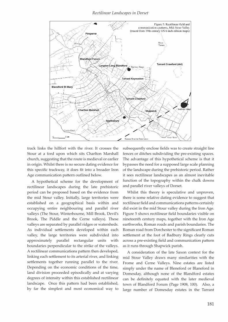
track links the hillfort with the river. It crosses the Stour at a ford upon which sits Charlton Marshall church, suggesting that the route is medieval or earlier in origin. Whilst there is no secure dating evidence for this specific trackway, it does fit into a broader Iron Age communication pattern outlined below.
A hypothetical scheme for the development of rectilinear landscapes during the late prehistoric period can be proposed based on the evidence from the mid Stour valley. Initially, large territories were established on a geographical basis within and occupying entire neighbouring and parallel river valleys (The Stour, Winterbourne, Mill Brook, Devil’s Brook, The Piddle and the Cerne valleys). These valleys are separated by parallel ridges or watersheds. As individual settlements developed within each valley, the large territories were subdivided into approximately parallel rectangular units with boundaries perpendicular to the strike of the valleys. A rectilinear communications pattern then developed, linking each settlement to its arterial river, and linking settlements together running parallel to the river. Depending on the economic conditions of the time, land division proceeded episodically and at varying degrees of intensity within this established rectilinear landscape. Once this pattern had been established, by far the simplest and most economical way to
subsequently enclose fields was to create straight line fences or ditches subdividing the pre-existing spaces. The advantage of this hypothetical scheme is that it bypasses the need for a supposed large scale planning of the landscape during the prehistoric period. Rather it sees rectilinear landscapes as an almost inevitable function of the topography within the chalk downs and parallel river valleys of Dorset.
Whilst this theory is speculative and unproven, there is some relative dating evidence to suggest that rectilinear field and communications patterns certainly did exist in the mid Stour valley during the Iron Age. Figure 5 shows rectilinear field boundaries visible on nineteenth century maps, together with the Iron Age earthworks, Roman roads and parish boundaries. The Roman road from Dorchester to the significant Roman settlement at the foot of Badbury Rings clearly cuts across a pre-existing field and communication pattern as it runs through Shapwick parish.
A consideration of the late Saxon context for the mid Stour Valley draws many similarities with the Frome and Cerne Valleys. Nine estates are listed simply under the name of Bleneford or Blaneford in Domesday, although none of the Blandford estates can be definitely equated with the later medieval town of Blandford Forum (Page 1908, 100). Also, a large number of Domesday estates in the Tarrant
Rectilinear Landscapes in Dorset
181

it approached the eponymous ford. It is not known if this suburb represents one of the Domesday manors, but it originally took the form of another dispersed settlement situated on a road running perpendicular to the river (Fig. 6).
Analysis of the road pattern within the town of Blandford Forum indicates that the layout of the medieval town was strongly influenced by the pre-existing rectilinear landscape patterns (Fig. 6). Firstly, early post-medieval route maps such as that of Ogilby show that the main London to Weymouth road entered the town via Monkton Down and Black Lane. It should be noted however, that the medieval chapel of St Leonard actually fronts on to a path which runs parallel to Black Lane, slightly to the north. This path is more directly aligned with East Street and may represent the original course of the major eastern medieval route. Secondly, West Street may originally have continued directly south from Salisbury Street, crossing the Stour at the old ford east of Blandford Bridge (Penn 1980, 21 inset). Following construction of the bridge West Street was extended westwards on its present course. Furthermore, Lea’s 1690 road map of Dorset shows the main road from Blandford to Shaftesbury leaving Blandford along Mill Down Road and then turning east across Mill
Valley are simply called Tarrant (Thorn & Thorn 1983). Furthermore, of the nine Blandford Domesday estates, four have their pasture recorded in length and breadth measurements. Furthermore, estates in Charlton Marshall, Pimperne, Spetisbury, Shapwick, Tarrant Crawford and Tarrant Keyneston, have their woodland, as well as their pasture, assessed in this way.
The modern parish of Blandford St Mary comprises at least five separate Domesday manors; strung out along the south side of the River Stour, just above the flood plain. Each manor had a strip of land running up the valley slopes from the river to Little Down. The settlements were linked by a road running parallel to the river; Poole Road, on a slightly different course than the modern Bournemouth Road (AOC 2001, 5). Each settlement had a further road running perpendicular to the river, providing access to its fields and meadow. The earliest secure evidence for occupation within Blandford St Mary comes from the Stour Park retail site where excavation has produced Late Saxon pottery in association with a shrunken medieval settlement and its perpendicular holloway (Graham & Cox 1993a; 1993b; Hennessy 2004). Furthermore, the Hardinge Survey of Cranborne Chase dated 1618 shows that the medieval suburb of Blandford St Mary originally lay on either side of Dorchester Hill, where
John Davey
182

Down itself towards Tin Pot Lane and Kites Corner (Good 1966, 54-5, 62, 105). Evidence from the changes in the course of Park Road and Milldown Road also suggest that Damory Street and White Cliff Mill Street formerly opened out into a broad unenclosed way, later enclosed as Milldown Road. An alternative route from Blandford to Kite’s Corner followed Salisbury Road and Shaftesbury Lane (1618 survey of Cranborne Chase).
Sherborne
Rectilinear land division in the Sherborne area has already been the focus for a number of studies. Barker (1977; 1984, 13-20) first recognized them as potentially
similar to the Dartmoor reaves. Keen (1984) preferred a Saxon rather than a prehistoric date, primarily based on the fact that the field boundaries seem to follow the alignment of a Herepath mentioned in the tenth-century Rimpton charters (Marston Magna Road). The author has argued elsewhere (Davey 2010a) that the Sherborne field alignments actually form part of a wider system of land division incorporating the hundred of Horethorne in south east Somerset (Fig. 7). These alignments run perpendicular to a series of dips and scarps associated with the Jurassic Geology of the region, culminating to the east with the western slopes of the Cale valley. In the immediate Sherborne region the River Yeo marks the southern boundary
Rectilinear Landscapes in Dorset
183

founded in AD 705 on a pre-existing British monastic estate of 100 hides (Barker 1982). It is possible then that this 100-hide estate was separated from an earlier, potentially prehistoric rectilinear land unit at Horethorne sometime during the late or post-Roman period. The fact that the field system predates the county boundary north of Sherborne can be clearly seen in the stepped nature of the parish boundary between Poyntington and Oborne, which represents the county boundary at the time of Domesday (Fig. 8). It is clear that the county boundary respects a pre-existing field system and in this case individual fields surviving in the modern landscape can be shown to be late Saxon or earlier in origin.
The pre-urban settlement pattern in the upper Yeo valley comprised a series of Iron Age and Roman settlements regularly spaced along the spring line parallel to the north bank of the Yeo. Leach (1964, 13) noted that there were at least six Romano-British settlement sites strung out along the Yeo valley at intervals of approximately 1 mile from Pinford Lane in the east to Bradford Abbas in the west. This regular dispersed settlement pattern was integrated within the rectilinear pattern of lanes and fields. It is only when the nucleated town of Sherborne was established
of this geological unit. Excavations by the South Cadbury Environs Project indicate that the regular field alignments in this region originated in the late prehistoric period and were further subdivided during the late Roman period (Davey 2005, 72-4). The herepath mentioned in the Rimpton Charters, therefore represents the designation of a pre-existing prehistoric trackway rather than the foundation of a Saxon route de novo.
The course of the Domesday county boundary between Somerset and Dorset, north of Sherborne, suggests that a Sherborne estate had been removed from the rectilinear Horethorne Hundred by the late Saxon period (Fig. 7). A 100-hide estate is recorded in the foundation charters for Sherborne cathedral at Lanprobi (Baring-Gould and Fisher 1913, 107). The British place name Lanprobi is mentioned in a fourteenth-century list of fundatores to the Sherborne church contained within a collection of Sherborne Charters and held at the British Library. This charter is sometimes known as the Cotton manuscript Faustina A. ii, which records the granting of 100 hides of land at Lanprobi by Cenwalh, King of Wessex (643-672), to the church at Sherborne. Thus it is plausible that the cathedral at Sherborne was
John Davey
184

during the Saxon period that alterations to the pre-existing field system came about (Fig. 9). These changes were limited at first to the vicinity of the Cathedral precinct. Sherborne holds a significant position in the history of Wessex. Although not mentioned by name, events relating to its foundation are recorded in both the Anglo-Saxon Chronicle and Bede’s Historia. It became a see for the diocese of Wessex, west of Selwood, in AD 705 and became the capital of Wessex for a short period from 860-878 whilst Winchester was exposed to Viking attacks (Wildman 1911, 3-4). Hall has drawn attention to the fact that bishoprics on the continent were normally founded at important Roman administrative centres. In England, early sees were also created in former Roman towns such as Canterbury, Winchester and Dorchester-on-Thames. Why then was Sherborne chosen above Ilchester or Dorchester? There was a substantial Roman settlement at Pinford Lane, close to Sherborne Castle, but it was never a walled town. It is possible that Sherborne was chosen as see because of a pre-existing British Church on the site with a large estate already endowed for its support. In fact Lanprobi may already have been the seat of a British bishop. The foundation of the Saxon see led to subtle changes in alignment at Sherborne. Although the location of the pre-existing British church has not been demonstrated beyond doubt, twelfth-century Papal Bullae suggest that it lay in the vicinity of Sherborne Old Castle, perhaps on or close to the site of the substantial Roman settlement
at Pinford Lane. The Saxon cathedral however, was established approximately half a kilometre to the west adjacent to a clear or bright stream from which the town of Sherborne derives its name. The cathedral was established, in the Saxon fashion, within a rectangular precinct aligned more truly north than the pre-existing field boundaries in the region and the secular town subsequently grew around this newly established precinct (Hall 2005, 135-39; Barker 1984, 18)). These Saxon N-S alignments also continue a little to the east of the precinct in the region of Newland. Deviations in the routes of Acreman and South Streets represent the points at which the old prehistoric alignments abut against the later Saxon alignments.
Finally, it may have been as late as the mid eighteenth century that the radial communication pattern was established around Sherborne. The first Turnpike Act relating to Dorset was dated 1752-3 and it was at this time that the Yeovil and the Bristol Roads were designated (Good 1966, 124-26).
Christchurch Hundred
The topography of the Christchurch region is dominated by the valleys of the rivers Stour and Avon, emptying into Christchurch Harbour. The town itself occupies a narrow low gravel ridge between the two rivers, immediately north of the harbour. The lower courses of the rivers are regularly flooded. Marshland still dominates here, notably at Stanpit marsh and
Rectilinear Landscapes in Dorset
185

Barlins. Either side of the central vale, the ground slopes gently up to the New Forest on the east and the former heaths, now developed for the urban area of Bournemouth, to the west. The Bournemouth heaths and the New Forest both represented vast tracts of unenclosed marginal land as late as the late nineteenth century. Between the river valley marshes and the unenclosed heaths and forests, was a narrow strip of cultivable land historically occupied by dispersed settlement and organised into tithings of Christchurch Hundred.
The hundred of Christchurch passed to the Malmesbury Estate during the eighteenth century and a map was produced depicting the various tithings and the land occupied by the estate tenants. This map, held at Hampshire Record Office (HRO 9M73-139), provides a rare and accurate depiction of land division in the region prior to the late-nineteenth-century parliamentary enclosure. A tracing of the map (Fig. 10) reveals a number of interesting field patterns. These include oval enclosures at Street and Nea (Davey 2010a, 93-5).
The most pertinent aspect of the map, for the purposes of this paper, is the depiction of rectilinear field alignments arranged into tithings running perpendicular to the corresponding river. That is,
those on the east side of the hundred have long axes perpendicular to the river Avon, and those on the west run perpendicular to the river Stour. Furthermore, the regular land division only extends in the strip of land between the floodable marshes and the unenclosed heaths and forest. Parliamentary enclosures came late to the Christchurch region, bitterly opposed and resisted by the townspeople. The Portfield in Christchurch was not finally enclosed until the late nineteenth century. Common fields at Stanpit and Street were also enclosed during the nineteenth century. The 1796 map then, depicts a pre-enclosure landscape, demonstrating that the regular rectangular fields are not the result of parliamentary enclosures. Unfortunately, there is no further independent dating evidence for this field system. Nevertheless, the fact that tithing boundaries follow the same alignments suggests that they be medieval or earlier in origin. The evidence presented in this paper suggests that, morphologically, these field systems can be considered to be of late prehistoric origin. The proximity of Hengistbury Head might provide an economic context for pre-Roman land division in the region.
Within the limited area covered by the 1796 map it is clear that the medieval settlements are regularly
John Davey
186

spaced, both running up the slope to the east and along the strike of the valley to the north. Thus we get columns of settlement sites; Stanpit - Bure- Nea; Street - Somerford- Hubborne; and Staple Cross - Roeshott Farm. It is unclear whether settlements at Mudeford and Highcliffe existed during the medieval period.
Similarly, on the west side of the region, the medieval settlements are also regularly spaced in pairs; Tuckton and Southbourne; Iford and Pokesdown. Furthermore, Figure 11 (traced from the nineteenth century O.S. edition six inch series maps) shows that this settlement pattern extended beyond the confines of the four tithings and continues up the respective river valleys to the north and west. It is also apparent that the lanes and tracks linking the settlements are regularly arranged into rectangular blocks. This is particularly clear on the eastern slopes of the Avon Valley. The larger nucleated villages lie in a string along the course of the rivers themselves; Sopley, Winkton, Burton, Wick, Tuckton, Iford and Holdenhurst. Behind these larger settlements are a series of regularly spaced hamlets and farmsteads. Thus, we have a three-tiered settlement pattern; one row alongside the river, the second at regular intervals in a row behind (The Bockhamptons, Waterditch Farm, Somerford and Bure) and a third group on the edge of the forest (Bransgore, Neacroft,Godwinscroft,Waterditch, Roeshot Farm, Hubborne and Nea.
The Bockhamptons (North, Middle and South Bockhampton) form a particularly interesting group in that these dispersed settlements do not lie at nodes within the communications pattern, but rather along an isolated stretch of track running perpendicular to the river.
Conclusions
It is clear that a significant proportion of Dorset’s rural landscape comprises tracts of rectilinear land division of potential late prehistoric origin but fossilised within the modern fieldscape and communications pattern. The chalk downs and valleys, running across the centre of the county, from the Upper Frome and Sydling Brook in the west to the River Allen in the east, provide the main block of rectilinear landscapes. The east-west topographical alignments of the South Dorset Ridgeway, Frome Valley and Purbeck Ridge provide the setting for another tranche of co-axial fields with long alignments running north-south. A third, broad group lie in the north of the county and have long alignments running ENE-WSW, perpendicular to the upper Stour Valley, Blackmore Vale and a series of dips and scarps of Jurrassic origin on the Somerset-Dorset border in the region of Sherborne. In many places these areas of regular land division have been shown to be integrated within a regular pattern of dispersed settlement and communications. This suggests remarkable continuity of land use and rural economy from the late prehistoric period, through the Roman interlude and Dark Ages into the medieval and modern eras. The most dramatic changes to this organised landscape have probably occurred within the last two hundred years. This is not to say that the changes over the last two millennia have been negligible. These represent working landscapes used with fluctuating intensity. Specific boundaries, tracks and settlements may have a relatively short lifespan, but the overall pattern has remained constant. Environmental evidence suggests that there may have been a retreat from marginal land and a reduction in arable farming following the collapse of the Roman
Rectilinear Landscapes in Dorset
187

Empire (Thew 194, 170; Dark 1996, 35 & 46-50; for example). Nevertheless, this does not necessarily imply an abandonment of rural infrastructure such as land division. Ditched field boundaries are still useful even if there is a reversion from intensive arable to more extensive pastoral agrarian regimes. The availability of enclosed fields allows the stock holder to control grazing more effectively and maximise production and regeneration of pasture. It may well have been the presence of such a valuable rural resource, as organised rectilinear landscapes, that enabled the rapid rise of Alfredian Wessex and an effective reorganisation of the military in terms of herepaths, defended burhs and thegns capable of supporting the King on long campaigns (Davey 2010a, 101).A new model for the distribution of dispersed settlement within rectilinear landscapes can be proposed (Davey 2010a, 96-99). Figure 12.1 shows the generally accepted landscape model of dispersed settlement. The settlement itself lies at the centre of its land unit. Arable or most intensely cultivated infields lie close to the settlement with unenclosed or less intensely cultivated pasture around it. A radial communication pattern connects the settlement with its regularly spaced neighbours. This geographical model owes much to Christaller’s Central Place Theory. However, Christaller’s model was chronologically static and assumed that settlement and associated land units occupied a previously blank canvas on a flat plain. In other words there was no preceding system of settlement or land division, casting a residual influence on the pattern. This is clearly not the case for medieval dispersed settlement within a pre-existing system of Roman or late prehistoric land division and communication.
A more appropriate model for the Dorset regions of rectilinear land division can be derived from geographical studies of the Dutch Polders described by Chisolm (1968, 62). Here, vast tracts of land have been reclaimed from the sea over the last few hundred years or more. It was found that the most efficient way of dividing the land into farm units was in a rectilinear pattern similar to a co-axial field system. When considering the position of farmsteads within these land units, a number of different options were available, illustrated in Figure 12.2. In option A the farms are placed at the centre of their land holdings. This facilitates cultivation, but renders the farm further from its communications routes making transportation of produce or supplies more expensive. The farmhouse is also a long distance from its nearest neighbour should co-operation be necessary for example, at harvest or in
a crisis. The second alternative B represents nucleated settlement. Here the advantages of communication and co-operation between neighbours are paramount. The main disadvantage is that each farmstead lies at such a distance from its cultivable land to render production in the farthest corners unsustainable. Option C illustrates a compromise between the conflicting requirements of rural production, co-operation and distribution. On the one hand, the settlements are relatively close to the centre of their land unit, whilst on the other they are close to a linking track. Furthermore, the settlement is paired with a neighbour allowing for co-operation and pooling of resources in times of need.
Nucleated villages and markets tend to lie close to the major communication routes, generally represented by watercourses in prehistoric and medieval Dorset. This model allows for a tithing, manor or parish to extend back from the nucleated settlement, with paired dispersed farmsteads evenly spaced and strung out along a lane running back from the river. This pattern is recognisable to the north of Dorchester, in the Stour Valley and in Christchurch Hundred.
Generally, where large nucleated settlements have developed, so have radial communications patterns. This is a relatively recent phenomenon associated with post-medieval and modern economic patterns of production, trade and distribution. Many of the radial roads identified in this study are eighteenth-century turnpikes. Central Place Theory is very much a twentieth-century model describing a modern economic world. The factors influencing the distribution of settlement, communication patterns and landholding were totally different for the greater part of the last two millennia. A diverse local economy was of paramount importance and the transportation of bulk goods outside of the region less so. The new model suggests that patterns within the historic landscape have developed as the result of a compromise between economic factors, which require a settlement to be located centrally within its land (Figure 12.1; 12.2A) and social factors, which encourage co-operation between neighbours (Figure 12.2B & C).
The author has previously noted that this new model needs testing for all periods in which rectilinear land division was in use (Davey 2010a, 98). The study of the distribution of Iron Age and Roman settlements in the Sherborne, Blandford and Purbeck regions has gone some way towards that. In each of these study areas, late prehistoric settlement has been evenly distributed
John Davey
188

along the length of river valleys. In the Stour Valley near Blandford, theoretical rectangular territories and communications patterns associated with hillforts have been proposed. These fit the evidence on the ground better than Theissen polygons. Similarly, the late Saxon rectangular estates in Purbeck may retain the memory of a pre-existing late-prehistoric and Roman system of land holding.
The study of rectilinear communications patterns has also provided an insight into the development of town plans. It is clear that the layout of many of Dorset’s historic towns has been strongly influenced by pre-existing patterns within the landscape. Changes in town plans have usually arisen for a specific reason as a solution to a specific problem. These changes can be piecemeal and organic or planned on a larger scale. The creation of the Saxon cathedral precinct in Sherborne on a more north-south alignment is an example of large-scale re-planning, as is the creation of simple double-row nucleated villages. Other common developments include; planned burgages; a medieval market place, often on the edge of an earlier Saxon settlement and the creation of new radial turnpike roads during the eighteenth century. Each of these changes may take place within the milieu of a pre-existing rectilinear landscape, enabling us to unravel the earliest elements within the town and the extent of each subsequent alteration. Walking along Bradford Lane in Sherborne or Damory Street in Blandford Forum, we might be forgiven for not recognising that we are on what is essentially a prehistoric alignment, and one of the oldest components in the town plan.
This link between town and country has implications for guiding development control. Landscape archaeology is an integrated process. Archaeological landscapes need to be considered in their entirety and not just in terms of isolated sites. Thus pipeline trenches across an ostensibly empty landscape have the potential to provide information not only on rural landscapes, but on the timing and origin of our townscapes as well. Similarly, excavations within towns have the potential to expand our knowledge of prehistoric and medieval rural landscapes. Work conducted through the Dorset Historic Towns Project also suggests that there is frequently a link between Dorset’s earliest towns and regions of rectilinear land division. This may be more than coincidence. For towns to flourish they must have a productive hinterland.
Rectilinear land division has been and will continue to be identified within every county of lowland Britain
and beyond. If no evidence for centuriation can be convincingly established in Britain it is perhaps because the island was already subdivided in to utilitarian rectilinear units. Dorset seems to be particularly well endowed with this landscape phenomenon. This is only partly a function of topography and may also be a reflection of the early date at which grassland was established on the chalk downs. It is also a reflection of the relative stability of the region following the collapse of the Roman Empire. It is likely that this continuing and valuable landscape resource supported a solid rural economy which in turn provided the platform for the rise of the house of Wessex during the late ninth century AD.
ACKNOWLEDGEMENTS
I would like to thank Peter Bellamy of the Dorset Historic Towns Project for his invaluable input and encouragement over the last four years. Much of the research for this paper has arisen out of work conducted for the Dorset Historic Towns Project funded by English Heritage and Dorset County Council. I would also like to take this opportunity to thank Mike Costen, Christopher Taylor and Mick Aston for their input and support over the years. My research in the Sherborne Region has arisen from my time with the South Cadbury Environs Project. I would like to thank Richard Tabor, Giles Cooper, Richard Wykes and James Gerrard for their help and advice during this period. I would also like to thank Katherine Barker for providing the impetus to get this paper published and commenting on an early draught.
REFERENCES
Allen M. Chisham C. & Stevens C. 2006. ‘Environmental Archaeology in the Commercial Sector – ethos and practice’ in The Archaeologist 59 (Winter 2006), 18-19.
AOC 2001. The Old School House, Blandford St Mary, Dorset; Historic Building Impact Assessment. Unpublished AOC Archaeology Group client report December 2001.
Baring-Gould, S. & Fisher, J. 1913. Lives of the British Saints. London.
Barker K, 1977. ‘The Origins of Sherborne: A Preliminary Report’, Proceedings of the Dorset Natural History and Archaeological Society 99, 127-28.
——— . 1982. ‘The Early History of Sherborne’ in Pearce S.M. (ed). Studies presented to C A Ralegh Radford arising from a conference organised in his honour by the Devon Archaeological Society, BAR British Series 102, 77-116.
——— . 1984. ‘Sherborne in Dorset; an early ecclesiastical settlement and its estate’, Anglo-Saxon Studies in
Rectilinear Landscapes in Dorset
189

Archaeology and History 3, 1-33. ——— . 1988. ‘Aelfric the Mass-priest and the Anglo-Saxon
Estates of Cerne Abbey’ in Barker (ed.). The Cerne Abbey Millennium Lectures, 27-42.
Chisholm M. 1968. Rural Settlement and Land Use, Hutchinson, London.
Costen M. 2007. ‘Anonymous Thegns in the Landscape of Wessex 900-1066’ in Costen (ed.). People and Places: Essays in Honour of Mick Aston, Oxbow, Oxford.
Cox, P.W. 1988. ‘A Seventh Century Inhumation Cemetery at Shepherd’s Farm, Ulwell, near Swanage, Dorset’, Proceedings of the Dorset Natural History and Archaeological Society 110, 37-47.
Dark, S.P. 1996. ‘Palaeoecological Evidence for Landscape Continuity and Change in Britain circa AD 400-800’, in Dark, K.R. (ed.). External Contacts and the Economy of Late Roman Britain and Post-Roman Britain, 23-51,The Boydell Press, Woodbridge.
Davey, J. E. 2005. The Roman to Medieval Transition in the Region of South Cadbury Castle, Somerset. BAR British Series 399.
———. 2009a. Abbotsbury Draft Historic Urban Characterisation Report. Dorset County Council and English Heritage. http://www.dorsetforyou.com/392176
——— . 2009b. Corfe Castle Draft Historic Urban Characterisation Report. Dorset County Council and English Heritage. http://www.dorsetforyou.com/393195
——— . 2010a. ‘Rectilinear Field Systems and Dispersed Settlement in South Somerset and Dorset’, Early Medieval Enquiries: The Proceedings of the Clifton Antiquarian Club 9, 85-102.
——— . 2010b Wareham Draft Historic Urban Characterisation Report. Dorset County Council and English Heritage. http://www.dorsetforyou.com/398181
Drew, C.D. 1947. ‘The Manors of the Iwerne Valley Dorset: A Study in Early Country Planning’, Proceedings of the Dorset Natural History and Archaeological Society 69, 45-50.
Fleming, A. 1978 ‘The Prehistoric Landscape of Dartmoor. Part 1: South Dartmoor’, Proceedings of the Prehistoric Society 44, 97-123.
Fowler, J. 1951. Mediaeval Sherborne. Dorchester: Longmans.Gardiner, J. 2003. ‘Dorchester, Land to the West and South
West of Poundbury Farm 2000-2001’, Proceedings of the Dorset Natural History and Archaeological Society 125, 154-6.
Good, R. 1966. The Old Roads of Dorset. HG Commin Ltd, Bournemouth (new enlarged edition).
Graham, A. & Cox, P.W. 1993a. ‘The Archaeological Evaluation of the Proposed Stour Park, Blandford St Mary, Dorset’ (Centred on ST889057). Unpublished AC Archaeology client report number AC 3093/1/0
——— . 1993b. ‘The Stage 2 Archaeological Evaluation of the Proposed Stour Park, Blandford St Mary, Dorset’ (Centred on ST888057). Unpublished AC Archaeology client report number AC 3093/2/0
Hall, T.A. 2005. ‘Sherborne: Saxon Christianity be Westanwuda’. In Barker, Hinton and Hunt (eds). St
Wulfsige and Sherborne: Essays to Celebrate the Millennium of the Benedictine Abbey, 998-1998. 133-148. Oxbow, Oxford.
Hennessy, B. 2004. ‘Stour Park, Blandford St Mary, Dorset; Post Excavation Assessment’. Unpublished Wessex Archaeology client report number WA 54246.01.
Hinton, D.A. 1994. ‘Some Anglo-Saxon Charters and Estates in South-East Dorset.’ Proceedings of the Dorset Natural History and Archaeological Society 116, 11-20.
Keen, L. 1984. ‘The Towns of Dorset’, in Haslam J. (ed.). Anglo-Saxon Towns in Southern England. 203-47.
Ladle, L. 2004. Bestwall; Pits, Pots and People. The archaeology of Bestwall Quarry, Wareham, Dorset. Bestwall Archaeology Project.
Leach, J. 1964. ‘The Roman Farmstead at Thornford (interim report)’ in Journal of the Sherborne Historical Society 1, 8-13.
Morris P. 2002. Abbotsbury Historic Landscape Research Project; Synthesis Report No.1. Ilchester Estates.
O’Donovan, M.A. 1988. Charters of Sherborne, OUP.Oosthuizen, S. 2005. ‘New Light on the Origins of Open
Field Farming?’ Medieval Archaeology 49, 165-93.Page, W. (ed.). 1908. A History of the County of Dorset Volume
2. VCH.Penn, K.J. 1980. The Historic Towns of Dorset. Dorset Natural
History and Archaeological Society, Monograph 1.RCHM. 1970. An Inventory of Historical Monuments in the
County of Dorset. Volume 2 (South East). in 3 parts. The Royal Commission for Historic Monuments in England.
Smith, R.J.C. 1992. ‘Middle Farm, Bridport Road, Dorchester’, Proceedings of the Dorset Natural History and Archaeological Society 114, 239.
Sunter, N. & Woodward P.J. 1987. Romano-British Industries in Purbeck. Dorset Natural History and Archaeology Society Monograph Series no. 6.
Taylor, C. C. 1970 The Making of Dorset, Hodder and Stoughton, London.
——— . 2004 The Making of Dorset (paperback edition), Dovecote Press, Wimborne.
Thew, N. 1994. ‘Geology and Geoarchaeology in the Yeo Valley at Ilchester’, in Leach, P. Ilchester Volume 2; Archaeology Excavations and Fieldwork to 1984, 157-71, Sheffield Excavation Reports 2.
Thorn, C., & Thorn F. 1983. Domesday Book, Dorset. Phillimore, Chichester.
Webster, C.J. 2008. The Archaeology of South West England, South West Archaeological Research Framework.
Wildman, W.B. 1911. A Short History of Sherborne from 705 AD, 3rd edition, F. Bennett.
Williamson, T. 1987. ‘Early Co-axial Field Systems on the East Anglian Boulder Clays’, in Proceedings of the Prehistoric Society 53, 9-31.
——— . 2003. Shaping Medieval Landscapes; Settlement, Society and Environment, Windgather Press, Macclesfield.
John Davey
190