The shift of trade routes across th English Channel during the Roman expansion in Western Europe
7
Published by Jonas Enzmann in Skyllis 2013.1, p. 32-37. The shift of trade routes across the English Channel during the roman expansion in Western Europe Abstract: There are only four passages which are habitually used in crossing from the mainland to the island, those which begin at the mouths of the rivers — the Rhenus (Rhine), the Sequana (Seine), the Liger (Loire), and the Garumna (Garonne) (Strab. Geog. 4, 5, 2). These are the words of Strabo who described the situation around 63 BC – 23 AD. With the beginning of the Roman expansion in Western Europe political and cultural changes occurred which also changed the trade and trade routes. This presentation is about the shifts in trade routes during the Roman expansion and is mainly based on maritime locality. It is divided into three phases of expansion: First, the situation before the advent of the Romans in Gaul; then the situation after the conquest of Gaul, and Caesar's brief visit to Britain; finally the phase after the Roman conquest of Britain. Various wrecks and maritime sites in the area of the English Channel were collected from the literature and will be part of this presentation. Inhalt: Es gibt vier Überfahrten, deren man sich gewöhnlich vom Festlande nach der Insel bedient, nämlich von der Mündung der Ströme Rhenus [Rhein], Sequana [Seine], Liger [Loire] und Garumna [Garonne] aus (Strab. Geog. 4, 5, 2). Diese Worte von Strabon beschreiben die Situation zu seinen Lebzeiten um 63 v. Chr. bis 23 n. Chr. Mit dem Beginn der römischen Expansion in Westeuropa finden zahlreiche politische und kulturelle Veränderungen statt, die auch Auswirkungen auf die Handelsrouten haben. Dieser Artikel dreht sich um die Veränderung der Handelsrouten während der römischen Expansion in Westeuropa und basiert hauptsächlich auf maritimen Fundstellen. Er gliedert sich in drei Abschnitte der römischen Expansion: Erstens, die Situation vor dem Erscheinen der Römer in Gallien; Zweitens die Situation nach der Eroberung Galliens und Cäsars kurzem Aufenthalt in Britannien; Drittens die Situation nach der Eroberung Britanniens durch die Römer. Verschiedene Wracks und maritime Fundstellen aus dem Ärmelkanal wurden zu diesem Zweck zusammengestellt kurz präsentiert und eingeordnet. The Island of Britain is only separated from Continental Europe by the narrow English Channel. This geographical speciality is important for the Maritime Archaeology because every imported or exported good needs to be transported over the sea. Other aspects, that are connected with the geography are the extreme natural conditions in the Channel. Strong currents, extreme tides and dangerous weather complicate the work of Underwater-Archaeologists. In the archaeological research of the last decades, that was normally terrestrial based, the island situation of Britain was used to develop models that describe the exchange of men, goods and ideas between Britain and the Continent. The intention of this paper is to check these models against wrecks and other maritime findings. For this purpose, the text is divided into three phases of the Roman expansion: First, the situation before the arrival of the Romans in Gaul, then the situation after the conquest of Gaul and Caesar's brief visit to Britain and finally, the phase after the Roman conquest of Britain until the end of the third century. The description of such a long period lacks in detail, but this paper is more an attempt to demonstrate the major developments. It should be a rough overview, to rise some questions and to show in which way the Maritime Archaeology could be helpful to answer these questions. The first phase begins with the growing Roman influence in the trade to North Western Europe. After the fall of Carthage in 146 BC, the route to Britain around the Iberian Peninsula, formerly dominated by the Carthaginians seems to be aborted. With the establishment of the Province, Gallia Narbonensis in 125 BC and the foundation of the city Narbo Martius (Narbonne) in 118 BC the Romans gained the control over the favourite trade routes towards North Western Europe. When Massilia (Marseille) and Arelatum (Arles) were
Transcript of The shift of trade routes across th English Channel during the Roman expansion in Western Europe
Published by Jonas Enzmann in Skyllis 2013.1, p. 32-37.
The shift of trade routes across the English Channel during the roman expansion inWestern Europe
Abstract: There are only four passages which are habitually used in crossing from the mainland to the island, thosewhich begin at the mouths of the rivers — the Rhenus (Rhine), the Sequana (Seine), the Liger (Loire), andthe Garumna (Garonne) (Strab. Geog. 4, 5, 2).These are the words of Strabo who described the situation around 63 BC – 23 AD. With the beginning of theRoman expansion in Western Europe political and cultural changes occurred which also changed the tradeand trade routes.This presentation is about the shifts in trade routes during the Roman expansion and is mainly based onmaritime locality. It is divided into three phases of expansion: First, the situation before the advent of theRomans in Gaul; then the situation after the conquest of Gaul, and Caesar's brief visit to Britain; finally thephase after the Roman conquest of Britain.Various wrecks and maritime sites in the area of the English Channel were collected from the literature andwill be part of this presentation.
Inhalt:Es gibt vier Überfahrten, deren man sich gewöhnlich vom Festlande nach der Insel bedient, nämlich von derMündung der Ströme Rhenus [Rhein], Sequana [Seine], Liger [Loire] und Garumna [Garonne] aus (Strab. Geog. 4, 5, 2).Diese Worte von Strabon beschreiben die Situation zu seinen Lebzeiten um 63 v. Chr. bis 23 n. Chr. Mit demBeginn der römischen Expansion in Westeuropa finden zahlreiche politische und kulturelle Veränderungenstatt, die auch Auswirkungen auf die Handelsrouten haben. Dieser Artikel dreht sich um die Veränderung der Handelsrouten während der römischen Expansion inWesteuropa und basiert hauptsächlich auf maritimen Fundstellen. Er gliedert sich in drei Abschnitte derrömischen Expansion: Erstens, die Situation vor dem Erscheinen der Römer in Gallien; Zweitens dieSituation nach der Eroberung Galliens und Cäsars kurzem Aufenthalt in Britannien; Drittens die Situationnach der Eroberung Britanniens durch die Römer. Verschiedene Wracks und maritime Fundstellen aus dem Ärmelkanal wurden zu diesem Zweckzusammengestellt kurz präsentiert und eingeordnet.
The Island of Britain is only separated from Continental Europe by the narrow English Channel. Thisgeographical speciality is important for the Maritime Archaeology because every imported or exported goodneeds to be transported over the sea. Other aspects, that are connected with the geography are the extremenatural conditions in the Channel. Strong currents, extreme tides and dangerous weather complicate the workof Underwater-Archaeologists. In the archaeological research of the last decades, that was normallyterrestrial based, the island situation of Britain was used to develop models that describe the exchange ofmen, goods and ideas between Britain and the Continent. The intention of this paper is to check these modelsagainst wrecks and other maritime findings. For this purpose, the text is divided into three phases of theRoman expansion: First, the situation before the arrival of the Romans in Gaul, then the situation after theconquest of Gaul and Caesar's brief visit to Britain and finally, the phase after the Roman conquest of Britainuntil the end of the third century. The description of such a long period lacks in detail, but this paper is morean attempt to demonstrate the major developments. It should be a rough overview, to rise some questions andto show in which way the Maritime Archaeology could be helpful to answer these questions.
The first phase begins with the growing Roman influence in the trade to North Western Europe. After the fallof Carthage in 146 BC, the route to Britain around the Iberian Peninsula, formerly dominated by theCarthaginians seems to be aborted. With the establishment of the Province, Gallia Narbonensis in 125 BCand the foundation of the city Narbo Martius (Narbonne) in 118 BC the Romans gained the control over thefavourite trade routes towards North Western Europe. When Massilia (Marseille) and Arelatum (Arles) were
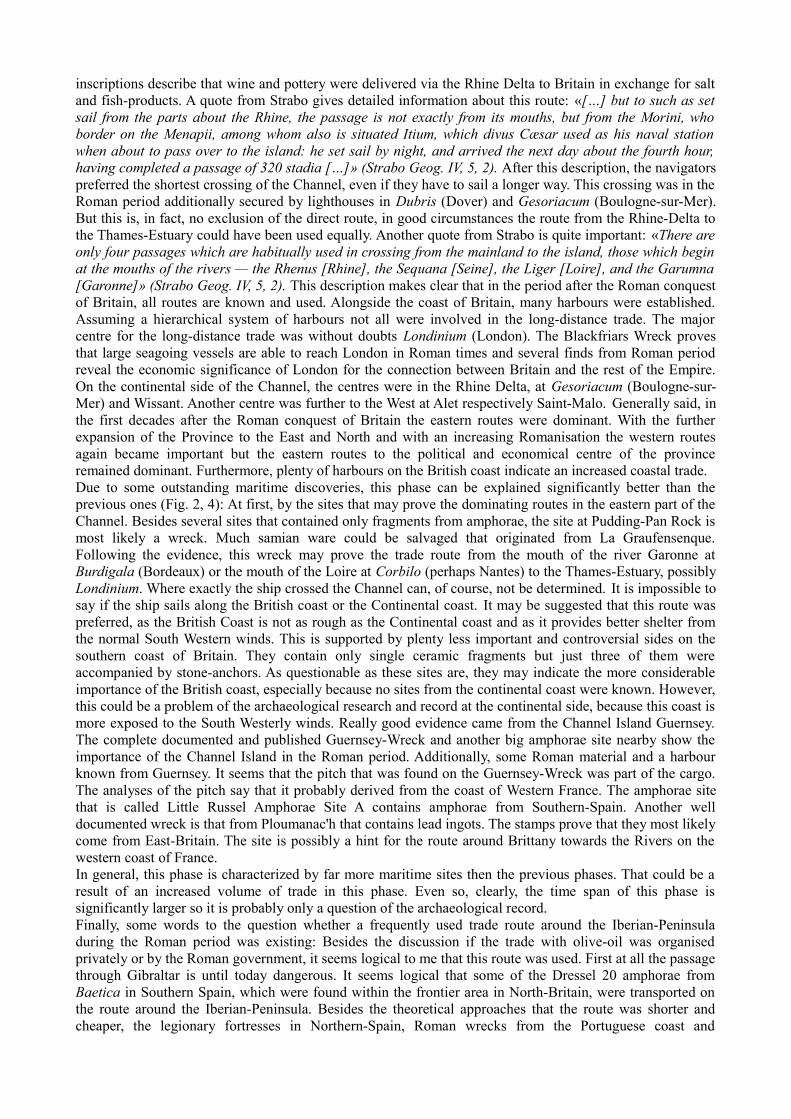
the big centres for the trade along the Rhône towards the Gaulish oppida, then Narbo Martius was the centreof the trade with North Western Europe. The traditional route follows the river Aude, crosses the gap atCarcassonne to the river Garonne that flows in the Gironde and at least into the Atlantic Ocean (Fig. 1). Fromthere the route is heading north along the French coast to Brittany and from there directly to South Britain,where Hengistbury Head, Mount Batten and Poole Harbour were the main centres of long-distance trade.Besides these direct routes across the Channel to the major centres in South Britain, some goods may havebeen traded to one of the centres and then along the coast of Britain to the others. The importance of thewhole route is clearly illustrated by the distribution of Dressel 1a amphorae that dated from the last quarterof the second-century BC to the mid of the first-century BC (Galliou 1984). A quote from Caesar on this factis interesting: «The influence of this state is by far the most considerable of any of the countries on the wholesea coast, because the Veneti both have a very great number of ships, with which they have been accustomedto sail to Britain, and [thus] excel the rest in their knowledge and experience of nautical affairs; and as onlya few ports lie scattered along that stormy and open sea, of which they are in possession, they hold astributaries almost all those who are accustomed to traffic in that sea» (Caes. B. Gall. III, 8, 1) . Followingthis quote it is likely that the Veneti were working as middlemen in the trade for the part of the route from theFrench river mouths to Brittany and South Britain. There are certain problems with this interpretationbecause finds of Veneti coins in Britain are few, but many coins from the neighbouring tribe of theCoriosolites in the North of Brittany were found (Cunliffe/de Jersey 1997). Despite from these problems inthe interpretation about the role that the Veneti played in the trade across the Channel, the evidence from thedistribution of Dressel 1a amphorae seems to prove the close contact between the Veneti region in SouthBrittany and South Britain. Besides this long distance trade with Italian wine other regional goodsdemonstrate the close connection between the North Western French regions and the South of Britain. Forexample, many fine wares found in the assemblages of Hengistbury Head and the other Southern Britainsites that originate from Armorica (Cunliffe 1984). In addition, there was maybe another connection furtherto the east between the Seine valley and the Solent region. Unfortunately little evidence is found for theexports from Britain in this period, but Strabo writes later that Britain exports: grain, cattle, gold, silver, iron,hides, slaves and hunting dogs (Strabo Geog. IV, 5 , 2). So it is possible to think that these export goods alsoplayed a significant role in the time before the Roman conquest of Gaul, even though there is little chance todemonstrate this archaeologically. To summarize this brief overview, it can be said that the major trade routesin this period cross the channel in the western part. Believing, that the ancient navigators should have steered a course where they are in sight of land as long aspossible there were two major routes to cross the Channel in the western part: First, from the Isle of Ushantstraight north to the Plymouth Sound and the region of Mount Batten. Secondly, around Brittany to the coastof Armorica and the Channel Islands and then westwards of the Contentin-Peninsula across the Channel tothe Poole Harbour region and Hengistbury Head. As mentioned before maybe another route from the mouthof the Seine to the Solent region east of the Contentin-Peninsula was existing. However for the long-distancetrade with Italian wine, this route seems to be unimportant, because only few amphorae were foundcompared with the other routes. Following Séan McGrail (1983), who sailed all the routes and published hisexperiences, both routes should be difficult, but possible for the ancient navigators. Clearly, some points canbe criticized. In an anachronistic view from the Romano-Celtic shipwrecks and the hints given by Caesar (B.Gall. III, 13) about the ships of the Veneti it can be assumed that the Gaulish ships at this time were larger,then McGrail estimated, and that they had a deck. Altogether the ships had perhaps a slightly betterperformance than McGrail thought, but this won't change the picture significantly. The distribution of marine sites that contained material from this period match the picture that is describedabove (Fig. 2, 3). Nevertheless the major problems of these sites are that they all reflect single finds ofceramic fragments, that were taken by fishermen and afterwards described to archaeologists. That meansboth, the type and the exact position of the find are in most cases unclear, so they have been extremely poorconcerning their explanatory power. For example, in most cases only the amphorae type could bedetermined, while the precise variant, which is extraordinary importance for the dating, is missing. However,no significant discovery of material from this period was made outside the described area. With all care, itcan be summarized that the routes, which are based upon the evaluation of imported amphorae from theMediterranean and imported goods from North Western France in Britain, are right, as they correspond to theresults of the sailing tests of McGrail
The second phase begins with a big change in the political, social and cultural structure on the continentalside of the Channel. The campaigns by Julius Caesar and the establishment of the Roman Provinces inFrance, Belgium, Western and South Germany and the South Netherlands opened new trade routes across the
Channel. The first thing, that must be determined, is that after the failed uprising of the Veneti and a coupleof allied tribes in 56 BC, the major player of the trade to Britain disappeared. In consequence of the defeatthe Veneti and the tribes formed an alliance with them lost their ships needed in the trade to Britain. Inaddition, the navigators were most likely in captivity, slavery or dead. Furthermore, the campaigns on landmust have destroyed the economic basis of production. Against all these historical implications, thearchaeological evidence1 shows that the route from Southern France around the Brittany to the PooleHarbour region was still in use. Nevertheless, the western routes lost importance. The new major routescrossed the Channel further to the east, from the mouth of the Seine and a bit later from the Rhine Deltatowards South East Britain and the Thames-Estuary. At first, the change in the long-distance trade withimported wine from the Mediterranean should be discussed. Around the middle of the first-century BC, theDressel 1a amphorae were abandoned, and the Italian wines now were traded in Dressel 1b amphorae(Galliou 1984). The distribution of the Dressel 1b amphorae are completely different from the Dressel 1aamphorae. Most findings were made in South-Eastern Britain. The common thesis is, that this shift wasconnected with Caesar's brief Britain-Campaign in 54 BC. The invasion was completed via the shortest routeacross the Channel from Wissant to Dover, and the following battles are concentrated on the South East ofBritain. Before the Romans after a short time retreated from the British Isle, they made peace and closedsome political allegiances with the tribes in South-Eastern Britain. In this context, some of the amphoraefound, may have been gifts or bribes. It could be another possibility that an exclusive trade deal with theRomans was part of these allegiances. The close contact between the area at the mouth of the Seine and theSolent region continued, which is demonstrated by the fine wares that were found along both sides of theChannel. Furthermore, in Wessex many coins were found, that were minted under Commius. According tothe controversial Belgian-Invasion theory, this Atrebatic chieftain fled from the Romans across the Channelto build a dynasty in the Solent region (Cunliffe 1984). There is no room here to discuss this matter further,but the archaeological evidence clearly displays a close contact between these regions. After the Romanshave fully established their Rhine provinces the route along the Rhône, Saône, Mosel and Rhine and thencross the Channel to the Thames-Estuary becomes more and more important. The strong military poweralongside the Rhine and several campaigns into free Germany must have resulted in a flourished trade. Thechiefdoms in South-Eastern Britain, that had friendly contacts with the Romans benefited from thisintensified trade. The archaeological record shows, that the graves of the Aylesford-Culture in SoutheastBritain with imported metal vessels, Gallo-Belgic wares and brooches with Italian origin or inspiration datedpost-Caesarian (Stead 1984). It can be assumed, that these regions after Caesar's campaigns were linkedtogether by an intensified exchange of goods. The big change in the trade across the Channel at this time isindicated by a losing importance of the eastern routes, when the route from the mouth of the Seine and theroutes from the Rhine-Delta to the Thames-Estuary and South East Britain became more and moreimportant. Unfortunately, the maritime archaeological record for this phase is nearly not existing. Maybe some findingsfrom the earlier phase that were mentioned above are dating in this phase, but without a clear determinedvariant, it is impossible to say (Fig. 2, 3). Only one site near Guernsey may date to this phase, but again, it isa find made by a fisherman. Nonetheless, this find may prove the route from the coast of Armorica, mostlikely from the harbour of Alet towards Britain. Probably, a reduction in the total volume of trade in thisphase could be stated.
The third phase begins with the Roman invasion of Britain under Emperor Claudius AD 43. Due to the closecontacts, the alliances and the good geographical situation for an invasion, the Romans landed in the South-Eastern part of Britain.2 If it is possible to talk about regular trade in the early phase of the invasion, then itshould be strongly influenced by military interests (Jones 2009). This didn't change much in the followingdecades, the uprising of the Iceni in AD 61 and the long-standing war in Wales characterizing the early phaseof the Roman rule in Britain. With an increasing Romanisation, the regular civilian trade becomes even moreimportant than ever before. In general, the Roman province Britain is characterized by an enormous militarypersonnel, a special richness of metal and a developed agriculture. The trend in the trade routes, that could beobserved at the phase before is growing. The western routes, especially the route from the Rhine-Delta to theThames-Estuary seems to be the major route to transport goods from the Continent to Britain. This isdemonstrated by numerous votive inscriptions on altars in Colijnsplaat and Domburg, where for example thegoddess Nehalennia is asked to guarantee a favourable crossing (Schmidts 2011). In addition, these
1 There are several finds of Iberian amphorae and western French fine ware in post-Caesarian assemblages in Southern Britain.
2 Where exactly is another controversial discussion, which couldn't present here.
inscriptions describe that wine and pottery were delivered via the Rhine Delta to Britain in exchange for saltand fish-products. A quote from Strabo gives detailed information about this route: «[…] but to such as setsail from the parts about the Rhine, the passage is not exactly from its mouths, but from the Morini, whoborder on the Menapii, among whom also is situated Itium, which divus Cæsar used as his naval stationwhen about to pass over to the island: he set sail by night, and arrived the next day about the fourth hour,having completed a passage of 320 stadia […]» (Strabo Geog. IV, 5, 2). After this description, the navigatorspreferred the shortest crossing of the Channel, even if they have to sail a longer way. This crossing was in theRoman period additionally secured by lighthouses in Dubris (Dover) and Gesoriacum (Boulogne-sur-Mer).But this is, in fact, no exclusion of the direct route, in good circumstances the route from the Rhine-Delta tothe Thames-Estuary could have been used equally. Another quote from Strabo is quite important: «There areonly four passages which are habitually used in crossing from the mainland to the island, those which beginat the mouths of the rivers — the Rhenus [Rhine], the Sequana [Seine], the Liger [Loire], and the Garumna[Garonne]» (Strabo Geog. IV, 5, 2). This description makes clear that in the period after the Roman conquestof Britain, all routes are known and used. Alongside the coast of Britain, many harbours were established.Assuming a hierarchical system of harbours not all were involved in the long-distance trade. The majorcentre for the long-distance trade was without doubts Londinium (London). The Blackfriars Wreck provesthat large seagoing vessels are able to reach London in Roman times and several finds from Roman periodreveal the economic significance of London for the connection between Britain and the rest of the Empire.On the continental side of the Channel, the centres were in the Rhine Delta, at Gesoriacum (Boulogne-sur-Mer) and Wissant. Another centre was further to the West at Alet respectively Saint-Malo. Generally said, inthe first decades after the Roman conquest of Britain the eastern routes were dominant. With the furtherexpansion of the Province to the East and North and with an increasing Romanisation the western routesagain became important but the eastern routes to the political and economical centre of the provinceremained dominant. Furthermore, plenty of harbours on the British coast indicate an increased coastal trade. Due to some outstanding maritime discoveries, this phase can be explained significantly better than theprevious ones (Fig. 2, 4): At first, by the sites that may prove the dominating routes in the eastern part of theChannel. Besides several sites that contained only fragments from amphorae, the site at Pudding-Pan Rock ismost likely a wreck. Much samian ware could be salvaged that originated from La Graufensenque.Following the evidence, this wreck may prove the trade route from the mouth of the river Garonne atBurdigala (Bordeaux) or the mouth of the Loire at Corbilo (perhaps Nantes) to the Thames-Estuary, possiblyLondinium. Where exactly the ship crossed the Channel can, of course, not be determined. It is impossible tosay if the ship sails along the British coast or the Continental coast. It may be suggested that this route waspreferred, as the British Coast is not as rough as the Continental coast and as it provides better shelter fromthe normal South Western winds. This is supported by plenty less important and controversial sides on thesouthern coast of Britain. They contain only single ceramic fragments but just three of them wereaccompanied by stone-anchors. As questionable as these sites are, they may indicate the more considerableimportance of the British coast, especially because no sites from the continental coast were known. However,this could be a problem of the archaeological research and record at the continental side, because this coast ismore exposed to the South Westerly winds. Really good evidence came from the Channel Island Guernsey.The complete documented and published Guernsey-Wreck and another big amphorae site nearby show theimportance of the Channel Island in the Roman period. Additionally, some Roman material and a harbourknown from Guernsey. It seems that the pitch that was found on the Guernsey-Wreck was part of the cargo.The analyses of the pitch say that it probably derived from the coast of Western France. The amphorae sitethat is called Little Russel Amphorae Site A contains amphorae from Southern-Spain. Another welldocumented wreck is that from Ploumanac'h that contains lead ingots. The stamps prove that they most likelycome from East-Britain. The site is possibly a hint for the route around Brittany towards the Rivers on thewestern coast of France. In general, this phase is characterized by far more maritime sites then the previous phases. That could be aresult of an increased volume of trade in this phase. Even so, clearly, the time span of this phase issignificantly larger so it is probably only a question of the archaeological record. Finally, some words to the question whether a frequently used trade route around the Iberian-Peninsuladuring the Roman period was existing: Besides the discussion if the trade with olive-oil was organisedprivately or by the Roman government, it seems logical to me that this route was used. First at all the passagethrough Gibraltar is until today dangerous. It seems logical that some of the Dressel 20 amphorae fromBaetica in Southern Spain, which were found within the frontier area in North-Britain, were transported onthe route around the Iberian-Peninsula. Besides the theoretical approaches that the route was shorter andcheaper, the legionary fortresses in Northern-Spain, Roman wrecks from the Portuguese coast and
lighthouses, like that at La Coruña, were maybe hints that such an route in the Roman period existed(Carreras/Morais 2010). At the moment, it is difficult to say of which relevance this route may have been.This does not mean that the continental route was not important. Quite contrary the sites at Domburg andColjinsplaat and other inscriptions from Britain and France show the strong connection between theContinental Provinces and Britain, but this must not completely exclude a route around the Iberian-Peninsula. From this point, the Little Russel Amphorae Site A near Guernsey with the Baetican-Amphorae ismaybe the rest of a ship that was on this route and not a coastal transport from the Rhine-Delta.
In conclusion, several developments could be outlined. The major change, that could be stated, is the shiftfrom the exchange between the Continent and Britain along the eastern and central routes to the dominanceof the central and western routes. This change was, simply formulated, connected with the RomanExpansion, but many other factors, like different regional relationships had influenced this change. A bittertruth is that the Maritime Archaeology does not provide help to understand the first two phases. The findsand sites are few, and the validity is limited. However, the sites and finds from the third phase prove that theMaritime Archaeology has great potential to complete findings from the terrestrial Archaeology. Questionslike the one about the existence of a route around the Iberian-Peninsula or the one which Celtic tribes wereinvolved in the Cross-Channel trade, could be answered by new finds from the Maritime Archaeology.
Bibliography:
André 1959: J. André, Trois amphores romaines “pêchées” au large des côtes Morbihannaise. Ann. Bretagne 66, 1959, 64-66.
André 1961: J. André, Notes d'archéologie sous-marine. Amphore romaine au large de Belle-Île. Ann. Bretagne 68, 1961, 95-97.
Carreras/Morais 2010: C. Carreras/R. Morais (ed.), The Western Roman Atlantic Facade: A study of the Economy and Trade in the Mar Exterior from the Republic to the Principate. BAR Internat. Ser. 2162(Oxford 2010).
Cunliffe 1984: Relations between Britain and Gaul in the First Century B.C. and Early First Century A.D. In:Macready/Thompson 1984, 3-23.
Cunliffe/de Jersey 1997: B. W. Cunliffe/P. de Jersey, Armorica and Britain. Cross Channel Relationships in the Late First Millennium BC. Studies in Celtic Coinage 3. Oxford Univ. Com. Arch. Monogr. 45 (Oxford 1997).
Dean 1984: M. Dean, Evidence for possible prehistoric and Roman wrecks in British waters. Internat. Journal of Nautical Arch. 13, 1984, 78-79.
Galliou 1984: Days of Wine and Roses? Early Armorica and the Atlantic Wine Trade. In: Macready/Thompson 1984, 24-36.
Jones 2009: J. E. Jones, The Maritime and Riverine Landscape of the West of Roman Britain: Water Transport on the Atlantic Coasts and Rivers of Britannia. BAR Internat. Ser. 493 (Oxford 2009).
L'Hour 1987: M. L'Hour, Un site sous-marine sur la côte de l'Armorique: l'épave antique de Ploumanac'h. Rev. Arch. de l'Ouest 4, 1987, 113-131.
Macready/Thompson 1984: S. Macready/F. H. Thompson (ed.), Cross-Channel Trade between Gaul amd Britain in the Pre-Roman Iron Age. Soc. Ant. of London Occasional Papers 4 (London 1984).
McGrail 1983: S. McGrail, Cross-Channel seamanship and navigation in the late 1st millenium BC. Oxford Journal Arch. 2, 1983, 299-337.
Parker 1992: A. J. Parker, Ancient shipwrecks of the Mediterranean and the Roman Provinces. BAR Internat.Ser. 580 (Oxford 1992).
Schmidts 2011: Th. Schmidts, Akteure und Organisation der Handelsschifffahrt in den nordwestlichen Provinzen des Römischen Reiches. Monogr. RGZM 97 (Mainz 2011).
Stead 1984: I. M. Stead, Some Notes on Imported Metalwork in Iron Age Britain. In: Macready/Thompson 1984, 43-66.
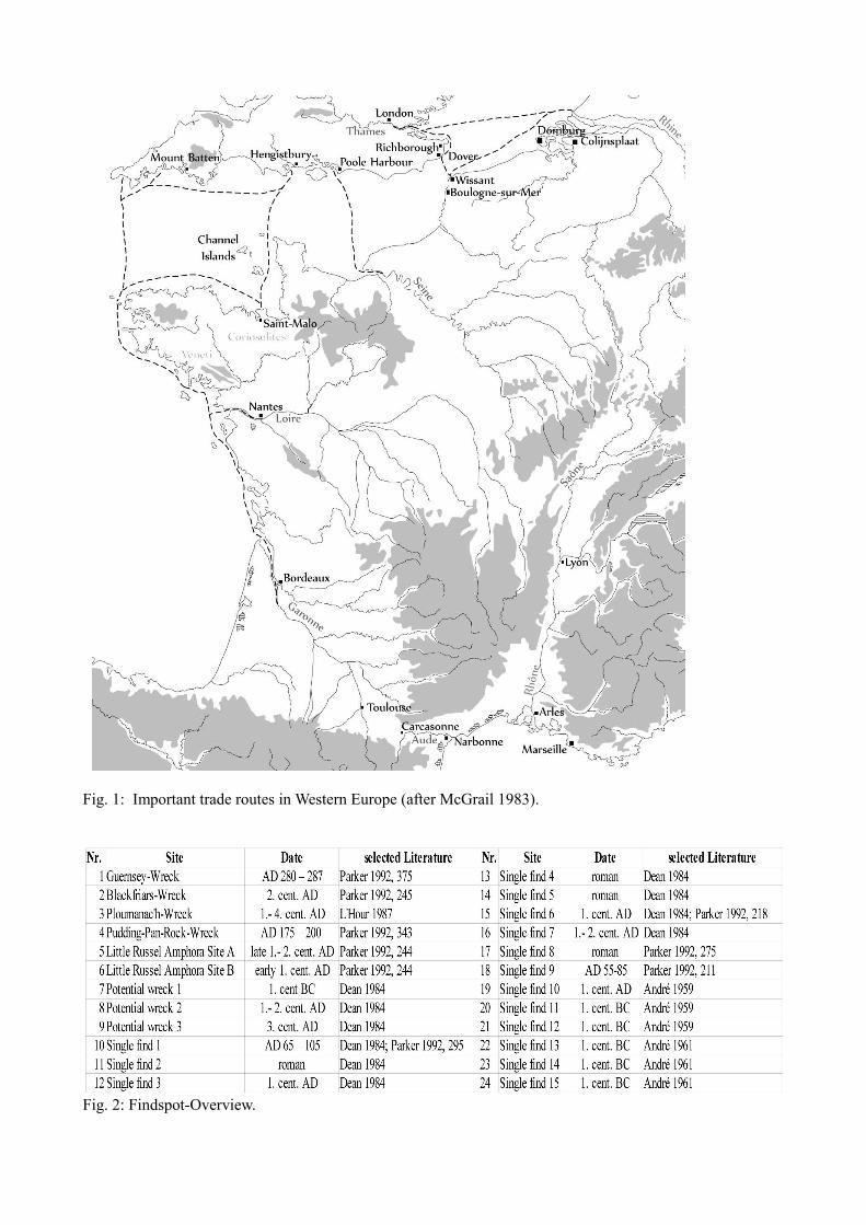
Fig. 1: Important trade routes in Western Europe (after McGrail 1983).
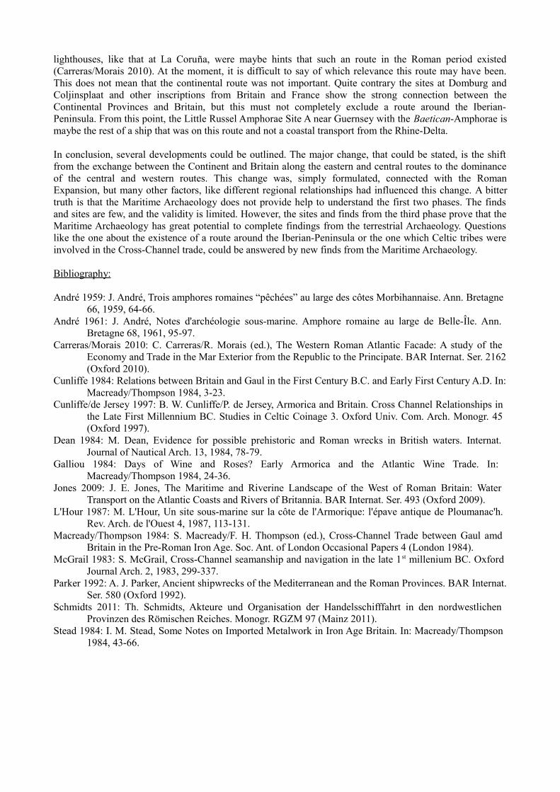
Fig. 2: Findspot-Overview.
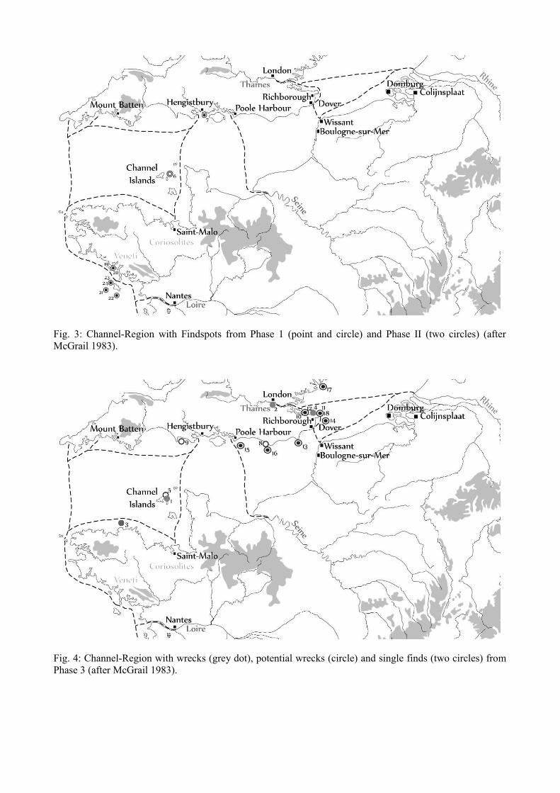
Fig. 3: Channel-Region with Findspots from Phase 1 (point and circle) and Phase II (two circles) (afterMcGrail 1983).
Fig. 4: Channel-Region with wrecks (grey dot), potential wrecks (circle) and single finds (two circles) fromPhase 3 (after McGrail 1983).