Lifestyle Migration of Japanese: A Case Study of Retired Japanese in Chiang Mai Province, Thailand
Upload
khangminh22Category
view
0download
0
The Plan of Chiang Mai City: Concepts and Local Knowledge
Sarassawadee OngsakulChiang Mai University
Abstract—Chiang Mai city was planned in accordance with distinctive concepts and knowledge. The city was designed to be the center of Lan Na with a square shape that differentiated it from other urban areas. The city was located between Doi Suthep and the Ping River. Rainwater falling on Doi Suthep flowed eastward along rivers and streams that fed into the Ping River, providing water supply for various settlements, an ancient swamp, and irrigation canals along the way. These streams and canals were systematically managed. The planning of the city reflected three overlapping concepts: the city as a living body; the city as an astrological device (thaksa mueang); and the city as representation of the cosmos.
Introduction
Chiang Mai city was founded more than seven centuries ago, in 1296. Its favorable location contributed to the fact that the city was for many centuries the center of the Kingdom of Lan Na from its foundation by King Mangrai (r. 1292–1311). After the city was abandoned for twenty years in the wars of the 18th century, it revived under the rule of King Kawila (r. 1782–1816) through the strategy of “collecting vegetables into baskets, people into towns,” and again became the center of Lan Na. Today, Chiang Mai is considered the second most important city in Thailand and the center of the northern region.
This article explores the concepts and local knowledge behind the planning of Chiang Mai city. The article is divided into three parts: first, knowledge on water supply and the systems of water management; second, the distinctive character of Chiang Mai among other Lan Na cities; and third, three overlapping concepts behind the foundation and planning of the city.
Knowledge on water supply and water management
Chiang Mai city lies in a basin on an alluvial plain along the Ping River, flanked by mountain ridges. The Ping flows from north to south, fed by several tributaries crossing the basin. The city lies between Doi Suthep to the west and the Ping River to the east. The urban settlement and the forest are interdependent. In the past, the forested area was larger than today, extending from Doi Suthep up to the western gate of the city, Suan Dok Gate. Doi Suthep has played an important role in providing the city’s water supply
Journal of the Siam Society, Vol. 108, Pt. 2, 2020, pp. 47–64© The Siam Society Under Royal Patronage 2020
63-10-048 047-064 jss108 22-10 i_coatedepple.indd 4763-10-048 047-064 jss108 22-10 i_coatedepple.indd 47 22/10/2563 BE 19:3422/10/2563 BE 19:34

48 Sarassawadee Ongsakul
through several tributaries, such as Huai Kaeo, Huai Chang Khian, Wai Stream, Huai Mae Hia and Huai Tueng Thao (see Figure 1). In particular, four places were believed to have auspicious significance for the city:
1. Doi Suthep has strong associations with both traditional beliefs and Buddhism. Its forested slopes collected water which supplied the city throughout the year, and also filled the city moat through ditches surrounding the city walls.
2. The Mae Kha Stream, rising in the Doi Suthep–Pui area, flowed into Nong Bua, an old swamp in the northeast of the city that no longer exists. In the past, the Mae Kha stream acted as the outer moat for the city. The stream also channeled excess from Nong Bua to the Ping River to prevent flooding.
3. The Nong Bua swamp, also known as Nong Bua Chet Ko, Nong Khiao or Nong Pa Phaeng, was present from the foundation of the city. Nong Bua covered a very
Figure 1. City and waterways (National Research Council of Thailand, 1991: 257). 1=Doi Suthep; 2=Doi Phu; 3=Huai Chiang Khian; 4=Huai Kaeo; 5=Wiang Jet Lin; 6=Wiang Suan Dok; 7=Chiang Mai
Journal of the Siam Society, Vol. 108, Pt. 2, 2020
63-10-048 047-064 jss108 22-10 i_coatedepple.indd 4863-10-048 047-064 jss108 22-10 i_coatedepple.indd 48 22/10/2563 BE 19:3422/10/2563 BE 19:34

49The Plan of Chiang Mai City
wide area and had the capacity to collect a large amount of water from various sources. It acted as a reservoir, as well helping to prevent floods.
4. The Ping River flowed past the city on the eastern side. It served as a source of water, as well a communication route southwards to Siam (see Figure 2).
There is a network of watercourses flowing from Doi Suthep in the northwest to the Ping River in the southeast. The early wiang or town settlements such as Wiang Jet Lin, Wiang Suan Dok, Wiang Chiang Mai, Wiang Bua were located in the spaces between these watercourses. So too was the Nong Bua swamp and an early irrigation system (in the area where Chiang Mai University is today). The location of settlements within this network of watercourses displays the local knowledge on water system management.
Wiang Jet Lin at the foot of Doi Suthep was designed in a circular shape, protected by two walls with a moat between them. Water for the moat came from Doi Suthep. Jet Lin means seven ditches which drew water to the town. Water from Wiang Jet Lin was believed to be sacred, and bathing or drinking had auspicious results. According to the Phra Suwanna Maha Wihan Inscription, Wiang Jet Lin was established in 1411 during
DO
I SU
THEP
Ping RiverHuai Kaeo
Lam Khu Wai
Huai Chang Khian
Mae
Kha
Strea
m
Mae Kha Stream
Nong Bua
Swamp
wiang between streams
Figure 2. Wiang between streams.
Journal of the Siam Society, Vol. 108, Pt. 2, 2020
63-10-048 047-064 jss108 22-10 i_coatedepple.indd 4963-10-048 047-064 jss108 22-10 i_coatedepple.indd 49 22/10/2563 BE 19:3422/10/2563 BE 19:34
50 Sarassawadee Ongsakul
the time of King Sam Fang Kaen (Penth, 2003: 77) in a strategic position on an upland which served as a lookout for approaching invaders, hence the circular shape like a fort. Lan Na kings often built palaces and temples at Wiang Jet Lin and occasionally stayed there (Subcommittee, 1995: 60).
Wiang Suan Dok, to the west of the city, was planned in the square shape of the main city, though smaller in size. The site had earlier been a royal garden named Suan Dok Mai Phayom (Tamnan Mulasasana, 1975: 208), and had several forest temples including Wat Suan Dok, Wat Pa Daeng, Wat Fai Hin, and Wat Umong. In 1371, King Kuena built Wiang Suan Dok as a wiang phrathat or town of holy relics and temples where Sumana Thara lived after moving from Sukhothai (Prasert and Griswold, 1992: 605-608). He founded the Raman or Suan Dok school which contributed to the prosperity of Buddhism by introducing new ideas and practices. Wiang Suan Dok was surrounded by a single earthwork with a moat outside, fed by water which came from Fai Hin through the ancient swamp. From the southeast corner of this moat, water was channeled into the Chiang Mai city moat.
This network of linked streams, canals, swamps and moats served several purposes. First, it prevented flooding. Heavy rain on Doi Suthep had the potential to cause flash floods, but the waterways dispersed the volume over a wide area, and the swamp served as a storage sink. The waterways passed over a series of terraces which slowed down the flow. Second, it provided a year-round water supply for the local settlements and Chiang Mai city. Third, it filled the defensive moats around the city and the settlements throughout the year.
To the south of the swamp, embankments were constructed in a curved shape perpendicular to the flow of water from Doi Suthep. These embankments collected the flow and dispersed it in two directions, into a reservoir to the north, and along the earthwork to the south. Any excess water would spill into rice fields. This system protected Wiang Suan Dok and Chiang Mai city against flooding (Sarassawadee, 2000: 127-129).
Wiang Chiang Mai was at the center of the other settlements. Its inner walls were square, with outer walls in crescent-moon shape to the east and the south. The city’s site sloped down from northwest to southeast. The water supply from Doi Suthep entered the city moats at the Hua Lin corner, and circulated in both directions down to the Khatham corner, the lowest point. Spillways were built at various points to draw off any excess water, as well as canals to supply various other communities. There were also canals at Hua Lin corner which directed water to communities before reaching Khatham corner, as stated in the Chiang Mai Chronicle:
On the 4th of March, during the 9th waning crescent, the King ordered his men to dig three to four canals: one from the Hua Lin corner to the Si Phum corner and then to the Khatham corner; one through a large canal in front of Wat Dap Phai and Wat Phra Sing; one through the west of the city; one past the north of the Royal Palace to the swamp at the center of the city and onward to the Chiang Yuen Gate and out to the Khatham corner in front of Wat Sai Mun. Each was built with soil and bricks (Subcommittee, 1995: 158).
Journal of the Siam Society, Vol. 108, Pt. 2, 2020
63-10-048 047-064 jss108 22-10 i_coatedepple.indd 5063-10-048 047-064 jss108 22-10 i_coatedepple.indd 50 22/10/2563 BE 19:3422/10/2563 BE 19:34

51The Plan of Chiang Mai City
The distribution of water in the city and moats of Chiang Mai demonstrates how people in the past used their understanding of the landscape to secure a year-round water supply.
Wiang Bua, to the north of Chiang Mai city, covered an area on both sides of today’s Chotana Road. Its name came from the nearby swamp of Nong Bua to the northeast. There is no evidence as to the date of its foundation. Some traces of old earthworks can still be seen. The palace of Khum Wiang Bua is believed to have occupied the current site of the Teacher Training College (Sumali, 1987: 30). James McCarthy (1994: 123) wrote that “to the north is the site of the once famous Mueang Timan, on the downfall of which the present city came into existence.” This statement reflects a belief that, prior to the foundation of Chiang Mai, there was a settlement to the north in a favorable location on a slope surrounded by water, namely the great swamp of Nong Bua. The swamp was fed by various streams, including Huai Chang Khian passing north of Wiang Jet Lin. On exiting the swamp, water ran southward along the Mae Kha Stream, looping round the city, and flowing into the Ping to the south of the city at the site known as Sop Kha” (sop means “meeting”). The network of rivers and streams provides water for the city and settlements. This arrangement reflects Lan Na knowledge from more than 700 years ago (see Figure 3).
Figure 3. Streams, wiang, and the Ping River (Sarassawadee 2001: 66).
Journal of the Siam Society, Vol. 108, Pt. 2, 2020
63-10-048 047-064 jss108 22-10 i_coatedepple.indd 5163-10-048 047-064 jss108 22-10 i_coatedepple.indd 51 22/10/2563 BE 19:3422/10/2563 BE 19:34

52 Sarassawadee Ongsakul
The distinctiveness of the Chiang Mai City plan
The plan of the city is a square, oriented to the compass. Wiang Suan Dok was the same. One represented a secular world while the other represented a religious one (see Figure 4). The plan of Chiang Mai City differed from earlier cities of Lan Na, which were built in accordance with geography, not in geometric shapes.
The early period (8th-12th century). Earlier cities such as Wiang Hariphunchai (Lamphun), Wiang Khelang Nakorn (Lampang) and Wiang Phrae were planned in the shape of a conch. According to the Mulasasana Chronicle, at the foundation of Hariphunchai, the hermit Suthep traced the shape of a conch on the ground (Tamnan Mulasasana, 1975: 124). These cities were sited on alluvial plains, with one side flanked by a river, and the other by earthen walls following the terrain. These early cities were built with low technology, and had no right-angled corners.
The later period (13th-18th century). After the establishment of Chiang Mai, cities were built either on the alluvial plain or on a hill. With the exception of Wiang Suan Dok, founded in the reign of Kuena (r. 1355–1385 according to Jinakalimali), none of the cities on the plain had a rectangular shape. For example, Wiang Chiang San, which was established during the Saen Phu reign in 1328, had a polygonal shape, while Wiang Pa Sang, established by Kawila in 1782, had a long oval shape along the Tha River (see Figure 5).
A large number of cities were built on hills, usually elevated to around 20-24 meters above the surrounding plain. These cities had no natural streams as moats, so moats were dug to serve as defenses, along with walls. The area inside these fortifications served as
Figure 4. Wiang Chiang Mai and Wiang Suan Dok (Aerial Photography Division, Royal Thai Survey Department, Ministry of Defence, 1954).
Journal of the Siam Society, Vol. 108, Pt. 2, 2020
63-10-048 047-064 jss108 22-10 i_coatedepple.indd 5263-10-048 047-064 jss108 22-10 i_coatedepple.indd 52 22/10/2563 BE 19:3422/10/2563 BE 19:34

53The Plan of Chiang Mai City
temporary settlements when the city came under threat. The permanent settlements were on the plains outside the cities. The design of moats differed according to geographical conditions. In some places, a single freestanding moat was dug around the hill. In others, there was a network of moats, linked like chains. In others, outer moats were added after the population expanded (see Figures 6 and 7).
In sum, cities in Lan Na were built according to geographical considerations. The question then naturally arises: What influenced the square plan of Chiang Mai? My conclusion is that the influence came from Khmer culture via Sukhothai.
Khmer cities were generally rectangular in shape, surrounded by moats and with a place of worship at the center. This pattern can be found at the old Khmer capital of Angkor as well as many Khmer-influenced cities in Thailand, such as Phimai and Nong Han Luang (now in Sakon Nakhon province). Phimai’s original plan was a rectangle of 500 x 900 meters in size with earthen walls, surrounded by moats, and with rivers on three sides (Thada, 2001: 129). Nong Han Luang’s plan was a square surrounded by two walls with 40-meter moats between them (Thada, 2001: 138) (see Figures 8 and 9).
The plan of Sukhothai was similar, as the art and architecture of Sukhothai was influenced by Khmer culture, clearly seen in 12th-century buildings such as the Ta Pha Daeng Shrine and Wat Si Sawai. The original plan of Sukhothai was a rectangle surrounded by moats with four city gates and a place of worship at the center (Chotima, 2017: 9). To the west of Sukhothai is a mountain, and to the east a river, similar to Chiang Mai, but with the city located closer to the mountain and
Figure 7. Wiang Chiang Dao (Aerial Photography Division, Royal Thai Survey Department, Ministry of Defence, 1976, reproduced in Sayan, Phasuk and Suphot, 1996: 132).
Figure 5. Wiang Pa Sang (Aerial Photography Division, Royal Thai Survey Department, Ministry of Defence, 1954).
Figure 6. Wiang Prao (Aerial Photography Division, Royal Thai Survey Department, Ministry of Defence, 1976, reproduced in Sayan, Phasuk and Suphot, 1996: 138).
Journal of the Siam Society, Vol. 108, Pt. 2, 2020
63-10-048 047-064 jss108 22-10 i_coatedepple.indd 5363-10-048 047-064 jss108 22-10 i_coatedepple.indd 53 22/10/2563 BE 19:3422/10/2563 BE 19:34

54 Sarassawadee Ongsakul
further from the river than at Chiang Mai. According to Khmer thinking, a city should turn its back to the mountains and face towards water in the east (Thada, 2001: 104). The geographical similarity suggests that Chiang Mai’s plan was influenced by Sukhothai. The Chiang Mai Chronicle records that, during the time Chiang Mai was established, King Ramkhamhaeng of Sukhothai and King Ngam Mueang of Phayao were invited to visit the city to advise King Mangrai on the construction (Subcommittee, 1995: 33).
Chiang Mai was designed to be different from other cities in Lan Na as part of its claim to rule over other cities as the capital of the Kingdom of Lan Na. It was larger than other cities in Lan Na, and enjoyed the highest status among “57 Lan Na cities” as the seat of the king.
Different areas within the city had a distinct function and status. The north, known as “Hua Wiang” (the head of the city), had the highest status. The area was slightly elevated, sloping downwards towards the swamp in the northeast. The area was a good location for settlement, and is believed to have been occupied prior to the establishment of Chiang Mai. During the coronation, the king entered the city through the Hua Wiang Gate (later renamed as Chang Phueak Gate), and the Royal Palace (Wiang Kaeo) was located there.
To the west was Doi Suthep, a sacred mountain where the spirits of ancestors lived. It was a highland forest that was a water source for the city, and the site of several forest temples, such as Wat Pa Daeng, Wat Fai Hin, and Wat Umong.
The east was the front of the city near the Ping River. This was the commercial area where merchants lived and did business. Tha Phae Gate, a symbol of commerce, was in this area.
The south was a lowland area, and the lowest ranked in status. Low-ranking nobles lived in this area. The Saen Pung Gate and Hai Ya Gate were used for carrying dead bodies out of the city.
According to the Chiang Man Inscription, the auspicious time for starting the
Figure 9. Nong Han Luang, Sakon Nakhon (reproduced in Thada, 2001: 143).
Figure 8. Phimai (reproduced in Thada, 2001: 125).
Journal of the Siam Society, Vol. 108, Pt. 2, 2020
63-10-048 047-064 jss108 22-10 i_coatedepple.indd 5463-10-048 047-064 jss108 22-10 i_coatedepple.indd 54 22/10/2563 BE 19:3422/10/2563 BE 19:34
55The Plan of Chiang Mai City
construction of the city moats was “the year 658, a year of the monkey, the eighth day of the waxing moon in the eighth month at an auspicious early hour” (Historical Document Publishing Committee, 1965: 210). The Committee on the Verification and Study of the Town’s Horoscope resolved this date as Thursday, 12 April 1296 CE at 4.00 a.m. according to the Julian calendar, or 19 April by the Gregorian calendar. There is still debate about the date which should be recognized for the actual foundation of Chiang Mai City.
Three concepts behind the city plan
There are three related and overlapping conceptions behind the plan of Chiang Mai: the city as a living body; the city as an astrological device (thaksa mueang); and the city as a representation of the cosmos.
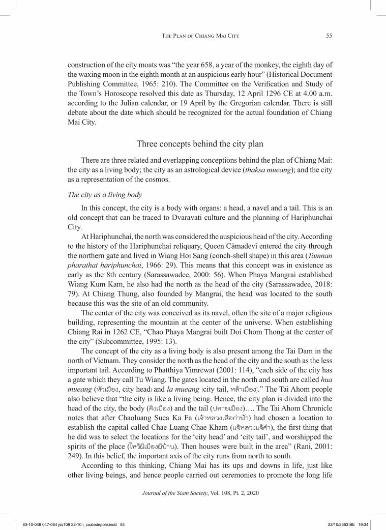
The city as a living body
In this concept, the city is a body with organs: a head, a navel and a tail. This is an old concept that can be traced to Dvaravati culture and the planning of Hariphunchai City.
At Hariphunchai, the north was considered the auspicious head of the city. According to the history of the Hariphunchai reliquary, Queen Cāmadevi entered the city through the northern gate and lived in Wiang Hoi Sang (conch-shell shape) in this area (Tamnan pharathat hariphunchai, 1966: 29). This means that this concept was in existence as early as the 8th century (Sarassawadee, 2000: 56). When Phaya Mangrai established Wiang Kum Kam, he also had the north as the head of the city (Sarassawadee, 2018: 79). At Chiang Thung, also founded by Mangrai, the head was located to the south because this was the site of an old community.
The center of the city was conceived as its navel, often the site of a major religious building, representing the mountain at the center of the universe. When establishing Chiang Rai in 1262 CE, “Chao Phaya Mangrai built Doi Chom Thong at the center of the city” (Subcommittee, 1995: 13).
The concept of the city as a living body is also present among the Tai Dam in the north of Vietnam. They consider the north as the head of the city and the south as the less important tail. According to Phatthiya Yimrewat (2001: 114), “each side of the city has a gate which they call Tu Wiang. The gates located in the north and south are called hua mueang (หวเมอง, city head) and la mueang (city tail, หลาเมอง).” The Tai Ahom people also believe that “the city is like a living being. Hence, the city plan is divided into the head of the city, the body (คงเมอง) and the tail (ปลายเมอง)…. The Tai Ahom Chronicle notes that after Chaoluang Suea Ka Fa (เจาหลวงเสอกาฟา) had chosen a location to establish the capital called Chae Luang Chae Kham (แจหลวงแจคำา), the first thing that he did was to select the locations for the ‘city head’ and ‘city tail’, and worshipped the spirits of the place (ไหวผเมองผบาน). Then houses were built in the area” (Rani, 2001: 249). In this belief, the important axis of the city runs from north to south.
According to this thinking, Chiang Mai has its ups and downs in life, just like other living beings, and hence people carried out ceremonies to promote the long life
Journal of the Siam Society, Vol. 108, Pt. 2, 2020
63-10-048 047-064 jss108 22-10 i_coatedepple.indd 5563-10-048 047-064 jss108 22-10 i_coatedepple.indd 55 22/10/2563 BE 19:3422/10/2563 BE 19:34

56 Sarassawadee Ongsakul
of the city (phithi sueb chata mueang พธสบชาตาเมอง), particularly after some ominous incident occurred, in order to prevent bad luck, boost people’s morale. and bring good fortune. A grand long-life ceremony was conducted during a war against the Yunnanese Chinese during the rule of King Sam Phraya Fang Kaen (r. 1402–1441):
King Sam Phraya Fang Kaen told his men to ask monks, astrologers and scholars to have a discussion. [He said] we should worship the city’s horoscope; then worship the gods of the domain’s fortune, majesty, and age, and every guardian spirit of the city; then worship the four guardians of the world (lokaban) and Indra as the fifth; then ask the gods to help and protect our city and every part of it. (Subcommittee, 1995: 59)
In 1825 during the reign of Phraya Khamfan, the long-life ceremony was performed with worship of the twenty-eight guardians of the city, especially the city pillar known as Inthakhin (Subcommittee, 1995: 160). A manuscript history of Chiang Mai kept in Wat San Pa Liang explains that the guardians of Chiang Mai are the city navel, the city pillar, a yang tree (a tall dipterocarp), Kumphan Asura (a protective ogre), the five city gates, Phraya Changphueak Hua Wiang, and all the gods and every late king of Chiang Mai in Lan Na. The ceremony has been performed since the Mangrai dynasty (1292–1558) and the Chao Jet Ton dynasty (1732–1939) (Sarassawadee, 2016: 55-57). The residences of the key guardians of the city who feature in this ritual were listed as follows:
city center Saen Tong TaengInthakhin (city pillar) Saen Nangsue, Saen KhaekKumphan guarding Inthakhin Phuak Chang TaemSuan Dok Gate Muen ChitMangrai guardian Saen SriHua Lin Phuak Dap(Center for the Promotion and Study of Lan Na Thai Culture, 1980: 57)
The ceremony is still performed today. There have been some changes but it is still called the city merit-making ceremony (พธทำาบญเมอง, phithi tham bun mueang). The focus in on ten important places, namely, the five city gates, the four city corners, and the city center. Buddhism plays a larger role, displacing the guardian gods and spirits. The heads of the ceremony are no longer common people and nobles but governmental organizations based near the ceremony venue. The role of the guardians and the participation of the whole population are no longer seen.
The body or organs of Chiang Mai city consisted of the head, the navel and the feet. The head of the city was in the north. In the past, people were not allowed to bring any ominous items through the Hua Wiang Gate as it was a sacred area with the White Elephant Statue, Singh Statue, and the residence of the king. The center of the city was its navel containing several sacred sites including the City Pillar, Wat Chedi Luang, Wat Sadue Mueang, and Khuang Luang, an open space for public activities. The last area was the tail or the feet of the city, that was in the south on the outskirts of the city. The
Journal of the Siam Society, Vol. 108, Pt. 2, 2020
63-10-048 047-064 jss108 22-10 i_coatedepple.indd 5663-10-048 047-064 jss108 22-10 i_coatedepple.indd 56 22/10/2563 BE 19:3422/10/2563 BE 19:34

57The Plan of Chiang Mai City
area was low in terms of status. It was where the king’s servants lived. There were some small temples built by noblemen in this area, such as Wat Phan Waen and Wat Muen Tum (Sarassawadee, 2018: 99-101).
The city as astrological device: thaksa mueang
Thaksa is an ancient form of astrology using nine heavenly bodies: sun, moon, Mars, Mercury, Jupiter, Venus, Saturn, Rahu, and Neptune (Ketu). They are arrayed clockwise around a nine-cell diagram, where the eight outer cells represent eight aspects of life. The heavenly body mapped into each cell has the greatest effect on that aspect of the life of a person or city.
Aspect of lifeboriwan acquaintances, close associates,
subordinatesayu age, disease, parasitesdet status, power, righteous authoritysi morale, wealth, luck and prosperitymontri patrons in the family, parents, teachers,
masters and patronsmula birthplace, residence, land, monetary
inheritance, family wealthutsaha perseverance, diligence, endeavor,
helpers, working equipment, industry, commerce.
kalakini bad things, disgrace, enemies, obstacles, bad luck, poverty, sadness, serious disease, humiliation and carelessness
(Athawirot, 2003: 138-139; Phaithun, 2003: 27)
Chiang Mai city was built in line with the concept of thaksa. The city was officially founded on a Thursday, in Thai the day of Jupiter, the largest planet in the solar system, as the founder wanted Chiang Mai to be the capital which had authority over other satellite towns. According to the theory of thaksa, the heavenly body on the birth or founding day determines the boriwan, the relationships with others. In Chiang Mai’s thaksa diagram, the boriwan is to the west, and the other aspects arrayed clockwise from there (Somchot and Sarassawadee, 2005: 3-6, 36).
sun northeast 1 moon east 2 Mars southeast 3 Mercury south 4 Saturn southwest 7 Jupiter west 5 Rahu northwest 8 Venus north 6
Journal of the Siam Society, Vol. 108, Pt. 2, 2020
63-10-048 047-064 jss108 22-10 i_coatedepple.indd 5763-10-048 047-064 jss108 22-10 i_coatedepple.indd 57 22/10/2563 BE 19:3422/10/2563 BE 19:34

58 Sarassawadee Ongsakul
The city itself is a thaksa 9-cell diagram (see Figure 10). The central cell is the city center, the location of the navel in the concept of the city as a living body. The eight outer cells are as follows:
boriwan Suan Dok Gate west ayu Hua Lin corner northwest det Hua Wiang/Changphueak Gate north si Si Phum corner northeast mula Tha Phae Gate east utsaha Khatham corner southeast montri Chiang Mai Gate south kalakini Ku Hueang corner southwest
Thaksa also guided the location of temples in the city. People regarded the earth as the center of the universe, around which other planets revolved. Wat Chedi Luang, the largest pagoda in Lan Na, represented Mount Meru, the center of the universe. Other temples near the city center were located in the directions of the sun, moon and Venus. Wat Chai Si Phum was to the northeast, the sun, representing the aspect of si. Wat Buppharam was to the east, the moon, representing the aspect of mula. Wat Chiang Yuen was to the north, Venus, representing the aspect of det. Other temples were further out: Wat Nantharam to the south, Mercury, representing the aspect of montri; Wat Chai Mongkhon to the southeast, Mars, aspect of utsaha; and Wat Suan Dok to the west,
Wat Jet YotHua Lin Corner
Wat Chiang YuenHua Wiang Gate
Chiang Mai Gate
Wat Chai SiphumSiphum Corner
Wat Chedi Luang Wat BuppharamTha Phae Gate
Wat Nantharam Wat Chai MongkhonKhatham Corner
Wat Suan DokSuan Dok Gate
Wat Tapo TharamKu Hueang Corner
ayu
boriwan
kalakini
det
montri
si
mula
utsaha
HEAD
NAVEL
TAIL
NORTHWEST
WEST
SOUTHWEST
NORTH
CENTER
SOUTH
NORTHEAST
EAST
SOUTHEAST
1 Sun6 Venus
Ketu
4 Mercury
8 Rahu
5 Jupiter
7 Saturn
2 Moon
3 Mars
Figure 10. Thaksa mueang and sites in Chiang Mai city.
Journal of the Siam Society, Vol. 108, Pt. 2, 2020
63-10-048 047-064 jss108 22-10 i_coatedepple.indd 5863-10-048 047-064 jss108 22-10 i_coatedepple.indd 58 22/10/2563 BE 19:3422/10/2563 BE 19:34

59The Plan of Chiang Mai City
Jupiter, aspect of boriwan. According to the understanding of people in the past, Saturn and Rahu were the planets furthest away from earth. Wat Tapotharam was sited to the southwest, Saturn, aspect of kalakini, and Wat Chet Yot to the northwest, Rahu, aspect of ayu. (Ibid: 45) (Figure 10).
The concept of thaksa was compatible with the concept of a city as a living body. Both gave priority to the north-south axis. The north of the city, the head in the living concept, contained the areas corresponding to the auspicious aspects of ayu, det, si. This area enjoyed the highest status. The south of the city, the tail in the living concept, contained the areas corresponding to the less auspicious aspects of kalakini, montri, and utsaha, and was of lower status. The lives and actions of people in the city were influenced by these beliefs. Because the Hua Wiang Gate or Changphueak Gate was considered to be auspicious, the king entered the city through this gate at his coronation. Townsmen were not allowed to carry dead bodies through this gate, even to the point of making a hole through the wall in case of emergency. Dead bodies were normally carried out in the kalakini southwest through Saen Pung Gate and Hai Ya Gate.
The city as representation of the cosmos
The perception that one’s own community is the center of the universe can be found throughout the history of mankind from prehistoric times to the present. People in China, India, Nepal, Tibet, Cambodia, Myanmar and Indonesia saw themselves as the center of the universe. This concept is reflected in pillars, trees, city planning, arts, architecture, literature, and circles or squares which stand for the universe. At Chiang Mai, the center of the city was invested with cosmological meaning. This concept aligned with ideas about the city pillar and the Buddhist reliquary.
Figure 11.Wat Chedi Luang (photo: TripInThailand)
Journal of the Siam Society, Vol. 108, Pt. 2, 2020
63-10-048 047-064 jss108 22-10 i_coatedepple.indd 5963-10-048 047-064 jss108 22-10 i_coatedepple.indd 59 22/10/2563 BE 19:3422/10/2563 BE 19:34

60 Sarassawadee Ongsakul
Inthakhin, the name of Chiang Mai’s city pillar was believed to be the residence of suea mueang (เสอเมอง), guardians who protected the city (Figure 12). The long-life ceremony (mentioned above) placed importance on Inthakhin. According to the Chiang Mai Chronicle, when the townsmen were worried about being plundered by invaders, they asked a hermit to find a solution. When Indra knew their problem, he gave them the city pillar and had two asura carry it down from the heaven (Social Research Institute, 1994: 16). Hence, the pillar is called Inthakhin, meaning the pillar of Indra. According to the Rigveda, Indra created the core of the universe where heaven and earth meet (Snodgrass, 1985: 163-164). Therefore Inthakhin was the symbol of the center of the universe. It was also located in the navel of the city at the location of Ketu in the thaksa diagram.
The concept of the city pillar must date back a long way, and was shared by Tai Yuan and Lua people, who lived together. The Lua in this region also believed in sao sakang, a pillar at the center of a village. The pu sae ya sae (ancestors) ritual performed by people in Mae Hia also shows their respect to the pillar and nature. This belief is also found among Wa people in Yunnan and rural areas in the north of Myanmar (Tanabe 2000: 300; 2019: 404).
The concept of the city pillar combines with cosmology and beliefs in gods and spirits to create a sacred area at the center of the city, in front of Wat Chedi Luang. This area contained the shrine of Inthakhin, a statue of Khumpan Asura, the hermit, and a
Figure 13. Inthakhin, the Chiang Mai city pillar (photo: Heinrich Damm, CC by 2.0).
Journal of the Siam Society, Vol. 108, Pt. 2, 2020
63-10-048 047-064 jss108 22-10 i_coatedepple.indd 6063-10-048 047-064 jss108 22-10 i_coatedepple.indd 60 22/10/2563 BE 19:3422/10/2563 BE 19:34

61The Plan of Chiang Mai City
yang tree (Figure 13). It was also the place of ancestral spirits. Inthakhin was identified with suea mueang, the protective spirit of the city. The worship of the pillar dates back to the foundation of the city, and has been performed annually ever since, usually in the planting season. People in Chiang Mai believed that this ritual brought rain, a common belief in an agrarian society. Subsequently these beliefs were infused with Buddhist cosmology.
A yang tree beside the pillar, which was believed to have been present prior to the city’s foundation and was positioned towards the auspicious si northeast, was considered to be another suea mueang, worshipped by the city dwellers. The Chiang Mai Chronicle calls it ton nikhrot (a Pali name for a kind of banyan). The tree was destroyed by the subterfuge of enemies in the time of King Tilokarat (r. 1441–1487), resulting in the city being weakened and thus defeated by Ayutthaya (Subcommittee, 1995: 75). The tree was deemed to be a suea mueang because it was like the universe in miniature. According to Adrian Snodgrass (1985: 177-178), the tree’s branches represent heaven, its roots under the ground are hell, and the upright trunk is the core of the universe that links heaven, earth and hell.
Representation of the universe in Buddhism
The cosmologies of both Buddhism and Hinduism have a sacred mountain called Meru or Sineru at the center of the universe. In Angkorian culture, a religious site was often built at the center of the city to stand for Mount Meru, and the surrounding walls and ponds represented the mountain ranges and oceans surrounding Mount Meru in the cosmology.
At Chiang Mai, the cosmology was adjusted after the acceptance of Buddhism. The Ku Luang (กหลวง, a Lan Na word for a stupa) was built at the center of the city to
Figure 14. Chiang Mai city pillar shrine, with yang tree behind (photo: Winai Ponsgripian team).
Journal of the Siam Society, Vol. 108, Pt. 2, 2020
63-10-048 047-064 jss108 22-10 i_coatedepple.indd 6163-10-048 047-064 jss108 22-10 i_coatedepple.indd 61 22/10/2563 BE 19:3522/10/2563 BE 19:35

62 Sarassawadee Ongsakul
represent Mount Meru or the center of the universe, and was later renamed as Chedi Luang, the “great reliquary.” The construction was started in the reign of King Saen Mueang Ma (r. 1385–1401) and finished in that of King Sam Fang Kaen, then renovated under King Tilokarat, who had the image of Khumpan Asura and the city pillar moved from the original site at Wat Inthakhin (near present-day Wat Luang Pho Khao on Inwarorot Road) to an area in front of Wat Chedi Luang (Social Research Institute, 1996: 35). The idea was to bring all the representations of the center of the universe together in the same place. There has been a misunderstanding that Khumpan Asura and the city pillar were moved during the time of King Kawila. In fact, the Chiang Mai Chronicle says that King Kawila rebuilt the statues of Khumpan Asura and the hermit near the Inthakhin Shrine, and does not say anything about moving them as this had occurred in the reign of King Tilokarat. The Chronicle states that Kawila “built two Khumpan Asuras in front of Wat Choti Karam and the hermit in west of the Inthakhin Shrine” (Subcommittee, 1995: 31).
In King Tilokarat’s reign, relics of the Buddha were installed in Chedi Luang and the Emerald Buddha was placed in a niche on the east side of the chedi. Chedi Luang was the largest reliquary in Lan Na. The Chronicle states that “King Saen Mueang Ma ordered his men to build a reliquary of a height that people could see as far as four kilometers away” (Subcommittee, 1995: 53).
The center of Chiang Mai City was the center of the universe under several different and overlapping frameworks of belief, including the ancient spirit belief represented by the City Pillar, and the Buddhist concept of Mount Meru represented by the reliquary and its surrounding walls and moats. The plan of the city reflected the cosmological beliefs of people in the past (Sumet, 1986: 30).
Conclusion
The plan of Chiang Mai city differed from other cities in Lan Na because the city was built to be the center of the Kingdom of Lan Na, lording over older cities with long histories. The plan reflected the city’s claim to overlordship. The location of the city contributed to its success in remaining the political, economic, social and cultural center of the region from its foundation to the present.
The plan of Chiang Mai was created by people with excellent knowledge about how to manage water supply. Minor towns were built around the city in areas watered by streams running from Doi Suthep. These streams ran from settlement to settlement before reaching the city moat and finishing up in the Ping River to the east of the city. The well-organized network, including irrigation canals and the Nong Bua swamp, provided a supply of water for people throughout the year and also prevented floods by holding water in the rainy season.
The square shape of Chiang Mai, with a perimeter of moats and a religious site at the center, was derived from Khmer culture via Sukhothai, and was unique in Lan Na. The city was located between a mountain to the west and a river to the east, similar to Sukhothai. According to legend, King Ramkhamhaeng of Sukhothai and King Ngam Mueang of Phayao visited Chiang Mai to give King Mangrai advice on city planning.
Journal of the Siam Society, Vol. 108, Pt. 2, 2020
63-10-048 047-064 jss108 22-10 i_coatedepple.indd 6263-10-048 047-064 jss108 22-10 i_coatedepple.indd 62 22/10/2563 BE 19:3522/10/2563 BE 19:35

63The Plan of Chiang Mai City
Three overlapping concepts shaped the plan of the city. First, the city was conceived as a living being. This concept predated the foundation of the city. Examples are known from the cultures of Hariphunchai, Tai Yuan, Tai Dam and Tai Ahom. According to this concept, the head of the city was to the north, the navel at the center, and the tail to the south. Second, the theory of thaksa mapped the city onto a nine-cell grid which held the city’s horoscope. The city was born on a Thursday. The most auspicious areas according to the horoscope were to the north, and the least auspicious to the south. Third, the city represented the universe. According to older beliefs, the center of the city was occupied by a pillar gifted by Indra to serve as the residence of the protective spirits. After the ascendancy of Buddhism, the great reliquary or Chedi Luang was built at the city center as a representation of Mount Meru or the center of the universe.
These three concepts overlapped. Both the Inthakhin city pillar and the great reliquary were located at the center, the navel in the concept of the city as a living being, and the central cell of the thaksa diagram. These three concepts did not conflict. Many traditional rituals, such as the celebration of the city pillar and the merit-making for long life were centuries-old practices which have been adjusted over the years and are still performed today.
References
Athawirot Situla. 2003/2546. Tamra du duang duai ton-eng ตำาราดดวงดวยตนเอง [Calculating your own horoscope]. Bangkok: Siam Intermultimedia.
Center for the Promotion and Study of Lan Na Thai Culture. 1980/2523. Tamnan thammikarat tamnan dontao phithi suep chata mueang chiang mai lae kotmai chao na ตำานานธรรมกราช ตำานานดอนเตา พธสบชาตาเมอง และกฎหมายเชานา [Thammikarat Legend, Dontao Legend, the Long-Life Ceremony of Chiang Mai and Agrarian Law]. Chiang Mai: Center for the Promotion and Study of Lan Na Thai Culture, Chiang Mai Teacher College.
Chotima Chaturawong. 2017/2560. “Phangmueang sukhothai lae watthanatham kan pluk tan” ผงเมองสโขทยและวฒนธรรมการปลกตาล [The Plan of Sukhothai and the Tradition of Planting Sugar Palms]. Nachua (หนาจว) 14: 6-43.
Historical Document Publishing Committee. 1965/2508. Prachum sila charuek phak thi sam ประชมศลาจารก ภาคท 3 [Collected Inscriptions, Part 3]. Bangkok: Prime Minister’s Office.
McCarthy, James. 1994. Surveying and Exploring in Siam. Bangkok: White Lotus.National Research Council of Thailand, Ministry of Science, Technology and Energy. 1991. Jak
huang awakat su phuen phaendin thai จากหวงอวกาศสพนแผนดนไทย [Thailand from Space]. Bangkok: National Research Council Executive Board.
Penth, Hans. 2003. Inscriptions in the Chiang Sän Museum Part 2. Chiang Mai: Archive of Lan Na Inscriptions, Social Research Institute, Chiang Mai University.
Phaithun Dokbuakaeo. 2003/2547. Horasat lan na โหราศาสตรลานนา. [Lanna Astrology]. Chiang Mai: Ming Mueang Press.
Phatthiya Yimrewat. 2001/2544. Prawattisat sip song chu tai ประวตศาสตรสบสองจไท [History of Sip Song Chu Tai]. Bangkok: Sangsan Press.
Prasert Ṇa Nagara and A.B. Griswold. 1992. Epigraphic and Historical Studies. Bangkok: Historical Society.
Journal of the Siam Society, Vol. 108, Pt. 2, 2020
63-10-048 047-064 jss108 22-10 i_coatedepple.indd 6363-10-048 047-064 jss108 22-10 i_coatedepple.indd 63 22/10/2563 BE 19:3522/10/2563 BE 19:35

64 Sarassawadee Ongsakul
Rani Loetlueamsai. 2001/2544. Fa-khwan-mueang chakkawan dangdoem khong tai: sueksa chak khamphi boran tai ahom ฟา-ขวญ-เมอง จกรวาลทศนดงเดมของไท : ศกษาจากคมภรโบราณไทอาหม [Heaven–Khwan–City Traditional Cosmology of Tai: Study From Old Ahom Manu-scripts]. Bangkok: Khrongkan Withithat,.
Sarassawadee Ongsakul. 2001/2543. Chumchon boran nai aeng chiang mai–lamphun ชมชนโบราณในแองเชยงใหม-ลำาพน [Ancient Communities in the Chiang Mai–Lamphun Basin]. Bangkok: Toyota Japan Foundation.
Sarassawadee Ongsakul. 2001b. History of Lan Na. Chiang Mai: Silkworm Books.Sarassawadee Ongsakul. 2016/2559. Phinit lakthan prawattisat lan na พนจหลกฐานประวตศาสตร
ลานนา [Rethinking Lan Na Historical Records]. Chiang Mai: Lan Na Studies Centre, Faculty of Humanities, Chiang Mai University.
Sarassawadee Ongsakul. 2018/2561. Prawattisat lanna chabap sombun ประวตศาสตรลานนา ฉบบสมบรณ [History of Lanna, Complete Edition]. 12th printing. Bangkok: Amarin Printing and Publishing.
Sayan Phraichanchit, Phasuk Ditsayadet, and Suphot Phrommanot. 1996/2539. Mueang lae laeng chumchon boran nai Lanna เมองและแหลงชมชนโบราณในลานนา [Ancient Towns and Settlements in Lan Na]. Bangkok: Committee for Revising Thai History, Office of the Prime Minister.
Snodgrass, Adrian. 1985. The Symbolism of the Stupa. Ithaca, N.Y.: Cornell University Southeast Asia Program.
Social Research Institute. 1994/2537. Tamnan chiang mai pang doem ตำานานเชยงใหมปางเดม [Old Chiang Mai Legends]. Chiang Mai: Chiang Mai University.
Somchot Ongsakul and Sarassawadee Ongsakul. 2003/2548. Wat nai thaksa mueang วดในทกษาเมอง [Temples in thaksa mueang]. Chiang Mai: Pongsawat Press.
Subcommittee on Reviewing and Revising the Chiang Mai Chronicle. 1995/2538. Tamnan phuenmueang chiang mai (chabap chiang mai chet roi pi) ตำานานพนเมองเชยงใหม (ฉบบ เชยงใหม 700 ป) [Chiang Mai Chronicle, 700th Anniversary Edition]. Chiang Mai: Chiang Mai Culture Center, Chiang Mai Rajabhat Institute.
Sumali Yupraphat. 1987/2530. Rai-ngan kan wichai rueang “kan plianplaeng kan thuekhrong thidin boriwen mueang chiang mai” รายงานการวจยเรอง “การเปลยนแปลงการถอครองทดนบรเวณเมองเชยงใหม [Report on Changes in Landholding in Chiang Mai Urban Area]. Social Research Institute, photocopy version.
Sumet Jumsai Na Ayutthaya. 1986/2529. Nam: bokoet haeng watthanatham thai นำ� บอเกดแหงวฒนธรรมไทย[Water: The Origins of Thai Culture]. Bangkok: Thai Wattana Panich.
Tanabe, Shigeharu. 2000. “Autochthony and the Inthakhin Cult of Chiang Mai.” In Andrew Turton, ed. Civility and Savagery: Social Identity in Tai States, pp. 294-318, London: Curzon.
Tanabe, Shigeharu. 2019. “An Animic Regime Subjugated: The Pu Sae Na Sae Spirit Cult in Chiang Mai.” Bulletin of the National Museum of Ethnology, 43, 3: 391-442.
Tamnan mulasasana. 1975/2518. ตำานานมลศาสนา [Mulasasana Chronicle]. Published for the cremation of ML Det Sanitwong, 17 December.
Tamnan phrathat hariphunchai. 1966/2509. ตำานานพระธาตหรภญชย [History of the Hariphunchai Reliquary]. Published for the cremation of Phra Phichit Osot (Rot Sutantanon), 23 May.
Thada Sutthitham. 2001/2544. Phangmueang nai prathet thai: phang chumchon lae kan chai thidin sai arayatham khamen nai phaktawan-ok chiangnuea ผงเมองในประเทศไทย: ผงชมชนและการใชทดนสายอารยธรรมเขมรใน ภาคตะวนออกเฉยงเหนอ [Settlement Plans in Thailand: Khmer-style Community Plans and Land Use in the Northeast]. Khon Kaen: Toyota Japan Foundation.
Journal of the Siam Society, Vol. 108, Pt. 2, 2020
63-10-048 047-064 jss108 22-10 i_coatedepple.indd 6463-10-048 047-064 jss108 22-10 i_coatedepple.indd 64 22/10/2563 BE 19:3522/10/2563 BE 19:35
Copyright © 2022 FDOKUMEN