The Outstanding 2004/05 Drought in the Iberian Peninsula: Associated Atmospheric Circulation
17
The Outstanding 2004/05 Drought in the Iberian Peninsula: Associated Atmospheric Circulation RICARDO GARCÍA-HERRERA,* DANIEL PAREDES, RICARDO M. TRIGO, # ISABEL FRANCO TRIGO, @ EMILIANO HERNÁNDEZ,* DAVID BARRIOPEDRO,* AND MANUEL A. MENDES & * Departamento de Física de la Tierra II, Facultad de Físicas, Universidad Complutense, Madrid, Spain * Departamento de Física de la Tierra II, Facultad de Físicas, Universidad Complutense, Madrid, Spain, and University of Lisbon, CGUL, IDL, Lisbon, Portugal # University of Lisbon, CGUL, IDL, and Departamento de Engenharias, Universidade Luso ´ fona, Lisbon, Portugal @ Instituto de Meteorologia, and University of Lisbon, CGUL, IDL, Lisbon, Portugal & Instituto de Meteorologia, Lisbon, Portugal (Manuscript received 29 March 2006, in final form 11 September 2006) ABSTRACT The 2004/05 hydrological year (October 2004 to September 2005) was characterized by intense dry conditions affecting most of western Europe (35°–55°N and 10°W–10°E). In Iberia the drought affected every month of this period, with the southern half of Iberia receiving roughly 40% of the usual precipitation by June 2005. Moreover, this episode stands as the driest event in the last 140 yr, producing major socio- economic impacts particularly due to the large decrease in hydroelectricity and agricultural production in both Iberian countries (Portugal and Spain). To assess the atmospheric submonthly circulation associated with this drought an Eulerian [weather types (WTs)] and a Lagrangean (objective storm tracks) analysis were combined. There was a dramatic drop in “wet” WT frequency during winter, with less than 50% of the normal value, and a corresponding increase of “dry” WTs. The storm-track analysis reveals an impressive northward displacement of cyclone trajec- tories in the North Atlantic sector in winter months, resulting in an almost complete absence of cyclones crossing Iberia and western Europe. At the monthly scale, the intense drought in Iberia was due to a combination of different physical mechanisms. First, the scarce precipitation observed between November 2004 and January 2005 was asso- ciated with positive North Atlantic Oscillation (NAO) indexes for these months. In February, the East Atlantic (EA) pattern seems to be the main driver. In March neither the negative NAO (1.8) nor the positive EA (1.1) are capable of explaining the large negative precipitation anomalies. However, it is shown that during March 2005, an intense and anomalous blocking was displaced southward of its usual location, inhibiting the occurrence of precipitation over Iberia and leading to a negative NAO index anomalously associated with low precipitation records. 1. Introduction The recent 2004/05 hydrological year was character- ized by one of the worst droughts ever recorded in the Iberian Peninsula, particularly in the central and south- ern sectors. Using data from the Global Precipitation Climatology Center (GPCC) we computed the spatially averaged precipitation over Iberia, between October 2004 and June 2005, which corresponds to roughly 45% less than the 1961–90 climatological average (Fig. 1). However, if we look at the spatial variability of this decrease, it is immediately striking that a significant percentage of the southern half of the Iberian Penin- sula received 60% less than the average precipitation (Fig. 1). The occurrence of intense droughts in Iberia is a usual feature of its precipitation regime, characterized by a strong interannual and decadal variability (Este- ban-Parra et al. 1998). Nevertheless, the decades of the 40s and the early 50s along with the 80s and 90s are described as particularly dry throughout the whole Ibe- rian territory (Vicente-Serrano 2006a,b). These ex- tremely dry periods in Iberia coincide with a large drought incidence over much of the European conti- nent (Briffa et al. 1994; Dai et al. 1998, 2004; Lloyd- Corresponding author address: Ricardo García-Herrera, Dto. Física de la Tierra II, Facultad de Físicas, Universidad Com- plutense, Av. Complutense s/n, C.P. 28040 Madrid, Spain. E-mail: [email protected] JUNE 2007 GARCÍA-HERRERA ET AL. 483 DOI: 10.1175/JHM578.1 © 2007 American Meteorological Society JHM578
-
Upload
independent -
Category
Documents
-
view
3 -
download
0
Transcript of The Outstanding 2004/05 Drought in the Iberian Peninsula: Associated Atmospheric Circulation

The Outstanding 2004/05 Drought in the Iberian Peninsula: AssociatedAtmospheric Circulation
RICARDO GARCÍA-HERRERA,* DANIEL PAREDES,� RICARDO M. TRIGO,# ISABEL FRANCO TRIGO,@
EMILIANO HERNÁNDEZ,* DAVID BARRIOPEDRO,* AND MANUEL A. MENDES&
*Departamento de Física de la Tierra II, Facultad de Físicas, Universidad Complutense, Madrid, Spain*Departamento de Física de la Tierra II, Facultad de Físicas, Universidad Complutense, Madrid, Spain, and University of Lisbon,
CGUL, IDL, Lisbon, Portugal#University of Lisbon, CGUL, IDL, and Departamento de Engenharias, Universidade Lusofona, Lisbon, Portugal
@ Instituto de Meteorologia, and University of Lisbon, CGUL, IDL, Lisbon, Portugal&Instituto de Meteorologia, Lisbon, Portugal
(Manuscript received 29 March 2006, in final form 11 September 2006)
ABSTRACT
The 2004/05 hydrological year (October 2004 to September 2005) was characterized by intense dryconditions affecting most of western Europe (35°–55°N and 10°W–10°E). In Iberia the drought affectedevery month of this period, with the southern half of Iberia receiving roughly 40% of the usual precipitationby June 2005. Moreover, this episode stands as the driest event in the last 140 yr, producing major socio-economic impacts particularly due to the large decrease in hydroelectricity and agricultural production inboth Iberian countries (Portugal and Spain).
To assess the atmospheric submonthly circulation associated with this drought an Eulerian [weather types(WTs)] and a Lagrangean (objective storm tracks) analysis were combined. There was a dramatic drop in“wet” WT frequency during winter, with less than 50% of the normal value, and a corresponding increaseof “dry” WTs. The storm-track analysis reveals an impressive northward displacement of cyclone trajec-tories in the North Atlantic sector in winter months, resulting in an almost complete absence of cyclonescrossing Iberia and western Europe.
At the monthly scale, the intense drought in Iberia was due to a combination of different physicalmechanisms. First, the scarce precipitation observed between November 2004 and January 2005 was asso-ciated with positive North Atlantic Oscillation (NAO) indexes for these months. In February, the EastAtlantic (EA) pattern seems to be the main driver. In March neither the negative NAO (�1.8) nor thepositive EA (1.1) are capable of explaining the large negative precipitation anomalies. However, it is shownthat during March 2005, an intense and anomalous blocking was displaced southward of its usual location,inhibiting the occurrence of precipitation over Iberia and leading to a negative NAO index anomalouslyassociated with low precipitation records.
1. Introduction
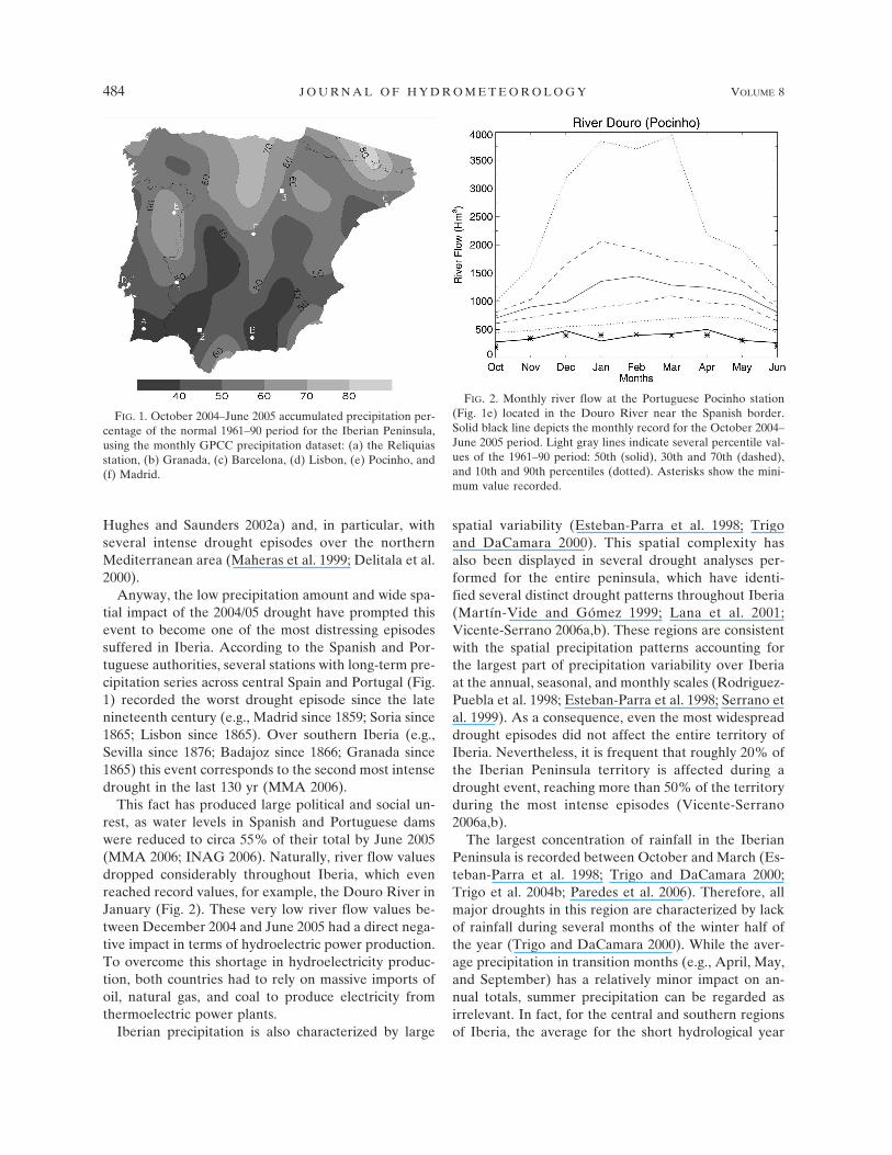
The recent 2004/05 hydrological year was character-ized by one of the worst droughts ever recorded in theIberian Peninsula, particularly in the central and south-ern sectors. Using data from the Global PrecipitationClimatology Center (GPCC) we computed the spatiallyaveraged precipitation over Iberia, between October2004 and June 2005, which corresponds to roughly 45%less than the 1961–90 climatological average (Fig. 1).
However, if we look at the spatial variability of thisdecrease, it is immediately striking that a significantpercentage of the southern half of the Iberian Penin-sula received 60% less than the average precipitation(Fig. 1).
The occurrence of intense droughts in Iberia is ausual feature of its precipitation regime, characterizedby a strong interannual and decadal variability (Este-ban-Parra et al. 1998). Nevertheless, the decades of the40s and the early 50s along with the 80s and 90s aredescribed as particularly dry throughout the whole Ibe-rian territory (Vicente-Serrano 2006a,b). These ex-tremely dry periods in Iberia coincide with a largedrought incidence over much of the European conti-nent (Briffa et al. 1994; Dai et al. 1998, 2004; Lloyd-
Corresponding author address: Ricardo García-Herrera, Dto.Física de la Tierra II, Facultad de Físicas, Universidad Com-plutense, Av. Complutense s/n, C.P. 28040 Madrid, Spain.E-mail: [email protected]
JUNE 2007 G A R C Í A - H E R R E R A E T A L . 483
DOI: 10.1175/JHM578.1
© 2007 American Meteorological Society
JHM578
Hughes and Saunders 2002a) and, in particular, withseveral intense drought episodes over the northernMediterranean area (Maheras et al. 1999; Delitala et al.2000).
Anyway, the low precipitation amount and wide spa-tial impact of the 2004/05 drought have prompted thisevent to become one of the most distressing episodessuffered in Iberia. According to the Spanish and Por-tuguese authorities, several stations with long-term pre-cipitation series across central Spain and Portugal (Fig.1) recorded the worst drought episode since the latenineteenth century (e.g., Madrid since 1859; Soria since1865; Lisbon since 1865). Over southern Iberia (e.g.,Sevilla since 1876; Badajoz since 1866; Granada since1865) this event corresponds to the second most intensedrought in the last 130 yr (MMA 2006).
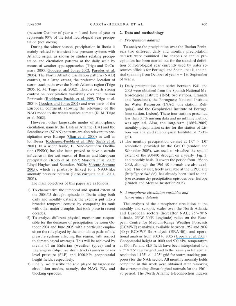
This fact has produced large political and social un-rest, as water levels in Spanish and Portuguese damswere reduced to circa 55% of their total by June 2005(MMA 2006; INAG 2006). Naturally, river flow valuesdropped considerably throughout Iberia, which evenreached record values, for example, the Douro River inJanuary (Fig. 2). These very low river flow values be-tween December 2004 and June 2005 had a direct nega-tive impact in terms of hydroelectric power production.To overcome this shortage in hydroelectricity produc-tion, both countries had to rely on massive imports ofoil, natural gas, and coal to produce electricity fromthermoelectric power plants.
Iberian precipitation is also characterized by large
spatial variability (Esteban-Parra et al. 1998; Trigoand DaCamara 2000). This spatial complexity hasalso been displayed in several drought analyses per-formed for the entire peninsula, which have identi-fied several distinct drought patterns throughout Iberia(Martín-Vide and Gómez 1999; Lana et al. 2001;Vicente-Serrano 2006a,b). These regions are consistentwith the spatial precipitation patterns accounting forthe largest part of precipitation variability over Iberiaat the annual, seasonal, and monthly scales (Rodriguez-Puebla et al. 1998; Esteban-Parra et al. 1998; Serrano etal. 1999). As a consequence, even the most widespreaddrought episodes did not affect the entire territory ofIberia. Nevertheless, it is frequent that roughly 20% ofthe Iberian Peninsula territory is affected during adrought event, reaching more than 50% of the territoryduring the most intense episodes (Vicente-Serrano2006a,b).
The largest concentration of rainfall in the IberianPeninsula is recorded between October and March (Es-teban-Parra et al. 1998; Trigo and DaCamara 2000;Trigo et al. 2004b; Paredes et al. 2006). Therefore, allmajor droughts in this region are characterized by lackof rainfall during several months of the winter half ofthe year (Trigo and DaCamara 2000). While the aver-age precipitation in transition months (e.g., April, May,and September) has a relatively minor impact on an-nual totals, summer precipitation can be regarded asirrelevant. In fact, for the central and southern regionsof Iberia, the average for the short hydrological year
FIG. 1. October 2004–June 2005 accumulated precipitation per-centage of the normal 1961–90 period for the Iberian Peninsula,using the monthly GPCC precipitation dataset: (a) the Reliquiasstation, (b) Granada, (c) Barcelona, (d) Lisbon, (e) Pocinho, and(f) Madrid.
FIG. 2. Monthly river flow at the Portuguese Pocinho station(Fig. 1e) located in the Douro River near the Spanish border.Solid black line depicts the monthly record for the October 2004–June 2005 period. Light gray lines indicate several percentile val-ues of the 1961–90 period: 50th (solid), 30th and 70th (dashed),and 10th and 90th percentiles (dotted). Asterisks show the mini-mum value recorded.
484 J O U R N A L O F H Y D R O M E T E O R O L O G Y VOLUME 8
(between October of year n � 1 and June of year n)represents 90% of the total hydrological year precipi-tation (not shown).
During the winter season, precipitation in Iberia ismainly related to transient low pressure systems withAtlantic origin, as shown by studies relating precipi-tation and circulation patterns at the daily scale bymeans of weather-type approaches (Trigo and DaCa-mara 2000; Goodess and Jones 2002; Paredes et al.2006). The North Atlantic Oscillation pattern (NAO)controls, to a large extent, the preferred location ofstorm-track paths over the North Atlantic region (Trigo2006; R. M. Trigo et al. 2002). Thus, it exerts strongcontrol on precipitation variability over the IberianPeninsula (Rodriguez-Puebla et al. 1998; Trigo et al.2004b; Goodess and Jones 2002) and over parts of theEuropean continent, showing the relevance of theNAO mode to the winter surface climate (R. M. Trigoet al. 2002).
However, other large-scale modes of atmosphericcirculation, namely, the Eastern Atlantic (EA) and theScandinavian (SCAN) patterns are also relevant to pre-cipitation over Europe (Qian et al. 2000) as well asfor Iberia (Rodriguez-Puebla et al. 1998; Sáenz et al.2001). In a wider frame, El Niño–Southern Oscilla-tion (ENSO) has also been proved to have a certaininfluence in the wet season of Iberian and Europeanprecipitation (Rodó et al. 1997; Mariotti et al. 2002;Lloyd-Hughes and Saunders 2002b; Vicente-Serrano2005), which is probably linked to a NAO-likeanomaly pressure pattern (Pozo-Vázquez et al. 2001,2005).
The main objectives of this paper are as follows:
1) To characterize the temporal and spatial extent ofthe 2004/05 drought episode in Iberia using bothdaily and monthly datasets; the event is put into abroader temporal context by comparing its rankwith other major droughts that took place in recentdecades.
2) To analyze different physical mechanisms respon-sible for the decrease of precipitation between Oc-tober 2004 and June 2005, with a particular empha-sis on the role played by the anomalous paths of lowpressure systems affecting this region, with respectto climatological averages. This will be achieved bymeans of an Eulerian (weather types) and aLagrangean (objective storm tracks) analysis of sealevel pressure (SLP) and 1000-hPa geopotentialheight fields, respectively.
3) Finally, we describe the role played by large-scalecirculation modes, namely, the NAO, EA, andblocking episodes.
2. Data and methodology
a. Precipitation datasets
To analyze the precipitation over the Iberian Penin-sula two different daily and monthly precipitationdatasets were examined. The analysis of annual pre-cipitation has been carried out for the standard defini-tion of hydrological year currently used by water re-sources officials for Portugal and Spain, that is, the pe-riod spanning from October of year n � 1 to Septemberof year n:
1) Daily precipitation data series between 1941 and2005 were obtained from the Spanish National Me-teorological Institute (INM; two stations, Granadaand Barcelona), the Portuguese National Institutefor Water Resources (INAG; one station, Reli-quias), and the Geophysical Institute of Portugal(one station, Lisbon). These four stations presentedless than 0.5% missing data and no infilling methodwas applied. Also, the long-term (1865–2005)monthly precipitation series for the station of Lis-bon was analyzed (Geophysical Institute of Portu-gal).
2) The monthly precipitation dataset at 1.0° � 1.0°resolution, provided by the GPCC (Rudolf andSchneider 2005), was used to visualize the spatialextent of the 2004/05 drought on a yearly (Fig. 1)and monthly basis. It covers the period from 1986 to2005, although the 1961–90 normals are also avail-able. This dataset, freely available at the GPCC site(http://gpcc.dwd.de), has already been used to ana-lyze extreme dry precipitation episodes over Europe(Rudolf and Meyer-Christoffer 2005).
b. Atmospheric circulation variables andtemperature datasets
The analysis of the atmospheric circulation at themonthly and synoptic scales over the North Atlanticand European sectors (hereafter NAE; 25°–70°Nlatitude, 25°W–30°E longitude) relies on the Euro-pean Centre for Medium-Range Weather Forecasts(ECMWF) reanalysis, available between 1957 and 2002[40-yr ECMWF Re-Analysis (ERA-40)], and opera-tional analysis from 2003 to 2005 (Uppala et al. 2005).Geopotential height at 1000 and 500 hPa, temperatureat 850 hPa, and SLP fields have been interpolated to a2.5° � 2.5° regular grid (and to the reanalysis full spatialresolution 1.125° � 1.125° grid for storm-tracking pur-poses) for the NAE sector. All monthly anomaly fieldscomputed in this work were obtained after removingthe corresponding climatological normals for the 1961–90 period. The North Atlantic teleconnection indexes
JUNE 2007 G A R C Í A - H E R R E R A E T A L . 485
(NAO and EA) and the ENSO index maintained by theClimate Prediction Center (CPC) were also analyzed.
c. Methodologies
The atmospheric synoptic features of the 2004/05drought are characterized through the analysis of threeadditional databases of storm tracks, circulationweather types, and blocking events previously devel-oped by the authors:
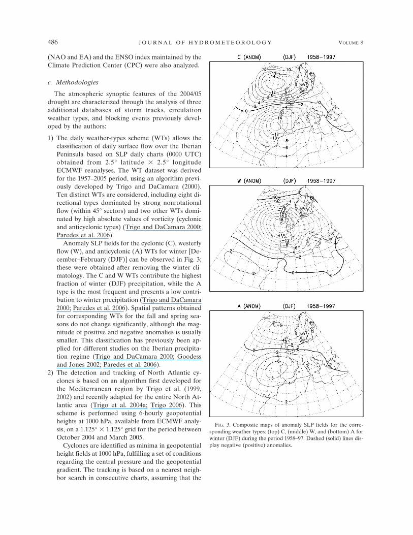
1) The daily weather-types scheme (WTs) allows theclassification of daily surface flow over the IberianPeninsula based on SLP daily charts (0000 UTC)obtained from 2.5° latitude � 2.5° longitudeECMWF reanalyses. The WT dataset was derivedfor the 1957–2005 period, using an algorithm previ-ously developed by Trigo and DaCamara (2000).Ten distinct WTs are considered, including eight di-rectional types dominated by strong nonrotationalflow (within 45° sectors) and two other WTs domi-nated by high absolute values of vorticity (cyclonicand anticyclonic types) (Trigo and DaCamara 2000;Paredes et al. 2006).
Anomaly SLP fields for the cyclonic (C), westerlyflow (W), and anticyclonic (A) WTs for winter [De-cember–February (DJF)] can be observed in Fig. 3;these were obtained after removing the winter cli-matology. The C and W WTs contribute the highestfraction of winter (DJF) precipitation, while the Atype is the most frequent and presents a low contri-bution to winter precipitation (Trigo and DaCamara2000; Paredes et al. 2006). Spatial patterns obtainedfor corresponding WTs for the fall and spring sea-sons do not change significantly, although the mag-nitude of positive and negative anomalies is usuallysmaller. This classification has previously been ap-plied for different studies on the Iberian precipita-tion regime (Trigo and DaCamara 2000; Goodessand Jones 2002; Paredes et al. 2006).
2) The detection and tracking of North Atlantic cy-clones is based on an algorithm first developed forthe Mediterranean region by Trigo et al. (1999,2002) and recently adapted for the entire North At-lantic area (Trigo et al. 2004a; Trigo 2006). Thisscheme is performed using 6-hourly geopotentialheights at 1000 hPa, available from ECMWF analy-sis, on a 1.125° � 1.125° grid for the period betweenOctober 2004 and March 2005.
Cyclones are identified as minima in geopotentialheight fields at 1000 hPa, fulfilling a set of conditionsregarding the central pressure and the geopotentialgradient. The tracking is based on a nearest neigh-bor search in consecutive charts, assuming that the
FIG. 3. Composite maps of anomaly SLP fields for the corre-sponding weather types: (top) C, (middle) W, and (bottom) A forwinter (DJF) during the period 1958–97. Dashed (solid) lines dis-play negative (positive) anomalies.
486 J O U R N A L O F H Y D R O M E T E O R O L O G Y VOLUME 8

speed of individual storms is less than 50 km h�1 inthe westward direction and 110 km h�1 in any other.Further details on the cyclone detecting and track-ing methodology may be found in Trigo (2006). Forthe purpose of this study, only cyclones lasting aminimum of 48 h and presenting minimum pressurevalues below 1010 hPa throughout their life cyclewere considered.
3) The blocking detection methodology developed byBarriopedro et al. (2006) is applied to the NorthernHemisphere during the period 1958–2005. This tech-nique is performed by using geopotential height re-analysis data at 500 hPa from the ECMWF data-base. The application of the blocking algorithm al-lows the detection of those blocked longitudes foreach day from a set of conditions imposed to theaveraged zonal flow between 40° and 60°N. A block-ing anticyclone is then identified when five or moreadjacent longitudes are blocked for at least 5 days.The tracking procedure is then performed by com-paring the overlapping areas in consecutive dailycharts and computing the main parameters associ-ated with blocking episodes, namely, duration, loca-tion of the blocking center, and extension in longi-tude. Further information may be found in Barrio-pedro et al. (2006).
3. The major 2004/05 drought
a. Iberia
To show the magnitude of the 2004/05 drought, wehave used the longest daily data series available (Oc-tober 1941–June 2005) for three stations across thesouthern and eastern parts of the peninsula (Fig. 1,Reliquias, Portugal; Granada and Barcelona, Spain).This event broke existing records by the beginning ofthe summer season (Fig. 4a, Reliquias, and Fig. 4c, Bar-celona). The shortage of precipitation during the winterseason is clearly noticeable at the daily scale; unlikeprevious severe drought episodes that typically re-corded low precipitation values during the wintermonths, the winter of 2004/05 barely registered any pre-cipitation in southern Portugal and Spain (Fig. 4a, Reli-quias, and Fig. 4b, Granada). In fact, the precipitationpercentage recorded, compared to the normal 1961–90,from mid-December 2004 to mid-February 2005 wasbelow 8% in both stations.
Figure 5 compares the monthly accumulated precipi-tation between January 2004 and September 2005 withthe long-term climatology (1865–2005) for the Lisbonobservatory. The 2004/05 drought was the driest in thelast 140 yr at this location. The major drought spannedthe period from November 2004 to June 2005; every
month within this period presented values below the30th percentile of the long-term climatology. It is worthnoticing that the severe effects of this major drought onthe hydrological cycle were enhanced by the previous“minor” drought that occurred between February andJune 2004 (Fig. 5), where every month (except March)recorded precipitation values below the 30th percentile.This fact is particularly relevant for water resourcesmanagement, as it highlights the water-stressed levelalready present at the beginning of the 2004/05 hydro-logical year. Naturally, despite the observed wet Octo-ber 2004, levels of soil moisture decreased continuouslysince the beginning of 2004, reaching extremely lowvalues at the end of spring 2005 with negative impactson vegetation growth.
We have computed monthly precipitation percent-
FIG. 4. Daily accumulated precipitation anomaly compared tothe 1961–90 normal for the stations at (a) Reliquias, (b) Granada,and (c) Barcelona. Black line depicts the precipitation anomalyrecorded during the October 2004–June 2005 period. The coloredlines display the six greater droughts ever recorded in each station(1941–2005 period) during the corresponding October (year n �1) to June (year n) hydrological year.
JUNE 2007 G A R C Í A - H E R R E R A E T A L . 487
Fig 4 live 4/C

ages with respect to the corresponding climatological(1961–90) normals (Fig. 6). This was done using themonthly dataset maintained by the GPCC and re-stricted to areas with significant climatological monthlyrainfall amounts (�20 mm) in order to avoid mislead-ing results over southern Europe and northern Africanregions. During the core winter period (November–March), most of the Spanish and Portuguese territorypresented accumulated precipitation values lower than50% of the normal period 1961–90. The exceptionswere relatively small, like the Mediterranean andnorthern coastal areas, which recorded precipitationvalues slightly above the average values in Decemberand February (Fig. 6).
However, the dry conditions continued to prevail un-til June throughout the Iberian Peninsula, particularlyfor the southern half (Fig. 6). Some precipitation wasrecorded in March and May in western Iberia but witha minor effect on the accumulated precipitationanomaly (e.g., Fig. 4a). Naturally, the lack of springprecipitation was crucial to understand the widespreadamplitude of this drought and its socioeconomic im-pacts. In fact, some of the former historical droughts(Fig. 4) presented a greater recovery during springmonths, which is not present in the 2004/05 episode.This was particularly problematic for the eastern half ofIberia, where the spring precipitation is usually higherthan that recorded during winter.
b. Europe and northern Africa
Taking a broader look at the European monthly pre-cipitation for the November 2004–June 2005 period, itis evident that this episode affected the precipitation
regime over an extensive area that extended over west-ern Europe and northern Africa (Fig. 6). These wide-spread and persistent precipitation anomalies can beassociated with corresponding large-scale anomalies ofthe atmospheric circulation fields of 1000-hPa geopo-tential height (Fig. 6) and 500-hPa geopotental height(Fig. 7) over the NAE sector.
From November 2004 to February 2005, the vast ma-jority of western Europe and northwestern Africa wereunder the influence of similar dry conditions that af-fected Iberia (Fig. 6). In particular, parts of southernUnited Kingdom and France recorded abnormally lowlevels of accumulated precipitation that led to droughtconditions. In contrast, the eastern (and parts of thecentral and western) Mediterranean basin recordedhigh precipitation amounts. As expected, the 1000-hPageopotential height signature for each month betweenNovember 2004 and February 2005 reveals large posi-tive anomalies (significant at p � 0.05 for February)over the North Atlantic, with maximum amplitude lo-cated between Iceland, the United Kingdom, andAzores. Upper-level pressure anomalies (Fig. 7) con-firm the overall structure derived at surface level. Itmust be emphasized that the anomalies show a baro-tropic structure during the period November 2004 toFebruary 2005, while for the other months, baroclinicityseems to prevail in the anomaly fields.
As a consequence of the high NW–SE gradient ofgeopotential height, both at the surface and at upperlevels, during the December–February period, westernEurope was under the influence of strong cold-air ad-vection from northern latitudes. This is particularlyclear for February 2005, displaying 850-hPa tempera-ture anomalies below �2°C all over western Europe(Fig. 7). These low temperature values are associatedwith arctic air outbreaks over Iberia (see, e.g., Madrid,Fig. 8) and northern Africa, being associated with in-tense episodes of snow in northern and central Spain.Similar patterns were obtained for considerably differ-ent settings, such as Granada (southern Iberia) andBarcelona (northern Mediterranean coast).
The dry pattern persisted over much of Europe dur-ing the following months, with the exception of April(Fig. 6) when above-average precipitation values wererecorded for almost the entire continent (except forScandinavia and as far as Greece). During April andMay the North African coast close to Iberia also re-corded some of the lowest precipitation amounts duringthis drought (�25% of the normal). The 500-hPa geo-potential height field during these 3 months (Fig. 8)shows consistent positive anomalies (at p � 0.05 in Mayand June) located exactly over the western North Af-rican coast, immediately under Iberia (April), that dis-
FIG. 5. Monthly accumulated precipitation at Lisbon (gray bars)compared to different percentiles (described in the legend at thetop-right corner of the figure) computed for the 1865–2005 period.
488 J O U R N A L O F H Y D R O M E T E O R O L O G Y VOLUME 8
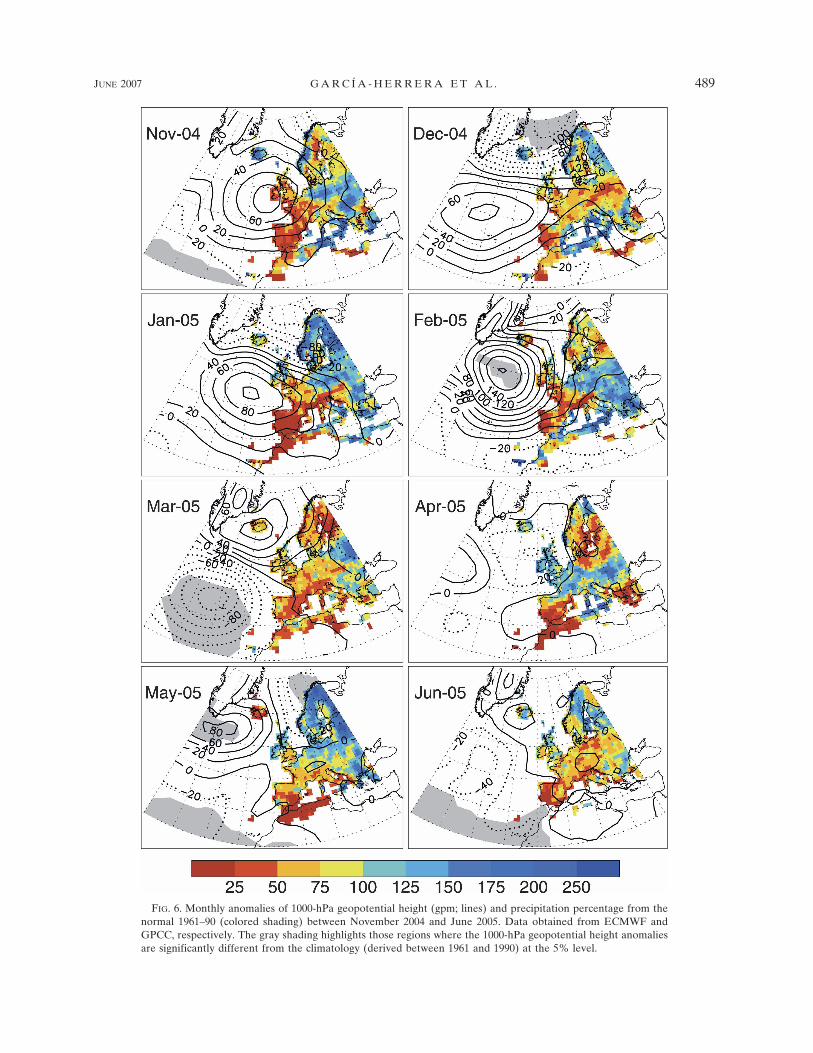
FIG. 6. Monthly anomalies of 1000-hPa geopotential height (gpm; lines) and precipitation percentage from thenormal 1961–90 (colored shading) between November 2004 and June 2005. Data obtained from ECMWF andGPCC, respectively. The gray shading highlights those regions where the 1000-hPa geopotential height anomaliesare significantly different from the climatology (derived between 1961 and 1990) at the 5% level.
JUNE 2007 G A R C Í A - H E R R E R A E T A L . 489
Fig 6 live 4/C
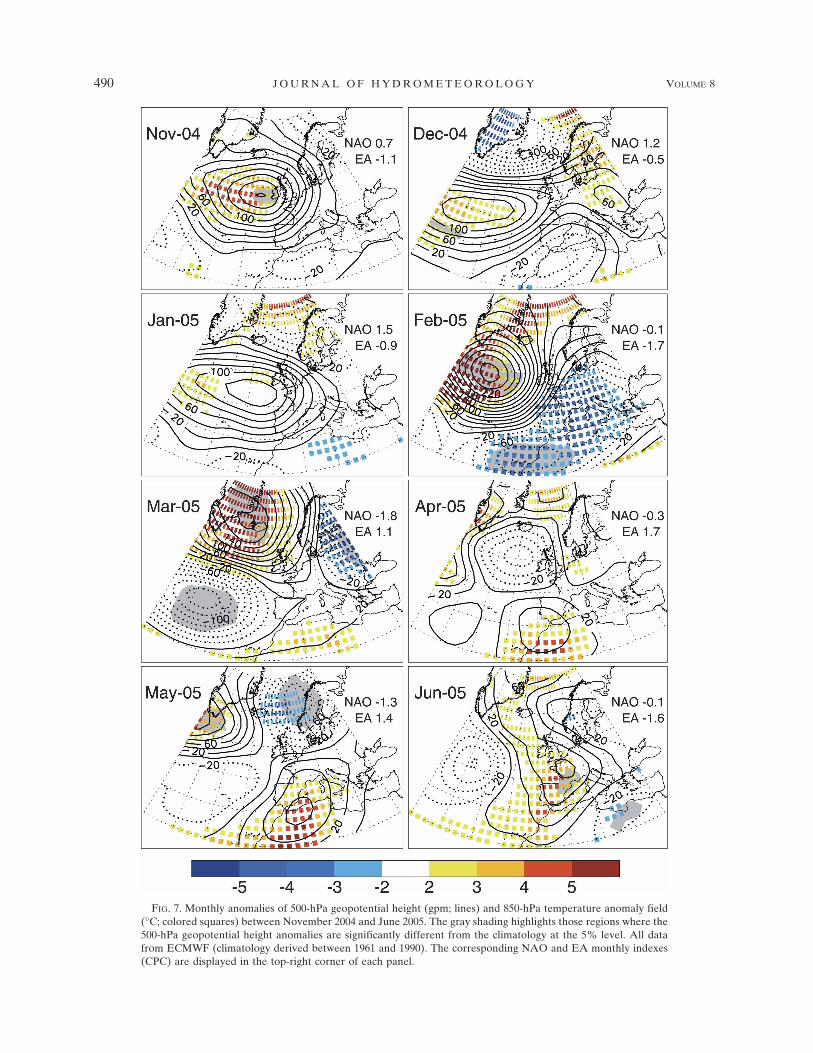
FIG. 7. Monthly anomalies of 500-hPa geopotential height (gpm; lines) and 850-hPa temperature anomaly field(°C; colored squares) between November 2004 and June 2005. The gray shading highlights those regions where the500-hPa geopotential height anomalies are significantly different from the climatology at the 5% level. All datafrom ECMWF (climatology derived between 1961 and 1990). The corresponding NAO and EA monthly indexes(CPC) are displayed in the top-right corner of each panel.
490 J O U R N A L O F H Y D R O M E T E O R O L O G Y VOLUME 8
Fig 7 live 4/C
placed northward to reach western Europe (June). Infact, these anomalies resemble the usual positive phaseof EA, particularly so for April, explaining the highprecipitation totals obtained over the United Kingdomand France. Despite the relatively minor amplitude of
positive 1000-hPa geopotential height anomalies (Fig.6), these remained over southwestern Europe inducinglow precipitation totals over the western North Africancoastal and western Europe regions. Furthermore, hotand dry air from the south was advected into northernAfrica and southwestern Europe (Fig. 7), displayinglarge positive temperature anomalies at 850 hPa (above4°C under the center of the high). These above-normaltemperatures also had an impact on surface tempera-tures, particularly increasing the minimum tempera-tures above the 95th percentile distribution over Iberia(Fig. 8).
4. Synoptic circulation anomalies over Iberia basedon weather types
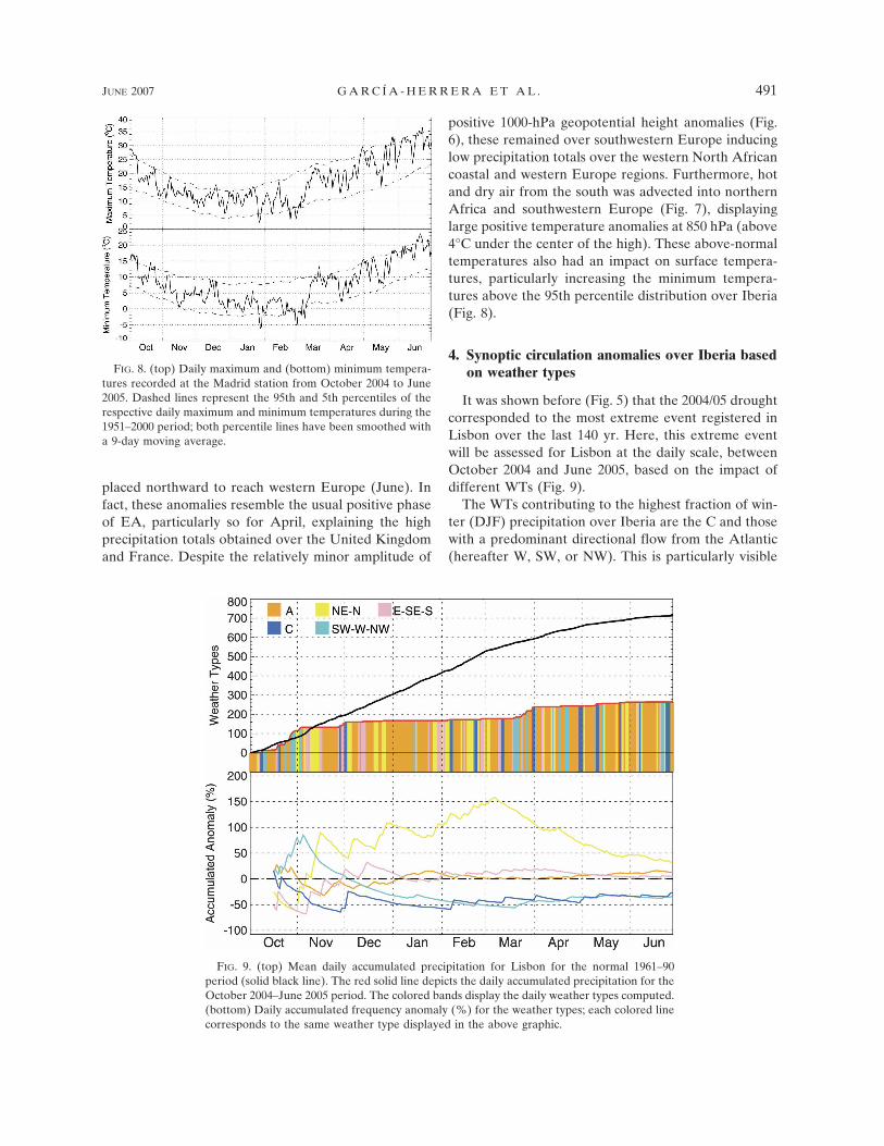
It was shown before (Fig. 5) that the 2004/05 droughtcorresponded to the most extreme event registered inLisbon over the last 140 yr. Here, this extreme eventwill be assessed for Lisbon at the daily scale, betweenOctober 2004 and June 2005, based on the impact ofdifferent WTs (Fig. 9).
The WTs contributing to the highest fraction of win-ter (DJF) precipitation over Iberia are the C and thosewith a predominant directional flow from the Atlantic(hereafter W, SW, or NW). This is particularly visible
FIG. 9. (top) Mean daily accumulated precipitation for Lisbon for the normal 1961–90period (solid black line). The red solid line depicts the daily accumulated precipitation for theOctober 2004–June 2005 period. The colored bands display the daily weather types computed.(bottom) Daily accumulated frequency anomaly (%) for the weather types; each colored linecorresponds to the same weather type displayed in the above graphic.
FIG. 8. (top) Daily maximum and (bottom) minimum tempera-tures recorded at the Madrid station from October 2004 to June2005. Dashed lines represent the 95th and 5th percentiles of therespective daily maximum and minimum temperatures during the1951–2000 period; both percentile lines have been smoothed witha 9-day moving average.
JUNE 2007 G A R C Í A - H E R R E R A E T A L . 491
Fig 9 live 4/C
for Lisbon, where the C WT (occurring on average forabout 7.8% of DJF days) and a combination of theSW–W–NW types (with an average frequency of28.1%), contribute to 22.2% and 59.5%, respectively, ofthe total accumulated precipitation (Table 1). The re-maining WTs are much drier, particularly the A typeand those dominated by an easterly or southerly flowcomponent. Therefore, during the winter season, WTscan be split into “wet” (C, W, NW, and SW) and “dry”(A, N, NE, S, SE, and E). This division is also appli-cable to the fall and spring seasons (Table 1).
The combined analysis of wet/dry WT frequency [ap-plied previously elsewhere, e.g., Fowler and Kilsby(2002) for the United Kingdom] and the daily accumu-lated precipitation for Lisbon, during the October2004–June 2005 period (Fig. 9), shows a number of in-teresting features, namely:
1) In October, the accumulated precipitation for Lis-bon (red curve) was slightly above the average(black curve). This fact is explained by the above-normal occurrence of wet WTs (SW–W–NW) dur-ing the second fortnight of this month.
2) During November, the anomaly of the accumulatedfrequency for the dry NE–N WTs increased (yellowcurve) to roughly 100% in mid-November, while thecorresponding frequency of the wet SW–W–NWWTs dropped dramatically (light blue curve). Onlyat the end of November was some marginal precipi-tation recorded, but the bulk of accumulated pre-cipitation was already below the normal values.
3) From December 2004 until mid-March 2005, thecurve for the accumulated precipitation (red line)shows an impressive plateau. During this period theaccumulated frequency for both wet WT groupsdropped to 55% of the normal value (by the begin-ning of March they had been recorded 7.5 days ver-sus an average of 13.25 days for the C WT and 20days versus an average of 41 days for the combinedSW–W–NW group, 56% and 49%, respectively). In
contrast, the contribution of the dry NE–N typesincreased, reaching a record of 150% above the nor-mal by the beginning of March (38.5 days comparedto the mean value of 15.5 days). Again, at the end ofMarch some precipitation can be seen over westernIberia (Fig. 6) clearly associated with the appear-ance of wet WTs (Fig. 9).
4) Finally, another precipitation plateau can be ob-served between April and June, a period that wasagain dominated by the higher-than-usual occur-rence of various dry WTs.
5. The role of transient low pressure systems(storm tracks)
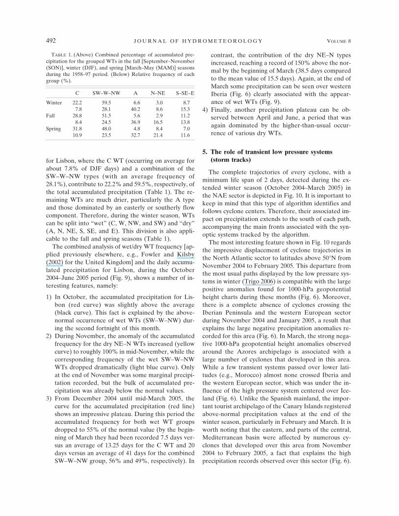
The complete trajectories of every cyclone, with aminimum life span of 2 days, detected during the ex-tended winter season (October 2004–March 2005) inthe NAE sector is depicted in Fig. 10. It is important tokeep in mind that this type of algorithm identifies andfollows cyclone centers. Therefore, their associated im-pact on precipitation extends to the south of each path,accompanying the main fronts associated with the syn-optic systems tracked by the algorithm.
The most interesting feature shown in Fig. 10 regardsthe impressive displacement of cyclone trajectories inthe North Atlantic sector to latitudes above 50°N fromNovember 2004 to February 2005. This departure fromthe most usual paths displayed by the low pressure sys-tems in winter (Trigo 2006) is compatible with the largepositive anomalies found for 1000-hPa geopotentialheight charts during these months (Fig. 6). Moreover,there is a complete absence of cyclones crossing theIberian Peninsula and the western European sectorduring November 2004 and January 2005, a result thatexplains the large negative precipitation anomalies re-corded for this area (Fig. 6). In March, the strong nega-tive 1000-hPa geopotential height anomalies observedaround the Azores archipelago is associated with alarge number of cyclones that developed in this area.While a few transient systems passed over lower lati-tudes (e.g., Morocco) almost none crossed Iberia andthe western European sector, which was under the in-fluence of the high pressure system centered over Ice-land (Fig. 6). Unlike the Spanish mainland, the impor-tant tourist archipelago of the Canary Islands registeredabove-normal precipitation values at the end of thewinter season, particularly in February and March. It isworth noting that the eastern, and parts of the central,Mediterranean basin were affected by numerous cy-clones that developed over this area from November2004 to February 2005, a fact that explains the highprecipitation records observed over this sector (Fig. 6).
TABLE 1. (Above) Combined percentage of accumulated pre-cipitation for the grouped WTs in the fall [September–November(SON)], winter (DJF), and spring [March–May (MAM)] seasonsduring the 1958–97 period. (Below) Relative frequency of eachgroup (%).
C SW–W–NW A N–NE S–SE–E
Winter 22.2 59.5 6.6 3.0 8.77.8 28.1 40.2 8.6 15.3
Fall 28.8 51.5 5.6 2.9 11.28.4 24.5 36.9 16.5 13.8
Spring 31.8 48.0 4.8 8.4 7.010.9 23.5 32.7 21.4 11.6
492 J O U R N A L O F H Y D R O M E T E O R O L O G Y VOLUME 8
6. Blocking analysis
In the previous sections we have characterized theatmospheric circulation associated with the 2004/05drought in Iberia, at the monthly (section 3) and daily(section 4) scales. While indexes associated with well-established patterns (such as NAO and EA) are usefulto evaluate the average monthly circulation, they oftenmerge several distinct patterns at the submonthly(weekly) scale. Part of this submonthly analysis wastherefore presented by showing the complete path ofstorm tracks, lasting at least 2 days (section 5). How-ever, this approach covers only transient systems andnot relatively stable anticylonic patterns. One of themost important large-scale features modulating surfaceclimate in the middle and higher latitudes are blocking
events, that is, large anticylonic patterns displacednorthward of their usual latitude and lasting between 5and 25 days (Trigo et al. 2004a; Barriopedro et al.2006). Here, we have evaluated the location and dura-tion of blocking events throughout the October 2004 toJune 2005 period, particularly focused over the Atlanticsector (90°W to 0° longitude), where the influence ofblocking events on the western European climate ishigher (Trigo et al. 2004a).
The blocking activity from October to Decemberwithin the Atlantic sector was similar to the corre-sponding average obtained for the 1958–2005 period(not shown). However, the frequency of blockingevents from January to March (JFM) was exceptional,particularly between 40° and 20°W, where it surpassedthe 95th percentile (Fig. 11a). This high level of block-
FIG. 10. Path of individual cyclones detected by applying the storm-track methodology from October 2004 toMarch 2005. Only cyclones lasting at least 48 h are depicted.
JUNE 2007 G A R C Í A - H E R R E R A E T A L . 493
Fig 10 live 4/C

ing activity over the Atlantic sector can be observedthrough the time series of standardized anomalies forthe number of winter blocking days (1958–2005), beingonly slightly surpassed by the winter of 1965 (Fig. 11b).Moreover, the blocking activity was remarkable inMarch, which showed a record-breaking number ofblocking days since 1958 (not shown). In fact, the block-ing activity in winter was characterized by three persis-tent and quasi-consecutive blocking events. The firstone spanned the second half of January to the begin-ning of February, centered over the eastern AtlanticOcean basin. From mid-February to mid-March the At-
lantic sector was consecutively blocked by two persis-tent episodes, roughly confined to the second fortnightof February (Fig. 12a) and the first fortnight of March(Fig. 12b), both revealing a predominant omega blockconfiguration pattern (Barriopedro et al. 2006) west ofEurope.
The enhanced meridional flow component associatedwith these blocking events explains the preponderanceof the northern component WTs during the winter sea-son until mid-March, as well as the scarce precipitationand cold-air advection from northern latitudes in Feb-ruary over western Europe (Fig. 12a). Previous studieshave shown that anomalous high-latitude blocking epi-sodes induce below-normal temperatures in the lowertroposphere over central and northwestern Europe, as
FIG. 11. (a) Longitudinal distribution for the frequency ofblocked longitudes in winter (JFM) 2005 (thick solid line) and theaveraged distribution for the 1958–2005 period (dashed line). Thedark gray shading denotes the 1.0-sigma level deviation from theclimatological mean, and the light gray shading depicts the rangebetween the 10th and 90th percentile levels; (b) time series of thestandardized anomalies for the number of winter blocking daysover the Atlantic sector (90°W–0°) for the 1958–2005 period.Dashed lines indicate the 5th and 95th percentile levels. The solidline represents the filtered series with a 3-yr running average.
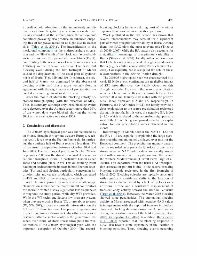
FIG. 12. Composite of the daily 500-hPa geopotential heightfield for (a) the second fortnight of February 2005 and (b) the firstfortnight of March 2005.
494 J O U R N A L O F H Y D R O M E T E O R O L O G Y VOLUME 8
a result of cold advection by the anomalously meridi-onal mean flow. Negative temperature anomalies areusually recorded at the surface, since the anticyclonicconditions prevailing also produce an enhanced outgo-ing flux of longwave radiation at night due to clearerskies (Trigo et al. 2004a). The intensification of themeridional component of the midtroposphere circula-tion and the NE–SW tilt of the block axis favored cold-air intrusions over Europe and northern Africa (Fig. 7),contributing to the occurrence of several snow events inFebruary in the Iberian Peninsula. The persistentblocking event during the first fortnight of Marchcaused the displacement of the usual path of cyclonesnorth of Iberia (Figs. 12b and 10). In contrast, the sec-ond half of March was dominated by the absence ofblocking activity and thus a more westerly flow, inagreement with the slight increase of precipitation re-corded in some regions of western Iberia.
After the month of March the blocking activity de-creased through spring (with the exception of May).Thus, in summary, although only three blocking eventswere detected over the Atlantic sector, more than 50%of the winter days were blocked, showing the winter2005 as the most active one since 1965.
7. Conclusions and discussion
The 2004/05 hydrological year was characterized byan intense drought throughout western Europe, reach-ing record levels over the Iberian Peninsula. In particu-lar, the southern half of Iberia received less than 45%of the usual precipitation between October 2004 andJune 2005. The hydrological year from October 2004 toSeptember 2005 was the driest on record at several lo-cations throughout Iberia, in particular Lisbon (since1865) and Madrid (since 1859). This outstanding eventhad major socioeconomic impacts in both Iberian coun-tries (Portugal and Spain), particularly concerning hy-droelectricity and cereals production, which decreasedto 40% and 60% of the average, respectively.
An Eulerian approach by means of a weather-typeclassification shows that the major rainfall contributorsfor Iberia in winter display significant low frequenciesthroughout the study period, while dry WTs prevailed.While the WT technique detects low pressure systemswhen they are crossing Iberia (C), or are about to cross(W, NW, SW), it does not provide information on thefull path of these transient low pressure systems. Anexplicit Lagrangean storm-track algorithm over a widenorthern Atlantic sector confirms the generalized ab-sence, over Iberia, of storm tracks throughout the win-ter months of the 2004/05 hydrological year, with theimportant exception of October 2004. The record-
breaking blocking frequency during most of the winterexplains these anomalous circulation patterns.
Work published in the last decade has shown thatseveral teleconnections may account for a significantpart of winter precipitation variability in Iberia. Amongthem, the NAO plays the most relevant role (Trigo etal. 2004b, 2005), while the EA pattern also accounts fora significant percentage of precipitation variability inIberia (Sáenz et al. 2001). Finally, other authors showthat La Niña events may precede drought episodes overIberia (e.g., Vicente-Serrano 2005; Pozo-Vázquez et al.2005). Consequently, we investigated the role of theseteleconnections in the 2004/05 Iberian drought.
The 2004/05 hydrological year was characterized by aweak El Niño event, confirming the negligible impactof SST anomalies over the Pacific Ocean on thisdrought episode. However, the scarce precipitationrecords obtained in the Iberian Peninsula between De-cember 2004 and January 2005 match with the positiveNAO index displayed (1.2 and 1.5, respectively). InFebruary, the NAO index (�0.1) can hardly provide aclear explanation to the scarce precipitation registeredduring this month. In this case, the negative EA index(�1.7), which is related to the anomalous high pressurewest of the United Kingdom, provides the better expla-nation for low precipitation values observed in thismonth.
Interestingly, in March neither the NAO (�1.8) northe EA (1.1) are capable of explaining the large nega-tive precipitation anomalies displayed over most of theEuropean continent. The precipitation anomaly patterncan be regarded as a particularly awkward one, sincestrong negative NAO index values are usually associ-ated with above-normal precipitation over Iberia andthe western Mediterranean (Hurrell 1995; Trigo et al.2004b). This departure from the usual NAO precipita-tion association pattern is due to the record-breakingblocking episode registered in the first fortnight ofMarch 2005. Blocking episodes are typically associatedwith significant meridional shifts in the location ofstorm tracks characterized by a lack of cyclones overnorthern Europe and a southward displacement oftransient eddy activity toward the Iberian Peninsula(Trigo et al. 2004a). However, the March 2005 blockingshowed some peculiarities. The anomalous blockingactivity in March associated with negative NAO valuesis in agreement with the reported increase in blockeddays and blocking durations over the Atlantic sectorduring the negative phases of the NAO (Shabbar et al.2001; Barriopedro et al. 2006). In addition, Barriopedroet al. (2006) reported that the blocking response toNAO also reveals some asymmetry in the location ofblocking episodes. Thus, blocking events occurring
JUNE 2007 G A R C Í A - H E R R E R A E T A L . 495
during negative phases of the NAO are relativelymore (less) frequent along a band stretching betweenGreenland and Iceland (United Kingdom and northernEurope) than those associated with the positive NAOphase. This northwestern displacement of blockingcenters for the negative phases of the NAO is onthe order of 5° in latitude and 30° in longitude, favor-ing the appearance of cyclones crossing over Iberiaand the western Mediterranean (Barriopedro et al.2006).
Figure 13 depicts the difference at 500-hPa geopo-tential height between the blocked days of March 2005and those occurring during the negative NAO phase (inMarch) during the 1958–2005 period. It can be seenhow the enhanced cyclone trajectory across the south-ern half of Iberia, which is typically observed duringhigh blocking situations, was dramatically cut off by ananomalous southeastern elongation of the blocking pat-tern. The southward extension of the blocking actiontoward lower-than-usual latitudes and the preferencefor blocked longitudes around 20°W interrupted thecyclone tracks across the Iberian Peninsula and pro-longed the drought through the first half of the month.Thus, although the number of cyclones in lower lati-tudes increased notably in March, in agreement withthe negative NAO index, its activity was confined totwo isolated centers of action located over Azores andthe eastern Mediterranean (Fig. 10). The southernbranch of transient activity expanding between bothcenters and through Iberia was almost suppressed andanomalously displaced southward toward the Morocco
coastline, leading to above-normal precipitation overthe Canary Islands and northern Africa. In addition,the anomalous intensity and extension of the block isable to explain the impressive extension of low rainfallrecords toward the western and central Europe, evenreaching Scandinavia, which is a typical feature of At-lantic blocks (Trigo et al. 2004a).
Thus, we can conclude that the 2004/05 Iberiadrought is attributable to three main factors that oc-curred successively: a NAO positive pattern from No-vember to January, a positive EA pattern in February,and a record-breaking blocking episode, which ex-tended from mid-February to mid-March. The atmo-spheric circulation analysis at the submonthly scale inMarch has highlighted a certain limitation of the tele-connection indexes to explain precipitation extremes.The results obtained within this work show the NAOand EA indexes, two of the most prominent North At-lantic teleconnection patterns modulating climate in theIberian Peninsula, incapable to detect the low precipi-tation totals in March.
In fact, the explanation for this anomalous event wasobtained through the detailed analysis of the blockingpattern at the submonthly scale. The subweekly objec-tive methods used in this work, storm tracks andweather-types approach, are also key techniques tocharacterize the atmospheric circulation during ex-treme events. This has been shown previously for theanalysis of the 2003 heat wave in Europe, which alsopresented particularly dry conditions (Fink et al. 2004),and also describes the circulation anomalies inducingsignificant precipitation trends (Paredes et al. 2006)
Even when a systematic analysis of the Iberiandroughts and their associated atmospheric circulation isnot available yet, it is known that they occur under awide variety of distinct synoptic patterns (Vicente-Serrano 2006a; Haylock and Goodess 2004). The use ofobjective tools as those used in this paper, applied inthe appropriate time scale, a work currently in progressby the authors, will improve significantly our currentknowledge of droughts and the underlying dynamicsand provide a framework for the analysis of extremedroughts that is currently lacking.
Acknowledgments. This work was partially supportedby the Spanish Ministry of Science through Grant HP2004-0039. We also thank the Instituto Nacional de Me-teorología (INM) for providing the precipitation datafor the Spanish stations. R. M. Trigo was supported byProjects VAST (Variability of Atlantic Storms andtheir impact on land climate), Contract POCTI/CTA/46573/2002, and CLIMAAT (Climate and Meteorologyof the Atlantic Archipelagos), Interreg IIIb A3/2.3,
FIG. 13. Difference of composites for blocking days (at 500-hPaheight) over the Atlantic sector between March 2005 and thosemonths of March with negative NAO index registered in the1958–2005 period. Shaded areas indicate significant differences at90%, 95%, and 99% levels after a two-tailed t test.
496 J O U R N A L O F H Y D R O M E T E O R O L O G Y VOLUME 8
both cofinanced by the EU under program FEDER.Three anonymous reviewers also helped to improvethis manuscript.
REFERENCES
Barriopedro, D., R. García-Herrera, A. R. Lupo, and E. Hernán-dez, 2006: A climatology of Northern Hemisphere blocking.J. Climate, 19, 1042–1063.
Briffa, K. R., P. D. Jones, and M. Hulme, 1994: Summer moisturevariability across Europe, 1892–1991: An analysis based onthe Palmer drought severity index. Int. J. Climatol., 14, 475–506.
Dai, A. G., K. E. Trenberth, and T. R. Karl, 1998: Global varia-tions in droughts and wet spells: 1900–1995. Geophys. Res.Lett., 25, 3367–3370.
——, ——, and T. Qian, 2004: A global dataset of Palmer DroughtSeverity Index for 1870–2002: Relationship with soil moistureand effects of surface warming. J. Hydrometeor., 5, 1117–1130.
Delitala, A. M. S., D. Cesari, P. A. Chessa, and M. N. Ward, 2000:Precipitation over Sardinia (Italy) during the 1946–1993 rainyseason and associated large-scales climate variations. Int. J.Climatol., 20, 519–541.
Esteban-Parra, M. J., F. C. Rodrigo, and Y. Castro-Díez, 1998:Spatial and temporal patterns of precipitation in Spain for theperiod 1880–1992. Int. J. Climatol., 18, 1557–1574.
Fink, A. H., T. Brücher, A. Krüger, G. C. Leckebusch, J. G. Pinto,and U. Ulbrich, 2004: The 2003 European summer heatwaves and drought—Synoptic diagnosis and impacts.Weather, 59, 209–216.
Fowler, H. J., and C. G. Kilsby, 2002: Precipitation and the NorthAtlantic Oscillation: A study of climatic variability in north-ern England. Int. J. Climatol., 22, 843–866.
Goodess, C. M., and P. D. Jones, 2002: Links between circulationand changes in the characteristics of Iberian rainfall. Int. J.Climatol., 22, 1593–1615.
Haylock, M. R., and C. M. Goodess, 2004: Interannual variabilityof European extreme winter rainfall and links with meanlarge-scale circulation. Int. J. Climatol., 24, 759–776.
Hurrell, J. W., 1995: Decadal trends in the North Atlantic Oscil-lation: Regional temperatures and precipitation. Science, 269,676–679.
INAG, 2006: Relatório de Balanço da Seca de 2005 (report on the2005 drought). Comissão para a Seca 2005. Instituto da Água,104 pp. [Available online at http://www.inag.pt/inag2004/port/divulga/actualidades/seca/relatorioBalanco.pdf.]
Lana, X., C. Serra, and A. Burgueño, 2001: Patterns of monthlyrainfall shortage and excess in terms of the standardized pre-cipitation index for Catalonia (NE Spain). Int. J. Climatol.,21, 1669–1691.
Lloyd-Hughes, B., and M. A. Saunders, 2002a: A drought clima-tology for Europe. Int. J. Climatol., 22, 1571–1592.
——, and ——, 2002b: Seasonal prediction of European springprecipitation from El Niño–Southern Oscillation and localsea-surface temperatures. Int. J. Climatol., 22, 1–14.
Maheras, P., E. Xoplaki, and H. Kutiel, 1999: Wet and drymonthly anomalies across the Mediterranean basin, and theirrelationship with circulation, 1860–1990. Theor. Appl. Clima-tol., 64, 189–199.
Mariotti, A., M. Zeng, and K. M. Lau, 2002: Euro-Mediterranean
rainfall and ENSO—A seasonally varying relationship. Geo-phys. Res. Lett., 29, 1621, doi:10.1029/2001GL014248.
Martín-Vide, J., and L. Gómez, 1999: Regionalisation of peninsu-lar Spain based on the length of dry spells. Int. J. Climatol.,19, 537–555.
MMA, 2006: Informe balance del año hidrológico 2004–2005 (re-port on the hydrological year 2004–2005). ProgramaA.G.U.A., Ministerio de Medio Ambiente, 141 pp. [Avail-able online at http://www.mma.es/portal/secciones/acm/aguas_continent_zonas_asoc/ons/mapa_informe_ons/informes_cuenca.htm.]
Paredes, D., R. M. Trigo, R. García-Herrera, and I. F. Trigo, 2006:Understanding precipitation changes in Iberia in early spring:Weather typing and storm-tracking approaches. J. Hydro-meteor., 7, 101–113.
Pozo-Vázquez, D., M. J. Esteban-Parra, F. S. Rodrigo, and Y.Castro-Díez, 2001: A study on NAO variability and its pos-sible non-linear influences on European surface tempera-tures. Climate Dyn., 17, 701–715.
——, S. R. Gámiz-Fortis, J. Tovar-Pescador, M. J. Esteban-Parra,and Y. Castro-Díez, 2005: El Niño–Southern Oscillationevents and associated European winter precipitation anoma-lies. Int. J. Climatol., 25, 17–31.
Qian, B., J. Corte-Real, and H. Xu, 2000: Is the North AtlanticOscillation the most important atmospheric pattern for pre-cipitation in Europe? J. Geophys. Res., 105, 11 901–11 910.
Rodó, X., E. Baert, and F. A. Comín, 1997: Variations in seasonalrainfall in southern Europe during the present century: Re-lationships with the North Atlantic Oscillation and the ElNiño–Southern Oscillation. Climate Dyn., 13, 275–284.
Rodriguez-Puebla, C., A. H. Encinas, S. Nieto, and J. Garmendia,1998: Spatial and temporal patterns of annual precipitationvariability over the Iberian Peninsula. Int. J. Climatol., 18,299–316.
Rudolf, B., and A. Meyer-Christoffer, 2005: Hydrometeorologicalconditions during the extremely dry year 2003 in the long-term and European context. Annual Bulletin on the Climatein WMO Region VI–2003, 87–93.
——, and U. Schneider, 2005: Calculation of gridded precipita-tion data for the global land-surface using in-situ gaugeobservations. Proc. Second Workshop of the InternationalPrecipitation Working Group IPWG, Monterey, CA,EUMETSAT, 231–247.
Sáenz, J., J. Zubillaga, and C. Rodríguez-Puebla, 2001: Interan-nual variability of winter precipitation in northern IberianPeninsula. Int. J. Climatol., 21, 1503–1513.
Serrano, A., A. J. Garcia, V. L. Mateos, M. L. Cancillo, and J.Garrido, 1999: Monthly modes of variation of precipitationover the Iberian Peninsula. J. Climate, 12, 2894–2919.
Shabbar, A., J. Huang, and K. Higuchi, 2001: The relationshipbetween the wintertime North Atlantic Oscillation andblocking episodes in the North Atlantic. Int. J. Climatol., 21,355–369.
Trigo, I. F., 2006: Climatology and interannual variability ofstorm-tracks in the Euro-Atlantic sector: A comparison be-tween ERA-40 and NCEP/NCAR reanalyses. Climate Dyn.,26, 127–143.
——, T. D. Davies, and G. R. Bigg, 1999: Objective climatology ofcyclones in the Mediterranean region. J. Climate, 12, 1685–1696.
——, G. R. Bigg, and T. D. Davies, 2002: Climatology of cyclo-genesis mechanisms in the Mediterranean. Mon. Wea. Rev.,130, 549–569.
JUNE 2007 G A R C Í A - H E R R E R A E T A L . 497

Trigo, R. M., and C. C. DaCamara, 2000: Circulation weathertypes and their impact on the precipitation regime in Portu-gal. Int. J. Climatol., 20, 1559–1581.
——, T. J. Osborn, and J. Corte-Real, 2002: The North AtlanticOscillation influence on Europe: Climate impacts and asso-ciated physical mechanisms. Climate Res., 20, 9–17.
——, I. F. Trigo, C. C. DaCamara, and T. J. Osborn, 2004a: Cli-mate impact of the European winter blocking episodes fromthe NCEP/NCAR reanalyses. Climate Dyn., 23, 17–28.
——, D. Pozo-Vázquez, T. J. Osborn, Y. Castro-Díez, S. Gámiz-Fortis, and M. J. Esteban-Parra, 2004b: North Atlantic Oscil-lation influence on precipitation, river flow and water re-sources in the Iberian Peninsula. Int. J. Climatol., 24, 925–944.
——, J. L. Zêzere, M. L. Rodrigues, and I. F. Trigo, 2005: Theinfluence of the North Atlantic Oscillation on rainfall trig-gering of landslides near Lisbon. Nat. Hazards, 36, 331–354.
Uppala, S. M., and Coauthors, 2005: The ERA-40 reanalysis.Quart. J. Roy. Meteor. Soc., 131, 2961–3012.
Vicente-Serrano, S. M., 2005: El Niño and La Niña influence ondroughts at different time scales in the Iberian Peninsula.Water Resour. Res., 41, W12415, doi:10.1029/2004WR003908.
——, 2006a: Differences in spatial patterns of drought on differenttime scales: An analysis of the Iberian Peninsula. Water Re-sour. Manage., 20, 37–60.
——, 2006b: Spatial and temporal analysis of droughts in the Ibe-rian Peninsula (1910–2000). Hydrol. Sci. J., 51, 83–97.
498 J O U R N A L O F H Y D R O M E T E O R O L O G Y VOLUME 8