The Neslen Formation near Harley Dome, Book Cliffs, Utah
102
Copyright By Ashlyn Victoria Murphy 2017
-
Upload
khangminh22 -
Category
Documents
-
view
5 -
download
0
Transcript of The Neslen Formation near Harley Dome, Book Cliffs, Utah

Copyright
By
Ashlyn Victoria Murphy
2017

The Thesis Committee for Ashlyn Victoria Murphy
Certifies that this is the approved version of the following thesis:
Paleoenvironmental reconstruction of a heterogeneous, tidally
influenced reservoir analogue: The Neslen Formation near
Harley Dome, Book Cliffs, Utah
APPROVED BY
SUPERVISING COMMITTEE:
Supervisor:
Ron Steel
Co-Supervisor:
Peter Flaig
Charles Kerans

Paleoenvironmental reconstruction of a heterogeneous, tidally
influenced reservoir analogue: The Neslen Formation near
Harley Dome, Book Cliffs, Utah
by
Ashlyn Victoria Murphy
Thesis
Presented to the Faculty of the Graduate School of
The University of Texas at Austin
in Partial Fulfillment
of the Requirements
for the Degree of
Master of Science in Geological Sciences
The University of Texas at Austin
August 2017

Dedication
I dedicate this thesis to my husband, Kevin Murphy, whose unwavering support and sacrifice for
my dream made this thesis possible. I would also like to dedicate this thesis to my father, Clark
Boswell, my mother, Robyn Boswell, and my sister Macy Sharp.

v
Acknowledgements
I would first like to thank my supervisor Dr. Peter Flaig for his patience, guidance, support, and
encouragement throughout the completion of the thesis project. I am truly a better geologist due to your instruction
in the field, guidance in grant writing, step-by-step teaching during my facies analysis, and constant encouragement.
I would also like to thank Drs. Steel and Kerans for their assistance as committee members and for their comments
to improve this thesis. My gratitude extends to Dr. Stephen Hasiotis, Emily Marino, and Rebecca Jones for their
insight and assistance during my field work and post field discussions. Additional thanks to Dr. Jacob Covault for
ideas, insight, and grant edits which helped provide partial funding for this project. Other additional thanks go to
Yawen He who was always willing to teach and answer my questions about reservoir modeling. This project was
supported in part by the Quantitative Clastics Laboratory at the Bureau of Economic Geology and the Jackson
School of Geosciences, UT Austin. Additional funding for this project was provided through grants from
ExxonMobil’s Global Geoscience Recruiting Grant program, Jackson School of Geosciences at the University of
Texas at Austin, the American Association of Petroleum Geologists, and the Geological Society of America.
Kevin Murphy, thank you for your willingness to do whatever it takes so that I can fulfill my dream. Your
unconditional love and encouragement during these past few years is the reason I have been able to come back to
school and study what I love.
Mom and Dad, thank you for your consistent support and love and for always reminding me that I can
finish strong.
Grandpa, thank you for getting an undergraduate degree in geology so that you may share your interest
with me as I was growing up. Without you I would not have known that geology was my passion and I am forever
grateful to you for that.
Lastly, I want to thank my sister, Macy Sharp, for sitting through another one of my graduations.

vi
Abstract
Paleoenvironmental reconstruction of a heterogeneous, tidally
influenced reservoir analogue: The Neslen Formation near
Harley Dome, Book Cliffs, Utah
Ashlyn Victoria Murphy, M.S. Geo. Sci.
The University of Texas at Austin, 2017
Supervisor: Ron Steel
Co-Supervisor: Peter Flaig
A sedimentologic, ichnologic, and architectural analysis of the upper Sego and Neslen fms
(Campanian) along the Book Cliffs near Harley Dome, UT document a paleoenvironmental
evolution from wave and tidally-modified deltaic deposits of the upper Sego Fm to tidally
influenced estuarine deposits of the Neslen Fm. Paleoenvironments of the upper Sego include tidal
barforms and interdistributary bays while those of the Neslen include distal to proximal tidal-
fluvial channels, sandy and muddy tidal flats, and floodplains.
A total of 28 trace fossil forms were identified in the upper Sego and Neslen fms including
14 fully marine traces, 11 facies breaking traces, (those traces that can exist in fresh, brackish, or
marine salinities), 1 freshwater trace, and 2 continental traces. Ichnology was critical for refining
vii
paleoenvironmental interpretations and was used to distinguish between deposits of distal tidal-
fluvial channels and proximal tidal-fluvial channels, and tidal flats and floodplains. The
Teredolites ichnofacies was used as an indicator of marine flooding events.
Neslen sandbodies preserve inclined heterolithic stratification in point bars of estuarine
tidal-fluvial channels. In contrast to recent studies, bayhead deltas and deltaic deposits were not
identified in the Neslen near Harley Dome. Carbonates that include stromatolites and oolites are
identified for the first time in the Neslen. The predominance of distal to proximal tidal-fluvial
channels and tidal flats, abundant marine ichnology, the recurrence of the Teredolites ichnofacies
and carbonates, and the lack of bayhead delta or wave-modified deposits suggests deposition
within a distal, yet protected estuarine environment.
The Neslen Fm near Harley Dome provides an analogue for a heterolithic, paralic reservoir
system. Due to the heterogeneity that is evident at multiple scales within tidally influenced
systems, the outcrops of the Neslen Fm in the Harley Dome, UT area provide an analogue to
examine the distribution of various heterogeneities and facies in estuarine deposits that could
ultimately affect reservoir performance.
viii
Table of Contents
List of Tables.…………………………………………………………………………………….xi
List of Figures.…………………………………………………………………………………...xii
Chapter 1 Introduction of Project…………...…………………………………………………......1
Chapter 2: The Sego-Neslen Formation Transition (Campanian) near Harley Dome, Utah: An
Analogue for Tidally Influenced, Heterolithic, Paralic Reservoir Systems……………….3
Introduction………………………………………………………………………………..4
Regional Stratigraphic Setting and Previous Work……………………………………....13
Methods…………………………………………………………………………………..15
Facies Analysis…….……………………………………………………………………..19
Facies Association I (FA-I): Distal Tidal-Fluvial Channel…………...…………..19
Description……………………………………………………………….19
Interpretation……………………………………………………………..23
Facies Association II (FA-II): Tidal Flat…………………………………………29
Facies Association IIa & IIb (FA-IIa, FA-IIb): Sandy & Muddy Tidal Flat………29
Description……………………………………………………………….31
Interpretation……………………………………………………………..32
Facies Association IIc (FA-IIc): Distal Estuary…………………………………..31
Description……………………………………………………………….31
Interpretation……………………………………………………………..31
Facies Association III (FA-III): Proximal Tidal-Fluvial Channel………………..38
Description……………………………………………………………….38
Interpretation……………………………………………………………..38
Facies Association IV (FA-IV): Floodplain……………………………………...44
Facies Association IVa (FA-IVa): Levee-Splay-Swamp Margin………………...44
Description……………………………………………………………….44
Interpretation……………………………………………………………..44
Facies Association IVb (FA-IVb): Swamp……………………………………….45

ix
Description……………………………………………………………….45
Interpretation……………………………………………………………..45
Facies Association IVc (FA-IVc): Paleosol……………………………………...45
Description……………………………………………………………….45
Interpretation……………………………………………………………..46
Facies Association IVd (FA-IVd): Lake-Pond…………………………………...46
Description……………………………………………………………….46
Interpretation……………………………………………………………..46
Facies Association V (FA-V): Tidal Barform…………………………………….49
Description……………………………………………………………….49
Interpretation……………………………………………………………..49
Facies Association VI (FA-VI): Interdistributary Bay……………………………50
Description……………………………………………………………….50
Interpretation……………………………………………………………..50
Discussion………………………………………………………………………………..54
Combining Ichnology and Sedimentology to Refine Paleoenvironmental
Interpretations……………………………………………………………………54
Paleoenvironmental Evolution of the upper Sego to Neslen Formations at Harley
Dome……………………………………………………………………………..59
Sequence Stratigraphic Framework for the upper Sego and Neslen fms………...63
Regional Comparative Analysis of the Neslen Fm………………………………65
Implications for Reservoir Modelers………………….…………………………66
Conclusions………………………………………………………………………………68
Chapter 3: Future Studies in the Neslen Formation………………………………………………70
Appendix A: Detailed Composite Measured Sections: Harley Dome area, Utah…………………72
Appendix B: Paleocurrent Data…………………………………………………………………..73
Appendix C: Measured Sections with Paleocurrents: Harley Dome area, Utah…………………..74
Appendix D: Detailed Fence Diagram: Harley Dome area, Utah………………………………...75
Appendix E: Drone Videos: Harley Dome area, Utah……………………………………………76

x
Appendix F: 2D Geocellular Modeling Study of the Neslen Formation………………………….77
Appendix G: WTF Geocellular Model and Facies Distribution…………………………………..78
References………………………………………………………………………………………..79

xi
List of Tables
Table 2.1: Facies of the upper Sego and Neslen Formations near Harley Dome, UT……….21
Table 2.2: Facies associations (paleoenvironments) of the upper Sego and Neslen
Formations near Harley Dome, UT……………………………………………....22
Table 2.3: Dominant salinity of trace fossils found in the Sego and Neslen Formations near
Harley Dome, UT………………………………………………………………...54

xii
List of Figures
Figure 2.1: Regional paleogeography of the study area and modern basin geography. A.
Approximate location of the study area in northeastern Utah along the Campanian
paleoshoreline of the Cretaceous Western Interior Seaway. The location of the
study area is shown by the black box (Roberts and Kirschbaum, 1995; Willis and
Gabel, 2003; Painter et al., 2013). Modified from Prather (2016). B. Modern-day
geography of Laramide age basins and uplifts of northeastern Utah and
northwestern Colorado. Modified from Gomez-Veroiza and Steel
(2010)……………………………………………………………………………...7
Figure 2.2: Ammonite biostratigraphy and generalized lithostratigraphy for the Uinta, Piceance
Creek, and Sand Wash Basins of northeastern Utah and northwestern Colorado
(Konishi, 1959; Gill and Hail, 1975; Hettinger and Kirschbaum, 2002; Gomez and
Steel, 2010). Red box indicates the interval examined in this study. Modified from
Burton et al. (2016) and Prather (2016). ………………………...............................8
Figure 2.3: Map of the study area and the relative location of additional studies on the Neslen
Formation (black boxes) in the Book Cliffs, Utah. Modified from Shiers et al.
(2014)……………………………………………………………………………...9
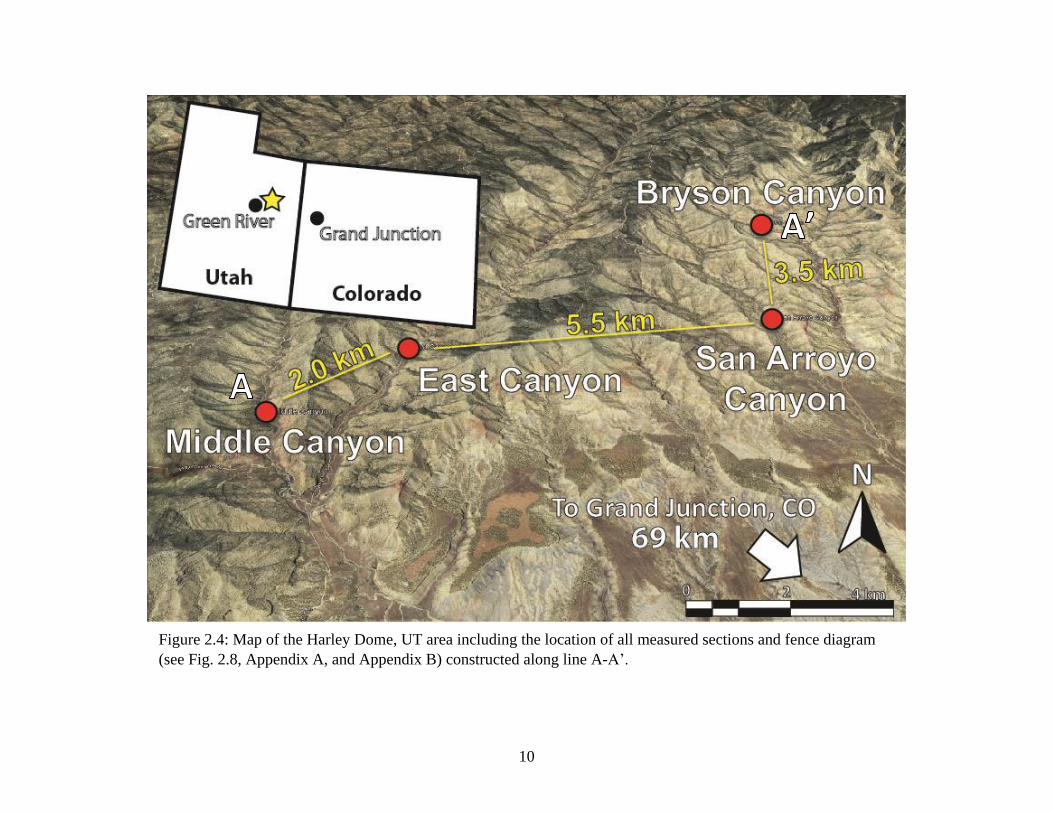
Figure 2.4: Map of the Harley Dome, UT area including the location of all measured sections
and fence diagram (see Fig. 2.8, Appendix A, and Appendix B) constructed along
line A-A’.……………………….………………………...……………………...10

xiii
Figure 2.5: A. Interpreted photomosaic from East Canyon showing the formations and
formation members found in the outcrop belt. B. Interpreted photomosaic in East
Canyon showing the two lowermost sandbodies at the base of the Neslen Fm
separated by finer grained deposits……………………………………………….11
Figure 2.6: A. Interpreted photo from East Canyon outcrop belt showing inclined heterolithic
stratification (white dashed lines) in sandbodies overlying coal and other fine
grained deposits. B. Interpreted photo from San Arroyo outcrop belt showing
multiple scour surfaces within one sandbody interpreted as a distal tidal-fluvial
channel (San Arroyo Canyon, 68 m). Sandbody in B is a potential candidate for a
deeply incised tidal channel or incised valley. Person for scale (white oval),
approximately 1.5 m……………………………………………………………...12
Figure 2.7: Legend for Figure 2.8 and Appendix A, C and D…………………………………17
Figure 2.8: Simplified version of the four composite measured sections and cross-section of the
top of the upper-Sego and Neslen deposits near Harley Dome, UT. Diagram
includes interpreted depositional environments and their correlation across the four
measured sections. Measured section locations and distances between outcrops are
included. Location of cross-section is shown on Fig. 2.4. I1 and I2 are addressed in
the paleoenvironmental evolution section of the discussion. A detailed version of
this figure is located in Appendix D………………………………………………18
Figure 2.9: Orthophoto of the basal Neslen showing dimensions of the lower two sandbodies
interpreted as distal tidal-fluvial channels. Orthophoto also shows the relationship

xiv
between deposits of distal tidal-fluvial channels (FA-I), tidal flats (FA-II), and
floodplain (FA-IV) within outcrops along East Canyon………………………….25
Figure 2.10: Predominant facies, sedimentary structures, and inclusions found in distal tidal-
fluvial channels (FA-I) of the Neslen Fm. Images include A. Organic-rich lag
consisting of carbonaceous rip-up clasts at the base of FA-I; B. Mud-rich lag
consisting of mud chips and mud rip-up clasts at the base of FA-I exhibiting some
soft sediment deformation; C. F-11 containing combined flow ripple cross-
laminated sandstone with abundant mud drapes and double mud drapes; D. F-8
combined flow ripple cross-laminated sandstone; E. Wood fragments in the lag at
the base of FA-I; F. F-14 small to large scale trough cross-stratified sandstone
within FA-I. Shovel (50 cm) for scale. Pocket knife (9 cm) for scale……………..26
Figure 2.11: Trace fossils found in the Neslen within distal tidal-fluvial channels (FA-I). A.
Ophiomorpha (Op) within a bed of F-8; B. Bergaueria (Be) on the underside of F-
14; C. Diplocraterion (Di) within a bed of F-8; D. Siphonichnus (Si) within a bed
of F-11; E. Teichichnus (Te) within a bed of F-11; F. Rhizocorallium (Rh) within a
bed of F-11; G. Teredolites (Td) burrowed log within a bed of F-11; H. Tetrapod
swim tracks (TST) on the underside of F-11. Shovel (50 cm) for scale. Pocket knife
(9 cm) for scale. Lens cap (6 cm) for scale..………………………………………27
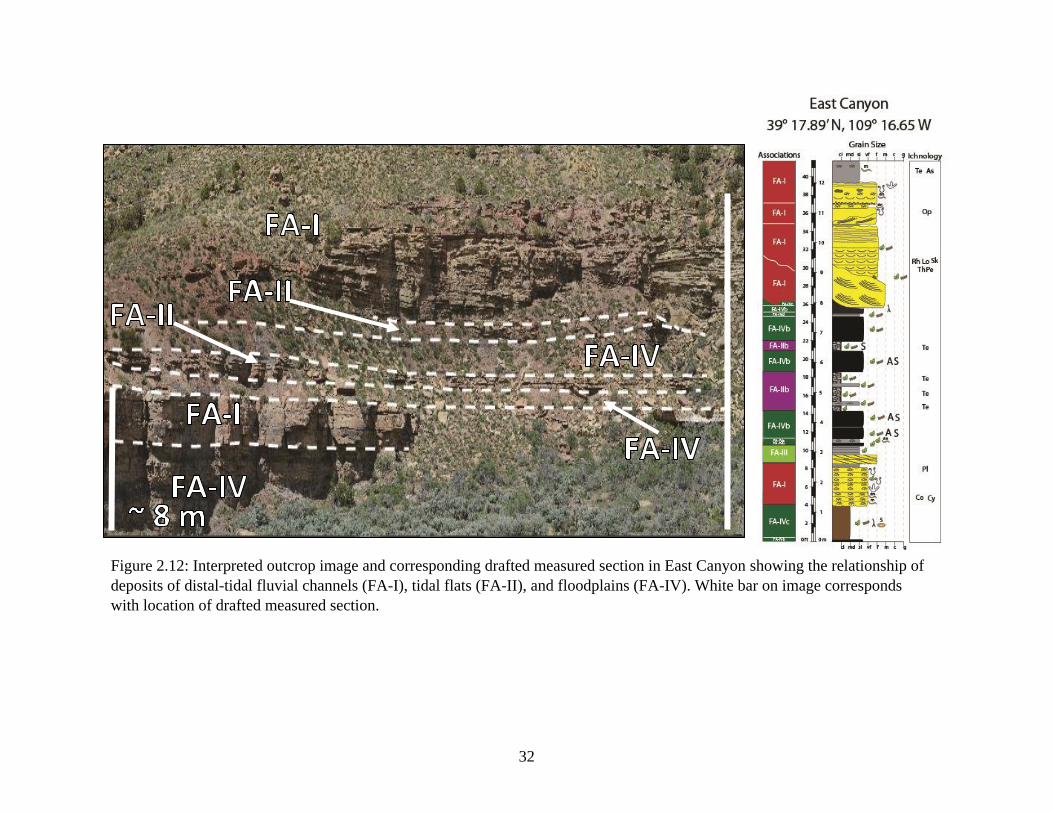
Figure 2.12: Interpreted outcrop image and corresponding drafted measured section in East
Canyon that shows the relationship of deposits of distal-tidal fluvial channels (FA-
I), tidal flats (FA-II), and floodplain (FA-IV). White bar on image corresponds with
location of drafted measured section.…………………………………………….32

xv
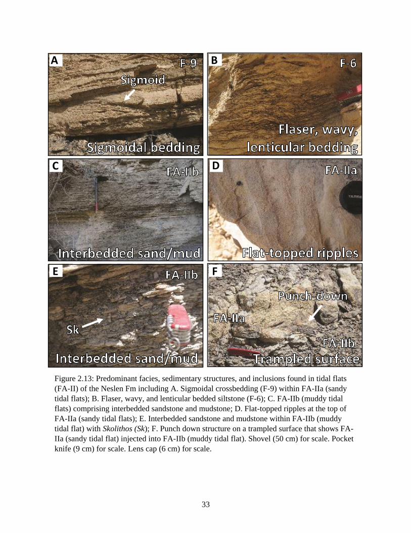
Figure 2.13: Predominant facies, sedimentary structures, and inclusions found in tidal flats (FA-
II) of the Neslen Fm including A. Sigmoidal crossbedding (F-9) within FA-IIa
(sandy tidal flats); B. Flaser, wavy, and lenticular bedded siltstone (F-6); C. FA-IIb
(muddy tidal flats) comprising interbedded sandstone and mudstone; D. Flat-topped
ripples at the top of FA-IIa (sandy tidal flats); E. Interbedded sandstone and
mudstone within FA-IIb (muddy tidal flat) with Skolithos (Sk); F. Punch down
structure on a trampled surface that shows FA-IIa (sandy tidal flat) injected into
FA-IIb (muddy tidal flat). Shovel (50 cm) for scale. Pocket knife (9 cm) for scale.
Lens cap (6 cm) for scale..…………………………………………......................33
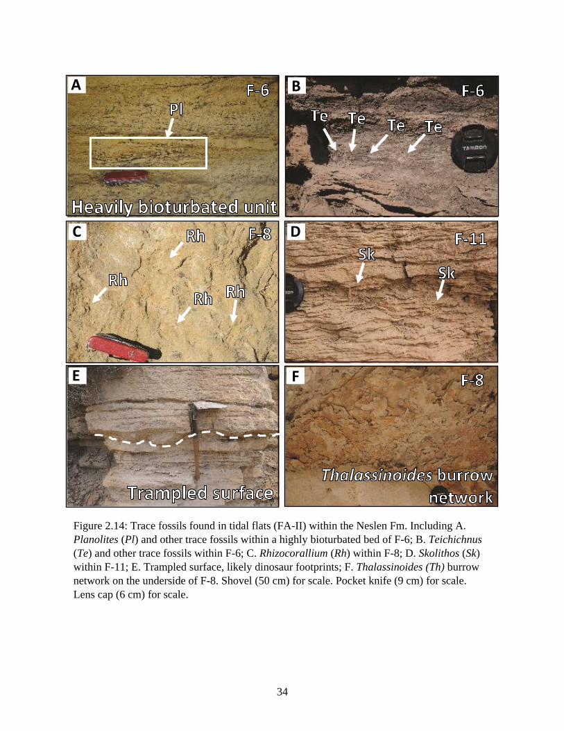
Figure 2.14: Trace fossils found in tidal flats (FA-II) within the Neslen Fm. Including A.
Planolites (Pl) and other trace fossils within a highly bioturbated bed of F-6; B.
Teichichnus (Te) and other trace fossils within F-6; C. Rhizocorallium (Rh) within
F-8; D. Skolithos (Sk) within F-11; E. Trampled surface, likely dinosaur footprints;
F. Thalassinoides (Th) burrow network on the underside of F-8. Shovel (50 cm) for
scale. Pocket knife (9 cm) for scale. Lens cap (6 cm) for scale……………………34
Figure 2.15: Carbonate deposits found within the Neslen Fm. Including A. Stromatolite; B.
Stromatolite block with ooids on the surface; C. Skeletal-rich deposit with shells
and other skeletal fragments; D. Close-up of shell half within skeletal-rich deposits.
Pocket knife (9 cm) for scale. Lens cap (6 cm) for scale………………………….35
Figure 2.16: Photomicrographs of carbonate deposits found in the Neslen Fm in East Canyon
and Middle Canyon near Harley Dome, UT. A. Stromatolite showing algal
amalgamation and carbonate cement; B and C. Ooids found on the surface of
stromatolites in outcrop; D. Broken skeletal fragments found in the skeletal hash

xvi
deposit; E. Gastropod shell found in the skeletal hash deposit; F. Broken skeletal
fragments found in the skeletal hash deposit. Locations for each photomicrograph
are shown in Figure 2.15………………………………………………………….37
Figure 2.17: Interpreted outcrop image and corresponding drafted measured section in Middle
Canyon including deposits of tidal flats (FA-II), proximal tidal-fluvial channels
(FA-III), and floodplain (FA-IV). White bar on image corresponds with location of
drafted measured section.………………………………………………………...40
Figure 2.18: Predominant facies and sedimentary structures found in proximal tidal-fluvial
channels (FA-III) of the Neslen. A. Soft-sediment deformation in a bed of F-14; B.
Large-scale trough cross-stratification (F-14); C. Low-angle planar laminations (F-
8). Shovel (50 cm) for scale………………………………………………………41
Figure 2.19: Trace fossils found in the Neslen within proximal tidal-fluvial channels (FA-III).
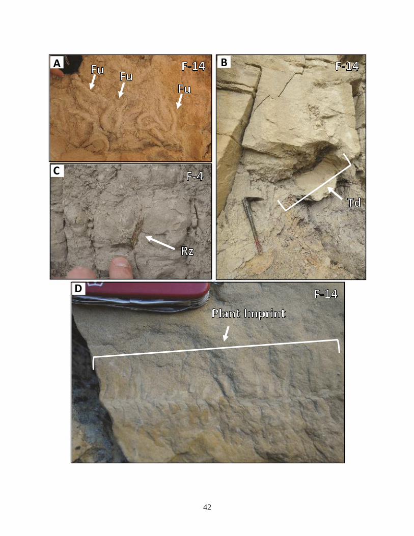
A. Fuerisichnus (Fu) on the underside of a bed of F-14; B. Teredolites (Td) burrows
in a log within a bed of F-14; C. Rhizoliths (Rz) within a bed of F-4; D. Plant imprint
on a bedding contact of F-14. Shovel (50 cm) for scale. Pocket knife (9 cm) for
scale. Lens cap (6 cm) for scale. Finger for scale…………………………………42
Figure 2.20: Floodplain sub-facies associations including A. Levee-splay complex (FA-IVa); B.
Paleosol with rhizolith (Rz); C. Interbedded swamp (FA-IVb) and levee-splay (FA-
IVa) deposits. Shovel (50 cm) for scale. Lens cap (6 cm) for scale. White bar on
image C corresponds with location of drafted measured section…………………48

xvii
Figure 2.21: A. Outcrop image of the upper Sego in East Canyon showing the locations of Fig.
2.19B and Fig. 2.19C; B. Hummocky cross-stratification (F-15); C. Rhizocorallium
trace fossil in a bed of F-8. Shovel (50 cm) for scale. Pocket knife (9 cm) for scale.
……………………………………………………………………………………52
Figure 2.22: A. Teredolites ichnofacies in Middle Canyon; B. Teredolites ichnofacies in East
Canyon; C. Teredolites burrows on a log; D. Teredolites burrows in place of what
was once a log; E. Teredolites burrows in place of a log; F. Single Teredolites
within coal classified as an ichnofacies. Pocket knife (9 cm) for scale. Lens cap (6
cm) for scale……………………………………………………………………...58
Figure 2.23: Paleoenvironmental reconstruction of the Neslen Fm near Harley Dome, UT. Flood
and ebb tide directions are based on paleocurrent data shown in the rose diagram
from the Neslen Fm (n = 157). Tidal barforms of the reworked tidal deltas of the
upper Sego are also shown. Modified from Emery and Myers (1996)……………62

1
Chapter 1: Introduction of Project
This thesis contains a high-resolution, multiproxy sedimentologic, ichnologic, and stratal
architecture study of the transition between the Campanian upper Sego and Neslen formations
(fms) exposed along the Book Cliffs in the Harley Dome area of the Uinta Basin, Utah. The
primary focus of this thesis is the examination of the Neslen Formation (Fm) and is presented as a
stand-alone manuscript in the 2nd chapter of this thesis.
Chapter 2 integrates outcrop-based sedimentologic, ichnologic, and stratal architecture
analyses to describe and interpret deposits of the upper Sego and Neslen fms in four canyons (East,
Middle, Bryson, San Arroyo) in the Book Cliffs of UT near Harley Dome. The Harley Dome
outcrops comprise facies, ichnology, and architectural elements of an estuarine mixed fluvio-tidal
paralic system. The deposits of the upper Sego and Neslen fms represent the transition from tidally-
modified deltaic deposits to estuarine deposits, and thus provide an ancient outcrop analogue to
identify an estuarine system in the rock record and build a sequence stratigraphic framework.
Because the stratigraphy discussed herein is shallow-marine to continental transitional, ichnology
played a crucial role in the interpretation of flooding surfaces and refinement of
paleoenvironments, and therefore the importance of examining ichnology is highlighted in this
thesis. The deposits in the four canyons are described, interpreted, and correlated, and
paleoenvironmental interpretations of the Neslen Fm near Harley Dome are presented in a spatio-
temporal paleoenvironmental reconstruction. These interpretations are ultimately compared-
contrasted to those documented in three studies of the Neslen Fm undertaken southwest of the
Harley Dome area, 58 km from the study area by Shiers et al. (2014), 57 km from the study area
by Olariu et al. (2015), and 70 km from the study area by Aschoff et al. (2016). The Neslen Fm
2
can serve as an estuarine reservoir analogue and thus resultant sandbody geometries and internal
heterogeneity scale and distribution within estuarine paleoenvironments is discussed.
The goals of this thesis are to: 1) identify paleoenvironments and clarify 3D architectural
element geometries for the Sego-Neslen transition at Harley Dome, focusing on the Neslen, Fm,
to produce a spatio-temporal paleoenvironmental reconstruction based on stratigraphy, ichnology,
and stratal architectures; 2) place the upper Sego and Neslen fms into a sequence stratigraphic
framework, 3) compare-contrast the data set and these resultant interpretations with other
published research on Sego-Neslen transitional stratigraphy previously described from the Book
Cliffs region (Shiers et al. 2014; Olariu et al. 2015; Aschoff et al. 2016) to provide a revised,
regional framework; and 4) discuss the reservoir elements of the Neslen Fm including sandbody
geometries and heterogeneities to aid reservoir modelers of estuarine petroleum systems.

3
Chapter 2: The Sego-Neslen Formation Transition (Campanian) near Harley
Dome, Utah: An Analogue for Tidally Influenced, Heterolithic,
Paralic Reservoir Systems
INTRODUCTION
The Book Cliffs near Harley Dome and the Utah-Colorado border (Fig. 2.1) preserve Late
Cretaceous (Campanian) strata of the Mesaverde Group (Fig. 2.2) including fluvial-distributive to
shallow-marine strata of the Castlegate Sandstone (Castlegate), Buck Tongue of the Mancos Shale,
Sego Sandstone Member of the Mancos Shale (Sego), Neslen Formation (Fm), and Bluecastle
Tongue of the Castlegate (Konishi, 1959; Gill and Hail 1975; Hettinger and Kirschbaum 2003;
Gomez and Steel 2010; Burton et al. 2016; Allen and Pranter 2016). This study focuses solely on
the transition from the uppermost Sego to the Neslen Fm near Harley Dome, UT.
The Neslen Fm records deposition along a low relief coastal plain and associated shallow-
marine systems along the western shore of the Cretaceous Western Interior Seaway (Fig. 2.1)
(Aschoff and Steel 2011; Shiers et al. 2014; Olariu et al. 2015; Aschoff et al. 2016). The position
of the Neslen Fm within a sequence stratigraphic framework is still debated. Some workers place
the Neslen within the transgressive systems tract (TST), with a transgressive lag in the basal Neslen
(Yoshida et al. 1996), while others place a sequence boundary is in the middle to upper Neslen
(McLaurin and Steel 2000; Hettinger and Kirschbaum 2002). Others suggest that the Neslen is not
in the TST but rather the lowstand systems tract (LST) and therefore no sequence boundary exists
within the Neslen Fm (Willis 2000). The most recent sequence stratigraphic interpretation places
the lower Neslen in the TST and the upper Neslen in the highstand systems tract (HST), with a
maximum flooding surface in the upper-middle Neslen (Shiers et al. 2017). In general, the Neslen
Fm is typically placed within the TST with variable interpretations of the location of the
transgressive lag.
4
In transgressive systems along embayed coastlines, estuaries are common features rather
than tidal deltas like those of the Sego Fm (Van Wagoner 1991; Dalrymple et al. 1992; Willis and
Gabel 2003; Olariu et al. 2015). Estuaries are defined as the seaward portions of drowned incised
valleys that receive sediment from both marine and fluvial sources, and contain deposits often
exhibiting a mix of wave, tide, and/or fluvial influence (Dalrymple et al. 1992). Environments
associated with estuaries include washover fans, flood-tidal deltas, central estuary basin, bayhead
deltas, tidal flats, tidal sand bars, lagoons, floodplains, and tidal-fluvial channels (Dalrymple et al.
1992).
Recent studies of the Neslen focus on Book Cliffs strata 50-70 km southwest of Harley
Dome near Floy Canyon (Fig. 2.3; Olariu et al. 2015), Crescent Canyon (Fig. 2.3; Shiers et al.
2014), and Coal Canyon (Fig. 2.3; Aschoff et al. 2016). Although Neslen sediments are described
at these select outcrops (Shiers et al. 2014; Olariu et al. 2015; Aschoff et al. 2016), no multi-proxy,
high-resolution sedimentologic, ichnologic, and stratal architecture study has been employed to
the east in the Harley Dome area. This study describes and interprets the heterogeneous deposits
of the Neslen near Harley Dome to update the regional depositional framework for the Neslen Fm,
and provides reservoir modelers with an analogue for a tidally influenced paralic system.
Outcrops along four canyons in the Harley Dome area (Middle, East, Bryson, and San
Arroyo) (Fig. 2.4) examined for this study contain heterolithic deposits that include sandstones
with inclined heterolithic stratification comprising alternating sand-rich laminae and thin mud
drapes. Sand-rich intervals are separated by intervals of finer-grained mudstone, siltstone,
pedogenically modified sediments, and coal (Fig. 2.5). Inclined heterolithic stratification (IHS,
Fig. 2.6) is defined as large-scale, lithologically heterogeneous siliciclastic sedimentary
successions whose strata are inclined in the original depositional angle and exhibit initial dips of

5
1°-36° (Thomas et al. 1987). Some of these Neslen sandstones, but not all, have erosional bases,
and most contain numerous internal scour surfaces within sandstone packages (Fig. 2.6).
Sandbodies in the Harley Dome area that appear grossly similar to those described from other
Neslen outcrop belts have been interpreted as point bars of fluvial channels (Shiers et al. 2014;
Olariu et al. 2015; Aschoff et al. 2016), while others are interpreted as bayhead deltas (Shiers et
al, 2014; Olariu et al. 2015; Aschoff et al. 2016). Because these different depositional systems
(channels, deltas) imply inherently different plan view geometries for reservoir modelers, an
outcrop study that includes sedimentologic, ichnologic, and architecture analyses is employed to
correctly identify the depositional systems responsible for deposits of the Neslen Fm near Harley
Dome.
Not only is outcrop characterization essential for reservoir modeling to define large-scale
stratigraphic architectures, but the multiple scales of heterogeneity that exist within tidal-fluvial
systems are difficult to distinguish from subsurface data alone. Through an outcrop study such as
this, the distribution of facies within reservoir analogues can be established, and characteristics
such as grain size, sorting, and variation in lithology can be tested for its effect on reservoir
performance (Richardson et al. 1978; Lasseter et al. 1986, Thomas et al. 1987; Tyler and Finley
1991; Hartkamp-Bakker and Donselaar 1993; Willis and White 2000; Pranter et al. 2007).
Examining the transition into the Neslen Fm from the upper Sego in the Harley Dome area
is important because: 1) the study area contains shallow-marine to continental transitional
stratigraphy with complex architectural elements and fluctuating ichnology, therefore a combined
sedimentologic, ichnologic, and architectural analysis is the best way to identify and refine
interpretations of depositional systems, each of which imply different sandbody-shale geometries;
2) the Neslen was once a producing natural gas reservoir in the eastern and southeastern Uinta

6
Basin (Keighin 1979; Pitman et al. 1987) and refining the Neslen reservoir analogue near Harley
Dome could improve recovery in nearby petroleum fields; 3) sandbody-shale geometries and
internal architectures from such analogues as the Neslen can be used to refine reservoir models of
tidally influenced distributive-paralic-shallow-marine systems in general; and 4)
paleoenvironmental interpretations of the Neslen from this study can be compared and contrasted
to those presented by Shiers et al. (2014), Olariu et al. (2015), and Aschoff et al. (2016) to refine
the regional paleoenvironmental model for the upper-Sego and Neslen fms.
The purpose of this manuscript is therefore to: 1) describe the facies, ichnology and
architectural elements found within upper Sego-Neslen fms in outcrops in the Harley Dome area;
2) place the upper Sego and Neslen fms into a sequence stratigraphic framework; 3) identify
paleoenvironments and provide a spatio-temporal paleoenvironmental reconstruction for the study
area; 3) compare these results to previous studies of the upper Sego-Neslen fms in the Book Cliffs
to refine the regional model of the Neslen Fm, and 4) discuss the implications for regional
paleoenvironmental reconstructions of the Neslen Fm and for reservoir models of tidally
influenced fluvial-distributive-shallow-marine coastal systems.

7
Figure 2.1: Regional paleogeography of the study area and modern basin geography. A. Approximate location of the study area in
northeastern Utah along the Campanian paleoshoreline of the Cretaceous Western Interior Seaway. The location of the study
area is shown by the black box (Roberts and Kirschbaum, 1995; Willis and Gabel, 2003; Painter et al., 2013). Modified from
Prather (2016). B. Modern-day geography of Laramide age basins and uplifts of northeastern Utah and northwestern Colorado.
Modified from Gomez-Veroiza and Steel (2010).

8
Figure 2.2: Ammonite biostratigraphy and generalized lithostratigraphy for the Uinta, Piceance Creek, and Sand Wash Basins
of northeastern Utah and northwestern Colorado (Konishi, 1959; Gill and Hail, 1975; Hettinger and Kirschbaum, 2002; Gomez
and Steel, 2010). Red box indicates the interval examined in this study. Modified from Burton et al. (2016) and Prather (2016).

9
Figure 2.3: Map of the study area and the relative location of additional studies on the Neslen Formation (black boxes) in the
Book Cliffs, Utah. Modified from Shiers et al. (2014).
10
Figure 2.4: Map of the Harley Dome, UT area including the location of all measured sections and fence diagram
(see Fig. 2.8, Appendix A, and Appendix B) constructed along line A-A’.

11
B
Figure 2.5: A. Interpreted photomosaic from East Canyon showing the formations and formation members found in the outcrop
belt. B. Interpreted photomosaic in East Canyon showing the two lowermost sandbodies at the base of the Neslen Fm separated
by finer grained deposits.
A

12
B
Figure 2.6: A. Interpreted photo from East Canyon outcrop belt showing inclined heterolithic
stratification (white dashed lines) in sandbodies overlying coal and other fine grained deposits.
B. Interpreted photo from San Arroyo outcrop belt showing multiple scour surfaces within one
sandbody interpreted as a distal tidal-fluvial channel (San Arroyo Canyon, 68 m). Sandbody in
B is a potential candidate for a deeply incised tidal channel or incised valley. Person for scale
(white oval), approximately 1.5 m.
A
IHS
FA-II
FA-I
FA-III

13
REGIONAL STRATIGRAPHIC SETTING AND PREVIOUS WORK
The Late Cretaceous (Campanian) upper-Sego and Neslen fms are members of the
Mesaverde Group (Fig. 2.2) deposited in a retroarc foreland basin within east-southeastward
prograding clastic wedges shed from the Sevier orogenic belt to the west (Jordan 1981; Hettinger
and Kirschbaum 2003; Willis and Gabel 2003; Aschoff and Steel 2011; Burton et al. 2016). Upper-
Sego and Neslen strata are exposed within the Laramide-type uplifts in the Uinta Basin of eastern
Utah and western Colorado (Fig. 2.1). The Neslen Fm (Fig. 2.2) is traditionally interpreted as
tidally-influenced fluvial-distributive and shallow-marine deposits emplaced along what was
likely a rugose southwest-northeast trending coastline of the Cretaceous Western Interior Seaway
(CWIS). The Neslen is underlain by the upper Sego (Willis and Gabel 2003; Hettinger and
Kirschbaum 2003; Aschoff and Steel 2011; Shiers et al. 2014; Burton et al. 2016) (Fig. 2.5). The
upper Sego is the equivalent of the middle Iles Sandstone, located to the east in the Piceance Basin
of Colorado, and contains the ammonite Baculites scotti, indicating deposition at approximately
76 MA. (Fig. 2.2) (Gill and Hail 1975; Hettinger and Kirschbaum 2003; Gomez-Veroiza and Steel
2010; Kirschbaum and Spear 2012; Burton et al. 2016). The upper Sego is dominated regionally
by trough-cross stratification; is highly bioturbated, containing such fully marine traces as
Ophiomorpha, Siphonichnus, and Thalassinoides; and is typically interpreted as deposits of tidal
bars within tidally influenced deltas, tidally-modified fluvial deposits, and deposits of fluvial
distributary channels (Van Wagoner 1991; Willis and Gabel 2003; Olariu et al. 2015). The base of
the overlying Neslen Fm is typically defined as the first appearance of coal, representing a shift
from regression to transgression (Kirschbaum and Hettinger 2004; Olariu et al. 2015). Because
carbonaceous deposits such as coal typically are laterally discontinuous, the stratigraphic level of
the base of the Neslen Fm above the Sego is inconsistently interpreted throughout the Book Cliffs.

14
The presence of the ammonite Didymoceras nebrascense indicates that the Neslen Fm was
deposited at approximately 76 MA. (Gill and Hail 1975; Hettinger and Kirschbaum 2003; Burton
et al. 2016).
Recent work on the Neslen includes outcrop studies between Floy Wash and Crescent
Canyon, UT (Shiers et al. 2014), at Floy Canyon, UT (Olariu et al. 2015), and at Coal Canyon, UT
(Aschoff et al. 2016) (Fig. 2.3). Shiers et al. (2014) subdivided the Neslen into three distinct coal
bearing zones, a methodology similar to that employed by Gualtieri (1991), Hettinger and
Kirschbaum (2003), Kirschbaum and Hettinger (2004), and Cole (2008). Shiers et al. (2014)
describe the lowermost zone, the Palisade Zone, as dominated by fine grained floodplain deposits
and coal, with deposits of small sinuous fluvial channels, tidally influenced fluvial channels, and
overbank deposits. The overlying Ballard Zone is dominated by coal, recording raised pear mires
and rare ribbon-like distributary channel deposits and levees. The stratigraphically highest
Chesterfield Zone, is further divided into lower and upper zones. The lower Chesterfield Zone is
dominated by large fluvial point bar deposits of narrower ribbon-style distributary channels.
Channel size increases upward in the lower Chesterfield Zone with incision at the larger channel
bases (Shiers et al. 2014). The upper Chesterfield Zone comprises deposits of highly amalgamated
high-energy fluvial channels, and common overbank sandstones (Shiers et al. 2014). Olariu et al.
(2015) identified seven depositional environments in the upper Sego and Neslen fms at Floy
Canyon, UT. Olariu et al. (2015) interpreted the upper Sego to include deposits of tidal bars and
dunes within an estuary mouth, muddy tidal flats, overbank fines, lagoons, and tidal-fluvial
channels. The Neslen Fm includes deposits of muddy tidal flats, bay-head deltas, lagoons, tidal-
fluvial channels, and overbank. Olariu et al. (2015) describe the Neslen Fm as dominated by
inclined heterolithic stratification (IHS) and interpret 5-8 m thick sandbodies as deposits of tidally

15
influenced point bars within tidal-fluvial channels. This interpretation is based on the presence of
brackishwater trace fossils, common mud drapes, tidal rhythmites, bidirectional ripples and cross-
stratification, and lateral accretion surfaces. Aschoff et al. (2016) divided the upper Sego and
Neslen fms into four lithofacies associations: 1) sandy, fluvial-dominated, tide-influenced, wave-
affected deposits that include tidally influenced subaerial distributary channels, proximal mouth
bars, terminal distributary channels, tide-reworked delta front turbidites, distal delta front slumps,
and proximal prodelta; 2) heterolithic, fluvial-dominated, tide-influenced and wave-affected
deposits including prodelta and medial delta front turbidites; 3) heterolithic, tide-dominated,
fluvial-influenced and wave-affected deposits that include sandy tidal flats, distal mouth bars,
muddy tidal flats, wave-reworked proximal delta front, and abandoned delta front; and 4) muddy,
distal bayhead delta and bay-fill deposits found in the central basin or distal central basin.
METHODS
Sections were recorded in Middle Canyon, East Canyon, Bryson Canyon, and San
Arroyo Canyon (Fig. 2.4), an area covering approximately 70 km2. Measured sections began 2-
35 m below the assumed upper Sego-Neslen transition, which was based on a facies change from
deltaic to estuarine deposits and the presence of coal. Measured sections were terminated at or
above the Neslen-Bluecastle Tongue transition, defined by a consistent lack of marine or
brackish water traces and a predominance of architecturally blocky sandbodies generally lacking
IHS and containing thicker packages of coarser grained material than those of the Neslen Fm.
Stratigraphic columns include lithology, grain size, contacts, sedimentary structures, bed
thickness, trace fossils, bioturbation index, flora, and fauna.

16
Paleocurrent directions (n=157) were recorded from trough cross-stratification, ripple
cross-lamination, and parting lineation/primary current lineation and plotted as rose diagrams
using GeoOrient software.
High resolution photomosaics were recorded with a Nikon D 800 SLR camera and 200-
400 mm Nikkor lens on a GigaPan robotic panhead. Panoramas and photomosaics were stitched
together using GigaPan EFX Stitch software. Photomosaics were used in an architectural
analysis to examine vertical and lateral variations in stratigraphy, pinpoint architectural elements,
and clarify outcrop stacking patterns. A DJI Phantom 4 Pro drone with a 20 megapixel camera
and an 8.8-24 mm lens was used to record a matrix of laterally and vertically continuous photos
along select outcrop belts. Photos were uploaded into AgiSoft software to create 3D point clouds
that were converted into a tiled mesh and orthomosaics. The 3D imagery produced in AgiSoft
provided quantitative data on sandbody width, thickness, and area, and also provided additional
information on the variability of sandbody and shale geometries in the Neslen in 2D-3D space
(Fig. 2.9).

17
Figure 2.7: Legend for Figure 2.8 and Appendix A, C and D.

18
Figure 2.8: Simplified version of the four composite measured sections and cross-section of the
top of the upper-Sego and Neslen deposits near Harley Dome, UT. Diagram includes interpreted
depositional environments and their correlation across the four measured sections. Measured
section locations and distances between outcrops are included. Location of cross-section is
shown on Fig. 2.4. I1 and I2 are addressed in the paleoenvironmental evolution section of the
discussion. A detailed version of this figure is located in Appendix D.
A
I1
I2

19
FACIES ANALYSIS
The Upper Sego and the Neslen fms in the Harley Dome area are broken down into 16
distinct facies (Table 2.1) based on lithology, sedimentary structures, grain size, and upper and
lower contacts. These facies are combined into 6 facies associations based on vertical and lateral
facies relationships, facies stacking patterns, and trace fossils (Table 2.2). Facies associations
exclusive to the upper Sego include: Tidal Barforms (FA-V) and Interdistributary Bays (FA-VI).
Facies associations of the Neslen Fm record deposition in Distal Tidal-Fluvial Channels (FA-I),
Tidal Flats (FA-II), and Proximal Tidal-Fluvial Channels (FA-III) along associated Floodplains
(FA-IV).
Facies Association I (FA-I): Distal Tidal-Fluvial Channels (upper Sego and Neslen fms)
Description
FA-I (Table 2.2) is a fining-upward succession (0.5-12 m thick) with an erosional base that
exhibits inclined heterolithic stratification in outcrop. FA-I is dominated by small to large-scale
trough cross-stratified sandstone (F-14) or combined-flow ripple cross-laminated very-fine to fine-
grained sandstone with common mud-drapes, abundant double mud-drapes, mud rip-ups, and rare
mud balls (F-11) at the base. The succession fines-upward into very-fine to upper fine-grained
combined-flow ripple cross-laminated sandstone (F-8) and is typically capped by carbonaceous
shale (F-2) or structureless siltstone (F-4). FA-I rarely contains very-fine to fine-grained
structureless sandstone (F-7) and very-fine to fine-grained planar-laminated sandstone (F-9). Mud
drapes (2-20 inches thick) occur on inclined heterolithic stratification. Mud rip-up clasts and mud
balls are commonly found in lags above the erosional base and soft-sediment deformation is also

20
common. Sandbodies are typically 5-12 m thick and can be exposed as either heterolithic sheets
that extend for 100s to 1000s of m laterally, or can occur as arcuate channel-forms only 10s of m
wide. Carbonaceous material in the form of organic drapes, rip-up clasts, logs, and sticks are found
within the sandbodies as well as in the fine-grained facies capping the succession. Trace fossils
include Arenicolites (Ar), Asterosoma (As), Bergaueria (Be), Chondrites (Ch), Conichnus (Co),
Cylindrichnus (Cy), Diplocraterion (Di), Lockeia (Lo), Macaronichnus (Ma), Ophiomorpha (Op),
Palaeophycus (Pa), Planolites (Pl), Rhizocorallium (Rh), Siphonichnus (Si), Skolithos (Sk),
Teredolites (Td), dinosaur footprints, and tetrapod swim tracks.

21
Table 2.1: Facies of the upper Sego and Neslen Formations near Harley Dome, UT.
Facies Sedimentary Structures and Grain
Size
Color Upper/Lower Contacts Bed Thickness
Range
Diagnostic Features
F-1 Coal brown, black Base: Sharp
Top: Sharp to erosional
Thickest: 2.1 m
Thinnest: 5 cm
Common amber and
sulphur; can have
higher silt/sand content;
breaks blocky or in thin
sheets
F-2 Carbonaceous Shale brown, gray, black Base: Sharp, rarely
gradational
Top: Sharp to erosional
Thickest: 6 m (1.4)
Thinnest: 2 cm
Thinly laminated to
fissile, sulphur halos
common, can be flaser,
wavy, and lenticular
bedded
F-3 Structureless to rooted mudstone brown, red brown, gray,
black
Base: Sharp, rarely
gradational
Top: Sharp to erosional
Thickest: 2 m
Thinnest:10 cm
Abundant organics,
rounded nodular
weathering
F-4
Structureless to rooted siltstone
brown, gray, black Base: Sharp to erosional,
rarely gradational
Top: Sharp to erosional,
rarely gradational
Thickest: 3.6 m
Thinnest: 5 cm
Abundant organics, can
be thinly laminated
and/or interbedded with
mudstone or sandstone
F-5 Combined-flow current- rippled cross-
laminated siltstone
brown, gray, black Base: Sharp
Top: Sharp to erosional,
rarely gradational
Thickest: 2.1 m
Thinnest: 2 cm
Abundant organics, can
be thinly laminated
and/or interbedded with
sandstone, may contain
mud drapes
F-6
Flaser, wavy, and lenticular bedded
siltstone
brown, red brown, gray,
black
Base: Sharp
Top: Sharp, rarely
gradational
Thickest: 2.5 m
Thinnest: 5 cm
Isolated very-fine sand
lenses within silt
F-7 Very-fine to fine-grained structureless
sandstone
tan Base: Sharp to erosional,
rarely gradational
Top: Sharp to erosional
Thickest: 50 cm
Thinnest: 5 cm
Commonly heavily
bioturbated or
sideritized
F-8 Very-fine to upper fine-grained
combined- flow ripple cross-laminated
to planar-laminated sandstone
tan Base: Sharp to erosional
Top: Sharp to erosional
Thickest: 40 cm
Thinnest: 10 cm
Soft sediment
deformation common,
can be thinly laminated
and interbedded with
siltstone, rare syneresis
cracks
F-9 Very-fine to upper fine-grained low-
angle planar-laminated to sigmoidal-
bedded sandstone
tan Base: Sharp to erosional
Top: Sharp to erosional
Thickest: 60 cm
Thinnest: 10 cm
Mud-rich or organic-
rich lags common at
basal contact
F-10 Very-fine to fine grained current ripple
cross laminated sandstone
tan Base: Sharp to erosional
Top: Sharp to erosional
Thickest: 20 cm
Thinnest: 5 cm
Organic or mud-rich
lags common, mud-
drapes rare
F-11 Very-fine to fine grained combined-
flow ripple cross-laminated sandstone
with abundant mud drapes and mud
chips
tan Base: Sharp to erosional
Top: Sharp to erosional
Thickest: 1.9 m
Thinnest: 10 cm
Abundant mud drapes
and double mud drapes
and/or mud chips,
organics common
F-12 Wave rippled very-fine to upper fine-
grained sandstone
tan Base: Sharp to erosional
Top: Sharp to erosional
Thickest: 70 cm
Thinnest: 10 cm
Abundant mud drapes
and double mud drapes,
abundant organics
F-13 Climbing ripple cross-laminated very
fine- grained sandstone
tan Base: Erosional
Top: Erosional
Thickest: 20 cm
Thinnest: 5 cm
Trampled surfaces
common
F-14
Small to large-scale trough cross-
stratified to tabular cross-stratified
sandstone
tan Base: Sharp to erosional
Top: Sharp to erosional
Thickest: 2 m
Thinnest: 10 cm
Common mud or
organic drapes or
ripples on cross-beds,
mud rip-ups common
F-15 Hummocky cross-stratified sandstone
(Sego only)
tan Base: Sharp
Top: Gradational
Thickest: 3 m
Thinnest: 10 cm
Many Op burrows at
base and along
bounding surfaces
F-16 Carbonate white Base: Sharp
Top: Sharp
Thickest: 30 cm
Thinnest: 15 cm
Stromatolites and ooids;
rare in section

22
Table 2.2: Facies associations (paleoenvironments) of the upper Sego and Neslen Formations
near Harley Dome, UT.
Facies
Associations
Inclusive Facies Diagnostic Features Ichnology Relationship to
other FA
FA-I:
Distal Tidal-Fluvial
Channels
F-2, F-3, F-4, F-5,
F-6, F-7, F-8, F-9,
F-10, F-11, F-12,
F-13, F-14
Erosionally based, IHS, fining-
upward successions 0.5-12 m
thick. Dominated by F-14 (0.2-
1.5 m) and F-11 (0.1-0.5 m) at
the base, fining-upward into F-8
(0.1-1 m), and capped by F-2, F-
3, F-4, F-5, F-6. F-7 and F-9 rare
in section. Mud drapes and
double mud drapes common.
Lags of mud balls and mud chips
common. Some soft-sediment
deformation and carbonaceous
material.
Ar, As, Be, Ch, Co,
Cy, Di, Lo, Ma, Op,
Pa, Pl, Rh, Si, Sk,
Td,Te, Th,
Dinosaur
Footprints,
Tetrapod Swim
Tracks
Overlies FA-IIa, FA-
IIb, FA-III, FA-IVa,
FA-IVb, FA-IVc,
FA-IVd, FA-VII,
FA-VIII.
Underlies FA-IIa,
FA-IIb, FA-III, FA-
IVa, FA-IVb, FA-
IVc, FA-IVd, FA-V,
FA-VII, FA-VIII.
FA-II: Tidal Flats
FA-IIa:
Sandy Tidal Flats
F-4, F-6, F-7, F-8,
F-9, F-11
Dominated by F-11 (0.05-0.2 m)
and F-8 (0.05-0.2 m). Commonly
interbedded with F-4 (0.05-0.1
m) and F-6 (0.05-0.1 m). F-7
(0.03 m) rare. Mud drapes and
carbonaceous material common
with rare soft-sediment
deformation. Sheet-like
geometry.
As, Co, Cy, Lo, Op,
Pl, Rh, Sk, Td, Th,
Dinosaur Footprints
Overlies FA-I, FA-
IIb, FA-III, FA-IVa,
FA-IVb, FA-IVc.
Underlies FA-I, FA-
IIb, FA-III, FA-IVa,
FA-IVb.
FA-IIb:
Muddy Tidal Flats
F-2, F-3, F-4, F-5,
F-6
Dominated by F-4 (0.05-0.5 m),
F-5 (0.05- 0.5 m), and F-6 (0.1-
0.75 m). Carbonaceous material
common with rare sulphur,
amber, mud drapes and double
mud drapes. Sheet-like geometry.
Cy, Op, Pa, Ph, Pl,
Rh, Sk, Td, Te, Th,
Dinosaur Footprints
Overlies FA-I, FA-
IIa, FA-IIc, FA-IVa,
FA-IVb, FA-IVc,
FA-VIII.
Underlies FA-I, FA-
IIa, FA-III, FA-IVa,
FA-IVb, FA-IVc.
FA-IIc:
Distal Estuary
F-16 Solely F-16 (0.2-0.4 m).
Carbonate deposits in the form of
stromatolites, oolites, and skeletal
hash.
None Overlies FA-IVb.
Underlies FA-IIb,
FA-IVd.
FA-III:
Proximal Tidal-Fluvial
Channels
F-3, F-4, F-5, F-6,
F-7, F-8, F-9, F-10,
F-11, F-13, F-14
Erosionally based, IHS, typically
fining-upward packages 0.5 to 20
m thick. Dominated by F-14 (0.2-
2 m), F-8 (0.3-0.75 m), F-10 (0.1-
1.5 m), and F-11 (0.05-1 m),
fining-upward into F-4, F-5, and
F-6. F-7, F-9, and F-13 rare. Mud
drapes, double mud drapes, and
soft-sediment deformation
common. Lags of mud balls and
mud chips. Carbonaceous
material rare.
Cy, Pl, Td (in logs),
Dinosaur Footprints
Overlies FA-I, FA-
IIa, FA-IIb, FA-IVa,
FA-IVb, FA-IVc,
FA-IVd.
Underlies FA-I, FA-
IIa, FA-IVa, FA-IVb,
FA-IVc, FA-IVd.
FA-IV: Floodplain
FA-IVa:
Levee-Splay, Swamp
Margin
F-2, F-3, F-4, F-5,
F-7
Commonly coarsening-upward
successions 0.3-2 m thick of F-2,
F-4, F-5, and rarely capped by F-
7. F-3 is also rare. Carbonaceous
material common with rare
siderite.
Dinosaur Footprints Overlies FA-I, FA-
IIa, FA-IIb, FA-III,
FA-IVb, FA-IVc.
Underlies FA-I, FA-
IIa, FA-IIb, FA-III,
FA-IVb, FA-IVc,
FA-IVd.

23
Table 2.2 continued: Facies associations (paleoenvironments) of the upper Sego and Neslen
Formations near Harley Dome, UT.
FA-IVb:
Swamp
F-1, F-2, F-3 Dominated by F-1 (0.1-1.5 m)
with rare F-2 (0.1-0.5 m) and F-3
(0.1 m). Carbonaceous material
common with F-1 containing
sulphur and amber.
Td Overlies FA-I, FA-
IIa, FA-IIb, FA-III,
FA-IVa, FA-IVc,
FA-IVd.
Underlies FA-I, FA-
IIa, FA-IIb, FA-IIc,
FA-III, FA-IVa, FA-
IVc, FA-IVd.
FA-IVc:
Paleosol
F-3, F-4, F-6, F-7 Dominated by F-3 containing
rhizoliths. Rhizolith bearing F-4,
F-5, F-6, and F-7 rare. Paleosols
range from 0.5-2 m thick.
Carbonaceous material and wood
abundant. Nodular weathering
common.
None Overlies FA-I, FA-
IIb, FA-III, FA-IVa,
FA-IVb, FA-IVd,
FA-VIII.
Underlies FA-I, FA-
IIa, FA-IIb, FA-III,
FA-IVa, FA-IVb,
FA-IVd.
FA-IVd:
Lake-Pond
F-2, F-4, F-5, F-6 Dominated by F-6 (0.4-2.5 m)
with carbonaceous material
abundant. F-2, F-4, and F-5 rare.
Rare organic lentils in F-6.
None Overlies FA-I, FA-
IIa, FA-IIc, FA-III,
FA-IVa, FA-IVb,
FA-IVc.
Underlies FA-I, FA-
III, FA-IVb, FA-IVc.
Facies Associations Exclusive to the upper Sego
FA-V:
Tidal Barforms
F-3, F-4, F-5, F-6,
F-7, F-8, F-9, F-10,
F-11, F-14, F-15
Dominated by F-14 (0.5-2.5 m)
with F-3, F-4, F-5, F-6, F-7, F-8,
F-9, F-10, F-11, and F-15 rare.
Rare mud drapes, mud chips, and
mud balls.
As, Cy, Op, Pa, Pl,
Rh, Sch, Si, Sk, Te,
Th
Overlies FA-I, FA-
VI.
Underlies FA-I, FA-
IIb, FA-VI.
FA-VI:
Interdistributary Bay
F-4, F-5 Dominated by F-5 (0.5-0.6 m)
and F-4 (0.7 m) with mud drapes
common and rare siderite.
As, Cy, Pa, Pl, Te Overlies FA-V.
Underlies FA-V.
Interpretation
Concave up, erosionally based, sandbodies with trough cross-stratification, mud chip and
mud ball lags, mud drapes, abundant double mud drapes, and marine to brackish-water trace fossils
that thin and fine-upward into finer-grained facies have been interpreted as tidal-fluvial channels
(Dalrymple et al. 1992; Shiers et al. 2014; Olariu et al. 2015). These channels are not interpreted
as deposits of distributary channels because they are part of a transgressive estuarine system and
were not distributing sediment to a delta (Dalrymple et al. 1992; Shiers et al. 2014; Olariu et al.

24
2015; Shiers et al. 2017). Mud drapes on inclined heterolithic stratified sandbodies are continuous
across the entire sandbody and contain rhythmic sand-mud alterations and abundant double mud
drapes, similar to typical descriptions of estuarine tidal-fluvial point bars (Thomas et al. 1987;
Ranger and Pemberton 1992; Allen 2009). Double mud drapes on combined flow ripples suggests
two slack-water periods during a flood and ebb tidal cycle, and are a characteristic feature of the
subtidal zone (Nio and Yang 1991b). Mud balls and mud clasts within sandbodies and in lags
indicate higher-energy flows that rip-up and rework mud (Martinius et al. 2001). The fining
upward successions represented as inclined heterolithic stratification in outcrop with paleocurrents
indicating flow at a high angle to the bounding surfaces record lateral accretion of channels
(Fielding 2006). Scour surfaces within the laterally extensive sheet-like sandbodies reflect
autocyclic changes and reoccupation of older channels (Hughes 2012). The high diversity and high
abundance trace fossil assemblage is classified as proximal Cruziana and Skolithos ichnofacies
and therefore indicates marine salinities (Gingras and MacEachern 2012). The presence of marine
trace fossils eliminates the classification of these deposits being of purely fluvial origin. FA-IIa
and FA-IIb (sandy and muddy tidal flats) commonly overlie and underlie FA-I. Fluvial-tidal
channels such as these can incise into tidal flats, and tidal flats typically form on the flanks of
estuaries (Weimer et al. 1982; Dalrymple et al. 1992; Hughes 2012).

25
Figure 2.9: Orthophoto of the basal Neslen showing dimensions of the lower two sandbodies interpreted as distal tidal-fluvial
channels. Orthophoto also shows the relationship between deposits of distal tidal-fluvial channels (FA-I), tidal flats (FA-II), and
floodplain (FA-IV) within outcrops along East Canyon.

26
A B
D
E F
Figure 2.10: Predominant facies, sedimentary structures, and inclusions found in distal tidal-
fluvial channels (FA-I) of the Neslen Fm. Images include A. Organic-rich lag consisting of
carbonaceous rip-up clasts at the base of FA-I; B. Mud-rich lag consisting of mud chips and
mud rip-up clasts at the base of FA-I exhibiting some soft sediment deformation; C. F-11
containing combined flow ripple cross-laminated sandstone with abundant mud drapes and
double mud drapes; D. F-8 combined flow ripple cross-laminated sandstone; E. Wood
fragments in the lag at the base of FA-I; F. F-14 small to large scale trough cross-stratified
sandstone within FA-I. Shovel (50 cm) for scale. Pocket knife (9 cm) for scale.
C

27
Figure 2.11
A B
C D
E F
G H

28
Figure 2.11: Trace fossils found in the Neslen within distal tidal-fluvial channels
(FA-I). A. Ophiomorpha (Op) within a bed of F-8; B. Bergaueria (Be) on the
underside of F-14; C. Diplocraterion (Di) within a bed of F-8; D. Siphonichnus (Si)
within a bed of F-11; E. Teichichnus (Te) within a bed of F-11; F. Rhizocorallium
(Rh) within a bed of F-11; G. Teredolites (Td) burrowed log within a bed of F-11; H.
Tetrapod swim tracks (TST) on the underside of F-11. Shovel (50 cm) for scale.
Pocket knife (9 cm) for scale. Lens cap (6 cm) for scale.

29
Facies Association II (FA-II): Tidal Flats (Neslen Fm)
FA-II (Table 2.2) is dominated by finer-grained facies including rooted siltstone (F-4),
combined-flow current-ripple cross-laminated siltstone (F-5), and flaser, wavy, and lenticular
bedded siltstone (F-6) along with coarser-grained facies including very-fine to fine-grained
combined-flow ripple cross-laminated sandstone with abundant mud drapes and mud chips (F-11)
or very-fine to fine-grained combined-flow ripple cross-laminated to planar-laminated sandstone
(F-8). FA-II is divided into three sub-facies associations: FA-IIa: Sandy Tidal Flats, FA-IIb:
Muddy Tidal Flats, and FA-IIc: Distal Estuary.
Facies Association IIa & IIb (FA-IIa): Sandy & Muddy Tidal Flats
Description
FA-IIa (Table 2.2) is dominated by very-fine to fine-grained combined-flow ripple cross-
laminated sandstone (0.05-0.2 m thick) with abundant mud drapes and mud chips (F-11), very-
fine to fine-grained low-angle planar-laminated to sigmoidal-bedded sandstone (F-9) (Fig. 2.12A),
or very-fine to fine-grained combined-flow ripple cross-laminated to planar-laminated sandstone
(0.05-0.2 m thick) (F-8) and can be interbedded with structureless to rooted siltstone (F-4) or flaser,
wavy, and lenticular bedded siltstone (F-6) (Fig. 2.12B). Very-fine to fine grained structureless
sandstone (F-7) is rare. Flat-topped ripples are rare (Fig. 2.12D). Carbonaceous material is
common in all facies and includes organic rip-up clasts, organic chips, organic drapes, leaves, and
sticks. Soft-sediment deformation is less common. FA-IIa varies in thickness from 0.25-2.0 m.
FA-IIa and IIb are both expressed as a laterally extensive sheets that may be 10s-100s m wide (Fig.

30
2.11). Trace fossils include As, Co, Cy, Lo, Op, Pl (Fig. 2.13A), Rh (Fig. 2.13C), Sk (Fig. 2.13F),
Td (Fig. 2.13D), Th (Fig. 2.13H), and dinosaur footprints (Figs. 2.12F, 2.13G).
FA-IIb (Table 2.2) is dominated by structureless to rooted siltstone (F-4), combined-flow
current-ripple cross-laminated siltstone (F-5), and flaser, wavy, and lenticular-bedded siltstone (F-
6) (Fig. 2.12B). FA-IIb ranges from 0.1-2.5 m thick. Carbonaceous material is common in the form
of organic rip-up clasts and plant debris with rare sulphur and amber. Trace fossils include Cy, Op,
Pa, Phycosiphon, (Ph), Pl, Rh, Sk (Fig. 2.12E), Td, Te (Fig. 2.13B), Th, and dinosaur footprints.
Interpretation
The predominance of sand-rich facies in FA-IIa suggests strong current action that
winnowed out finer-grained material (Weimer et al. 1982). In comparison, the dominance of finer-
grained facies in FA-IIb suggests a location closest to the high tide line (Reineck 1972). In both
FA-IIa and FA-IIb, mud drapes, interbedded sandstone and siltstone, and flaser, wavy, and
lenticular bedding suggest alternating currents and slack water, suggesting tidal influence (Reineck
and Wunderlich 1968). The high diversity and high abundance trace fossil assemblage is
characteristic of tidal flat deposits and indicates marine influence (Gingras and MacEachern 2011).
Rhizoliths and dinosaur footprints indicate some subaerial exposure with alternation between
subaqueous and subaerial environments, also characteristic of tidal flats (Weimer et al. 1982).

31
Facies Association IIc (FA-IIc): Distal Estuary (East Canyon only)
Description
Rare carbonate deposits in the form of stromatolites, oolites, and skeletal fragments are
found at two separate stratigraphic levels in East Canyon (F-16) (Fig. 2.13E). Carbonate deposits
occur above the first major sandbody of the Neslen (~53 m) (Fig. 2.8, 2.9, 2.16, Appendix A) and
near the base of the Whiskey Tango Foxtrot (WTF) sandbody (~118 m) (Fig. 2.8, 2.16, Appendix
A). Stromatolites are found as isolated carbonate lenses 1-2 m thick and 10s m wide, and are
commonly overlain by intervals of oolites (Fig. 2.15). On a micro-scale, algal-skeletal fragments
are encased in carbonate mud (Fig. 2.16).
Interpretation
Stromatolites may form in distal estuarine environments, such as in the estuaries found
along the western shore of Andros Island, Bahamas (Franҫoise and Bourrouilh 2007).
Stromatolites can even form with an influx of clastics if there are periods of clastic quiescence that
allow microbial mats to form and accrete (Weimer et al. 1982; Reineck and Gerdes 1997; Lee et
al. 2000; Draganits and Noffke 2004). The ooids encrusting the stromatolites formed from tidal
reworking of carbonate sediments (Davies et al. 1978) and can be found in distal estuarine
environments, such as the oolite deposits described in the Lower Carboniferous estuarine
Ducabroook Formation in Queensland, Australia (Parker and Webb 2008). Skeletal fragments
were deposited in this restricted marine setting either by tidal reworking or by storm events
(Wiedemann 1972).
32
Figure 2.12: Interpreted outcrop image and corresponding drafted measured section in East Canyon showing the relationship of
deposits of distal-tidal fluvial channels (FA-I), tidal flats (FA-II), and floodplains (FA-IV). White bar on image corresponds
with location of drafted measured section.
33
Figure 2.13: Predominant facies, sedimentary structures, and inclusions found in tidal flats
(FA-II) of the Neslen Fm including A. Sigmoidal crossbedding (F-9) within FA-IIa (sandy
tidal flats); B. Flaser, wavy, and lenticular bedded siltstone (F-6); C. FA-IIb (muddy tidal
flats) comprising interbedded sandstone and mudstone; D. Flat-topped ripples at the top of
FA-IIa (sandy tidal flats); E. Interbedded sandstone and mudstone within FA-IIb (muddy
tidal flat) with Skolithos (Sk); F. Punch down structure on a trampled surface that shows FA-
IIa (sandy tidal flat) injected into FA-IIb (muddy tidal flat). Shovel (50 cm) for scale. Pocket
knife (9 cm) for scale. Lens cap (6 cm) for scale.
A B
A
C
A
D
A
E
A
F
A
34
A B
C D
E F
Figure 2.14: Trace fossils found in tidal flats (FA-II) within the Neslen Fm. Including A.
Planolites (Pl) and other trace fossils within a highly bioturbated bed of F-6; B. Teichichnus
(Te) and other trace fossils within F-6; C. Rhizocorallium (Rh) within F-8; D. Skolithos (Sk)
within F-11; E. Trampled surface, likely dinosaur footprints; F. Thalassinoides (Th) burrow
network on the underside of F-8. Shovel (50 cm) for scale. Pocket knife (9 cm) for scale.
Lens cap (6 cm) for scale.

35
A B
C D
murphya
Typewritten Text
Figure 2.15

36
Figure 2.15: Carbonate deposits found within the Neslen Fm near Harley Dome. Including A.
Stromatolite; B. Stromatolite block with ooids on the upper surface; C. Skeletal-rich deposit
with shells and other skeletal fragments; D. Close-up of shell cross-section within skeletal-rich
deposits. Pocket knife (9 cm) for scale. Lens cap (6 cm) for scale.

37
A B
A
C
A
D
A
E
A
F
A
Figure 2.16: Photomicrographs of carbonate deposits found in the Neslen Fm in East Canyon
and Middle Canyon near Harley Dome, UT. A. Stromatolite showing algal amalgamation and
carbonate cement; B and C. Ooids found on the surface of stromatolites in outcrop; D.
Broken skeletal fragments found in the skeletal hash deposit; E. Gastropod shell found in the
skeletal hash deposit; F. Broken skeletal fragments found in the skeletal hash deposit.
Locations for each photomicrograph are shown in Figure 2.15.

38
Facies Association III (FA-III): Proximal Tidal-Fluvial Channels (Neslen Fm)
Description
FA-III (Table 2.2) exhibits inclined heterolithic stratification within erosionally based,
fining-upward successions (0.5- 20 m thick) dominated by small to large-scale trough cross-
stratified sandstone (F-14), very-fine to fine-grained combined-flow ripple cross-laminated to
planar-laminated sandstone (F-8), and very-fine to fine-grained combined flow ripple cross-
laminated sandstone with abundant mud drapes and mud chips (F-11). These facies fine-upward
upward into structureless to rooted siltstone (F-4), combined-flow current-ripple cross-laminated
siltstone (F-5), and flaser, wavy, and lenticular bedded siltstone (F-6). Very-fine to fine-grained
structureless sandstone (F-7), Very-fine to upper fine-grained low-angle planar-laminated to
sigmoidal-bedded sandstone (F-9), and climbing ripple cross-laminated very fine-grained
sandstone (F-13) are rare in fining-upward successions. Sandbodies can be laterally extensive (10s-
100s m wide) exhibiting sheet-like or channel-form geometries, and can exhibit deep incision (>
10 m) and multiple scour surfaces. Mud drapes, double mud drapes, soft-sediment deformation,
mud balls, mud chips, and mud rip-up lags are common. Carbonaceous material in the form of
organic drapes, logs, and other plant debris is rare. Trace fossils include Cy, Fuerisichnus (Fu), Pl,
and Td found in logs.
Interpretation
Similar to FA-I, FA-III is a concave up, erosionally based, cross-stratified sandbody with
a mud chip lag similar to tidally influenced fluvial-channels (Dalrymple et al. 1992; Shiers et al.
2014; Olariu et al. 2015). Sandbodies that compose the inclined heterolithic stratification within
FA-III thin and fine-upward into finer-grained facies with brackish water trace fossils and

39
abundant double mud drapes. FA-III are interpreted to be point bars of estuarine tidal-fluvial
channels due to the continuous mud drapes on IHS and interbedded sand and mud. FA-III is
interpreted as proximal tidal-fluvial channels rather than distal tidal-fluvial channels because FA-
III contains thinner and less abundant mud drapes on IHS than FA-I (2-5 inches thick) and a higher
sandstone/mudstone ratio (~0.7) than FA-I (~0.5-0.6). Most notably FA-III contains a lower-
diversity trace fossil assemblage, also suggesting deposition in a more proximal position near
freshwater input than FA-I (Gingras and MacEachern 2012). Deep incision created by proximal
tidal-fluvial channels is observed in San Arroyo Canyon and is interpreted as a potential incised
valley (Willis and Gabel 2003).

40
Figure 2.17: Interpreted outcrop image and corresponding drafted measured section in Middle Canyon including deposits of
tidal flats (FA-II), proximal tidal-fluvial channels (FA-III), and floodplain (FA-IV). White bar on image corresponds with
location of drafted measured section.

41
A
C
A
Figure 2.18: Predominant facies and sedimentary structures found in proximal tidal-fluvial channels (FA-III) of
the Neslen. A. Soft-sediment deformation in a bed of F-14; B. Large-scale trough cross-stratification (F-14); C.
Low-angle planar laminations (F-8). Shovel (50 cm) for scale.
B
A
42
A
C
A
D
A
B
A
murphya
Typewritten Text
Figure 2.19

43
Figure 2.19: Trace fossils found in the Neslen within proximal tidal-fluvial channels
(FA-III). A. Fuerisichnus (Fu) on the underside of a bed of F-14; B. Teredolites (Td)
burrows in a log within a bed of F-14; C. Rhizoliths (Rz) within a bed of F-4; D.
Plant imprint on a bedding contact of F-14. Shovel (50 cm) for scale. Pocket knife (9
cm) for scale. Lens cap (6 cm) for scale. Finger for scale.

44
Facies Association IV (FA-IV): Floodplain (Neslen Fm)
FA-IV (Table 2.2) contains finer-grained sediments including coal (F-1), carbonaceous
shale (F-2), structureless to rooted mudstone (F-3), structureless to rooted siltstone (F-4),
combined-flow current-ripple cross-laminated siltstone (F-5), flaser, wavy, and lenticular bedded
siltstone (F-6), and rare very-fine to fine grained structureless sandstone (F-7). Wood and plant
debris is abundant and marine or brackishwater trace fossils are absent. FA-IV is divided into four
sub-facies associations based on inclusive facies and facies stacking.
Facies Association IVa (FA-IVa): Levee-Splay, Swamp Margin
Description
FA-IVa (Table 2.2) is typically a coarsening-upward succession (0.3-2 m thick and 10-
100s of m wide) with carbonaceous shale (F-2) at the base. Overlying facies include structureless
to rooted siltstone (F-4) and combined-flow current-ripple cross-laminated siltstone (F-5) that is
rarely capped by very-fine to fine-grained structureless sandstone (F-7). Root traces, wood, and
plant debris is abundant. Trace fossils are limited to dinosaur footprints.
Interpretation
Thin, coarsening upward successions composed of sandstone and siltstone with finer
grained facies, abundant organic material, and root traces suggest that these record crevasse-splays
and levees on the flanks of channels or swamps, some of which are pedogenically modified
(Coleman et al. 1964; Elliott 1974; Bridge 1984; Fielding 1984; Kraus 1987; Mjøs et al. 1993;
Smith and Pérez-Arlucca 1994; Changsong et al. 1995; Rajchl and Uličnŷ 2005; Martín-Closas

45
and Galtier 2005; Flaig et al. 2011). Vertebrate footprints are common in channel marginal
environments (Laporte and Behrensmeyer 1980).
Facies Association IVb (FA-IVb): Swamp
Description
FA-IVb (Table 2.2) is dominated by 0.1-1.5 m thick and 10-100s of m wide packages of
coal (F-1) with rare carbonaceous shale (F-2) and structureless to rooted mudstone (F-3). Wood
and plant debris is abundant and sulphur and amber are rare. Trace fossils include Td in logs and
on the surface of some coals.
Interpretation
Coal and carbonaceous shale record swamps (Fielding 1985). The abundance of coal and
the position of these coals within the stratigraphy suggest that Neslen peats formed on the lower
delta plain on channel margins, abandoned crevasse-splays, and near lakes or bays (Frazier and
Osanick 1969; Donaldson et al. 1970; Fielding 1984; Fielding 1985; Fielding 2010; Cross 2012).
Facies Association IVc (FA-IVc): Paleosol
Description
FA-IVc (Table 2.2) is dominated by 0.5-2 m thick and 5-100s m wide packages of rooted
mudstone (F-3) and rooted siltstone (F-4). Rhizoliths are ubiquitous and nodular weathering, plant
debris, and wood-plant debris is also common.

46
Interpretation
Mudstone and siltstone containing rhizoliths are interpreted as pedogenically modified
deposits (paleosols). Rhizoliths, root traces from ancient plants, form during subaerial exposure,
landscape stability, and non-deposition (Kraus 1999; Ruskin and Jordan 2007; Tänavsuu-
Milkeviciene and Plink-Björklund 2009). Neslen paleosols are brown to gray in color and contain
abundant organic material, suggesting these could be classified as poorly drained gleysols that
experienced rapid burial and reducing conditions (Fanning and Fanning 1989, Retallack 2001,
Kraus and Hasiotis 2006; Flaig et al. 2013).
Facies Association IVd (FA-IVd): Lake-Pond
Description
FA-IVd (Table 2.2) is dominated by 0.4-2.5 m thick and 5-10 s of m wide packages of
flaser, wavy, and lenticular bedded siltstone (F-6) with abundant carbonaceous plant debris.
Carbonaceous shale (F-2), and combined-flow current-rippled cross-laminated siltstone (F-5) rare.
Organic rich lentils in flaser, wavy, and lenticular bedded siltstone (F-6) are less common.
Interpretation
Interbedded siltstone and carbonaceous shale with sharp, non-erosive bases lacking marine
or brackishwater trace fossils are commonly interpreted as lakes or ponds on the floodplain
(Fielding 1984; Pontén and Plink-Björklund 2007; Flaig et al. 2011; Flaig et al. 2013). Deposition
of these sediments likely occurred in low-energy settings such as depressions on the floodplain
(Pontén and Plink-Björklund 2007). These deposits are interpreted as purely freshwater due to the

47
lack of marine ichnology and their stratigraphic position below and above other strata interpreted
as floodplain deposits and paleosols (Pontén and Plink-Björklund 2007; Flaig et al. 2013).

48
Figure 2.20: Floodplain sub-facies associations including A. Levee-splay complex (FA-IVa); B. Paleosol with rhizoliths (Rz); C.
Interbedded swamp (FA-IVb) and levee-splay (FA-IVa) deposits. Shovel (50 cm) for scale. Lens cap (6 cm) for scale. White bar on
image C corresponds with location of drafted measured section.
A
B
C

49
Facies Association V (FA-V): Tidal Barforms (upper Sego Fm)
Description
FA-V (Table 2.2) is dominated by small to large scale trough cross-stratification (F-14) in
packages ranging in thickness from 0.5-2.5 m and 100s-1000s of m wide. Sandbodies of FA-V
form a sheet-like geometry. Less common in FA-V are structureless mudstone (F-3), structureless
siltstone (F-4), combined-flow current-ripple cross-laminated siltstone (F-5), flaser, wavy, and
lenticular bedded siltstone (F-6), very-fine to fine grained structureless sandstone (F-7), very-fine
to upper fine grained combined flow ripple cross laminated to planar laminated sandstone (F-8),
very-fine to upper fine grained planar laminated to sigmoidal sandstone (F-9), very-fine to fine
grained current ripple cross-laminated sandstone (F-10), and very-fine to fine grained combined
flow ripple cross laminated sandstone with abundant mud drapes and mud chips (F-11),
hummocky cross-stratified sandstone (F-15). Mud drapes, mud chips, and mud balls are rare.
Trace fossils include As, Cy, Op, Pa, Pl, Rh, Schaubcylindrichnus (Sch), Si, Sk, Te, and Th.
Interpretation
Sigmoidal and trough-cross stratified intervals such as this containing such tidal indicators
as single and double mud drapes and mud chips are interpreted as tidal barforms deposited in a
high-energy environment, such as on the front of tide-dominated deltas (Van Wagoner 1991;
Fenies and Tastet 1997; Willis 2000; Willis and Gabel 2001, 2003; Fielding 2010; Hurd et al.
2015). Sigmoidal geometries with reactivation surfaces and low-angle planar laminations indicate
bar migration with a component of tidal reworking due to strong tidal indicators such as double
mud drapes (Rossi and Steel 2016). The trace fossil assemblage is high-diversity and high-
abundance and contains both marginal-marine and fully marine traces indicating repeated influx

50
of marine water into this portion of the system (Gingras and MacEachern 2012). FA-V is
interbedded and cross-cut by FA-I, indicating that tidal channels alternated with and incised into
these barforms. The association of FA-V with surrounding distal tidal-fluvial channels and tidal
flats places these tidal bars into an estuarine system rather than a deltaic system (Rossi and Steel
2016).
Facies Association VI (FA-VI): Interdistributary Bay (upper Sego Fm)
Description
FA-IX (Table 2.2) is dominated by packages of combined-flow current-ripple cross-
laminated siltstone (F-5) and structureless siltstone (F-4) ranging in thickness from 0.5-0.7 m with
widths of 10s of m. Mud drapes are abundant while siderite is rare. Trace fossils include As, Cy,
Pa, and Te.
Interpretation
Relatively thick intervals containing F-5 and F-4 with tidal indicators such as mud drapes
are interpreted as interdistributary bay deposits (c.f. van der Kolk et al. 2015) emplaced in a lower-
energy environment where fine-grained sediment was deposited from suspension settling between
distributary channels along a delta front (Elliot 1974; Phillips 2003; Bhattacharya 2010; van der
Kolk 2015). The trace fossil assemblage is low-diversity and contains both marginal-marine and
fully marine traces indicating both brackish and fully marine salinities (Gingras and MacEachern
2012). Interdistributary bay deposits (FA-VI) are similar to tidal flat deposits (FA-II) in outcrop,
but are differentiated from FA-II because they are consistently underlain and overlain by tidal

51
barform deposits, which are interpreted to be the preserved portion of reworked delta fronts (Rossi
and Steel 2016).

52
A
C B
murphya
Typewritten Text
Figure 2.21

53
Figure 2.21: A. Outcrop image of the upper Sego in East Canyon showing the locations of
Fig. 2.19B and Fig. 2.19C; B. Hummocky cross-stratification (F-15); C. Rhizocorallium trace
fossil in a bed of F-8. Shovel (50 cm) for scale. Pocket knife (9 cm) for scale.

54
Table 2.3: Dominant salinity of trace fossils found in the Sego and Neslen Formations near
Harley Dome, UT
DOMINANT SALINITY TRACE FOSSILS
Marine Asterosoma, Bergaueria, Chondrites,
Diplocraterion, Macaronichnus,
Ophiomorpha, Phycosiphon, Rhizocorallium,
Schaubcylindrichnus, Teichichnus,
Teredolites, Thalassinoides, Treptichnus,
Zoophycos
Marine, Brackish, or Freshwater Arenicolites, Conichnus, Cylindrichnus,
Lockeia, Palaeophycus, Piscichnus,
Planolites, Siphonichnus, Skolithos, Syneresis
cracks, Tetrapod swim tracks
Freshwater Fuerisichnus
Continental Dinosaur footprints, Rhizoliths
DISCUSSION
Combining Ichnology and Sedimentology to Refine Paleoenvironmental Interpretations
Combining sedimentologic and ichnologic observations and interpretations was essential
for differentiating between marine, brackishwater, freshwater, and continental deposits in the
Harley Dome area. A total of 28 trace fossils were identified in the upper Sego and Neslen fms
near Harley Dome (Table 2.3). All trace fossils were categorized based on their predominant
salinity (Table 2.3) resulting in the identification of 14 fully marine traces, 11 facies breaking
traces (trace fossils found in marine, brackish, or freshwater deposits), 1 freshwater trace, and 2
continental traces. The most abundant trace fossils include Cy, Pl, Sk, Td, Te, and Th with Co,
dinosaur footprints, Op, Rh, rhizoliths and Si being common. Rare traces include Ar, As, Be, Ch,
Di, Fu, Lo, Ma, Pa, Ph, Pi, Sch, syneresis cracks, Tetrapod swim tracks, Tr, and Zo.

55
Ichnologic observations were critical to distinguish between 1) distal tidal-fluvial channels
(FA-I) and proximal tidal-fluvial channel deposits (FA-III); and 2) deposits of tidal flats (FA-II)
and floodplains (FA-IV). Both distal tidal-fluvial channels and tidal flats exhibit a high-abundance,
high-diversity trace fossil assemblage (Table 2.2), with most trace fossils indicative of marine
salinities and few brackishwater traces or facies breakers (Table 2.3). In contrast, proximal tidal
fluvial channels and floodplain deposits exhibit low-diversity and diminutive traces in the form of
Cy, Fu, Pl, and Td found in logs, which suggests brackish water influence. A key surface
dominated by the Teredolites ichnofacies was identified at several intervals in the Neslen. The
Teredolites ichnofacies is a proxy for a marine flooding surface.
Distal tidal-fluvial channels versus proximal tidal-fluvial channels.- Distal tidal-fluvial
channels and proximal tidal-fluvial channels contain similar facies and fining upward trends, and
can overlie or underlie similar deposits such as those of tidal flats (FA-II) or floodplains (FA-IV)
(Fig. 2.9, 2.15). However, distal tidal-fluvial channels and proximal tidal-fluvial channels can be
distinguished using ichnology. For example, the distal tidal-fluvial channel found at ~35 m-42 m
in the East Canyon measured section contains the fully marine traces Sch, Td, and Th, and facies
the breaking traces Co, Cy, Pl, and, Sk. The presence of fully marine traces within this channel
indicates that sedimentation likely occurred in a more distal position with waters of marine
salinities, rather than in an up-dip position dominated by brackish or freshwater. Distal tidal-fluvial
channels of the Neslen commonly underlie and incise into tidal flats, which also exhibit a suite of
fully marine traces such as Op, Td, and Th. The presence of fully marine traces in the deposits
above and below the distal tidal-fluvial channels reinforces the interpretation that these channels
were marine. Contrastingly, proximal tidal-fluvial typically contain a suite of traces including Cy,
Fu, Pl, and Td found in logs. Cy and Pl are low-abundance and commonly diminutive. Fu a

56
freshwater trace fossil, are large and abundant, indicating freshwater influence. Td, although
common in waters of marine salinities, are only present in isolated logs, indicating that the
burrowing occurred while the log was in marine water and that the log was subsequently swept
upstream. The uppermost facies in proximal tidal-fluvial channels also contain continental trace
fossils including dinosaur footprints and rare rhizoliths, indicating subaerial exposure, reinforcing
their interpretation as channels occupying more up-dip positions.
Tidal flats versus floodplain. - Tidal flats and floodplain deposits can both be fine
grained, contain abundant carbonaceous material, occur in close stratigraphic proximity to each
other, and have similar outcrop expressions. This makes distinguishing between these
paleoenvironments difficult; however, tidal flats have a high abundance, high diversity trace fossil
assemblage that includes marine, brackishwater, and continental ichnology (Gingras and
MacEachern 2011), whereas floodplain deposits only exhibit freshwater and continental trace
fossils, such as dinosaur footprints and rhizoliths (Laporte and Behrensmeyer 1980; Kraus 1999;
Ruskin and Jordan 2007; Tänavsuu-Milkeviciene and Plink-Björklund 2009). Both sandy and
muddy tidal flats of the Neslen (FA-IIa, FA-IIb), contain the trace fossils As, Co, Cy, dinosaur
footprints, Di, Lo, Op, Ph, Pl, Rh, Sk, Td, Te, and Th. This indicates both marine affinities (As, Di,
Op, Ph, Rh, Td, Te, Th) and periodic subaerial exposure (dinosaur footprints). Floodplain deposits
of the Neslen (FA-IVa, FA-IVb, FA-IVc, FA-IVd) only contain dinosaur footprints and rhizoliths,
suggesting a purely continental paleoenvironment.
Teredolites Ichnofacies.- The Teredolites ichnofacies occurs at several intervals in the
Neslen near Harley Dome including 14 m and 80 m in Middle Canyon, 43 m, 65 m, and 92 m in
East Canyon, 8 m and 40 m in Bryson Canyon, and 4 m and 60 m in San Arroyo Canyon (see
Appendix A). The Teredolites ichnofacies (Fig. 2.20) is a regionally extensive surface of
57
Teredolites burrows, made by wood-boring clams that required elevated salinities to survive, on
the surface of coal (Castagna 1961; Bromley et al. 1984; Filho et al. 2008; Cragg et al. 2009;
Didžiulis 2011). In the study area, Teredolites ichnofacies surfaces are high-abundance, with large
Teredolites burrows (Fig. 2.20A, 2.20B). Hence, the Teredolites ichnofacies records a regional
marine flooding event (Bromley et al. 1984). This differs from the Teredolites trace fossil found
in isolated logs, which are transported and are not indicative of a flooding event (Fig. 2.20C, 2.20D,
and 2.20 E). In the Harley Dome area laterally extensive, sand filled Teredolites burrows at and
near the top of a coal bed, as well as additional Teredolites burrows on the basal contact of a
sandstone above the coal are interpreted to indicate marine flooding events. The presence of
abundant Teredolites on a surface such as this indicates that waters with elevated salinities
encroached upon the area and remained long enough for wood boring clams to burrow the
underlying coal (Bromley et al. 1984). The Teredolites ichnofacies commonly occurs at the base
of distal tidal-fluvial channels and tidal flats in the Neslen Fm (Fig. 2.20). These numerous
Teredolites ichnofacies suggest that multiple, regional marine incursions occurred during Neslen
deposition in the Harley Dome area. The Teredolites ichnofacies has the potential to be a
correlatable, albeit time transgressive surface that could extend beyond the Harley Dome area,
allowing for larger-scale regionally correlations of the Neslen.

58
A B
C D
E F
Figure 2.22: A. Teredolites ichnofacies in Middle Canyon; B. Teredolites ichnofacies in East
Canyon; C. Teredolites burrows on a log; D. Teredolites burrows in place of what was once a
log; E. Teredolites burrows in place of a log; F. Single Teredolites within coal classified as an
ichnofacies. Pocket knife (9 cm) for scale. Lens cap (6 cm) for scale.

59
Paleoenvironmental Evolution of the upper Sego to Neslen Formations at Harley Dome
Deposits in the Harley Dome area record the transition from tidally influenced deltas of the
Sego to tidal-fluvial channels, tidal flats, and floodplains associated with an estuary during
deposition of the Neslen (Fig. 2.8, 2.23, Appendix A, and Appendix D). Tidally-influenced deltas
of the upper Sego Fm are evidenced by trough cross-stratified, tabular cross-stratified, and
combined flow ripple cross-laminated sandstone with abundant mud drapes and/or mud chips as
well as low-angle planar laminated to sigmoidal bedded sandstone. Hummocky cross-stratification
indicate wave influence in addition to tidal influence. The upper Sego in the Harley Dome area
contains a diverse trace fossil assemblage (11 different traces), dominated by fully marine traces
with some heavily bioturbated intervals (I.I. ≥ 4) (Droser and Bottjer 1986).
The transition from the upper Sego Fm into the Neslen Fm in the Harley Dome area is
marked by a change from deposits of tide-wave modified deltas to estuarine channels, tidal flats,
and floodplains. Directly overlying the tidal barforms of the Sego is a laterally extensive tidal flat,
a deposit typically flanking estuaries. Above the tidal flat deposits is the first coal, the traditional
marker for the basal Neslen. The transition from tidally influenced delta deposits into deposits of
tidal flats and swamps represents onset of transgression and estuary formation by flooding of a
tidal delta (Dalrymple et al. 1992). Evidence of tidal modification from potential estuary
confinement also persists into the Neslen Fm, with tidal indicators such as mud drapes, double
mud drapes, and mud lags being common. Some intervals in the Neslen contain a high-abundance,
diverse trace fossil assemblage (19 different traces) dominated by brackish traces such as Cy, Pl,
Sk, Td, Te, and Th with Co, dinosaur footprints, Op, Rh, rhizoliths and Si being common. Rare
traces include Ar, As, Be, Di, Fu, Lo, Ma, Pa, Ph, Pi, Sch, syneresis cracks, Tetrapod swim tracks,
Tr, and Zo.

60
The Neslen Fm in the Harley Dome area is interpreted to record deposits of an estuary (Fig
2.23). Two intervals within a fence diagram were chosen to capture the spatio-temporal
distribution of Neslen paleoenvironments (Fig. 2.8, 2.23). The first interval I-1 (2.8, 2.23) captures
deposits of distal-tidal-fluvial channels and tidal flats along an estuary (Fig. 2.8, 2.23, Appendix
A, Appendix D) in Middle Canyon, East Canyon, and Bryson Canyon. Paleocurrents in East
Canyon indicate paleoflow to the southeast, (134°, n=11, Appendix C). San Arroyo Canyon
deposits in I-1 are proximal tidal-fluvial channels and floodplain deposits (Fig. 2.8, 2.23, Appendix
A, Appendix B, Appendix C, Appendix D), more proximal than all other locations. This interval
(I-1) was chosen to illustrate the more distal components of the Neslen system, represented by
distal tidal-fluvial channels and tidal flats formed during the early stages of transgression. Interval
two (I-2) (Fig. 2.8, 2.23) was chosen to show the more proximal deposits of the Neslen as the
system graded into the purely fluvial deposits of the Bluecastle Tongue. I-2 in East Canyon
contains deposits interpreted as distal tidal-fluvial channels and in Middle, Bryson, and San Arroyo
Canyon as proximal tidal-fluvial channels (Fig. 2.8, Appendix C). Paleocurrents from Middle
Canyon indicate that paleoflow was to the east (90°, n=2) and those from East Canyon indicate
paleoflow to the south (182°, n=3) (Appendix B, Appendix C). The transition into the fluvial
Bluecastle Tongue of the Castlegate, is characterized by relatively thick, blocky sand packages
containing little mud and no marine or brackishwater ichnology.
Overall, the Neslen Fm at Harley Dome records the transition from distal tidally-influenced
deposits in the basal Neslen that include distal tidal-fluvial channels and tidal flats to more
proximal deposits including proximal tidal-fluvial channels and floodplain deposits to purely
fluvial channels of the Bluecastle Tongue (Fig. 2.8, 2.23). The presence of the Teredolites
ichnofacies in several intervals throughout the Neslen indicates periodic marine incursions. The

61
presence of carbonates in East Canyon indicates a more distal position within the estuary where
marine conditions exist and are more conducive for algal mat and carbonate production. The lack
of wave influence, and abundance of tidal indicators support the interpretation of the Neslen as
tidally influenced estuarine deposits protected from wave modification and typically near marine
water rather than at a more proximal position in the estuary.

62
Figure 2.23: Paleoenvironmental reconstruction of the Neslen Fm near Harley Dome, UT. Flood and ebb tide directions are based
on paleocurrent data shown in the rose diagram from the Neslen Fm (n = 157). Tidal barforms of the reworked tidal deltas of the
upper Sego are also shown. Modified from Emery and Myers (1996).

63
Sequence Stratigraphic Framework for the upper Sego and Neslen fms
The location of the upper Sego and Neslen fms within a sequence stratigraphic framework
remains controversial. This includes the systems tracts the deposits represent but also the location
of sequence boundaries within the deposits. The upper Sego is commonly placed in the LST due
to the abundance of progradational deposits of tidally influenced deltas (Van Wagoner 1991; Willis
and Gabel 2003; Olariu et al. 2015), with the Neslen Fm deposited above placed in the TST
(Yoshida et al. 1996; McLaurin and Steel 2000; Hettinger and Kirschbaum 2002; Shiers et al.
2017). In the Harley Dome, UT area in all four canyons within the study area, the upper Sego is
dominated by tidal barforms near the Sego-Neslen transition. Tidal barforms can be found either
as reworked tidal delta deposits or within estuaries (Pontén and Plink-Björklund 2009; Rossi and
Steel 2016). Deltaic tidal bars are identified based on poor sorting (grain sizes varying from very-
fine to granule), overall progradational stacking patterns, basinward dominated paleocurrents, and
vertical and lateral association with deltaic paleoenvironments (Pontén and Plink-Björklund 2009;
Rossi and Steel 2016). Estuarine tidal bars are identified based on well to very-well sorted deposits,
grain-sizes ranging from very-fine to fine, overall retrogradational stacking patterns with marine
mudstones above, landward dominated paleocurrents, and vertical and lateral association with
estuarine paleoenvironments (Pontén and Plink-Björklund 2009; Rossi and Steel 2016). In the
Harley Dome, UT area, only the upper 35 m of the upper Sego was measured and the deposits
were dominated by tidal barforms. These tidal barforms are well to very-well sorted, range in
grain-size from very-fine to upper-fine grained, and are capped by bioturbated marine mudstone
and siltstone (Appendix A, 0-35 m). Although no paleocurrent data was obtained from this interval,
shallow migration and oblique growth are interpreted from sigmoidal bedding, trough cross-
stratification, and strong tidal indicators such as double mud drapes (Willis and Gable 2003; Rossi

64
and Steel 2016). Association with estuarine paleoenvironments such as distal tidal-fluvial channels
and tidal flats suggests these tidal bars originated as deposits of the upper Sego deltas and were
reworked during rising sea level in an estuary. This places the upper Sego in the Harley Dome area
in the TST. The transgressive lag normally found between the LST and TST is not visible in the
upper Sego interval measured in East Canyon and is thus is likely to be lower in the section.
The Neslen Fm in the Harley Dome, UT area represents the continuation of the TST
observed in the upper Sego that resulted in estuarine deposits originating from flooding of deltas
at the end of the LST. The Neslen Fm is overlain by the Bluecastle Tongue of the Castlegate
sandstone, which is interpreted as preserved braided fluvial deposits. Between the upper Sego-
Neslen transition and the Bluecastle Tongue, paleoenvironments of the Neslen exhibit an overall
shallowing up, dominated by distal deposits in the lower to middle Neslen (distal tidal-fluvial
channels and tidal flats), and more proximal deposits in the middle to upper Neslen (proximal tidal-
fluvial channels and floodplain), overlain by fluvial deposits. Within this overall shallowing
pattern, there are multiple marine flooding surfaces identified by the Teredolites ichnofacies or
highly bioturbated intervals with fully marine trace fossils such as Siphonichnus or Rhizocorallium
(Appendix A, East Canyon, 82-84 m). These multiple marine flooding surfaces could represent
the maximum flooding surface (MFS) if they can be correlated regionally, but nonetheless
represent multiple periods of marine incursion within the overall transgressive Neslen. Rather than
a typical retrogradational pattern of a TST, MFS, and then the HST, the Neslen is more
aggradational within the TST, and the MFS occurs in the upper Neslen with the Bluecastle Tongue
of the Castlegate signifying the beginning of the HST.
65
Regional Comparative Analysis of the Neslen Fm.
In order to better understand the distribution of Neslen depositional systems in the Book
Cliffs region a comparison is made to paleoenvironmental interpretations from three additional
studies that focus on the Neslen: Shiers et al. (2014), Crescent Canyon; Olariu et al. (2015), Floy
Canyon; and Aschoff et al. (2016), Coal Canyon (Fig. 2.3). In contrast to interpretations from the
studies of Shiers et al. (2014), no evidence of deposits of purely fluvial channels were documented
in the Neslen Fm at Harley Dome. In addition no deposits of delta distributary channels, mouth
bars, or other deltaic paleoenvironments such as those described by Olariu et al. and Aschoff et al.
(2016) are found in the Neslen near Harley Dome. No deposits of washover fans or bayhead deltas
as described by Shiers et al. (2014), Olariu et al. (2015), and Aschoff et al. (2016) were identified.
Each of the three prior outcrop studies of the Neslen Fm identified bayhead deltas based
on coarsening upward successions of inclined heterolithic stratification with paleoflow
measurements oriented parallel to bounding surfaces and facies breaking trace fossils (Shiers et al.
2014; Olariu et al. 2015; Aschoff et al. 2016). Although the Neslen deposits near Harley Dome do
exhibit inclined heterolithic stratification and have some architectural similarities with deposits of
deltas such as sheetlike geometries, and marine to brackishwater ichnology, sandbodies are
dominated by fining upward sequences with paleoflow at a high angle to bounding surfaces, and
multiple incision surfaces. This evidence resulted in the interpretation of inclined heterolithic
stratification as lateral accretion surfaces on point bars of tidal-fluvial channels rather than inclined
heterolithic stratification on bayhead deltas. Some deposits could be mistaken for coarsening-
upward successions because coarser-grained tidal-fluvial channels may overlie finer-grained tidal
flats that overlie coals and carbonaceous shales. These coarsening upward sequences are not
deltaic but instead record tidal flat development adjacent to swamps and incision of tidal-fluvial

66
channels into tidal flats. The distinction between tidal-fluvial channels and bayhead deltas has
important implications in terms of sandbody and shale geometries. Bayhead deltas exhibit overall
lobate geometries and are typically overlain by distributary channel deposits and underlain by
prodelta or middle estuary deposits (Aschoff et al. 2016). Tidal-fluvial channels in the Harley
Dome area are preserved as isolated arcuate channel forms that may be sinuous, or as laterally
extensive sheets if a channel complex is preserved. Tidal-fluvial channels are overlain by
floodplain deposits and underlain by tidal flats or floodplain deposits. Deposits of bayhead deltas
and tidal-fluvial channels have different geometries and associated facies, and thus should be
treated differently by reservoir modelers.
The Neslen near Harley Dome is interpreted as being on the flank or distal portion of an
estuary, rather than at the head of the estuary. This interpretation is based on the absence of
bayhead deltas, a classic head of estuary deposit, and presence of marine indicators including
marine ichnology, the marine flooding surface of the Teredolites ichnofacies, and carbonate
deposits, none of which were described by Shiers et al. (2014), Olariu et al. (2015), and Aschoff
et al. (2016). The deeply incised tidal-fluvial channel present in San Arroyo Canyon is also a
marine proximity indicator due to the presence of marine ichnology within the deposits.
Implications for Reservoir Modelers
Reservoir models of such highly heterogeneous reservoir analogues as the Neslen Fm are
crucial to improve recovery from complex paralic reservoir systems with a high mud content
(>30%). The Neslen Fm was a producing gas play in the Uinta Basin, but could also be used as an
analogue for tidally-influenced reservoir heterogeneous systems with heterolithic channel bodies

67
(IHS) such as the McMurray and Viking Fms of Alberta, and the Prince Creek-Ugnu of the North
Slope of Alaska (Reinson et al. 1988; Flaig et al. 2011; Musial et al. 2012). A major component in
tidally-influenced systems that affects reservoir quality and compartmentalization is mud content
(Pranter et al. 2007; Musial et al. 2012). Mud serves as a barrier and baffle to flow and must be
considered when predicting subsurface reservoir quality and flow characteristics (Pranter et al.
2007). The Neslen Fm contains many scales of internal heterogeneities including <10 mm small-
scale mud drapes on numerous sedimentary structures up to drapes as large as 0.5 m scale mud
drapes on IHS. The best reservoirs in the Neslen Fm outcrop analogue would be the sandy tidal
flats due to low mud content and large lateral extent (100s of m) or the laterally extensive distal to
proximal tidal-fluvial channels deposits (10s to 100s of m). Tidal fluvial channels are heterolithic,
however, which provide many barriers to flow. Floodplain deposits are non-reservoirs because
they are composed of finer grained deposits. Coals are thought to be the source of the
hydrocarbons produced from the Neslen (Pitman et al. 1987).

68
CONCLUSIONS
The Sego and Neslen Fms near Harley Dome contain tidally modified deposits that can be used as
a reservoir analogue for tidally influenced paralic systems.
Deposits of the upper Sego Fm include those of tidal barforms and interdistributary bays.
Deposits of the Neslen Fm include those of distal tidal-fluvial channels, tidal flats, proximal
tidal-fluvial channels, and floodplains.
A total of 28 trace fossils were identified in the upper Sego and Neslen fms with 14 fully
marine traces, 11 facies breaking traces, 1 freshwater trace, and 2 continental traces.
Ichnology proved critical to identifying distal vs. proximal tidal-fluvial channels, tidal flats
vs. floodplain deposits, and potential flooding surfaces. The Teredolites ichnofacies is
present in several intervals in the Harley Dome Neslen and is indicative of a marine
incursions.
Overall the Sego-Neslen system evolved from 1) wave and tide modified deltaic deposits
to 2) estuarine tidal flats and distal-tidal fluvial channels to 3) proximal tidal-fluvial
channels and floodplain deposits, and ultimately to 4) fluvial channels and floodplains of
the Bluecastle Tongue of the Castlegate.
In contrast to recent studies of the Neslen Fm, bayhead deltas and deltaic deposits were not
identified. Inclined heterolithic stratification in outcrops near the Harley Dome preserve
point bars of tidal-fluvial channels

69
Stromatolites, oolites, and shells identified in two intervals within Neslen Fm in East
Canyon and record deposition in a distal position along an estuary. This is the first time
that carbonates have been identified in Neslen
The tidal bars of the upper Sego have been interpreted as estuarine, thus placing the upper
Sego within the TST.
The aggradational stacking pattern of the Neslen Fm into the Bluecastle Tongue above
places it within the TST and the Bluecastle Tongue in the beginning of the HST. The
transgressive lag present at the transition from LST to TST is likely within the Sego, below
the studied interval. The MFS is likely represented by one of the many marine incursions
identified in the middle to upper Neslen.
Interpretations of the Neslen Fm near Harley Dome as dominated by distal to proximal
tidal-fluvial channels and tidal flats as well as the recurrence of the Teredolites ichnofacies
and the lack of bayhead delta deposits suggests a distal position along an estuary. Abundant
marine ichnology, recurring carbonates, deeply incised tidal-fluvial channels, and the lack
of wave influence and dominance of tidal indicators also supports deposition within a distal
yet protected estuarine environment
Examination of such outcrop analogues as the Neslen Fm are essential to develop accurate,
geocellular reservoir models of heterolithic, paralic reservoir systems.

70
Chapter 3: Future Studies in the Neslen Formation
Future work that could ultimately supplement the work done in Chapter 2 of this thesis on
the Neslen in the Harley Dome area of the Book Cliffs would include a geocellular reservoir model
and streamlined flow simulation to assess how the various scales of heterogeneity within the
Neslen Fm could affect reservoir performance. A similar study performed by Pranter et al. (2007)
on a fluvial point bar in an outcrop of the Williams Fork Formation in the Piceance Basin
developed a reservoir model by geostatistically populating facies and petrophysical data, and flow
simulating the model. The goal was to assess how mud-drape continuity on lateral accretion
surfaces affected reservoir performance. A modeling study such as this on the Neslen distal tidal-
fluvial channels at Harley Dome could provide a workflow from outcrop to subsurface, evaluate
the distribution of facies seen in outcrop in three-dimensions, examine sandbody and shale
geometries established from paleoenvironmental reconstruction, and identify important
heterogeneities to inform a reservoir model, which could be ultimately flow simulated to assess
the effects of increased heterogeneity on flow.
To build such a model, multiple data sets would need to be integrated to produce a
meaningful model. In the case of the Neslen Fm near Harley Dome, an outcrop of amalgamated
distal tidal-fluvial point bars, named the Whiskey Tango Foxtrot (WTF) outcrop in East Canyon,
is an ideal candidate for this study. The outcrop is well exposed, relatively easily accessed, and is
highly heterogeneous. Multiple stratigraphic sections along the entire extent of the outcrop could
be measured, including paleocurrents if possible, and plugs for porosity and permeability data
could be collected. In order to capture the three-dimensionality of the sandbody, the same interval
should be assessed similarly in nearby outcrops.

71
Reservoir model construction could be done in any 3-D geostatistical modeling software
such as Halliburton’s DecisionSpace or Schlumberger’s Petrel. Measured sections for outcrops
could be uploaded into the software and georeferenced. If subsurface data exists it could be
uploaded into the modeling software as well. Measured sections can be used to geostatistically
populate a user-defined model container with facies. These facies can then be geostatistically
populated with petrophysical data obtained from outcrop or nearby equivalent reservoir data. Once
the model is populated with porosity and permeability, a streamlined flow simulation can be run.
Multiple iterations of a flow simulation could be run to quantitatively assess how flow is affected
by multiple scales of heterogeneity. These results could then be compared to see which scale of
heterogeneity had the greatest effect on flow within this tidal-fluvial channel could be compared
and contrasted to the results of the Pranter et al. (2007) study.
Although a robust data set was not acquired, Appendix F contains a short chapter detailing
a workflow from outcrop to basic 2D geocellular facies model in Petrel of the WTF outcrop in
East Canyon. This workflow does not include any geostatistical population of facies or
petrophysical properties nor was the model run through flow simulation. It does however provide
a basic outline and workflow for a future study.

72
Appendix A
Appendix A contains drafted composite sections of the upper Sego and Neslen fms in
Middle Canyon, East Canyon, Bryson Canyon, and San Arroyo Canyon in the Harley Dome, UT
area of the Book Cliffs. These measured sections are located in a supplementary PDF on the
attached CD-ROM under the file name “Detailed Composite Measured Sections” as well as in a
large pull-out in the Thesis for higher resolution viewing of the figure.

73
Appendix B
Appendix B contains paleocurrent data recorded from trough-cross stratification, current
ripples, primary current lineation, rib and furrow, dip of bounding surfaces, and accretion
directions. Paleocurrent data includes 157 measurements taken from Middle Canyon, East Canyon,
Bryson Canyon, and San Arroyo Canyon. Raw data is shown along with rose diagrams. Vector
mean polar is the average paleocurrent angle for all values in one group and is represented by an
arrow along the outer edge of the rose diagram. Vector mean length polar is a value to
quantitatively assess the amount of variation in paleocurrent angles in that grouping. Mean length
values range from 0-1, with a value closer to 0 indicating greater variation and a value at 1
indicating no variation in paleocurrent angles in that grouping. Paleocurrent data is included as a
PDF file named “Paleocurrent Data” on included CD-ROM.
74
Appendix C
Appendix C contains detailed measured sections as in Appendix A with paleocurrent data
included as rose diagrams on the measured sections in the locations paleocurrents were measured.
Each rose diagram includes an arrow along the outer circle indicating the mean paleocurrent angle
for that grouping as well as the number of measurements included in that rose diagram (n=#).
Measured sections with paleocurrent data are included in a PDF titled “Measured Sections with
Paleocurrent Data” on the attached CD-ROM.

75
Appendix D
Appendix D includes a higher-resolution version of the fence diagram found in Figure 2.8.
This figure includes all composite measured sections with paleoenvironmental interpretations
made across the four canyons. This figure is included as a PDF on the attached CD-ROM named
“Detailed Fence Diagram”.

76
Appendix E
Appendix E includes four videos taken with the DJI Phantom 4 drone in each canyon
studied. Each video is named for the canyon in which it was filmed. These videos are included in
the attached CD-ROM as .MOV files.

77
Appendix F
Appendix includes a write-up of the first few steps of an outcrop to geocellular model
workflow mentioned in Chapter 3: Potential Future Work in the Neslen Formation. The workflow
is preliminary. This write-up is included as a PDF named “2D Geocellular Modeling Study of the
Neslen Fm” on the attached CD-ROM.

78
Appendix G
Appendix G includes high-resolution imagery of the 2D facies distribution of the WTF
outcrop drafted in Adobe Illustrator, and the geocellular model created in Petrel informed by data
from the 2D facies distribution figure. These figures are included as PDF files named “WTF
Illustrator Figure” and “WTF Petrel Model” on the attached CD-ROM.

79
References
ALLEN, D.B., AND PRANTER, M.J., 2016, Geologically constrained electrofacies
classification of fluvial deposits: An example from the Cretaceous Mesaverde Group,
Uinta and Piceance Basins. AAPG Bull. 100, p. 1775-1801.
ALLEN, G., 2009, Sedimentary processes and facies in the Gironde estuary: a recent model for
macrotidal estuarine systems, in, Smith, D.G., Reinson, G.E., Zaitlin, A., and Rahmani,
R.A., eds., Clastic Tidal Sedimentology: Canadian Society of Petroleum Geologists
Memoir 16, p. 29-40.
ASCHOFF, J.L., OLARIU, C., AND STEEL, R.J., 2016, Recognition and significance of
bayhead delta deposits in the rock record: a comparison of modern and ancient systems:
Sedimentology, International Association of Sedimentologists, Accepted Author
Manuscript, p. 1-56.
ASCHOFF, J.L. AND STEEL, R.J., 2011, Anomalous clastic wedge development during the
Sevier-Laramide transition, North American Cordilleran foreland basin, USA: GSA
Bulletin, v. 123, p. 1822-1835.
BHATTACHARYA, J.P., 2010, Deltas, in, Dalrymple, R.G., and James, N.P., eds., Facies
Models 4: St. John’s, Newfoundland, Geological Society of Canada, Geotext, p. 233-
264.
BROMLEY, R.G., PEMBERTON, S.G., AND RAHMANI, R.A., 1984, A Cretaceous
woodground: the Teredolites ichnofacies: Journal of Paleontology, v. 58, p. 488-498.
BURTON, D., FLAIG, P.P., AND PRATHER, T.J., 2016, Regional controls on depositional
trends in tidally modified deltas: insights from sequence stratigraphic correlation and
mapping of the Loyd and Sego Sandstones, Uinta and Piceance Basins of Utah and
Colorado, U.S.A.: Journal of Sedimentary Research, v. 86, p. 763-785.
CANT, D.J. AND WALKER, R.G., 1978, Fluvial processes and facies sequences in the sandy
braided Saskatchewan River, Canada: Sedimentology, 25, p. 625-648.
CASTAGNA, M., 1961, Shipworms and other marine borers: Marine Fisheries Review, v. 35, p.
7-12.
COLE, R., 2008, Characterization of fluvial sand bodies in the Neslen and lower Farrer
Formations (upper Cretaceous), lower Sego Canyon, Utah, in, Longman, M.W., and
Morgan, C.D., eds., Hydrocarbon Systems and Production in the Uinta Basin, Utah:
Rocky Mountain Association of Geologists and Utah Geological Association Publication
37, p. 81-100.
CRAGG, S.M., JUMEL, M. C., AL-HORANI, F.A., AND HENDY, I.W., 2009, The life history
characteristics of the wood-boring bivalve Teredo bartschi are suited to the elevated

80
salinity, oligotrophic circulation in the Gulf of Aqaba, Red Sea: Journal of Experimental
Marine Biology and Ecology, Elsevier, v. 375, p. 99-105.
DALRYMPLE, R.W., 2010, Tidal depositional systems, in, James, N.P., and Dalrymple, R.W.,
eds., Facies Models 4: St. Johns, Newfoundland: Geological Association of Canada, p.
201-231.
DALRYMPLE, R.W., ZAITLIN. B.A., AND BOYD, R., 1992, Estuarine facies models:
conceptual basis and stratigraphic implications: Journal of Sedimentary Petrology, v. 62,
no. 6, p. 1130-1146.
DAVIES, P.J., BUBELA, B., AND FERGUSON, J., 1978, The formation of ooids:
Sedimentology, v. 25, p. 703-730.
DIDŽIULIS, V., 2011, NOBANIS-Invasive alien species factsheet-Teredo navalis: From: Online
Database of the European Network of Invasive Alien Species, www.nobanis.org.
DRAGANITS, E. AND NOFFKE, N., 2004, Siliciclastic stromatolites and other microbially
induced sedimentary structures in an early Devonian barrier-island environment (Muth
Formation, NW Himalayas): Journal of Sedimentary Research, Society for Sedimentary
Geology, v. 74, p. 191-202.
DROSER, M.L. AND BOTTJER, D.J., 1986, A semiquantitative field classification of
ichnofabric: research method paper: Journal of Sedimentary Research, v. 56, p. 558-559.
ELLIOT, T., 1974, Interdistributary bay sequences and their genesis: Sedimentology, v. 21, p.
611-622.
ERDMANN, C.E., 1934, The Book Cliffs coal field in Garfield and Mesa Counties, Colorado:
U.S. Geological Survey Bulletin, 851, p. 1-150.
FENIES, H. AND TASTET, J.P., 1998, Facies and architecture of an estuarine tidal bar (the
Trompeloup bar, Gironde Estuary, SW France): Marine Geology, Elsevier, v. 150, p.
149-169.
FIELDING, C.R., 2006, Upper flow regime sheets, lenses and scour fills: Extending the range of
architectural elements for fluvial sediment bodies: Sedimentary Geology, Elsevier, v.
190, p. 227-240.
FIELDING, C.R., 2010, Planform and facies variability in asymmetric deltas: facies analysis and
depositional architecture of the Turonian Ferron Sandstone in the western Henry
mountains, South-Central Utah, U.S.A.: Journal of Sedimentary Research, v. 80, p. 455-
479.
FILHO, C.S., TAGLIARO, C.H., AND BEASLEY, C.R., 2008, Seasonal abundance of the
shipworm Neoteredo reynei (Bivalvia, Teredinidae) in mangrove driftwood from a
northern Brazilian beach: Iheringia. Série Zoologia, v. 98, p. 17-23.

81
FISHER, D.J., 1936, The Book Cliffs coal field in Emery and Grand Counties, Utah: U.S.
Geological Survey Bulletin, 852, p. 1-104.
FLAIG, P.P., MCCARTHY, P.J., AND FIORILLO, A.R., 2011, A tidally influenced high-
latitude coastal-plain: the Upper Cretaceous (Maastrichtian) Prince Creek Formation,
North Slope, Alaska, in, Davidson, S., Leleu, S., and North, C., eds., From river to rock
record: the preservation of fluvial sediments and their subsequence interpretation: SEPM
Special Publication 97, p. 233-264.
FLAIG, P.P., MCCARTHY, P.J., AND FIORILLO, A.R., 2013, Anatomy, evolution, and
paleoenvironmental interpretation of an ancient arctic coastal plain: Integrated
paleopedology and palynology from the upper Cretaceous (Maastrichtian) Prince Creek
Formation, North Slope, Alaska, USA: New Frontiers in Paleopedology and Terrestrial
Paleoclimatology, SEPM Special Publication 114, p. 179-230.
GILL, J.R., AND HAIL, JR., W.J., 1975, Stratigraphic sections across Upper Cretaceous
Mancos Shale-Mesaverde Group boundary, eastern Utah and western Colorado: U.S.
Geological Survey Oil and Gas Investigation Chart OC-68.
GINGRAS, M.K., AND MACEACHERN, J.A., 2012, Tidal Ichnology of Shallow-Water Clastic
Settings, in, Davis, R.A., Jr., and Dalrymple, R.W., eds., Principles of Tidal
Sedimentology: Dordrecht, Springer, p. 57-77.
GOMEZ-VEROIZA, C.A., AND STEEL, R.J., 2010, Iles clastic wedge development and
sediment partitioning within a 300-km fluvial to marine Campanian transect (3 my),
Western Interior seaway, southwestern Wyoming and northern Colorado. AAPG bulletin,
v. 94, no. 9, p. 1349-1377.
HARTKAMP-BAKKER, C.A. AND DONSLEAR, M.E., 1993, Permeability patterns in point
bar deposits: Tertiary Loranca Basin, central Spain, in, Flint, S.S. and Bryant, I.D., eds.,
The geological modelling of hydrocarbon reservoirs and outcrop analogs: International
Association of Sedimentologists Special Publication 15, p. 157-168.
HE, Y., ZENG, H., JANSON, X., AND KERANS, C., 2015, Influence of spatial velocity
distribution on seismic imaging of mixed carbonate-siliciclastic clinoforms based on
outcrop-based synthetic model of the Permian San Andres Formation, Last Chance
Canyon, NM, USA: SEG New Orleans Annual Meeting Abstract, p. 1612-1617.
HETTINGER, R.D., AND KIRSCHBAUM, M.A., 2003, Stratigraphy of the Upper Cretaceous
Mancos Shale (upper part) and Mesaverde Group in the southern part of the Uinta and
Piceance Basins, Utah and Colorado, Reston, Virginia, United States Geological Survey,
Digital Data Series DDS-69-B.
HUGHES, Z.J., 2012, Tidal channels on tidal flats and marshes, in, Davis, R.A., Jr., and
Dalrymple, R.W., eds., Principles of Tidal Sedimentology: Dordrecht, Springer, p. 269-
300.

82
JONES, A., DOYLE, J., JACOBSEN, T., AND KJØNSVIK, D., 1995, Which sub-seismic
heterogeneities influence waterflood performance? A case study of a low net-to-gross
fluvial reservoir, in, Haan, H.J., ed., New Developments in Improved Oil Recovery:
Geological Society Special Publication No. 84, p. 5-18.
JORDAN, T.E., 1981, Thrust loads and foreland basin evolution, Cretaceous, western United
States: American Association of Petroleum Geologists (AAPG) Bulletin, v. 65, p. 2506-
2520.
KEIGHIN, C.W., AND FOUCH, T.D., 1981, Depositional environments and diagenesis of some
nonmarine upper Cretaceous reservoir rocks, Uinta Basin, Utah: SEPM Special
Publication, No. 31, p. 109-125.
KONISHI, K., 1959, Upper Cretaceous surface stratigraphy, Axial Basin and Williams Fork
area, Moffat and Routt Counties, Colorado, in, Huan, J.D., and Weimer, R.J., eds.
Symposium on Cretaceous Rocks of Colorado and Adjacent Areas, 11th Annual Field
Conference: Rocky Mountain Association of Geologists, p. 67-73.
KREISA, R.D., AND MOIOLA, R.J., 1986, Sigmoidal tidal bundles and other tide-generated
sedimentary structures of the Curtis Formation, Utah: Geological Society of American
Bulletin, v. 97, p. 381-387.
LASSETER, T.J., WAGGONER, J.R., AND LAKE, L.W., 1986, Reservoir heterogeneities and
their influence on ultimate recovery, in, Lake, L.W. and Carroll, Jr., H.B., eds., Reservoir
characterization: Orlando, Academic Press, p. 545-559.
LEE, S. J., BROWNE, K. M., AND GOLUBIC, S., 2000, On stromatolite lamination, in, Riding,
R. E., and Awramik, S. M., eds., Microbial Sediments: Berlin, Springer, p. 16-24.
MCILROY, D., 2004, Ichnofabrics and sedimentary facies of a tide-dominated delta: Jurassic Ile
Formation of Kristin Field, Haltenbanken, Offshore Mid-Norway, in, McIlroy, D., eds.,
The Application of Ichnology to Paleoenvironmental and Stratigraphic Analysis:
Geological Society of London Special Publication, V. 228, p. 237-272.
MCLAURIN, B.T., AND STEEL, R.J., 2000, Fourth-order nonmarine to marine sequences,
middle Castlegate Formation, Book Cliffs, Utah: Geology, v. 28, p. 359-362.
MELLERE, D., AND STEEL, R.J., 1996, Tidal sedimentation in Inner Hebrides half grabens,
Scotland: the Mid-Jurassic Bearreraig Sandstone Formation, in, De Batist, M. and Jacobs,
P., eds., Geology of Siliciclastic Shelf Seas: Geological Society of London Special
Publication, v. 117, p. 49-79.
MIALL, A.D., 1993, The architecture of fluvial-deltaic sequences in the upper Mesaverde Group
(upper Cretaceous), Book Cliffs, Utah, in, Best, J.L., and Bristow, C.S., eds., Braided
Rivers: Geological Society Special Publication, No. 75, p. 305-332.
MUSIAL, G., REYNAUD, J., GINGRAS, M.K., FÉNIES, H, LABOURDETTE, R, AND
PARIZE, O, 2012, Subsurface and outcrop characterization of large tidally influenced

83
point bars of the Cretaceous McMurray Formation (Alberta, Canada): Sedimentary
Geology, Elsevier, v. 279, p. 156-172.
NIO, S.D., AND YANG, C.S., 1991b, Diagnostic attributes of clastic tidal deposits: a review, in,
Smith, D.G., Zaitlin, B., and Rahmani, R., eds., Clastic Tidal Sedimentology: Canadian
Society of Petroleum Geology Memoir, v. 16, p. 3-28.
NOFFKE, N., 2010, Geobiology: Microbial mats in sandy deposits from the Archean Era to
today: Heidelberg, Springer Verlag.
OLARIU, C., STEEL, R.J., OLARIU, M.I., AND CHOI, K., 2015, Facies and architecture of
unusual fluvial-tidal channels with inclined heterolithic strata: Campanian Neslen
Formation, Utah, USA, in, Ashworth, P.J., Best, J.L., Parsons, D.R., eds., Developments
in Sedimentology, v. 68, p. 283-321.
PAINTER, C.S., YORK-SOWECKE, C.C., AND CARRAPA, B., 2013, Sequence stratigraphy
of the Upper Cretaceous Sego Sandstone Member reveals spatio-temporal changes in
depositional processes, northwest Colorado, USA: Journal of Sedimentary Research, v.
83, p. 323-338.
PHILLIPS, R.L., 2003, Depositional environments and processes in Upper Cretaceous
nonmarine and marine sediments, Ocean Point dinosaur locality, North Slope, Alaska:
Cretaceous Research, v.24, p. 499-523.
PITMAN, J.K., FRANCZYK, K.J., AND ANDERS, D.E., 1987, Marine and nonmarine gas-
bearing rocks in upper Cretaceous Blackhawk and Neslen Formations, eastern Uinta
Basin, Utah: sedimentology, diagenesis, and source rock potential: American Association
of Petroleum Geologists (AAPG) Bulletin, v. 71, p. 76-94.
PONTÉN, A., AND PLINK-BJÖRKLUND, P., 2007, Depositional environments in an extensive
tide-influenced delta plain, Middle Devonian Gauja formation, Devonian Baltic Basin:
Sedimentology, v. 54, p. 969-1006.
PRANTER, M.J., ELLISON, A.I., COLE, R.D., AND PATTERSON, P.E., 2007, Analysis and
modeling of intermediate-scale reservoir heterogeneity based on a fluvial point-bar
outcrop analog, Williams Fork Formation, Piceance Basin, Colorado: AAPG Bulletin, v.
91, no. 7, p. 1025-1051.
RANGER, M.J. AND PEMBERTON, S.G., 1992, The sedimentology and ichnology of estuarine
point bars in the McMurray formation of the Athabasca oil sands deposit, northeastern
Alberta, Canada: Society for Sedimentary Geology, Applications of Ichnology to
Petroleum Exploration CW17, p. 401-421.
REINECK, H. E., AND GERDES, G., 1997, Tempestites in recent shelf and tidal environments
of the southern North Sea: Courier Forschungsinstitut Senckenberg, v. 201, p. 361-370.
84
REINSON, G.E., CLARK, J.E., AND FOSCOLOS, A.E., 1988, Reservoir geology of Crystal
Viking Field, Lower Cretaceous estuarine tidal channel-bay complex, South-Central
Alberta: AAPG Bulletin, v. 72, no. 4, p. 1270-1294.
RICHARDSON, J.G., HARRIS, D.G., ROSSEN, R.H., AND VAN HEE, G., 1978, The effect of
small, discontinuous shales on oil recovery: Journal of Petroleum Technology, v. 20, p.
1531-1537.
SHIERS, M.N., MOUNTNEY, N.P., HODGSON, D.M., AND COBAIN, C.L., 2014,
Depositional controls on tidally influenced fluvial successions, Neslen Formation, Utah,
USA: Sedimentary Geology, v. 311, p. 1-16.
STEEL, R.J., PLINK- BJÖRKLUND, P., AND ASCHOFF, J.L., 2012, Tidal deposits of the
Campanian Western Interior Seaway, Wyoming, Utah and Colorado, USA, in, Davis,
R.A., Jr., and Dalrymple, R.W., eds., Principles of Tidal Sedimentology: Dordrecht,
Springer, p. 437-471.
THOMAS, R.G., SMITH, D.G., WOOD, J.M., VISSER, J., CALVERLEY-RANGE, E.A., AND
KOSTER, E.H., 1987, Inclined heterolithic stratification-Terminology, description,
interpretation, and significance: Sedimentary Geology, v. 53, p. 123-179.
TYLER, N. AND FINLEY, R.J., 1991, Architectural controls on the recovery of hydrocarbons
from sandstone reservoirs, in, Miall, A.D. and Tyler, N., eds., The three-dimensional
facies architecture of terrigenous clastic sediments and its implications for hydrocarbon
discovery and recovery: SEPM Concepts in Sedimentology and Paleontology, v. 3, p. 1-
5.
VAN WAGONER, J.C., POSAMENTIER, H.W., MITCHUM, R.M., VAIL, P.L., SARG, J.F.,
LOUTIT, T.S., AND HARDENBOL, J., 1988, An overview of the fundamentals of
sequence stratigraphy and key definitions: SEPM Special Publication 42, p. 39-45.
VISSER, M.J., 1980, Neap-spring cycles reflected in Holocene subtidal large-scale bedform
deposits: a preliminary note: Geology, v. 8, p. 543-546.
WEBER, K.J., 1982, Influence of Common Sedimentary Structures on Fluid Flow in Reservoir
Models: Journal of Petroleum Technology, p. 665-672.
WEIMER, R. J., HOWARD, J. D., AND LINDSAY, D. R., 1982, Tidal flats and associated tidal
channels, in, Scholle, P.A., and Spearing, D., eds., Sandstone Depositional Environments:
American Association of Petroleum Geologists, Memoir 31, p. 191-245.
WIEDEMANN, H.U., 1972, Shell deposits and shell preservation in Quaternary and Tertiary
estuarine sediments in Georgia, U.S.A.: Sedimentary Geology, v. 7, p. 103-125.
WILLIS, B., AND GABEL, S., 2001, Sharp-based, tide-dominated deltas of the Sego Sandstone,
Book Cliffs, Utah, U.S.A.: Sedimentary Geology, v. 136, p. 277-317.
WILLIS, B., AND GABEL, S., 2003, Formation of deep incisions into tide-dominated river
deltas; implications for the stratigraphy of the Sego Sandstone, Book Cliffs, Utah,

85
U.S.A., in, Gabel, S.L., ed., Journal of Sedimentary Research, Volume 73: United States,
Society of Economic Paleontologists and Mineralogists: Tulsa, OK, United States, p.
246-263.
WILLIS, B.J. AND WHITE, C.D., 2000, Quantitative outcrop data for flow simulation: Journal
of Sedimentary Research, v. 70, no. 4, p. 788-802.
YORK, C.C., PAINTER, C.S., AND CARRAPA, B., 2011, Sedimentological characterization of
the Sego Sandstone (NW Colorado, USA): a new scheme to recognize ancient flood-
tidal-delta deposits and implications for reservoir potential: Journal of Sedimentary
Research, v. 81, p. 401-419.
YOSHIDA, S., JACKSON, M.D., JOHNSON, H.D., MUGGERIDGE, A.H., AND MARTINUS,
A.W., 2001, Outcrop studies of tidal sandstones for reservoir characterization (Lower
Cretaceous Vectis Formation, Isle of Wright, southern England), in, Martinsen, O.J. and
Dreyer, T., eds., Sedimentary Environments Offshore Norway-Paleozoic to Recent: NPF
Special Publication 10, p. 233-257.
YOUNG, R.G., 1955, Sedimentary facies and intertonguing in the Book Cliffs, Utah-Colorado:
Geological Society of America Bulletin, v. 55, p. 177-202.