The Mendel Formation: Evidence for Late Miocene climatic cyclicity at the northern tip of the...
23
This article appeared in a journal published by Elsevier. The attached copy is furnished to the author for internal non-commercial research and education use, including for instruction at the authors institution and sharing with colleagues. Other uses, including reproduction and distribution, or selling or licensing copies, or posting to personal, institutional or third party websites are prohibited. In most cases authors are permitted to post their version of the article (e.g. in Word or Tex form) to their personal website or institutional repository. Authors requiring further information regarding Elsevier’s archiving and manuscript policies are encouraged to visit: http://www.elsevier.com/copyright
Transcript of The Mendel Formation: Evidence for Late Miocene climatic cyclicity at the northern tip of the...

This article appeared in a journal published by Elsevier. The attachedcopy is furnished to the author for internal non-commercial researchand education use, including for instruction at the authors institution
and sharing with colleagues.
Other uses, including reproduction and distribution, or selling orlicensing copies, or posting to personal, institutional or third party
websites are prohibited.
In most cases authors are permitted to post their version of thearticle (e.g. in Word or Tex form) to their personal website orinstitutional repository. Authors requiring further information
regarding Elsevier’s archiving and manuscript policies areencouraged to visit:
http://www.elsevier.com/copyright

Author's personal copy
The Mendel Formation: Evidence for Late Miocene climatic cyclicity at the northerntip of the Antarctic Peninsula
Daniel Nývlt a,⁎, Jan Košler b,c, Bedřich Mlčoch b, Petr Mixa b, Lenka Lisá d,Miroslav Bubík a, Bart W.H. Hendriks e
a Czech Geological Survey, Brno branch, Leitnerova 22, 658 69 Brno, Czechiab Czech Geological Survey, Klárov 3, 118 21 Praha 1, Czechiac Department of Earth Science, University of Bergen, Allegaten 41, Bergen, Norwayd Institute of Geology of the Czech Academy of Sciences, v.v.i., Rozvojová 269, 165 02 Praha, Czechiae Geological Survey of Norway, Leiv Eirikssons vei 39, 7491 Trondheim, Norway
a b s t r a c ta r t i c l e i n f o
Article history:Received 31 May 2010Received in revised form 9 November 2010Accepted 13 November 2010Available online 19 November 2010
Keywords:Antarctic PeninsulaJames Ross IslandMioceneClimatic cyclicityDiamictitesQuartz microtexturesMicropaleontology87Sr/86Sr dating40Ar/39Ar datingJames Ross Island Volcanic GroupPaleoenvironment
A detailed description of the newly defined Mendel Formation is presented. This Late Miocene (5.9–5.4 Ma)sedimentary sequence with an overall thickness of more than 80 m comprises cyclic deposition in terrestrialglacigenic, glaciomarine andmarine environments. Subglacial till was deposited by a thick grounded AntarcticPeninsula ice stream advancing eastwards through the Prince Gustav Channel, crossing the northernmost partof present-day James Ross Island, with most of the material carried actively at the base of the warm-basedglacier. The form of the Prince Gustav Channel originated before the late Miocene and its present glacial over-deepening resulted in multiple grounded glacier advances during the Neogene and Quaternary. The seaprograded from the east and the glacier margin became buoyant, building a small ice shelf, below and in frontof which glaciomarine and marine sediments were deposited. These sedimentary deposits are composed ofmaterial that was transported mostly by small glaciers and subsequently by the floating ice shelf and bycalving icebergs towards the open sea. These environmental and glaciological conditions differ strongly fromthe present cold-based local glaciers of James Ross Island and the Antarctic Peninsula. These changes weretriggered by the global sea level fluctuation connected with climatic changes due to Antarctic ice sheet buildup and decay. This reveals Late Miocene obliquity-driven cyclicity with a ~41 ka period. The MendelFormation sedimentary sequence is comprised of at least two glacial periods and one interglacial period. Sealevel rise at the northern tip of the Antarctic Peninsula between glacial lowstand and interglacial highstandwas more than 50 m during the late Miocene and was followed by a subsequent sea level fall of at least thesamemagnitude. The presence of well-preserved, articulated pectinid bivalves support “interglacial” open seaconditions. The re-deposition of palaeontological material was shown to be important for the MendelFormation. Reworked pectinid shells revealed an open marine “interglacial” condition in this part of theAntarctic Peninsula during the Early to Mid Miocene (20.5–17.5 Ma). Unfortunately, relevant sedimentarydeposits have not been found on land.
© 2010 Elsevier B.V. All rights reserved.
1. Introduction
Neogene glacigenic and glaciomarine deposits have been found inseveral places in Antarctica during the last few decades. Differentglacial lithostratigraphic units are known from East Antarctica,including the Sirius Group in the Transantarctic Mts. (e.g. Hambreyet al., 2003; Stroeven, 1997; Webb et al., 1996; Wilson et al., 1998),the Sørsdal Formation in Vestfold Hills (e.g. Harwood et al., 2000;Quilty et al., 2000), Pliocene sedimentary deposits in HeidemannValley (Colhoun et al., 2010), the Pagodroma Formation in the Prince
Charles Mts. (e.g. Hambrey and McKelvey, 2000; McKelvey et al.,2001), the unnamed glacigenic succession in the Grove Mts. (Fanget al., 2005), and many others.
Initial Antarctic glaciation during the Oligocene was astronomi-cally controlled (Pälike et al., 2006), and Oligocene glacial deposits inthe West Antarctic are known from the northernmost part of theAntarctic Peninsula (AP). The oldest glacial sedimentary deposits areat the top of the La Meseta Formation on Seymour Island (Ivany et al.,2004, 2006) and are dated to the Oi-1 glaciation event (Pälike et al.,2006) – close to the Eocene/Oligocene transition (~34 Ma), howeverthese results are disputed by others, as the dated palaeontologicalmaterial may be reworked to much younger deposits (Gaźdicki et al.,2004; Marenssi et al., 2010). Other Oligocene glacial sequences areknown from King George Island as the Polonez Cove and CapeMelville
Palaeogeography, Palaeoclimatology, Palaeoecology 299 (2011) 363–384
⁎ Corresponding author. Tel.: +420 543429265; fax: +420 543212370.E-mail address: [email protected] (D. Nývlt).
0031-0182/$ – see front matter © 2010 Elsevier B.V. All rights reserved.doi:10.1016/j.palaeo.2010.11.017
Contents lists available at ScienceDirect
Palaeogeography, Palaeoclimatology, Palaeoecology
j ourna l homepage: www.e lsev ie r.com/ locate /pa laeo

Author's personal copy
Formations: ~30 Ma and ~23 Ma (Birkenmajer, 1982; Birkenmajerand Gaźdicki, 1986; Birkenmajer et al., 1991; Dingle et al., 1997;Troedson and Smellie, 2002). They correlate with glacial events of theuppermost Oligocene witnessed by δ18O values from carbonates inODP leg 199 in the equatorial Pacific (Pälike et al., 2006). Severalyounger glacial/interglacial sedimentary sequences occur below andwithin the James Ross Island Volcanic Group (JRIVG) in the James RossBasin, namely on Seymour Island (e.g. Doktor et al., 1988; Gaźdickiet al., 2004; Malagnino et al., 1981; Zinsmeister and de Vries, 1983);Cockburn Island (e.g. Andersson, 1906; Gaźdicki and Webb, 1996;Hennig, 1911; Jonkers, 1998a; McArthur et al., 2006; Williams et al.,2010); Vega Island (e.g. Hambrey and Smellie, 2006; Lirio et al., 2007;Pirrie et al., 1991; Smellie et al., 2006, 2008); Tail Island (Pirrie andSykes, 1987); and on James Ross Island (Andersson, 1906; Bibby,1966; Carrizo et al., 1998; Clark et al., 2010; Concheyro et al., 2005,2007; del Valle et al., 1987; Dingle and Lavelle, 1998; Hambrey andSmellie, 2006; Hambrey et al., 2008; Jonkers et al., 2002; Lirio and delValle, 1997; Lirio et al., 2003; Marenssi et al., 1987; Nelson, 1966;Nelson et al., 2009; Nordenskjöld, 1905; Pirrie et al., 1997; Smellieet al., 2006, 2008; Strelin et al., 1997).
The Cenozoic sedimentary successions around Antarctica allow thereconstruction of palaeoenvironmental and palaeogeographical con-ditions in the terrestrial and surrounding oceans. These reconstruc-tions are crucial not only for understanding climatic changesconnected with advances and retreats of the East and West Antarcticice sheets, but they are also important for modelling future climaticchange in the Antarctic.
This paper aims to be a detailed multidisciplinary study of anextensive and thick sedimentary deposit in the Ulu Peninsula, on thenorthernmost part of James Ross Island (JRI). The stratigraphical,sedimentological, palaeontological, and age dating results from thisregion allow reconstruction of the palaeoenvironment and palaeocli-mate for this part of JRI in a short time interval in the latest Miocene.
2. Timing of glacigenic and glaciomarine sedimentary unitsassociated with the James Ross Island Volcanic Group onJames Ross Island
Sedimentary deposits found in association with volcanic rocks ofthe JRIVG on JRI fall into different age intervals of the Neogene andQuaternary. The age of these units was determinedmostly by 87Sr/86Srdating of pectinid bivalves and 40Ar/39Ar dating of associated volcanicrocks. The available 87Sr/86Sr ages are listed in Table 1. Numeroussedimentary successions are intercalated in the JRIVG; for the most
part, they do not contain fossils and may be dated only usingunderlying or overlying volcanic rocks. The most thorough list ofavailable 40Ar/39Ar dates (69 age determinations) from JRI wasrecently presented by Smellie et al. (2008), who described at least50 individual eruptive phases during the last 6.2 Ma. According to ourfieldmapping in the northern Ulu Peninsula, JRI we know at present atleast 70 localities with sedimentary sequences associated with theJRIVG, however most of them do not contain datable fossil material.
Some of the dates listed in Table 1 should be accepted with cautionbecause the sedimentary environment of the deposits has not beenstudied in detail. A potential source of error in interpreting the 87Sr/86Sr dates lies in the reworking of shell fragments into the subglacialterrestrial or glaciomarine environment, as is common in manysedimentary units of the JRIVG. Strontium dating should therefore besupported by a detailed evaluation of the sedimentary environmentand/or by 40Ar/39Ar dating of associated lavas. It will be demonstratedthat shell reworking is an important factor in the interpretation of Srisotopic ages in the Mendel Formation.
3. Field sites and methods
3.1. Sedimentary field and laboratory methods
The sites investigated in this study lie in the northernmost part ofthe Ulu Peninsula, between Cape Lachman, Berry Hill and the CzechAntarctic Johann Gregor Mendel Base (Fig. 1). Six sections of the 13natural exposures (see Fig. 1 for localities), with individualthicknesses between 6 and 20 m, have been studied using standardsedimentological analyses, such as lithofacies logging, textural,fabric, palaeoflow and striation measurements. Sedimentary unitswere sampled for sedimentary petrological analyses, such as clastshape and roundness, surface features, and statistical and micro-scopic analyses. Visible macrofossils and samples for microfossilanalyses have also been collected together with the underlyingvolcanic rocks.
Facies analyses have been undertaken using the lithofaciesdesignations for glacial and poorly sorted sediments modified forAntarctic glacigenic and glaciomarine sediments by M. Hambrey(Benn and Evans, 1998; Hambrey, 1994; Hambrey and McKelvey,2000; Moncrieff, 1989). Geographic north values of clast fabric andpalaeoflow measurements were used throughout this study. Threedimensional clast fabric analyses were undertaken on terrestrialglacigenic units, measuring 25 elongated pebbles for each sample todistinguish individual subglacial till types (Benn, 1994; Lawson,1979). The evaluation of clast shape is based on the Benn andBallantyne (1993) modification of the Sneed and Folk (1958)equilateral ternary diagram and was undertaken on 25 basaltpebbles for each sample. All ternary diagrams were plotted usingthe spreadsheet program of Graham and Midgley (2000). The C40
index gives the percentage of clasts with a c:a ratio of b0.4(Ballantyne, 1982). Clast roundness is based on the discriminationinto the six main groups of Powers (1953). The RA index is defined asthe percentage of very angular and angular clasts; the arbitrarythreshold value for Krumbein's visual roundness of 0.25 has beenadopted in this study. Overall clast form is expressed in covariantplots of the C40 index versus RA index (Benn and Ballantyne, 1994).Surface features (striae, facets, chatter marks or bullet-shapes) werealso recorded. Macroscopic petrological analyses were undertakenfor some units. Different petrologies have also been studiedmicroscopically.
3.2. Quartz microtextures
The 0.25–0.5 mm fraction was separated for study of microtex-tures of quartz sand grains from diverse environments. The fractionwas boiled for 20 min in 10% hydrochloric acid to remove calcium
Table 1Summary of available 87Sr/86Sr dates from James Ross Island.
Locality 87Sr/86Sr MeanSr age(Ma)
Error(+/−)
Reference
Rabot Point 0.70893 9.9 0.97/0.97 Dingle and Lavelle(1998)
Fjordo Belén (not given) 6.8 1.3/0.5 Jonkers (1998b)Eastern Forster Cliffs 0.708971 6.45 0.31/0.21 Smellie et al. (2006)Rockfall Valley –
Stoneley Point0.708977 6.31 0.32/0.14 Nelson et al. (2009)
Rhino Cliffs 0.709007 5.77 0.23/0.30 Nelson et al. (2009)Jonkers Mesa –
Pecten Spur0.709022 5.44 0.20/0.27 Nelson et al. (2009)
Forster Cliffs 0.709034 5.06 0.35/0.41 Smellie et al. (2006)Eastern Forster Cliffs 0.709038 4.93 0.35/0.51 Smellie et al. (2006)Blancmange Hill 0.709039 4.89 0.35/0.53 Nelson et al. (2009)Cape Gage 0.709043 4.74 0.32/0.63 Smellie et al. (2006)Forster Cliffs 0.709051 4.23 0.51/0.95 Smellie et al. (2006)SW Croft Bay 0.709069 2.54 0.86/0.36 Smellie et al. (2006)Terrapin Hill (Not given) 1.95 1.12/0.52 Lirio et al. (2003)
364 D. Nývlt et al. / Palaeogeography, Palaeoclimatology, Palaeoecology 299 (2011) 363–384

Author's personal copy
carbonate, iron staining and adhering particles, and then washed indistilled water. Dilute sodium hexametaphosphate (calgon solution)was then added for shaking. The suspension was then boiled in astannous chloride solution to remove any iron oxide coatings.Approximately 30–50 grains were randomly picked, mounted ondouble sided graphite adhesive fixed to aluminium specimen stubs forSEM viewing and gold-coated. SEM photographs were made forfurther interpretations. All morphological, mechanical and chemicalfeatures were noted and described according to the propositions ofBull (1986), Helland et al. (1997) and Fuller and Murray (2002).
3.3. 40Ar/39Ar dating
Irradiation for argon dating was undertaken at the McMasterNuclear Reactor Facility, Hamilton, Canada. The samples at McMasterwere irradiated for 16 h 50 m (50 MWH) with a nominal neutron fluxof 4 ∙1013 n cm−2 s−1. The nominal temperature of the irradiation siteis b50 °C (M. Butler, pers. comm.). The production of isotopes of Ca
and K was determined by irradiation of CaF and K2SO4 salts, givingvalues of 36/37Ca=0.000298, 39/37Ca=0.000702 and 40/39 K=0.0267,respectively. The samples were analysed at the 40Ar/39Ar Geochro-nology Laboratory at the Norwegian Geological Survey. Gas releasedduring ablation was cleaned in the extraction line for 11 min usingtwo pairs of SAES AP-10 getters, mounted in isolated sections of theline, each maintained with its own vacuum pump. The purified gaswas then analysed in an MAP 215-50 mass spectrometer. The data forblanks, monitors and unknowns were collected on a Johnson electronmultiplier with a gain setting of 1, while the magnet was automat-ically scanned overmasses 35 through 41 in a cycled ‘peak-hop’mode.Masses 37 through 40 were each measured in eight cycles and 10counts per mass per cycle; mass 36 was measured with 20 counts percycle. Sample data were corrected for blanks prior to being reducedwith the IAAA (Interactive Ar–Ar Analysis) software package (VisualBasic programming for PC Windows) written by T.H. Torsvik and N.O.Arnaud and based in part on equations from Steiger and Jäger (1977),Dalrymple et al. (1981) and McDougall and Harrison (1999). Data
Fig. 1. Geological sketch map of the northernmost part of the Ulu Peninsula, James Ross Island with the extent of the Mendel Formation sedimentary deposits and studied sectionsshown. Topography based on the topographic map at 1:25,000 scale (Czech Geological Survey, 2009). Geology based on field mapping made by B. Mlčoch and D. Nývlt.
Fig. 2. Sedimentary log with description and interpretation of depositional environment at the PC05-3 section of the Mendel Formation with underlying lava flow at the neck of CapeLachman. Facies codes according to Hambrey (1994) and Benn and Evans (1998), clast shape of basalts is given in the equilateral ternary diagram of Benn and Ballantyne (1993). CPis the percentage of gravel clasts; S is the percentage of striated clasts; C40 is the percentage of clasts with c/a ratios of b0.4; RA is the percentage of very angular and angular clasts.Orientation data for erosional surfaces, lamination and cross bedding are also presented.
365D. Nývlt et al. / Palaeogeography, Palaeoclimatology, Palaeoecology 299 (2011) 363–384

Author's personal copy
reduction in IAAA incorporates corrections for interfering isotopes,mass discrimination (measured with an air pipette; 287.5), error inblanks and decay of 37Ar.
3.4. 87Sr/86Sr dating
The pecten shells were repeatedly cleaned in an ultrasonic bath inDI water and visually checked under the microscope for potentialsurface contamination. The Sr isotopes in the pulverised shells(~100 mg) were measured in a Finnigan 262 mass-spectrometer at
the Department of Earth Science, University of Bergen. Chemicalprocessing was carried out in a clean-room environment, usingreagents purified in two-bottle Teflon stills. Sampleswere dissolved in3 N HNO3 and Sr was separated by specific extraction chromatogra-phy using an Eichron Sr-Spec resin. Sr samples were loaded on adouble Re-filament and analysed in static mode. The 87Sr/86Sr isotopicratios were corrected for mass fractionation using a 88Sr/86Sr ratio of8.3752. Repeated measurements of the NBS-987 standard in thecourse of this study gave an average 87Sr/86Sr value of 0.710240 withan analytical uncertainty of ±0.000019 (2 sigma). Ages derived from
Fig. 3. Sedimentary log with description and interpretation of the depositional environment at the PC05-6 section of the Mendel Formation at the beach of the coast between theMendel Base and Cape Lachman. For abbreviations and further explanation see Fig. 2.
Fig. 4. Sedimentary log with description and interpretation of depositional environment at the PC05-2 section of the Mendel Formation close to Mendel Base. For abbreviations andfurther explanation see Fig. 2.
366 D. Nývlt et al. / Palaeogeography, Palaeoclimatology, Palaeoecology 299 (2011) 363–384

Author's personal copy
the isotopic composition of Sr in the pecten shells were calculatedusing the LOWESS 3:10 curve for Sr isotopic evolution in sea water(McArthur et al., 2001).
3.5. Micropalaeontology
Samples for micropalaeontology were processed by standardlaboratory methods. More lithified samples were crushed usinghydraulic press, soaked with a sodium bicarbonate solution, andfinally washed on a 0.063 mm sieve. Microfossils were picked under abinocular microscope. The picked amount of residue exceeded 40 gper sample. All samples were extremely poor in microfossils andorganic remnants.
4. Lithofacies description and interpretation
The interpretations are based on the lithofacies designation forAntarctic poorly sorted glacial sedimentary deposits (Benn and Evans,1998; Hambrey, 1994; Hambrey and McKelvey, 2000), and sixlithofacially different sediment types were defined. Lithofaciesdescription is complemented by clast fabric, palaeoflow and striationmeasurements, microtextures of quartz sand grains and othersedimentary petrological methods (e.g. clast shape, roundness andsurface features of gravels). Individual facies types present in theMendel Formation are described below and in Figs. 2–7 andphotographically illustrated in Fig. 8. The interpretation of thedepositional environment is based on the lithofacies description and
the evaluation of the sedimentary petrological data. Overall micro-textural features are given in Fig. 9. SEM microphotographs of typicalfeatures are shown in Fig. 10. 3-D measurements of the fabric of clastsfrom terrestrial subglacial till units were plotted on contouredstereonets and a ternary diagram of their fabric shape using themethod proposed by Benn (1994) is given in Fig. 11. A covariant plotof clast shape and roundness indices is given in Fig. 12.
4.1. Terrestrial sediments
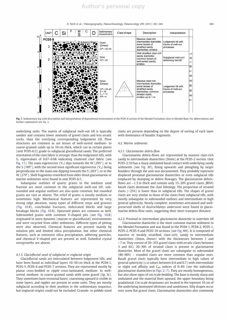
4.1.1. Lodgement tillLodgement till is the most common type of terrestrial sedimentary
rocks found in theMendel Formation; it was documented at the PC04-1, PC05-3, PC05-4, PC05-5, PC05-6, PC05-7 and PC05-8 sections. It istypically a massive or sometimes weakly stratified, matrix-supported,clast-rich, intermediate to sandy diamictite, occasionally with lensesof stratified sandy diamictites (Dmm, Dmws) and common striatedclasts up to 1 m ormore, and high amounts of erratic rocks (see Fig. 8Band D). The thickness of individual lodgement tills ranges from 3 to7 m. They usually contain 30–50% of gravel clasts and 30–40% of themare striated (see Fig. 8E). Typically 90–95% of the gravel clasts are local(JRIVG) basalts, the rest is composed of local Cretaceous sandstone,siltstone or conglomerate and erratic phyllite, gneiss, or granitoidderived from the AP (see detailed petrographic descriptions of erraticrocks below). The relative volume of erratics varies between 1 and 5%.Most of the gravel clasts are subangular to subrounded (~80%);only ~12% of them are rounded. Basalt gravel clasts typically have
Fig. 5. Sedimentary log with description and interpretation of depositional environment at the PC04-2 section of the Mendel Formation close to Mendel Base. For abbreviations andfurther explanation see Fig. 2.
367D. Nývlt et al. / Palaeogeography, Palaeoclimatology, Palaeoecology 299 (2011) 363–384

Author's personal copy
intermediate to high values of general sphericity (c/a values between0.4 and 0.7) with slight rod affinity and C40 indices of only 4–12% (seethe individual lodgement tills in Figs. 2–7). The preferred orientationof the clast fabric is mostly medium, with S1 eigenvalues being 0.55–0.58 indicating a girdle to cluster clast fabric (see Fig. 11). The maineigenvector (V1) dips towards the W (275–295°), and the secondmost significant eigenvector (V2) is perpendicular to the main onedipping towards the S (185–201°). Some lodgement tills (units PC05-6/5, PC05-8/1) contain reworked fragments of pectinid shells, whichhave been used for strontium dating (see the dating results below).Lodgement tills have mostly sharp erosional bases with clastpavements above fine-grained sediments, but they can also gradegradually from underlying melt-out tills and can also bear evidencesof melt-out processes and lenses of stratified sands or sandydiamictites.
Quartz grains in the sand fraction are mainly subangular tosubrounded (Fig. 10.1). Rounded and angular grains are less commonor sometimes almost absent. The relief of the grains is predominantlymedium; less common is high relief and the presence of low relief islimited. Mechanical features are represented mainly by edge abrasion
(Fig. 10.4), dish-shaped concavities (Fig. 10.1), straight steps andgrooves (Fig. 10.4), large breakage (Fig. 10.4) and imbricated blocks(Fig. 10.1) or upturned or broken plates. Conchoidal fractures(Fig. 10.4) are less common and arcuate steps, striations, meanderingridges, V-shaped pits and curved grooves are absent or very rare.Chemical features are typical for medium to strong post-sedimentaryweathering conditions. Extensive silica precipitation and grains withadhering particles (Fig. 10.2) are usually present. Solution pits andchemical V-shaped pits are rather rare or absent.
4.1.2. Subglacial melt-out tillA subglacial melt-out till was found to be the lowermost member
of the Mendel Formation (unit PC05-3/2, PC05-4/2, PC05-6/1); it wasalso documented at the PC05-8 section. It is a well-stratified, matrix-supported, clast-rich, sandy diamictite (Dms), with ~20–25% gravelclasts and typical thicknesses of 1–3 m. Well-sorted sand lenses arecommon in subglacial melt-out tills. The lower boundary could beerosional (at the PC05-3 section above the pillow lava, see Fig. 8A), butsometimes also gradational, sometimes with striated clasts paved onthe bottom surface due to the melt-out of finer particles from
Fig. 6. Sedimentary log with description and interpretation of depositional environment at the PC04-1 section of the Mendel Formation close to Mendel Base. For abbreviations andfurther explanation see Fig. 2.
368 D. Nývlt et al. / Palaeogeography, Palaeoclimatology, Palaeoecology 299 (2011) 363–384
Author's personal copy
underlying units. The matrix of subglacial melt-out till is typicallysandier and contains lower amounts of gravel clasts and less erraticrocks, than the overlying corresponding lodgement till. Flowstructures are common as are lenses of well-sorted medium- tocoarse-grained sands up to 10 cm thick, which can in certain places(unit PC05-6/2) grade to subglacial glaciofluvial sands. The preferredorientation of the clast fabric is stronger than the lodgement tills, withS1 eigenvalues of 0.67–0.68 indicating clustered clast fabric (seeFig. 11). The main eigenvector (V1) dips towards the W (295°), or tothe S (189°), with the second most significant eigenvector (V2) beingperpendicular to the main one dipping towards the S (203°), or to theW (279°). Shell fragments reworked from older distal glaciomarine ormarine sediments were found in unit PC05-6/1.
Subangular outlines of quartz grains in the medium sandfraction are most common in the subglacial melt-out till; sub-rounded and angular outlines are also quite common, but roundedgrains are rare or absent. The relief of grains is mostly medium orsometimes high. Mechanical features are represented by verystrong edge abrasion, many types of different steps and grooves(Fig. 10.8), conchoidal fractures, imbricated blocks and largebreakage blocks (Fig. 10.8). Upturned plates are common as well.Subrounded grains with common V-shaped pits (see Fig. 10.8)originated in more dynamic (marine or glaciofluvial) environmentsand were recycled from older sediments. Different types of pittingwere also observed. Chemical features are present mainly bysolution pits and limited silica precipitation, but other chemicalfeatures, such as extensive silica precipitation, adhering particles,and chemical V-shaped pits are present as well. Euhedral crystalovergrowths are absent.
4.1.3. Glaciofluvial sand of subglacial or englacial originGlaciofluvial sands are intercalated between lodgement tills, and
have been found as individual layers 10–50 cm thick at the PC04-1,PC05-5, PC05-6 and PC05-7 sections. They are represented mostly byplanar cross-bedded or ripple cross-laminated, medium- to well-sorted, medium- to coarse-grained sands with some gravel (Sp, Sr).They sometimes have erosional bases; coarsening upward is visible insome layers, and ripples are present in some units. They are mostlysubglacial according to their position in the sedimentary sequence,but englacial origins could not be excluded. Granule- to pebble-sized
clasts are present depending on the degree of sorting of each layerwith dominance of basaltic fragments.
4.2. Marine sediments
4.2.1. Glaciomarine debris-flowGlaciomarine debris-flows are represented by massive clast-rich
sandy to intermediate diamictites (Dmm) at the PC05-2 section. UnitPC05-2/10 has a sharp undulated basal contact with underlying sandysediments (see Fig. 8F), fining upwards and ploughing by largerboulders through the unit was documented. They probably representdisplaced proximal glaciomarine diamictites or even subglacial tillsemplaced by slumping or debris flowages. The glaciomarine debris-flows are ~1.3 m thick and contain only 15–20% gravel clasts. JRIVGbasalt clasts dominate the clast lithology. The proportion of striatedclasts (b25%) is lower than in subglacial tills. The shapes of gravelclasts are very similar to those of the clasts from subglacial tills, withmostly subangular to subrounded outlines and intermediate to highgeneral sphericity. Nearly complete, sometimes articulated and well-preserved shells of Austrochlamys anderssoni were found in glacio-marine debris-flow units, suggesting their short transport distance.
4.2.2. Proximal to intermediate glaciomarine diamictite to waterlain tillGlaciomarine diamictite is the most common marine sediment in
the Mendel Formation and was found in the PC04-1, PC04-2, PC05-1,PC05-2, PC05-9 and PC05-10 sections (see Fig. 8H). It is composed ofmassive or weakly stratified, clast-rich, sandy to intermediatediamictites (Dmm, Dmws) with the thicknesses between 1 andN7 m. They consist of 20–35% gravel clasts with erratic clasts between3 and 6%). 20–30% of striated clasts is present in glaciomarinediamictite. Most of the gravel clasts are subangular to subrounded(80–90%) – rounded clasts are more common than angular ones.Basalt gravel clasts typically have intermediate to high values ofgeneral sphericity (c/a values between 0.4 and 0.7) with intermediateor slight rod affinity and C40 indices of 0–8% (see the individualglaciomarine diamictites in Figs. 2–7). They are mostly homogeneous,but also show signs of cm-scale bedding. The base is mostly sharp andundulated and the material fines upward, the upper boundary beinggradational. Cm-scale dropstones are located in the topmost 10 cm ofthe underlying laminated siltstones and sandstones. Silty drapes occurover some flat gravel clasts. Glaciomarine diamictites also commonly
Fig. 7. Sedimentary log with description and interpretation of depositional environment at the PC05-8 section of the Mendel Formation close to Mendel Base. For abbreviations andfurther explanation see Fig. 2.
369D. Nývlt et al. / Palaeogeography, Palaeoclimatology, Palaeoecology 299 (2011) 363–384

Author's personal copy
bear traces of reworking by sliding or slumping. They cannot alwaysbe differentiated from subaqueous glacigenic (waterlain) tills.
Quartz sand grains have mainly subangular and angular outlineswith predominant medium relief. Mechanical features are mainlyedge abrasion, imbricated blocks (Fig. 10.5), large breakages andconchoidal fractures (Fig. 10.3 and 10.5). Other features present aredifferent types of steps, grooves (Fig. 10.7) and ridges. Some olderfeatures such as different steps and V-shaped pits (Fig. 10.5 and 10.7)
are covered by a new generation of mechanical features (Fig. 10.3). Allthese features are typical of glacial environments; however, veryabundant pitting, typical for marine environments, is present on thesurface of some grains.
4.2.3. Tuffaceous horizontally laminated sandstone to siltstoneHorizontally laminated coarse- to fine-grained sandstones or coarse-
grained siltstones (Sl, Fl), partly rhythmically bedded, comprise a
Fig. 8. Sedimentary lithofacies of the Mendel Formation. A. Erosional contact of basal glacigenic sediments with underlying lava flow at the PC05-3 section. The erosional contact isredlined. B. Large erratic blocks originating from the Mendel Formation, on the beach close to the PC05-6 section. C. Tuffaceous horizontally laminated sandstone with exposedmassive proximal glaciomarine diamictite to the left of the hammer at the PC04-2 section. D. Massive clast-rich diamictite with common erratics up to 1 m diameter in the bottom ofthe unit, with stratified sandy diamictite and smaller and more rounded erratics in the top at the PC05-8 section. The figure is 3.2 m high. E. Detail of striated Cretaceous siltysandstone concretion within the massive clast-rich intermediate diamictite at the PC05-6 section. F. Sharp undulating erosional basal contact of massive clast-rich glaciomarinedebris-flow deposits with erratics and underlying tuffaceous laminated sandstone at the PC05-2 section. G. Tuffaceous laminated slightly inclined sandstone with 2–3 cm thicklaminae at the PC05-2 section. H. General view of the lower part of the PC05-2 section (Section PC05-1 is located down-valley at the right-hand side of the same valley) withalternating tuffaceous horizontally laminated sandstone (lighter layers are coveredmostly by scree) andmassive clast-rich glaciomarine diamictites (darker layers with large clasts).The visible outcrop is ~45 m wide. The hammer in all figures is 28 cm long, with the exception of figure C, where the hammer is 40 cm long.
370 D. Nývlt et al. / Palaeogeography, Palaeoclimatology, Palaeoecology 299 (2011) 363–384

Author's personal copy
Fig. 9. Different quartz microtextures throughout the samples from different environmental settings of theMendel Formation: those from terrestrial glacigenic sedimentary depositsin the upper part; and glaciofluvial, glaciomarine and marine sedimentary deposits in the lower part.
371D. Nývlt et al. / Palaeogeography, Palaeoclimatology, Palaeoecology 299 (2011) 363–384

Author's personal copy
Fig. 10. Typical microtextures of quartz grains of the Mendel Formation. 1. Subrounded quartz grain with high relief from lodgement till with traces of melt-out processes; PC05-8/1;A – large breakage; B – upturned plates; C – subrounded outline; D – dish shaped concavity; E – straight step; F – imbricated block. 2. Angular quartz grain with medium relief fromlodgement till with traces of melt-out processes; PC05-8/1; A – solution and chemical V-shaped pits; B – edge abrasion; C – adhering particles. 3. Subrounded quartz grain withmedium relief from proximal glaciomarine sediment with slumping traces; PC04-1/4; A – V-shaped pits; B – large breakage; C – old conchoidal texture; D – imbricated blocks; E –
adhering particles. 4. Subangular quartz grain with high relief and distinct phases of glacial transport from lodgement till with traces of melt-out processes; PC05-8/1; A – straightgrooves and meandering ridges from the first glacial transport phase, filled by post-depositional limited silica precipitation; B – fresh small conchoidal fracture; C – edge abrasion;D – large breakage. 5. Subrounded quartz grain with medium relief from proximal glaciomarine sediment with slumping traces; PC04-1/4; A – conchoidal fracture; B – V-shaped pitsand solution steps; C – imbricated blocks; D – straight step. 6. Subangular grain with medium relief from laminated pro-delta sediment; PC04-1/5; A – chemical V-shaped pits; B –
edge abrasion; C – subangular outline; D – imbricated block. 7. Subrounded originally fluvial quartz grain crushed by glacial grinding from proximal glaciomarine sediment withslumping traces; PC04-1/4; A – sharp edge; B – small conchoidal fracture; C – large breakage; D – V-shaped pits; E – straight grooves; F – curved grooves. 8. Subrounded grain withmedium relief from subglacial melt-out till; PC05-3/2; A – V-shaped pits; B – curved grooves; C – large breakage. White line at left bottom of each figure is 0.2 mm long.
Fig. 11. Fabric shape of clasts from terrestrial subglacial till units of theMendel Formation based on Benn's ternary diagram, compared with subglacial glacigenic deposits of Hambreyet al. (2008) and glacigenic debris flows of Nelson et al. (2009) from James Ross and Vega Islands.
372 D. Nývlt et al. / Palaeogeography, Palaeoclimatology, Palaeoecology 299 (2011) 363–384

Author's personal copy
significant part of theMendel Formation (see Fig. 8C and G). They can bemore than 5 m thick, with a gradational base and coarsening upwardwith common dropstones in the topmost 10 cm of each layer, but scarcein their distribution throughout. The top surfaces are sometimeserosional. Rhythmically bedded units (PC04-2/2 and PC04-2/4) containlaminae 1–10 cm thick, commonly 2–3 cm (see Fig. 8G). They arecommonly planar-laminated, sometimes wavy or flaser-bedded, occa-sionally with loading structures. These tuffaceous laminites are com-posedmostly of sand and silt grains of quartz andbasalt fragments, lowerproportions of plagioclase, microcline, amphibole, clinopyroxene, epi-dote, palagonite glass, and some quartzite, olivine and mudstone withcarbonate cement and small fragments of fossils indicating a dominantsource in local Cretaceous sediments and Neogene basalts.
Morphological features on quartz grains of horizontally laminatedsandstone and siltstone are represented mainly by subangular andangular outlines with medium to high relief, with some subroundedquartz grains. Mechanical features are poorly preserved and aremainly edge abrasion, imbricated blocks (Fig. 10.6) and largebreakages. Conchoidal fractures are present but very badly preserved.Other features present are different types of steps, grooves, ridges andmechanical V-shaped pits (Fig. 10.6). The present mechanical andmorphological features indicate previous glacial transport; the impactof the marine environment on the grain microtextures is limited. Themost common and well preserved are chemical textural features suchas chemical pitting and euhedral crystal overgrowths. Chemicalsolution, precipitation and adhering particles are present as well.
4.3. Lithofacies interpretation
The relative proportions of the different lithofacies have beencalculated for the documented sections. The depositional sequencedescribed here is composed mostly of massive to less stratifieddiamictites (nearly 76%). The sandy to silty lithofacies (Sp, Sl, Fl, Shand Sr) are more important only in the middle part of the succession,representing 24% of the documented thickness. The individual litho-facies are interpreted in Figs. 2–7 and described above. The mostcommon type of sedimentary deposits is lodgement till, partly withtraces of melt-out processes (35%) and proximal to intermediateglaciomarine diamictites and waterlain till (33%). Horizontally laminat-ed sandstone also forms a significant part (23%) of the succession. Theother three sedimentary types (glaciomarine debris-flows, glaciofluvialsand and subglacial melt-out till) are less common and they accounttogether for less than 10% of the succession. Sediments deposited in the
marine environment prevail slightly (59%) over terrestrial deposits(41%). The overall sedimentary thickness of thewhole succession of theMendel Formation exceeds 80 m.
Diamictite units contain 15–50% of gravel clasts; there is a slightdifference in clast content between individual lithofacies. A higherproportion occurs in subglacial terrestrial facies, where there are 25–50% gravel clasts, with the average ~35%. Typically massive lodgementtills contain more gravel clasts than stratified subglacial melt-out tills.The proportion of gravel clasts in subaqueous diamictites is mostly15–40%, with the average ~25%. The proportion of erratic gravels indiamictite units is mostly 1–6%, with an average of 4%. Clasts aremostly subangular to subrounded, always with more rounded claststhan angular ones. Striated clasts are more common in terrestrialglacigenic sediments (30–45%) than in subaqueous diamictites (20–30%). The fabric shape in subglacial melt-out tills is rather high, withS1 eigenvalues ~0.68 andmoderate in lodgement tillswith S1 eigenvaluesin the range0.55–0.58 (seeFig. 11). Thepreferredorientationof clastshasbeen documented, especially for subglacial melt-out tills, where clastfabric shapes with an almost cluster pattern occur. Lodgement tills havegirdle to cluster fabric shapes. All of the documented diamictite faciesshowvery lowC40 andRA indices; nevertheless, terrestrial subglacial tillshave slightly higher values (see Fig. 12).
A rather high proportion of arcuate and straight steps, conchoidalfractures and breakage blocks on surfaces of studied sand grains inmost subglacial till units show the importance of brittle fracture.However, edge abrasion, as the most common mechanical feature,together with the mostly sub-angular to sub-rounded outline ofparticles implies that brittle fractures originated in older comminu-tion processes. The share of particles with edge abrasion is evenhigher in subglacial melt-out tills and in glaciofluvial sandy layers,than in lodgement tills. This relates to the amount of water present inthe final deposition of the material. On the other hand, the portion ofparticles with edge abrasion is much lower for glaciomarine andmarine deposits, with glaciomarine debris-flows having the lowestshare. Glaciomarine debris-flow sand grains also mostly have lowrelief. Chemical textures are most important on grain surfaces inmarine laminated sandstones. The most common is chemical pittingand euhedral crystal overgrowth. All these features are typical of veryintense post-depositional weathering.
The lower contact of the Mendel Formation dips towards the W(295°) with an average dip of 15°. This contact is well exposed on thebasalt surface, which is subglacially ploughed and striated. The clastfabric of the lowermost subglacial tills shows the main eigenvector(V1) dipping in the same direction (see Fig. 11) as the striation on theunderlying basalt surface. As the basalt was overridden by anadvancing terrestrial glacier it is not possible to distinguish the glacieradvance direction, as it may have been from E towards W or inopposite direction. However, according to rather high proportions oferratic rocks (up to 6%) originating from the AP we interpret the basalparts of the Mendel Formation as being subglacially deposited by anadvancing ice tongue of the Antarctic Peninsula ice sheet (APIS). TheW–E direction is dominant in clast fabrics of most of the terrestrialsubglacial till units examined (see Fig. 11); the same orientation (276–278°) is also typical for dips of erosional bases of other subglacial tills(see Figs. 3 and 6). The orientation of laminae in marine tuffaceoussiltstone and sandstone is towards theWandWNW(289–298°);mostsharp or undulating bases of glaciomarine diamictite or subaqueousdebris flows dip in the same direction (272–299°) with dips of 5°–11°(see Figs. 4–6). This shows that the sea invaded from the E duringglacier retreat with floating ice shelf build-up.
Detailed study of sedimentary rock units of the Mendel Formationshows changes in the depositional environment through theevolution of the succession (see Fig. 13). Sedimentation started asterrestrial glacigenic in the subglacial environment; subglacial tills areonly sometimes intercalated by thin layers of sub/en-glacial glacio-fluvial sandstone. The thickest middle part of the succession was
Fig. 12. Covariant plot of RA versus C40 indices for glaciomarine diamictites andlodgement tills from the Mendel Formation compared with stratified and massivediamictites of Hambrey et al. (2008) and glacigenic debris flows of Nelson et al. (2009)from James Ross and Vega Islands.
373D. Nývlt et al. / Palaeogeography, Palaeoclimatology, Palaeoecology 299 (2011) 363–384

Author's personal copy
deposited in a glaciomarine to marine environment in distanceschanging from the glacier margin. The glaciomarine diamictites oftenbear evidences of subaqueous sliding and slumping; they have beendeposited at various distances from the floating glacier margins withimportant ice-rafted component. The open marine laminated sand-stone to siltstone was deposited in a pro-delta environment with avery limited glacial influence but are very probably coeval with thevolcanic activity in the area, which was the most important source ofthe deposited material. Their top surfaces are sometimes erosionaldue to glacial or mass-movement erosion prior to the deposition ofthe subsequent unit, showing on a fluctuating floating glacier margin.The Mendel Formation terminates with terrestrial subglacial tillsshowing the advance of a grounded glacier.
5. Clast petrology
The gravel clasts found in the Mendel Formation can be divided intwo groups according to their provenance; themost common are localJRI rocks including Cenozoic volcanic rocks and less commonCretaceous sedimentary rocks. The second group is made of erraticrocks originating from the AP and/or the Transantarctic and EllsworthMountains. The proportion of erratic gravels lies in the range of 1% to6%, but it varies throughout the individual lithofacies (see above). Thebasic rock groups found in the gravel-to-boulder fraction in theMendel Formation are summarised in Table 2 and shown in Fig. 14.
6. Dating of the Mendel Formation
The underlying basalt of Cape Lachman (sample JR-1) was datedusing the 40Ar/39Ar method to determine the maximum age ofdeposition of the Mendel Formation. The basal part of the MendelFormation rests directly on pillow lavas and overlying tuffs, whichform a part of the Cape Lachman volcanic complex composed of pillowlavas, hyaloclastite tuffs to breccias and numerous dykes that yieldedan isochron age of 5.85±0.31 Ma (1 sigma including uncertainty on Jvalue, 68% of the cumulative 39Ar) with an 36Ar/40Ar intercept of302.5±20.4 and a MSWD of 1.45 (See Table 3 and Fig. 15). Both theintercept and the lowMSWD indicate that this age is well constrainedand may be used as the maximum age of the Mendel Formation.
Six shell samples were analysed for 87Sr/86Sr isotopic ratios(Table 4). The Sr isotopic data suggest that the sample taken fromthe PC04-1/2 unit is a reworked shell fragment from the underlyingCretaceous marine sediments. Its precise age cannot be derived fromthe Sr evolution curve, but based on the measured Sr isotopic ratio, itis between 84.9 and 130.2 Ma. There are four possible age intervals forthis sample: 84.9–85.7 Ma, 97.2–104.0 Ma, 120.6–122.5 Ma, and128.3–130.2 Ma. It is more likely that the dated shell fragment wasreworked from the nearby Santa Marta Formation (Crame et al., 1991,1999; Scasso et al., 1991), because it agrees with the age of belemnitesdated at 85.5–86.1 Ma by McArthur et al. (2000) and rocks from otherthree above-mentioned age intervals can only be found in thewesternparts of JRI (Riding and Crame, 2002).
The other three pectinid shell samples were collected from ter-restrial subglacial till units, and they were re-deposited from olderglaciomarine or marine sediments. The 87Sr/86Sr age data indicate thatthe source sediments were deposited in an open marine interglacialsetting in the lowerMiocene (20.7–17.3 Ma). Sedimentary sequences ofthis age have not been found on JRI so far. The two samples from thePC05-1 section (correlated with PC05-2/10 unit) represent nearlycomplete, partly articulated and well-preserved shell fragments ofAustrochlamys anderssoni. This indicates only limited transport of these
Fig. 13. Composite section of the Mendel Formation with the position of individualdescribed sections and an interpretation of the glacial and interglacial conditions andglacier fluctuations.
374 D. Nývlt et al. / Palaeogeography, Palaeoclimatology, Palaeoecology 299 (2011) 363–384

Author's personal copy
shells before their deposition and coeval living with subaqueous glacialdeposition. The age may therefore be regarded as the depositional agefor the middle part of the Mendel Formation at ~28 m, in theglaciomarine/marine part of the succession. The ages are 5.93 +0.09 /–0.11 and 5.65 +0.15 /−0.24 Ma and represent the only ages of theMendel Formation valid for the glaciomarine/marine part.
7. Micropalaeontology
Biostratigraphical and palaeoenvironmental evidence of micro-fossils was limited by the extremely poor microfossil content of theMendel Formation. Of the eight samples washed for microfossils, onlytwo contained foraminifers (PC05-3/2, PC05-8/1), none of themcontain any nannofossils. The total number of recovered foraminiferswas just 3 specimens, together with one ostracod. The extremescarcity is due to the terrestrial and glacial nature of the sedimentarydeposits. The marine microfossils are reworked from older marinesediments. On the other hand, the samples from sediments inter-preted here as being deposited in the pro-delta marine environmentwith less glacial influence (e.g. sample PC05-2/1), does not containany obvious marine microfossils. A reason for that may be the low
salinity caused by melt-water input below and in front of the floatingice shelves during deposition of the rock.
Mineralised wood fragments are the most common fossilremnants. Most of them are coalified, but pyritised and silicifiedfragments also occur. The wood fragments apparently originate fromdifferent plant taxa. Fossil woods are commonly reported from theUpper Cretaceous on JRI (e.g. Cantrill and Poole, 2005), and this is avery probable source of wood fragments within the MendelFormation, the other possibility may be the Miocene interglacialorigin at the northern AP. However, further work is needed to solvethe question of plant macro- and micro- (incl. the pollen andpalynomorphs) fossils.
Among marine microfossils fragmentary, abraded and re-crystal-lised echinoid spines are most frequent. They are straight, narrow,possessing fine striation on the surface and radial structure on thecross section. Such types are characteristic of regular echinoidspopulating shallow seas worldwide.
Scarce foraminifers are represented by three taxa: HoeglundinaasanoiMatsunaga,Nonionella bradii (Chapman), andGlobocassidulina sp.
Hoeglundina asanoiwas originally described by Matsunaga (1963)from the Pliocene of Japan and the specimen from sample PC05-3/2
Table 2Main rock groups found within the gravel-to-boulder fraction of the Mendel Formation sediments. Minerals abbreviations according to Kretz (1983): (p) – phenocrysts orporphyroblasts, Op – opaque minerals.
Rock type Provenance Structures Textures Groundmass/matrix Main minerals/clasts Accesories Notes
Olivine basalt JRI Compact toamygdaloidal
Intersertal, ophitic,porphyric, vesicular
Volcanic glassdecomposed into lath-shaped Pl, serpentinizedOl, Srp
Ol (p), Pl, Cpx, Srppseudomorphs, Spl andKy inclusions
Mgt Vesicles filledwith zeolites,Chl and siltsedimentxenoliths
Tuff, tuffite JRI Lappili Clastic Volcanic glassdecomposed intomixture ofphyllosilicates, fine Qtzclasts, Cpx, Pl, Kfs, Amp,Glt
Basalts, granites, contact-metamorphic biotitegneisses, Pl, Cpx,siltstones, greywackes,sandstone, Qtz
Volcanic ash JRI Sandy clastic withgranule admixture
Clay minerals Volcanic rocks withophitic texture, Pl, Px,Mgt, sandstones, sparite
Calcareous testfragments
Siltstone to conglomerate JRI Silty to sandy clastic Carbonate, sparite andclay minerals fromdecomposed volcanicglass
Qtz, Pl, Ep, Amp, Cpx, Ilm,chloritized Bt, carbonate-clay pellets
Carbonatizedfossils
Granite, granodiorite, tonalite AP batholith Hypidiomorphic,granophyric
Mainly epigranular,sometimes porphyricmedium-grained
Kfs, Pl, Qtz, Amp, Bt Ap, Ms, Zrn,Ttn, Ep, Op
Alterationincludingsericitization,chloritizationandepidotization
Gabbro, diorite AP batholith Medium-grainedequigranular,poikilophitic
Mainly epigranularmedium-grained
Pl, Qtz, Cpx, Amp, Hbl Chl, Ttn, Hem,Ap, Ilm, Op, Olpseudomorphs
Sericitization ofAmp and Pl
Biotite paragneiss AP batholithcontactaureole
Banded Fine-grainedporphyroblasticwith augen
Pl, Qtz, Bt, Kfs, Grt Zrn, Ms, Chl,Ep, Cal, Op
Biotite-cordierite paragneiss AP batholithcontactaureole
Heteroblastic tolepidogranoblastic,banded
Qtz, Pl, Bt, Kfs, Chl,sagenite, Crd
Zrn, Op Migmatized
Chert AP batholithcontactaureole
Sometimesfoliated
Micro-fibrogranoblastic
Qtz, Bt, Ms, Crdpseudomorphs
Zrn, Cal, Ttn,Op
Secondary Chl
Phyllite TPG Banded,foliated
Micro-lepidogranoblastic
Qtz, Ms, Chl, Op Crenulationcleavage
Biotite orthogneiss AP basement,Transantarcticor EllsworthMts.
Bandedaugen,foliated
Granoblastic,lepidogranoblastic
Fine-grained Pl, Kfs, Qtz, Bt, Zrn, Ms, Chl Ilm, Ttn Sericitization
Amphibolite AP basement,Transantarcticor EllsworthMts.
Finecrystallizedbands,weaklyfoliated
Nematogranoblastic Amp, Ilm, Pl, Bt
375D. Nývlt et al. / Palaeogeography, Palaeoclimatology, Palaeoecology 299 (2011) 363–384

Author's personal copy
corresponds well with the type description and figure of this species,though there are no recent records on its spatial and stratigraphicdistribution. Generally, representatives of the genus live in cold andturbid waters on muddy substrates (also in Antarctic waters). Thestratigraphic range of the genus is Cretaceous–Holocene.
Nonionella bradii was originally found in modern benthic commu-nities of upper bathyal habitats of the Ross Sea. Specimens from
sample PC05-8/1 are close to the form from the Pecten conglomerateof Cockburn Island (Gaźdicki and Webb, 1996). The stratigraphicrange is Oligocene–Holocene.
Globocassidulina sp. is a damaged test with broken older chambersfound in sample PC05-3/2 and differs from representatives of thegenus common in the Austral realm. It is possible that the specimenrepresents juvenile Cassidulinoides sp. Cassidulinid foraminifers
Fig. 14. Microphotographs of the typical local and erratic rocks from the Mendel Formation. A. Vesicle in basalt filled with silty sediments. B. Olivine basalt. C. Woody tissueconstituting rarely interstitial material in pebbles from the Whisky Bay Formation. D. Phyllite with crenulation cleavage highlighted by organic pigment. E. Biotite orthogneiss.F. Muscovite–biotite granite. Scale bar at right bottom of each figure is 0.2 mm long.
376 D. Nývlt et al. / Palaeogeography, Palaeoclimatology, Palaeoecology 299 (2011) 363–384

Author's personal copy
represent dominant elements of Cenozoic benthic foraminifercommunities of Antarctica.
The tests of H. asanoi and Globocassidulina sp. are filled withgreenish, clay-like sediment that does not show any similarity to thelithology of the samples. This is a further indicator of possiblereworking from older, very probably Cretaceous, sediments.
A single ostracod was recovered from sample PC05-3/2. It is arelatively well-preserved large right valve of Rostrocytheridea sp. Ourspecies can be related to Rostrocytheridea hamiltonensis describedrecently by Fauth et al. (2003) from the Campanian of JRI, but it differsby possessing fine longitudinal ribs at the ventral side of the valve andby lacking any denticulation. Generally Rostrocytheridea is typical ofthe Cretaceous in the Austral realm.
Other marine microfossils recovered from the Mendel Formationwere thick organic-walled brown-red cysts that can be assigned to thegenus Tasmanites (Prasinophyta). Representatives of Tasmanites arereported frommarine sediments through the Phanerozoic. Teleosteanteeth and fragmentary sponge spicules rarely occur, but do notpossess practical importance.
8. Formal lithostratigraphy
During the geological mapping in the northernmost Ulu Penin-sula, sedimentary rocks representing former ‘pecten conglomerates’of Andersson (1906) or ‘tuffaceous conglomerates’ of Nelson (1966)have been found and subsequently mapped in detail in the areabetween Cape Lachman, Berry Hill and Mendel Base (Fig. 1). Theyrepresent sediments deposited in open marine, glaciomarine andterrestrial glacigenic environments. The presence of these depositswas mentioned by various English and Argentinean geologists (e.g.Bibby, 1966; Hambrey and Smellie, 2006; Strelin et al., 1997), butthey have not been studied in detail. A new formal name – MendelFormation – is herein proposed for the sedimentary succession,because according to the data described here it does not correspondto any of the other Neogene sedimentary formations found on JRI(Drift Refugio San Carlos of Rabassa, 1983; Hobbs Glacier Formationof Pirrie et al., 1997; Belén Formation of Lirio et al., 2003; GageFormation of Lirio et al., 2003; Terrapin Formation of Lirio et al.,2003).
Table 3Complete data table for sample JR-1. (1) 39Ar (×10−16mol), (2) Cumulative 39Ar gas released during the experiment (%), (3) %40*=% radiogenic 40Ar of total 40Ar released. J-value0.005951. In bold steps 3–7, on which the calculated isochron age is based.
JR-1/step 40/39 38/39 37/39 36/39 39Ar1 F39Ar2 %40⁎3 40⁎/39K Age ±1 sigma
1 4.642 0.037 0.293 0.014 3.843 1.17 11.60 0.54 5.77 1.362 1.879 0.024 0.300 0.005 35.207 11.85 22.20 0.42 4.48 0.153 1.174 0.021 0.260 0.002 57.535 29.32 46.50 0.55 5.86 0.144 0.956 0.020 0.232 0.001 54.990 46.01 55.50 0.53 5.69 0.055 0.929 0.020 0.212 0.001 45.194 59.73 56.40 0.52 5.61 0.126 0.938 0.019 0.290 0.001 37.729 71.18 56.70 0.53 5.70 0.077 1.038 0.020 0.278 0.002 28.399 79.81 49.60 0.51 5.52 0.098 1.151 0.019 0.249 0.002 20.895 86.15 60.20 0.69 7.43 0.139 1.500 0.019 0.290 0.003 26.530 94.20 38.30 0.58 6.17 0.2010 2.482 0.022 0.305 0.006 10.390 97.36 34.20 0.85 9.09 0.5011 3.342 0.022 0.416 0.009 8.711 100.00 22.80 0.76 8.17 0.90
Fig. 15. Age spectrum for sample JR-1 (2 sigma error bars). Five steps cover 68% of cumulative 39Ar. Isochron age (inset) for these steps is 5.85±0.31 Ma (1 sigma, includinguncertainty on J value). 36Ar/40Ar intercept 302.5±20.4 with MSWD of 1.45. Top panel displays K/Ca (dashed) and 38ArCl/39ArK (solid) as a function of cumulative 39Ar.
377D. Nývlt et al. / Palaeogeography, Palaeoclimatology, Palaeoecology 299 (2011) 363–384

Author's personal copy
8.1. Derivation of the name
The Mendel Formation is named after the nearby Czech JohannGregor Mendel Base, which is named for the famous scientist JohannGregor Mendel – founder of the science of genetics – and is located onthe Holocene marine terrace at the western tip of the sedimentarysuccession between Cape Lachman and Bibby Point, Ulu Peninsula,James Ross Island.
8.2. Boundaries and age
The Mendel Formation overlies Cretaceous marine strata (WhiskyBay and Hidden Lake Formations of the Gustav Group; Crame et al.,1991; Pirrie et al., 1997; Riding and Crame, 2002) in its southern andsouth-western part; at the neck of Cape Lachman in the north itoverlies a subglacial volcanic sequence built of pillow lavas,hyaloclastite tuffs to breccias and dykes of one of the oldest phasesof the JRIVG (Nelson, 1966; Smellie et al., 2008). This volcanicsequence was correlated with the Lachman Crags basal delta bySmellie et al. (2008) and a minimum age of 5.32±0.16 Ma wasreported based on the 40Ar/39Ar method. Unfortunately, the availablesections of the Mendel Formation reveal only the contact with basaltat the PC05-3 section in the northern part of the sedimentarysequence (see Fig. 1). The contact between basalt and the overlyingMendel Formation diamictite at the PC05-3 section is erosional, sharpand undulating. At this time the maximum potential age of theMendel Formation, based on dating the pillow lava (JR-1) using 40Ar/39Ar dating puts the age at 5.85±0.31 Ma (Table 3, Fig. 15). This isolder than the Davies Dome basal delta, which has an age of 5.04±0.04 Ma as reported by Kristjánsson et al. (2005). Because the agereported by Smellie et al. (2008) for the Cape Lachman volcanic rocks(sample DJ.1715.1; 5.32±0.16 Ma) is a minimum age, the validity ofthe correlation of the Cape Lachman volcanic rocks with the LachmanCrags basal delta (Smellie et al., 2008) cannot be evaluated based onthese constraints alone. There are no outcrops showing the contactwith Cretaceous rocks in the west; however, reworked Cretaceousfossils can be found in the lower diamictites of the PC04-1 section,indicating a position close to the Cretaceous basement.
The lower basaltic lava at Berry Hill, which marks the southernlimit of the Mendel Formation, corresponds to the lava dated byKristjánsson et al. (2005) to 5.04±0.04 Ma in the southern part ofLachman Crags. Remnants of the basal Lachman Crags volcanic deltadated by Smellie et al. (2008) with a minimum age of 5.32±0.16 Ma,also lie above the Mendel Formation. Numerous basaltic platyboulders up to 1 m wide and only few cm thick cover the surface ofthe Mendel Formation. As they are not present in the sediments of theMendel Formation, they must represent remnants of a subaerialvolcanic phase younger than the Mendel Formation, but older thanthe basal Lachman Crags delta.
In the east, at the neck of Cape Lachman, the sedimentarysuccession is covered by subglacial till with abundant erratic material(with granitoid boulders up to 3 m in the a-axis) derived from the APand deposited during the last glacial maximum (MIS 2 prior to ~12 kaBP; unpublished data of the authors) by the (APIS) flowing throughthe northern Prince Gustav Channel towards Erebus and Terror Gulf
(Camerlenghi et al., 2001). Sediments of the Mendel Formation andLate Pleistocene to early Holocene glacigenic deposits are covered by(glacio)lacustrine deposits with a surface ~16–18 m asl on the easterncoast of the neck of Cape Lachman (Hjort et al., 1997; Ingólfsson et al.,1992). This ice-contact lacustrine deposition is of early Holocene age(~9.5 ka BP; Ingólfsson et al., 1992). A small westernmost part of theMendel Formation is covered by a younger Holocene marine terrace(with a surface ~8–10 m asl), where the Mendel Base is built. In thesouth, the Mendel Formation is covered by Holocene blocky slopedeposits with a small amount of matrix containing blocks ofhyaloclastite breccias and basalts on the northern and northwesternslopes of Berry Hill, which in some places form protalus ramparts. Theupper lower-lying part was transformed by paraglacial processes intosorted polygons on the flat surface and to sorted stripes andsolifluction lobes on the slopes of Berry Hill. These forms and depositsare younger than the deglaciation of this area, which enabled theparaglacial activity. The age of the complete deglaciation is not knownexactly, but there are data of lake sedimentation starting at ~9.5–6 kaBP from the wider area of the northern Ulu Peninsula (Hjort et al.,1997; Ingólfsson et al., 1992) and some data for neoglacial advances oflocal glaciers at ~5–4.2 ka BP (Björck et al., 1996; Hjort et al., 1997).The area covered by the Mendel Formation was not affected by anyimportant neoglacial advance of local glaciers beside the small glacieron the southeastern slope of Berry Hill according to geological andgeomorphological mapping (see Fig. 1). The upper contacts were notstudied on any of the documented sections, as they are obscured byscree or there are no outcrops available in the relevant areas. TheMendel Formation occurs in the altitudinal range 0–155 m.
Two shells ofAustrochlamys anderssoni fromthePC05-1 sectionweredated using the Sr evolution curve for seawater (McArthur et al., 2001).This sample can be correlated with the PC05-2 section described, whichis located in the same erosional valley. Shells are well preserved andnearly complete and originate from massive clast-rich sandy tointermediate diamictite. They were dated at 5.93 +0.09/−0.11 and5.65+0.15/−0.24 Ma (Table 4). Their physical appearance allows theseages to be interpreted as depositional ages of the studied part of theMendel Formation. Beside samples of these ages, three other dateablepectinid shell sampleswere collected fromterrestrial subglacial till units(PC05-6/1, PC05-6/5, PC05-8/1) of the Mendel Formation. Their 87Sr/86Sr ages fall into the lowerMiocene (20.6–17.4 Ma), and they representre-deposition from older sediments, as evidenced by their presence interrestrial glacigenic sediments and their strongly fragmentary nature.The other dated shell fragment (from PC04-1/2 unit) representsreworked Cretaceous fossil material, a conclusion which is supportedby abundant reworkedmacrofossil finds. According to the review of theages listed above, the Mendel Formation was deposited during the lateMiocene between 6.16 Ma and 5.23 Ma, taking into account 2 sigmauncertainties. Nevertheless, its deposition most probably occurredduring a much shorter time in the middle of this interval.
8.3. Distribution
The extent of the Mendel Formation based on detailed geologicalmapping is shown in Fig. 1. It must continue below the Holocenemarine terrace, where Mendel Base is built. Its distribution below sea
Table 4Strontium isotopic data for shell fragments from the Mendel Formation. Ages calculated using the LOWESS version 3:10 of McArthur et al. (2001).
Sample Geographical coordinates 87Sr/86Sr ±2sigma
Age Min. Max.
X Y Z [m a.s.l.] Ma Ma Ma
PC04-1/2 S 63° 48.3803' W 57° 52.2605' 64 0.707436 0.000008 – 84.91 130.17PC05-6/1 S 63° 48.0196' W 57° 50.1290' 2 0.708429 0.000007 20.45 20.35 20.56PC05-6/5 S 63° 48.0196' W 57° 50.1290' 2 0.708645 0.000007 17.46 17.37 17.53PC05-8/1 S 63° 48.3541' W 57° 52.9455' 50 0.708569 0.000009 18.32 18.21 18.43PC05-1a S 63° 48.1222' W 57° 52.5285' 23 0.708992 0.000008 5.93 5.84 6.02PC05-1b S 63° 48.1222' W 57° 52.5285' 23 0.709012 0.000010 5.65 5.41 5.80
378 D. Nývlt et al. / Palaeogeography, Palaeoclimatology, Palaeoecology 299 (2011) 363–384

Author's personal copy
level is not known, but it could continue further west in Prince GustavChannel and east in Herbert Sound. Sedimentary rocks of the MendelFormation on the eastern cliff of the neck of the Cape Lachman areunfortunately buried by scree in the upper part and/or by snow-patches in the lower part of the cliff and they have therefore not beenstudied in detail.
8.4. Type section and thickness
The section with visible lower contact and subglacial tills is PC05-3,which lies close to sea level at the neck of Cape Lachman (S 63.79287°;W 57.81103°). Section PC05-2 (S 63.80385°; W 57.87252°), which wasdocumented on slopes of a deeply incised stream valley in front of asmall ice accumulation close to Mendel Base, represents the openmarine and glaciomarine type section of the Mendel Formation. Themaximumvisible thickness is at the PC04-1 section,wherea thicknessofnearly 20 m was documented; the overall calculated sedimentarythickness of the whole succession must exceed 80 m (see Fig. 9). Thebase at thenorthern coast lies approximately at sea level, and the surfaceascends to an altitude of ~155 m in its southern part on the slopes ofBerry Hill. We know little about the nature of the base of the MendelFormation, but it is possible that it is undulating and rises towards the Sand SE. If the base of the Mendel Formation were planar, then themaximum thickness may reach 160 m, but this statement is ratherspeculative and may only be proved by geophysical methods.
8.5. Lithology
The Mendel Formation is composed of terrestrial glacigenic andglaciofluvial, glaciomarine and open marine sedimentary rocks.Terrestrial sedimentary deposits are composed of lodgement tills,subglacial melt-out tills and glaciofluvial sandstone, all of themsubglacial or englacial in origin. Marine sedimentary deposits includeglaciomarine debris-flows, glaciomarine diamictites to waterlain tillsand tuffaceous horizontally laminated sandstones or siltstones. Thewhole succession constitutes a cycle of sedimentation starting asterrestrial glacigenic grading through glaciomarine sedimentationtowards marine pro-delta sedimentation and back to terrestrialglacigenic deposition. A detailed lithofacies and sedimentary petro-logical description with environmental interpretation is given in thesection “Lithofacies description and interpretation” (Section 4 above)and in Figs. 2–7.
8.6. Palaeontology
The present palaeontological finds are scarce. Macrofossil assem-blages composedofwell-preservedandnearly complete and sometimesarticulated shells of Austrochlamys anderssoni were found in massiveclast-rich sandy to intermediate diamictite (PC05-1 – correlated withPC05-2/10) and were used for 87Sr/86Sr dating. Their articulated andcomplete nature indicates short transport before deposition and coevalexistence of these molluscs with subaqueous glacial deposition, andmay therefore be used for dating theMendel Formation. Other pectinidshell fragments were found only in the terrestrial glacigenic units(PC05-6/1, PC05-6/5, PC05-8/1) andmust have been glacially reworked,as shown by their 87Sr/86Sr ages (see below). These collected fragmentsare too small (mostly less than 1 cm) to recognise species. Encrustingbryozoan colonies of up to few-cm large, calcifiedworm tubes and somebarnacles were found on the surface of some basalt gravel clasts.Reworked Cretaceous bivalves and petrified wood are quite common,especially close to the base of the Mendel Formation where it overliesCretaceous marine sedimentary rocks of the Whisky Bay and HiddenLake Formations. The microfossil content of the formation consists offragments of fossil wood (often coalified, less frequently pyritised orsilicified), calcareous benthic foraminifers, echinoid spines, spongespicules, rare Tasmanites cysts, fish teeth, and ostracods. Marine fossils
(foraminifers etc.) were obtained solely from terrestrial glacigenic unitsof the Mendel Formation and therefore represent reworked assem-blages of a presently unknown origin. However, further work especiallyon palynomorphs, bryozoans and diatoms is needed to supplement theoverall palaeontological knowledge of the Mendel Formation.
9. Discussion
9.1. Timing of Mendel Formation deposition
The prevailing olivine basalt and eruptive members of the basaltsequence found in the Mendel Formation relate to the early phase ofvolcanic activity at JRI (Nelson, 1966; Smellie, 1999; Smellie et al., 2008)during the late Miocene. The oldest dated in situ volcanic rocks in thenorthern part of the Ulu Peninsula are 6.16±0.08 Ma old and form theStickle Ridge lower delta (Smellie et al., 2008). The oldest 40Ar/39Ar agesof volcanic rocks from the JRIVGwere froma basalt clast fromdiamictiteat the Fjordo Belén, JRI dated at 9.2±0.5 Ma (Jonkers et al., 2002) and abasalt clast from the Miocene diamictites of Seymour Island, recentlydated using the 40K/40Ar method at 12.4±0.5 Ma (Marenssi et al.,2010). In the northern Ulu Peninsula a basalt clast from glaciomarinediamictite was sandwiched between Cretaceous sediments of the SantaMarta Formation and JRIVG located close to the Crame Col and MedusaCliffs dated using the 40K/40Ar method at 7.13±0.49 Ma (Sykes, 1988).
The prevailing hyaloclastite tuff cone with associated pillow lavasof Cape Lachman is macroscopically different than any of the LachmanCrags volcanic rocks. At the time of the sedimentation of the MendelFormation, the Lachman Crags basal delta did not exist, as volcanicrocks of the Lachman Crags lie stratigraphically above the MendelFormation sedimentary rocks surrounding Berry Hill. Therefore, weassume that the Cape Lachman volcanic rocks predate and theLachman Crags delta postdates the Mendel Formation, in spite of the40Ar/39Ar ages lying within the 2 sigma uncertainty interval.Summarising these ages with the 87Sr/86Sr dating of pectinid shells,it seems that the possible depositional age of the Mendel Formation is6.16–5.23 Ma; however, it was very probably deposited during amuch shorter time in the middle of this interval, most likely between5.9 and 5.4 Ma.
9.2. Stratigraphy and sedimentary environments
The Mendel Formation differs from the Hobbs Glacier Formation(Hambrey et al., 2008; Pirrie et al., 1997) not only in the thickness ofthe sedimentary succession, but especially by the cycle of sedimen-tation from terrestrial through glaciomarine and open marine back toterrestrial deposition. The thickness of the Mendel Formation (N80 m,or maybe up to 160 m) could be compared with the Cape GageFormation of Lirio et al. (2003), for which the overall thickness mayreach up to 50 m (J. M. Lirio, pers. comm. 2005) and with the thickconglomerate at Stickle Ridge (up to 150 m) or Rhino Cliffs (64 m)described by Nelson et al. (2009).
It is evident from the position of Mendel Formation above the CapeLachman volcanic rocks, that Cape Lachman was a volcanic islandseparated from JRI by an ~2 kmwide channel during the deposition ofthe Mendel Formation in the late Miocene. The other evidence for thisis the recent marine terrace, which extends for some hundreds ofmeters on both sides of the neck of Cape Lachman during low tide. Theexposure of pillow lava basalts and small Mendel Formationdiamictite relics can be seen in the sea more than 200 m away fromthe coast and is only little covered by young marine mud drape. Thisterrace originated as a glacial erosional surface in volcanic rocks onwhich the sedimentary deposits of the Mendel Formation weredeposited. The erosional signs below sea level are similar to thosefound at the base of the Mendel Formation (PC05-3 section) on thewestern cliff of the neck of Cape Lachman. The levelling of the surfaceis very probably marine in origin, but glacial erosion was the agent of
379D. Nývlt et al. / Palaeogeography, Palaeoclimatology, Palaeoecology 299 (2011) 363–384
Author's personal copy
the final surface sculpting. Softer diamictites and tuffaceous sandstonehave recently been removed from the sea floor on both sides of theCape Lachman neck by marine erosion, and the former erosionalsurface has been re-exposed in the late Holocene after the fall of thesea level to its present position.
The tuffaceous sandstone to siltstone units in theMendel Formationare not genetically connected with hyaloclastite breccias as Hambreyet al. (2008) demonstrated fromother localities at JamesRoss Island.Weinterpret these tuffaceous horizontally laminated partly rhythmicallybedded sandstone and siltstone, as being deposited in a marine pro-delta setting with low glacial influence as described by Pirrie and Sykes(1987). This interpretation is due to the presence of dropstones releasedfrom floating icebergs rather than the low concentration turbiditycurrentdepositionanddirect ash-fall into thewater bodyproposed laterby Pirrie et al. (1997). Its tuffaceous nature and the presence of clasts ofpalagonite glass do not imply isochronism with local volcanic phases,but rather a reworking of volcanic material deposited in a setting ratherdistal from the volcanic source.
In addition to the prevailing local volcanic material incorporated inthe Mendel Formation sediments, clasts of Cretaceous sediments ofthe James Ross Basin are also present. They consist of gravelconglomerates, which are likely to belong to coarse-grained membersof the Whisky Bay Formation (late Albian to late Turonian). Theconglomerates are accompanied by a variety of siltstone to sandstoneand concretions derived from late Cretaceous formations of the JamesRoss Basin, which either underlies theMendel Formation (Whisky Bayand Hidden Lake Formations) or lies in the vicinity (Santa MartaFormation). The reworking of material from underlying and/oradjoining Cretaceous formations was proved by the 87Sr/86Sr datingof reworked shells and by the presence of foraminifers andmineralised wood fragments of Cretaceous origin.
9.3. Provenance of erratic material
A small part of the gravel clasts (mostly 1–6%; but an importantproportion of large boulders, see Fig. 8B) in the diamictites is not local,but of erratic rocks composed of magmatic, contact and regionalmetamorphic rocks. A broad spectrum of granitoids, diorites, tonalitesand gabbros may be derived from the Antarctic Peninsula Batholith(Mount Reece and Mount Bradley being the closest area with theiroutcrops) see; e.g. Aitkenhead (1975), Leat et al. (1995), Scarrow et al.(1998). Biotite gneiss and chert are thought to form a contact aureoleof the Antarctic Peninsula Batholith. This sequence is also likely tocontain phyllite originating from the Trinity Peninsula Group, a low-grade flyshoid sequence of the Permian–Triassic accretion prism (e.g.Hyden and Tanner, 1981; Trouw et al., 1997).
The origin of gravels of regionally metamorphosed rocks, orthog-neisses and amphibolites appears to be mysterious. High-grademetamorphic rocks form the Silurian-Triassic basement of theAntarctic Peninsula sensu stricto and are exposed in rare outcrops onthe AP (cf. Hervé et al., 1996; Millar et al., 2002). However, the samerocks have also been found in more distant areas, such as theTransantarctic or Ellsworth Mountains, and have been glaciallytransported up to the South Shetland Islands (e.g. Polonez Cove andCape Melville Formations on King George Island; Birkenmajer, 1987;Dingle and Lavelle, 1998; Troedson and Smellie, 2002). The fartravelled erratics, for which the Transantarctic or EllsworthMountainsorigin is assumed, have very probably been transported in icebergs,which were carried along the AP by ocean currents controlled by thecyclonicWeddell Gyre (Diekmann and Kuhn, 1999; Swithinbank et al.,1980) from the Filchner-Ronne Ice Shelf area.
9.4. Ice dynamics and extent
Three-dimensional clast fabric analyses allowed differentiationbetween subglacial lodgement and melt-out tills. Subglacial melt-out
tills show generally better-developed cluster clast fabric shapes thanlodgement tills, which have girdle to cluster fabric shapes. Thisdifference has been shown in numerous studies around the world(e.g. Bennett et al., 1999; Dowdeswell and Sharp, 1986; Larsen andPiotrowski, 2003). Fabric shapes of subglacial till units in the MendelFormation also differ from glacigenic debris flows described by Nelsonet al. (2009), where more variable fabric shapes may be found.Terrestrial glacigenic units also have lower C40 and RA indices due tolonger active (sub)glacial transport, which generally reduces disc-and rod-like clasts and decreases the general sphericity of highlyspherical clasts (e.g. Bennett et al., 1997; Nývlt and Hoare, in press).
The generally high proportion of striated clasts (typically 30–45%in terrestrial glacigenic sediments and 20–30% in subaqueousdiamictites), together with the degree of clast roundness (mostlysubangular to subrounded) and the prevailing silty to fine-sandymatrix point mainly to warm-based glacier, active subglacialtransport and glacial ploughing as very important factors (Benn andEvans, 1998). The importance of brittle fractures on quartz sand grainsin subglacial tills, which is mostly attributed to glacier crushing(Mahaney, 1995), was shown by the study of quartz microtextures.However, they are commonly masked by edge abrasion, which is themost common mechanical superficial microtexture, implying thatbrittle fractures originated by older comminution processes. They arenot necessarily only glacial in origin. Grain breakages require grain tograin contacts during transport (Fuller and Murray, 2002) and mayhave originated in submarine density flows at the slope or slope aprondepositional environment (the environments interpreted for theunderlying Cretaceous formations, e.g. Svojtka et al., 2009) or in thesubaqueous volcanic environment. However, their glacial origin ismore probable, and they are commonly taken to be indicators ofsubglacial transport at the base of thick ice sheets (with thicknessusually greater than 1000 m), rather than under thin valley glaciers(Mahaney, 1995). Subsequent edge abrasion and clast rounding isconnected with active transport of material in warm-based subglacialconditions, where surface abrasion causes particle rounding (Bennand Ballantyne, 1994) and fractures are less common due to lesscommon grain to grain contacts owing to the water present. Edgeabrasion is not typical of glaciomarine and marine deposits, whereintense post-depositional weathering is present. This was shown to betypical of Late Pliocene glaciomarine deposits in the BellingshausenSea off Alexander Island by Cowan et al. (2008). They explained thepresence of highly weathered grains, with a low proportion of crushedand abraded grains, by material transport by small glaciers that didnot completely inundate the topography; therefore, much debristransported supraglacially or englacially was deposited without beingsubstantially modified (Cowan et al., 2008). This shows a complextransport history of the grains before their final deposition; however,glacial transport dominates the shaping of the grain surfaces, asshown by Mahaney et al. (1996) for different tills from Antarctica.
Warm-based subglacial environments and active subglacialploughing of particles were very common features for all Neogeneglacial sequences associated with the JRIVG, as was recently shown byHambrey and Smellie (2006), Smellie et al. (2006), Hambrey et al.(2008) and Nelson et al. (2009), but these environmental conditionsdiffer strongly from recent cold-based local glaciers of JRI. Volcanicactivity may have been an important agent for melting out ofdiamictites from basal glacier layers, as was mentioned by Smellieet al. (2006, 2008). An-other important observation is the mostlyinterglacial affinity of glaciomarine and marine sequences of theMendel Formation due to the inheritance of well-preserved Austro-chlamys anderssoni. The species of Austrochlamys anderssoni (formerlyZygochlamys anderssoni – see Jonkers, 2003 for a detailed taxonomicappraisal) disappeared from Antarctic waters at the Pliocene–Pleistocene transition (Berkman et al., 2004; Jonkers, 1998b), andlived mostly in relatively warmer conditions than were presentaround Antarctica during Quaternary interglacials and required ice-
380 D. Nývlt et al. / Palaeogeography, Palaeoclimatology, Palaeoecology 299 (2011) 363–384

Author's personal copy
free marine conditions even during winters (Berkman et al., 2004;Williams et al., 2010). The idea of glacier expansion during relativelywarm periods was recently proposed also by Nelson et al. (2009) forother Neogene pectinid-bearing glacigenic debris flows from differentparts of JRI. Williams et al. (2010) showed interglacial conditions for aslightly younger Cockburn Island Formation (4.4–4.8 Ma, McArthuret al., 2006) with sea-ice free NW Weddell Sea even during wintertimes.
The grounded APIS advanced eastwards through Prince GustavChannel and crossed the northernmost part of the present JRIbetween the recent Lachman Crags and Cape Lachman. The form ofPrince Gustav Channel evidently originated before the late Miocene,and its present pronounced glacial over-deepening with depth up to1000 m in its northern part (Camerlenghi et al., 2001) resulted inmultiple advances of grounded glaciers through this trough valleyduring the Neogene and Quaternary. The eastwards advance andtransport of AP material is in good agreement with the results ofNelson et al. (2009), who found higher proportions of AP derivederratics (7–8%) in the NW part of JRI and interpreted some of thesesediments (at Stoneley Point) as being deposited by the advancingAPIS. Other locally derived glacigenic debris flows examined byNelson et al. (2009) contain less than 1% of erratic gravel clastsoriginating from the AP and were deposited by a local ice cap or itsoutlets. Hambrey et al. (2008) found evidence of the advance of agrounded AP glacier at Pirrie Col on Vega Island, which lies towardsthe SE of theMendel Formation. Sedimentary records from themarineand glaciomarine parts of the Mendel Formation show sea advancefrom the east connected with glacier retreat towards the AP area,which appeared during warmer interglacial conditions with rising sealevel. The open marine warm conditions and deposition of marinelaminites were interrupted by advancing and retreating floating iceshelves, below or in front of which glaciomarine diamictites andsubaqueous debris flows were deposited. The floating ice shelf waslater replaced by a grounded ice stream advancing in W–E direction.
9.5. Climatic implications
Sediments of Mendel Formation reveal changes in the depositionalenvironment; sedimentation began as terrestrial glacigenic, continuedas glaciomarine tomarine and terminated again as terrestrial glacigenic.These changes also indicate different depositional distances from theglacier margin of the grounded glacier and floating ice shelf. Coevalvolcanic activity may have been an important explanation for the highproportion of volcanic material deposited in the Mendel Formation, butprobably not as important for the change of subglacial conditions towarm-based, aswas proposed by Smellie et al. (2006, 2008). Thewarm-based or polythermal glacier regime was induced by the generallywarmer late Miocene climate (Zachos et al., 2001a). On the other hand,the regional climatic trend revealed by opal depositional rate from Site1095 in the Bellingshausen Sea off Alexander Island (Hillenbrand andEhrmann, 2005) shows cooling during the latest Miocene between 6.9and 5.6 Ma. However, the climate was still warmer than present, andcooling was interpreted only as a regional trend by Hillenbrand andEhrmann (2005). Similarly, Billups (2002) concluded from isotopicrecords from Site 1088 at the Agulhas Ridge that the Southern Oceancooled during the latest Miocene, and the cooling provided the initialconditions for the early Pliocenewarming. Bart et al. (2005) reported atleast 12groundedglacier advances to the shelf edgeon theopposite sideof theAPduring the LateMiocene (7.94–5.12 Ma); however, their closercorrelation is not possible due to the lack of dating of the West APgrounding events.
Sedimentary deposits of the Mendel Formation show evidence oflate Miocene climatic cyclicity. The benthic stable oxygen isotoperecord shows, that late Miocene and Pliocene climate change wasdriven by the obliquity cyclicity with a ~41 ka period (Lisiecki andRaymo, 2007; Naish et al., 2009). The Mendel Formation sedimentary
sequence is composed of at least two glacial and one interglacialinterval; therefore, the whole sequence of the Mendel Formation mayhave been deposited within less than 100,000 years, but a longer timeis more probable. The rapid warming between 5.6 and 5.0 Ma(Hillenbrand and Ehrmann, 2005) is connected with a major rise inrelative sea level, which may be compared with the eustatic curve ofHaq et al. (1987). Fielding et al. (2008) suggested a sea level riseof ~100 m between 6 and 5 Ma in the McMurdo Sound region. Fromthe sedimentary record of theMendel Formation, it can be shown thatthe sea level rise at the northern tip of the AP between glaciallowstand and interglacial highstand was N50 m during the lateMiocene (5.9–5.6 Ma) and that it was followed by a subsequent sealevel fall of at least the same magnitude.
Micro- and macro-fossils obtained from the sedimentary rocks ofthe Mendel Formation represent a pseudo-association – a mixture ofreworked fossils from various sources. The allochthonous nature ofthe marine microfossils is evident from the fact that many of themwere recovered from non-marine sedimentary rocks – in terrestrialsubglacial tills. Neogene foraminifer and palynomorph assemblages inthe area of JRI and the adjoining islands are described by Gaźdicki andWebb (1996); Pirrie et al. (1997); Jonkers et al. (2002); Concheyroet al. (2005, 2007), and by Nelson et al. (2009). All of these authorsreport on re-working of late Cretaceous micro- and macro-fossils intoNeogene microfossil associations, as is also the case in the MendelFormation. Scarce foraminifer finds in the Mendel Formation may bestratigraphically assigned to the Oligocene–Miocene. It is probablethat the source of some re-deposited microfossils is the same as thesource of the pectinid bivalves (dated at 20.5–17.5 Ma). However, theoriginal deposits have not been found in this part of Antarctica so far.The presence of pectinids is evidence of open marine interglacialsedimentation in this part of AP also during the early Miocene. This isconcurrent with data from DSDP Site 270 log in the Ross Sea, where alimited amount of ice was recorded for the period 20–17 Ma (Barrett,1999). A recent compilation of Cenozoic deep marine benthicforaminifer oxygen isotopic record (Zachos et al., 2001a) shows thatafter the first longer colder period during the Oligocene (34–26 Ma), awarmer period began with Late Oligocene warming at ~26 Ma,continued until the end of themid-Miocene climatic optimum ~13 Maago (Zachos et al., 2001a) and was connected with high sea level (Haqet al., 1987) and higher atmospheric levels of CO2 (Tripati et al., 2009).This warmer period is interrupted only during the Mi-1 glaciationevent centred at 23.0 Ma (Pälike et al., 2006; Roberts et al., 2003;Zachos et al., 2001b). The East Antarctic Ice Sheet was partial orephemeral during this warm period and was re-established by 10 Ma,after the gradual cooling since ~14 Ma (Lewis et al., 2008; Williamset al., 2008; Zachos et al., 2001a). Further micro- and macro-palaeontological work is needed to resolve these questions.
10. Conclusions
Herewith we define the Mendel Formation, a sedimentary rocksequence appearing in the northern part of JRI, which is sandwichedbetween volcanic rocks of the JRIVG. Its broad depositional age is6.16–5.23 Ma but wasmost likely to have been deposited between 5.9and 5.4 Ma. This time interval is given by ages of underlying andoverlying volcanic rocks supported by strontium dating of pectinidbivalves from the middle part of the sedimentary sequence. TheMendel Formation contains subglacial tills, sub- or en-glacial glacio-fluvial sediments, glaciomarine diamictites, subaqueous debris flowsand laminated tuffaceous sandstone to siltstone, which weredeposited in terrestrial glacigenic, glaciomarine and open marinesedimentary environments. Its cyclic sedimentary deposition indiverse sedimentary environments, position within the JRIVG, andits formation thickness (N80 m), differentiates the Mendel Formationfrom previously defined sedimentary formations cropping out in theJRI archipelago.
381D. Nývlt et al. / Palaeogeography, Palaeoclimatology, Palaeoecology 299 (2011) 363–384

Author's personal copy
Glacier crushing features indicate subglacial transport at the baseof an ice sheet more than 1000 m thick. These fractures are, however,mostly masked by edge abrasion and other features, which areconnected with subglacial ploughing of material in warm-basedsubglacial conditions. Subglacial tills were deposited by a thickgrounded APIS, with most of the material carried actively at thebase of the glacier. These environmental and glaciological conditionsdiffer strongly from the present cold-based local glaciers of JRI and theAP. The glaciomarine and marine sedimentary material was carriedtowards the glaciomarine/marine environment by small glaciers,where a significant part of thematerial was transported and depositedsupraglacially or englacially without being modified by active glacialprocesses. The material was subsequently carried by a floating iceshelf and by calving icebergs towards the open sea away from the AP.
During the deposition of the Mendel Formation, Cape Lachmanwas a small volcanic island separated from JRI by an ~2 km widechannel. A significant proportion of erratics derived from AP or fromsoutherly areas was found in diamictite units of the MendelFormation. A grounded APIS advanced eastwards through the PrinceGustav Channel and crossed the northernmost part of the present JRI.The form of Prince Gustav Channel originated before the late Mioceneand its present pronounced glacial over-deepening with depths up to1000 m resulted in multiple grounded glacier advances through thisvalley during the Neogene and Quaternary. After the retreats of thegrounded ice stream, the sea advanced from the E and the glaciermargin began floating, building a small floating ice shelf, which waslater replaced by a grounded ice stream advancing in W–E direction.
Coeval volcanic activity was an important factor inducing warm-based or polythermal subglacial conditions for other glaciomarinesediments at JRI, but not for the environmental changes documentedin the Mendel Formation caused by global sea level fluctuation due toAntarctic ice sheet build up and decay connected with advances andretreats of the APIS and the associated ice shelf in the northern PrinceGustav Channel. This illustrates Late Miocene climatic cyclicity, whichwas driven by the obliquity ~41 ka period. The Mendel Formationsedimentary sequence is composed of at least two glacial periods andone interglacial period. The sea level rise at the northern tip of the APbased on the Mendel Formation sediments between the glaciallowstand and interglacial highstand was N50 m during the lateMiocene and was followed by a subsequent sea level fall of at least thesamemagnitude. The age of the Mendel Formation is compatible withlocal relatively colder conditions in the Late Miocene with a climaticshift from a cooling period (6.9–5.6 Ma) towards the warming phaseat the end of theMiocene and Early Pliocene (5.6–5.0 Ma) found in thecircum-Antarctic waters around the AP.
The appearance of well-preserved, and sometimes articulatedpectinid bivalves of Austrochlamys anderssoni in the glaciomarine partof the Mendel Formation is evidence for sedimentation during warminterglacial conditions with the open sea and on limited reworking ofthe shells before deposition. They therefore testify to less extensiveglaciation along the AP in the Miocene “interglacials” and prevailingglaciomarine deposition below or in front of floating ice shelves.Reworked pectinid shells indicated an open marine “interglacial”condition in this part of AP during the Early to Mid Miocene (20.5–17.5 Ma). This timing is compatible with warmer circum-Antarcticand global conditions from different marine records. Unfortunately,the origin of the molluscs is obscure, as relevant sedimentary rockshave not been found on land.
Acknowledgements
This study was financially supported by R & D projects VaV/660/1/03 and VaV SP II 1a9/23/07 of the Ministry of the Environment of theCzech Republic. The fieldwork at JRI was undertaken by DN, JK, BMand PM mostly during the austral summer seasons of 2004, 2005 and2007. We thank Juan Manuel Lirio for providing unpublished
information from his research on JRI and for help with searching therelevant Argentinean literature. Fuerza Aerea Argentina is alsothanked for logistical support during the field campaigns. The workof LL was supported by Institutional research of the Institute ofGeology, ASCR, v.v.i. no. Z 3013 0516. We are very grateful for theconstructive comments of Mark Williams and both journal reviewers,which substantially helped to clarify this paper.
References
Aitkenhead, N., 1975. The geology of the Duse Bay-Larsen Inlet area, North-East GrahamLand. British Antarctic Survey Scientific Report 51. 62 pp.
Andersson, J.G., 1906. On the Geology of Graham Land. Bulletin of the GeologicalInstitution of the University of Uppsala 7, 19–71.
Ballantyne, C.K., 1982. Aggregate clast form characteristics of deposits near the marginsof four glaciers in the Jotunheimen Massif, Norway. Norsk Geografisk Tidsskrift 36,103–113.
Barrett, P., 1999. Antarctic climate history over the last 100 million years. TerraAntarctica Reports 3, 53–72.
Bart, P.J., Egan, D., Warny, S.A., 2005. Direct constraints on Antarctic Peninsula Ice Sheetgrounding events between 5.12 and 7.94 Ma. Journal of Geophysical Research 110,F04008.
Benn, D.I., 1994. Fabric shape and the interpretation of sedimentary fabric data. Journalof Sedimentary Research A64, 910–915.
Benn, D.I., Ballantyne, C.K., 1993. The description and representation of particle shape.Earth Surface Processes and Landforms 18, 665–672.
Benn, D.I., Ballantyne, C.K., 1994. Reconstructing the transport history of glacigenicsediments: a new approach based on the co-variance of clast form indices.Sedimentary Geology 91, 215–227.
Benn, D.I., Evans, D.J.A., 1998. Glaciers and glaciation. Arnold, London. 734 pp.Bennett, M.R., Hambrey, M.J., Huddart, D., 1997. Modification of clast shape in high-
Arctic glacial environments. Journal of Sedimentary Research 67, 550–559.Bennett, M.R., Waller, R.I., Glasser, N.F., Hambrey, M.J., Huddart, D., 1999. Glacigenic
clast fabrics: genetic fingerprint or wishful thinking? Journal of Quaternary Science14, 125–135.
Berkman, P.A., Cattaneo-Vietti, R., Chiantore, M., Howard-Williams, C., 2004. Polaremergence and the influence of increased sea-ice extent on the Cenozoicbiogeography of pectinid molluscs in Antarctic coastal areas. Deep-Sea ResearchII 51, 1839–1855.
Bibby, J.S., 1966. The stratigraphy of part of North-East Graham Land and the James RossIsland Group. British Antarctic Survey Scientific Report 53. 37 pp.
Billups, K., 2002. Late Miocene through early Pliocene deep water circulation andclimate change viewed from the sub-Antarctic South Atlantic. Palaeogeography,Palaeoclimatology, Palaeoecology 185, 287–307.
Birkenmajer, K., 1982. Pliocene tillite-bearing succession of King George Island (SouthShetland island, Antarctica). Studia Geologica Polonica 74, 7–72.
Birkenmajer, K., 1987. Oligocene–Miocene glacio-marine sequences of King GeorgeIsland (South Shetland Islands), Antarctica. Palaeontologica Polonica 49, 9–36.
Birkenmajer, K., Gaźdicki, A., 1986. Oligocene age of the Pecten Conglomerate on KingGeorge Island, West Antarctica. Bulletin of the Polish Academy of Sciences, EarthSciences 34, 219–226.
Birkenmajer, K., Gaźdicki, A., Gradziński, R., Kreuzer, H., Porebski, S.J., Tokarski, A.K.,1991. Origin and age of pectinid-bearing conglomerate (Tertiary) on KingGeorge Island, West Antarctica. In: Thomson, M.R.A., Crame, J.A., Thomson, J.W.(Eds.), Geological Evolution of Antarctica. Cambridge University Press, Cambridge,pp. 663–665.
Björck, S., Olsson, S., Ellis-Evans, C., Håkansson, H., Humlum, O., de Lirio, J.M., 1996.Late Holocene palaeoclimatic records from lake sediments on James Ross Island,Antarctica. Palaeogeography, Palaeoclimatology, Palaeoecology 121, 195–220.
Bull, P.A., 1986. Procedures in environmental reconstructions by SEM analysis. In: DeSieveking, G., Hart, U.B. (Eds.), The scientific study of Flint and Chert. Proceedings ofthe Fourth International Flint Symposium. Cambridge University Press, Cambridge,pp. 221–230.
Camerlenghi, A., Domack, E., Rebesco, M., Gilbert, R., Ishman, S., Leventer, A., Brachfeld,S., Drake, A., 2001. Glacial morphology and post-glacial contourites in northernPrince Gustav Channel (NW Weddell Sea, Antarctica). Marine GeophysicalResearch 22, 417–443.
Cantrill, D.J., Poole, I., 2005. Taxonomic turnover and abundance in Cretaceous toTertiary wood floras of Antarctica: implications for changes in forest ecology.Palaeogeography, Palaeoclimatology, Palaeoecology 215, 205–219.
Carrizo, H.G., Torielli, C.A., Strelin, J.A., Muñoz, C.E.J., 1998. Ambiente eruptivo del GrupoVolcánico Isla James Ross en Riscos Rink, Isla James Ross, Antártida. Revista de laAsociación Geológica Argentina 53, 469–479.
Clark, N., Williams, M., Okamura, B., Smellie, J., Nelson, A., Knowles, T., Taylor, P., Leng,M., Zalasiewicz, J., Haywood, A., 2010. Early Pliocene Weddell Sea seasonalitydetermined from bryozoans. Stratigraphy 7, 199–206.
Colhoun, E.A., Kiernan, K.W., McConnell, A., Quilty, P.G., Fink, D., Murray-Wallace, C.V.,Whitehead, J., 2010. Late Pliocene age of glacial deposits at Heidemann Valley, EastAntarctica: evidence for the last major glaciation in the Vestfold Hills. AntarcticScience 22, 53–64.
Concheyro, A., Adamonis, S., Salani, F.M., Lirio, J.M., 2005. La Formación Hobbs Glacier(Mioceno Superior) en el sudeste de la Isla James Ross, Antártida: Localidades y
382 D. Nývlt et al. / Palaeogeography, Palaeoclimatology, Palaeoecology 299 (2011) 363–384

Author's personal copy
contenido paleontológico. In: Actas del V° Simposio Argentino y I° Latinoamericanosobre Investigaciones Antárticas CD-ROM, Resúmen Expandido N° 105GP, 4 pp.
Concheyro, A., Salani, F.M., Adamonis, S., Lirio, J.M., 2007. Los depósitos diamictíticoscenozoicos de la cuenca James Ross, Antártida: Una síntesis estratigráfica y nuevoshallazgos paleontológicos. Revista de la Asociación Geológica Argentina 62,568–585.
Cowan, E.A., Hillenbrand, C.-D., Hassler, L.E., Ake, M.T., 2008. Coarse-grainedterrigenous sediment deposition on continental rise drifts: a record of Plio-Pleistocene glaciation on the Antarctic Peninsula. Palaeogeography, Palaeoclima-tology, Palaeoecology 265, 275–291.
Crame, J.A., Pirrie, D., Riding, J.B., Thomson, M.R.A., 1991. Campanian–Maastrichtian(Cretaceous) stratigraphy of the James Ross Island area, Antarctica. Journal of theGeological Society, London 148, 1125–1140.
Crame, J.A., McArthur, J.M., Pirrie, D., Riding, J.B., 1999. Strontium isotope correlation ofthe basal Maastrichtian Stage in Antarctica to the European and US biostratigraphicschemes. Journal of the Geological Society, London 156, 957–964.
Czech Geological Survey, 2009. James Ross Island - Northern Part. Topographic map 1:25 000. CGS, Praha.
Dalrymple, G.B., Alexander, E.C., Lanphere, M.A., Kraker, G.P., 1981. Irradiation ofsamples for 40Ar/39Ar dating using the Geological Survey TRIGA reactor. GeologicalSurvey Professional Paper 1176, 1–55.
Del Valle, R.A., Marshall, P.A., Lirio, J.M., Camerlingo, E., 1987. Sobre la presencia delconglomerado con pectin en el fiordo Belen, isla James Ross. Primera Reunion deComunicaciones sobre Investigaciones Antárticas, Buenos Aires, 16 al 20 Noviem-bre 1987. DNA, Buenos Aires.
Diekmann, B., Kuhn, G., 1999. Provenance and dispersal of glacial–marine surfacesediments in the Weddell Sea and adjoining areas, Antarctica: ice-rafting versuscurrent transport. Marine Geology 158, 209–231.
Dingle, R.V., Lavelle, M., 1998. Antarctic Peninsular cryosphere: Early Oligocene(c. 30 Ma) initiation and a revised glacial chronology. Journal of the GeologicalSociety, London 155, 433–437.
Dingle, R.V., McArthur, J.D., Vroon, P., 1997. Oligocene and Piocene interglacial events inthe Antarctic Peninsula dated using strontium isotope stratigraphy. Journal of theGeological Society, London 154, 257–264.
Doktor, M., Gaźdicki, A., Marenssi, S.A., Porebski, S.J., Santillana, S.N., Vrba, A.V., 1988.Argentine-Polish geological investigations on Seymour (Marambio) Island,Antarctica. Polish Polar Research 9, 521–541.
Dowdeswell, J.A., Sharp, M., 1986. Characterisation of pebble fabrics in modernterrestrial glacigenic sediments. Sedimentology 33, 699–710.
Fang, A., Liu, X., Li, X., Huang, F., Yu, L., 2005. Cenozoic glciogenic sedimentary record inthe Grove Mountains of East Antarctica. Antarctic Science 17, 237–240.
Fauth, G., Seeling, J., Luther, A., 2003. Campanian (Upper Cretaceous) ostracods fromsouthern James Ross Island, Antarctica. Micropaleontology 49, 95–107.
Fielding, C.R., Whittaker, J., Henrys, S.A., Wilson, T.J., Naish, T.R., 2008. Seismic facies andstratigraphy of the Cenozoic succession in McMurdo Sound, Antarctica: implica-tions for tectonic, climatic and glacial history. Palaeogeography, Palaeoclimatology,Palaeoecology 260, 8–29.
Fuller, S., Murray, T., 2002. Sedimentological investigations in the forefield of anIcelandic surge-type glacier: implications for the surge mechanism. QuaternaryScience Reviews 21, 1503–1520.
Gaźdicki, A., Webb, P.-N., 1996. Foraminifera from the Pecten Conglomerate (Pliocene)of Cockburn Island, Antarctic Peninsula. Palaeontologia Polonica 55, 147–174.
Gaźdicki, A., Tatur, A., Hara, U., Del Valle, R.A., 2004. The Weddell Sea Formation: post-Late Pliocene terrestrial glacial deposits on Seymour Island, Antarctic Peninsula.Polish Polar Research 25, 189–204.
Graham, J.D., Midgley, N.G., 2000. Technical communication: graphical representationof particle shape using triangular diagrams: an excel spreadsheet method. EarthSurface Processes and Landforms 25, 1473–1477.
Hambrey, M.J., 1994. Glacial environments. UCL Press, London. 296 pp.Hambrey, M.J., McKelvey, B., 2000. Major Neogene fluctuations of the East Antarctic ice
sheet: Stratigraphic evidence from the Lambert Glacier region. Geology 28, 887–891.Hambrey, M.J., Smellie, J.L., 2006. Distribution, lithofacies and environmental context of
Neogene glacial sequences on James Ross and Vega Islands, Antarctic Peninsula. In:Francis, J.E., Pirrie, D., Crame, J.A. (Eds.), Cretaceous-Tertiary High-LatitudePalaeoenvironments. James Ross Basin, Antarctica: Geological Society of LondonSpecial Publications 258, London, pp. 187–200.
Hambrey, M.J., Webb, P.-N., Harwood, D.M., Krissek, L.A., 2003. Neogene glacial recordfrom the Sirius Group of the Shackleton Glacier area, central TransantarcticMountains, Antarctica. Geological Society of America Bulletin 115, 994–1015.
Hambrey, M.J., Smellie, J.L., Nelson, A.E., Johnson, J.S., 2008. Late Cenozoic glacier-volcano interaction on James Ross Island and adjacent areas, Antarctic Peninsularegion. Geological Society of America Bulletin 120, 709–731.
Haq, B.U., Hardenbol, J., Vail, P.R., 1987. Chronology of fluctuating sea levels since theTriassic. Science 235, 1156–1167.
Harwood,D.M.,McMinn,A.,Quilty, P.G., 2000.Diatombiostratigraphyandageof thePlioceneSørsdal Formation, Vestfold Hills, East Antarctica. Antarctic Science 12, 443–462.
Helland, P.E., Huang, P.-H., Diffendal, R.F., 1997. SEM Analysis of Quartz Sand GrainSurfaceTextures Indicates Alluvial/Colluvial Origin of the Quaternary “Glacial”Boulder Clays at Huangshan (Yellow Mountain), East-Central China. QuaternaryResearch 48, 177–186.
Hennig, A., 1911. Le conglomérat Pleistocène à Pecten de l'île Cockburn: Wissenschaf-tliche Ergebnisse der Schwedischen Südpolar-Expedition, 1901–1903. Geologieund Paläontologie 3 (10), 1–73.
Hervé, F., Lobato, J., Ugalde, I., Pankhurst, R.J., 1996. The geology of Cape Dubouzet,northern Antarctic Peninsula: continental basement to the Trinity PeninsulaGroup? Antarctic Science 8, 407–414.
Hillenbrand, C.-D., Ehrmann, W., 2005. Late Neogene to Quaternary environmentalchanges in the Antarctic Peninsula region: evidence from drift sediments. Globaland Planetary Change 45, 165–191.
Hjort, C., Ingólfsson, Ó., Möller, P., Lirio, J.M., 1997. Holocene glacial history and sea-level changes on James Ross Island, Antarctic Peninsula. Journal of QuaternaryScience 12, 259–273.
Hyden, G., Tanner, P.W.G., 1981. Late Paleozoic–Early Mesozoic fore-arc basinsedimentary rocks at the Pacific margin in Western Antarctica. GeologischeRundschau 70, 529–541.
Ingólfsson, Ó., Hjort, C., Björck, S., Smith, R.I.L., 1992. Late Pleistocene and Holoceneglacial history of James Ross Island, Antarctic Peninsula. Boreas 21, 209–222.
Ivany, L.C., Blake, D.B., Lohmann, K.C., Aronson, R.B., 2004. Eocene cooling recorded inthe chemistry of La Meseta Formation molluscs, Seymour Island, AntarcticPeninsula. GeoSur 2004 Proceedings, International Symposium on the Geologyand Geophysics of the Southernmost Andes, the Scotia Arc and the AntarcticPeninsula. Buenos Aires. 4 pp.
Ivany, L.C., Van Simaeys, S., Domack, E.W., Samson, S.D., 2006. Evidence for an earliestOligocene ice sheet on the Antarctic Peninsula. Geology 34, 377–380.
Jonkers, H.A., 1998a. The Cockburn Island Formation: Late Pliocene interglacialsedimentation in the James Ross Basin, northern Antarctic Peninsula. Newsletterson Stratigraphy 36, 63–76.
Jonkers, H.A., 1998b. Stratigraphy of Antarctic late Cenozoic pectinid-bearing deposits.Antarctic Science 10, 161–170.
Jonkers, H.A., 2003. Late Cenozoic–Recent Pectinidae (Mollusca: Bivalvia) of theSouthern Ocean and Neighbouring Regions. Monographs of Marine Mollusca 5,Backhuys, Kerwerve. 125 pp.
Jonkers, H.A., Lirio, J.M., Del Valle, R.A., Kelley, S.P., 2002. Age and environment ofMiocene–Pliocene glaciomarine deposits, James Ross Island, Antarctica. GeologicalMagazine 139, 577–594.
Kretz, R., 1983. Symbols for rock-forming minerals. American Mineralogist 68,277–279.
Kristjánsson, L., Gudmundsson, M.T., Smellie, J.L., McIntosh, W.C., Esser, R., 2005.Palaeomagnetic, 40Ar/39Ar, and stratigraphical correlation of Miocene–Pliocenebasalts in the Brandy Bay area, James Ross Island, Antarctica. Antarctic Science 17,409–417.
Larsen, N.K., Piotrowski, J.A., 2003. Fabric pattern in a basal till succession and itssignificance for reconstructing subglacial processes. Journal of SedimentaryResearch 75, 725–734.
Lawson, D.E., 1979. A comparison of the pebble orientations in ice and deposits of theMatanuska Glacier, Alaska. Journal of Geology 87, 629–645.
Leat, P.T., Scarrow, J.H., Millar, I.L., 1995. On the Antarctic Peninsula batholith.Geological Magazine 132, 399–412.
Lewis, A.R., Marchant, D.R., Ashworth, A.C., Hedenäs, L., Hemming, S.R., Johnson, J.V.,Leng, M.J., Machlus, M.L., Newton, A.E., Raine, J.I., Willenbring, J.K., Williams, M.,Wolfe, A.P., 2008. Mid-Miocene cooling and the extinction of tundra in thecontinental Antarctica. Proceedings of the National Academy of Sciences of theUnited States of America 105, 10676–10680.
Lirio, J.M., Del Valle, R.A., 1997. Conglomerados con pecten (Miocene Superior yPliocene Superior) en la isla J. Ross, Península Antártica. IV Jornadas sobreInvestigaciones Antárticas. DNA, Buenos Aires, pp. 298–304.
Lirio, J.M., Núñez, H.J., Bertels-Psotka, A., Del Valle, R.A., 2003. Diamictos fosilíferos(Mioceno-Pleistoceno): Formaciones Belén, Gage y Terrapin en la isla James Ross,Antártida. Revista de la Asociación Geológica Argentina 58, 298–310.
Lirio, J.M., Concheyro, A., Chaparro, M.A., Nyvlt, D., Mlcoch, F., 2007. Diamictita CaboLamb, un nuevo depósito fosilífero marino Cenozoico en la Isla Vega, PenínsulaAntártica, In: Actas del VI° Simposio Argentino y III° Latinoamericano sobreInvestigaciones Antárticas, Buenos Aires 10 al 14 de Septiembre de 2007. CD-ROM,Resúmen Expandido N° GEORE818, Buenos Aires, 4 pp.
Lisiecki, L.E., Raymo, M.E., 2007. Plio-Pleistocene climate evolution: trends andtransitions in glacial cycle dynamics. Quaternary Science Reviews 26, 56–69.
Mahaney, W.C., 1995. Glacial crushing, weathering and diagenetic histories of quartzgrains inferred from scanning electron microscopy. In: Menzies, J. (Ed.), ModernGlacial Environments – Processes, Dynamics and Sediments, Glacial Environments,vol. 1. Butterworth-Heinemann, Oxford, pp. 487–506.
Mahaney, W.C., Claridge, G., Campbell, I., 1996. Microtextures on quartz grains in tillsfrom Antarctica. Palaeogeography, Palaeoclimatology, Palaeoecology 121, 89–103.
Malagnino, E.C., Olivero, E.B., Rinaldi, C.A., Spikermann, Y.J.P., 1981. Aspectosgeomórfologicos de la isla Vicecomodoro Marambio, Antártida. VIII CongresoGeológico Argentino, Actas II, San Luis, pp. 883–896.
Marenssi, S.A., Lirio, J.M., Stinco, L.P., Macchiavello, J.C., 1987. Informe preliminar acercade diamictitas en el terciario de punta Redonda, Isla James Ross. Primera Reunionde Comunicaciones sobre Investigaciones Antárticas, 16 al 20 Noviembre 1987.DNA, Buenos Aires.
Marenssi, S.A., Casadío, S., Santillana, S.N., 2010. Record of LateMiocene glacial deposits onIsla Marambio (Seymour Island), Antarctic Peninsula. Antarctic Science 22, 193–198.
Matsunaga, T., 1963. Benthonic smaller foraminifera from the oil fields of northernJapan. Tohoku University, Scientific Reports, Ser. 2 (Geol.), v. 35, 2, Sendai.
McArthur, J.M., Crame, J.A., Thirlwall, M.F., 2000. Definition of Late Cretaceous stageboundaries in Antarctica using strontium isotope stratigraphy. Journal of Geology108, 623–640.
McArthur, J.M., Howarth, R.J., Bailey, T.R., 2001. Strontium isotope stratigraphy:LOWESS Version 3. Best-fit line to the marine Sr-isotope curve for 0 to 509 Ma andaccompanying look-up table for deriving numerical age. Journal of Geology 109,155–169.
McArthur, J.M., Rio, D., Massari, F., Castradori, D., Bailey, T.R., Thirlwall, M., Houghton, S.,2006. A revised Pliocene record for marine- 87Sr/86Sr used to date an interglacial
383D. Nývlt et al. / Palaeogeography, Palaeoclimatology, Palaeoecology 299 (2011) 363–384

Author's personal copy
event recorded in the Cockburn Island Formation, Antarctic Peninsula. Palaeogeo-graphy, Palaeoclimatology, Palaeoecology 242, 126–136.
McDougall, I., Harrison, T.M., 1999. Geochronology and thermochronology by the 40Ar/39Ar method, Oxford Monographs on Geology and Geophysics 9, Second ed. OxfordUniversity Press, New York. 269 pp.
McKelvey, B.C., Hambrey,M.J., Harwood,D.M.,Mabin,M.C.G.,Webb, P.-N.,Whitehead, J.M.,2001. The Pogodroma Group–a Cenozoic record of the East Antarctic Ice Sheetin the northern Prince Charles Mountains. Antarctic Science 13, 455–468.
Millar, I.L., Pankhurst, R.J., Fanning, C.M., 2002. Basement chronology of the AntarcticPeninsula: recurrent magmatism and anatexis in the Palaeozoic GondwanaMargin.Journal of the Geological Society, London 159, 145–156.
Moncrieff, A.C.M., 1989. Classification of poorly-sorted sedimentary rocks. SedimentaryGeology 65, 191–194.
Naish, T., Powell, R., Levy, R., Wilson, G., Scherer, R., Talarico, F., Krissek, L., Niessen, F.,Pompilio, M., Wilson, T., Carter, L., DeConto, R., Huybers, P., McKay, R., Pollard, D.,Ross, J., Winter, D., Barrett, P., Browne, G., Cody, R., Cowan, E., Crampton, J., Dunbar,G., Dunbar, N., Florindo, F., Gebhardt, C., Graham, I., Hannah, M., Hansaraj, D.,Harwood, D., Helling, D., Henrys, S., Hinnov, L., Kuhn, G., Kyle, P., Läufer, A., Maffioli,P., Magens, D., Mandernack, K., McIntosh, W., Millan, C., Morin, R., Ohneiser, C.,Paulsen, T., Persico, D., Raine, I., Reed, J., Riesselman, C., Sagnotti, L., Schmitt, D.,Sjunneskog, C., Strong, P., Taviani, M., Vogel, S., Wilch, T., Williams, T., 2009.Obliquity-paced Pliocene West Antarctic ice sheet oscillations. Nature 458,322–328.
Nelson, P.H.H., 1966. The James Ross Island Volcanic Group of North-East Graham Land.British Antarctic Survey Scientific Report 54. 62 pp.
Nelson, A.E., Smellie, J.L., Hambrey, M.J., Williams, M., Vautravers, M., Salzmann, U.,McArthur, J.M., Regelous, M., 2009. Neogene glacigenic debris flows on James RossIsland, northern Antarctic Peninsula, and their implications for regional climatehistory. Quaternary Science Reviews 28, 3138–3160.
Nordenskjöld, O., 1905. Petrographische Untersuchungen aus dem westantarktischenGebiete. Bulletin of the Geological Institution of the University of Uppsala 6, 234–246.
Nývlt, D., Hoare, P.G., in press. Petrology, provenance and shape of clasts in theglaciofluvial sediments of the Mníšek member, northern Bohemia, Czechia. Journalof Geological Sciences, Anthropozoic.
Pälike, H., Norris, R.D., Herrle, J.O., Wilson, P.A., Coxall, H.K., Lear, C.H., Shackleton, N.J.,Tripati, A.K., Wade, B.S., 2006. The heartbeat of the Oligocene climate system.Science 314, 1894–1898.
Pirrie, D., Sykes, M.A., 1987. Regional significance of proglacial delta-front reworkedtuffs, James Ross Island area. British Antarctic Survey Bulletin 77, 1–12.
Pirrie, D., Crame, J.A., Riding, J.B., 1991. Late Cretaceous stratigraphy and sedimentologyof Cape Lamb, Vega Island, Antarctica. Cretaceous Research 12, 227–258.
Pirrie, D., Crame, J.A., Riding, J.B., Butcher, A.R., Taylor, P.D., 1997. Miocene glaciomarinesedimentation in the northern Antarctic Peninsula region: the stratigraphy andsedimentology of the Hobbs Glacier Formation, James Ross Island. GeologicalMagazine 136, 745–762.
Powers, M.C., 1953. A new roundness scale for sedimentary particles. Journal ofSedimentary Petrology 23, 117–119.
Quilty, P.G., Lirio, J.M., Jillet, D., 2000. Stratigraphy of the Pliocene Sørsdal Formation,Marine Plain, Vestfold Hills, East Antarctica. Antarctic Science 12, 205–216.
Rabassa, J., 1983. Stratigraphy of the glacigenic deposits in Northern James Ross Island,Antarctic Peninsula. In: Evenson, E., Schlüchter, C., Rabassa, J. (Eds.), Tills andrelated deposits. A.A. Balkema, Rotterdam, pp. 329–340.
Riding, J.B., Crame, J.A., 2002.Aptian toConiacian (Early-LateCretaceous)palynostratigraphyof the Gustav Group, James Ross Basin, Antarctica. Cretaceous Research 23, 739–760.
Roberts, A.P., Wilson, G.S., Harwood, D.M., Verosub, K.L., 2003. Glaciation across theOligocene-Miocene boundary in southern McMurdo Sound, Antarctica: newchronology from the CIROS-1 drill hole. Palaeogeography, Palaeoclimatology,Palaeoecology 198, 113–130.
Scarrow, J.H., Leat, P.T., Wareham, C.D., Millar, I.L., 1998. Geochemistry of mafic dykes inthe Antarctic Peninsula continental-margin batholith: a record of arc evolution.Contributions to Mineralogy and Petrology 131, 289–305.
Scasso, R.A., Olivero, E.B., Buatois, L.A., 1991. Lithofacies, biofacies, and ichnoassemblageevolution of a shallow submarine volcaniclastic fan-shelf depositional system
(Upper Cretaceous, James Ross Island, Antarctica). Journal of South American EarthSciences 4, 239–260.
Smellie, J.L., 1999. Lithostratigraphy of Miocene-recent, alkaline volcanic field in theAntarctic Peninsula and eastern Ellsworth Land. Antarctic Science 11, 362–378.
Smellie, J.L., McArthur, J.M., McIntosh, W.C., Esser, R., 2006. Late Neogene interglacialevents in the James Ross Island region, northern Antarctic Peninsula, dated by Ar/Arand Sr-isotope stratigraphy. Palaeogeography, Palaeoclimatology, Palaeoecology242, 169–187.
Smellie, J.L., Johnson, J.S., McIntosh, W.C., Esser, R., Gudmundsson, M.T., Hambrey, M.J.,van Wyk de Vries, B., 2008. Six million years of glacial history recorded in volcaniclithofacies of the James Ross Island Volcanic Group, Antarctic Peninsula.Palaeogeography, Palaeoclimatology, Palaeoecology 260, 122–148.
Sneed, E.D., Folk, R.L., 1958. Pebbles in the lower Colorado River, Texas: a study inparticle morphogenesis. Journal of Geology 66, 114–150.
Steiger, R.H., Jäger, E., 1977. Subcommission on geochronology: convention on the useof decay constants in geo- and cosmochronology. Earth and Planetary ScienceLetters 36, 359–362.
Strelin, J.A., Muñoz, C.E., Torielli, C.A., Carrizo, H.G., Medina, F.A., 1997. Las Diamictitasde la isla James Ross, Antártida: Origen y probable relacion con “Conglomeradocon Pecten”. IV Jornadas sobre Investigaciones Antárticas. DNA, Buenos Aires,pp. 328–335.
Stroeven, A.P., 1997. The Sirius Group of Antarctica: age and environments. In: Ricci,C.A. (Ed.), The Antarctic region: geological evolution and processes. Terra AntarcticaPublications, Siena, pp. 747–761.
Svojtka, M., Nývlt, D., Murakami, M., Vávrová, J., Filip, J., Mixa, P., 2009. Provenance andpost-depositional low-temperature evolution of the James Ross Basin sedimentaryrocks (Antarctic Peninsula) based on fission track analysis. Antarctic Science 21,593–607.
Swithinbank, C., McClain, P., Little, P., 1980. Drift tracks of Antarctic icebergs. PolarRecord 18, 495–501.
Sykes, M.A., 1988. New K–Ar age determinations on the James Ross Island VolcanicGroup, North-East Graham Land, Antarctica. British Antarctic Survey Bulletin 80,51–56.
Tripati, A.K., Roberts, C.D., Eagle, R.A., 2009. Coupling of CO2 and ice sheet stability overmajor climate transitions of the last 20 million years. Science 326, 1394–1397.
Troedson, A.L., Smellie, J.L., 2002. The Polonez Cove Formation of King George Island,Antarctica: stratigraphy, facies and implications for mid-Cenozoic cryospheredevelopment. Sedimentology 49, 277–301.
Trouw, R.A.J., Passchier, C.W., Simoes, L.S.A., Andreis, R.R., Valeriano, C.M., 1997.Mesozoic tectonic evolution of the south Orkney microcontinent, Scotia arc,Antarctica. Geological Magazine 134, 383–401.
Webb, P.-N., Harwood, D.M., Mabin, M.G.C., McKelvey, B.C., 1996. A marine andterrestrial Sirius Group succession, middle Beardmore Glacier–Queen AlexandraRange, Transantarctic Mountains, Antarctica. Marine Micropalaeontology 27,273–297.
Williams, M., Siveter, D.J., Ashworth, A.C., Wilby, P.R., Horne, D.J., Lewis, A.R., Marchant,D.R., 2008. Exceptionally preserved lacustrine ostracods from the Middle Mioceneof Antarctica: implications for high-latitude palaeoenvironment at 77° south.Proceedings of the Royal Society B 275, 2449–2454.
Williams, M., Nelson, A.E., Smellie, J.L., Leng, M.J., Johnson, A.L.A., Jarram, D.R., Haywood,A.M., Peck, V.L., Zalasiewicz, J., Bennett, C., Schöne, B.R., 2010. Sea ice extent andseasonality for the Early Pliocene northern Weddell Sea. Palaeogeography,Palaeoclimatology, Palaeoecology 292, 306–318.
Wilson, G.S., Harwood, D.M., Askin, R.A., Levy, R.H., 1998. Late Neogene Sirius Groupstrata in Reedy Valley, Antarctica: a multiple-resolution record of climate, ice-sheetand sea-level events. Journal of Glaciology 44, 437–447.
Zachos, J., Pagani, M., Sloan, L., Thomas, E., Billups, K., 2001a. Trends, rhythms, andaberrations in global climate 65 Ma to present. Science 292, 686–693.
Zachos, J.C., Shackleton, N.J., Revenaugh, J.S., Pälike, H., Flower, B.P., 2001b. Climateresponse to orbital forcing across the Oligocene–Miocene boundary. Science 292,274–278.
Zinsmeister, W.J., de Vries, T.J., 1983. Quaternary glacial marine deposits on SeymourIsland. Antarctic Journal of the United States 18, 64–65.
384 D. Nývlt et al. / Palaeogeography, Palaeoclimatology, Palaeoecology 299 (2011) 363–384