The Land Administration Domain Model - CLGE
21
The L and A dministration D omain M odel [ISO 19152:2012] - an introduction CLGE SPRING G ENERAL A SSEMBLY 2022 WS1 |LADM Eftychia KALOGIANNI, MSc, PhD (c) TUDelft Peter VAN OOSTEROM, Prof, Dr TUDelft Skopje | May 14, 2022
-
Upload
khangminh22 -
Category
Documents
-
view
0 -
download
0
Transcript of The Land Administration Domain Model - CLGE

The Land Administration Domain Model [ISO 19152:2012] - an introduction
C L G E SPRING GENERAL ASSEMBLY 2022WS1 |LADM
Eftychia KALOGIANNI, MSc, PhD (c) TUDelft
Peter VAN OOSTEROM, Prof, Dr TUDelft
Skopje | May 14, 2022

CLGE SPRING GA 2022|intro to WS1:LADM
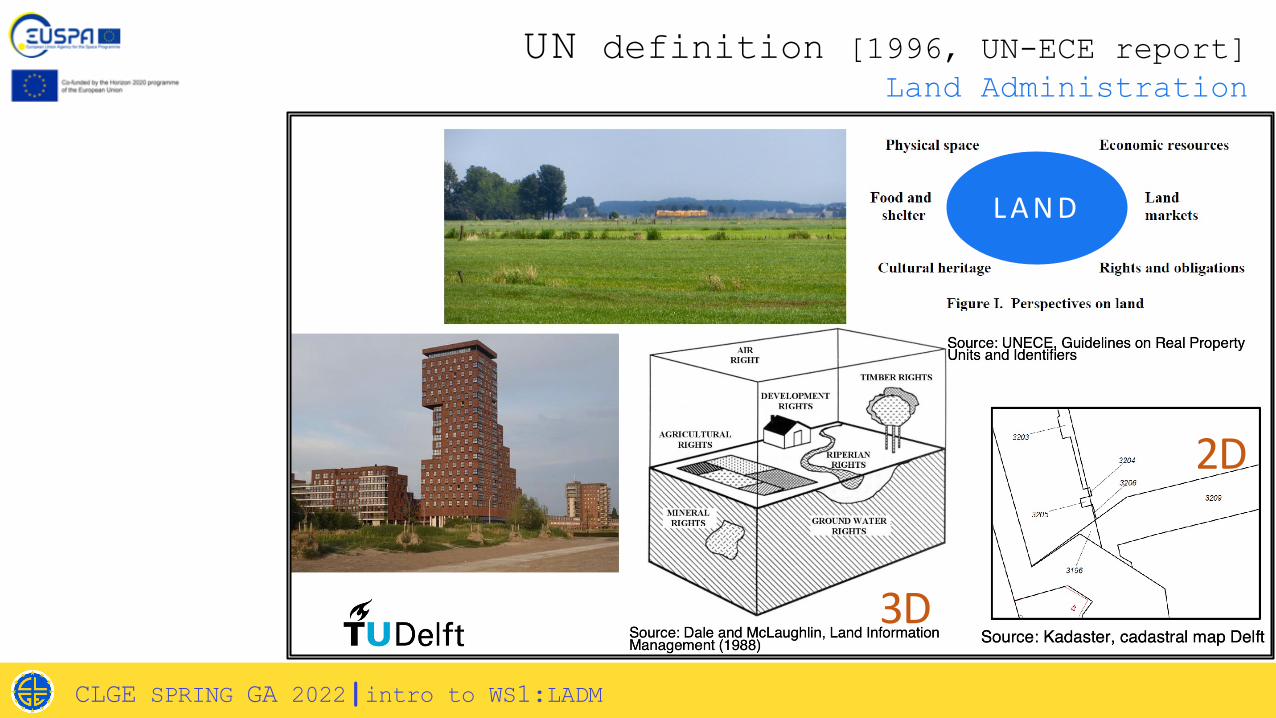
Land Administration
Συστήματα Κτηματολογίου και Πολιτική Γης
L A N D
3D
2D
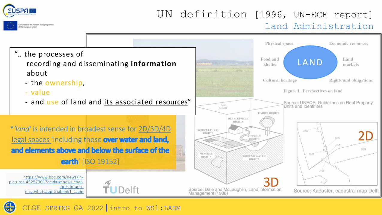
UN definition [1996, UN-ECE report]Land Administration
CLGE SPRING GA 2022|intro to WS1:LADM
Συστήματα Κτηματολογίου και Πολιτική Γης
L A N D“.. the processes of
recording and disseminating informationabout - the ownership, - value- and use of land and its associated resources”
3D
2D
UN definition [1996, UN-ECE report]Land Administration
CLGE SPRING GA 2022|intro to WS1:LADM
https://www.bbc.com/news/in-pictures-45257901?ocid=wsnews.chat-
apps.in-app-msg.whatsapp.trial.link1_.auin
*'land' is intended in broadest sense for 2D/3D/4D legal spaces 'including those over water and land, and elements above and below the surface of the
earth’ [ISO 19152]

Property Right
Spatial Unit/ Parcel
Party
Συστήματα Κτηματολογίου και Πολιτική ΓηςHenssen, 1995
People to land relationship
CLGE SPRING GA 2022|intro to WS1:LADM

Queensland, Australia
Current SituationLand Administration
Common(immovable)Cadastral Objects:
1. (Land) Parcel;
2. Apartment in multi-storey houses;
3. Other structures;
4. (Utility networks).
Greece
Netherlands
2D
CLGE SPRING GA 2022|intro to WS1:LADM

CLGE SPRING GA 2022|intro to WS1:LADM
https://www.pinterest.com/Storpweber/
http://www.asmecbg.com/projects.html
https://marinecadastre.gov/
https://www.tap-ag.com/
Kitsakis and Dimopoulou, 2014
Floros et al., 2020
Future (?) Cadastral Objects

CLGE SPRING GA 2022|intro to WS1:LADM
https://www.pinterest.com/Storpweber/
http://www.asmecbg.com/projects.html
https://marinecadastre.gov/
https://www.tap-ag.com/
Kitsakis and Dimopoulou, 2014
Floros et al., 2020
Future (?) Cadastral Objects
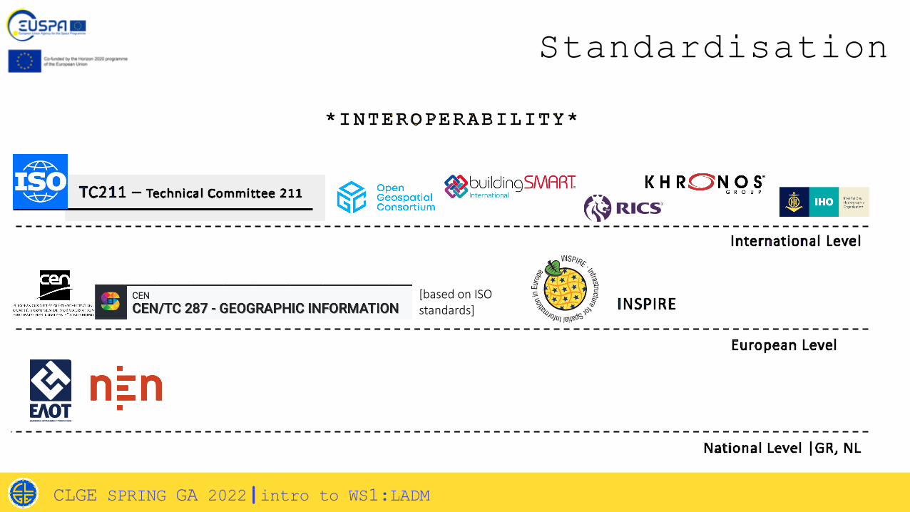
[based on ISO standards]
Standardisation
CLGE SPRING GA 2022|intro to WS1:LADM
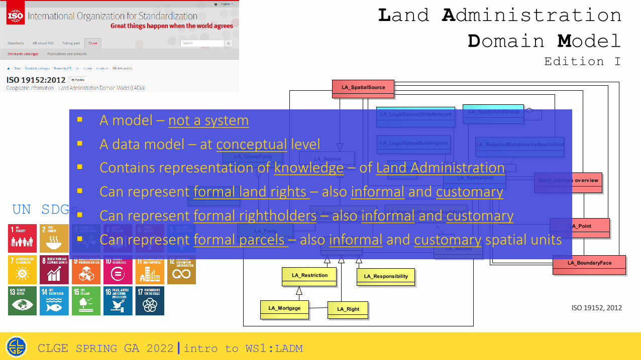
LA_SpatialUnit
LA_Party
LA_RRRLA_BAUnit
LA_Right
LA_Restriction LA_Responsibility
LA_Mortgage
LA_Administrativ eSource LA_RequiredRelationshipBAUnit
LA_GroupParty
LA_PartyMember
LA_Lev el
LA_SpatialUnitGroup
LA_LegalSpaceBuildingUnit
LA_LegalSpaceUtilityNetwork
LA_RequiredRelationshipSpatialUnit
LA_Source
LA_SpatialSource
LA_Point
LA_BoundaryFace
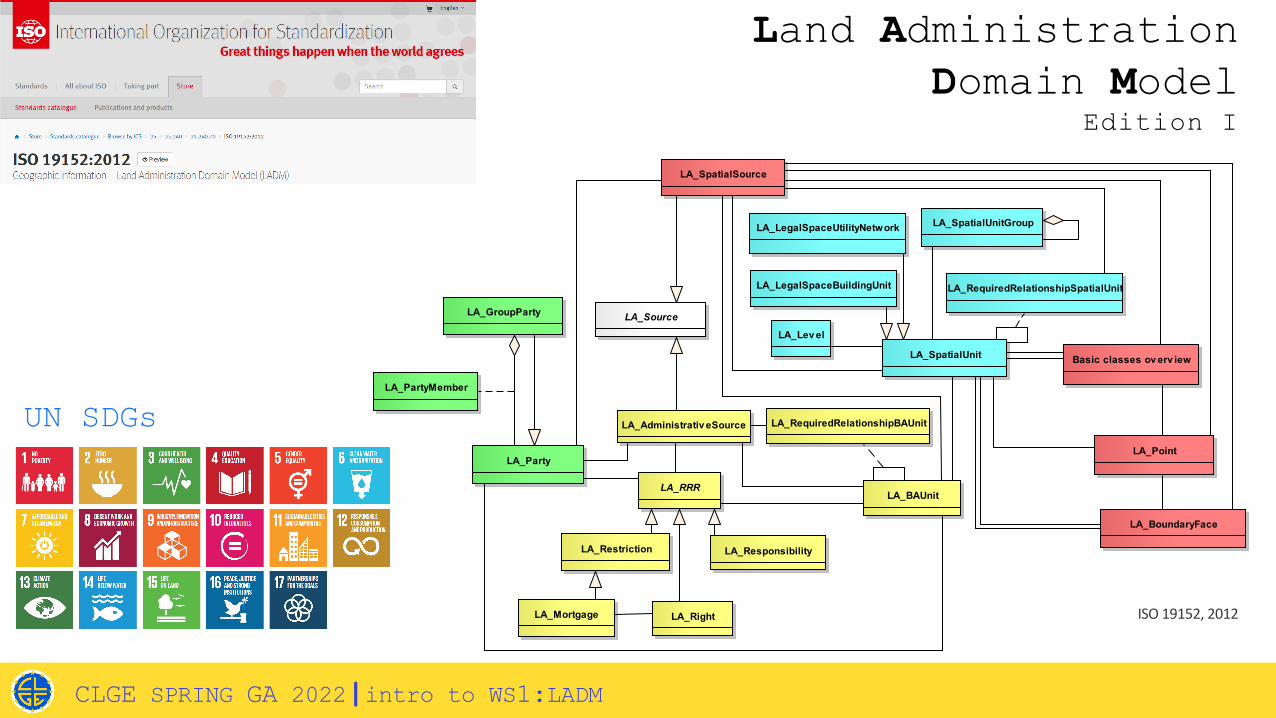
Basic classes ov erv iew
ISO 19152, 2012
Land AdministrationDomain Model
Edition I
UN SDGs
CLGE SPRING GA 2022|intro to WS1:LADM
LA_SpatialUnit
LA_Party
LA_RRRLA_BAUnit
LA_Right
LA_Restriction LA_Responsibility
LA_Mortgage
LA_Administrativ eSource LA_RequiredRelationshipBAUnit
LA_GroupParty
LA_PartyMember
LA_Lev el
LA_SpatialUnitGroup
LA_LegalSpaceBuildingUnit
LA_LegalSpaceUtilityNetwork
LA_RequiredRelationshipSpatialUnit
LA_Source
LA_SpatialSource
LA_Point
LA_BoundaryFace
Basic classes ov erv iew
ISO 19152, 2012
Land AdministrationDomain Model
Edition I
UN SDGs
CLGE SPRING GA 2022|intro to WS1:LADM
§ A model – not a system§ A data model – at conceptual level§ Contains representation of knowledge – of Land Administration§ Can represent formal land rights – also informal and customary§ Can represent formal rightholders – also informal and customary§ Can represent formal parcels – also informal and customary spatial units
CLGE SPRING GA 2022|intro to WS1:LADM

CLGE SPRING GA 2022|intro to WS1:LADM
Part 1: Fundamentals2/ NOT YET
SUBMITTED
Part 2: Land Registration 3..6
/ NOT YETSUBMITTED

CLGE SPRING GA 2022|intro to WS1:LADM
LADM 19152-2

LADM Cooperations
LADM REFINED
SURVEY MODEL
CLGE SPRING GA 2022|intro to WS1:LADM
16
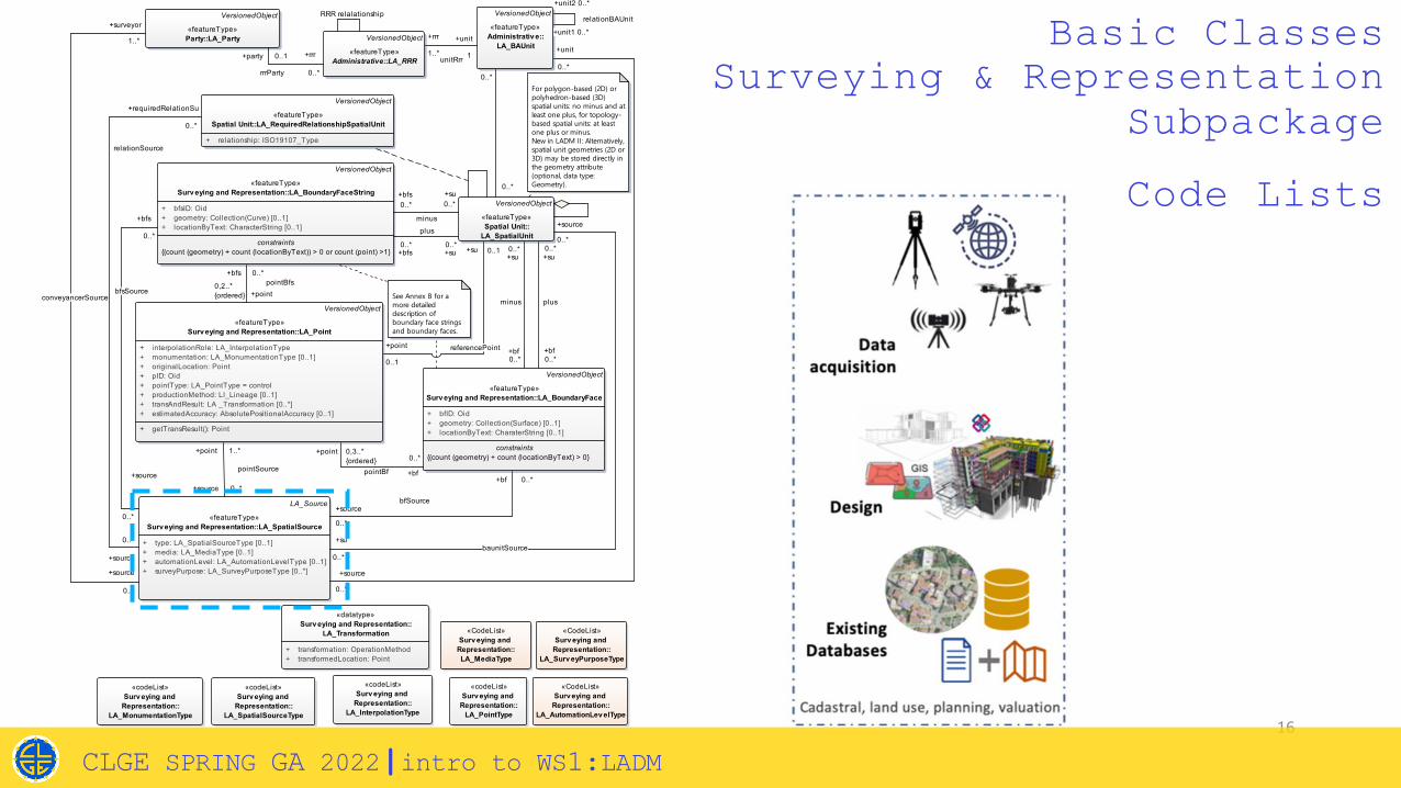
Basic ClassesSurveying & Representation
Subpackage
class Surv eying and Representation Subpackage (Classes, with Attributes, Constraints, Operations, and Code lists)
VersionedObject
«featureType»Party::LA_Party VersionedObject
«featureType»Administrative::LA_RRR
VersionedObject
«featureType»Administrativ e::
LA_BAUnit
VersionedObject
«featureType»Spatial Unit::
LA_SpatialUnit
VersionedObject
«featureType»Surv eying and Representation::LA_BoundaryFace
+ bfID: Oid+ geometry: Collection(Surface) [0..1]+ locationByText: CharaterString [0..1]
constraints{(count (geometry) + count (locationByText) > 0}
VersionedObject
«featureType»Surv eying and Representation::LA_BoundaryFaceString
+ bfsID: Oid+ geometry: Collection(Curve) [0..1]+ locationByText: CharacterString [0..1]
constraints{(count (geometry) + count (locationByText)) > 0 or count (point) >1}
VersionedObject
«featureType»Surv eying and Representation::LA_Point
+ interpolationRole: LA_InterpolationType+ monumentation: LA_MonumentationType [0..1]+ originalLocation: Point+ pID: Oid+ pointType: LA_PointType = control+ productionMethod: LI_Lineage [0..1]+ transAndResult: LA _Transformation [0..*]+ estimatedAccuracy: AbsolutePositionalAccuracy [0..1]
+ getTransResult(): Point
LA_Source
«featureType»Surv eying and Representation::LA_SpatialSource
+ type: LA_SpatialSourceType [0..1]+ media: LA_MediaType [0..1]+ automationLevel: LA_AutomationLevelType [0..1]+ surveyPurpose: LA_SurveyPurposeType [0..*]
For polygon-based (2D) or polyhedron-based (3D) spatial units: no minus and at least one plus, for topology-based spatial units: at least one plus or minus.New in LADM II: Alternatively, spatial unit geometries (2D or 3D) may be stored directly in the geometry attribute (optional, data type: Geometry).
«codeList»Surv eying and
Representation::LA_MonumentationType
«codeList»Surv eying and
Representation::LA_SpatialSourceType
«datatype»Surv eying and Representation::
LA_Transformation
+ transformation: OperationMethod+ transformedLocation: Point
«codeList»Surv eying and
Representation::LA_InterpolationType
«codeList»Surv eying and
Representation::LA_PointType
See Annex B for a more detailed description of boundary face strings and boundary faces.
VersionedObject
«featureType»Spatial Unit::LA_RequiredRelationshipSpatialUnit
+ relationship: ISO19107_Type
«CodeList»Surv eying and
Representation::LA_AutomationLev elType
«CodeList»Surv eying and
Representation::LA_Surv eyPurposeType
«CodeList»Surv eying and
Representation::LA_MediaType
+bfs 0..*pointBfs
+point0,2..*{ordered}
+party 0..1
rrrParty
+rrr
0..*
+source
0..*
conveyancerSource
+surveyor
1..*
+source
0..*
bfSource
+bf 0..*
+su0..*
plus
+bf0..*
+point 1..*
pointSource
+source 0..*
+bfs0..*
plus
+su0..*
+bf
0..*
pointBf
+point 0,3..*{ordered}
+rrr
1..*unitRrr
+unit
1
+bf0..*
minus
+su0..*
+unit
0..*
baunitSource
+source
0..*
+su
0..*
+source
0..*
+unit1 0..*
relationBAUnit
+unit2 0..*
+point
0..1
referencePoint
+su 0..1
0..*
0..*
+su0..*
minus
+bfs0..*
+source
0..*
bfsSource
+bfs
0..*
RRR relalationship
+requiredRelationSu
0..*
relationSource
+source
0..*
Code Lists
CLGE SPRING GA 2022|intro to WS1:LADM
class RefinedSurv eyModel
LA_SourceSurv eying and Representation::
LA_SpatialSource
Surv eying and Representation::LA_Surv eySource
Surv eying and Representation::LA_DesignSource
Surv eying and Representation::LA_GNSSObserv ation
+ receiverID: Oid [0..1]+ systemType: LA_Satell iteSystemType [0..*]+ numSatTracked: Integer [0..1]+ numSatUsed: Integer [0..1]+ fixDateTime: DateTime [0..1]+ /gDOP: Real [0..1]+ covarianceMatrix: MatrixOfDouble [0..1]+ GNSSReferenceStationsNetwork: LA_GNSSReferenceStationsNetworkType [0..1]+ rawMeasurement: Point [0..1]+ GNSSSurveyType: LA_GNSSSurveyType [0..1]+ GNSSReferenceStationsNetworkName: CharacterString [0..1]+ GNSSReferenceStationsNetworkScale: LA_GNSSReferenceStationsNetworkScale [0..1]+ site_displacement_included: Boolean [0..1]
Surv eying and Representation::LA_TPSObserv ation
+ instrumentHeight: Real [0..1]+ targetHeight: Real [0..1]+ reflectorHeight: Real [0..1]+ slopeDistance: Real [0..1]+ horizontalDistance: Real [0..1]+ horizontalAngle: Real [0..1]+ azimuth: Real [0..1]+ verticalAngle: Real [0..1]+ instrumentPoint: Point
Surv eying and Representation::LA_PointCloudObserv ation
+ pointsNumber: Integer [0..1]+ maxSNR: Integer [0..1]+ minSNR: Integer [0..1]+ maxIntensity: Integer [0..1]+ minIntensity: Integer [0..1]+ minNorthing: CharacterString [0..1]+ maxNorthing: CharacterString [0..1]+ minEasting: CharacterString [0..1]+ maxEasting: CharacterString [0..1]+ minElevation: Real [0..1]+ maxElevation: Real [0..1]+ pointCloud: PointCloud [0..1]
Surv eying and Representation::LA_ImageObserv ation
+ name: CharacterString [0..1]+ description: CharacterString [0..1]+ image: Image [0..1]Surv eying and Representation::
LA_DistanceObserv ation
+ distance: Real [0..1]+ distanceType: LA_DistanceType [0..1]+ description: CharacterString [0..1] Surv eying and Representation::
LA_AngularObserv ation
+ angle: Real [0..1]+ description: CharacterString [0..1]+ angularType: LA_AngularType [0..1]Surv eying and Representation::
LA_Lev elObserv ation
+ deltaHeight: Real [0..1]+ description: CharacterString [0..1]
VersionedObjectSurv eying and Representation::LA_GNSSCorrection
+ convergenceTime: DateTime [0..*]+ frequencyType: LA_GNSSFrequencyType [0..1]+ Ext_OSR_LumpSumCorrection_ID: Ext_OSR_LumpSumCorrection [0..1]+ SSR_Error_Components: LA_SSR_Error_Components [0..1]+ correctionServiceType: LA_CorrectionServiceType [0..1]
Surv eying and Representation::LA_DistanceType
Surv eying and Representation::
LA_SatelliteSystemType
Surv eying and Representation::LA_GNSSReferenceStationsNetworkType
Surv eying and Representation::LA_AngularType
Surv eying and Representation::
LA_GNSSSurv eyType
Surv eying and Representation::
LA_GNSSFrequencyType
Surv eying and Representation::
LA_CorrectionServ iceType
Surv eying and Representation::LA_GNSSReferenceStationsNetworkScale
Surv eying and Representation::LA_SSR_Error_Components
+ ExtTroposphericCorrectionID: ExtTroposphericCorrection [0..*]+ ExtIonoshpericCorrectionID: ExtIonoshpericCorrection [0..1]+ ExtSatell iteOrbitCorrectionID: ExtSatell iteOrbitCorrection [0..*]+ satell iteClockCorrection: DateTime [0..1]
Surv eying and Representation::LA_Transformation
+ transformation: OperationMethod+ transformedLocation: Point
0..1
0..*
17
Basic ClassesSurveying & Representation
Subpackage
Code Lists
CLGE SPRING GA 2022|intro to WS1:LADM
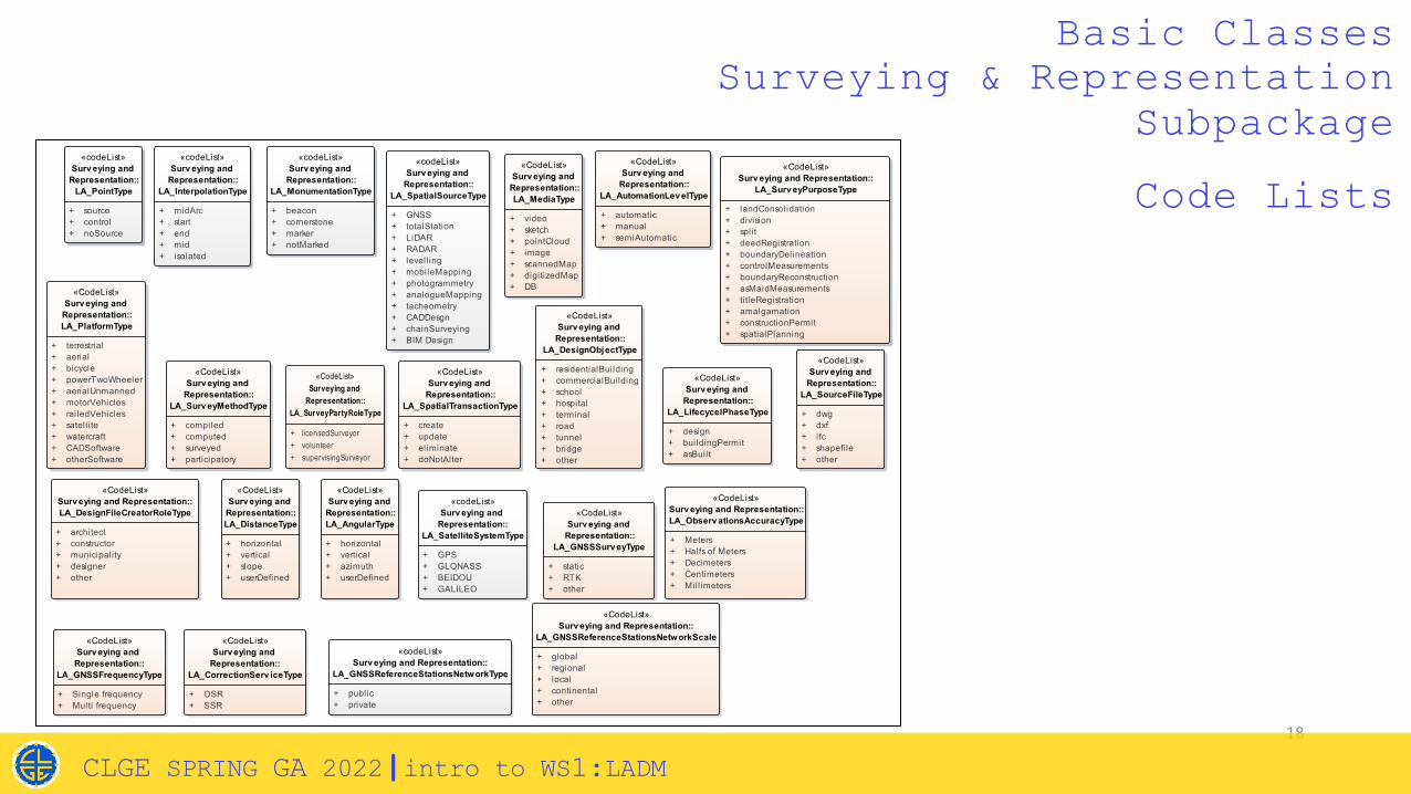
18
Basic ClassesSurveying & Representation
Subpackageclass RefinedSurv eyModel_CodeLists
«CodeList»Surv eying and Representation::
LA_Surv eyPurposeType
+ landConsolidation+ division+ split+ deedRegistration+ boundaryDelineation+ controlMeasurements+ boundaryReconstruction+ asMaidMeasurements+ titleRegistration+ amalgamation+ constructionPermit+ spatialPlanning
«codeList»Surv eying and
Representation::LA_SpatialSourceType
+ GNSS+ totalStation+ LiDAR+ RADAR+ levelling+ mobileMapping+ photogrammetry+ analogueMapping+ tacheometry+ CADDesgn+ chainSurveying+ BIM Design
«codeList»Surv eying and
Representation::LA_SatelliteSystemType
+ GPS+ GLONASS+ BEIDOU+ GALILEO
«CodeList»Surv eying and
Representation::LA_LifecycelPhaseType
+ design+ buildingPermit+ asBuilt
«CodeList»Surv eying and
Representation::LA_AutomationLev elType
+ automatic+ manual+ semiAutomatic
«CodeList»Surv eying and
Representation::LA_GNSSSurv eyType
+ static+ RTK+ other
«CodeList»Surv eying and
Representation::LA_MediaType
+ video+ sketch+ pointCloud+ image+ scannedMap+ digitizedMap+ DB
«codeList»Surv eying and
Representation::LA_InterpolationType
+ midArc+ start+ end+ mid+ isolated
«codeList»Surv eying and
Representation::LA_MonumentationType
+ beacon+ cornerstone+ marker+ notMarked
«CodeList»Surv eying and
Representation::LA_SourceFileType
+ dwg+ dxf+ ifc+ shapefile+ other
«CodeList»Surv eying and
Representation::LA_DesignObjectType
+ residentialBuilding+ commercialBuilding+ school+ hospital+ terminal+ road+ tunnel+ bridge+ other
«CodeList»Surv eying and Representation::LA_DesignFileCreatorRoleType
+ architect+ constructor+ municipality+ designer+ other
«CodeList»Surv eying and
Representation::LA_DistanceType
+ horizontal+ vertical+ slope+ userDefined
«CodeList»Surv eying and
Representation::LA_AngularType
+ horizontal+ vertical+ azimuth+ userDefined
«CodeList»Surv eying and
Representation::LA_Surv eyMethodType
+ compiled+ computed+ surveyed+ participatory
«codeList»Surv eying and Representation::
LA_GNSSReferenceStationsNetworkType
+ public+ private
«CodeList»Surv eying and
Representation::LA_PlatformType
+ terrestrial+ aerial+ bicycle+ powerTwoWheeler+ aerialUnmanned+ motorVehicles+ railedVehicles+ satell ite+ watercraft+ CADSoftware+ otherSoftware
«codeList»Surv eying and
Representation::LA_PointType
+ source+ control+ noSource
«CodeList»Surveying and
Representation::LA_SurveyPartyRoleType
+ licensedSurveyor+ volunteer+ supervisingSurveyor
«CodeList»Surv eying and
Representation::LA_SpatialTransactionType
+ create+ update+ eliminate+ doNotAlter
«CodeList»Surv eying and Representation::LA_Observ ationsAccuracyType
+ Meters+ Halfs of Meters+ Decimeters+ Centimeters+ Mill imeters
«CodeList»Surv eying and
Representation::LA_GNSSFrequencyType
+ Single frequency+ Multi frequency
«CodeList»Surv eying and
Representation::LA_CorrectionServ iceType
+ OSR+ SSR
«CodeList»Surv eying and Representation::
LA_GNSSReferenceStationsNetworkScale
+ global+ regional+ local+ continental+ other
Code Lists
CLGE SPRING GA 2022|intro to WS1:LADM

19
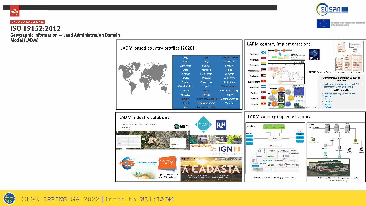
LADM EDITION II PART 6 & RELATED STANDARDS
§ OGC LandInfra§ LandXML§ (Geo/City)Json§ XML/GML§ RDF§ Dxf/ Dwg§ Shp§ BIM/ IFC§ Xyz§ INTERLIS§ …
LADM Edition II Part 6: Implementation
§ How?§ How many?§ Compatibility?§ LADM-compliant?§ …
SURVEY MODEL Implementation
CLGE SPRING GA 2022|intro to WS1:LADM
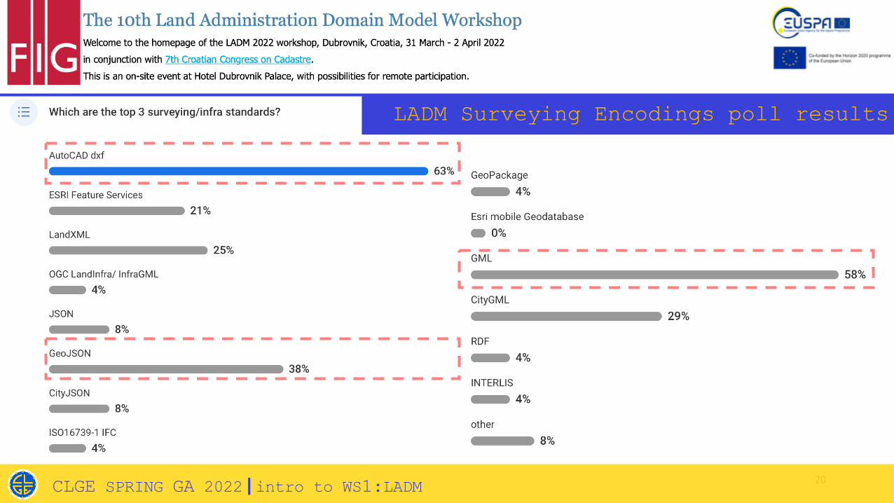
20CLGE SPRING GA 2022|intro to WS1:LADM
LADM Surveying Encodings poll results
Thank you!!See you at the workshop J
C L G E SPRING GENERAL ASSEMBLY 2022WS1 |LADM
Eftychia KALOGIANNI, MSc, PhD (c) TUDelft
Peter VAN OOSTEROM, Prof, Dr TUDelft
Skopje | May 14, 2022