The Impact of Beltways Upon Selected Central City ...
136
University of Rhode Island University of Rhode Island DigitalCommons@URI DigitalCommons@URI Open Access Master's Theses 1983 The Impact of Beltways Upon Selected Central City The Impact of Beltways Upon Selected Central City Characteristics: A Social and Economic Indicator Analysis Characteristics: A Social and Economic Indicator Analysis Deborah M. Kupa University of Rhode Island Follow this and additional works at: https://digitalcommons.uri.edu/theses Recommended Citation Recommended Citation Kupa, Deborah M., "The Impact of Beltways Upon Selected Central City Characteristics: A Social and Economic Indicator Analysis" (1983). Open Access Master's Theses. Paper 642. https://digitalcommons.uri.edu/theses/642 This Thesis is brought to you for free and open access by DigitalCommons@URI. It has been accepted for inclusion in Open Access Master's Theses by an authorized administrator of DigitalCommons@URI. For more information, please contact [email protected].
-
Upload
khangminh22 -
Category
Documents
-
view
3 -
download
0
Transcript of The Impact of Beltways Upon Selected Central City ...

University of Rhode Island University of Rhode Island
DigitalCommons@URI DigitalCommons@URI
Open Access Master's Theses
1983
The Impact of Beltways Upon Selected Central City The Impact of Beltways Upon Selected Central City
Characteristics: A Social and Economic Indicator Analysis Characteristics: A Social and Economic Indicator Analysis
Deborah M. Kupa University of Rhode Island
Follow this and additional works at: https://digitalcommons.uri.edu/theses
Recommended Citation Recommended Citation Kupa, Deborah M., "The Impact of Beltways Upon Selected Central City Characteristics: A Social and Economic Indicator Analysis" (1983). Open Access Master's Theses. Paper 642. https://digitalcommons.uri.edu/theses/642
This Thesis is brought to you for free and open access by DigitalCommons@URI. It has been accepted for inclusion in Open Access Master's Theses by an authorized administrator of DigitalCommons@URI. For more information, please contact [email protected].

THE IMPACT OF BELTWAYS
UPON SELECTED CENTRAL CITY CHARACTERISTICS:
A SOCIAL AND ECONOMIC INDICATOR ANALYSIS
BY
DEBORAH M. KUPA
A THESIS PROJECT SUBMITTED IN PARTIAL FULFILLMENT
OF THE REQUIREMENTS FOR THE DEGREE OF
MASTER OF COMMUNITY PLANNING
AND
AREA DEVELOPMENT
UNIVERSITY OF RHODE ISLAND
1983

TABLE OF CONTENTS
ACKNOWLEDGEMENTS ............................... ii
PREFACE ....................................... iii
INTRODUCTION .................................... 1
Chapter
I THE HISTORICAL PERSPECTIVE OF BELTWAYS Introduction ............................. 5 Current Thought on Beltway Impacts ....... 6 SUIIDilary . . . . . . . . . . . . . . ................... 10
II THE INDICATOR MODEL Introduction ............................ 12 The Indicator Model ..................... 13 Assumptions Inherent in the Indicator
Model ................................. 14 The Rating System ....................... 15 Criteria for Indicator Selection ........ 16 Interrelationships Between the
Indicators ........................... . 21 The Indicators within the Model ......... 36
III PROVIDENCE, RHODE ISLAND AND THE ROUTE I-295 BELTWAY: A CASE STUDY Introduction ............................ 42 History ................................. 42 Key Elements in the City/Beltway
Development Process ................... 48 Surmnary ................................. 7 4
IV TESTING THE INDICATOR MODEL: THE ROUTE I-295 CASE STUDY Introduction ............................ 78 Analysis of Beltway Impacts by
Area of Concern ....................... 7 8 Demographics ....................... 78 Employment ..... .. .................. 82 Housing ............................ 84 Economic - Retail/Commercial ....... 85 Office ............................. 86 Industry ........................... 88 Land Use ......... ...... ............ 90 Transportation ..................... 92
SUIIDilary ................................. 9 3

TABLE OF CONTENTS cont.
Chapter
V PROJECT CONCLUSIONS AND CRITIQUE .......... 97
APPENDIX I ........... . ........................ 100
APPENDIX II ................................... 126
SOURCES ....................................... 128

Table
I
II
III
IV
v
VI
VII
VIII
IX
x
XI
XII
XIII
XIV xv
XVI XVII
XVIII
XIX
xx
XXI
XXII
LIST OF TABLES
Indicators of Beltway Impact Upon Central Cities ......................... 17
Selected Indicators By Category: Input Descriptive Indicators ............ 24 Purpose of Indicator Selection: Input Descriptive Indicators ............ 2S Selected Indicators by Category: Non-manipulable input indicators ........ 26 Purpose of Indicator Selection: Non-manipulable input indicators ........ 27 Selected Indicators by Category: Analytic Indicators ..................... 28 Purpose of Indicator Selection: Analytic Indicators ..................... 29 Selected Indicators by Category: Output descriptive indicators ........... 30 Purpose of Indicator Selection: Output Descriptive Indicators ........... 31 Selected Indicators by Category: Side Effect Descriptive Indicators ...... 34 Purpose of Indicator Selection: Side Effect Descriptive Indicators ..... . 3S A List of the Rhode Island Towns
Nearest to Route I-29S ................. 4S Plant Additions, New Buildings, and
New Plants in Corridor Towns and Providence, 19SS - 19S8 ................ 47
Change in Providence Population ......... 49 Population Trends of the Corridor
Towns .................................. SO Industry of Employed Persons ............ S2 Employment Trends by Industry for the
I-29S Corridor Region, 1960-80 ........ . S3 Trends in the Labor Force of the
Corridor Region, 1960-80 .............. . SS Trend in the Range of Median Family
Income in the Corridor Towns .......... . S6 Trend in Residential Building Permits
in Providence and Corridor Towns ....... S8 Number of Single and Multi-family
Homes in Providence and the Corridor Region, 1970, 1980 ..................... S8
Regional Shopping Centers Built After 196S ............................. S9

Table
XXIII
·xxiv xxv XXVI XXVII
Figure
LIST OF TABLES cont.
New Connnercial Construction in Providence and the Corridor, 1966-1980 ............... 62
New Construction for Manufacturers in Providence and the Corridor Region ..... 65
Land Uses in the City of Providence . . ...... 67 Land Uses in the Corridor Region ........... 68 Average Daily Traffic on Route I-295 ....... 73
LIST OF FIGURES
I Interrelationships in the Indicator Model .. 22 II Interstate Highways Reconnnended for
Accelerated Construction .................. 44 III Locations of the Regional Malls ............ 61 IV Land Zoned for Industrial Use, 1977 ........ 63 V Rhode Island Highway System ................ 70 VI Rhode Island Travel Times .................. 72

ACKNOWLEDGEMENTS
There are a number of people who have put consi
derable time and effort in bringing this project to a
successful completion. First, I wish to express my
sincere appreciation to Dr. Marcia M. Feld for her
advice and enthusiasm on this project, and throughout
my years in the department. She has brought a unique
sense of humor, and unfailing support to every project
I have attempted.
I would also like to thank Dr. Thomas D. Galloway
for his comments and help in refining this paper. Dr.
Galloway has provided a good working atmosphere in all
the studies on which I have worked.
My parents, John and Brenda Kupa, have been a
fine support team, in every sense of the word. I wish
to thank them for providing me with an education and
the chance to go my own way in every endeavor.
ii

PREFACE
The focus of this research project is on the devel
opment and testing of a methodology to assess the impacts
of a beltway upon the central city it surrounds.
The analytic method employed in this study is social
and economic indicator analysis. It is intended to
provide the evaluator of highway impacts with a frame
work through which specific cases can be applied. The
information system which is developed can then be
employed in making policy decisions concerning the
highway's impact upon its central city.
The methodology used in the project is tested
through an application to a specific beltway and the
city it surrounds. The conclusions derived from this
test illustrate the ability of the methodology to
present a valid examination of the .specific case.
The key element within this study is the develop
ment of a normative methodology, which is not limited
to strict quantitative data analysis, or simple quali
tative review. The methodology intermixes these
forms of analysis, and allows the decision-maker to
consider the entire situation, including city policies.
iii

1
INTRODUCTION
The purpose of this research project is to develop
and test a methodology for use in the assessment of the
impacts that beltways have upon the central cities they
surround. The methodology which is employed is social
and economic indicator analysis, and the test is an
application of the model to a specific beltway case.
The project is divided into five chapters. The
information presented in Chapter I provides an en-
capsulation of historical and current literature on
the impacts of beltways. The general intention of this
chapter is to acquaint the reader with the internal
issues of beltway impacts.
The second chapter presents the methodological
framework through which the indicator model is developed.
The model is derived from a number of sources, including
the Land and Spilerman study entitled Social Indicator
Models, and the United States Department of Transportation's 1 The Land Use and Urban Development Impacts of Beltways.
A number of functional areas are examined in Chapter II,
including demographics; housing; employment; economics,
with the sub-areas of retail/corrrrnercial, office, and manu
facturing; land use and transportation. Indicators of
a beltway's impact upon the central city were derived
within each each functional area. In addition, there

2
is an examination of the techniques employed in indica
tor selection, the assumptions inherent in the model,
the interrelationships between the indicators, and the
rating system used to determine the type of impact the
beltway has had upon the central city.
Chapter III is a presentation of information through
which the model is tested. The beltway chosen for
model application is Interstate Route 295 (I-295) which
surrounds the city of Providence, Rhode Island. The
data is divided into the six functional areas described
above, and is presented in both tabular and textual forms.
Chapter IV includes the application of the model
to the I-295 case, and presents a number of conclusions
as to the impacts of the beltway upon Providence. This
is the test of the methodology which shows the ability of
the model to manage information.
Chapter V presents the project conclusions, includ
ing an assessment of the indicator model as an appro
priate methodoloeical tool for use in determining belt
way impacts. A brief discussion of further studies is
provided, with consideration of the indicator model as
an information system. In addition, the results of the
development and testing of the model are critiqued and
recommendations as to its improvement are made.
The intention of the study is to develop and test
a specific method of impact assessment, social indica-

3
tor analysis. In the planning process, it would repre
sent the first stage in decision-making, that of infor
mation collection and analysis. Further stages of the
process include examination of alternatives and the
refinement of data analysis.

4
FOOTNOTES
1 . The extent to which these sources were used in the development of the methodology and indicators is des cribed in Chapter II , The Indicator Model.

5
CHAPTER I
THE HISTORICAL PERSPECTIVE OF BELTWAY IMPACTS
Introduction
The implementation of the Interstate Highway System
in 1944 formed the basis for construction of many exist-
ing beltways, although at that time emphasis was placed
upon building roads which penetrated the city centers.
The Federal-Aid Highway Act of 1944 provided the funding
for highway construction projects, including 2,300 miles 1 of urban circumferential routes. As urban expressway
projects progressed, funds were quickly depleted. The
1956 Federal-Highway Act provided the impetus for further
highway construction. It was at this point that a require
ment was initiated which held that "state highway depart
ments, in planning a Federal-Aid project involving the
bypassing of or going through a city or town, must hold,
or offer to hold a public hearing and must consider the
economic effects of such a location. 112
There have been approximately 40 beltways partially or
completely constructed since 1956. The beltway examined
in this study was originally built as part of the Inter-
state Highway System.
Subsequent Federal-Aid Highway Acts addressed the
issue of transportation planning, with the approach shift
ing from a highway orientation to a multi-modal approach. 3
It was not until the 1960's however, that transportation

6
planning began to address the issues of land use planning,
and the socio-economic, environmental and energy impacts
of highways. In the discussion of beltway impacts, concern
was of ten expressed over the affects such roadways had
upon the central cities they surrounded. Ntmlerous studies
have addressed this point, two of which are included in
Appendix I.
Current Thought on Beltway Impacts
The relationships between beltway construction and the
impacts of the highway have been explored in a somewhat
limited manner. Studies range from a 1958 examination of
the Route 128 corridor in Massachusetts to the 1980 U. S.
Department of Transportation publication in which the federal
policy implications of beltway construction were reviewed in a
case study context.
Early impact studies concentrated on the positive effects
beltways had upon the cities they served. Subsequent studies
agree that the highways have some impact on urban growth and
development patterns, but that these impacts were widely
varied and were of differing magnitudes. The current area of
study is concerned with whether beltways affect intra
metropolitan growth patterns, especially the shift of
population from the central city to outer suburban areas.
The majority of beltway impact studies indicate that
the effects of such a roadway appear to vary with the type
of city it surrounds. There are, however, some general

7
attributes which are generalizable for most beltways.
First, the construction of a beltway around a central
city can improve the accessibility of the outer regions
of a metropolitan area. In turn, this often triggers
heightened residential, retail and industrial locations,
especially at the interchanges of the beltway. Increased
accessibility allows workers in the city to live further
from their jobs without increasing work trip times, and
allows firms to locate in lower cost sites distant from
the city without losing contact with the metropolitan
market. 4 Although the positive aspects of increased
regional accessibility are appealing to many firms,
most of the current literature on locational decisions
indicates that it is not sufficient to attract a large
number of corm:nercial and industrial establishments to
beltway corridors .5 There are a substantial number of
elements other than accessibility which play key roles
in attracting firms to the beltway corridor. These
elements include the area's market potential in com-
parison to the city's market potential, the availability
of utilities, current land use patterns, the :ivailabilitv
of suitably zoned land for a variety of uses, along with
a number of others. The literature recognizes that
the construction of a beltway is not enough to create a
market in an area that has few amenities, or which serves
no existing market.

8
Second, the effect of beltway construction upon a
central city's economy, although varying widely, may often
be negative. This is an impact which is thought to be highly
dependent on the permissiveness of land use policies, and
illustrates the importance of strong regional land use planning
in a beltway area. Historically, central cities surrounded
by surburban beltways showed lower gains in retail sales and
6 employment than those cities without beltways.
In addition, negative shifts in the areas of whole
saling and service sector employment, along with industrial
1 f . b 1 . . 7 Th emp oyment were o ten present in e tway cities. ese
shifts tended to be small, but statistically significant.
In the area of .study concerning development patterns,
the majority of beltway impact studies indicate that any
suburbanization which has taken place since the construction
of the highway probably would have occurred in the absence
of the construction. 8 In addition, it is believed that belt-
ways do not tend to change development patterns, but simply
reinforce the patterns currently in existence. In a study
examining several existing beltway's effects on development
the pattern of a short-lived shift of office space construction
to beltway sites and a clustering of garden apartments adjacent
to the highway was evident. 9 Impacts on other types of
development were weak or non-existent .10
The conclusion of
studies such as this one shows that while beltway construction
can spear development in growth areas, it cannot change the
development patterns in an area which does not have a market
. 1 11 potentia .

9
In addition to the positive and neutral effects that
beltway construction may have upon a central city and its
suburbs, negative effects have been documented inmany reports.
Besides those negative points which have .been discussed
previously in this chapter, there are environmental and
social issues which have been negatively affected by beltway
construction. First, beltway travel is often not an energy
efficient mode of transportation. Vehicle miles traveled
usually increase in beltway areas, and public transit is less
of a factor in transporting city connnuters. These elements
can lead to increased energy usage and less efficient use of
a city's public transit program. There are, however, many
methods to mitigate these effects, including encouraging
nodal development along the highway, and the construction of
park and ride facilities for city connnuters in the beltway
corridor.
The social impacts of beltway construction are as wide
ranging as the types of cities around which the highways are
located. First, as a beltway can facilitate suburbanization
of population and employment, few benefits are conferred upon
lower income residents of the central city. 12 The investments
a city may make in the construction of a beltway may, in fact,
affect the city's ability to provide needed social services.13
Lastly, job opportunities for central city residents may be
reduced if development is attracted to the beltway area.14

10
Summary
The impacts of a beltway on the central city it sur
rounds are generally dependent on the type of city, the
current growth patterns of the city, and the market
potential of the beltway area. Although the effects
outlined in this section can be viewed as general im
pacts of the majority of beltways, each highway should
be viewed as a unique entity. The current literature
addressing beltway development and impacts shows a large
ntmlber of variables which must be considered when
planning and assessing beltway construction. This study
will attempt to develop and test a methodology for
organizing this large information system through social
indicator analysis.

\
11
FOOTNOTES
1. U.S. Department of Transportation, The Land Use and Urban Develo ment Im acts of Beltwa s - Final
Was ington, D.C.: U.S. Government Printing 0 p. 13.
2. 70 U.S. Stat. 374.
3. U.S. Department of Transportation, p. 15.
4. U.S. Department of Transportation, The Land Use and Urban Develo ment Im acts of Beltwa s - Surmnar , Washington, D.C.: U.S. Government Printing 0 ice, 1980),
p.15.
5. The current literature, however, strongly supports the decentralization of households and firms due to the Interstate Highway System as a whole. Beltways comprise only a small percentage of the highway system, and are viewed in a different context than the highway system as a whole.
6. U.S. Department of Transportation, The Land Use and Urban Development Impacts of Beltways - Surmnary, p. 11.
7. Ibid., p. 12.
8. Ibid., p. 13.
9. Ibid., p. 11.
10. Ibid.
11. Ibid.
12. Ibid.
13. Ibid., p. 15.
14. Ibid.

\
12
CHAPTER II
THE INDICATOR MODEL
Introduction
For the purposes of this paper, the model is considered
to be a hypothesis which addresses the relationships be
tween a beltway and the central city it surrounds. It
is a normative methodology which considers both quanti
tative information and qualitative analysis. The model
employs social and economic indicators which are defined
as statistical measures of social and economic conditions,
past and present, measurable in a time series, within a
.f. h. 1 1 speci ic geograp ica area. The geographical regions
which are employed in this study are cities, tmms and
states. The corridor region is a compilation of a number
of towns, and is calculated as the sum of those towns.
Units of measure should be as specific as possible for
use within the model, and should be easily compared.
Within the geographical areas, the following specific
functional areas were selected for use in the model:
-Demographics
-Employment
-Housing
-Economics
-Retail/Commercial
-Off ice -Industry
-Land Use
-Transportation

13
The model relies upon the comparison of functional areas
within the city to those areas within the corridor.
The indicators presented in this chapter were developed
in part, from a review of current literature on beltway
impacts. Two summaries of such literature, and the
various measures used to assess these impacts, are found
in Appendix I. The criteria for selection of indicators
is presented at a later point in this chapter.
In addition, the indicators are organized into a
framework illustrating their specific interrelationships.
This framework is loosely based upon the social indicator
model developed in the Land and Spilerman study entitled
Social Indicator Models. 2
The chapter also includes a discussion of the assump
tions inherent in the model, and the rating system through
which the impacts of the beltway upon the city are assessed.
An explanation of each indicator and its purposes within
the model is also included.
The Indicator Model
The basic premise underlying the indicator model
in this study is the assumption that there is a quanti
fiable relationship between a beltway and the functional
area characteristics of the city it surrounds. The
model provides a structure for illustrating these impacts
through its interrelationships and through the rating
system. A list of the indicators employed in the model

J
\
14
are found in Table I.
Assumptions Inherent in the Indicator Model
There are five primary assumptions which form the
boundaries for use of the indicator model in this study.
The major assumption used in the model is the ability
of a beltway to have a measurable effect -on the various
functional area characteristics of the city it surrounds.
This assumption is tested in the application presented
in Chapter IV. It is dependent upon the units of
measure, the type of data employed (primary or secondary),
the interrelationships between indicators, and the
validity of the rating system.
The second assumption made in the model design is
that the level of aggregation of measures provides a
reliable picture of beltway impacts . Current social
indicator literature states that this is a valid as sump-
tion. 3 Because the model is designed for use in the
early stages of the planning process, further use should
result in a refinement of the data, and of the analysis itself.
As a result of time constraints, the bulk of the
information collected for the testing of this model is
of a secondary nature. The United States Census is the
predominant source of data for the model application.
A continuation of this model application in the planning
process would require the use of primary data.

•
15
The fourth assumption made in this methodology
lies in the rating system. Because of the normative
nature of social and economic indicator analysis, there
is a connection between the quantitative information
and the qualitative conclusions. The rating system
is described in the following section .
The Rating System
A principal element of the indicator model is the
rating of beltway impacts. This system is founded upon
the city's normative policy coilllllittments. That is,
whether an impact is rated as positive, neutral or
negative depends on the contextual base from which the
city's decisions are made. For example, it increased
industrial development is one of a city's policy objectives,
then additional construction of industrial plants in the
city is viewed as a positive occurrence. The positive,
neutral and negative ratings are described in detail
below.
Positive Impact - This rating indicates the beltway has
benefitted a selected functional area within the city,
and follows its stated policy direction. This ranges
from the improvement of the accessibility to the city's
shopping areas to attracting additional office space to
the central city.

16
Neutral Impact - A neutral rating means the construction
of a beltway has had no significant impact (benefit or
detriment) on a particular functional area within the
city. An example would be an impact which cannot
be assigned to beltway development because the major
forces behind the impact lie elsewhere.
Negative Impact - This rating indicates the beltway has
had a detrimental affect upon a certain functional area
within the city. For example, if city policy aimed to-
ward revitalizing the central business district in
terms of additional retail and connnercial establishments,
and the beltway was attracting most new retail and
commercial development to its corridor towns, a negative
impact would be assigned.
Criteria for Indicator Selection
The indicators which were chosen for use within the
model are found in Table I . They were selected by employing
the following criteria:
1. Study relevance - The chosen measure must be
applicable to the problem being reviewed, in this case the
effects of beltway construction on macroscale central city
characteristics.
2. Reliability - The quality of the measure that
consistently reflects a characteristic without wide variability. 4

\
TABLE I
INDICATORS OF BELTWAY IMPACT UPON CENTRAL CITIES
Area of Concern
Demographics
Employment
Housing
Economic: Retail/Commercial
Indicator
City population trends.
SMSA/County/Corridor population trends .
Nonwhite City population trends.
Trend in City employment by industry class.
Trend in SMSA/County/Corridor employment by industry class .
Unemployment rate in the City before and after beltway construction. Median family income in City.
Median family income in SMSA/ County/Corridor.
Total single and multi-family dwelling units in City/SMSA/ County/Corridor.
Trend in residential building permits in City/County/SMSA/ Corridor.
Trend in location of regional shopping centers before and after beltway construction.
New commercial construction in the City after beltway construction.
New commercial construction in the SMSA/County/Corridur after beltway construction.
17

Area of Concern
Economic: Retail/Commercial cnt.
Economic : Office
Economic: Manuf acturing
TABLE I cont.
Indicator
I
Trend in retail sales in City .
Trend in retail sales in SMSA/ County/Corridor.
Trend in percent of city sales of SMSA/County sales. j
l Trend in location of new office space after beltway construction.
Trend in new off ice soace construction in City after beltway construction.
Proposed future construction of new office space in City.
Trend in location of industrial parks after beltway construction.
New construction for manuf acturers in the SMSA/County/Corridor.
Number and location of available industrial zones in City .
Number and location of available industrial zones in SMSA/County/ Corridor .
I
Number of industries relocated to beltway region from the City .
New construction for manuf acturers in the City.
Trend in amount of space available in the City's industrial parks.
18

Area of Concern
Economic: Manufacturing Cont.
Land Use
TABLE I cont.
Indicator
Availability of utilities in the[ SMSA/County/Corridor.
Availability of utilities in thel City.
Trend in land uses in the City before and after beltway construction.
Current land uses in the City/ SMSA/County/Corridor.
Amount of developable space in City.
Amount of developable space in SMSA/County/Corridor.
Number, location and type of physical constraints on development.
Trend in location of residential, cormnercial and industrial uses before and after beltway construction.
Average cost of land per square foot in City.
Average cost of land per square foot in Corridor.
Size of central city in square miles.
Transportation Average daily traffic on beltway over time.
Number of interchanges on beltway.
19

Area of Concern
Transportation
TABLE I cont.
Indicator
Spacing of interchanges on beltway.
Extensiveness of radial highway system from central city.
20
Length of beltway in miles.
Number of automobiles available per family in City/Beltway region
Years of beltway construction.
Average number of miles the beltway is located from the city center. Proximity of beltway to alternate modes of transportation.

\
21
3. Validity - The extent to which the measure reflects
the concept that it is intended to measure. Three basic
approaches are normally used to test for indicator validity. 5
a . Examine the design of the measure and decide if
the measure is a reasonable one. This is a relatively
subjective test, relying on intuition and knowledge
of the concept/problem the indicator is intended to
measure.
b. Examine the measure to see if it behaves the way
it is expected to behave.
c. Look at the behavior of other measures of the same
or related phenomena .
4 . Availability - The data should be readily available
through standard collection methods .
5. Timeliness - All measures should be time-relevent
and trends should relate to the correct time period .
6. Aggregation - A specific level of aggregation,
macroscale or microscale, should be designated for ease
of comparison.
Interrelationships Between the Indicators
In order to illustrate the interrelationships of the
indicators within the model, they are organized into the
framework in Figure I .6
Five main types of indicators are
identified within the flow chart, and are defined as follows: 7

_,.
FIGURE I
INTERRELATIONSHIPS IN THE INDICATOR MODEL
Input Oa1criptlva Indicatora
-Trend in SMSA/County •ploymant by lnduatry cla1a .
-Trend in location. of r•1lonal 1hoppln1 cant.era bafoT• and after beltway c:onatru~tlon .
- New coaaercial construction in the beltway corridor .
- trend in retail aalea in the beltway corridor .
-Total sln1h/arultlfmily clwellln1 unlta ln SHSA/County/ Corridor .
-Trend in realdentlal bulldin& peralta in the SMSA/County Corridor .
-Trend in location of nev office 1pace after belt"W&y conatructlon .
-Trend in location of induacrial parka after beltva7 con1truct ion .
-Nev con1cructlon tor manufacturar1 in cha SMSA/County/ Corridor .
I Ano!.Ltic lndicotoro
-Av•r•a• dally traffic on beltvay over t.iae . -- -M\abar of 1ntarchana•• cm baltva7 .
-Spaclna of lnterchana•• cm beltway .
- btanalven••• of radial bl&bwa7 171t- from central clt.7 .
-L•n1th of beltvey ln •ll•• ·
-Yaar1 of baltva7 conatnctlon.
--ber of eut-..bllH avallabla per f-111 ln Clty/lelt-vay ra1lon .
I Hon-11&1\ipulabla input indicatoro · 1---+ I -Amount of developabla apace in Clt7/leltve7 ra1lon .
-Trend in Cit7/SHSA/Count7/Corrldor population .
-Trend in nonwhite City/SMSA/County/Corridor population .
-un ... ployaent rota in Clt7/SHSA/Count7/Corrldor .
-Hedhn family income ln Clt7/SHSA/Count7/Corridor.
-Year ecructuro built lD Cit7/SHSA/Count7/Corridor .
-Current land usH in the Cit7/SHSA/Co1mt7/Corrido~ .
-Number and location of available induatrlal zonaa in City /SHSA/County/Corrldor .
---+
Output D11crlptlve Indlcator1 ---,
-Trend in City •ploym1nt by lnduatry 1accor .
-ttav comnarclal con1tructlon in the City over ct.ma .
-Trend ln recall 1alaa in City .
-Percent of City• 1 1hara of total SKSA ratall 1alea ovar tiJM .
-Total sln1le/aultlf-1ly clwellin1 unite in Clty over ti•• .
-Trend ln ruldentlal buildin1 penolta in Clty .
·Trend in nav of flea 1paca con1tructloa in City .
-Propo1ad future con1tructlon of nev offlca development in City .
-Number of induu:rla1 relocated co baltvay raalon from the Clty .
-Trend ln •ount of apace avellabla in the City'a induatrlal parka.
· Mav conacructlon for •anufaccurere ln Clty .
-Trend ln lAnd u••• ln the City before and after beltway con1trucclon .
Side Effect be1crlptlve IftdlcAtora
-Aver•a• number of •11•• th• beltway 11 located from th• city .
-Size of centTal city in 1quare all ea .
-Aver•a• coat of land per equare foot in Clty/leltway re1lon1 .
-Avolhblllty of utilltlu ln leltvay roalon end City.
N N
23
1. Input descriptive indicators are those which represent
conditions in the beltway region, whether Standard Metropolitan
Statistical Area, county or corridor which can be manipulated
by decision makers.
2. Non-manipulable descriptive indicators represent
city or belt region conditions which cannot be altered by
decision-makers.
3. Output descriptive indicators define the city
conditions resulting from the impacts of the beltway on
the central city .
4. Side-effect descriptive indicators are those
variables which influence, or are influenced by the conditions
and processes being considered.
5. Analytic indicators measure the underlying relation
ships which affect the output indicators, both descriptive and
side-effect.
For example, the number of multifamily units built in the
corrido~ a variable which can be changed by policy makers, is
related to the number of such units built (or not built) in
the city, as a result of beltway construction. Non-manipulable
indicators which would effect this are total city and regional
population, and the side-effect indicator is the average
cost of land per square feet in the city and beltway region.

TABLE II
SELECTED INDICATORS BY CATEGORY
(1960, 1970, 1980)
In..E_ut Descr~tive Indicators
-Trend in SMSA/County employment by industry class.
-Trend in location of regional shopping centers before and after beltway construction.
-New connnercial co.nstruction in the beltway corridor.
-Trend in retail sales in the beltway corridor.
24
-Total single/multifamily dwelling units in SMSA/County/ Corridor.
-Trend in residential building permits in the SMSA/County· Corridor.
-Trend in location of new office space after beltway construction.
-Trend in location of industrial parks after beltway construction.
-New construction for manufacturers in the SMSA/County/ Corridor.

TABLE III ---
PURPOSE OF INDICATOR SELECTION
(Input Descriptive Indicators 1)1
Indicator
-Trend in SMSA/County/Corridor employment by industry class.
-Trend in location of regional shopping centers before and after beltway construction.
-New commercial construction in the highway corridor.
-Trend in retail sales in the highway corridor.
-Total single/multifamily dwelling units in SMSA/County/Corridor.
-Trend in residential building permits.
-Trend in location of new office space after beltway construction.
-Trend in location of industrial parks after beltway construction.
-New construction for manufacturers in SMSA/County/Corridor.
-
Purpose
Measure stability/change in employment oyer time.
Trace the induced commercial development in the highway corridor .
Trace the induced commercial development in the highway corridor.
Assess the direction of retail trade.
Measure the induced housing development in the highway corridor. Assess patterns of suburbanization.
Measure the induced housing development in the highway corridor. Assess patterns of suburbanization.
Measure the induced off ice space develop- I ment in the highway corridor.
Measure the induced industrial develop-ment in the highway corridor.
Measure the induced industrial develop-ment in the highway corridor.
!'..)
°'

27
TABLE IV
SELECTED INDICATORS BY CATEGORY
(1960, 1970, 1980)
Non-manij>_ulable inj>_ut indicators
-Trend in City/SMSA/County/Corridor population.
-Trend in nonwhite City/SMSA/County/Corridor population.
-Unemployment rate in City/SMSA/County/Corridor.
-Median family income in City/SMSA/County/Corridor.
-Year structure built in City/SMSA/County/Corridor.
-Current land uses in the City/SMSA/County/Corridor.
-Number and location of available industrial zones in City/SMSA/County/Corridor.

_.,
TABLE V
PURPOSE OF INDICATOR SELECTION
(Non-manipulable input indicators)
Indicator
-Trend in City/SMSA/County/Corridor population.
-Trend in nonwhite City/SMSA/County/ Corridor population.
-Unemployment rate in City/SMSA/ County/Corridor.
-Median family income in City/SMSA/ County/Corridor.
-Year structure built in City/SMSA/ County/Corridor.
-Current land uses in the City/SMSA/ County/Corridor.
-Number and location of available industrial zones in the City/SMSA/ County/Corridor.
Pur_p_ose
Assess growth trends and suburbanization patterns.
Trace any segregation effects beltway construction may have had.
Measure of economic stability.
Assess the buying power differences in the city/beltway regions. Assess overall quality of housing available in the city/beltway regions.
Provide a spatial profile of the city/ beltway regions as they now exist.
Assess the city/beltway area's ability to provide suitable locations for industrial development.
N 00

29
TABLE VI
SELECTED INDICATORS BY CATEGORY
(1960, 1970, 1980)
Analytic Indicators
-Average daily traffic on beltway over time.
-Ntllllber of interchanges on beltway.
-Spacing of interchanges on beltway.
-Extensiveness of radial highway system from central city.
-Length of beltway in miles.
-Years of beltway construction.
-Number of automobiles available per family in City/Belt-way region.
-Amount of developable space in City/Beltway region.
\

TABLE VII
PURPOSE OF INDICATOR SELECTION
(Analytic Indicators)
Indicator
-Average daily traffic on beltway.
-Number of interchanges on beltway.
-Spacing of interchanges on beltway.
-Total amount of developable space in City/Beltway region.
-Extensiveness of radial highway system from central City.
-Length of beltway in miles.
-Years of beltway construction.
-Number of automobiles available per family in City/Beltway region.
Pur_E_ose
Assess the changes in the extent to which the beltway is used.
Measure the available prime developable space in the beltway corridor.
Measure the available prime developable space in the beltway corridor.
Measure the available prime developable space in the beltway corridor.
Assess the availability of other transportation systems in the region.
Measure the total space on which development may occur.
Trace the time period in which the beltway was planned and built.
Gauge the ability of residents to utilize the beltway.
LV 0

31
TABLE VIII
SELECTED INDICATORS BY CATEGORY
(1960, 1970, 1980)
Out..E_ut Descri..E_tive Indicators
-Trend in City employment by industry sector.
-New commercial construction in the City over time.
-Trend in retail sales in City.
-Percent of City's share of total SMSA retail sales over time.
-Total single/multifamily dwelling units in City over time.
-Trend in residential building permits in City.
-Trend in new office space construction in City .
-Proposed future construction of new off ice development in City.
-Number of industries relocated to beltway region from the City.
-Trend in amount of space available in the City's industrial parks.
-New construction for manufacturers in City.
-Trend in land uses in the City before and after beltway construction.
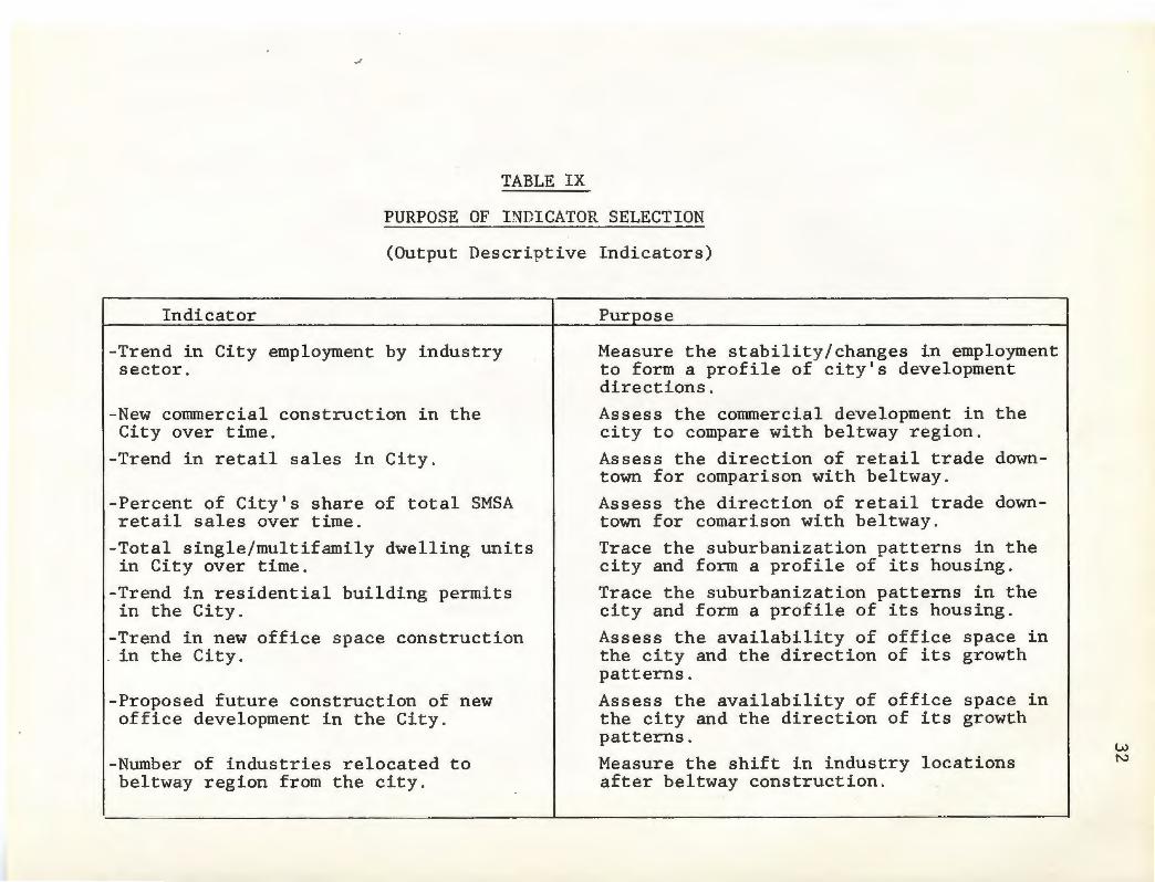
TABLE IX
PURPOSE OF INDICATOR SELECTION
(Output Descriptive Indicators)
Indicator
-Trend in City employment by industry sector.
-New commercial construction in the City over time.
-Trend in retail sales in City.
-Percent of City's share of total SMSA retail sales over time.
-Total single/multifamily dwelling units in City over time.
-Trend in residential building permits in the City.
-Trend in new off ice space construction . in the City.
-Proposed future construction of new office development in the City.
-Number of industries relocated to beltway region from the city.
Pu~ose
Measure the stability/changes in employment to form a profile of city's development directions.
Assess the commercial development in the city to compare with beltway region.
Assess the direction of retail trade downtown for comparison with beltway.
Assess the direction of retail trade downtown for comarison with beltway.
Trace the suburbanization patterns in the city and form a profile of its housing.
Trace the suburbanization patterns in the city and form a profile of its housing.
Assess the availability of office space in the city and the direction of its growth patterns.
Assess the availability of office space in the city and the direction of its growth patterns.
Measure the shift in industry locations after beltway construction.
w N

_,,
TABLE IX cont.
PURPOSE OF INDICATOR SELECTION
(Output Descriptive Indicators)
Indicator Pur_E_ose
-Trend in amount of space available in Measure the shift in industry locations the City's industrial parks. after beltway construction.
-New construction for manufacturers Measure the shift in industry locations in the City. after beltway construction.
-Trend in land uses in the City before Assess space use changes in the city and and after belt construction. relate to beltway land use changes.
w w

\
TABLE X
SELECTED INDICATORS BY CATEGORY
( 1960, 1970, 1980)
Side Effect Descri_E_tive Indicators
-Average number of miles the beltway is located from the city.
-Size of central city in square miles.
-Average cost of land per square foot in City/Beltway regions.
34
-Availability of utilities in Beltway region and City.

_,,
TABLE XI
PURPOSE OF INDICATOR SELECTION
(Side Effect Descriptive Indicators)
Indicator
-Average number of miles beltway is located from City center.
-Size of central City in square miles.
-Average cost of land per square foot in City/Beltway regions .
-Availability of utilities in City/ Beltway regions.
Purpose
Assess land area available for development within the beltway.
Compare to available land in suburbs and beltway region.
Assess differences in land values for city and beltway regions.
Assess the current development capacity of the available land in the city and beltway regions.
l.V V1

36
The indicators presented in Table I are divided by
type and purpose in Tables II to XI. A discussion of
the context in which they are viewed within the model
follows.
The Indicators within the Model
Demographic
The selected indicators in this functional area are
descriptive trends of population for cities and the
regions surrounding them. The primary function of
the indicators is to illustrate any suburbanization
effects that the beltway may have upon the city it
surrounds. For example, if the population of a city
decreases with a corresponding increase in beltway
corridor population over time, it indicates the city
may be losing population to the beltway corridor. It
is important to remember, however, that this is only
possible when the indicators are viewed in the context of
the entire model and its interrelationships.
Employment
The trends in the number of corridor or other geo
graphical area residents employed by industry sector are
descriptive indicators, which can be somewhat influenced
by beltway construction. They are important in assessing
the types of firms being served by the corridor and city,
in conjunction with the labor supply. The number of persons
employed by industry category is used to compare the city mix

37
with the regional mix, therefore assessing the differen
ces between the areas. This enables the analyst to
later assess any gross shifts of industry employment from
the city to the beltway corridor.
The city unemployment rates before and after construc
tion of the beltway are intended to describe any changes
the road may have caused in city employment, when used
along with the industry class shifts, and the nlllilber and
location of industrial parks. It is somewhat of a hy-
brid mix of analytic and descriptive indicator types.
Lastly, the measure of median family income for
city, SMSA and county residents is generally descrip
tive. It should follow the general statistical inference
of higher family income in areas outside city boundaries,
in most cases.
Housing
The trend in the years of structure construction is
intended to illustrate the phenomena of suburbanization.
In theory, the years .that structures in the beltway corri
dor were built would be more recent than the majority of
those in the central city. Beltways tend to attract
some new housing development, although as stated in
Chapter I, do not have as large an impact on the housing
market as believed in the early literature. The main
impact upon the city here is that new housing built in
the beltway region will detract from the central city

38
housing market. A second indicator which would aid in
the determination of trends in city and corridor resi
dential development is the number of building permits
issued for each geographical area in a time series. This
measure, in conjunction with the total number of single
family homes per year in each area should provide a fairly
accurate portrayal of the direction of residential
development, that is, whether it is staying in the city
or has moved to the beltway corridor towns.
The number of multifamily units constructed in the
city and corridor region, in addition to the number of
single family homes, illustrates the current and historical
mix of housing types in each area. It also gives a
sense of trends toward increased multifamily or single
family housing construction.
Economic - Retail/Commercial
The three main indicators in this category are
the new commercial construction in the beltway and city
areas over time, the number and location of regional
shopping centers built after the beltway was completed,
and the trend in retail sales for the belt and city regions.
The impacts upon the central city shown by all of the above

indicators tend to be somewhat negative. This is es
pecially true if a strong central city revitalization
movement does not exist. Regional shopping centers
39
are often located at or near beltway interchanges,
providing increased retail sales in the corridor region.
The beltway interchanges often attract retail establish
ments away from the city, where access is poor, parking
problems abound, and the potential market is less broad.
Off ice
The location and amount of office space, as well as
proposed future development of off ice space in the city
are the major indicators of beltway impact in this section.
They are intended to show the movement of off ice develop
ment away from the central city to the beltway corridor,
in addition to mitigation efforts by the city to attract
additional office development to offset any losses.
Industry
The trends in location of industrial parks are intended
to illustrate the attractive capacity of the beltway when the
proper mixture of ingredients is present . Beltways
attract industrial parks for a number of reasons: 1) ac
cessibility, 2) the proximity of other modes of transpor
tation, 3) the labor force mix, 4) the proximity of hous-
ing for employees, 5) the presence of utilities, and
above all others, 6) usable, available, and spacious

40
land. Therefore, all of the indicators selected for this
section must be employed as an interrelated group to
assess belt impacts.
Land Use and Transportation
The sixteen indicators included in these two sections
are generally descriptive. They illustrate the availability
and type of land available in the regions, the zoning require
ments, and what types of access exist . In addition, the
beltway can be described in fairly complete form through
the transportation indicators. The number and spacing of
interchanges are important elements for use with the economic
section, especially in judging the locational decision .
Again, interrelationships between these measures and the
indic~ ~ors of other categories should be keenly observed
for a clear assessment of belt impacts.
Summary
The indicators and the model of their interrelationships
have been presented in this chapter. The indicators were
based upon those measures used by beltway impact evaluators
in the case summaries . The model is constructed through the
employment of a social indicator model developed in Social
Indicator Models. 8 In addition, a number of new indicators
were chosen through a selection process of specific criteria,
and were assigned a positive, neutral or negative connotation
as they related to the beltway's impact upon the functional
area characteristics of the central city .

41
FOOTNOTES
1. This definition of the term social indicator differs somewhat from the generally accepted definition. Social indicators are defined as normative statistics which measure changing conditions; they are used in a time series, or disaggregated by other characteristics; and they are theory based, goal-connected, and based on the assumption of predictability of group behavior. (Joanne Cassulo, "The United State Self-Determination Policy in Indian Affairs: An Indicator Systems Policy Analysis," Unpublished thesis, University of Rhode Island, 1982.) p. 28.
2. Kenneth C. Land, Social Indicator Models ed. Land and Spilerman (New York: Sage Foundation, 1975) p. 18. The Land and Spilerman model is a complex social system model intended to measure the outcomes of social programs. Elements of the model which are used inthis project are the interrelational aspects of the indicators, and a modification of the indicator classifications . For example, Land and Spilerman's policy instrument indicators. are modified to become input descriptive indicators in the present model. In addition, the meaning of the indicator is somewhat altered, and is presented in the body of the report.
3. Ibid. pp. 30-31. (The units of measure which are used in the application of this model to the Interstate Route 295 case are cities and towns, rather than the larger aggregation of SMSA or county. This is due to the need for a more refined level of analysis than the aggregate data is able to provide. In many of the examples in this chapter, however, the SMSA and county references are included to provide the analyst with a choice of measurement units.)
4. Judith deNeufville, Social Indicators and Public Policy. (Elsevier Scientific Publishing Company: New York, 1975), p. 144.
5. Ibid., pp. 63-64.
6. Land, p. 18.
7. Ibid.
8. Ibid.

Introduction
CHAPTER III
PROVIDENCE, PJIODE ISLAND
AND THE ROUTE I-295 BELTWAY:
A CASE STUDY
42
Planning for a circumferential highway around Provi
dence, Rhode Island began in the early 1960's. It was
a part of the Federal-Aid Highway program of the United
States System of Interstate Highways enacted in 1956,
as were many of the beltway constructed during that
period. (See Chapter I)
The highway was constructed in part to solve the
traffic congestion problems of Providence and Route I-95.
In addition, economic development planners viewed the
belt as a chance to repeat the success of Boston's Route
128 as a manufacturing, office and high technology 1 center. The beltway's completion in 1975 has raised
the question of whether it has met with success.
This chapter is intended to provide a review of
Providence and its relationship with its beltway. The
chapter is structured in a similar fashion as the four
case sunnnaries presented in Chapter II; the review is
more comprehensive.
History
The 1959 study by Arthur D. Little, Inc. entitled

43
"Industrial Development and Highway Planning in Rhode
Island" recommended that "plans be prepared for the
construction of Interstate Route 295." At the time,
construction was planned to occur during the years
1960 to 1964, to coincide with the completion of
Interstate Route 95. (See Figure II ) Construction
of the highway was called for to alleviate traffic
congestion problems with through-traffic in Providence,
and with travel between suburban areas. These prob-
lems, in conjunction with the absence of a well-
developed mass transit system were viewed as the cause
of fragmentation in the Rhode Island labor market and
the reduction in the state's attractiveness to indus-
2 try. The highway system in the state, especially
in the Providence area, was extremely fragmented, and
was seen as detrimental to the locale's development.
At the time of highway planning, the city of Provi-
dence was losing population steadily. The eleven
towns which I-295 was proposed to pass through or near
were gaining actual population and in the 1950's ac
counted for nearly 70 percent of the state's population
growth. (See Table XII for a list of the towns.)
These trends have continued through 1960, 1970, and
1980. In 1980, the corridor towns held 37 percent
of the total state population, while the population of
Providence continued to decline.
The Basic Study Report prepared in 1962 for I-295
\
FIGURE II
1 I I I
- UISTllG llTUITATl MlllNAY SCMlDULlD ,01 COUTIUCTIOI
-- 11 TUTATIVl SYI PIOQIAll
•••• mrri;~m~.'01 ACClLUATlD
--· RADIUS COITAllllG 701 0, . STATl ,0,ULATIOI "
-- OTMU IOADS e llTUSTATE HIGHWAYS
0 US HIGHWAYS
I' I I I I I
INTERSTATE HIGHWAYS RECOMMENDED FOR ACCELERATED CONSTRUCTION
Source: <lrth11r ZD.l.i1tll' • .!111r.
44

TABLE XII
A LIST OF THE RHODE ISLAND TOWNS NEAREST TO ROUTE I-295
Coventry Cranston Cumberland East Greenwich Johnston
Lincoln
North Providence North Smithfield Smithfield Warwick West Warwick
45
Source: Arthur D. Little, Inc., Industrial Development and Highway Planning in Rhode Island, (Cambridge, Massachusetts, 1959.) p.10.

by Charles A. Maguire and Associates illustrated the
belief that the highway held great development poten
tial:
"Interstate Route 295 has the potential to
attract commerce and industry to the Metro
politan Providence area in much the same
manner as dramatically demonstrated by the
extraordinary and prospering developments
along Route 128 in Massashusetts. 113
The industry-attractive potential that the highway
had was supported by employment figures and new plant
46
construction in the 1950's . Although the state's
manufacturing employment was declining, the share of towns in
the corridor increased. 4 In addition, the bulk of
new plant construction was occurring in the suburbs, with
nearly 60 percent taking place in the corridor towns
in the 1950's. 5 (See Table XIII)
Although prosperous development scenarios were
envisioned for Route 295 at its inception, the
reality remains a question. A nlll!1ber
of factors have been identified by local economic
development officials. First, many feel that the
state was errant in not providing a development plan
for the highway corridor. With no specific development
guidelines, the advantages of the corridor were lost. 6
Secondly , and equally important, is the lack of utili
ites along much of the corridor. Water and sewage facil-
ities have not been provided in many of the corridor
communities, and according to one industrial develop-

47
TABLE XIII
PLANT ADDITIONS, NEW BUILDINGS, AND NEW PLANTS IN CORRIDOR TOWNS AND PROVIDENCE, 1955-19581
Additions, New Buildings, Town and New Plants New Plants Only
S_g_uare Foota_g_e Number S_g_uare Foota_g_e Number
Coventry 9000 1 9000 1 Cranston 199750 34 38000 9 Cumberland 198500 4 120000 1 East Greenwich 475000 1 475000 1 Lincoln 19452 2 19452 2
North Providence 4500 1 4500 1 North Smithfield 89000 3 79000 2 Warwick 413300 18 51000 8
% of State Total 58.7 41. 3 87.6 69.5 Providence 455693 so 71607 4
% of State Total 18.9 32.3 7.9 11.1
\ 1~ Includes only eight of the eleven towns originally mentioned in the report. Source: Arthur D. Little, Inc., Industrial Development and Hi~hway Planning in Rhode Island, (Cambridge, Massachusetts, 1959) p. 6.

ment commission member, "nothing has really developed
because there are no sewers. 117 Other reasons for the
48
relative lack of development success in many areas along
the I-295 corridor are the many other available locations
for industrial and commercial development in the state,
along with its relatively slow economic growth. 8
Key Elements in the City/Beltway Development Process
Demographics
As stated in the previous section, Providence's
population has been in decline since the 1940's. It
decreased from a high in 1940 of 253,504 to the present
level of 156,804 (1980), a decline of 38.1 percent. (See
Table XIV ) The decline, although a continuing trend,
is slowing somewhat.
The populations of each of the eight corridor towns
have been steadily increasing since 1940. 9 (See Table
XV ) The largest increase in population has occurred
in Smithfield, which had an increase of 266.2 percent
from 1940 to 1980. Smithfield has continued to increase
its population, with an addition of over 25 percent from
1970 to 1980. One town has decreased in population from
1970 to 1980, by 3.1 percent. The towns currently (1980)
hold a 62.2 percent share of the state's population growth, and
29.8 percent of its total population.
Both Providence and the eight towns are part of the
Providence-Warwick-Pawtucket SMSA. Due to size of the
SMSA, data was employed for the corridor towns only.

49
TABLE XIV
CHANGE IN PROVIDENCE POPULATION
1940-1980
Year Po_Qulat ion Percent Chan_g_e
1940 253,504
1950 248,674 -1. 9
1960 207,498 -16.6
1970 179,116 -13.7
1980 156,804 -12.5
1940-80 -38.1
Source: Rhode Island Department of Economic Development, Basic Economic Statistics 1982-83, R.I . Dept. of Economic Development, 1982.

50
TABLE XV
POPULATION TRENDS OF THE CORRIDOR TOWNS
% Change % Change % Nonwhite Town 1980 Po_E_ . 1940-80 1970-80 Po_E_ulation, 1980
Cumberland 27,069 154.8 1. 7 2.0 Lincoln 16,949 60.2 4.7 1. 6 Warwick 87,123 203.0 4.1 1. 7 Smithfield 16,886 266.2 25 . 4 1.1 Johnston 24' 907 133. 4 13 . 0 0.8 Cranston 71,992 52.9 -3.1 2.4 West 27 , 026 48.6 11.1 2.4 Warwick No. Smith- 9,972 137.7 6.7 1. 0 field
Total 281 , 924
Source: Rhode Island Department of Economic Development, Basic Economic Statistics 1982-83, R.I Dept. of Economic Development.

. 51
Employment
The largest sector of employment in the city of
Providence historically has been manufacturing. (See
Table XVI ) However, trends indicate movement away
from that sector toward the services sector, which
showed the greatest growth between 1960 and 1980, near
ly 156 percent. It is one of the few sectors which
has increased during the last twenty years. Manu
facturing has also lost in its share of total employ
ment, while the services sector increased from an 8. 2
percent share in 1960 to a 32.8 percent share in 1980.
Total employment in the city has followed national
trends, decreasing over 36 percent from 1960. In
addition, the total number of establishments has de
creased.
The Providence labor force has decreased over seven
percent since 1970, while the unemployment rate has
increased, following national trends.
The eight corridor towns are primarily oriented
to manufacturing, the major industry sector for the past
twenty years. (See Table XVII ) There has been
a 63 percent increase (1960-80) in the number of employees in
the manufacturing sector within the corridor. This is
due primarily to the increase in industrial parks in
the area. There are presently eleven industrial parks
located in the corridor.

TABLE XVI
INDUSTRY OF EMPLOYED PERSONS
IN PROVIDENCE , 1960 - 1980
52
Sector Percent Percent Percent Percent Change
Construction & Mining
Manufacturing
Transportation & Cormnunication
Wholesale & Retail Trade
Finance, Insurance & Real Estate
Services
Public Administration
Total Employment
Total Number of Firms
1960 1970 1980 1960 - 1980
3.4 2.6 NA NA
46.0 42.9 31. 7 -56.0
8.9 9.1 4.4 -68.8
23.8 21. 9 16.4 -56 . 0
9.8 12 . 3 NA NA
8.2 11. 3 32.8 155 . 8
NA NA 6.1 NA
103,096 97,766 65,786 -36.2
7 , 840 6,560 NA NA
Sources: U.S. Dept. of Connnerce, 1980 County Business Patterns.
R. I . Dept . of Economic Development, Basic Economic Statistics 1982-83 , (R . I . D. E . D., Providence, R . I., 1983).

l
TABLE XVII
EMPLOYHENT TRENDS BY INDUSTRY
53
FOR THE I-295 CORRIDOR REGION, 1960 - 1980 1
Sector
Agriculture, Forestry & Fishing
Mining
Construction
Manufacturing
Transportation/ Communications
Wholesale & Retail Trade
Finance, Insurance, Real Estate
Services
Total Employment
Number of Firms
1960
178
67
1289
20686
878
5980
539
1856
31997
3586
% of Total
0.6
0.2
4.0
64.6
2.7
18.7
1. 7
5.8
1970
199
84
2663
26884
1563
12740
855
4712
50037
4529
% of Total
0.4
0.2
5.3
53.6
3.1
25.5
1. 7
1980
354
72
2498
33726
2250
22926
4362
% of Total
0 . 4
0.1
3.1
41. 8
2.8
28.4
5.4
9.4 14581 18.1
80777
6315
1. All data was collected in the month of March in each respective year. Source: R.I . Dept. of Employment Security, Employment Covered by R.I. Employment Security Act, 1960, 1970, 1980.

\
54
The sector which show the greatest increases in
employee numbers are sel!'vices, finance, insurance and
real estate, and wholesale and retail trade. This has
been a result of the new office and retail construction
occurriing the~ southern part of the belt. lO
Total employment in the towns increased over 150
percent between 1960 and 1980. (See Table XVII) The
movement of population to the suburban areas, in addi
tion to the shifting of manufacturers from city-based
locations to outer regions have been the key factors
in this increase.
Trends indicate a comparable rise in the total
labor force residing in the corridor towns. (See
Table XVIII) In 1980, the corridor region comprised
nearly one-third of the state's total labor force,
and 24 percent of its total employment.
Income
In all three census years examined, the median fami
ly income in the city of Providence is lower than that
of the median income for the state. It has also in
creased at a slower rate than the Rhode Island med•ian.
Median family income in the corridor region has
increased at a somewhat faster rate than the state
average, with the state figure on the low side of the
corridor range. In all three years, the low end of
the range has been higher than the median family income
in Providence. (See Table XIX)

\
Year
1960 1970 1980
TABLE XVIII
TRENDS IN THE LABOR FORCE OF THE CORRIDOR REGION, 1960 - 1980
Number in Percent of Percent Labor Force State Total Chan_g_e
89,579 24.9 117,215 28.0 30.9 142,297 30.6 21. 4
55
Source: Rhode Island Department of Economic Development, Basic Economic Statistics 1982-83, (R.I. D.E.D., Providence, Rhode Island, 1983)

Year
1959 1969 1979
56
TABLE XIX
TREND IN THE RANGE OF MEDIAN FAMILY INCOME IN THE CORRIDOR TOWNS, 1959, 1969, 1979
Corridor
$5,549-6,390 $9,485-11,311
$18,332-24,016
Rhode Island
$5589 $9,739
$19,448
Providence
$5,069 $8,430
$14,948
Source: R.I. Department of Economic Development, Basic Economic Statistics 1982-83, (R.I. D.E.D, Providence, R.I., 1983)

Housing
The trends in numbers of building permits issued
for residential units between 1965 and 1980 show that
57
although fewer homes were built in Providence in 1980,
the city's share of permits issued dropped by nearly
fifty percent. and also lost in its share of the total
permits issued for Rhode Island. (See Table XX)
The number of single family homes in the city rose
68.7 percent between 1970 and 1980 , while the total
multifamily units dropped. In the corridor region,
single family homes increased by over 28 percent from
1970 to 1980, and increased 12 percent in multifamily
housing in the same period. (See Table XXI)
Economic - Retail/Connnercial
The trend in retail sales for the city of Provi-
dence illustrates a loss of sales between 1970 and 1978
of 21 percent . During this time the corridor region
gained in sales by 42 percent, supplementing a 136
percent gain in the 1962 to 1970 period.
Providence has higher per capita retail sales
than the corridor region, although it decreased from
1970 to 1980. The corridor region increased over
' 150 percent between 1962 and 1978, while retail sales
in the city increased only 38 percent during that time.
Four regional shopping centers have been constructed
in the beltway corridor since 1965. (See Table XXII)
Three of these centers, the Lincoln Mall, the Midland

58
TABLE XX
TREND IN RESIDENTIAL BUILDING PERMITS IN PROVIDENCE AND CORRIDOR REGION, 1965-1980
% of % of % of Area 1965 3tate 1970 State 1980 State
Corridor 1702 38.5 1579 33.0 865 29.6
Providence 164 3.7 235 4.9 193 6.6
State 4422 4790 2925
Source: R. I. Department of Economic Development, Basic Economic Statistics, 1968, 1975, 1982-82.
TABLE XXI
NUMBER OF SINGLE AND MULTI-FAMILY HOMES IN PROVIDENCE AND THE CORRIDOR REGION, 1970, 1980
Single family Multifamily Area 1970 1980 % Chan_g_e 1970 1980 % Chan_g_e
Corridor 59,199 76,148 28.6 23,335 26,139 12 . 0
Providence 14 '7 82 24,933 68.7 53,339 42,531 -20.3
Sources: U.S. Department of Connnerce, U.S. Census of Housing, 1970, 1980.

Center
Apple Valley Mall Lincoln Mall Midland Mall Warwick Mall
TABLE XXII.
REGIONAL SHOPPING CENTERS BUILT AFTER 1965
Location S_quare Footage
Smithfield NA Lincoln 536,000 Warwick 483,248 Warwick 1,009,196
59
Date 0_E_ened
1966
NA 1967 1970
Source : The Providence Journal and Evening Bulletin, Shopping Centers in Rhode Island, 1982.

60
Mall and the Warwick Mall are the three largest shop-
ping centers in the state . The locations of the
malls are illustrated in Figure III.
Construction of new commercial spac~ which includes
office, hotel/motel, and banks, as well as retail, finds
Providence in a declining trend. It has moved from
a 30 percent share of the state's cormnercial construe-
tion to a six percent share between 1966 and 1980.
(See Table XXIII)
The I-295 corridor has remained fairly consis-
tent in its share of the state's new cormnercial con-
struction, although the total amount built has been
declining. In 1980, the corridor held a 36.7 percent
share of the state total, while the city's share was
6.4 percent .
Manufacturing
In 1982 there were eleven industrial parks con
structed adjacent to or within one mile of the Route
I-295 beltway. (See Appendix II for a list of the
parks.) There were over 830 total acres of industrial
parks, of which 431 (52 percent) were occupied . The
industrial areas occur primarily in the northern
half of the belt, in the towns of Smithfield, Cumberland
and Lincoln, where utilities and industrial zones
are available. (See Figure IV)
Nearly 11,000 acres of land area in the corridor
was zoned for industrial use in 1977. 11 Only 22 percent

61
FIGURE III
LOCATIONS OF THE REGIONAL MALLS
BURRILL VILLE
SCITUATE
COVENTRY
LEGEND: No. 7 - Apple Valley Mall No. 57 - Lincoln Mall No. 69 - Midland Mall No. 109 - Warwick Mall Source: Providence Journal-Bulletin, Guide to R.I. Shopping Centers, 1981

62
TABLE XXIII
NEW COMMERCIAL CONSTRUCTION
IN PROVIDENCE AND THE I-295 CORRIDOR, 1966-19801
(l,OOO's of Square Feet Floor Space)
1960 1970 1980 % of % of % of
Area Total State Total State Total State
Corridor 891 38.8 548 28.1 338 36.7
Providence 698 30.4 10222 52.3 59 6.4
State 2294 1953 921
1 . Projects of 50 , 000 square feet or greater. Incluaes office, retail, banks, and hotels .
2. Includes new Prov~dence Civic Center .

FIGURE IV
63
Land Zoned for Industrial Use
1977
Source: R.I. Statewide Planning Program, Technical Report No. 76, 1978.

of this, 2,450 acres, was used for industry. Ap
proximately half of the available zoned land was
vacant in 1977. Lack of utilities appeared to be an
important factor in this high vacancy figure, along
with topographical and soil constraints. Over 19
percent of the sites lacked sewers, 5.7 percent
64
lacked gas, and 3.3 percent did not have access to
water. Approximately one-third of these zones con
tained some type of soil or topographical element which
restricted development of the site.12
There are 46 sites zoned for industrial use within
five miles of the I-295 beltway.13 Eighty-five percent
of these sites are partially or wholly occupied by
some type of industry. This indicates a high per
centage of vacant space in many of the industrial zones.
In the city of Providence there were 2,312 acres
of land zoned for industrial use, of which over 50 per
cent were actually occupied by industry in 1977. Only
18 percent of the available sites were left vacant. All
of the sites had utilities available, and most had
good access to all major modes of transportation.
As stated in the employment section of this chapter,
manufacturing is the largest employer in the corridor
towns. In 1980 there were 919 manufacturing firms in
the corridor, up from 627 in 1970, a 46.6 percent increase.
The manufacturing sector was also the largest in Provi-

65
TABLE XXIV
NEW CONSTRUCTION FOR MANUFACTURERS IN PROVIDENCE AND THE CORRIDOR REGION
1961 - 1981
(l,OOO's of Square Feet of Floor Space)
1961 1962 1963 1964 1965 1966 1967 1969
Corridor 271 319 540 293 433 770 360 405 604
1970 1971 1972 1973 1975 1976 1977 1978 Providence 00 55
Corridor 548 571 1255 1083 439 150 766 677 365
1979 1980 1981 Providence 7
Corridor 760 491 404
Source : R.I. Department of Economic Development, Basic Economic Statistics, 1968 , 1975 , 1982-83.

14 dence, but dropped 8.4 percent from 1970 to 1980.
New construction of manufacturing firms in the
corridor towns dropped from 548 in 1970 to 491 in
1980. This represented a -10.4 percent change.
During the same time period, new manufacturing con-
struction in Providence dropped 79 percent to the low-
15 est number of starts in twenty years. (See Table
XXIV)
Land Use
The 19.1 square miles which compose the city of
Providence is comprised primarily of urban lands. 16
As in most cities, high density residential land makes
up the majority of the space usage. Open and public
lands follow, with a 12.0 percent share of the total.
(See Table XXV)
66
Over seven percent of the city's land is in indus-
trial use, of which 75 percent is heavy industry. Provi-
dence' s transportation network also comprises a large
percentage (9.5 percent) of its land area.
Forest land comprises nearly half (48 percent) of
the total land area in the eight highway corridor
towns. (See Table XXVI) It is followed by urban land
(30 percent) and agricultural/open lands (13.3 percent).
Development is inhibited in many corridor areas by
topography and soil constraints, such as sharp slopes
and rocky ledge.

67
TABLE XXV
LAND USES IN THE CITY OF PROVIDENCE (1970)
Land T_YE_e Acrea_g_e Percent of
Urban Land 10,107 82.7 Industrial 867 7.1 Commercial 1,353 11.1 Residential 5,254 42.9 Transportation 1,167 9.5 Open and Public 1,466 12.0
Outdoor Recreation 651 5.3 Agriculture/Open 123 1. 0 Forest Land 526 4.3 Wet Land 795 6.S Mining, Waste 22 0.2 Total 12,224 100.0
Source: William P. Macconnell, Remote Sensing Land Use and Vegetative Cover in Rhode Island, Cooperative Extension Service, University of Rhode Island, 1974.
Total
a) Due to the unavailability of current land use data by city and town, data presented is for the year 1970 unless otherwise stated.

68
TABLE XXVI
LAND USES IN THE I-295 CORRIDOR REGION
Land T_Y.E_e Acrea__g_e Percent of Total
Urban Land 37,475 29.9 Industrial 1,645 1. 3 Commercial 2,357 1. 8 Residential 25,623 20.4 Transportation 3,627 2.9 Open/Recreation 3,923 3.1
Outdoor Recreation 2,085 1. 7 Agriculture/Open 16,633 13.3 Forest Land 60,157 48.0 Wet Land 7,850 6.3 Mining/Waste 1,523 1. 2
Total 125,423 100.0
Source: William P. Macconnell, Remote Sensing Land Use and Vegetative Cover in Rhode Island, Cooperative Extension Service, University of Rhode Island, 1974.
\

69
Although open land predominates in the corridor,
there has been increases in both commercial and in-
dustrial uses. This is especially true of the northern
corridor towns, where utilities and zoning are well-
. d . d . 1 17 suite to in ustria ust.
Transportation - Highways
The regional transportation system of Providence
and the surrounding towns centers around Interstate
Route 95, which passes directly through the city. (See
Figure V ) The major radials connecting the city
to I-295 and the outlying region are R.I. Route 146,
U.S. Route 44, U.S. Route 6, R.I. Route 195, R.I.
Route 14, R.I. Route 7, R.I. Route 122, and R.I. Route
114. Route I-95 south connects with I-295 at its
southernmost point, in Warwick. The distance from
any one point on Route I-295 to the center of Provi
dence through this system of radials varies from 5 to
13 miles, with an estimated travel time of 10 to 20 min
utes.18
There are eleven interchanges along I 295 in Rhode
Island, at the following locat iions :
1. R. I. Route 114 in Cumberland.
2. R. I. Route 122 in Cumberland .
3. R . I. Route 146 in Lincoln.
4. R. I. Route 7 in Smithfield.
5. U. S. Route 44 in Smithfield.
6. U.S. Route 6 in Johnston.
7. R. I. Route 195 in Johnston.
8. R. I. Route 14 at the Johnston/Cranston line.

FIGURE V
RHODE ISLAND HIGHWAY SYSTEM
,.,., ,. 11 ... 11.
0 c ...... u.,
INTl .. HATI HtQttWAYS
'"IMA•Y ll'OUTll ,...,., __ .. _ ... ecc:••··-----OIMt .,.,., r-t••-----
70
R I 0 l 0 RESEARCH DIVISION
.JUN[ 1982
---

71
9. R.I. Route 37 in Cranston.
10. R.I. Routes 2 and 113 in Warwick.
11. Interstate Route 95 in Warwick .
The highway is approximately 23 miles in length, dis
tributed as follows: Warwick, 1.5 miles; West Warwick,
negligible mileage; Cranston, 4.3 miles; Johnston,
5.3 miles; Smithfield, 5.7 miles; Lincoln, 2.4 miles;
Cumberland, 3.2 miles. The addition of Interstate
Routes 95 and 295 has significantly reduced automobile
travel times. Route 295 has played an important role
in opening up the northwestern Rhode Island area to
development .19 (See Figure VI)
Average daily traffic on the beltway has increased
substantially since the completion of its last seg
ments in 1975. (See Table XXVII) 20 There has been a
large increase at each of the counters located on
I-295, with the exception of the Mendon Road to Diamond
Hill Road segment, and the counter at the Massachusetts
state line . Since the opening of the last segment of
I-295, from Route 6 to Route 44, average daily traffic
has increased by approximately 23,000 vehicles per day.
In another substantial increase, traffic on the belt
near the mall area increased by nearly 8,000 vehicles
per day.
Transportation - Rail and Air
There are currently two freight lines which serve
the corridor towns of Cranston, West Warwick, Lincoln

CONN
72
FIGURE VI
RHODE ISLAND TRAVEL TIMES (1955-82)
IUllllll lU,.Yl ll(
W(Sf
30 Minutes from Providence
.. .
Source: R. I. Dept . of Economic Development, Basic E·conornic Statistics, 1982-83 (Providence, R. I ., R. I . D.E.D ., 1983 . )

Area of Concern
Land Use
Transportation
81
TABLE XXVIII cont.
Indicator r ·.
Availability X=Yes N=No
Trend in City land uses before and after belt construction. Trend in belt region land uses before and after belt
N
construction. N Size of central city in square miles. X Average cost of land per square foot in City. X Average cost of land per square foot in belt region. N Location of development con-straints in City. X Location of development con-straints in belt region. X
Trend in average daily traffic on beltway. Number of interchanges on
x
beltway. X Spacing of interchanges on beltway. X Length of beltway in miles. X Extensivenes of radial system. X Evidence of pollution prob-lems generated by belt. N Usage of belt by public tran-sit. N Number of automobiles availa-ble per family . X Years of beltway construc-tion. X
•'

Area of Concern
Economic: Retail/ Commercial
Off ice
Industry
80
TABLE XVIII...: cont.
Indicator Availability X=Yes· N=No
Trend in location of regional shopping centers before and after beltway. New commercial construction in beltway region. Trend in City retail sales. Trend in beltway region retail sales.
Trend in location of new office space in City after beltway construction. Trend in location of new office space in beltway region
x
x x
x
N
after construction. N Proposed future construction of office space in City. X
Trend in location of industrial parks after beltway construction. New construction f©r· manuf ac-
x
turers in City. X New construction for manuf ac-turers in beltway region. X Trend in industry mix in City. X Available labor force in belt-way region. X Number and location of availa-ble industrial zones in City. X Number and location of availa-ble industrial zones in belt-way region. X Number of industries relocated to belt region from City. N Trend in amount of available space in City's industrial parks. X

79
TABLE XXVIII
THE AVAILABILITY OF INDICATORS FOR USE IN THE I-295 CASE STUDY
Area of Concern
Demographics
Employment
Housing
Indicator
Trend in City population. Trend in SMSA/County/Corrid,or population. Trend in nonwhite City population. Trend in SMSA/County/Corridor population.
Trend in City employment by industry class . Trend in SMSA/County/Corri-
Availability X=Yes N=No
x
x
x
x
x
dor employment by industry. X Unemployment rate in City. N Unemployment rate in SMSA/ County/Corridor. N Median family income of City. X Medd..an family income of SMSA/ County/Corridor. X
Total single/multifamily dwelling units in City. Total single/multifamily dwel-ling units in SMSA/County/
x
Corridor. X Trend in residential building permits in City. X Trend in residential building permits in SMSA/County/Corri-dor. X Year structure built in City. N Year structure built in SMSA/ County/Corridor. N

-CHAPTER IV
APPLICATION OF THE INDICATOR MODEL TO THE INTERSTATE ROUTE 295 CASE
Introduction
78
The focus of this chapter is an application of the
model (organizational framework) presented in Chapter III
to the case study of Interstate Route 195, to determine
impacts upon Providence, Rhode Island. It is organized
into five areas of concern: demographics; employment;
housing; economic, including retail/commercial, office,
and manufacturing; land use and transportation. Within
these areas, the interrelationships between indicators
are examined, and conclusions drawn as to whether the
beltway has exerted a positive, neutral or negative influ
ence upon the central city.
Although the majority of indicators selected for use
within the model were available, some were not. A list
of the indicators and their availability for use in this
case study is presented in Table XXVIII.
Analysis of Beltway Impacts by Area of Concern
Demographics
The key indicator relationships within this section
are those between the population of Providence and that
of the corridor towns. The data show a steady decline in
the city's aggregate population since 1940, while the
corridor towns have all increased in population. This

FOOTNOTES
1. Charles A. Maguire, Basic Study Report - Interstate· Route 295: Warwick, West Warwick, Cranston, Johnston and Smithfield (Boston, Mass.: Charles A. Maguire and Associates, Engineers, 1959.) p. 10.
2. Arthur D. Little, Inc., Industrial Development and Highwah Planni~g in Rhode Island (Cambridge, Mass.: Artur D. Little, Inc., 1959.)
3. Charles A. Maguire and Associates, p. 10.
4. Arthur D. Little, Inc., p. 14.
5. Ibid.
6. Gregg Krupa, title unknown, Providence JournalBulletin, November, 1, 1981, p. F-1.
7. Ibid.
8. Ibid.
75
9. The eight corridor towns examined in the remainder of the paper are those the beltway passes through, or nearly through: Cumberland, Smithfield, North Smithfield, Cranston, Johnston, Warwick, West Warwick, Lincoln.
10. Interview with Marcel Valois, Blackstone Valley Chamber of Commerce, Pawtucket, Rhode Island, April 11, 1983.
11. R.I. Statewide Planning Program, Land Zoned for Industrial Use - Technical Pa~er No. 76 (Providence, Rhode Island, R.I. Statewidelanning Program, November, 1978.) p.9.
12. Ibid., p. 12.
13. Ibid.
14. R.I. Department of Economic Development, Basic Economic Statistics - 1982-83 (Providence, Rhode Island, R.I. Dept. of Economic Development, 1983.) p. 94-95.
15. Ibid.
16. Urban lands are defined as res.idential, commercial, industrial and transportation larlds.

17. Dieter Hammerschlag, The Interstate Hi9hwRt System and Urban Structure: · A F'orce for Chan e in · ode Is an Provi ence, o e Is an : R.I . Dept. o Transportation, 1976.) p. 33.
18. Rhode Island Dept. of Connnunity Affairs, Ma~or Jrndustrial s·ites on· Interstate 295 in Rhode Islan (Providence, Rhode Island: R.I. Development Council, 1970.) p. 2.
19 . Ibid., p. 295.
20. Interview with Marcel Valois.
21. R.I. Department of Economic Development, p. 110.
77

TABLE XXVII
AVERAGE DAILY TRAFFIC ON ROUTE' I-295
Loaation
Near Warwick & Midland Malls
Plainfield Pike to Rte. 195
Rte. 6 to Rte. 44
Louisquisset Pike to Mendon Road
Mendon Road to Diamond Hill Road
At the Massachusetts line.
(1974, 1975, 1981)
1974
10,400
16,000
Not Open
9,100
12,100
13,000
1975
13,800
21,700
11,200
14,700
14,300
13,000
1981
21,700
27,800
34,200
16,100
12,300
13,900
Sources: R.I. Department of Transportation, Traffic Flow Map, 1981.
Providence Journal Bulletin, Paul A. Kelly, "Counts show traffic diminished at spots along Route 95," November 9, 1975.
73

and Cumberland. Access to the main Conrail line is in
downtown Prov~dence. 21
74
The Theodore F. Green State Airport in Warwick, and
the North Central State Airport on the Smithfield/
Lincoln town line provide the main air access to the
Providence, I-295 area. The Theodore F. Green State
Airport is the state's largest, and is located 12 minutes
by vehicle from Providence. The North Central Airport
serves primarily private air traffic.
Summary
This chapter has presented a compendium of data re
garding Pl:r.ovidence, Rhode Island and Interstate Route
295. The trends and changes are intended to show the
impacts of the beltway upon Providence when set to the
indicator model. In addition, the material represents
an information system which can be employed in future
studies of the highway and its impacts.

82
illustrates a trend toward the suburbanization of the city.
However, it is an outward movement which occurred before
the initiation of beltway planning and construction. There
fore, the belt has probably had some affect on this trend,
but is not solely responsible for the shift. This leads
to a neutral ranking within the model structure.
The area in which the beltway did impact the suburb
anization of population is in providing improved accessi
bility to towns which were previously lacking in such access.
The state and town road system which served these towns
previously, especially Cumberland, Smithfield and John-
ston, did not provide for extensive accessibility. In
this capacity, the beltway opened up more development
opportunities in the outer region, while the city re-
mained in its current mode. Since the beltway did not have a
significant impact upon the city in this area, the neutral
rating remains.
Employment
The indicator relationship which illustrates belt
impact upon city employment is that between the employ
ment by industry class, and the indicators of the retail/
corrnnercial, office and manufacturing sections. The city
of Providence has shown a shift in its employment mix
from manufacturing to services in the past twenty years.
Beltway construction has directly contributed to

83
this shift. First, as the employment in the manufactur-
ing sector in the city has dropped, manufacturing employ
ment in the corridor towns has risen dramatically. Sec-
ondly, the amount of land available for the development
of industrial sites in the corridor is much greater
than in the city, due to the large differences in land
area . This has lead to increased manufacturing cons-
truction in the corridor, weakening the amount of
construction occurring in the city. This, in turn,
leads to a loss in the city's share of manufacturing
employment.
In addition, the corridor holds a much greater
share of the new connnercial construction that the city.
This, coupled with the shifting population, removes much
of the employment in the retail and wholesale trade
sectors of the city. This is evident also by visual
inspection of both areas. While the city has lost a
number of its leading retail employers, the beltway
corridor has gained four regional shopping centers and 1 the employment generated by them.
The employment sector of finance, insurance and real
estate has remained fairly consistent in its share of
Providence's total employment, while the same sector
has increased over 700 percent in the corridor region.
This is due primarily to the construction of a major

84
insurance firm's headquarters in the city of Warwick
in the early 1970's. While this appears to have had some
impact on this sector in Providence, closer inspection
finds that the belt had little impact in the relocation
of this firm. The access provided by Route I-95 seems
to have had more impact on its locational choice.
Thus the beltway has exerted primarily a negative
impact upon the central city's employment sector. Again,
it cannot be viewed as the sole cause of these alterations
but as a major contributor. It appears that as the popu
lation moves outward, the businesses and employment
opportunties follow.
Housing
The indicators employed to determine I-295's impact
upon the housing conditions in Providence are the number
of single and multi-family homes constructed, and the
trends in residential bui ] ding permits. The key concept
in the examination of housing, as with population, is
suburbanization.
The city of Providence has remained consistent in
its total number of housing units, with the major share
of that in multifamily housing. The corridor has gained
nearly one quarter of its total number of units, and
remains primarily single family oriented. It is not
clear from these shifts whether I-295 has had a major
impact upon the city. Rather it appears that it has

85
exerted a positive impact in the corridor towns, and a
neutral impact in the city.
While the total nmnber of residential building per
mits has decreased for both the city and the corridor,
the city has shown an increase in its share of the state's
total housing units. At the same time. the corridor
region has dropped in its share of the total units in
Rhode Island. This information, coupled with the fact
that the city has a higher number of multi-faTiily units
and the differences between median family income
the city and the corridor, may indicate a trend toward
movement back to the city by a certain segment of the
population. This is viewed as a positive impact upon
the city, and one in which Route I-295 is not playing
an important role.
The overall impact of the beltway upon the city in
the area of residential development and suburbanization
is a neutral one. Other factors have had more of an
affect upon the suburbanization of Providence than the
construction of Route I-295, including the large network
of radial highways along which the bulk of the new cons
truction took place during the 1950's and 1960's.
Economic - Retail/Cormnercial
It is in this sector that the beltway has exerted
definite impact upon Providence. Three main indicat0rs

86
have been selected to illustrate the shift in the city's
retail sector. First, the trends in retail sales show
a definite loss in the city's retail sales in the years
before and after beltway construction. This loss has been
a function of a complex set of factors, of which
beltway construction is one. Since four regional shop-
ping centers have been built in the corridor region since
construction of the beltway began, retail dollars have
risen sharply. At the same time, the city has lost its
major anchor stores, and has taken a sharp drop in its
share of Rhode Island's new commercial construction. The
added accessibility, larger market area, and trend
toward a private transportation oriented society have led
to the negative impact of beltway construction upon the
city's retail vitality.
Employment trends in the city also support this
finding. There has been a substantial drop in employ-
ment in the retail and wholesale trade sector in Provi-
dence, and a corresponding leap in corridor employment
in the sector .
Economic - Off ice
Data for the development of indicators in this
category was unavailable. However, interviews with area
planners and city officials provided some insight into the 2 beltway impacts upon this category. The same commer-
cial construction data employment in the retail/commer
cial category is applicable here since it includes

87
office construction. This indicates the belt region
holds a larger proportional share of new coilllllercial con-
struction in the state since beltway construction, includ-
ing office space. The officials interviewed, however,
felt that the highway had not had an extensive impact
on the city's office sector. It was pointed out that
employment in the service and finance sectors have grown
since the initiation of belt construction, and that no
large office projects have been undertaken in the belt
way corridor, with the exception of the Metropolitan
Life Insurance firm in Warwick, discussed in a previous
section of this chapter.
In addition, the city is presently experiencing
large gains in new office construction. Three major
office centers have been completed, or are in the last
stages of construction at the present time, and two
additional off ice buildings are designated for comple
tion in 1985. 3 The Capital Center Project, which is
the largest single development project in Providence
since the 1960's is scheduled for completion in 1988. 4
Of the eleven designated parcels in the project, office
. h f d . . 5 space is t e pre erre use in nine.
Therefore, although quantifiable indicators are
weak in this category, the neutral impact of the beltway
on the city's office sector is visible.
Economic - Manufacturing
There are a number of key indicator relationships
which show the impact of I-295 upon Providence's manu
facturing sector. First a comparison of the amount of
developed industrial park area in the city and
in the corridor towns is necessary. In Providence
88
there are three industrial parks, comprising 330 acres. 6
Over 95 percent of these parks are actually developed.
The acreage in industrial park use in the I-295 corridor
was substantially larger (830+ acres) than in Providence,
but only 50 percent of the parks were in a developed
statein 1980. Occupancy of the incustrial parks in the belt
corridor has been slow, due to the unavailability of
utilities in many areas adjacent to the beltway. 7 Al
though this indicator illustrates, in part, that indus
trial development 'Was induced by the beltway, it does not
show the impact of such development upon the city.
Therefore, other indicator relationships are necessary.
The measure of new construction for manufacturers
provides a more useful picture of the city and beltway
trends. (See Chapter IV) In the early 1960's, when the
initial beltway planning was underway, new manufacturing
construction in Providence outdistanced that of the
corridor towns. (See Table XIII ) Soon after, however,
new industry growth shifted to the outlying towns,
and has been consistently higher in those towns since

89
1962. In addition, while manufacturing employment in the
city has decreased since beltway construction, it has
increased in the corridor. This forms a key inter-
relationship which illustrates the attraction of manu
facturing firms to the outlying corridor regions. 8
There is also more potential for industrial growth in
the corridor than in Providence. This is illustrated
by the number and percentage of development of industri
ally zoned land. Over 50 percent of such land is developed
in the city, while less that 25 percent of a substantially
larger land area is developed in the corridor.
These indicator relationships, when viewed in the
context of dynamic interaction, represent an overall
negative impact of I-295 upon Providence's manufacturing
sector.
90
Land Use
The land use indicators employed in the model pro-
vide a profile of existing land uses within each geo
graphic area. The main indicator relationships within
this category show an assessment of the potential for
growth in the city versus the beltway. Examination of
the land uses in Providence shows a very low percentage
of open space for development. The large number of
forest and open acres in the corridor region shows a
potential for substantial increased development. There
fore, it can be assumed that a larger proportion of future
development will occur in the beltway region, rather than
in the city. This assumption relies on a complex set
of interrelated elements, including the provision of
utilities in the beltway corridor, the attractive forces
of the beltway versus those of other areas within the
state, and the type of development that is predicted.
For instance, trends show Providence is remaining the office
center of the state, and there are no indications that
the beltway towns will attract a substantial percentage
of new office construction in the future. There are a
number of factors underlying this trend . First, the belt
area does not have any existing office centers, which would
be an attraction to other office developers. Providence
is the state center for office development, a trend which is 0
projected to continue for the next ten years, at minimum.J

Second, the revitalization efforts of Providence busi-
nesspeople and municipal officials have been strong.
A number of large development projects are underway,
in addition to improved transportation facilities. 10
The city is being marketed, while the beltway corridor
is not. This is playing, and will continue to play,
an important tole in land use trends in both areas.
This example is not applicable to every function-
al area, for it is evident that areas such as manu-
f acturing and retail trade will continue to thrive
91
and grow in the beltway corridor. However, every
revitalization or planning effort in the city will
affect beltway development, and vice versa. Therefore,
in considering the land use trends and future possibili-
ties, planning should be a key focus.
In addition, to the growth potential in each area,
development constraints must also be examined. Physi-
cal constraints, namely topography and slope, soils,
wetlands, and extremely rocky areas, are development
inhibitors, and direct where growth will occur. There
are relatively few physcial constraints in the city,
with its major inhibitor being the amount of existing
development. In the beltway corridor, steep slopes,
11 poor soils, rocky ledge and wetlands abound. Future
development in this area will be directed by these
constraints, and in turn, will affect the amount of
development attracted to the belt corridor from the city.

Transportation
There are four key points of analysis in this
section. First, is the relationship between the belt-
way and the extensive radial system of highways con-
necting it to Providence. Second is the number of
interchanges along the length of I-295, and the mile-
age within each corridor town. The third point is
the trend in average daily traffic onthe beltway,
and on the other major interstate serving Providence,
Route I-95. Lastly, the other modes of transportation
available and their proximity to both the beltway and
city locations.
92
There are eight radial highways connecting the city
of Providence with Route I-295, in addition to Route
I-95 .13 This highway system serves all of the corridor
towns, and was in place for many years before I-295.
Thus, it has been developed to a large extent, and
has been a key factor in the suburbanization of Provi-
dence. The beltway has had little effect on the role
h • 1 • h • I • h 12 t is system p ays in t e city s transportation sc eme.
However, because the radials do intersect the beltway,
fonning prime locations for development, some impact
must be assigned. To what extent such development has
impacted the city is not determined.
The trends in average daily traffic on the belt
have shown a marked increase since the completion of
its final segments in 1975. Traffic figures for Route

93
95 have also increased at most points. 14 This indicates
that most in-state travelers have not begun to use
I-295 as a connection to Providence and its surround
ing suburbs. In addition, the average daily traffic
figure for the Massachusetts state line, where I-295
crosses, has not shown a substantial increase. A
stable figure here is an indication that through traffic
has not been using I-295 as a bypass of Providence.
These findings present an interesting pattern which
seems to show little or no impact on traffic in the Provi
dence area. The increases in average daily traffic
on I-295 may be attributed to suburbanization factors,
growth in development in the corriddr towns, or a com
bination of the two.
The beltway's proximity to alternate modes of
transportation is inconsequential to the city in this
analysis. All·other forms of transporation are closer
to, or within the city limits. Thus, there does not
appear to be any competitive advantage for the beltway
in this area.
Summary
The analysis of interrelationships between selected
indicators shows that I-295 has had somewhat of a
neutral to negative impact upon certain functional area
characteristics of the city of Providence. This con
clusion results from the analysis of each area of con
cern, of which employment, retail/commercial, and manu-

94
facturing were negatively impacted by the beltway, and
all other categories having undergone little or no
impact. While this finding does not comply fully with
the case summary findings, it does follow the general
trends.

FOOTNOTES
1. The Outlet and Shepards Department stores have left the downtown in recent years.
2. Interviews with Susan Morrison, Rhode Island Office of Statewide Planning, Providence Rhode Island, April 12, 1983, and with Ted Green, Executive Director, Capital Center Commission, Providence, Rhode Island, April 18, 1983, and with Marcel Valois, Blackstone Valley Chamber of Commerce, Pawtucket, Rhode Island, April 11, 1983.
3. The General Services Administration building; One Empire Plaza; the J. Joseph Garrahy Judicial Complex. 4. The Old Stone Plaza and the Fleet/Gilbane Tower.
95
5. Skidmore, Owings and Merrill, Ca~ital Center Design and Development Criteria, October, 19 0. 6. Vincent Harrington, Industrial Parks in Rhode Island, (Rhode Island Department of Economic Development, Providence, Rhode Island, 1982)
7. Interview with Marcel Valois. 8. Interview with Marcel Valois. 9. Interview with Ken Orenstein, Director, Providence Foundation, Providence Rhode Island, April 15, 1983.
10. Interview with Ted Green.
11. U.S. Geological Survey, North Scituate Quadrangle, Georgiaville Quadrangle, Pawtucket Quadrangle, East Greenwich Quadrangle, Providence Quadrangle. (U.S. Department of the Interior, Washington, D.C., 1970, 1975.)
12. Interviews with Marcel Valois and Susan Morrison.
13. Rhode Island Department of Transportation, Traffic Flow Map, 1981. A radial highway is defined as one which radiates from the central city.
14. Rhode Island Department of Transportation, Traffic Flow Map, 1981.

CHAPTER V
PROJECT CONCLUSIONS AND CRITIQUE
The focus of this research project was the
development and testing of a particular methodology
for use in the assessment of the social and economic
impacts a beltway has upon the city it surrounds.
The normative methodology of social and economic in
dicator analysis was chosen as the instrument through
which thi.s could be accomplished. In order to test
the methodology, a case study was selected for an
application of the model . ·
A number of conclusions as to the relative
suitability of this type of methodolo3y to assessment
of beltway impacts have been made. First, indicator
analysis proved to be a suitable mode through which
to evaluate beltway impacts. Within the analysis ,
however , a variety of problems were encountered. The
units of measure which were employed to assess the
impacts of the beltway should be disaggregated to the
highest extent possible. The aggregate units used ,
97
the city and the corridor towns, provided useful infor
mation, but at a gross level of aggregation. In
addition, the analyst must employ comparable units of
measure. A large variety of units will not allow
an accurate picture of the beltway's impacts to be
prepared .

98
The second problem encountered within the model
is the large number of variables (indicators) which
are interrelated to form the composite beltway impact
scenario. The number employed in this project proved
to be manageable, but any increase in variables would
require more sophisticated data synthesis processes.
There is a danger of the model becoming oversimplified
if the variable total is decreased, requiring the analyst
to use caution when selecting the variables.
A third problem encountered in the development
of this methodology was the extensive number of exo
genous forces affecting a beltway's impacts upon a
city. Without primary data, including surveys of
residents, businesspeople, and government officials,
many impacts cannot be wholly attributed to the beltway's
existence. This is evident in attempting to assess
suburbanization patterns, housing development patterns,
and market changes. It is recorrnnended that further
social and economic indicator analyses of beltway impacts
be designed to accomodate primary data in addition to
secondary data.
The rating system developed to assess beltway
impacts proved to be somewhat general in nature, not always
allowing for an accurate sense of the direction an impact
was moving. A more sensitive rating system should be
developed for use in future indicator analyses of beltway
impacts, one which is more closely related to the

99
quantitative data.
The final problem encountered during the develop
ment and testing of this methodology was that of employ
ing quantitative information to reach qualitative con
clusions. It must be recognized that social and economic
indicator analysis is a normative procedure, relying
on direct, normative statistics which assess the rela
tive direction in which a social process is moving. In
order for this to occur, interplay between the quanti
tative and qualitative is required. However, as stated
above, a more sensitive connection between the two should
be developed.
In conclusion, this project determined that
the methodology of social and economic indicator analysis
was a suitable process for the assessment of beltway
impacts upon selected funational areas within the city
it surrounds. The methodology is not without its problems,
however, and future applications of this type of analysis
must address those problems. Social and economic indi
cator analysis is a methodology which, although fairly
recently developed, is finding a place in many functional
areas.

100
APPENDIX I
SUMMARIES OF BELTWAY IMPACT STUDIES
Introduction
This appendix presents summaries of two case studies
which were developed by the United State Department of
Transportation. It is intended to illustrate the large
number of measures which have been used in past studies
of beltways and their impacts upon the cities they sur
round.
The two studies include the cities of Minneapolis
and St. Paul, Minnesota, and Raleigh, North Carolina.
The Department of Transportation chose to divide the
case studies into four areas of concern: 1) demographics,
2) employment, 3) housing, 4) economic, including
retail, office and manufacturing. In each case, the
unit of measure selected was the Standard Metropolitan
Statistical Area (SMSA), the county in which the city
is located, and the city itself.
The Twin Cities of Minneapolis/St. Paul comprise a
land area of roughly 107 square miles, and are surrounded
by a beltway over 50 miles in length. In contrast, the
city of Raleigh is 55 square miles in size, surrounded
by a 14 mile beltway. Comparison of the population trends
in the cities show Minneapolis/St. Paul decreasing in
total numbers, while Raleigh has grown substantially from
1960 to 1980. In both cases the beltway was completed in 1970.

101
Minneapolis/St. Paul - Interstate Routes 494 and 694
History
The Twin Cities are the larger of" the two case
studies presented in this appendix. Its beltway was
constructed during the 1960's and runs entirely through
suburban neighborhoods. The roadway follows the route
of an older beltway, and is enclosed in the urban area
of the two cities. 1 (See Figure I )
An unusual feature of the beltway is the close
spacing of interchanges (one mile or less). The De
partment of Transportation cites this, along with the
vast system of radial highways serving the cities, as
important features in analyzing the beltway's impact
h . . 2 upon t e cities.
The strong revitalization program developed by a
number of government agencies is the key to the Twin
Cities' vitality, and has lessened the impacts the belt-
ld h h d h . . 3 F h h way wou ave a on t e cities. orces ot er t an
the beltway have been more consequential in the suburbani
zation of the two cities. The beltway, in fact, has had
little affect on residential, retail, and industrial
1 . 4 ocations. The beltway had, however, provided a favor-
able location for new office construction in the 1970's
Demographics
The Twin Cities have shown a decrease in population
from 1960 to 1980, with a decline of 19. 3 percent. (See
Table I ) They have also decreased in their share of

' : ............. _ ~--·· ,/
\ . • ... ~·· .... ·-~ __ .:::..,_ __
\ " '\~ . ' ·· . ~., ""-·-.
~~.. '\ '"'-~·.
\ . \ \ . ' . ... .. ' .,\. . 1. .......... . .............. '
,. ~i:1 ·.
,- ,r/,-·1 ~--- . ... .. - ,;._/./
-~ · .... ~ ------- •'-... _;:...··· ""-, .,¥"__,,._/ / - it--·· ------- __..../ r···- ............... .
' '
r······/ .. ..'i
I I !
MINNEAPO IS CASE STUDY AREA '
' ' : ................................................... 1
LEGEND
Beltway
~ Interstate Highway
~ U.S. Highway
Proposed Highw11y
Principal Road
City Limit
County Line
• • c
CID
FIGURE I
Shopping Center > 400,000 Sq. Ft.
Other Major Retail Center
Industrial Park
Central Business District
Airport

103
SMSA population.
The metropolitan area has experienced a large increase
in suburbanization during the past three decades, a
factor which cannot be wholly attributed to the construc
tion of the beltway. 5 A number of other factors have
contributed to this phenomenon, including increasing re-
liance on the automob~le, a rising birth rate, federal
income tax policies favoring the homeowner, and the
increased availability of Federal Home Administration
and Veteran's Administration home loans. 6
Employment
Manufacturing and the wholesale and retail sales
sectors comprised the largest groups of employees in
the Twin Cities in 1979. (See Table II ) However,
the finance, insurance, real estate, service and govern-
ment sectors have increased in employment during the
last twenty-five years, indicating an increasing need for
office space. 7
There has been some shifting of city residents
from employment within the city to employment · in outer
suburbs within Hennepin and Ramsey Counties. This may
be due to the trend of off ice space construction in
these outer areas of the city. 8
Housing
Minneapolis/St. Paul has experienced a strong trend

Year
1960
1970
1980
TABLE I
POPULATION IN MINNEAPOLIS/ST. PAUL , SURROUNDING
COUNTIES AND STANDARD METROPOLITAN AREA,
1960-1980
Hennepin Cities as a Minneapolis and Ramsey Percent of and St. Paul Counties Counties SMSA
795 , 000 1,434,000 55 1,833,000
744,000 1, 436 '000 52 1,965,000
641 , 180 1,401,195 46 2,113 , 533
104
Cities as a Percent of SMSA
43
38
30
Source: U. S. Department of Transportation, The Land Use and Urban Development Impacts of Beltways, 1980, p. M-3.

TABLE II
DISTRIBUTION OF NON-AGRICULTURAL EMPLOYMENT
IN MINNEAPOLIS/ST. PAUL SMSA .BY SECT0R - 1979
Sector
Construction, Mining Manufacturing
Transportation, Public Utilities and Communications
Wholesale and Retail Trade Finance, Insurance and Real Estate
Services
Government
Percent of Total
5.4
23.0
6.2
24.6
6.5
20.9 13.4
105
Source: U. S. Department of Transportation, The Land Use and
Urban Development Impacts of Beltways - Case Studies,
1980, p. M-5.
toward suburbanziation, beginning in the 1950's. As
suggested previously, many factors have influenced
this residential development pattern. 9 However, since
the beltway was not constructed until the 1960's it
did not have an appreciable affect on suburbanization.
Although many residences have located on the radial
highways in the area between the city and the beltway,
106
less housing development has occurred along the beltway
itself. This can be seen in Figure II , which
illustrates residential development patterns in the
Twin Cities metropolitan area.
Economic - Retail/Commercial
The Twin Cities Beltway has had some effect on the
location of retail and commercial establishments in the area.
Three of the region's eight major retail centers are located
on the belt, and with the exception of one, all were built 10
more recently than the five non-beltway centers. (See
Figure III)
Retail sales trends indicate a greater rise in Standard
Metropolitan Statistical Area sales than in central cities
sales. One Central Business District, St. Paul, actually
deceased in retail sales from 1958 to 1977. As a percentage
of the Standard Metropolitan Statistical Area, the central
cities again declined in retail sales:1
(See Table III)

107
FIGURE II
RESIDENTIAL DEVELOPMENT PATTERNS
-
Source : U.S. Bureau of the Censu•. !Ir.!!_~n Allu
LEGEND Beltway
W'/o or more of housing constructed prior to 1960
1970 urbanized area, population density ii: ICXX> persons per square mile
5 I
MILES
• N
Source: U. S . Dept. of Transportation, The Land Use and Urban Development Impacts of Beltways-Case Studies, 1980.

Pre 1957
1961-1965
1971-1975
1957-1960
1966-1970
1976-1980
EVOLUTION OF THE MINNEAPOLIS BELTWAY Base Map: 1979 Highway Network e Regional Shopping Center
FIGURE III
108

109
TABLE III
RETAIL SALES TRENDS: MINNEAPOLIS/ST. PAUL 1958 - 1977 1
Average Annual % Change
Area 1958 1963 1967 1972 1977 1958 - 1977
SMSA 1729 3084 2836 4488 7281 7.9 Central 1238 1258 1483 1673 2171 3.0 Cities Minneapolis NA 256 281 285. 325 1. 7 . CBD
St. Paul NA 104 117 105 91 -0.9 CBD
Both CBDs 401 360 398 390 416 0.2 CBD as a 23 17 14 9 6 % of SMSA
1. In millions of dollars. Sources: U.S. Department of Transportation, The Land Use and
Urban Development Impacts of Beltways - Case Studies,
1980, p. M-19. U.S. Bureau of the Census, Census of Retail Trade

110
In 1977, retail centers located within one mile of the
beltway had $316 million in sales, or 76 percent of the total
sales in the two Central Business Districts.
Off ice
The late 1970's found the majority of private office
space in the Twin Cities located in the two central business
districts. Suburbs inside and outside the beltway, and the
beltway corridor itself captured nearly 34 percent of the
office space. New office construction on and around the high
way showed its greatest increase in the early to mid-1970's 12
(See Table IV )
Industry
The Minneapolis/St. Paul area has experienced a
shift in industrial locations from the central cities
to the suburbs surrounding the beltway. Studies under
taken in 1979 indicated that firms which were moving
held good transportation and sewer service to be among
the most impo~tant determinants in relocation. 13 (See
Figure IV ) The beltway was an important factor in
the relocation of these industries, along with the mas-
sive urban renewal taking place in the central cities,
and the excellent radial system of highways. 14

Area
Minneapolis CBD
St. Paul CBD
Remainder Central Cities
Suburbs Inside Beltway
Beltway
Suburbs Outside Beltway
Total
TABLE IV
CHANGE IN LOCATION OF
PRIVATE OFFICE SPACE 1970 - 1976
Pre - 1970 New Construction Percent Percent Distribution Distribution
36.4 21. 8
29.0 14.5
13.1 1. 4
11. 3 21.1
7.3 32.5
2.9 8.6
100 . 0 100 . 0
111
Off ice Space Percent Distribution
32.0
24.6
9.6
14 . 3
14.9
4.6
100 . 0
Source: U.S. Department of Transportation, The Land Use and Urban Develolment Impacts of Beltways - Case Studies, 1980, p. M-2 .

LEGEND
O no mo Yu
r-:-1 no net ~ ch1n11
~ k>t10( ~ 11ino( ~ ll·JOO l:..:.;.;.;.;J 1·10
~ louof Dpinor ~ 11·20 11 -20
A N
INNER RIHO
AUllALRIHO
I I
FIGURE IV
··········· ····· ......... .......
Source : Metropolitan Council . (M-24 . p. 4).
MOVEMENT OF INDUSTRIAL FIRMS BETWEEN JURISDICTIONS, 1960-1977
112
Source: U.S. Department of Transportation, The Land Use and Urban Develo ment Iin acts of Beltwa s (U.S. Government Printing 0 ice, Washington, D.C., 980)

113
Summary
The beltway which surrounds the cities of Minne
apolis and St. Paul was built as an upgraded connector
for the vast system of radial highways in the area.
According to the U.S. Department of Transportation, it
met this criteria with success. In addition, the beltway
has provided a number of unintended impacts to the
cities it surrounds.
Suburbanization patterns, which are the focus of
the trends in demographics and housing, show a shift
of population from the cities to the outlying regions.
Housing starts have also followed this trend. 15 The
impact that the beltway has had upon these shifts has
been minimal, due to the large and complex set of
factors which were involved in suburbanization, and
because beltway construction began well after the initial
trend toward suburbanization. 16
Employment has also shown shifts in geographic location,
. · 1 . h ff. 17 primari y int e o ice sectors. When viewed in conjunction
with the increased number of offices constructed in the belt-
way corridor versus the Central Business District, a negative
impact upon city employment is evident.
The roadway had an extensive impact .upon the retail,
office and industry sectors of the cities. In all sectors,
trends showed movement of employment, infrastructure, and
sales dollars to the beltway region.

FOOTNOTES
1. U.S. Department of Transportation, The Land Use and Urban Develo ment Im acts of Beltwa s - Case Studies,
U.S. Government Printing 0 ice, Washington, D.C., 1980). p. M-12.
2. Ibid., p. M-2.
3. Ibid., p. M-3.
4. Ibid., p. M-2.
5. Ibid., p. M-3.
6. Ibid .
7. Ibid.
8. Ibid., p. M-14.
9 . Ibid., p. M-16 .
10. Ibid., p. M-20.
11. Ibid . , p. M-21.
12. Ibid., p. M-22.
13. Ibid . , p. M-24.
14. Ibid.
15. I'· ; d ~-, p. M-25.
114
16. Howard P . Chudacoff, The Evolution of American Urban Society, (Prentice-Hall, Englewood Cliffs, N.J. 1981), pp. 75-76.
17 . U.S. Dept. of Transportation, p. M-22.

\
Raleigh, North Carolina - U. S. Routes 1 and 64
History/Setting
115
The "Beltline" surrounding the city of Raleigh, North
Carolina is comprised of U. S . Routes 1 and 64. It was
built as a solution to downtown congestion problems resulting
from six state and federal highways which converged upon the
city. As of 1980, the southern part of the beltway was still
under construction. (See Figures V and VI)
Since the first parts of the belt were completed between
1960 and 1964 traffic has greatly increased. This is partly
due to the large increases in population the city has
experienced between 1960 and 1980, a 60 percent increase.
Raleigh itself is substantially different from the
other case study cities examined in this report. Its primary
employment areas are in government, services and trade, and
it is not surrounded by suburban communities. In addition,
it appears that the beltway has exerted various pressures
on the city in the areas of housing, offices, and retail
development. The city has lost much of its retail activity
to centers along the beltway, where customers have excellent
access to shopping and free parking. The city is also
concernedwith the loss of office space to the Beltline. Over
50 percent of new office space was constructed on the belt
during the years of major construction .

116 :'\
:: \,. ············ :' ····-.
,.,,,, ,-,,-------------____ , . ... , ..
---..;. ·· ............. ' ·•· .. ·., : ............... I '',, ~
" ' ' ' l,•
.... ~Md :
~ Triontle Pon!" f
" . ' ·· \
1-----Y' '--.........., ~ ................ .. ; .""' ....... ·· ··· .....
,,.--· - . ~.... ···., . :·-·\ ' · ...... .,l .J \
,..1 ' . // ·-·-"\ ....... "\
.···
..... ___ ,..
;'\" :.. ,-~ ............ r·· . ' ~ • J \ :
\ : , ...... , ... ~· r··-:.. \ : : \ / : \-'/
ICAl.l~o"'.'."""..._ ..... _._..._ .......... _..:... ............... ...i.. .......... ...l,~·M'U RALEIGH CASE STUDY AREA
LEGEND
Beltway
--@-- Interstate Highway
-©- U.S. Highway
Proposed Highwoy
Principal Road
City Limit
County Linc
FIGURE V
• • a
Shopping Center > 400.000 Sq. Ft.
Other Major Retail Center
Industrial Park
cao Central Business District
® Airport

Pre 1957
1961-1965
1971-1975
1957-1960
1966-1970
1976-1980
EVOLUTION OF THE RALEIGH BELTWAY Base Map: 1979 Highway Network • Regional Shopping Center
FIGURE VI
117

118
Demographics
Trends indicate that Raleigh has a rapidly growing
population, centralized in the city area. Between 1960
and 1970 the population increased 30.8 percent, and
between 1970 and 1980 it increased 22. 3 percent. (See
Table V ) The city has decreased in its share of
Wake County and its SMSA population, but by a relatively
small amount. This indicates a trend toward suburbaniza-
tion, but not at the level of many other cities of
comparable size. 3
Employment
In 1979, over 25 percent of the work force in Raleigh
was employed in the government sector, attributable to the
city's function as state capitol. The services sector
employed 21.6 percent of the work force and the wholesale
and retail trade sector, over 19 percent. This is also due
to the presence of three major universities in and near
Raleigh .4
(See Table VI)
The Research Triangle Park, located between the city
of Raleigh, Chapel Hill and Durham, employs more than 10,000,
making it the largest planned research park in the United
States. The majority of its employees live in Hake County
and in Raleigh itself .5

TABLE V
POPULATION IN RALEIGH , WAKE COUNTY , AND SMSA, 1960 - 1980
Wake Year Ralei_g_h Count_y
1960 93,931 169,082 1970 122,830 229,006 1980 150,255 301,327
City as % City as % of Count_y SMSA of SMSA
56 323,998 29 54 419,254 29 50 531,167 28
Sources: U.S. Department of Transportation, The Land Use and Urban Development Impacts of Beltways - Case Studies, 1980 , p. R-3.
119

TABLE VI
DISTRIBUTION OF NON-AGRICULTURAL EMPLOYMENT IN RALEIGH SMSA BY SECTOR, 1979
Sector
Construction, Mining Manufacturing Transportation, Public Utilities, and CoIIllllunications Wholesale and Retail Trade Finance, Insurance, and Retail Trade Services Government
Percent of Total
5.1
16.9
5.4
19.6
6.0
21.6 25.4
120
Source: U.S. Department of Transportation, The Land Use and Urban Development Impacts of Beltways - Case Studies,
1980, p. R-4.

121
Housine
Construction of the beltway around Raleigh had a
significant impact upon multifamily housing during 1961
and 1972. After the plans for construction of a beltway
were revealed, local developers began purchasing large blocks of
land around the proposed right-of-way. Out of the approximate
3,400 apartment units built during this time, over half were
oriented to the Beltline . While the belt had an affect on the
clustering of multifamily units, the outward spread of single
family housing had already begun to occur. Suburbanization
of the area, therefore, cannot be totally attributed to belt
way construction although it did provide a force for change. 6
Economic - Retail/Commercial
The beltway has had a substantial impact on regional
shopping in the Raleigh area. Two of the three regional
shopping centers in the area are located at belt interchanges.
Over 60 percent of the dollar cost of commercial development
during 1961 to 1972 occurred within 4,000 feet of the belt
way. 7 (See Figure VI)
Retail sales within Raleigh's central business
district declined from 1967 to 1977 , while sales for the
city as a whole have increased steadily. This is due to
the fact that the beltway is located almost entirely
within the city limits, and that it has attracted the
location of two highly successful regional shopping cen
ters. On the other hand , the beltway has been a major
contributor to the Central Business District's loss of

\
Area
Raleigh CBD
CBD as a % of city
RETAIL
1967
258
76
29
TABLE VII
SALES TRENDS IN
1967 - 1977
1972
455 68
15
122
RALEIGH
Percent Change 1967- 1972-
1977 1972 1977
673 76 48
46 -11 -32
7
Source : U.S . Department of Transportation, The Land Use and Urban Develotment Impacts of Beltways - Case Studies, 1980, p. R-1

123
loss of sales. 8 (See Table VII )
Off ice
Approximately 2S percent of the dollar value of new
office space in Raleigh between 1961 and 1972 was constructed
within 4,000 feet of a beltway interchange. The beltway,
however, has not had a substantial negative effect on new
office construction within the Central Business District,
which has increased its regional share.9
Over SO percent
of the total amount of new off ice space constructed between
1961 and 1972 was built within one mile of a beltway inter
change. The belt has had a clear effect upon the new office
space locations. However, the city is continuing to attract
off ice development to meet the needs of the government
sector.
Industry
During the years 1961 to 1972 nearly SO percent of the
dollar value of new industrial development occurred within
4,000 feet of a beltway interchange. Much of the recent
industrial development has taken place north of U. S. 1,
and has not been relocated from the Central Business District.
Summary
The Raleigh Beltline has had a positve impact upon the
city, with the most improvement coming in the areas of office
space, retail and connnercial establisl:unents, and in improving
the general accessibility of the region. Not only does the

124
road provide a loop around the central city, but it also forms
an important link in the region's crosstown traffic network.
Through this function it has satisfied the reasons for its
. ff. . 1. f lO construction, tra ic congestion re ie .
The belt forms an important access link for the employees
of the Research Triangle Park, most of whom live in the
Raleigh area.
Construction of the Beltline seems to have stimulated
a change in the character of the central city. During the
years between 1960 and 1970 the bulk of new development
occurred around the belt. This removed the retail character
of the city to some extent, and it is now viewed as a
governmental, administrative, financial and entertainment
center. Recently this change in character has reverted
somewhat, with the construction of a civic center complex
and a new downtown mall.
There are no significant negative impacts that
the beltway has had upon the central city.11 Rather than
act as an outward pull, removing life from the city,
it has brought in new firms and establishments, pro
vided improved access to the city, and generally acted
as a strong base on which to build the central city. •

125
FOOTNOTES
1. U.S. Department of Transportation, The Land Use and Urban Develo ment Im acts of Beltwa s - Case Studies,
U.S. Government Printing 0 ice, Washington, D.C., 1980) p. R-1.
2. Ibid., p. R-2.
3. Ibid., p. R-3.
4. North Carolina State in Raleigh, Duke University in Durham, and the University of North Carolina at Chapel Hill.
5. U.S. Dept. of Transportation, p. R-3.
6. Ibid., p. R-4.
7. Ibid., p. R-13.
8. Ibid., p. R-13.
9. Ibid., p. R-17.
10 . Ibid.
11. Ibid., p. R-18.

\
APPENDIX II
R.I. INDUSTRIAL PARKS BY MUNICIPALITYl
Cranston
Howard Industrial Park I-95 and Rte. 37 190 Acres: 124 Available
Pettaconsett Industrial Park I-95 and Rte. 37 32.6 Acres: None Available
Western Cranston Industrial Park Comstock Parkway and I-295 100 Acres: 100 Available
Cumberland
Cumberland Industrial Park 30 Acres: 22 Available
Lincoln
Lincoln Park for Off ice and Industry Albion Road 60 Acres: None Available
North Central Industrial Air Park Albion Road and Powder Hill Road 250 Acres: None Available
North Central/295 Industrial Park Washington Highway 84 Acres: 55 Available
Smithfield
Interchange Realty Rte . 44 and I-295 116 Acres: 116 Available
Lan-Rex Industrial Park Farnum Pike !2 Acres Available
Lark Industrial Park Lark Industiral Parkway 42 Acres: 19 Available
1. Those in the corridor region and Providence only.
126

Smithfield cont.
Puritan Site Rte. 7 and I-295 30 Acres: 30 Available
Smithfield Industrial Park Rte. I-295 and Rte. 116 45 Acres: 27 Available
295 Industrial Park and Office Park Rte. 7 and I-295 65 Acres: 50 Available
127

SOURCES
Bishop, A. Bruce, C.H. Oglesby, and Gene E . Willeke. Socio-Economic and Connnunity Factors in Planning Urban Freeways Washington, D.C.: U.S . Dept. of Transporation 1970.
Bone, A.J. Route 128 Study : Survey of Industrial Development Boston, Mass.: Mass. Division of Public Works 1958.
Boston Redevelopment Authority . Transportation Facts for the Boston Region, 1967 Boston, Mass.: Boston Redevelopment Authority 1967.
Boston Redevelopment Authority. Transportation Facts for the Boston Region, 1968-69, Boston, Mass.: Boston Redevelopment Authority 1969.
Chudacoff, Howard P. The Evolution of American Urban Societl Englewood Cliffs, New Jersy: Prentice Hall 981.
128
deNeufville, Judith. Social Indicators and Public Policy New York: Elsevier Publishing Co. 1975.
Frederiksen, Robert C. "$5.3 million approved for work on Route 295" Providence Journal-Bulletin Nov. 10, 1978.
Governor's Highway Study Committee. Rhode Island RoadsA Relort on Hi~hway Problems Providence, R.I. : Hera d Press 958 .
Hammerschlag, Dieter. The Interstate Highway System and Urban Structure: A Force for Change in Rhode Island Providence, R.I.: R.I. Dept. of Transportation 1976.
Harrington, Vincent K. "Industrial Parks in Rhode Island" Providence , R.I.: R.I. Dept. of Economic Development 1982.
Interview with Ted Green, Executive Director, Capital Center Commission, Providence, Rhode Island, April 18, 1983.

129
Interview with Susan Morrison, R.I. Statewide Planning Program, Providence, Rhode Island, April 12, 1983.
Interview with Ken Orenstein, Providence Foundation, Providence, Rhode Island, April 15, 1983.
Interview with Marcel Valois, Blackstone Valley Chamber of Commerce, Pawtucket, Rhode Island, April 11, 1983.
Kelly, Paul A. "Rolling out Route 295 carpet (maybe, probably, hopefully)" Providence JournalBulletin, February 16, 1975.
Kelly, Paul A. "Route 295 main lanes open today, 10 years after forecast date" Providence JournalBulletin, June 12, 1975.
Kelly, Paul A. "Route 295 opening is eyed" Providence Journal-Bulletin, April 15, 1975.
Krupa, Gregg. title unknown. Providence JournalBulletin, Nov. 10, 1981, p. F-1.
Land, Kenneth C. Social Indicator Models New York: Sage Foundation 1975.
Levitan, Don. "Highway Development and Local Government: An Analysis of Relationships - A Case Study of Massachusetts Route 128" Thesis New York University 1971.
Little, Arthur D., Inc. Industrial Development and Highway Planning in Rhode Island Cambridge, Mass.: Arthur D. Little, Inc. 1959.
Macconnell, William P. Remote Sensin~ Land Use and Vegetative Cover in Rhode Islan Kingston, Rhode Island: University of Rhode Island Cooperative Extension Service 1974.
Maguire, Charles A. and Associates. Basic Study Report Interstate Route 295: Warwick, West Warwick, Cranston, Johnston, and Smithfield Boston, Mass.: Charles A. Maguire and Associates 1959.

Massachusetts Department of Connnerce and Development. The Golden Semi-Circle Boston, Mass.: Massachusetts Dept. of Connnerce and Development 1974.
Massachusetts Division of Employment Security. Annual Planning Information Report - Fiscal Year 1983 -Greater Boston Boston, Mass.: Massachusetts Division of Employment Security 1983.
Mills, Florence. "Effects of Beltways on the Location of Residences and Selected Workplaces," Transportation Research Record No. $12, Washington, D.C.: National Academy of Sciences 1981.
Muller, Thomas, et al. The Impact of Beltwa~s on Central Business Districts: A Case Stu y of Richrilond Washington, D.C.: The Urban Institute 1978.
Providence Journal-Bulletin. A Guide to Rhode Island Shopping Centers Providence, Rhode Island: Providence Journal-Bulletin 1981.
R.I. Department of Connnunity Affairs. Major Industrial Sites on Interstate 295 in Rhode Island Providence, Rhode Island: R.I. Development Council 1970.
R.I. Department of Economic Development. Rhode Island Basic Economic Statistics 1982-83 Providence, Rhode Island 1983.
R.I. Department of Economic Development. Rhode Island Basic Economic Statistics, 1977°-78 Providence, Rhode Island: R.I. Dept. of Economic Development 1978.
R.I. Department of Economic Development. Rhode Island Basic Economic Statistics, 1968 Providence, Rhode Island: R.I. Development Council 1968.
R. I. Department of Economic Development. 1980 Census Data - Selected Tables City and Town" Providence, Rhode R.I. Dept. of Economic Development
"Rhode Island by County, Island:
1982.
R.I. Department of Transportation. "Traffic Flow Map: 1981.
130

R.I. Statewide Planning Program. Land Zoned for Industrial Use: Inventory and Analysis -Technical Paper1No. 76. Providence, Rhode Island: R.I. Statewide Planning Program 1978.
Skidmore, Owings and Merill. Capital Center Design and Develokment Criteria Providence, Rhode Island: S idriiore, Owings and Merrill 1980.
U.S. Department of Commerce. U.S. Census of Population and Housing: 1960 Washington, D.C.: U.S. Government Printing Office 1961.
U.S. Department of Commerce. U.S. Census of Population and Housing: 1970 Washington, D.C.: U.S. Government Printing Office 1971.
U.S. Department of Commerce. U.S. Census of Population and Housing: 1980 Washington, D.C.: U.S. Government Printing Office 1981.
U.S. Department of Transportation. Social and Economic Effects of Highways Washington, D.C.: U.S. Dept. of Transportation 1974.
U.S. Department of Transportation. Social and Economic Effects of Highways Washington, D.C.: U.S. Dept. of Transportation, 1976.
U.S. Department of Transportation. The Land Use and Urban Development Impacts of Beltways Washington D.C.: U.S. Government Printing Office, 1980.
U.S. Department of Transportation. Radial Freeways and the Growth of Office Space in the Central Cities Washington, D.C.: U.S. Dept. of Transportation 1977.
U.S. Geological Survey. Selected quadrangle maps. 1970, 1975.
131