The History of Oceanography - Denton ISD
25
A sextant and marine charts. The sextant is an early navigational aid first constructed by John Bird in 1759. The History of Oceanography Field Notes: Planning and Executing a Successful Oceanographic Expedition 16 1.9 Oceanography in the Twentieth Century 19 1.10 The Recent Past, the Present, and the Future of Oceanography 22 Summary 24 Key Terms 25 Study Questions 25
-
Upload
khangminh22 -
Category
Documents
-
view
2 -
download
0
Transcript of The History of Oceanography - Denton ISD

A sextant and marine charts. The sextant is an early navigational aidfirst constructed by John Bird in 1759.
The History ofOceanography
Field Notes: Planning and Executing a SuccessfulOceanographic Expedition 16
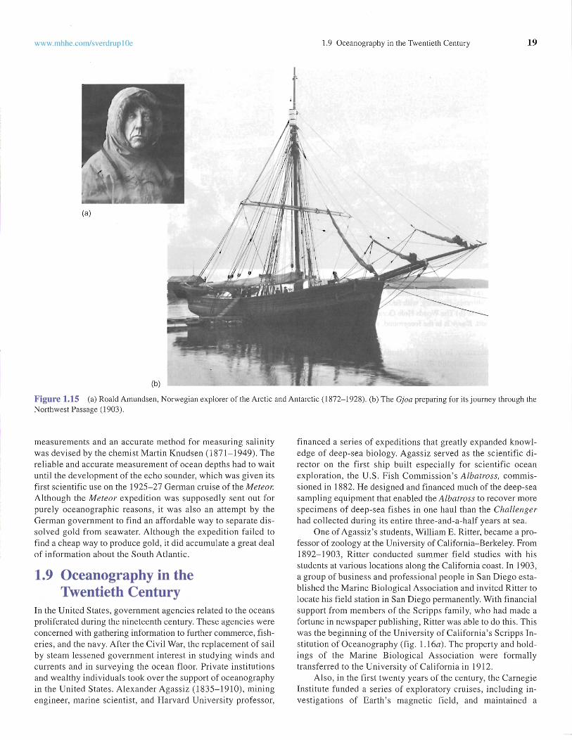
1.9 Oceanography in the Twentieth Century 191.10 The Recent Past, the Present , and the Future of
Oceanography 22Summary 24
Key Terms 25
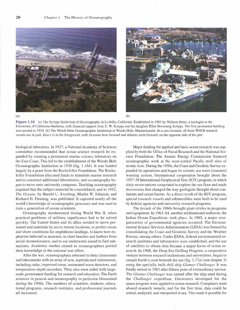
Study Questions 25

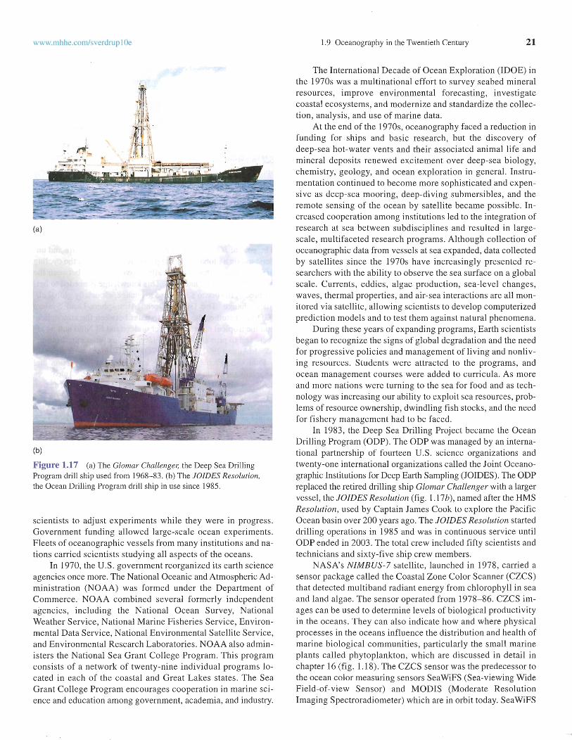
2
After studyi ng the informatio n in this chapter stude nts shouldbe able to:
1. describe the difference between a scientific hypo thesis and atheory,
2. discuss the interaction of early civiliza tions with the ocean s,
3. sketch the major seafaring routes of the great voyages ofdi sc overy in the fi ftee nth and sixteenth centur ies, Jam es
Oceanography is a broad field in whi ch many sciencesare focused on the co mmo n goa l of understanding theoceans . Geo logy , geography, geo physics, phy sics,
che mis try, geochemis try, ma thema tics, meteorology, bot any,and zoology ha ve all played roles in expanding our knowledgeof the oceans . Oceanograph y today is usuall y broken do wninto a number of subdisciplines bec ause the field is ex tremelyinter disc iplinary .
Geological oceanog raphy inc ludes the study of Earth atthe sea 's edge and bel ow its surface, and the hist ory of theprocesses that form the ocean basin s. Physical oceanog ra phyinves tigates the ca use s and charac teri stics of wa ter movements such as waves, currents, and tides and how the y affectthe mar ine environme nt. It also includes studies of the transmiss ion of energy such as so und, light, and heat in sea water.Marine meteor ology (the study of heat transfer, water cyc les,and air-sea interactions) is often included in the disc ipline ofphys ica l oceanog raphy. Che mica l oceanog ra phy studies theco mposition and hist ory of the water , its pro cesses, and its interactions. Biol ogical oce anography co nce rns marin e organism s and the re lat ionship between these org anis ms and theenvironment in the oceans . Oce an engi nee ring is the disciplinethat de sign s and plans equipme nt and inst all ation s fo r useat sea.
Scienti sts make discoveries about the natural world, bothas it is now and as it has been thro ughout its history, by gat hering data throu gh observation and experi mentation. Data arethe "facts " used by sc ientists . Scient ific data are reproducibl ean d accompan ied by an estimate of error. If an observa tionis not reprodu ci ble and doe s not inc lude an error es tima te, itis not a scien tifi c datum. Rep eated observations an d measure me nts by indep endent scien tis ts are ex pec ted to yie lddata who se erro r reg ions overlap with the error reg io nsaround the orig inal data.
A scientific hypothesis is an ini tial explanation of data thatis bas ed on well-es tablished physical or chemica l laws. If thedat a are quantitat ive (i.e. , if they are rep resented as numbers),the hypothe sis is often expressed as a mathematica l equatio n. Inorder to be considere d a scientific hypothesis, it must be subjec tto testin g and falsification (demo nstra tion that something is nottrue). A scientific hypoth esis that has been repea tedly tested andfound to be in agree me nt with observed facts is provisionall y
Cook 's voyages of discover y, and the scientific voyages ofCharl es Darwin and the Challenger expedition.
4. list the major discoveries of the Challenger expedition,
5. compare and contrast the meth ods of making scientificmeasurements in the nineteenth and twentieth centuries, and
6. desc ribe the difference in both the qu ant ity of ocea nographic dat a and the den sity of that data available tooceanographers now compared to the ninet eenth century.
cons idered to be a valid hypothesis, recogniz ing that it may bereplaced by a more complete hypothesis in the future.
If a hypoth esis is consis tently supported by repeated , differe nt experiments, then it may be advanced to the level of a theory . The great value of a theory is its ability to predict theexis tence of phe nomena or relationsh ips that had not previ ouslybeen recogni zed . Scientists use the word "theory" in a muchmore restrictiv e sense than the genera l publ ic, who use the wordin the same way the word "speculation" is used. A scientific theory is not an idle spec ulation, however. It is a tested, reliable,and pre cise statement of the relationships among reproducibl eobservatio ns.
A collec tion of hourl y measurement s of sea surface elevation at a spec ific poi nt would co mprise a set of scie ntific dataor fact s. An init ial explanation of these data might be the hypothesis tha t sea surface elevation varies in response to tidalforces . Thi s hypothesis could be exp ressed as a math em aticalequation. If repeated measurements elsew here in the oceansyie lded reproducible data that continued to be accuratel y ex plained by the hypothesis, it wo uld rise to the level of tidal theory (discussed in chap ter 11).
Even when a hypothesis is eleva ted to the statu s of a theory,the scientific inves tigation will not necessarily stop. Scie ntis tsdo not discard accepted theori es easily; new discoveries arc firstassumed to fit into the existing theoretical fram ework. It is onlywhen , afte r repeated exper imental tests, the new data cannot beexplained that scientists seriously question a theory and attemptto mod ify it.
The study of the oceans was promoted by intellectual and social forces as well as by our needs for marine resources, trade andcommerce, and national sec urity. Oceanography started slow lyand informally; it began to develop as a modern scie nce in themid-1800s and has grow n dramatically, even expl osively, in thelast few decades. Our progress toward the goal of understand ingthe ocea ns has been uneven and progress has frequently changeddirection. The interests and needs of nations as well as the scholarly curio sity of scientists have contro lled the ways we study theoceans, the meth ods we use to study them, and the priority wegive to certain areas of study. To gain perspectiv e on the currentstate of knowledge about the oceans, we need to know somethingabout the even ts and incentives that guided people 's previous invest iga tions of the oceans.

www.mhhe.com/sverdrup IOe 1,1 The Early Times 3
1.1 The Early TimesPeo ple have been gathering information about the ocea ns formillenn ia, acc umulating bits and pieces of kno wledge and passing it on by wo rd of mouth, Curious indiv idu als must have acquired their fir st ideas of the oceans fro m wandering theseashore , wading in the shallo ws, and ga thering foo d from theocean's edges, During the Paleolithi c period, humans developedthe barbed spear, or harpoon, and the go rge . Th e gorge was adouble-poi nted stick inserted int o a bait and attached to a string,At the beg inning of the Neo lithic period, the bone fishhook wasdeveloped and later the net (fig. 1.1), By 5000 B.C., cop per fis hhooks were in use.
As early humans moved slowly away from their inland cen ters of developmen t, they were prepared to take advan tage of thesea's food so urces whe n they firs t expl ored and later settledalong the ocean sho re , The re mains of shells and othe r refuse,
(a)
(b)
(c)
Figure 1.1 Trad itional fish ing and hu nting imp leme nts from coas talNative Ame rica n cu ltures of the Pacific Nort hwes t. (a) A duc k spearmade of cedar. (b) A bo ne harpoon point and lanyard made of sinew,hemp , and twine, (c) A fishhook made of bone and steam-bent cedarroot.
in piles know n as ki tche n middens, have been foun d at the sitesof ancient shore se ttlemen ts, These remains show that our earlyances tors gathered shellfish, and fish bones found in some middens sugg est that they also used rafts or so me type of boat foroffshore fishing. Some scientists think that many more ar tifac tshave been lost or sca ttered as a result of ris ing sea level. Th e artifac ts that have been foun d probably give us only an idea of theminimum ex tent of ancient shore se ttleme nts. Drawin gs on ancie nt temple wall s show fis hnets; on the tomb of the Egy pt ianPharaoh Ti , Fifth Dynasty (5000 years ago), is a drawing of thepo isonous pufferfish with a hieroglyph ic description and warning, As lon g ago as 1200 B,C. or earlier, dried fish were tradedin the Persian Gulf; in the Mediterr anean, the ancient Greeksca ught, preserved , and traded fish, while the Phoen iciansfounde d fishing se ttlements, such as "the fis her's town"Sido n, tha t gre w int o imp ortant trading ports ,
Early information about the oceans was mainly collected byex plorers and traders, These voyages left littl e in the way ofrecorded info rma tion, Using descriptions passed down fro m onevoyager to another, ear ly sailors piloted their way from one landmark to another, sa iling close to shore and often bringi ng thei rboats up onto the beach eac h night.
Some historians be lieve that seagoing shi ps of all kindsare derived from early Egyptian vesse ls. The first recorded voyage by sea was led by Pharaoh Snefru abo ut 3200 B.C. In 2750B.C., Hannu led the earliest doc umented exp loring ex peditio nfrom Egypt to the so uthe rn edge of the Arabian Peni nsu la andthe Red Sea.
Th e Phoe nicians, who lived in present-day Le ba non fromabo ut 1200 to 146 B.C., we re we ll -kno wn as excelle nt sai lorsand navigators. Wh ile their land was fertile it was also dense lypopulated, so they were co mpe lle d to eng age in trade to acquire many of the goods they needed. They accompl ished thisby establis hing land routes to the east and marine routes to thewest. Th e Phoenicians were the only nation in the region at thattim e that had a navy. They trade d through out the Medi ter ranean Sea wit h the in habita nts of North Africa, Ital y, Greece,France, and Spain. They also ven tured out of the Mediter ra nea n Sea to travel north alo ng the coas t of Euro pe to theBr itish Isles and south to circumnav iga te Africa in abo ut590 B.C. In 1999, the wrec kage of two Ph oeni cian cargo vesse ls circa 750 B.C. was ex plored using rem otely operated vehicles (ROYs) that co uld dive to the wreckage and send backlive video images of the ships. The ships were discovered abo ut48 krn (30 mi) off the coast of Israel at dep ths of 300-900 m(ro ughly 1000-3000 ft) .
Ex te nsi ve migration throu ghout the Southwestern Pacificmay have beg un by 2500 B.C. These earl y voyages were relatively easy because of the comparatively short distance betweenislands in the far Southwestern Pacific reg ion . By 1500 B.C., thePol ynesians had begun more ex tensive voyages to the east,where the distance be tween islands grew from tens of kilometers in the western Pacific to thousands of kilometers in the caseof voyages to the Hawaiian Islands, Th ey reached and colonizedthe Hawaiian Isl an ds sometime bet we en A,D. 450 and 600.By the eig hth cen tury A.D ., they had colonized eve ry habi tabl eisland in a triang ular reg io n ro ugh ly tw ice the size of the

4 Chapter J Th e Hi story of Oceano graph y
Figure 1.2 On Satawal Island master navigator Mau Piailug teachesnavigation to his son and grandson with the help of a star compass. Thecompass consists of an outer ring of stones, each representing a star ora constellation when it rises or sets on the horizon, and an inner ring ofpieces of palm leaf representing the swells which travel from setdirections and which together with the stars help the navigator find hisway over the sea. In the center of the ring, the palm leaves serve as amodel outrigger canoe.
United States bound by Hawaii on the north , New Zealand in thesouthwest, and Easter Island to the east.
A basic component of navigation throughout the Pacific wasthe careful observation and recording of where prominent starsrise and set on the horizon. Observed near the equator, the starsappear to rotate from east to west on a north-south axis . Somerise and set farther to the north and some farther to the south, andthey do so at different times. Navigators created a "star structure" by dividing the horizon into thirty-two segments wheretheir known stars ros e and set. These directions form a compassand provide a reference for recording information about the direction of winds, currents , waves, and the relative positions ofislands, shoals, and reefs (fig. 1.2) . The Polynesians also navigated by making close observations of waves and cloud formations. Observations of birds and distinctive smells of landsuch as flowers and wood smoke alerted them to possible landfalls . Once islands were discovered, their locations relati ve toone another and to the regular patterns of sea swell and wavesbent around islands could be recorded with stick ch arts constructed of bamboo and shells (fig . 1.3).
As early as 1500 B.C., Middle Eastern peoples of many different ethnic groups and regions were exploring the IndianOcean . In the seventh century A.D., they were unified und er Islam and controlled the trade routes to India and China and consequently the commerce in silk, spices, and other valuablegoods. (This monopoly wasn't broken until Vasco da Gama de feated the Arab fleet in 1502 in the Arabian Sea. )
The Greeks called the Mediterranean 'Thalassa" and believed that it was encompassed by land, which in turn was surrounded by the endlessly circling river Oceanus. In 325 B.C.,
Alexander the Great reached the deserts of the Mekran Coast,now a part of Pakistan. He sent his fleet down the coast in an apparent effort to probe the mystery of Oceanus. He and his troopshad expected to find a dark , fear some sea of whirlpools and water
Figure 1.3 A navigational chart (rebillib) of the Marshall Islands.Sticks represent a series of regular wave patterns (swells). Curvedsticks show waves bent by the shorelines of individual islands. Islandsare represented by shells.
spouts inhabited by monsters and demons; they did find tides thatwere unknown to them in the Mediterranean Sea. His commander, Nearchus, took the first Greek ships into the ocean, explored the coast, and brought them safely to the port of Hormuzeighty days later. Pytheas (350-300 B.C.), a navigator, geographer, astronomer, and contemporary of Alexander, made one ofthe earliest recorded voyages from the Mediterranean to England. From there, he sailed north to Scotland, Norway, and Germany . He navigated by the Sun, stars, and wind, although he mayhave had some form of sailing directions. He recognized a relationship between the tides and the Moon, and made early attempts at determining latitude and longitude. These early sailorsdid not investigate the oceans; for them, the oceans were only adangerous road, a pathway from here to there, a situation thatcontinued for hundreds of years. However, the information theyaccumulated slowly built into a body oflore to which sailors andvoyagers added each year.
While the Greeks traded and warred throughout the Mediterranean , they observed the sea and asked questions . Aristotle(384-322 B.C.) believed that the oceans occupied the deepestparts of Earth's surface; he knew that the Sun evaporated waterfrom the sea surface, which condensed and returned as rain. Healso began to catalog marine organisms. The brilliant Eratosthenes(c. 264-194 B.C.) of Alexandria, Egypt, mapped his known worldand calculated the circumference of Earth to be 40,250 km,
www. m hhe.c om/svcrdru p IOe 1.2 The Middle Ages 5
or 25,000 mi (today's measurement is 40,067 km, or 24,881 mi).Posidonius (c. 135-50 B.C.) reportedly measured an ocean depthof about 1800 m (6000 ft) near the island of Sardinia, accordingto the Greek geographer Strabo (c. 63 B.C.-A.D. 21). Pliny theElder (c. A.D. 23-79) related the phases of the Moon to thetides and reported on the currents moving through the Strait ofGibraltar. Claudius Ptolemy (c. A.D . -85-161) produced the firstworld atlas and established world boundaries: to the north, theBritish Isles, Northern Europe, and the unknown lands of Asia;to the south, an unknown land, "Terra Australis Incognita," including Ethiopia, Libya, and the Indian Sea; to the east, China;and to the west, the great Western Ocean reaching around Earthto China. His atlas listed more than 8000 places by latitudeand longitude, but his work contained a major flaw. He hadaccepted a value of 29,000 km (18,000 mi) for Earth's circumference. This value was much too small and led Columbus, morethan 1000 years later, to believe that he had reached the easternshore of Asia when he landed in the Americas .
1.2 The Middle AgesAfter Ptolemy, intellectual activity and scientific thought declined in Europe for about 1000 years. However, shipbuildingimproved during this period; vessels became more seaworthyand easier to sail, so sailors could make longer voyages. TheVikings (Norse for piracy) were highly accomplished seamenwho engaged in extensive exploration, trade, and colonizationfor nearly three centuries from about 793 to 1066 (fig. 1.4). During this time, they journeyed inland on rivers through Europeand western Asia, traveling as far as the Black and Caspian Seas.The Vikings are probably best known for their voyages acrossthe North Atlantic Ocean . They sailed to Iceland in 871 where asmany as 12,000 immigrants eventually settled . Erik Thorvaldsson(known as Erik the Red) sailed west from Iceland in 982 and discovered Greenland. He lived there for three years before returning to Iceland to recruit more settlers. Icelander BjarniHerjolfsson, on his way to Greenland to join the colonists in985-86, was blown off course, sailed south of Greenland, and
is believed to have come within sight of Newfoundland beforeturning back and reaching Greenland. Leif Eriksson, son of Erikthe Red, sailed west from Greenland in 1002 and reached NorthAmerica roughly 500 years before Columbus.
To the south , in the region of the Mediterranean after the fallof the Roman Empire, Arab scholars preserved Greek and Roman knowledge and continued to build on it. The Arabic writerEl-Mas'ude (d. 956) gives the first description of the reversal ofthe currents due to the seasonal monsoon winds. Using thisknowledge of winds and currents, Arab sailors established regular trade routes across the Indian Ocean . In the 11OOs, largeChinese junks with crews of 200 to 300 sailed the same routes(between China and the Persian Gulf) as the Arab dhows.
During the Middle Ages, while scholarship about the searemained primitive, the knowledge of navigation increased.Harbor-finding charts, or portolanos, appeared. These charts carried a distance scale and noted hazards to navigation, but they didnot have latitude or longitude. With the introduction of the magneticcompass to Europe from Asia in the thirteenth century, compass directions were added. A Dutch navigational chart from Johannes vanKeulen 's Great New and Improved Sea-Atlas or Water-World of1682-84 is shown in figure 1.5. The compass directions follow thepattern used in early fourteenth-century portolanos.
Although tides were not understood, the Venerable Bede(673-735) illustrated his account of the tides with data from theBritish coast. His calculations were followed in the tidal observations collected by the British Abbot Wallingford of SaintAlban's Monastery in about 1200. His tide table, titled "Fled atLondon Brigge," documented the times of high water. Sailorsmade use of Bede's calculations until the seventeenth century.
As scholarship was reestablished in Europe, Arabic translations of early Greek studies were translated into Latin and thusbecame available to European scholars. The study of tides continued to absorb the medieval scientists, who were also interested in the saltiness of the sea . By the 1300s, Europeans hadestablished successful trade routes, including some partial oceancrossings. An appreciation of the importance of navigationaltechniques grew as trade routes were extended .
1200W 300W
I
\ ~20oN
300E~
Viking Routes
-- Earliest -- Lei! Eriksson-- Erik the Red -- Ingvar
Figure 1.4 Major routes of the Vikings to the British Isles, to Asia , and across the Atlantic to Iceland, Greenland, and North America.

6 Chapter 1 T he History of O cean ograph y
Figure 1.5 A navigational chart of northern Europe from Johannes van Keulen' sSea-Atlas of 1682-84.
Figure 1.6 The routes of Bartholomeu Dias and Vasco da Gama around the Cape of Good I-lope andChris topher Co lumbus's first voyage.
- V. da Gama 1497-1502
In Eu rope, the desire for rich es from newland s persuaded wea lthy ind ividu als, oftenrep resenting their countries, to und erw rite thecos ts of long voyages to all the oceans of theworld. Th e individual mo st res ponsi ble forthe grea t age of European discovery wasPrince Henry the Navigator (1394-1460) ofPortugal. In 14 19, his father, King John, madehim governo r of Portu gal's southernmostcoasts . Pr ince Henr y was keenl y int erested insai ling and commerce, and studied navigationand mapm akin g. He es tablished a naval observatory for the teachin g of navigat ion, astro nomy, and cartography about 1450. From1419 until his death in 1460, Prince Henry sentexpedi tio n after ex pedition south along thewest coas t of Africa to secure trade routes andes tablish colonies. These expeditions movedslowly due to the mariners' beli ef that wa tersat the equator were at the boiling point and thatsea monsters would engulf ships. It wasn' t until twent y-seven years after Prince Henr y'sdeath that Barthol omeu Dia s (l 450?- 1500)braved these "da ngers" and rounded the Capeof Goo d Hope in 1487 in the fir st of the greatvoyages of discovery (fig. 1.6). Dias had sailedin sea rch of new and fas ter routes to the spicesand silks of the East.
Portu gal' s slow pro gre ss along the we stcoa st of Afri ca in sea rch for a route to the eas t finally ca me tofruition with Vasco da Gama (1469-1524) (fig. 1.6). In 1498, hefoll owed Barth olomeu Dias' s route to the Cape of Good Hopeand then continued beyond along the eastern coast of the Africanco ntinent. He successf ully mapped a route to Indi a but was
- C. Columbus 1492 (First voyage)- B. Dias 1487
.",. !
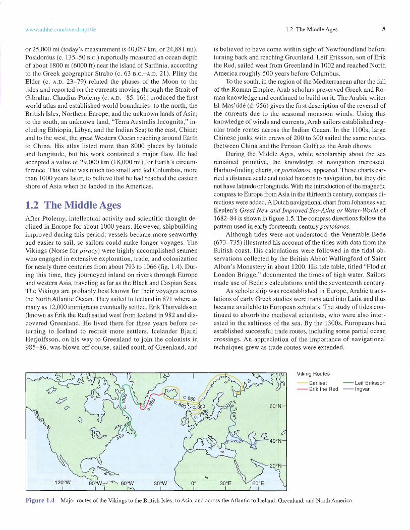
1.3 Voyages of DiscoveryFrom 1405 to 1433, the grea t Chinese admiral Zheng He conducted seven epic voyages in the wes tern Pacific Ocean andacross the Indian Ocean as far as Africa. Zheng He's fleetconsisted of over 300 ships. Thefleet is believed to have includedas many as sixty -two "treasureships" thought to have been asmuch as 122 m (400 ft) long and52 m ( 170 ft) wide; this was tentimes the size of the ships usedfor the European voyages ofdiscovery dur ing this period oftime. The purp ose of thesevoyages remains a matter of adebate among scholars . Sugges ted reasons include the establishment of trade routes,diplomacy with other governments , and milit ary defense.Th e voyages ended in 1433,when their explora tions led theChinese to believe that other socie ties had little to offer, and thegovernment of China withdrewwithin its borders , beginning400 years of isolati on .
www.mhhc.com /s verdrup lOe 1.4 The Beginnings of Earth Science 7
Figure 1.7 Th e sixteenth-century circumnavigation voyages by Mage llan and Drake.
60°8
600N
1.4 The Beginnings of Earth ScienceNew ideas and new knowl edge had stimulated the prac tica l exploration of the oce ans du ring the fift eenth and sixtee nth centuries, but most of the think ing about the sea was still rooted inthe ideas of Aris totle and Plin y. In the seventee nth century, although the practi cal needs of co mmerce , national security, and
Spice Islands in November 1521 , where theyloaded valu able spices for a re turn home. Inan attempt to guarantee that at least one shipmade it back to Spai n, the two ships partedways. The Victoria conti nued sailing west andsuccessfully cros sed the Indian Ocean,round ed Africa's Cape of Good Hope , and arrived back in Spain on Sep tember 6, 1522,with eig hteen of the original crew. Th is wasthe firs t circumnav iga tion of Earth (fig. 1.7).Magell an 's skill as a navigator makes hisvoyage probabl y the most outstanding singleco ntribution to the ea rly charting of theocea ns. In addition, dur ing the voyage, he established the length of a degree of latitudeand measured the cir cumference of Earth . Itis said that Ma gell an tr ied to test the mid-ocean depth of the Pacific with a hand line,but this idea see ms to co me from a nineteenth-century German oce anog rapher ;writings from Magellan' s time do not supp ortthis story.
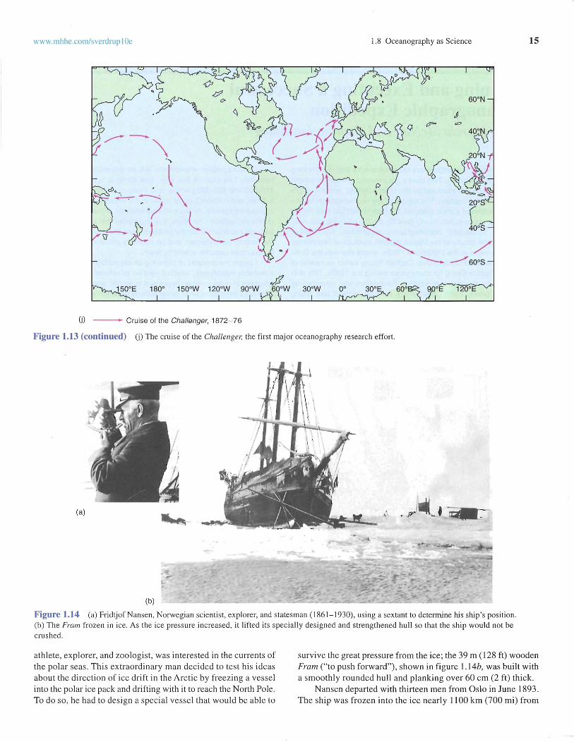
By the latter half of the sixteenth century, adventure, curios ity, and hope s offinding a trading shor tcut to Chin a spurre deffo rts to find a sea passage aro und North America. Sir MartinFro bisher (1535?- 94) made three voyages in 1576, 1577 , and1578, and Henry Hud son (d. 1611) made four voyages (1607 ,1608, 1609, and 1610 ), dying with his son when set adrift inHudson Bay by his mutinous crew. The North west Passage continued to beckon , and in 1615 and 1616, William Baffin( 1584- 1622) made two unsuccessful atte mpts .
Whil e European countries were setting up co lonies andclaiming new land s, Fr ancis Drake (1540-96) set out in 1577with 165 crewmen and five ships to show the English flag aroundthe world (fig . 1.7). He was forced to abando n two of his shipsoff the coas t of South America. He was separated from the othertwo ships while passing thro ugh the Strait of Magellan. Duringthe voyage Drake plundered Spani sh shipping in the Caribbea nand in Central America and loaded his ship with treasure. In June1579, Drake land ed off the coast of present -day Californi aand sai led north along the co ast to the present United StatesCanadian border. He then turned southwe st and crossed thePacific Ocean in two months' time . In 1580, he completed hisci rcumnav igation and ret urned home in the Golden Hind witha cargo of Spanish gold, to be knighted and trea ted as a nat ionalhero. Queen Elizabeth I encouraged her sea captains' exploits asexp lorers and raid ers beca use , when needed , their ships andknowledge of the sea bro ught milit ary vic tories as well aseco nomic gains.
--_, F. Magellan 1519-22
--_, F. Drake 1577- 80
cha lle nged along the way by Ara b ships . In 1502, da Gamareturned wit h a flotilla of four tee n hea vily armed ships anddefeated the Arab fleet. By 1511, the Portugue se controlledthe spice routes and had access to the Spice Islands. In 1513 ,Portugue se trade ext end ed to China and Jap an.
Chri st oph er Colu mbu s (145 1-1506) made fo ur voyagesacross the Atlantic Oce an in an effort to find a new rout e to theEast Ind ies by travel ing west rat he r than eas t. By relying oninaccurate est imates of Earth's size , he badl y undere stimatedthe distan ces invo lve d and bel ie ved he had fo und isl ands offthe coast of Asi a when, in fact, he had reach ed the New World(fig . 1.6).
It al ian navigator Am eri go Vespucci (145 4- 1512) madese vera l voyages to the New World (1499-1 504 ) fo r Sp ainand Portu gal , exploring nearl y 10,000 km (6000 mi) of So uthAmerica n coastline . He accepted South America as a new contin ent not part of Asi a, and in 1507, German cartogra pherMartin Wald seemiill er applied the name " Ame rica" to thecontinent in Vespucci 's honor. Vasco Nu nez de Balboa(1475-15 19) cros sed the Isthmu s of Panama and found thePa cifi c Ocean in 1513, and in the same year, Ju an Ponce deLeon (1460?-152 1) discovered Flo rida and the F lori da C urrent. All cl aim ed the new lan ds they found for thei r homecountr ies. Although these men had sai led for fa me and riches ,not knowled ge, they more acc ura te ly documented the ex tentand pr op erties of the oc eans, and the ne ws of their tra ve lsstimula ted othe rs to fo llow.
Ferdinand Magellan (14 80-1521) left Spain in September1519 with 270 men and five vessels in search of a westward passage to the Sp ice Island s. The exped ition lost two ships beforefinally discovering and passing through the Str ait of Magell anand round ing the tip of South Ame rica in November 1520 .Magellan crossed the Pacific Ocean and arrived in the Philipp inesin March 1521 , where he was killed in a battle with the nativeson April 27, 152 1. Two of his ships sailed on and reached the
8 Chapter 1 The History of Oceanography
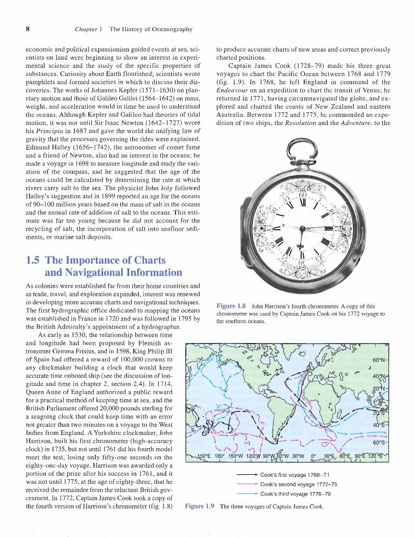
Figure 1.9 The three voyages of Captain James Cook.
eco nomic and political expansioni sm guide d events at sea, scien tists on lan d were beginning to show an interes t in experimental sc ience and the study of the spec ific prop er ties ofsubs tances. Curiosity abo ut Earth flourished; sc ientis ts wrotepamphlets and forme d soc ieties in wh ich to discuss their discoveries. The work s of Johannes Kepl er (1571-1630) on planetary motion and those of Gali leo Galilei (1564- 1642) on mass,weight, and accelera tion would in tim e be used to und erstandthe oceans . Although Kepl er and Galileo had theories of tidalmot ion , it was not until Sir Isaac Ne wton (164 2-1727) wrotehis Principia in 1687 and gave the world the uni fying law ofgravi ty that the proc esses governing the tides were exp lained.Edm und Hall ey (1656- 1742), the astronomer of co met fam eand a frie nd of Newton , also had an interest in the oceans; hemade a voyage in 1698 to measure longitude and study the variation of the co mpass, and he suggested that the age of theoceans co uld be ca lculated by det erm ining the rate at whi chri vers ca rry sa lt to the sea . The physicist John Jo ly followedHall ey' s suggestion and in 1899 repor ted an age for the oceansof 90-100 mill ion years based on the mass of salt in the oceansand the annual rate of addition of sa lt to the ocean s. Thi s es timate was far too yo ung because he did not account for therecycling of salt, the incorporation of sa lt into sea floor sediments, or marine salt deposits.
1.5 The Importance of Chartsand Navigational Information
As co lonies were established far fro m their home countries andas trade, travel, and exploration expanded, interest was renewedin developing more accurate char ts and navigational techniques.Th e first hyd rographic office dedicated to mapping the oce answas established in France in 1720 and was foll owed in 1795 bythe British Adm iralty' s appoi ntment of a hydrographer.
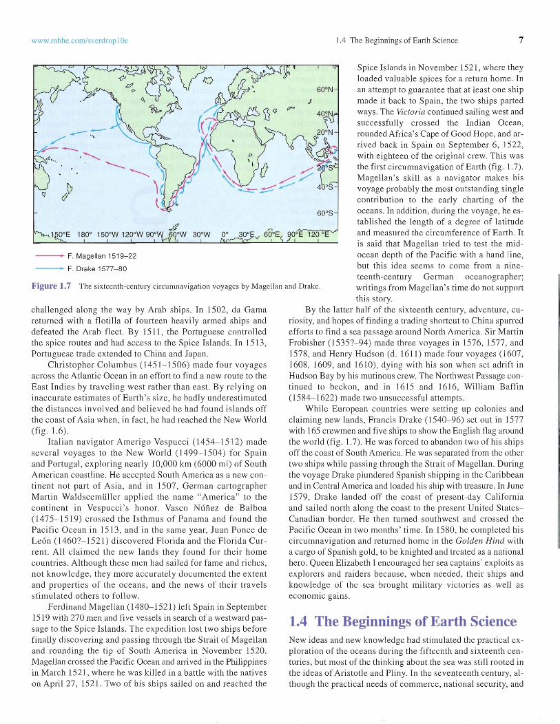
As early as 1530, the relatio nship between timeand lon gitude had been proposed by Flemish astronomer Gemma Frisius, and in 1598, King Philip IIIof Spain had offered a reward of 100,000 crow ns toany clockmaker building a clock that would keepaccurate time onboard ship (see the disc ussion of longitude and time in cha pter 2, sec tion 2.4). In 1714,Queen Ann e of England authorized a publ ic rewa rdfor a practical method of keeping time at sea, and theBri tish Parl iament offered 20,000 pounds sterling fora seago ing clo ck that could keep time with an errornot grea ter than two minutes on a voyage to the WestIndi es from England. A Yorkshire clockmaker, JohnHarri son, built his firs t chronometer (high-acc urac yclock) in 1735, but not until 1761 did his fourth modelmeet the tes t, losin g only fift y-one seconds on theeighty-one-day voyage. Harrison was awarded only aportion of the pri ze after his success in 1761, and itwas not unt il 1775, at the age of eigh ty-three, that hereceived the rema inder from the reluctant Brit ish gov-ernment. In 1772, Captain James Cook took a copy ofthe fourth version of Harrison's chronometer (fig . 1.8)
to produ ce accurate charts of new areas and correc t previouslycharted positions.
Captai n Jam es Co ok (1728-79) mad e his thr ee greatvoyages to cha rt the Paci fic Ocean bet ween 1768 and 1779(fi g. 1.9). In 1768, he left Eng land in co mma nd of theEndeavo ur on an expe dition to chart the tra nsit of Venu s; hereturned in 1771 , hav ing ci rcum na viga ted the globe, and expl ored and charted the coas ts of New Ze aland and eas ternAu stral ia . Between 1772 and 1775, he co mma nde d an expediti on of two ships, the Resolu tion and the Adve nture, to the
Figure 1.8 John Harrison's fourth chronometer. Acopy of thischronometer was used by Captain James Cook on his 1772 voyagetothe southern oceans.
--_. Cook's firstvoya ge 1768-71
--- Cook's secondvoyag e 1772-75
--_. Cook's third voya ge 1776-79

www .mhhe .com/sverdrup IOe 1.5 The Importance of Charts and Navigational Information 9
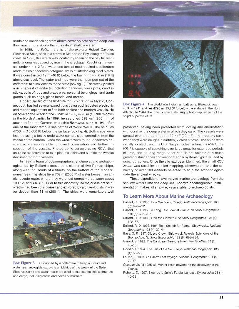
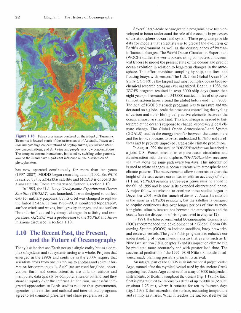
Figure 1.11 Annual average sea surf ace temperature for 1996. Thered-orange streak of 25° to 30°C water shows the Gulf Stream.Compare with figure 9.8.
updated and expanded with each editi on, serving genera tions ofmarin ers' and navigators.
In 1807, the U.S. Con gress, at the directi on of Pres ide ntThom as Jefferson, for med the Survey of the Coast under theTreasury Departm ent , later named the Coast and Geodetic Survey and now known as the National Ocean Survey. The U.S .Naval Hydrographic Office, now the U.S . Naval OceanographicOffice, was set up in 1830. Both were dedicated to exploring theoceans and producing bett er coas t and ocean charts . In 1842,Lieutenant Matthew F. Maury (1806-73), who had worke d withthe Coast and Geodetic Survey, was ass igned to the Hydrographic Office and founde d the Na val Depot of Charts. He began a systematic collecti on of wind and current data from ships'logs. He produ ced his first wind and current charts of the NorthAtlantic in 1847. At the 1853 Bru sse ls Maritime Conference,Mau ry issued a plea for international cooperatio n in data collect ion, and from the ships ' logs he received, he produ ced thefir st publ ished atl ases of sea conditions and sailin g direct ions.His work was enormously useful, allowing ships to sail moresafely and take days off their sailing time s between major portsaround the world . The British estimated that Maury' s sai ling directions took thirty days off the passage from the British Isles toCalifornia, twenty days off the voyage to Austral ia, and ten daysoff the sailing time to Rio de Janeiro. In 1855, he publi shed ThePhysical Geography ofthe Sea. This work includes chapters onthe Gulf Stream , the atmos phere, currents, depths, winds, cl imates, and storms, as well as the first bathymetric chart of theNorth Atlantic with contours at 6000, 12,000, 18,000, and 24,000ft. Many marine scientist s consider Maury's book the first textbook of what we now call ocea nogra phy and consider Maury thefirs t true oceanograph er. Again , national and commercial intere sts were the driving forces behind the study of the oceans.
30 3510 15 20 25SST (0C)
5
.• .--3 0
Figure 1.10 The Franklin-Fo lger map of the Gulf Stream , 1769.Compare this map with figure !.I I.
South Pacific. On this journey, he charted ma ny islands, explored the Antarctic Ocean, and , by co ntro ll ing hi s sa ilors'diet , prevented vitamin C deficien cy and sc urvy, the diseaseth at had decimated crews that spe nt long period s of tim e atsea. Coo k sailed on his th ird and last voyage in 1776 in theResoluti on and Discovery. He spent a year in the South Pacificand then sa iled north , discov erin g the Hawaiian Isl ands in1778. He co ntinued on to the northwest coas t of North America and into the Bering St rait , searchi ng for a passage to theAtla ntic . He returned to Hawaii for the winter and was kill edby nati ves at Kealakekua Bay on the island of Hawaii in 1779.Cook takes his place not only as one of history 's greatest navigators and seamen but als o as a fine scient ist. He madeso undings to depths of 400 m (1200 ft) and acc ura te observati on s of winds, currents, and water temperatures. Cook 'scareful and acc urate observations produced much valuable inform ation and made him one of the fo unders of oceanog raphy.
In the United State s, Benjamin Frankl in (1706-90) becameco nce rned about the time required for news and cargo to travelbetween Engla nd and Ameri ca. With Cap tain Tim othy Folger,his cousin and a whaling captain from Nantucket, he constructedthe 1769 Frankl in-Folger chart of the Gulf Stream current(fig. 1.10). Wh en published, the chart encour aged captains tosail within the Gulf Stream en route to Europe and return via thetrade wind s belt and follow the Gul f Strea m north again toPhiladelphia, New York City, and other ports. Sin ce the GulfStream carries warm water from low latitud es to high latitud es,it is possibl e to map its location with satelli tes that measure seasurfa ce temperatur e. Compare the Frankl in-Folger chart infigur e 1.10 to a map of the Gulf Stream shown in figure 1.11based on the average sea surface temperature during 1996. In1802, Nathaniel Bowd itch (1773-1 838), another American, published the New American Practi cal Nav igato r. In this book ,Bowditch made the techniques of cele stial navigation availablefor the first time to eve ry competent sailor and set the stage forU.S. supremacy of the seas dur ing the years of the Yankee clip pers. When Bowditch died, his copyright was bought by the U.S.Navy, and his book continued in print. Its information was
More than 2000 years of exploration, war, and tr ading haveleft thousands of wrecks scattered acro ss the oceanfloors. These wrecks are great storehouses of information
for archa eologists and historians searching fo r informat ion abo utships, t rade, warfare, and the details of human life in anc ient tim es.Marine archaeologists use techniques developed for oceanographicresearch to find , explore, recover, and preserve wrecks and other arti fact s lying under the sea. Sound beams that sweep the sea f loorprod uce images that are viewed onboard ship , and an object of interest can be located very precisely with computer-controlledpositioning systems. Magnetom eters are also used in thesesearches to detect iron from sunken vessels. Divers ca n be sentdown to verify a wreck in shallow water, and a research submersible(SUbmarine) car rying obse rvers can be used in deeper wate r. Unsta ffed , towed cam era and instrument sleds or remotely operatedvehicles (ROVs) equ ipped with underwat er video cameras explorein deep water or areas that are difficu lt or unsafe for divers and submersibles. ROVs and submersibles also co llect samples to helpident ify wrecks.
The old est known shipwreck, from the fourteenth century B.C.,
a Bronze Age merch ant vess el, was dis cov ered in 1983 more than33 m (100 ft) down in the Med iterranean Sea off the Turkish coast.Divers have recovered thousand s of art ifact s from its carg o, inc ludinq copper and tin ingots , pottery, ivory, and ambe r. Using theseitems, archaeologists have been able to learn about the life and cultu re of the period , trace the ship's trad e route, and understand moreabout Bronze Age peo ple's shipbuildi ng sk ills.
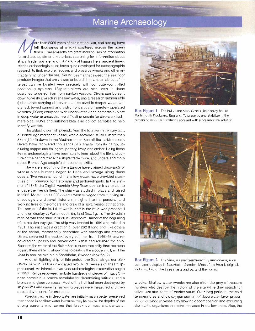
The waters around northern Europe have c laimed thousands ofwrecks since humans began to trade and voyage along thesecoasts. Two vessels , found in shallow water, have provided quantit ies of informat ion fo r historians and arch aeolog ist s. In the summer of 1545, the English warship Mary Rose sank as it sailed out toengage the French fleet. The ship was studied in place and raisedin 1982. More than 17,000 obje ct s were salvaged from it , giving archaeologists and naval historians insight s into the personal andwor king lives of the offic ers and crew of a naval vesse l at that tim e.The portion of the hull that was buried in the mud was preservedand is on display at Portsmouth, England (box fig. 1). The Swedishman-of -war Vasa sank in 1628 in Stockholm Harbor at the beginningof its ma iden voyag e. The ship was loc ated in 1956 and raised in1961. The Vasa was a great ship, over 200 ft long and , like othersof the period , fantast ica lly decorated with carvings and statu es.Divers searched the seabed every summer from 1963-67 and recovered sc ulptures and carved details that had ado rned the ship.Because the water of the Baltic Sea is much less salty than the openocean, there were no shipworms to destroy the wooden hull , and theVasa is now on exhibit in Sto ckho lm, Swe den (box fig . 2).
Another fighting ship of th is period, the Spa nish galleon SanDieg o, sank in 1600 as it engaged two Dutch vessels off the Philippine coast. An intensive, two-year archaeological excavation beganin 1992 . Relics recovered inc lude hundreds of pieces of intact Chinese porcel ain, a bronze astrolabe for determining latitude, and abronze and glass compass. Most of the hull had been destroyed byshipworms and currents ; surviving pieces were measured and thencovered with sand fo r protect ion .
Wrecks that lie in deep water are initia lly much better preservedthan tho se in shallow water because they lie below the depths of thestrong currents and wave s that break up most shall ow-water
10
Box Figure 1 The hull of the Mary Rose in its display hall atPortsmouth Dockyard, England. To preserve and stabilize it, theremaining wood is constantly sprayed with a preservative solution.
Box Figure 2 The Vasa, a seventeenth-century man-of-war, is onpermanent display in Stockholm, Sweden. Most of the Vasa is original,including two of the three masts and parts of the rigging.
wrecks . Shallow-water wrecks are also often the prey of t reasurehunters who destroy the history of the site while they search foradventu re and items of market va lue. Over long peri ods, the co ldtemp erature s and low oxygen content of deep water favor preservat ion of wood en vesse ls by slowing decom pos itio n and exc ludingthe marine organisms that bore into wood in shallow areas. Also, the