The greening of Arabia: Multiple opportunities for human occupation of the Arabian Peninsula during...
19
The greening of Arabia: Multiple opportunities for human occupation of the Arabian Peninsula during the Late Pleistocene inferred from an ensemble of climate model simulations Richard P. Jennings a, * , Joy Singarayer b , Emma J. Stone c , Uta Krebs-Kanzow d , Vyacheslav Khon e, f , Kerim H. Nisancioglu g, h , Madlene Pfeiffer d , Xu Zhang d , Adrian Parker i , Ash Parton a , Huw S. Groucutt a , Tom S. White a , Nick A. Drake j , Michael D. Petraglia a a School of Archaeology, Research Laboratory for Archaeology and the History of Art, University of Oxford, Oxford OX13QY, United Kingdom b Centre for Past Climate Change, Department of Meteorology, University of Reading, Earley Gate, Reading RG6 6BB, United Kingdom c BRIDGE, School of Geographical Sciences, University of Bristol, BS8 1SS, United Kingdom d The Alfred Wegener Institute, Bussestraße 24, D-27570 Bremerhaven, Germany e Institute of Geosciences, University of Kiel, Kiel, Germany f A.M. Obukhov Institute of Atmospheric Physics RAS, Moscow, Russia g Department of Earth Science and the Bjerknes Centre, University of Bergen, Norway h UNI Research Climate, All egaten 55, 5007 Bergen, Norway i Department of Social Sciences, Oxford Brookes University, Headington Campus, Oxford OX3 0BP, United Kingdom j Department of Geography, King's College London, K4U.06 Strand Campus, London WC2R 2LS, United Kingdom article info Article history: Available online xxx Keywords: Climate models Late Pleistocene Human evolution Arabian Peninsula Precipitation abstract Climate models are potentially useful tools for addressing human dispersals and demographic change. The Arabian Peninsula is becoming increasingly significant in the story of human dispersals out of Africa during the Late Pleistocene. Although characterised largely by arid environments today, emerging climate records indicate that the peninsula was wetter many times in the past, suggesting that the region may have been inhabited considerably more than hitherto thought. Explaining the origins and spatial distribution of increased rainfall is challenging because palaeoenvironmental research in the region is in an early developmental stage. We address environmental oscillations by assembling and analysing an ensemble of five global climate models (CCSM3, COSMOS, HadCM3, KCM, and NorESM). We focus on precipitation, as the variable is key for the development of lakes, rivers and savannas. The climate models generated here were compared with published palaeoenvironmental data such as palaeolakes, speleo- thems and alluvial fan records as a means of validation. All five models showed, to varying degrees, that the Arabia Peninsula was significantly wetter than today during the Last Interglacial (130 ka and 126/ 125 ka timeslices), and that the main source of increased rainfall was from the North African summer monsoon rather than the Indian Ocean monsoon or from Mediterranean climate patterns. Where available, 104 ka (MIS 5c), 56 ka (early MIS 3) and 21 ka (LGM) timeslices showed rainfall was present but not as extensive as during the Last Interglacial. The results favour the hypothesis that humans potentially moved out of Africa and into Arabia on multiple occasions during pluvial phases of the Late Pleistocene. © 2015 Elsevier Ltd and INQUA. All rights reserved. 1. Introduction The timing and spatial distribution of the dispersal of Homo sapiens out of Africa is the subject of intense and continued scien- tific debate (e.g. Oppenheimer, 2009; Frumkin et al., 2011; Boivin et al., 2013; Mellars et al., 2013). The consensus view is that ge- netic and archaeological evidence supports a major dispersal of * Corresponding author. E-mail address: [email protected] (R.P. Jennings). Contents lists available at ScienceDirect Quaternary International journal homepage: www.elsevier.com/locate/quaint http://dx.doi.org/10.1016/j.quaint.2015.01.006 1040-6182/© 2015 Elsevier Ltd and INQUA. All rights reserved. Quaternary International xxx (2015) 1e19 Please cite this article in press as: Jennings, R.P., et al., The greening of Arabia: Multiple opportunities for human occupation of the Arabian Peninsula during the Late Pleistocene inferred from an ensemble of climate model simulations, Quaternary International (2015), http:// dx.doi.org/10.1016/j.quaint.2015.01.006
-
Upload
oxfordbrookes -
Category
Documents
-
view
0 -
download
0
Transcript of The greening of Arabia: Multiple opportunities for human occupation of the Arabian Peninsula during...

lable at ScienceDirect
Quaternary International xxx (2015) 1e19
Contents lists avai
Quaternary International
journal homepage: www.elsevier .com/locate/quaint
The greening of Arabia: Multiple opportunities for human occupationof the Arabian Peninsula during the Late Pleistocene inferred from anensemble of climate model simulations
Richard P. Jennings a, *, Joy Singarayer b, Emma J. Stone c, Uta Krebs-Kanzow d,Vyacheslav Khon e, f, Kerim H. Nisancioglu g, h, Madlene Pfeiffer d, Xu Zhang d,Adrian Parker i, Ash Parton a, Huw S. Groucutt a, Tom S. White a, Nick A. Drake j,Michael D. Petraglia a
a School of Archaeology, Research Laboratory for Archaeology and the History of Art, University of Oxford, Oxford OX1 3QY, United Kingdomb Centre for Past Climate Change, Department of Meteorology, University of Reading, Earley Gate, Reading RG6 6BB, United Kingdomc BRIDGE, School of Geographical Sciences, University of Bristol, BS8 1SS, United Kingdomd The Alfred Wegener Institute, Bussestraße 24, D-27570 Bremerhaven, Germanye Institute of Geosciences, University of Kiel, Kiel, Germanyf A.M. Obukhov Institute of Atmospheric Physics RAS, Moscow, Russiag Department of Earth Science and the Bjerknes Centre, University of Bergen, Norwayh UNI Research Climate, All�egaten 55, 5007 Bergen, Norwayi Department of Social Sciences, Oxford Brookes University, Headington Campus, Oxford OX3 0BP, United Kingdomj Department of Geography, King's College London, K4U.06 Strand Campus, London WC2R 2LS, United Kingdom
a r t i c l e i n f o
Article history:Available online xxx
Keywords:Climate modelsLate PleistoceneHuman evolutionArabian PeninsulaPrecipitation
* Corresponding author.E-mail address: [email protected] (R
http://dx.doi.org/10.1016/j.quaint.2015.01.0061040-6182/© 2015 Elsevier Ltd and INQUA. All rights
Please cite this article in press as: JenningsPeninsula during the Late Pleistocene infedx.doi.org/10.1016/j.quaint.2015.01.006
a b s t r a c t
Climate models are potentially useful tools for addressing human dispersals and demographic change.The Arabian Peninsula is becoming increasingly significant in the story of human dispersals out of Africaduring the Late Pleistocene. Although characterised largely by arid environments today, emergingclimate records indicate that the peninsula was wetter many times in the past, suggesting that the regionmay have been inhabited considerably more than hitherto thought. Explaining the origins and spatialdistribution of increased rainfall is challenging because palaeoenvironmental research in the region is inan early developmental stage. We address environmental oscillations by assembling and analysing anensemble of five global climate models (CCSM3, COSMOS, HadCM3, KCM, and NorESM). We focus onprecipitation, as the variable is key for the development of lakes, rivers and savannas. The climate modelsgenerated here were compared with published palaeoenvironmental data such as palaeolakes, speleo-thems and alluvial fan records as a means of validation. All five models showed, to varying degrees, thatthe Arabia Peninsula was significantly wetter than today during the Last Interglacial (130 ka and 126/125 ka timeslices), and that the main source of increased rainfall was from the North African summermonsoon rather than the Indian Ocean monsoon or from Mediterranean climate patterns. Whereavailable, 104 ka (MIS 5c), 56 ka (early MIS 3) and 21 ka (LGM) timeslices showed rainfall was present butnot as extensive as during the Last Interglacial. The results favour the hypothesis that humans potentiallymoved out of Africa and into Arabia on multiple occasions during pluvial phases of the Late Pleistocene.
© 2015 Elsevier Ltd and INQUA. All rights reserved.
.P. Jennings).
reserved.
, R.P., et al., The greening of Arred from an ensemble of c
1. Introduction
The timing and spatial distribution of the dispersal of Homosapiens out of Africa is the subject of intense and continued scien-tific debate (e.g. Oppenheimer, 2009; Frumkin et al., 2011; Boivinet al., 2013; Mellars et al., 2013). The consensus view is that ge-netic and archaeological evidence supports a major dispersal of
rabia: Multiple opportunities for human occupation of the Arabianlimate model simulations, Quaternary International (2015), http://

R.P. Jennings et al. / Quaternary International xxx (2015) 1e192
human populations after 70,000 years ago (ka) during MarineIsotope Stage (MIS) 4 or early MIS 3 (Mellars et al., 2013). However,this has been challenged by recent archaeological discoveries andnew genetic and environmental interpretations, which advocatemultiple dispersals during MIS 5 (130e71 ka) and also later times(Boivin et al., 2013; Groucutt and Petraglia, 2014; Parton et al., inthis volume). Central to this debate is the need to understand theenvironmental context of human dispersals. In regions wheresecure palaeoenvironmental records are incomplete or underdevelopment this is a difficult task. Here we present a differentapproach and assess the degree to which global climate models caninform us about past climate change and human dispersals.
Climate models are sophisticated mathematical tools that havebeen used in similar contexts to address key questions such as theextinction of the Neanderthals and the arrival of modern humans inEurope (Davies et al., 2003), the identification of Neanderthalrefugia in southern Iberia (Jennings et al., 2011) and the modellingof human populations structures in North Africa (Scerri et al.,2014a,b). Eriksson and colleagues (2012) have recently used onemodel to explore H. sapiens dispersals out of Africa but on a largergeographic scale than we now present. Instead, we focus solely onone key region, the Arabian Peninsula.
Thoseworking in theArabian Peninsula consider the region to bea critical area for understanding H. sapiens dispersals and demog-raphy (Petraglia and Alsharekh, 2003; Bailey, 2009; Marks, 2009;Parker, 2009; Parker et al., 2009; Armitage et al., 2011; Petraglia,2011; Rose et al., 2011; Rosenberg et al., 2011, 2013; Groucutt andPetraglia, 2012, 2014; Crassard and Hilbert, 2013; Crassard et al.,2013). Yet, the Saharo-Arabian desert belt, a hyperaridearidexpanse at 14e35�N, has often been seen as amajor biogeographicalbarrier for human range expansions out of Africa, with theNile Riverhypothesised as a possible dispersal corridor (Van Peer, 1998;Vermeersch, 2001). However, over the last decade it has beenshown that the Sahara was not always desert and that rivers, lakesand savanna grasslandsdevelopedduring pluvial episodes, linked tochanges in insolation (e.g. Drake et al., 2011, 2013; Larrasoa~na et al.,2013). As research develops in the Arabian Peninsula, researchersare returning to ancient lakebeds previously investigated in the1970s (e.g. Petraglia, 2011; Rosenberg et al., 2011, 2013; Crassardet al., 2013). Although these palaeolakes were once thought todate to MIS 3, evidence now indicates that the lakes formed duringMIS 5 (Petraglia, 2011; Rosenberg et al., 2011). Speleothemgrowth, asign of increased humidity, has also been dated to this period incaves in south and southeast Arabia (Fleitmann et al., 2004, 2007),while Late Quaternary fluvial deposits have been identified in theUnited Arab Emirates (UAE) (Atkinson et al., 2013).
Much of what we know about Arabia's past climate is currentlyundergoing extensive revision. Just as in the Sahara, the idea that theArabian Peninsula was wetter during certain periods of the Pleis-tocene is rapidly developing into the null hypothesis. Recent dis-coveries of Middle Palaeolithic sites in stratified contexts on theshores of some of these aforementioned palaeolakes strongly sug-gests that H. sapiens populations, or possibly even Neanderthals,were in the interior of the Arabia Peninsula during MIS 5 (Groucuttand Blinkhorn, 2013; Petraglia et al., 2012; Crassard et al., 2013). Ifsavanna grassland and lakes had developed 130 ka, the idea of solelya coastal dispersal around Arabia to explain human dispersals (cf.Mellars et al., 2013), in which the interior of Arabia was bypassed,seems highly unlikely. Instead, the presence of savanna habitats inthe Arabian interior suggests that human populations could havedispersed into this region during humid phases between 130 and78 ka, especially given that H. sapiens fossils at Skhul and Qafzeh inthe Levant (Grün et al., 2005), and archaeological assemblages atJebel Faya in SEArabia (Armitage et al., 2011; Bretzke et al., 2013) andin East Africa (Basell, 2008) date to this time.
Please cite this article in press as: Jennings, R.P., et al., The greening of APeninsula during the Late Pleistocene inferred from an ensemble of cdx.doi.org/10.1016/j.quaint.2015.01.006
One of the key difficulties in testing the hypothesis that humanpopulations inhabited the interior of Arabia during the Late Pleis-tocene is the lack of dated and stratified archaeological sites. For alandmass that is one quarter of the size of Europe, a small handfulof dated lakebeds, speleothems and stratified sites do not provideenough evidence to link human presence to the palaeoclimaticframework. Here, we take a different approach and assess this datain the context of five climate models covering the Arabian Penin-sula. We employ climate models because they are an informativeway of developing insights into past climate change, especiallywhere comprehensive palaeoclimate records are not available.Climate models take into account the major processes that shapedpast climate change, such as astronomical forcing, ice sheet extent,sea-level, vegetation cover, and atmospheric greenhouse gas con-centrations. The climate models provide spatial and temporalframeworks that can be tested using securely dated, independentlyderived sedimentological and palaeontological data (Braconnotet al., 2012; Heiri et al., 2014).
Here we focus on modelling precipitation, as this variable is auseful measure for determining the amount of rainfall that poten-tially fell across the Peninsula during the Late Pleistocene, as waterwould have undoubtedly been vital for the range expansion of ourspecies (Finlayson, 2014). Multiple timeslices are examined, butwith a particular focus on specific periods of MIS 5e, when rainfalllevels are thought to have been at their highest (Parton et al., in thisvolume). We first review the main weather systems bringingrainfall into the Peninsula today and describe the boundary con-ditions used in model experiments. Understanding both of thesecomponents is necessary before using palaeoenvironmental andarchaeological evidence to assess the models and form hypotheseson human demography in the Arabian Peninsula during theseperiods.
2. Present day rainfall patterns in the Arabia Peninsula
The Arabian Peninsula supports some of the driest environmentsanywhere in the world. Areas of the Negev desert, north andnorthwest Saudi Arabia, and in the Rub Al-Khali, a vast expanse ofsand desert in southern Saudi Arabia, receive mean annual rainfalllevels of<60mmper annum, placing them in hyper-arid bioclimaticzones (Almazroui et al., 2012). Rainfall is more varied elsewhere inthe peninsula (Fig.1), attaining an average of 75.4mm in the EasternProvince of Saudi Arabia (with the highest yearly total recordedbeing 384 mm) (Barth and Steinkohl, 2004), up to 140 mm perannum in the UAE (Parker et al., 2006), 234 mm per annum inBahrain (Elagib and Abdu, 2010) and up to 400 mm in the Al Jabaland Al Akhdar mountains of Oman (Kwarteng et al., 2009). Highlevels of rainfall are also known in the Yemen highlands and insouthwest SaudiArabia,whereup to400mmper annum is recordedand it can rain during everymonth of the year (Al-Subyani, 2004; Al-Subyani, 2005; Almazroui, 2011; Furl et al., 2014). However, decadalaverages across the peninsula do not typically exceed 200 mm perannum outside the upland areas of SW Saudi Arabia, Yemen andOman (Almazroui et al., 2012) and as such, an arid to hyper-aridclimate prevails across the vast majority of the peninsula.
An important reason for the observed rainfall variation in Arabiais orography, where rainfall increases with elevation. For instance,the Asir Mountains (3000 m above sea level) which run parallel tothe Red Sea along the western side of the Peninsula, and theHadramaut (1500 m above sea level) in the south of Arabia receivehigher rainfall than interior areas. It has been noted that there aretoo fewweather stations to record accurately precipitation levels insuch regions owing to the complex orographic variability (Abo-Monasar and Al Zahrani, 2014). Elsewhere, at Wadi Yalalam in thewest of Arabia, rainfall levels are higher in the wadi's upper reaches
rabia: Multiple opportunities for human occupation of the Arabianlimate model simulations, Quaternary International (2015), http://
Fig. 1. Present day rainfall levels of the Arabian Peninsula derived from WorldClim data. Arid to hyperarid levels prevail across the Peninsula, with exceptions in Yemen, Oman, andparts of Jordan, where levels exceed 300 mm per annum.
R.P. Jennings et al. / Quaternary International xxx (2015) 1e19 3
(220 mm), on the western slopes of the Hijaz escarpment, than atsea level (110 mm) where it discharges into the Red Sea at Tihamah(Al-Subyani, 2005). Similarly, although arid and semi arid zones(receiving <300mm) exist on the leeward side of the Al Jabal and AlAkhdar mountains in the interior of Oman, coastal regions remainhumid due to monsoonal weather patterns (Kwarteng et al., 2009).In Jordan, annual rainfall levels are negligible on the southern andeastern sides of the Jordanian highlands, with only 32mm recordedat Aqaba in the very south. In contrast, values exceed 500 mm peryear on their upper western flanks, where Mediterranean condi-tions prevail (Freiwana and Kadioglu, 2008). As such, a strong NeSprecipitation gradient exists in the Eastern Mediterranean, theLevant, and the southern Negev.
Inter-annual rainfall variability is also a strong feature of theArabian climate (Almazroui et al., 2012). Many climate systemsbring mainly low levels of precipitation to the Arabian Peninsula,each varying in timing, location, and intensity. Sometimes a singlerainfall episode can provide an area with its annual rainfall total,meaning decadal averages are required to gauge patterns (Elagiband Abdu, 1997; Rheman, 2010). The Inter-Tropical ConvergenceZone (ITCZ), a major airflow that drives monsoonal activity acrosssub-tropical latitudes of the world, is a key driver of rainfall acrossthe Arabian Peninsula. The ITCZ moves on a continuous yearly cy-cle, reaching as far north as 25e30�N in Asia in July and as far south
Please cite this article in press as: Jennings, R.P., et al., The greening of APeninsula during the Late Pleistocene inferred from an ensemble of cdx.doi.org/10.1016/j.quaint.2015.01.006
as 15�S over Africa in January (Henderson-Sellers and Robinson,1991). Sub-tropical weather affects the south of the ArabianPeninsula in the summer months (MayeSeptember) as the ITCZbegins its move northwards. In particular, rains of the North Africansummer monsoon, which is a northward extension of the WestAfrican monsoon system, cross the Sahel and reach SW Arabia inJuly (Bosmans et al., 2014), while the Indian Ocean Monsoon rea-ches the southern coasts of Yemen and Oman in June (Kwartenget al., 2009). The ITCZ movement is caused by seasonal landeseathermal contrast and subsequent development of a low-pressurecell situated above the foothills of the Tibetan plateau (Fleitmannet al., 2004). Central and northern Arabia remains largely dry dur-ing these months.
During the winter (OctobereApril), the Azores high pressure ofthe North Atlantic Oscillation (NAO) and the East Atlantic/WestRussian (EAWR) atmospheric circulation systems drive the ITCZsouthwards, which in turn generates moisture-bearing westerlies.These take the form of storms, produced as cold air masses meetwarm ocean waters, which generally move along the Mediterra-nean basin into the Middle East and down the Arabian Gulf as far assouthern Oman (Krichak et al., 2000; Barth and Steinkohl, 2004;Kwarteng et al., 2009; Brayshaw et al., 2010; Trigo et al., 2010;Kalimeris et al., 2011). The northeast winter monsoon (VanRampelbergh et al., 2013) also brings low levels of rain to the
rabia: Multiple opportunities for human occupation of the Arabianlimate model simulations, Quaternary International (2015), http://
R.P. Jennings et al. / Quaternary International xxx (2015) 1e194
southern coast of Arabia, particularly in January as the ITCZ movesto its most southerly position.
Other climatic systems also contribute rainfall to the Peninsula:winter air masses from the Mediterranean meet the ZagrosMountains and may develop into independent low-pressure cellsthat bring precipitation to north and east Arabia (Barth andSteinkohl, 2004); tropical cyclones form in the Arabian Sea inMay and again in October to November and bring rainfall to the GulfStates (Kwarteng et al., 2009); and local convection over Arabia,where a strong contrast between weather cells can occur atdifferent times of the year and lead to rain (Barth and Steinkohl,2004; Kwarteng et al., 2009). For example, cool northeasterly aircurrents from the Siberian trough can meet warm air currents fromthe Red Sea Trough (also known as the Sudan Trough), resulting inlow-pressure, warm and humid air masses in November, March andApril over Arabia. This may lead to low levels of rainfall (Barth andSteinkohl, 2004; Lionello et al., 2012; Almazroui et al., 2012; Furlet al., 2014).
3. Model configuration
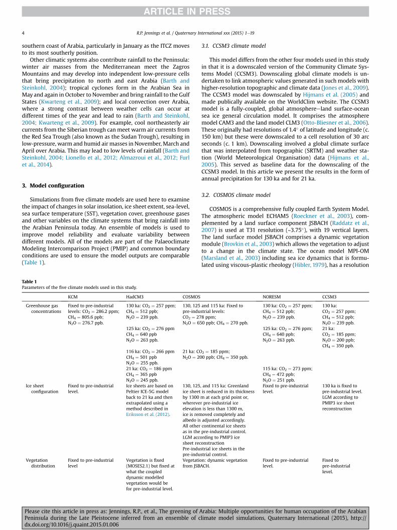
Simulations from five climate models are used here to examinethe impact of changes in solar insolation, ice sheet extent, sea-level,sea surface temperature (SST), vegetation cover, greenhouse gasesand other variables on the climate systems that bring rainfall intothe Arabian Peninsula today. An ensemble of models is used toimprove model reliability and evaluate variability betweendifferent models. All of the models are part of the PalaeoclimateModeling Intercomparison Project (PMIP) and common boundaryconditions are used to ensure the model outputs are comparable(Table 1).
Table 1Parameters of the five climate models used in this study.
KCM HadCM3 COSMOS
Greenhouse gasconcentrations
Fixed to pre-industriallevels: CO2 ¼ 286.2 ppm;CH4 ¼ 805.6 ppb;N2O ¼ 276.7 ppb.
130 ka: CO2 ¼ 257 ppm;CH4 ¼ 512 ppb;N2O ¼ 239 ppb.
130, 125pre-induCO2 ¼ 27N2O ¼ 65
125 ka: CO2 ¼ 276 ppmCH4 ¼ 640 ppbN2O ¼ 263 ppb.
116 ka: CO2 ¼ 266 ppmCH4 ¼ 501 ppbN2O ¼ 255 ppb.
21 ka: CON2O ¼ 20
21 ka: CO2 ¼ 186 ppmCH4 ¼ 365 ppbN2O ¼ 245 ppb.
Ice sheetconfiguration
Fixed to pre-industriallevel.
Ice sheets are based onPeltier ICE-5G modelback to 21 ka and thenextrapolated using amethod described inEriksson et al. (2012).
130, 125ice sheetby 1300whereveelevationice is remalbedo isAll otheras in theLGM accsheet recPre-indupre-indu
Vegetationdistribution
Fixed to pre-industriallevel
Vegetation is fixed(MOSES2.1) but fixed atwhat the coupleddynamic modelledvegetation would befor pre-industrial level.
Vegetatiofrom JSB
Please cite this article in press as: Jennings, R.P., et al., The greening of APeninsula during the Late Pleistocene inferred from an ensemble of cdx.doi.org/10.1016/j.quaint.2015.01.006
3.1. CCSM3 climate model
This model differs from the other four models used in this studyin that it is a downscaled version of the Community Climate Sys-tems Model (CCSM3). Downscaling global climate models is un-dertaken to link atmospheric values generated in such models withhigher-resolution topographic and climate data (Jones et al., 2009).The CCSM3 model was downscaled by Hijmans et al. (2005) andmade publically available on the WorldClim website. The CCSM3model is a fully-coupled, global atmosphereeland surface-oceansea ice general circulation model. It comprises the atmospheremodel CAM3 and the land model CLM3 (Otto-Bliesner et al., 2006).These originally had resolutions of 1.4� of latitude and longitude (c.150 km) but these were downscaled to a cell resolution of 30 arcseconds (c. 1 km). Downscaling involved a global climate surfacethat was interpolated from topographic (SRTM) and weather sta-tion (World Meteorological Organisation) data (Hijmans et al.,2005). This served as baseline data for the downscaling of theCCSM3 model. In this article we present the results in the form ofannual precipitation for 130 ka and for 21 ka.
3.2. COSMOS climate model
COSMOS is a comprehensive fully coupled Earth System Model.The atmospheric model ECHAM5 (Roeckner et al., 2003), com-plemented by a land surface component JSBACH (Raddatz et al.,2007) is used at T31 resolution (~3.75�), with 19 vertical layers.The land surface model JSBACH comprises a dynamic vegetationmodule (Brovkin et al., 2003) which allows the vegetation to adjustto a change in the climate state. The ocean model MPI-OM(Marsland et al., 2003) including sea ice dynamics that is formu-lated using viscous-plastic rheology (Hibler, 1979), has a resolution
NORESM CCSM3
and 115 ka: Fixed tostrial levels:8 ppm;0 ppb; CH4 ¼ 270 ppb.
130 ka: CO2 ¼ 257 ppm;CH4 ¼ 512 ppb;N2O ¼ 239 ppb.
130 ka:CO2 ¼ 257 ppm;CH4 ¼ 512 ppb;N2O ¼ 239 ppb.
125 ka: CO2 ¼ 276 ppm;CH4 ¼ 640 ppb;N2O ¼ 263 ppb.
21 ka:CO2 ¼ 185 ppm;N2O ¼ 200 ppb;CH4 ¼ 350 ppb.
2 ¼ 185 ppm;0 ppb; CH4 ¼ 350 ppb.
115 ka: CO2 ¼ 273 ppm;CH4 ¼ 472 ppb;N2O ¼ 251 ppb.
, and 115 ka: Greenlandis reduced in its thicknessm at each grid point or,r pre-industrial iceis less than 1300 m,oved completely andadjusted accordingly.continental ice sheetspre-industrial control.ording to PMIP3 iceonstructionstrial ice sheets in thestrial control.
Fixed to pre-industriallevel.
130 ka is fixed topre-industrial level.LGM according toPMIP3 ice sheetreconstruction
n: dynamic vegetationACH.
Fixed to pre-industriallevel.
Fixed topre-industriallevel.
rabia: Multiple opportunities for human occupation of the Arabianlimate model simulations, Quaternary International (2015), http://
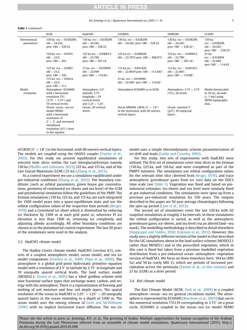
Table 1 (continued )
KCM HadCM3 COSMOS NORESM CCSM3
Astronomicalparameters
130 ka: ecc ¼ 0.038209,obl ¼ 24.242,prec-180 ¼ 228.32.
130 ka: ecc ¼ 0.038209obl ¼ 24.242,prec-180 ¼ 228.32.
130 ka: ecc ¼ 0.038209obl ¼ 24.242, prec-180 ¼ 228.32.
130 ka: ecc ¼ 0.038209,obl ¼ 24.242� ,prec-180� ¼ 228.32� .
130 ka:ecc ¼ 0.038209,obl ¼ 24.242� ,prec-180� ¼ 228.32� .
126 ka: ecc ¼ 0.0397,obl ¼ 23.9,prec-180 ¼ 291.
125 ka ecc ¼ 0.040013obl ¼ 23.798prec-180 ¼ 307.14.
125 ka ecc ¼ 0.040028obl ¼ 23.7872 prec-180 ¼ 308.073� .
125 ka: ecc ¼ 0.040013,obl ¼ 23.798� ,prec-180� ¼ 307.14� .
21 ka:ecc ¼ 0.018994obl ¼ 22.949�
peri-180� ¼ 114.42� .122 ka: ecc ¼ 0.0407,obl ¼ 23.2,prec-180 ¼ 356.
21 ka: ecc ¼ 0.018994obl ¼ 22.949�
peri-180� ¼ 114.42� .
115 ka ecc ¼ 0.041420obl ¼ 22.4019 prec-180 ¼ 111.843� .
115 ka: ecc ¼ 0.041421,obl ¼ 22.405� ,prec-180� ¼ 110.88� .
115 ka: ecc ¼ 0.0414,obl ¼ 22.4,prec-180 ¼ 111.
21 ka: ecc ¼ 0.018994obl ¼ 22.949� peri-180� ¼ 114.42� .
Modelresolution
Atmosphere: ECHAM5with a horizontalresolution T31(3.75� � 3.75�) and19 vertical levels.
Atmosphere: 2.5�
latitude, 3.75�
longitude� 19vertical levelsand 1.25 � 1.25� .
Atmosphere ECHAM5 as in KCM. Atmosphere: 3.75 � 3.75�
(T31), 26 levels.Model downscaledto 30 arc seconds(c. 1 km) usingSRTM topographicdata.
Ocean: oceanesea icemodel NEMOwith a horizontalresolution of2� � 2� and increasedmeridionalresolution (0.5�) closeto the equator.
Ocean: 20 verticallevels.
Ocean MPIOM: GR30 (3� � 1.8�)in the horizontal, with 40 unevenvertical layers.
Ocean: nominal 3�
(g37), 30 isopycnallayers.
R.P. Jennings et al. / Quaternary International xxx (2015) 1e19 5
of GR30 (3� �1.8�) in the horizontal, with 40 uneven vertical layers.The models are coupled using the OASIS3 coupler (Valcke et al.,2003). For this study we present equilibrated simulations ofselected time slices within the Last Interglacial/Eemian namely130 ka (Pfeiffer and Lohmann, 2013), 125 ka, and 115 ka, and of theLast Glacial Maximum (LGM) (21 ka) (Zhang et al., 2013).
As a control experiment we use a simulation equilibrated underpre-industrial conditions (Zhang et al., 2013). The boundary con-ditions (such as orbital parameters, green house gas concentra-tions, geometry of continental ice sheets and sea level) of the LGMand preindustrial simulation follow the guidelines of the PMIP. TheEemian simulations (130 ka, 125 ka, and 115 ka) are each integratedfor 1500 model years into a quasi-equilibrium state and use theorbital configuration values of the respective time periods (Berger,1978) and a Greenland ice sheet which is diminished by reducingice thickness by 1300 m at each grid point or, wherever PI iceelevation is less than 1300 m, removing ice completely andadjusting albedo accordingly. All other boundary conditions arechosen as in the preindustrial control experiment. The last 50 yearsof the simulations were used in the analysis.
3.3. HadCM3 climate model
The Hadley Centre climate model, HadCM3 (version 4.5), con-sists of a coupled atmospheric model, ocean model, and sea icemodel components (Gordon et al., 2000; Pope et al., 2000). Theatmosphere is a global grid-point hydrostatic primitive equationmodel with a resolution of 2.5� in latitude by 3.75� in longitude and19 unequally spaced vertical levels. The land surface model(MOSES2.1; Essery et al., 2001) has a ‘tiled’ gridbox scheme withnine fractional surface types that exchange water, carbon, and en-ergy with the atmosphere. There is a representation of freezing andmelting of soil moisture and four soil depth layers. The spatialresolution of the ocean in HadCM3 is 1.25� � 1.25� � 20 unequallyspaced layers in the ocean extending to a depth of 5200 m. Theocean model uses the mixing scheme of Gent and McWilliams(1990) with no explicit horizontal tracer diffusion. The sea ice
Please cite this article in press as: Jennings, R.P., et al., The greening of APeninsula during the Late Pleistocene inferred from an ensemble of cdx.doi.org/10.1016/j.quaint.2015.01.006
model uses a simple thermodynamic scheme parameterisation ofice drift and leads (Cattle and Crossley, 1995).
For this study, two sets of experiments with HadCM3 wereutilised. The first set of simulations cover time slices in the Eemian(130 ka, 125 ka, and 116 ka) and were completed as part of thePMIP3 initiative. The simulations use orbital configuration valuesfor the relevant time slice (derived from Berger, 1978), and traceatmospheric greenhouse gases from ice core data on the EDC3time-scale (see Table 1). Vegetation was fixed and based on pre-industrial estimates. Ice-sheets and sea level were similarly fixedat pre-industrial conditions. The simulations were spun up from aprevious pre-industrial simulation for 550 years. The outputsdescribed in this paper are 50-year average climatologies followingthe spin-up period (Lunt et al., 2013).
The second set of simulations cover the last 120 ka with 62snapshot simulations at roughly 2 ka intervals. In these simulationsthe orbital configuration is varied, as well as the atmosphericgreenhouse gases, ice-sheets, and sea level (via an altered landeseamask). Themodellingmethodology is described in detail elsewhere(Singarayer and Valdes, 2010; Eriksson et al., 2012). However, thisstudy uses a slightly different version of themodel to that describedfor the LIG simulations above in the land surface scheme (MOSES2.1rather than MOSES1) and in the prescribed vegetation, which inthis case is fixed but taken from a previous modelled vegetationdistribution from a pre-industrial oceaneatmosphereevegetationversion of HadCM3. We focus on three timeslices here: 104 ka (MIS5a) and 56 ka (early MIS 3), which are periods of increased pre-cipitation across the peninsula (Parton et al., in this volume) and21 ka (LGM) as a drier period.
3.4. Kiel climate model
The Kiel Climate Model (KCM; Park et al., 2009) is a coupledatmosphereeoceanesea ice general circulation model. The atmo-sphere is represented by ECHAM5 (Roeckner et al., 2003) that ran inthe numerical resolution T31L19 corresponding to 3.75� on a greatcircle. ECHAM5 is coupled to the oceanesea ice model NEMO
rabia: Multiple opportunities for human occupation of the Arabianlimate model simulations, Quaternary International (2015), http://

R.P. Jennings et al. / Quaternary International xxx (2015) 1e196
(Madec, 2006) that has a horizontal resolution of about 1.3� withenhanced meridional resolution of 0.5� close to the equator. KCMshows good agreement between simulated precipitation and ob-servations for contemporary climate, as well as with the hydro-logical changes that occurred during themid-Holocene (Khon et al.,2010).
Four 1000 year-long time-slice simulations were performedusing different orbital configurations (Braconnot et al., 2008). Thesecorresponded to four Eemian (130, 126, 122 and 115 ka) epochs andhad been completed in a previous model experiment (Khon et al.,2010). The concentration of greenhouse gases (GHGs) was fixedto pre-industrial levels. To account for model spin-up only the last100 years of the simulations were analysed. Here we focus on 130,126 and 115 ka timeslices.
3.5. NorESM climate model
The Norwegian Earth System Model (NorESM; Bentsen et al.,2013; Iversen et al., 2013), is derived from the Community EarthSystem Model (CESM) developed at the National Center for At-mospheric Research (NCAR). It consists of the same components forthe atmosphere (CAM4), land (CLM4) and sea ice (CICE4), and usesthe CESM coupler (CLP7). However, these are coupled to a versionof the Miami Isopycnic Coordinate Ocean Model (MICOM) which ismodified in order to improve conservation of mass and heat, andthe efficiency and robustness tracer transport (Assmann et al.,2010).
The simulations used in this study are performed with the low-resolution version of NorESM (NorESM-L; Zhang et al., 2012). Theatmosphere has a spatial resolution of approximately 3.75� (T31)with 26 vertical levels. The ocean has a nominal grid size of 3� (g37)with 30 isopycnic layers.
This study includes three Last Interglacial experiments withGHG and orbital parameters fixed to 130, 125, and 115 ka values, asdescribed in Langebroek and Nisancioglu (2014). These werebranched off a 500 year pre-industrial run and the output describedin this paper is 100 year average climatologies at the end of the1000 year integrations.
4. Precipitation simulations
Important aspects of the predicted precipitation levels producedby themodels are briefly described. These are presented in absolutevalues of mm per month or, in the case of the downscaled CCSMmodel, mm per year. Winter (January) and summer (August) valuesare shown in Figs. 4e8, with additional monthly data available inSupplementary Information 1. Beforehand, we examined pre-industrial levels of the models and evaluated how they comparedwith the observational data described in Section 2. This was un-dertaken because if pre-industrial rainfall levels are not accurate forthe present day, then they may not be accurate for timeslices of theLast Interglacial or any other past period. The results are shown inFig. 2. They show that HadCM3 and KCM underestimate precipi-tation more than NorESM and COSMOS, with NorESM the mostaccurate for modelling Mediterranean winter westerlies. However,it is important that none of the models overestimate pre-industrialprecipitation, because any increased precipitation levels of thetimeslices under this study could be attributed to this observation.
4.1. CCSM3 climate model (Fig. 3)
130 ka: The annual rainfall values of the CCSM3 model showthat Mediterranean westerlies bring 500e1500 mm of rainfall tothe Middle East, with the highest values recorded in the Leb-anoneAnti-Lebanon mountain ranges. Values of 200 mm extend
Please cite this article in press as: Jennings, R.P., et al., The greening of APeninsula during the Late Pleistocene inferred from an ensemble of cdx.doi.org/10.1016/j.quaint.2015.01.006
into Sinai and northern Saudi Arabia. Further south and in centralArabia rainfall levels exceed 600 mm. Most other parts of thepeninsula receive up to 600mmper year, with a small area in southcentral and most of eastern Arabia receiving <300 mm.
21 ka (LGM): Precipitation during the Last Glacial Maximum isrestricted to three main areas: the mountains of southern Yemen,where summer rainfall levels reach 600 mm; the Levant, whereMediterranean rainfall exceeds 1000 mm in the north and 600 mmin the southern Jordan highlands; and in central Arabia, whereannual rainfall reaches 300 mm. Elsewhere, vast tracts of thePeninsula are arid.
4.2. COSMOS climate model (Fig. 4)
130 ka: Mediterranean winter westerlies (NoveMarch) bring200 mm of rainfall to northern Jordan and Syria, but hyper-aridconditions (<80 mm) prevail across other parts of the Arabianpeninsula during the winter months. In May, weather patternsdriven by the Indian monsoon bring rainfall across the southernthird of Arabia, from the Arabian Gulf to the Red Sea. The rain fromthismonsoonal systemeases in June but it is replaced bymonsoonalrainfall from subtropical Africa, which spreads across the entirepeninsula. This peaks in September, when it extends as far north asthe Mediterranean Sea and into Syria at 34�N. The rainfall does notentirely dissipate until December, persisting in coastal regions of theRed Sea and southern Arabia. In total for the year, 300 mm of pre-cipitation falls in Syria and Jordan and up to 200 mm in Sinai,northern Saudi Arabia and southern Jordan, from both winter andsummer rainfall. Elsewhere, 650 mm falls in central Arabia and asmuch as 1400 mm falls in the south of the peninsula, which isaffected by both Indian and African monsoon systems.
125 ka: Mediterranean winter westerlies are unchanged from130 ka. Rainfall from Indian monsoonal activity in May covers asimilar geographic range to the 130 ka simulation, but is stronger.The same can be said of the arrival of the Africanmonsoonal rains inJune, which extends north into the Sinai a month earlier than in130 ka, and on into the Mediterranean Sea and as far north as Syria.In total, 400 of precipitation falls throughout the year in Syria andnorthern Jordan, 250 mm in southern Jordan, Sinai and northernSaudi Arabia, 760mm in central Arabia, and as much as 1800mm inthe south of Arabia.
115 ka: The Mediterranean winter westerlies lose intensity anddo not extend into the Middle East beyond February. A period ofrainfall in southwestern Arabia occurs in June and remains untilSeptember, occasionally integrating with Indian and Africanmonsoonal activity, which in marked contrast to 130 ka and 126 kasimulations that never significantly penetrate into the peninsula.Total annual rainfall in the Syria and northern Jordan does notexceed 100 mm, while levels in the south do not exceed 500 mm.
21 ka (LGM): The coldest time of the last glacial brings extremearidity to the Arabian Peninsula. From NovembereFebruary, Med-iterranean westerlies bring 200 mm of rainfall no further souththan 28�N. There is almost no rainfall from MarcheJune in thepeninsula, and from JulyeAugust it is restricted to SW Arabia andthere it does not exceed 200 mm.
4.3. HadCM3 climate model (Figs. 5 and 6)
130 ka: Two weather systems dominate rainfall: the Mediter-ranean westerlies, which brings rain into southern Jordan and theArabian Gulf, and the African summer monsoon, which extends inAugust up the Red Sea and across SWArabia. Total annual rainfall inboth the Mediterranean and SW Arabia is 100e650 mm, but inintervening areas rainfall is low (<80 mm). The majority of therainfall in central Arabia arrives in AprileMaywhen aweather front
rabia: Multiple opportunities for human occupation of the Arabianlimate model simulations, Quaternary International (2015), http://

Fig. 2. Pre-industrial precipitation levels of four climate models used in this study. The levels represent (NorESM and COSMOS) or under-represent (HadCM3 and KCM) the mainelements of Arabian precipitation but do not detect local climate systems. That the models do not over-represent present day values means increased rainfall levels seen in climatemodels of past conditions is not a result of present day biases.
R.P. Jennings et al. / Quaternary International xxx (2015) 1e19 7
extends from the Arabian Gulf and meets weather patterns comingup from sub-tropical Africa ahead of the arrival of the full monsoonin SW Arabia. The southern rainfall belt reaches 22�N in August.
125 ka: Mediterraneanwesterlies bring similar rainfall amountsas seen in the 130 ka simulation. Levels are more intense in SWArabia than at 130 ka as they exceed 500 mm per year and reach23�N, but the arid zone over central Arabia still persists, withrainfall not above 100 mm per annum in these areas.
116 ka: Mediterranean westerlies once again remain constantcompared with early simulations, but rainfall contracts and reducesto 400 mm in SW Arabia. Large areas of central Arabia are hyper-arid as they receive <20 mm of annual rainfall.
104 ka (MIS 5c) and 56 ka (mid MIS 3): Rainfall is very similar tothe 130 ka and 125 ka simulations, but patterns are marginally lessintense and extensive.
21 ka (LGM): Mediterranean weather patterns are consistentwith the 116 ka simulation. It is in the south of the peninsula where
Please cite this article in press as: Jennings, R.P., et al., The greening of APeninsula during the Late Pleistocene inferred from an ensemble of cdx.doi.org/10.1016/j.quaint.2015.01.006
rainfall is most different from the 116 ka timeslice but 20 mmannual rainfall still persists in SW Arabia. Intervening areas arehyper-arid (<40 mm).
4.4. Kiel climate model (Fig. 7)
130 ka: From NovembereMarch, Mediterranean westerliesbring rainfall levels of at least 120 mm per year to the windwardside of the Lebanon and the anti Lebanon mountain ranges in Syria,only 60 mm in southern Jordan, and even less in Saudi Arabia andthe Sinai peninsula. By April and May, the westerlies disappear asthe ITCZ moves northwards, bringing slight rainfall to the south ofArabia. Subtropical precipitation from Africa and minor contribu-tions from the Indian monsoon falls from June to September up to27�N, in line with the head of the Arabian Gulf and the Sinai. Therainfall all but disappears from the peninsula in October. The
rabia: Multiple opportunities for human occupation of the Arabianlimate model simulations, Quaternary International (2015), http://

R.P. Jennings et al. / Quaternary International xxx (2015) 1e198
Please cite this article in press as: Jennings, R.P., et al., The greening of Arabia: Multiple opportunities for human occupation of the ArabianPeninsula during the Late Pleistocene inferred from an ensemble of climate model simulations, Quaternary International (2015), http://dx.doi.org/10.1016/j.quaint.2015.01.006

Fig. 4. Winter (January) and summer (August) rainfall levels of the COSMOS climate model. These show that the Arabian Peninsula was much wetter at 130 ka and 125 ka than115 ka or the present day. The source of the increased rainfall is the North African summer monsoon, which brought the highest monthly rainfall to Arabia in the month of August.The models suggest that rainfall from Mediterranean winter westerlies was not a major source of increased precipitation.
R.P. Jennings et al. / Quaternary International xxx (2015) 1e19 9
highest rainfall levels reach 460 mm per annum in the south of thepeninsula.
126 ka: Mediterranean westerlies are marginally weaker fromNoveMarch during the last interglacial peak than at 130 ka. They,however, increase in intensity in the south as the ITCZ movesnorthwards and the African monsoon system brings intensiverainfall of up to 600 mm, with rainfall lasting from June rightthrough to September once again, followed by an almost aridOctober. The rain from the south reaches 29�N.
115 ka: Mediterranean winter westerlies weaken and extend nofurther south than Jordan at their peak in January. By April theydisappear from the Middle East while the southerly rainfall that
Fig. 3. The CCSM3 climate model timeslice of 130 ka shows that Arabia was wetter at thi300e600 mm per year. Orange in Northern Arabia represents the contracted Saharo-Arabiareferences to colour in this figure legend, the reader is referred to the web version of this
Please cite this article in press as: Jennings, R.P., et al., The greening of APeninsula during the Late Pleistocene inferred from an ensemble of cdx.doi.org/10.1016/j.quaint.2015.01.006
characterised the 130 ka and 126 ka timeslices during this monthdoes not appear until May. Light rainfall linked to the Africanmonsoon also arrives during this month, three months later than126 ka. It only passes over southern Arabia up to 19�N and rainfallremains at low intensity until November, giving a peak of only120 mm of rainfall per year.
4.5. NorESM climate model (Fig. 8)
130 ka: The Mediterranean winter westerlies arrive in theMiddle East in October and extend into the Sinai and northernSaudi Arabia in November. They retreat from these areas in March
s time than the present day. The dominant green colour equates to rainfall levels ofn desert belt where rainfall levels were <100 mm per year. (For interpretation of thearticle.)
rabia: Multiple opportunities for human occupation of the Arabianlimate model simulations, Quaternary International (2015), http://

Fig. 5. Winter (January) and summer (August) rainfall levels of the HadCM3 climate model. The summer timeslices for 130 ka and 125 ka show that the North African summermonsoon was the source of increased rainfall into the Peninsula. The spatial distribution of rainfall was not as extensive as that seen in the other models but nevertheless supportsthe idea that rainfall levels were higher 130 ka and 125 ka than today.
R.P. Jennings et al. / Quaternary International xxx (2015) 1e1910
but sweep around from the Arabian Gulf into Central Arabia tobring light rainfall into this region. In April, this rainfall links torainfall entering the Arabian Peninsula from the SW, a precursor tothe arrival of the African monsoon in June. In July, rain from theAfrican and Indian monsoons create a band of rainfall that coversthe southern half of Arabia. These reach their northward peak inAugust, bringing rain to around 28�N. They weaken the followingmonth with African monsoonal activity recorded in SW Arabia atthe same time the Mediterranean westerlies bring rainfall to thenorthern Levant. Total annual rainfall in Sinai and northern SaudiArabia is 160 mm, central Arabia 200 mm, and in southern Arabia itis 450 mm.
125 ka: The Mediterranean winter westerlies do not extendsouth over the entire Sinai as they do in 130 ka simulation, and therainfall sweeping into central Arabia in March is also weaker. Thisconnects with rainfall from NE Africa in AprileMay to create aSWeNE band of light rainfall across the peninsula. African andIndian monsoonal activity is broadly the same as in the 130 kasimulation, though it is stronger and persists further north inSeptember.
115 ka: There is a strengthening of theMediterraneanwesterliesin the Arabian Gulf and central Arabia compared with the 130 kaand 125 ka simulations and the simulation provides a particularlypronounced arrival of the westerlies in November, which bringlight rainfall as far south as NE Africa. Aweakened Africanmonsoonsystem is the reason for an absence of interconnectivity betweenMediterranean and African weather patterns in April and May.African and Indian monsoonal rainfall arrives in July, is light,
Please cite this article in press as: Jennings, R.P., et al., The greening of APeninsula during the Late Pleistocene inferred from an ensemble of cdx.doi.org/10.1016/j.quaint.2015.01.006
extends no further than SW Arabia and Oman, and is gone bySeptember.
4.6. Summary
All models simulate the main aspects of the weather systems ofArabia, however some are much wetter than others. For the 130 katimeslice, models exhibiting extensive rainfall patterns are CCSM3,which shows rainfall originating in Africa as far north as northernArabia in the summer months, and COSMOS, which shows rainfallfrom Africa reaching the Mediterranean Sea. The Africanmonsoonal rains reach central Arabia in the KCM and NorESMmodels, and in southern Arabia for HadCM3. Mediterraneanwinterwesterlies are most pronounced in the NorESM and HadCM3models, with rainfall shown reaching the Arabian Gulf. In terms ofintensity, Rainfall levels are highest in SWArabia, where they rangefrom 1400 mm per year for the COSMOSmodel to 450 mm per yearfor HadCM3. These patterns strengthen slightly for the four modelsused to convey precipitation at 126/125 ka. There is then anoticeable decline in summer precipitation in the 115 ka timeslicesof the fourmodels, with levels below present day values in all cases.The same reductions are seen in rainfall of the Mediterraneanwinter westerlies, with the one exception being NorESM, whichshows a minor increase in rainfall a 115 ka compared with 125 ka.Timeslices of the HadCM3 model for 104 ka and 56 ka show pat-terns similar to their 125 ka timeslice where rainfall is shown in thesouthern parts of Arabia. Three timeslices for 21 ka have the lowestlevels of rainfall of any of the periods investigated. We can now
rabia: Multiple opportunities for human occupation of the Arabianlimate model simulations, Quaternary International (2015), http://
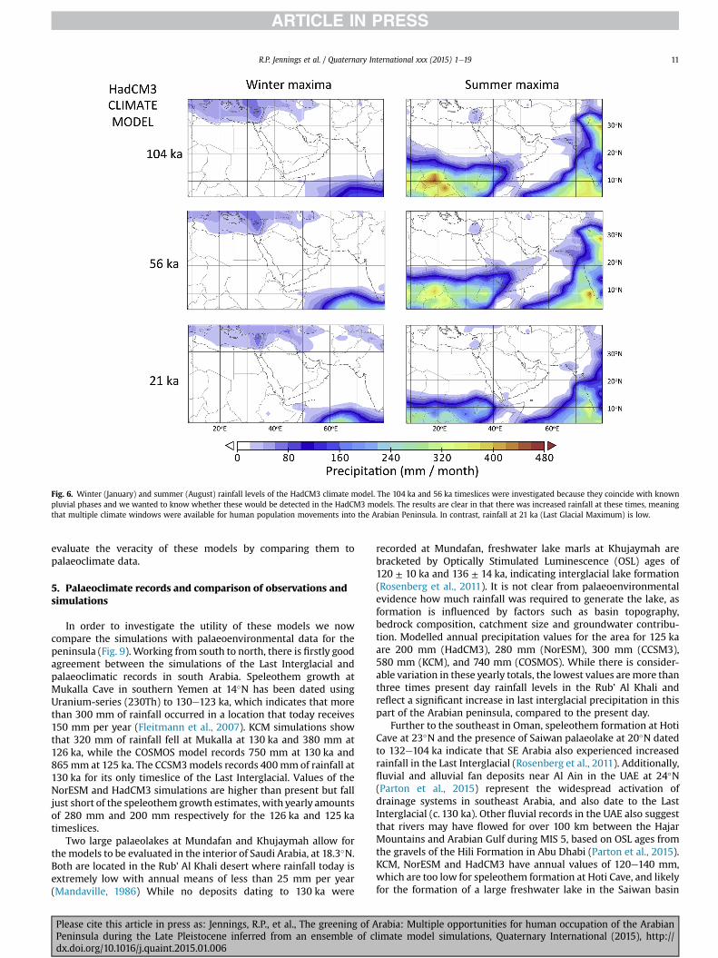
Fig. 6. Winter (January) and summer (August) rainfall levels of the HadCM3 climate model. The 104 ka and 56 ka timeslices were investigated because they coincide with knownpluvial phases and we wanted to know whether these would be detected in the HadCM3 models. The results are clear in that there was increased rainfall at these times, meaningthat multiple climate windows were available for human population movements into the Arabian Peninsula. In contrast, rainfall at 21 ka (Last Glacial Maximum) is low.
R.P. Jennings et al. / Quaternary International xxx (2015) 1e19 11
evaluate the veracity of these models by comparing them topalaeoclimate data.
5. Palaeoclimate records and comparison of observations andsimulations
In order to investigate the utility of these models we nowcompare the simulations with palaeoenvironmental data for thepeninsula (Fig. 9). Working from south to north, there is firstly goodagreement between the simulations of the Last Interglacial andpalaeoclimatic records in south Arabia. Speleothem growth atMukalla Cave in southern Yemen at 14�N has been dated usingUranium-series (230Th) to 130e123 ka, which indicates that morethan 300 mm of rainfall occurred in a location that today receives150 mm per year (Fleitmann et al., 2007). KCM simulations showthat 320 mm of rainfall fell at Mukalla at 130 ka and 380 mm at126 ka, while the COSMOS model records 750 mm at 130 ka and865mm at 125 ka. The CCSM3models records 400mmof rainfall at130 ka for its only timeslice of the Last Interglacial. Values of theNorESM and HadCM3 simulations are higher than present but falljust short of the speleothem growth estimates, with yearly amountsof 280 mm and 200 mm respectively for the 126 ka and 125 katimeslices.
Two large palaeolakes at Mundafan and Khujaymah allow forthe models to be evaluated in the interior of Saudi Arabia, at 18.3�N.Both are located in the Rub' Al Khali desert where rainfall today isextremely low with annual means of less than 25 mm per year(Mandaville, 1986) While no deposits dating to 130 ka were
Please cite this article in press as: Jennings, R.P., et al., The greening of APeninsula during the Late Pleistocene inferred from an ensemble of cdx.doi.org/10.1016/j.quaint.2015.01.006
recorded at Mundafan, freshwater lake marls at Khujaymah arebracketed by Optically Stimulated Luminescence (OSL) ages of120 ± 10 ka and 136 ± 14 ka, indicating interglacial lake formation(Rosenberg et al., 2011). It is not clear from palaeoenvironmentalevidence how much rainfall was required to generate the lake, asformation is influenced by factors such as basin topography,bedrock composition, catchment size and groundwater contribu-tion. Modelled annual precipitation values for the area for 125 kaare 200 mm (HadCM3), 280 mm (NorESM), 300 mm (CCSM3),580 mm (KCM), and 740 mm (COSMOS). While there is consider-able variation in these yearly totals, the lowest values aremore thanthree times present day rainfall levels in the Rub’ Al Khali andreflect a significant increase in last interglacial precipitation in thispart of the Arabian peninsula, compared to the present day.
Further to the southeast in Oman, speleothem formation at HotiCave at 23�N and the presence of Saiwan palaeolake at 20�N datedto 132e104 ka indicate that SE Arabia also experienced increasedrainfall in the Last Interglacial (Rosenberg et al., 2011). Additionally,fluvial and alluvial fan deposits near Al Ain in the UAE at 24�N(Parton et al., 2015) represent the widespread activation ofdrainage systems in southeast Arabia, and also date to the LastInterglacial (c. 130 ka). Other fluvial records in the UAE also suggestthat rivers may have flowed for over 100 km between the HajarMountains and Arabian Gulf during MIS 5, based on OSL ages fromthe gravels of the Hili Formation in Abu Dhabi (Parton et al., 2015).KCM, NorESM and HadCM3 have annual values of 120e140 mm,which are too low for speleothem formation at Hoti Cave, and likelyfor the formation of a large freshwater lake in the Saiwan basin
rabia: Multiple opportunities for human occupation of the Arabianlimate model simulations, Quaternary International (2015), http://

Fig. 7. Winter (January) and summer (August) rainfall levels of the Kiel climate model for 130, 126 and 115 ka. The Kiel timeslices show clear evidence for increased rainfall in theArabian Peninsula from the North African summer monsoon at 130 ka and 126 ka, with levels declining by 115 ka.
R.P. Jennings et al. / Quaternary International xxx (2015) 1e1912
(Rosenberg et al., 2013), or within the southern Rub al Khali(Rosenberg et al., 2012). COSMOS predicts 420 mm for Hoti Caveand 300 mm at the Saiwan basin at 125 ka, which agrees best withthe available data. Further, the models show that rainfall was notnecessarily exclusively from an Africanmonsoon source. Rather, themodels suggest that precipitation in these regions is derived fromboth African and Indian monsoon activity.
Unfortunately, there are presently no dated palae-oenvironmental sites in central Arabia with which to validate themodels. Many of the models, however, show adequate rainfall inthis area, which is reasonable, given the potential extent ofincreased humidity indicated by the wider palaeoclimatic record.Future validation may be provided by dates from speleothem for-mations at Surprise Cave at 26�N, which are located in central SaudiArabia (Fleitmann et al., 2004).
Moving further northwards, the next palaeoenvironmentaldatasets encountered to test themodel simulations are in the Nefuddesert in north-central Saudi Arabia at 27�N. Palaeolakes haverecently been dated to 130e115 ka in the western Nefud nearTayma (Rosenberg et al., 2013), and at Jubbah Palaeolake near Ha'il(Petraglia, 2011), but only one set of deposits has been dated withreasonable certainty. These are at an interdunal locality within thewestern Nefud (Rosenberg et al., 2013). Sand above and below a0.50 m thick layer of lacustrine diatomites and plant remains wasdated using OSL to 128 ± 9 ka and 125 ± 10 ka respectively. TheKCM, HadCM3 and NorESM models suggest annual rainfall at126 ka or 125 ka here was less than 100 mm, likely too low tosustain lakes unless seasonally recharged by groundwater. How-ever, COSMOS and CCSM3models are more in agreement with lake
Please cite this article in press as: Jennings, R.P., et al., The greening of APeninsula during the Late Pleistocene inferred from an ensemble of cdx.doi.org/10.1016/j.quaint.2015.01.006
formation at this time, with annual rainfall values of 280 mm and300 mm respectively.
When moving into the north of the peninsula, it is important toconsider what impact advancing winter Mediterranean westerlieshad upon rainfall totals in northern Arabia. However, rainfall fromthis direction appears to be low during the entire Last Interglacialfor all of the models. The westerlies indicate rainfall of at least120 mm per annum in north Jordan and Syria, falling on thewestern Lebanon and the Anti-Lebanon mountain ranges. There-after, rainfall levels decline abruptly to the south. At 130 ka, theCOSMOS and HadCM3 simulations show that winter westerliescontribute <80 mm per year of rainfall in the Arabian Peninsula,while the KCM model indicates <60 mm. The NorESM model, incontrast, shows the greatest southerly excursion of the Mediter-ranean weather patterns, reaching Sinai and northern Saudi Arabiaat 29�N but still contributing only 100 mm per annum. Rainfallfrom the westerlies is less or is unchanged in the 126 ka and 125 kasimulations. By 115 ka, rainfall is restricted to north Jordan in theCOSMOS, KCM and HADCM3 models, but in the NorESM model itextends as far south as northeast Africa, albeit at low levels.
Mudawwara palaeolake is an important locality to validate themodels in the north of the peninsula. The site comprises a series oflarge basins located in southern Jordan on the border with SaudiArabia at 29.3�N and provides evidence for lake formation duringMIS 5. A range of Uranium/Thorium dates on Cerastoderma shellswere generated, with those at Site 4 of relevance to the climatemodels under evaluation, providing a date for lake formation in thedepression of 125 ± 5 ka (Petit Maire et al., 2010). However, onlythree of the models, NorESM, COSMOS and CCSM3, produce levels
rabia: Multiple opportunities for human occupation of the Arabianlimate model simulations, Quaternary International (2015), http://
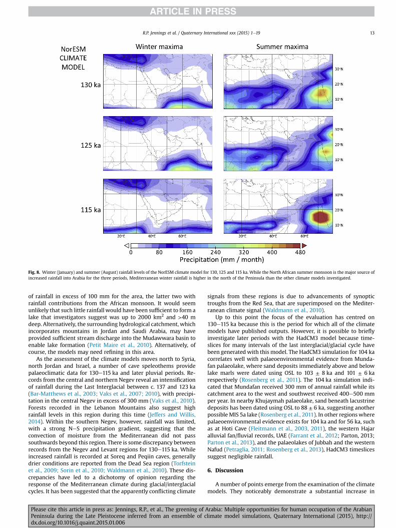
Fig. 8. Winter (January) and summer (August) rainfall levels of the NorESM climate model for 130, 125 and 115 ka. While the North African summer monsoon is the major source ofincreased rainfall into Arabia for the three periods, Mediterranean winter rainfall is higher in the north of the Peninsula than the other climate models investigated.
R.P. Jennings et al. / Quaternary International xxx (2015) 1e19 13
of rainfall in excess of 100 mm for the area, the latter two withrainfall contributions from the African monsoon. It would seemunlikely that such little rainfall would have been sufficient to form alake that investigators suggest was up to 2000 km2 and >40 mdeep. Alternatively, the surrounding hydrological catchment, whichincorporates mountains in Jordan and Saudi Arabia, may haveprovided sufficient stream discharge into the Mudawwara basin toenable lake formation (Petit Maire et al., 2010). Alternatively, ofcourse, the models may need refining in this area.
As the assessment of the climate models moves north to Syria,north Jordan and Israel, a number of cave speleothems providepalaeoclimatic data for 130e115 ka and later pluvial periods. Re-cords from the central and northern Negev reveal an intensificationof rainfall during the Last Interglacial between c. 137 and 123 ka(Bar-Matthews et al., 2003; Vaks et al., 2007; 2010), with precipi-tation in the central Negev in excess of 300 mm (Vaks et al., 2010).Forests recorded in the Lebanon Mountains also suggest highrainfall levels in this region during this time (Jeffers and Willis,2014). Within the southern Negev, however, rainfall was limited,with a strong NeS precipitation gradient, suggesting that theconvection of moisture from the Mediterranean did not passsouthwards beyond this region. There is some discrepancy betweenrecords from the Negev and Levant regions for 130e115 ka. Whileincreased rainfall is recorded at Soreq and Peqiin caves, generallydrier conditions are reported from the Dead Sea region (Torfsteinet al., 2009; Sorin et al., 2010; Waldmann et al., 2010). These dis-crepancies have led to a dichotomy of opinion regarding theresponse of the Mediterranean climate during glacial/interglacialcycles. It has been suggested that the apparently conflicting climate
Please cite this article in press as: Jennings, R.P., et al., The greening of APeninsula during the Late Pleistocene inferred from an ensemble of cdx.doi.org/10.1016/j.quaint.2015.01.006
signals from these regions is due to advancements of synoptictroughs from the Red Sea, that are superimposed on the Mediter-ranean climate signal (Waldmann et al., 2010).
Up to this point the focus of the evaluation has centred on130e115 ka because this is the period for which all of the climatemodels have published outputs. However, it is possible to brieflyinvestigate later periods with the HadCM3 model because time-slices for many intervals of the last interglacial/glacial cycle havebeen generated with this model. The HadCM3 simulation for 104 kacorrelates well with palaeoenvironmental evidence from Munda-fan palaeolake, where sand deposits immediately above and belowlake marls were dated using OSL to 103 ± 8 ka and 101 ± 6 karespectively (Rosenberg et al., 2011). The 104 ka simulation indi-cated that Mundafan received 300 mm of annual rainfall while itscatchment area to the west and southwest received 400e500 mmper year. In nearby Khujaymah palaeolake, sand beneath lacustrinedeposits has been dated using OSL to 88 ± 6 ka, suggesting anotherpossible MIS 5a lake (Rosenberg et al., 2011). In other regionswherepalaeoenvironmental evidence exists for 104 ka and for 56 ka, suchas at Hoti Cave (Fleitmann et al., 2003, 2011), the western Hajaralluvial fan/fluvial records, UAE (Farrant et al., 2012; Parton, 2013;Parton et al., 2013), and the palaeolakes of Jubbah and the westernNafud (Petraglia, 2011; Rosenberg et al., 2013), HadCM3 timeslicessuggest negligible rainfall.
6. Discussion
A number of points emerge from the examination of the climatemodels. They noticeably demonstrate a substantial increase in
rabia: Multiple opportunities for human occupation of the Arabianlimate model simulations, Quaternary International (2015), http://
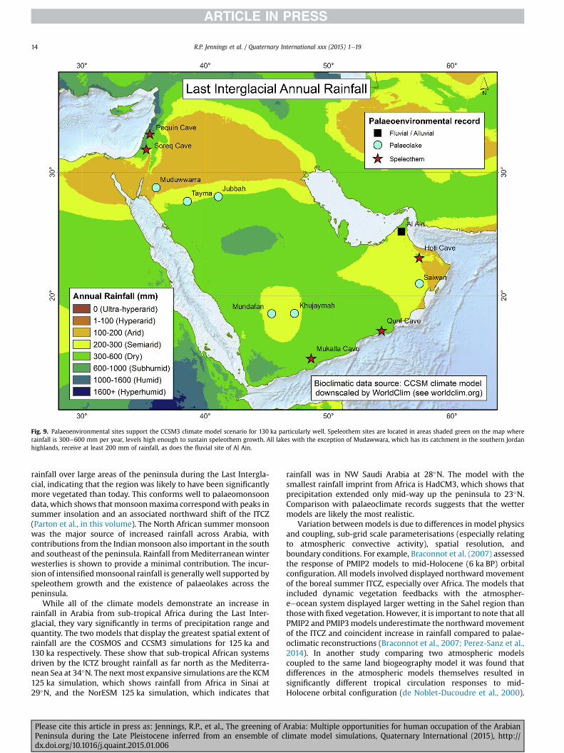
Fig. 9. Palaeoenvironmental sites support the CCSM3 climate model scenario for 130 ka particularly well. Speleothem sites are located in areas shaded green on the map whererainfall is 300e600 mm per year, levels high enough to sustain speleothem growth. All lakes with the exception of Mudawwara, which has its catchment in the southern Jordanhighlands, receive at least 200 mm of rainfall, as does the fluvial site of Al Ain.
R.P. Jennings et al. / Quaternary International xxx (2015) 1e1914
rainfall over large areas of the peninsula during the Last Intergla-cial, indicating that the region was likely to have been significantlymore vegetated than today. This conforms well to palaeomonsoondata, which shows that monsoonmaxima correspondwith peaks insummer insolation and an associated northward shift of the ITCZ(Parton et al., in this volume). The North African summer monsoonwas the major source of increased rainfall across Arabia, withcontributions from the Indianmonsoon also important in the southand southeast of the peninsula. Rainfall fromMediterraneanwinterwesterlies is shown to provide a minimal contribution. The incur-sion of intensifiedmonsoonal rainfall is generallywell supported byspeleothem growth and the existence of palaeolakes across thepeninsula.
While all of the climate models demonstrate an increase inrainfall in Arabia from sub-tropical Africa during the Last Inter-glacial, they vary significantly in terms of precipitation range andquantity. The two models that display the greatest spatial extent ofrainfall are the COSMOS and CCSM3 simulations for 125 ka and130 ka respectively. These show that sub-tropical African systemsdriven by the ICTZ brought rainfall as far north as the Mediterra-nean Sea at 34�N. The next most expansive simulations are the KCM125 ka simulation, which shows rainfall from Africa in Sinai at29�N, and the NorESM 125 ka simulation, which indicates that
Please cite this article in press as: Jennings, R.P., et al., The greening of APeninsula during the Late Pleistocene inferred from an ensemble of cdx.doi.org/10.1016/j.quaint.2015.01.006
rainfall was in NW Saudi Arabia at 28�N. The model with thesmallest rainfall imprint from Africa is HadCM3, which shows thatprecipitation extended only mid-way up the peninsula to 23�N.Comparison with palaeoclimate records suggests that the wettermodels are likely the most realistic.
Variation betweenmodels is due to differences in model physicsand coupling, sub-grid scale parameterisations (especially relatingto atmospheric convective activity), spatial resolution, andboundary conditions. For example, Braconnot et al. (2007) assessedthe response of PMIP2 models to mid-Holocene (6 ka BP) orbitalconfiguration. All models involved displayed northward movementof the boreal summer ITCZ, especially over Africa. The models thatincluded dynamic vegetation feedbacks with the atmospher-eeocean system displayed larger wetting in the Sahel region thanthosewith fixed vegetation. However, it is important to note that allPMIP2 and PMIP3models underestimate the northward movementof the ITCZ and coincident increase in rainfall compared to palae-oclimatic reconstructions (Braconnot et al., 2007; Perez-Sanz et al.,2014). In another study comparing two atmospheric modelscoupled to the same land biogeography model it was found thatdifferences in the atmospheric models themselves resulted insignificantly different tropical circulation responses to mid-Holocene orbital configuration (de Noblet-Ducoudre et al., 2000).
rabia: Multiple opportunities for human occupation of the Arabianlimate model simulations, Quaternary International (2015), http://
R.P. Jennings et al. / Quaternary International xxx (2015) 1e19 15
Differences in boundary conditions are also important, and in somecases dominate other factors. For example, DiNezio and Tierney(2013) demonstrated the importance of prescribing lower sealevel at the LGM by examining the performance of a range of LGMclimate model simulations in a model-data comparison for theIndo-Pacific region. Exposure of the Sunda Shelf was criticallyimportant to matching reconstructed changes to the glacial IndianOcean hydrologic pattern, due to its impact on the Walker circu-lation. The models that best simulated these patterns includedlower sea level and exposure of the shelf in the Indo-Pacific.
The models also detect climate changes within the Last Inter-glacial, suggesting that climatic conditions were not uniformlyhumid between ca. 130 ka and 115 ka. Precipitation was greatest at125 ka rather than at 130 ka, while levels were at their lowest as thelast interglacial ended at 115 ka. This pattern was repeated in all ofthemodels. In term of seasonality, four climatemodels show that assub-tropical African monsoon rainfall advanced in the summermonths during 130 ka and the 126/125 ka, Mediterranean winterwesterlies remained stable or also increased. As the summer sub-tropical rains contracted in the 115 ka simulations, so did thewinterwesterlies. The only exception was the NorESM model for 115 ka,which showed an increase inwinter rainfall when summer rainfallswere in decline. As such, the models generally provide some, albeitinconclusive, support to the suggestion that Mediterranean andmonsoon systems intensify in concert during mid-high latitudeinterglacials.
There were also subtle shifts in timing of weather patterns,although the peak month of rainfall was the summer month ofAugust in all cases. The minor shifts concerned the Mediterraneanwinter westerlies, which during four 115 ka simulations end in theMiddle East between JaneMarch rather than MarcheApril in the126/125 ka peaks. This shorter winter rainfall seasonmust have hadan impact on vegetation patterns in this area. In the LebanonMountains, forests gave way to grassland and steppe environmentsat the end of the Last Interglacial (Jeffers andWillis, 2014). Indeed, ashortened rainy season may have also impacted upon drip andspeleothem growth rates which in turn, may have led to theapparent dichotomy of records from the Negev and Levant regions.
While the focus of the climate simulations is on the Last Inter-glacial, there is good evidence that MIS 5c, MIS 5a, and early MIS 3(c. 60e55 ka) were also pluvial phases that brought rainfall to theArabian Peninsula (e.g. Rosenberg et al., 2011, 2012; Parton et al.,2013, 2014). The HadCM3 model is the only one currently avail-able to evaluate these phases, and even though it is the mostconservative of the models under evaluation in terms of rainfallduring MIS 5e, it indicates an increase in rainfall derived from sub-tropical Africa for each of these timeslices, albeit at a marginallyreduced intensity than seen for the Last Interglacial.
In periods of reduced precipitation, such as 115 ka, 21 ka, andtoday, there is a substantial fall in precipitation across the peninsulain all models, however, levels remain high in southern and south-eastern regions. This suggests that subtropical refugial environ-ments have persisted in these areas of the peninsula throughoutthe last 130,000 years.
6.1. Implications for human demography
In Arabia, the Middle Palaeolithic is known from several hun-dred sites and has been the topic of several investigations (e.g.Petraglia and Alsharekh, 2003; Crassard, 2009; Armitage et al.,2011; Rose et al., 2011; Delagnes et al., 2012; Groucutt andPetraglia, 2012; Petraglia et al., 2012; Usik et al., 2013; Scerriet al., 2014a,b; Groucutt et al., in this volume; Scerri et al., in thisvolume). The vast majority of sites occur from surface contexts,and so lack chronometric age estimates. Nevertheless, these surface
Please cite this article in press as: Jennings, R.P., et al., The greening of APeninsula during the Late Pleistocene inferred from an ensemble of cdx.doi.org/10.1016/j.quaint.2015.01.006
sites provide extremely important information on technologicalvariability in Arabia as well as insights into hominin landscape use.
Fig. 10 shows the distribution of published Middle Palaeolithicsites (updated from Groucutt and Petraglia, 2012) on the CCSM3model timeslice for 130 ka, which conveys high rainfall levels and isused as an analogy for a pluvial phase. The black dots refer either toindividual sites or to clusters of sites. In Dhofar, Oman, for example,hundreds of Middle Palaeolithic sites have recently been discoveredfollowing extensive surveys (Rose et al., 2011; Usik et al., 2013) andthese are represented by a single black dot. Additionally, there maybe surveying biases in the dataset; for instance the distributionmapshows a line of sites extending along the survey route to thenorthwest of Riyadh. Despite this, it is likely that at a peninsulawide level the distribution of sites does reflect, or at least mirror,something of the real distribution of sites.
Little has been published on the technological and behaviouralaspects of most of the Middle Palaeolithic sites of Arabia. Never-theless, there are some key anchor points across Arabia. Jebel Faya(Armitage et al., 2012) in the eastern UAE presents a series ofPalaeolithic assemblages. This site is situated in a region in whichthe climate model suggests was more humid than surroundingregions. Importantly, the site is situated within a large braidplainextending westwards from the Hajar Mountains, in which drainagechannels may have formed freshwater corridors linking the Gulf tothemountains. The location of the sitewithin this zonemay explainthe repeated occupation of Jebel Faya. In the Huqf area of Oman theextensive Palaeolithic record presents itself with a generally idio-syncratic character (Jagher, 2009). For example, the abundantNubian cores found a few hundred kilometres to the southwest areapparently entirely absent from this area. The climate models showthat the east of Arabia was arid even during periods such as MIS 5,which may suggest a considerable (i.e. Middle Pleistocene) antiq-uity for many of these sites. Nubian Levallois technology was firstrecognised in Yemen (Inizan and Ortlieb, 1987; Crassard, 2009) andsubsequently found in far great abundance in the neighbouringDhofar region of Oman (Rose et al., 2011; Usik et al., 2013). Mostrecently, this technology has been identified near Al Kharj in centralArabia (Crassard and Hilbert, 2013). The climate model shows thatthese sites are all in the 300e600 mm per year rainfall zone.
The CCSM3 climate model suggests that sites demonstrating analternative form of technology focused on centripetal Levalloistechnology (Groucutt et al., in this volume) were also located inregions that experienced increased rainfall. These included Mun-dafan in southwest Saudi Arabia (Crassard et al., 2013), sites in theUAE such as Jebel Barakah (Wahida et al., 2009) and Jebel Faya(Bretzke et al., 2014), and sites in northern Saudi Arabia such asJebel Qattar 1 and Jebel Umm Sanman 1 (Petraglia et al., 2012). AtJubbah in the Nefud desert, sites such as JKF-1 have been inter-preted as demonstrating similarities to sampled NE African sites(Scerri et al., 2014b), but others are reminiscent of the Levantinelate Middle Palaeolithic (Crassard and Hilbert, 2013), suggestingpossible MIS 5 or 3 connections to the north. In this sense theemerging picture suggests a more complex and varied MiddlePalaeolithic record in northern than in SE Arabia.
Finally, the sites of Wadi Surdud in Yemen, particularly SD-1,present a series of important and well-dated occupations(Delagnes et al., 2012). A suite of OSL dates firmly associates themajor human occupation with MIS 3 (c. 55 ka). This correlates withthe 56 ka pluvial phase of the HadCM3 model shown in Fig. 6.Palaeoenvironmental reconstruction and faunal analysis suggest atleast semi-arid condition during the occupation of the site. Thetechnological characteristics of SD-1 are unique, with reduction ofnon-Levallois character focussing on simple hard hammer reduc-tion of single platform cores to produce blades and elongatedpoints (Delagnes et al., 2012). While the ancestry of the occupants
rabia: Multiple opportunities for human occupation of the Arabianlimate model simulations, Quaternary International (2015), http://
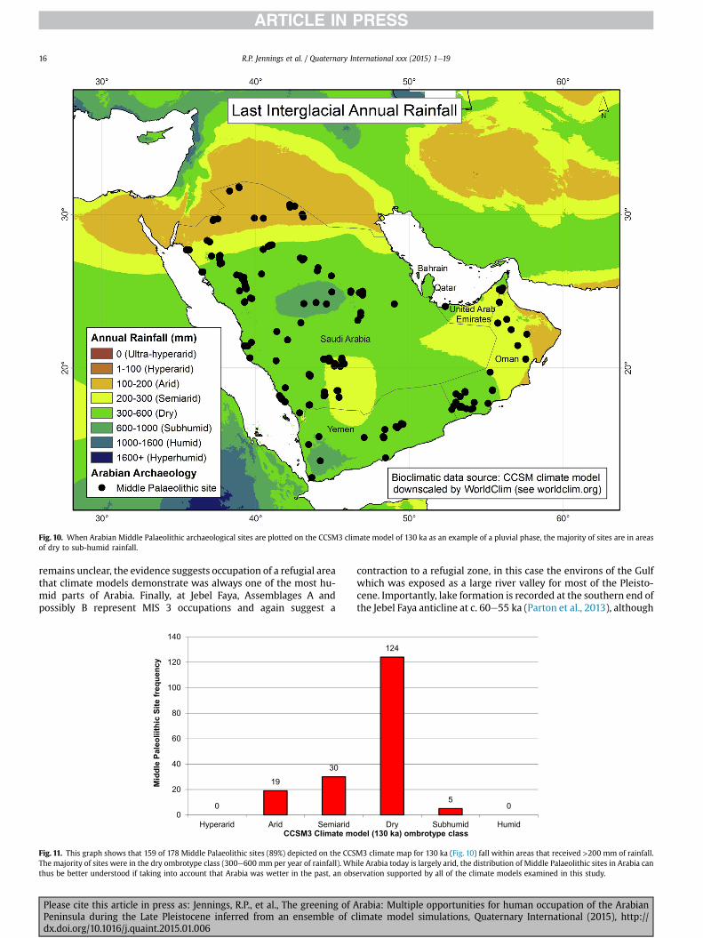
Fig. 10. When Arabian Middle Palaeolithic archaeological sites are plotted on the CCSM3 climate model of 130 ka as an example of a pluvial phase, the majority of sites are in areasof dry to sub-humid rainfall.
R.P. Jennings et al. / Quaternary International xxx (2015) 1e1916
remains unclear, the evidence suggests occupation of a refugial areathat climate models demonstrate was always one of the most hu-mid parts of Arabia. Finally, at Jebel Faya, Assemblages A andpossibly B represent MIS 3 occupations and again suggest a
Fig. 11. This graph shows that 159 of 178 Middle Palaeolithic sites (89%) depicted on the CCSThe majority of sites were in the dry ombrotype class (300e600 mm per year of rainfall). Whthus be better understood if taking into account that Arabia was wetter in the past, an obs
Please cite this article in press as: Jennings, R.P., et al., The greening of APeninsula during the Late Pleistocene inferred from an ensemble of cdx.doi.org/10.1016/j.quaint.2015.01.006
contraction to a refugial zone, in this case the environs of the Gulfwhich was exposed as a large river valley for most of the Pleisto-cene. Importantly, lake formation is recorded at the southern end ofthe Jebel Faya anticline at c. 60e55 ka (Parton et al., 2013), although
M3 climate map for 130 ka (Fig. 10) fall within areas that received >200 mm of rainfall.ile Arabia today is largely arid, the distribution of Middle Palaeolithic sites in Arabia canervation supported by all of the climate models examined in this study.
rabia: Multiple opportunities for human occupation of the Arabianlimate model simulations, Quaternary International (2015), http://

R.P. Jennings et al. / Quaternary International xxx (2015) 1e19 17
whether this coincides with human occupation of the region re-mains unclear.
Many questions remain, including the character of MiddlePalaeolithic assemblages in the far north of Arabia, which ourmodels suggest generally remains arid. Likewise, the MiddlePalaeolithic of highland SWArabia remains little understood beforeMIS 3, although scattered lithics are reported fromMIS 5 (Delagneset al., 2012). However, overall there is a strong correlation betweenMiddle Palaeolithic sites distributions and areas with dry to sub-humid precipitation (Fig. 11). This demonstrates the importanceof rainfall in the ranging of hominin populations across the ArabiaPeninsula during the Late Pleistocene.
7. Conclusions
The ensemble of climate models presented here show that theArabian Peninsula was substantially wetter than today, particularlyin the Last Interglacial. Several other periods saw the peninsulareceive increased rainfall, including in MIS 5c, MIS 5a, and at theonset of MIS 3, at c. 56 ka. The comparison of emerging empiricaldata with simulations of the Last Interglacial, the wettest period ofthe last 130,000 years, demonstrate that climate models provide auseful framework to interpret what is a currently a limited set ofterrestrial palaeoenvironmental data. The models help to under-stand the patterns and processes behind why Arabia was wetter inthe past. Increased rainfall helps to explain why so many MiddlePalaeolithic sites exist in areas that are hyperaridearid today. Awetter climate in the past would have, of course, sustained hunt-eregatherer populations across much of the peninsula.
Though there is a considerable way to go before the models canbe said to represent the past climate of Arabia, our research rep-resents a first step towards characterization of potential environ-ments. The next phase of research is to develop multiple regionalclimate models for the peninsula, which will factor in variablessuch as higher-resolution land surface topography and more ac-curate boundary conditions. Ideally, such models will incorporateinteractive vegetation and interactive lake deposit components, asthese are potential feedback mechanisms that increase precipita-tion levels further. Future models will also hopefully have time-slices with thousand-year periodicity in order to pick up changesthrough time, while further detailed palaeoenvironmental recordsare also required to test such models. Other variables alreadyincluded in the models may also be studied in detail, such as windspeed, evapotranspiration and air temperature. Models outputs willalso be analysed in concert with palaeohydrology (Breeze et al., inthis volume) to help determine the timing of river and lake for-mation in Arabia during the Late Pleistocene. Regional models willbe useful to detect the smaller-scale weather patterns that bringrainfall into the peninsula, something that the current simulationsdo not detect. All of this will allow us to develop testable biogeo-graphic models of the Arabian Peninsula.
Acknowledgements
We acknowledge funding support from the European Researchcouncil (ERC) to M.D. Petraglia (Advanced Grant 295719 ‘PALAE-ODESERTS: Climate Change and Hominin Evolution in the ArabianDesert: Life and Death at the Cross-roads of the Old World’). Wethank HRH Prince Sultan bin Salman, President of the GeneralCommission for Tourism and Antiquities, and Professor Ali Al-Ghabban, Vice President for Antiquities and Museums, JamalOmar, the Saudi Commission for Tourism and Antiquities (SCTA)and Dr. Abdullah Alsharekh (King Saud University) for their sup-port. Thanks also to Prof. Clive Finlayson, Dr. Geraldine Finlaysonand Dr. Darren Fa, The Gibraltar Museum, and to Dr. Bette Otto-
Please cite this article in press as: Jennings, R.P., et al., The greening of APeninsula during the Late Pleistocene inferred from an ensemble of cdx.doi.org/10.1016/j.quaint.2015.01.006
Bliesner, National Center for Atmospheric Research, for theirconstructive advice on the research.
Appendix A. Supplementary data
Supplementary data related to this article can be found at http://dx.doi.org/10.1016/j.quaint.2015.01.006.
References
Abo-Monasar, A., Al-Zahrani, M.A., 2014. Estimation of rainfall distribution for thesouthwestern region of Saudi Arabia. Hydrological Sciences Journal 59,420e431.
Al-Subyani, A.M., 2004. Geostatistical study of annual and seasonal mean rainfallpatterns in southwest Saudi Arabia. Hydrological Sciences Journal 49, 803e817.
Al-Subyani, A.M., 2005. Hydrochemical identification and salinity problem ofground-water in Wadi Yalamlam basin, Western Saudi Arabia. Journal of AridEnvironments 60, 53e66.
Almazroui, M., 2011. Calibration of TRMM rainfall climatology over Saudi Arabiaduring 1998e2009. Atmospheric Research 99, 400e414.
Almazroui, M., Islam, N.M., Athar, H., Jones, P.D., Rahman, M.A., 2012. Recent climatechange in the Arabian Peninsula: annual rainfall and temperature analysis ofSaudi Arabia for 1978e2009. International Journal of Climatology 32, 953e966.
Armitage, S.J., Jasim, S.A., Marks, A.E., Parker, A.G., Usik, V.I., Uerpmann, H.-P., 2011.The southern route “out of Africa”: evidence for an early expansion of modernhumans into Arabia. Science 331, 453e456.
Assmann, K.M., Bentsen, M., Segschneider, J., Heinze, C., 2010. An isopycnic oceancarbon cycle model. Geoscientific Model Development 3, 143e167.
Atkinson, O.A.C., Thomas, D.S.G., Parker, A.G., Goudie, A.S., 2013. Late Quaternaryhumidity and aridity dynamics in the northeast Rub’ al-Khali, United ArabEmirates: implications for early human dispersal and occupation of easternArabia. Quaternary International 300, 292e301.
Bailey, G., 2009. The Red Sea, coastal landscapes, and hominin dispersals. In:Petraglia, M.D., Rose, J.I. (Eds.), The Evolution of Human Populations in Arabia.Springer, Dortrecht, pp. 15e37.
Bar-Matthews, M., Ayalon, A., Gilmour, M., Matthews, A., Hawkesworth, C.J., 2003.Sea-land oxygen isotopic relationships from planktonic foraminifera and spe-leothems in the Eastern Mediterranean region and their implication for pale-orainfall during interglacial intervals. Geochimica et Cosmochimica Acta 67,3181e3199.
Barth, H.J., Steinkohl, F., 2004. Origin of winter precipitation in the central coastallowland of Saudi Arabia. Journal of Arid Environments 5, 101e115.
Basell, L.S., 2008. Middle Stone Age (MSA) site distributions in eastern Africa andtheir relationship to Quaternary environmental change, refugia and the evo-lution of Homo sapiens. Quaternary Science Reviews 27, 2484e2498.
Bentsen, M., Bethke, I., Debernard, J.B., Iversen, T., Kirkevåg, A., Seland, Ø., Drange, H.,Roelandt, C., Seierstad, I.A., Hoose, C., Kristj�ansson, J.E., 2013. The Norwegianearth systemmodel, NorESM1-Mepart 1: descriptionandbasic evaluation of thephysical climate. Geoscientific Model Development 6, 687e720.
Berger, A., 1978. Long-term variations of daily insolation and Quaternary climaticchanges. Journal of Atmospheric Sciences 35, 2362e2367.
Boivin, N., Fuller, D.Q., Dennell, R., Allaby, R., Petraglia, M.D., 2013. Human dispersalacross diverse environments of Asia during the Upper Pleistocene. QuaternaryInternational 300, 32e47.
Bosmans, J.H.C., Drijfhout, S.S., Tuenter, E., Hilgen, F.J., Lourens, L.J., 2014. Responseof the North African summer monsoon to precession and obliquity forcings inthe EC-Earth GCM. Climate Dynamics. http://dx.doi.org/10.1007/s00382-014-2260-z.
Braconnot, P., Otto-Bliesner, B., Harrison, S., Joussaume, S., Peterchmitt, J.-Y., Abe-Ouchi, A., Crucifix, M., Driesschaert, E., Fichefet, T., Hewitt, C.D., Kageyama, M.,Kitoh, A., Laîn�e, A., Loutre, M.-F., Marti, O., Merkel, U., Ramstein, G., Valdes, P.,Weber, S.L., Yu, Y., Zhao, Y., 2007. Results of PMIP2 coupled simulations of theMid-Holocene and Last Glacial Maximum e part 2: feedbacks with emphasis onthe location of the ITCZ and mid- and high latitudes heat budget. Climate of thePast 3, 279e296.
Braconnot, P., Marzin, C., Gregoire, L., Mosquet, E., Marti, O., 2008. Monsoonresponse to changes in Earth's orbital parameters: comparisons between sim-ulations of the Eemian and of the Holocene. Climate Past 4, 281e294.
Braconnot, P., Harrison, S.P., Kageyama, M., Bartlein, P.J., Masson-Delmotte, V., Abe-Ouchi, A., Otto-Bliesner, B., Zhao, Y., 2012. Evaluation of climate models usingpalaeoclimatic data. Nature Climate Change 2, 417e424.
Brayshaw, D.J., Hoskins, B., Black, E., 2010. Some physical drivers of changes in thewinter storm tracks over the North Atlantic and Mediterranean during theHolocene. Philosophical Transactions of the Royal Society A 368, 5185e5223.
Breeze, P.S., Drake, N.A., Groucutt, H.S., Parton, A., Jennings, R.P., Clark-Balzan, L.,Shipton, C., White, T.S., Scerri, E., Stimpson, C., Crassard, R., Hilbert, Y.,Alsharekh, A., al-Omari, A., Petraglia, M.D., 2014. Remote sensing and GIStechniques for reconstructing Arabian palaeohydrology and identifying andcharacterising archaeological sites. Quaternary International (in this volume).
Bretzke, K., Armitage, S.J., Parker, A.G., Walkington, H., Uerpmann, H.-P., 2013. Theenvironmental context of Paleolithic settlement at Jebel Faya, Emirate Sharjah,UAE. Quaternary International 300, 83e93.
rabia: Multiple opportunities for human occupation of the Arabianlimate model simulations, Quaternary International (2015), http://

R.P. Jennings et al. / Quaternary International xxx (2015) 1e1918
Bretzke, K., Conard, N.J., Uerpmann, H.-P., 2014. The excavations at Jebel Faya d TheFAY-NE1 shelter sequence. In: Proceedings of the Seminar for Arabian Studies01/2014; 44, pp. 69e82.
Brovkin, V., Raddatz, T., Reick, C.H., Claussen, M., Gayler, V., 2003. Global bio-geophysical interactions between forest and climate. Geophysical. ResearchLetters 36, 1e5.
Cattle, H., Crossley, J., 1995. Modelling Arctic climate-change. Philosophical Trans-actions of the Royal Society A 352, 201e213.
Crassard, R., 2009. The Middle Paleolithic of Arabia: the view from the HadramawtRegion, Yemen. In: Petraglia, M.D., Rose, J.I. (Eds.), The Evolution of HumanPopulations in Arabia. Springer, Dordrecht, pp. 151e168.
Crassard, R., Hilbert, Y.H., 2013. A Nubian Complex site from central Saudi Arabia:implications for taxonomy and human dispersals during the Upper Pleistocene.PLoS One 8, e69221.
Crassard, R., Petraglia, M.D., Drake, N.A., Breeze, P., Gratuze, B., Alsharekh, A.,Arbach, M., Groucutt, H.S., Khalidi, L., Michelsen, N., Robin, C.J., Schiettecatte, J.,2013. Middle Palaeolithic and Neolithic occupations around Mundafan palae-olake, Saudi Arabia: implications for climate change and human dispersals.PLoS One 8, e69665.
Davies, W., Van Andel, T.H., Weninger, B., 2003. The human presence in Europeduring the Last Glacial Period I: human migrations and the changing climate.In: Van Andel, T.H., Davies, W. (Eds.), Neanderthals and Modern Humans in theEuropean Landscape During the Last Glaciation: Archaeological Results of theStage 3 Project. The McDonald Institute for Archaeological Research, Cam-bridge, UK, pp. 31e56.
de Noblet-Ducoudre, N., Claussen, R., Prentice, C., 2000. Mid-Holocene greening ofthe Sahara: first results of the GAIM 6000 year bp experiment with twoasynchronously coupled atmosphere/biome models. Climate Dynamics 16,659e689.
Delagnes, A., Tribolo, C., Bertran, P., Brenet, M., Crassard, R., Jaubert, J., Khalidi, L.,Mercier, N., Nomade, S., Peign�e, S., Sitzia, S., Tournepiche, J.-F., Al-Halibi, M., Al-Mosabi, A., Macchiarelli, R., 2012. Inland human settlement in southern Arabia55,000 years ago. New evidence from the Wadi Surdud Middle Paleolithic sitecomplex, western Yemen. Journal of Human Evolution 63, 452e474.
DiNezio, P.N., Tierney, J.E., 2013. The effect of sea level on glacial Indo-Pacificclimate. Nature Geoscience 6, 485e491.
Drake, N.A., Blench, R.M., Armitage, S.J., Bristow, C.S., White, K.H., 2011. Ancientwatercourses and biogeography of the Sahara explain the peopling of thedesert. Proceedings of the National Academy of Sciences 108, 358e462.
Drake, N.A., Breeze, P., Parker, A.G., 2013. Palaeoclimate in the Saharan and ArabianDeserts during the Middle Palaeolithic and the potential for hominin dispersals.Quaternary International 300, 48e61.
Elagib, N.A., Abdu, A.S.A., 1997. Climate variability and aridity in Bahrain. Journal ofArid Environments 36, 405e419.
Elagib, N.A., Abdu, A.S.A., 2010. Development of temperatures in the Kingdom ofBahrain from 1947 to 2005. Theoretical and Applied Climatology 101, 269e279.
Eriksson, A., Betti, L., Friend, A.D., Lycett, S.J., Singarayer, J.S., Von Cramon, N.,Valdes, P.J., Balloux, F., Manica, A., 2012. Late Pleistocene climate change and theglobal expansion of anatomically modern humans. Proceedings of the NationalAcademy of Sciences 109, 16089e16094.
Essery, R., Best, M., Cox, P., 2001. MOSES 2.2 Technical Documentation, HadleyCentre Technical Note.
Farrant, A.R., Ellison, R.A., Thomas, R.J., Pharaoh, T.C., Newell, A.J., Goodenough, K.M.,Lee, J.R., Knox, R.O., 2012. The geology and geophysics of the United ArabEmirates. In: Geology of the Western and Central United Arab Emirates. BritishGeological Survey, vol. 6. Keyworth, Nottingham, 371 pp.
Finlayson, C., 2014. The Improbable Primate: How Water Shaped Human Evolution.Oxford University Press, Oxford.
Fleitmann, D., Burns, S.J., Neff, U., Mangini, A., Matter, A., 2003. Changing moisturesources over the last 330,000 years in Northern Oman from fluid-inclusionevidence in speleothems. Quaternary Research 60, 223e232.
Fleitmann, D., Burns, S.J., Neff, U., Mudelsee, M., Mangini, A., Matter, A., 2004.Palaeoclimatic interpretation of high-resolution oxygen isotope profiles derivedfrom annually laminated speleothems from Southern Oman. Quaternary Sci-ence Reviews 23, 935e945.
Fleitmann, D., Burns, S.J., Mangini, A., Mudelsee, M., Kramers, J., Villa, I., Neff, U., Al-Subbary, A.A., Buettner, A., Hippler, D., Matter, A., 2007. Holocene ITCZ andIndian monsoon dynamics recorded in stalagmites from Oman and Yemen(Socotra). Quaternary Science Reviews 26, 170e188.
Fleitmann, D., Burns, S.J., Pekala, M., Mangini, A., Al-Subbary, A., Al-Aowah, M.,Kramers, J., Matter, A., 2011. Holocene and Pleistocene pluvial periods in Yemen,southern Arabia. Quaternary Science Reviews 30, 783e787.
Freiwana, M., Kadioglu, M., 2008. Climate variability in Jordan. International Journalof Climatology 28, 69e89.
Frumkin, A., Bar-Yosef, O., Schwarcz, H., 2011. Possible paleohydrologic and paleo-climatic effects on hominin migration and occupation of the Levantine MiddlePaleolithic. Journal of Human Evolution 60, 437e451.
Furl, C., Sharif, H.O., Alzahrani, M., El Hassan, A., Mazari, N., 2014. Precipitationamount and intensity trends across southwest Saudi Arabia. Journal of theAmerican Water Resources Association 50, 74e82.
Gent, P.R., McWilliams, J.C., 1990. Isopycnal mixing in ocean circulation models.Journal of Physical Oceanography 20, 150e155.
Gordon, C., Cooper, C., Senior, C.A., Banks, H., Gregory, J.M., Johns, T.C.,Mitchell, J.F.B., Wood, R.A., 2000. The simulation of SST, sea ice extents and
Please cite this article in press as: Jennings, R.P., et al., The greening of APeninsula during the Late Pleistocene inferred from an ensemble of cdx.doi.org/10.1016/j.quaint.2015.01.006
ocean heat transports in a version of the Hadley Centre coupled model withoutflux adjustments. Climate Dynamics 16, 147e168.
Groucutt, H.S., Blinkhorn, J., 2013. The Middle Palaeolithic in the Desert and itsimplications for understanding hominin adaptation and dispersal. QuaternaryInternational 300, 1e12.
Groucutt, H.S., Petraglia, M.D., 2012. The prehistory of the Arabian Peninsula: de-serts, dispersals and demography. Evolutionary Anthropology 21, 113e125.
Groucutt, H.S., Petraglia, M.D., 2014. An Arabian perspective on the dispersal ofHomo sapiens out of Africa. In: Dennell, R., Porr, M. (Eds.), South Asia, Australiaand Human Origins. Cambridge University Press, Cambridge, pp. 51e63.
Groucutt, H.S., Shipton, C., Alsharekh, A., Jennings, R.P., Scerri, E.M.L., Petraglia, M.D.,2014. The lithic assemblage of Jebel Katefeh-1, Jubbah: Upper Pleistocenehominin settlement of the desert interior of Saudi Arabia. Quaternary Inter-national (in this volume).
Grün, R., Stringer, C., McDermott, F., Nathan, R., Porat, N., Robertson, S., Taylor, L.,Mortimer, G., Eggins, S., McCulloch, M., 2005. U-series and ESR analyses ofbones and teeth relating to the human burials from Skhul. Journal of HumanEvolution 49, 316e334.
Heiri, O., Brooks, S.J., Renssen, H., Bedford, Q.A., Hazekamp, M., Ilyashuk, B.,Jeffers, E.S., Lang, B., Kirilova, E., Kuiper, S., Millet, L., Samartin, S., Toth, M.,Verbruggen, F., Watson, J.E., van Arsch, N., Lammertsma, E., Amon, L., Birks, H.H.,Birks, H.J.B., Mortensen, M.F., Hoek, W.Z., Magyari, E., Sobrino, C.M., Sepp€a, H.,Tinner, W., Tonkov, S., Veski, S., Lotter, A.F., 2014. Validation of climate model-inferred regional temperature change for late-glacial Europe. Nature Commu-nications 5 (4914), 1e7.
Henderson-Sellers, A., Robinson, P.J., 1991. Contemporary Climatology. LongmanScientific and Technical, New York, USA.
Hibler III, W.D., 1979. A dynamic thermodynamic sea ice model. Journal of PhysicalOceanography 9, 815e846.
Hijmans, R.J., Cameron, S.E., Parra, J.L., Jones, P.G., Jarvis, A., 2005. Very high reso-lution interpolated climate surfaces for global land areas. International Journalof Climatology 25, 1965e1978.
Inizan, M.-L., Ortlieb, L., 1987. Prehistoire dans la region de Shabwa au Yemendu sud(R.D.P. Yemen). Paleorient 13, 5e22.
Iversen, T., Bentsen, M., Bethke, I., Debernard, J.B., Kirkevåg, A., Seland, Ø.,Drange, H., Kristjansson, J.E., Medhaug, I., Sand, M., Seierstad, I.A., 2013. TheNorwegian earth system model, NorESM1-M e part 2: climate response andscenario projections. Geoscientific Model Development 6, 389e415.
Jagher, R., 2009. The Central Oman Paleolithic Survey: recent research in southernArabia and reflection on the prehistoric evidence. In: Petraglia, M.D., Rose, J.I.(Eds.), The Evolution of Human Populations in Arabia. Springer, Netherlands,pp. 139e150.
Jeffers, D., Willis, K.J., 2014. Vegetation response to climate change during the LastInterglacialeLast Glacial transition in the southern Bekaa Valley, Lebanon.Palynology. http://dx.doi.org/10.1080/01916122.2014.880958.
Jennings, R.P., Finlayson, J.C., Fa, D.A., Finlayson, G., 2011. Southern Iberia as a refugefor the last Neanderthal populations. Journal of Biogeography 38, 1873e1885.
Jones, P.G., Thornton, P.K., Heinke, J., 2009. Generating Characteristic Daily WeatherData Using Downscaled Climate Model Data from the IPCC's Fourth Assessment.Project Report. ILRI, Nairobi (Kenya).
Kalimeris, A., Founda, D., Giannakopoulos, C., Pierros, F., 2011. Long-term precipi-tation variability in the Ionian Islands, Greece (Central Mediterranean): climaticsignal analysis and future projections. Theoretical and Applied Climatology 109,51e72.
Khon, V.C., Park, W., Latif, M., Mokhov, I., Schneider, B., 2010. Response of the hy-drological cycle to orbital and greenhouse gas forcing. Geophysical ResearchLetters 37, L19705.
Krichak, S.O., Tsidulko, M., Alpert, P., 2000. Monthly synoptic patterns associatedwith wet/dry conditions in the eastern Mediterranean. Theoretical and AppliedClimatology 65, 215e229.
Kwarteng, A.Y., Dorvlo, A.S., Vijaya Kumar, G.T., 2009. Analysis of a 27-year rainfalldata (1977e2003) in the Sultanate of Oman. International Journal of Clima-tology 29, 605e617.
Langebroek, P.M., Nisancioglu, K.H., 2014. Simulating last interglacial climate withNorESM: role of insolation and greenhouse gases in the timing of peak warmth.Climate Past 10, 1305e1318.
Larrasoa~na, J.C., Roberts, A.P., Rohling, E.J., 2013. Dynamics of Green Sahara periodsand their role in hominin evolution. PLoS One 8, e76514.
Lionello, P., Abrantes, F., Congedi, L., Dulac, F., Gacic, M., Gomis, D., Goodess, C.,Hoff, H., Kutiel, H., Luterbacher, J., Planton, S., Reale, M., Schr€oder, K.,Struglia, M.V., Toreti, A., Tsimplis, M.N., Ulbrich, U., Xoplaki, E., 2012. Intro-duction: Mediterranean Climate: Background Information. In: Lionello, P. (Ed.),The Climate of the Mediterranean Region, From the Past to the Future. ElsevierNetherlands, Amsterdam xxxv-xc, ISBN:9780124160422.
Lunt, D.J., Abe-Ouchi, A., Bakker, P., Berger, A., Braconnot, P., Charbit, S., Fischer, N.,Herold, N., Jungclaus, J.H., Khon, V.C., Krebs-Kanzow, U., Langebroek, P.M.,Lohmann, G., Nisancioglu, K.H., Otto-Bliesner, B., Park, W., Pfeiffer, M.,Phipps, S.J., Prange, M., Rachmayani, R., Renssen, H., Rosenbloom, N.,Schneider, B., Stone, E.J., Takahashi, K., Wei, W., Yin, Q., 2013. A multi-modelassessment of last interglacial temperatures. Climate of the Past 9, 699e717.
Madec, G., 2006. NEMO Reference Manual, Ocean Dynamics Component: NEMO-OPA. Preliminary version, Note Pole Model. 27, Inst. Pierre-Simon Laplace, Paris.
Mandaville, J.P., 1986. Plant life in the Rub' al-Khali (the Empty Quarter), south-central Arabia. Proceedings of the Royal Society of Edinburgh 89B, 147e157.
rabia: Multiple opportunities for human occupation of the Arabianlimate model simulations, Quaternary International (2015), http://

R.P. Jennings et al. / Quaternary International xxx (2015) 1e19 19
Marks, A.E., 2009. The Paleolithic of Arabia in an inter-regional context. In:Petraglia, M.D., Rose, J.I. (Eds.), The Evolution of Human Populations in Arabia.Springer, Dortrecht, pp. 295e308.
Marsland, S.J., Haak, H., Jungclaus, J.H., Latif, M., R€oske, F., 2003. The Max-Planck-Institute global ocean/sea ice model with orthogonal curvilinear coordinates.Ocean Model 5, 91e127.
Mellars, P., Gori, K.C., Carr, M., Soares, P.A., Richards, M.B., 2013. Genetic and archae-ological perspectives on the initial modern human colonization of southern Asia.Proceedings of the National Academy of Sciences 110, 10699e10704.
Oppenheimer, S., 2009. The great arc of dispersal of modern humans: Africa toAustralia. Quaternary International 202, 2e13.
Otto-Bliesner, B., Marshall, S., Overpeck, J., Miller, G., Hu, A., 2006. Simulating Arcticclimate warmth and icefield retreat in the last interglaciation. Science 311,1751e1753.
Park, W., Keenlyside, N., Latif, M., Stroeh, A., Redler, R., Roeckner, E., Madec, G., 2009.Tropical Pacific climate and its response to global warming in the Kiel ClimateModel. Journal of Climatology 22, 71e92.
Parker, A.G., 2009. Pleistocene climate change in Arabia: developing a frameworkfor hominin dispersal over the last 350 ka. In: Petraglia, M.D., Rose, J.I. (Eds.),The Evolution of Human Populations in Arabia. Springer, Dortrecht, pp. 39e50.
Parker, A.G., Goudie, A.S., Stokes, S., White, K., Hodson, M.J., Manning, M., Kennet, D.,2006. A record of Holocene climate change from lake geochemical analyses insoutheastern Arabia. Quaternary Research 66, 465e476.
Parton, A., Farrant, A.R., Leng, M.J., Schwenninger, J.L., Rose, J.I., Uerpmann, H.P.,Parker, A.G., 2013. An early MIS 3 pluvial phase in Southeast Arabia: climaticand archaeological implications. Quaternary International 300, 62e74.
Parton, A., White, T.S., Parker, A.G., Breeze, P.S., Groucutt, H.S., Jennings, R.P.,Petraglia, M.D., 2014. Orbital-scale monsoon variability and the greening ofArabia as a motor for human dispersal. Quaternary International (in thisvolume).
Parton, A., Farrant, A.R., Leng, M.J., Telfer, M., Groucutt, H.S., Petraglia, M.D.,Parker, A.G., 2015. Alluvial fan records from southeast Arabia reveal multiplewindows for human dispersal. Geology in press.
Perez-Sanz, A., Gonz�alez-Samp�eriz, P., Harrison, S.P., 2014. Evaluation of modernand mid-Holocene seasonal precipitation of the Mediterranean and northernAfrica in the CMIP5 simulations. Climate of the Past 10, 551e568.
Petit-Maire, N., Carbonel, P., Reyss, J.L., Sanlaville, P., Abed, A., Bourrouilh, R.,Fontugne, M., Yasin, S., 2010. A vast Eemian palaeolake in Southern Jordan(29�N). Global and Planetary Change 72, 368e373.
Petraglia, M.D., 2011. Trailblazers across Arabia. Nature 470, 50e51.Petraglia, M.D., Alsharekh, A., 2003. The Middle Palaeolithic of Arabia: implications
for modern human origins, behaviour and dispersals. Antiquity 77, 671e684.Petraglia, M.D., Alsharekh, A., Breeze, P., Clarkson, C., Crassard, R., Drake, N.A.,
Groucutt, H.S., Jennings, R.P., Parker, A.G., Parton, A., Roberts, R.G., Shipton, C.,Matheson, C., al-Omari, A., Veall, M.-A., 2012. Hominin dispersal into the Nefuddesert and Middle Palaeolithic settlement along the Jubbah Palaeolake,Northern Arabia. PLoS One 7, e49840.
Pfeiffer, M., Lohmann, G., 2013. The Last Interglacial as simulated by an atmosphere-ocean general circulation model: sensitivity Studies on the influence of theGreenland Ice Sheet. In: Lohmann, G., Grosfeld, K., Wolf-Gladrow, D.,Unnithan, V., Notholt, J., Wegner, A. (Eds.), Earth System Science: Bridging theGaps Between Disciplines Perspectives from a Multi-disciplinary HelmholtzResearch School. Springer Briefs in Earth System Sciences, pp. 57e64.
Pope, V.D., Gallani, M.L., Rowntree, P.R., Stratton, R.A., 2000. The impact of newphysical parameterisations in the Hadley Centre climate model: HadAM3.Climate Dynamics 16, 123e146.
Raddatz, T.J., Reick, C.H., Knorr, W., Kattge, J., Roeckner, E., Schnur, R.,Schnitzler, K.G., Wetzel, P., Jungclaus, J., 2007. Will the tropical land biospheredominate the climate-carbon cycle feedback during the twenty-first century?Climate Dynamics 29, 565e574.
Rehman, S., 2010. Temperature and rainfall variation over Dhahran, Saudi Arabia,(1970e2006). International Journal of Climatology 30, 445e449.
Roeckner, E., Baeuml, G., Bonaventura, L., Brokopf, R., Esch, M., Giorgetta, M.,Hagemann, S., Kirchner, I., Kornblueh, L., Manzini, E., Rhodin, A., Schlese, U.,Schulzweida, U., Tompkins, A., 2003. The Atmospheric General CirculationModel ECHAM5. Part I: Model Description. Max Planck Institute for Meteo-rology Report 349.
Please cite this article in press as: Jennings, R.P., et al., The greening of APeninsula during the Late Pleistocene inferred from an ensemble of cdx.doi.org/10.1016/j.quaint.2015.01.006
Rose, J.I., Usik, V.I., Marks, A.E., Hilbert, Y.H., Geiling, J.M., Galletti, C.S., Parton, A.,Morley, M.W., Cerny, V., Roberts, R.G., 2011. The Nubian Complex of Dhofar,Oman and implications for early modern human occupation of southern Arabia.PLoS One 6, e28239.
Rosenberg, T.M., Preusser, F., Fleitmann, D., Schwalb, A., Penkman, K., Schmid, T.W.,Al-Shanti, M.A., Kadi, K., Matter, A., 2011. Late Pleistocene pluvial periods insouthern Arabia - windows of opportunity for modern human dispersal. Ge-ology 39, 1115e1118.
Rosenberg, T.M., Preusser, F., Risberg, J., Plikk, A., Kadi, K.K., Matter, A., Fleitmann, D.,2013. Middle and Late Pleistocene humid periods recorded in palaeolake de-posits of the Nafud desert, Saudi Arabia. Quaternary Science Reviews 70,109e123.
Scerri, E.M.L., Breeze, P., Parton, A., Groucutt, H.S., Stimpson, C., Clark-Balzan, L.,Jennings, R.P., White, T., Petraglia, M.D., 2014a. Landscape archives and Middleto Late Pleistocene human habitation in the Nefud Desert, Saudi Arabia. Qua-ternary International (in this volume).
Scerri, E.M.L., Groucutt, H.S., Jennings, R.P., Petraglia, M.D., 2014b. Unexpectedtechnological heterogeneity in Arabia indicates geographically diverse tooltraditions and a complex out-of-Africa dispersal history. Journal of HumanEvolution 75, 125e142.
Singarayer, J.S., Valdes, P.J., 2010. High-latitude climate sensitivity to ice-sheetforcing over the last 120 ka. Quaternary Science Reviews 29, 43e55.
Sorin, L., Anton, V., Bar-Matthews, M., Pinhasi, R., Frumkin, R., 2010. Late Pleistocenepalaeoclimatic and palaeoenvironmental reconstruction of the Dead Sea area(Israel), based on speleothems and cave stromatolites. Quaternary Science Re-views 29, 1201e1211.
Trigo, R.M., Gouveia, C.M., Barriopedro, D., 2010. The intense 2007e2009 drought inthe Fertile Crescent: impacts and associated atmospheric circulation. Agricul-tural and Forest Meteorology 150, 1245e1257.
Torfstein, A., Haase-Schramm, A., Waldmann, N., 2009. U-series and oxygen isotopechronology of the mid-Pleistocene Lake Amora (Dead Sea Basin). Geochimica etCosmochimica Acta 73, 2603e2630.
Usik, V.I., Rose, J.I., Hilbert, Y.H., Van Peer, P., Marks, A.E., 2013. Nubian Complexreduction strategies in Dhofar, southern Oman. Quaternary International 300,244e266.
Vaks, A., Bar-Matthews, M., Ayalon, A., Matthews, A., Halicz, L., Frumkin, A., 2007.Desert speleothems reveal climatic window for African exodus of early modernhumans. Geology 35, 831e834.
Vaks, A., Bar-Matthews, M., Matthews, A., Ayalon, A., Frumkin, A., 2010. Middle-LateQuaternary paleoclimate of northern margins of the Saharan-Arabian Desert:reconstruction from the speleothems of Negev Desert, Israel. Quaternary Sci-ence Reviews 29, 2647e2662.
Valcke, S., Caubel, A., Declat, D., Terray, L., 2003. OASIS Ocean Atmosphere Sea IceSoil Users Guide. Technical report. CERFACS.
Van Peer, P., 1998. The Nile corridor and the out-of-Africa model: an examination ofthe archaeological record. Current Anthropology 39, S115eS140.
van Rampelbergh, M., Fleitmann, D., Verheyden, S., Cheng, H., Edwards, L., DeGeest, P., De Vleeschouwer, D., 2013. Mid to late Holocene Indian OceanMonsoon variability recorded in four speleothems from Socotra Island, Yemen.Quaternary Science Reviews 65, 129e142.
Vermeersch, P.M., 2001. ‘Out of Africa’ from an Egyptian point of view. QuaternaryInternational 75, 103e112.
Wahida, G., al-Tikriti, W.Y., Beech, M., al-MuQbali, A., 2009. Early Middle Paleolithicassemblage in Abu Dhabi Emirate. In: Petraglia, M., Rose, J. (Eds.), Evolution ofhuman populations in Arabia: paleoenvironments, prehistory and genetics.Springer, Dordrecht, pp. 117e124.
Waldmann, N., Torfstein, A., Stein, M., 2010. Northward intrusions of low- and mid-latitude storms across the Saharo-Arabian belt during past interglacials. Geol-ogy 38 (6), 567e570.
Zhang, Z.S., Nisancioglu, K., Bentsen, M., Tjiputra, J., Bethke, I., Yan, Q.,Risebrobakken, B., Andersson, C., Jansen, E., 2012. Pre-industrial and mid-Pliocene simulations with NorESM-L. Geoscientific Model Development 5,523e533.
Zhang, X., Lohmann, G., Knorr, G., Xu, X., 2013. Different ocean states and transientcharacteristics in Last Glacial Maximum simulations and implications fordeglaciation. Climate Past 9, 2319e2333.
rabia: Multiple opportunities for human occupation of the Arabianlimate model simulations, Quaternary International (2015), http://