The Geography of Settlement in Louisiana, 1699-1890, and Its ...
359
Louisiana State University Louisiana State University LSU Digital Commons LSU Digital Commons LSU Historical Dissertations and Theses Graduate School 1988 Predicting the Past: The Geography of Settlement in Louisiana, Predicting the Past: The Geography of Settlement in Louisiana, 1699-1890, and Its Application to Historic Preservation. 1699-1890, and Its Application to Historic Preservation. Peter Bingham Mires Louisiana State University and Agricultural & Mechanical College Follow this and additional works at: https://digitalcommons.lsu.edu/gradschool_disstheses Recommended Citation Recommended Citation Mires, Peter Bingham, "Predicting the Past: The Geography of Settlement in Louisiana, 1699-1890, and Its Application to Historic Preservation." (1988). LSU Historical Dissertations and Theses. 4661. https://digitalcommons.lsu.edu/gradschool_disstheses/4661 This Dissertation is brought to you for free and open access by the Graduate School at LSU Digital Commons. It has been accepted for inclusion in LSU Historical Dissertations and Theses by an authorized administrator of LSU Digital Commons. For more information, please contact [email protected].
-
Upload
khangminh22 -
Category
Documents
-
view
1 -
download
0
Transcript of The Geography of Settlement in Louisiana, 1699-1890, and Its ...
Louisiana State University Louisiana State University
LSU Digital Commons LSU Digital Commons
LSU Historical Dissertations and Theses Graduate School
1988
Predicting the Past: The Geography of Settlement in Louisiana, Predicting the Past: The Geography of Settlement in Louisiana,
1699-1890, and Its Application to Historic Preservation. 1699-1890, and Its Application to Historic Preservation.
Peter Bingham Mires Louisiana State University and Agricultural & Mechanical College
Follow this and additional works at: https://digitalcommons.lsu.edu/gradschool_disstheses
Recommended Citation Recommended Citation Mires, Peter Bingham, "Predicting the Past: The Geography of Settlement in Louisiana, 1699-1890, and Its Application to Historic Preservation." (1988). LSU Historical Dissertations and Theses. 4661. https://digitalcommons.lsu.edu/gradschool_disstheses/4661
This Dissertation is brought to you for free and open access by the Graduate School at LSU Digital Commons. It has been accepted for inclusion in LSU Historical Dissertations and Theses by an authorized administrator of LSU Digital Commons. For more information, please contact [email protected].
INFORMATION TO USERS
The most advanced technology has been used to photograph and reproduce this manuscript from the microfilm master. UMI films the text directly from the original or copy submitted. Thus, some thesis and dissertation copies are in typewriter face, while others may be from any type of computer printer.
The quality of this reproduction is dependent upon the quality of the copy submitted. Broken or indistinct print, colored or poor quality illustrations and photographs, print bleedthrough, substandard margins, and improper alignment can adversely affect reproduction.
In the unlikely event that the author did not send UMI a complete manuscript and there are missing pages, these will be noted. Also, if unauthorized copyright material had to be removed, a note will indicate the deletion.
Oversize materials (e.g., maps, drawings, charts) are reproduced by sectioning the original, beginning at the upper left-hand corner and continuing from left to right in equal sections with small overlaps. Each original is also photographed in one exposure and is included in reduced form at the back of the book. These are also available as one exposure on a standard 35mm slide or as a 17" x 23" black and white photographic print for an additional charge.
Photographs included in the original manuscript have been reproduced xerographically in this copy. Higher quality 6" x 9" black and white photographic prints are available for any photographs or illustrations appearing in this copy for an additional charge. Contact UMI directly to order.
University Microfilms International A Bell & Howell Information Company
300 North Zeeb Road, Ann Arbor, Ml 48106-1346 USA 313/761-4700 800/521-0600
Reproduced with permission of the copyright owner. Further reproduction prohibited without permission.

Reproduced with permission of the copyright owner. Further reproduction prohibited without permission.
Order Number 8917840
Predicting the past: The geography of settlem ent in Louisiana, 1699-1890, and its application to historic preservation
Mires, P ete r Bingham, Ph.D.
The Louisiana S tate University and A gricultural and Mechanical Col., 1988
Copyright © 1989 by Mires, P eter Bingham. All rights reserved.
UMI300 N. Zccb Rd.Ann Arbor. M I 48106
Reproduced with permission of the copyright owner. Further reproduction prohibited without permission.

Reproduced with permission of the copyright owner. Further reproduction prohibited without permission.
PREDICTING THE PAST:THE GEOGRAPHY OF SETTLEMENT IN LOUISIANA, 1699-1890,
AND ITS APPLICATION TO HISTORIC PRESERVATION
A DissertationSubmitted to the Graduate Faculty of the
Louisiana State University and Agricultural and Mechanical College
in partial fulfillment of the requirement for the degree of
Doctor of Philosophyin
The Department of Geography and Anthropology
byPeter Bingham Mires ,
B.A., University of New Hampshire, 1979 M.A., University of Arkansas, 1983
December, 1988
Reproduced with permission of the copyright owner. Further reproduction prohibited without permission.
TABLE OF CONTENTS
PAGE
ACKNOWLEDGEMENTS..................................... ivLIST OF TABLES....................................... viLIST OF FIGURES.................... viiABSTRACT............................................. X
CHAPTER I: INTRODUCTION AND STATEMENT OF PROBLEM . . 1Settlement Geography and the Cultural
Landscape of Louisiana ..................... 1Sources of Data................................. 6
CHAPTER II: METHOD AND THEORY....................... 14Historical Settlement Geography and the
Time-Slice Method........................... 14Historic Structures as Artifacts .............. 19Typology and Houses............................. 22Houses in Time and Space....................... 24Migrations and Cultural Influences ............ 36Folk Building Traditions ....................... 37Colonial and Territorial Settlement Model. . . . 46Statehood Settlement Model ..................... 52
CHAPTER III: PHYSICAL SETTING....................... 56Potential Natural Vegetation ................... 56The Alluvial Landscape ......................... 64
CHAPTER IV: COLONIAL AND TERRITORIAL SETTLEMENT. . . 68French Colonial Louisiana....................... 68
French Colonial Architecture.............. 78Spanish and British Colonial Louisiana ........ 85
Evolving Creole House Types .............. 96Territorial Louisiana............................. 103
American and Haitian Influence............... 113CHAPTER V: CADASTRAL SURVEY AS SETTLEMENT ARTIFACT . 120
Pre-Statehood Survey Systems ................... 120The French Arpent........................... 121The Spanish Sitio........................... 123The British Metes and Bounds................. 124
The Colonial Land Claim Map of Louisiana . . . . 126
ii
Reproduced with permission of the copyright owner. Further reproduction prohibited without permission.
TABLE OF CONTENTS (CONTINUED)
PAGE
CHAPTER VI: STATEHOOD SETTLEMENT ................... 131The Upland South Comes to Louisiana...........131
The Upland South Building Tradition . . . . 142The Golden Age of the Plantation.............151
Antebellum Plantation Architecture.......165Reconstruction ................................. 177
The Nadir of Building in Louisiana.......187The Railroad and Lumber B o o m ................. 194
Building Diversity and Proliferation. . . . 208CHAPTER VII: PRESENTATION AND ANALYSIS OF DATA . . . 222
Historic Standing Structures Sample............... 222Two Case Studies:.............. 241
Settlement and Natural Vegetation:The Example of Terrebonne Parish.......242
Planters and Farmers: Spatial Patternsof the 1850 Agricultural Census.......256
Summary............................................281CHAPTER VIII: CONCLUSIONS............................. 282REFERENCES CITED........................................291APPENDIX I: POTENTIAL NATURAL VEGETATION .......... 314APPENDIX II: POPULATION CENSUS DATA............... 319APPENDIX III: HISTORIC STANDING STRUCTURES SAMPLE. . 327VITA.................................................... 341
i i i
Reproduced with permission of the copyright owner. Further reproduction prohibited without permission.
ACKNOWLEDGEMENTS
First and foremost, I would like to thank individuals from the Department of Geography and Anthropology at Louisiana State University, especially my dissertation committee, Dr. William V. Davidson, Dr. Jay D. Edwards,Mr. Philip B. Larimore, Dr. Robert A. Muller, and Dr.Miles R. Richardson. My debt to the late Dr. Milton B. Newton, Jr. is enormous. His intellectual imprint is apparent thoughout this study, and I can only hope that I have managed to "carry the flag forward."
The considerable amount of time that I spent on one of the INTERGRAPH workstations in the CADGIS Research Laboratory at L.S.U. was made all the more pleasant and productive because of a number of individuals, particularly Farrell Jones, Sridhar Itadhakrishnan, and Wayne Wilkerson. Joyce Nelson of the Cartographic Information Center, Clifford Duplechin and Mary Lee Eggart of the Cartographic Section, Maudrie Monceaux, the Department's secretary, and Linda McQueen, the Department's editor, were all extremely helpful.
I am also appreciative of the generous assistance given me by the staffs of the Louisiana Room of the Hill Memorial Library at L.S.U., the Louisiana State Land Office in Baton Rouge, and The Historic New Orleans Collection in New Orleans. The staff of the Louisiana Division of Historic Preservation in Baton Rouge
iv
Reproduced with permission of the copyright owner. Further reproduction prohibited without permission.
facilitated my study by not only giving me temporary desk space and unlimited access to their files, but were very helpful in matters pertaining to architectural style and the National Register as well.
A significant place in the historical geography of Louisiana is the town of Natchez, Mississippi. This place holds special meaning for me beyond the academic. I have had the good fortune of being the recipient of hospitality for which the State of Mississippi is so famous. Jim and Fan Barnett, Dr. Elizabeth Boggess, Geoffrey Ray Lehmann and his family, and Mrs. Grace MacNeil instilled in me their affection for the land and people of the Lower Mississippi Valley that is impossible to acquire from within the "Ivory Tower."
My wife, Dr. Martha L. Henderson, beyond helping me to navigate the sometimes treacherous waters one encounters while writing a dissertation, continues to remind me that causing the cursor to move back and forth across the computer screen is only a small part of what we were put on this earth to do.
My parents, Dr. and Mrs. Maynard H. Mires, Jr., deserve the ultimate acknowledgement for "programming" my young mind with an intellectual curiosity about the past that in adulthood has become a source of incredible satisfaction. They also have shown by example that we should strive to respect the past, love in the present, and work for the betterment of tomorrow.
Reproduced with permission of the copyright owner. Further reproduction prohibited without permission.
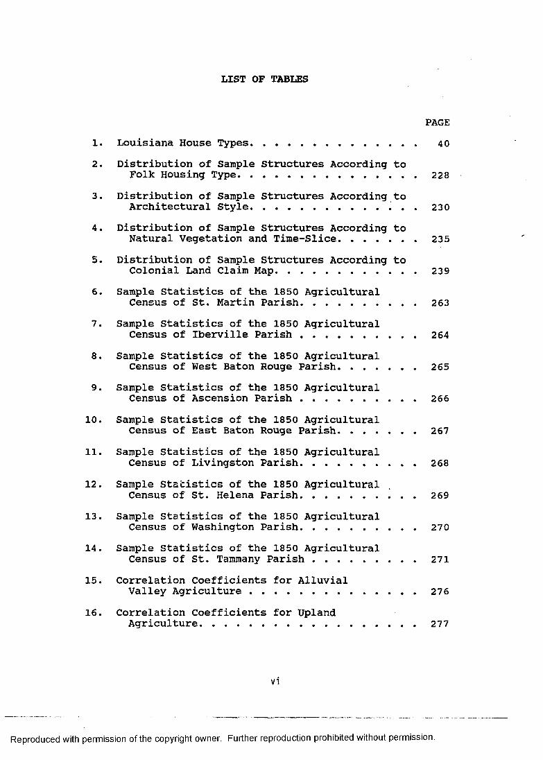
LIST OF TABLES
PAGE
1. Louisiana House Types........................... 402. Distribution of Sample Structures According to
Folk Housing Type............................... 2283. Distribution of Sample Structures According to
Architectural Style...................... 2304. Distribution of Sample Structures According to
Natural Vegetation and Time-Slice............... 2355. Distribution of Sample Structures According to
Colonial Land Claim Map......................... 2395. Sample Statistics of the 1850 Agricultural
Census of St. Martin Parish..................... 2637. Sample Statistics of the 1850 Agricultural
Census of Iberville Parish ................... 2648. Sample Statistics of the 1850 Agricultural
Census of West Baton Rouge Parish............... 2659. Sample Statistics of the 1850 Agricultural
Census of Ascension Parish ................... 26610. Sample Statistics of the 1850 Agricultural
Census of East Baton Rouge Parish............... 26711. Sample Statistics of the 1850 Agricultural
Census of Livingston Parish. . ............... 26812. Sample Statistics of the 1850 Agricultural
Census of St. Helena Parish..................... 26913. Sample Statistics of the 1850 Agricultural
Census of Washington Parish..................... 27014. Sample Statistics of the 1850 Agricultural
Census of St. Tammany Parish................... 27115. Correlation Coefficients for Alluvial
Valley Agriculture ........................... 27616. Correlation Coefficients for Upland
Agriculture......................................277
vi
Reproduced with permission of the copyright owner. Further reproduction prohibited without permission.
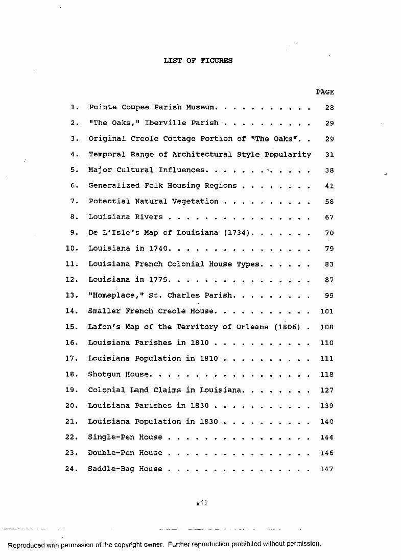
LIST OF FIGURES
PAGE
1. Pointe Coupee Parish Museum..................... 282. "The Oaks," Iberville Parish................... 293. Original Creole Cottage Portion of "The Oaks". . 294. Temporal Range of Architectural Style Popularity 315. Major Cultural Influences.............-......... 386. Generalized Folk Housing Regions ............... 417. Potential Natural Vegetation ................... 588. Louisiana Rivers ............................... 679. De L'Isle's Map of Louisiana (1734)............. 70
10. Louisiana in 1740................................ 7911. Louisiana French Colonial House Types............ 8312. Louisiana in 1775............................... 8713. "Homeplace," St. Charles Parish................. 9914. Smaller French Creole House........................10115. Lafon's Map of the Territory of Orleans (1806) . 10816. Louisiana Parishes in 1 8 1 0 ........................11017. Louisiana Population in 1 8 1 0 .............. ill18. Shotgun House...................................... 11819. Colonial Land Claims in Louisiana..................12720. Louisiana Parishes in 1830 ..................... 13921. Louisiana Population in 1830 ................... 14022. Single-Pen H ouse............................ . 14423. Double-Pen House ............................... 14624. Saddle-Bag House ............................... 147
vii
Reproduced with permission of the copyright owner. Further reproduction prohibited without permission.
LIST OF FIGURES (CONTINUED)
PAGE
25. Dog-Trot H o u s e .....................................14926. Bluffland House.................................... 15027. Parishes in 1850 with Slave Populations Greater
than Fifty Percent of the Total................. 15928. Louisiana Parishes in 1850 ..................... 16029. Louisiana Population in 1850 ................... 16130. Hill Plantation I-House............................ 16731. Carolina I-House ................................ 16832. Lowland South Plantation House ................. 17033. Louisiana Parishes in 1870 ..................... 18434. Louisiana Population in 1870 ................... 18535. Camel-Back House ................................ 19036. Louisiana Parishes in 1890 ..................... 20437. Louisiana Population in 1890 ................... 20538. Midwest I-House.................................... 21039. Bungalow H o u s e .................................... 21140. Pyramidal House.................................... 21341. North Shore House.................................. 21442. Sample Structures: Number Per Time-Slice. . . . 22443. Map of Historic Standing Structures Sample . . . 22644. Distribution of Architectural Styles of
Louisiana Structures on the NationalRegister of Historic Places..................... 231
45. Terrebonne Parish, Louisiana ................... 24346. Terrebonne Parish: Natural Vegetation and
Land Claims.................... 252
v i i i
Reproduced with permission of the copyright owner. Further reproduction prohibited without permission.

LIST OF FIGURES (CONTINUED)
PAGE47. Percent of Spanish Land Claim within each
Vegetation Type................ 25348. 1850 Agricultural Census Sample A r e a ............. 258
ix
Reproduced with permission of the copyright owner. Further reproduction prohibited without permission.
ABSTRACT
Historical geographers, because of their ability to place cultural phenomena in the appropriate spatial and temporal dimensions often conduct research that significantly parallels the interests of the preservationist. Now that the initial focus within historic preservation has shifted from the individual specimen to the cultural and historical milieu of which it was a part, a thorough understanding of the forces that were responsible for the creation of what confronts us as a relict cultural landscape is indispensable.
The preservation of cultural resources, specifically historic sites and structures has, in the past, normally been conducted on a case-by-case basis. In this initial phase of cultural resource management, sites and structures were frequently identified and evaluated only when threatened with destruction. More recently, preservationists have realized the importance of planning and have attempted to isolate meaningful cultural and historical themes and to anticipate their material manifestations.
This dissertation examines the settlement geography of Louisiana from the first French settlement in 1699 until the railroad and lumber boom of the 1890s. The study uses seven time-slices to present the progression of the patterns and processes of settlement. For 1740, 1775,
x
Reproduced with permission of the copyright owner. Further reproduction prohibited without permission.
1810, 1830, 1850, 1870, and 1890, major patterns were derived from censuses, the differential occupation of natural vegetation zones, and the cadastral imprint of French, Spanish, and British colonial settlement. Agricultural land use, the role of water and railroad transportation, and social change constitute the most important factors that shaped the patterns of settlement.
Building upon this spatial and temporal framework, characteristics of Louisiana's historic standing houses are presented. Folk types and architectural styles including French Creole, Antebellum plantation houses, and pyramidal roof structures are treated as a product, or artifact, of the state's dynamic settlement geography. Assumptions concerning that portion of settlement known as the "built environment" are tested using a sample of 557 historic standing structures.
Further, two case studies of Louisiana parishes are presented to illustrate the settlement-environment relationship. The example of Terrebonne Parish confirmed the close relationship between colonial land claim location and natural levees. A nine parish swath between St. Martin and St. Tammany was used to demonstrate the relationship between agricultural production and the lcass blufflands, alluvial bottomlands, and piney woods. The results of this study refine our understanding of the cultural and environmental parameters of the settlement of Louisiana, and address the significance of individual
xi
Reproduced with permission of the copyright owner. Further reproduction prohibited without permission.
structures by placing them in the broader context of historical geography.
xi i
Reproduced with permission of the copyright owner. Further reproduction prohibited without permission.
CHAPTER I: INTRODUCTION AND STATEMENT OF PROBLEM
The geographer cannot study houses and towns, fields and factories, as to their localization of activities without knowing the functioning of the culture, the process of living together of the group, and he cannot do this except by historical reconstruction. If the object is to define and understand human associations as areal growths, we must find out how they and their distributions (settlements) and their activities (land use) came to be what they are. Modes of living and winning a livelihood from their land involves knowing both the ways (culture traits) they discovered for themselves, and those they acquired from other groups. Such study of culture areas is historical geography.. . . Dealing with man and being genetic in its analysis, the subject is of necessity concerned with sequences of time.- Carl 0. Sauer, Baton Rouge, Louisiana, 1940
SETTLEMENT GEOGRAPHY AND THE CULTURAL LANDSCAPEOF LOUISIANA
This study is an exercise in historical settlement geography. Its explicit aim is to develop models of historic settlement for Louisiana and to relate those models to historic standing structures. They incorporate physical, cultural, and historical data deemed useful for the prediction, or "retrodiction," of where people lived, when, and in what numbers. The models also address the spatial and temporal aspects of the structures they lived in. This information is considered a necessary backdrop for future material culture studies dealing with historic standing structures, as well as preservation efforts designed to insure the survival of at least a
1
Reproduced with permission of the copyright owner. Further reproduction prohibited without permission.
representative sample of these important cultural resources.
The historical geographer John Jakle (1980:1)outlined the ways in which a study of this sort isrelevant to historic preservation.
Historical geography can be related to historic preservation in at least four ways. First, historical geographers are concerned to model past landscapes to discover what typified the geographic past. Second, they are concerned to know how people in the past actually experienced their environments. Third, historical geographers attempt to understand and predict landscape change in order to identify the processes which alter human habitats. Finally, they are involved in inventorying the relic features which survive from the past in the contemporary scene.Louisiana has been the research domain for
individuals interested in historic standing structures, particularly folk housing, for more than a half century now, and a sizable body of literature on the subject has accumulated (e.g., Edwards 1982, 1986a, 1986b, 1988; Fricker 1984; Kniffen 1936, 1963, 1965, 1974; Knipmeyer 1956; Lewis 1973; Martin 1984; Newton 1971a, 1985; Newton and Pulliam-DeNapoli 1977; Rehder 1971; Wright 1956). It is fair to conclude, therefore, that the study of historic standing structures in Louisiana has progressed well beyond the descriptive and typological stages of analysis. The present study accepts and endorses these generally agreed upon classifications (e.g., Edwards 1988a; Newton 1985). Their morphological classification is not at issue.
Reproduced with permission of the copyright owner. Further reproduction prohibited without permission.
The view taken here is that historic standing structures are artifacts. They are what survive from the past (theoretically, from a pool of every structure ever built). In the aggregate they form the relict cultural landscape. It is not what remains that is the focus of this study, but the physical and cultural milieu of which these remnants were once a part.
To a large extent, simulating the historic settlement of Louisiana has been hampered by a general reliance upon assigning census information to certain localities or political units (e.g., Kyser 1938). Researchers have had to contend with vaguely defined censuses and vast political regions. Colonial population enumerations generally place individuals in the geographical context of post or precinct. Later American censuses tally individuals living in municipalities or along identified watercourses or nameless roads within specific parishes.
It is sometimes painstakingly possible to "retrace" the census taker's route by comparing named individuals to land records. The precision promised by this procedure, however, could be achieved only through years of patient, and no doubt frustrating, research. A middle ground is proposed here.
The geographer, keenly aware of the man-land relationship, recognizes that people are distributed unevenly in space and time. Explanation of pattern and process in settlement geography must consider both
Reproduced with permission of the copyright owner. Further reproduction prohibited without permission.
cultural and environmental contexts. Analysis of why people choose to live where they do or did requires the formulation of models. In this study, the use of models increases the resolution of our understanding of where people lived, when, and in what numbers for the State of Louisiana, which should sharpen the population distribution map of the state based simply on census figures within parish boundaries.
From the perspective of geography, the most significant break in the history of the settlement of Louisiana is the Louisiana Purchase. Certainly other events, such as the Civil War, had a profound geographical impact, but in the creation of the cultural landscape, the eighteenth century was markedly different from the nineteenth century. Two models are outlined in this study that underscore the importance of the factors that contribute to the validity of this dichotomy. The variables that make up the models are: environment(reflected by natural vegetation), population, transportation, land use, and environmental perception. Additionally, features of the cultural landscape, specifically cadastral survey and standing structures, articulate with the models as artifacts of the settlement process.
While avoiding the pitfalls of environmental determinism, the settlement of Louisiana is explained, in part, in terms of the exploitation of specific
Reproduced with permission of the copyright owner. Further reproduction prohibited without permission.
environmental zones. The various cultures that occupied Louisiana in the eighteenth and nineteenth centuries made decisions of site selection based on their intended use of the land (and water). Suitability of the land for commercial or subsistence agriculture, logging, or other economic activities, all of which promote settlement, is a cultural assessment based upon physical qualities such as soil fertility and cultural considerations such as accessibility by steamboat. The variables examined in this study work in concert in the historical decisionmaking process.
Louisiana in the eighteenth century was sparsely populated and population was concentrated in a few cores. These areas correspond to specific environments best described in terms of natural vegetation as the bottomlands, the blufflands, and the eastern margins of the Southwest Prairies. Land use was fundamentally agricultural. The most important form of transportation consisted of non-motorized watercraft.
Nineteenth century Louisiana, on the other hand, grew rapidly, except for the period of the Civil War and Reconstruction. Population spread extensively beyond the older colonial core regions to include occupance of additional environments, specifically the pine forests and prairies. The environmental perception of upland Southerners, who regarded the piney woods as home and that of Midwestern farmers who saw agricultural potential in
Reproduced with permission of the copyright owner. Further reproduction prohibited without permission.
Louisiana's expansive prairies account for some of this initial occupance. Changes in land use accelerated throughout the century, in part as responses to innovations in transportation such as the steamboat and railroad, as well as social changes such as the abolition of slavery. The nineteenth century closed with a period of industrial lumbering on a scale never seen in colonial Louisiana.
The time-slice method of historical geography is used to organize the presentation and analysis of nearly two centuries of settlement data. The area examined is that of the present State of Louisiana. The temporal coverage is the eighteenth and nineteenth centuries. There are two time-slices for the eighteenth century and five for the nineteenth century. For reasons of personal preference and in the interest of limiting the scope of this work, the twentieth century is ignored. Analysis of settlement in the years 1740, 1775, 1810, 1830, 1850, 1870, and 1890 portrays Louisiana during the French colonial period (1699-1763), the Spanish (1763-1803) and British (1763- 1779) colonial period, and the American territorial and statehood periods of the nineteenth century.
SOURCES OF DATAThe major sources of data used fall into two broad
categories: 1) features of the physical environment and2) data relevant to the historic cultural landscape.These two types of data are considered differently in this
Reproduced with permission of the copyright owner. Further reproduction prohibited without permission.
study. The physical environment is assumed to remain constant in time and variable in space (Kniffen 1954:222). In terms of historic time, the general qualities of the environment have changed little. Elevation, soil, hydrology, potential natural vegetation, and climate are, for all intents and purposes, not dramatically different from the physical geography of two or three centuries ago.
Historical data obviously are variable in both time and space (Kniffen 1954:222). For this reason, the distribution of present phenomena is frequently not equivalent to what may have existed in the past. This is especially critical when examining the distribution of old houses, for example. One important consideration is the attrition of structures because of the "ravages of time."
Conceptually, it is easy to separate physical and cultural data. But, in reality, it is the point where the two come together, the man-land relationship, that gives meaning to this sort of historical settlement geography. The following data sets are used in this study: 1)potential natural vegetation, 2) parish boundaries, 3) censuses, 4) transportation routes, 5) cadastral systems, and 6) historic standing structures. These are used to make statements about the environment, population, transportation, and land use. Statements concerning environmental perception are gleaned from historical literature.
Reproduced with permission of the copyright owner. Further reproduction prohibited without permission.
The first data set, potential natural vegetation, is the single most important index of the physical environment, and therefore serves as a good summary statement of the physical qualities of any particular locality. Natural vegetation has been used successfully in historical settlement geography studies, particularly those that focus on settlers whose adaptation to the land was primarily agricultural (e.g., Jordan 1964, 1975). Natural vegetation is used in both the narrative settlement history, describing how different environments were used and when, as well as in predictive modelling and the testing of hypotheses about historic site location.One of the major research goals of this study will be met if it can be successfully demonstrated that trends in historic settlement proceeded according to certain environmental parameters. The very simple operation of comparing a large sample of actual historic sites, as indicated by extant structures, to the state's potential natural vegetation map should determine the validity of the historical models.
The historic political units used derive from JohnS. Kyser's doctoral dissertation "The Evolution of Louisiana Parishes in Relation to Population Growth and Movement" (1938). This is the definitive study for the changing configuration of Louisiana parishes. Parishes form the spatial base for data from censuses and other
Reproduced with permission of the copyright owner. Further reproduction prohibited without permission.
statistical sources, particularly from the nineteenth century.
Two types of census information are used in this study, colonial and American. The colonial authorities only sporadically ordered censuses (e.g., Ditchy 1930:207; Maduell 1972), quite unlike the decennial American census. Moreover, colonial censuses seldom enumerated the population of the colony as a whole at one time. The nineteenth century time-slices are spaced so as to use every other decennial census.
Transportation plays a key role in the settlement, growth, and economic prosperity of an area. Louisiana during the period of study relied upon three principal modes of transport: (1) waterways, (2) roads, and (3) railroads. Each can be considered a phase in the movement of people and products (Kniffen 1951).
The location of colonial land claims testify to the importance of waterways in the settlement of Louisiana. These aquatic corridors provided the threads around which settlement crystallized (Hilliard 1975; Johnson 1963; Kane 1943, 1944; McKenna 1975).
Roads have traversed the Louisiana landscape since prehistoric times, and have ranged from ephemeral footpaths to well-travelled thoroughfares (L'Herrison 1981; Nardini 1961; Newton 1970b; Newton and Raphael 1971; Swanson 1981). The famous camino real. the main route during much of the colonial period connecting Louisiana
Reproduced with permission of the copyright owner. Further reproduction prohibited without permission.
with New Spain, is an example of the latter. Inasmuch as roads responded to and promoted settlement, they are an important variable for the present study.
The influence of railroads on the settlement of Louisiana was overwhelming in some areas of the state during the last three decades of the nineteenth century. Much of North and Southwest Louisiana, for example, experienced unparalleled population expansion in response to the coming of the railroad (Kniffen 1974; Legan 1976; Reed 1957). The Illinois Central Railroad was actually responsible for the creation of one Louisiana parish (Tangipahoa), the configuration of which appears like a wide right-of-way for the railroad itself.
The cadaster, or system of land division, is one of the bedrocks of cultural geography. Louisiana has a fascinating variety of cadastral survey types implanted upon the landscape (see French 1978; Hall 1970; Hilliard 1973; Taylor 1950). These include the French concession and arpent systems, the Spanish sitio, the British metes and bounds, and the American General Land Office township-and-range and long lot systems (Newton 1986:167-185). Knowledge of the cadastral systems holds great utility for an historical settlement geography.
This study presents an original map of colonial land claims that precede the American General Land Office survey system. Because colonial land grant policies encouraged actual settlement, as opposed to the purchase
Reproduced with permission of the copyright owner. Further reproduction prohibited without permission.
of land for speculation, this map is a vivid approximation of where people lived prior to the sale of land by the American government. It is, therefore, an integral test of the model of colonial and territorial settlement.
The historic standing structures of Louisiana constitute a source rich in research potential for the cultural geographer (Kniffen 1936, 1965, 1974; Knipmeyer 1956; Lewis 1973; Newton 1967, 1971a, 1974b; Newton and Pulliam-DeNapoli 1977). Like any artifact, their morphology and context can contribute directly to history and theory, provided the proper questions are asked. This study concerns primarily the historic settlement of Louisiana, and historic standing structures provide tangible documentation of that settlement and its attendant cultural landscape.
The sample of historic standing structures comes from two sources: 1) those properties on the National Registerof Historic Places for the state of Louisiana (Division of Historic Preservation 1983) and 2) from a survey of vernacular architecture by Dr. Jay Edwards of the Department of Geography and Anthropology, Louisiana State University (Edwards 1982). The National Register nomination forms and supporting information are on file with the Louisiana Division of Historic Preservation.There are, at the time of this writing, 648 listed properties. While most of these are individual dwellings, some single nominations are actually historic districts
Reproduced with permission of the copyright owner. Further reproduction prohibited without permission.
made up of hundreds of structures. This study examines 440 of these properties. Edwards' survey contributed an additional 117 structures.
One important advantage of using National Register properties and Edwards' survey data in a study such as this comes from the degree of documentation; each property has been accurately dated. This temporal accuracy is a crucial consideration when it comes to testing a historical model. A geographic consideration is satisfied by the existence of U.T.M. coordinates for each property.
The historic standing structure sample, therefore, is accurately dated and precisely located. As such, there should be little ambiguity as to which time-slice to assign individual structures or where to place them on the map. The inclusion of the structural attributes of type and style enhance the potential of this sample. Not only will it begin to provide answers to research questions, such as the distribution of type and the diffusion of style for structures in Louisiana, but it should form a foundation for future work in the area of historic standing structure research.
This study will be considered successful if the relict features of the cultural landscape examined here, colonial cadastral surveys and historic standing structures, correspond to the two models of settlement. The purpose of this entire exercise is the demonstration of the utility of the perspective of historical geography to historic
Reproduced with permission of the copyright owner. Further reproduction prohibited without permission.
13
preservation. By modelling the patterns and processes of Louisiana's fascinating settlement geography a more holistic view of the built environment results.
Reproduced with permission of the copyright owner. Further reproduction prohibited without permission.
CHAPTER II: METHOD AND THEORY
HISTORICAL SETTLEMENT GEOGRAPHY AND THE TIME-SLICE METHOD The historic settlement of Louisiana can be viewed as
a dynamic selectivity of land occupance. The far from homogeneous physical landscape has undergone varied land use. As is true today when Louisiana contains everything from major urban centers of commerce and industry with great concentrations of population to essentially vacant "wilderness," so too in the past there existed substantial differences in population density in both time and space.
This continuous series of kaleidoscopic patterns results from more than simple population increase.Economic opportunity and technical innovation play large roles in determining the viability of population growth. For example, some areas of the state remained sparsely populated until the introduction of the railroad made feasible the extraction of timber and stimulated the growth of service centers. The same railroad, on the other hand, could spell disaster for the river town whose importance as a point of shipment rapidly declined.
For the historical geographer, the settlement of an area is viewed through the dimensions of time and space. Within the temporal dimension, he can limit his observation synchronically, that is the distribution of phenomena at one time (e.g., Brown 1943; Darby 1952), or choose the more ambitious diachronic historical study
14
Reproduced with permission of the copyright owner. Further reproduction prohibited without permission.
(e.g., Brown 1948), attempting to account for change over time. A comprehensive diachronic historical geography is impossible to achieve (Hartshorne 1949:188), so the "time- slice" method serves as a substitute.
The time-slice method involves the sequence of synchronic geographies spaced at intervals covering the desired span of history. The selection of each slice, also called a "stage" (Whittlesey 1929:162) or "cross- section" (Hartshorne 1949:184), is usually based upon its representativeness of social and technological trends that punctuate history, that which the historian commonly calls periods. In thinking about the time-slice method, it is worthwhile to recall Clark's (1954:71) comment that "conditions observed at any period of time are to be understood as momentary states in continuing and complex processes of change." The time-slice, therefore, is a device used to isolate periods of time for the purposes of description and analysis.
Some social scientists prefer to conceive of historical change not merely as a continuum of constant change, but more of a punctuated equilibrium. Certainly, in our long span of recorded history greatly expanded by prehistorical and paleoanthropological research we refer to great events that dramatically transformed human use of the earth such as "the agricultural revolution" and "the industrial revolution." The profound change brought about by some sudden social or technological occurrence or
Reproduced with permission of the copyright owner. Further reproduction prohibited without permission.

innovation then becomes the accepted mode until replaced or modified by the next punctuation.
Punctuated equilibrium is currently a viable theoretical paradigm in studies of hominid evolution. Although the evidence is scant, the fossil record seems to indicate that human morphological change was not a slow and continuous process. Phylogenesis occurred, according to this view, in periodic episodes followed by relative ontogenic stability.
American geographers have conceived of historical change as punctuated equilibrium since the 1920s. In Derwent Whittlesey's (1929) brief article on the nature of historical geography he advocated a conception of historical geography as "a succession of stages of human occupance" (1929:162, emphasis mine). He refers to this succession as sequent occupance.
Sequent occupance has been a useful heuristic device for historical geographers, albeit in modified form, since Whittlesey's initial enunciation of the term in 1929. The fatal flaw in Whittlesey's model, however, is his assertion that "human occupance of area, like other biotic phenomena, carries within itself the seed of its own transformation" (Whittlesey 1929:162). This is a form of determinism reminiscent of the nineteenth century unilineal evolution model (Langness 1974:12-39). It can also be considered as a cultural counterpart to the Davis erosion cycle model (James and Martin 1981:283-286). For
Reproduced with permission of the copyright owner. Further reproduction prohibited without permission.
many geographers, this aspect of sequent occupance was quickly rejected. Carl Sauer, for example, writing in the same year as the date of publication of Whittlesey's paper but not referring to it specifically, summarily rejected the notion of "successive stages" because of its clear resemblance to "the old culture-stage concept" (Sauer 1963:48).
In an insightful analysis of sequent occupance in American geography, Marvin Mikesell (1976:161) argued that its decline resulted from growing dissatisfaction in "an approach that offered effects without causes and demanded acceptance of the premise that process is implicit in stage." Fully cognizant of the pitfalls inherent in sequent occupance as originally defined, historical geographers have retained the time-slice method as a useful organizational device for the presentation of diachronic geographical data, yet have not neglected to address the question of process (e.g., Clark 1968;Davidson 1974; Hilliard 1961; Lewis 1976; McManis 1975; Mead 1981; Meinig 1969).
A concern for the exposition and analysis of the causal factors of change to compliment the time-slice is evident in a study that came out only three years after Whittlesey's article (Broek 1932). In his historical geography of the Santa Clara Valley of California, Broek linked together four time-slice chapters representing the four significant periods in the valley's occupation by
Reproduced with permission of the copyright owner. Further reproduction prohibited without permission.
three intervening chapters dealing with the processes responsible for the changes manifested on the landscape.In a later publication, Broek (1965:29) explained his method:
The somewhat original device I used was to divide the treatment of each period in two parts. The first was explanatory: it analyzedthe forces and functions that shaped the mode of life in the valley. The second part described the cultural landscape resulting from the social-economic determinants. In this manner, "process" received due attention, but its scope was guided and restrained by the relevance of its forces to the purpose of this study, namely understanding the landscape.A similar two part time-slice method, where each
time-slice has a processual and a landscape component, is followed in this study of the settlement geography of Louisiana. In this case, however, it is the settlement process that is given primacy. The cultural landscape, mainly in the form of domestic structures, is used as tangible evidence, or "dottable data" (Newton 1986:47), representative of processes such as migration, diffusion, population growth and expansion, and environmental adaptation that characterize each time-slice.
Because settlement was an ongoing process, it is necessary to somehow synthesize or distill this information to make it manageable. And yet, to approximate historical reality the synthesis should not be so generalizing as to obscure or dilute important historical and geographical changes. The selection of each of the time-slices was done with this mind, and in
Reproduced with permission of the copyright owner. Further reproduction prohibited without permission.
terms of both number and spacing they are believed to be more than sufficient for the purpose of this study.
HISTORIC STRUCTURES AS ARTIFACTSHumankind is not the only species to seek shelter for
comfort ami protection; we cannot even claim the monopoly on construction. (This is readily apparent to anyone who has taken the time to inspect a beaver's house or prairie dog town for example.) Yet, it seems that cross-culturally and well back into prehistory, ours is a species endowed with a penchant for building.
Among the vast variety of the constructions that comprise the so-called "built environment," houses are the most fundamental. The need for shelter obviously supercedes the need to build schools, churches, and courthouses. Although civic architecture such as schools, churches, and courthouses provide loci for the satisfaction of other human needs - education, worship, and justice - the primacy of housing cannot be overstated.
Early pioneer settings in Louisiana neatly illustrate the importance of shelter. Upon moving into an area, the pioneer's first concern was housing for his family. In many cases, land clearing and house building took place simultaneously. The felled trees in areas of Anglo settlement in Louisiana commonly received minimal modification prior to their use in horizontal log construction. In French settled Louisiana, timber was hand-hewn for heavy timber frame construction.
Reproduced with permission of the copyright owner. Further reproduction prohibited without permission.
Even with the aggregation of individuals into communities, public and commercial buildings were often minimal. Circuit riding teachers, preachers, and judges served a population dispersed over a vast territory for much of Louisiana's history. Aside from the domicile and its associated buildings such as barns, corncribs, smokehouses, sheds and the like, stores have probably been the most common structures of the historic built environment. Many stores, however, also served as the domicile of the storekeeper and his family, calling into question its classification as a non-domestic structure.
The house, therefore, is the most basic structure of the built environment. With respect to historic constructions on the landscape of Louisiana, houses are, according to Kniffen (1979:60), "perhaps numerically the most prominent of anything man had done."
Besides being fundamental to humans as basic shelter and numerous and conspicuous on the landscape, houses are items of material culture with attributes of cultural and historical significance beyond the individual specimen. They are artifacts of shared beliefs and values (culture). One merely has to drive through a modern subdivision and observe the uniformity to confirm the "shared" nature of housing. Houses are not idiosyncratic constructions, although some wealthy individuals and innovative architects have deviated significantly from the norm.
Reproduced with permission of the copyright owner. Further reproduction prohibited without permission.
It is not only valid, but conceptually useful tothink of houses as artifacts. Anthropologists andcultural geographers have devoted a great deal of study tothe ways in which material items manifest the culturesthat produce them. Morphological characteristics of itemstend to be non-random and reflect cultural choices in suchattributes as material, form, decorative treatment, and soforth. The anthropologist James Deetz used the term"mental template" to describe what is considered to begood and proper (culturally acceptable) by those who makeand use material items.
The idea of the proper form of an object exists in the mind of the maker, and when this idea is expressed in tangible form in raw material, an artifact results. The idea is the mental template from which the craftsman makes the object. The form of an artifact is a close approximation of this template, and variations in a group of similar objects reflect variation in the ideas which produce them (Deetz 1967:45-46).
Thus, to a large extent, form follows idea. This idea is essentially bounded by cultural parameters. And, where form differs, cultural values and beliefs should theoretically account for the differences. This is the fundamental basis and theoretical justification for the taxonomy of cultural material. It links our observation and description of material items to particular cultures, allowing us to identify them as culture traits. Furthermore, it is the grammar by which we may speak of cultural process.
Reproduced with permission of the copyright owner. Further reproduction prohibited without permission.
TYPOLOLOGY AND HOUSESOne question that has troubled those who attempt to
deal taxonomically with cultural material has been this: do the types we establish truly represent, to use Deetz's term, a mental template? In other words, can we really decipher mental template by observation and description, or are types simply imposed by the researcher to facilitate the study of cultural material. In American archaeology opposing sides of this issue are best represented by James A. Ford and Albert C. Spaulding (see Willey and Sabloff 1974:141-145).
Cultural geographers, most notably Fred B. Kniffen, have used typology as a descriptive and analytic tool (e.g., Newton 1971a; Pillsbury and Kardos 1970; Wilson 1969). It has been applied with greatest frequency and success to houses, although other forms on the cultural landscape such as fences, fields, cadasters, and cemeteries have also been subject to typological consideration. Their involvement in typological studies can be traced directly to Kniffen's (1936) seminal article on Louisiana house types.
There has been a cross-fertilization of ideas on the nature of typology between the disciplines of anthropology and geography. It is not surprising that James A. Ford used house types as illustrations in his article "The Type Concept Revisisted" (Ford 1954). He expressed keen interest in Kniffen's work on Louisiana house types. (In
Reproduced with permission of the copyright owner. Further reproduction prohibited without permission.
fact, he made the drawings of house types for Kniffen's1936 article.) At the same time, Kniffen kept close tieswith archaeologists such as Ford and their typologicalefforts, particularly with prehistoric ceramics.
The issue of whether we can discover the mentaltemplate through typology will probably never be fullyresolved. Nevertheless, we continue to use itsuccessfully as a descriptive and analytic tool, andfrequently make the assumption that our constructsapproximate past reality. For example, Newton andPulliam-DeNapoli (1977:360) take up the question oftypology in their article on Southern log houses. Theystate clearly this fundamental problem in the firstparagraph of their article.
Students of landscape know that their subject varies rather subtly and that it can be grasped intellectually only through abstraction.Systematic cultural geographers have tried to bring the illusive quality of sameness-in- diversity under conceptual control by use of types, notably house types. These types have been set forward as either modal patterns observed by the geographer or as models imposed by the culture of the settlers.Some theoreticians in the disciplines of geography
and anthropology jokingly speak of procreating potsherds and other reifications that are implicit in typology. However, life without classification is chaos. We realize that typologies often create ideal types out of composite attributes and few, if any, actual specimens match the specifications of the type. The term "sameness-in-
Reproduced with permission of the copyright owner. Further reproduction prohibited without permission.
diversity," cited above, neatly sums up the purpose of typology (and abstract thought generally).
HOUSES IN TIME AND SPACECultural geography shares with anthropology the study
of artifacts (material culture) in the dimensions of time and space. This is usually accomplished through a considerable amount of field observation and careful description, leading to the establishment of types. Then, distributional studies placing the types in their temporal and spatial contexts may allow for higher level theoretical considerations. Such cultural processes as diffusion or migration, for example, can be postulated only by beginning with the fundamental abstraction of type.
Gordon R. Willey and Philip Phillips (1958) discuss the temporal and spatial dimensions of artifact types and introduce the concepts of "tradition" and "horizon" to define those relationships. Although these concepts are used commonly and explicitly in American archaeology, they have remained implicit in the study of house types. Tradition, according to Willey and Phillips (1958:37), is defined as "temporal continuity represented by persistent configurations in single technologies or other systems of related forms." Horizon, on the other hand, is defined as, "a primarily spatial continuity represented by cultural traits and assemblages whose nature and mode of occurrence permit the assumption of a broad and rapid
Reproduced with permission of the copyright owner. Further reproduction prohibited without permission.
spread" (1958:33). The implication of this conceptual framework for the built environment is, simply, that except for the completely idiosyncratic, structures have important linkages to other structures in both time and space.
Another important and related concept is that of change over time and through space. Morphological change may appear to be genetic, that is to behave biologically. This is, however, a distortion of the nature of culture change. Forms are frequently said to "evolve" out of other forms. Hybridization, biological distance, and isolation are concepts often used to explain the unique and different.
Change in material culture does not occur as a function of time, space, or culture contact per se (Dethlefsen and Deetz 1966). Morphological modification results from the deliberate decisions of people. Forms may be seen to change through time, but time does not cause change. Likewise, there may be continuity or change in material culture over space, but there is no equation governing change because of linear distance or environment. Finally, culture contact situations do not necessarily insure change. Introduction of an innovation is still subject to cultural acceptance or rejection (see Redfield 1960 for a discussion of donor and recipient cultures.)
Reproduced with permission of the copyright owner. Further reproduction prohibited without permission.
The placement of types in the temporal dimension is done by either relative or absolute dating methods. Relative dating is a system of "ordinal" classification independent of reference to a specific calender year. For example, it is frequently used in the seriation of an archaeological assemblage. Houses are relatively dated in several ways: 1) a single structure may exhibit severalphases of construction and can be ordered accordingly, 2) elements of architectural style with a temporal range of popularity may be present, 3) methods of construction and material may help bracket a date range for probable date of construction, 4) documentary records may help isolate probable date of construction, 5) datable archaeological material may be found in and around the structure, and 6) by comparison with similar structures.
Absolute dating of a structure means that a specific calender year for the date of construction is known or discoverable. A structure's absolute date of construction may be recorded: 1) in documentary sources, 2) on thebuilding in the form of an inscription, 3) by informants, and 4) by materials for which an absolute date is obtainable (e.g., wood datable by means of dendrochronology).
Those who study old houses often use relative dating when evaluating the changes a house has undergone in the form of additions and alterations. It is possible to examine structural and stylistic differences evident in a
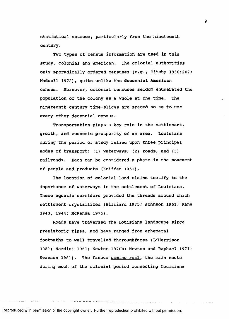
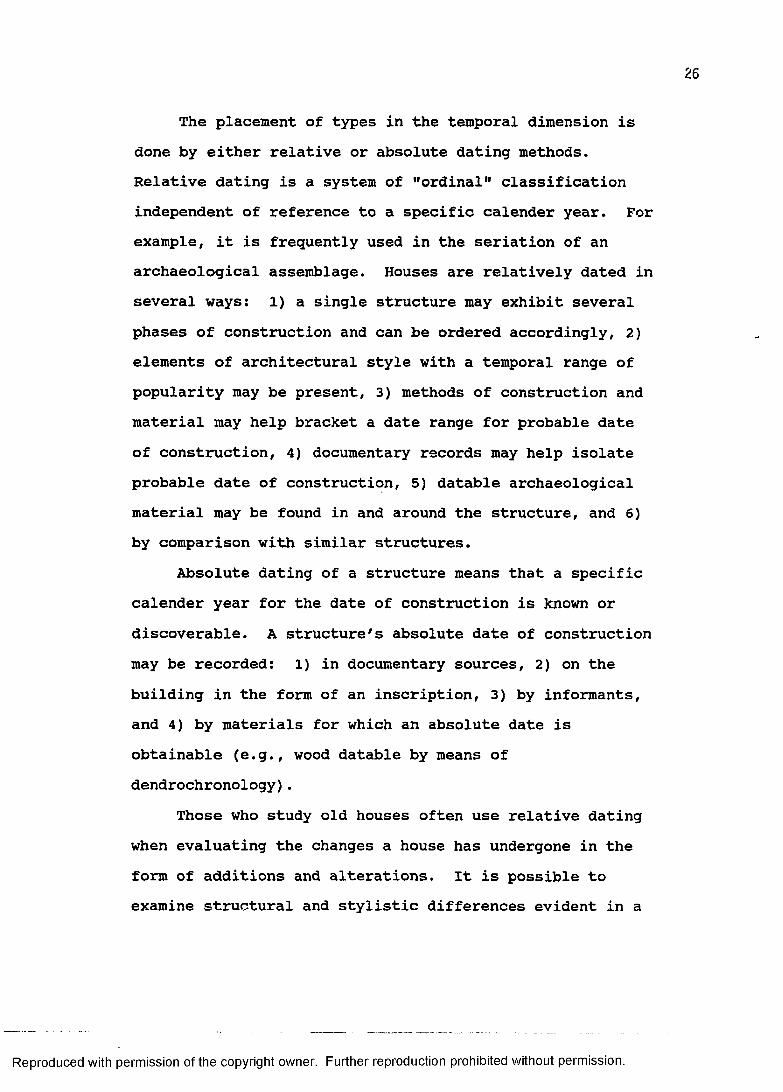
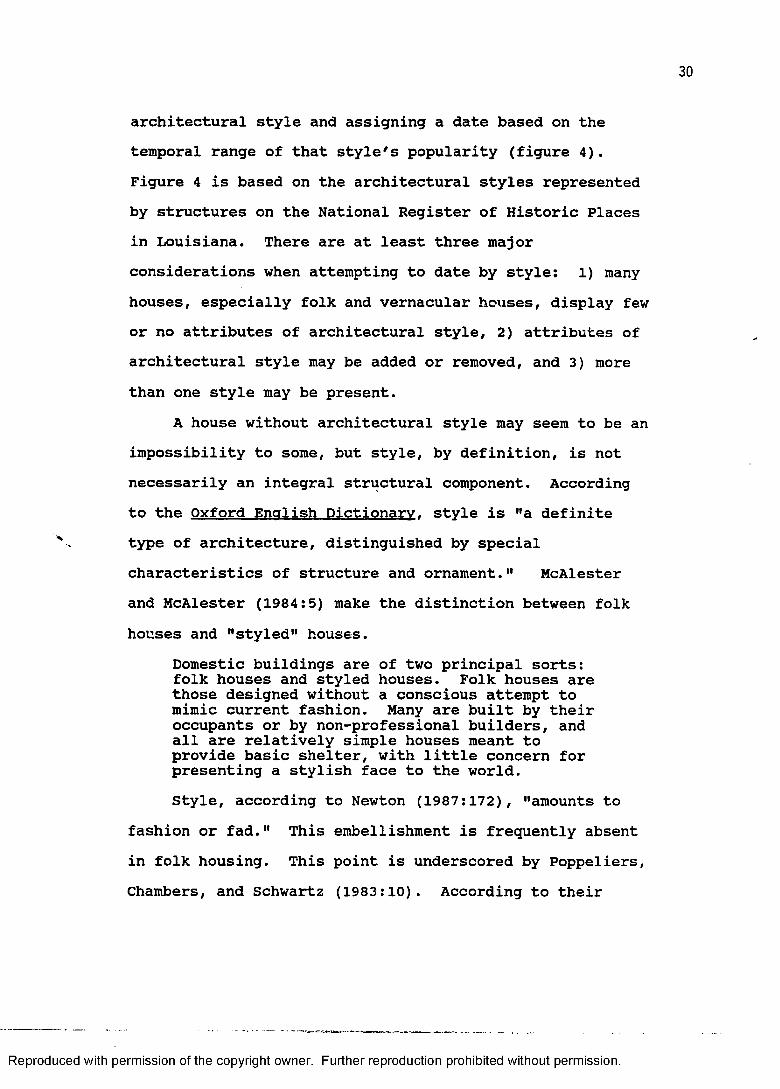
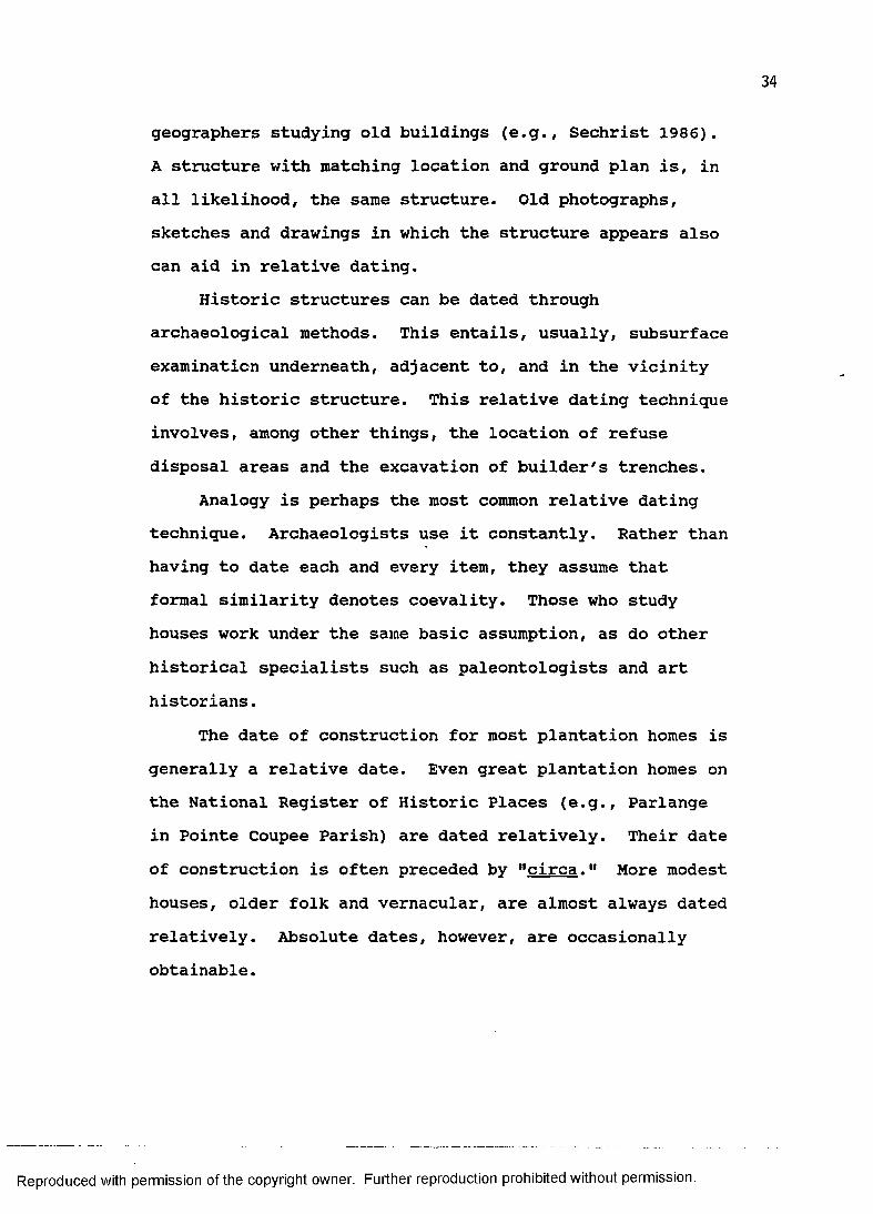
Reproduced with permission of the copyright owner. Further reproduction prohibited without permission.
single structure and to order them chronologically in relative terms. A good example of this comes from what is now the Pointe Coupee Parish Museum near New Roads, Louisiana (figure 1). The "core" of the house (the left side in the photo) is of planked horizontal log construction with full dove-tail corner-notching. The chimney divides its two rooms. The addition (the right side) is of heavy timber construction filled with mud and moss (bousillage). The dates of construction for both the core and the addition are not known. However, we may confidently speak of this structure in relative terms; the left side is earlier than the right.
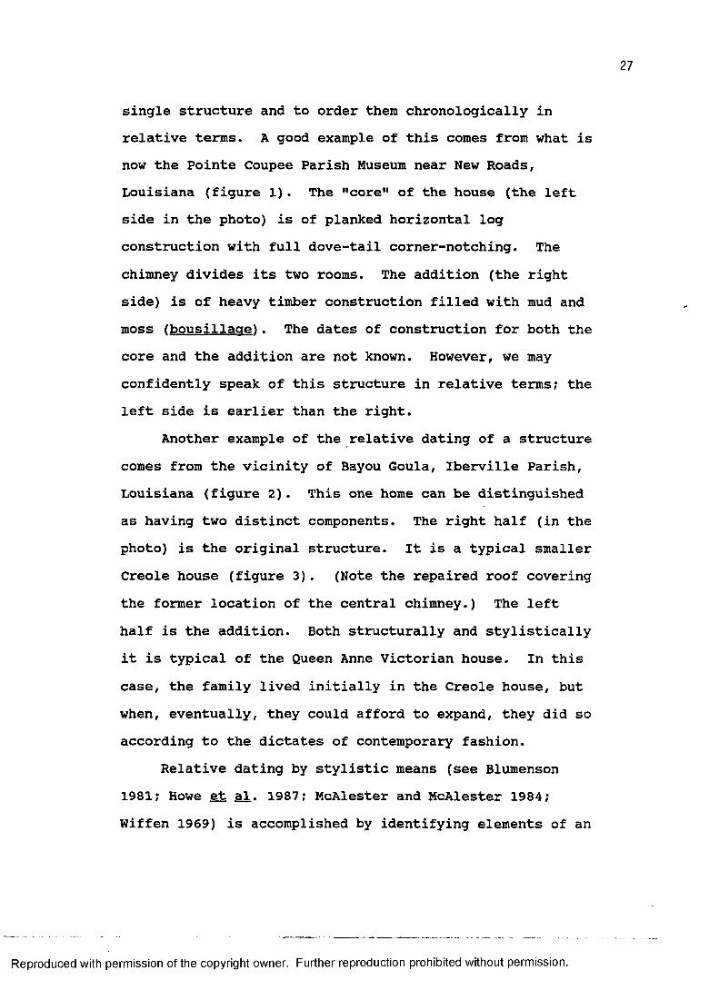
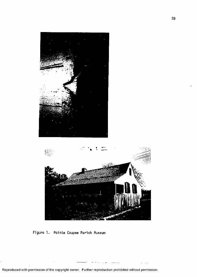
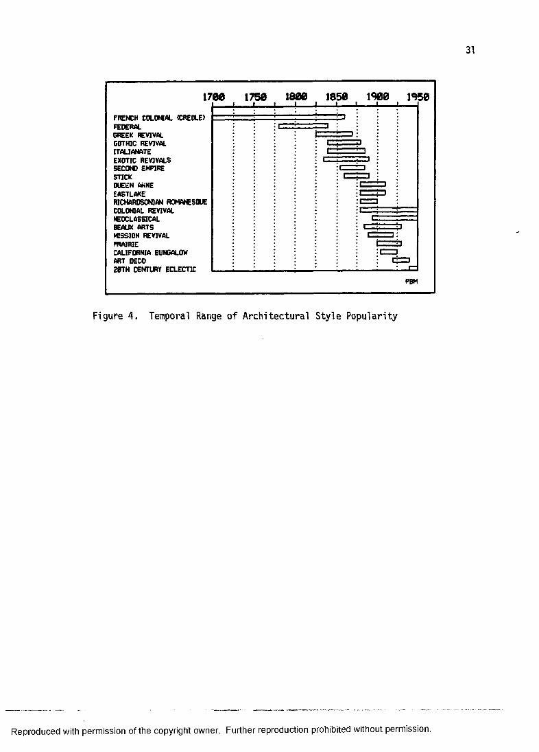
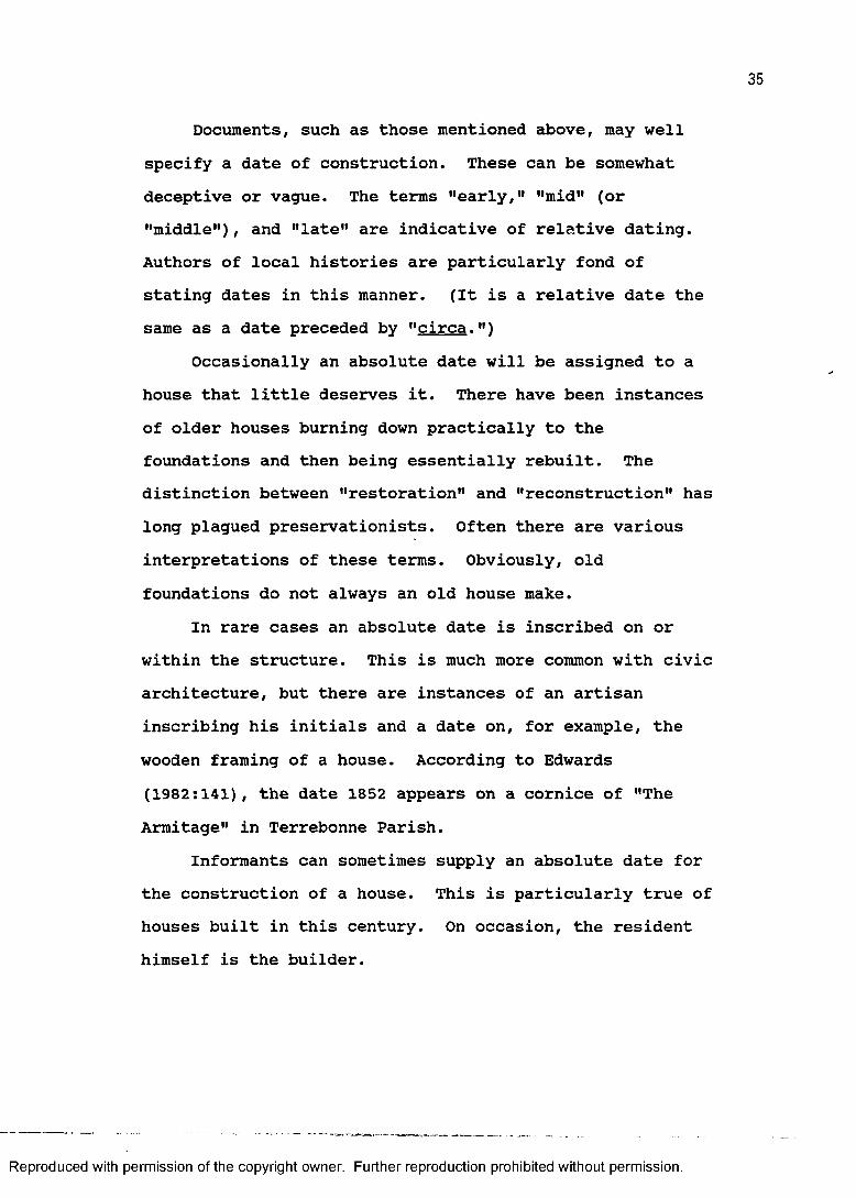
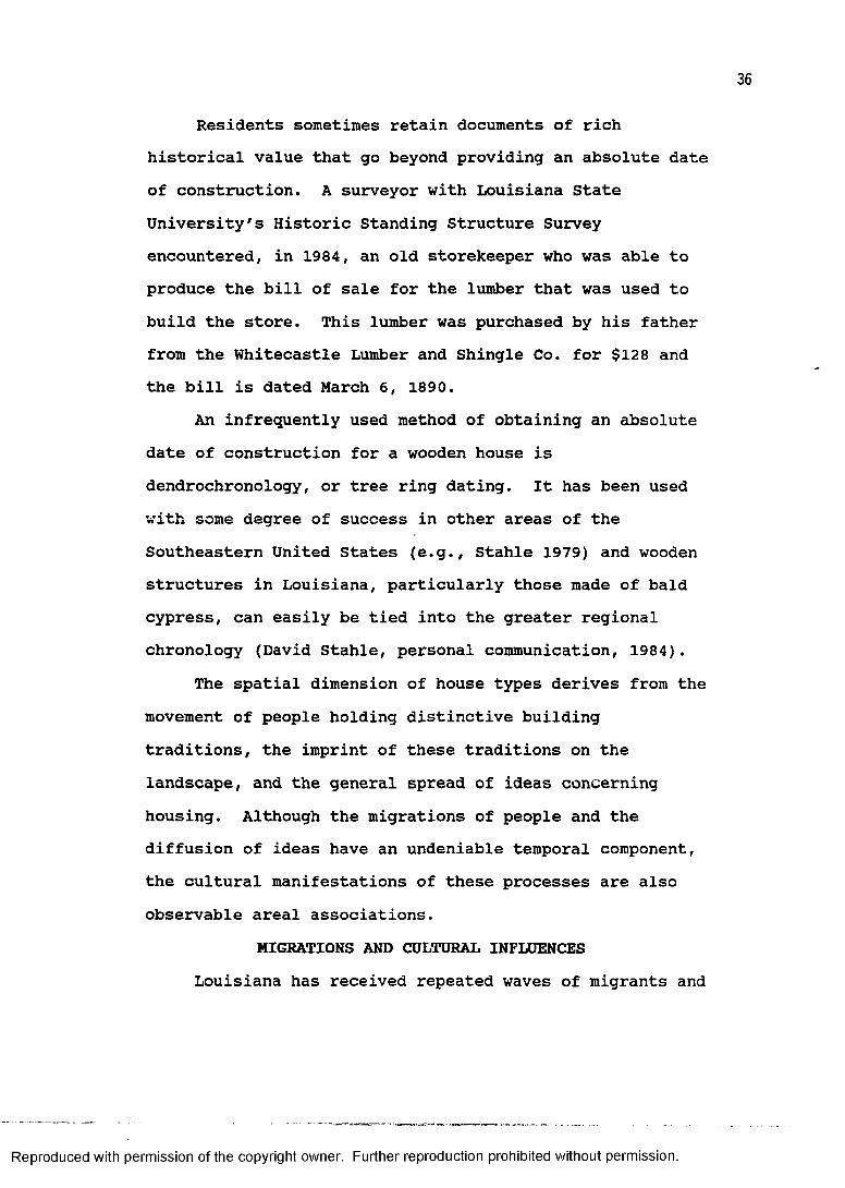
Another example of the relative dating of a structure comes from the vicinity of Bayou Goula, Iberville Parish, Louisiana (figure 2). This one home can be distinguished as having two distinct components. The right half (in the photo) is the original structure. It is a typical smaller Creole house (figure 3). (Note the repaired roof covering the former location of the central chimney.) The left half is the addition. Both structurally and stylistically it is typical of the Queen Anne Victorian house. In this case, the family lived initially in the Creole house, but when, eventually, they could afford to expand, they did so according to the dictates of contemporary fashion.
Relative dating by stylistic means (see Blumenson 1981; Howe et al. 1987; McAlester and McAlester 1984; Wiffen 1969) is accomplished by identifying elements of an
Reproduced with permission of the copyright owner. Further reproduction prohibited without permission.
28
Figure 1. Pointe Coupee Parish M u se um
Reproduced with permission of the copyright owner. Further reproduction prohibited without permission.
29
WSJLU—WHBM: "WX
Figure 2. "The Oaks," Iberville Parish
Figure 3. Original Creole Portion of "The Oaks"
Reproduced with permission of the copyright owner. Further reproduction prohibited without permission.
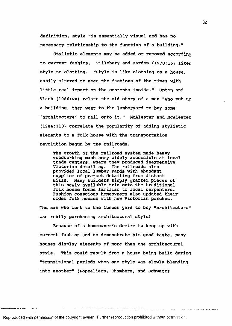
architectural style and assigning a date based on thetemporal range of that style's popularity (figure 4).Figure 4 is based on the architectural styles representedby structures on the National Register of Historic Placesin Louisiana. There are at least three majorconsiderations when attempting to date by style: 1) manyhouses, especially folk and vernacular houses, display fewor no attributes of architectural style, 2) attributes ofarchitectural style may be added or removed, and 3) morethan one style may be present.
A house without architectural style may seem to be animpossibility to some, but style, by definition, is notnecessarily an integral structural component. Accordingto the Oxford English Dictionary, style is "a definitetype of architecture, distinguished by specialcharacteristics of structure and ornament." McAlesterand McAlester (1984:5) make the distinction between folkhouses and "styled" houses.
Domestic buildings are of two principal sorts: folk houses and styled houses. Folk houses are those designed without a conscious attempt to mimic current fashion. Many are built by their occupants or by non-professional builders, and all are relatively simple houses meant to provide basic shelter, with little concern for presenting a stylish face to the world.Style, according to Newton (1987:172), "amounts to
fashion or fad." This embellishment is frequently absentin folk housing. This point is underscored by Poppeliers,Chambers, and Schwartz (1983:10). According to their
Reproduced with permission of the copyright owner. Further reproduction prohibited without permission.
1700 1750 1800 1850 1900 1950
FRENCH COLONIAL (CREOLE)FEDERALGREEK HEVIVALGOTHIC REVIVALITALIANATEEXOTIC REVIVALSSECOtC EMPIRESTICKOUEEN AHNE EASTLAKERICHARDSONIAN R0MAIC50UECOLONIAL REVIVALICOCLASSICALBEAUX ARTSMISSION REVIVALPRAIRIECALIFORNIA BUNGALOW ART DECO20TH CENTURY ECLECTIC
PBM
Figure 4. Temporal Range o f Architectural Style Popularity
Reproduced with permission of the copyright owner. Further reproduction prohibited without permission.
definition, style "is essentially visual and has nonecessary relationship to the function of a building."
Stylistic elements may be added or removed accordingto current fashion. Pillsbury and Kardos (1970:16) likenstyle to clothing. "Style is like clothing on a house,easily altered to meet the fashions of the times withlittle real impact on the contents inside." Upton andVlach (1986:xx) relate the old story of a man "who put upa building, then went to the lumberyard to buy some' architecture' to nail onto it." McAlester and McAlester(1984:310) correlate the popularity of adding stylisticelements to a folk house with the transportationrevolution begun by the railroads.
The growth of the railroad system made heavy woodworking machinery widely accessible at local trade centers, where they produced inexpensive Victorian detailing. The railroads also provided local lumber yards with abundant supplies of pre-cut detailing from distant mills. Many builders simply grafted pieces of this newly available trim onto the traditional folk house forms familiar to local carpenters. Fashion-conscious homeowners also updated their older folk houses with new Victorian porches.
The man who went to the lumber yard to buy "architecture"was really purchasing architectural style!
Because of a homeowner's desire to keep up withcurrent fashion and to demonstrate his good taste, manyhouses display elements of more than one architecturalstyle. This could result from a house being built during"transitional periods when one style was slowly blendinginto another" (Poppeliers, Chambers, and Schwartz
Reproduced with permission of the copyright owner. Further reproduction prohibited without permission.
1983:11). Intermittent attempts at keeping an older house in step with stylistic fashion could also produce a house displaying more than one architectural style.
Method of construction and material may provide clues as to the probable age of the structure. Some notable examples with temporal significance are: method of wallconstruction (especially balloon framing indicating a post-1850 structure), lumber milling, and nail type (wrought, cut, or wire). These features, among others, pertain to the fundamental structure of the house and should serve as a reliable means of relative dating. Although the recycling of older material such as sash sawn lumber and machine cut nails has been known to occur, it is usually possible to distinguish curation behavior from original structure based on other contextual information. Conversely, newer material (e.g., aluminum siding) is often added to an old structure.
Documents, both written and graphic, can yield a relative date for a structure. Written information such as wills, diaries, ledgers, tax records, newspaper accounts, and local histories frequently mention specific structures, thus providing a terminus ante cruem (Noel Hume 1969:69), or "date before which" the house must have been built.
Cartographic sources, notably the Sanborn Fire Insurance maps, often show structures in scaled ground plan. They have been used with success by cultural
Reproduced with permission of the copyright owner. Further reproduction prohibited without permission.
geographers studying old buildings (e.g., Sechrist 1986).A structure with matching location and ground plan is, in all likelihood, the same structure. Old photographs, sketches and drawings in which the structure appears also can aid in relative dating.
Historic structures can be dated through archaeological methods. This entails, usually, subsurface examination underneath, adjacent to, and in the vicinity of the historic structure. This relative dating technique involves, among other things, the location of refuse disposal areas and the excavation of builder's trenches.
Analogy is perhaps the most common relative dating technique. Archaeologists use it constantly. Rather than having to date each and every item, they assume that formal similarity denotes coevality. Those who study houses work under the same basic assumption, as do other historical specialists such as paleontologists and art historians.
The date of construction for most plantation homes is generally a relative date. Even great plantation homes on the National Register of Historic Places (e.g., Parlange in Pointe Coupee Parish) are dated relatively. Their date of construction is often preceded by "circa." More modest houses, older folk and vernacular, are almost always dated relatively. Absolute dates, however, are occasionally obtainable.
Reproduced with permission of the copyright owner. Further reproduction prohibited without permission.
Documents, such as those mentioned above, may well specify a date of construction. These can be somewhat deceptive or vague. The terms "early," "mid" (or "middle"), and "late" are indicative of relative dating. Authors of local histories are particularly fond of stating dates in this manner. (It is a relative date the same as a date preceded by "circa.")
Occasionally an absolute date will be assigned to a house that little deserves it. There have been instances of older houses burning down practically to the foundations and then being essentially rebuilt. The distinction between "restoration" and "reconstruction" has long plagued preservationists. Often there are various interpretations of these terms. Obviously, old foundations do not always an old house make.
In rare cases an absolute date is inscribed on or within the structure. This is much more common with civic architecture, but there are instances of an artisan inscribing his initials and a date on, for example, the wooden framing of a house. According to Edwards (1982:141), the date 1852 appears on a cornice of "The Armitage" in Terrebonne Parish.
Informants can sometimes supply an absolute date for the construction of a house. This is particularly true of houses built in this century. On occasion, the resident himself is the builder.
Reproduced with permission of the copyright owner. Further reproduction prohibited without permission.
Residents sometimes retain documents of rich historical value that go beyond providing an absolute date of construction. A surveyor with Louisiana State University's Historic Standing Structure Survey encountered, in 1984, an old storekeeper who was able to produce the bill of sale for the lumber that was used to build the store. This lumber was purchased by his father from the Whitecastle Lumber and Shingle Co. for $128 and the bill is dated March 6, 1890.
An infrequently used method of obtaining an absolute date of construction for a wooden house is dendrochronology, or tree ring dating. It has been used with some degree of success in other areas of the Southeastern United States (e.g., Stahle 1979) and wooden structures in Louisiana, particularly those made of bald cypress, can easily be tied into the greater regional chronology (David Stahle, personal communication, 1984).
The spatial dimension of house types derives from the movement of people holding distinctive building traditions, the imprint of these traditions on the landscape, and the general spread of ideas concerning housing. Although the migrations of people and the diffusion of ideas have an undeniable temporal component, the cultural manifestations of these processes are also observable areal associations.
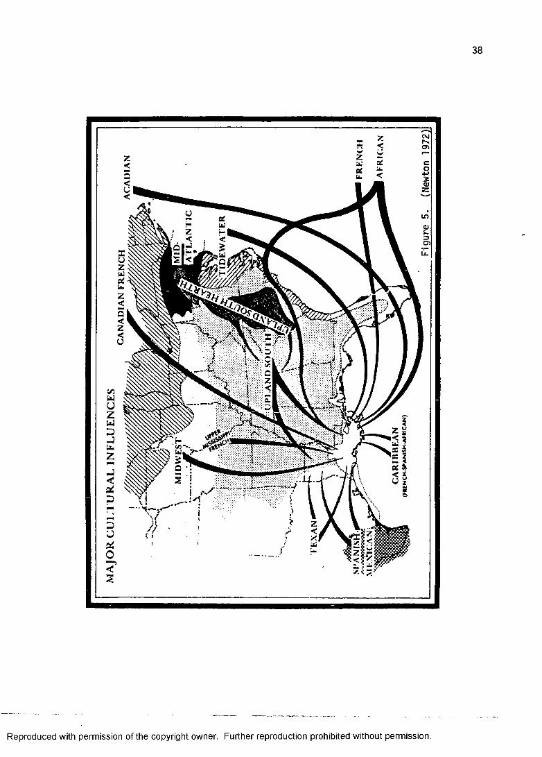
MIGRATIONS AND CULTURAL INFLUENCES Louisiana has received repeated waves of migrants and
Reproduced with permission of the copyright owner. Further reproduction prohibited without permission.
immigrants with differing cultural backgrounds over the course of three hundred years of settlement (figure 5). Along with other beliefs, values, and practices, each group brought its building traditions. Some of these have become part of the cultural landscape observable today.
While most of these groups maintained their cultural identities and expressed them through the houses that they built, two processes, assimilation and syncretism, have blurred traditional forms. Some ethnic groups have come to Louisiana and totally assimilated with respect to the material culture of the local, dominant group. For example, large numbers of Germans immigrated to Louisiana in the 1720s and 1730s and settled up river from New Orleans in St. Charles and St. John the Baptist parishes. They adopted the traditional building methods of their French neighbors to the degree that they are indistinguishable.
A syncretism, or blending, of building attributes has also taken place here in Louisiana. The best example of this is what is known as the Louisiana Creole house. It seems to be a composite structure with building elements traceable to three continents.
BUILDING TRADITIONSCultural geographers have recognized four separate
building traditions in Louisiana folk housing. They are, according to Newton (1971:4-6), the pen tradition, the French tradition, the shotgun tradition, and the pyramidal
Reproduced with permission of the copyright owner. Further reproduction prohibited without permission.
Reproduced with permission of the copyright owner. Further reproduction prohibited without permission.
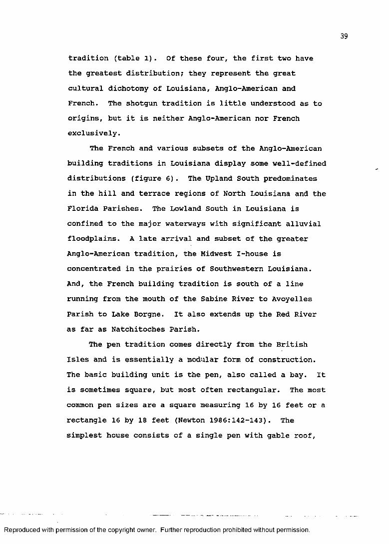
tradition (table 1). Of these four, the first two have the greatest distribution; they represent the great cultural dichotomy of Louisiana, Anglo-American and French. The shotgun tradition is little understood as to origins, but it is neither Anglo-American nor French exclusively.
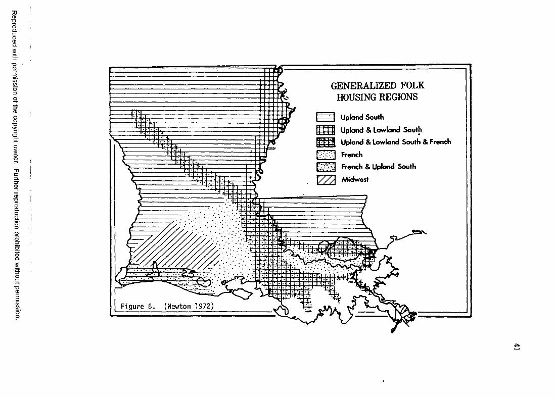
The French and various subsets of the Anglo-American building traditions in Louisiana display some well-defined distributions (figure 6). The Upland South predominates in the hill and terrace regions of North Louisiana and the Florida Parishes. The Lowland South in Louisiana is confined to the major waterways with significant alluvial floodplains. A late arrival and subset of the greater Anglo-American tradition, the Midwest I-house is concentrated in the prairies of Southwestern Louisiana. And, the French building tradition is south of a line running from the mouth of the Sabine River to Avoyelles Parish to Lake Borgne. It also extends up the Red River as far as Natchitoches Parish.
The pen tradition comes directly from the British Isles and is essentially a modular form of construction. The basic building unit is the pen, also called a bay. It is sometimes square, but most often rectangular. The most common pen sizes are a square measuring 16 by 16 feet or a rectangle 16 by 18 feet (Newton 1986:142-143). The simplest house consists of a single pen with gable roof,
Reproduced with permission of the copyright owner. Further reproduction prohibited without permission.

TABLE l: LOUISIANA HOUSE TYPES
I. PEN TRADITION (from the British Isles)A. Upland South (from the Middle Colonies)
1. single-pen house2. double-pen house3. saddle-bag house4. dog-trot house5. bluffland house
B. The I-house (widespread American form)1. hill plantation I-house2. Carolina I-house3. Midwest I-house
C. Lowland South plantation house(from the Tidewater area)
II. FRENCH TRADITIONA. Creole houses (from French Caribbean)
1. smaller Creole house2. Creole raised cottage
B. Acadian Upper Teche house III. SHOTGUN TRADITION
A. Older, more widespread types1. shotgun house2. bungalow house
B. New Orleans types1. camel-back house2. North Shore house
IV. PYRAMIDAL TRADITION A. Pyramidal house
Source: Newton 1971a:4-6.
Reproduced with permission of the copyright owner. Further reproduction prohibited without permission.
Reproduced
with perm
ission of the
copyright ow
ner. Further
reproduction prohibited
without
permission.
GENERALIZED FOLK HOUSING REGIONS
I Upland South
f 1 1 U p l a n d & Lowland South
Upland & Lowland South & French
t ' French
[V; French & Upland South
VZA MidwestIF i gu re 6. (Newton 1972)
chimney at one gable end, and entrances on each of the eave sides.
Houses all across British America employed the pen tradition as the basic module and in expansion. In all three culture hearths of British America - New England, the Middle Atlantic, and Tidewater Virginia - different house types arose out of this shared building tradition (Pillsbury and Kardos 1970). Three subsets of this tradition are important to the cultural landscape of Louisiana: 1) Upland South houses, 2) Lowland Southhouses, and 3) 1-houses.
A distinctive set of traits fused in the southern Appalachians in the late 18th and early 19th centuries to form what is called the Upland South culture. The people were mainly of German and Scotch-Irish ancestry; we know them as the pioneers of lore. After immigrating largely to the middle colonies along the Eastern Seaboard, they quickly moved beyond the settled coastal plain and pushed into the frontier south and west of the Appalachians (Kniffen 1965; Newton 1974:149; Meinig 1986:361). They brought with them a mental template of the house types of the Middle Atlantic region and a knowledge of horizontal log construction (Kniffen and Glassie 1966:58-61; Weslager 1969).
The Lowland South culture came to Louisiana from the Tidewater region of Virginia and the Carolinas. These people were strongly British in ancestry and custom and
Reproduced with permission of the copyright owner. Further reproduction prohibited without permission.
geared to a plantation economy. (Tidewater Virginia is where the plantation system began in British North America.) They moved directly to Louisiana and transplanted their cultural traditions in areas suitable for plantation agriculture. Kniffen (1963:294) described this transplantation as a movement from Tidewater Virginia of "aristocratic planters thoroughly imbued with ideas as to the proper manner of living and equipped with the capital and slave labor sufficient to put them into effect." Although far fewer Lowland South whites than Upland South people came to Louisiana, their building traditions are present, nonetheless, on the cultural landscape.
A house type more closely affiliated with the Upland South, but not belonging to its building traditions exclusively is the I-house. Kniffen (1936:185) named this family of related forms the "I-house" because of its almost total dominance as the apotheosis of a farm house in the states of Indiana, Illinois, and Iowa. Its origin in this country, however, seems to be in the Middle Atlantic states. According to Newton (1985:184),"I-houses were built in Louisiana from about 1800 until perhaps 1930 in any region where uplanders of plantation background settled, where farmers prospered, or where town dwellers sought to imitate planters."
The French building tradition in Louisiana resembles that of the mother country and the sister colony of French
Reproduced with permission of the copyright owner. Further reproduction prohibited without permission.
Canada, but is most closely associated with the French Caribbean. This tradition includes heavy timber frame construction filled with brick, or mud and moss, a variety of floorplans, steeply pitched side-gabled or hipped roof, frequent use of small dormers, and interior chimney location. The traits acquired from the Caribbean include the raising of the house on a brick basement or posts, broad galleries (often on all four sides) under a continual pitch or broken-pitch roof, numerous full-length double doors, and outside stairs leading both to the main floor and the loft.
The influence of the Caribbean experience on the building traditions of Louisiana is well documented (see Edwards 1986b, 1988a), but some scholars explain Louisiana French house types in terms of either continental antecedent (Fricker 1984:152) or indigenous development (Heck 1978:161). Heck, for example, wrote that the Creole house resulted not from contact with planters in the French Caribbean, but because of the Acadians'"sensitivity and acute awareness to the new region [which] encouraged a fuller consciousness of climate, indigenous materials and variations on constructional methods." This explanation ignores the fact that the Creole house was already part of the cultural landscape by the time the Acadians arrived in Louisiana! As Newton (1985:183) pointed out,
these Caribbean houses had appeared in ruralLouisiana by at least 1740, first with planters
Reproduced with permission of the copyright owner. Further reproduction prohibited without permission.
who had immigrated directly from the Caribbean.By the time that Acadians began arriving (1765), the most prestigious form of house was that of the Caribbean planter.
Louisiana Creole houses are part of a wider circum-Caribbean family of house types. (Even the British raisedcottage and the raising of the Upland South types are partof the wider pattern.)
The shotgun tradition seems to be a Haitian (andultimately African) contribution to the Louisiana culturallandscape. The most distinctive feature of housesbelonging to this tradition is the location of theentrance at the narrower gable end. Both British andFrench traditions place the entrance along the widerside. Various explanations have been offered to accountfor the origin of this tradition. Newton (1986:149),summed these up as follows:
The origin of the shotgun is difficult or impossible to trace. Its origin has been attributed to Louisiana Indian palmetto-covered cabins, to slave memory of a West African house, to houseboats placed on land, to European waterfront settlements, to factory manufacturers of ready-built houses, to the influences of narrow urban lots, and to the Greek Revival fashion.
Although it has been argued that no single explanation seems likely for the source of this building tradition, the position taken here follows the most current research on the subject (Vlach 1975, 1986a, 1986b).
Finally, the pyramidal tradition is composed of houses displaying a pyramidal roof form. These houses are generally associated with the railroad and lumber boom of
Reproduced with permission of the copyright owner. Further reproduction prohibited without permission.
the late nineteenth century. They will be described in some detail in the 1890 time-slice.
COLONIAL AND TERRITORIAL SETTLEMENT MODELAlthough the term model frequently brings to mind
unsettling images of confusing flow charts, arrows shooting every which way, and scores of boxes containing sometimes curious sounding "buzz words," a model is defined here as simply "an artificial representation of reality" (Zubrow 1973:242). The models are actually summaries of the historical geographic data which are given full treatment in the body of the study. Many of these summary statements have been made before by individuals (geographers, anthropologists, historians, architectural historians, etc.) making generalizations about the historical geography of the state. It is the goal of later chapters to develop and to analyze the validity of the component parts of the model as well as the model as a functioning whole.
The model of settlement for the colonial and territorial periods of Louisiana developed here, as well as the statehood settlement model to follow, consists of information gleaned from the historic record. This information is important because of its utility in helping us to understand better and to interpret the historical geography of Louisiana. Ginsburg (1970:306) defined the challenge for the historical geographer: "Thereconstruction and evaluation of conditions of
Reproduced with permission of the copyright owner. Further reproduction prohibited without permission.
geographical significance in particular periods of timethus provides a major problem for the historicalgeographer." These geographically significant dataconstitute the material for reconstruction and from whichevaluations are drawn. The models presented below formseparate data into a coherent working replication of thesettlement process relevant to historic preservation.
Models are not created in a vacuum. They are notentirely intuitive, but must be firmly grounded insubstantive data. The process pf induction allows us tobuild from the known and observed to the "theoretical."Models act as an intermediary heuristic device thatfunction somewhere between data and theory. Kniffen(1974:254-255) clearly understood this intellectualprocess according to which our discipline operates:
It is important to keep in mind that the cultural geographer employs an evidential approach that basically studies material things.As with archaeology, many of the things studied belong to a practically undocumented past. Only by first considering the material forms can subjective values be discerned. One does not start with subjective concepts and values. He ends with them after considering the evidence in material expression. . . . This approach has worked very well. What other is there that can derive and substantiate conclusions on subjective matters?
One function of each time-slice in this study is topresent the evidential approach that Kniffen advocated.
The dichotomizing of the seven time-slices is basedon actual research as outlined above and is intended toimpart a higher order of generalization in advance of more
Reproduced with permission of the copyright owner. Further reproduction prohibited without permission.
intensive description and examination. It also facilitates the testing of some of our basic assumptions about the settlement of Louisiana by making them explicit and, therefore, subject to close scrutiny. This scrutiny, in fact, takes place in this study finally through the examination of an independent set of data, 557 historic standing structures.
The components that make up the models are basically statements derived from the some of the data introduced in the first chapter of this study. These include statements concerning occupance of specific environments, population increase and spread as measured by censuses, the role of cadastral survey in Louisiana's settlement geography, the geography of economic activity, ethnicity, urbanization, transportation, and finally some spatial and temporal aspects of architecture.
The settlement of Louisiana for most of the colonial and territorial periods actually took place in specific environments. For a variety of reasons, which mostly concerned agricultural and transportation, settlement concentrated in the bottomlands and blufflands of South Louisiana. Some settlers ventured out into the eastern margins of the prairies in the southwestern portion of the state. The marsh and swamp were strictly avoided for settlement, although resources from these environments were used. The piney woods were very sparsely populated
Reproduced with permission of the copyright owner. Further reproduction prohibited without permission.
throughout the colonial periods and thinly and unevenly settled in the territorial period.
From the formation of the colony until the end of the territorial period, population clustered in New Orleans and intensified in some very specific areas, mainly in the "River Parishes" of South Louisiana. Most of the population inhabited a limited portion of the state, a demographic pattern that would not change until later in the nineteenth century. These areas were, specifically, along the Mississippi from St. Francisville to just below New Orleans, along the upper Lafourche and Teche, around False River in Pointe Coupee Parish, and up the Red as far as Natchitoches.
Census figures clearly indicate nodes of population in incipient towns such as Natchez (later part of Mississippi), Natchitoches, Opelousas, St. Martinville, and Baton Rouge, but New Orleans was the primate (and only) city. Even New Orleans was a relatively small place until the Louisiana Purchase. The population of New Orleans burgeoned after 1803. Urbanization, in the true sense of the term, was not a feature of any other town throughout the colonial and territorial periods.
The ethnicity of the population during the colonial and territorial periods was predominantly French and black African. Germans, Spanish, British, and later Americans added to the ethnic mix. An early geographical pattern developed where the French population became entrenched in
Reproduced with permission of the copyright owner. Further reproduction prohibited without permission.
the areas of initial colonial occupance. Blacks were, for the most part, slaves and their presence was greatest in the areas of plantation agriculture. For the most part, the Germans and Spanish assimilated into the dominant French culture. The British occupied the western Florida Parishes. And, Americans came to New Orleans and other settled areas in increasing numbers following the Louisiana Purchase.
Agriculture, both subsistence and plantation, characterized the economy of the colonial and territorial periods. Some ranching was also practiced, especially on the eastern prairies near Opelousas and in the Natchitoches area. Only in New Orleans were other economic activities represented to any degree (e.g., mercantile, administrative, military).
Transportation in Louisiana during the colonial and territorial periods was mainly in the form of nonmotorized watercraft (the steamboat came later in the nineteenth century) along, naturally, the navigable waterways. Louisiana's rivers and bayous saw everything from ocean-going sailing ships to small canoe-like pirogues. The most common mode of cargo transportation on the Mississippi River were the keelboat and flatboat.Roads were generally bad, but several important routes existed. The most important road was the camino real which began in Natchitoches and had as its southern terminus the capital of New Spain (Mexico City).
Reproduced with permission of the copyright owner. Further reproduction prohibited without permission.
Louisianians and their goods, however, generally travelled by water.
An important settlement feature of the colonial periods was the land claim. The French, Spanish, and British were insistent upon settlers' compliance with an orderly land alienation policy. As a result, a map of the colonial cadastral surveys is an excellent approximation of where people lived in colonial times.
The territorial period, which excludes the Florida Parishes, was a period of chaotic transition for private land claims because it took the American government some time to institute their own system. Many new settlers did not have their land surveyed until long after they had established themselves. Many simply occupied land without benefit of legal sanction at all.
The architecture of the colonial and territorial periods is predominately French. British (Lowland South) structures were built to some extent in the Florida Parishes and along the Mississippi. Some Upland South architecture began infiltrating the state during the territorial period, and some initial American architectural influence can be seen in New Orleans in the first decade of the nineteenth century. It is also possible that some African architecture was built in Louisiana at some time during the colonial and territorial periods.
Reproduced with permission of the copyright owner. Further reproduction prohibited without permission.
STATEHOOD SETTLEMENT MODELThe statehood settlement of Louisiana in the
nineteenth century is characterized by a continued growth in the lower alluvial valleys and an expansion into areas that had only been sparsely settled in earlier period, specifically the piney woods and prairies. The four time- slices that make up this model all highlight the growing importance of the northern half of the state. And, initial occupance of the western and southwestern portions of the state did not take place to any great extent until the 1890s. The environmental component of the statehood model, therefore, can be characterized by a widening environmental adaptation and settlement. However, these additional environments do not include the marsh and cypress forests as suitable settlement sites.
Population during statehood grew rapidly except for the period of the Civil War and Reconstruction. Loss of life during the War, a reduction of immigration, and some emigration combined to produce a plateau in the otherwise ascending trajectory of the state's population. The general pattern of statehood population growth, which actually began during the territorial period, is in stark contrast to the relatively slow population increase of the colonial periods. Urbanization did not occur to a great degree outside of New Orleans for most of the nineteenth century. Cotton stimulated the growth of some towns such as Shreveport and Monroe (and Natchez, Mississippi) late
Reproduced with permission of the copyright owner. Further reproduction prohibited without permission.
in the antebellum period, but Louisiana was still an agrarian society with a large percentage of the population living in a rural context. The railroad and lumber boom beginning in the 1890s, probably did more to stimulate the growth of towns and cities than any other period of settlement. Nevertheless, urbanization is an increasingly important factor in settlement during statehood.
The ethnic composition of Louisiana changed during statehood with the important addition of large numbers of Anglo-Americans. Frenchmen and blacks continued to dominate in the core areas of colonial settlement. The initial Anglo-American migration of Upland Southerners was followed by Easterners (both North and South) in general. The last migration of the nineteenth century consisted of Northern loggers and Midwestern farmers. These Anglo- Americans tended to settle outside or on the edges of the famous French triangle (Estaville 1984), which is defined by corners at New Orleans, Marksville, and Lake Charles.
Although the economies of both the colonial and territorial period and the statehood period were fundamentally reliant on agriculture, the latter period can be characterized by expansion and change. Cotton moved into some of the piney woods areas of the state during the first half of the nineteenth century.Following the Civil War tenant farming kept the plantation system alive. And, the Southwestern Prairies became a great rice producing region beginning around 1890.
Reproduced with permission of the copyright owner. Further reproduction prohibited without permission.
Transportation was revolutionized during the statehood period; first with the introduction of the steamboat in the second decade of the nineteenth century, and then with the spread of the railroad, particularly in the decades following the Civil War. The importance of transportation to the spread of settlement in the state cannot be overemphasized. The steamboat did for cotton what the railroad later did for industrial lumbering; and it seems that prosperity occurred in proportion to increasingly efficient transportation.
Cadastral survey in the statehood period had its effect on settlement, but as mentioned earlier, it is less reliable as a true indicator of settlement than landclaims of the colonial periods. The regularity induced bythe township-and-range system is most apparent on the landscape of the Southwest Prairies, but even here settlement cannot be inferred from the distinction in public versus private domain. Therefore, no map has been made of land claims comparable to that made for the colonial period.
The hallmark of architecture of the statehood periods is its Americanization. Louisiana began to look less like the French Caribbean and more like surrounding Southern states. This was manifested in both house type andarchitectural style. Architectural style, in fact, becameincreasingly important for domestic structures through the nineteenth century. French structures continued to be
Reproduced with permission of the copyright owner. Further reproduction prohibited without permission.

built in the French core, and even adapted architecturally to changes sweeping the rest of the state.Americanization, however, characterized most of Louisiana's architecture for most of the nineteenth century.
Reproduced with permission of the copyright owner. Further reproduction prohibited without permission.

CHAPTER III: PHYSICAL SETTING
POTENTIAL NATURAL VEGETATIONVegetation, taken as the composite of the whole
assemblage of plants growing in an area, responds to such physical environmental factors as climate, soils, hydrology, and elevation. For that reason, natural vegetation provides a good summary indicator of the physical properties of any location (Sternitzke 1965).This study uses potential natural vegetation for that purpose. The word "potential" is used here in the same sense that Kuchler used it in his map Potential Natural Vegetation of the Coterminous United States (Kuchler 1964). It is meant to distinguish the vegetational climax communities of the state from the vegetational composition and distribution as seen at present.
The information on Louisiana's potential natural vegetation comes from a variety of sources. Primarily, the vegetational polygon configuration comes from the 1937 Natural Vegetation Map of Louisiana prepared by the State Board of Engineers (Jacobs 1937). This map, in turn, is based on the work of Samuel Lockett, a West Point-trained engineer and Louisiana State University's first geographer (Post 1964). His 1873 map (Lockett 1969) is the first topographical map of the state and the foundation of numerous potential natural vegetation maps. For example, Milton B. Newton, Jr. used these sources to produce his
56
Reproduced with permission of the copyright owner. Further reproduction prohibited without permission.
nap of the natural vegetation of Louisiana which appears in the Atlas of Louisiana (Newton 1972:35). It is also the basis of Kniffen and Hilliard's (1988:79) natural vegetation nap that appears in Louisiana: Its Land andPeople. In addition to these sources, a nap published by the Louisiana Departnent of Wildlife and Fisheries, Vegetative Type Map of the Louisiana Coastal Marshes (Chabreck and Linscombe 1978), has helped clarify the distribution of different narsh connunities.
The nap of potential natural vegetation that appears in this study (figure 7) is a conpilation of the above- nentioned sources. The information was transferred to 1:250,000 naps of Louisiana and converted into a digital format suitable for conputer cartographic manipulation using the INTERGRAPH in the CADGIS Research Laboratory at Louisiana State University. For a more complete listing of the dominant species (both common and scientific names) that comprise the potential natural vegetation types refer to Appendix I.
The structural approach, as opposed to the floristic approach, is used here to describe vegetation and its implications for human settlement. Newton (1987:73 emphasis original) described the structural approach as resting on:
the observed fact that similar environments have similar looking vegetations. Rain forests, coniferous forests, and prairies look similar, regardless of where they occur. At the same time, similar processes and conditions exist in places where similar vegetation structures
Reproduced with permission of the copyright owner. Further reproduction prohibited without permission.

PETER B. MIRES CADGIS Research Lab, LSU
P O T E N T IA L N A T U R A L V E G E T A T IO N
SHORTLEAF pine f o r e s t sLONGLEAF PINE FORESTSBOTTOMLAND HARDWOODS (LOBLOLLY-OAK)UPLAND HARDWOODS (BLUFFLANDS)FLATWOODSPRAIRIEGALLERY FORESTS CYPRESS FORESTS BOTTOMLANDS(COTTONWOOD-SYCAMORE-WILLOW) MARSH
6 0 M I.
33j
32
30"
29
94 92 90
Figure 7. Potential Natural Ve ge tat io n
Reproduced with permission of the copyright owner. Further reproduction prohibited without permission.
occur. Even though the floras (list of species) differ, the physiognomy remains largely the same.
This classification of natural vegetation is conducive to the creation of regions because it deemphasizes some floristic variability because of slight climatic or edaphic factors. For example, flatwoods occur to the east and west of the Mississippi alluvial valley between thirty and thirty-one degrees north latitude. The major distinction between the two is the absence of shortleaf pine in the flatwoods of southwestern Louisiana (Brown 1945:8). This floristic difference is not sufficient to abandon their identical classification based on structural similarity.
At the most general structural level, the natural vegetation of Louisiana can be grouped into three broad categories: 1) forest, 2) prairie, and 3) marsh. The forest category constitutes a forested landscape. Even a cursory examination of the Potential Natural Vegetation Map (figure 7) reveals that in Louisiana forests predominate. This includes the shortleaf pine forests, longleaf pine forests, bottomland hardwoods (loblolly- oak) , upland hardwoods (also called blufflands), flatwoods, gallery forests, and bottomlands (cottonwood, sycamore, willow).The second broad category is that of prairie. The prairies of Louisiana are dry grasslands. They contain trees in concentration only along the margins of streams
Reproduced with permission of the copyright owner. Further reproduction prohibited without permission.

that flow through the area. The third broad category is that of marsh. A marsh is a wet grassland.
The distribution of potential natural vegetation types corresponds to a number of different physical conditions, one of the most noticeable of which is relief. By sorting out the types on the basis of relief, it can be seen that the bottomlands and cypress forests pretty well define the major low-lying alluvial valleys of the state. The marsh is limited to areas of coastal downwarping along the Gulf of Mexico. The prairies and flatwoods are located on lower terraces. And, the remaining forests are on higher terraces and hills.
The great wedge of the Mississippi alluvial valley makes it appear as if there are actually two regions of pine forests in Louisiana. The shortleaf pine, longleaf pine, and flatwoods (sometimes called the longleaf pine flatwoods) of northern and western Louisiana and those of the Florida Parishes are actually all part of a much greater pine belt stretching from East Texas through the Southeast to Virginia and the Carolinas (Nelson and Zillgitt 1969:9).
An additional distinction that can be made within the category of forest is between coniferous and deciduous forest. This does not mean that the forests are pure stands of either conifers (trees with cones and needlelike leaves) and deciduous (broadleaf trees that generally shed their leaves) trees. Instead, it simply indicates
Reproduced with permission of the copyright owner. Further reproduction prohibited without permission.
that these species dominate numerically. This is frequently expressed as a percent of the total. For example, the shortleaf pine forest is defined as a forest with at least fifty percent shortleaf pine and other southern pines, except longleaf pine (Nelson and Zillgitt 1969:9). The remainder of the shortleaf forest is composed of deciduous tree species such as various oaks and hickories (see Appendix I).
A structural distinction of great importance to our understanding of the environmental zonation of species is that of upland versus lowland habitats. Some species within the above-mentioned coniferous group, for example, are upland species, while others are found in the lowlands. Almost all of the pines are upland species, as evidenced by their dominance in the hill and terrace regions of the state. The bald cypress, on the other hand, is a conifer that is found in lowlands, or alluvial floodplains, sloughs, and swamps.
Deciduous trees, often called hardwoods, also have an upland versus lowland distinction. As seen in the Potential Natural Vegetation Map (figure 7) some hardwood forests are classified according to this upland-lowland dichotomy. The bottomlands forest is a lowland forest type in which hardwoods dominate. Cottonwoods, sycamores, and willows are hardwood species that one frequently associates with the natural levee forest of alluvial valleys. Oaks and hickories comprise the most numerous
Reproduced with permission of the copyright owner. Further reproduction prohibited without permission.
deciduous species that make up the upland hardwoods, or blufflands, forest.
Two forest types, the bottomland hardwoods and the gallery forests, have specialized structural locations. They both are found along the margins of streams. The edaphic conditions along these streams permit the growth of hardwoods (Brown 1945:9; Newton 1987:78). The bottomland hardwoods forest is characterized by a dominance of hardwood vegetation in an otherwise pine- dominated region. It is found in the shortleaf pine, longleaf pine, and flatwoods forests of northern and western Louisiana. The gallery forests, as the name implies, are forests of hardwoods that form a gallery, or arched covering, along either bank of streams flowing through the prairies of southwestern Louisiana.
The largest area of prairie, or dry grassland, is located in the southwestern portion of the state. There are several much smaller patches of grassland in the state, most notably the Avoyelles Prairie in Avoyelles Parish, but the Southwest Louisiana prairie constitutes a true vegetation region.
As of this writing no satisfactory explanation for the existence of this large prairie region has emerged (Kniffen and Hilliard 1988:81; Newton 1987:80). A frequently cited suggestion is the presence of a hard clay pan roughly a foot below the surface (Kniffen 1974:257; Post 1974:15). The possibility of intentional periodic
Reproduced with permission of the copyright owner. Further reproduction prohibited without permission.
burning of vegetation by Native Americans in prehistorictimes to create clearings has also been suggested (Kniffenand Hilliard 1988:81; Newton 1987:80).
The existence of such an expanse of dry grassland inSouthwest Louisiana is certainly an interestinggeographical problem, yet its genesis is not particularlycrucial to the present research. There is nodocumentation to alter our assumption that the prairieexisted in much the same configuration as presented here(figure 7) for the span of time under examination.
Another grassland, the great coastal marsh ofLouisiana, has some unique structural characteristics.According to Newton (1987:80), the marsh, like theprairie, is also a grassland, but because of continualsaturation and varying degrees of salinity it isstructurally and floristically different.
Still technically a grassland, the marsh was even called wet prairie during historic periods.It is, of course, completely a herbaceous cover, like the other prairies. The differentiation of the marsh lies principally upon the degree of saltiness of the water that keeps it continuously saturated. Of course, the amount of salt differs gradually and imperceptibly; even so, experts divide it into two, three, or four grades. Although the grades are arbitrary, they can commonly be described in terms of species tolerences.The individual marsh types are merged into one
category for most of this study. The assumption is that except for pirates, runaway slaves, and hunters and trappers, the marsh was never host to human settlement.To test this assumption, however, the settlement of a
Reproduced with permission of the copyright owner. Further reproduction prohibited without permission.
coastal parish, Terrebonne, is examined later in this study.
THE ALLUVIAL LANDSCAPERivers created Louisiana. Some ancient rivers laid
down the deposits that are now the uplifted hills of northern and western Louisiana. The succession of terraces, found mainly in southwestern Louisiana and the Florida Parishes, result from later alluvial action. Much of the coastal marsh is actually downwarping deltaic sediment. Finally, there is the present alluvial landscape (Davis 1968).
Rivers transported most the sediment to not only what is today Louisiana, but created the entire Gulf Coastal Plain. This material has been subject to modification by other physical processes since its deposition. Uplift and downwarping are the primary processes responsible for the creation of relief. There are significant areas of the state where old alluvial terraces are capped with loess soil, a deposit assumed to be aeolian in origin. Wind and wave action has produced elongated ridges, known as cheniers. that parallel the shoreline along the southwestern coast. Finally, another category of landform that is not attributable to alluvial processes is the salt dome. These are large masses of salt that have been thrust up from miles below ground through ancient and more recent alluvial sediments. The rivers of Louisiana remain, however, the foremost geomorphological agent; this
Reproduced with permission of the copyright owner. Further reproduction prohibited without permission.

is especially true for the period of human occupation, or the past twelve thousand years (Kane 1944; Mclntire 1954).
The most impressive feature of the alluvial landscape of Louisiana is the celebrated Mississippi alluvial valley. This valley shows up vividly on the Potential Natural Vegetation map (figure 7) as the wide zone of bottomlands and cypress forests. The alluvial valley is bounded by Pleistocene terraces roughly fifty miles apart. These terraces form the valley walls. Most of the eastern valley wall between thirty-one and thirty-three degrees north latitude is part of the State of Mississippi. And, for those who have gazed out across the Mississippi River from the vantage point of either Natchez or Vicksburg, Mississippi, the enormity of this physical feature is impressive indeed.
The southernmost extent of the alluvial valley is roughly formed by a line connecting the southwestern corner of the Florida Parishes and the southeastern edge of the prairies of Southwest Louisiana. From this line south the river has made is way to the Gulf of Mexico creating a succession of deltas (Kniffen and Hilliard 1988:54). The most recent delta, the Balize, has been forming for the past millenium.
Two other sizable alluvial valleys in Louisiana are the Red River Valley and, to a lesser extent, the Ouachita River Valley. These are also identifiable on figure 7 as fairly extensive zones of bottomlands and cypress forests.
Reproduced with permission of the copyright owner. Further reproduction prohibited without permission.

Unlike the Mississippi River in Louisiana these rivers have many tributaries and rather extensive drainage basins.
Figure 8 identifies the major rivers of Louisiana. This study follows accepted descriptive terminology when referring to a particular waterway, for example, Tangipahoa "river," "bayou" Teche, or Thompson "creek." When referring to a stream in the abstract or in general either "river" or "waterway" is used.
Reproduced with permission of the copyright owner. Further reproduction prohibited without permission.
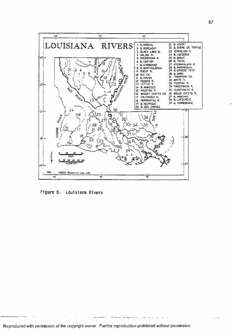
LOUISIANA RIVERSSS1!—
3!‘t—
/ l.S
] B. BODCAU 21 B. W1KOFF2 B.OORCHEAT 22 B. OUENE DE TORTUE3 BLACK LAKE B. 23 VERMILION R.4 SALINE R. 24 B. COCODRIE5 □UGDEMONA R. 25 B. BOEUF6 B. CASTOR 26 B. TECHE7 B. D'ARBONNE 27 ATCHAFALAYA R.fi B. BARTHOLOMEW 2B B. MAR1NGOU1N4 BOEUF R. 2A B. GROSSE TETE10 BIO CR. 30 B. SARA11 B. MACON 31 THOMPSON CR.1? TENSAS R. 32 AMITE R.n LITTLE r . 33 T1CKFAW R.14 B. ANACOCO 34 TANGIPAHOA P..15 HOUSTON R. 35 TCHEFUNCTE R.16 WHISKY CHITTO CR. 36 BOGUE CHITTO R.17 CALCASIEU R. 37 B. MANCHACIfi MERMENTAU R. 36 B. LAFOURCHEIS B. NEZPIOUE 3S B. TERREBONNE26 B.DES CANNES
is) ; .'31 ..
3/iZ/-20 ’ ' ' - C L - / 1 7 f/ 21 2 6 ^
no \ UL-'" . -ui / KJ ^ ^ 22 f23_%.\v-— *— cv> *r
m iles
g 20 48 60 80 ie e
KILOMETERS
CA0GI5 Research Lob. LSU
33: 3 4 ;
n 3T
Figure 8. Lo uisiana Rivers
Reproduced with permission of the copyright owner. Further reproduction prohibited without permission.
CHAPTER IV: COLONIAL AND TERRITORIAL SETTLEMENTFRENCH COLONIAL LOUISIANA
The process of European exploration and colonization of what is today the State of Louisiana began long before the initial time-slice presented in this study. During the first half of the sixteenth century, the Spanish, from their bases in the Gulf of Mexico, sent forth a number of expeditionary forces that encountered Louisiana's coast and interior. These include, most notably, the "ill-fated" Narvaez expedition (1528) and the famed, and equally disastrous, De Soto entrada (1539-1543). These Spanish explorers and conquistadors rapidly lost interest in the area through their failure to locate mineral wealth (as they had in Middle and South America). Without the incentives that fortune provides, the struggles with a resistant native population hardly seemed worth the effort.
The Lower Mississippi Valley was virtually ignored by Europeans for more than a century following De Soto's death and his army's rout (Hudson 1976:107-116). Spanish interests concentrated to the south and west. Other European powers, particularly England and France, cast a profit-minded eye toward the northeastern portion of North America, although successful colonization did not begin until the first decade of the seventeenth century.
The next European venture into the area for which we have documentation is that of Marquette and Joliet in
68
Reproduced with permission of the copyright owner. Further reproduction prohibited without permission.

1673. They began their travels from the French settlements on the Upper St. Lawrence River and, upon reaching the Mississippi, explored that river by canoe until reaching the mouth of the Arkansas. Actual penetration of the area that constitutes the present State of Louisiana came nine years later with the expedition of La Salle. He is credited with the "discovery" of the mouth of the Mississippi River and the proclamation of its valley as the possession of King Louis XIV of France.
Colonization of Louisiana is said to begin in 1699 with a party of Frenchmen and Canadians who first established a foothold on the northern shore of the Gulf of Mexico in the vicinity of Biloxi, Mississippi (Giraud 1953:31; Parkman 1930). In charge of this group of about 300 were the Le Moyne brothers, Pierre (Sieur d'Iberville) and Jean Baptiste (Sieur d'Bienville). From this base, which they called Fort Maurepas, they were able to reconnoiter their immediate surroundings, both physical and cultural. This included charting the lay of the land, particularly with respect to the great Mississippi River, and making contact with neighboring Indian tribes. (See, for example, Guillaume De L'Isle's map of Louisiana published in 1734 as an illustration of contemporary emphasis on the mapping of rivers and the location of Indian tribes - shown here as figure 9).
The French continued to occupy sites along the Gulf Coast (later moving to Mobile Bay, Alabama) while
Reproduced with permission of the copyright owner. Further reproduction prohibited without permission.
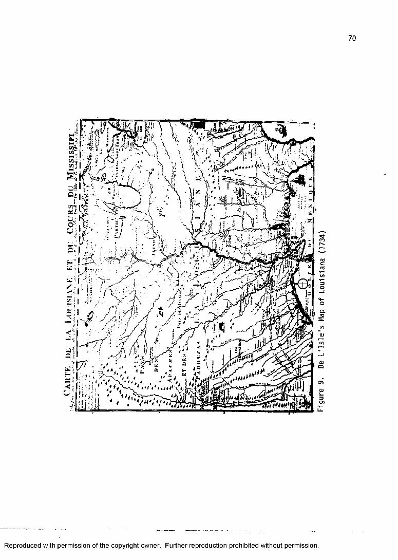
70
Reproduced with permission of the copyright owner. Further reproduction prohibited without permission.
Figure
9.
De L'I
sle's
Map o
f Lou
isiana
(17
34)
increasing their knowledge of the Lower Mississippi Valley through exploratory foray. The first permanent settlement within present-day Louisiana was not, as might be expected, on the Mississippi River, but was at Natchitoches well upstream on the Red River. This site was chosen as a clear challange to the eastern periphery of Spain's dominion (Bolton 1921).
In 1714, under the vigorous leadership of Louis Antoine Juchereau de St. Denis a garrison for French troops, Fort St. Jean Baptiste, was established on the banks of the Cane River, an old course of the Red. Taking its name from the local Caddo Indian tribe, the town of Natchitoches grew up nearby. This little settlement, so far removed from Mobile, prospered. The cash crops of tobacco and indigo thrived in the fertile red soil of the floodplain. Cattle and horses multiplied; their increase having been attributed more to the rustling activities of Indians to the west than to the efficiency of French husbandry.
As if boldly thrusting chess pieces to the middle of the board, Spain countered by sending forth a contingent of troops from San Antonio and established the Presidio de Los Adaes a mere fourteen miles to the west of Fort St. Jean Baptiste. This posturing served to check the French "encroachment,11 but also tacitly confirmed La Salle's claim to all lands drained by the Mississippi and its tributaries.
Reproduced with permission of the copyright owner. Further reproduction prohibited without permission.

Natchitoches grew in importance in subsequent years as an outpost on the western frontier (Bridges and DeVille 1963). A symbiotic relationship developed between these two neighboring posts, far-flung from their respective administrative centers. In a time of jealously-guarded trade restrictions, the Natchitoches area became, essentially, a great turnstyle through which flowed all manner of contraband. Instead of complying with regulations and requisitioning goods from Vera Cruz, more than a thousand miles to the south, the Spanish at Los Adaes and others along the camino real to the southwest found it easier and cheaper to get these goods from their French neighbors. In the other direction flowed cattle, horses, and mules.
Another site of early French settlement was at Natchez, Mississippi. Bienville was finally able to negotiate peaceful relations with the Natchez Indians in 1716 and built a fort, Fort Rosalie, on the bluffs overlooking the Mississippi River. This became a site of some importance for the French, although it ultimately spelled disaster for the Indians who gave the town its name.
In the early years of the French Colony, as in the English settlements along the Eastern Seaboard, Indians often kept the colonists from starvation. This is especially true of the French who settled among the Natchez. They acquired land that had already been
Reproduced with permission of the copyright owner. Further reproduction prohibited without permission.
cleared, concentrated on the cultivation of cash crops,and frequently purchased foodstuffs. Le Page du Pratz,who moved to Natchez in 1720, described this stratagem forsurvival (Le Page du Pratz 1774:27).
I found upon the main road that leads from the chief village of the Natchez to the fort, about a hundred paces from the last, a cabin of the natives upon the road side, surrounded with a spot of cleared ground, the whole of which I bought by means of an interpreter. I made this purchase with the more pleasure, as I had upon the spot, wherewithal to lodge me and my people, with all my effects: the cleared ground wasabout six acres, which would form a garden and a plantation for tobacco, which was then the only commodity cultivated by the inhabitants. I had water convenient for my house, and all my land was very good.Throughout the French colonial period the sequence of
dependence, encroachment, and displacement characterized European-Native American relations. Nowhere is this more evident and vivid than in the Natchez area. The French in Canada generally were more successful in maintaining a rapport with the native inhabitants because they concentrated on developing trading partnerships and were less concerned with the appropriation of vast tracts of land. St. Denis succeeded in the Natchitoches area by bringing the Caddo and other western tribes into his economic empire. The land-hungry plantation system, using African slave labor, left little room for native peoples who relied on the same arable land for their livelihood. (This same scenario was played out in the English Virginia Colony a century earlier.)
Reproduced with permission of the copyright owner. Further reproduction prohibited without permission.
This aspect of French-Indian relations is reiteratedin a recent study on the subject (Woods 1978:233-234).
Traditional opinion concerning French and Indian relations in colonial North America holds that the natives received better treatment from the French than from the other Europeans who explored and settled the continent. However, this interpretation was arrived at largely through the study of the Canadian fur trade, a form of resource exploitation into which the Indians were easily integrated. Indeed, French fur trading and trapping disturbed the social ecology of the wilderness far less than Spanish mining or English farming. Perhaps, a general assessment of these racial relations should stress not the national traits of the various Europeans who came, but rather, their intended uses of the land and other resources which they found.Although Natchitoches and Natchez were settled
earlier, New Orleans gained prominence as the primate city of the colony. In 1717, it was felt that the colonial administrative center at Mobile was too far removed from the Mississippi River to be of strategic importance so the site of New Orleans was selected. Settlers began erecting buildings the following year.
The site of New Orleans, as the locus of development for one of this country's major urban places, is indeed a puzzle. How could a place so prone to flood, hurricane, and disease have been seriously considered for human habitation? How did it succeed in developing into a colonial and later territorial and state administrative and commercial center? One obvious answer is its location on one of the world's great rivers, the Mississippi. But the Mississippi River is 2,348 miles long; what did the
Reproduced with permission of the copyright owner. Further reproduction prohibited without permission.
early French colonizers find so attractive about that portion of the river that flows through a South Louisiana swamp?
Although some felt that higher ground along the river would be more desireable, such as is found above Bayou Manchac near Baton Rouge, the site of New Orleans prevailed because of the presence of a small bayou, Bayou St. John, which allowed navigation from New Orleans through Lake Pontchartrain to the Gulf. According to the French Colonial engineer, Le Blond de la Tour (Wilson 1968:1):
In ascending the river, I have examined the most suitable sites for placing New Orleans and have not found a better situation than the spot where it is. The land is highest here and it is located at a portage of a bayou, a small river that flows into Lake Pontchartrain by which one can at all times communicate with New Biloxi,Mobile and the other posts more easily than by the lower river.
This seems to be the key as to why the site of New Orleanswas selected. It was relatively close enough to the mouthof the river to be of strategic importance and it offereda "short cut" to the Gulf.
The site of early New Orleans was the natural leveealong the left bank of the Mississippi River 120 milesfrom its outlet into the Gulf of Mexico. This naturallevee is rarely over fifteen feet above sea level andslopes gradually away from the river. Areas of cypressswamp at or below sea level occur within a mile or two ofthe river.
Reproduced with permission of the copyright owner. Further reproduction prohibited without permission.

In 1718, Bienville put fifty men to work clearing land and constructing some rude buildings. By 1719 a small clearing along the edge of the river boasted storehouses, barracks, and other residences. These buildings were placed in a haphazard manner. It was not until 1721 that the engineer de Pauger laid out a city plan (Reps 1965:98). This plan was based on principles of citadel fortification developed by Louis XIV's military engineer Vauban (Wilson 1968:6).
New Orleans was laid out as a walled city in the European tradition, of which only a handful were transplanted in North America (e.g., Quebec City). The plan consisted of a central .parade ground surrounded on three sides by administrative, military, and religious buildings. The blocks were laid out nine wide along the river and six deep. A higher artificial levee was built up fronting the river for nine hundred yards along either side of the settlement (Clark 1970:4). Most maps of the period show the city surrounded by ramparts and forts.The ramparts were earthen embankments topped with wooden posts. This plan is basically what survives today as the French Quarter, or Vieux Carre of New Orleans.
After roughly two decades since the founding of New Orleans the Louisiana Colony was still in its infancy. As a proprietary colony of John Law's Company of the West and later the Company of the Indies (1717-1731), the settlers suffered continual setback and hardship. When the crown
Reproduced with permission of the copyright owner. Further reproduction prohibited without permission.
begrudgingly took back this liability known as Louisiana, matters failed to improve. Shipments of badly needed supplies were few and far between. Indian attack was a perennial problem. And, the colony itself contained a fair number of indigents, exiled felons, and other unproductive inhabitants.
In 1731, the population of the colony was estimated to be 7,500 (Davis 1971:62). By 1744, this number had dwindled to roughly 5,800, of whom approximately 1,400 lived in New Orleans (Davis 1971:66). The importation of African slaves comprised a significant percentage (34%) of the total population at this time (Davis 1971:66).
One saving grace, from the standpoint of the peopling of the colony with productive settlers, seems to have come from the large nu.aber of German peasants who emmigrated to Louisiana during the 1720s and 1730s (Deiler 1909; Newton 1986:100). They settled primarily on both sides of the Mississippi River above New Orleans in St. Charles and St. John the Baptist parishes. The area became known as the German Coast, or Cote des Allemands. According to Davis (1971:58), "these people had not come to Louisiana to make quick riches and return home or because they had been shipped out as criminals or moral lepers, they had come of their own volition to build homes and to make a new life for themselves and their families." Their contribution to the survival of the colony comes mainly from their sustaining both the idle and those concerned
Reproduced with permission of the copyright owner. Further reproduction prohibited without permission.
with the cultivation of cash crops through the abundance of foodstuffs from their gardens.
By 1740, occupation of Louisiana was restricted to the Gulf Coast area between Biloxi and Mobile, along the Mississippi River from Natchez to just below New Orleans, in Pointe Coupee Parish around False River, at various nodes along the Red River as far as Natchitoches, on the Upper Bayou Teche near Opelousas, and at an isolated post on the Ouachita River (figure 10). Population distribution of the colony was already beginning to cluster in the capital, New Orleans, and along the Mississippi River for roughly fifty miles above and below this primate city.
The orientation of settlement toward Louisiana's major waterways reflected both a fundamental reliance on water transportation and the cultivation of the fertile alluvial bottomland, of which it is so abundantly endowed. A major impediment to expansion seems to have been a real or imagined hostility with the Indian inhabitants of the area (Woods 1978).
FRENCH COLONIAL ARCHITECTUREThe architecture of the French colony of Louisiana in
the year 1740 consisted of an assemblage of types popular to French Canada as well as the mother country (Edwards 1988a, 1988b; Wilson 1987; Oszuscik 1983). Discounting the early temporary shelters that the French Canadians constructed on the Gulf Coast, most houses were either of
Reproduced with permission of the copyright owner. Further reproduction prohibited without permission.

79
LOUISIANA IN 1740
NATCHEZ
MOBILE-
POINTECOUPEE
BILOXI
NEWIRLEAI
iGERMAN
COAST
FT. DE LA BOULAYE
FT. DE LA BALIZEO
32
— 31
3 0
2S
Figure 10. Louisiana in 1740 (Modern state boundary)
Reproduced with permission of the copyright owner. Further reproduction prohibited without permission.
half-timber or log construction. The heavy half-timber houses of Louisiana and Canada have direct antecedents in Normandy, France (Edwards 1988a:2; Newton 1985:180-181), whereas the log house construction bears the "characteristic mark of Canadian architectural influence" (Edwards 1988a:5). The architectural influence of the French Caribbean was just beginning to modify Louisiana structures in 1740.
Most houses of the first half of the French Colonial period rested directly on the ground or had important structural members anchored in the ground. Common types such as poteaux en terre (post-in-the-ground) and olaunch debout en terre (upright plank in the ground) tended to rot fairly quickly in this humid semitropical environment Edwards (1988:5) pointed out that sketches and drawings from the early eighteenth century clearly show that the French were constructing these house forms that suited them well back in France or in Canada but were clearly "environmentally ill-adapted" to Gulf Coast conditions.
The French settlers of New Orleans after about a decade of constant structural maintenance modified their houses so that they rested on cypress posts (Edwards 1988a:7). These highly rot resistant posts supported a sill upon which the same basic half-timber structure was built. This new design was referred to as poteaux sur solle (post-on-sill). The famed Creole raised cottage, where the house rested on raised piers or a full basement
Reproduced with permission of the copyright owner. Further reproduction prohibited without permission.
is an architectural hallmark of the latter half of the eighteenth century.
An additional feature of the French half-timber, or colombaqe. construction was the placement of some sort of material between the mortised and tenoned heavy timber framework. This material was either brick or a mixture of mud and moss called bousillaae. The habit of using bricks or mud mixed with some binding agent (e.g., straw) as nogging material was transferred from France (Newton 1985:181), but the use of the locally available Spanish moss was apparently adopted from the Indians (Edwards 1988a:7). According to Edwards (1988:7), "loaves of the bousillage mixture were laid over a lattice of barreaux (bars) that had been set between the wall posts with a mallet." These filled spaces between the timbers not only strenghened the structure but also provided insulation against heat and cold.
Because this nogging material would readily disintregrate if left exposed to the elements, the walls of the colombaqe house were covered with plaster, or planks. The best method of exterior wall covering consisted of horizontal boards attached in clapboard-like fashion (Wilson 1968:99). The wide galleries that later were incorporated into the framing served the additional function of protecting the walls.
The earliest roof form was a steep single-pitch slightly hipped (pavilion) roof (McAlester and McAlester
Reproduced with permission of the copyright owner. Further reproduction prohibited without permission.
1984:120-121). The roof and its underlying structure (figure 11), in fact, are important classificatory elements in the evolution of Louisiana French architecture (Edwards 1988a). According to this classification, the earliest form ("class I") is a single-pitch roof with or without an optional gallery attached under its own framework and roof. The intermediate form ("class II") is the broken-pitch roof that incorporates a gallery.Finally, a single-pitch roof returns to popularity but with the distinction that it now includes a fully engaged gallery ("class III"). This classification is further subdivided according to additional structural innovations.
The class I house, therefore, is the Norman and Canadian structure unmodified by West Indian influence. This was probably the dominant house form in Louisiana in 1740, although class II structures, which exemplified the Caribbean influence, had existed for some time on the Gulf Coast (Oszuscik 1983, 1988) and were making an appearance in the Mississippi Valley (Edwards 1988a:9).
Another French building tradition that was contemporary with the class I structure in Louisiana was the horizontal log, piece sur piece, house. This distinctly French Canadian construction differed from the log house building tradition of the Upland South (discussed later) primarily in the attention to not only the notching element but finishing the entire log by planing it to make it square in cross-section.
Reproduced with permission of the copyright owner. Further reproduction prohibited without permission.
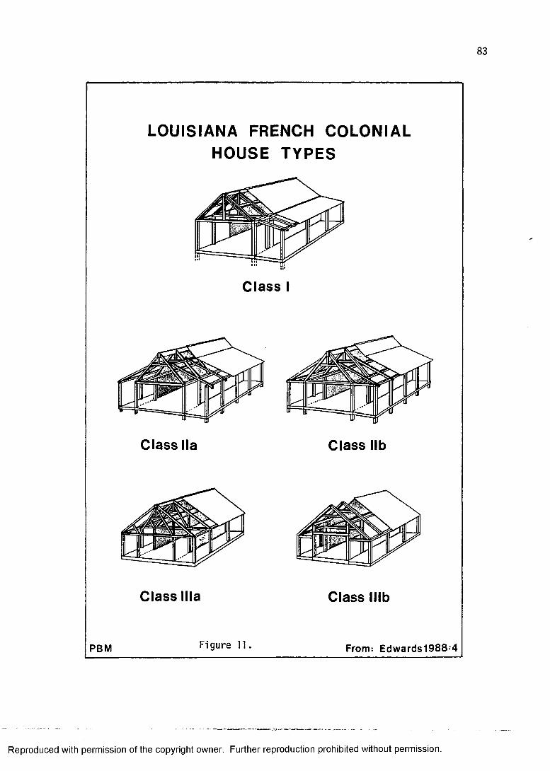
LOUISIANA FRENCH COLONIAL HOUSE TYPES
Class I
rpr* S1» r===—■— tlr==3
Class lla Class lib
Class Ilia Class lllb
PBM Figure 11 From: Edwards1988‘4
Reproduced with permission of the copyright owner. Further reproduction prohibited without permission.
84
The extent to which the French built in horizontal log is unknown. Some of the structures within the palisade of Fort Maurepas were probably of horizontal log construction (Oszuscik 1983:51), yet the structures within Fort St. Jean Baptiste were poteaux en terre and colombaqe (Broutin 1733). An extant example of piece sur piece construction is preserved as the Pointe Coupee Parish Museum (figure 1). It is an excellent specimen exhibiting the characteristic full dovetail notching and planed logs. Nevertheless, the relict cultural landscape and historical records suggest that the colombaqe house was considerably more widespread (Kniffen 1963:294; Wilson 1968:99).
The broken pitch roof structure with integral gallery (class II), has been called the "Mississippi Valley French Colonial” (Edwards 1988a:4) because it was built wherever French outposts occurred along the Middle and Lower Mississippi River (Ostby 1981; Peterson 1941). To those unaccustomed to the vagaries of cultural diffusion, finding houses reminiscent of the French West Indies in America's heartland (Missouri and Illinois for example) may seem a little perplexing. Yet, there are extant French Colonial structures practically in the shadow of the "Gateway to the West" Arch in St. Louis, a monument to the "manifest destiny" of the American pioneer.
The Mississippi Valley French Colonial house differed from French Caribbean structures in two important respects. First, the pitch of the inner roof of these
Reproduced with permission of the copyright owner. Further reproduction prohibited without permission.
broken-pitch roof structures resembled the pavilion roof of the class I structure. According to Edwards (1986:63), "in retaining their beloved pavilion roof, they produced a distinctive Mississippi Valley French Creole settler's house with a steep inner roof and a sharp break in pitch about halfway between the ridge and the eaves." The pitch of the West Indian French Creole house was considerably lower (Edwards 1988a:8-9). Secondly, these houses were not raised above the ground to the extent that the West Indian houses were. The Mississippi Valley French Colonial house used the poteaux sur solle construction which elevated the structure only slightly above the ground (Edwards 1986:64).
The famous Creole raised cottage, the next significant architectural innovation to be distributed across the Louisiana landscape, was really more of a hallmark of the Spanish and British Colonial period (Edwards 1988a:11). One important component of this innovation was, as the name suggests, adopting the Caribbean trait of raising the structure well off the ground.
SPANISH AND BRITISH COLONIAL LOUISIANASome significant changes took place in the
intervening years between 1740 and 1775. One profound transformation occurred in 1763 when France was forced to abandon its sovereignty over its possessions in continental North America (Canada and Louisiana).
Reproduced with permission of the copyright owner. Further reproduction prohibited without permission.
France's loss to the British (in the "French and Indian War") resulted in the division of the Louisiana Colony between Spain and Britain. According to the terms of the Treaty of Paris, all territory east of the Mississippi River and north of Bayou Manchac (and following a line through pass Manchac through lakes Maurepas and Pontchartrain to the Gulf) became British (figure 12). Spain inherited that area west of the Mississippi River and south of the Manchac line. This includes what has, since Iberville's day, been know as the "Isle of Orleans."
This change in political administration, in some respects, had little effect on the lives of the colonists who had settled under the French regime. French culture persisted vigorously under the umbrella of Spanish bureaucracy. Spain made little attempt to Hispanicize these Louisianaians. French remained, for all practical purposes, the official language. The majority of Francophone residents, now under Spanish rule, felt betrayed by the French crown and abandoned, but continued to look toward Paris rather than Madrid for cultural identification and stimulation (Moore 1976).
The lands acquired by Britain, which became known as British West Florida had been essentially devoid of a resident white population (Albrecht 1945; Carter 1917; Seramuzza 1930; Skipwith 1892). The one exception to this was Natchez, which later unfurled the Union Jack once the boundary separating Indian territory from British was
Reproduced with permission of the copyright owner. Further reproduction prohibited without permission.
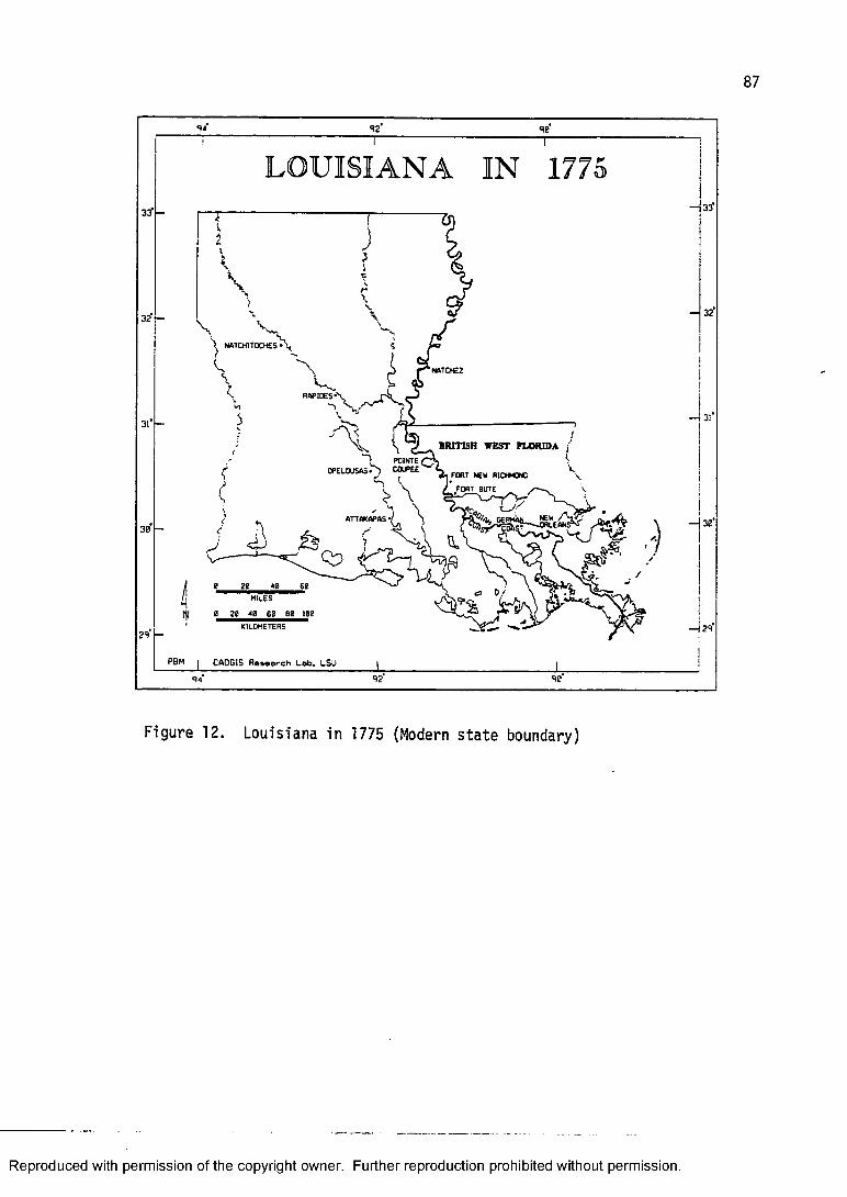
87
92 90
LOUISIANA IN 1775
32
31* -
30
29
NATCHITOCHES
NATCHEZ
RAPIDES
BRITISH WEST FLORIDA fP01NTECOUPEEOPELOUSAS' PORT NEW R 1 C M O C
FORT BUTE
ATTAKAPAS
HIlES
kilometers
•33*
32
— {30*
— 29
PBM CADC15 Research Lab. LSU92 9e
Figure 12. Louisiana in 1775 (Modern state boundary)
Reproduced with permission of the copyright owner. Further reproduction prohibited without permission.
moved up to a line running eastward from the Yazoo at Vicksburg. Pensacola served as the capitol of British West Florida and the Gulf Coast received the vast majority of new settlers during the 1760s (Howard 1947).
The British officer, Philip Pittman, made a reconnaissance of the Mississippi River and adjacent lands a few years after the Treaty of Paris and his noteworthy account (Pittman 1770) bears testimony to the paucity of white settlers in what has become known as the Florida Parishes. Except for a short-lived post on the east bank of the Mississippi north of Bayou Manchac (Fort Bute), which had been established by the British in the Spring of 1765 (Pittman 1770:31), the entire area seems to have been inhabited almost exclusively by various Indian groups.
The western portion of British West Florida, especially the lands along the Mississippi River, was rapidly and intensively settled during the decade of the 1770s. This coincided with the brewing of discontent and ultimate rebellion in the British Eastern Seaboard colonies. According to Johnson (1943:149), "the designation of West Florida as an asylum for loyalists in 1775 provided an additional stimulus to immigration, and settlers in large numbers from the colonies in rebellion and from the West Indies sought refuge, particularly in the Mississippi region of the province."
The non-Indian population along the Mississippi River portion of British West Florida is said to have increased
Reproduced with permission of the copyright owner. Further reproduction prohibited without permission.
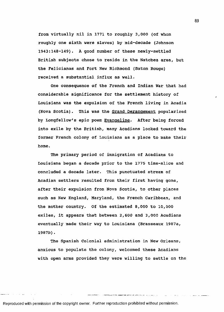
from virtually nil in 1771 to roughly 3,000 (of whom roughly one sixth were slaves) by mid-decade (Johnson 1943:148-149). A good number of these newly-settled British subjects chose to reside in the Natchez area, but the Felicianas and Fort New Richmond (Baton Rouge) received a substantial influx as well.
One consequence of the French and Indian War that had considerable significance for the settlement history of Louisiana was the expulsion of the French living in Acadia (Nova Scotia). This was the Grand Derangement popularized by Longfellow's epic poem Evangeline. After being forced into exile by the British, many Acadians looked toward the former French colony of Louisiana as a place to make their home.
The primary period of immigration of Acadians to Louisiana began a decade prior to the 1775 time-slice and concluded a decade later. This punctuated stream of Acadian settlers resulted from their first having gone, after their expulsion from Nova Scotia, to other places such as New England, Maryland, the French Caribbean, and the mother country. Of the estimated 8,000 to 10,000 exiles, it appears that between 2,600 and 3,000 Acadians eventually made their way to Louisiana (Brasseaux 1987a, 1987b).
The Spanish Colonial administration in New Orleans, anxious to populate the colony, welcomed these Acadians with open arms provided they were willing to settle on the
Reproduced with permission of the copyright owner. Further reproduction prohibited without permission.
margins of the colony, hence extending the frontier. The first wave of immigrants was settled, according to strict Spanish instruction, on either side of the Mississippi River just upstream from the Germans. For this reason, the river portion of St. James and Ascension parishes has since been frequently referred to as the Acadian Coast.
Modest grants of land fronting the river provided the petite habitant with resources that would sustain a modicum of self-sufficiency and comfort. The configuration of the grants conformed to the French arpent system whereby settlement along a waterway was maximized by laying out long narrow lots perpendicular to the river. (An arpent is a linear measurement equal to 192 English feet.) Grants given to Acadian families by the Spanish typically ranged from four to eight arpents of frontage by forty arpents in depth (Voorhies 1978:108).
The Acadians also settled down the Bayou Lafourche, along the Bayou Teche in the vicinity of the Post of Attakapas (St. Martinville), and near Bayou Courtableau at the Post of Opelousas. The Opelousas area borders on the eastern margins of the great prairie region of Southwest Louisiana and the Acadians who settled here adopted a somewhat different lifestyle than their bayou brethren;
tthey soon enthusiastically embraced the Spanish penchantfor cattle ranching. According to Post (1974:4, emphasisoriginal),
many elements of this pastoral economy undoubtedly were borrowed from the Spanish under
Reproduced with permission of the copyright owner. Further reproduction prohibited without permission.
whose domination the Acadians lived for more than a third of a century. . . . The prairies were especially suited to the raising of half-wild cattle, and on them the Acadians established their ranches or vacheries. The cattle were sold in New Orleans and to the planters along the Mississippi.
Settlement in Spanish Colonial Louisiana in the year 1775was, like that of the earlier time-slice, most dense inand around the capital, New Orleans. The plantationsalong the Mississippi River immediately above and belowthe city were the most developed and intensivelycultivated. Another locus of population was along FalseRiver in Pointe Coupee Parish. This area, one of theearliest settled during the French Colonial period,continued to prosper under Spanish dominion. A letter(Bjork 1924:21) from Governor Alejandro O'Reilly to theMinister of the Indies in Madrid dated December 10, 1769described the settlement density at Pointe Coupee:
The day after tomorrow, the 12th of the present month, I shall undertake my trip to Punta Cortada, which is situated up the river about fifty leagues from this city, and which, except the immediate surroundings of the Capitol, is about the only well populated district in this province.On the frontier of Spanish Louisiana of the early
1770s only four posts of any consequence existed. These were Attakapas, Opelousas, Natchitoches, and Rapides (Bridges and DeVille 1963; DeVille 1963, 1985; Post 1937; Stokes 1964). One of the first orders of business of Governor O'Reilly was to commission Edwardo Nugent and Juan Kelly to make a reconnaissance of the area for
Reproduced with permission of the copyright owner. Further reproduction prohibited without permission.
strategic purposes and report on the population and condition of these posts.
With respect to Attakapas (St. Martinville) andOpelousas, Nugent and Kelly's account is an excellentgeographical observation and is quoted at length below(Bjork 1924:30):
Atacapas and Opelusas are two separate districts divided by a small Bayou which flows by Fusilier's [an individual with whom they lodged]. However, they can be considered as one, wholly alike in quality of land, products and live stock. These two districts extend 25 leagues in length and five in width, which is the inhabited part. The land has been cleared of trees where the houses have been built, which gives them the advantage of proximity to water and forest. The land between the estates consists of spacious prairies covered with admirable grazing of very high and slender grass which is free from thistle and thorn, etc.These prairies extend three and four leagues in circuit surrounded by clear forests through which small streams flow. Hence the inhabitants maintain everything imaginable in the way of live stock, such as cows, horses, and sheep.There are excellent prairies covered with small grass suitable as pasture for sheep. There are also places where undoubtedly good crops of wheat could be raised if only ardor for its cultivation existed among the inhabitants. The products raised at present are rice, corn, and sweet potatoes as well as much live stock consisting of cows, heifers and some sheep.These products are used for the sustenance of the people and for trade with the native who ought to apply themselves to the raising of sheep and planting of corn, wheat, oats, rice, and flax since they have the most excellent land for these crops.
Their horses are good and they might raise a large number of them.
The inhabitants are not indolent and among them there are some industrious Acadians, who already have a good start towards an establishment which promises to be very useful in the lines of agriculture and cattle-raising. These people live in great tranquillity and accord, are law-abiding, and are well satisfied
Reproduced with permission of the copyright owner. Further reproduction prohibited without permission.
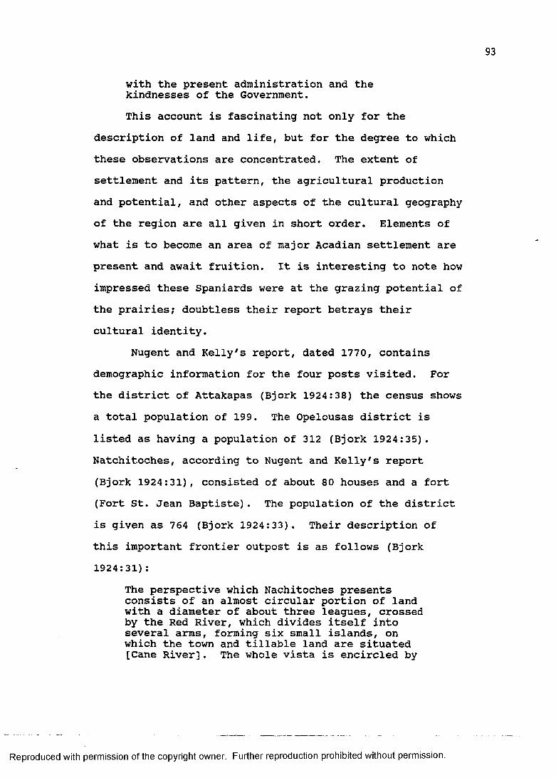
with the present administration and the kindnesses of the Government.This account is fascinating not only for the
description of land and life, but for the degree to whichthese observations are concentrated. The extent ofsettlement and its pattern, the agricultural productionand potential, and other aspects of the cultural geographyof the region are all given in short order. Elements ofwhat is to become an area of major Acadian settlement arepresent and await fruition. It is interesting to note howimpressed these Spaniards were at the grazing potential ofthe prairies; doubtless their report betrays theircultural identity.
Nugent and Kelly's report, dated 1770, contains demographic information for the four posts visited. For the district of Attakapas (Bjork 1924:38) the census shows a total population of 199. The Opelousas district is listed as having a population of 312 (Bjork 1924:35). Natchitoches, according to Nugent and Kelly's report (Bjork 1924:31), consisted of about 80 houses and a fort (Fort St. Jean Baptiste). The population of the district is given as 764 (Bjork 1924:33). Their description of this important frontier outpost is as follows (Bjork 1924:31):
The perspective which Nachitoches presents consists of an almost circular portion of land with a diameter of about three leagues, crossed by the Red River, which divides itself into several arms, forming six small islands, on which the town and tillable land are situated [Cane River]. The whole vista is encircled by
Reproduced with permission of the copyright owner. Further reproduction prohibited without permission.
thick pine forests by which the view is limited on every side.
The products of this country are mainly tobacco, corn, and rice.
The live stock consists of cattle, a few pigs, and sheep, and a few domestic animals. . . . There are several persons who are not farming and who do not have any honest way of living. . .As in the description of Opelousas and Attakapas, the
authors7 ability to summarize the physical geography of the site and the cultural setting is excellent. It is evident also that some residents of this frontier town are engaged in some clandestine or illicit trade; an activity almost as early as the Louisiana Colony itself and one that would continue into the nineteenth century.
The last post mentioned in this incredible document is that of Rapides (Alexandria). As this post had only recently been established (De Ville 1985:6) and there was little to differentiate it from the surrounding wilderness, it received only cursory examination on the part of Governor O'Reilly's emissaries. The residents of Rapides, 51 in all, lived in eight rude houses and were just beginning to establish their tobacco plantations (Bjork 1924:32-37) .
As a summary of settlement in Louisiana circa 1775, the above-mentioned places formed the core areas. North and Southwest Louisiana were, and would remain for some time, devoid of a resident white population of any significance (with the possible exception of Fort Miro established on the Ouachita River a decade later).
Reproduced with permission of the copyright owner. Further reproduction prohibited without permission.
The capital of the Spanish colony was not only the primate city, but the only city. Although the economic situation for New Orleans improved markedly during the Spanish period as the plantation economy of its hinterland boomed, the physical appearance changed little. In fact, according to accounts, there was some deterioration. Governor Unzaga wrote in 1775, "the fortress of this city is made of a stockade which forms six bastions that are almost destroyed by decay and the dampness of the soil.It is kept up only by continual repairs" (Wilson 1968:44). It is assumed that all structures were vulnerable to the process of decay of which Unzaga complained.
Disaster also contributed to inhibiting the growth of the city. Four years after the Governor penned the words quoted above, a hurricane struck and destroyed much of the city. Fire would also plague the city throughout the remainder of the century (specifically, the devastating fires of 1788 and 1794). Nevertheless, Bienville's assessment of the advantageous situation of the crescent city was borne out during the Spanish Colonial period. Despite its appearance, it remained the cultural, political, religious, and commercial center of the colony (and region for that matter).
Population enumeration of the Spanish Colony completed in May of 1777 indicates that Louisiana had a total of 16,292 persons, half of whom were slaves (Davis
Reproduced with permission of the copyright owner. Further reproduction prohibited without permission.
1971:109-110). The capital contained 3,206 residents (Davis 1971:110). The colony, therefore, had tripled in size since the 1744 census and the capital had more than doubled. Evidently the plantation economy was expanding as well, if the number of slaves and their ratio relative to the white population are indicators. The number of slaves had more than quadrupled over the past thirty-three years and shifted from a third to a half of the total population.
EVOLVING CREOLE HOUSE TYPESDespite the changes in house construction during the
French Colonial period, those early years of occupation appear to have been relatively stable architecturally when compared to the diversity displayed by Spanish and British Colonial period Creole houses. Just as the population remained predominantly French during this period, so too was the architecture. The Spanish and British made their contributions, certainly, but the greatest change came from the adoption and adaptation of the French West Indian house.
From the middle of the French Colonial period until the Treaty of Paris more and more Mississippi Valley French Creole houses were constructed fully raised in the West Indian style, so that by "the beginning of the Spanish period, raised Class II Creole houses had become a common sight in and around the City of New Orleans and as
Reproduced with permission of the copyright owner. Further reproduction prohibited without permission.
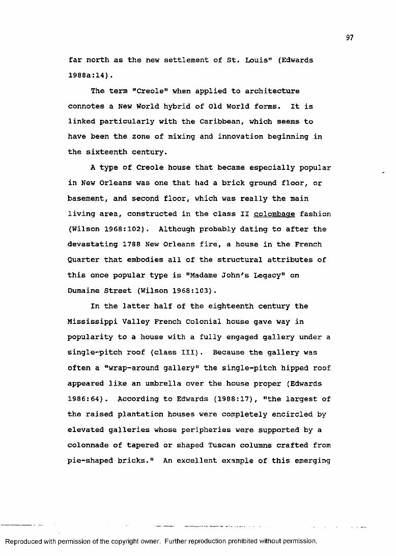
far north as the new settlement of St. Louis" (Edwards 1988a:14).
The term "Creole" when applied to architecture connotes a New World hybrid of Old World forms. It is linked particularly with the Caribbean, which seems to have been the zone of mixing and innovation beginning in the sixteenth century.
A type of Creole house that became especially popular in New Orleans was one that had a brick ground floor, or basement, and second floor, which was really the main living area, constructed in the class II colombaae fashion (Wilson 1968:102). Although probably dating to after the devastating 1788 New Orleans fire, a house in the French Quarter that embodies all of the structural attributes of this once popular type is "Madame John's Legacy" on Dumaine Street (Wilson 1968:103).
In the latter half of the eighteenth century the Mississippi Valley French Colonial house gave way in popularity to a house with a fully engaged gallery under a single-pitch roof (class III). Because the gallery was often a "wrap-around gallery" the single-pitch hipped roof appeared like an umbrella over the house proper (Edwards 1986:64). According to Edwards (1988:17), "the largest of the raised plantation houses were completely encircled by elevated galleries whose peripheries were supported by a colonnade of tapered or shaped Tuscan columns crafted from pie-shaped bricks." An excellent example of this emerging
Reproduced with permission of the copyright owner. Further reproduction prohibited without permission.
style (figure 13) is "Homeplace" (ca.1790) in St. Charles Parish (Blumenson 1981:14; Edwards 1988a:17; McAlester and McAlester 1984:126).
The large class III raised Creole plantation house is perhaps the most vivid rural example of French architecture of colonial Louisiana according to modern popular conception. Its popularity has extended into the modern subdivision where architects have designed some of their nicer homes in the "Louisiana style," aping the exterior appearance of these large French plantation homes (Newton 1971a:14). However, as Edwards (1988:12) pointed out, the latter half of the eighteenth century was a period of incredible diversity with respect to the French Creole house, and plantation homes such as "Homeplace," although beautiful, represent only one form among many.
One area where this architectural diversity took place was in the floorplan of the house. The interior arrangement of rooms, attached rooms, and gallery configuration offered a seemingly limitless potential combination of plans. According to Edwards (1988:12) "it is useful to conceive of Creole houses in terms of a classification of their plans." There is also an evolutionary sequence to these various floor plans.Suffice it to say that in general the possibilities for variation and complexity became greater as the French Creole house evolved from class I to class III forms.
Reproduced with permission of the copyright owner. Further reproduction prohibited without permission.
99
Figure 13. "Homeplace," St. Charles Parish
Reproduced with permission of the copyright owner. Further reproduction prohibited without permission.

TOO
Some of the floorplan variation seems to be explained by the influence of the Georgian architectural style (McAlester and McAlester 1984:138-142) popular in the British Eastern Seaboard colonies. French Creole houses beginning in the mid-eighteenth century became more symmetrical in plan; later examples even adopting the central hall (Edwards 1988a:24-25). Newton (1987:179) suggested that the movement in architectural design toward greater structural symmetry "reflect[s] the adoption of stylistic trends felt widely throughout the western world."
The simple gable roof (with the gable to the side)was another architectural change that added to thediversity of the later smaller French Creole house (figure14) . This roof form came into common usage in the 1750sand 1760s, especially in the vicinity of New Orleans(Edwards 1986:64). Heck (1978:162) discussed the gableroof with engaged gallery as a popular form amongAcadians, but does not address the details of theiradoption of this typically Creole architecture. As Edwards(1986b:64) explained, the newly-arrived Acadians displayeda clear preference for this gable roof house:
Acadian (French Canadian) settlers began to arrive in New Orleans from Haiti in 1765, a decade after they had been cruelly deported en masse from Nova Scotia. They adopted as their own a gabled-roof cottage with a built-in porch- a diminutive, single-room form of the Creolehouse then popular in the New Orleans area and familiar to them from Haiti. . . . Beginning in the 1790s, a module with two rooms of equal
Reproduced with permission of the copyright owner. Further reproduction prohibited without permission.

Figure 14. Smaller French Creole House
Reproduced with permission of the copyright owner. Further reproduction prohibited without permission.
102
width and two doors on the facade became the standard in many areas settled by the Acadians.A considerable amount of descriptive literature on
the smaller Creole, or Acadian, cottage exists (e.g., Heck1978:161-172; Newton 1971a:13; Post 1974:83-91), but it isclear that research questions concerning the origins ofthis popular house type need to be addressed (e.g. Edwards1980, 1988). In addition, the basic type experiencedfascinating architectural transformations once it tookroot in Louisiana, such as the differential placement ofstairways to get up into the loft, or the addition of a"false gallery" (Edwards 1988a:18-21).
The Acadian Upper Teche house is another folk type inthe French tradition, but its distribution is verylimited. It is essentially a smaller Creole house withoutthe integrated gallery and is not raised. Because it doesnot display the Caribbean traits of the other Creolehouses it is "the only house type in Louisiana that can beproperly called an 'Acadian house,' a term that has beenused very promiscuously" (Newton 1971:14).
British Creole houses were also built during thelatter half of the eighteenth century in the blufflandsbetween Baton Rouge and Natchez, Mississippi. Thesestructures were mainly Lowland South (Tidewater)plantation houses that were modified by the Caribbeanarchitectural influence. Even though the British Creolehouse resembled the French Creole house in somefundamental respects such as half-timber construction atop
Reproduced with permission of the copyright owner. Further reproduction prohibited without permission.
a full brick basement, engaged galleries, and a non- symmetrical floorplan, upon closer inspection telltale features distinguish between the two. According to Edwards (1988:23), "the geometry of the floorplans was subtly different from the Creole aesthetic." Other features include a slightly broken-pitch roof and external chimneys on the gable ends. One British Creole house in West Feliciana Parish, "Oakley" (ca. 1790), is frequently cited as an example of the French Creole raised cottage type because of shared Caribbean traits that the structure exhibits (Newton 1987:183).
In sum, the Spanish and British Colonial Period of the late eighteenth century was characterized architecturally by considerable Caribbean influence and subsequent modification. These modifications tended to create a number of competing forms, most of which were subject to change through time. This was the era of the Creole cottage, whether urban or rural, large or small, French or British. It was the period of what Edwards (1988:28) has termed "the wonderful florescence of the Creole tradition."
TERRITORIAL LOUISIANASeveral significant changes occurred in Louisiana in
the intervening years between 1775 and 1810. One dramatic event, brewing in the British colonies in the East, was the American Revolution. Louisianians in the Spanish colony joined the cause under the leadership of Governor
Reproduced with permission of the copyright owner. Further reproduction prohibited without permission.

104
Bernardo de Galvez and captured the British fort at Baton Rouge on September 21, 1779. They moved on to capture Mobile and Pensacola and the surrender of British West Florida officially took place on May 10, 1781. The whole of Louisiana now belonged to the King of Spain.
Following the War for Independence, Americans began their great westward migration. Into the valleys west of the Appalachians came a steady stream of land-hungry pioneers. Typical of the times is the life of William Darby (Kennedy 1981), a highly-motivated and talented individual. Darby, at age six, accompanied his parents across the Alleghenies in 1781. He grew up on the frontier and acquired a taste for new lands and the opportunities they offered. In 1799, at the age of twenty-four, he went to seek his fortune, and like so many before and after him, he floated down the Ohio and Mississippi rivers and disembarked in Natchez. There met his wife who moved with him in 1805 to Opelousas, Louisiana. He became a capable surveyor and an important figure in the history of Louisiana cartography.
With the massive influx of settlers into the region between the Appalachians and the Mississippi, Americans began to view the Spanish colony of Louisiana as crucial to their national interests. Given the difficulty of overland communication between east and west, the Mississippi River system became an expedient outlet for a growing number of Americans. Spain, however, controlled
Reproduced with permission of the copyright owner. Further reproduction prohibited without permission.
105
the outlet of the Mississippi and thus, according to Graebner, Fite, and White (1971:256), "three-eighths of the United States depended on New Orleans for access to markets for its produce."
The attention of the young nation of the United States focused on Louisiana at the close of the eighteenth century. Spain was protective of its port and eyed the burgeoning American traffic suspiciously. A 1795 treaty with Spain allowed Americans the right to export goods out of New Orleans, but in 1802 this privilege, so necessary to western Americans, was denied (Davis 1971:157).
Louisiana was but a pawn being moved about in the larger game of European geopolitics. As a concession to Napoleon Bonaparte, the new leader of France who was beginning to flex his muscles on the continent, Spain retroceded its Louisiana colony by the Treaty of San Ildefonso on October 1, 1800. Sentiments among most Americans ran high, and even President Jefferson referred to the nation that possessed New Orleans as "our natural and habitual enemy" (Graebner, Fite, and White 1971:256).
While France moved slowly to reinstate its administration in Louisiana, American negotiators in Paris moved swiftly to impress upon Napoleon the importance of the lower Mississippi River to the American people. The initial intention of Robert Livingston and James Monroe was to bargain for the Isle of Orleans and the right to navigation on the lower Mississippi, but to everyone's
Reproduced with permission of the copyright owner. Further reproduction prohibited without permission.
surprise Napoleon began to view the whole of Louisiana asa liability and offered to sell the entire colony to theUnited States. The famous Louisiana Purchase agreement,"the greatest bargain in American history" (Morison1965:366), was signed on April 30, 1803.
The purchase was indeed a bargain. America paidabout 4 cents an acre for an enormous piece of realestate, roughly 830,000 square miles. Davis (1971:165)put the Louisiana Purchase into geographical perspective:
The purchase of Louisiana almost doubled the land area of the United States. The territory was more than thirteen times larger than New England, nearly three times larger than the thirteen original states of the Union, and roughly a third of the continental area of the present-day nation.The economic impact was felt almost immediately.
According to Kane (1943:74), the tonnage of cargo shipped out of New Orleans "increased almost fifty per cent during the first year that Louisiana was part of the United States." This sudden prosperity opened the. floodgates to a surge of eager settlers. Americans were on the move; the destination for many was the old Louisiana colony itself.
Not all of the old colony of Louisiana had been given over to the French in 1800 and subsequently transferred to the United States in 1803. Spain retained West Florida.It held on to the "Florida Parishes" until September 23, 1810 when a contingent of armed planters stormed the Spanish fort in Baton Rouge and proclaimed the area as the
Reproduced with permission of the copyright owner. Further reproduction prohibited without permission.
107
independent Republic of West Florida (Davis 1971:172-173). This tiny republic was short-lived, however, because less than three months later the Governor of the Territory of Orleans, William C.C. Claiborne, annexed it. Congress officially joined the Florida Parishes between the Pearl and Mississippi rivers to the Territory of Orleans on April 14, 1812 (Davis 1971:173).
The Territory of Orleans (Lebreton 1969) itself was separated from the vast lands included in the Louisiana Purchase by Act of Congress on March 26, 1804. Figure 15 is Lafon's (1806) map of the Territory of Orleans. This new territory included all land drained by the Mississippi River south of the 33rd parallel. That same year, the newly-created legislative council divided their territory into 12 counties. Three years later division of the territory into 19 parishes began to erode the power of the county system of administration. According to Davis (1971:169), these counties were "apparently retained for the purpose of electing representatives and levying taxes, and gradually the functions went out of existence." Kyser (1938:15) explained that the brief tenure of the county system of civil administration was because of the "resistance of the Latin inhabitants of Louisiana to the new order." He further stated that their "well-known dislike for the new judicial system was undoubtedly one of the strongest factors working against the preservation of the counties as originally created" (Kyser 1938:15). At
Reproduced with permission of the copyright owner. Further reproduction prohibited without permission.

108
"''VluMl'J
3A1'"I
Reproduced with permission of the copyright owner. Further reproduction prohibited without permission.
Figure
15.
Laf
on's
Map o
f the
Ter
ritory
of
Orlean
s (18
06)
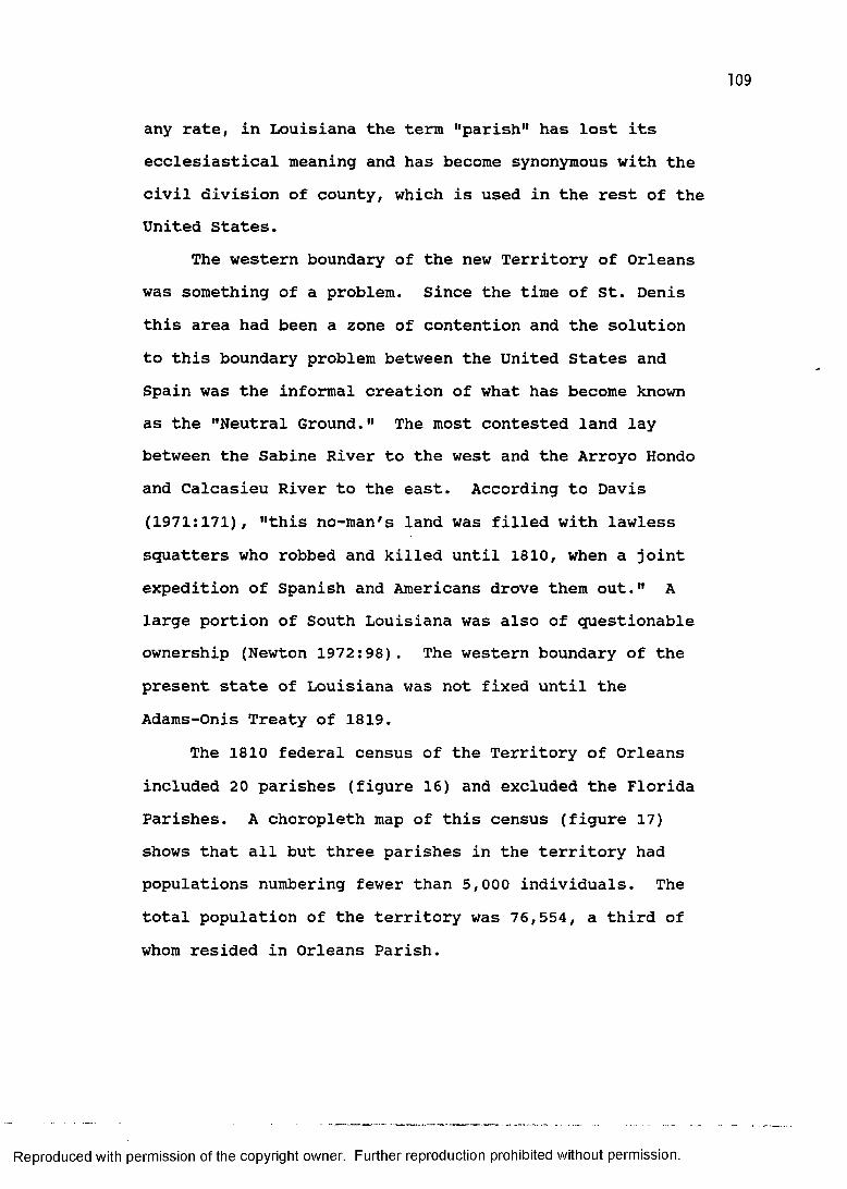
any rate, in Louisiana the term "parish" has lost its ecclesiastical meaning and has become synonymous with the civil division of county, which is used in the rest of the United States.
The western boundary of the new Territory of Orleans was something of a problem. Since the time of St. Denis this area had been a zone of contention and the solution to this boundary problem between the United States and Spain was the informal creation of what has become known as the "Neutral Ground." The most contested land lay between the Sabine River to the west and the Arroyo Hondo and Calcasieu River to the east. According to Davis (1971:171), "this no-man's land was filled with lawless squatters who robbed and killed until 1810, when a joint expedition of Spanish and Americans drove them out." A large portion of South Louisiana was also of questionable ownership (Newton 1972:98). The western boundary of the present state of Louisiana was not fixed until the Adams-Onis Treaty of 1819.
The 1810 federal census of the Territory of Orleans included 20 parishes (figure 16) and excluded the Florida Parishes. A choropleth map of this census (figure 17) shows that all but three parishes in the territory had populations numbering fewer than 5,000 individuals. The total population of the territory was 76,554, a third of whom resided in Orleans Parish.
Reproduced with permission of the copyright owner. Further reproduction prohibited without permission.
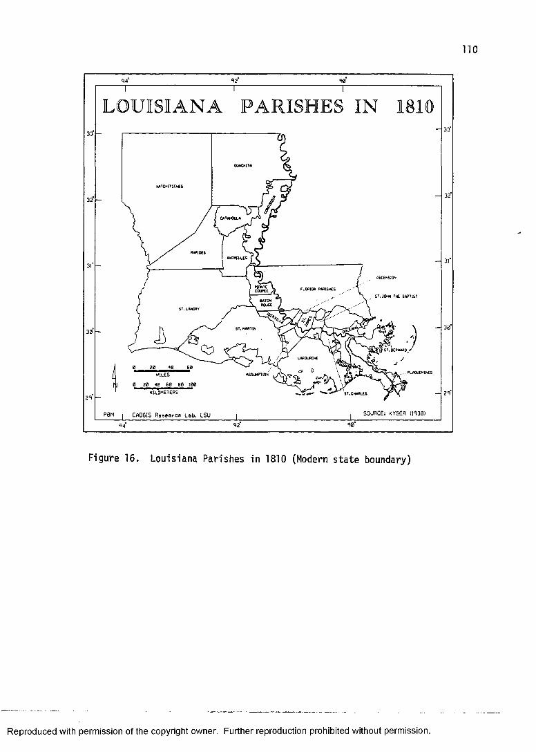
LOUISIANA PARISHES IN
ROUGE
20 60MILES
SOURCE: KYSER (1938)PBM CA0G1S Research Lab, LSU94
Figure 16. Louisiana Parishes in 1810 (Modern state boundary)
Reproduced with permission of the copyright owner. Further reproduction prohibited without permission.
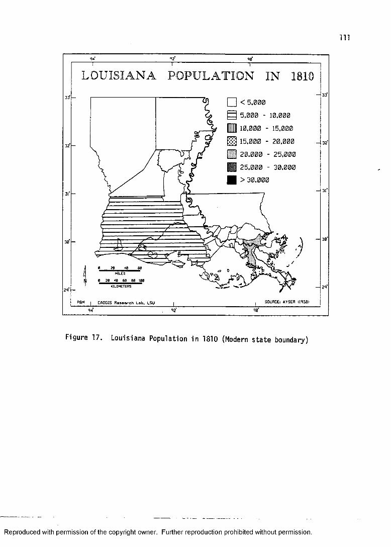
in
L O U ISIA N A P O P U L A T IO N IN
□ < 5,000E3 5,000 - 10,000
10,000 - 15,00015,000 - 20,00020,000 - 25,000
H H 25,000 - 30,000 | > 30,000
60IM
MILES
KILOMETERS
SOURCE: KYSER (1A38)PBM CADGIS Research Lab. LSU
Figure 17. Louisiana Population in 1810 (Modern state boundary)
Reproduced with permission of the copyright owner. Further reproduction prohibited without permission.
112
New Orleans, the only metropolis in the territory, had a population of 17,242. New Orleans was, according to the 1810 census, the largest city west of the Appalachians and the fifth largest city in the United States (Lewis 1976:37). This growth had its effect on the old colonial city. With the expansion of New Orleans in the three possible directions complete by 1810, it was decided to remove the old fortifications and physically connect the suburbs with the city. According to Reps (1965:102), "as occurred in many European walled cities, when the old perimeter fortifications were pulled down broad boulevards replaced them: Canal Street, North Rampart Street, andEsplanade Avenue of the present day."
Just as the population of Orleans Parish was concentrated in New Orleans, so too the populations of St. Landry and St. Martin parishes were mainly in the vicinity of Opelousas and St. Martinville (Attakapas).Most of southwestern Louisiana remained sparsely populated and figure 17 highlights the inherent problem of the choropleth method of cartographic data distribution.
A choropleth map of each of the 19th century time-slices' population census is presented in this study because it is felt that the attempt of graphic representation of these data would enhance the simple tabulation of census returns. The census returns are generally no more specific than the parish level, so the choropleth pattern extends over the entire parish. The
Reproduced with permission of the copyright owner. Further reproduction prohibited without permission.
113
interval scale used is the same to allow for visual comparison between time-slices. At any rate, the actual census figures are presented in Appendix II.
North Louisiana in 1810 was essentially vacant. The huge parishes of Natchitoches and Ouachita had a combined population of only 3,947, most of whom lived in the vicinity of the town of Natchitoches along the Cane River or along the Ouachita River in or near Fort Miro (Monroe).
An attempt had been made later in the 18th century to encourage settlement in the Ouachita region, but this ended in failure. The Spanish, in 1795, granted a huge tract of land amounting to 12 leagues square (about 650,000 acres) to the Baron de Bastrop. He, in return, agreed to settle this grant with 500 families. When he succeeded in enticing only a tenth of that number to settle in the region his grant was revoked (Lewis 1973:34) .
AMERICAN AND HAITIAN INFLUENCEThe first shock waves of American migration to
Louisiana were felt in the city of New Orleans.Immediately following the Louisiana Purchase the city filled with Americans who brought with them, among other things, their own customs of architectural propriety and style. One of the most famous architects of the early Classical Revival, Benjamin Henry Latrobe, was working in New Orleans in these early years and saw the proverbial handwriting on the wall. " I have no doubt but that the
Reproduced with permission of the copyright owner. Further reproduction prohibited without permission.
114
American style will ultimately be that of the whole city" (Wilson 1968:112).
Actually, the French Creoles dug in their heels and their Vieux Carre remained relatively free from this American onslaught. The wide boulevard of Canal Street became the boundary (the original "neutral zone") as the unwelcome Americans built their own city upstream. Even still, a few Federal style and early Classical Revival style buildings were constructed in the French Quarter, the work of father and son architects Benjamin Henry Latrobe and Henry S. Latrobe.
One of the first of these non-Creole structures was the new Custom House, designed in 1807, which was built in the Federal style out of red brick from Philadelphia (Wilson 1968:110). The New Orleans Custom House is a building that would not have been out of place in Philadelphia, Baltimore, or especially the growing city of Washington; cities that were rapidly growing during the Federal Period (1780-1820) . In the Vieux Carre, however, the Custom House and the few residences "with fronts of Philadelphia bricks in English bond and a slate roof" (Wilson 1968:110) were considered architectural oddities.
American architectural influence was strongest, naturally, in the growing American sector, the so-called Faubourg St. Mary. Although this area has recently been characterized as "now half ghetto, half skid row" (Lewis 1976:40) because the affluent and middle class American
Reproduced with permission of the copyright owner. Further reproduction prohibited without permission.
115
residential neighborhoods moved progressively farther upstream along the crescent of the Mississippi natural levee, it was once the site of numerous structures in the "American style."
The architectural style that Americans introduced to Louisiana in the period around 1810 is the Federal style. This style is characterized by a low pitched hip or gable roof, dentil molding under the eaves, smooth fascade, semi-circular or eliptical fan light above a paneled front door, and perhaps with Palladian windows, (Blumenson 1981:20-21; McAlester and McAlester 1984:152-158; Poppeliers, Chambers, and Schwartz 1983:30-31). The favored building material for a Federal style structure was wood frame in New England and brick in the Middle Atlantic and the South. The Federal style was quickly replaced by the Greek Revival style around 1820.
In New Orleans, some structures were built in the Federal style a little later than the style's period of national popularity. The Hermann-Grima house (1831) in the French Quarter, for example, is relatively late for a "Federal" house. It is, nevertheless, according to Wilson (1968:113), "one of the best examples of American influence on New Orleans architecture."
Another group that migrated to New Orleans in large numbers following the Louisiana Purchase was composed of French Creole planters and their slaves, as well as free blacks ("free persons of color"). They came mainly from
Reproduced with permission of the copyright owner. Further reproduction prohibited without permission.

116
Haiti, driven out by slave insurrections that were sweeping the West Indies (Clark 1970:275-276). According to Vlach (1986a:63), "between May 10 and August 19, 1809, some fifty ships brought to New Orleans 1,887 whites,2,112 slaves, and 2,060 free people of color fleeing conditions in Haiti - 6,060 in all." There seems to be reasonable evidence to support the contention that one of the most enigmatic of Louisiana's house types, the shotgun, was introduced by Haitians who came to New Orleans at this time (Vlach 1986a; 1986b).
Although i.'ully cognizant of the competing explanations for the genesis of the shotgun house (e.g., Newton 1987:189-190), Vlach (1986a:67), after careful field investigation in Louisiana, the Caribbean, and Africa, has asserted that "the origins of the shotgun are not to be found in the swamps and bayous of Louisiana but in Haiti." Actually, this is not the first time that the suggestion that Haitians brought the shotgun house to Louisiana has been made. Kniffen (1963:293) proposed that the shotgun "may have derived from the thatched houses of Haitian slaves." But, Vlach's research is the most thorough and comprehensive to date and merits serious consideration.
In the Notarial Archives of New Orleans Vlach (1986a:63) uncovered drawings of shotgun houses from the early nineteenth century. These drawings advertized houses that were for sale, and it appears that the oldest
Reproduced with permission of the copyright owner. Further reproduction prohibited without permission.

117
rendering of the shotgun type was of a house in the French Quarter that was sold in November of 1833 (Vlach 1986a:63). This date tells nothing of the actual date of construction, but is merely a terminus ante ouem (Noel Hume 1968:69).
The association of Haitian free blacks in New Orleans who were either in the building trade or had contracted for a typical Haitian shotgun, a maison basse. to be built has also been established by Vlach (1986a:63). According to Vlach (1986a:63), New Orleans was experiencing a "severe shortage of housing" at the time of the 1810 census and the recent Haitian immigrants "were in a position to buy and build houses of their own choosing." They evidently chose to build the precursor of what we know today as the shotgun house (figure 18).
The shotgun house is to the shotgun tradition as the single-pen is to the pen tradition (discussed in chapter six), the most fundamental building block. The unique feature of the shotgun tradition is the gable front orientation. The shotgun house is one room wide and three or more rooms deep. Additions at the back of the structure can give the shotgun an "L" or "T" plan.Earlier forms are usually vertical board construction.The roof can be gable or hipped, and if there is a porch it can be fully or partially integrated with the roof, or simply attached (e.g., a shed porch). The chimney, if
Reproduced with permission of the copyright owner. Further reproduction prohibited without permission.
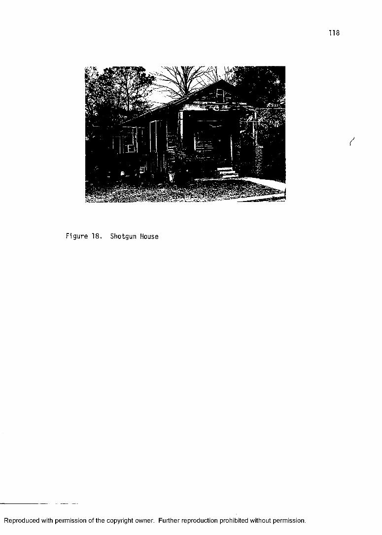
Figure 18. Shotgun House
Reproduced with permission of the copyright owner. Further reproduction prohibited without permission.
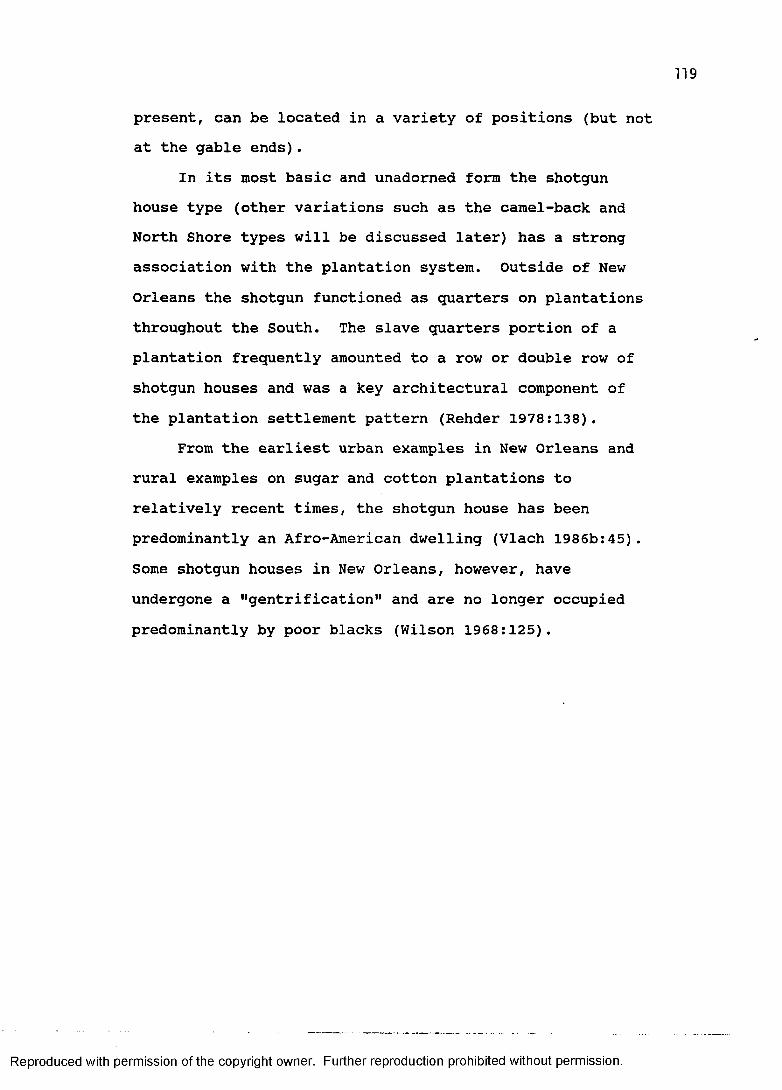
119
present, can be located in a variety of positions (but not at the gable ends).
In its inost basic and unadorned form the shotgun house type (other variations such as the camel-back and North Shore types will be discussed later) has a strong association with the plantation system. Outside of New Orleans the shotgun functioned as quarters on plantations throughout the South. The slave quarters portion of a plantation frequently amounted to a row or double row of shotgun houses and was a key architectural component of the plantation settlement pattern (Rehder 1978:138).
From the earliest urban examples in New Orleans and rural examples on sugar and cotton plantations to relatively recent times, the shotgun house has been predominantly an Afro-American dwelling (Vlach 1986b:45). Some shotgun houses in New Orleans, however, have undergone a "gentrification" and are no longer occupied predominantly by poor blacks (Wilson 1968:125).
Reproduced with permission of the copyright owner. Further reproduction prohibited without permission.
CHAPTER V: CADASTRAL SURVEY AS SETTLEMENT ARTIFACT
PRE-STATEHOOD SURVEY SYSTEMSColonial Louisiana is history. Yet, nowhere else is
the mark of the past so much a part of the present than in the pattern of land survey. The act of settlement has left a tangible expression on the land in the form of the cadaster, and even a cursory examination of a modern map reveals the bold imprint of the historic land claim. The significance of this phenomenon has not escaped the attention of the cultural geographer (e.g., French 1978; Hall 1970; Hilliard 1973; Jordan and Rowntree 1986:97-104; Taylor 1950). Louisiana has a fascinating variety of cadastral types implanted on the landscape. These include the French concession and arpent system, the Spanish sitio, the British metes and bounds, and the American General Land Office township-and-range and long lot systems (Newton 1986:167-185). This study examines the private land claims, for the most part colonial grants, recognized by the United States Congress in the early nineteenth century (Downs 1960; American State Papers, Public Lands 1834).
The importance of various cadastral systems to the study of settlement geography derives from the legal recognition of a transfer of land ownership from government to individual, or severance from sovereign, that they represent. In the colonial period of
120
Reproduced with permission of the copyright owner. Further reproduction prohibited without permission.
121
Louisiana's history a grant of land from sovereign to individual was usually made with the understanding that the grantee would actually settle, or cause others to settle, the grant within a period or forfeiture of the grant would result (see Arena 1974). The implication of this policy to the cultural geographer is, simply, that the surviving colonial land claims may be viewed as artifacts of settlement.
THE FRENCH ARPENTDuring the French colonial period, land was granted
to individuals in one of two ways. Following the seigniorial system, especially popular along the St. Lawrence River in French Canada (Harris 1966), large land grants known as concessions were made to individuals upon the agreement that they would then populate the grant with settlers. The profit motive was at work here, whereby the crown's coffers would increase by the sale of idle land, while the seignior, or concessionaire, benefited by receiving a percentage of the settlers' production. The other form of land grant was made to individual settlers directly.
Whether concession or individual settler grant, the French employed the system of measurement known as the arpent. These grants were made almost exclusively along waterways and had a configuration which ran perpendicular to the course of the river.
Reproduced with permission of the copyright owner. Further reproduction prohibited without permission.
There were actually few concessions granted during the French rule, but what they lack in number is made up for in size. They had broad frontage and usually extended more than two miles in depth (Newton 1986:169). The greatest concentration of concessions is along the Mississippi River in the vicinity of New Orleans, in fact, concessions, according to Newton (1986:169), "underlie the present layout of the city of New Orleans, accounting for the Crescent City's 'crescent' shape."
The typical individual grant was variable in the amount of frontage (along the river), but usually extended to a depth of forty arpents. Where the natural levee was broad enough to permit more than forty arpents of depth (7,680 feet), additional forty arpent grants were laid out. Unlike concessions, which were located according to the site selection of the concessionaire, these smaller grants were given to settlers in a size (measured by so many arpents of frontage) usually corresponding to the size of their household. One stipulation made by French authorities was that the settler accept land contiguous to that of previous settlers. This policy encouraged settlement while at the same time provided for an ever-expanding zone of solid occupance. Settlers were also required to construct levees and roads, thereby increasing flood-control and enhancing transportation for the common good.
Reproduced with permission of the copyright owner. Further reproduction prohibited without permission.
123
THE SPANISH SITIOThe Spanish continued the use of the arpent system,
primarily in South Louisiana, but also introduced their own form of cadastral survey known as the sitio (Hilliard 1973:9; Newton 1986:173). The Spanish penchant for ranching, as demonstrated in New Spain, necessitated extensive land holdings and the sitio seems to have fulfilled this function.
Sitios ideally were large square grants measuring either one league (three miles) or half a league on a side. The square sitio measuring a league on a side would, accordingly, contain nine square miles, or some 5,760 acres. However, numerous sitios in Louisiana (e.g., Terrebonne Parish) were actually parallelograms, still a league on a side but containing something less than nine square miles.
Although most sitio grants were made in the portion of Louisiana that lies west of the Atchafalaya and Red rivers, they also occur sporadically in South Louisiana (e.g., Iberville and Terrebonne parishes), in the Florida Parishes (e.g., St. Tammany), and in North Louisiana (e.g., on Bodcau Bayou in Bossier and Webster parishes).
Many of these Spanish sitios have not been recognized as such until the present study. Rehder (1978:148), in fact, misidentified what are Spanish sitios in Terrebonne Parish. He attributed their configuration to the American General Land Office survey. Upon closer inspection it can
Reproduced with permission of the copyright owner. Further reproduction prohibited without permission.
124
be seen that they conform to the parallelogram variety of the sitio. Confirmation of this is found in the plat records of the Louisiana State Land Office as well as in the American State Papers. Public Lands (1834(3):267, 4:34-35).
Two unusually large Spanish grants, known as Las Ormigas and La Nana respectively, were made in the old Spanish area of the state between Los Adaes and the Sabine River in what is today DeSoto and Sabine parishes. Las Ormiaas was a rectangular group of four grants adjoining the Sabine River. The individual portions measured a league and a half by five leagues. La Nana was a large square shape where each of the four segments measured one league by four leagues.
The largest Spanish land grants, however, were made to the Baron de Bastrop and the Marquis de Maisonrouge in the northeastern portion of the state (Mitchell and Calhoun 1937). Although the grants were later nullified because of their inability to attract settlers to the Ouachita Country, one of the conditions imposed by the Spanish, the configuration of these huge grants persisted cartographically well into the nineteenth century (see, for example, Darby's map of 1816).
THE BRITISH METES AND BOUNDSThe British colonizers of North America transplanted
a system of land division known as metes and bounds.Except for southern New England and coastal New Hampshire
Reproduced with permission of the copyright owner. Further reproduction prohibited without permission.
125
and Maine, which had a settlement pattern of villages with fragmentary agricultural fields, this was the most common way to parcel out land in areas settled by British people prior to the American Revolution. In Louisiana, British Colonial land grants were made in abundance in British West Florida. Although the Florida Parishes contain land claims attributable to the French and Spanish (and later American) governments, it is the only area of the state where one can find the cadastral type known as the metes and bounds survey.
Hilliard (1987:155) has described this particular survey system as "part geometry, part topography, and part consensus." This is because of the process of laying out a metes and bounds land survey, generally resulting in an irregular configuration. The metes and bounds survey, unlike either the French arpent or the Spanish sitio, had few rules governing shape.
These British grants were generally placed according to the claimants's wishes. The only stipulations were that the claim did not overlap an existing claim, and if placed along or astride a stream, water frontage could not exceed one third of the length away from the stream (Newton 1987:217). This latter stipulation obviously served to prevent individuals from monopolizing the valuable land along waterways.
The metes and bounds cadastral system involved selecting the site for the land claim, mindful of the two
Reproduced with permission of the copyright owner. Further reproduction prohibited without permission.
stipulations just mentioned, and surveying from a known point of origin through however many benchmarks were necessary and returning to the point of origin. Some metes and bounds polygons are angular in the extreme. A landscape that has been surveyed according to the metes and bounds system is frequently described as appearing like a "crazy quilt." This is especially apparent in the northwestern portion of the Florida Parishes (French 1978:96).
THE COLONIAL LAND CLAIMS MAP OF LOUISIANAThe map that appears in this study as figure 19 is a
composite map of all contiguous areas (greater than two square miles) of French, Spanish, and British cadastral systems. It was compiled from Louisiana State Department of Transportation parish maps. This map series is an excellent source of cartographic information relative to cadastral survey because all of the private colonial land claims that were confirmed by the United States Congress are represented.
Cadastral systems of colonial Louisiana have been mapped previously in general outline (e.g., Taylor 1956), but, except for French's (1978) work on the Florida Parishes, these are actually rude approximations. The colonial land claims map that appears here is more accurate and comprehensive for two reasons: 1) thecadastral configurations were transformed into digital format using an INTERGRAPH, thus reducing error inherent
Reproduced with permission of the copyright owner. Further reproduction prohibited without permission.
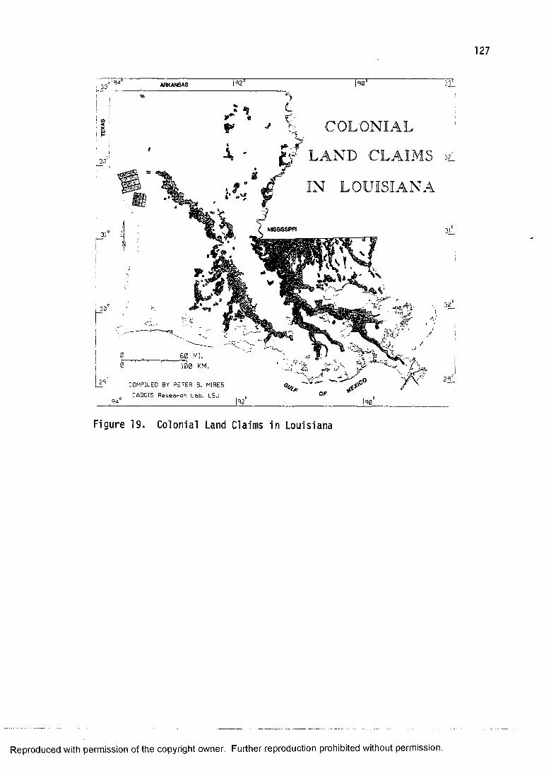
COLONIAL
LAND CLAIMS
IN LOUISIANA
o R4 ARKANSAS
F.
60 MI.100 KM.
DMPILED BY PETER B. MIRESADGIS Research Lob. LSU
Figure 19. Colonial Land Claims in Louisiana
Reproduced with permission of the copyright owner. Further reproduction prohibited without permission.
128
in the transfer of data by hand from base map to final copy, and 2) questionable cadastral types were checked with copies of the original plat maps on file in the Louisiana State Land Office.
The cadastral survey types attributable to the American General Land Office are omitted. These types are the famous and widespread rectilinear, or township and range system, and the not-so-familiar American long lot. The American rectilinear survey is readily distinguishable from any colonial type because of its geometry and compass orientation. The American long lot, however, is frequently confused with the colonial arpent system. One major distinction between the two long lot systems is that the American long lots are not strictly perpendicular in relation to rivers.
The initial function of the General Land Office in Louisiana during the territorial and early statehood periods was the scrutiny of private land claims made prior to 1803. One of the first orders of business of a government that acquires land that is already settled is to review the property rights of individuals and to decide whether to honor them. The succession of European colonial administrations in Louisiana generally recognized prior private land claims (except those of Native Americans), and it is by this process that cadastral forms that pre-date the Louisiana Purchase appear on a modern map of the state of Louisiana.
Reproduced with permission of the copyright owner. Further reproduction prohibited without permission.
129
The Colonial Land Claims Hap is inserted between the chapter in this study that discusses colonial settlement and that of statehood settlement because it is hypothesized that the colonial land claim is an excellent indicator of actual settlement. This is not possible during the later period of American statehood for three simple reasons: 1) most of the state was ultimatelysurveyed in a systematic fashion by the General Land Office without regard to habitability, 2) the General Land Office habitually surveyed numerous series of lots in the frequently erroneous expectation of actual settlement (e.g., American long lots), and 3) squatting and the purchase of land for purposes other than settlement (e.g., speculation) were rampant in the nineteenth century.
The explicit expectation of this study's use of colonial cadastral survey is as a reliable indicator of where people lived in the French, Spanish, and British colonial periods. (It should be remembered that the Spanish Colonial period lasted until 1810 in the Florida Parishes portion of Louisiana, hence the grouping of the 1810 time-slice with the other two earlier colonial time- slices.) Keeping in mind some of the major trends in colonial settlement outlined in the preceding chapter, even a cursory inspection of the colonial land claims map reveals its utility to settlement prediction and historic preservation. This is where most people lived and where we should expect to find most of the pre-1810 structures!
Reproduced with permission of the copyright owner. Further reproduction prohibited without permission.
130
Except for the deceivingly huge Las Ormiaas and La Nana grants in DeSoto and Sabine parishes, the collective pattern of the thousands of colonial land claims that make up this map should be considered as the most complete graphic representation of colonial settlement in Louisiana published to date (Newton 1987:208). For those somewhat familiar with the geography of Louisiana the settlement areas stand out boldly, even without benefit of physical features other than the Mississippi River. Colonial settlement shows up clearly along the waterways such as the Red, Teche, Vermilion, Lafourche, Bogue Chitto, and Mississippi.
It is also significant to notice where colonial land claims are scarce or absent. For example, the Atchafalaya Swamp lying between the Teche and the Mississippi conspicuously appears on the map as an area devoid of land claims. (The two nodes of claims between the Mississippi and the Teche are actually along the Grosse Tete natural levee.) Further, the coastal portion of the state, which is dominated by marsh, lacks any considerable collection of colonial claims (even modern ones for that matter).And, as will become evident in the following chapter, the vast northern and western portions of the state were host to relatively few settlers in colonial times.
Reproduced with permission of the copyright owner. Further reproduction prohibited without permission.
CHAPTER VI: STATEHOOD SETTLEMENT
THE UPLAND SOUTH COMES TO LOUISIANAThe election of Andrew Jackson in 1828 as seventh
President of the United States resoundly proclaimed a dramatic shift in national politics and society. To be sure, "Old Hickory" was the hero of the battle of New Orleans and had attracted national attention.Nevertheless, the new president differed from his predecessors in two important respects; he was raised in a familial and social setting that was far from affluent and he was a product of, and spokesman for, the new west. All previous presidents of the United States emerged from well-to-do families. Their interests were decidedly those of the Eastern Seaboard states. Jackson was a new breed. His parents were poor immigrants from Ireland, not landed gentry. He was raised on the frontier of the Carolina uplands and Tennessee, not in any of the old culture hearths of colonial America. Although he was indeed an exemplary individual, he was also something of a symbol of the thousands of individuals of lesser notoriety. As Todd and Curti (1966:263) have put it, "Jackson's election indicated that the western section of the country was a new force to be reckoned with in national politics."
Andrew Jackson was perhaps the personification of the new breed of American settler coming to Louisiana by 1830. This new breed has been termed the "Upland South
131
Reproduced with permission of the copyright owner. Further reproduction prohibited without permission.
132
Culture." The Upland South Culture congealed in thesouthern Appalachians between 1725 and 1775 and thenspread in a westerly and southwesterly direction forroughly the next seventy-five years (Newton 1987:141).Its capacity to push the frontier forward has beenattributed to a body of culture traits that was"preadapted" (Newton 1987:141-142) to conditionsencountered in the southeastern woodlands.
In general, the Upland Southerner sought out anenvironment similar in its physical geography to that of"home" (Jordan 1975; 1949:53). The characteristics ofclimate, soils, hydrology, topography, and vegetation werescrutinized as to how closely they resembled those of theenvironment of their upbringing. This keen interest infinding a like environmental setting was not so much fornostalgic reasons, although that played a part, but forthe practical reasons of making a living. Owsley(1949:53) explained the settler's reasoning for this.
The farmer who seeks a country similar in appearance, climate, and soil to the old community in which he has lived makes the basic and sound assumption that he can continue in the new country to grow the field crops, fruits, and vegetables, the tillage, habits, and marketing of which are part of his mental furniture.
This underscores the importance of cultural preadaptation.By 1830, a sizable number of individuals from the
Upland South core area in the southern Appalachians hadmade their way to Louisiana. This influx of new settlerswas composed of individuals who varied in their degree of
Reproduced with permission of the copyright owner. Further reproduction prohibited without permission.
sedentism, but possessed shared culture traits known collectively as the Upland South Culture.
Although the westward and southwestward movement of Upland South people has been characterized as consisting of "waves" of people with differing strategies for survival (Owsley 1949; Miller 1966:135), the sequential nature of this occupance has been called into question (e.g., Newton 1974). According to Owsley (1949:24), the vanguard of the Upland South Culture was the hunter-herder. These individuals moved into the hill regions of the state that heretofore had only seen Native American occupance. The hunter-herder pursued a subsistence-settlement pattern that can best be described as nomadic. They stayed in an area for as long as the game and the forage remained available. Their agricultural activities were limited to small plots of corn and vegetables.
According to this view, the hunter-herders were followed by the "plain folk" agriculturalists (Owsley 1949:8). This group, like the hunter-herder, took full advantage of unsurveyed public domain lands and moved about at will. They were considerably more settled than the hunter-herder, but still, by all accounts, their shifting cultivation and free-ranging cattle and hogs constituted an extensive land use. The huge, virtually unoccupied expanse of piney woods in Louisiana proved to be an ideal habitat for this culture group.
Reproduced with permission of the copyright owner. Further reproduction prohibited without permission.
134
Frequently, however, the hunter-herder was notsurplanted by the agriculturalist; he became one. Hesimply began to supplement his income through cropproduction until that became a primary economic pursuit.The two "waves” of Upland South occupance of the pineywoods, therefore, actually represent two adaptations tothe same environment whose sequence is probably illusory.The primary distinction seems to be the degree to whichagriculture was involved. At any rate, the UplandSoutherner was spatially, if not culturally, distinct fromthose involved in the prosperous plantation regions of thelowlands and blufflands.
Frank Owsley, in his book Plain Folk of the Old South(1949), convincingly makes the point that these UplandSoutherners deliberately selected the uplands and pineywoods, rather than being forced out of the more fertileriver valleys by wealthy planters. The view that theplain folk were social outcasts relegated to life beyondthe pale in the piney woods is satirically reiterated byOwsley (1949:1-2).
They had been pushed off by the planters into the pine barrens and sterile sand hills and mountains. Here as squatters upon abandoned lands and government tracts they dwelt in squalid log huts and kept alive by hunting and fishing, and by growing patches of corn, sweet potatoes, collards, and pumpkins in the small "deadenings" or clearings they had made in the all-engulfing wilderness. They were illiterate, shiftless, irresponsible, frequently vicious, and nearly always addicted to the use of "rot gut" whiskey and to dirt eating. Many, perhaps nearly all, according to later writers, had malaria, hookworm, and pellagra. Between the
Reproduced with permission of the copyright owner. Further reproduction prohibited without permission.
135
Great Unwashed and the slaveholders there was achasm that could not be bridged.Rather than making a distinction based on moral fiber
or degree of literacy, a contrast between the Upland South and the wealthy planter class is really one of ethnicity and culture. The Upland Southers were predominately Scotch-Irish and German. The planters of 1830 were either French or English Creoles.
Of course many French Louisianians had been involved in plantation agriculture since the early days of the colony, but the English were later arrivals. Many planters of English extract relocated to the alluvial lands and blufflands of Louisiana in the 1770s to avoid the inevitable rebellion that was in full ferment, as well as to take advantage of an environment well suited to a variety of cash crops. These English planters are known as the Lowland Southerners because of their origin in the tidewater lowlands of the Eastern Seaboard. According to Newton (1970:1-2), when considering the South as a cultural region, "the most striking cultural fact to emerge is the overriding distinction between the Upland South and the Lowland (Tidewater) South, between the frontier-Appalachian smal1-holder and the coastal Cavalier planter."
The terms Upland South and Lowland South are rich in cultural geographical content. They imply both a cultural and a geographical distinction. Not only was there an ethnic difference between the "plain folk" and the wealthy
Reproduced with permission of the copyright owner. Further reproduction prohibited without permission.
136
planter, but this condition had a geographic expression that replicated itself in Louisiana. The Scotch-Irish and Germans settled in the piedmont and mountains of the southern Appalachians, while the English dominated the coastal plain. In Louisiana, this topographical separation was still maintained, albeit to a lesser degree.
For many Upland Southerners, Louisiana was not their final destination. Those who came to the Florida Parishes were more likely to remain, but quite a few who entered Louisiana through Vicksburg or Natchez were actually on their way to Texas. These were the Americans who wrested the Republic of Texas from Mexico in 1836.
The main overland route travelled by Upland Southerners bound for Louisiana and Texas was the Natchez Trace. If they chose to push on toward Texas on foot or by horse the linkage with the camino real leading to Nacogdoches and San Antonio, as well as locations farther into Mexico, was the town of Natchitoches, Louisiana (Swanson 1981:16-17). Connecting Natchez to Natchitoches was a road resembling a 11 v" with Alexandria at its apex.This road skirted Catahoula Lake, crossed the Red at Alexandria, and went up the west bank of the Red and Cane Rivers to Natchitoches. Two other routes of lesser importance that led to Texas were the Vicksburg-Monroe- Natchitoches route and a route that went from Opelousas to Lake Charles.
Reproduced with permission of the copyright owner. Further reproduction prohibited without permission.
137
The growing interest in the western portion of Louisiana (Scott 1942), which was also the southwestern corner of the United States, is evidenced by not only known routes but by the establishment of forts as well.In 1822 the United States Army felt the need to fortify the "neutral ground" (Haggard 1943) along the Sabine River so, under the direction of Colonel Zachary Taylor, Fort Jessup was constructed along the camino real west of Natchitoches. To the south and also somewhat inland from the Sabine River boundary, Fort Atkinson was built in the Lake Charles vicinity in 1830.
Another related signal of the mass migration of the Upland Southerners at this time was the sale of lands belonging to the Caddo Indians in Northwest Louisiana.According to Kniffen, Gregory, and Stokes (1987:76), this amounted to a huge portion of the state "since the Caddo ranged from the Sabine River in the west to the Ouachita River in the east." The United States government, in 1835, pursuaded the Caddo to sell this land for $80,000 (Louisiana Writers Project 1941:46). Although it has been reasoned (Louisiana Writers Project 1941:46) that this "resulted in rapid settlement" of North Louisiana, it appears that the pre-emption of Indian land in Louisiana by Upland Southerners had been going on for some time. In a manner of speaking, then, it was not the treaty that resulted in rapid settlement of the region, but vice- versa .
Reproduced with permission of the copyright owner. Further reproduction prohibited without permission.
138
By 1828, the giant northwest Louisiana parish of Natchitoches had a sufficient number of people in its northern portion that a separate parish, Claiborne (figures 20 and 21), was formed (Kyser 1938:84-85). This population is attributable to the influx of Upland South settlers rather than planters establishing profitable cotton plantations up the Red River. The latter would have to wait another decade until a huge log jam, known as the Great Raft, was cleared out and the Red River above Natchitoches made navigable.
Although other portions of the state were experiencing population growth that equaled or exceeded that of North Louisiana, it is the initial occupance of this vast area by Upland Southerners that stands out in bold relief when one looks at the settlement of the state around the year 1830 (Allen 1974; Hardin 1937; Williamson and Williamson 1939). As the title of this time-slice suggests, it was indeed a time characterized by a group of people whose adaptation to the land differed markedly from that of the majority of settlers who had arrived in Louisiana since 1699.
North Louisiana in the 1830s was the fastest growing area of the state. Comparing the 1810 population of the parishes of Natchitoches, Ouachita, and Catahoula with that of 1830 for roughly the same area, which now included the newly created Claiborne Parish (see Appendix II), it can be seen that the population increased by three and a
Reproduced with permission of the copyright owner. Further reproduction prohibited without permission.

139
LOUISIANA PARISHES IN
6 0 MEST BATON rouge
miles
SOURCE: KYSER (1930)P8M CADGIS Research Lob. LSU
Figure 20. Louisiana Parishes in 1830
Reproduced with permission of the copyright owner. Further reproduction prohibited without permission.
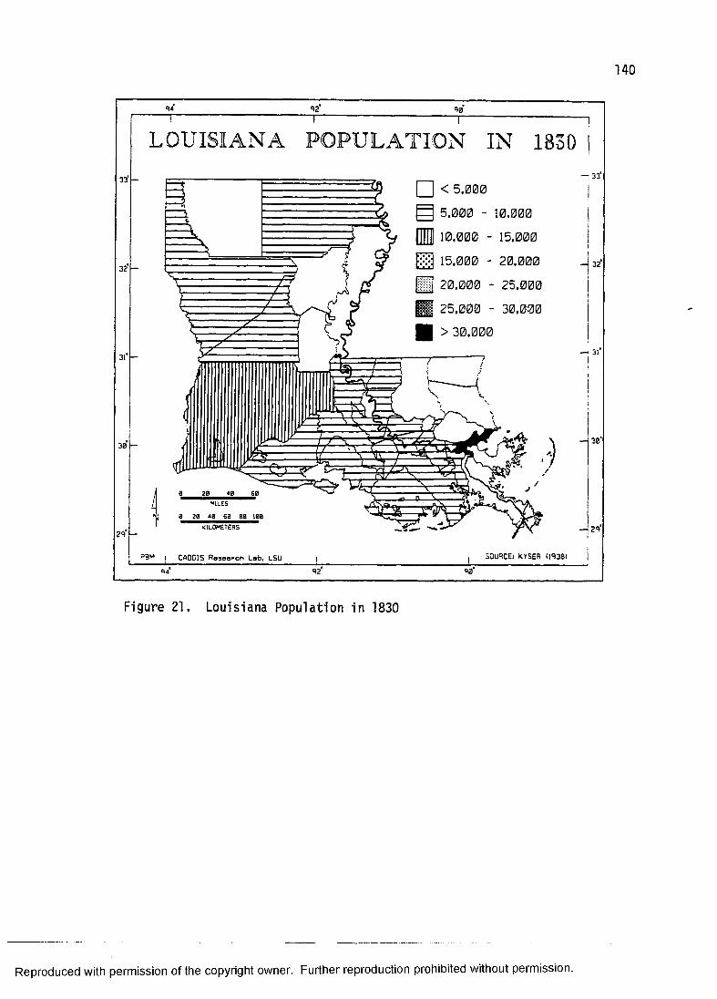
140
92 9 0
33
32
30
29
LOUISIANA POPULATION IN 1830
□ < 5.0005.000 - 10,00010.000 - 15,000
•;3 15.000 - 20,00020.000 - 25.00025.000 - 30,000 > 30,000
PiH1LES
0 20 40 S0 80 100
— 33
H32
— 30
—1293B'4 i CADGIS Research Lab, LSU SOURCE: KYSER 09381
92 90
Figure 21. Louisiana Po pu lat io n in 1830
Reproduced with permission of the copyright owner. Further reproduction prohibited without permission.
half times from 5,111 to 17,390. The population of Ouachita Parish increased by almost five times.
By way of contrast, the Mississippi River parishes from Ascension Parish to the Gulf, those roughly sixty miles above and below New Orleans, doubled in population from 1810 to 1830. This area includes the old Acadian Coast, the German Coast, and the thriving city of New Orleans. The population of the whole area increased from 39,576 to 88,113.
Clearly, the population of those Mississippi River parishes increased a great deal more in terms of raw numbers, but expressed as a rate of growth North Louisiana can be said to have been growing more rapidly. The lower river parishes contained much that was conducive to population growth, both by natural increase and immigration. This area was the famous "sugar bowl" where the production of sugarcane was heavily dependent upon slave labor. The number of slaves in this area, in fact, actually tripled from 1810 to 1830, whereas population as a whole doubled. The City of New Orleans was also growing. Nevertheless, by assessing population growth and expansion in terms of rates of increase and the occupance of new terrain, the Upland South settlement of North Louisiana merits notice.
The other significant area of the state that received settlers from the Upland South was the Florida Parishes.
Reproduced with permission of the copyright owner. Further reproduction prohibited without permission.
142
Unfortunately, as mentioned earlier, these parishes were Spanish at the time of the 1810 census, therefore it is not possible to make any statements about population growth. The blufflands of the Felicianas and East Baton Rouge Parish (figure 20) was an area that people from the Lowland South found attractive. The piney woods of the three eastern parishes (St. Helena, Washington, and St. Tammany) constituted an area of Upland South settlement more akin to neighboring counties in Mississippi to the north and east, as well as North Louisiana.
The difference in the intensity of settlement between the western and eastern Florida Parishes shows up in figure 21. Even though the eastern three parishes made up about two thirds of the total area, it contained only about one third of the population. According to Newton (1967:6), much of the area of St. Helena Parish was initially settled by Upland Southerners in the first two decades of the nineteenth century. Washington and St. Tammany parishes both had sparse populations in 1830; the heaviest concentrations of population being along the north shore of Lake Ponchartrain and along the Tangipahoa, Pearl, and Bogue Chitto rivers.
THE UPLAND SOUTH BUILDING TRADITIONThe Upland South settlers differed from their French
neighbors in many cultural respects and the kinds of houses they built and lived in was one of them. One distinction is the importance of horizontal log
Reproduced with permission of the copyright owner. Further reproduction prohibited without permission.

143
construction to the Upland South building tradition (Jordan 1970:420, 1978; Kniffen and Glassie 1966:65). It was not a common construction technique among the French of South Louisiana (Kniffen 1963:294), although there is evidence to suggest that niece sur piece structures were built to some extent (Edwards 1988a:5-7).
Log construction in the Upland South building tradition continued in some parts of Louisiana until around 1880 (Newton 1987:186). Where sawn lumber was available and people had the desire to do so, Upland South types were built of frame construction covered with clapboard. Generally speaking, although some Upland South houses were framed using half-timber construction, a technique of framing known as balloon framing began to replace rapidly log construction after the Civil War.
Another aspect of the Upland South building tradition is the use of the British "pen" or "bay." The Upland South building tradition is a subset of the pen tradition which is shared with two other Anglo-American culture regions, the Middle Atlantic and New England (Kniffen 1965). The single-pen house (figure 22) is the fundamental building block of the pen tradition. All other pen tradition houses are made up of a combination of these single-pen structures. Some double-pen. saddle-bag, or dog-trot houses started out as a single-pen.
The single-pen usually measures between sixteen and twenty-five feet in front and between sixteen and twenty-
Reproduced with permission of the copyright owner. Further reproduction prohibited without permission.
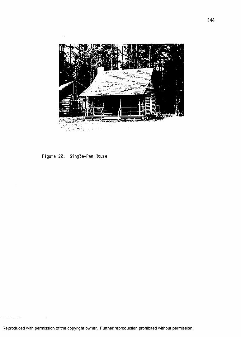
144
Figure 22. Single-Pen House
Reproduced with permission of the copyright owner. Further reproduction prohibited without permission.

145
one feet on the side (Newton and Pulliam DeNapoli 1977:369-370). Construction material was generally horizontal logs, but later lumber was used. The chimney was exterior and attached to the gable end. If there was a porch, it was either attached or under a broken-pitch roof.
The double-pen house (figure 23) is, as the name suggests, two single-pens put together under the same gable roof. The dimensions are usually around sixteen by thirty-two or sixteen by thirty-six feet. They generally have chimneys located at both gable ends. A front porch is frequently attached or under a broken-pitch roof. A shed addition, and sometimes an ell, may have been attached to the back of the house.
The double-pen house was, according to Newton (1971a:7), "most common as a plantation quarters along the Mississippi and Red rivers." It is found across the Upland South (Glassie 1969:82), but is not a frequent form in Louisiana.
The saddle-bag house (figure 24) is essentially a double-pen with a central chimney. If it has a continuous-pitch roof it may be mistaken for a small Creole house. According to Newton (197la:18), the following characteristics should distinguish the two forms:
1) the centering of doors in each pen of the saddle-bag, 2) the typical three-room division of the Creole rear shed, 3) the bousillage (mud and moss) wall of many Creole houses, 4) the
Reproduced with permission of the copyright owner. Further reproduction prohibited without permission.
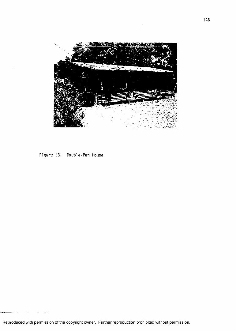
146
W r m
Figure 23. Double-Pen House
Reproduced with permission of the copyright owner. Further reproduction prohibited without permission.
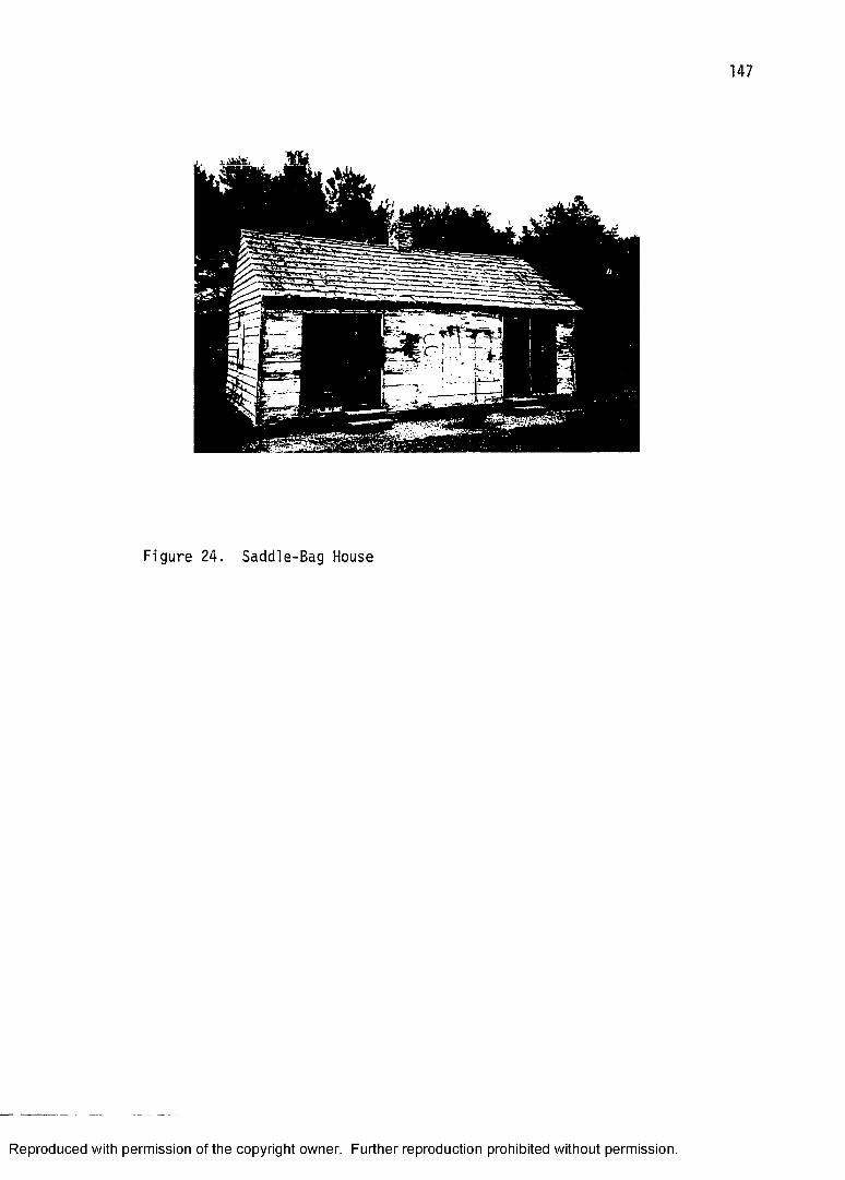
Figure 24. Saddle-Bag House
Reproduced with permission of the copyright owner. Further reproduction prohibited without permission.
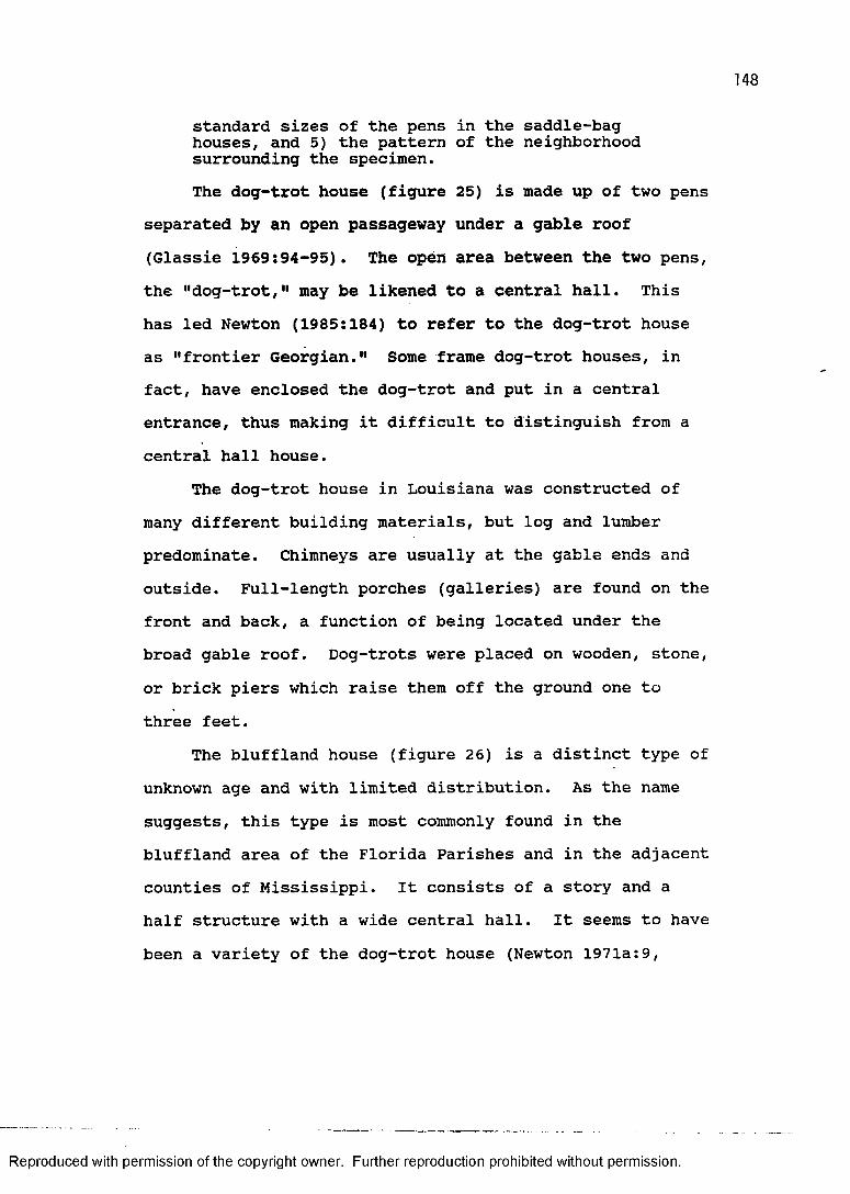
standard sizes of the pens in the saddle-bag houses, and 5) the pattern of the neighborhood surrounding the specimen.The dog-trot house (figure 25) is made up of two pens
separated by an open passageway under a gable roof (Glassie 1969:94-95). The open area between the two pens, the "dog-trot," may be likened to a central hall. This has led Newton (1985:184) to refer to the dog-trot house as "frontier Georgian." Some frame dog-trot houses, in fact, have enclosed the dog-trot and put in a central entrance, thus making it difficult to distinguish from a central hall house.
The dog-trot house in Louisiana was constructed of many different building materials, but log and lumber predominate. Chimneys are usually at the gable ends and outside. Full-length porches (galleries) are found on the front and back, a function of being located under the broad gable roof. Dog-trots were placed on wooden, stone, or brick piers which raise them off the ground one to three feet.
The bluffland house (figure 26) is a distinct type of unknown age and with limited distribution. As the name suggests, this type is most commonly found in the bluffland area of the Florida Parishes and in the adjacent counties of Mississippi. It consists of a story and a half structure with a wide central hall. It seems to have been a variety of the dog-trot house (Newton 1971a:9,
Reproduced with permission of the copyright owner. Further reproduction prohibited without permission.
Figure 25. Dog- Tro t House
Reproduced with permission of the copyright owner. Further reproduction prohibited without permission.

Figure 26. B luff!and House
Reproduced with permission of the copyright owner. Further reproduction prohibited without permission.
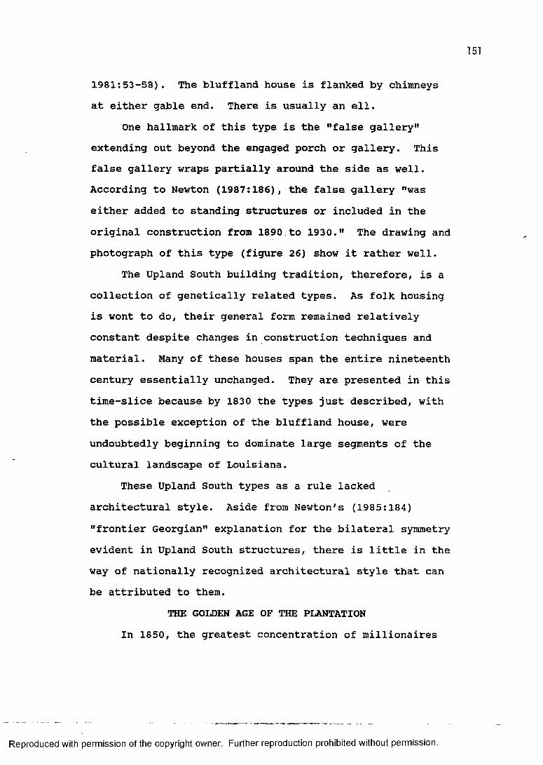
151
1981:53-58). The bluffland house is flanked by chimneys at either gable end. There is usually an ell.
One hallmark of this type is the "false gallery" extending out beyond the engaged porch or gallery. This false gallery wraps partially around the side as well. According to Newton (1987:186), the false gallery "was either added to standing structures or included in the original construction from 1890 to 1930." The drawing and photograph of this type (figure 26) show it rather well.
The Upland South building tradition, therefore, is a collection of genetically related types. As folk housing is wont to do, their general form remained relatively constant despite changes in construction techniques and material. Many of these houses span the entire nineteenth century essentially unchanged. They are presented in this time-slice because by 1830 the types just described, with the possible exception of the bluffland house, were undoubtedly beginning to dominate large segments of the cultural landscape of Louisiana.
These Upland South types as a rule lacked architectural style. Aside from Newton's (1985:184) "frontier Georgian" explanation for the bilateral symmetry evident in Upland South structures, there is little in the way of nationally recognized architectural style that can be attributed to them.
THE GOLDEN AGE OF THE PLANTATION In 1850, the greatest concentration of millionaires
Reproduced with permission of the copyright owner. Further reproduction prohibited without permission.
152
in this country was along the Mississippi River between Natchez and New Orleans. This opulence resulted from the plantation system of agriculture. The combination of fertile alluvial or upland (loess) soils, suitable climate, efficient river transportion, slave labor, and a world demand for the cash crops of sugar and cotton resulted in a landscape that is, in many respescts, consistent with today's popular conception of the Antebellum South. To be sure, the plantation system at mid-century in Louisiana was a fact of life for most people, whether they be planter or slave, New Orleans merchant, Acadian petite habitant, or piney woods squatter. The planter class controlled the economy and the political scene. They provided role models for others to emulate. And, they owned outright a significant number of the black population of the state. It would not be hyperbolism, therefore, to state that the plantation system was the single most important feature of the cultural geography for a Louisiana of the 1850s.
A plantation, by definition, is a large land holding, usually with more than 500 acres (Newton 1987:134), that concentrates on the production of a single cash crop, although it usually would produce moderate amounts of a variety of other things, frequently staples. However, according to Newton (1987:136), "the classic tropical plantation owner did not aim at self-sufficiency; supplying the staple needs of his own firm actually
Reproduced with permission of the copyright owner. Further reproduction prohibited without permission.
constituted a distraction from the production of profit yielding commodities." As a result, a hinterland of farms that supplied these needs developed hand in hand with the plantation economy and prospered along with it.
Prior to 1850 a number of cash crops had their period of popularity; among these were indigo, rice, and tobacco. Sugarcane and cotton came to dominate the plantation scene in Louisiana, but tended to concentrate in different regions of the state. The so-called "sugar bowl" developed in the Mississippi alluvial valley south of the thirty-first parallel, with an extension up the Red River to include Rapides Parish (Hilliard 1984:77; Shugg 1939:4). Cotton was produced over much of North Louisiana, but a very noticable cotton belt developed from the Felicianas northward along the Mississippi alluvial valley and adjacent uplands (Hilliard 1984:70). This belt is sometimes referred to as the "Tensas Cotton Belt"(Shugg 1939:4).
Obviously, an important ingredient in any agricultural endeavor is the crucial and basic medium for plant growth, soil. Agriculturalists since the early French Colonial era had recognized the richness of the alluvial bottomland environment. The fertility of these alluvial soils is because of the accumulation of regular overbank flooding resulting in incredibly deep deposits that are capable of sustained yield. By 1850, in fact, a portion of the Mississippi alluvial valley had been
Reproduced with permission of the copyright owner. Further reproduction prohibited without permission.
154
cultivated for over a century without noticable reduction in crop yield.
The uplands, or blufflands, whose deep and fertile loess soil was known to be agriculturally productive since the earliest days of French settlement (e.g., Fort Rosalie in Natchez). As part of the Old Natchez District from the British colonial period, the Felicianas, which have some of the deepest loess in the state, remained a landscape characterized by Lowland South plantations. In fact, according to the 1850 agricultural census, West Feliciana Parish produced more cotton per square mile than anywhere else in Louisiana and most of the South (Hilliard 1984:70).
The climatic requirements, or tolerances, for the two significant plantation crops, sugarcane and cotton, are different. The most important difference is that sugarcane is a more tropical crop and its distribution is limited to South Louisiana. Cotton on the other hand is not as restricted, being able to thrive from the warm moist coast to the cooler drier interior. A relatively dry season in late summer and fall, however, facilitates the cotton harvest (Newton 1987:248). Both crops are vulnerable to a climatic event not uncommon in Louisiana, the hurricane. According to Hilliard (1984:16), "the tall cane stalks could be flattened by high winds, and the freshly opened cotton bolls were susceptible to damage by heavy rains."
Reproduced with permission of the copyright owner. Further reproduction prohibited without permission.

155
One of the most important factors in the location of antebellum plantation agriculture was efficient river transportation, specifically the advent of the steamboat. Other forms of watercraft had moved goods and people up and down the navigable waterways of the state since prehistoric times (e.g., Johnson 1963; Scroggs 1909), but cargo capacity was limited and travel against the current was always difficult.
Plantations produce a bulk commodity, and, as is true with the economic geography of any bulk commodity, transportion costs are a vital ingredient in the equation that determines profit. For plantations of the 1850s this translated into a sort of imaginary line inland from all navigable rivers frequented by steamboats. This line separated the zone of profitability, based on relative ease of transportation, from the zone of unprofitability.
The steamboat was really the only option in 1850 for the planter who needed to get his crop from field to factor (usually an agent in New Orleans). Railroad construction was in its infancy in 1850 (Newton 1987:158), and the roads of the period were generally in a deplorable and unreliable state. With respect to the latter, Taylor (1976:69) noted that "antebellum roads in Louisiana were so poor as hardly to deserve the name, and that situation did not improve until the twentieth century."
The steamboat had actually been a fixture in the realm of transportation in Louisiana since the first one
Reproduced with permission of the copyright owner. Further reproduction prohibited without permission.
156
came down the Mississippi to New Orleans in 1812.Technical innovations of a shallow-draft hull and more powerful steam engines increased the steamboat's ability to travel against strong current and ply shallow bayous and rivers at low stage.
The steamboat opened up North Louisiana, so to speak, where steamboat and settlement became almost synonymous terms. The people of Fort Miro, a town on the west bank of the Ouachita River, were so impressed by the arrival in 1819 of the first steamboat, the James Monroe, that they decided to rename their town (Monroe) to commemorate such a momentous event (Winters 1968:26). This paved the way for their participation in the cotton boom. According to Allen (1975:152), "prior to the coming of the steamboat on the Ouachita River, planting of large crop acreage was impractical.11
Another important North Louisiana town's name is intimately associated with steamboating, that of Shreveport. After clearing the great raft on the Red River above Natchitoches in the 1830s, Captain Henry M. Shreve and some associates founded the town of Shreveport in 1838. From its very inception, Shreveport was the major port for the shipment of cotton out of Northwest Louisiana.
For much of North Louisiana, then, the steamboat not only facilitated but actually made possible the expansion of plantation agriculture. Towns like Monroe and
Reproduced with permission of the copyright owner. Further reproduction prohibited without permission.
157
Shreveport owed their growing importance to the steamboat, and plantations began to line the waterways of the northern part of the state much as they had expanded on the Mississippi above and below New Orleans a century earlier. "By midcentury, every stream, if navigable only at high water stage, had steamboats pushing into it to bring in supplies and carry out cotton" (Kniffen and Hilliard 1988:138).
A component of plantation agriculture of the Antebellum South was slavery. The production of sugarcane and cotton were both labor intensive activities that relied almost exclusively on the labor of black slaves.The habit of using black African slaves was as old as the colony itself, for example a shipload of 500 slaves arrived in 1719 just as New Orleans was being built (Taylor 1976:11). By 1850, half of the population of the State of Louisiana was black and most of them were slaves.
Although the importation of African slaves became more difficult, particularly because of the intervention of the British beginning in 1810, it continued in an inceasingly clandestine manner. Within the United States, sentiment had polarized the county. Despite, arguments on moral grounds, however, it remained a fact that Louisiana's economy, its genre de vie, was dependant upon cotton and sugarcane, which, in turn, were dependant, according to the methods of production of the time, upon slave labor.
Reproduced with permission of the copyright owner. Further reproduction prohibited without permission.
158
Figure 27 highlights the association of slaves and plantations by displaying the parishes in 1850 where the percent of slaves exceeds fifty percent of the total parish population. The distribution is clearly one of association with the alluvial valleys of the Mississippi and Red. The only exceptions to this pattern seem to be Rapides, Lafourche, Jefferson, and Orleans parishes. They can be explained by more Upland Southerners living in the piney woods of Rapides relative to the slave population, more cajuns along Bayou Lafourche relative to the slave population, and the urban dwellers of the New Orleans area in Jefferson and Orleans parishes relative to slaves.Also, East Baton Rouge Parish and the Felicianas techically belong to the uplands, or blufflands, classification, but their association with the plantation region of the state has already been noted. It is also interesting to examine the other areas of the state where slaves comprise less than half of the parish population. These areas coincide with the piney woods of the eastern Florida parishes and North Louisiana, as well as the prairie region of Southwest Louisiana.
The population pattern of the state (figures 28 and 29) shows a growth pattern that, in part, can be attributed to the expansion of the plantation system (Treat 1967). One of the most noticable aspects of population growth can be seen in the change in the number of parishes in North Louisiana from 1830 to 1850 and the
Reproduced with permission of the copyright owner. Further reproduction prohibited without permission.
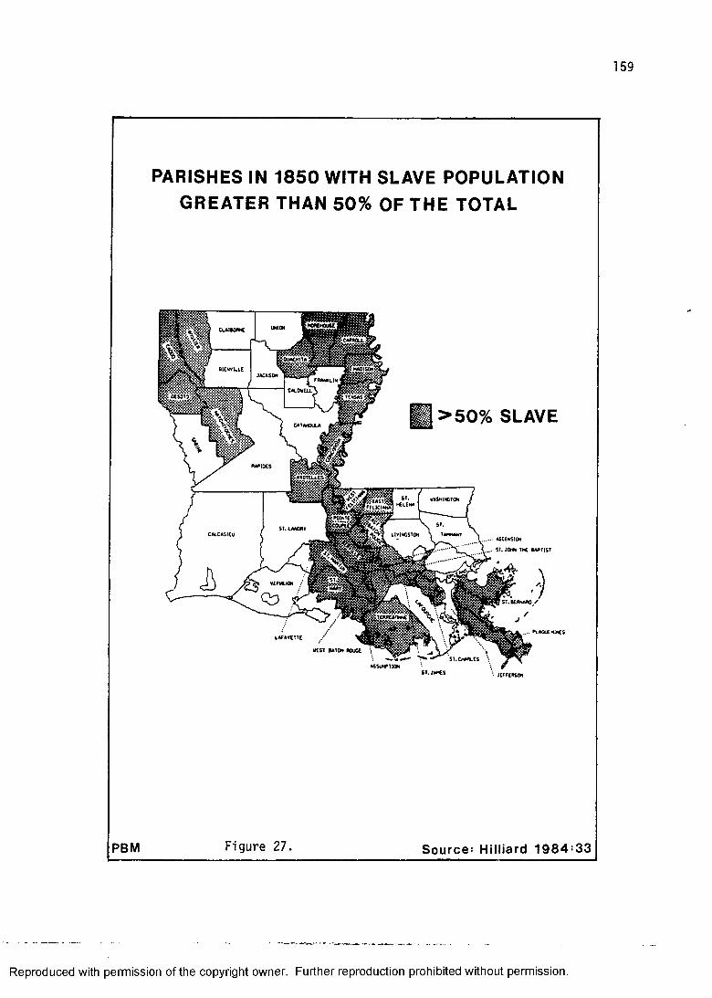
159
PBM
PARISHES IN 1850 WITH SLAVE POPULATION GREATER THAN 50% OF THE TOTAL
I >50% SLAVE
OUttKlTA
BlENVtUC
DC SOTO
MPIDCS
MShUCTCM*IENAFFUC1ANA
C«i.C«SICUASCENSION
. . . ST. JOr#< Th£ BAPTIST
Figure 27. Source: Hilliard 198 4 :33
Reproduced with permission of the copyright owner. Further reproduction prohibited without permission.
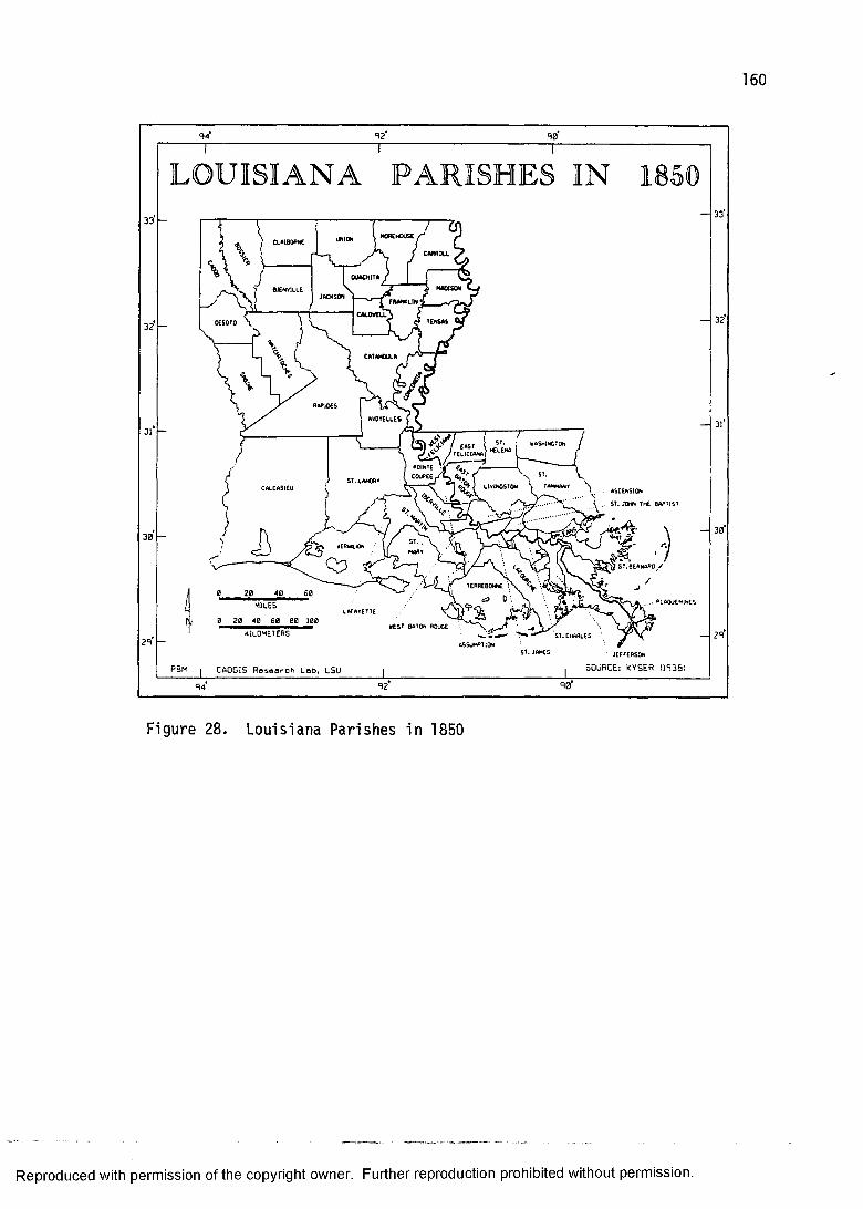
160
92 90
LOUISIANA PARISHES IN 185033
32
29
40/fl
. .. . PLAQUEMINESMILES
■EST BA^ON BOuOE \
ASSUMPTION
KILOMETERS
ST. JAMES
33
32
30
29
PBM j CAQGIS Reseorch Lob» LSU SOURCE: KYSER 0938:9 4 90
Figure 28. Louisiana Parishes in 1850
Reproduced with permission of the copyright owner. Further reproduction prohibited without permission.
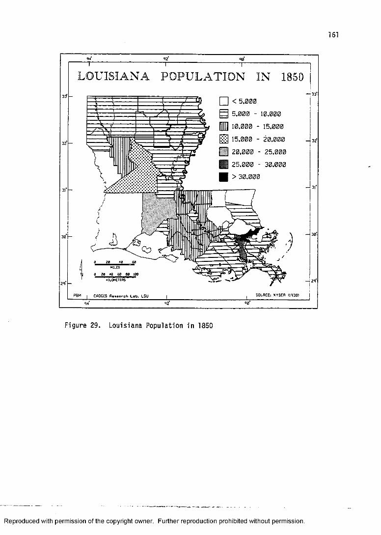
161
32'
31*
30*
29*
Reproduced with permission of the copyright owner. Further reproduction prohibited without permission.
92 90
33*
32
30
29
LO U ISIA N A PO PU L A T IO N IN 1850
□ < 5.0005.000 - 10,00010.000 - 15,00015.000 - 20,00020.000 - 25,00025.000 - 30,000 > 30,000
i
rV - --------- 1— ^
0 20 40 60
m iles
0 20 40 60 80 100
PSM | CAOCIS fleaeoreh Lob» LSU , SOURCE: KYSER (1938) |I --- ■94 92
Figure 29. Louisiana Population in 1850

population growth, particularly in the "Tensas Cotton Belt" (Phillips 1953).
Between 1830 and 1850 sixteen new parishes were created, of which thirteen were in North Louisiana. The area covered by the seven North Louisiana parishes in 183 0 of Avoyelles, Catahoula, Claiborne, Concordia, Natchitoches, Ouachita, and Rapides had been split into twenty parishes. This area north of the thirty-first parallel had increased at an even more accelerated rate than that of the interval between 1810 and 1830. In 1830, the population of the above-mentioned parishes totaled 33,111. Twenty years later, the 1850 census for the parishes comprising the same area reported a population of 151,757. The increase, therefore, is greater than four and a half times!
During the same period, the so-called "Tensas Cotton Belt" experienced a population increase of five and a half times. In 1830, the population of the elongated parish of Concordia, which contained most of North Louisiana's share of the Mississippi alluvial valley, had a population of only 4,662. By 1850, the same area had split up into three parishes, Madison, Tensas, and Concordia. Their combined population was 25,571. The prime mover behind this incredible population increase was the cotton plantation.
By way of comparison, a well populated area appears block-like in the choropleth map of 1850 population
Reproduced with permission of the copyright owner. Further reproduction prohibited without permission.

163
(figure 29) with all of the parishes except one having populations between 10,000 and 15,000. This block is formed by West Feliciana in the north to St. Mary in the south, St. Martin in the west, and Ascension in the east. These eleven parishes, including West Baton Rouge, had an 1830 population of 71,732. In 1850, the population had increased to 126,463. Had this area experienced the same rate of population increase as did the Concordia example just mentioned, it would have had an 1850 population of 393,091! Instead, the actual increase was only 1.76 times the 1830 population.
To further place the cotton boom of North Louisiana into statewide perspective, Orleans parish increased from 49,826 to 119,460 from 1830 to 1850. This is an increase of 2.39 times. Expressed differently, Orleans parish, which means essentially the primate city of New Orleans, had roughly 70,000 more residents. The growing towns and countryside of North Louisiana had roughly 120,000 more residents. Of course it is somewhat unfair to compare the population of a single city with a huge area covering half of the state, but the point here is that the tide of population increase was no longer greatest in the south. North Louisiana, by 1850, was becoming a real entity in terms of population.
The city of New Orleans, however, was not only the fastest growing city in the South, but it was changing in the composition of its population as well. Its sinuous
Reproduced with permission of the copyright owner. Further reproduction prohibited without permission.

164
urban development upstream along the natural levee had been the trajectory of expansion since the Louisiana Purchase, and it was in 1850, according to Shugg (1939:38- 39) three cities in one. There was the American sector, or "Garden District," the old French core, and an area that came to be dominated by recent Irish and German immigrants. "Of these three sections the American was wealthiest, the French most populous, and the Irish-German poorest in both numbers and money" (Shugg 1939:39).
Another observation that should be noted when comparing the 1830 population distribution to that of 1850 is the pattern of population distribution that is revealed with the creation of Calcasieu Parish from the massive parent 1830 parish of St. Landry. It can be readily seen that the majority of population had resided in the eastern half of this area. In fact, this is the old Opelousas area that had been a popular settlement area since the late eighteenth century. Once the area is split in half the census figures reveal this fact vividly; Calcasieu has only 3,914 to St. Landry's 22,253. In terms of settlement, then, it appears that the southwestern portion of the state, along with Sabine Parish and three of the four easternmost Florida Parishes, can be characterized as only sparsely settled.
In sum, Louisiana in 1850 can be fairly described as "The Golden Age of the Plantation." Cotton and Steamboats came to dominate the cultural landscape of North
Reproduced with permission of the copyright owner. Further reproduction prohibited without permission.
165
Louisiana, and the western Florida Parishes. In the case of the former, it was responsible for a great deal of initial occupance of the area, and in the latter, it simply intensified an extant Lowland South plantation economy. Sugarcane, of course, continued to be the plantation crop of choice for South Louisiana. New Orleans solidified its role as entrepot for this agrarian culture despite the growth of towns up the Mississippi, Red, and Ouachita rivers. Almost everything continued to pass through this world class port and population growth reflects these flush times. It was, however, also the culmination of a system about to collapse.
ANTEBELLUM PLANTATION ARCHITECTUREIt is fitting to present the domestic architecture of
plantations within this particular time-slice because most of the "great" plantation houses of Louisiana were built within two decades prior to the Civil War. This is the period of the quintessential Greek Revival style plantation home such as "Oak Alley" (1836), "Houmas House" (1840), or "Madewood" (1848). It is the period in which nationally popular architectural styles comes into their own in Louisiana, sometimes with incredibly idiosyncratic results. The styles that are the hallmark of antebellum plantation architecture are Greek Revival, and, to a lesser extent, Gothic Revival and Italianate.
The domestic architecture of plantations also consist of some recognized types. These types include two types
Reproduced with permission of the copyright owner. Further reproduction prohibited without permission.
166
of Upland South plantation homes, as well as the Lowland South plantation type. The temporal affiliation of these types is, of course, much greater than the years surrounding 1850
Two Upland South plantation house types that are part of the pen tradition are the hill plantation I-house (figure 30) and the Carolina I-house (figure 31). The first, the hill plantation I-house is sort of a box two rooms wide, one room deep, and two stories high. Both stories have a central hall and a porch running the full length of the front of the house. Chimneys are generally exterior and at both gable ends. In some respects it resembles a two story dog-trot (Newton 1971a:10).
The Carolina I-house is similar to the hill plantation I-house except for the full-length one story porch in front and the one story shed across the back.Found throughout the Upland South, this type had its origin in the western Carolinas. In Louisiana, the Carolina I-house occurs more frequently in the western Florida Parishes.
The Upland South plantation house differs from other Upland South types in degree rather than kind. The common building block, the pen tradition, can be clearly identified in the construction of these houses. Where and how they differ from other Upland South types seems to be the obvious association with plantation agriculture.Where Upland Southerners engaged in plantation agriculture
Reproduced with permission of the copyright owner. Further reproduction prohibited without permission.
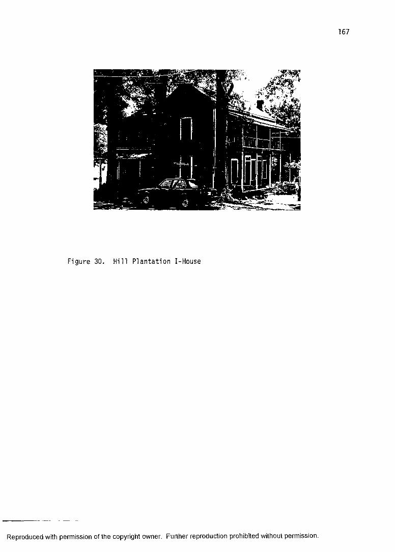
Figure 30. H i l l P lantation I-House
Reproduced with permission of the copyright owner. Further reproduction prohibited without permission.
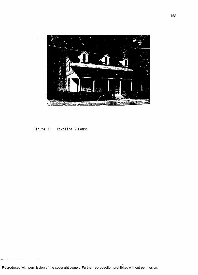
168
Figure 31. Carolina I-House
Reproduced with permission of the copyright owner. Further reproduction prohibited without permission.
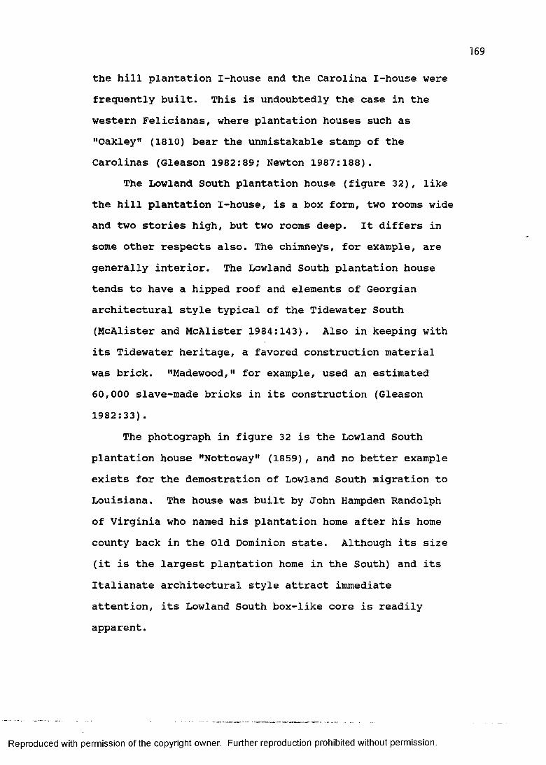
169
the hill plantation I-house and the Carolina I-house were frequently built. This is undoubtedly the case in the western Felicianas, where plantation houses such as "Oakley" (1810) bear the unmistakable stamp of the Carolinas (Gleason 1982:89; Newton 1987:188).
The Lowland South plantation house (figure 32), like the hill plantation I-house, is a box form, two rooms wide and two stories high, but two rooms deep. It differs in some other respects also. The chimneys, for example, are generally interior. The Lowland South plantation house tends to have a hipped roof and elements of Georgian architectural style typical of the Tidewater South (McAlister and McAlister 1984:143). Also in keeping with its Tidewater heritage, a favored construction material was brick. "Madewood," for example, used an estimated 60,000 slave-made bricks in its construction (Gleason 1982:33) .
The photograph in figure 32 is the Lowland South plantation house "Nottoway" (1859), and no better example exists for the demostration of Lowland South migration to Louisiana. The house was built by John Hampden Randolph of Virginia who named his plantation home after his home county back in the Old Dominion state. Although its size (it is the largest plantation home in the South) and its Italianate architectural style attract immediate attention, its Lowland South box-like core is readily apparent.
Reproduced with permission of the copyright owner. Further reproduction prohibited without permission.
Figure 32. Lowland South Plantation House
Reproduced with permission of the copyright owner. Further reproduction prohibited without permission.

171
Of the house types just mentioned, architectural style in the period around 1850 was an important feature only in the Lowland South plantation house. These houses always displayed architectural style of one sort or another, whereas the Upland South types seldom did. In later years these other types took on stylistic attributes, either structural or decorative. For the late antebellum period, however, the plantation house of lore was the Lowland South type in a Greek Revival, Gothic Revival, or Italianate style.
The Greek Revival style began its period of popularity in America in the Northeastern United States around 1820. Although American interest in the classical world of ancient Greece and Rome can be traced to the "enlightened" ideas that inspired the American Revolution and was later expressed in Federal and Jeffersonian (Roman Revival) architecture, a clear "Hellenophilia" began to sweep the country beginning in 1820. The Greek Revival style amounts to the architectural component of a wider cultural revival that was sparked by the Greek struggle for independence. Cultural geographers are familiar with a toponymic dimension of this same romantic movement with classical town names spreading across the country from 1820 to 1860 (Zelinsky 1967).
Poppeliers, Chambers, and Schwartz (1983:36) described the most common Greek Revival stylistic features as columns and pilasters, moldings, pedimented gables,
Reproduced with permission of the copyright owner. Further reproduction prohibited without permission.
172
heavy cornices and horizontal transoms. McAlester and McAlester (1984:184) added that the front-gable house is another feature of the Greek Revival style. (This new structural orientation was used by later architects designing in different styles.) Although there developed numerous attributes and regional variations (Blumenson 1981:26-27; Hamlin 1944; Lewis 1970:35-36; Pillsbury and Kardos 1970:18), the common conception of the Greek Revival style as white, gable-fronted and columned "temples" is not too far off the mark.
Given its period of popularity at a time when the plantation economy of Louisiana was booming and many planters were engaged in an architectural one-upsmanship, it is not surprising that they chose to build in the most fashionable style on a massive scale. And the Greek Revival style was certainly an appropriate medium for Herculean architecture. The taller the columns and the higher the ceiling, the better.
A plethora of columns, however, should not be interpreted as ostentatious display given the syncretic nature of South Louisiana architecture. Many of Louisiana's Greek Revival plantation homes seem to be surrounded by these large columns which support a wide hip roof. This actually represents an adoption of the French Caribbean plantation homes' wrap-around wide gallery.According to McAlester and McAlester (1984:184), "these forms slowly evolved in the Gulf Coast states into the
Reproduced with permission of the copyright owner. Further reproduction prohibited without permission.

173
full colonnaded Greek Revival form." Architects designing Louisiana plantation homes in the Greek Revival style, apparently took into consideration some of the environmentally-adapted morphological characteristics of the Creole raised cottage. Examples of "full colonnaded" variety of the Greek Revival plantation house include "Oak Alley," mentioned earlier, and the majestic "Dunleith"(1856) in Natchez, Mississippi.
A later architectural style, the Gothic Revival was nationally popular from 1840 to 1880 (Andrews 1975; Loth and Sadler 1975). It was never as popular as the competing Greek Revival or Italianate styles. And, from the standpoint of regional receptivity, the style was not nearly as well received in the South as it was in the North. Most examples in Louisiana are antebellum.
The Gothic Revival style is characterized by a steeply pitched gable roof, gables with decorative vergeboards, and pointed-arch shape windows among other features (Blumenson 1981:30-31; McAlester and McAlester 1984:196-200; Poppeliers, Chambers, and Schwartz 1983:40).The usual building material of domestic architecture was lumber, although stone and masonry were also used. It was a common architectural style for churches (e.g., Grace Episcopal Church in West Feliciana Parish). Larger stone and masonry examples frequently have towers and castellated parapets and resemble medieval castles out of a Sir Walter Scott novel.
Reproduced with permission of the copyright owner. Further reproduction prohibited without permission.
174
One of these "castles" is the Old Louisiana StateCapitol (1850) situated on the banks of the Mississippi atBaton Rouge. Designed by the noted New Orleans architectJames H. Dakin, it is a spectacular example of the GothicRevival style (Andrews 1975:107; Loth and Sadler 1975:85-86). Its imposing towers and parapets, however, failed toimpress one outspoken and experienced traveller of theMississippi River, Samuel L. Clemens.
Sir Walter Scott is probably responsible for the Capitol building; for it is not conceivable that this little sham castle would ever have been built if he had not run the people mad, a couple of generations ago, with his medieval romances.. . . It is pathetic enough that a whitewashed castle, with turrets and things . . . should ever have been built in this otherwise honorable place; but it is much more pathetic to see this architectural falsehood undergoing restoration and perpetuation in our day, when it would have been so easy to let dynamite finish what a charitable fire began, and then devote this restoration money to the building of something genuine (Twain 1874:332-333).
It is evident that Mark Twain was not taken by the GothicRevival style1
Some plantation homes (and associated outbuildingssuch as carriage houses and outhouses) were built in theGothic Revival style. "Afton Villa" (1849) in WestFeliciana Parish is probably the finest example of aGothic Revival plantation home in Louisiana. "OrangeGrove" (1850) in Plaquemines Parish was also constructedin the style. And, although the incredibly ornateplantation home "San Francisco" (1853) has been describedas belonging to the "Steamboat Gothic" style, implying
Reproduced with permission of the copyright owner. Further reproduction prohibited without permission.
175
that it is a variety of the Gothic Revival (Hunt 1984:132; Louisiana Department of Commerce and Industry n.d.:9), it is actually more Italianate. The term "Steamboat Gothic" derives from a novel of the same name by Francis Parkinson Keyes that was set here.
The Italianate style was roughly contemporaneous with the Gothic Revival. Its period of national popularity began in 1840 and continued until 1885. Some important features of this style include, a low pitched roof with wide eaves frequently accompanied by decorative brackets, tall narrow round-headed windows with hood molding, ornate entrance, and a square tower or cupola (Blumenson 1981:36- 37; McAlester and McAlester 1984:21-215; Poppeliers,Chambers, and Schwartz 1983:46-47).
The Italianate style in Louisiana had a wider application than the Gothic Revival. The most notable examples of plantation homes built in the Italianate style in Louisiana are "Nottoway" and "San Francisco" mentioned earlier. But, besides its use as an architectural style for plantation homes, it appears in other building forms as well. Stores, banks, city halls, schools, business "blocks," and churches all built in the Italianate style.Its greater flexiblility in design offered a wider application, hence its greater popularity. "This adaptability made it nearly a national style in the 1850s" (Poppeliers, Chambers, and Schwartz 1983:46).
Reproduced with permission of the copyright owner. Further reproduction prohibited without permission.
176
An architectural influence that had minor plantation home manifestation has been grouped under the rubric "Exotic Revivals." In the Lower Mississippi Valley the plantation home that best fits this category is unquestionably "Longwood" (1860) in Natchez, Mississippi.It is something of a hybrid structure. The shape is octagonal, an extremely rare form with a brief period of national popularity (1850-1870). The decorative treatment is Italianate. And, the onion dome that sits atop the huge cupola is Exotic (Oriental) Revival.
From the standpoint of architectural style, therefore, Louisiana structures built around 1850, particularly plantation homes, were not just diluted imitations of architectural forms found in the Northeastern United States. Although the nationally popular Greek Revival, Gothic Revival, and Italianate styles found initial expression in that part of the country, the plantation region of the Lower Mississippi Valley has shown that not only did some of its inhabitants participate in wider cultural movements that included an architectural component, but they did so with incredible results (Cullison 1983; Vogt 1985). The Greek Revival architecture in Louisiana, for example, is some of the best this country has to offer.
Reproduced with permission of the copyright owner. Further reproduction prohibited without permission.

177
RECONSTRUCTIONIn the minds of many, the change that occurred in
Louisiana between 1850 and 1870 is undoubtedly one of the most dramatic in American history. A society, whose members were not held in bondage, enjoyed a prosperity, optimism, and cultural vigor that was unequaled until halfway into the present century. As a consequence, those who have concerned themselves with the writing of this nation's history have devoted more ink to the interval of these two decades than any period before or since. This has been described by one eminent historian of Louisiana as "the most tragic in all Louisiana history" (Davis 1971:243). The period, of course, is that of the American Civil War, 1861-1865, as well as its causes and aftermath.
It is beyond the scope of this present study to give an accounting of what in some quarters is referred to as "the War for Southern Independence" (Davis 1971:253; Kyser 1939:138; Newton 1987:244). It is left to others to assess a value judgement of what was undeniably a cultural cataclysm. The fact remains that the American South in general and Louisiana in particular was, in 1870, engaged in a "reconstruction" (Carter 1959; Highsmith 1953; Taylor 1974). This "reconstruction" did not amount to a replication of the social, political, and economic order that existed prior to the Civil War. Instead, it was actually a "restructuring" of a culture.
Reproduced with permission of the copyright owner. Further reproduction prohibited without permission.
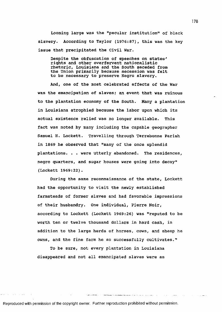
Looming large was the "pecular institution" of blackslavery. According to Taylor (1976:87), this was the keyissue that precipitated the Civil War.
Despite the obfuscation of speeches on states' rights and other overfervent nationalistic rhetoric, Louisiana and the South seceded from the Union primarily because secession was felt to be necessary to preserve Negro slavery.And, one of the most celebrated effects of the War
was the emancipation of slaves? an event that was ruinousto the plantation economy of the South. Many a plantationin Louisiana atrophied because the labor upon which itsactual existence relied was no longer available. Thisfact was noted by many including the capable geographerSamuel H. Lockett. Travelling through Terrebonne Parishin 1869 he observed that "many of the once splendidplantations. . . were utterly abandoned. The residences,negro quarters, and sugar houses were going into decay"(Lockett 1969:22).
During the same reconnaissance of the state, Locketthad the opportunity to visit the newly establishedfarmsteads of former slaves and had favorable impressionsof their husbandry. One individual, Pierre Noir,according to Lockett (Lockett 1969:26) was "reputed to beworth ten or twelve thousand dollars in hard cash, inaddition to the large herds of horses, cows, and sheep heowns, and the fine farm he so successfully cultivates."
To be sure, not every plantation in Louisianadisappeared and not all emancipated slaves were as
Reproduced with permission of the copyright owner. Further reproduction prohibited without permission.
179
fortunate and successful as Pierre Noir. Cotton plantations fared better than sugar plantations during Reconstruction because of the relatively high post-war demand for cotton and that sugar production required a substantially greater capital investment in machinery.The sugar plantations that did survive adopted the wage system, while sharecropping, or tenant farming, became the usual mode of production on the cotton plantation (Kniffen and Hilliard 1988:139). The end result for the majority of blacks who remained with the plantation system as wage laborers or sharecroppers was that the quality of life was probably not greatly improved.
After emancipation, the options open to most blacks were to remain in plantation agriculture as wage laborers or sharecroppers, to establish farmsteads of their own, to move to New Orleans, or to leave the state altogether.Just like the white yeoman farmers who chose sharecropping, blacks frequently discovered that this arrangement resulted in a sort of debt-peonage, similar in many respects to the condition of slavery. Many found themselves hopelessly indebted to the plantation store, from which they had purchased basic necessities on credit (usually at greatly inflated prices) and were forbidden to move off the plantation until this debt was cleared. Nevertheless, for a significant percentage of blacks this presented the most viable alternative.
Reproduced with permission of the copyright owner. Further reproduction prohibited without permission.
The establishment of a subsistence farmstead by blacks was another adaptation to post-bellum conditions. Quite often these farmsteads were clustered into settlements such as the Darlings Creek settlements of St. Helena Parish described by Newton (1971b). These subsistence farmsteads occurred outside of the prime plantation areas, mainly in the piney woods.
Black-flight off the plantations and into New Orleans began during the early years of the Civil War. It has been estimated that perhaps as many as 10,000 slaves streamed into New Orleans after the Union army, commanded by Major General Benjamin F. Butler, secured South Louisiana in 1862 (Taylor 1974:6). They were encouraged to return to the plantations as freedmen, but many decided to stay and eke out a living in the stagnant economy of New Orleans.
Some freedmen decided to migrate from the state that had enslaved them. Nearly three thousand black families moved to Texas (Taylor 1974:424). Later in the decade, many blacks got "Kansas Fever" and decided to try their hand at becoming wheat farmers in Kansas (Hair 1969:83- 106; Taylor 1976:128). For various reasons, most returned. Actually, a black exodus from Louisiana on any appreciable scale would not occur until industrial jobs in the North beckoned in the twentieth century.
The lives of white yeoman farmers were as negatively impacted by the Civil War and the Reconstruction as any
Reproduced with permission of the copyright owner. Further reproduction prohibited without permission.

other group. First of all, Louisiana's enlisted Confederate soldiers came mainly from the ranks of the "plain folk." They enthusiastically joined the cause and constituted a great share of the 65,000 men mustered to fight the Yankee (Davis 1971:253). Thousands never returned to their piney woods farms. Those who did often found them desolate and devoid of livestock; their families merely trying to cling to the land as best they could.
Another casualty of the War that caused profound distress to planters and farmers was the tremendous loss of livestock. According to Newton (1981:32), "horses, mules, and oxen were in that time, after all, the basic underpinning of agriculture and industry. To lose half of these beasts. . . literally crippled production." These animals were in short supply for years to come.
Upland Southerners continued to pour into North Louisiana as settlers or as transients bound for Texas, but times were difficult. Despite the fact that free homesteads in the public domain amounting to a quarter section of land (160 acres) were available throughout the 1870s, many simply found a piece of land to their liking and settled "without going through [the] formalities of law" (Shugg 1939:263). Land, it seems, was just about the only thing during Reconstruction not in short supply. "The average Louisianian could afford few if any luxuries, and many could not even afford all of the necessities of
Reproduced with permission of the copyright owner. Further reproduction prohibited without permission.
182
life" (Davis 1971:275). For the yeoman farmer, accustomed to a certain amount of hardship and privation, the only solution was to simply keep working.
The destruction of property during the War in Louisiana was greatest along most of the length of the Mississippi alluvial valley above New Orleans, along the lower Red River alluvial valley, inland between Alexandria and Opelousas, and down the bayous Teche and Lafourche. Damage coincided with the theaters of battle, as well as with the richest plantation areas of the state capable of sustaining armies. So, not only were the plantations located here deprived of their slaves and livestock, but quite often little was left but the land itself.
The plantation generally survived (Clay 1962; Shugg 1937), but frequently under different ownership. Many antebellum planters, particularly sugar planters, were ruined and had no alternative but to sell. The irony of this "redistribution of ownership" (Shugg 1939:236) is that not only did the plantation system survive, but the number of plantations actually began to increase after the War. The increase in large land-holdings has been attributed to sharecropping, or tenant farming, because the profit received from the tenants sometimes exceeded that received from the crop (Shugg 1939:241; Taylor 1976:118). Although cotton sharecropping ended, for all intents and purposes, in the 1950s (Aiken 1978:151), the trend toward absentee plantation ownership and land
Reproduced with permission of the copyright owner. Further reproduction prohibited without permission.
183
consolidation has continued until the present.The effects of Reconstruction can be seen clearly in
the population figures and the distribution of population (figures 33 and 34). First of all, in the twenty year interval between 1848 and 1868 only one new parish, Winn, had been created. And, in the period between 1850 and 1870 only six new parishes were created. This is in marked contrast to the parish growth spurt of the 1830s and 1840s when sixteen new parishes were created. Part of this is, of course, the result of approximating the more or less idealized parish size and that North Louisiana could not be expected to fission parishes indefinately. However, it also seems to be a simple function of population growth.
The state's population was rising steadily according to the decennial census until the decade of the Civil War and Reconstruction. In 1840 the population of Louisiana was 352,411, in 1850 it was 517,762, on the eve of the Civil War (1860) it was 708,002, then in 1870 it had grown by less than 20,000. (The 1870 population was 726,915.) The population gain in the decade between 1860 and 1870 is only one tenth that of the decade leading up to the 1860! The direct loss of perhaps 11,000 Confederate soldiers only partially accounts for this drop in what had been a rising population trajectory. The indirect loss of the potential progeny of those who died (both soldier and civilian) as the result of the War and its deprivations to
Reproduced with permission of the copyright owner. Further reproduction prohibited without permission.
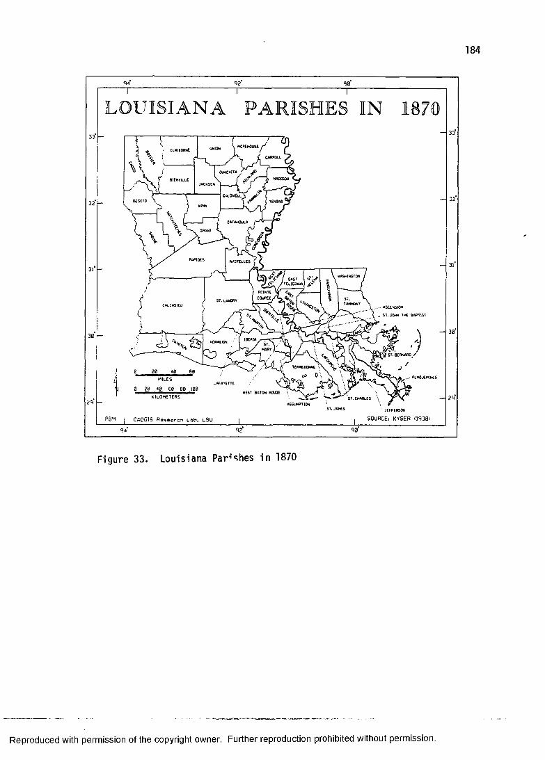
184
LOUISIANA
8 i e n v iu £
Desoto
... &T.JOMN ftftPtiSt
KILOMETERS2R -' JEFFERSON
SOURCE: KYSER (1S38)CADGIS Research Lab. LSU
Figure 33. Louisiana P a r c h e s in 1870
Reproduced with permission of the copyright owner. Further reproduction prohibited without permission.
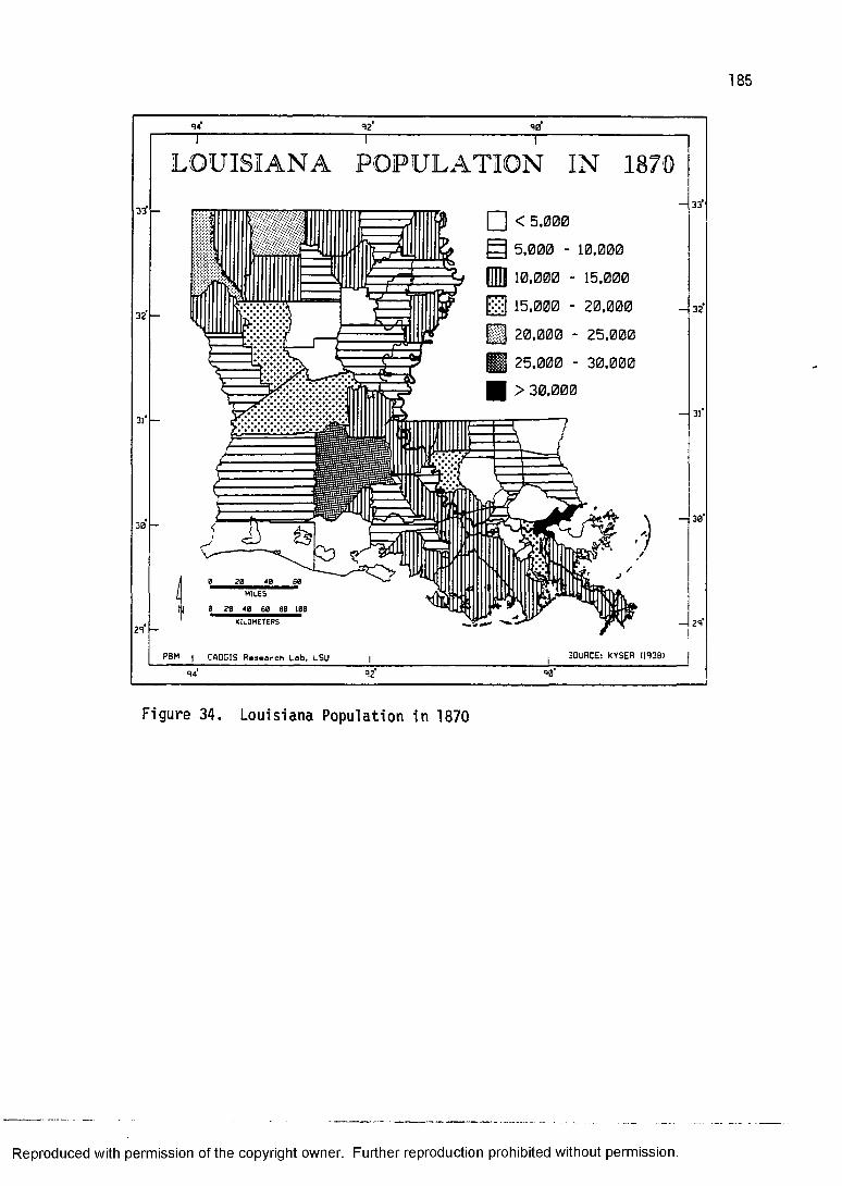
12 10
33T
32
3l‘
30
21
LOUISIANA POPULATION IN 1870
□ < 5.0005.000 - 10,00010.000 - 15,00015.000 - 20,00020.000 - 25,00025.000 - 30,000 > 30,000
a s
HIlES0 2 0 40 60 60 100
PBM | CADDIS Research Lob. LSU
33
32
30
29
SOURCE: KYSER U93B)94 R2 90
Figure 34. Lo uisiana Population in 1870
Reproduced with permission of the copyright owner. Further reproduction prohibited without permission.
186
the rate of natural increase is yet another factor. However, the most significant causes of this demographic change are declining immigration and increasing emigration.
In 1870, Louisiana's population was beginning to grow again and was expanding into new areas. Cities other than primate city of New Orleans were in the incipient stage of urbanization. Twelve places had a population over one thousand. They were, in decending order, New Orleans (191,418), Baton Rouge (6,498), Shreveport (4,607), Monroe (1,949), Thibodaux (1,922), Donaldsonville (1,573), Opelousas (1,546), New Iberia (1,472), Plaquemine (1,460), Natchitoches (1,401), Alexandria (1,218), and St. Martinville (1,190). Clearly the Crescent City was, in terms of 1870 population, the only city worthy of the name.
The great disparity between New Orleans and even the next largest city, Baton Rouge, illustrates this distinction. Even though Baton Rouge had been the state capital from 1846 until 1862, New Orleans still had both population and power. In fact, New Orleans was nearly eight times larger than these other eleven cities combined. Roughly one quarter of the state's population resided in New Orleans, whereas only 3.4 percent resided in the eleven other places with over one thousand inhabitants. It remains, however, that the state in 1870
Reproduced with permission of the copyright owner. Further reproduction prohibited without permission.
187
can be characterized as roughly seventy percent rural and thirty percent urban.
Two other areas of economic growth were beginning to appear in 1870, railroads and lumber. Both are the hallmarks of the final time-slice in this study because by 1890 they had brought about important changes in the settlement pattern of the state. So, as the old plantation system with its attendant reliance upon steamboat transportation was beginning to fade from view, the lumber boom and railroad came into sharper focus.
THE NADIR OF BUILDING IN LOUISIANAAlthough Natchez, Mississippi had been separate
politically from Louisiana since the Treaty of Madrid (1795), culturally it was as tied to the plantation system and the lower Mississippi River as any place in Louisiana. Many who lived on those Pleistocene bluffs overlooking the Mississippi actually operated plantations across the river in Louisiana and had close ties with down-river ports such as Baton Rouge and New Orleans. It is valid, therefore, to illustrate the impact of the Civil War and Reconstruction by examining this once important city that figured prominently in the history of Louisiana since the days of Iberville and Bienville.
Natchez, like much of Louisiana, lay devastated in 1870. Physically, the city remained, but its antebellum vibrancy, which was a tribute to the now defunct plantation system, was gone. Twenty years earlier Natchez
Reproduced with permission of the copyright owner. Further reproduction prohibited without permission.
188
had been one of the most important cities in the UnitedStates. The Civil War succeeded in halting its rampantprosperity as surely as Mount Vesuvius put a stop toPompeii. As Harnett T. Kane (1957:334) put it:
all that Natchez had left was its past. . . . In these drowsing years, when few newcomers came and few old people left except on that last ride to the cemetery, Natchez lived in and with and, some observed, for its past.Natchez is noted for having one of the greatest
concentrations of antebellum plantation architecture in the South for the simple reason that the economy remained so depressed that little new was built and the old was not subject to remodelling. For the historical geographer, it is one of this country's most inspiring relict landscapes (both under the hill and above). Much of the city and many of the surrounding plantation homes have been restored, over the past half century, to the splendor of lore circa 1850.
Few places in Louisiana were as "frozen in time" as was Natchez as a result of the Civil War and Reconstruction; many lesser places eventually expired or revived economically. This, of course, had its architectural implications of structural decay or restoration, modification and addition. For the period of 1870, however, with the possible exception of New Orleans, the rest of Louisiana resembled Natchez.
One curious folk house type makes its appearance during Reconstruction, the "camel-back" house. The camel-
Reproduced with permission of the copyright owner. Further reproduction prohibited without permission.
189
back house (figure 35) is a member of the shotguntradition whose distribution is mainly limited to NewOrleans and to some extent Baton Rouge. The camel-back isan innovative adaptation to the urban environment. It isapparently a shotgun with its addition not on the side orrear, like its rural counterpart, but on top of the backportion of the house.
Wilson (1968:125) confirmed the speculation that thecamel-back house grew out of the Reconstruction as a formof inexpensive housing to accommodate tenants in the urbanenvironment of New Orleans.
The most significant addition to the Vieux Carre scene. . . was the proliferation of narrow frame cottages of the "shotgun" variety, mostly doubles, with the occasional "camel back" where the rear portion of the house was made two stories. Houses of this type were erected in all parts of New Orleans in the 1870's, 1880's, and 90's wherever land could be bought at a low price and cheap houses could be built for rental purposes.
According to Lewis (1976:61), "origin of this unusual house form is uncertain, but may have resulted from tax laws which assessed the value of a house according to its height along the streetfront." Whatever the causes for the origin of this peculiar house type, the camel-back is a strickly urban type, found predominantly in New Orleans, whose period of popularity appears to begin around 1870 and lasts through the rest of the nineteenth century.
It is in keeping with the general impoverishment of the state in 1870 that the house type to emerge from the ashes of the Civil War was a hybrid of the shotgun, a type
Reproduced with permission of the copyright owner. Further reproduction prohibited without permission.
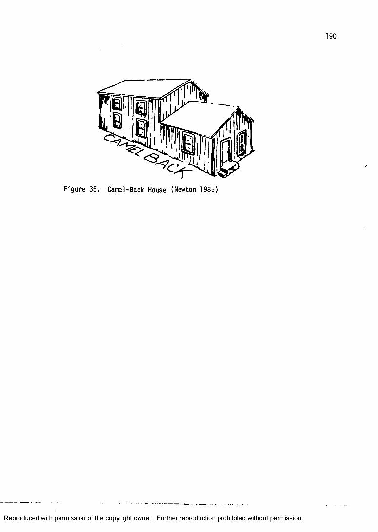
190
Figure 35. Ca me l-B ac k House (Newton 1985)
Reproduced with permission of the copyright owner. Further reproduction prohibited without permission.
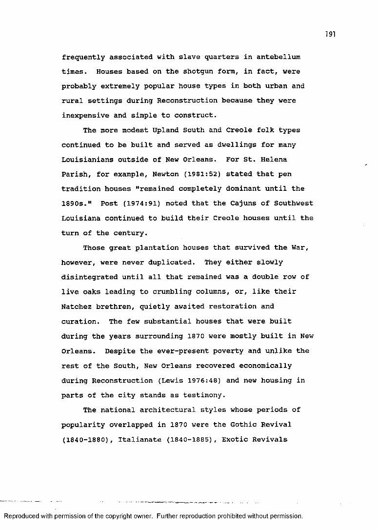
191
frequently associated with slave quarters in antebellum times. Houses based on the shotgun form, in fact, were probably extremely popular house types in both urban and rural settings during Reconstruction because they were inexpensive and simple to construct.
The more modest Upland South and Creole folk types continued to be built and served as dwellings for many Louisianians outside of New Orleans. For St. Helena Parish, for example, Newton (1981:52) stated that pen tradition houses "remained completely dominant until the 1890s." Post (1974:91) noted that the Cajuns of Southwest Louisiana continued to build their Creole houses until the turn of the century.
Those great plantation houses that survived the War, however, were never duplicated. They either slowly disintegrated until all that remained was a double row of live oaks leading to crumbling columns, or, like their Natchez brethren, quietly awaited restoration and curation. The few substantial houses that were built during the years surrounding 1870 were mostly built in New Orleans. Despite the ever-present poverty and unlike the rest of the South, New Orleans recovered economically during Reconstruction (Lewis 1976:48) and new housing in parts of the city stands as testimony.
The national architectural styles whose periods of popularity overlapped in 1870 were the Gothic Revival (1840-1880), Italianate (1840-1885), Exotic Revivals
Reproduced with permission of the copyright owner. Further reproduction prohibited without permission.
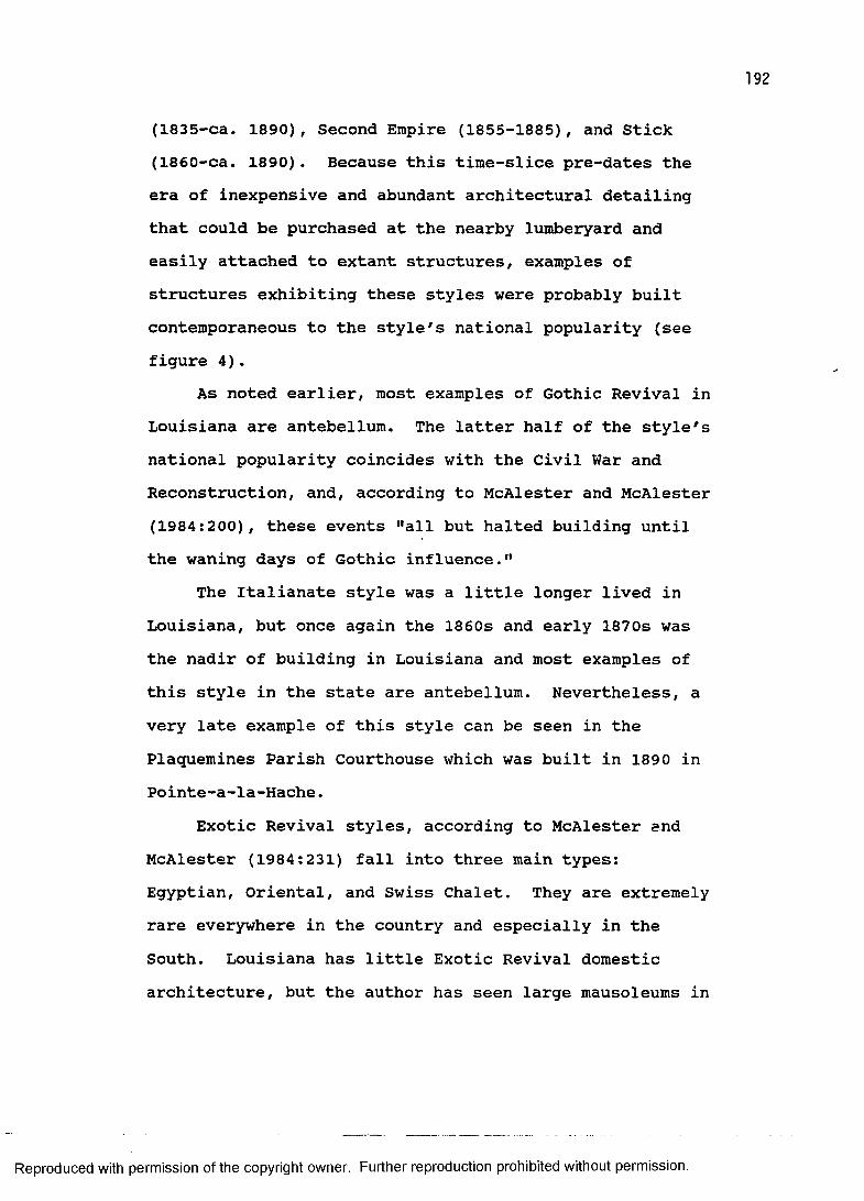
(1835-ca. 1890), Second Empire (1855-1885), and Stick (1860-ca. 1890). Because this time-slice pre-dates the era of inexpensive and abundant architectural detailing that could be purchased at the nearby lumberyard and easily attached to extant structures, examples of structures exhibiting these styles were probably built contemporaneous to the style's national popularity (see figure 4).
As noted earlier, most examples of Gothic Revival in Louisiana are antebellum. The latter half of the style's national popularity coincides with the Civil War and Reconstruction, and, according to McAlester and McAlester (1984:200), these events "all but halted building until the waning days of Gothic influence."
The Italianate style was a little longer lived in Louisiana, but once again the 1860s and early 1870s was the nadir of building in Louisiana and most examples of this style in the state are antebellum. Nevertheless, a very late example of this style can be seen in the Plaquemines Parish Courthouse which was built in 1890 in Pointe-a-la-Hache.
Exotic Revival styles, according to McAlester and McAlester (1984:231) fall into three main types:Egyptian, Oriental, and Swiss Chalet. They are extremely rare everywhere in the country and especially in the South. Louisiana has little Exotic Revival domestic architecture, but the author has seen large mausoleums in
Reproduced with permission of the copyright owner. Further reproduction prohibited without permission.
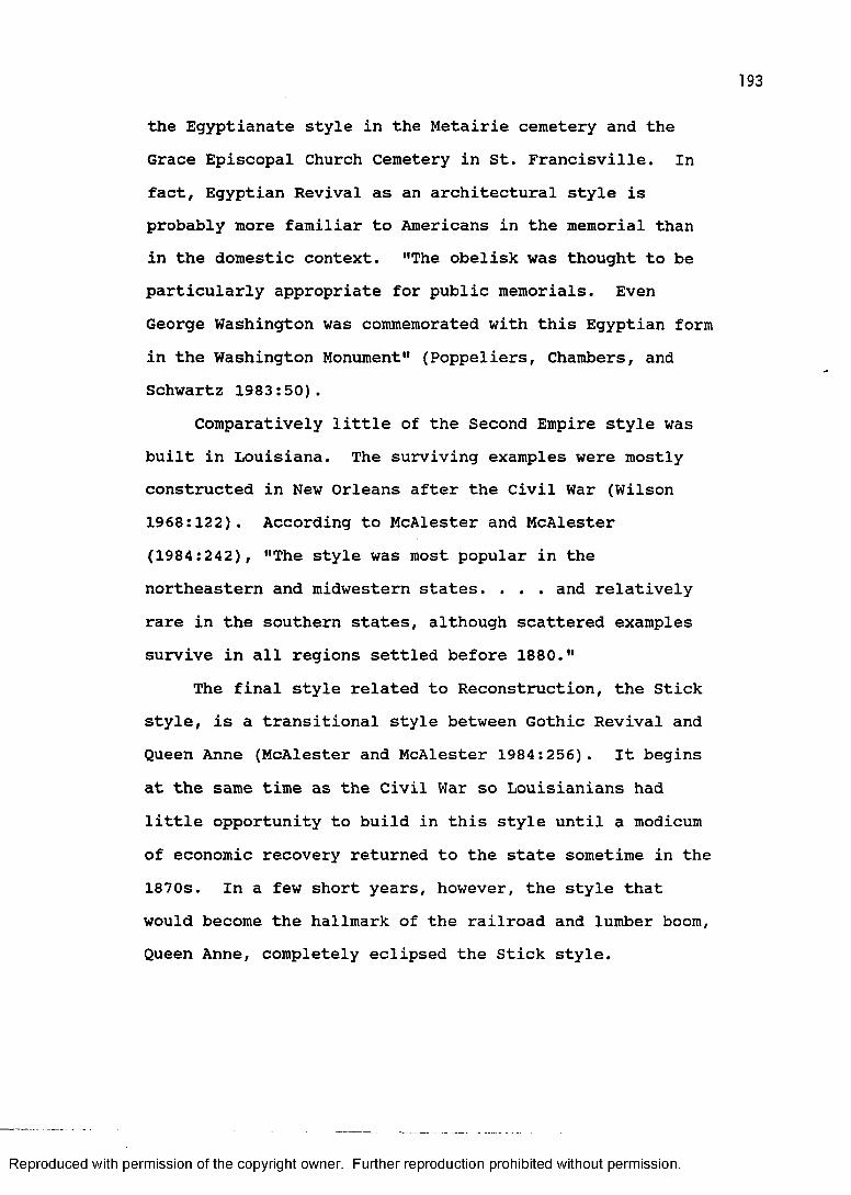
193
the Egyptianate style in the Metairie cemetery and the Grace Episcopal Church Cemetery in St. Francisville. Infact, Egyptian Revival as an architectural style is probably more familiar to Americans in the memorial than in the domestic context. "The obelisk was thought to be particularly appropriate for public memorials. Even George Washington was commemorated with this Egyptian form in the Washington Monument" (Poppeliers, Chambers, and Schwartz 1983:50).
Comparatively little of the Second Empire style was built in Louisiana. The surviving examples were mostly constructed in New Orleans after the Civil War (Wilson 1968:122). According to McAlester and McAlester (1984:242), "The style was most popular in the northeastern and midwestern states. . . . and relatively rare in the southern states, although scattered examples survive in all regions settled before 1880."
The final style related to Reconstruction, the Stick style, is a transitional style between Gothic Revival and Queen Anne (McAlester and McAlester 1984:256). It begins at the same time as the Civil War so Louisianians had little opportunity to build in this style until a modicum of economic recovery returned to the state sometime in the 1870s. In a few short years, however, the style that would become the hallmark of the railroad and lumber boom,Queen Anne, completely eclipsed the Stick style.
Reproduced with permission of the copyright owner. Further reproduction prohibited without permission.
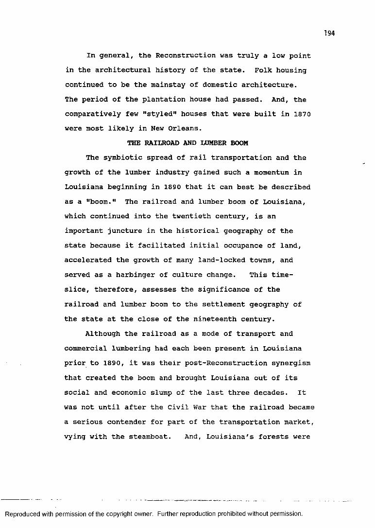
In general, the Reconstruction was truly a low point in the architectural history of the state. Folk housing continued to be the mainstay of domestic architecture.The period of the plantation house had passed. And, the comparatively few "styled" houses that were built in 1870 were most likely in New Orleans.
THE RAILROAD AND LUMBER BOOMThe symbiotic spread of rail transportation and the
growth of the lumber industry gained such a momentum in Louisiana beginning in 1890 that it can best be described as a "boom." The railroad and lumber boom of Louisiana, which continued into the twentieth century, is an important juncture in the historical geography of the state because it facilitated initial occupance of land, accelerated the growth of many land-locked towns, and served as a harbinger of culture change. This time- slice, therefore, assesses the significance of the railroad and lumber boom to the settlement geography of the state at the close of the nineteenth century.
Although the railroad as a mode of transport and commercial lumbering had each been present in Louisiana prior to 1890, it was their post-Reconstruction synergism that created the boom and brought Louisiana out of its social and economic slump of the last three decades. It was not until after the Civil War that the railroad became a serious contender for part of the transportation market, vying with the steamboat. And, Louisiana's forests were
Reproduced with permission of the copyright owner. Further reproduction prohibited without permission.
195
unexploited to the extent that even by the time of the Civil War the state was still roughly seventy-five percent forested; that, despite a large portion of the state devoted to agriculture.
Louisianians embraced the railroad as a useful technological innovation virtually as quickly and readily as anyone in the world. The world's first rail line was built in England in 1825 to service the coal industry, and within a decade six railroads in Louisiana were chartered or incorporated. These were the Pontchartrain Railroad (1830), the West Feliciana Railroad (1831), the Clinton- Port Hudson Railroad (1833), the New Orleans and Carrollton Railroad (1833), the Alexandria and Cheneyville Railroad (1833), and the New Orleans and Nashville Railroad (1835). Later rail lines included the Mexican Gulf (1837), the New Orleans, Jackson and Great Northern (1850), the New Orleans, Opelousas and Great Western (1852), and the Vicksburg, Shreveport and Texas (1852).
Despite the early optimism and enthusiasm for railroads and the rapidity with which companies formed and made plans, most routes only existed as lines on the map rather than on the landscape until well after the Civil War. The dormancy of the railroad in Louisiana can be attributed to the supremacy and entrenchment of the steamboat and the dominance of the plantation system that endorsed it. Building a railroad was a laborious task requiring a significant capital investment, and most of
Reproduced with permission of the copyright owner. Further reproduction prohibited without permission.
the wealth in the state was in the hands of planters who were, in general, well situated with regard to water transportation and satisfied with the existing system. According to Cotterill (1922:326), "railroads were looked upon as auxiliaries to the rivers rather than as main lines of transportation." As a result, in the three decades between the first Louisiana railroad charter and the outbreak of Civil War, the combined effort of the ten railroad companies just cited was slightly over ten miles of new track per year. This is not exactly a flurry of railroad building activity!
The real period of railroad construction occurred in the wake of Reconstruction. According to Taylor (1976:71), "Not until after 1880 was the rail network of Louisiana improved significantly over what had existed in 1860." Later railroads differed from their antebellum counterparts in two important respects; they were considered to be more than simply an adjunct to water transportation, and they were controlled by Northern interests (Newton 1987:244; Odum 1963).
The most successful of the early railroads was the New Orleans, Jackson and Great Northern, later called the Illinois Central Railroad. It eventually connected the Gulf and the Great Lakes, with termini at New Orleans and Chicago. Writing in 1874, Samuel Lockett referred to this as the most important rail line in the state and "second only to the Mississippi River as a means of inter-
Reproduced with permission of the copyright owner. Further reproduction prohibited without permission.

197
communication between the metropolis of the South [New Orleans] and the other states of the Union" (Lockett 1969:132).
The importance of this route was given political recognition in Louisiana in 1869 by the creation of a new parish, Tangipahoa (Bennett 1974? Newton 1987:238). The linear form of Tangipahoa Parish parallelling the Illinois Central the entire north-south distance of this portion of the Florida Parishes, and the settlement pattern closely aligned to that route, has prompted one geographer to refer to Tangipahoa Parish as "the child of the Illinois Central" (Kyser 1938:161).
In 1874, Lockett (1969:132-133) mentioned four railroads of any consequence and some miscellaneous lines in operation in the state. In all, they amounted to roughly four hundred miles of track. The Louisiana portion of the New Orleans, Jackson, and Great Northern Railroad was fully functioning. The Mobile, New Orleans and Texas Railroad ran east from New Orleans to Mobile and west as far as Donaldsonville. The Morgan's Louisiana and Texas Railroad was operational between New Orleans and Morgan City. And, the only completed portion of the North Louisiana and Texas Railroad was that between Delta, a town on the Mississippi across from Vicksburg, and Monroe.
Some eighteen years after Lockett described the status of railroads in the state, George Cram published his Railroad and County Map of Louisiana (Cram 1892). One
Reproduced with permission of the copyright owner. Further reproduction prohibited without permission.
198
of the most immediate observations made when comparing the two sources is that the amount of railroad track had dramatically increased. In fact, it had more than tripled, from four hundred to thirteen hundred miles. Lengthy expanses of rail line now traversed the state.The major east-west route across North Louisiana, whose name had changed to the Vicksburg, Shreveport and Pacific, was complete. The Texas Pacific cut a diagonal swath through the state linking New Orleans, Alexandria, and Shreveport. And, the old Morgan's Louisiana and Texas had pushed beyond Morgan City and ran northwest through Lafayette to connect with the Texas Pacific in Cheneyville, as well as providing a link with the Galveston Harbor and San Antonio Railroad which ran west from Lafayette (now the Southern Pacific).
The development of the lumbering industry in Louisiana goes back a great deal further than that of railroads. Whereas railroads developed slowly for approximately half a century beginning in 1830, the state's forest resources were used on a commercial basis, albeit on a relatively small scale, since the beginning of colonial settlement (Holmes 1969; Landreth 1985). Logging activity for the entire period prior to the Civil War was confined to areas where logs could be rafted on rivers to mill or market. The expanding net of rail lines ushered in a whole new period in logging technology that is frequently referred to as "industrial lumbering" (Caldwell
Reproduced with permission of the copyright owner. Further reproduction prohibited without permission.

199
1975; Hickman 1958, 1966; Kniffen and Hilliard 1988:166;Mancil 1969, 1972; Stokes 1954).
According to Stokes (1954:25), lumbering in Louisianacan be divided into three phases:
an early phase, during which demand was small and logging operations were largely confined to areas along streams; a middle phase, the era of intensive logging, when the railroad became the prime mover; and a final stage, the present, dominated by the small portable mill and its servant, the motor truck.
The important factor in these three phases is transportation. Increasing flexibility in log transport allowed for greater resource exploitation. The middle phf.se was made possible because of the relative ease of establishing trunk rail lines to all forested areas of the state except the cypress swamp. The West Point-trained engineer Samuel Lockett, in fact, writing during Reconstruction, advocated expansion of the railroad into the forested uplands and saw few impediments in the terrain. "All of the upland country is well timbered; the streams are not large or difficult to bridge; and in no part of the state will be encountered any serious trouble in making excavations and embankments in preparing a road bed" (Lockett 1969:133-134).
The railroad, therefore, was clearly a catalyst for logging in the state; so much so that some see it as a sine qua non for the period of industrial logging. According to Stokes (1954:35), "railroad expansion was essential to forest exploitation." Hickman (1966:79),
Reproduced with permission of the copyright owner. Further reproduction prohibited without permission.
200
speaking of the eastern Florida Parishes stated, "commercial lumbering in the back country of east Louisiana received a powerful stimulus with the construction of the New Orleans, Jackson and Great Northern Railroad." And, Davis (1971:298) wrote, "during the 1890's, after the completion of the Kansas City Southern Railroad, the western section of the state rapidly developed its lumber industry."
The railroad and lumber boom stimulated the growth of settlement in the forested interior areas of the state, and is especially credited with the creation of numerous towns. As rails penetrated mature stands of timber, towns, however ephemeral, sprang up seemingly overnight. Many of these towns followed the familiar boom and bust cycle (Kniffen and Hilliard 1988:169; Stokes 1957). However, a surprising number of these "sawmill towns" survived, such as Bernice in Union Parish, Dubach in Lincoln Parish, Alden Bridge in Bossier Parish, Fisher in Sabine Parish, and Elizabeth in Allan Parish (Caldwell 1975:72; Stokes 1957:251).
The railroad and lumber town was incredibly prosperous for a time. Bernice in 1899, for example, sold seven thousand dollars worth of house lots in one day (Caldwell 1975:72). With the sawmills of these towns turning out tens of thousands of board feet of lumber each day the railroads were kept busy hauling this valuable commodity to market and bringing in scores of workers and
Reproduced with permission of the copyright owner. Further reproduction prohibited without permission.
201
a wide range of goods. The typical town boasted elegant hotels, churches, a business district parallel or perpendicular to the railroad, and neighborhoods with large mansions of company officials and prosperous merchants as well as those of the workers who lived in rows of company built housing. The prosperity was fleeting, however, and in two to three decades many of these towns disappeared as quickly as they had appeared.
The period of industrial lumbering lasted from about 1890 to almost 1930. Because of a policy of "cut out and get out" (Kniffen and Hilliard 1988:169), the big logging companies added Louisiana to their list of states that had been denuded to satisify an appetite for American virgin timber. The pace of this consumption was incredible indeed. According to Stokes (1954:35), loggers working for some of the big sawmills could, like so many gypsy moths eating their way through a forest, devour an entire section (one square mile) of virgin timber in two weeks or less.
Just as the railroad helped create the period of industrial lumbering and its attendant settlement, so too it stimulated a significant period of settlement in a nonforested region of the state, the prairie (Kniffen 1974:260; Perrin 1891). In 1885, railroad and land company interests hired the noted professor of agriculture from Iowa State University, Dr. Seaman A. Knapp, and asked him to assess the agricultural potential of the prairie
Reproduced with permission of the copyright owner. Further reproduction prohibited without permission.

202
region of Southwest Louisiana (Davis 1971:296; Newton1987:148; Post 1974:81; Taylor 1976:130). After carefulstudy he determined that rice would be the best crop forthis region's climate, terrain, and soil. Upon Knapp'srecommendation, large numbers of grain farmers from theAmerican Midwest were given free passage on the railroadto come to the Southwest Prairies to see for themselvesthe prospects of this new agricultural region. A largenumber of farmers accepted the offer and decided toimmigrate to Louisiana. As a result, many of the culturallandscape elements of the Midwest are replicated inSouthwest Louisiana (kniffen 1963:297).
Roads are oriented on the cardinal directions, fields are square conforming to the sections of the township-and-range system, land is tilled to its edges, and towns are grids straddling railroads (Newton 1987:149).Generally, the placement of towns along the railroad
was not a haphazard event; their location was determined by railroad company engineers (Newton 1987:159). One such planned town was Crowley along the Southern Pacific Railroad on the prairies west of Lafayette. According to Davis (1971:295), Crowley, the parish seat of Acadia Parish, was founded in 1887 and named for an employee of the Southern Pacific Railroad. Other planned towns include Oberlin, Kinder, Jennings, and Iowa.
The railroad and lumber boom, therefore, significantly furthered the viability and intensity of settlement to include the heretofore sparsely populated
Reproduced with permission of the copyright owner. Further reproduction prohibited without permission.

longleaf pine forests, shortleaf pine forests, flatwoods, and southwestern prairies. The so-called piney woods portions of Louisiana in 1890 were, for the first time, making the transition from pioneer, or frontier, self- sufficiency to participation in a national economy. "The coming of industrial lumbering. . . along with its companion, the railroad, . . . ended what was essentially a frontier period in the upland South" (Caldwell 1975:5). This was also, according to Newton (1987:147), the beginning of the transition from folk culture to popular culture and technical order. The railroad was also responsible for much of the initial settlement of the prairies of Southwest Louisiana.
The creation of most of the new parishes in the two decades preceeding 1890 reflect, to a degree, population growth in the piney woods and prairies of northern, western, and southwestern Louisiana (figures 36 and 37). The six new parishes created between 1870 and 1890 were Webster, Lincoln, Red River, Carroll fissioned into East and West, Vernon, and Acadia.
The number of towns and cities with a population greater than one thousand had more than doubled. New Orleans retained its crown as primate city and had a population of 242,039. Shreveport was the second largest urban place in the state with a population of 11,979, edging out the capital, Baton Rouge, by 1,501. Some of these towns with populations over one thousand had
Reproduced with permission of the copyright owner. Further reproduction prohibited without permission.
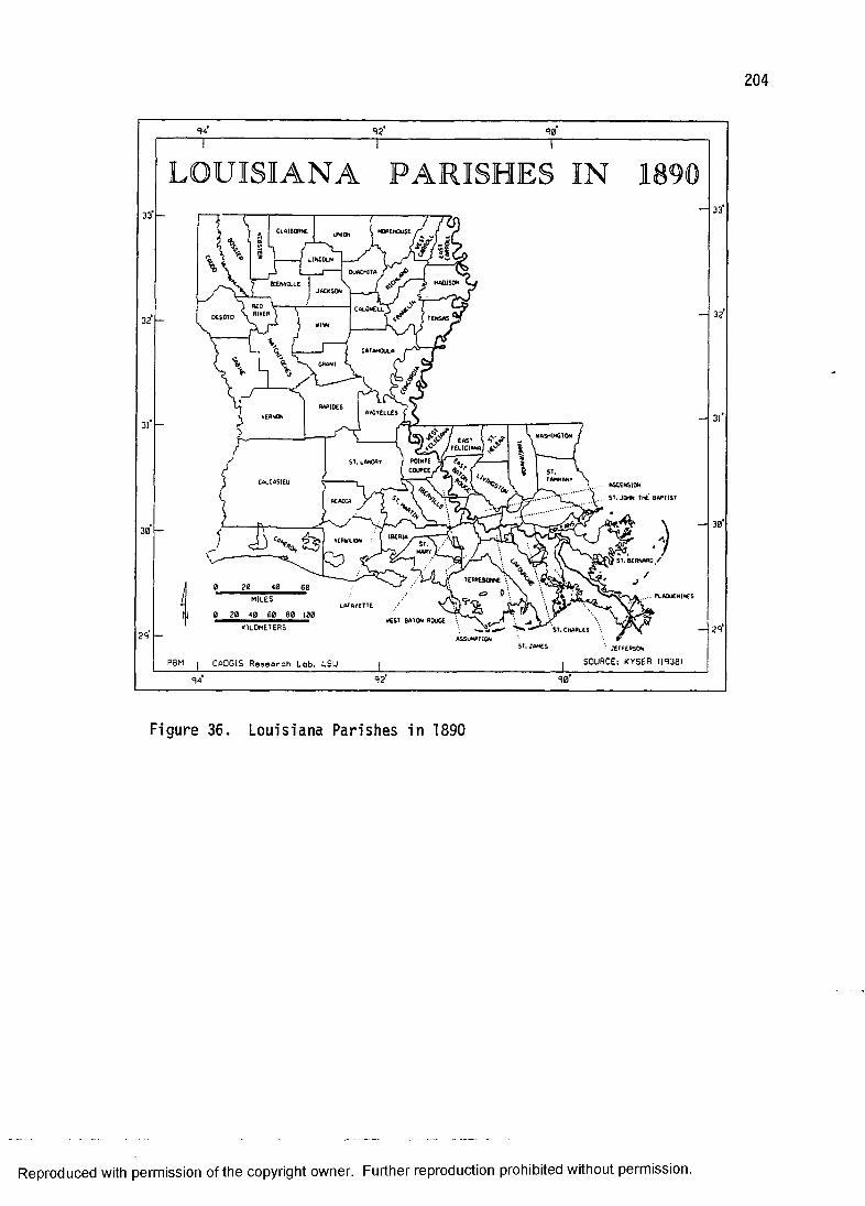
204
LOUISIANA PARISHES
ASCENSIONST.JOHN ThE BAPTIST
40MILES
• JErrERsON
SOURCE: KYSER (JS38)PBM j CADGIS Resoorch Lob, ISU
Figure 36. Loui sia na Parishes in 1890
Reproduced with permission of the copyright owner. Further reproduction prohibited without permission.
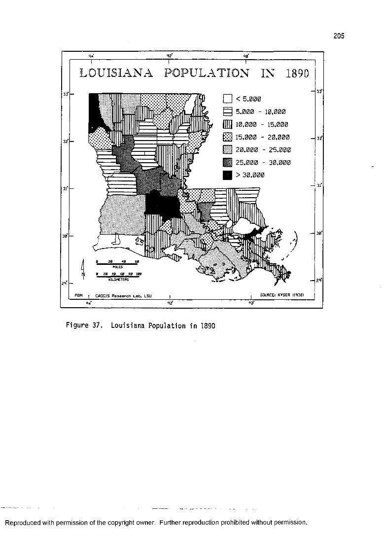
205
L O U ISIA N A PO P U L A T IO N IN 1890
< 5,0005,000 - 10,00010,000 - 15,00015,000 - 20.000 32
20,000 - 25,00025,000 - 30,000> 30,000
30
40 60
MILES100
29
SOURCE: KYSER (!938>PBM CADGIS Reseoreh Lob* LSU9092
Fi gu re 37. Lo uisiana Population in 1890
Reproduced with permission of the copyright owner. Further reproduction prohibited without permission.
206
significantly fewer residents twenty years earlier. Their growth can be attributed to the railroad and lumber boom. They were, to name a few, Lake Charles (3,442), Morgan City (2,291), Franklin (2,127), Lafayette (2,106), Amite (1,510), Patterson (1,414), Minden (1,298), and Homer (1,132).
A good example of the difference a railroad can make in the prosperity of a town is supplied by comparing two towns, both parish seats along the Bayou Teche, New Iberia and St. Martinville. In 1870 their populations were about equal, with New Iberia having 1,472 residents and St. Martinville having 1,190. The Southern Pacific Railroad went through New Iberia and bypassed St. Martinville. The 1890 census reveals that while New Iberia had more than doubled and now had a population of 3,447, St. Martinville only had 624 new residents.
One example of growth on the parish level attributed to the railroad and lumber boom is Calcasieu Parish. According to the choropleth map of 1870 population (figure 34) the parish had between 5,000 and 10,000 residents.The actual number was 6,733. Figure 37 shows that the population in 1890 was between 20,000 and 25,000. The actual number was 20,176. This represents a threefold increase in population in the intervening twenty years.By way of comparison, East Baton Rouge Parish went from 17,816 to 25,922, or an increase of only one and a half times. In terms of real numbers, Calcasieu Parish gained
Reproduced with permission of the copyright owner. Further reproduction prohibited without permission.
207
by 13,443, while East Baton Rouge Parish gained by only 8,106.
The railroad and lumber boom is an important period in the historical settlement geography of Louisiana. From the wider perspective that the passage of time provides it represents one of those significant punctuations in the evolution of a culture. Industrial lumbering brought a return to economic prosperity the likes of which had not been seen for two generations. Louisianians were learning to parlay their natural resources into tangible income; an adaptation that would manifest itself in later years (e.g., oil and gas). And, with the establishment of Midwestern farmers in Southwest Louisiana the complexion of commercial agriculture in the state was also changing. To quote the cultural geographer Lauren C. Post (1974:79), the mechanized rice industry of Southwest Louisiana represented 11 a type of agriculture in which white men would do most of the work - a departure from a generally established custom in the South." Finally, the revolution in transportation initiated by the railroad meant that Louisianians were able to break away from their hereditary reliance upon the naturally imposed pattern of navigable waterways. This permitted and encouraged the settlement of interfluve areas of the state where places such as Ruston, founded in 1884 and now Louisiana's eighteenth largest city, were established and continue to prosper into the twenty-first century.
Reproduced with permission of the copyright owner. Further reproduction prohibited without permission.
208
BUILDING DIVERSITY AND PROLIFERATIONAccording to Newton (1987:151), "between 1880 and
1920, the architectural landscape of both town and country in the State was completely overhauled." This statewide facelift was actually part of a national architectural transformation brought about by the railroad and lumber boom. "Rail transportation made inexpensive building materials - principally lumber from large mills located in timber-rich areas - readily available over much of the nation" (McAlester and McAlester 1984:63).
Because Louisiana fully participated in the railroad and lumber boom it is not surprising to see the extent of modification of the cultural landscape. These landscape changes came in the form of newly built structures and alterations of older structures. The architectural impact of the railroad and lumber boom on modern landscape perception is so profound, in fact, that people tend to think of a Victorian structure, for example, as an old house. But, as Newton (1987:153) pointed out, "much of the historic landscape of Louisiana came down to us as the remains of the dawn of technical order, the New South, not the traditional South of romance."
There are four recognized folk and vernacular house types typical of the railroad and lumber boom. They are the Midwest I-house, the bungalow, the pyramidal house, and a variant of the shotgun, the North Shore house. Although the historical genesis of some of these types is
Reproduced with permission of the copyright owner. Further reproduction prohibited without permission.
a little obscure, particularly the bungalow, they are best placed within the architectural legacy of the railroad and lumber boom. Certainly the Midwest I-house belongs to this time-slice. The pyramidal house was a common type of workers' housing in mill towns and is representative of the period. And, the North Shore house is clearly a Victorian architectural phenomenon.
The Midwest I-house (figure 38) is a type common to the prairie region of Southwest Louisiana. It is simply two rooms wide, one room deep, and two stories high.There is often a one story ell. The Midwest I-house lacks a central hall and full length gallery.
Just as the Carolina I-house is testimony to a migration of people from the Carolinas, the Midwest I- house is evidence on the cultural landscape of a migration of people from the Midwest (Kniffen 1963:293, 1974:261). These Midwesterners came to Louisiana in the late nineteenth century following the "opening up" of the prairies by the railroads (Post 1962:35).
The bungalow house (figure 39) is a late nineteenth and early twentieth century form that, at first glance, appears to be a double shotgun (Vlach 1986:61), but there is no clear evidence that the shotgun and bungalow are related forms (Newton 1985:186). A common floor plan is two rooms wide and three rooms deep. The bungalow house is primarily a single family dwelling, but some are used as rental duplexes. The house type should not be confused
Reproduced with permission of the copyright owner. Further reproduction prohibited without permission.
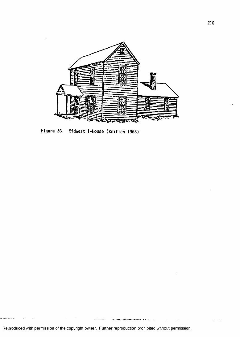
Figure 38. Midwest I-House (Kniffen 1963)
Reproduced with permission of the copyright owner. Further reproduction prohibited without permission.
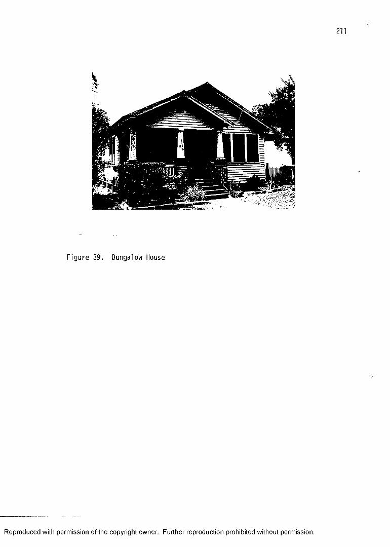
211
Figure 39. Bu ng alo w House
Reproduced with permission of the copyright owner. Further reproduction prohibited without permission.
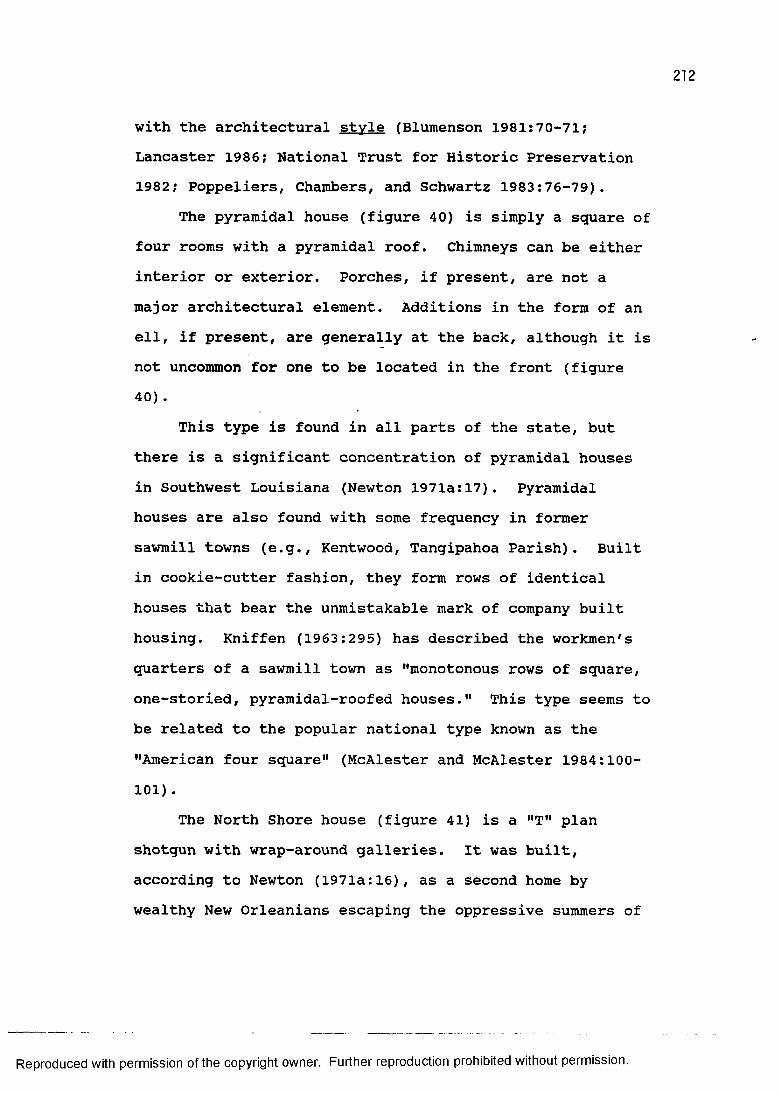
212
with the architectural style (Blumenson 1981:70-71; Lancaster 1986; National Trust for Historic Preservation 1982; Poppeliers, Chambers, and Schwartz 1983:76-79).
The pyramidal house (figure 40) is simply a square of four rooms with a pyramidal roof. Chimneys can be either interior or exterior. Porches, if present, are not a major architectural element. Additions in the form of an ell, if present, are generally at the back, although it is not uncommon for one to be located in the front (figure 40) .
This type is found in all parts of the state, but there is a significant concentration of pyramidal houses in Southwest Louisiana (Newton 1971a:17). Pyramidal houses are also found with some frequency in former sawmill towns (e.g., Kentwood, Tangipahoa Parish). Built in cookie-cutter fashion, they form rows of identical houses that bear the unmistakable mark of company built housing. Kniffen (1963:295) has described the workmen's quarters of a sawmill town as "monotonous rows of square, one-storied, pyramidal-roofed houses." This type seems to be related to the popular national type known as the "American four square" (McAlester and McAlester 1984:100- 101) .
The North Shore house (figure 41) is a "T" plan shotgun with wrap-around galleries. It was built, according to Newton (1971a:16), as a second home by wealthy New Orleanians escaping the oppressive summers of
Reproduced with permission of the copyright owner. Further reproduction prohibited without permission.
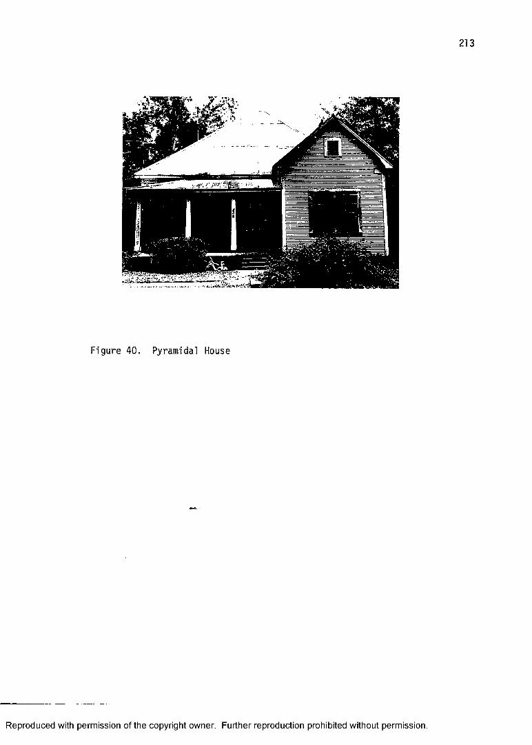
Figure 40. Pyramidal House
Reproduced with permission of the copyright owner. Further reproduction prohibited without permission.
Figure 41. North Shore House
Reproduced with permission of the copyright owner. Further reproduction prohibited without permission.
215
that city. They were built with some frequency in southern St. Tammany Parish in places such as Abita Springs and Mandeville. The North Shore house type usually displays some architectural style such as Queen Anne.
The railroad and lumber boom was also the period of architectural style. This time-slice cross-cuts more periods of architectural style popularity (figure 4) than any other time-slice in this study. The 1870 time-slice is a close second, but given the general economic conditions of the time actual Louisiana examples of styles then popular (nationally) are comparatively few. The proximity of sawmills, inexpensive and architecturally adaptable balloon framing, and efficient rapid transportation contributed to the spread of "styled" houses in Louisiana in the 1890s.
Concomitant with material and transportation was the important factor known to cultural geographers as the rise of popular culture. Architectural style, from the folk cultural perspective was once viewed as only for elite residences and civic and religious buildings. (This perspective, however, is still very much with us among some architectural historians; see, for example, Hunt 1984). Architectural style became a component of popular culture in the 1890s by being advertized in magazines, sold piecemeal at the local lumberyard, and integrated into rapidly growing cities and towns.
Reproduced with permission of the copyright owner. Further reproduction prohibited without permission.
216
The architectural styles that were nationally popular during the period of the railroad and lumber boom in Louisiana spanned from the end of the Second Empire and Stick Styles, 1885 and 1890 respectively, through the period of popularity of the California Bungalow which ended around 1930 (figure 4). Of these eleven styles, the Queen Anne style (1880-1910) was probably the most popular in Louisiana in 1890 (Maass 1957). According to McAlester and McAlester (1984:266), the Queen Anne style, which actually includes the variety commonly called Eastlake, "was the dominant style of domestic building during the period from about 1880 until 1900." And, the New South of the railroad and lumber boom has, in their view, "some of the most fanciful examples" (McAlester and McAlester 1984:268"
It is particuarly common for Queen Anne style to be expressed structurally as well as decoratively. More elaborate specimens of the Queen Anne style were constructed with towers, projecting gables and bay windows, porches, and an overall asymmetrical appearance. These high style examples were designed by architects, but folk and vernacular examples did not usually require building a whole new structure to accommodate the style. According to Newton (1987:172), "on lesser specimens, however, style is commonly added to the facades of buildings of the folk and vernacular sorts." This added style came in the form of decorative details, and
Reproduced with permission of the copyright owner. Further reproduction prohibited without permission.
217
functioned "principally to enhance the beauty of the house exterior" (McAlester and McAlester 1984:52). Anotherstyle of the Victorian period, named for its Louisiana- born architect Henry Hobson Richardson (1838-1886), is the Richardsonian Romanesque. After studying architecture at Harvard and the Ecole des Beaux-Arts in Paris, he worked in New York and eventually settled in Boston where he designed some of his best known buildings (McAlester and McAlester 1984:302). These buildings consisted of massive masonry and stone construction with elaborate towers and arches, and, as a consequence, were extremely labor intensive and expensive to build. The style is usually associated with civic architecture such as libraries, schools, and courthouses. In Louisiana, an example of this style can be seen in the Pointe Coupee Parish Courthouse in New Roads which was completed in 1902.
The Colonial Revival style is said to have grown out of the Philadelphia Centennial in 1876 which stimulated interest in the architecture of the colonial Eastern Seaboard (McAlester and McAlester 1984:326). It consists of a rather free interpretation of structural and stylistic elements of colonial houses often resulting in a composite colonial-looking (frequently Georgian) house.The Colonial Revival style is an eclectic category of architectural style with a relatively long period of popularity.
Reproduced with permission of the copyright owner. Further reproduction prohibited without permission.
218
Like the Colonial Revival, the Neoclassical style is also a long-lived eclectic style. One of the hallmarks of this style is a "facade dominated by a full-height porch with roof supported by classical columns" (McAlester and McAlester 1984:343). The Neoclassical was particularly popular in the New South where a penchant for becolumned architecture existed. Louisianians, for example, appropriately selected the Neoclassical style for the official home of their Governor (now the "Old Governor's Mansion," built in the 1930s). It later became very popular in some subdivisions attempting to appear "upscale. "
The Beaux Arts style exudes wealth through itsmassive stone or masonry construction and ornate detailing(Poppeliers, Chambers, and Schwartz 1983:66-69). Some ofthe best public architectural examples of this style, suchas the Library of Congress, are found in Washington, D.C.McAlester and McAlester (1984:380) described some economicand geographic aspects of the style:
Houses in the Beaux Arts style are usually architect-designed landmarks and were built principally in the prosperous urban centers where turn-of-the-century wealth was concentrated. . . . In those pre-income tax days, great fortunes were proudly displayed in increasingly ornate and expensive houses.
Louisiana public architectural examples of the styleinclude the Beauregard Parish Courthouse (1914) in DeRidder and the Whitney National Bank (1909) in NewOrleans.
Reproduced with permission of the copyright owner. Further reproduction prohibited without permission.

219
The Mission Revival was to the West what the Colonial Revival was to the East. It began in California around 1890 and represents an architectural adaptation of the state's many Spanish colonial missions. And, according to McAlester and McAlester (1984:410), "it received further impetus when the Santa Fe and Southern Pacific railways adopted the style for stations and resort hotels throughout the West." Many examples of the Mission Revival style in Louisiana undoubtedly owe their existence to the inspiration of the railroad. Mission Revival style railroad stations in Louisiana include Depots in Acadia, Calcasieu, and Vernon parishes.
The Prairie style, unlike the other styles mentioned, explicited eschewed an architectural revival or replication of classical, medieval, or romantic forms.The Prairie style originated in Chicago around the turn of the century and is associated with the architect Frank Lloyd Wright (Brooks 1972). Wright and others attempted to design an architectural interpretation of the rolling landform of the American Midwest. The style was somewhat popular between 1900 and 1920 in the Upper Midwest, but generally, according to Poppeliers, Chambers, and Schwartz (1983:83), "during the first decades of the 20th century most Americans chose to live, work and shop in buildings patterned after architectural styles of the past."
There can be no greater contrast in American architecture of the early twentieth century than the
Reproduced with permission of the copyright owner. Further reproduction prohibited without permission.
220
difference between the general public rejection of thePrairie style and their overwhelming embrace of theCalifornia Bungalow style (Lancaster 1985). So popularwas the Bungalow, in fact, that magazines devoted entirelyto the style flourished, and one could even receive bymail order a California Bungalow style house through theSears catalog (Stevenson and Jandl 1986). According toNewton (1987:192), "the bungalow style was, perhaps, thefirst completely adopted national style for the commonman." One implication of the style's popularity to thecultural landscape of Louisiana is, as Newton (1987:192)has observed, that
any town in Louisiana that was prospering at all between 1890 and 1930 has whole neighborhoods of California bungalow houses and other types trimmed with elements of that style.
Furthermore, the California Bungalow style is strickly adomestic architectural style, whereas even the Prairie
tstyle, for example, found expression in civic architecture such as banks and courthouses.
In sum, from the beginnings of the railroad and lumber boom to the present, Louisianians have been increasingly participatory in popular culture. Concern with architectural style (fashion or fad if you prefer) has been a component of this. Some who could afford to do so, built full-blown examples of the style then popular.And, these newly constructed stylish houses often clustered in expanding neighborhoods creating vivid examples of the "Law of Initial Occupance" and its
Reproduced with permission of the copyright owner. Further reproduction prohibited without permission.
corollary the "Law of the Dominance of Contemporary Fashion" (Newton 1987:183-185).
Reproduced with permission of the copyright owner. Further reproduction prohibited without permission.
CHAPTER VIIs PRESENTATION AND ANALYSIS OF DATA
The historic standing structure data used in this study came from two sources: 1) the individually listedstructures on the National Register of Historic Places on file with the Louisiana Division of Historic Preservation, and 2) structures from a survey of Louisiana vernacular architecture conducted by Dr. Jay Edwards of the Department of Geography and Anthropology, Louisiana State University (Edwards 1982). The rationale for selecting these sources of information on the historic houses of Louisiana was based on a number of criteria. The use of these data in the diachronic examination of settlement geography requires accurate temporal and spatial information. Additionally, an assessment of house type and architectural style can bolster the utility of the data, particularly in the areas of cultural migration and diffusion. The National Register and Edwards' survey more than satisfy these requirements.
The sample is composed primarily of domestic structures, although a few non-domestic structures such as churches, courthouses, railroad stations, and historic forts are also included. Furthermore, because of its importance in the historical geography of the state, one site for which there are no extant structures is included in the sample. This is the site of the Presidio de Los Adaes.
222
Reproduced with permission of the copyright owner. Further reproduction prohibited without permission.
A data matrix consisting of observation number, parish (designated alphabetically), date of construction, type, style, and U.T.M. coordinate (Easting and Northing) was loaded into the VAX computer system in the CADGIS Research Laboratory, Louisiana State University, and is presented here in Appendix III. The following analysis was greatly facilitated by the cartographic capabilities of the INTERGRAPH workstation.
The sample consists of a total of 557 historic standing structures. Four hundred and forty of these are properties individually listed on the National Register. The remaining 117 structures come from Edwards' survey. The temporal coverage of the sample (figure 42), based on assigned date of construction, falls within the range of each time-slice considered in this study as follows: two from 1759 and earlier, twenty-four from 1760 to 1799, thirty-seven from 1800 to 1819, ninety-nine from 1820 to 1839, one hundred and forty-nine from 1840 to 1859, sixty from 1860 to 1879, and one hundred and eighty-four from 1880 and later. Two structures are not dated, making the total number of dated structures 555.
The frequency bar chart (figure 42) of the temporal distribution of the sample has a trajectory that is compatible with the state's population increase and the amount of building as described in the time-slices. The most immediate exception to an expected growth curve is the period of the Civil War and Reconstruction. Actually,
Reproduced with permission of the copyright owner. Further reproduction prohibited without permission.
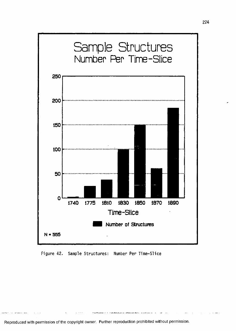
224
Sample StructuresNumber Per Time-Slice
250
200
1740 1775 1810 1830 1850 1870 1890
Time-Slice
Number of Structures
N ■ 555
Figure 42. Sample Structures: Number Per Ti me -Sl ic e
Reproduced with permission of the copyright owner. Further reproduction prohibited without permission.
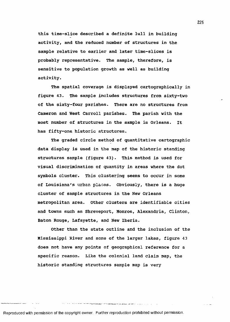
225
this time-slice described a definite lull in building activity, and the reduced number of structures in the sample relative to earlier and later time-slices is probably representative. The sample, therefore, is sensitive to population growth as well as building activity.
The spatial coverage is displayed cartographically in figure 43. The sample includes structures from sixty-two of the sixty-four parishes. There are no structures from Cameron and West Carroll parishes. The parish with the most number of structures in the sample is Orleans. It has fifty-one historic structures.
The graded circle method of quantitative cartographic data display is used in the map of the historic standing structures sample (figure 43). This method is used for visual discrimination of quantity in areas where the dot symbols cluster. This clustering seems to occur in some of Louisiana's urban places. Obviously, there is a huge cluster of sample structures in the New Orleans metropolitan area. Other clusters are identifiable cities and towns such as Shreveport, Monroe, Alexandria, Clinton, Baton Rouge, Lafayette, and New Iberia.
Other than the state outline and the inclusion of the Mississippi River and some of the larger lakes, figure 43 does not have any points of geographical reference for a specific reason. Like the colonial land claim map, the historic standing structures sample map is very
Reproduced with permission of the copyright owner. Further reproduction prohibited without permission.

226
92~T~
90
HISTORIC STANDING STRUCTURES SAMPLE
32 —
30 ;
129 j
ONE DOT EQUALS ONE STRUCTURE
50 STRUCTURES•— 30 STRUCTURES — 10 STRUCTURES
6020
Irj
MILES
KILOMETERS
32
— 29
PBM | CADGIS Reaeorch Lob. LSU94 92 90
Figure 43. Map of H i st ori c S t an din g St ru ctu re s Sa mple
Reproduced with permission of the copyright owner. Further reproduction prohibited without permission.
instructive by itself. It was felt that parish boundaries or a myriad of rivers would distract from this interesting pattern. For example, the string of historic structure dot symbols practically draws both the Red River and Bayou Teche.
The distribution of folk housing type displayed in table 2 clearly shows that many of the types discussed in this study are either not represented or are underrepresented. This is no doubt a function of the data in the sense that most of the structures are on the National Register of Historic Places, and therefore less likely to include common folk forms. The inclusion of Edwards' survey structures partially compensates for this weighting toward the high style architecture. Edwards' structures add more types that are in the French building tradition than anything else, so that other types, particularly those of the shotgun tradition, are not so well represented.
Another dimension of the house types identified in the sample is that some of these types are now considered to be somewhat too simplistic and generalizing. This is particularly true with the Creole raised cottage and, to some extent, the smaller Creole house. As Edwards (1988) has pointed out, there was a great deal more variability in what we know as the French building tradition. In light of recent scholarship, therefore, these types may well disappear from the vocabulary of future folk and
Reproduced with permission of the copyright owner. Further reproduction prohibited without permission.

228
TABLE 2: DISTRIBUTION OF SAMPLE STRUCTURESACCORDING TO FOLK HOUSING TYPE
Folk Housing Type Number
Single-pen house.........................................4Double-pen house .................................... 0Saddle-bag house .................................... 1Dog-trot house ...................................... 9Bluffland house ...................................... 11Hill plantation I-house .............................. 11Carolina I-house .................................... 6Midwest I-house ...................................... 0Lowland South plantation house ...................... 31Smaller Creole house ................................ 82Creole raised cottage ................................ 99Acadian Upper Teche house ............................ 0Shotgun house ........................................ 5Bungalow house ...................................... 0Camel-back house .................................... 0North Shore house .................................... 0Pyramdal house .................................... 0Other.................................................. 19
Reproduced with permission of the copyright owner. Further reproduction prohibited without permission.
229
vernacular architecture studies. Nevertheless, in spite of discussing alternatives for the Creole raised cottage type in this study, for example, these data were compiled and analyzed according to an earlier established typology (Newton 1971).
Table 3 displays the actual number of structures of each architectural style in the sample. The style of those structures that are on the National Register of Historic Places is displayed in the form of a horizontal bar graph in figure 44. The "no style" category primarily represents folk housing types.
The most immediate impression to these data should be the glaring and overwhelming presence of the Greek Revival style. The 1850 time-slice suggested that Greek Revival architectural style was extremely popular, but the representativeness of this sample's distribution is certainly called into question when roughly one third of all of the individually listed National Register structures in the sample are of one style. By comparing figure 44 to the temporal range of architectural style popularity (figure 4), the conclusion that the number of structures for any particular style on the National Register is not a function of the temporal duration of the style's popularity. For example, Greek Revival and Beaux Arts styles both have the same duration of popularity at different times in the past (figure 4), but there are
Reproduced with permission of the copyright owner. Further reproduction prohibited without permission.
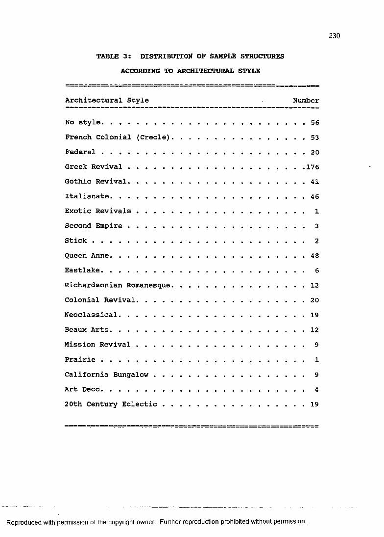
230
TABLE 3: DISTRIBUTION OF SAMPLE STRUCTURESACCORDING TO ARCHITECTURAL STYLE
Architectural Style Number
No style................................................ 56French Colonial (Creole)................................ 53Federal................................................ 20Greek Revival......................................... 176Gothic Revival................ 41Italianate.............................................. 46Exotic Revivals ....................................... 1Second Empire ......................................... 3Stick...................... 2Queen Anne.............................................. 48Eastlake................................................. 6Richardsonian Romanesque................................ 12Colonial Revival........................................ 20Neoclassical.......................................... .19Beaux Arts.............................................. 12Mission Revival ....................................... 9Prairie ............................................... 1California Bungalow .................................. 9Art Deco................................................. 420th Century Eclectic ................................ 19
Reproduced with permission of the copyright owner. Further reproduction prohibited without permission.
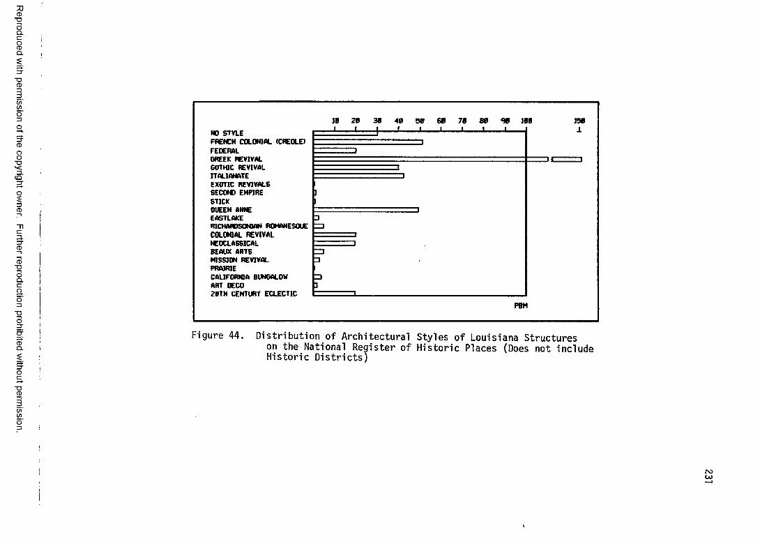
Reproduced
with perm
ission of the
copyright ow
ner. Further
reproduction prohibited
without
permission.
HO STYLEFRENCH COLONIAL (CREOLE)FEDERALGREEK REVIVALGOTHIC REVIVALITALIANATEEXOTIC REVIVALS6EC0W EMPIRESTICKOUEEN AWE EASTLAKERICHARDSONIAN ROMANESQUECOLONIAL REVIVALNEOCLASSICALBEAUX ARTSMISSION REVIVALPRAIRIECALIFORNIA BUNGALOW ART OECO2BTH CENTURY ECLECTIC
PBM
F i gu re 44. D i s t r i b u t i o n o f Ar ch it e c t u r a l S t yl es o f L o u i s i a n a S t ru ctu re son the National R e g i s t e r o f H i s t o r i c Places (Does not i n cl ude H i s t o r i c Distric ts )
POCO
v
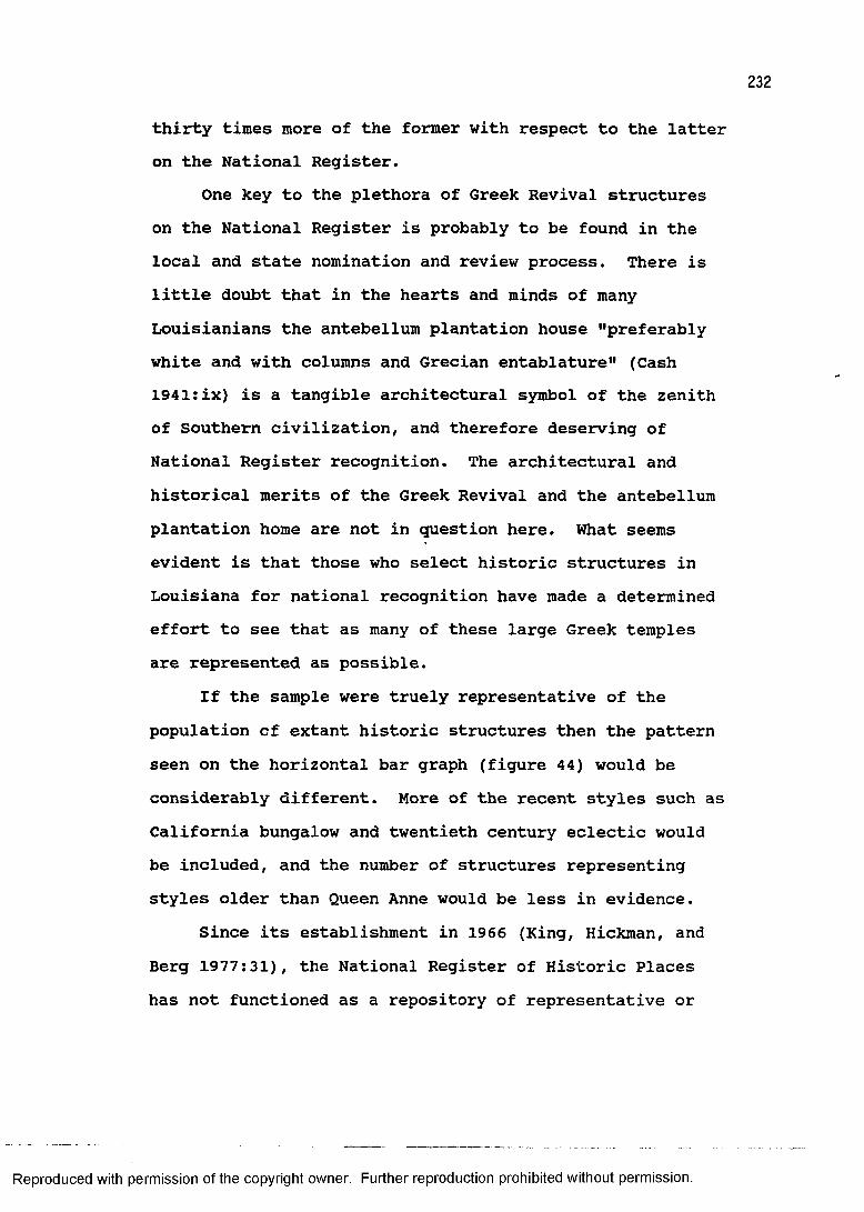
thirty times more of the former with respect to the latter on the National Register.
One key to the plethora of Greek Revival structures on the National Register is probably to be found in the local and state nomination and review process. There is little doubt that in the hearts and minds of many Louisianians the antebellum plantation house "preferably white and with columns and Grecian entablature" (Cash 1941:ix) is a tangible architectural symbol of the zenith of Southern civilization, and therefore deserving of National Register recognition. The architectural and historical merits of the Greek Revival and the antebellum plantation home are not in question here. What seems evident is that those who select historic structures in Louisiana for national recognition have made a determined effort to see that as many of these large Greek temples are represented as possible.
If the sample were truely representative of the population of extant historic structures then the pattern seen on the horizontal bar graph (figure 44) would be considerably different. More of the recent styles such as California bungalow and twentieth century eclectic would be included, and the number of structures representing styles older than Queen Anne would be less in evidence.
Since its establishment in 1966 (King, Hickman, and Berg 1977:31), the National Register of Historic Places has not functioned as a repository of representative or
Reproduced with permission of the copyright owner. Further reproduction prohibited without permission.
233
ordinary historic (and prehistoric) cultural resources, although there are criteria for eligibility that are sufficiently broad so as conceivably to apply to any site or structure. In practice, the National Register's listing of historic structures has tended to concentrate on the more "high style" examples. This tendency, therefore, partially explains the dominance of Louisiana's Greek Revival architecture on a nationally recognized scale.
Understanding the biases of National Register listing, it is now possible to examine the bar graph of architectural styles (figure 44) in other ways. The desire to identify structures of the popular antebellum Greek Revival style can be interpreted, in part, as a way of celebrating a period of prosperity. By extension, therefore, the relative abundance of buildings with architectural style can conceivably be correlated with the state's economy. This hypothesis has already been put forth to account for the lack of National Register structures dating to the Civil War and Reconstruction period. The sensitivity of architectural styles to economic conditions combined with the temporal parameters of each style results in a unique barometer of the economic history of Louisiana.
Architectural style plotted cartographically can reveal areal differentiation. Historical geographers have identified initial occupance and the dominance of
Reproduced with permission of the copyright owner. Further reproduction prohibited without permission.
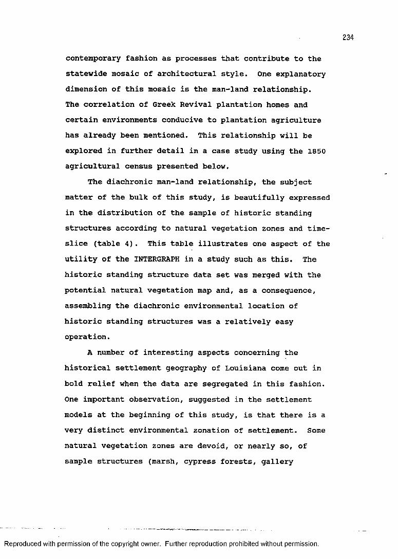
234
contemporary fashion as processes that contribute to the statewide mosaic of architectural style. One explanatory dimension of this mosaic is the man-land relationship.The correlation of Greek Revival plantation homes and certain environments conducive to plantation agriculture has already been mentioned. This relationship will be explored in further detail in a case study using the 1850 agricultural census presented below.
The diachronic man-land relationship, the subject matter of the bulk of this study, is beautifully expressed in the distribution of the sample of historic standing structures according to natural vegetation zones and time- slice (table 4). This table illustrates one aspect of the utility of the INTERGRAPH in a study such as this. The historic standing structure data set was merged with the potential natural vegetation map and, as a consequence, assembling the diachronic environmental location of historic standing structures was a relatively easy operation.
A number of interesting aspects concerning the historical settlement geography of Louisiana come out in bold relief when the data are segregated in this fashion.One important observation, suggested in the settlement models at the beginning of this study, is that there is a very distinct environmental zonation of settlement. Some natural vegetation zones are devoid, or nearly so, of sample structures (marsh, cypress forests, gallery
Reproduced with permission of the copyright owner. Further reproduction prohibited without permission.

235
TABLE 4: DISTRIBUTION OF SAMPLE STRUCTURESACCORDING TO NATURAL VEGETATION AND TIME-SLICE
1 1 1 1 1 1 17 7 8 8 8 8 84 7 1 3 5 7 90 5 0 0 0 0 0
ShortleafPine 1 11 14 7 17ForestsLongleafPine 2 1 5 1 23ForestsBottomlandHardwoods
UplandHardwoods 6 13 18 16 3 21
Flatwoods1 2 18
Prairie1 1 9 6 5 18
GalleryForests 3
CypressForests 1
Bottomlands1 17 20 61 108 42 85
Marsh
Reproduced with permission of the copyright owner. Further reproduction prohibited without permission.
236
forests, and bottomland hardwoods). In the case of the gallery forests and the bottomland hardwoods, these thin ribbons of mainly deciduous trees that line many of the tributary streams west of ninety-two degrees longitude, it was suggested that settlement located adjacent to rather than within these vegetation types.
It was also explicitly stated in the settlement models that the marsh and cypress forests were avoided as places of actual settlement, although their resources were certainly exploited (Comeaux 1969, 1972). Table 4 confirms this hypothesis in so far as there are no structures in the sample located in marsh and only one located in the cypress forests. The one major exception to this general rule of settlement site selection according to vegetation zones is in the intensively occupied Orleans Parish where areas that are classified as potential cypress forests were converted into habitable areas through intensive human intervention. (The location of the single site in potential cypress forests is along Bayou St. John at its outlet into Lake Ponchartrain in Orleans Parish.)
Having examined the environments where settlement did not occur according to the sample, it is clear that some of the natural vegetation zones in the state were recipients of considerable settlement. The most outstanding example of the clustering of the historic standing structure sample within a single natural
Reproduced with permission of the copyright owner. Further reproduction prohibited without permission.
237
vegetation zone is seen in the distribution of structures in the bottomlands. This pattern should come as no surprise, having repeatedly mentioned the importance of the natural levee location throughout this study. In fact, nearly sixty percent of all the structures in the entire sample are in the bottomlands.
Another important characteristic of the structures in the bottomlands as seen in table 4 is their distribution through time. The bottomlands, or natural levee forests, were early on an important locus of settlement and continued to be throughout the period of study. Notice, particularly, the peak at 1850 which was created in large measure by antebellum plantation homes that were built around this time on bottomlands plantations.
The upland hardwoods of the western Florida Parishes are another area of consistent settlement. Although not nearly as important as the natural levee bottomlands, according to the sample's distribution, the upland hardwoods, or blufflands, contain about fourteen percent of the sample structures. These are fairly well distributed across the time-slices with the exception of the earliest. Also, as with the bottomlands, the nadir of building during the Civil War and Reconstruction is especially apparent in this environment.
Two final environments, the piney woods and the prairie, have similar distributions. Sample structures in the piney woods environments (the shortleaf and longleaf
Reproduced with permission of the copyright owner. Further reproduction prohibited without permission.
pine forests and the flatwoods) are generally clustered in the latter half of the nineteenth century. This is particularly true of structures in the longleaf pine forests and flatwoods, where it is not until the railroad and lumber boom of 1890 that any appreciable number of structures appear in these environments. The same is true for the prairie, although to a lesser extent. This is consistent with the settlement model of the statehood period.
The final sorting of the historic standing structure data is probably the most fascinating from the standpoint of settlement prediction. The importance of colonial land claims as artifacts of settlement and indices of land that was deemed suitable for habitation in the eighteenth and early nineteenth centuries has been mentioned throughout this study. The reason for introducing this component of the cultural landscape is its profound utility for historic preservation. It was suggested that Louisiana's oldest historic sites and structures would be located within colonial land claims. Table 5 confirms it.
Once again, through the marvels of the INTERGRAPH, the sample of historic standing structures was sorted according to time-slice categories and as to whether an individual structure was within or outside of a colonial land claim. Table 5 clearly shows that of the sixty-three structures that belong to the colonial and territorial periods, sixty-one (or 97%) were within colonial land
Reproduced with permission of the copyright owner. Further reproduction prohibited without permission.
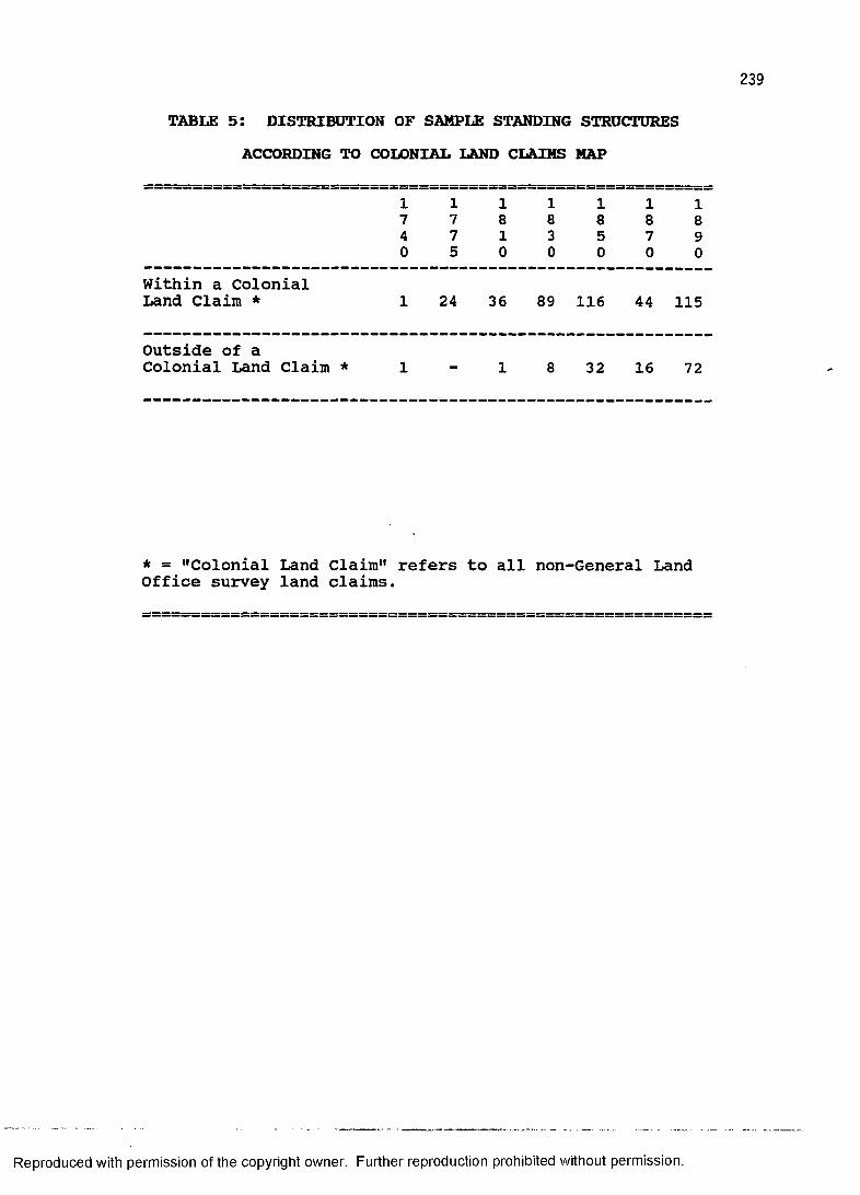
TABLE 5: DISTRIBUTION OF SAMPLE STANDING STRUCTURESACCORDING TO COLONIAL LAND CLAIMS MAP
1 1 1 1 1 1 17 7 8 8 8 8 84 7 1 3 5 7 90 5 0 0 0 0 0
Within a ColonialLand Claim * 1 24 36 89 116 44 115
Outside of aColonial Land Claim * 1 1 8 32 16 72
* = "Colonial Land Claim" refers to all non-General Land Office survey land claims.
Reproduced with permission of the copyright owner. Further reproduction prohibited without permission.
240
claims. The two deviants are the site of the Presidio de Los Adaes that was not given a French Colonial land grant and a single-pen house in Washington Parish (which is actually within half of a kilometer of a colonial land claim). Discounting the Spanish site of Los Adaes and the Washington Parish squatter, the results highlight the degree to which these colonial land claims mirror historic settlement.
If the comparison between structures within and outside of colonial land claims is extended to include the 1830 structures the results are just as impressive. Out of the 160 structures in these four time-slices only ten are not within a colonial land claim. Extrapolating from the sample's distribution to a statewide pattern it appears that even as late as the early period of availability of United States General Land Office township-and-range parcels in Louisiana (roughly 1830) ninety-four percent of the structures were still located on land that had been claimed during colonial times.
A further observation of the distribution of the sample according to colonial land claims is that, expressed differently, the growth of Louisiana outside of the old colonial core can be seen clearly in the final three time-slices. This is particularly true for the structures dating to the railroad and lumber boom period (1890) where sixty-three percent are outside of the old colonial core area.
Reproduced with permission of the copyright owner. Further reproduction prohibited without permission.
The relationship between colonial land claims, historic structures, and natural vegetation is explored below in a case study. Terrebonne Parish, Louisiana is an excellent example of the interrelationship between the variables that this study has isolated for examination.
TWO CASE STUDIES:The following two case studies are presented as a
demonstration of how the variables selected in this study articulate into a coherent whole in actual research situations. They stress the importance of the potential natural vegetation data set for settlement and subsistence. The Terrebonne Parish example also serves as a close-up examination of how the colonial land claims "fit," or overlay, with the physical geography of the study area. The 1850 agricultural census case study vividly illustrates the divide between the plantation area and the upland farming area by means of critical examination of historical census data. This information has obvious architectural implications (plantation homes are found in areas where people engaged in plantation agriculture).
The assumptions and hypotheses put forth in the case studies are further put to the test by showing how the pattern outlined is corroborated by the sample of historic standing structures. For example, in the Terrebonne Parish case study, statements in the literature about settlement in the parish are reiterated (people lived on
Reproduced with permission of the copyright owner. Further reproduction prohibited without permission.
242
the natural levee). Then, the testimony of the cadastral survey is employed to determine whether the above statement is correct (people claimed land on the natural levee to the exclusion of other environments). Finally, the expectation that historic standing structures should be located within the land claims in this environment (people built houses on the natural levee) is examined.
The reasoning behind the procedures used in these two case studies is the raison d'etre of the dissertation itself. It is an excercise in deduction in terms of the man-land relationship, going from the general, such as broad vegetation zones and what is known about historic settlement processes, to the specific represented by individual structures. A stated goal of this entire study is its application to the field of historic preservation.What is presented below should convincingly demonstrate that individual historic structures, however humble or grand, were part of much larger and more complex world.For those of us who study the past through material culture, historical geography is indispensable.
SETTLEMENT AND NATURAL VEGETATION:THE EXAMPLE OF TERREBONNE PARISH
Terrebonne Parish (figure 45) provides an excellent example of the relationship between cadastral survey and natural vegetation. The assumption is that the private land claim, in this case claims made under the Spanish Colonial administration of Louisiana just prior to the
Reproduced with permission of the copyright owner. Further reproduction prohibited without permission.
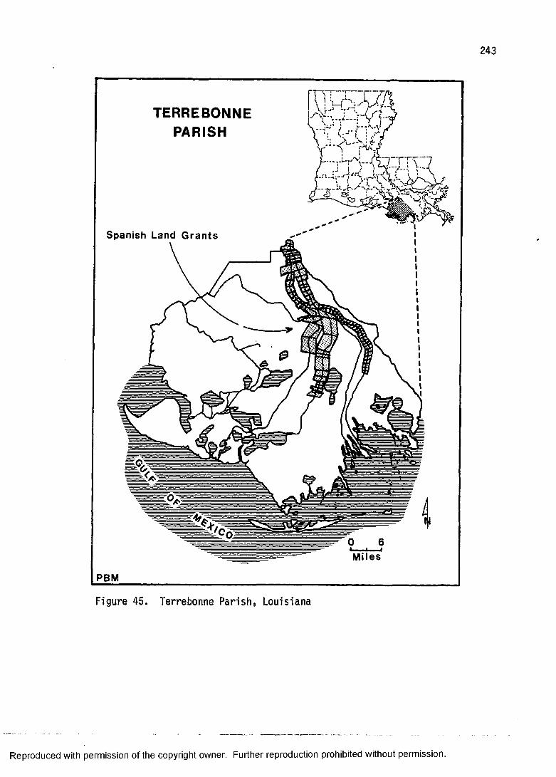
243
TERREBONNEPARISH
Spanish Land Grants
Miles
PBM
Figure 45. T e r r e b o n n e Parish, Louisiana
Reproduced with permission of the copyright owner. Further reproduction prohibited without permission.
244
Louisiana Purchase, represents land that was deemed the most desireable for settlement out of the total land available.
The land of South Lousiana is a mosiac of vegetation types. Settlement of the area, however, has displayed a clear preference for the higher natural levee forests.This portion of the study focuses on the specific environmental setting of fifty-nine private land claims, amounting to 331 square kilometers of land, to evaluate the historic man-land relationship in Louisiana's largest parish.
Few people lived in what is today Terrebonne Parish prior to the Spanish Colonial era beginning in 1763.Although an appendage of Lafourche Parish, which was the locus of early and dense French settlement, Terrebonne Parish was apparently only sparsely occupied by ephemeral camps of hunters, trappers, and fishermen. Pirates found that the labyrinth of coastal bays and bayous conveniently and effectively concealed their hideouts; what Watkins (1939:28) calls their HPied-a-terre.11
The Houma Indians moved into the parish in the early years of the Spanish regime after a circuitous series of settlements that include West Feliciana Parish, Orleans Parish along Bayou St. John, and Lafourche Parish (Swanton 1911:290). According to Swanton (1911:292), three Houma families remained in the area and took French surnames of Couteaux, Billiot, and Verdine. A number of them
Reproduced with permission of the copyright owner. Further reproduction prohibited without permission.
245
successfully obtained grants of land along Bayou Derbonne (later Terrebonne) from the Spanish Governor Miro. These same grants were later confirmed by the United States Congress (American State Papers, Public Lands,1834(11):432) .
White settlers intent on making the land of lower Lafourche Interior (Terrebonne Parish) their home, like the sluggish bayous, trickled slowly gulfward. Bayou Terrebonne provided the link with the settled area along Bayou Lafourche. It and the bayous du Large, Black, Grand Caillou, and Little Caillou were the threads along which land occupance crystalized.
The evidence for the timing of actual settlement comes mainly in the form of cadastral survey. Contrary to earlier assessments of the nature of cadastral survey in Terrebonne Parish (Hall 1970, Knipmeyer 1956, Taylor 1950), this study reveals that surprisingly Terrebonne Parish does not contain a single land grant attributable to French long lot survey. This French long lot survey, as mentioned earlier, is characterized by the French long lot, or arpent, system. One of the most vivid examples of the arpent system's imprint on the Louisiana landscape can be seen in the adjacent parish of Lafourche along Bayou Lafourche. Instead, all private claims presented before the Register, Eastern District of Louisiana, General Land Office of the United States (American State Papers, Public Lands II, III, V, VII) date to the period of Spanish
Reproduced with permission of the copyright owner. Further reproduction prohibited without permission.
Louisiana. The earliest land grant in the parish with an order of survey and later confirmed by the United States Congress dates to May 5, 1775. This was made under the administration of Governor Galvez (American State Papers, Public Lands 1834(II):581).
Most private claims, however, were not accompanied by signed and dated documents such as complete patents or orders of survey (Poret 1972:30). Their confirmation by the United States Congress, upon the recommendation of the Register, is an example of largesse which served to encourage settlement and promote good will. The only stipulations, apparently, were that the claimant demonstrate actual occupancy prior to the Louisiana Purchase or some other form of testimony, and that the claim not exceed six hundred and forty acres.
The difficulty in dating private claims in Terrebonne Parish is underscored by General Land Office Register's records and recommendations (American State Papers, Public Lands 1834(11), III). Of the fifty-nine private claims from the documents cited above, fifty-one lack dated documentation in support of the claim. Except for the earliest claim dated 1775, the remainder date to the 1790s (four from 1794, one from 1795, and two from 1798) . From the evidence of private land claims, therefore, it seems reasonable to conclude that Terrebonne Parish was not settled to any great extent until late in the Spanish Colonial period.
Reproduced with permission of the copyright owner. Further reproduction prohibited without permission.
247
In support of the argument that Terrebonne Parish did not participate in the French long lot survey system, one merely has to examine the configuration of private claims.One striking difference is that all private claims in the parish are situated astride one of the five streams mentioned above. This is a flagrant deviation from the French arpent system where land claims fronted, but did not cross, waterways. It is, however, consistent with Spanish Colonial cadastral survey.
Further, these claims are generally square, rectangular, or trapezoidal in shape. In fact, five large claims are clearly Spanish sitios with the characteristic measurements of one league (three mile) sides. The unquestionable distinction between the French arpent system and the Terrebonne Parish claims can be seen clearly in the plat of Township 15 south, Range 16 east (State Land Office, Baton Rouge).
Numerous statements have been put forth concerning the settlement of South Louisiana in general and Terrebonne Parish in particular. Most of them are made by non-geographers and range from naive and general to fallacious. In terms of generating a model of vegetation type as a settlement selection variable, some of these statements are of little analytical value. In the case of a history of Terrebonne Parish, the author mingles useful fact with embellished romantic vision. "One could live easily off the fat of the land and water, and with a
Reproduced with permission of the copyright owner. Further reproduction prohibited without permission.
little tilling of the wonderfully fertile soil he couldverily say he was in the land of plenty" (Watkins1939:19). This is merely a native's pride in herhomeland. But, how many times have we read someone waxingeloquently about the land of their birth as a Garden ofEden or land of milk and honey? Fortunately, Watkins didnot resort to hyperbole when discussing the environmentand settlement of Terrebonne Parish. She discussed thenatural levee forests, swamp forests, and marsh, andcorrectly isolated the natural levee as the locus ofhabitation (Watkins 1939:12):
Except for the islands the immigrants could not live along the coast for fifteen or twenty miles inland, for the region was made up mostly of marsh, trembling and floating prairies, and bottomless or wooded swamps. Farther inland and in some of the more elevated sections between the bayous were open prairies used as grazing land during dry weather. Only along the streams and in the northern part of the parish was the land elevated several feet above sea level.Watkins (1939:19-21) continued:Both sides of the bayous were covered with heavy timber and canebrakes extending back to the prairies. On the high lands, covering from five to forty arpents in depth according to elevation, abounded the ash, elm, gum, sycamore, pecan, mulberry, and live oak. Also common were the willow, locust, maple, magnolia, elder sassafras, and persimon. The great extent of swamps gave invaluable building material in the form of the cypress tree.Knipmeyer (1956:12) effectively illustrated the
natural levee in the context of swamp, marsh, and withsettlement. According to Knipmeyer (1956:12),
virtually all settlements are on natural levees, as those are the only features that provide
Reproduced with permission of the copyright owner. Further reproduction prohibited without permission.
249
enough high ground. . . . The width of the levee places certain positive restrictions on the amount of land that might be cultivated, and in some places there is none after the dwellings have been built.
High ground suitable for cultivation, therefore, isidentified as the preferred settlement environment. Thisis synonymous with the natural levee forests. "The areassuited to crops are on the low natural levee ridges in thenorthern and eastern parts of the parish" (U.S.D.A.1960:2).
Transportation has also been identified as animportant settlement variable. "Due to the natural low,swampy features of the terrain of Terrebonne Parish,transportation and communication constituted a majorproblem during the early days of settlement" (TerrebonneParish Development Board n.d.:9). This is the oftrepeated story of the bayous of South Louisianaconstituting the highways and biways of the area (see, forexample, Kane 1943) . Transportation has been, untilrecently, a real problem in the marsh particularly (Detro1978). The Terrebonne Parish Development Board (n.d.:9)reitterated the early importance of the waterways.
As in the early days of the parish these numerous waterways were used as a principal means of communication and travel, settlements and plantations came into being along the bayous.To recapitulate, the three broad vegetation types
have three grades of utility for the settler. The natural levee forests offered maximum opportunity in terms of
Reproduced with permission of the copyright owner. Further reproduction prohibited without permission.
250
dwelling site, agricultural potential, and transportation. The cypress forests had an intermediate utility to the early settler. Its importance seems to have been derived mainly from the source of a favored building material (cypress) and as a sort of game preserve. The marsh was generally avoided except for trapping activity. The deterrents of the marsh were (and, to a large extent, still are) difficult transportation, continuously wet, no firm soil, differing degrees of salt water, and finally a certain vulnerability to hazardous weather events. Therefore, a prediction of historic settlement in Terrebonne Parish is possible given a knowledge of the settlers' occupational preferences (economy, dwellings, level of technology, etc.) and the available natural vegetation.
In terms of quantity of each natural vegetation type in Terrebonne Parish, one fact stands out boldly, the marsh dominates. There are 3,837 square kilometers of land in Terrebonne Parish. The marsh makes up 79 percent of the total land area with 3,038 square kilometers. The remaining 21 percent is composed of bottomland hardwoods and cypress forests, with 521 and 278 square kilometers respectively. The natural levee forests (bottomland hardwoods) and cypress forests are confined to the northern and eastern portions of the parish. The offshore islands and coast are exclusively marsh.
Reproduced with permission of the copyright owner. Further reproduction prohibited without permission.

251
Although the natural vegetation map in this study (figure 7) merges different marsh types into one broad vegetative category, the specific analysis of the historic settelement of Terrebonne Parish identifies four distinct marsh types: 1) fresh marsh, 2) intermediate marsh, 3)brackish marsh, and 4) saline marsh. This marsh typology is based on Chabreck and Linscombe's (1978) Vegetative Type Map of the Louisiana Coastal Marshes. In terms of area within Terrebonne Parish, these four marsh types constitute 978, 336, 733, and 991 square kilometers respectively. As stated in the physical setting chapter, the critical differences among the four types is the degree of salinity and species tolerences.
Using the testimony of the cadastral survey as an expression of land preferences, the private claims made under the Spanish were overlaid with the natural vegetation map. The INTERGRAPH combined the resulting polygons and calculated areas within each vegetation type. The frequency bar chart (figure 46) shows the amount of Spanish land grants within each vegetation type in square kilometers. A few conclusions about the distribution can be briefly stated. One important one is that although the natural levee forests and cypress forests make up only twenty-one percent of the total land area, 84.4 percent of the area of Spanish private land claims fall within these vegetation types (figure 47). Expressed differently, only 15.6 percent of the area of Spanish private land claims
Reproduced with permission of the copyright owner. Further reproduction prohibited without permission.
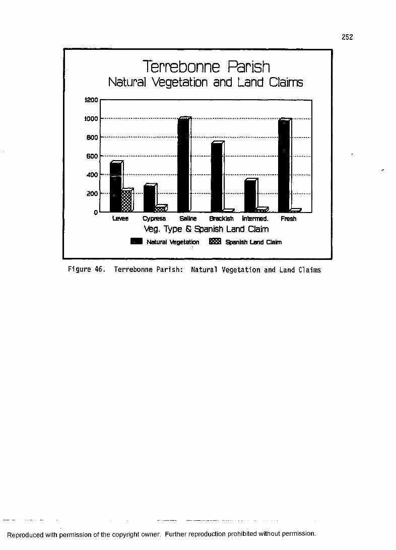
Terrebonne ParishNatural Vegetation and Land Claims
1200
Levee Cypress Saline Brackish lntermed. FreshVteg. Type £ Spanish Land ClaimI Natural Vegetation 628 Spanish Land Claim
Figu re 46. T e r r e b o n n e Parish: Natural Ve g e t a t i o n and Land Claims
Reproduced with permission of the copyright owner. Further reproduction prohibited without permission.
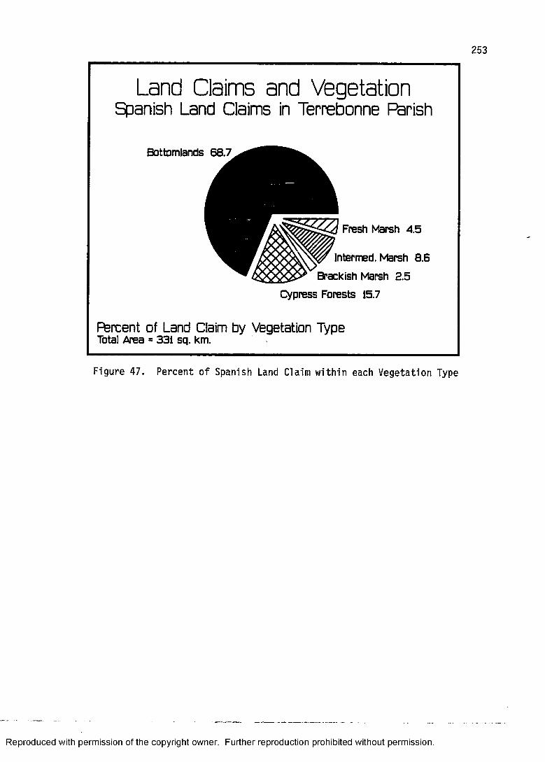
Land Claims and VegetationSpanish Land Claims in Terrebonne Parish
Bottomlands 68.7
Fresh Marsh 4.5
Intermed. Marsh 8.6 Brackish Marsh 2.5
Cypress Forests 15.7
Percent of Land Claim by Vegetation TypeTotal Area = 331 sq. km.
Figure 47. Perc ent o f Spanish Land Claim w i th in each V e g e t a t i o n T y pe
Reproduced with permission of the copyright owner. Further reproduction prohibited without permission.
254
fall within the marsh zones which make up seventy-nine percent of the total land area of the parish. A further observation is that nearly seventy percent of the area of Spanish private claims fall within the natural levee forests.
The interpretation given here is that the land claims are centered on the natural levee and extend off into either swamp or marsh. The high incidence of land claimed in the cypress forest is a consequence of the physiography of the area; the natural levee drops off into the swamp.
At least five of the grants are sitios with three miles on a side, but since they are not perfect squares they contain something less than nine square miles. The point here is that when the land grant is of this dimension it is, in this environment, inevitable that it encompass more than the preferred natural levee vegetation.
An important distinction that this research brings out is that the simple assumed correlation between South Louisiana settlement and waterways is not so simple. The fact that the private claims stop shortly below the ecotone between natural levee forest and marsh leads to the conclusion that somehow a barrier to contiguous settlement had been reached. In fact, one might speculate that the appearance of a slight penetration into the marsh could be the result of land subsidence. It may well be that these claims were made back in the late eighteenth
Reproduced with permission of the copyright owner. Further reproduction prohibited without permission.
255
century when the land contained natural levee vegetation and not the marsh that is indicated on the map today.
The utility of plotting cadastral survey onto natural vegetation rather than simply plotting it against the local waterways, as many people have done in the past (e.g., Watkins 1939:12a), brings out this distinction clearly. Simply looking at private land claims and waterways goes nowhere in answering the question "well, why did they stop there and not claim land all the way down the bayou to the coast?"
The preceding discussion of the historic settlement of Terrebonne Parish has demonstrated that colonial land claims undeniably focus on the natural levee bottomlands forest. To what extent do historic structures conform to this pattern? Clearly, if our ideas about the settlement implications of both natural vegetation and cadastral survey are valid, then we should expect that the historic structures, the older ones at least, be located within the bottomlands forest and within the colonial land claims.
As it turns out, of the twenty-two structures in the statewide sample that are from Terrebonne Parish, all are located on the natural levee in the bottomlands forest.All but three are within colonial land claims. The three that are outside of colonial claims are located within American long lots and date to 1845, 1849, and 1850 respectively.
Reproduced with permission of the copyright owner. Further reproduction prohibited without permission.
256
Unfortunately, there are no structures in the sample that actually date to the colonial period, but as the historic record indicates, the parish was apparently in the period of initial occupance (by Europeans) at the time of the Louisiana Purchase. The range of the dates of construction of the sample structures is between 1834 and 1904. Nevertheless, as has been demonstrated considering the state as a whole, there is every reason to believe that the earliest sites of historic settlement in the parish (which may exist only as part of the archaeological record) are located within the colonial land claims.
This case study of settlement in Terrebonne Parish is encouraging from the standpoint of "predicting the past."Although the bottomlands forest makes up only thirteen percent of the total land area in the parish, it contains seventy percent of the area that constitutes colonial land claims. All twenty-two sample structures are within a zone of bottomlands vegetation. Further, although they do not date to the colonial period, eighty-six percent of the sample structures are within colonial land claims. The pattern is clear; one need not search the entire parish for evidence of historic habitation.
PLANTERS AND FARMERS: SPATIAL PATTERNS OFTHE 1850 AGRICULTURAL CENSUS
The assumption that an important historical distinction existed between planter and farmer is examined using the 1850 agricultural census for a portion of
Reproduced with permission of the copyright owner. Further reproduction prohibited without permission.

Louisiana. This distinction, mentioned previously in the 1850 time-slice, has obvious architectural implications; the planters were the builders of the celebrated antebellum plantation homes. Farmers lived in more modest dwellings. It is expected that plantation homes dating to the 1850s be located in areas that engaged in plantation agriculture according to the 1850 agricultural census. These areas should correspond to the potential natural vegetation zones that most used for plantation agriculture as identified in the 1850 time-slice.
This test case examines a sample of the 1850 agricultural census for nine parishes (figure 48). These parishes are aligned in an east-west swath between the Pearl River and Vermilion Bay, and consist of most of the parishes on the Baton Rouge 1:250,000 map. The sample parishes are St. Martin, Iberville, Ascension, West Baton Rouge, East Baton Rouge, St. Helena, Livingston, Washington, and St. Tammany. Modern Tangipahoa Parish is included, but this political unit did not exist in 1850 (figure 28).
The distinction between alluvial valley and uplands neatly characterizes the environments within the research area at a gross level. The parishes, although contiguous, are environmentally heterogeneous. Generally speaking, the western portion of the research area is characterized by the Mississippi alluvial valley environment and the
Reproduced with permission of the copyright owner. Further reproduction prohibited without permission.

1850 AGRICULTURAL CENSUS SAMPLE AREA
PBM Figure 48.
Reproduced with permission of the copyright owner. Further reproduction prohibited without permission.
eastern portion is characterized by the upland terraces of the Florida Parishes.
The parishes that are referred to here as uplands, or piney woods, and that are distant from the Mississippi alluvial valley are the four easternmost, St. Helena, Livingston, Washington, and St. Tammany. The majority of East Baton Rouge Parish is physiographically and vegetatively associated with the uplands, but its more fertile loess soil and proximity to the Mississippi alluvial valley suggest that it should more closely align itself to the plantation region of the alluvial valley.The other parishes in the research area, Ascension, West Baton Rouge, Iberville, and St. Martin are primarily alluvial valley parishes, and should, therefore, be more devoted to plantation agriculture.
This distinction between alluvial valley and piney woods can be seen clearly by referring to the Potential Natural Vegetation Map (figure 7). The western half of the research area is overwhelmingly cypress forests and bottomlands. A small amount of prairie is found in St. Martin Parish on the western extreme of the research area. The eastern half is itself environmentally diverse, but longleaf pine forests, flatwoods, and upland hardwoods predominate. Thin ribbons of bottomlands correspond to the major river drainages. A small prairie also exists in the northwest portion of East Baton Rouge Parish.
Reproduced with permission of the copyright owner. Further reproduction prohibited without permission.
The data set consists of a total of 606 entries (individuals) from the 1850 federal agricultural census of Louisiana. The sample was compiled and transferred to keypunch cards by Dr. Sam B. Hilliard of Louisiana State University. Hilliard encoded the first ten names on each page of the census schedule. This amounts to roughly a twenty-four percent sample of the entire agricultural census for the research area. The specific number of sample entries according to parish is as follows: St.Martin (109), Iberville (49), West Baton Rouge (50), Ascension (40), East Baton Rouge (90), Livingston (80),St. Helena (78), Washington (70), and St. Tammany (40)
The variables listed can be partitioned into three separate categories: 1) land, 2) livestock, and 3) crops.For each of the 606 individuals in the data set, returns are given for improved land, unimproved land, horses, mules, milk cows, oxen, other cattle, sheep, swine, wheat, corn, oats, rice, cotton, peas and beans, sweet potatoes, and sugar.
The hypotheses that are tested using these data relate to the dichotomy of alluvial valley and uplands.It is assumed that these two broadly defined environments correspond to two types of agricultural production, plantation and subsistence. Plantation agriculture is composed of large tracts of land, an emphasis on the cultivation of a single cash crop, and involves a large investment in labor and equipment. Subsistence
Reproduced with permission of the copyright owner. Further reproduction prohibited without permission.
261
agriculture is actually a misleading term for a small- scale, mixed agricultural economy. Although cash crops are often involved, there is an emphasis on agricultural diversity and local consumption. The size of land devoted to agricultural production is relatively small as a result of the limitations of capital, labor, and resources.
Based upon these distinctions, it is expected that the agricultural census data will reveal a spatial pattern reflecting these two agricultural types. The following hypotheses make explicit the expected distinctions: 1)the alluvial valley will have larger units of land devoted to agricultural production than will the uplands, 2) the agriculture in the alluvial valley will follow a pattern of cash crop cultivation, while that in the uplands will follow a pattern of mixed farming, and 3) the more substantial and ornate houses will tend to be associated with areas where plantation agriculture is practiced.
The quantitative analysis of the data was limited to univariate and bivariate S.A.S. procedures. The data set was examined in two ways, as a whole and separately by parish. Descriptive statistics such as number, mean, standard deviation, minimum value, maximum value, and sum were generated. Bivariate relationships were examined through crossplots and correlation coefficients.
By comparing histograms of the same variable for each parish, an initial sense of spatial patterning was achieved. For example, the histogram for sugar in the
Reproduced with permission of the copyright owner. Further reproduction prohibited without permission.
262
alluvial valley had good distributions, while those for the uplands were virtually absent. In fact, of the 269 fanners in St. Helena, Washington, Livingston, and St.Tammany parishes, only one farmer produced sugar!
By comparing histograms of different variables within the same parish, an initial sense of correlation between variables was achieved. For example, the histograms for mules and sugar in Iberville Parish displayed similar distributions suggesting covariance.
After screening univariate relationships, a number of combinations of variables seemed to require additional investigation. The bivariate methods of crossplots and correlation coefficients were then applied to the more promising variables. The distinction between the two is that crossplot is a visual display of the relationship between two variables, while the correlation coefficient is a statistical measure of association.
Tables 6 through 14 display the descriptive statistics for each of the parishes in the research area.The number, mean, standard deviation, minimum value, maximum value, and sum are given for each of the variables. In an effort to characterize the agricultural production of each parish the mean is examined. However, a caveat as to the potential deceptiveness of basing conclusions on this single statistic is in order. The arithmetic mean, or the sum of values divided by the total number of observations, is one of the most important
Reproduced with permission of the copyright owner. Further reproduction prohibited without permission.
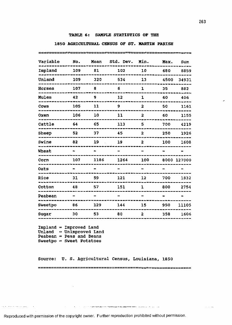
263
TABLE 6: SAMPLE STATISTICS OF THE1850 AGRICULTURAL CENSUS OF ST. MARTIN PARISH
Variable No. Mean Std. Dev. Min. Max. SumImpland 109 81 102 10 680 8859Unland 109 320 534 13 4500 34931Horses 107 8 6 1 35 882Mules 42 9 12 1 60 406Cows 105 11 9 2 50 1161Oxen 106 10 11 2 60 1155Cattle 64 65 113 5 700 4219Sheep 52 37 45 2 250 1926Swine 82 19 19 2 100 1608Wheat - - - - - -
Corn 107 1186 1264 100 8000 127000Oats - - - - - -
Rice 31 59 121 12 700 1832Cotton 48 57 151 1 800 2754Peabean - - - - - -
Sweetpo 86 129 144 15 950 11105Sugar 30 53 80 2 358 1606
Impland = Improved Land Unland = Unimproved Land Peabean = Peas and Beans Sweetpo = Sweet Potatoes
Source: U. S. Agricultural Census, Louisiana, 1850
Reproduced with permission of the copyright owner. Further reproduction prohibited without permission.
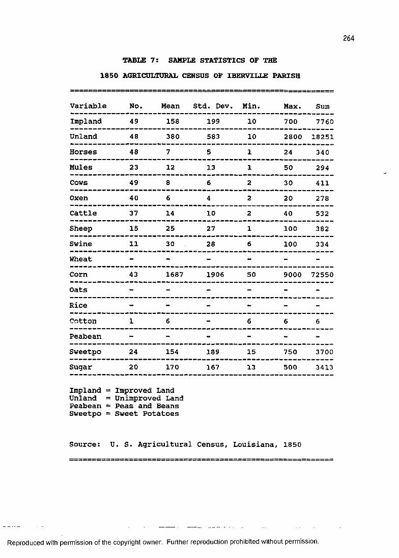
264
TABLE 7: SAMPLE STATISTICS OF THE1850 AGRICULTURAL CENSUS OF IBERVILLE PARISH
Variable No. Mean Std. Dev.. Min. Max. SumImpland 49 158 199 10 700 7760Unland 48 380 583 10 2800 18251Horses 48 7 5 1 24 340Mules 23 12 13 1 50 294Cows 49 8 6 2 30 411Oxen 40 6 4 2 20 278Cattle 37 14 10 2 40 532Sheep 15 25 27 1 100 382Swine 11 30 28 6 100 334Wheat - - - - - -
Corn 43 1687 1906 50 9000 72550Oats - - - - - -
Rice - - - - - -
Cotton 1 6 - 6 6 6Peabean - - - - - -
Sweetpo 24 154 189 15 750 3700Sugar 20 170 167 13 500 3413
Impland = Unland = Peabean = Sweetpo =
Improved Land Unimproved Land Peas and Beans Sweet Potatoes
Source: U. S. Agricultural Census, Louisiana, 1850
Reproduced with permission of the copyright owner. Further reproduction prohibited without permission.
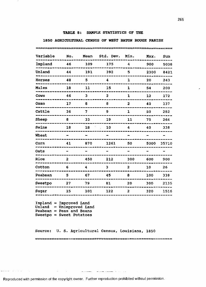
265
TABLE 8: SAMPLE STATISTICS OF THE1850 AGRICULTURAL CENSUS OF WEST BATON ROUGE PARISH
Variable No. Mean Std. Dev. Min. Max. SumImpland 46 109 175 4 900 5038Unland 44 191 392 5 2300 8421Horses 48 5 4 1 20 243Mules 18 11 15 1 54 200Cows 46 3 2 1 12 172Oxen 17 8 8 2 40 137Cattle 36 7 9 1 50 282Sheep 8 33 19 11 75 264Swine 18 18 10 4 40 338Wheat - - - - - -
Corn 41 870 1261 50 5000 35710Oats - - - - - -Rice 2 450 212 300 600 900Cotton 6 4 3 2 10 26Peabean 5 67 45 8 100 338Sweetpo 27 79 81 20 300 2135Sugar 15 101 122 2 320 1516
Impland = Improved LandUnland = Unimproved Land Peabean = Peas and Beans Sweetpo = Sweet Potatoes
Source: U. S. Agricultural Census, Louisiana, 1850
Reproduced with permission of the copyright owner. Further reproduction prohibited without permission.
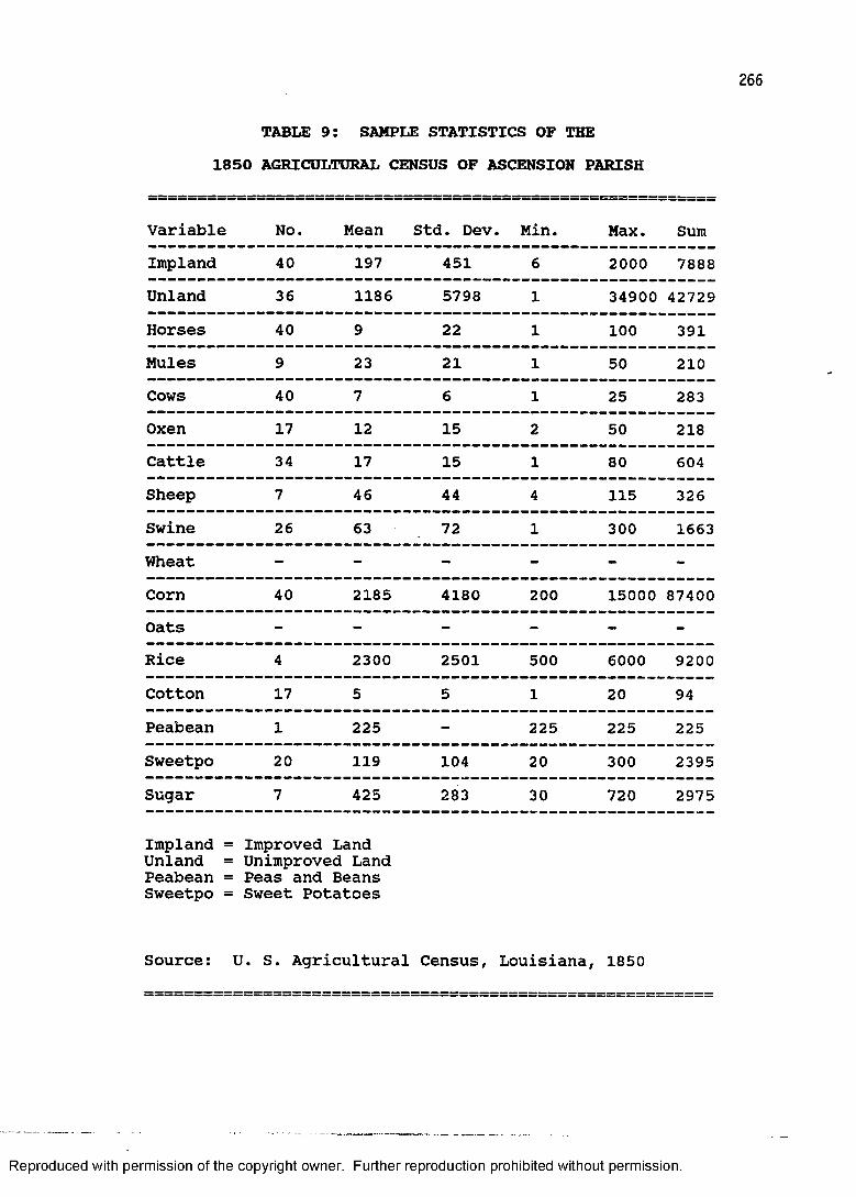
266
TABLE 9: SAMPLE STATISTICS OF THE1850 AGRICULTURAL CENSUS OF ASCENSION PARISH
Variable No. Mean Std. Dev Min. Max. SumImpland 40 197 451 6 2000 7888Unland 36 1186 5798 1 34900 42729Horses 40 9 22 1 100 391Mules 9 23 21 1 50 210Cows 40 7 6 1 25 283Oxen 17 12 15 2 50 218Cattle 34 17 15 1 80 604Sheep 7 46 44 4 115 326Swine 26 63 72 1 300 1663Wheat - - - - - -
Corn 40 2185 4180 200 15000 87400Oats - - - - - -
Rice 4 2300 2501 500 6000 9200Cotton 17 5 5 1 20 94Peabean 1 225 - 225 225 225Sweetpo 20 119 104 20 300 2395Sugar 7 425 283 30 720 2975
Impland = Unland = Peabean = Sweetpo =
Improved Land Unimproved Land Peas and Beans Sweet Potatoes
Source: U. S. Agricultural Census, Louisiana, 1850
Reproduced with permission of the copyright owner. Further reproduction prohibited without permission.
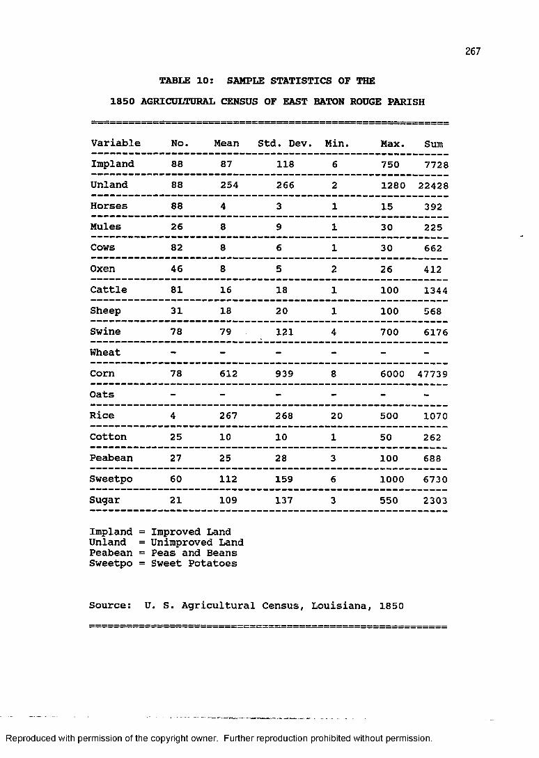
267
TABLE 10: SAMPLE STATISTICS OF THE1850 AGRICULTURAL CENSUS OF EAST BATON ROUGE PARISH
Variable No. Mean Std. Dev Min. Max. SumImpland 88 87 118 6 750 7728Unland 88 254 266 2 1280 22428Horses 88 4 3 1 15 392Mules 26 8 9 1 30 225Cows 82 8 6 1 30 662Oxen 46 8 5 2 26 412Cattle 81 16 18 1 100 1344Sheep 31 18 20 1 100 568Swine 78 79 121 4 700 6176Wheat - - - - - -
Corn 78 612 939 8 6000 47739Oats - - - - - -
Rice 4 267 268 20 500 1070Cotton 25 10 10 1 50 262Peabean 27 25 28 3 100 688Sweetpo 60 112 159 6 1000 6730Sugar 21 109 137 3 550 2303
Impland = Unland = Peabean = Sweetpo =
Improved Land Unimproved Land Peas and Beans Sweet Potatoes
Source: U. S. Agricultural Census, Louisiana, 1850
Reproduced with permission of the copyright owner. Further reproduction prohibited without permission.
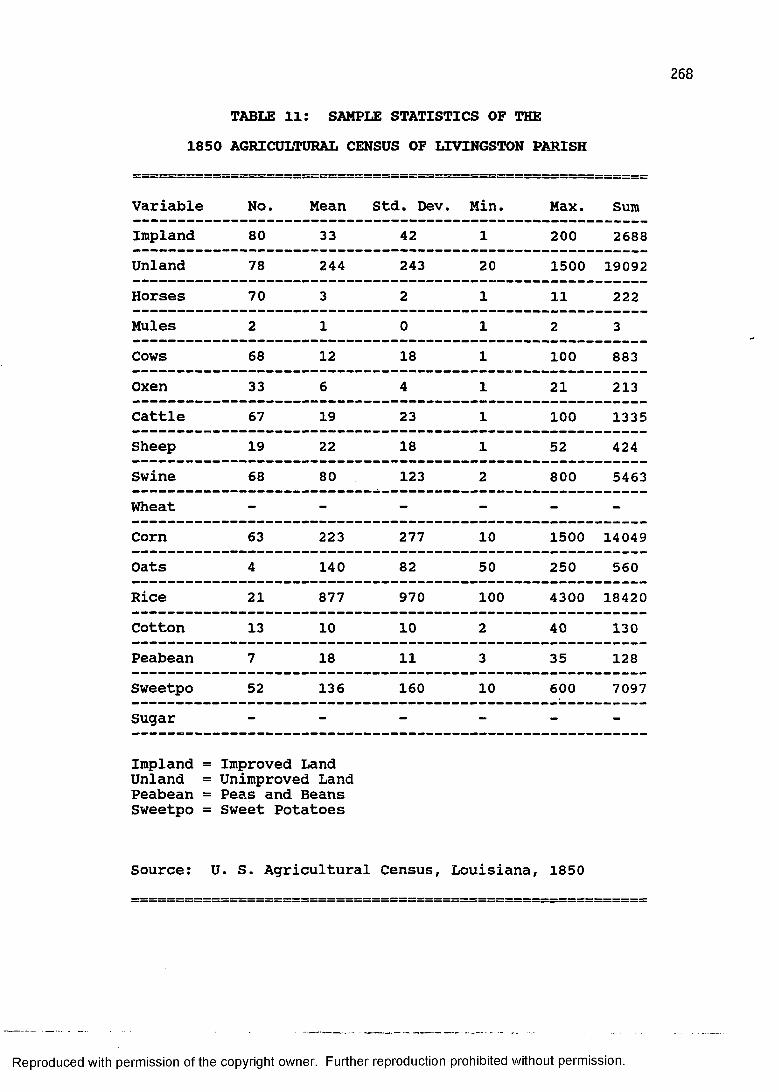
268
TABLE 11: SAMPLE STATISTICS OF THE1850 AGRICULTURAL CENSUS OF LIVINGSTON PARISH
Variable No. Mean Std. Dev. Min. Max. SumImpland 80 33 42 1 200 2688Unland 78 244 243 20 1500 19092Horses 70 3 2 1 11 222Mules 2 1 0 1 2 3Cows 68 12 18 1 100 883Oxen 33 6 4 1 21 213Cattle 67 19 23 1 100 1335Sheep 19 22 18 1 52 424Swine 68 80 123 2 800 5463Wheat - - - - - -
Corn 63 223 277 10 1500 14049Oats 4 140 82 50 250 560Rice 21 877 970 100 4300 18420Cotton 13 10 10 2 40 130Peabean 7 18 11 3 35 128Sweetpo 52 136 160 10 600 7097Sugar - - - - - -
Impland = Unland = Peabean = Sweetpo =
Improved Land Unimproved Land Peas and Beans Sweet Potatoes
Source: U. S. Agricultural Census, Louisiana, 1850
Reproduced with permission of the copyright owner. Further reproduction prohibited without permission.
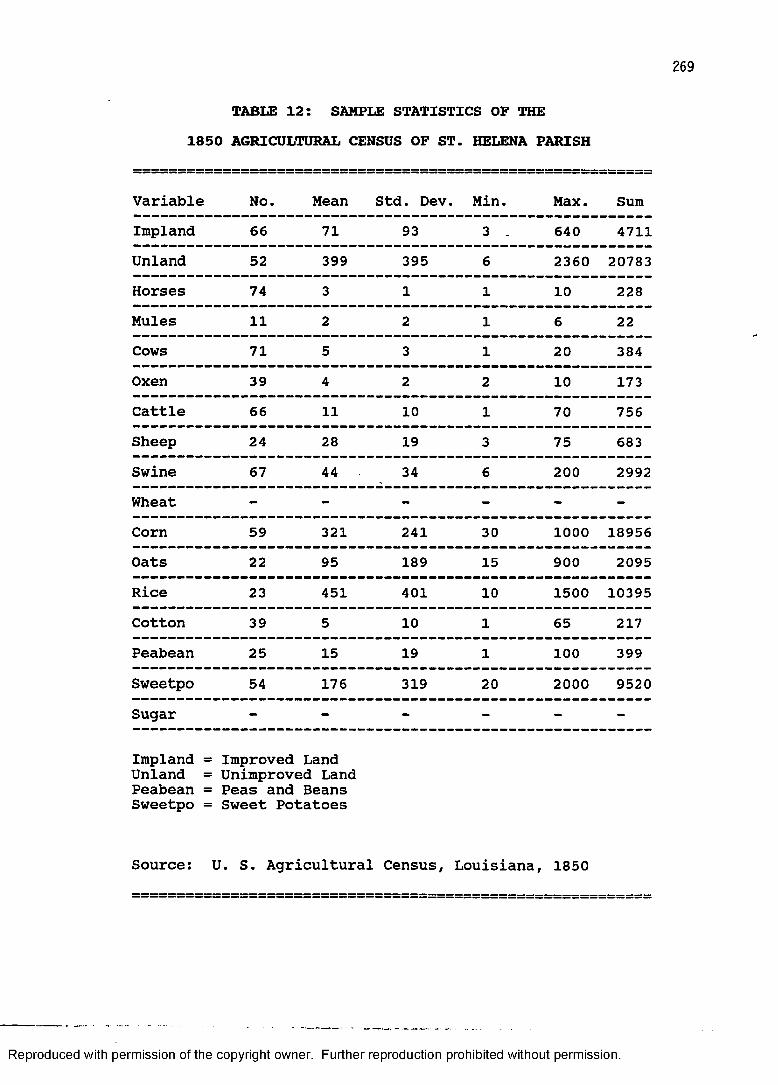
269
TABLE 12: SAMPLE STATISTICS OF THE1850 AGRICULTURAL CENSUS OF ST. HELENA PARISH
Variable No. Mean Std. Dev. Min. Max. SumImpland 66 71 93 3 . 640 4711Unland 52 399 395 6 2360 20783Horses 74 3 1 1 10 228Mules 11 2 2 1 6 22Cows 71 5 3 1 20 384Oxen 39 4 2 2 10 173Cattle 66 11 10 1 70 756Sheep 24 28 19 3 75 683Swine 67 44 34 6 200 2992Wheat - - - - - -
Corn 59 321 241 30 1000 18956Oats 22 95 189 15 900 2095Rice 23 451 401 10 1500 10395Cotton 39 5 10 1 65 217Peabean 25 15 19 1 100 399Sweetpo 54 176 319 20 2000 9520Sugar - - - - - -
Impland = Unland = Peabean = Sweetpo =
Improved Land Unimproved Land Peas and Beans Sweet Potatoes
Source: U. S. Agricultural Census, Louisiana, 1850
Reproduced with permission of the copyright owner. Further reproduction prohibited without permission.
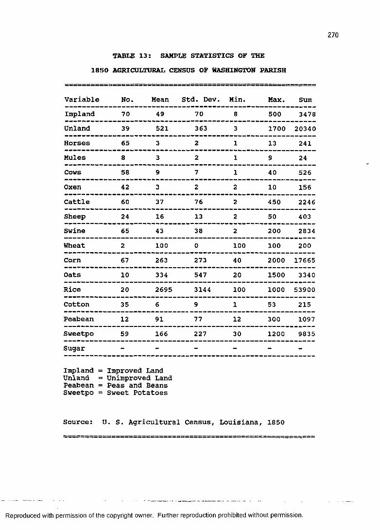
270
TABLE 13: SAMPLE STATISTICS OF THE1850 AGRICULTURAL CENSUS OF WASHINGTON PARISH
Variable No. Mean Std. Dev. Min. Max. SumImpland 70 49 70 8 500 3478Unland 39 521 363 3 1700 20340Horses 65 3 2 1 13 241Mules 8 3 2 1 9 24Cows 58 9 7 1 40 526Oxen 42 3 2 2 10 156Cattle 60 37 76 2 450 2246Sheep 24 16 13 2 50 403Swine 65 43 38 2 200 2834Wheat 2 100 0 100 100 200Corn 67 263 273 40 2000 17665Oats 10 334 547 20 1500 3340Rice 20 2695 3144 100 1000 53900Cotton 35 6 9 1 53 215Peabean 12 91 77 12 300 1097Sweetpo 59 166 227 30 1200 9835Sugar - - - - - -
Impland = Improved Land Unland = Unimproved Land Peabean = Peas and Beans Sweetpo = Sweet Potatoes
Source: U. S. Agricultural Census, Louisiana, 1850
Reproduced with permission of the copyright owner. Further reproduction prohibited without permission.
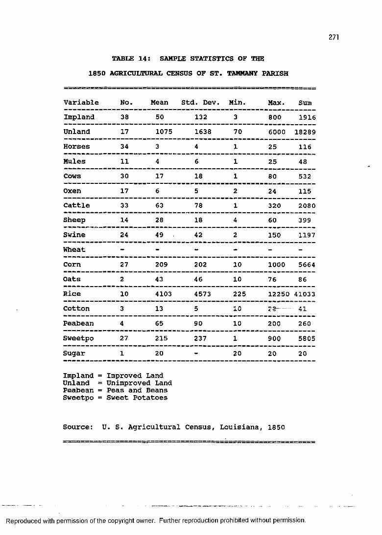
271
TABLE 14: SAMPLE STATISTICS OF THE1850 AGRICULTURAL CENSUS OF ST. TAMMANY PARISH
Variable No. Mean Std. Dev. Min. Max. SumImpland 38 50 132 3 800 1916Unland 17 1075 1638 70 6000 18289Horses 34 3 4 1 25 116Mules 11 4 6 1 25 48Cows 30 17 18 1 80 532Oxen 17 6 5 2 24 115Cattle 33 63 78 1 320 2080Sheep 14 28 18 4 60 399Swine 24 49 42 2 150 1197Wheat - - - - - -
Corn 27 209 202 10 1000 5664Oats 2 43 46 10 76 86Rice 10 4103 4573 225 12250 41033Cotton 3 13 5 10 23“ . A •%
Peabean 4 65 90 10 200 260Sweetpo 27 215 237 1 900 5805Sugar 1 20 - 20 20 20
Impland = Improved LandUnland = Unimproved Land Peabean = Peas and Beans Sweetpo = Sweet Potatoes
Source: U. S. Agricultural Census, Louisiana, 1850
Reproduced with permission of the copyright owner. Further reproduction prohibited without permission.
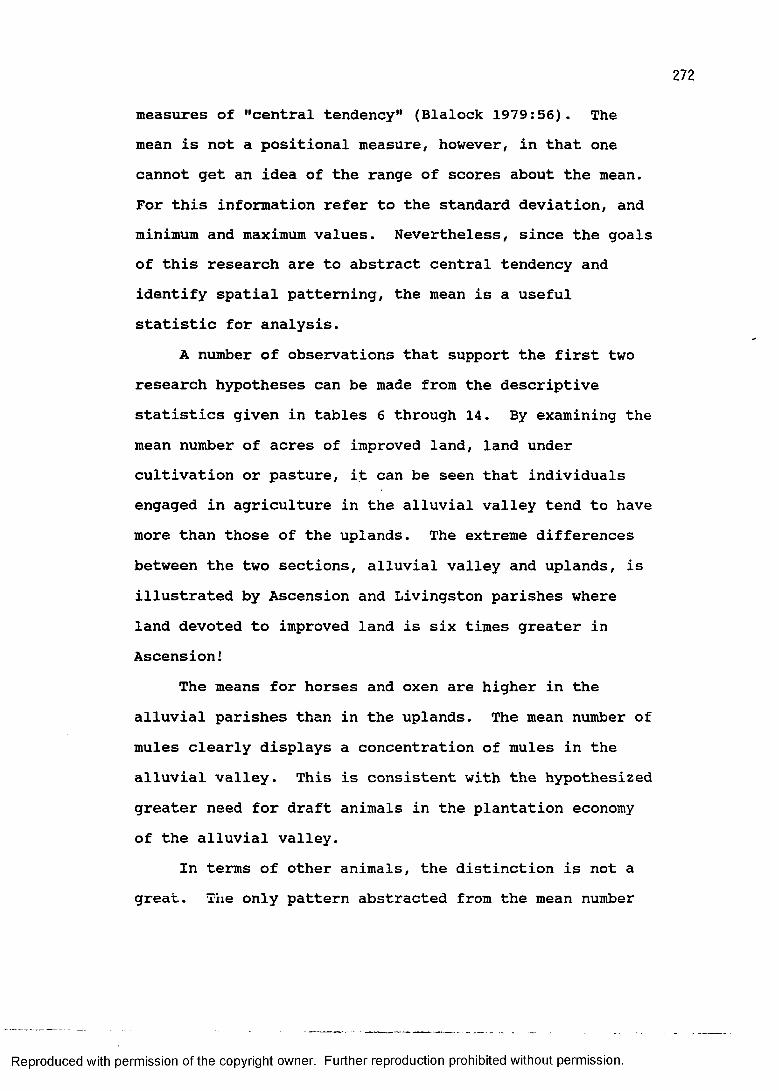
measures of "central tendency" (Blalock 1979:56). The mean is not a positional measure, however, in that one cannot get an idea of the range of scores about the mean. For this information refer to the standard deviation, and minimum and maximum values. Nevertheless, since the goals of this research are to abstract central tendency and identify spatial patterning, the mean is a useful statistic for analysis.
A number of observations that support the first two research hypotheses can be made from the descriptive statistics given in tables 6 through 14. By examining the mean number of acres of improved land, land under cultivation or pasture, it can be seen that individuals engaged in agriculture in the alluvial valley tend to have more than those of the uplands. The extreme differences between the two sections, alluvial valley and uplands, is illustrated by Ascension and Livingston parishes where land devoted to improved land is six times greater in Ascension!
The means for horses and oxen are higher in the alluvial parishes than in the uplands. The mean number of mules clearly displays a concentration of mules in the alluvial valley. This is consistent with the hypothesized greater need for draft animals in the plantation economy of the alluvial valley.
In terms of other animals, the distinction is not a great. The only pattern abstracted from the mean number
Reproduced with permission of the copyright owner. Further reproduction prohibited without permission.
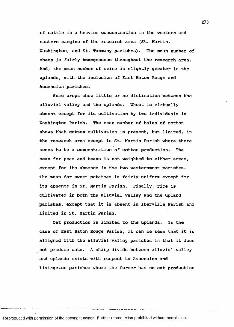
273
of cattle is a heavier concentration in the western and eastern margins of the research area (St. Martin,Washington, and St. Tammany parishes). The mean number of sheep is fairly homogeneous throughout the research area.And, the mean number of swine is slightly greater in the uplands, with the inclusion of East Baton Rouge and Ascension parishes.
Some crops show little or no distinction between the alluvial valley and the uplands. Wheat is virtually absent except for its cultivation by two individuals in Washington Parish. The mean number of bales of cotton shows that cotton cultivation is present, but limited, in the research area except in St. Martin Parish where there seems to be a concentration of cotton production. The mean for peas and beans is not weighted to either areas, except for its absence in the two westernmost parishes.The mean for sweet potatoes is fairly uniform except for its absence in St. Martin Parish. Finally, rice is cultivated in both the alluvial valley and the upland parishes, except that it is absent in Iberville Parish and limited in St. Martin Parish.
Oat production is limited to the uplands. In the case of East Baton Rouge Parish, it can be seen that it is alligned with the alluvial valley parishes in that it does not produce oats. A sharp divide between alluvial valley and uplands exists with respect to Ascension and Livingston parishes where the former has no oat production
Reproduced with permission of the copyright owner. Further reproduction prohibited without permission.
274
and the latter has a mean of 140 bushels. This distinction is perhaps illusory because the oat production in Livingston Parish can be attributed to four individuals. It is possible that this is evidence of horse or mule breeding in that oats are used as a feed crop.
Corn is much more heavily produced in the alluvial valley than it is in the uplands. The mean number of bushels of corn shows a clear bias toward the alluvial valley. For example, the mean of Ascension Parish is almost ten times that of Livingston Parish. Yet corn seems to be a fairly staple crop to upland farmers. In St. Helena Parish corn is grown by 76 percent of the individuals, in St. Tammany by 71 percent, in Washington by 96 percent, and in Livingston by 79 percent of all individuals in the sample.This is consistent with our concepts of Upland South crop production.
The mean for sugar, on the other hand, shows its virtually exclusive cultivation in the alluvial valley.In fact, in the four upland parishes there is only one sugar producer and that individual only produced 20 hogsheads. In contrast, one individual in Ascension produced 720 hogsheads of sugar.
Some clear tendencies have been demonstrated with respect to the spatial distribution of agricultural census variables. Certain livestock and crop production areas
Reproduced with permission of the copyright owner. Further reproduction prohibited without permission.
275
overlap within the same area. Models for plantation and subsistence agriculture have been posited to account for this patterning.
Alluvial valley agriculture in the research area is characterized by larger amounts of improved land per individual and higher means for sugar, mules, horses, oxen, and corn. It has a moderate amount of seven other items listed in the agricultural census.
By contrast, upland agriculture is not really characterized by agricultural dominance. The one exception to this is that oat production is limited to the uplands. Swine and peas and beans seem to have an association with the uplands, but are not produced in vastly greater amounts with respect to the alluvial valley. The upland agriculture also includes a moderate amount of ten other items listed in the agricultural census.
A table of correlation coefficients was generated to measure the association between variable pairs. This is presented in tables 15 and 16 for the variables identified with both of the agricultural types. One distinguishing feature between the two farming types is the relatively good correlation coefficients of the alluvial valley plantation system and the poor correlation coefficients of the upland subsistence system. This seems to confirm the hypothesis that the plantation economy is a tightly-knit system of interdependent parts. The subsistence farm, on
Reproduced with permission of the copyright owner. Further reproduction prohibited without permission.
276
TABLE 15: CORRELATION COEFFICIENTS FORALLUVIAL VALLEY AGRICULTURE
A B C D E FI I I I I I I
A I XX I .86 I .73 I .69 I .59 I .88 II I I I I I II I I I I I I
B I .86 I XX I .75 I .52 I .49 I .84 II I I I I I II I I I I I I
C I .73 I .75 XX I .38 I .56 I .67 II I I I I I II I I I I I
0 I .69 I .52 I .38 I XX I .63 I .72 II I I I I II I I I I I I
E I .59 I .49 I .56 .63 I XX I .21 II I I I I I II I I I I I I
F I COCO• I .84 I .67 I .72 I .21 I XX II I I I I I I
A = Improved Land B = Sugar C = Mules D = Horses E = Oxen F = Corn
Reproduced with permission of the copyright owner. Further reproduction prohibited without permission.
277
TABUS 16: CORRELATION COEFFICIENTS FORUPLAND AGRICULTURE
A B CI I I I
A I XX I .04 I .17 II I I II I I I
B I .04 I XX I .51 II I I II I I I
C I .17 I .51 I XX II I I I
A = Peas and Beans B = Swine C = Oats
Reproduced with permission of the copyright owner. Further reproduction prohibited without permission.
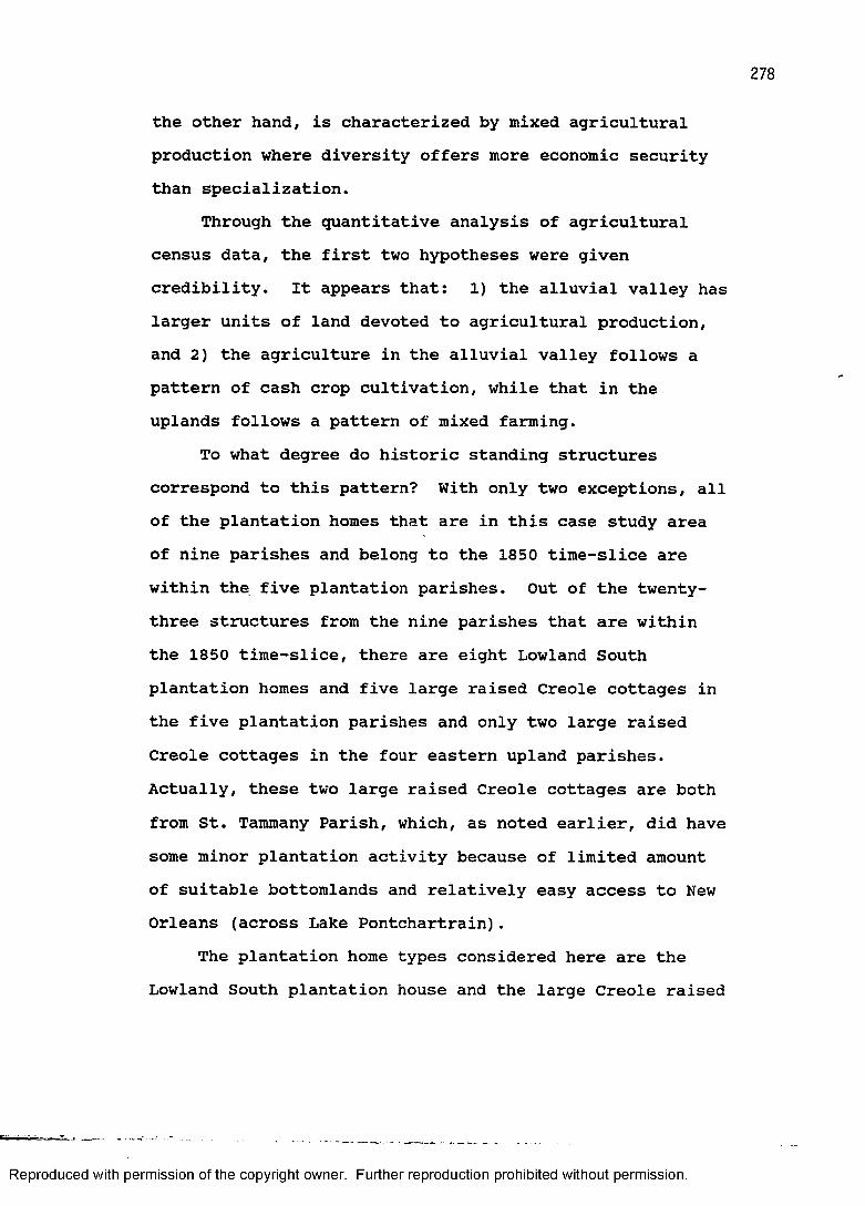
278
the other hand, is characterized by mixed agricultural production where diversity offers more economic security than specialization.
Through the quantitative analysis of agricultural census data, the first two hypotheses were given credibility. It appears that: 1) the alluvial valley haslarger units of land devoted to agricultural production, and 2) the agriculture in the alluvial valley follows a pattern of cash crop cultivation, while that in the uplands follows a pattern of mixed farming.
To what degree do historic standing structures correspond to this pattern? With only two exceptions, all of the plantation homes that are in this case study area of nine parishes and belong to the 1850 time-slice are within the five plantation parishes. Out of the twenty- three structures from the nine parishes that are within the 1850 time-slice, there are eight Lowland South plantation homes and five large raised Creole cottages in the five plantation parishes and only two large raised Creole cottages in the four eastern upland parishes. Actually, these two large raised Creole cottages are both from St. Tammany Parish, which, as noted earlier, did have some minor plantation activity because of limited amount of suitable bottomlands and relatively easy access to New Orleans (across Lake Pontchartrain).
The plantation home types considered here are the Lowland South plantation house and the large Creole raised
Reproduced with permission of the copyright owner. Further reproduction prohibited without permission.
279
cottage. The hill plantation I-house and the Carolina I- house would qualify as plantation types, but are not represented in 1850 structures from any of the nine parishes.
Besides the two raised Creole cottages in St. Tammany Parish, there are four other structures in the sample from the four parishes that this case study has classified as upland parishes. These four include two that do not conform to any of the house types used in this study, one single-pen house, and one dog-trot house. These last two are definitely Upland South types.
Architectural style is another way to segregate the sample. In the five plantation parishes the following styles are represented: one French Colonial, seventeenGreek Revival, two Gothic Revival, one Italianate, one Romanesque, and one Neoclassical. In the four upland parishes there is little in the way of style. The two raised Creole cottages in St. Tammany Parish are of French Colonial and Greek Revival style respectively. In addition, a non-typed structure, also in St. Tammany Parish, has elements of Queen Anne style. Obviously, the structures with Romanesque, Neoclassical, and Queen Anne styles have experienced post-construction modification.
According to statements made in this study and elsewhere, architectural style, particularly the Greek Revival, was an important index of wealth and could almost be considered a symbol of the plantation system. From
Reproduced with permission of the copyright owner. Further reproduction prohibited without permission.
280
this one style alone, it can be seen that the plantation area in this case study stands out. There are seventeen Greek Revival structures rather evenly distributed in the five parish plantation area, whereas St. Tammany Parish has the lone example of this style in the four parish upland area.
As measured by both house type and architectural style, therefore, there is a general correspondence between the parishes that sources such as the United States agricultural census identify as having plantation scale production and the cultural landscape of plantation homes. As predicted, and probably to nobody's surprise, plantation homes are located where documents suggest, at least on the parish level.
The utility of this case study to historic preservation and historic site prediction is not only the explicit demonstration that some of our assumptions concerning the location of plantation homes are valid, but also, when combined with information presented in the 1850 time-slice, it is hoped that the answer to why these assumptions are valid has been given sufficient emphasis.Good navigable waterways and suitable acreages of fertile bottomlands and bluffland seem to be key factors that separate these nine contiguous parishes into two groups.The agricultural census and historic standing structures are tangible forms of evidence that, in a sense, echo a fascinating historic man-land relationship.
Reproduced with permission of the copyright owner. Further reproduction prohibited without permission.
SUMMARYThe purpose of this chapter has been to introduce the
historic standing structures data and to make some evaluations based on earlier statements regarding the broad sweep of the historical settlement geography of Louisiana. The sample has served as an independent test of the settlement models presented in the second chapter of this study. The models are summaries of a rather large corpus of literature pertaining to the complex settlement history of the state. Through pragmatic demonstration, the sample has managed to convincingly strengthen some commonly held notions of Louisiana's historic settlement geography, as well as establish some new and reliable parameters.
The two case studies demonstrated how the various components that are central to historical geography, such as censuses and other historical records, contemporary cultural practices, and the physical environment all articulate in actual research situations. The sample of historic standing structures added a further degree of credibility to the settlement scenarios.
Reproduced with permission of the copyright owner. Further reproduction prohibited without permission.
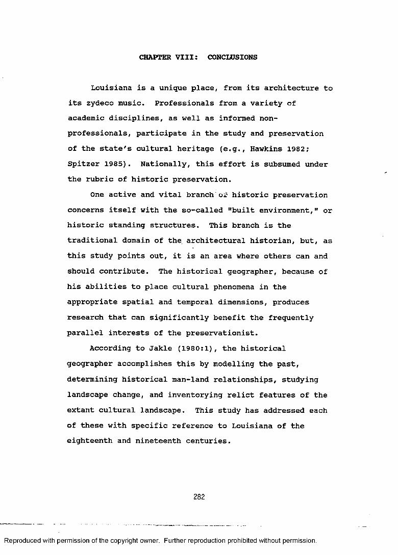
CHAPTER VIII: CONCLUSIONS
Louisiana is a unique place, from its architecture to its zydeco music. Professionals from a variety of academic disciplines, as well as informed nonprofessionals, participate in the study and preservation of the state's cultural heritage (e.g., Hawkins 1982; Spitzer 1985). Nationally, this effort is subsumed under the rubric of historic preservation.
One active and vital branch of historic preservation concerns itself with the so-called "built environment," or historic standing structures. This branch is the traditional domain of the architectural historian, but, as this study points out, it is an area where others can and should contribute. The historical geographer, because of his abilities to place cultural phenomena in the appropriate spatial and temporal dimensions, produces research that can significantly benefit the frequently parallel interests of the preservationist.
According to Jakle (1980:1), the historical geographer accomplishes this by modelling the past, determining historical man-land relationships, studying landscape change, and inventorying relict features of the extant cultural landscape. This study has addressed each of these with specific reference to Louisiana of the eighteenth and nineteenth centuries.
282
Reproduced with permission of the copyright owner. Further reproduction prohibited without permission.
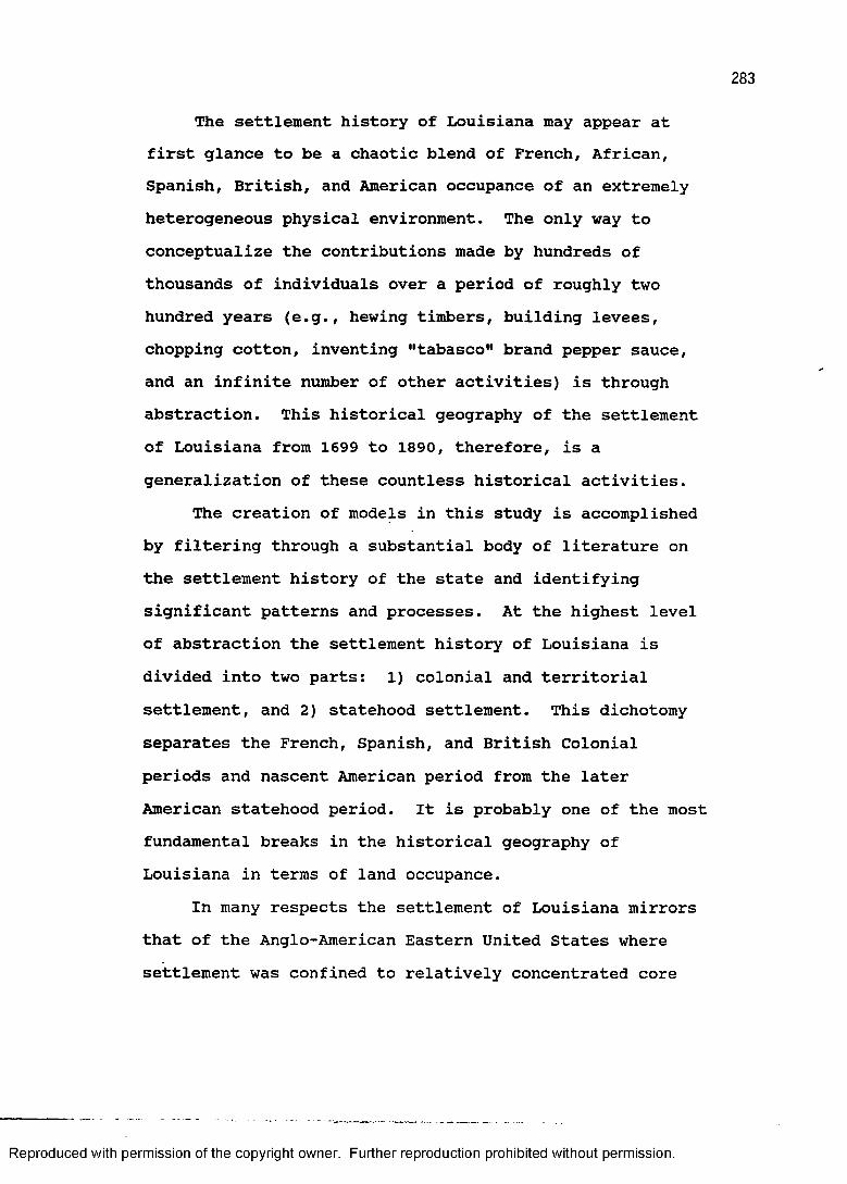
283
The settlement history of Louisiana may appear at first glance to be a chaotic blend of French, African,Spanish, British, and American occupance of an extremely heterogeneous physical environment. The only way to conceptualize the contributions made by hundreds of thousands of individuals over a period of roughly two hundred years (e.g., hewing timbers, building levees, chopping cotton, inventing "tabasco" brand pepper sauce, and an infinite number of other activities) is through abstraction. This historical geography of the settlement of Louisiana from 1699 to 1890, therefore, is a generalization of these countless historical activities.
The creation of models in this study is accomplished by filtering through a substantial body of literature on the settlement history of the state and identifying significant patterns and processes. At the highest level of abstraction the settlement history of Louisiana is divided into two parts: 1) colonial and territorialsettlement, and 2) statehood settlement. This dichotomy separates the French, Spanish, and British Colonial periods and nascent American period from the later American statehood period. It is probably one of the most fundamental breaks in the historical geography of Louisiana in terms of land occupance.
In many respects the settlement of Louisiana mirrors that of the Anglo-American Eastern United States where settlement was confined to relatively concentrated core
Reproduced with permission of the copyright owner. Further reproduction prohibited without permission.
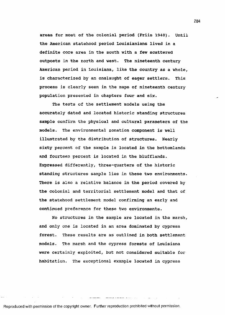
284
areas for most of the colonial period (Friis 1940). Until the American statehood period Louisianians lived in a definite core area in the south with a few scattered outposts in the north and west. The nineteenth century American period in Louisiana, like the country as a whole, is characterized by an onslaught of eager settlers. This process is clearly seen in the maps of nineteenth century population presented in chapters four and six.
The tests of the settlement models using the accurately dated and located historic standing structures sample confirm the physical and cultural parameters of the models. The environmental zonation component is well illustrated by the distribution of structures. Nearly sixty percent of the sample is located in the bottomlands and fourteen percent is located in the blufflands. Expressed differently, three-quarters of the historic standing structures sample lies in these two environments. There is also a relative balance in the period covered by the colonial and territorial settlement model and that of the statehood settlement model confirming an early and continued preference for these two environments.
No structures in the sample are located in the marsh, and only one is located in an area dominated by cypress forest. These results are as outlined in both settlement models. The marsh and the cypress forests of Louisiana were certainly exploited, but not considered suitable for habitation. The exceptional example located in cypress
Reproduced with permission of the copyright owner. Further reproduction prohibited without permission.
285
forest is probably on a small natural levee of Bayou St. John that is masked by the scale of the potential natural vegetation map.
The models also projected that settlement of the prairies and piney woods (shortleaf pine, longleaf pine, and flatwoods) would be more intensive during statehood. This is particularly true of the longleaf pine and flatwoods forests. The eastern margin of the great Southwest Prairie region was the site of settlement as early as colonial times, but as the geographical distribution of sample structures indicates the prairie region as a whole was more extensively settled during statehood.
The question of historical man-land relationships has been a major focus of this research. Constant reference to the correspondence between settlement and the state's various environments is made throughout this study. The map of Louisiana's potential natural vegetation has proven itself to be an extremely useful descriptive and analytic tool, and one of the major accomplishments of this study has been the demonstration of the degree to which this is so. It illustrates, for example, the overwhelming importance of the bottomlands (natural levee) environment to plantation agriculture.
The concept of the man-land relationship, which is central to the historical geographer, is well illustrated in Louisiana's physical and cultural diversity. Cattle
Reproduced with permission of the copyright owner. Further reproduction prohibited without permission.

ranches and later irrigated rice farms thrived on the prairies, Northern lumber companies were drawn like a magnet to Louisiana's magnificent longleaf and shortleaf pine forests, pirates found refuge in the labyrinth of bays and rivers that cut into the coastal marsh, and Grecian columns and sugarcane sprang up from the rich alluvial bottomlands.
Because these man-land relationships were not static, but dynamic and changing, this study addresses landscape change. The device used in this study to describe and to assess Louisiana's diachronic cultural landscapes is the time-slice. Each of seven time-slices (1740, 1775, 1810, 1830, 1850, 1870, and 189Q) is composed of two parts; the first presents the patterns and processes of the man-land relationship that are most characteristic of the period, and the second specifically deals with the housing types and architectural styles that also typify that particular time-slice.
The appreciation gained by presenting buildings in their spatial and temporal contexts comes from a fuller understanding of the structure's place in the cultural landscape. For example, to grasp the true historical significance of the antebellum plantation home one must see it not as an isolated entity (in coffee table book fashion), but as part of a larger system that included land, slaves, factors, steamboats, politics, architects,
Reproduced with permission of the copyright owner. Further reproduction prohibited without permission.
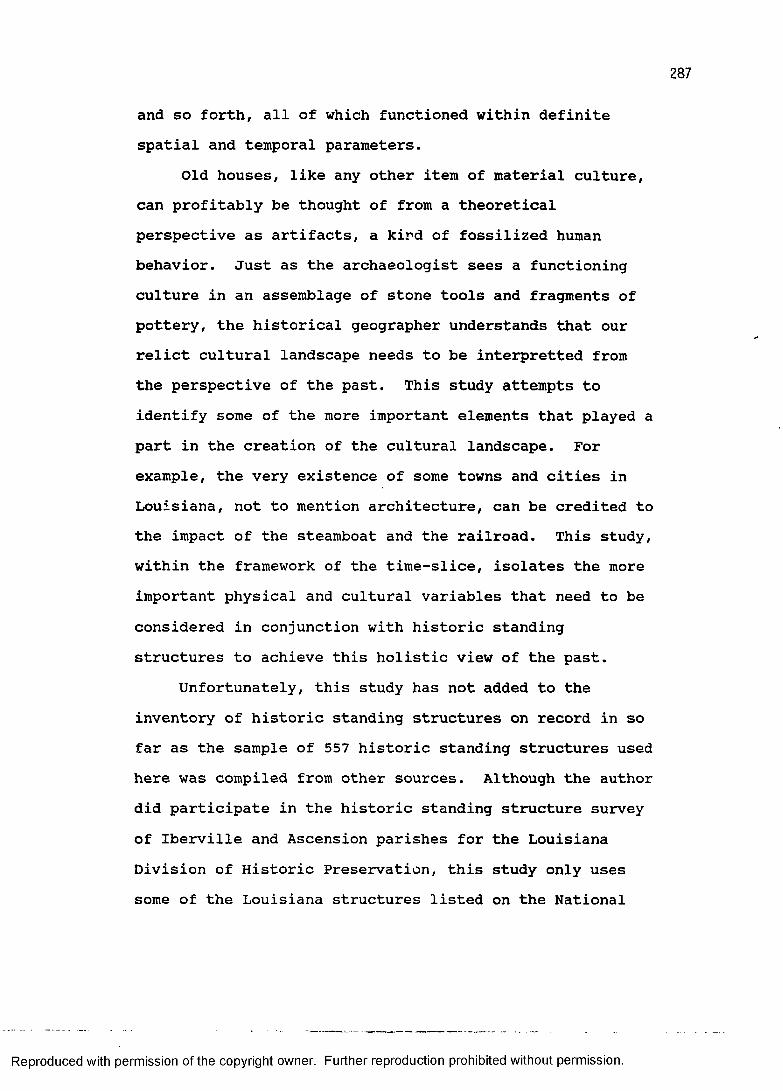
287
and so forth, all of which functioned within definite spatial and temporal parameters.
Old houses, like any other item of material culture, can profitably be thought of from a theoretical perspective as artifacts, a kind of fossilized human behavior. Just as the archaeologist sees a functioning culture in an assemblage of stone tools and fragments of pottery, the historical geographer understands that our relict cultural landscape needs to be interpretted from the perspective of the past. This study attempts to identify some of the more important elements that played a part in the creation of the cultural landscape. For example, the very existence of some towns and cities in Louisiana, not to mention architecture, can be credited to the impact of the steamboat and the railroad. This study, within the framework of the time-slice, isolates the more important physical and cultural variables that need to be considered in conjunction with historic standing structures to achieve this holistic view of the past.
Unfortunately, this study has not added to the inventory of historic standing structures on record in so far as the sample of 557 historic standing structures used here was compiled from other sources. Although the author did participate in the historic standing structure survey of Iberville and Ascension parishes for the Louisiana Division of Historic Preservation, this study only uses some of the Louisiana structures listed on the National
Reproduced with permission of the copyright owner. Further reproduction prohibited without permission.
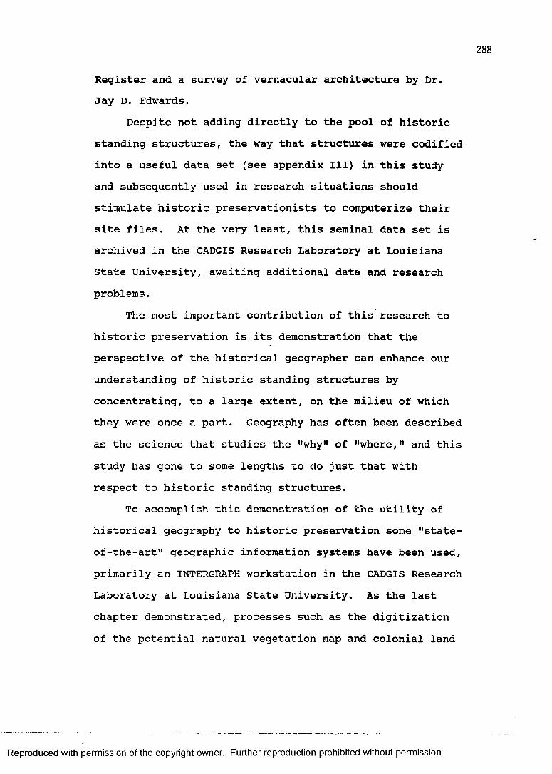
288
Register and a survey of vernacular architecture by Dr.Jay D. Edwards.
Despite not adding directly to the pool of historic standing structures, the way that structures were codified into a useful data set (see appendix III) in this study and subsequently used in research situations should stimulate historic preservationists to computerize their site files. At the very least, this seminal data set is archived in the CADGIS Research Laboratory at Louisiana State University, awaiting additional data and research problems.
The most important contribution of this research to historic preservation is its demonstration that the perspective of the historical geographer can enhance our understanding of historic standing structures by concentrating, to a large extent, on the milieu of which they were once a part. Geography has often been described as the science that studies the "why" of "where," and this study has gone to some lengths to do just that with respect to historic standing structures.
To accomplish this demonstration of the utility of historical geography to historic preservation some "state- of-the-art" geographic information systems have been used, primarily an INTERGRAPH workstation in the CADGIS Research Laboratory at Louisiana State University. As the last chapter demonstrated, processes such as the digitization of the potential natural vegetation map and colonial land
Reproduced with permission of the copyright owner. Further reproduction prohibited without permission.
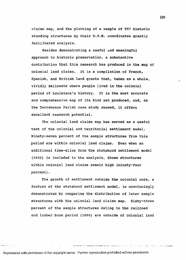
claims map, and the plotting of a sample of 557 historic standing structures by their U.T.M. coordinates greatly facilitated analysis.
Besides demonstrating a useful and meaningful approach to historic preservation, a substantive contribution that this research has produced is the map of colonial land claims. It is a compilation of French, Spanish, and British land grants that, taken as a whole, vividly delineate where people lived in the colonial period of Louisiana's history. It is the most accurate and comprehensive map of its kind yet produced, and, as the Terrebonne Parish case study showed, it offers excellent research potential.
The colonial land claims map has served as a useful test of the colonial and territorial settlement model. Ninety-seven percent of the sample structures from this period are within colonial land claims. Even when an additional time-slice from the statehood settlement model (1830) is included in the analysis, those structures within colonial land claims remain high (ninety-four percent).
The growth of settlement outside the colonial core, a feature of the statehood settlement model, is convincingly demonstrated by comparing the distribution of later sample structures with the colonial land claims map. Sixty-three percent of the sample structures dating to the railroad and lumber boom period (1890) are outside of colonial land
Reproduced with permission of the copyright owner. Further reproduction prohibited without permission.
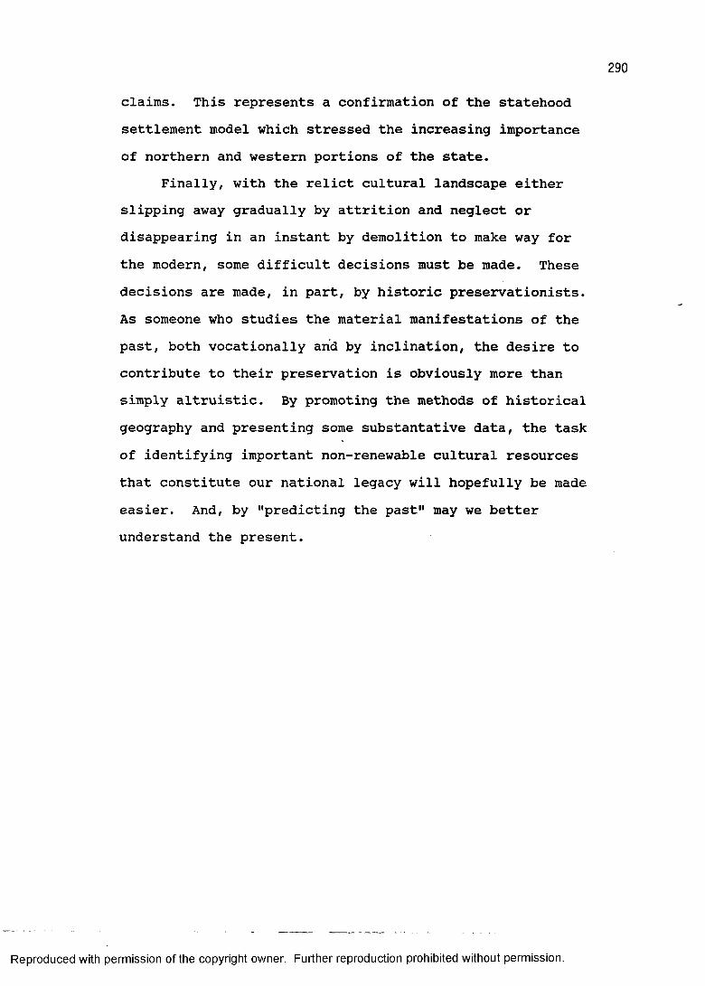
290
claims. This represents a confirmation of the statehood settlement model which stressed the increasing importance of northern and western portions of the state.
Finally, with the relict cultural landscape either slipping away gradually by attrition and neglect or disappearing in an instant by demolition to make way for the modern, some difficult decisions must be made. These decisions are made, in part, by historic preservationists. As someone who studies the material manifestations of the past, both vocationally and by inclination, the desire to contribute to their preservation is obviously more than simply altruistic. By promoting the methods of historical geography and presenting some substantative data, the task of identifying important non-renewable cultural resources that constitute our national legacy will hopefully be made easier. And, by "predicting the past" may we better understand the present.
Reproduced with permission of the copyright owner. Further reproduction prohibited without permission.
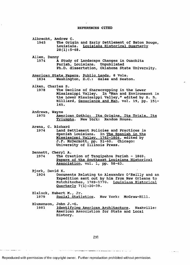
REFERENCES CITED
Albrecht, Andrew C.1945 The Origin and Early Settlement of Baton Rouge,
Louisiana. Louisiana Historical Quarterly 28(1):5-68.
Allen, Danny1974 A Study of Landscape Changes in Ouachita
Parish, Louisiana. UnpublishedPh.D. dissertation, Oklahoma State University.
American State Papers. Public Lands. 8 Vols.1834 Washington, D.C.: Gales and Seaton.
Aiken, Charles S.1978 The Decline of Sharecropping in the Lower
Mississippi Valley. In "Man and Environment in the Lower Mississippi Valley," edited by S. B. Hilliard, Geoscience and Man. vol. 19, pp. 151- 165.
Andrews, Wayne1975 American Gothic: Its Origins. Its Trials. Its
Triumphs. New York: Random House.Arena, C. Richard
1974 Land Settlement Policies and Practices inSpanish Louisiana. In The Spanish in the Mississippi Valley. 1762-1804. edited by J.F. McDermott, pp. 51-60. Chicago:University of Illinois Press.
Bennett, Cheryl A.1974 The Creation of Tangipahoa Parish - 1869.
Papers of the Southeast Louisiana Historical Association, vol. 1, pp. 58-63.
Bjork, David K.1924 Documents Relating to Alexandro O'Reilly and an
Expedition sent out by him from New Orleans to Natchitoches, 1769-1770. Louisiana Historical Quarterly 7(l):20-39.
Blalock, Hubert M., Jr.1979 Social Statistics. New York: McGraw-Hill.
Blumenson, John J.-G.1981 Identifying American Architecture. Nashville:
American Association for State and Local History.
291
Reproduced with permission of the copyright owner. Further reproduction prohibited without permission.

292
Bolton, H. E.1921 The Spanish Borderlands. New Haven: Yale
University Press.Brasseaux, Carl A.
1987a The Founding of New Acadia: The Beginnings ofAcadian Life in Louisiana. 1765-1803. Baton Rouge: Louisiana State University Press.
1987b Acadian Settlements, 1765-1860. In The Caiuns:Their History and Culture, edited by S. Hamilton, pp. 239-256. Opelousas, Louisiana. Report to the National Park Service, Jean Lafitte National Historic Park, 6 Vols.
Bridges, Katherine and Winston De Vilie1963 Natchitoches in 1766. Louisiana History
4:145-159.Broek, Jan 0. M.
1932 The Santa Clara Valiev. California: A Study inLandscape Chances. Utrecht: The University ofUtrecht.
1965 Geography; Its Scope and Spirit. Columbus,Ohio: Charles E. Merrill.
Brooks, H. Allen1972 The Prairie School: Frank Llovd Wriaht and his
Midwest Contemporaries. Toronto: Universityof Toronto Press.
Brown, Clair1945 Louisiana Trees and Shrubs. Baton Rouge:
Louisiana Commission of Forestry.Brown, Ralph H.
1943 Mirror for Americans: Likeness of the EasternSeaboard. 1810. New York: AmericanGeographical Society.
1948 Historical Geography of the United States. NewYork: Harcourt, Brace.
Brutin, Ignace Francois1733 Plan du Fort des Natcheitoches. Paris:
Archives Nationales.
Reproduced with permission of the copyright owner. Further reproduction prohibited without permission.
Caldwell, John M.1975 The Forest of Vintage: A Geography of
Industrial Lumbering in North Central Louisiana, 1890-1920. Unpublished M.A. thesis, University of Oklahoma.
Carter, Clarence E.1917 The Beginnings of British West Florida.
Mississippi Valiev Historical Review 4:314-341.Carter, Hodding
1959 The Anarv Scar: The Storv of Reconstruction.Garden City, New York:
Cash, W. J.1941 The Mind of the South. New York: Alfred A.
Knopf.Chabreck, Robert H. and Greg Linscombe
1978 Vegetative Type Map of the Louisiana CoastalMarshes. New Orleans: Louisiana Department ofWildlife and Fisheries.
Clark, Andrew H.1954 Historical Geography. In American Geography:
Inventory and Prospect, edited by P. E. James and C. F. Jones, pp. 70-105. Syracuse:Syracuse University Press.
1968 Acadia: The Geography of Earlv Nova Scotia to1760. Madison: University of Wisconsin Press.
Clark, John G.1970 New Orleans. 1718-1812: An Economic History.
Baton Rouge: Louisiana State University Press.Clay, Floyd M.
1962 Economic Survival of the Plantation Systemwithin the Feliciana Parishes, 1865-1880. Unpublished M.A. thesis, Louisiana State University.
Comeaux, Malcolm L.1969 Settlement and Folk Occupations of the
Atchafalaya Basin. Unpublished Ph.D. dissertation, Louisiana State Univerisity.
1972 Atchafalaya Swamp Life. Baton Rouge: Louisiana State University, Geoscience Publications, vol. 2.
Reproduced with permission of the copyright owner. Further reproduction prohibited without permission.
294
Cotterill, R.S.1922 Beginning of Railroads in the Southwest.
Mississippi Valiev Historical Review 8:318-326.Cram, George F.
1892 Railroad and Countv Map of Louisiana. Chicago:George F. Cram.
Cullison, William R., III1983 Architecture in Louisiana: A Documentary
History. New Orleans: SoutheasternArchitectural Archive, Tulane University Library.
Darby, H. C..1952 The Domesdav Geography of Eastern England. New
York: Cambridge University Press.Darby, William
1816a A Map of the State of Louisiana, with Part of the Mississippi Territory.Philadelphia: J. Melish.
1816b A Geographical Description of the State ofLouisiana. Philadelphia: J. Melish.
Davidson, William V.1974 Historical Geography of the Bav Islands.
Honduras. Birmingham, Alabama: SouthernUniversity Press.
Davis, Edwin A.1971 Louisiana: A Narrative History. 3rd Edition.
Baton Rouge: Claitor's Press.(ed.)
1968 The Rivers and Bavous of Louisiana. Baton Rouge: Louisiana Education ResearchAssociation.
Deetz, James F.1967 Invitation to Archaeology.
History Press.New York: Natural
Deiler, J. Hanno1909 The Settlement of the German Coast of Louisiana
and the Creoles of German Descent.Philadelphia: Americana-Germanica Press.
De L'Isle, Guillaume1734 Carte de la Louisiane et du Cours du
Mississippi. Paris: Guillaume De L'Isle.
Reproduced with permission of the copyright owner. Further reproduction prohibited without permission.
295
Dethlefsen, Edwin and James F. Deetz1966 Death's Heads, Cherubs, and Willow Trees:
Experimental Archaeology in Colonial Cemeteries. American Antiquity 31f4):502-511.
Detro, Randall A.1978 Transportation in a Difficult Terrain: The
Development of the Marsh Buggy. In "Man andEnvironment in the Lower Mississippi Valley," edited by S. B. Hilliard, Geoscience and Man. vol. 19, pp. 93-99.
De Ville, Winston1963 The Opelousas Post, From the Earliest
Settlement to 1803. Unpublished M.A. thesis, Louisiana State University.
1985 Rapides Post on the Red River: Census andMilitary Documents for Central Louisiana. 1769-1800. Ville Platte, Louisiana: Theauthor.
Ditchy, Jay K.1930 Early Census Tables of Louisiana.
Historical Quarterly 13:205-229.Louisiana
Downs, R.H.1960 Public Lands and Private Claims in Louisiana.
Unpublished M.A. thesis, Louisiana State University.
Edwards, Jay D.1980 Cultural Syncretism in the Louisiana Creole
Cottage. Louisiana Folklore Miscellany 4(1):9- 40.
1982 A Survey of Louisiana French VernacularArchitecture. 2 Vols. Baton Rouge: Louisiana State University, Museum of Geoscience.
1986a Louisiana's French Vernacular Architecture: Historical and Social Bibliography. Monticello, Illinois: Vance Bibliographies.
1986b French [vernacular architecture]. InAmerica's Architectural Roots: Ethnic Groupsthat Built America, edited by Del Upton, pp. 62-67. Washington, D.C.: National Trustfor Historic Preservation.
Reproduced with permission of the copyright owner. Further reproduction prohibited without permission.
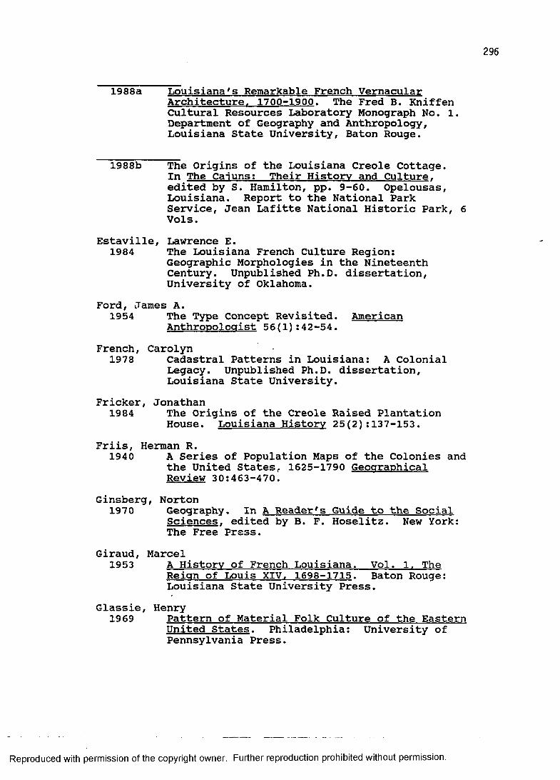
296
1988a Louisiana's Remarkable French VernacularArchitecture. 1700-1900. The Fred B. Kniffen Cultural Resources Laboratory Monograph No. 1. Department of Geography and Anthropology, Louisiana State University, Baton Rouge.
1988b The Origins of the Louisiana Creole Cottage.In The Caiuns; Their History and Culture, edited by S. Hamilton, pp. 9-60. Opelousas, Louisiana. Report to the National Park Service, Jean Lafitte National Historic Park, 6 Vols.
Estaville, Lawrence E.1984 The Louisiana French Culture Region:
Geographic Morphologies in the Nineteenth Century. Unpublished Ph.D. dissertation, University of Oklahoma.
Ford, James A.1954 The Type Concept Revisited. American
Anthropologist 56(l):42-54.French, Carolyn
1978 Cadastral Patterns in Louisiana: A ColonialLegacy. Unpublished Ph.D. dissertation, Louisiana State University.
Fricker, Jonathan1984 The Origins of the Creole Raised Plantation
House. Louisiana History 25(2):137-153.Friis, Herman R.
1940 A Series of Population Maps of the Colonies andthe United States, 1625-1790 Geographical Review 30:463-470.
Ginsberg, Norton1970 Geography. In A Reader's Guide to the Social
Sciences. edited by B. F. Hoselitz. New York: The Free Press.
Giraud, Marcel1953 A History of French Louisiana. Vol. 1. The
Reign of Louis XIV. 1698-1715. Baton Rouge: Louisiana State University Press.
Glassie, Henry1969 Pattern of Material Folk Culture of the Eastern
United States. Philadelphia: University ofPennsylvania Press.
Reproduced with permission of the copyright owner. Further reproduction prohibited without permission.
297
Gleason, David K.1982 Plantation Homes of Louisiana and the Natchez
Area. Baton Rouge: Louisiana State UniversityPress.
Graebner, Norman A., Gilbert C. Fite, and Philip L. White 1971 A History of the American People. New York:
McGraw-Hill Book Co.Haggard, Juan V.
1943 The Neutral Ground Between Louisiana and Texas. Louisiana Historical Quarterly 28:1001-1028.
Hall, John W.1970 Louisiana Survey Systems, Their Antecedents,
Distribution, and Characteristics. Unpublished Ph.D. dissertation, Louisiana State University.
Hamlin, Talbot1944 Greek Revival Architecture in America. New
York: Oxford University Press.Hardin, J. Fair
1937 Northeastern Louisiana. A History of theWatershed of the Red River. 1714-1937. Shreveport: The Historical Record Association.
Harris, Richard C.1966 The Seianeurial System in Earlv Canada.
Madison: University of Wisconsin Press.Hartshorne, Richard
1949 The Nature of Geography: A Critical Survey ofCurrent Thought in the Light of the Past. Lancaster, Pennsylvania: Association ofAmerican Geographers.
Hawkins, Nancy W.1982 Preserving Louisiana's Legacy; Everyone Can
Help. Louisiana Division of Archaeology, Anthropological Study No. 5, Baton Rouge, Louisiana.
Heck, Robert W.1978 Building Traditions in the Acadian Parishes.
In The Caiuns: Essays on Their History andCulture. edited by G. R. Conrad, pp. 161-172. Lafayette: University of SouthwesternLouisiana.
Reproduced with permission of the copyright owner. Further reproduction prohibited without permission.
298
Hickman, Nollie W.1958 History of Forest Industries in the Longleaf
Pine Belt of East Louisiana and Mississippi, 1840-1915. Unpublished Ph.D. dissertation, University of Texas, Austin.
1966 The Yellow Pine Industries in St. Tammany,Tangipahoa, and Washington Parishes, 1840-1915. Louisiana Studies 5:75-88.
Highsmith, William E.1953 Louisiana During Reconstruction. Unpublished
Ph.D. dissertation, Louisiana State University,Hilliard, Sam B.
1961 Birdsong: Sequent Occupance on a SouthwesternGeorgia Plantation. Unpublished M.A. thesis, University of Georgia.
1973 An Introduction to Land Survey Systems in the Southeast. In Geographic Perspectives on Southern Development 12:1-15.
1975 Antebellum Interregional Trade: TheMississippi River as an example. In Pattern and Process: Research in Historical Geography,edited by R.E. Ehrenberg, pp. 202-214. Washington, D.C.: Howard University Press.
1984 Atlas of Antebellum Southern Agriculture.Baton Rouge: Louisiana State University Press.
1987 A Robust New Nation, 1783-1820. In North America: The Historical Geography of aChanging Continent, edited by R. D. Mitchell and P. A. Groves, pp. 149-171. Totowa, New Jersey: Rowman & Littlefield.
Holmes, Jack D. L.1969 Louisiana Trees and Their Uses: Colonial
Period. Louisiana Studies 8(l):36-67.Howard, Clinton N.
1947 The British Development of West Florida.1763-1769. Berkeley: University of CaliforniaPress.
Reproduced with permission of the copyright owner. Further reproduction prohibited without permission.
299
Howe, Barbara J., Dolores A. Fleming, Emory L. Kemp, and Ruth Ann Overbeck1987 Houses and Homes: Exploring Their History.
Nashville: The Association for State and LocalHistory.
Hudson, Charles1976 The Southeastern Indians. Knoxville:
University of Tennessee Press.Hunt, William D., Jr.
1984 American Architecture: A Field Guide to theMost Important Examples. New York: Harper andRow.
Jakle, John A.1980 Past Landscapes: A Bibliography for
Preservationists. Revised edition.Monticello, Illinois: Vance Bibliographies.
Jacobs, Harry1937 Natural Vegetation Map of Louisiana. Baton
Rouge: Louisiana State Board of Engineers.James, Preston E. and Geoffrey J. Martin
1981 All Possible Worlds: A History of GeographicalIdeas. Second Edition. New York: John Wiley& Sons.
Johnson, Cecil1943 British West Florida. 1763-1783. New Haven:
Yale University Press.Johnson, John A.
1963 Pre-Steamboat Navigation on the Louisiana Mississippi River. Unpublished Ph.D. dissertation, Louisiana State University.
Jordan, Terry G.1964 Between the Forest and the Prairie.
Agricultural History 38:205-216.
1970 The Texan Appalachia. Annals of theAssociation of the American Geographers 60(3):409-427.
1975 Vegetational Perception and Choice ofSettlement Site in Frontier Texas. In Pattern and Process: Research in Historical Geography,edited by R. E. Ehrenberg, pp. 244-257. Washington, D.C.: Howard University Press.
Reproduced with permission of the copyright owner. Further reproduction prohibited without permission.
1978 Texas Log Buildings: A Folk Architecture.Austin: University of Texas Press.
Jordan, Terry G. and Lester Rowntree1986 The Human Mosaic: A thematic Introduction to
Cultural Geography. 4th edition. New York: Harper and Row.
Kane, Harnett T.1943 The Bavous of Louisiana. New York: William
Morrow and Co.
1944 Deep Delta Country. New York: Duell, Sloanand Pearce.
1957 Natchez on the Mississippi. New York: BonanzaBooks.
Kennedy, J. Gerald1981 The Astonished Traveler: William Darby.
Frontier Geographer and Man of Letters. Baton Rouge: Louisiana State University Press.
King, Ameda R.1931 Social and Economic Life in Spanish Louisiana,
1763-1783. Unpublished Ph.D. dissertation, University of Illinois, Urbana-Champaign.
King, Thomas F., Patricia P. Hickman, and Gary Berg1977 Anthropology in Historic Preservation: Carina
for Culture/s Clutter. New York: AcademicPress.
Kniffen, Fred B.1936 Louisiana House Types. Annals of the
Association of American Geographers 26:179-193.
1951 Geography and the Past. Journal of Geography 50(3):126-129.
1954 Whither Cultural Geography? Annals of theAssociation of American Geographers 44:222-223.
1963 The Physiognomy of Rural Louisiana. Louisiana History 4(4^:291-299.
Reproduced with permission of the copyright owner. Further reproduction prohibited without permission.
301
1965 Folk Housing: Key to Diffusion. Annals of theAssociation of American Geographers 55(4):549-577.
1974
Kniffen,1966
Kniffen,1987
Kniffen,1988
Material Culture in the Geographic Interpretation of the Landscape. In The Human Mirror, edited by Miles Richardson, pp. 252-268. Baton Rouge: Louisiana StateUniversity Press.
Fred B. and Henry GlassieBuilding in Wood in the Eastern United States:A Time Place Perspective. Geographical Review 56(1):40-66.
Fred B., Hiram F. Gregory, and George A. Stokes The Historic Indian Tribes of Louisiana. Baton Rouge: Louisiana State University Press.
Fred B. and Sam B. HilliardLouisiana: Its Land and People. Revisededition.Baton Rouge: Louisiana State University Press.
Knipmeyer, William B.1956 Settlement Succession in Eastern French
Louisiana. Unpublished Ph.D. dissertation, Louisiana State University.
Kuchler, A. W.1964 Potential Natural Vegetation of the Coterminous
United States (Map and Manual), American Geographical Society, Special Publication No. 36.
Kyser, John S.1938 The Evolution of Louisiana Parishes in Relation
to Population Growth and Movements.Unpublished Ph.D. dissertation, Louisiana State University.
Lafon, Bernard1806 Carte Generale du Territoire d*Orleans. . .
New Orleans: Bernard Lafon.Lancaster, Clay
1986 The American Bungalow. 1880-1930.Abbeville Press.
New York:
Reproduced with permission of the copyright owner. Further reproduction prohibited without permission.
302
Landreth, John1985 The Journal of John Landreth. Surveyor: An
Expedition to the Gulf Coast November 15. 1818 - Mav 19. 1819. edited by Milton B. Newton,Jr. Baton Rouge: Geoscience Publications forthe Department of Geography and Anthropology, Louisiana State University.
Langness, Lewis L.1974 The Study of Culture. San Francisco: Chandler
& Sharp.Lebreton, Marietta M.
1969 History of the Territory of Orleans,1803-1812. Unpublished Ph.D. dissertation, Louisiana State University.
Legan, Marshall S.1976 Railroad Sentiment in North Louisiana in the
1850's. Louisiana History 17(2):125-142.LePage du Pratz, Antoine S.
1774 The History of Louisiana. A facsimilereproduction of the 1774 edition published by Louisiana State University Press, Baton Rouge.
Lewis, John C.1973 The Settlement Succession of the Boeuf River
Basin, Louisiana. Unpublished Ph.D. dissertation, Louisiana State University.
Lewis, Peirce F.1970 The Geography of Old Houses. Pennsylvania
State University, Earth and Mineral Sciences 39(5):33-37.
1976 New Orleans: The Making of an Urban Landscape.Cambridge, Massachusetts: Ballinger.
L'Herrison, Lawrence E., Jr.1981 The Evolution of the Texas Road and the
Sequential Settlement Occupancy of Northwest Louisiana: 1528-1819. UnpublishedM.A. thesis, Louisiana State University.
Lockett, Samuel H.1969 Louisiana As It Is: A Geographical and
Topographical Description of the State. Baton Rouge: Louisiana State University Press.(Initial printing of 1873 manuscript, edited and with an introduction by Lauren C. Post.)
Reproduced with permission of the copyright owner. Further reproduction prohibited without permission.
1873 Louisiana State University Topographical Map of Louisiana. . . New York: Colton and Co.
Longfellow, Henry W.1847 Evangeline: A Tale of Acadie. Reprint of
original. Winnipeg: Art Multigraphers.Loth, Calder and Julius T. Sadler, Jr.
1975 The Only Proper Stvle: Gothic Architecture inAmerica. Boston: New York Graphic Society.
Louisiana Writers Project1941 Louisiana: A Guide to the State. New York:
Hastings House.Louisiana Department of Commerce and Industryn.d. Louisiana Plantation Homes. Baton Rouge:
Louisiana Department of Commerce and Industry.Maass, John
1957 The Gingerbread Aae: A View of VictorianAmerica. New York: Rinehart.
McAlester, Virginia and Lee McAlester1984 A Field Guide to American Houses. New York:
Alfred A. Knopf.Mclntire, William G.
1978 Methods of Correlating Cultural Remains withStages of Coastal Development. In Environment and Culture, edited by H. J. Walker and M. B. Newton, Jr., pp. 117-125. (reprint of 1959 article.)
McKenna, John R.1975 The Role of Water Transportation in the
Settlement of Bayou Manchac and the Amite River, Louisiana. Unpublished M.A. thesis, Louisiana State University.
McManis, Douglas R.1975 Colonial New England: A Historical Geography.
New York: Oxford University Press.Maduell, Charles R., Jr.
1972 The Census Tables for the French Colony ofLouisiana from 1699 through 1732. Compiled and translated by C.R. Maduell, Jr. Baltimore: Genealogical Publishing Co.
Reproduced with permission of the copyright owner. Further reproduction prohibited without permission.
Mancil, Ervin1969 Some Historical and Geographical Notes on the
Cypress Lumbering Industry in Louisiana. Louisiana Studies 8(l):14-25.
1972 An Historical Geography of Industrial Cypress Lumbering in Louisiana. Unpublished Ph.D. dissertation, Louisiana State University.
Martin, F. Lester1981-86 Folk Architecture of North Louisiana. Vol. I,
Lincoln Parish, 1981; Vol. II, Bienville Parish, 1983; Vol. Ill, Union Parish, 1983; Vol. IV, Webster Parish, 1984; Vol. V, Jackson Parish, 1985; Vol. VI, Claiborne Parish, 1986. Ruston, Louisiana: Louisiana Tech School ofArchitecture.
Mead, W. R.1981 An Historical Geography of Scandinavia.
London: Academic Press.Meinig, Donald W.
1969 Imperial Texas. Austin: University of TexasPress.
The Shaping of America: A GeographicalPerspective on 500 Years of History. Vol. 1. Atlantic America. 1492-1800. New Haven: YaleUniversity Press.
Marvin W.The Rise and Decline of "Sequent Occupance:" A Chapter in the History of American Geography.In Geographies of the Mind, edited by D. Lowenthal and M. J. Bowden, pp. 149-169. New York: Oxford University Press.
Miller, John C.1966 The First Frontier: Life in Colonial America.
New York: Dell.Mitchell, Jennie 0. and Dabney Calhoun
1937 The Marquis de Maison Rouge, the Baron deBastrop and Colonel Abraham Morehouse - Three Ouachita Valley Soldiers of Fortune. The Maison Rouge and Bastrop Grants. Louisiana Historical Quarterly 20:289-462.
1986
Mikesell,1976
Reproduced with permission of the copyright owner. Further reproduction prohibited without permission.
305
Moore, John P.1976 Revolt in Louisiana: The Spanish Occupation.
1766-1770. Baton Rouge: Louisiana StateUniversity Press.
Morison, Samuel E.1965 The Oxford History of the American People. New
York: Oxford University Press.National Trust for Historic Preservation
1982 Getting to Know Your Early Twentieth-CenturyNeighborhood. Conserve Neighborhoods No. 25, a newsletter published by the National Trust for Historic Preservation.
Nardini, Louis R.1961 No Man's Land: A History of El Camino Real.
New Orleans: Pelican Publishing Co.Nelson, -Thomas C. and Walter M. Zillgitt
1969 A Forest Atlas of the South. New Orleans:U.S.D.A., Forest Service, Southern Forest Experiment Station.
Newton, Milton B., Jr.1967 The Peasant Farm of St. Helena Parish,
Louisiana: A Cultural Geography. UnpublishedPh.D. dissertation, Louisiana State University.
1970a Of Sand Hillers, Crackers, and Cedar Choppers: The Upland South in Southern Cultures. Paper in author's possession.
1970b Route Geography and the Routes of St. Helena Parish, Louisiana. Annals of the Association of American Geographers 60:134-152.
1971a Louisiana House Types: A Field Guide.Melanges No. 2. Museum of Geoscience, Louisiana State University.
1971b The Darlings Creek Peasant Settlements ofSt. Helena Parish, Louisiana. In The Not So Solid South, edited by J. Kenneth Moriand. Southern Anthropological Society Proceedings No. 4.
1972 Atlas of Louisiana. Baton Rouge: LouisianaState University, School of Geoscience.
Reproduced with permission of the copyright owner. Further reproduction prohibited without permission.
1974a Cultural Preadaptation and the Upland South. In Han and Cultural Heritage, edited by H.J. Walker and W.G. Haag Geoscience and Man 5:143-154. Baton Rouge: Louisiana StateUniversity, School of Geoscience.
1974b Settlement Patterns as Artifacts of Social Structure. In The Human Mirror, edited by Miles Richardson, pp. 339-361. Baton Rouge: Louisiana State University Press.
1981 The Comprehensive Plan for St. Helena Parish, Louisiana, Historic Preservation Study, Vol.I. Report on file with the Louisiana Division of Historic Preservation, Baton Rouge.
1985 Louisiana Folk Houses. In Louisiana Folklife:A Guide to the State, edited by Nicholas R. Spitzer, pp. 179-189. Baton Rouge: Louisiana Department of Culture, Recreation, and Tourism.
1986 Draft of "Louisiana: A Geographical Portrait"in author's possession.
1987 Louisiana: A Geographical Portrait. BatonRouge: Geoforensics.
Newton, Milton B., Jr. and Linda Pulliam-DeNapoli1977 Log Houses as Public Occasions: A Historical
Theory. Annals of the Association of American Geographers 67(3):360-383.
Newton, Milton B., Jr. and C. Nicholas Raphael 1971 Relic Roads of East Feliciana Parish,
Louisiana. The Geographical Review 61(2):250- 264.
Noel Hume, Ivor1969 Historical Archaeology.
A. Knopf.New York: Alfred
Odum, E. Dale1963 The Vicksburg, Shreveport, and Texas: The
Fortunes of a Scalawag Railroad. Southwestern Social Science Quarterly 44(4):277-285.
Reproduced with permission of the copyright owner. Further reproduction prohibited without permission.
307
Oszuscik, Philippe1983 French Creole Housing on the Gulf Coast: The
Early Years. Pioneer America Society Transactions 6:49-58.
1988 The French Creole Cottage and its CaribbeanConnection. In French and Germans in the Mississippi Valiev: Landscape and CulturalTraditions, edited by M. Roark, pp. 61-78.Cape Girardeau, Missouri: Southeast MissouriState University.
Ostby, Otis L., III1981 French Architecture in the Mississippi River
Valley, 1680-1803. Unpublished M.A. thesis, University of Virginia.
Owsley, Frank L.1949 Plain Folk of the Old South. Baton Rouge:
Louisiana State University Press.Parkman, Francis
1930 The French in Louisiana, 1699-1712.Unpublished Ph.D. dissertation, Harvard University.
Perrin, William H. (ed.)1891 Southwest Louisiana: Biographical and
Historical. New Orleans: Gulf Publishing Co.Peterson, Charles E.
1941 Early Ste. Genevieve and its Architecture.Missouri Historical Review 35(2):223-227.
Phillips, Yvonne1953 Settlement Succession in the Tensas Basin.
Unpublished Ph.D. dissertation, Louisiana State University.
Pillsbury,1970
Richard and Andrew KardosA Field Guide to the Folk Architecture of the Northeastern United States. Hanover, New Hampshire: Geography Publications atDartmouth No. 8.
Pittman, Capt. Philip1770 The Present State of European Settlements on
the Mississippi. A facsimile edition with anintroduction and notes by John F. McDermott. Memphis, Tennesssee: Memphis State UniversityPress (1977).
Reproduced with permission of the copyright owner. Further reproduction prohibited without permission.
308
Poppeliers, John C., S. Allen Chambers, Jr., and NancyB. Schwartz1983 What Stvle is it?; A Guide to American
Architecture. Washington, D.C.: ThePreservation Press.
Porey, Ory G.1972 History of Land Titles in the State of
Louisiana. Baton Rouge: Department of NaturalResources.
Post, Lauren C.1937 Cultural Geography of the Prairies of Southwest
Louisiana. Unpublished Ph.D. dissertation, University of Calfornia, Berkeley.
1974 Caiun Sketches. From the Prairies of Southwest Louisiana. Baton Rouge: Louisiana StateUniversity Press.
1964 Samuel Henry Lockett (1837-1891) - A Sketch of His Life and Work. Louisiana History 5:421-441.
Redfield, Robert1960 Peasant Society and Culture.
University of Chicago Press.Chicago:
Reed, Merl E.1957 Louisiana's Transportation Revolution: The
Railroads, 1830-1850. Unpublished Ph.D. dissertation, Louisiana State University.
Rehder, John B.1971 Sugar Plantation Settlements of South
Louisiana: A Cultural Geography. UnpublishedPh.D. dissertation, Louisiana State University.
1978 Diagnostic Landscape Traits of SugarPlantations in Southern Louisiana. In "Man and Environment in the Lower Mississippi Valley," edited by S. B. Hilliard, Geoscience and Man vol. 19, pp. 135-150.
Reps, John W.1965 Town Planning in Frontier America. Princeton,
New Jersey: Princeton University Press.
Reproduced with permission of the copyright owner. Further reproduction prohibited without permission.
309
Sauer, Carl O.1941 Foreward to Historical Geography. Annals of
the Association of American Geographers 31(1):1-24.
1963 Historical Geography and the Western Frontier. In Land and Life: A Selection from theWritings of Carl Ortwin Sauer, edited by J. Leighly, pp. 45-52. Berkeley: University ofCalifornia Press.
Scott, Elton M.1942 The Geography of Settlement in a Portion of the
Texas-Louisiana Coastal Plain. Unpublished Ph.D. dissertation, University of Wisconsin.
Scroggs, W .O .1909 Early Trade and Travel in the Lower Mississippi
Valley. Proceedings of the Mississippi Valiev Historical Association 2:1-22.
Sechrist, Gail S.1986 Church Buildings Enter the Urban Age: A
Louisiana Example of the Church in Settlement Geography (1885-1930). Unpublished Ph.D. dissertation, Louisiana State University.
Seramuzza, V.M.1930 Galveztown, A Spanish Settlement of Colonial
Louisiana. Louisiana Historical Quarterly 13:553-609.
Shugg, Roger W.1937 Survival of the Plantation System in Louisiana.
Journal of Southern History 3:311-325.
1939 Origins of Class Struggle in Louisiana. BatonRouge: Louisiana State University Press.
Skipwith, Henry1892 East Feliciana. Louisiana. Past and Present:
Sketches of the Pioneers. New Orleans:Hopkins.
Spitzer, Nicholas R. (ed.)1985 Louisiana Folklife: A Guide to the State.
Baton Rouge: Louisiana Folklife Program.Stahle, David
1979 Tree-Ring Dating of Historic Buildings inArkansas. Tree-Ring Bulletin 39:1-28.
Reproduced with permission of the copyright owner. Further reproduction prohibited without permission.

310
Stahle, David, personal communication, 1984.Sternitzke, Herbert S.
1965 Louisiana Forests. New Orleans: U.S. ForestService, Southern Forest Experiment Station.
Stevenson, Katherine C. and H. Ward Jandl1986 Houses bv Mail: A Guide to Houses from Sears.
Roebuck and Company. Washington, D.C.: ThePreservation Press.
Stokes, George A.1954 Lumbering in Southwest Louisiana: A Study of
the Industry as a Culturo-Geographic Factor. Unpublished Ph.D. dissertation, Louisiana State University.
1957 Lumbering and Western Louisiana Cultural Landscapes. Annals of the Association of American Geographers 47:250-266.
1964 Landscape Forms and Patterns of French Originin the Natchitoches Parish, Louisiana Area. Louisiana Studies 3 (1):105-116.
Swanson, Mark T.1981 El Camino Real and the Great Migration Route:
An Examination of 18th and Earlv 19th Century Roads in Louisiana. New World Research, Inc., Report of Investigations No. 48.
Swanton, John R.1911 Indian Tribes of the Lower Mississippi Valley
and Adjacent Coast of the Gulf of Mexico.Bureau of American Ethnology Bulletin No. 43. Washington, D.C.: The Smithsonian Institution.
Taylor, James W.1950 Louisiana Land Survey Systems. Southwestern
Social Science Quarterly 31:275-282.
1956 The Agricultural Settlement Succession in thePrairies of Southwest Louisiana. Unpublished Ph.D. dissertation, Louisiana State University.
Taylor, Joe G.1974 Louisiana Reconstructed. 1863-1877. Baton
Rouge: Lousiana State University Press.
Reproduced with permission of the copyright owner. Further reproduction prohibited without permission.
311
1976 Louisiana: A Bicentennial History. New York:W. W. Norton.
Terrebonne Parish Development Boardn.d. Terrebonne Parish Resources and Facilities.
Baton Rouge: Department of Public WorksPlanning Division.
Todd, Lewis P. and Merle Curti1966 Rise of the American Nation. 2nd edition. New
York: Harcourt, Brace and World.Treat, Victor H.
1967 Migration into Louisiana, 1834-1880.Unpublished Ph.D. dissertation, University of Texas, Austin.
Twain, Mark1874 Life on the Mississippi. New York: Houghton.
Upton, Dell and John M. Vlach (eds.)1986 Common Places: Readings in American Vernacular
Architecture. Athens, Georgia: The Universityof Georgia Press.
U.S.D.A, Soil Conservation ServiceI960 Soil Survey. Terrebonne Parish. Louisiana.
Baton Rouge: Soil Conservation Service,Louisiana Agricultural Experiment Station.
Vlach, John M.1975 Sources of the Shotgun House: African and
Caribbean Antecedents for Afro-American Architecture. Unpublished Ph.D. dissertation, Indiana University.
1986a The Shotgun House: An African ArchitecturalLegacy. In Common Places: Readings inAmerican Vernacular Architecture, edited by D. Upton and J. M. Vlach, pp. 58-78. Athens, Georgia: University of Georgia Press.
1986b Afro-American [Vernacular Architecture]. InAmerica's Architectural Roots: Ethnic Groupsthat Built America, edited by D. Upton, pp. 42- 47. Washington, D.C.: The Preservation Press,
Vogt, Lloyd1985 New Orleans Houses: A House-Watcheds Guide.
Gretna, Louisiana: Pelican Publishing Co.
Reproduced with permission of the copyright owner. Further reproduction prohibited without permission.
Voorhies, Jacqueline K. (comp.)1973 Some Late Eighteenth Century Louisianians:
Census Records of the Colony. 1758-1796. Lafayette: University of Southwestern Louisiana.
Watkins, Marguerite E.1933 History of Terrebonne Parish to 1861.
Unpublished M.A. thesis, Lousiana State University.
Weslager, Clinton A.1969 The Log Cabin in America. New Brunswick, New
Jersey: Rutgers University Press.Whittlesey, Derwent
1929 Sequent Occupance. Annals of the Associationof American Geographers 19:162-165.
Wiffen, Marcus1969 American Architecture Since 1780. Cambridge,
Massachusetts: M.I.T. Press.Willey, Gordon R. and Philip Phillips
1958 Method and Theory in American Archaeology. Chicago: University of Chicago Press.
Willey, Gordon R. and Jeremy A. Sabloff1974 A History of American Archaeology.
San Francisco: W.H. Freeman.Williamson, Frederick W. and Lillian H. Williamson
1939 Northeast Louisiana: A Narrative History ofthe Ouachita River Valiev and the Concordia Country. Monroe, Louisiana: The HistoricalRecord Association.
Wilson, Eugene M.1969 Folk Houses of Northern Alabama. Unpublished
Ph.D. dissertation, Louisiana State University.Wilson, Samuel, Jr.
1968 The Vieux Carre. New Orleans. Its Plan. ItsGrowth. Its Architecture. New Orleans: TheCity of New Orleans.
1987 The Architecture of Colonial Louisiana: Collected Essays of Samuel Wilson. Jr.. F.A.I.A. Compiled and edited by J. M. Farnsworth and A. M. Masson. Lafayette, Louisiana: University of SouthwesternLouisiana.
Reproduced with permission of the copyright owner. Further reproduction prohibited without permission.
313
Winters, John D.1968 The Ouachita-Black. In The Rivers and Bavous
of Louisiana, edited by E. A. Davis. Baton Rouge: Louisiana Education ResearchAssociation.
Woods, Patricia D.1978 The Relations Between the French of Colonial
Louisiana and the Choctaw, Chickasaw and Natchez, 1699-1762. Unpublished Ph.D. dissertation, Louisiana State University.
Wright, Martin1956 Log Culture in Hill Louisiana. Unpublished
Ph.D. dissertation, Louisiana State University.Zelinsky, Wilber
1967 Classical Town Names: The Historical Geographyof an American Idea. Geographical Review 57:463-495.
Zubrow, Ezra1973 Adequacy Criteria and Prediction in
Archeological Models. In Research and Theory in Current Archeology, edited by C. L. Redman, pp. 239-255.
Reproduced with permission of the copyright owner. Further reproduction prohibited without permission.
APPENDIX Is POTENTIAL NATURAL VEGETATION OF LOUISIANA
314
Reproduced with permission of the copyright owner. Further reproduction prohibited without permission.
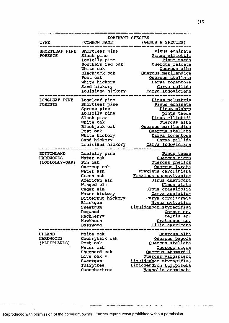
315
DOMINANT SPECIESTYPE (COMMON NAME) (GENUS & SPECIES)SHORTLEAF PINE Shortleaf pine Pinus echinataFORESTS Slash pine Pinus elliottii
Loblolly pine Pinus taedaSouthern red oak Ouercus falcataWhite oak Ouercus albaBlackjack oak Ouercus marilandicaPost oak Ouercus steilataWhite hickory Carva tomentosaSand hickory Carva DallidaLouisiana hickory Carva ludoviciana
LONGLEAF PINE Longleaf pine Pinus DalustrisFORESTS Shortleaf pine Pinus echinata
Spruce pine Pinus glabraLoblolly pine minus taedaSlash pine Pinus elliottiiWhite oak Ouercus albaBlackjack oak Ouercus marilandicaPost oak Ouercus steilataWhite hickory Carva tomentosaSand hickory Carva oallidaLouisiana hickory Carva ludoviciana
BOTTOMLAND Loblolly pine Pinus taedaHARDWOODS Water oak Ouercus nigra(LOBLOLLY-OAK) Pin oak Ouercus Dhellos
Overcup oak Ouercus lyrataWater ash Fraxinus carolinianaGreen ash Fraxinus oennsvlvanicaAmerican elm Ulmus americanaWinged elm Ulmus alataCedar elm Ulmus crassifoliaWater hickory Carva aouiaticaBitternut hickory Carva cordiformisBlackgum Nvssa svlvaticaSweetgum Liquidambar styracifluaDogwood Cornus sd.Hackberry Celtis sp.Hawthorn Crataegus so.Basswood Tilia americana
UPLANDHARDWOODS(BLUFFLANDS)
White oak Cherrybark oak Post oak Water oak Shummard oak Live oak * Sweetgum Tuliptree Cucumbertree
Ouercus alba Ouercus pagoda
Ouercus steilata Ouercus nigra
Ouercus shumardii Ouercus virainiana
Licmidambar stvraciflua Liriodendron tulioifera Magnolia acuminata
Reproduced with permission of the copyright owner. Further reproduction prohibited without permission.
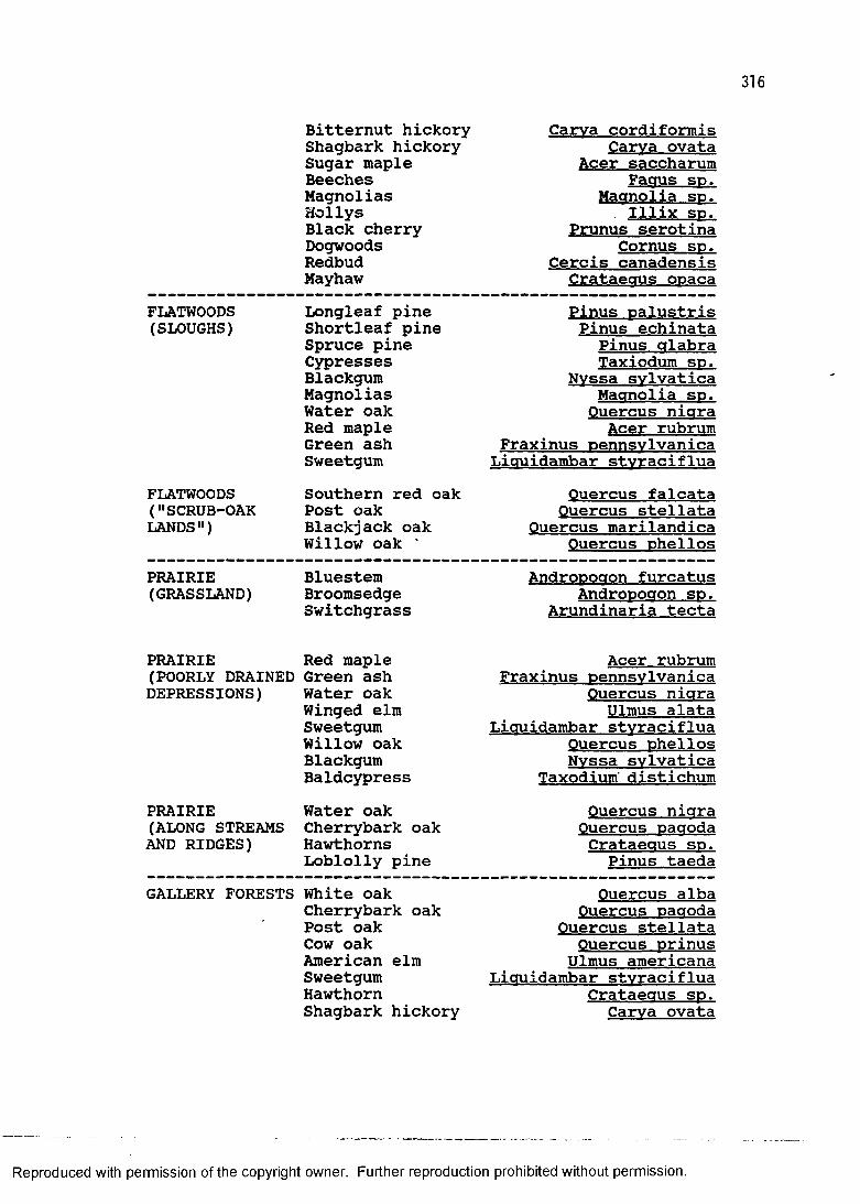
Bitternut hickory Shagbark hickory Sugar maple Beeches Magnolias HollysBlack cherry Dogwoods Redbud Mayhaw
Carva cordiformis Carva ovata
Acer saccharum Faaus so.
Magnolia sp. Illix sp.
Prunus serotina Cornus so.
Cercis canadensis Crataeous opaca
FLATWOODS(SLOUGHS)
FLATWOODS ("SCRUB-OAK LANDS")
Longleaf pine Shortleaf pine Spruce pine Cypresses Blackgum Magnolias Water oak Red maple Green ash SweetgumSouthern red oak Post oak Blackjack oak Willow oak '
Pinus palustris Pinus echinata
Pinus glabra Taxiodum sp.
Nvssa svlvatica Magnolia sp. Ouercus nigra
Acer rubrum Fraxinus pennsvlvanica
Liauidambar stvracifluaOuercus falcata
Ouercus steilata Ouercus marilandica
Ouercus phellosPRAIRIE(GRASSLAND)
Bluestem Broomsedge Switchgrass
Andropogon furcatus Andropogon sp.
Arundinaria tecta
PRAIRIE Red maple(POORLY DRAINED Green ash DEPRESSIONS) Water oak
Winged elm Sweetgum Willow oak Blackgum Baldcypress
PRAIRIE Water oak(ALONG STREAMS Cherrybark oak AND RIDGES) Hawthorns
Loblolly pine
Acer rubrum Fraxinus pennsvlvanica
Ouercus nigra Ulmus alata
Liauidambar stvraciflua Ouercus Phellos Nvssa svlvatica
Taxodium distichumOuercus nigra Ouercus pagoda Crataegus sp.
Pinus taedaGALLERY FORESTS White oak
Cherrybark oak Post oak Cow oak American elm Sweetgum Hawthorn Shagbark hickory
Ouercus alba Ouercus pagoda
Ouercus steilata Ouercus prinus
Ulmus americana Liauidambar stvraciflua
Crataegus sp. Carva ovata
Reproduced with permission of the copyright owner. Further reproduction prohibited without permission.
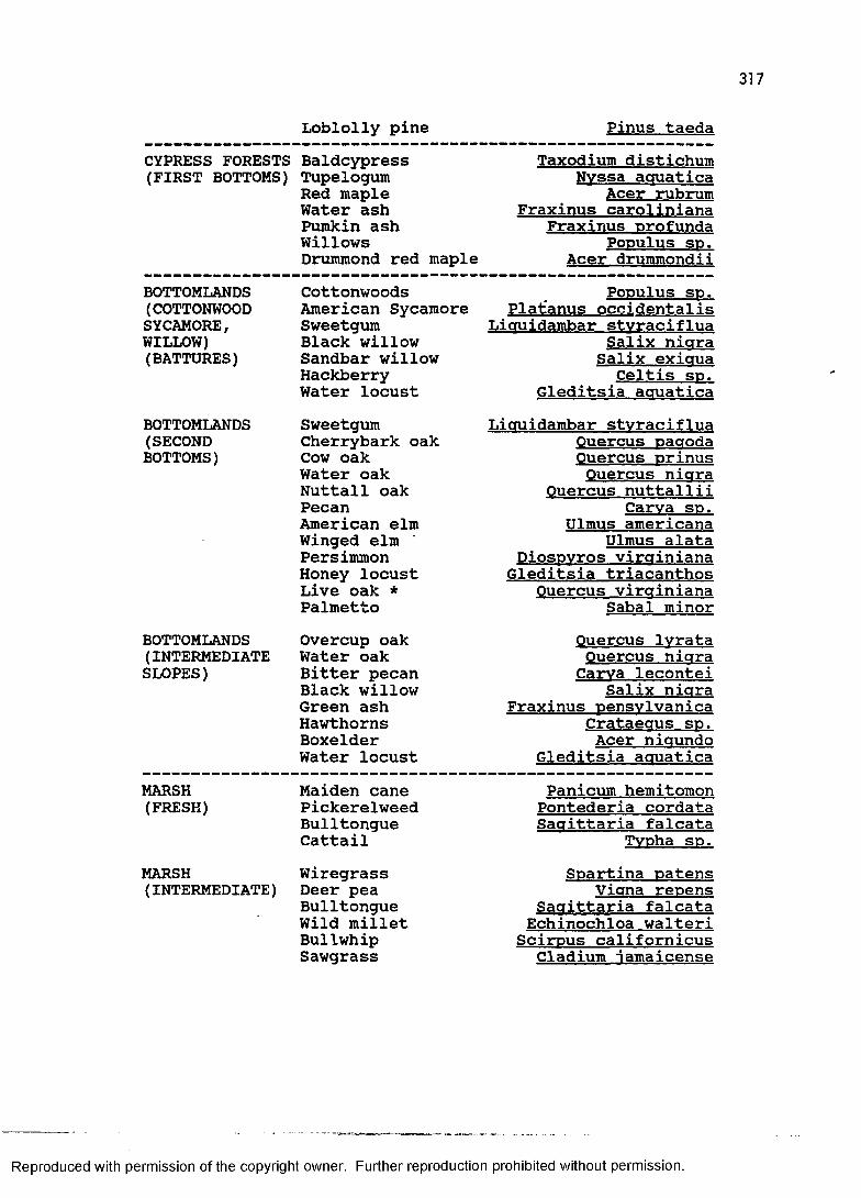
Loblolly pine Pinus taedaCYPRESS FORESTS Baldcypress Taxodium distichum(FIRST BOTTOMS) Tupelogum Nvssa aauatica
Red maple Acer rubrumWater ash Fraxinus carolinianaPumkin ash Fraxinus orofundaWillows Populus SD.Drummond red maple Acer drummondii
BOTTOMLANDS Cottonwoods Populus sp.(COTTONWOOD American Sycamore Plat'anus occidentalisSYCAMORE, Sweetgum Liauidambar stvracifluaWILLOW) Black willow Salix niara(BATTURES) Sandbar willow Salix exiaua
Hackberry Celtis sd.Water locust Gleditsia aauatica
BOTTOMLANDS Sweetgum Liauidambar stvraciflua(SECOND Cherrybark oak Ouercus DaaodaBOTTOMS) Cow oak Ouercus Drinus
Water oak Ouercus niaraNuttall oak Ouercus nuttalliiPecan Carva sd.American elm Ulmus americanaWinged elm Ulmus alataPersimmon DiosDvros virainianaHoney locust Gleditsia triacanthosLive oak * Ouercus virainianaPalmetto Sabal minor
BOTTOMLANDS Overcup oak Ouercus lvrata(INTERMEDIATE Water oak Ouercus niaraSLOPES) Bitter pecan Carva lecontei
Black willow Salix niaraGreen ash Fraxinus DensvlvanicaHawthorns Crataeaus s d .Boxelder Acer niaundoWater locust Gleditsia aauatica
MARSH Maiden cane Panicum hemitomon(FRESH) Pickerelweed Pontederia cordata
Bulltongue Saaittaria falcataCattail TvDha sd.
MARSH Wiregrass SDartina oatens(INTERMEDIATE) Deer pea Viana reDens
Bulltongue Saaittaria falcataWild millet Echinochloa walteriBullwhip ScirDus californicusSawgrass Cladium iamaicense
Reproduced with permission of the copyright owner. Further reproduction prohibited without permission.
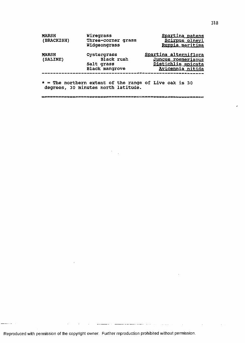
318
MARSH(BRACKISH)
MARSH(SALINE)
Wiregrass Three-corner grass WidgeongrassOystergrass
Black rush Salt grass Black mangrove
Soartina patens Scirpus olnevi
Ru p pia maritimaSpartina alterniflora
Juncus roemerianus Distichlis soicata Avicennia nitida
* = The northern extent of the range of Live oak is 30 degrees, 30 minutes north latitude.
Reproduced with permission of the copyright owner. Further reproduction prohibited without permission.
APPENDIX II: POPULATION CENSUS DATA
319
Reproduced with permission of the copyright owner. Further reproduction prohibited without permission.
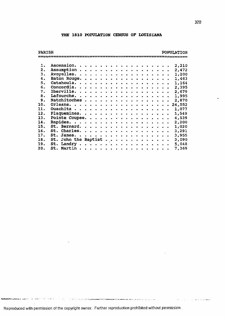
THE 1810 POPULATION CENSUS OF LOUISIANA
PARISH POPULATION
1. Ascension....................................... 2,2102. Assumption..................................... 2,4723. Avoyelles....................................... 1,2004. Baton Rouge..................................... 1,4635. Catahoula....................................... 1,1646. Concordia....................................... 2,3957. Iberville....................................... 2,6798. Lafourche....................................... 1,9959. Natchitoches................................... 2,870
10. Orleans....................................... 24,55211. Ouachita....................................... 1,07712. Plaquemines..................................... 1,54913. Pointe Coupee................................... 4,53914. Rapides......................................... 2,20015. St. Bernard..................................... 1,02016. St. Charles..................................... 3,29117. St. James....................................... 3,95518. St. John the Baptist ......................... 2,09019. St. Landry...........'......................... 5,04820. St. Martin..................................... 7,369
Reproduced with permission of the copyright owner. Further reproduction prohibited without permission.
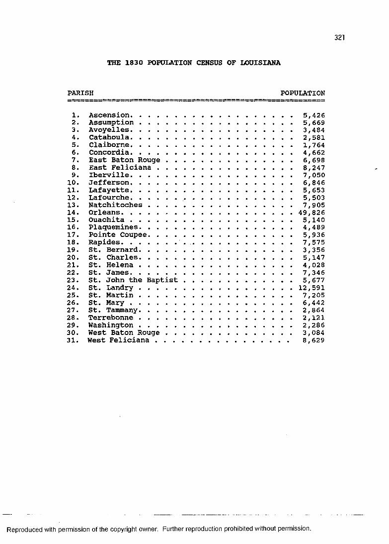
THE 1830 POPULATION CENSUS OF LOUISIANA
PARISH POPULATION
1. Ascension........................................5,4262. Assumption..................................... 5,6693. Avoyelles........................................3,4844. Catahoula........................................2,5815. Claiborne........................................1,7646. Concordia........................................4,6627. East Baton Rouge............................... 6,6988. East Feliciana................................. 8,2479. Iberville........................................7,050
10. Jefferson........................................6,84611. Lafayette........................................5,65312. Lafourche............ 5,50313. Natchitoches................................... 7,90514. Orleans....................................... 49,82615. Ouachita........................................5,14016. Plaquemines......................................4,48917. Pointe Coupee................................... 5,93618. Rapides.............. 7,57519. St. Bernard......................................3,35620. St. Charles......................................5,14721. St. Helena......................................4,02822. St. James........................................7,34623. St. John the Baptist............................ 5,67724. St. Landry.....................................12,59125. St. Martin..................................... 7,20526. St. M a r y ........................................6,44227. St. Tammany..................................... 2,86428. Terrebonne..................................... 2,12129. Washington..................................... 2,28630. West Baton Rouge............................... 3,08431. West Feliciana.............................. 8,629
Reproduced with permission of the copyright owner. Further reproduction prohibited without permission.
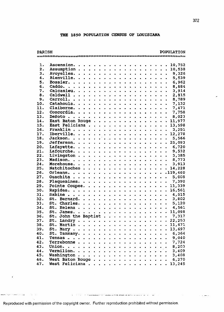
322
THE 1850 POPULATION CENSUS OF LOUISIANA
1. Ascension.......................................10,7522. Assumption ................................... 10,5383. Avoyelles........................................9,3264. Bienville........................................5,5395. Bossier..........................................6,9626. Caddo. . . . . . . . . . . . ................. 8,8847. Calcasieu........................................3,9148. Caldwell........................................2,8159. Carroll..........................................8,78910. Catahoula........................................7,13211. Claiborne........................................7,47112. Concordia........................................7,75813. DeSoto..........................................8,02314. East Baton Rouge ............................. 11,97715. East Feliciana................................ 13,59816. Franklin........................................3,25117. Iberville.......................................12,27818. Jackson.............. 5,56619. Jefferson..................................... 25,09320. Lafayette........................................6,72021. Lafourche................................. 9,53222. Livingston......................................3,38523. Madison..........................................8,77324. Morehouse....................................... 3,91325. Natchitoches ................................. 14,22826. Orleans........................................119,46027. Ouachita....................................... 5,00828. Plaquemines................................ > . 7,39029. Pointe Coupee...................................11,33930. Rapides.........................................16,56131. Sabine..........................................4,51532. St. Bernard..................................... 3,80233. St. Charles......................................5,12034. St. Helena......................................4,56135. St. James.......................................11,09836. St. John the Baptist........................... 7,31737. St. Landry................................... 22,25338. St. Martin.....................................11,67139. St. M a r y .......................................13,69740. St. Tammany......................................6,36441. Tensas.......................................... 9,04042. Terrebonne..................................... 7,72443. Union............................................8,20344. Vermilion..................................... 3,40945. Washington..................................... 3,40846. West Baton R ouge............................... 6,27047. West Feliciana................................ 13,245
Reproduced with permission of the copyright owner. Further reproduction prohibited without permission.
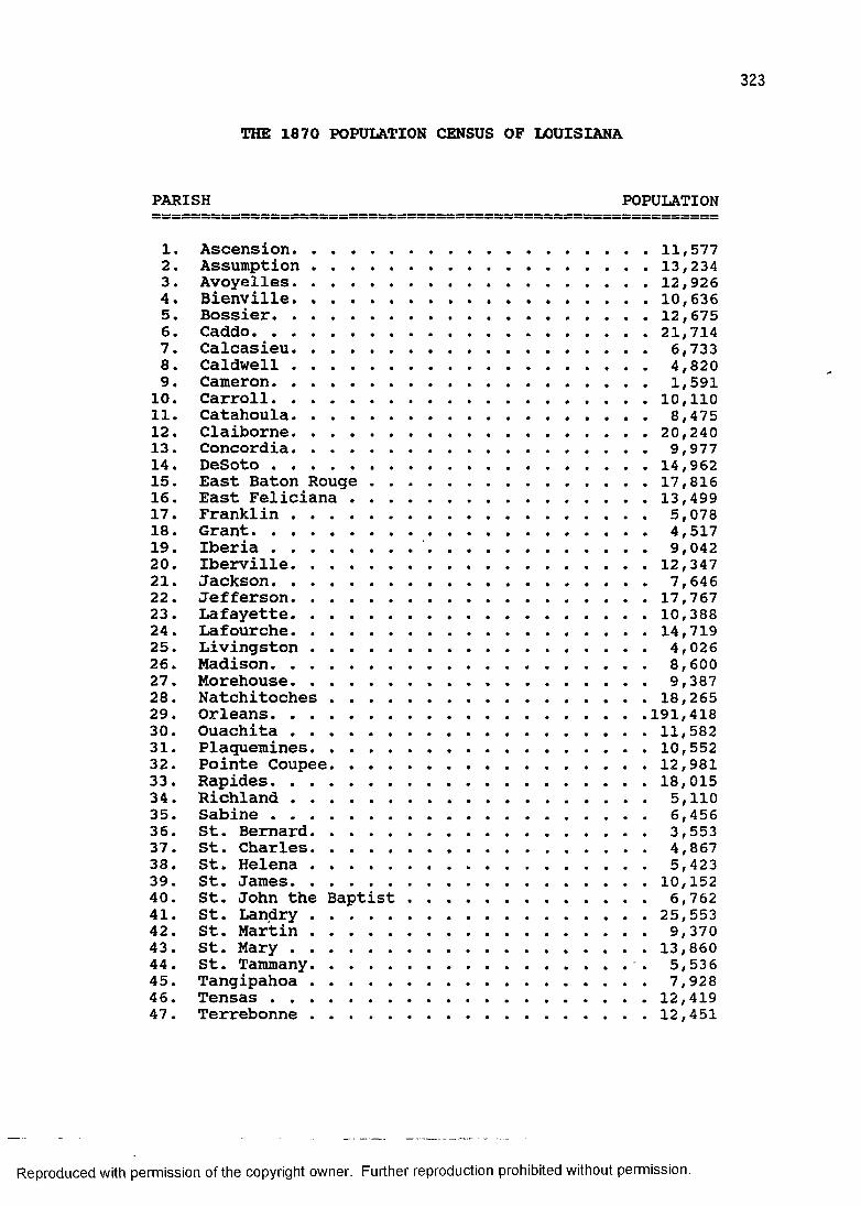
323
THE 1870 POPULATION CENSUS OF LOUISIANA
1. Ascension..................................... 11,5772. Assumption .................................. 13,2343. Avoyelles..................................... 12,9264. Bienville......... 10,6365. Bossier........................................12,6756. Caddo..........................................21,7147. Calcasieu...................................... 6,7338. Caldwell...................................... 4,8209. Cameron........................................ 1,59110. Carroll....................................... 10,11011. Catahoula...................................... 8,47512. Claiborne..................................... 20,24013. Concordia...................................... 9,97714. DeSoto ...................................... 14,96215. East Baton Rouge ............................ 17,81616. East Feliciana............................... 13,49917. Franklin...................................... 5,07818. Grant............... 4,51719. Iberia............... 9,04220. Iberville..................................... 12,34721. Jackson........................................ 7,64622. Jefferson..................................... 17,76723. Lafayette..................................... 10,38824. Lafourche..................................... 14,71925. Livingston.................................... 4,02626. Madison........................................ 8,60027. Morehouse........... 9,38728. Natchitoches ................................ 18,26529. Orleans...................................... 191,41830. Ouachita .................................... 11,58231. Plaquemines................................... 10,55232. Pointe Coupee................................. 12,98133. Rapides....................................... 18,01534. Richland...................................... 5,11035. Sabine........................................ 6,45636. St. Bernard.................................... 3,55337. St. Charles.................................... 4,86738. St. Helena.................................... 5,42339. St. James..................................... 10,15240. St. John the Baptist......... 6,76241. St. Landry.................................. 25,55342. St. Martin.................................... 9,37043. St. M a r y ..................................... 13,86044. St. Tammany................................. 5,53645. Tangipahoa.................................... 7,92846. Tensas ...................................... 12,41947. Terrebonne .................................. 12,451
Reproduced with permission of the copyright owner. Further reproduction prohibited without permission.
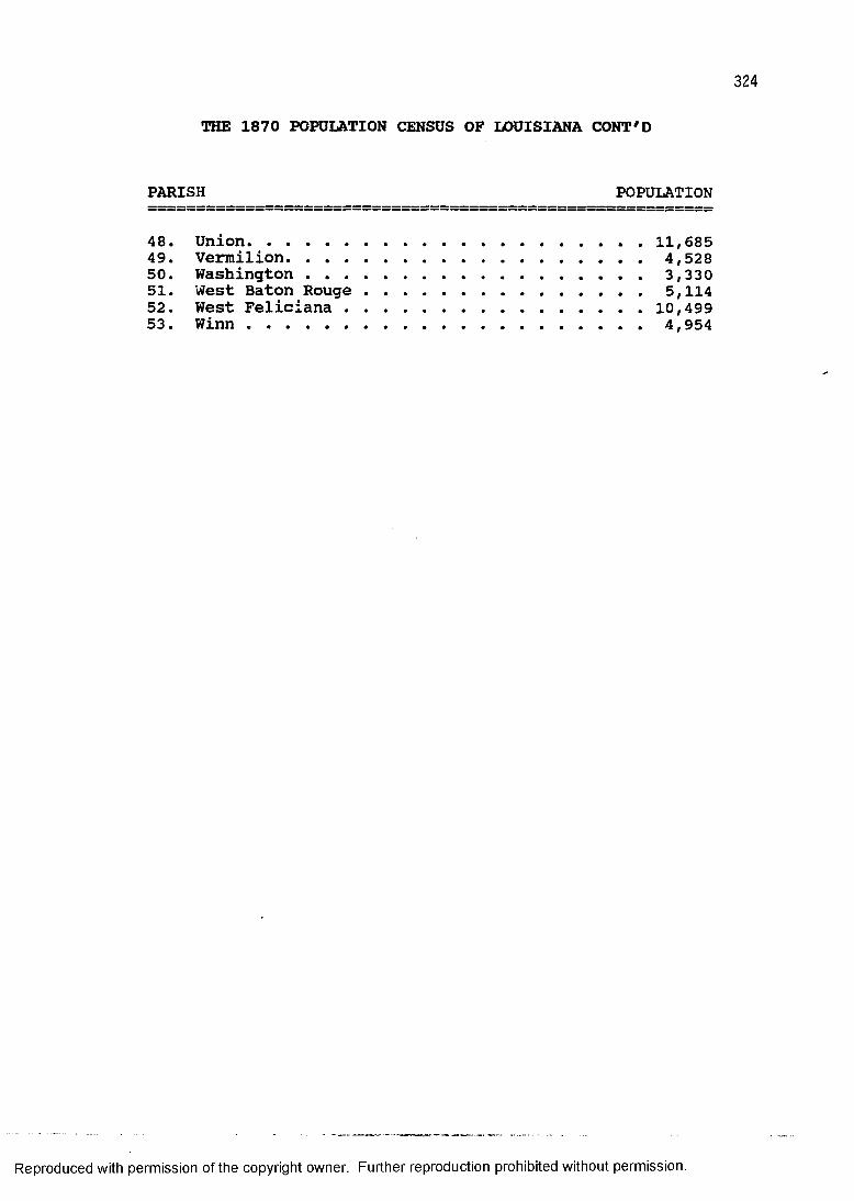
324
THE 1870 POPULATION CENSUS OF LOUISIANA CONT'D
PARISH POPULATION
48. Union.......................................... 11, 68549. Vermilion....................................... 4,52850. Washington..................................... 3,33051. West Baton Rouge................................ 5,11452. West Feliciana................................ 10,49953. W i n n ........................................... 4,954
Reproduced with permission of the copyright owner. Further reproduction prohibited without permission.
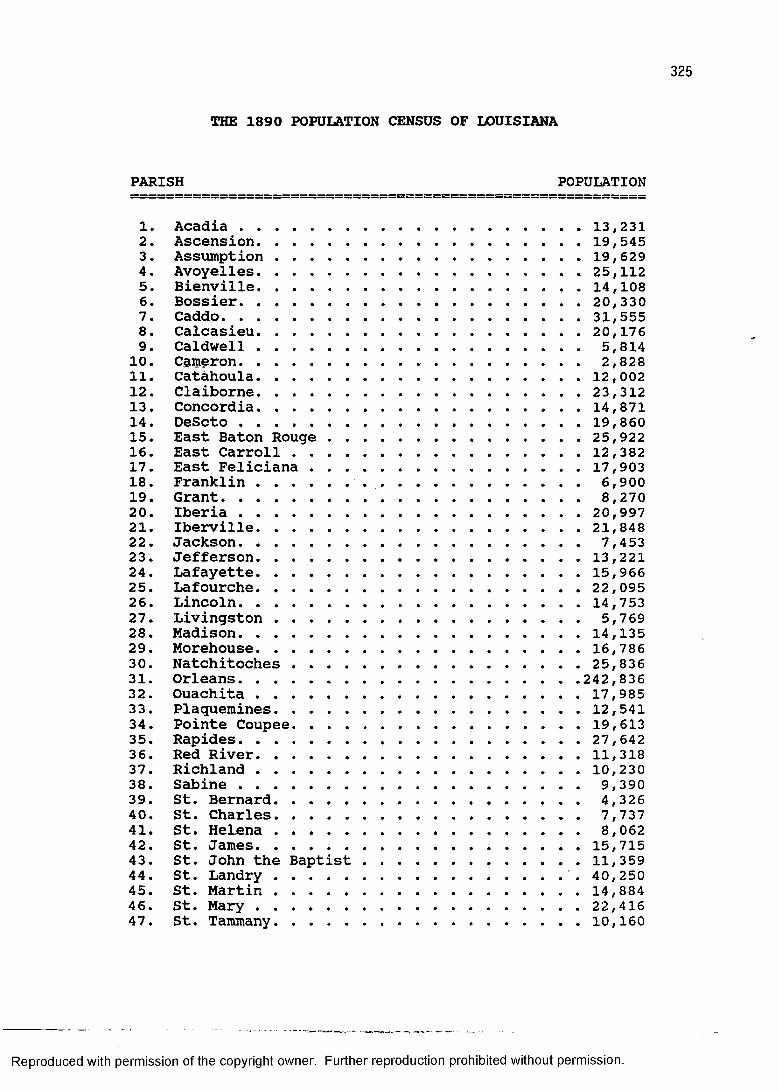
THE 1890 POPULATION CENSUS OF LOUISIANA
PARISH POPULATION
1. Acadia ...................................... 13,2312. Ascension..................................... 19,5453. Assumption .................................. 19,6294. Avoyelles............................. 25,1125. Bienville......................................14,1086. Bossier...................................... 20,3307. Caddo..........................................31,5558. Calcasieu..................................... 20,1769. Caldwell...................................... 5,814
10. Cameron..................... 2,82811. Catahoula..................................... 12,00212. Claiborne..................................... 23,31213. Concordia......................................14,87114. DeScto ...................................... 19,86015. East Baton Rouge ............................ 25,92216. East Carroll................................. 12,38217. East Feliciana............................... 17,90318. Franklin........... 6,90019. Grant.......................................... 8,27020. Iberia ...................................... 20,99721. Iberville..................................... 21,84822. Jackson........................................ 7,45323. Jefferson..................................... 13,22124. Lafayette..................................... 15,96625. Lafourche.................................... 22,09526. Lincoln....................................... 14,75327. Livingston.................................... 5,76928. Madison....................................... 14,13529. Morehouse..................................... 16,78630. Natchitoches ................................ 25,83631. Orleans...................................... 242,83632. Ouachita .................................... 17,98533. Plaquemines................................... 12,54134. Pointe Coupee................................. 19,61335. Rapides...................................... 27,64236. Red River....................... 11,31837. Richland .................................... 10,23038. Sabine........................................ 9,39039. St. Bernard.................................... 4,32640. St. Charles.................................... 7,73741. St. Helena.................................... 8,06242. St. James..................................... 15,71543. St. John the Baptist......................... 11,35944. St. Landry................................... 40,25045. St. Martin................................... 14,88446. St. M a r y ..................................... 22,41647. St. Tammany................................... 10,160
Reproduced with permission of the copyright owner. Further reproduction prohibited without permission.

THE 1890 POPULATION CENSUS OF LOUISIANA CONT'D
PARISH POPULATION
48. Tangipahoa.................................... 12,65549. Tensas ....................................... 16,64750. Terrebonne.................................... 20,16751. Union...........................................17,30452. Vermilion.......................................14,23453. Vernon..........................................5,90354. Washington......................................6,70055. Webster.........................................12,46656. West Baton Rouge................................ 8,36357. West Carroll................................... 3,74858. West Feliciana................................ 15,06259. W i n n ............................................7,082
Reproduced with permission of the copyright owner. Further reproduction prohibited without permission.
APPENDIX Ills HISTORIC STANDING STRUCTURE SAMPLE
327
Reproduced with permission of the copyright owner. Further reproduction prohibited without permission.
MODERN PARISHES OF LOUISIANA IN ALPHABETICAL ORDER01. Acadia 33. Madison02. Allen 34. Morehouse03. Ascension 35. Natchitoches04. Assumption 36. Orleans05. Avoyelles 37. Ouachita06. Beauregard 38. Plaquemines07. Bienville 39. Pointe Coupee08. Bossier 40. Rapides09. Caddo 41. Red River10. Calcasieu 42. Richland11. Caldwell 43. Sabine12. Cameron 44. St. Bernard13. Catahoula 45. St. Charles14. Claiborne 46. St. Helena15. Concordia 47. St. James16. DeSoto 48. St. John17. East Baton Rouge 49. St. Landry18. East Carroll 50. St. Martin19. East Feliciana 51. St. Mary20. Evangeline 52. St. Tammany21. Franklin 53. Tangipahoa22. Grant 54. Tensas23. Iberia 55. Terrebonne24. Iberville 56. Union25. Jackson 57. Vermilion26. Jefferson 58. Vernon27. Jefferson Davis 59. Washington28. Lafayette 60. Webster29. Lafourche 61. West Baton Rouge30. LaSalle 62. West Carroll31. Lincoln 63. West Feliciana32. Livingston 64. Winn
Reproduced with permission of the copyright owner. Further reproduction prohibited without permission.
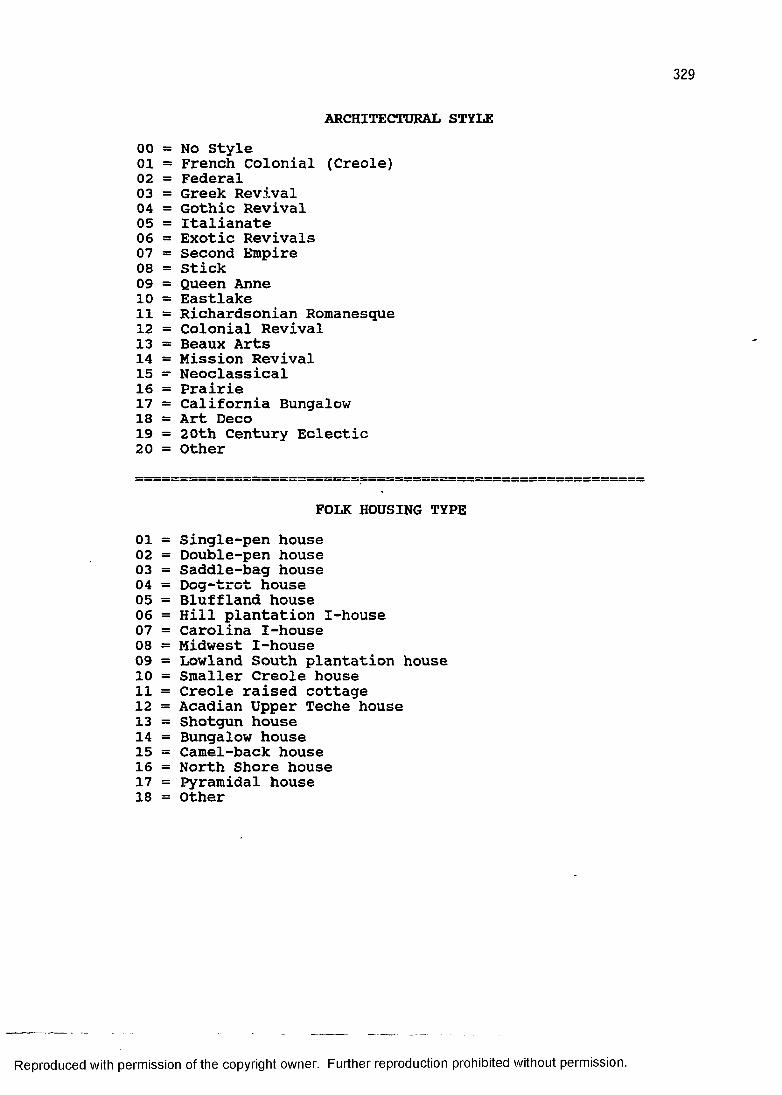
ARCHITECTURAL STYLE00 = No Style01 = French Colonial (Creole)02 = Federal03 = Greek Revival04 = Gothic Revival05 = Italianate06 = Exotic Revivals07 = Second Empire08 = Stick09 = Queen Anne10 = Eastlake11 = Richardsonian Romanesque12 = Colonial Revival13 as Beaux Arts14 = Mission Revival15 — Neoclassical16 = Prairie17 = California Bungalow18 = Art Deco19 = 20th Century Eclectic20 = Other
FOLK HOUSING TYPE01 = Single-pen house02 = Double-pen house03 = Saddle-bag house04 = Dog-trot house05 = Bluffland house06 = Hill plantation I-house07 = Carolina I-house08 = Midwest I-house09 = Lowland South plantation house10 = Smaller Creole house11 = Creole raised cottage12 = Acadian Upper Teche house13 = Shotgun house14 = Bungalow house15 = Camel-back house16 = North Shore house17 = Pyramidal house18 = Other
Reproduced with permission of the copyright owner. Further reproduction prohibited without permission.
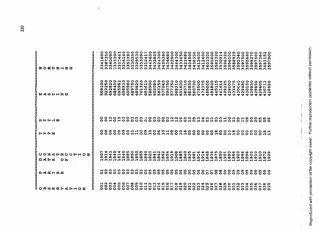
oC OC O
W OS CO Eh H 55 U
I CO Eh !x J W
Eh >* fa W
O O S S C Q E h K S d O E h m O S S
Q < Eh W O fa
fa < fa H W «
O « C 0 P q « > < E H O l 3
o o o o CO o O o o o t" O in o o o o o o o o o o o o O o xr o o in o o o o o xr CN oo in cn o 10 XT Ol in CO a\ rH in CN o 00 00 o o in CO o in o o o O CN rH CN o CN xr o VO o vo in oCO CO o CO xT rH CO CO in cn xr VO 00 CO CO VO Ol co xr VO in CO xr xr o 00 co Ol CO o 01 co in vo CN in co rH 01rH r" o CO CO VO CO o o\ CO (M CO CN xr in VO CN xr co CO xr VO CN CN rH in CN O VO VO 00 in r* in in fx COHi* CO *3" CO CO CO in CO in co rH xr CO CN CN CO CN xr co CN CN co rH H O Ol 00 CO Ol Ol 00 Ol Ol Ol Ol Ol Ol 00 OlCO CO CO CO CO CO CO CO CO CO CO xr xr xr xT xr xr xr xr xr xr xr xr xr VO in in in in in in in in in in in in xr inCO CO CO n co CO CO co CO CO CO CO CO CO CO CO CO CO CO CO CO CO CO CO CO CO CO co CO CO CO CO co CO co CO co CO CO
o o o O CN o o o o o 01 O o o o o o o o o o o o in o o in xr in o in o o o o o in CO oo in CN O 00 co CO in CN CN rH O 00 in xr in in rH o rH o o o o o rH rH CN o r-« 00 o in in o rH corH CN 00 xr Ol Ol Ol 00 co VO Ol o rH o r> CO CN vo fx CO fx in CO o 00 rH xr CN o xr vo xr rH CO 00 vo C OlOl CN CN 00in 00 in Ol Ol rH CO 00 CN co o p- Ol rH in CO o CN CN in xr in rH 01 Ol CO o 01 O 01 Ol Ol O 00in CN Ol CO Ol Ol Ol 00 00 o Ol 00 o 00 Ol 00 o CO 00 Ol C" i Ol 01 xr xr CN CN CO CO CN CO CN CN CN CO CNin in VO VO vo VO vo VO VO tx- VO in vo inin in in in vo in in in xr xr xr xr xr xr xr xr xr xr xr xr xr xr xr xr xr
o o i n o i n n o n n n.i o n n o n o t M i n n o m p i ^ n n n n H o n m H o i o o i n i n m O O r H O r H O O O O O O O O O O O r H r H O O r H O i H O O O O O r H O O O r H O C N C N O O O
o o m o o t o i o dO O O O O O O r H
O O l O O V O O r H O l O O O O i n O O O O O C O O OO O r H O O H r H O O r H r H O O O O O O r H O O
c o c o o o o o o o c o r oH r H O O O O O O r H r H
fx-xr rH O xr O in O O in O in rH CN CN xr Ol 00 in o in rH xr xr 00 VO in O rH o VO O vo 00 in O O CN Olo rHxr xr rHxr CO in in in xr CN xr xrin in rH o 00 xr co O rH rH xr CO e'in O 00 in O Ol Ol O rH rH rx O01 Ol 00 00 00 00 CO 00 00 00 00 00 00 00 00 00 cn 01 00 00 00 01 Ol 01 00 00 en 00 01 00 00 01 00.CO 01 01 Ol CO 01rH rH rH H rH rH rH rH rH rH H rH rH rH rH H rH rH H rH rH rH rH rH rH rH rH rH *1 rH rH rH rH rH rH rH rH rH rH
H CN CO CO CO CO CO CO CO CO xr in in in in in in in in in in in VO VO r- rx CO 00 Ol Ol Ol Ol Ol Ol Ol Ol Ol Ol OlO O O O O O O O O O o O o o O o o o o o O o O O o o O o o O O o O © O O O O ©
rH CN co xr in vo O' CO Ol o rH CN CO xr in VO px 00 Ol o rH CN CO xr in VO tx- 00 Ol O H CN CO xr in vo fx. 00 01O O o o o o o o o rH rH rH i—1rH rH rH rH rH rH CN CN CN CN CN CN CN CN CN CN CO CO CO CO CO co CO CO CO COO O o o o o o o o o o O o O o o o o o O O O O O O O O O O o O o o o o o o o o
Rep
rodu
ced
with
pe
rmis
sion
of
the
copy
right
ow
ner.
Furth
er
repr
oduc
tion
proh
ibite
d w
ithou
t pe
rmis
sion
.
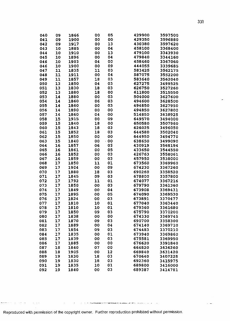
331
040 09 1866 00041 09 1900 00042 09 1917 00043 10 1885 00044 10 1910 00045 10 1896 00046 10 1903 04046 10 1900 00047 11 1835 11048 11 1911 00049 11 1857 18050 13 1850 04051 13 1830 18052 13 1880 18053 14 1880 00054 14 1860 06055 14 1860 00056 14 1890 00057 14 1860 04058 15 1915 00059 15 1840 18060 15 1843 18061 15 1852 18062 15 1850 00063 15 1840 00064 16 1857 06065 16 1861 00066 16 1852 00067 16 1859 00068 17 1850 11069 17 1904 00070 17 1880 18071 17 1845 09072 17 1792 11073 17 1850 00074 17 1849 00075 17 1895 00076 17 1824 00077 17 1810 10078 17 1810 10079 17 1850 09080 17 1838 00081 17 1870 09082 17 1889 00083 17 1854 09084 17 1835 00085 17 1839 00086 17 1885 00087 18 1840 07088 18 1905 00089 19 1830 18090 19 1830 18091 19 1835 10092 19 1840 00
429900 3597500429350 3596880430380 3597620458100 3368400479100 3343930479840 3344160458460 3367060444055 3339685583425 3562175587075 3552200583640 3562040627275 3499525626750 3527260611800 3515550504000 3627600494600 3628500494850 3627950494850 3627800514850 3638925649570 3494000650580 3507960626025 3496050644580 3502040644950 3494770638650 3499090430919 3568194433650 3544550426763 3558061457950 3538000673560 3369960674230 3367260690260 3358520678800 3357800674077 3367216679790 3361360673908 3369431674090 3369530673891 3370477677040 3363440679360 3361680675790 3370200674330 3369745690700 3358300674140 3369710674483 3370210673940 3369860675581 3369950676620 3391840664820 3636260669840 3631420670640 3407228692360 3415975689800 3416000689387 3414781
050013041304000903040303030003030300000900030300000305030301090303010304050301010300030403010300001203030103
Reproduced with permission of the copyright owner. Further reproduction prohibited without permission.
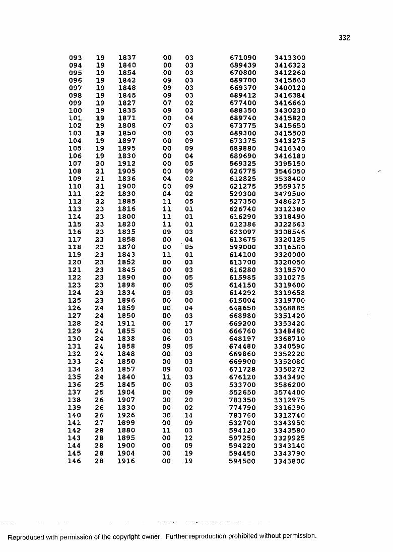
093 19 1837 00 03 671090 3413300094 19 1840 00 03 689439 3416322095 19 1854 00 03 670800 3412260096 19 1842 09 03 689700 3415560097 19 1848 09 03 669370 3400120098 19 1845 09 03 689412 3416384099 19 1827 07 02 677400 3416660100 19 1835 09 03 688350 3430230101 19 1871 00 04 689740 3415820102 19 1808 07 03 673775 3415650103 19 1850 00 03 689300 3415500104 19 1897 00 09 673375 3413275105 19 1895 00 09 689880 3416340106 19 1830 00 04 689690 3416180107 20 1912 00 05 569325 3395150108 21 1905 00 09 626775 3546050109 21 1836 04 02 612825 3538400110 21 1900 00 09 621275 3559375111 22 1830 04 02 529300 3479500112 22 1885 11 05 527350 3486275113 23 1816 11 01 626740 3312380114 23 1800 11 01 616290 3318490115 23 1820 11 01 612386 3322563116 23 1835 09 03 623097 3308546117 23 1858 00 04 613675 3320125118 23 1870 00 05 599000 3316500119 23 1843 11 01 614100 3320000120 23 1852 00 03 613700 3320050121 23 1845 00 03 616280 3318570122 23 1890 00 05 615985 3310275123 23 1898 00 05 614150 3319600124 23 1834 09 03 614292 3319658125 23 1896 00 00 615004 3319700126 24 1859 00 04 648650 3368885127 24 1850 00 03 668980 3351420128 24 1911 00 17 669200 3353420129 24 1855 00 03 666760 3348480130 24 1838 06 03 648197 3368710131 24 1858 09 05 674480 3340590132 24 1848 00 03 669860 3352220133 24 1850 00 03 669900 3352080134 24 1857 09 03 671728 3350272135 24 1840 11 03 676120 3343490136 25 1845 00 03 533700 3586200137 25 1904 00 09 552650 3574400138 26 1907 00 20 783350 3312975139 26 1830 00 02 774790 3316390140 26 1926 00 14 783760 3312740141 27 1899 00 09 532700 3343950142 28 1880 11 03 594120 3343580143 28 1895 00 12 597250 3329925144 28 1900 00 09 594220 3343140145 28 1904 00 19 594450 3343790146 28 1916 00 19 594500 3343800
Reproduced with permission of the copyright owner. Further reproduction prohibited without permission.
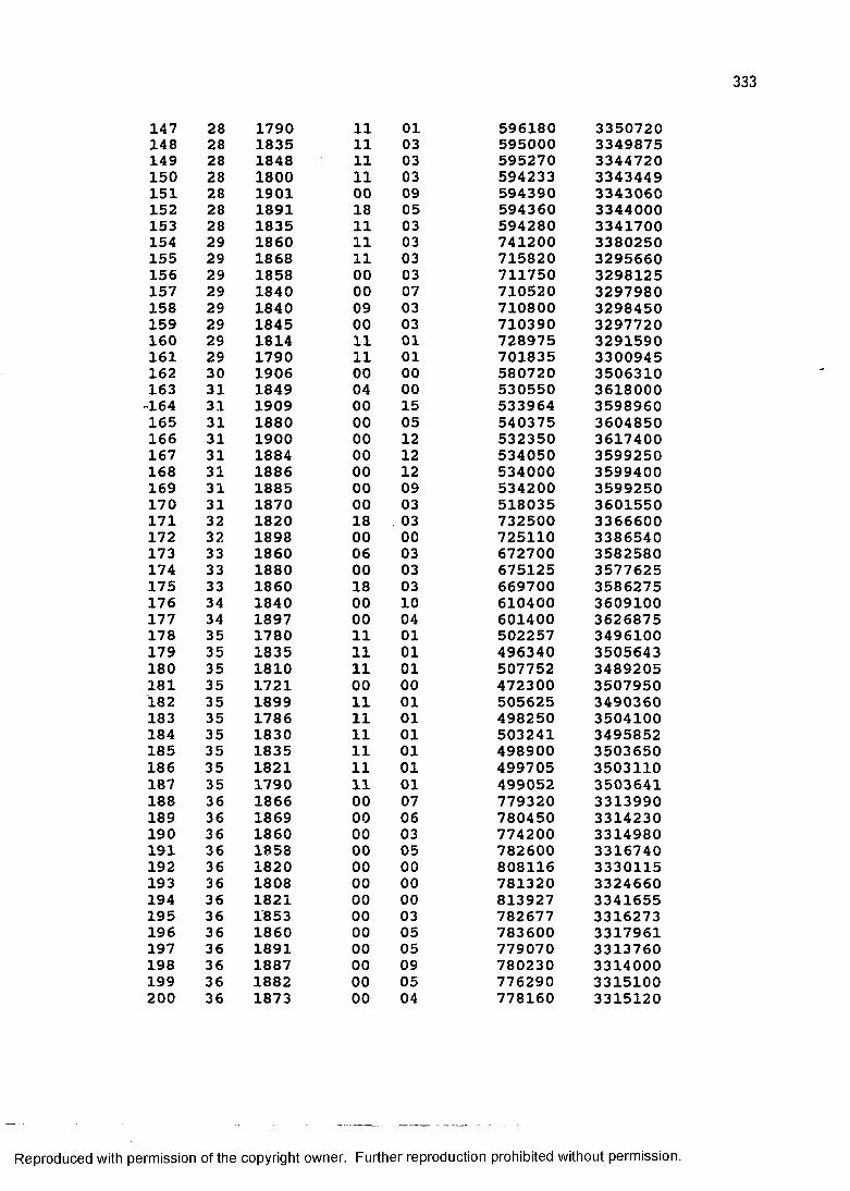
147 28 1790 11 01 596180 3350720148 28 1835 11 03 595000 3349875149 28 1848 11 03 595270 3344720150 28 1800 11 03 594233 3343449151 28 1901 00 09 594390 3343060152 28 1891 18 05 594360 3344000153 28 1835 11 03 594280 3341700154 29 1860 11 03 741200 3380250155 29 1868 11 03 715820 3295660156 29 1858 00 03 711750 3298125157 29 1840 00 07 710520 3297980158 29 1840 09 03 710800 3298450159 29 1845 00 03 710390 3297720160 29 1814 11 01 728975 3291590161 29 1790 11 01 701835 3300945162 30 1906 00 00 580720 3506310163 31 1849 04 00 530550 3618000-164 31 1909 00 15 533964 3598960165 31 1880 00 05 540375 3604850166 31 1900 00 12 532350 3617400167 31 1884 00 12 534050 3599250168 31 1886 00 12 534000 3599400169 31 1885 00 09 534200 3599250170 31 1870 00 03 518035 3601550171 32 1820 18 . 03 732500 3366600172 32 1898 00 00 725110 3386540173 33 1860 06 03 672700 3582580174 33 1880 00 03 675125 3577625175 33 1860 18 03 669700 3586275176 34 1840 00 10 610400 3609100177 34 1897 00 04 601400 3626875178 35 1780 11 01 502257 3496100179 35 1835 11 01 496340 3505643180 35 1810 11 01 507752 3489205181 35 1721 00 00 472300 3507950182 35 1899 11 01 505625 3490360183 35 1786 11 01 498250 3504100184 35 1830 11 01 503241 3495852185 35 1835 11 01 498900 3503650186 35 1821 11 01 499705 3503110187 35 1790 11 01 499052 3503641188 36 1866 00 07 779320 3313990189 36 1869 00 06 780450 3314230190 36 1860 00 03 774200 3314980191 36 1858 00 05 782600 3316740192 36 1820 00 00 808116 3330115193 36 1808 00 00 781320 3324660194 36 1821 00 00 813927 3341655195 36 1853 00 03 782677 3316273196 36 1860 00 05 783600 3317961197 36 1891 00 05 779070 3313760198 36 1887 00 09 780230 3314000199 36 1882 00 05 776290 3315100200 36 1873 00 04 778160 3315120
with permission of the copyright owner. Further reproduction prohibited without permission.
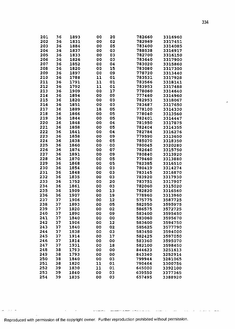
201 36 1893 00 20 782660 3316960202 36 1831 00 02 782969 3317451203 36 1884 00 05 783400 3314085204 36 1837 00 03 788538 3316917205 36 1833 00 03 782700 3316150206 36 1826 00 03 783640 3317900207 36 1852 00 04 783020 3315860208 36 1820 00 15 783080 3317300209 36 1897 00 09 778720 3313440210 36 1788 11 01 783531 3317928211 36 1791 11 01 783566 3318141212 36 1792 11 01 783953 3317488213 36 1909 00 17 778060 3314640214 36 1894 00 09 777460 3314960215 36 1820 00 03 782953 3318067216 36 1851 00 03 783687 3317650217 36 1889 18 05 778100 3314330218 36 1866 00 05 778040 3313560219 36 1844 00 05 782401 3314447220 36 1848 00 04 781950 3317875221 36 1858 00 05 782404 3314355222 36 1841 00 04 782784 3316276223 36 1858 00 09 779590 3313650224 36 1838 00 05 785070 3318350225 36 1860 00 00 780045 3320280226 36 1874 00 07 782640 3315750227 36 1891 00 09 780840 3313920228 36 1870 00 05 779460 3313880229 36 1868 00 05 782385 3316510230 36 1854 00 03 780419 3314274231 36 1848 00 03 783145 3316870232 36 1835 00 03 783920 3317930233 36 1752 00 20 783751 3317907234 36 1861 00 03 782060 3315020235 36 1909 00 13 782820 3316560236 36 1907 00 19 778960 3313960237 37 1906 00 12 575775 3587725238 37 1893 00 05 582950 3595975239 37 1820 00 02 586575 3572725240 37 1890 00 09 583400 3595450241 37 1840 00 00 583060 3595670242 37 1906 00 12 583600 3594750243 37 1840 00 02 585625 3577790244 37 1838 00 03 583450 3594000245 37 1914 00 17 582425 3597050246 37 1814 00 00 583360 3595070247 37 1931 00 18 582100 3598450248 38 1.793 00 00 844623 3251613249 38 1793 00 00 843340 3252914250 38 1840 00 03 799944 3281065251 38 1820 11 01 790464 3300756252 39 1830 11 01 645000 3392100253 39 1840 00 03 639550 3377365254 39 1835 00 03 657495 3388920
Reproduced with permission of the copyright owner. Further reproduction prohibited without permission.
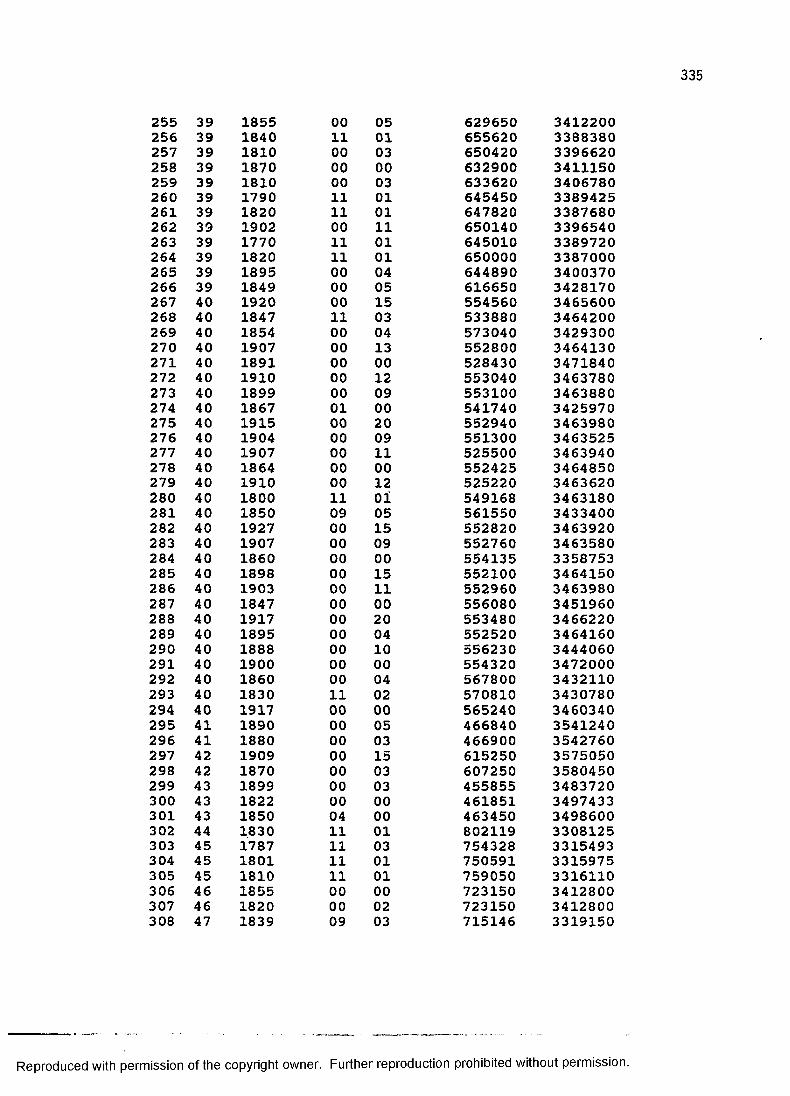
255 39 1855 00 05 629650 3412200256 39 1840 11 01 655620 3388380257 39 1810 00 03 650420 3396620258 39 1870 00 00 632900 3411150259 39 1810 00 03 633620 3406780260 39 1790 11 01 645450 3389425261 39 1820 11 01 647820 3387680262 39 1902 00 11 650140 3396540263 39 1770 11 01 645010 3389720264 39 1820 11 01 650000 3387000265 39 1895 00 04 644890 3400370266 39 1849 00 05 616650 3428170267 40 1920 00 15 554560 3465600268 40 1847 11 03 533880 3464200269 40 1854 00 04 573040 3429300270 40 1907 00 13 552800 3464130271 40 1891 00 00 528430 3471840272 40 1910 00 12 553040 3463780273 40 1899 00 09 553100 3463880274 40 1867 01 00 541740 3425970275 40 1915 00 20 552940 3463980276 40 1904 00 09 551300 3463525277 40 1907 00 11 525500 3463940278 40 1864 00 00 552425 3464850279 40 1910 00 12 525220 3463620280 40 1800 11 01 549168 3463180281 40 1850 09 05 561550 3433400282 40 1927 00 15 552820 3463920283 40 1907 00 09 552760 3463580284 40 1860 00 00 554135 3358753285 40 1898 00 15 552100 3464150286 40 1903 00 11 552960 3463980287 40 1847 00 00 556080 3451960288 40 1917 00 20 553480 3466220289 40 1895 00 04 552520 3464160290 40 1888 00 10 556230 3444060291 40 1900 00 00 554320 3472000292 40 1860 00 04 567800 3432110293 40 1830 11 02 570810 3430780294 40 1917 00 00 565240 3460340295 41 1890 00 05 466840 3541240296 41 1880 00 03 466900 3542760297 42 1909 00 15 615250 3575050298 42 1870 00 03 607250 3580450299 43 1899 00 03 455855 3483720300 43 1822 00 00 461851 3497433301 43 1850 04 00 463450 3498600302 44 1830 11 01 802119 3308125303 45 1787 11 03 754328 3315493304 45 1801 11 01 750591 3315975305 45 1810 11 01 759050 3316110306 46 1855 00 00 723150 3412800307 46 1820 00 02 723150 3412800308 47 1839 09 03 715146 3319150
Reproduced with permission of the copyright owner. Further reproduction prohibited without permission.
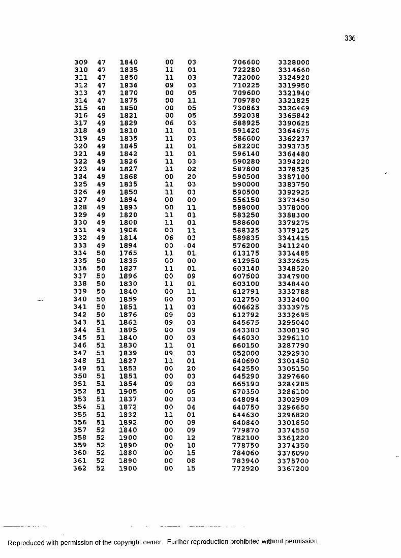
309 47 1840 00 03 706600 3328000310 47 1835 11 01 722280 3314660311 47 1850 11 03 722000 3324920312 47 1836 09 03 710225 3319950313 47 1870 00 05 709600 3321940314 47 1875 00 11 709780 3321825315 48 1850 00 05 730863 3326469316 49 1821 00 05 592038 3365842317 49 1829 06 03 588925 3390625318 49 1810 11 01 591420 3364675319 49 1835 11 03 586600 3362237320 49 1845 11 01 582200 3393735321 49 1842 11 01 596140 3364480322 49 1826 11 03 590280 3394220323 49 1827 11 02 587800 3378525324 49 1868 00 20 590500 3387100325 49 1835 11 03 590000 3383750326 49 1850 11 03 590500 3392925327 49 1894 00 00 556150 3373450328 49 1893 00 11 588000 3378000329 49 1820 11 01 583250 3388300330 49 1800 11 01 588600 3379275331 49 1908 00 11 588325 3379125332 49 1814 06 03 589835 3341415333 49 1894 00 04 576200 3411240334 50 1765 11 01 613175 3334485335 50 1835 00 00 612950 3332625336 50 1827 11 01 603140 3348520337 50 1896 00 09 607500 3347900338 50 1830 11 01 603100 3348440339 50 1840 00 11 612791 3332788340 50 1859 00 03 612750 3332400341 50 1851 11 03 606625 3333975342 50 1876 09 03 612792 3332695343 51 1861 09 03 645675 3295040344 51 1895 00 09 643380 3300190345 51 1840 00 03 646030 3296110346 51 1830 11 01 660150 3287790347 51 1839 09 03 652000 3292930348 51 1827 11 01 640690 3301450349 51 1853 00 20 642550 3305150350 51 1851 00 03 645290 3297660351 51 1854 09 03 665190 3284285352 51 1905 00 05 670350 3286100353 51 1837 00 03 648094 3302909354 51 1872 00 04 640750 3296650355 51 1832 11 01 644630 3296820356 51 1892 00 09 640840 3301850357 52 1840 00 09 779870 3374550358 52 1900 00 12 782100 3361220359 52 1890 00 10 778750 3374350360 52 1880 00 15 784060 3376090361 52 1890 00 08 783940 3375700362 52 1900 00 15 772920 3367200
Reproduced with permission of the copyright owner. Further reproduction prohibited without permission.
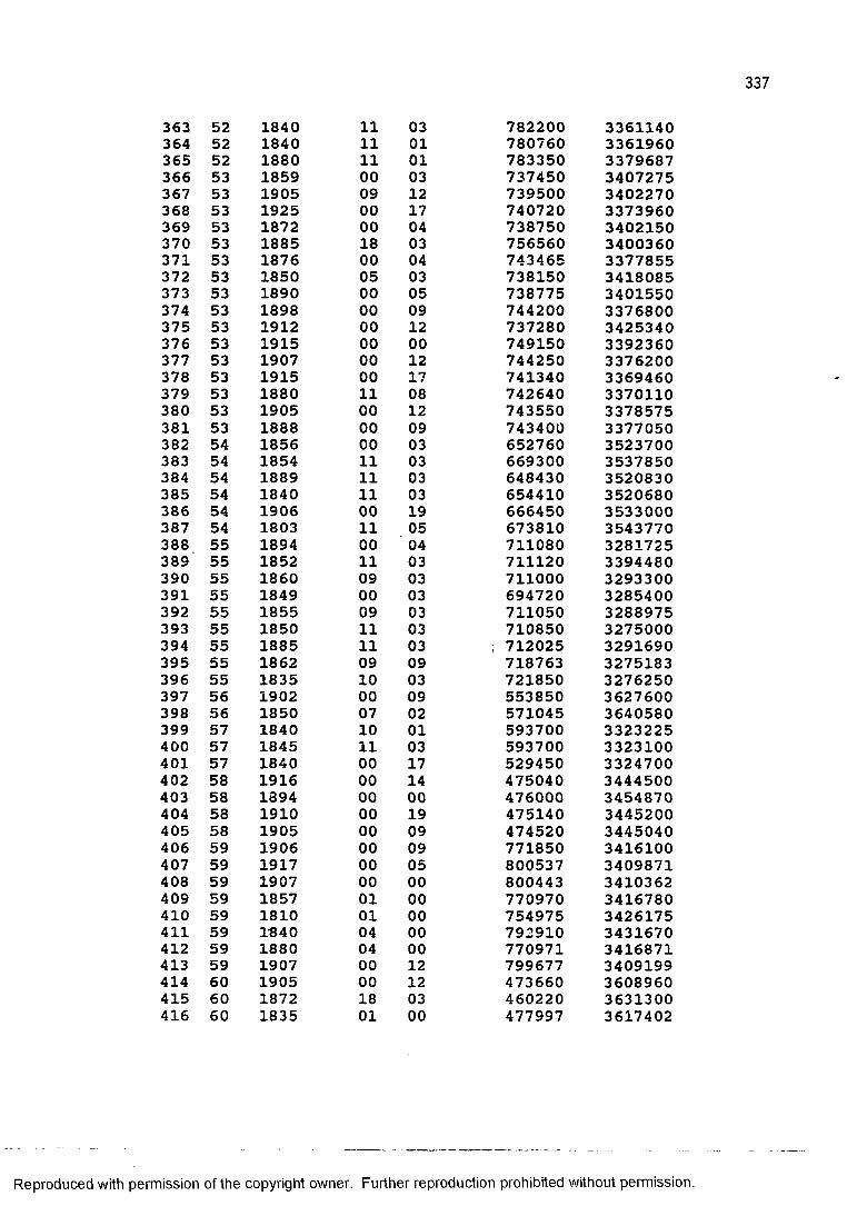
363 52 1840 11 03 782200 3361140364 52 1840 11 01 780760 3361960365 52 1880 11 01 783350 3379687366 53 1859 00 03 737450 3407275367 53 1905 09 12 739500 3402270368 53 1925 00 17 740720 3373960369 53 1872 00 04 738750 3402150370 53 1885 18 03 756560 3400360371 53 1876 00 04 743465 3377855372 53 1850 05 03 738150 3418085373 53 1890 00 05 738775 3401550374 53 1898 00 09 744200 3376800375 53 1912 00 12 737280 3425340376 53 1915 00 00 749150 3392360377 53 1907 00 12 744250 3376200378 53 1915 00 17 741340 3369460379 53 1880 11 08 742640 3370110380 53 1905 00 12 743550 3378575381 53 1888 00 09 743400 3377050382 54 1856 00 03 652760 3523700383 54 1854 11 03 669300 3537850384 54 1889 11 03 648430 3520830385 54 1840 11 03 654410 3520680386 54 1906 00 19 666450 3533000387 54 1803 11 05 673810 3543770388 55 1894 00 04 711080 3281725389 55 1852 11 03 711120 3394480390 55 1860 09 03 711000 3293300391 55 1849 00 03 694720 3285400392 55 1855 09 03 711050 3288975393 55 1850 11 03 710850 3275000394 55 1885 11 03 ; 712025 3291690395 55 1862 09 09 718763 3275183396 55 1835 10 03 721850 3276250397 56 1902 00 09 553850 3627600398 56 1850 07 02 571045 3640580399 57 1840 10 01 593700 3323225400 57 1845 11 03 593700 3323100401 57 1840 00 17 529450 3324700402 58 1916 00 14 475040 3444500403 58 1894 00 00 476000 3454870404 58 1910 00 19 475140 3445200405 58 1905 00 09 474520 3445040406 59 1906 00 09 771850 3416100407 59 1917 00 05 800537 3409871408 59 1907 00 00 800443 3410362409 59 1857 01 00 770970 3416780410 59 1810 01 00 754975 3426175411 59 1840 04 00 792910 3431670412 59 1880 04 00 770971 3416871413 59 1907 00 12 799677 3409199414 60 1905 00 12 473660 3608960415 60 1872 18 03 460220 3631300416 60 1835 01 00 477997 3617402
Reproduced with permission of the copyright owner. Further reproduction prohibited without permission.
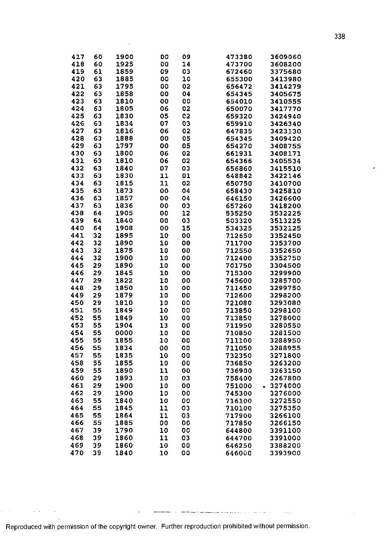
417 60 1900 00 09 473380 3609060418 60 1925 00 14 473700 3608200419 61 1859 09 03 672460 3375680420 63 1885 00 10 655300 3413980421 63 1795 00 02 656472 3414279422 63 1858 00 04 654345 3405675423 63 1810 00 00 654010 3410555424 63 1805 06 02 650070 3417770425 63 1830 05 02 659320 3424940426 63 1834 07 03 659910 3426340427 63 1816 06 02 647835 3423130428 63 1888 00 05 654345 3409420429 63 1797 00 05 654270 3408755430 63 1800 06 02 661931 3408171431 63 1810 06 02 654366 3405534432 63 1840 07 03 656860 3415510433 63 1830 11 01 648842 3422146434 63 1815 11 02 650750 3410700435 63 1873 00 04 658430 3425810436 63 1857 00 04 646150 3426600437 63 1836 00 03 657260 3418200438 64 1905 00 12 535250 3532225439 64 1840 00 03 503320 3513225440 64 1908 00 15 534325 3532125441 32 1895 10 00 712650 3352450442 32 1890 10 00 711700 3353700443 32 1875 10 00 712550 3352650444 32 1900 10 00 712400 3352750445 29 1890 10 00 701750 3304500446 29 1845 10 00 715300 3299900447 29 1822 10 00 745600 3285700448 29 1850 10 00 711450 3299750449 29 1879 10 00 712600 3298200450 29 1810 10 00 721080 3293080451 55 1849 10 00 713850 3298100452 55 1849 10 00 713850 3278000453 55 1904 13 00 711950 3280550454 55 0000 10 00 710850 3281500455 55 1855 10 00 711100 3288950456 55 1834 00 00 711050 3288955457 55 1835 10 00 732350 3271800458 55 1855 10 00 736850 3263200459 55 1890 11 00 736900 3263150460 29 1893 10 03 758400 3267800461 29 1900 10 00 751000 . 3274000462 29 1900 10 00 745300 3276000463 55 1840 10 00 716100 3272550464 55 1845 11 03 710100 3275350465 55 1864 11 03 717900 3266100466 55 1885 00 00 717850 3266150467 39 1790 10 00 644800 3391100468 39 1860 11 03 644700 3391000469 39 1860 10 00 646250 3388200470 39 1840 10 00 646000 3393900
with permission of the copyright owner. Further reproduction prohibited without permission.
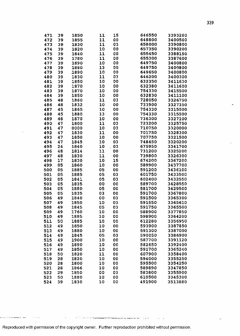
471 39 1850 11472 39 1855 11473 39 1830 11474 39 1820 10475 39 1840 11476 39 1780 11477 39 1890 10478 39 1880 13479 39 .1890 10480 39 1830 11481 39 1850 10482 39 1870 10483 39 1870 10484 39 1850 10485 48 1860 11486 48 1832 10487 45 1865 10488 45 1880 13489 48 1870 10490 47 1800 11491 47 0000 10492 47 1830 11493 47 1850 10494 47 1845 10495 24 1840 10496 48 1814 11497 48 1830 11498 17 1830 10499 05 1860 10500 05 1885 05501 05 1885 05502 05 1841 05503 05 1835 00504 05 1880 05505 05 1835 03506 49 1840 00507 49 1850 10508 49 1845 05509 49 1760 10510 49 1885 10511 50 1885 10512 49 1850 10513 49 1880 10514 49 1845 05515 49 1900 10516 49 1890 10517 49 1850 10518 50 1820 11519 28 1820 10520 28 1800 10521 28 1866 10522 29 1850 00523 50 1880 10524 39 1830 10
646550 3393200648800 3400500658000 3390800657350 3390200655450 3388150655300 3387600649750 3400800649750 3400800649650 3400800646200 3400300632350 3411630632380 3411600754330 3415500632830 3411100728050 3326750733900 3327350754330 3315500754330 3315500736300 3327100723200 3325750710750 3320000701750 3328300707750 3321500748450 3320200675950 3341700731200 3325200739800 3326300674200 3367200589900 3437700591200 3436100601750 3433500602400 3432550589700 3428550581700 3429500591700 3367800591500 3365300591550 3365610591750 3365500588900 3377850598900 3364200612280 3356950593900 3387850591300 3387000590050 3386900587700 3391120582650 3392400591700 3365240607900 3358400594000 3355250595500 3354250589890 3347850583800 3355900610500 3345300491900 3513880
150003000000000000030000000003000000000303000003030000150000030300000003030300000000000300000000000000030000
Reproduced with permission of the copyright owner. Further reproduction prohibited without permission.
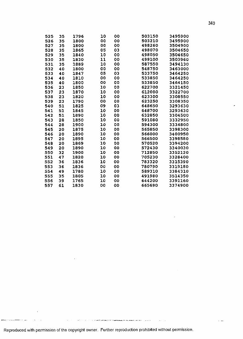
525 35 1796 10 00 503150 3495900526 35 1800 00 00 503210 3495900527 35 1800 00 00 498260 3504900528 35 1865 05 03 498070 3504650529 35 1840 10 00 498050 3504650530 35 1830 11 00 499100 3503960531 35 1889 10 00 587550 3494130532 40 1800 00 00 548750 3463000533 40 1847 05 03 533750 3464250534 40 1810 00 00 533850 3464250535 40 1800 00 00 533850 3464150536 23 1850 10 00 622700 3321450537 23 1870 10 00 612000 3322700538 23 1820 10 00 623300 3308550539 23 1790 00 00 623250 3308350540 51 1825 09 03 648650 3293630541 51 1845 10 00 648700 3293630542 51 1890 10 00 632850 3304500543 28 1850 10 00 591080 3332950544 28 1900 10 00 594300 3334800545 20 1875 10 00 565850 3398300546 20 1890 10 00 566000 3400950547 20 1895 10 00 566500 3398580548 20 1869 10 00 570520 3394200549 20 1890 10 00 572430 3340030550 32 1900 10 00 712850 3352120551 47 1820 10 00 705230 3328400552 36 1836 10 00 783320 3315390553 36 1836 00 00 780790 3319180554 49 1780 10 00 589310 3384310555 35 1805 10 00 491980 3514350556 39 1765 10 00 644200 3391160557 61 1830 00 00 665690 3374900
Reproduced with permission of the copyright owner. Further reproduction prohibited without permission.
VITA
Peter Bingham Mires was born on October 3, 1953 in Burlington, Vermont. He received the Bachelor of Arts degree (cum laude) from the University of New Hampshire with a dual major in anthropology and history and a minor in Latin American studies. His Master of Arts degree is in anthropology from the University of Arkansas. He has been in the Ph.D. program of the Department of Geography and Anthropology at Louisiana State University since 1983.
341
Reproduced with permission of the copyright owner. Further reproduction prohibited without permission.
DOCTORAL EXAMINATION AND DISSERTATION REPORT
Candidate: Peter Bi ng h a m Mires
Major Field: Geography
Title of Dissertation: PREDICTING THE PAST: THE GEOGRAPHY OF SETTLEMENT IN LOUISIANA,1699-1890, AND ITS APPLICATION TO HISTORIC PRESERVATION
Approved:
J / t / d k ^ v K ,Major Professor and Chairman
Dean of the Graduate
EXAMINING COMMITTEE:
JJA.XJ.KjJ -
Date of Examination:
December 1, 1988
Reproduced with permission of the copyright owner. Further reproduction prohibited without permission.