The Forsyth-Warren Tavern Knowledge Base
48
~ 1 ~ The Forsyth-Warren Tavern Knowledge Base The Forsyth – Warren Tavern A Living History Farm & Museum 2020
-
Upload
khangminh22 -
Category
Documents
-
view
0 -
download
0
Transcript of The Forsyth-Warren Tavern Knowledge Base
~ 1 ~
The Forsyth-Warren Tavern
Knowledge Base
The
Forsyth – Warren Tavern A Living History Farm & Museum
2020
~ 2 ~
Index
Prehistory - - - - - - - - - - - - - - - - - - - - - - - - - - - - - - 3
Forsyth Family - - - - - - - - - - - - - - - - - - - - - - - - - - - 5
Ganson Family - - - - - - - - - - - - - - - - - - - - - - - - - - - 8
Holland Land Company - - - - - - - - - - - - - - - - - - - - - - 13
John & Mary - - - - - - - - - - - - - - - - - - - - - - - - - - - 14
Mary Ganson-Forsyth and the War of 1812 - - - - - - - - - - - 20
Ezra Warren - - - - - - - - - - - - - - - - - - - - - - - - - - - 24
A Day of Infamy - - - - - - - - - - - - - - - - - - - - - - - - - 26
Eli Bruce - - - - - - - - - - - - - - - - - - - - - - - - - - - - - 29
Underground Railroad - - - - - - - - - - - - - - - - - - - - - - - 33
Next Generation - - - - - - - - - - - - - - - - - - - - - - - - - 34
Structural History - - - - - - - - - - - - - - - - - - - - - - - - - 36
1857-2017 - - - - - - - - - - - - - - - - - - - - - - - - - - - - 42
Supplemental Maps - - - - - - - - - - - - - - - - - - - - - - - - 45
~ 3 ~
Prehistory
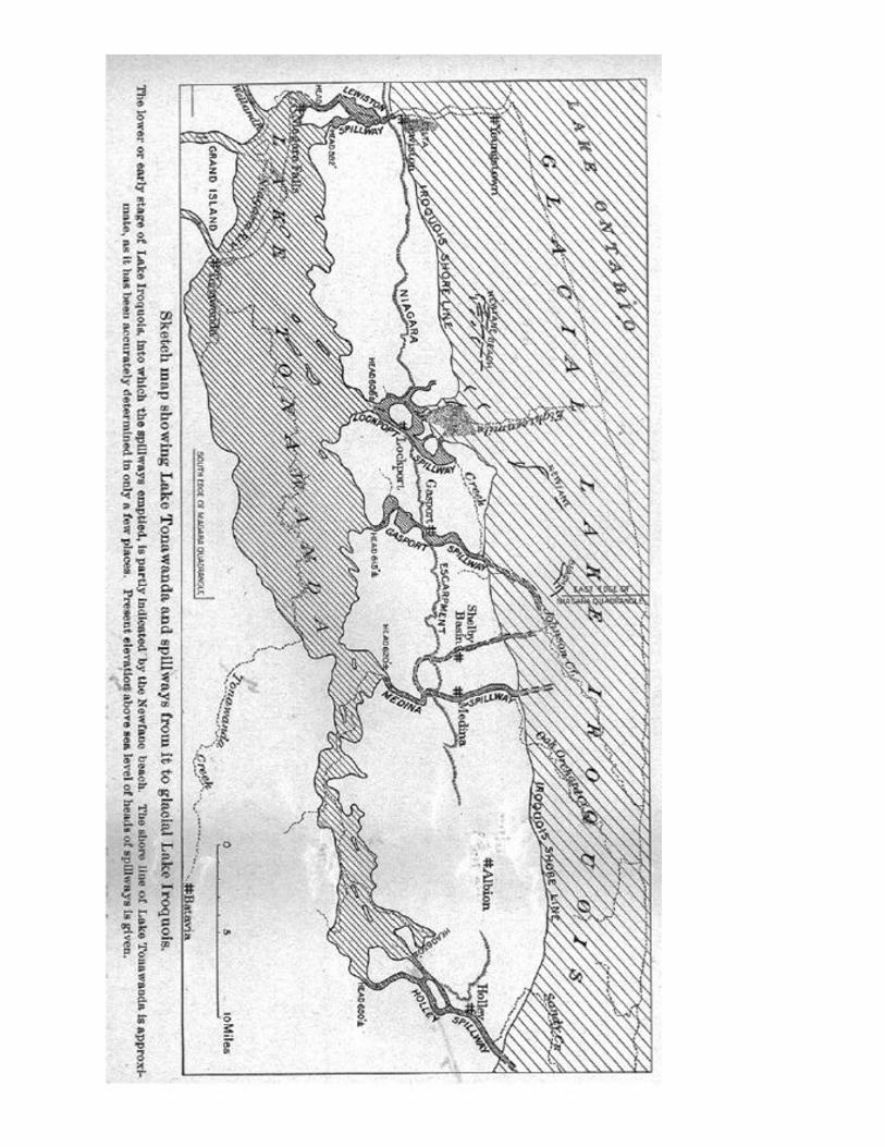
Glacial Lake Iroquois was a prehistoric proglacial lake that existed at the end of the last
ice age approximately 13,000 years ago. The lake was essentially an enlargement of the
present Lake Ontario that formed because the St. Lawrence River downstream from the lake
was blocked by an ice sheet near the present Thousand Islands. The level of the lake was
approximately 30 m (~100 ft) above the present level of Lake Ontario.
At its shoreline a mound of sand and gravel accumulated, creating a natural foot trail
cutting through the forests and marshlands of Western New York.
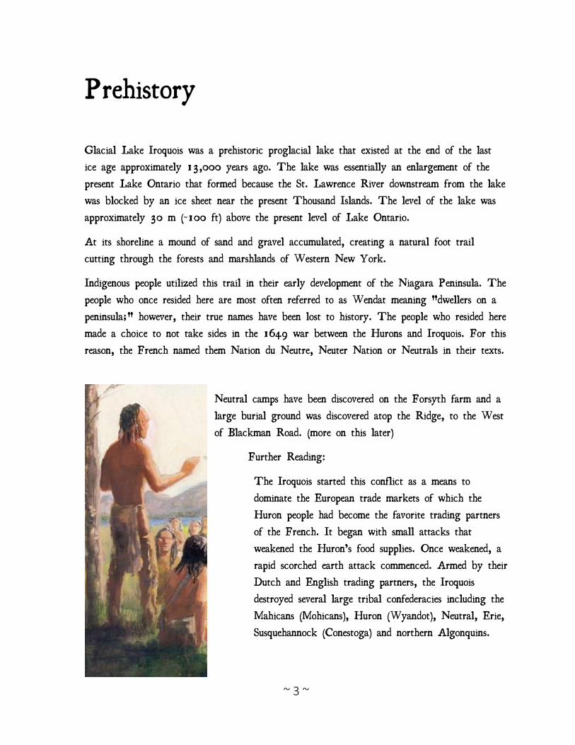
Indigenous people utilized this trail in their early development of the Niagara Peninsula. The
people who once resided here are most often referred to as Wendat meaning "dwellers on a
peninsula;" however, their true names have been lost to history. The people who resided here
made a choice to not take sides in the 1649 war between the Hurons and Iroquois. For this
reason, the French named them Nation du Neutre, Neuter Nation or Neutrals in their texts.
Neutral camps have been discovered on the Forsyth farm and a
large burial ground was discovered atop the Ridge, to the West
of Blackman Road. (more on this later)
Further Reading:
The Iroquois started this conflict as a means to
dominate the European trade markets of which the
Huron people had become the favorite trading partners
of the French. It began with small attacks that
weakened the Huron’s food supplies. Once weakened, a
rapid scorched earth attack commenced. Armed by their
Dutch and English trading partners, the Iroquois
destroyed several large tribal confederacies including the
Mahicans (Mohicans), Huron (Wyandot), Neutral, Erie,
Susquehannock (Conestoga) and northern Algonquins.
~ 4 ~
~ 5 ~
Forsyth Family
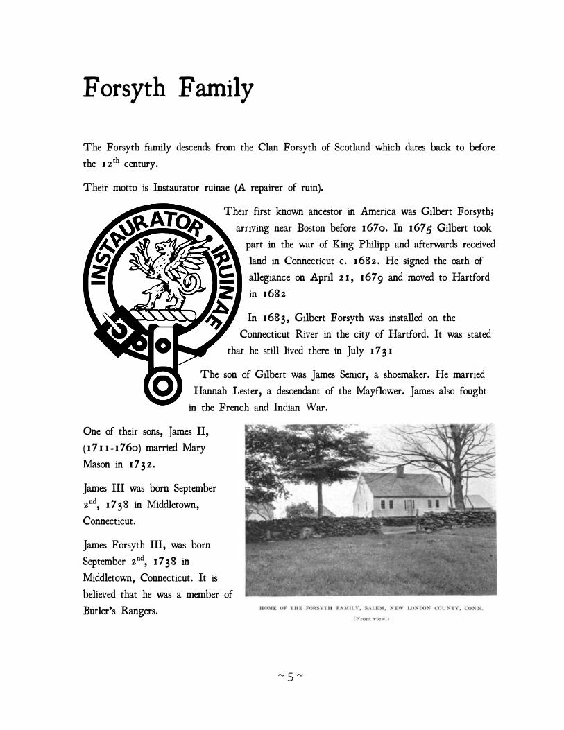
The Forsyth family descends from the Clan Forsyth of Scotland which dates back to before
the 12th century.
Their motto is Instaurator ruinae (A repairer of ruin).
Their first known ancestor in America was Gilbert Forsyth;
arriving near Boston before 1670. In 1675 Gilbert took
part in the war of King Philipp and afterwards received
land in Connecticut c. 1682. He signed the oath of
allegiance on April 21, 1679 and moved to Hartford
in 1682
In 1683, Gilbert Forsyth was installed on the
Connecticut River in the city of Hartford. It was stated
that he still lived there in July 1731
The son of Gilbert was James Senior, a shoemaker. He married
Hannah Lester, a descendant of the Mayflower. James also fought
in the French and Indian War.
One of their sons, James II,
(1711-1760) married Mary
Mason in 1732.
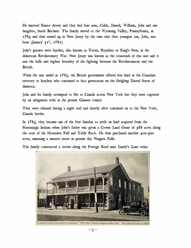
James III was born September
2nd, 1738 in Middletown,
Connecticut.
James Forsyth III, was born
September 2nd, 1738 in
Middletown, Connecticut. It is
believed that he was a member of
Butler’s Rangers.
~ 6 ~
He married Eunice Avery and they had four sons, Caleb, Daniel, William, John and one
daughter, Sarah Buchner. The family moved to the Wyoming Valley, Pennsylvania, in
1769 and then turned up in New Jersey by the time that their youngest son, John, was
born (January 31st, 1781).
John’s parents were loyalist, also known as Tories, Royalists or King’s Men, in the
American Revolutionary War. New Jersey was known as the crossroads of this war and it
saw the bulk and highest brutality of the fighting between the Revolutionaries and the
British.
When the war ended in 1783, the British government offered free land in the Canadian
territory to loyalists who continued to face persecution on the fledgling United States of
America.
John and his family attempted to flee to Canada across New York but they were captured
by an indigenous tribe in the present Genesee county.
They were released during a night raid and shortly after continued on to the New York,
Canada border.
In 1785, they became one of the first families to settle on land acquired from the
Mississauga Indians when John’s father was given a Crown Land Grant of 388 acres along
the crest of the Horseshoe Fall and Table Rock. He then purchased another 400-500
acres, amassing a massive estate in present day Niagara Falls.
The family constructed a tavern along the Portage Road near Lundy’s Lane today.
~ 7 ~
Records in the Canadian Archives reveal that John and his brother William were involved in
smuggling and found trouble with the law of Canada between 1797 and 1799. In 1797
John was arrested for smuggling a person in his wagon. 1798 John was arrested for aiding
his brother in firing upon the person and horses of Robert Hamilton and Thomas
Silverthorn. Later that same year, John was arrested again for setting fire to the hay of
Robert Hamilton. John and William boarded a ferry to the village at Black Rock around
1800. William would return to Canada to open a stage coach line from Black Rock to
Niagara on the Lake and then to construct the famed Pavilion Hotel atop the falls while
John sojourned first to the area near Rochester that his family briefly called home once
before and then to Ganson’s Settlement at present day LeRoy.
Continued…
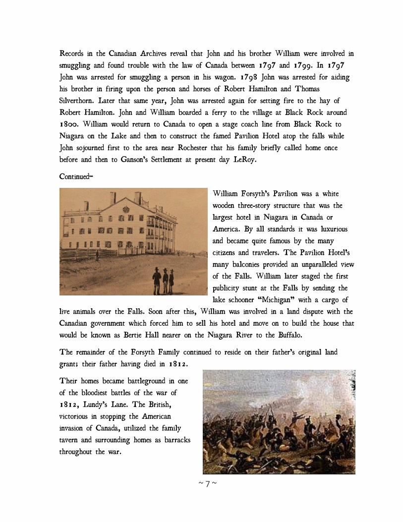
William Forsyth’s Pavilion was a white
wooden three-story structure that was the
largest hotel in Niagara in Canada or
America. By all standards it was luxurious
and became quite famous by the many
citizens and travelers. The Pavilion Hotel's
many balconies provided an unparalleled view
of the Falls. William later staged the first
publicity stunt at the Falls by sending the
lake schooner “Michigan” with a cargo of
live animals over the Falls. Soon after this, William was involved in a land dispute with the
Canadian government which forced him to sell his hotel and move on to build the house that
would be known as Bertie Hall nearer on the Niagara River to the Buffalo.
The remainder of the Forsyth Family continued to reside on their father’s original land
grant; their father having died in 1812.
Their homes became battleground in one
of the bloodiest battles of the war of
1812, Lundy’s Lane. The British,
victorious in stopping the American
invasion of Canada, utilized the family
tavern and surrounding homes as barracks
throughout the war.
~ 8 ~
Ganson Family Plans began in 1606 for the first permanent British settlements on the east coast of North
America. On April 10, 1606, King James I of England granted a charter forming two
joint-stock companies. Neither of these corporations was given a name by this charter, but
the territories were named as the "first Colony" and "second Colony", over which they were
respectively authorized to settle and to govern. Under this charter, the "first Colony" and
the "second Colony" were to be ruled by a Council composed of 13 individuals in each
colony. The charter provided for an additional council of 13 persons named "Council of
Virginia" which had overarching responsibility for the combined enterprise.
A flotilla of ships sailed from England beginning in April 1630, sometimes known as the
Winthrop Fleet. They began arriving at Salem in June and carried more than 700 colonists,
Governor John Winthrop, and the colonial charter.
The ships in the fleet were:
Talbot (carried 19 cannon) Capt. Benjamin Ganson, family had long history with
the Royal Navy., Sir Admiral Richard Hawkins and Sir Francis Drake.
Long line of descendants.
George Bonaventure (carried 20 cannon)
Lyon's Whelp (carried 40 planters + crew + 8 cannon)
Four Sisters (carried 14 cannon)
Mayflower (carried 14 guns and was a different ship than the Pilgrim's Mayflower.
Pilgrim (small ship with 4 guns that carried supplies only)
Captian John Ganson, born c. 1745, was the grandson of Captain Benjamin Ganson. He
married Molly Holton of Danvers Massachusetts and they resided in New Salem. He was a
private in Captain Ebenizer Goodall’s Company of Minute Men, Colonel Woodbridge
Regiment which marched on the alarm of April 19, 1775. He was later wounded at the
battle of Bunker Hill and list his gun and finger June 17, 1775. He served several
enlistments under Captains Richardson, Ballard, Partricks, Alden and Coburn. He was
~ 9 ~
promoted 2nd Lieutenant in Captain Seth Pierce’s Co. Col. Seth Murray’s regt. And 1st
Lieutenant in Oliver Coney’s Co. Col. Sears regt. 1781.
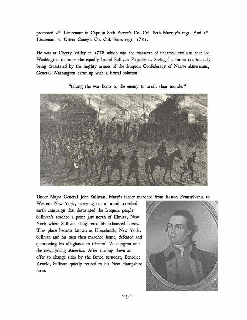
He was at Cherry Valley in 1778 which was the massacre of unarmed civilians that led
Washington to order the equally brutal Sullivan Expedition. Seeing his forces continuously
being devastated by the mighty armies of the Iroquois Confederacy of Native Americans,
General Washington came up with a brutal solution:
“taking the war home to the enemy to break their morale.”
Under Major General John Sullivan, Mary’s father marched from Easton Pennsylvania to
Western New York, carrying out a brutal scorched
earth campaign that devastated the Iroquois people.
Sullivan’s reached a point just north of Elmira, New
York where Sullivan slaughtered his exhausted horses.
This place became known as Horseheads, New York.
Sullivan and his men then marched home, defeated and
questioning his allegiance to General Washington and
the new, young America. After turning down an
offer to change sides by the famed turncoat, Benedict
Arnold, Sullivan quietly retired to his New Hampshire
farm.
~ 10 ~
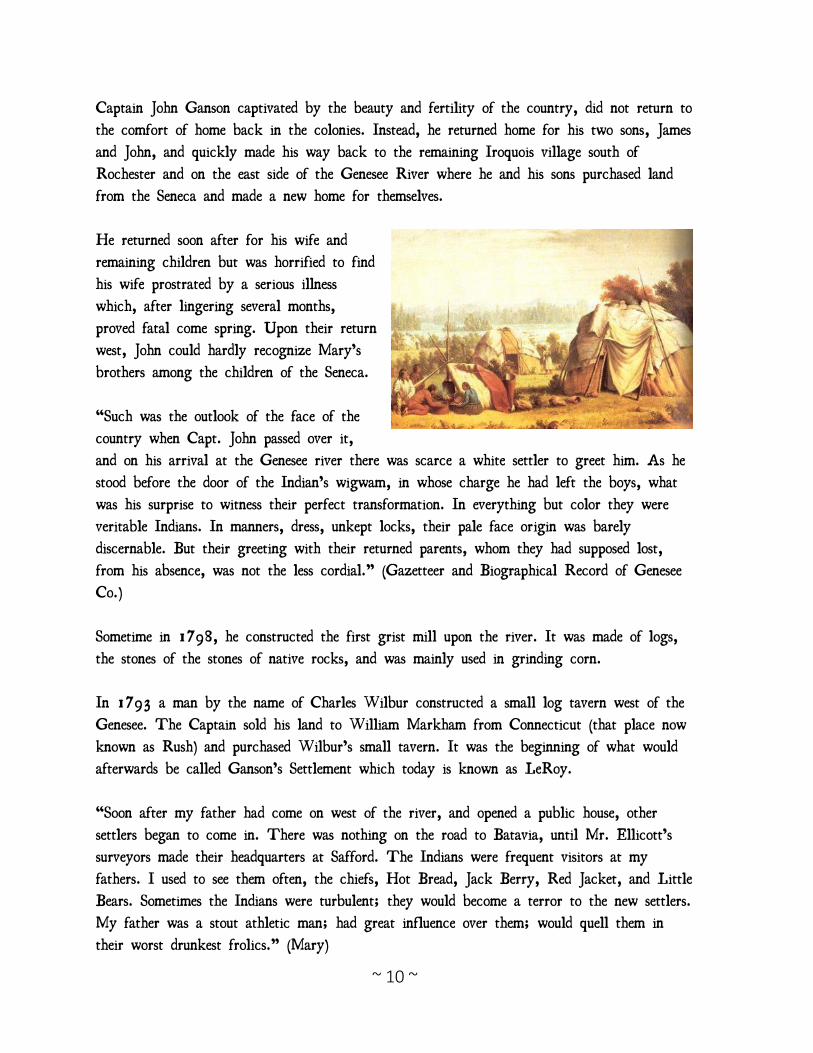
Captain John Ganson captivated by the beauty and fertility of the country, did not return to
the comfort of home back in the colonies. Instead, he returned home for his two sons, James
and John, and quickly made his way back to the remaining Iroquois village south of
Rochester and on the east side of the Genesee River where he and his sons purchased land
from the Seneca and made a new home for themselves.
He returned soon after for his wife and
remaining children but was horrified to find
his wife prostrated by a serious illness
which, after lingering several months,
proved fatal come spring. Upon their return
west, John could hardly recognize Mary’s
brothers among the children of the Seneca.
“Such was the outlook of the face of the
country when Capt. John passed over it,
and on his arrival at the Genesee river there was scarce a white settler to greet him. As he
stood before the door of the Indian’s wigwam, in whose charge he had left the boys, what
was his surprise to witness their perfect transformation. In everything but color they were
veritable Indians. In manners, dress, unkept locks, their pale face origin was barely
discernable. But their greeting with their returned parents, whom they had supposed lost,
from his absence, was not the less cordial.” (Gazetteer and Biographical Record of Genesee
Co.)
Sometime in 1798, he constructed the first grist mill upon the river. It was made of logs,
the stones of the stones of native rocks, and was mainly used in grinding corn.
In 1793 a man by the name of Charles Wilbur constructed a small log tavern west of the
Genesee. The Captain sold his land to William Markham from Connecticut (that place now
known as Rush) and purchased Wilbur’s small tavern. It was the beginning of what would
afterwards be called Ganson’s Settlement which today is known as LeRoy.
“Soon after my father had come on west of the river, and opened a public house, other
settlers began to come in. There was nothing on the road to Batavia, until Mr. Ellicott’s
surveyors made their headquarters at Safford. The Indians were frequent visitors at my
fathers. I used to see them often, the chiefs, Hot Bread, Jack Berry, Red Jacket, and Little
Bears. Sometimes the Indians were turbulent; they would become a terror to the new settlers.
My father was a stout athletic man; had great influence over them; would quell them in
their worst drunkest frolics.” (Mary)
~ 11 ~
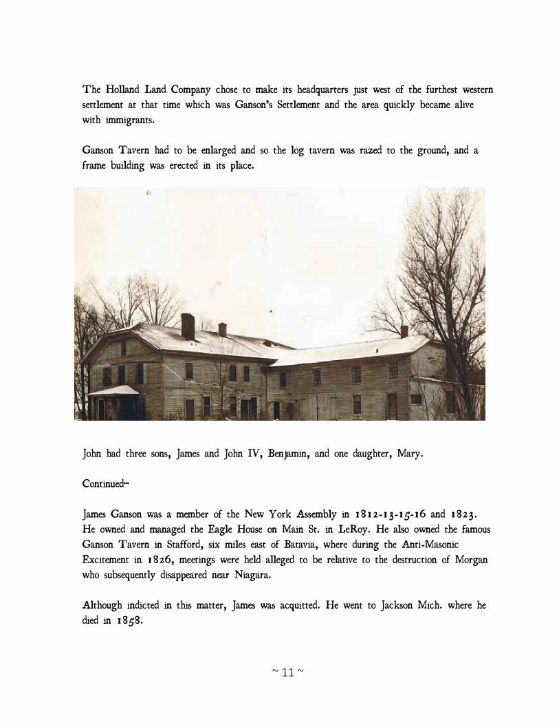
The Holland Land Company chose to make its headquarters just west of the furthest western
settlement at that time which was Ganson’s Settlement and the area quickly became alive
with immigrants.
Ganson Tavern had to be enlarged and so the log tavern was razed to the ground, and a
frame building was erected in its place.
John had three sons, James and John IV, Benjamin, and one daughter, Mary.
Continued…
James Ganson was a member of the New York Assembly in 1812-13-15-16 and 1823.
He owned and managed the Eagle House on Main St. in LeRoy. He also owned the famous
Ganson Tavern in Stafford, six miles east of Batavia, where during the Anti-Masonic
Excitement in 1826, meetings were held alleged to be relative to the destruction of Morgan
who subsequently disappeared near Niagara.
Although indicted in this matter, James was acquitted. He went to Jackson Mich. where he
died in 1858.
~ 12 ~
John IV continued to operate his father’s tavern. He and wife, Lucy, had children Holden
(M.D. of Batavia), James (cashier of Marine Bank of Buffalo and twin of), John (graduate
of Harvard, lawyer, Representative in New York Legislature 1862, Representative in 38th
Congresses serving committee of Elections, Delegate to Chicago Convention 18641qq).
Captain John Ganson died in 1813. His tombstone was brought from Albany by ox team
and reads,
“In travelers claims he bent his weary way,
where perils prowled and wild beasts lurked for prey;
by perseverance and industrious toil
laid low the forests and made the desert smile,
till low in death he laid his weary head
beloved while living, and revered now dead.”
John IV’s Stone is also intriguing. It reads as follows:
“Here lies the mortal part of John Ganson Jr,
who departed this life, November 30, 1819, in the
45yh my year of his age.
read what this silent stone doth say,
and mind that you must pass away,
and have no time of trial more,
in time thereof, prepare to die,
that you may rest with Christ on high.”
From The Fleet in the Forest by Carl Lane (about the war of 1812) :
“Mr. Ganson buried his rum casks in manure and locked his tavern, then sledded along the
great Bend Road all the way to Newton on the Tioga. He went not only east but south as
well.
Fifteen hundred frozen soldiers and a dozen barn carpenters, buildin’ a damn navy between
me and the British! East ain’t enough, I snum, he said at New Hartford and drove on.”
They got into the sleds again, drawn up in a line before Mr. Gansons deserted tavern. Nez
had led the breakin and found the rum under the manure easily. He considered Mr. Ganson’s
loss only just; when a man hung out a tavern sign it was his bounding duty to be around
and make good on it.”
~ 13 ~
Holland Land Company
In 1788, an organization formed by Oliver Phelps and Nathaniel Gorham bought
preemptive rights to six million acres of land in what is now western New York State from
the Commonwealth of Massachusetts and the pre-emptive right to the title on the land from
the Six Nations of the Iroquois Confederacy. Phelps and Gorham exhausted themselves trying
to clear the title to the land and it defaulted back to the Commonwealth of Massachusetts.
Robert Morris purchased 1.5 million acres from Massachusetts for 1.5 shillings per acre.
Morris succeeded in extinguishing Native American title by means of the Treaty of Big
Tree and subsequently sold 3.3 million acres west of the Genesee River in 1792-1793 to
the Holland Land Company, a group of wealthy businessmen in Amsterdam.
From the company’s headquarters in Philadelphia, they hired Joseph Ellicott and sent him
and 130 men to begin surveying the land. Surveying was done by the transit method, which
required line-of-sight measurements and used 150 men to clear and gage the vast frontier
lands, between March 1798 and October of 1800. They divided the tract into 6 mile
square townships, those divided into 320 acre lots and the lots into 120 acre tracts measured
in metes and bounds that were marked by inscribed stones or natural features of the
landscape.
In 1801 Joseph Ellicott platted Batavia to be the headquarters of his land office. This new
settlement was to be located just ten miles from the Ganson Settlement, which was then the
farthest settlement west of the Genesee River, where John and Mary (Ganson) Forsyth lived.
The first parcels were offered up for sale at the same time. The survey teams had cut some
paths through forests and established camps along the way; however, most of the roads then
were Indian trails and where no Indian trails were found, pioneers had to make their own
paths. In 1801 land was selling for $2.75 an acre and purchasers were required to place at
least 10 percent down to their local land office. Often incentives were given to those first
purchasers. These varied from being allowed to put less down to perhaps working off their
debt by building a road, opening a sawmill, or any other action that would be necessary to
further develop this western territory.
~ 14 ~
John and Mary
John traveled from Buffalo to Gaines before he received word of a distant aunt who had
married into a the prominent Ganson family of Ganson Settlement. He found himself in the
home and tavern of Captain John Ganson and there he met Miss Mary Rose Ganson. They
were married sometime in 1800 or 1801.
John then purchased land in Dunham’s Corners near Ganson’s Settlement and in 1801 they
had their first child, a boy named Ira (May 3, 1801 – August 7, 1802).
John Forsyth signed an article of agreement with Joseph Ellicott on February 28, 1801 to
purchase a lot along the speculative Queenstown Road whenever said road should be laid out.
This lot was located near to Batavia, the Holland Land Company headquarters. Early
settlers were attracted to the well-drained fertile soils of the glacial beach line which Ridge
Road occupies. Initially the speculative Queenstown Road was an Indian trail that crossed
through land that once was home to the Neutral Nation, an Iroquoian-speaking indigenous
people who lived in the region in the sixteenth and seventeenth centuries but had largely been
replaced by the Iroquoian Confederacy by the mid-1600s.
It became one of the earliest roads in western New York and remains a principal east-west
thoroughfare in central Niagara County. It is identified as a “wagon road” on one of the
first maps of the region prepared by Joseph Ellicott in 1804. The road would ultimately
not be named Queenstown Road but Ridge Road instead.
It remains unclear whether or not John and Mary Forsyth were approached by Joseph
Ellicott to construct a tavern in the new territory or if they chose to do so of their own
design. In the early nineteenth century, the Holland Land Company was struggling to sell
its lands in western New York and was looking for new ways to encourage the settlement of
the region. One of the ways of accomplishing that was by establishing a series of inns and
taverns on major roads that served as way-stations for arriving settlers. Given that John was
the son of a pioneer Scottish family which operated a tavern at Niagara Falls, Canada,
sometime prior to 1783, and that Mary’s father operated a tavern in his settlement after the
Revolution, it seems plausible that they would have been approached by Joseph Ellicott as
potential tavern operators. Shortly after John made an agreement with Joseph Ellicott, the
first purchase of land in the new territory was made by David Klink, who was also
contracted to open a tavern under the direct guidance of Joseph Ellicott, suggesting that this
~ 15 ~
may have also been the situation with the Forsyths. Klink’s tavern fit into the plan of
providing accommodations for other prospective land buyers visiting the area.
In June 1804 John sat on the first traverse jury organized in the new court of record. In
that trial Joseph Rhineberger was found guilty of manslaughter and sentenced to 10 years in
State Prison at hard labor.
On November 28, 1804, John Forsyth signed indenture papers to take ownership of a tract
of land along the Ridge Road at a principal intersection between the proposed villages of
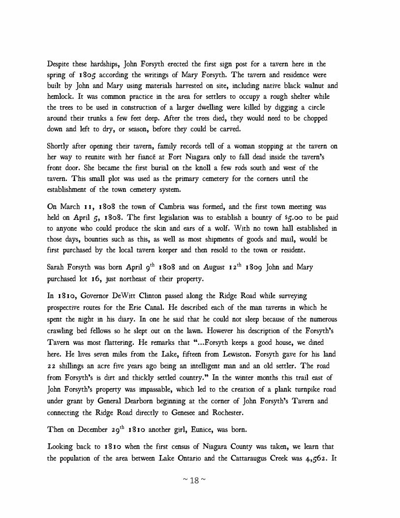
Batavia and New Amsterdam (Buffalo) and the proposed village of Lewiston and Fort
Niagara and just 5 miles east of the log tavern established by David Klink. Forsyth
purchased 190 acres as part of lots 23 and 24 in township 14, range 7, distinguished as
“The East Parts of Lots Numbers twenty-three and twenty-four... exclusive of one acre and
six tenths of one acre reserved for a road.”
The pioneers of the area had a dense forest to confront them as they located along the
glacial lake line. Many years earlier, beavers had constructed dams that obstructed the flow
of water in its natural course, so that three swamps were within, or contiguous to its
boarders. The one in the north part, called big bear swamp, encompassed hundreds of acres;
the one south of Ridge Road flooded a large tract of land for most of the year, and the one
on the east, located principally on the Forsyth farm, though not as large, retained water
like the previous ones until the hot days of summer, when it generated malaria that caused
fevers and ague (a form of malaria) that enfeebled many members of the community.
Mary was pregnant with their son Luther, born February 8, 1806, when she and John left
for their new land.
With them was their son Edmund Jonas, born July 15, 1803. In an 1849 interview with
Mary Forsyth, she described her and John’s move and establishment of a tavern. She drove a
covered wagon pulled by oxen. Tied to one side was a plow and on the other a coop with
six chickens. The family cow was tied to the back of the cart. Following them was John
on horseback leading three or four sheep and the same number of hogs. The trip took them
five or six days. She indicated that early settlers had a difficult time co-existing with the
indigenous wildlife and that livestock such as hogs had to be protected from bears and
wolves. On their arrival a temporary abode was constructed. In the fall a more commodious
log house was erected near the site of the current homestead. At that date their nearest
neighbor east was Samuel B. Moorehouse, who kept a tavern at the place now called
Hartland Corners. The intermediate space was known for many years as the eleven mile

~ 16 ~
woods. Five miles west on the South Ridge, Joseph Hewett had located. The first summer of
John Forsyth’s residence, having occasion to cut swail grass in the marshes south of the
ridge, he was obligated to go to Mr.
Hewett’s to borrow a pair of boots to protect himself from the bite of the rattlesnakes that
infested the marshy places in the warm days of July and August.
Mary’s Own Words (from Pioneer History of the Holland Purchase of New York)
“When we came, there were but three or four settlers between Dunham’s grove and
Lockport. East, there was no settler till we passed the Eleven Mile Woods. Our nearest
neighbor west, was Joseph Hewett, at Howell’s creek.
From James Barton’s recounting of his journey from Avon to Lewiston in 1807 as told by
Clarence Lewis:
Near the U.S. Arsenal (now the Batavia Fairgrounds), the road from Canandaigua branched.
One road led to Buffalo where the other continued in a northwesterly direction and was
called by Mr. Barton the Queenstown or Batavia Road. It was with a few deviations our
present Lewiston Road.
After traveling this road for five miles he came to Durham’s farm. From there to Forsyth’s
he found only four log cabins. The first, after passive the Tonawanda Indian Reservation,
was near the northwest corner of the present Genesee County, just short distance from the
Town of Royalton’s east line today.
It was a tavern kept by a man named Walworth and, like many of the early
taverns, was sponsored by Joseph Ellicott of the Holland Land Company for the
convenience of the new settlers coming to buy farms. In latter years it came to be
called Reynolds “Half-Way House” because of its being approximately halfway
between Batavia and Lockport.
Stage coaches stopped there for many years. Whether the old plank walled house that is
there now is the original tavern is problematical, but it surely dates back to the early part
of the last century. The house stands on the northwest corner of the Lewiston Road and the
Medina-Akron Road.
From this place the road in 1807 passed through six miles of forest. Mr. Barton then came
to a partially completed log cabin occupied by a very poor family named Waldo. They
appeared to be in want of many necessities.
~ 17 ~
From there to Charles Wilber’s Tavern at Cold Springs was about five miles. At Cold
Springs the road turned abruptly north and passed through the “unbroken woods to
Forsyth’s” Here was the “Forsyth Tavern” referred to by many travelers of that day as
being one of the best in Western New York. Eastward from Forsyth’s, the Ridge Road had
not yet been opened and except in dry weather the trail there was impassable.
In 1808, the Ridge road was laid out by General Rhea, Elias Ransom, and Charles
Hartford. I remember well the arrival of the surveyors; their delight at finding a bed to
sleep in, and something to eat that was cooked by a female. Previous to this there had been
nothing by Indian path through the low grounds, west of Wright’s Corners.
We brought in a few sheep with us, I think they were the only ones in the neighborhood;
they became the especial object of the wolves. Coming out of the Wilson swamp nights,
their howling would be terrific. Two years after we came in, I was alone with my then
small children one day, when I heard the sheep bleating and running, and went out to see
what the matter was. A large wolf had badly wounded a sheep. As I approached him he
left the sheep and walked off snarling at me as if reluctant to quit his prey. I went for my
nearest neighbor, Mr. Stoughton to get him to come and dress the sheep. It was three
fourths of a mile through the woods. On my way a large grey fox crossed the road ahead
of me. Returning with my neighbor, a large bear slowly crossed the road in sight of us. I
could tell many stories of wild beasts in this region; but I think I never saw as much of
them in any one day, before or since. We had no way to keep fowls, but to secure them
well in their roosting places. The first settlers found it very difficult to keep hogs; the bears
would even come out of the woods and take them by daylight.”
~ 18 ~
Despite these hardships, John Forsyth erected the first sign post for a tavern here in the
spring of 1805 according the writings of Mary Forsyth. The tavern and residence were
built by John and Mary using materials harvested on site, including native black walnut and
hemlock. It was common practice in the area for settlers to occupy a rough shelter while
the trees to be used in construction of a larger dwelling were killed by digging a circle
around their trunks a few feet deep. After the trees died, they would need to be chopped
down and left to dry, or season, before they could be carved.
Shortly after opening their tavern, family records tell of a woman stopping at the tavern on
her way to reunite with her fiancé at Fort Niagara only to fall dead inside the tavern’s
front door. She became the first burial on the knoll a few rods south and west of the
tavern. This small plot was used as the primary cemetery for the corners until the
establishment of the town cemetery system.
On March 11, 1808 the town of Cambria was formed, and the first town meeting was
held on April 5, 1808. The first legislation was to establish a bounty of $5.00 to be paid
to anyone who could produce the skin and ears of a wolf. With no town hall established in
those days, bounties such as this, as well as most shipments of goods and mail, would be
first purchased by the local tavern keeper and then resold to the town or resident.
Sarah Forsyth was born April 9th 1808 and on August 12th 1809 John and Mary
purchased lot 16, just northeast of their property.
In 1810, Governor DeWitt Clinton passed along the Ridge Road while surveying
prospective routes for the Erie Canal. He described each of the man taverns in which he
spent the night in his diary. In one he said that he could not sleep because of the numerous
crawling bed fellows so he slept out on the lawn. However his description of the Forsyth’s
Tavern was most flattering. He remarks that “...Forsyth keeps a good house, we dined
here. He lives seven miles from the Lake, fifteen from Lewiston. Forsyth gave for his land
22 shillings an acre five years ago being an intelligent man and an old settler. The road
from Forsyth’s is dirt and thickly settled country.” In the winter months this trail east of
John Forsyth’s property was impassable, which led to the creation of a plank turnpike road
under grant by General Dearborn beginning at the corner of John Forsyth’s Tavern and
connecting the Ridge Road directly to Genesee and Rochester.
Then on December 29th 1810 another girl, Eunice, was born.
Looking back to 1810 when the first census of Niagara County was taken, we learn that
the population of the area between Lake Ontario and the Cattaraugus Creek was 4,562. It
~ 19 ~
is interesting to note that eight of them were slaves. The Town of Cambria which then
comprehended all of Niagara County north of Tonawanda Creek or its present area had 248
families or approximately 1,450 people.
There were only three access routes to and through the county. Access through central
Niagara County was the Ridge Road formerly an Indian trail from the east to about where
the Checkered Tavern Road is now located, then branching off to the southwest, joined the
Niagara Trail near Cold Spring. The reason for this changing from the Ridge was because
the area between what is now Warren’s Corners was a great swamp and practically
impassable except when frozen over.
When in the early war years General Dearborn, secretary of war, wanted to transfer cannon
from the Gaines Arsenal to our frontier, he had a “log causeway” or corduroy road built
through this swamp. The next spring many of the logs washed away. By 1816, however, a
permanent road sufficiently passable for stage coaches was built.
On May 11, 1811, John and Mary Forsyth sold their land in Genesee Country, lot 14,
section 8, township 12, to Russell Nobles for three-hundred and twenty-one dollars,
indicating that the family intended to stay in the town of Cambria.
~ 20 ~
Mary Ganson-Forsyth and the
War of 1812
In 1812, however, tragedy struck the pioneer family as John Forsyth died, reportedly of
paralysis, at the young age of about 31. His was the second burial made on the property,
on the knoll to the south of the tavern. By that time the family had grown by two more
children, Sarah, born April 9, 1808, and Eunice, born December 29, 1810. After John’s
death, Mary continued as the proprietor of the tavern. A new deed was cast for her by the
Holland Land Company on July 13, 1813, granting her ownership over all of the land
that she and John had purchased along the Ridge Road. Later that same year, Mary and
her young family had a front row seat to one of the nation’s earliest military events, as the
Niagara Frontier, and the Ridge Road, became strategically important during the War of
1812.
On October 13, 1813, American troops crossed the Niagara River from the Village of
Lewiston, which was at the terminus of the road on which the tavern stood, and began what
would become known as the Battle of Queenstown Heights. It was the first major battle of
the War of 1812 in which American troops invaded British Canada. Due to poor training
and organization, the American troops were defeated on the shores of the Niagara River.
December 10, 1813, American troops under direction of General McClure invaded Canada
again, captured Fort George and burned the Canadian Village of Newark. This displaced
about 400 women and children into the hardships of early nineteenth century winters.
The British retaliated for the burning of Newark by invading Niagara County on December
19, 1813, beginning a campaign that decimated much of the early settlement in Western
New York. Under Colonel Murray, British forces attacked Fort Niagara, at the
northwestern tip of Niagara County. Meanwhile, some one thousand British troops and a
large number of Western Native Americans under the command of General Riall joined the
troops at Fort Niagara. When the fort fell that same day, the British troops marched south
to Lewiston. British General Drummond reported that “the Indians under intoxication had
burned the great part of the houses at and near Lewiston. I thought it advisable to direct
the remainder of them to be set on fire.”
~ 21 ~
Many accounts and books of the residents of Lewiston tell a gruesome tale of families being
slaughtered, scalped and burned in their houses in the small Village of Lewiston. The
refugees fled the village and were perused east along the Ridge Road. With no forewarning
or time to consider, many families along the road joined the retreat from the frontier towards
the larger settlements near the Genesee.
The frontier fugitives had such short notice of the attack that they left most of their
possessions behind. In some cases the women tied their silver and other small treasures in
bags and dropped them in the well or hid them in the nearby underbrush.
Orsamus Turner wrote,
“There was little warning, the Indians preceding the English soldiers swarmed out of the
woods and commenced an indiscriminate shooting down of the fleeing citizens plundering and
burning their log homes. Six or seven men and boys were killed and scalped.”
On Ridge Road, Tuscarora Indians who were friendly with the area settlers witnessed the
flight of pioneers and the pursuing army from their reservation high on the banks of the
ridge and took a stand against the invading army. They did not have the numbers to take
on the advancing army and so they gathered the whole nation, men women and children on
the escarpment above the ascending road. The men had all guns, the women each with a
round stick looking like a gun barrel from below and a horn for every boy and girl. It was
a big bluff but it held up the invaders for some time.
The Tuscarora then again stepped into the line of fire closer to the Forsyth’s Tavern even
after their own village had been set to touch. Some men along with a few white settlers
took a stand at a small arsenal of a dozen muskets and ammunition west of Howell’s Creek
where they were able to gain time for the women, children and the old folks to get a safe
distance ahead.
When those fleeing the frontier arrived at the tavern of Mary Forsyth, she sent her two
boys to her father and brother in Genesee County, who had become guardians of her
children after the death of her husband. Mary remained at the tavern, with five-year-old
Sarah and nearly two-year-old Eunice.
The British continued onward only three miles east along the Ridge Road and upon finding
both Howell’s Tavern and William Molyneaux’s Tavern empty, they proceeded no further.
Mary’s tavern was the next place east on the Ridge Road, being only four and one-half
miles from Molyneaux Corners. The remainder of Niagara County was abandoned and many
of its residents would never again return. The U.S. Government officially counted twenty-one
~ 22 ~
farmsteads burned during this invasion between Hustler’s Tavern in Lewiston to Forsyth’s on
the Ridge Road. Continued raiding parties continued to burn settlements along the Lake
Ontario shoreline.
Many of those who fled the Lewiston area reached the Town of Gaines, roughly thirty
miles west of the tavern, on the same day. Residents of the Town of Gaines recount that
the villagers from Lewiston passed through their homes with warnings of an invading army
killing and burning everything along the Ridge Road. The residents at Gains decided not to
flee but to muster a militia. It is said that all of the males over 18 living along the Ridge
Road were gathered and under the direction of Captain McCarthy they proceeded single file
west on the road by early daylight on Friday, December 20, 1813. They paused at the
home and tavern of the widow Forsyth just before nightfall where the soldiers argued about
whether to make camp or continue to the arms stockpile further up the Ridge Road. They
came upon the tavern of William Molyneaux (originally that of David Klink) where some
British soldiers and their Native allies had burned the barn and taken residence in the log
tavern. In the dark, the militia stormed the tavern. Two British soldiers and one Native
American were killed in the skirmish and the remainder were taken as prisoners. The militia
later turned their prisoners over to the American army as it advanced from the south to
scout the charred remains of the settlement at Lewiston. Twenty-one farms were destroyed on
the Ridge Road between Lewiston and the Forsyth Tavern. The British continued to
dispatch raids of approximately 15 men each throughout the Niagara Frontier to pillage and
burn farms. Meanwhile an army of over 1,000 burned the village of Buffalo.
Every home between Lewiston and Warren’s Corners on or near the Lewiston Trail (Ridge
Road) was deserted by the families and as far as Church Street they were looted and burned.
Settlers on the Lake Road and up to the east bank of the Eighteen Mile Creek to Can
Horn’s Mill suffered the same fate so that the west half of Niagara County was almost
depopulated.
Sergeant Ezra Warren, a native of Vermont, and his company were stationed at the Forsyth
tavern. The plank road was completed and utilized as the main transportation route for
soldiers and supplies. Ezra and his company were tasked with managing and protecting these
transports as they arrived at the edge of the war front. The Forsyth Tavern was also used
for a time to supply meals to the barracks at Hardscrapple (later known as Dickersonville, a
hamlet roughly nine- and one-half miles west of Warren’s Corners on Ridge Road).
~ 23 ~
The barracks are estimated between various military letters to have been large enough to
house up to two thousand men, with storage and a hospital. 500 men were listed at station
there before the camp was burned by the British.
In April 1814 an American soldier, a member of our Frontier forced defected to the
English station at York (Toronto). He reported that the only sites on the American side of
the Niagara River were as follows:
“The troops on that line totaled 7,000 men, the 25th Regiment of 500 men stationed at
Hardscrabble, 100 men at Black Rock, and 6,500 men at Eleven Mile Creek (Ellicott
Creek, about a mile south of Williamsville).
“On the Ridge Road at Hardscrabble there is an arsenal, a log building containing 500
stands of arms deposited by the militia who were all dismissed on the 11th of April 1814.
There is also there a quantity of ammunition and four wagon loads of entrenching tools.
There are no field pieces.
There is a depot of provisions on the Ridge Road at the Widow Forsyth’s. It consists of
beef, pork, whiskey and flour of all of which there is a large supply. There is a road
leading from the mouth of 18-Mile Creek on the west side. The distance is 10 miles but
the road is very bad. He thinks there is at least 2,000 barrels of provisions at this depot.”
July 1813, Ezra and Mary are believed to have been married. The War of 1812 was
ended by the Treaty of Ghent, signed on Christmas Eve, 1814. The settlement stipulated
that captured territory be returned to the status quo ante bellum, meaning that the British
would remove themselves back across the Niagara River and settlers could return to their
lands and reestablish the Niagara Frontier.
~ 24 ~
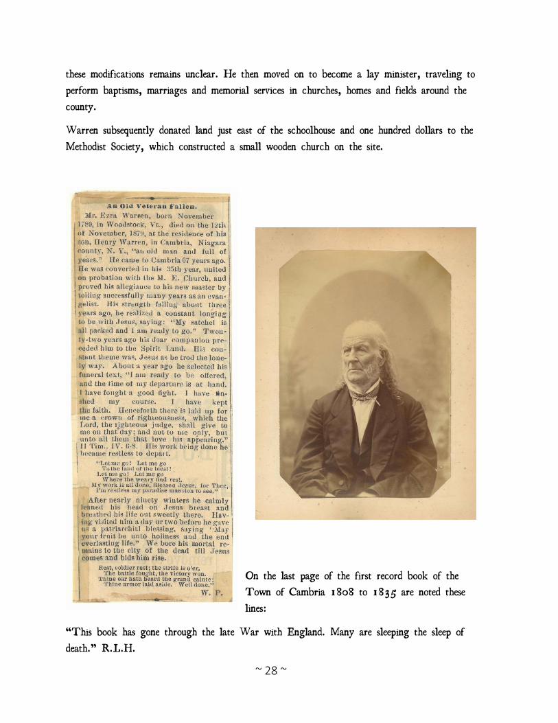
Ezra Warren
In 1814 Ezra was deeded the entirety of Mary’s estate, including the tavern, which he took
over as proprietor. Ezra also constructed a grocery store across the Ridge Road in 1814,
roughly two hundred feet north of the tavern (outside the nomination boundary, no longer
extant). By removing the holding and sales of goods from within the tavern and into its own
building, Ezra was able to vastly expand his wares. From the large collections of receipts
that remain from Ezra’s store we can see that he provided neighbors and travelers alike with
all manner of items from butter to coffee to nails and brandy. Single receipts total over one
hundred dollars and were paid off over several years.
In addition to the store, Ezra
Warren was active in helping to
develop the fledgling surrounding
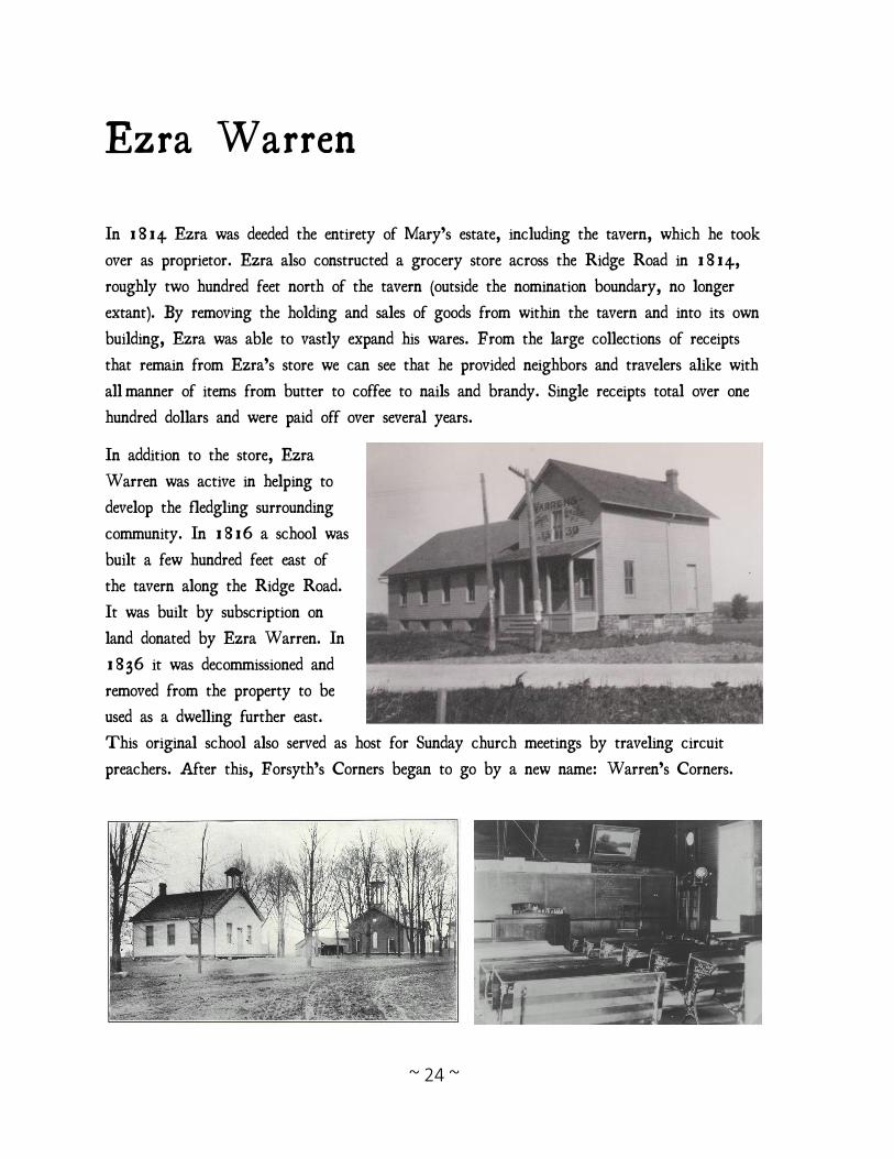
community. In 1816 a school was
built a few hundred feet east of
the tavern along the Ridge Road.
It was built by subscription on
land donated by Ezra Warren. In
1836 it was decommissioned and
removed from the property to be
used as a dwelling further east.
This original school also served as host for Sunday church meetings by traveling circuit
preachers. After this, Forsyth’s Corners began to go by a new name: Warren’s Corners.
~ 25 ~
1816 was the year without a summer; commonly referred to as “Eighteen Hundred and
Froze to Death.” The stage coaches began stopping at the tavern that year and one day a
young man alighted from the stage and told Ezra Warren that he had no more money and
therefore could go no further on the stage. Mr. Warren employed him for a month and then
he went on to Lewiston where he taught school, served as tax collector and by 1825 was
so well known and popular that he was elected sheriff of Niagara County. His name was
Eli Bruce and the story of the remaining seven years of his short life is a sad one. (More on
that later)
Twelve regular stagecoach schedules were established and the post office at the Forsyth
Tavern became increasingly prominent. Sarah Forsyth (daughter of Mary and John) even
married a young stagecoach driver in 1827 after years of being courted by him during his
brief passes through the tavern.
In 1819 Isaac Warren, cousin to Ezra Warren, purchased land a mile east of Warren’s
Corners and opened an inn and tailor shop.
Eunice Forsyth passed away in 1820 at the age of ten.
State officials appointed a three-member commission to designate the county seat and it was
reported that two of the three commissioners designated Warren’s Corners. One of the three
died and in 1822 an entirely new commission was appointed. By that time the Erie Canal
had begun to be surveyed and the county seat was selected for a site along its route instead
of at Warren’s Corners.
In 1823 Company “A” of the Niagara County military regiment was established with
Captain Edmund Forsyth as its lead and with nearly 100 men, company drills were staged
on the Warren Farm the first of every September until 1849.
~ 26 ~
A Day of Infamy
Like most taverns, Ezra kept a large stock of wine and liquors on hand. The many barrels
of whiskey and brandy were stored in his basement which due to the slope of the land
opened on the rear into a sort of low swale. Ezra’s conscience had never bothered in the
least about selling liquor. Tavern keepers were popular and greatly respected in most cases.
About the year of 1825, however, there was started more or less simultaneously all over the
east a great temperance movement. In 1825 a Temperance lecturer came to Warren’s
Corners. Atop a large stump where the Methodist Church now stands, he dwelt on the evils
resulting from the habit of drinking liquor and even went so far as to paint a verbal picture
of tavern keepers sizzling in the lower regions.
All this made a deep impression on Ezra Warren. During the night he dreamed that the
Lord appeared before him and commanded him to cease selling liquor and to begin preaching
the gospel and the evils of intemperance. Bright and early the next morning Ezra went to
the basement door and he rolled barrel after barrel of whiskey and cherry brandy out into
the gully. When the very last barrel was out he began knocking in the heads of the barrels
and soon there were great pools of whiskey and cherry brandy with cherries floating in it.
Now like all taverns along the Ridge, meals were served here to the weary travelers who
arrived by stagecoach, on horseback or whole families in covered wagon. The scraps of food
from the table were thrown out the rear of the kitchen into the swale. The only garbage
collectors in those days were hogs which by law were at that time “Free commoners” which
meant they were allowed to run at large.
Naturally all hogs anywhere near Warrens Corners came to the rear of Ezra Warren’s
Tavern for the tidbits tossed out the windows. On this particular morning when Ezra was
obeying the command of the Lord and spilling out all of his liquor the usual number of
hogs were on hand. At first, they sniffed the brandy, then ate the cherries. A real treat this
time they must have thought. Next, they began to drink the brandy and whiskey from the
pools.
Ezra began to overhear his patrons,
“Farmer Dowdy’s pig is trying to jump over the road fence!”
~ 27 ~
“Why the pigs are chewing each other’s ears and romping like kittens.”
“They’re eating the buttercups!”
“They’re chasing butterflies!”
Ezra finally went to have a look, and saw that this was al too true. Squealing and
“oinking” as they never had before, the swine were rooting in the gully. Most appeared
totally stricken, stretched out, their tails as straight as sting.
In those days every owner of domestic animals that were “free commanders” had to have one
ear of each animal perforated or slit with his own “earmark.” These were of many different
shapes and were registered with the Town Clerk in what was designated “The Book of
Strays.”
Ezra recognized the “earmarks” of the drunken hogs and since they showed no signs of
“sobering up,” Ezra then saddled up a horse or sent a messenger depending on whose
recounting you read and rode to notify all of the hog owners. His shouted greeting at each
whistle stop was:
“Come and get your drunken pigs!”
It meant two trips for most of the owners, because they had to return home and get teams
of oxen and mud boats for by that time the pigs were out cold.
Neighborhood farmers who had prodded their swine in vain, now faced the ex=cavalryman,
leaning on their pitchforks.
“Kind sirs,” the latter began, feeling their silent reproach as he climbed a stump.
“In these innocent creatures some of you may see yourselves. Believe me, they have consumed
the best and last from Warren’s taproom. They don’t know any better but you as men, do.
Feel only compassion for your hogs. They’re drunk.”
Ezra Warren thereafter traveled from place to place preaching the word of God and the
evils of intemperance. He never became an ordained minister, because he refused to be
baptized; saying that he had been “Baptized by the Holy Spirit,” but he undoubtedly had a
tremendous influence in aiding the Temperance Movement. He afterwards was called “Father
Warren.”
Soon after he gave up the tavern business, Ezra modified the tavern into appear more
“homely.” He described it as “rounding off” the building; however, the exact nature of
~ 28 ~
these modifications remains unclear. He then moved on to become a lay minister, traveling to
perform baptisms, marriages and memorial services in churches, homes and fields around the
county.
Warren subsequently donated land just east of the schoolhouse and one hundred dollars to the
Methodist Society, which constructed a small wooden church on the site.
On the last page of the first record book of the
Town of Cambria 1808 to 1835 are noted these
lines:
“This book has gone through the late War with England. Many are sleeping the sleep of
death.” R.L.H.
~ 29 ~
Eli Bruce
Calvin Baker, brother of Dr. Artemus Baker and Jonas Baker, came from their native place
in Connecticut in 1816. Eli Bruce was his companion. The stage that brought them stopped
at Warren’s Corners. Mr. Baker was at home with his brother who resided across the road
from the tavern whereas Bruce had no relatives where he could make a temporary home. He
was in a strange land and among strangers and still worse was using the oft repeated
parlance “strapped.” He applied to Mr. Warren for work and succeeded in securing a job of
cutting cord wood. Just emerged from his college studies with soft hands, not inured to hard
work would look at his sore and blistered hands, then soliloquize with himself, “Now Eli,
you must, you will have to… there is no other way, you have come out to western New
York to make your fortune and there is no backing out until a better opportunity presents
itself.”
Then he turns up again in 1823, a schoolteacher and tax collector for the Village of
Lewiston. He received word that Mr. Eliakam Hammond had discovered something most
gruesome on his farm on upper mountain road just south of the Tavern back in Cambria.
This of course was the infamous PIT.
The pit lying between upper and lower mountain roads was what was left of the 14th
century native American civilization that once resided there. They were a colossal nation
atop the hill, consisting of thousands of men, woman and children reduced to a pit of
skeletons. It was a massacre of profound depth.
Mr. Hammond and Mr. Bruce opened the farm up as a tourist attraction for 10cents a
piece. It is said that some 150 people a day visited the site and left with a bone souvenir
each. For this reason, the site has vanished; leaving only the mansion which Mr. Hammond
built with his fine earnings. Today we who know of it call it the BONE HOUSE.
Eli also became quite wealthy and also quite popular. So much in fact that he was soon
elected Sheriff by his townspeople.
On July 5, 1826 James Ganson, secretary of the Batavia Royal Arch Chapter gave David
C. Miller the text of a petition to institute a new chapter in Batavia. William Morgan’s
name was left off the list of petitioners. The following day Morgan was allowed to add his
~ 30 ~
name to the petition, and then while he was on a several-day drunk, it was destroyed and
another petition circulated.
On Sunday September 10th, Nicholas G. Chesebro, Master of a lodge in Canandaigua, and
coroner for Ontario County, obtained a warrant for Morgan’s arrest on a charge of stealing
a shirt and cravat. Chesebro left Canandaigua with Constable Holloway Hayward, as well as
Henry Howard, Harris Seymour, Moses Roberts and Joseph Scofield. At Avon they were
joined by innkeeper Asa Nowlan and storekeeper John Butterfield; at Le Roy they were
joined by Ella G. Smith and others. James Ganson joined the posse in Stafford. Dr. Samuel
S. Butler proceeded them to Batavia to inform Nathan Follett and William Seaver, Master
of Batavia Lodge No 433, of their approach. Two miles from Batavia the posse wes met
by Butler who conveyed Seaver’s message to not come on. They returned to Ganson’s
Tavern to spend the night.
Morgan was formally arrested at Donald’s Tavern on September 11th and the group
proceeded to Le Roy. Morgan was discharged in Canandaigua and re-arrested by Chesebro
on a debt of $2 due to Aaron Ackley, a tavern keeper in Canandaigua. ($2.69, debt and
costs [2]) Morgan spent the night in jail. According to his jailkeeper Israel Hall, Hall’s
wife Mary and a fellow prisoner, Daniel Tallmadge, Morgan was well provided with food
and liquor through the night and following day.
Loton Lawson and two others arrived Tuesday night sometime after 6:00 pm. They left
when Mrs. Hall refused to release Morgan into their custody and returned with Captain Ed
Sawyer to be met with the same refusal. They left and returned with Chesebro who
authorized Sawyer’s payment of Morgan’s debt and took custody of Morgan. They took
Morgan from the jailhouse where, drunk and argumentative, Morgan changed his mind and
decided he didn't want to go, screamed "Murder! Help! Murder!" John Whitney arrived at
this point and Morgan calmed down, getting into the carriage driven by Hiram Hubbard, a
livery stable proprietor.
There was no attempt at secrecy and many freemasons and non-masons were aware of the
progress of the carriage. James Gillis, a visiting Freemason from Pennsylvania met them at
Victor and agreed to ride ahead to announce Morgan’s progress. Dawn found them in
Hanford’s Landing on the outskirts of Rochester. At the insistance of Morgan, and with no
attempt at secrecy and in broad daylight, the procession of couriers, outriders, carrage and
sulkey and other riders stopped at almost every tavern and inn on the route.
Three miles west of Clarkson there was a change of horses and Captain Isaac Allan took
over driving. The next stop, a mile beyond Gaines, Elijah Mathers took over driving. At
~ 31 ~
Ridgeway Jeremiah Brown, road supervisor and later member of the Legislature, took the
reins. Arriving at Wrights tavern seven miles from Lockport, at least fifty Masons met that
evening to discuss the project. Eli Bruce, Sheriff of Niagara County arrived and near 10:00
pm the procession continued. Brown was replaced by Corydon Fox at 1:00 in the morning.
The journey ended in Youngstown, at the residence of Colonel William King, Master of a
lodge in Lewiston — a journey of more than 100 miles in thirty hours.
Fox drove King, Bruce, Morgan and a fourth man to a point near the ferry at the
Niagara River. they were met by Edward Giddins, innkeeper and keeper of the Fort
Niagara Magazine, who ferried the party across the river. Orsamus Turner and Captain
Jared Darrow met them on the other side and told them that the Canadian Freemasons
weren't ready for him. They returned to the American side where for five days Morgan was
imprisoned in the Powder Magazine in the care of Giddins, who, it later developed, was a
confederate of Miller. On Friday Giddens' association with Miller was uncovered; he was
releaved of responsibility and replaced by Elisha Adams.
On or about Monday night, September 18th, Colonel King [d. 1829/05/28], John
Whitney of Rochester, Eli Bruce, Sheriff Niagara County, Orsamus Turner, editor, Captain
Jared Darrow, Loton Lawson, John Sheldon, James Gillis, Timothy Shaw, Noah Beach,
Samuel Chubbuck, William Miller, David Hague, Richard Howard and other unidentified
Freemasons confronted Morgan in the magazine.
Morgan recounted the full confession he gave three weeks previous to Whitney: that he had
never been a regular Freemason, that he had entered into a contract with Miller to write an
exposition of Freemasonry, and that Miller had failed to fulfil the terms of the contract.
Given the option of a farm at Breede’s Hill or a horse and $500 in gold, Morgan took the
gold in exchange for leaving the country forever. Colonel King, John Whitney, Richard
Howard, Jared Darrow and Sammuel Chubbuck accompanied Morgan across the river. Given
the horse and gold, Morgan was offered an escort which he declined. John Whitney’s
deposition on these events can be found in Rob Morris' William Morgan; Or Political Anti-
masonry, Its Rise, Growth and Decadence,
Recognizing the damage Miller could do them, Sheriff Bruce, Whitney and King hired two
trackers to find Morgan. They reported that Morgan had travelled to the settlement that
would later become Hamilton, then to York where he visited Richmond Hill and finally to
Point Hope where he sold his horse and embarked on a steamer bound for Boston,
Massachusetts.

~ 32 ~
18. Sheriff Elli Bruce was removed from office by Governor Clinton on September 26,
1827 and received a 28 months sentence. An appeal failed and he was jailed from May 20,
1829 to Sept 23, 1831. Loton Lawson received two years in the County jail; Nicholas G.
Chesebro, one year , Edward Sawyer, one month; and John Sheldon, three months. Colonel
William King died before trial. All of them made depositions prior to trial date; confessing
their guilt in holding Morgan against his will for five days but denying that he had
accompanied them against his will or that they had killed him.
In April, 1827, Jesse French, James Hurlurt, Roswell Willcox, and James Ganson, were
tried at Batavia, in Genessee county, for an alleged riot, assult and battery upon, and the
false imprisonment of David C. Miller. They were all found guilty, but Ganson
Eli Bruce died shortly after that; a victim of the Cholera Epidemic in 1832.
~ 33 ~
Underground Railroad
In 1850 the Fugitive Slave Act was passed by the United States Congress. This federal law
mandated the return of runaway slaves found in free states to their masters. Former slaves
who had settled in the New England states as refugees began fleeing to the United States
boarder with Canada. The brother of the late John Forsyth, William Forsyth, had since
sold his own tavern at the Canadian Horseshoe Falls and constructed a large home along the
Niagara River presently known as Bertie Hall. Many sources cite his home as a final
destination on the Underground Railroad. On August 12, 1854, an article in the Anti-
Slavery Bugle wrote about a man named Chares Brown who fled upon the arrival of his
former owner’s nephew to his home in Warren’s Corners. Oral tradition holds that a secret
room in the tavern was used by Brown and others to hide on their journey to the Niagara
River. Such a room does exist on the second floor of the tavern and the Methodist Church is
often mentioned in connection with the underground railroad and anti-slavery movements. The
combination of family connections to the underground railroad in Canada, combined with
Ezra Warren’s position as a preacher for the Methodist Church, suggest that the family may
have been involved with the underground railroad in this time.
Anti-Slavery Bugle (Salem, Ohio), August 12, 1854, 3,c4: SLAVE-HUNTERS IN THE EMPIRE
STATE-- The following letters is from the Lockport (N.Y.) Journal: Warren's Corners, Niagara Co., June
20, 1854: Southern bloodhounds and slave catchers are abroad! Our remarkably quiet neighborhood has this
day been thrown into great excitement from the appearance and suspicious deportment of some strangers.
Charles Brown, a colored man, who has resided in our midst more than two years, and who has won the
respect of all who made his acquaintance, was, at an early hour this morning, rather surprised by the
appearance of his master's nephew from Kentucky. Two gentlemen had been making strange maneuvers in the
neighborhood by the residence of Brown on the Lockport and Warren Plankroad, going toward Lockport.
They stopped nearly in front of Mr. David Carlton's then wheeled around and drove up the lane to Brown's
house. One of them went back to Mr. Carlton's and inquired for Mr. Mighells (on whose farm Brown lives):
the other remained in the carriage looking directly through the door of Brown's house, watching apparently for
some one. The one in quest of Mr. Mighells pretended to want to rent his farm for the ensuing year. Brown
saw him, recognized him. It was the nephew of his old master! Brown fled to the woods with the avowed
intention of crossing Niagara River. We have not heard from him yet to-night, but we hope that he has kept
clear of the river, as all the crossings are undoubtedly watched. It probably was the plan of the hunters to
start him from his place and trap him there. But we know that others are on the alert, and that the fugitive
will not be captured without a struggle.
~ 34 ~
Next Generations
John and Mary Forsyth had five children:
Ira (May 3, 1801 – August 7, 1802)
Edmund Jonas (July 15, 1803 – November 16, 1877) Married Harriet Pardy in 1825
Luther (February 8, 1806 – October 31, 1872) Married Maria B. Newman in 1829
Sarah (April 9, 1808 – March 14, 1829) Married Daniel Rees
Eunice (December 29, 1810 – August 13, 1820)
Ezra and Mary Warren had eight children:
Henry Harrison (February 21, 1814 – April 12, 1890) Married Sarah Ann Gray in 1847
John Ganson (April 13, 1816 – September 13, 1894) Married Betsy Snyder
Mary Louise (May 13, 1816 – June 26, 1891) Married Harvey Stedman
Ira James (July 25, 1819 – Unknown, Tonawanda) Married to a Mary
Asa Prat (October 30, 1821 – November 9, 1903) Married to a Emily
Emily Eunice (January 12, 1824 – May 14, 1903) Married Charles McNeil
Enos E (April 22, 1826 – January 15, 1881) Married to a Esther
John died June 2, 1812
Marry died February 23, 1857
Ezra Died November 12, 1879
John Forsyth’s two sons, Edmund and Luther, filed for rights to part of the land and were
given large parcels to the east as well a monetary buyout of their interests in the tavern.
Ezra’s son Asa later became quite successful in the barrel making business and operated just
west of the old Forsyth Tavern, while another son, Henry, took over operation of the farm.
~ 35 ~
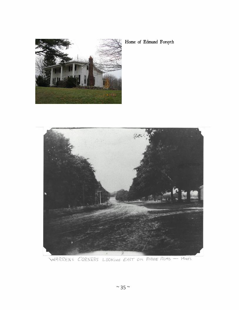
Home of Edmund Forsyth
~ 36 ~
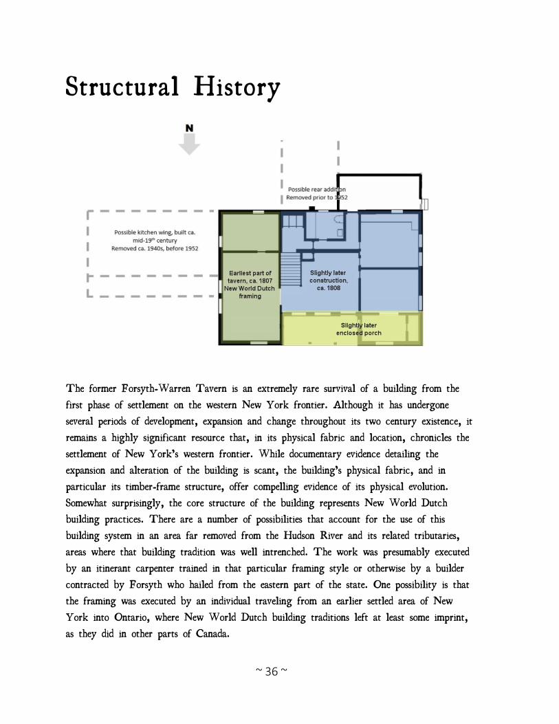
Structural History
The former Forsyth-Warren Tavern is an extremely rare survival of a building from the
first phase of settlement on the western New York frontier. Although it has undergone
several periods of development, expansion and change throughout its two century existence, it
remains a highly significant resource that, in its physical fabric and location, chronicles the
settlement of New York’s western frontier. While documentary evidence detailing the
expansion and alteration of the building is scant, the building’s physical fabric, and in
particular its timber-frame structure, offer compelling evidence of its physical evolution.
Somewhat surprisingly, the core structure of the building represents New World Dutch
building practices. There are a number of possibilities that account for the use of this
building system in an area far removed from the Hudson River and its related tributaries,
areas where that building tradition was well intrenched. The work was presumably executed
by an itinerant carpenter trained in that particular framing style or otherwise by a builder
contracted by Forsyth who hailed from the eastern part of the state. One possibility is that
the framing was executed by an individual traveling from an earlier settled area of New
York into Ontario, where New World Dutch building traditions left at least some imprint,
as they did in other parts of Canada.
~ 37 ~
The Forsyth-Warren house, along with a Dutch-framed house recently identified in
Laceyville, Pennsylvania, chronicle the geographic reach of a distinctive building tradition
that in New York is more typically associated with the New World Dutch vernacular
architecture of the Hudson, Mohawk and Schoharie valleys. Recent discoveries such as the
nominated example indicate the extent to which this tradition was carried into distant
geographic locations.
The core frame was built in characteristic New World Dutch fashion with a series of
closely spaced H “bents” consisting of two vertical posts linked by a horizontal tie beam.
Prior to the Revolution and for a time afterwards, the tie beams were planed smooth and
expressed on the interior; as such they served both structural and aesthetic ends. The
common rafter roof frame is also characteristic. This framing concept, which gave rise to
the story-and-a-half house type, was much employed in areas of New York State settled by
lowland Europeans and continued to be employed into the first decades of the nineteenth
century. The term “New World Dutch” encompasses the related building traditions in New
York State inclusive of its early Dutch, Palatine German and French Huguenot peoples.
While subtle variations might be discerned in comparing the early vernacular architecture of
the Dutch with that of the Palatine Germans, it is generally acknowledged that these two
distinctive ethnic groups conceived of and built largely in the same manner. When contrasted
with contemporary framing practices employed by those of New England background, the
Dutch type frame offered the advantages of simpler and less joinery; however, it did require
more timber.
The earliest known photograph of the Forsyth-Warren house from the 1920s shows a
building with two wings, a one-story side gable wing to the east, and a one-story wing to
the rear/south. Based on the appearance of turned columns on the porch fronting the east
wing, it would appear that this wing may date to the mid- to late-nineteenth century. Since
it’s likely that the house originally had a basement kitchen, this eastern addition was likely
built as a kitchen wing, supported by the appearance of a chimney in the historic photo.
The function and character of the wing at the rear is unknown, as no information about its
construction or appearance exists.
Some evidence of this wing is likely present in the unusual rear porch on the south side of
the building, and there are scattered remnants of what appear to be fieldstone foundation
south of the house. What is known is that these wings were removed sometime before 1952,
likely in the 1940s, when a photograph of the house shows the building essentially as it
remains today.
~ 38 ~
Outbuildings on the property reflect both the early agricultural function of the farm, as well
as the increased reliance on mechanical equipment. The property itself appears to have three
broad periods of development for the outbuildings. The first wave occurred roughly
contemporaneously to the tavern, with the construction of a three-bay barn ca. 1808 with a
rear lean-to added. It is unknown, but likely, that there may have been additional early
outbuildings on the property that have since been lost. The next major development on the
farm occurred with the construction of the large gambrel barn in 1896, which would have
increased the workspace as well as the small dairy operations. The early twentieth century
was the third and final major development era on the farm, with the construction of a
garage in 1915, a chicken coup in 1925, and a machine shed also in 1925. The garage
and machine shed reflect the increasing importance of mechanized equipment on farms during
the era, the storage of mechanical tractors and automobiles. The chicken coup is a crudely
built structure, clearly made out of several repurposed windows, which reflects the thrift and
resourcefulness typical in many farm outbuildings. Perhaps nothing speaks to the early
history of the property more than the presence of the small family cemetery, set up on a
slight rise at the rear of the property. Created out of need, with no neighboring church
cemeteries available, the establishment of the small cemetery reflects burial customs and
traditions of the era, with simple headstones typical of the early nineteenth century. The
family cemetery held the remains of members of the Forsyth and Warren families during the
earliest era of development in Niagara County, while later family members were buried in
more traditional mid- to late-nineteenth century off-site cemeteries. Taken as a whole, the
house, outbuildings, and cemetery reflect the settlement, growth, and development of a family
farm over the span of more than a century.
During the earliest years of settlement and occupation, the focus of agricultural activities
would have been largely of a subsistence nature, with arable land given over to the
cultivation of cereal grains, of which wheat would have been preeminent. Livestock would
have been necessarily limited at an early date, given the ever-present threat of wolves and
bears. The English barn that remains on the site would have served as the center of
agricultural endeavors; there hay could be stored, grain could be stored prior to threshing on
the floor of the central bay, and animals could have been safely stabled. Much of the
agricultural production likely fed not only the family, but served the tavern’s needs as well.
Under the Warren family, agricultural production on the property appears to have been
historically modest. The agricultural census records, available for the period of 1860-1880,
when the farm was under the ownership of Henry Warren, appear to reflect a largely
subsistence family farm, and the family’s income was likely supplemented by the profits
~ 39 ~
generated by the general store. Crops and livestock produced on the farm appear to largely
have sustained the family, and the operations were not large. There is some indication that
the farm may have been a sheep farm in the 1860s; however, by the 1880s, this product
declined. Like many farms in Niagara County, the Warren farm appears to have had a
significant orchard component, particularly after the Civil War.
The 1860 agricultural census reveals that the farm consisted of 63 acres of improved land,
with a cash value of $3,150 and $300 worth of farm equipment and machinery. The farm
consisted of 2 horses, 3 milk cows, 20 sheep, and 3 swine for a livestock value of $319.
Crops produced on the farm included 150 bushels of Indian corn (generally used for
cornmeal and flour), 100 bushels of oats, 136 pounds of wool, 100 bushels of potatoes, 10
bushels of buckwheat. The farm had a total orchard value of $150, indicating the likely
presence of fruit trees on the property. Products also included 400 pounds of butter and 2
tons of hay.
Little had changed for the Forsyth-Warren Farm in the 1870 agricultural census, when it
consisted of 62 acres of improved land. The farm was valued at $5,000 with $300 in
equipment and machinery and a total value of $1,000 for overall farm production.
Interestingly, the record indicates that $40 had been paid in wages, suggesting that the
Warrens may have hired a few farm hands to assist on the farm, possibly at harvest season.
During this time the farm consisted of 3 horses, 3 milk cows, 2 cattle, and 2 swine for a
total value of $661. It appears that between 1860 and 1870 sheep and wool production had
been abandoned on the farm. Crops consisted of 100 bushels of winter wheat, 50 bushels of
Indian corn, 60 bushels of oats, 40 bushels of buckwheat, 40 bushels of potatoes, and a
value of $360 worth of orchard products. Produced on the farm were 375 pounds of butter,
25 tons of hay, 8 pounds of beeswax, and 150 pounds of honey. The presence of
beekeeping and the increase in orchard products during this time suggests that both were
becoming important parts of the production on the Warren farm.
The last available agricultural census, taken in 1880, reveals some more detailed information
about how the Warren-Forsyth Farm was utilized. A total of 64 acres were noted in the
farm, 56 acres being improved and 8 acres of woodland. At the time, the farm had a value
of $6,500, $400 worth of farm machinery and equipment, and $810 worth of livestock.
The figures given for the farm’s livestock were comparable to the 1870 census, with the
exception of 60 chickens, producing 400 eggs. Of those 56 acres in production, 5 acres
were utilized for barley (producing 80 bushels), 4 acres produced Indian corn (producing
200 bushels), 3 acres were dedicated for oats (yielding 150 bushels), 9 acres were utilized
~ 40 ~
for wheat (producing 165 bushels of wheat), and one-half acre was dedicated for growing
potatoes (yielding 30 bushels). On 8 acres were 320 apple trees, producing 1,250 bushels
of apples, and on 3 acres were 360 peach trees, yielding 50 bushels of peaches. The value
of the orchard produce was set at $875, and 800 pounds of honey were produced. Based on
these figures, it appears that substantial land was devoted to the orchard and fruit growing,
which is consistent with other farms in Niagara County. While there are few remains of the
orchard production on the property today, likely because as the fruit trees were exhausted
they were removed and not replaced, the few scattered peach, pear and apple trees on the
property, just south of the barn, reflect this important crop.
In addition to the census record, the ledgers of Henry Warren contain consistent sales
primarily of barley, bees wax, wood, oats, milk, butter, peppers, squash, cucumbers as well
as eggs, horse hair, lath, meat and fruits by the barrel. There are also a variety of store
items intermixed in these sales ledgers, such as cigars, salt, tea, coffee, coal, borax, paint,
rice, dishes, currants, cloves, yeast cakes, raisins, soap blacksmithing, furniture making,
silks, stock fish, and farm equipment among many others demonstrating a very active
growing and importing business.
One way in which the Warren family may have also supplemented their income was through
sales of parts of the property originally purchased by John Forsyth. Forsyth had originally
purchased lots 23 and 24 of township 14, range 7, which were approximate 190 acres in a
long north-south strip that straddled the only early route through the region. This type of
long, narrow land division was a common land division by the Holland Land Company
during its first wave of land sales starting in 1800 and falling out of favor by 1803.
The first known major land sale on the nominated property occurred ca. 1872, when
approximately 112 acres to the south of the primary farm grouping was sold off to the
Blackstone family.35 However, this land sale may have occurred earlier than the 1870s, as
the 1860 agricultural census indicates that the farm consisted of only 63 acres of improved
land. A parcel to the west of the barn was given to Enos Warren, Ezra Warren’s son,
sometime prior to the 1850 federal census. This property later became the home of the
Parker family by 1907.36 A map of the town of Cambria from 1938 shows the property
under the ownership of Jennie Warren, widow of Charles Warren, reflecting that roughly
57 acres, both north and south of Ridge Road, were associated with the farm.
Elmer Warren, son of Charles and Jennie Warren, was the last generation of Warrens to
own the farm, and after his death around 1950, his widow, Maude, sold the property to
Floyd Yousey. Yousey had been living on the property and aiding as a farmhand. After his
~ 41 ~
death in 1999, the property passed to his daughters, Virginia Ferchen-Yousey and Phyllis
Orchard-Yousey. They sold the property to Harry B. Morton III in 2003, and in 2007
the property was foreclosed on. Due to the foreclosure, much of the land to the south and
the parcel to the north was sold off between 2007 and 2013, leading to the current parcel
of approximately 5 acres. However, by this time, the land had lost much of its historic
character as agricultural land. Several new houses and properties were constructed on the
former Forsyth-Warren lands, and aerial images show the loss of the orchard and organized
farm fields by the 1950s. The remaining lands contain all surviving built resources
associated with the Forsyth-Warren property and sufficiently convey the history and
character of the property as a farm dating back to the pioneer era in Western New York.
~ 42 ~
1857 - 2017
Mary died in 1857 at seventy-five and Ezra died in 1879 at eighty-nine. After Ezra
Warren’s death, his son, Henry Warren, continued operating the businesses on the family
homestead. Around this time, farm production in the area began to diversify from the
simplicity of livestock and grains to commercial orchards and vineyards.
The first cider mill in the area was constructed one mile east of the tavern, abutting land
willed to the sons of John Forsyth and Mary Ganson. It is also assumed that the farm had
a rather large cherry production due in part to Ezra’s sales records of cherry brandy as well
as the later cherry productions by subsequent generations. In 1896, a second barn was added
abutting the original. This new barn provided much more open space to accommodate more
robust thrashing equipment as well as a large straw shed and hayloft. It also included a sub
level with milking sanctions. It was at this time that the farm most likely began to mass
produce dairy milk for sale. Asa Pratt Warren, the fourth son of Ezra and Mary, opened a
cooper shop one lot to the west of the former tavern before 1850.
Their other three Warren sons and two daughters relocated to the far west territories as
America expanded westward.
Following Henry Warren’s death in 1890, his son, Charles, inherited the farm. He was a
carpenter by trade and hired stewards to operate and maintain the family farm. An ink
barrel stamp bearing his name can be found one of the interior barn walls and is also
stamped on several furniture pieces that have remained on the property.
Charles leased the former grocery store on the property to the National Grange of the
Order of Patrons of Husbandry to expire when or if the grange hall ceased to function.
Warren’s Corners Grange had upwards of three hundred members. Unfortunately, both the
grange and the Warren Grocery Store were torn down in the 1950s. The Town of
Cambria received electricity in January of 1905 and the tavern was electrified shortly
thereafter.
In 1926, Charles Warren, son of Henry Warren and grandson of Ezra Warren,
constructed a large frame house about three-hundred feet west of the former tavern. It
appears that around this same time, alterations may have been made to the interior of the
former tavern building, including a new staircase with a square newel post and several arched
~ 43 ~
openings between rooms. It is unknowns who, if anyone, lived in the former tavern at this
time; however, it has been suggested that at least one family resided there for some time as
charity from the Warren family. The son of Henry, Elmer Warren, had married Maude
Capen, whose family resided in the stone house located just north of the former tavern.
Elmer and Maude moved into the home of Jennie Warren and Elmer's late father, Charles.
After Charles’s death in 1930, his wife, Jennie, took over ownership of the farm. In 1940,
a commercial milk house was added abutting both previous barns. The milk house was built
to the standards approved by New York State for the commercial bottling of dairy milk.
The original plans for this standardized building remain with the property. Jennie hired a
farm hand, Floyd Yousey, to help maintain the six remaining acres of cherries, peaches and
apples, as well as the dairy cows and chickens. Yousey resided on the upper floor of
Charles’s home until the death of Jennie Warren in 1943, at which point Floyd and his
family moved into the former tavern.
Early in Floyd Yousey’s employment with the Warrens in the 1940s, a large addition
abutting the eastern rear of the former tavern and extending to the south was removed. No
evidence of its existence remains today except for a painting that has hung in the home of
Charles Warren since 1924. During this era, a chimney was added in the south crawlspace
of the second floor to service a cooking stove in the kitchen below. Presumably, this
chimney replaced that chimney for the original basement oven, which was removed at some
point. The removal of this large chimney allowed for a much larger and more open kitchen
space. The walls were also covered in wallpaper around this time. Elmer inherited his
father's property after the death of his mother, Jennie, but died only four years later. Maude
Warren sold the property, then consisting of fifty acres of land, to their steward, Floyd
Yousey, marking the end of nearly 150 years of ownership of the property by the Forsyth
and Warren families.
In May 1964 the Cambria Water District was established and public water lines began to
be installed. For the tavern this meant that the longstanding row of hemlock trees that lined
the Ridge Road in Warren’s Corners was removed in front of the tavern and the Yousey
family ceased using the three spring-fed wells on the property to supply water to the house;
however, they continued to use the barn well to supply water to their dairy.
On January 16, 1971, a fire engulfed the 1896 addition to the barn. The news headlines
listed it as a two-alarm fire that resulted in a total loss of the priceless historical landmark;
however; the Youseys were able to repair the barn with a new roof and new metal siding
~ 44 ~
around the 1896 addition. The interior, though blackened in the 1896 portion and along
the roof of the 1808 section, remained structurally sound.
Virginia Ferchen, and her husband, Ronald, took up residency in the former tavern until the
death of her father, Floyd, in 1999. At this point the property was deeded to Floyd’s
daughters, Virginia and Phyllis. Verda Yousey died a year later while tending to the gardens
behind the former tavern.
In May of 2003, the former tavern was sold along with 5 acres of land to Henry Morton.
Virginia Ferchen remained in the house to the west. Parcels of 2.4 acres and 9.1 acres
south of the former tavern were sold in May of 2007 to the Rickerson and Ness families.
In November 2013, the 27.9 acre parcel remaining of lot 24 north of the former tavern
was sold to the McCollum Farms Partnership. Then in 2007 the remaining 5 acres,
including the original Forsyth tavern and barn, were foreclosed upon and abandoned. During
this period, all of the buildings suffered from the effects of poor roofs and vandalism. The
parcel was purchased in 2017 at auction by Tyler Booth of the Forsyth-Warren Tavern
Foundation. Efforts began immediately to restore the five-acre parcel back to its original
appearance and functionality. The mission of this group is to open and operate the property
as a non-profit living history farm and museum utilizing the historic buildings, farm,
artifacts, and recorded histories to replicate life on frontier farm in the earliest years of its
existence.
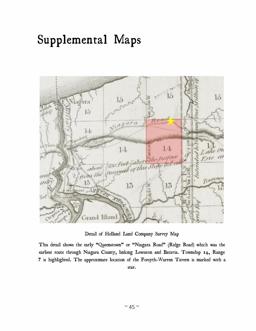
~ 45 ~
Supplemental Maps
Detail of Holland Land Company Survey Map
This detail shows the early “Queenstown” or “Niagara Road” (Ridge Road) which was the
earliest route through Niagara County, linking Lewiston and Batavia. Township 14, Range
7 is highlighted. The approximate location of the Forsyth-Warren Tavern is marked with a
star.
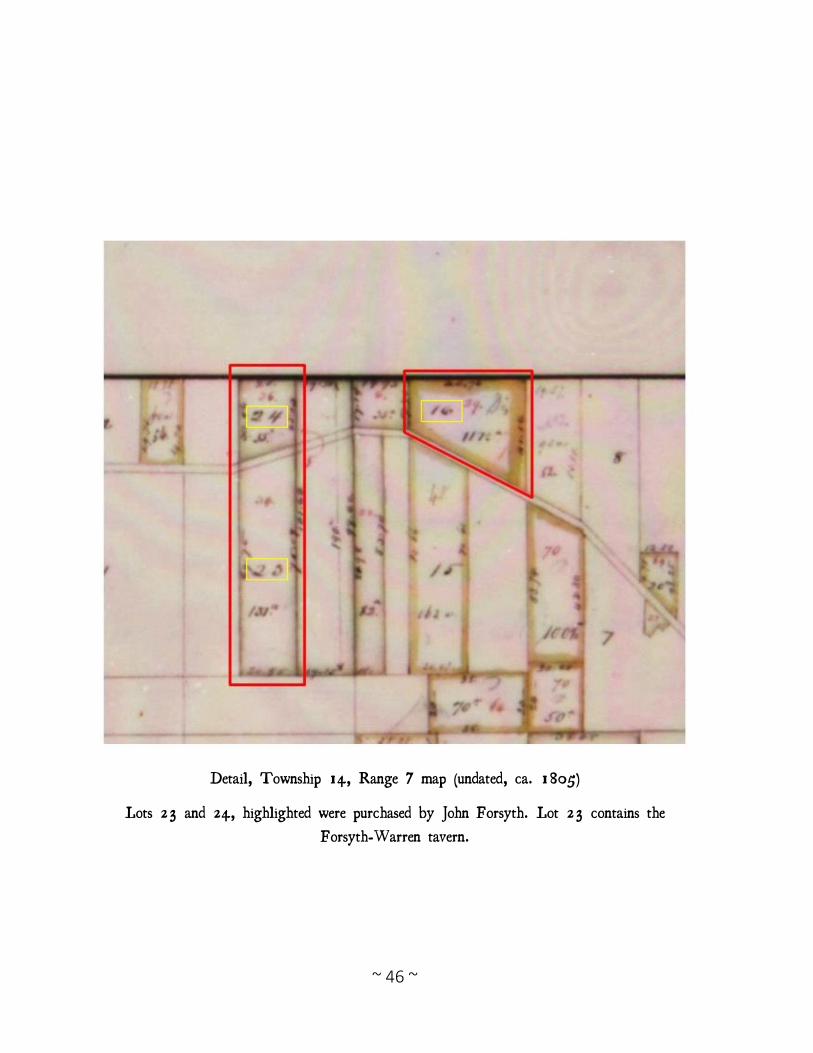
~ 46 ~
Detail, Township 14, Range 7 map (undated, ca. 1805)
Lots 23 and 24, highlighted were purchased by John Forsyth. Lot 23 contains the
Forsyth-Warren tavern.
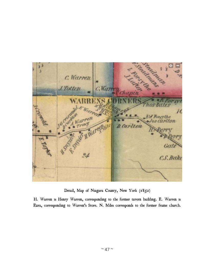
~ 47 ~
Detail, Map of Niagara County, New York (1852)
H. Warren is Henry Warren, corresponding to the former tavern building. E. Warren is
Ezra, corresponding to Warren’s Store. N. Miles corresponds to the former frame church.
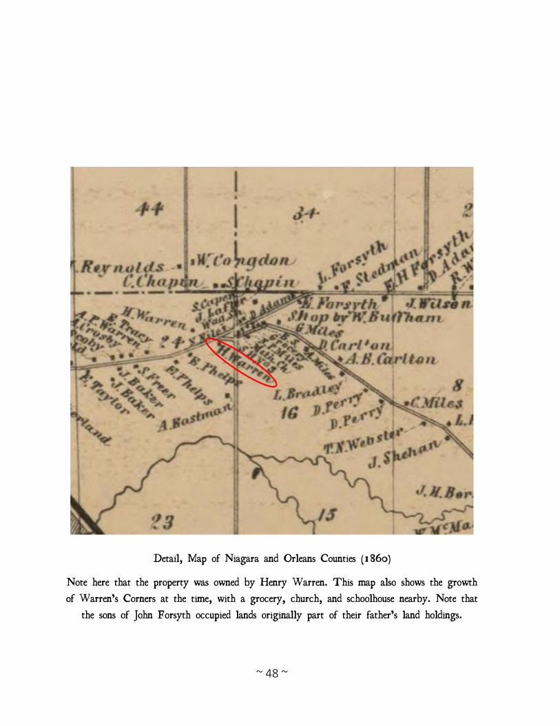
~ 48 ~
Detail, Map of Niagara and Orleans Counties (1860)
Note here that the property was owned by Henry Warren. This map also shows the growth
of Warren’s Corners at the time, with a grocery, church, and schoolhouse nearby. Note that
the sons of John Forsyth occupied lands originally part of their father’s land holdings.