The Excavation of an Unenclosed House of the Early Christian Period at Drumadonnell,County Down,...
11
Ulster Archaeological Society The Excavation of an Unenclosed House of the Early Christian Period at Drumadonnell, County Down Author(s): Cormac McSparron, David A. Weir and Eileen M. Murphy Source: Ulster Journal of Archaeology, Third Series, Vol. 60 (2001), pp. 47-56 Published by: Ulster Archaeological Society Stable URL: http://www.jstor.org/stable/20568270 . Accessed: 29/09/2014 13:40 Your use of the JSTOR archive indicates your acceptance of the Terms & Conditions of Use, available at . http://www.jstor.org/page/info/about/policies/terms.jsp . JSTOR is a not-for-profit service that helps scholars, researchers, and students discover, use, and build upon a wide range of content in a trusted digital archive. We use information technology and tools to increase productivity and facilitate new forms of scholarship. For more information about JSTOR, please contact [email protected]. . Ulster Archaeological Society is collaborating with JSTOR to digitize, preserve and extend access to Ulster Journal of Archaeology. http://www.jstor.org This content downloaded from 143.117.16.36 on Mon, 29 Sep 2014 13:40:05 PM All use subject to JSTOR Terms and Conditions
Transcript of The Excavation of an Unenclosed House of the Early Christian Period at Drumadonnell,County Down,...
Ulster Archaeological Society
The Excavation of an Unenclosed House of the Early Christian Period at Drumadonnell,County DownAuthor(s): Cormac McSparron, David A. Weir and Eileen M. MurphySource: Ulster Journal of Archaeology, Third Series, Vol. 60 (2001), pp. 47-56Published by: Ulster Archaeological SocietyStable URL: http://www.jstor.org/stable/20568270 .
Accessed: 29/09/2014 13:40
Your use of the JSTOR archive indicates your acceptance of the Terms & Conditions of Use, available at .http://www.jstor.org/page/info/about/policies/terms.jsp
.JSTOR is a not-for-profit service that helps scholars, researchers, and students discover, use, and build upon a wide range ofcontent in a trusted digital archive. We use information technology and tools to increase productivity and facilitate new formsof scholarship. For more information about JSTOR, please contact [email protected].
.
Ulster Archaeological Society is collaborating with JSTOR to digitize, preserve and extend access to UlsterJournal of Archaeology.
http://www.jstor.org
This content downloaded from 143.117.16.36 on Mon, 29 Sep 2014 13:40:05 PMAll use subject to JSTOR Terms and Conditions
Ulster Journal of Archaeology, Vol 60, 2001
THE EXCAVATION OF AN UNENCLOSED HOUSE OF THE EARLY CHRISTIAN PERIOD AT DRUMADONNELL, COUNTY DOWN
CORMAC McSPARRON Centre for Archaeological Fieldwork, School of Archaeology and Palaeoecology,
Queen's University, Belfast*
with contributions by EILEEN MURPHY & DAVID A WEIR
A site at Drumadonnell, Co Down, is identified as that of a sub-circular house
of the second half of the first millennium AD.
INTRODUCTION In 1999 Northern Archaeological Consultancy Ltd were
contracted by the Southern Education and Library Board
to carry out archaeological monitoring of topsoil stripping in advance of the construction of a new primary school at Drumadonnell, Moneyslane, Co Down (IGR J242
388) (Fig 1). Monitoring of topsoil stripping began on
20 January 1999 and excavation was carried out between
26 January and 7 February 1999. The surrounding land
is gently undulating and currently mostly usedforpasture. The topsoil is good quality loam above a buff-to-orange
sandy clay subsoil. There is a stream just to the north of
the site.
BACKGROUND The area was selected for archaeological surveillance
because it was the location of an Early Christian high cross which is currently housed at Castlewellan Forest
Park. The cross had been built into the wall of the old
Drumadonnell primary school, apparently after it was
damaged by a group of Presbyterian 'seceders' who
attacked it as a 'popish' symbol in 1778 (Bigger 1908,
56). But there is a difference of opinion as to whether
Drumadonnell was the original location of the cross.
Bigger believed that the cross was originally at 'old
Drumgooland' in the nearby townland of Deehommed, but that it was moved around 1778 by the Reverend
Richard Tighe, Rector of Drumgooland, to
Drumadonnell, presumably during a relocation of the
parish church of Drumgooland. There is an early ecclesiastical site at Deehommed which has an old
graveyard with a circular enclosure (Bigger 1908, 57).
Others, however, believe that Drumadonnell was always the site of the parish church of Drumgooland and that the
cross was at its original location. It has been suggested that there is evidence that Richard Tighe was resident at
Drumadonnell many years before the supposed move in
1778 (Fitzpatrick 1909). It is also mentioned that
knowledgeable locals believed that Drumadonnell was
the site of an ancient ecclesiastical site (ibid).
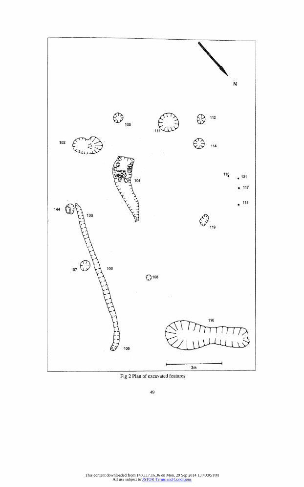
THE EXCAVATION (Figs. 2, 3) During topsoil stripping of the site a sub-circular pit (111), 0.95 - 0.98 m in diameter and 0.15 m deep, was identified. It was filled by several gritty orange loam and charcoal layers. The uppermost fill (132) was an orange brown coarse gritty loam circa 0.06 m thick. Beneath it was grey gritty loam (133) containing much charcoal
flecking and burnt bone. Also below (132) was the medium grey/brown, charcoal-rich, gritty loam (134). Beneath both (133) and (134) was a layer of dark grey, charcoal-rich, gritty loam (135). Beneath (135) was the
charcoal-flecked, orange brown, silty loam (136). In the
base of the cut for the hearth there was a very thin layer of loose grits (137) about 5 mm thick.
About 2.0 m to the east of the cut (111) there was an
elongated pit (104), 3.35 m long by 0.95 m wide and 0.15 m deep, which tapered into a slightly curving tail at the
east end. It had three fills. The uppermost fill ( 122) was
a mid to dark brown slightly sandy loam. Beneath it was
a dark grey/brown gritty loam ( 123) containing charcoal
flecks. The primary fill was a thin layer of charcoal
(124), never more than 2 cm thick, which covered the
base of the west end of the feature but which gradually thinned until it ran out in the centre of the feature. Below
the middle fill ( 123), but above the charcoal-rich primary fill (124) of the cut (111), there was a setting of stones
(142). These appeared to cover much of the base and
sides of the wide west end of the feature and formed a
linear setting, possibly capped, running a little way towards the tapering east end of the feature.
In the immediate vicinity of these two large cuts were
the truncated remains of eight small post-holes and a
number of small stake-holes. Post-hole (105) was located
to the south of the site. It was 0.26 m in diameter and 0,05
m deep and was filled by the dark grey/brown, slightly
gritty loam (127). To the east of (105) there was a post hole (144) which was about 0.30 m wide by 0.15 m deep
* formerly of Northern Archaeological Consultancy
Ltd, Belfast
47
This content downloaded from 143.117.16.36 on Mon, 29 Sep 2014 13:40:05 PMAll use subject to JSTOR Terms and Conditions

and was filled with (145) a dark grey/brown loam.
Farther to the east was post-hole (107) which was 0.50
m in diameter and 0.07 m deep and was filled by (126) the grey/brown gritty loam. Post-hole (108) was about
3.0 m north west of (107) was 0.20 m in diameter and
0.04 m deep. Posthole ( 109) was 0.35 by 0.27 m and 0.08
m deep and was filled by ( 124) the mid grey, sandy loam.
To the south-west of the pit (104) was post-hole (140) which was 0.40 m in diameter and 0.14 m deep and was
filled by the mid brown gritty loam ( 141 ). Circa 4 m to
the west of post-hole (140) was post-hole (112), 0.40 by 0.30 m and 0.05 m deep which was filled by ( 128) a mid
to dark grey slightly gritty loam. Circa 1.2 m to the
north-east of post-hole (112) was post-hole (114) which
was 0.45 by 0.49 m and 0.09 m deep and was filled by the dark grey gritty loam ( 129). The post-hole (119) was
located 3.0 m to the north-west of the post-hole (114) and was 0.50 by 0.30 m and was 0.07 m deep. It was
filled with (130), a grey/ brown loam.
In the north-west of the site were four stake-holes
(115), (117), (118) and(132). The stake-hole (115) was
0.11 m in diameter and 0.04 m deep. The stake-hole
(117) was 0.13 by 0.10 m and 0.04 m deep. The small
stake-hole (118) was 0.08 m in diameter and 0.07 m
deep and the stake-hole (132) was 0.10 m in diameter
and 0.06 m deep. To the extreme south end of the site there was a large
pit or post-hole ( 102) which was 1.20 by 1.10 m and 0.34 m deep and was filled by the mid grey/ brown sandy loam (120).
A second pit ( 110) was located at the extreme north
east of the site. It was key hole shaped being c 1.20 m at
its widest south end, 0.60 m wide at its north end and 4.0 m long. At its deepest it was 0.44 m deep. It had two fills;
(138) a mid grey/brown sandy loam and (139) a dark
grey/brown, charcoal-rich, loam which was thickest at
the widest part of the feature and tailed off towards the narrower north end.
The upper fill of ( 110) was covered by the charcoal
rich loam layer (143). This was a narrow band of
charcoal-rich loam which ran down slope, south-west to
north-east, across the site. There was a gully (106) close to the south-east edge
of the site. It was 7.30 m long by 0.28 m wide at the widest and a maximum of 0.12 m deep. It was filled with
the grey/brown gritty loam (125).
THE FINDS (not illustrated)1 A number of sherds of pottery were recovered from the
excavation. Most of the sherds, which with one exception were found in the charcoal-filled pits (104) and (111), were typical of souterrain ware, which corresponds well with the radiocarbon dates obtained for the site (see below). However, two sherds do not seem typical of souterrain ware, having a finer and more even surface than the typically rough souterrain ware, well sorted inclusions and a slightly pimply texture. Also the uniform oxidization of the exterior surfaces of these pot sherds is not typical of the souterrain ware tradition which has
patchy, oxidized and reduced surfaces tending towards
reduction. While it is possible that these two sherds are
atypical examples of the souterrain ware tradition it may be that they are of a different pottery type. It seems
unlikely that they represent a different contemporary
potting tradition or that they are imports. It seems most
likely that the sherds are residual and date from an
earlier phase of occupation. The fabric and appearance
Fig 1 Site location.
48
This content downloaded from 143.117.16.36 on Mon, 29 Sep 2014 13:40:05 PMAll use subject to JSTOR Terms and Conditions
?
Q108
?
114
118 .131
? 117
? 118
O 119
3m
Fig 2 Plan of excavated features.
49
This content downloaded from 143.117.16.36 on Mon, 29 Sep 2014 13:40:05 PMAll use subject to JSTOR Terms and Conditions
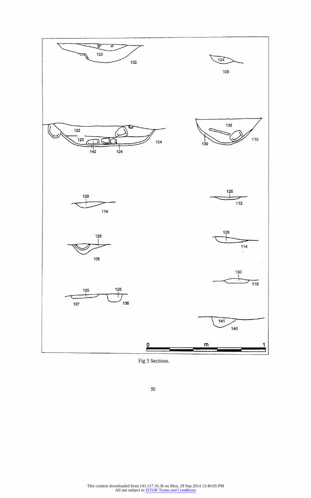
125 126
107 T3 106
Fig 3 Sections.
J24
109
142 124
129
114
-^fp^ 106
128
112
114
50
This content downloaded from 143.117.16.36 on Mon, 29 Sep 2014 13:40:05 PMAll use subject to JSTOR Terms and Conditions
of the sherds is not incompatible with their being Bronze
Age and, as is detailed in the flora report below, the
assemblage of grains etc from (139), the lower fill of pit (110), is suggestive of a Bronze Age date for this feature.
This may show that there had been some Bronze Age activity at the site. Unfortunately the single tiny sherd of
pottery recovered from (139) was so small and abraded that it was impossible to see if it was more typical of
Early Christian or Bronze Age pottery.
ENVIRONMENTAL MATERIAL Soil A total of 74.86 kg of soil samples was processed by John Davison of the School of Archaeology and
Palaeoecoiogy, Queen's University, Belfast. Charcoal, burnt bone, hazelnut shells, grains and a fruit stone were recovered.
Bone Remains
A considerable number of burnt bone fragments were
recovered from the two hearths (104) and (111). These were analysed by Eileen Muiphy, whose full report is
given below. She concludes that while most of the bone
fragments were too burnt and small to be positively identified, those that could be identified were all
fragments of ovicaprids andcattle. All the bone fragments had been subjected to temperatures between 285? C and 1200? C, most probably having been heated to between
285? C and 525? C.
The bone remains from Drumadonnell accord well with what is known of the Early Christian diet and the cattle-based economy. It compares with faunal remains from excavated Early Christian sites such as Shaneen
Park, Ballyaghagan, Co Antrim, where the vast majority of the identified bones were of cattle with just a small amount of pig (Proudfoot 1958).
Plant Remains
Charred plant remains recovered during processing of soil samples were examined by Dave Weir, whose full
report is given below. To summarize, he identifies remains for oats, barley and wheat as well as hazelnut shell and a sloe stone. This again accords well with what is known of the Early Christian diet. One sample (139), the basal fill of pit (110), contained seeds and grains
which were not typical of an Early Christian assemblage but were more typical of the Late Bronze Age.
Radiocarbon Dates Two radiocarbon dates were obtained for context (123), the fill of hearth (104), and for context (133), the fill of
hearth (111), from Beta Analytic, Miami, Florida. The dates were calibrated using the INTCAL98
Radiocarbon Age Calibration (Stuiver et al 1998)
DISCUSSION There was certainly domestic activity at the Drumadonnell site and it seems very1 likely that the structures uncovered during the excavation are the remains of a building which probably functioned as a house. No evidence for an ecclesiastical association was identified.
Context ( 104) was a domestic fireplace. The presence of some burnt bone and pottery in the charcoal-rich primary fill (124) is strongly suggestive of cooking. The stone setting (142) in this hearth was not an original feature of the fireplace but was sitting on, and in, the dark charcoal primary fill ( 124). This would suggest that these stones were set here after the hearth had been in use for some time. So little of the setting remained to be recorded that it is difficult to be certain about its function, but it is not unreasonable to speculate that it may have been part of an oven. This would explain the 'tail' going north from the hearth as the area in which the ashes were raked from the oven. The positioning of the hearth to one
side, the south-east, of the building is consistent with the
positioning of some hearths in previously excavated
Early Christian settlements. It has been suggested that this off-centre location was because of a deliberate intention to position the hearth close to the door, both to aid fuelling and to encourage draught and dispersal of smoke (Lynn 1982).
There was a sub-circular setting of cuts arranged around this hearth. They were truncated post-holes
which would have held supports for a structure. The diameter of this structure would have been 7.0 by 8.0 m. There was no floor material but, as the depth of the
postholes shows, there was considerable truncation. The posthole (102) is much larger and deeper than
the other post-holes. It was found to the south east of the structure and may have been deeper to support a doorway.
This posthole was very wide at the top and cut the
ground in such a way as to make one side of the cut
stepped. This shape of posthole is consistent with the
post having been removed after being rocked back and
forth. It has been suggested that door jambs from Early Christian houses may have been removed, at the end of the life of a building, for use in other buildings. If this
was a doorway it would have opened to the south. This was a common orientation for doors on Early Christian
houses which tended to avoid opening to the west, the
direction of the prevailing wind (Lynn 1994).
Sample Conventional C14 Date 1 Sigma Date Range 2 Sigma Date Range
(68% probability) (95% probability) _Calibrated _Calibrated_
(123) 790 +/- 60 ad_785 to 970 AD_705 to 1005 AD
(133) 750+/-60 ad 765 to 895 AD 680 to 980 AD
51
This content downloaded from 143.117.16.36 on Mon, 29 Sep 2014 13:40:05 PMAll use subject to JSTOR Terms and Conditions
The house site is similar to a house excavated inside
an Early Christian ringfort at Ballyfounder, near
Portaferry, Co Down. This house was composed of a
hearth with surrounding post-holes, circa 7 m in diameter.
The postholes were between 0.15 and 0.30 m deep. The
post-holes were grouped together in twos and threes
which would imply that the structure had been rebuilt a
number of times (Waterman 1958). The hearth (104) has some similarities to a hearth
excavated in an Early Christian structure at the
ecclesiastical enclosure at Doras, Co Tyrone. This was
a hollow in the ground lined with stones. Like (104) there was a gully running from the centre of the hearth
towards the outside of the house. There was also a layer of charcoal-rich soil lining the bottom of the hollow
beneath the stones. The hearth was about 3 m in length and the house at Doras had a diameter of about 6.0 m
(McDowell 1987). There was a second hearth (111) at the site. This
hearth was very different from the hearth (104). It was
almost totally circular with dimensions of 0.98 m by 0.95 m and 0.17 m deep. It was filled with charcoal and
mixed ash and gritty loams. This hearth was not directly associated with the probable house but was situated in
what would have been the middle of the wall of the structure. This implies that it could not have been
contemporary with the house. Itmay have been associated with a structure of which no evidence remains, or it may have been a hearth outside a building. Evidence from some excavated Early Christian settlements suggests some hearths may have been free-standing (Warhurst 1971).
It is interesting to note that the two hearths ( 104) and (111 ) contained very different quantities of burnt bone.
Hearth (104) contained a total of 6.6 g of burnt bone from a total sample weight of 23.97 kg. This is a ratio of 1 g of bone per 3.63 kg of sample. Hearth (111), by
contrast, produced 320 g of burnt bone from a total
sample weight of 25.06 kg. This is a ratio of 1 g of bone
per 78.3 g of sample. If looked at more closely we can see that most of this bone, 311.4 g, came from one layer (133). Its ratio of bone to sample (minus the bone and
sample weight of the other layers in the hearth) is 311.4
g for a sample weight of 19.68 kg or 1 g of bone per 63
g of sample. The ratios for layers (134) and (135) respectively are 1 g of bone per 506 g of sample and 1 g of bone per 838 g of sample. The only identifiable bones came from hearth (111), with layer (133) containing some cattle bone fragments, layer (134) containing sheep/goat and layer (136) containing one fragment of cattle tooth enamel. It is difficult to be sure as to the
significance of the differentiation in the two hearths. It could be suggested that this is evidence of different functions for the two hearths, perhaps that one was for
cooking meat and the other for baking bread. However
it may also mean that the method of use of hearth (111) was more likely to lead to bits of bone ending up in the
fire.
There is some doubt over the function of ( 110). It was
keyhole-shaped and about 4.0 m long. It had a layer of
charcoal at its base. The subsoil into which the pit was
cut appeared to have been exposed to heat, suggesting either that combustion took place in the pit or that ashes
were deposited in it while they were still hot. In addition, the assemblage of flora from the basal layer (139) of this
feature would suggest that it was not contemporary with
the other excavated features on the site (see Appendix 2).
It is difficult to say if the curving gully ( 106) is indeed
archaeological. The fill of the gully did contain two
fragments of burnt hazelnut shell which was common in
the fills of hearths (104) and (111). However it also
contained one piece of modern pottery, although the
gully is so shallow that it could be intrusive, possibly
pushed down into the fill by the mechanical digger tracks. Drainage gullies are common on Early Christian
settlement sites and this may have been the function of
this gully.
CONCLUSIONS The site is a small but interesting Early Christian
settlement. One structure was uncovered which was
composed of the postholes and hearth (104). There may have been a second, not contemporary, structure
represented by the hearth (110) of which there is no
additional surviving evidence. Even if this was a hearth outside a building it was clearly associated with some sort of settlement in the vicinity, since the burnt bone
within it testifies to its domestic function. During the
monitoring of topsoil removal and the excavation no trace of a ditch enclosing the site was found. Consequently this must be considered an unenclosed settlement.
Analysis of the macrofloral (seed and grain) remains of sites of this period has only commonly been carried out in recent years. To date this is only the second Early
Christian site in Co Down to have this type of analysis carried out. It provides scientific verification of what
was stated in the early Irish legal document, Bretha Dein
Ch?cht, written 1300 years ago, which stated that oats were the least valuable cereal crop with wheat the most
valued, and barley in the middle (Kelly 1997). The unenclosed settlement at Drumadonnell would
presumably have been of middle to low status. The dominance of barley and wheat, combined with the
paucity of wheat from the site, would accord with the
crops the Bretha D?in Ch?cht and other legal documents
say a middle ranking settlement would have grown.
52
This content downloaded from 143.117.16.36 on Mon, 29 Sep 2014 13:40:05 PMAll use subject to JSTOR Terms and Conditions
THE BURNT ANIMAL BONE
EILEEN M MURPHY School of Archaeology and Palaeoecology,
Queen's University, Belfast
METHODOLOGY Details of the remains retrieved from each context are
provided below, and the data includes the quantity, size
and degree of fragmentation of the bones. These findings enable one to assess the amount of information it was
possible to obtain from each context and also allows for
aspects of the cooking technology to be reconstructed.
The colour of the burnt bone is included so that the
efficiency of the combustion process can be ascertained.
The colour of cremated bone reflects the amount of
oxidization the organic components of the bone have
undergone and is partly dependant on temperature. When bones are subjected to increasing temperature
they change from black, through various stages of grey, to white (McKinley 1994,77). Experimental studies on
modern animal bone to determine variations in bone
colour caused by fire temperatures have been undertaken
by several researchers, including Mays (1998,217). The
results of his study have indicated that bone changes to
a white or pale yellow colour at temperatures of between
645?C and 1200?C, while black and grey discoloration
generally occurs at temperatures of between 285?C and
525?C.
Rib and vertebrae fragments which were
unidentifiable to species were classed as large or medium
in size. Large fragments are considered to have originated from cattle or horses, while medium-sized fragments
would have belonged to pigs or ovicaprids.
Context 122, Upper 50%
A total of 250 fragments of burnt bone were recovered
from this context, including two fragments of animal
crania. The majority of fragments were less than 15 mm
in size, and the largest piece measured 24.1 mm by 14.1 mm. All of the fragments were white with some grey
discoloration, and it is likely that they had been burned
at temperatures of between 285?C and 1200?C (Mays
1998, 217).
Context 122, Lower 50% A total of 25 fragments of unidentifiable burnt bone
were recovered from this context. Most of the fragments were less than 10 mm in size, and the largest piece measured 16 mm by 10 mm. The majority of fragments were white although some also displayed a grey
coloration, and it is probable that they had been burned
at temperatures of between 285?C and 1200?C (Mays
1998, 217).
Context 121
Five fragments of unidentifiable burnt bone were
retrieved from this context, all of which were less than
10 mm in size. The fragments ranged in colour from dark grey to white which may indicate that they had been burned at temperatures ranging from 285?C to 1200?C
(Mays 1998,217).
Context 123 A total of 31 fragments of unidentifiable burnt bone were recovered from this context. The majority of
fragments were less than 10 cm in size, but the largest piece measured 13 mm by 9.1 mm. Most of the fragments were white although some displayed tinges of grey, and it is probably that they had undergone combustion at
temperatures of 285?C to 1200?C (Mays 1998,217).
Context 133
A total of 1984 unidentifiable fragments of burnt bone were retrieved from this context. In addition, 12 crania, three rib, and two vertebrae (from a large animal)
fragments were recovered. A fragment of cattle mandible, five pieces of cattle tooth enamel, a cattle tarsal/carpal, a fragment of long bone shaft from a medium-sized animal and apiece of long bone shaft from a large animal
were also present in the corpus. The latter fragment represented the largest piece of bone in the assemblage,
measuring 54.2 mm by 15.4 mm, although the vast
majority of fragments were less than 20 mm in size. All
of the fragments were white with some grey discoloration, and it is probable that they had been burned at
temperatures ranging from 285?C to 1200?C (Mays 1998, 217).
Context 134
A total of 48 fragments of burnt bone were recovered
from this context. Three fragments were identifiable and
these consisted of an ovicaprid distal metapodia, an
ovicaprid long-bone shaft fragment and a piece of a
medium-sized vertebra. The metapodial fragment was
fused indicating that it had originated from an adult
animal. Most of the fragments were less than 10 mm in
size, although the largest fragment which comprised the
ovicaprid metapodia, measured 18.7 mm by 8.1 mm.
The majority of fragments were white although a number
also displayed a grey coloration and it is probable that
they had been burned at temperatures ranging from
285?C to 1200?C (Mays 1998,217).
Context 136
A total of 46 fragments of burnt bone were retrieved
fromtm^context/TTieonlyidentifiablefragmentincluded in the corpus comprised a fragment of enamel from a
cattle tooth. The majority of fragments had a size of less
than 10 mm, although the largest fragment measured 15
53
This content downloaded from 143.117.16.36 on Mon, 29 Sep 2014 13:40:05 PMAll use subject to JSTOR Terms and Conditions

mm by 16 mm. Most of the fragments were white but
some displayed tinges of grey and it probable that they had undergone combustion at a temperature range of
285?C to 1200?C (Mays 1998, 217).
CONCLUSIONS A total of 2415 fragments of burnt bone were recovered
during the excavation at Drumadonnell. The bones were
in a highly fragmentary condition, with the majority of
fragments measuring less than 20 mm in size. This high
degree of fragmentation resulted in the vast majority of"
fragments (98%) being unidentifiable to either species or bone type. It was possible, however, to determine
from a number of bone fragments that cattle and
ovicaprids were represented. All of the pieces of bone
were white with tinges of grey discoloration, and it is
most probable that they had been combusted at
temperatures of between 285?C and 525?C (Mays 1998,
217).
THE SEED AND GRAIN REMAINS
DAVID A WEIR 4 Mount Michael Drive, Belfast BT8 6JZ
INTRODUCTION Charred plant material from sampled features was
extracted by flotation and sieving, conducted by John
Davison, who also sorted the charcoal residues and
extracted the charred seeds and grain. The extracted
material was passed to the author for identification.
METHODS Identifications were made at x7 - x30 magnification,
using a Leica Zoom 2000 microscope. Weed seeds were
identified with the aid of illustrations in seed atlases
(Beijerinck 1947; Schochetal 1988) and by comparison with reference material. There is no adequate identification aid for cereals, and identification was
aided by reference to modern and previously identified
material from archaeological sites. Conclusive
identification of the different cereal species or types within a group is dependent on the presence of well
preservedrachis and glume material (ie chaff). This was
not present in this sample, and has restricted the level of some identifications, especially of the oats (Avena sp).
RESULTS The results for individual features or contexts are
presented in Table 1, but will be dealt with here as
groups rather than individually. The results from (78) and ( 121 -
37) are generally similar, as they are dominated
by barley (Hordeum vulg?re) and also contain oats, the
percentages of identified grain from these contexts
being 61% and 36.5% respectively. Where the barley was well preserved it was identifiable as hulled, six-row
type, with a more angular outline, traces of adhering lemma and palea, and a ratio of 2:1 twisted to non
twisted grain. The oat species is not identifiable, as no
glume bases were found, and could be any of the main
species, though is probably either cultivated oat (Avena
sativa) or bristle-pointed oat (Avena strigosa). One
context, (121), contained four grains which are
comparable to wheat, but too poorly preserved to be
certain. The majority of contexts also contain some
hazel (Corylus avellana) nut fragments. A single sloe
(Prunus spinosa) stone was found in (134). Context (139) is significantly different, with the
identified grain being entirely barley and with no oats
present. It is the richest context overall, containing 49%
of the identified grain from the site, and the preservation is generally quite good. The majority of the well preserved
grain is of six-row, hulled type, but a total of 16 grains
appeared to belong to the 'naked' variety (Hordeum
vulg?re var nudum). In this variety the lemma and palea do not adhere to the grain, and are thus not preserved, the
grain itself being more rounded in outline and having a
distinct ridge in the ventral groove. In addition to the
grain this was the only context to yield any evidence for an arable weed flora, with Persicaria! Poly gonaceae seeds present, which are common weeds of nitrogen
rich, disturbed ground.
DISCUSSION The results from most of contexts are typical of the
majority of Early Christian sites of this period, with
barley as the dominant cereal, and a significant component of oats (Monk 1986; 1991). Both cereals are
tolerant of a wide range of soils and would have grown well in this area, though it is difficult to equate the amount of cereal grains recovered from a site with the
possible extent of arable agriculture in the surrounding area. The cumulative evidence does, however, suggest a major expansion of arable agriculture throughout Ireland in the Early Christian Period (Monk 1991), As
well as evidence from charred grain assemblages, this includes increased cereal and arable weed representation in pollen diagrams (Singh & Smith 1973; Hall 1990;
Weir 1995) from areas of good agricultural land. In
54
This content downloaded from 143.117.16.36 on Mon, 29 Sep 2014 13:40:05 PMAll use subject to JSTOR Terms and Conditions

Species (?6) (121) (104) (123) (125) Middle
fill
(122)
cf Hordeum vulg?re (barley)
Hordeum vulg?re (barley)
cf Hordeum vulg?re var nudum
(cf six-row naked barley)
Hordeum vulg?re
(six-row, hulled barley) 3
cf Triticum (wheat)
cf Avena sp (oats) 1
Avena sp (oats) 1
cf Avena/Secale (oats/rye)
Cereal (indeterminate)
Cereal fragment 15
Poaceae (indeterminate)
(cereal/wild grasses) 1
Coryius avellana
(hazelnut shell fragment)
Prunus spinosa (blackthorn)
Persicaria cf MaculosaAapathifolia (redshank/pale persicaria)
Polygonaceae -
cf Ranunculus (cf buttercup)
1
33
29
15
18
10
(133) Areal Areal Areal (136) ?37? C139i Total (133) (133) (134)
Level Level Level 1 1 1
4 14
2 5 1
2
1 1
1 1
65
75
I
3
124
116
5
20
38
1
2
25
1
4
3
1
Table 1
addition, dendrochronology has identified a major phase of horizontal mill construction between AD 777 and 850
(Baillie 1995). There is only one other published analysis of charred
grain material from Co Down, most excavators not
having taken samples for analysis, and the only evidence
for arable agriculture is usually finds of quern stones. At
Lough Faughan crannog Morrison (in Collins 1955,75
6) found a 'considerable quantity' of obviously well
preserved material, the majority of which were oats with a smaller component of barley, some of which - from the
photographs - is clearly hulled six-row barley. This is a
less usual situation, with only four out of 23 sites
throughout Ireland having oats as the dominant cereal
(Monk 1991). Still fewer had wheat as the dominant
cereal, such as was recently found in Early Christian
contexts in Armagh (Weir 2000). To some extentresults
reflect a combination of the status of the site and the
quality of surrounding soils. Wheat is associated with
high status, and also requires the best soils. Oats are of
the lowest status, and are relatively undemanding of
soils, with barley of somewhat higher status andneeding
better soils. A site of medium to low status on average to good soils could thus be expected to have a cereal
assemblage dominated by oats and barley. The presence of hazelnut fragments in most contexts
is interesting, demonstrating the value of these as a food source. In the Old Irish tree-list hazel is described as one
of the 'nobles of the wood' (Kelly 1997), for its value
both as a foodstuff and providing rods for building or
fencing. It is almost certain that areas of hazel coppice in the surrounding area would have been managed to
provide both nuts and rods. The single, charred stone of
blackthorn from (134) is also interesting, as the fruit
(sloe) is generally considered too bitter today to eat, but
was obviously eaten in the past (Kelly 1997, 306-7).
Indeed, considerable quantities of sloe stones were
recovered from 12th-to 13th-century contexts in Dublin,
which indicated that they were being eaten or processed for juice extraction and probable fermentation (Mitchell
1987). Context ( 139) has the highest incidence of grain from
the site, producing about 50% of the total identified. It
is obviously different from the other contexts, the most
55
This content downloaded from 143.117.16.36 on Mon, 29 Sep 2014 13:40:05 PMAll use subject to JSTOR Terms and Conditions

obvious difference being the absence of oats. The
identified grain is all barley, mostly six-row, hulled
barley, but there are also a significant number of grains that appear to be naked barley. The latter is generally considered to be a more primitive type, commonly found on prehistoric sites. By the Late Bronze Age, hulled six-row barley was beginning to occur, as at
Killymoon, Co Tyrone, where it seems to predominate (Weir in progress). It has, however, also been found on
at one least Early Christian site (Monk 1986), but the
presence of naked wheat and absence of oats would tend
to suggest a prehistoric date for this context, probably Late Bronze Age. The available evidence would suggest that this was also a period of considerable arable activity in Ireland (Weir 1993; 1995). This includes increases in
cereal pollen in pollen diagrams, such as Loughnashade, Co Armagh, and major assemblages of charred grain from sites such as Killymoon and Haughey's Fort, Co
Armagh. The grain assemblages from both of these sites
also consist entirely of barley. The pit from which ( 139) comes is some distance from the other contexts, and it
wTould be no surprise if an assemblage of this size did
turn out to be Late Bronze Age. It could, however, also
be due to a different processing activity occurring in this
area, or represent separate storage of the barley crop, but
this seems less likely.
CONCLUSIONS The assemblage from Drumadonnell is particularly useful as there is little other evidence from Co Down for charred cereals. The material from Early Christian contexts fits well with that available from the rest of
Ireland. A single, rich context containing only barley may be of Late Bronze Age date.
NOTE 1 At the time of writing the finds are held by Northern Ar
chaeological Consultancy Ltd.
REFERENCES Baillie, M G L 1995 A Slice Through Time. London.
Beijerinck, W 1947 Zadenatlas der Nederlandische Flora.
Wageningen. Bigger, F J 1908 'The ancient cross of Drumgolan in the Co.
Down', UJA (2nd ser) 14 (1908), 56-8.
Collins, A E P 1955 'Excavations in Lough Faughan crannog, Co. Down, 1951-52', UJA 18 (1955), 45-82.
Fitzpatrick, T 1909 'The ancient cross of Drumgoolan, Co.
Down', UJA (2nd ser) 15 (1909), 45-7.
Hall, V A 1990 'Recent landscape history from a Co. Down lake deposit', New Phytologist 115 (1990) 377-83.
Kelly, F 1997 Early Irish Farming. Dublin.
Lynn, C J 1982 'The excavation of Rathmullan, a raised rath and motte in Countv Down', UJA 44 & 45 (1981-82), 65 171.
Lynn, C J 1994 'Houses in rural Ireland AD 500-1000', UJA
57(1994), 81-94.
Mays, S 1998 The Archaeology of Human Bones. London.
McKinley, JI 1994 The Anglo-Saxon Cemetery at Spong Hill, North Elmham. Part VIII: The Cremations (East Anglian Archaeology Reports 69). Norwich.
Mitchell, G F 1987 Archaeology & Environment in Early Dublin (Medieval Dublin Excavations 1962-81, ser C, vol
1). Dublin.
Monk, M A 1986 'Evidence from macroscopic plant remains for crop husbandry in prehistoric and early Ireland', / Irish
Archaeol 3 (1985-86), 31-6. Monk, M A1991 'The archaeobotanical evidence for field crop
plants in Early Historic Ireland', in Renfrew, J (ed), New
Light on Early Farming: Recent Developments in
Palaeoethnobotany, 315-28. Edinburgh. Proudfoot, V B 1958 'Further excavations at Shaneen Park,
Belfast, Ballyaghagan townland, Co. Antrim', UJA 21
(1958), 18-38. Schoch, W H, Pawlik, B & Schweingruber, F H1988 Botanical
Macro-remains. Berne.
Singh, G & Smith, A G 1973 'Post-glacial vegetational history and relative land- and sea-level changes in Lecale, Co.
Down', /7H? 73B (1973), 1-51.
Stuiver, M, Reimer, P J, Bard, E, Beck, J W, Burr, G S, Hughen, K A, Kromer, B, McCormac, G, van derPlicht, J, & Spurk, M 1998 '?NTCAL98 radiocarbon age calibration, 24000-0 cal BF, Radiocarbon 40 (3) (1998), 1041-83.
Waterman, D W 1958 'Excavations at Ballyfounder rath, Co. Down', UJA 21 (1958), 39-61.
Warhurst, C 1971 'Excavations of a rath at Shanes Castle, Co. Antrim', UJA 34 (1971), 58-64.
Weir, D A1993 An Environmental History of the Navan Area, Co. Armagh. Unpublished PhD Thesis, Queen's University, Belfast
Weir, D A 1995 'A palynological study of landscape and agricultural development in County Louth from the second
millennium BC to the first millennium AD', Discovery Programme Reports: 2 Project Results 1993, 77-126. Dublin.
Weir, D A 1998 Armagh Town 1998: Charred grain. Report to Northern Archaeological Consultancy Ltd, Belfast.
56
This content downloaded from 143.117.16.36 on Mon, 29 Sep 2014 13:40:05 PMAll use subject to JSTOR Terms and Conditions