The Evaluation of Green Infrastructure Elements to Enhance Green Neighbourhood Park in Shah Alam,...
20
International Conference on Research Methodology for Built Environment and Engineering 17 th -18 th December 2012, FSPU, UiTM Shah Alam THE EVALUATION OF GREEN INFRASTRUCTURE ELEMENTS TO ENHANCE NEIGHBOURHOOD PARK IN SHAH ALAM, SELANGOR CENTRE OF STUDIES FOR TOWN AND REGIONAL PLANNING, FACULTY OF ARCHITECTURE, PLANNING AND SURVEYING, UNIVERSITI TEKNOLOGI MARA, SHAH ALAM,
Transcript of The Evaluation of Green Infrastructure Elements to Enhance Green Neighbourhood Park in Shah Alam,...
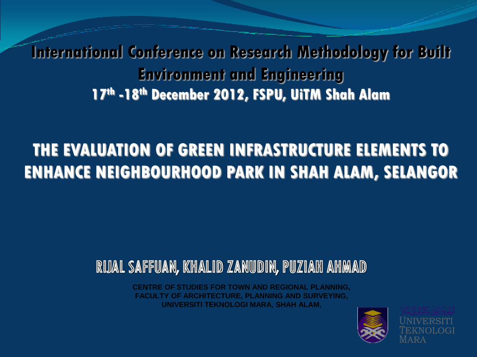
International Conference on Research Methodology for Built
Environment and Engineering17th -18th December 2012, FSPU, UiTM Shah Alam
THE EVALUATION OF GREEN INFRASTRUCTURE ELEMENTS TO
ENHANCE NEIGHBOURHOOD PARK IN SHAH ALAM, SELANGOR
CENTRE OF STUDIES FOR TOWN AND REGIONAL PLANNING,
FACULTY OF ARCHITECTURE, PLANNING AND SURVEYING,
UNIVERSITI TEKNOLOGI MARA, SHAH ALAM,
Presentation Outline
• Introduction
• A Quick Overview
• Concept of Green Infrastructure
• Research Methodology
• Analysis and Findings
• Conclusion
• Climate change which faced by many countries nowadays has been closelyrelated with the process of urbanisation or urban sprawl. Thus, smartgrowth and smart conservation have been identified as one of theapproaches that can be applied in our effort to combat and counter theurban sprawl (Suzuki & Moola, 2010).
• One of the smart growth and conservation approaches that can beimplemented is the Green Infrastructure Network concept which is part ofthe green technology as a tool that can enhance facilities andinfrastructure in the park.
Introduction
• This paper aims to exemplify an effort by a group of student doingmaster’s coursework in evaluating elements of green infrastructure as acatalyst of green neighbourhood park development.
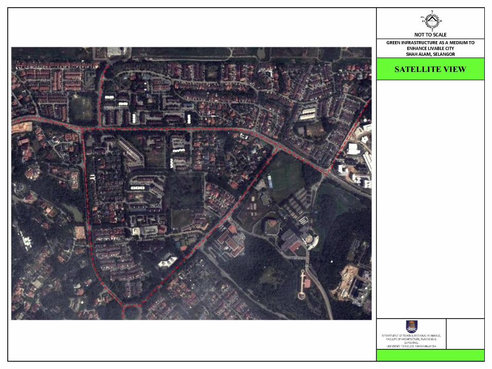
• The purpose of the study is to apply the implementation of greeninfrastructure concept as a medium to enhance the neighbourhood parkusing green infrastructure concept and principle in Section 6, Section 7,and Section 8, Shah Alam.
Introduction
• According to Tzoulas (2007), Green infrastructure is an approach ofproviding improvement in infrastructure provision such as tools ofnetworks and linkages of green spaces. This green infrastructure basicallyconsists of diverse green spaces which may be linked and connected bythe streets, waterways and drainage network in urban areas.
• Green Infrastructure is the sub-regional network of protected sites,nature reserves, green spaces, and greenway linkages. The linkagesinclude river corridors and flood plains, migration routes and features ofthe landscape, which are of importance as wildlife corridors. (Town andCountry Planning Association, UK, 2010)
A Quick Overview
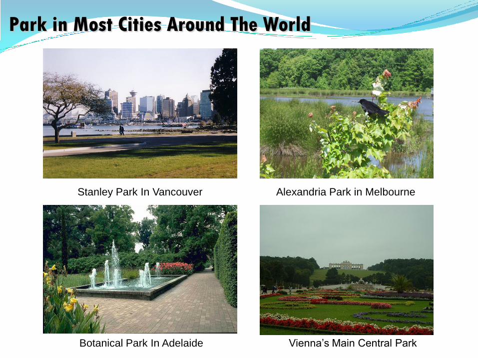
Vienna’s Main Central Park
Park in Most Cities Around The World
Stanley Park In Vancouver Alexandria Park in Melbourne
Botanical Park In Adelaide
Concept of
Green Infrastructure
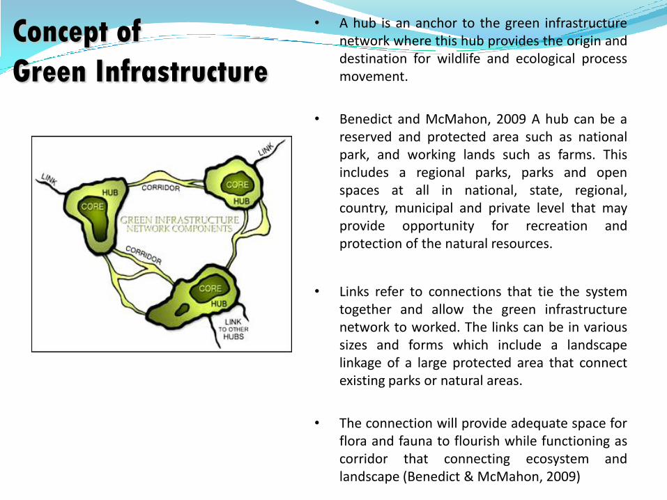
• A hub is an anchor to the green infrastructurenetwork where this hub provides the origin anddestination for wildlife and ecological processmovement.
• Benedict and McMahon, 2009 A hub can be areserved and protected area such as nationalpark, and working lands such as farms. Thisincludes a regional parks, parks and openspaces at all in national, state, regional,country, municipal and private level that mayprovide opportunity for recreation andprotection of the natural resources.
• Links refer to connections that tie the systemtogether and allow the green infrastructurenetwork to worked. The links can be in varioussizes and forms which include a landscapelinkage of a large protected area that connectexisting parks or natural areas.
• The connection will provide adequate space forflora and fauna to flourish while functioning ascorridor that connecting ecosystem andlandscape (Benedict & McMahon, 2009)
Figure 1: Conceptual green infrastructure diagram:
a network of core areas, hubs and corridors
(Adapted from Weber et. all, (2011). Landscape
and Urban Planning, Volume 96, Issue 4, 30 June
2012)
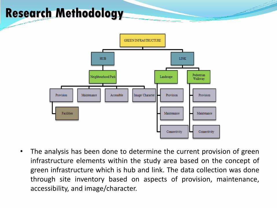
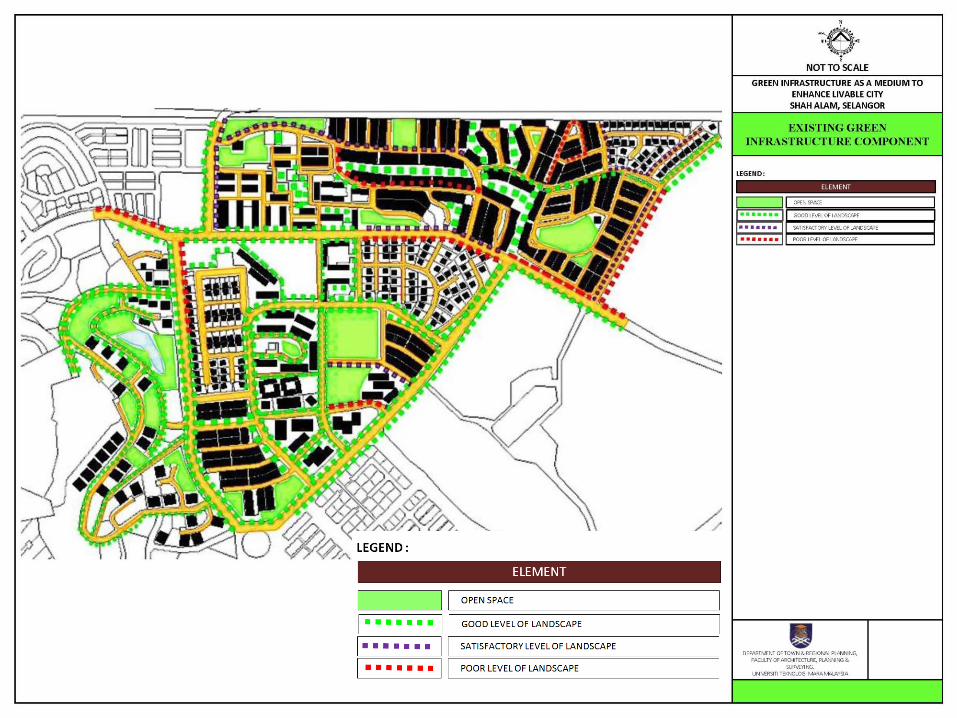
• The analysis has been done to determine the current provision of greeninfrastructure elements within the study area based on the concept ofgreen infrastructure which is hub and link. The data collection was donethrough site inventory based on aspects of provision, maintenance,accessibility, and image/character.
Research Methodology
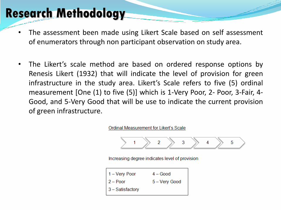
• The assessment been made using Likert Scale based on self assessmentof enumerators through non participant observation on study area.
• The Likert’s scale method are based on ordered response options byRenesis Likert (1932) that will indicate the level of provision for greeninfrastructure in the study area. Likert’s Scale refers to five (5) ordinalmeasurement [One (1) to five (5)] which is 1-Very Poor, 2- Poor, 3-Fair, 4-Good, and 5-Very Good that will be use to indicate the current provisionof green infrastructure.
Research Methodology
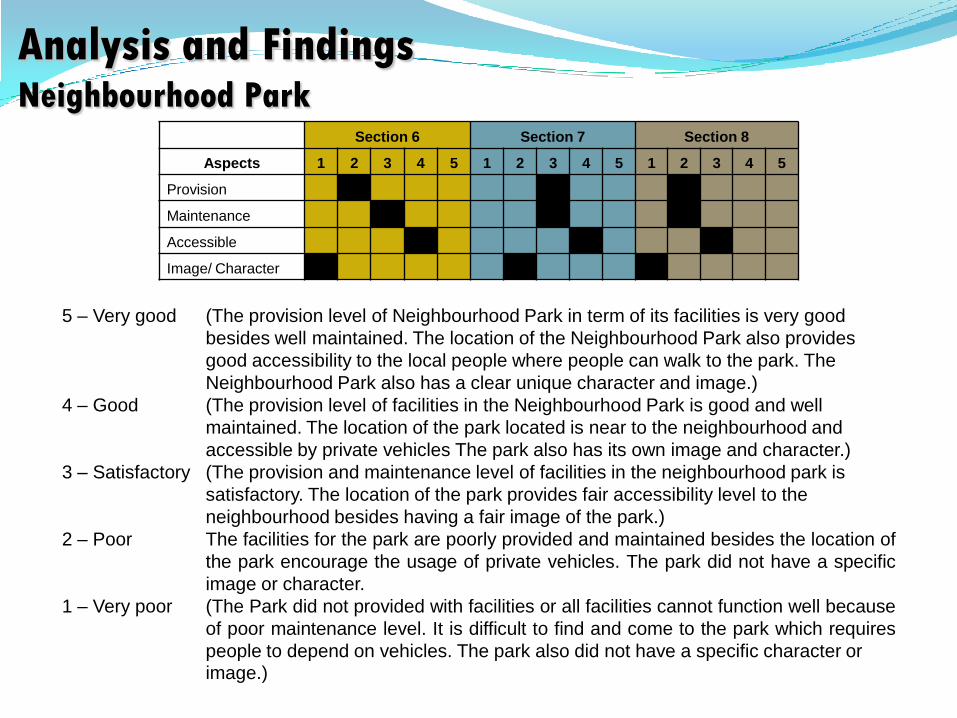
Analysis and FindingsNeighbourhood Park
Section 6 Section 7 Section 8
Aspects 1 2 3 4 5 1 2 3 4 5 1 2 3 4 5
Provision
Maintenance
Accessible
Image/ Character
5 – Very good (The provision level of Neighbourhood Park in term of its facilities is very good
besides well maintained. The location of the Neighbourhood Park also provides
good accessibility to the local people where people can walk to the park. The
Neighbourhood Park also has a clear unique character and image.)
4 – Good (The provision level of facilities in the Neighbourhood Park is good and well
maintained. The location of the park located is near to the neighbourhood and
accessible by private vehicles The park also has its own image and character.)
3 – Satisfactory (The provision and maintenance level of facilities in the neighbourhood park is
satisfactory. The location of the park provides fair accessibility level to the
neighbourhood besides having a fair image of the park.)
2 – Poor The facilities for the park are poorly provided and maintained besides the location of
the park encourage the usage of private vehicles. The park did not have a specific
image or character.
1 – Very poor (The Park did not provided with facilities or all facilities cannot function well because
of poor maintenance level. It is difficult to find and come to the park which requires
people to depend on vehicles. The park also did not have a specific character orimage.)

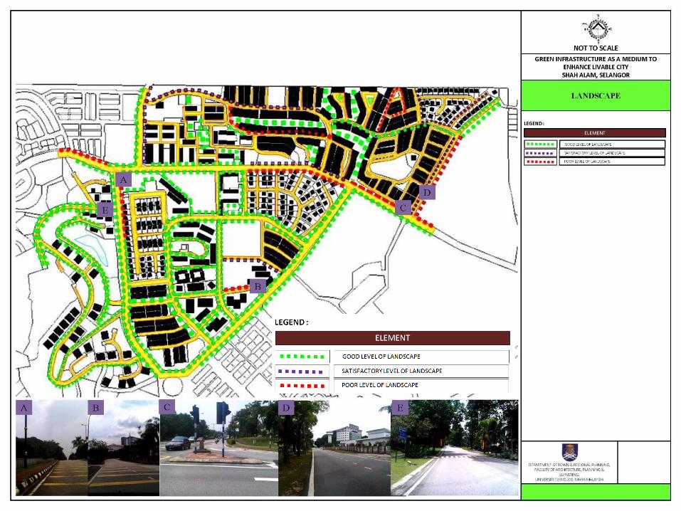
Analysis and Findings Landscape Section 6 Section 7 Section 8
Aspects 1 2 3 4 5 1 2 3 4 5 1 2 3 4 5
Provision
Maintenance
Connectivity
5 – Very good (The provision of landscape is adequate which able to encourage walkable
environment in all or most of the area. The maintenance of landscape is in a very
good condition and it is able to enhance the visual aesthetic of the area. The
provision of landscape is able to form a connection of network.)
4 – Good (The provision of landscape is able to encourage walkable environment in majority
of the area. The maintenance of landscape is able to enhance the visual aesthetic
value to the area. The provision of landscape is able to form a connection in most of
the area.)
3 – Satisfactory (The provision of landscape satisfactorily encourages walkable environment in the
study area. The maintenance of landscape satisfactorily enhances the visual
aesthetic value to the area. The provision of landscape is able to form a connection
in some part of the area.)
2 – Poor (The provision of landscape unable to encourage walkable environment in most of
the study area. The maintenance of landscape is unable to provide the visual
aesthetic value to the area. The provision of landscape is unable to form a
connection in most of the area.)
1 – Very poor (The provision of landscape cannot encourage walkable environment in the study
area. The maintenance of landscape did not provide or enhances the visual
aesthetic value to the area. The provision of landscape is unable to form a
connection in whole study area.)
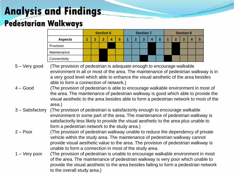
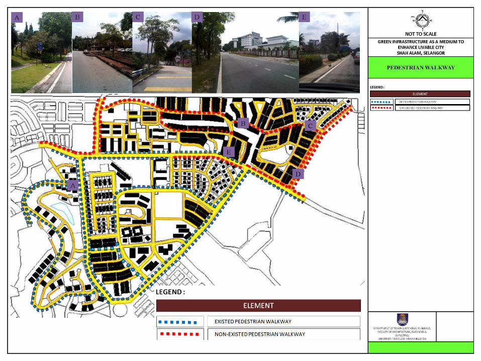
Analysis and Findings Pedestarian Walkways
Section 6 Section 7 Section 8
Aspects 1 2 3 4 5 1 2 3 4 5 1 2 3 4 5
Provision
Maintenance
Connectivity
5 – Very good (The provision of pedestrian is adequate enough to encourage walkable
environment in all or most of the area. The maintenance of pedestrian walkway is in
a very good level which able to enhance the visual aesthetic of the area besides
able to form a connection of network.)
4 – Good (The provision of pedestrian is able to encourage walkable environment in most of
the area. The maintenance of pedestrian walkway is good which able to provide the
visual aesthetic to the area besides able to form a pedestrian network to most of the
area.)
3 – Satisfactory (The provision of pedestrian is satisfactorily enough to encourage walkable
environment in some part of the area. The maintenance of pedestrian walkway is
satisfactorily less likely to provide the visual aesthetic to the area plus unable to
form a pedestrian network to the study area.)
2 – Poor (The provision of pedestrian walkway unable to reduce the dependency of private
vehicle within the study area. The maintenance of pedestrian walkway cannot
provide visual aesthetic value to the area. The provision of pedestrian walkway is
unable to form a connection in most of the study area.
1 – Very poor (The provision of pedestrian is unable to encourage walkable environment in most
of the area. The maintenance of pedestrian walkway is very poor which unable to
provide the visual aesthetic to the area besides failing to form a pedestrian network
to the overall study area.)

Conclusion• Every state and local government has a park management plan. At the
same time, local communities also have detailed plans for improving thefacilities and infrastructure for the neighbourhood park.
• Green infrastructure plans provide a blueprint for sustainablemanagement plans and create a framework for future growth and at thesame time ensure significant natural resources will be preserved forfuture generations.
• Green Infrastructure can provide many social, economic andenvironmental benefits close to where people live and work includingspace and habitat for wildlife with access to nature for people andimproved health and well being of people especially places for outdoorrelaxation and play.
ReferenceBenedict. M, et al (2009). Green Infrastructure: Smart Conservation for the 21st Century. Sprawl watches clearinghouse monograph series, Island Press UK. Retrieved 6 October 2013, from www.dnr.mo.gov/env/wpp/stormwater/documents/gi.../gi-appendixb.pdf
Suzuki & Moola (2010). Using smart growth to combat urban sprawl in Canda. Retrieved 6 October 2013, from http://www.straight.com/news/david-suzuki-using-smart-growth-combat-urban-sprawl-canada
Tzoulas, (2007). Promoting ecosystem and human health in urban areas using Green Infrastructure: A literature review, Landscape and Urban Planning, Volume 81, Issue 3, 20 June 207
Weber et. all (2011). Landscape and Urban Planning, Volume 96, Issue 4, 30 June 2012 Williamson. K.S (2003). Growing with Green Infrastructure, GI, Heritage Conservancy, Doylestown PA. Retrieved 6 October 2013, from,www.greeninfrastructurenw.co.uk/resources/Growing_with_GI.pdf
Winchester City Council (2010). Green Infrastructure Study 2010, Winchester City Council Wesite. Retrieved 6 October 2012, from http://www.winchester.gov.uk/planning-policy/evidence-base/environment/green-infrastructure-study-2010/
MOHD RIJAL SAFFUAN BIN ABDUL [email protected]
Centre of Studies for Town and Regional Planning,Faculty of Architecture, Planning and Surveying,
Universiti Teknologi MARA 40450 Shah Alam Selangor
Contact Information