The Dutch and the VOC (Dutch East India Company) in the Persian Gulf: material and cultural...
32
1 The School of Oriental Studies, University of London WORD COUNT: 5,436 Nicolette Krajewski/Student ID 156135/MPhil-PhD/December 2011 Directed Readings/0.5unit/Dr Geoffrey King/Credit essay for MPhil year 2011-12/15PARH037 The Dutch and the VOC (Dutch East India Company) in the Persian Gulf: material and cultural transfer. This essay will aim to outline the structure and function of the VOC (Vereenigde Oost- Indische Compagnie or Dutch East India Company), how the VOC and other Dutch individuals came to be in the Gulf, what broad circumstances preceded this arrival and presence, where the VOC’s main strongholds and entrepots were in that area, how the area’s cartography evolved during the period of its presence and what the resultant material and cultural transfer in as well as out of the area was as a consequence of the VOC’s presence. Necessarily, in this essay for reasons of brevity the focus has been kept mainly on the VOC’s operations in Persia, which are the most widely published to date and give the most informative view of material and cultural transfer into and out of the area. With regards to mapping, we will use the early map of Arabia Felix and the Persian Gulf shown in fig 1 as the base case for subsequent Dutch expansion of cartographic knowledge. Though not Dutch in origin, this is one of the earliest separate maps of Arabia and shows the land surrounding the Red Sea and Persian Gulf as well as parts of Egypt.
Transcript of The Dutch and the VOC (Dutch East India Company) in the Persian Gulf: material and cultural...
1
The School of Oriental Studies, University of London WORD COUNT: 5,436
Nicolette Krajewski/Student ID 156135/MPhil-PhD/December 2011
Directed Readings/0.5unit/Dr Geoffrey King/Credit essay for MPhil year 2011-12/15PARH037
The Dutch and the VOC (Dutch East India Company) in the Persian Gulf: material and cultural transfer.
This essay will aim to outline the structure and function of the VOC (Vereenigde Oost-
Indische Compagnie or Dutch East India Company), how the VOC and other Dutch
individuals came to be in the Gulf, what broad circumstances preceded this arrival and
presence, where the VOC’s main strongholds and entrepots were in that area, how the
area’s cartography evolved during the period of its presence and what the resultant material
and cultural transfer in as well as out of the area was as a consequence of the VOC’s
presence. Necessarily, in this essay for reasons of brevity the focus has been kept mainly on
the VOC’s operations in Persia, which are the most widely published to date and give the
most informative view of material and cultural transfer into and out of the area. With regards
to mapping, we will use the early map of Arabia Felix and the Persian Gulf shown in fig 1 as
the base case for subsequent Dutch expansion of cartographic knowledge. Though not
Dutch in origin, this is one of the earliest separate maps of Arabia and shows the land
surrounding the Red Sea and Persian Gulf as well as parts of Egypt.
2
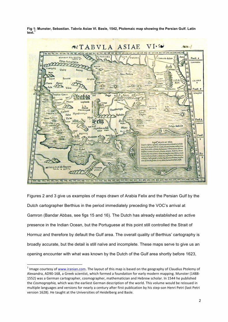
Fig 1: Munster, Sebastian. Tabvla Asiae VI. Basle, 1542, Ptolemaic map showing the Persian Gulf. Latin text.1
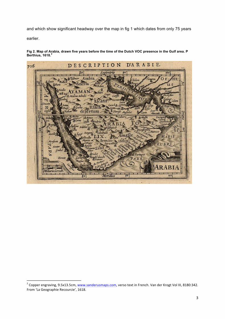
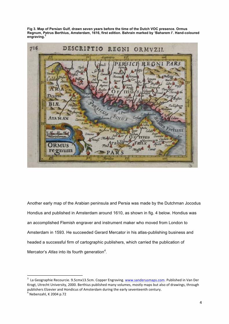
Figures 2 and 3 give us examples of maps drawn of Arabia Felix and the Persian Gulf by the
Dutch cartographer Berthius in the period immediately preceding the VOC’s arrival at
Gamron (Bandar Abbas, see figs 15 and 16). The Dutch has already established an active
presence in the Indian Ocean, but the Portuguese at this point still controlled the Strait of
Hormuz and therefore by default the Gulf area. The overall quality of Berthius’ cartography is
broadly accurate, but the detail is still naïve and incomplete. These maps serve to give us an
opening encounter with what was known by the Dutch of the Gulf area shortly before 1623,
1 Image courtesy of www.iranian.com. The layout of this map is based on the geography of Claudius Ptolemy of Alexandra, AD90-‐168, a Greek scientist, which formed a foundation for early modern mapping. Munster (1488-‐1552) was a German cartographer, cosmographer, mathematician and Hebrew scholar. In 1544 he published the Cosmographia, which was the earliest German description of the world. This volume would be reissued in multiple languages and versions for nearly a century after first publication by his step-‐son Henri Petri (last Petri version 1628). He taught at the Universities of Heidelberg and Basle.
3
and which show significant headway over the map in fig 1 which dates from only 75 years
earlier.
Fig 2. Map of Arabia, drawn five years before the time of the Dutch VOC presence in the Gulf area. P Berthius, 1618.2
2 Copper engraving, 9.5x13.5cm, www.sanderusmaps.com, verso text in French. Van der Krogt Vol III, 8180:342. From ‘La Geographie Recourcie’, 1618.
4
Fig 3. Map of Persian Gulf, drawn seven years before the time of the Dutch VOC presence. Ormus Regnum, Petrus Berthius, Amsterdam, 1616, first edition. Bahrain marked by ‘Baharem I’. Hand-coloured engraving.3
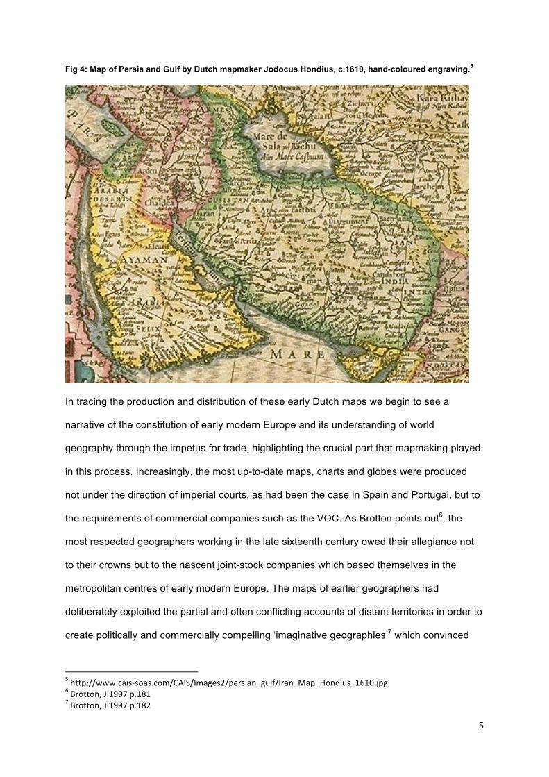
Another early map of the Arabian peninsula and Persia was made by the Dutchman Jocodus
Hondius and published in Amsterdam around 1610, as shown in fig. 4 below. Hondius was
an accomplished Flemish engraver and instrument maker who moved from London to
Amsterdam in 1593. He succeeded Gerard Mercator in his atlas-publishing business and
headed a successful firm of cartographic publishers, which carried the publication of
Mercator’s Atlas into its fourth generation4.
3 La Geographie Recourcie. 9.5cmx13.5cm. Copper Engraving. www.sanderusmaps.com. Published in Van Der Krogt, Utrecht University, 2000. Berthius published many volumes, mostly maps but also of drawings, through publishers Elzevier and Hondicus of Amsterdam during the early seventeenth century. 4 Nebenzahl, K 2004 p.72
5
Fig 4: Map of Persia and Gulf by Dutch mapmaker Jodocus Hondius, c.1610, hand-coloured engraving.5
In tracing the production and distribution of these early Dutch maps we begin to see a
narrative of the constitution of early modern Europe and its understanding of world
geography through the impetus for trade, highlighting the crucial part that mapmaking played
in this process. Increasingly, the most up-to-date maps, charts and globes were produced
not under the direction of imperial courts, as had been the case in Spain and Portugal, but to
the requirements of commercial companies such as the VOC. As Brotton points out6, the
most respected geographers working in the late sixteenth century owed their allegiance not
to their crowns but to the nascent joint-stock companies which based themselves in the
metropolitan centres of early modern Europe. The maps of earlier geographers had
deliberately exploited the partial and often conflicting accounts of distant territories in order to
create politically and commercially compelling ‘imaginative geographies’7 which convinced
5 http://www.cais-‐soas.com/CAIS/Images2/persian_gulf/Iran_Map_Hondius_1610.jpg 6 Brotton, J 1997 p.181 7 Brotton, J 1997 p.182
6
backers with a mixture of ‘aesthetic beauty and loudly proclaimed scholarly wisdom’8. The
processes of mapping that evolved during the early decades of the seventeenth century
gradually eroded this perception, based as it was on very shaky ground, as the joint-stock
companies were hardly interested in speculating on commercially valuable and
geographically distant places. What mattered to them were accuracy, objectivity and a
systematic mapping of strategic territory.
Maps and illustrations from the pre-VOC period indicate the extent of the impact that the
Portuguese were having on trade throughout the Indian Ocean. Almost a century earlier, Piri
Re’is9, a commander of the Ottoman fleet who also became a great cartographer, said10 as
part of his description of Hormuz, whose strategic location at the entrance to the Gulf made it
a vital conduit in the movement of merchandise between both the Indian Ocean and also the
Mediterranean:
‘But now the Portuguese have reached this place and they have built a fort on that cape. There they wait and collect tolls from ships that pass. You have now learned the circumstances of this place. The Portuguese have overcome them all and the khans of the island are filled with their merchants. In fall or summer, no trading takes place unless the Portuguese are present.’11
The Dutch were, however, already watching avidly: even in the late sixteenth century, Dutch
merchants were looking for direct access to the spice trade. As social, political and economic
life in the Netherlands became more dynamic, the demand for an atlas of cities became
8 ibid 9 Piri Re’is was the nephew of the illustrious Turkish admiral Kamel Re’is, sailed with his uncle until the admiral’s death in 1511 and then became his successor. He is remembered for his atlases of fine sea charts and two survuvng fragments of world maps he drew in the early sixteenth century. Nebenzahl K 2004 p.60. 10 Around 1521 11 Piri Re’is Kitab-‐I bahriye I 1988 p.97-‐9, see also Brotton 1997 p.113. The Ottoman gathering of geographical information for the completion of the Kitab-‐I Bahriye was carried out at the same time as the collection of commercial information on the adverse effects that strategic Portuguese possession of commercially vital cities such as Hormuz was having, not only on the revenues of the Ottoman Empire but also on the trade of the Mediterranean more generally. The Portuguese capture of Hormuz in 1515 signalled a fair measure of Portuguese pre-‐eminence in Indian Ocean trade, in practice forcing local traders to purchase cartazes which obliged them to pay customs duties on all merchandise direct to the Portuguese authorities.
7
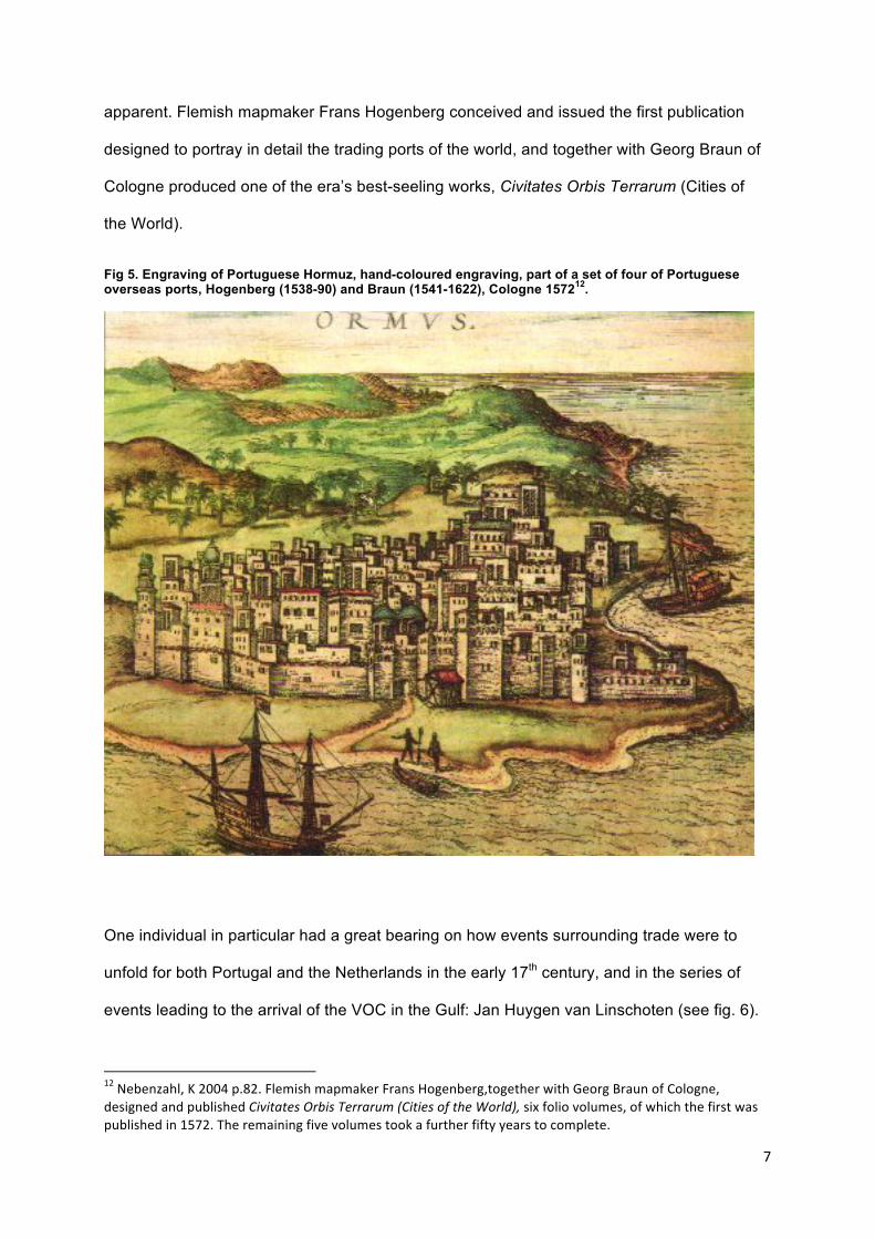
apparent. Flemish mapmaker Frans Hogenberg conceived and issued the first publication
designed to portray in detail the trading ports of the world, and together with Georg Braun of
Cologne produced one of the era’s best-seeling works, Civitates Orbis Terrarum (Cities of
the World).
Fig 5. Engraving of Portuguese Hormuz, hand-coloured engraving, part of a set of four of Portuguese overseas ports, Hogenberg (1538-90) and Braun (1541-1622), Cologne 157212.
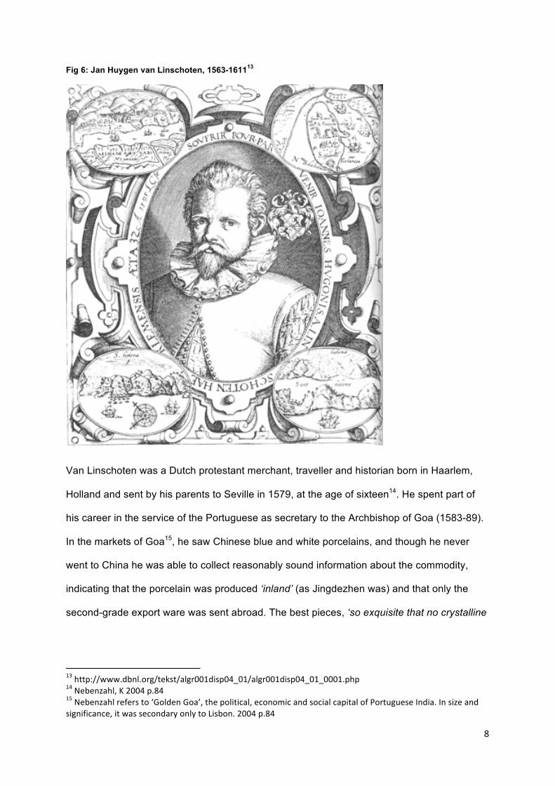
One individual in particular had a great bearing on how events surrounding trade were to
unfold for both Portugal and the Netherlands in the early 17th century, and in the series of
events leading to the arrival of the VOC in the Gulf: Jan Huygen van Linschoten (see fig. 6).
12 Nebenzahl, K 2004 p.82. Flemish mapmaker Frans Hogenberg,together with Georg Braun of Cologne, designed and published Civitates Orbis Terrarum (Cities of the World), six folio volumes, of which the first was published in 1572. The remaining five volumes took a further fifty years to complete.
8
Fig 6: Jan Huygen van Linschoten, 1563-161113
Van Linschoten was a Dutch protestant merchant, traveller and historian born in Haarlem,
Holland and sent by his parents to Seville in 1579, at the age of sixteen14. He spent part of
his career in the service of the Portuguese as secretary to the Archbishop of Goa (1583-89).
In the markets of Goa15, he saw Chinese blue and white porcelains, and though he never
went to China he was able to collect reasonably sound information about the commodity,
indicating that the porcelain was produced ‘inland’ (as Jingdezhen was) and that only the
second-grade export ware was sent abroad. The best pieces, ‘so exquisite that no crystalline
13 http://www.dbnl.org/tekst/algr001disp04_01/algr001disp04_01_0001.php 14 Nebenzahl, K 2004 p.84 15 Nebenzahl refers to ‘Golden Goa’, the political, economic and social capital of Portuguese India. In size and significance, it was secondary only to Lisbon. 2004 p.84
9
glass is to be compared with them’ were kept at home for the court16. Indeed, Dutch readers
first learned about Chinese porcelain in 1596 through Van Linschoten’s monumental tome
‘Itinerario’, which inspired the coming generation of Dutch world traders. In publishing this
book, Van Linschoten is also credited with copying top-secret Portuguese nautical charts and
also Portuguese sailing guides, which enabled the passage to the elusive East Indies to be
opened to the English and the Dutch, and thus allowing the British East India Company and
the VOC to break the sixteenth century monopoly that the Portuguese had on Indian Ocean
trade. The sailing guides were particularly useful, as they provided the best sailing routes to
the East Indies and its lucrative spice trade, as well as the route from port to port once there.
Upon his return to Amsterdam, van Linschoten published these documents together with
maps and his own descriptions of the area in his monumental ‘Itinerario’. Few books have
had greater influence on Dutch historical events, and van Linschoten is still widely regarded
as a key eyewitness of the Portuguese-Asian empire at its pinnacle, and as an individual who
had a significant impact on the movement of the epicenter of European expansion from the
Iberian peninsula in favour of England and Holland17. Furthermore, Van Linschoten’s work
was a significant advance of the mapping of India and the Middle East.
16 Brook T 2008 p.63 17 In 1604, van Linschoten published an abridged version of Itinerario, called Icones et Habitus Indorum, which contained 36 engravings previously published in Itinerario together with Latin captions. Van der Boogaart 2002.
10
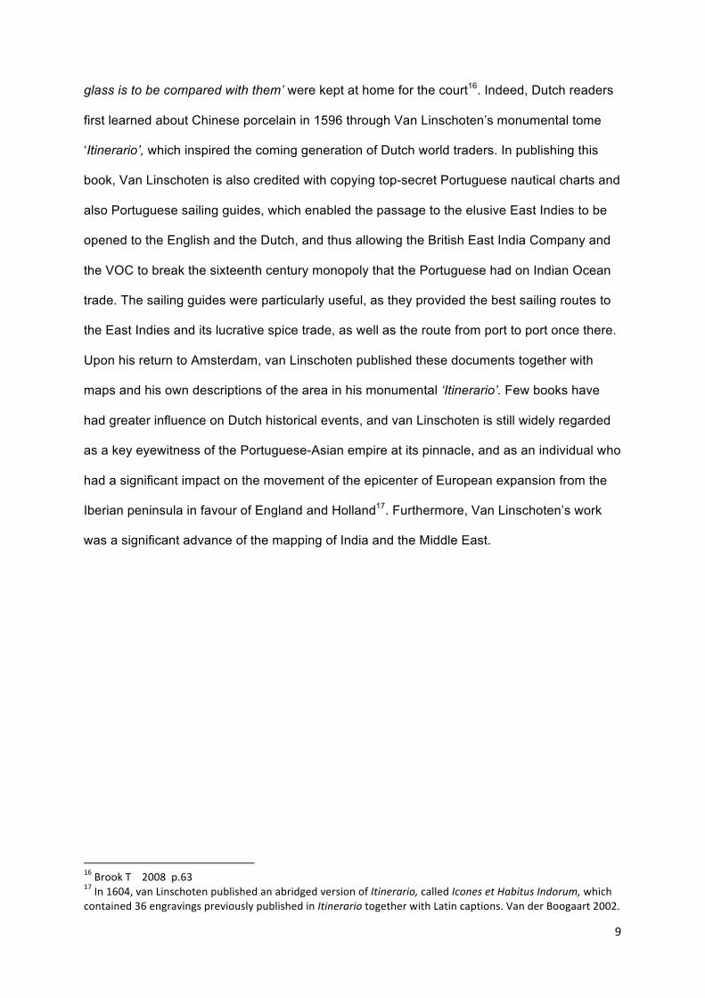
Fig 7: Map of Asia by Jan Huygen van Linschoten 1596, hand-coloured engraving.18
The surprising revelation of Hondius’ map in fig 4 is the closeness of the representation of
the Arabian peninsula to that on a modern map, when compared with other engraved maps
of this period, but drawn without the benefits of van Linschoten’s Portuguese intelligence. By
contrast, Van Linschoten’s Itinerario maps such as that in fig 7 are styled after Portuguese
portolan charts of the sixteenth century, and even in printed form, these maps retain the lush
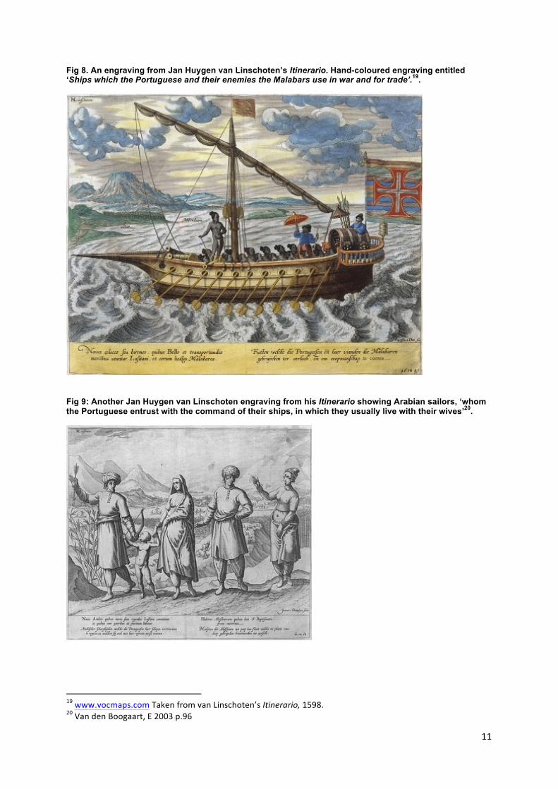
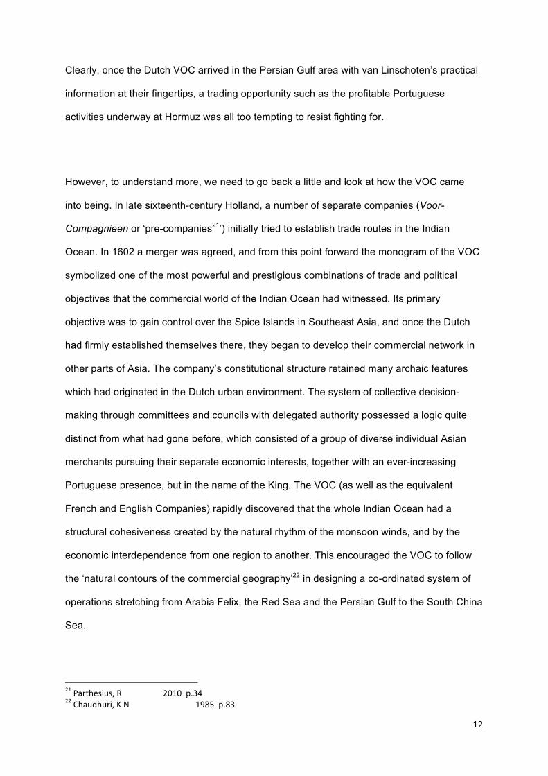
decorative flourishes of their sources. Van Linschoten’s Itinerario illustrations are equally
lush, often fanciful, and vividly portray Indian Ocean life in the early seventeenth century.
Examples are shown in figs 8 and 9 below.
18 http://www.cais-‐soas.com/CAIS/Images2/persian_gulf/Jan_Huygen_Van_Linschoten_1596WM.png. Amsterdam, 1596, hand coloured. 20.5 x 15 inches. From van Linschoten’s Itinerario.
11
Fig 8. An engraving from Jan Huygen van Linschoten’s Itinerario. Hand-coloured engraving entitled ‘Ships which the Portuguese and their enemies the Malabars use in war and for trade’.19.
Fig 9: Another Jan Huygen van Linschoten engraving from his Itinerario showing Arabian sailors, ‘whom the Portuguese entrust with the command of their ships, in which they usually live with their wives’20.
19 www.vocmaps.com Taken from van Linschoten’s Itinerario, 1598. 20 Van den Boogaart, E 2003 p.96
12
Clearly, once the Dutch VOC arrived in the Persian Gulf area with van Linschoten’s practical
information at their fingertips, a trading opportunity such as the profitable Portuguese
activities underway at Hormuz was all too tempting to resist fighting for.
However, to understand more, we need to go back a little and look at how the VOC came
into being. In late sixteenth-century Holland, a number of separate companies (Voor-
Compagnieen or ‘pre-companies21’) initially tried to establish trade routes in the Indian
Ocean. In 1602 a merger was agreed, and from this point forward the monogram of the VOC
symbolized one of the most powerful and prestigious combinations of trade and political
objectives that the commercial world of the Indian Ocean had witnessed. Its primary
objective was to gain control over the Spice Islands in Southeast Asia, and once the Dutch
had firmly established themselves there, they began to develop their commercial network in
other parts of Asia. The company’s constitutional structure retained many archaic features
which had originated in the Dutch urban environment. The system of collective decision-
making through committees and councils with delegated authority possessed a logic quite
distinct from what had gone before, which consisted of a group of diverse individual Asian
merchants pursuing their separate economic interests, together with an ever-increasing
Portuguese presence, but in the name of the King. The VOC (as well as the equivalent
French and English Companies) rapidly discovered that the whole Indian Ocean had a
structural cohesiveness created by the natural rhythm of the monsoon winds, and by the
economic interdependence from one region to another. This encouraged the VOC to follow
the ‘natural contours of the commercial geography’22 in designing a co-ordinated system of
operations stretching from Arabia Felix, the Red Sea and the Persian Gulf to the South China
Sea.
21 Parthesius, R 2010 p.34 22 Chaudhuri, K N 1985 p.83
13
Only a unique federal state such as the Dutch Republic could have come up with a federal
structure such as that of the VOC: it combined flexibility with strength, and as Brook states,
‘giving the Dutch a huge advantage in the competition to dominate maritime trade to Asia’23.
The incentive was a pure stream of monopoly profits, not interfered with by the state. Within
a few decades, the VOC proved to be the most powerful trading corporation in the
seventeenth century world and the model for the large-scale business enterprises that today
dominate the global economy. The VOC company was controlled and directed by a board of
directors known as the Heeren XVII (the Seventeen Gentlemen or, in short, the XVII) in
Amsterdam who were in turn informed by their local representatives24 on the ground in their
entrepots, and in particular to a governor-general and his council based in Batavia25.
Amsterdam became the European terminal for these commercial activities, and this caught
the attention of the French philosopher Rene Descartes. In 1631, Descartes was in the
middle of a long exile in the Netherlands, having been driven from France as a result of his
controversial ideas. He described Amsterdam that year as ‘an inventory of the possible’.
‘What place on earth could one choose where all the commodities and all the curiosities one
could wish for were as easy to find as in this city?’ 26.
For 136 years, from 1033AH/1623 – 1174AH/1759, the VOC was the single most important
foreign trading firm in Persia, though not unchallenged. Except for the years 1623-3827, most
of the information on Dutch/VOC relations with Persia have to date not been published28,
23 Brook, T 2008 p.16 24 A local council could however override a director, and did so on many occasions. This collegial form of management proved both flexible and effective in the absence of a rapid means of communication with Batavia or with the XVII. The same council system existed at the trading stations that depended on Bandar Abbas, such as Isfahan and Basra. 25 Modern-‐day Jakarta in Indonesia. 26 See Braudel F 1992 p.30, also Brook, T 2008 p.8 27 Dunlop 1930 28 Most of the documentation remains unpublished in the national archives (Algemeen Rijks Archief in the Hague, though some reports, journals and letters by individual Dutch travellers to Persia have been published, for example Hotz 1908, Roobacker, van Dam, Valentijn, Floor 1979a, 1982, 1982, 1984, 1986)
14
although a few studies have been based on these documents29. From these, we know that
the early Persian VOC directorate included not only Iran but also Basra, Bushehr and
Muscat. However, the overall period of VOC influence was relatively short-lived, and by 1753
the directorate included only Kharg Island and Bandar Abbas. The head of the Persian
directorate was based in Bandar Abbas30. The VOC maintained trading stations in Bandar
Abbas (1623-1765) and Isfahan (1623-1745) as well as rest houses in Lar and Shiraz31. It
also had trading posts in Kirman (1659-1758) and Bushehr (1734-1753). When the Bushehr
office was closed, one was opened on Kharg Island which lasted until 1766. The VOC was
only intermittently present in Basra between 1645 and 175332. There is also very little
information about the Dutch, occasionally called Valandis or Holandis33, in Persian sources
perhaps because many of the state records were destroyed by the Afghans in the mid-18th
century and also perhaps because merchants were of little interest to the Persian upper
classes. That Persians visited Holland is clear from Francois Valentijn’s comment that he
‘need not describe the Persians, neither how they are dressed nor their nature, because
there are many of them in Amsterdam, where one can see them every day’34.
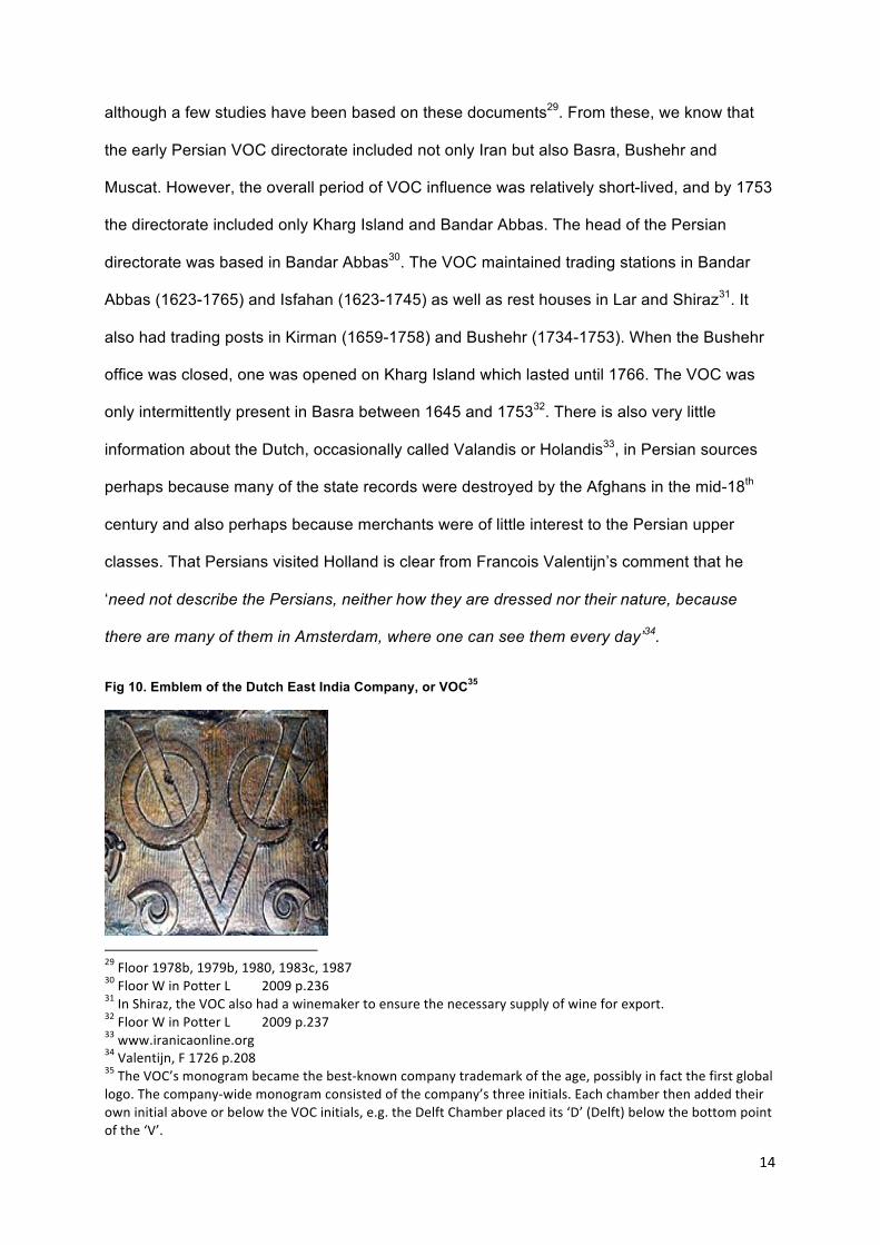
Fig 10. Emblem of the Dutch East India Company, or VOC35
29 Floor 1978b, 1979b, 1980, 1983c, 1987 30 Floor W in Potter L 2009 p.236 31 In Shiraz, the VOC also had a winemaker to ensure the necessary supply of wine for export. 32 Floor W in Potter L 2009 p.237 33 www.iranicaonline.org 34 Valentijn, F 1726 p.208 35 The VOC’s monogram became the best-‐known company trademark of the age, possibly in fact the first global logo. The company-‐wide monogram consisted of the company’s three initials. Each chamber then added their own initial above or below the VOC initials, e.g. the Delft Chamber placed its ‘D’ (Delft) below the bottom point of the ‘V’.
15
Although the Dutch did not arrive in the Persian Gulf until 1622, there had already been
significant Dutch contact with that part of the world. Prior to this date, Dutchmen had come to
the region as part of Portuguese operations (such as van Linschoten, see above) rather than
to advance Dutch interests36, as until 1594, as we have seen, direct maritime voyages from
Europe to Asia were a Portuguese-enforced monopoly. Shah Abbas I’s37 ambassador to the
European courts, Zayn al-Din Beg, had visited the Netherlands in 1608 to ask for technical
and military assistance. However, the Dutch were not at this stage ready to start operations
in Persia. The VOC directors had received word in 1608 that the king of Hormuz had risen
against the Portuguese, and so they wrote to their admirals in India that ‘if this be true, you
will try to conclude an alliance with this king so that we may secure the trade of Persia. You
will also try to get a substantial cargo of raw silk from Persia, if this is possible, as well as
other goods which may be profitable here’.38 The reason for this particular interest in raw silk
was that because by that time, Amsterdam had become a major centre of the European silk
industry. Although Dutch-Persian trade relations did not immediately commence, as the VOC
first had to build military and financial strength to combat the Portuguese39, several wheeler-
dealers including Sir Robert Sherley40 and other Dutch competitors tried to promote Dutch
silk trade with Iran in the years subsequent to this pronouncement. Silk as a commodity was
also a good fit with the VOC’s inter-Asian network; all the Chinese silk bought at Pattani in
Thailand since 1609 was needed for trade with Japan, meaning that the VOC were hungry
for Persian silk, which it needed for the European markets.
Hormuz was commercially and strategically an obstacle that had to be overcome if access to
Persian silk was to be achieved. After a lengthy naval campaign against the Portuguese
lasting more than thirty years, Hormuz was captured from the Portuguese in 1622 through
36 Van Linschoten’s account of his 1589 voyage to Asia and especially to the Gulf was influential throughout Europe and heightened Northern European interest in direct trade with Asia and Persia. In his account, he details both the riches that could be gained as well as the weakness of the Portuguese that could be overcome. Van Linschoten, J H. London trans. 1885. 37 Shah Abbas I r.1588-‐1629 38 National Archives, The Hague. VOC 478 (Amsterdam, 11 April 1608). 39 And at this time, trade with Mukha, Ceylon and Surat were still of greater importance than that with Persia. 40 Floor, W in Potter, L 2009 p.235
16
rare co-operation between the Dutch and the English in order to open the Persian silk
market, which neither party felt strong enough to achieve on its own. Although this event can
mainly be attributed to the English East India Company’s officials in Surat giving plentiful
assistance to the forces of the Shah of Persia, it turned out to be more than just a political
incident, as it marked the entry of both the English and the Dutch to the Middle Eastern
markets through the back door of the Indian Ocean. An armada of nine ships under Admiral
Jacob Dedel sailed from Batavia in September 1621 to co-operate with the English fleet
against the Portuguese, but the fleet arrived too late, and Hormuz had already been taken.
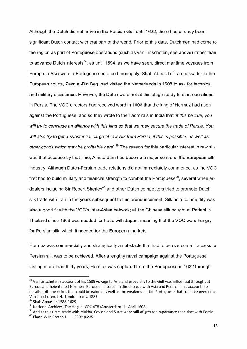
Fig 11. Shah Abbas welcoming foreigners to his court, from a ceiling fresco at the 40-Column Palace, Isfahan41
The lifting of Portuguese control of the Strait of Hormuz immediately stimulated the trade of
Gamron, or Gombroon (Bandar Abbas) on the opposite mainland, and the VOC set up a post
there in 1623 having the same year sent an ambassador and experienced merchant, Hubert
Visnich, to Shah Abbas. The Dutch expected trade to be lucrative, and Visnich was given the
41 The painting shows Shah Abbas enjoying dancing and wine with his courtiers. The Safavids, in accordance with strict religious decrees, had banned the use of musical instruments and the consumptions of alcoholic drinks for the general public. However, as this painting shows, the ban clearly did not stretch as far as the court.
17
mission to sail to Mocha with a valuable cargo to sell in Persia. He was also to keep track of
other potentially profitable business ventures in Persia and tasked with negotiating trade
permissions with the Shah. In June of 1623 Visnich arrived in the port of Bandar Abbas and
traveled overland to the Shah’s court in Isfahan, with the aim of establishing a trading post
there42. He was received well, quickly becoming a favorite of the Shah. There was genuine
bilateral interest: the Persians saw the Dutch with equal enthusiasm, in the optic of a
potential outlet for Persian products, whereas the VOC saw the Persians as a link in the
greater chain of Asian trade. The company proceeded to open a rest house at Lar for VOC
caravans moving between Isfahan and the coast at Hormuz43. The most important
commodity to be provided by the VOC to Persia was pepper, but aside from this there was a
wide and variable list which included spices, textiles, tin, camphor, Japanese copper,
powdered and lump sugar, zinc, indigo, sappanwood, chinaroot, gum lac, bezoin, iron, steel
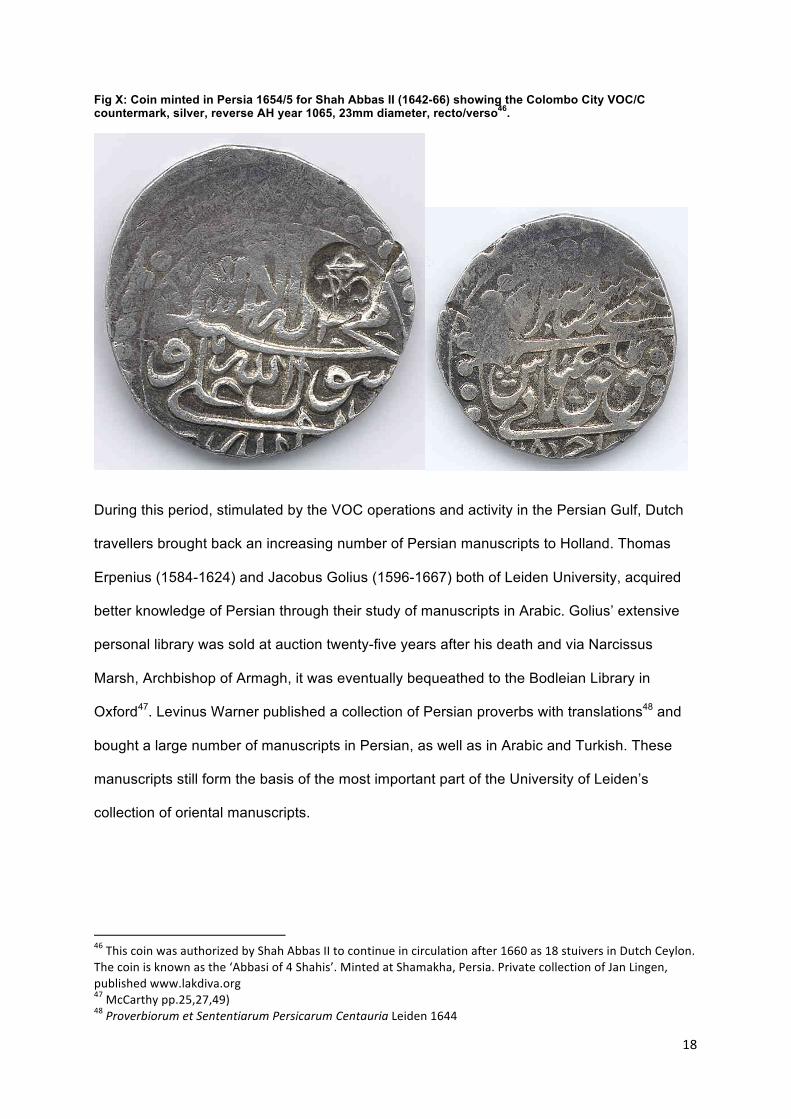
and sandalwood. In contrast, and as well as silk, the Persians exported specie (gold and
silver, such as the silver coin in fig 12, to be compared with the VOC emblem in fig.10)44,
dried fruit, pistachios, almonds, hazelnuts, madder, wine and rose water from Shiraz, and
medicinal drugs. Trade was conducted through brokers, and merchants usually received
credit45.
42 www.iranicaonline.org. Lockhart xxxx p.381, Hotz 1908 p.136-‐7. 43 Hotz 1908 p.47 44 exported illegally at first by the VOC, see www.iranicaonline.org 45 a variety of drafts, money orders, and the like were used. See Floor, 1978b, Ch 1.
18
Fig X: Coin minted in Persia 1654/5 for Shah Abbas II (1642-66) showing the Colombo City VOC/C countermark, silver, reverse AH year 1065, 23mm diameter, recto/verso46.
During this period, stimulated by the VOC operations and activity in the Persian Gulf, Dutch
travellers brought back an increasing number of Persian manuscripts to Holland. Thomas
Erpenius (1584-1624) and Jacobus Golius (1596-1667) both of Leiden University, acquired
better knowledge of Persian through their study of manuscripts in Arabic. Golius’ extensive
personal library was sold at auction twenty-five years after his death and via Narcissus
Marsh, Archbishop of Armagh, it was eventually bequeathed to the Bodleian Library in
Oxford47. Levinus Warner published a collection of Persian proverbs with translations48 and
bought a large number of manuscripts in Persian, as well as in Arabic and Turkish. These
manuscripts still form the basis of the most important part of the University of Leiden’s
collection of oriental manuscripts.
46 This coin was authorized by Shah Abbas II to continue in circulation after 1660 as 18 stuivers in Dutch Ceylon. The coin is known as the ‘Abbasi of 4 Shahis’. Minted at Shamakha, Persia. Private collection of Jan Lingen, published www.lakdiva.org 47 McCarthy pp.25,27,49) 48 Proverbiorum et Sententiarum Persicarum Centauria Leiden 1644
19
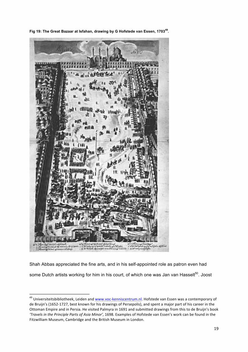
Fig 19: The Great Bazaar at Isfahan, drawing by G Hofstede van Essen, 170349.
Shah Abbas appreciated the fine arts, and in his self-appointed role as patron even had
some Dutch artists working for him in his court, of which one was Jan van Hasselt50. Joost
49 Universiteitsbibliotheek, Leiden and www.voc-‐kenniscentrum.nl. Hofstede van Essen was a contemporary of de Bruijn’s (1652-‐1727, best known for his drawings of Persepolis), and spent a major part of his career in the Ottoman Empire and in Persia. He visited Palmyra in 1691 and submitted drawings from this to de Bruijn’s book ‘Travels in the Principle Parts of Asia Minor’, 1698. Examples of Hofstede van Essen’s work can be found in the Fitzwilliam Museum, Cambridge and the British Museum in London.
20
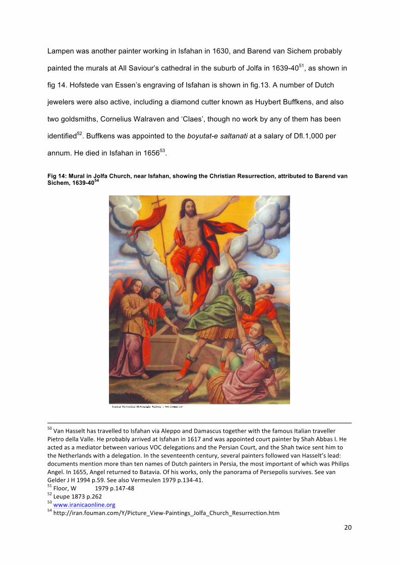
Lampen was another painter working in Isfahan in 1630, and Barend van Sichem probably
painted the murals at All Saviour’s cathedral in the suburb of Jolfa in 1639-4051, as shown in
fig 14. Hofstede van Essen’s engraving of Isfahan is shown in fig.13. A number of Dutch
jewelers were also active, including a diamond cutter known as Huybert Buffkens, and also
two goldsmiths, Cornelius Walraven and ‘Claes’, though no work by any of them has been
identified52. Buffkens was appointed to the boyutat-e saltanati at a salary of Dfl.1,000 per
annum. He died in Isfahan in 165653.
Fig 14: Mural in Jolfa Church, near Isfahan, showing the Christian Resurrection, attributed to Barend van Sichem, 1639-4054
50 Van Hasselt has travelled to Isfahan via Aleppo and Damascus together with the famous Italian traveller Pietro della Valle. He probably arrived at Isfahan in 1617 and was appointed court painter by Shah Abbas I. He acted as a mediator between various VOC delegations and the Persian Court, and the Shah twice sent him to the Netherlands with a delegation. In the seventeenth century, several painters followed van Hasselt’s lead: documents mention more than ten names of Dutch painters in Persia, the most important of which was Philips Angel. In 1655, Angel returned to Batavia. Of his works, only the panorama of Persepolis survives. See van Gelder J H 1994 p.59. See also Vermeulen 1979 p.134-‐41. 51 Floor, W 1979 p.147-‐48 52 Leupe 1873 p.262 53 www.iranicaonline.org 54 http://iran.fouman.com/Y/Picture_View-‐Paintings_Jolfa_Church_Resurrection.htm
21
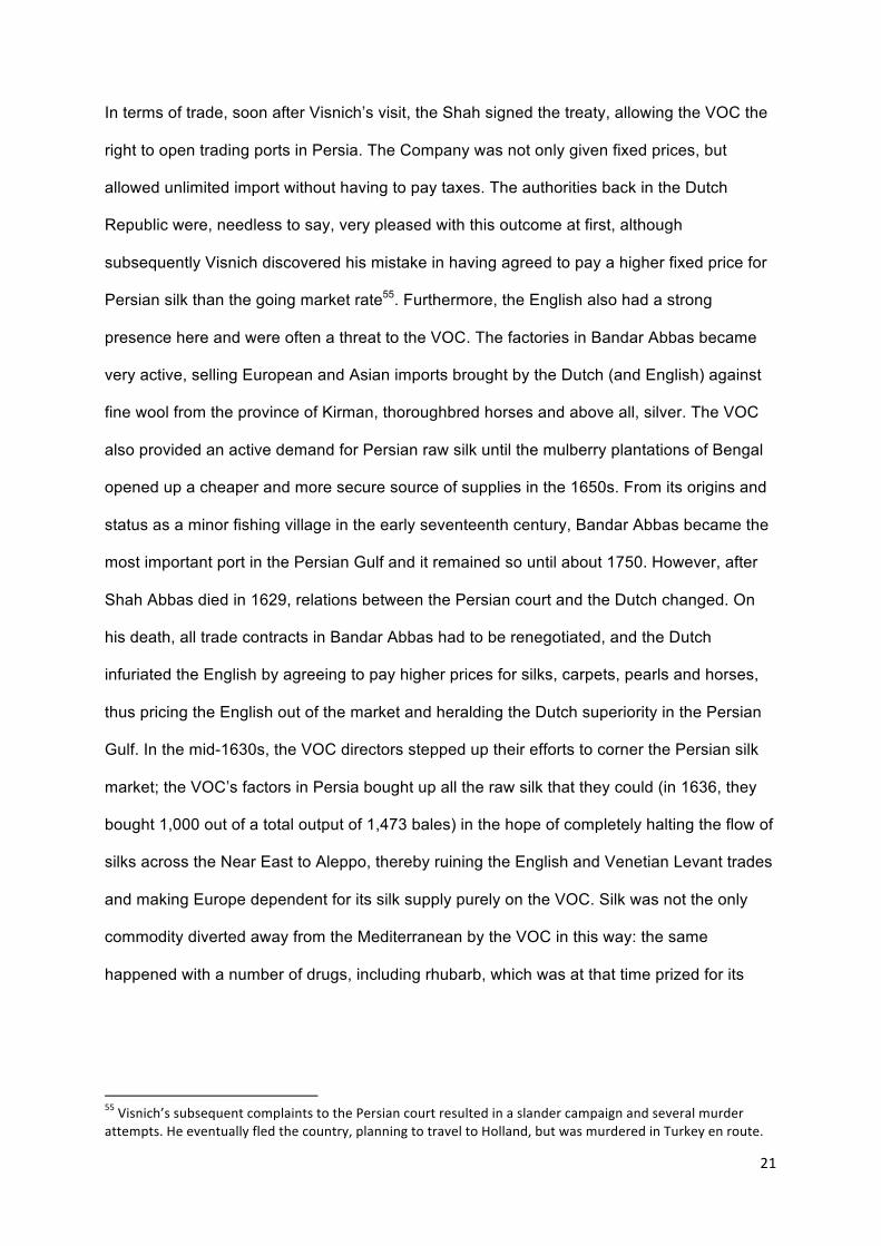
In terms of trade, soon after Visnich’s visit, the Shah signed the treaty, allowing the VOC the
right to open trading ports in Persia. The Company was not only given fixed prices, but
allowed unlimited import without having to pay taxes. The authorities back in the Dutch
Republic were, needless to say, very pleased with this outcome at first, although
subsequently Visnich discovered his mistake in having agreed to pay a higher fixed price for
Persian silk than the going market rate55. Furthermore, the English also had a strong
presence here and were often a threat to the VOC. The factories in Bandar Abbas became
very active, selling European and Asian imports brought by the Dutch (and English) against
fine wool from the province of Kirman, thoroughbred horses and above all, silver. The VOC
also provided an active demand for Persian raw silk until the mulberry plantations of Bengal
opened up a cheaper and more secure source of supplies in the 1650s. From its origins and
status as a minor fishing village in the early seventeenth century, Bandar Abbas became the
most important port in the Persian Gulf and it remained so until about 1750. However, after
Shah Abbas died in 1629, relations between the Persian court and the Dutch changed. On
his death, all trade contracts in Bandar Abbas had to be renegotiated, and the Dutch
infuriated the English by agreeing to pay higher prices for silks, carpets, pearls and horses,
thus pricing the English out of the market and heralding the Dutch superiority in the Persian
Gulf. In the mid-1630s, the VOC directors stepped up their efforts to corner the Persian silk
market; the VOC’s factors in Persia bought up all the raw silk that they could (in 1636, they
bought 1,000 out of a total output of 1,473 bales) in the hope of completely halting the flow of
silks across the Near East to Aleppo, thereby ruining the English and Venetian Levant trades
and making Europe dependent for its silk supply purely on the VOC. Silk was not the only
commodity diverted away from the Mediterranean by the VOC in this way: the same
happened with a number of drugs, including rhubarb, which was at that time prized for its
55 Visnich’s subsequent complaints to the Persian court resulted in a slander campaign and several murder attempts. He eventually fled the country, planning to travel to Holland, but was murdered in Turkey en route.
22
medicinal properties and sourced only from Tibet and other regions of Central Asia, then re-
routed through the Persian Gulf and around Africa by the VOC56.
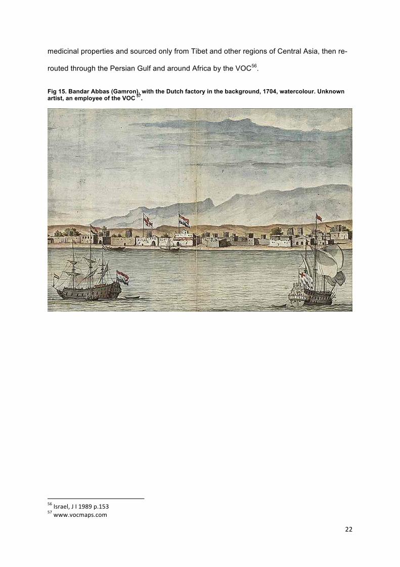
Fig 15. Bandar Abbas (Gamron), with the Dutch factory in the background, 1704, watercolour. Unknown artist, an employee of the VOC 57.
56 Israel, J I 1989 p.153 57 www.vocmaps.com
23
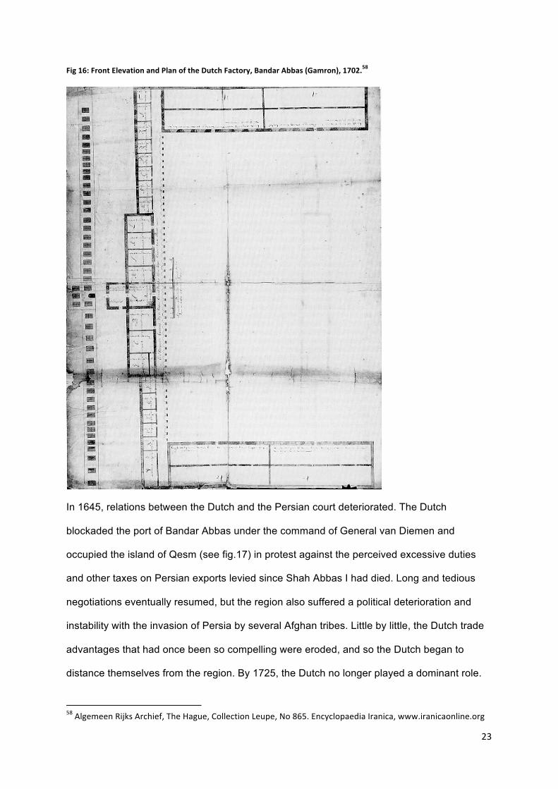
Fig 16: Front Elevation and Plan of the Dutch Factory, Bandar Abbas (Gamron), 1702.58
In 1645, relations between the Dutch and the Persian court deteriorated. The Dutch
blockaded the port of Bandar Abbas under the command of General van Diemen and
occupied the island of Qesm (see fig.17) in protest against the perceived excessive duties
and other taxes on Persian exports levied since Shah Abbas I had died. Long and tedious
negotiations eventually resumed, but the region also suffered a political deterioration and
instability with the invasion of Persia by several Afghan tribes. Little by little, the Dutch trade
advantages that had once been so compelling were eroded, and so the Dutch began to
distance themselves from the region. By 1725, the Dutch no longer played a dominant role.
58 Algemeen Rijks Archief, The Hague, Collection Leupe, No 865. Encyclopaedia Iranica, www.iranicaonline.org
24
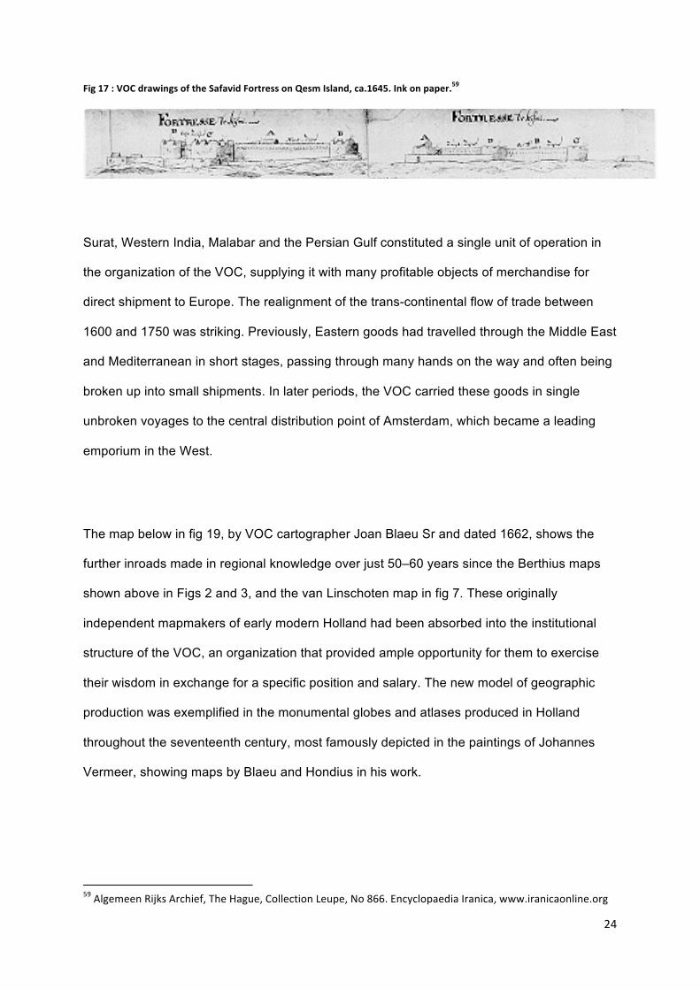
Fig 17 : VOC drawings of the Safavid Fortress on Qesm Island, ca.1645. Ink on paper.59
Surat, Western India, Malabar and the Persian Gulf constituted a single unit of operation in
the organization of the VOC, supplying it with many profitable objects of merchandise for
direct shipment to Europe. The realignment of the trans-continental flow of trade between
1600 and 1750 was striking. Previously, Eastern goods had travelled through the Middle East
and Mediterranean in short stages, passing through many hands on the way and often being
broken up into small shipments. In later periods, the VOC carried these goods in single
unbroken voyages to the central distribution point of Amsterdam, which became a leading
emporium in the West.
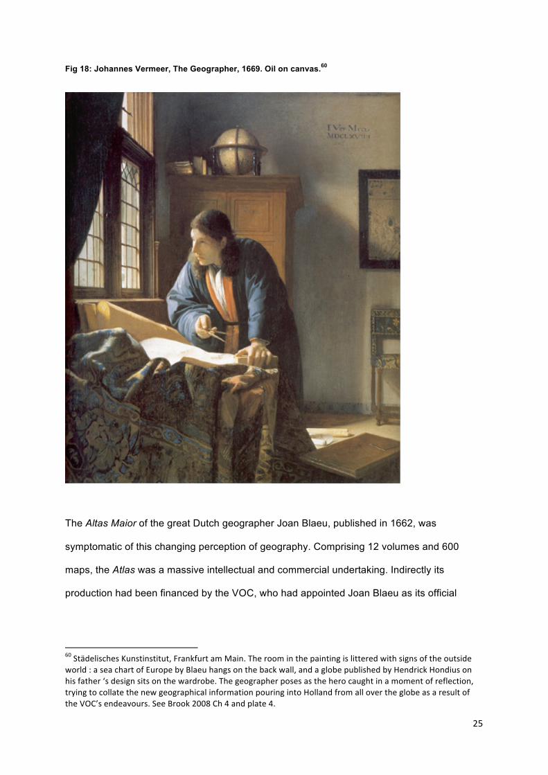
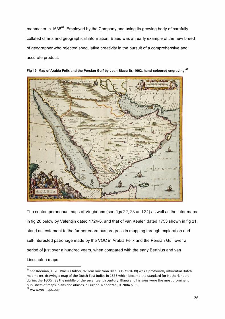
The map below in fig 19, by VOC cartographer Joan Blaeu Sr and dated 1662, shows the
further inroads made in regional knowledge over just 50–60 years since the Berthius maps
shown above in Figs 2 and 3, and the van Linschoten map in fig 7. These originally
independent mapmakers of early modern Holland had been absorbed into the institutional
structure of the VOC, an organization that provided ample opportunity for them to exercise
their wisdom in exchange for a specific position and salary. The new model of geographic
production was exemplified in the monumental globes and atlases produced in Holland
throughout the seventeenth century, most famously depicted in the paintings of Johannes
Vermeer, showing maps by Blaeu and Hondius in his work.
59 Algemeen Rijks Archief, The Hague, Collection Leupe, No 866. Encyclopaedia Iranica, www.iranicaonline.org
25
Fig 18: Johannes Vermeer, The Geographer, 1669. Oil on canvas.60
The Altas Maior of the great Dutch geographer Joan Blaeu, published in 1662, was
symptomatic of this changing perception of geography. Comprising 12 volumes and 600
maps, the Atlas was a massive intellectual and commercial undertaking. Indirectly its
production had been financed by the VOC, who had appointed Joan Blaeu as its official
60 Städelisches Kunstinstitut, Frankfurt am Main. The room in the painting is littered with signs of the outside world : a sea chart of Europe by Blaeu hangs on the back wall, and a globe published by Hendrick Hondius on his father ‘s design sits on the wardrobe. The geographer poses as the hero caught in a moment of reflection, trying to collate the new geographical information pouring into Holland from all over the globe as a result of the VOC’s endeavours. See Brook 2008 Ch 4 and plate 4.
26
mapmaker in 163861. Employed by the Company and using its growing body of carefully
collated charts and geographical information, Blaeu was an early example of the new breed
of geographer who rejected speculative creativity in the pursuit of a comprehensive and
accurate product.
Fig 19. Map of Arabia Felix and the Persian Gulf by Joan Blaeu Sr, 1662, hand-coloured engraving.62
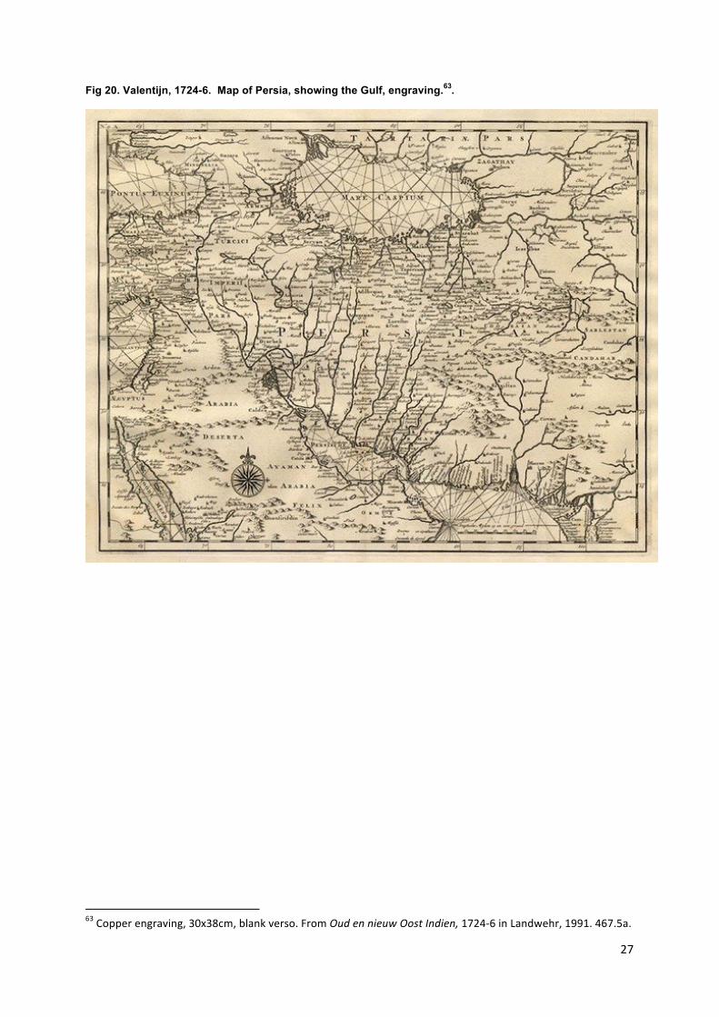
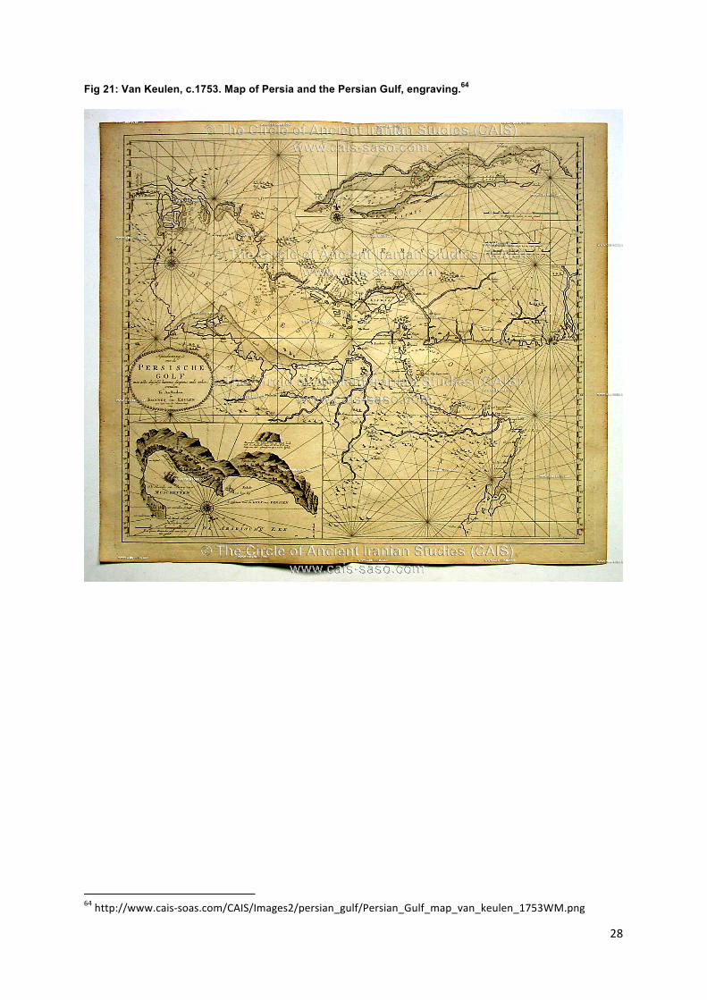
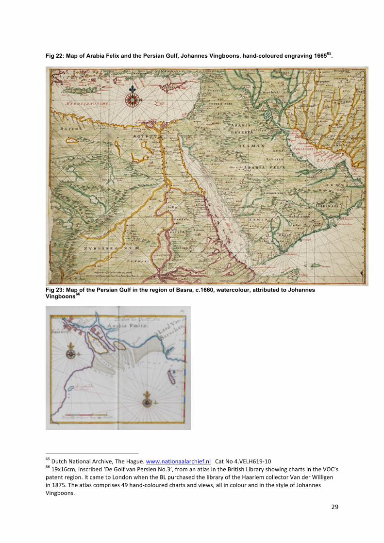
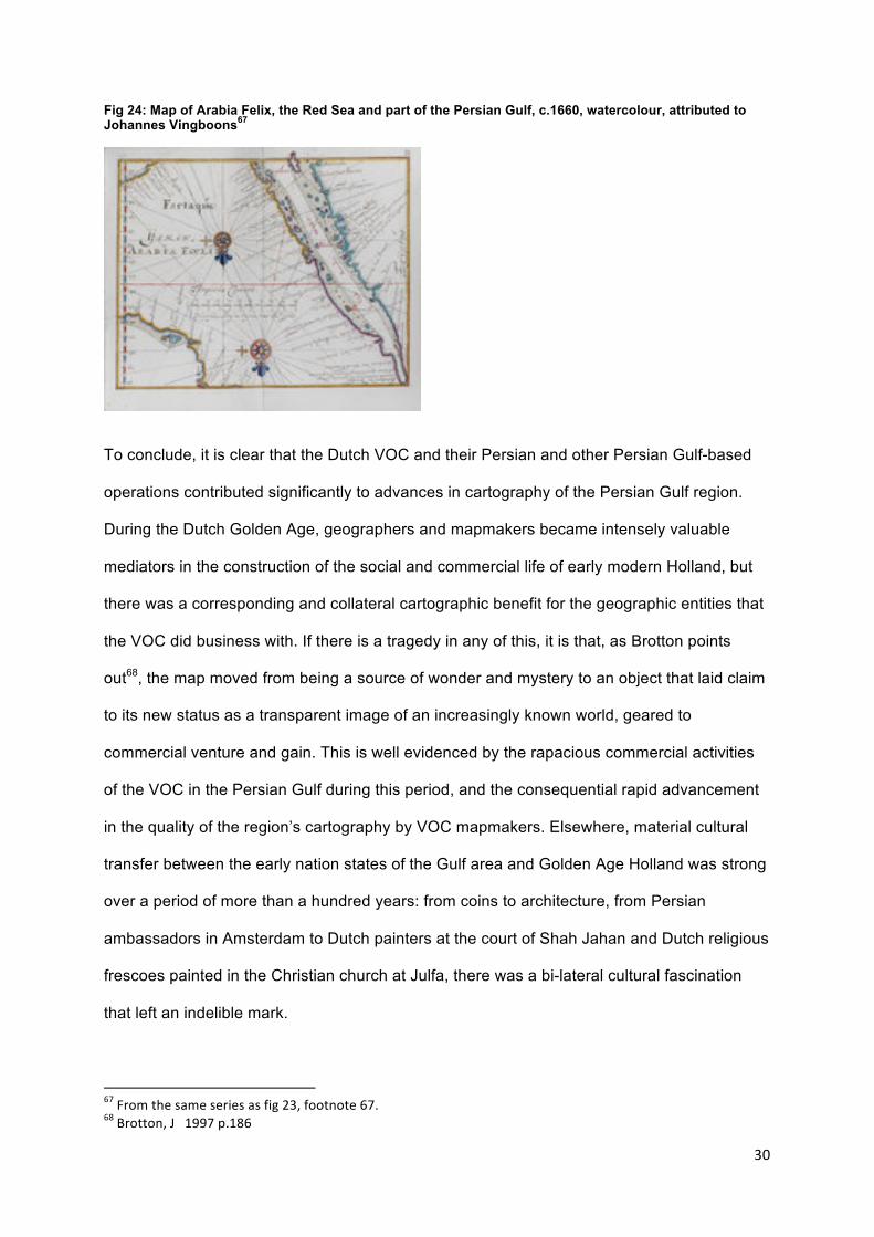
The contemporaneous maps of Vingboons (see figs 22, 23 and 24) as well as the later maps
in fig 20 below by Valentijn dated 1724-6, and that of van Keulen dated 1753 shown in fig 21,
stand as testament to the further enormous progress in mapping through exploration and
self-interested patronage made by the VOC in Arabia Felix and the Persian Gulf over a
period of just over a hundred years, when compared with the early Berthius and van
Linschoten maps. 61 see Koeman, 1970. Blaeu’s father, Willem Janszoon Blaeu (1571-‐1638) was a profoundly influential Dutch mapmaker, drawing a map of the Dutch East Indies in 1635 which became the standard for Netherlanders during the 1600s. By the middle of the seventeenth century, Blaeu and his sons were the most prominent publishers of maps, plans and atlases in Europe. Nebenzahl, K 2004 p.96. 62 www.vocmaps.com
27
Fig 20. Valentijn, 1724-6. Map of Persia, showing the Gulf, engraving.63.
63 Copper engraving, 30x38cm, blank verso. From Oud en nieuw Oost Indien, 1724-‐6 in Landwehr, 1991. 467.5a.
28
Fig 21: Van Keulen, c.1753. Map of Persia and the Persian Gulf, engraving.64
64 http://www.cais-‐soas.com/CAIS/Images2/persian_gulf/Persian_Gulf_map_van_keulen_1753WM.png
29
Fig 22: Map of Arabia Felix and the Persian Gulf, Johannes Vingboons, hand-coloured engraving 166565.
Fig 23: Map of the Persian Gulf in the region of Basra, c.1660, watercolour, attributed to Johannes Vingboons66
65 Dutch National Archive, The Hague. www.nationaalarchief.nl Cat No 4.VELH619-‐10 66 19x16cm, inscribed ‘De Golf van Persien No.3’, from an atlas in the British Library showing charts in the VOC’s patent region. It came to London when the BL purchased the library of the Haarlem collector Van der Willigen in 1875. The atlas comprises 49 hand-‐coloured charts and views, all in colour and in the style of Johannes Vingboons.
30
Fig 24: Map of Arabia Felix, the Red Sea and part of the Persian Gulf, c.1660, watercolour, attributed to Johannes Vingboons67
To conclude, it is clear that the Dutch VOC and their Persian and other Persian Gulf-based
operations contributed significantly to advances in cartography of the Persian Gulf region.
During the Dutch Golden Age, geographers and mapmakers became intensely valuable
mediators in the construction of the social and commercial life of early modern Holland, but
there was a corresponding and collateral cartographic benefit for the geographic entities that
the VOC did business with. If there is a tragedy in any of this, it is that, as Brotton points
out68, the map moved from being a source of wonder and mystery to an object that laid claim
to its new status as a transparent image of an increasingly known world, geared to
commercial venture and gain. This is well evidenced by the rapacious commercial activities
of the VOC in the Persian Gulf during this period, and the consequential rapid advancement
in the quality of the region’s cartography by VOC mapmakers. Elsewhere, material cultural
transfer between the early nation states of the Gulf area and Golden Age Holland was strong
over a period of more than a hundred years: from coins to architecture, from Persian
ambassadors in Amsterdam to Dutch painters at the court of Shah Jahan and Dutch religious
frescoes painted in the Christian church at Julfa, there was a bi-lateral cultural fascination
that left an indelible mark.
67 From the same series as fig 23, footnote 67. 68 Brotton, J 1997 p.186
31
Bibliography Braudel, F Civilization and Capitalism, 15th – 18th Century: the Perspective of the World UCP Berkeley, California 1992
Brook, T Vermeer’s Hat: the Seventeenth Century and the Dawn of the Global World Profile, London 2008
Brotton, J Trading Territories: Mapping the early modern world. Cornell U P 1997
Chaudhuri, K N Trade and Civilisation in the Indian Ocean Cambridge 1985
Dunlop H Bronnen tot de Geschiedenis der Oost Indische Compagnie in Perzie Rijks Geschiedkundige Publicatien 72, The Hague 1930
Floor, W Commercial Conflict between Iran and the Netherlands 1712-1719 Durham Occasional Papers 37, Durham 1978
Floor, W Description of the Persian Gulf and its inhabitants in 1756 Persica 8 1979a
Floor, W Dutch Painters in Iran during the first half of the 17th Century Persica 8 1979b
Floor, W Het Nederlands-Iraanse Conflict van 1645 in Verslagenen en Aanwinsten 1978-9 van de StichtingCultuurgeschiedenis van de Nederlands Overzee, Amsterdam 1980
Floor, W First Contacts between the Netherlands and Muscat, or a Report on the Discovery of the coast of Oman in 1666. Translation and Introduction. ZDMG 132 1982
Floor, W The Revolt of Sheikh Ahmad Madani in Larestan and the Garmsirat (1730-1733) Stud.Ir. 12 p.63-93 1983
Floor, W The Bahrain Project of 1754 Persica 11 1984
Floor, W Bar oftadan-e Safawian wa bar-amadan-e Mahmud Afhgan ed. and transl. A Serri, Tehran 1365AH/1986
Floor, W The Iranian Navy in the Gulf during the 18th century Iranian Studies 20 1987
Hotz, A Journaal der Reis van den Gezant der O.I. Compagnie, Joan Cunaeus naar Perzie in 1651-52 Amsterdam 1908
Israel, J Irvine Dutch Primacy in World Trade 1585-1740 Oxford Univ Press 1989
Koeman, I C Joan Blaeu and his Grand Atlas Amsterdam 1970
Landwehr, J VOC: a bibliography of publications relating to the Dutch East India Company 1602-1800. Utrecht University, HES Publishers BV 1991
Leupe P A Nederlandsche Schilders in Persie en Hindostan in de eerste helft der 17e Eeuw. De Nederlandsche Spectator 33-34 1873 p.260-66
Lockhart, L The Fall of the Safavi Dynasty and the Afghan Occupation London 1956
McCarthy, M All Graduates and Gentlemen. Marsh’s Library. Dublin 1980
Nebenzahl, K Mapping the Silk Road and Beyond Phaidon 2004
Parthesius, R Dutch Ships in Tropical Waters: the Development of the VOC Shipping Network in Asia 1595-1660 Amsterdam University Press 2010
32
Potter, L G (ed) The Persian Gulf in History Palgrave MacMillan 2009
Reis, Piri Kitab-i bahriye I Istanbul 1997
Roobacker, C C Scheeps Journaal Gamron-Basra (1645). De eerste reis der Nederlanders door de Perzische Golf ed.A Hotz Leiden 1907
Valentijn, F Oud en Nieuw Oost-Indien. Dordrecht-Amsterdam, G. Onder de Linden. 5 parts, 8 vols. 1724-6
Van den Boogaart, E Civil and Corrupt Asia : Image and Text in the Itinerario and the Icones of Jan Huygen van Linschoten University of Chicago Press 2002
Van der Krogt, Peter Koeman’s Atlantes Nederlandici, New Edition, Vol III Utrecht University, HES Publishers BV 2000
Van Dam, P Beschrijvinge van der Oostindische Compagnie ed. F WStapel, Rijks Geschiedkundige Publicatien 83, The Hague 1939
Van Gelder, J H Eastward Bound: Dutch ventures and adventures in the Middle East Editions Rodopi BV, Amsterdam 1994
Van Linschoten, J H The Voyage of Jan Huygen van Linschoten to the East Indies, ed. and trans.A C Burnell and A P Tiele, 2 vols, London. Hakluyt Society. 1885
Van Linschoten, J Itinerario: Voyage ofte schipvaert van Jan Huygen van Linschoten naer Oost ofte Portugaels Indien 1579-1592 (Travel account of JHvL to Portuguese East India) (First published 1598 as ‘Scheepsreis naar Oost- ofwel Portuguees-Indie) ULT 2009
Valentijn, F Oud en Nieuw-Oost Indien Dordrecht 1726
Vermeulen, U La Mission de Jan L van Hasselt comme agent du Sjah de Perse aux Provinces-Unis (1629-31) in Persica VIII (1979) p134-141
National Archives, The Hague: www.nationaalarchief.nl
Encyclopaedia Iranica: www.iranicaonline.org
www.vocmaps.com
www.sanderusmaps.com
www.iranian.com