The deep mapping of Pennine Street: a cartographic fiction
15
Humanities 2015, 4, 760–774; doi:10.3390/h4040760 humanities ISSN 2076-0787 www.mdpi.com/journal/humanities Article The Deep Mapping of Pennine Street: A Cartographic Fiction Claire Reddleman Goldsmiths, University of London, Lewisham Way, New Cross, London SE14 6NW, UK; E-Mail: [email protected]; Tel.: +44-788-607-4488 Academic Editor: Les Roberts Received: 29 July 2015 / Accepted: 27 October 2015 / Published: 6 November 2015 Abstract: Pennine Street is a cartographic art experiment, twinning High Street 2012 in London with the Pennine Way, a long-distance footpath running between the Peak District and the Scottish Borders. Pennine Street was initially prompted by the London 2012 Olympic spectacle; more specifically, by the militarization of the Games through the proposed deployment of surface-to-air missiles at sites in London. The project initially took the form of three organized walks along the route of High Street 2012, from Aldgate to Stratford. Readings were made while walking on each occasion, and both photographic and textual collages emerged out of the initial walks. The project engages the idea of trespass as a political action, as both potent and futile, and traces the development of modes of photographic and textual “trespass”, or transgression. Textual collage is employed to investigate the possibility of articulating Pennine Street as a “space-between” the empirical and the imagined. Keywords: deep mapping; cartography; cartographic art; trespass; collage; quotation; textual collage 1. Introduction Pennine Street is a cartographic art experiment, twinning High Street 2012 in London with the Pennine Way, a long-distance footpath running between the Peak District and the Scottish Borders. In this article, I give an account of this as-yet open-ended critical art project that considers it as a form of “deep mapping”: a deep mapping occupied with, and attempting to give an account of, both a particular geographically located “place” and, simultaneously, a second space-between that both OPEN ACCESS
-
Upload
goldsmiths -
Category
Documents
-
view
1 -
download
0
Transcript of The deep mapping of Pennine Street: a cartographic fiction

Humanities 2015, 4, 760–774; doi:10.3390/h4040760
humanities ISSN 2076-0787
www.mdpi.com/journal/humanities
Article
The Deep Mapping of Pennine Street: A Cartographic Fiction
Claire Reddleman
Goldsmiths, University of London, Lewisham Way, New Cross, London SE14 6NW, UK;
E-Mail: [email protected]; Tel.: +44-788-607-4488
Academic Editor: Les Roberts
Received: 29 July 2015 / Accepted: 27 October 2015 / Published: 6 November 2015
Abstract: Pennine Street is a cartographic art experiment, twinning High Street 2012 in
London with the Pennine Way, a long-distance footpath running between the Peak District
and the Scottish Borders. Pennine Street was initially prompted by the London 2012
Olympic spectacle; more specifically, by the militarization of the Games through the
proposed deployment of surface-to-air missiles at sites in London. The project initially
took the form of three organized walks along the route of High Street 2012, from Aldgate
to Stratford. Readings were made while walking on each occasion, and both photographic
and textual collages emerged out of the initial walks. The project engages the idea of
trespass as a political action, as both potent and futile, and traces the development of
modes of photographic and textual “trespass”, or transgression. Textual collage is
employed to investigate the possibility of articulating Pennine Street as a “space-between”
the empirical and the imagined.
Keywords: deep mapping; cartography; cartographic art; trespass; collage; quotation;
textual collage
1. Introduction
Pennine Street is a cartographic art experiment, twinning High Street 2012 in London with the
Pennine Way, a long-distance footpath running between the Peak District and the Scottish Borders.
In this article, I give an account of this as-yet open-ended critical art project that considers it as a form
of “deep mapping”:
a deep mapping occupied with, and attempting to give an account of, both a particular
geographically located “place” and, simultaneously, a second space-between that both
OPEN ACCESS

Humanities 2015, 4 761
mediates and contests the exclusionary position of the authorizing official networks of
culture and knowledge [1].
Pennine Street may be understood as constituting such a “space-between”, that is able to mediate
and to contest some of the dominant, “official” narratives that are currently functioning in the places of
“east London” and the “Pennine Way”. Where the concept and practice of deep mapping is still
emerging and finding definition as a way of exploring place, I offer Pennine Street as a project that
may contribute to our understanding of deep mapping, and that may deepen its attention to imaginative
and fictional aspects of place.
In this article, I describe how the project of Pennine Street began and how it developed, attending to
the personal experience of creative production as well as to the theoretical and political concerns that
prompted and continue to animate the work. As I discuss further below, the invention and exploration
of Pennine Street was initially prompted by the advent of the Olympics in east London. However, it is
also more broadly concerned to explore, and problematize, the categorization of places through their
(ontological and political) incorporation into new named entities, and the experience of perceiving and
encountering such abstractions. Beginning from a juxtaposition of the two routes as contrasts to one
another—rural/urban, established/new, traditional/postmodern—the project attempts to complicate and
disrupt such binary formations, to explore how these formations inform and co-constitute one another,
and how a theoretically-inspired approach to creative action might be able to play out as a form of
political response to the spectacular politics of mega-events such as the Olympics, and the harms they
cause. These are the motivations and the interests of the project, though of course I do not suggest that
any of these issues are “answered” or resolved here.
The much larger political question of the effectiveness of protest is, for me, one of the most
important unresolved questions of the Pennine Street project. With the conviction that conventional
forms of direct action, demonstration and non-violent resistance would have no effect on the
implementation and “success” of the Olympics, I made the also-ineffectual choice to develop a creative
and theoretically-informed artistic project to attempt to address some of the underlying conceptual
dynamics that make such phenomena possible; including considering how places can be defined and
re-defined in this particular cultural moment; how the power to undertake processes of definition
works through institutions and conventions such as naming; and how we might be able to re-consider
what is accepted as “real” and “natural” through taking up an interest in fiction and imagination. These
considerations have informed the development of Pennine Street as a resistant, imaginative response to
the Olympic project, though they are, of course, not resolved in the project.
2. Critical Context
The project as a whole may be seen in the context of other approaches to re-thinking and
re-experiencing place with an emphasis on radical political change. The Situationists, in particular, are
a well-known antecedent in this area. The Situationist International was a group of artists, writers,
architects and activists gathered around Guy Debord in the late 1950s, who wrote and collectively
published a wide range of work loosely focussed on changing the experience and structure of everyday
life in the city [2,3]. One of the most well known techniques the Situationists developed is the
“dérive”, a deliberate attempt to walk in the city while eschewing conventional way-finding, in order

Humanities 2015, 4 762
to reconfigure the received social constraints that are placed on ways of being and experimentally
develop new ways of moving and new forms of consciousness. The initial walks of Pennine Street, in
particular, owe some of their interest in walking as a form of political action to the example of
the Situationists.
The latter, textual stage of Pennine Street draws on techniques used by members of Oulipo, the
“workshop of potential literature”, a collective of writers, mathematicians and scientists active from
1960. Working with writing constraints such as omitting particular letters of the alphabet and
techniques for substituting words [4], the Oulipian concern to expand the formal possibilities for
literature, and their commitment to experimentation and play, have influenced the technique of textual
collage that I have developed in Pennine Street. The form of the Guidebook text, imitating the
established guidebook genre, and working by means of the “constraint” of writing in quotation, is as
important in the project as the content, the specific phrases, books and authors that are quoted. The
techniques that I have used and developed in Pennine Street attempt to disrupt and undermine the
Olympic re-casting of the A11 between Aldgate and Stratford as High Street 2012, to bring this route
into a creative relationship with another significant British route, the Pennine Way, to explore both
these routes and their formation, and the potential means through which we can understand the
interaction between empirical and imaginative places as a political activity.
3. Walking “against” the Olympics
Pennine Street was initially prompted by the London 2012 Olympic spectacle; more specifically, by
the militarization of the Games through the proposed deployment of surface-to-air missiles at sites in
London. Its starting premise was to imaginatively, and performatively, “twin” two routes that I found
to be personally significant and politically resonant at that moment in 2012: the so-called “High Street
2012” and the long-distance path known as the Pennine Way. High Street 2012 was an almost invisible
phenomenon of the London 2012 Olympics. Re-branding the A11 between Aldgate and Stratford, in
east London, High Street 2012 provided a rubric under which some refurbishment work was undertaken
to the “public realm” along the route between the City of London and the Olympic site. By apparent
contrast, the Pennine Way was established in 1965 as the first National Trail in Britain, allowing
public access to a continuous stretch of footpaths, offering members of the public “a once in a lifetime
experience” [5]. Running between Edale in Derbyshire and Kirk Yetholm in the Scottish Borders, the
Pennine Way is 268 miles long and includes the most remote parts of the country to be designated as
national trails.
The idea to “twin” these two very different routes emerged as my confused and wounded response,
as researcher, artist and local resident, to the militarization of the London Olympics. A planned holiday
to walk the Pennine Way became an opportunity to remove myself from immediate proximity to the
Olympic spectacle while it took place, and to form an artistic response to both the political project of
the Olympics and my own experience of it as a violating imposition.
Taking up the idea of twinned routes, the project initially took the form of three organized walks
along the route of High Street 2012, from Aldgate to Stratford. Open to the public, the walks, named
“Pennine Street Trespasses”, were taken by small groups, who were invited to bring and read texts of
any kind that they felt had a connection to the concerns of the project. (This participatory element of

Humanities 2015, 4 763
the project proved to be less successful than anticipated, and came to function as a prompt for my
further reading and research rather than as a methodology that played a central role in the Pennine
Street project.) The walks were explicitly framed as an act of both homage and parody of the Kinder
Trespass of 1932, in which ramblers organized a Mass Trespass at Kinder Scout in the Derbyshire
Peak District. The first Pennine Street Trespass took place on 24th April 2012, the 80th anniversary
of the Kinder Trespass. This event plays a central role in contemporary narratives of struggle and
political contestation of restrictions to access to the land, and through Pennine Street I attempt to open
out a space to examine and challenge my own attitude to the Trespass, as well as its enrolment in
somewhat triumphalist contemporary discourses of struggle.
I particularly wanted to complicate my own received impression of a simplified narrative in relation
to the Kinder Trespass; based on partial awarenesses gathered as a walker, through reading websites
and guidebooks, and consuming media such as newspapers and radio programmes, I wanted to make
my own (partial, inadequate) process of impression-formation an object of inquiry and criticism as
much as the “external” objects of inquiry such as the routes and their histories. Therefore rather than
presenting an account of current attitudes towards, and uses of, the Kinder Trespass that aspired to
intellectual objectivity, I was concerned to question my own perspective, particularly as someone without
experience of any of the struggles for access to the private land on which the Pennine Way was established
privileged position of being able to “escape” the Olympics.
I saw in the Pennine Way, and its establishment as the first “national trail” in Britain, a narrative of
a constructed route as metonymic of the nation (the National Trails website and the official guidebook,
also published by Natural England, both refer to the Pennine Way as following “the backbone of
England” ([5]; [6], p. 12). In twinning the two routes, then, I was partly interested to position High
Street 2012 in relationship to the Pennine Way as a cynical or inadequate national metonym for the
early twenty-first century; where the Pennine Way has inspired hyperbole it also offers rich and
rewarding experience, forming a problematic, questioning binary with High Street 2012 as offering no
comparable opportunities.
The three walks followed the route of High Street 2012 between Aldgate and Stratford; the first and
third walks proceeded west to east, and the second walk, east to west. Readings were made while
walking on each occasion (to which I return, below). I took as the end of High Street 2012 the location
of the final improvement project along the route; Stratford High Street DLR (Docklands Light
Railway) Station (see Figure 1). This site is a short walk away from the main Stratford Station, which
includes Overground and Underground trains and which saw extensive improvement works ahead of
the Olympics. The distance between the end of High Street 2012 and the main station providing access
to the Olympic site became amplified in the imaginary of Pennine Street, as a sign of the feeling of
bureaucratic ineptitude, of plans being slightly off and unfinished, delayed. I connected this impression
with my sense of the futility of physical, or legal, trespass; my feeling of powerlessness in the face of the
Olympic spectacle. In this I also saw a certain problematic “sublimity” that I found myself attributing
to the Olympics as a whole. In response to these considerations, I read the well-known “tilting at
windmills” passage from Don Quixote by Miguel de Cervantes at the Stratford High Street DLR
Station, and photographed the new lighting scheme:

Humanities 2015, 4 764
Figure 1. Stratford High Street DLR Station, 2012.
A series of subsequent walks enabled me to photograph more of the route, and to extend the idea of
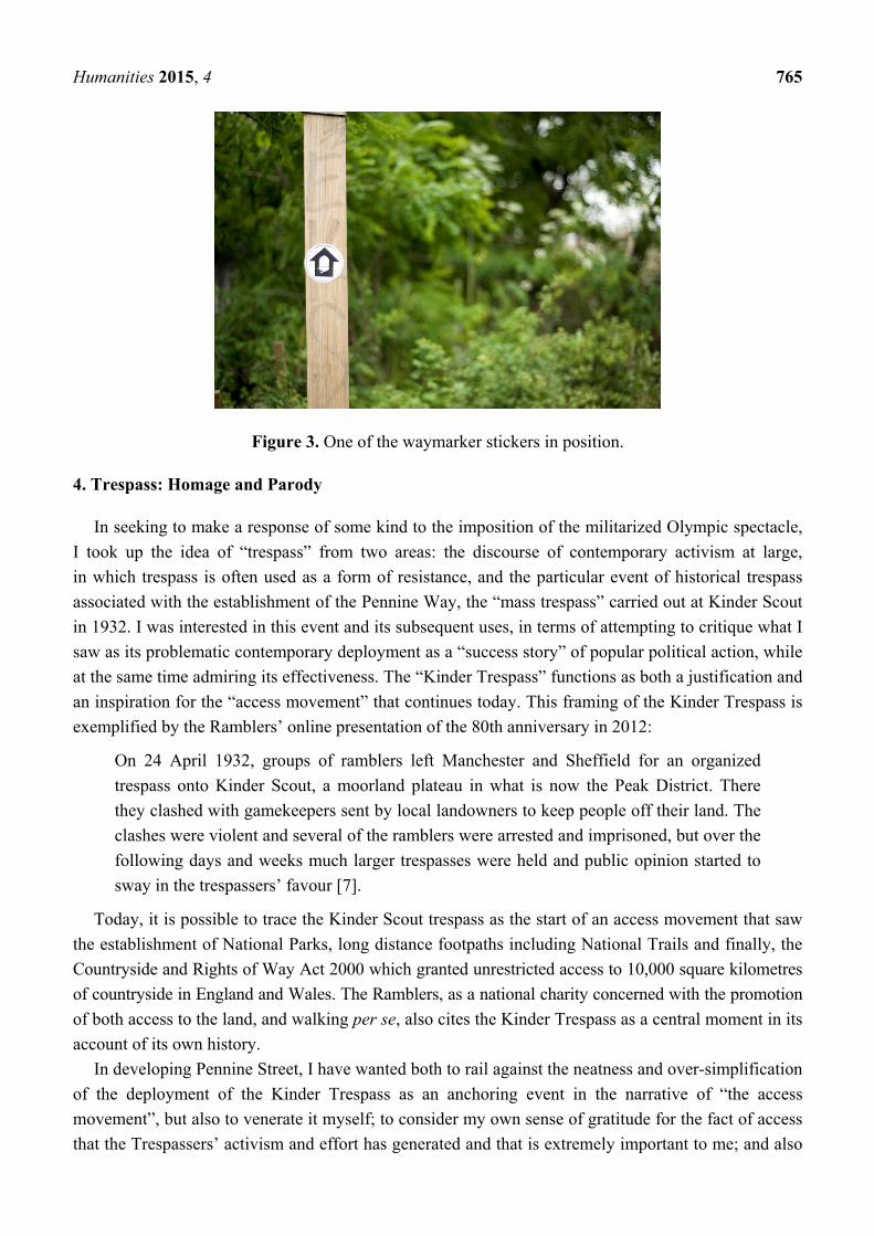
trespass in the project through stickering. Stickers were placed along the route and its environs,
offering waymarkers for the (non-existent) walker to follow (see Figures 2 and 3). On a personal level,
I was surprised at how self-conscious I felt at making this very minor transgression, of placing stickers
in public places, on signage and street furniture. I was not carrying out an act of trespass in the
conventional and politicized sense of accessing land that is private or otherwise forbidden; rather, I
considered that this attempt was to “trespass” in plain sight, so to speak, by unofficially and
ineffectually declaring public spaces to be part of the new, non-official and fictional space of
Pennine Street.
Figure 2. The Pennine Street waymarker sticker.
Humanities 2015, 4 765
Figure 3. One of the waymarker stickers in position.
4. Trespass: Homage and Parody
In seeking to make a response of some kind to the imposition of the militarized Olympic spectacle,
I took up the idea of “trespass” from two areas: the discourse of contemporary activism at large,
in which trespass is often used as a form of resistance, and the particular event of historical trespass
associated with the establishment of the Pennine Way, the “mass trespass” carried out at Kinder Scout
in 1932. I was interested in this event and its subsequent uses, in terms of attempting to critique what I
saw as its problematic contemporary deployment as a “success story” of popular political action, while
at the same time admiring its effectiveness. The “Kinder Trespass” functions as both a justification and
an inspiration for the “access movement” that continues today. This framing of the Kinder Trespass is
exemplified by the Ramblers’ online presentation of the 80th anniversary in 2012:
On 24 April 1932, groups of ramblers left Manchester and Sheffield for an organized
trespass onto Kinder Scout, a moorland plateau in what is now the Peak District. There
they clashed with gamekeepers sent by local landowners to keep people off their land. The
clashes were violent and several of the ramblers were arrested and imprisoned, but over the
following days and weeks much larger trespasses were held and public opinion started to
sway in the trespassers’ favour [7].
Today, it is possible to trace the Kinder Scout trespass as the start of an access movement that saw
the establishment of National Parks, long distance footpaths including National Trails and finally, the
Countryside and Rights of Way Act 2000 which granted unrestricted access to 10,000 square kilometres
of countryside in England and Wales. The Ramblers, as a national charity concerned with the promotion
of both access to the land, and walking per se, also cites the Kinder Trespass as a central moment in its
account of its own history.
In developing Pennine Street, I have wanted both to rail against the neatness and over-simplification
of the deployment of the Kinder Trespass as an anchoring event in the narrative of “the access
movement”, but also to venerate it myself; to consider my own sense of gratitude for the fact of access
that the Trespassers’ activism and effort has generated and that is extremely important to me; and also

Humanities 2015, 4 766
to confront the tensions involved in performing a bourgeois subject position in relation to a movement
that has been positioned as a working class victory against the figure of the bourgeois landowner, or
more particularly, the departicularized figure of the “gamekeeper”. Standing in for any actual landowner
in accounts of the Trespass, the gamekeeper provides a coherent antagonist to the trespasser. Here
again a paring-down, a critical simplification, of the presence and role of this figure takes place; for
example, injuries to gamekeepers are cited in more in-depth accounts and left unmentioned in briefer
and more widely circulated accounts, while the fact of imprisonment for the trespassers survives the
simplification process [8].
I read in this narrativizing process a deep ambivalence toward the question of violence and violation
in the Trespass as a political action. Physical violence (the gamekeeper’s broken leg) is effaced in
favour of symbolic violence—enacted at the level of the law rather than the level of the person. In
Pennine Street, through positioning the initial walks as “trespasses” held in both homage and parody to
the Kinder Trespassers, I attempted to perform some of my own sense of conflictedness about the
importance of symbolic action as well as its non-effectiveness at the immediate political level. That is,
I was very aware that any action of trespass or physical resistance to the Olympics that I could make
would have no effect on their going ahead, but still felt that attempting to intervene at the level of the
symbolic was important and possible. It was this sense of conflictedness itself that I attempted to evoke
and explore through the idea of the walks as both homage and parody.
The visual register of Pennine Street also attempts to explore the notion of “trespass”
through collage (see Figure 4)—“trespassing” the integral image in favour of images that disrupt and
violate one another—appropriating imagery, and stickering (see Figures 2 and 3). The walks generated
a lot of photographic imagery, which I experimented with using collage as a visual analogue of the
twinning, combining and interspersing of places proposed by the project as a whole. These visual
experiments enabled the incorporation of photographs from the Pennine Way, as well as the
appropriation of parts of maps, particularly Google Maps (see Figure 5).
Figure 4. Early collage “sketch” incorporating photographs of the Kinder Plateau,
Derbyshire and Mile End, London.

Humanities 2015, 4 767
Figure 5. Early collage “sketch” incorporating satellite map image of Balderhead
Reservoir, County Durham, and photograph of Mile End, London.
5. Declaring Twinned Places: Haworth Idea Store and Hadrian’s Interchange
The experiments in collage gave rise to a more particular twinning of specific locations along the
two routes, attending, though not rigidly, to relative position in relation to the route as a whole (see
Figure 6). For example, the beginning of the route became “Aldgatedale”, incorporating toponymic
reference to both Aldgate in London and Edale in Derbyshire; the end point became “Kirk Stratford
High St DLR Station”, incorporating, in the same way, reference to Stratford High St DLR Station in
London and Kirk Yetholm in the Scottish Borders. The need to map the routes more closely onto each
other arose through making this more explicit correlation between the two routes.
Figure 6. Early layout bringing the two routes into a parallel orientation, and abandoning
relative scale.

Humanities 2015, 4 768
Particular twinned locations were “declared”, including Haworth Idea Store (see Figure 7),
Stepney-in-Ribblesdale, Hadrian’s Interchange, Kielder-Stratford Forest and Hackney Heath. Haworth
Idea Store was prompted by the emphasis placed on Haworth and Top Withins by the Pennine Way
guidebook, Pennine Way South: Edale to Bowes, as key locations of interest to the Pennine Way
walker, thus:
Ahead and to the left is a broken spine of a wall leading to the ruins of Top Withins [...]
Readers of Wuthering Heights may be disappointed by the first sight of this famous ruin,
which has been “conserved”, but the view from the lonely steading is still wonderful. After
passing Top Withins the Way drops downhill along a well-worn literary trail ([6], p. 67).
Figure 7. Haworth Idea Store.
A further inset page is devoted to “The Brontёs of Haworth” ([6], p. 69), and further describes
Top Withins:
Top Withins, the inspiration for Wuthering Heights, beckons the more committed.
Its setting is splendid and it should stir the imagination, but one of the most attractive
things about a ruin is that it is insubstantial. It is a pity to see the once-crumbling remains
of Top Withins enshrined as a blockhouse ([6], p. 69).
The emphasis, as well as the guidebook’s apparently straightforward treatment of a material ruin as
the setting of a fiction, prompted the inclusion of “Haworth” as a place within Pennine Street. In the
transposed mapping of the two routes, the “real” Whitechapel Idea Store in London occupies
a geographical position within High Street 2012 that is roughly equivalent to Haworth’s position
within the Pennine Way; that is, about a quarter of the way along their respective whole routes. The
two locations are twinned, and juxtaposed, as sites of official, or institutional, interest, the library and
the heritage site positioned as sites for the improvement of their visitors, and both centrally concerned
with “fiction”. The resulting twinned site, Haworth Idea Store, was also photographed (see Figure 7).
A concern with criticism is in play throughout the project, and specifically here in the choice to
draw a connection between Top Withins and Haworth, and the Whitechapel Idea Store, through the
idea of fiction. An angry, sardonic tone, or attitude, may be read as functioning at all times in the

Humanities 2015, 4 769
project and its specific moments, performing an aggressive degree of criticism that is simultaneously
proffered and disavowed. This may be read in the “Haworth Idea Store” in terms of a conflicted attack
on the phenomenon of the Idea Store, with its avowed aims of “reaching the non-learning public” [9]
while finding itself deeply entangled in contemporary politics of “place-making” ([10], p. 12) and the
ongoing gentrification of Whitechapel. These developments are metonymized in the Whitechapel Idea
Store, which comes to stand for the simultaneous improvement of services for the “non-learning
public” and their social and economic marginalization. “Non-learning” in this context functions as
a euphemism for working- and sub-working class, itself a deeply racialized category in Tower Hamlets.
For me, as against the official view [11], the Idea Store is an ambivalent place of accessible learning
dignified by designer architecture, on the one hand, and a place of emptiness and false promise on the
other, offering a shockingly limited range of materials packaged for people whom the state (in the form
of London Borough of Tower Hamlets) regards as having little value and scant potential for positive
change. The concern with criticism in the project is partly, then, an anxiety about offering it at all
toward a scheme widely regarded as successful; and partly with a self-reflexive awareness of the
privilege of my own social and economic position in relation to those who are “targeted” ([11], p. 58)
by such services as the Idea Store.
Hadrian’s Interchange is the result of twinning the Bow Interchange in east London, a huge, multi-level,
multi-lane gyratory, or roundabout, with Hadrian’s Wall, once the fortified northernmost boundary of
Roman Britain, now a world heritage site and major tourist destination. I discuss Hadrian’s Interchange
in more detail below.
The most recent photographic stage of Pennine Street is a series of photographic collages focussing
on the new imaginary of “Hadrian’s Interchange” (see Figures 8 and 9).
Figure 8. Collage depicting Hadrian’s Interchange, composed of photographs of Hadrian’s
Wall and Bow Interchange.
Humanities 2015, 4 770
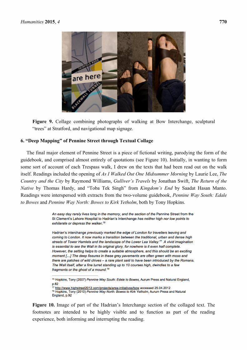
Figure 9. Collage combining photographs of walking at Bow Interchange, sculptural
“trees” at Stratford, and navigational map signage.
6. “Deep Mapping” of Pennine Street through Textual Collage
The final major element of Pennine Street is a piece of fictional writing, parodying the form of the
guidebook, and comprised almost entirely of quotations (see Figure 10). Initially, in wanting to form
some sort of account of each Trespass walk, I drew on the texts that had been read out on the walk
itself. Readings included the opening of As I Walked Out One Midsummer Morning by Laurie Lee, The
Country and the City by Raymond Williams, Gulliver’s Travels by Jonathan Swift, The Return of the
Native by Thomas Hardy, and “Toba Tek Singh” from Kingdom’s End by Saadat Hasan Manto.
Readings were interspersed with extracts from the two-volume guidebook, Pennine Way South: Edale
to Bowes and Pennine Way North: Bowes to Kirk Yetholm, both by Tony Hopkins.
Figure 10. Image of part of the Hadrian’s Interchange section of the collaged text. The
footnotes are intended to be highly visible and to function as part of the reading
experience, both informing and interrupting the reading.

Humanities 2015, 4 771
The guidebook became the central text for the project, due in part to my experience, when walking
the Pennine Way using the guidebook, of Hopkins’ narrative voice becoming something of a fictional
presence throughout the walk. Providing a would-be objective and comprehensive description of what
the walker will see, and need to negotiate (for example roads or areas of wet ground or poor signage),
the narrative voice of the guidebook also habitually “deviates” into idiosyncratic reflections on points
such as the conservation of Top Withins, noted above, or comments on the walker’s “experience”:
“When you walk into Hawes early, after a comparatively easy walk, you will wonder what all the fuss
was about.” ([6], p. 104) The guidebook as both an object and a narrative voice becomes a central
feature of the experience of walking. It is read aloud, and re-read, particularly when its description
proves difficult to connect with the landscape itself; it is protected from rain, and held in the hand
while walking. The author’s idiosyncratic moments became moments to look forward to amid the
succession of directions: “After crossing the lower meadows you begin to climb again” ([6], p. 120);
“the route follows the towpath beneath a little bridge” ([6], p. 82); “just beyond this wood you bear
right” ([6], p. 86).
As this text had taken up such a central role in my experience and memory of walking the Pennine
Way, I used it to structure both the readings on the Trespasses and the written accounts I produced
afterwards. Extracts from the guidebook describing, for example, one’s view at a particular location,
were interrupted with place-names taken from the map of east London. Extracts from the readings
were also incorporated, drawing on the idea of collage used as a visual technique to “collage” the texts
into new forms to create a fictional, imaginative “account” of walking Pennine Street—as though it
were a “real” National Trail for which one could obtain a guidebook. The guidebook is structured by
breaking down the whole route into manageable days of walking, for example, “4—Hebden Bridge to
Ponden” and “5—Ponden to Thornton-in-Craven” [6]. I took up this format, sub-dividing Pennine
Street into a recommended five-day walk between particular twinned, or combined, places:
Day One: Aldgatedale to the Haworth Idea Store
Day Two: Haworth Idea Store to St Clement’s Lahore Hospital
Day Three: St Clement’s Lahore Hospital to Hadrian’s Interchange
Day Four: Hadrian’s Interchange to Kielder-Stratford Forest
Day Five: Kielder-Stratford Forest to Kirk Stratford High St DLR Station
The length of High Street 2012 is around 4.5 miles, and the length of the Pennine Way 268 miles,
and this mode of textual division holds together the scales of both routes without collapsing one into
the other. The proposition that it could take five days to walk the length of High Street 2012 is, of
course, absurd, potentially comic, as is the proposition that it would be possible to walk the Pennine
Way in five days. A new sense of time and distance is suggested in the insistence on the scales and
sizes of both routes.
The “twinned place” of Hadrian’s Interchange offers an opportunity to consider in more detail how
this place is evoked in Pennine Street through textual collage. The Interchange comes in the section
“Day Three: St Clement’s Lahore Hospital to Hadrian’s Interchange” (see Figure 10).
Here, the first line comes from the guidebook by Tony Hopkins, Pennine Way South: Edale to
Bowes, then from the “High Street 2012” website, then the guidebook again, with altered place names
added by me. The idea of Hadrian’s Interchange is of interest for me partly because of the sense,

Humanities 2015, 4 772
picked up in this passage, of a boundary or a point of transition, to the east of which is beyond what I
think of as “my” east London. One crosses the River Lea, which is quite dwarfed by the structure of
the roundabout and flyover. Thinking of this bleak urban space in conjunction with Hadrian’s Wall
gives an opportunity to consider the constitutive binaries of the military boundary, which was the
Wall’s original purpose, against the spatial boundary of the road and the river. Hadrian’s Wall is now
exclusively and relentlessly a site of leisure, and cultural consumption, but still controlled and
protected. The guidebook’s overbearing instruction on the need for a vivid imagination now comes to
apply to both spaces; it retains its reference to Hadrian’s Wall, and, placed in this new narrative
context, it refers also to the incompleteness of the project of High Street 2012, which was originally
part of the package of benefits that were supposed to accrue to the local area and the people who live
there, but which were significantly diminished in the actual course of events.
There is both humour and performativity in the idea that this urban place could be proposed as
somewhere that one might deliberately visit for the purpose of leisure, which as far as I can tell, no-one
does. It is used as a shortcut by locals, but its layout does not provide for pedestrian access to the
central space of the Interchange. The twinned place poses the further question, then, of what kinds of
walking and access are understood as “leisure” and which kinds understood as “necessity” or everyday
life. The need for a “vivid imagination”, in this context, comes to refer also to the degree of
imagination that may be required for those of us who are not compelled to live in this place to
understand how it is done. The question of everyday life, and an imaginative engagement with how
others live, was, I argue, absent from the project of High Street 2012.
The fictional Guidebook simultaneously offers an account and a guide to the imagined route,
Pennine Street. The photographic collages act as illustrations to this imagined route, and are positioned
at the relevant locations in the text, replicating the illustrative role of (non-collaged) photographic
illustrations in the original guidebook. In this way, the capacity of photography to evoke the potential
visual experience of the walker is disrupted through presenting altered images that “fail” to convey
what may be seen when one is in place. The places that are combined in the images interrupt and
supplement one another, resisting a coherent presentation of place. In the same spirit, the Guidebook’s
composition from quotations also stages this kind of interruption and deliberate lack of coherence. This
mode of collaged writing came about in response to my desire to have the original voices and
utterances of the “Trespass” texts appear directly, rather than being summarized or re-phrased, and my
concurrent concern with learning and navigating the rules and conventions of academic writing as
a PhD researcher.
The collaged text came to function as a way to experiment with taking up words written by others
and my awareness of the violation entailed in the process of quotation, of making a selection from
a coherent whole text, and re-presenting this selection in a new textual setting. I considered this
approach in light of the initial concern with trespass, as a form of textual rather than physical trespass.
I was also concerned to explore, in this specific context, the broader idea of how creating something
new (whether a new named route, or a piece of writing) can entail dismantling and reconfiguring prior
work by others. This method also apes, and subverts, the processes of forming and declaring the
existence of the two routes engaged with in Pennine Street: both the more positive process of forming
the Pennine Way through existing pathways, and the more superficial process of declaring High Street
2012 as a re-imagining of an existing main road.

Humanities 2015, 4 773
While the project is currently a work in progress, the present version of the “guidebook text” may
be accessed at the project’s website [12]. I intend to publish the work as an artist’s book, following the
format of the guidebook with some of the photographic collages and hand drawn maps acting as
guidebook illustrations. Further exploration of the ideas generated through the Pennine Street project
could also take the form of replicating the twinning of two routes to create a third “space-between”. In
the same way that the declaration of the Pennine Way as a National Trail led on to the establishment of
further National Trails, so the same process of twinning could be productively applied in other locations.
What I suggest is “mapped” in Pennine Street, then, in the expanded sense of deep mapping, is
a layering of means of depiction simultaneously with two posited geographical locations. At Hadrian’s
Interchange in particular, as with Pennine Street as a whole, textual collage is combined with
photographic collage to evoke a “new” imaginative place, beyond the empirical; a “space-between”.
While Pennine Street continues to evolve, and therefore what is presented here is something of a report
on a work in progress, I suggest that it indicates emerging possibilities for deep mapping to articulate
and evoke imaginative aspects of place. In this way, approaches to place that we may consider under
the rubric of deep mapping are able to push beyond the traditional cartographic concern with
representation and engage with more political, and politicized, aspects of place and imagination.
Acknowledgments
Parts of this article were initially presented as a conference paper at the 2015 Nordic Geographers’
Meeting, “Geographical Imagination: Interpretations of Nature, Art and Politics”.
Conflicts of Interest
The author declares no conflict of interest.
References and Notes
1. Iain Biggs. “Deep Mapping as an Essaying of Place.” Illustrated talk given at the Writing
Seminar, the Bartlett School of Architecture, London, UK, 9 July 2010. Available online:
http://www.iainbiggs.co.uk/text-deep-mapping-as-an-essaying-of-place/ (accessed on 1
November 2015).
2. The wide range of Situationist writings are usefully anthologized in The Situationists and the City.
Edited by Tom McDonough. London: Verso, 2009.
3. See also Situationist International Anthology. Edited by Ken Knabb. Berkeley: Bureau of Public
Secrets, 2006.
4. For a detailed anthology of oulipian innovations and techniques, see The Oulipo Compendium.
Edited by Harry Mathews and Alastair Brotchie. London: Atlas, 1998.
5. National Trails. “Pennine Way.” Available online: http://www.nationaltrail.co.uk/pennine-way
(accessed on 1 November 2015).
6. Tony Hopkins. Pennine Way South: Edale to Bowes. London: Aurum Press, 2007.
7. Ramblers. “Kinder 80: Marking the Mass Trespass.” Available online: http://www.ramblers.
org.uk/kinder80 (accessed on 1 November 2015).

Humanities 2015, 4 774
8. For an account of the Mass Trespass that is favourable to the Trespassers’ cause, see Tom
Stephenson, Ann Holt, and Mike Harding. Forbidden Land: The Struggle for Access to Mountain
and Moorland. Manchester: Manchester University Press, 1989.
9. Heather Wills. “An innovative approach to reaching the non-learning public: The new Idea Stores
in London.” The New Review of Library and Lifelong Learning 4 (2003): 107–120. This article is
authored by the Idea Store Programme Director and provides an institutional perspective on the
programme. The Idea Store programme has been implemented in Tower Hamlets, the London
borough which includes Whitechapel and much of the route of Pennine Street, ostensibly to
rejuvenate the borough’s provision of public library services.
10. Dorte Skot-Hansen, Casper Hvenegaard Rasmussen, and Henrik Jochumsen. “The role of public
libraries in culture-led urban regeneration.” New Library World 114 (2012): 7–19.
11. London Borough of Tower Hamlets. “Idea Store Strategy 2009.” Available online: https://www.
ideastore.co.uk/assets/documents/IdeaStoreStrategyAppx1CAB290709(1).pdf (accessed on 1
November 2015).
12. Claire Reddleman. “Pennine Street: A Cartographic Fiction in East London.” Available online:
http://www.penninestreet2012.wordpress.com (accessed on 1 November 2015).
© 2015 by the author; licensee MDPI, Basel, Switzerland. This article is an open access article
distributed under the terms and conditions of the Creative Commons Attribution license
(http://creativecommons.org/licenses/by/4.0/).