The 'Court Circle' Excavation at Thynghowe, Hanger Hill ...
75
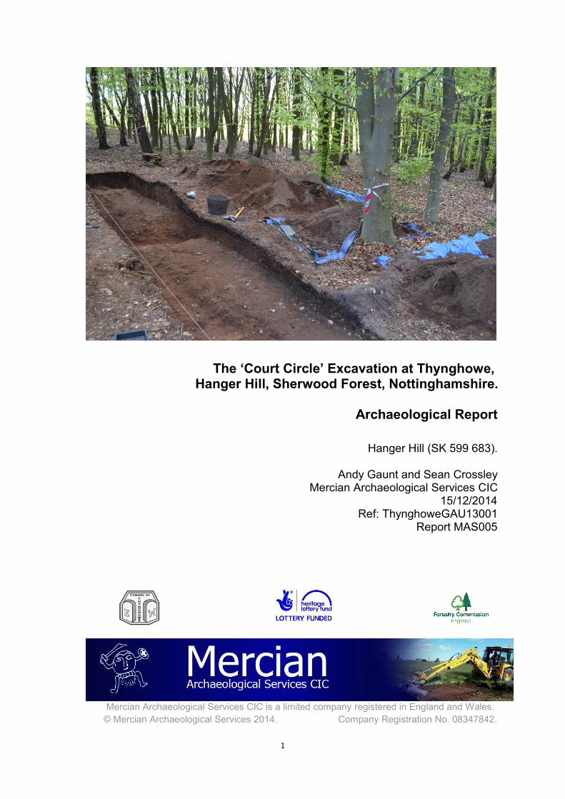
1 The ‘Court Circle’ Excavation at Thynghowe, Hanger Hill, Sherwood Forest, Nottinghamshire. Archaeological Report Hanger Hill (SK 599 683). Andy Gaunt and Sean Crossley Mercian Archaeological Services CIC 15/12/2014 Ref: ThynghoweGAU13001 Report MAS005 Mercian Archaeological Services CIC is a limited company registered in England and Wales. © Mercian Archaeological Services 2014. Company Registration No. 08347842.
-
Upload
khangminh22 -
Category
Documents
-
view
1 -
download
0
Transcript of The 'Court Circle' Excavation at Thynghowe, Hanger Hill ...
1
The ‘Court Circle’ Excavation at Thynghowe,Hanger Hill, Sherwood Forest, Nottinghamshire.
Archaeological Report
Hanger Hill (SK 599 683).
Andy Gaunt and Sean CrossleyMercian Archaeological Services CIC
15/12/2014Ref: ThynghoweGAU13001
Report MAS005
Mercian Archaeological Services CIC is a limited company registered in England and Wales.© Mercian Archaeological Services 2014. Company Registration No. 08347842.
The ‘Court Circle’ Excavation at Thynghowe, Hanger Hill, Sherwood Forest, Nottinghamshire.Archaeological Report MAS005.
© Mercian Archaeological Services CIC 2014.www.mercian-as.co.uk
2
The ‘Court Circle’ Excavation at Thynghowe,Hanger Hill, Sherwood Forest, Nottinghamshire.
Archaeological Report
Hanger Hill (SK 599 683).
Andy Gaunt and Sean CrossleyMercian Archaeological Services CIC
MAS005
Title: The ‘Court Circle’ Excavation at Thynghowe,Hanger Hill, Sherwood Forest, Nottinghamshire.
Archaeological ReportAuthor: Andy Gaunt and Sean Crossley
Derivation: -
Date of Origin: 01/06/2013
Version Number: 1.1
Date of Last Revision: 15/12/2014
Revisers: DJB, APG, SBC
Status: Final
Summary of Changes: Editorial changes
Mercian Project Identifier: GAU13001
Client: The Friends of Thynghowe, The Forestry Commission forEngland, The Heritage Lottery Fund.
Checked / Approved for Releaseby:
David Budge, Director MAS, 15/12/2014
The ‘Court Circle’ Excavation at Thynghowe, Hanger Hill, Sherwood Forest, Nottinghamshire.Archaeological Report MAS005.
© Mercian Archaeological Services CIC 2014.www.mercian-as.co.uk
3
Contents Page
1. Summary 5
2. Project Location, topography and geology 6
3. Archaeological and Historical Background 7
4. Research Aims and Objectives 10
5. Methodology 12
6. Results 15
7. Discussion 21
8. Bibliography 27
Appendices
I. Sections and Plans 32
II. Context Register and Site Matrix 35
III. Finds Report- Heat Shattered Pebbles 41
IV. Finds Report- Post Roman Pottery 51
V. Finds Report- Ceramic Building Material 56
VI. Finds Report- Flaked Stone and IronObjects
62
VII. Environmental Archaeological Site VisitRésumé
66
VIII. Community Archaeology PhotographicArchive- Mercian Archaeological ServicesCIC and the Friends of Thynghowe
71
9. Acknowledgments 31
10. Disclaimer 31
The ‘Court Circle’ Excavation at Thynghowe, Hanger Hill, Sherwood Forest, Nottinghamshire.Archaeological Report MAS005.
© Mercian Archaeological Services CIC 2014.www.mercian-as.co.uk
4
Plates and Figures in the Text
Page
Figure 1: Site Location 6
Figure 2: Trench Location- features based on data collected inthe field.
13
Plate 1: Northwest facing section, showing bank (103, (122), (127) and(128) in centre, the ditch [110] is to the left and (104) to the right hand side
16
Plate 2: Southeast facing section. The ditch [110] is to the right, the bank(103) is centre and (104) is to the left hand side.
17
Plate 3: Southeast facing section showing (105) and ditch [110] to the lefthand side.
18
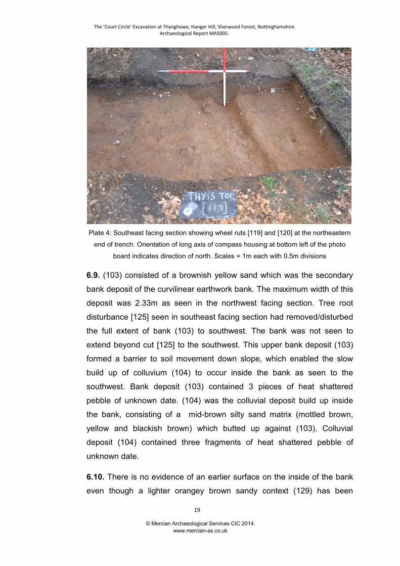
Plate 4: Southeast facing section showing wheel ruts [119] and [120] at thenortheastern end of trench.
19
Plate 5: Southeast facing Section showing the location of the sondage inthe south west corner of the trench adjacent to the section.
21
The ‘Court Circle’ Excavation at Thynghowe, Hanger Hill, Sherwood Forest, Nottinghamshire.Archaeological Report MAS005.
© Mercian Archaeological Services CIC 2014.www.mercian-as.co.uk
5
The Court Circle Excavation at Thynghowe,
Hanger Hill, Sherwood Forest, Nottinghamshire.
Archaeological Report
1. Summary
1.1. An excavation of earthworks in the vicinity of Hanger Hill, known
historically as Thynghowe, was undertaken in April 2013. The
excavation was carried out for the Friends of Thynghowe by Mercian
Archaeological Services CIC (Mercian). The excavation took place over
3 days from the 23rd -25th April 2013 alongside volunteers from the
Friends of Thynghowe who sieved 100% of the spoil generated. There
were a further 3 days of recording by Mercian. The work involved the
hand excavation of one 10m x 1.5m trench at right angles to the central
section of a curvilinear earthwork consisting of a bank and ditch and an
adjacent trackway. The location of the trench was at approximately
SK5998 6841, about 50m to the northeast of the summit of Hanger Hill.
The excavation was undertaken to investigate the nature of the
earthwork; to understand its original shape and dimensions and to
determine, if possible, the date of its construction and use. Also to
determine, if possible, the age of the adjacent trackway.
1.2. The excavations revealed that the bank and ditch were considerably
larger than the visible surface remains suggested. Evidence from the
excavation and the preceding topographic survey, LiDAR and historic
mapping suggests the feature may have originally formed part of a
circular enclosure with the bank on the inside of the ditch. Environmental
evidence does not directly suggest the enclosure was formed to enclose
and area of woodland (Mike Allen, pers comm.). If the earthwork was
originally circular the internal bank suggests the site was designed to
limit access to an internal space. This function, the location of the
feature at the extreme periphery of the Parish of Budby where the parish
adjoins two others (often ancient meeting sites are at the periphery of

The ‘Court Circle’ Excavation at Thynghowe, Hanger Hill, Sherwood Forest, Nottinghamshire.Archaeological Report MAS005.
© Mercian Archaeological Services CIC 2014.www.mercian-as.co.uk
6
landscapes) (Mallett et al 2012), and the spatial proximity to Hangar Hill
(a posited Viking assembly site) suggests that it is not impossible that
the enclosure may be associated with the possible Viking meeting site of
Thynghowe. The only artefacts recovered from the excavation (except
for CBM, iron and pottery all from the adjacent modern trackway) were
Heat Shattered Pebbles. These seem to have been deposited after the
ditch and bank were constructed. Their presence, combined with the
environmental evidence, indicates that a Bronze Age or Early Medieval
construction period for the bank and ditch is not impossible and may
even be most likely.
2. Project location, topography and geology
2.1. Site Location: The site is located near Hanger Hill (SK 599 683), in
the parish of Budby, Nottinghamshire, and is adjacent to the boundaries
of Edwinstowe and Warsop parishes.
Figure 1: Site Location
2.2 Topography: Hanger Hill is situated on a ridge of high ground
between the Maun Valley to the South and the valley of the River Meden
to the north. The hill itself stands at a height of 108m Ordnance Datum
The ‘Court Circle’ Excavation at Thynghowe, Hanger Hill, Sherwood Forest, Nottinghamshire.Archaeological Report MAS005.
© Mercian Archaeological Services CIC 2014.www.mercian-as.co.uk
7
Newlyn (ODN) and commands notable views over the Meden Valley to the
north. The site would have been a significant feature in the landscape from
this direction in antiquity (Gaunt 2010). The site also commands views to
the east, southeast and southwest (ibid).
2.3 Geology: Hanger Hill is located on the Nottingham Castle Sandstone
Formation - Sandstone, Pebbly (gravelly). This Sedimentary Bedrock
formed approximately 246 to 251 million years ago in the Triassic Period.
The local environment at the time of deposition was dominated by rivers;
depositing mainly sand and gravel detrital material in channels to form
river terrace deposits, with fine silt and clay from overbank floods forming
floodplain alluvium, and some bogs depositing peat; includes estuarine
and coastal plain deposits mapped as alluvium (www.BGS.ac.co.uk-
accessed 08/07/2013).
3. Archaeological and Historical Background
3.1. The English Place Names Society volume for Nottinghamshire
published in 1940 gives the derivation of Hanger Hill as “formerly
Thynghhowe”. Spellings include Thinghowe c1300 and Thingaw Hill in the
early 17th century. The origin of the name of Thynghowe is þing haugr (“þ”
is the Saxon letter thorn pronounced “th”), meaning ‘hill of assembly or
meeting place’ (Glover et al 1940).
3.2. A 14th century boundary perambulation of Birklands and Billhaugh,
possibly produced for the Forest Eyre of 1334 includes the place name
Thyghowe. This is recorded in ‘The Sherwood Forest Book’, edited by
Helen Boulton in 1964 . Boulton in her footnotes for the perambulation,
states “Hanger Hill, formerly Thynghowe” (1964, 54).
3.3. Tynghough Assart adjoins the hill to the northwest, between Warsop
and Budby, on an early 17th century map of Sherwood Forest. The map is
The ‘Court Circle’ Excavation at Thynghowe, Hanger Hill, Sherwood Forest, Nottinghamshire.Archaeological Report MAS005.
© Mercian Archaeological Services CIC 2014.www.mercian-as.co.uk
8
probably part of the Crown Survey of Sherwood Forest in 1609 by Richard
Bankes (PRO,MPF 295 [map 2] Mastoris & Groves 1997).
3.4. The location of Hanger Hill at the junction of a number of parishes
may explain its original name. It has however also been suggested as a
possible location for the meeting place of the wapentake of Bassetlaw
(Mallett et al 2012). An alternative site for the Bassetlaw Wapentake
meeting place has been suggested as Beacon Hill in East Markham
(Crook 1982).
3.5. Thynghowe may have alternatively been the meeting place for the
district of Hatfield which formed the western half of the Wapentake of
Bassetlaw (Mallett et al 2012).
3.6 In 2005 Thynghowe was rediscovered by Stuart Reddish and Lynda
Mallett using an 1816 perambulation document. The Friends of
Thynghowe was subsequently formed to interpret, record, and promote
the site. Recent work by the Friends of Thynghowe both at home and
abroad has suggested that the site is a ‘Thing’ site as seen in Scandinavia,
linking this site into a network of meeting sites stretching across northern
Europe (Reddish and Mallett 2012).
3.7. The Thynghowe site was subjected to a topographic survey in 2010
by Nottinghamshire County Council Community Archaeology (Gaunt
2010). The survey helped to place the site in its wider landscape context,
as well as identifying a number of earthworks including the curvilinear
earthwork investigated here. The wider landscape around Thynghowe
was also subject to a level one survey to record features and boundary
stones detected by the group (Gaunt 2010).
3.8. The site has been included in a University College London (UCL)
‘Landscapes of Governance’ project to record the meeting and assembly
sites of Britain. A geophysical (magnetometer) survey was undertaken by
The ‘Court Circle’ Excavation at Thynghowe, Hanger Hill, Sherwood Forest, Nottinghamshire.Archaeological Report MAS005.
© Mercian Archaeological Services CIC 2014.www.mercian-as.co.uk
9
Stuart Brookes and John Baker of UCL in 2011 (Baker & Brookes 2012)
as part of that project.
3.9. A LiDAR survey of Thynghowe and the surrounding landscape was
undertaken in 2012 by Geomatics Group- Environment Agency and the
data was processed by a team consisting of Simon Crutchley of English
Heritage, Peter Crow of Forest Research at the Forestry Commission,
Amy Chandler, Hugh Mannall and Tim Yarnell, all of the Forestry
Commission, Steve Horne and Lynda Mallett of the Friends of Thynghowe,
Ian Major of the Sherwood Forest Trust and Stuart Reddish of Public
Information Research Organisation. The results included the discovery of
a trackway subsequently identified as Nether Warsop Gate by Gaunt from
map source NRO ED 4 L. A series of ground-truthing sessions have
taken place to record and interpret features on the ground that were
detected by the recent LiDAR survey. The survey also confirmed the
existence of the curvilinear earthwork that had been recorded in the
topographic survey, and helped to suggest that the earthwork was
originally part of a circular enclosure (Thynghowe and the Forgotten
Heritage of Birklands, Heritage Lottery funded Project 2012).
3.10. A summary of the research and fieldwork up to end of 2011 has
been published in the Transactions of the Thoroton Society as: Mallett, L.,
Reddish S., Baker, J., Brookes, S., & Gaunt, A. 2012. Community
Archaeology at Thynghowe, Birklands, Sherwood Forest. Transactions of
the Thoroton Society 116 (Mallett et al 2012).
3.11. Map regression research by Steve Horne of the Friends of
Thynghowe has recently identified the curvilinear earthwork on a map of
1791 (NRO ED 4 L) and indicated that at this time it appeared to be part
of a near circular feature (Horne pers comm.)
3.12. Thynghowe has recently been added to the list of Thing sites across
the Viking diaspora and Scandinavia by the Thing Project
(www.thingproject.eu), helping to confirm the importance attributed to the
The ‘Court Circle’ Excavation at Thynghowe, Hanger Hill, Sherwood Forest, Nottinghamshire.Archaeological Report MAS005.
© Mercian Archaeological Services CIC 2014.www.mercian-as.co.uk
10
site by international academics.
4. Research Aims and Objectives
4.1. The objective of the project was to excavate a section across the
curvilinear earthwork described above in order to determine if the feature
was modern or of antiquity and to establish the nature of surviving
remains.
4.2. The excavation was also positioned to investigate and date the
adjacent trackway. The purpose was to determine whether the trackway
was part of Nether Warsop Gate as identified from the LiDAR and the
1791 map.
4.3. The excavation also aimed to address questions about the extent of
the Thynghowe site and to add to the interpretation of the monument and
its landscape.
4.4. Information from the excavation will form a key element in the
formation of a management plan for the conservation of the site.
4.5. The project was designed with the aim of potentially addressing the
following updated research agenda questions highlighted in the recent
publication: (Knight, Vyner and Allen 2012). East Midlands Heritage- An
Updated Research Agenda and Strategy for the Historic Environment of
the East Midlands.
4.6. 6.3 Neolithic and Early Bronze Age:
4.7. 6.3.4.1 Exploitation of different landscape zones: Can we further
refine our knowledge of the selective use of particular landscapes for ritual,
agricultural and other activities?
4.8. Research Objective 3F: Identify monument complexes and prioritise
The ‘Court Circle’ Excavation at Thynghowe, Hanger Hill, Sherwood Forest, Nottinghamshire.Archaeological Report MAS005.
© Mercian Archaeological Services CIC 2014.www.mercian-as.co.uk
11
for curatorial action.
4.9. 6.6 Early Medieval:
4.10. 6.6.7.5 The agricultural economy and rural landscape: To what
extent did woodland regenerate in the post-Roman period and how were
woodlands used and managed?
4.11. 6.6.1.5 Demography and the identification of political and social
groups: How can we refine our understanding of the chronology and
process of Scandinavian immigration during ninth and tenth centuries?
4.12. 6.6.4.1 Rural settlement patterns: What impact may Germanic and
Scandinavian immigration have had upon rural settlement patterns, and
how may place-name evidence contribute to studies of settlement
evolution?
4.13. Research objective 6F: Identify cultural boundaries in the Early
Medieval period.
4.14. Research objective 6G: Elucidate the development of the parochial
system.
4.15. 6.7 High Medieval:
4.16. 6.7.7.2 Manors and manorial estates: How did the medieval manor
and manorial estates develop from the Anglo-Saxon period, and what was
the impact of the Danelaw?
4.17 Research objective 7I: Investigate the development of the open-field
system and medieval woodland.
4.18 The project forms part of Mercian Archaeological Services CIC’s
research into the development of the landscape of Sherwood Forest.
The ‘Court Circle’ Excavation at Thynghowe, Hanger Hill, Sherwood Forest, Nottinghamshire.Archaeological Report MAS005.
© Mercian Archaeological Services CIC 2014.www.mercian-as.co.uk
12
5. Methodology
5.1. The excavation was undertaken by Mercian Archaeological Services
CIC, with spoil from all contexts being 100% sieved by volunteers from the
Friends Of Thynghowe.
5.2. During the excavation, Mercian supervisors taught volunteers various
aspects of archaeological method and theory, including excavation
techniques, recording techniques and conventions, site photography,
surveying and leveling, in order to increase understanding and experience
of archaeological theory and practice among the Friends of Thynghowe.
5.3. A 10 metre x 1.5 metre trench was excavated by hand across and at
right angles to the line of a section of the curvilinear earthwork over six
days in April 2013. The trench was centred at SK 5998 6841. The position
of the trench was such that it took in the point where the curvilinear
earthwork was closest to the adjacent trackway (figure 2), in order to
permit examination of both features within the one trench and to
determine the stratigraphic relationships between the two features, should
such relationships exist. Excavation proceeded by context, or by spits
where contexts happened to have an homogeneous appearance, but with
the context unit having absolute priority.

The ‘Court Circle’ Excavation at Thynghowe, Hanger Hill, Sherwood Forest, Nottinghamshire.Archaeological Report MAS005.
© Mercian Archaeological Services CIC 2014.www.mercian-as.co.uk
13
Figure 2: Trench Location.Contains Ordnance Survey data © Crown copyright and database right 2014
5.4. Excavation and reporting followed the IFA Code of Conduct (IFA
2012). Mercian also seek to follow best practice and standards and
guidance including IFA Standard and Guidance for Archaeological
Excavation (IFA 2008).
5.5. Environmental sampling on-site and post-sampling reporting was
undertaken by Allen Environmental Archaeology.
5.6. Metal detecting by an experienced and responsible metal detectorist
was undertaken on the spoil heaps to ensure no metallic objects were
missed and all artefacts thus recovered were added to the site archive.
5.7. Sections of features were recorded at a scale of 1:10. They were
recorded to include context changes and context numbers, Ordnance
Survey heights and other necessary features. Drawings include dashed
lines where the change between contexts was not discernible in the field
or was too diffuse for precise recording (see sections and plans in

The ‘Court Circle’ Excavation at Thynghowe, Hanger Hill, Sherwood Forest, Nottinghamshire.Archaeological Report MAS005.
© Mercian Archaeological Services CIC 2014.www.mercian-as.co.uk
14
Appendix I).
5.8. Section lines were located on the site plan (see Appendix I).
5.9. Digital photographs using a DSLR with resolution of greater than 6
megapixels were taken of each context before removal, along with
general views of the excavation and the most relevant features.
5.10. A context record sheet was filled in for each context using Mercian
context record sheets, which follow the conventions set out in the
Museum of London Archaeological Field Manual (MoLAS 1994).
5.11. A context register was completed on-site to record contexts as they
were encountered.
5.12. A site note book was kept of the excavation.
5.13. X, Y and Z values were recorded on a Leica TCR805 Total Station.
A Temporary Benchmark (TBM) was established on-site and control
points established. An arbitrary height was given to the TBM for in the
field recording. Corrections were then made to the measurements from
LiDAR data to give absolute heights for the data. LiDAR is accurate to +/-
100mm (Crutchley 2010) which complies with English Heritage
requirements for control of archaeological survey (Lutton 2003).
5.14. An OASIS entry pertaining to the work has been created. The
OASIS identifier for the project is merciana2-187445. Mercian will also
publish downloadable versions of the report via our online documents
stores.
5.15. A summary of the work was published in the Archaeological Short
Reports section of the Transactions of the Thoroton Society Volume 117
for 2013 (pp29 - 30).
5.16. Pottery was processed on site and following the fieldwork, by David
Budge of Mercian. The recording and quantification fulfilled the ‘Minimum
Standards’ published by the MPRG (MPRG 2001).
The ‘Court Circle’ Excavation at Thynghowe, Hanger Hill, Sherwood Forest, Nottinghamshire.Archaeological Report MAS005.
© Mercian Archaeological Services CIC 2014.www.mercian-as.co.uk
15
5.17. Heat Shattered Pebbles were analysed by David Budge.
5.18. Lithics and Iron Objects were analysed by David Budge.
5.19. Environmental Samples were taken on-site by Michael Allen of Allen
Environmental Archaeology, these included: Bulk samples from basal fills,
Monolith sample of the ditch and bank profiles and Kubiena tin samples.
Samples have been preserved for future analysis. Should the client desire,
Monolith and Kubiena samples will be subsampled for pollen, and the
Kubiena sample considered for soil thin section manufacture.
5.20. A basic environmental description from field observations and
preliminary examination of the samples by Allen Environmental
Archaeology was produced to give a broad assessment of the
depositional environment at the time that the bank and ditch were
constructed (Appendix VII). Further information has also been provided by
Mike Allen by personal communication.
5.21. The finds from the excavation and records have been given to the
Friends of Thynghowe Group, and copies of the records are held by
Mercian Archaeological Services CIC.
6. Results
6.1. The trench was circa 10m in length (southeast facing section being
9.89m and the northwest facing section measuring 9.96m). A layer of leaf
mulch (101) dark orange brown in colour appeared to seal the entire
trench on initial excavation except for an area of tree root disturbance
towards the northeast. It could be seen in the southeast facing section
that (101) was truncated by [116], an area of tree root disturbance
including the remains of a large decomposing tree root (114). Above tree
disturbance (114) lay a deposit of mid orangey brown leaf mulch (123)
which appeared to be composed of a more recent accumulation of leaf fall.
6.2. Context (101) lay directly upon a blackish brown soil (102). Below
(102) was context (109) consisting of a greyish brown silty sand with white

The ‘Court Circle’ Excavation at Thynghowe, Hanger Hill, Sherwood Forest, Nottinghamshire.Archaeological Report MAS005.
© Mercian Archaeological Services CIC 2014.www.mercian-as.co.uk
16
(quartzite) flecks, this deposit lay in a depression formed by ditch cut [110].
Beneath (109) lay a deposit of slightly mottled reddish brown sand (117),
which included some silt and has been interpreted as a soil formed in an
area of heath land. This suggests that the landscape was open with little
or no tree canopy in antiquity (Appendix VII).
6.3. In the northwest facing section (117) was seen to seal upper bank
deposit (103), though in the southwest facing section tree root disturbance
had removed/truncated this relationship and (117) was not seen to
continue on the southwest side of cut [125]. (117) also part covers
contexts (104) and (105). Of note here is the fact that preserved
archaeological deposits, specifically bank deposit (103), lay buried a mere
0.12m below the surface.
6.4. Ditch [110] was irregular in profile being steeper on the northeast side:
in the southeast facing section it was seen to be 1.20m wide and 0.45m
deep; in the northwest facing section the ditch cut was 1.15m wide and
0.35m deep. It was observed in section that upper bank deposit (103)
appeared to be slumping forward into the ditch (towards
northeast).
Plate 1: Northwest facing section, showing bank (103), (122), (127) and (128) in centre,
the ditch [110] is to the left and (104) to the right hand side. Scales = 1m long with 0.5m
divisions.
The ‘Court Circle’ Excavation at Thynghowe, Hanger Hill, Sherwood Forest, Nottinghamshire.Archaeological Report MAS005.
© Mercian Archaeological Services CIC 2014.www.mercian-as.co.uk
17
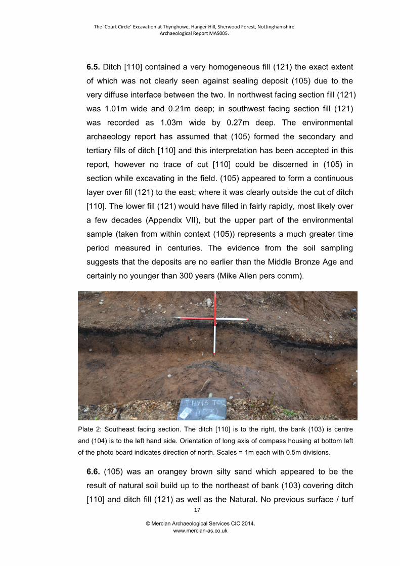
6.5. Ditch [110] contained a very homogeneous fill (121) the exact extent
of which was not clearly seen against sealing deposit (105) due to the
very diffuse interface between the two. In northwest facing section fill (121)
was 1.01m wide and 0.21m deep; in southwest facing section fill (121)
was recorded as 1.03m wide by 0.27m deep. The environmental
archaeology report has assumed that (105) formed the secondary and
tertiary fills of ditch [110] and this interpretation has been accepted in this
report, however no trace of cut [110] could be discerned in (105) in
section while excavating in the field. (105) appeared to form a continuous
layer over fill (121) to the east; where it was clearly outside the cut of ditch
[110]. The lower fill (121) would have filled in fairly rapidly, most likely over
a few decades (Appendix VII), but the upper part of the environmental
sample (taken from within context (105)) represents a much greater time
period measured in centuries. The evidence from the soil sampling
suggests that the deposits are no earlier than the Middle Bronze Age and
certainly no younger than 300 years (Mike Allen pers comm).
Plate 2: Southeast facing section. The ditch [110] is to the right, the bank (103) is centre
and (104) is to the left hand side. Orientation of long axis of compass housing at bottom left
of the photo board indicates direction of north. Scales = 1m each with 0.5m divisions.
6.6. (105) was an orangey brown silty sand which appeared to be the
result of natural soil build up to the northeast of bank (103) covering ditch
[110] and ditch fill (121) as well as the Natural. No previous surface / turf
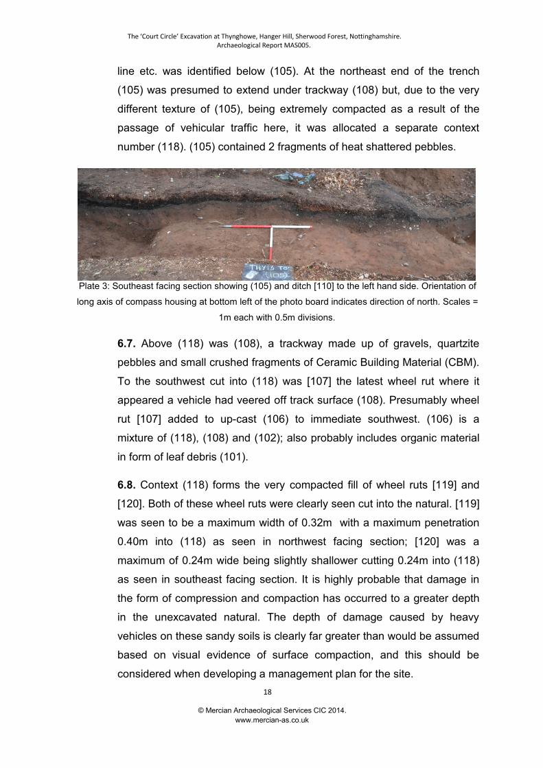
The ‘Court Circle’ Excavation at Thynghowe, Hanger Hill, Sherwood Forest, Nottinghamshire.Archaeological Report MAS005.
© Mercian Archaeological Services CIC 2014.www.mercian-as.co.uk
18
line etc. was identified below (105). At the northeast end of the trench
(105) was presumed to extend under trackway (108) but, due to the very
different texture of (105), being extremely compacted as a result of the
passage of vehicular traffic here, it was allocated a separate context
number (118). (105) contained 2 fragments of heat shattered pebbles.
Plate 3: Southeast facing section showing (105) and ditch [110] to the left hand side. Orientation of
long axis of compass housing at bottom left of the photo board indicates direction of north. Scales =
1m each with 0.5m divisions.
6.7. Above (118) was (108), a trackway made up of gravels, quartzite
pebbles and small crushed fragments of Ceramic Building Material (CBM).
To the southwest cut into (118) was [107] the latest wheel rut where it
appeared a vehicle had veered off track surface (108). Presumably wheel
rut [107] added to up-cast (106) to immediate southwest. (106) is a
mixture of (118), (108) and (102); also probably includes organic material
in form of leaf debris (101).
6.8. Context (118) forms the very compacted fill of wheel ruts [119] and
[120]. Both of these wheel ruts were clearly seen cut into the natural. [119]
was seen to be a maximum width of 0.32m with a maximum penetration
0.40m into (118) as seen in northwest facing section; [120] was a
maximum of 0.24m wide being slightly shallower cutting 0.24m into (118)
as seen in southeast facing section. It is highly probable that damage in
the form of compression and compaction has occurred to a greater depth
in the unexcavated natural. The depth of damage caused by heavy
vehicles on these sandy soils is clearly far greater than would be assumed
based on visual evidence of surface compaction, and this should be
considered when developing a management plan for the site.
The ‘Court Circle’ Excavation at Thynghowe, Hanger Hill, Sherwood Forest, Nottinghamshire.Archaeological Report MAS005.
© Mercian Archaeological Services CIC 2014.www.mercian-as.co.uk
19
Plate 4: Southeast facing section showing wheel ruts [119] and [120] at the northeastern
end of trench. Orientation of long axis of compass housing at bottom left of the photo
board indicates direction of north. Scales = 1m each with 0.5m divisions
6.9. (103) consisted of a brownish yellow sand which was the secondary
bank deposit of the curvilinear earthwork bank. The maximum width of this
deposit was 2.33m as seen in the northwest facing section. Tree root
disturbance [125] seen in southeast facing section had removed/disturbed
the full extent of bank (103) to southwest. The bank was not seen to
extend beyond cut [125] to the southwest. This upper bank deposit (103)
formed a barrier to soil movement down slope, which enabled the slow
build up of colluvium (104) to occur inside the bank as seen to the
southwest. Bank deposit (103) contained 3 pieces of heat shattered
pebble of unknown date. (104) was the colluvial deposit build up inside
the bank, consisting of a mid-brown silty sand matrix (mottled brown,
yellow and blackish brown) which butted up against (103). Colluvial
deposit (104) contained three fragments of heat shattered pebble of
unknown date.
6.10. There is no evidence of an earlier surface on the inside of the bank
even though a lighter orangey brown sandy context (129) has been
The ‘Court Circle’ Excavation at Thynghowe, Hanger Hill, Sherwood Forest, Nottinghamshire.Archaeological Report MAS005.
© Mercian Archaeological Services CIC 2014.www.mercian-as.co.uk
20
recorded in the northwest facing section. It is believed this is part of the
build up of colluvium inside bank (103), or that it is the same as (128) (see
below). It could be that (128) represents an earlier phase of the bank, but
it may be that it represents a buried original soil layer (see 6.12).
6.11. In the northwest facing section bank (103) could be seen in more
detail and appeared to show signs of slumping both to northeast into the
ditch as well as to the southwest. Beneath this was context (122) a ‘dirty’
mid yellowish brown silty sand which formed the lower bank deposit,
1.61m in width with a maximum thickness 0.29m. It seems likely that (122)
was formed by the up cast spoil from ditch cut [110]. Under (103) and
above (122) was a thin layer, (127), only a few millimetres thick, and
identified as a turf line (Appendix VII). This is evidence that the bank (122)
existed long enough for turf to develop on it, or that turf was laid on it to
give it stability, and (103) is evidence of the bank being reconstructed
(increased in height), and/or maintained. (103) is lighter in colour and
'cleaner' than (122), suggesting it was most likely constructed using
'natural' sand with very low organic content. The nearest and most easily
accessible source of such sand is likely to have been the bottom of ditch
[110], though no other evidence for the re-cutting of this ditch was
encountered.
6.12. Below this was (128), width 1.57m and a maximum thickness of
0.14m, which may be either the original surviving ground surface
(Appendix VII) prior to the bank being constructed or evidence of an
earlier bank. If the latter, no evidence was seen for an earlier ditch cut
prior to [110]. It is possible that ditch [110] has removed any evidence of
an earlier ditch feature. Of interest context (129) to the southwest was of a
similar thickness to (128), being 0.15m, which if (128) is considered to be
a surviving early soil then possibly (129) could be part of that horizon.
Unfortunately no turf line was seen above (128) or (129) to confirm this.
6.13. A sondage was excavated in the south western corner of the trench
adjacent to the southeast facing section. This was undertaken to confirm
The ‘Court Circle’ Excavation at Thynghowe, Hanger Hill, Sherwood Forest, Nottinghamshire.Archaeological Report MAS005.
© Mercian Archaeological Services CIC 2014.www.mercian-as.co.uk
21
that the deposit underlying (104) was indeed the undisturbed 'natural'. It
was.
Plate 5: Southeast facing section showing the location of the sondage in the south west
corner of the trench adjacent to the section. Orientation of long axis of compass housing
at bottom left of the photo board indicates direction of north. Scales = 1m each with 0.5m
divisions.
7. Discussion
7.1. The bank and ditch were sealed by context (102) this was a forest or
woodland soil which had built up during the life span of the current
plantation (Mike Allen Appendix VII).
7.2. The surviving earthwork on the surface consists of a bank 0.42m high
and a ditch 20mm deep.
7.3. Excavation has demonstrated that, due to the protection afforded to
the archaeological remains by colluviation, the archaeological remains are
far more significant than the surviving earthworks immediately suggest.
The bank survives to a height of 0.52m above the original ground surface
and has a width of up to 2.33m while the associated ditch is approximately
0.45m deep and 1.20m wide.
The ‘Court Circle’ Excavation at Thynghowe, Hanger Hill, Sherwood Forest, Nottinghamshire.Archaeological Report MAS005.
© Mercian Archaeological Services CIC 2014.www.mercian-as.co.uk
22
7.4. Excavation demonstrated that the track way is of 20th century date
and revealed no evidence for any earlier track in this location, suggesting
the present track was not part of an earlier route that can, in other
locations, be identified from cartographic and documentary evidence as
Nether Warsop Gate.
7.5. Topographic survey (Gaunt 2010), LiDAR results (2012), and Historic
Mapping evidence (NRO ED 4 L) from 1791 suggests that the bank and
ditch may have originally formed part of a circular enclosure.
7.6. If this was the case then the excavation demonstrated that the bank
was internal to the ditch.
7.7. Environmental evidence from the excavation suggests that the area
was not under woodland canopy during the construction or infilling of the
bank and ditch (Mike Allen, pers comm.). If the original earthwork was a
circular enclosure this rules out the possibility that it functioned as a wood
bank to support a hedge to protect saplings in a hay or coppice.
7.8. Environmental analysis of the soils of the secondary and tertiary fill of
the ditch (Appendix VII) identified as (105) in the excavation suggests that
the soil developed over a timescale measured in centuries. Personal
communication with Dr Allen suggests that a period of at least 300 years
would be required for the soil to build up regardless of when it began
infilling.
7.9. Cartographic evidence from 1791 shows that the earthwork was
significant enough to warrant recording at that time. The map does not
however indicate a function for the site and does not indicate the condition
of the bank and ditch, thus it is not possible to infer from this source
whether the earthwork was newly constructed or substantially silted at this
time.
7.10 Environmental evidence suggests that the secondary and tertiary fills
of the ditch (105) would not date from before the Middle Bronze Age
(Allen, M, pers comm).
The ‘Court Circle’ Excavation at Thynghowe, Hanger Hill, Sherwood Forest, Nottinghamshire.Archaeological Report MAS005.
© Mercian Archaeological Services CIC 2014.www.mercian-as.co.uk
23
7.11. Although this is a wide date range, from Middle Bronze Age to 300
years ago, this range can be narrowed through analysis of finds.
7.12. The only artefacts recovered from the excavation (associated with
the ditch fills, bank and soil build ups discussed above) were Heat
Shattered Pebbles (HSPs) (Appendix III). There were no ceramic finds in
any context except those associated with the adjacent modern track way.
7.13. The Heat Shattered Pebbles found in the excavations could not be
directly associated with the construction of the bank and ditch. However,
their absence in the initial construction deposits and primary ditch silts and
presence in the stratigraphically later deposits – being: bank
enhancement; colluvial deposit; soils built up after the construction -
raises two possible interpretations, either that the HSPs were produced by
activity following the construction of the bank and ditch, or that they come
from earlier activity and were only mobilised by activities within the
enclosure following its construction (Appendix III).
7.14. HSPs are found in many prehistoric contexts from the late Neolithic
onwards (Appendix III).
7.15. One possible interpretation of the earthwork is that it is part of an
enclosure associated with the Brickwork Plan Field System (Garton 2008),
similar to the nearby Hayman Rooke Enclosure, which may date from this
period (Gaunt 2009). Such an interpretation would assign a Romano-
British date to the site. However, enclosures where HSP are common in
these field systems are also abundant in ceramic finds of the period
(Garton 2008). The lack of such ceramics in the excavations at
Thynghowe suggests this interpretation may not be the most appropriate.
7.16. The HSP analysis for the site suggests they are very unlikely to
come from a burnt mound and are more likely to derive from small scale
cooking or possibly brewing activity. Scant evidence from England and
Wales along with slightly more comprehensive evidence from Ireland
indicates an early medieval date for the creation of the HSPs is not
The ‘Court Circle’ Excavation at Thynghowe, Hanger Hill, Sherwood Forest, Nottinghamshire.Archaeological Report MAS005.
© Mercian Archaeological Services CIC 2014.www.mercian-as.co.uk
24
impossible, while the lack of other artefact types suggests activity on the
site may have occurred during a chronological period when durable
artefacts such as flint and ceramics were scarce (Appendix III).
7.17. It should be noted that further excavation may reveal finds that were
absent from this investigation, and also Radiocarbon Dating of
environmental deposits planned for the future may prove these theories to
be inaccurate. However at this time there is no evidence from the
excavation or subsequent analysis of soils and artefacts to prove that the
monument is not of early medieval date, and the general lack of
artefactual evidence tentatively suggests that construction during the early
medieval period may even be more likely than other periods.
7.18. The curvilinear earthwork is situated adjacent to the site of the
posited Viking Age meeting place of Thynghowe (Mallett et al 2012). This
site may well have Bronze Age origins as a burial mound (ibid.)
Combination of environmental evidence and HSP analysis suggest the
Bronze Age or the Early Medieval period as possible contenders for the
creation of the feature. If the feature was originally circular then the south-
western edge of the circle runs against the north-eastern edge of the
Thynghowe mound.
7.19. The curvilinear earthwork excavated is located at the extreme south-
western periphery of the parish of Budby. The parish boundary at this
location extends in a rectangle around an area of land which includes the
curvilinear earthwork. Budby parish boundary meets the parish
boundaries of Edwinstowe and Warsop on top of the mound of
Thynghowe; 3 stones mark their meeting (Mallett et al 2012). It is
assumed that the Budby parish boundary has followed this line since the
Early Medieval period; meeting the other parishes as it does on top of the
mound. The boundary is depicted this way on Sanderson's 1835 Map of
20 Miles Around Mansfield. It is possible that this part of the parish
boundary extends to include the curvilinear earthwork which may have
originally formed a circular enclosure, and other features to the north
The ‘Court Circle’ Excavation at Thynghowe, Hanger Hill, Sherwood Forest, Nottinghamshire.Archaeological Report MAS005.
© Mercian Archaeological Services CIC 2014.www.mercian-as.co.uk
25
which could be associated with the meeting site of Thynghowe (pers
comm Stuart Reddish).
7.20. It is plausible that this enclosure could be associated with
Thynghowe. The location of this site at the extreme periphery of Budby
parish adjacent to Thynghowe suggests that it could be associated with
the meeting site. If the earthwork was originally a circular enclosure it was
designed to limit access to an internal space, not designed for the
containment of livestock or as a wooded enclosure (Appendix VII).
7.21. It has been suggested by Stuart Reddish (pers comm) that, if the
feature was originally circular and is part of the monumental landscape of
Thynghowe, it could have functioned as a 'court circle' associated with
activities of a Viking site. Although such a function has not been proved by
this excavation, evidence to disprove it was not forthcoming either.
7.22. It should be noted that no case in England has been found where an
enclosure can be genuinely associated with an assembly mound and such
features are also rare in Nordic countries. However Thynghowe is posited
to be a rare example of a 'pristine' assembly site where the larger
landscape context and chronological development can be evaluated
(Mallett et al 2012). Thynghowe is potentially therefore a site of national
and international importance, which may indeed provide the only
opportunity for such features as 'court circles' to survive.
7.23. As previously stated it should be noted that further archaeological
excavation could prove the above suggestions to be incorrect. If further
work was undertaken it could help to gain a better understanding of the
site, not least as only the opening of a larger area over the bank and ditch
would be able to detect traces of deliberate, regular features such as post
holes or palisades.
7.24. Further interventions on the ditch and bank, combined with
geophysical survey could help to confirm if it was a complete circular
enclosure. Further environmental analysis including Radiocarbon dating
The ‘Court Circle’ Excavation at Thynghowe, Hanger Hill, Sherwood Forest, Nottinghamshire.Archaeological Report MAS005.
© Mercian Archaeological Services CIC 2014.www.mercian-as.co.uk
26
would potentially enable an absolute date for the feature to be gained and
confirm or deny its association with a Bronze Age, Viking or Early
Medieval monumental landscape.
7.25. Samples taken during this excavation have been preserved by Allen
Environmental Archaeology for future analysis should the opportunity
arise.
7.26. Geophysical survey would also be desirable within the area
enclosed by the feature to look for evidence of occupation or use, and
also in the immediate hinterland of Thynghowe to determine whether
other enclosures or features exist.

The ‘Court Circle’ Excavation at Thynghowe, Hanger Hill, Sherwood Forest, Nottinghamshire.Archaeological Report MAS005.
© Mercian Archaeological Services CIC 2014.www.mercian-as.co.uk
27
8. Bibliography
A Short Guide to GPS. 2004. British Archaeological Jobs Resource.
Ainsworth, S., Bowden, M., McOmish, D. & Pearson, T. 2007. Understanding theArchaeology of Landscape. English Heritage.
Ainsworth, S. & Thomason, B. 2003. Where on Earth are We? The GlobalPositioning System (GPS) in archaeological field survey. English Heritage.
Archaeological Ceramic Building Materials Group, 2002, Ceramic Building Material,Minimum Standards for the Recovery, Curation, Analysis and Publication. Draftdocument
Bannister, A., Raymond, S. and Baker, R. 1998. Surveying. Longman, Essex.
Barfield, L. and Hodder, M. (1987) Burnt mounds as saunas, and the prehistory ofbathing. Antiquity 61: 370-379
Barley, M.W. 1986. Sherwood Forest, in Skelton, R.A & Harvey P.D.A., (eds), LocalMaps and plans from medieval England (Clarendon Press, 1986).
Beamish, M G, 2001, Neolithic Acivity on the Trent Floodplain, DerbyshireArchaeological Journal 121: 9-17,
Beamish, M G and Ripper, S A, 2000, Burnt Mounds in the East Midlands, Antiquity75: 37-8
Bettess, F. 1990. Surveying for Archaeologists. Penshaw Press: University ofDurham.
Boulton, H.E., (ed), 1965. The Sherwood Forest Book, Thoroton Society RecordSeries XXIII
Bowden, M. 1999. Unravelling the landscape. An inquisitive Approach toArchaeology. Tempus, Stroud.
Brown, A. 1987. Fieldwork for Archaeologists and Historians. Batsford, London.
Chapman, H. 2006. Landscape Archaeology and GIS. Tempus.
Crook, D. 1982. The location of ‘Bassetlaw’, Transactions of the Thoroton SocietyLXXXVI.
Crutchley, S. 2010. The Light Fantastic: Using airborne lidar in archaeological survey.English Heritage Publishing.
Deutsches Museum, nd, http://www.deutsches-museum.de/en/exhibitions/werkstoffe-produktion/agriculture/brewing/, accessed
The ‘Court Circle’ Excavation at Thynghowe, Hanger Hill, Sherwood Forest, Nottinghamshire.Archaeological Report MAS005.
© Mercian Archaeological Services CIC 2014.www.mercian-as.co.uk
28
21/11/13
English Heritage, 2011 Introductions to Heritage Assets – Animal Management
English Heritage, 1997 Sustaining the historic environment: new perspectives on thefuture
English Heritage, 1991 Exploring our Past. Strategies for the Archaeology ofEngland
English Heritage, 1991 Management of Archaeological Projects (MAP2)
Gaunt, A. 2009. An Ancient Work in Birkland- A topographic survey of an earthworkin Sherwood Forest National Nature Reserve. Unpublished report forNottinghamshire County Council. Report No. NCA-003.
Gaunt, A. 2010. A topographic earthwork survey of Thynghowe. Hanger Hill,Nottinghamshire. Unpublished Report for Nottinghamshire County Council. ReportNo. NCA-016.
Gaffney, C. & Gater J. 2006. Revealing the Buried Past: Geophysics forArchaeologists. Tempus Publishing.
Garton, D. 2008. The Romano-British landscape of the Sherwood Sandstone ofNottinghamshire: fieldwalking the Brickwork-Plan Field-Sytstems. Transactions of theThoroton Society 112.
Glover, J. E. B., Mawer, A. & Stenton, F. M. 1940. Placenames of Nottinghamshire.English Placenames Society. Vol. XVII
Hawker, J M, 2001, A Manual of Archaeological Field Drawing (new edition),RESCUE.
Hawkes, A, 2011, Medieval Fulachtaí Fia in Ireland? An Archaeological AssessmentJournal of Irish Archaeology 20: 77-100
Howard, P. 2007. Archaeological Surveying and Mapping. Routledge, Oxford.
IFA, 2012, By-laws. Code of Conduct, Institute of Field Archaeologists, Reading.
IFA 1994 (updated) 2008. Standards and Guidance: for Archaeological Excavation.Institute of Field Archaeologists.
Jeffrey, S. 1991. Burnt Mounds, Fulling and Early Textiles? in Burnt Mounds and HotStone Technology.
Knight, D and Howard, A J, 2004, Trent Valley Landscapes
Lutton, S. 2003. Metric Survey Specifications for English Heritage. English Heritage.
Mallett, L., Reddish, S., Baker, J., Brookes, S. and Gaunt, A. 2012. CommunityArchaeology at Thynghowe, Birklands, Sherwood Forest. Transactions of the
The ‘Court Circle’ Excavation at Thynghowe, Hanger Hill, Sherwood Forest, Nottinghamshire.Archaeological Report MAS005.
© Mercian Archaeological Services CIC 2014.www.mercian-as.co.uk
29
Thoroton Society 116.
Mastoris, S. and Groves, S. 1997. Sherwood Forest in 1609. A crown survey byRichard Bankes. Thoroton Record Series XL.
Medieval Pottery Research Group, 2001, Minimum Standards for the Processing,Recording, Analysis and Publication of Post-Roman Ceramics, MPRG OccasionalPaper no. 2
Medieval Pottery Research Group, 2001, Minimum Standards for the Processing,Recording, Analysis and Publication of Post-Roman Ceramics.
Medieval Pottery Research Group, 2011, A Research Framework for Post-RomanCeramic Studies in Britain, MPRG occasional paper no. 6
MoLAS, 1994, Archaeological Site Manual, Museum of London, London.
Muir, R. 2004. Landscape Encyclopaedia: A reference guide to the HistoricLandscape Windgather Press.
Nailor, V and Young, J, 2001, A Fabric Type Series for Post Roman Pottery fromNottingham City (5th – 16th Centuries), Unpublished Report for Nottingham CityMuseum.
National Monuments Record Thesauri. © English Heritage 1999 NationalMonuments Record Centre
Palfreyman, A, 2001. Report on the Excavation of a Romano-British Aisled Buildingat Little Hay Grange Farm, Ockbrook, Derbyshire 1994 –97. DerbyshireArchaeological Journal 121: 70 - 161
Perry, G, 2011, Beer, Butter and Burial, The Pre-Burial Origins of Cremation Urnsfrom the early Anglo-Saxon Cemetery of Cleatham, North Lincolnshire. MedievalCeramics 32: 9 - 22
Quinn, W and Moore, D, 2007, Ale, Brewing and Fulacht Fiadh. Archaeology Ireland21.3: 8 –11
Ripper, S A, 2004. Bodies, Burnt Mounds and Bridges: A Riverine Landscape atWatermead Country Park, Birstall, Unpublished ULAS Document.
Sysila, I, 1998, Sahti – A Remnant of Finland’s Rustic Past. Brewing Techniques 6.4,article accessed online athttp://morebeer.com/brewingtechniques/library/styles/6_4style.html, accessed20/11/2013
Survey Basics – Laying out a Trench and Levelling. 2005. British ArchaeologicalJobs & Resources.
Watkinson, D E and Neale, V, 1998, First Aid for Finds. Rescue / UKIC third edition
Williams, G. 1990. Burnt mounds in south-west Wales. In V. Buckley (ed.), Burnt
The ‘Court Circle’ Excavation at Thynghowe, Hanger Hill, Sherwood Forest, Nottinghamshire.Archaeological Report MAS005.
© Mercian Archaeological Services CIC 2014.www.mercian-as.co.uk
30
offerings: international contributions to burnt mound archaeology, 129–39.
Young, J, Vince, A, and Nailor, V, 2005, A Corpus of Anglo-Saxon and MedievalPottery from Lincoln, Lincoln Archaeological Studies.
Websites:
http://www.bajr.org
http://www.bgs.ac.uk
http://www.english-heritage.org.uk
http://www.leica-geosystems.com
http://smartnet.leica-geosystems.co.uk
http://www.thingproject.eu
http://totalstation.org/total-stations-functionality.php
Maps:
NRO ED 4 L. A Plan of the Hays of Birkland and Bilhaugh within the Forest ofSherwood in the County of Nottingham belonging to the Crown. Surveyed in 1791 byJohn Renshaw.
The ‘Court Circle’ Excavation at Thynghowe, Hanger Hill, Sherwood Forest, Nottinghamshire.Archaeological Report MAS005.
© Mercian Archaeological Services CIC 2014.www.mercian-as.co.uk
31
9. Acknowledgments:
Mercian Archaeological Services CIC would like to than the Friends of Thynghowe;and in particular Lynda Mallett, Stuart Reddish and Steve Horne for their hard workand research, and for their continuous help and assistance.
All volunteers (particularly Sue and Bob Longden) who helped with sieving and theexcavation.
Amy Chandler, Hugh Manell and Tim Yarnell of the Forestry Commission for accessto the site and support throughout.
The Forestry Commission and the Thorseby Estate for permission to excavate thesite.
The Heritage Lottery Fund for funding the excavation.
10. Disclaimer:
©Mercian Archaeological Services CIC 2014.
Mercian Archaeological Services CIC and the individual authors retain copyright onall reports and documentation produced as part of the project under the Copyright,Designs and Patents Act 1988 with all rights reserved. However, they will providelicence for the client to use the documents and reports for matters related to theproject.
Licence is also granted for the document to be included in the County HistoricEnvironment Record, where it will be publicly accessible.
Mercian Archaeological Services CIC should always be credited when references orimages are used and permission to reproduce this document in whole or part can besought from the authors.
Mercian Archaeological Services CIC is a limited company registered in England andWales. Company Registration No. 08347842.
The ‘Court Circle’ Excavation at Thynghowe, Hanger Hill, Sherwood Forest, Nottinghamshire.Archaeological Report MAS005.
© Mercian Archaeological Services CIC 2014.www.mercian-as.co.uk
32
Appendix I:
Sections and Plans

© Mercian Archaeological Services CIC 2014.www.mercian-as.co.uk
33
Figure 3: Southeast facing section
Figure 4: Northwest facing section.
The ‘Court Circle’ Excavation at Thynghowe, Hanger Hill, Sherwood Forest, Nottinghamshire.Archaeological Report MAS005.
© Mercian Archaeological Services CIC 2014.www.mercian-as.co.uk
34
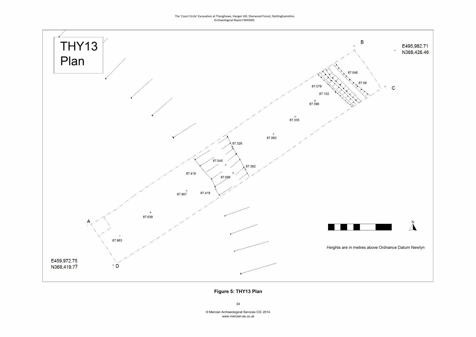
Figure 5: THY13 Plan

© Mercian Archaeological Services CIC 2014.www.mercian-as.co.uk
35
Appendix II:
Context Register and Site Matrix
© Mercian Archaeological Services CIC 2014.www.mercian-as.co.uk
36
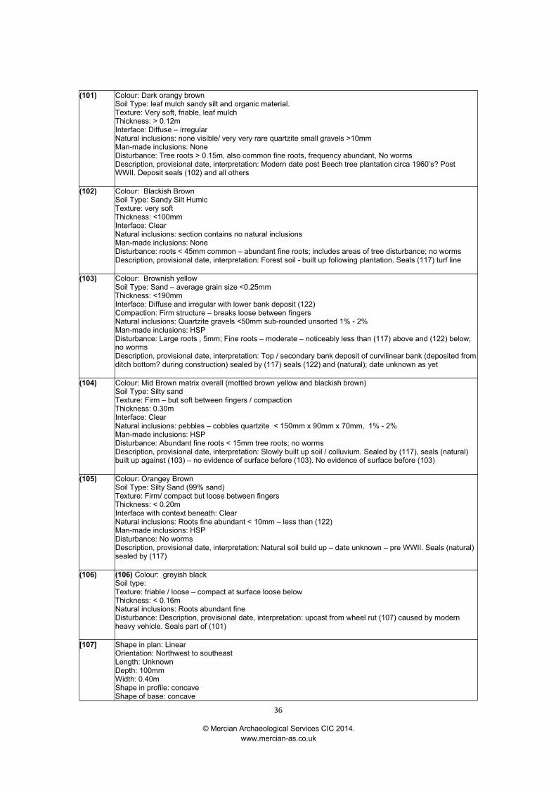
(101) Colour: Dark orangy brownSoil Type: leaf mulch sandy silt and organic material.Texture: Very soft, friable, leaf mulchThickness: > 0.12mInterface: Diffuse – irregularNatural inclusions: none visible/ very very rare quartzite small gravels >10mmMan-made inclusions: NoneDisturbance: Tree roots > 0.15m, also common fine roots, frequency abundant, No wormsDescription, provisional date, interpretation: Modern date post Beech tree plantation circa 1960’s? PostWWII. Deposit seals (102) and all others
(102) Colour: Blackish BrownSoil Type: Sandy Silt HumicTexture: very softThickness: <100mmInterface: ClearNatural inclusions: section contains no natural inclusionsMan-made inclusions: NoneDisturbance: roots < 45mm common – abundant fine roots; includes areas of tree disturbance; no wormsDescription, provisional date, interpretation: Forest soil - built up following plantation. Seals (117) turf line
(103) Colour: Brownish yellowSoil Type: Sand – average grain size <0.25mmThickness: <190mmInterface: Diffuse and irregular with lower bank deposit (122)Compaction: Firm structure – breaks loose between fingersNatural inclusions: Quartzite gravels <50mm sub-rounded unsorted 1% - 2%Man-made inclusions: HSPDisturbance: Large roots , 5mm; Fine roots – moderate – noticeably less than (117) above and (122) below;no wormsDescription, provisional date, interpretation: Top / secondary bank deposit of curvilinear bank (deposited fromditch bottom? during construction) sealed by (117) seals (122) and (natural); date unknown as yet
(104) Colour: Mid Brown matrix overall (mottled brown yellow and blackish brown)Soil Type: Silty sandTexture: Firm – but soft between fingers / compactionThickness: 0.30mInterface: ClearNatural inclusions: pebbles – cobbles quartzite < 150mm x 90mm x 70mm, 1% - 2%Man-made inclusions: HSPDisturbance: Abundant fine roots < 15mm tree roots; no wormsDescription, provisional date, interpretation: Slowly built up soil / colluvium. Sealed by (117), seals (natural)built up against (103) – no evidence of surface before (103). No evidence of surface before (103)
(105) Colour: Orangey BrownSoil Type: Silty Sand (99% sand)Texture: Firm/ compact but loose between fingersThickness: < 0.20mInterface with context beneath: ClearNatural inclusions: Roots fine abundant < 10mm – less than (122)Man-made inclusions: HSPDisturbance: No wormsDescription, provisional date, interpretation: Natural soil build up – date unknown – pre WWII. Seals (natural)sealed by (117)
(106) (106) Colour: greyish blackSoil type:Texture: friable / loose – compact at surface loose belowThickness: < 0.16mNatural inclusions: Roots abundant fineDisturbance: Description, provisional date, interpretation: upcast from wheel rut (107) caused by modernheavy vehicle. Seals part of (101)
[107] Shape in plan: LinearOrientation: Northwest to southeastLength: UnknownDepth: 100mmWidth: 0.40mShape in profile: concaveShape of base: concave

The ‘Court Circle’ Excavation at Thynghowe, Hanger Hill, Sherwood Forest, Nottinghamshire.Archaeological Report MAS005.
© Mercian Archaeological Services CIC 2014.www.mercian-as.co.uk
37
Disturbance, truncation etc: N/ADescription, provisional date, interpretation: Modern wheel rut
(108) Colour: greyish blackSoil type: Silty SandTexture: Very firm / cemented (compaction – very heavy)Depth of context: at surfaceThickness: < 0.15mInterface: disturbed by vehicle compaction and movementNatural inclusions: quartzite pebbles < 20 – 30mm round and sub roundedMan-made inclusions: CBM – CMB presumably broken up for road surface; one pottery sherd (mid 19th
Century/early 20th English Stone Ware); quartzite cobble (see finds appendix)Disturbance: disturbed by vehiclesDescription, provisional date, interpretation: Trackway – circa 1940’s
(109) Colour: greyish brown with white (quartzite) flecks has a purple hueSoil type: Silty sandTexture: Firm/compactThickness:Interface: DiffuseNatural inclusions: Possible quartzite pebble 30mm rounded not sorting?Compaction: CompactMan-made inclusions: Charcoal FlecksDisturbance: Roots few fine?Description, provisional date, interpretation: Sealed by (108) seals/over (117) Date unknown pre (102)
[110] Shape in plan: CurvilinearOrientation: In trench ditch is northwest to southeastLength: >50mDepth: 0.45mWidth: 1.20mShape in profile: IrregularShape of base: FlattishDisturbance, truncation etc: Roots common/abundant fineDescription, provisional date, interpretation: Cut of curvilinear ditch, date unknown
(111) (111) = (117)
(112) (112) = (121)
113 Context not used
(114) Decomposing tree root, organic natural large tree root in excavated area of trench
115 Context not used
[116] Shape in plan:Orientation:Length:Depth:Width:Shape in profile:Shape of base:Disturbance, truncation etc:Description, provisional date, interpretation: (116) Cut for tree root (114)
(117) Colour: reddish brown some slight mottlingSoil type: Silty SandDepth of context: below (102)?Thickness: <80mmInterface: DiffuseNatural inclusions: N/AMan-made inclusions: N/ADisturbance: Moderate root activity <8mmDescription, provisional date, interpretation: decomposed turf line or heath/ heather build up
(118) Colour: yellowish grey - under (108)Soil type: Silty SandDepth of context: 0.11mThickness: 0.31mInterface: ClearCompaction: Heavily compacted / cement

The ‘Court Circle’ Excavation at Thynghowe, Hanger Hill, Sherwood Forest, Nottinghamshire.Archaeological Report MAS005.
© Mercian Archaeological Services CIC 2014.www.mercian-as.co.uk
38
Natural inclusions: <1% quartzite pebbles rounded and sub-rounded <30mmMan-made inclusions: N/ADisturbance: Occasional fine roots and one larger root < 12mm diameterDescription, provisional date, interpretation: Build up on natural below (108) trackway - fills wheel ruts [119]and [120] into natural - could suggest regular use - no evidence of soil build up
[119] Shape in plan: LinearOrientation: Northwest to SoutheastLength: UnknownDepth: 0.18mWidth: 0.32mShape in profile: Sharpe break of slope at top and base; steep sided (almost vertical)Shape of base: FlatDisturbance, truncation etc: N/ADescription, provisional date, interpretation: Cut for wider wheel rut
[120] Shape in plan: LinearOrientation: Northwest to SoutheastLength: UnknownDepth: 0.12mWidth: 0.24mShape in profile: Moderately steep but concaveShape of base: Shallow concaveDisturbance, truncation etc: N/ADescription, provisional date, interpretation: Cut for narrow wheel rut
(121) Colour: Mid reddish brownSoil type: Silty (1%) Sand (99%)Thickness: 0.27m (width 1.03)Interface: ClearCompaction: FirmNatural inclusions: quartzite pebbles rounded and sub-rounded < 80mm - 60mm average - poorly sorted 3%Man-made inclusions: N/ADisturbance: Abundant roots fine <20mmDescription, provisional date, interpretation: Primary fill of ditch
(122) Colour: Mid yellowish brownSoil type: Silty sandThickness: < 0.29mInterface: Irregular – clearCompaction: FirmNatural inclusions: 2% quartzite pebbles rounded and sub-rounded <50mmMan-made inclusions: N/ADisturbance: Abundant roots fine <15mm - no worm activityDescription, provisional date, interpretation: Primary layer of bank made up of soil and subsoil from whatbecame ditch. Seals natural, sealed by (103)
(123) Colour: Light brownSoil type: Leaf mulchDepth of context: SurfaceThickness:Interface: ClearCompaction: LooseNatural inclusions: N/AMan-made inclusions: N/ADisturbance: N/ADescription, provisional date, interpretation: Lense of leaf mulch in tree root (114)
(124) (124) Colour: Greyish brownSoil type: Sandy Silty and organic materialThickness: 0.30m (0.37m wide)Interface: Moderately clearCompaction: Moderately firmNatural inclusions: N/AMan-made inclusions: N/ADisturbance: N/ADescription, provisional date, interpretation: Area of tree root disturbance
[125] Shape in plan: N/AOrientation: N/ALength: N/ADepth: 0.30mWidth: 0.39m (cut is actually wider than fill)

The ‘Court Circle’ Excavation at Thynghowe, Hanger Hill, Sherwood Forest, Nottinghamshire.Archaeological Report MAS005.
© Mercian Archaeological Services CIC 2014.www.mercian-as.co.uk
39
Shape in profile: V shapedShape of base: Flat (possibly extends further into natural beyond L.O.E )Disturbance, truncation etc: N/ADescription, provisional date, interpretation: Cut of tree root disturbance (124)
(126) Colour: Blackish GreySoil type: Sand with organic materialThickness: 100mm (0.40m wide)Interface: ClearCompaction: LooseNatural inclusions: N/AMan-made inclusions: N/ADisturbance: N/ADescription, provisional date, interpretation: Fill of modern wheel rut [107]
(127) Colour: Mid reddish brownSoil type: sand/organicThickness: 2mmInterface: ClearCompaction: FirmNatural inclusions: Fine rootsMan-made inclusions: N/ADisturbance: N/ADescription, provisional date, interpretation: Turf or heather/heath (remains of)
(128) Colour: Brownish yellowSoil type: SandThickness: 0.14m (length 1.57m)Interface: ClearCompaction: FirmNatural inclusions: Fine roots; quartzite pebbles <50mmMan-made inclusions: N/ADisturbance: Fine root activityDescription, provisional date, interpretation: Build up behind (103)
(129) Colour: Mid yellowish brownSoil type: SandThickness: 0.15mInterface: DiffuseCompaction: FirmNatural inclusions: N/AMan-made inclusions: N/ADisturbance: Fine root activityDescription, provisional date, interpretation: Early sand build up behind (103)
Natural moderate 5% pebbles decreasing with depth in sondage to c.2-3% quartzite rounded <80mm
The ‘Court Circle’ Excavation at Thynghowe, Hanger Hill, Sherwood Forest, Nottinghamshire.Archaeological Report MAS005.
© Mercian Archaeological Services CIC 2014.www.mercian-as.co.uk
40
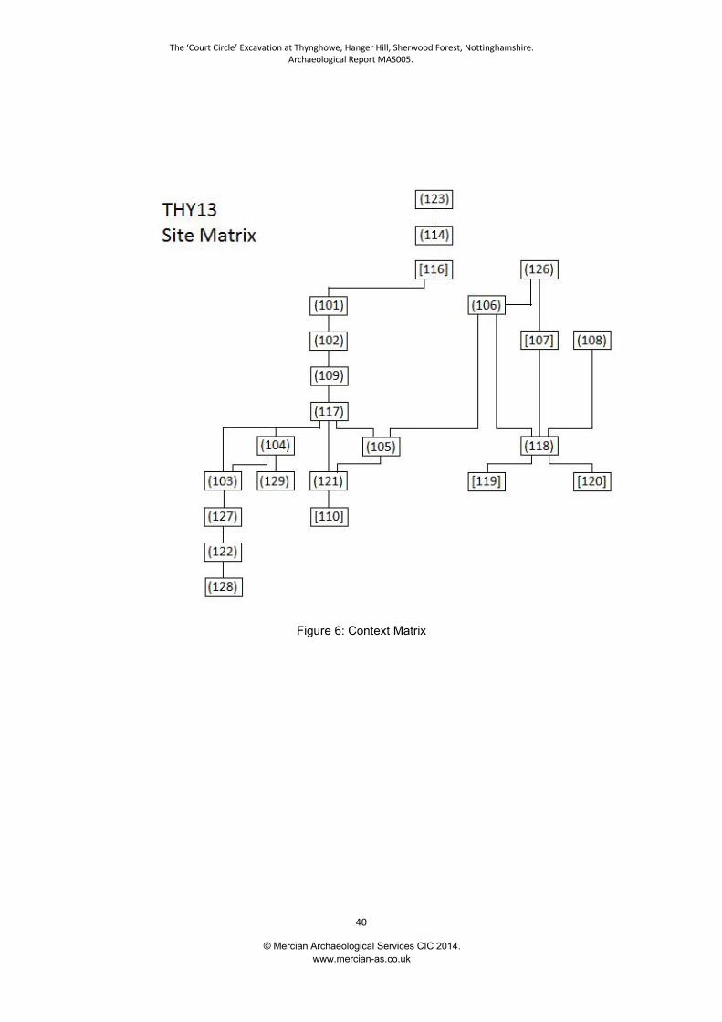
Figure 6: Context Matrix

The ‘Court Circle’ Excavation at Thynghowe, Hanger Hill, Sherwood Forest, Nottinghamshire.Archaeological Report MAS005.
© Mercian Archaeological Services CIC 2014.www.mercian-as.co.uk
41
Appendix III
Finds Report – Heat Shattered Pebbles:
The ‘Court Circle’ Excavation at Thynghowe, Hanger Hill, Sherwood Forest, Nottinghamshire.Archaeological Report MAS005.
© Mercian Archaeological Services CIC 2014.www.mercian-as.co.uk
42
Finds Report – Heat Shattered Pebblesfrom Hangar Hill, Sherwood Forest, Nottinghamshire.
Site Code: THY13
David James Budge 22/10/2013

The ‘Court Circle’ Excavation at Thynghowe, Hanger Hill, Sherwood Forest, Nottinghamshire.Archaeological Report MAS005.
© Mercian Archaeological Services CIC 2014.www.mercian-as.co.uk
43
Introduction:
A total of 8 heat-shattered pebbles (HSPs, sometimes known as fire-cracked pebbles) with atotal mass of 443.6 grams were recovered during the THY13 excavations. The HSPs wererecovered from three contexts, (103), (104) and (105). They had all been re-deposited andcould not be linked directly to the construction, use or filling in of the bank and ditch. Theymay derive from prehistoric cooking activity upslope of the site, beyond the excavated area.The possibility that they may alternatively derive from early medieval activity upslope cannotentirely be discounted. Such activity may be cooking or possibly brewing. Possible HSPs froma number of other contexts were also submitted for analysis but, on inspection, proved to bedevoid of evidence for human modification. A provisional recording system to allow intra andinter-site comparison of common features of HSP assemblages is proposed.
Heat Shattered Pebbles:
Heat Shattered Pebbles (HSPs), sometimes referred to as Heat Affected Stones or FireCracked Pebbles, are a category of artefact resulting from the utilisation of naturally occurringpebbles by humans. They are not deliberately manufactured but acquire their diagnosticcharacteristics as a, probably undesirable, side effect of the use to which they were put. HSPswere employed as a heat transfer system for the purpose of boiling liquids, often without theuse of a ceramic or metal container. Diagnostic features of HSPs are irregular crazing to thesurface and irregularly fractured edges. These features are generated as a result of thermalshock arising when the heated pebble is deposited in the liquid to be warmed and as a resultsuffers a rapid cooling.
A further feature that may occur on HSPs is a reddish or pinkish surface, which is a result ofthe oxidation of iron in the stone when the fire in which it is heated has an oxidisingatmosphere.
Methodology:
The HSPs were washed in lukewarm water and air-dried for at least 24 hours until fully dry.When fully dry they were examined by eye and under 20x magnification using a BrunelMicroscopes MX1 stereomicroscope where necessary. They were weighed using a MaplinVV52G electronic balance calibrated prior to use with a 100g mass and checked followingrecording with the same 100g mass. These control readings showed no deviation, beingprecisely 100.0g. Mass of the HSPs was recorded to the nearest 0.1g.
HSPs are a category of finds that have historically been discarded following quantification (orsometimes simply recorded as presence / absence by context and not even recovered fromsite). Given the present storage crisis in museums this situation is unlikely to change so aprovisional methodology recording as much potentially useful data about the HSPs aspossible was devised.
It is not currently known if all the information collected will prove to be of use in interpretingand understanding FCP assemblages as the factors determining the development andmagnitude of the features recorded are likely to include both anthropogenic and geologicalprocesses, however it was considered that recording ‘too much’ information was preferableover recording too little for an artefact type unlikely to be retained for future study.
With this small assemblage the extra time required to record all the information over the basic
The ‘Court Circle’ Excavation at Thynghowe, Hanger Hill, Sherwood Forest, Nottinghamshire.Archaeological Report MAS005.
© Mercian Archaeological Services CIC 2014.www.mercian-as.co.uk
44
minimum was negligible, though for larger assemblages the process may require re-evaluation. It is hoped that more data and further research (including experimentation) willdemonstrate how valid the categories of evidence recorded actually are. It is anticipated thismethodology will be revised, refined and adapted as a result of research, experimentation,analysis and discussion with interested parties.
The categories chosen for recording were those felt to be most likely to reveal informationabout past activities and processes.
The basic categories of data collected were those that could be recorded objectively and aregenerally considered to be the basic minimum quantification required to enable objectivecomparison of assemblages within and between sites (eg Archaeological Ceramic BuildingMaterials Group 2002, Medieval Pottery Research Group, 2001). They were as follows(spreadsheet column name in brackets following category name):
Context number (ContextNo),
Quantity (Quantity) - each artefact was recorded individually, therefore value was ‘1’ in allcases,
Mass (Mass(g)) - to nearest 0.1g
Further categories of data were collected. Owing to their nature they were recorded in a moresubjective manner as detailed below. These categories were included as it was consideredpossible they may hold information about the way in which the stones were used, althoughthe degree to which they are affected by anthropogenic rather than natural processes both atthe time of their creation and subsequently is unclear. The categories (and rationale forinclusion) were as follows:
Oxidation (Oxid?) - HSPs sometimes display surface alteration arising as a result of theoxidation of naturally occurring iron within the stone during heating. This alteration manifestsitself in a range of pinkish to red surface colours. Presence / absence and degree of oxidationis likely to depend on a number of factors, including presence of Fe in parent mineral,temperature of fire, nature of fire (generally oxidising or reducing atmosphere), position ofFCP within fire (likely to affect the availability of oxygen to the stone). Additionally, if thermalshock fracture surfaces show evidence of oxidation this is likely to indicate the use of thestone for more than one water-heating episode, since the fractures are believed to occur as aresult of thermal shock after the stone has been removed from the fire as it is deposited in thecooler liquid. If present, such evidence should be recorded in the ‘Notes’ column. HSPs canbe found without evidence of oxidation. Colour change due to a reducing atmosphere mayalso be anticipated, however, the often greyish natural colours of the raw materials usedmean such change is likely to be much more difficult to spot than oxidation.
Surface Crazing (Crazed?) – Records the extent and quality of surface fractures (which havenot (yet) resulted in the fragmentation of the pebble). This factor is very much linked to thatfollowing as surface crazing simply indicates fractures that, for whatever reason, did not resultin fragmentation of the original pebble. This may be due to insufficient penetration into thepebble or just the geometry of the fractures themselves. The degree of crazing is likely toresult from a number of factors, including temperature difference between the outer surface ofthe FCP and the liquid into which it is placed, the nature of the parent material and potentiallythe number of times an FCP is used. A probably overly simplistic (and presently scientificallyuntested as far as the author is aware) model would envisage a basic progression from lightlyutilised / heated HSPs displaying minor surface crazing that progresses with increasedtemperature and / or reuse into more extensive crazing and fragmentation of the pebble (egHawkes 2011, 77), however, the nature of the parent material is likely to exert a significantinfluence on surface crazing and fragmentation and it is possible some stone types mayfragment almost immediately. If the stone shows no evidence of crazing or irregular fracturesit is felt that the evidence is too insubstantial for it to be considered an HSP.
Irregular fractures / (Edges?) – indicates the quality (irregularity and depth of penetration of
The ‘Court Circle’ Excavation at Thynghowe, Hanger Hill, Sherwood Forest, Nottinghamshire.Archaeological Report MAS005.
© Mercian Archaeological Services CIC 2014.www.mercian-as.co.uk
45
irregularity) of the thermally fractured edges of FCP fragments. Linked to the precedingcategory, as irregularly fractured edges are the ultimate result of crazed surface crackspropagating through the material. Factors likely to impact this category include qualities of theparent material, temperature gradient between pebble surface / immersion liquid, possibly thethermal gradient from exterior to interior of pebble (which may provide an indication of thelength of time the pebble was heated for?). Fragmentation may also occur following use dueto mechanical shock causing the pebble to break apart along the existing lines of weaknessrepresented by the surface craze lines. This may occur for example if, following use, thepebbles are cleaned out and thrown on a pile, or as a result of impact from agriculturalmachinery. This category is probably more meaningful for HSPs recovered from primarycontexts where the impact of these latter factors will be considerably reduced.
These categories were recorded using a four point system, being None (traces of thecategory were entirely absent, shown as ‘x’), Poor (traits were present but very poorlyexpressed, eg slight oxidation to a small part of the surface, one or two minor and short crazelines, one or two edges with slightly irregular fractures not penetrating far into the interior),Moderate (trait clearly present but not fully developed, eg overall light surface oxidation orsmall patches of more intense oxidation, reasonable coverage of irregular craze lines over thesurface, edges irregular but only close to the surface), Good (trait very well developed, egextensive blushing to surface, extensive crazing to whole surface, all fractured edges veryirregular with irregularities extending right into the heart of the pebble).
A further two columns were included:
Fragmentation (Frag) – this category records an estimate of the maximum surviving surfaceof the pebble in degrees. It appears to be the most unsatisfactory category as it does not takeinto account the three-dimensional nature of the artefacts. However, it has the potential toyield some information about the degree of fragmentation of the pebbles, particularly ifcombined in some manner with the mass.
Notes (Notes) – a free text field to record any relevant information not covered by the othercategories, such as oxidised thermal fracture surfaces, extent of penetration of irregularfractures into the centre of the pebble and minimum dimensions of the parent stone if enoughsurfaces remain to enable useful measurement.
Once the quantification was complete the data were input into a Microsoft Excel spreadsheetand queried. The data are included at the end of this report.
Results:A total of eight (8) fire cracked pebble fragments were recovered from three (3) contexts.Three (3) fragments were discovered in context (103), the upper bank deposit, three (3) incontext (104), colluvial deposit behind bank, and two (2) from (105), build up of soil outsidethe enclosure.
Other fragments also submitted for analysis from contexts (103), (104), (105) and (117)proved to be entirely natural fragments of stone when examined following washing.
The HSPs were generally small, highly fragmented pieces, with only a single example fromcontext (104) (the colluvial deposit) possessing a relatively high degree of completeness.
Only two pieces had visible surface oxidation, with one of these showing possible oxidation ofa thermally fractured surface.
Source:
The ‘Court Circle’ Excavation at Thynghowe, Hanger Hill, Sherwood Forest, Nottinghamshire.Archaeological Report MAS005.
© Mercian Archaeological Services CIC 2014.www.mercian-as.co.uk
46
In all cases the parent stones were sub-rounded to rounded pebbles and all appeared to bequartzite. The only HSP with sufficient surviving surfaces to be measured indicated a parentrock with minimum dimensions of 60 x more than 55mm. Such stones are a common naturalcomponent of the Nottingham Castle Sandstone Formation, the bedrock of the site. They maybe readily encountered locally whenever there is ground disturbance such as tree throws orerosion patches (pers obs) and it is likely this situation was no different in the past. It istherefore probable the pebbles were collected in the immediate vicinity of the site prior to use.
Discussion:It should be borne in mind during the following discussion that the brief from the client seeksinvestigation of the possibility that the excavated features relate to early medieval, specificallyViking, activity.
Heat Shattered Pebbles seem to have been used for heating liquids. They were used fordomestic cooking and also for larger scale ‘industrial’ processes. This latter activity isrepresented throughout Britain and Ireland by burnt mounds, monuments consisting ofextensive spreads of discarded HSPs in a charcoal rich soil matrix and with associatedhearths and large pits or troughs in which the water was heated. They may also sometimeshave other structures associated.
It is unclear what purpose the water boiled at these sites was put to and a variety of useshave been postulated, from brewing (Quinn and Moore 2007) to dyeing and textile / woolprocessing (Jeffrey 1991 for the former, Ripper 2004 for arguments for the latter) and sweatlodges (Barfield and Hodder 1987). Recent evidence from South Derbyshire andLeicestershire has also resurrected the idea they were cooking / food preparation sitespossibly for large scale feasting (Beamish and Ripper 2000, Beamish 2001). It is likelyhowever that a single overarching interpretation for this site type is unwarranted and they mayhave been employed for a myriad of processes where large quantities of heated water wererequired.
Burnt mounds appear to be mostly prehistoric in date. Specifically, many appear to belong tothe Bronze Age, though Late Neolithic examples are known (eg Willington, Derbyshire,Beamish 2001, Birstall, Leicestershire, Ripper 2004). However, in Ireland the apparentappearance of burnt mounds in early documentary sources combined with a few radiocarbondates and supposedly early medieval artefacts associated with burnt mound sites suggestedthat the monument type persisted into the early medieval period. A more recent review of thedocumentary and archaeological evidence has, however, suggested this was probably not thecase (Hawkes 2011).
Hawkes proposes that the majority of early medieval dates for burnt mound sites in Irelandderive from samples or contexts unlikely to be associated with the original use of the sites.However, he discounts a small number of sites where he considers the carbon samplesyielding early medieval and medieval dates are highly likely to be associated with the originaluse of the burnt mound. These sites are discounted primarily on the basis that the datingconsists of single samples (Hawkes 2011, 89, 94) or that they do not represent sites wherewater was boiled due to the small size of the associated pit (Hawkes 2011, 92). While adegree of caution is certainly warranted where a single radiocarbon date from one of anumber of cut features is concerned, it does not entirely discount the possibility of an earlymedieval date for a few of the burnt mound sites in Ireland.
Additionally, Hawkes latter assertion, that none of the early medieval sites represent thespecific burnt mound monument type but could represent other early medieval use of hotstone technology is interesting. Unfortunately, the gazetteer appears to use the terms ‘heataffected stone’, ‘heat shattered stone’ and ‘burnt stone’ somewhat interchangeably (Hawkes2011, 90, 92) and the precise meaning of each is not defined. Burnt stone appearsparticularly problematic as it implies a stone showing signs of heating but not necessarily onedisplaying the effects of thermal shock resulting from immersion in liquid, as should be thecase for an HSP as defined above. Indeed, a number of gazetteer sites where the stones are
The ‘Court Circle’ Excavation at Thynghowe, Hanger Hill, Sherwood Forest, Nottinghamshire.Archaeological Report MAS005.
© Mercian Archaeological Services CIC 2014.www.mercian-as.co.uk
47
listed as limestone are unlikely to have been used for heating liquid since the conversion ofheated limestone into Calcium Hydroxide, slaked lime, on contact with water, would likely beundesirable.
Despite this, the gazetteer does appear to indicate a number of sites where probable HSPsas defined above have been discovered in apparently secure early medieval and medievalcontexts in Ireland. The description of the site at Doughiska, County Galway (site 25, Hawkes2011, 92) is particularly promising, where an approximately 6x6m spread of heat-shatteredstone and charcoal sealing a pit containing similar material yielded three carbon datesspanning the late 9th to 12th centuries AD (cal). Other sites in the gazetteer also indicate earlymedieval or medieval dates for features associated with probable HSP use, including Derver4 (site 24, Hawkes 2011, 91 - 92) where a pit containing some burnt stones yielded a similardate to Doughiska, though the stones may have been residual, Kilmurry North 2 (site 34,Hawkes 2011, 93 - 94), where two pits containing charcoal and heat-shattered stone weredated 10th to mid 13th century (cal), Cloonaghboy III (site 15, Hawkes 2011, 89 - 90), whereone of two small spreads of heat shattered stone and charcoal gave calibrated dates of late9th to mid 12th century, and Cloonfane VI (site 18, Hawkes 2011, 90), where a small spread ofheat affected stone and charcoal gave a calibrated date of late 8th to late 10th century.
Of particular importance to the interpretation of the HSP from the Hangar Hill site is that burntmounds are primarily situated in areas close to water, where the trough can fill with waternaturally (via a high water table or presence of a spring) or where water (being the mostdifficult component of the system to transport) can be introduced to the trough with aminimum of effort. The lack of nearby streams (the closest water source is the River Meden,approximately 1.7km away from the site at its closest), locally elevated situation (just abovethe 100m contour) and the porous sandstone geology suggest the HSPs are extremelyunlikely to derive from a burnt mound in the vicinity.
This, then, leaves the possibility of cooking or smaller-scale liquid heating. HSPs commonlyappear in domestic contexts from the Neolithic to the late Iron Age / Roman period. HSPsfrom the latter part of this time span are frequently encountered in close association withsettlement. It seems likely that if the HSPs from Hanger Hill were associated with Late IronAge or Romano British settlement then sherds of pottery or other contemporary rubbishmaterial would be encountered with them, particularly as the HSPs may often be found inmore sheltered locations such as pits dug into partially silted up boundary ditches (egPalfreyman 2001, 87), and may therefore be less prone to erosion than associatedoccupation surfaces. Similarly, if the HSPs were associated with Neolithic or Bronze Ageoccupation, whether temporary or more permanent, then it might be reasonable to expectsome trace of lithic debitage or tools.
An early medieval radiocarbon date (mid 7th to late 10th century) from a mound of burnt stoneat Morfa Mawr in South West Wales (Williams 1990, 134) and an early medieval pitcontaining HSPs at Catholme in Staffordshire (thanks to Daryl Garton for pointing out theexistence of this evidence) are the only British examples currently known to the author.However, Hawkes’ review of the Irish evidence (2011) showed that recent archaeologicalinterventions arising as a result of development had identified a number of sites with probableHSPs dating to the early medieval and medieval periods. Though the archaeology of Irelandis not the same as that of Britain, Hawkes’ work suggests the possibility that a similar reviewand synthesis of recent British developer funded work might reveal more securely datedevidence of early medieval HSP use in Britain.
At the very least, the evidence suggests that an Early Medieval origin is not necessarilyimpossible for the Hangar Hill finds. Indeed, the complete lack of other finds within theexcavated area seems to suggest activity on Hangar Hill was taking place during a periodwhen artefacts are few. The Early Medieval period in Nottinghamshire is notably poor indomestic artefacts (pers obs from working at the Notts HER) and has been described as “aculture of low archaeological visibility with a prominent role for organic and perishablematerials” (Knight, 2004, 162, discussing the early Saxon period).
Quinn and Moore suggested the possible use of burnt mound monuments for brewing (Quinnand Moore 2007) but also drew attention to other brewing methods, which would generatesmaller quantities of heat shattered pebbles. These methods are historically attested, one still

The ‘Court Circle’ Excavation at Thynghowe, Hanger Hill, Sherwood Forest, Nottinghamshire.Archaeological Report MAS005.
© Mercian Archaeological Services CIC 2014.www.mercian-as.co.uk
48
being practiced in Finland (though was probably imported to that area in high or late medievaltimes) for the brewing of Sahti (Sysila, 1998) and another practiced in Germany until relativelyrecently (Deutsches Museum, nd). They both involve heating the mash in wooden containersusing red-hot stones. In the brewing of Sahti, when the mash is ready it is decanted intofermentation containers. The stones are presumably removed from the mash container anddiscarded or retained for re-use if necessary at this point. The archaeological signature ofsuch brewing would be difficult to detect, consisting of little more than small groups ofdiscarded HSPs, a hearth and maybe some associated traces of malted grain, though thelatter substance is unlikely to be discarded as it could be used as a foodstuff for humans oranimals.
The writer is unaware whether consumption, and particularly brewing, of alcohol was a part ofthe events occurring at an early medieval meeting place and is not aware of anyarchaeological evidence for the above mentioned form of brewing. Ethnographic studiessuggest attrition of the interior surface of 265 out of 958 Anglo-Saxon ceramic vessels (whichwere subsequently utilised as cremation urns in the Cleatham, Lincolnshire, cemetery) ismost likely to occur as a result of the vessels being employed as fermentation containers(Perry 2011). The processes leading to the production of fermenting liquids are many andvaried and the presence of fermentation in early medieval Britain certainly does not imply theuse of the above-mentioned brewing methods.
However, the possibility of brewing should perhaps be borne in mind should further work takeplace at Hangar Hill, although the lack of nearby water sources would probably discount anypossibility of larger scale brewing.
Irrespective of the date of origin of the HSPs, due to the contexts in which they were foundthey would not provide an accurate date for the of construction of the bank and ditch underinvestigation. The contexts in which they were found were the colluvial deposit built upagainst the bank (104), the secondary bank make up (103) and the soil outside the enclosure(105). None were present in the ditch fills or original bank deposits.
It is not clear what amount of time elapsed between the construction of the bank and theformation of the colluvial deposit (104). Consequently, the HSPs within this deposit couldderive from upslope activity contemporary with the construction of the bank and ditch. Theycould just as easily have been present upslope for some considerable time prior to theirinclusion in the colluvial deposit, or could equally relate to activity much later than theconstruction of the bank if the colluvium is significantly later than the bank.
Layer (105) was interpreted as a soil layer to the north east of the bank, formed following theinitial silting of the ditch, the primary fills of which it sealed. The HSPs in this layer could againbe of any period. However, the apparent presence of the bank by the time this deposit wasforming would likely act as a barrier to colluvial movement. The HSPs in layer (105) are ofsmaller size than those in (104) so could have been more mobile and more likely to be movedaround the site by anthropogenic or natural means. However, given the presence of HSPs inthe secondary bank material (103), which is earlier than layer (105), it is possible the HSPs in(105) may have eroded out of (103).
The secondary bank deposit (103) appears to have been an enhancement or repair to thebank. Again, it is unclear how much time elapsed from the original construction to the repair.The HSPs from (103), like those from (105), are relatively more fragmented than those from(104).
It is notable that no HSPs were recovered from the primary bank deposits / possible buriedsoil beneath the bank or the early silting of the ditch. Only a small area was excavated andonly a few HSPs were recovered, resulting in a sample size effectively too small to allowsecure conclusions to be drawn. However, had HSPs already been present in the soils intowhich the ditch was dug they might have been encountered in the primary bank make up orthe early silting of the ditch, in a similar fashion to the way HSPs were recovered from thestratigraphically later deposits.
On the basis of this scanty evidence it could be very tentatively suggested that the HSPs mayhave been produced by activities taking place following the initial construction of the bank andditch but prior to the repair / enhancement of the monument, or that they pre-date it and

The ‘Court Circle’ Excavation at Thynghowe, Hanger Hill, Sherwood Forest, Nottinghamshire.Archaeological Report MAS005.
© Mercian Archaeological Services CIC 2014.www.mercian-as.co.uk
49
became mobilised by activities upslope following the initial construction of the ditch but priorto the enlargement of the bank. As such a small area of the feature was sampled though,further work may prove this suggestion inaccurate.
Conclusions:
The Heat Shattered Pebbles found in the excavations could not be directly associated withthe construction of the bank and ditch. However, their absence in the initial constructiondeposits and primary ditch silts and presence in the stratigraphically later deposits – being:bank enhancement; colluvial deposit; soils built up after the construction - leads to thetentative suggestion that the HSPs may have been produced by activity following theconstruction of the bank and ditch, or that they come from earlier activity and were onlymobilised by activities within the enclosure following its construction.
They are very unlikely to come from a burnt mound and are more likely to derive from smallscale cooking or possibly brewing activity. Scant evidence from England and Wales andslightly more comprehensive evidence from Ireland indicates an early medieval date for thecreation / use of the HSPs is not impossible, and the lack of other artefact types suggestsactivity on the site occurred during a chronological period when durable artefacts were scarce.
Bibliography:
Archaeological Ceramic Building Materials Group, 2002, Ceramic Building Material, MinimumStandards for the Recovery, Curation, Analysis and Publication. Draft document
Barfield, L. and Hodder, M. (1987) Burnt mounds as saunas, and the prehistory of bathing.Antiquity 61: 370-379
The ‘Court Circle’ Excavation at Thynghowe, Hanger Hill, Sherwood Forest, Nottinghamshire.Archaeological Report MAS005.
© Mercian Archaeological Services CIC 2014.www.mercian-as.co.uk
50
Beamish, M G, 2001, Neolithic Acivity on the Trent Floodplain, Derbyshire ArchaeologicalJournal 121: 9-17
Beamish, M G and Ripper, S A, 2000, Burnt Mounds in the East Midlands, Antiquity 75: 37-8
Deutsches Museum, nd, http://www.deutsches-museum.de/en/exhibitions/werkstoffe-produktion/agriculture/brewing/, accessed 21/11/13
Hawkes, A, 2011, Medieval Fulachtaí Fia in Ireland? An Archaeological Assessment Journalof Irish Archaeology 20: 77-100
Jeffrey, S. 1991. Burnt Mounds, Fulling and Early Textiles? in Burnt Mounds and Hot StoneTechnology.
Knight, D and Howard, A J, 2004, Trent Valley Landscapes
Medieval Pottery Research Group, 2001, Minimum Standards for the Processing, Recording,Analysis and Publication of Post-Roman Ceramics.
Palfreyman, A, 2001. Report on the Excavation of a Romano-British Aisled Building at LittleHay Grange Farm, Ockbrook, Derbyshire 1994 –97. Derbyshire Archaeological Journal 121:70 - 161
Perry, G, 2011, Beer, Butter and Burial, The Pre-Burial Origins of Cremation Urns from theearly Anglo-Saxon Cemetery of Cleatham, North Lincolnshire. Medieval Ceramics 32: 9 - 22
Quinn, W and Moore, D, 2007, Ale, Brewing and Fulacht Fiadh. Archaeology Ireland 21.3: 8 –11
Ripper, S A, 2004. Bodies, Burnt Mounds and Bridges: A Riverine Landscape at WatermeadCountry Park, Birstall, Unpublished ULAS Document
Sysila, I, 1998, Sahti – A Remnant of Finland’s Rustic Past. Brewing Techniques 6.4, articleaccessed online at http://morebeer.com/brewingtechniques/library/styles/6_4style.html,accessed 20/11/2013
Williams, G. 1990. Burnt mounds in south-west Wales. In V. Buckley (ed.), Burnt offerings:international contributions to burnt mound archaeology, 129–39.
The ‘Court Circle’ Excavation at Thynghowe, Hanger Hill, Sherwood Forest, Nottinghamshire.Archaeological Report MAS005.
© Mercian Archaeological Services CIC 2014.www.mercian-as.co.uk
51
Appendix IV:
Finds Report – Post Roman Pottery
The ‘Court Circle’ Excavation at Thynghowe, Hanger Hill, Sherwood Forest, Nottinghamshire.Archaeological Report MAS005.
© Mercian Archaeological Services CIC 2014.www.mercian-as.co.uk
52
Finds Report – Post Roman Potteryfrom Hangar Hill, Sherwood Forest, Nottinghamshire.
Site Code: THY13
David James Budge 22/10/2013
The ‘Court Circle’ Excavation at Thynghowe, Hanger Hill, Sherwood Forest, Nottinghamshire.Archaeological Report MAS005.
© Mercian Archaeological Services CIC 2014.www.mercian-as.co.uk
53
Introduction:
A single fragment of English Stoneware was found in road metalling deposits(108). It was a fragment of ink bottle of mid 19th to early 20th century date. Thepottery has been fully archived to the level required by the Medieval PotteryResearch Group (2001).
Methodology:The pottery was washed in lukewarm water using a soft bristled brush and airdried for at least 48 hours. When fully dry the material was examined by eyeand under 20x magnification using a Brunel Microscopes MX1stereomicroscope. The assemblage was quantified using sherd count, sherdmass and vessel count in each context. Weighing was carried out using aMaplin VV52G electronic balance calibrated prior to use with a 100g massand checked following recording with the same 100g mass. These controlreadings showed no deviation, being precisely 100.0g. The mass of thepottery sherds was recorded to the nearest 1g.
The data were input into a Microsoft Access database using code namesdeveloped for the City of Nottingham Type Series (Nailor and Young 2001)and the Lincoln Ceramic Type Series (Young, Vince and Nailor 2005). Thedatabase and code list was kindly supplied by Jane Young, independent post-Roman ceramic specialist. The resulting archive conforms to the standardsand guidelines set out by the Medieval Pottery Research Group (2001).
Results:A single sherd of pottery was found during the excavation. This was a sherdof English Stoneware from context (108), the metalling of the road. Thesharply angled shoulder is from an ink bottle made from light grey stonewarewith slightly bubbly transparent glaze on both interior and exterior surfaces. Itis decorated with a horizontal line just above the shoulder. A bottle of identicalprofile, colour and decoration is in the Museum of London, accession no80.486/71, where it is dated 1850 to 1900. Such bottles may also continueinto the 20th century. Bottles of this type were made throughout Britain, withthe Derbyshire stoneware industries being some of the largest producers atthis period, but with other centres such as Bristol having significant impact.
Discussion:
The ‘Court Circle’ Excavation at Thynghowe, Hanger Hill, Sherwood Forest, Nottinghamshire.Archaeological Report MAS005.
© Mercian Archaeological Services CIC 2014.www.mercian-as.co.uk
54
There are too many factors which could control the circumstancessurrounding the deposition of a single pot sherd in the metalling of a road, soit is not possible to attempt to draw any conclusions from such a smallassemblage.
Conclusions:A sherd from a mid 19th to early 20th century ink bottle was recovered from theroad metalling (108).
Bibliography:
Medieval Pottery Research Group, 2001, Minimum Standards for theProcessing, Recording, Analysis and Publication of Post-Roman Ceramics.MPRG occasional paper 2
Nailor, V and Young, J, 2001, A Fabric Type Series for Post Roman Potteryfrom Nottingham City (5th – 16th Centuries), Unpublished Report forNottingham City Museum.
Young, J, Vince, A, and Nailor, V, 2005, A Corpus of Anglo-Saxon andMedieval Pottery from Lincoln, Lincoln Archaeological Studies.

© Mercian Archaeological Services CIC 2014.www.mercian-as.co.uk
55
The ‘Court Circle’ Excavation at Thynghowe, Hanger Hill, Sherwood Forest, Nottinghamshire.Archaeological Report MAS005.
© Mercian Archaeological Services CIC 2014.www.mercian-as.co.uk
56
Appendix V:
Finds Report – Ceramic Building Material
The ‘Court Circle’ Excavation at Thynghowe, Hanger Hill, Sherwood Forest, Nottinghamshire.Archaeological Report MAS005.
© Mercian Archaeological Services CIC 2014.www.mercian-as.co.uk
57
Finds Report – Ceramic Building Materialfrom Hangar Hill, Sherwood Forest, Nottinghamshire.
Site Code: THY13
David James Budge 22/11/2013
The ‘Court Circle’ Excavation at Thynghowe, Hanger Hill, Sherwood Forest, Nottinghamshire.Archaeological Report MAS005.
© Mercian Archaeological Services CIC 2014.www.mercian-as.co.uk
58
Introduction:
143 fragments of Ceramic Building Material weighing a total of 1.360kg wererecovered during the THY13 excavations. All were from context (108). Allwere extensively fragmented and abraded. They had been dumped ashardcore to create the road surface (108).
Methodology:The CBM was washed in lukewarm water using a soft bristled brush and driedin a warm air current for at least 48 hours. When fully dry the material wasexamined under 20x magnification using a Brunel Microscopes MX1stereomicroscope and divided into fabric groups. They were then counted andweighed in their fabric groups. Weighing was carried out using a MaplinVV52G electronic balance calibrated prior to use with a 100g mass andchecked following recording with the same 100g mass. These controlreadings showed no deviation, being precisely 100.0g. The mass of the CBMfragments was recorded to the nearest 1g.
The data were input into a Microsoft Access database using nationally andlocally agreed code names. The database and code list was kindly suppliedby Jane Young, independent post Roman ceramic specialist. The resultingarchive conforms to the standards and guidelines set out by the MedievalPottery Research Group (2001). Given the date and origin of the assemblage,it was not considered desirable to produce detailed written descriptions of thefabrics.
Results:A total of 143 fragments of CBM with a combined mass of 1.360kg wererecovered from a single context, road surface (108). CBM was notencountered in any other contexts. The material consisted of small,extensively abraded, fragments. Insufficient survived of any of the fragmentsto attempt to measure brick dimensions.
Only two roof tile fragments were positively identified. The fragments were toosmall to determine the form of tile they had come from, but they are likely tobe of later post medieval or modern date.
A number of fragments were very small and abraded and were small enoughthat they could have come either from tiles or bricks.
The remaining fragments were large enough or had enough evidence ofshape, or similarity of fabric to definitely identifiable bricks, that they were
The ‘Court Circle’ Excavation at Thynghowe, Hanger Hill, Sherwood Forest, Nottinghamshire.Archaeological Report MAS005.
© Mercian Archaeological Services CIC 2014.www.mercian-as.co.uk
59
classified as bricks.
Three main fabric groups were identified, though there was a reasonabledegree of variation within the groups, suggesting that each group may actuallyinclude products of more than one production site using similar raw materials.
The biggest group, both in terms of number of fragments (50) and total mass(385g) was characterised by a soft orange to pink fabric with common finesub-rounded calcareous inclusions in the background of the clay. A fewexamples had occasional larger sub rounded calcareous inclusions. Thisfabric could derive from clays associated with the limestone areas not far tothe west of the site, extending into Derbyshire.
The second largest group (46 fragments, 301g total mass) was a soft orangefabric with moderate quartz sand. This fabric is similar to those found in theTrent Valley.
The third largest group (32 fragments, total mass 295g) had a soft orangesandy fabric with a background of fine mica. Relatively iron rich clays with amicaceous background may have been exploited in Roman and Medievaltimes at a presently unknown location near Southwell in Nottinghamshire(Jane Young, pers comm.) but also occur elsewhere in Nottinghamshire andDerbyshire, suggesting these bricks too may be of local origin.
Due to the lack of pieces large enough to obtain measurements of the originalbrick sizes, dating these groups is very difficult. The bricks could have beenmanufactured at any time from post medieval to the end of the 19th century.
The fourth largest group, in terms of combined mass (249g), consisted of justfour fragments, two of which joined. The large size of the fragments isexplained by the much harder fabric of this group. The bricks had a fine bufffabric with rough vitrified surfaces ranging in colour from purple and dull red toyellow. These bricks are not likely to pre-date the 18th century but could havebeen manufactured any time from then to the 20th century.
The other fragments are mostly variants of the first three groups, some harderfired, some potentially just extreme outliers of the groups. None haveparticularly unusual inclusions for Nottinghamshire and could all be of localorigin
Discussion:The bricks had been dumped as hardcore to make up the road surface (108).The less fragmented nature of the harder fabrics suggests they may not havebeen crushed in a crushing machine, since this would probably reduce allfragments equally. They may have been initially broken up manually andspread on the road surface, where the softer pieces further fragmented withthe passage of heavy traffic.
The ‘Court Circle’ Excavation at Thynghowe, Hanger Hill, Sherwood Forest, Nottinghamshire.Archaeological Report MAS005.
© Mercian Archaeological Services CIC 2014.www.mercian-as.co.uk
60
Conclusions:
The bricks are all likely to be of relatively local origin, with the clays andtempers of the main fabric groups all being available in Nottinghamshire or theimmediate vicinity. The bricks were too fragmentary to be closely dated andfor the most part can only be assigned a broad post medieval to modern date.
They probably came from a variety of structures of different dates that weredemolished and the rubble from which was used as metalling for the road.The CBM and single pottery find from (108), together with the crushed natureof the CBM and quartzite from this context suggesting passage of heavymachinery may support the excavator’s interpretation of the road as a featureconstructed by the military at some point during their use of Sherwood Forestas a training ground.
Bibliography:
Medieval Pottery Research Group, 2001, Minimum Standards for theProcessing, Recording, Analysis and Publication of Post-Roman Ceramics.
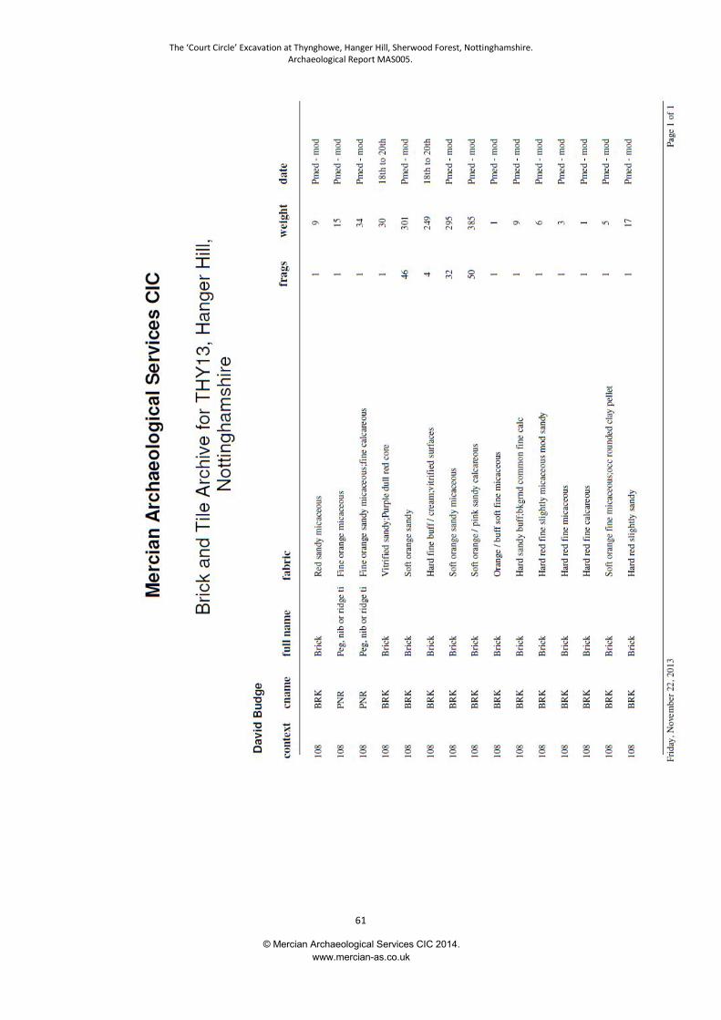
The ‘Court Circle’ Excavation at Thynghowe, Hanger Hill, Sherwood Forest, Nottinghamshire.Archaeological Report MAS005.
© Mercian Archaeological Services CIC 2014.www.mercian-as.co.uk
61

The ‘Court Circle’ Excavation at Thynghowe, Hanger Hill, Sherwood Forest, Nottinghamshire.Archaeological Report MAS005.
© Mercian Archaeological Services CIC 2014.www.mercian-as.co.uk
62
Appendix VI:
Finds Report – Flaked Stone and Iron Objects

The ‘Court Circle’ Excavation at Thynghowe, Hanger Hill, Sherwood Forest, Nottinghamshire.Archaeological Report MAS005.
© Mercian Archaeological Services CIC 2014.www.mercian-as.co.uk
63
Finds Report – Flaked Stone and Iron Objectsfrom Hangar Hill, Sherwood Forest, Nottinghamshire.
Site Code: THY13
David James Budge 22/11/2013
The ‘Court Circle’ Excavation at Thynghowe, Hanger Hill, Sherwood Forest, Nottinghamshire.Archaeological Report MAS005.
© Mercian Archaeological Services CIC 2014.www.mercian-as.co.uk
64
Introduction:
A flaked quartzite pebble and an iron object were discovered during theHanger Hill excavation. The quartzite pebble was recovered from metallingdeposits associated with a modern trackway. The pattern of flaking wasconsistent with crushing damage inflicted either by the wheels of heavymachinery or by a crushing machine. The iron object was totally mineralised.It was probably a nail. It came from the decaying organic fill of a relativelyrecent tree root high in the stratigraphic sequence.
Methodology:The flaked pebble was washed, air dried and examined by eye. Due to itsmodern date and origin as hardcore or as a result of mechanical damage, nofurther action was taken. The nail was examined by eye. Being completelymineralised with no metallic iron remaining, it was allowed to air dry. As fullymineralised iron is stable, though brittle (Watkinson and Neale 1998, 35), nofurther treatment was necessary. The object was measured with a 30cm rulewith 1mm divisions and weighed using a Maplin VV52G electronic balancecalibrated prior to use with a 100g mass and checked following recording withthe same 100g mass. These control readings showed no deviation, beingprecisely 100.0g. Mass of the iron object was recorded to the nearest 0.1g.
Results:
Lithics:
The pebble, from (108), is quartzite. It has had a series of consecutive flakesremoved from three platforms, each platform at an almost 90° angle to theprevious and formed on the distal end of the previous flake scar, suggestingthe core was rotated about a single plane during flaking. In addition to thedetached flakes, each platform shows evidence of heavy crushing.
Iron:
From context (114). Iron object, two joining fragments, recent break.Completely mineralised with central void, no metallic iron remaining. Surfaceshowing orange brown corrosion with adhering sand particles. Roughly oval insection with a swelling at one end. Probably a nail.
Dimensions:
Length: 61mm
The ‘Court Circle’ Excavation at Thynghowe, Hanger Hill, Sherwood Forest, Nottinghamshire.Archaeological Report MAS005.
© Mercian Archaeological Services CIC 2014.www.mercian-as.co.uk
65
Width (shaft): 17 x 10mm
Width (head): 19 x 14mm
Mass: 14.8g
Discussion:
The pattern of flaking on the quartzite cobble is consistent with the damageexpected of a pebble being rolled under the wheel of heavy machinery (suchas agricultural vehicles or a tank) or with a pebble being rotated in the rollersof a crushing machine. Given the presence of large quantities of crushedCBM also within context (108), it is likely that the flaking of the pebble ismodern and that it was either imported to the site as hardcore to surface theroad, or that it was damaged by the passage of heavy, probably military,vehicles using the road.
The iron object is most likely to be a nail. It is too corroded to determine theexact form. Assuming it is hand made it may date any time from the Iron Ageto the 20th century. The relatively high stratigraphic position of the context inwhich it was found (114) suggests a post medieval to modern date is mostlikely.
Conclusions:The quartzite core is a product of modern mechanical crushing. It may bediscarded if necessary. The iron object is probably a nail. It cannot be closelydated. As it is entirely mineralised and has been dried it is stable and can bestored if necessary without requiring further conservation.
Bibliography:
Watkinson, D E and Neale, V, 1998, First Aid for Finds. Rescue / UKIC thirdedition
The ‘Court Circle’ Excavation at Thynghowe, Hanger Hill, Sherwood Forest, Nottinghamshire.Archaeological Report MAS005.
© Mercian Archaeological Services CIC 2014.www.mercian-as.co.uk
66
Appendix VII:
Environmental Archaeological
Site Visit Résumé

The ‘Court Circle’ Excavation at Thynghowe, Hanger Hill, Sherwood Forest, Nottinghamshire.Archaeological Report MAS005.
© Mercian Archaeological Services CIC 2014.www.mercian-as.co.uk
67
AEA210: Edwinstowe, Nottinghamshire; Site visit résumé(THW 13)
Michael J. Allen
The site at Edwinstowe, comprising a trench across a clear bank and ditch,
was visited on 3rd May 2013 with Andy Gaunt. Three profiles were described
and two sampled. The bank and buried soil profile was described and
samples as undisturbed 50cm monolith (for subsampling for pollen and more
detailed geoarchaeological description), and a kubiena sample (for
consideration for soil thin section and subsampling for pollen). The ditch
profile was cleaned, described and also sampled in 50cm monolith, and the
colluvial build-up behind the bank was recorded.
The site was under beech woodland plantation in Sherwood Forest, and
present day soils consist of sandy pozolic brown earth under leaf litter. All
profiles were very sandy and had common fine fleshy to medium woody roots
penetration throughout the profile, comprising the integrity of the disturbed
samples. Each profile was cleaned prior to description following standard
sedimentological notation (Hodgson 1976) and munsell colours were recorded
in the field moist.
Figure 1. The bank and ditch profile
A very brief summary of the three profiles follows:-
Figure 1. The bank and ditch profile
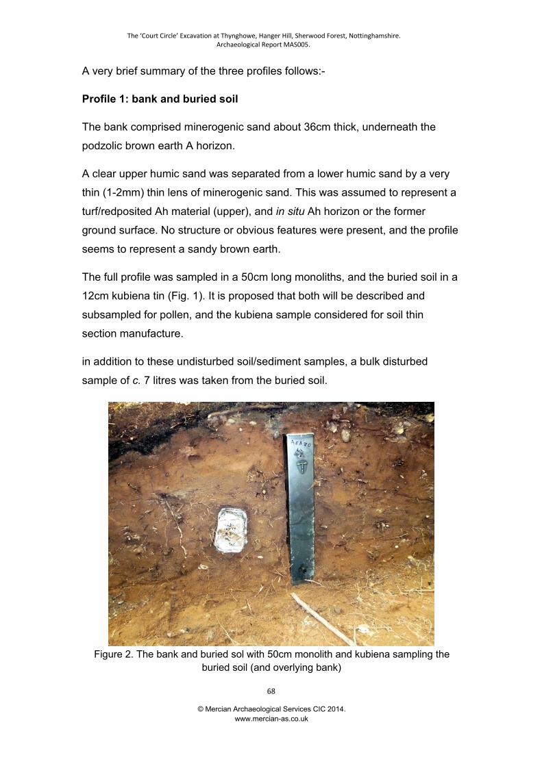
The ‘Court Circle’ Excavation at Thynghowe, Hanger Hill, Sherwood Forest, Nottinghamshire.Archaeological Report MAS005.
© Mercian Archaeological Services CIC 2014.www.mercian-as.co.uk
68
A very brief summary of the three profiles follows:-
Profile 1: bank and buried soil
The bank comprised minerogenic sand about 36cm thick, underneath the
podzolic brown earth A horizon.
A clear upper humic sand was separated from a lower humic sand by a very
thin (1-2mm) thin lens of minerogenic sand. This was assumed to represent a
turf/redposited Ah material (upper), and in situ Ah horizon or the former
ground surface. No structure or obvious features were present, and the profile
seems to represent a sandy brown earth.
The full profile was sampled in a 50cm long monoliths, and the buried soil in a
12cm kubiena tin (Fig. 1). It is proposed that both will be described and
subsampled for pollen, and the kubiena sample considered for soil thin
section manufacture.
in addition to these undisturbed soil/sediment samples, a bulk disturbed
sample of c. 7 litres was taken from the buried soil.
Figure 2. The bank and buried sol with 50cm monolith and kubiena sampling theburied soil (and overlying bank)

The ‘Court Circle’ Excavation at Thynghowe, Hanger Hill, Sherwood Forest, Nottinghamshire.Archaeological Report MAS005.
© Mercian Archaeological Services CIC 2014.www.mercian-as.co.uk
69
Profile 2: ditch
The ditch profile was about 0.63 m deep and under the present Ah horizon
(topsoil) was a massive, uniform sandy upper fill becoming slightly more
cohesive with depth (17-33cm and 33-54cm). This represents the secondary /
tertiary fills. A basal primary fill (45-63) was also a uniform less humic fill,
representing rapid infill of the ditch principally from weathering of the sides
and the soil through which the ditch was cut.
A single 50cm long monolith was taken through this profile (Fig. 3)
Figure 3. The ditch profile and 50cm monolith sampling the main sequence
Profile 3: colluvial accumulation behind bank
A loose massive slightly humic sand accumulated behind the bank and
represents local small-scale colluviation from the area immediate upslope and
behind the bank. This could have occurred under either woodland or more
The ‘Court Circle’ Excavation at Thynghowe, Hanger Hill, Sherwood Forest, Nottinghamshire.Archaeological Report MAS005.
© Mercian Archaeological Services CIC 2014.www.mercian-as.co.uk
70
open conditions. Examination of the field log may go towards determining this.
No sampling was considered necessary of this sequence - and this area was
more heavily rooted significantly compromising the integrity of any sample
Discussion and Summary
A clear buried soil was present under the bank, and fieldwork indicated a low
line of turves were placed onto of the soil before the more minerogenic
material piled up to form the main the bank. The ditch infilled relatively rapidly,
principally with material weathering from the ditch sides and soil. The last
main event was the sandy colluvium washing against the bank.
The sequence has the potential to provide a local and subregional history of
the development of the pre-ditch and post ditch landscape. This could include
the changing nature of the soils and of the local environment and woodland.
Reference
Hodgson, J.M. 1976. Soil Survey Field Handbook. Harpenden: Soil Survey
Technical Monograph 5
LIST OF SAMPLES
M1 50cm monolith though bank and buried soil
K2 12cm kuniena tin through buried soil
M3 50cm monolith through the ditch
4 7 litre bulk sample from the buried soil

The ‘Court Circle’ Excavation at Thynghowe, Hanger Hill, Sherwood Forest, Nottinghamshire.Archaeological Report MAS005.
© Mercian Archaeological Services CIC 2014.www.mercian-as.co.uk
71
Appendix VIII:
Community Archaeology Photographic Archive
Mercian Archaeological Services CIC and the Friends of Thynghowe

The ‘Court Circle’ Excavation at Thynghowe, Hanger Hill, Sherwood Forest, Nottinghamshire.Archaeological Report MAS005.
© Mercian Archaeological Services CIC 2014.www.mercian-as.co.uk
72
Excavation looking north-west
Excavation looking north-west
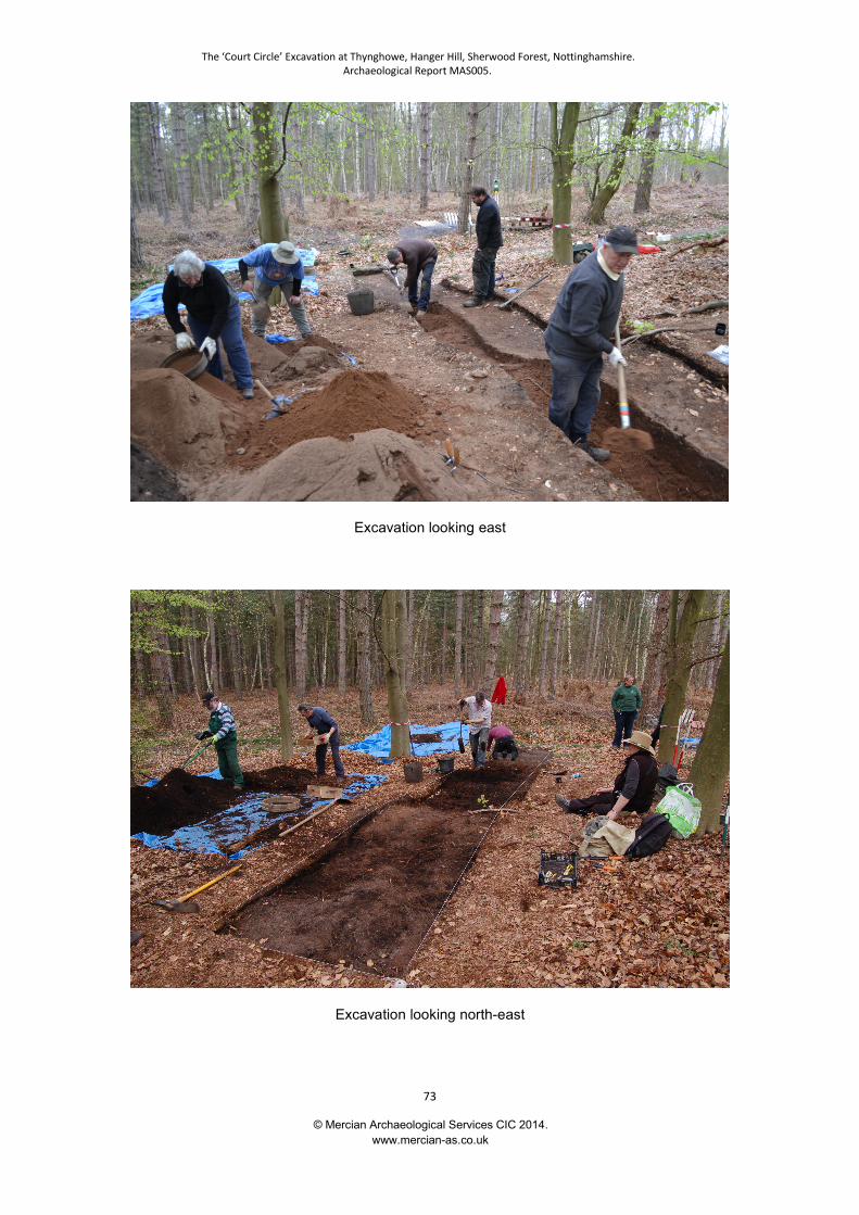
The ‘Court Circle’ Excavation at Thynghowe, Hanger Hill, Sherwood Forest, Nottinghamshire.Archaeological Report MAS005.
© Mercian Archaeological Services CIC 2014.www.mercian-as.co.uk
73
Excavation looking east
Excavation looking north-east
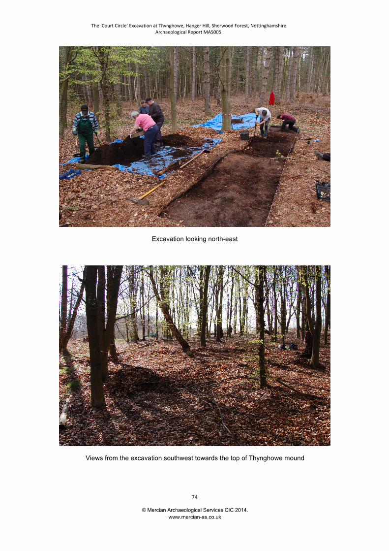
The ‘Court Circle’ Excavation at Thynghowe, Hanger Hill, Sherwood Forest, Nottinghamshire.Archaeological Report MAS005.
© Mercian Archaeological Services CIC 2014.www.mercian-as.co.uk
74
Excavation looking north-east
Views from the excavation southwest towards the top of Thynghowe mound
The ‘Court Circle’ Excavation at Thynghowe, Hanger Hill, Sherwood Forest, Nottinghamshire.Archaeological Report MAS005.
© Mercian Archaeological Services CIC 2014.www.mercian-as.co.uk
75
Mercian Archaeological Services CIC is a limited company registered in England and Wales.© Mercian Archaeological Services 2014. Company Registration No. 08347842.