The Citizen's Guide to Land Use & City ... - ScholarWorks@UNO
150
University of New Orleans University of New Orleans ScholarWorks@UNO ScholarWorks@UNO Planning and Urban Studies Reports and Presentations Department of Planning and Urban Studies 7-2012 An Evaluation of the Foundation for Louisiana: The Citizen's Guide An Evaluation of the Foundation for Louisiana: The Citizen's Guide to Land Use & City of New Orleans Citizen Engagement: New to Land Use & City of New Orleans Citizen Engagement: New Orleans Land Use Planning Districts Orleans Land Use Planning Districts Michelle M. Thompson University of New Orleans, [email protected] Follow this and additional works at: https://scholarworks.uno.edu/plus_rpts Part of the Urban Studies Commons Recommended Citation Recommended Citation Thompson, Michelle M., "An Evaluation of the Foundation for Louisiana: The Citizen's Guide to Land Use & City of New Orleans Citizen Engagement: New Orleans Land Use Planning Districts" (2012). Planning and Urban Studies Reports and Presentations. Paper 12. https://scholarworks.uno.edu/plus_rpts/12 This Report is brought to you for free and open access by the Department of Planning and Urban Studies at ScholarWorks@UNO. It has been accepted for inclusion in Planning and Urban Studies Reports and Presentations by an authorized administrator of ScholarWorks@UNO. For more information, please contact [email protected].
-
Upload
khangminh22 -
Category
Documents
-
view
0 -
download
0
Transcript of The Citizen's Guide to Land Use & City ... - ScholarWorks@UNO

University of New Orleans University of New Orleans
ScholarWorks@UNO ScholarWorks@UNO
Planning and Urban Studies Reports and Presentations Department of Planning and Urban Studies
7-2012
An Evaluation of the Foundation for Louisiana: The Citizen's Guide An Evaluation of the Foundation for Louisiana: The Citizen's Guide
to Land Use & City of New Orleans Citizen Engagement: New to Land Use & City of New Orleans Citizen Engagement: New
Orleans Land Use Planning Districts Orleans Land Use Planning Districts
Michelle M. Thompson University of New Orleans, [email protected]
Follow this and additional works at: https://scholarworks.uno.edu/plus_rpts
Part of the Urban Studies Commons
Recommended Citation Recommended Citation Thompson, Michelle M., "An Evaluation of the Foundation for Louisiana: The Citizen's Guide to Land Use & City of New Orleans Citizen Engagement: New Orleans Land Use Planning Districts" (2012). Planning and Urban Studies Reports and Presentations. Paper 12. https://scholarworks.uno.edu/plus_rpts/12
This Report is brought to you for free and open access by the Department of Planning and Urban Studies at ScholarWorks@UNO. It has been accepted for inclusion in Planning and Urban Studies Reports and Presentations by an authorized administrator of ScholarWorks@UNO. For more information, please contact [email protected].

An Evaluation of the Foundation for Louisiana
The Citizen’s Guide to Land Use
&
City of New Orleans Citizen Engagement:
New Orleans Land Use Planning Districts
Prepared by Spring 2012 MURP4050 Urban Land Use Plans and Plan Making: Rita Bautista, Christopher Guess, Stephen Kroll, Mariana Marmol, Joseph Marshall III, Ava Monnet, Scott Mucci, Bianca San Martin, Jennifer Stephens, Sofie Strasser Compiled by: Professor Michelle M. Thompson, PhD University of New Orleans, Department of Planning & Urban Studies July 2012

2
Table of Contents
Report Overview ..................................................................................... 3
Project Purpose/Scope/Executive Summary ..................................... 4
About UNO Course Requirements .................................................... 11
Part I: Foundation for Louisiana Citizen Guide Reviews ............... 12
PART II Evaluation of the City of New Orleans Neighborhood Guides and Plans ................................................................................. 32
Key Findings/Recommendations ..................................................... 107
Appendix .............................................................................................. 128

3
Report Overview 6 July 2012
The MURP 4050/G Urban Land Use Planning & Plan Making course provides an introduction to the social, political, economic and practical aspects to developing contemporary land use plans. The course ensures a fundamental understanding of land use theory, history and issues related to citizen engagement in the neighborhood planning process.
Prior to evaluating the Foundation for Louisiana (FFL) toolkit and City of New Orleans neighborhood plans, student were provided the theoretical framework for why and how land use plans are developed. By examining local and national examples of successful and holistic plans, we developed a metric from which to evaluate the New Orleans case studies.
This report provides both a reflection and a critique of both the Foundation for Louisiana’s “The Citizen’s Guide to Land Use” and select City of New Orleans “Neighborhood Land Use Zoning Maps and Plans”. Students transformed into ‘citizen planners’ using the FFL guide to simulate and evaluate its’ ease of use for a wide range of residents. After using the online resources, the citizen planners went into the field to use the NOLA land use maps to evaluate this toll in an ‘on the ground’ experience.
The exercise of evaluating the both the content and design of each tool will give these future planners a better understanding of how to provide for citizen engagement and participation. We hope that this report will inform and support the efforts of the FFL and City of New Orleans to accomplish both of these goals now and into the future.
We welcome your questions and feedback on this report.
Dr. Michelle M. Thompson
[email protected] 504-280-6593

4
Project Purpose/Scope/Executive Summary (San Martin)
Purpose Statement
During this spring semester, the Urban Land Use Planning and Plan Making course enabled me to actively participate and directly evaluate community planning tools. Throughout this class, I have learned to examine what an optimal implementation of a plan would be like. With exercises such as the hypothetical city, I was able to read into the significance and importance of citizen participation within a neighborhood planning context. Through a group effort we were able to utilize tools like holding community meetings and translating concerns into plans of action. The most effective tool use was in using a variety of media to present the ideas to the community. Through different deliverables such as reports, visual posters, presentations, and maps, we did our best to help citizen’s visualize our projected plans and results.
In using a Citizen’s Guide, this exercise allows me to
integrate ideas and practice with a non-government form of community guide. This project is intended to meet the requirements of MURP 4050 Urban Land Use Planning and Plan Making. For this assignment, I will be reviewing and analyzing the area of Orleans Parish known as the West Bank. In review for this final project, I will proactively be resourcing the City of New Orleans Participation Plan and the “Citizen’s guide to Land use.”
This course has encouraged class participation as means of
improvising real life plan making scenarios. Deliverables such as reports and presentations were a group effort to present a plan and also learn how to engage citizen participation. It was helpful to play the role of a citizen to be able to understand the role of

5
community engagement. Overall, the report deliverables such as community meetings and plan presentations made it a concrete way to engage citizens and properly make Land Use Plans.
(Strasser)
1. Introduction
This report is a project of a Land Use Planning and Plan Making class at the Department of Urban and Regional Planning from the University of New Orleans in spring 2012.
The following sections are dealing with the definition and purpose of land use in relation to citizen participation within the planning processes of the City of New Orleans and an evaluation of the supportive material, provided by the city for its citizens. The focus of the report is directed on the actual application of the "Citizen's Guide to Land Use" that was issued in 2012 by the Foundation for Louisiana. It will as well address zoning- and land use maps provided for download on the internet.
(Stephens)
Statement of Purpose
The purpose of this project is to review the citizen participation aspect of the land use planning process in the city of New Orleans. I will look at how citizens are encouraged, empowered, and instructed to participate in the planning process in their city and examine the tools available to New Orleans residents in this participation process, while giving suggestions to improve citizen participation in New Orleans planning efforts.

6
Scope of the Project
The object of this project is to evaluate the community planning tools available to citizens of the City of New Orleans, specifically The Citizen’s Guide to Land Use produced by the Foundation for Louisiana. This report will explain the land use planning process as it is described in The Citizen’s Guide, review the material covered in The Citizen’s Guide and how it aids and encourages citizen participation in the planning process, discuss planning and citizen participation efforts in New Orleans Planning District 3, and present recommendations for bettering The Citizen’s Guide to Land Use Planning and other citizen participation tools available to the New Orleans population.
(Mucci)
Project Scope and Purpose
The Purpose of this project is to evaluate the Unified New Orleans Plan according to The Citizen’s Guide to Planning, as a final requirement of MURP 4050 Urban Land Use Planning & Plan Making. The specific district being reviewed is district 10 (Michaud, New Orleans). There is also a Comprehensive Zoning Ordinance, developed by the City Planning Department, which will also be reviewed in this paper.
In order to make an informed opinion of the plan for district 10, there will also be an evaluation of citizen engagement and the planning process. Deliverables for this assignment will come in the form of .doc and .pdf files. Included in the document will be the analysis, appendices, works cited, and a 1 page resume.

7
(Kroll)
Purpose statement
This report will review two recently produced documents that are important to land use planning in New Orleans, the Foundation for Louisiana’s The Citizen’s Guide to Land Use and the City of New Orleans' Plan for the 21st Century: New Orleans 2030. It will assess the extent to which the Citizen’s Guide effectively facilitates informed, effective citizen participation in the planning process in New Orleans. It will then use the Citizen's Guide to evaluate the Plan for the 21st Century, the City's comprehensive plan. This report will address the extent to which the Plan for the 21st Century effectively addresses the land use problems affecting one part of New Orleans, Planning District 6. In doing this, the paper is intended to provide constructive criticism which could inform future revisions to both the Citizen's Guide and the Plan for the 21st Century.
Figure 1 - The Plan for the 21st Century’s Future Land Use Map for Planning District 6

8
Project scope
In order to effectively define the scope of this paper, it is important to also state what the paper is not intended to do. Since Hurricane Katrina, there have been numerous planning documents produced by various entities in an effort to guide the city's recovery from that disaster and its development and growth going forward.
This paper will examine one such planning document, the multiple-volume Plan for the 21st Century, with a focus on the plan's future land use map. These particular sections will be evaluated because they relate directly to the discussion of land use planning made by the Foundation for Louisiana's Citizen's Guide. This paper will not evaluate most other sections of the Plan for the 21st Century, including its chapters on historic preservation, housing, economic development, green infrastructure, and other chapters, because they are not directly relevant to this discussion. The paper will also not substantively discuss New Orleans' various other post-Hurricane Katrina planning documents.
Deliverables
This document is intended to meet the requirements of MURP 4050 Urban Land Use Planning and Plan Making. It contains the report as well as an appendix that includes the future land use map for Planning District 6, photographs of a one-block study area in the 4900 block of Marigny Street, and the author's resume.

9
(Marmol)
Executive Summary After Katrina the City of New Orleans had a clean slate to plan for the future. Since 2005 a lot has been accomplished in terms of creating a vision for the community as a whole. The basic facts, goals, objectives, and land use maps have been adopted. Two very important plans have been drafted: the Unified New Orleans Plan for Recovery and Rebuilding and the New Orleans Master Plan. To ensure that the planning process occurs in a manner that is engaging and participatory, however, it is necessary that the City revisit their process from time to time.
This document contains several components. First, it includes a brief summary of the Land Use Planning process and the role of citizens. Second, it presents an analysis of District 5’s current conditions, including the characteristics of its population, its land use and zoning, and its current planning process. Third, it includes a critique of the Foundation for Louisiana’s “Citizens’ Guide to Land Use” as it relates to District 5’s planning process. Finally, the document contains recommendations on how to offer better and easier-to-access information to the public as well as on how to better engage citizens into the planning process.
(Monnet)
On the first day of Urban Land Use Planning and Plan Making, there were certain goals and objectives laid out for what knowledge and experience students would walk away from this class having ascertained. The first line of the first document received states, “A land-use plan represents the values of the people who make it.” It goes on to state, “The objective of this course is for students to learn about those values and to clarify their own….to understand how plans are made by observing and

10
making plans.”1 The purpose of this report is a fulfillment of that
last objective. I will attempt to evaluate the community planning tools that have been made available by the City of New Orleans and also to examine ways to improve upon, expand or even implement citizen engagement in the land use planning process.
(Guess) Overview: (Executive Summary)
This is an analysis of the purposed land use plan of District 4 and their use of citizen engagement in New Orleans Louisiana. New Orleans has a unique opportunity to reshape and revitalize its community after Hurricane Katrina. Today is a critical time, before the built environment is resurrected completely the opportunity exist to revitalized community that were previously marginalized.
This analysis will review the existing land use, citizen participation, evaluation of current plan and a site visit. The intention is to evaluate the effectiveness and appropriateness of the current proposed zoning ordinance for this district and my target site specifically.
The purposed zoning ordinance for my target site of mix-use medium density is appropriate and proper.
(Bautista)
Purpose Statement The purpose of the Final Course Report is to define land use planning and how citizen engagement can aid the comprehensive and land use plans. This report will also evaluate “The Citizen’s Guide to Land Use” and its validity in aiding citizen engagement. A site analysis will also be conducted and evaluated in planning District 7 of New Orleans, La. This analysis will review a ten block 1 MURP 4050/4050G Urban Land Use Planning and Plan Making Syllabus

11
radius bound by Louisa to the north, St Roch to the east, N Derbigny to the south and Elysian Fields to the west. The results will be used to rate its usefulness to planning area in District 7.Finally, there will be r recommendations given from the results of all of the information gathered in order for there to be better citizen engagement in District 7. The conclusion will be in the summary at the end of the project.
Project Scope This project is intended to meet the final requirements of the MURP 4050 Urban Land Use Planning and Plan Making class conducted by Dr. Michelle Thompson.
Deliverables A boarder understanding of citizen participation and its importance is one of the most important things that are hoped to be understood by the end of this project. Exclusions will be all of the areas not bound by the following streets: Elysian Fields Avenue, St. Roch Avenue, North Derbigny, and Louisa St.
About UNO Course Requirements
MURP 4050 at the University of New Orleans aims to teach students about the fundamental concepts and practices in land use planning in the United States and how they can be applied to various types of communities. This course has stressed the importance of community participation in the planning process for all communities and how inadequate citizen involvement can lead to unsuccessful plans that do not meet the community’s needs. This project allows students to use what they have learned to review and critique a local plan and its tools for citizen participation.

12
Part I: Foundation for Louisiana Citizen Guide Reviews
(San Martin)
Citizen’s Guide to Land Use: Foundation for Louisiana
The Foundation for Louisiana has composed a “Citizen’s Guide to Land Use Planning.” This guide allows for citizens in the community to learn how to get involved. In creating these resources, the Foundation for Louisiana has contributed these works to mobilize resident and neighborhood input to provide a laid out vision of recovery from Hurricane Katrina and a future plan. The foundation relies on residents as a fundamental role in the planning process. The CEO states that the purpose of this guide is to provide support and resources to the citizens to ensure that concerns and future visions are addressed in the updated plan. Also this guide is supposed to help citizens facilitate an understanding of terms used by policy makers and planners. The Citizen’s Guide goes over terms to explain in depth what Land Use Planning is and how it is beneficial to the progression of rebuilding the city. The guide gives definitions and a step by step process of how to plan for the future.
The guide encourages citizen involvement through a
variety of means offered throughout the city of New Orleans. It makes a significant claim for residents to make their voice heard and to educate themselves on current proposals to the plan. The guide encourages citizens to join a neighborhood association, keep track of changes, and stay knowledgeable of current conditions. The guide states that it is important to participate in neighborhood planning context to directly influence the future of one’s neighborhood. The guide initially states its purpose is to define land use vocabulary, explain

13
current plan practices, and focus on engaging citizen participation in the process.
Some strengths of the Citizen’s Guide include the
graphics and photos used to help visualize the land use planning process. Vocabulary definitions are included to help citizens communicate with professional planners, thus helping people to understand the dialogue used in the planning process. The guide gives an introduction to Land Use planning. I think it is important when the guide makes statements such as learning what the colors on a land use maps means can empower citizens “to understand how the neighborhood functions.” This makes the reader absorb the knowledge and know the significance to planning. The guide goes into innate detail describing the color palette of land use maps. The guide then continues to explain and define all of the introductory terms of planning for Urban Land Use. I do not feel as though the guide was lacking in information or had any weaknesses. The access to the information makes it easy for the readers to not only understand the full potential of citizen engagement but the purpose of citizen’s in the planning process. Below I’ve attached a photo of a graphic to describe the planning process and its key players.
4

14
The Citizen’s Guide optimally expresses a universal
explanation of a plan to help the city of New Orleans to develop and prosper. The guide explains the 13 planning districts providing by the Planning Commission as a way to help divide the neighborhoods up to give citizens in each planning zone a chance to be heard. The guide describes each zoning district in the city of New Orleans and defines what each land use classification is like specifically aimed to detail the current conditions.
Although, the Citizen’s Guide does a great job of overall
defining Land Use Planning, however; the guide cannot be used to evaluate a specific neighborhood plan. Although the guide highly involves citizen engagement and defines planning dialogue, it would be more beneficial to have specific information for each planning district. Also, I recommend providing other means of plan deliverables to citizens. In essence, the Foundation of Louisiana does a phenomenal job of connecting citizens to the planning process.
(Strasser)
Citizen Engagement
The citizens of a neighborhood ideally should be generously included in all planning concerns. The planning stuff of a neighborhood is responsible for providing activities, events and institutional arrangements targeting to involve and inform the community as well as the general public.
Figure 1The Citizen's Guide Pg. 26

15
Material provided by the professional planning staff for informing and involving citizens must be prepared in a way that citizens can easily participate in the process. Information must be accurate and openly available for the public. Since the planning process is complex and involves a bulk of information, which is all intricate with each other, and as well carries the factor of time, it would be very necessary to prepare the information in a way that is clear and coherent to understand and easy to use, not only for general questions, but also for specific ones. Further the material provided needs to be up to date.
In an ideal case, citizens that participate in the planning process are also involved in shaping the information development. Planners must include the input and concerns of their community actively into the plan. Issues of importance for citizens need to be emphasized in the information section of the plan.
Planners should prepare a participation plan that determines at what stages of the planning process and in what form and extent citizen participation will take place.
Preparation should include the establishment of an organizational framework, the identification of stakeholders, the creation of scenarios and visions and a communication plan.
When the plan making is in process meetings must be held, the general public must be informed, to elaborate planning goals and planning details in collaboration with the participants. It should be a consensus-building process. Good practice requires that the plan is regularly updated in response to changing conditions. Citizens have to be informed about the change of conditions and be involved in updating activities. Further they need to be provided with information about the progress of implementation.

16
(Stephens)
Overview of The Citizen’s Guide to Land Use
The Citizen’s Guide to Land Use is a detailed look at land use and the planning process from a citizen’s point of view. This guide provides concise, easy-to-understand explanations of common planning terms and concepts and aims to give the citizen a basic understanding of what land use planning is and why he or she should get involved in the planning process. It explains the process in three concise chapters that relate the discussed concepts back to common neighborhood amenities and facilities and concludes with an appendix that discusses the planning process in relation to the city of New Orleans and the current New Orleans Master Plan.
How does this guide address citizen participation?
The Citizen’s Guide to Land Use stresses that citizen participation is vital to the planning process and encourages citizens to use their newly acquired planning knowledge to take part in planning in their community. However, this guide does not provide specific steps for citizens to follow to get involved. Empowering citizens to be an active part of planning is a very important step to successful citizen participation, but these efforts are completely lost if citizens are unaware of how they can physically get involved. In fact, this approach could even turn off citizens who are excited to participate in community planning efforts, but end up frustrated because they are not given a way to get involved, which could be detrimental to the community planning process.
How can this guide be used to evaluate the New Orleans Master Plan?

17
This guide is a wonderful resource for evaluating the current New Orleans Master Plan because it has an appendix specifically devoted to land use planning in New Orleans. This is especially helpful to citizens of New Orleans who may have difficulty relating the planning process to the unique situation present in their city.
As most people know, New Orleans is a city unlike any other. Aside from the vast historical and cultural influences and social structures that deviate from the norm, the city of New Orleans is still in the recovery stages after suffering one of the largest natural disasters in United States history. This presents a unique situation for planners and citizens who are looking to rebuild in the best ways possible. Because planning has been a focus for many citizens and city officials, this guide comes at a perfect time, when educating the public on successful planning practices is of the utmost importance.
What are this guide’s strengths and weaknesses?
The Citizen’s Guide to Land Use has both strengths and weaknesses. Overall, it successfully explains the land use planning process in a way that can be understood by citizens of all levels of experience, while also empowering citizens to get involved in the planning efforts in their community. However, it does not provide specific outlets for citizen participation, which could hinder the participation efforts of some citizens who are unaware of how to get involved. This guide is also quite large and expansive, making it difficult for someone to memorize all of the concepts inside or carry to a planning meeting or community discussion for quick reference.
What can be added to improve its quality?
To improve the quality of this guide, I believe that the Foundation for Louisiana should add a section detailing exact ways for citizens to get involved in the planning process or at
18
least notes on how and where to find outlets for participation. I also think that a smaller pamphlet or booklet that gives a brief overview of the process would be useful for many citizens that wish to have resources to reference quickly in meetings or discussions.
(Mucci)
Citizen’s Guide
The Citizen’s Guide to Planning3
was published as a user friendly guide for citizens to better inform themselves in how good plans are created. By understanding the planning process, citizens can more actively engage themselves in the planning process. The guide also helps create a framework that is used to evaluate a plan. While the formatting in the Citizen’s Guide is dense and difficult to read, the topics answer important questions. Why plan, How to navigate planning agencies, how a plan should be used, how to create a plan, how to implement a plan, how to review a plan, and what laws surround the planning process.
(Kroll)
Evaluation of the Citizen’s Guide to Land Use Given this need for citizen participation over long time
period, it can be helpful to create permanent institutions, both inside and outside of government, to support citizen involvement. In New Orleans, a non-profit organization, the Foundation for Louisiana, has created a document that is intended to support citizen engagement by providing an easily digestible overview of the basic land use concepts and the planning process for the public’s consumption. This document, the Citizen’s Guide to Land Use, was created to “support the citizen engagement that is essential to equitable growth and development.” It explains land use planning, decodes its technical jargon, shows how to read a

19
land use map, identifies the players in the planning process, and discusses citizen participation tools.
The Citizen's Guide states that “engaging and informing residents around land use issues prior to a major planning process is the best way to ensure that the plan is driven by their vision” (italics added) (Foundation for Louisiana, 2011, p. iii). The Citizen’s Guide successfully fulfills the inform portion of this formula. Its primary strength is its clear overview of land use planning and the actors and processes it involves. This essential information enables citizens to navigate the land use planning process with a fundamental base of knowledge. Having this understanding of the planning process, what a plan can and cannot do, and how the plan accomplishes its objectives allows citizens to provide thoughtful, relevant comments that can have a meaningful impact on planning decisions.
The Citizen’s Guide does have a major deficiency: it leaves the engaging portion of the “engaging and informing” requirement mostly unfulfilled. The document does not state how a land use planning effort should go about encouraging citizen participation and ensuring that it occurs on an ongoing basis. While the specific ways in which any planning process will include the public is up to the elected officials and planners guiding that process, it would nonetheless have been helpful if the Citizen’s Guide addressed this to some extent, given the tremendous importance of citizen involvement. This could be accomplished through a discussion of best practices for citizen participation or at least a more detailed review of how citizen participation is usually handled in planning efforts. While some of this is addressed in Section 3.1 of the document, a more detailed discussion could better help citizens get a better sense of how and to what extent planning efforts in their community will encourage their participation.

20
A second criticism of the Citizen’s Guide is that while it effectively describes the components of a land use plan, it does not assist the reader in evaluating the quality of the finished product, the final version of the plan. All plans will include land use maps and many will be the product of meaningful community engagement. However, a land use plan or comprehensive plan can have these features and still not be a clear, workable document that successfully communicates a vision for the development of a community.
To help the reader assess whether any plan is a quality document, the Citizen’s Guide should have provided a metric for plan evaluation. To address this deficiency, an updated version of the Citizen’s Guide should include a list of components that a land use plan should and should not include.
Given the Citizen’s Guide’s orientation towards the layperson, this list does not need to be too technical but should list some of the major features of a successful land use plan and citizen engagement process. It might note that an effective land use plan should reflect community land use goals and should ensure that future land use areas are related to transportation proposals, water and sewer proposals, and are appropriately sized to accommodate future population growth (or even population decline).
It should also note the importance of measuring the effectiveness of the plan as it is implemented to determine the extent to which its objectives are being achieved. Periodic efforts to update the plan should be informed by these effectiveness measures and by public comment.

21
(Marmol)
Evaluation of “The Citizen’s Guide to Land Use “The Citizen’s Guide to Land Use” is a planning tool that has been made available to improve and expand citizen engagement in New Orleans’ land use planning process. This tool consists of an easy-to-read 50-page document. The Guide is basic yet extremely useful in many ways.
The guide has wonderful graphics that are very captivating and easy to understand. The guide does a very good job at explaining the different facets of the planning process, from Land Use Maps to Zoning Ordinance and Regulations. The guide also does a fairly good job explaining why public participation is important.
Although the guide points out the need for the community to be more engaged into the planning process, the guide does a very poor job actually encouraging citizens to take action because it lacks the key ingredient of how exactly one gets involved. Minor details and examples are given with respect to public participation tools. I believe this should be expanded upon. Additionally, it is unfair to place all the blame on “The Citizen’s Guide.” After All it is the local government’s responsibility to create a variety of ways in which the public can participate.
During the planning process, it is important to improve liquidity of information through a variety of tools. According to Nick Bowden from MindMixer—a two-year old platform that offers web-based engagement tools as a way to facilitate discussion—providing ways to empower citizens as equal partners in planning through data and analytical tools would “change the dynamics of citizens, and their desire to contribute vs. consume” (The Mix Blog, 2012, online).
During a session at the American Planning Association National

22
Conference last month, Francis Hebbert from OpenPlans argued for the use of technology to facilitate discussion. He specifically discussed the use of the Internet as a means to opening up data and allowing the community to get involved. Both OpenPlans and MindMixer are platforms that allow citizens to share ideas and interact with local leaders without the limitations of having to be physically present at a community meeting. Already various local governments from around the country are using MindMixer to encourage citizen engagement through the web. Some of these cities include San Francisco, Omaha, Kansas City, Los Angeles, and Cincinnati. These platforms help participants get a better understanding of the impacts that their decisions have on their communities.
Jason Lally from PlaceMatters, another web-based platform, spoke of different qualitative approaches to engage the public beside the use of websites and blogs. He talked about the land vision process. His inclusion of children in the planning process through simple activities that would revolve around a central question: what would you like to see there? One of these activities included children drawing themselves on a photo of a blighted or unused property of their neighborhood in a completely new scenario or environment. Lally also talked about walk-shops, which are interactive walking tour of a City’s plan areas. As participants learn about completed and upcoming projects, they have the opportunity to take photos of things they would like to see more of, and those they would like to have improved upon. PlaceMatters also offers capacity building via trainings, workshops, and direct consultation, for communities and organizations seeking to improve their public participation. The goal is to ensure the maintenance of high quality community engagement and decision-making on a day-to-day basis.

23
(Monnet)
The Citizens Guide to Land Use Planning provides the following definitions:
“Land use” is the phrase planners use to refer to a collection of colors, maps and concepts used by planners and other professionals to illustrate what is taking place in your parish, city, or neighborhood. Land use focuses on the interaction of people with the built and natural environment. Buildings, waterways, streets, and public activities are all aspects of land use. In the context of a changing city, land use helps us understand how our complex neighborhoods work. This is a vital part of deciding how we want our neighborhoods to look, feel, and function in the future. Land use planning is the strategy for reaching these future ambitions. (Foundation for Louisiana, 2012)
The statement that stands out the most in that definition, as it relates to this class and report in particular is, “….how we want our neighborhoods to look, feel and function…” This statement is relative to the objective of the class as described above, that the land use plan being representative of the values of the people making it, which would be the citizens.
In November 2008, the citizens of New Orleans voted to give their master plan (which had yet to be written) the force of law. This amendment also included a provision that requires the city to create, “a system for organized and effective neighborhood participation in land-use decisions and other issues that affect quality of life.” (Warner, 2008)
The drive for a citizen participation program began in 1992, when citizens created the “New Century New Orleans” document. The desire was reiterated in the final version of the Unified New Orleans Plan, released in January 2007. It was not until 2008,

24
though, through an amendment that citizen participation was mandated through legislation. (Committee for a Better New Orleans, 2010).
The Citizen Participation Program is intended to be a multilevel organization with a hierarchical system of lower agencies disseminating information to individuals higher up and so on until it reaches the 15 member Community Advisory Group (Figure 1). This group reviews the function of the CPP.
Figure 2: Proposed Model
Why is citizen engagement so crucial? The Citizens’ Guide… answers the question this way, “The most fundamental truth in planning is that a community knows what is best for their neighborhood. You are a local; you know the streets, the buildings the people. This is why your input and the voices of your neighbors plays such an important role in planning.” It goes on to say, “Meaningful community engagement is crucial to creating strong, resourceful and resilient communities and given the

25
appropriate tools and means of support, residents can charge and chart their own course for success…However, for residents’ efforts to be successful, they must stay engaged in the planning process.”
The interest in citizen participation is hardly local or even uniquely American. The University of Queensland, in conjunction with Griffith University, did a Research and Evaluation paper entitled, “From consultation to participatory governance? A critical review of citizen engagement strategies in Queensland.” The article begins by stating, “This article explores what appears to be a major shift in the policies and practices of national and international governments-the increased attention to, and use of, citizen engagement strategies as a basis for developing more participatory forms of governance.” (Reddel, 2004) This article went in depth discussing the lengths that Queensland Commonwealth went to make community engagement a principle in their government planning process. The article discusses how important it is to the national government to have a sense of inclusion for citizens, but that sense of inclusion is just as important to local governments.
“Human service planning, community development activities and citizen participation in land use planning are increasingly seen to be important directions for local government.” (Reddel, 2004) It is apparent that citizen engagement is an integral part of planning at every level of governance.
As noted above, in 2012 the Foundation for Louisiana released the Citizens Guide to Land Use. The stated intention of the Guide was “…to build upon the community organizing, citizen engagement and public partnerships…” of the LA Disaster Recovery Foundation. The Guide offers the following advice to citizens, “The importance of being proactive cannot be overstated. To ensure your voice is heard, you must be aware of current

26
proposals in your area. Meetings may not be well advertised or may be held in short notice. Some simple steps, such as creating and checking an e-mail account, joining a neighborhood group or simply keeping track of changes in your community can help keep you in touch with new developments….many times government officials and other decision makers may not come to you; you will have to go to them.” This is the most guidance that is going to be given by the Guide pertaining to how to get involved. The Guide’s value is as an asset in preparing you to become involved and ensuring that you can be as effective as possible in communicating your ideas and understanding what is being proposed.
Having the ability to read a land use map is a critical skill needed when participating in any land use policy debate. The Guide goes into great detail in telling the citizen what different land use policy terms mean (such as mixed-use, commercial, industrial, etc.). It also explains how different colors coordinate to specific usages so that any citizen can pick up a map and easily see what land use changes are being proposed.
The Guide then goes on to discuss zoning. Zoning is the legal force behind a land use plan. Zoning can be used to regulate no only land use, but the physical and use intensity of a place in order to create or maintain balance. The Guide provides this information because the Foundation for Louisiana (who commissioned the Guide) believes, “With a strong understanding of land use concepts and mapping, particularly the meaning and definition of each of the land use colors, you are now able to play a vital role in the planning processes that will help define your community for years to come.”
The Guide should be the first step in becoming an involved and engaged citizen. While it does not go in depth in telling someone how to get involved in their specific community, I am of

27
the opinion that if it did, this would do a disservice to the reader. As it stands now, the Guide is a good reference tool for individuals regardless of what community they live in. It does do two important things besides its primary purpose of giving the reader the knowledge they need to join the planning conversation. First, it tells individuals what they would generally need to do to become involved. It states an email address is needed to stay connected. If this is out of the question for you, (which it shouldn’t be due to the fact that every public library in the community has computer access) then becoming a part of a neighborhood organization is vital. This may seem like unreasonable requests that put the burden on the citizen, but being engaged is going to take some effort on the individuals’ end. Second, it gives the reader a place to start utilizing the knowledge provided.
The Guide directs the reader to the New Orleans Master Plan. The Master Plan is the culmination of an extensive planning process that resulted in a vote in 2008 to give the plan the force of law. The Comprehensive Zoning Ordinance (CZO) is a tool that is utilized to enforce what is stipulated in the Master Plan. The CZO consists of documents, charts and maps that dictate how each parcel of land in the planning area can be used.
(Marshall)
The Citizen’s Guide to Land Use
The Citizen’s Guide to Land Use by the Foundation for Louisiana was created to help the average person decipher the land use plans created for their individual community. It is intended to help the person that does not that does not know much about land use planning. I found the guide to be informative in its process of explain the topics that would be in a land use plan. I am also a student in an Urban Planning program so many of these topics are familiar to me.

28
To get a different perspective, I asked my lovely wife to review the Citizen’s Guide to Land Use Planning. She did find that document helpful and very professional looking but did not feel that it gave the reader enough credit. She wondered about the probability of the average person actually reading this entire booklet due to the length and availability. She said that it looked like something done in response to the complaints of people not understanding.
While I agree that the document was too long for the average person’s attention span, I do feel that a document of this type needs to explain in simple terms to appeal to all audiences. A suggestion would be to create a small pamphlet of 1 or 2 pages with core information that might hold the reader. I also feel that this document should be linked to every online plan in the state. I feel that the explanation of colors was unnecessary and would drive readers away before they ever got to the heart of the document.
Limiting Conditions
Unfortunately, I was unable to complete every aspect of this project that I would have liked too. Due to lack of time and the ability to make more on-site visits, I was not able to attend any community meetings or meet with different neighborhood groups. I have not been successful in finding specific housing practices and buildings codes. I only visited the Crowder Blvd. area for my site visit. I was forced to use my prior knowledge of the area to make recommendations. In the future, I would like to visit the large apartment complex to see if they are as nice on the inside as they appear on the outside. I would also like to talk to politicians or community leaders about future economic development projects.
(Guess)

29
Evaluation of “The Citizens Guide to Land Use”
The Foundation for the Louisiana released “The Citizens Guide to Land Use”
1; this document is a valuable tool for citizens
to participate in the land use process. It is important to involve citizens in the process for reasons mentioned in the previous section. Citizen and community engagement is in the best interest of the community and planning legislature. This text provides the foundation for citizen to affect change.
It provides citizens with the language and prospective to engage in meaningful dialogue with their planning legislature and accurately convey what they want. Since planners and legislative bodies use exclusive language and jargon that the layperson may not be privileged too this text decodes our jargon and makes it available to all citizens. This is useful in communicating to legislative bodies so that all members can understand the needs of a community and respond with recommendations, compliance, or negotiate a compromised.
Additionally, this text provides citizens with more technical aspects of planning. Pre assigned color codes that denote density and use are some of the more exclusive aspect of planning. Formally trained planners can misread or improperly use color codes. Citizens having access to these tools can add authenticity their proposal and credibility.
Overall, the text is easy to read, very descriptive, and contains useful illustrations. “The Citizens Guide to Land Use” is a valuable tool for citizens and planners alike to begin dialogue on the engagement process. For the citizen is lays to foundation to begin a meaningful dialogue with their planning legislature and express, in a method useful to vested legislating bodies, their interest and have their input considered. For the planner this text can refresh their formal training and prepare them to engage a

30
planning legislature on behalf of citizens, a worthy use of planners and their training.
(Bautista)
Evaluation of the “Citizen’s Guide to Land Use”
This section will take a look at “the Citizen’s Guide to Land Use” created by the Foundation for Louisiana. After reading the document, observations have been made and will be recommended.
Intent of the document “The Citizen’s Guide to Land Use Planning” was created to serve as a common ground between citizens, developers, and on land use planners by guide to refer to when looking at a comprehensive land use or future land use plan. It is to be used as a tool to offer a user friendly approach to defining and understanding land use maps. The guide also has definitions commonly used at planning meetings.
The guides’ encouragement to citizen involvement The beginning of the guide starts off with a great point, “The information in this guide is only valuable when it can be put to use—and many times government officials and other decision makers may not come to you; you will have to go to them.” (Foundation for Louisiana, p. iii) This is a great point that the guide makes because citizen engagement can be a long and growling process. The purpose of the guide is to help the citizens understand how to read a land use plan but they must also understand that the power of engagement also lives within them. The guide is made with the intent to educate and encourage engagement because it not only explains that the motivation

31
comes from the individual, it also gives definitions on what are necessary things to know when trying to be involved.
Guide’s strengths and weaknesses A strength found within the guide is the language that is used to communicate the information. It was written in a way that anyone can understand. The colors are vibrant and it really draws the attention of the reader. The pictures and illustrations that are included aid the person reading it to understand what the different labels for the areas are. I did use the land use plan when I conducted my site visit and found it useful because the legend that was provided with the future land use map was too small. Although the plan does mention that citizen engagement must be motivated by oneself, it does not explain how to even begin the process. It lacks more in-depth information on citizen participation and community involvement.
Information to be added Recommendations that could help this guide become more successful are to possibly add a detailed section on citizen participation. An explanation of citizen engagement and steps to follow would be a great addition. An idea could be to draft a “Citizens Guide to Citizen Engagement.” This could be added as a continuation to this guide to explain more in-depth the importance of engagement. The guide could also be specialized for each individual district and contain information on the entire neighborhood associations located in that particular district.

32
PART II Evaluation of the City of New Orleans Neighborhood Guides and Plans
Introducing the Lower Ninth Ward Neighborhood Profiles (San Martin)
District 12 is located in the southeast corner of Orleans Parish. The study area is defined by the Mississippi River to the north and west, the Donner canal, and the Intracoastal Waterway. District 12 includes boundary streets: Sullen Pl, down Patterson Rd, around Algiers Point, the Donner Canal along the Jefferson Parish line and parallel to Holmes Blvd, extends down over the Intracoastal Waterway and crosses 408 twice and connects back east to Patterson Rd. The following neighborhoods consist of District 12: Algiers Point, McDonogh, Algiers, Whitney, Fischer Housing Development, Behrman, Naval Station, Aurora, Huntlee Village, Walnut Bend, Tall Timbers, Bretchel, River Park, and Cut Off.
The planning area of District 12 is known as Algiers. In 1870,
this area was annexed to the city of New Orleans as the 15th
ward. Algiers Point is along the river bend and is known as the most historic area of the West Bank. Located across from the French Quarter this area is known as the oldest part of Algiers. In 1978, Algiers Point was placed on the national Register of Historic Places and designated a local historic district in 1994. With the exception of Algiers Point, most of the construction of Algiers took place after the Second World War. Algiers is comprised of middle class and income and is a racially mixed community.

33

34
After the first Mississippi River Bridge was constructed in 1958, the oil industry, Algiers, and other parts of Jefferson and Orleans Parish grew. Algiers is not a predominately economic generator, although the current land use plan intends to make more use out of the available green space and land resources. Key corridors include General De Gaulle, General Meyer, and Behrman Highway has given access to development of commercial areas in District 12.
Wal-Mart is the largest retail center in District 12. Fast food restaurants and local eateries are common. Some other current Land Uses includes a Naval Facility, Oschner Medical center, Holy Cross College, a Delgado Community College branch, the old Mardi Gras World, recreation and park facilities, as well as various recovery and charter schools. The Algiers Ferry is an important mode of transportation to the residents of the area and tourists who travel to find District 12’s historical character.
Most low density residential is located in Algiers Point. This
neighborhood is the oldest part of Algiers. The expansion of this area did not occur until after World War II. The City of New Orleans Master Plan and Comprehensive Zoning Ordinance includes proposed ideas for the future development and land use of District 12. Some ideas include a developing a Business center in the southern corner of the boundary lines right across the Intracoastal Waterway. Also there are proposed neighborhood commercial areas as well as mixing residential areas.
Currently the area of Algiers is under redevelopment and
restoration after Hurricane Katrina. Although this area did not flood, wind destruction and debris destroyed much of the historically preserved homes. This area is still a victim to blighted

35
homes, tall grass, open lots, and abandoned warehouses. As a part of this report I have conducted a site visit of planning district 12. Below are photos from ten contiguous locations along Brooklyn Ave and Opelousas Ave.
Legend:
1 Algiers Council of Neighborhood
2 Algiers Crescent Community Development Corporation Beryl Ragas
3 Algiers Neighborhood Improvement Association

36
4 Algiers Point Association
5 Algiers Riverview Association
6 Aurora Civic Association 7 Aurora Gardens Community Association
8 Aurora Oaks, Hyman, Kabel Civic Organization
9 Aurora West Civic Association
10 Behrman Heights Association
11 Bocage Civic Association
12 Carriage Park Homeowner's Association
13 Donner Estates Homeowners Association
16 Fischer Residents Council
17 Lakewood Country Club Association
18 Lakewood Estates Homeowners Association
19 Lennox Boulevard Homeowners Association
20 Lower Algiers Neighborhood Civic Association
21 Old Algiers Civic Association
22 Old Algiers Main Street Corporation
23 Pakenham Oaks Homeowners Association
24 Park Place Subdivision
25 Park Timbers Homeowners Association

37
26 Real Timbers Homeowners Association
27 Steeple Chase / deBattista Civic Association
28 Tall Timbers Owners Association
29 Walnut Bend Association
30 Woodland Heights Association
Images from the Site Visit 1. 1319 & 1317 Brooklyn Ave. Residential home located directly in between a railroad track and an unused warehouse. There is a lot of unused land and open space surrounding the house. This area is very low density single family housing.
2. Along the Mississippi River there is a running and bike path. Located directly along the river bank, the path is illuminated by light posts at night and offers benches to sit and enjoy the view of the City of New Orleans across the river.
A-2

38
3. 1140 Brooklyn Ave. This is a photo of another residential home located on the opposite side from the railroad tracks. This is to show of the many blighted homes in the area probably as a result of Hurricane Katrina.
4. 1012 Brooklyn Ave. This is a photo of a neighborhood business. Fleur de’ Paws is a doggy day care and salon. This historically preserved home is used as a dog groomer and boarding business. There are not many commercial use along this street. It is mostly industrial.
7

39
5. This is a photo of the industrial warehouses in this area. Kern Studios is located on Brooklyn Ave. This commercial business has 3 large warehouses which store and produce Mardi Gras floats.
6. 731 Brooklyn Ave. These two doubles are freshly renovated and painted. These photos are to depict the renewal and preservation of this area. These homes are painted in vibrant colors and are located at the end of Brooklyn Ave, near the corner of Opelousas Ave.

40
7. Located directly across the street from the photo above is this open space. After Hurricane Katrina, some home owners tore down their homes but have yet to rebuild. Along Brooklyn Ave and
throughout Algiers Point there are many blighted and abandoned homes.

41
8. The following picture is on the corner of 300 Opelousas Ave. This area was open land space. The tall grass and remaining slab indicates this is an abandoned area that used to be a home or homes.
9. This photo is of the New Orleans Fire Department Station. Located on 425 Opelousas Ave. This is an institutional land use classification.

42
10. This is a photo to shows the infrastructure of the area is flawed.
Limiting Conditions
Some information that was not available in the Citizen’s Guide and Master Plan was the specific Land Use plans of District 12. In my research I have found a report by the Unified New Orleans Plan which provided detailed descriptions of each planning district as well as plans for future development. It would have been much more useful if the New Orleans Master Plan or Comprehensive Planning Ordinance included a brief on every planning district’s current and projected conditions. I was unable to find a lot of information on District 12 in any of the provided resources. More information on each specific District and projected plans could be helpful when attempting to engage community participation.

43
Also, the planning commissions should offer a wider variety of distribution materials, perhaps mail out copies of the Citizen’s Guide and Master Plan or distribute these resources at planning meetings. The websites provided were difficult to navigate and understand. Through evaluating these sources, I was unable to find clearly legible maps that were connected to District 12.
(Strasser)
Introduction Planning District 2
New Orleans planning district 2 is located upriver of the Warehouse District and the CBD and lies on what is commonly referred to as the "crescent" of the Mississippi River. Its area stretches upriver from the Pontchartrain Expressway to Napoleon Avenue, with the Mississippi River and Tchoupitoulas Street as its south border.
The district comprises eight different neighborhoods, each with a unique character and its own cultural and historical background. This determines the rich diversity within the district's borders. The topography of the district includes a large variation, with parts below and parts above sea level. Therefor the impact of hurricane Katrina and the subsequent flooding had a very different extent in different parts of the district.
The Lower Garden District, River Garden / St. Thomas, the Irish Channel, the Garden District, Touro Bouligny, and East Riverside are referred to as “high / dry ground” because they experienced no flooding due to Katrina , whereas the neighborhoods Milan and Central City, including Hoffman Triangle and Zion City, are referred to as “low / wet” ground. These neighborhoods were flooded to different extents, some received just little, others devastating substantial damage due to the flooding of Katrina.
44
Economic drivers within district 2 are Touro Infirmary and the Ochsner Hospital, as well as the commercial corridors that run parallel to the River, St Charles Avenue and Magazine Street specifically; These corridors are economically significant as they support both, residents and visitors from other parts of the city as well as tourists.
Usability Analysis
This section will evaluate the usability of the Neighborhood Plan of district 2 (UNOP) and “The Citizen’s Guide to Land Use” by developing a persona and a real life scenario. It will observe in how far the given information applies and supports the citizens by dealing with a real life situation.
Persona Profile and Scenario
Mary Jones is a 40 Year old secretary who currently lives in Baton Rouge. She knows New Orleans from visiting, but has never lived here. A job offer from Loyola University made her decide to move to New Orleans. She owns a car and a bicycle. She has a 13 year old son which she is raising by herself. She has access to the internet over a PC laptop and has general experience in searching the internet. She owns a printer.
Mary is seeking to buy a property in the second planning district. The proposed property is a duplex residential property on Marengo Street. She is planning on renovating the property and moving into one side of the building, while the second side will be rented out.
Before taking a decision on investing a major amount of money, Mary is trying to collect information on the area and its potential for investment, as well as it's living qualities. She wants to read the neighborhood plan to get informed about the future plans for the area and she plans on visiting the site with a land use map

45
and a zoning map to figure out what to expect. Since this is the first property Mary is buying she has no experience with land use maps and zoning ordinances. The aspects for her assessment are once those of an investor, since she will rent out half of the property, and second those of a resident, since she will live in the property herself.
Process
Searching for Information
When Mary puts "neighborhood plan" and "New Orleans" in a google search, the website of Unified New Orleans does not show up within the first 30 entries. The first link Mary finds that provides information about UNOP is nolaplans.com, which is listed 25th within this search (this is the 3rd page of the google search). NOLAplans.com is a website which was set up by two graduate students in City Planning from the University of California, Berkeley . In their about-section they describe that the bulk of various plans developed after Hurricane Katrina was confusing involved citizens and that "also those who were familiar with them were unable to locate the final plans on their home website or elsewhere." (Horne, Nee, 2012 nolaplans.com). The website contains links to the final planning documents produced since hurricane Katrina, along with commentary from the two researchers and the ability for the public to add comments. The website was updated last in January 2007.
Once on the UNOP website, is easy for Mary to find out which planning district the property she is looking at is located in. The homepage states the following: "Each district has news and events updated by your district leaders weekly. All plans have been broken down into easy download and chapters." (http://www.unifiedneworleansplan.com/home3/choose/) Besides that this is not correct english, Mary cannot find the proposed

46
information on news and updates on the UNOP website. When clicking on Planning district 2 she has access to the PDF-downloads of all chapters, but no further information or link on what is going on right now, how the implementation process is going on, and how she can get involved. Further there is a typo in one of the chapter's headlines (Recovery Scenerio), which makes an unprofessional impression.
Planning District 2 Neighborhood Plan
Planning district 2 is a very diverse district, since it comprises 8 neighborhoods. They not only differ culturally and economically, they also diverge strongly in the level of damage caused by hurricane Katrina. So planning goals and visions for different parts of the district are diverging too.
Mary downloads the Table of Contents to find out where to look for specific information about the East Riverside. The PDF contains only one page that exactly repeats the names of the chapters, as stated on the download page. Nothing more.
Mary downloads the introduction PDF. When reading the section about the East Riverside she finds out that "Rental costs have increased as a result of demand and the community has openly expressed concern about the potential for over-densification in the future." (UNOP Planning District 2, Introduction, p18).
The Planning Process PDF provides Mary with a list of neighborhood associations, but no contact information or further description of the groups is provided. Mary can not identify one, that is located in her prospective neighborhood.
When studying the Visions, Goals & Principles Chapter, Mary finds out about the goals concerning schools and infrastructure. However, she cannot determine in how far these goals will be implemented in her neighborhood. Studying further the recovery

47
projects she can see the development of her prospect neighborhood going into a mixed use direction. Since the recovery projects don't seem to be stated in a coherent order (like neighborhood, timeline, category) it is hard to find out which projects will have an effect on her prospect property.
The implementation section lists the proposed projects in a time line. However, it is not to determine out of the document, which projects were actually implemented and which ones in progress, were postponed or changed.
Conclusion: The neighborhood plans are hard to find and uncomfortable to navigate. Mary had to download multiple PDF's to find very few useful information. She does not have a Land Use Map, she has no information about the current implementation progress. She has a list of neighborhood associations of which none seems to be focussing on her prospect neighborhood. She has no contact information to any of the associations.
Questions raised within the process are: - How is the implementation of the Neighborhood Plan proceeding? - What neighborhood associations are active in her prospective neighborhood? - How can a citizen get involved, now after the plans have been issued? - When and where are public meetings.
4.2.2 Finding the Land Use Map and Zoning Ordinance Mary starts a google search "land use map" "New Orleans" "district 2". The first entry displayed is the pdf-download link of the Land Use Map on the nola.gov website. The color code on the side of the map provides her with information about the land use ( see Fig.1 next page) Since she wants more information on the plan she types in

48
nola.gov. The homepage of the city does not have a direct link from their start page to the plan information. To navigate to the plan information it is necessary to click on "Residents" in the menu, but the overview provided on the start site does not contain the planning section under the residents menu point. So Mary has to guess that this section contains more than listed.
Once on nola.gov/RESIDENTS/City%20Planning/ she has access to a variety of zoning material:
link 1: Comprehensive Zoning Ordinance This link offers 22 files to download, including 18 articles and 4 other files. Mary does not understand what this is for. She decides to process further without reviewing this.
link 2 & 3: How to read the Draft Zoning Text and Maps, PDF download, Draft Zoning Map The PDF explains the purpose of a zoning map and how to read it. Mary downloads the draft zoning map of district 2 and finds the blocks around her prospect property ( see Fig. 2) Again the color scale tells her about the zoning. The same that is medium density residential in the Land Use Plan is here zoned as 2 Family Residential and Multifamily Residential. What is designated to Low Density Mixed Use in the Land use Plan is zoned as Neighborhood Commercial in the zoning draft map. Mary is concerned about the fact that the area of her prospect property is zoned as multifamily, even though the neighborhood plan stated that the historic residential areas of the district should keep their
Fig.1, Land Use Map, Zoning District 2, zoom in on the focus area
character. She decides to take a closer look at the area. When she reviews the map again she sees that is states "Map for Illustrative Purposes only" (Draft Zoning Map District 2) The PDF

49
that explains the map states: "The new zoning maps will differ from the current zoning maps because the zoning districts within the zoning text have been changed in order to reflect the policies of the Master Plan. The maps show where the new districts should be placed to meet the directions of the Future Land Use Plan, which is a component of the adopted Master Plan." (How to read the draft zoning, p3). And further: "The city’s current official zoning maps, which show the boundaries between all of the individual existing zoning districts, can be viewed on the City Planning Commission’s website at cpc.nola.gov."(How to read the draft zoning, p3). Clicking that link, Mary gets back to exactly the same website where she downloaded the Draft Zoning Map and explanatory PDF.
50
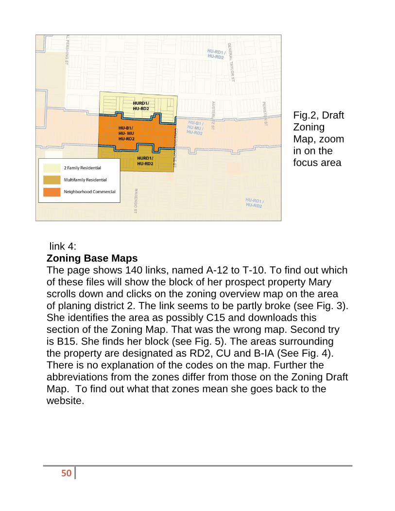
Fig.2, Draft Zoning Map, zoom in on the focus area
link 4: Zoning Base Maps The page shows 140 links, named A-12 to T-10. To find out which of these files will show the block of her prospect property Mary scrolls down and clicks on the zoning overview map on the area of planing district 2. The link seems to be partly broke (see Fig. 3). She identifies the area as possibly C15 and downloads this section of the Zoning Map. That was the wrong map. Second try is B15. She finds her block (see Fig. 5). The areas surrounding the property are designated as RD2, CU and B-IA (See Fig. 4). There is no explanation of the codes on the map. Further the abbreviations from the zones differ from those on the Zoning Draft Map. To find out what that zones mean she goes back to the website.

51
Fig. 3 Overview of the Base Zoning Maps (above)
Fig. 4 Zoom in on the Base Zoning Map (below)

52
link 5: Draft Zoning Ordinance Text
Looking back on her draft zoning map (Fig.2) she tries to find out what HU-RD1 could mean. It takes her a bit to figure out that HD it is the abbreviation for Historic Urban and R stands for residential. She downloads the articles explaining the zones, but she cannot figure out what the letters RD2, CU and B-IA on the Base Zoning Map ( Fig. 5) mean. Mary returns to the Nola.gov website and clicks on the FAQ's. On the question "How can I find out the definition of a specific zoning designation?" The site states the following answer :
"The City Planning Commission website offers a link to Lexis Nexis where detailed a definition of specific zoning district and overlays can be found." ( Nola.gov, 2012) This Link however cannot be found. Mary googles "Lexis Nexis" "New Orleans" "zoning". The 4th entry is "New Orleans, Louisiana Zoning Ordinance". When Mary clicks the link she comes to a site that says: "We’re sorry, but the product you are looking for is not currently available.
Click here to continue shopping."
(http://www.lexisnexis.com/store/catalog/booktemplate/productdetail.jsp?pageName=relatedProducts&catId=46&prodId=41874, 2012)

53
Fig. 5. Land use survey from the focus area
By googeling the specific abbreviations she finds out that RD2 means residential district 2 family and CU could possibly mean "conditional use". She could not find out what B-IA means.
Site Visit Mary decides to revisit the site with all the maps she has. When she takes a look at the actual buildings she finds, that most of the houses within the RD2 section (draft zoning map) are actually single residential, while the area designated to multifamily residential has mostly double family structures. The area designated as mixed use has, except of one building, strictly commercial uses (see Fig. 5).
During this whole process Mary did not stumble over the "Citizens Guide to Land Use".

54
Conclusion: The process of navigating through the zoning and land use landscape is daunting. A lot of information is not easily accessible. Broken links make the process even more difficult. The fact that finding out for what to search already takes so long is quite demotivating.
Questions raised within the process are: - What is the difference in purpose of Land Use Maps in comparison to Zoning Maps? - Why are there 2 different Zoning Maps? - Where can Information on the zones be found?
(Stephens)
Description of Planning District 3
Planning District 3 is a large group of neighborhoods often locally referred to as “Uptown”. It is bound by the Mississippi River to the south, Napoleon Avenue and Toledano Street to the east, Earhart Boulevard and the Pontchartrain Expressway to the north, and finally the Orleans/Jefferson Parish line to the west. It is largely designated Residential Low Density Pre-War land use and provides a fairly even mix of single- and multi-family homes. The other land use categories present are Mixed-Use, including the popular Magazine, Oak, and Maple Streets; Institutional, which represents Tulane and Loyola Universities, many primary and secondary schools, and two major medical facilities, Children’s Hospital and Ochsner Baptist Medical Center; and Parkland and Open Spaces, including Audubon Park. This popular area of the city offers a wide variety of residents from different backgrounds and with unique interests and needs, which gives planners a large and diverse group of citizens to reach out to and include in the planning process (The Unified New Orleans Plan, 2007).

55
Current Planning Issues and Community Involvement
Planning District 3 does not appear to have many complicated zoning issues to be amended and included in the New Orleans Master Plan. Nearly all of the proposed changes simply transform residential areas to mixed-use areas and vice versa or resolve current zoning conflicts, where buildings have been used for one purpose for an extensive period of time, but are zoned for another purpose.
To some areas needing more amendments to their section of the plan, these issues might seem minor and for the size of this planning district, the amount of amendments is relatively low. However, the citizens in this district appear to be very active in the planning process in their community. The suggestions and comments gathered for this planning district were contained in nine separate documents on the City Planning Commission’s website, while every other district had only one document. When reading through these comments, many residents welcomed the proposed changes and offered constructive comments and suggestions for areas that they would like to include in the plan. It was clear that these citizens do care about their district and have taken the initiative to get involved in the planning process, thus insuring that their district is planned to meet their needs.
Findings of Site Visit
When conducting my site visit, I chose the area bound by the 5600 blocks of Magazine and Constance Streets and the 700 blocks of Joseph and Arabella Streets. This area is designated for a mixed-use land use, which is exactly what I found during my visit.

56
The properties directly on Magazine Street housed commercial buildings, such as the massive Whole Foods Market, the Romney Pilates Studio, Chicos, Pinkberry, and various other small restaurants and shops. Joseph, Constance, and Arabella Streets each held multi-family homes and residential developments. I was very disappointed to find big box retail, Whole Food Market, in this area.
With a general pattern of small-scale homes and local shops, this massive structure sticks out and dominates the other buildings on the block. However, I was glad to find that an open parking lot was not allowed and rather parking was contained in a small covered lot that blends into the façade of the building. With the exception of the big box Whole Foods Market, these findings are directly consistent with what I expected to find in this area, as well as with the planned land use, and fit into the landscape of the surrounding areas.
The next section of this report contains a map and list of properties discussed and photographed during my site visit. Individual photographs of each property can be found in Appendix A at the end of this report.

57
Map: Site Visit Properties
Property 1 | Whole Food Market
Property 2 | Chez Nous Restaurant
Property 3 | Dirty Coast T-Shirt Shop
Property 4 | Romney Pilates Studio
Property 5 | Shopping Center – Chicos, Pinkberry Frozen Yogurt
Property 6 | St. Joe’s Bar
Property 7 | Slice Pizzeria
Property 8 | Private Residential
Property 9 | Arabella Residential Private Community
Property 10 | Private Residential

58
Section 5 | Limiting Conditions
What could be been provided to allow for a better review process?
I believe that I could have better reviewed the New Orleans Master Plan and The Citizen’s Guide to Land Use if I had a more time to establish a solid understanding of the intricacies of the plan and my assigned Planning District. Because the planning documents available on the City of New Orleans website were somewhat complicated to navigate, I was unable to locate all of the necessary documents and comprehend all of the concepts within the documents for an in-depth plan analysis. If the documents presented on the City’s planning website were more concise and organized, I feel that I could have better reviewed and understood the plan elements.
What parts of this analysis could be studied further?
The current citizen participation efforts in my assigned planning district and the city as a whole could be studied further. I would have liked to meet some of the active citizens from my district and discuss the plan and how they have participated in the planning process. I believe that this would have helped me better decide if the planning tools available to citizens in New Orleans are adequate for successful citizen participation.
As mentioned previously, the plan itself could also be studied further for a better understanding of the tools available to citizens wishing to participate in the planning process.
(Mucci)
Site Visit

59
In District 10, there is a strong Vietnamese community with a great deal of wealth an influence. Immediately after Hurricane Katrina, they came back to a completely devastated area with few standing structures. While this may seem unfortunate, it did allow them to start from scratch in developing their community.
The community engaged themselves and started to rebuild their district. However, their planning and redevelopment efforts moved at a much faster pace than the City of New Orleans planners. They developed their own planning committee through the Queen Mary of Vietnam Church which issued the following statement
1:
MQVN Community Development Corporation, Inc. (MQVN CDC) was established by community leaders in May 2006 to assist Vietnamese-Americans in New Orleans East rebuild their lives and their community after hurricane Katrina.
In the immediate aftermath of hurricane Katrina, MQVN CDC played a leading role in providing emergency relief assistance as well as organizing Vietnamese-American residents to play an active role in the rebuilding of the community surrounding New Orleans East area.
MQVN CDC's mission is to preserve and promote our unique diversity and improving the quality of life of residents in the Greater New Orleans area, beginning in New Orleans East. Together with community partners, our work encompasses health care, environmental and agricultural concerns, education, housing, social services, economic development and culture and the arts.
They initiated new construction projects throughout district 10 before the city planners started to collect data. Most neighborhoods were re-built, a community center was

60
established, and ground was broken on several new parks. (See Appendix 2 – Site Photos)
When the city planning committee finally came to do a baseline survey of the area, they found already completed housing, schools, etc. Therefore, the existing plan maps were developed using the already established future goals. Upon reviewing the existing land use map, you find that there is little to no changes to the future land use map. The only changes one can find is the expansion of the commercial area, and the expansion of neighborhoods, which was already previously planned.
The way I evaluated the overall progress of the area was to study 10 contiguous blocks within the district. I chose a neighborhood that straddled the commercial area, middle income residential, and the residential area within the Vietnamese community. I found that businesses were doing well and several new developments had been started. Moving into the middle income, I found that while there was some new construction, it was of low quality and the streets were in disrepair. Moving into the Vietnamese community, it was obvious where the influence was coming from. House after house, there were “McMansions” lining the streets.
There was also a wide main road separating the more expensive houses from the middle income ones. The Vietnamese community appeared to be very insular and separated themselves from the rest of the district. Even the new playground was fenced in, forcing entry through the Queen Mary of Vietnam church.

61
Neighborhood Study Narrative
Since the planning process was already initiated by the Vietnamese community, the Unified New Orleans Plan (UNOP) was forced to follow it. The planning process identified the needs, vision and goals of the community. In order of importance they identified Housing Conditions, Historic Preservation, Economic Development / Business Activity, Transportation/Transit Conditions, Infrastructure / Public Works, Hurricane / Flood Protection, Public Safety, Education / Health care, and other Community Services.
Housing conditions were very poor in the district after Hurricane Katrina. Most houses were destroyed past the point of no repair. So the community started to rebuild the neighborhoods from the ground up. However, the plan does not account for any mixed income or low income property. It also excludes all multi-family housing. I believe this sends a negative message to the surrounding communities, implying that you have to be of a minimum income level to access the district.
Historic Preservation was one topic I found odd for the area. Since everything was destroyed, there was nothing left to preserve as historic. I think it was a broad term used by New Orleans planners that gets thrown into every plan. I think that this idea of historic preservation also has a tendency to slow down any real progress. Construction permitting takes much longer when having to consult with the State Historic Preservation Office (SHPO), even when it is established that there is nothing of historic value in the area.
Economic Development and Business Activity is one very positive aspect of the plan. It calls for the development of a commercial corridor, the re-establishment of retail outlets, and the expansion of the commercial zone by the canal to the south.

62
Economic Development will help bring much needed income to the district so that repairs can be made to the public utilities in the middle income level neighborhoods, not just the rich ones.
Transportation if mentioned in the plan in a rather idealistic manner. It emphasizes public transportation and expanded bike lanes, but based on how spread out the area is and the distance between homes and retail, one must ask who the bike lanes are serving. Also, public transportation is another idealistic notion since most people elect to drive their own cars since the residents of the district are at a high income level.
Infrastructure and public works are areas that are lagging behind. The communities managed to rebuild quickly, but since he government process for funding approval and construction takes so long, many streets are still full of pot holes, there are still many downed light poles, and a lot of missing street signs. Infrastructure should really be one of the higher priorities simply because a city can’t grow larger than what the infrastructure can support.
Hurricane and Flood Protection is another issue that could be seen as idealistic and not realistic. Since this is the lowest area of the city in elevation, it is at extreme risk of flood, even from heavy rain. The current plan does mention an evacuation plan, but that is about the only option for this area. I think the plan needs to go into further detail about such an important issue.
Public safety is another issue that district 10 struggles with. Since there are very few residents, businesses are the targets of criminal activity. Unfortunately the only way to secure the areas would be to increase the amount of patrols, but with budget constraints, this is unlikely to happen. The plan did also mention 100% enforcement of penalties. The idea is to send a zero tolerance message as to deter people from committing any crimes in the first place.

63
Healthcare and Education are mentioned together in the plan mostly because the district lacks hospitals and public schools. A single charter school is the only available educational institution, and the hospitals are located in other districts. The plan calls to re-open the closed public schools and develop healthcare facilities. It is a very broad idea and somewhat vague on how to execute the plan.
The last goal for the plan is simply labeled as “Other Community Services”. It is a vague goal meant to capture any miscellaneous projects that come up that could not fit into one of the other established categories. It is a smart thing to say it in this manner so that the plan has some flexibility when it comes to implementation. Most of the specific items listed in this goal are parks and recreation areas.
Overall I think the plan is a good plan. However, since the Vietnamese community started implementing their plans before the city had a chance to have their say, I think a large portion of the population is excluded from moving into the area. This is because the city plan was an adaptation of the community’s internal plans. In regards to formatting, the UNOP plan was easy to navigate and understand, well lay out, and had excellent graphics / maps.
Statement of Limiting Conditions
The hindrances I found to analyzing the plan had more to do with the citizen engagement. I found plenty of material from the Vietnamese community, but none from any other residents. It felt as if the planning was done behind closed doors and the city was not consulted. Another limiting condition was the fact that the plan had seemingly no change from current conditions. It took a while to travel around the site checking on multiple locations just to find that nothing was going to change.

64
(Kroll)
Discussion of the Plan for the 21st Century and the Neighborhood Study Area Having discussed the strengths and weaknesses of the Citizen’s Guide generally, we will now use it to evaluate recent land use planning in one portion of New Orleans, Planning District 6. Planning District 6 is one of the city’s thirteen planning districts and contains the Gentilly neighborhood. The district is bounded by Bayou Saint John to the west, the Industrial Canal to the east, Lake Pontchartrain to the north, and Interstate 610 to the south. As of the 2010 Census, Planning District had a population of 30,488 people, 75% of which were African-American and 16% of which were white, with the remaining population composed mostly of Asian and Hispanic residents. It had 12,205 housing units, 63% of which were owner-occupied (Greater New Orleans Community Data Center, 2010).
Planning District 6 was mostly developed in the decades immediately before and after World War II and features the development pattern of that era. Its streets follow a traditional grid pattern, forming rectangular squares. These squares are divided into lots of consistent size and shape. As the area was developed after the establishment of a citywide zoning code, its land use patterns are generally homogeneous. Most of the district is occupied by detached single- and two-unit residences, while commercial uses are generally restricted to major streets. The district also features large institutional uses in the campuses of Dillard University, Southern University at New Orleans, and the University of New Orleans. This land use pattern is shown on the city’s most recent existing land use map, which was published in 1999. Though that existing land use map is somewhat outdated due to its age and the fact that it was created prior to Hurricane
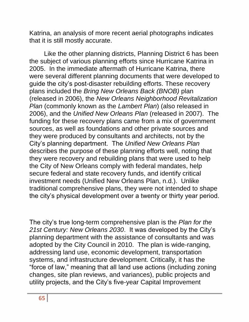
65
Katrina, an analysis of more recent aerial photographs indicates that it is still mostly accurate.
Like the other planning districts, Planning District 6 has been the subject of various planning efforts since Hurricane Katrina in 2005. In the immediate aftermath of Hurricane Katrina, there were several different planning documents that were developed to guide the city’s post-disaster rebuilding efforts. These recovery plans included the Bring New Orleans Back (BNOB) plan (released in 2006), the New Orleans Neighborhood Revitalization Plan (commonly known as the Lambert Plan) (also released in 2006), and the Unified New Orleans Plan (released in 2007). The funding for these recovery plans came from a mix of government sources, as well as foundations and other private sources and they were produced by consultants and architects, not by the City’s planning department. The Unified New Orleans Plan describes the purpose of these planning efforts well, noting that they were recovery and rebuilding plans that were used to help the City of New Orleans comply with federal mandates, help secure federal and state recovery funds, and identify critical investment needs (Unified New Orleans Plan, n.d.). Unlike traditional comprehensive plans, they were not intended to shape the city’s physical development over a twenty or thirty year period.
The city’s true long-term comprehensive plan is the Plan for the 21st Century: New Orleans 2030. It was developed by the City’s planning department with the assistance of consultants and was adopted by the City Council in 2010. The plan is wide-ranging, addressing land use, economic development, transportation systems, and infrastructure development. Critically, it has the “force of law,” meaning that all land use actions (including zoning changes, site plan reviews, and variances), public projects and utility projects, and the City’s five-year Capital Improvement

66
Program and annual capital budget must be consistent with the plan’s goals, policies, and strategies (City of New Orleans, 2010, vol. 2, ch. 1, p. 1).
While the plan mostly addresses economic development, transportation systems, and infrastructure development at the citywide level, land use is addressed at the level of the planning district. The plan articulates what areas are to be used in what ways through future land use maps that are specific to each planning district. These future land use maps have all the characteristics of the typical land use map described in the Citizen's Guide, including streets, bodies of water, and, most importantly, color-coded land use designations (Foundation for Louisiana, 2011, p. 4). Just as described in the Citizen's Guide, shades of yellow represent types of residential areas, shades of red indicate commercial areas, and gray shades represent mixed-use areas, etcetera (Foundation for Louisiana, 2011, p. 4). The future land use map, like the rest of the plan, has the force of law. As such, only zoning changes that are consistent with the map’s color-coded land use designations can be made. For example, if the future land use map designates a particular property for residential use, then it cannot be rezoned to a commercial zoning district.
With a few exceptions, the Plan for the 21st Century’s future land use designations for Planning District 6 reinforces the status quo. Overall, it does not call for dramatic changes in land use. Comparing the future land use map to the existing land use map the City created in 1999, we see that areas that were low-density residential in 1999 are designated for low-density residential use in the future, while most areas that were used for commercial purposes in 1999 are to be used for commercial purposes in the future. The only exceptions are that some areas that were used commercially in 1999 are designated as mixed-use areas by the future land use map.

67
One shortcoming of the Plan for the 21st Century's land use plan and land use plans in general is that they cannot address all problems related to the development of a neighborhood. Though this is not adequately discussed in the Citizen's Guide, a limitation of land use plans and the zoning ordinances that implement them is that they can really only guide the use of land. They cannot ensure that any particular property is actually used. In growing communities, this is not really a problem since the high demand for land ensures that most properties are used. However, it becomes a problem in neighborhoods such as Gentilly, which suffer from shrinking or stagnant populations. In these areas, where there are over-supplies of property relative to demand, the land use issues of greatest concern have to do with blight and vacancy resulting from properties going unused, not unacceptable mixes of land uses in certain areas.
While a land use plan cannot by itself create the demand for land that is necessary to address these issues of blight and vacancy, these issues can be addressed elsewhere in a comprehensive plan, such as in sections related to economic development efforts and blight mitigation efforts. For example, comprehensive plans can call for the establishment of programs that convert vacant lots to community gardens, urban farms, or facilities. It is important that land use plans include land use designations that are flexible enough to allow for some of these facilities. For example, the Plan for the 21st Century's land use categories generally does not include community gardens and similar facilities in the range of uses they allow. Rather, those uses are mostly restricted to those areas designated as "natural areas" and "parkland and open space." By not allowing community gardens in residential areas, the future land use plan may preclude one effective strategy for addressing blight and vacancy from being used in many residential parts of the city.

68
Another land use problem that Gentilly is experiencing that the Plan for the 21st Century's future land use plan is not well suited to address is that new residential structures are often out of scale with existing residences. Gentilly's older housing stock is composed mostly of small single-story bungalows, most of which are raised only a few feet above grade. In contrast, the new residences that have been built since Hurricane Katrina often stand three stories tall, as they are raised a full story above grade and usually have two stories of living space. This larger size is partially a result of stricter base flood elevation requirements and partially a product of the contemporary taste for larger homes. When a vacant lot that is surrounded by older structures is redeveloped, the new structure frequently dwarfs its older neighbors in size. This is illustrated by the photograph to the right, which is of properties in the 4900 block of Marigny Street.
At first, this may seem odd. After all, land use plans are usually intended to guide not only the use but also the massing and physical characteristics of buildings. Looking at the future land use map, we see that much of Planning District 6, including the 4900 block of Marigny Street, is designated as Residential Single-Family Post-War, which is indicated by a pale yellow color. That future land use category calls for “preserv[ing] the existing character and scale of low-density single-family residential in post-war (WWII) areas of the city and allow[ing] for compatible infill development.” The fact that Gentilly's newer residences are out of scale with the neighborhood's older structures would seem to violate the Plan for the 21st Century's land use goal of ensuring that new development is consistent with the scale and character
69
of existing development (City of New Orleans, 2010, vol. 2, ch. 14, p. 14.10). So how is this being allowed?
The culprit here is that while the land use plan states that new and old development should be similar in size and character, it does not actually define acceptable size and character. This is done through the zoning ordinance, which sets specific height, bulk, setback, and design requirements (Duerksen et al., 2009, p. 81). Currently, there is a disconnect between the heights of most of Gentilly's older homes, which usually measure approximately twenty feet in height, and the height limits in the zoning ordinance, which allow new residences in most of Gentilly to be up to forty feet in height. While the City is in the process of addressing this by developing a new zoning ordinance, this example shows that the Plan for the 21st Century's land use plan is only as effective as the tool that is used to implement it, the zoning ordinance. Because the zoning ordinance's current standards do not reflect the land use plan's goals, those goals are being undermined.
(Marmol) Use of the Citizen’s Guide in evaluating Planning District 5 Background
District 5 is located in the northwest corner of Orleans Parish and includes six neighborhoods, totaling a population of 19,642 residents (U.S. Census 2010). The neighborhoods associated with this district are Lakeview, Lakeshore/Lake Vista, Navarre, West End, City Park, and Lakewood. The district is bordered by Lake Pontchartrain to the north, Jefferson Parish to the west, Bayou St. John to the east and New Orleans Country Club, City Park Avenue, Toulouse Street, North Carrollton Avenue, and

70
Orleans Avenue to the south. The racial make-up of the district is 84.4% white; 5.7% Black or African American, and 9 % other.
District 5 is mostly residential and open space. Most of the residential housing was built after World War II from the late 1940’s to the late 1970’s (UNOP, 2007). According to the Unified New Orleans Plan, “the predominant character of housing consists of suburban slab-on-grade, ranch style, single-family homes” with the exception of older neighborhoods characterized by the traditional, two-story homes (UNOP, 2007). District 5 is heavily auto-dependent. Public transit is very limited.
Pre-Katrina, this district was known for its socio-economic wellbeing as well as for being a family-oriented district. This stability was partly due to this district’s high (UNOP, 2007). There are a few key commercial nodes in several clustered areas including Harrison Avenue, Robert E. Lee Boulevard and at the south end of Canal Boulevard.
“Plans” for District 5 The Future Land Use Map District 5 adopted in 2010 by the City
Planning Commission illustrates the visions represented in the City’s Master Plan. The Land Use Map for district 5 specifically shows the residential character of the area. The land use plan calls for the revitalization of a neighborhood commercial corridor along Harrison Avenue, as well as it encourages a few other mixed-use locations. One of the most prominent changes adopted was the proposal to zone the marina area as mixed-use high density. Interestingly enough, almost all locations previously recommended as multi-family residential in the early land use draft, have been changed to mixed-use areas instead.
The Master Plan is a comprehensive plan that reflects a vision for the community of New Orleans as a whole. Although it contains land use maps for each district, and a general understanding of the plan does not go into any detail of the small

71
planning areas (i.e., districts, neighborhoods).
The Unified New Orleans Plan for Recovery and Rebuilding (UNOP) was an action-oriented plan created in 2007 to include all neighborhoods in planning the recovery of the city. One of its main focuses was to inform local, state, and federal governments of critical funding and resource allocation decisions. The UNOP was a first decent attempt to neighborhood or small area planning before even adopting a new comprehensive master plan. This is unique to New Orleans because at the time the city needed a plan of action for recovery. The plan is broken up into specific districts, which made planning for recovery much more specialized depending on the needs and aspirations of each community. However, UNOP has not been updated since 2007 and therefore the information is outdated. Even though UNOP is a recovery plan and not a master plan, I have evaluated UNOP using the Plan-Quality Evaluation Protocol. See Appendix A for the entire evaluation.
Community Transept The Harrison Avenue corridor is zoned as a Lake Area Neighborhood Business District and according to the Future Land Use Map is proposed to be both mixed-use low density as well as commercial. The corridor is surrounded by Post-War single-family residences. Currently the area has a number of thriving businesses. Among these businesses we can observe a number of restaurants, shopping centers, coffee shops, and banks. Additionally the corridor also houses institutions such as St. Dominic Catholic Church and Edward Hynes Elementary School. A future MD Urgent Care facility is under construction.
An interesting fact is the allocation of banks in this corridor. Whitney Bank, First NBC Bank, and the Gulf Coast Bank and Trust Co. are all clustered in a four block radius bound by General

72
Diaz Street and Marshall Foch Street. I found this to be an odd allocation of commercial land, since nowadays with the advent of technology and the Internet, banks are much less visited.
There is ample parking in this corridor to serve the auto-oriented neighborhoods of District 5. As of 2009, the median of Harrison Avenue was widened to include parking. This was accomplished by reducing the size of the streets. These changes have given the corridor a much more human-scale as well as better access to residents from nearby neighborhoods. Even though car access in this area is key, it is also important to plan for a variety of transportation modes, such as biking and public transit. This has not been the case in the area. Biking amenities and facilities are very limited.
Limiting conditions Currently, access to information is both chaotic and limited. The website Nolamasterplan.org, home to the City’s Master Plan as well as to the Comprehensive Zoning Ordinance draft has not been working properly for some time. Consequently, all the information is now located on the City of New Orleans’ website. The information is not divided per districts or neighborhoods, which makes navigation much more complicated and less user-friendly.
Additionally, information about the different community organizations is to a large extent non-existent on the web, which is problematic to members of the community wishing to get involved.
(Monnet)
The City Planning Commission divided the planning area into 13 districts. The Guide states, “Knowing what district you live in is the first step to providing input on planning issues in the city.” I would

73
disagree with this contention. Familiarizing yourself with the Guide would be the appropriate first step. Then, finding your district would be the second. Then, seeing what in the CZO pertains to your district would be the third. So, for the use of determining if the Guide and the information laid forth in it would prepare me to become an engaged citizen, I am going to analyze District 8.
District 8 is the area commonly known as the Lower 9th
Ward. This area is bounded by the Industrial Canal to the West, St. Bernard Parish to the East, Florida Ave to the North and the Mississippi River to the South (Figure 2). Few would disagree that it was the area hardest hit after Hurricane Katrina and the subsequent levee failures. As a result, planning in this area was in some ways the most easy and in other ways, the most difficult.
Some would contend that the planning process was made easier by the fact that the Lower 9
th ward was completely
obliterated, giving planners a clean slate. There would be no need for consideration of saving anything or historic preservation because everything was destroyed, if not completely wiped away. But, from the aspect of community engagement, the planning process took on a whole new level of difficulty. There were no citizens to consult. The citizens of this area were, quite literally, everywhere. Planners were faced with the difficult task of attempting to include the input of a citizenry that could barely locate each other, let alone be located by an agency attempting to rebuild.
Reviewing the map of District 8 would be much more difficult if it were not for the information that was provided by the Guide. While a key is provided, knowing what each color represents gives the user a sense of confidence that they would not possess if the community meeting was the first time they came face to face with any of this information. A resident cannot know they do not want Multi-Family Residential in their neighborhood without

74
knowing what that is? This is why the Guide is a valuable asset in assessing a specific neighborhood plan, in this case, District 8.
After analyzing the land use map for District 8, I went down to the Lower 9
th Ward in order to see how the plan matches up

75
with what is actually occurring. Looking at the map, mostly everything above North Claiborne is zoned Residential Single Family. This, to me, tells a lot about the demographic of the Lower 9
th Ward. Families live there. Most of the families are
homeowners. This would be consistent with what I knew of the area before the storm. Visiting the area, there is very little there, but what is there is consistent with the land use map-single family homes.

76
Within this area, though, there are two different rebuilding efforts happening. There are the individuals who are attempting to rebuild houses on their own. In this area, building is sporadic and has resulted in the “jack-o-lantern” effect that is associated when a rebuilding effort comes entirely from the community and they are mainly rebuilding with their own resources. Then there’s the area immediately northwest of N. Claiborne Ave. This area has been redeveloped with the vast resources of the Make It Right Foundation.
Make It Right was started by actor Brad Pitt after Hurricane Katrina and the levee failures flooded 80% of New Orleans. The web site states, “Hardest hit was the Lower 9
th Ward where more
than 4,000 homes were destroyed by the storm and the surge of water caused by the breach of the Industrial Canal levee.” It goes on to state that after touring the city more than 2 years after the storm he (Pitt) noticed, “…no progress had been made in the Lower 9
th Ward. Still, the community was determined to rebuild.
After meeting with local families, Pitt established Make It Right to build 150 green, affordable, high-quality design homes in the neighborhood closest to the levee breach.”
The foundation has honored the commitment it made to the neighborhood. The website offers a very impressive timeline: after groundbreaking in March 2008, construction on the first home began in June 2008. The first 6 homes were completed by August 2008. The first 50 homes were completed by December 2010. The first 75 homes were completed by May 2011. (Make It Right). Figures 3-5 are all examples of Make It Right homes that were completed in the 1000 block of Deslonde St. Figure 6 shows the progress Make It Right has made in this particular section of the Lower 9
th Ward.
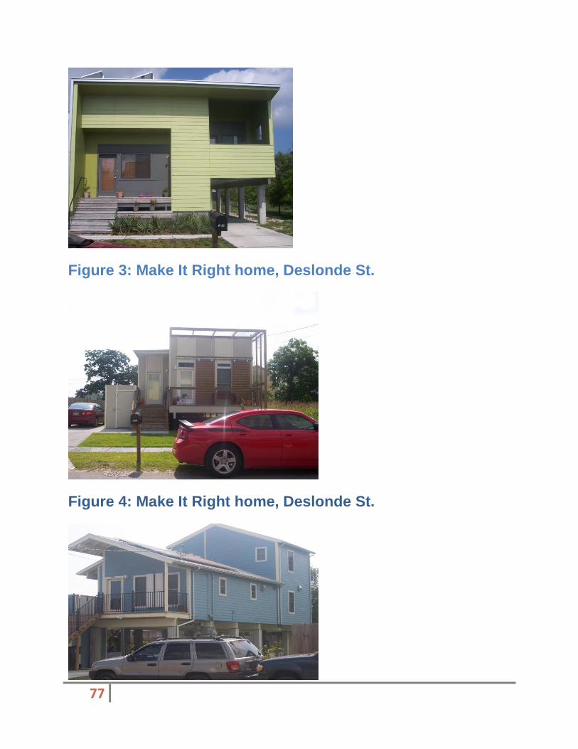
77
Figure 3: Make It Right home, Deslonde St.
Figure 4: Make It Right home, Deslonde St.

78
Figure 5: Make It Right home, Deslonde St.
Figure 6: Map of all completed Make It Right Homes
The agency is in the progress of building 19 additional homes, as shown in Figures 7 and 8. The area Make It Right has chosen to redevelop is a bright spot in an otherwise desolate location. As you are leaving the area, you can see that there are homes being built next to slabs of former homes that haven’t been removed (Figure 9, property #68 in Figure 6).
Redevelopment in other areas of the 9th ward have been
piecemeal and completely citizen driven. There are very few businesses and only one school, an elementary school that co-

79
exists with the area’s only library (Figure 10). Businesses are nearly non-existent. According to the land use map, there isn’t any plan for a commercial district of any significance.
Figure 7: Construction of Make It Right home

80
Figure 8: Construction of Make It Right Home

81
Figure 9: Forstall St.
The land use plan calls for three blocks on either side of N. Claiborne to be developed as commercial. This is a mistake. The residents of the Lower 9
th ward need and deserve a thriving
commercial center, just as every other area of the city needs and deserves the same thing.
The other major thoroughfare, St. Claude Ave., is entirely mapped as mixed use high density. This is another mistake, due to the lack of rules regarding the intensity of the area. Figure 11 shows the type of businesses that have sprung up along St. Claude Ave. By not zoning this area commercial, which it should be, there is a wasted potential to attract major businesses to one of the few areas of the city that has the available land mass to put in any type of large retail development.

82
Figure 10: Martin L. King School/Library
Figure 11:Business on St. Claude Ave
For the most part, business, just like residential in the lower 9
th ward, is a shell of what it used to be, quite literally. Figures 12-

83
15 show areas of District 8 that are still standing abandoned. Unfortunately, displays like this are the rule, not the exception.
Figure 12: Vast area of Lower 9th
Ward

84
Figure 13: Abandoned business on Claiborne
Figure 14: Abandoned home in Lower 9th Ward
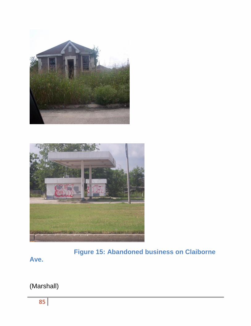
85
Figure 15: Abandoned business on Claiborne Ave.
(Marshall)

86
District 9 Overview
District 9 is a suburban style region on the outskirts of the city of New Orleans. It formed this type of lifestyle due to the fact that it was developed on the fringe of the city during a time of a great migration out of downtown and into the suburbs. Residents of this district predominantly live in slab foundation, ranch style houses or in one of the many multiunit apartment complexes. The major commercial corridors are the north to south routes of Downman, Crowder, Read, and Bullard, and the east to west routes of Hayne, Morrison, Lake Forest, and Chef Menteur. Heavy Industry is mainly located on Jourdan Road, which runs along the Industrial Canal and Almonaster Avenue which parallel to the Intercoastal Waterway. Interstate 10 runs directly through the center of District 9, east to west, and is the primary route in and out. It serves as a main evacuation route during hurricane season. New Orleans Lakefront Airport serves as a regional commercial airport, primarily used for small charter flights. There is direct access to Lake Pontchartrain along Hayne Blvd., but a levee separates the lake from the rest of the district.
The overall point of this project is to understand all of the tools that New Orleans has in place to explain the current land use plan. I will use any material that I may find to understand the development plan for my district of study, district 9 commonly known as New Orleans East. My focus has been centered on the UNOP plan, because this plan appears to be the most relevant in my study and it is the only plan that has a section specific to New Orleans East. I will critique this plan along with any other sources that I may find, on the basis of relevance to the region, functionality, flexibility, and citizen input.
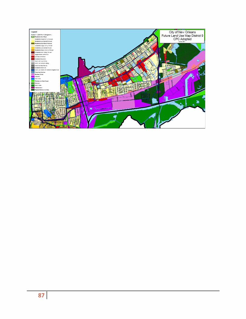
87
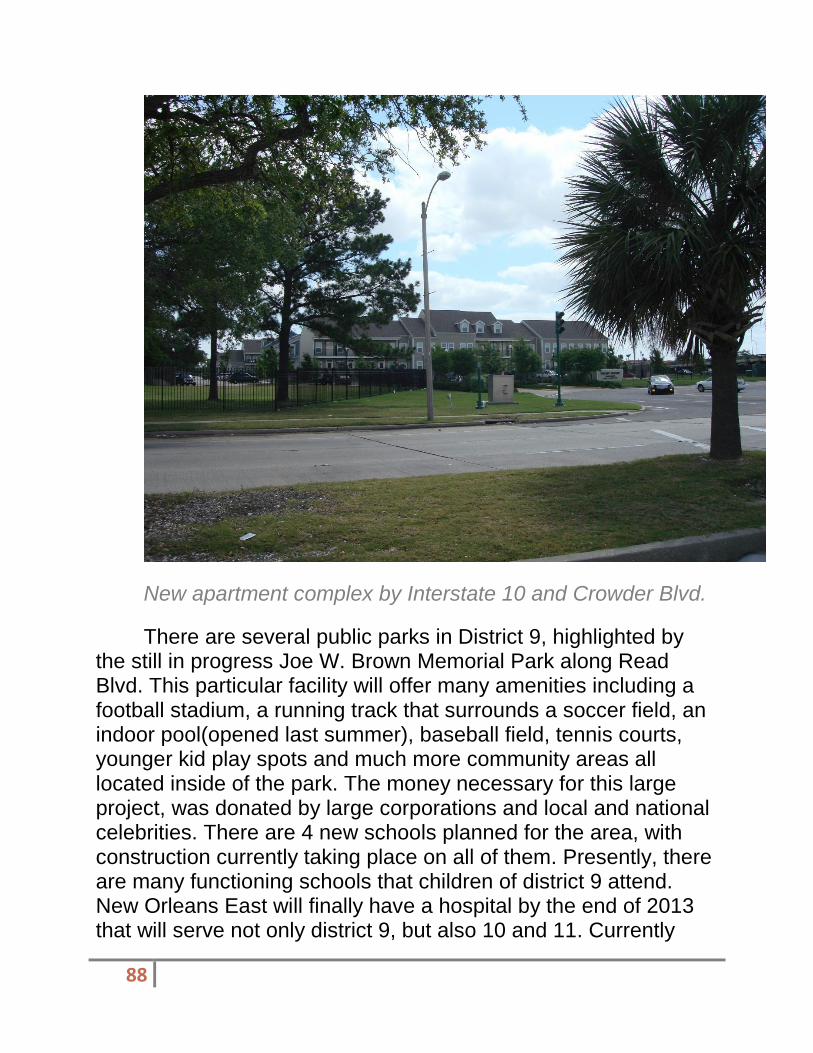
88
New apartment complex by Interstate 10 and Crowder Blvd.
There are several public parks in District 9, highlighted by the still in progress Joe W. Brown Memorial Park along Read Blvd. This particular facility will offer many amenities including a football stadium, a running track that surrounds a soccer field, an indoor pool(opened last summer), baseball field, tennis courts, younger kid play spots and much more community areas all located inside of the park. The money necessary for this large project, was donated by large corporations and local and national celebrities. There are 4 new schools planned for the area, with construction currently taking place on all of them. Presently, there are many functioning schools that children of district 9 attend. New Orleans East will finally have a hospital by the end of 2013 that will serve not only district 9, but also 10 and 11. Currently

89
these residents are forced to go downtown for major services that cannot be handled by present, local clinics. There are 2 fire stations and 1 recently completed police station to serve the district.
There are many new projects that make district 9 sound like a place that has a bright future. New state of the art schools, a park, a police station, a regional library, and flood protection are not the only projects planned. The residents of New Orleans East are aggressively pursuing new commercial developments. A new WalMart is planned near the site of the old store destroyed during Hurricane Katrina and the old Six Flag site in neighboring district 10 is under consideration for a possible factory outlet mall. Currently, the only big box stores are Lowes and Home Depot hardware stores.
There is, as of today, only 2 national big box stores in a region that has over 60,000 people, roughly the size of Kenner and Lake Charles. There is only one major grocery store and a few smaller convenience stores in the district. Many citizens want national brands of grocery and clothing stores, and chain restaurants. There are many abandoned buildings, which once housed commercial establishments, which have not opened since Katrina. If a person drives from the east on Interstate 10 and has never been through the area, they would see empty lots that once housed large stores, houses that are still blighted and many empty office buildings that have not filled in 6 years. These sites would lead one to believe that district 9 is not very populated and is still in major recovery mode. These areas have been the center of attention in many of the plans, but much work is still needed.

90
Abandoned shopping strip along Crowder Blvd.
District 9 was not a center of commercial activity immediately before the storm. There was an adequate amount of local restaurants and grocery stores, but large name brand stores tended to shy away in favor of locations in Jefferson and St. Tammany parishes. Lake Forest Plaza mall did not reopen after Katrina due mostly to the years of decline. Blight also became an issue long before the storm, as people began to move to other areas due to poor economic conditions and a declining crime situation. Today, areas with the highest amounts of blight have the highest occurrences of crime. This is coincident with the rest of the areas of the city.

91
Typical middle class house along Crowder Blvd.
(Guess) Evaluation of the City of New Orleans District 4 neighborhood plan
The plan for District 4 of the City of New Orleans comprehensive zoning ordinance (CZO)
[3][2] meets the criteria for

92
a quality plan. With the web site provided, and at a quick glance, I was able to access graphic information systems (GIS) maps of the entire district and their future land codes as of June 22, 2010
3[A-1], complete with the anticipated linier park project The
Laffite Corridor. Additionally I was able to view traditional home in the area to get a perspective of traditional authentic life in district 4.
Some criticisms of the CZO is its fragmented nature and difficultly to locate online. New Orleans, and more specifically Orleans parish, is not that large. The web site seems usually difficult to traverse and segments the information. An example of this is the location of the residential zoning codes. The codes are defined at the CZO site
6 but not used in the Future Land Use Map
of district 43.
Citizens were engaged in the cities mater plan process. Possibly because New Orleans purposed some radical redevelopment strategies after Hurricane Katrina or because New Orleans communities each have unique characteristics, the citizens took an active role in their redevelopment. Refreshingly, the planning legislature received and noted their concerns and suggestions and posted a PDF file on the city website
2. The
planning legislature was unable to accommodate the request of all citizens and some of the structures that are erect now are proof the every community cannot be zoned R-1 (Low density residential). Interestingly enough almost every request from individual property owners was opposed to high-mid density for their area. Some went as far propose alternative areas where they felt higher density would a better fit, it began to embody the planner acronym N.I.M.B.Y. (Not in My Back Yard).
Larger organizations such as HANO participated in the citizen’s engagement process. Larger organization and institutions have planned to repurpose old schools into living

93
units. The layperson could forget that all community serving agencies like housing authorities and school districts do not have a seat at the table in all affairs that affect the city, planning included, a quick glance at the citizen’s letter to the planning legislature will remind them. Larger community serving organization participated in the planning process. Zion city, although opposed to a very small amount of their assigned zoning, took the opportunity to request other land use items. Examples include being referred to as “Zion City” or “Mid City” and preserving their residential and business corridor with including any additional industrial uses. Gert Town obviously took notice and followed suit. These two communities are adjacent to each other and used the same template.
Site Visit (Photo’s/Analysis)

94

95

96

97
�
98
Site Visit Narrative The city has zoned the area in my site visit med-density mixed use
3. This zoning is disputed on the city’s website
from most individual residence but there was no published objection to the zoning for this area. This area has some lays in census tract 60, has over half of its population living below the poverty line
4 and, is not as populous as the census tracts
surrounding it [A-2].
Also, much of the residence in this area have been removed and replaced in different areas of town because of the V.A./LSU medical center. I’d like to take this time to note the unease I feel when I learned of this amount of people being relocated. Regardless, the fact remains that this area has much blight, vacant buildings, and gives the perception of crime. Across the street from my target site was a number of motels that post hourly rates, establishments like this work with the perception of crime.
Also, across the street from my target site is the Fallstaff apartment building. This building is unique because it was once the Fallstaff refinery. This structure has been repurposed and used as apartments. The Fallstaff catches the attention of by passers because of the rugged and weathered exterior which still bears of the appearance of a refinery but upon closer inspection you can see the sign and characteristics of apartments.
This type of development is appropriate for this area because if the displaced residence who resided on the site of the V.A./LSU Medical facility site. Adding inclusionary housing to those previous residences could replace residences who wish to return. Additionally, the blighted large brewery’s and garage structure have the rugged
99
exterior and a roomy interior that be used for repurposed housing.
The addition of repurposed housing would be useful for neighborhood revitalization and repopulation, especially considering the displaced residence of the medical center neighborhood. The zoning in place is suited to fit a proper vision of the community. Mix use medium density residential would act to revitalize the neighborhood and offer an option to replace displaced residence.
Limitations There are limitations to this analysis. Available information from the U.S. Census Bureau is completed every 10 years. The last completed Census was in 2010, before the removal of the residence on the medical site. The information of the City of New Orleans web site is fragmented and seems intentionally difficult to locate. Illustrations of what mix-use medium density looks like are absent from the web site and no explicit intention to repurpose any building is included.
(Bautista) EVALUATION OF PLANNING DISTRICT 7 A Brief History
The district is located downriver of the Vieux Carr and includes the neighborhoods of Marigny, Bywater, St. Roch, St. Claude, Desire Area, Florida Area, Florida Housing

100
Development, and Desire Housing Development. (Unified New Orleans Plan, 2012). District 7 is bound mostly by Elysian Fields Ave, St. Claude Ave to the west, I-10 which is the main through fair to the north, the Industrial canal to the east, and the Mississippi River to the south which can be seen in the future land use map.(See figure 1)
Figure 1: Future Land Use Plan of District 7
Unfortunately the last census done of the area was pre-Katrina. These numbers do not reflect the current population due to the loss of its citizens. In 2000 census, the population was at 41,163 people, representing just fewer than 9% of the city’s population of 484,674. Median household income in the district was $20,179, compared with a citywide median of $31,207. As of 2000, 34% of housing units were owner-occupied—slightly below citywide levels of 41 percent. That same year, 85% of District 7 residents
were African-American and 14% were white/Caucasian. Citywide figures for 2000 reveal that 67% of New Orleans

101
residents were African American, 27% were white, and approximately 7% identified as members of other racial background. (Unified New Orleans Plan, 2012)
Current land use In the ten block radius that I visited, there was a mix of housing, local business, and commercial land uses. In the current land use of District 7, the housing consists of mainly residential low density prewar housing. There has been a lot of new construction in the area due to devastations caused by Hurricane Katrina. Figures 2 and 4 show some of the new housing. Below are pictures taken on my cite visit to the area of the housing. (Figures 2, 3 and 4) Figure 3 shows an older construction that survived post Katrina.
Figure 2: Housing in District 7

102
Figure 3: Housing in District 7
Figure 4: Newer Construction Housing
The picture below is an area zoned for commercial. (See figure 5) This area contains a Lowes which allows for jobs for local residents.
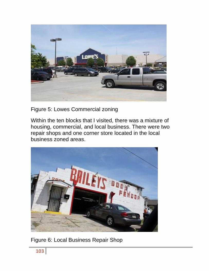
103
Figure 5: Lowes Commercial zoning
Within the ten blocks that I visited, there was a mixture of housing, commercial, and local business. There were two repair shops and one corner store located in the local business zoned areas.
Figure 6: Local Business Repair Shop
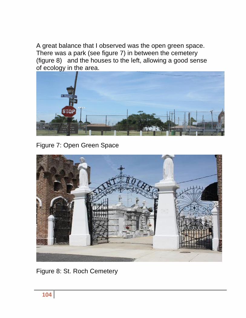
104
A great balance that I observed was the open green space. There was a park (see figure 7) in between the cemetery (figure 8) and the houses to the left, allowing a good sense of ecology in the area.
Figure 7: Open Green Space
Figure 8: St. Roch Cemetery

105
Unfortunately, the effects of Hurricane Katrina can still not only in district 7 but in all of New Orleans. The haunting abandoned houses and open lots are everywhere and cause an eye sore for an area that is still developing. Below there is a picture of an open lot that has over ground grass almost covering the house next to it? (Figure 9)
Figure 9: Open Lot Covering House Next-door
District 7 Citizen Participation Citizen participation in this area is present. There are numerous organizations dedicated to hearing the voice of it citizens. The ten blocks used to conduct the site visit fell under the St. Roch Neighborhood association. While conducting research, there were a number of emails, letters, and faxes sent in between the planning commission and the Bywater neighborhood association showing their dissatisfaction concerning future land uses in the area. These letters eventually gain importance and some of the concerns of the citizens were taken into consideration. There

106
is also the neighborhood partnership network that has centralized information on all of the associations in the area.
Proposed land use The master plan with the proposed land use was very difficult to read. In to find the proposed land uses for the future were, I had to look in various different places. Most of the proposed land use is dealing with housing in the area. The staff proposed future for housing was to convert a majority of residential low density prewar to mixed use low density.
Limiting Conditions The site visit of District 7 was only conducted in a ten block radius. This area was bound by the following streets: Elysian Fields to the west, N. Derbigny to the South, St. Roch to the east and Louisa
There were many links provided for the assignment but none of them showed me the Current Land Use Map or the Master plan. In an attempt to retrieve it, an email was sent to Christopher Mills, a Senior City Planner of the New Orleans Planning Commission. He explained that he did not have a current land use map of the area and that it was actually not the guiding document that is used to make decisions. He also informed that the Future Land Use Map is what the current decisions are based on. Only the Future Land Use Map was used in this analysis.
Google was used to search for much of the information found here. Due to broken links, Google redirected me to the exact page, causing me to bypass the original websites needed

107
Key Findings/Recommendations
(San Martin) Recommendations/ Summary I recommend that the City of New Orleans include specific details on each planning district. It was difficult to find any information substantial to District 12. Although the Foundation of Louisiana’s “Citizen’s Guide” provided a connection between citizens and the planning process, it would have been more beneficial to an Algiers resident to provide current and future land use maps. I also recommend offering resources such as the Algiers Point historic commission or other neighborhood associations to better grasp the attention of citizens. It would also be beneficial to District 12 to engage in activities to create tools to connect the people to the neighborhood planning context. In my evaluation of District 12 according to the proposed Land Use plan, I found that the Unified New Orleans Plan is more beneficial in detail to a planner and even citizen. In order to actively participate as a citizen it is important to have background knowledge on their district as well as the planning process. The Citizen’s Guide to Land Use Planning makes an organizational framework for a citizen to understand the planning process. Unfortunately, the guide does not offer tangible access to get involved or contact information. The Master Plan could include separated sites to detail the specific planning districts. In conclusion, the use of a non-government community guide can be helpful to attract and engage citizen participation. By accessing the Citizen’s guide and the master plan, community involvement can
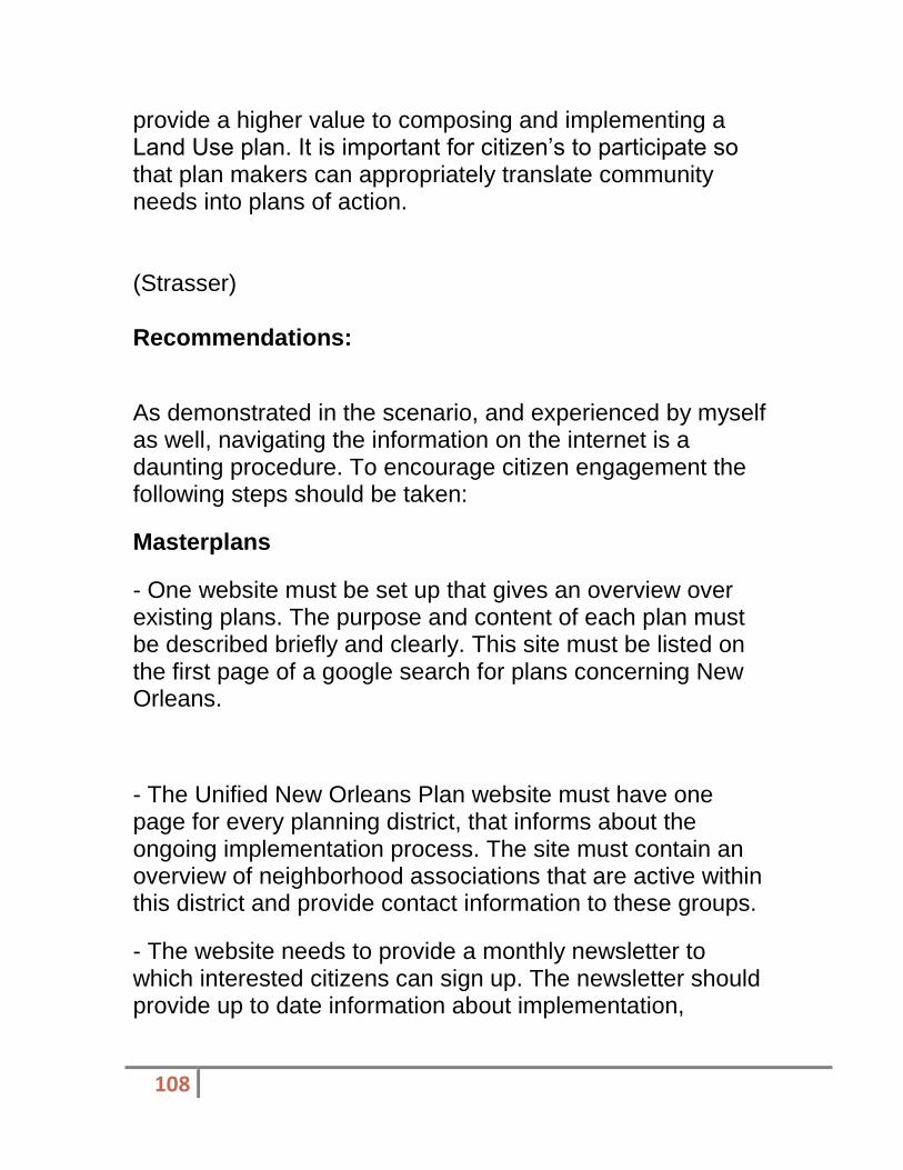
108
provide a higher value to composing and implementing a Land Use plan. It is important for citizen’s to participate so that plan makers can appropriately translate community needs into plans of action. (Strasser) Recommendations:
As demonstrated in the scenario, and experienced by myself as well, navigating the information on the internet is a daunting procedure. To encourage citizen engagement the following steps should be taken:
Masterplans
- One website must be set up that gives an overview over existing plans. The purpose and content of each plan must be described briefly and clearly. This site must be listed on the first page of a google search for plans concerning New Orleans.
- The Unified New Orleans Plan website must have one page for every planning district, that informs about the ongoing implementation process. The site must contain an overview of neighborhood associations that are active within this district and provide contact information to these groups.
- The website needs to provide a monthly newsletter to which interested citizens can sign up. The newsletter should provide up to date information about implementation,

109
changes and upcoming events from neighborhood associations and the government.
Zoning
- The site that shows the zoning ordinance and map needs a search function. I would suggest a wiki style tool. Such a tool would make it possible to type in an abbreviation from the zoning map and get linked directly to the corresponding text. Complex issues can be connected via links and explanations of terms and processes can be included too. People that use the internet generally understand how to navigate a wiki.
- The zoning maps are confusing. The draft zoning map and the base zoning map must be explained in a way that people know their purpose before they decide which one to download.
- The base zoning map needs a clearer overview, so the respective part of the map can be easily identified.
Citizens Guide for Land Use
-The Citizens Guide should have a prominent download link on every website that relates to the masterplan or the neighborhood plans.
- The definition of Land Use should be reviewed and brought in context with the definition of zoning.
- The language of the text should be reviewed and brought to a level that does not suggest that their readers are not intelligent enough to understand land use and planning.
Examples are:

110
"“Land use” is the phrase planners use to refer to a collection of
colors, maps and concepts used by planners and other professionals
to illustrate what is taking place in your parish, city, or neighborhood." (p1)
"Not to be confused with bodies of water, blue is used in land use maps to designate institutional land uses." (p6)
"For the purposes of this document, you do not need to worry about different color palettes.
Whether in rural Louisiana or in the urban environment, land use works the same." (p11)
"Land use planning takes place at town, city, and regional levels. However, most people
relate to their neighborhoods because it is difficult to understand these larger scales." (p27)
- The guide should provide support on how to navigate through the information on the internet. It should have links to the master plan, the neighborhood plans, the zoning ordinance and so on.
- The guide should explain the role of neighborhood associations and how to get in touch with them.
- The layout of the guide should be revised and it should be reduced to be printable on 25 pages. Further it should be offered to order hard copies for free.
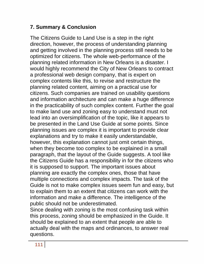
111
7. Summary & Conclusion
The Citizens Guide to Land Use is a step in the right direction, however, the process of understanding planning and getting involved in the planning process still needs to be optimized for citizens. The whole web-performance of the planning related information in New Orleans is a disaster. I would highly recommend the City of New Orleans to contract a professional web design company, that is expert on complex contents like this, to revise and restructure the planning related content, aiming on a practical use for citizens. Such companies are trained on usability questions and information architecture and can make a huge difference in the practicability of such complex content. Further the goal to make land use and zoning easy to understand must not lead into an oversimplification of the topic, like it appears to be presented in the Land Use Guide at some points. Since planning issues are complex it is important to provide clear explanations and try to make it easily understandable, however, this explanation cannot just omit certain things, when they become too complex to be explained in a small paragraph, that the layout of the Guide suggests. A tool like the Citizens Guide has a responsibility in for the citizens who it is supposed to support. The important issues about planning are exactly the complex ones, those that have multiple connections and complex impacts. The task of the Guide is not to make complex issues seem fun and easy, but to explain them to an extent that citizens can work with the information and make a difference. The intelligence of the public should not be underestimated. Since dealing with zoning is the most confusing task within this process, zoning should be emphasized in the Guide. It should be explained to an extent that people are able to actually deal with the maps and ordinances, to answer real questions.

112
This report is focused on issues, concerning information provided on the internet. It does not analyze the situation for those citizens, that do not have internet access or skills to use the internet. Since the planning process in the United States is based on a highly democratic idea, it should take especially care of those that are not accessing the internet.
(Stephens)
Recommendations
I would first recommend that the City of New Orleans organize the planning section of their website to be more user-friendly, thus allowing citizens of any level of experience to understand the on-going and future planning efforts in their community and inspiring them to get involved in the planning process. I would also suggest that the City’s planning documents be separated by planning district to allow a citizen to focus on only the documents necessary for his or her neighborhood. My final recommendation for the City’s planning website would be to formulate a guide to the planning documents contained in each section of the site, which would make it easy for a citizen to log on and quickly find the exact information for which they are looking.
My first recommendation for The Citizen’s Guide to Land Use is to include a chapter or section on specific ways that a citizen can get involved in their community’s planning process, rather than broadly encouraging them to participate as the current document does. I would also suggest that the Foundation for Louisiana produce a smaller quick-reference pamphlet or booklet to accompany the full guide so that citizens can reference their materials in any setting rather than carrying the larger guide with them or trying to memorize the concepts within the complete guide.
113
Summary of Guide Evaluation Project
Overall, I do believe that The Citizen’s Guide to Land Use is an effective guide for teaching citizens about land use planning and encouraging them to get involved in the process. However, I think that this guide could use a stronger emphasis on actual methods of citizen engagement. Throughout my research, I have also seen that the City of New Orleans’s planning website should be much better organized so that citizens can easily find and reference materials for the New Orleans Master Plan. While I did encounter some difficulty, I found this project to be informative and eye-opening to the importance of citizen participation in the land use planning process.
(Mucci)
Overall Summary
Overall, I think this was a good plan, or at least a step in the right direction. I think the community needs to engage themselves wholly in the planning process and the plan brought to everyone for review before implementation. My recommendations would include more accessible town hall meetings, integration of a website for residents to participate in polls, and a requirement to have a representative from each section of the districts population (i.e. low income, middle income, high income, business owner, public servants, etc.)
The plan is headed in the right direction, it just needs some refinement, another level of detail on certain aspects, explanations of how certain components will be implemented, and an overall time frame for completion of the plan.

114
(Kroll)
Recommendations The deficiencies of the Citizen's Guide and the Plan for the 21st Century can be easily addressed. The Citizen's Guide clearly showed what a land use plan is and effectively described the plan-making process. This is very helpful to members of the general public, as it will allow them to be informed participants in future land use planning endeavors. The problem, though, is helping them become participants. Though the Citizen's Guide notes the importance of citizen participation in planning activities, aside from a brief discussion of charettes, it does not note the mechanisms that communities usually use to encourage citizen participation. There are many ways that citizens can be involved in both long-term planning efforts and the review processes for individual developments. Though there is wide variation between communities, citizens can receive public notices for various planning efforts, many of which include public hearings where citizens can express their sentiments about planning proposals (Duerksen et al., 2009, p. 143). But changes in technology are enabling the public to express their opinions in a number of different ways besides the traditional public hearing. By using both the internet and traditional notification procedures to reach out to a community's citizens, planning agencies can encourage broad participation in the planning process (Goodspeed, 2008, p. 32). Future editions of the Citizen's Guide should make note of the ways in which planning processes can and should involve these various tools.

115
The Citizen's Guide should also provide citizens with a means of assessing the quality of a land use plan or comprehensive plan. It should note the importance of a plan being developed based on an assessment of existing and projected land use and population trends, should state that land use plans should be coordinated with capital improvement and infrastructure plans, and should include mechanisms to encourage citizen involvement in the implementation and periodic updating of the plans (Berke et al., 2006, p. 78).
The Plan for the 21st Century’s future land use plan is intended to shape the development of Planning District 6 but does not sufficiently address two of its main development challenges that many parcels are vacant or blighted and that new residential development is often out of scale with older structures. While the future land use plan cannot by itself address the problems of blight and vacancy that are frequently associated with a stagnant or declining population, it can be changed so that it allows vacant properties to be used as community facilities. The future land use plan’s residential land use categories should be revised so they allow for community gardens and urban agriculture, in addition to traditional residential uses. This could be done fairly quickly, as the Plan for the 21st Century can be amended as frequently as once per year (Foundation for Louisiana, 2011, p. 33).
The other problem Gentilly is experiencing is that despite the Plan for the 21st Century’s mandate that new development be consistent in character with existing development, the current zoning ordinance’s inappropriate height, bulk, and massing requirements are allowing the construction of new structures that are out of scale with existing structures. This is already in the process of being

116
addressed through the drafting of a new comprehensive zoning ordinance which will contain development standards that are better suited to the development patterns of the city’s neighborhoods. This will resolve the problem, ensuring that zoning standards reinforce the Plan for the 21st Century’s land use goals, not undermine them. However, the drafting of a zoning ordinance is a long and complicated process. Given that the new zoning ordinance could encounter opposition from the general public, the business community, and other interests, it is possible that it will not be adopted for many months. To address the problem of incompatible development that Gentilly is facing, it may be sensible to immediately amend the existing zoning ordinance to include more appropriate height, bulk, and massing requirements in Gentilly in addition to incorporating such requirements into the new zoning ordinance.
Recommendations for Further Study
In its discussion of the Plan for the 21st Century, this report notes the difficulties land use planning efforts face when planning not for growth but for population loss and the vacancy and blight that accompanies it. While this report suggests that the Plan for the 21st Century’s land use categories be made more accommodating of community gardens, urban agriculture, and other community uses of vacant property, there may be other ways by which land use plans can address issues of vacancy. Future researchers should study this issue in greater depth, assessing the ways in which land use planning efforts in various cities have coped with population loss and creating a list of best practices. Such a list would be invaluable to the many cities across the United States that are now confronting population loss, not growth, as their most pressing land use planning issue.

117
(Marmol)
Recommendations for further study Civic engagement is essential for the planning process because it simply makes better and more equitable cities. It is for this reason that I highly commend the Louisiana Foundation for the efforts taken towards improving the relationship between residents and the City of New Orleans via the “Citizens’ Guide to Land Use” and its companion the “Citizens’ Gide to Urban Design.”
I would like to offer recommendations on how to possibly improve the liquidity of information for the public as well for the City of New Orleans.
Currently there are too many websites that the public needs to access in order to get information about different themes that relate to the planning process (i.e., comprehensive planning, area planning, zoning, recovery, and evacuation). It becomes even more complicated when searching for a particular district or neighborhood. Therefore, a first set of recommendations is:
1. To create an all-inclusive website for each individual district in order to organize all the plans, meeting minutes, and city documents relevant to the residents of the particular district. Within each district’s website, it would also be useful to create neighborhood websites. This website should include links to Master Plan, Zoning Ordinance, Unified New Orleans Plans, as well as planning tools such as the “Citizen Guides.”
2. To create web-based community participation tools such as those offered by the platform MindMixer.

118
3. To create more dynamic and creative exercises to engage a diverse range of people.
For the Foundation of Louisiana 1. Expand upon the tools used for public engagement in the
land use planning process. Include and define a variety of other tools used for public participation (other than community meetings and charrettes). The Citizen’s Guide to Planning by Duerksen, Dale, and Elliott offer a few examples of these tools:
Web Interaction: Use of technology and broadcast media. (Websites, blogs, cell phone apps, etc.).
Design Workshops: Offer the public a more hands-on opportunity to brainstorm and create plans. (i.e., walk-shops, charrettes, land vision processes).
Keypad Polling: Allows attendees to vote on ideas or solutions through hand-held electronic transmitters leading to better understanding of community’s preferences.
Focus Group Interviews: Allow planners to engage face-to-face with stakeholders and different group interests.
Scientific Surveys: Gauges community’s attitudes towards different issues through quantifiable methods. These are usually expensive but very useful.
2. Draft “The Citizen’s Guide to Zoning”– Due to the success of “The Citizen’s Guide to Land Use” and “The Citizen’s Guide to Urban Design,” I recommend the creation of a third complementary volume that introduces the public to the Consistency Table. Therefore, bridging the Land Use and

119
the Zoning processes in New Orleans.
3. Get input from the different districts, neighborhoods, and grassroots community organizations as to see what type of participatory tools they would respond more favorably with in terms of being engaged with the planning efforts of the community.
(Monnet)
Nathaniel Rich wrote an article for the New York Times, entitled Jungleland, in which he described what he saw in his visit to the Lower 9
th ward:
It is misleading to talk about abandoned lots in the context of the Lower Ninth Ward. Vast sections of the neighborhood have been abandoned, so it’s often unclear where one property ends and the next begins. (An exception is the sliver of land on the neighborhood’s innermost edge, where Brad Pitt’s Make It Right Foundation has built 76 solar-paneled, pastel-hued homes — though this seems less a part of the neighborhood than a Special Economic Zone.) To visualize how the Lower Ninth looked in September — before the city’s most recent campaign to reclaim the neighborhood — you have to understand that it no longer resembled an urban, or even suburban environment. Where once there stood orderly rows of single-family homes with driveways and front
yards, there was jungle. The vegetation had all sprouted since Katrina. Trees that did not exist before the storm are now 30 feet high. (Rich, 2012)
In the article, the author speaks to a resident who is walking her dog. He says she appears anxious. There are
120
snakes and packs of wild dogs wandering around her neighborhood. Two weeks before he spoke to her, a body was found burned inside a car and no one had any idea how long it had been there due to the fact it was obscured by overgrown bush. He goes on to observe, “Many of the ruined buildings have been cleared away, and most of the old foundations are obscured. The inhabited lots, one per city block, are the exception.” I noted the same earlier seen during the site visit. Of the occupied homes, he noted, “With their dutifully trimmed lawn, upright fences and new construction, they stand out like teeth in a jack-o-lantern”. (Rich, 2012)
So the question remains, what role have these few but determined residents played in the planning of what their community should look like? To answer that question, I will go back to the New Orleans Master plan.
The New Orleans Master plan, with very little exception, is the exact same as the Unified New Orleans Plan. On its web-site, the question is asked, “What is the Unified New Orleans Plan?” The answer is as follows, “UNOP addresses specific actions necessary to facilitate the recovery and rebuilding of New Orleans. The objective of this multi-level planning process is to successfully integrate community input and a set of deliverables from the district-level and neighborhood planning processes into a Unified Recovery and Rebuilding Plan that will be submitted to the City Planning Commission, City Council, Mayor’s Office and State of Louisiana. The plan culminates with a city-wide plan that encompasses all districts and neighborhoods.” (UNOP, 2006) As a result, the New Orleans Master Plan is as citizen driven as the Unified New Orleans Plan, since the former was derived from the latter.

121
The UNOP plan was born from the failed planning process started by then Mayor Ray Nagin in January of 2006. It was entitled the Bring New Orleans Back Commission. That planning effort died due to a lack of funding. As a result, neighborhood organizations, frustrated and using their own resources, started a grass-roots planning efforts. At the same time, the City Council appropriated $2.9 million through a noncompetitive process to two planners, Paul Lambert of Miami and Shelia Danzey of New Orleans.
2
Residents were furious. Due to the vociferous response to the City Council’s decision, Lambert and Danzey were not fired, but were included among dozens of planning firms that neighborhood organizations had an opportunity to work with. “All 73 New Orleans neighborhoods will get a chance to produce their own recovery plan by the end of the year…” begins an article that ran in the Times Picayune in 2006. In the article, Andy Kopplin, the director of the Louisiana Recovery Authority, praised the negotiations that resulted in, “…the so-called Unified New Orleans Plan” (Warner, New Orleans Blazes Trail for Grant Money, 2006).
A four member team assembled by the Greater New Orleans Association called the bottom up neighborhood planning effort “historic” in a subsequent article in the Times Picayune. The article states, “Bleary eyed after reading proposals from teams seeking a place in New Orleans neighborhood planning effort an expert screening panel said Wednesday that city residents have a unique, historic shot at influencing change in the urban landscape.” (Warner, Locals Key to N.O. Rebirth, 2006).
2 Times Picayune, Thursday July 6, 2006; “New Orleans Blazes Trail for Grant Money”

122
The Unified New Orleans Plan was created with extensive neighborhood input. There is an entire section devoted to informing readers the extent to which planners went to include neighborhood input, including utilizing established outreach agencies like ACORN in order to track residents to garner their input. Public meetings were held, but initially, only 300 of the 20,000 residents of District 8 had returned to the city.
3 When the meetings were held,
residents were more interested in getting information that pertained to their immediate needs, such as housing, than in planning for the not-foreseeable future.
All total, there were a total of 6 public meetings held from October 14, 2006-January 6, 2007. Additionally, there were 6 community stakeholder meetings held from the same date range and even a meeting of District pastors held on January 8, 2007. Sub-groups were created and H3 Studio Project Team (the planning firm residents chose to create the plan for their district) organized the vision of residents into a District plan that could be incorporated into the overall Unified New Orleans Plan.
From the information gathered, it seems the UNOP, and therefore the New Orleans Master Plan, sets the standard for neighborhood engagement in city and land use planning. But, there were some conditions that could adjust this opinion. For instance, I was unable to speak with any residents personally. I have information that was given to a third party, but I don’t have any first hand opinions about how involved residents actually consider themselves.
Additionally, the Lower 9th ward is not a homogenous
area. There is the newer, most intensely developed Make It Right project area, but there is the older, more historic Holy
3 Unified New Orleans Plan

123
Cross. Then there is Jackson Barracks, which is an entity unto itself. Then there’s everything in between. A more thorough examination would look at how residents of different areas of the Lower 9
th ward have different views on
their engagement level.
The city of New Orleans has a Master Plan that has the force of law that was given to it by the citizens through a vote. The Master Plan was adopted from a Unified New Orleans Plan that went through great lengths to include citizen input. There has never been a planning effort as extensive as the one taken in New Orleans after Hurricane Katrina.
4 With that being said, I am of the opinion that while
citizens have played a major role in the planning of the city, there is still a lot of work that needs to be done as far as the implementation of those plans. District 8 is evidence that citizens can’t do it alone.
(Marshall) Recommendations and Summary I believe that district 9 is on the right path to recovery. Unfortunately, it is taking longer than it should. The new projects mentioned and excited are exciting but more are needed. Home ownership levels should continue to rise and blight will reduce. I recommend that more attention be paid to the commercial areas of Interstate 10 and the industrial regions along the district’s waterways. Sound walls should be built along Interstate 10 to reduce noise and obstruct views of blighted properties.
4 Times Picayune, Thursday July 6, 2006; “New Orleans Blazes Trail for Grant Money”

124
These sound walls were specifically called by the residents in the UNOP plan. Blight removal should be concentrated along Interstate 10 to improve perception of the area, since it is the first thing most people see when driving into New Orleans. I believe that there is a negative perception about this area associated with crime, lack of population, and poverty levels. Empty buildings and blighted property still with holes that people climbed out of are not helping to change public opinion.
Middle class single family homes along Crowder Blvd.

125
(Guess) Recommendations & Summary Though citizen engagement is critical in neighborhood planning it is not the only valuable tool. Unreasonable fears of irrational treats can cause a Not In My Back Yard (NIMBY) effect on the layperson and can ultimately impair a neighborhood. The credentialed planner should have a major voice in guiding the community and advocating for their best interest to the planning legislature.
With all things considered the zoning ordinance for District 4 seems appropriate and proper. The potential to repurpose the build structures on Tulane Avenue should be a primary priority so that displaced residence and return. This will also act as a tool for neighborhood revitalization and attract capital investment.
• The purposed zoning in the area of my target site is Mixed-Use Medium Density
• The current uses are blighted and abandoned structures
• The City of New Orleans should continue to move forward with their current purposed zoning.
• Blighted structures should be repurposed (i.e. The Fallstaff) and include affordable housing options
• This is especially important because of the community immediately south of the target area (Tulane/Gravier community) being removed because of the new medical facility.
• Tulane Avenue is a main thoroughfare and the target site will be adjacent to the new medical structure.
• This will increase the property value and rent of any structures in the area and serve as a tool to revitalize Tulane Avenue.

126
(Bautista)
Recommendations for further Study The future for more citizen engagement maybe promising for this area but more measures must be taken. People must have easy access to the information needed or they will lose interest in the things they are trying to accomplish. In order to do this, a few recommendations have been made.
First of all, the website that contains the land use and comprehensive plans must be working. It would help for it to be simplified by making everything that had to go with each district under one link instead of having to go to many different sites or links. The Zoning Districts on the Master Plan that also contain the proposed land uses should be readable and understandable.
The map was too small and even when made larger it was still difficult to read. Also, the proposed land uses should probably be numbered in consecutive order on the map, not just on the legend, so that when trying to see where the proposed land uses are, one does not have to look all over the map for them. This caused a lot of confusion and would have been a lot easier had they had been in a general location as those items proposed with the same number.
Another recommendation for citizens’ engagement is to have the best access to the information, tools and a possible computer to allow for internet access at a drop in location in their district. During a visit to a grocery store in Jefferson parish, I noticed that a neighborhood meeting had just taken place in a Winn Dixie. I believe that something like this is ideal because since there is high traffic in an area like this, it could cause for more people to be interested in participating. The drop in center could be anywhere that contains the

127
same amount of traffic in this area. Access to planning maps and “The Citizen’s Guide to Planning” could be kept there. Meetings could be conducted on a monthly basis along with other associations to come together and find a common goal for the future of the community.
Another suggestion that goes along with the website is to have a virtual drop box of concerns for the area. These concerns would have to be submitted at least 3 weeks before each meeting so that they can be looked and possibly added to the agenda of the meeting.
While conducting my visit to the ten block radius in District 7, I noticed that there was a local business that was not on the land use plan or on the zoning map. I tried looking for it when I got home later to see if I was wrong but I still could not find it. I am not sure if it was accidentally not zoned for local business or if this area is not being paid attention to closely. In order to keep this from happening, there should be a bi- yearly visit to the areas in order to make sure that the zoned areas are accurate. If they are not, then there must be proper measures to make sure that things are not being done illegally.

128
Appendix
Resources accessed in Spring 2012
Foundation for Louisiana “The Citizen’s Guide to Land Use”: http://www.foundationforlouisiana.org/news_resources/reports_publications.
City of New Orleans Neighborhood Participation Plan:
http://www.nola.gov/RESIDENTS/City-Planning/Neighborhood-Participation-Program/
This site has the CZO: http://www.nola.gov/RESIDENTS/City-Planning/Comprehensive-Zoning-Ordinance/Comprehensive-Zoning-Ordinance/
Master Plan and adopted Land Use Maps: http://www.nola.gov/RESIDENTS/City-Planning/Master-Plan-Elements/
New Philadelphia Zoning Code: Best Practices Report, by the Zoning Code Commission's Clarion/Duncan consulting team. http://zoningmatters.org/facts/trends
Algiers Point. Neighborhood boundary data. 2011. Urban Mapping Inc. http://www.city-data.com/neighborhood/Algiers-Point-New-Orleans-LA.html
Algiers Point Historic District.http://algierspoint.us/
http://www.oldalgiersmainstreet.com/
http://www.algierspoint.org/ A-1
A-3

129
Unified New Orleans District 12 Plans. http://unifiedneworleansplan.com/home3/districts/12/plans/
(Strasser)
8. Appendix
8.1 Survey
The Survey of the focus area showed that the main part of the RD2 designated area had generous single structures, while the area designated as multifamily had mainly double structures. The mixed use area had except for one multifamily building exclusively commercial uses. The property chosen for purchase in the scenario is marked with 1 on the lnad use survey (Fig.5). Following images show the structures 1 to 8, located as shown on the map.
left: Image 1, double structure, proposed property for purchase in the scenario
Image 2,3, single family structure in the RD-2 Zone
On the very top: Image 4, 5, single family structure in the RD-2 Zone

130
above and left: Image 6, 7, 8 double family structure in the multifamily zone
below left: Image 9, The only residential structure in the mixed use zone
below right: Image 10, Commercial
uses on Magazine St.

131
8.2 Bibliography
American Planning Association. 2012. "About Planning" online: http://www.planning.org/aboutplanning/whatisplanning.htm
Berke, Philip. Godschalk, David. Kaiser, Edward. Rodriguez, Daniel. 2006. "Urban Land Use Planning" 5th Edition, University of Illinois Press, Chicago, IL
Cooper, Alan. 2007. "About Face 3: the Essentials of Interaction Design" Wiley Publishing Inc. Indianapolis, IN
"Citizens Guide to Land Use", 2012, Foundation for Louisiana, New Orleans, LA
City of New Orleans 2007 "Unified New Olreans Plan, Planning District 2" New Orleans, LA
Duerkson, Christopher. Dale, C. Gregory. Elliott, Donald M. 2009. "Citizens Guide to Planning" American Planning Association, Chicago, IL
New Orleans City Planning Commission. "How to read Draft Zoning". PDF, New Orleans, LA
(Stephens)

132
Section 7 | Appendices
Appendix A | Property Photographs from Site Visit
Property 1 | Whole Food Market Property 2 | Chez Nous Restaurant
Property 3 | Dirty Coast T-Shirt Shop Property 4 | Romney Pilates Studio

133
Property 5 | Shopping Center Property 6 | St. Joe’s Bar

134
Property 7 | Slice Pizzeria Property 8 | Private Residential
Property 9 | Arabella Private Community Property 10 | Private Residential

135
Appendix B | Resources
City Planning Commission, City of New Orleans (2010, December 31). Comprehensive Zoning Ordinance. Retrieved on 26 April 2012 from http://www.nola.gov/
RESIDENTS/City-Planning/Comprehensive-Zoning-Ordinance/Comprehensive- Zoning-Ordinance/
City Planning Commission, City of New Orleans (2012, April 13). Draft Zoning Maps. Retrieved on 26 April 2012 from http://www.nola.gov/RESIDENTS/City- Planning/DRAFT-Zoning-Ordinance/Draft-Zoning-Maps/
City Planning Commission, City of New Orleans. (2011, March 25). Plan for the 21
st Century: New Orleans 2030.
Retrieved on 26 April 2012 from http://www.nola .gov/RESIDENTS/City-Planning/Master-Plan-Elements/
City Planning Commission, City of New Orleans (2012, April 13). What’s New with City Planning. Retrieved on 26 April 2012 from http://www.nola.gov/RESIDENTS/City- Planning/
Duerksen, C.J.; Dale, C.G.; & Elliott, D.L. (2009). The Citizen’s Guide to Planning. Chicago, IL: American Planning Association
Foundation for Louisiana. (n.d.). The Citizen’s Guide to Land Use. Retrieved on 24
April 2012 from http://www.foundationforlouisiana.org/news_resources/
citizen_guides/

136
The Unified New Orleans Plan. (2007). Chapter 1: Introduction to the District. Retrieved on 28 April 2012 from http://www.unifiedneworleansplan.com/home3/districts/3/
plans/
(Mucci)
Appendix I – Works Cited
1. The Unified New Orleans Plan (2006). Accessed on May 8, 2012 http://www.unifiedneworleansplan.com/home3/districts/10/plans/
2. Urban Land Use Planning, Fifth Edition (2006). Berke, Godschalk, and Kaiser. University of Illinois.
3. The Citizen’s Guide to Planning (2009). Duerksen, Dale, and Elliot. The American Planning Association, Washington D.C.

137
APPENDIX II – SITE PHOTOGRAPHS

138

139

140
Baseline Flood Elevation Map – Unified New Orleans Plan 2006. Accessed 28 April 2012.
(Kroll)
Works Cited Berke, P. R., Godschalk, D. R., Kaiser, E. J., & Rodriguez,
D. A. (2006). Urban land use planning (Fifth ed., p. 69-82). Chicago, LA: University of Illinois Press.
City of New Orleans. (2010). Plan for the 21st century: New Orleans 2030. Retrieved May 5, 2012, from http://www.nola.gov/RESIDENTS/City-Planning/Master-Plan-Elements/
Duerksen, C. J., Dale, C. G., & Elliott, D. L. (2009). The citizen's guide to planning (Fourth ed., Vols. 1 - 1). Chicago, IL: American Planning Association Planners Press.

141
Foundation for Louisiana. (2011). The citizen's guide to land use. Retrieved May 5, 2012, from http://foundationforlouisiana.org/news_resources/citizen_guides/
Goodspeed, R. C. (2008). Citizen participation and the internet in urban planning (Master's thesis). Retrieved May 5, 2012, from http://www.arch.umd.edu/images/student-work/documents/RGoodspeed%20finalpaper%20.pdf
Greater New Orleans Community Data Center. (2010). Retrieved May 5, 2012, from www.gnocdc.org
(n.d.). In Unified New Orleans Plan. Retrieved May 5, 2012, from http://www.unifiedneworleansplan.com/home3/
Additional Images referenced in text:

142
Figure 2 Figure 3
Figure 2 shows the 4900 block of Marigny Street as depicted on the Future Land Use Map, while Figure 3 shows an aerial photograph of that block.

143
Figure 4 – Photographs of the 4900 block of Marigny Street
(Marmol)
Works Cited Bowden, N. (2012, March 27). The Mix Blog. Retrieved 1 2012, April, from

144
http://www.mindmixer.com/blog/3
City of New Orleans Neighborhood Participation Plan.
http://www.nola.gov/RESIDENTS/City-Planning/Neighborhood-
Participation-Program/
Daft Comprehensive Zoning Ordinance.
http://www.nola.gov/RESIDENTS/City-Planning/
Duerksen, C.J., Dale, G.C., & Elliott, D.L. (2009). The Citizen’s Guide to
Planning. Chicago: American Planning Association.
Esnard, A.-M., Berke P.R., Godschalk, D.R., & Kaiser, E.J. (2006). Urban
Land Use Planning. Illinois. The Board of Trustees of the University
of Illinois.
Foundation for Louisiana “The Citizen’s Guide to Land Use.”
http://www.foundationforlouisiana.org/news_resources/r

145
eports_
publications.
Master Plan and adopted Land Use Maps:
http://www.nola.gov/RESIDENTS/City-Planning/Master-Plan-
Elements/
U.S. Census Bureau. (2010). 2010 Census 2010 Summary File 1 (SF1).
Orleans Parish, Louisiana.
(Monnet)
Works Cited
(n.d.). Retrieved from http://nolacpp.wordpress.com/nola-cpp-executive-summary/
Committee for a Better New Orleans. (2010, December 17). NOLA CPP, Executive Summary. Retrieved May 3, 2012, from http://nolacpp.wordpress.com/nola-cpp-executive-summary/
Foundation for Louisiana. (2012). The Citizens Guide to Land Use. Baton Rouge: Concordia, LLC.

146
Make It Right. (n.d.). About Make It Right:Our History. Retrieved May 5, 2012, from Make It Right: http://makeitrightnola.org/index.php/about/detail/our_history/
Redell, T. a. (2004, September). Retrieved May 5, 2012, from Australian Journal of Public Administration: http://unpan1.un.org/intradoc/groups/public/documents/apcity/unpan030165.pdf
Rich, N. (2012, March 21). Jungleland:The Lower 9th Ward in New Orleans Gives New Meaning to 'Urban Growth'. Retrieved May 7, 2012, from New York Times: http://www.nytimes.com/2012/03/25/magazine/the-lower-ninth-ward-new-orleans.html?ref=magazine
UNOP. (2006). Unified New Orleans Plan, Home. Retrieved May 7, 2012, from Unified New Orleans Plan: http://unifiedneworleansplan.com/home3/
Warner, C. (2008, November 4). Retrieved May 3, 2012, from NOLA.com: http://www.nola.com/news/index.ssf/2008/11/no_voters_approve_master_plan.html
Warner, C. (2006, June 20). Locals Key to N.O. Rebirth. Times Picayune , p. B1 and B3.
Warner, C. (2006, July 6). New Orleans Blazes Trail for Grant Money. Times Picayune , p. A1 and A4.
(Marshall)
Works Cited

147
(n.d.). Retrieved from http://www.neworleanseast.com/operation_comeback/operation_comeback.htm
(n.d.). Retrieved from http://unifiedneworleansplan.com
(n.d.). Retrieved from http://www.foundationforlouisiana.org/docs/CGLU_guide.pdf
Goodman, J. (2010, July 01). Builder online. Retrieved from http://www.builderonline.com/green-building/new-orleans-slowly-embracing-sustainable-building-practices.aspx
(n.d.). Retrieved from http://www.neworleansonline.com/tools/maps/neighborhoods/neworleanseast/NewOrleansEast.pdf
(Guess) References: 1
http://www.foundationforlouisiana.org/news_resources/reports_publications
2 http://www.nola.gov/RESIDENTS/City-Planning/
3 http://www.nola.gov/RESIDENTS/City-Planning/Master-
Plan-Elements/
4 Source: US Census (Tract 60) – table QT-P1
5
http://www.coa.gatech.edu/~stiftel/STIFTEL_AICP_Planning_Theory_Chapter.pdf

148
6 http://www.nola.gov/RESIDENTS/City-
Planning/Comprehensive-Zoning-Ordinance/Comprehensive-Zoning-Ordinance/
(Bautista)
Works Cites
1. Buisness Dictionary. (2012). Land Use Planning. Retrieved from Buisness Dictionary: http://www.businessdictionary.com/definition/land-use-planning.html
2.Foundation for Louisiana. (n.d.). The Citizen's Guide to Land Use.
3. Figure 1: Unifed New Orleans Plan. (2012, May 3). District Plans. Retrieved from Unified New Orleans Plans: http://unifiedneworleansplan.com/home3/districts/7/plans/
4.Unified New Orleans Plan. (2012, May 3). Introduction to the District. Retrieved from UNOP: http://willdoo-storage.com/Plans/D7/District_07_Bywater-Marigny_Chapter_01_Introduction_to_the_District.pdf
5. Figure 2: Housing in District 7: by Rita Bautista
6. Figure 3: Housing in District 7: by Rita Bautista
7. Figure 4: Newer Construction Housing District 7: by Rita Bautista
8. Figure 5: Lowes Commercial Zoning: by Rita Bautista
9. Figure 6: Local Business Repair Shop: by Rita Bautista

149
10. Figure 7: Open Green Space: by Rita Bautista
11. Figure 8: St. Roch Cemetery: by Rita Bautista
12. Figure 9: Open Lot Covering House Next Door: by Rita Bautista