Configuration Guide for Courier Express Parcel - SAP Help ...
Upload
khangminh22Category
view
1download
0
TENTATIVE PARCEL/TRACT MAP (TPM/TTM) APPLICATION GUIDELINES Application for a TPM/TTM is processed by the Community Development Department, Planning Division.
I. Preliminary Review
Prior to applying for a TPM/TTM, it is highly recommended that a Preliminary Review be submitted and checked. This procedure notifies the potential TPM/TTM applicant, in advance, of the Department’s requirements and recommendations to the Planning Commission. The Preliminary Review consists of three (3) sets of plans including the information required in No.1 (see below) along with a $217.05 review fee. The Preliminary Review is designed to allow applicants to be informed of the Community Development Department’s recommendations and requirements prior to preparing the complete TPM/TTM package and paying the required fees. This review may not include recommendations and requirements of other Departments or Agencies (e.g. Building and Safety, Fire, County Health etc.).
II. Complete TPM/TTM Package
Materials necessary to process a TPM/TTM include: 1. Ten (10) copies of proposed Plot Plan drawing of lot split/tie drawn to scale showing the following:
A. The minor land division number assigned by the County Engineer. B. The name, address, and other identification of the owner whose property is proposed to be
divided and the name, address, and other identification of the divider; C. The name, address, and other identification of the person who prepared the map and the
data preparation; D. The north point and scale (not less than one inch equaling fifty (50’) feet); E. The location and outline to scale of each existing building and structure to remain and be
maintained; F. The location, name, and width of adjacent streets and alleys; G. The location and outline to scale showing easements on the property, driveways, and
property lines of the area covered in the legal description; H. The lot lines and approximate dimensions and designation of each proposed lot or parcel,
beginning with the letter “A”; I. The width and location of all existing and proposed public utility and private easements; J. The location of existing building setback lines; K. The source of water supply, proposed method of sewage disposal, and proposed pattern of
surface drainage; and L. The lot split/tie drawing shall be drawn to scale and all property lines, structure, driveways,
etc. shall be completely dimensioned. 2. Two (2) copies of reduced plans, either 8 ½” x 11” or 11” x 17” 3. One (1) CD Rom containing all files in digital PDF or JPEG formats. 4. Two (2) sets of 300 foot Public Notice Radius Maps and Mailing Labels (see attached example) 5. TPM/TTM Application (complete, see attached). 6. Environmental Assessment Checklist (complete, see attached). 7. Photographs of Site and Adjacent Properties.

TPM/TTM APPLICATION GUIDELINES – PAGE 2
8. Required Fees: A. $1,899.20 for TPM/TTM B. $ 249.61 for Environmental Assessment
$2,148.81 Total How is the application processed? Tentative Parcel/Tract Maps are approved based upon the discretion (subject to appeal) of the Planning Commission. Upon the submittal of the above mentioned materials and payment of fees, the proposal will be given a case number (e.g. 1741- TPM/TTM), and be scheduled for the earliest appropriate Redevelopment Agency meeting (if necessary) and Planning Commission meeting. Assuming the materials submitted are accurate and complete, Community Development Department staff can process the application and present it to the Planning Commission within approximately one month from the submittal date. The processing includes the notification of all property owners within 300 feet of the site (or as required by the California Environmental Quality Act if applicable), a notice of the request advertised in a newspaper of general circulation and the preparation of a staff report (subject to environmental analysis and findings as required by the California Environmental Quality Act) for the Planning Commission. It is recommended that the applicant and/or representative attend the meeting, and be prepared to answer questions and present evidence supporting the requested TPM/TTM. The Planning Commission is very interested in hearing all views concerning the proposed TPM/TTM, and how it applies to the required findings. It is suggested that the applicant prepare themselves to answer questions pertaining to the required findings during the public hearing. A Community Development Department report will be available at the Community Development public counter on the Monday before the Planning Commission meeting. A copy of the report will also be provided to the applicant prior to the meeting. What happens after the Planning Commission’s decision? After publicly discussing the case, the Planning Commission may approve, deny, or continue the case to a later meeting for further study. It is important to know that if an application is approved, it does not become final for fifteen (15) days. During this time an appeal may be filed by the applicant or anyone requesting that the City Council reverse the decision of the Planning Commission. An appeal may be filed and paid for at the City Clerk’s Office, Room 148 in City Hall. The appeal will then scheduled to be heard by the City Council which may affirm, modify or overturn the Planning Commission action. What are “conditions” of approval? If the applicant is approved, the TPM/TTM will contain certain conditions affecting operation or maintenance of the use. The Community Development recommends conditions to the Commission for the mitigation and/or improvement of the individuals circumstances to ensure the compatibility of the use with surrounding land uses. For further information, please contact the Planning Division by calling (323) 584-6210 between 7:00 a.m. and 5:30 p.m. Monday through Thursday. Attachments : Tentative Parcel/Tract Map Application Environmental Assessment Checklist Planning Commission Meeting Schedule Radius Map Guidelines
Other Guidelines as Requested or Necessary for Particular Uses (see attached list)

CITY OF HUNTINGTON PARK Community Development Dept. • Planning Division 6550 Miles Avenue, Huntington Park, CA 90255 Tel. (323) 584-6210 • [email protected]
TENTATIVE PARCEL/ TRACT MAP (TPM/TTM)
APPLICATION
For Office Use Only
Date Filed: File No.: Fee/Receipt No.: Initials:
Application is hereby made to the Huntington Park Planning Commission requesting approval for a lot split/tie for the following described property. 1. Property Address:
2. Legal description (give exact legal description of entire ownership proposed to be split/tied):
3. Assessor’s Parcel Number(s):
4. Record owner(s) of property:
Name:
Mailing address:
Phone 1: Phone 2: Fax:
5. Property owner(s) representative:
Name:
Mailing address:
Phone 1: Phone 2: Fax:
Relationship to owner(s) (engineer, contractor, attorney, purchaser, lessee):
6. Does any adjoining property belong to the owner(s) involved in this application?
Yes No Describe
7. How long has the owner(s) held title to this property?
8. Are there any easements controlling the use of this property? Yes No
Describe
Expiration Date

9. Are there any private or deed restrictions controlling use of the property?
Yes No Describe
Expiration date
10. Proposed Purchaser:
Name:
Mailing address:
Phone 1: Phone 2: Fax:
11. Present use of property:
12. Proposed use of property:
13. Present Zoning:
14. Total square feet of the existing undivided parcel to be split:
15. Total square feet of each parcel be consolidated:
16. Lot Split/Tie applied for (describe the split or tie proposed and give the boundary dimensions and
square footage of each parcel proposed to be created or consolidated ):
______________________________________________________________________
17. How is access to be provided? (Describe)
18. How is water to be provided? (Describe)
Water Company
19. How is gas to be provided? (Describe)
Gas Company _____
20. How is electric to be provided? (Describe)
Electric Company
21. How is sewer to be provided? (Describe)

22. In a lot split/tie proceedings, it shall be shown that the following circumstances are found to apply
(give full and complete answers):
a. The granting of such lot split/tie will not be materially detrimental to the public welfare,
injurious to the property or improvements in the vicinity and zone in which said land is
located, and will not be contrary to or adversely affect the comprehensive zoning plan for
the City because:
___________________________________________
b. Proper and adequate provisions has been made for access to the land to be sold, divided
or subdivided and also to the portion of the land remaining, or access to said land is by
means of decided streets of a sufficient width and state of improvements to adequately
serve the land described in this application because:
___________________________________________________________
c. Proper and adequate provisions have been made for all public utilities and public services,
including sewers, because:
________________________________________________________________
d. The land described in this application will not be divided or sold off in the portions having an
area less than that required by the Zoning Ordinance, or having an area less than the
average of the area of the single parcels of land in the surrounding vicinity, because:
___________________________________________________________

CERTIFICATE AND AFFIDAVIT OF APPLICANT: I/We certify that all statements made on this application are true and complete to the best of my knowledge. I/We understand that any false statements may result in denial of the requested permit or revocation of any issued permit. I/We further certify that I am, or have permission by, the property owner to conduct the proposed development applied for herein. Date Applicant Signature (Required) Print Name Note: If the applicant is not the legal property owner, the legal owner of the property must sign the
application or a written authorization must be submitted so that the applicant may file the application.
Date Legal Property Owner Signature (Required) Print Name

CITY OF HUNTINGTON PARK Community Development Dept. • Planning Division 6550 Miles Avenue, Huntington Park, CA 90255 Tel. (323) 584-6210 • [email protected]
ENVIRONMENTAL INFORMATION FORM
FOR OFFICE USE ONLY
Date Filed: File No.: Fee/Receipt No.: Initials:
1. Applicant (please circle whether Owner, Leasee, Purchaser or Representative):
Name:
Address:
Telephone: Fax:
2. Contact Person concerning this project:
Name:
Address:
Telephone: Fax:
3. Address of project:
4. Assessor’s Parcel Number (APN):
5. Indicate type of permit application(s) (i.e. Conditional Use Permit, Development Permit, Variance, etc.) for the project to which this form pertains:
6. List any other permits and/or other public agency approvals required for this project, including those required by City, County, State and/or Federal agencies:
7. Existing Zone:
8. Proposed use of site:

ENVIRONMENTAL INFORMATION FORM – PAGE 2
9. Site size (lot dimensions and square footage):
10. Project size:
Square feet to be added/constructed to structure(s):
Total square footage of structure(s):
11. Number of floors of construction:
Existing:
Proposed:
12. Parking:
Amount required:
Amount provided:
13. Anticipated time scheduling of project:
14. Proposed phasing of development:
15. If residential, include number of units, schedule of unit sizes, range of sale/rent prices,
and type of household size expected:
16. If commercial, indicate the type of commercial use, estimated employment per shift,
proposed hours of operations, indicate whether neighborhood, City or Regionally oriented, square footage of sales area, and loading locations:

ENVIRONMENTAL INFORMATION FORM – PAGE 3
17. If industrial, indicate type of industrial or manufacturing use, estimated employment per shift, proposed hours of operations, and loading locations:
18. If institutional, indicate type of institutional use, estimated employment per shift,
proposed hours of operations, estimated occupancy, loading locations, and community benefits to be derived from the project:
Please complete numbers 19 through 33 by marking “A” through “D” and briefly discuss any items marked “A” “B” or “C” (attach additional sheets as necessary). Items marked “D” do not need discussion.
A) Potentially B) Potentially C) Less than D) No Impact Significant Significant Impact Significant Impact Unless Mitigation Impact Incorporated
AESTHETICS 19. Would the proposed project: a. Affect a scenic vista?
b. Have a demonstrable negative aesthetic effect? c. Create light or glare?
AIR QUALITY 20. Would the proposed project: a. Affect air quality or contribute to an existing or projected air
quality violation? b. Create or cause smoke, ash, or fumes in the vicinity? c. Create objectionable odors?

ENVIRONMENTAL INFORMATION FORM – PAGE 4
BIOLOGICAL RESOURCES 21. Would the proposed project: a. Remove of any existing trees or landscaping? CULTURAL RESOURCES: 22. Would the proposed project: a. Affect historical resources? b. Have the potential to cause a significant physical change which
would affect unique ethnic cultural values? GEOLOGY AND SOILS 23. Would the proposed project:
a. Result in erosion, changes in topography or unstable soil conditions from excavation, grading or fill?
b. Be located on expansive soils? c. Result in unique geologic or physical features? HAZARDS 24. Would the proposed project: a. Create a risk of accidental explosion or release of hazardous substances
(including, but not limited to: oil, pesticides, chemicals or radiation)? b. The use or disposal of potentially hazardous materials (i.e. toxic or flammable substances)? c. The creation of any health hazard or potential health hazard? d. Exposure of people to existing sources of potential health hazards? HYDROLOGY AND WATER QUALITY 25. Would the proposed project: a. Change water drainage patterns? b. Change the quantity of ground waters, either through direct
additions or withdrawals, or through interception of an aquifer by cuts or excavations or through substantial loss of groundwater
recharge capabilities?
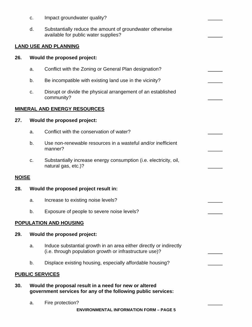
ENVIRONMENTAL INFORMATION FORM – PAGE 5
c. Impact groundwater quality? d. Substantially reduce the amount of groundwater otherwise
available for public water supplies? LAND USE AND PLANNING 26. Would the proposed project: a. Conflict with the Zoning or General Plan designation? b. Be incompatible with existing land use in the vicinity? c. Disrupt or divide the physical arrangement of an established
community? MINERAL AND ENERGY RESOURCES 27. Would the proposed project: a. Conflict with the conservation of water? b. Use non-renewable resources in a wasteful and/or inefficient
manner? c. Substantially increase energy consumption (i.e. electricity, oil,
natural gas, etc.)? NOISE 28. Would the proposed project result in: a. Increase to existing noise levels? b. Exposure of people to severe noise levels? POPULATION AND HOUSING 29. Would the proposed project: a. Induce substantial growth in an area either directly or indirectly
(i.e. through population growth or infrastructure use)? b. Displace existing housing, especially affordable housing? PUBLIC SERVICES 30. Would the proposal result in a need for new or altered
government services for any of the following public services: a. Fire protection?

ENVIRONMENTAL INFORMATION FORM – PAGE 6
b. Police protection? c. Schools? d. Maintenance of public facilities, including roads? e. Other governmental services? RECREATION 31. Would the proposed project: a. Increase the demand for neighborhood or regional parks or other
recreational facilities? b. Affect existing recreational opportunities? TRANSPORTATION AND TRAFFIC 32. Would the proposed project: a. Increase vehicle trips or traffic congestion? b. Increase hazards to safety from design features (i.e. sharp curves or
dangerous intersections)? c. Inadequate access to nearby uses? d. Insufficient on-site parking capacity? e. Hazards or barriers for pedestrians or bicyclists? UTILITIES AND SERVICE SYSTEMS 33. Would the proposed project result in a need for new systems or supplies, or
alterations to the following utilities: a. Power or natural gas? b. Communications systems? c. Local or regional water treatment or distribution facilities? d. Sewer or septic tanks? e. Storm water drainage? f. Solid waste disposal? g. Local or regional water supplies?

ENVIRONMENTAL INFORMATION FORM – PAGE 7
34. Describe the project site as it exists before the project, including any existing structures
on the site, and the use of the structures (i.e. residential, commercial, industrial, etc.) Attach photographs of the site and of the surrounding land uses.
35. Describe the intensity of land use (i.e. single-family, apartment dwellings, shopping
center, etc.), and specifications of development (i.e. height, primary frontage, secondary frontage, setbacks, rear yard, etc.).
CERTIFICATION: I hereby certify that the statements furnished above and in the attached plans present the data and information required for this initial evaluation to the best of my ability, and that the facts, statements and information presented are true and correct to the best of my knowledge and belief. Applicant (Signature) Date R:\PLANNING DIVISION\FORMS AND TEMPLATES\ENVIRONMENTAL ASSESSMENT CHECKLIST.DOC
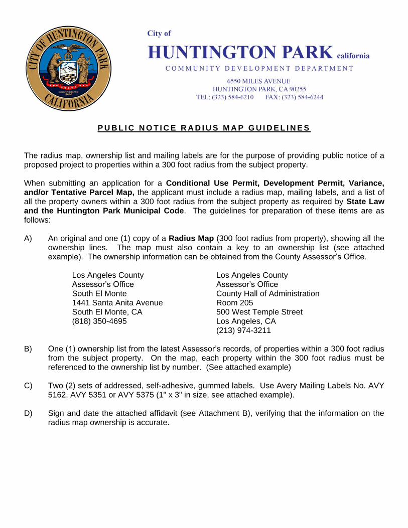
P U B L I C N O T I C E R A D I U S M A P G U I D E L I N E S
The radius map, ownership list and mailing labels are for the purpose of providing public notice of a proposed project to properties within a 300 foot radius from the subject property. When submitting an application for a Conditional Use Permit, Development Permit, Variance, and/or Tentative Parcel Map, the applicant must include a radius map, mailing labels, and a list of all the property owners within a 300 foot radius from the subject property as required by State Law and the Huntington Park Municipal Code. The guidelines for preparation of these items are as follows: A) An original and one (1) copy of a Radius Map (300 foot radius from property), showing all the
ownership lines. The map must also contain a key to an ownership list (see attached example). The ownership information can be obtained from the County Assessor’s Office.
Los Angeles County Los Angeles County Assessor’s Office Assessor’s Office South El Monte County Hall of Administration 1441 Santa Anita Avenue Room 205 South El Monte, CA 500 West Temple Street (818) 350-4695 Los Angeles, CA
(213) 974-3211
B) One (1) ownership list from the latest Assessor’s records, of properties within a 300 foot radius from the subject property. On the map, each property within the 300 foot radius must be referenced to the ownership list by number. (See attached example)
C) Two (2) sets of addressed, self-adhesive, gummed labels. Use Avery Mailing Labels No. AVY
5162, AVY 5351 or AVY 5375 (1" x 3" in size, see attached example). D) Sign and date the attached affidavit (see Attachment B), verifying that the information on the
radius map ownership is accurate.
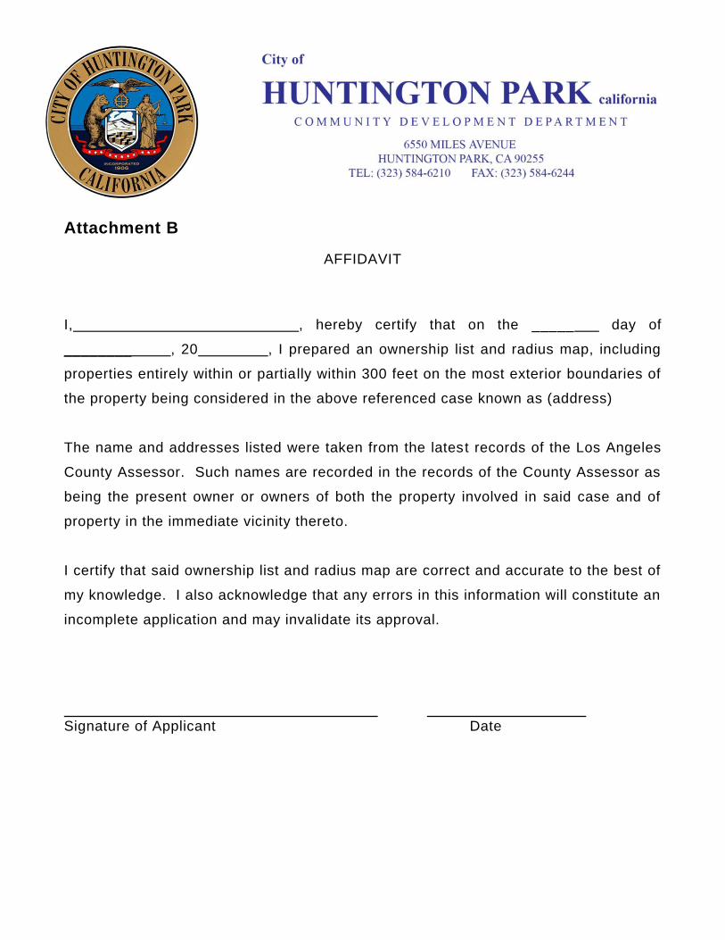
Attachment B
AFFIDAVIT
I, , hereby certify that on the _____ day of
________ , 20 , I prepared an ownership list and radius map, including
properties entirely within or partially within 300 feet on the most exterior boundaries of
the property being considered in the above referenced case known as (address)
The name and addresses listed were taken from the latest records of the Los Angeles
County Assessor. Such names are recorded in the records of the County Assessor as
being the present owner or owners of both the property involved in said case and of
property in the immediate vicinity thereto.
I certify that said ownership list and radius map are correct and accurate to the best of
my knowledge. I also acknowledge that any errors in this information will constitute an
incomplete application and may invalidate its approval.
. . Signature of Applicant Date


Copyright © 2022 FDOKUMEN