Genetic structure of three Croatian horse breeds: implications for their conservation strategy

ELSEVIER Tectonophysics 297 (1998) 283–293
Tectonic activity in the Croatian part of the Pannonian basin
Eduard Prelogovic a,Ł, Bruno Saftic a, Vlado Kuk b, Josipa Velic a, Mate Dragas c,Dubravko Lucic c
a Faculty of Mining, Geology and Petroleum Engineering, University of Zagreb, Pierottijeva 6, HR-10000 Zagreb, Croatiab Faculty of Science and Mathematics, University of Zagreb, Horvatovac, Croatia
c INA-Naftaplin, Geological Exploration and Development Division, Zagreb, Croatia
Received 10 March 1997; accepted 1 December 1997
Abstract
Three main stages in structural development of the SW Pannonian basin are differentiated: the onset of extensionaltectonics between the Oligocene and the Early Miocene, main extensional processes in the Early and Middle Mioceneand prevailing transpression in the Pliocene and Quaternary. The neotectonic phase is given special attention in thispaper. Structural fabrics allow to subdivide the area into three large structural zones: corresponding to the Western,Southern and Central marginal part of the Pannonian basin in Croatia. These zones are bounded by important faults:the Periadriatic–Drava fault, the Medvednica fault zone and the southern marginal fault of the Pannonian basin. Therecent displacements within the Dinarides and the Eastern Alps form the boundary conditions for active transpressionaldeformation in the Western marginal part of the Pannonian basin. Dextral transcurrent displacement is evident in the zoneof the Periadriatic–Drava wrench fault. The formation of the new types of structures is observed, especially in zones ofcompression along the faults. Narrowing of the area between the Sava and Drava rivers causes structural changes in themarginal parts of the corresponding basins, i.e. in the areas close to the Slavonian Mts. Recent tectonic activity is markedby the occurrence of earthquakes which are most common in the northwestern part of Croatia. The spatial distribution ofhypocentres and of seismotectonically active zones is used to reconstruct probable displacements and the structural style ofdeformation in depth. The earthquake sources in the vicinity of the Medvednica fault and the Periadriatic–Drava fault aregiven special attention. 1998 Elsevier Science B.V. All rights reserved.
Keywords: Pannonian basin; active tectonics; transpression; earthquake
1. Introduction
The structural evolution of the Croatian part ofthe Pannonian basin has been a matter of researchfor a long time. Most of these works, however,refrained from putting local observations into a co-
Ł Corresponding author. Tel.: C385 (1) 4836-042; Fax: C385 (1)4836-064.
herent regional tectonic frame and there existed aneed for a structural study in order to obtain an ac-ceptable kinematic model. A significant impetus tothis project was given by the new geotectonic models(Herak, 1986) and by the regional geodynamic mod-els for the Pannonian basin system as a whole (e.g.Royden and Horvath, 1988; Bergerat, 1989; Cson-tos et al., 1991; Tari et al., 1992). Several paperstreating neotectonic and structural aspects followed
0040-1951/98/$19.00 1998 Elsevier Science B.V. All rights reserved.PII: S 0 0 4 0 - 1 9 5 1 ( 9 8 ) 0 0 1 7 3 - 5

284 E. Prelogovic et al. / Tectonophysics 297 (1998) 283–293
Fig. 1. Location of the SW Pannonian basin adjacent to the Eastern=Southern Alps and the Dinarides. Boxes indicate the location ofdetailed maps in Figs. 2–9.
(Jamicic, 1988a; Prelogovic and Velic, 1988, 1992;Herak et al., 1990). The constant inflow of newdata from the Pannonian basin and from the widerPannonian–Carpathian–Dinaride area (e.g. Horvath,1993; Becker, 1993; Lankreijer et al., 1995; McClay, 1995; Decker and Peresson, 1996) is joinedby the researchers from Croatia (Vlahovic et al.,1995; Jamicic, 1995; Hecimovic, 1995). Interestingcontributions were also given by explorationists par-ticipating in the PANCARDI project (Decker, 1996).
The interpretation of surface- and subsurface dataallows us to present a reconstruction of the struc-tural development of the Croatian part of the Pan-nonian basin from the Oligocene on. The data setincludes published and unpublished archive material.The most important published data are contained ina number of sheets of the Basic Geological Mapscale 1 : 100,000 (Sikic et al., 1977; Galovic andMarkovic, 1979; Sparica et al., 1979, 1983; Basch,1981; Simunic et al., 1983; Korolija and Crnko,1985; Jamicic and Brkic, 1986; Sparica, 1986; Heci-movic, 1987; Jamicic, 1988b; Korolija and Jamicic,1988). The archive data set that was used consistsof logs of about 1700 deep wells and 40 regionalseismic sections, previously constructed lithofaciesand thickness maps provided by INA Naftaplin, andvarious satellite images of northern Croatia. The re-cent tectonic activity of the studied area is describedand discussed on a wider regional scale (Fig. 1).
2. Structural development and position of thestudied area in the regional tectonic context
The evolution of the SE Pannonian basin occurredduring continued convergence between the Adriaticplate and the Southern Alps=Dinarides. The tectonicmovements were driven by the subduction of theAdriatic plate under the Dinarides and the Alps withthe largest amount of shortening in the SouthernAlps. Collision led to the formation of the overthrustsand reverse structures both in the Southern Alps andthe Dinarides, as well as to dextral transcurrentdisplacements (Fig. 3).
Extensional tectonics in the SE Pannonian basinstarted between the Oligocene and the EarlyMiocene. The onset of extension was marked byandesitic volcanism in the area north of Zagreb(Pamic, 1997; Pamic et al., 1998). This was followedby the main extensional phase during the Early andMiddle Miocene, which is described from the areashown in Fig. 2. The regional displacement of majorblocks towards the northeast along the Medvednicafault and the faults between Pakrac and Osijek ledto the opening of both large and local extensionalbasins which are filled with Neogene sediments.From the Early Miocene to the Sarmatian, andesiticand basaltic eruptive rocks appear together with py-roclastics in the Drava region and in the region of theSlavonian Mts. (Pamic, 1997). During the Pannonian
E. Prelogovic et al. / Tectonophysics 297 (1998) 283–293 285
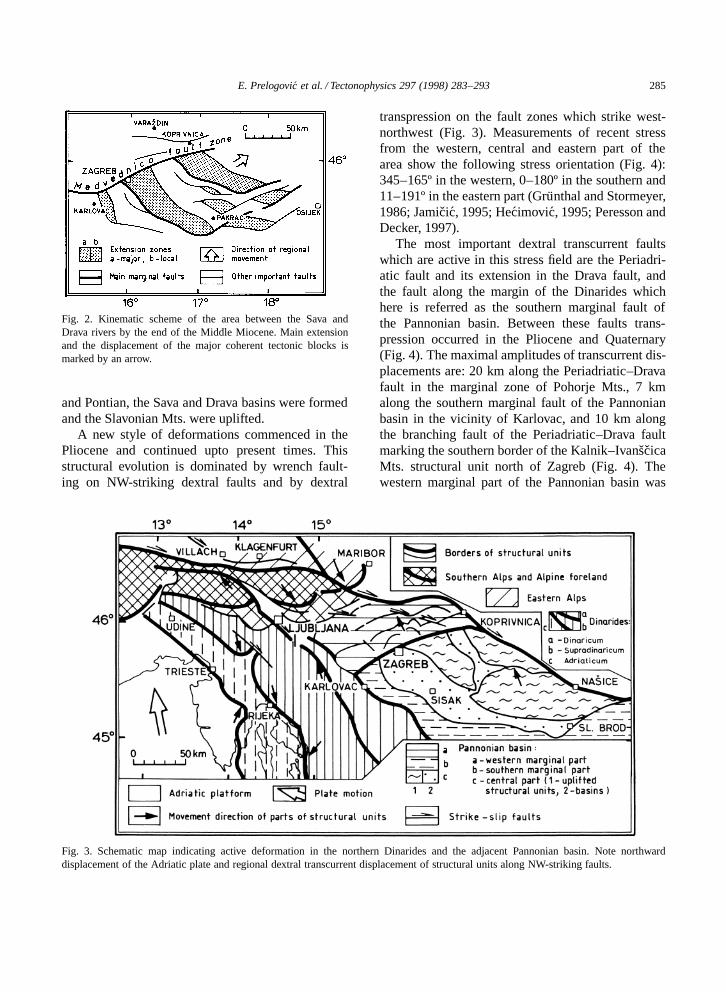
Fig. 2. Kinematic scheme of the area between the Sava andDrava rivers by the end of the Middle Miocene. Main extensionand the displacement of the major coherent tectonic blocks ismarked by an arrow.
and Pontian, the Sava and Drava basins were formedand the Slavonian Mts. were uplifted.
A new style of deformations commenced in thePliocene and continued upto present times. Thisstructural evolution is dominated by wrench fault-ing on NW-striking dextral faults and by dextral
Fig. 3. Schematic map indicating active deformation in the northern Dinarides and the adjacent Pannonian basin. Note northwarddisplacement of the Adriatic plate and regional dextral transcurrent displacement of structural units along NW-striking faults.
transpression on the fault zones which strike west-northwest (Fig. 3). Measurements of recent stressfrom the western, central and eastern part of thearea show the following stress orientation (Fig. 4):345–165º in the western, 0–180º in the southern and11–191º in the eastern part (Grunthal and Stormeyer,1986; Jamicic, 1995; Hecimovic, 1995; Peresson andDecker, 1997).
The most important dextral transcurrent faultswhich are active in this stress field are the Periadri-atic fault and its extension in the Drava fault, andthe fault along the margin of the Dinarides whichhere is referred as the southern marginal fault ofthe Pannonian basin. Between these faults trans-pression occurred in the Pliocene and Quaternary(Fig. 4). The maximal amplitudes of transcurrent dis-placements are: 20 km along the Periadriatic–Dravafault in the marginal zone of Pohorje Mts., 7 kmalong the southern marginal fault of the Pannonianbasin in the vicinity of Karlovac, and 10 km alongthe branching fault of the Periadriatic–Drava faultmarking the southern border of the Kalnik–IvanscicaMts. structural unit north of Zagreb (Fig. 4). Thewestern marginal part of the Pannonian basin was
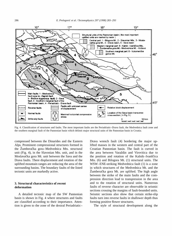
286 E. Prelogovic et al. / Tectonophysics 297 (1998) 283–293
Fig. 4. Classification of structures and faults. The most important faults are the Periadriatic–Drava fault, the Medvednica fault zone andthe southern marginal fault of the Pannonian basin which delimit major structural units of the Pannonian basin in Croatia.
compressed between the Dinarides and the EasternAlps. Prominent compressional structures formed inthe Zumberacka gora–Medvednica Mts. structuralunit (Fig. 4), in the Slavonian Mts. unit, and in theMoslavacka gora Mt. unit between the Sava and theDrava faults. There displacement and rotation of theuplifted mountain ranges are reducing the area of thesurrounding basins. The boundary faults of the listedtectonic units are markedly active.
3. Structural characteristics of recentdeformation
A detailed tectonic map of the SW Pannonianbasin is shown in Fig. 4 where structures and faultsare classified according to their importance. Atten-tion is given to the zone of the dextral Periadriatic–
Drava wrench fault (4) bordering the major up-lifted masses in the western and central part of theCroatian Pannonian basin. The fault is curved inthe area between Varazdin and Virovitica due tothe position and rotation of the Kalnik–IvanscicaMts. (6) and Bilogora Mt. (1) structural units. TheWSW–ENE-striking Medvednica fault (1) is a zonein which structures of the Medvednica Mt. and theZumberacka gora Mt. are uplifted. The high anglebetween the strike of the main faults and the com-pression direction lead to transpression in the areaand to the rotation of structural units. Numerousfaults of reverse character are observable in seismicsections crossing the margins of fault-bounded units.Seismic sections also show that certain strike-slipfaults turn into reverse faults in shallower depth thusforming positive flower structures.
The style of structural development along the
E. Prelogovic et al. / Tectonophysics 297 (1998) 283–293 287
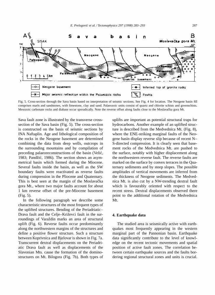
Fig. 5. Cross-section through the Sava basin based on interpretation of seismic sections. See Fig. 4 for location. The Neogene basin fillcomprises marls and sandstones, with limestone, clay and sand. Palaeozoic units consist of quartz and chlorite schists and greenschists.Mesozoic carbonate rocks and diabase occur sporadically. Note the reverse offset along faults close to the Moslavacka gora Mt.
Sava fault zone is illustrated by the transverse cross-section of the Sava basin (Fig. 5). The cross-sectionis constructed on the basis of seismic sections byINA Naftaplin. Age and lithological composition ofthe rocks in the Neogene basement are determinedcombining the data from deep wells, outcrops inthe surrounding mountains and by compilation ofpreceding palaeoreconstructions of the basin (Velic,1983; Pandzic, 1986). The section shows an asym-metrical basin which formed during the Miocene.Several faults inside the basin, as well as the SWboundary faults were reactivated as reverse faultsduring compression in the Pliocene and Quaternary.This is best seen at the margin of the Moslavackagora Mt., where two major faults account for about1 km reverse offset of the pre-Miocene basement(Fig. 5).
In the following paragraph we describe somecharacteristic structures of the most frequent types ofthe uplifted structures. Bending of the Periadriatic–Drava fault and the Celje–Krizevci fault in the sur-roundings of Varazdin marks an area of structuraluplift (Fig. 6). Reverse faults occur predominantlyalong the northwestern margins of the structures anddefine a positive flower structure. Such a structurebetween Koprivnica and Bjelovar is shown in Fig. 7a.Transcurrent dextral displacements on the Periadri-atic Drava fault as well as displacements of theSlavonian Mts. cause the formation of the domino-structures on Mt. Bilogora (Fig. 7b). Both types of
uplifts are important as potential structural traps forhydrocarbons. Another example of an uplifted struc-ture is described from the Medvednica Mt. (Fig. 8),where the ENE-striking marginal faults of the Neo-gene basin display reverse slip because of recent N–S-directed compression. It is clearly seen that base-ment rocks of the Medvednica Mt. are pushed tothe surface, notably with higher displacement alongthe northwestern reverse fault. The reverse faults aremarked on the surface by convex terraces in the Qua-ternary sediments and by steep slopes. The possibleamplitudes of vertical movements are inferred fromthe thickness of Neogene sediments. The Medved-nica Mt. is also cut by a NW-trending dextral faultwhich is favourably oriented with respect to therecent stress. Dextral displacements observed therepoint to the additional rotation of the MedvednicaMt.
4. Earthquake data
The studied area is seismically active with earth-quakes most frequently appearing in the westernmarginal part of the Pannonian basin. Earthquakedata significantly contribute to the level of knowl-edge on the recent tectonic movements and spatialposition of active fault zones. The correlation be-tween certain earthquake sources and the faults bor-dering regional structural zones and units is crucial.
288 E. Prelogovic et al. / Tectonophysics 297 (1998) 283–293
Fig. 6. Tectonic map and seismic activity of the Periadriatic–Drava fault in the Varazdin region. Bending of the Periadriatic–Drava faultand the Celje–Krizevci fault marks the area of structural uplift characterised by concentration of earthquake epicentres.
Such correlation enables to study displacements ofparticular rock masses, and to delimitate areas withmore extensive compression.
Fig. 7. (a) Example of a flower-structure in Bilogora Mt. (b)Example of a domino-structure in Bilogora Mt.
The Archives of the Geophysical Department ofthe Faculty of Science and Mathematics in Zagrebprovided the seismological data base. This Archivescontains macroseismic and microseismic data, andthe catalogue of earthquakes in Croatia and neigh-bouring regions. The data were taken from the re-vised Croatian catalogue of earthquakes for the pe-riod 1908–1992 (Herak et al., 1996), supplementedwith the data for the years after 1992 and the period1880–1907 (Kispatic, 1891, 1892, 1895; Shebalinet al., 1974). Here the year 1908 represents thebeginning of the permanent instrumental collectingof the seismological data, since it was the year inwhich A. Mohorovicic installed the Wiechert seis-mograph in Zagreb. The catalogue is estimated tobe complete for events with magnitude M ½ 4:0.The magnitude completeness threshold decreases to3.8 after the middle of the century, and to about 3.6in the last decades. The reliability of the hypocen-tral coordinates determination is not uniform for thewhole catalogue because it depends on several pa-rameters (number of the instrumental=macroseismicdata used, their azimuthal coverage, velocity modelsapplied, etc.). Generally, there is significantly greaterreliability in the last several decades. The conclu-sions based on hypocentral coordinate data should

E. Prelogovic et al. / Tectonophysics 297 (1998) 283–293 289
Fig. 8. Seismotectonic activity of the Medvednica fault zone. The ENE-striking marginal faults delimit a zone where reverse faults aremost prominent and where the strongest earthquakes occur.
be interpreted bearing in mind that some of theconclusions contain subjective estimations.
Fig. 9 shows the distribution of earthquake epi-centres in the most active part of studied area. Theseismically most active areas, marked by concentra-tion of the earthquakes and by the strongest earth-quakes that happened in the period 1880–1995, arethe following: the Zagreb surroundings (MedvednicaMt., in Fig. 8); the area to the west and southwest ofZagreb (Zumberacka gora Mt.); the area to the southof Zagreb (Vukomericke gorice Mt.) and vicinity ofVarazdin (Kalnik and Ivanscica Mts., together withthe northern part of Bilogora Mt.). The parametersof the strongest earthquakes are listed in Table 1.
In order to enable comparison with structures it isnecessary to observe the concentration and zonationof earthquake epicentres. Such a zonation is wellmarked in zones of the Medvednica fault and thePeriadriatic–Drava fault, as well as in the transi-tional zone between the Dinarides and the southern
marginal part of the Pannonian basin (to the westof Zagreb). The earthquake epicentres are obviouslygrouped within the area of marked compression. Thepossibility to deliminate the spatial position of seis-motectonically active zones is of more importance.The following two examples are given.
The area of Ivanscica Mt., Kalnik Mt. and thenorthern part of the Bilogora Mt. (Fig. 6) is shown ontwo cross-sections (Fig. 10). Section C–D (Fig. 10)cuts through the zones of the Periadriatic–Dravafault and the Celje–Krizevci fault. The earthquakehypocentres are found at depths between 5 and 20km. In accordance to the seismic fault plane so-lutions (Herak et al., 1995), the seismotectonicallyactive zones exhibit the following features. The zoneconnected to the Periadriatic–Drava fault is 5 kmwide; to a depth of 7 km it is steeply inclined anddisplays reverse displacement of a hanging wall,whereas to a depth of 20 km it is almost vertical.The zone of the Celje–Krizevci fault has a width

290 E. Prelogovic et al. / Tectonophysics 297 (1998) 283–293
Fig. 9. Earthquake epicentres in the Western marginal part of thePannonian basin in Croatia.
between 2 and 5 km, to a depth of 8 km it is curveddue to reverse displacement of the northern wall; aconnection with the zone of the Periadriatic–Dravafault is possible at a depth close to 16 km.
Due to the higher number of observed earth-quakes, the section across the Kalnik Mt. yieldsadditional data on the zone of the Periadriatic–Dravafault (Fig. 10, section E–F): to the depth of 5 kmthe zone is roughly 3 km wide; at depths between8 and 25 km the zone is widening up to some 10
Table 1The strongest earthquakes that happened in NW Croatia in the period 1880–1995
Location Year Epicentre Focal depth Magnitude(km)
ϕ (ºN) λ (ºE)
Medvednica Mt. 1880 45.91 16.11 10 6.3Medvednica Mt. 1906 45.91 16.11 5 6.1Zumberacka g. Mt. 1917 45.00 15.57 13 5.7Kalnik–Ivanscica–Bilogora Mts. 1905 46.15 16.21 10 5.2Kalnik–Ivanscica–Bilogora Mts. 1938 46.02 16.85 7 5.6Vukomericke gorice Mt. 1909 45.60 16.15 8 6.0Kalnik Mt. 1993 46.23 16.55 18 4.7
or 12 km and is curved in space; between 8 and 16km two convex-up branches with possible reversedisplacements of hanging walls are discerned.
The strongest earthquakes happened in theMedvednica Mt. (Fig. 8). The cross-section G–H(Fig. 10) shows the seismotectonically active zones.The earthquake hypocentres are most common inthe depth range between 5 and 17 km. The zoneassociated to the Zagreb fault is steeply inclined andcurves both in depth and close to the surface. Thezone is 5 to 8 km wide. The second zone is associ-ated to the Brezice–Koprivnica fault and has a dip of60º. Reverse displacements of the hanging walls areinterpreted from seismic fault plane solutions whichare corroborated by geological evidence on the sur-face (Sikic et al., 1977; Basch, 1981; Simunic et al.,1983). The zone is approximately 4 km wide andmay be connected to the zone of the Zagreb faultat a depth of around 15 km. The seismotectonicallyactive zones delimit an area of active uplift related tocompression between the two zones.
5. Conclusions
The structural evolution of the SW Pannonianbasin and the adjacent Dinarides is analysed forthe period from the end of the Oligocene until thepresent. In the main extensional phase during theEarly and Middle Miocene, the Sava and Dravabasins formed together with smaller subbasins. Theextension-related depositional cycle ended in Pontiantimes and a new tectonic phase began in the Pliocene.Pliocene to recent tectonics led to an overprint of theolder structures and to the inversion of the formerly

E. Prelogovic et al. / Tectonophysics 297 (1998) 283–293 291
Fig. 10. Seismotectonic cross-sections through the Ivanscica Mt. (C–D, see Fig. 6 for location), Kalnik Mt. (E–F, see Fig. 6 for location),and Medvednica Mt. (G–H, see Fig. 8 for location). The concentration of earthquake hypocentres marks seismotectonically active zonesthat are linked with the most active surface faults.
extensional basins (Figs. 3 and 4). A transpressionalwrench-fault model is established for the Pliocene torecent evolution of the SW Pannonian basin which isregarded as the neotectonic period.
The joining of the Periadriatic and Drava faultsduring the Pliocene and Quaternary is an importantfact because the new-formed united fault zone sep-arates the studied area from the main part of thePannonian basin (Fig. 4). This is confirmed by twofacts. First, in the broad fault zone which extendsfrom the Ivanscica and Kalnik Mts. over the Bilo-gora Mt. to the Slavonian Mts. a series wrench-faultsand transpressional structures appear (Figs. 4 and 7).
Second, the Medvednica fault zone is cut by tran-scurrent faults in the area of Krizevci (Fig. 8). TheMedvednica fault zone is observed in depth by themeans of seismic sections; to the northeast it canbe traced into the northern part of the Bilogora Mt.(Fig. 4).
The recent tectonic activity in the area is markedby frequent earthquakes. Earthquake sources are as-sociated with particular fault zones. The spatial posi-tion of the seismotectonically active zones illustratesfault zones and displacements of the rock massesin depth. Widths and inclinations of some zoneswhich are mapped by hypocentre distributions in-

292 E. Prelogovic et al. / Tectonophysics 297 (1998) 283–293
dicate bending of the fault zones in cross-sections.Reverse displacements along such curved faults arefrequently observed. In our examples (Fig. 10), thedistributions of earthquake hypocentres show possi-ble connections between certain seismotectonicallyactive zones at depth. In this way it is possible tolink some of the surface faults with the Periadriatic–Drava fault zone and Medvednica fault zone. Thehypocentre depths characteristic for particular seis-motectonically active zones that are associated withthe most important faults are as follows:
(1) the Periadriatic–Drava fault — earthquakehypocentres concentrate at depths between 5 and 25km;
(2) the Sava fault bordering the southern marginalpart of the Pannonian basin — most earthquakehypocentres occur at depths between 10 and 30 km;
(3) the Medvednica fault — earthquake hypocen-tres mostly at depths between 5 and 17 km.
These observations indicate that the most impor-tant faults reach the MOHO-discontinuity which, ac-cording to Aljinovic (1987), lies at a depth between25 and 30 km in the investigated area.
Acknowledgements
The presented data are the results of a researchproject which was founded by the Ministry of Sci-ence and Technology of the Republic of Croatia (sci-entific project No. 1-09-020: ‘Subsurface GeologicalStructures and Neotectonic Relations in Croatia’)and which was carried out in co-operation with thenational oil-company ‘INA-Naftaplin’ whose per-mission to publish the results is greatly appreciated.
References
Aljinovic, B., 1987. On certain characteristics of the Mo-horovicic discontinuity in the region of Yugoslavia. ActaGeol., Jugosl. Akad. Znan. Umjet., Zagreb 17 (12), 13–20.
Basch, O., 1981. Osnovna geoloska karta 1 : 100,000, list IvanicGrad. Institute of Geology, Zagreb.
Becker, A., 1993. Contemporary stage of stress and neotectonicdeformation in the Carpathian and Pannonian region. TerraNova 5, 375–388.
Bergerat, F., 1989. From pull-apart to the rifting process: theformation of the Pannonian basin. Tectonophysics 157, 271–280.
Csontos, L., Tari, G., Bergerat, F., Fodor, L., 1991. Evolutionof the stress fields in the Carpatho-Pannonian area during theNeogene. Tectonophysics 199, 73–91.
Decker, K. (Ed.), 1996. PANCARDI workshop 1996. Dynam-ics of the Pannonian–Carpathian–Dinaride system. Mitt. Ges.Geol. Bergbaustud.-Osterr., Wien 41, 148 pp.
Decker, K., Peresson, H., 1996. Tertiary kinematics in theAlpine–Carpathian–Pannonian system: links between thrust-ing, transform faulting and crustal extension. In: Wessely,G., Liebl, W. (Eds.), Oil and Gas in Alpidic Thrustbelts andBasins of Central and Eastern Europe. EAGE Spec. Publ. 5,69–77.
Galovic, I., Markovic, S., 1979. Osnovna geoloska karta1 : 100,000, list Virovitica. Institute of Geology, Zagreb.
Grunthal, G., Stormeyer, D., 1986. Stress pattern in CentralEurope and adjacent areas. Gerlands Beitr. Geophys. 95 (5),443–452.
Hecimovic, I., 1987. Osnovna geoloska karta 1 : 100,000, listDurdevac. Institute of Geology, Zagreb.
Hecimovic, I., 1995. Tektonski odnosi sireg podrucja Kalnika(with English abstr.). Ph.D. Thesis, Faculty of Mining Geologyand Petroleum Engineering, Univ. of Zagreb, 152 pp.
Herak, M., 1986. A new concept of geotectonics of the Dinar-ides. Acta Geol. Jugosl. Akad. Znan. Umjet., Zagreb 16 (1),1–42.
Herak, M., Jamicic, D., Simunic, A., Bukovac, J., 1990. Thenorthern boundary of the Dinarides. Acta Geol. Jugosl. Akad.Znan. Umjet., Zagreb 20, 5–27.
Herak, M., Herak, D., Markusic, S., 1995. Fault-plane solutionsfor earthquakes (1956–1995) in Croatia and neighbouring re-gions. Geofizika 12, 43–56.
Herak, M., Herak, D., Markusic, S., 1996. Revision of theearthquake catalogue and seismicity of Croatia. Terra Nova 8,86–94.
Horvath, F., 1993. Towards a kinematic model for the formationof the Pannonian basin. Tectonophysics 226, 333–357.
Jamicic, D., 1988a. Strukturni sklop Slavonskih planina (sjeverniPsunj, Papuk, Krndija) (with English abstr.). Ph.D. Thesis,Faculty of Mining, Geology and Petroleum Engineering, Univ.of Zagreb, 157 pp.
Jamicic, D., 1988b. Osnovna geoloska karta 1 : 100,000, listDaruvar. Institute of Geology, Zagreb.
Jamicic, D., 1995. The role of sinistral strike-slip faults in theformation of the structural fabric of the Slavonian Mts. Geol.Croatica 48 (2), 155–160.
Jamicic, D., Brkic, M., 1986. Osnovna geoloska karta1 : 100,000, list Orahovica. Institute of Geology, Zagreb.
Kispatic, M., 1891. Potresi u Hrvatskoj. Rad Jugosl. Akad. Znan.Umjet., CVII, Zagreb.
Kispatic, M., 1892. Potresi u Hrvatskoj. Rad Jugosl. Akad. Znan.Umjet., CIX, Zagreb.
Kispatic, M., 1895. Potresi u Hrvatskoj. Rad Jugosl. Akad. Znan.Umjet., CXXII, Zagreb.
Korolija, B., Crnko, J., 1985. Osnovna geoloska karta1 : 100,000, list Bjelovar. Institute of Geology, Zagreb.
Korolija, B., Jamicic, D., 1988. Osnovna geoloska karta1 : 100,000, list Nasice. Institute of Geology, Zagreb.

E. Prelogovic et al. / Tectonophysics 297 (1998) 283–293 293
Lankreijer, A., Kovac, M., Cloetingh, S., Pitonak, P., Hloska,M., Biermann, C., 1995. Quantitative subsidence analysis andforward modelling of the Vienna and Danube basins: thin-skinned versus thick-skinned extension. Tectonophysics 252,433–451.
Mc Clay, K.R., 1995. 2D and 3D analogue modelling of ex-tensional fault structures: templates for seismic interpretation.Pet. Geosci. 1 (2), 163–178.
Pandzic, J., 1986. Pretercijar jugozapadnog dijela Panonskogbazena (with English abstr.). INA-Naftaplin, Zagreb.
Pamic, J., 1997. Volcanic rocks from the Sava–Drava interfluveand Baranja in the South Pannonian Basin (Croatia) (in Croat-ian with English summary). Nafta J. Spec. Publ., Zagreb, 192pp.
Pamic, J., Gusic, I., Jelaska, V., 1998. Geodynamic evolution ofthe Central Dinarides. Tectonophysics 297, 251–268.
Peresson, H., Decker, K., 1997. Far-field aspects of the LateMiocene subduction in the Eastern Carpathians: E–W com-pression and inversion of structures in the Alpine–Carpathian–Pannonian region. Tectonophysics 16 (1), 38–56.
Prelogovic, E., Velic, J., 1988. Quaternary tectonic activity in thewestern part of the Drava depression (in Croatian with Englishsummary). Geol. Vjesnik 41, 237–253.
Prelogovic, E., Velic, J., 1992. Correlation of Quaternary sedi-ments and tectonic activity of the eastern part of the Dravariver depression. Geol. Croatica 45, 151–162.
Royden, L.H., Horvath, F. (Eds.), 1988. The Pannonian Basin. A
Study in Basin Evolution. Am. Assoc. Pet. Geol. Mem. 45.Shebalin, N.V., Karnik, V., Hadzievski, D., 1974. Catalogue of
earthquakes I–II, UNDP=UNESCO Survey of the seismicityof the Balkan region, Skopje.
Sikic, K., Basch, O., Simunic, A., 1977. Osnovna geoloska karta1 : 100,000, list Zagreb. Institute of Geology, Zagreb.
Simunic, A., Pikija, M., Hecimovic, I., 1983. Osnovna geoloskakarta 1 : 100,000, list Varazdin. Institute of Geology, Zagreb.
Sparica, M., 1986. Osnovna geoloska karta 1 : 100,000, listSlavonski Brod. Institute of Geology, Zagreb.
Sparica, M., Jurisa, M., Simunic, A., Jovanovic, C., Zivanovic,D., 1979. Osnovna geoloska karta 1 : 100,000, list NovaKapela. Institute of Geology, Zagreb.
Sparica, M., Buzaljko, R., Jovanovic, C., 1983. Osnovna ge-oloska karta 1 : 100,000, list Nova Gradiska. Institute of Geol-ogy, Zagreb.
Tari, G., Horvath, F., Rumpler, J., 1992. Styles of extension inthe Pannonian basin. Tectonophysics 208, 203–219.
Velic, J., 1983. The neotectonic relations and development of thewestern part of the Sava river depression (in Croatian withEnglish summary). Acta Geol., Jugosl. Akad. Znan. Umjet.,Zagreb 13 (2), 26–65.
Vlahovic, I., Velic, I., Sparica, M. (Eds.), 1995. Proceedings ofthe First Croatian Geological Congress, Opatija 18–21 Octo-ber (in English or in Croatian with English Abstr.). Institute ofGeology, Zagreb, Vol. 1, 344 pp., Vol. 2, 665 pp.
Copyright © 2022 FDOKUMEN