
Taladanda O&M Plan -Vol-2 - Deptt. of Water Resources, Odisha
163
Departme Proje Orissa I Water Managem (ADB Lo Taladanda O H Sutra Consulting Pvt. ent of Water Resources (D ect Management Unit (PMU Integrated Irrigated Agriculture ment Investment Programme (O oan No. 2444 and OFID Loan No. 125 Operation & Maintenanc Volume 2 of 2 Annexes (Final Version 1) Prepared by ISPMC March 2017 Hydrosult, Division of SNC- Lavalin Inc. In association with Ltd., SBH Consultants Pvt. Ltd. and N.K. B DoWR) U) e and OIIAWMIP) 51-P) ce Manual Buildcon Pvt. Ltd.
-
Upload
khangminh22 -
Category
Documents
-
view
0 -
download
0
Transcript of Taladanda O&M Plan -Vol-2 - Deptt. of Water Resources, Odisha
Department of Water Resources (DoWR)
Project Management Unit (PMU)Orissa Integrated Irrigated Agriculture and
Water Management Investment Programme (OIIAWMIP)
(ADB Loan No. 2444 a
Taladanda Operation & Maintenance Manu
Hydrosult, Division of SNC
Sutra Consulting Pvt. Ltd., SBH
Department of Water Resources (DoWR)Project Management Unit (PMU)
Orissa Integrated Irrigated Agriculture and
Water Management Investment Programme (OIIAWMIP)
(ADB Loan No. 2444 and OFID Loan No. 1251
Operation & Maintenance Manu
Volume 2 of 2
Annexes (Final Version 1)
Prepared by ISPMC
March 2017
Hydrosult, Division of SNC - Lavalin Inc. In association with
Sutra Consulting Pvt. Ltd., SBH Consultants Pvt. Ltd. and N.K. Buildcon Pvt. Ltd.
Department of Water Resources (DoWR) Project Management Unit (PMU)
Orissa Integrated Irrigated Agriculture and
Water Management Investment Programme (OIIAWMIP)
nd OFID Loan No. 1251-P)
Operation & Maintenance Manu al
Consultants Pvt. Ltd. and N.K. Buildcon Pvt. Ltd.
Orissa Integrated Irrigated Agriculture & Water Management Investment Program (OIIAWMIP) Irrigation Systems Operations & Maintenance
Government of Orissa, Department of Water Resources ,
Project Management Unit
Name of Project: Orissa Integrated Irrigated Agriculture and Water Management
Investment Program Title of Report: Taladanda Operation & Maintenance Manual Period: December 2016 - March 2017
Our Project No.: 634829
Prepared by: Hemanta K Patra Signature Operations & Maintenance Specialist Sarat K Garanaik Signature Agriculture Specialist Reviewed by: Satya R Mishra Signature Deputy Team Leader
Date: 20 March 2017
Orissa Integrated Irrigated Agriculture & Water Management Investment Program (OIIAWMIP) Irrigation Systems Operations & Maintenance
Taladanda Irrigation Sub-Project Taladanda O&M Plan -Vol-2 i
Contents
A. BACKGROUNDDATA FOR SCHEME 1
B. SUMMARY CLIMATE DATA 5
C. APPRAISAL OF O&M PRACTICE 19
D. EXISTING SUBPROJECT O&M STAFFING AND RESPONSIBILITIES 29
E. EXISTING FACILITIES, EQUIPMENT AND COMMUNICATION 31
F. BUDGETING AND EXPENDITURE 34
G. PROCEDURE FOR PREPARATION OF IRRIGATION PLANS 35
H. MAINTENANCE PROCEDURES 71
I. FUNCTIONS AND RESPONSIBILITIES 75
J. ACTION PLAN FOR EMERGENCIES 77
K. ASSET MANAGEMENT SYSTEM 78
L. PANI PANCHAYAT O&M GUIDELINES 79
M. WATER DISTRIBUTION SCHEDULLING TOOL 84
The seasonal water distribution plan 90
Development of the water distribution tool 91
Input data 135
Module 1: Flow through the Main Intake 135
Module 2: Flow through the Main Intake and the Distributaries 136
Module 3: Flow through the Main Intake, the Distributaries, and the Minor, Sub-minors and direct outlets offtaking from the main canal. 136
Module 4: Chak water requirement and flow through the Main Intake, the total canal system i.e. Distributaries, Minors, Sub-minors, feeders and all outlets. 137
Module 3 139
Module 4 142
Reasons for Rotational Supply 143
Water Availability in Taladanda Irrigation Scheme during the Kharif Season 145
Pani Panchayat Act 2002 and Rules 2003 145
CTA Field Guides 2008 - Guide 4: Minor System Operation 146
Concluding remarks 149
Adoption and Further Development of the water distribution scheduling tool 150
Improving the Practice of Water Distribution 150
TABLES Table C-1: Canal Classification Criteria 20
Table C-2: Reclassification of Canals 21
Table C-3: Taladanda Main Canal Flow Measurment Locations 24
Table C-4: Flow Measurement at Main Canal Offtakes 25
Table C-5: Flow Measurement in Distributary System 25
Table D-1: Staffing in Division Office 29
Table D-2: Staffing in Sub-division & Section offices 29
Table F-1: Operation & Maintenance Expenditure 34
Table G-1: Crop Water Requirements for non-rice crops 39
Table G-2: Paddy Water Requirements 40
Table G-3: Block Wise Strategic Control Points of TMC with FS Levels, Inflow-Outflow, CCA & Water Allotted 41

Orissa Integrated Irrigated Agriculture & Water Management Investment Program (OIIAWMIP) Irrigation Systems Operations & Maintenance
Taladanda Irrigation Sub-Project Taladanda O&M Plan -Vol-2 ii
Table G-4: Block wise designed & required discharge and sub blocks CCA 42
Table G-5: Grouping of canals of whole canal system of Taladanda 43
Table G-6: Crop and their water requirement 44
Table G-7: Rotational Program of Taladanda Canal System for the period -7th January to 21st March-2017 Priority of rotational Group (with two group method) 45
Table G-8: Block wise, Canal wise, PP wise, CCA, Discharge 54
Table K-1: Operation & Maintenance Management Information System 78
Table M-1: Data requirement for calculation of irrigation water requirement 97
Table M-2: Block wise strategic control points of TMC with FS Levels, Inflow-outflow, CCA & Water Allotted 101
Table M-3: Basic feature of Taladanda canal Scheme 107
Table M-4: Main canal structure 107
Table M-5: Taladanda Irrigation System: Pani Panchayats 108
Table M-6: Design Statement of Taladanda Canal (Unlined) 114
Table M-7: Taladanda Irrigation System - List of Canals as per Design Statement 128
FIGURES Figure A-1: Taladanda Irrigation Scheme - Organogram - Mahanadi South Division-1 2
Figure A-2: Structure of Pani Panchayat (Water Users’ Association) 3
Figure B-1: Average monthly rainfall (2000-2015) 6
Figure B-2: Rainfall and reference Effective Rainfall 7
Figure B-3: Rainfall and reference Effective Rainfall 7
Figure B-4: Five Year Return Period Rainfall, 1-7 Day Duration (mm) 8
Figure B-5: Frequency (Return Period) of Rainfall 8
Figure B-6: Mean Monthly Temperatures and Relative Humidity, Cuttack 9
Figure B-7: Climatic Data and Reference Evapotranspiration - Cuttack 9
Figure B-8: Rainfall and reference Effective Rainfall– Cuttack 10
Figure B-9: Catchment Area of Mahanadi River 10
Figure B-10: Annual Flows at Naraj (000 HaM), 1969-2006 12
Figure B-11: Decadal Average Flows at Naraj (u/s of Sinjori-Mahanadi bifucation) 12
Figure B-12: Irrigation Systems supplied from Mahanadi Barrage Complex 13
Figure B-13: Seasonal Canal Diversions from Mahadadi Pond 13
Figure B-14: Present Operating Rules of Naraj Barrage 14
Figure B-15: Seasonal Water Balance for Mahanadi Pond 15
Figure B-16: Mahanadi Pond Canal Diversion, River inflows and Surplus. 16
Figure B-17: Ground water Resources of Cuttack and Jagatsinghpur Districts 16
Figure B-18: Behaviour of Ground Water level during 2014-15 17
Figure C-1: Rabi Season Flow at Biribati 20
Figure D-1: Taladanda Irrigation Scheme: Existing Organization Chart 30
Figure -E-1: Existing Facilities Equipment and communications 31
Figure G-1: Calculation Procedure for Irrigation Plan 35
Figure H-1:Annual O&M Calendar Workplan and Activities Schedule - Taladanda 72
Figure L-1: DoWR – WUA (PP): Shared Management 79
Figure M-1: O&M Plans: Principal Elements 88
Figure M-2: Taladanda Irrigation Scheme: Eight principal water distribution blocks 89
Figure M-3: Generic process for preparation of a water distribution schedule 95
Figure M-4: Basic module for calculation of irrigation water requirement 96
Figure M-5: Operation Strategy for Taladanda Canal System 105
Figure M-6: Salient Feature of Mahanadi Barrage 106
Figure M-7: Schematic Diagram of Taladanda Canal Syatem 113
Figure M-8: Schematics for Eight Principal Water Distribution Blocks of Taladanda 119
Figure M-9: Schematics for Principal Water Distribution Block – 1 120
Figure M-10: Schematics for Principal Water Distribution Block -2 121
Figure M-11: Schematics for Principal W\ater Distribution Block - 3 122
Figure M-12: Schematics for Principal Water Distribution Block-4 123
Orissa Integrated Irrigated Agriculture & Water Management Investment Program (OIIAWMIP) Irrigation Systems Operations & Maintenance
Taladanda Irrigation Sub-Project Taladanda O&M Plan -Vol-2 iii
Figure M-13: Schematics for Principal Water Distribution Block-5 124
Figure M-14: Schematics for Principal Water Distribution Block-6 125
Figure M-15: Schematics for Principal Water Distribution Block-7 126
Figure M-16: Schematics for Principal Water Distribution Block-8 127
Figure M-17: Overview of tested rainfall pattern. 139
Figure M-18: Module 3: Summary of test run results - Main Intake 139
Figure M-19: Summary of test run results - Details or Main Intake and each Principal Water Distribution Block 140
Figure M-20: Module 3 - Test run 3.1: Details for each head regulator (arranged by Principal Water Distribution Block) 141
Figure M-21: Different Perspectives—Common Goal: Efficient Use of Water to Maximize Return 153
Figure M-22: Monsoon Water Discharge of Taladanda 155
Figure M-23: Non-Monsoon Water Discharge Taladanda 156

Orissa Integrated Irrigated Agriculture & Water Management Investment Program (OIIAWMIP) Irrigation Systems Operations & Maintenance
Taladanda Irrigation Sub-Project Taladanda O&M Plan -Vol-2 iv
Orissa Integrated Irrigated Agriculture & Water Management Investment Program (OIIAWMIP) Irrigation Systems Operations & Maintenance
Taladanda Irrigation Sub-Project Taladanda O&M Plan -Vol-2 1
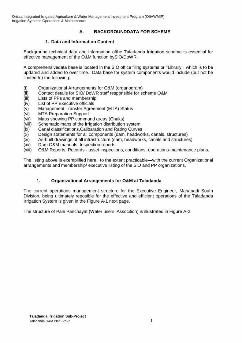
A. BACKGROUNDDATA FOR SCHEME
1. Data and Information Content
Background technical data and information ofthe Taladanda Irrigation scheme is essential for effective management of the O&M function bySIO/DoWR. A comprehensivedata base is located in the SIO office filing systems or ‘’Library’’, which is to be updated and added to over time. Data base for system components would include (but not be limited to) the following: (i) Organizational Arrangements for O&M (organogram) (ii) Contact details for SIO/ DoWR staff responsible for scheme O&M (iii) Lists of PPs and membership (iv) List of PP Executive officials (v) Management Transfer Agreement (MTA) Status (vi) MTA Preparation Support (vii) Maps showing PP command areas (Chaks) (viii) Schematic maps of the irrigation distribution system (ix) Canal classifications,Calibaration and Rating Curves (x) Design statements for all components (dam, headworks, canals, structures) (xi) As-built drawings of all infrastructure (dam, headworks, canals and structures) (xii) Dam O&M manuals, Inspection reports (xiii) O&M Reports, Records - asset inspections, conditions, operations-maintenance plans. The listing above is exemplified here to the extent practicable—with the current Organizational arrangements and membership/ executive listing of the SiO and PP organizations,
1. Organizational Arrangements for O&M at Taladanda
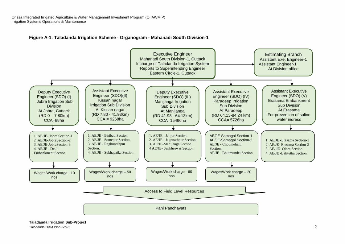
The current operations management structure for the Executive Engineer, Mahanadi South Division, being ultimately reposible for the effective and efficient operations of the Taladanda Irrigation System is given in the Figure A-1 next page. The structure of Pani Panchayat (Water users’ Assocition) is illustrated in Figure A-2.
Orissa Integrated Irrigated Agriculture & Water Management Investment Program (OIIAWMIP) Irrigation Systems Operations & Maintenance
Taladanda Irrigation Sub-Project Taladanda O&M Plan -Vol-2 2
Figure A-1: Taladanda Irrigation Scheme - Organogra m - Mahanadi South Division-1
Deputy Executive Engineer (SDO) (I)
Jobra Irrigation Sub Division
At Jobra, Cuttack (RD 0 – 7.80km)
CCA=88ha
1. AE/JE - Biribati Section. 2. AE/JE - Somepur Section. 3. AE/JE - Raghunathpur Section. 4. AE/JE - Sukhapaika Section
1. AE/JE- Jobra Section-1. 2. AE/JE-JobraSection-2. 3. AE/JE-JobraSection-3 4. AE/JE - Deuli Embankment Section.
Assistant Executive Engineer (SDO)(II)
Kissan nagar Irrigation Sub Division
At Kissan nagar (RD 7.80 - 41.93km)
CCA = 9268ha
Assistant Executive Engineer (SDO) (V)
Erasama Embankment Sub Division At Erasama
For prevention of saline water ingress
Wages/Work charge - 10 nos
1. AE/JE - Jaipur Section. 2. AE/JE - Jagnnathpur Section. 3. AE/JE-Manijanga Section. 4 AE/JE- Sankheswar Section
AE/JE-Samagal Section-1. AE/JE-Samagal Section-2 AE/JE - Choumuhani Section. AE/JE - Bhutmundei Section.
Deputy Executive Engineer (SDO) (III) Manijanga Irrigation
Sub Division At Manijanga
(RD 41.93 - 64.13km) CCA=15496ha
Pani Panchayats
Wages/Work charge – 50 nos
Wages/Work charge - 60 nos
WagesWork charge – 20 nos
Executive Engineer Mahanadi South Division-1, Cuttack
Incharge of Taladanda Irrigation System Reports to Superintending Engineer
Eastern Circle-1, Cuttack
Assistant Executive Engineer (SDO) (IV) Paradeep Irrigation
Sub Division At Paradeep
(RD 64.13-84.24 km) CCA= 5726ha
1. AE/JE -Erasama Section-1 2. AE/JE -Erasama Section-2 3. AE/ JE -Olora Section 4. AE/JE -Balitutha Section
Estimating Branch Assistant Exe. Engineer-1 Assistant Engineer-1
At Division office
Access to Field Level Resources

Orissa Integrated Irrigated Agriculture & Water Management Investment Program (OIIAWMIP)Irrigation Systems Operations & Maintenance
Taladanda Irrigation Sub-Project Taladanda O&M Plan -Vol-2
Figure A-2 : Structure of Pani Panchayat (Water Users’ Associa tion
Orissa Integrated Irrigated Agriculture & Water Management Investment Program (OIIAWMIP)Irrigation Systems Operations & Maintenance
: Structure of Pani Panchayat (Water Users’ Associa tion
Orissa Integrated Irrigated Agriculture & Water Management Investment Program (OIIAWMIP)
3
: Structure of Pani Panchayat (Water Users’ Associa tion )

Orissa Integrated Irrigated Agriculture & Water Management Investment Program (OIIAWMIP) Irrigation Systems Operations & Maintenance
Taladanda Irrigation Sub-Project Taladanda O&M Plan -Vol-2 4
2. Current status of Management Transfer Agreement (MTA)
As per the principle out lined in the CTA guide lines, as well as PP Act and Rule, the canal system below the head regulator of minor canal, would be handed over to Pani Panchayat, so that PP would be responsible for the operation and maintenance of the minor system canals, below head regulator.
But the handing over of the minor system to Pani Panchayat is not yet complete at Taladanda sub project. This creates serious problem on imposing O&M responsibility on PPs. This handing over of the minor system would be done by SIO manager Taladanda by signing a MTA (management transfer agreement) with PP.
The election is complete in 34 PPs out of 73 PPs of Taladanda subproject. The election procedure is in progress in rest of the PPs.
SIO Taladanda would draw a program for signing of MTA with 73 number of PP functioning in the Taladanda system, so that PP can take the maintenance work as per the O&M calendar.
SIO manager Taladanda is to start the signing of MTA with PPs where the election has already been completed, next he will move forward to cover all 73 PPs.
The most important part of the MTA documentation of minor system is preparation of hydraulic boundaries Chak maps and maintaining the Registers of assets to be handedover to PP at the time of signing of MTA.
3. MTA Preparation Support
Under the supervision of Additional Director O&M, the Deputy Director (Pani Panchayat) is to monitor the program of signing of MTA by SIO Taladanda and 73 numbers of PPs
For preparation of MTA documents SIO manager, Taladanda can take the help of the ISPMC consultants, if he so desires. Section officers are to be trained in preparation of MTA documents for 1 PP of their section by working with ISPMC consultants, the preparation of MTA documents for rest of the PPs of their jurisdiction may proceed independently. Hand-holding training is reommneded for Sub-Divisional Officers, Section Officers and deputy SIOM (Executive Engineer) of Taladanda, in preparation of MTA document.
.
Orissa Integrated Irrigated Agriculture & Water Management Investment Program (OIIAWMIP) Irrigation Systems Operations & Maintenance
Taladanda Irrigation Sub-Project Taladanda O&M Plan -Vol-2 5
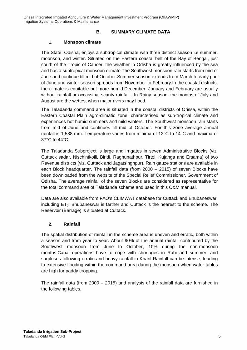
B. SUMMARY CLIMATE DATA
1. Monsoon climate
The State, Odisha, enjoys a subtropical climate with three distinct season i.e summer, moonson, and winter. Situated on the Eastern coastal belt of the Bay of Bengal, just south of the Tropic of Cancer, the weather in Odisha is greatly influenced by the sea and has a subtropical monsoon climate.The Southwest monsoon rain starts from mid of June and continue till mid of October.Summer season extends from March to early part of June and winter season spreads from November to February.In the coastal districts, the climate is equitable but more humid.December, January and February are usually without rainfall or occassinal scanty rainfall. In Rainy season, the months of July and August are the wettest when major rivers may flood.
The Taladanda command area is situated in the coastal districts of Orissa, within the Eastern Coastal Plain agro-climatic zone, characterised as sub-tropical climate and experiences hot humid summers and mild winters. The Southwest monsoon rain starts from mid of June and continues till mid of October. For this zone average annual rainfall is 1,588 mm. Temperature varies from minima of 12°C to 14°C and maxima of 37°C to 44°C. The Taladanda Subproject is large and irrigates in seven Administrative Blocks (viz. Cuttack sadar, Nischintkoili, Biridi, Raghunathpur, Tirtol, Kujanga and Ersama) of two Revenue districts (viz. Cuttack and Jagatsinghpur). Rain gauze stations are available in each Block headquarter. The rainfall data (from 2000 – 2015) of seven Blocks have been downloaded from the website of the Special Relief Commissioner, Government of Odisha. The average rainfall of the seven Blocks are considered as representative for the total command area of Taladanda scheme and used in this O&M manual.
Data are also available from FAO’s CLIMWAT database for Cuttack and Bhubaneswar, including ET0. Bhubaneswar is farther and Cuttack is the nearest to the scheme. The Reservoir (Barrage) is situated at Cuttack.
2. Rainfall
The spatial distribution of rainfall in the scheme area is uneven and erratic, both within a season and from year to year. About 90% of the annual rainfall contributed by the Southwest monsoon from June to October, 10% during the non-monsoon months.Canal operations have to cope with shortages in Rabi and summer, and surpluses following erratic and heavy rainfall in Kharif.Rainfall can be intense, leading to extensive flooding within the command area during the monsoon when water tables are high for paddy cropping. The rainfall data (from 2000 – 2015) and analysis of the rainfall data are furnished in the following tables.

Orissa Integrated Irrigated Agriculture & Water Management Investment Program (OIIAWMIP) Irrigation Systems Operations & Maintenance
Taladanda Irrigation Sub-Project Taladanda O&M Plan -Vol-2 6
Figure B-1: Average monthly rainfall (2000-2015)
Note: Average of seven rain gauze stations situated in Taladanda command area viz. Cuttack sadar Nischintakoili, Biridi, Raghunathpur, Tirtol, Kujanga and Erasama
Year Jan mm
Feb mm
Mar mm
Aprmm
May mm
Jun mm
Jul mm
Aug mm
Sepmm
Oct mm
Nov mm
Dec mm
Annualmm
2000 0 2 0 16 44 246 225 181 69 49 2 0 834
2001 0 0 2 1 124 158 419 679 221 47 15 0 1666
2002 0 0 2 1 124 158 419 679 221 47 15 0 1666
2003 0 7 9 1 17 191 368 374 320 459 10 16 1772
2004 6 2 1 49 19 102 271 440 173 272 0 0 1335
2005 20 0 46 26 45 118 460 258 438 418 4 0 1833
2006 0 0 2 1 124 158 419 679 221 47 15 0 1666
2007 0 53 0 0 118 145 155 524 464 61 1 0 1521
2008 26 15 5 97 66 359 223 408 393 59 0 0 1651
2009 3 0 0 0 185 61 576 212 285 160 40 0 1522
2010 24 0 0 0 100 167 172 272 153 279 47 0 1214
2011 11 14 3 19 164 293 242 333 372 14 0 0 1465
2012 29 0 3 17 26 114 352 275 189 54 94 9 1162
2013 0 0 0 28 89 171 251 113 137 598 0 0 1387
2014 0 12 25 9 171 59 488 358 379 145 0 0 1646
2015 22 10 9 42 38 108 378 274 142 50 4 3 1080
Average 9 7 7 19 91 162 339 379 261 172 15 2 1463
Minimum 0 0 0 0 17 59 155 113 69 14 0 0 834
Maximum 29 53 46 97 185 359 576 679 464 598 94 16 1833
Orissa Integrated Irrigated Agriculture & Water Management Investment Program (OIIAWMIP) Irrigation Systems Operations & Maintenance
Taladanda Irrigation Sub-Project Taladanda O&M Plan -Vol-2 7
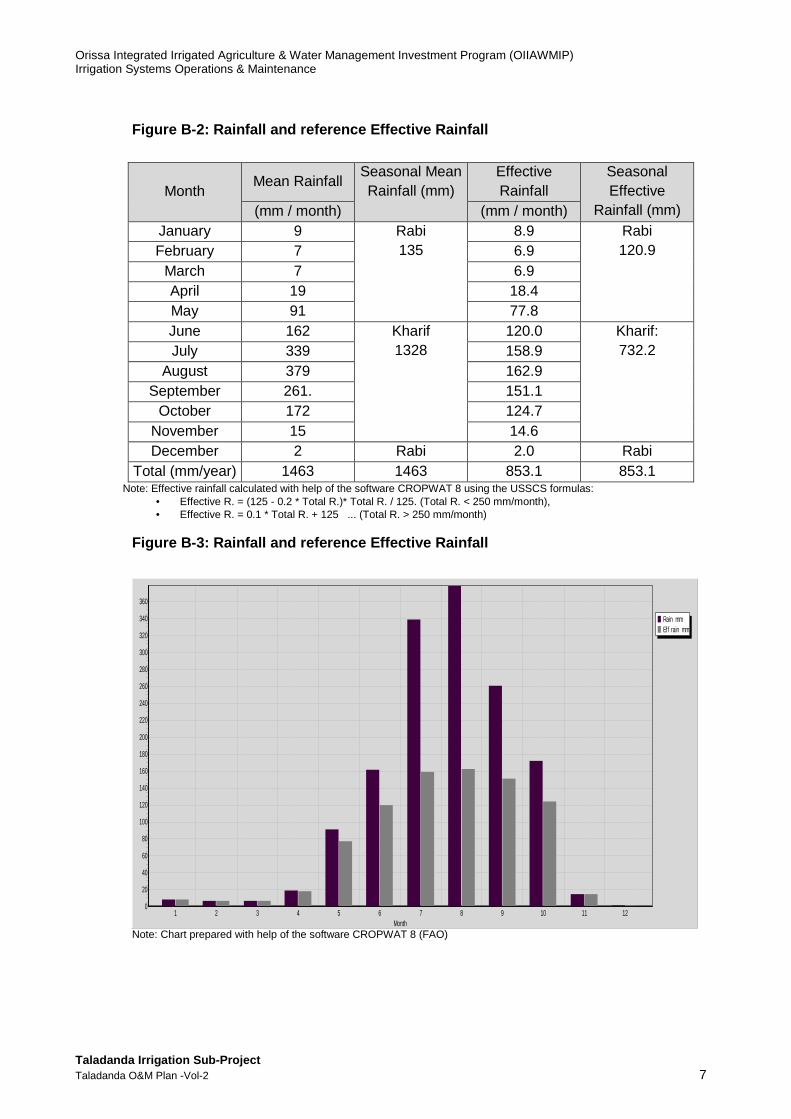
Figure B-2: Rainfall and reference Effective Rainfa ll
Month Mean Rainfall
Seasonal Mean Rainfall (mm)
Effective Rainfall
Seasonal Effective
Rainfall (mm) (mm / month) (mm / month) January 9 Rabi
135
8.9 Rabi 120.9 February 7 6.9
March 7 6.9 April 19 18.4 May 91 77.8 June 162 Kharif
1328
120.0 Kharif: 732.2
July 339 158.9
August 379 162.9 September 261. 151.1
October 172 124.7 November 15 14.6 December 2 Rabi 2.0 Rabi
Total (mm/year) 1463 1463 853.1 853.1 Note: Effective rainfall calculated with help of the software CROPWAT 8 using the USSCS formulas:
• Effective R. = (125 - 0.2 * Total R.)* Total R. / 125. (Total R. < 250 mm/month), • Effective R. = 0.1 * Total R. + 125 ... (Total R. > 250 mm/month)
Figure B-3: Rainfall and reference Effective Rainfa ll
Note: Chart prepared with help of the software CROPWAT 8 (FAO)
Rain mmEff rain mm
Month121110987654321
360
340
320
300
280
260
240
220
200
180
160
140
120
100
80
60
40
20
0
Orissa Integrated Irrigated Agriculture & Water Management Investment Program (OIIAWMIP) Irrigation Systems Operations & Maintenance
Taladanda Irrigation Sub-Project Taladanda O&M Plan -Vol-2 8
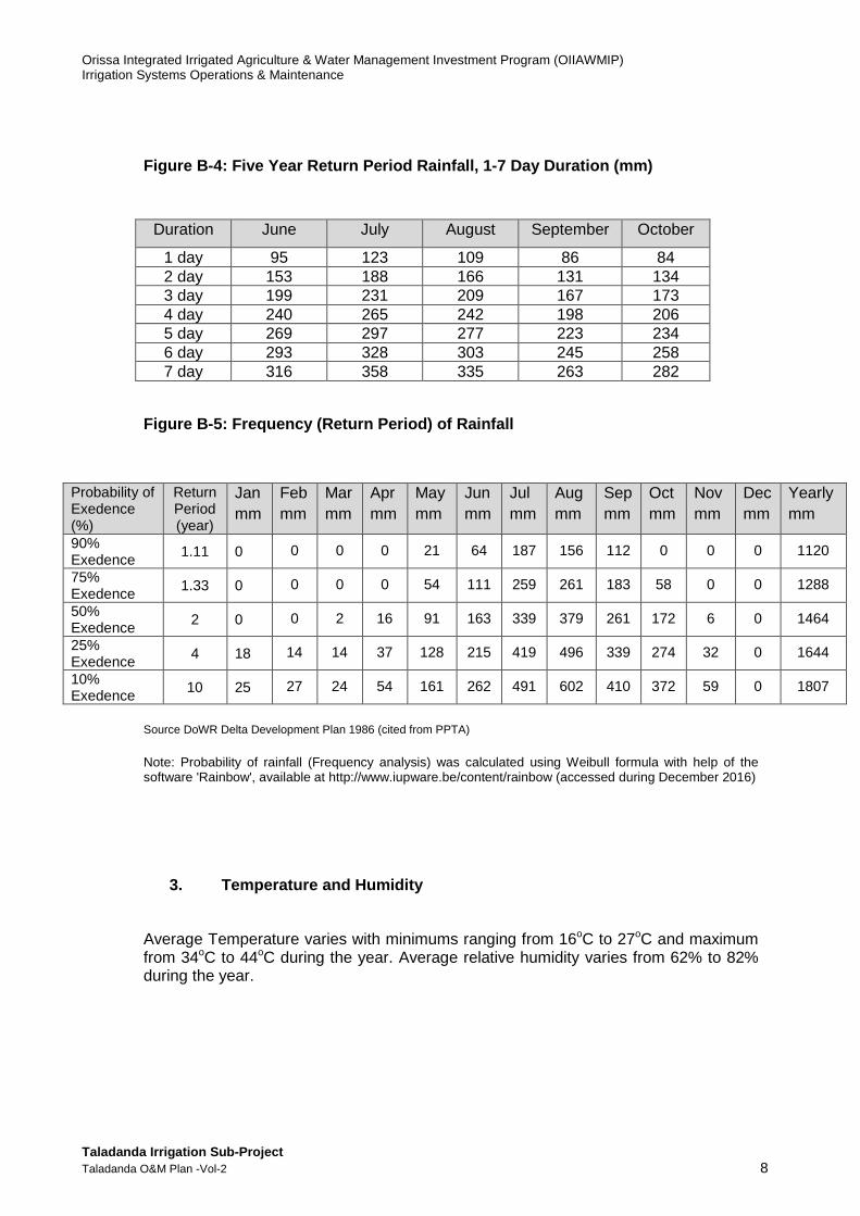
Figure B-4: Five Year Return Period Rainfall, 1-7 D ay Duration (mm)
Figure B-5: Frequency (Return Period) of Rainfall
Source DoWR Delta Development Plan 1986 (cited from PPTA)
Note: Probability of rainfall (Frequency analysis) was calculated using Weibull formula with help of the software 'Rainbow', available at http://www.iupware.be/content/rainbow (accessed during December 2016)
3. Temperature and Humidity
Average Temperature varies with minimums ranging from 16oC to 27oC and maximum from 34oC to 44oC during the year. Average relative humidity varies from 62% to 82% during the year.
Duration June July August September October
1 day 95 123 109 86 84 2 day 153 188 166 131 134 3 day 199 231 209 167 173 4 day 240 265 242 198 206 5 day 269 297 277 223 234 6 day 293 328 303 245 258 7 day 316 358 335 263 282
Probability of Exedence (%)
Return Period (year)
Jan mm
Feb mm
Mar mm
Aprmm
May mm
Jun mm
Jul mm
Aug mm
Sepmm
Oct mm
Nov mm
Dec mm
Yearly mm
90% Exedence
1.11 0 0 0 0 21 64 187 156 112 0 0 0 1120
75% Exedence
1.33 0 0 0 0 54 111 259 261 183 58 0 0 1288
50% Exedence
2 0 0 2 16 91 163 339 379 261 172 6 0 1464
25% Exedence
4 18 14 14 37 128 215 419 496 339 274 32 0 1644
10% Exedence
10 25 27 24 54 161 262 491 602 410 372 59 0 1807

Orissa Integrated Irrigated Agriculture & Water Management Investment Program (OIIAWMIP) Irrigation Systems Operations & Maintenance
Taladanda Irrigation Sub-Project Taladanda O&M Plan -Vol-2 9
Figure B-6: Mean Monthly Temperatures and Relative Humidity, Cuttack
Source: FAO ClimWat database
4. Climate Data from FAO CLIMWAT database
Data are available from FAO’s CLIMWAT database for Cuttack and Bhubaneswar, including ET0. Bhubaneswar is farther and Cuttack is the nearest to the scheme. The Reservoir (Barrage) is situated at Cuttack. Bhubaneswar has more wind which increases the ET0.As Cuttack is close to the Scheme, it will provide reasonable guidance for those parameters for crop water requirements calculations.The tables below for Cuttack and Bhubaneswar has been abstracted from FAO’s CLIMWAT database.
Figure B-7: Climatic Data and Reference Evapotransp iration - Cuttack 1
Month Max. Temp. (0C)
Min. Temp (0C)
Relative Humidity
(%)
Wind Speed Km/day
Sunshine Hour h/day
Solar (Global)
Radiation Mj/m2/day
ET0
mm/day Mm/month
Jan 28.9 15.7 67.4 51.8 8.29 16.89 2.72 84.32 Feb 31.5 18.2 61.9 60.5 8.44 19.03 3.47 97.16 Mar 35.9 22.1 62.0 86.4 8.05 20.49 4.44 137.64 Apr 38.3 25.3 62.4 121.0 8.05 21.72 5.36 160.80 May 38.8 26.9 62.5 155.5 8.24 22.33 5.99 185.69 Jun 35.8 26.5 70.3 121.0 5.16 17.65 4.63 138.90 Jul 31.6 25.6 81.7 103.7 4.03 15.88 3.73 115.63 Aug 31.6 25.6 81.8 103.7 7.80 16.77 3.79 117.49 Sep 32.2 25.5 80.2 95.0 5.20 16.63 3.77 113.10 Oct 32.0 23.7 73.7 86.4 6.75 17.30 3.81 118.11 Nov 30.1 18.8 65.7 86.4 8.63 17.79 3.49 104.70 Dec 28.4 15.5 64.7 51.8 8.37 16.31 2.66 82.46
Note: The Penman-Monteith equation was used in ET0 calculations with the following values for Angstrom's Coefficients: a = 0.25; b = 0.5. For ClimWat, see http://www.fao.org/nr/water/infores_databases_climwat.html
1Cuttack, India (20.260 N, 85.930 E, 27 meter(s) above sea level. From FAO CLIMWAT database).
Month Average Temperatures
Average Relative Humidity
Max oc Min oc % January 28.9 15.7 67.4 February 31.5 18.2 61.9 March 35.9 22.1 62.0 April 38.3 25.3 62.4 May 38.8 26.9 62.5 June 35.8 26.5 70.3 July 31.6 25.6 81.7 August 31.6 25.6 81.8 September 32.2 25.5 80.2 October 32.0 23.7 73.7 November 30.1 18.8 65.7 December 28.4 15.5 64.7

Orissa Integrated Irrigated Agriculture & Water Management Investment Program (OIIAWMIP) Irrigation Systems Operations & Maintenance
Taladanda Irrigation Sub-Project Taladanda O&M Plan -Vol-2 10
Figure B-8: Rainfall and reference Effective Rainfa ll– Cuttack
Month Mean Rainfall
Mm/month Seasonal
Mean Rainfall (mm)
Effective Rainfall
Mm/month
Seasonal Effective
Rainfall (mm) January 12 Rabi
191 11.76 Rabi
175.40 February 25 24.00 March 36 33.92 April 33 31.25 May 81 70.50 June 208 Kharif
1300 138.77 Kharif
734.58 July 356 160.6 August 320 157.0
September 256 150.6 October 141 109.19
November 19 18.42 December 4 Rabi 3.97 Rabi
Total (mm/year) 1491 1491 909.98 909.98 Note Effective rainfall calculated using the USSCS formulas: Effective R. = (125 - 0.2 * Total R.)* Total R. / 125 ... (Total R. < 250 mm/month), Effective R. = 0.1 * Total R. + 125 ... (Total R. > 250 mm/month).
5. Surface Water Resources
Orissa has abundant water resources considering the volume available to the State. The State receives its annual supply of fresh water from two sources. Surface Water and Ground Water, both derived from annual rainfall.The rainfall is greatly influenced by Southwest monsoon rain which starts from mid of June and continue till mid of October.
a. Mahanadi River Flows
The Taladanda scheme is situated in Mahanadi river basin and the distribution of rainfall in the scheme area is uneven and erratic.Rainfall from the south-west monsoon is intense in July and August which results high runoff. The chatchment details of Mahanadi River is given in the Table bellow and illustrated in the Figure-. Figure B-9: Catchment Area of Mahanadi River
Name of River
Catchment Area (Sq. km) Water Resources (M cum) Total Area Area Within
Odisha % of Catchment
area to Geographical
area of the State
75% Dependable
Average
Mahanadi 141134 65628 42.15 48732 59155
Source: DoWR (Orissa State Water Plan 2004 and Annual Report 2014-15)

Orissa Integrated Irrigated Agriculture & Water Management Investment Program (OIIAWMIP) Irrigation Systems Operations & Maintenance
Taladanda Irrigation Sub-Project Taladanda O&M Plan -Vol-2 11
Due to low elevation, flat slopes and storm surges about a third of the Mahanadi Basin area suffers flooding and drainage congestion. Storm surges2 in the 1999 super cyclone were estimated in excess of 6-7m. Flood levels and protection embankments along rivers and nullahs are closely monitored during the monsoon. Flood estimation along the Mahanadi is based on rainfall data received from 13 gauging stations3, eight upstream of Hirakud reservoir. In addition, the Central Water Commission (CWC) has 22 stations upstream and 5 downstream of the dam. A combination of Wallingford and US Curve number methods are used to plan dam operation and ensure minimum Rabi irrigation supplies of 3,924 ham at Naraj (6-7 km upstream of Mahanadi barrage). Data recorded digitally at Hirakud are transmitted twice daily to downstream barrage operating staff (Executive Engineer, Mahanadi Division) and the CWC. Operators at Hirakud are able to provide 36 hours advance flood warning. CWC has a telemetry station about 3.2km downstream of Munduli barrage, at the railway crossing over the Mahanadi (at Naraj), just upstream of the bifurcation of the Mahanadi into the Sinjori (right) and Mahanadi (left). Hourly river flows are automatically recorded and transmitted4 in real time to the Central Water Commission (CWC) at Hirakud, Bhubaneswar and Delhi. No major tributaries join the river downstream of Naraj and these data are therefore adopted as the inflows to Mahanadi barrage. Annual peak flows measured at Naraj are shown below. The annual average flood for this period was 510,020ham (5,900m3/s). The design flood for the Mahanadi barrage is 15,300m3/s.
2 Information provided in “Orissa State Water Plan (Annexures)”, Orissa Water Planning Organization,
Department of Water Resources, 2004 3 Stations are located at Ghorari, Nandaghat, Seorinarayan, Champa, Saradihi, Tarapur, Deogaon,
Bheden and downstream at Belgaon, Khairmal, Barmul, Mundali and Burla. 4 The information is conveyed to DoWR Bhubaneswar via CWC and DoWR at Burl
Orissa Integrated Irrigated Agriculture & Water Management Investment Program (OIIAWMIP) Irrigation Systems Operations & Maintenance
Taladanda Irrigation Sub-Project Taladanda O&M Plan -Vol-2 12
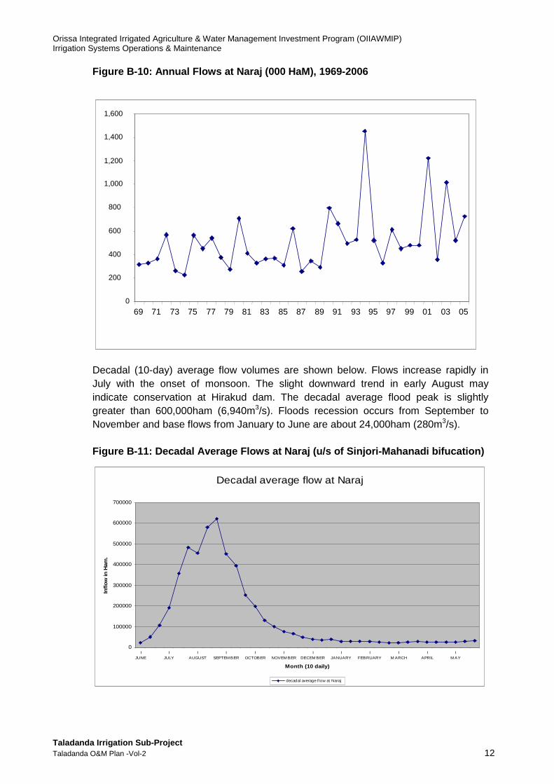
Figure B-10: Annual Flows at Naraj (000 HaM), 1969- 2006
0
200
400
600
800
1,000
1,200
1,400
1,600
69 71 73 75 77 79 81 83 85 87 89 91 93 95 97 99 01 03 05
Decadal (10-day) average flow volumes are shown below. Flows increase rapidly in July with the onset of monsoon. The slight downward trend in early August may indicate conservation at Hirakud dam. The decadal average flood peak is slightly greater than 600,000ham (6,940m3/s). Floods recession occurs from September to November and base flows from January to June are about 24,000ham (280m3/s). Figure B-11: Decadal Average Flows at Naraj (u/s of Sinjori-Mahanadi bifucation)
Decadal average flow at Naraj
0
100000
200000
300000
400000
500000
600000
700000
IJUNE
IJULY
IAUGUST
ISEPTEM BER
IOCTOBER
INOVEM BER
IDECEM BER
IJANUARY
IFEBRUARY
IM ARCH
IAPRIL
IM AY
Month (10 daily)
Inflo
w in
Ham
.
decadal average f low at Naraj
Orissa Integrated Irrigated Agriculture & Water Management Investment Program (OIIAWMIP) Irrigation Systems Operations & Maintenance
Taladanda Irrigation Sub-Project Taladanda O&M Plan -Vol-2 13
Base flows coincide with peak irrigation water requirements for Rabi (and early summer) cultivation and for Kharif pre-irrigation.
b. Water Users
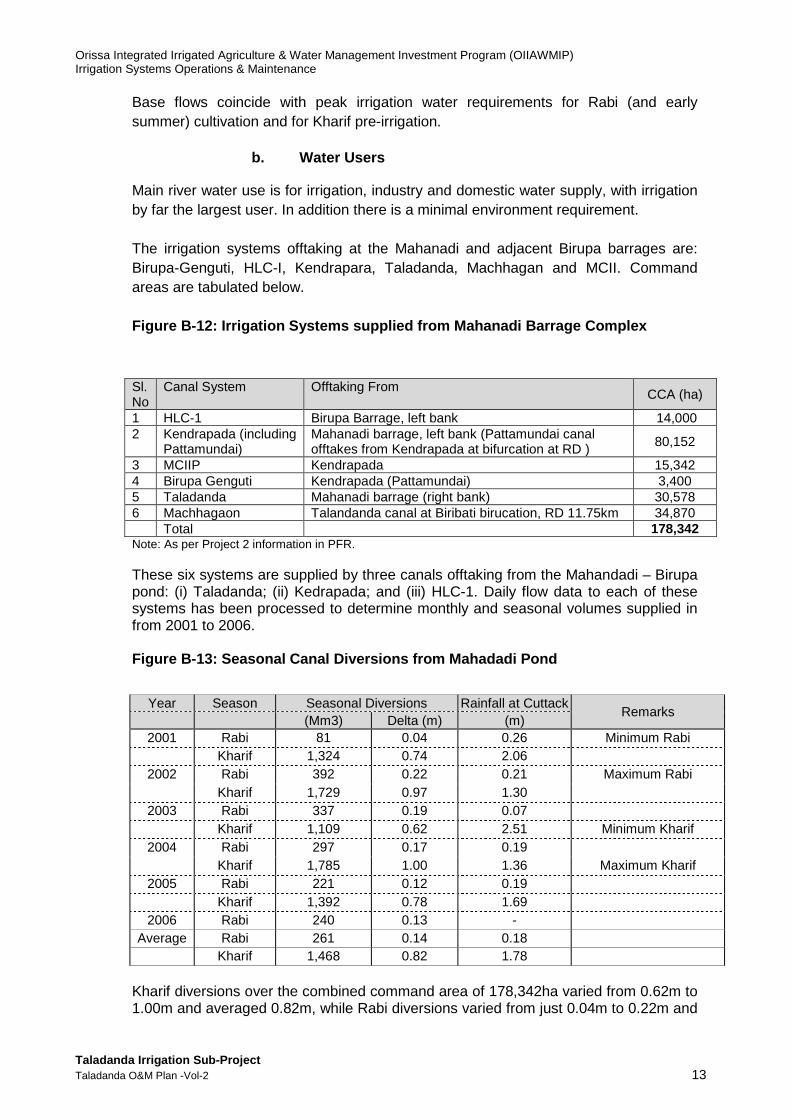
Main river water use is for irrigation, industry and domestic water supply, with irrigation by far the largest user. In addition there is a minimal environment requirement. The irrigation systems offtaking at the Mahanadi and adjacent Birupa barrages are: Birupa-Genguti, HLC-I, Kendrapara, Taladanda, Machhagan and MCII. Command areas are tabulated below. Figure B-12: Irrigation Systems supplied from Mahan adi Barrage Complex
Sl. No
Canal System Offtaking From
CCA (ha)
1 HLC-1 Birupa Barrage, left bank 14,000 2 Kendrapada (including
Pattamundai) Mahanadi barrage, left bank (Pattamundai canal offtakes from Kendrapada at bifurcation at RD ) 80,152
3 MCIIP Kendrapada 15,342 4 Birupa Genguti Kendrapada (Pattamundai) 3,400 5 Taladanda Mahanadi barrage (right bank) 30,578 6 Machhagaon Talandanda canal at Biribati birucation, RD 11.75km 34,870 Total 178,342 Note: As per Project 2 information in PFR. These six systems are supplied by three canals offtaking from the Mahandadi – Birupa pond: (i) Taladanda; (ii) Kedrapada; and (iii) HLC-1. Daily flow data to each of these systems has been processed to determine monthly and seasonal volumes supplied in from 2001 to 2006. Figure B-13: Seasonal Canal Diversions from Mahadad i Pond
Year Season Seasonal Diversions Rainfall at Cuttack
Remarks (Mm3) Delta (m) (m)
2001 Rabi 81 0.04 0.26 Minimum Rabi Kharif 1,324 0.74 2.06
2002 Rabi 392 0.22 0.21 Maximum Rabi Kharif 1,729 0.97 1.30
2003 Rabi 337 0.19 0.07 Kharif 1,109 0.62 2.51 Minimum Kharif
2004 Rabi 297 0.17 0.19 Kharif 1,785 1.00 1.36 Maximum Kharif
2005 Rabi 221 0.12 0.19 Kharif 1,392 0.78 1.69
2006 Rabi 240 0.13 - Average Rabi 261 0.14 0.18
Kharif 1,468 0.82 1.78 Kharif diversions over the combined command area of 178,342ha varied from 0.62m to 1.00m and averaged 0.82m, while Rabi diversions varied from just 0.04m to 0.22m and

Orissa Integrated Irrigated Agriculture & Water Management Investment Program (OIIAWMIP) Irrigation Systems Operations & Maintenance
Taladanda Irrigation Sub-Project Taladanda O&M Plan -Vol-2 14
averaged 0.14m. Including for rainfall average supplies were 2.60m in Kharif and 0.32m in Rabi. The large quantities of water supplied in Kharif greatly exceed paddy evaporation requirements (0.6m), and recharge groundwater as well as leaving the scheme command areas draining through nullahs and rivers to the sea. In Rabi evapotranspiration exceeds supply, residual moisture cropping dominates and water tables decline. Rabi irrigations if supplied at the right time boost crop yields. Current industrial utilization as reported by DoWR is 3m3/s with a further 3m3/s having been requested. Domestic water supply requirements for Cuttack with its urban agglomeration population of 663188 in 20115 and for a per capita supply of 150l/d plus 30% for losses6 Indicates a water requirement of 1.5m3/s. Other downstream cities (Bhubaneswar) also draw water from rivers to some extent. In total a combined flow for urban and industrial users of 22.5m3/s has been adopted for water balance (see below), about 3 times the current requirement. Minimum environmental flows comprising a base flow of 50m3/s plus 30% of river flow is adopted for water balance. This flow is for both the Mahanadi delta downstream of Mahanadi barrage as well as for the Kathjori river offtaking at Naraj7. The Kathjori contributes fresh water freshwater to Chilika Lake through its two branches, Bhargavi and Daya. Chilika Lake, at the southern end of the Mahanadi delta, currently receives 45% of its fresh water inflow from the Mahanadi River during the monsoon season. Although flow from the Mahanadi is a substantial proportion of inflow to the lake, it represents less than 6% of the Mahanadi’s flow. The World Bank sponsored an environmental assessment enabling operating rules for the Najaj, Mahanadi & Birupa barrage complex to be developed. The rules, tabulated below, were developed for the following principals:
(i) During Rabi priority is for irrigation supply.
(ii) During the monsoon the Naraj barrage can be operated to maximize inflows to Chilika Lake (ie restore lake levels) and reduce flood flows just downstream at the Mahanadi / Birupa barrages.
Figure B-14: Present Operating Rules of Naraj Barra ge
Discharge of Mahanadi at Mundali Barrage upto 11000 Cumec Discharge through Kathajodi at Naraj 60% Discharge through Mahanadi at Jobra 40% Discharge of Mahanadi at Mundali Barrage beyond 11000 Cumec
Discharge through Kathajodi at Naraj 50% Discharge through Mahanadi at Jobra 50% Source: DoWR, Mahanadi South Division, Cuttack
5 Population Census data (Urban Agglomeration i.e Cuttack + Choudwar Muncipality with population
610189 + 52999) 6 Orissa State Water Plan, 2004 7 Component of OWRCP and commissioned in 2006
Orissa Integrated Irrigated Agriculture & Water Management Investment Program (OIIAWMIP) Irrigation Systems Operations & Maintenance
Taladanda Irrigation Sub-Project Taladanda O&M Plan -Vol-2 15
c. River Water Balance
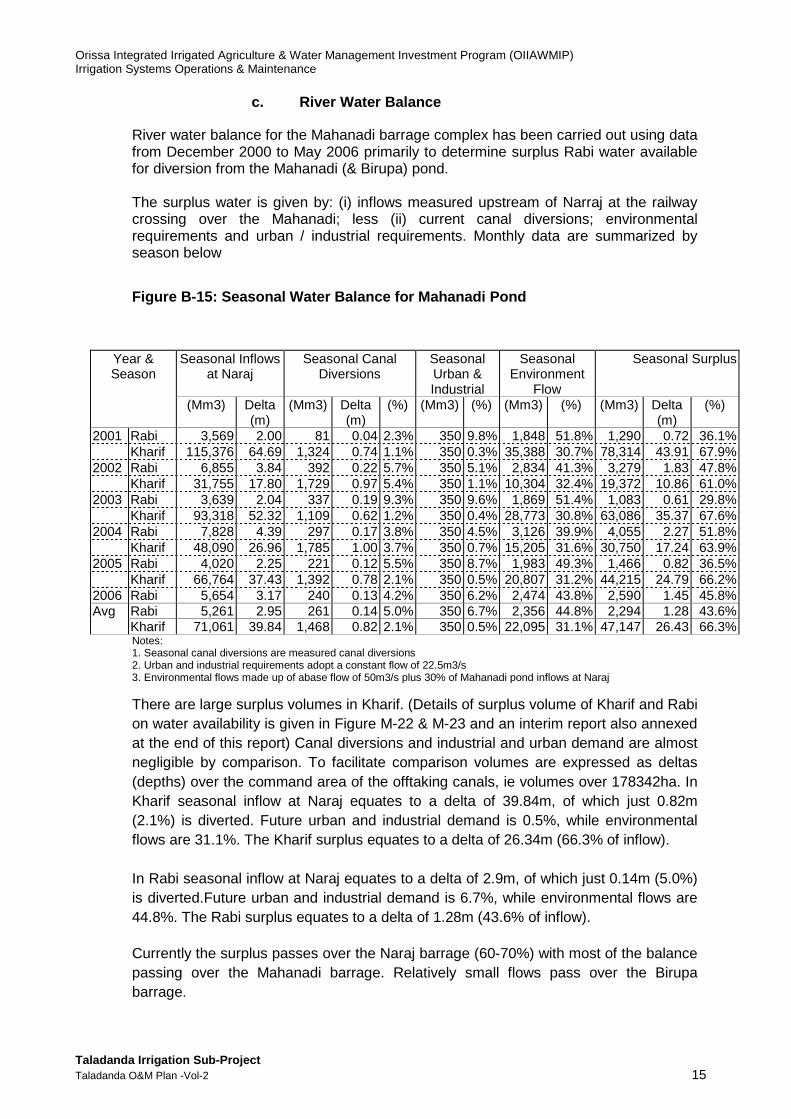
River water balance for the Mahanadi barrage complex has been carried out using data from December 2000 to May 2006 primarily to determine surplus Rabi water available for diversion from the Mahanadi (& Birupa) pond. The surplus water is given by: (i) inflows measured upstream of Narraj at the railway crossing over the Mahanadi; less (ii) current canal diversions; environmental requirements and urban / industrial requirements. Monthly data are summarized by season below
Figure B-15: Seasonal Water Balance for Mahanadi Po nd
Notes: 1. Seasonal canal diversions are measured canal diversions 2. Urban and industrial requirements adopt a constant flow of 22.5m3/s 3. Environmental flows made up of abase flow of 50m3/s plus 30% of Mahanadi pond inflows at Naraj
There are large surplus volumes in Kharif. (Details of surplus volume of Kharif and Rabi on water availability is given in Figure M-22 & M-23 and an interim report also annexed at the end of this report) Canal diversions and industrial and urban demand are almost negligible by comparison. To facilitate comparison volumes are expressed as deltas (depths) over the command area of the offtaking canals, ie volumes over 178342ha. In Kharif seasonal inflow at Naraj equates to a delta of 39.84m, of which just 0.82m (2.1%) is diverted. Future urban and industrial demand is 0.5%, while environmental flows are 31.1%. The Kharif surplus equates to a delta of 26.34m (66.3% of inflow). In Rabi seasonal inflow at Naraj equates to a delta of 2.9m, of which just 0.14m (5.0%) is diverted.Future urban and industrial demand is 6.7%, while environmental flows are 44.8%. The Rabi surplus equates to a delta of 1.28m (43.6% of inflow). Currently the surplus passes over the Naraj barrage (60-70%) with most of the balance passing over the Mahanadi barrage. Relatively small flows pass over the Birupa barrage.
Year & Season
Seasonal Inflows at Naraj
Seasonal Canal Diversions
Seasonal Urban & Industrial
Seasonal Environment
Flow
Seasonal Surplus
(Mm3) Delta (m)
(Mm3) Delta (m)
(%) (Mm3) (%) (Mm3) (%) (Mm3) Delta (m)
(%)
2001 Rabi 3,569 2.00 81 0.04 2.3% 350 9.8% 1,848 51.8% 1,290 0.72 36.1% Kharif 115,376 64.69 1,324 0.74 1.1% 350 0.3% 35,388 30.7% 78,314 43.91 67.9% 2002 Rabi 6,855 3.84 392 0.22 5.7% 350 5.1% 2,834 41.3% 3,279 1.83 47.8% Kharif 31,755 17.80 1,729 0.97 5.4% 350 1.1% 10,304 32.4% 19,372 10.86 61.0% 2003 Rabi 3,639 2.04 337 0.19 9.3% 350 9.6% 1,869 51.4% 1,083 0.61 29.8% Kharif 93,318 52.32 1,109 0.62 1.2% 350 0.4% 28,773 30.8% 63,086 35.37 67.6% 2004 Rabi 7,828 4.39 297 0.17 3.8% 350 4.5% 3,126 39.9% 4,055 2.27 51.8% Kharif 48,090 26.96 1,785 1.00 3.7% 350 0.7% 15,205 31.6% 30,750 17.24 63.9% 2005 Rabi 4,020 2.25 221 0.12 5.5% 350 8.7% 1,983 49.3% 1,466 0.82 36.5% Kharif 66,764 37.43 1,392 0.78 2.1% 350 0.5% 20,807 31.2% 44,215 24.79 66.2% 2006 Rabi 5,654 3.17 240 0.13 4.2% 350 6.2% 2,474 43.8% 2,590 1.45 45.8% Avg Rabi 5,261 2.95 261 0.14 5.0% 350 6.7% 2,356 44.8% 2,294 1.28 43.6%
Kharif 71,061 39.84 1,468 0.82 2.1% 350 0.5% 22,095 31.1% 47,147 26.43 66.3%

Orissa Integrated Irrigated Agriculture & Water Management Investment Program (OIIAWMIP) Irrigation Systems Operations & Maintenance
Taladanda Irrigation Sub-Project Taladanda O&M Plan -Vol-2 16
Figure B-16: Mahanadi Pond Canal Diversion, River i nflows and Surplus.
The water balance indicates scope to considerable increase diversions from the Mahanadi pond with current storage provided by Hirakud reservoir. Further in depth studies are required to assess the impact of new / planned irrigation developments and firm up environmental and other requirements.
6. Groundwater Resources
Ground water is a major natural replenishable resource to meet the water requirement for irrigation, domestic and industrial needs. It plays a key role in agrarian economy. According the “State of Environment Report, Orissa (Chapter v – Water Resources)”, the annualy replenishable ground water resource of Odisha is assessed as 21, 01,128 hect-meter (HM) and 60% of it isconsidered as safe use. The ground water resources of Cuttack and Jagatsinghpur districts are furnished in the Table bellow. Figure B-17: Ground water Resources of Cuttack and Jagatsinghpur Districts
District Ground
water resource assessed
(HM)
Utilizable Resource
for domestic & industrial use (HM)
Annual draft for Irrigation
use (HM)
Gross annual draft for all uses
(HM)
Stage of Ground water
development (%)
Cuttack 105367 6747 10755 14886 14.13
Jagatsinghpur 139699 2765 11423 13646 9.77 Source: State of Environment Report, Orissa (abstract from Table 5-12 of Chapter v – Water Resources)
The Table above shows the Groundwater utilization in Cuttack and Jagatsinghpur districtsis in the range of 14.13 and 9.77 respectively. There is limited groundwater development in both the districts as 60% utilization of the ground water resource is considered as safe use. Groundwater is abstracted mostly by dug wells. Shallow hand-
Mahanadi Pond River Supply, Diversions and Surplus
0.00
0.50
1.00
1.50
2.00
2.50
3.00
3.50
4.00
4.50
5.00
Rab
i 00/
01
Kha
rif 0
1
Rab
i 01/
02
Kha
rif 0
2
Rab
i 02/
03
Kha
rif 0
3
Rab
i 03/
04
Kha
rif 0
4
Rab
i 04/
05
Kha
rif 0
5
Rab
i 05/
06
Del
tas
(ove
r 180
,578
ha, m
)
Canal Diversions River inflows Surplus Water
Orissa Integrated Irrigated Agriculture & Water Management Investment Program (OIIAWMIP) Irrigation Systems Operations & Maintenance
Taladanda Irrigation Sub-Project Taladanda O&M Plan -Vol-2 17
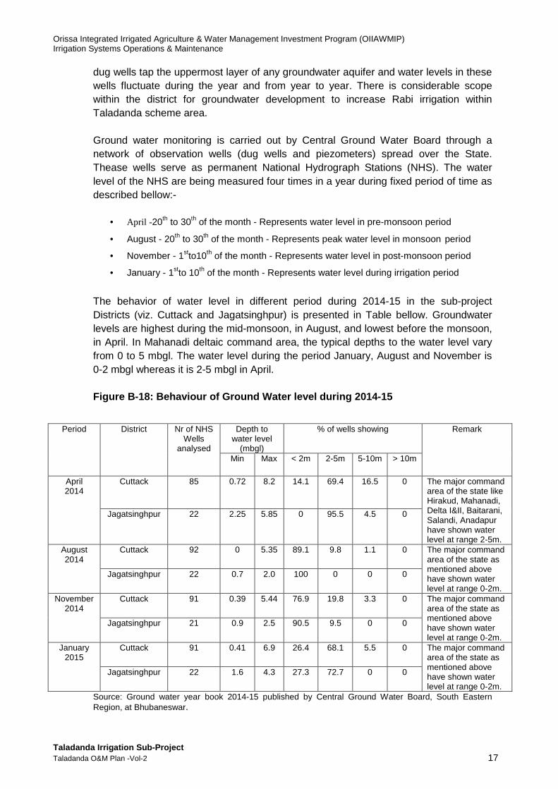
dug wells tap the uppermost layer of any groundwater aquifer and water levels in these wells fluctuate during the year and from year to year. There is considerable scope within the district for groundwater development to increase Rabi irrigation within Taladanda scheme area. Ground water monitoring is carried out by Central Ground Water Board through a network of observation wells (dug wells and piezometers) spread over the State. Thease wells serve as permanent National Hydrograph Stations (NHS). The water level of the NHS are being measured four times in a year during fixed period of time as described bellow:-
• April -20th to 30th of the month - Represents water level in pre-monsoon period
• August - 20th to 30th of the month - Represents peak water level in monsoon period
• November - 1stto10th of the month - Represents water level in post-monsoon period
• January - 1stto 10th of the month - Represents water level during irrigation period
The behavior of water level in different period during 2014-15 in the sub-project Districts (viz. Cuttack and Jagatsinghpur) is presented in Table bellow. Groundwater levels are highest during the mid-monsoon, in August, and lowest before the monsoon, in April. In Mahanadi deltaic command area, the typical depths to the water level vary from 0 to 5 mbgl. The water level during the period January, August and November is 0-2 mbgl whereas it is 2-5 mbgl in April. Figure B-18: Behaviour of Ground Water level during 2014-15
Period District Nr of NHS
Wells analysed
Depth to water level
(mbgl)
% of wells showing Remark
Min Max < 2m 2-5m 5-10m > 10m
April 2014
Cuttack 85 0.72 8.2 14.1 69.4 16.5 0
The major command area of the state like Hirakud, Mahanadi, Delta I&II, Baitarani, Salandi, Anadapur have shown water level at range 2-5m.
Jagatsinghpur 22 2.25 5.85 0 95.5 4.5 0
August 2014
Cuttack 92 0 5.35 89.1 9.8
1.1 0 The major command area of the state as mentioned above have shown water level at range 0-2m.
Jagatsinghpur 22 0.7 2.0 100 0 0 0
November 2014
Cuttack 91 0.39 5.44 76.9 19.8 3.3
0 The major command area of the state as mentioned above have shown water level at range 0-2m.
Jagatsinghpur 21 0.9 2.5 90.5 9.5 0 0
January 2015
Cuttack 91 0.41 6.9 26.4 68.1 5.5
0 The major command area of the state as mentioned above have shown water level at range 0-2m.
Jagatsinghpur 22 1.6 4.3 27.3 72.7 0 0
Source: Ground water year book 2014-15 published by Central Ground Water Board, South Eastern Region, at Bhubaneswar.

Orissa Integrated Irrigated Agriculture & Water Management Investment Program (OIIAWMIP) Irrigation Systems Operations & Maintenance
Taladanda Irrigation Sub-Project Taladanda O&M Plan -Vol-2 18
Groundwater development within the scheme area has been substantial. Information prepared by the Groundwater Estimation Committee (GEC), published by the Directorate of Groundwater Survey and Investigation, provides general groundwater related information at district and block level. This latest available information describes the hydrogeology of Cuttack and Jagatsinghpur districts and with it of Taladanda scheme area as generally comprising of semi-consolidated lower Precambrian metamorphosed rock, or of consolidated Precambrian intrusive and extrusive lavas and traps. The district is further classified as suitable for extraction of groundwater by dug wells. Groundwater within the area is qualified as having less than 500 ppm dissolved solids. Local variations in groundwater availability are expected due to variations in hydrogeology.
Orissa Integrated Irrigated Agriculture & Water Management Investment Program (OIIAWMIP) Irrigation Systems Operations & Maintenance
Taladanda Irrigation Sub-Project Taladanda O&M Plan -Vol-2 19
C. APPRAISAL OF O&M PRACTICE
1. Existing Operation - Traditional system operatio n
This section serves to provide a reference point for measuring operational improvement. The description of past system operation in this chapter serves as further background for developing new O&M procedures, as well as a reference point for monitoring of O&M implementation and evaluation of performance, which will be used to adjust future O&M plans.
In accordance with the Orissa Irrigation Act, 1959, DoWR irrigation officers are in charge of canal Operation & Maintenance, while Tahasildars are responsible for assessment and collection of water tax under the Revenue Department. Pani Panchayats will be responsible for O&M of minor canal systems of the command area although, because the election is not complete in all 73 PPs, handover is not yet achieved.
a. Kharif Season Operation
The crop year starts traditionally after the Mid-June festival (Raja Sankranti), which coincides roughly with the arrival of the monsoon rains. Kharif season irrigation nominally starts in 1stweek of July, but depends on sufficient river flow.
The existing system operation is primarily to ensure the farmers in the command area to getsufficient water to cultivate a Kharif paddy crop although kharif irrigation is supplementary to rainfall. The Kharif season starts in early July and continue to the end of November.The maximum discharges are between mid September and end November when the monsoon rainfall has finished but the paddy has not been harvested. The irrigation season is supposed to end by 31st October but continue upto end of November depending on the kharif crop condition because of staggered cultivation. An earlier start to the kharif season would reduce the amount of water being used during the pre-harvest period.
During the monsoon season the canal flow is reduced in response to rainfall.There is consistency of canal flow except for Taladanda lock where the flow appears to be high. However, the canal flow includes the water assigned to Paradeep Port.
b. Rabi Season Operation
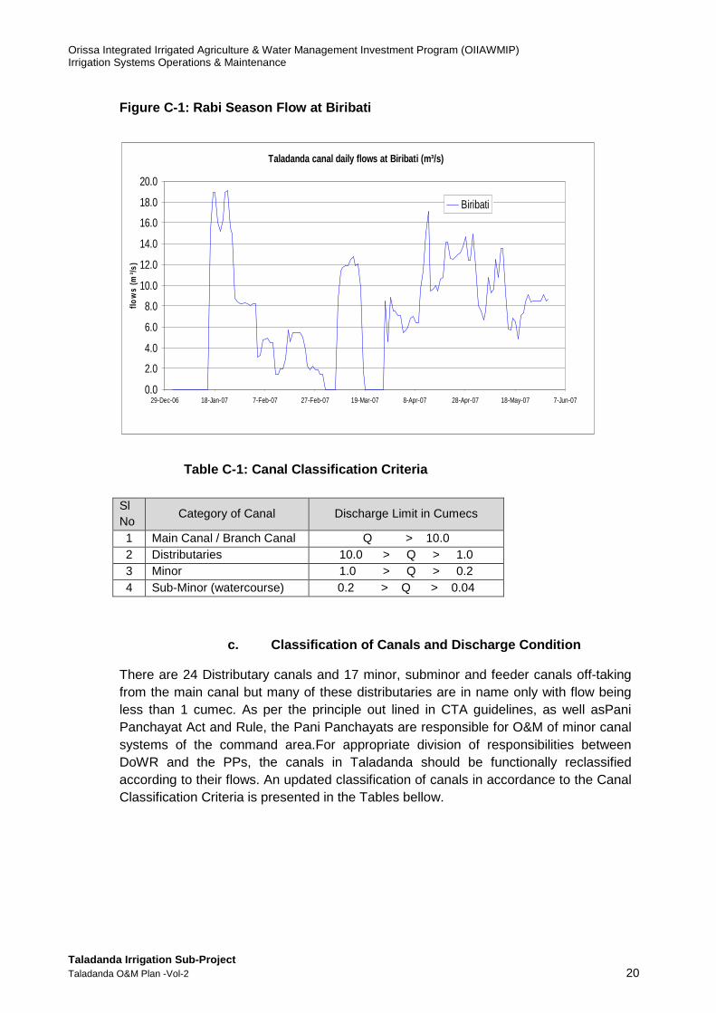
There is currently little or no effort to make efficient use of the Rabi season water or to achieve equitable distribution.
An available sample of Rabi season canal flows is plotted on Figure C-1. The flow is quite variable with a peak in January. The flow data are only available for one location so the equity of distribution of water along the canal is unknown.
Orissa Integrated Irrigated Agriculture & Water Management Investment Program (OIIAWMIP) Irrigation Systems Operations & Maintenance
Taladanda Irrigation Sub-Project Taladanda O&M Plan -Vol-2 20
Figure C-1: Rabi Season Flow at Biribati
Table C-1: Canal Classification Criteria
c. Classification of Canals and Discharge Condition
There are 24 Distributary canals and 17 minor, subminor and feeder canals off-taking from the main canal but many of these distributaries are in name only with flow being less than 1 cumec. As per the principle out lined in CTA guidelines, as well asPani Panchayat Act and Rule, the Pani Panchayats are responsible for O&M of minor canal systems of the command area.For appropriate division of responsibilities between DoWR and the PPs, the canals in Taladanda should be functionally reclassified according to their flows. An updated classification of canals in accordance to the Canal Classification Criteria is presented in the Tables bellow.
Taladanda canal daily flows at Biribati (m³/s)
0.0
2.0
4.0
6.0
8.0
10.0
12.0
14.0
16.0
18.0
20.0
29-Dec-06 18-Jan-07 7-Feb-07 27-Feb-07 19-Mar-07 8-Apr-07 28-Apr-07 18-May-07 7-Jun-07
flow
s (m
³/s)
Biribati
Sl No
Category of Canal Discharge Limit in Cumecs
1 Main Canal / Branch Canal Q > 10.0 2 Distributaries 10.0 > Q > 1.0 3 Minor 1.0 > Q > 0.2 4 Sub-Minor (watercourse) 0.2 > Q > 0.04

Orissa Integrated Irrigated Agriculture & Water Management Investment Program (OIIAWMIP) Irrigation Systems Operations & Maintenance
Taladanda Irrigation Sub-Project Taladanda O&M Plan -Vol-2 21
Table C-2: Reclassification of Canals
Sl. No
Name of Canal Discharge in m³/s Category
1 Taladanda main canal 84.186 Main Canal / Branch Canal 2 Disty No. - 0 0.097 Sub-minor 3 Disty No. - 1 3.511 Distributary 4 Suka paika North Channel 1.740 Distributary 5 Disty No. - 11/2 0.668 Minor 6 Disty No. - 2 0.263 Minor 7 Disty No. - 2(A) 0.022 Watercourse 8 Disty No. - 2(B) 0.040 Sub-minor 9 Disty No. - 2(C) 0.080 Sub-minor 10 Disty No. - 3 0.437 Minor 11 Disty No. - 3(A) 0.056 Sub-minor 12 Disty No. - 3(B) 0.113 Sub-minor 13 Disty No. - 3(C) 0.113 Sub-minor 14 Disty No. - 4 0.236 Minor 15 Disty No. - 4(A) 0.056 Sub-minor 16 Disty No. - 4(B) 0.070 Sub-minor 17 Disty No. - 5 0.335 Minor 18 Disty No. - 5(A) 0.049 Sub-minor 19 Disty No. - 5(B) 0.044 Sub-minor 20 Disty No. - 51/2 0.154 Sub-minor 21 Disty No. - 6 0.570 Minor 22 Disty No. - 6(A) 0.062 Sub-minor 23 Disty No. - 6(C) 0.292 Minor 24 Disty No. - 6(C1) 0.042 Sub-minor 25 Disty No. - 6(D) 0.027 Watercourse 26 Disty No. - 6(D1) 0.043 Sub-minor 27 Disty No. - 6(E) 0.025 Watercourse 28 Disty No. - 61/2 0.086 Sub-minor 29 Disty No. - 7 0.294 Minor 30 Disty No. - 7(A) 0.031 Watercourse 31 Disty No. - 7(B) 0.002 Watercourse 32 Disty No. - 7(C) 0.218 Minor 33 Disty No. - 8 0.768 Minor 34 Disty No. - 8(A) 0.196 Minor 35 Disty No. - 8(B) 0.048 Sub-minor 36 Disty No. - 8(C) 0.072 Sub-minor 37 Disty No. - 8(D) 0.208 Minor 38 Disty No. - 81/2 0.096 Sub-minor 39 Disty No. - 9 0.516 Minor 40 Disty No. - 9(A) 0.037 Watercourse 41 Disty No. - 9(C) 0.160 Sub-minor 41 Disty No. - 10 0.310 Minor 43 Disty No. - 11 0.491 Minor 44 Disty No. - 11(A) 0.066 Sub-minor 45 Disty No. - 12 10.100 Branch Canal 46 Disty No. - 12(A) 0.430 Minor

Orissa Integrated Irrigated Agriculture & Water Management Investment Program (OIIAWMIP) Irrigation Systems Operations & Maintenance
Taladanda Irrigation Sub-Project Taladanda O&M Plan -Vol-2 22
d. Existing Flow Measurement
Flows are measured at the Talandanda head regulator at the barrage and at the cross regulators along the main canal. No off-taking flows to distributary canals are measured. Lines painted at key structures mark full supply levels. I. Diversion flows from the barrage pond are recorded in hard copy data books kept at the Jobra control tower, while records for flows recorded at main canal cross regulators are kept at the section / SDO offices along the canal. II. Existing jurisdictions of the Subdivisions are as follows:
• SD Jobra, Cuttack: Mahanadi (Jobra) barrage to village Matgajapur (RD 0.00 to RD 7.80 km). CCA 88 ha.
• SD Kissan Nagar: Village Matgajapur (RD 7.80 km) to Tarapur Lock (41.93 km). CCA 9268 ha
• SD Manijanga: Tarapur Lock (RD 41.93 km) to Pankapal (RD 64.13 km). CCA 15496 ha
• SD Paradep: Pankapal (RD 64.13 km) to Choumuhani (RD 84.24 km). CCA 5726 ha
III. Flow requirements are assessed and conveyed verbally to the concerned Exective Engineer by the Assistant Executive Engineers (SDOs) in charge of each of the four Subdivisions in Talandanda. The Executive Engineer submits an indent in writing to SDO Barrage, Mahandadi Southern Division in Cuttak whenever a change in supply is required.
47 Disty No. - 12(B) 0.293 Minor 48 Disty No. - 12(C) 0.220 Minor 49 Disty No. - 12(D) 0.730 Minor 50 Disty No. - 12(E) 2.230 Distributary 51 Disty No. - 12(E1) 0.380 Minor 52 Disty No. - 12(F) 0.690 Minor 53 Disty No. - 12(G) 1.100 Distributary 54 Disty No. - 12(G1) 1.710 Distributary 55 Disty No. - 12(G2) 0.260 Minor 56 Disty No. - 13 2.713 Distributary 57 Disty No. - 13(A) 0.320 Minor 58 Disty No. - 13(B) 0.170 Sub-minor 59 Disty No. - 13(C) 1.477 Distributary 60 Disty No. - 14 2.728 Distributary 61 Disty No. - 14(A) 1.320 Distributary 62 Disty No. - 14(B) 1.450 Distributary 63 Disty No. - 15 0.304 Minor 64 Disty No. - 15(A) 0.112 Sub-minor 65 Disty No. - 16 0.740 Minor 66 Disty No. - 17 0.551 Minor 67 Disty No. - 18 0.236 Minor
Orissa Integrated Irrigated Agriculture & Water Management Investment Program (OIIAWMIP) Irrigation Systems Operations & Maintenance
Taladanda Irrigation Sub-Project Taladanda O&M Plan -Vol-2 23
IV. Existing operation regulates flow in response to rainfall in the command area on a non-quantified basis. The minimal flow data collected are not routinely processed to improve / assess operations.
2. Existing Maintenance
The system has been deprived of sufficient maintenance. Many water control gates are missing or broken and canals have changed their shapes, often losing capacity. The section of the Taladanda main canal downstream of Biribati has tended to widen because the original cross section was too narrow, while the tail part of the canal has silted up because the cross section is too wide for the flow.
3. Review of current system maintenance practice an d process of Taladanda sub project
ISPMC consultants reviewed the current maintenance practice and process followed at Taladanda, and found that the method of maintenance & practice of maintenance is identical with other irrigation schemes of the state, which is traditional in nature.
There is no specific period earmarked as maintenance season in the Taladanda system. There is no O&M calendar to which Taladanda management follows. The current maintenance practice, bases upon an ad-hoc approach, which needs to be more structured, more systematic and more scientific oriented, for the sustainability of Taladanda infrastructure.
Due to this current ad-hoc approach and inadequate maintenance practice followed at Taladanda, the project would suffer in future. The probable result would be, the current rehabilitated infrastructure of Taladanda schemes might get deteriorated, by following current process of inadequate maintenance practice.
Under the above circumstances, ISPMC recommends to SIO manager Taladanda, for adoption of a scientific technique of improved maintenance practice as a model of maintenance. The objective of this model maintenance practice is to introduce sustainable maintenance practice, to break the vicious cycle of Construction-Deterioration- and rehabilitation and to keep the infrastructures of conveyance and distribution canals of the system in a reasonable good condition during the entire life period of Taladanda scheme.
4. Scope for improvement
ISPMC recommends improved and sustainable model maintenance concept for adoption at Taladanda, as follows:
• Maintaining rather than rehabilitating. • Documenting all maintenance needs & cost to improve financial management
and accountability. • Participatory approach in maintenance planning, implementation, evaluation &
reporting. • Enhancing sensitivity among supplier and user of irrigation water. • Adopting process approach by replacing prescriptive approach. • Calibrating flow control structures for discharge measurement.
Orissa Integrated Irrigated Agriculture & Water Management Investment Program (OIIAWMIP) Irrigation Systems Operations & Maintenance
Taladanda Irrigation Sub-Project Taladanda O&M Plan -Vol-2 24
Each statement of the concept describes one issue of the CTA guide lines, or PP Act or PP Rule. ISPMC consultants have converted it in to action plan, implementation plan and step wise process of implementation, for adoption by the SIO Taladanda.
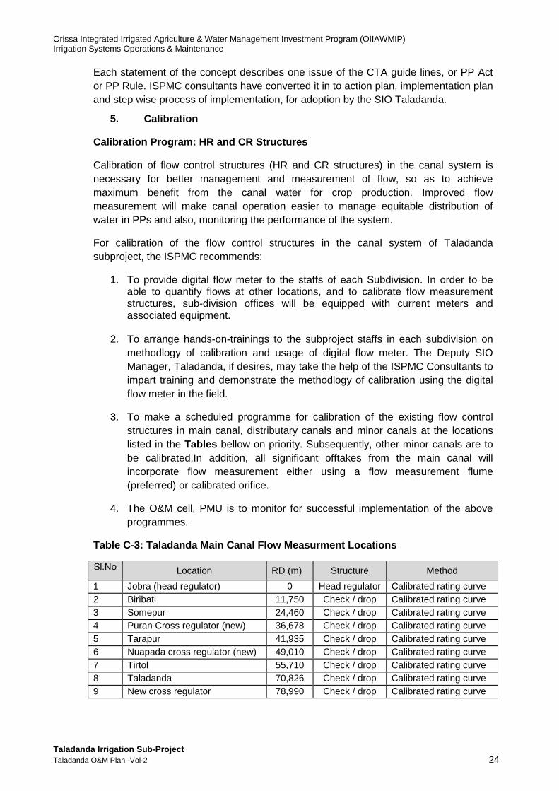
5. Calibration
Calibration Program: HR and CR Structures
Calibration of flow control structures (HR and CR structures) in the canal system is necessary for better management and measurement of flow, so as to achieve maximum benefit from the canal water for crop production. Improved flow measurement will make canal operation easier to manage equitable distribution of water in PPs and also, monitoring the performance of the system.
For calibration of the flow control structures in the canal system of Taladanda subproject, the ISPMC recommends:
1. To provide digital flow meter to the staffs of each Subdivision. In order to be able to quantify flows at other locations, and to calibrate flow measurement structures, sub-division offices will be equipped with current meters and associated equipment.
2. To arrange hands-on-trainings to the subproject staffs in each subdivision on methodlogy of calibration and usage of digital flow meter. The Deputy SIO Manager, Taladanda, if desires, may take the help of the ISPMC Consultants to impart training and demonstrate the methodlogy of calibration using the digital flow meter in the field.
3. To make a scheduled programme for calibration of the existing flow control structures in main canal, distributary canals and minor canals at the locations listed in the Tables bellow on priority. Subsequently, other minor canals are to be calibrated.In addition, all significant offtakes from the main canal will incorporate flow measurement either using a flow measurement flume (preferred) or calibrated orifice.
4. The O&M cell, PMU is to monitor for successful implementation of the above programmes.
Table C-3: Taladanda Main Canal Flow Measurment Loc ations
Sl.No Location RD (m) Structure Method
1 Jobra (head regulator) 0 Head regulator Calibrated rating curve 2 Biribati 11,750 Check / drop Calibrated rating curve 3 Somepur 24,460 Check / drop Calibrated rating curve 4 Puran Cross regulator (new) 36,678 Check / drop Calibrated rating curve 5 Tarapur 41,935 Check / drop Calibrated rating curve 6 Nuapada cross regulator (new) 49,010 Check / drop Calibrated rating curve 7 Tirtol 55,710 Check / drop Calibrated rating curve 8 Taladanda 70,826 Check / drop Calibrated rating curve 9 New cross regulator 78,990 Check / drop Calibrated rating curve
Orissa Integrated Irrigated Agriculture & Water Management Investment Program (OIIAWMIP) Irrigation Systems Operations & Maintenance
Taladanda Irrigation Sub-Project Taladanda O&M Plan -Vol-2 25
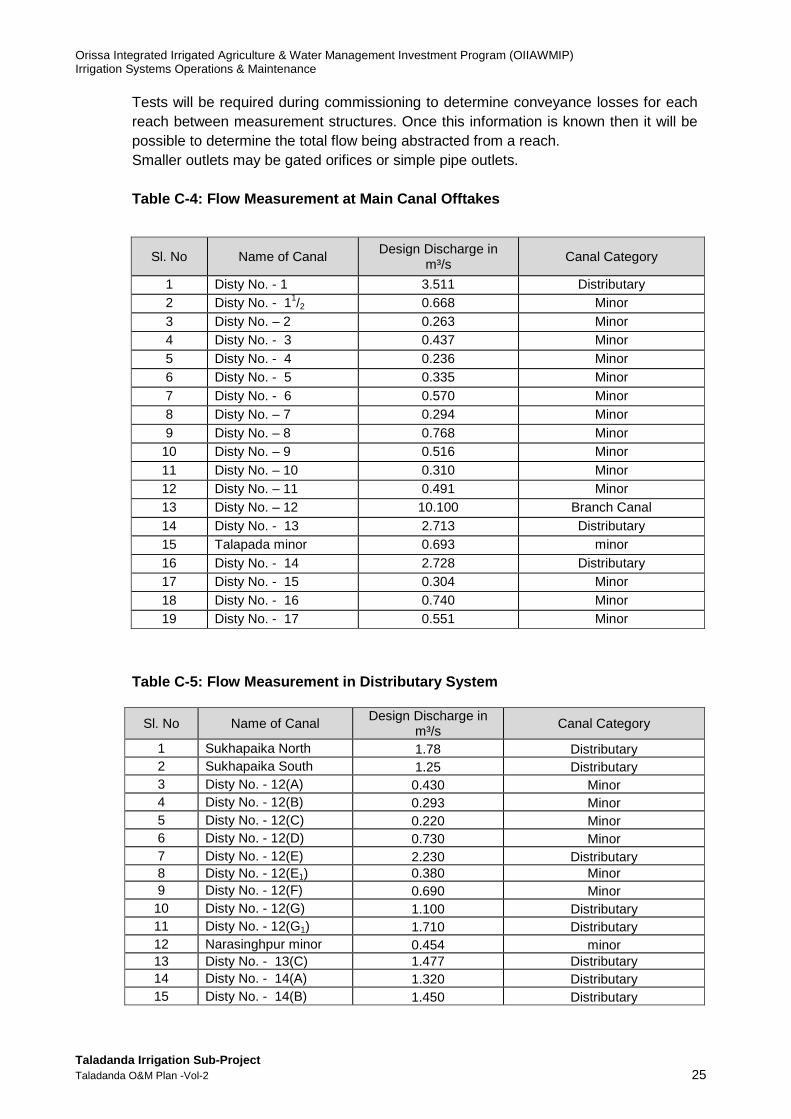
Tests will be required during commissioning to determine conveyance losses for each reach between measurement structures. Once this information is known then it will be possible to determine the total flow being abstracted from a reach. Smaller outlets may be gated orifices or simple pipe outlets. Table C-4: Flow Measurement at Main Canal Offtakes
Sl. No Name of Canal Design Discharge in
m³/s Canal Category
1 Disty No. - 1 3.511 Distributary 2 Disty No. - 11/2 0.668 Minor 3 Disty No. – 2 0.263 Minor 4 Disty No. - 3 0.437 Minor 5 Disty No. - 4 0.236 Minor 6 Disty No. - 5 0.335 Minor 7 Disty No. - 6 0.570 Minor 8 Disty No. – 7 0.294 Minor 9 Disty No. – 8 0.768 Minor
10 Disty No. – 9 0.516 Minor 11 Disty No. – 10 0.310 Minor 12 Disty No. – 11 0.491 Minor 13 Disty No. – 12 10.100 Branch Canal 14 Disty No. - 13 2.713 Distributary 15 Talapada minor 0.693 minor 16 Disty No. - 14 2.728 Distributary 17 Disty No. - 15 0.304 Minor 18 Disty No. - 16 0.740 Minor 19 Disty No. - 17 0.551 Minor
Table C-5: Flow Measurement in Distributary System
Sl. No Name of Canal Design Discharge in
m³/s Canal Category
1 Sukhapaika North 1.78 Distributary 2 Sukhapaika South 1.25 Distributary 3 Disty No. - 12(A) 0.430 Minor 4 Disty No. - 12(B) 0.293 Minor 5 Disty No. - 12(C) 0.220 Minor 6 Disty No. - 12(D) 0.730 Minor 7 Disty No. - 12(E) 2.230 Distributary 8 Disty No. - 12(E1) 0.380 Minor 9 Disty No. - 12(F) 0.690 Minor 10 Disty No. - 12(G) 1.100 Distributary 11 Disty No. - 12(G1) 1.710 Distributary 12 Narasinghpur minor 0.454 minor 13 Disty No. - 13(C) 1.477 Distributary 14 Disty No. - 14(A) 1.320 Distributary 15 Disty No. - 14(B) 1.450 Distributary
Orissa Integrated Irrigated Agriculture & Water Management Investment Program (OIIAWMIP) Irrigation Systems Operations & Maintenance
Taladanda Irrigation Sub-Project Taladanda O&M Plan -Vol-2 26
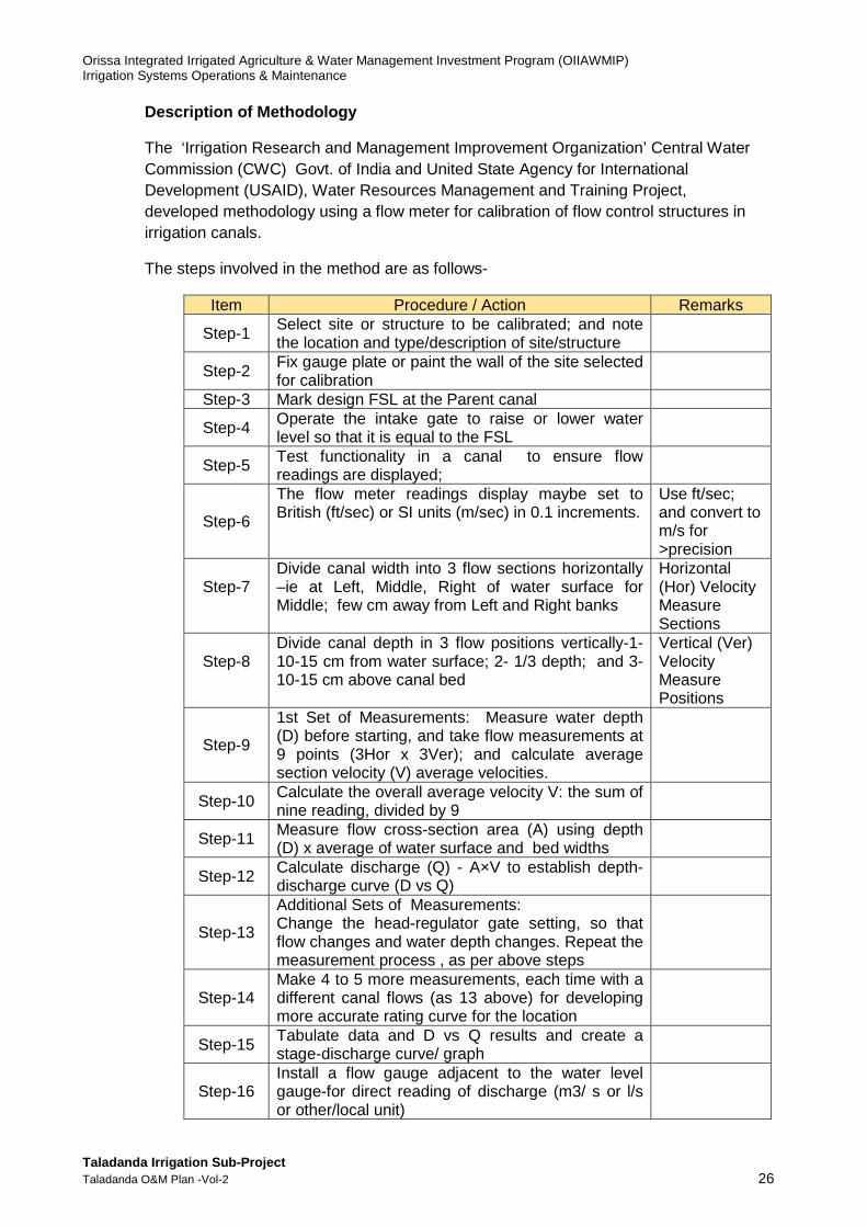
Description of Methodology
The ‘Irrigation Research and Management Improvement Organization’ Central Water Commission (CWC) Govt. of India and United State Agency for International Development (USAID), Water Resources Management and Training Project, developed methodology using a flow meter for calibration of flow control structures in irrigation canals.
The steps involved in the method are as follows-
Item Procedure / Action Remarks
Step-1 Select site or structure to be calibrated; and note the location and type/description of site/structure
Step-2 Fix gauge plate or paint the wall of the site selected for calibration
Step-3 Mark design FSL at the Parent canal
Step-4 Operate the intake gate to raise or lower water level so that it is equal to the FSL
Step-5 Test functionality in a canal to ensure flow readings are displayed;
Step-6
The flow meter readings display maybe set to British (ft/sec) or SI units (m/sec) in 0.1 increments.
Use ft/sec; and convert to m/s for >precision
Step-7
Divide canal width into 3 flow sections horizontally –ie at Left, Middle, Right of water surface for Middle; few cm away from Left and Right banks
Horizontal (Hor) Velocity Measure Sections
Step-8
Divide canal depth in 3 flow positions vertically-1-10-15 cm from water surface; 2- 1/3 depth; and 3- 10-15 cm above canal bed
Vertical (Ver) Velocity Measure Positions
Step-9
1st Set of Measurements: Measure water depth (D) before starting, and take flow measurements at 9 points (3Hor x 3Ver); and calculate average section velocity (V) average velocities.
Step-10 Calculate the overall average velocity V: the sum of nine reading, divided by 9
Step-11 Measure flow cross-section area (A) using depth (D) x average of water surface and bed widths
Step-12 Calculate discharge (Q) - A×V to establish depth-discharge curve (D vs Q)
Step-13
Additional Sets of Measurements: Change the head-regulator gate setting, so that flow changes and water depth changes. Repeat the measurement process , as per above steps
Step-14 Make 4 to 5 more measurements, each time with a different canal flows (as 13 above) for developing more accurate rating curve for the location
Step-15 Tabulate data and D vs Q results and create a stage-discharge curve/ graph
Step-16 Install a flow gauge adjacent to the water level gauge-for direct reading of discharge (m3/ s or l/s or other/local unit)
Orissa Integrated Irrigated Agriculture & Water Management Investment Program (OIIAWMIP) Irrigation Systems Operations & Maintenance
Taladanda Irrigation Sub-Project Taladanda O&M Plan -Vol-2 27
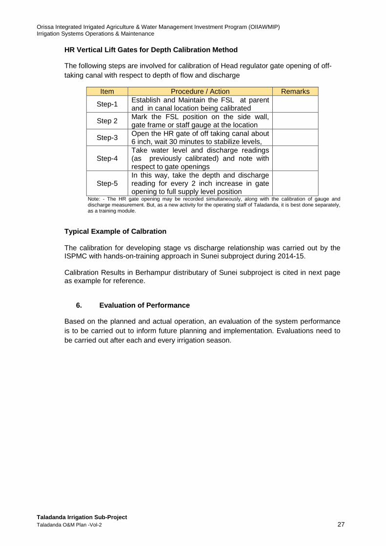
HR Vertical Lift Gates for Depth Calibration Method
The following steps are involved for calibration of Head regulator gate opening of off-taking canal with respect to depth of flow and discharge
Item Procedure / Action Remarks
Step-1 Establish and Maintain the FSL at parent and in canal location being calibrated
Step 2 Mark the FSL position on the side wall, gate frame or staff gauge at the location
Step-3 Open the HR gate of off taking canal about 6 inch, wait 30 minutes to stabilize levels,
Step-4 Take water level and discharge readings (as previously calibrated) and note with respect to gate openings
Step-5 In this way, take the depth and discharge reading for every 2 inch increase in gate opening to full supply level position
Note: - The HR gate opening may be recorded simultaneously, along with the calibration of gauge and discharge measurement. But, as a new activity for the operating staff of Taladanda, it is best done separately, as a training module.
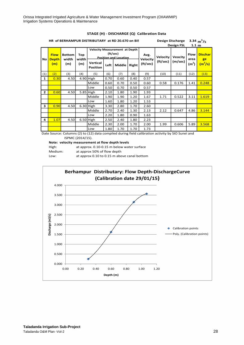
Typical Example of Calbration The calibration for developing stage vs discharge relationship was carried out by the ISPMC with hands-on-training approach in Sunei subproject during 2014-15. Calibration Results in Berhampur distributary of Sunei subproject is cited in next page as example for reference.
6. Evaluation of Performance
Based on the planned and actual operation, an evaluation of the system performance is to be carried out to inform future planning and implementation. Evaluations need to be carried out after each and every irrigation season.
Orissa Integrated Irrigated Agriculture & Water Management Investment Program (OIIAWMIP) Irrigation Systems Operations & Maintenance
Taladanda Irrigation Sub-Project Taladanda O&M Plan -Vol-2 28
HR of BERHAMPUR DISTRIBUTARY at RD 20.670 on BISOL CANAL 3.34 m3/s
1.1 m
Vertical
Position Left Middle Right
(1) (2) (3) (4) (5) (6) (7) (8) (9) (10) (11) (12) (13)
1 0.30 4.50 4.90 High 0.70 0.60 0.40 0.57
Middle 0.60 0.70 0.50 0.60 0.58 0.176 1.41 0.248
Low 0.50 0.70 0.50 0.57
2 0.60 4.50 5.85 High 2.10 1.80 1.90 1.93
Middle 1.90 1.90 1.20 1.67 1.71 0.522 3.11 1.619
Low 1.60 1.80 1.20 1.53
3 0.90 4.50 6.30 High 3.30 2.80 1.70 2.60
Middle 2.70 2.40 1.30 2.13 2.12 0.647 4.86 3.144
Low 2.20 1.80 0.90 1.63
4 1.07 4.50 6.50 High 2.50 2.40 1.80 2.23
Middle 2.30 2.00 1.70 2.00 1.99 0.606 5.89 3.568
Low 1.80 1.70 1.70 1.73
Date Source: Columns (2) to (12) data compiled during field calibration activity by SIO Sunei and
ISPMC (2014/15).
Note: velocity measurement at flow depth levels
High: at approx. 0.10-0.15 m below water surface
Medium: at approx 50% of flow depth
Low: at approx 0.10 to 0.15 m above canal bottom
STAGE (H) - DISCHARGE (Q) Calibration Data
No
Flow
Depth
(m)
Bottom
width
(m)
Top
width
(m)
Avg.
Velocity
(ft/sec)
Velocity
(ft/sec)
Veocity
(m/sec)
Flow
area
(m2)
Dischar
ge
(m3/s)
Design Discharge
Design FSL
Velocity Measurement at Depth
(ft/sec)
Position and Location
0.000
0.500
1.000
1.500
2.000
2.500
3.000
3.500
4.000
0.00 0.20 0.40 0.60 0.80 1.00 1.20
Dis
char
ge (
m3/
s)
Depth (m)
Berhampur Distributary: Flow Depth-DischargeCurve
(Calibration date 29/01/15)
Calibration points
Poly. (Calibration points)

Orissa Integrated Irrigated Agriculture & Water Management Investment Program (OIIAWMIP) Irrigation Systems Operations & Maintenance
Taladanda Irrigation Sub-Project Taladanda O&M Plan -Vol-2 29
D. EXISTING SUBPROJECT O&M STAFFING AND RESPONSIBIL ITIES
The Taladanda irrigation system falls under the Executive Engineer, Mahanadi South Division, who is based at Cuttack. The staffing in the division and sub-division offices is listed in Table D 1 and the organisation structure is shown on Figure D 1.
Table D-1: Staffing in Division Office
Table D-2: Staffing in Sub-division & Section offic es
Jobra Irrigation Sub-
division Kissan nagar Irrigation
Sub-division Manijanga Irrigation
Sub-division Paradeep Irrigation
Sub-division Naraj barrage to VRB; RD 0-7.80km (CCA 88ha)
VRB to Tarapur X-Reg; RD 7.80 to 41.935km (CCA 9356ha)
Tarapur X-Reg to FB; 41.935 to RD 64.127 (CCA 15496ha)
FB to tail; RD 64.127 to 84.24 (CCA 5726 ha)
SDO - 1 SDO - 1 SDO - 1 SDO – 1 SO - 4 SO - 4 SO - 3 SO– 3 (Workers in Section Offices) Junior clerk 1(vacant) Junior clerk 1 Junior clerk 1 Junior clerk 1 (vacant) Khalasi 11 Khalasi 18 Khalasi 12(1vacant) Khalasi 6 Work Sarkar 1 Work Sarkar 1 Work Sarkar 3 Work Sarkar 2 Peon 2 (1vacant) Peon 2 Peon 2 (vacant) Peon 2(vacant) Patrol 1(vacant) Patrol 2 Patrol 2 (1 vacant) - Night watchman 1 Night Watchman 1(vacant) Night Watchman 2 - Mate 1 - Mate 2 Mate 1 - Gauge Reader 1 Gauge Reader 1 - Sweeper 1 - - - - - - Tyndol 1 - - - Toll Collector 1 Jeep Driver 1 - - - Truck Helper 1(vacant) - - - Total 21 Total 26 Total 25 Total 14 Total number of staff in the four sub-divisions = 21+26+25+14 = 86 At present the Executive Engineer, Mahanadi South Division-1 is responsible for the whole of the Taladanda canal, including supply to the Machhagaon Canal, and the four sub-division command areas.
Staff in Division Office headed by Executive Engineer
Head Clerk 1 Mohatir 1 Senior Clerk 2 Patrol 3 (1 vacant) Junior Clerk 9 Sweeper 1 Revenue Clerk 3 Treasury Guard 2(2vacant) Junior Stenographer 1 (vacant) Tyndel 6 (2 vacant) Draughtsman 1 Khalasi 21 (12 vacant) Tracer 1 Gauge Reader 2 (1 vacant) Daftari 1 (vacant) Toll Collector 5 (3 vacant) Peon 10 (2 vacant) River Guard 2(2 vacant) Night Watch Man 1 Majhi 1(1 vacant)

Orissa Integrated Irrigated Agriculture & Water Management Investment Program (OIIAWMIP) Irrigation Systems Operations & Maintenance
Taladanda Irrigation Sub-Project Taladanda O&M Plan -Vol-2 30
Figure D-1: Taladanda Irrigation Scheme: Existing O rganization Chart
Deputy Exe. Engineer (SDO)
Monijanga Irrigation Sub Division At Monijanga
(RD 41.93-64.13km) CCA=15496ha
Assistant Exe.Engineer (SDO)
Paradeep Irrigation Sub Division At Paradeep
(RD 64.13-83.24 km) CCA=5726ha
Deputy Exe. Engineer (SDO)
Jobra Irrigation Sub Division
At Jobra (RD 0 – 7.80km)
CCA = 88ha
1. AE/JE in charge of Jobra Section-1 2. AE/JE in charge of Jobra Section-2 3. AE/JE in charge of Jobra Section-3 4. AE/JE in charge of Deuli Embankment
1. AE/JE in charge of Erasama Section – 1 2.AE/JE in charge of Erasama Section -1 3. AE/JE in charge of Olora Section 4. AE/JE in charge of Balitutha Section.
Estimating Branch Assistant Exe. Engineer-1
Assistant Engineer-1 At Division office, Cuttack
1. AE/JE in charge of Jaipur Section 2. AE/JE in charge of Jaganathpur Section. 3. AE/JE in charge of Manijanga Section 4. AE/JE in charge of Sankheswar Section
1. AE/JE in charge of Samagal Section -1 2. AE/JE in charge of Samagal Section - 2 3. AE/JE in charge of Choumuhani Section 4. AE/JE in charge of Bhutmundei Section.
Executive Engineer Mahanadi South Division-1
At Cuttack
Assistant Exe. Engineer (SDO)
Kissan nagar Irrigation Sub Division
At Kissan nagar (RD 7.80-41.93km)
CCA = 9268ha
1. AE/JE in charge of Biribati Section 2. AE/JE in charge of Somepur Section 3. AE/JE in charge of Raghunathpur Section 4. AE/JE in charge of Sukhpaika Section.
Superintending Engineer Eastern Circle - 1
Cuttack
Assistant Exe.Engineer (SDO)
Erasana Embankment Sub Division At Erasana
For Prevention of saline water ingress
Working staffs 21 nos
Working staffs 26 nos
Working staffs 25 nos
Working staffs 14 nos

Orissa Integrated Irrigated Agriculture & Water Management Investment Program (OIIAWMIP) Irrigation Systems Operations & Maintenance
Taladanda Irrigation Sub-Project Taladanda O&M Plan -Vol-2 31
E. EXISTING FACILITIES, EQUIPMENT AND COMMUNICATION
Existing facilities, equipmentand communications are summarized in the Table below.
Figure -E-1: Existing Facilities Equipment and comm unications
Name of Office & Location Facilities Equipment Vehicles Remarks
Office of the Executive Engineer, Mahanadi South Division-1, at Cuttack.
Phone: Land phone in office. Resides in won house.
Computer - 8 nos
Hired Vehicle-1 EE uses his personal cell phone while roaming.
1. Jobra Irrigation Sub-Division at Jobra
Office of the Sub-Divisional Officer at Jobra, Cuttack headed by Deputy Exe. Engineer
Telephone – Nil. Resides in won house.
Computer- 2 nos
Govt. Vehicle- 1 DEE uses his personal cell phonewhile roaming.
i) Section Officer(AE/JE), Jobra Section-1 at Jobra
Telephone-Nil. Resides in won house.
Computer- Nil Govt. Vehicle- Nil Uses own motercycle &Gets a motorcycle allowance
ii) Section Officer(AE/JE),Jobra Section-2 at Jobra
Telephone-Nil. Resides in rented house
Computer- Nil Govt. Vehicle- Nil Uses own motercycle & gets a motorcycle allowance
iii) Section Officer(AE/JE), Jobra Section-3 at Jobra
Telephone-Nil. Resides in rented house
Computer- Nil Govt. Vehicle- Nil Uses own motercycle &gets a motorcycle allowance
iv) Section Officer(AE/JE), Deuli Embankment section at Deuli
Telephone-Nil. Resides in own house
Computer- Nil Govt. Vehicle- Nil Uses own motercycle & gets a motorcycle allowance
Other field workers are in Pay Roll. They inspect, report to SO and operate gates as per instruction of SO
Nil Nil Nil Move on foot or uses personal cycle/ motorcycle if any.
2. Kissan nagar Irrigation Sub-Division at Kissan nagar
Office of the Sub-Divisional Officer at Kissan nagar headed by Asst.Exe. Engineer
Telephone – Nil Resides in Govt. Quarter
Computer- 1 Govt. Vehicle- 1 AEE uses his personal cell phone while roaming.
i) Section Officer(AE/JE),Biribati Section at Biribati
Telephone-Nil Resides in rented house
Computer- Nil Govt. Vehicle- Nil Uses own motercycle &Gets a motorcycle allowance
ii) Section Officer(AE/JE),Somepur Section at Somepur
Telephone-Nil Resides in rented house
Computer- Nil Govt. Vehicle- Nil Uses own motercycle &Gets a motorcycle allowance
iii) Section Officer(AE/JE),Raghunathpur Section at Kulasai
Telephone-Nil Resides in rented house
Computer- Nil Govt. Vehicle- Nil Uses own motercycle &Gets a motorcycle allowance
iv) Section Officer(AE/JE),Sukhpaika Section at Sukhapaika
Telephone-Nil Resides in rented house
Computer- Nil Govt. Vehicle- Nil Uses own motercycle &Gets a motorcycle allowance
Other field workers are in Pay Roll. They inspect, report to SO and operate gates as per instruction of SO.
Nil Nil Nil Move on foot or uses personal cycle/ motorcycle if any.
Orissa Integrated Irrigated Agriculture & Water Management Investment Program (OIIAWMIP) Irrigation Systems Operations & Maintenance
Taladanda Irrigation Sub-Project Taladanda O&M Plan -Vol-2 32
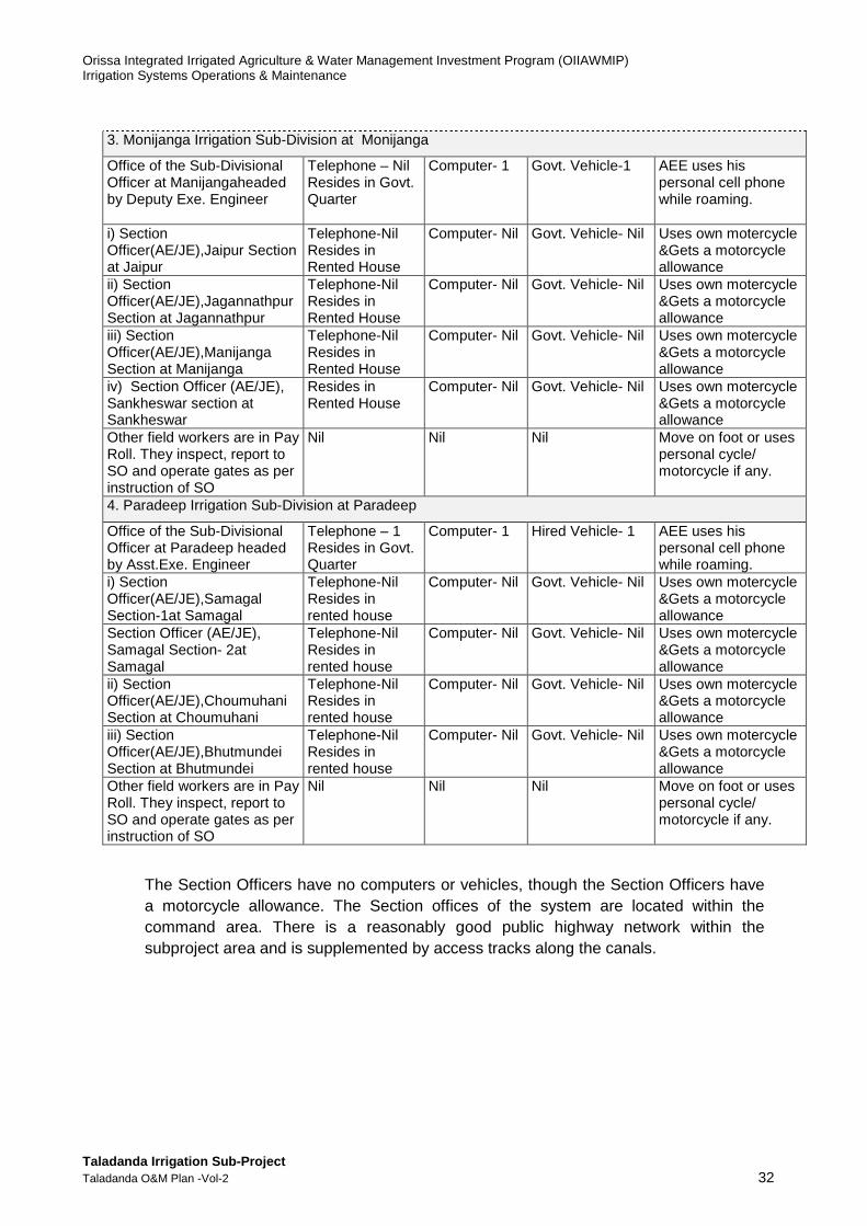
The Section Officers have no computers or vehicles, though the Section Officers have a motorcycle allowance. The Section offices of the system are located within the command area. There is a reasonably good public highway network within the subproject area and is supplemented by access tracks along the canals.
3. Monijanga Irrigation Sub-Division at Monijanga
Office of the Sub-Divisional Officer at Manijangaheaded by Deputy Exe. Engineer
Telephone – Nil Resides in Govt. Quarter
Computer- 1 Govt. Vehicle-1 AEE uses his personal cell phone while roaming.
i) Section Officer(AE/JE),Jaipur Section at Jaipur
Telephone-Nil Resides in Rented House
Computer- Nil Govt. Vehicle- Nil Uses own motercycle &Gets a motorcycle allowance
ii) Section Officer(AE/JE),Jagannathpur Section at Jagannathpur
Telephone-Nil Resides in Rented House
Computer- Nil Govt. Vehicle- Nil Uses own motercycle &Gets a motorcycle allowance
iii) Section Officer(AE/JE),Manijanga Section at Manijanga
Telephone-Nil Resides in Rented House
Computer- Nil Govt. Vehicle- Nil Uses own motercycle &Gets a motorcycle allowance
iv) Section Officer (AE/JE), Sankheswar section at Sankheswar
Resides in Rented House
Computer- Nil Govt. Vehicle- Nil Uses own motercycle &Gets a motorcycle allowance
Other field workers are in Pay Roll. They inspect, report to SO and operate gates as per instruction of SO
Nil Nil Nil Move on foot or uses personal cycle/ motorcycle if any.
4. Paradeep Irrigation Sub-Division at Paradeep
Office of the Sub-Divisional Officer at Paradeep headed by Asst.Exe. Engineer
Telephone – 1 Resides in Govt. Quarter
Computer- 1 Hired Vehicle- 1 AEE uses his personal cell phone while roaming.
i) Section Officer(AE/JE),Samagal Section-1at Samagal
Telephone-Nil Resides in rented house
Computer- Nil Govt. Vehicle- Nil Uses own motercycle &Gets a motorcycle allowance
Section Officer (AE/JE), Samagal Section- 2at Samagal
Telephone-Nil Resides in rented house
Computer- Nil Govt. Vehicle- Nil Uses own motercycle &Gets a motorcycle allowance
ii) Section Officer(AE/JE),Choumuhani Section at Choumuhani
Telephone-Nil Resides in rented house
Computer- Nil Govt. Vehicle- Nil Uses own motercycle &Gets a motorcycle allowance
iii) Section Officer(AE/JE),Bhutmundei Section at Bhutmundei
Telephone-Nil Resides in rented house
Computer- Nil Govt. Vehicle- Nil Uses own motercycle &Gets a motorcycle allowance
Other field workers are in Pay Roll. They inspect, report to SO and operate gates as per instruction of SO
Nil Nil Nil Move on foot or uses personal cycle/ motorcycle if any.

Orissa Integrated Irrigated Agriculture & Water Management Investment Program (OIIAWMIP) Irrigation Systems Operations & Maintenance
Taladanda Irrigation Sub-Project Taladanda O&M Plan -Vol-2 33
1. Computers
1. Computers will be used for:
(i) Record keeping at section and subdivision offices. (ii) Reporting and calculations by staff (technical, revenue, administrative,
etc). (iii) Preparation of irrigation plans and schedules. (iv) Improved dissemination of data, including canal flows, volumes and
command deltas, to and between DoWR staff and PPs. (v) Development and updating of a scheme information system, in particular
an asset inventory and maintenance planning system. 2. Both the section and sub-division offices will be equipped with computers with internet connections through either the wired (if available) or the cell phone system. Laptop computers (or the smaller “notebooks”) will be preferable because the built-in battery provides backup power and they can be locked away when not in use. The computer equipment at the sub-division offices will include accessories such as uninterruptible power supplies and printers. A small standby generator may also be needed to power essential equipment.
2. Equipment
3. Equipment requirements, other than computers provided to all offices, for each sub-division will include:
(i) Printers (ii) Survey level and tape measures. (iii) Handheld GPS. (iv) Digital camera. (v) Calculators. (vi) Communications equipment including mobile phones. (vii) Basic tools for undertaking petty maintenance and simple repairs. (viii) Torches or lanterns for doing field operations at night, when necessary; (ix) Small standby generator.
4. Operational staff would have access (under agreed procedures) to equipment from the Division office including: (i) current metering equipment to calibrate discharge measurement structures; (ii) additional survey equipment; (iii) sediment sampling equipment; and (iv) salinity meters.
3. Communications
5. Division, sub-division, section and apex PP staff must be mobile and have good communications for voice and data exchange. Commercial mobile (cell) phone coverage is fair throughout the command area and is proposed for voice communications between sub-division and apex PP staff, and between section, sub-division and division staff. 6. Data will be exchanged over the internet between office computers. Internet and intranet sites should be set. Connections will be either: (i) using fixed lines; or (ii) the mobile phone network using plug-in datacards. A website for Taladanda may be set up, either with its own domain name or as part of the DoWR website
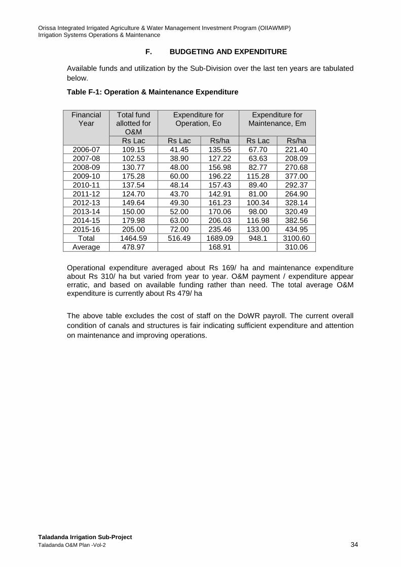
Orissa Integrated Irrigated Agriculture & Water Management Investment Program (OIIAWMIP) Irrigation Systems Operations & Maintenance
Taladanda Irrigation Sub-Project Taladanda O&M Plan -Vol-2 34
F. BUDGETING AND EXPENDITURE
Available funds and utilization by the Sub-Division over the last ten years are tabulated below.
Table F-1: Operation & Maintenance Expenditure
Operational expenditure averaged about Rs 169/ ha and maintenance expenditure about Rs 310/ ha but varied from year to year. O&M payment / expenditure appear erratic, and based on available funding rather than need. The total average O&M expenditure is currently about Rs 479/ ha
The above table excludes the cost of staff on the DoWR payroll. The current overall condition of canals and structures is fair indicating sufficient expenditure and attention on maintenance and improving operations.
Financial Year
Total fund allotted for
O&M
Expenditure for Operation, Eo
Expenditure for Maintenance, Em
Rs Lac Rs Lac Rs/ha Rs Lac Rs/ha 2006-07 109.15 41.45 135.55 67.70 221.40 2007-08 102.53 38.90 127.22 63.63 208.09 2008-09 130.77 48.00 156.98 82.77 270.68 2009-10 175.28 60.00 196.22 115.28 377.00 2010-11 137.54 48.14 157.43 89.40 292.37 2011-12 124.70 43.70 142.91 81.00 264.90 2012-13 149.64 49.30 161.23 100.34 328.14 2013-14 150.00 52.00 170.06 98.00 320.49 2014-15 179.98 63.00 206.03 116.98 382.56 2015-16 205.00 72.00 235.46 133.00 434.95
Total 1464.59 516.49 1689.09 948.1 3100.60 Average 478.97 168.91 310.06
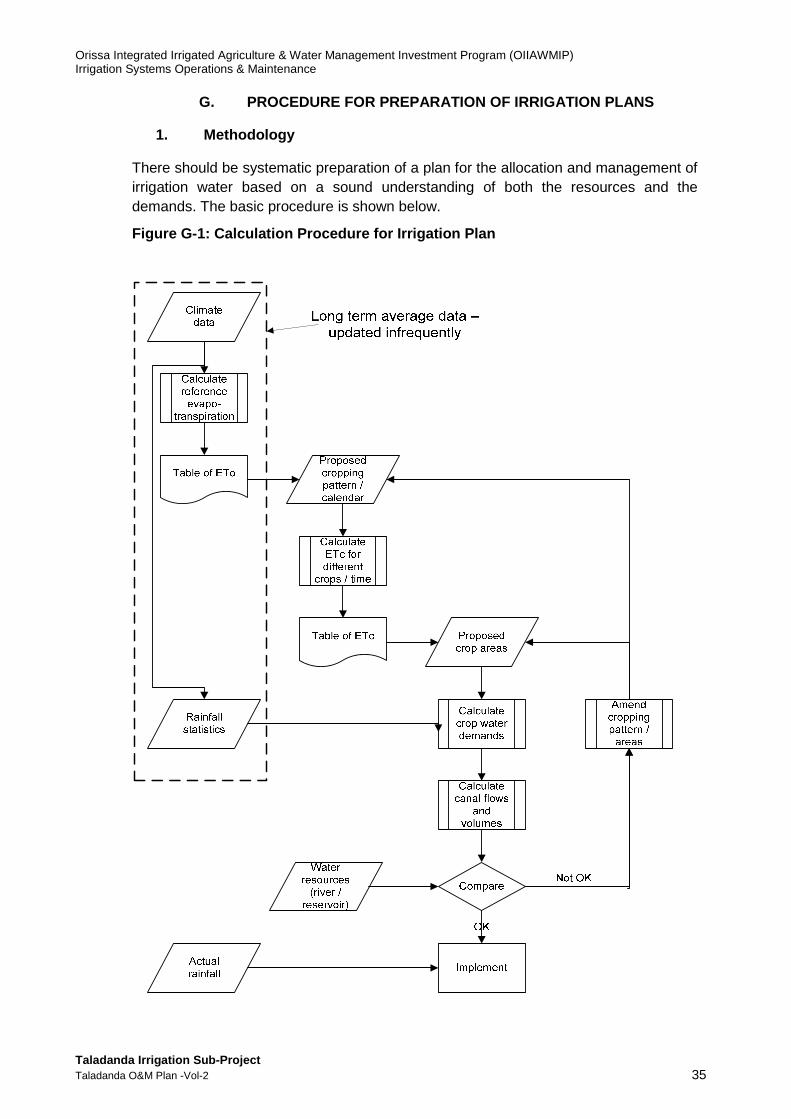
Orissa Integrated Irrigated Agriculture & Water Management Investment Program (OIIAWMIP) Irrigation Systems Operations & Maintenance
Taladanda Irrigation Sub-Project Taladanda O&M Plan -Vol-2 35
G. PROCEDURE FOR PREPARATION OF IRRIGATION PLANS
1. Methodology
There should be systematic preparation of a plan for the allocation and management of irrigation water based on a sound understanding of both the resources and the demands. The basic procedure is shown below.
Figure G-1: Calculation Procedure for Irrigation Pl an
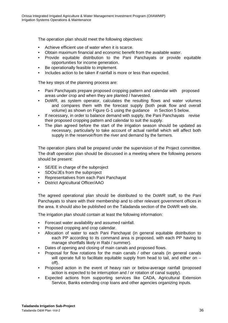
Orissa Integrated Irrigated Agriculture & Water Management Investment Program (OIIAWMIP) Irrigation Systems Operations & Maintenance
Taladanda Irrigation Sub-Project Taladanda O&M Plan -Vol-2 36
The operation plan should meet the following objectives:
• Achieve efficient use of water when it is scarce. • Obtain maximum financial and economic benefit from the available water. • Provide equitable distribution to the Pani Panchayats or provide equitable
opportunities for income generation. • Be operationally feasible to implement. • Includes action to be taken if rainfall is more or less than expected. The key steps of the planning process are:
• Pani Panchayats prepare proposed cropping pattern and calendar with proposed areas under crop and when they are planted / harvested.
• DoWR, as system operator, calculates the resulting flows and water volumes and compares them with the forecast supply (both peak flow and overall volume) as shown on Figure G-1 using the guidance in Section 5 below.
• If necessary, in order to balance demand with supply, the Pani Panchayats revise their proposed cropping pattern and calendar to suit the supply.
• The plan agreed before the start of the irrigation season should be updated as necessary, particularly to take account of actual rainfall which will affect both supply in the reservoir/from the river and demand by the farmers.
The operation plans shall be prepared under the supervision of the Project committee. The draft operation plan should be discussed in a meeting where the following persons should be present:
• SE/EE in charge of the subproject • SDOs/JEs from the subproject • Representatives from each Pani Panchayat • District Agricultural Officer/AAO
The agreed operational plan should be distributed to the DoWR staff, to the Pani Panchayats to share with their membership and to other relevant government offices in the area. It should also be published on the Taladanda section of the DoWR web site.
The irrigation plan should contain at least the following information:
• Forecast water availability and assumed rainfall. • Proposed cropping and crop calendar. • Allocation of water to each Pani Panchayat (in general equitable distribution to
each PP according to its command area is proposed, with each PP having to manage shortfalls likely in Rabi / summer).
• Dates of opening and closing of main canals and proposed flows. • Proposal for flow rotations for the main canals / other canals (in general canals
will operate full to facilitate equitable supply from head to tail, and either on – off).
• Proposed action in the event of heavy rain or below-average rainfall (proposed action is expected to be interruption and / or rotation of canal supply).
• Expected actions from supporting services like CADA, Agricultural Extension Service, Banks extending crop loans and other agencies organizing inputs.

Orissa Integrated Irrigated Agriculture & Water Management Investment Program (OIIAWMIP) Irrigation Systems Operations & Maintenance
Taladanda Irrigation Sub-Project Taladanda O&M Plan -Vol-2 37
The operation plan will be implemented by the DoWR staff in coordination with the Pani Panchayats. Actual performance should be compared to the plan with daily updates of flows, flow volumes, rainfall and operational changes to the plan (including changes in response to rainfall and unplanned closures). The overall objective will be to maintain the planned volumes after adjustment for rainfall.
The number of locations for flow measurement shall be sufficient to allow volume and depths of water supplied to each part of the command area to be determined, and rainfall. Ideally quantification of supply to each PP command will be achieved.
Pani Panchayats are responsible for the detailed planning of water distribution to their PP members.
The plan may need to be updated and reissued depending on actual performance and climatic conditions. If rainfall is significantly less than expected then the water available in the reservoir will be reduced. If water is scarce then a decision will be required as to whether to use the water for supporting the Kharif crop or conserve it for the Rabi season.
2. Kharif Season
Effectively, irrigation is Kharif is supplementary to rainfall. The main considerations in the planning are:
• Whether residual stored water in the reservoir can be used to ensure a timely start to the irrigation season through use for nurseries. However, the water requirements for overall land preparation are substantial and rain will still be needed before the seedlings can be transplanted.
• Irrigation after September should be minimized in order to provide the maximum carry-over of stored water for Rabi season cropping, and to prevent drainage congestion.
• A timely start to the Kharif season will facilitate a timely start to the Rabi season. The net quantity of water available for irrigation shall be worked out along with quantity of water allocable to each PP and shall be intimated to the PPs, Project Committee, and respective Assistant AgricultureOfficers (AAOs) by 15th April. Information to be considered includes:
• Forecast from the Indian Meteorological Department (IMD) about ensuing monsoon, whether normal, excess/deficit rains are expected and commencement on due dates / delayed (in the absence of any forecast the average shall be assumed).
• Storage position expected as on 1st July. • Water allocation for purposes other than Irrigation (if any). • Seepage / transmission losses in the canals. • Evaporation and seepage losses from the reservoir. • Quantity of water available from ground water and tanks in the command area. • Critical growth stages and period of water supply (frequency of irrigation) and
experience / lessons from previous season(s). The Project Committee shall consolidate the operation plan of all the PPs and suggest modification/ changes, if necessary, in crop areas, periods of water supply and opening/closing of canals so as to have uniformity and arrive at a common plan for the entire command.
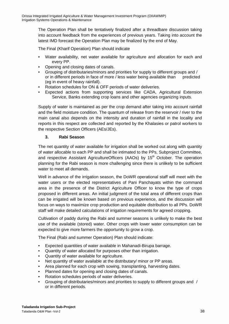
Orissa Integrated Irrigated Agriculture & Water Management Investment Program (OIIAWMIP) Irrigation Systems Operations & Maintenance
Taladanda Irrigation Sub-Project Taladanda O&M Plan -Vol-2 38
The Operation Plan shall be tentatively finalized after a threadbare discussion taking into account feedback from the experiences of previous years. Taking into account the latest IMD forecast the Operation Plan may be finalized by the end of May.
The Final (Kharif Operation) Plan should indicate
• Water availability, net water available for agriculture and allocation for each and every PP.
• Opening and closing dates of canals. • Grouping of distributaries/minors and priorities for supply to different groups and /
or in different periods in face of more / less water being available than predicted (eg in event of heavy rainfall).
• Rotation schedules for ON & OFF periods of water deliveries. • Expected actions from supporting services like CADA, Agricultural Extension
Service, Banks extending crop loans and other agencies organizing inputs. Supply of water is maintained as per the crop demand after taking into account rainfall and the field moisture condition. The quantum of release from the reservoir / river to the main canal also depends on the intensity and duration of rainfall in the locality and reports in this respect are collected and reported by the Khalasies or patrol workers to the respective Section Officers (AEs/JEs).
3. Rabi Season
The net quantity of water available for irrigation shall be worked out along with quantity of water allocable to each PP and shall be intimated to the PPs, Subproject Committee, and respective Assistant AgricultureOfficers (AAOs) by 15th October. The operation planning for the Rabi season is more challenging since there is unlikely to be sufficient water to meet all demands.
Well in advance of the irrigation season, the DoWR operational staff will meet with the water users or the elected representatives of Pani Panchayats within the command area in the presence of the District Agriculture Officer to know the type of crops proposed in different areas. An initial judgment of the total area of different crops than can be irrigated will be known based on previous experience, and the discussion will focus on ways to maximize crop production and equitable distribution to all PPs. DoWR staff will make detailed calculations of irrigation requirements for agreed cropping.
Cultivation of paddy during the Rabi and summer seasons is unlikely to make the best use of the available (stored) water. Other crops with lower water consumption can be expected to give more farmers the opportunity to grow a crop.
The Final (Rabi and summer Operation) Plan should indicate:
• Expected quantities of water available in Mahanadi-Birupa barrage. • Quantity of water allocated for purposes other than irrigation. • Quantity of water available for agriculture. • Net quantity of water available at the distributary/ minor or PP areas. • Area planned for each crop with sowing, transplanting, harvesting dates. • Planned dates for opening and closing dates of canals. • Rotation schedules periods of water deliveries. • Grouping of distributaries/minors and priorities to supply to different groups and /
or in different periods.
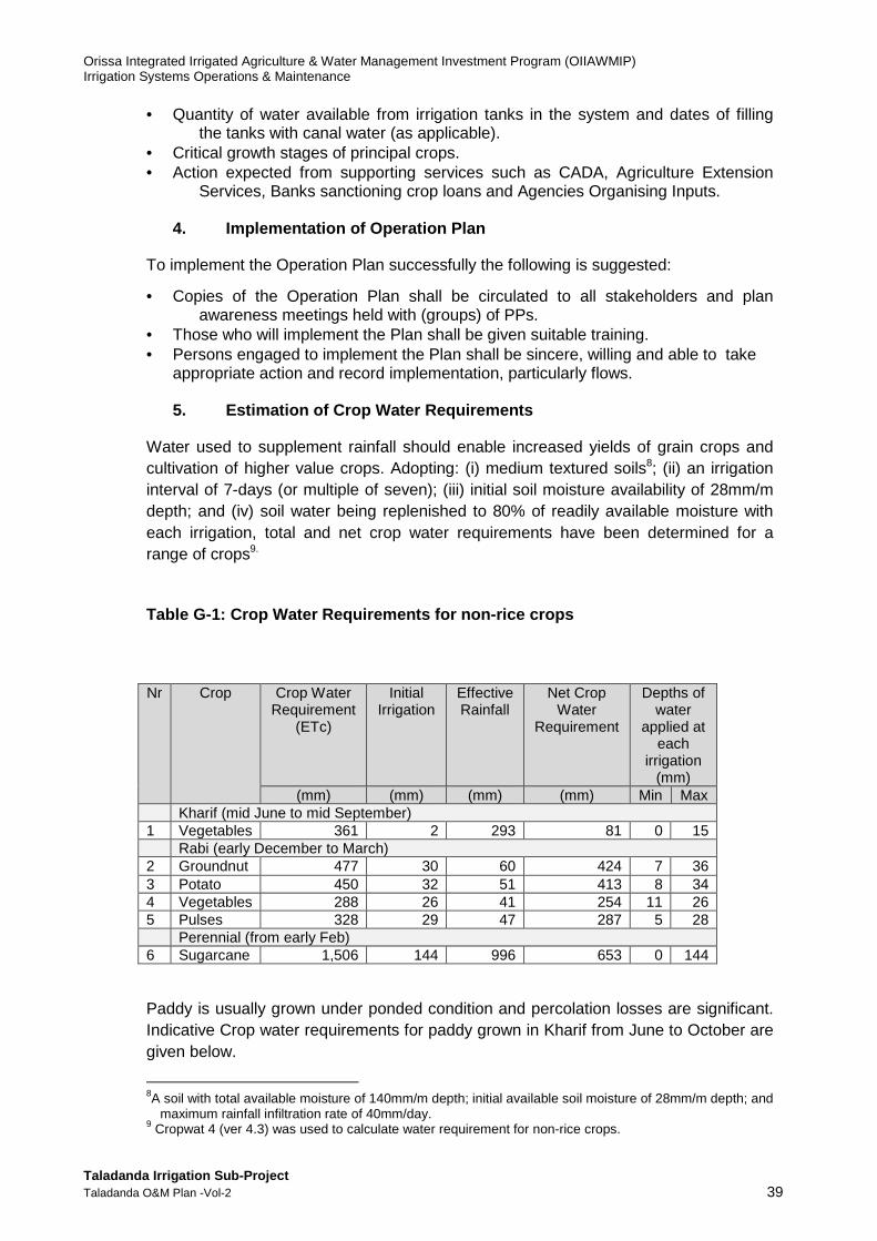
Orissa Integrated Irrigated Agriculture & Water Management Investment Program (OIIAWMIP) Irrigation Systems Operations & Maintenance
Taladanda Irrigation Sub-Project Taladanda O&M Plan -Vol-2 39
• Quantity of water available from irrigation tanks in the system and dates of filling the tanks with canal water (as applicable).
• Critical growth stages of principal crops. • Action expected from supporting services such as CADA, Agriculture Extension
Services, Banks sanctioning crop loans and Agencies Organising Inputs.
4. Implementation of Operation Plan
To implement the Operation Plan successfully the following is suggested:
• Copies of the Operation Plan shall be circulated to all stakeholders and plan awareness meetings held with (groups) of PPs.
• Those who will implement the Plan shall be given suitable training. • Persons engaged to implement the Plan shall be sincere, willing and able to take
appropriate action and record implementation, particularly flows.
5. Estimation of Crop Water Requirements
Water used to supplement rainfall should enable increased yields of grain crops and cultivation of higher value crops. Adopting: (i) medium textured soils8; (ii) an irrigation interval of 7-days (or multiple of seven); (iii) initial soil moisture availability of 28mm/m depth; and (iv) soil water being replenished to 80% of readily available moisture with each irrigation, total and net crop water requirements have been determined for a range of crops9.
Table G-1: Crop Water Requirements for non-rice cro ps
Paddy is usually grown under ponded condition and percolation losses are significant. Indicative Crop water requirements for paddy grown in Kharif from June to October are given below.
8A soil with total available moisture of 140mm/m depth; initial available soil moisture of 28mm/m depth; and
maximum rainfall infiltration rate of 40mm/day. 9 Cropwat 4 (ver 4.3) was used to calculate water requirement for non-rice crops.
Nr Crop Crop Water Requirement
(ETc)
Initial Irrigation
Effective Rainfall
Net Crop Water
Requirement
Depths of water
applied at each
irrigation (mm)
(mm) (mm) (mm) (mm) Min Max Kharif (mid June to mid September) 1 Vegetables 361 2 293 81 0 15 Rabi (early December to March) 2 Groundnut 477 30 60 424 7 36 3 Potato 450 32 51 413 8 34 4 Vegetables 288 26 41 254 11 26 5 Pulses 328 29 47 287 5 28 Perennial (from early Feb) 6 Sugarcane 1,506 144 996 653 0 144
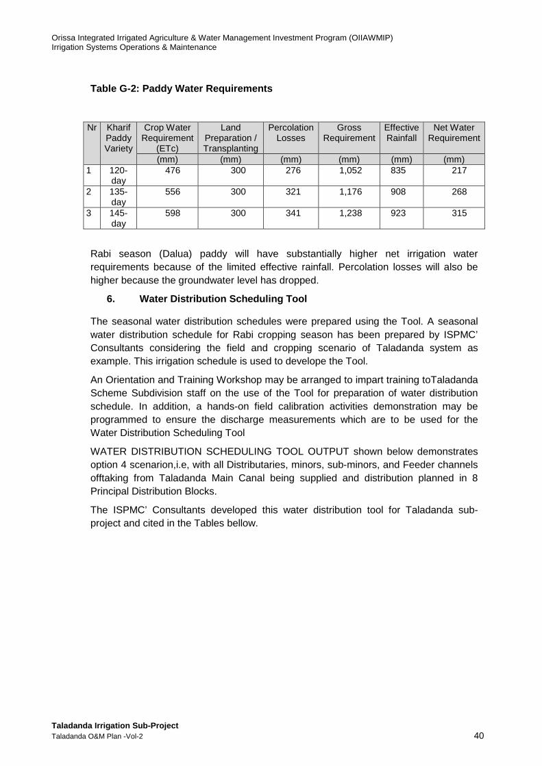
Orissa Integrated Irrigated Agriculture & Water Management Investment Program (OIIAWMIP) Irrigation Systems Operations & Maintenance
Taladanda Irrigation Sub-Project Taladanda O&M Plan -Vol-2 40
Table G-2: Paddy Water Requirements
Rabi season (Dalua) paddy will have substantially higher net irrigation water requirements because of the limited effective rainfall. Percolation losses will also be higher because the groundwater level has dropped.
6. Water Distribution Scheduling Tool
The seasonal water distribution schedules were prepared using the Tool. A seasonal water distribution schedule for Rabi cropping season has been prepared by ISPMC’ Consultants considering the field and cropping scenario of Taladanda system as example. This irrigation schedule is used to develope the Tool.
An Orientation and Training Workshop may be arranged to impart training toTaladanda Scheme Subdivision staff on the use of the Tool for preparation of water distribution schedule. In addition, a hands-on field calibration activities demonstration may be programmed to ensure the discharge measurements which are to be used for the Water Distribution Scheduling Tool
WATER DISTRIBUTION SCHEDULING TOOL OUTPUT shown below demonstrates option 4 scenarion,i.e, with all Distributaries, minors, sub-minors, and Feeder channels offtaking from Taladanda Main Canal being supplied and distribution planned in 8 Principal Distribution Blocks.
The ISPMC’ Consultants developed this water distribution tool for Taladanda sub-project and cited in the Tables bellow.
Nr Kharif Paddy Variety
Crop Water Requirement
(ETc)
Land Preparation / Transplanting
Percolation Losses
Gross Requirement
Effective Rainfall
Net Water Requirement
(mm) (mm) (mm) (mm) (mm) (mm) 1 120-
day 476 300 276 1,052 835 217
2 135-day
556 300 321 1,176 908 268
3 145-day
598 300 341 1,238 923 315
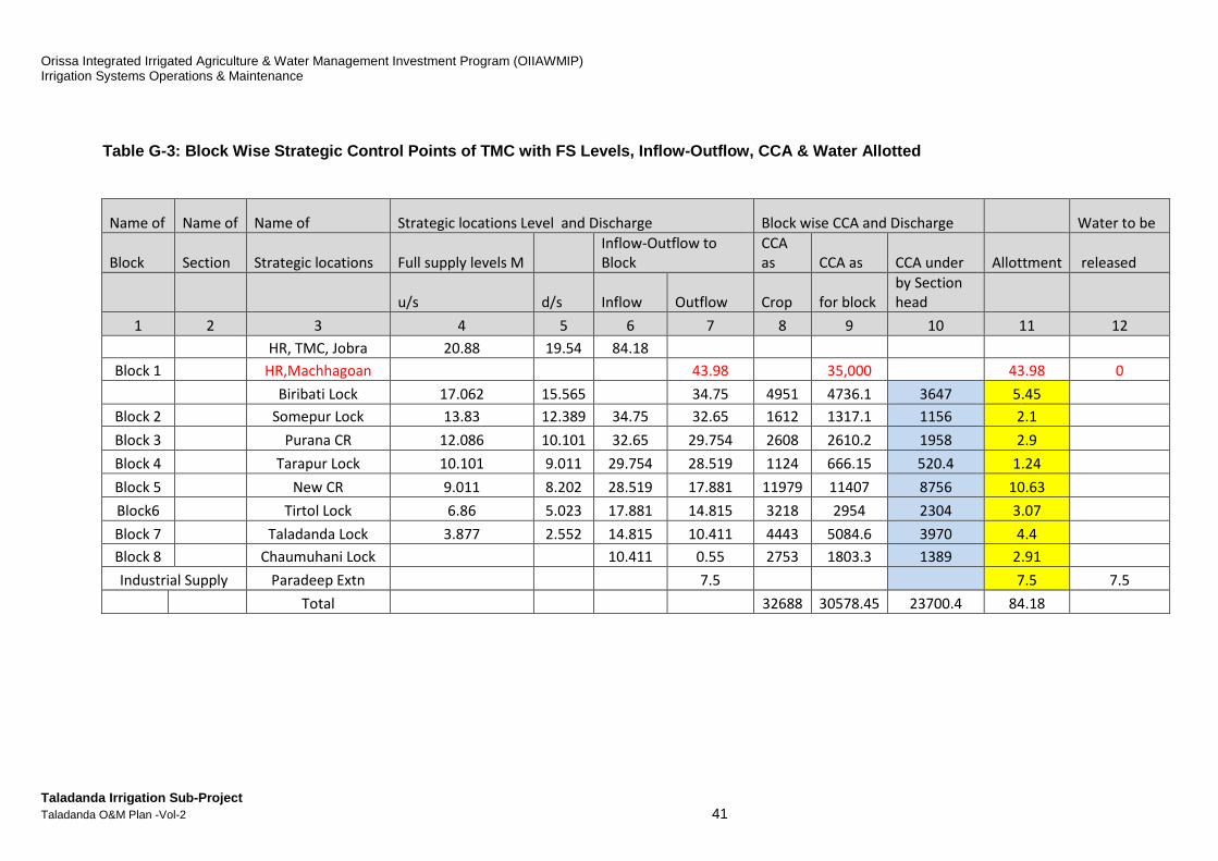
Orissa Integrated Irrigated Agriculture & Water Management Investment Program (OIIAWMIP) Irrigation Systems Operations & Maintenance
Taladanda Irrigation Sub-Project Taladanda O&M Plan -Vol-2 41
Table G-3: Block Wise Strategic Control Points of T MC with FS Levels, Inflow-Outflow, CCA & Water Allo tted
Name of Name of Name of Strategic locations Level and Discharge Block wise CCA and Discharge Water to be
Block Section Strategic locations Full supply levels M
Inflow-Outflow to
Block
CCA
as CCA as CCA under Allottment released
u/s d/s Inflow Outflow Crop for block
by Section
head
1 2 3 4 5 6 7 8 9 10 11 12
HR, TMC, Jobra 20.88 19.54 84.18
Block 1
HR,Machhagoan
43.98
35,000
43.98 0
Biribati Lock 17.062 15.565
34.75 4951 4736.1 3647 5.45
Block 2
Somepur Lock 13.83 12.389 34.75 32.65 1612 1317.1 1156 2.1
Block 3
Purana CR 12.086 10.101 32.65 29.754 2608 2610.2 1958 2.9
Block 4
Tarapur Lock 10.101 9.011 29.754 28.519 1124 666.15 520.4 1.24
Block 5
New CR 9.011 8.202 28.519 17.881 11979 11407 8756 10.63
Block6
Tirtol Lock 6.86 5.023 17.881 14.815 3218 2954 2304 3.07
Block 7
Taladanda Lock 3.877 2.552 14.815 10.411 4443 5084.6 3970 4.4
Block 8
Chaumuhani Lock
10.411 0.55 2753 1803.3 1389 2.91
Industrial Supply Paradeep Extn
7.5
7.5 7.5
Total
32688 30578.45 23700.4 84.18

Orissa Integrated Irrigated Agriculture & Water Management Investment Program (OIIAWMIP) Irrigation Systems Operations & Maintenance
Taladanda Irrigation Sub-Project Taladanda O&M Plan -Vol-2 42
Table G-4: Block wise designed & required discharge and sub blocks CCA
Block No Water Calculated water Block Block's sub groups Rabi crop Block's sub Grouping Crop Water Need for sub block in Ham
allotted requirment for CCA in ha CCA in ha under the groups under Rotationl 1st 2nd 3rd 4th
to block the block Subblock CCA Block Rabi crops purpose watering watering watering watering
1 2 3 4 5 6 7 8 9 10 11 12 13
Block 1 5.45 A 2246 1705.9 1956 195.6 146.7 146.7 146.7
4736.1 B 2240 3647 1691 1941 194.1 145.5 145.5 145.5
Common 250.1 250.1
Block 2 2.1 A 660 580 580 58 43.5 43.5 43.5
1317.1 B 657.1 1156 576 576 57.6 43.2 43.2 43.2
Common 0 0
Block 3 2.9 A 1302.2 1002 1002 100.2 75.1 75.1 75.1
2610.2 B 1308 1958 956 956 95.6 71.7 71.7 71.7
Common 0 0
Block 4 1.24 A 330 255 255 25.5 19.1 19.1 10.1
667.15 B 337.15 520.4 265.4 265.4 26.5 19.9 19.9 19.9
Common 0 0
Block 5 10.63 A 4943 3667 5074 507.4 380.5 380.5 380.5
11407 B 5057 8756 3682 5089 508.9 381.6 381.6 381.6
Common 1407 1407
Block 6 3.07 A 1378 1130 1130 113 84.7 84.7 84.7
2954 B 1576 2304 1174 1174 117.4 88 88 88
Common 0 0
Block 7 4.4 A 2859 2164 2546 254.6 190.9 190.9 190.9
5083.15 B 1842.15 3970 1424 1806 180.6 135.4 135.4 135.4
Common 382 382
Block 8 2.91 A 652.3 440 946 94.6 70.9 70.9 70.9
1803.3 B 645 1389 443 949 94.9 71.1 71.1 71.1
Common 506 506
Industry 7.5
Total 30578 30578 23700.4 23700.4 26245.4
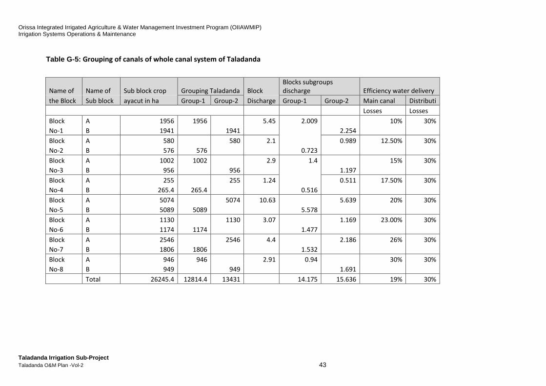
Orissa Integrated Irrigated Agriculture & Water Management Investment Program (OIIAWMIP) Irrigation Systems Operations & Maintenance
Taladanda Irrigation Sub-Project Taladanda O&M Plan -Vol-2 43
Table G-5: Grouping of canals of whole canal system of Taladanda
Name of Name of Sub block crop Grouping Taladanda Block
Blocks subgroups
discharge Efficiency water delivery
the Block Sub block ayacut in ha Group-1 Group-2 Discharge Group-1 Group-2 Main canal Distributi
Losses Losses
Block A 1956 1956 5.45 2.009 10% 30%
No-1 B 1941
1941
2.254
Block A 580 580 2.1
0.989 12.50% 30%
No-2 B 576 576 0.723
Block A 1002 1002 2.9 1.4 15% 30%
No-3 B 956 956
1.197
Block A 255
255 1.24
0.511 17.50% 30%
No-4 B 265.4 265.4 0.516
Block A 5074 5074 10.63
5.639 20% 30%
No-5 B 5089 5089 5.578
Block A 1130 1130 3.07
1.169 23.00% 30%
No-6 B 1174 1174 1.477
Block A 2546 2546 4.4
2.186 26% 30%
No-7 B 1806 1806 1.532
Block A 946 946 2.91 0.94 30% 30%
No-8 B 949 949
1.691
Total 26245.4 12814.4 13431 14.175 15.636 19% 30%
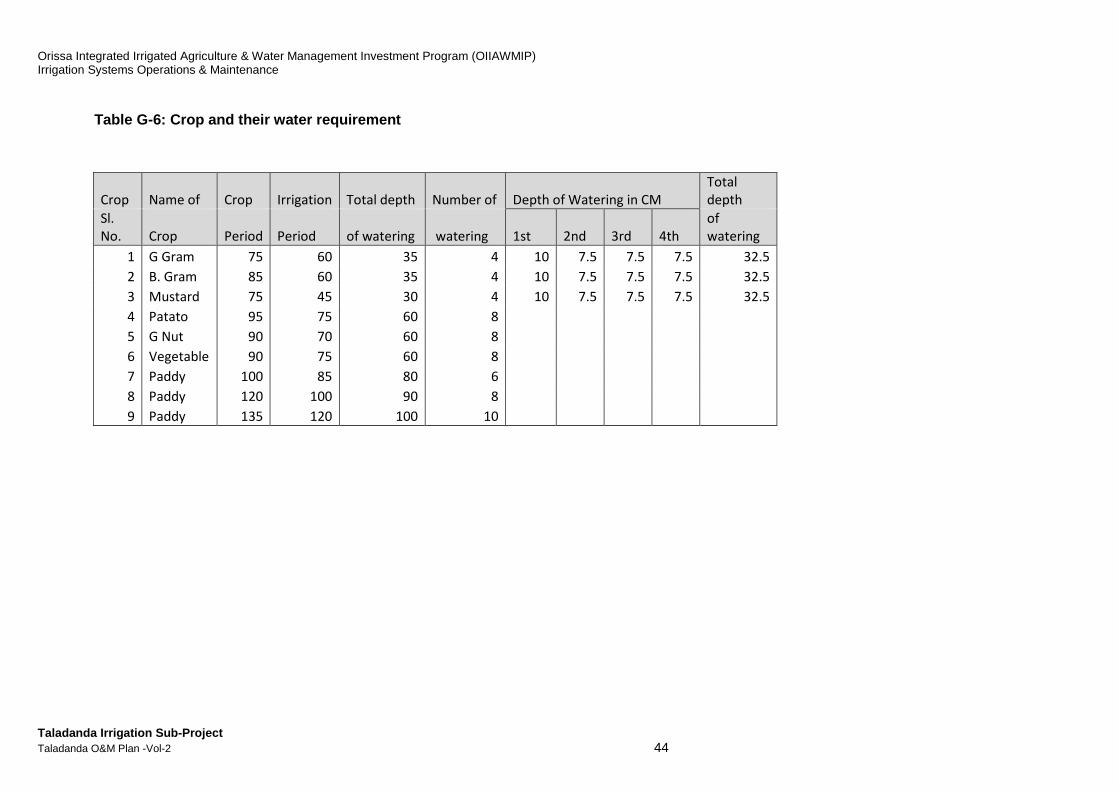
Orissa Integrated Irrigated Agriculture & Water Management Investment Program (OIIAWMIP) Irrigation Systems Operations & Maintenance
Taladanda Irrigation Sub-Project Taladanda O&M Plan -Vol-2 44
Table G-6: Crop and their water requirement
Crop Name of Crop Irrigation Total depth Number of Depth of Watering in CM
Total
depth
Sl.
No. Crop Period Period of watering watering 1st 2nd 3rd 4th
of
watering
1 G Gram 75 60 35 4 10 7.5 7.5 7.5 32.5
2 B. Gram 85 60 35 4 10 7.5 7.5 7.5 32.5
3 Mustard 75 45 30 4 10 7.5 7.5 7.5 32.5
4 Patato 95 75 60 8
5 G Nut 90 70 60 8
6 Vegetable 90 75 60 8
7 Paddy 100 85 80 6
8 Paddy 120 100 90 8
9 Paddy 135 120 100 10

Orissa Integrated Irrigated Agriculture & Water Management Investment Program (OIIAWMIP) Irrigation Systems Operations & Maintenance
Taladanda Irrigation Sub-Project Taladanda O&M Plan -Vol-2 45
Table G-7: Rotational Program of Taladanda Canal Sy stem for the period -7th January to 21st March-2017 Priority of rotational Group (with two group method)
Period
Date of Opening
& Closing Rotational Preferential order of Group
From To Cycle I
Block-1 Block-2 Block-3 Block-4 Block-5 Block-6 Block-7 Block-8
Pre-
sowing
7/1/2
017
16/1/20
17
A B A B B B B A
OL OL Nanpur
Disty
No 9(R)
Disty No 12
(D)
Disty No 13
( C )
Disty No
14 (B)
Disty
No 15
OL
Paramhansa
OL Sarapur Disty No 12 (E)
Pankapal
minor
Disty
No 18
1
Sukapaika
north Disty No 6 ( R )
Disty No 12 (
G1) Direct OL
Direct
OL
Dharania
minor OL Manpur ( 1) Jainabad s/m
Disty No 4
( R) OL Manpur ( 2)
Gobindapur
s/m
Disty No 5
( R )
Disty No 6 - 1/2
( R )
Direct OL 135
no
Disty No
5-1/2( R )
Bodar minor
(Old)
Kantua
Bodar minor
(New)
Disty No 7 ( R )
Ayodhapur
minor

Orissa Integrated Irrigated Agriculture & Water Management Investment Program (OIIAWMIP) Irrigation Systems Operations & Maintenance
Taladanda Irrigation Sub-Project Taladanda O&M Plan -Vol-2 46
Period
Date of opening
& Closing Rotational Preferential order of Group
From To Cycle II
Block-1 Block-2 Block-3 Block-4 Block-5 Block-6 Block-7 Block-8
Pre-
sowing
16/1/
2017
25/01/2
017
B A B A A A A B
Sukapai
ka
south OL Fakirpada
Raghunathpu
r minor
OL Odapada
(R ) Disty No 11
Disty No
13 (A)
Talapada
minor
Disty
No 16
Bhutapada
minor
Disty No 8 (
A)
OL Odapada
(L ) Nuapada minor
Disty No
13 (B)
Disty No
14 (A)
Disty
No 17
1
Disty 1
- 1/2 OL ( R )
Jagannathpur
minor Puran minor Disty No 12 (A)
Direct OL
43 no Direct OL
Direct
OL
Disty 2 OL ( R )
Athagunthari
minor OL Kulasahi Disty No 12 (B)
Disty No 3 (
R) Disty No 8 ( R) Disty No 12 (C )
OL Parabil
Disty No 8-
1/2
OL
Patanigoan
Tentulipada
minor
OL Odapada OL Barti Disty No 12( F)
Kotakona
minor
Disty No 10
( R )
Kosti
mallikapur s/m
Lenka minor
Bhattagram
S/M
R K Pur S/M
(1) Disty No 12 (G)
R K Pur S/M
(2) Alana S/M
Srirampur S/M
Narasinghpur
S/M
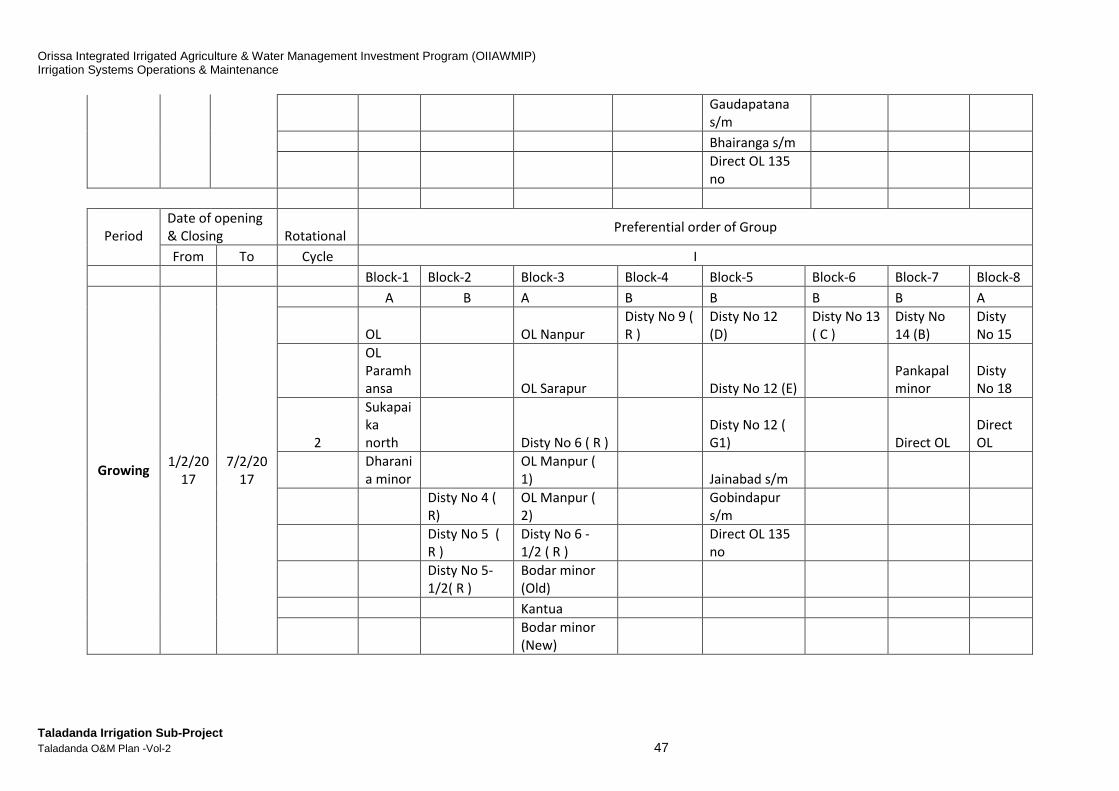
Orissa Integrated Irrigated Agriculture & Water Management Investment Program (OIIAWMIP) Irrigation Systems Operations & Maintenance
Taladanda Irrigation Sub-Project Taladanda O&M Plan -Vol-2 47
Gaudapatana
s/m
Bhairanga s/m
Direct OL 135
no
Period
Date of opening
& Closing Rotational Preferential order of Group
From To Cycle I
Block-1 Block-2 Block-3 Block-4 Block-5 Block-6 Block-7 Block-8
Growing 1/2/20
17
7/2/20
17
A B A B B B B A
OL OL Nanpur
Disty No 9 (
R )
Disty No 12
(D)
Disty No 13
( C )
Disty No
14 (B)
Disty
No 15
OL
Paramh
ansa
OL Sarapur Disty No 12 (E)
Pankapal
minor
Disty
No 18
2
Sukapai
ka
north Disty No 6 ( R )
Disty No 12 (
G1) Direct OL
Direct
OL
Dharani
a minor
OL Manpur (
1) Jainabad s/m
Disty No 4 (
R)
OL Manpur (
2)
Gobindapur
s/m
Disty No 5 (
R )
Disty No 6 -
1/2 ( R )
Direct OL 135
no
Disty No 5-
1/2( R )
Bodar minor
(Old)
Kantua
Bodar minor
(New)
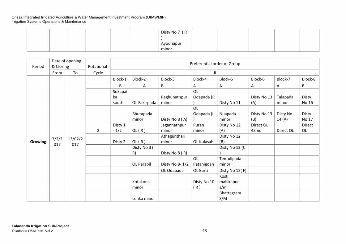
Orissa Integrated Irrigated Agriculture & Water Management Investment Program (OIIAWMIP) Irrigation Systems Operations & Maintenance
Taladanda Irrigation Sub-Project Taladanda O&M Plan -Vol-2 48
Disty No 7 ( R
)
Ayodhapur
minor
Period
Date of opening
& Closing Rotational Preferential order of Group
From To Cycle II
Block-1 Block-2 Block-3 Block-4 Block-5 Block-6 Block-7 Block-8
Growing 7/2/2
017
13/02/2
017
B A B A A A A B
Sukapai
ka
south OL Fakirpada
Raghunathpur
minor
OL
Odapada (R
) Disty No 11
Disty No 13
(A)
Talapada
minor
Disty
No 16
Bhutapada
minor Disty No 8 ( A)
OL
Odapada (L
)
Nuapada
minor
Disty No 13
(B)
Disty No
14 (A)
Disty
No 17
2
Disty 1
- 1/2 OL ( R )
Jagannathpur
minor
Puran
minor
Disty No 12
(A)
Direct OL
43 no Direct OL
Direct
OL
Disty 2 OL ( R )
Athagunthari
minor OL Kulasahi
Disty No 12
(B)
Disty No 3 (
R) Disty No 8 ( R)
Disty No 12 (C
)
OL Parabil Disty No 8- 1/2
OL
Patanigoan
Tentulipada
minor
OL Odapada OL Barti Disty No 12( F)
Kotakona
minor
Disty No 10
( R )
Kosti
mallikapur
s/m
Lenka minor
Bhattagram
S/M
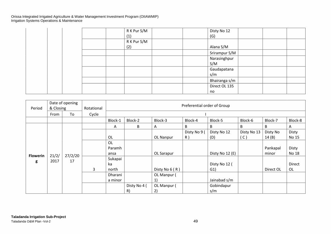
Orissa Integrated Irrigated Agriculture & Water Management Investment Program (OIIAWMIP) Irrigation Systems Operations & Maintenance
Taladanda Irrigation Sub-Project Taladanda O&M Plan -Vol-2 49
R K Pur S/M
(1)
Disty No 12
(G)
R K Pur S/M
(2) Alana S/M
Srirampur S/M
Narasinghpur
S/M
Gaudapatana
s/m
Bhairanga s/m
Direct OL 135
no
Period
Date of opening
& Closing Rotational Preferential order of Group
From To Cycle I
Block-1 Block-2 Block-3 Block-4 Block-5 Block-6 Block-7 Block-8
Flowerin
g
21/2/
2017
27/2/20
17
A B A B B B B A
OL OL Nanpur
Disty No 9 (
R )
Disty No 12
(D)
Disty No 13
( C )
Disty No
14 (B)
Disty
No 15
OL
Paramh
ansa
OL Sarapur Disty No 12 (E)
Pankapal
minor
Disty
No 18
3
Sukapai
ka
north Disty No 6 ( R )
Disty No 12 (
G1) Direct OL
Direct
OL
Dharani
a minor
OL Manpur (
1) Jainabad s/m
Disty No 4 (
R)
OL Manpur (
2)
Gobindapur
s/m
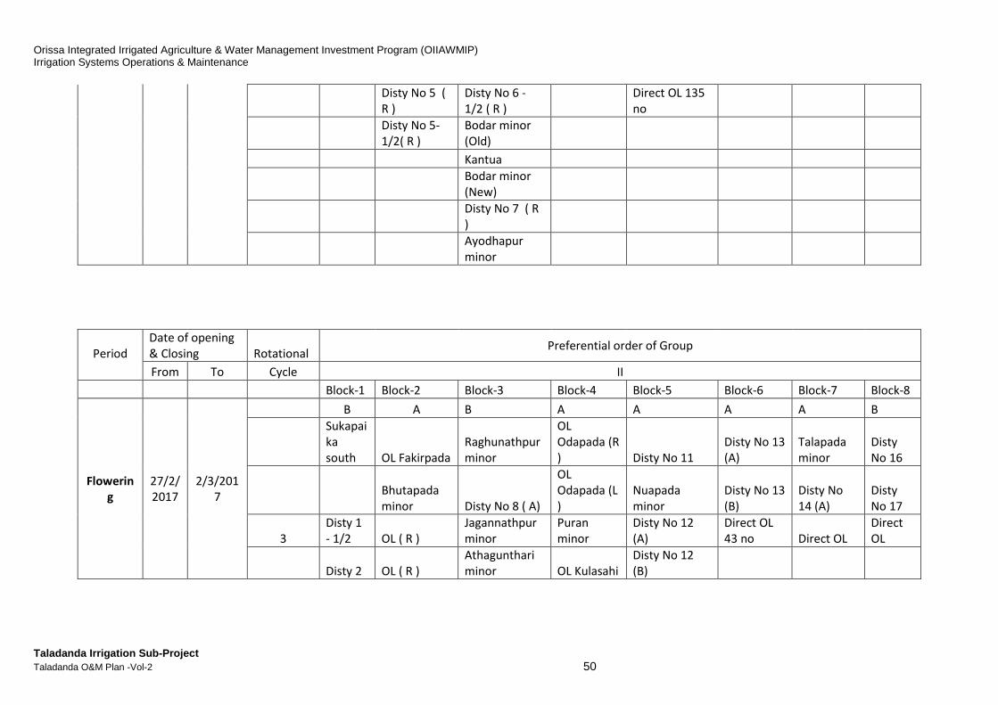
Orissa Integrated Irrigated Agriculture & Water Management Investment Program (OIIAWMIP) Irrigation Systems Operations & Maintenance
Taladanda Irrigation Sub-Project Taladanda O&M Plan -Vol-2 50
Disty No 5 (
R )
Disty No 6 -
1/2 ( R )
Direct OL 135
no
Disty No 5-
1/2( R )
Bodar minor
(Old)
Kantua
Bodar minor
(New)
Disty No 7 ( R
)
Ayodhapur
minor
Period
Date of opening
& Closing Rotational Preferential order of Group
From To Cycle II
Block-1 Block-2 Block-3 Block-4 Block-5 Block-6 Block-7 Block-8
Flowerin
g
27/2/
2017
2/3/201
7
B A B A A A A B
Sukapai
ka
south OL Fakirpada
Raghunathpur
minor
OL
Odapada (R
) Disty No 11
Disty No 13
(A)
Talapada
minor
Disty
No 16
Bhutapada
minor Disty No 8 ( A)
OL
Odapada (L
)
Nuapada
minor
Disty No 13
(B)
Disty No
14 (A)
Disty
No 17
3
Disty 1
- 1/2 OL ( R )
Jagannathpur
minor
Puran
minor
Disty No 12
(A)
Direct OL
43 no Direct OL
Direct
OL
Disty 2 OL ( R )
Athagunthari
minor OL Kulasahi
Disty No 12
(B)
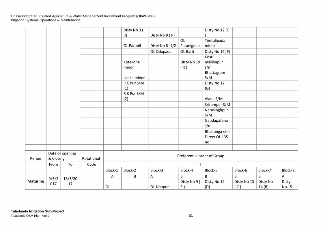
Orissa Integrated Irrigated Agriculture & Water Management Investment Program (OIIAWMIP) Irrigation Systems Operations & Maintenance
Taladanda Irrigation Sub-Project Taladanda O&M Plan -Vol-2 51
Disty No 3 (
R) Disty No 8 ( R)
Disty No 12 (C
)
OL Parabil Disty No 8- 1/2
OL
Patanigoan
Tentulipada
minor
OL Odapada OL Barti Disty No 12( F)
Kotakona
minor
Disty No 10
( R )
Kosti
mallikapur
s/m
Lenka minor
Bhattagram
S/M
R K Pur S/M
(1)
Disty No 12
(G)
R K Pur S/M
(2) Alana S/M
Srirampur S/M
Narasinghpur
S/M
Gaudapatana
s/m
Bhairanga s/m
Direct OL 135
no
Period
Date of opening
& Closing Rotational Preferential order of Group
From To Cycle I
Block-1 Block-2 Block-3 Block-4 Block-5 Block-6 Block-7 Block-8
Maturing 9/3/2
017
15/3/20
17
A B A B B B B A
OL OL Nanpur
Disty No 9 (
R )
Disty No 12
(D)
Disty No 13
( C )
Disty No
14 (B)
Disty
No 15
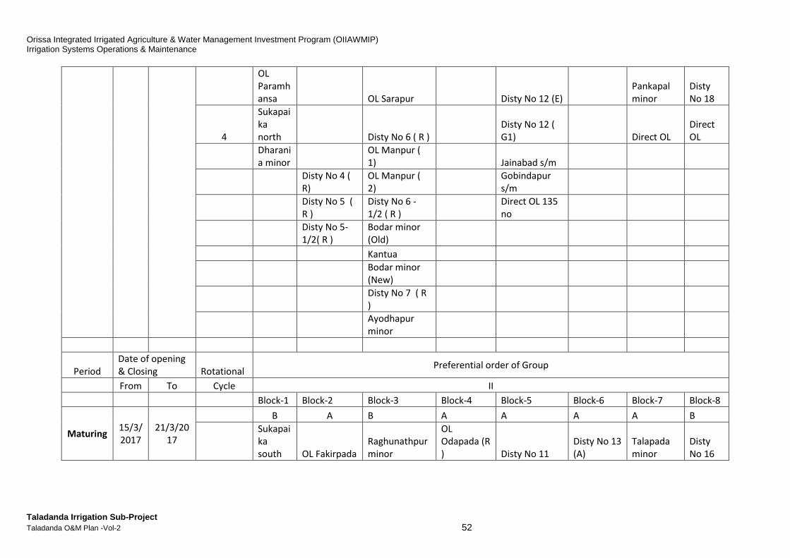
Orissa Integrated Irrigated Agriculture & Water Management Investment Program (OIIAWMIP) Irrigation Systems Operations & Maintenance
Taladanda Irrigation Sub-Project Taladanda O&M Plan -Vol-2 52
OL
Paramh
ansa
OL Sarapur Disty No 12 (E)
Pankapal
minor
Disty
No 18
4
Sukapai
ka
north Disty No 6 ( R )
Disty No 12 (
G1) Direct OL
Direct
OL
Dharani
a minor
OL Manpur (
1) Jainabad s/m
Disty No 4 (
R)
OL Manpur (
2)
Gobindapur
s/m
Disty No 5 (
R )
Disty No 6 -
1/2 ( R )
Direct OL 135
no
Disty No 5-
1/2( R )
Bodar minor
(Old)
Kantua
Bodar minor
(New)
Disty No 7 ( R
)
Ayodhapur
minor
Period
Date of opening
& Closing Rotational Preferential order of Group
From To Cycle II
Block-1 Block-2 Block-3 Block-4 Block-5 Block-6 Block-7 Block-8
Maturing 15/3/
2017
21/3/20
17
B A B A A A A B
Sukapai
ka
south OL Fakirpada
Raghunathpur
minor
OL
Odapada (R
) Disty No 11
Disty No 13
(A)
Talapada
minor
Disty
No 16

Orissa Integrated Irrigated Agriculture & Water Management Investment Program (OIIAWMIP) Irrigation Systems Operations & Maintenance
Taladanda Irrigation Sub-Project Taladanda O&M Plan -Vol-2 53
Bhutapada
minor Disty No 8 ( A)
OL
Odapada (L
)
Nuapada
minor
Disty No 13
(B)
Disty No
14 (A)
Disty
No 17
4
Disty 1
- 1/2 OL ( R )
Jagannathpur
minor
Puran
minor
Disty No 12
(A)
Direct OL
43 no Direct OL
Direct
OL
Disty 2 OL ( R )
Athagunthari
minor OL Kulasahi
Disty No 12
(B)
Disty No 3 (
R) Disty No 8 ( R)
Disty No 12 (C
)
OL Parabil Disty No 8- 1/2
OL
Patanigoan
Tentulipada
minor
OL Odapada OL Barti Disty No 12( F)
Kotakona
minor
Disty No 10
( R )
Kosti
mallikapur
s/m
Lenka minor
Bhattagram
S/M
R K Pur S/M
(1)
Disty No 12
(G)
R K Pur S/M
(2) Alana S/M
Srirampur S/M
Narasinghpur
S/M
Gaudapatana
s/m
Bhairanga s/m
Direct OL 135
no

Orissa Integrated Irrigated Agriculture & Water Management Investment Program (OIIAWMIP) Irrigation Systems Operations & Maintenance
Taladanda Irrigation Sub-Project Taladanda O&M Plan -Vol-2 54
Table G-8: Block wise, Canal wise, PP wise, CCA, Di scharge
BLOCK NO:1
BLOCK:-
NO:
R.D.
M
Location Level Dischar
ge
Block-wise Command area details under
block
PP
NO.
No. of
Chaks
PP CCA Crop planned
U/S TMC watr allotment Name of
canal
CCA Dischar
ge
No. of
chaks
Area in
Ha
D/S as per DS as per
DS
as per
DS
0 HR ,TMC ,
Jobra
21.18 84.186 5.443 Disty 0L 53 0.096 ICAR - Central-Rice Research Institute
20.88 OL(L) 35 0.167
11.3
55
Machh.
Canal
19.586 43.986 Disty 1L 4069 3.511
PP 2P 59 438.7 42 337.8
PP 4 35 404.51 25 311.5
PP6 40 439.62 28 338.5
PP 7 59 697.23 40 536.8
Block
NO-1
PP 9 51 555.23 45 427.5
PP 10 45 360.39 32 277.5
PP 23 34 391.81 24 301.7
PP 24 13 444.2 9 342.03
PP 25 31 397.71 22 306.3
Disty 1.5L 497 0.668
PP 1 46 332.55 34 256.1
11.7
5
Biribati
Lock
19.54 34.757 OL Param 14 0.012

Orissa Integrated Irrigated Agriculture & Water Management Investment Program (OIIAWMIP) Irrigation Systems Operations & Maintenance
Taladanda Irrigation Sub-Project Taladanda O&M Plan -Vol-2 55
17.062 Disty 2R 283 0.263
PP 13(P) 23 274.16 17 211.1
Machagaon 35000 43.986
CCA as per canal
designe
4951 10 No
PP
436 4736 318 3646.83
BLOCK NO:2
BLOCK: 2 R.D. Location Level Discha
rge
Block-wise Command area details under
block
PP NO. No of
chaks
PP CCA Crop planned
U/S TMC water alloted Name of
canal
CCA Discha
rge
No of
chaks
PP area
D/S in a PP in Ha
24.4
6
Sompur
Lock
15.565 32.653 2.104 OL fakir 47 0.042
13.83 Bhutapada
mnr
81 0.089
PP 13(P) 20 69.89 14 55.2
OL R 14 0.031
OL R 11 0.027
Disty 3R 473 0.437
PP 15 39 400.48 28 316.4
OL Parbil® 34 0.087
Disty 4R 253 0.235
PP 3(P) 27 244.77 20 193.4
Kotakan
mnr
34 0.103
PP 3(P) 12.85 10.2
Lenka Mnr 56 0.051

Orissa Integrated Irrigated Agriculture & Water Management Investment Program (OIIAWMIP) Irrigation Systems Operations & Maintenance
Taladanda Irrigation Sub-Project Taladanda O&M Plan -Vol-2 56
RK pur s/m1 26 0.038
PP 3(P) 11.8 9.4
RK pur s/m2 32 0.084
PP 3(P) 4.92 3.8
Disty 5R 375 0.335
PP 5(P) 30 86.46 20 68.3
PP 11 39 295.31 27 233.3
Disty 5.5R 176 0.153
PP 5(P) 23 190.64 17 150.6
1612 1.712 178 1317 126 1041
BLOCK NO:3
BLOCK: 3 R.D. Location Level Discha
rge
Block-wise Command area details under
block
PP NO. PP CCA Crop planned
U/S TMC water alloted Name of
canal
CCA Discha
rge
No of
chaks
PP area
D/S in a PP in Ha
36.6
78
CR at
Puran
12.389 29.754 2.899 OL Nanpur 40 0.094
12.086 OL sarapur 40 0.062
Disty 6R 646 0.569
PP 12 49 389.56 35 292.17
PP 70 63 335.73 42 251.79
OL Manpur
1
35 0.05
OL Manpur
2
37 0.06
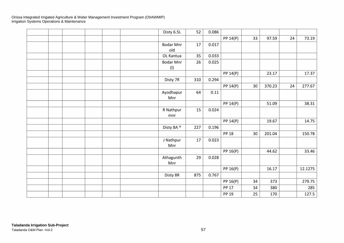
Orissa Integrated Irrigated Agriculture & Water Management Investment Program (OIIAWMIP) Irrigation Systems Operations & Maintenance
Taladanda Irrigation Sub-Project Taladanda O&M Plan -Vol-2 57
Disty 6.5L 52 0.086
PP 14(P) 33 97.59 24 73.19
Bodar Mnr
old
17 0.017
OL Kantua 35 0.033
Bodar Mnr
(l)
26 0.025
PP 14(P) 23.17 17.37
Disty 7R 310 0.294
PP 14(P) 30 370.23 24 277.67
Ayodhapur
Mnr
64 0.11
PP 14(P) 51.09 38.31
R Nathpur
mnr
15 0.024
PP 14(P) 19.67 14.75
Disty 8A ® 227 0.196
PP 18 30 201.04 150.78
J Nathpur
Mnr
17 0.023
PP 16(P) 44.62 33.46
Athagunth
Mnr
29 0.028
PP 16(P) 16.17 12.1275
Disty 8R 875 0.767
PP 16(P) 34 373 279.75
PP 17 34 380 285
PP 19 25 170 127.5
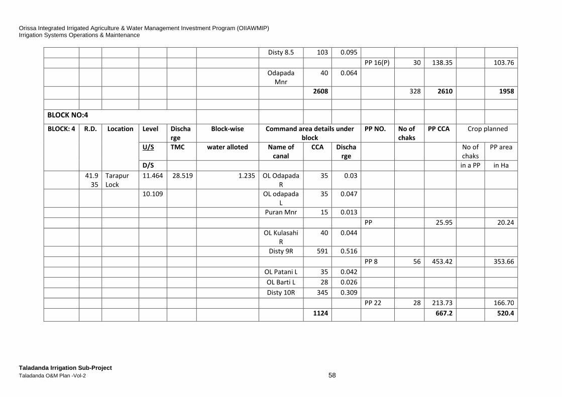
Orissa Integrated Irrigated Agriculture & Water Management Investment Program (OIIAWMIP) Irrigation Systems Operations & Maintenance
Taladanda Irrigation Sub-Project Taladanda O&M Plan -Vol-2 58
Disty 8.5 103 0.095
PP 16(P) 30 138.35 103.76
Odapada
Mnr
40 0.064
2608 328 2610 1958
BLOCK NO:4
BLOCK: 4 R.D. Location Level Discha
rge
Block-wise Command area details under
block
PP NO. No of
chaks
PP CCA Crop planned
U/S TMC water alloted Name of
canal
CCA Discha
rge
No of
chaks
PP area
D/S in a PP in Ha
41.9
35
Tarapur
Lock
11.464 28.519 1.235 OL Odapada
R
35 0.03
10.109 OL odapada
L
35 0.047
Puran Mnr 15 0.013
PP 25.95 20.24
OL Kulasahi
R
40 0.044
Disty 9R 591 0.516
PP 8 56 453.42 353.66
OL Patani L 35 0.042
OL Barti L 28 0.026
Disty 10R 345 0.309
PP 22 28 213.73 166.70
1124 667.2 520.4
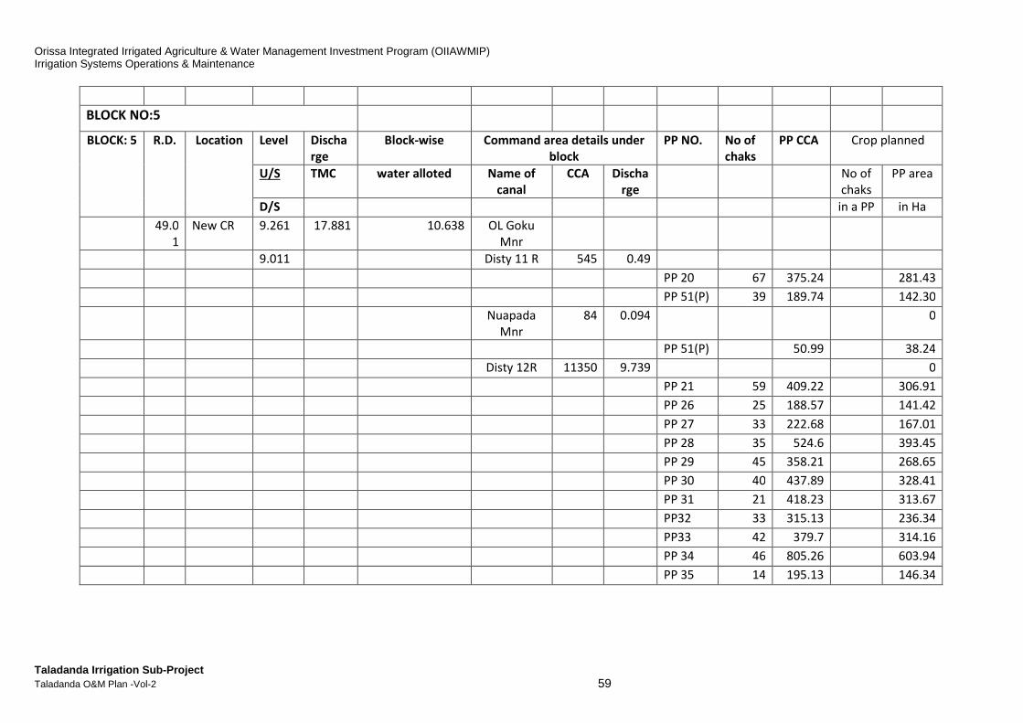
Orissa Integrated Irrigated Agriculture & Water Management Investment Program (OIIAWMIP) Irrigation Systems Operations & Maintenance
Taladanda Irrigation Sub-Project Taladanda O&M Plan -Vol-2 59
BLOCK NO:5
BLOCK: 5 R.D. Location Level Discha
rge
Block-wise Command area details under
block
PP NO. No of
chaks
PP CCA Crop planned
U/S TMC water alloted Name of
canal
CCA Discha
rge
No of
chaks
PP area
D/S in a PP in Ha
49.0
1
New CR 9.261 17.881 10.638 OL Goku
Mnr
9.011 Disty 11 R 545 0.49
PP 20 67 375.24 281.43
PP 51(P) 39 189.74 142.30
Nuapada
Mnr
84 0.094 0
PP 51(P) 50.99 38.24
Disty 12R 11350 9.739 0
PP 21 59 409.22 306.91
PP 26 25 188.57 141.42
PP 27 33 222.68 167.01
PP 28 35 524.6 393.45
PP 29 45 358.21 268.65
PP 30 40 437.89 328.41
PP 31 21 418.23 313.67
PP32 33 315.13 236.34
PP33 42 379.7 314.16
PP 34 46 805.26 603.94
PP 35 14 195.13 146.34

Orissa Integrated Irrigated Agriculture & Water Management Investment Program (OIIAWMIP) Irrigation Systems Operations & Maintenance
Taladanda Irrigation Sub-Project Taladanda O&M Plan -Vol-2 60
PP 36 41 444.91 333.68
PP 39 21 285.02 213.76
PP 52 49 369.59 277.19
PP 53 33 510.97 383.22
PP 54 36 553.36 415.02
PP 55 32 426.96 320.22
PP 56 24 451.546 338.65
PP 57 53 421.14 365.45
PP 58 34 675.61 506.70
PP 59 28 465.99 349.49
PP 66 20 456.48 382.7
PP 67 37 387.52 290.64
PP 68 32 551.16 480.37
PP 69 34 536.54 402.40
11979 973 11407 8742
BLOCK NO:6
BLOCK: 6 R.D. Location Level Discha
rge
Block-wise Command area details under
block
PP NO. PP CCA Crop planned
U/S TMC water alloted Name of
canal
CCA Discha
rge
No of
chaks
PP area
D/S in a PP in Ha
55.7
1
Tirtol
Lock
8.202 14.815 3.066 Tarangfeder
R
10 0.025
6.86 Rathipurfed
er
56 0.072
Disty 13R 3152 2.713

Orissa Integrated Irrigated Agriculture & Water Management Investment Program (OIIAWMIP) Irrigation Systems Operations & Maintenance
Taladanda Irrigation Sub-Project Taladanda O&M Plan -Vol-2 61
PP 60 25 320 279.6
PP 61 45 630 526.7
PP 62 22 490 382.2
PP 63 37 802 625.56
PP 37 31 400 312
PP 38 30 312 243.36
3218 190 2954 2369
BLOCK NO:7
BLOCK: 7 R.D. Location Level Discha
rge
Block-wise Command area details under
block
PP NO. PP CCA Crop planned
U/S TMC water alloted Name of
canal
CCA Discha
rge
No of
chaks
PP area
D/S in a PP in Ha
70.8
26
Taladand
lock
5.023 10.411 4.404 Taalapada
mnr R
889 0.808
PP 64 30 565 435.05
PP 65 27 602 463.54
3.877 OL R 42 0.052 0
OL Chand R 22 0.028 0
OL Pank 1R 28 0.031 0
OL Pank 2R 45 0.053 0
OL Pank
Mnr
34 0.053 0
PP 71 16.43 12.65
Disty 14R 3168 2.727 0
PP 40 37 557 428.89

Orissa Integrated Irrigated Agriculture & Water Management Investment Program (OIIAWMIP) Irrigation Systems Operations & Maintenance
Taladanda Irrigation Sub-Project Taladanda O&M Plan -Vol-2 62
PP 41 35 551 424.27
PP 42 21 414 378.7
PP 43 13 230 201.1
PP 44 21 511 393.47
PP 47 32 570 438.9
PP 48 20 275 211.75
PP 49 27 479 368.83
PP 71 32 314.14 241.88
OL Badapal
L
28 0.024 0
OL Badapal
R
30 0.031 0
OL Pnpur R 25 0.027 0
OL Tala 1R 38 0.045 0
OL Tala 2R 30 0.042 0
OL Mala R 36 0.046 0
OL Tala 3R 28 0.026 0
4443 295 5085 3999
BLOCK NO:8
BLOCK: 8 R.D. Location Level Discha
rge
Block-wise Command area details under
block
PP NO. PP CCA Crop planned
U/S TMC water alloted Name of
canal
CCA Discha
rge
No of
chaks
PP area
D/S in a PP in Ha
84.2
4
Chaumuh
ani lck
2.552 0.5 7 OL Sandpur
1R
42 0.079

Orissa Integrated Irrigated Agriculture & Water Management Investment Program (OIIAWMIP) Irrigation Systems Operations & Maintenance
Taladanda Irrigation Sub-Project Taladanda O&M Plan -Vol-2 63
OL Sadapur
2R
40 0.051
OL Kouthi R 40 0.043
OL Bala 1L 40 0.046
OL Bala 2R 47 0.049
OL Bala 3R 40 0.041
OL Kesi R 40 0.035
OL Samtar 38 0.04
Disty 15R 342 0.303
PP 45 46 380.55 293.02
Disty 16R 862 0.739 0
PP 73 31 337.72 289.8
OL Bahar 27 0.061 0
OL Pepal R 27 0.063 0
Disty 17R 635 0.55 0
PP 50 12 307.63 236.87
Disty 18 237.7 0
PP 46 14 267.8 206.20
0
PP 72 15 509.57 405.7
2458 118 1803 1432
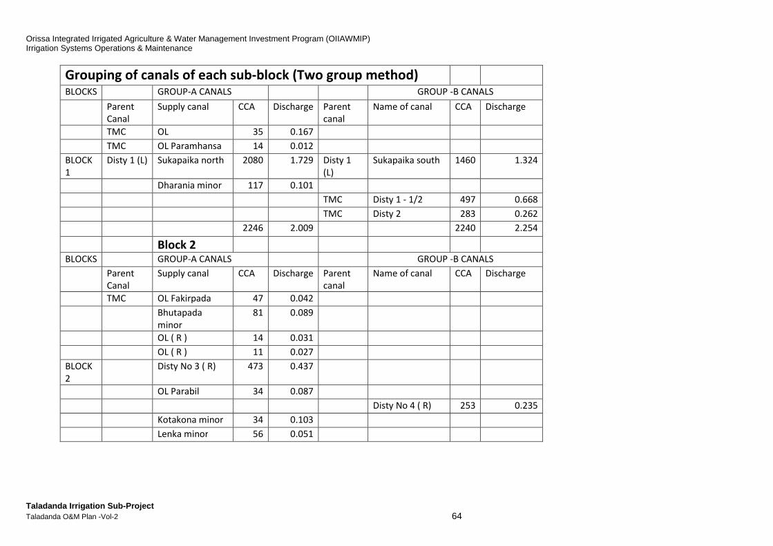
Orissa Integrated Irrigated Agriculture & Water Management Investment Program (OIIAWMIP) Irrigation Systems Operations & Maintenance
Taladanda Irrigation Sub-Project Taladanda O&M Plan -Vol-2 64
Grouping of canals of each sub-block (Two group method)
BLOCKS GROUP-A CANALS GROUP -B CANALS
Parent
Canal
Supply canal CCA Discharge Parent
canal
Name of canal CCA Discharge
TMC OL 35 0.167
TMC OL Paramhansa 14 0.012
BLOCK
1
Disty 1 (L) Sukapaika north 2080 1.729 Disty 1
(L)
Sukapaika south 1460 1.324
Dharania minor 117 0.101
TMC Disty 1 - 1/2 497 0.668
TMC Disty 2 283 0.262
2246 2.009 2240 2.254
Block 2
BLOCKS GROUP-A CANALS GROUP -B CANALS
Parent
Canal
Supply canal CCA Discharge Parent
canal
Name of canal CCA Discharge
TMC OL Fakirpada 47 0.042
Bhutapada
minor
81 0.089
OL ( R ) 14 0.031
OL ( R ) 11 0.027
BLOCK
2
Disty No 3 ( R) 473 0.437
OL Parabil 34 0.087
Disty No 4 ( R) 253 0.235
Kotakona minor 34 0.103
Lenka minor 56 0.051
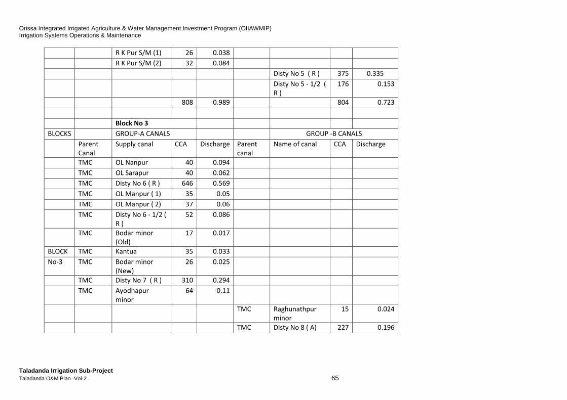
Orissa Integrated Irrigated Agriculture & Water Management Investment Program (OIIAWMIP) Irrigation Systems Operations & Maintenance
Taladanda Irrigation Sub-Project Taladanda O&M Plan -Vol-2 65
R K Pur S/M (1) 26 0.038
R K Pur S/M (2) 32 0.084
Disty No 5 ( R ) 375 0.335
Disty No 5 - 1/2 (
R )
176 0.153
808 0.989 804 0.723
Block No 3
BLOCKS GROUP-A CANALS GROUP -B CANALS
Parent
Canal
Supply canal CCA Discharge Parent
canal
Name of canal CCA Discharge
TMC OL Nanpur 40 0.094
TMC OL Sarapur 40 0.062
TMC Disty No 6 ( R ) 646 0.569
TMC OL Manpur ( 1) 35 0.05
TMC OL Manpur ( 2) 37 0.06
TMC Disty No 6 - 1/2 (
R )
52 0.086
TMC Bodar minor
(Old)
17 0.017
BLOCK TMC Kantua 35 0.033
No-3 TMC Bodar minor
(New)
26 0.025
TMC Disty No 7 ( R ) 310 0.294
TMC Ayodhapur
minor
64 0.11
TMC Raghunathpur
minor
15 0.024
TMC Disty No 8 ( A) 227 0.196

Orissa Integrated Irrigated Agriculture & Water Management Investment Program (OIIAWMIP) Irrigation Systems Operations & Maintenance
Taladanda Irrigation Sub-Project Taladanda O&M Plan -Vol-2 66
TMC Jagannathpur
minor
17 0.023
TMC Athagunthari
minor
29 0.028
TMC Disty No 8 ( R) 875 0.767
TMC Disty No 8- 1/2 103 0.095
TMC OL Odapada 40 0.064
1302 1.4 1306 1.197
Block No- 4
BLOCKS GROUP-A CANALS GROUP -B CANALS
Parent
Canal
Supply canal CCA Discharge Parent
canal
Name of canal CCA Discharge
TMC OL Odapada (R ) 35 0.03
TMC OL Odapada (L ) 35 0.047
BLOCKS TMC Puran minor 15 0.013
No- 4 TMC OL Kulasahi 40 0.044
TMC Disty No 9 ( R ) 591 0.516
TMC OL Patanigoan 35 0.042
TMC OL Barti 28 0.026
TMC Disty No 10 ( R ) 345 0.309
533 0.511 591 0.516
BLOCK NO -5
BLOCKS GROUP-A CANALS GROUP -B CANALS
Parent
Canal
Supply canal CCA
(PP)
Discharge Parent
canal
Name of canal CCA Discharge
TMC Disty No 11 514 0.491 Disty No Disty No 12 (D) 694 0.62
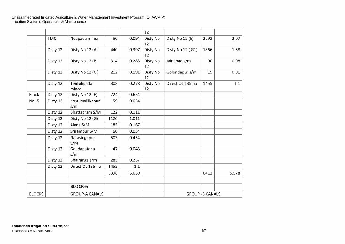
Orissa Integrated Irrigated Agriculture & Water Management Investment Program (OIIAWMIP) Irrigation Systems Operations & Maintenance
Taladanda Irrigation Sub-Project Taladanda O&M Plan -Vol-2 67
12
TMC Nuapada minor 50 0.094 Disty No
12
Disty No 12 (E) 2292 2.07
Disty 12 Disty No 12 (A) 440 0.397 Disty No
12
Disty No 12 ( G1) 1866 1.68
Disty 12 Disty No 12 (B) 314 0.283 Disty No
12
Jainabad s/m 90 0.08
Disty 12 Disty No 12 (C ) 212 0.191 Disty No
12
Gobindapur s/m 15 0.01
Disty 12 Tentulipada
minor
308 0.278 Disty No
12
Direct OL 135 no 1455 1.1
Block Disty 12 Disty No 12( F) 724 0.654
No -5 Disty 12 Kosti mallikapur
s/m
59 0.054
Disty 12 Bhattagram S/M 122 0.111
Disty 12 Disty No 12 (G) 1120 1.011
Disty 12 Alana S/M 185 0.167
Disty 12 Srirampur S/M 60 0.054
Disty 12 Narasinghpur
S/M
503 0.454
Disty 12 Gaudapatana
s/m
47 0.043
Disty 12 Bhairanga s/m 285 0.257
Disty 12 Direct OL 135 no 1455 1.1
6398 5.639 6412 5.578
BLOCK-6
BLOCKS GROUP-A CANALS GROUP -B CANALS
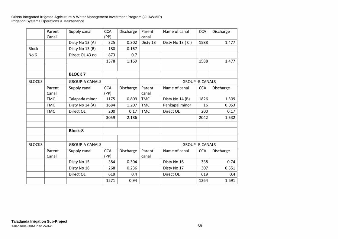
Orissa Integrated Irrigated Agriculture & Water Management Investment Program (OIIAWMIP) Irrigation Systems Operations & Maintenance
Taladanda Irrigation Sub-Project Taladanda O&M Plan -Vol-2 68
Parent
Canal
Supply canal CCA
(PP)
Discharge Parent
canal
Name of canal CCA Discharge
Disty No 13 (A) 325 0.302 Disty 13 Disty No 13 ( C ) 1588 1.477
Block Disty No 13 (B) 180 0.167
No 6 Direct OL 43 no 873 0.7
1378 1.169 1588 1.477
BLOCK 7
BLOCKS GROUP-A CANALS GROUP -B CANALS
Parent
Canal
Supply canal CCA
(PP)
Discharge Parent
canal
Name of canal CCA Discharge
TMC Talapada minor 1175 0.809 TMC Disty No 14 (B) 1826 1.309
TMC Disty No 14 (A) 1684 1.207 TMC Pankapal minor 16 0.053
TMC Direct OL 200 0.17 TMC Direct OL 200 0.17
3059 2.186 2042 1.532
Block-8
BLOCKS GROUP-A CANALS GROUP -B CANALS
Parent
Canal
Supply canal CCA
(PP)
Discharge Parent
canal
Name of canal CCA Discharge
Disty No 15 384 0.304 Disty No 16 338 0.74
Disty No 18 268 0.236 Disty No 17 307 0.551
Direct OL 619 0.4 Direct OL 619 0.4
1271 0.94 1264 1.691
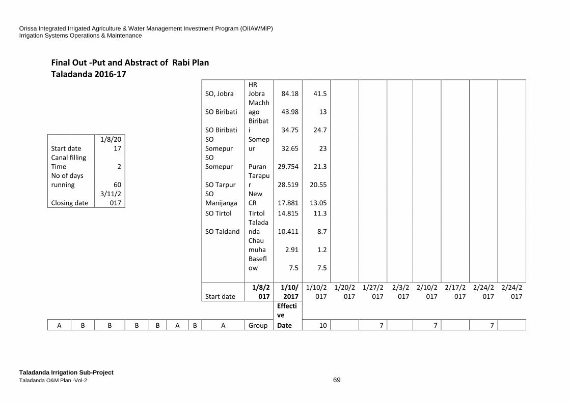
Orissa Integrated Irrigated Agriculture & Water Management Investment Program (OIIAWMIP) Irrigation Systems Operations & Maintenance
Taladanda Irrigation Sub-Project Taladanda O&M Plan -Vol-2 69
Final Out -Put and Abstract of Rabi Plan
Taladanda 2016-17
SO, Jobra
HR
Jobra 84.18 41.5
SO Biribati
Machh
ago 43.98 13
SO Biribati
Biribat
i 34.75 24.7
Start date
1/8/20
17
SO
Somepur
Somep
ur 32.65 23
Canal filling
Time 2
SO
Somepur Puran 29.754 21.3
No of days
running 60
SO Tarpur
Tarapu
r 28.519 20.55
Closing date
3/11/2
017
SO
Manijanga
New
CR 17.881 13.05
SO Tirtol Tirtol 14.815 11.3
SO Taldand
Talada
nda 10.411 8.7
Chau
muha 2.91 1.2
Basefl
ow 7.5 7.5
Start date
1/8/2
017
1/10/
2017
1/10/2
017
1/20/2
017
1/27/2
017
2/3/2
017
2/10/2
017
2/17/2
017
2/24/2
017
2/24/2
017
Effecti
ve
A B B B B A B A Group Date 10 7 7 7

Orissa Integrated Irrigated Agriculture & Water Management Investment Program (OIIAWMIP) Irrigation Systems Operations & Maintenance
Taladanda Irrigation Sub-Project Taladanda O&M Plan -Vol-2 70
1
B A A A A B A B
Group
2 2 10 7 7 7
Bloc
k-8
Bloc
k-7 Block-6
Block
-5
Blo
ck-
4
Bloc
k-3
Bl
o
c
k-
2 Block-1 Block
Filing
time Presowing Maturing
Flower
ing
Machu
rity
2.91 4.4 3.07
10.6
3
1.2
4 2.9
2.
1 5.45
Design
Q
1.2 2.6 1.75 7.5
0.7
5 1.7
1.
3 3.8
Requir
d Q
13
Machh
agaon
Orissa Integrated Irrigated Agriculture & Water Management Investment Program (OIIAWMIP) Irrigation Systems Operations & Maintenance
Taladanda Irrigation Sub-Project Taladanda O&M Plan -Vol-2 71
H. MAINTENANCE PROCEDURES
1. Annual O&M Calendars - Work-Plans and Schedules Much of the success for effective, efficient and reliable service provision for delivery of water to users is due to proper inspection, planning, scheduling and programming of Operations and Maintentnace activities and their implementation Management (sometimes called the OMM function). These plans and schedules are management tools and typically laid out in Calendars or time chart formats. Such tools are necessary to provide the system managers and user community (PPs) with a guide for implementation of necessary work activities on a time frame to meet the agronomic needs to success in efficient water use and optimization of economic returns Figure H-1 below illustrates a detailed Annual O&M Calendar–Workplan and Schedule with components activities, time frames and assigned operational responsibilities for implementation.

Orissa Integrated Irrigated Agriculture & Water Management Investment Program (OIIAWMIP) Irrigation Systems Operations & Maintenance
Taladanda Irrigation Sub-Project Taladanda O&M Plan -Vol-2 72
Figure H-1:Annual O&M Calendar Workplan and Activit ies Schedule - Taladanda
(page 1 of 2 )
(page 2 of 2)
ID Task Name Duration Start Finish Predecessors
1 Activities 366 days? Fri 01-05-15 Sat 30-04-162 Establishing the Water Distribution Plan for Kharif 46 days Fri 01-05-15 Mon 15-06-153 Calculate how much water is available 2 days Fri 01-05-15 Sat 02-05-15
4 Consider meteorological forecasts 3 days Fri 01-05-15 Sun 03-05-15
5 Analyze the historical monsoon inflow data 4 days Fri 01-05-15 Mon 04-05-15
6 Prepare a draft water distribution plan 11 days Tue 05-05-15 Fri 15-05-15 3,4,5
7 Convene the Executive Committee meeting of the Apex Committee 1 day Sat 16-05-15 Sat 16-05-15 6
8 Discuss the proposed draft water distribution plan 0.5 days Sat 16-05-15 Sat 16-05-15
9 Accommodate changes, if any 0.5 days Sat 16-05-15 Sat 16-05-15 8
10 Approve the draft water distribution plan 0 days Sat 16-05-15 Sat 16-05-15 9
11 Circulate the draft water distribution plan to PPs, AE, JE and all other stakeholders 1 day Sun 17-05-15 Sun 17-05-15 10
12 Start raising early nurseries 29 days Mon 18-05-15 Mon 15-06-15 11
13 Hold PP meetings and collect PP inputs 10 days Mon 18-05-15 Wed 27-05-15 11
14 Finalise the Water Distribution Plan 4 days Thu 28-05-15 Sun 31-05-15 13
15 Convene the Apex Committee meeting 1 day Mon 01-06-15 Mon 01-06-15 14
16 Discuss the proposed Final Water Distribution Plan 0.5 days Mon 01-06-15 Mon 01-06-15
17 Accommodate changes, if any 0.5 days Mon 01-06-15 Mon 01-06-15 16
18 Approve the Final Water Distribution Plan 0 days Mon 01-06-15 Mon 01-06-15 17
19 Submit the Final Water Distribution Plan for formal approval by Baripada Irrigation Circle 3 days Tue 02-06-15 Thu 04-06-15 18
20 Return the Approved Water Distribution Plan to Deputy SIO Manager for circulation 3 days Fri 05-06-15 Sun 07-06-15 19
21 Circulate Approved Water Distribution Plan to AEs, JEs, PPs, O&M cell, PPSU, SIO Manager and SE 7 days Mon 08-06-15 Sun 14-06-15 20
22 Ensure all staff and PPs are ready for canal operation 1 day Mon 15-06-15 Mon 15-06-15 21
23 Pre-Kharif Maintenance Period 46 days? Fri 01-05-15 Mon 15-06-1524 Main system maintenance (by MoWR) 1 day? Fri 01-05-15 Fri 01-05-15
25 Minor system maintenance (by PPs) 46 days Fri 01-05-15 Mon 15-06-15
26 Participatory Walk-Through from head regulator to tail end 5 days Fri 01-05-15 Tue 05-05-15
27 Identify all the critical reaches 2 days Mon 04-05-15 Tue 05-05-15 26FF
28 Prioritize works, depending on severity, risk and available funds 2 days Wed 06-05-15 Thu 07-05-15 27
29 Cost Estimation of prioritised works 5 days Fri 08-05-15 Tue 12-05-15 28
30 Technical sanction of prioritised works (OPWD Code of Practice) 3 days Wed 13-05-15 Fri 15-05-15 29
31 Administrative approval of prioritised works 3 days Sat 16-05-15 Mon 18-05-15 30
32 Implementation of works 46 days Fri 01-05-15 Mon 15-06-15
33 Execute scheduled and prioritised works by PP 46 days Fri 01-05-15 Mon 15-06-15
34 Maintain accounts and records of PP works 46 days Fri 01-05-15 Mon 15-06-15
35 Select agency for execution of the prioritised works 3 days Tue 19-05-15 Thu 21-05-15 31
36 Issue work order to executing agency 2 days Fri 22-05-15 Sat 23-05-15 35
37 Sign, record and publicise work orders 2 days Fri 22-05-15 Sat 23-05-15 36SS
38 Work execution 18 days Sun 24-05-15 Wed 10-06-15 37
39 Works monitoring and reporting 18 days Sun 24-05-15 Wed 10-06-15 38SS
40 Preparation of bills 3 days Mon 08-06-15 Wed 10-06-15 39FF
41 Approval for payment 3 days Thu 11-06-15 Sat 13-06-15 40
42 Payment for works 2 days Sun 14-06-15 Mon 15-06-15 41
43 Kharif Season 138 days Tue 16-06-15 Sat 31-10-15 2244 Preparation of Maintenance Completion Report 15 days Tue 16-06-15 Tue 30-06-15 42FF
45 Implement the Approved Water Distribution Plan for Kharif 138 days Tue 16-06-15 Sat 31-10-15
DtySIO,JE,AE
DtySIO,JE,AE
DtySIO,JE,AE
DtySIO,JE,AE
AEC,DtySIO,AE,JE
AEC,DtySIO,AE,JE
DtySIO,AE,JE
16-05
DtySIO
PPM
DtySIO,AE,JE,PP
DtySIO,AE,JE
DtySIO,AE,JE,AC
AC,DtySIO,AE,JE
DtySIO,AE,JE
01-06
DtySIO,SIO,SE,BIC
SE,BIC,SIO
DtySIO
AE,JE
PPP,DtySIO,CL,CM,AE,JE,SO
DtySIO,AE,JE,PPEC,PPNVM
PPEC
DtySIO,AE,JE
DtySIO,SIO
DtySIO,AE,JE,PPEC,PPNVM
PP,DtySIO,JE,AE
PPS,AE,DtySIO,JE
PPEC,DtySIO,AE,JE
DtySIO,AE,JE,PPP
DtySIO,AE,JE,PPS
WEA
PPWS,AE,JE,DtySIO
DtySIO,AE,JE
PPP,PPWS
PPT,PPS,PPP
AE,DtySIO,JE,SIO
16 17 18 19 20 21 22 23 24 25 26 27 28 29 30 31 32 33 34 35 36 37 38 39 40 41 42 43 44 45 46 47 48 49 50 51 52 1 2 3 4 5 6 7 8 9 10 11 12 13 14 15 16May June July August September October November December January February March April
Quarter 1 Quarter 2 Quarter 3 Quarter 4 Quarter 5

Orissa Integrated Irrigated Agriculture & Water Management Investment Program (OIIAWMIP) Irrigation Systems Operations & Maintenance
Taladanda Irrigation Sub-Project Taladanda O&M Plan -Vol-2 73
ID Task Name Duration Start Finish Predecessors
46 Establishing the Water Distribution Plan for Rabi 45 days Sun 01-11-15 Tue 15-12-1547 Evaluate the Approved Water Distribution Plan for Kharif (and previous Rabi season) 4 days Sun 01-11-15 Wed 04-11-15 45
48 Calculate how much water is available 2 days Sun 01-11-15 Mon 02-11-15 47SS
49 Consider meteorological forecasts 3 days Sun 01-11-15 Tue 03-11-15 47SS
50 Analyze the historical inflow data 4 days Sun 01-11-15 Wed 04-11-15 47SS
51 Prepare a draft water distribution plan 11 days Thu 05-11-15 Sun 15-11-15 47,48,49,50
52 Convene the Executive Committee meeting of the Apex Committee 1 day Mon 16-11-15 Mon 16-11-15 51
53 Discuss the proposed draft water distribution plan 0.5 days Mon 16-11-15 Mon 16-11-15
54 Accommodate changes, if any 0.5 days Mon 16-11-15 Mon 16-11-15 53
55 Approve the draft water distribution plan 0 days Mon 16-11-15 Mon 16-11-15 54
56 Circulate the draft water distribution plan to PPs, AE, JE and all other stakeholders 1 day Tue 17-11-15 Tue 17-11-15 55
57 Start raising early nurseries 28 days Wed 18-11-15 Tue 15-12-15 56
58 Hold PP meetings and collect PP inputs 10 days Wed 18-11-15 Fri 27-11-15 56
59 Finalise the Water Distribution Plan 4 days Sat 28-11-15 Tue 01-12-15 58
60 Convene the Apex Committee meeting 1 day W ed 02-12-15 W ed 02-12-15 59
61 Discuss the proposed Final Water Distribution Plan 0.5 days Wed 02-12-15 Wed 02-12-15
62 Accommodate changes, if any 0.5 days Wed 02-12-15 Wed 02-12-15 61
63 Approve the Final Water Distribution Plan 0 days Wed 02-12-15 Wed 02-12-15 62
64 Submit the Final Water Distribution Plan for formal approval by Baripada Irrigation Circle 3 days Thu 03-12-15 Sat 05-12-15 63
65 Return the Approved Water Distribution Plan to Deputy SIO Manager for circulation 3 days Sun 06-12-15 Tue 08-12-15 64
66 Circulate Approved Water Distribution Plan to AEs, JEs, PPs, O&M cell, PPSU, SIO Manager and SE 6 days Wed 09-12-15 Mon 14-12-15 65
67 Ensure all staff and PPs are ready for canal operation 1 day Tue 15-12-15 Tue 15-12-15 66
68 Early Hydraulic Performance Inspection 5 days Tue 27-10-15 Sat 31-10-15
69 Testing of structures on main canal / distributaries 5 days Tue 27-10-15 Sat 31-10-15 43FF
70 Pre-Rabi Maintenance Period 45 days Sun 01-11-15 Tue 15-12-154371 Participatory Walk-Through 5 days Sun 01-11-15 Thu 05-11-15
72 Prioritization and estimation of works 15 days Fri 06-11-15 Fri 20-11-15 71,47
73 Implementation of works 45 days Sun 01-11-15 Tue 15-12-15
74 Rabi Season 131 days Wed 16-12-15 Sun 24-04-166775 Preparation of Maintenance Completion Report 15 days Wed 16-12-15 Wed 30-12-15
76 Implement the Approved Water Distribution Plan for Rabi 131 days Wed 16-12-15 Sun 24-04-16
77 Evaluate the Approved Water Distribution Plan for Rabi (and previous Kharif season) 5 days Mon 25-04-16 Fri 29-04-16 76,47
78 Emergency maintenance (as and when required) 366 days Fri 01-05-15 Sat 30-04-16
79 Reporting Deliverables 366 days Fri 01-05-15 Sat 30-04-1680 Approved Water Distribution Plan for Kharif 0 days Mon 15-06-15 Mon 15-06-15 22
81 Pre-Kharif Maintenance Completion Report 0 days Tue 30-06-15 Tue 30-06-15 44
82 Approved Water Distribution Plan for Rabi 0 days Tue 15-12-15 Tue 15-12-15 67
83 Pre-Rabi Maintenance Completion Report 0 days Wed 30-12-15 Wed 30-12-15 75
84 Periodic Management Reports - MIS based (weekly, monthly , quarterly) 366 days Fri 01-05-15 Sat 30-04-16
DtySIO,AE,JE
DtySIO,JE,AE
DtySIO,JE,AE
DtySIO,JE,AE
DtySIO,JE,AE
AEC,DtySIO,AE,JE
AEC,DtySIO,AE,JE
DtySIO,AE,JE
16-11
DtySIO
PPM
DtySIO,AE,JE,PP
DtySIO,AE,JE
DtySIO,AE,JE,AC
AC,DtySIO,AE,JE
DtySIO,AE,JE
02-12
DtySIO,SIO,SE,BIC
SE,BIC,SIO
DtySIO
AE,JE
15-12
30-12
43 44 45 46 47 48 49 50 51 52 1 2 3 4 5 6 7 8 9 10 11 12 13 14 15 16 17 18 19 20 21 22 23 24 25 26November December January February March April May June
Quarter 4 Quarter 5

Orissa Integrated Irrigated Agriculture & Water Management Investment Program (OIIAWMIP) Irrigation Systems Operations & Maintenance
Taladanda Irrigation Sub-Project Taladanda O&M Plan -Vol-2 74
2. Definition and objective of essential structures maintenance
In Taladanda medium irrigation sub project, there are more than 2600 structures, and all structures are not eqully important for the SIO Manager, from the water management point of view. The structures important from the water management point of view are categoriezed as essential structures. These essential structuresare where flow control and flow measurement are done simultaneously (2 in 1 function structures) The objective of this categorization of structures and hydraulic survey of structures is to identify maintenance needs of this, 1st category of structures, to keep it in tip top condition.
Figure H-2 : Hydraulic Survey of Essential Structur es - Form
Survey during canal operation: (Kharif- June, July, August, September) 1. Name of the Project: Taladanda Irrigation sub project 2. Date of Survey:__________________________ 3. Name of the AE/JE:_______________________ 5. Type of structure: _______________________ 6. Name of the canal: ______________________ 7. Parent canal: ___________________off-take RD ________________ 8. Name of the PP: ________________________ 9. Is it a gated structure? YES (___), NO (___) 10. Is there any visible damage or leakage? YES (___), NO (___) 11. Is there any difficulty in operation? YES (___), NO (___) 12. Completely close the gate and observe- 13. If it can be completely seated? YES (___), NO (___) 14. View the amount of leakage-NIL (___), LOW (___), MED (___), HIGH (___) 15. Have you decided where to fix the staff gauge and benchmark?
A) U/S YES (____), NO (____) B) D/S - YES (____), NO (____) C) Benchmark YES (____), NO (____) (required to measure water level during calibration for developing discharge rating curve) D) Describe BM details, If C)=yes,,
(i)Location of benchmar (ii)describe BM-nail or set-pin in structure or adjacent tree (iii) sketch location plan with guiding measurements/off-sets distances (hand drawn rough sketch).
Orissa Integrated Irrigated Agriculture & Water Management Investment Program (OIIAWMIP) Irrigation Systems Operations & Maintenance
Taladanda Irrigation Sub-Project Taladanda O&M Plan -Vol-2 75
I. FUNCTIONS AND RESPONSIBILITIES
The functions and responsibilities of DoWR officers for O&M are as follows:
(i) Superintending Engineer (SE):
• Ensure O & M is carried out as per Manual & on due dates. • Initiate revision/updating of Manual as and when necessary on account of more
information, changes in water availability & improvement in performance. • Monitor periodic and specialised training of field workers & farmers. • Organise coordination among Agriculture Research / Extension, Irrigation, Financial
Institutions and Meteorological Department. • Inspect the project at least once during irrigation season, suggest improvements and
order essential repairs. • Approve the O & M Plan prepared by the EE in consultation with PPs. • Issue permission to relocate or redesign of outlets. • Scrutinise land register and see if there is any unauthorised lease, encroachment or
transfer and take appropriate action. • Scrutinise whether asset registers have been updated in timely manner. • Visit and meet with PP representatives. • Verify water budgeting for the incoming crop year and take due action.
(ii) Executive Engineer(EE):
• Preparation of O & M Plans and finalisation of operation plan in consultation with PPs and Project Committee & Agricultural Officer.
• Get the approval of SE. • Implement O & M Plan. • Prepare annual/seasonal irrigation performance report and submit to SE indicating
areas of improvement. • Inspect the subproject including dam, spillway, other head works and main canal
system pre-monsoon and post-monsoon. • Scrutinise gauges, order corrections, ensure timely delivery of correct quantity of
water to the PPs • Guide and instruct AEE/DEE, AE/JEs on maintenance, repairs, recording gauges,
accounting water and adherence to schedules and operation plans in closing & opening canals.
• Visit PPs and provide guidance on irrigation management. • Organise testing of canals periodically to check capacities and transit losses. • Check & sanction maintenance and repair estimate. • Inspect maintenance and repair works and guide field staff.
(iii) Sub-Divisional Officer (AEE/DEE)
• Implement O & M Plan. • Prepare detail schedule for running canals ‘On’ &’Off’ as per plan. • Organise release of water to PPs. • Discuss the operation plan with the PPs and Project Committee and get their views. • Organise reading, recording, reporting the gauges regularly through the AE/JEs & the
Operators. • Maintain gauge register and compute discharges through main canals, distributaries
& minors to account for water delivered to PPs daily, rotation wise and season wise.
Orissa Integrated Irrigated Agriculture & Water Management Investment Program (OIIAWMIP) Irrigation Systems Operations & Maintenance
Taladanda Irrigation Sub-Project Taladanda O&M Plan -Vol-2 76
• Compare the gauges/flows received from the AEs/JEs/Operators and ensure that the flows are as per schedule plan. Order corrections if necessary.
• Record rainfall in the command (and catchment) and discuss water deliveries with PPs.
• Compute irrigation efficiency of each channel, transit losses etc. • Initiate annual/seasonal irrigation report and submit to EE. • Collect information on area irrigated, crops and crop areas, productivity and production
from PPs/Agriculture Officer. Visit PPs and Project Committee and provide guidance on irrigation management.
• Jointly prepare the classification and certification of work and culturable command area with the PPs.
• Maintain outlet register and indicate changes in location and size. • Conduct Walk through Survey of Head Works and Main Canals to identify repairs and
prepare estimates for repairs to submit it to the EE. • Maintain spillway, hoist gates, gantry, head regulator of canals and ensure gates are
working properly and smoothly. • Prepare and maintain Asset Register and update it in every six months. • Check all estimates furnished by the AEsJEs and submit the correct estimates to EE
for timely sanction. • Visit PPs and provide guidelines on irrigation management, business procedures and
financial management.
(iv) Section Officer (AE/JE):
• Release water to the PPs as per Operation Plan through the Operators and Khalasies. • Collect gauges from the Operators/khalasies, examine and enter them in the register.
Compute discharge and volume of flows daily, rotation wise, season wise. • Inspect canal gauges and order corrections, if necessary. • Maintain water account, quantity supplied to each PP & transmission losses rotation
wise and season wise. • Compute irrigation & conveyance efficiency of each channel within jurisdiction. • Collect information on crops, crop areas, sowing and harvesting times, productivity and
production from PPs/ Agriculture Officer (AAO). • Organise routine maintenance as per schedule. • Organise repairs of canals during flow periods, If necessary. • Organise other repairs as per schedule. • Walk through the PPs in preparing maintenance and repair estimate. • Maintain Land register and Tree register within the reach. (v) Operator:
• Operates the gates in spillway, head of main canals, CR gates, HR gates in distributaries and minors within his jurisdiction & as per instruction of his AE/JE.
• Watches the entire canal area within his jurisdiction to see whether it gets canal water or not.
• Will inform to AE/JE for immediate repair or of less water in the Tail end. In case of any canal breach, he immediately reports to theAE/JE.
• Directs Khalasi for minor repairs and closure and opening of outlets as per their needs. • Operates the gates during irrigation period as per instruction of the Assistant
Engineer/Junior Engineer with the help of Khalasi. • Records the flow measurement, rainfall data and submits to the AE/JE.
Orissa Integrated Irrigated Agriculture & Water Management Investment Program (OIIAWMIP) Irrigation Systems Operations & Maintenance
Taladanda Irrigation Sub-Project Taladanda O&M Plan -Vol-2 77
J. ACTION PLAN FOR EMERGENCIES
Emergency situations usually crop up during operation of any system, when very quick and sensible actions are required by the O&M staff to dry up a part of the canal system without affecting the rest of whole system and taking quick action to restore the supply of water.
An essential part of the operation procedures is, therefore, to be prepared for emergency situations. Plans shall be prepared for action in such emergencies and to ensure that subproject operations staff and the Pani Panchayat leaders are aware of the plans. The availability of emergency plans will provide the field staff with the framework within which to take action to mitigate the emergency situation while also taking steps to disseminate information about the emergency.
Emergencies may arise for a number of reasons, natural or man-made. Emergency conditions may include cyclones, dam, flood embankment or canal breach. Consideration should be given to closing the canal system in advance of a forecast cyclone or exceptional rainfall. Therefore the most likely operational emergency is a flood embankment or canal breach or structural failure.
For example, in case of a breach of canal embankment, sudden failure of a structure or an accident in the canal warranting forced closure, the following actions may be taken:
• Close the cross regulator, if any, head regulator on upstream side of the affected part and open nearest upstream escape to divert water.
• Instruct the operator of the head regulator of the main canal (by cell phone) to either reduce discharge from the reservoir to the extent that may be diverted in distributaries / minors upstream of the breach and/or to close the head regulator.
• Inform the JE/SO, AE/SDO & Pani Panchayat (nearest Police Station in case of accident) by cell phone about the situation.
• JE/SO & AE/SDO to prepare a report stating location of accident, extent of damage, probable cause, action taken to reduce or stop flow through main canal, probable time when repair can be started or rescue operation started as the case may be, need for labour-material-machine, expected time to restore supply, etc, and send the report to the EE.
A basic emergency plan should be in place so that people know who to contact and what action to carry out. The system emergency plan should include:
• Contact details of project staff (telephone number, if available, and address) • Contact procedures both during and outside the working day • Instructions for action in the event of a problem at the dam (the dam emergency plan
should be prepared by a dams specialist) • Instructions for immediate action in event of a canal breach • Measures to be taken to avoid further damage • Actions to mitigate the effects

Orissa Integrated Irrigated Agriculture & Water Management Investment Program (OIIAWMIP) Irrigation Systems Operations & Maintenance
Taladanda Irrigation Sub-Project Taladanda O&M Plan -Vol-2 78
K. ASSET MANAGEMENT SYSTEM
Anirrigation infrastructure or Assets Management information system is essential for implementation of O&M plans. Such a database reliant information system, in which pertinent data are measured and processed and analyzed, allows management to make informed decisions- quantify evaluate impact of the operational decisions, assess and gradually improveO&M performance. The information system should/would be computer based, with internet (web-based) access for dissemination and communications. The envisaged MIS to be supported by the OIIAWMIP is tabulated below.
Table K-1: Operation & Maintenance Management Infor mation System
Purpose General Description Configuration / Architecture MIS for Improved Main System Operation The system will: (i) Provide system operators with improved information for planning and undertaking operation. (ii) Provide system operators with scheme performance indicators (such as area and production value per unit of water). (iii) Provide the PPs with better information on how much water is being distributed and where during the irrigation season.
Data made available: (i) Rainfall within command area and reservoir water level (ii) Releases at headworks and discharges at the major control points throughout the schemes. (iii) Ponded depths / water table depths at selected high & low points in the command area. (iv) Basic data pertaining to crops & crop calendar. Also agricultural production and area irrigated by season. (v) Provides some decision support linking improved planning of water service delivery to irrigated agricultural plans.
Each irrigation scheme would have its own section of the DoWR web-site (identified by scheme name) with controlled accessibility. The data would be uploaded daily to the system by the DoWR division and / or sub-divisions responsible for the scheme. (Note: Divisions & subdivision will be provided with internet connectivity under the OIIAWMIP) Each scheme’s page would be constructed with a set of parameters unique to that scheme and these could also (in the longer-term) be tied in with a GIS system to provide some geographical context to the information that is posted.
MIS for Improved Main System Maintenance The system will: (i) Provide system operators with improved information for planning and undertaking maintenance. (ii) Provide stakeholders with clear information on what funds are being invested in maintenance of the system and what work was carried out.
Data made available: (i) Infrastructure asset inventories grouped by head-works and canal system. (ii) Infrastructure condition: canals and structures (iii) Maintenance activities carried out & costs, grouped by category (Routine, Periodic, Emergency and Preventative / Special). (iv) Maintenance needs and associated costs.
Initially data entry will be by concerned division / sub-division staff using database designed for future migration to DoWR web-site for wider access.
MIS for Improved Minor Systems O&M The system will: (i) Provide system operators / PIM-CAD Directorate with improved information on how minor canal systems are being operated (eg adoption of irrigation schedules) and maintenance work carried out by PPs.
Data made available: (i) Infrastructure asset inventories grouped by PP / minor canal system (ii) Infrastructure condition: canals and structures (iii) Maintenance activities carried out & costs, grouped by category (Routine, Periodic, Emergency & Preventative / Special). (iv) Maintenance needs and associated costs.
Could be a future development of the relevant part of the program-specific MIS.
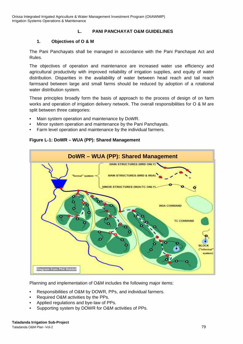
Orissa Integrated Irrigated Agriculture & Water Management Investment Program (OIIAWMIP) Irrigation Systems Operations & Maintenance
Taladanda Irrigation Sub-Project Taladanda O&M Plan -Vol-2 79
L. PANI PANCHAYAT O&M GUIDELINES
1. Objectives of O & M
The Pani Panchayats shall be managed in accordance with the Pani Panchayat Act and Rules.
The objectives of operation and maintenance are increased water use efficiency and agricultural productivity with improved reliability of irrigation supplies, and equity of water distribution. Disparities in the availability of water between head reach and tail reach farmsand between large arid small farms should be reduced by adoption of a rotational water distribution system.
These principles broadly form the basis of approach to the process of design of on farm works and operation of irrigation delivery network. The overall responsibilities for O & M are split between three categories:
• Main system operation and maintenance by DoWR. • Minor system operation and maintenance by the Pani Panchayats. • Farm level operation and maintenance by the individual farmers. Figure L-1: DoWR – WUA (PP): Shared Management
Planning and implementation of O&M includes the following major items:
• Responsibilities of O&M by DOWR, PPs, and individual farmers. • Required O&M activities by the PPs. • Applied regulations and bye-law of PPs. • Supporting system by DOWR for O&M activities of PPs.
Diagram from Phil Riddell PhilRiddell
DoWR – WUA (PP): Shared Management
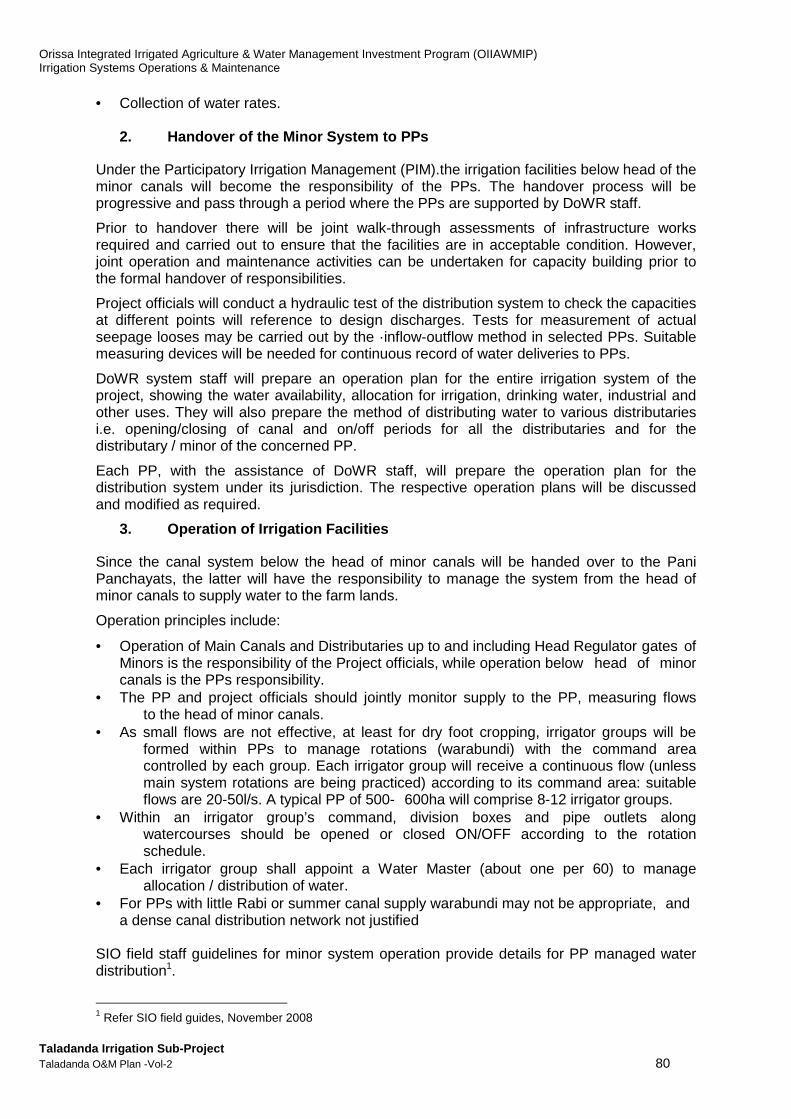
Orissa Integrated Irrigated Agriculture & Water Management Investment Program (OIIAWMIP) Irrigation Systems Operations & Maintenance
Taladanda Irrigation Sub-Project Taladanda O&M Plan -Vol-2 80
• Collection of water rates. 2. Handover of the Minor System to PPs
Under the Participatory Irrigation Management (PIM).the irrigation facilities below head of the minor canals will become the responsibility of the PPs. The handover process will be progressive and pass through a period where the PPs are supported by DoWR staff.
Prior to handover there will be joint walk-through assessments of infrastructure works required and carried out to ensure that the facilities are in acceptable condition. However, joint operation and maintenance activities can be undertaken for capacity building prior to the formal handover of responsibilities.
Project officials will conduct a hydraulic test of the distribution system to check the capacities at different points will reference to design discharges. Tests for measurement of actual seepage looses may be carried out by the ·inflow-outflow method in selected PPs. Suitable measuring devices will be needed for continuous record of water deliveries to PPs.
DoWR system staff will prepare an operation plan for the entire irrigation system of the project, showing the water availability, allocation for irrigation, drinking water, industrial and other uses. They will also prepare the method of distributing water to various distributaries i.e. opening/closing of canal and on/off periods for all the distributaries and for the distributary / minor of the concerned PP.
Each PP, with the assistance of DoWR staff, will prepare the operation plan for the distribution system under its jurisdiction. The respective operation plans will be discussed and modified as required.
3. Operation of Irrigation Facilities
Since the canal system below the head of minor canals will be handed over to the Pani Panchayats, the latter will have the responsibility to manage the system from the head of minor canals to supply water to the farm lands.
Operation principles include:
• Operation of Main Canals and Distributaries up to and including Head Regulator gates of Minors is the responsibility of the Project officials, while operation below head of minor canals is the PPs responsibility.
• The PP and project officials should jointly monitor supply to the PP, measuring flows to the head of minor canals.
• As small flows are not effective, at least for dry foot cropping, irrigator groups will be formed within PPs to manage rotations (warabundi) with the command area controlled by each group. Each irrigator group will receive a continuous flow (unless main system rotations are being practiced) according to its command area: suitable flows are 20-50l/s. A typical PP of 500- 600ha will comprise 8-12 irrigator groups.
• Within an irrigator group’s command, division boxes and pipe outlets along watercourses should be opened or closed ON/OFF according to the rotation schedule.
• Each irrigator group shall appoint a Water Master (about one per 60) to manage allocation / distribution of water.
• For PPs with little Rabi or summer canal supply warabundi may not be appropriate, and a dense canal distribution network not justified
SIO field staff guidelines for minor system operation provide details for PP managed water distribution1.
1 Refer SIO field guides, November 2008

Orissa Integrated Irrigated Agriculture & Water Management Investment Program (OIIAWMIP) Irrigation Systems Operations & Maintenance
Taladanda Irrigation Sub-Project Taladanda O&M Plan -Vol-2 81
4. Maintenance of Irrigation Facilities
a. Maintenance Categories
Proper maintenance of the entire irrigation system as well as appropriate operation is indispensable for ensuring that the scheme functions properly and is sustainable. The maintenance works are broadly divided into the following categories.
(i) Routine maintenance : minor works carried out by water masters and farmers each year and when required, including localized sediment removal from structures, localized embankment repairs including illegal cuts, addressing localised damage by grazing animals, removal of encroachments into canal right of way, gate greasing and painting.
(ii) Periodic maintenance: more major works carried out every 2-5 years by PP mobilizing both labour and its own resources as well as using grant in aid. Works include re-sectioning of canal prism and embankment strengthening; gate and gauge repair / replacement; structures repair / replacement; removal of weed and vegetation; improvements to buildings and roads; etc.
(iii) Preventative and Special maintenance: includes works that improve infrastructure and / or address particular problems faced by PPs, either for irrigation, drainage or communications. Examples include additional flow measurement structures, extensions to canals / drains, lining; and a new bridge.
(iv) Emergency works: any (temporary) measures to address damage resulting from excessive loading conditions, including over-topping and/or collapse of an embankment.
5. Maintenance Process, Strategy and Plan
Under the Project each PP should prepare a maintenance strategy, detailing the maintenance process, maintenance categories, priorities, implementation arrangements, costs and funding arrangements. SIO field staff guidelines for minor system maintenance provide details for PP managed maintenance1. While the strategy document need only be prepared once (and periodically updated), maintenance plans need to be prepared each year to plan and budget maintenance works.
Key to successful maintenance is the asset register of PP managed infrastructure and appreciation of maintenance requirements and costs.
6. Performance Monitoring
The PP should monitor together with DoWR officials the gauges at the head of minors / distributaries to ensure that the authorized discharge is flowing through the channels.
At the end of the season, irrigation performance should be evaluated based on the following parameters:
• Quantity of water planned to be delivered to PP & actually delivered • Area planned to be irrigated vis-a-vis actually irrigated • Yields of crops planned vis-a-vis actual • Production of principal crops planned vis-a-vis actual • Total number of disputes in sharing water • Total number of irrigation offences • Water fees assessed and actually recovered
1 Refer SIO field guides, November 2008
Orissa Integrated Irrigated Agriculture & Water Management Investment Program (OIIAWMIP) Irrigation Systems Operations & Maintenance
Taladanda Irrigation Sub-Project Taladanda O&M Plan -Vol-2 82
ANNEX M
Water Distribution Scheduling Tool (software provided separately in Sept 2014)
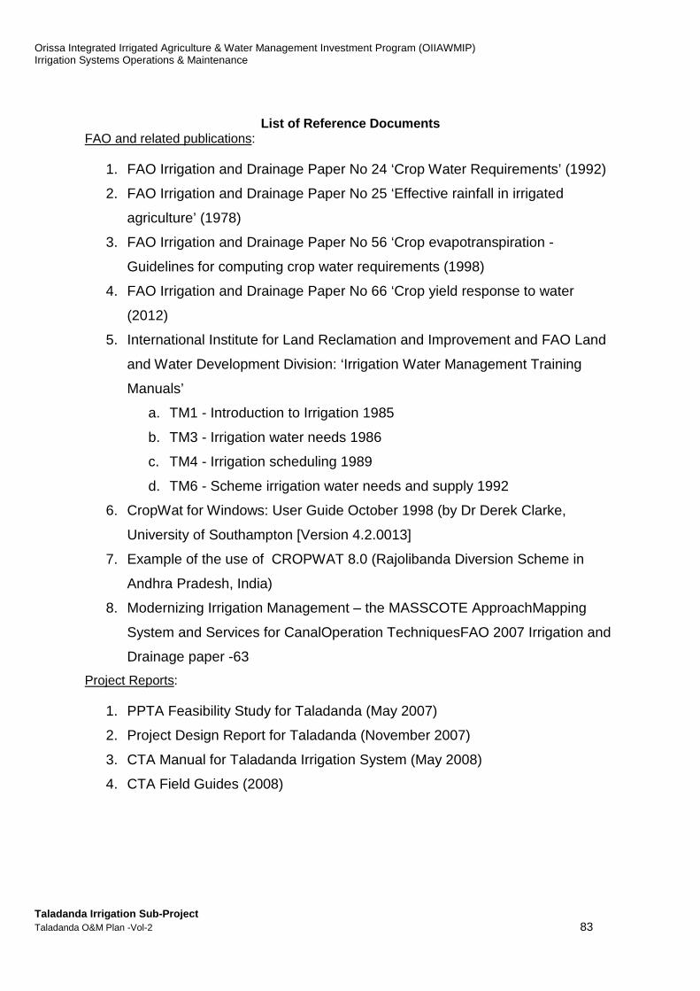
Orissa Integrated Irrigated Agriculture & Water Management Investment Program (OIIAWMIP) Irrigation Systems Operations & Maintenance
Taladanda Irrigation Sub-Project Taladanda O&M Plan -Vol-2 83
List of Reference Documents
FAO and related publications:
1. FAO Irrigation and Drainage Paper No 24 ‘Crop Water Requirements’ (1992)
2. FAO Irrigation and Drainage Paper No 25 ‘Effective rainfall in irrigated
agriculture’ (1978)
3. FAO Irrigation and Drainage Paper No 56 ‘Crop evapotranspiration -
Guidelines for computing crop water requirements (1998)
4. FAO Irrigation and Drainage Paper No 66 ‘Crop yield response to water
(2012)
5. International Institute for Land Reclamation and Improvement and FAO Land
and Water Development Division: ‘Irrigation Water Management Training
Manuals’
a. TM1 - Introduction to Irrigation 1985
b. TM3 - Irrigation water needs 1986
c. TM4 - Irrigation scheduling 1989
d. TM6 - Scheme irrigation water needs and supply 1992
6. CropWat for Windows: User Guide October 1998 (by Dr Derek Clarke,
University of Southampton [Version 4.2.0013]
7. Example of the use of CROPWAT 8.0 (Rajolibanda Diversion Scheme in
Andhra Pradesh, India)
8. Modernizing Irrigation Management – the MASSCOTE ApproachMapping
System and Services for CanalOperation TechniquesFAO 2007 Irrigation and
Drainage paper -63
Project Reports:
1. PPTA Feasibility Study for Taladanda (May 2007)
2. Project Design Report for Taladanda (November 2007)
3. CTA Manual for Taladanda Irrigation System (May 2008)
4. CTA Field Guides (2008)

Orissa Integrated Irrigated Agriculture & Water Management Investment Program (OIIAWMIP) Irrigation Systems Operations & Maintenance
Taladanda Irrigation Sub-Project Taladanda O&M Plan -Vol-2 84
M. WATER DISTRIBUTION SCHEDULLING TOOL
a. Purpose This water distribution schedule tool and resultant operations aims at providing obtaining the best economic value for the water available, improve on the traditional ‘system operation’, and address the key problems of inefficient water use and under-supply to tail-end areas. It is assumed that the readers are acquainted with the basic concepts applied in irrigation engineering and especially in determining irrigation water requirement, have familiarity with operational management and maintenance concepts of irrigations systems particularly those used in the FAO publications on this topic (see List of Reference Documents), as well as with features and management of the Taladanda Irrigation System. The main objectives are to present (i) a model or prototype of a tool for scheduling water distribution in the Taladanda Irrigation Scheme; (ii) selecting a water distribution schedules produced with this tool for Taladanda typical operations and (iii) provide guidance for longer term institutional development in the process of improving water distribution in the scheme. To succeed therefore, the water distribution scheduling will have to ensure reliable and equitable1 supply of water to PPs in both Rabi and Kharif by improving main system management and infrastructure, and refocus on the soft side of CAD works, mentoring with PPs and farmers, as well as improving minor system and on-farm infrastructure including flow control and measurement structures. The schedules included are for purpose of illustration and analysis, and needs field testing and fine-tuning to ensure that it adequately represents the scheme or system conditions.
b. Content Expectations The DoWR/CAD-PIM O&M Unit (AD O&M) requirement, as part of a technical O&M Plan, is a water distribution schedule for Taladanda Irrigation System that specifies irrigation water supply at the head-regulators of each sub-minor, minor, distributaries, and main canal head-regulator. The water distribution schedule extends the CTA work (2007-2008) to indicate the discharges to be supplied to the various parts of the scheme.2The infrastructure-related issues of low control over flow through outlets and absence of DMS will need to be addressed subsequently. FAO Guidelines and common practice tools (software i.e CropWat) were used to consider detailed methods that calculating crop water requirement. The ISPMCConultants have developed a system-specific tool for seasonal water distribution scheduling. The tool does not apply all features of FAO’s CropWat program. For example, it does not apply soil moisture accounting and calculation of crop water stress.
1 The PP Rules, 2003 suggest available Rabi water be allocated equitably among distributary committee and PPs
adopting circular rotation (Rule 27). 2 OIIAWMIP -CTA produced an O&M Manual for Taladanda Irrigation System (Nov 2008) and field guides for
PP-level work.

Orissa Integrated Irrigated Agriculture & Water Management Investment Program (OIIAWMIP) Irrigation Systems Operations & Maintenance
Taladanda Irrigation Sub-Project Taladanda O&M Plan -Vol-2 85
1. Introduction - The Water Distribution Scheduling ‘’Tool’’
The Water Distribution Scheduling Tool and the schedules produced are described/presented in this ANNEX as a‘Next Step’ in the preparation of the prototype O&M Plan for Taladanda, using a system-specific approach as per the framework recommended at the project preparation stage (CTA, 2008) The Tool consists is a non-complex MS-Excel FILE/workbook of spreadsheets comprising input tables and input/output modules. At prelimary stage, the SIO Manager,Gohira, if he so desires, may arrange a Training programme so that the National O&M Specialist would impart training to the AE/JEon the use of the MS-Excelfile. Document Structure: The Annex comprises the ANNEX M main text and Appendix A which provides an overview of Input Parameters for the Tool. Section 2 explains (i) the process of calculation of irrigation water requirement and the structure of the unit-module; (ii) availability of input data for calculation of irrigation water requirement for Taladanda Irrigation System; and (iii) default values used in the tool for some of the input data. Section 3 --Describes the key features of the 30578 ha Taladand a Irrigation Scheme. It presents the input data for use in the calculation module. It also gives the key-features of the canal system, needed as a basis for structuring a water distribution scheduling tool. Section 4 --Explains the Pre-Karif Cropping Plan Survey as a me ans to assess PPs cropping pattern and serve as baseline for measuring of outcomes and impacts of improved O&M plans Section 5 - Explains the structure of the scheduling tool and f unctions of the 4 Modules The Modules were prepared in MS-Excel and the explanations refer to names of MS-Excel files, names of worksheets, and names of tables on these worksheets (MS-Excel files provided separately on CD with the report and also presented in the Water Distribution Scheduling Tool Report. Section 6 - Reviews a series of water distribution schedules ma de using the scheduling tool modules . The section includes results presented and conclusions reached on each of the trials made. Module 3 may be adopted as appropriate to address distribution schedule planning from headworks (reservoir intake) to sub-minor turnouts to chaks. However, chack level planning would require a much more comprehensive approach—i.e. sub-schedules water distribution would need to be prepared for each chakh in the Taladanda scheme. This level of detailed planning is considered not practicable at the current stages of operational management development at PP level. Section 7—compares: Rotational water supply versus Continuou s supply. The water distribution schedules of Section 6 list irrigation water requirement as continuous supply flow. These flows are most of the season considerably lower than canal design capacity. Such ‘small’ flows tend to ‘dry up’ along their way to the tail-end. One way to mitigate this is by applying a rotational supply schedule. Under rotational supply, the full canal flow is directed over a limited period of time to a group of selected chaks (or outlets) only, and then switched to another group of selected chaks. For example, if there are 8 chaks on a canal, the flow could be alternated between the upstream 4 chaks and the downstream 4 chaks. Alternation could be day/night or even/uneven days, or several days at a time.

Orissa Integrated Irrigated Agriculture & Water Management Investment Program (OIIAWMIP) Irrigation Systems Operations & Maintenance
Taladanda Irrigation Sub-Project Taladanda O&M Plan -Vol-2 86
Section 8- lists priorities for further work on improving water distribution in Taladanda Irrigation Scheme, as well as on improving the scheduling tool. The SIO will complete the canal system test run and submit a detailed report to OIIAWMIP PMU. SIO will also establish flow monitoring facilities and arrange for regular readings of water level gauges. In regard of the scheduling tool, the basic input data need to be reviewed, especially rainfall and percolation rates, as well as the representative crop calendars. At first glance, preparation of a seasonal water distribution schedule seems to be not much different from the preparation of the list of design discharges for each canal section. Indeed much of the methodology is similar: (i) assume a typical cropping plan; (ii) calculate irrigation water requirement for each period; (iii) from the results, identify peak water demand; and (iv) based on this, determine the ‘irrigation duty’. This ‘duty’ is subsequently used to (v) calculate at each point in the system the net irrigation water flow under peak water demand conditions. Lastly, (vi) determine gross flows by taking conveyance (canal) losses into account. This exercise is done just once, namely during system design. A seasonal water distribution schedule could be prepared according to the above process, namely by using the calculated irrigation water requirements for each period to calculate the necessary flow at each point of the system. But, where the above process has to use 75%- or 80%-exceedance rainfall, the calculations for the seasonal water distribution schedule should make use of the most realistic prediction of rainfall. Therefore, the tool uses as default values ‘average monthly rainfall’. In some countries, a seasonal water distribution schedule is prepared only once and used each year again. Where this is done, it commonly leads the irrigation system operator (‘operation management’) to believe that the farmers are obliged to plan their agriculture activities in such a manner that water demand fits this ‘static’ water distribution schedule. Where this is the case, there is a tendency for ‘operation management’ to adopt over time a set of largely ‘static’ gate-settings, and for the water distribution schedule proper to disappear in the background, regarded as a historical document that needs to be photocopied each year and presented at the pre-season meeting with the water users representatives. The Pani Panchayat Act of 2002 requires a different approach. The act turns the table and requires the irrigation service to support cropping plans decided by water users, and be based on principles of efficient use of water and maximisation of financial returns in irrigated agriculture. Thus, a ‘modern’ seasonal water distribution schedule needs to be drawn up each season. It also needs to be flexible, because it needs to respond to actual water demand and therefore to be adjusted to water distribution during the season. For systems like Taladanda Irrigation System, having thousands of chaks, re-calculating canal discharges several times during a season is only feasible with help of a computer program. Such a program would make it possible to produce water distribution schedules that recognise the diversity of water demand among sub-areas in the command area, as determined by (i) local rainfall (ii) locally prevailing crop growth stages, (iii) irrigation performance during the preceding weeks/days, etc., and calculate the specific water requirement of each sub-area. The prototype water distribution scheduling tool presented in this report offers these possibilities. Comprehensiveness of the Tool This report refers to the building blocks for preparing a water distribution scheduling tool as ‘unit-modules’ for calculation of irrigation water requirement’. The number of unit-modules to be used depends on the level of finesse required. If the purpose were to estimate irrigation water requirement at the main intake, the simplest tool would use just one unit-module and assume just one set of input values, representing the full scheme area. A most
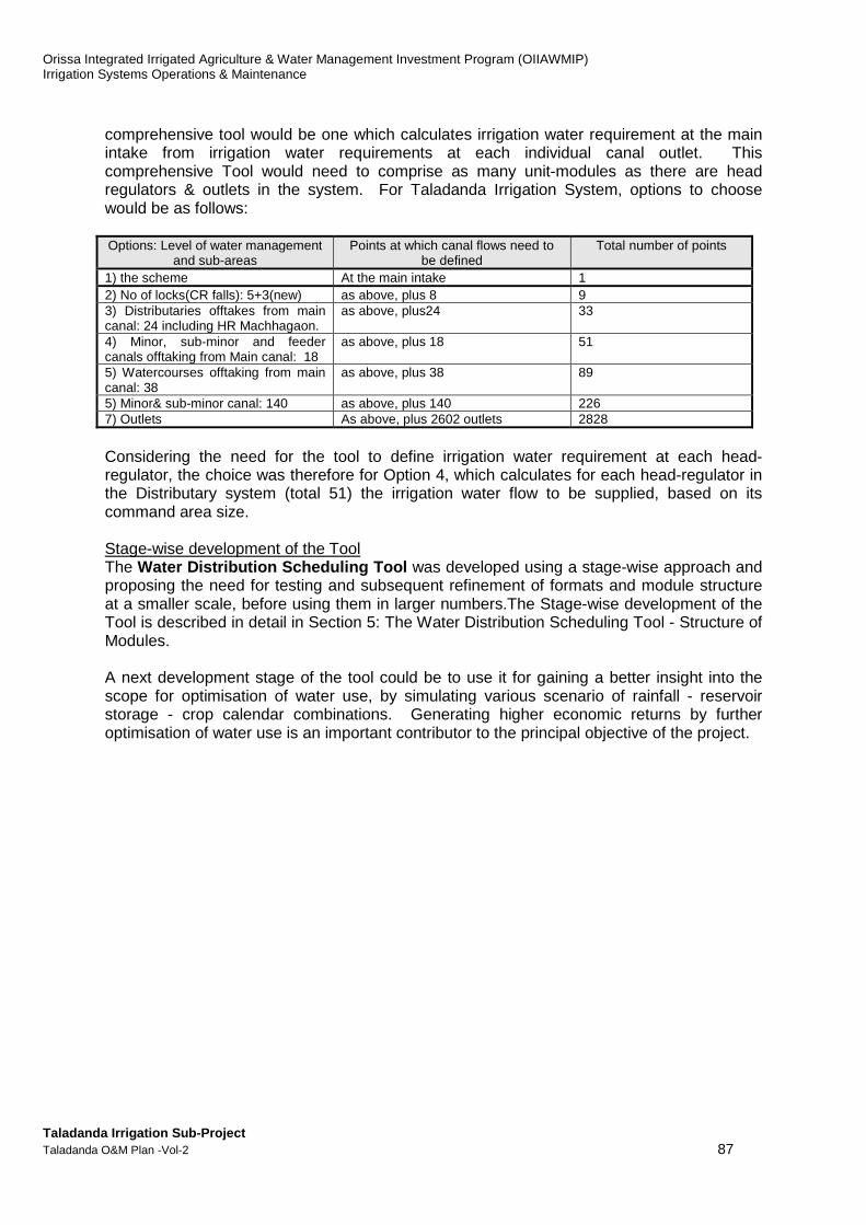
Orissa Integrated Irrigated Agriculture & Water Management Investment Program (OIIAWMIP) Irrigation Systems Operations & Maintenance
Taladanda Irrigation Sub-Project Taladanda O&M Plan -Vol-2 87
comprehensive tool would be one which calculates irrigation water requirement at the main intake from irrigation water requirements at each individual canal outlet. This comprehensive Tool would need to comprise as many unit-modules as there are head regulators & outlets in the system. For Taladanda Irrigation System, options to choose would be as follows: Options: Level of water management
and sub-areas Points at which canal flows need to
be defined Total number of points
1) the scheme At the main intake 1 2) No of locks(CR falls): 5+3(new) as above, plus 8 9 3) Distributaries offtakes from main canal: 24 including HR Machhagaon.
as above, plus24 33
4) Minor, sub-minor and feeder canals offtaking from Main canal: 18
as above, plus 18 51
5) Watercourses offtaking from main canal: 38
as above, plus 38 89
5) Minor& sub-minor canal: 140 as above, plus 140 226 7) Outlets As above, plus 2602 outlets 2828
Considering the need for the tool to define irrigation water requirement at each head-regulator, the choice was therefore for Option 4, which calculates for each head-regulator in the Distributary system (total 51) the irrigation water flow to be supplied, based on its command area size. Stage-wise development of the Tool The Water Distribution Scheduling Tool was developed using a stage-wise approach and proposing the need for testing and subsequent refinement of formats and module structure at a smaller scale, before using them in larger numbers.The Stage-wise development of the Tool is described in detail in Section 5: The Water Distribution Scheduling Tool - Structure of Modules. A next development stage of the tool could be to use it for gaining a better insight into the scope for optimisation of water use, by simulating various scenario of rainfall - reservoir storage - crop calendar combinations. Generating higher economic returns by further optimisation of water use is an important contributor to the principal objective of the project.
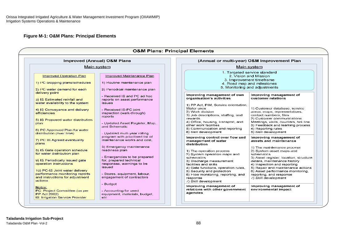
Orissa Integrated Irrigated Agriculture & Water Management Investment Program (OIIAWMIP) Irrigation Systems Operations & Maintenance
Taladanda Irrigation Sub-Project Taladanda O&M Plan -Vol-2 88
Figure M-1: O&M Plans: Principal Elements
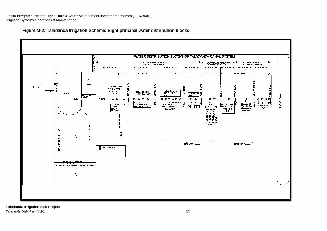
Orissa Integrated Irrigated Agriculture & Water Management Investment Program (OIIAWMIP)Irrigation Systems Operations & Maintenance
Taladanda Irrigation Sub-Project Taladanda O&M Plan -Vol-2
Figure M-2: Taladanda Irrigation Scheme: Eight
Orissa Integrated Irrigated Agriculture & Water Management Investment Program (OIIAWMIP)
89
ight principal water distribution blocks

Orissa Integrated Irrigated Agriculture & Water Management Investment Program (OIIAWMIP) Irrigation Systems Operations & Maintenance
Taladanda Irrigation Sub-Project Taladanda O&M Plan -Vol-2 90
2. Determining Irrigation Water Requirement
The seasonal water distribution plan
The principal steps of the seasonal water distribution planning process are regulated in the Pani Panchayat Act of 2002 and Regulation of 2003, and presented in CTA 2008 as follows:
1. In advance of the season, the Irrigation System Operator will inform the Pani Panchayat Project Committee of the water availability for irrigation (for Kharif, this will be by 15th April)
2. Each Pani Panchayat prepares a cropping plan, specifying which crops will be planted in which sub-command areas (chaks), and at what time, and submits it to the Project Committee.
3. The Project Committee collects and reviews the plans and submits the result to the Irrigation System Operator
4. The Irrigation System Operator, based on the plans, prepares a seasonal water distribution schedule and assesses its feasibility in view of water availability, etc.; if necessary, the Operator consults the Project Committee on the need for changes in order to balance the crop plan better with expected water availability; Pani Panchayats may be asked to revise their cropping plan; the Operator will submit the resulting water distribution schedule to the Project Committee for its approval.
5. In a formal meeting, prior to the start of the irrigation season, the Project Committee reviews and approves (possibly, after modifications) the seasonal water distribution schedule.
6. The approved schedule is made public and is distributed to the Pani Panchayats to share with their membership and to irrigation- and agriculture-related government agencies.
A water distribution schedule typically provides the following information:
1. Forecasted water availability and assumed rainfall 2. The PP cropping plans 3. Dates of opening and closing of main canals 4. Irrigation water flow through each head-regulator 5. Any rotational schedules for the main canals and distributaries 6. Special actions in the event of drought or heavy rain 7. Planned maintenance activities 8. For Kharif season, the water availability forecast, will consider the following: ♦ The Indian Meteorological Department (IMD) forecast of the onset of the monsoon
rains ♦ Reservoir water storage expected on 1-st of June ♦ Water allocation for purposes other than Irrigation (if any) ♦ Seepage / transmission losses in the canals ♦ Evaporation losses from the reservoir ♦ Water available from ground water and tanks in the command area ♦ Critical growth stages and period of water supply (frequency of irrigation) and
experience from previous seasons. A seasonal water distribution schedule will necessarily have to be based as much as possible on seasonal expectations. In addition to the above water availability forecast, it
Orissa Integrated Irrigated Agriculture & Water Management Investment Program (OIIAWMIP) Irrigation Systems Operations & Maintenance
Taladanda Irrigation Sub-Project Taladanda O&M Plan -Vol-2 91
requires a sound understanding of (i) the infrastructure system’s prevailing condition, (ii) the expected cropping activities and associated crop water demand. Key objectives of the schedule are (i) efficient use of available water; (ii) maximise financial and economic benefit generated by the use of the water; (iii) equitable, properly balanced access to water for all water users. The water distribution schedule will be implemented by the DoWR staff in coordination with the Pani Panchayats, while the Pani Panchayats will arrange the water distribution within their area. Daily updates of the realities in the field, particularly actual flows in the canals and rainfall, but also progress of planting, will be used by the operator to re-assess and adjust the schedule. Adjustments need to be made in consultation with the Project Committee. Canal discharge monitoring is highly important. This requires a number of locations where flow can be measured easily. It is often stated that in Kharif, irrigation is just supplementary to rainfall, meaning that rainfall is in reality the main provider of crop water. However, this overlooks the fact that during the first 1 to 2 months the demand for water is enormous, clearly exceeding average rainfall. This is so, because by the end of the dry season, the soils of the paddy fields have dried out and need to be re-saturated for the soaking period and the puddling prior to transplanting. During these two months, irrigation water supply is essential in order to make it possible for farmers to prepare their fields as early as possible. Irrigation is also essential for the last 1-2 months of the season, i.e. October and November, for any fields where the paddy crop was planted late. Adequate supply during the first 1-2 months has long been and still is the primary challenge for the Taladanda system: irrigation water can only reach the tail end areas quite late, so that transplanting there is completed as late as the second half of August. Such crops still stand in the field in late September - November, when the rains tend to have ceased, and thus require considerable irrigation supply. Due to this supply, water stored in the reservoir reduces to about 60% of capacity, thus reducing the potential Rabi cropping area. The most popular paddy varieties have a growth-duration of about 145-days. With transplanting taking place after its 21-30 days in the nursery, the time remaining until harvest is circa 120 days, with irrigation needed over 105 days. Say, a paddy crop was transplanted on August 15, then it would still need access to irrigation water until 25-30 November. Therefore, the following are the main considerations for water distribution scheduling:
1. A timely start to the Kharif season will facilitate a timely start to the Rabi season 2. Early establishment of nurseries in order to complete transplanting by 31st July. 3. Minimise need for irrigation after September, in order to maximise reservoir storage
for use in the Rabi season
Development of the water distribution tool
The water distribution scheduling tool for Taladanda Irrigation Scheme is meant to be used by the Irrigation System Operator for preparing the yearly Kharif water distribution schedule, applying the above generic calculation process. The following sub-sections explain the calculation process, the input data, and the default values used in the prototype tool presented in this report.
Orissa Integrated Irrigated Agriculture & Water Management Investment Program (OIIAWMIP) Irrigation Systems Operations & Maintenance
Taladanda Irrigation Sub-Project Taladanda O&M Plan -Vol-2 92
The calculation process
The generic process for preparation of a water distribution schedule is shown in Figure M-3. The first step in the development of the tool was to set up the process for calculation of irrigation water requirement for one uniform command area. The Basic module for calculation of irrigation water requirement is presented in Figure M-4.
Input data: requirement, availability, and default values
From the calculation process, it becomes clear what input data are required including ETo, average monthly rainfall data (at least for 20 years rainfall data), soil percolation rate in addition to crop (paddy) variety and Kc. For a number of input data and default values, explanations are presented in the notes below.
Note on Effective rainfall
Taladanda Irrigation System project documents have applied a variety of methods for determining the rainfall to be used as input in the irrigation water requirement calculations. The Project Design Report of 2007 adopted effective rainfall as 70% and dependable rainfall (Chance rainfall) as 75% of average monthly rainfall at Cuttack Station.The PPTA FS of July 2007 adopted the same method. The CTA Taladanda Manual of 2008 considered Dam average monthly rainfall but not caluculted effective rainfall. The PPTA method of using 75%-dependable monthly rainfall is only useful for system planning purposes, such as for determining infrastructure design capacity.1 It is not relevant for seasonal water distribution scheduling. The PPTA, CTA, and Project Design Report all use Dam rainfall, which is only representative for the scheme’s most upstream parts. For Agriculture production, effective rainfall refers to that portion of rainfall that can effectively be used by plants. This is to say that all rain water is not available to the crops as some rain water is lost through Runoff (RO) and Deep Percolation (DP). This runoff and deep percolation water can not be used by plants. In other words, part of the rainfall is is not effective. The remaining part of rainfall is stored in the soil near root zone and can be used by the crop plants. This part of rain is the so-called effective rainfall. FAO methods:In general, (i) the efficiency of rainfall will decrease with increasing rainfall and (ii) for most rainfall values below 100 mm/month, the efficiency is approximately 80%. FAO’s CropWat offers a choice of four methods, all calculating effective rainfall from actual rainfall data. The options are: (1) Fixed percentage: Effective rainfall is a fixed percentage of actual rainfall, being calculated according to: Peff = Fixed percentage * P. The fixed percentage is to be given by the user to account for the losses due to runoff and deep percolation. (2) Dependable rainfall (FAO/AGLW formula): Based on an analysis carried out for different arid and sub-humid climates, an empirical formula was developed in the Water Service of FAO to estimate dependable rainfall, the combined effect of dependable rainfall (80% probability of exceedance) and estimated losses due to Runoff (RO) and Deep Percolation (DP). This formula may be used for design purposes where 80% pro-bability of exceedance is required. Calculation is as follows: - monthly steps: Peff = 0.6 * P - 10 for Pmonth <= 70 mm and Peff = 0.8 * P - 24 for Pmonth > 70 mm
1 See for, among others, the CropWat 8.0 example: “Dependable rainfall: The amount of rainfall which can be
depended upon in 1 out of 4 or 5 years, corresponding to a 75 or 80% probability of exceedance and representing a dry year. The dependable rainfall (80%) is used for the design of the irrigation system capacity.”

Orissa Integrated Irrigated Agriculture & Water Management Investment Program (OIIAWMIP) Irrigation Systems Operations & Maintenance
Taladanda Irrigation Sub-Project Taladanda O&M Plan -Vol-2 93
- decade steps: Peff(dec) = 0.6 * Pdec - (10 for Pdec <= (70 / 3) mm and Peff(dec) = 0.8 * Pdec - (24 / 3 for Pdec > (70 / 3) mm (3) Empirical formula: the same formula as for Dependable rainfall, above, but using different parameters, as would follow from an analysis of local climatic records (values for a, b, c, d and z are correlation coefficients): - monthly step: Peff = a * Pmonth - b for Pmonth <= z mm; Peff = c * Pmonth - d for Pmonth > z mm - decade step: Peff(dec) = a * Pdec - (b / 3) for Pdec <= (z / 3) mm; Peff(dec) = c * Pdec - (d / 3) for Pdec > (z / 3) mm. (4) USDA Soil Conservation Service: Formula developed by USCS, where effective rainfall can be calculated according to: - Monthly step: Peff = Pmonth * (125 - 0.2 * Pmonth) / 125 for Pmonth <= 250 mm; and Peff = 125 + 0.1 * Pmonth for Pmonth > 250 mm - Decade step: Peff(dec) = Pdec * (125 - 0.6 * Pdec)) / 125 for Pdec <= (250 / 3) mm; Peff(dec) = (125 / 3) + 0.1 * Pdec for Pdec > (250 / 3) mm The Taladanda Scheme is large and provides irrigation in seven Administrative Blocks viz. Cuttack sadar, Nischintkoili, Biridi, Raghunathpur, Tirtol, Kujanga and Ersama. Rain gauze stations are available in each Block headquarter. The rainfall data (from 2000 – 2015) of seven Blocks has been averaged and the average rainfall of the seven Blocks is considered as representative for the total command area of Taladanda scheme. In Taladanda scheme, in the Kharif season months June - September, average monthly rainfall is between 250 mm and 400 mm, thus much higher than 100 mm. Rain falls on bunded paddy fields and when rainfall is low, say below 10mm, effectiveness is very high. For this reason, the USDA Soil Conservation Servicemethod has been used for determining effective rainfall.
Note on Crop factors (Kc)
FAO Irrigation and Drainage Paper 56, Chapter 6 (‘FAO’) deals with the calculation of crop evapotranspiration (ETc) under standard conditions, where crop growth is not affected by water stress, salinity stress, unsuitable crop density, pests and diseases, weed infestation, or low fertility. Under such conditions, ETc can be determined by the ‘crop coefficient approach’ whereby the effect of the various weather conditions are incorporated into an ‘ETo’ and the specific crop characteristics into a ‘Kc coefficient’. The equation is: ET c = Kc * ETo. The Kc coefficient incorporates crop characteristics and averaged effects ofevaporation from the soil. For normal irrigation planning and management purposes, for the development of basic irrigation schedules, and for mosthydrologic water balance studies, average crop coefficients are relevant and more convenient than the Kc computed on a daily time step, using separate coefficients for crop and for soil. Kc varies over crop life. FAO has published Kc factors for numerous crops. The FAO distinguishes four key stages of crop life: (i) the initial stage; (ii) the development stage; (iii) the mid-season stage; and (iv) the late season stage. Only three point values for Kc are required to describe and to construct a Kc curve. The curve is constructed using the following three steps: 1. Divide the growing period into four general growth stages that describe crop development: initial, crop development, mid-season, and late season stage) 2. Determine the length of each growth stage 3. Identify the three Kc values that correspond to Kc ini, Kc mid and Kc end 4. Construct a curve by connecting straight line segments through each of the four growth stages. Horizontal lines are drawn through Kc ini in the initial stage and through Kc mid in the mid-season stage. Diagonal lines are drawn from Kc ini to Kc mid within the course of the crop development stage and from Kc mid to Kc end within the course of the late season stage.
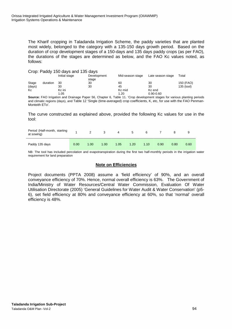
Orissa Integrated Irrigated Agriculture & Water Management Investment Program (OIIAWMIP) Irrigation Systems Operations & Maintenance
Taladanda Irrigation Sub-Project Taladanda O&M Plan -Vol-2 94
The Kharif cropping in Taladanda Irrigation Scheme, the paddy varieties that are planted most widely, belonged to the category with a 135-150 days growth period. Based on the duration of crop development stages of a 150-days and 135 days paddy crops (as per FAO), the durations of the stages are determined as below, and the FAO Kc values noted, as follows: Crop: Paddy 150 days and 135 days Initial stage Development
stage Mid-season stage Late season stage Total
Stage duration (days)
30 30 60 30 150 (FAO) 30 30 45 30 135 (tool)
Kc Kc ini Kc mid Kc end 1.05 1.20 0.90-0.60 Source: FAO Irrigation and Drainage Paper 56, Chapter 6, Table 11. ‘Crop development stages for various planting periods and climatic regions (days), and Table 12 ‘Single (time-averaged) crop coefficients, K, etc, for use with the FAO Penman-Monteith ETo’. The curve constructed as explained above, provided the following Kc values for use in the tool: Period (Half-month, starting at sowing) 1 2 3 4 5 6 7 8 9
Paddy 135 days 0.00 1.00 1.00 1.05 1.20 1.10 0.90 0.80 0.60
NB: The tool has included percolation and evapotranspiration during the first two half-monthly periods in the irrigation water requirement for land preparation
Note on Efficiencies
Project documents (PPTA 2008) assume a ‘field efficiency’ of 90%, and an overall conveyance efficiency of 70%. Hence, normal overall efficiency is 63%. The Government of India/Ministry of Water Resources/Central Water Commission, Evaluation Of Water Utilisation Directorate (2005) ‘General Guidelines for Water Audit & Water Conservation’ (p5-6), set field efficiency at 80% and conveyance efficiency at 60%, so that ‘normal’ overall efficiency is 48%.
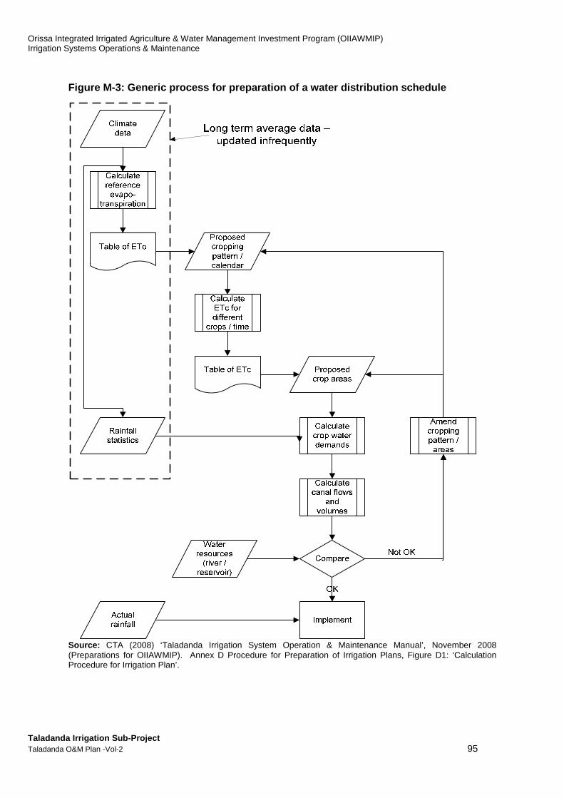
Orissa Integrated Irrigated Agriculture & Water Management Investment Program (OIIAWMIP) Irrigation Systems Operations & Maintenance
Taladanda Irrigation Sub-Project Taladanda O&M Plan -Vol-2 95
Figure M-3: Generic process for preparation of a wa ter distribution schedule
Source: CTA (2008) ‘Taladanda Irrigation System Operation & Maintenance Manual’, November 2008 (Preparations for OIIAWMIP). Annex D Procedure for Preparation of Irrigation Plans, Figure D1: ‘Calculation Procedure for Irrigation Plan’.

Orissa Integrated Irrigated Agriculture & Water Management Investment Program (OIIAWMIP) Irrigation Systems Operations & Maintenance
Taladanda Irrigation Sub-Project Taladanda O&M Plan -Vol-2 96
Figure M-4: Basic module for calculation of irrigat ion water requirement
A. Irrigation water requirement calculation A1. Prepare input data
A1.1 Calculate the average reference evapotranspiration (ETo) for the representative meteorological station(-s), using the ???? Penman equation A1.2 Calculate average effective rainfall for the representative rainfall station(-s).
A2. Calculate irrigation water supply discharge
A1.1 Use Kc factors and ETo, to calculate net crop evapotranspiration: ETc = ETo * Kc A1.2 Use land preparation water requirement, percolation rate, and ETc to calculate gross crop water requirement A1.3 Use effective rainfall and gross crop water requirement to calculate net irrigation requirement (mm) A1.4 Convert above the volume of irrigation water per hectare, to be supplied during the period A1.5 Use efficiencies and above net irrigation requirement to calculate the volume of gross irrigation water requirement per hectare for the period
A1.6 Use the cultivable command area (ha) to calculate the average discharge to be supplied at the head regulator
Period No in the Calendar Year (half-months)
- 11 12
Days in this period nr 15 15
ETo mm/day 4.96 4.30
Average rainfall over this period mm 131.8 170.6
Effective rainfall over this period, based on average rainfall
mm 106.9 134.6
Effective average daily rainfall over this period
mm/day 7.1 9.0
JuneFactor
Kc - 0.00
Land preparation requirement mm/day 13.33
Percolation losses mm/day 0.00
ETc = ETo x Kc mm/day 0.00
Gross crop water requirement (Land preparation req. + Perc. losses + ETc)
mm/day 13.33
Irrigation requirement (Gross crop water requirement - Effective rainfall)
mm/day 4.36
Net irrigation requirement this period (depth)
mm 65.38
Net irrigation requirement this period (volume per hectare)
m3/ha 653.82
Gross irrigation requirement (Net irrigation requirement / efficiency)
m3/ha 1220.96
Average discharge to be supplied per hectare
l/sec/ha 0.94
Average discharge to be supplied at the head regulator
m3/sec 0.39
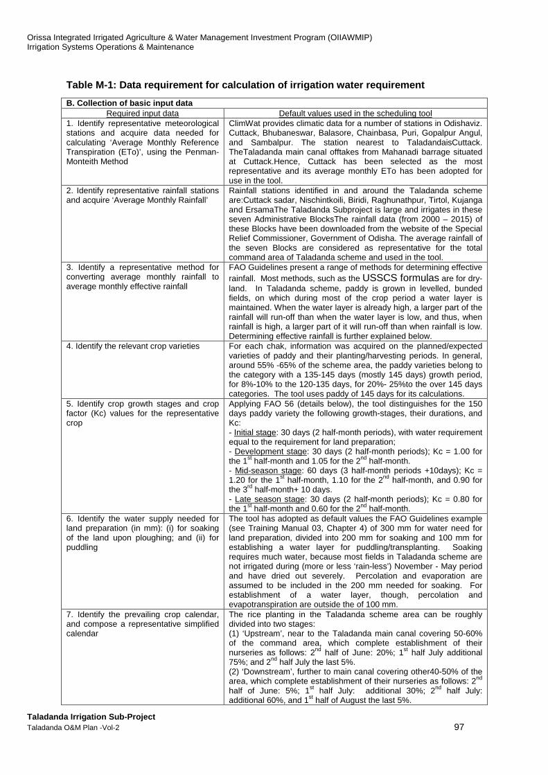
Orissa Integrated Irrigated Agriculture & Water Management Investment Program (OIIAWMIP) Irrigation Systems Operations & Maintenance
Taladanda Irrigation Sub-Project Taladanda O&M Plan -Vol-2 97
Table M-1: Data requirement for calculation of irri gation water requirement
B. Collection of basic input data Required input data Default values used in the scheduling tool
1. Identify representative meteorological stations and acquire data needed for calculating ‘Average Monthly Reference Transpiration (ETo)’, using the Penman-Monteith Method
ClimWat provides climatic data for a number of stations in Odishaviz. Cuttack, Bhubaneswar, Balasore, Chainbasa, Puri, Gopalpur Angul, and Sambalpur. The station nearest to TaladandaisCuttack. TheTaladanda main canal offtakes from Mahanadi barrage situated at Cuttack.Hence, Cuttack has been selected as the most representative and its average monthly ETo has been adopted for use in the tool.
2. Identify representative rainfall stations and acquire ‘Average Monthly Rainfall’
Rainfall stations identified in and around the Taladanda scheme are:Cuttack sadar, Nischintkoili, Biridi, Raghunathpur, Tirtol, Kujanga and ErsamaThe Taladanda Subproject is large and irrigates in these seven Administrative BlocksThe rainfall data (from 2000 – 2015) of these Blocks have been downloaded from the website of the Special Relief Commissioner, Government of Odisha. The average rainfall of the seven Blocks are considered as representative for the total command area of Taladanda scheme and used in the tool.
3. Identify a representative method for converting average monthly rainfall to average monthly effective rainfall
FAO Guidelines present a range of methods for determining effective rainfall. Most methods, such as the USSCS formulas are for dry-land. In Taladanda scheme, paddy is grown in levelled, bunded fields, on which during most of the crop period a water layer is maintained. When the water layer is already high, a larger part of the rainfall will run-off than when the water layer is low, and thus, when rainfall is high, a larger part of it will run-off than when rainfall is low. Determining effective rainfall is further explained below.
4. Identify the relevant crop varieties For each chak, information was acquired on the planned/expected varieties of paddy and their planting/harvesting periods. In general, around 55% -65% of the scheme area, the paddy varieties belong to the category with a 135-145 days (mostly 145 days) growth period, for 8%-10% to the 120-135 days, for 20%- 25%to the over 145 days categories. The tool uses paddy of 145 days for its calculations.
5. Identify crop growth stages and crop factor (Kc) values for the representative crop
Applying FAO 56 (details below), the tool distinguishes for the 150 days paddy variety the following growth-stages, their durations, and Kc: - Initial stage: 30 days (2 half-month periods), with water requirement equal to the requirement for land preparation; - Development stage: 30 days (2 half-month periods); Kc = 1.00 for the 1st half-month and 1.05 for the 2nd half-month. - Mid-season stage: 60 days (3 half-month periods +10days); Kc = 1.20 for the 1st half-month, 1.10 for the 2nd half-month, and 0.90 for the 3rd half-month+ 10 days. - Late season stage: 30 days (2 half-month periods); Kc = 0.80 for the 1st half-month and 0.60 for the 2nd half-month.
6. Identify the water supply needed for land preparation (in mm): (i) for soaking of the land upon ploughing; and (ii) for puddling
The tool has adopted as default values the FAO Guidelines example (see Training Manual 03, Chapter 4) of 300 mm for water need for land preparation, divided into 200 mm for soaking and 100 mm for establishing a water layer for puddling/transplanting. Soaking requires much water, because most fields in Taladanda scheme are not irrigated during (more or less ‘rain-less’) November - May period and have dried out severely. Percolation and evaporation are assumed to be included in the 200 mm needed for soaking. For establishment of a water layer, though, percolation and evapotranspiration are outside the of 100 mm.
7. Identify the prevailing crop calendar, and compose a representative simplified calendar
The rice planting in the Taladanda scheme area can be roughly divided into two stages: (1) ‘Upstream’, near to the Taladanda main canal covering 50-60% of the command area, which complete establishment of their nurseries as follows: 2nd half of June: 20%; 1st half July additional 75%; and 2nd half July the last 5%. (2) ‘Downstream’, further to main canal covering other40-50% of the area, which complete establishment of their nurseries as follows: 2nd half of June: 5%; 1st half July: additional 30%; 2nd half July: additional 60%, and 1st half of August the last 5%.

Orissa Integrated Irrigated Agriculture & Water Management Investment Program (OIIAWMIP) Irrigation Systems Operations & Maintenance
Taladanda Irrigation Sub-Project Taladanda O&M Plan -Vol-2 98
B. Collection of basic input data
8. Identify representative percolation rates for the soils under command
According to all project documents, the soils have a medium-category texture. For Kharif paddy, the Detailed Project Design of Nov 2007 (for ERM under OIIAWMIP) assumes 4 mm/day. The PPTA FS of May 2007 assumes 3 mm/day. The tool assumes percolation losses as included in the 300 mm water supply for land preparation. It assumes a default percolation rate of 3 mm/day after the land preparation stage During the last half-month, the fields are left to dry.
9. Identify representative irrigation efficiencies at field level and the various levels of canal (main canal, distributary, minor, sub-minor)
Project documents assume a chak-level ‘field efficiency’ of 90%, and an overall conveyance efficiency of 70%, or 60% or 54%, depending on document. The original design assumes 10% losses for each off-taking canal: sub-minor 10%, minor 10%, distributary 10%, and main canal 10%. The Government of India/Ministry of Water Resources/Central Water Commission, Evaluation Of Water Utilisation Directorate (2005) ‘General Guidelines for Water Audit & Water Conservation’ (p5-6), set field efficiency at 80% and conveyance efficiency at 60%, so that ‘normal’ overall efficiency is 48%. Considering that chak-level efficiency is in fact quite low, and that the original design’s setting of an efficiency per off-taking canal usefully reflects the fact that losses increase with distance, the tool assumes as default values: (1) a chak-level efficiency of 80% (2) a conveyance efficiency per off-taking canal of 10%.
Orissa Integrated Irrigated Agriculture & Water Management Investment Program (OIIAWMIP) Irrigation Systems Operations & Maintenance
Taladanda Irrigation Sub-Project Taladanda O&M Plan -Vol-2 99
Simulation of staggered planting
In Taladanda Irrigation Scheme, nursery establishment, land preparation, and transplanting for the Kharif paddy crop takes not place simultaneously over the scheme’s command area. Rather, they take place in a staggered fashion, starting in the upstream chaks of the command area and ending in the most downstream chaks. This is a general phenomenon in almost all irrigation schemes in the world, but in it is more pronounced in some than in others, and it is more of a problem in some than in others. In Taladanda Irrigation Scheme, the problem with a pronounced staggering process is that in areas where planting has been late, the paddy crop will still stand on the fields in October-November, or even early December, and need serious irrigation. In late September, Taladanda reservoir is usually filled to the brim but the monsoon rains have substantially diminished or even ceased. Thus, any water released from the reservoir is unlikely to get restored and will thus reduce the volume of water available to support the Rabi crops. The principal cause for the staggering is the very large water requirement for land preparation, while the monsoon rainfall in June (the start of the Kharif irrigation season) is usually not yet substantial, and thus the demand for irrigation water is huge. Providing an adequate supply of irrigation water is often problematic. There are several factors affecting it. Firstly, canal capacity puts a limit to the flow that can be conveyed. Usually, canal capacity has been designed on basis of one or another pattern of staggered planting, for reasons of economy in regard of infrastructure construction cost. If the irrigation system would need to provide the flow needed to allow the full scheme area to prepare the land simultaneously, canal capacities (and thus canal cross-sections) would have to be larger and the cost of establishing this infrastructure would be higher, than when a staggered pattern of land preparation is assumed. In practice, actual canal capacities may be less than the design capacity for a variety of reasons, such as (i) the use of ‘optimistic’ design standards; (ii) construction that was not in accordance with design; and (iii) lack of maintenance. Where actual capacity is considerably smaller than design capacity, this would contribute to duration of the time span of the staggering. A second factor is the operation of the system. Under the ‘traditional method’ the main intake is opened at the start of the Kharif season so that the main canal runs at full capacity. All cross-regulators and head-regulators are opened fully and remain in that position for the remainder of the season, that is, unless serious requests are received. The main intake is closed when heavy rainfall occurs. Frequent opening and closing of the main intake is unfortunate for the most downstream areas, because it always takes a few days for the downstream canal sections to fill up. Under this method, a proportionally larger part of the flow gets diverted through the upstream head-regulators and outlets, leaving less water in the canal for downstream users than would be their fair share. The ‘over-diversion’ in the upstream sections reduces after some weeks, when farmers close outlets to their chaks when their fields have received (already more than) enough water. This is usually after the completion of transplanting. As a result, flow in the downstream sections of the canals gradually increases, allowing chaks on those sections to divert more and more water, until they have completed their transplanting. Thirdly, there are a number of rather complex agriculture-related and socio-economic factors influencing the duration of the staggering time span. Perhaps most important is the strong preference among Taladanda farmers for using paddy varieties with a relatively long growth period. In general, the yield of those varieties is higher than the yield of varieties with shorter growth duration. Particularly for Taladanda’s downstream communities, achievement of an as-high-as-possible Kharif paddy yield is adamant, because this is the only crop they (can) grow in the year. Historically, irrigation water from the reservoir during the Rabi season has
Orissa Integrated Irrigated Agriculture & Water Management Investment Program (OIIAWMIP) Irrigation Systems Operations & Maintenance
Taladanda Irrigation Sub-Project Taladanda O&M Plan -Vol-2 100
only been supplied to upstream communities and downstreamers had no choice than to leave their fields fallow. Upstream communities have always used the Rabi season irrigation water supply to grow a second paddy crop on suitably situated chaks/fields. As explained above, the downstream areas are forced to plant last and therefore in need of substantial irrigation in October and November, drawing down the reservoir water level. It is difficult to convince these downstream communities that they should plant paddy with a shorter duration, and thus accept a lower yield level, when the savings in water (in the reservoir) will not benefit them, but the upstream communities. Other factors in this category are timely availability of inputs, particularly seed, in adequate quantities, and also labour. While some degree of staggering is an essential feature of the irrigation process, the general desire for optimisation of water use requires that maximum effort be made to have the reservoir filled to the brim by the start of the Rabi season. This means that Kharif crop production processes should make maximum use of the abundant rainfall and that therefore the spread of the staggering process be reduced to a minimum. Currently in Taladanda scheme, land preparation and nurseries establishment is staggered over a period of 2 months, between mid-June and mid-August. The challenge for system operation and agriculture extension is to reduce this. This can be done by ensuring that (i) a reasonable volume of water is available in the reservoir by the start of the Kharif season; (ii) actual canal capacities are adequate (e.g. ‘as per design’); (iii) the system is operated actively, both at main system level, as well as at PP level, and at chak-level; (iv) late-planting areas use paddy varieties with a relatively short growth period; (v) agriculture inputs are timely available in adequate quantities. The water distribution scheduling tool is designed to make simulation of the staggering process possible. For this purpose, a ‘unit-module’ (a module for calculating the irrigation water requirement in one (sub-) command area) was developed which consists of four inter-related basic modules. These basic modules can be dedicated to different crops. The prototype modules presented in this report assume the same 135 -145 days paddy crop is planted throughout the scheme, and simulate the staggering process by distinguishing crops according to the period during which the initial growth stage commences. For example, for the upstream areas of the sub-project, the prototype’s default is that on 16/06, the initial growth stage commences in 20% of the area, on 01/07 in 75%; on 16/07 in 5%, and on 01/08 0%. For the downstream areas of the sub-project, the prototype’s default is that on 16/06, the initial growth stage commences in 5% of the area, on 01/07 in 30%; on 16/07 in 60%, and on 01/08 in 5%. The choice of using four basic modules and not three or five or another number, is based on the understanding that in one (sub-) command area of Taladanda scheme, the actual process of staggered planting does not exceed four half-month periods, and more typically covers 3 to 4 half-month periods for a large sub-unit, such as a principal water distribution block, and less for a smaller sub-area, such as a minor or sub-minor unit.
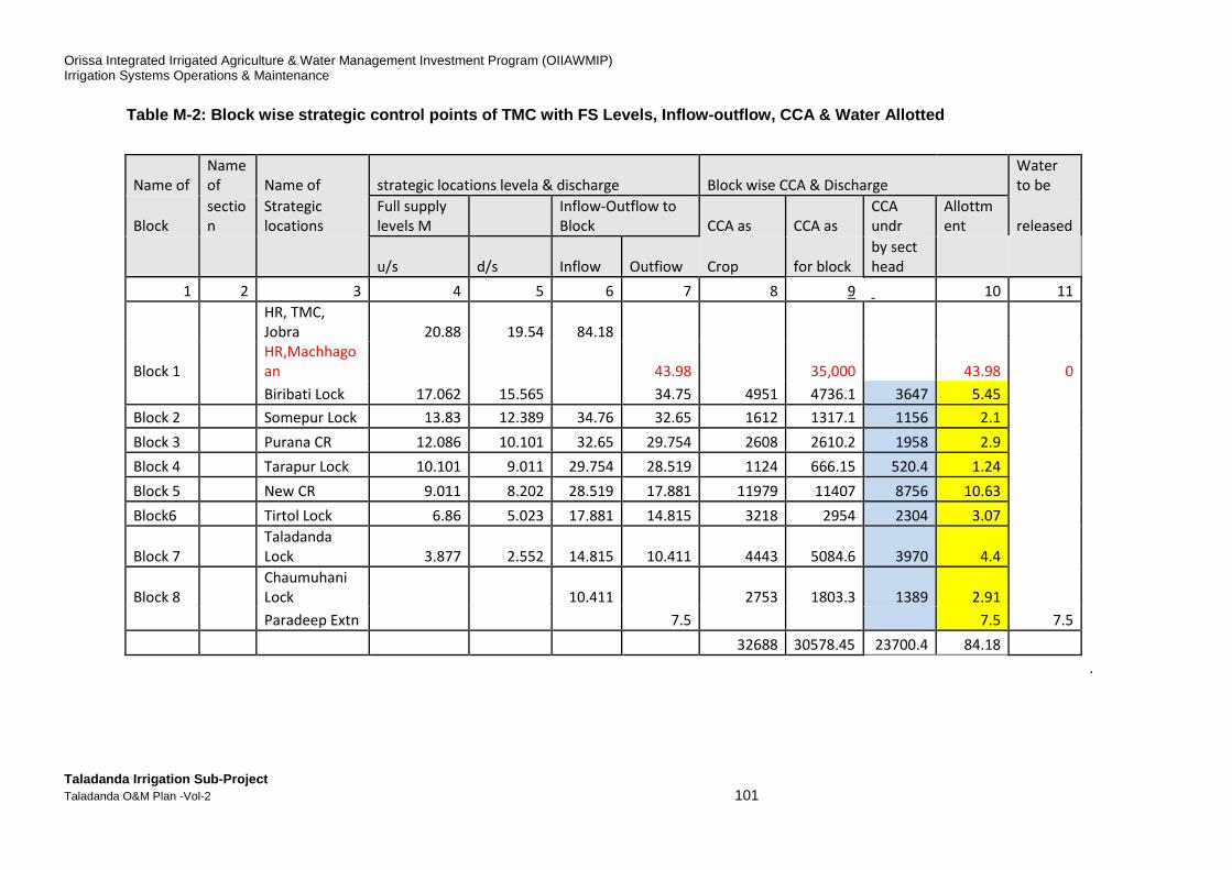
Orissa Integrated Irrigated Agriculture & Water Management Investment Program (OIIAWMIP) Irrigation Systems Operations & Maintenance
Taladanda Irrigation Sub-Project Taladanda O&M Plan -Vol-2 101
Table M-2: Block wise strategic control points of T MC with FS Levels, Inflow-outflow, CCA & Water Allo tted
Name of
Name
of Name of strategic locations levela & discharge Block wise CCA & Discharge
Water
to be
Block
sectio
n
Strategic
locations
Full supply
levels M
Inflow-Outflow to
Block CCA as CCA as
CCA
undr
Allottm
ent
released
u/s d/s Inflow Outfiow Crop for block
by sect
head
1 2 3 4 5 6 7 8 9 10 11
HR, TMC,
Jobra 20.88 19.54 84.18
Block 1
HR,Machhago
an 43.98 35,000 43.98 0
Biribati Lock 17.062 15.565 34.75 4951 4736.1 3647 5.45
Block 2 Somepur Lock 13.83 12.389 34.76 32.65 1612 1317.1 1156 2.1
Block 3 Purana CR 12.086 10.101 32.65 29.754 2608 2610.2 1958 2.9
Block 4 Tarapur Lock 10.101 9.011 29.754 28.519 1124 666.15 520.4 1.24
Block 5 New CR 9.011 8.202 28.519 17.881 11979 11407 8756 10.63
Block6 Tirtol Lock 6.86 5.023 17.881 14.815 3218 2954 2304 3.07
Block 7
Taladanda
Lock 3.877 2.552 14.815 10.411 4443 5084.6 3970 4.4
Block 8
Chaumuhani
Lock 10.411 2753 1803.3 1389 2.91
Paradeep Extn 7.5 7.5 7.5
32688 30578.45 23700.4 84.18
.
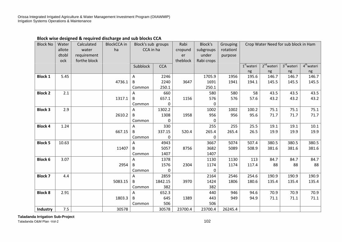
Orissa Integrated Irrigated Agriculture & Water Management Investment Program (OIIAWMIP) Irrigation Systems Operations & Maintenance
Taladanda Irrigation Sub-Project Taladanda O&M Plan -Vol-2 102
Block wise designed & required discharge and sub blocks CCA
Block No Water
allote
dtobl
ock
Calculated
water
requirement
forthe block
BlockCCA in
ha
Block's sub groups
CCA in ha
Rabi
cropund
er
theblock
Block's
subgroups
under
Rabi crops
Grouping
rotationl
purpose
Crop Water Need for sub block in Ham
Subblock CCA 1st
wateri
ng
2nd
wateri
ng
3rd
wateri
ng
4th
wateri
ng
Block 1 5.45 A 2246 1705.9 1956 195.6 146.7 146.7 146.7
4736.1 B 2240 3647 1691 1941 194.1 145.5 145.5 145.5
Common 250.1 250.1
Block 2 2.1 A 660 580 580 58 43.5 43.5 43.5
1317.1 B 657.1 1156 576 576 57.6 43.2 43.2 43.2
Common 0 0
Block 3 2.9 A 1302.2 1002 1002 100.2 75.1 75.1 75.1
2610.2 B 1308 1958 956 956 95.6 71.7 71.7 71.7
Common 0 0
Block 4 1.24 A 330 255 255 25.5 19.1 19.1 10.1
667.15 B 337.15 520.4 265.4 265.4 26.5 19.9 19.9 19.9
Common 0 0
Block 5 10.63 A 4943 3667 5074 507.4 380.5 380.5 380.5
11407 B 5057 8756 3682 5089 508.9 381.6 381.6 381.6
Common 1407 1407
Block 6 3.07 A 1378 1130 1130 113 84.7 84.7 84.7
2954 B 1576 2304 1174 1174 117.4 88 88 88
Common 0 0
Block 7 4.4 A 2859 2164 2546 254.6 190.9 190.9 190.9
5083.15 B 1842.15 3970 1424 1806 180.6 135.4 135.4 135.4
Common 382 382
Block 8 2.91 A 652.3 440 946 94.6 70.9 70.9 70.9
1803.3 B 645 1389 443 949 94.9 71.1 71.1 71.1
Common 506 506
Industry 7.5 30578 30578 23700.4 23700.4 26245.4
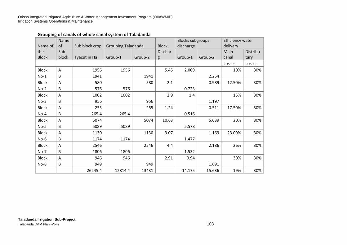
Orissa Integrated Irrigated Agriculture & Water Management Investment Program (OIIAWMIP) Irrigation Systems Operations & Maintenance
Taladanda Irrigation Sub-Project Taladanda O&M Plan -Vol-2 103
Grouping of canals of whole canal system of Taladanda
Name of
Name
of Sub block crop Grouping Taladanda Block
Blocks subgroups
discharge
Efficiency water
delivery
the
Block
Sub
block ayacut in Ha Group-1 Group-2
Dischar
g Group-1 Group-2
Main
canal
Distribu
tary
Losses Losses
Block A 1956 1956 5.45 2.009 10% 30%
No-1 B 1941
1941
2.254
Block A 580 580 2.1
0.989 12.50% 30%
No-2 B 576 576 0.723
Block A 1002 1002 2.9 1.4 15% 30%
No-3 B 956 956
1.197
Block A 255
255 1.24
0.511 17.50% 30%
No-4 B 265.4 265.4 0.516
Block A 5074 5074 10.63
5.639 20% 30%
No-5 B 5089 5089 5.578
Block A 1130 1130 3.07
1.169 23.00% 30%
No-6 B 1174 1174 1.477
Block A 2546 2546 4.4
2.186 26% 30%
No-7 B 1806 1806 1.532
Block A 946 946 2.91 0.94 30% 30%
No-8 B 949 949
1.691
26245.4 12814.4 13431 14.175 15.636 19% 30%

Orissa Integrated Irrigated Agriculture & Water Management Investment Program (OIIAWMIP) Irrigation Systems Operations & Maintenance
Taladanda Irrigation Sub-Project Taladanda O&M Plan -Vol-2 104
3. Taladanda Irrigation Scheme: Key Features
The Taladanda main canal was designed and built foremost as a 84.24 km navigation canal in the mid-19th Century, extending from Cuttack to an estuary adjacent to the Mahanadi river about 12km from its final outfall to the sea.It was an East India Company commercial project. The Company started construction but sold the project to the British Government in 1871. The British Government expanded the scope and completed the scheme. Navigation use declined leaving a main canal system ill designed for its remaining function, conveyance of water for irrigation. The Taladanda irrigation system receives water from Mahanadi barrage Pond. The water availability for Mahanadi Barrage is affected by use upstream, and releases from Hirakud reservoir. Four broad zones of operation are described below and illustrated in Figure M-5:
(i) Zone-I: infrastructure upstream of Mahanadi barrage, including Hirakud reservoir, Munduli Barrage and the 3-barrage complex at Cuttack. At this level the river basin authority is managing water allocations among: (i) Hirakud irrigation systems; (ii) Hirakud power generation; (iii) Puri main canal; (iv) Taladanda main canal; (v) Kendrapara main canal; and (vi) HLC system.
(ii) Zone-II: Three irrigation systems receiving water from the Mahanadi- Birupa pond.The three canals offtake from the Mahanadi-Birupa pond are: (i) HLC-1 on the left bank of the Birupa; (ii) Kendrapara on the left bank of the Mahanadi; and (iii) Taladanda on the right bank of the Mahanadi.
(iii) Zone-III: Talandana main canal system under the Executive Engineer supported by four1 Assistant engineers.
(iv) Zone-IV: Minor canal systems and command area managed by Pani Panchayat and farmers.
The schematic diagram of Taladanda canal system is given in Figure M 7.
1 Four Assistant engineers for the Talandanda system excluding the Machagaon branch canal which offtakes at
RD 11.78km.

Orissa Integrated Irrigated Agriculture & Water Management Investment Program (OIIAWMIP)Irrigation Systems Operations & Maintenance
Taladanda Irrigation Sub-Project Taladanda O&M Plan -Vol-2
Figure M-5: Operation Strategy for Taladanda Canal System
Orissa Integrated Irrigated Agriculture & Water Management Investment Program (OIIAWMIP)
Operation Strategy for Taladanda Canal System
105

Orissa Integrated Irrigated Agriculture & Water Management Investment Program (OIIAWMIP) Irrigation Systems Operations & Maintenance
Taladanda Irrigation Sub-Project Taladanda O&M Plan -Vol-2 106
The salient features of Mahanadi Barrage are furnished in the Table M-6 bellow. Figure M-6: Salient Feature of Mahanadi Barrage
Source: Downloded from DoWR website, January 2017. The Taladanda irrigation infrastructure system has the following main elements:1 The Taladanda Main canal off takes from the right side of the Mahanadi Barrage at Cuttack and bifurcates at RD 11.75 km with the Machhagaon canal off-taking right.The Taladanda system comprises the 83.4 km long main canal, twentyfour distributarychannels off taking from main canal (including distributaries, minors and sub minors) and 140 minor and sub minor canals. The total length of the canal system is about 594 km. The gross command area is 96,795 ha and the verified command area is 67,688 ha of which 32688 ha is served by Taladanda canal and about 35,000 ha is served by the Machhagaon canal. The details of the Taladanda canal system are given in the following Tables. 1 Source: PPTA Feasibility Study of May 2007and CTA (O&M mannual) November 2008.
Salient Features
Name of the Structure Mahanadi Barrage
Nearest city Cuttack
District Cuttack
State Odisha
Name of River Mahanadi
Basin Mahanadi
Year of completion 1991
Mean annual rainfall (mm) 1424
Total annual yield of catchment (MCM) 59155
Design flood (Cumec) 15300
Length of Barrage and Anicut (m) 1928
Type of spillway gate Other
Spillway gates - Number 79
Crest Level (m) 16.2
Pond level (m) 23.2
Highest Flood Level (m) 23.35
Under sluice bay - Number 12
Means for dissipating energy (Hydraulic) stilling basin
Status of BWA Construction Completed

Orissa Integrated Irrigated Agriculture & Water Management Investment Program (OIIAWMIP) Irrigation Systems Operations & Maintenance
Taladanda Irrigation Sub-Project Taladanda O&M Plan -Vol-2 107
Table M-3: Basic feature of Taladanda canal Scheme
No Description
Taladanda Head Regulator (at Mahanadi Barrage) 1 HR Design capacity 142 m3/sec 2 Number of Gates 4 3 Size of Gates 10m x 2.95m 4 Sill level 18.40 m asl
Taladanda Canal (below Biribati Weir) 5 Design Capacity 37 m³/sec 6 Length of Main canal 84.24 km. 7 Distributary Canals off taking from Main canal 24 8 Minor, S/M & feeder Canals off taking from Main canal 18 9 Watercourse Outlets off taking from Main canal 38
10 No. of locks (cross regulator falls) 5 + 3 (New) 11 No. of Escapes 3
Distribution System 12 Length of Distributaries (24 nos) 122.396 km 13 Length of Minors/ Sub-minors 388.541 km 14 Total number of outlets 2602 15 Average command area per outlet (67,554 / (1,863+34)) 35.6 ha
Table M-4: Main canal structure
No Type of structure No of structures 1 Cross Regulators 5+3 (new)= 8 2 Escapes 3 3 Cross Drain Structure 6 4 Head regulators 42 5 Road Bridges(HLB/VRB/FB/ Wooden) 60 6 Field Outlets 38
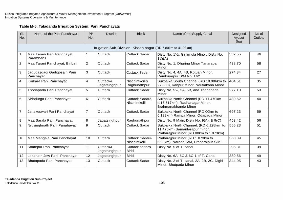
Orissa Integrated Irrigated Agriculture & Water Management Investment Program (OIIAWMIP) Irrigation Systems Operations & Maintenance
Taladanda Irrigation Sub-Project Taladanda O&M Plan -Vol-2 108
Table M-5: Taladanda Irrigation System: Pani Pancha yats
Sl. No.
Name of the Pani Panchayat PP No.
District Block Name of the Supply Canal Designed Ayacut
(ha)
No of Outlets
Irrigation Sub-Division, Kissan nagar (RD 7.80km to 41.93km)
1 Maa Tarani Pani Panchayat, Paramhans
1 Cuttack Cuttack Sadar Disty No. 1½, Gajamula Minor, Disty No.
1½(A)
332.55 46
2 Maa Tarani Panchayat, Biribati 2 Cuttack Cuttack Sadar Disty No. 1, Dharina Minor Tanarapa Minor,
438.70 58
3 Jagudasgadi Gadigosain Pani Panchayat
3 Cuttack
Cuttack Sadar Disty No. 4, 4A, 4B, Kotuan Minor, Ramkumrpur S/M No. 1&2
274.34 27
4 Korkara Pani Panchayat 4 Cuttack& Jagatsinghpur
Nischintkoili& Raghunathpur
Sukpaika South Channel (RD 18.986km to 27.800), Kanpur Minor, Neutiakana Minor
404.51 35
5 Thoriapada Pani Panchayat 5 Cuttack Cuttack Sadar Disty No. 5½, 5A, 5B, and Thoriapada Minor
277.10 53
6 Sirlodurga Pani Panchayat 6 Cuttack Cuttack Sadar& Nischintkoili
Sukpaika North Channel (RD 11.470km to16.617km), Radhanagar Minor, Brahmanakhanda Minor
439.62 40
7 Janakeswari Pani Panchayat 7 Cuttack Cuttack Sadar Sukpaika North Channel (RD 00km to 6.128km) Rampa Minor, Odapada Minor
697.23 59
8 Maa Sarala Pani Panchayat 8 Jagatsinghpur Raghunathpur Disty No. 9 Main, Disty No. 9(A), & 9(C) 453.42 56
9 Nrusinghnath Pani Panahayat 9 Cuttack Cuttack Sadar Sukpaika North Channel, (RD 6.128km to 11.470km) Samantarapur minor, Praharajpur Minor (RD 00km to 1.073km)
555.23 51
10 Maa Mangala Pani Panchayat 10 Cuttack Cuttack Sadar& Nischintkoili
Praharajpur Minor (RD 1.073km to 5.90km), Narada S/M, Praharajpur S/M-I I
360.39 45
11 Somepur Pani Panchayat 11 Cuttack& Jagatsinghpur
Cuttack sadar& Biridi
Disty No. 5 of T. canal 295.31 39
12 Lokanath Jew Pani Panchayat 12 Jagatsinghpur Biridi Disty No. 6A, 6C & 6C-1 of T. Canal 389.56 49
13 Bhutapada Pani Panchayat 13 Cuttack Cuttack Sadar Disty No. 2 of T. canal, 2A, 2B, 2C, Dighi Minor, Bhutpada Minor
344.05 43

Orissa Integrated Irrigated Agriculture & Water Management Investment Program (OIIAWMIP) Irrigation Systems Operations & Maintenance
Taladanda Irrigation Sub-Project Taladanda O&M Plan -Vol-2 109
Sl. No.
Name of the Pani Panchayat PP No.
District Block Name of the Supply Canal Designed Ayacut
(ha)
No of Outlets
14 Raghunath Jew Pani Panchayat 14 Jagatsinghpur Raghunathpur Disty No. 6½ & 7 of T. canal, Disty. No 7A, 7B & 7C Raghunathpur Minor & Ayodhyapur Minor of T. canal, Bodar Minor (old)
561.75 63
15 Sidheswar Pani Panchayat 15 Cuttack& Jagatsinghpur
Cuttack Sadar& Biridi
Disty No. 3 of T. canal, Disty. No 3A, 3B(Parabil outlet) & 3C
400.48 39
16 Maa Dakhineswari Pani Panchayat 16 Jagatsinghpur Raghunathpur Jagannathpur Minor, Athagaontari Minor, Disty No 8B, 8C & 8½, Puran S/M of Disty. 8½, Puran Minor of T. canal, Kulasahi Mahara of Puran Minor, Puran Direct-outlet No I R, Odapada Direct-outlet No II R.
508.30 64
17 Kapaleswar Pani Panchayat 17 Jagatsinghpur Raghunathpur Disty No. 8 of T.Canal 380.59 34
18 Sri Jagannath Pani Panchayat 18 Jagatsinghpur Raghunathpur Disty No. 8 A of T.Canal 201.04 30
19 Dharadharpur Pani Panchayat 19 Jagatsinghpur Raghunathpur Disty. No 8D 170.49 25
20 Tarpur Pani Panchayat 22 Jagatsinghpur Raghunathpur Disty No. 10 of T. canal, GokuIpur Minor, Harishpur minor, Harishpur Direct-outlet, Khandtari Direct-outlet.
213.73 28
21 Damodarpur Pani Panchayat 23 Cuttack Cuttack Sadar Sukhpaika South Channel (RD 00 to 7.268km)
391.81 34
22 Bastapada Pani Panchayat 24 Cuttack Cuttack Sadar Sukhpaika South Channel (RD 7.268km to 11.356km)
444.20 13
23 Bodhapur Pani Panchayat 25 Cuttack Cuttack Sadar Sukhpaika South Channel (RD 11.356km to 18.986km)
397.71 31
24 Jagannath Pani Panchayat 70 Cuttack& Jagatsinghpur
Nischintkoili, Raghunathpur& Biridi
Disty No. 6 of T. canal, Disty. No, 6D, 6D1 and 6E, Direct-outlet: 2nos.
335.73 63
Kissan nagar Irrigation Sub-Division: Total
24 PPs
9267.84 1025
Irrigation Sub-Division, Manijanga (RD 41.93 km to 64.13 km)
25 Kapileswar Pani Panchayat 20 Jagatsinghpur Raghunathpur Disty No. 11 Main, Pandra S/M, Ganeilo S/M, Purunabasanta S/M
375.24 67

Orissa Integrated Irrigated Agriculture & Water Management Investment Program (OIIAWMIP) Irrigation Systems Operations & Maintenance
Taladanda Irrigation Sub-Project Taladanda O&M Plan -Vol-2 110
Sl. No.
Name of the Pani Panchayat PP No.
District Block Name of the Supply Canal Designed Ayacut
(ha)
No of Outlets
26 Maa Sarala Pani Panchayat 21 Jagatsinghpur Tirtol Disty No 12(A), Baffapur S/M, Baripada S/M
409.22 59
27 Mahabir Pani Panchayat 26 Jagatsinghpur Tirtol Disty No. 12(C) and Oleipada S/M 188.57 25
28 Muni Sarala Pani Panchayat 27 Jagatsinghpur Tirtol Tenttuliapada Minor 222.68 33
29 Mahakali Pani Panchayat 28 Jagatsinghpur Tirtol Disty.No 12D, Korkora S/M. Malanda S/M 524.60 35
30 Maa Jhankadabasini Pani Panchayat
29 Jagatsinghpur Tirtol Disty No. 12D, Bakharapur S/M, Kutilo S/M, Sarolo S/M, Salijanga S/M
358.21 45
31 Madhaba Pani Panchayat 30 Jagatsinghpur Tirtol Disty. No 12E, Govindapur S/M, SahansaS/M, Sitol S/M
437.89 40
32 Paschimeswar Pani Panchayat 31 Jagatsinghpur Tirtol Banito S/M, Kantapada S/M 418.23 21
33 Biswakabi Pani Panchayat 32 Jagatsinghpur Tirtol Hatikana S/M, Mithilo S/M, Napanga S/M 315.13 33
34 Maa Mangala Pani Panchayat 33 Jagatsinghpur Tirtol Disty No. 12E-1, Sarikhi S/M 379.70 42
35 Nilamadhab Pani Panchayat 34 Jagatsinghpur Tirtol Disty. No 12 Main, Gouda Patana S/M, Bhiranga S/MOlomarei S/M
805.26 46
36 Banadurga Pani Panchayat 35 Jagatsinghpur Tirtol Alana S/M 195.13 14
37 Raghunathjew Pani Panchayat 36 Jagatsinghpur Tirtol Narsinghpur Minor Sijukuthi S/M 444.91 41
38 Dharameswar Pani Panchayat 37 Jagatsinghpur Tirtol Disty No.13 Main, 13 A minor 400.32 31
39 Mahabir Pani Panchayat 38 Jagatsinghpur Tirtol Disty No. 13 Main, 13 B 312.79 30
40 Sidheswar Pani Panchayat 39 Jagatsinghpur Tirtol Disty No. 12 B 285.02 21
41 Gorekhanath Pani Panchayat 51 Jagatsinghpur Tirtol Disty No. 11 A, Gandhanapada Minor, Nuapada S/M
189.74 39
42 Srirampur Pani Panchayat 52 Jagatsinghpur Tirtol Disty No. 12 Main, Disty No. 12 G-1 Minor Srirarnpur S/M
369.59 49
43 Nimol Pani Panchayat 53 Jagatsinghpur Tirtol Disty No. 12G-1 Minor, Sagabaria S/M, Turukha S/M
510.97 33
44 R.B.G Sasan Pani Panchayat 54 Jagatsinghpur Tirtol and Balikuda
Disty No. 12 Main, Jainabad S/M, Narsinghpur Minor
553.36 36
45 Sanilo Pani Panchayat 55 Jagatsinghpur Tirtol Disty No. 12 Main 426.96 32

Orissa Integrated Irrigated Agriculture & Water Management Investment Program (OIIAWMIP) Irrigation Systems Operations & Maintenance
Taladanda Irrigation Sub-Project Taladanda O&M Plan -Vol-2 111
Sl. No.
Name of the Pani Panchayat PP No.
District Block Name of the Supply Canal Designed Ayacut
(ha)
No of Outlets
46 Kothi Pani Panchayat 56 Jagatsinghpur Tirtol Disty No. 12G-1, Turukha S/M, Kumardihi S/M, Ornal S/M, Mandira S/M
451.55 24
47 Bodhei Pani Panchayat 57 Jagatsinghpur Tirtol Disty No. 12 E, Anla S/M, Gopalpur S/M, Kaintola S/M
421.14 53
48 Pandua Pani Panchayat 58 Jagatsinghpur Tirtol Disty No. 12 E, Patilo S/M 675.61 34
49 Gobindapur Pani Panchayat 59 Jagatsinghpur Tirtol Disty No. 12 Main 465.99 28
50 Khuntola Pani Panchayat 60 Jagatsinghpur Tirtol Disty No. 13 Main 323.48 25
51 Garei Pani Panchayat 61 Jagatsinghpur Tirtol Disty No. 13 C, Beherda S/M, Chhotibara S/M, Garei S/M
632.06 45
52 Dasipur Pani Panchayat 62 Jagatsinghpur Tirtol & Kujanga Disty No. 13 C 490.99 22
53 Digitari Pani Panchayat 63 Jagatsinghpur Tirtol & Kujanga Disty 13 C, Dardia S/M 804.57 37
54 Naliapal Pani Panchayat 64 Jagatsinghpur Tirtol & Kujanga Talapada Minor 565.83 30
55 Paikasta Pani Panchayat 65 Jagatsinghpur Kujanga TalapadaMinor 609.61 27
56 Chatol Pani Panchayat 66 Jagatsinghpur Tirtol Disty No. 12 F minor 456.48 20
57 Bhatagram Pani Panchayat 67 Jagatsinghpur Kujanga Disty No. 12 Main, Kosti Malikapur S/M. Bhatagrarn S/M
387.52 37
58 Haldia Pani Panchayat 68 Jagatsinghpur Kujanga Disty No. 12 F minor 551.16 32
59 Uradha Pani Panchayat 69 Jagatsinghpur Tirtol Disty No. 12 Main, Disty No. 12 G minor, 12G-2 minor
536.54 34
Monijanga Irrigation Sub-Division: Total
35 PPs
15496.05 1220
Irrigation Sub-Division, Paradeep(RD 64.13 km to 84.24 km)
60 Pokhariapada Pani Panchayat 40 Jagatsinghpur Kujanga Disty. No 14A, Pokhariapada Minor, Chatua S/M, Janardhanur S/M
557.44 37
61 Boulanga Pani Panchayat 41 Jagatsinghpur Kujanga Disty. No 14 A, Baulanga Minor 551.30 35
62 Badabuda Pani Panchayat 42 Jagatsinghpur Kujanga Disty. No 14 A, Badabuda Minor 414.10 21
63 Ghodamara Pani Panchayat 43 Jagatsinghpur Kujanga GandakulaMinor 237.53 13
64 Gandikipur Pani Panchayat 44 Jagatsinghpur Kujanga Gandakipur S/M, Pratappur S/M 510.81 21
65 Mangarajpur Pani Panchayat 45 Jagatsinghpur Kujanga Disty No. 15 & 15 A, Mangarajpur S/M 384.55 46
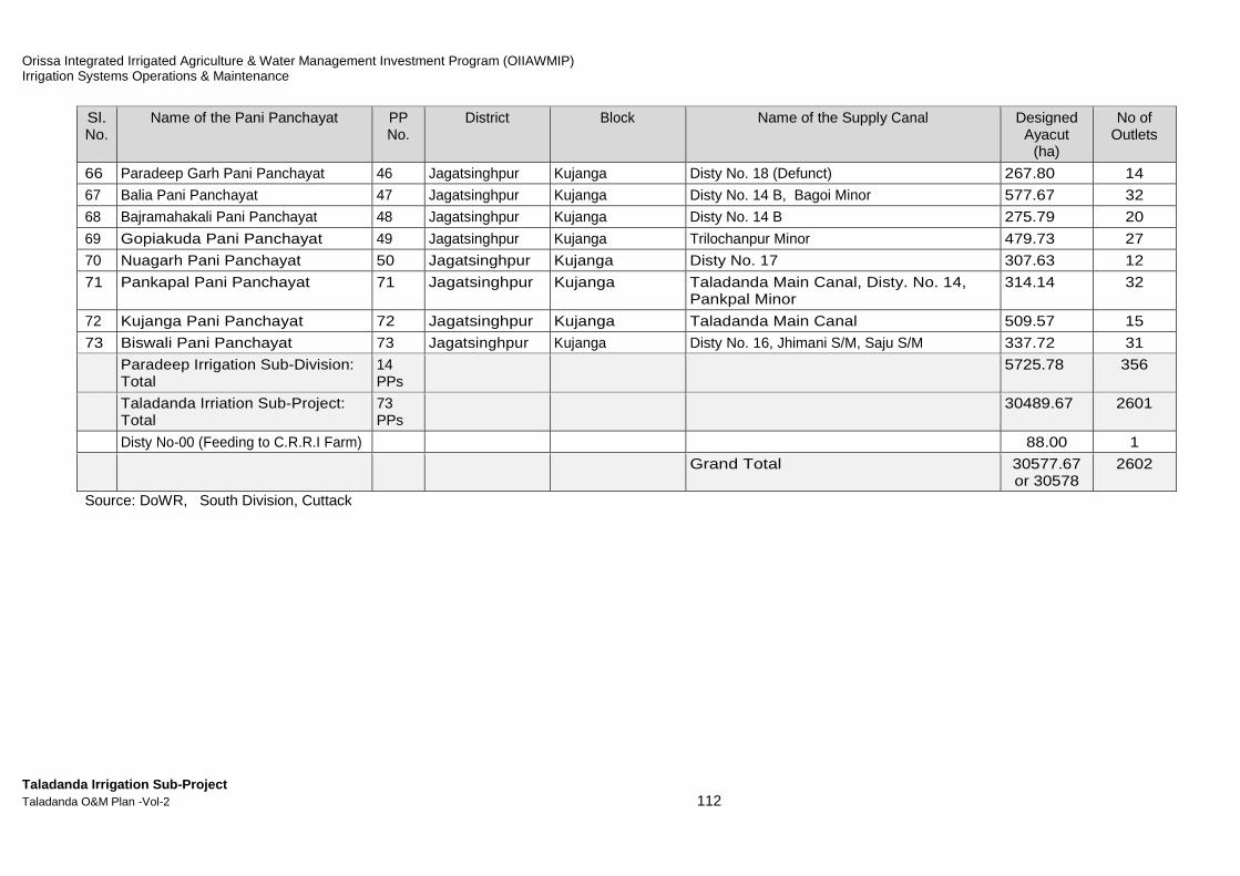
Orissa Integrated Irrigated Agriculture & Water Management Investment Program (OIIAWMIP) Irrigation Systems Operations & Maintenance
Taladanda Irrigation Sub-Project Taladanda O&M Plan -Vol-2 112
Sl. No.
Name of the Pani Panchayat PP No.
District Block Name of the Supply Canal Designed Ayacut
(ha)
No of Outlets
66 Paradeep Garh Pani Panchayat 46 Jagatsinghpur Kujanga Disty No. 18 (Defunct) 267.80 14
67 Balia Pani Panchayat 47 Jagatsinghpur Kujanga Disty No. 14 B, Bagoi Minor 577.67 32
68 Bajramahakali Pani Panchayat 48 Jagatsinghpur Kujanga Disty No. 14 B 275.79 20
69 Gopiakuda Pani Panchayat 49 Jagatsinghpur Kujanga Trilochanpur Minor 479.73 27
70 Nuagarh Pani Panchayat 50 Jagatsinghpur Kujanga Disty No. 17 307.63 12
71 Pankapal Pani Panchayat 71 Jagatsinghpur Kujanga Taladanda Main Canal, Disty. No. 14, Pankpal Minor
314.14 32
72 Kujanga Pani Panchayat 72 Jagatsinghpur Kujanga Taladanda Main Canal 509.57 15
73 Biswali Pani Panchayat 73 Jagatsinghpur Kujanga Disty No. 16, Jhimani S/M, Saju S/M 337.72 31
Paradeep Irrigation Sub-Division: Total
14 PPs
5725.78 356
Taladanda Irriation Sub-Project: Total
73 PPs
30489.67 2601
Disty No-00 (Feeding to C.R.R.I Farm) 88.00 1
Grand Total 30577.67 or 30578
2602
Source: DoWR, South Division, Cuttack

Orissa Integrated Irrigated Agriculture & Water Management Investment Program (OIIAWMIP) Irrigation Systems Operations & Maintenance
Taladanda Irrigation Sub-Project Taladanda O&M Plan -Vol-2 113
Figure M-7: Schematic Diagram of Taladanda Canal Sy atem

Orissa Integrated Irrigated Agriculture & Water Management Investment Program (OIIAWMIP) Irrigation Systems Operations & Maintenance
Taladanda Irrigation Sub-Project Taladanda O&M Plan -Vol-2 114
Table M-6: Design Statement of Taladanda Canal (Unl ined)
(from RD.0.000 Km to 84.24 Km) RESERVOIR
MAHANADI SOUTH DIVISION, CUTTACK. FRL - 21.200 m.Duty 1282 Ha/Cumecs (for Taladanda) DSL. - 21.180 m.
Disch. Loss Loss in PC. Total Cummul. Designed Parameters.New Verified in in 2.50 Dischg. Dischg. Existing Design Design Rema-
Sl. Name of Structures RD GCA CCA Cumecs offtakes cumecs/ in Reqd. in Bed FSD Water Vel. C.V.R. Free Bank Bed Bed Old FSL FSL rksNo. in m. in in 0.78 in million Sqm Cumecs. Cumecs. Width in m.Slope in Board Width Level Level in m. in m. (Head
Ha Ha lps/Ha cumecs of WP in m. 1 in m/s in in m. in m. in m. Loss
Current Proposed (D) 20% (L) 5.55 m. L/R U/S U/S U/S in m)1 2 3 4 5a 5b 5c 6 7 8 9 10 12 13 14 15 16 17 18 19 20 21 22 231 Head Regulator 0 0.000 0.000 0.1645 0.1645 87.682 35.36 2.700 10000 0.849 0.867 0.750 5.00/3.00 17.800 18.175 20.880 20.8752 Ranihat Bridge 1,580 0.000 0.000 0.0843 0.0843 87.518 35.36 2.700 10000 0.848 0.867 0.750 5.00/3.01 17.650 18.017 20.7173 Chatrabazar Bridge 2,390 0.000 0.000 0.0989 0.0989 87.433 35.36 2.700 10000 0.848 0.867 0.750 5.00/3.02 17.570 17.936 20.6364 In Let of Matrubhawan sluice (R ) 3,340 0.000 0.000 0.0208 0.0208 87.334 35.36 2.700 10000 0.847 0.867 0.750 5.00/3.03 17.480 17.841 20.5415 N.H.-5 Crossing 3,540 0.000 0.000 0.1707 0.1707 87.314 35.36 2.700 10000 0.847 0.867 0.750 5.00/3.04 17.460 17.821 20.5216 Nuabazar Bridge 5,180 0.000 0.000 0.0822 0.0822 87.143 35.36 2.700 10000 0.847 0.867 0.750 5.00/3.05 17.350 17.657 20.3577 HR of Disty No:0 (L) 5,970 75 53 0.041 0.008 0.0520 0.1016 87.06135.36 2.700 10000 0.846 0.867 0.750 5.00/3.06 17.203 17.578 20.2788 Out Let (L) 6,470 50 35 0.027 0.005 0.1384 0.1711 86.95935.36 2.700 10000 0.846 0.867 0.750 5.00/3.07 17.153 17.528 20.2289 V.R.Bridge at Gatiroutipatana (not on GE) 7,800 0.000 0.000 0.1071 0.1071 86.788 35.36 2.700 10000 0.845 0.867 0.750 5.00/3.08 17.020 17.395 20.09510 HR of Disty No 1(L) 8,830 5,811 4,069 3.174 0.635 0.0198 3.8283 86.681 35.36 2.700 10000 0.845 0.867 0.750 5.00/3.09 16.925 17.292 19.99211 HR of Disty No.1-1/2 (R ) 9,020 710 497 0.388 0.078 0.2413 0.7065 82.852 35.36 2.700 10000 0.831 0.867 0.750 5.00/3.10 16.910 17.273 19.97312 Out Let at Paramhansa (R ) 11,350 20 14 0.011 0.002 0.0005 0.0136 82.14635.36 2.700 10000 0.829 0.867 0.750 5.00/3.11 16.662 17.040 19.74013 HR of Machhagaon Canal (R ) 11,355 50,010 35,000 39.080 4.885 0.0212 43.9862 82.132 35.36 2.700 10000 0.8290.867 0.750 5.00/3.12 16.658 17.040 19.74014 HR of Distry No:2( R ) 11,560 471 283 0.221 0.044 0.0186 0.2835 38.146 35.36 2.700 10000 0.624 0.867 0.750 5.00/3.13 16.640 17.019 19.71915 Biribati Lock-cum-fall-cum-VRB 11,750 0.000 0.000 0.0000 0.0000 37.863 35.36 2.700 10000 0.622 0.867 0.750 5.00/3.14 16.622 17.000 19.702 19.700
CHANGE POINT 11,750 0.000 0.000 0.0211 0.0211 37.863 17.07 2.410 8487 0.811 0.868 0.750 5.00/3.00 14.254 14.698 16.854 17.108 2.5916 H.L.Bridge on Cuttack Paradeep Road 12,120 0.000 0.000 0.0046 0.0046 37.842 17.07 2.410 8487 0.811 0.868 0.750 5.00/3.00 14.654 17.06417 In Let at Neishapur (L) 12,200 0.000 0.000 0.0683 0.0683 37.837 17.07 2.410 8487 0.811 0.868 0.750 5.00/3.00 14.406 14.645 17.05518 In Let at Neishapur (L) 13,400 0.000 0.000 0.1357 0.1357 37.769 17.07 2.410 8487 0.810 0.868 0.750 5.00/3.00 14.265 14.503 16.91319 Out Let Fakirpada ( R ) 15,785 68 47 0.037 0.007 0.0020 0.0464 37.63317.07 2.410 8487 0.810 0.868 0.750 5.00/3.00 13.984 14.222 16.63220 Prposed V.R.Bridge at Fakirpada 15,821 0.000 0.000 0.0397 0.0397 37.587 17.07 2.410 8487 0.809 0.868 0.750 5.00/3.00 13.980 14.218 16.62821 HR of Bhutupada Minor (R ) 16,520 116 81 0.063 0.013 0.0205 0.0963 37.547 17.07 2.410 8487 0.809 0.868 0.750 5.00/3.00 13.906 14.136 16.54622 Bed Level Escape near Kandarpur ( R ) 16,880 0.000 0.000 0.0000 0.0000 37.451 17.07 2.410 8487 0.808 0.868 0.750 5.00/3.00 13.864 14.093 16.50323 Drainage Syphon at Kandarpur 16,880 0.000 0.000 0.0017 0.0017 37.451 17.07 2.410 8487 0.808 0.868 0.750 5.00/3.00 13.864 14.093 16.503
Existing VRB 16,910 0.000 0.000 0.0210 0.0210 37.449 17.07 2.410 8487 0.808 0.868 0.750 5.00/3.00 14.090 16.50024 Out Let (R ) 17,280 20 14 0.011 0.002 0.0193 0.0324 37.42817.07 2.410 8487 0.808 0.868 0.750 5.00/3.00 13.807 14.046 16.45625 Out Let (R ) 17,620 16 11 0.009 0.002 0.0176 0.0279 37.39617.07 2.410 8487 0.808 0.868 0.750 5.00/3.00 13.767 14.006 16.41626 HR of Distry No:3( R ) 17,930 675 473 0.369 0.074 0.0312 0.4740 37.368 17.07 2.410 8487 0.808 0.868 0.750 5.00/3.00 13.743 13.969 16.37927 Out Let at Parabil (R ) 18,480 49 34 0.027 0.005 0.0578 0.0896 36.894 17.07 2.410 8487 0.804 0.868 0.750 5.00/3.00 13.673 13.905 16.31528 DrainageSyphon at Kamarpada 19,500 0.000 0.000 0.0425 0.0425 36.804 17.07 2.410 8487 0.803 0.868 0.750 5.00/3.00 13.545 13.784 16.194
Existing VRB 20,250 0.000 0.000 0.0119 0.0119 36.762 17.07 2.410 8487 0.803 0.868 0.750 5.00/3.00 13.696 16.10629 HR of Disty No.4 (R ) 20,460 362 253 0.197 0.039 0.0190 0.2558 36.750 17.07 2.410 8487 0.803 0.8680.750 5.00/3.00 13.447 13.671 16.08130 HR of Kotakan Minor (L) 20,795 49 34 0.027 0.005 0.0736 0.1054 36.494 17.07 2.410 8487 0.801 0.868 0.750 5.00/3.00 13.394 13.632 16.04231 HR of Lenka Minor ( R ) 22,095 80 56 0.044 0.009 0.0028 0.0552 36.389 17.07 2.410 8487 0.800 0.868 0.750 5.00/3.00 13.252 13.479 15.88932 HR of Ramkumarpur Sub-Minor-I ( L ) 22,145 37 26 0.020 0.004 0.0162 0.0406 36.333 17.07 2.410 8487 0.800 0.868 0.750 5.00/3.00 13.246 13.473 15.88333 Proposed Foot Bridge at Ramkumarpur 22,432 0.000 0.000 0.0417 0.0417 36.293 17.07 2.410 8487 0.800 0.868 0.750 5.00/3.00 13.200 13.439 15.84934 HR of Ramkumarpur Sub-Minor No.II (L) 23,170 45 32 0.025 0.005 0.0571 0.0870 36.251 17.07 2.410 8487 0.799 0.868 0.750 5.00/3.00 13.153 13.352 15.76235 HR of Distry No. 5 (R ) 24,180 535 375 0.293 0.059 0.0130 0.3640 36.164 17.07 2.410 8487 0.799 0.868 0.750 5.00/3.00 13.016 13.233 15.64336 HR of Distry No. 5- 1/2 (L ) 24,410 251 176 0.137 0.027 0.0028 0.1676 35.800 17.07 2.410 8487 0.796 0.868 0.750 5.00/3.00 12.989 13.206 15.61637 Sompur Lock-cum-fall-cum-V.R.B. 24,460 0.000 0.000 0.0000 0.0000 35.632 17.07 2.410 8487 0.795 0.868 0.750 5.00/3.00 12.770 13.200 15.370 15.610
CHANGE POINT 24,460 0.000 0.000 0.0868 0.0868 35.632 16.00 2.410 8467 0.807 0.862 0.750 5.00/3.00 10.873 11.293 13.373 13.703 1.91
DESIGN STATEMENT OF TALDANDA MAIN CANAL (Unlined)
88
SD Boundaries & CCA excl.
Machegaon (ha)
4,951
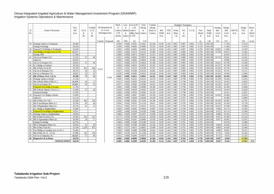
Orissa Integrated Irrigated Agriculture & Water Management Investment Program (OIIAWMIP) Irrigation Systems Operations & Maintenance
Taladanda Irrigation Sub-Project Taladanda O&M Plan -Vol-2 115
Disch. Loss Loss in PC. Total Cummul. Designed Parameters.New Verified in in 2.50 Dischg. Dischg. Existing Design Design Rema-
Sl. Name of Structures RD GCA CCA Cumecs offtakes cumecs/ in Reqd. in Bed FSD Water Vel. C.V.R. Free Bank Bed Bed Old FSL FSL rksNo. in m. in in 0.78 in million Sqm Cumecs. Cumecs. Width in m.Slope in Board Width Level Level in m. in m. (Head
Ha Ha lps/Ha cumecs of WP in m. 1 in m/s in in m. in m. in m. Loss
Current Proposed (D) 20% (L) 5.55 m. L/R U/S U/S U/S in m)38 Drainage Syphon at Tatalapada 26,060 0.000 0.000 0.0201 0.0201 35.546 16.00 2.410 8467 0.807 0.862 0.750 5.00/3.00 11.104 13.514
Existing Footbridge 26,430 0.000 0.000 0.0000 0.0000 35.525 16.00 2.410 8467 0.807 0.862 0.750 5.00/3.00 11.060 13.47039 Proposed V.R.Bridge at Tatalapada 26,430 0.000 0.000 0.0405 0.0405 35.525 16.00 2.410 8467 0.807 0.862 0.750 5.00/3.00 10.855 11.060 13.47040 Foot Bridge at Nanpur (not on GE) 27,177 0.000 0.000 0.0116 0.0116 35.485 16.00 2.410 8467 0.806 0.862 0.750 5.00/3.00 10.769 10.972 13.382
Existing VRB 27,390 0.000 0.000 0.0073 0.0073 35.473 16.00 2.410 8467 0.806 0.862 0.750 5.00/3.00 10.947 13.35741 Out Let at Nanpur ( R ) 27,525 57 40 0.031 0.006 0.0602 0.0976 35.466 16.00 2.410 8467 0.806 0.862 0.750 5.00/3.00 10.753 10.931 13.341
Outlet (L) 28,635 0.000 0.000 0.0005 0.0005 35.368 16.00 2.410 8467 0.805 0.862 0.750 5.00/3.00 10.800 13.21042 Out Let at Sarapur ( R ) 28,645 57 40 0.031 0.006 0.0279 0.0654 35.368 16.00 2.410 8467 0.805 0.862 0.750 5.00/3.00 10.621 10.799 13.20943 H. L.Bridge at Gadama 29,160 0.000 0.000 0.0016 0.0016 35.303 16.00 2.410 8467 0.805 0.862 0.750 5.00/3.00 10.557 10.738 13.14844 HR of Distry No.6( R) 29,190 923 646 0.504 0.101 0.0152 0.6198 35.301 16.002.410 8467 0.805 0.862 0.750 5.00/3.00 10.550 10.734 13.14445 Out Let at Manapur ( R ) 29,470 50 35 0.027 0.005 0.0206 0.0534 34.681 16.00 2.410 8467 0.800 0.862 0.750 5.00/3.00 10.522 10.701 13.11146 Out Let at Manapur ( R ) 29,852 53 37 0.029 0.006 0.0285 0.0632 34.628 16.00 2.410 8467 0.800 0.862 0.750 5.00/3.00 10.453 10.656 13.06647 HR of Distry No.6 -1/2( L) 30,380 75 52 0.041 0.008 0.0411 0.0901 34.565 16.00 2.410 8467 0.799 0.862 0.750 5.00/3.00 10.426 10.594 13.00448 Drainage Syphon at Bodar 31,140 0.000 0.000 0.0232 0.0232 34.474 16.00 2.410 8467 0.798 0.862 0.750 5.00/3.00 10.329 10.504 12.91449 HR of Bodar Minor (Old) ( L ) 31,570 24 17 0.013 0.003 0.0030 0.0185 34.451 16.00 2.410 8467 0.798 0.862 0.750 5.00/3.00 10.251 10.453 12.86350 Out Let at Kantua ( R ) 31,625 50 35 0.027 0.005 0.0040 0.0368 34.433 16.00 2.410 8467 0.798 0.862 0.750 5.00/3.00 10.245 10.447 12.85751 Proposed Foot bridge at Kantua 31,700 0.000 0.000 0.0086 0.0086 34.396 16.00 2.410 8467 0.798 0.862 0.750 5.00/3.00 10.236 10.438 12.84852 HR of Bodar Minopr ( New) ( L ) 31,860 37 26 0.020 0.004 0.0038 0.0281 34.387 16.00 2.410 8467 0.798 0.862 0.750 5.00/3.00 10.214 10.419 12.829
Existing footbridge 31,930 0.000 0.000 0.0030 0.0030 34.359 16.00 2.410 8467 0.798 0.862 0.750 5.00/3.00 10.411 12.82154 Proposed V.R. Bridge at Bodar 31,985 0.000 0.000 0.0067 0.0067 34.356 16.00 2.410 8467 0.798 0.862 0.750 5.00/3.00 10.202 10.404 12.814
Outlet (L) 32,110 0.000 0.000 0.0038 0.0038 34.349 16.00 2.410 8467 0.797 0.862 0.750 5.00/3.00 10.390 12.80053 HR of Distry No:7 (R ) 32,180 443 310 0.242 0.048 0.0281 0.3182 34.346 16.002.410 8467 0.797 0.862 0.750 5.00/3.00 10.203 10.381 12.79155 HR of Ayodhyapur Minor (L ) 32,700 92 64 0.050 0.010 0.0555 0.1154 34.027 16.00 2.410 8467 0.795 0.862 0.750 5.00/3.00 10.143 10.320 12.73056 HR of Ragunathpur Minor (L) 33,730 21 15 0.012 0.002 0.0113 0.0253 33.912 16.00 2.410 8467 0.794 0.862 0.750 5.00/3.00 10.035 10.198 12.60857 H.L. Bridge at Raghunathpur 33,940 0.000 0.000 0.0043 0.0043 33.887 16.00 2.410 8467 0.794 0.862 0.750 5.00/3.00 9.996 10.173 12.58359 Proposed Foot Bridge at Raghunathpur 33,937 0.000 0.000 0.0338 0.0338 33.882 16.00 2.410 8467 0.794 0.862 0.750 5.00/3.00 9.972 10.174 12.58458 Drainage Syphon at Raghunathpur 34,020 0.000 0.000 0.0307 0.0307 33.849 16.00 2.410 8467 0.794 0.862 0.750 5.00/3.00 9.986 10.164 12.57461 HR of Disty No.8(A) ( R ) 34,565 324 227 0.177 0.035 0.0100 0.2224 33.818 16.002.410 8467 0.793 0.862 0.750 5.00/3.00 9.911 10.100 12.51060 HR of Jagannathpur Minor (L) 34,590 24 17 0.013 0.003 0.0247 0.0406 33.595 16.00 2.410 8467 0.792 0.862 0.750 5.00/3.00 9.917 10.097 12.507
Existing Footbridge 34,750 0.000 0.000 0.0188 0.0188 33.555 16.00 2.410 8467 0.791 0.862 0.750 5.00/3.00 10.078 12.48862 HR of Athangutari Minor (L) 35,050 41 29 0.023 0.005 0.0188 0.0460 33.536 16.00 2.410 8467 0.791 0.862 0.750 5.00/3.00 9.864 10.042 12.45263 HR of Disty No:8 (R ) 35,100 1,250 875 0.683 0.137 0.0473 0.8663 33.490 16.00 2.410 8467 0.791 0.862 0.750 5.00/3.00 9.864 10.036 12.44664 Foot Bridge at Gopalpur (not on GE ) 35,400 0.000 0.000 0.0388 0.0388 32.624 16.00 2.410 8467 0.784 0.862 0.750 5.00/3.00 9.800 10.001 12.41165 HR of Disty No. 8 - 1/2 (L) 35,980 147 103 0.080 0.016 0.0374 0.1338 32.585 16.002.410 8467 0.783 0.862 0.750 5.00/3.00 9.753 9.932 12.34266 Out Let at Odapada ( R ) 36,125 57 40 0.031 0.006 0.0296 0.0670 32.451 16.00 2.410 8467 0.782 0.862 0.750 5.00/3.00 9.712 9.915 12.32569 Proposed C.R at Puran 36,678 0.000 0.000 0.0000 0.0000 32.384 16.00 2.410 8467 0.782 0.862 0.750 5.00/3.00 9.647 9.850 12.260
CHANGE POINT 36,678 0.000 0.000 0.0209 0.0209 32.384 15.24 2.410 8437 0.792 0.858 0.750 5.00/3.00 9.647 9.543 11.953 0.31
10,207
5,344
SD Boundaries & CCA excl.
Machegaon (ha)

Orissa Integrated Irrigated Agriculture & Water Management Investment Program (OIIAWMIP) Irrigation Systems Operations & Maintenance
Taladanda Irrigation Sub-Project Taladanda O&M Plan -Vol-2 116
Disch. Loss Loss in PC. Total Cummul. Designed Parameters.New Verified in in 2.50 Dischg. Dischg. Existing Design Design Rema-
Sl. Name of Structures RD GCA CCA Cumecs offtakes cumecs/ in Reqd. in Bed FSD Water Vel. C.V.R. Free Bank Bed Bed Old FSL FSL rksNo. in m. in in 0.78 in million Sqm Cumecs. Cumecs. Width in m.Slope in Board Width Level Level in m. in m. (Head
Ha Ha lps/Ha cumecs of WP in m. 1 in m/s in in m. in m. in m. Loss
Current Proposed (D) 20% (L) 5.55 m. L/R U/S U/S U/S in m)67 Out Let at Odapada ( R ) 36,718 50 35 0.027 0.005 0.0451 0.0778 32.363 15.24 2.410 8467 0.790 0.862 0.750 5.00/3.00 9.665 9.538 11.94868 Out Let at Odapada ( L ) 36,729 50 35 0.027 0.005 0.0446 0.0774 32.285 15.24 2.410 8467 0.790 0.862 0.750 5.00/3.00 9.664 9.537 11.94770 Drainage Syphon at Puran 37,080 0.000 0.000 0.0369 0.0369 32.208 15.24 2.410 8437 0.790 0.858 0.750 5.00/3.00 9.521 9.495 11.90571 HR of Puran Minor (L) 37,585 21 15 0.012 0.002 0.0291 0.0431 32.171 15.24 2.410 8437 0.790 0.858 0.750 5.00/3.00 9.464 9.436 11.84672 Out Let at Kulasahi ( R ) 37,588 57 40 0.031 0.006 0.0380 0.0754 32.128 15.24 2.410 8437 0.789 0.858 0.750 5.00/3.00 9.439 9.435 11.84573 RCC.br at Kulasahi in place of wooden br 37,790 0.000 0.000 0.0400 0.0400 32.053 15.24 2.410 8437 0.789 0.858 0.750 5.00/3.00 9.415 9.411 11.82174 HR of Disty No.9 (R ) 38,145 844 591 0.461 0.092 0.0091 0.5623 32.013 15.242.410 8437 0.788 0.858 0.750 5.00/3.00 9.377 9.369 11.77975 Out Let at Patnigaon ( L ) 38,320 50 35 0.027 0.005 0.0124 0.0452 31.450 15.24 2.410 8437 0.784 0.858 0.750 5.00/3.00 9.352 9.348 11.75876 Escape at Barti (L) 38,560 0.000 0.000 0.0124 0.0124 31.405 15.24 2.410 8437 0.783 0.858 0.750 5.00/3.00 9.345 9.320 11.73077 Out Let at Barti ( L ) 38,800 40 28 0.022 0.004 0.0023 0.0285 31.393 15.24 2.410 8437 0.783 0.858 0.750 5.00/3.00 9.295 9.292 11.70278 Proposed Pile Bridge at Barti 38,845 0.000 0.000 0.1357 0.1357 31.364 15.24 2.410 8437 0.783 0.858 0.750 5.00/3.00 9.290 9.286 11.69679 H.L.Bridge at Tarapur 41,470 0.000 0.000 0.0103 0.0103 31.229 15.24 2.410 8437 0.782 0.858 0.750 5.00/3.00 9.013 8.975 11.38580 HR of Disty No.10(R ) 41,670 493 345 0.269 0.054 0.0137 0.3366 31.218 15.242.410 8437 0.782 0.858 0.750 5.00/3.00 8.980 8.951 11.36181 Lock & weir-cum-V.R.B. at Tarapur. 41,935 0.000 0.000 0.0000 0.0000 30.882 15.24 2.410 8437 0.779 0.858 0.750 5.00/3.00 8.833 8.920 11.333 11.330 1.604
CHANGE POINT 41,935 0.000 0.000 0.0616 0.0616 30.882 15.24 2.286 8424 0.779 0.860 0.750 5.00/3.00 7.205 7.654 9.605 9.940 1.390Wooden bridge 43,130 0.000 0.000 0.1193 0.1193 30.820 15.24 2.286 8424 0.779 0.860 0.750 5.00/3.00 7.512 9.798
82 Escape at Jaipur (R ) 45,445 0.000 0.000 0.0126 0.0126 30.701 15.24 2.286 8424 0.778 0.860 0.750 5.00/3.00 7.085 7.237 9.52383 H.L. Bridge at Jaipur 45,690 0.000 0.000 0.0170 0.0170 30.688 15.24 2.286 8424 0.778 0.860 0.750 5.00/3.00 7.066 7.208 9.49484 H.R.of No.11 Main (R ) 46,020 778 545 0.425 0.085 0.0237 0.5338 30.671 15.242.286 8424 0.778 0.860 0.750 5.00/3.00 7.035 7.169 9.45585 Proposed VRB at Jaipur (replace FB)? 46,480 0.000 0.000 0.1058 0.1058 30.137 15.24 2.286 8424 0.773 0.860 0.750 5.00/3.00 6.978 7.114 9.40086 F B at Nuapada in place of wooden br 48,540 0.000 0.000 0.0010 0.0010 30.031 15.24 2.286 8424 0.772 0.860 0.750 5.00/3.00 6.682 6.870 9.15687 HR of Nuapada Minor (R ) 48,560 120 84 0.066 0.013 0.0221 0.1007 30.030 15.24 2.286 8424 0.772 0.860 0.750 5.00/3.00 6.681 6.867 9.15388 H.R.of Disty.No.12 (R ) 48,990 16,214 11,350 8.853 1.771 0.0010 11.2676 29.930 15.24 2.286 8424 0.771 0.860 0.750 5.00/3.00 6.623 6.816 9.10289 Proposed Cross Regulator d/s disty 12 49,010 0.000 0.000 0.0000 0.0000 18.662 15.24 2.286 8424 0.656 0.860 0.750 5.00/3.00 6.621 6.814 9.100
CHANGE POINT 49,010 15,197 0.000 0.000 0.0552 0.0552 18.662 13.50 1.850 8278 0.680 0.857 0.750 5.00/3.00 6.621 6.939 8.789 0.31190 F B at Kotakana in place of wooden br 50,255 0.000 0.000 0.0552 0.0552 18.607 13.50 1.850 8278 0.680 0.857 0.750 5.00/3.00 6.788 6.789 8.63991 F B at Balipatna in place of wooden br 51,500 0.000 0.000 0.0284 0.0284 18.552 13.50 1.850 8278 0.679 0.857 0.750 5.00/3.00 6.722 6.639 8.48992 HR of Tertanga Feeder (R ) 52,140 15 10 0.008 0.002 0.0164 0.0258 18.523 13.50 1.850 8278 0.679 0.857 0.750 5.00/3.00 6.637 6.561 8.41193 F B at Dandasahi in place of wooden br 52,510 0.000 0.000 0.0421 0.0421 18.497 13.50 1.850 8278 0.678 0.857 0.750 5.00/3.00 6.595 6.517 8.36794 HR ofRathipur Feeder (R ) 53,460 80 56 0.044 0.009 0.0231 0.0755 18.455 13.50 1.850 8278 0.678 0.857 0.750 5.00/3.00 6.407 6.402 8.25295 F B at Rathipur in place of wooden bridge 53,982 0.000 0.000 0.0685 0.0685 18.380 13.50 1.850 8278 0.677 0.857 0.750 5.00/3.00 6.338 6.339 8.18996 H.R.of Disty.No.13 Main (R ) 55,530 4,502 3,152 2.459 0.492 0.0080 2.9582 18.311 13.50 1.850 8278 0.676 0.857 0.750 5.00/3.00 6.289 6.152 8.00297 Tirtol Lock 55,710 0.000 0.000 0.0000 0.0000 15.353 13.50 1.850 8278 0.636 0.857 0.750 5.00/3.00 5.580 6.130 7.980 7.980
CHANGE POINT 55,710 0.000 0.000 0.0546 0.0546 15.353 11.50 1.850 8220 0.663 0.842 0.750 5.00/3.00 5.106 5.013 6.856 6.863 1.117
16,086
SD Boundaries & CCA excl.
Machegaon (ha)
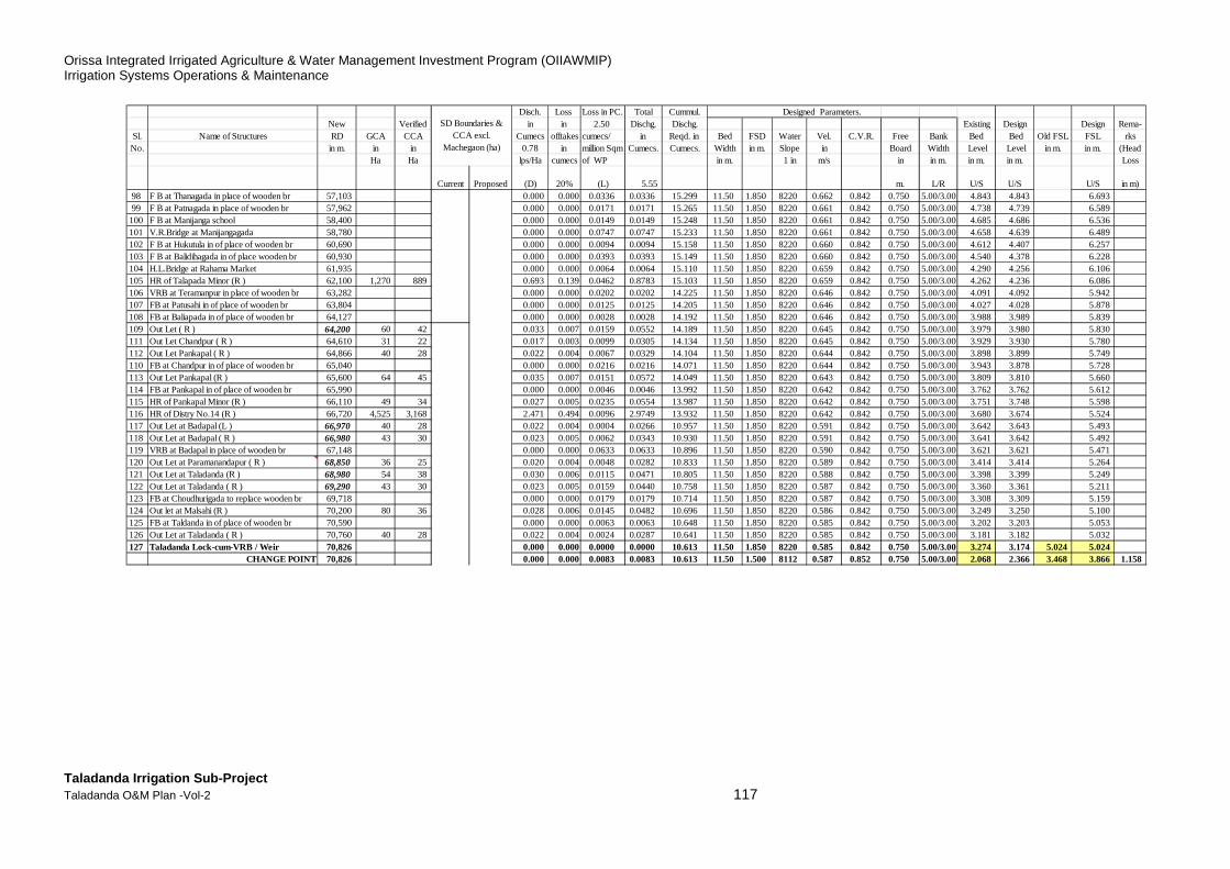
Orissa Integrated Irrigated Agriculture & Water Management Investment Program (OIIAWMIP) Irrigation Systems Operations & Maintenance
Taladanda Irrigation Sub-Project Taladanda O&M Plan -Vol-2 117
Disch. Loss Loss in PC. Total Cummul. Designed Parameters.New Verified in in 2.50 Dischg. Dischg. Existing Design Design Rema-
Sl. Name of Structures RD GCA CCA Cumecs offtakes cumecs/ in Reqd. in Bed FSD Water Vel. C.V.R. Free Bank Bed Bed Old FSL FSL rksNo. in m. in in 0.78 in million Sqm Cumecs. Cumecs. Width in m.Slope in Board Width Level Level in m. in m. (Head
Ha Ha lps/Ha cumecs of WP in m. 1 in m/s in in m. in m. in m. Loss
Current Proposed (D) 20% (L) 5.55 m. L/R U/S U/S U/S in m)98 F B at Thanagada in place of wooden br 57,103 0.000 0.000 0.0336 0.0336 15.299 11.50 1.850 8220 0.662 0.842 0.750 5.00/3.00 4.843 4.843 6.69399 F B at Patnagada in place of wooden br 57,962 0.000 0.000 0.0171 0.0171 15.265 11.50 1.850 8220 0.661 0.842 0.750 5.00/3.00 4.738 4.739 6.589100 F B at Manijanga school 58,400 0.000 0.000 0.0149 0.0149 15.248 11.50 1.850 8220 0.661 0.842 0.750 5.00/3.00 4.685 4.686 6.536101 V.R.Bridge at Manijangagada 58,780 0.000 0.000 0.0747 0.0747 15.233 11.50 1.850 8220 0.661 0.842 0.750 5.00/3.00 4.658 4.639 6.489102 F B at Hukutula in of place of wooden br 60,690 0.000 0.000 0.0094 0.0094 15.158 11.50 1.850 8220 0.660 0.842 0.750 5.00/3.00 4.612 4.407 6.257103 F B at Balidihagada in of place wooden br 60,930 0.000 0.000 0.0393 0.0393 15.149 11.50 1.850 8220 0.660 0.842 0.750 5.00/3.00 4.540 4.378 6.228104 H.L.Bridge at Rahama Market 61,935 0.000 0.000 0.0064 0.0064 15.110 11.50 1.850 8220 0.659 0.842 0.750 5.00/3.00 4.290 4.256 6.106105 HR of Talapada Minor (R ) 62,100 1,270 889 0.693 0.139 0.0462 0.8783 15.103 11.50 1.850 8220 0.659 0.842 0.750 5.00/3.00 4.262 4.236 6.086106 VRB at Teramanpur in place of wooden br 63,282 0.000 0.000 0.0202 0.0202 14.225 11.50 1.850 8220 0.646 0.842 0.750 5.00/3.00 4.091 4.092 5.942107 FB at Patusahi in of place of wooden br 63,804 0.000 0.000 0.0125 0.0125 14.205 11.50 1.850 8220 0.646 0.842 0.750 5.00/3.00 4.027 4.028 5.878108 FB at Baliapada in of place of wooden br 64,127 0.000 0.000 0.0028 0.0028 14.192 11.50 1.850 8220 0.646 0.842 0.750 5.00/3.00 3.988 3.989 5.839109 Out Let ( R ) 64,200 60 42 0.033 0.007 0.0159 0.0552 14.189 11.50 1.850 8220 0.645 0.842 0.750 5.00/3.00 3.979 3.980 5.830111 Out Let Chandpur ( R ) 64,610 31 22 0.017 0.003 0.0099 0.0305 14.134 11.50 1.850 8220 0.645 0.842 0.750 5.00/3.00 3.929 3.930 5.780112 Out Let Pankapal ( R ) 64,866 40 28 0.022 0.004 0.0067 0.0329 14.104 11.50 1.850 8220 0.644 0.842 0.750 5.00/3.00 3.898 3.899 5.749110 FB at Chandpur in of place of wooden br 65,040 0.000 0.000 0.0216 0.0216 14.071 11.50 1.850 8220 0.644 0.842 0.750 5.00/3.00 3.943 3.878 5.728113 Out Let Pankapal (R ) 65,600 64 45 0.035 0.007 0.0151 0.0572 14.049 11.50 1.850 8220 0.643 0.842 0.750 5.00/3.00 3.809 3.810 5.660114 FB at Pankapal in of place of wooden br 65,990 0.000 0.000 0.0046 0.0046 13.992 11.50 1.850 8220 0.642 0.842 0.750 5.00/3.00 3.762 3.762 5.612115 HR of Pankapal Minor (R ) 66,110 49 34 0.027 0.005 0.0235 0.0554 13.987 11.50 1.850 8220 0.642 0.842 0.750 5.00/3.00 3.751 3.748 5.598116 HR of Distry No.14 (R ) 66,720 4,525 3,168 2.471 0.494 0.0096 2.9749 13.932 11.50 1.850 8220 0.642 0.842 0.750 5.00/3.00 3.680 3.674 5.524117 Out Let at Badapal (L ) 66,970 40 28 0.022 0.004 0.0004 0.0266 10.957 11.50 1.850 8220 0.591 0.842 0.750 5.00/3.00 3.642 3.643 5.493118 Out Let at Badapal ( R ) 66,980 43 30 0.023 0.005 0.0062 0.0343 10.930 11.50 1.850 8220 0.591 0.842 0.750 5.00/3.00 3.641 3.642 5.492119 VRB at Badapal in place of wooden br 67,148 0.000 0.000 0.0633 0.0633 10.896 11.50 1.850 8220 0.590 0.842 0.750 5.00/3.00 3.621 3.621 5.471120 Out Let at Paramanandapur ( R ) 68,850 36 25 0.020 0.004 0.0048 0.0282 10.833 11.50 1.850 8220 0.589 0.842 0.750 5.00/3.00 3.414 3.414 5.264121 Out Let at Taladanda (R ) 68,980 54 38 0.030 0.006 0.0115 0.0471 10.805 11.50 1.850 8220 0.588 0.842 0.750 5.00/3.00 3.398 3.399 5.249122 Out Let at Taladanda ( R ) 69,290 43 30 0.023 0.005 0.0159 0.0440 10.758 11.50 1.850 8220 0.587 0.842 0.750 5.00/3.00 3.360 3.361 5.211123 FB at Choudhurigada to replace wooden br 69,718 0.000 0.000 0.0179 0.0179 10.714 11.50 1.850 8220 0.587 0.842 0.750 5.00/3.00 3.308 3.309 5.159124 Out let at Malsahi (R ) 70,200 80 36 0.028 0.006 0.0145 0.0482 10.696 11.50 1.850 8220 0.586 0.842 0.750 5.00/3.00 3.249 3.250 5.100125 FB at Taldanda in of place of wooden br 70,590 0.000 0.000 0.0063 0.0063 10.648 11.50 1.850 8220 0.585 0.842 0.750 5.00/3.00 3.202 3.203 5.053126 Out Let at Taladanda ( R ) 70,760 40 28 0.022 0.004 0.0024 0.0287 10.641 11.50 1.850 8220 0.585 0.842 0.750 5.00/3.00 3.181 3.182 5.032127 Taladanda Lock-cum-VRB / Weir 70,826 0.000 0.000 0.0000 0.0000 10.613 11.50 1.850 8220 0.585 0.842 0.750 5.00/3.00 3.274 3.174 5.024 5.024
CHANGE POINT 70,826 0.000 0.000 0.0083 0.0083 10.613 11.50 1.500 8112 0.587 0.852 0.750 5.00/3.00 2.068 2.366 3.468 3.866 1.158
SD Boundaries & CCA excl.
Machegaon (ha)
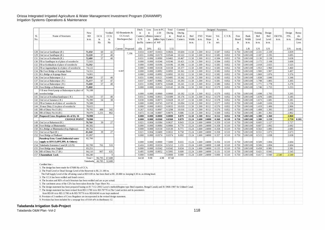
Orissa Integrated Irrigated Agriculture & Water Management Investment Program (OIIAWMIP) Irrigation Systems Operations & Maintenance
Taladanda Irrigation Sub-Project Taladanda O&M Plan -Vol-2 118
Disch. Loss Loss in PC. Total Cummul. Designed Parameters.New Verified in in 2.50 Dischg. Dischg. Existing Design Design Rema-
Sl. Name of Structures RD GCA CCA Cumecs offtakes cumecs/ in Reqd. in Bed FSD Water Vel. C.V.R. Free Bank Bed Bed Old FSL FSL rksNo. in m. in in 0.78 in million Sqm Cumecs. Cumecs. Width in m.Slope in Board Width Level Level in m. in m. (Head
Ha Ha lps/Ha cumecs of WP in m. 1 in m/s in in m. in m. in m. Loss
Current Proposed (D) 20% (L) 5.55 m. L/R U/S U/S U/S in m)128 Out Let at Sandhapur (R ) 71,050 60 42 0.033 0.007 0.0433 0.0826 10.604 11.50 1.500 8112 0.587 0.852 0.750 5.00/3.00 2.331 2.339 3.839129 Out Let at Sandhapur (R ) 72,220 57 40 0.031 0.006 0.0170 0.0544 10.522 11.50 1.500 8112 0.585 0.852 0.750 5.00/3.00 2.187 2.195 3.695131 Out Let at Kothiasahi (R ) 72,680 57 40 0.031 0.006 0.0090 0.0465 10.467 11.50 1.500 8112 0.584 0.852 0.750 5.00/3.00 2.130 2.138 3.638130 FB at Sandhapur in of place of wooden br 72,925 0.000 0.000 0.0246 0.0246 10.421 11.50 1.500 8112 0.584 0.852 0.750 5.00/3.00 2.172 2.108 3.608132 FB at Kothisahi in of place of wooden br 73,592 0.000 0.000 0.0196 0.0196 10.396 11.50 1.500 8112 0.583 0.852 0.750 5.00/3.00 2.018 2.025 3.525133 FB at Jagannathpur in of place of wooden br 74,122 0.000 0.000 0.0158 0.0158 10.377 11.50 1.500 8112 0.583 0.852 0.750 5.00/3.00 1.953 1.960 3.460134 Pile Foot Bridge at Kujanga Bazar 74,551 6,307 0.000 0.000 0.0092 0.0092 10.361 11.50 1.500 8112 0.582 0.852 0.750 5.00/3.00 1.900 1.907 3.407135 H.L.Bridge at Kujanga Bazar 74,801 0.000 0.000 0.0092 0.0092 10.352 11.50 1.500 8112 0.582 0.852 0.750 5.00/3.00 1.869 1.876 3.376136 Out Let at Balarampur ( L ) 75,050 57 40 0.031 0.006 0.0121 0.0495 10.342 11.50 1.500 8112 0.582 0.852 0.750 5.00/3.00 1.838 1.846 3.346137 Out Let at Balarampur ( R ) 75,377 67 47 0.037 0.007 0.0082 0.0522 10.293 11.50 1.500 8112 0.581 0.852 0.750 5.00/3.00 1.798 1.805 3.305138 Out Let at Balarampur ( R ) 75,600 57 40 0.031 0.006 0.0074 0.0448 10.241 11.50 1.500 8112 0.580 0.852 0.750 5.00/3.00 1.771 1.778 3.278139 Foot Bridge at Balarampur 75,800 0.000 0.000 0.0143 0.0143 10.196 11.50 1.500 8112 0.579 0.852 0.750 5.00/3.00 1.746 1.753 3.253
140F B near Petrol pump at Balarampur in place of wooden bridge
76,1880.000 0.000 0.0060 0.0060 10.182 11.50 1.500 8112 0.579 0.852 0.750 5.00/3.00 1.698 1.705 3.205
141 Out Let at Krushnachandrapur ( R ) 76,350 57 40 0.031 0.006 0.0015 0.0389 10.176 11.50 1.500 8112 0.579 0.852 0.750 5.00/3.00 1.678 1.685 3.185142 Out Let at Sanatara ( R ) 76,390 54 38 0.030 0.006 0.0073 0.0428 10.137 11.50 1.500 8112 0.578 0.852 0.750 5.00/3.00 1.673 1.681 3.181143 FB at Santara in of place of wooden br 76,588 0.000 0.000 0.0745 0.0745 10.094 11.50 1.500 8112 0.577 0.852 0.750 5.00/3.00 1.649 1.656 3.156144 B near Disty.15 in place of wooden br 78,615 0.000 0.000 0.0033 0.0033 10.019 11.50 1.500 8112 0.576 0.852 0.750 5.00/3.00 1.419 1.406 2.906145 HR of Distry No:15 (R ) 78,705 488 342 0.267 0.053 0.0097 0.3298 10.016 11.501.500 8112 0.576 0.852 0.750 5.00/3.00 1.408 1.395 2.895146 HR of Distry No:16 (R ) 78,970 1,231 862 0.672 0.134 0.0007 0.8076 9.686 11.50 1.500 8112 0.569 0.852 0.750 5.00/3.00 1.381 1.362 2.862147 Proposed Cross Regulator d/s of Dy 16 78,990 0.000 0.000 0.0000 0.0000 8.879 11.50 1.500 8112 0.552 0.852 0.750 5.00/3.00 1.380 1.360 2.860
CHANGE POINT 78,990 0.000 0.000 0.0360 0.0360 8.879 15.24 1.600 24000 0.360 0.510 0.750 5.00/3.00 1.380 1.159 2.759 0.101149 Out Let at Bahartarai (R ) 79,760 39 27 0.021 0.004 0.0384 0.0637 8.843 15.24 1.600 24000 0.359 0.510 0.750 5.00/3.00 0.605 1.127 2.727148 Foot Bridge at Bhutamundai 80,582 0.000 0.000 0.0084 0.0084 8.779 15.24 1.600 24000 0.358 0.510 0.750 5.00/3.00 0.607 1.092 2.692150 H.L.Bridge at Bhutmundai (Exp.Highway) 80,762 0.000 0.000 0.0130 0.0130 8.771 15.24 1.600 24000 0.358 0.510 0.750 5.00/3.00 0.563 1.085 2.685151 Out Let at Pipal (R ) 81,040 39 27 0.021 0.004 0.0400 0.0652 8.758 15.24 1.600 24000 0.358 0.510 0.750 5.00/3.00 0.551 1.073 2.673152 Foot Bridge at Phulbarei 81,897 0.000 0.000 0.0374 0.0374 8.692 15.24 1.600 24000 0.357 0.510 0.750 5.00/3.00 0.515 1.038 2.638
153
Paradeep Extn. Canal (Industrial water supply to IFFCO,PPT,PPL & Others)
82,700
0.000 0.000 0.0000 7.5000 8.655 15.24 1.600 24000 0.356 0.510 0.750 5.00/3.00 0.509 1.004 2.604154 Taladanda Extension Canal (R ) (U/S) 82,700 761 533 0.416 0.083 0.0224 0.5212 1.155 15.24 1.600 24000 0.168 0.510 0.750 5.00/3.00 0.506 1.004 2.604155 Foot Bridge near Singitali 83,251 0.000 0.000 0.0342 0.0342 0.634 15.24 1.600 24000 0.133 0.510 0.750 5.00/3.00 0.458 0.981 2.581156 HR of Distry No.17 (R ) 84,110 907 635 0.495 0.099 0.0052 0.5995 0.600 15.24 1.600 24000 0.131 0.510 0.750 5.00/3.00 0.421 0.945 2.545157 Chaumuhani Lock 84,240 0 0.000 0.000 0.0000 0.000 15.24 1.600 24000 0.000 0.510 0.750 5.00/3.00 0.417 0.940 2.540 2.540
Total = 96,795 67,688 64.58 9.98 4.98 87.68Taladanda =46,785 32,688
Certified that :-1. The design has been made for 67688 Ha of CCA.2. The Pond Level or Dead Storage Level of the Reservoir is RL 21.180 m. The Full Supply Level of the off taking canal at RD 0.00 m. has been fixed at RL 20.880 m. keeping 0.30 m. as driving head.3. The CCA has been verified and found correct.4. The location and RD's of each Structure has been verified and are as per actual.5. The catchment areas of the CD's has been taken from the Topo Sheet No. ………………...6. The design statement has been prepared basing on IS 7112-2002 Lacey's method(Regime type fitted equation, Bengal Canals) and IS 5968-1987 for Unlined Canal.7. The design statement has been revised from RD.11780 m to RD.78770 m.The Canal section and its parameters from RD.00 m to RD.11780 m & RD.78770 m to RD.84240 m are kept unaltered8. Provision of 3 numbers of Cross Regulator are incorporated in the revised design statement.9. Provision has been included for a seepage loss of 0.64 m³/s in distributary 12.
7,196
SD Boundaries & CCA excl.
Machegaon (ha)
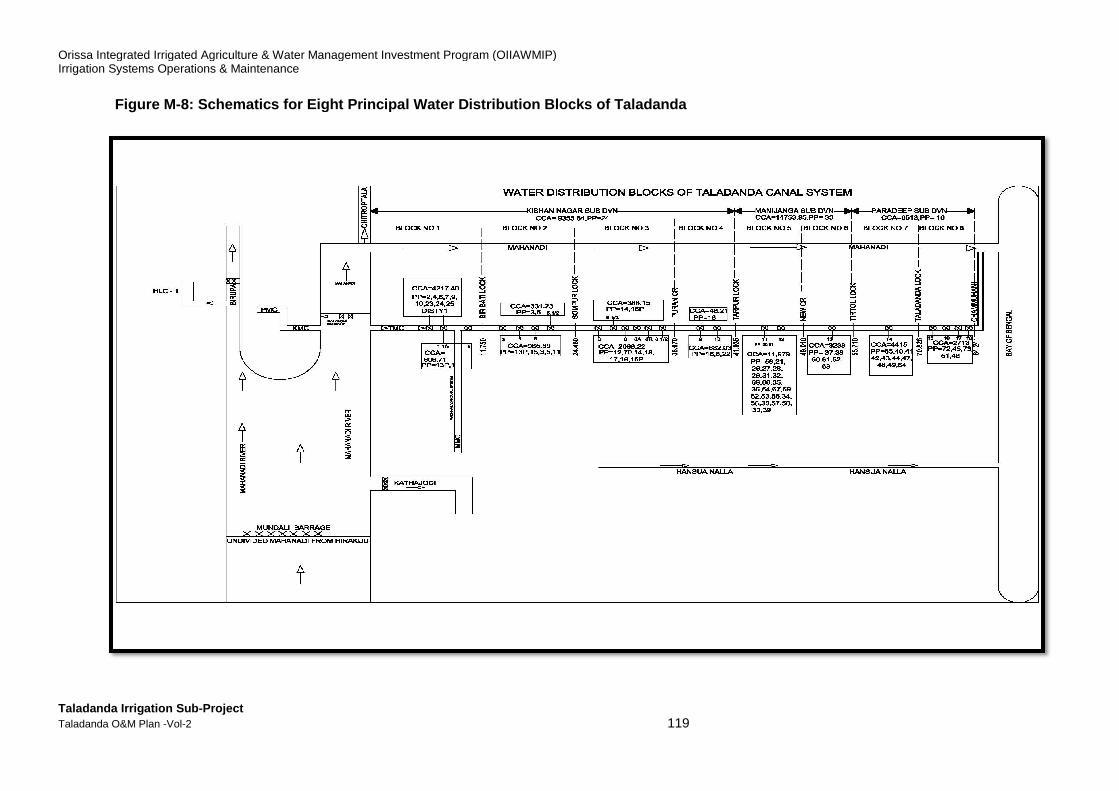
Orissa Integrated Irrigated Agriculture & Water Management Investment Program (OIIAWMIP)Irrigation Systems Operations & Maintenance
Taladanda Irrigation Sub-Project Taladanda O&M Plan -Vol-2
Figure M-8: Schematics for E ight Principal Water Distribution Blocks
Orissa Integrated Irrigated Agriculture & Water Management Investment Program (OIIAWMIP)
119
ight Principal Water Distribution Blocks of Taladanda
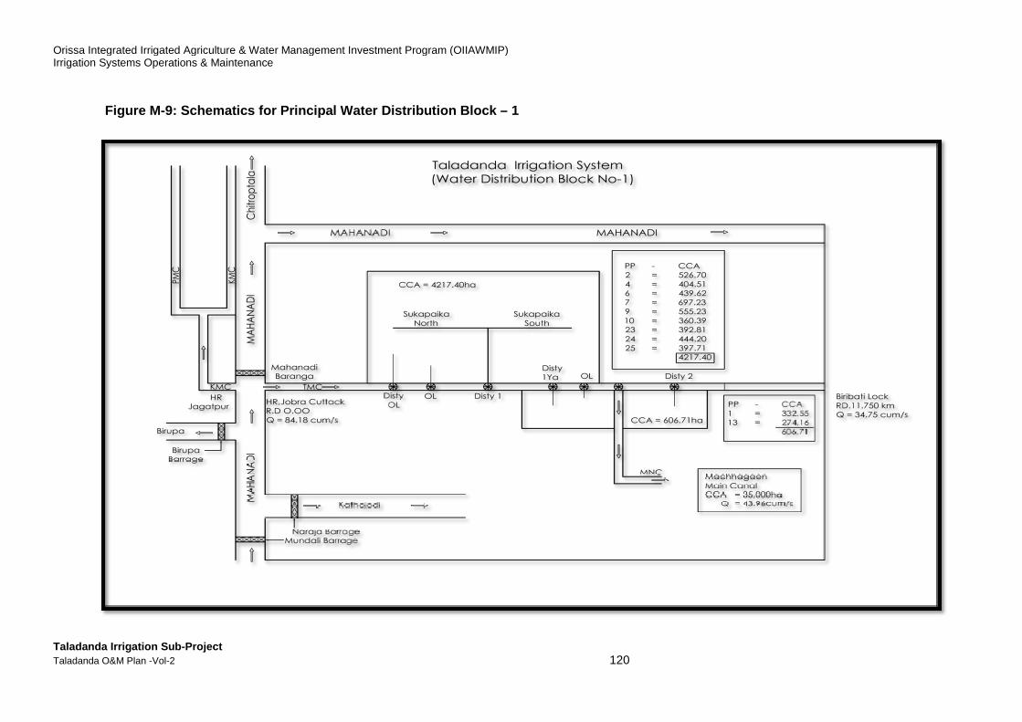
Orissa Integrated Irrigated Agriculture & Water Management Investment Program (OIIAWMIP)Irrigation Systems Operations & Maintenance
Taladanda Irrigation Sub-Project Taladanda O&M Plan -Vol-2
Figure M-9: Schematics for Principal Water Distribution Block
Orissa Integrated Irrigated Agriculture & Water Management Investment Program (OIIAWMIP)
120
Schematics for Principal Water Distribution Block – 1
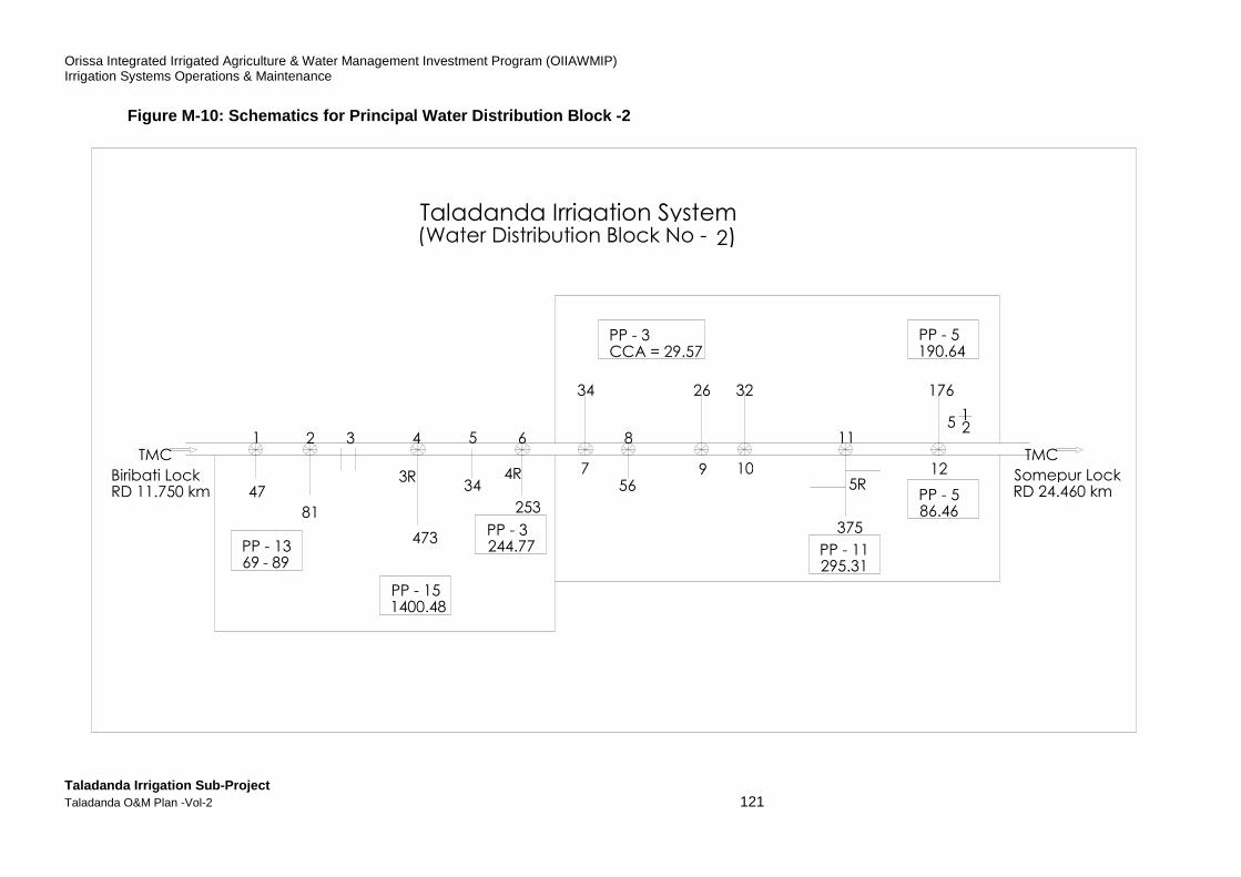
Orissa Integrated Irrigated Agriculture & Water Management Investment Program (OIIAWMIP) Irrigation Systems Operations & Maintenance
Taladanda Irrigation Sub-Project Taladanda O&M Plan -Vol-2 121
Figure M-10: Schematics for Principal Water Distrib ution Block -2
1 2 3 4 5 6
7
8
9 47
81
473
253
10
PP - 13 89 - 69
PP - 15 1400.48
PP - 3 244.77
R 3 34
R 4 56
34 26 32
11
375
12
176
5 2 1
PP - 11 295.31
PP - 5 86.46
PP - 5 190.64
PP - 3 CCA = 29.57
5 R
TMC Somepur Lock RD 24.460 km
TMC Biribati Lock RD 11.750 km
Taladanda Irrigation System Water Distribution Block No - ( 2)
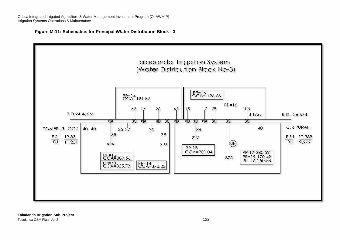
Orissa Integrated Irrigated Agriculture & Water Management Investment Program (OIIAWMIP)Irrigation Systems Operations & Maintenance
Taladanda Irrigation Sub-Project Taladanda O&M Plan -Vol-2
Figure M-11: Schematics for Principal W\ ater Distribution Block
Orissa Integrated Irrigated Agriculture & Water Management Investment Program (OIIAWMIP)
122
ater Distribution Block - 3
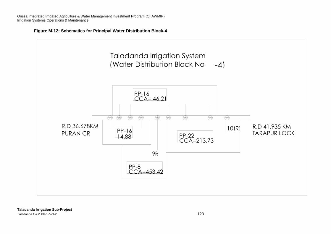
Orissa Integrated Irrigated Agriculture & Water Management Investment Program (OIIAWMIP) Irrigation Systems Operations & Maintenance
Taladanda Irrigation Sub-Project Taladanda O&M Plan -Vol-2 123
Figure M-12: Schematics for Principal Water Distrib ution Block-4
PP-16 14.88
PP-16 CCA= 46.21
PP-8 CCA=453.42
PP-22 CCA=213.73
10(R)
9 R
R.D 36.678KM
PURAN CR
R.D 41.935 KM TARAPUR LOCK
Taladanda Irrigation System ( -4) Water Distribution Block No
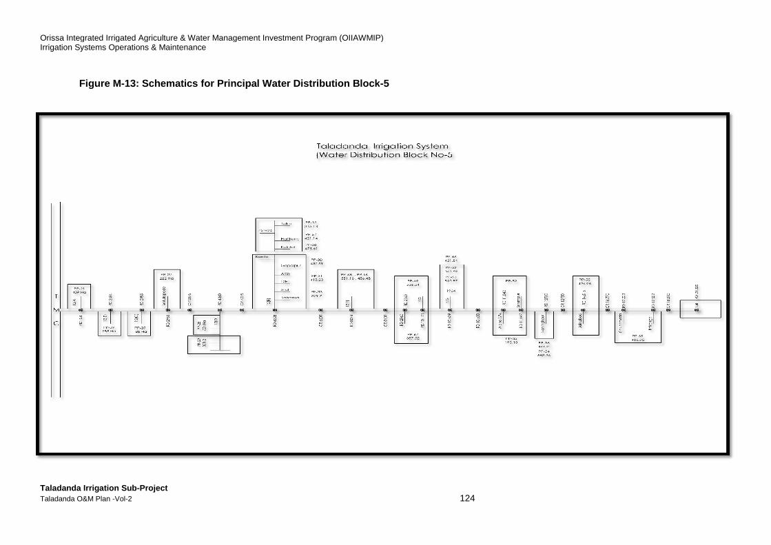
Orissa Integrated Irrigated Agriculture & Water Management Investment Program (OIIAWMIP)Irrigation Systems Operations & Maintenance
Taladanda Irrigation Sub-Project Taladanda O&M Plan -Vol-2
Figure M-13: Schematics for Principal Water Distribution Block
Orissa Integrated Irrigated Agriculture & Water Management Investment Program (OIIAWMIP)
124
Schematics for Principal Water Distribution Block -5
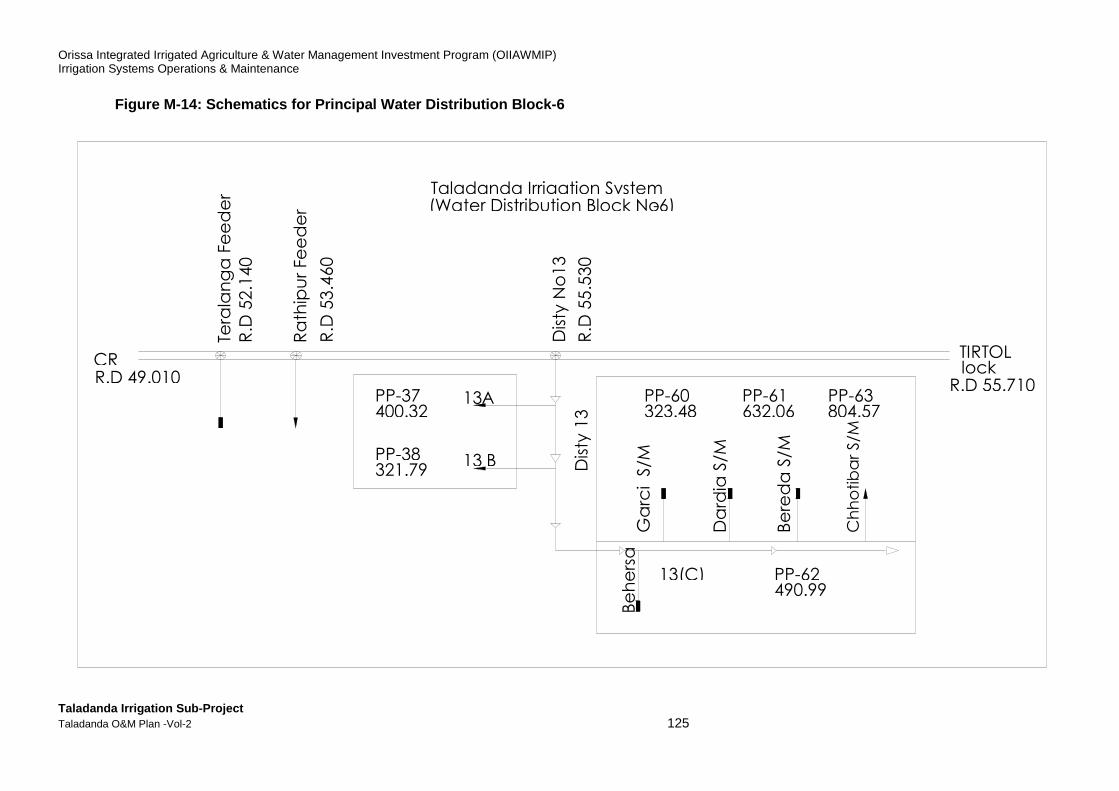
Orissa Integrated Irrigated Agriculture & Water Management Investment Program (OIIAWMIP) Irrigation Systems Operations & Maintenance
Taladanda Irrigation Sub-Project Taladanda O&M Plan -Vol-2 125
Figure M-14: Schematics for Principal Water Distrib ution Block-6
TIRTOL lock
R.D 55.710
Dis
ty 1
3
CR R.D 49.010
Taladanda Irrigation System -6) Water Distribution Block No (
Ga
rci S
/M
Be
he
rsa
13(C) PP-62 490.99
PP-63 804.57
PP-61 632.06
PP-60 323.48
Da
rdia
S/M
Be
red
a S
/M
Ch
ho
tib
ar
S/M
A 13
13 B
PP-37 400.32
PP-38 321.79
Dis
ty N
o1
3
Tera
lan
ga
Fe
ed
er
Ra
thip
ur
Fe
ed
er
R.D
55
.53
0
R.D
52
.14
0
R.D
53
.46
0
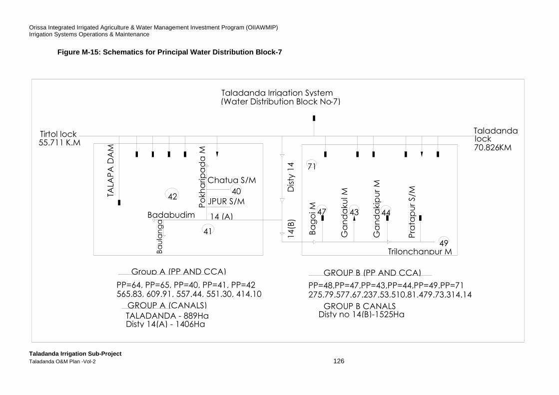
Orissa Integrated Irrigated Agriculture & Water Management Investment Program (OIIAWMIP) Irrigation Systems Operations & Maintenance
Taladanda Irrigation Sub-Project Taladanda O&M Plan -Vol-2 126
Figure M-15: Schematics for Principal Water Distrib ution Block-7
TALA
PA
DA
M
Badabudim
Po
kh
arip
ad
a M
Chatua S/M
JPUR S/M
Ba
go
i M
Ga
nd
aku
l M
Ga
nd
akip
ur
M
Pra
tap
ur
S/M
Trilonchanpur M
Taladanda lock 70.826 KM
49
44 43 47
71
Dis
ty 1
4
14
(B)
Ba
ula
ng
a
41
) (A 14
Tirtol lock K.M 55.711
42 40
Group A (PP AND CCA)
GROUP A (CANALS)
GROUP B (PP AND CCA)
GROUP B CANALS
PP=64, PP=65, PP=40, PP=41, PP=42
TALADANDA - 889Ha
PP=48,PP=47,PP=43,PP=44,PP=49.PP=71
Disty no 14(B)-1525Ha
565.83, 609.91, 557.44, 551.30, 414.10
Disty 14(A) - 1406Ha
275.79,577.67,237.53,510.81,479.73,314.14
Taladanda Irrigation System Water Distribution Block No -7) (

Orissa Integrated Irrigated Agriculture & Water Management Investment Program (OIIAWMIP) Irrigation Systems Operations & Maintenance
Taladanda Irrigation Sub-Project Taladanda O&M Plan -Vol-2 127
Figure M-16: Schematics for Principal Water Distrib ution Block-8
TALADANDA LOCK 70.826 KM
PP-45 384.55
15(R)
342 PP-73 332.72
) (R 16
862
17(R)
PP-72 509.57
635
PARADEEP EXTN
) (R 18 PP-46 267.80 267
Chaumuhani Lock
84.240km
PP-45 384.55
GROUP-A CANALS DISTY NO15(R) = 342Ha
DISTY NO 17(R) = 635Ha
PP-73 337.72
PP-50 PP-46 307.63 267.80
977 Ha GROUP-B CANALS DISTY NO 16 (R)= 862Ha
Taladanda Irrigation System Water Distribution Block No - 8
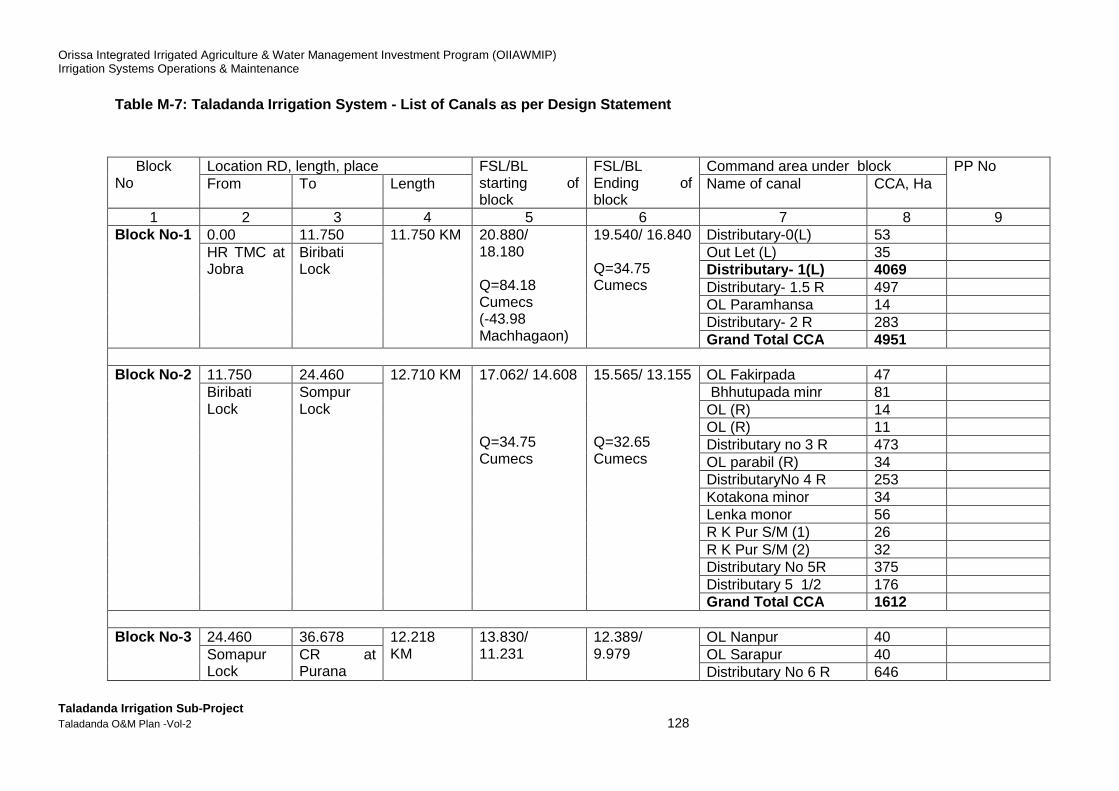
Orissa Integrated Irrigated Agriculture & Water Management Investment Program (OIIAWMIP) Irrigation Systems Operations & Maintenance
Taladanda Irrigation Sub-Project Taladanda O&M Plan -Vol-2 128
Table M-7: Taladanda Irrigation System - List of Ca nals as per Design Statement
Block No
Location RD, length, place FSL/BL starting of block
FSL/BL Ending of block
Command area under block PP No From To Length Name of canal CCA, Ha
1 2 3 4 5 6 7 8 9 Block No -1 0.00 11.750 11.750 KM 20.880/
18.180 Q=84.18 Cumecs (-43.98 Machhagaon)
19.540/ 16.840 Q=34.75 Cumecs
Distributary-0(L) 53 HR TMC at Jobra
Biribati Lock
Out Let (L) 35 Distributary - 1(L) 4069 Distributary- 1.5 R 497 OL Paramhansa 14 Distributary- 2 R 283 Grand Total CCA 4951
Block No -2 11.750 24.460 12.710 KM 17.062/ 14.608
Q=34.75 Cumecs
15.565/ 13.155 Q=32.65 Cumecs
OL Fakirpada 47 Biribati Lock
Sompur Lock
Bhhutupada minr 81 OL (R) 14 OL (R) 11 Distributary no 3 R 473 OL parabil (R) 34 DistributaryNo 4 R 253 Kotakona minor 34 Lenka monor 56 R K Pur S/M (1) 26 R K Pur S/M (2) 32 Distributary No 5R 375 Distributary 5 1/2 176 Grand Total CCA 1612
Block No -3 24.460 36.678 12.218
KM 13.830/ 11.231
12.389/ 9.979
OL Nanpur 40 Somapur Lock
CR at Purana
OL Sarapur 40 Distributary No 6 R 646
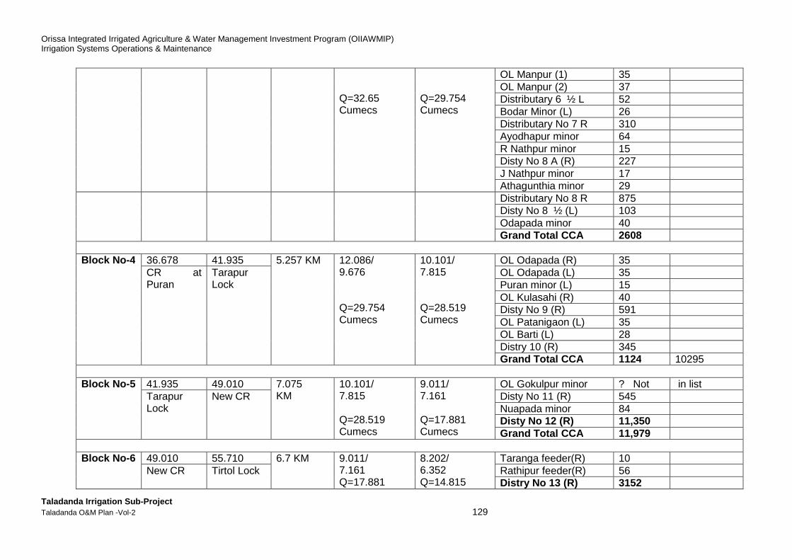
Orissa Integrated Irrigated Agriculture & Water Management Investment Program (OIIAWMIP) Irrigation Systems Operations & Maintenance
Taladanda Irrigation Sub-Project Taladanda O&M Plan -Vol-2 129
Q=32.65 Cumecs
Q=29.754 Cumecs
OL Manpur (1) 35 OL Manpur (2) 37 Distributary 6 ½ L 52 Bodar Minor (L) 26 Distributary No 7 R 310 Ayodhapur minor 64 R Nathpur minor 15 Disty No 8 A (R) 227 J Nathpur minor 17 Athagunthia minor 29
Distributary No 8 R 875 Disty No 8 ½ (L) 103 Odapada minor 40 Grand Total CCA 2608
Block No -4 36.678 41.935 5.257 KM 12.086/
9.676 Q=29.754 Cumecs
10.101/ 7.815 Q=28.519 Cumecs
OL Odapada (R) 35 CR at Puran
Tarapur Lock
OL Odapada (L) 35 Puran minor (L) 15 OL Kulasahi (R) 40 Disty No 9 (R) 591 OL Patanigaon (L) 35 OL Barti (L) 28 Distry 10 (R) 345 Grand Total CCA 1124 10295
Block No -5 41.935 49.010 7.075
KM 10.101/ 7.815 Q=28.519 Cumecs
9.011/ 7.161 Q=17.881 Cumecs
OL Gokulpur minor ? Not in list Tarapur Lock
New CR Disty No 11 (R) 545 Nuapada minor 84 Disty No 12 (R) 11,350 Grand Total CCA 11,979
Block No -6 49.010 55.710 6.7 KM 9.011/
7.161 Q=17.881
8.202/ 6.352 Q=14.815
Taranga feeder(R) 10 New CR Tirtol Lock Rathipur feeder(R) 56
Distry No 13 (R) 3152
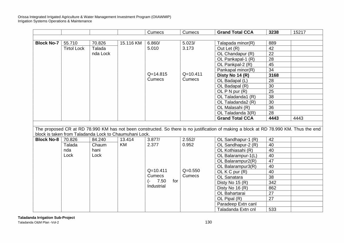
Orissa Integrated Irrigated Agriculture & Water Management Investment Program (OIIAWMIP) Irrigation Systems Operations & Maintenance
Taladanda Irrigation Sub-Project Taladanda O&M Plan -Vol-2 130
Cumecs Cumecs Grand Total CCA 3238 15217 Block No -7 55.710 70.826 15.116 KM 6.860/
5.010 Q=14.815 Cumecs
5.023/ 3.173 Q=10.411 Cumecs
Talapada minor(R) 889 Tirtol Lock Talada
nda Lock Out Let (R) 42 OL Chandapur (R) 22 OL Pankapal-1 (R) 28 OL Pankpal-2 (R) 45 Pankapal minor(R) 34 Disty No 14 (R) 3168 OL Badapal (L) 28 OL Badapal (R) 30 OL P N pur (R) 25 OL Taladanda1 (R) 38 OL Taladanda2 (R) 30 OL Malasahi (R) 36 OL Taladanda 3(R) 28 Grand Total CCA 4443 4443
The proposed CR at RD 78.990 KM has not been constructed. So there is no justification of making a block at RD 78.990 KM. Thus the end block is taken from Taladanda Lock to Chaumuhani Lock. Block No -8 70.826 84.240 13.414
KM 3.877/ 2.377 Q=10.411 Cumecs (- 7.50 for Industrial
2.552/ 0.952 Q=0.550 Cumecs
OL Sandhapur-1 (R) 42 Talada nda Lock
Chaum hani Lock
OL Sandhapur-2 (R) 40 OL Kothiasahi (R) 40 OL Balarampur-1(L) 40 OL Balarampur2(R) 47 OL Balarampur3(R) 40 OL K C pur (R) 40 OL Sanatara 38 Disty No 15 (R) 342 Disty No 16 (R) 862 OL Bahartarai 27 OL Pipal (R) 27 Paradeep Extn canl Taladanda Extn cnl 533
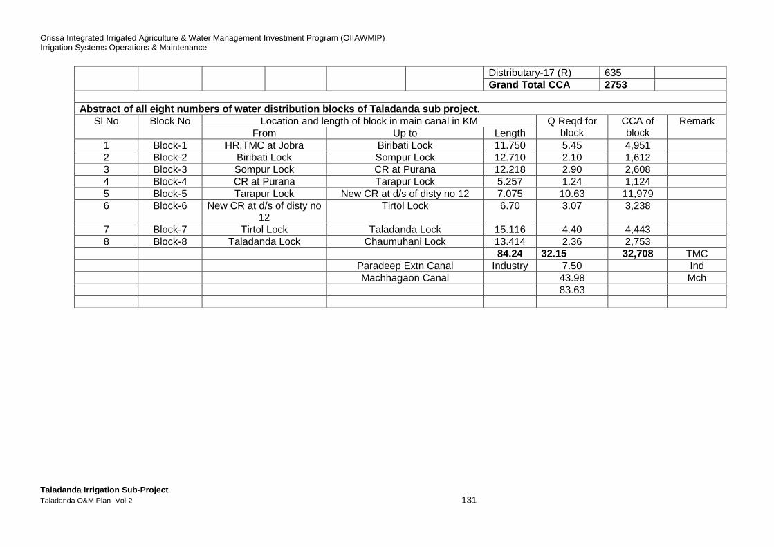
Orissa Integrated Irrigated Agriculture & Water Management Investment Program (OIIAWMIP) Irrigation Systems Operations & Maintenance
Taladanda Irrigation Sub-Project Taladanda O&M Plan -Vol-2 131
Distributary-17 (R) 635 Grand Total CCA 2753
Abstract of all eight numbers of water distribution blocks of Taladanda sub project.
Sl No Block No Location and length of block in main canal in KM Q Reqd for block
CCA of block
Remark From Up to Length
1 Block-1 HR,TMC at Jobra Biribati Lock 11.750 5.45 4,951 2 Block-2 Biribati Lock Sompur Lock 12.710 2.10 1,612 3 Block-3 Sompur Lock CR at Purana 12.218 2.90 2,608 4 Block-4 CR at Purana Tarapur Lock 5.257 1.24 1,124 5 Block-5 Tarapur Lock New CR at d/s of disty no 12 7.075 10.63 11,979 6 Block-6 New CR at d/s of disty no
12 Tirtol Lock 6.70 3.07 3,238
7 Block-7 Tirtol Lock Taladanda Lock 15.116 4.40 4,443 8 Block-8 Taladanda Lock Chaumuhani Lock 13.414 2.36 2,753 84.24 32.15 32,708 TMC Paradeep Extn Canal Industry 7.50 Ind Machhagaon Canal 43.98 Mch 83.63
Orissa Integrated Irrigated Agriculture & Water Management Investment Program (OIIAWMIP) Irrigation Systems Operations & Maintenance
Taladanda Irrigation Sub-Project Taladanda O&M Plan -Vol-2 132
4. The Pre-Kharif Cropping Plan Survey
As a first step towards improved ‘operation management’, The Project Committee is to discuss and decide in the Pre-Kharif meeting on flows to be maintained to upstream and downstream PP area, thereby presenting four basic options. Option 1: No change; Option 2: Equal (weighted) supply toupstream and downstream PP area at all times; Option 3: Increased supply (with a stated size of flow) to the upstream PPs for the first period of X weeks; followed by gradually increase in supply to the downstream PPs (and inherent decrease in supply to the upstream PPs) up to a stated flow size; Option 4: Increased supply to the downstream PPs first, and later to the upstream PPs. To support decisions on flow size, a water distribution schedule would need to be prepared. According to the PP Act 2002, PPs will prepare and submit cropping plans, DoWR will prepare a proposed seasonal water distribution schedule to support the PP cropping plans, and the PP Project Committee will discuss and approve the seasonal water distribution plan. In Taladanda Subproject, in general, Kharif cropping assumes circa 95% coverage of the command area by paddy with staggered planting dates and circa 5% non-paddy crops. The most preferred paddy varieties planted widely in the sub-project command area are within the growth duration of 135-150 days. About 20-25% of the paddy varieties are with growth duration exceeding 150 days. While preparing kharif crop plan, the PPs should consider to shorten the kharif paddy by planting varieties within growth duration of 135-150 days.

Orissa Integrated Irrigated Agriculture & Water Management Investment Program (OIIAWMIP) Irrigation Systems Operations & Maintenance
Taladanda Irrigation Sub-Project Taladanda O&M Plan -Vol-2 133
5. The water distribution scheduling Tool- Structur e of Modules
Section 5 explains about the Modules 1, 2, 3, and 4. Discussion held with the Additional Director and Deputy Director of O&M cell and it was decided to consider the Module 3 for preparation of the Water Distribution Scheduling “Tool” of Gohira subproject. Hence the structure of Module 3 is explained in this section.The Module 3 is prepared in MS-Excel format. This Water Distribution Scheduling “Tool” was developed stage-wise, considering the need for testing and refinement in a small size module of (i) the basic element, (ii) the module structure, and (iii) the formats of the input, output, and calculation tables, before developing a larger size module. The following stages can be distinguished: Stage 1 - Development of the Basic Elements Stage 2 - Development of Module 1 : This module views the scheme as one command area, and hence consists of just one basic element. Stage 3 - Development of Module 2 : This module recognises that the scheme consists of eight major sub-areas, referred to as ‘principal water distribution blocks’ and consists of eight basic elements, as follows (for a schematic illustration, see Figure M-8):1
1) Block 1–Main canal RD 0.0km (Jobra) - 11.750km (Biribati lock), CCA= 4800 ha: the area supplied via the head regulator of Disty. No. 1L, 11/2 R, 2R. (see Figure M-9)
2) Block 2 - Main canal RD 11.750km (Biribati lock) – 24.460km (Somepur lock), CCA= 1612 ha: the area supplied via the head regulator of Disty. No. 3R, 4R 5R, 51/2L.(see Figure M-10)
3) Block 3 - Main canal RD 24.460km (Somepur lock) – 36.670km (Puran C/R), CCA= 2608 ha: the area supplied via the head regulator of Disty. No. 6R, 61/2L, 7R, 8A(R), 8R, 81/2L.(see Figure M-11)
4) Block 4 - Main canal RD 36.670km (Puran C/R) – 41.935km (Tarapur lock), CCA= 1124 ha: the area supplied via the head regulator of Disty. No. 9R, 10R. (see Figure M-12)
5) Block 5 - Main canal RD 41.935km (Tarapur lock) – 49.010km (New C/R), CCA=11979ha: the area supplied via the head regulator of Disty. No. 11R, 12R(see Figure M-13)
6) Block 6 - Main canal RD 49.010km (New C/R) – 55.710km (Tirtol lock), CCA= 3238 ha: the area supplied via the head regulator of Disty. No. 13R.(see Figure M-14)
7) Block 7 - Main canal RD 55.710km (Tirtol lock) – 70.826km (Taladanda lock), CCA= 4443 ha: the area supplied via the head regulator of Disty. No. 14R(see Figure M-15)
8) Block 8 - Main canal RD 70.826km (Taladanda lock) – 84.240km (Choumuhani lock), CCA= 2753 ha: the area supplied via the head regulator of Disty. No. 15R, 16R, 17R, 18R.(see Figure M-16)
1 CCA stands for ‘Culturable Command Area’. Areas listed are rounded-off figures, derived from the list of PPs
in CTA 2008.
Orissa Integrated Irrigated Agriculture & Water Management Investment Program (OIIAWMIP) Irrigation Systems Operations & Maintenance
Taladanda Irrigation Sub-Project Taladanda O&M Plan -Vol-2 134
Stage 4 - Development of Module 3 : This module calculates for each head-regulator in the system the irrigation water flow to be supplied, based on each head-regulator’s command area features; the module consists of 86 basic elements. Stage 5 - Development of Module 4 : This module recognises the all chaks as the basic building blocks of the head-regulator command areas and calculates for each chak the irrigation water requirement (due to the large number of chaks, full development of this module will require additional work). As per discussion held with the Additional Director and Deputy Director of O&M cell and considering the need for the tool to define irrigation water requirement at each head-regulator, the choice is therefore for Module 3. This module calculates for each head-regulator in the system (86 in total: main canal system, distributary, minor, sub-minor offtakes from main canal) the irrigation water flow to be supplied, based on its command area size.Hence the structure of Module 3 is explained in the following pages. The input data required is explained in the following Table.
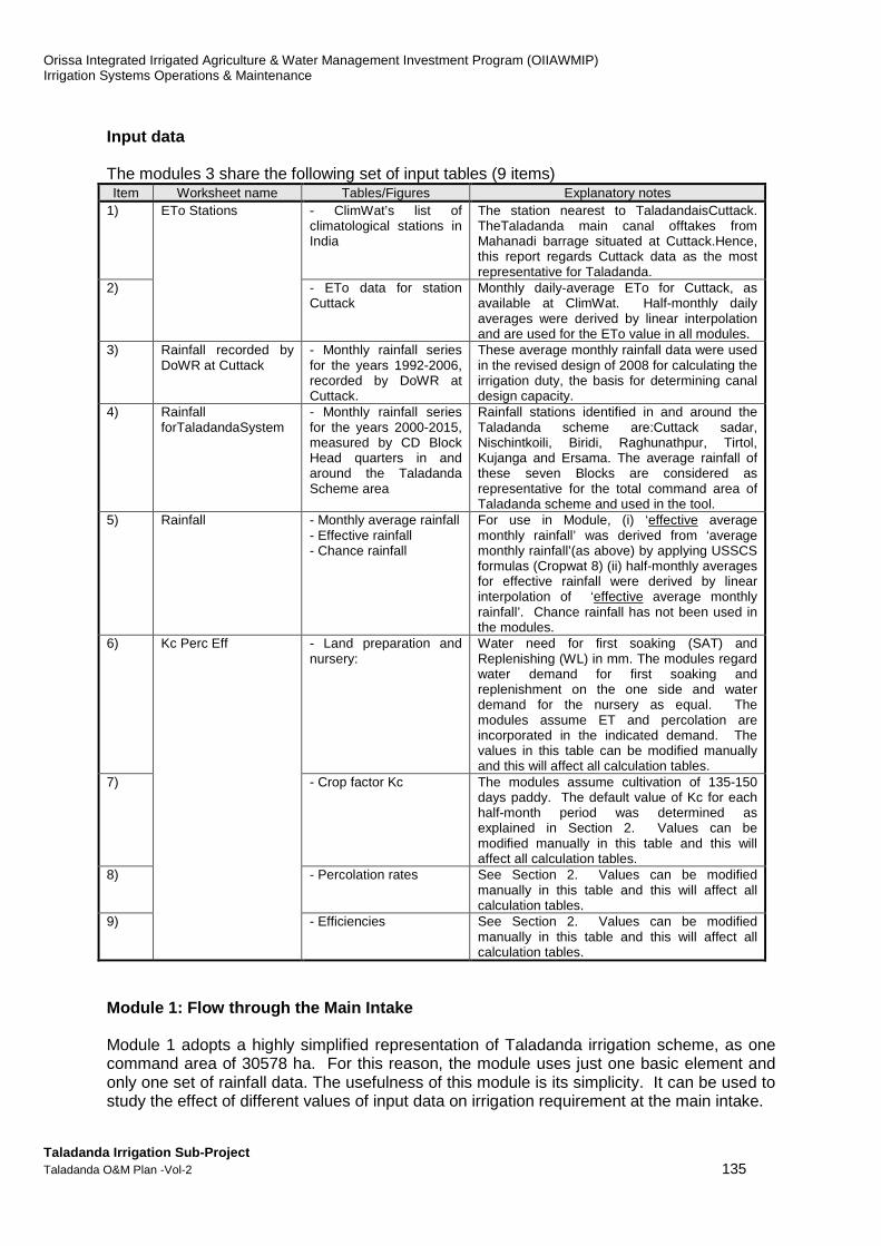
Orissa Integrated Irrigated Agriculture & Water Management Investment Program (OIIAWMIP) Irrigation Systems Operations & Maintenance
Taladanda Irrigation Sub-Project Taladanda O&M Plan -Vol-2 135
Input data
The modules 3 share the following set of input tables (9 items) Item Worksheet name Tables/Figures Explanatory notes
1) ETo Stations - ClimWat’s list of climatological stations in India
The station nearest to TaladandaisCuttack. TheTaladanda main canal offtakes from Mahanadi barrage situated at Cuttack.Hence, this report regards Cuttack data as the most representative for Taladanda.
2) - ETo data for station Cuttack
Monthly daily-average ETo for Cuttack, as available at ClimWat. Half-monthly daily averages were derived by linear interpolation and are used for the ETo value in all modules.
3) Rainfall recorded by DoWR at Cuttack
- Monthly rainfall series for the years 1992-2006, recorded by DoWR at Cuttack.
These average monthly rainfall data were used in the revised design of 2008 for calculating the irrigation duty, the basis for determining canal design capacity.
4) Rainfall forTaladandaSystem
- Monthly rainfall series for the years 2000-2015, measured by CD Block Head quarters in and around the Taladanda Scheme area
Rainfall stations identified in and around the Taladanda scheme are:Cuttack sadar, Nischintkoili, Biridi, Raghunathpur, Tirtol, Kujanga and Ersama. The average rainfall of these seven Blocks are considered as representative for the total command area of Taladanda scheme and used in the tool.
5) Rainfall - Monthly average rainfall - Effective rainfall - Chance rainfall
For use in Module, (i) ‘effective average monthly rainfall’ was derived from ‘average monthly rainfall’(as above) by applying USSCS formulas (Cropwat 8) (ii) half-monthly averages for effective rainfall were derived by linear interpolation of ‘effective average monthly rainfall’. Chance rainfall has not been used in the modules.
6) Kc Perc Eff - Land preparation and nursery:
Water need for first soaking (SAT) and Replenishing (WL) in mm. The modules regard water demand for first soaking and replenishment on the one side and water demand for the nursery as equal. The modules assume ET and percolation are incorporated in the indicated demand. The values in this table can be modified manually and this will affect all calculation tables.
7) - Crop factor Kc The modules assume cultivation of 135-150 days paddy. The default value of Kc for each half-month period was determined as explained in Section 2. Values can be modified manually in this table and this will affect all calculation tables.
8) - Percolation rates See Section 2. Values can be modified manually in this table and this will affect all calculation tables.
9) - Efficiencies See Section 2. Values can be modified manually in this table and this will affect all calculation tables.
Module 1: Flow through the Main Intake
Module 1 adopts a highly simplified representation of Taladanda irrigation scheme, as one command area of 30578 ha. For this reason, the module uses just one basic element and only one set of rainfall data. The usefulness of this module is its simplicity. It can be used to study the effect of different values of input data on irrigation requirement at the main intake.
Orissa Integrated Irrigated Agriculture & Water Management Investment Program (OIIAWMIP) Irrigation Systems Operations & Maintenance
Taladanda Irrigation Sub-Project Taladanda O&M Plan -Vol-2 136
Module 2: Flow through the Main Intake and the Dist ributaries
Module 2 is a refinement of Module 1. It recognises that the scheme is not one uniform area with irrigation water supply to be provided through one gate, but that it comprises eight major sub-areas, to which this report refers as ‘principal water distribution blocks’ (see System Schematic in Figure M-8). This module introduces a ‘one-step-higher’ level of operation of Taladanda Irrigation System than the traditional one, by monitoring flow at two levels: in addition to monitoring and adjustment of flow at the main intake, ‘one-step-higher’ level of operation requires that flows are also monitored and adjusted at each of eight block head regulators. Water needs to be distributed among these blocks, in accordance with each block’s ‘water right’, as (is meant to be) determined/approved in the seasonal Project Committee Meeting. In the history of Taladanda scheme, it has turned out to be very difficult, if not impossible, to actually provide the ‘intended flow’ to the tail-end areas. The ‘one-step-higher’ level of operation supported by Module 2, will result in better information to base day-to-day operation on, thereby making immediate action corrective possible, as soon as actual flow at one or more of these head-regulators is found to deviate from the ‘intended flow’. Corrective actions can belong to one or a combination of the following categories: (i) adjusting the flow released through the main intake; (ii) adjusting the flow released through the head-regulator of each block; (iii) adjusting the flow released through the various head-regulators and outlets; (iv) improving the discharge capacity of Main Canal and distributaries (e.g. by cleaning the canal, and/or restoring embankment level to design level).
Module 3: Flow through the Main Intake, the Distrib utaries, and the Minor, Sub-minors
and direct outlets offtaking from the main canal.
Module 3 is a refinement of Module 2. Module 3 recognises that each of the eight ‘principal water distribution blocks’, comprises a series of ‘sub-sub-areas’, being minor and sub-minor canal command areas, as depicted in the System Schematic of Figures M-9 to M-16. Within each block, water needs to be distributed among these command areas in accordance with each area’s ‘water right’, as (is meant to be) determined/approved in the seasonal Project Committee Meeting. This ‘two-steps-higher’ level of operation (as relative to ’traditional operation’), requires that flows are monitored and adjusted at three levels: (i) the main intake (or ‘main canal head-regulator; see Module 1); (ii) each of eight block head-regulators (see Module 2); as well as (iii) each outlet, minor, sub-minor canal’s head regulator offtaking from the main canal. Module 3 calculates for each of these three levels of flow control the irrigation water requirement at the head regulator. In total, Taladanda Irrigation System has 89 such flow control points: 1 main intake, 8 CR head-regulators, 24 distributary head-regulators,20 minor canals, and 34 water courses (Outlets) Module 3’s representation of the scheme reflects to a large degree how according to general principles of irrigation system operation, Taladanda’s ‘operation management’ would be expected to look at the scheme. However, in the specific case of Taladanda Irrigation System ‘operation management’, this expectation is not realistic and not fair, because it supposes that each head-regulator is equipped with standard facilities for monitoring flow (‘discharge measurement structures’), which is not the case. Therefore, the practical value of Module 3 for operation is limited to it being a finer instrument than Module 2, for determining the irrigation water requirement of each block. However, this only is meaningful when data on actual staggering patterns are available for each sub-minor command area.
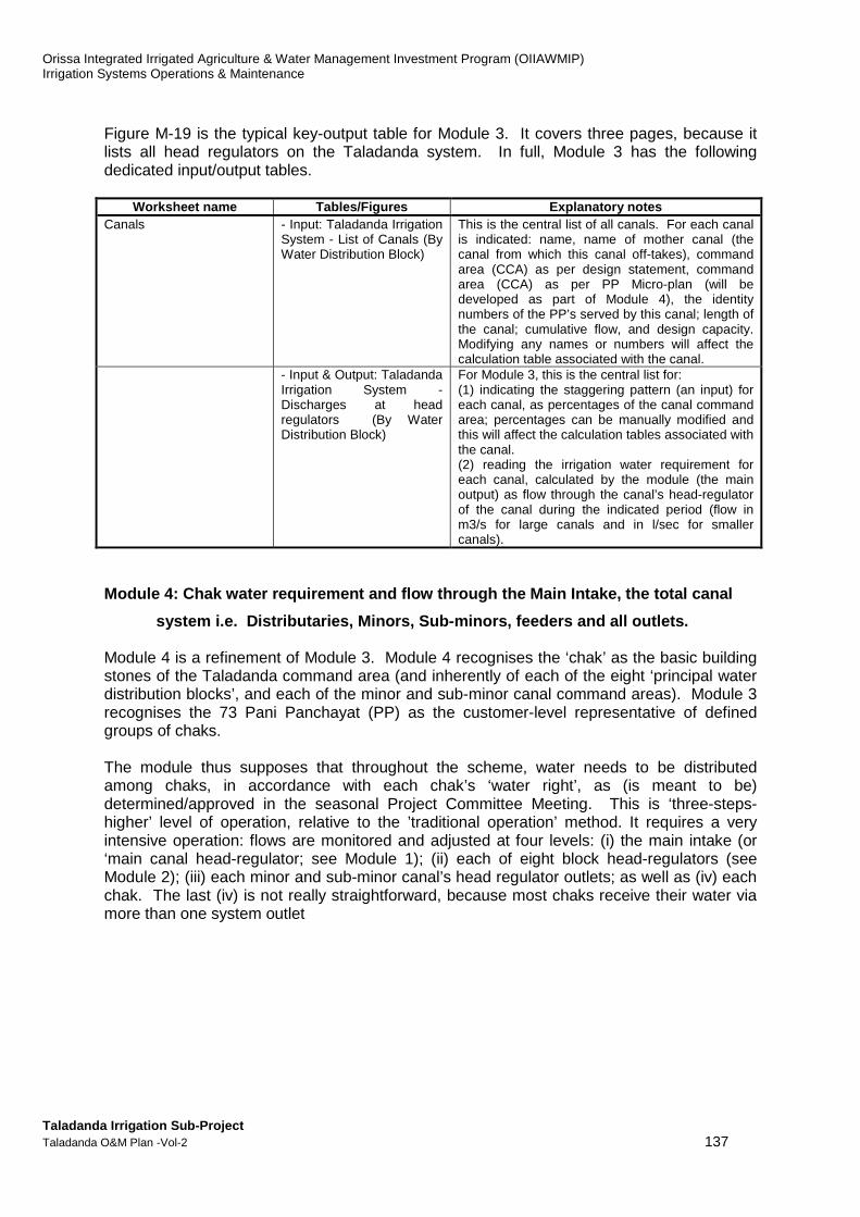
Orissa Integrated Irrigated Agriculture & Water Management Investment Program (OIIAWMIP) Irrigation Systems Operations & Maintenance
Taladanda Irrigation Sub-Project Taladanda O&M Plan -Vol-2 137
Figure M-19 is the typical key-output table for Module 3. It covers three pages, because it lists all head regulators on the Taladanda system. In full, Module 3 has the following dedicated input/output tables.
Worksheet name Tables/Figures Explanatory notes Canals - Input: Taladanda Irrigation
System - List of Canals (By Water Distribution Block)
This is the central list of all canals. For each canal is indicated: name, name of mother canal (the canal from which this canal off-takes), command area (CCA) as per design statement, command area (CCA) as per PP Micro-plan (will be developed as part of Module 4), the identity numbers of the PP’s served by this canal; length of the canal; cumulative flow, and design capacity. Modifying any names or numbers will affect the calculation table associated with the canal.
- Input & Output: Taladanda Irrigation System - Discharges at head regulators (By Water Distribution Block)
For Module 3, this is the central list for: (1) indicating the staggering pattern (an input) for each canal, as percentages of the canal command area; percentages can be manually modified and this will affect the calculation tables associated with the canal. (2) reading the irrigation water requirement for each canal, calculated by the module (the main output) as flow through the canal’s head-regulator of the canal during the indicated period (flow in m3/s for large canals and in l/sec for smaller canals).
Module 4: Chak water requirement and flow through t he Main Intake, the total canal
system i.e. Distributaries, Minors, Sub-minors, fe eders and all outlets.
Module 4 is a refinement of Module 3. Module 4 recognises the ‘chak’ as the basic building stones of the Taladanda command area (and inherently of each of the eight ‘principal water distribution blocks’, and each of the minor and sub-minor canal command areas). Module 3 recognises the 73 Pani Panchayat (PP) as the customer-level representative of defined groups of chaks. The module thus supposes that throughout the scheme, water needs to be distributed among chaks, in accordance with each chak’s ‘water right’, as (is meant to be) determined/approved in the seasonal Project Committee Meeting. This is ‘three-steps-higher’ level of operation, relative to the ’traditional operation’ method. It requires a very intensive operation: flows are monitored and adjusted at four levels: (i) the main intake (or ‘main canal head-regulator; see Module 1); (ii) each of eight block head-regulators (see Module 2); (iii) each minor and sub-minor canal’s head regulator outlets; as well as (iv) each chak. The last (iv) is not really straightforward, because most chaks receive their water via more than one system outlet

Orissa Integrated Irrigated Agriculture & Water Management Investment Program (OIIAWMIP) Irrigation Systems Operations & Maintenance
Taladanda Irrigation Sub-Project Taladanda O&M Plan -Vol-2 138
6. Module Test Runs
Test runs should be conducted in Taladanda System during Kharif and Rabi for refinement of the operation module. The ISPMC Consultantscould not able to conduct Test-run inTaladanda sub-project because of shortage of assignment time period but conducted test-run in Sunei sub-project. The result of Module 3 in Sunei sub-project is cited in the figures bellow as Example.

Orissa Integrated Irrigated Agriculture & Water Management Investment Program (OIIAWMIP) Irrigation Systems Operations & Maintenance
Taladanda Irrigation Sub-Project Taladanda O&M Plan -Vol-2 139
Module 3
The series of test-runs made with Module 3 use the default values and test a variety of rainfall patterns as in Figure M-17. Summary results for main intake discharge in Figure M-18, and summary results for irrigation water requirement at each principal water distribution block in Figure M-19. The Module 3 test run 3.1 and test run 3.2 results for irrigation water requirement at each canal head-regulator are in Figure M-20. Figure M-17: Overview of tested rainfall pattern.
Figure M-18: Module 3: Summary of test run results - Main Intake
Module 3 allows for defining staggering blocks for each sub-minor command area. Changing the percentages set for an SM staggering block from the default value, will affect the calculated irrigation water requirement for the related minor canal (if any), the principal water distribution block, and the main intake. Thus, with the default values in Module 2 and 3 being the same, the test-run results are the same as well, and thus also the main observations in regard of irrigation water requirement at main intake and block level. For ease of the reader, they are repeated here: With the assumed default staggering patterns for the two upstream and the two downstream principal water distribution blocks, test run 3.1, using average monthly rainfall data from Kaptipada station for the two upstream blocks: Kaptipada and Bisol, Udala station for Bisol tail-end block, and Nilagiri station for Berhampur block, finds two peaks in irrigation water requirement at the main intake: in 2nd half of July 10.2 m3/s, while water requirement in 1st half of November is considerable 5.2 m3/s. Test run 3.2, using the same rainfall stations as above, applies monthly rainfall as was recorded in year 2004, when Kharif rainfall was quite low (3rd to 4th lowest in the recorded 13 years 2000-2013). Again, it finds the peak in 2nd half of July 11.2 m3/s, and a substantial requirement in 1st half of November 6.9 m3/s. The assumed staggering pattern needs to be reviewed, before drawing more definite conclusions.
Module 3: Rainfall patterns tested
3.1
3.2 Nilagiri (00-13) Low: 2004Kaptipada (00-13) Low: 2004 Kaptipada (00-13) Low: 2004 Udala (00-13) Low: 2004
Nilagiri (00-13) Average monthlyKaptipada (00-13) Average monthly Kaptipada (00-13) Average monthly Udala (00-13) Average monthly
Block Berhampur
Station Rainfall pattern Station Rainfall pattern Station Rainfall pattern Station Rainfall patternTest runs
Block Kaptipada Block Bisol Block Bisol Tail-end
Summary for Bisol MC Undivided 9,825 ha
11 12 13 14 15 16 17 18 19 20 21 22 23 24
3.1 0 1.23 6.83 10.18 5.06 0.69 0.00 0.00 1.77 3.63 5.15 1.59 0.09 0.00
2.2 0 1.23 6.83 10.18 5.06 0.69 0.00 0.00 1.77 3.63 5.15 1.59 0.09 0.00
3.2 0 2.03 9.29 11.17 6.69 2.60 3.47 4.43 2.93 1.98 6.85 1.71 0.10 0.00
2.3 0 2.03 9.29 11.17 6.69 2.60 3.47 4.43 2.93 1.98 6.85 1.71 0.10 0.00
November DecemberTest runs
June July August September October
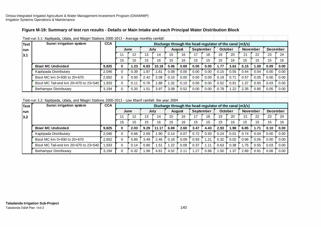
Orissa Integrated Irrigated Agriculture & Water Management Investment Program (OIIAWMIP) Irrigation Systems Operations & Maintenance
Taladanda Irrigation Sub-Project Taladanda O&M Plan -Vol-2 140
Figure M-19: Summary of test run results - Details or Main Intake and each Principal Water Distributio n Block
Test-run 3.1: Kaptipada, Udala, and Nilagiri Stations 2000-2013 - Average monthly rainfall
11 12 13 14 15 16 17 18 19 20 21 22 23 24
15 15 15 16 15 16 15 15 15 16 15 15 15 16
Bisol MC Undivided 9,825 0 1.23 6.83 10.18 5.06 0.69 0.00 0. 00 1.77 3.63 5.15 1.59 0.09 0.00
Kaptipada Distributary 2,046 0 0.39 1.87 1.61 0.08 0.00 0.00 0.00 0.15 0.55 0.44 0.04 0.00 0.00
Bisol MC km 0+930 to 20+670 2,652 0 0.50 2.42 2.08 0.10 0.00 0.00 0.00 0.19 0.71 0.57 0.05 0.00 0.00
Bisol MC Tail-end km 20+670 to 23+540 1,933 0 0.11 0.76 1.88 1.32 0.10 0.00 0.00 0.52 0.91 1.37 0.50 0.03 0.00
Berhampur Distributary 3,194 0 0.20 1.51 3.97 3.08 0.52 0.00 0.00 0.78 1.22 2.35 0.85 0.05 0.00
Test-run 3.2: Kaptipada, Udala, and Nilagiri Stations 2000-2013 - Low Kharif rainfall: the year 2004
11 12 13 14 15 16 17 18 19 20 21 22 23 24
15 15 15 16 15 16 15 15 15 16 15 15 15 16
Bisol MC Undivided 9,825 0 2.03 9.29 11.17 6.69 2.60 3.47 4. 43 2.93 1.98 6.85 1.71 0.10 0.00
Kaptipada Distributary 2,046 0 0.66 2.69 1.90 0.14 0.07 0.72 0.93 0.24 0.01 0.74 0.04 0.00 0.00
Bisol MC km 0+930 to 20+670 2,652 0 0.85 3.49 2.46 0.18 0.09 0.93 1.21 0.32 0.02 0.96 0.05 0.00 0.00
Bisol MC Tail-end km 20+670 to 23+540 1,933 0 0.14 0.80 1.51 1.22 0.09 0.37 1.11 0.63 0.38 1.75 0.55 0.03 0.00
Berhampur Distributary 3,194 0 0.32 1.99 4.61 4.52 2.11 1.27 0.96 1.50 1.37 2.89 0.91 0.06 0.00
Test
run
3.2
Sunei irrigation system CCA
Test
run
3.1
Sunei irrigation system CCA
DecemberDischarge through the head-regulator of the canal (m3/s)
June July August September October November
DecemberJune July August September October November Discharge through the head-regulator of the canal (m3/s)

Orissa Integrated Irrigated Agriculture & Water Management Investment Program (OIIAWMIP) Irrigation Systems Operations & Maintenance
Taladanda Irrigation Sub-Project Taladanda O&M Plan -Vol-2 141
Figure M-20: Module 3 - Test run 3.1: Details for e ach head regulator (arranged by Principal Water Dis tribution Block)
Sunei Irrigation System - Discharges at head regulators Test run 3.1
In this list: Tot Kap Bis BisT Ber Rainfall: Average
distributaries 2 1 0 0 1 Kaptipada Block Kaptipada Station
minors 11 3 2 3 3 Bisol Block Kaptipada Station
subminors 71 17 19 12 23 Bisol Tail Area Block Udala Station
Of which sub-sub minors 11 Berhampur Block Nilagiri Station
Undivided Bisol M.C.
A B C D
12 13 14 14 11 12 13 14 15 16 17 18 19 20 21 22 23 24
15 15 15 16 15 16 15 15 15 16 15 15 15 16
Bisol MC Undivided 12% 52% 34% 3% - 1.23 6.83 10.18 5.06 0.69 - - 1.77 3.63 5.15 1.59 0.09 -
Kaptipada Distributary 20% 75% 5% 0% - 0.39 1.87 1.61 0.08 - - - 0.15 0.55 0.44 0.04 - -
Bisol MC km 0+930 to 20+670 20% 75% 5% 0% - 0.50 2.42 2.08 0.10 - - - 0.19 0.71 0.57 0.05 - -
Bisol MC Tail-end km 20+670 to 23+5405% 30% 60% 5% - 0.11 0.76 1.88 1.32 0.10 - - 0.52 0.91 1.37 0.50 0.03 -
Berhampur Distributary 5% 30% 60% 5% - 0.20 1.51 3.97 3.08 0.52 - - 0.78 1.22 2.35 0.85 0.05 -
Duration of period (days)
Start of nursery in period no:
Staggering blocks Discharge through the head-regulator of the canal (m3/s)
June July August September October November December
Color legend
1 Majhigadia SM
2 Parasabadi SM
3 Gayalmara SM
4 Baniaposi SM
Clarification
Light blue:
Thus: Gayamalra SM offtakes from Bisol MC, while
Baniaposi SM offtakes from Gayamalra SM
Canal offtaking from distributary or main canal
Canal offtaking from light yellow canal above
Bisol MC km 0+930 to 20+670 Color code:
Light yellow:
Orissa Integrated Irrigated Agriculture & Water Management Investment Program (OIIAWMIP) Irrigation Systems Operations & Maintenance
Taladanda Irrigation Sub-Project Taladanda O&M Plan -Vol-2 142
Module 4
While Module 3 calculates irrigation water requirement per canal command area and therefore has to comprise 87 unit-modules, Module 4 calculates irrigation water requirement per chak, and therefore has to comprise Unit-modules. Because of this, the building of a complete Module 4 would require considerable effort and time. The assumed staggering pattern needs to be reviewed, before drawing more definite conclusion.
Orissa Integrated Irrigated Agriculture & Water Management Investment Program (OIIAWMIP) Irrigation Systems Operations & Maintenance
Taladanda Irrigation Sub-Project Taladanda O&M Plan -Vol-2 143
7. Continuous Flow and Rotational Supply
This section briefly introduces the basic purpose of rotational supply and some technical aspects to be considered when preparing a rotational supply schedule.
Reasons for Rotational Supply
In Kharif, the only crop grown in the Taladanda Irrigation Scheme is paddy. During the first two months of the Kharif season, land preparation activities and transplanting generate a very high demand for water, clearly exceeding average rainfall. Without lots of irrigation water, transplanting can not be completed before Mid-August. Any crop transplanted late, i.e. after Mid-August will still stand on the field in October/November. By that time, the monsoon rains have ceased and for their water supply, those crops will depend fully on irrigation water released from the reservoir. Water released from the reservoir after September is unlikely to be replaced by inflow and thus reduces water availability for the Rabi season. For explaining the usefulness of rotational supply, we first consider the situation at chak-level. A chak receives irrigation water through one or more outlets on a sub-minor, minor, distributary, or main canal section. Water users prefer the incoming flow to be continuous and of substantial size. Via the chak’s (internal) water course/field canal network and the usually well-established field-to-field ‘pass-on’ mechanisms, the incoming flow is distributed over the fields. Where the chak’s internal canal system is in poor condition and/or poorly operated, and the incoming flow is small and/or often interrupted, water has difficulty reaching the fields in the downstream parts of the chak. Rotational supply is a way to increase the size of the flow, while compromising on its continuity. For rotational supply to be implemented successfully, the chak’s internal canal system should be in reasonable good condition and actively operated. Whether a flow is of large or small size is relative to (i) water users’ demand/expectation and/or (ii) canal design capacity. For the farmers, the first is the most valid one. For ‘operation management’ (the irrigation agency) the second is - at least in first instance - much more relevant than the first. Anyway, if the flow is of large size, there is a chance that at least a part of this flow will reach the fields situated furthest away from the chak’s intake (canal outlet). However, if the supplied flow is small, it is likely that the flow will be used up (‘exhausted’) in the upstream area, and not reach the tail-end fields. In general, the tendency for upstreamers is to monopolise the incoming flow of irrigation water and take all the time they need for (slowly) completing their cultivation activities. The downstreamers have no other choice than to be patient and wait for the upstreamers to reduce their intake of water. This causes the staggering pattern to be stretched over a much longer time than necessary. Under conditions of a relatively small flow, one way to solve their problem is for the downstreamers to agree with the upstreamers on a rotational supply schedule, for example: after the upstream fields have enjoyed the use of the full flow for 3 days, it will be the turn for

Orissa Integrated Irrigated Agriculture & Water Management Investment Program (OIIAWMIP) Irrigation Systems Operations & Maintenance
Taladanda Irrigation Sub-Project Taladanda O&M Plan -Vol-2 144
the fields in the downstream half of the chak to receive the full flow for 3 days. Naturally, there are numerous variations on this example schedule. The degree of difficulty in getting such a rotational schedule actually implemented/adhered to, differs from community to community. In some communities, it is fully acceptable, when the water users in the downstream half, upon the time for their turn having arrived, to close the field intakes in the upstream half and see to it that they remain closed for the duration of the downstreamers’ turn. In other communities, particularly when downstreamers and upstreamers belong to different villages and/or have different ethnic backgrounds, a formal agreement will need to be drawn up and implementation monitored under government authority. One type of arrangement, somewhere positioned in between these two extremes, is that of the ‘water master’. A chak-water master would be in charge of chak-level irrigation water distribution and of keeping the chak’s internal canal system in reasonable condition. He will typically operate under a higher the authority, such as the head of village or the board of a chak-level water users’ group. In some cases, the irrigation agency expects water masters to work very closely with the agency field staff. It is common for the chak water users to reward their water master’s work with a fee, in currency or in kind. Usually payment is upon completion of the harvest and water users may use the moment of fee payment to express their gratitude or their being displeased. In Taladanda Irrigation Scheme, water users in each chak agreeing (i) a date by which transplanting should have been completed; (ii) a type of rotational supply schedule which improves irrigation water supply to chak tail-end areas; (iii) an effective program for repair and improvement of the chak’s canal network; and (iv) a water-master arrangement to take care of chak-level water distribution and routine canal network maintenance, would be an important step towards increasing total chak paddy production and reduce the staggering period;. Reducing the period of staggering is necessary to ensure as much as possible water will be available in the reservoir at the start of the Rabi season. And establishing agreements between upstreamers and downstreamers on date of completion of transplanting and an associated water distribution arrangement are essential for reducing the period of staggering. For deciding whether or not to use a rotational schedule, a chak water users’ community needs to discuss whether or not at paddy should have been transplanted all fields before a certain date. Only when such a date is set, there will be an incentive to change from the traditional laissez-faire water distribution mechanism to a more efficient one, which ensures that all fields will receive timely enough water to complete their nurseries, prepare the land, and transplant the paddy. The earlier that date is in the season, the more efficient available water (rainfall and irrigation water entering the chak) will need to be used and thus distributed. In Taladanda scheme, need for a rotational schedule does not only occur at chak-level, but at all canal levels, with the exception, perhaps, of the main canal. The following section reflects on this.

Orissa Integrated Irrigated Agriculture & Water Management Investment Program (OIIAWMIP) Irrigation Systems Operations & Maintenance
Taladanda Irrigation Sub-Project Taladanda O&M Plan -Vol-2 145
Water Availability in Taladanda Irrigation Scheme d uring the Kharif Season
In Kharif, availability of water for Taladanda scheme irrigation is usually very good and every Kharif, ‘operation management’ lifts the main intake high enough to run the main canal at full supply level. During periods with heavy rainfall, the main intake opening is reduced or even closed. Notwithstanding the enormous releases from the reservoir, the inflow into the reservoir tends to be large enough to have the reservoir filled to the brim by September/early October. In theory, running at full supply level means that a canal runs at its design capacity. From the main canal, water could be distributed into the distributaries, minors, and sub-minors according to those canals’ respective design capacities. Under such conditions, applying a rotational schedule would not only be unnecessary, but also impossible because canals would already be filled to full supply level and not be able to cope with any increase in flow. None of the canals has been designed with a larger capacity, specifically to make rotational supply possible during peak water demand periods.
Pani Panchayat Act 2002 and Rules 2003
For water distribution, some relevant paragraphs in the Pani Panchayat Act 2002 and Rules 2003 are as follows: Pani Panchayat Act 2002 Definitions In clauses as mentioned below: 2 (1) In this Act, unless the context otherwise requires: (s) "operational plan" means a schedule of irrigation deliveries with details of the mode and duration of supplies drawn up for regulation of irrigation in the commanded area of an irrigation system; (v) "warabandi" means a system of distribution of water allocation to water users by turn, according to an approved schedule indicating the day, duration and the time of supply; (w) "water allocated" in relation to an irrigation system means distribution of water determined from time to time by a farmers’ organization in its area of operation. 17. The Pani Panchayat shall perform the following function, namely: (a) to prepare a cropping programme suitable for the soil and agro-climatic condition with due regard to crop diversification; (d) to regulate the use of water among the various pipe outlets under its area of operation according to the warabandi schedule of the system. Pani Panchayat Act - Rules 2003: Operational plan and water budgeting 27. Water Budget for Famers’ Organisation: 1) The Executive Committee of the respective Farmers’ Organisation shall, along then
assistance of the competent authority, prepare a water budget for the area of operation under control as per specified below:
Orissa Integrated Irrigated Agriculture & Water Management Investment Program (OIIAWMIP) Irrigation Systems Operations & Maintenance
Taladanda Irrigation Sub-Project Taladanda O&M Plan -Vol-2 146
a) One month before the onset of the khariff season, the Project Committee shall, subject to such directions as may be given by Government from time to time, work out the anticipated inflow and existing water availability in the reservoir and work out the water allocation to all the Distributary Committees. The Distributary Committees shall allocate the water made available to Pani Panchayat in its jurisdiction;
b) For the Rabi season, the Project Committee will determine the area to be thrown open for irrigation based upon the actual availability of water at the beginning of khariff season. The Water so available shall be allocated equitably among the Distributary Committee and Pani Panchayats adopting circular rotation;
c) Based on the availability of water the Pani Panchayat will drawn up a suitable crop plan in consultation with the farmers and officials of Agriculture Department;
d) Each of the Farmers’ Organisation, shall draw up an operational plan which shall specify the quantity of water to be drawn on a fortnightly basis;
e) The drawal of water shall be monitored each day at specified gauge points as decided by the Farmers’ Organisation;
f) Review of drawal and distribution shall be done by each of the Farmers’ Organisation at the end of each fortnight an corrective measures taken; and
g) At the end of each season the respective Farmers’ Organisation shall prepare a report of water received and utilized along with the area irrigation, quantity of water supply and extent of crops produced.
Water Regulation. 28. After a water budget is prepared, the Farmers’ Organisation shall draw up a plan of water regulation as follows:
a) The dates of release and closure shall be informed to all members well in advance : b) Equitable distribution of water amongst all user shall be the main principle in water
regulation; c) A Farmers’ Organisation shall draw water and monitor flows based on the operational
plan prepared; d) A Warabandi Schedule shall be prepared for each outlet in a Farmers’ organization; e) A Farmers’ Organisation may, for the purpose of monitoring, install such devices as
may be required within its jurisdiction.
CTA Field Guides 2008 - Guide 4: Minor System Opera tion
Field Guide 4, prepared by CTA in 2008 for use under OIIAWMIP, explains that In dry periods, particularly in Rabi and summer, when non-paddy crops dominate the cropping pattern, rotational supply (warabandi) is an effective and equitable way to distribute canal water. A strict enforcement would allow water markets to develop with farmers adjusting their cropping plan or exchanging their allocated turns to better cope with crop water requirements, or utilising alternative water sources, such as buying water from a local pump station. Some farmers may want to grow paddy in Rabi and would need to obtain additional water, while others may want to minimise their water use by growing a crop with low water demand, maximising the use of residual soil moisture. The guide describes in Section 4 the technical steps to be followed in designing a system of rotational water distribution, for a PP command area:

Orissa Integrated Irrigated Agriculture & Water Management Investment Program (OIIAWMIP) Irrigation Systems Operations & Maintenance
Taladanda Irrigation Sub-Project Taladanda O&M Plan -Vol-2 147
• Step 1: Determine number of irrigator groups and group design flow • Step 2: Decide on rotation of supply to group members, including number of
irrigators and time each receives water • Step 3: Determine volume of water supplied to farmers’ plots
The guide recommends that a watercourse should ideally supply an area of about 40ha (one chak) and field canals should supply water to areas of about 8ha. Outlets on these canals would supply individual farmer plots of typically 0.2 ha. The guide takes as an example a PP unit of 500 ha, a design ‘irrigation duty’ of 0.78 l/s at the head of a watercourse; and a watercourse efficiency of 90%. Step 1: Determine number of irrigator groups and group design flow The guide states as criteria for determining the number of irrigator groups within the PP area that (i) the continuous flows to each group are about 40l/s; (ii) a prime number should be avoided; and (iii) irrigation channel layout and topography. For the example PP, the design continuous flow to be provided would be 390l/s (0.78 l/s x 500ha) and the number of irrigator groups would be nine, each with an area of 55-56ha, and each group would receive a continuous flow of 43 l/s (390 l/s divided by 9), but this reduced to 39l/s due to 10% conveyance losses. The guide recognises that this ‘ideal’ situation may not be encountered in practice, making preparation and strict implementation of such a schedule difficult:
• it may not be possible to form equal size irrigator groups; in that case, the flow to each group needs to be calculated depending on irrigator group area
• the schedule could be combined with a water master arrangement, under the direction of the PP water management subcommittee; assigning a water master is particularly helpful for responding to sudden changes in water demand
• an adequate canal network and simple structures to control and measure flows to each irrigator group are needed, but in reality canal networks may be limited in extent, possibly in poor condition, and with few hydraulic control structures
• conveyance losses for watercourses and field canals in good condition may be 10%; while for those in poor condition it may be 40% or more
• in Kharif, rainfall is quite erratic and this will affect crop water requirements and disrupt rotations, such as reduction of flow in the event of rainfall and / or low crop demand
Step 2: Decide on rotation of supply to group members, including number of irrigators and time each receives water While each irrigator group would receive a continuous flow of water, each individual water user in an irrigator group would receive water in turn. Factors to consider in preparing a schedule would include (i) the rotation period (irrigation interval); (ii) the effective number of

Orissa Integrated Irrigated Agriculture & Water Management Investment Program (OIIAWMIP) Irrigation Systems Operations & Maintenance
Taladanda Irrigation Sub-Project Taladanda O&M Plan -Vol-2 148
irrigation hours each 24-hour day; and (iii) the number of group members that will receive water simultaneously. The guide provides an example for a 7-day rotation period (while stating that In Kharif, when paddy cropping dominates, and canal irrigation supplements rainfall, 10 or 14-day rotations may be adopted):
• time required to switch flow from one user to the next is 2 hrs per 24 hours, so that net irrigation time is 22hrs per day and 154hrs per week;
• optimal flow to a water users is 15-20 l/s, in order to minimize field application losses and optimize labour time, so that two water users will receive simultaneously a flow of about 19.5l/s (39l/s divided by 2), less field canal conveyance losses;
• the duration that a water user receives this flow depends on the size of his field: in 7 days (the assumed rotation period) all fields should have received an equal volume of water, thus for a 1 ha field the duration of the turn is (7days *22 hrs)/55.6 ha = 2.77 hrs, if the full flow is received by one water users, and 5.55 hours, if the flow is split between two users.
The guide recognises that the optimal flow size also depends on soil type, application method (basin / furrow, etc) and crop cultivated and should be discussed and agreed with farmers. For example, the irrigator group may choose for the full flow to be supplied to one water user at a time in order to simplify operations and avoid disputes. Or, alternatively, to three or more water users, each receiving a relatively small flow, but over a longer period. The guide also points out that rotational turns during night hours may not be popular and that irrigator groups should therefore periodically change the sequence of turns, for example seasonally, by shifting the timing by 8 or 12 hrs. Step 3: Determine volume of water supplied to farmers’ plots In the calculation example below, the guide assumes 20% losses at field level, and finds that the net depth of irrigation water provided is 31 mm.
Nr Item Unit Quantity 1 Volume supplied to group farmers in rotation period m3/ha 389 2 Field & lateral channel efficiency % 80% 3 Depth supplied to group farmers fields in rotation period mm 31
Alternative options for rotation among chak groups
In alternative rotational schedules, where the full canal flow is allocated to a group of chaks. This does not fully solve the problem. If water needs to be distributed over a large number of chaks simultaneously fair distribution will be a challenge because (i) to make the large flow enter the chak: outlets to chaks are pipes with quite a low capacity, as based on continuous supply; and (ii) distribute the large flow within the chak in the short time available.
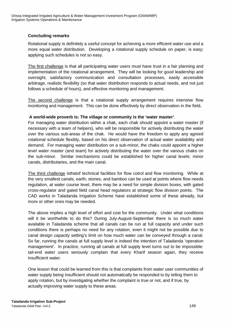
Orissa Integrated Irrigated Agriculture & Water Management Investment Program (OIIAWMIP) Irrigation Systems Operations & Maintenance
Taladanda Irrigation Sub-Project Taladanda O&M Plan -Vol-2 149
Concluding remarks
Rotational supply is definitely a useful concept for achieving a more efficient water use and a more equal water distribution. Developing a rotational supply schedule on paper, is easy; applying such schedules is not so easy. The first challenge is that all participating water users must have trust in a fair planning and implementation of the rotational arrangement. They will be looking for good leadership and oversight, satisfactory communication and consultation processes, easily accessible arbitrage, realistic flexibility (so that water distribution responds to actual needs, and not just follows a schedule of hours), and effective monitoring and management. The second challenge is that a rotational supply arrangement requires intensive flow monitoring and management. This can be done effectively by direct observation in the field. A world-wide proverb is: The village or community is the ‘water master’ . For managing water distribution within a chak, each chak should appoint a water master (if necessary with a team of helpers), who will be responsible for actively distributing the water over the various sub-areas of the chak. He would have the freedom to apply any agreed rotational schedule flexibly, based on his direct observation of actual water availability and demand. For managing water distribution on a sub-minor, the chaks could appoint a higher level water master (and team) for actively distributing the water over the various chaks on the sub-minor. Similar mechanisms could be established for higher canal levels: minor canals, distributaries, and the main canal. The third challenge isthatof technical facilities for flow cotrol and flow monitoring. While at the very smallest canals, earth, stones, and bamboo can be used at points where flow needs regulation, at water course level, there may be a need for simple division boxes, with gated cross-regulator and gated field canal head regulators at strategic flow division points. The CAD works in Taladanda Irrigation Scheme have established some of these already, but more or other ones may be needed. The above implies a high level of effort and cost for the community. Under what conditions will it be worthwhile to do this? During July-August-September there is so much water available in Taladanda scheme that all canals can be run at full capacity and under such conditions there is perhaps no need for any rotation, even it might not be possible due to canal design capacity setting’s limit on how much water can be conveyed through a canal. So far, running the canals at full supply level is indeed the intention of Taladanda ’operation management’. In practice, running all canals at full supply level turns out to be impossible: tail-end water users seriously complain that every Kharif season again, they receive insufficient water. One lesson that could be learned from this is that complaints from water user communities of water supply being insufficient should not automatically be responded to by telling them to apply rotation, but by investigating whether the complaint is true or not, and if true, by actually improving water supply to these areas.
Orissa Integrated Irrigated Agriculture & Water Management Investment Program (OIIAWMIP) Irrigation Systems Operations & Maintenance
Taladanda Irrigation Sub-Project Taladanda O&M Plan -Vol-2 150
8. Next Steps – ‘’APPLIED REFINEMENT’’ OF THE TOOL
Adoption and Further Development of the water distr ibution scheduling tool
It is possible now, with help of the Tool to produce seasonal water distribution schedules for Taladanda within a short time. How realistic and appropriate the resultant schedules are, depends on the validity and completeness values of the input factors (quality of data). The data sets for each input factor, as assumed for the tool, definitely need verification (quality checks). For example, is an assumed default percolation rate of 4 mm/day realistic? What about the field and conveyance efficiencies? What about effectiveness of rainfall? Can service provider and user agree realistic crop calendars? The process of preparation of the water distribution scheduling tool, of which the-test runs made were a part, had defined a series of factors that determine irrigation water requirement. Test-runs were made to gain insight in the influence of a variety of rainfall scenario on irrigation water requirement, and verify to what extend canal design capacities would suffice in a dry year. Seasonal Water Requirement Characteristics as follows:
1. July-August, requirement is high, with a peak in the 2nd half of July 2. September, requirement is low to nil 3. October-November, requirement is high again
This confirms the importance of shortening the period of staggering for minimising irrigation requirement in October - November, and having more water available in Rabi In this respect, monitoring is highly important. Not only the monitoring of actual flows supplied at selected key-points, but also in at least selected chaks. A next “applied’ development or refinement stage of the tool would be to expand functionality or scope to enable optimisation of water use—i.e. comparative analysis of simulations for various scenarios of rainfall, reservoir storage and crop calendar combinations. Optimization would focus on generating higher economic returns from efficiency in water use as an important contributor to the principal purpose and goal of the project.
Improving the Practice of Water Distribution
Another question is whether seasonal schedules have practical value. It is clear from the rainfall data series that rainfall is truly erratic, over time as well as location. System operation is strongly influenced by periods with heavy rainfall. Thus, establishing a seasonal water distribution schedule may look as proper preparation for the season, but in fact, it would not be realistic to adhere strictly to the schedule throughout the season. For practical reasons, actual water distribution may well need to continue to be based on simple straight forward considerations:
Orissa Integrated Irrigated Agriculture & Water Management Investment Program (OIIAWMIP) Irrigation Systems Operations & Maintenance
Taladanda Irrigation Sub-Project Taladanda O&M Plan -Vol-2 151
(1) water availability is very high and in principle, all canal sections can be run at full capacity from the start of the Kharif season, so as to support an as early as possible completion of transplanting (‘managing Kharif for Rabi’);
(2) when there is heavy rainfall the main intake will be closed partly or fully (for reasons which are not yet fully clear: to prevent submergence of fields in low areas, or to save water by keeping it in the reservoir); and
(3) when there are strong requests or complaints from the Project Committee, special operational action will be agreed and undertaken.
This set of simple considerations is quite all right. What need to be improved, though, is the intensity of flow monitoring and flow adjustment. In addition, amore critical mind set is needed: believes that (i) when a canal runs at full supply level, it also runs at design capacity; and (ii) that if the main canal runs at full supply level and all off-takes are fully open, then also the off-taking canals will run at full supply level are pertinent wrong.
Improve flow monitoring at key points
Taladanda system has not successfully and reliablymet requirements to supply water to the Tail-end of the entire command area. These tail-end areas require more irrigation water and receive considerably less than the requirement There are two possible reasons for this: (i) the main canaldesign is ill suited for irrigation purpose; and/or (ii) efficiency of upstream diversion-water is diverted from the main canal, upstream of the head-regulators controlling/restricting flow to the downstream blocks. It is necessary to intensively monitor the flow passing those two head regulators. It is necessary to install water level gauges at all the regulators.andwith calibrating the structures and developing H-Q curves/tables for these regulators, to be used for converting gauge-readings to discharges.
Rotational supply
Where chaks receive insufficient water, particular, tail end chaks on long canals with a relatively small flow, DoWR needs to assist PPs with reviewing the situation and improve the flow to those chaks. This may concern a sub-minor, a minor, or even a distributary. One of the measures that could be tested is to direct the full flow to the most downstream chaks for a defined period (thus closing the upstream outlets).
The Chak-level
A number of key problems in water distribution are inherent to the ‘Traditional Operation Principles’. However, there are also other, possibly more important causes for those key problems. In the first place the two inter-related causes at the Chak level: weak management of water distribution and a poor state of the water course and field canal systems. SIO may want to undertake programmes in selected chaks, to determine criteria, approach, methodology, and resources requirement for improved chak performance.
Formal hand-over of minor systems to PPs
Under OIIAWMIP, minor systems have been rehabilitated. The formal hand-over of (the management of) these systems to the PPs is an extremely important step in establishing the

Orissa Integrated Irrigated Agriculture & Water Management Investment Program (OIIAWMIP) Irrigation Systems Operations & Maintenance
Taladanda Irrigation Sub-Project Taladanda O&M Plan -Vol-2 152
desired O&M arrangements for Taladanda system. A well-implemented hand-over process should help the PPs develop their functions fully, as stipulated in the PP Act 2002. In the past these were paper-transactions without bringing any practical improvement. How in Taladanda to carry out the hand-over process in a proper way has to be found out.
Unified Purpose but Different Perspectives
There is quite a strong contrast between two main realities (i) the type of day-to-day water distribution schedule that is needed at the scheme level by the users (PPs) versus (ii) service providers (Gov’t) policy/administration mechanism driving economic factors such as budgets and operations management planning. -- The contrast results from the difference in mix of these two main realities as illustrated in Figure M-21.
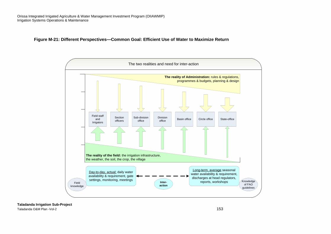
Orissa Integrated Irrigated Agriculture & Water Management Investment Program (OIIAWMIP) Irrigation Systems Operations & Maintenance
Taladanda Irrigation Sub-Project Taladanda O&M Plan -Vol-2 153
Figure M-21: Different Perspectives—Common Goal: Ef ficient Use of Water to Maximize Return
Knowledge of FAO
guidelines
Long-term, average seasonal water availability & requirement, discharges at head regulators,
reports, workshops
Field staff and
Irrigators
The reality of Administration: rules & regulations, programmes & budgets, planning & design
The reality of the field: the irrigation infrastructure, the weather, the soil, the crop, the village
Section officers
Sub-division office
Division office
Basin office State-officeCircle office
Day-to-day, actual: daily water availability & requirement, gate settings, monitoring, meetings
Field knowledge
Inter-action
The two realities and need for inter-action
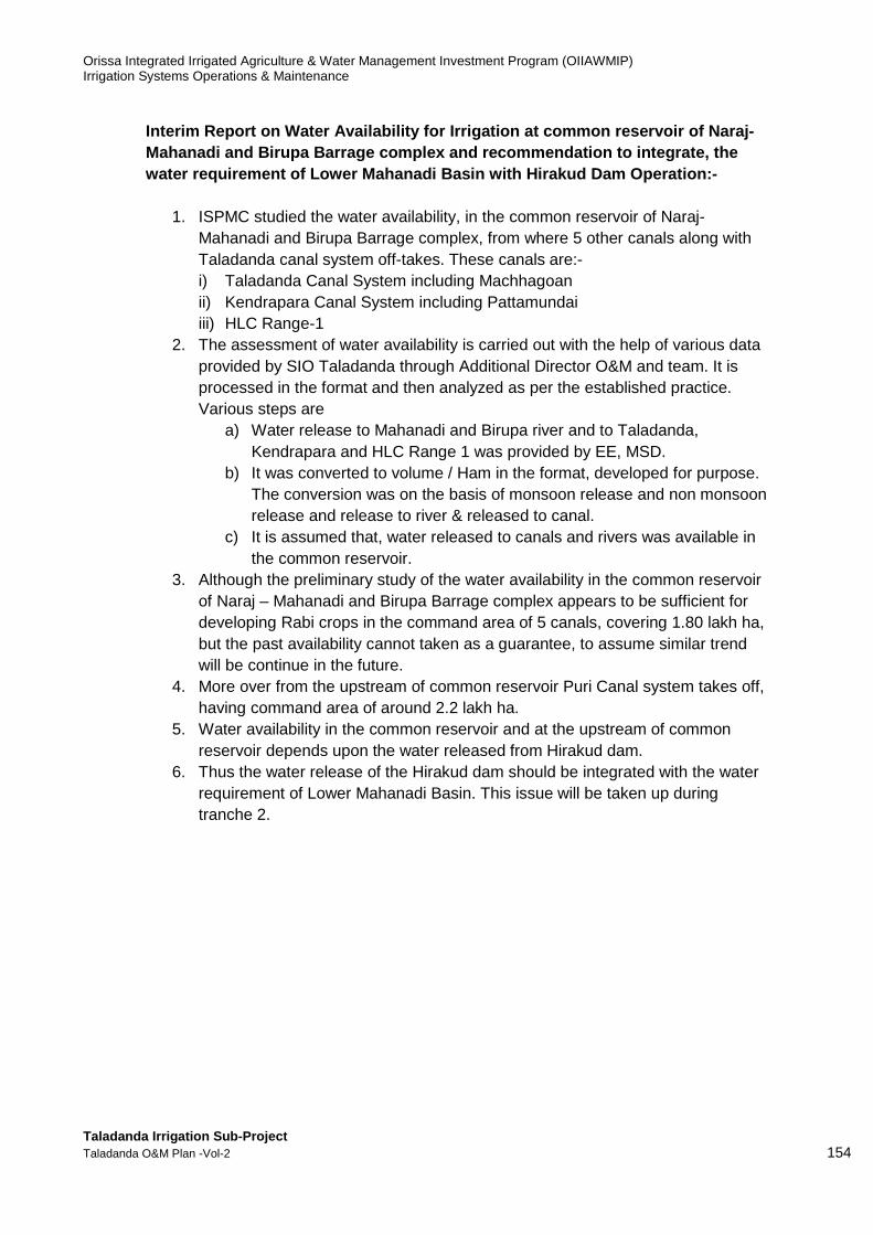
Orissa Integrated Irrigated Agriculture & Water Management Investment Program (OIIAWMIP) Irrigation Systems Operations & Maintenance
Taladanda Irrigation Sub-Project Taladanda O&M Plan -Vol-2 154
Interim Report on Water Availability for Irrigation at common reservoir of Naraj-Mahanadi and Birupa Barrage complex and recommendat ion to integrate, the water requirement of Lower Mahanadi Basin with Hira kud Dam Operation:-
1. ISPMC studied the water availability, in the common reservoir of Naraj-
Mahanadi and Birupa Barrage complex, from where 5 other canals along with Taladanda canal system off-takes. These canals are:- i) Taladanda Canal System including Machhagoan ii) Kendrapara Canal System including Pattamundai iii) HLC Range-1
2. The assessment of water availability is carried out with the help of various data provided by SIO Taladanda through Additional Director O&M and team. It is processed in the format and then analyzed as per the established practice. Various steps are
a) Water release to Mahanadi and Birupa river and to Taladanda, Kendrapara and HLC Range 1 was provided by EE, MSD.
b) It was converted to volume / Ham in the format, developed for purpose. The conversion was on the basis of monsoon release and non monsoon release and release to river & released to canal.
c) It is assumed that, water released to canals and rivers was available in the common reservoir.
3. Although the preliminary study of the water availability in the common reservoir of Naraj – Mahanadi and Birupa Barrage complex appears to be sufficient for developing Rabi crops in the command area of 5 canals, covering 1.80 lakh ha, but the past availability cannot taken as a guarantee, to assume similar trend will be continue in the future.
4. More over from the upstream of common reservoir Puri Canal system takes off, having command area of around 2.2 lakh ha.
5. Water availability in the common reservoir and at the upstream of common reservoir depends upon the water released from Hirakud dam.
6. Thus the water release of the Hirakud dam should be integrated with the water requirement of Lower Mahanadi Basin. This issue will be taken up during tranche 2.

Orissa Integrated Irrigated Agriculture & Water Management Investment Program (OIIAWMIP)Irrigation Systems Operations & Maintenance
Taladanda Irrigation Sub-Project Taladanda O&M Plan -Vol-2
Figure M-22: Monsoon Water Discharge
YEAR
CANAL DISCHARGE
HAM
2000
2001
2002
2003
2004
2005
2006
2007
2008
2009
2010
2011
2012
2013
2014
2015
Orissa Integrated Irrigated Agriculture & Water Management Investment Program (OIIAWMIP)Irrigation Systems Operations & Maintenance
Monsoon Water Discharge of Taladanda
CANAL DISCHARGE in
TOTAL DISCHARGE in
HAM
160247 719615
117456 2428349
153576 717889
105490 2528740
143600 2192800
108001 2690621
112848 4249353
126826 3366425
130728 2890065
143369 2388938
146939 2186784
137159 3156911
137454 3643017
123093 3868898
121367 4759581
158626 2047018
Orissa Integrated Irrigated Agriculture & Water Management Investment Program (OIIAWMIP)
155
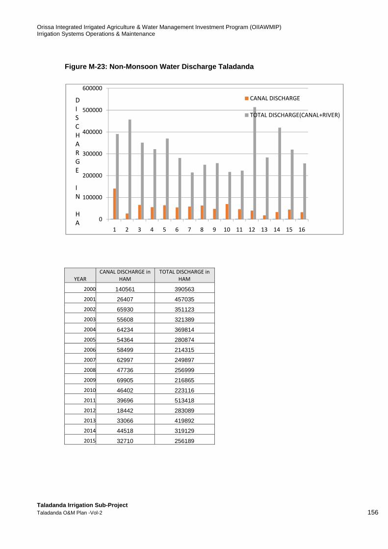
Orissa Integrated Irrigated Agriculture & Water Management Investment Program (OIIAWMIP) Irrigation Systems Operations & Maintenance
Taladanda Irrigation Sub-Project Taladanda O&M Plan -Vol-2 156
Figure M-23: Non-Monsoon Water Discharge Taladanda
YEAR
CANAL DISCHARGE in
HAM
TOTAL DISCHARGE in
HAM
2000 140561 390563
2001 26407 457035
2002 65930 351123
2003 55608 321389
2004 64234 369814
2005 54364 280874
2006 58499 214315
2007 62997 249897
2008 47736 256999
2009 69905 216865
2010 46402 223116
2011 39696 513418
2012 18442 283089
2013 33066 419892
2014 44518 319129
2015 32710 256189
0
100000
200000
300000
400000
500000
600000
1 2 3 4 5 6 7 8 9 10 11 12 13 14 15 16
CANAL DISCHARGE
TOTAL DISCHARGE(CANAL+RIVER)
D
I
S
C
H
A
R
G
E
I
N
H
A

Orissa Integrated Irrigated Agriculture & Water Management Investment Program (OIIAWMIP) Irrigation Systems Operations & Maintenance
Taladanda Irrigation Sub-Project Taladanda O&M Plan -Vol-2 157
Last Page


![ELECTRICAL SYLLABUS [NEW] - SCTEVT Odisha](https://static.fdokumen.com/doc/165x107/6317192cf68b807f88038180/electrical-syllabus-new-sctevt-odisha.jpg)

