TABLE OF CONTENT 1. Gazette Notification of Vadodara ...
73
TABLE OF CONTENT 1. Gazette Notification of Vadodara Mumbai Expressway 2. Social Impact Assessment Report
-
Upload
khangminh22 -
Category
Documents
-
view
0 -
download
0
Transcript of TABLE OF CONTENT 1. Gazette Notification of Vadodara ...

TABLE OF CONTENT
1. Gazette Notification of Vadodara Mumbai Expressway
2. Social Impact Assessment Report

Scanned by CamScanner

Scanned by CamScanner

Intercontinental Consultants and Technocrats Pvt. Ltd. A-8, Green Park, New Delhi-110016, India
Social Impact Assessment Report
Development of Vadodara Mumbai Expressway (Phase-II) from km.26.320 to km.104.700
(km.390.864 of NH-8) of Main Expressway in the State of Maharashtra
(MoEFCC F. No. No.10-80/2016-IA-III)
Project Proponent
NATIONAL HIGHWAYS AUTHORITY OF INDIA Ministry of Road Transport and Highways, Government of India
EIA Consultant
Sl. No. in QCI’s List ‘1’of Accredited EIA Consultant (15th October 2019) : 90
NOVEMBER 2019

Project : Development of Vadodara Mumbai Expressway (Phase-II) from km.26.320 to km.104.700 of Main Expressway in the State of Maharashtra
Document : ICT/E&S/VME/567/Social Impact Assessment Report Date: Nov 2019 Table of Contents Revision: R1
Page - i
TABLE OF CONTENTS
Page No#
Executive Summary .................................................................................................. 1 to 3
Chapter-1 Introduction and Methodology ...................................................................... 1 to 7 1.1 Introduction ......................................................................................................... 1 1.2 Project Description ......................................................................................................... 3 1.3 Social Impact Assessment ............................................................................................... 5 1.4 Land Acquisition and Project Impact ................................................................................. 6 1.5 Measures to Minimize Impacts .......................................................................................... 6 1.6 Benefit to the Project Region Populace ............................................................................. 6 1.7 Objectives of the Social Impact Assessment .................................................................... 7 1.8 Data Collection from Primary and Secondary Sources ...................................................... 7 1.9 Reporting Requirements ................................................................................................... 7
Chapter-2 Socio-economic Profile of the Project Area................................................ 8 to 31 2.1 Introduction ......................................................................................................... 8 2.2 Palghar - The Physical Features and the District Profile.................................................... 8 2.2.1 Area and Location.................................................................................................... 8 2.2.2 History of Palghar .................................................................................................... 9 2.2.3 Geography ......................................................................................................... 9 2.2.4 Climate ......................................................................................................... 9 2.2.5 Flora, Fauna and Forest ........................................................................................ 10 2.2.6 Land Use Pattern ................................................................................................... 10 2.2.7 Agriculture ....................................................................................................... 11 2.2.8 Economy ....................................................................................................... 11 2.2.9 Culture, Fair and Festivals ..................................................................................... 11 2.2.10 Rail Transport ...................................................................................................... 12 2.2.11 Road Transport .................................................................................................... 13 2.2.12 Air Transport ....................................................................................................... 13 2.2.13 Tourism ....................................................................................................... 13 2.3 Demographic and Socio-economic Features of Project Influence District ........................ 16 2.3.1 Total Population ..................................................................................................... 16 2.3.2 Population Density ................................................................................................. 16 2.3.3 Vulnerable Population ............................................................................................ 16 2.3.4 Literacy Rate ....................................................................................................... 17 2.3.5 Distribution of Population by Workers and Non-Workers and Occupation .............. 17 2.4 Socio-economic Profile of the Project Area ..................................................................... 20 2.4.1 Social and Demographic Profile of the Affected Villages ........................................ 20 2.4.2 Population ....................................................................................................... 20 2.4.3 Social Classification ............................................................................................... 22 2.4.4 Educational Status ................................................................................................. 24 2.4.5 Workforce in Project affected villages .................................................................... 25

Project : Development of Vadodara Mumbai Expressway (Phase-II) from km.26.320 to km.104.700 of Main Expressway in the State of Maharashtra
Document : ICT/E&S/VME/567/Social Impact Assessment Report Date: Nov 2019 Table of Contents Revision: R1
Page - ii
Page No#
2.4.6 Category wise Distribution of Main Workforce ....................................................... 27 2.5 Conclusion ....................................................................................................... 31
Chapter-3 Evaluation of Social Impact and Land Acquisition .................................. 32 to 38 3.1 Introduction ....................................................................................................... 32 3.2 Summary of Land Acquisition and Social Impact ............................................................ 32 3.3 Land Acquisition ....................................................................................................... 33 3.4 Affected Households ....................................................................................................... 34 3.5 Properties to be Affected ................................................................................................. 35 3.5.1 Ownership of Affected Properties ........................................................................... 35 3.5.2 Type of Construction of the Structures ................................................................... 35 3.5.3 Legal Status of the Ownership of the Properties/ Structures .................................. 36 3.5.4 Impact on Affected Private Structures ................................................................... 36 3.5.5 Impact on Affected Land Holders ........................................................................... 37 3.6 Government Properties and other CPRs to be Affected ............................................ 37 3.7 Religious Properties to be Affected along the Alignment ................................................. 38 3.8 Conclusion ....................................................................................................... 38
Chapter-4 Resettlement Policy, Legal Framework and Mitigation Measures .......... 39 to 47 4.1 Policies and Legal Framework ........................................................................................ 39 4.2 The Indian Legal Framework .......................................................................................... 39 4.2.1 Ministry of Environment and Forests Guidelines, 1989 ........................................... 39 4.2.2 National Highway Act 1956 .................................................................................... 40 4.2.3 The Right to Fair Compensation and Transparency in Land Acquisition, Rehabilitation and Resettlement Act, 2013...................................................................... 41 4.2.4 The Provisions of the Panchayats (Extension to Scheduled Areas) Act, 1996 ........ 42 4.3 The Entitlement Matrix and Mitigation Measures ............................................................. 42
Chapter 5 Public Consultation .................................................................................... 48 to 60 5.1 Identification of Stakeholders................................................................................................ 48 5.2 Methods of Public Consultation ............................................................................................ 48 5.3 Scope of Consultation ......................................................................................................... 48 5.4 Date and Location of Public Consultation ............................................................................. 49 5.5 Findings of Public Consultation ............................................................................................ 49 5.6 Information Disclosure and Dissemination ........................................................................... 51 5.7 Terms of References for the NGO to Implement the Resettlement Plan ......................... 52 5.7.1 Scope of Work ....................................................................................................... 53 5.7.2 Administrative Responsibilities of the NGO ............................................................ 53 5.7.3 Implementation of the Resettlement Plan .............................................................. 54 5.7.4 Documentation and Reporting by NGO .................................................................. 59 5.7.5 Condition of Services ............................................................................................. 59 5.7.6 Timeframe for Services .......................................................................................... 60 5.7.7 Data, Services and Facilities to be provided by the Client ...................................... 60

Project : Development of Vadodara Mumbai Expressway (Phase-II) from km.26.320 to km.104.700 of Main Expressway in the State of Maharashtra
Document : ICT/E&S/VME/567/Social Impact Assessment Report Date: Nov 2019 Table of Contents Revision: R1
Page - iii
Page No#
Chapter-6 Resettlement Budget .................................................................................. 61 to 63 6.1 Introduction ....................................................................................................... 61 6.2 Estimated R&R Budget ................................................................................................... 61 6.2.1 Cost of the Land .................................................................................................... 61 6.2.2 Cost of Structure .................................................................................................... 61 6.2.3 Cost of NGOs Involvement ..................................................................................... 62 6.2.4 Tentative R&R Cost .............................................................................................. 62

Project : Development of Vadodara Mumbai Expressway (Phase-II) from km.26.320 to km.104.700 of Main Expressway in the State of Maharashtra
Document : ICT/E&S/VME/567/Social Impact Assessment Report Date: Nov 2019 Executive Summary Revision: R1
Page - 1
EXECUTIVE SUMMARY E.1 INTRODUCTION
The social impact assessment study is meant to determine the magnitude of impact on the population due to development of proposed expressway with the objective to ensure the social considerations be given adequate weightage in the selection and design of proposed project. Basic idea is to minimize adverse social impacts with best possible engineering solutions at the optimal cost.
E.2 NEED OF THE PROJECT The Mumbai–Ahmedabad Corridor is one of the important transport corridors of the country. On one side of this corridor is Mumbai which is the financial capital of the country and on the other side is Vadodara, an important commercial and business city. Many industries like, textile, gems & jewelries, petrochemical & fertilizer etc. have been established along this corridor. This corridor also serves SEZ areas and ports. NH-8 is of great significance for transportation in this corridor between Delhi to Mumbai. NH8 has been widened to 6 lane but many of the sections have already reached nearly the capacity volume of 6 lane in the year 2015 with average journey speed of 50-60 km/hr. Further widening of NH-8 is not feasible. With rapid economic development taking place in the States of Gujarat and Maharashtra, there is a need to develop an expressway wherein the movement of large volumes of passenger and goods vehicles can take place at a fast pace. Keeping in view of the importance of the National Highways for the economic development, the construction of about 379 km long proposed Vadodara Mumbai Expressway (VME) including SPUR is envisaged to fulfill this objective. The proposed VME has been divided into three phases for implementation. This SIA Report deals with development of VME Phase II from Km 26+582 to Km 104+700 of main expressway.
E.3 LOCATION OF THE PROJECT The proposed project is the development of 8 lane access-controlled green-field Vadodara Mumbai Expressway (Phase-II). The expressway starts at proposed chainage 26+582 (at Koshimb village of Vasai Taluka) and ends at proposed chainage 104+700 [km 390+864 of new NH-48 (old NH-8)] at Ibhadpada village of Talasari Taluka in the state of Maharashtra. Total length of expressway (Phase-II) is 78.118 km. The proposed alignment is passing through 4 talukas (Vasai, Palghar, Dahanu and Talasari) of Palghar district in the state of Maharashtra.
E.4 SOCIO-ECONOMIC PROFILE
Total Population: population composition of the villages is important to anticipate
the extent of project impact. Population details of the 51 villages have been derived

Project : Development of Vadodara Mumbai Expressway (Phase-II) from km.26.320 to km.104.700 of Main Expressway in the State of Maharashtra
Document : ICT/E&S/VME/567/Social Impact Assessment Report Date: Nov 2019 Executive Summary Revision: R1
Page - 2
from primary census abstract 2011 and total population is 85,476, out of which 42,390 are male and 43,086 are female.
Tribal Population: Total tribal population of 51 villages is 66,819 (Scheduled Cast –
1,123 and Scheduled Tribes – 65,696), which is 78.2% of the total population. As per Census of India, 2011, 100% population of Chandwad village is Scheduled Tribes. Out of 51 villages, maximum tribal population is observed in Vadavali village (5375 nos.) and in 24 villages, tribal population is more than 90%.
Literacy Rate: Among 51 villages, highest literacy rate is observed in Nagaze
village of Palghar Taluka (male – 92.02%, female – 78.88%). Lowest literacy rate among male observed in Dhaniwari villagre (44.01%) of Dahanu Taluka and among female observed in Ganeshbag village (18.52%) of Dahanu Taluka. In Dhaniwari and Ganeshbag village, tribal population is more than 99%. Overall literacy levels among tribals are lower than that of the general population.
Category wise Distribution of Main Workforce: Agriculture does play an
important sector in engaging the workforce in the project area. Majority of main workers are cultivators (42.8%) followed by agricultural labours (33.2%), other workers (22.0%) and only 2.0% population are engaged in household industry such as handloom, weaving, biri rolling, papad making, toy making, etc.
E.5 LAND ACQUISITION AND SOCIAL IMPACT ASSESSMENT
The Greenfield expressway traverses through 51 villages of four Talukas in Palghar district of Maharashtra state. The tentative private land need to be acquired for the project is 710.3247 hectares and forest land proposed to be diverted is 191.5894 ha (data updated till October 2019). Joint Measurement Survey with the concerned department is under progress. Therefore, both non-forest and forest land proposed to be diverted will be updated time to time during the land acquisition and forest clearance process. As per findings of Joint Measurement Survey (JMS) of affected land and non-land assets, the project impacts can be broadly classified as (i) impacts on private land, (ii) impacts on private structures and; (iii) loss of common property resources. The social impacts of the proposed project are summarized below:
Table E-1 Summary of Project Impacts (Phase-II of Main Alignment)
Sl. No. Impacts Number/ Area
1 Total private land acquisition requirement (data updated till November 2019) 710.3247 ha
2 Total number of private land units/plots affected (No.) 2393
3 Fully displaced land owner (15% of affected land owners) (No.) 359
4 Total number of structures affected of all categories (Including Private, Government, and Religious)
895

Project : Development of Vadodara Mumbai Expressway (Phase-II) from km.26.320 to km.104.700 of Main Expressway in the State of Maharashtra
Document : ICT/E&S/VME/567/Social Impact Assessment Report Date: Nov 2019 Executive Summary Revision: R1
Page - 3
Sl. No. Impacts Number/ Area
5 Total number of affected private structures 717
6 Number of Fully displaced structure owner (15% of affected structure owners)
108
7 Total number of affected Households Including Land & Structures 3110
8 Total number of Govt. /Communities properties 175
9 Total number of religious properties 3
Source: Field Study 2019
E.6 MITIGATION MEASURES The basic features of the proposed policy framework and mitigation measures, for implementation of the RFCTLARR Act 2013 and others legal provisions, are detail in Chapter 4.
E.7 PUBLIC CONSULTATION The task of public consultation has been done in the light of consultation and focus group techniques, which were applied on various groups of stakeholders along the project corridor. It was organized in the form of small groups of potentially affected people as discussed in detail in Chapter 5.
E.8 TENTATIVE R&R BUDGET The R&R budget for the expressway of phase II is approximately INR 1,594 Crores which includes the cost of land and structures, relocation or enhancement of religious, government and community structures and involvement of NGO. The summery of the tentative budget are given in Table E-2
Table E-2 Tentative R&R Cost
Sl. No. Component Cost in Cr.
1 Land Acquisition Cost 1,361.0
2 Cost of Private, Government and Other Communities Structures 85.0
3 Involvement of NGO for RAP Implementation 3.0
Total Sum (1+2+3+4+5) 1,449.0
Contingency @ 10% 144.9
Grand Total (In Cr.) 1,593.9
Say Rs. 1,594 Cr. Note: Last updated in the year 2018. May be modified at the time of actual land acquisition based

Project : Development of Vadodara Mumbai Expressway (Phase-II) from km.26.320 to km.104.700 of Main Expressway in the State of Maharashtra
Document : ICT/E&S/VME/567/Social Impact Assessment Report Date: Nov 2019 Chapter-1 : Introduction Revision: R1
Page - 1
CHAPTER-1: INTRODUCTION AND METHODOLOGY
1.1 INTRODUCTION The Mumbai–Ahmedabad Corridor in the western part of the country is one of the important transport corridors of the country. On one side of this corridor is Mumbai which is the financial capital of the country and on the other side is Vadodara, an important commercial and business city. Many industries like, textile, gems & jewelries, petrochemical & fertilizer etc. have been established along this corridor. This corridor also serves SEZ areas and ports. New NH 48 (old NH 8) is of great significance for transportation in this corridor starting from the country’s administrative capital of Delhi to
financial capital of Mumbai. Present condition and steps taken to develop its speed and safety are as follows: The Vehicle Damage Factor (VDF) as assessed on NH8 varies from 2.04 to 5.86 for
2 axle vehicles and varies from 19.48 to 25.69 for 6 axle vehicles. The average journey speed in majority part of Mumbai-Vadodara section of NH 8
was found to be in the range of 50-60 km/hr. whereas the designed speed is 100km/hr.
NH8 has been widened to 6 lane but many of the sections have already reached nearly the capacity volume (LOS E) of 6 lane NH (120,000 PCU) in the year 2015.
Even with six laning or further widening, segregation of long distance and local and / or slow traffic is hard to achieve. Further, NH-8 is not an access controlled highway and is passing through many settlements where land availability and displacement of people would be a major concern for further widening. With rapid economic development taking place in the States of Gujarat and Maharashtra, there is a need to develop an expressway wherein the movement of large volumes of passenger and goods vehicles can take place at a fast pace. Keeping in view of the importance of the National Highways for the economic development, the Government of India has taken up an ambitious program of development of the National Highways under different phases of National Highway Development Program (NHDP). The construction of about 379 km long proposed Vadodara Mumbai Expressway along with SPUR of about 94 km is envisaged to fulfill this objective and decided to be implemented under NHDP (Phase-VI). The proposed Vadodra - Mumbai Expressway has been divided into three phases for implementation (Figure 1-1): A. Phase I: From proposed chainage 104+700 to chainage 378+722 in the State of
Gujarat, Maharashtra and Union Territory of Dadra and Nagar Haveli. Environmental Clearance has already obtained from MoEF&CC vide letter dated 11th February 2015 for Phase-I development.

Project : Development of Vadodara Mumbai Expressway (Phase-II) from km.26.320 to km.104.700 of Main Expressway in the State of Maharashtra
Document : ICT/E&S/VME/567/Social Impact Assessment Report Date: Nov 2019 Chapter-1 : Introduction Revision: R1
Page - 2
Figure 1-1 Index Map showing various phases of Proposed Vadodara Mumbai Expressway

Project : Development of Vadodara Mumbai Expressway (Phase-II) from km.26.320 to km.104.700 of Main Expressway in the State of Maharashtra
Document : ICT/E&S/VME/567/Social Impact Assessment Report Date: Nov 2019 Chapter-1 : Introduction Revision: R1
Page - 3
B. Phase II (Main Expressway): This section starts from chainage 26+320 near Vasai (revised to chainage 26+582 in March 2019). It terminates at chainage 104+700 on the junction with new NH-48 [km.390.864 of new NH-48 (old NH-8)]. This Social Impact Assessment Report deals with development of VME Phase II (Main Expressway).
C. Phase II (SPUR): Start point of SPUR (ch. 0+000) is chainage 26+320 of the main
expressway (revised to Ch. 26+582 in March 2019). It ends at chainage 94+390 at km 24.476 of NH-4B near JNPT (length 94.390 km) in the state of Maharashtra.
D. Phase III: From proposed chainage 0+000 to 26+320 (26.320 km) in Thane District
of Maharashtra. The consultant recommended deletion of this stretch to avoid large scale displacement of people & demolition of residential, commercial and industrial establishments at Mira-Bhaynder & Vasai-Virar Municipal area. This recommendation has been accepted by the PWD, Government of Maharashtra and gave No Objection for exclusion of Phase-III vide letter no. NHP 2014/CR171/N.H.1 dated May 22, 2018.
1.2 PROJECT DESCRIPTION
The proposed project is the development of 8 lane access-controlled green-field Vadodara Mumbai Expressway (Phase-II). The expressway starts at proposed chainage 26+320 (at Koshimb village of Vasai Taluka) and ends at proposed chainage 104+700 [km 390+864 of new NH-48 (old NH-8)] at Ibhadpada village of Talasari Taluka in the state of Maharashtra (78.380 km). The proposed SPUR of VME was initially decided to starts from Km 26+320 of main expressway. However, after the decision for deletion of Phase-III of VME (as discussed in Section-1.1) and finalization of development proposal of SPUR; a meeting was held on 22nd March 2019 in the office of Regional Officer (NHAI) Mumbai, where it is decided that the start point of SPUR will be at Km 26.582 of main expressway of VME. Therefore, the start point of Phase-II main expressway is revised from km 26+320 to Km 26+582, which eventually reduces the length of the main expressway by 262 m. Revised length of the VME (Phase-II) main expressway is 78.118 km. The proposed alignment is passing through 4 talukas of Palghar district in the state of Maharashtra. The Taluka wise length of proposed expressway is given in Table 1-1.
Table 1-1 Taluka wise break-up of Length of Proposed Expressway District Taluka No. of Village Start Chainage End Chainage Length (Km)
Palghar
Vasai 3 26+582 31+000 4.418 Palghar 27 31+000 68+400 37.400 Dahanu 15 68+400 96+200 27.800 Talasari 6 96+200 104+700 8.500
Total 51 78.118 Source: DPR Prepared by the ICT Pvt. Ltd.

Project : Development of Vadodara Mumbai Expressway (Phase-II) from km.26.320 to km.104.700 of Main Expressway in the State of Maharashtra
Document : ICT/E&S/VME/567/Social Impact Assessment Report Date: Nov 2019 Chapter-1 : Introduction Revision: R1
Page - 4
The villages / settlements through which the expressway is traversing in Phase II are given in Table 1-2.
Table 1-2 Chainage wise List of Villages / Settlements along the Proposed Expressway Sl. No. Taluka Village Start Chainage End Chainage Length (m)
1. Vasai Koshimb 26+582 28+375 1,793
2. Vasai Khardi 28+375 29+600 1,225
3. Vasai Doliv 29+600 31+000 1,400
4. Palghar Vadhiv 31+000 31+600 600
5. Palghar Navghar 31+600 32+875 1,275
6. Palghar Ghateem 32+875 33+800 925
7. Palghar Penand 33+800 35+700 1,900
8. Palghar Sonave 35+700 37+680 1,980
9. Palghar Pargaon 37+680 39+520 1,840
10. Palghar Girale 39+520 40+550 1,030
11. Palghar Nagav 40+550 41+700 1,150
12. Palghar Navje 41+700 43+020 1,320
13. Palghar Sakhare 43+020 44+900 1,880
14. Palghar Dahisar 44+900 45+000 100
15. Palghar Khambloli 45+000 47+350 2,350
16. Palghar Dhukthan 47+350 50+300 2,950
17. Palghar Govade 50+300 50+450 150
18. Palghar Masvan 50+450 51+700 1,250
19. Palghar Vandivali 51+700 52+700 1,000
20. Palghar Vakadi 52+700 53+350 650
21. Palghar Vasroli 53+350 53+420 70
22. Palghar Katale 53+420 54+320 900
23. Palghar Lovare 54+320 56+550 2,230
24. Palghar Nihe 56+550 58+400 1,850
25. Palghar Nagzari 58+400 60+020 1,620
26. Palghar Lalonde 60+020 61+000 980
27. Palghar Kirat 61+000 63+600 2,600
28. Palghar Borsheti 63+600 64+700 1,100
29. Palghar Ravte 64+700 66+450 1,750
30. Palghar Chinchare 66+450 68+400 1,950
31. Dahanu Dhabon 68+400 72+200 3,800
32. Dahanu Aine 72+200 73+000 800
33. Dahanu Rankol 73+000 75+850 2,850
34. Dahanu Chandwad 75+850 77+080 1,230
35. Dahanu Navnath 77+080 77+330 250
36. Dahanu Ganjad 77+330 77+900 570
Dahanu Navnath 77+900 79+100 1,200
37. Dahanu Somnath 79+100 79+570 470
Dahanu Navnath 79+570 81+000 1,430
38. Dahanu Ganeshbagh 81+000 82+500 1,500

Project : Development of Vadodara Mumbai Expressway (Phase-II) from km.26.320 to km.104.700 of Main Expressway in the State of Maharashtra
Document : ICT/E&S/VME/567/Social Impact Assessment Report Date: Nov 2019 Chapter-1 : Introduction Revision: R1
Page - 5
Sl. No. Taluka Village Start Chainage End Chainage Length (m)
39. Dahanu Awadhani 82+500 82+850 350
40. Dahanu Dhanivari 82+850 86+750 3,900
41. Dahanu Chinchale 86+750 89+650 2,900
42. Dahanu Talote 89+650 90+480 830
43. Dahanu Punjave 90+480 91+140 660
Dahanu Talote 91+140 91+215 75
Dahanu Punjave 91+215 91+215 0
Dahanu Talote 91+215 91+580 365
44. Dahanu Bharmanwadi 91+580 93+380 1,800
45. Dahanu Vankas 93+380 96+200 2,820
46. Talasari Vadavali 96+200 97+900 1,700
47. Talasari Savane 97+900 98+300 400
48. Talasari Kawad 98+300 98+945 645
49. Talasari Awarpada 98+945 99+920 975
Talasari Kawad 99+920 101+280 1,360
50. Talasari Talasari 101+280 104+200 2,920
51. Talasari Ibhadpada 104+200 104+700 500
Total Length 78,118 km Source: DPR Prepared by the ICT Pvt. Ltd.
1.3 SOCIAL IMPACT ASSESSMENT
The social impact assessment and Resettlement Action Planning component has following elements: Enumeration of affected properties and baseline socio-economic survey of the
potentially affected Families;
Consultations with stakeholders at various levels; Preparation of a time-bound Resettlement Action Plan (RAP). The enumeration of properties has been carried out through Joint Measurement survey (JMS) to register and document all the properties in land acquisition area. It is a process to assess the status of the potentially affected population within the project impact area, their assets, and sources of livelihood. The socio-economic data has been collected from different secondary sources and has been analyzed to understand the demographic profile of affected area. The analysis provides a baseline against which mitigation measures and support has been evaluated & measured. Socio-economic analysis comprehensively assesses people’s assets,
incomes, important cultural or religious networks or sites, and other sources of support such as common property resources.

Project : Development of Vadodara Mumbai Expressway (Phase-II) from km.26.320 to km.104.700 of Main Expressway in the State of Maharashtra
Document : ICT/E&S/VME/567/Social Impact Assessment Report Date: Nov 2019 Chapter-1 : Introduction Revision: R1
Page - 6
1.4 LAND ACQUISITION AND PROJECT IMPACT In the process, various types of land such as commercial, residential and agricultural would be affected. At this stage, it is estimated that total land requirement for proposed greenfield expressway is around 710.3247 Hectares. The social assessment also reveals that about 51 villages are falling within the proposed RoW of the expressway and several pucca / kutcha structures are being affected, most of which is the residential structures as detailed in Chapter 3.
1.5 MEASURES TO MINIMIZE IMPACTS Efforts have been made to minimize the resettlement impact on the existing structures, while finalizing the expressway alignment by adopting appropriate engineering design. An attempt was made at this final stage to minimize the negative social impact, i.e. to save the structured properties, to avoid displacement and to reduce disruption of livelihoods in settlement areas in proposed Greenfield alignment. To take a decision, emphasis was made on minimizing the impacts within the limitations of technical feasibility and cost effectiveness. The options considered for minimizing negative social impacts included design considerations and public consultations. To make the project peoples’ friendly, the role of the NGOs/ CBOs, working in the area, will be very important. However, Public consultation has been carried out during project designing period, which helps in getting better planning and designing inputs towards minimizing negative social impacts.
1.6 BENEFITS TO THE PROJECT REGION POPULACE The following additional inputs have been taken for improved project design to benefit the expressway users as well as the local populace. Provision for adequate traffic signs on the proposed expressway, including cross
walks, underpasses; Provision for improved infrastructure for expressway side rural markets; Public amenities such as rest rooms, telephone booths, and facilities for public
conveniences (co-operation of the Private sector would be sought).
The proposed project would also facilitate faster and smooth vehicular movement, ensure safety and will increase the connectivity of interior resource hinterland with the major market centers. With the better connectivity and increased mobility, access to quality consumer products would be ensured. As per the people’s perception the
improved highway will contribute directly to more vibrant market economy. In an area of acute underemployment and poverty, some employment will be generated during the expressway construction for the unskilled construction laborers, who migrate

Project : Development of Vadodara Mumbai Expressway (Phase-II) from km.26.320 to km.104.700 of Main Expressway in the State of Maharashtra
Document : ICT/E&S/VME/567/Social Impact Assessment Report Date: Nov 2019 Chapter-1 : Introduction Revision: R1
Page - 7
from interior villages. This way they can be assured of employment for a substantial period of 3-4 years as well as for getting an opportunity to enhance their skill.
1.7 OBJECTIVES OF THE SOCIAL IMPACT ASSESSMENT The report on Social Impact Assessment has been prepared keeping the following broad objectives: The negative impact on persons affected by the project would be avoided or
minimized. Affected people and the beneficiary population will be informed and consulted about
the project and its design. Where the negative impacts are unavoidable, the project-affected persons will be
assisted in improving or regaining their standard of living. Vulnerable groups will be identified and assisted in improving their standard of living.
People’s participation will be undertaken in planning and implementation of the
project. All information related to prepared documents and implementation will be disclosed
to APs (Affected Population).
1.8 DATA COLLECTION FROM PRIMARY AND SECONDARY SOURCES This report has been based, largely, on primary data collected during field survey but it also includes a review of available secondary data on baseline information. Relevant baseline data on socio-economic and cultural conditions were collected from various available secondary sources, like Census Handbooks and District Gazetteers, Maharashtra Government website maintained by the NIC, etc., to understand the socio-economic context of the proposed project and for providing necessary inputs for social analysis of the project.
1.9 REPORTING REQUIREMENTS
Keeping in mind the above requirement, this report has been organized in following Chapters: Chapter-1 : Introduction and Methodology Chapter-2 : Socio-Economic Profile of the Project Area Chapter-3 : Evaluation of Social Impact and Land Acquisition
Chapter-4 : Resettlement Policy and Legal Framework Chapter-5 : Public Consultations and Stakeholder Analysis Chapter-6 : Resettlement Budget

Project : Development of Vadodara Mumbai Expressway (Phase-II) from km.26.320 to km.104.700 of Main Expressway in the State of Maharashtra
Document : ICT/E&S/VME/567/Social Impact Assessment Report Date: Nov 2019 Chapter-2 : Socio-economic Profile of the Project Area Revision: R1
Page - 8
CHAPTER-2: SOCIO-ECONOMIC PROFILE OF THE PROJECT AREA
2.1 INTRODUCTION The project influence area of the proposed Greenfield expressway in Phase-II of main expressway traverses in the district of Palghar of Maharashtra state. The proposed expressway of this phase starts from Km 26+582 and ends at Km 104+700, comprising a total length of 78.118 Km. In the light of above circumstance, the socio-economic profile of the project area will elucidate the details of the district coming in the way of Greenfield expressway. Main demographic features of the project impacted district have been presented in this chapter. The description of socio-economic features of the district and project affected villages through which the greenfield expressway traverses, comprises the demographic, social and economic aspect of the population, which includes the features of population distribution, density of population, workforce and share of workers in major economic categories and the vulnerable groups. Main socio-economic and demographic features of the project affected district and villages have been delineated in the subsequent paragraph.
2.2 PALGHAR - THE PHYSICAL FEATURES AND THE DISTRICT PROFILE
2.2.1 Area and Location Palghar District is a district in the state of Maharashtra in Konkan Division. On 1 August 2014, the Maharashtra State government announced the formation of the 36th district of Maharashtra, when a new Palghar District was carved out of the old Thane district. Palghar District starts from Dahanu at the north and ends at Naigaon. It comprises the talukas of Palghar, Vada, Vikramgad, Jawhar, Mokhada, Dahanu, Talasari and Vasai-Virar. In the 2011 Census, the talukas which was made part of Palghar district had a total population of 2,990,116. Palghar has an urban population of 1,435,210 that is 48% of total population. The district is bounded by Thane and Nashik Districts on the east and northeast, and by Valsad District of Gujarat state and Union Territory of Dadra and Nagar Haveli on the

Project : Development of Vadodara Mumbai Expressway (Phase-II) from km.26.320 to km.104.700 of Main Expressway in the State of Maharashtra
Document : ICT/E&S/VME/567/Social Impact Assessment Report Date: Nov 2019 Chapter-2 : Socio-economic Profile of the Project Area Revision: R1
Page - 9
north. The Arabian Sea forms the western boundary, while Vasai-Virar is part of Mumbai Metropolitan Region.
2.2.2 History of Palghar The part of the country’s largest urban sea-hill of Thane District, divisioned on 1st August 2014 or 36th new district Palghar came into existence. The working time of a new district in the presence of then Chief Minister Prithviraj Chavan and then Revenue Minister Balasaheb Thorat started from 1st August 2014. Palghar is the 36th district of the state. It is spreaded between the west coast of the Arabian Sea and the Sahyadri Mountains rows that are east of the Northern District of Palghar. Total population of Palghar district is around 2,990,116. Until 1 August 2014, the talukas now comprising Palghar District formed a part of Thane District. After a struggle and demand for almost 25 years, for bifurcation, the creation of the new district was approved by the Cabinet of Maharashtra on 13 June 2014 and the new district of Palghar came into existence on 1 August. Abhijit S. Bangar was the first Collector of the district. Vijay Suryavanshi was the first Chief Executive Officer and Suvez Haq was the first district Superintendent of Police.
2.2.3 Geography The district is the northern most part of the Konkan lowlands of Maharashtra. It comprises the wide amphitheater like Ulhas basin on the south and hilly Vaitarna valley on the north together with plateaus and the slopes of Sahyadri. From the steep slopes of the Sahyadri in the east, the land falls through a succession of plateaus in the north and center of the district to the Ulhas valley in the south. The distance from the parts of different palaces to headquarters Palghar by road is as follows: Khodala 138 km, Mokhada 112 km, Jawhar 75 km, Vikramgad 60 km. The main river flowing through the district is the Vaitarna. The river has many tributaries; the most important of them are Barvi and Bhatsa, Pinjal, Surya, Daherja and Tansa. Vaitarna, the largest of Konkan Rivers rises in the Tryambak hills in Nashik district, opposite to the source of Godavari. The river flows across Shahapur, Vada and Palghar talukas and enter the Arabian Sea through a wide estuary off Arnala. Vaitarna River is 154 km long and has a drainage area that practically covers the entire northern part of the district. Ulhas River which flows to Arabian Sea is Vasai creek, district's southern border. Arnala Island is located in Vasai taluka, at the entrance to the Vaitarna estuary.
2.2.4 Climate Climate of the study area is characterized by high humidity throughout the year, a hot summer followed by well distributed and heavy rainfall during the southwest monsoon season. The normal annual rainfall in the study area ranges from 1900 mm to 2600 mm

Project : Development of Vadodara Mumbai Expressway (Phase-II) from km.26.320 to km.104.700 of Main Expressway in the State of Maharashtra
Document : ICT/E&S/VME/567/Social Impact Assessment Report Date: Nov 2019 Chapter-2 : Socio-economic Profile of the Project Area Revision: R1
Page - 10
and mean annual rainfall during the year 1981 to 2010 is 1874.6 mm.
2.2.5 Flora, Fauna and Forest The project alignment is running parallel to the west coast. The coastal region is flat and subject to flooding and periodic inundation both by the Arabian Sea and the rivers. In this region, the rivers form marshy estuaries in the broad tidal flats. The marshes support mangrove vegetation - Tiwar (Avicennia alba) and Maraudi (Acanthus ilicifolius). Plantation of Suru (Casuarina equisetifolia) and Coconut (Cocus nucifera) is done in the coastal areas. Among tree species, Tectona grandis, Phoenix dactylifera, Bombax ceiba, Terminalia tomentosa, Butea monosperma, Acacia catecu etc. for found in the area. The fauna of project area is based on direct sighting during field survey, stakeholder consultation, review of Forest working plan of Dahanu Division, Wildlife Management plan of Tungeshwar Wildlife Sanctuary, DNH Wildlife Sanctuary and published literature. The fauna of the project area comprised of Schedule-I and threatened species such as Panthera pardus, Felis chaus Tragulus meminna, Axis axis, Sus scrofa, Antilope cervicapra, Muntiacus muntjak, Accipiter badius Gyps bengalensis, Haliaeetus leucogaster etc. The Forests of Dhanu Division are classified into following categories as per the Classification of Indian Forest Types by Champion and Seth (1968). A. Tropical Southern moist Teak bearing Forests B. Tropical Southern moist mixed deciduous Forests C. Western sub-tropical Hill Forests D. Mangrove Scrub Forests The proposed expressway does not pass through any Wildlife Sanctuary, National Park etc. it is located at a distance of 1.28 km from the boundary of Tungareshwar Wildlife Sanctuary and at a distance of 0.456 km from the notified Eco-Sensitive Zone boundary of Tungareshwar Wildlife Sanctuary i.e. outside the Eco-Sensitive Zone. Approx. 27.745 km stretch of the proposed expressway is traversing through Dahanu Taluka Ecologically Sensitive Area (proposed km 68+455 to Km 96+200).
2.2.6 Land Use Pattern The total geographic area of Palghar district is 5,17,634 ha. According to 2011Census the Land use patterns indicate that 42% is under cultivation while 37% is under forest. The 4% is cultivable waste land. While 1% is current fallow land of the total geographical area.

Project : Development of Vadodara Mumbai Expressway (Phase-II) from km.26.320 to km.104.700 of Main Expressway in the State of Maharashtra
Document : ICT/E&S/VME/567/Social Impact Assessment Report Date: Nov 2019 Chapter-2 : Socio-economic Profile of the Project Area Revision: R1
Page - 11
Land Use within PROW (100m-120m): Agricultural and allied uses occupied largest part amounting 73.13% of the total area, followed by open scrub (13.41%), barren land (6.48%), reserved forest (2.71%), surface water bodies (2.12%), settlements (1.37%), mangrove forest (0.36%), open mixed forest (0.24%), mudflats (0.15%) and marshy land (0.04%)
Land Use within Study Area: Total study area is 3027.325 ha. Agriculture land occupied major part (48.27%) of the total area, followed by reserved forest (31.39%), settlement (both urban and rural) (5.83%), surface water bodies (3.66%), marshy land (22.82%), open scrub (2.57%), open mixed jungle (1.83%), industrial (1.1%), mangrove forest (0.85%), salt pan (0.71%), barren land (0.64%), mudflats (0.34%).
2.2.7 Agriculture
Agriculture is the main occupation of the people residing in project area. Paddy (Oryza sativa) is grown in the low lying areas and nagli (Eleusine coracana) and warai (Panicum sumatrense) in the hilly tract. Pulses (cowpea, blackgram, pigeon pea, chick pea), and ground nut are also cultivated. Farms of Chickoo (Manilkara zapota), Naryal (Cocus nucifera), Papaya (Carica papaya) and Banana (Musa sps) are located in the area. Taal (Borassus flabellifer), Teak (Tectona grandis), Chinch (Tamarindus indica), Mango (Mangifera indica), Neem (Azadirchta indica), Khajoor (Phoenix dactylifera), Karanj (Pongamia pinnata), Pipal (Ficus religiosa), Umber (Ficus glomerata), Palash (Butea monosperma), Khair (Acacia cataechu), Drumstick (Moringa oleifera) and Gulmohar (Delonix regia) are commonly found in the area
2.2.8 Economy Palghar has India's first atomic power plant located at Tarapur. The industrial town of Boisar is also home to one of Maharashtra's largest industrial areas at Tarapur MIDC. However, Palghar district has 5757 small registered Industries, 1883 temporary small registered industries and 427 large / medium industries. Maharashtra's largest fishing port is Satpati, Dahanu, Arnala, Vasai and Datiware are also major fishing ports. Dahanu is best known for their chickoo production in the whole of India. A special Chickoo festival is held every year at Bordi beach in Dahanu.
2.2.9 Culture, Fair and Festivals Although the culture of Thane/ Palghar is greatly influenced by the cosmopolitan lifestyle of Mumbai, it aptly maintains its traditional heritage. The most popular dance form here is Lavani, supplemented by other traditional dance styles like Bharatnatyam, Kathak, Odissi as well as modern dances like Ballet. Coming to festivals, Thane/ Palghar observes Ganesh Chaturthi with full gusto and enthusiasm as in all of Maharashtra. Apart from this, Holi, Diwali, Gudhi Padwa, Durga Puja, Janmashtami, Navratri, Dahi

Project : Development of Vadodara Mumbai Expressway (Phase-II) from km.26.320 to km.104.700 of Main Expressway in the State of Maharashtra
Document : ICT/E&S/VME/567/Social Impact Assessment Report Date: Nov 2019 Chapter-2 : Socio-economic Profile of the Project Area Revision: R1
Page - 12
Handi and Shivaji Jayanti are also celebrated with equal fervour. Thane/ Palghar offer the best of street foods across India, the signature dishes being Vada Pao and Pav Bhaji. The city specialises in Konkani cuisine along with its much known indulgence in snacks particularly ‘Bhajjiyas’ and ‘Pakodas’. The folk art and craft of Thane/ Palghar is another marker of its rich cultural heritage. Janmashtami, the birthday of Shri Krishna, is celebrated with great splendour. Rows of lights are lit everywhere, Kirtans and Bhajans are sung, sermons are delivered and Krishna is worshipped in his infant form. Krishna is Lord Vishnu's eighth avatar (incarnation) on earth. Diwali which leads us into Truth and Light is celebrated on a nation-wide scale on Amavasya - the 15th day of the dark fortnight of the Hindu month of Ashwin (October/ November) every year. It symbolizes that age-old culture of our country which teaches us to vanquish ignorance that subdues humanity and to drive away darkness that engulfs the light of knowledge. Diwali, the festival of lights even to-day in this modern world projects the rich and glorious past of our country and teaches us to uphold the true values of life. This festival is essentially religious in nature. It is celebrated with true devotion in the various temples dedicated to the Mother, or Mataji, as she is familiarly called. In some homes, images of the Mother are worshipped in accordance with accepted practice. This is also true of the temples, which usually have a constant stream of visitors from morning to night. Holi in Maharashtra is one of the festivals that celebrate the vibrant spirit of the people. Holi is a festival of color and happiness, and on this day it is a custom to resolve all differences with everybody, including enemies. The festival, Holi has its origin in the legend of Lord Krishna. Lord Krishna used to take active part in Holi. During this festival, it is also customary to drink buttermilk, as it was the favorite drink of Lord Krishna. On the eve of Holi, a beautiful bonfire is decorated with flowers and fruits. Many people also offer home cooked food or other edibles such as raw mangoes, coconut, corn, toys made up of sugar or khoya (a milk product) to the bonfire as their offerings to the Goddess Holika. It is also a ritual to put a vermilion mark on each other's forehead and hug each other on this day.
2.2.10 Rail Transport Palghar has its own Railway Station named as Palghar Railway Station which is connected to the major cities of Maharashtra. It is linked with the cities like New Delhi, Bangalore, Mysore, Jamnagar, Chennai, Kanyakumari, Puri, Nasik, Surat, Ahmedabad and Jaipur through Dehradun Express, Lok Shakti Express, Ahmedabad Passenger, Ranakpur Express and Saurashtra Express.
Project : Development of Vadodara Mumbai Expressway (Phase-II) from km.26.320 to km.104.700 of Main Expressway in the State of Maharashtra
Document : ICT/E&S/VME/567/Social Impact Assessment Report Date: Nov 2019 Chapter-2 : Socio-economic Profile of the Project Area Revision: R1
Page - 13
2.2.11 Road Transport Palghar is 90 Kms from Thane, 106 Kms from Mumbai, 162 Kms from Nasik, 216 Kms from Surat, 237 Kms from Pune, 460 Kms from Ahmedabad, 797 Kms from Hyderabad and is well connected through Maharashtra State Road Transport Corporation (MSRTC) and some private travel services.
2.2.12 Air Transport The nearest International Airport is Chhatrapati Shivaji International Airport, Mumbai, roughly two hour drive from Palghar. It is well connected to a spectrum of cities in the country such as Bhopal, Bhubaneswar, Ahmedabad, Aurangabad, Bangalore, Chandigarh, Delhi, Goa, Gwalior, Jaipur, Jamnagar, Hyderabad, Indore and Jodhpur through Air India, Air France, Air China, Air Arabia and Air India Express.
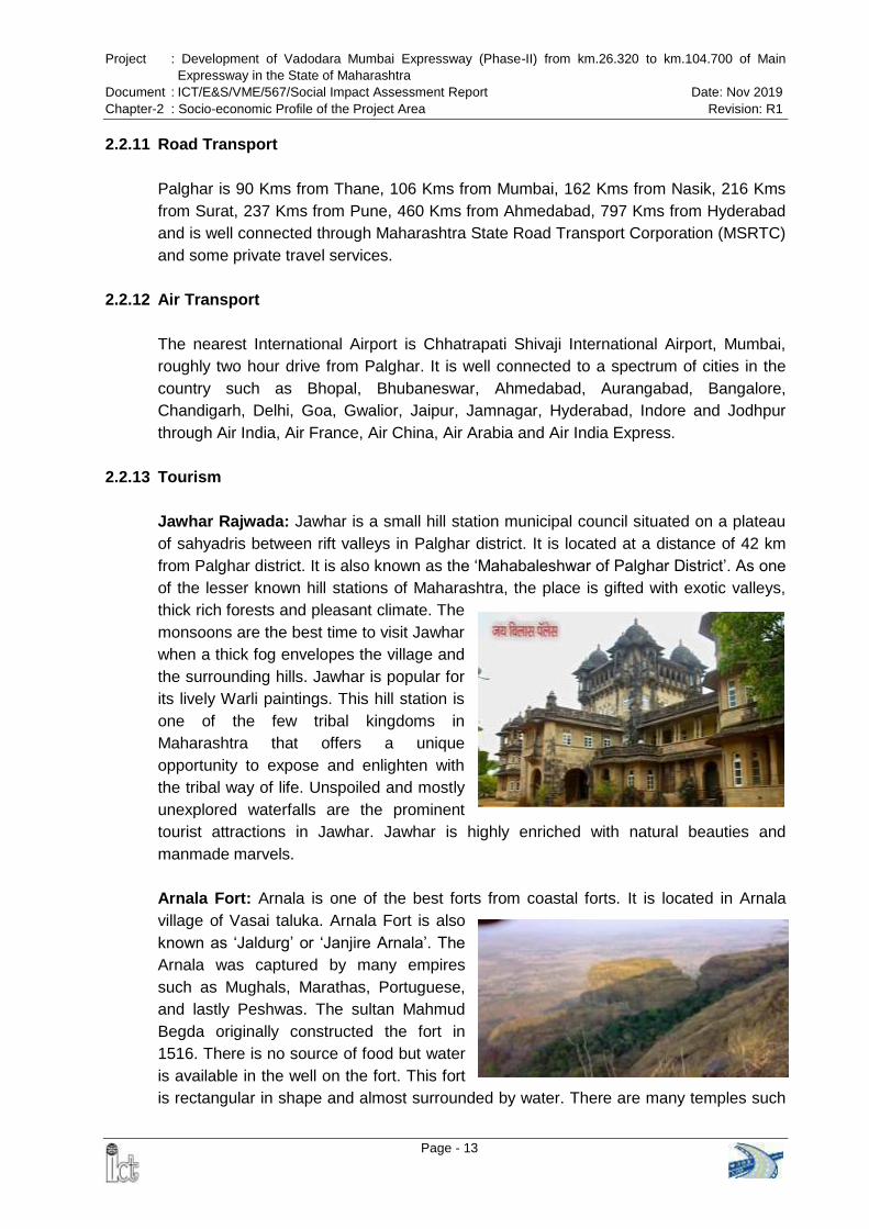
2.2.13 Tourism Jawhar Rajwada: Jawhar is a small hill station municipal council situated on a plateau of sahyadris between rift valleys in Palghar district. It is located at a distance of 42 km from Palghar district. It is also known as the ‘Mahabaleshwar of Palghar District’. As one
of the lesser known hill stations of Maharashtra, the place is gifted with exotic valleys, thick rich forests and pleasant climate. The monsoons are the best time to visit Jawhar when a thick fog envelopes the village and the surrounding hills. Jawhar is popular for its lively Warli paintings. This hill station is one of the few tribal kingdoms in Maharashtra that offers a unique opportunity to expose and enlighten with the tribal way of life. Unspoiled and mostly unexplored waterfalls are the prominent tourist attractions in Jawhar. Jawhar is highly enriched with natural beauties and manmade marvels. Arnala Fort: Arnala is one of the best forts from coastal forts. It is located in Arnala village of Vasai taluka. Arnala Fort is also known as ‘Jaldurg’ or ‘Janjire Arnala’. The
Arnala was captured by many empires such as Mughals, Marathas, Portuguese, and lastly Peshwas. The sultan Mahmud Begda originally constructed the fort in 1516. There is no source of food but water is available in the well on the fort. This fort is rectangular in shape and almost surrounded by water. There are many temples such
Project : Development of Vadodara Mumbai Expressway (Phase-II) from km.26.320 to km.104.700 of Main Expressway in the State of Maharashtra
Document : ICT/E&S/VME/567/Social Impact Assessment Report Date: Nov 2019 Chapter-2 : Socio-economic Profile of the Project Area Revision: R1
Page - 14
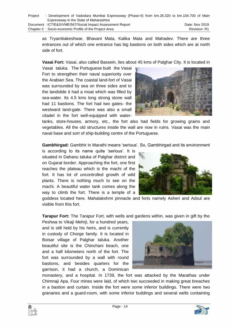
as Tryambakeshwar, Bhavani Mata, Kalika Mata and Mahadev. There are three entrances out of which one entrance has big bastions on both sides which are at north side of fort. Vasai Fort: Vasai, also called Bassein, lies about 45 kms of Palghar City. It is located in Vasai taluka. The Portuguese built the Vasai Fort to strengthen their naval superiority over the Arabian Sea. The coastal land-fort of Vasai was surrounded by sea on three sides and to the landslide it had a moat which was filled by sea-water. Its 4.5 kms long strong stone wall had 11 bastions. The fort had two gates- the westward land-gate. There was also a small citadel in the fort well-equipped with water-tanks, store-houses, armory, etc., the fort also had fields for growing grains and vegetables. All the old structures inside the wall are now in ruins. Vasai was the main naval base and sort of ship-building centre of the Portuguese. Gambhirgad: Gambhir in Marathi means ‘serious’. So, Gambhirgad and its environment
is according to its name quite ‘serious’. It is situated in Dahanu taluka of Palghar district and on Gujarat border. Approaching the fort, one first reaches the plateau which is the machi of the fort. It has lot of uncontrolled growth of wild plants. There is nothing much to see on the machi. A beautiful water tank comes along the way to climb the fort. There is a temple of a goddess located here. Mahalakshmi pinnacle and forts namely Asheri and Adsul are visible from this fort. Tarapur Fort: The Tarapur Fort, with wells and gardens within, was given in gift by the Peshwa to Vikaji Mehrji, for a hundred years, and is still held by his heirs, and is currently in custody of Chorge family. It is located in Boisar village of Palghar taluka. Another beautiful site is the Chinchani beach, one and a half kilometers north of the fort. The fort was surrounded by a wall with round bastions, and besides quarters for the garrison, it had a church, a Dominican monastery, and a hospital. In 1739, the fort was attacked by the Marathas under Chimnaji Apa. Four mines were laid, of which two succeeded in making great breaches in a bastion and curtain. Inside the fort were some inferior buildings. There were two granaries and a guard-room, with some inferior buildings and several wells containing

Project : Development of Vadodara Mumbai Expressway (Phase-II) from km.26.320 to km.104.700 of Main Expressway in the State of Maharashtra
Document : ICT/E&S/VME/567/Social Impact Assessment Report Date: Nov 2019 Chapter-2 : Socio-economic Profile of the Project Area Revision: R1
Page - 15
abundant and excellent water. Vasai was the main naval base and sort of ship-building center of the Portuguese. Kaldurga: Kaldurga fort is hill type fort and is located in Palghar District. The height of this fort is about 1550 feet. The fort range is Palghar and grade is medium. The Palghar range contains many hill forts and Kaldurga is one of them. The top of the fort is rectangular. Due to this rectangular shape of fort one can easily locate it from a distance. There is no sign which states that this is a fort. There are large numbers of forest trees on the fort so healthy population of tribes is on the fort. But standard of living is poor. The fort is divided due to this rectangular rock as fort above the rock and fort below the rock. There are two to three steps which separate these two parts. Kelva Fort: Kelva Fort, a historically important fort constructed by Portuguese during 16th century, is located at the southern end of the beautiful and serene Kelva Lake. The fort was used by Chhatrapati Shivaji Maharaja during his Maratha rule. The fort offer exquisite panoramic views of the natural surroundings covered by greenish Suru trees. The fort, surrounded all the sides by the water, provide enchanting eye catching experience during the tidal procession and recessions. During low tide periods this is accessible and visible perfectly and local country boat facility is available to approach the fort. Kamandurg: Kamandurg is situated in Vasai taluka of Palghar district. People residing in Belkadi belong to Adivasi community-Varli and are very helpful. One has to cross 4 water streams and the 3rd stream is 40feet wide. There are 5 water cisterns on the plateau and a stone with image of an idol carved on it. The entire region is covered with thick forest and looks green. A beautiful view of Vasai creak can be seen. There are 2 peaks and one hasto descend and make a traverse and then climb from the other side to reach on the second peak. Shirgaon Fort: Shirgaon fort is located at one side of Shirgaon beach in Palghar. The fort was used by great Maratha King Chhatrapati Shivaji as a place to keep a watch on enemies coming through Arabian Sea. The ancient fort is in ruins now. The Portuguese had

Project : Development of Vadodara Mumbai Expressway (Phase-II) from km.26.320 to km.104.700 of Main Expressway in the State of Maharashtra
Document : ICT/E&S/VME/567/Social Impact Assessment Report Date: Nov 2019 Chapter-2 : Socio-economic Profile of the Project Area Revision: R1
Page - 16
dominance over this fort before Marathas. In 1818, the British captured this fort from the Marathas. The fort stands about 200 feet tall and spans more than 150 feet. The Portuguese renovated this fort and increased its area while keeping the original brick and red stone construction intact. The five feet cannon on the northwest of citadel marks the history of the battles that took place over here. The picturesque environs of the fort and cleanliness attract many historians apart from the regular tourists. The most exciting bit is the palm tree with six to seven branches, a rarity. Shirgaon fort is well fortified and the walls are in good condition. There are many hidden caves in the walls of the fort.
2.3 DEMOGRAPHIC AND SOCIO-ECONOMIC FEATURES OF PROJECT INFLUENCE DISTRICT
2.3.1 Total Population The total population of project impacted district is nearly 2.9 million. The population percentage of the project influence district is presented in the following Table 2-1.
Table 2-1 Population Likely to be benefited by Project Implementation
Name of State/District Population Percentage
Maharashtra 112374333 100
Palghar 2990116 2.66 Source: PCA 2011 & https://palghar.gov.in/about-district/
2.3.2 Population Density The district has been incorporated in the year 1st August 2014. Hence now decadal comparison is not available. The present density of the Palghar district is 578/ km² which is greater than the state (370/ km²). This is evident from the following Table 2-2.
Table 2-2 Population Density
Name of State/District Persons per km²
2011
Maharashtra 370
Palghar 578 Source: PCA 2011 & https://palghar.gov.in/about-district/
2.3.3 Vulnerable Population
As per the Land Acquisition, Rehabilitation and Resettlement (LARR) Act 2013, people belonging to Scheduled Castes & Scheduled Tribes are to be considered as vulnerable population and are eligible for special assistance under law. The census data summarizes the numbers of SC and ST population of project influence Palghar district in the following Table 2-3.

Project : Development of Vadodara Mumbai Expressway (Phase-II) from km.26.320 to km.104.700 of Main Expressway in the State of Maharashtra
Document : ICT/E&S/VME/567/Social Impact Assessment Report Date: Nov 2019 Chapter-2 : Socio-economic Profile of the Project Area Revision: R1
Page - 17
Table 2-3 Tribal and SC Population
Project Influence State / District Total Population SC Population ST Population
Maharashtra 11,23,74,333 1,32,75,898 1,05,10,213
Palghar 29,90,116 86,978 11,18,008
Source: PCA 2011 & https://palghar.gov.in/about-district/
2.3.4 Literacy Rate
It is also clear from the Table 2-4 that the literacy rate of Palghar district is less than the state literacy rate.
Table 2-4 Literacy Rate
Project Influence State / District Literacy Rate (Percentage)
Maharashtra 82.34%
Palghar 66.65% Source: PCA 2011 & https://Palghar.gov.in>about-district
2.3.5 Distribution of Population by Workers and Non-Workers and Occupation It has been revealed from the primary census data 2011 that most of the populations of the project influence talukas of Palghar district are largely engaged in agriculture and allied activities. However, the agriculture is the main occupation of its inhabitants in the project influenced talukas of district as it is evident from Table 2-5.
Table 2-5 Distribution of Population by Workers and Non-workers
State/Talukas of District Working Population Male Female Total
Maharashtra
Main Workers 29989314 13773576 43762890
Marginal Workers 2627561 3037427 5664988
Non- Workers 25626181 37320274 62946455
Total 58243056 54131277 112374333
Vasai-Virar
Main Workers 379419 113989 493408
Marginal Workers 28833 24468 53301
Non- Workers 301519 495174 796693
Total 709771 633631 1343402
Palghar
Main Workers 145151 46826 191977
Marginal Workers 25577 21543 47120
Non- Workers 117786 193283 311069
Total 288514 261652 550166
Dahanu Main Workers 90031 55556 145587

Project : Development of Vadodara Mumbai Expressway (Phase-II) from km.26.320 to km.104.700 of Main Expressway in the State of Maharashtra
Document : ICT/E&S/VME/567/Social Impact Assessment Report Date: Nov 2019 Chapter-2 : Socio-economic Profile of the Project Area Revision: R1
Page - 18
State/Talukas of District Working Population Male Female Total
Marginal Workers 17492 22960 40452
Non- Workers 92051 124005 216056
Total 199574 202521 402095
Talasari
Main Workers 27171 14859 42030
Marginal Workers 9872 12145 22017
Non- Workers 39374 51397 90771
Total 76417 78401 154818
Jawhar
Main Workers 24761 19808 44569
Marginal Workers 12029 13963 25992
Non- Workers 32543 37083 69626
Total 69333 70854 140187
Mokhada
Main Workers 18722 15805 34527
Marginal Workers 4118 5542 9660
Non- Workers 18851 20415 39266
Total 41691 41762 83453
Vada
Main Workers 39699 19073 58772
Marginal Workers 13202 12850 26052
Non- Workers 39089 54457 93546
Total 91990 86380 178370
Vikramgad
Main Workers 30909 26723 57632
Marginal Workers 7064 9708 16772
Non- Workers 30516 32705 63221
Total 68489 69136 137625 Source: Census of India 2011
Table 2-6 contains occupational structure of work force in the project affected talukas of Palghar district. Talukas wise breakup suggests that occupation in agricultural sector is greater than other sector in all talukas of Palghar district and more workers who are involved in agricultural and allied activities whereas the rest of them are involved in either HH industries or other kind of work.
Table 2-6 Categories of Workers
State / Talukas of Palghar District Categories Male Female Total
Maharashtra
Cultivators 7181136 4296939 11478075
Agricultural Laborers 5846810 5222118 11068928
HH industries 606540 384770 991310

Project : Development of Vadodara Mumbai Expressway (Phase-II) from km.26.320 to km.104.700 of Main Expressway in the State of Maharashtra
Document : ICT/E&S/VME/567/Social Impact Assessment Report Date: Nov 2019 Chapter-2 : Socio-economic Profile of the Project Area Revision: R1
Page - 19
State / Talukas of Palghar District Categories Male Female Total
Other Workers 16354828 3869749 20224577
Total 2,99,89,314 1,37,73,576 4,37,62,890
Vasai-Virar
Cultivators 4599 2272 6871
Agricultural Laborers 6414 4063 10477
HH industries 8051 4349 12400
Other Workers 328489 87037 415526
Total 3,47,553 97,721 4,45,274
Palghar
Cultivators 15771 8115 23886
Agricultural Laborers 17338 12628 29966
HH industries 3355 1699 5054
Other Workers 108687 24384 133071
Total 1,45,151 46,826 1,91,977
Dahanu
Cultivators 23615 17365 40980
Agricultural Laborers 23025 21215 44240
HH industries 3450 1736 5186
Other Workers 39941 15240 55181
Total 90,031 55,556 1,45,587
Talasari
Cultivators 9331 5363 14694
Agricultural Laborers 5484 5150 10634
HH industries 552 390 942
Other Workers 11804 3956 15760
Total 27,171 14,859 42,030
Jawhar
Cultivators 9775 8770 18545
Agricultural Laborers 10008 9215 19223
HH industries 329 245 574
Other Workers 4649 1578 6227
Total 24,761 19,808 44,569
Mokhada
Cultivators 6370 4941 11311
Agricultural Laborers 10122 9867 19989
HH industries 230 189 419
Other Workers 2000 808 2808
Total 18,722 15,805 34,527
Vada Cultivators 9076 5032 14108

Project : Development of Vadodara Mumbai Expressway (Phase-II) from km.26.320 to km.104.700 of Main Expressway in the State of Maharashtra
Document : ICT/E&S/VME/567/Social Impact Assessment Report Date: Nov 2019 Chapter-2 : Socio-economic Profile of the Project Area Revision: R1
Page - 20
State / Talukas of Palghar District Categories Male Female Total
Agricultural Laborers 12509 9416 21925
HH industries 768 458 1226
Other Workers 17346 4167 21513
Total 39,699 19,073 58,772
Vikramgad
Cultivators 16617 14489 31106
Agricultural Laborers 10067 10196 20263
HH industries 295 313 608
Other Workers 3930 1725 5655
Total 30,909 26,723 57,632
Source: Census of India 2011
2.4 SOCIO ECONOMIC PROFILE OF THE PROJECT AREA 2.4.1 Social and Demographic Profile of the Affected Villages
A social and demographic profile of the project-affected area/population is essential to create database and develop indicators for the evaluation of the SIA/RAP. To understand the social context of the proposed project and for providing necessary inputs for social analysis of the project, relevant baseline data on social, economic and cultural conditions were collected from various available primary and secondary sources. Due to the implementation of project, 51 settlements in the affected Palghar district are likely to be affected. Those settlements/ villages have been identified through primary and secondary sources and the same has been documented in the report. The important demographic features of the villages, i.e., population, social categories, literacy level and economy of the village are described as a part of baseline data in the following section.
2.4.2 Population The population composition of any village is important to anticipate the extent of project impact. Keeping in mind the importance of demographic profile, the population of 51 affected villages was computed as per the data available in the primary census abstract 2011. The composition of population with respect to male and female population of potentially affected villages/ settlements is shown in Table 2-7.
Table 2-7 Distribution of the Population of Different Villages with Sex Composition
Sr. No District Taluka Village Name Male Female Total
1 Palghar Vasai
Koshimbe* NA NA NA
2 Khardi 655 638 1293

Project : Development of Vadodara Mumbai Expressway (Phase-II) from km.26.320 to km.104.700 of Main Expressway in the State of Maharashtra
Document : ICT/E&S/VME/567/Social Impact Assessment Report Date: Nov 2019 Chapter-2 : Socio-economic Profile of the Project Area Revision: R1
Page - 21
Sr. No District Taluka Village Name Male Female Total
3 Doliv 345 345 690
4
Palghar
Wadhiv Saravali 396 376 772
5 Navghar 594 585 1179
6 Ghatim 342 367 709
7 Penand 615 591 1206
8 Sonave 1348 1302 2650
9 Pargaon 798 799 1597
10 Girale 489 461 950
11 Nagave 261 281 542
12 Navaje 997 1001 1998
13 Sakhare 820 832 1652
14 Dahisar T Manor 1267 1290 2557
15 Khamloli 769 765 1534
16 Dhuktan 1410 1440 2850
17 Gowade 521 521 1042
18 Maswan 825 842 1667
19 Wandivali 265 279 544
20 Wakadi 162 149 311
21 Wasaroli 123 109 232
22 Katale 634 607 1241
23 Loware 563 555 1118
24 Nihe 1147 1099 2246
25 Nagzari 964 847 1811
26 Lalonde 690 797 1487
27 Kirat 878 839 1717
28 Borsheti 974 975 1949
29 Ravate 472 455 927
30 Chichare 461 452 913
31
Dahanu
Dabhon 1742 1702 3444
32 Aine 657 698 1355
33 Rankol 1436 1481 2917
34 Chandwad 622 660 1282
35 Navnath 821 930 1751
36 Ganjad 954 1012 1966
37 Somnath 989 951 1940
38 Ganeshbag 673 692 1365
39 Awadhani 1027 1110 2137
40 Dhaniwari 655 735 1390

Project : Development of Vadodara Mumbai Expressway (Phase-II) from km.26.320 to km.104.700 of Main Expressway in the State of Maharashtra
Document : ICT/E&S/VME/567/Social Impact Assessment Report Date: Nov 2019 Chapter-2 : Socio-economic Profile of the Project Area Revision: R1
Page - 22
Sr. No District Taluka Village Name Male Female Total
41 Chinchale 749 700 1449
42 Talothe 238 291 529
43 Punjave 232 235 467
44 Bramhanwadi 430 441 871
45 Vankas 1903 2116 4019
46
Talasari
Vadavali 2783 3108 5891
47 Sawane 1652 1356 3008
48 Kawade 1495 1632 3127
49 Awarpada 767 795 1562
50 Talasari 2166 2208 4374
51 Ibhadpada 614 634 1248
Total 42,390 43,086 85,476 Source: Census of India, 2011 *As per PCA 2011, Population of Koshimbe village has been included in the Vasai-Virar City Municipal Corporation.
2.4.3 Social Classification
It is very important to identify vulnerable population during Social Impact Assessment. Social baseline data was applied to understand the social classification in affected settlements/ villages. Total tribal population of 51 villages is 67, 312 (Scheduled Cast – 1,377 and Scheduled Tribes – 65,935), which is 78.1% of the total population. As per Census of India, 2011, 100% population of Chandwad village is Scheduled Tribes. Out of 51 villages, maximum tribal population is observed in Vadavali village (5375 nos.). The assessment of the population under different social categories in the concerned settlements/ villages is discussed in Table 2-8.
Table 2-8 Social Classification in Villages
Sr. No District Taluka Village Name SC ST
1
Palghar
Vasai
Koshimbe* NA NA
2 Khardi 0 60
3 Doliv 0 2
4
Palghar
Wadhiv Saravali 0 0
5 Navghar 4 309
6 Ghatim 0 387
7 Penand 0 1113
8 Sonave 16 1900
9 Pargaon 35 430
10 Girale 51 397
11 Nagave 0 16
12 Navaze 11 754
13 Sakhare 14 737

Project : Development of Vadodara Mumbai Expressway (Phase-II) from km.26.320 to km.104.700 of Main Expressway in the State of Maharashtra
Document : ICT/E&S/VME/567/Social Impact Assessment Report Date: Nov 2019 Chapter-2 : Socio-economic Profile of the Project Area Revision: R1
Page - 23
Sr. No District Taluka Village Name SC ST
14 Dahisar T. Manor 83 1481
15 Khamloli 17 574
16 Dhuktan 86 2174
17 Gowade 19 623
18 Maswan 33 1249
19 Wandivali 0 523
20 Wakadi 18 286
21 Wasaroli 6 200
22 Katale 13 489
23 Loware 11 651
24 Nihe 0 1592
25 Nagzari 75 685
26 Lalonde 45 882
27 Kirat 0 1393
28 Borsheti 0 1641
29 Ravate 0 868
30 Chichare 0 909
31
Dahanu
Dabhon 10 3335
32 Aine 1 1273
33 Rankol 0 2508
34 Chandwad 0 1282
35 Navnath 3 1522
36 Ganjad 1 1782
37 Somnath 0 1938
38 Ganeshbag 4 1352
39 Awadhani 0 2126
40 Dhaniwari 0 1389
41 chinchale 0 1379
42 Talothe 0 528
43 Punjave 6 458
44 Bramhanwadi 0 855
45 Vankas 0 4005
46
Talasari
Vadavali 21 5354
47 Sawane 0 2967
48 Kawade 0 3116
49 Awarpada 540 1018
50 Talasari 0 4009
51 Ibhadpada 0 1175
Total 1,123 65,696 Source: Census of India, 2011 *As per PCA 2011, Population of Koshimbe village has been included in the Vasai-Virar City Municipal Corporation
Project : Development of Vadodara Mumbai Expressway (Phase-II) from km.26.320 to km.104.700 of Main Expressway in the State of Maharashtra
Document : ICT/E&S/VME/567/Social Impact Assessment Report Date: Nov 2019 Chapter-2 : Socio-economic Profile of the Project Area Revision: R1
Page - 24
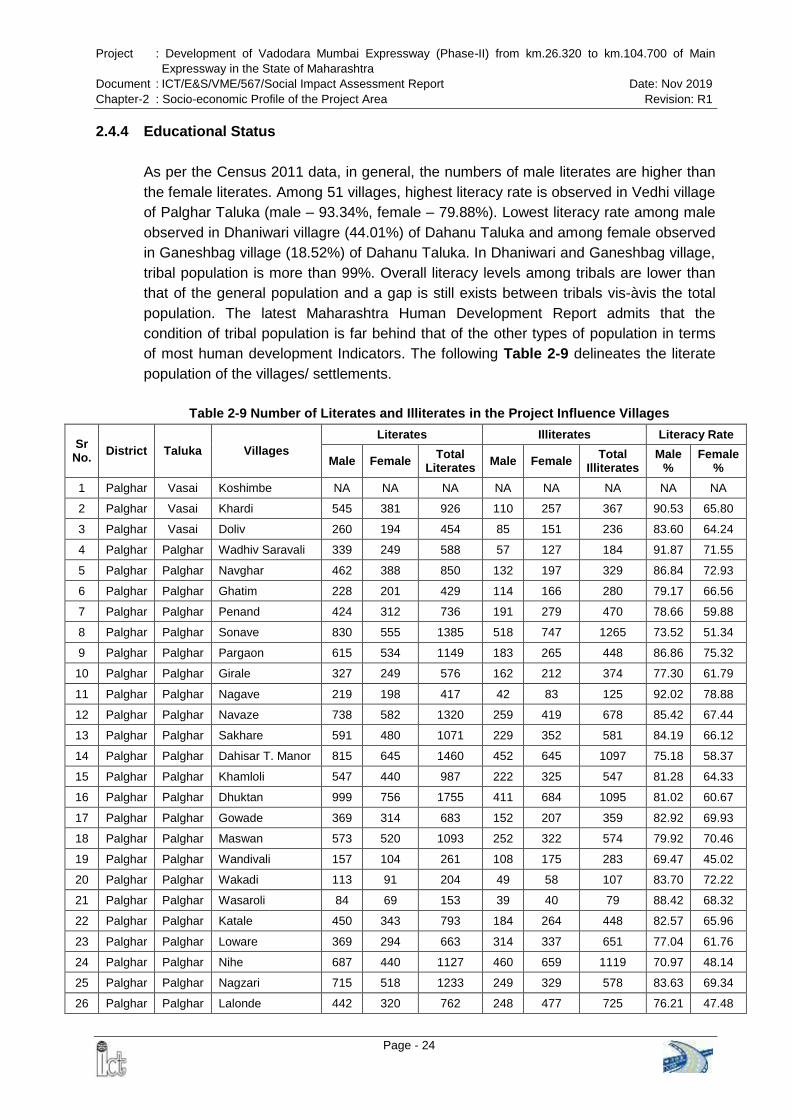
2.4.4 Educational Status As per the Census 2011 data, in general, the numbers of male literates are higher than the female literates. Among 51 villages, highest literacy rate is observed in Vedhi village of Palghar Taluka (male – 93.34%, female – 79.88%). Lowest literacy rate among male observed in Dhaniwari villagre (44.01%) of Dahanu Taluka and among female observed in Ganeshbag village (18.52%) of Dahanu Taluka. In Dhaniwari and Ganeshbag village, tribal population is more than 99%. Overall literacy levels among tribals are lower than that of the general population and a gap is still exists between tribals vis-àvis the total population. The latest Maharashtra Human Development Report admits that the condition of tribal population is far behind that of the other types of population in terms of most human development Indicators. The following Table 2-9 delineates the literate population of the villages/ settlements.
Table 2-9 Number of Literates and Illiterates in the Project Influence Villages
Sr No. District Taluka Villages
Literates Illiterates Literacy Rate
Male Female Total Literates Male Female Total
Illiterates Male
% Female
%
1 Palghar Vasai Koshimbe NA NA NA NA NA NA NA NA
2 Palghar Vasai Khardi 545 381 926 110 257 367 90.53 65.80
3 Palghar Vasai Doliv 260 194 454 85 151 236 83.60 64.24
4 Palghar Palghar Wadhiv Saravali 339 249 588 57 127 184 91.87 71.55
5 Palghar Palghar Navghar 462 388 850 132 197 329 86.84 72.93
6 Palghar Palghar Ghatim 228 201 429 114 166 280 79.17 66.56
7 Palghar Palghar Penand 424 312 736 191 279 470 78.66 59.88
8 Palghar Palghar Sonave 830 555 1385 518 747 1265 73.52 51.34
9 Palghar Palghar Pargaon 615 534 1149 183 265 448 86.86 75.32
10 Palghar Palghar Girale 327 249 576 162 212 374 77.30 61.79
11 Palghar Palghar Nagave 219 198 417 42 83 125 92.02 78.88
12 Palghar Palghar Navaze 738 582 1320 259 419 678 85.42 67.44
13 Palghar Palghar Sakhare 591 480 1071 229 352 581 84.19 66.12
14 Palghar Palghar Dahisar T. Manor 815 645 1460 452 645 1097 75.18 58.37
15 Palghar Palghar Khamloli 547 440 987 222 325 547 81.28 64.33
16 Palghar Palghar Dhuktan 999 756 1755 411 684 1095 81.02 60.67
17 Palghar Palghar Gowade 369 314 683 152 207 359 82.92 69.93
18 Palghar Palghar Maswan 573 520 1093 252 322 574 79.92 70.46
19 Palghar Palghar Wandivali 157 104 261 108 175 283 69.47 45.02
20 Palghar Palghar Wakadi 113 91 204 49 58 107 83.70 72.22
21 Palghar Palghar Wasaroli 84 69 153 39 40 79 88.42 68.32
22 Palghar Palghar Katale 450 343 793 184 264 448 82.57 65.96
23 Palghar Palghar Loware 369 294 663 314 337 651 77.04 61.76
24 Palghar Palghar Nihe 687 440 1127 460 659 1119 70.97 48.14
25 Palghar Palghar Nagzari 715 518 1233 249 329 578 83.63 69.34
26 Palghar Palghar Lalonde 442 320 762 248 477 725 76.21 47.48

Project : Development of Vadodara Mumbai Expressway (Phase-II) from km.26.320 to km.104.700 of Main Expressway in the State of Maharashtra
Document : ICT/E&S/VME/567/Social Impact Assessment Report Date: Nov 2019 Chapter-2 : Socio-economic Profile of the Project Area Revision: R1
Page - 25
Sr No. District Taluka Villages
Literates Illiterates Literacy Rate
Male Female Total Literates Male Female Total
Illiterates Male
% Female
%
27 Palghar Palghar Kirat 492 339 831 386 500 886 68.72 46.37
28 Palghar Palghar Borsheti 558 340 898 416 635 1051 67.64 41.56
29 Palghar Palghar Ravate 245 160 405 227 295 522 63.97 42.11
30 Palghar Palghar Chinchare 211 130 341 250 322 572 58.29 36.52
31 Palghar Dahanu Dhabon 813 445 1258 929 1257 2186 58.74 32.01
32 Palghar Dahanu Aine 289 167 456 368 531 899 56.78 30.64
33 Palghar Dahanu Rankol 805 547 1352 631 934 1565 64.45 42.80
34 Palghar Dahanu Chandwad 248 174 422 374 486 860 49.90 31.41
35 Palghar Dahanu Navnath 320 180 500 501 750 1251 48.34 23.41
36 Palghar Dahanu Ganjad 575 456 1031 379 556 935 70.73 52.78
37 Palghar Dahanu Somnath 382 204 586 607 747 1354 51.90 27.79
38 Palghar Dahanu Ganeshbag 265 100 365 408 592 1000 48.89 18.52
39 Palghar Dahanu Awadhani 448 198 646 579 912 1491 52.40 21.83
40 Palghar Dahanu Dhaniwari 235 155 390 420 580 1000 44.01 25.04
41 Palghar Dahanu Chinchale 434 271 705 315 429 744 67.39 46.01
42 Palghar Dahanu Talothe 107 54 161 131 237 368 56.02 24.11
43 Palghar Dahanu Punjave 108 77 185 124 158 282 55.38 39.29
44 Palghar Dahanu Bramhanwadi 206 103 309 224 338 562 57.54 29.51
45 Palghar Dahanu Vankas 709 380 1089 1194 1736 2930 47.68 22.97
46 Palghar Talasari Vadavali 1562 1135 2697 1221 1973 3194 69.42 44.76
47 Palghar Talasari Sawane 937 288 1225 715 1068 1783 66.69 27.17
48 Palghar Talasari Kawade 661 393 1054 834 1239 2073 54.85 29.53
49 Palghar Talasari Awarpada 341 211 552 426 584 1010 54.21 32.36
50 Palghar Talasari Talasari 989 599 1588 1177 1609 2786 56.55 33.35
51 Palghar Talasari Ibhadpada 293 198 491 321 436 757 61.95 38.00
Source: Census of India, 2011
2.4.5 Workforce in Project affected villages
In general, majority of work force belongs to the category of main workers followed by the category of marginal workforce, however, in some cases; the numbers of marginal workers are more in comparison to main workers. The details of workforce of the affected villages are summarized in Table 2-10.
Table 2-10 Workers in the Project-Affected Villages
Sl. No. District Taluka Village
Main Workers Marginal Workers Total Workers
Male Female Total Male Female Total Male Female Total
1 Palghar Vasai Koshimbe NA NA NA NA NA NA NA NA NA
2 Palghar Vasai Khardi 152 123 275 29 34 63 181 157 338
3 Palghar Vasai Doliv 210 147 357 8 30 38 218 177 395
4 Palghar Palghar Wadhiv Saravali 255 12 267 4 1 5 259 13 272
5 Palghar Palghar Navghar 50 7 57 280 45 325 330 52 382

Project : Development of Vadodara Mumbai Expressway (Phase-II) from km.26.320 to km.104.700 of Main Expressway in the State of Maharashtra
Document : ICT/E&S/VME/567/Social Impact Assessment Report Date: Nov 2019 Chapter-2 : Socio-economic Profile of the Project Area Revision: R1
Page - 26
Sl. No. District Taluka Village
Main Workers Marginal Workers Total Workers
Male Female Total Male Female Total Male Female Total
6 Palghar Palghar Ghatim 147 58 205 71 43 114 218 101 319
7 Palghar Palghar Penand 265 94 359 100 214 314 365 308 673
8 Palghar Palghar Sonave 596 317 913 141 249 390 737 566 1303
9 Palghar Palghar Pargaon 343 131 474 191 233 424 534 364 898
10 Palghar Palghar Girale 265 105 370 6 2 8 271 107 378
11 Palghar Palghar Nagave 99 13 112 61 14 75 160 27 187
12 Palghar Palghar Navaze 457 212 669 129 162 291 586 374 960
13 Palghar Palghar Sakhare 268 125 393 259 294 553 527 419 946
14 Palghar Palghar Dahisar T. Manor 613 514 1127 175 190 365 788 704 1492
15 Palghar Palghar Khamloli 448 410 858 7 1 8 455 411 866
16 Palghar Palghar Dhuktan 484 121 605 342 333 675 826 454 1280
17 Palghar Palghar Gowade 158 87 245 128 124 252 286 211 497
18 Palghar Palghar Maswan 284 117 401 216 249 465 500 366 866
19 Palghar Palghar Wandivali 141 110 251 3 2 5 144 112 256
20 Palghar Palghar Wakadi 6 6 12 88 30 118 94 36 130
21 Palghar Palghar Wasaroli 58 23 81 5 9 14 63 32 95
22 Palghar Palghar Katale 361 113 474 9 44 53 370 157 527
23 Palghar Palghar Loware 283 176 459 57 151 208 340 327 667
24 Palghar Palghar Nihe 659 582 1241 11 9 20 670 591 1261
25 Palghar Palghar Nagzari 219 60 279 172 153 325 391 213 604
26 Palghar Palghar Lalonde 400 226 626 42 63 105 442 289 731
27 Palghar Palghar Kirat 434 310 744 45 117 162 479 427 906
28 Palghar Palghar Borsheti 478 169 647 44 141 185 522 310 832
29 Palghar Palghar Ravate 268 263 531 11 7 18 279 270 549
30 Palghar Palghar Chinchare 218 211 429 20 21 41 238 232 470
31 Palghar Dahanu Dhabon 721 689 1410 199 148 347 920 837 1757
32 Palghar Dahanu Aine 307 230 537 38 36 74 345 266 611
33 Palghar Dahanu Rankol 438 491 929 139 155 294 577 646 1223
34 Palghar Dahanu Chandwad 309 334 643 42 38 80 351 372 723
35 Palghar Dahanu Navnath 358 373 731 11 33 44 369 406 775
36 Palghar Dahanu Ganjad 263 101 364 124 207 331 387 308 695
37 Palghar Dahanu Somnath 458 439 897 16 26 42 474 465 939
38 Palghar Dahanu Ganeshbag 197 180 377 168 214 382 365 394 759
39 Palghar Dahanu Awadhani 569 449 1018 79 241 320 648 690 1338
40 Palghar Dahanu DhaniwFari 328 352 680 2 11 13 330 363 693
41 Palghar Dahanu Chinchale 141 167 308 72 90 162 213 257 470
42 Palghar Dahanu Talothe 143 192 335 13 6 19 156 198 354
43 Palghar Dahanu Punjave 132 141 273 0 2 2 132 143 275
44 Palghar Dahanu Bramhanwadi 159 6 165 78 246 324 237 252 489
45 Palghar Dahanu Vankas 580 400 980 384 708 1092 964 1108 2072
46 Palghar Talasari Vadavali 718 504 1222 536 679 1215 1254 1183 2437

Project : Development of Vadodara Mumbai Expressway (Phase-II) from km.26.320 to km.104.700 of Main Expressway in the State of Maharashtra
Document : ICT/E&S/VME/567/Social Impact Assessment Report Date: Nov 2019 Chapter-2 : Socio-economic Profile of the Project Area Revision: R1
Page - 27
Sl. No. District Taluka Village
Main Workers Marginal Workers Total Workers
Male Female Total Male Female Total Male Female Total
47 Palghar Talasari Sawane 485 177 662 136 304 440 621 481 1102
48 Palghar Talasari Kawade 696 631 1327 88 13 101 784 644 1428
49 Palghar Talasari Awarpada 141 27 168 271 154 425 412 181 593
50 Palghar Talasari Talasari 659 296 955 362 478 840 1021 774 1795
51 Palghar Talasari Ibhadpada 278 200 478 38 117 155 316 317 633
Source: Census of India, 2011
2.4.6 Category wise Distribution of Main Workforce
It is evident from the below table that people of the likely affected villages are engaged in agriculture, household industries and other work. However, agriculture does play an important sector in engaging the workforce as is shown in Table 2-11.

Project : Development of Vadodara Mumbai Expressway (Phase-II) from km.26.320 to km.104.700 of Main Expressway in the State of Maharashtra Document : ICT/E&S/VME/567/Social Impact Assessment Report Date: Nov 2019 Chapter-2 : Socio-economic Profile of the Project Area Revision: R1
Page - 28
Table 2-11 Distribution of Main Workforce in Project Affected Villages
Sl. No. District Taluka Villages
Cultivators Agricultural Laborers Household Industries Other Workers Non Workers Total
Total Male Female Total Male Female Total Male Female Total Male Female Total Male Female Total Male Female
1 Palghar Vasai Koshimbe NA NA NA NA NA NA NA NA NA NA NA NA NA NA NA NA NA NA
2 Palghar Vasai Khardi 117 111 228 6 6 12 6 0 6 23 6 29 474 481 955 626 604 1230
3 Palghar Vasai Doliv 17 22 39 4 1 5 95 73 168 94 51 145 127 168 295 337 315 652
4 Palghar Palghar Wadhiv Saravali 30 7 37 65 39 104 8 7 15 90 21 111 137 363 500 330 475 767
5 Palghar Palghar Navghar 1 1 2 0 0 0 2 1 3 47 5 52 264 533 797 314 540 854
6 Palghar Palghar Ghatim 41 15 56 50 22 72 0 0 0 56 21 77 124 266 390 271 324 595
7 Palghar Palghar Penand 85 35 120 103 31 134 8 7 15 69 21 90 250 283 533 515 377 892
8 Palghar Palghar Sonave 201 31 232 233 196 429 3 2 5 159 88 247 611 736 1347 1207 1053 2260
9 Palghar Palghar Pargaon 133 48 181 89 40 129 22 17 39 99 26 125 264 435 699 607 566 1173
10 Palghar Palghar Girale 119 65 184 113 30 143 1 1 2 32 9 41 218 354 572 483 459 942
11 Palghar Palghar Nagave 1 1 2 0 1 1 3 0 3 95 11 106 101 254 355 200 267 467
12 Palghar Palghar Navaze 193 86 279 151 104 255 3 0 3 110 22 132 411 627 1038 868 839 1707
13 Palghar Palghar Sakhare 79 39 118 47 40 87 3 2 5 139 44 183 874 782 1656 1142 907 2049
14 Palghar Palghar Dahisar T Manor 100 69 169 222 217 439 44 30 74 247 198 445 479 586 1065 1092 1100 2192
15 Palghar Palghar Khamloli 211 196 407 171 193 364 2 0 2 64 21 85 314 354 668 762 764 1526
16 Palghar Palghar Dhuktan 136 31 167 171 39 210 12 5 17 165 46 211 293 413 706 777 534 1311
17 Palghar Palghar Gowade 52 24 76 62 40 102 4 7 11 40 16 56 235 310 545 393 397 790
18 Palghar Palghar Maswan 51 7 58 67 25 92 3 1 4 163 84 247 325 476 801 609 593 1202
19 Palghar Palghar Wandivali 1 1 2 122 105 227 0 0 0 18 4 22 121 167 288 262 277 539

Project : Development of Vadodara Mumbai Expressway (Phase-II) from km.26.320 to km.104.700 of Main Expressway in the State of Maharashtra Document : ICT/E&S/VME/567/Social Impact Assessment Report Date: Nov 2019 Chapter-2 : Socio-economic Profile of the Project Area Revision: R1
Page - 29
Sl. No. District Taluka Villages
Cultivators Agricultural Laborers Household Industries Other Workers Non Workers Total
Total Male Female Total Male Female Total Male Female Total Male Female Total Male Female Total Male Female
20 Palghar Palghar Wakadi 0 0 0 0 0 0 1 0 1 5 6 11 68 113 181 74 119 193
21 Palghar Palghar Warsaroli 0 0 0 40 15 55 0 0 0 18 8 26 60 77 137 118 100 218
22 Palghar Palghar Katale 127 40 167 29 17 46 4 0 4 201 56 257 264 450 714 625 563 1188
23 Palghar Palghar Loware 158 150 308 68 14 82 3 1 4 54 11 65 223 228 451 506 404 910
24 Palghar Palghar Nihe 223 181 404 208 212 420 7 6 13 221 183 404 477 508 985 1136 1090 2226
25 Palghar Palghar Nagzari 4 2 6 11 6 17 3 2 5 201 50 251 379 420 799 598 480 1078
26 Palghar Palghar Lalonde 107 68 175 169 134 303 0 0 0 124 24 148 248 508 756 648 734 1382
27 Palghar Palghar Kirat 124 106 230 125 128 253 4 1 5 181 75 256 399 412 811 833 722 1555
28 Palghar Palghar Borsheti 140 56 196 179 80 259 2 3 5 157 30 187 452 665 1117 930 834 1764
29 Palghar Palghar Ravate 76 74 150 174 181 355 2 0 2 16 8 24 193 185 378 461 448 909
30 Palghar Palghar Chinchare 70 74 144 109 126 235 0 0 0 39 11 50 223 220 443 441 431 872
31 Palghar Dahanu Dhabon 351 319 670 282 295 577 11 16 27 77 59 136 822 865 1687 1543 1554 3097
32 Palghar Dahanu Aine 88 45 133 130 163 293 6 4 10 83 18 101 312 432 744 619 662 1281
33 Palghar Dahanu Rankol 183 205 388 167 214 381 3 2 5 85 70 155 859 835 1694 1297 1326 2623
34 Palghar Dahanu Chandwad 192 208 400 105 123 228 0 0 0 12 3 15 271 288 559 580 622 1202
35 Palghar Dahanu Navnath 184 229 413 90 106 196 6 3 9 78 35 113 452 524 976 810 897 1707
36 Palghar Dahanu Ganjad 99 28 127 49 40 89 18 6 24 97 27 124 567 704 1271 830 805 1635
37 Palghar Dahanu Somnath 90 62 152 277 366 643 0 3 3 91 8 99 515 486 1001 973 925 1898
38 Palghar Dahanu Ganeshbag 29 16 45 149 148 297 1 1 2 18 15 33 308 298 606 505 478 983
39 Palghar Dahanu Awadhani 389 281 670 169 162 331 1 2 3 10 4 14 379 420 799 948 869 1817

Project : Development of Vadodara Mumbai Expressway (Phase-II) from km.26.320 to km.104.700 of Main Expressway in the State of Maharashtra Document : ICT/E&S/VME/567/Social Impact Assessment Report Date: Nov 2019 Chapter-2 : Socio-economic Profile of the Project Area Revision: R1
Page - 30
Sl. No. District Taluka Villages
Cultivators Agricultural Laborers Household Industries Other Workers Non Workers Total
Total Male Female Total Male Female Total Male Female Total Male Female Total Male Female Total Male Female
40 Palghar Dahanu Dhaniwari 257 236 493 60 102 162 4 0 4 7 14 21 325 372 697 653 724 1377
41 Palghar Dahanu Chinchale 99 122 221 22 30 52 10 2 12 10 13 23 536 443 979 677 610 1287
42 Palghar Dahanu Talothe 128 189 317 2 0 2 0 0 0 13 3 16 82 93 175 225 285 510
43 Palghar Dahanu Punjave 19 19 38 86 98 184 0 0 0 27 24 51 100 92 192 232 233 465
44 Palghar Dahanu Bramhanwadi 145 4 149 10 1 11 1 0 1 3 1 4 193 189 382 352 195 547
45 Palghar Dahanu Vankas 276 190 466 104 134 238 9 3 12 191 73 264 939 1008 1947 1519 1408 2927
46 Palghar Talasari Vadavali 422 345 767 121 82 203 0 3 3 175 74 249 1529 1925 3454 2247 2429 4676
47 Palghar Talasari Sawane 241 23 264 85 126 211 9 3 12 150 25 175 1031 875 1906 1516 1052 2568
48 Palghar Talasari Kawade 597 525 1122 16 73 89 0 1 1 83 32 115 711 988 1699 1407 1619 3026
49 Palghar Talasari Awarpada 13 7 20 76 10 86 1 1 2 51 9 60 355 614 969 496 641 1137
50 Palghar Talasari Talasari 446 205 651 115 37 152 3 4 7 95 50 145 1145 1434 2579 1804 1730 3534
51 Palghar Talasari Ibhadpada 152 148 300 13 11 24 0 0 0 113 41 154 298 317 615 576 517 1093
Source: Census of India, 2011

Project : Development of Vadodara Mumbai Expressway (Phase-II) from km.26.320 to km.104.700 of Main Expressway in the State of Maharashtra
Document : ICT/E&S/VME/567/Social Impact Assessment Report Date: Nov 2019 Chapter-2 : Socio-economic Profile of the Project Area Revision: R1
Page - 31
2.5 CONCLUSION Overall, it can be concluded that in the project influence villages, majority of the population are Scheduled Tribe and agriculture sector is the main source of employment. One of the distinct features of the area is poor industrialization; as a result large scale population engaged in farming and allied activities. Literacy of male population is higher than female population. Overall literacy levels among tribals are lower than that of the general population and a gap is still exists between tribals vis-àvis the total population. The gaps are substantial, and their persistence is a serious social and ethical problem. The latest Maharashtra Human Development Report admits that the condition of tribal population is far behind that of the total population in terms of most human development Indicators. The proposed project will provide better connectivity of villages, talukas, districts and with other part of the state; establish linkages between distant cities; increase employment opportunity and thereby enhance the quality of life. The construction of the expressway will also help the farmers in getting good prices of their produce by way of quick and fast transportation of perishable goods to the market places. The expressway connectivity will also help in import of new techniques of agriculture to the backward areas.

Project : Development of Vadodara Mumbai Expressway (Phase-II) from km.26.320 to km.104.700 of Main Expressway in the State of Maharashtra
Document : ICT/E&S/VME/567/Social Impact Assessment Report Date: Nov 2019 Chapter-3 : Evaluation of Social Impact and Land Acquisition Revision: R1
Page - 32
CHAPTER-3: EVALUATION OF SOCIAL IMPACT AND LAND ACQUISITION
3.1 INTRODUCTION The social impact assessment and resettlement study is meant to determine the magnitude of actual and potential impact on the population due to construction of proposed expressway with the objective to ensure the social considerations be given adequate weightage in the selection and design of proposed expressway construction. Basic idea is to minimize adverse social impacts with best possible engineering solutions at the optimal cost. The main features and findings of this report are discussed below. It needs to be mentioned that the present report considered those persons who are affected directly and indirectly, whose structures and lands are to be affected due to the construction of the expressway
3.2 SUMMARY OF LAND ACQUISITION AND SOCIAL IMPACT This report will assess the social impacts and land acquisition requirement for construction of Vadodara Mumbai Expressway (Phase II). The alignment traverses through Talasari, Dahanu, Palghar, and Vasai Taluka in the district of Palghar of Maharashtra state. The report deals with affected persons, who are losing either their structures or land, due to project implementation. The land compensation has been calculated for 51 villages of all four Talukas. The detail of project impact summary is briefed here. As per findings of Joint Measurement Survey (JMS) of affected land and non-land assets, the project impacts can be broadly classified as (i) impacts on private land, (ii) impacts on private structures and; (iii) loss of common property resources. From the analysis of impacts, it is noted that almost 2393 land units/plots (all private land units) and 895 structures including 717 private structures will be affected due to the project. As per the JMS survey (up to November 2019), total 3110 households will be affected in the project. The details of project impacts are presented in the Table 3-1.
Table 3-1 Summary of Project Impacts (Phase-II of Main Alignment)
Sl. No. Impacts Number/ Area
1 Total private land acquisition requirement (data updated till November 2019) 710.3247 ha
2 Total number of private land units/plots affected (No.) 2393
3 Fully displaced land owner (15% of affected land owners) (No.) 359
4 Total number of structures affected of all categories (Including Private, Government, and Religious)
895
5 Total number of affected private structures 717
6 Number of Fully displaced structure owner (15% of affected structure owners) 108
7 Total number of affected Households Including Land & Structures 3110

Project : Development of Vadodara Mumbai Expressway (Phase-II) from km.26.320 to km.104.700 of Main Expressway in the State of Maharashtra
Document : ICT/E&S/VME/567/Social Impact Assessment Report Date: Nov 2019 Chapter-3 : Evaluation of Social Impact and Land Acquisition Revision: R1
Page - 33
Sl. No. Impacts Number/ Area
8 Total number of Govt. /Communities properties 175
9 Total number of religious properties 3
Source: Field Study 2019
3.3 LAND ACQUISITION Due to construction of greenway expressway, the scope of land acquisition is quite significant. The Greenfield expressway traverses through 51 villages of four Talukas in Palghar district of Maharashtra state. The tentative private land need to be acquired for the project is 710.3247 hectares and forest land proposed to be diverted is 191.5894 ha (data updated till October 2019). Joint Measurement Survey with the concerned department is under progress. Therefore, both non-forest and forest land proposed to be diverted will be updated time to time during the land acquisition and forest clearance process. The village wise details of tentative land acquisition are briefed in Table 3-2.
Table 3-2 Details of village wise Land being acquired for the Project
Taluka Village Forest Land (Ha) Non-forest Land (Ha) Total Area (Ha)#
Vasai Koshimb 5.3146 27.5316 32.8462
Vasai Khardi 0.0000 11.4406 11.4406
Vasai Doliv 3.3498 11.2698 14.6196
Palghar Vadhiv 1.6171 1.4493 3.0664
Palghar Navghar 1.4817 10.3785 11.8602
Palghar Ghateem 0.0000 9.9044 9.9044
Palghar Penand 7.5269 13.4203 20.9472
Palghar Sonave 15.9512 7.2356 23.1868
Palghar Pargaon 0.2032 21.9772 22.1804
Palghar Girale 0.0000 12.1014 12.1014
Palghar Nagav 0.0000 24.5884 24.5884
Palghar Navje 3.2338 7.9481 11.1819
Palghar Sakhare 9.7748 12.0781 21.8529
Palghar Dahisar 0.0000 1.6589 1.6589
Palghar Khambloli 2.5410 23.0980 25.6390
Palghar Dhukthan 6.5880 28.2973 34.8853
Palghar Govade 0.0383 2.0135 2.0518
Palghar Masvan 2.1348 11.0566 13.1914
Palghar Vandivali 0.0000 9.9064 9.9064
Palghar Vakadi 2.0715 8.6336 10.7051
Palghar Vasroli 0.0000 0.9580 0.9580
Palghar Katale 1.2055 9.4996 10.7051
Palghar Lovare 6.9338 19.6267 26.5605
Palghar Nihe 0.0000 21.2324 21.2324

Project : Development of Vadodara Mumbai Expressway (Phase-II) from km.26.320 to km.104.700 of Main Expressway in the State of Maharashtra
Document : ICT/E&S/VME/567/Social Impact Assessment Report Date: Nov 2019 Chapter-3 : Evaluation of Social Impact and Land Acquisition Revision: R1
Page - 34
Taluka Village Forest Land (Ha) Non-forest Land (Ha) Total Area (Ha)#
Palghar Nagzari 0.0000 20.1600 20.1600
Palghar Lalonde 0.0000 9.7844 9.7844
Palghar Kirat 7.1570 19.8757 27.0327
Palghar Borsheti 0.0000 12.2602 12.2602
Palghar Ravte 7.9344 10.3676 18.3020
Palghar Chinchare 0.0000 20.5053 20.5053
Dahanu Dhabon 11.5849 28.6545 40.2394
Dahanu Aine 0.0105 10.0421 10.0526
Dahanu Rankol 25.4256 8.8438 34.2694
Dahanu Chandwad 5.7481 8.6578 14.4059
Dahanu Navnath 10.9101 26.8338 37.7439
Dahanu Ganjad 2.6130 7.9374 10.5504
Dahanu Somnath 4.9328 0.0000 4.9328
Dahanu Ganeshbagh 7.2151 10.7800 17.9951
Dahanu Awadhani 2.0512 1.6428 3.6940
Dahanu Dhanivari 23.5527 17.6691 41.2218
Dahanu Chinchale 12.4880 19.3631 31.8511
Dahanu Talote 0.0000 19.5209 19.5209
Dahanu Punjave 0.0000 6.9611 6.9611
Dahanu Bharmanwadi 0.0000 18.0207 18.0207
Dahanu Vankas 0.0000 32.9607 32.9607
Talasari Vadavali 0.0000 16.5124 16.5124
Talasari Savane 0.0000 4.2371 4.2371
Talasari Kawad 0.0000 22.4033 22.4033
Talasari Awarpada 0.0000 10.3800 10.3800
Talasari Talasari 0.0000 38.6466 38.6466
191.5894 710.3247 901.9141 Source: Field Study 2019, land records, forest records & JMS **Note: land proposed to be diverted may change after completion of Joint Measurement Survey with the concerned departments. The same will be updated time to time during the land acquisition and forest clearance process
3.4 AFFECTED HOUSEHOLDS
Due to loss of structures and land many people will be losing their properties / livelihoods and will be adversely affected. As per the data received from compensation award list, field survey and JMS, 2393 land owners are affected as per the available compensation award data, and 717 private structures owners will be affected in the proposed alignment. The data reveals that a total number of 3110 households are getting affected due to the project. The details for the same are shown in Table 3-3.

Project : Development of Vadodara Mumbai Expressway (Phase-II) from km.26.320 to km.104.700 of Main Expressway in the State of Maharashtra
Document : ICT/E&S/VME/567/Social Impact Assessment Report Date: Nov 2019 Chapter-3 : Evaluation of Social Impact and Land Acquisition Revision: R1
Page - 35
Table 3-3 Number of Affected Households
Sl. No. Affected Livelihoods Category of AHs Total %
1 Land Owner Owner 2393 76.95%
2 Structures Only Owner 717 23.05%
Total 3110 100% Source: Field Study 2019 & JMS
3.5 PROPERTIES TO BE AFFECTED
The properties to be affected by the proposed expressway include houses, shops, religious establishments, community halls or any other structures. The survey team attempted to get the details of various structures that are located within the proposed RoW of the project alignment. The census survey carries out to enumerate the properties, falling within proposed ROW. The finding of the study revealed that 895 structures are going to be affected within the proposed right of way, out of which 717 are private structures. Total structures include the private properties, religious properties, community properties, government properties. The following sections deals with the details of the affected structures within the project alignment.
3.5.1 Ownership of Affected Properties The total numbers of affected properties under different categories in terms of its uses, such as private, religious, public / government and communities structures are tentatively 895, out of which 717 are private properties (80.11%) followed by Government /CPRs (19.55%), and religious properties (0.34%). The ownership details of total affected properties are tabulated in Table 3-4.
Table 3-4 Ownership of Properties to be affected
Sl. No. Type of Properties Total Percentage
1 Private 717 80.11
2 Religious 3 0.34
3 Government/CPRs 175 19.55
Total 895 100.00 Source: Field Study 2019 & JMS
3.5.2 Type of Construction of the Structures
As per field survey and JMS, 701 (97.77%) structures are Pucca and 16 are Kutcha (2.23%). Types of constructions of the structures are tabulated in Table 3-5.

Project : Development of Vadodara Mumbai Expressway (Phase-II) from km.26.320 to km.104.700 of Main Expressway in the State of Maharashtra
Document : ICT/E&S/VME/567/Social Impact Assessment Report Date: Nov 2019 Chapter-3 : Evaluation of Social Impact and Land Acquisition Revision: R1
Page - 36
Table 3-5 Type of Construction of Private Structures
Sl. No. Type of Construction Total Percentage
1 Pucca 701 97.77
2 Semi-Pucca 0 0.00
3 Kutcha 16 2.23
Total 717 100 Source: Field Study 2019 & JMS
3.5.3 Legal Status of the Ownership of the Properties/ Structures
Due to loss of structures and land many people will be losing their properties / livelihoods and will be economically affected. As per the field survey and JMS, tentatively 3110 households will be losing their properties / livelihood due to loss of structures and land under titleholders’ category. The details of the affected households are shown in Table 3-6.
Table 3-6 Entitlement of Properties
Sl. No. Category of Affected Households Description Number of Affected
Households (AHs) Total AHs
1 Title Holders Structures only 717
3110 Land Owner 2393
2 Non- titleholders Squatters 0
0 Encroachers 0
3 Tenants Commercial 0 0
4 Employees Commercial 0 0
Total 3110 3110
Source: Field Study 2019 & JMS
3.5.4 Impact on Affected Private Structures The level of impact has been considered under two categories namely, partial displaced and fully displaced. The structures, which are getting partially affected and remaining part of the structures are usable, are 85%, whereas 15% structures are fully impacted and leads to physical displacement, detailed are tabulated in Table 3-7.
Table 3-7 Impact Level on Structures
Sl. No. Percentage of Impact on (Structure Owners)
No. of Households (Structure Owners) Impact Level %
1 Up to 10% 0 609 Partially Displacement
85% 2 10% to 20% 0
3 20% to 30% 609
4 30% to 40% 0 108 Fully Displacement
15% 5 40% to 50% 0

Project : Development of Vadodara Mumbai Expressway (Phase-II) from km.26.320 to km.104.700 of Main Expressway in the State of Maharashtra
Document : ICT/E&S/VME/567/Social Impact Assessment Report Date: Nov 2019 Chapter-3 : Evaluation of Social Impact and Land Acquisition Revision: R1
Page - 37
Sl. No. Percentage of Impact on (Structure Owners)
No. of Households (Structure Owners) Impact Level %
6 50% to 60% 0
7 60% to 70% 0
8 70% to 80% 108
9 80% to 90% 0
10 90% to 100% 0
11 NA/NR 0
Total 717 717 100% Source: Field Study 2019 & JMS
3.5.5 Impact on Affected Land Holders
The level of impact has been considered under two categories namely, partial impact and fully impact. The land holders, which are getting partially affected are 85%, whereas 15% land holders are fully impacted and leads to physical displacement, detailed in Table 3-8.
Table 3-8 Impact level on Land
Sl. No. Percentage of Impact on (Land Owners)
No. of Households (Land Owners) Impact Level %
1 Up to 10% 0 2034 Partially Displacement
85% 2 10% to 20% 0
3 20% to 30% 2034
4 30% to 40% 0
359 Fully Displacement
15%
5 40% to 50% 0
6 50% to 60% 0
7 60% to 70% 0
8 70% to 80% 359
9 80% to 90% 0
10 90% to 100% 0
11 NA/NR 0
Total 2393 2393 100% Source: Field Study 2019 & JMS
3.6 GOVERNMENT PROPERTIES AND OTHER CPRs TO BE AFFECTED
Tentatively, 175 government / CPRs properties are to be affected due to the Greenfield expressway. Details of such properties are tabulated in Table 3-9.
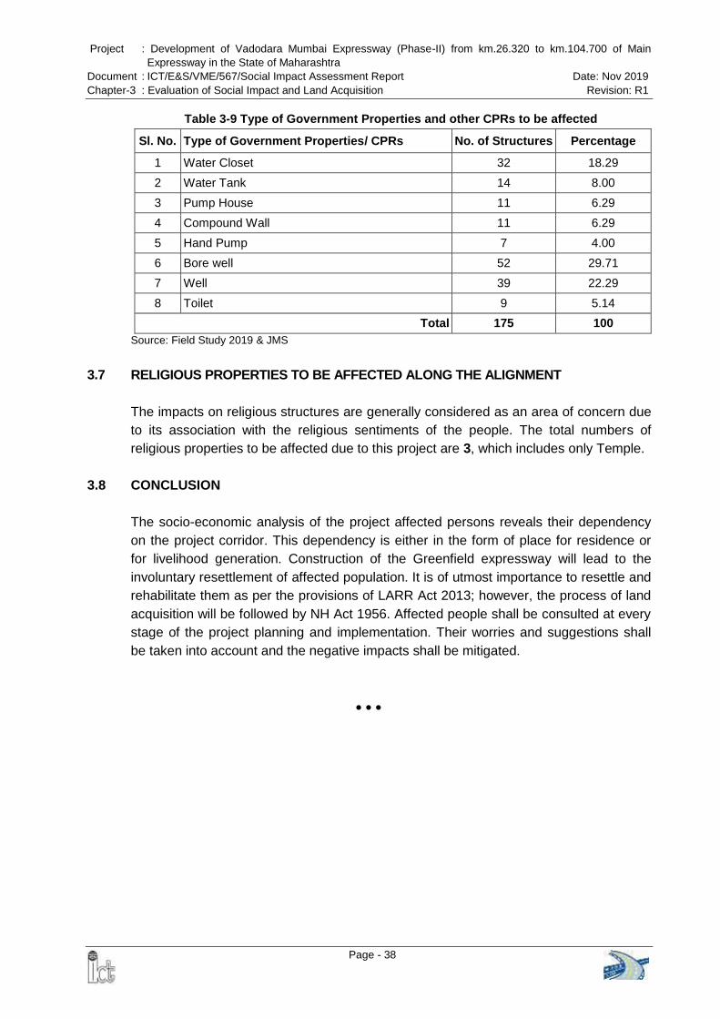
Project : Development of Vadodara Mumbai Expressway (Phase-II) from km.26.320 to km.104.700 of Main Expressway in the State of Maharashtra
Document : ICT/E&S/VME/567/Social Impact Assessment Report Date: Nov 2019 Chapter-3 : Evaluation of Social Impact and Land Acquisition Revision: R1
Page - 38
Table 3-9 Type of Government Properties and other CPRs to be affected
Sl. No. Type of Government Properties/ CPRs No. of Structures Percentage
1 Water Closet 32 18.29
2 Water Tank 14 8.00
3 Pump House 11 6.29
4 Compound Wall 11 6.29
5 Hand Pump 7 4.00
6 Bore well 52 29.71
7 Well 39 22.29
8 Toilet 9 5.14
Total 175 100 Source: Field Study 2019 & JMS
3.7 RELIGIOUS PROPERTIES TO BE AFFECTED ALONG THE ALIGNMENT
The impacts on religious structures are generally considered as an area of concern due to its association with the religious sentiments of the people. The total numbers of religious properties to be affected due to this project are 3, which includes only Temple.
3.8 CONCLUSION The socio-economic analysis of the project affected persons reveals their dependency on the project corridor. This dependency is either in the form of place for residence or for livelihood generation. Construction of the Greenfield expressway will lead to the involuntary resettlement of affected population. It is of utmost importance to resettle and rehabilitate them as per the provisions of LARR Act 2013; however, the process of land acquisition will be followed by NH Act 1956. Affected people shall be consulted at every stage of the project planning and implementation. Their worries and suggestions shall be taken into account and the negative impacts shall be mitigated.

Project : Development of Vadodara Mumbai Expressway (Phase-II) from km.26.320 to km.104.700 of Main Expressway in the State of Maharashtra
Document : ICT/E&S/VME/567/Social Impact Assessment Report Date: Nov 2019 Chapter-4 : Resettlement Policy, Legal Framework and Mitigation Measures Revision: R1
Page - 39
CHAPTER-4: RESETTLEMENT POLICY, LEGAL FRAMEWORK AND MITIGATION MEASURES
4.1 POLICIES AND LEGAL FRAMEWORK
A road-upgrading project often involves the acquisition of land where the existing right of way is not adequate to accommodate the improved road requirements. This process leads to the involuntary displacement of the affected people and loss of their livelihoods (both temporary and permanent), culminating in a process of impoverishment. The country and the State have administrative, policy and legal framework to counter this process, including the Indian Land Acquisition Act 1896/ 1984, the National Highways Act 1956, the Indian Ministry of Environment and Forests Guidelines 1989, and the Indian „The Right to Fair Compensation and Transparency in Land Acquisition, Rehabilitation and Resettlement Act, 2013’1. An overview of these laws and policies are attempted in this chapter in the context of the social impact of the present project.
4.2 THE INDIAN LEGAL FRAMEWORK
4.2.1 Ministry of Environment and Forests Guidelines, 1989
As this project will require acquisition of land, structures and other assets and cause displacement of people as a consequence, the social impact requirement of the Government of India refers to the Relocation section in the Environmental Guidelines for Rail/Road/Highway Projects. The Guidelines recommend the following mitigation measures for social impacts, including a special programme for squatters: Advance notification of enough (say, two years) time must be given to enable the relocatees to find a suitable place. At the same time, the Project Authorities could arrange for public relations through television, radio, and advertisement on the need for the project and how land acquisition and compensation will be effected. Advance realistic payment should be available in some form for the relocatees to
secure a new unit.
The estimation of compensation for land and property should be based on the fair market value. The term fair market value is defined as being the amount at which the property would exchange between a willing buyer and a willing seller and both parties should have reasonable knowledge of all relevant facts.
The choice of replacement of a living unit organized by the Project Authority may be made available for the relocatees who are not satisfied with the compensation amount or who cannot find a suitable house.
Re-establishment cost must be carefully considered to offset the loss in income, increase in expenditure resulting from disconnection of public utility services and
1Published in the Gazette of India, Extraordinary, Part 1, Section I, dated the 26th September, 2013.

Project : Development of Vadodara Mumbai Expressway (Phase-II) from km.26.320 to km.104.700 of Main Expressway in the State of Maharashtra
Document : ICT/E&S/VME/567/Social Impact Assessment Report Date: Nov 2019 Chapter-4 : Resettlement Policy, Legal Framework and Mitigation Measures Revision: R1
Page - 40
moving cost. Special attention must be paid to the possible loss of jobs or business that cannot be re-established.
In case of any squatters, a special programme for construction of a low cost housing unit (the labour provided by relocatees) may be set up.
A social work subsection should be established in the PIU to follow up and monitor the problems faced by the relocatees. This sub-section should also be entrusted with the responsibility to ensure that individual households relocated receive sufficient compensation with enough lead time to secure a living unit.
Discussion: While the land acquisition process according to the Land Acquisition Act spans a minimum of 2-3 years because of the lengthy procedures and possible litigation involved, the relocation parameters of the Environmental Guidelines makes a modest suggestion of giving at least two years notice to the affected persons whose land will be acquired by the Government. The provision of assistance to the encroachers and squatters is a good consideration of the Guidelines.
4.2.2 National Highway Act 1956
The National Highways Authority of India acquires land for a public purpose by invoking Section 3 (and its sub-sections) of the National Highways Act 1956. The Land Acquisition Act of 1894 does not apply when the National Highways Act 1956 is invoked. The NH Act 1956 provides for acquiring land through competent authority, which means any person or authority authorized by the Central Government by notification in the official Gazette to perform functions of the competent authority for such areas as may be specified in the notifications. Like the Land Acquisition Act, 1894, the National Highways Act, 1956, too does not per se provide for mitigation measures, but the Competent Authority under this Act determines the amount payable as compensation. For the purpose of land acquisition, the NH Act defines the various procedures as follows: Section 3A : Intention of Central Government to acquire land Section 3B: Power to enter for survey Section 3C: Hearing of objections Section 3D: Declaration of acquisition Section 3E: Power to take possession, Section 3F: Power to enter into the land where land has vested in the central
government Section 3G: Determination of compensation and Section 3H: Deposit and payment of the amount The Act requires that the processes must be completed within a year from 3A to 3D.

Project : Development of Vadodara Mumbai Expressway (Phase-II) from km.26.320 to km.104.700 of Main Expressway in the State of Maharashtra
Document : ICT/E&S/VME/567/Social Impact Assessment Report Date: Nov 2019 Chapter-4 : Resettlement Policy, Legal Framework and Mitigation Measures Revision: R1
Page - 41
Although the NH Act significantly reduces the timeframe for acquisition, the rules and principles of compensation have been derived from the LARR Act of 2013. As indicated before, the existing laws do not address many of the social and economic issues associated with displacement and resettlement, which will be addressed in this project with a project specific resettlement and rehabilitation policy framework.
4.2.3 The Right to Fair Compensation and Transparency in Land Acquisition,
Rehabilitation and Resettlement Act, 2013
The Right to Fair Compensation and Transparency in Land Acquisition, Rehabilitation and Resettlement Act, 2013 has been effective from January 1, 2014 after receiving the assent of the President of Republic of India. The Act replaced the Land Acquisition Act, 1894. The Act has since late December 2014 been amended to make it more flexible and the description of the amendment is described below. The aims and objectives of the act include is to ensure, in consultation with institutions of local self-government and Gram Sabhas established under the Constitution of India, a humane, participative, informed and transparent process for land acquisition for industrialization, development of essential infrastructural facilities and urbanization with the least disturbance to the owners of the land and other affected families. It provides for compensation and resettlement assistance to the affected families whose land or other assets are affected by the project. A few of key features that are revised from the old Act include the recognition of non-title holders to compensations if they have lived in the area proposed to be acquired in the past three years as well as compensations for loss of livelihood. Section 26 of the Act defines the method by which market value of the land shall be computed under the proposed act. Schedule I outlines the proposed minimum compensation based on a multiple factor of market value. Schedule II through VI outline the resettlement and rehabilitation entitlements to land owners and livelihood losers, which shall be in addition to the minimum compensation per Schedule I. An Amendment Ordinance to the Act was promulgated on December 31, 2014. The Ordinance provides exemptions for five categories of projects from the certain requirements: (i) Defence; (ii) Rural infrastructure; (iii) Affordable housing; (iv) Industrial corridors; (v) Infrastructure projects including Public Private Partnership (PPP) projects where the central government owns the land. These 5 categories of projects are exempted from the requirement of consent of 80% of land owners to be obtained for private projects and that the consent of 70% of land owners be obtained for PPP projects as well as conducting the Social Impact Assessment through a notification. In the context of this project, it is likely to fall within one of the categories exempted from the Social Impact Assessment (category “Infrastructure projects including Public Private

Project : Development of Vadodara Mumbai Expressway (Phase-II) from km.26.320 to km.104.700 of Main Expressway in the State of Maharashtra
Document : ICT/E&S/VME/567/Social Impact Assessment Report Date: Nov 2019 Chapter-4 : Resettlement Policy, Legal Framework and Mitigation Measures Revision: R1
Page - 42
Partnership (PPP) projects where the central government owns the land”). An SIA will
still be conducted as it is required by the ADB SPS, but without following the LARR guidelines.
4.2.4 The Provisions of the Panchayats (Extension to Scheduled Areas) Act (PESA), 1996 PESA is a law enacted by the Government of India for ensuring self-governance through traditional Gram Sabhas for people living in the Scheduled Areas of India. Scheduled Areas are areas identified by the Fifth Schedule of the Constitution of India. Scheduled Areas are found in ten states of India including Maharashtra, which have predominant population of tribal communities. The Scheduled Areas were not covered by the 73rd Constitutional Amendment or Panchayati Raj Act of the Indian Constitution as provided in the Part IX of the Constitution. PESA was enacted on 24 December 1996 to extend the provisions of Part IX of the Constitution to Scheduled Areas, with certain exceptions and modifications. PESA sought to enable the Panchayats at appropriate levels and Gram Sabhas to implement a system of self-governance with respect to a number of issues such as customary resources, minor forest produce, minor minerals, minor water bodies, selection of beneficiaries, sanction of projects, and control over local institutions. PESA is an Act to provide for the extension of the provisions of Part IX of the Constitution relating to the Panchayats and the Scheduled Areas. PESA was viewed as a positive development for tribal communities in Scheduled Areas who had earlier suffered tremendously from engagement with modern development processes and from the operation of both colonial laws and statutes made in independent India. The loss of access to forest, land, and other community resources had increased their vulnerability. Rampant land acquisition and displacement due to development projects had led to large scale distress in tribal communities living in Scheduled Areas. PESA was seen as a panacea for many of these vulnerabilities and sought to introduce a new paradigm of development where the tribal communities in such Scheduled Areas were to decide by themselves the pace and priorities of their development.
4.3 THE ENTITLEMENT MATRIX AND MITIGATION MEASURES The basic features of the proposed policy framework and mitigation measures, for implementation of the RFCTLARR Act 2013 and others legal provisions, are the following:

Project : Development of Vadodara Mumbai Expressway (Phase-II) from km.26.320 to km.104.700 of Main Expressway in the State of Maharashtra Document : ICT/E&S/VME/567/Social Impact Assessment Report Date: Nov 2019 Chapter-4 : Resettlement Policy, Legal Framework and Mitigation Measures Revision: R1
Page - 43
Sl. No. Category / Target Group Provisions in RFCT-LARR Act 2013
A. APPLICABILITY
1 Infrastructural Project 3 (o) “infrastructure project” shall include any one or more of the following, namely:—
(i.) any project relating to generation, transmission or supply of electricity;
(ii.) any project relating to telecommunication services;
(iii.) construction of roads, highways, Defense projects, bridges, airports, ports, rail systems or mining activities, educational, sports, health care, tourism, transportation, inland waterways, inland port, space programme, projects involving agro-processing and supply of inputs to agriculture, projects for preservation and storage of processed agro-products and perishable agricultural commodities and housing for such income groups, as may be specified from time to time by the appropriate Government;
(iv.) water supply project, irrigation project, water harvesting and water conservation structures, water treatment system, sanitation and sewerage system, solid waste management system;
(v.) any other project or public facility as may be notified in this regard by the Central Government;
B. POLICY DEFINITIONS
1 Project 3 (z) “project” means a project for which land is being acquired, irrespective of the number of persons
affected;
2 Family 3 (m) “family” includes a person, his or her spouse, minor children, minor brothers and minor sisters
dependent on him;
3 Displaced Family/ Involuntary displacement
Defined in clause 3.c (i) (ii) (iii) (iv) (v) & (vi) of affected family.
4 Project affected family/ Affected Family
3.c The definition of 'Affected family' has been defines as:
3c (i) A family whose land or other immovable property has been acquired or who have been permanently displaced from their land or immovable property;

Project : Development of Vadodara Mumbai Expressway (Phase-II) from km.26.320 to km.104.700 of Main Expressway in the State of Maharashtra Document : ICT/E&S/VME/567/Social Impact Assessment Report Date: Nov 2019 Chapter-4 : Resettlement Policy, Legal Framework and Mitigation Measures Revision: R1
Page - 44
Sl. No. Category / Target Group Provisions in RFCT-LARR Act 2013
3.c (ii) A family which does not own any land but a member or members of such family may be agricultural labourers, tenants, share-croppers or artisans or may be working in the affected area for three years prior to the acquisition of the land, whose primary source of livelihood stand affected by the acquisition of land;
3.c (iii) Tribal and other traditional forest dwellers who have lost any of their traditional rights recognized under the Scheduled Tribes and Other Traditional Forest Dwellers (Recognition of Forest Rights) Act, 2006 due to acquisition of land;
3c (iv) Family whose primary source of livelihood for three years prior to the gatherers of forest produce, hunters, fisher folk and boatmen and such livelihood is affected due to acquisition of land;
3c (v) A member of the family who has been assigned land by the State Government or the Central Government under any of its schemes and such land is under acquisition;
3.c (vi) A family residing on any land in the urban areas for preceding three years prior to the acquisition of the land or whose primary source of livelihood for three years prior to the acquisition of the land is affected by the acquisition of such land.
5 Affected Zone/ Affected Area
3 (zc) “Resettlement Area” means an area where the affected families who have been displaced as a result
of land acquisition are resettled by the appropriate Government;
6 Marginal farmer 3 (t) “marginal farmer” means a cultivator with an un-irrigated land holding up to one hectare or irrigated land holding up to one-half hectare;
7 Khatedar Not mention in the policy
8 Requiring body 3 (zb) “Requiring Body” means a company, a body corporate, an institution, or any other organisation for whom land is to be acquired by the appropriate Government, and includes the Appropriate Government, if the acquisition of land is for such Government either for its own use or for subsequent transfer of such land in public
9 Appropriate Government 3 (e) “Appropriate Government” means,—

Project : Development of Vadodara Mumbai Expressway (Phase-II) from km.26.320 to km.104.700 of Main Expressway in the State of Maharashtra Document : ICT/E&S/VME/567/Social Impact Assessment Report Date: Nov 2019 Chapter-4 : Resettlement Policy, Legal Framework and Mitigation Measures Revision: R1
Page - 45
Sl. No. Category / Target Group Provisions in RFCT-LARR Act 2013
(i) in relation to acquisition of land situated within the territory of, a State, the State Government;
(ii) in relation to acquisition of land situated within a Union territory (except Puducherry), the Central Government;
(iii) in relation to acquisition of land situated within the Union territory of Puducherry, the Government of Union territory of Puducherry;
(iv) in relation to acquisition of land for public purpose in more than one State, the Central Government; and
(v) in relation to the acquisition of land for the purpose of the Union as may be specified by notification, the Central Government;
interest to a company, body corporate, an institution, or any other organisation, as the case may be, under lease, license or through any other mode of transfer of land
10 Small Farmer 3(ze) “small farmer” means a cultivator with an un-irrigated land holding up to two hectares or with an irrigated land holding up to one hectare, but more than the holding of a marginal farmer.
11 Holding 3 (n) “holding of land” means the total land held by a person as an owner, occupant or tenant or otherwise;
C. HOMESTEAD LAND/ HOUSE CONSTRUCTION ASSISTANCE
1 Project Affected Family/ Displaced Family
If a dwelling unit is acquire, amount prescribed in Pradhan Mantri Gramin Awaas Yojana (for rural areas) or Pradhan Mantri Awaas Yojana (for urban areas) will be paid subject to a minimum of Rs. 1.50 Lakh, in addition to the compensation amount for land & structures paid to them.
D. AGRICULTURAL LAND
1 Project Affected Family / Displaced Family owning agriculture land
Land will be acquired by the CALA (Competent Authority for Land Acquisition) in accordance with the provisions of the Right to Fair Compensation and Transparency in Land Acquisition, Rehabilitation and Resettlement (RFCTLARR) Act, 2013 under the National Highways Act, 1956
Compensation will be determined in accordance with First Schedule, rehabilitation and resettlement assistance specified in the Second & Third Schedule of RFCTLARR Act, 2013 applicable to the land

Project : Development of Vadodara Mumbai Expressway (Phase-II) from km.26.320 to km.104.700 of Main Expressway in the State of Maharashtra Document : ICT/E&S/VME/567/Social Impact Assessment Report Date: Nov 2019 Chapter-4 : Resettlement Policy, Legal Framework and Mitigation Measures Revision: R1
Page - 46
Sl. No. Category / Target Group Provisions in RFCT-LARR Act 2013
acquisition under the National Highways Act, 1956
E. CONSTRUCTION OF CATTLE SHED/ PETTY SHOPS
1 Project Affected Family/Displaced Family
One-time financial assistance of Rs. 25,000/- or the amount as decided by the appropriate government would be payable
F. SHIFTING/TRANSPORTATION ALLOWANCE
1 Project Affected Family/ Displaced Family
Applicable in cases where a family is displaced and is compelled to change its place of residence to any other location and the amount would be payable as per RFCTLARR Act, 2013.
G. SUBSISTENCE GRANT
1 Project Affected Family / Displaced Family
This provision would be applicable in cases where the family whose land is acquired, or the landless family whose source of livelihood is dependent on such landowning displaced family. In each such case, an amount of Rs. 36,000/- would be payable. Further, if such displacement of any family from the Scheduled Castes and the Scheduled Tribes takes place in the Scheduled Areas, an additional amount of Rs. 50,000/-would be payable.
H. ANNUITY POLICIES
1 Each Project Affected Family/Displaced Family
The scheme of "Rehabilitation and Resettlement" is applicable in cases where the landowner, whose land is acquired, and the landless family whose source of livelihood is dependent upon such landowner, is dislocated and compelled to change his place of residence or business due to such acquisition. This situation normally does not occur in the case of acquisition of land for linear projects like National Highways, unless a person's entire landholding is acquired.
The Second Schedule refers to Sections 31(1), 38(1), and 105(3) of the RFCTLARR Act and these sections do not contain any provision in respect of this component of "Choice of Annuity or Employment".

Project : Development of Vadodara Mumbai Expressway (Phase-II) from km.26.320 to km.104.700 of Main Expressway in the State of Maharashtra Document : ICT/E&S/VME/567/Social Impact Assessment Report Date: Nov 2019 Chapter-4 : Resettlement Policy, Legal Framework and Mitigation Measures Revision: R1
Page - 47
Sl. No. Category / Target Group Provisions in RFCT-LARR Act 2013
Secondly, this component has multiple options, which have to be specified by the appropriate government. It is beyond the Competent Authority or the Collector to make an Award in this behalf in the absence of any provision by the Appropriate Government.
I. ONE-TIME RESETTLEMENT ALLOWANCE
1 Each Affected Family/ Displaced Family
This provision would apply only where an affected family is displaced and has to re-settle somewhere else due to acquisition of his / her land
J. R & R BENEFITS TO SCHEDULED CASTE & SCHEDULED TRIBE FAMILIES
1 Each Tribal Project Affected Families/ Schedule Tribe Displaced Families
(1) In case of land being acquired from members of the Scheduled Castes or the Scheduled Tribes, at least one-third of the compensation amount due shall be paid to the affected families at the outset as first instalment and the rest shall precede the taking over of the possession of the land U/S-41 (6) of RFCTLARR Act, 2013
(2) The Scheduled Tribes affected families shall be resettled preferably in the same Scheduled Area in a compact block, so that they can retain their ethnic, linguistic and cultural identity U/S-41 (7) of RFCTLARR Act, 2013
(3) Any alienation of tribal lands or lands belonging to members of the Scheduled Castes in disregard of the laws and regulations for the time being in force shall be treated as null and void; and in the case of acquisition of such lands, the R&R benefits shall be available to the original tribal land owners or land owners belonging to the Scheduled Castes U/S-41 (9) of RFCTLARR Act, 2013
(4) Where the affected families belonging to the Scheduled Castes and Scheduled Tribes are relocated outside of the district, then, they shall be paid an additional R&R benefits to which they are entitled in monetary terms along with a one-time entitlement U/S-41 (11) of RFCTLARR Act, 2013

Project : Development of Vadodara Mumbai Expressway (Phase-II) from km.26.320 to km.104.700 of Main Expressway in the State of Maharashtra
Document : ICT/E&S/VME/567/Social Impact Assessment Report Date: Nov 2019 Chapter-5 : Public Consultant Revision: R1
Page - 48
CHAPTER 5: PUBLIC CONSULTATION
5.1 IDENTIFICATION OF STAKEHOLDERS Consultations with many stakeholders were carried out during various phases of project preparation. The primary stakeholders are Project Affected Person (PAPs) and Executing Agency, especially the officials of NHAI. Additionally, the concerned district magistrate and the revenue officials are also considered to be the primary stakeholders. Secondary stakeholders in the project include Gram Panchayats, village administrative officers, farmers, business communities, people living along the proposed alignment, and other vulnerable communities like the scheduled caste (SC), scheduled tribe (ST) and BPL families.
5.2 METHODS OF PUBLIC CONSULTATION During the course of the social assessment, consultation meetings were held to inform the communities and population about the positive as well as negative impacts of the proposed project construction. Consultations and discussions were held along the project influence area with the affected households and other stakeholders including village heads, gram panchayat members, head of households, shopkeepers etc. These meetings were used to get wider public input from both the primary and secondary stakeholders. The consultation methods followed to elicit required information (their views & opinions) are detailed below in Table 5.1.
Table 5-1 Methods of Public Consultations
Stakeholders Consultation Method
Displaced Persons (DPs) Individual consultation
Village Sarpanch / Representative of APs Public / Stakeholders Consultation
Local communities Public / Stakeholders Consultation
Executive Agency (EA) Individual interview, discussion, joint field visit
Line Departments (Revenue Officials) Individual meeting/interview, discussion 5.3 SCOPE OF CONSULTATION
During the consultation process efforts were made by the study teams to: Ascertain the views of the APs, with reference to land acquisition and widening of the
expressway ; Understand views of the community on land acquisition, resettlement issues and
rehabilitation options; Identify and assess the major socio-economic characteristics of the villages to enable

Project : Development of Vadodara Mumbai Expressway (Phase-II) from km.26.320 to km.104.700 of Main Expressway in the State of Maharashtra
Document : ICT/E&S/VME/567/Social Impact Assessment Report Date: Nov 2019 Chapter-5 : Public Consultant Revision: R1
Page - 49
effective planning and implementation; Obtain opinion of the community on issues related to the impacts on community
property and relocation of the same; Examine AP’s opinion on problems and prospects of expressway related issues; Identify people's expectations from project and their absorbing capacity; Finally, to establish an understanding for identification of overall developmental goals
and benefits of the sub-project.
5.4 DATE AND LOCATION OF PUBLIC CONSULTATION Consultations with several stakeholders were carried out at various levels in the project area and gram panchayat. Key stakeholders consulted including affected people as well as other community members directly or indirectly affected in the area. Moreover, revenue officials, village heads, head of Gram Panchayat, and village administrative officers were also consulted. Date of consultation, locations and number of people participated are summarized in Table 5.2.
Table 5-2 Village wise Public Consultations (PC)
Sl. No. Date Village Name No. of Participants
1 20/03/2013 Vankash 28
2 20/03/2013 Talote 35
3 03/12/2014 Chinchara 30
Total 93
5.5 FINDINGS OF PUBLIC CONSULTATIONS
Consultation with Project Affected Persons: During the social survey, the consultations were conducted in three villages along the project alignment keeping in mind the building of confidence among land losers. The participants in these consultations were not limited to the DPs but also village elders, local leaders and the local residents from nearby small villages. A total of 93 persons were present in three consultation meetings. Some of the major issues that were discussed and feedback received from the affected persons, who are losing their land and or properties, during the course of the consultations and measures taken are summarized in the Table 5-3.

Project : Development of Vadodara Mumbai Expressway (Phase-II) from km.26.320 to km.104.700 of Main Expressway in the State of Maharashtra Document : ICT/E&S/VME/567/Social Impact Assessment Report Date: Nov 2019 Chapter-5 : Public Consultant and Stakeholders Analysis Revision: R1
Page - 50
Table 5-3: Issues Discussed and Outcome of Consultations SI. No. Date and Location Issues Discussed Outcome/Suggestions of the
Consultation Action Taken
1 Date 20/3/2013 Place: Vankash Taluk: Dahanu District: Palghar No. of Participants- 28
Awareness about the project. Safety Measures Connectivity from one side to other Mitigation Measures Avoiding potential adverse impacts
on people. Employment opportunities to be
provided. Fair and appropriate compensation. Other issues
People were aware about the project. The consultant briefed them in details about the project and proposed alignment.
People consider it as a good development initiative and supported the project as good expressway will reduce the time.
According to people expressway development is as financial development of their area as new expressway will lead to new business opportunity for them to start business along the expressway.
People want both side connecting with road and also, cross connectivity from the expressway
People asked about employment opportunities during construction to be provided to each family those who are losing their livelihood.
People asked for maximum compensation for affected land and structure
Consultant briefed them about the Compensation system and told them, that they will be paid as per the LARR Act 2013 & Rules of Govt. of India.
Stakeholders Input and suggestion has been provided to design team for consideration and appropriate mitigation measures to be taken with best engineering solution. 2 Date 20/3/2013
Place: Talote Taluk: Dahanu District: Palghar No. of Participants- 35
3 Date 03/12/2014 Place: Chinchara Taluk: Palghar District: Palghar No. of Participants- 30
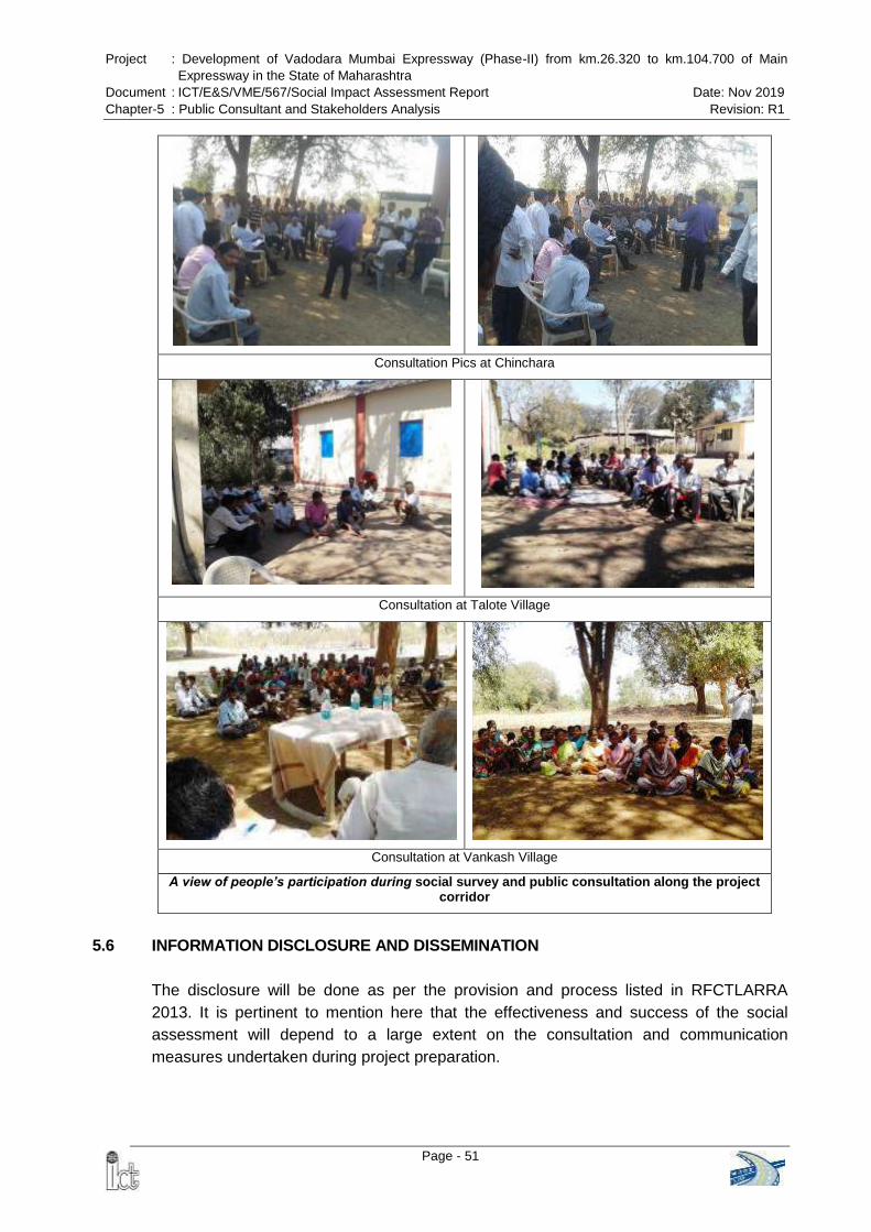
Project : Development of Vadodara Mumbai Expressway (Phase-II) from km.26.320 to km.104.700 of Main Expressway in the State of Maharashtra
Document : ICT/E&S/VME/567/Social Impact Assessment Report Date: Nov 2019 Chapter-5 : Public Consultant and Stakeholders Analysis Revision: R1
Page - 51
Consultation Pics at Chinchara
Consultation at Talote Village
Consultation at Vankash Village
A view of people’s participation during social survey and public consultation along the project corridor
5.6 INFORMATION DISCLOSURE AND DISSEMINATION
The disclosure will be done as per the provision and process listed in RFCTLARRA 2013. It is pertinent to mention here that the effectiveness and success of the social assessment will depend to a large extent on the consultation and communication measures undertaken during project preparation.

Project : Development of Vadodara Mumbai Expressway (Phase-II) from km.26.320 to km.104.700 of Main Expressway in the State of Maharashtra
Document : ICT/E&S/VME/567/Social Impact Assessment Report Date: Nov 2019 Chapter-5 : Public Consultant and Stakeholders Analysis Revision: R1
Page - 52
Several additional rounds of consultations with PAPs will form part of project implementation, which is conducted by NHAI and facilitated by the RAP implementing Consultant which include the followings: Key information to use in the leaflet include: Project information; Key project
impacts; Eligibility and cut-off date; summarized and key information from the EM; Contact number and location of local Grievance Redress Committee; Contact number of NHAI.
Disclosure of the RAP on NHAI and the Executing Agency (EA)’s websites and hard
copies made available in local administration offices. Information dissemination, through public meetings, dissemination of leaflets, public
announcements, disclosure in the local media and RAPs made available in relevant Panchayat, government agencies (including the DC’s office), and PIU offices.
Setting-up posters with contact information of local safeguards officer and local grievance redress in key locations.
APs will be informed of any change in alignment through consultations and be consulted to minimize resettlement impacts.
Information dissemination sessions will be conducted. Public meetings will be organized at different stages of implementation to appraise
the communities about the progress of civil works, compensation and assistance. Consultation and focus group discussions with vulnerable groups like women, SC,
ST, and elderly will be conducted to ensure that their needs are taken into consideration.
Efforts will be made to ensure that women are properly consulted during the implementation of the RAP. This will be monitored and reported on in the semi-annual monitoring reports during implementation.
5.7 TERMS OF REFERENCES FOR THE NGO TO IMPLEMENT THE RESETTLEMENT
PLAN To assist NHAI in the implementation of the RAP, NHAI shall invite the services of eligible NGOs to be procured under quality-based lump sum contracts. The NGO shall be responsible for the following, according to the Resettlement Plan: Educating the Displaced Persons (DPs) on their rights to entitlements and
obligations. To ensure that the DPs are given the full entitlements due to them, according to the
entitlements in the RP. To provide support and information to DPs for income restoration. Assist the DPs in relocation and rehabilitation, including counseling, and
coordination with local authorities. Assist the DPs in redressing their grievances (through the grievance redress
committee set up by the subproject) Impart information to all the DPs about the functional aspects of the various set up

Project : Development of Vadodara Mumbai Expressway (Phase-II) from km.26.320 to km.104.700 of Main Expressway in the State of Maharashtra
Document : ICT/E&S/VME/567/Social Impact Assessment Report Date: Nov 2019 Chapter-5 : Public Consultant and Stakeholders Analysis Revision: R1
Page - 53
by the project, and assist them in benefiting from such institutional mechanisms. To assist the Project Implementation Unit (PIU) with social responsibilities of the
sub-project, such as compliance with labour laws, prohibition of child labour, and gender issues.
To conduct awareness program for HIV/AIDs, Human Trafficking. To collect data and submit progress reports on a monthly and quarterly basis for
Authority Engineer and EA to monitor the progress of RP implementation. 5.7.1 Scope of Work
The NGO shall play the role of a secondary stakeholder in implementation of the RP and in mitigating adverse effects of the project. The NGO shall be responsible for the development of a comprehensive livelihood restoration system to facilitate the DPs to take advantage of the options available (as per the RP).
5.7.2 Administrative Responsibilities of the NGO
The administrative responsibilities of the NGO will include: Working in co-ordination with the Project Resettlement Officer (RO) in the PIU and
Authority Engineer (AE); Assist the RO in carrying out the implementation of the RP; To co-ordinate with the GRCs in implementing the RP; Assist the AE and RO in conducting all public meetings, information campaigns at
the commencement of the project and give full information to the affected community;
Translate the summary RP in local language to implement actions for mitigating adverse impacts on the DPs;
To assist the PIU / Authority Engineer to ensure that the Contracts comply with the applicable labour laws (including prohibition of child labour) and gender issues;
To assist the PIU and /or the Engineers in ensuring compliance with the safety, health and hygiene norms, and the conduct HIV/AIDS and Human Trafficking awareness / prevention campaigns.
Report to the RO on a monthly and quarterly basis. The report should include physical and financial progress, both in quantitative and qualitative terms. The report should prominently feature the problems and issues addressed and tackled with the DPs and the solutions found. The report should have a separate chapter on women's issues, their problems and what has been done (within the framework of the RP) to ensure their participation in decision-making as well as the options made available to them to access economic opportunities, marketing and credit. The report should clearly indicate the number of field visits made by the NGO staff and the outcome of consultations with people.
Data base management of the DPs. The displaced persons will be assisted in the Income Generation Scheme training
Project : Development of Vadodara Mumbai Expressway (Phase-II) from km.26.320 to km.104.700 of Main Expressway in the State of Maharashtra
Document : ICT/E&S/VME/567/Social Impact Assessment Report Date: Nov 2019 Chapter-5 : Public Consultant and Stakeholders Analysis Revision: R1
Page - 54
through the NGO i.e. the provision made for training will be best utilized through the active support and involvement of the NGO.
5.7.3 Implementation of the Resettlement Plan
Identification DPs and Verification of Database from RP NGO shall verify the information already contained in the RP and the individual
losses of the DPs. They should validate the data provided in the RP and make suitable changes if required. The NGO shall establish rapport with DPs, consult and provide information to them about the respective entitlements as proposed under the RP, and distribute entitlement cum Identity Cards to the eligible DPs. The identity card should include a photograph of the DP, the extent of loss suffered due to the project, and the choice of the DP with regard to the mode of compensation and assistance.
The NGO shall develop rapport between the DPs and the Project Authority, particularly the AE and RO. This will be achieved through regular meetings with both the RO and the DPs. Meetings with the RO will be held at least fortnightly, and meetings with the DPs will be held monthly, during the entire duration of the assignment. All meetings and decisions taken shall be documented by the NGO.
Prepare monthly action plans with targets in consultation with the RO. The NGO shall prepare a list of the project-displaced persons/families for relocation,
enlisting the losses and the entitlements, after verification. It shall also prepare a list of the displaced persons (DPs) enlisting the losses and the entitlement as per the RP, after verification. Verification shall include actual measurement of the extent of total property loss/damage, and valuation of the loss/damage/affect along with the RO. The NGO shall display the list of eligible DPs in prominent public places like villages, Panchayat Offices, Block/Tehsil headquarters, and the District Headquarters.
During the identification and verification of the eligible DPs, the NGO shall ensure that each of the DPs are contacted and consulted either in groups or individually. The NGO shall specially ensure consultation with women from the DP families especially women headed households.
Participatory methods should be adopted in assessing the needs of the DPs, especially with regard to the vulnerable groups of DPs. The methods of contact may include village level meetings, gender participation through group’s interactions, and
Individual meetings and interactions. While finalizing the entitled persons (EPs) for compensation/assistance the NGO
shall make a list of entitled DPs, and distribute Identity Cards to each and every verified eligible DP.

Project : Development of Vadodara Mumbai Expressway (Phase-II) from km.26.320 to km.104.700 of Main Expressway in the State of Maharashtra
Document : ICT/E&S/VME/567/Social Impact Assessment Report Date: Nov 2019 Chapter-5 : Public Consultant and Stakeholders Analysis Revision: R1
Page - 55
Counseling the Entitled Persons The counseling shall include the following activities: The NGO shall explain to the DPs the provisions of the policy and the entitlements
under the RP. This shall include communication to the expressway side squatters and encroachers about the need for their eviction, the timeframe for their removal and their entitlements.
The NGO shall disseminate information to the DPs on the possible consequences of the project on the communities' livelihood systems and the options available, so that they do not remain ignorant.
The NGO shall prepare micro-level plans for income restoration, in consultation with the DPs. Women's perceptions are important to be incorporated in the development of these plans.
NGO will monitor the involvement of child labour in the civil construction work in each package.
In all of these, the NGO shall consider women as a special focus group, and deal with them with care and sympathy. Disbursing the Assistance Prepare micro plans indicating category of entitlement. Prepare micro plans for livelihood indicating alternative livelihood options, land
identification, skills up grading and institutions responsible for training for eligible DPs.
The NGO shall assist the project authorities in ensuring a smooth transition (during the part or full relocation of the DPs), helping the DPs to take salvaged materials and shift. In close consultation with the DPs, the NGO shall inform the RO about the shifting dates agreed with the DPs in writing and the arrangements desired by the DPs with respect to their entitlements.
The NGO shall assist the DPs in opening bank accounts explaining the implications, the rules and the obligations of a joint account and how s/he can access the resources s/he is entitled to.
The NGO shall ensure proper utilization of the R&R budget available for each of the packages. The NGO shall ensure that the DPs have found economic investment options and are able to restore the losses of land and other productive assets. The NGO shall identify means and advise the RO to disburse the entitlements to the eligible persons/families in a manner that is transparent, and shall report to the EA on the level of transparency achieved in the project.
Accompanying and Representing the EPs at the Grievance Committee Meetings
The NGO shall nominate a suitable person (from the staff of the NGO) to be a

Project : Development of Vadodara Mumbai Expressway (Phase-II) from km.26.320 to km.104.700 of Main Expressway in the State of Maharashtra
Document : ICT/E&S/VME/567/Social Impact Assessment Report Date: Nov 2019 Chapter-5 : Public Consultant and Stakeholders Analysis Revision: R1
Page - 56
member of the GRCs for the respective contract packages. The NGO shall make the DPs aware of the Grievance Redress Committees (GRCs) The NGO shall train the DPs on the procedure to file a grievance application and to
confirm that a statement of claim from the concerned DP accompanies each grievance application. The NGO shall help the DPs in filling the grievance application and also in clearing their doubts about the procedure as well as the context of the GRC award.
The NGO shall record the grievance and bring it to the notice of the GRCs within seven days of receipt of the grievance from the DPs. It shall submit a draft resolution with respect to the particular grievance of the affected person, suggesting multiple solutions, if possible, and deliberate on the same in the GRC meeting through the NGO representative in the GRC.
To accompany the DPs to the GRC meeting on the decided date, help the DP to express his/her grievance in a formal manner if requested by the GRC and again inform the DPs of the decisions taken by the GRC within 3 days of receiving a decision from the GRC. (The time frame for the GRC to take a decision is 15 days).
Assisting the EPs and the RO to Identity and Negotiate for New Land for Resettlement As part of the RP, it is proposed that a sizable number among the eligible DPs will receive alternative land (commercial) building structures. Some of the more vulnerable among the DPs will be eligible to receive these free of cost. Regarding these the NGO shall, Obtain the DPs choice in terms of Land identification, Site for relocation, Shifting
plan and arrangements, Grant utilization plan and Community asset building plan and institutional arrangements in maintaining the assets.
Assist squatters whose structures needs to be shifted to the remaining government land for continuation of earning their livelihood before construction of expressway starts.
Assist the DPs/ RO in identifying suitable land for relocation and for agriculture, ensuring the replacement of the land lost in terms of quality and quantity.
Identify suitable government land in consultation with the Revenue Department officials and assist in negotiating its transfer to the DPs/ RO at reasonable prices and motivate them to appreciate and welcome the new neighbours.
Assisting Eligible DPs to take advantage of the existing Government Housing and Employment Schemes With regard to the above, the NGO shall, Co-ordinate (and impart wherever required) the training and capacity building of the
DPs, for upgrading their skills for income restoration. This will include the training to be given by the NGO to women self-help-group members in accounting, record maintenance, skill acquisition in the chosen enterprise, and marketing, etc.

Project : Development of Vadodara Mumbai Expressway (Phase-II) from km.26.320 to km.104.700 of Main Expressway in the State of Maharashtra
Document : ICT/E&S/VME/567/Social Impact Assessment Report Date: Nov 2019 Chapter-5 : Public Consultant and Stakeholders Analysis Revision: R1
Page - 57
Help the DPs in realizing and optimizing the indigenous technology knowledge (ITK) through use of local resources.
Define, evolve, and explore alternative methods of livelihood using the local skill and resources.
Establish linkages with the district administration to ensure that the DPs are benefited from the schemes available and those they are entitled to. The focus for this component of the NGO work shall be the vulnerable DPs for their income restoration. The NGO shall maintain a detailed record of such facilitation.
Inter-Agency Linkages for Income Restoration and other R&R Services The NGO shall be responsible for establishing linkages with,
Financial institutions to assist the DPs to access credit. Government departments, district administration, etc., to ensure that the DPs are
included in the development schemes, as applicable; Training institutes to impart skills and management training for enterprise
creation and development.
NGO shall conduct training programmes for income restoration for DPs. NGO should prepare an income restoration plan.
Assisting the Authority Engineer with the Project’s Social Responsibilities The NGO shall assist the Authority Engineer (AE) to ensure that the Contractors are abiding by the various provisions of the applicable laws, concerning the worker's safety, health and hygiene; women's issues and the child labour issues. The applicable laws include (A) the maternity benefit Act, 1951; (B) the Contract Labour (Regulation and Abolition) Act, 1948; (C) the Minimum Wagers act, 1948. (D) The Equal Remuneration Act, 1979. (E) the Industrial Employment (Standing Order) Act, 1946; (F) the Child Labour (Prohibition and Regulation ) Act, 1986; (G) the Building and Other Construction Workers (Regulation of Employment and Conditions of Service) Act 1996; (H) the Cess Act of 1996 and (I) the Factories Act, 1948. Any divergence from the (workers welfare and remuneration, safety, health, hygiene, women's issues, and child labour issues) provisions of these laws should be brought to the notice of the AE and the RO. According to these laws, there are specifications regarding the facilities/requirements at the construction camp/site, including basic health care facilities, Mother and Child Welfare units and facilities for vaccinations, day crèche facilities, etc. The NGO shall work in co-ordination of the Lady Inspector of Works or the Resident engineers of the Contractor, or any other representative of the Contractors, to ensure these facilities are provided in a satisfactory manner, and all social responsibilities of the Contract is implemented satisfactorily.
Project : Development of Vadodara Mumbai Expressway (Phase-II) from km.26.320 to km.104.700 of Main Expressway in the State of Maharashtra
Document : ICT/E&S/VME/567/Social Impact Assessment Report Date: Nov 2019 Chapter-5 : Public Consultant and Stakeholders Analysis Revision: R1
Page - 58
Coordinate with the Sr. Environmental Specialist of AE to facilitate consultation on rehabilitation of borrow areas. Assisting the PIU / Authority Engineer in HIV/AIDS awareness / prevention campaigns Information campaigns / advertisements in collaboration with line agencies (such as NACO, DFID, etc), including provision of signage/hoardings at suitable locations, distribution of vehicle stickers, and provision of condom vending machines at suitable locations (rest areas, truck parking lay-byes, etc.). The NGO shall assist the PIU/ AE to implement these measures, including collaboration with the line agencies. The contractors are required to provide condom vending machines at the construction camps, provide for medical facilities and regular medical checkups especially for detecting / curing STD / AIDS. The NGO shall ensure, in collaboration with the AE that such facilities and medical checkups are provided to the workers at the construction camps. Monitoring and Reporting The RP includes provision for monthly internal monitoring by NGO/ RO and quarterly, mid-term, and post-project monitoring and Reporting by external agency. The NGO involved in the implementation of the RP will be required to supply all information, documents to the external monitoring and Reporting consultants. To this end, the NGO shall keep proper documentation of their work and the R&R process involved in the project, and shall be responsible for the upkeep and updating of such documents periodically and regularly. The documentation shall include photographs and videotapes of the pre-intervention and post-intervention scenario of all the properties, structures, and assets affected by the project. Recommending Improvement of R&R Services Extend all services recommended by any additional studies to be undertaken by the
project, in respect to the R&R services to be provided as part of the project. Recommend and suggest techniques and methods for improvement of services
extended by the concerned government departments and other agencies and committees in disbursement/extension of R&R services in the project.
Document implementation of the R&R process and services, including difficulties faced and corresponding solutions.
Discuss, with the PIU on contingency management and other improvement of R&R services, within the project period.
Documenting of tasks carried out by the NGO and Reporting of the achievements of RP.

Project : Development of Vadodara Mumbai Expressway (Phase-II) from km.26.320 to km.104.700 of Main Expressway in the State of Maharashtra
Document : ICT/E&S/VME/567/Social Impact Assessment Report Date: Nov 2019 Chapter-5 : Public Consultant and Stakeholders Analysis Revision: R1
Page - 59
5.7.4 Documentation and Reporting by NGO The NGO selected for the assignments shall be responsible to:
Submit an inception report within three weeks; on signing up of the contract
including a work plan for the whole contract period, staffing and personnel deployment plan, and a withdrawal plan at the end of the period of contract. The withdrawal plan shall be detailed and reflect how the DPs will maintain the assets created and transferred to the DPs.
Prepare monthly progress reports to be submitted to the RO, with weekly progress and work charts as against the scheduled timeframe of RP implementation.
Prepare and submit quarterly reports on a regular basis, to be submitted to the RO. Submit a completion report at the end of the contract period summarizing the actions
taken during the project, the methods and personnel used to carry out the assignment, and a summary of support / assistance given to the DPs.
All other reports/documentation as described in these terms of reference. Record minutes of all meetings. All progress reports shall include data on input and output indicators as required by the RO. Reporting in writing as well as photographs, videotapes etc., taken during the assignment shall be submitted in support of the reports, along with an electronic copy of the documents in a CD or pen drive. All reports should be in English (translational of the report in local language is optional). Accounts reports both on expenditure on administration as well as training and other heads shall be submitted with the quarterly and the completion reports. In addition to these above, the NGO shall prepare and submit separate descriptive reports on participatory micro-plans with full details of the Participatory Rapid Appraisal exercises conducted. The NGO shall document in full detail, the consultation/counseling processes, the process of identification of the resettlement sites, and a full description of the training imparted (on facilitated) as part of the assignment. This documentation shall be submitted to the EA as annual reports.
5.7.5 Condition of Services The NGO shall ensure that the RP is implemented in an effective and proper manner. The prime responsibility of the NGO shall be to ensure that each and every eligible DP receives appropriate and due entitlement (within the Entitlement Framework) and that, at the end of the project R&R services, the eligible DPs have improved (or at least restored) their previous standard of living. Additionally the NGO shall help the PIU in all other matters deemed to be required to implement the RP in its spirit and entirely including activities involving some financial implications.

Project : Development of Vadodara Mumbai Expressway (Phase-II) from km.26.320 to km.104.700 of Main Expressway in the State of Maharashtra
Document : ICT/E&S/VME/567/Social Impact Assessment Report Date: Nov 2019 Chapter-5 : Public Consultant and Stakeholders Analysis Revision: R1
Page - 60
All documents created, generated or collected during the period of contract, in carrying out the services under this assignment will be the property of the PIU. No information gathered or generated during and in carrying out this assignment shall be disclosed by the NGO without explicit permission of the PIU.
5.7.6 Timeframe for Services The NGO will be contracted for a period of 30 months from the date of commencement, with a withdrawal methodology built in to the proposals from the NGO.
5.7.7 Data, Services and Facilities to be provided by the Client
The PIU will provide to the NGO the copies of the SIA report / DPs' Census, the RP, the strip plan final design report and any other relevant reports/data prepared by the project preparation consultants. The PIU will assist the NGO in collaborating with the Authority Engineer. All facilities required in the performance of the assignment, including office space, office stationery, transportation and accommodation for staff of the NGO, etc., shall be arranged by the NGO.
Project : Development of Vadodara Mumbai Expressway (Phase-II) from km.26.320 to km.104.700 of Main Expressway in the State of Maharashtra
Document : ICT/E&S/VME/567/Social Impact Assessment Report Date: Nov 2019 Chapter-6 : Resettlement Budget Revision: R1
Page - 61
CHAPTER 6: RESETTLEMENT BUDGET 6.1 INTRODUCTION
A consolidated overview of the budget is provided and the cost estimates given below shall be viewed accordingly. The cost estimates for structures are based on the findings, emerges from the joint measurement survey, which is equivalent to replacement cost. In addition, the cost of the land to be acquired has been estimated by taking the cost from award compensation and tentative land rates taken from award compensation for the villages where the award has not been declared yet. In the Resettlement Budget, the provision for compensation and R&R assistance to the affected people is made as per the entitlement framework based on The Right to Fair Compensation and Transparency in Land Acquisition, Rehabilitation and Resettlement Act, 2013. The budget is indicative of outlays for the different expenditure categories and will be updated and adjusted to the inflation rate as the project continues. The budget is to be modified based on the decision of the Competent Authority of Land Acquisition (CALA) at the time of acquisition.
6.2 ESTIMATED R&R BUDGET
The R&R budget includes a tentative cost of acquisition of land, built-up properties such as residential and commercial units, religious, community buildings, government properties and boundary wall etc. In addition, the budget also includes the cost of R&R assistance, administrative expenses, NGOs involvement and Monitoring and Evaluation (M&E). The following tables show the item wise tentative cost estimates of resettlement.
6.2.1 Cost of the Land
The basic land rate has been collected from DLC rate. Under the policy guidelines (RFCTLARR Act, 2013), the compensation of land has to be paid on replacement value of the land. It is comparatively reasonable cost of the land to be paid to the affected people. Depending upon the available rates of land, an estimate of land cost was done and is reflected in the Table 6-1.
Table 6-1 Tentative cost of Land Acquisition
Sl. No. Item Eligibility Quantity
(Hectare) Unit Rate Total
1 Cost of land Title Holder 710.3247 As per applicable Rate Rs. 1,361 Cr.
Note: Last updated in the year 2018. May be modified at the time of actual land acquisition based on the decision of CALA
6.2.2 Cost of Structure
All structures were enumerated and cost estimates were done to meet the replacement

Project : Development of Vadodara Mumbai Expressway (Phase-II) from km.26.320 to km.104.700 of Main Expressway in the State of Maharashtra
Document : ICT/E&S/VME/567/Social Impact Assessment Report Date: Nov 2019 Chapter-6 : Resettlement Budget Revision: R1
Page - 62
value of the affected properties. The estimated cost of the properties / structures being affected has been delineated in the following Table 6.2.
Table 6.2: Valuation of Structures
Sl. No. Item No of
Structures Amount
(Rs. in Cr.) 100%
Solatium Total
(Rs. in Cr.)
A Cost of Private Structures 717 41.3 41.3 82.6
B Cost of Government and Communities Structures 175 1.9 Not
Applicable 1.9
C Religious Properties 3 0.03 0.03
Grand Total 84.53
Say Rs. 85.0 Cr. Note: Last updated in the year 2018. May be modified at the time of actual land acquisition based on the decision of CALA
6.2.3 Cost of NGOs Involvement
The involvement of NGOs is required to help in implementation of the project, especially when the compensation is distributed among the affected household. The NGO will be selected on a normative and transparent manner (the TOR for the NGO is attached) through technical and financial competitive bidding. The experience, expertise and credibility of the NGO will be taken into consideration while selecting them. The lump sum budget which includes salary of the key professionals, sub-professionals, office staff, field staff, vehicle cost, vehicle running cost, training and workshop expenses, conducting HIV and AIDS awareness programs, office equipment expenses, rent of the office, stationery, overhead expenses and miscellaneous expenses etc. for one NGO is Rs. 3.0 Cr. for the project road.
6.2.4 Tentative R&R Cost The R&R budget for the expressway of phase II is approximately INR 1,594 Crores which includes the cost of land and structures, relocation or enhancement of religious, government and community structures and involvement of NGO. The summery of the tentative budget are given in Table 6-3
Table 6-3 Tentative R&R Cost
Sl. No. Component Cost in Cr.
1 Land Acquisition Cost 1,361.0
2 Cost of Private, Government and Other Communities Structures 85.0
3 Involvement of NGO for RAP Implementation 3.0
Total Sum (1+2+3+4+5) 1,449.0
Contingency @ 10% 144.9
Grand Total (In Cr.) 1,593.9

Project : Development of Vadodara Mumbai Expressway (Phase-II) from km.26.320 to km.104.700 of Main Expressway in the State of Maharashtra
Document : ICT/E&S/VME/567/Social Impact Assessment Report Date: Nov 2019 Chapter-6 : Resettlement Budget Revision: R1
Page - 63
Sl. No. Component Cost in Cr.
Say Rs. 1,594 Cr. Note: Last updated in the year 2018. May be modified at the time of actual land acquisition based on the decision of CALA