
TA to Connectivity in the Western Balkans EuropeAid/137850 ...
54
1 TA to Connectivity in the Western Balkans EuropeAid/137850/IH/SER/MULTI Sub-Project Code: CONNECTA-TRA-CRM-REG-01 Area: Connectivity Transport Reform Measures Preparation of Road Safety Inspection and Audit Plans for core/comprehensive road network in Western Balkans (WB6) and Pilots FINAL REPORT – ROAD SAFETY INSPECTIONS 30 May 2018
-
Upload
khangminh22 -
Category
Documents
-
view
4 -
download
0
Transcript of TA to Connectivity in the Western Balkans EuropeAid/137850 ...

1
TA to Connectivity in the Western Balkans
EuropeAid/137850/IH/SER/MULTI
Sub-Project Code: CONNECTA-TRA-CRM-REG-01 Area: Connectivity Transport Reform Measures
Preparation of Road Safety Inspection and Audit Plans for core/comprehensive road network in Western Balkans (WB6) and Pilots
FINAL REPORT – ROAD SAFETY INSPECTIONS
30 May 2018

2
Issue and revision record
Revision Date Originator Checker Approver Description
1 23/03/2018 Stelios Efstathiadis
(Task. Manager)
Jesper Mertner Kostas
Georgiou
RSI Draft Report
2 16/05/2018 Stelios Efstathiadis
(Task. Manager)
Jesper Mertner Kostas
Georgiou
RSI Final Report
3 30/05/2018 Stelios Efstathiadis
(Task. Manager)
Jesper Mertner Kostas
Georgiou
RSI Final Report
Information Class: EU Standard
The contents of this document are the sole responsibility of the Mott MacDonald Connecta Consortium and can in no way be
taken to reflect the views of the European Union.
This document is issued for the party, which commissioned it and for specific purposes connected with the above-captioned
project only. It should not be relied upon by any other party or used for any other purpose.
We accept no responsibility for the consequences of this document being relied upon by any other party, or being used for any
other purpose, or containing any error or omission which is due to an error or omission in data supplied to us by other parties.
This document contains confidential information and proprietary intellectual property. It should not be shown to other parties
without consent from us and from the party, which commissioned it.

3
Contents
1 SYNOPSIS ........................................................................................................................................ 7
1.1 Component 1- Purpose and Objectives .................................................................................. 8
1.1.1 Project Purpose ................................................................................................................... 8
1.1.2 Objectives of TA .................................................................................................................. 8
1.1.3 Activities of component ....................................................................................................... 9
2 Existing Core and Comprehensive road network in Western Balkans ........................................... 10
3 Road Safety Inspections implemented in the past ......................................................................... 12
4 Three-Year Plan for Road Safety Inspections ................................................................................ 15
4.1 Methodology scheme ............................................................................................................ 15
4.1.1 EuroRAP Road Risk Mapping ........................................................................................... 15
4.1.1.1 Road length ............................................................................................................... 16
4.1.1.2 Crash data ................................................................................................................. 16
4.1.1.3 Traffic flow ................................................................................................................ 17
4.1.1.4 Assessment period .................................................................................................... 17
4.1.2 The iRAP Method .............................................................................................................. 17
4.1.2.1 Measuring the road infrastructure safety ................................................................. 18
4.1.2.2 The Star Rating process ............................................................................................. 18
4.1.3 The ‘traditional’ RSI ........................................................................................................... 19
4.1.3.1 The partners in the RSI process and their roles ........................................................ 20
4.1.3.2 Preparatory work in the office .................................................................................. 20
4.1.3.3 Field Study ................................................................................................................. 20
4.1.3.4 RSI findings and report .............................................................................................. 20
4.1.3.5 Completion of the RSI ............................................................................................... 20
4.1.3.6 Follow-up and evaluation ......................................................................................... 20
4.2 Requirements - Qualifications ............................................................................................... 21
4.2.1 EuroRAP road risk mapping requirements ....................................................................... 21
4.2.2 iRAP requirements ............................................................................................................ 21
4.2.3 Traditional RSI ................................................................................................................... 21
4.3 The 3-year plan proposal ...................................................................................................... 22
4.3.1 Cost estimations ................................................................................................................ 24
4.3.2 Albania .............................................................................................................................. 24

4
4.3.3 Bosnia and Herzegovina ................................................................................................... 25
4.3.4 The former Yugoslav Republic of Macedonia ................................................................... 26
4.3.5 Kosovo .............................................................................................................................. 27
4.3.6 Montenegro ....................................................................................................................... 27
4.3.7 Serbia ................................................................................................................................ 28
4.3.8 Yearly allocation of resources ........................................................................................... 30
5 Pilot Road Safety Inspections ......................................................................................................... 31
5.1 The selection – planning process ......................................................................................... 31
5.2 General findings .................................................................................................................... 39
5.2.1 Assessment of the deficits ................................................................................................ 39
5.2.2 Proposals and Recommendations .................................................................................... 40
5.2.2.1 Improve the guardrail system ................................................................................... 40
5.2.2.2 Unsafe guardrail ends ............................................................................................... 41
5.2.2.3 Tunnel entrances ...................................................................................................... 43
5.2.2.4 Pedestrian crossing with proper lighting .................................................................. 43
5.2.2.5 Agriculture access roads ........................................................................................... 44
5.2.2.6 Additional signage for curves .................................................................................... 44
5.2.2.7 Built-up Area Gates and Speed Management .......................................................... 45
5.2.2.8 Access control ........................................................................................................... 47
5.2.2.9 Bus stops ................................................................................................................... 49
5.3 RSI reporting ......................................................................................................................... 50
6 Summary and Conclusions ............................................................................................................. 51

5
List of Abbreviations
ALB/AL Albania
AO Administrative Order
ARA Albanian Roads Authority
AusRAP Australian Road Assessment Programme
BiH Bosnia and Herzegovina
CA Contracting Authority
ChinaRAP China Road Assessment Programme
CNC Core Network Corridor
Connecta Technical Assistance to Connectivity in the Western Balkans
Connecta The MMD led Consortium implementing Connecta
CRM Connectivity Reform Measures
CRMMP Connectivity Reform Measures Management Plan
DG MOVE Directorate-General for Mobility and Transport
DG NEAR Directorate-General for Neighbourhood and Enlargement Negotiations
EBRD European Bank for Reconstruction and Development
EC European Commission
EU European Union
EUR Euro (currency)
EuroRAP The European Road Assessment Programme
FBiH Federation of BiH (entity)
FR Final Report
ICJ International Court of Justice
IFI International Financing Institution
IFICO International Financing Institution Coordination Office
IPA Instrument for Pre-accession Assistance
IPF Infrastructure Project Facility
ITS Intelligent Transport Systems
IR Inception Report
iRAP The International Road Assessment Programme
KE Key Expert
KfW Kreditanstalt fur Wiederaufbau (Bank)
KiwiRAP Kiwi Road Assessment Programme
KoM Kick-off-Meeting
KOS Kosovo (hereinafter referred to as Kosovo)
MAP Multi Annual Plan
MED Mediterranean (corridor)
MKD the former Yugoslav Republic of Macedonia
MMD Mott MacDonald
MNE/MON Montenegro
MoTC/MoI/MoCTI Ministry related to Transport and Infrastructure
MTI Ministry of Transport and Infrastructure
This designation is without prejudice to positions on status, and is in line with UNSCR 1244/1999 and the ICJ Opinion on the
Kosovo declaration of independence.

6
NIPAC National IPA Coordinator
NKE Non-Key Expert
OEM Orient East Mediterranean (corridor)
PD Preliminary Design
PDF Project Description Form
PE Public Enterprise
PERS/PE RoS Public Enterprise Roads of Serbia
PM Project Manager
REG Regional
RFA Request for Approval
RPS Road Protection Score
RS Republic of Srpska (entity of BiH)
RS Road Safety
RSA Road Safety Audit
RSI Road Safety Inspection
RSWG Road Safety Working Group
SEETIS South East Europe Transport Information System
SEETO South East Europe Transport Observatory
SNKE Senior Non Key Expert
SRB/SER Serbia
TA Technical Assistance
TAIEX Technical Assistance and Information Exchange instrument of the European Commission
TEN-T Trans-European Network – Transport
TL Team Leader
ToR Terms of Reference
TRA Transport
UNSCR United Nations Security Council Resolutions
usRAP United States Road Assessment Programme
ViDA cloud-based software developed for iRAP
vWB Western Balkan
WB6 Western Balkans 6 countries
WB (G) World Bank (Group)

7
1 SYNOPSIS
Project (sub-project) Title: Preparation of Road Safety Inspection (RSI) and Audit (RSA) Plans for core/comprehensive network in Western Balkans (WB6) and Pilots
Final report - Road Safety Inspection (RSI)
Project Code: CONNECTA-TRA-CRM-REG-01
Area: Connectivity Transport Reform Measures in WB6
Contracting Authority: European Commission - DG NEAR
Main Beneficiary/Monitoring: SEETO
End Beneficiaries: Albania, Bosnia and Herzegovina, the former Yugoslav Republic of Macedonia, Kosovo (hereinafter referred to as Kosovo), Montenegro, and Serbia
Context: Regional
Consultant: Mott MacDonald Ltd. (UK) in Consortium with COWI A/S, WYG, CeS
COWI, TRENECON, SYSTEMA
Administrative Order: 31 May 2017 (supplementary on 26 June 2017)
Mobilisation of NKEs: 05 June 2017 (Kick-off Meeting with SEETO at 13 June 2017)
Sub-Project Duration: 12 months
Anticipated completion: 04 June 2018
Responsible Transport KE: Kostas Georgiou

8
1.1 Component 1- Purpose and Objectives
The South East Europe Region has a high road crash rate compared to EU countries with the 6 SEETO
Regional Participants having almost 84 road deaths per million population in 2016 compared to the
EU28 at just over 50 road deaths per million of population. In 2016, more than 1,500 were killed and
almost 55,000 were injured in the SEETO Regional Participants according to MAP20181. The road
safety reform progress around the WB6 varies but is generally low. The EU Directive 2008/96/EC is not
(or only partly) transposed in national legislations.
The Preparation of Road Safety Inspection (RSI) and Audit (RSA) Plans for core/comprehensive
network in Western Balkans (WB6) and Pilots Project commenced with a Kick-off Meeting on the 13
June 2017 with an expected project duration of 12 months.
1.1.1 Project Purpose
The purpose of this TA is to prepare short-term plans (2018-2020) for road safety inspection and audit
for the whole Core and Comprehensive Road Network in the Western Balkans. This consultancy will -
as RSI/RSA pilots - also deliver a part (10% and 6 projects, respectively) of these overall plans in 2018.
The objective is to provide direct support to the Western Balkans’ ministries responsible for transport
and infrastructure and to road authorities for programming infrastructure maintenance and to assist the
SEETO Secretariat in monitoring the implementation of relevant transport measures in the framework
of Connectivity Agenda.
1.1.2 Objectives of TA
The specific objectives of this TA are to support the implementation of road safety measures under the
CRMMP for 2016/2017:
Prepare three-year RSI plan for the core and comprehensive network and pilot RSIs on high
crash sections
Help to ensure that road safety audits are carried out according to the Directive 2008/96/EC on
all projects on the core and comprehensive network and undertake sample audits
Support RPs in establishment of a national system for continuous road crash data collection
(by 2018).
1 SEETO Multi-Annual Development Plan, Multi-Annual Plan 2018, Common problems – Shared
solutions

9
1.1.3 Activities of component
The four activities contained within this component are:
Activity 1 Map existing core and comprehensive road network in Western Balkans.
Activity 2 Compile a list of all Road Safety Inspections that have been implemented during the last
3 years (2014-2016), including those that followed the EuroRAP/iRAP inspection
methodology. The list should include the recommendations of these inspections.
Activity 3 Prepare a three-year Plan (2018-2020) for road safety inspection for the core and
comprehensive road network. This plan should recommend the use of two methods: i)
traditional road safety inspection using SEETO’s road safety inspection guidelines, and ii)
EuroRAP road survey and star rating methodology. The Plan will include the required
inspectors’ inputs and an indicative cost to deliver it by consulting firms.
Activity 4 Undertake road safety inspections using SEETO’s road safety inspection guidelines on
10% (about 550 km) of the core and comprehensive road network that is considered
highest risk portion of the network based on fatal crash data. SEETO members will prepare
a list of their high risk sections and the Consultant will then compile a list of about 550 km
of these high risk roads by maintaining a reasonable distribution among all SEETO’s
members. The decision on the specific sections to be inspected will be taken jointly with
SEETO and by also taking into account existing and foreseen TAs for RSI.
The present report is the three-year plan (2018/19-2020/21) for road safety inspection of the SEETO
core and comprehensive road network.

10
2 Existing Core and Comprehensive road network in Western
Balkans
The SEETO road network consists of Corridors and Routes, as follows:
Corridor Vc (400km): CRO border/Bosanski Samac (BIH) – Sarajevo (BIH) – Doljani/CRO border
Corridor VIII (657km): Tirane/ Durres/ Vlore (ALB) – Skopje (MKD) – Deve Bair/BG border
Corridor X (726km): CRO border /Batrovci –Belgrade (SRB) – Skopje (MKD) – Bogorodica/GR border
Corridor X B (185km): HU border/ Horgos—Novi Belgrade (SRB)
Corridor X C (110km): Nis (SRB) —Gradina/BG border
Corridor X D (117km): Veles (MKD) —Medzitlija/ GR border
Route 1 (147km): CRO border/Neum Northwest – Neum (BIH) –Bar (MNE)
Route 2a (228km): CRO border/Gradiska – Banja Luka (BIH) – Lasva (BIH)
Route 2b (395km): Sarajevo (BIH) – Podgorica (MNE) – Vore (ALB)
Route 2c (125km): Fier (ALB) —Kakavija/GR border
Route 3 (185km): Sarajevo (BIH) —Uzice (SRB)
Route 4 (601km): Romanian border/Vatin – Belgrade (SRB) – Podgorica (MNE) – Bar (MNE)
Route 5 (213km): Cacak (SRB) – Krusevac (SRB) – Paracin (SRB) – Vrska Cuka/BG border
Route 6a (259km): Ribarevina (MNE) – Ribarice (SRB) – Pristina (KOS) – Skopje (MKD)
Route 6b (205km): Pristina (KOS) –Peje/Pec (KOS) – Kolasin (MNE)
Route 7 (314km): Lezhe (ALB) – Pristina (KOS) – Doljevac (SRB)
Route 8 (78km): Podmolje (MKD) – Bitola MKD)
Route 9a (305km): Novi Sad (SRB) – Ruma (SRB) – Loznica (SRB)/Zvornik (BIH) – Tuzla (BiH) – Doboj (BiH) – Banja Luka (BiH)
Route 10 (142km): Miladinovci (MKD) – Stip (MKD) – Novo Selo (MKD)
The total length of the SEETO comprehensive and core network is according to MAP20182 5462 km of
which the Core road network is 3,522 km and of the Comprehensive road network is 1,940 km long. On
the entire network, approx. 2,198 km are Corridors and approx. 3,264 km are Routes.
The following map shows the Core and Comprehensive network of the Western Balkans (WB6).
2 SEETO Multi-Annual Development Plan, Multi-Annual Plan 2018, Common problems – Shared
solutions

11
R2A
R2A
R1
Vc
Vc
R1
VIII
R1 VIII
VIII
VIII
X
X
X
X
X
X
X
XX
Xb
Xb
Xc
Xc
Xd
Xd
VIII
R2B
R2B
R2B
R2B
R2C
R3 R3
R4
R4
R4
R4
R4
R4
R4
R4
R4
R5
R5
R6A
R6A
R6B
R7
R7
R7
R7
R8
R10R10
R9A
R9AR9A
R9A
12
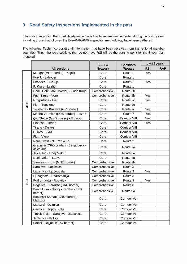
3 Road Safety Inspections implemented in the past
Information regarding the Road Safety Inspections that have been implemented during the last 3 years,
including those that followed the EuroRAP/iRAP inspection methodology have been gathered.
The following Table incorporates all information that have been received from the regional member
countries. Thus, the road sections that do not have RSI will be the starting point for the 3-year plan
proposal.
All sections SEETO Network
Corridors /Routes
past 3years
RSI iRAP
AL
B
Muriqan(MNE border) - Koplik Core Route 1 Yes
Koplik - Skhoder Core Route 1
Skhoder - F. Kruje Core Route 1 Yes
F. Kruje - Lezhe Core Route 1
Hani i Hotit (MNE border) - Fush Kruje Comprehensive Route 2b
Fush Kruje - Vore Comprehensive Route 2b Yes
Rrogozhine - Fier Core Route 2c Yes
Fier - Tepelene Core Route 2c
Tepelene - Kakavia (GR border) Core Route 2c Yes
Morine Vermice (KOS border) - Lezhe Core Route 7 Yes
Qaf Thane (MKD border) - Elbasan Core Corridor VIII Yes
Elbasan - Tirane Core Corridor VIII Yes
Tirane - Durres Core Corridor VIII
Durres - Vlore Core Corridor VIII
Fier - Vlore Core Corridor VIII
BIH
Neum west - Neum South Core Route 1
Gradiska (CRO border) - Banja Luka - Jajce Jug
Core Route 2a
Jajce Jug - Donji Vakuf Core Route 2a
Donji Vakuf - Lasva Core Route 2a
Sarajevo - Hum (MNE border) Comprehensive Route 2b
Sarajevo - Lapisnica Comprehensive Route 3
Lapisnica - Ljubogosta Comprehensive Route 3 Yes
Ljubogosta - Podromanija Comprehensive Route 3
Podromanija - Rogatica Comprehensive Route 3 Yes
Rogatica - Vardiste (SRB border) Comprehensive Route 3
Banja Luka - Doboj - Karakaj (SRB border)
Comprehensive Route 9a
Bosanski Samac (CRO border) - Matuzici
Core Corridor Vc
Matuzici - Ozimica Core Corridor Vc
Ozimica - Topcic Polje Core Corridor Vc
Topcic Polje - Sarajevo - Jablanica Core Corridor Vc
Jablanica - Potoci Core Corridor Vc
Potoci - Doljani (CRO border) Core Corridor Vc

13
All sections SEETO Network
Corridors /Routes
past 3years
RSI iRAP
MK
D
Djeneral Jankovic (KOS border) - Skopje
Core Route 6a Yes
Podmolje - Bitola Comprehensive Route 8 Yes
Miladinovci - Stip - Novo Selo (BG border)
Comprehensive Route 10 Yes
Kafasan (ALB border) - Skopje Core Corridor VIII Yes
Skopje - Stracin Core Corridor VIII Yes
Stracin - Kriva Palanka Core Corridor VIII Yes
Kriva Palanka - Deve Bair (BG border) Core Corridor VIII Yes
Tabanovce (SRB border) - Skopje - Bogorodica (GR border)
Core Corridor X Yes
Veles - Prilep Comprehensive Corridor Xd Yes
Prilep - Bitola Comprehensive Corridor Xd Yes
Bitola - Medzitlija (GR border) Comprehensive Corridor Xd Yes
KO
S*
Brnjak (SRB border) - Veternik Comprehensive Route 6a
Veternik - Lipljan Core Route 6a
Lipljan - Hani i Elezit ( MKD border) Core Route 6a
Kuqishte (MNE border) - Kijeve/Kijevo Comprehensive Route 6b
Kijeve/Kijevo - Gjurgjice/Djurdjice Comprehensive Route 6b
Gjurgjice/Djurdjice - Fushe Kosove/Kosovo Polje
Comprehensive Route 6b
Vermice/Vrbnica (ALB border) - Merdare (SRB border)
Core Route 7
MN
E
Debeli Brijeg (CRO border) - Sukobin (ALB border)
Core Route 1
Scepan Polje (BIH border) - Bozaj (ALB border)
Comprehensive Route 2b
Dobrakovo (SRB border) - Mioska Core Route 4
Mioska - Podgorica Core Route 4
Podgorica - Bar Core Route 4
Ribarevine - Dracenovac (SRB border) Comprehensive Route 6a
Kolasin - Kula (KOS border) Comprehensive Route 6b

14
All sections SEETO Network
Corridors /Routes
past 3years
RSI iRAP
SR
B
Uzice - Kotroman (BIH) Comprehensive Route 3
Vatin (RO border) - Belgrade - Orlovaca
Core Route 4
Orlovaca-Stepojevac Core Route 4
Stepojevac-Celije Core Route 4
Celije - Knezevici Core Route 4
Knezevici - Kokin Brod Core Route 4 Yes
Kokin Brod - Gostun (MNE border) Core Route 4
Cacak/Preljina - Mrcajevci Comprehensive Route 5
Mrcajevci - Vrnjci Comprehensive Route 5
Vrnjci - Kamidzora Comprehensive Route 5
Kamidzora- Paracin - Vrska Cuka (BG border)
Comprehensive Route 5
Spiljani (MNE border) - Brnjak (KOS border)
Comprehensive Route 6a
Nis - Merosina Core Route 7 Yes
Merosina - Merdare (KOS border) Core Route 7
Novi Sad/Petrovaradin - Sremska Kamenica
Comprehensive Route 9a
Sremska Kamenica - Irig Comprehensive Route 9a Yes
Irig - Ruma Comprehensive Route 9a
Ruma - Klenak Comprehensive Route 9a Yes
Klenak - Loznica - Mali Zvornik (BIH border)
Comprehensive Route 9a
Batrovci (CRO border) - Kuzmin Core Corridor X
Kuzmin - Sremska Mitrovica Core Corridor X Yes
Sremska Mitrovica - Beograd/Dobanovci
Core Corridor X
Beograd/Dobanovci - Bubanj Potok Core Corridor X
Bubanj Potok - Mali Pozarevac Core Corridor X
Mali Pozarevac - Presevo (MKD border)
Core Corridor X
Horgos (HU border) - Feketic Core Corridor Xb
Feketic-Sirig Core Corridor Xb
Sirig - Beograd/Dobanovci Core Corridor Xb
Nis - Gradina (BG border) Core Corridor Xc

15
4 Three-Year Plan for Road Safety Inspections
4.1 Methodology scheme
A 3-year plan for road safety inspection of the SEETO Core and Comprehensive Road Network has
been prepared. This way, until 2021 the total SEETO Core and Comprehensive Road Network will have
been inspected according to the SEETO manual for Road Safety Inspections, which actually is in line
with the EC 2008/96 Directive.
As an initial stage of road network assessment, the EuroRAP Risk Mapping procedure is proposed
where reliable crash data are easily available. This can then be repeated following e.g. 3-5 years to see
what are the results ad benefits. Risk mapping is a fast and low-cost process of evaluating road corridors
based on reliable crash data, traffic volumes and mapping information. The EuroRAP Risk Mapping is
proposed to be adopted only in the case that the required data are readily available and reliable.
In order to prepare the Plan for RSI, first the road safety inspections that have been implemented within
the last 3 years will be taken into consideration and the relevant road sections will be excluded.
Afterwards, the (pilot) Road Safety Inspections performed under Activity 4 of the Connecta project will
be taken into account, as well. Thus, the three-year Plan will be established for the rest of road sections
(that have not been inspected).
The approach for the Plan is recommended, as follows:
The road network under consideration should be surveyed according to the iRAP methodology in order
to classify the road sections under one of the five risk rating categories. This procedure could be
completed by the end of 2018.
The ‘traditional’ Road Safety Inspection using SEETO’s road safety inspection guidelines should be
performed as follows:
The 1st year for all 1-star road sections
The 2nd year for all 2- and 3-star road sections
The 3rd year for all 4- and 5-star road sections.
This 2-step approach has as scope to quickly proceed with the assessment of the most dangerous road
sections. Performing ‘traditional’ RSI requires substantial resources, effort, time and budget.
Furthermore, the execution of a large scale (in terms of road length) ‘traditional’ RSI would present
outcomes after a considerable time period. Thus, implementing gradually the ‘traditional’ RSI to the
Core and Comprehensive road network, according to the available budget, seems the most logical
process. Therefore, in order to categorize at safety levels the road network, and give more importance
and substance to the most dangerous sections, the initial assessment with the iRAP methodology is
the quickest, least expensive and most acceptable process.
4.1.1 EuroRAP Road Risk Mapping
Risk Maps are colour-coded maps showing the risk of death and/or serious injury on individual road
sections across a road network. This could as mentioned above be used by Regional Participants that
have reliable and readily available crash data to compare the before and after situation. If data are not
reliable and readily available the Regional Participant should follow the suggested process with iRAP
screening and then traditional road safety inspections and not wait for crash data to be available.

16
Risk Maps are statistically designed to support national road safety strategies and add an extra layer
of information alongside existing approaches. Using an international and common basis of
measurement that can be used to assess priorities, Risk Mapping identifies the safest and most
dangerous road sections within a region or country. Comparisons between countries enable
benchmarking and progress to be tracked. Knowing where risk has been reduced and the measures
that have worked are essential in building best practice and knowledge transfer.
Risk Mapping, by its very nature, relies on the use of historic crash and traffic flow data. As such, when
published, some routes may already have had road safety improvements. Others may be more difficult
to change and on these roads it is particularly important for road users to be aware that they face higher
risks than they might expect. Risk Mapping should therefore be updated at regular intervals to ensure
that they represent the most up-to-date picture.
Risk Maps based on crash rates show the combined influence of behaviour, road and vehicle. Rates
per vehicle kilometre travelled can show the likelihood of a particular type of road-user (e.g. car driver,
motorcyclist, lorry driver), on average, being involved in a road crash.
4.1.1.1 Road length
To identity road sections which demonstrate differences in general road standard performance, it is
essential to assess lengths that minimise the impact of year-on-year variability in crash numbers and
present a stable longer term estimate of crash risk.
While it is typical for fatal and serious crash rates to differ from road type group averages, variability is
considerably greater for short sections. Where a section comprises a short length between junctions,
crash rates may be unrepresentative of average rates, since crashes at junctions will form a
disproportionately large contribution to the total in that length. This may be due to a proportionately
higher influence from junction crashes at the ends of the short sections.
Sections less than 5kms tends to show greater year-on-year variability in crash numbers, were more
likely to change risk rating from one period to another, and were therefore less reliable when compared
over time. For motorways and dual and single carriageways these differences were significant up to
section lengths of 10kms.
When assessing whether individual sections have fatal and serious crash rates that are above or below
average, minimum thresholds of 10kms for motorways and dual carriageways and 5kms for single
carriageways should be used as a starting point in assessing crash numbers. Where it is not possible
to aggregate short sections, care must be taken when interpreting risk ratings.
4.1.1.2 Crash data
EuroRAP protocols focus on fatal and serious crashes. In addition to reflecting the key policy targets
across Europe, such crashes reflect the ability of the road design to ‘contain’ the event and are likely to
be reported more consistently than those falling in the ‘slight injuries’ and ‘damage only’ categories.
They also represent the severity levels generally used in national targets and those that can have life-
changing consequences.
EuroRAP Road Risk Mapping presents crashes at the severe end of the crash spectrum and provides
adjustment factors to allow for differences between countries in reporting, standard crash definitions
and elements such as the quality of medical care that may influence these issues. These factors are
based on standard ratios between the number of fatal and serious crashes using values that are
reviewed at frequent intervals as new evidence is presented.
Analysis has shown that when crash numbers are compared over time, the general relationship is
strong, but the variation in frequency can become large when the numbers fall below 20 crashes per
road section over three years.
17
4.1.1.3 Traffic flow
Traffic flow data is used as an exposure measure in expressions of fatal and serious crash risk in
EuroRAP Road Risk Mapping.
4.1.1.4 Assessment period
A widely misunderstood aspect of road safety relates to the way in which crash numbers vary from year
to year and can appear to show a trend that requires urgent attention, only for the trend to reverse a
year later. Regression-to-mean, also sometimes called ‘bias by selection’, can complicate evaluations
at sites with high crash numbers. Locations chosen for treatment following a year with particularly high
numbers, often in practice will tend to reduce in the next year even if no treatment is applied. It is
believed that the regression-to-mean effect can over-state the effect of a treatment by 5-30%,
dependent on the assessment period.
A simple way of assessing regression-to-mean and changes in the environment is by using control sites
chosen in exactly the same way as the treated sites, identified as having similar problems, but left
untreated. In practice, it is difficult to find matched control sites and, if investigated, to justify not treating
them.
The effect does, however, tend to be diminished if longer periods of time are selected.
Where crash numbers are insufficient to meet the criteria suggested of 20 per road section over three
years, the data period could be extended. However, it should be noted that extending the period beyond
three years will increase the likelihood of significant network changes over the period of investigation
and therefore a thorough review of planned or potential large scale changes should be assessed at an
early stage. Some variance over time may therefore not show up. In some circumstances lack of change
in the colour banding of the same road section over time may be a good indicator of the robustness of
the technique.
4.1.2 The iRAP Method
The protocols are developed by the International Road Assessment Programme (iRAP). iRAP is a
registered charity dedicated to saving lives through safer roads. The programme is the umbrella
organisation for EuroRAP, AusRAP, usRAP, KiwiRAP and ChinaRAP. Road Assessment Programmes
(RAP) are now active in many countries worldwide.
iRAP provides tools for inspecting roads and developing Star Ratings, Safer Roads Investment Plans
and Risk Maps.
The main objective of the iRAP method is the improvement of the road users’ safety by proposing cost-
effective investment plans. The method indicates that the severity of a road crash can be reduced
through the intervention at the sequence of events happening during this crash. As it is known, an injury
crash results from a chain of events, starting with an initial event, probably resulting from several factors,
which leads to a dangerous situation. The basic idea is to intervene at any point of this chain, in order
to reduce the kinetic energy of all road users who are involved in the crash to a tolerable level. Such an
intervention may not only reduce the number of crashes but also the severity of injuries.
The initial step for the implementation of the RAP method is the inspection and record of the
infrastructure elements of a road network, which relate to road safety. The record leads to the
quantification of the safety that a road section provides to its users by awarding safety scores (Star
Rating Scores). The Star Rating Scores express the safety capacity of a road section in a 5-Stars scale.
This quantification aims to identifying the most appropriate countermeasures, which will increase the
infrastructure’s road safety score. The Safer Roads Investment Plan (SRIP) includes all the

18
countermeasures proved able to provide the greater safety capacity and maximize the benefit over
spent cost of the planned investments. Thus, the SRIPs are considered as a valuable tool for the
authorities, stakeholders and investors in order to decide for the most cost-effective and efficient road
infrastructure investments.
4.1.2.1 Measuring the road infrastructure safety
The assessment of road safety requires Road Safety Inspections of the road network sections and the
assignment of a safety score to them. The inspection is conducted by visual observation and record of
the road infrastructure elements which are related (directly or not) to road safety and have a proven
influence on the likelihood of a crash or its severity. The RAP uses two types of inspection; the drive-
through and the video-based inspection. During the first one, the record of the infrastructure’s elements
is performed manually, with the help of specialized software, while during the second, a specially
equipped vehicle is used, so as the recorded video to be used for a virtual drive-through of the network
and an automated identification of the infrastructure’s elements.
Following the RSI, the Road Protection Score (RPS) is calculated. The RPS is a unit-less indicator,
which depicts the infrastructure’s safety capacity for each road user type and it is calculated for 100m
road segments. Road user types considered are car occupants, motorcyclists, bicyclists and
pedestrians, who may be involved in road crashes. For each road user type and for every 100m road
segmentation the respective RPS is calculated as follows:
n,u n,u,c n,u,c n,u,c n,u,c n,u,c n,u,cc c
RPS = RPS = L * S * OS * EFI * MT
where “n” is the number of 100m road segment, “u” the type of road user and “c” the crash type that the
road user type “u” may be involved in. The following variables are taken into consideration:
L: the Likelihood that the “i” crash may be initiated
S: the Severity of the “i” crash
OS: the degree to which risk changes with the Operating Speed for the specific “i” crash type
EFL: the degree to which a person’s risk of being involved in the “i” type of crash is a function of another person’s use of the road (External Flow Influence)
MT: the potential that an errant vehicle will cross a median (Median Traversability).
4.1.2.2 The Star Rating process
The aim of the Star Rating process is the award of the “n” 100m road segments with Stars, depicting
the safety offered to each of the “u” road users’ types. The Star Rating system uses the typical
international practice of recognising the best performing category as 5-star and the worst as 1-star (5
stars scale), so that a 5-star road means that the probability of a crash occurrence, which may lead to
death or serious injury is very low. The Star Rate is determined by assigning each RPS calculated to
the Star Rating bands. The thresholds of each band are different for each road user and were set
following significant sensitivity testing to determine how RPS varies with changes in road infrastructure
elements. The assignment procedure leads to the development of a risk-worm chart, which depicts the
variation of the RPS score in relation to the position (distance from the beginning) on the road under
consideration. The final output of the Star Rating is the Star Rating Maps, in which the “n” road sections
are shown with different colour, depending on their Star award (5-star green and 1-star black).

19
4.1.3 The ‘traditional’ RSI
The ‘traditional’ RSI is performed according to the SEETO guidelines for Road Safety Inspections. The
inspection process is presented at the following figure.
The following steps outline the procedure of the inspector’s work:
STEP 1 Preparatory work in the office
STEP 2 On-site field study
STEP 3 RSI report
STEP 4 Remedial measures and follow-up.
START OF THE RSI
Client awards RSI to the inspector
Client hands over all documents/data to the inspector
Independent RSI report prepared by the inspector
Client decides whether to implement RSI report
END OF THE RSI
Client considers: proposed
measures accepted
Client explains the reasons for rejecting proposed measures
RSI
report shows no safety problems
Client considers: proposed
measures not accepted
Ordering
Undertaking
Completion

20
4.1.3.1 The partners in the RSI process and their roles
The client (usually the road authority or private road operating company) and the inspector (or team of
Inspectors) participate in the inspection process.
Order the RSI: Usually, the decision to order an inspection is taken by the client (road authority).
However, it may be regulated by a Ministry decision or by law as well as by the financing donor.
Selecting the team: The client commissions the inspector, who can either be an individual or a team. A
list of potential inspectors compiled by the client can be helpful for the selection process. It is important
to consider including members with experience regarding all aspects of facility maintenance including
signage, traffic lighting control, vegetation, snow removal, etc. It may be useful to include a police officer
who is experienced in road safety and crash investigation.
4.1.3.2 Preparatory work in the office
Background information about the road, the function of the road, the standard of the road and traffic
volumes should be obtained as a first step. Information from local residents might prove useful and can
be obtained through face-to-face discussions or a questionnaire. The list below provides information
about the sort of questions that should be asked and the answers recorded during the preparatory work:
Road function
Traffic situation
Road standards.
The RSI team should have the necessary equipment to perform their tasks.
4.1.3.3 Field Study
When an intersection is included in the road to be inspected it is necessary to inspect part of the
intersecting road as well (at least the approaches), both by vehicle and on foot. Site inspections should
be undertaken over a range of traffic and environmental conditions likely to be encountered. Both night-
time and daytime inspections are essential to appreciate the situation. It may also be necessary to view
the location at other times of the day (e.g. when school finishes, during peak hours or the weekly
market). The core part of the RSI is to identify deficiencies on the road that may cause crashes or could
have an influence on the severity of crashes.
4.1.3.4 RSI findings and report
The RSI team or expert notes in the report the problems detected and provides recommendation on
inventions and measures that will reduce or remove the road safety problem. The RSI team may also
do an assessment of the risk, e.g. High, Medium or Low.
4.1.3.5 Completion of the RSI
Upon receipt of the report, the client must consider the indicated problems and proposals and make a
decision on how or if the proposed measures will be implemented. A ‘Completion meeting’ should be
organised in order to finalise the ‘Response to the inspection report’.
4.1.3.6 Follow-up and evaluation
For the foreseen periodic RSI of the core network it is very important that sufficient and an effective way
for serious follow up is identified.

21
In addition, it could be helpful to conduct some studies at a later time to evaluate the effects of the
remedial measures. The road authority could organise such. Behavioural studies should be carried out
in the same way and in the same locations as during the investigation. Traffic volumes and speeds
should be checked, as well as the traffic environment.
4.2 Requirements - Qualifications
There are specific requirements for the realization of this 3-year plan, in terms of capacity/capability and
resources.
4.2.1 EuroRAP road risk mapping requirements
Members may only use the RAP Road Risk Mapping protocol if they have a licence to do so. The licence
gives access to the detailed specifications for data collation and analysis, ensuring consistency of output
in form and style. The licence also appoints the Member as principal manager and communications
outlet within a territory and gives access to the EuroRAP name and logo for the communication of
results. The organisation has specific standards and procedures that should be followed. More detailed
information may be found at the official EuroRAP site (www.eurorap.net).
Additionally, it is obligatory that risk maps produced to be Quality Assured. This, again, is a procedure
according to specific standards.
In terms of performance, it is envisaged that (on average) a country’s road network may be risk mapped
within one month of an accredited consultant.
4.2.2 iRAP requirements
An iRAP may be performed only by a certified supplier of iRAP. The organisation has specific standards
and procedures that should be followed. Furthermore, there are specific procedures for someone to be
accredited by iRAP. More detailed information may be found at the official site of iRAP (www.irap.org).
Additionally, it is obligatory that all road sections assessed according to iRAP methodology, to be
Quality Assured. This, again, is a procedure according to specific standards.
Finally, there is the availability of uploading all iRAP assessed road section to a cloud-based software
(named ViDA), where various analyses may be performed. In order to achieve this, specific training
needs to be obtained.
In terms of performance, it is envisaged that an average of 30 km road length may be completed
within one working day of the iRAP Team (based on international experience).
4.2.3 Traditional RSI
The team performing ‘traditional’ RSI (based on the SEETO Road Safety Inspection manual) should be
comprised, ideally, by 3 persons (team leader and 2 members).
The RSI team should be comprised by experienced road safety engineers, with more than 10 years of
experience on the field. The team leader should be a certified road safety inspector and/or auditor.

22
In terms of performance, it is envisaged that an average of 10 km road length may be completed
within one working day of the RSI Team (based on international experience, but also experience that
Connecta RSI team gained during pilots in the context of this sub-project). This comprises both field
work and reporting.
4.3 The 3-year plan proposal
The following Table incorporates all information that has been received by the WB6 Regional
Participants member countries. It also contains the RSI conducted by Connecta as “pilots”
(approximately 580 km of the network).
All sections SEETO NetworkCorridors /
Routespast RSI
past/
current
iRAP
Connecta
pilot RSI
Missing
RSI
Muriqan(MNE border) - Koplik Core Route 1
Koplik - Skhoder Core Route 1
Skhoder - F. Kruje Core Route 1
F. Kruje - Lezhe Core Route 1
Hani i Hotit (MNE border) - Fush Kruje Comprehensive Route 2b
Fush Kruje - Vore Comprehensive Route 2b
Rrogozhine - Fier Core Route 2c
Fier - Tepelene Core Route 2c
Tepelene - Kakavia (GR border) Core Route 2c
Morine Vermice (KOS border) - Lezhe Core Route 7
Qaf Thane (MKD border) - Elbasan Core Corridor VIII
Elbasan - Tirane Core Corridor VIII
Tirane - Durres Core Corridor VIII
Durres - Vlore Core Corridor VIII
Fier - Vlore Core Corridor VIII
Neum west - Neum South Core Route 1
Gradiska (CRO border) - Banja Luka - Jajce Jug Core Route 2a
Jajce Jug - Donji Vakuf Core Route 2a
Donji Vakuf - Lasva Core Route 2a
Sarajevo - Hum (MNE border) Comprehensive Route 2b
Sarajevo - Lapisnica Comprehensive Route 3
Lapisnica - Ljubogosta Comprehensive Route 3
Ljubogosta - Podromanija Comprehensive Route 3
Podromanija - Rogatica Comprehensive Route 3
Rogatica - Vardiste (SRB border) Comprehensive Route 3
Banja Luka - Doboj - Karakaj (SRB border) Comprehensive Route 9a
Bosanski Samac (CRO border) - Matuzici Core Corridor Vc
Matuzici - Ozimica Core Corridor Vc
Ozimica - Topcic Polje Core Corridor Vc
Topcic Polje - Sarajevo - Jablanica Core Corridor Vc
Jablanica - Potoci Core Corridor Vc
Potoci - Doljani (CRO border) Core Corridor Vc
Djeneral Jankovic (KOS border) - Skopje Core Route 6a
Podmolje - Bitola Comprehensive Route 8
Miladinovci - Stip - Novo Selo (BG border) Comprehensive Route 10
Kafasan (ALB border) - Skopje Core Corridor VIII
Skopje - Stracin Core Corridor VIII
Stracin - Kriva Palanka Core Corridor VIII
Kriva Palanka - Deve Bair (BG border) Core Corridor VIII
Tabanovce (SRB border) - Skopje - Bogorodica (GR border) Core Corridor X
Veles - Prilep Comprehensive Corridor Xd
Prilep - Bitola Comprehensive Corridor Xd
Bitola - Medzitlija (GR border) Comprehensive Corridor Xd
Brnjak (SRB border) - Veternik Comprehensive Route 6a
Veternik - Lipljan Core Route 6a
Lipljan - Hani i Elezit ( MKD border) Core Route 6a
Kuqishte (MNE border) - Kijeve/Kijevo Comprehensive Route 6b
Kijeve/Kijevo - Gjurgjice/Djurdjice Comprehensive Route 6b
Gjurgjice/Djurdjice - Fushe Kosove/Kosovo Polje Comprehensive Route 6b
Vermice/Vrbnica (ALB border) - Merdare (SRB border) Core Route 7
Debeli Brijeg (CRO border) - Sukobin (ALB border) Core Route 1
Scepan Polje (BIH border) - Bozaj (ALB border) Comprehensive Route 2b
Dobrakovo (SRB border) - Mioska Core Route 4
Mioska - Podgorica Core Route 4
Podgorica - Bar Core Route 4
Ribarevine - Dracenovac (SRB border) Comprehensive Route 6a
Kolasin - Kula (KOS border) Comprehensive Route 6b
Uzice - Kotroman (BIH) Comprehensive Route 3
Vatin (RO border) - Belgrade - Orlovaca Core Route 4
Orlovaca-Stepojevac Core Route 4
Stepojevac-Celije Core Route 4
Celije - Knezevici Core Route 4
Knezevici - Kokin Brod Core Route 4
Kokin Brod - Gostun (MNE border) Core Route 4
Cacak/Preljina - Mrcajevci Comprehensive Route 5
Mrcajevci - Vrnjci Comprehensive Route 5
Vrnjci - Kamidzora Comprehensive Route 5
Kamidzora- Paracin - Vrska Cuka (BG border) Comprehensive Route 5
Spiljani (MNE border) - Brnjak (KOS border) Comprehensive Route 6a
Nis - Merosina Core Route 7
Merosina - Merdare (KOS border) Core Route 7
Novi Sad/Petrovaradin - Sremska Kamenica Comprehensive Route 9a
Sremska Kamenica - Irig Comprehensive Route 9a
Irig - Ruma Comprehensive Route 9a
Ruma - Klenak Comprehensive Route 9a
Klenak - Loznica - Mali Zvornik (BIH border) Comprehensive Route 9a
Batrovci (CRO border) - Kuzmin Core Corridor X
Kuzmin - Sremska Mitrovica Core Corridor X
Sremska Mitrovica - Beograd/Dobanovci Core Corridor X
Beograd/Dobanovci - Bubanj Potok Core Corridor X
Bubanj Potok - Mali Pozarevac Core Corridor X
Mali Pozarevac - Presevo (MKD border) Core Corridor X
Horgos (HU border) - Feketic Core Corridor Xb
Feketic-Sirig Core Corridor Xb
Sirig - Beograd/Dobanovci Core Corridor Xb
Nis - Gradina (BG border) Core Corridor Xc
SR
BA
LB
BIH
KO
S*
MK
DM
NE

23
The previous table shows (last column) the road sections that have not been inspected during the last
three years (either with ‘traditional’ RSI or with EuroRAP/iRAP methodology) and not included in the
Connecta pilot RSI.
It is suggested that for the remaining road sections (road network that has not been inspected during
the last three years and not included at Connecta pilot RSI – column ‘missing RSI’ of previous table)
the following methodological approach to be followed:
1. Prepare iRAP maps, according to the star rating methodology.
2. Perform detailed road safety inspections for the road sections that have the worst performance
according to the iRAP star rating methodology as described in section 4.1.
It is estimated that if a RP performs RSI for the 20% of the country’s core and comprehensive road
network, within 5 years the whole network will have been inspected. If funds are short, the iRAP may
be performed and the RSI will focus only at the less performed road sections.
All sections SEETO NetworkCorridors /
Routespast RSI
past/
current
iRAP
Connecta
pilot RSI
Missing
RSI
Muriqan(MNE border) - Koplik Core Route 1
Koplik - Skhoder Core Route 1
Skhoder - F. Kruje Core Route 1
F. Kruje - Lezhe Core Route 1
Hani i Hotit (MNE border) - Fush Kruje Comprehensive Route 2b
Fush Kruje - Vore Comprehensive Route 2b
Rrogozhine - Fier Core Route 2c
Fier - Tepelene Core Route 2c
Tepelene - Kakavia (GR border) Core Route 2c
Morine Vermice (KOS border) - Lezhe Core Route 7
Qaf Thane (MKD border) - Elbasan Core Corridor VIII
Elbasan - Tirane Core Corridor VIII
Tirane - Durres Core Corridor VIII
Durres - Vlore Core Corridor VIII
Fier - Vlore Core Corridor VIII
Neum west - Neum South Core Route 1
Gradiska (CRO border) - Banja Luka - Jajce Jug Core Route 2a
Jajce Jug - Donji Vakuf Core Route 2a
Donji Vakuf - Lasva Core Route 2a
Sarajevo - Hum (MNE border) Comprehensive Route 2b
Sarajevo - Lapisnica Comprehensive Route 3
Lapisnica - Ljubogosta Comprehensive Route 3
Ljubogosta - Podromanija Comprehensive Route 3
Podromanija - Rogatica Comprehensive Route 3
Rogatica - Vardiste (SRB border) Comprehensive Route 3
Banja Luka - Doboj - Karakaj (SRB border) Comprehensive Route 9a
Bosanski Samac (CRO border) - Matuzici Core Corridor Vc
Matuzici - Ozimica Core Corridor Vc
Ozimica - Topcic Polje Core Corridor Vc
Topcic Polje - Sarajevo - Jablanica Core Corridor Vc
Jablanica - Potoci Core Corridor Vc
Potoci - Doljani (CRO border) Core Corridor Vc
Djeneral Jankovic (KOS border) - Skopje Core Route 6a
Podmolje - Bitola Comprehensive Route 8
Miladinovci - Stip - Novo Selo (BG border) Comprehensive Route 10
Kafasan (ALB border) - Skopje Core Corridor VIII
Skopje - Stracin Core Corridor VIII
Stracin - Kriva Palanka Core Corridor VIII
Kriva Palanka - Deve Bair (BG border) Core Corridor VIII
Tabanovce (SRB border) - Skopje - Bogorodica (GR border) Core Corridor X
Veles - Prilep Comprehensive Corridor Xd
Prilep - Bitola Comprehensive Corridor Xd
Bitola - Medzitlija (GR border) Comprehensive Corridor Xd
Brnjak (SRB border) - Veternik Comprehensive Route 6a
Veternik - Lipljan Core Route 6a
Lipljan - Hani i Elezit ( MKD border) Core Route 6a
Kuqishte (MNE border) - Kijeve/Kijevo Comprehensive Route 6b
Kijeve/Kijevo - Gjurgjice/Djurdjice Comprehensive Route 6b
Gjurgjice/Djurdjice - Fushe Kosove/Kosovo Polje Comprehensive Route 6b
Vermice/Vrbnica (ALB border) - Merdare (SRB border) Core Route 7
Debeli Brijeg (CRO border) - Sukobin (ALB border) Core Route 1
Scepan Polje (BIH border) - Bozaj (ALB border) Comprehensive Route 2b
Dobrakovo (SRB border) - Mioska Core Route 4
Mioska - Podgorica Core Route 4
Podgorica - Bar Core Route 4
Ribarevine - Dracenovac (SRB border) Comprehensive Route 6a
Kolasin - Kula (KOS border) Comprehensive Route 6b
Uzice - Kotroman (BIH) Comprehensive Route 3
Vatin (RO border) - Belgrade - Orlovaca Core Route 4
Orlovaca-Stepojevac Core Route 4
Stepojevac-Celije Core Route 4
Celije - Knezevici Core Route 4
Knezevici - Kokin Brod Core Route 4
Kokin Brod - Gostun (MNE border) Core Route 4
Cacak/Preljina - Mrcajevci Comprehensive Route 5
Mrcajevci - Vrnjci Comprehensive Route 5
Vrnjci - Kamidzora Comprehensive Route 5
Kamidzora- Paracin - Vrska Cuka (BG border) Comprehensive Route 5
Spiljani (MNE border) - Brnjak (KOS border) Comprehensive Route 6a
Nis - Merosina Core Route 7
Merosina - Merdare (KOS border) Core Route 7
Novi Sad/Petrovaradin - Sremska Kamenica Comprehensive Route 9a
Sremska Kamenica - Irig Comprehensive Route 9a
Irig - Ruma Comprehensive Route 9a
Ruma - Klenak Comprehensive Route 9a
Klenak - Loznica - Mali Zvornik (BIH border) Comprehensive Route 9a
Batrovci (CRO border) - Kuzmin Core Corridor X
Kuzmin - Sremska Mitrovica Core Corridor X
Sremska Mitrovica - Beograd/Dobanovci Core Corridor X
Beograd/Dobanovci - Bubanj Potok Core Corridor X
Bubanj Potok - Mali Pozarevac Core Corridor X
Mali Pozarevac - Presevo (MKD border) Core Corridor X
Horgos (HU border) - Feketic Core Corridor Xb
Feketic-Sirig Core Corridor Xb
Sirig - Beograd/Dobanovci Core Corridor Xb
Nis - Gradina (BG border) Core Corridor Xc
SR
BA
LB
BIH
KO
S*
MK
DM
NE

24
4.3.1 Cost estimations
In order to estimate the cost of the proposed assessments, the following assumptions have been taken
under consideration.
For EuroRAP Road Risk Mapping implementation, an accredited consultant would require (if data is
readily available) a team work of data and map processing.
Taken into account all cost items involved, it is estimated that the total cost per km of length
included at the Risk Map is between 20€ and 30€. The total cost incorporates all associated required
costs (i.e. QA, mapping according to standards, etc.).
For iRAP implementation, a licenced team leader along with two junior members are required.
Furthermore, an accredited iRAP system needs to be involved. Lastly, according to the iRAP protocol
a Quality Assurance procedure needs to be followed.
In terms of resources required, adapting the assumption that for iRAP implementation, overall and as
an average, in terms of performance, the iRAP team may complete 30 km of road length within a
working day, the average cost per km may be estimated. This assumption of performance, integrates
the time and cost for survey planning, field tasks, elements coding, data uploading to ViDA, and
reporting.
Taken into account all cost items involved, it is estimated that the total cost per km of length
assessed is between 100€ and 120€. The total cost incorporates all associated required costs (i.e.
iRAP system, labour, reporting, etc.).
For the ‘traditional’ RSI, three road safety experts (one team leader and two team members) need to
be involved. Since considerable time is on field, travel and accommodation costs are also involved.
In terms of resources required, having in mind that approximately 10 km of road length may be inspected
at a working day of the ‘traditional’ RSI team, as an average estimation and overall of a road network,
the average required budget per road length in km may be estimated. This estimation includes the costs
and time spent by the ‘traditional’ RSI team for meetings, planning, inspecting and reporting, as well as
of travel and accommodation, etc.
Taken into account all cost items involved, it is estimated that the total cost per km of length
inspected is at the range of 300€ to 350€. The total cost incorporates all associated necessary costs
(i.e. equipment, labour, per diems, reporting, etc.).
The above indicative cost ranges are based on the hypothesis of inspections to be conducted by private
contractor (as per ToR) and with a team of international (at least the leader) and local experts.
4.3.2 Albania
EuroRAP Road Risk Mapping for the whole core and comprehensive Albania network is anticipated to
cost between 17,000€ and 26,000€.
The following table presents the road sections that either have not been inspected in the last 3 years or
were not inspected as part of the Connecta pilot RSI.

25
SEETO Network
iRAP ‘traditional’ RSI
Road sections Corridors/Routes min max min max
Hani i Hotit (MNE border) - Fush Kruje
Comprehensive Route 2b 32.100 37.450
Fier - Tepelene Core Route 2c 24.600 28.700
Durres - Vlore Core Corridor VIII 35.700 41.650
The total length of the above mentioned road sections is approximately 310 km. Since it is relatively
small length, it is recommended to skip the initial phase of iRAP survey and rating, and proceed with
‘traditional’ road safety inspections.
Thus, it is proposed to implement RSI of approx. 100km per year, for the next 3 years.
The anticipated cost is between 92,500€ and 108,000€.
4.3.3 Bosnia and Herzegovina
EuroRAP Road Risk Mapping for the whole core and comprehensive Bosnia and Herzegovina network
is anticipated to cost between 21,000€ and 32,000€.
The following table presents the road sections that either have not been inspected in the last 3 years or
were not inspected as part of the Connecta pilot RSI.
SEETO Network
iRAP ‘traditional’ RSI
Road sections Corridors/Routes min max min max
Neum west - Neum South
Core Route 1 500 600 1.500 1.750
Gradiska (CRO border) - Banja Luka - Jajce Jug
Core Route 2a 12.700 15.240 38.100 44.450
Donji Vakuf - Lasva Core Route 2a 6.800 8.160 20.400 23.800
Sarajevo - Hum (MNE border)
Comprehensive Route 2b 9.700 11.640 29.100 33.950
Sarajevo - Lapisnica
Comprehensive Route 3 250 300 750 875
Ljubogosta - Podromanija
Comprehensive Route 3 2.750 3.300 8.250 9.625
Rogatica - Vardiste (SRB border)
Comprehensive Route 3 6.560 7.872 19.680 22.960
Banja Luka - Doboj - Karakaj (SRB border)
Comprehensive Route 9a 19.800 23.760 59.400 69.300
Bosanski Samac (CRO border) - Matuzici
Core Corridor Vc 8.000 9.600 24.000 28.000
Topcic Polje - Sarajevo - Jablanica
Core Corridor Vc 16.820 20.184 50.460 58.870
Potoci - Doljani (CRO border)
Core Corridor Vc 6.200 7.440 18.600 21.700
The total length of the above mentioned road sections is approximately 900 km.

26
According to the recommended approach, iRAP methodology is recommended for these road sections.
This task could be fulfilled until the end of 2018.
According to the iRAP output, the 1-star ranking road sections are recommended to be ‘traditionally’
road safety inspected within 2019. The 2- and 3- star ranking road sections should follow and implement
‘traditional’ RSI until April 2021. Finally, for the 4- and 5- star ranking road sections is recommended to
implement ‘traditional’ RSI until end 2021. It is noted that, the exact percentage of 1-star (or 2-star and
so on) ranking road length over the total network could be known before iRAP is implemented, thus
assumptions are applied.
The total anticipated cost is 90,000€ - 108,000€ for iRAP and from 270,000€ to 315,000€ for ‘traditional’
RSI.
4.3.4 The former Yugoslav Republic of Macedonia
EuroRAP Road Risk Mapping for the whole core and comprehensive former Yugoslav Republic of
Macedonia network is anticipated to cost between 16,500€ and 25,000€.
In MKD, a project that implements iRAP methodology for all Core and Comprehensive Road Network
is ongoing. The results are expected soon. Therefore, there is no need for further iRAP implementation.
The following table presents the road sections that either have not been inspected in the last 3 years or
were not inspected as part of the Connecta pilot RSI.
SEETO Network
iRAP ‘traditional’ RSI
Road sections Corridors/Routes min max min max
Djeneral Jankovic (KOS border) - Skopje
Core Route 6a 1.600 1.920 4.800 5.600
Podmolje - Bitola Comprehensive Route 8 7.800 9.360 23.400 27.300
Miladinovci - Stip - Novo Selo (BG border)
Comprehensive Route 10 14.200 17.040 42.600 49.700
Kafasan (ALB border) - Skopje
Core Corridor VIII 19.000 22.800 57.000 66.500
Skopje - Stracin Core Corridor VIII 6.200 7.440 18.600 21.700
Kriva Palanka - Deve Bair (BG border)
Core Corridor VIII 1.600 1.920 4.800 5.600
Tabanovce (SRB border) - Skopje - Bogorodica (GR border)
Core Corridor X 18.100 21.720 54.300 63.350
Veles - Prilep Comprehensive Corridor Xd 6.100 7.320 18.300 21.350
Bitola - Medzitlija (GR border)
Comprehensive Corridor Xd 1.400 1.680 4.200 4.900
The total length of the above mentioned road sections is approximately 760 km.
According to the iRAP output, the 1-star ranking road sections are recommended to be ‘traditionally’
road safety inspected until the half of 2019. The 2- and 3- star ranking road sections should follow and
implement ‘traditional’ RSI until end 2020. Finally, for the 4- and 5- star ranking road sections is
recommended to implement ‘traditional’ RSI until end 2021. It is noted that, the exact portion of 1-star
(or 2-star and so on) ranking road length over the total network is not known yet, therefore assumptions
are applied.
27
The anticipated total cost is between 228,000€ and 266,000€.
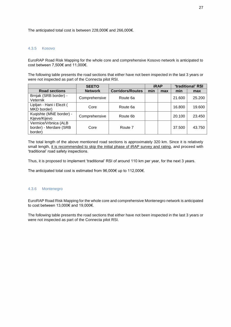
4.3.5 Kosovo
EuroRAP Road Risk Mapping for the whole core and comprehensive Kosovo network is anticipated to
cost between 7,500€ and 11,000€.
The following table presents the road sections that either have not been inspected in the last 3 years or
were not inspected as part of the Connecta pilot RSI.
SEETO Network
iRAP ‘traditional’ RSI
Road sections Corridors/Routes min max min max
Brnjak (SRB border) - Veternik
Comprehensive Route 6a 21.600 25.200
Lipljan - Hani i Elezit ( MKD border)
Core Route 6a 16.800 19.600
Kuqishte (MNE border) - Kijeve/Kijevo
Comprehensive Route 6b 20.100 23.450
Vermice/Vrbnica (ALB border) - Merdare (SRB border)
Core Route 7 37.500 43.750
The total length of the above mentioned road sections is approximately 320 km. Since it is relatively
small length, it is recommended to skip the initial phase of iRAP survey and rating, and proceed with
‘traditional’ road safety inspections.
Thus, it is proposed to implement ‘traditional’ RSI of around 110 km per year, for the next 3 years.
The anticipated total cost is estimated from 96,000€ up to 112,000€.
4.3.6 Montenegro
EuroRAP Road Risk Mapping for the whole core and comprehensive Montenegro network is anticipated
to cost between 13,000€ and 19,000€.
The following table presents the road sections that either have not been inspected in the last 3 years or
were not inspected as part of the Connecta pilot RSI.

28
SEETO Network
iRAP ‘traditional’ RSI
Road sections Corridors/Routes min max min max
Debeli Brijeg (CRO border) - Sukobin (ALB border)
Core Route 1 12.200 14.640 36.600 42.700
Scepan Polje (BIH border) - Bozaj (ALB border)
Comprehensive Route 2b 15.400 18.480 46.200 53.900
Dobrakovo (SRB border) - Mioska
Core Route 4 8.100 9.720 24.300 28.350
Podgorica - Bar Core Route 4 5.000 6.000 15.000 17.500
Ribarevine - Dracenovac (SRB border)
Comprehensive Route 6a 7.940 9.528 23.820 27.790
Kolasin - Kula (KOS border)
Comprehensive Route 6b 9.900 11.880 29.700 34.650
The total length of the above mentioned road sections is approximately 590 km.
According to the recommended approach, iRAP methodology is recommended for these road sections.
This task could be fulfilled until the end of 2018.
According to the iRAP output, the 1-star ranking road sections are recommended to be ‘traditionally’
road safety inspected within 2019. The 2- and 3- star ranking road sections should follow and implement
‘traditional’ RSI until April 2021. Finally, for the 4- and 5- star ranking road sections is recommended to
implement ‘traditional’ RSI until end 2021. For the yearly allocation of resources, assumptions are
utilised, since it’s not known what the road length per star category would be.
The total estimated cost is approx. 58,500€ - 70,000€ for iRAP and 175,500€ - 205,000€ for ‘traditional’
RSI.
4.3.7 Serbia
EuroRAP Road Risk Mapping for the whole Serbia core and comprehensive road network is anticipated
to cost between 34,500€ and 52,000€.
The following table presents the road sections that either have not been inspected in the last 3 years or
were not inspected as part of the Connecta pilot RSI.

29
SEETO Network
iRAP ‘traditional’ RSI
Road sections Corridors/Routes min max min max
Uzice - Kotroman (BIH)
Comprehensive Route 3 5.400 6.480 16.200 18.900
Vatin (RO border) - Belgrade - Orlovaca
Core Route 4 11.700 14.040 35.100 40.950
Celije - Knezevici Core Route 4 14.600 17.520 43.800 51.100
Kokin Brod - Gostun (MNE border)
Core Route 4 7.000 8.400 21.000 24.500
Mrcajevci - Vrnjci Comprehensive Route 5 4.400 5.280 13.200 15.400
Kamidzora- Paracin - Vrska Cuka (BG border)
Comprehensive Route 5 13.600 16.320 40.800 47.600
Spiljani (MNE border) - Brnjak (KOS border)
Comprehensive Route 6a 2.800 3.360 8.400 9.800
Merosina - Merdare (KOS border)
Core Route 7 7.100 8.520 21.300 24.850
Irig - Ruma Comprehensive Route 9a 900 1.080 2.700 3.150
Klenak - Loznica - Mali Zvornik (BIH border)
Comprehensive Route 9a 8.000 9.600 24.000 28.000
Batrovci (CRO border) - Kuzmin
Core Corridor X 3.410 4.092 10.230 11.935
Sremska Mitrovica - Beograd/Dobanovci
Core Corridor X 4.760 5.712 14.280 16.660
Mali Pozarevac - Presevo (MKD border)
Core Corridor X 35.000 42.000 105.000 122.500
Horgos (HU border) - Feketic
Core Corridor Xb 7.200 8.640 21.600 25.200
Sirig - Beograd/Dobanovci
Core Corridor Xb 9.090 10.908 27.270 31.815
Nis - Gradina (BG border)
Core Corridor Xc 11.000 13.200 33.000 38.500
The total length of the above mentioned road sections is approximately 1,450 km.
According to the recommended approach, iRAP methodology is recommended for these road sections.
This task could be fulfilled until the end of 2018.
According to the iRAP output, the 1-star ranking road sections are recommended to be ‘traditionally’
road safety inspected within 2019. The 2- and 3- star ranking road sections should follow and implement
‘traditional’ RSI until April 2021. Finally, for the 4- and 5- star ranking road sections is recommended to
implement ‘traditional’ RSI until end 2021. The yearly allocation of ‘traditional’ RSI may only be
estimated at best possible assumption.
The total anticipated cost is approximately 146,000€ - 175,000€ for iRAP and 438,000€ - 511,000€ for
‘traditional’ RSI.

30
4.3.8 Yearly allocation of resources
Based on the previous sections, the following table summarises the required financial resources on a
yearly basis, expressed in Euro currency for complementing inspections in SEETO
core/comprehensive road network. The necessary budget is indicative according to average cost
values per road length and per methodology followed.
Year 1 Year 2 Year 3 Year 4 Total
ALB
EuroRAP 21.500 21.500
iRAP 0
‘traditional' RSI 33.000 33.000 34.000 100.000
BiH
EuroRAP 26.500 26.500
iRAP 99.000 99.000
‘traditional' RSI 135.000 100.000 58.000 293.000
MKD
EuroRAP 9.000 9.000
iRAP 0
‘traditional' RSI 34.000 35.000 35.000 104.000
KOS1
EuroRAP 21.000 21.000
iRAP 0
‘traditional' RSI 110.000 85.000 52.000 247.000
MNE
EuroRAP 16.000 16.000
iRAP 64.500 64.500
‘traditional' RSI 95.000 65.000 30.000 190.000
SRB
EuroRAP 43.500 43.500
iRAP 160.500 160.500
‘traditional' RSI 210.000 165.000 99.000 474.000
Total
EuroRAP 137.500 0 0 0 137.500
iRAP 324.000 0 0 0 324.000
‘traditional' RSI 177.000 593.000 451.000 187.000 1.408.000
This is in fact an up to 3.5 year plan (in contrast to ToR for a 3 year plan), taken into account the date
of this report and the relevant sub-project completion date, as well as the time required for iRAP
implementation.
Hence, it was necessary to extend it till end of 2021, for some RPs with extensive network and
inspection needs.

31
5 Pilot Road Safety Inspections
5.1 The selection – planning process
Pilot road safety inspections have been carried out by the team (Activity 4, according to ToR) using
SEETO’s road safety inspection guidelines on 10% (about 550 km, as per ToR, but finally actually 580
km) of the core and comprehensive road network that is considered highest risk portion of the network
based on fatal crash data.
SEETO members prepared a list of their high risk sections and the team compiled a list of about 550
km of these high risk roads by maintaining a reasonable distribution among all SEETO’s members.
Initially the High Risk Road Sections from all WB6 countries were assessed. The information received
was not comparable and should not be, because all countries have different characteristics and different
problems. The crashes occurring on these roads is only an indication. Normally, it is not possible to
compare between different roads from various countries, if their traffic characteristics, volumes, design,
etc. are not known. Furthermore, the total length either of the TEN-T road network or of the high risk
road sections are not the same in all countries.
As some RPs might not be able to deliver specific crash information for these road sections, and more
importantly the exchange of information (either with meetings or information exchange) at the initial
stage would create more problems (time delays and having a second round of comparing information
between the WB6 countries), a proposal was developed by the team for SEETO and the Road Safety
WG to consider.
The area coverage, the population, the total number of road crashes, the total number of road fatalities,
the total number of road injuries, the relevant figures from WHO, the under-reporting of road safety
statistics, etc. of each country, were taken into consideration along with the team ’s engineering
judgement, and initially the total road section length of each country to be inspected as part of Connecta
project was formed.
Apart from statistics, it was aimed to include a representative sample of each country's road network.
In order to introduce RSI capacity building within each country and have sound information for the plan
to be developed later, it was proposed to have more than one road section within each country and not
less than a total of 40km for each SEETO RP. The only exception to this rationale was Montenegro,
where it was proposed to inspect only one road ("Podgorica- Mioska") instead of two road sections
(namely "Lipci - ljuta" and "Ribarevine - Berane"), because it was considered a much more important
road. Furthermore, it was intended not to underestimate the smaller countries.
Furthermore, since it seems that according to statistics, ALB and BiH face proportionally bigger road
safety problems, and SRB is the best performing country (according to WHO) in terms of fatality rate
per 100,000 population, we decreased the share of SRB and increased a bit the road length inspection
in ALB and BiH. Since there was a need for a fair sample from each country, the final proposed RSI
road length per country was the following:
ALB: 110km
BiH: 125km
MKD: 60km
KOS: 50km
MNE: 50km
SRB: 155km
The following Table presents the rationale for the determination of the length per country.

32
country area
population
(2017
est.wiki)
length
acc. Pop
accidents
(2013)
accidents
(2014)
fatalities
(2013)
fatalities
(2014)
injured
(2014)
injured %
total
(2014)
fatalities
WHO
estimated
(2013)
fatalities
WHO
estimated
(2013)
%total
Length
fatalities WHO
estimated
(2013) % total
accidents
% total
(2014)
fatalities
% total
(2014)
area %
total
length
acc. Area
pop
%total
average
(1) (km)
length
acc.
Fatalities
length
acc.
Injured
average
(2) (km)
fatality rate
per 100.000
pop. (WHO)
proposed
length
approx.
(km)
ALB 28.750 2.877.000 88 2.075 1.914 295 264 2.353 5% 478 22,1% 111 2% 19% 13% 72 16% 81 104 27 66 15,1 110
BiH 51.197 3.531.000 107 37.725 36.225 334 297 10.067 21% 676 31,3% 156 37% 21% 23% 129 20% 130 117 117 117 17,7 125
MKD 25.710 2.069.000 63 11.000 3.853 198 130 6.056 13% 198 9,2% 46 4% 9% 12% 65 11% 56 51 70 61 9,4 60
KOS* 10.908 1.859.000 57 19.929 16.301 118 111 9.713 20% 16% 8% 5% 27 10% 78 44 113 78 50
MNE 13.810 679.000 21 5.264 5.531 74 56 1.278 3% 74 3,4% 17 6% 4% 6% 35 4% 18 22 15 18 11,9 50
SRB 88.360 7.058.000 215 37.140 35.152 650 536 17.953 38% 735 34,0% 170 36% 38% 40% 222 39% 197 211 208 210 7,7 155

33
Additionally, all road sections delivered by WB6 were assessed. The selection included the most
important road sections, as well as some less busy roads. An attempt was also made to be close to the
proper road length per country.
In the following Table, the proposed Road Sections to be included for pilot RSI of Connecta, are
highlighted with green colour. Lastly, it should be mentioned that in order to be in line with the incoming
information of High Risk roads, only full road length was proposed and not sections out of the
information received (since it would not be possible to justify which segment to select).

34
Country Corridor/
Route/Node
Name of the Project
(sections)
Section_Start Node
Section_End Node Type of road SEETO Network/ Core/Comprehe
nsive
Section length (km)
RSI Proposed
Length
ALB E762 dhe SH1
Shkoder - Koplik
Road Start Tuzit Start of By Pass Koplik
Secondary Intercity (Kat C, according the Albanian Code)
Comprehensive 13 13,0
ALB E 851 Milot - Rreshen
Road Intersection Laç -Lezhe to Nation Road
Intersection of Nation Road to road Burrel - Peshkopi
Secondary Intercity (Kat C, according the Albanian Code)
Core 10,6
ALB E 762 F. Kruje - Lezhe
Overpassing F. Kruje
Roundabout in Lezha exit
Main Intercity (partially for Thumane - Milot) and secondary (the remaining part)
Core 35,9 35,9
ALB SH 2 Tirane - Durres
Overpassing Kamez
Interchange of By Pass Shkozet
Main intersity Core 30 30,0
ALB SH 3 dhe E 86
Pogradec - Bilisht
Road Intersection to Reshit Çollaku Road
Entry in Bilisht city Secondary intercity Comprehensive 65
ALB E 853 Fier - Vlore Intersection to Aulona Road
Intersection to road Sinan Ferhati
Main intercity (Levan - Vlore) and secondary for ( Fier- Levan)
Comprehensive 33,6 33,6
ALB: Sub-total: 112,5
BiH Route 2a Е-661 (Gradiška - Banja Luka)
0+000 32+000 Motorway Core 32
BiH Route 2b M-18 (Dobro polje-Miljevina)
0+000 18+809 The Main Road Comprehensive 18,809 18,8
BiH Route 2b M-18 (Brod na Drini 3-granica RS
0+000 20+715 The Main Road Comprehensive 20,715 20,7

35
Country Corridor/
Route/Node
Name of the Project
(sections)
Section_Start Node
Section_End Node Type of road SEETO Network/ Core/Comprehe
nsive
Section length (km)
RSI Proposed
Length (Šćepan polje))
BiH Route 3 M-19 (Podromanija-Sumbulovac)
0+000 21+559 The Main Road Comprehensive 21,559 21,6
BiH Route 9а М-4 (Donje Caparde-Karakaj 1)
0+000 15+350 The Main Road Comprehensive 15,35
BiH Route 2a Е-661 (M 5 : Jajce Jug - Donji Vakuf)
0+000 33+000 The Main Road Core 33
BiH Corridor Vc Е-73 (M 17: Karuše - Ozimica)
0+000 29+485 The Main Road Core 29,5
BiH Corridor Vc Е-73 (M 17: Ozimica - Topčić Polje)
0+000 23+993 The Main Road Core 24 24,0
BiH Corridor Vc Е-73 (M 17: Jablanica - Potoci)
0+000 36+312 The Main Road Core 36,3 36,3
BiH: Sub-total: 121,4
MKD 0 0 Gostivar Kicevo 0 0 48
MKD 0 0 Bitola Prilep 0 0 42 42,0
MKD 0 0 Gradsko Prilep 0 0 53,5
MKD 0 0 Bitola Resen 0 0 32
MKD 0 0 Stracin Kriva Palanka 0 0 27 27,0
MKD 0 0 Strumica Border with Bulgaria 0 Not in CCRN 21,5
MKD: Sub-total: 69,0

36
Country Corridor/
Route/Node
Name of the Project
(sections)
Section_Start Node
Section_End Node Type of road SEETO Network/ Core/Comprehe
nsive
Section length (km)
RSI Proposed
Length
KOS N9 0 Prishtine/N-2 and N-9 Interchange
Fushe Kosove National/ the main road
National road 6
KOS R6b 0 Fushe Kosove Gjurgjice/ R7-R6b Interchange
National/ the main road
Core 28 28,0
KOS R6b 0 Gjurgjice/ R7-R6b Interchange
Kijeve National/ the main road
Comprehensive 11 11,0
KOS R6a 0 Prishtine Mitrovice National/ the main road
Comprehensive 35
KOS R6a 0 Veternik/ N‐2 and N-25.2 interchange
Lipjan/N-2 and N-25 roundabout
National/ the main road
Core 7,6 7,6
KOS: Sub-total: 46,6
MNE Route 4 Podgorica- Mioska
PG Mioska National Belgrade 8 SRB)-Podgorica(MNE)
54 54,0
MNE Route1 Lipci - ljuta Lipci Ljuta National Neum ( Cro) - Debeli Brijeg- Bar
21,3
MNE Route 2b Nikšić - Danilovgrad
Nikšić Danilovgrad National Sarajevo ( Bih) - Podgorica ( MNE)
37,5
MNE Route 6b Ribarevine - Berane
Ribarevine Berane National Peje ( Kos) - Kolasin ( MNE)
28,7
MNE: Sub-total: 54,0
SRB Route 4 IB22 9 61 2way Comprehensive 22,1 22,1
SRB Route 9 IB21 97 98 motoput Comprehensive 7,8 7,8
SRB Corridor X A1 11 12 Autoput Core 20,6 20,6
SRB Corridor X A1 9 11 Autoput Core 29,5 29,5
SRB Route 4 IB22 61 62 2way Comprehensive 22,1 22,1
SRB Corridor Xb A1 37 38 Autoput Core 22,1 22,1

37
Country Corridor/
Route/Node
Name of the Project
(sections)
Section_Start Node
Section_End Node Type of road SEETO Network/ Core/Comprehe
nsive
Section length (km)
RSI Proposed
Length
SRB Route 5 IB23 77 78 2way Comprehensive 20,8 20,8
SRB Route 5 IB22 75 76 2way Comprehensive 12,3 12,3
SRB: Sub-total: 157,1 TOTAL: 560,6

38
The proposed road sections were a reasonable distribution among SEETO’s members, taking into
consideration the individual characteristics, needs, statistics and road safety situation of the 6 RPs, and
were agreed by SEETO and RSWG members.
After SEETO approval, the RSI team drafted a mission plan and started to contact the RSWG members
from each relevant country and set meetings.
During the meetings, apart from the data / information request the participation of local experts was
invited to the field tasks. The latter (although not required by ToR) was part of the Connecta input to the
country’s capacity building of RSI.
The RSI field tasks were performed according to the following time schedule:
3-7 September, 8-9 November, 4-8 December SRB
10-19 September, 11-14 December BiH
25-29 September ALB
2-7 October MNE
5-8 November KOS
19-23 November MKD.
The final selected road sections as well as the initial time plan had to be modified.
This was due to issues regarding inspections to be carried out by Inspectors not licensed raised by the
Republic of Srpska of the Bosnia and Herzegovina, during the September 19th meeting at Banja Luka.
These issues had as a consequence to reject the planned RSI at Republic of Srpska and re-allocate to
the Federation of Bosnia and Herzegovina the not-performed RSI length (following SEETO SC decision
and no objection by DG NEAR). Therefore, the following 2 road sections substituted the originally
selected RSI road sections that were located at the Republic of Srpska.
Corridor/ Route
Name of the Project (sections)
Section_ Start Node
Section_ End Node
Type of road
SEETO Core/ Comprehensive
RSI Section length (km)
Route 2a
Е-661 (M 5 : Jajce Jug - Donji Vakuf)
0+000 33+000 The Main Road
Core 33
Corridor Vc
Е-73 (M 17: Karuše - Ozimica)
0+000 29+485 The Main Road
Core 29,5
Furthermore, some additional road sections (precisely two from Macedonia around 18 km long) were
requested to be included in the pilot RSI. Connecta did that, despite that were considered extra from
what was initially decided.
These two sections are presented at the next table.

39
Corridor/ Route
Name of the Project (sections)
Section_ Start Node
Section_ End Node
Type of road
SEETO Core/ Comprehensive
RSI Section length (km)
R-106 Prilep - Drenovo Prilep Drenovo 8,5
R-106 Drenovo - Rosoman - connection A1
Drenovo Rosoman 9,9
After implementing the field tasks, the road length per section was precisely defined. So, small
dissimilarities were identified between the declared lengths and the real ones.
Thus, the road sections that have been inspected in the field have a total length of 580 km (30 km more
than the indicated in ToR).
5.2 General findings
Pilot road safety inspections have been carried out by the team using SEETO’s road safety
inspection manual on approximately 580 km of the core and comprehensive road network that is
considered highest risk portion of the network based on fatal crash data (based on information provided
by each RP).
Below are presented, in brief, the most important or/and frequent RSI findings along the road sections
inspected in WB6. Much more details on findings and proposed remedial measures are included in the
specific pilot RSI reports (separately for each road section).
5.2.1 Assessment of the deficits
The most critical deficits in respect of road safety are (of course, depending on each separate road
section):
Co-existence of long distance travel and local trips - increased speed conflicts and demand for overtaking.
Many accesses (houses and commercial businesses next to the road). Especially accesses with allowed left turns (especially from the main carriageway) contribute to many conflicts and increased risk of crashes.
Conflicts between vehicles and pedestrians. Activities around the road generate demand for pedestrian movement by the road and crossing the road at places with speed limit and operation speed more than 50 kph.
Unpaved areas near the road which have unregulated / unchanneled exits and entries to the main carriageway. Vehicles need to decelerate before exiting or accelerate after entering the traffic on the road. Manoeuvres interrupt other drivers, create traffic conflicts and could result to road crashes.
The absence of adequate pedestrian facilities at urban segments, near bus stops, etc. could force pedestrians to use the carriageway for walking along the road. It could increase risk and cause crashes involving pedestrians.

40
Parked vehicles (legal or illegal) in the settlements reduce sight distance, reduce space for pedestrians, take driver’s attention away and could make confused traffic situations and cause road crashes.
Legal and illegal advertising signs (billboards), placed in the safety zone of the road, taking driver’s attention away. Some advertisment billboards reduce sight distance, especially near the intersections. This could increase risk of road crashes near advertisment billboards.
Not adequate pedestrian facilities on urban subsections, near bus stops, near houses and commercial plots, could force pedestrians to use carriageway for walking along the road. It could increase risk and cause road crashes with pedestrians.
Insufficient space and not appropriate design of bus stops, with missing information signs in advance, could create unexpected situations in the traffic and cause crashes. It could make bus deceleration and acceleration difficult and unsafe.
Damaged, not maintained or not safe guardrails with unsafe ends, gaps and unsafe connections.
Road safety barriers are missing at some places where guardrails are needed to protect vehicles from hitting hard objects or from running off the road at dangerous places (i.e. high slopes).
Guardrails installed to protect culverts or hard objects near the road with inadequate length. These short guardrails cannot protect hard objects and would not keep vehicle which run off the road.
Unsafe barrier ends (terminals).
Sharp curves without chevron signs to inform and advice drivers
Street lighting not adequate in some villages, at schools and bus stops.
5.2.2 Proposals and Recommendations
Among the deficiencies, there are some that could greatly be improved with some low cost
implementation measures. Some general, initial remedies of the RSI team are described at the
following.
5.2.2.1 Improve the guardrail system
Add guardrails where needed, repair guardrails, improve connection, extend guardrails or change the
end of the guardrails.
The guardrail system should have proper length in order to be an appropriate restraint system for users.
Guardrails will not work in the system if the elements do not have the required length. It could also
create too many guardrail beginnings that may be problematic with regard to road safety.
Recommendation is based on the EN 1317-4 (or EN 1317-7 new end terminal treatment). In order to
protect errant vehicles to exit the road and to secure safe stops, end terminals should be constructed
based on the mentioned EN standards.

41
`
The required length of the guardrail, relevant to the object to be protected
Example of transition between concrete barrier and guardrail
5.2.2.2 Unsafe guardrail ends
Recommendation is based on the EN 1317-7 new end terminal treatment. In order to protect errant
vehicles to stop safely, end terminals should be constructed based on the mentioned EN standards.
The ends of the guardrails have to be rounded

42
Tangent energy-absorbing terminals
Example of a proper energy absorbing terminals

43
Example of barrier ends at intersection/access
5.2.2.3 Tunnel entrances
A recommended solution which could efficiently solve the problem with tunnel portals is installation of
tunnel portal safety barriers or crash cushions. The barriers cover the beginning and end of the head
front of tunnels portals. For bidirectional tunnels and tunnels regularly operated for bidirectional flows,
transitions should be designed for safety in both traffic directions. Guardrails can finish on the portal so
vehicles are protected from the head front of the portal. An example of possible implementation tunnel
portal safety barriers could be like in this case (picture below).
Example of the placement of safety barriers before parallel tunnel portals
5.2.2.4 Pedestrian crossing with proper lighting
General recommendation for pedestrian crossing lighting should be enhanced with additional lighting
poles at the intersection zones and in the areas where pedestrian movement is expected.
Proposed measures, in accordance with the standards, include placement of adequate lighting that
allows the lighting both of the crossing itself and the accesses, to ensure that drivers on the main road
notice pedestrians in time.

44
Good example of lighting of pedestrian crossing which makes positive silhouette of a pedestrian
5.2.2.5 Agriculture access roads
In order to protect users on the main road, pavement on the access roads from agriculture fields should
be made of asphalt, concrete or gravel. Satisfactory length for the pavement on the access road is min
15-20 m. Access from the agricultural roads should be gravel, because this material helps previously
accumulated dirt from wheels of the agricultural vehicle to be stripped before they access to the state
road.
This measure reduces bringing mud to the road and therefore the risk of vehicle encountering mud and,
consequently skidding and loss of control of the vehicle.
Agricultural access road from ribbed concrete (expensive but most efficient solution, example from
Serbia)
5.2.2.6 Additional signage for curves
Adding of chevron signs before and along the sharp curves is recommended. The number of chevron
signs should be calculated based on the length and radii of the curve as well as a principle that at each
point in time the driver should see at least three chevron signs. It is recommended that, depending on
the radii of the curve, distances between two chevron signs should be 8-15 m for curve radii of 60 m,
15-25 m for curve radii of 150 m and 25 m for curves with larger radii.

45
Proper installation of chevrons in curves
It is also recommended to install chevron signs with fluorescent base.
5.2.2.7 Built-up Area Gates and Speed Management
Considering that the speed limit outside of settlements is more than 50 kph (i.e. 80 kph) and in
settlements 50 km/h, it is necessary for the infrastructure to be adapted so that the drivers are forced
to reduce the speed when entering in the settlement. The following figure shows one of the possible
solutions to the problem.
Adapted infrastructure (gates) for entry into the settlement
The need to change the driving behaviour when entering built-up areas should be emphasized by some
infrastructure elements in order to indicate very clearly that driving conditions are changed. The typical
signs, according to the current traffic code, are not enough according to the RSI Team. The
recommendation of RSI Team is to have median islands (as gates) at all built-up areas’ limits.
At the entrance of built-up areas, an island accompanied with the relevant signage creates a ‘threshold’
effect to show drivers that they are ‘entering’ an urban area and that there is a change in road type and

46
its function, which requires lower speeds, attention to vulnerable road users (pedestrians, etc.) and
unanticipated movements.
Example - entering/exiting island to/from built-up areas
Good example of “gate” in Hungary
Good example with additional signage for “gate” in Austria
The gates should where relevant and at least at schools and bus stops be supplemented with speed
management schemes.

47
5.2.2.8 Access control
One of the big problems seen on most of the inspected roads are many and often unregulated accesses.
It is recommended to regulate accesses e.g. by:
Close illegal accesses if it is possible,
Connect more neighbouring accesses with a service road, if it is possible. The service road should be directed to the main road with deceleration and acceleration lanes, or
Do designs and improvements of regular individual accesses, in case it is possible.
A high number of accesses gives higher risk of crashes
As a recommendation for solving the problem of access control at the inspected section, the following
solutions are recommended:
Solution 1. Reconsider closing accesses on the road and redirecting them to an existing service (collecting) road and connect them to the main road (or to secondary road first and then to the main road) with a road junction. This solution is ideal if feasible. Thus, a feasibility study is primarily required.
Solution 1- Close accesses and redirect vehicles to regular intersection

48
Image 1a. Visualisation example of solution 1 (It is a planning problem and may be solved in close
cooperation with local communities, planners and designers )
Solution 2. Rearrange and improve regulation of the accesses, constructing acceleration and deceleration lanes in order to ensure safe entering and exiting to the road. This is feasible only when the relevant property has the available ’face’ on the main road.
Solution 2- Rearrange the accesses
Image 2a. Visualisation example of solution 2
Solution 3. Merge and/or construct a traffic island to allow entrance and exit to the road at controlled places. Available width from carrageway to the nearest property should be at least 4 m. This is the best solution when the Road Authority has the right-of-way for the available roadside area.

49
Solution 3- Merge and/or construction of a traffic island
Image 3a. Visualisation example of solution 3
5.2.2.9 Bus stops
It is recommended that bus stops (especially outside settlements) should incorporate an island
separating (forcing) the stopped bus from through traffic, bus stop sign at the bus stop and at some
meters ahead (according to speed limit) for informing drivers following a bus that should expect its
speed decrease, lighting, etc.
Example of safe bus stop – should be provided with safe facilities for crossing pedestrians

50
5.3 RSI reporting
The approx. 580 km SEETO network inspected (as pilots), have been classified in RPs and sections
for reporting purposes. Target was to deliver one report for each separate road section inspected.
The result is 24 separate (and standalone) RSI pilot reports for the 6 RPs of SEETO.
The pilot RSI reports have been submitted to each RP, according to the following table. The submission
status below is at the end of March.
Corridor Name Section_Start Node Section_End Node Submission Date (2018)
ALB 1 E762 SH1 Shkoder-Koplik Road Start Tuzit Start of By Pass Koplik 23/4
ALB 2 E 762 F. Kruje - Lezhe Overpassing F. Kruje r/a in Lezha exit 26/4
ALB 3 SH 2 Tirane - Durres Overpassing Kamez I/C of By Pass Shkozet 24/4
ALB 4 E 853 Fier - Vlore I/C to Aulona Road I/C to rd Sinan Ferhati 26/4
BiH 1 Route 2a Е-661 (M5) Jajce Jug Donji Vakuf 31/3
BiH 2 Corridor Vc Е-73 (M 17) Karuše Ozimica 28/2
BiH 3 Corridor Vc Е-73 (M 17) Ozimica Topčić Polje 28/2
BiH 4 Corridor Vc Е-73 (M 17) Jablanica Potoci 30/3
MKD 1 А3 Bitola Prilep 29/1
MKD 2 А2 Stracin Kriva Palanka 31/1
MKD 3 R-106 Prilep Drenovo 16/4
MKD 4 R-106 Drenovo Rosoman 16/4
KOS 1 R6b Fushe Kosove Gjurgjice/ R7-R6b I/C 10/4
KOS 2 R6b Gjurgjice/ R7-R6b I/C Kijeve 29/3
KOS 3 R6a Veternik/N‐2 N-25.2 I/C Lipjan/N-2 & N-25 r/a 10/4
MNE 1 Route 4 Podgorica Mioska 31/1
SRB 1 Route 4 IB22 Orlovaca Stepojevac 10/4
SRB 2 Route 4 IB22 Stepojevac Celije 26/3
SRB 3 Route 5 IB23 Vrnjci(Ugljarevo) Kamidzora 26/3
SRB 4 Route 5 IB22 Preljina Mrcajevci 14/2
SRB 5 Route 9 IB21 Petrovaradin Sremska Kamenica 26/3
SRB 6 Corridor X A1 Bubanj Potok Mali Pozarevac 30/3
SRB 7 Corridor X A1 Beograd (Dobanovci) Bubanj Potok 13/4
SRB 8 Corridor Xb
A1 Feketic Sirig 23/3
All RSI pilot reports were submitted by middle of April.

51
6 Summary and Conclusions
Following the completion of the missions to undertake pilot RSIs in each of the regional participants,
the opinion from each participant is that the missions were very valuable in raising awareness of the
inspection process and its benefits.
The RSI reports produced as part of this assignment will also be a useful tool for participants to give
some guidance on methodology, types of safety hazards, etc.
The Road Safety Inspections carried out in the WB6 countries showed overall lack of maintenance
leading to many of the road safety problems.
In the RSI's carried out, there were many common issues shared within all RPs. This includes the
overall lack of maintenance which require urgent action. Crash barriers (missing, inadequate, damaged,
etc.), property accesses and high operating speed vehicles passing through villages are the most
commonly hazards identified at all countries.
Consistent use of unsafe barrier terminals, short barrier lengths, missing barriers, gaps in barrier and
outdated bridge parapet implementation were common issues identified in all inspections. Commercial
and residence accesses, especially at the single carriageway roads (the non-motorway), are safety
hazards that need urgent confrontation. Junctions and interchanges are usually with many problems,
outdated design and missing elements. Roads passing through built-up areas or areas with
concentrated pedestrian movements do not have adequate infrastructure elements for vulnerable road
users.
The following Table presents the allocated costs per route/corridor and section.

52
Corridors / Routes
SEETO Network
All sections Country EuroRAP Risk Map
iRAP traditional
RSI
EuroRAP Risk Map Total (€)
iRAP Total (€)
traditional RSI
Total (€)
Corridor Vc
Core Bosanski Samac (CRO border) - Matuzici BIH 2.000 8.800 26.000
10.000 34.122 100.815
Core Matuzici - Ozimica BIH 738 - -
Core Ozimica - Topcic Polje BIH 600 - -
Core Topcic Polje - Sarajevo - Jablanica BIH 4.205 18.502 54.665
Core Jablanica - Potoci BIH 908 - -
Core Potoci - Doljani (CRO border) BIH 1.550 6.820 20.150
Corridor VIII
Core Qaf Thane (MKD border) - Elbasan ALB 2.025 - -
14.590 - 125.775
Core Elbasan - Tirane ALB 625 - -
Core Tirane - Durres ALB 750 - -
Core Durres - Vlore ALB 2.975 - 38.675
Core Fier - Vlore ALB 840 - -
Core Kafasan (ALB border) - Skopje MKD 4.750 - 61.750
Core Skopje - Stracin MKD 1.550 - 20.150
Core Stracin - Kriva Palanka MKD 675 - -
Core Kriva Palanka - Deve Bair (BG border) MKD 400 - 5.200
Corridor X
Core Tabanovce (SRB border) - Skopje - Bogorodica (GR border)
MKD 4.525 - 58.825
17.103 47.487 199.128
Core Batrovci (CRO border) - Kuzmin SRB 853 3.751 11.083
Core Kuzmin - Sremska Mitrovica SRB 533
Core Sremska Mitrovica - Beograd/Dobanovci SRB 1.190 5.236 15.470
Core Beograd/Dobanovci - Bubanj Potok SRB 738 - -
Core Bubanj Potok - Mali Pozarevac SRB 515 - -
Core Mali Pozarevac - Presevo (MKD border) SRB 8.750 38.500 113.750
Corridor Xb
Core Horgos (HU border) - Feketic SRB 1.800 7.920 23.400
4.625 17.919 52.943 Core Feketic-Sirig SRB 553 - -
Core Sirig - Beograd/Dobanovci SRB 2.273 9.999 29.543
Corridor Xc
Core Nis - Gradina (BG border) SRB 2.750 12.100 35.750 2.750 12.100 35.750
Corridor Xd
Comprehensive Veles - Prilep MKD 1.525 - 19.825
2.925 - 24.375 Comprehensive Prilep - Bitola MKD 1.050 - -
Comprehensive Bitola - Medzitlija (GR border) MKD 350 - 4.550

53
Corridors / Routes
SEETO Network
All sections Country EuroRAP Risk Map
iRAP traditional
RSI
EuroRAP Risk Map Total (€)
iRAP Total (€)
traditional RSI
Total (€)
Route 1
Core Muriqan(MNE border) - Koplik ALB 800 - -
12.690 35.420 104.650
Core Koplik - Skhoder ALB 325 - -
Core Skhoder - F. Kruje ALB 1.793 - -
Core F. Kruje - Lezhe ALB 898 - -
Core Neum west - Neum South BIH 125 550 1.625
Core Debeli Brijeg (CRO border) - Sukobin (ALB border) MNE 3.050 13.420 39.650
Route 2a
Core Gradiska (CRO border) - Banja Luka - Jajce Jug BIH 3.175 13.970 41.275
Core Jajce Jug - Donji Vakuf BIH 825 - -
Core Donji Vakuf - Lasva BIH 1.700 7.480 22.100
Route 2b
Comprehensive Hani i Hotit (MNE border) - Fush Kruje ALB 2.675 - 34.775
9.300 27.610 116.350 Comprehensive Fush Kruje - Vore ALB 350 - -
Comprehensive Sarajevo - Hum (MNE border) BIH 2.425 10.670 31.525
Comprehensive Scepan Polje (BIH border) - Bozaj (ALB border) MNE 3.850 16.940 50.050
Route 2c
Core Rrogozhine - Fier ALB 1.125 - -
4.625 0 26.650 Core Fier - Tepelene ALB 2.050 - 26.650
Core Tepelene - Kakavia (GR border) ALB 1.450 - -
Route 3
Comprehensive Sarajevo - Lapisnica BIH 63 275 813
4.625 16.456 48.620
Comprehensive Lapisnica - Ljubogosta BIH 170 - -
Comprehensive Ljubogosta - Podromanija BIH 688 3.025 8.938
Comprehensive Podromanija - Rogatica BIH 715 - -
Comprehensive Rogatica - Vardiste (SRB border) BIH 1.640 7.216 21.320
Comprehensive Uzice - Kotroman (BIH) SRB 1.350 5.940 17.550
Route 4
Core Dobrakovo (SRB border) - Mioska MNE 2.025 8.910 26.325
15.030 51.040 150.800
Core Mioska - Podgorica MNE 1.350 - -
Core Podgorica - Bar MNE 1.250 5.500 16.250
Core Vatin (RO border) - Belgrade - Orlovaca SRB 2.925 12.870 38.025
Core Orlovaca-Stepojevac SRB 553 - -
Core Stepojevac-Celije SRB 553 - -
Core Celije - Knezevici SRB 3.650 16.060 47.450
Core Knezevici - Kokin Brod SRB 975 - -
Core Kokin Brod - Gostun (MNE border) SRB 1.750 7.700 22.750
Route 5
Comprehensive Cacak/Preljina - Mrcajevci SRB 308 - -
5.328 19.800 58.500 Comprehensive Mrcajevci - Vrnjci SRB 1.100 4.840 14.300
Comprehensive Vrnjci - Kamidzora SRB 520 - -
Comprehensive Kamidzora- Paracin - Vrska Cuka (BG border) SRB 3.400 14.960 44.200

54
Corridors / Routes
SEETO Network
All sections Country EuroRAP Risk Map
iRAP traditional
RSI
EuroRAP Risk Map Total (€)
iRAP Total (€)
traditional RSI
Total (€)
Route 6a
Core Djeneral Jankovic (KOS border) - Skopje MKD 400 - 5.200
6.475 11.814 81.705
Comprehensive Brnjak (SRB border) - Veternik KOS 1.800 - 23.400
Core Veternik - Lipljan KOS 190 - -
Core Lipljan - Hani i Elezit ( MKD border) KOS 1.400 - 18.200
Comprehensive Ribarevine - Dracenovac (SRB border) MNE 1.985 8.734 25.805
Comprehensive Spiljani (MNE border) - Brnjak (KOS border) SRB 700 3.080 9.100
Route 6b
Comprehensive Kuqishte (MNE border) - Kijeve/Kijevo KOS 1.675 - 21.775
5.125 10.890 53.950 Comprehensive Kijeve/Kijevo - Gjurgjice/Djurdjice KOS 275 - -
Comprehensive Gjurgjice/Djurdjice - Fushe Kosove/Kosovo Polje KOS 700 - -
Comprehensive Kolasin - Kula (KOS border) MNE 2.475 10.890 32.175
Route 7
Core Morine Vermice (KOS border) - Lezhe ALB 2.775 - -
7.850 7.810 63.700 Core Vermice/Vrbnica (ALB border) - Merdare (SRB border) KOS 3.125 - 40.625
Core Nis - Merosina SRB 175 - -
Core Merosina - Merdare (KOS border) SRB 1.775 7.810 23.075
Route 8 Comprehensive Podmolje - Bitola MKD 1.950 25.350 1.950 0 25.350
Route 9a
Comprehensive Banja Luka - Doboj - Karakaj (SRB border) BIH 4.950 21.780 64.350
8.598 31.570 93.275
Comprehensive Novi Sad/Petrovaradin - Sremska Kamenica SRB 195 - -
Comprehensive Sremska Kamenica - Irig SRB 353 - -
Comprehensive Irig - Ruma SRB 225 990 2.925
Comprehensive Ruma - Klenak SRB 875 - -
Comprehensive Klenak - Loznica - Mali Zvornik (BIH border) SRB 2.000 8.800 26.000
Route 10 Comprehensive Miladinovci - Stip - Novo Selo (BG border) MKD 3.550 - 46.150 3.550 0 46.150 Total: 137.138 324.038 1.408.485 137.138 324.038 1.408.485