Syracuse Metropolitan Area (Onondaga County) Intelligent ...
511
Syracuse Metropolitan Area (Onondaga County) Intelligent Transportation Systems Strategic Plan Prepared for New York State Department of Transportation Syracuse Metropolitan Transportation Council Prepared by PB Farradyne In association with Clough, Harbour & Associates, LLP Howard/Stein-Hudson Associates, Inc. July 2003
-
Upload
khangminh22 -
Category
Documents
-
view
0 -
download
0
Transcript of Syracuse Metropolitan Area (Onondaga County) Intelligent ...

Syracuse Metropolitan Area (Onondaga County)
Intelligent Transportation SystemsStrategic Plan
Prepared for
New York State Department of Transportation
Syracuse Metropolitan Transportation Council
Prepared by
PB Farradyne In association with
Clough, Harbour & Associates, LLP
Howard/Stein-Hudson Associates, Inc.
July 2003

SSyyrraaccuussee MMeettrrooppoolliittaann AArreeaa
IInntteelllliiggeenntt TTrraannssppoorrttaattiioonn SSyysstteemmss SSttrraatteeggiicc PPllaann
FFiinnaall RReeppoorrtt EEXXEECCUUTTIIVVEE SSUUMMMMAARRYY
PPrreeppaarreedd ffoorr
NNeeww YYoorrkk SSttaattee DDeeppaarrttmmeenntt ooff TTrraannssppoorrttaattiioonn
&& SSyyrraaccuussee MMeettrrooppoolliittaann TTrraannssppoorrttaattiioonn CCoouunncciill
PPrreeppaarreedd bbyy PPBB FFaarrrraaddyynnee
JJuullyy 22000033

Syracuse Metropolitan Area ITS Strategic Plan Executive Summary 1
EXECUTIVE SUMMARY
Syracuse Metropolitan Area Intelligent Transportation Systems Strategic Plan
The New York State Department of Transportation (NYSDOT) has retained PB Farradyne (PB)
to develop a strategic plan for the deployment of Intelligent Transportation Systems (ITS) for the
Syracuse Metropolitan Area (Onondaga County). PB Farradyne, in its efforts to develop the
plan, is being assisted by Clough, Harbour & Associates, LLP and Howard/Stein-Hudson
Associates, Inc.
In addition to providing recommendations for the NYSDOT, the study also included
recommendations for the City of Syracuse Department of Public Works (DPW), the Onondaga
County Department of Transportation (OCDOT), the New York State Thruway Authority and the
Central New York Regional Transportation Authority (CNYRTA).
Since the detailed analysis of emergency service provider’s overall ITS needs were not part of
this study, a comprehensive section of the Project listed all available technology related
equipment that could improve their performance in responding to transportation incidents
without being specific.
The study’s regional ITS architecture framework also included recommendations, intended to be
advisory, for key regional transportation agencies in the spirit of developing integrated ITS in the
region. This Executive Summary provides an overview of the findings and recommendations of
the study.
Product of the Study
The detailed results of this study are presented in this Final Report consisting of the following
Technical Memoranda:
• Technical Memorandum # 1 - ITS Concept Plan
• Technical Memorandum # 2 - ITS Regional Architecture
• Technical Memorandum # 3 - ITS Implementation Plan

Syracuse Metropolitan Area ITS Strategic Plan Executive Summary 2
ITS Opportunities in the Region
Intelligent Transportation Systems (ITS) refers to the application of electronics,
communications, hardware, and software that support various services and products to address
the transportation challenges. When deployed in an integrated fashion, ITS allows the surface
transportation system to be managed as an intermodal, multi-jurisdictional entity, appearing to
the public as a seamless system. The United States Department of Transportation (U.S. DOT)
has been advancing the development and deployment of ITS through various programs
including the National ITS Architecture and Standards development efforts.
Onondaga County, with an area of approximately 800 square miles, contains the fourth largest
upstate city (Syracuse) in New York. Onondaga County and the City of Syracuse occupy a
central position within the local, regional, and national transportation system. The region’s
roadways, public transportation, rail, and airport provide outstanding access to services and
employment. In Onondaga County, two major interstates (Interstate 81, which provides
connections to the north and south and the New York State Thruway - Interstate 90, which
provides access to the east and west) meet and provide access to all of the Northeast and
Canada. In addition, I-690 runs through the City connecting the east to the west. There are
approximately 3,100 miles of roadway and almost 500 bridges in Onondaga County. However,
in some cases, connections among these facilities, and between these facilities and the local
road network, is limited. There are some gaps in the transportation system, and some facilities
have reached capacity. Implementation or expansion of Intelligent Transportation System (ITS)
strategies/elements can improve the overall safety and mobility of Onondaga County as well as
of the region.
ITS Stakeholder Coalition
In order to build consensus to deploy ITS in an integrated manner, major ITS stakeholders in
the region were identified and coalitions among them forged through monthly meetings,
workshops and seminars. The core group of the stakeholders which met monthly for the
duration of the project, included representatives from the New York State Department of
Transportation (NYSDOT), the New York State Thruway Authority (NYSTA), the Syracuse
Metropolitan Transportation Council (SMTC), the City of Syracuse Department of Public Works
(DPW), the Onondaga County Department of Transportation (OCDOT), the Central New York
Regional Transportation Authority (CNYRTA), the New York State Police (NYSP), the City of
Syracuse Police Department, the Onondaga County Sheriff’s Office, the City of Syracuse Fire

Syracuse Metropolitan Area ITS Strategic Plan Executive Summary 3
Department, and the Onondaga County Department of Emergency Communications, 911
Center.
ITS Vision & Goals
The vision for the ITS strategic plan for the Syracuse Metropolitan Area depicts the future
regional transportation system in a 20-year horizon. The ITS goals have been developed in
view of the deficiencies identified in the region’s existing transportation system as well as the
long-term vision of the future regional transportation system. The process of identification of
vision, goals, and of selection and prioritization of the appropriate ITS service options was
accomplished via the participation of a wide coalition of ITS stakeholders. A series of
seminars/meetings/workshops were held to develop a consensus and understanding of the ITS
goals and service needs for the area. The visioning process, including the final vision statement
as well as the goals, was presented in the Technical Memorandum # 1.
Market Packages
The market packages are comprised of specific ITS services. A market package is defined as a
collection of equipment capabilities that satisfy a market need (or an objective) and are likely to
be deployed as a group. The market packages were prioritized for the following participating
stakeholders: NYSDOT Region 3, NYSTA, NYSP, SMTC, CNYRTA, City DPW, City Police,
City Fire, County DOT, County Sheriff and County 911 Center. The deployment of an integrated
and seamless ITS in the region would require cooperation and coordination among these
agencies. The market packages were evaluated to one of the four levels of priority -- high,
medium, low, or not rated -- in view of the region’s ITS goals and objectives. The results are
presented in Technical Memorandum # 1.
The market package definitions and priorities serve as an entry point into the National ITS
Architecture program in order to develop the Regional ITS Architecture.
ITS Architecture
In the context of ITS, an “architecture” describes what a system does and, from a high-level
perspective, how it does it. It provides the overall framework for system design and
deployment; identifying the functions and operations to be performed, the basic subsystems and
elements that make up the system and what functions each performs, and the flows of
information between these components. In essence, an ITS architecture defines how system

Syracuse Metropolitan Area ITS Strategic Plan Executive Summary 4
elements interact and work together to achieve system goals. From a regional perspective, an
ITS architecture is concerned with what types of information are exchanged between
transportation related agencies and their respective transportation management systems and
centers, how the center-to-center connections are accomplished, and the additional functionality
this integrated information provides to users (e.g., travelers, system operators, transportation
managers, information service providers).
The Syracuse Metropolitan Area ITS architecture was developed based on the guidelines
provided in the National ITS Architecture (NITSA) program materials.
The importance of developing and subsequently deploying a regional ITS architecture cannot
be overemphasized. The real-time sharing of information between transportation agencies and
emergency management agencies and their respective systems promotes interagency
coordination and enables an area-wide view of the transportation network. Such synergy
between multiple systems is absolutely necessary to achieve the vision of an efficient, effective,
and seamless transportation network throughout the Syracuse metropolitan region.
Assumptions Made for Study Purposes
For simplifying the complexities involved in the development of the Regional Architecture, the
following assumptions were made.
1. Voice & Data Communication media such as telephone, fax and pagers are excluded
from the architecture. This means only electronic communication handled through a computer
on a wide area network (WAN) and/or a local area network (LAN) are included in this
architecture.
2. Some of the statewide databases and informational networks represented in the
Statewide Architecture such as NY State DMV Accident Reporting System are not included in
this architecture as they were already addressed in detail in the New York Statewide ITS
Architecture developed by NYSDOT and NYSTA. Also excluded in this architecture is the
Commercial Vehicle Operation (CVO) issue, since it has been already addressed in the
statewide ITS Architecture.
The study recommended the general concept of a centralized center (network) that collects and
dissipates Transportation related information between regional agencies. This recommendation
will require fewer interconnects eliminating the complexity of establishing a comparatively

Syracuse Metropolitan Area ITS Strategic Plan Executive Summary 5
expensive network that crisscrossed the study area connecting individual agencies to a
multitude of other agencies.
Further discussions on the establishment of such centralized network revealed “sensitivity” of
certain Emergency/Enforcement related data exchanged among the Regional emergency
service providers (State Police, County Sheriff, etc) that are not apt for a network which contains
other non-enforcement agencies. It was recommended that the “sensitive” emergency data
exchange between emergency service providers be handled through a separate network called
“SYracuse Regional Emergency Network (SYREN)”.
Theoretically, SYREN will be an integrated network of emergency information that is also
connected to all emergency Computer Aided Dispatch systems and ultimately to all emergency
vehicle mobile data terminals and will facilitate the exchange of emergency data among
agencies. Examples of non-transportation related emergency data are; verification of criminal
records, license data, fire incidents in city/county etc, while transportation related emergency
data exchanged through SYREN would include transportation incident management/response
data that directly impact the regional transportation operations.
Conceptually similar to that of SYREN, the MEtropolitan Transportation COmmunication
Network (METCON) was recommended for the transportation agencies. This network will
integrate all of the regional transportation agencies, including the emergency service providers,
and help exchange the transportation related data (including incident management data). The
METCON interface at the agency user will be a simple Internet based browser that provides
access to regional transportation related information. During the initial stages, METCON will be
functionally designed to exchange basic operation information such as each agency’s
construction activities and manually inserted incident information, and will later be expanded to
include automated exchange of real-time traffic data such as video images, traffic conditions
(detector data), etc.
Once operational, a data interface will be developed between the two networks (SYREN &
METCON) to share the needed information. For example, a transportation incident related
cellular 911 call will be received at the 911 Center with the approximate location. The entry of
such information in to SYREN will either be manual or automated. Once the incident is verified,
the information will automatically be transmitted to METCON via the data interface and from
there to all other agencies (transportation service providers and others).

Syracuse Metropolitan Area ITS Strategic Plan Executive Summary 6
At all of the Emergency Service Provider centers, there will be two separate interfaces for
METCON and SYREN where the dispatchers will be able to verify the transportation related
incidents reported on one network by using the other network . For example, an accident on the
highway reported from a cellular call on the scene through SYREN can be verified and
magnified by monitoring the video/detector data exchanged through METCON. Thus the
reported incident can be confirmed and appropriate response can be initiated from all the
needed agencies in the region.
The METCON interface will not be available to the field vehicles connected through the SYREN
network. Thus the needed information exchanged through METCON will be transmitted to field
personnel/vehicles through the SYREN network.
In contrast to SYREN, since the nature of data exchanged though METCON is usually “non-
sensitive”, entities such as local media can be linked to METCON to gain access to various
information exchanged through this network such as live video feeds from traffic cameras in the
region or traffic conditions on the roadways.

Syracuse Metropolitan Area ITS Strategic Plan Executive Summary 7
Provided below in Figure 1 are the various stakeholder agencies and their grouping under these
two networks.
Figure 1 – Schematic Representation of Regional Data Exchange Networks, SYREN & METCON

Syracuse Metropolitan Area ITS Strategic Plan Executive Summary 8
ITS Standards
Deploying ITS technologies by conforming to widely accepted standards permit the agencies to
use different vendors for the same element and help to ensure compatibility with future products
and services. Major ITS standards development efforts that are currently in progress include
the National Transportation Communications for ITS Protocol (NTCIP), Transit Communications
Interface Protocol (TCIP), and Location Reference Message Specifications (LRMS). Initial
versions of many ITS standards have been released but will be subject to refinement based on
operational experience. In the near term it is recommended to consider the application of ITS
standards on a case-by-case basis for ITS project design specifications. Over the long-term,
specification of mature NTCIP standards is strongly recommended as they have the potential to
greatly reduce the cost of ITS deployment as well as help achieve the National ITS Architecture
vision of deploying compatible, inter-operable and integrated systems.
ITS Implementation Plan
The final product of this ITS study is an overall ITS implementation plan in the form of individual
projects to be deployed over a period of time. The projects were identified considering all of the
preceding topics discussed in this Executive Summary. The primary focus of the
implementation plan is to provide recommendations to the NYSDOT Region 3. However, as
ITS deployments will normally require cooperation among other agencies that are involved,
directly or indirectly, in the operations and management of the regional transportation system,
the ITS projects are also identified for the City of Syracuse Department of Public Works, the
New York State Thruway Authority, the Onondaga County Department of Transportation, and
the Central New York Regional Transportation Authority.
Each project identified in the implementation plan was defined with a time frame for
implementation, the required components/technologies, locations of deployment, and costs of
deployment and operations. With regard to defining a project’s implementation time frame, the
following criteria were used:
• “Early Action” projects are critical to the operations of the region’s transportation
infrastructure, and they are recommended for immediate deployment.
• “Short-term” projects are recommended for deployment in one through five years time
horizon. These projects are intended to serve the region’s immediate transportation needs.

Syracuse Metropolitan Area ITS Strategic Plan Executive Summary 9
• “Mid-term” projects are recommended for deployment in the six through ten years time
horizon. These mid-term projects will build on the short-term projects and provide enhanced
functionality and coverage.
• “Long-term” projects are recommended for deployment in the eleven through twenty years
time horizon. The long-term projects are intended to expand on the short-term and mid-term
projects to complete the comprehensive ITS deployment in the region.
Overall, the Project Implementation Plan is intended to serve as a road map for the ITS
deployment program for the Onondaga County area and in particular the Syracuse Metropolitan
Area.
With regard to costs, the implementation plan has provided planning level estimates of “capital
costs” to deploy systems, and “annual operating and maintenance (O&M) costs”. The former
two categories together comprise the total capital cost. The cost summaries were prepared
providing a range (+/- 25%) of costs to account for uncertainties within the estimates for factors
including rapid changes and innovations in technologies. Table 1 provides a summary of costs
for the recommended projects.
Table 1 - Summary of Project Costs
Agency Deployment Time Frame
Number of
Projects
Capital Costs
Annual O&M costs
Early Action 3 $2.2 M Included in short term Short Term 14 $ 11 M $1.1 M Mid Term 9 $16.2 M $1.8 M
Long Term 8 $9.3 M $2.2 M
NYSDOT Region 3
TOTAL 34 $38.7 M $5.1 M Short Term 11 $ 8.7 M $0.66 M Mid Term 9 $6.9 M $1.1 M
Long Term 4 $10.2 M $1.5 M
City of Syracuse DPW
TOTAL 24 $25.8 M $3.26 M Short Term 10 $5.6 M $0.53 M Mid Term 8 $3.5 M $0.85 M
Long Term 3 $0.97 M $1.1 M
Onondaga County DOT
TOTAL 21 $10.1 M $2.48 M Early Action 3 $1.6 M Included in short term Short Term 3 $ 1.35 M $0.31 M Mid Term 3 $1.9 M $0.63 M
Long Term 2 $0.79 M $0.67 M
New York State Thruway Authority
TOTAL 11 $5.6 M $1.61 M Short Term 12 $5.4 M $0.7 M

Syracuse Metropolitan Area ITS Strategic Plan Executive Summary 10
Short Term 12 $5.4 M $0.7 M Mid Term 11 $7.7 M $1.2 M Long Term 9 $5 M $1.4 M TOTAL 32 $18.1 M $3.3 M
Finally, it should be recognized that the long-term implementation plans would change over
time. Therefore, it is important to periodically revisit the plan and revise the implementation
strategies accordingly.
Many projects recommended in this study can be implemented through inter-agency
cooperation and thus, economies of scale can be achieved in deployment, operations and
management.
Recommended Interagency Projects
The National ITS Architecture attempts to promote the integration and share of resources
among agencies. This has been the basis for the recommendations made and ITS projects
defined in this study.
The first and most important step in provision of integration and share of information is to build
an electronic communication network among the agencies where the regional construction
activities, incidents and special events can be shared across the boundaries. The Regional
Information Sharing Network, known to some as the METCON, has been defined as the first
early action project to build the basis of all future integration and information sharing needs. It is
recommended to use the available ITS standards for future ease of integration and compliance
with the National Architecture. By using the approved ITS standards, all current and future local
systems can translate their data into the same format via various data interfaces for integration
using the METCON system. Even though this is considered an interagency project, NYSDOT
has assumed the Champion role, has acquired the needed funds and will lead this effort on
behalf of the region.
The architecture of the METCON system should provide for future integration with ITS systems
as well as dissemination of real-time information among agencies. As such, the next phase of
the METCON project will provide integration with the I-81 Freeway Management System to
collect real time traffic conditions along the I-81 corridor. This integration will take place via a
Data Interface (DI) and will provide real time traffic condition on the State facilities to other

Syracuse Metropolitan Area ITS Strategic Plan Executive Summary 11
agencies. Upon further expansion of the NYSDOT Region 3 freeway coverage (i.e., I-690, I-
481, etc.) the DI will automatically share additional traffic conditions with all agencies.
It is also recommended that NYSTA, the City of Syracuse, the CNYRTA and Onondaga County
will provide similar DIs from their existing and future system to the METCON for the benefit of all
other agencies.
The existing and future planned expansion of the NYSDOT Weather monitoring system will
provide the region with a wealth of weather information. The study recommends the integration
and sharing of this information via the METCON system.
METCON will be a multi-modal, multi-agency system. Various information from the CNYRTA
will be integrated into this system. It is also recommended to integrate METCON and future
transit trips itinerary system to provide travelers with a single point of access to the regional
information.
The study also recommends deployment of the SYracuse Regional Emergency Network
(SYREN) under the 911 Center’s authority. This network will upgrade the existing network and
will provide additional functionalities such as the E911 system, upgraded GIS, AVL, etc. A
direct data interface is recommended between SYREN and METCON to assure timely and real-
time share of information.
The National ITS Architecture emphasizes, to the extent possible, sharing of each other’s
resources. The NYSDOT is about to deploy ITS along the I-81 freeway within the Syracuse
Metropolitan area. There will be a minimum of eight cameras at the major interchanges. The
City of Syracuse can benefit from video feeds from these cameras to enhance its operations.
Both, the NYSP and City of Syracuse Police can use this real-time video feeds to better manage
traffic conditions and incidents along the roadways. The 911 Center can take advantage of real
time information to better dispatch the needed resources to an accident scene. The study
recommends future expansion of the METCON system to provide interagency video sharing
ability across all facilities.
The development of a regional 511 system is another recommended interagency project that
will take advantage of the METCON system to provide travelers with unified, seamless
transportation information. In July of 2000, the FCC at the request of the USDOT and various
state and local agencies, designated the 3 digit phone number “511” as the national traveler

Syracuse Metropolitan Area ITS Strategic Plan Executive Summary 12
information number. The 511 traveler information service will be used in much the same way as
the existing 411 telephone information system. A traveler will be able to call 511 and receive
real-time traffic information (incidents, closures, special events, weather, travel time, etc.) for the
roadways that the traveler requests.
It is also recommended to share CENTRO’s Automated Vehicle Locater (AVL) infrastructure
with the City of Syracuse, Onondaga County and the NYSDOT to provide the AVL
functionalities to each agency’s fleets.
The CNYRTA has funds on the Transportation Improvement Program (TIP) to deploy two
Kiosks. It is recommended to use this opportunity to integrate with METCON and provide multi-
agency, multi-modal information to the users.
Each agency can either develop or enhance their web-site and provide individual transportation
information. It is recommended to use the METCON database for a regional transportation
website to provide comprehensive information to the travelers.
The study recommends co-location of Transportation Management Centers to the extent
possible to assure proper and needed integration of information and resources as well as
minimize the cost of remote connections/integrations within agencies.
NYSDOT, City of Syracuse DPW and County DOT do not believe there is a need for
coordination of interagency signal systems. The study recommends further discussion on this
issue. In particular, there are NYSDOT signals at the bottom of off ramps from major
interchanges that need to be integrated with the existing City signal system.
The study recommends as a Short-Term project, the creation of an incident management group
that includes all emergency service providers and transportation facility operators that will be
responsible for the development of a regional incident management plan. The plan will be
comprehensive, multi-agency and multi-modal.
The study recommends for the continuation of ITS coordination activities as well as for revisions
of the ITS Strategic Plan on a regular basis (every three to five years). This could take the form
of a “Syracuse Regional ITS Policy Committee” or other formal (or informal) body that meets
periodically to discuss issues and problems, and to plan for maintenance and continued
upgrade of the region’s ITS.

Syracuse Metropolitan Area ITS Strategic Plan Executive Summary 13
Intelligent Transportation Systems are widely recognized as the most cost effective way to
improve traffic flow. Increasing infrastructure is a timely and cost intensive undertaking, with
only a temporary benefit. These reports speak to many different projects that will benefit the
Syracuse Metropolitan Area. As mentioned, all agencies/stakeholders that will be affected by
any changes should be involved to the greatest extent possible. We firmly believe that if the
recommendations put forth are followed the improvement to the area will far out way any costs
associated with the upgrades.

Syracuse Metropolitan Area (Onondaga County)
Intelligent Transportation Systems
Concept Plan
Prepared for
New York State Department of Transportation
Syracuse Metropolitan Transportation Council
Prepared by
PB Farradyne In association with
Clough, Harbour & Associates, LLP
Howard/Stein-Hudson Associates, Inc.
July 2003

TABLE OF CONTENTS
1. INTRODUCTION ...................................................................................................... 1 1.1 GENERAL BACKGROUND .............................................................................. 1 1.2 IMPROVING TRANSPORTATION THROUGH TECHNOLOGY: AN OVERVIEW OF
INTELLIGENT TRANSPORTATION SYSTEMS (ITS) ........................................... 2 1.3 ITS ARCHITECTURE .................................................................................... 3 1.4 PURPOSE OF THE ITS STRATEGIC PLAN ...................................................... 6 1.5 ORGANIZATION OF CHAPTERS:..................................................................... 6
2. STAKEHOLDER INVOLVEMENT............................................................................. 7 2.1 OUTREACH PLAN ........................................................................................ 7 2.2 DOCUMENTATION OF INTERVIEWS ................................................................ 10 2.3 INITIAL EVALUATION OF INSTITUTIONAL ISSUES............................................. 11 2.4 RESPONSIBILITY FOR FACILITY OPERATIONS ................................................ 13 2.5 INTER-AGENCY COMMUNICATION/COORDINATION......................................... 14
3. ITS VISION ............................................................................................................... 16 3.1 VISION STATEMENT....................................................................................... 16 3.2 GOALS AND OBJECTIVES............................................................................... 17
4. EXISTING CONDITIONS / PROBLEMS / ITS ELEMENTS...................................... 19 4.1 INTRODUCTION ............................................................................................ 19
4.1.1 Methodology and Criteria for Selection of Priority Locations........... 19 4.1.2 Study Area....................................................................................... 20
4.2 ROADWAY SYSTEMS.................................................................................... 22 4.2.1 Roadway Network ........................................................................... 22 4.2.2 General Roadway Congestion......................................................... 23 4.2.3 Recurring Congestion...................................................................... 24 4.2.3.1 Congested Road Segments........................................................... 24 4.2.3.2 Congested Intersections ................................................................ 29 4.2.4 Special Event Access Roadways .................................................... 29 4.2.4.1 New York State Fairgrounds .......................................................... 29 4.2.4.2 Carrier Dome.................................................................................. 32 4.2.4.3 Clinton Square ............................................................................... 32 4.2.5 Regional Traffic Generators ............................................................ 33 4.2.6 High Accident Locations .................................................................. 33 4.2.6.1 State Highway System................................................................... 33 4.2.6.2 Local Roadway System.................................................................. 39 4.2.7 Critical Ramp Locations................................................................... 41 4.2.8 Overhead Bridges with Low Clearances ......................................... 41 Table 8 - Low Clearance Bridges .............................................................. 43 4.2.9 Highway-Rail Grade Crossings ....................................................... 45 4.2.10 Major Truck Routes ........................................................................ 47 Town of Camillus ....................................................................................... 47 Town of Dewitt ........................................................................................... 48 Town of Salina ........................................................................................... 49 Village of Liverpool .................................................................................... 49 Permitted Routes ....................................................................................... 49 Restricted Routes ...................................................................................... 50
Syracuse Metropolitan Area ITS Concept Plan

Minor Town and Village Route Restrictions............................................... 50 Table 13 - Minor Town and Village Route Restrictions.............................. 50 4.2.11 Weather Related Transportation Issues ......................................... 50
4.3 TRANSIT AND AIR SYSTEM ........................................................................... 55 4.3.1 Rail Network .................................................................................... 55 4.3.2 Bus Service ..................................................................................... 58 4.3.3 Air Service ....................................................................................... 60
4.4 EXISTING AND PLANNED ITS INVENTORY ..................................................... 62 4.4.1 City of Syracuse .............................................................................. 62 4.4.1.1.Existing ITS Elements.................................................................... 62 4.4.1.2 Proposed ITS Elements ................................................................. 64 4.4.2 Onondaga County ........................................................................... 64 4.4.2.1 Onondaga County Department of Transportation Proposed ITS
Elements ........................................................................................ 64 4.4.2.2 Onondaga County Dept. of Emergency Communications
Proposed ITS Elements ................................................................. 64 4.4.3 New York State Department of Transportation (NYSDOT) ............. 67 4.4.3.1 Existing ITS Elements .................................................................... 67 4.4.3.2 Proposed ITS Elements ................................................................. 72 4.4.4 Central New York Regional Transportation Authority (CNYRTA).... 73 4.4.4.1 Existing ITS Elements .................................................................... 73 4.4.4.2 Proposed ITS Elements ................................................................. 73 4.4.5 Existing Traffic Management Centers ............................................ 74 4.4.6 Existing Communication System ................................................. 76
5. MARKET PACKAGES .............................................................................................. 81 5.1 NATIONAL ITS ARCHITECTURE MARKET PACKAGES ....................................... 81 5.2 SYRACUSE METROPOLITAN AREA ITS STRATEGIC PLAN MARKET PACKAGE
DEFINITIONS................................................................................................ 85 5.2.1 Archived Data ................................................................................... 87 5.2.2 Advanced Public Transportation Systems ........................................ 87 5.2.3 Advanced Traveler Information Systems.......................................... 90 5.2.4 Advanced Traffic Management Systems .......................................... 92 5.2.5 Advanced Vehicle Safety Systems ................................................... 99 5.2.6 Commercial Vehicle Operations ...................................................... 101 5.2.7 Emergency Management ................................................................ 103
5.3 POTENTIAL BENEFITS OF MARKET PACKAGES .............................................. 104 5.4 AGENCY MARKET PACKAGE PLANS .............................................................. 112
5.4.1 Potential Applications of Market Packages ..................................... 112 5.4.2 Priority Rating Definitions ................................................................ 113
5.5 MARKET PACKAGE PLAN DEVELOPMENT ...................................................... 128 5.6 PROCESS OF MARKET PACKAGE PRIORITIZATION ......................................... 129 5.7 SUMMARY OF THE MARKET PACKAGES RATINGS .......................................... 135 5.8 NEXT STEPS................................................................................................ 136
6. PERFORMANCE CRITERIA .................................................................................... 137 6.1.1 Recommended Performance Criteria .............................................. 137 6.1.2 Recommended Roadway Performance Criteria .............................. 139 6.1.3 Recommended Transit Performance Criteria .................................. 144 On-Time Performance ............................................................................... 144 6.1.4 Recommended Performance Criteria & ITS Market Packages ....... 148 6.1.5 Recommended Performance Criteria and Data Needs ................... 149
Syracuse Metropolitan Area ITS Concept Plan

7 FUNDING................................................................................................................... 152 7.1 CAPITAL FUNDING FOR ITS .......................................................................... 153 7.2 OPERATIONS AND MAINTENANCE FUNDING FOR ITS ..................................... 153 7.3 PRIVATE SECTOR FUNDING.......................................................................... 154
Syracuse Metropolitan Area ITS Concept Plan

1. Introduction
1.1 General Background
The New York State Department of Transportation (NYSDOT) has retained PB Farradyne to
develop a strategic plan for deployment of Intelligent Transportation Systems (ITS) for the
Syracuse Metropolitan Area (Onondaga County). PB Farradyne, in its efforts to develop the
plan, is being assisted by Clough, Harbour & Associates, LLP and Howard/Stein-Hudson
Associates, Inc. This technical memorandum is one of a series of reports being prepared for
the strategic plan which will document the established goals, assess operational deficiencies,
analyze the existing conditions of transportation facilities, prioritize those facilities for potential
ITS deployment, and prioritize the ITS Market Packages needs of each involved agency and the
region. This effort considers the near, mid and long term needs of the area.
Onondaga County, with an area of approximately 800 square miles, contains the fourth largest
upstate city (Syracuse) in New York. Onondaga County and the City of Syracuse occupy a
central position within the local, regional, and national transportation system. The region’s
roadways, public transportation, rail, and airport provide outstanding access to services and
employment. In Onondaga County, two major interstates (Interstate 81, which provides
connections to the north and south and the New York State Thruway - Interstate 90, which
provides access to the east and west) meet in Onondaga County and provide access to all of
the Northeast and Canada. In addition, the I-690 runs through the City connecting east to the
west. There are approximately 3,100 miles of roadway and almost 500 bridges in Onondaga
County. However, in some cases, connections among these facilities, and between these
facilities and the local road network, is limited. There are some gaps in the transportation
system, and some facilities have reached capacity. Implementation or expansion of Intelligent
Transportation System (ITS) strategies/elements can improve the overall safety and mobility of
Onondaga County as well as of the region.
Syracuse Metropolitan Area ITS Concept Plan 1

1.2 Improving Transportation Through Technology: An Overview of
Intelligent Transportation Systems (ITS)
The current Long-Range Transportation Plan forecasts that travel times will increase extensively
in the next several years. Therefore, the demand for more traffic capacity will continue to
increase. In addition, more traffic volume translates into an increase in accidents. Accidents not
only cause personal injuries and property damage, but also result in long traffic delays.
Traffic delays and other related problems are not new to the Syracuse Metropolitan area. Like
other metropolitan areas have learned in the past few decades, transportation officials realized
that they could not simply build their way out of congestion. New approaches were needed. In
addition to traditional roadway improvements, the NYSDOT responded to the need to improve
regional transportation services by providing funds to develop a Regional ITS Strategic Plan to
set the stage for regional implementation of ITS, coordination among agencies and sharing of
information.
The concepts of ITS incorporate a broad range of technologies that, when integrated, can help
solve many of our transportation problems. ITS technology elements include information
processing, communications, control systems, and electronic field equipment. Applying these
technologies to our transportation system will save lives, save time, and save money. ITS
technology and the application of management and operations strategies allow transportation
system managers to not only respond to capacity issues, but to improve the overall delivery of
transportation services. Some of the types of service improvements ITS enables include:
• Minimizing response time to incidents and accidents through the use of incident
management programs.
• Providing real time traffic information to help motorists avoid congestion.
• Reducing weather related traffic incidents by using Road-Weather Information Systems
(RWIS) to sense and respond to snow and icing more quickly.
• Improving emergency management communications and providing real-time traffic
information to improve emergency vehicle routing.
• Improving on-time performance and security for transit users through the use of automatic
vehicle location systems.
Syracuse Metropolitan Area ITS Concept Plan 2

In addition, ITS can promote inter-agency communication, cooperation and data distribution.
Through ITS, agencies in different jurisdictions can work together to manage the regional
transportation network as a seamless whole. An integrated transportation system, managed and
operated more efficiently through the use of ITS, enhances quality of life through improvements
to motorist safety, promotion of a strong and growing economy and enhancement and
protection of environmental quality. Last, ITS can address the public’s expectations and
demands for service from their government agencies. Technology is now in the hands of the
public, and their expectations for technology to improve all aspects of their daily lives, including
travel, has increased.
1.3 ITS Architecture
A planning-level architecture (as is provided in this report) describes the planned connections
between diverse computerized systems. The connections are defined by the data that flows
between the systems. In addition, standards required to ensure that each computerized system
can understand and communicate data in a uniform fashion are also included in the ITS
architecture.
ITS architectures are important when ITS elements/systems are implemented in an incremental
fashion by multiple agencies. Computer systems are very difficult to modify once they have
been implemented. Extraction of data from a system that is not designed for that purpose can
be very costly. It is often less costly to replace an entire system than it is to reconfigure it for
specific data extraction. With architecture, systems can be designed up front to accommodate
future connections to other computer systems.
The Syracuse ITS Strategic Plan is simply a plan that describes how local agencies will
connect, communicate and coordinate with each other, and also describes how to enhance the
efficiency of various types of transportation systems, and to determine what types of data will
flow across those connections. Where applicable, communications standards for the data are
identified. In addition, the Syracuse ITS architecture contained within the Strategic Plan
describes how the regional partners will use the transmitted data to improve the delivery of
services. Development of this Strategic Plan and ITS Architecture meets Federal requirements
for ITS project funding.
Syracuse Metropolitan Area ITS Concept Plan 3

On January 8, 2001, the Federal Highway Administration (FWHA) rule and Federal Transit
Authority (FTA) policy on ITS Architecture and Standards were published to implement section
5206(e) of the Transportation Equity Act for the 21st Century (TEA-21). The FTA and FHWA
have different processes and procedures for project development. Therefore, the FHWA has
issued a Regulation, and FTA has issued a Policy. The policy language in each document is
consistent and will be carried out in a coordinated fashion, as applicable under FTA and FHWA
project management and oversight procedures. This final rule/policy requires that ITS projects
funded by the Highway Trust Fund and the Mass Transit Account conform to the National ITS
Architecture, as well as to the United State Department of Transportation’s (USDOT) adopted
ITS Standards.
The final rule/policy requires that:
Regions currently implementing ITS projects must have a regional ITS architecture in
place in four years from the effective date or before April 8, 2005. Regions not currently
implementing ITS projects must develop a regional ITS architecture within four years from
the date their first ITS project advances to final design.
ITS projects funded by the Highway Trust Fund and the Mass Transit Account must
conform to a regional ITS architecture.
Major ITS projects should move forward based on a project level architecture that clearly
reflects consistency with the National ITS Architecture. A major ITS project is any ITS
project that impacts regional integration or national interoperability. In other words they are
those ITS projects in a region which are critical to future integration and therefore must be
developed within the framework of an architecture.
Projects must use USDOT adopted ITS standards as appropriate. To date, the USDOT
has not adopted any ITS standards, and a formal rulemaking process will precede any
USDOT ITS standard adoption. The proposed rule does not require replacement of
existing systems or equipment. Applicable ITS standards would be used as new features
and system upgrades are planned with the use of the National ITS Architecture.
Standards are mandated only when they become officially adopted by the USDOT; at this
point the USDOT has not adopted any ITS standards. The USDOT encourages the use of
applicable ITS standards prior to their official adoption, however, as appropriate.
Compliance with the regional ITS architecture will be in accordance with USDOT oversight
and Federal-aid procedures, similar to non-ITS projects.
Syracuse Metropolitan Area ITS Concept Plan 4

The rule includes requirements for both the ITS planning stage, and the project implementation
stage. This report focuses on the planning stage. Per the rule, the regional ITS plan and
architecture shall include, at a minimum, the following:
1. A description of the region;
2. Identification of participating agencies and other stakeholders;
3. An operational concept that identifies the roles and responsibilities of participating
agencies and stakeholders in the operation and implementation of the systems included
in the regional ITS architecture;
4. Any agreements (existing or new) required for operations, including at a minimum those
affecting ITS project interoperability, utilization of ITS related standards, and the
operation of the projects identified in the regional ITS architecture;
5. System functional requirements;
6. Interface requirements and information exchanges with planned and existing systems
and subsystems (for example, subsystems and architecture flows as defined in the
National ITS Architecture);
7. Identification of ITS standards supporting regional and national interoperability;
8. The sequence of projects required for implementation; and,
9. The agencies and other stakeholders participating in the development of the regional
ITS architecture shall develop and implement procedures and responsibilities for
maintaining it, as needs evolve within the region.
This plan is consistent with the requirements of the ITS Architecture rule.
Due to the importance of Regional ITS Architectures, the USDOT invested a significant amount
of money to develop a National ITS Architecture. The National ITS Architecture includes a broad
array of potential ITS applications and data flows. It can be thought of as the “full menu” of ITS.
Each region can start to create an architecture using the National ITS Architecture, by selecting
or modifying the applications and data flows appropriate to their region. In addition, applications
and data flows not on the National menu can be added.
Syracuse Metropolitan Area ITS Concept Plan 5

1.4 Purpose of The ITS Strategic Plan
Incorporating the ITS plans developed in the past and the ITS infrastructure now implemented in
the region, this plan updates past efforts, establishes an integrated/coordinated/multi-agency
Regional Architecture and agency-based ITS implementation plan and responds to two key
factors:
1. Technology changes- Technology is changing at a rapid pace, and will continue to do so
in the foreseeable future. These changes present certain opportunities to the region for
improving the delivery of transportation services. Long-term changes in technology
cannot be predicted. However, short-term innovations, particularly those tested and
proven elsewhere in the U.S., can be specifically incorporated as they meet local needs.
ITS plans must be frequently updated to reflect changes in technology, including
changes that affect cost.
2. Integration- It has always been the intent of the agencies in the region to develop an
integrated ITS infrastructure. That is, each agency should be able to share data with
other agencies that need it, and operations should be accomplished without regard to
jurisdictional boundaries. This plan addresses how systems can be connected to one
another.
1.5 Organization of Chapters:
Chapter 2 details the stakeholder involvement in the project until the development of this report
and also provides an insight of the institutional issues that were identified. Chapter 3 enlists the
vision and goals of this project while Chapter 4 provides the inventory of existing conditions in
the study area. In Chapter 5, the market packages from the National ITS Architecture were
explained in detail along with the process adopted by the Steering Committee (SC) to utilize
them in developing the ITS Architecture. Discussions in Chapter 6 are focused on identifying the
performance criteria for various ITS elements and Chapter 7 exclusively covers the funding
issues and opportunities that are present.
Syracuse Metropolitan Area ITS Concept Plan 6

2. Stakeholder Involvement
2.1 Outreach Plan
The elements of the Outreach Plan are designed to promote a dialog among the various
stakeholders to ensure reaching a consensus for the implementation of ITS projects in the
Syracuse Metropolitan area. The Plan includes:
• Steering Committee
• Stakeholders Database
• Stakeholders Interviews
• Workshops
• Fact Sheets
Steering Committee: The Steering Committee (SC) is comprised of representatives of all key
agencies that are responsible for the implementation of ITS in the Syracuse Metropolitan area.
The responsibilities of the SC include reviewing and commenting on deliverables, establishing
policy guidance for implementing ITS region wide, and maintaining liaison with other
stakeholders.
The core group of the SC, which meets monthly for the duration of the project, includes
representatives from the New York State Department of Transportation, the New York State
Thruway Authority, the Syracuse Metropolitan Transportation Council, the City of Syracuse,
Onondaga County, the New York State Police, the City of Syracuse Police, the Onondaga
County Sheriff’s Office, the County Fire Department, Onondaga County Emergency 911. The
current listing of the Steering Committee members is provided below:
Syracuse Metropolitan Area ITS Concept Plan 7

Table 1 - Outreach Participants Name Agency Phone Fax E-mail Mary Rowlands SMTC – Syracuse 315-422-5716 315-422-7753 [email protected] Jim Lawler NYSDOT - Syracuse 315-428-4312 315-428-4311 [email protected] Bruce Trexler Onondaga – DOT 315-435-3205 315-428-5744 [email protected] Eugenia Urman NYSDOT – Albany 518-457-0089 518-457-5933 [email protected] Frank DeGennaro NYS Police 315-455-2850 315-455-2944 [email protected] Mike Hartman NYSDOT – Albany 518-457-2384 518-457-1960 [email protected] Shannon Trice Syracuse Police 315-442-5130 315-422-5147 [email protected]
Andrew Sapoznikov Syracuse Fire
Department 315-473-
5525x602 [email protected]
Barry Stevens NYSDOT - Syracuse 315-428-4381 315-428-4311 [email protected] Tony DiGregorio OCHO EMS 315-435-6964 [email protected] Stephen Wisely Emergency Comm. 315-435-7911 315-435-8620 [email protected] Richard Landerkin CNYRTA 315-442-3381 315-442-3337 [email protected]
John Foland NYSTHA 315-437-2741 315-461-0765 [email protected].
us William Nurk City of Syracuse-PD 315-442-5203 315-442-5249 [email protected] Robin Palmer NYS Police 315-455-2850 315-455-2944 [email protected] Pete O’Conner Syracuse DPW 315-448-8576 315-448-8531 [email protected] Jerry Zell FHWA 518-431-4124 518-431-4121 [email protected] Frank Kobliski CNYRTA 315-442-3344 315-442-3337 [email protected]
Warren Darby Onondaga County
Sheriff’s Office 315-435-3044 315-435-3043 [email protected]
Peter Alberti Onondaga County Office
of Emergency
Management 315-435-2525 315-435-3309 [email protected]
John Harvey City of Syracuse-DPW 315-448-8518 315-448-8531 [email protected]
The consultant performs the following activities:
• prepares and distributes meeting notifications,
• prepares materials and handouts,
• facilitates the meetings, and
• records meeting activities and distribute summaries.
Stakeholders Database: The Syracuse Metropolitan Transportation Council’s ITS list serves as
the core for the project mailing list. The database also includes other public, private and
Syracuse Metropolitan Area ITS Concept Plan 8

institutional entities. The mailing list will be revised and expanded as other interested and
affected individuals and organizations are identified. The consultant maintains the database.
Stakeholders Interviews: A series of interviews were held with key stakeholders in the
Syracuse Metropolitan area to get everyone on board for the study and to gather information on
the existing and future transportation system conditions, safety related issues, current and
planned ITS projects, information sharing, funding, stakeholder needs, institutional barriers,
policy issues, jurisdictional issues, expectations of the study, etc.
The consultant drafted a discussion guide for review by the SC. Once the discussion guide was
finalized it was distributed prior to the interviews to facilitate the discussion. The consultant
facilitated the interviews, summarized the results and distributed to appropriate team members
for review and approval.
Workshops: Four workshops were scheduled during the course of the study to involve the
stakeholders on specific ITS issues. The workshops are:
Workshop #1: This workshop was held early in the study in conjunction with the Regional ITS
Strategic Plan. The full day workshop covered an overview of ITS, the benefits and process.
During the workshop a vision statement and goals and objectives was presented and
discussed.
Workshop #2: The second workshop was held approximately 2 months after the first workshop.
This workshop was executed in two separate days and focused on the Market Packages Needs
of the region. The first day focused on the definition of all market packages. Once all agencies
determined and rated their market packages needs, there was another workshop to review the
ratings.
Workshop #3: The first half of third workshop was held to discuss the initial concept of the
Regional Architecture and to review some possible alternatives. The second half focused on
the initial results of Turbo-Architecture and an agency interconnects and data flow needs.
Workshop #4: The final workshop will be held at the end of the study to discuss the executive
summary of the Final Strategic Plan and address any outstanding issues. This is a one-day
workshop.
The consultant is responsible for; preparation and distribution of all invitations, preparation of
the presentation materials and, documentation of all workshop activities.
Syracuse Metropolitan Area ITS Concept Plan 9

Fact Sheets: Two fact sheets are scheduled for this study. The first fact sheet discussed
general ITS concepts, introduced the project and detailed the projects goals and objectives.
The second fact sheet will be produced in conjunction with the Draft ITS Strategic Plan and will
discuss the recommendations of the study.
The fact sheets are produced as a tri-fold for easy reference. They are printed on high quality
paper in four-color format.
2.2 Documentation of Interviews
The Consultants met with the stakeholders in the region to perform an initial assessment of their
operational needs, to assess future developments, and to identify the issues that are of concern
to them with regard to regional transportation enhancement. Prior to the meeting, stakeholders
were provided with a “discussion guide” that was aimed at introducing the stakeholders to the
various issues associated with the implementation of an ITS network in the Syracuse area and
to serve as a guide for the interview process. The discussion guide and a cover letter
accompanying that were mailed to the stakeholder agencies before the interviews were
conducted. The agencies interviewed include:
• New York State Department of Transportation (Region 3 and Albany)
• Syracuse Metropolitan Transportation Council
• Onondaga County Department of Transportation
• City of Syracuse, Department of Public Works, Transportation
• Onondaga County Sheriff’s Office
• City of Syracuse Police Department
• New York State Thruway Authority
• New York State Police
• Onondaga County, Division of Emergency Management
• Onondaga County Department of Emergency Communications
• Central New York Regional Transportation Authority
Syracuse Metropolitan Area ITS Concept Plan 10

All of the interviews were conducted one-on-one. Draft minutes of the interviews were sent to
the interviewees to allow them the opportunity to add comments. The actual notes from the
interviews, as well as the list of interviewees can be found at the end of the report, Appendix A.
2.3 Initial Evaluation of Institutional Issues
One of the early tasks in developing the institutional issues for the “Intelligent Transportation
Systems (ITS) Strategic Plan for the Syracuse Metropolitan Area” study involves an inventory of
current regional ITS activities. As part of this effort, a series of interviews were held with
relevant current or potential ITS users in the region. Through the interviews, an understanding
was gained of the various agencies’ perspectives, roles and priorities related to the
implementation of ITS in the study area. This section summarizes the interviews and highlights
some of the issues that will need to be addressed during this study. Interview content focused
on the region’s institutional structure (relationship between agencies, government and other
stakeholders), as well as what the area’s agencies and potential users of a regional system see
the ITS providing.
• Everyone interviewed agreed that the Syracuse Metropolitan area does not yet have
extensive congestion problems, but they want to have the ability to avoid traffic congestion,
especially during special events.
• Almost all those interviewed were in agreement on most of the issues related to ITS. There
were a few differences of opinion, such as the need for a centralized or co-located Traffic
Operations Center and who should “champion” ITS in the region. Everyone agreed that a
“champion” is important.
• There is need for improved communications between various agencies and to the public.
This communication should be in the form of real-time traffic and incident information with
special emphasis given to incident management and construction detours. Motorists need
to be able to make choices at points in both time and location to allow them to make
intelligent decisions. The expansion and sharing of regional communication systems in both
the public and private sector is important.
• Currently, there are several different communications systems in use in the Syracuse area
including cellular phones, landline, radio, Nextel and fiber optics. Every agency appears to
be going in its own direction with their communications systems.
Syracuse Metropolitan Area ITS Concept Plan 11

• The same protocols should be used by all agencies for notification of emergencies to ensure
rapid and proper response and to avoid duplication of services.
• Everyone is interested in sharing information. While there currently is some sharing of
information, not all agencies are involved. Information needs vary by agency. All the
interviewees want information on; weather conditions, roadways and lane closures, traffic
data, construction schedules, incidents, and special events.
• The amount of data that is necessary to do the job correctly and its cost effectiveness need
to be determined.
• All the agencies interviewed are using some form of ITS. ITS elements in use include
Highway Advisory Radio (HAR), Variable Message Signs (VMS), various types of
communication systems, signal systems, Roadway Weather Information System (RWIS),
Automatic Vehicle Location (AVL-in progress), signal pre-emption (Syracuse Fire
Department only), loop detectors, and E-ZPass.
• There exist different levels of fiber optics coverage. Some agencies are well covered, while
others have limited access to fiber optics or none at all.
• The ITS needs vary greatly by agency. All interviewees want better communications. The
Central New York Regional Transportation Authority is in the process of implementing an
AVL system. The Onondaga County Department of Transportation is investigating how it
can use the AVL system. The importance of video cameras is recognized by most of the
agencies although requirements vary. RWIS is considered important by all agencies.
• Coordination is a major issue. While there is little coordination among agencies within the
Syracuse area, there is some coordination on services such as snow plowing and between
the various police departments.
• Everyone uses separate base maps, depending on their needs. This makes the sharing of
GIS data very difficult.
• Potential barriers to the implementation of ITS in the Syracuse area include lack of a
“champion”, funding, privacy issues and different agency requirements.
Syracuse Metropolitan Area ITS Concept Plan 12

2.4 Responsibility for Facility Operations
The City and County have different regulatory norms regarding the operational responsibility of
roads and highways. These responsibilities are important to understand, as they play a part in
the design of the regionally integrated intelligent transportation system. The system must
respond to the institutional framework created by these laws.
The New York State DOT and Thruway are responsible for the all freeway operations in the
study area. The freeways operated by these two agencies serve interstate passenger and
freight traffic. The State owns and operates the traffic control devices on its arterials and
freeways and the New York State Police are responsible for law enforcement. Commercial
Vehicle enforcement is a major role on the freeways undertaken by the State Police and they
operate a separate division that maintains commercial vehicle enforcement.
The City of Syracuse is responsible for the operation of the City arterial network that handles the
majority of the region’s traffic. Several extremely large traffic generators are located in the City
limits, such as Syracuse University, that contribute significantly to the region’s everyday traffic
throughput. The City Department of Public Works is responsible for the operation and control of
all the traffic signals, and several traffic control and monitoring devices such as cameras, on the
city arterials. In addition to traffic management responsibilities, the DPW controls some of the
parking areas within the city limits. Enforcement in the city limits is carried out by the Syracuse
City Police. Outside of the city limits, Onondaga County owns, maintains and operates the
county road networks. The County Sheriff’s Office is responsible for the Law Enforcement in the
County region.
All emergency operations within the City and County limits are carried out from the E-911
Center that is responsible for all law enforcement and emergency response. The E-911 center
receives most emergency telephone calls (including landline and cell phone calls) that are then
directed to appropriate agency personnel, who in turn will contact appropriate internal staff to
take a report on the incident. Some emergency calls from cell phones are occasionally received
by the NY State Police are also diverted back to the E-911 center for dispatch.
This decentralization of operations responsibility requires a flexible approach to regional ITS
design that can accommodate varying local needs. Plus, the design must overcome the barrier
of jurisdictional boundaries, and enable the system to be operated as a seamless whole, if the
local jurisdictions agree to operate in that fashion.
Syracuse Metropolitan Area ITS Concept Plan 13

For example, there are several principal arterials in the County and City and each agency is
responsible for owning and operating traffic signals located in their jurisdiction. Each jurisdiction
may have installed equipment that is incompatible with their neighboring jurisdiction’s
equipment, and may have a different operational philosophy that results in signal timing patterns
that could create discontinuities in the flow on the principal arterial. To implement changes on
such an arterial, not only must a system design enable operations that disregard jurisdictional
boundaries, but also the affected jurisdictions must coordinate and agree on an operational
philosophy that balances the local jurisdiction’s goals with the regional needs. The technology
can only enable improved operations – people must agree to implement new operations plans.
2.5 Inter-Agency Communication/Coordination
The regional multimodal transportation system is not managed as an integrated whole, because
multiple agencies are responsible for managing only portions of the system. Increased
jurisdictional coordination and communication could be enabled using ITS – but only if the
various agencies’ systems can be electronically connected.
In the past, the only systems that were available for traffic signal control, for automated vehicle
location, and even for freeway management were proprietary products that did not allow for
open data exchange with other systems. Today, we are coming into an era of national open
data and communications standards for all ITS. However, we are early in the standards
development stage. Agencies that have been on the “bleeding” edge of standards
implementation have found it costly, and have found that there are several problems with the
new standards that can only be worked out given more installations and time. As standards
mature, more and more manufacturers will adopt them, and they will become more and more
reliable.
New systems should enable open data exchange on a system-to-system basis. These
standards are early in the development and adoption stages. However, all new projects being
considered for regional integration (e.g. computer aided dispatch, automated vehicle location,
centralized signal systems) should be implemented using the latest version of the national data
and communications standards for transfer of data between systems (the National
Transportation Communications for ITS Protocol (NTCIP) center-to-center standard).
Syracuse Metropolitan Area ITS Concept Plan 14

Where needed, on-street (field) equipment should meet the same data and communications
protocol standard. Some integration will occur in the field, rather than between centralized
computer control systems. For example, coordinated signal operations can readily be
implemented in the field by connecting compatible signal controllers. At locations where
coordination should occur in the field, the affected agencies should evaluate whether it is
appropriate to replace existing equipment with NTCIP compliant equipment.
New regional systems, and changes to the existing systems, should be developed recognizing
the “home rule” environment that exists in the region. That is, they should enable integration for
willing jurisdictions, but not require it or “lock out” potential partners.
Syracuse Metropolitan Area ITS Concept Plan 15

3. ITS Vision
The vision for the Syracuse Metropolitan Area ITS Strategic Plan depicts the future regional
transportation system in a 20-year horizon. The project goals have been developed in view of
the deficiencies identified in the region’s existing transportation system as well as the long-term
vision of the future regional transportation system.
3.1 Vision Statement
Intelligent Transportation Systems (ITS) will create an efficient, effective, safe, and seamless
transportation network for the movement of people and goods in the Syracuse Metropolitan
Area. ITS will promote public and private partnerships by increasing private sector participation
in ITS projects. ITS will enhance interagency coordination and cooperation and provide a
flexible transportation system that can accommodate shifts between facilities. These
streamlined partnerships will greatly enhance emergency and transportation planning efforts.
Table 2 shows the visioning process established for the Syracuse Metropolitan area.
Syracuse Metropolitan Area ITS Concept Plan 16

Table 2 - Visioning Process Definitions
The term Intelligent Transportation Systems (ITS) refers to technological and management
advances to address the overall needs of the region, the travel requirements of the
transportation network users, and the development, operation, management, and maintenance
needs of the transportation system providers, both public and private.
The Metropolitan Area Transportation Network is defined as an integrated set of
transportation and communication systems and services located within and/or serving the
Syracuse Metropolitan area. The network includes facilities and services that support roadway
(for both passengers and freight), transit, and multimodal passenger travels.
Transportation Network Users include vehicle drivers, public transportation riders,
passengers, commercial/freight vehicle drivers and operators, pedestrians, bicyclists, and
users of other modes.
Transportation Service Providers include those public and private entities that plan, develop,
supply, maintain, manage, and operate the regional transportation network.
Why ITS Is Needed The Syracuse Metropolitan area can no longer build itself out of its transportation problems. In
the next 20 years the region will be challenged by growing traffic congestion in the context of
funding, environmental, physical, and other constraints that limit the ability to expand the
transportation infrastructure in the City and its vicinity.
3.2 Goals and Objectives
The members of Steering Committee formulated the outcome of the project in terms of its
Goals, and the Objectives that must be met through these goals. Table 3 lists the goals along
with the objectives.
Syracuse Metropolitan Area ITS Concept Plan 17

Table 3 - Goals and Objectives Goal #1 - Improve Safety
Reduce the frequency of incidents
Reduce the severity of incidents
Reduce emergency response time
Goal #2 - Increase Operational Efficiency and Mobility
Increase throughput of the transportation services
Reduce delay due to incidents
Improve travel time and service level reliability
Improve intermodal facilities and operations
Goal #3 - Increase Productivity
Increase cost savings
Reduce acquisition, maintenance and life cycle costs
Goal #4 - Reduce Environmental and Energy Impacts
Reduce harmful emissions
Reduce energy consumption
Goal #5 - Enhance Customer Satisfaction
Increase traveler benefits of the transportation services
Increase provider benefits of the transportation services
Goal #6 - Improve Traveler Information
Increase dissemination of real-time information
Provide alternate route information during emergencies
Enhance Roadway/Weather Information System (RWIS) and use to provide information to key users and the general public
Syracuse Metropolitan Area ITS Concept Plan 18

4. Existing Conditions / Problems / ITS Elements
4.1 Introduction
The objective of this report is to document the established goals, assess operational
deficiencies, analyze the existing conditions of transportation facilities, and prioritize those
facilities for potential ITS deployment. Available data were gathered and summarized in order
to identify the current status of the city and county’s transportation system.
Section 4.2 presents the roadway system while Section 4.3 provides an overview of the transit
and air system in Onondaga County. Priority locations and issues relating to each mode of
transportation are identified if applicable. An inventory of existing and proposed ITS elements
within the study area is presented in Section 4.4.
4.1.1 Methodology and Criteria for Selection of Priority Locations
ArcView GIS, a Geographic Information System, was used to array and analyze available data.
The GIS provides significant capabilities for base mapping, analyzing and displaying project
data and for producing high quality output in the form of maps and tables.
For highway corridors, the priority locations are identified based on recurring congestion.
Recurring congestion occurs during peak commuting times whenever the volume of traffic trying
to use a roadway segment approaches or exceeds its traffic carrying capacity. Information
provided by the Syracuse Metropolitan Transportation Council’s (SMTC) Congestion
Management System 2000-2001 Final Report provided the basis for the locations of recurring
congestion. Congested locations were defined as having a volume to capacity (V/C) ratio of
0.90 or greater.
Additional priority locations were identified through consultation with the ITS Strategic Plan
Steering Committee and through the analysis of a variety of data including the following:
• Traffic patterns and congestion during special events;
• State and local highway system accidents;
Syracuse Metropolitan Area ITS Concept Plan 19

• Low clearance bridges;
• Highway-rail grade crossings;
• Critical ramp locations;
• Truck routes;
• Locations that experience weather related transportation issues; and
• Transit and air travel availability and accessibility.
4.1.2 Study Area
The study area is comprised of Onondaga County, which includes the City of Syracuse (see
Figure 4.1). Based on the 2000 U.S. Census, Onondaga County has a population of 458,336.
Residents within the City limits account for 147,306 of the total County population.
Centrally located within Onondaga County, the City of Syracuse serves as the focus for
commercial and business activity. Land uses within the City include commercial, governmental
(federal, state, county, and city), institutional (education, medical, cultural, and religious), retail,
residential, and industrial.
Onondaga County offers a variety of high-quality educational, cultural, and recreational
opportunities. Major colleges and universities include Syracuse University, the State University
of New York College of Environmental Science and Forestry, Lemoyne College, the State
University of New York’s Upstate Medical University, and Onondaga Community College.
In addition to the colleges and universities, the County has a variety of cultural assets. These
include the Onondaga County Public Library System, the Everson Museum, Syracuse Stage,
the Syracuse Symphony Orchestra, the Museum of Science and Technology (MOST), the New
York State Fair, the Erie Canal, the Landmark Theater, the Onondaga County Convention
Center and the Carrier Dome.
Recreational facilities within the County include P&C Stadium, home of the Syracuse SkyChiefs
Triple-A baseball team, the Onondaga County War Memorial, home of the Syracuse Crunch
minor league hockey team, the Carrier Dome which hosts a variety of Syracuse University
sports teams and the Onondaga County Parks system.
Syracuse Metropolitan Area ITS Concept Plan 20

Syracuse Metropolitan Area ITS Concept Plan 21

Base Year and Data Sources
The year 2001 was selected as the base year for the analysis. The Syracuse Metropolitan
Transportation Council (SMTC) was the primary source of traffic data and ArcView GIS files.
The base year for traffic data contained in the SMTC database for its Congestion Management
System (the source of congested locations identified in this report) ranges between 1998 and
2000. Additional data was obtained from the Onondaga County and New York State
Departments of Transportation, the City of Syracuse, and the Central New York Regional
Transportation Authority (CNYRTA).
Accident data for the local highway system was obtained from the SMTC, the original source of
which was the NYSDOT. The accident data covers the years 1997 through 1999, which was
the most recent data available. State highway accident data was obtained directly from the
NYSDOT and covers the two-year period from September 1997 through August 1999.
Additional information was provided by the ITS Strategic Plan Steering Committee and from
interviews held with regional ITS stakeholders.
4.2 Roadway Systems
4.2.1 Roadway Network The highway network within the county and city, including functional classification, are shown in
Figure 4.2 and 4.2a, respectively. Onondaga County is primarily laid out in a radial pattern with
most of the major roadways and arterials leading to and from the City of Syracuse. The
highway network consists of interstate highways (I-81, I-90 (New York State Thruway), I-481, I-
690), freeways (Route 481, Route 690, Route 695), state highways (Route 5, Route 31, Route
80, Route 92, Route 173, Route 175, Route 257, Route 290, Route 298, and Route 370), US
highways (US 11, US 20), and other major arterials.
The north-south traffic in Onondaga County is primarily served by Interstate 81 and to a lesser
degree, Interstate 481 and US 11. In addition, major arterials such as Route 57, Morgan Road,
John Glenn Boulevard, Henry Clay Boulevard, Buckley Road, Thompson Road, and Northern
Boulevard also serve north-south traffic in the northern portion of the county.
Syracuse Metropolitan Area ITS Concept Plan 22

East-west traffic within Onondaga County is primarily served by Interstate 690 and State Routes
5 and 92. Other major east-west corridors in Onondaga County include Route 370, Onondaga
Lake Parkway, Route 31, Taft Road, Route 173, Route 175 and Route 290. Interstate 90 (New
York State Thruway) is a limited access toll highway that typically serves traffic passing through
or traffic from outside Onondaga County. There is very little use of Interstate 90 for trips within
Onondaga County.
As shown in Figure 4.2a, the City of Syracuse is primarily laid out in a grid street pattern and
consists of a variety of functional classifications. The roadway network consists of two
interstate highways (I-81 and I-690), state routes (Route 5, Route 80, Route 92, Route 173,
Route 175, and Route 290), one US highway (US 11), and major arterials (Erie Boulevard,
Genesee Street, Salina Street and Almond Street). In addition, there are numerous local streets
that are critical to the circulation patterns within the City of Syracuse.
The north-south traffic into and out of the Syracuse Central Business District (CBD) is primarily
served by Interstate 81 and the following four major arterials: Salina, Clinton, West, and Almond
Streets. Other significant north-south roadways in the City include Franklin, Geddes, and State
Streets and Teall Avenue.
East-west traffic within the CBD is primarily served by Genesee Street, Erie Boulevard and
Adams Street. Other major east-west corridors in the City include Washington Street, Fayette
Street, Harrison Street, and Jefferson Street.
4.2.2 General Roadway Congestion
Traffic in Onondaga County is typically concentrated during rush hours. The peak periods
typically last from 7:00 AM to 9:00 AM in the morning, and from 4:00 PM to 6:00 PM in the
evening. Outside of these times, traffic flow is generally good. Workers commuting in to the city
from the surrounding suburbs are the main cause of congestion. City of Syracuse residents and
businesses contribute relatively little to these volumes.
With the exception of the streets that flow directly into the CBD, the University Hill area and
streets that intersect with an interstate system ramp, traffic flow during peak hours within the city
is better than average.
Syracuse Metropolitan Area ITS Concept Plan 23

4.2.3 Recurring Congestion
4.2.3.1 Congested Road Segments
Information provided by the Syracuse Metropolitan Transportation Council’s (SMTC) Congestion
Management System 2000-2001 Final Report provided the basis for the locations of recurring
congestion. Congested locations were defined as having a volume to capacity (V/C) ratio of
0.90 or greater. Twenty-five locations were identified that had a v/c ratio > 0.90 for the PM peak
hour. The PM peak hour was used since a majority of the locations had higher volumes during
this time. Table 4 lists the twenty-five locations and Figure 4.3 displays the locations of these
road segments.
Syracuse Metropolitan Area ITS Concept Plan 24

Syracuse Metropolitan Area ITS Concept Plan 25

Syracuse Metropolitan Area ITS Concept Plan 26

Table 4 - Congested Road Segment Locations REFERENCE
NUMBER
ROAD FROM/TO SEGMENT
LENGTH
PM PEAK
V/C RATIO
1 I481 Acc Rts 5 92/Acc Rt 690I 1.26 0.92
2 I690 Jct Rt 695/Syracuse W City Ln 1.99 1.27
3 I690 Acc Geddes St Half Int/Acc West St 0.64 1.19
4 I690 Acc Midler Av/Syracuse E C L Rt 635 1.06 1.50
5 I690 Acc 81I NB/Acc McBride St EB 0.22 1.66
6 I81 Jct Taft Rd/Jct Rt 481 1.30 1.00
7 I81 Jct Rt 90I/Jct Rt 11 1.79 1.04
8 I81 Jct Colvin St/Jct E Adams St 0.97 1.04
9 I81 Jct E Adams St/Acc 690I 0.66 2.21
10 I81 Jct Rt 298 Bear St/Rt370 0.30 1.81
11 SR173 Genesee St Fairmount/Split Rock 1.82 0.95
12 SR290 Bridge St/Fremont Rd 1.87 1.44
13 SR31 End Rt 370 OLP/CR 91 Old Rt 57 3.62 1.31
14 SR370 River Rd Cold Springs/John Glenn
Blvd
0.77 1.17
15 SR370 Rt 931 G Old Rt 57/Syracuse N City
Ln
2.22 1.05
16 I481 Acc Kirkville Rd/Acc Rt 90I 1.13 0.99
17 SR5 Acc 481I/End Rt 92 OLP Lyndon 0.77 1.71
18 SR5 Rt 290 Mycenae/Madison County Line 0.85 0.91
19 SR695 Rt 5/690I End 695 2.30 0.92
20 SR92 End Rt 5 OLP/Woodchuck Hill Rd 1.73 1.57
21 SR92 End Rt 173 OLP/Pompey Ctr Rd 0.98 1.19
22 SR173 City of Syracuse/Rt 80 Valley Dr 0.43 1.15
23 W Fayette
St
Geddes St/West St 0.64 1.12
24 Teall Ave James St/Grant Blvd 0.48 0.92
25 CR 57 I90/Tulip St 0.75 1.17
Source: SMTC Congestion Management System 2000-2001 Final Report
Syracuse Metropolitan Area ITS Concept Plan 27

Syracuse Metropolitan Area ITS Concept Plan 28

4.2.3.2 Congested Intersections
In addition to the twenty-five road segments identified in the SMTC Congestion Management
System 2000-2001 Final Report, seven congested intersections were identified where at least
one approach had a v/c ratio that was greater than 1.0. The intersections are listed below and
the locations are shown in Figure 4.4.
• SR 370/CR 57/Old Liverpool Rd
• CR 57 at Tulip St
• Midler Ave at James St
• Butternut at Lodi St
• Genesee St at Erie Blvd West
• SR 173 (East) at SR 175
• Colvin St at Comstock
4.2.4 Special Event Access Roadways
Based on input from the ITS Strategic Plan Steering Committee there are a number of locations
that experience significant traffic increases due to special events. The special event traffic
generators and access roadways are discussed below and are shown in Figure 4.5.
4.2.4.1 New York State Fairgrounds
The New York State Fairgrounds is a 375 acre site located adjacent to Interstate 690 west of
the City of Syracuse. The site accommodates parking and shuttle service for 23,000 vehicles
and hosts over two million visitors annually. The following locations experience significant traffic
increases during special events at the New York State Fairgrounds:
• Interstate 690
• State Route 695
• State Fair Boulevard
• State Route 297 – Bridge Street
Syracuse Metropolitan Area ITS Concept Plan 29

Syracuse Metropolitan Area ITS Concept Plan 30

Syracuse Metropolitan Area ITS Concept Plan 31

4.2.4.2 Carrier Dome
The Carrier Dome is a 50,000 seat multi-purpose facility and is the only major domed stadium
on a college campus. Both sporting and entertainment events are held here year-round. The
facility is located on the campus of Syracuse University, adjacent to Interstate 81, but is only
served by city streets. The following locations experience significant traffic increases during
special events at the Dome:
• Interstate 81 northbound and southbound – mainline
• Interstate 81northbound off ramp at Adams Street
• Interstate 81 southbound off ramp at Harrison Street
• Adams Street
• Harrison Street
• Almond Street
• Irving Avenue
• Colvin Street
• Comstock Avenue
4.2.4.3 Clinton Square Clinton Square, located in the CBD of the City of Syracuse, is a civic plaza designed for year-
round use. The recently renovated space will host festivals, the farmers market, concerts and
lunchtime activities. The square is home to an ice skating rink during the winter months. The
following locations experience significant traffic increases during special events in Clinton
Square:
• Interstate 81 southbound off ramps at Salina/Clinton Streets
• West Genesee Street
• Salina Street
Syracuse Metropolitan Area ITS Concept Plan 32

4.2.5 Regional Traffic Generators Over the next three years, it is anticipated that the existing Carousel Center Mall, which is
located north of the City of Syracuse CBD adjacent to Interstate 81, will be transformed into a
multi-million dollar tourism center called DestiNY USA. It is projected that DestiNY USA will
include a five million square foot facility on 800 acres of land (an area seven times larger than
Magic Kingdom). The plans indicate that the facility will house 400 retailers, 30 restaurants and
cafes, and 4,000 hotel rooms. With 75 million people within a one-day drive, it is anticipated that
the development will have a significant impact on the local and regional transportation network.
Figure 4.6 shows the location of the Carousel Center Mall and identifies major access routes.
4.2.6 High Accident Locations
Data regarding high accident locations on both the state highway and local highway systems
has been included in this report. The information for the state highway system was provided by
the NYSDOT based on their Priority Investigation Location System (PILS) and for the local
highway system based on their Safety Information Management System (SIMS).
4.2.6.1 State Highway System
Table 5 lists the top twenty high accident locations on the state highway system and provides a
summary of accident types and action taken or proposed. The locations were selected based
on accident rates and severity by the NYSDOT for the two-year period September 1997 through
August 1999. The locations are numbered for referencing purposes only and are not intended to
indicate ranking (see Figure 4.7).
Syracuse Metropolitan Area ITS Concept Plan 33

Syracuse Metropolitan Area ITS Concept Plan 34

Syracuse Metropolitan Area ITS Concept Plan 35
Table 5 - State Highway Priority Accident Locations # RT LOCATION LENGTH
(miles) FATAL INJURY PDO TOTAL ACCIDENT TYPES ACTION
1 11 Bailey Rd 0.1 0 23 40 63 Pattern of left turn/head on collisions at signal
Traffic signal adjustments; no projects planned
2 31 Crabtree-Pardee Rd
0.2 0 24 55 79 Patterns of left turn/head on collisions at signalized I-81 ramp intersections and at gas station convenience stores west of Crabtree and east of Pardee Rd
Project to restore skid resistance scheduled for 2002
3 11 E. Circle Drive-Hogan
0.3 0 39 65 104 Pattern of left turn/head on collisions at E. Circle Drive signal
Adjusted traffic signal to protected only phase; considering reducing skew angle of slip ramp from E. Circle Drive to address rear end collisions
4 298 Carrier Circle 0.5 0 44 118 162 Patterns of rear end, merging collisions on all approaches, heaviest recently on 298 EB approach
Project (PIN 310413) scheduled to reduce skew angle and to channelize EB approach
5 11 Elbow Rd 0.1 0 11 17 28 Patterns of rear end collisions at signal
Project completed that reallocated Rt 11 to two lanes with left lanes at intersection; associated sign work included
6 11 Malden-SouthBay Rd
0.6 0 67 131 198 Most accidents in Mattydale Circle; right angles at I-81NB/Rt 11 SB, I-81 NB/Rt 11 NB; rear end collisions at Rt 11 SB/N Concourse and S. Bay Rd
Project completed that included lane additions /reallocations and associated sign work
7 I-81 Salina St-Spencer
0.3 0 31 71 102 Congestion related accidents at/near downtown ramps (mostly rear end and sideswipe collisions)
Ramp metering being considered for NB
8 31 Walmart-SouleRd
0.5 0 32 62 94 Patterns of congestion related rear end collisions
Recent project created 5-lane section from Belgium to Walmart area; right lane constructed on Rt 31 EB at Soule Rd; upcoming Target and Home Depot development will require additional pavement widening to mitigate generated traffic

Syracuse Metropolitan Area ITS Concept Plan 36
Table 5 - State Highway Priority Accident Locations (cont.) # RT LOCATION LENGTH
(miles) FATAL INJURY PDO TOTAL ACCIDENT TYPES ACTION
9 290 Bridge-BJ’s 0.2 0 11 33 44 Patterns of rear end collisions on slip ramps
Project under consideration to reduce skew angles
10 I-81 Adams-I-690 0.6 0 37 98 135 Patterns of sideswipe, rear end collisions at/near ramps and merge areas (I-81 NB to I-690 EB near Almond St on ramp); barrier hits.
No projects anticipated
11 298 GM Circle – Ridings Rd
0.3 0 13 22 35 Sideswipe accidents on GM Circle while exiting to 298 WB and left turn/head on collisions at the signalized Ridings Rd intersection
Project scheduled to realign left turn lanes at Ridings Rd; GM Circle to be resurfaced with upgrades to signs and markings
12 I-81 Court St – Bear Rd
0.3 0 26 56 82 Congestion related accidents near ramps
No projects planned for this area, however Carousel Mall expansion will impact operations along this section
13 930C(Adams St Art)
Clinton St – Almond St/ I-81
0.5 0 21 81 102 Patterns of left turn/head-on collisions at S. Salina St; left turn related sideswipes at S. State St; right angle, left turn related sideswipes and left turn/head-on collisions at Townsend St; and right angle, right turn, related rear end and sideswipe accidents at Almond St/I-81.
Recent improvements include brighter signal indications; a double left turn with protected only phasing for SB Townsend St; resurfacing and new pavement markings along the entire section
14 I-81 I-690 – Salina St
0.3 0 20 41 61 Patterns of rear end and sideswipe collisions at/near ramp junctures and several rail/barrier collisions
Recent project to clean scuppers, downspouts, and underground drainage system to minimize ponding related accidents
15 I-690 Thompson Rd – Bridge St
0.9 0 50 136 186 Recent study shows accidents on the collector/distributor roads, particularly at ramp junctures (mostly rear end and merging collisions); pattern of fixed object accidents on the WB exit to Thompson Rd NB
Countermeasures currently being considered for ramp accidents

Syracuse Metropolitan Area ITS Concept Plan 37
Table 5 - State Highway Priority Accident Locations (cont.)
# RT LOCATION LENGTH(miles)
FATAL INJURY PDO TOTAL ACCIDENT TYPES ACTION
16 635 Carrier Circle –Route 298
0.3 0 18 33 51 Past studies showed patterns of rear-end collisions at the signalized carrier driveways; a right angle collision pattern at the McDonald’s entrance, and rear end and merging collisions at Carrier Circle
A recent project on Thompson Rd established a 5-lane section with exclusive left turn lanes at the noted signals; a raised median eliminated left turns out of McDonald’s
17 I-81 LiverpoolInterchange
0.3 1 17 49 67 Concentrations of rear-end and sideswipe collisions on I-81 NB at/near the Liverpool exit and rear end collisions on I-81 SB near the 370/Old Liverpool Rd merges, mainly during peak periods; some icy pavement related accidents on ramp sections
Icy pavement signs in place, and pavement/weather monitor system installed in 1995 No future projects planned, however Carousel Mall expansion will impact this area
18 92 Jamesville Rd– Route 5
0.2 0 8 25 33 Recent study showed patterns of left turn/head on collisions at some of the commercial driveways; previous study showed a left turn/head on pattern at the Jamesville Rd signal.
An upcoming project (PIN 301016) will not include pavement widening on Rt 92
19 930W Westlind – Route 5
0.3 1 15 38 54 Patterns of rear end collisions on Rt 5 slip ramp to 930W WB, right angle collisions at Rt 5 Bypass exit signal, and rear-end and left turn/head-on collisions atWestlind signal.
Work completed includes conversion of yield control on slip ramp to 930W to a stop control, and signal, marking, and lane allocations completed related to Wegmans
20 I-690 I-81/OnondagaInterchange
0.3 0 18 42 60 Patterns of rear-end and sideswipe collisions at/near exit and entrance ramps
Measures to relieve peak hour congestion at I-81 SB/I-690 EB merge have been considered but no projects planned for this section at this time
Source: NYSDOT

Syracuse Metropolitan Area ITS Concept Plan 38

4.2.6.2 Local Roadway System Table 6 lists and Figure 4.8 displays those locations on the local roadway system that had more
than 40 accidents during the years 1997 through 1999. The locations are sorted by the total
number of accidents and do not take in to consideration accident rate or severity. The locations
are numbered for referencing purposes only and are not intended to indicate ranking.
Table 6 - Local Roadway Priority Accident Locations REFERENCE # LOCATION INJURY PDO TOTAL
1 East Adams St/I-81 Underpass 22 55 77 2 Harrison St/I-81 Underpass 19 51 70 3 W Fayette St/West Street Arterial 18 49 67 4 Grant Blvd/Teall Ave 29 37 66 5 N & S Geddes St/Erie Blvd W 24 41 65 6 N Salina St/E & W Genesee St 22 43 65 7 Burnet Ave/Teall Ave 17 48 65 8 N Townsend St/NY 5 19 43 62 9 S Salina St/E & W Seneca Tnpk 18 44 62 10 W Taft Rd/Buckley Rd 17 42 59 11 S Geddes St/W Fayette St 19 37 56 12 E Adams St/Comstock Ave 14 41 55 13 N Geddes St/W Genesee St 19 36 55 14 James St/N State St/E Genesee St 16 35 51 15 Lodi St/James St 23 27 50 16 N McBride St/Erie Blvd E 18 32 50 17 Midland Ave/W Brighton Ave 18 30 48 18 S Salina St/Brighton Ave E & W 18 29 47 19 Butternut St/Lodi St 19 27 46 20 W Hiawatha Blvd/Solar St 17 28 45 21 W Hiawatha Blvd/State Fair Blvd 13 31 44 22 Seymour St/S Geddes St 16 28 44 23 N Geddes St/W Belden Ave 20 23 43 24 Burnet Ave/S Midler Ave 8 34 42 25 James St/Teall Ave 16 26 42 26 E Colvin St/S State St 14 27 41
Source: SMTC, NYSDOT
Syracuse Metropolitan Area ITS Concept Plan 39

Syracuse Metropolitan Area ITS Concept Plan 40

4.2.7 Critical Ramp Locations
Based on input from regional stakeholders there are six off-ramps from interstate highways that
have a significant traffic impact on the local streets. The locations are listed in Table 7 and are
shown in Figure 4.9.
Table 7 - Critical Ramp Locations
Interstate Ramp
I-690 Eastbound off ramp at W. Genesee Street
I-81 Southbound off ramp at Clinton Street/Salina Street
I-690 Westbound off ramp at Townsend Street
I-81 Southbound off ramp at Harrison Street
I-81 Northbound off ramp at Adams Street
I-481 Southbound off ramp at exit 3E (Routes 5 and 92)
The off ramps at Clinton Street, Harrison Street, and Adams Street were also identified as
experiencing significant traffic increases during special events at the Carrier Dome and Clinton
Square.
4.2.8 Overhead Bridges with Low Clearances
The NYSDOT considers overhead bridges with a vertical clearance of less than 14 feet to be
substandard. Table 8 identifies sixteen bridges in Onondaga County that are posted for
substandard vertical clearance. The locations are shown in Figure 4.10.
The Route 20 bridge over Route 11A, referenced as number 1, is currently being reconstructed
and will not have substandard vertical clearance when completed.
Based on local knowledge, the CSX railroad bridge over Route 370 and the NYS&W railroad
bridge over W. Genesee Street, referenced as numbers 8 and 15, respectively, are hit most
frequently.
Syracuse Metropolitan Area ITS Concept Plan 41

Syracuse Metropolitan Area ITS Concept Plan 42

Table 8 - Low Clearance Bridges
REFERENCE
NUMBER
FEATURE CARRIED FEATURE CROSSED ACTUAL CLEARANCE
1 Route 20 Route 11A 13’ 6”
2 Interstate 81 Webb Road 13’ 6”
3 SB West Street Arterial West Genesee 13’ 9”
4 NB West Street Arterial West Genesee 13’ 9”
5 Ramp to Route 690 EB Catherine Street 13’ 9”
6 Finger Lakes Railway Genesee Street 12’ 8”
7 CSX Transport/Amtrak Route 11 13’ 9”
8 CSX Transport Route 370 12’ 03”
9 CSX Transport Route 370/Park
Street
11’ 09”
10 NYS&W Eager Road CR 232 12’ 02”
11 Allied Chemical County Road
6/North Street
12’ 00”
12 NYS&W Route 5 12’ 02”
13 NYS&W W Fayette Street 13’ 04”
14 NYS&W S Geddes Street 13’ 08”
15 NYS&W W Genesee Street 13’ 03”
16 NYS&W Siding W Fayette Street 13’ 08”
Source: NYSDOT
Syracuse Metropolitan Area ITS Concept Plan 43

Syracuse Metropolitan Area ITS Concept Plan 44

4.2.9 Highway-Rail Grade Crossings Table 9 lists and Figure 4.11 displays nine priority highway-rail grade crossing locations. The
first four locations listed are on the Chicago Main Line and were selected due to the frequency
and speed of trains at the crossings. All four locations have a frequency of 70 trains per day
with a maximum train speed of 79-Miles per Hour (MPH). If the state implements high-speed
rail as proposed, these sites will require an additional track for that purpose.
The remaining five sites each have Average Annual Daily Traffic (AADT) volumes greater than
5,000, have a frequency of between five and eight trains per day and a maximum train speed of
40 MPH.
All nine locations are equipped with gates and flashers. The only accident recorded at any of
the sites during the past ten years was a fatality in June of 2000 at the Herman/DeVoe grade
crossing. Motorists driving around lowered gates have been identified as an issue at some of
these locations.
Table 9 - Priority Highway-Rail Grade Crossings REFERENCE
NUMBER
STREET NAME AADT TRAIN
FREQUENCY/
DAY
MAX. TRAIN
SPEED
(MPH)
ACCIDENTS
1 Kirkville Road 2,807 70 79
2 Bennetts Corners Road 889 70 79
3 Pottery Road 762 70 79
4 Herman Road/DeVoe
Road
700 70 79 Fatality,
6/11/00
5 Vine Street 13,955 8 40
6 Old Liverpool Road 13,566 8 40
7 State Route 31 10,607 5 40
8 Henry Clay Boulevard 8,038 5 40
9 Wetzel Road 6,358 5 40
Source: SMTC
Syracuse Metropolitan Area ITS Concept Plan 45

Syracuse Metropolitan Area ITS Concept Plan 46

4.2.10 Major Truck Routes
The City of Syracuse Truck Route Study completed by the SMTC in May 2000 documented
existing truck routes within the City of Syracuse and made recommendations for creating one
new route while eliminating others. Figure 4.12 shows the existing truck routes within the City
and displays the changes recommended in the City of Syracuse Truck Route Study. All
highways in Onondaga County owned by the NYSDOT are open to all legal vehicles.
The Onondaga County Department of Transportation cannot legally post truck routes. The
County can post “No Truck” signs; however, since the towns have the authority to post truck
routes, it is the County’s policy to defer to the towns in the placement of “No Truck” signs.
The SMTC requested information from towns in Onondaga County regarding truck routes and
posted weight-restricted routes. The information that was received is summarized below.
Town of Camillus
Restricted Routes
Table 10 lists streets within the Town of Camillus that have weight limit restrictions:
Table 10 - Town of Camillus Weight Limit Restrictions Name of Street Weight Limit (tons)
Vanida Drive (between West Genesee Street and Sanderson Drive) 4 Sunnybrook Drive, Garland Road, Wilmont Road, Myron Road, Sherry Drive, Gifford Drive, Cotton Street, Sawyer Street, Jones Street and James Avenue
4
Cotton Street 5 Germania Avenue 5 Jones Street 5 Knowell Road 5 Male Avenue 5 Mackay Avenue 5 Myron Road 5 Myrtis Road 5 Sawyer Street 5 Sidney Street 5 Sunnybrook Drive 5 Semloh Drive 5 Lyons Road Extension 5 Gifford Drive 5 Hinsdale Road (between West Genesee Street and Milton Avenue) 5 DeVoe Road 5 VanAlstine Road 5 Thompson Road 5 Whedon Road 5/per axle Oakridge Drive 5/per axle
Source: Town of Camillus
Syracuse Metropolitan Area ITS Concept Plan 47

Town of Dewitt
Permitted Routes
The following roads are designated truck routes:
• Cedar Bay between Kinnie Road and Towpath Road
• Kinnie Road west from Agway Drive to Erie Boulevard
• Lapage Place from Walter Drive to Leo Avenue to James Street
Restricted Routes
Table 11 lists streets within the Town of Dewitt that have weight limit restrictions:
Table 11 - Town of Dewitt Weight Limit Restrictions
Name of Street Weight Limit (tons)
Ambergate Road 4 Bradford Drive 5 Bradford Heights Road 5 Butternut Drive (from East Genesee Street to Kinne Road) 4 Canterbury Road 4 Collamer Drive 4 Cross Road 5 DeWittshire Road 4 Franklin Park Drive 4 Grover Street 4 Hobson Avenue 8 Kinne Road (from Mapleview Road to Butternut Drive) 5 Kittel Road 8 Loucks Road 5 Lyndon Road (from East Genesee Street to Kinne Road 4 Orville-Jamesville Road No. 7 (from East Genesee to County Jamesville-Dewitt Interstate Route 281 4
Orvilton Drive (from Thompson Road to East Genesee Street 5 Peck Hill Road (from Nottingham Road to Tecumseh Road 5 Radcliffe Avenue (from Thompson Road to Syracuse City line) 4 Randall Road (from Kimber Road to Jamesville Road 5 Roby Avenue (from James Street to Grover Street) 4 Russell Lane 5 Schuyler Road 5 Scott Avenue 5 Syracuse-Dewitt County Road No. 6 (from Ogle Road to Rams Gulch Road) 5 Tecumseh Road (from Nottingham Road to Kimber Road) 5 Temple Drive 5 Thompson Road (from Kinne Road to Orvilton Drive 5 Warwick Road 4 Wellington Road (from 198 feet south of East Genesee Street south to its terminus) 4 Winchester Road (from Kinne Street to Franklin Park Drive 4 Woodchuck Hill Road (from Marmot Circle east to the Town of Manlius line) 5
Source: Town of Dewitt
Syracuse Metropolitan Area ITS Concept Plan 48

Town of Salina
Permitted Routes
Trucks in excess of five tons may travel on Factory Avenue East from US Route 11 (Brewerton)
to Town Line Road.
Restricted Routes
Many of the local streets within the Town of Salina have a weight limit restriction of 3 or 5 tons.
The following table lists six of the more significant streets and their associated weight limit
restrictions.
Table 12 - Town of Salina Weight Limit Restrictions
Name of Street Weight
Limit (tons) Bailey Road 5 Buckley Road (from 7th North Street to north boundary of the Town of Salina) 5 East Molloy Road (from US Route 11 to Town Line Road) 5 Hopkins Road (from Electronics Parkway to Buckley Road) 5 Malden Road (from US Route 11 to Town Line Road) 5 West Molloy Road (from Biltmore Street and McAlpine Street) 3
Source: Town of Salina
Village of Liverpool
Permitted Routes Trucks weighing greater than three tons are permitted to travel on the following roadways within
the Village of Liverpool:
• First Street between Tulip Street and Oswego Street
• Fourth Street between Vine Street and Cypress Street; Cypress Street from Fourth Street to
its intersection with Cleveland Street; Cleveland Street from Cypress Street to its end.
• North Willow Street
• Old Liverpool Road
• Onondaga Lake Parkway
• Oswego Street
• Pearl Street
• Route 370 – Second Street
• Salina Street
Syracuse Metropolitan Area ITS Concept Plan 49

• Tulip Street
• Vine Street
Restricted Routes Trucks weighing greater than three tons are excluded from all other village streets and all trucks
are excluded from Brow Street between Sycamore Street and Tulip Street.
Minor Town and Village Route Restrictions
Table 13 presents the remaining information that was received from towns and villages
regarding route restrictions.
Table 13 - Minor Town and Village Route Restrictions
Town/Village Name of Roadway Weight Limit
Village of Fayetteville Sheffield Lane 7,000 pounds
Village of Manlius All non-state highways and roads 5 tons Village of Marcellus South Street 5 tons
Village of Tully Railroad Street; Lincoln Street No through truck traffic
Town of Cicero East West Road (between Route 11 and East Circle Road); Lombardi Manor development tract 8,000 pounds
Town of Clay Soule Road 4 tons Town of Spafford All town roads No restrictions
Source: Towns and Villages identified in table
4.2.11 Weather Related Transportation Issues Due to Onondaga County’s geographic location, it is impacted by severe weather conditions
during the winter months including Lake Effect snow. The ITS Strategic Plan Steering
Committee identified the entire county as being subject to weather related transportation issues.
The following four sites were identified by the NYSDOT as locations where the weather has a
significant impact on transportation (see Figure 4.13):
1. Interstate 690 westbound ramp to Auburn
2. Route 695 over the railroad near the New York State Fairgrounds
3. Interstate 81 over Park Street
4. Interstate 81 over Route 80 in Tully
Syracuse Metropolitan Area ITS Concept Plan 50

The NYSDOT has installed Road Weather Information Systems (RWIS) at these locations. A
RWIS is a system developed from a combination of technologies that uses historic and current
climatological data to develop road and weather information to aid in roadway-related decision
making.
Syracuse Metropolitan Area ITS Concept Plan 51

Syracuse Metropolitan Area ITS Concept Plan 52

Syracuse Metropolitan Area ITS Concept Plan 53

There are three components to a RWIS including an environmental sensor system to collect
data, a model or processing system to develop forecasts and provide the information in an
understandable format, and a dissemination platform to display the information.
Syracuse Metropolitan Area ITS Concept Plan 54

4.3 TRANSIT AND AIR SYSTEM
Public transportation services in Onondaga County are primarily provided by the following:
• Centro- a subsidiary of the Central New York Regional Transportation Authority (CNYRTA)
providing fixed route local, express and regional bus service
• OnTrack - local passenger rail service
In addition to the local service, Greyhound and Amtrak provide intercity bus and rail services.
The transportation hub for the intercity services is located at the William F. Walsh Regional
Transportation Center (RTC) shown on Figure 4.14.
4.3.1 Rail Network
The study area passenger rail network consists of the Chicago Main Line owned by CSX
Transportation and the New York Susquehanna & Western Railway (NYS&W) of which OnTrack
is a subsidiary. The overall rail network for the county and the boarding platform locations for
OnTrack are shown in Figure 4.14.
OnTrack provides passenger rail service between Carousel Center Mall and the University area
with additional boarding platforms located at Armory Square and East Colvin Street. There are
also boarding platforms located south of the City in the Town of Jamesville and Jamesville
Beach. These sites are used seasonally for special events such as fall foliage trips.
An additional boarding platform is located at P&C Stadium just beyond the RTC, but service to
this location has been delayed due to the need for a new rail bridge over Park Street. It is
anticipated that this situation will be remedied within the next few years which will allow OnTrack
to provide service to the RTC and P&C Stadium.
OnTrack service is divided into three categories that consist of City Express, Orange Express,
and Special Events with a total annual ridership of 25,000. City Express is the regularly
scheduled service that runs between Carousel Center Mall and the University area and
accounts for approximately 50 percent of annual ridership. The Orange Express provides
service between Carousel Mall and the University for special events at the Carrier Dome. The
Syracuse Metropolitan Area ITS Concept Plan 55

Orange Express combined with other Special Event service accounts for the remaining 50
percent of ridership.
The City Express service operates Wednesday through Sunday from September through May.
The service provides eight daily round trips between 11:00 AM and 7:00 PM. During the
summer months when the Universities are not in session, the City Express only operates Friday
through Sunday. The fair for the City Express is $1.50 per boarding. The Orange Express
service that runs for special events at the Carrier Dome cost $3.00 round trip from Armory
Square and $4.00 round trip from Carousel Center Mall.
Syracuse Metropolitan Area ITS Concept Plan 56

Syracuse Metropolitan Area ITS Concept Plan 57

4.3.2 Bus Service The Central New York Regional Transportation Authority (CNYRTA) serves Onondaga, Cayuga,
and Oswego Counties. The CNYRTA has a fleet size of 207 vehicles and serves an area with a
population of 657,715. Approximately 4,000 daily trips are generated with a daily ridership of
41,000 people. Annual passengers total 13,316,428.
The CNYRTA provides for a number of transportation services including:
• Local, handicap accessible service
• Shopper shuttles
• Paratransit services
• Inter-city services between the cities of Auburn, Oswego, Fulton, and Syracuse
• Parking
• Carpool program
• Carrier Dome special events services
• Syracuse and SUNY Oswego shuttle services
A subsidiary of the CNYRTA commonly known as Centro, operates 12 numbered route groups
providing local and express bus service in Onondaga County. With the exception of route group
12, which provides service within the Syracuse University vicinity, all routes converge at
Common Center in downtown Syracuse where transfers can be made conveniently.
As a result of ReMAP (Regional Mobility Action Plan), a recently completed comprehensive
strategic plan for restructuring its public transportation services in Onondaga County, Centro
recently implemented two new routes, the Suburban East Loop and the Suburban West Loop.
The goal is to serve employment, shopping and activity centers while providing convenient
transfers to bus lines serving downtown Syracuse and other locations. Figure 4.15 shows the
areas served by current Centro routes.
Syracuse Metropolitan Area ITS Concept Plan 58

Syracuse Metropolitan Area ITS Concept Plan 59

4.3.3 Air Service
Syracuse Hancock International Airport, owned and operated by the City of Syracuse, is the
only major airport within the study area. In 1997, Hancock International Airport handled 152,000
flights and serviced 2.1 million people. Six major airlines and seven commuter airlines provide
air passenger service. In addition, six major air cargo carriers serve the County.
Syracuse Hancock International Airport is within a fifteen-minute drive of the City of Syracuse
Central Business District (CBD) and within five minutes of the crossroads of Interstates 81 and
90. Access to the airport, shown in Figure 4.16, is obtained via Interstate 81 and South Bay
Road. Access for commercial operations is also displayed.
Syracuse Metropolitan Area ITS Concept Plan 60

Syracuse Metropolitan Area ITS Concept Plan 61

4.4 EXISTING AND PLANNED ITS INVENTORY
This chapter provides an inventory of existing and planned ITS devices/systems based on
information available from various reports as well as information provided by the regional
stakeholders.
4.4.1 City of Syracuse
4.4.1.1. Existing ITS Elements
The City of Syracuse has implemented the following ITS projects (see Figure 4.17):
• Closed Loop Traffic Signal Systems 1. East Genesee Street from Columbus Avenue to Salt Springs Road
2. James Street from Shotwell Avenue to the City line
3. Seventh North Street from Court Street to Crouse Hinds parking lot (just past Hiawatha
Boulevard
4. Burnet Avenue from Catherine Street to Beech Street
5. West Genesee Street from Leavenworth to Avery Avenue
6. Geddes Street from Belden to Delaware Street
• Computer Controlled Traffic Signal Interconnect System: 143 intersections within the
City of Syracuse are currently under computer control. These signals are operated by the
City of Syracuse and connected to the Traffic Control Center (TCC) at the Department of
Public Works using multi-mode fiber optic cable. Figure 4.17 displays the locations of
intersections that are part of the traffic signal interconnect system.
• CCTV (Closed Circuit Television): The City currently has CCTV cameras installed at the
five intersections listed below. The CCTVs allow the City to visually monitor traffic conditions
at these locations from the TCC.
Syracuse Metropolitan Area ITS Concept Plan 62

Syracuse Metropolitan Area ITS Concept Plan 63

1. I-690 westbound off ramp / Townsend Street
2. Harrison Street / Irving Avenue
3. Harrison Street / Almond Street
4. Harrison Street / Montgomery Street
5. Adam Street / McBride Street
4.4.1.2 Proposed ITS Elements
The City of Syracuse has scheduled the following ITS improvements:
• Computer Controlled Traffic Signal Interconnect Project: Expansion of the traffic signal
interconnect system to include the Geddes Street - West Genesee Street loop which
includes 23 intersections is scheduled to begin design in 2004/2005. In addition, the design
for the inclusion of 15 additional intersections in the vicinity of N. Salina Street and Lodi
Street is scheduled for 2004/2005. The locations of the traffic signal interconnect system
expansion are shown in Figure 4.17. The City plans to have all of the traffic signals in the
City included in the interconnect system within the next ten years.
4.4.2 Onondaga County
4.4.2.1 Onondaga County Department of Transportation Proposed ITS Elements
The Onondaga County Department of Transportation currently does not own or operate any ITS
devices. However, the County does have plans to implement the following ITS system in 2002
(see Figure 4.18):
• A closed loop traffic signal system on Route 57 between the Interstate 90 (Thruway)
interchange and Gaskin Road (south of Route 31).
4.4.2.2 Onondaga County Dept. of Emergency Communications Proposed ITS Elements
Syracuse Metropolitan Area ITS Concept Plan 64

The Onondaga County Department of Emergency Communications (911 Center) recently
contracted to upgrade their equipment in order to accept Phase 1 and 2 wireless
communications service (enhanced wireless 911 system). The equipment upgrade is
scheduled for completion in the spring of 2002. Phase 1 wireless service would present 911
workers with digital and graphic information regarding the distressed callers wireless phone
numbers, what tower the signal is coming from and from which direction the signal hit the tower.
Phase 2 wireless service would provide the longitude and latitude of the calling party and
display the information graphically. Currently, there is no anticipated time frame in which phase
2 wireless service will be available.
In addition, the 911 Center has recently agreed to participate in trials for Automatic Crash
Notification (ACN) which uses wireless communication to send emergency information directly
to emergency centers.
Syracuse Metropolitan Area ITS Concept Plan 65

Syracuse Metropolitan Area ITS Concept Plan 66

4.4.3 New York State Department of Transportation (NYSDOT)
4.4.3.1 Existing ITS Elements The NYSDOT currently owns and operates the ITS devices listed below (see Figure 4.19):
• Permanent Variable Message Signs (VMS) 1. I-81 NB north and south of Route 31
2. I-81 SB north of Court Street
• Portable Variable Message Signs (VMS)
• The Onondaga East and West Maintenance Residencies have a total of ten portable
Variable Message Signs (VMS).
• Video Traffic Detection 1. Intersection of Routes 635 & 290 (Thompson Road/James Street)
• Closed Loop Signal Systems 1. Routes 5/92 – Lyndon Corners – Three signals
2. Route 11 – North Syracuse – Four signals
3. Route 31/Route 57 – Moyers Corners – Two Signals
4. Route 31 – Great Northern Mall – Eight Signals
5. Bridge Street – East Syracuse – Six Signals
6. Thompson Road – Dewitt – Eight Signals
7. Fairmount – Four Signals
8. Liverpool – Six Signals*
9. Manlius – Six Signals*
10. Route 5 at Fay Road – 1 Signal
11. Route 31 – Cicero – Six Signals*
*Spread Spectrum Radio Installations
Syracuse Metropolitan Area ITS Concept Plan 67

Syracuse Metropolitan Area ITS Concept Plan 68

• Road Weather Information System (RWIS) 1. I-690 WB Ramp to Auburn
2. Route 695 over railroad near State Fairgrounds
3. Interstate 81 over Park Street
4. Interstate 81 over Route 80 – Tully
• Induction Loop Sites: The NYSDOT has a number of induction loop sites that are used to
obtain traffic volume counts on a three year cycle for their Traffic Volume Report (TVR). The
sites are listed in Table 14. The induction loops are primarily installed at high volume
locations and eliminate the need to manually place tubes across the roadway to obtain
traffic volumes.
Five of the sites (noted in Table 14) are continuous count (CC) locations that provide traffic
volume counts 24 hours a day 365 days a year. In addition to these five locations, the Rt.
370 site has been equipped to be, and is used as, a seasonal CC location. A seasonal
restriction to travel speed has been imposed for safety reasons and therefore the NYSDOT
monitors traffic speed at this location during the winter months.
Syracuse Metropolitan Area ITS Concept Plan 69

Table 14 - NYSDOT Induction Loop Sites in Onondaga County
ROUTE DESCRIPTION
5 Bennets Corners – Rt 174
5 Rt 174 Camillus – Jct Newport Road
5 Jct Newport Rd – Jct Knowell Rd
5 Jct Knowell Rd – Jct Hinsdale Rd
5 Jct Hinsdale Rd – Acc Rt 173
5 Acc Rt 173 – Acc Rt 695
5 West St Arterial – Rt 11
5 Rt 11 – Rt 635 Syracuse E City Line
5 Rt 635 Syracuse E City Line – Rt 930P Bridge St (CC)
5 Rt 930P – St Rt 92 OLAP Dewitt
5 St Rt 92 OLAP Dewitt – Acc 481I
5 Acc 481I – End Rt 92 OLAP
11 Lemoyne Av – Jct 81I
31 Start 690 OLAP – End 690 OLAP (CC)
41 Rt 174 Borodino – Rt 20 Skaneateles (End of Rt) (CC)
81I Cortland Co Ln – Jct Rt 80 (CC)
81I Acc 481I – Jct Brighton Av
81I Jct Brighton Av – Jct Colvin Av
81I Jct Colvin Av – Jct E Adams St
81I Acc 690I – Jct Rt 298 Bear St
81I Jct Rt 298 Bear St – Rt 370
81I Rt 370 – Syracuse N City Line (CC)
81I Syracuse N City Line – Jct 7th North St
81I Jct Rt 90I – Jct Rt 11
81I Jct Rt 11 – Jct Airport Rd
81I Jct Airport Rd – Jct Taft Rd
81I Jct Taft Rd – Jct Rt 481I
81I Jct 481I – Jct Rt 31
Syracuse Metropolitan Area ITS Concept Plan 70

81I Jct Rt 31 – Jct Bartell Rd
81I Jct Bartell Rd – Oswego County Line
298 Midler Av Ext – Rt 635 Acc 90I
370 Rt 931G Old Rt 57 – Syracuse N City Line (seasonal CC)
481 Rt 81I Onon Co – Rt 11 Conn
481I Acc Rts 5 & 92 - Acc Rt 690I
481I Acc Kirkville Rd – Acc Rt 90I
635 Rt 5 Erie Blvd – Acc 690I
690I Int 39 90I Rt 690 – Rt 90I Under
690I Rt 90I Under – Jct State Fair Blvd
690I Jct State Fair Blvd – Jct Rt 695
690I Syracuse W Cty Ln – Acc Hiawatha Blvd
690I Acc Hiawatha Blvd – Acc Rt 298
690I Acc Rt 298 – Acc Geddes St Half Int
690I Acc Geddes St Half Int – Acc West St
690I Acc West St – Acc 81I SB
690I Acc 81I SB – Acc McBride St EB
690I Acc McBride St – Acc 81I EB
690I Acc 81I EB – Acc Teall Av
690I Acc Teall Av – Acc Midler Av
690I Acc Midler Av – Acc Rt 635
690I Acc Rt 635 – Acc Rt 290 Bridge St
690I Acc Rt 290 – Acc 481I End 690I
695 Rt 5 – Acc Rt 690I End 695
930B Acc Rt – Acc 690I Ramps
930C Adams St
930P Rt 5 – End 930P at Rt 290
Source: New York State Department of Transportation
• Long-Term Pavement Performance (LTPP) Study Site: The Federal Highway
Administration (FHWA) has a LTPP site on I-481 between the interchanges at Route 298
Syracuse Metropolitan Area ITS Concept Plan 71

and Northern Boulevard. This test site is under the Strategic Highway Research Program
(SHRP). Some of the features of the research site include the following:
Weigh-in-motion scales
Temperature sensors for pavement research
Induction loops to measure speeds and volume
Piezo strips for axle detection to classify vehicles
The station currently functions as a TVR station to be counted on a three-year cycle. The
bending plates that allow the weigh in motion scales to function will be removed. The new
piezo strips have the ability to weigh vehicles in motion, and can identify vehicle
classification.
4.4.3.2 Proposed ITS Elements
The NYSDOT plans on implementing the ITS devices listed below (see Figure 4.19):
• Five or six fixed VMS are proposed to be added within the Interstate 690 and Route 695
interchange near the New York State Fairgrounds to address icy pavement conditions
during the winter months, and assist the State Police in managing traffic during the State
Fair. Sensors will be installed in targeted locations, and may tie into the existing RWIS
located nearby.
In addition to the VMS, there is a proposed statewide contract for a statewide RWIS that would
tie the existing RWIS together. This project may result in an additional five RWIS in NYSDOT
Region 3 within the next five years. The NYSDOT also anticipates that five new closed loop
traffic signal systems will be added per year within Region 3.
Region 3 is also working with the Onondaga County Department of Emergency
Communications (911 center) to implement the enhanced wireless 911 system.
Syracuse Metropolitan Area ITS Concept Plan 72

4.4.4 Central New York Regional Transportation Authority (CNYRTA)
4.4.4.1 Existing ITS Elements
The CNYRTA currently has Automated Fare Collection (AFC) boxes on their buses.
4.4.4.2 Proposed ITS Elements
The CNYRTA is in the process of implementing a Mobile Data Acquisition System. The
purpose of implementing the system is to improve transit service control and to improve service
reliability. The CNYRTA expects the system to become an integral part of its evolving
management information system.
Currently, the CNYRTA operates three dispatch centers including the Syracuse facility and two
remote locations in Cayuga and Oswego Counties. A primary goal of the system is to have the
ability to dispatch to all three counties out of the Syracuse facility.
The intended system will provide CNYRTA management with on-line real time management
control of the fleet and a management reporting/information system. One component of the
system is an Automatic Vehicle Location (AVL) system that will provide the CNYRTA with better
knowledge of where their buses are at any given time. In addition to allowing for better fleet
management and greater customer satisfaction, it will also provide data on the location of
recurring problem areas.
Eventually, 30 buses will be equipped with Automatic Passenger Counters (APC) to allow for
the collection of ridership information.
The CNYRTA is aware of two additional issues that may be improved by the implementation of
ITS devices and are currently considering options. Bus and bus stop security could be
Syracuse Metropolitan Area ITS Concept Plan 73

enhanced by the use of cameras and information kiosks located at transit hubs could provide
real time information regarding route changes and bus availability.
4.4.5 Existing Traffic Management Centers
Figure 4.20 identifies the locations of the main public safety facilities (including answering points
and dispatch centers) and the City of Syracuse Traffic Control Center. The numbering system
below coincides with the numbering system shown on Figure 4.20.
1) New York State Police Headquarters
2) City of Syracuse Traffic Control Center, Department of Public Works
3) Onondaga County Sheriff’s Headquarters Building
4) City of Syracuse Police Department Headquarters
5) Onondaga County Department of Emergency Communications (911 Center)
Syracuse Metropolitan Area ITS Concept Plan 74

Syracuse Metropolitan Area ITS Concept Plan 75

4.4.6 Existing Communication System This inventory focuses on the existing communication infrastructure, and services, used by the
agencies in the Syracuse Metropolitan Area. It is based solely on the information provided by
each agency.
To create the inventory, a communications inventory questionnaire was developed and
distributed to all agencies. The results are summarized, by agency, below:
Onondaga County Department of Transportation
This department does not own any communications infrastructure and does not yet have an ITS
communication network in operation. The closed-loop signal system on Old Route 57 from just
South of New York State Route 31 to the New York State Thruway interchange is the only ITS
project under construction in the department. The closed-loop system will use the local
communications system to interconnect intersections. .
New York State Police Department
The Police Department has a T1 Frame Relay leased data network for data sharing between its
buildings. The Frame Relay service is working at a sub rate of 384 KB/S.
New York State Thruway Authority
The Authority, in exchange for use of its right of way, has received a duct system with inner-duct
conduit and a fiber optic network across its entire length. The fiber optic network, equipped with
a SONET OC-3 system, is for the sole use of the Authority.
The Authority has a plan to upgrade this network for more capacity. As part of an agreement
with the private sector, the use of this network is limited to the Authority application. It is
anticipated that all field ITS elements will use this network to connect to the Thruway Traffic
Operation Center.
In addition, there are T1 leased services, which are used for video transmission. ISDN and low
speed dial-up connections are also used by the Authority for exchanging data with the buildings
that are not connected to the fiber optic network.
The Authority does not utilize CDPD or other wireless data systems for accessing ITS elements.
Syracuse Metropolitan Area ITS Concept Plan 76

New York State Department of Transportation
NYSDOT does not own any communications infrastructure in the region. There are a large
number of fiber optic and cable duct systems in the area, which the department does not have
agreements or rights to use.
The State has an ISB WAN expansion project that will connect more than 85 locations
statewide. As part of this project, eight State office buildings in the Syracuse area will be
connected to that network. Communication links in this network are leased Frame Relay
service. A Video Tele-Conferencing Project is another data network under development that
includes 11 locations statewide. This network uses ISDN leased services from Verizon.
NYSDOT has closed-loop traffic signal control systems and Variable Message Signs in the
region. The closed-loop systems use dial-up links for connection between slave and master
controllers. Also, dial-up links are used for connection between VMSs and the NYSDOT
computer.
City of Syracuse Department of Public Works
The Syracuse Downtown Interconnect Project includes a centralized signal system, a CCTV
surveillance system and a fiber optic communication network.
The duct system for this communication network is combination of NMPC Conduit, the city duct,
the state-owned conduit, streetscape conduit and some overhead cable. .Figure 4.21 shows the
existing City fiber optic cable plan.
The Syracuse Downtown Interconnect fiber optic communications network uses multi mode
fiber optic cable for intersection interconnection data channels.
Each intersection is equipped with a “drop and insert” fiber optic modem assigned to a specific
channel. The several channels have a common multiplexing point. A multiplexing point is a
location where data channels are connected to a T1 multiplexer and transmitted to the city
Traffic Operations Center. There are three multiplexing points in the network. The
communications link between multiplexing points and TOC are fiber optic single mode cables.
The video surveillance system is an analog based system. The video and PTZ signals are
transmitted to the Operations Center, point-to-point, over one fiber optic strand.
Syracuse Metropolitan Area ITS Concept Plan 77

The single mode cables have 24 fiber optic strands. The current load on the communications
network utilizes about half of the available capacity, and the remaining capacity can be used for
future expansion.
The city has multiple analog radio systems in the Public Works Department. These systems
operate at 453.15, 458.15, 453.225 and 458.225 MHz frequencies. The city has licenses for
these frequencies.
Central New York Regional Transportation Authority (CNYRTA)
CNYRTA is currently in the process of deploying a Mobile Data Acquisition System (MDAS).
The MDAS is a wireless data communications network that has the capability of Automatic
Vehicle Identification (AVI) and two-way data and voice transmission. The MDAS system works
on 450 MHz frequency, for which the Authority has a license. The network coverage is provided
via three base stations. Two of the base stations located at Rose Hill and Pompey are
connected to the CNYRTA operation center via Microwave links. The third site at Oswego
provides auxiliary coverage for the area and it is connected to the Operation Center via T1
leased service.
Presently more than 200 of the Authority’s buses are equipped with Mobile Data Units (MDU).
This communications infrastructure has potential for the following expansion and other uses.
a) Provision of services to other agencies.
b) Integration of other ITS elements with this network as a communication media.
c) Utilization of the radio tower structures for installation of other radio systems.
Onondaga County 911, Emergency Communications Center
This Center is responsible for dispatching emergency services in the County. It operates and
maintains the County-wide radio system, utilizing a number of VHF LoBand (12 channels in
range of 39.46 to 47.58 MHz), VHF HiBand (14 channels in range of 153.370 to 159.060), UHF
Band (18 channels from 453.100 to 466.775) and 800 MHz (28 channels) simplex and duplex
radio channels. The Center also operates 15 microwave links in the County.
The County recently produced a Radio Communications Analysis and Development Master
Plan. As part of that study, a 9 site and 15 channels in 800 MHz trunked digital simulcast
(APCO 25 compliant) were recommended.
Syracuse Metropolitan Area ITS Concept Plan 78

Metro Net Network Project
This project is designed based on the Verizon and Telergy network. The goal of this project
was to create a communications network among; City of Syracuse, Syracuse University,
Onondaga County, County Library, Curse/ Community Hospital, SUNY HSC, Workforce
Development, BOCES, Oswego Schools, Syracuse Schools and Saint Joseph’s Hospital.
Telergy Company has recently filed for Bankruptcy protection. Therefore, the future of the
Syracuse Metro Net project is not clear. Verizon communications may take over the entire
project; however, this is not confirmed.
Syracuse Metropolitan Area ITS Concept Plan 79

Figure 4.21: City of Syracuse Fiber Optic Cable Plan
Syracuse Metropolitan Area ITS Concept Plan 80

5. Market Packages
Market Packages are comprised of specific ITS services. A market package is defined as a
collection of equipment capabilities that satisfy a market need (or an objective) and are likely to
be deployed as a group. Market Packages are physical entities that, later in the process, will
become a framework for projects that are actually implemented.
Market Packages are tailored to fit real-world transportation problems and needs. They are
technology-independent, can accommodate current and future technologies, and are flexible
enough to allow an implementer to develop a system by using existing resources and enhancing
it with maturing ITS capabilities.
This section provides a brief introduction to the National ITS Architecture Market Packages,
followed by a description of the prioritization process used to distinguish the various Market
Packages, along with a list of prioritized Market Packages by stakeholder agencies.
5.1 NATIONAL ITS ARCHITECTURE MARKET PACKAGES
To illuminate the deployment options that must be considered by the ITS implementer, the
developers of the National ITS Architecture have defined a set of Market Packages. To promote
ease of implementation, the Market Packages were defined to support specific benefits
analysis, and with clear ties to transportation problems. There are currently sixty-three Market
Packages identified in the National ITS Architecture Implementation Strategy
(www.iteris.com/itsarch as of 3/13/01). They are broadly classified under the following
transportation application scenarios:
• Archived Data (AD)
• Advanced Public Transportation Systems (APTS)
• Advanced Traveler Information Systems (ATIS)
• Advanced Traffic Management Systems (ATMS)
• Advanced Vehicle Safety Systems (AVSS)
• Commercial Vehicle Operations (CVO)
• Emergency Management (EM)
Syracuse Metropolitan Area ITS Concept Plan 81

Several different Market Packages are defined in each of these application areas. The
complete set of Market Packages is identified in Table 15. Each market package is given an
abbreviation indicating the general class of stakeholder and an index (e.g., atms01 - Network
Surveillance is a market package that primarily relates to Advanced Traffic Management
Systems and is of interest to transportation managers).
Syracuse Metropolitan Area ITS Concept Plan 82

Table 25: National ITS Architecture Market Packages Summary
List of Market Packages Archived Data
ad1 ITS Data Mart ad2 ITS Data Warehouse ad3 ITS Virtual Data Warehouse
Advanced Public Transportation Systems (APTS) apts1 Transit Vehicle Tracking apts2 Transit Fixed-Route Operations apts3 Demand Response Transit Operations apts4 Transit Passenger and Fare Management apts5 Transit Security apts6 Transit Maintenance apts7 Multi-modal Coordination apts8 Transit Traveler Information
Advanced Traveler Information Systems (ATIS) atis1 Broadcast Traveler Information atis2 Interactive Traveler Information atis3 Autonomous Route Guidance atis4 Dynamic Route Guidance atis5 ISP Based Route Guidance atis6 Integrated Transportation Management/Route Guidance atis7 Yellow Pages and Reservation atis8 Dynamic Ridesharing atis9 In Vehicle Signing
Advanced Traffic Management Systems (ATMS) atms01 Network Surveillance atms02 Probe Surveillance atms03 Surface Street Control atms04 Freeway Control atms05 HOV Lane Management atms06 Traffic Information Dissemination atms07 Regional Traffic Control atms08 Incident Management System atms09 Traffic Forecast and Demand Management atms10 Electronic Toll Collection atms11 Emissions Monitoring and Management atms12 Virtual TMC and Smart Probe Data atms13 Standard Railroad Grade Crossing atms14 Advanced Railroad Grade Crossing atms15 Railroad Operations Coordination atms16 Parking Facility Management atms17 Reversible Lane Management atms18 Road Weather Information System atms19 Regional Parking Management
Advanced Vehicle Safety Systems (AVSS) avss01 Vehicle Safety Monitoring avss02 Driver Safety Monitoring
Syracuse Metropolitan Area ITS Concept Plan 83

avss03 Longitudinal Safety Warning avss04 Lateral Safety Warning avss05 Intersection Safety Warning avss06 Pre-Crash Restraint Deployment avss07 Driver Visibility Improvement avss08 Advanced Vehicle Longitudinal Control avss09 Advanced Vehicle Lateral Control avss10 Intersection Collision Avoidance avss11 Automated Highway System
Commercial Vehicle Operations (CVO) cvo01 Fleet Administration cvo02 Freight Administration cvo03 Electronic Clearance cvo04 CV Administrative Processes cvo05 International Border Electronic Clearance cvo06 Weigh-In-Motion cvo07 Roadside CVO Safety cvo08 On-board CVO Safety cvo09 CVO Fleet Maintenance cvo10 HAZMAT Management
Emergency Management (EM) em1 Emergency Response em2 Emergency Routing em3 Mayday Support
Source: The National ITS Architecture Implementation Strategy, Appendix A
(The shaded text indicates the Market Packages that are identified as not applicable/beneficial
to the development of regional architecture and these market packages will be excluded from
consideration. CVO issues were perceived more as a statewide issue than as a regional issue,
especially for the Syracuse Metropolitan area due to low volume of freight movement across the
study area. AVSS applications, on the other hand are primarily aimed at the automobile
manufactures that build vehicle control systems with limited or absolutely no control from a
regional standpoint. These packages will be discussed in detail in the following pages though
they will not take part in the development of regional Architecture. For more information about
these market packages please refer to www.iteris.com/itsarch)
The developers of the National ITS Architecture stress that the Market Packages are illustrative
rather than prescriptive. The actual implementation variations that are possible across the
country are myriad and cannot be enumerated through a finite set of packages. The Market
Packages are tools that allow discussion of an incremental deployment of ITS services in a
manner consistent with the underlying architecture definition. Detailed descriptions of each of
Syracuse Metropolitan Area ITS Concept Plan 84

these national architecture Market Packages can be found in Appendix A of the National ITS
Architecture Implementation Strategy (Federal Highway Administration, 1998).
5.2 Syracuse Metropolitan Area ITS Strategic Plan Market Package Definitions
While the Market Packages identified in the national ITS architecture provides a general
framework for developing ITS solutions to transportation problems, their application in a regional
architecture is influenced by the nature of local transportation needs and supporting
infrastructure. Therefore, in adopting the packages in response to the multi-jurisdictional
transportation needs of the Syracuse Metropolitan Area, some revisions to the definition and
service options of some of the national architecture packages were deemed necessary. The
National ITS Architecture is periodically updated with new Market Packages and architecture
flows. This often mandates that agencies revise their regional architectures to keep abreast with
the change in the contents and other core changes mandated by the USDOT. The Architecture
helps ensure that regional ITS deployments are in harmony with national standards.
The pedestrian issues in the Syracuse Metropolitan area were initially suggested for placement
in a new, user-defined market package exclusively to address this issue. After discussions with
the National ITS Architecture experts, it was understood that there is no need to develop an
exclusive market package since there exists an architecture flow in the Physical Architecture to
address the pedestrian needs. The pedestrians are also included as a “terminator”, a
component of the physical architecture in the National ITS Architecture. All of the 63 Market
Packages from the National ITS Architecture were initially considered for the development of the
Syracuse Metropolitan Area ITS Strategic Plan.
Certain Market Packages were found to have no relevance to the regional needs, and hence
were dropped from the finalized list of Market Packages. Except for the following, the core
Market Packages specified by the National ITS Architecture were used to develop this strategic
plan. The revisions are classified as follows:
• Not Used – The Advanced Vehicle Safety Systems (AVSS) Market Packages are
not being considered within this ITS Strategic Plan context because they are not
applicable to the study area’s transportation network goals and they do not fall within
Syracuse Metropolitan Area ITS Concept Plan 85

the realm of the public agencies. These Market Packages are shown shaded in the
above listed table (Table 5.1).
• Fundamental - the market package is recognized as a fundamental building block
for implementation of ITS in the study area. The services offered by the package are
prerequisites to successful and effective operations of many other packages. All
affected agencies shall strive to make funding available for implementation of this
package.
Three Market Packages were identified to belong to this category: the Network
Surveillance (atms01) and the Probe Surveillance (atms02) for traffic management;
and the Transit Vehicle Tracking (apts01) for transit management. • Modified - the market package cvo01, Fleet Administration, is modified to address the
tracking of maintenance and supervisory vehicles of stakeholder agencies. This market
package is actually devised to track the movement of commercial vehicle fleet. But due
to the inadequacies of the current version of the National ITS Architecture in addressing
this issue, some user-defined flows are created exclusively for this market package to
define tracking of vehicles (snow plows) during emergencies, especially relating to
weather. A new market package called Maintenance and Construction Operations
(MCO) is already recommended for inclusion into the National ITS Architecture and will
find a place in the future updates/revisions of this architecture.
As stated in the National ITS architecture document, the deployment oriented Market Packages
can be traced to the interface-oriented architecture definition. Once a particular market
package is selected for implementation, the required subsystems, equipment packages, and
interface requirements are readily identified due to this traceability. This approach allows the
implementer (and this Implementation Strategy) to first consider service needs and later
concentrate on those pieces of the architecture necessary to provide the selected service.
The following list presents the ITS Strategic Plan deployment Market Packages as they have
been defined to reflect the characteristics of the Syracuse Metropolitan Area.
Syracuse Metropolitan Area ITS Concept Plan 86

5.2.1 Archived Data
1. ITS Data Mart (ad1) This market package provides a focused archive that houses data collected and owned by a
single agency, district, private sector provider, research institution, or other organization. This
focused archive typically includes data covering a single transportation mode and one
jurisdiction that is collected from an operational data store and archived for future use. It
provides the basic data quality, data privacy, and meta-data management common to all ITS
archives and provides general query and report access to archive data users. 2. ITS Data Warehouse (ad2) This market package includes all of the data collection and management capabilities provided
by the ITS Data Mart, and adds the functionality and interface definitions that allow collection of
data from multiple agencies and data sources spanning across modal and jurisdictional
boundaries. It performs the additional transformations and provides the additional metadata
management features that are necessary so that all this data can be managed in a single
repository with consistent formats. The potential for large volumes of varied data suggests
additional on-line analysis and data mining features that are also included in this market
package in addition to the basic query and reporting user access features offered by the ITS
Data Mart.
3. ITS Virtual Data Warehouse (ad3) This market package provides the same broad access to multimodal, multidimensional data
from varied data sources as in the ITS Data Warehouse Market Package, but provides this
access using enhanced interoperability between physically distributed ITS archives that are
each locally managed. Requests for data that are satisfied by access to a single repository in
the ITS Data Warehouse Market Package are parsed by the local archive and dynamically
translated to requests to remote archives which relay the data necessary to satisfy the request.
5.2.2 Advanced Public Transportation Systems 4. Transit Vehicle Tracking (apts1)
This market package provides for an Automated Vehicle Location System to track the transit
vehicle’s real time schedule adherence and updates the transit system’s schedule in real-time.
Vehicle position may be determined either by the vehicle (e.g., through GPS) and relayed to the
Syracuse Metropolitan Area ITS Concept Plan 87

infrastructure or may be determined directly by the communications infrastructure. A two-way
wireless communication link with the Transit Management Subsystem is used for relaying
vehicle position and control measures. Fixed route transit systems may also employ beacons
along the route to enable position determination and facilitate communications with each vehicle
at fixed intervals. The Transit Management Subsystem processes this information, updates the
transit schedule and makes real-time schedule information available to the Information Service
Provider Subsystem via a wire line link. 5. Transit Fixed-Route Operations (apts2)
This market package performs automatic driver assignment and monitoring, as well as vehicle
routing and scheduling for fixed-route services. This service uses the existing AVL database as
a source for current schedule performance data, and is implemented through data processing
and information display at the transit management subsystem. This data is exchanged using the
existing wire line link to the information service provider where it is integrated with that from
other transportation modes (e.g. rail, ferry, air) to provide the public with integrated and
personalized dynamic schedules. 6. Demand Response Transit Operations (apts3)
This market package performs automatic driver assignment and monitoring as well as vehicle
routing and scheduling for demand response transit services. This package uses the existing
AVL database to monitor current status of the transit fleet and supports allocation of these fleet
resources to service incoming requests for transit service while also considering traffic
conditions. The Transit Management Subsystem provides the necessary data processing and
information display to assist the transit operator in making optimal use of the transit fleet. The
Information Service Provider Subsystem may be either be operated by transit management
center or be independently owned and operated by a separate service provider. In the first
scenario, the traveler makes a direct request to a specific para-transit service. In the second
scenario, a third party service provider determines the para-transit service is a viable means of
satisfying a traveler request and uses wire line communications to make a reservation for the
traveler. 7. Transit Passenger and Fare Management (apts4)
This market package allows for the management of passenger loading and fare payments on-
board vehicles using electronic means. The payment instrument may be either a stored value or
credit card. This package is implemented with sensors mounted on the vehicle to permit the
driver and central operations to determine vehicle loads, and readers located either in the
Syracuse Metropolitan Area ITS Concept Plan 88

infrastructure or on-board the transit vehicle to allow fare payment. Data is processed, stored,
and displayed on the transit vehicle and communicated as needed to the Transit Management
Subsystem using existing wireless infrastructure. 8. Transit Security (apts5)
This market package provides for the physical security of transit passengers. An on-board
security system is deployed to perform surveillance and warn of potentially hazardous
situations. Public areas (e.g. stops, park and ride lots, stations) are also monitored. Information
is communicated to the Transit Management Subsystem using the existing or emerging wireless
(vehicle to center) or wire line (area to center) infrastructure. Security related information is also
transmitted to the Emergency Management Subsystem when an emergency is identified that
requires an external response. Incident information is communicated to the Information Service
Provider. 9. Transit Maintenance (apts6)
This market package supports automatic maintenance scheduling and monitoring. On-board
condition sensors monitor critical system status and transmit critical status information to the
Transit Management Subsystem. Hardware and software in the Transit Management
Subsystem processes this data and schedules maintenance activities. 10. Multi-modal Coordination (apts7)
This market package establishes two-way communications between multiple transit and traffic
agencies to improve service coordination. Intermodal coordination between transit agencies can
increase traveler convenience at transfer points and also improve operating efficiency.
Coordination between traffic and transit management is intended to improve on-time
performance of the transit system to the extent that this can be accommodated without
degrading overall performance of the traffic network. More limited local coordination between
the transit vehicle and the individual intersection for signal priority is also supported by this
package.
11. Transit Traveler Information (apts8)
This market package provides transit users at transit stops and on-board transit vehicles with
ready access to transit information. The information services include transit stop annunciation,
imminent arrival signs, and real-time transit schedule displays that are of general interest to
transit users. Systems that provide custom transit trip itineraries and other tailored transit
information services are also represented by this market package.
Syracuse Metropolitan Area ITS Concept Plan 89

5.2.3 Advanced Traveler Information Systems
12. Broadcast Traveler Information (atis1)
This market package provides the user with a basic set of ATIS services; its objective is early
acceptance. It involves the collection of traffic conditions, advisories, general public
transportation, toll and parking information, incident information, air quality and weather
information, and the near real time dissemination of this information over a wide area through
existing infrastructures and low cost user equipment (e.g., FM subcarrier, cellular data
broadcast). Different from the market package ATMS6--Traffic Information Dissemination--which
provides the more basic HAR and DMS information capabilities, ATIS1 provides the more
sophisticated digital broadcast service. Successful deployment of this market package relies on
availability of real-time traveler information from roadway instrumentation, probe vehicles or
other sources.
13. Interactive Traveler Information (atis2)
This market package provides tailored information in response to a traveler request. Both real-
time interactive request/response systems and information systems that "push" a tailored
stream of information to the traveler based on a submitted profile are supported. The traveler
can obtain current information regarding traffic conditions, transit services, ride share/ride
match, parking management, and pricing information. A range of two-way wide-area wireless
and wireline communications systems may be used to support the required digital
communications between traveler and the information service provider. A variety of interactive
devices may be used by the traveler to access information prior to a trip or en-route to include
phone, kiosk, Personal Digital Assistant, personal computer, and a variety of in-vehicle devices.
Successful deployment of this market package relies on availability of real-time transportation
data from roadway instrumentation, probe vehicles or other means.
14. Autonomous Route Guidance (atis3)
This market package relies on in-vehicle sensory, location determination, computational, map
database, and interactive driver interface equipment to enable route planning and detailed route
guidance based on static, stored information. No communication with the infrastructure is
assumed or required. Identical capabilities are available to the traveler outside the vehicle by
integrating a similar suite of equipment into portable devices.
15. Dynamic Route Guidance (atis4)
Syracuse Metropolitan Area ITS Concept Plan 90

This market package offers the user advanced route planning and guidance which is responsive
to current conditions. The package combines the autonomous route guidance user equipment
with a digital receiver capable of receiving real-time traffic, transit, and road condition
information which is considered by the user equipment in provision of route guidance.
16. ISP Based Route Guidance (atis5)
This market package offers the user advanced route planning and guidance which is responsive
to current conditions. Different than the Dynamic Route Guidance Market Package, this market
package moves the route planning function from the user device to the information service
provider. This approach simplifies the user equipment requirements and can provide the
infrastructure better information on which to predict future traffic and appropriate control
strategies to support basic route planning with minimal user equipment. The package includes
both turn-by-turn route guidance as might be used in a vehicle, as well as pre-trip routes. The
package includes two-way data communications and optionally also equips the vehicle with the
databases, location determination capability, and display technology to support turn-by-turn
route guidance.
17. Integrated Transportation Management/Route Guidance (atis6)
This market package allows a traffic management center to continuously optimize the traffic
control strategy based on near-real time information on intended routes for a proportion of the
vehicles within their network while offering the user advanced route planning and guidance
which is responsive to current conditions. It would utilize the individual and ISP route planning
information to optimize signal timing while at the same time providing updated signal timing
information to allow optimized route plans. The use of predictive link times for this market
package is possible through utilizing the market package ATMS9--Traffic forecast and Demand
Management--at the traffic management center.
18. Yellow Pages and Reservation (atis7)
This market package enhances the Interactive Traveler Information package by making
infrastructure provided yellow pages and reservation services available to the user. The same
basic user equipment is included. This market package provides multiple ways for accessing
information either while en-route in a vehicle using wide-area wireless communications or pre-
trip via wireline connections.
19. Dynamic Ridesharing (atis8)
Syracuse Metropolitan Area ITS Concept Plan 91

This market package enhances the Interactive Traveler Information package by adding an
infrastructure provided dynamic ridesharing/ride matching capability. In terms of equipment
requirements, ATIS8 is similar to ATIS7.
20. In Vehicle Signing (atis9)
This market package supports distribution of traffic and travel advisory information to drivers
through in-vehicle devices. It includes short-range communications between roadside
equipment and the vehicle and wire line connections to the Traffic Management Subsystem for
coordination and control. This market package also informs the driver of both highway-highway
and highway-rail intersection status.
5.2.4 Advanced Traffic Management Systems
21. Network Surveillance (atms01)
This market package includes traffic detectors, other surveillance equipment, the supporting
field equipment, and wire line communications to transmit the collected data back to the Traffic
Management Subsystem. The derived data can be used locally such as when traffic detectors
are connected directly to a signal control system or remotely (e.g., when a CCTV system sends
data back to the Traffic Management Subsystem). The data generated by this market package
enables traffic managers to monitor traffic and road conditions, identify and verify incidents,
detect faults in indicator operations, and collect census data for traffic strategy development and
long range planning. The collected data can also be analyzed and made available to users and
the Information Service Provider Subsystem.
22. Probe Surveillance (atms02)
This market package provides an alternative approach for surveillance of the roadway network.
Two general implementation paths are supported by this market package: 1) wide-area wireless
communications between the vehicle and Information Service Provider is used to communicate
current vehicle location and status, and 2) dedicated short range communications between the
vehicle and roadside is used to provide equivalent information back to the Traffic Management
Subsystem. The first approach leverages wide area communications equipment that may
already be in the vehicle to support personal safety and advanced traveler information services.
The second approach utilizes vehicle equipment that supports toll collection, in-vehicle signing,
Syracuse Metropolitan Area ITS Concept Plan 92

and other short range communications applications identified within the architecture. The
market package enables traffic managers to monitor road conditions, identify incidents, analyze
and reduce the collected data, and make it available to users and private information providers.
It requires one of the communications options identified above, roadside beacons and wire line
communications for the short range communications option, data reduction software, and
utilizes wire line links between the Traffic Management Subsystem and Information Service
Provider Subsystem to share the collected information. Both “Opt out” and “Opt in” strategies
are available to ensure the user has the ability to turn off the probe functions to ensure
individual privacy. Due to the large volume of data collected by probes, data reduction
techniques are required in this market package which includes the ability to identify and filter
out-of-bounds or extreme data reports.
23. Surface Street Control (atms03)
This market package provides the central control and monitoring equipment, communication
links, and the signal control equipment that support local surface street control and/or arterial
traffic management. A range of traffic signal control systems are represented by this market
package ranging from static pre-timed control systems to fully traffic responsive systems that
dynamically adjust control plans and strategies based on current traffic conditions and priority
requests. Additionally, general advisory and traffic control information can be provided to the
driver while en-route. This market package is generally an intra-jurisdictional package that does
not rely on real-time communications between separate control systems to achieve area-wide
traffic signal coordination. Systems that achieve coordination across jurisdictions by using a
common time base or other strategies that do not require real time coordination would be
represented by this package. This market package is consistent with typical urban traffic signal
control systems.
24. Freeway Control (atms04)
This market package provides the communications and roadside equipment to support ramp
control, lane controls, and interchange control for freeways. Coordination and integration of
ramp meters are included as part of this market package. This package is consistent with typical
urban traffic freeway control systems. This package incorporates the instrumentation included in
the Network Surveillance Market Package to support freeway monitoring and adaptive
strategies as an option. This market package also includes the capability to utilize surveillance
information for detection of incidents. Typically, the processing would be performed at a traffic
management center; however, developments might allow for point detection with roadway
Syracuse Metropolitan Area ITS Concept Plan 93

equipment. For example, a CCTV might include the capability to detect an incident based upon
image changes. Additionally, this market package allows general advisory and traffic control
information to be provided to the driver while en-route.
25. HOV Lane Management (atms05
This market package manages HOV lanes by coordinating freeway ramp meters and connector
signals with HOV lane usage signals. Preferential treatment is given to HOV lanes using special
bypasses, reserved lanes, and exclusive rights-of-way that may vary by time of day. Vehicle
occupancy detectors may be installed to verify HOV compliance and to notify enforcement
agencies of violations.
26. Traffic Information Dissemination (atms06)
This market package allows traffic information to be disseminated to drivers and vehicles using
roadway equipment such as dynamic message signs or highway advisory radio. This package
provides a tool that can be used to notify drivers of incidents; careful placement of the roadway
equipment provides the information at points in the network where the drivers have recourse
and can tailor their routes to account for the new information. This package also covers the
equipment and interfaces that provide traffic information from a traffic management center to the
media (for instance via a direct tie-in between a traffic management center and radio or
television station computer systems), transit management center, emergency management
center, and information service provider.
27. Regional Traffic Control (atms07)
This market package advances the Surface Street Control and Freeway Control Market
Packages by adding the communications links and integrated control strategies that enable
integrated Inter-jurisdictional traffic control. This market package provides for the sharing of
traffic information and control among traffic management centers to support a regional control
strategy. The nature of optimization and extent of information and control sharing is determined
through working arrangements between jurisdictions. This package relies principally on
roadside instrumentation supported by the Surface Street Control and Freeway Control Market
Packages and adds hardware, software, and wireline communications capabilities to implement
traffic management strategies which are coordinated between allied traffic management
centers. Several levels of coordination are supported from sharing of information through
sharing of control between traffic management centers.
Syracuse Metropolitan Area ITS Concept Plan 94

28. Incident Management System (atms08)
This market package manages both predicted and unexpected incidents so that the impact to
the transportation network and traveler safety is minimized. Requisite incident detection
capabilities are included in the freeway control market package and through the regional
coordination with other traffic management and emergency management centers, weather
service entities, and event promoters supported by this market package. Information from these
diverse sources are collected and correlated by this market package to detect and verify
incidents and implement an appropriate response. This market package provides Traffic
Management Subsystem equipment that supports traffic operations personnel in developing an
appropriate response in coordination with emergency management and other incident response
personnel to confirmed incidents. The response may include traffic control strategy
modifications and presentation of information to affected travelers using the Traffic Information
Dissemination market package. The same equipment assists the operator by monitoring
incident status as the response unfolds. The coordination with emergency management might
be through a CAD system or through other communication with emergency field personnel. The
coordination can also extend to tow trucks and other field service personnel.
29. Traffic Forecast and Demand Management (atms09)
This market package includes advanced algorithms, processing, and mass storage capabilities
that support historical evaluation, real-time assessment, and forecast of the roadway network
performance. This includes the prediction of travel demand patterns to support better link travel
time forecasts. The source data would come from the Traffic Management Subsystem itself as
well as other traffic management centers and forecasted traffic loads derived from route plans
supplied by the Information Service Provider Subsystem. In addition to short-term forecasts, this
market package provides longer-range forecasts that can be used in transportation planning.
This market package provides data that supports the implementation of TDM programs, and
policies managing both traffic and the environment. Information on vehicle pollution levels,
parking availability, usage levels, and vehicle occupancy are collected by monitoring sensors to
support these functions. Demand management requests can also be made to Toll
Administration, Transit Management, and Parking Management Subsystems.
30. Electronic Toll Collection (atms10)
This market package provides toll operators with the ability to collect tolls electronically and
detect and process violators. Variations in the fees that are collected enable implementation of
demand management strategies. Dedicated short-range communication between the roadway
Syracuse Metropolitan Area ITS Concept Plan 95

equipment and the vehicle is required as well as wire line interfaces between the toll collection
equipment and transportation authorities and the financial infrastructure that supports fee
collection. Vehicle tags of toll violators are read and electronically posted to vehicle owners.
Standards, inter-agency coordination, and financial clearinghouse capabilities enable regional
and ultimately national interoperability for these services. The population of toll tags and
roadside readers that these systems utilize can also be used to collect road use statistics for
highway authorities. This data can be collected as a natural by-product of the toll collection
process or collected by separate readers that are dedicated to probe data collection.
31. Emissions Monitoring and Management (atms11)
This market package monitors individual vehicle emissions and provides general air quality
monitoring using distributed sensors to collect the data. The collected information is transmitted
to the emissions management subsystem for processing. Both individual detection and
identification of vehicles that exceed emissions standards and general area-wide monitoring of
air quality are supported by this market package. For area wide monitoring, this market package
measures air quality, identifies sectors that are non-compliant with air quality standards, and
collects, stores and reports supporting statistical data. For point emissions monitoring, this
market package measures tail pipe emissions and identifies vehicles that exceed emissions
standards. The gathered information can be used to implement environmentally sensitive TDM
programs, policies, and regulations.
32. Virtual TMC and Smart Probe Data (atms12)
This market package provides for special requirements of rural road systems. Instead of a
central TMC, the traffic management is distributed over a very wide area (e.g., a whole state or
collection of states). Each locality has the capability of accessing available information for
assessment of road conditions. The package uses vehicles as smart probes that are capable of
measuring road conditions and providing this information to the roadway for relay to the Traffic
Management Subsystem and potentially direct relay to following vehicles (i.e., the automated
road signing equipment is capable of autonomous operation). In-vehicle signing is used to
inform drivers of detected road conditions.
33. Standard Railroad Grade Crossing (atms13)
This market package manages highway traffic at highway-rail intersections (HRIs) where
operational requirements do not dictate more advanced features (e.g., where rail operational
speeds are less than 80 miles per hour). Both passive (e.g., the crossbuck sign) and active
Syracuse Metropolitan Area ITS Concept Plan 96

warning systems (e.g., flashing lights and gates) are supported. (Note that passive systems
exercise only the single interface between the roadway subsystem and the driver in the
architecture definition.) These traditional HRI warning systems may also be augmented with
other standard traffic management devices. The warning systems are activated on notification
by interfaced wayside equipment of an approaching train. The equipment at the HRI may also
be interconnected with adjacent signalized intersections so that local control can be adapted to
highway-rail intersection activities. Health monitoring of the HRI equipment and interfaces is
performed; detected abnormalities are reported to both highway and railroad officials through
wayside interfaces and interfaces to the traffic management subsystem. Similar interfaces and
services are provided for other types of multimodal crossings (e.g., draw bridges).
34. Advanced Railroad Grade Crossing (atms14)
This market package manages highway traffic at highway-rail intersections (HRIs) where
operational requirements demand advanced features (e.g., where rail operational speeds are
greater than 80 miles per hour). This market package includes all capabilities from the Standard
Railroad Grade Crossing Market Package and augments these with additional safety features to
mitigate the risks associated with higher rail speeds. The active warning systems supported by
this market package include positive barrier systems which preclude entrance into the
intersection when the barriers are activated. Like the Standard Package, the HRI equipment is
activated on notification by wayside interface equipment which detects, or communicates with
the approaching train. In this market package, additional information about the arriving train is
also provided by the wayside interface equipment so that the train's direction of travel, its
estimated time of arrival, and the estimated duration of closure may be derived. This enhanced
information may be conveyed to the driver prior to, or in context with, warning system activation.
This market package also includes additional detection capabilities which enable it to detect an
entrapped or otherwise immobilized vehicle within the HRI and provide an immediate notification
to highway and railroad officials.
35. Railroad Operations Coordination (atms15)
This market package provides an additional level of strategic coordination between rail
operations and traffic management centers. Rail operations provide train schedules,
maintenance schedules, and any other forecast events which will result in highway-rail
intersection (HRI) closures. This information is used to develop forecast HRI closure times and
Syracuse Metropolitan Area ITS Concept Plan 97

durations which may be used in advanced traffic control strategies or to enhance the quality of
traveler information.
36. Parking Facility Management (atms16)
This market package provides enhanced monitoring and management of parking facilities. The
included equipment assists in the management of parking operations, coordinates with
transportation authorities, and supports electronic collection of parking fees. This is performed
by sensing and collecting current parking facilities status, sharing the data with information
service providers and traffic operations, and automatic fee collection using short-range
communications with the same in-vehicle equipment utilized for electronic toll collection.
37. Reversible Lane Management (atms17)
This market package provides for the management of reversible lane facilities. In addition to
standard surveillance capabilities, this market package includes sensory functions that detect
wrong-way vehicles and other special surveillance capabilities that mitigate safety hazards
associated with reversible lanes. The package includes the field equipment, physical lane
access controls, and associated control electronics that manage and control these special
lanes. This market package also includes the equipment used to electronically reconfigure
intersections and manage right-of-way to address dynamic demand changes and special
events.
38. Road Weather Information System (atms18)
This market package monitors current and forecast road and weather conditions using a
combination of weather service information and data collected from environmental sensors
deployed on and about the roadway. The collected road weather information is monitored and
analyzed to detect and forecast environmental hazards such as icy road conditions, dense fog,
and approaching severe weather fronts. This information can be used to more effectively deploy
road maintenance resources, issue general traveler advisories, and support location specific
warnings to drivers using the Traffic Information Dissemination Market Package.
39. Regional Parking Management (atms19)
This market package supports coordination between parking facilities to enable regional parking
management strategies.
Syracuse Metropolitan Area ITS Concept Plan 98

5.2.5 Advanced Vehicle Safety Systems
40. Vehicle Safety Monitoring (avss01)
This market package will diagnose critical components of the vehicle and warn the driver of
potential dangers. On-board sensors will determine the vehicle’s condition and performance,
determine on-board safety data, and display information.
41. Driver Safety Monitoring (avss02)
This market package will determine the driver’s condition, and warn the driver of potential
dangers. On-board sensors will determine the driver’s condition and performance, determine
on-board safety data, and display information.
42. Longitudinal Safety Monitoring (avss03)
This market package allows for longitudinal warning. It utilizes safety sensors and collision
sensors. It requires on-board sensors to monitor the areas in front of and behind the vehicle and
present warnings to the driver about potential hazards.
43. Lateral Safety Monitoring (avss04)
This market package allows for lateral warning. It utilizes safety sensors and collision sensors. It
requires on-board sensors to monitor the areas to the sides of the vehicle and present warnings
to the driver about potential hazards.
44. Intersection Safety Monitoring (avss05)
This market package will determine the probability of a collision in an equipped intersection
(either highway-highway or highway-rail) and provide timely warnings to drivers in response to
hazardous conditions. Monitors in the roadway infrastructure assess vehicle locations and
speeds near an intersection. Using this information, a warning is determined and communicated
to the approaching vehicle using a short-range communications system. Information can be
provided to the driver through the market package ATIS9--In-Vehicle Signing.
45. Pre-Crash Restraint Deployment (avss06)
This market package provides in-vehicle sensors to monitor the vehicle's local environment
determine collision probability and deploy a pre-crash safety system. It will include on-board
sensors to measure lateral and longitudinal gaps and together with weather and roadway
Syracuse Metropolitan Area ITS Concept Plan 99

conditions will determine lateral and longitudinal collision probability. It will have the mechanism
to deploy a pre-crash safety system.
46. Driver Visibility Improvement (avss07)
This market package will enhance driver visibility using an enhanced vision system. On-board
display hardware is needed.
47. Advanced Vehicle Longitudinal Control (avss08)
This market package automates the speed and headway control functions on board the vehicle.
It utilizes safety sensors and collision sensors combined with vehicle dynamics processing to
control the throttle and brakes. It requires on-board sensors to measure longitudinal gaps and a
processor for controlling the vehicle speed.
48. Advanced Vehicle Lateral Control (avss09)
This market package automates the steering control on board the vehicle. It utilizes safety
sensors and collision sensors combined with vehicle dynamics processing to control the
steering. It requires on-board sensors to measure lane position and lateral deviations and a
processor for controlling the vehicle steering.
49. Intersection Collision Avoidance (avss10)
This market package will determine the probability of an intersection collision and provide timely
warnings to approaching vehicles so that avoidance actions can be taken. This market package
builds on the Intersection Collision Warning infrastructure and in-vehicle equipment and adds
equipment in the vehicle that can take control of the vehicle in emergency situations. The same
monitors in the roadway infrastructure are needed to assess vehicle locations and speeds near
an intersection. This information is determined and communicated to the approaching vehicle
using a short-range communications system. The vehicle uses this information to develop
control actions which alter the vehicle’s speed and steering control and potentially activate its
pre-crash safety system.
50. Automated Highway System (avss11)
This market package enables “hands-off” operation of the vehicle on the automated portion of
the highway system. Implementation requires lateral lane holding, vehicle speed and steering
control, and Automated Highway System check-in and checkout. This market package currently
Syracuse Metropolitan Area ITS Concept Plan 100

supports a balance in intelligence allocation between infrastructure and the vehicle pending
selection of a single operational concept by the AHS consortium.
5.2.6 Commercial Vehicle Operations
51. Fleet Administration (cvo01)
This market package keeps track of vehicle location, itineraries, and fuel usage at the Fleet and
Freight Management Subsystem using a cell based or satellite data link and the pre-existing
wireless infrastructure. The vehicle has a processor to interface to its sensor (e.g., fuel gauge)
and to the cellular data link. The Fleet and Freight Management Subsystem can provide the
vehicle with dispatch instructions, and can process and respond to requests for assistance and
general information from the vehicle via the cellular data link. The market package also provides
the Fleet Manager with connectivity to intermodal transportation providers using the existing
wireline infrastructure.
52. Freight Administration (cvo02)
This market package tracks cargo and the cargo condition. This information is communicated
with the Fleet and Freight Management Subsystem via the existing wireless infrastructure.
Interconnections are provided to intermodal shippers and intermodal freight depots for tracking
the cargo from source to destination.
53. Electronic Clearance (cvo03)
This market package provides for automated clearance at roadside check facilities. The
roadside check facility communicates with the Commercial Vehicle Administration subsystem
over wireline to retrieve infrastructure snapshots of critical carrier, vehicle, and driver data to be
used to sort passing vehicles. This package allows a good driver/vehicle/carrier to pass
roadside facilities at highway speeds using transponders and dedicated short-range
communications to the roadside. The roadside check facility may be equipped with AVI,
weighing sensors, transponder read/write devices, and computer workstation processing
hardware, software, and databases.
54. CV Administrative Processes (cvo04)
This market package provides for electronic application, processing, fee collection, issuance,
and distribution of CVO credential and tax filing. Through this process, carriers, drivers, and
vehicles may be enrolled in the electronic clearance program provided by a separate market
Syracuse Metropolitan Area ITS Concept Plan 101

package which allows commercial vehicles to be screened at mainline speeds at commercial
vehicle check points. Through this enrollment process, current profile databases are maintained
in the Commercial Vehicle Administration Subsystem and snapshots of this database are made
available to the commercial vehicle check facilities at the roadside to support the electronic
clearance process.
55. International Border Electronic Clearance (cvo05)
This market package provides for automated clearance specific to international border
crossings. This package augments the electronic clearance package by allowing interface with
customs related functions and permitting NAFTA required entry and exit from the US to Canada
and Mexico.
56. Weigh-In-Motion (cvo06)
This market package provides for high speed weigh-in-motion with or without AVI attachment.
Primarily this market package provides the roadside with additional equipment, either fixed or
removable. If the equipment is fixed, then it is thought to be an addition to the electronic
clearance and would work in conjunction with the AVI and AVC equipment in place.
57. Roadside CVO Safety (cvo07)
This market package provides for automated roadside safety monitoring and reporting. It
automates commercial vehicle safety inspections at the Commercial Vehicle Check roadside
element. The capabilities for performing the safety inspection are shared between this market
package and the On-Board CVO Safety Market Package which enables a variety of
implementation options. The basic option, directly supported by this market package, facilitates
safety inspection of vehicles that have been pulled in, perhaps as a result of the automated
screening process provided by the Electronic Clearance Market Package. In this scenario, only
basic identification data and status information is read from the electronic tag on the commercial
vehicle. The identification data from the tag enables access to additional safety data maintained
in the infrastructure which is used to support the safety inspection, and may also inform the pull-
in decision if system timing requirements can be met. More advanced implementations,
supported by the On-Board CVO Safety market package, utilize additional vehicle safety
monitoring and reporting capabilities in the commercial vehicle to augment the roadside safety
check.
58. On-board CVO Safety (cvo08)
Syracuse Metropolitan Area ITS Concept Plan 102

This market package provides for on-board commercial vehicle safety monitoring and reporting.
It is an enhancement of the Roadside CVO Safety Market Package and includes roadside
support for reading on-board safety data via tags. This market package uses the same
communication links as the Roadside CVO Safety Market Package, and provides the
commercial vehicle with a wireless link (data and possibly voice) to the Fleet and Freight
Management and the Emergency Management Subsystems. Safety warnings are provided to
the driver as a priority with secondary requirements to notify the Fleet and Freight Management
and Commercial Vehicle Check roadside elements.
59. CVO Fleet Maintenance (cvo09)
This market package supports maintenance of CVO fleet vehicles through close interface with
on-board monitoring equipment and AVLS capabilities with in the Fleet and Freight
Management Subsystem. Records of vehicle mileage, repairs, and safety violations are
maintained to assure safe vehicles on the highway.
60. HAZMAT Management (cvo10)
This market package integrates incident management capabilities with commercial vehicle
tracking to assure effective treatment of HAZMAT material and incidents. HAZMAT tracking is
performed by the Fleet and Freight Management Subsystem. The Emergency Management
subsystem is notified by the Commercial Vehicle if an incident occurs and coordinates the
response. The response is tailored based on information that is provided as part of the original
incident notification or derived from supplemental information provided by the Fleet and Freight
Management Subsystem. The latter information can be provided prior to the beginning of the
trip or gathered following the incident depending on the selected policy and implementation.
5.2.7 Emergency Management
61. Emergency Response (em1) This market package provides the computer-aided dispatch systems, emergency vehicle
equipment, and wireless communications that enable safe and rapid deployment of appropriate
resources to an emergency. Coordination between Emergency Management Subsystems
supports emergency notification and coordinated response between agencies. Existing wide
area wireless communications would be utilized between the Emergency Management
Subsystem and an Emergency Vehicle to enable an incident command system to be
established and supported at the emergency location. The Emergency Management Subsystem
Syracuse Metropolitan Area ITS Concept Plan 103

would include hardware and software for tracking the emergency vehicles. Public safety, traffic
management, and many other allied agencies may each participate in the coordinated response
managed by this package.
62. Emergency Routing (em2) This market package supports dynamic routing of emergency vehicles and coordination with the
Traffic Management Subsystem for special priority on the selected route(s). The Information
Service Provider Subsystem supports routing for the emergency fleet based on real-time traffic
conditions and the emergency routes assigned to other responding vehicles. In this market
package, the Information Service Provider Subsystem would typically be integrated with the
Emergency Management Subsystem in a public safety communications center. The Emergency
Vehicle would also optionally be equipped with dedicated short-range communications for local
signal preemption.
63. Mayday Support (em3)
This package allows the user (driver or non-driver) to initiate a request for emergency
assistance and enables the Emergency Management Subsystem to locate the user and
determine the appropriate response. The Emergency Management Subsystem may be
operated by the public sector or by a private sector provider. The request from the traveler
needing assistance may be manually initiated or automated and linked to vehicle sensors. The
data is sent to the Emergency Management subsystem using wide area wireless
communications with voice as an option. Providing user location implies either a location
technology within the user device or location determination within the communications
infrastructure.
5.3 Potential Benefits of Market Packages
Benefits of these Market Packages have been recorded by the USDOT over the years, and
were listed in National ITS Architecture Market Package Analysis document (1999). The
following table 16 identifies the benefits of the different Market Packages grouped under their
area of applicability such as transit management, traffic management, etc. With the exception
of Vehicle Safety Market Packages, all others are designed predominantly to involve/aid the
public agencies in executing their roles in the regional transportation operations. In contrast,
the vehicle safety Market Packages are predominantly aimed at the private sector entities such
Syracuse Metropolitan Area ITS Concept Plan 104

as automobile manufacturers who contribute to the development and refinement of new
technologies that aid in the safety of vehicles on road.
Table 16 – Potential Benefits of ITS Market Packages
Market Packages Likely Benefits Context Where Benefits May Occur
Traveler Information Market Packages
Broadcast Traveler Information
• Possible benefits as high as other interactive ATIS services (see below), depending on capability of in-vehicle devices
• Primary value for incident-related (accidents, weather, special events, etc.) traffic delays, across all geographic areas
• Higher benefits to travelers with long trips, multiple mode and route alternatives
Interactive Traveler Information
• Reduction in travel time for equipped travelers
• Increases in speeds, decrease in number of stops for equipped travelers
• Some benefits for non-equipped travelers
• Higher benefits for pre-trip versus on route information
• Decreasing benefits with higher market penetrations
• Primary value for incident-related (accidents, weather, special events, etc.) traffic delays, across all geographic areas
• Higher benefits to travelers with long trips, multiple mode and route alternatives
• Decreasing benefits with higher network loadings (i.e. higher congestion)
Autonomous Route Guidance Dynamic Route Guidance ISP Based Route Guidance Integrated Transportation Management/Route Guidance
• Reduction in travel time for equipped travelers
• Increases in speeds, decrease in number of stops for equipped travelers
• Some benefits for non-equipped travelers
• Higher benefits for pre-trip versus en-route information
• Decreasing benefits with higher market penetrations
• Primary value for incident-related (accidents, weather, special events, etc.) traffic delays, across all geographic areas
• Higher benefits to travelers with long trips, multiple mode and route alternatives
• Higher benefits for visitor's and other unfamiliar travelers
Yellow Pages and Reservation
• Potential reduction of VMT spent searching for trip destinations
• Benefits highest for visitors and other unfamiliar travelers
• Familiar travelers benefit from parking reservation
Dynamic Ridesharing • Increased vehicle occupancy and
use of HOV modes • Improved individual mobility
• Significant density of related trips is necessary to ensure ride matching
In Vehicle Signing • Reduction in search time and
excess VMT • Reduction in accidents
• Anticipated benefits in congested areas, night driving, rural areas
• Aid to visually challenged drivers
Syracuse Metropolitan Area ITS Concept Plan 105

Market Packages Likely Benefits Context Where Benefits May Occur
Benefits of Transit Management Market Packages
Transit Vehicle Tracking • Improvement in vehicle on-time
performance • Reductions in field supervision
• Higher benefits to areas with significant transit service reliability problems
Fixed-Route Operations • Improved productivity of vehicles, labor
• All transit scenarios
Demand-Responsive Transit Operations
• Improved productivity of vehicles, labor
• Efficiencies in routing and trip scheduling
• All transit scenarios
Transit Passenger and Fare Management
• Passenger convenience of common fare instrument
• Reduction in cash handling losses • Reduction in costs of data
collection and fare processing
• Benefits clearest where multiple agencies share services, transfers, etc.
Transit Security • Faster response to incidents • Record of security incidents
• High benefits in less secure areas (e.g. large urban areas)
Transit Maintenance
• Effective scheduling of maintenance activities
• Reduction in maintenance and system repair costs
• All transit scenarios
Multi-modal Coordination • Reduction in transit travel times from signal priority
• Good institutional cooperation between traffic and transit managers is necessary
• Level of benefits depends on ambient traffic volumes and cross traffic in selected corridors or in area-wide systems
Transit Traveler Information
• Improved individual mobility • Enhanced attractiveness of
transit as alternative to SOV use • Reduced travel stress due to
knowledge of real time schedules and ability to generate custom itineraries
• Areas with unpredictable system route times and complex service.
Benefits of Traffic Management Market Packages
Network Surveillance • Indirect benefits only • Data support for other ATMS
services
• Essential component for incident detection and sometimes for signal control
• Higher value for regions where traffic pattern are transient and unpredictable
Syracuse Metropolitan Area ITS Concept Plan 106

Market Packages Likely Benefits Context Where Benefits May Occur
Probe Surveillance • Indirect benefits only • Data support for other ATMS
services
• Essential component for incident detection and sometimes for signal control
• Higher value for regions where traffic pattern are transient and unpredictable
Surface Street Control
• Reduction in travel time • Reduction in queue time • Increase in speeds • Reduction in stops • Reduction in fuel consumption • Reductions in VMT • Reductions in HC and CO
emissions • Reduction in intersection-related
accident rates, with higher reductions possible for left-turn accidents
• Significant benefit-to-cost ratio
• Most surface street systems will benefit from this Market Package
• Cities with major traffic generators such as theme park or stadium will benefit more
• It is expected that signal coordination tailored to specific local traffic patterns can have significantly higher benefits.
Freeway Control
• Increase in freeway speed (before-after) during congested peak hours, depending on level of congestion
• Increase in freeway throughput • Reduction in travel time • Reduction in queue time • Reduction in fuel consumption • Reduction in emissions
• Most freeway systems will benefit from this market package
• Essential component for HOV Lane Management and Reversible Lane Management Market Packages
• Capacities of freeway on and off ramps may be diminished by ramp metering
HOV Lane Management
• Reduction in travel time • Increase in lane carrying
capacity • Increase in use of transit and
HOV modes • Reduction in number of
stops (HOV priority at ramp meters)
• Benefits will be greatest in areas with high levels of congestion, concentrated residential and employment land uses, and limited route options.
• Improved service on HOV lanes could induce more HOV travelers and improve flow on non-HOV facilities.
Traffic Information Dissemination
• Positive value but quantitative estimates have yet to be determined
• Regions where travelers respond to traffic information by changing departure time, route choice, etc.
• Regions that have alternate routes, mode choices, etc.
Regional Traffic Control • Uncertain level of benefits, but
can be significant in many instances
• High benefits in regions with many cities or jurisdictions
Incident Management System
• Reduction in incident response times for large urban areas
• FSP programs report significant reductions in incident-related vehicle hours of delay
• Significant benefit to cost ratio
• Regions with high frequency of incidents
• Regions where incident delays constitute a substantial part of delays
Syracuse Metropolitan Area ITS Concept Plan 107

Market Packages Likely Benefits Context Where Benefits May Occur
Traffic Forecast and Demand Management
• Reductions in data collection cost
• Benefits depend heavily on current surveillance and analysis activities
• Regions that have TDM programs • Regions that have traffic
management plans responding to performance evaluation
Electronic Toll Collection
• Reduce peak hour congestion • Reduction in toll plaza operating
costs • Reduced incidents and
emissions
• Regions that have TDM programs or existing manual toll collection systems
• Toll collection infrastructure can be leveraged to provide traffic surveillance capabilities
Emissions monitoring and management • Improve air quality • High value in geographic areas in air
quality non-attainment
Virtual TMC and Smart Probe
• Reduction in incident notification time
• Reduction in infrastructure operating costs
• Support traffic management and traveler information services
• Assumed value in rural and inter-urban areas with low capital
Standard Railroad Grade Crossing Advanced Railroad Grade Crossing
• Some grade crossing accidents may be avoided
• Condition of rail roadside equipment can be monitored
• Requires institutional cooperation between rail operators and traffic managers
Railroad Operations Coordination
• Further contribution to benefits identified under Surface Street Control. Level of benefits unknown
• Larger traffic networks with significant highway-rail intersection closures.
Parking Facilities Management
• Reduction in administrative costs• Reduction in queues at parking
entrances and exits • Can support use of HOV and
transit modes
• Can leverage electronic toll collection equipment
• Most effective when coupled with other urban traveler information services
Reversible Lane Management
• Reduction in travel time • Increase in lane carrying
capacity • Mitigate safety risks with existing
reversible lanes
• Viable in corridors with clear directional patterns or to respond to dynamic demand changes and special events
Road Weather Information System
• Improved safety via valuable pre-trip and en-route information
• Enhanced facility maintenance efficiency
• Especially relevant in rural areas with diverse terrain and variable weather patterns.
Regional Parking Management
• Improved facility utilization • Reduced travel time, fuel use,
and emissions associated with traveler parking services
• Regional (i.e., Mutli-jursidictional / multi-agency) parking environments
Benefits of Commercial Vehicle Market Packages
Fleet Administration • Improvements in vehicle and
driver productivity • Increase in loaded miles
• Local and long-haul systems
Syracuse Metropolitan Area ITS Concept Plan 108

Market Packages Likely Benefits Context Where Benefits May Occur
Freight Administration • Largely unknown level of benefits
• Hazardous materials and other sensitive cargo
Electronic Clearance
• Reduction or elimination of border clearance times
• Reductions in commercial and public administrative costs
• Improvements in vehicle and driver productivity
• Highest benefits for long-haul carriers
Commercial Vehicle Administrative Processes
• Significant cost savings for commercial vehicle operators and regulatory agencies
• Reduced HAZMat incidents • Reduced tax evasion
• Most effective when implemented across jurisdictions.
International Border Electronic Clearance
• Reduction or elimination of border clearance times
• Reductions in commercial and public administrative costs
• Improvements in vehicle and driver productivity
• Highest benefits for long-haul carriers
Weigh-In-Motion
• Reduction in vehicle weighing times
• Reductions in commercial and public administrative costs
• Improvements in vehicle and driver productivity
• Highest benefits for long-haul carriers
Roadside CVO Safety
• Reduction in safety inspection times
• Reduction in commercial vehicle accidents
• The capabilities for performing the safety inspection are shared between this market package and the On-Board CVO Safety Market Package which enables a variety of implementation options
On-board CVO Safety
• Reduction in commercial vehicle accidents
• The capabilities for performing the safety inspection are shared between this market package and the Roadside CVO Safety Market Package which enables a variety of implementation options
CVO Fleet Maintenance
• Improvement in vehicle productivity
• Reduction in commercial vehicle accidents
• All CVO scenarios
HAZMAT Management
• Faster and more appropriate response to HAZMAT incidents
• Reduction in number of accidents
• Requires coordination between fleet administration, traffic management, and emergency management officials.
Benefits of Archived Data Market Package
Syracuse Metropolitan Area ITS Concept Plan 109

Market Packages Likely Benefits Context Where Benefits May Occur
ITS Data Mart
• Largely unknown level of benefits; rarely measured in quantitative terms, however the Archived Data Market Packages improved system planning by reducing sampling biases and providing more detailed data
• Potential reduction in effort required for data collection and analysis for system planning
• Agencies and analysts engaged in detailed modeling / simulation
• Agencies with significant data reporting responsibilities
ITS Data Warehouse
• Largely unknown level of benefits; rarely measured in quantitative terms, however the Archived Data Market Packages improved system planning by reducing sampling biases and providing more detailed data
• Potential reduction in effort required for data collection and analysis for system planning
• Support data integration and multi- variable analyses
• Data standards efforts will have a significant impact on ease of data sharing and integration
• Agencies and analysts engaged in detailed modeling / simulation
• Agencies with significant data reporting responsibilities
ITS Virtual Data Warehouse
• Largely unknown level of benefits; rarely measured in quantitative terms, however the Archived Data Market Packages improved system planning by reducing sampling biases and providing more detailed data
• Potential reduction in effort required for data collection and analysis for system planning
• Support data integration and multi-variable analyses
• Institutional relationships at a regional level must be sufficient to facilitate cooperation between different agencies and jurisdictions
Benefits of Emergency Management Market Packages
Emergency Response • Assumed reduction in response
times through system-coordinated response
• Higher level of benefit realized in areas with multiple jurisdictions and independent response agencies
Emergency Vehicle Routing
• Unknown level of benefits • Effectiveness can be enhanced with local signal preemption capabilities
Mayday Support
• Anticipated faster routing of calls, shorter response times
• Higher level of benefit realized in areas with multiple jurisdictions and independent response agencies
• High benefits in rural areas Benefits of Vehicle Safety Market Packages
The following Market Packages are primarily aimed towards the private sector (especially automobile manufacturers) and are considered of relatively low applicability to the public sector agencies.
Vehicle Safety Monitoring • Lower vehicle maintenance costs• Lower accident and vehicle
breakdown rates
Syracuse Metropolitan Area ITS Concept Plan 110

Market Packages Likely Benefits Context Where Benefits May Occur
Driver Safety Monitoring • Lower accident rates due to driver impairment
Longitudinal Safety Warning
• Reduction in backing and rear-end accidents
Lateral Safety Warning • Reduction in lane departure accidents
Intersection Safety Warning
• Difficult to estimate level of reduction of intersection-based accidents
• Some intersection-related accidents may be avoided
• Higher possible value at unsignalized intersections
Pre-Crash Restraint Deployment
• Reduction in accident severity
Driver Visibility Improvement
• Reduction in accidents due to driver vision impairment
• Reduction in night vision impairment accidents
• Higher benefits in night driving, inclement weather
• Significant benefits for visually challenged drivers
Advanced Vehicle Longitudinal Control
• Improvement in highway lane capacity
• Reduction in rear-end and backing accidents with other automobiles
• Reduction in rear-end and backing accidents with fixed objects
• Applications most likely on freeway and other restricted-access roads
Advanced Vehicle Lateral Control
• Reduction in lane departure accidents
• Applications most likely on freeway and other restricted-access roads
Intersection Collision Avoidance
• Unknown level of benefits, difficult to quantity
• Possible high value at unsignalized intersections
Automated Highway System
• Significant improvements in highway lane capacity
• Broad range possible safety and environmental benefits, depending on system design
• Likely scenarios still under discussion
Syracuse Metropolitan Area ITS Concept Plan 111

5.4 Agency Market Package Plans
The Market Package plan for an agency consists of a set of prioritized ITS services carefully
selected with a view to alleviating the existing problems and to achieving overall long-term
objectives of the agency. The importance of the agency-specific market package plan is
stressed by the fact that while the desired functional capabilities of the plan satisfy the agency’s
needs, the plan’s technological interface establishes the framework for the subsequent task of
developing the ITS system architecture for the agency. It allows the agency to concentrate on
those pieces of the architecture necessary to provide the required services. This section
develops market package plans for the transportation related agencies in the study area. These
agencies include:
• New York State Dept. of Transportation (NYSDOT Region 3)
• New York State Thruway Authority (NYSTA)
• New York State Police
• Syracuse Metropolitan Transportation Council (SMTC)
• Central New York Regional Transportation Authority (CNYRTA)
• City of Syracuse Department of Public Works (DPW)
• City of Syracuse Police Department
• City of Syracuse Fire Department
• City of Syracuse Emergency Management Services
• Onondaga County Department of Transportation
• Onondaga County Sheriff’s Office
• Onondaga County 9-1-1
5.4.1 Potential Applications of Market Packages
In subsection 3, a generic description was provided for each market package; however no real-
world applications were discussed. This sub-section simplifies the understanding of each
market package by providing examples of potential applications in terms of deployable projects.
As shown in Table 17, the Network Surveillance (atmsS01) market package will include
deployment of electronic devices such as Close Circuit Television (CCTV), Video Image
Syracuse Metropolitan Area ITS Concept Plan 112

Detectors (VID), and other detectors/sensors on the roadway network for measuring various
performance measures (e.g. speed, volume, vehicle classification, etc.). Similarly the other
Market Packages have potential applications that may relate to transit, commercial vehicles
operations, pedestrian, emergency management and so on. Sometimes two or more Market
Packages are required to achieve a desired function. Table 17 will be used in the subsequent
analyses to identify the priority Market Packages for each agency in the City of Syracuse region.
5.4.2 Priority Rating Definitions The market package plans for the agencies were developed by assigning a priority rating to
each package. With the exception of fundamental/mandatory Market Packages mentioned
earlier, the following priority ratings were used for other Market Packages:
High - the market package offers services that are fundamental to agency’s existing as
well as perceived future operations; a high priority candidate for funding. The agency
will actively pursue financing and implementation of the market package.
Medium - the market package offers services that are only complementary to agency’s
existing as well as perceived future operations; a medium priority candidate for agency
funding. The agency will consider financing it to the extent required to complement the
services of a high priority package.
Low - the market package offers services that are only remotely related to agency’s
existing as well as perceived future operations; a low priority candidate for agency
funding.
Not Rated - the market package offers services that are not related to the agency
operations. It is not a candidate for agency financing.
Syracuse Metropolitan Area ITS Concept Plan 113

This page is intentionally left blank
Syracuse Metropolitan Area ITS Concept Plan 114

Table 17 - Potential Applications of ITS Market Packages1
Market
Package Market
Package Name
Examples Of Potential Application Jurisdictions For Potential Application
ATMS01 NetworkSurveillance
• Install close circuit television (CCTV) cameras, video image detectors (VID), and other detectors for data collection along major City arterials.
• Install close circuit television (CCTV) cameras, video image detectors (VID), and other detectors for data collection along freeways.
• Install road and weather sensors for monitoring ice, snow and rain conditions. Purpose: to measure volume, speed, and travel time; and to detect incidents in real time
City of Syracuse, Onondaga County, adjacent city/ county jurisdictions, NYSDOT, NYSTA
ATMS02 ProbeSurveillance
• Install readers along the toll roads and freeways that use E-ZPass tags for toll collection. • Extend readers to non-toll roads and freeways, provided there are sufficient vehicles with
E-ZPass tags. • Use buses as probes along non-tolled freeways. • Use buses as probes along major City and County arterials. Purpose: to measure volume, speed, and travel time; and to detect incidents in real time.
NYSDOT, NYSTA, County and City
ATMS03 Surface StreetControl
• Install advanced signal controllers and computer controlled signal systems; apply traffic progression and coordination principles along signalized arterials.
• Install adaptive signal control systems, where appropriate, especially at major arterials with sudden surges in traffic pattern.
• Ensure inter-jurisdiction coordination to maintain signal coordination along arterials that traverses multiple jurisdictions.
Purpose: to provide central control of surface street signals; to reduce delay and vehicle emissions; to increase average travel speed by maintaining traffic flow and to increase throughput by utilizing optimum capacity.
City of Syracuse, County arterials,
1 This table is intended to simplify the understanding of ITS Market Packages by providing examples of potential applications. It should be noted that an agency might have already deployed some of the applications listed here. This table might have included those applications too (for the agency, see last column) to make this a comprehensive list. However, this table should not be treated as an all-inclusive list of applications as with innovations in technology there would always be new applications in every group of Market Packages.
Syracuse Metropolitan Area ITS Concept Plan 115

Market Package
Market Package
Name
Examples Of Potential Application Jurisdictions For Potential Application
ATMS04 FreewayControl –Ramp Control
• Install ramp metering at freeway ramps and interchanges, and coordinate ramp control
signals with local street signals Purpose: to maintain optimum traffic flow on freeway and ensure safe merging of on-ramp vehicles.
NYSDOT, NTSYTA
ATMS05/ ATMS17
HOV andReversible Lane Management
• Install cameras/detectors to monitor and enforce bus-HOV lanes on freeways • Install vehicle occupancy detectors along HOV lanes • Install cameras/detectors to monitor and enforce bus lanes on the arterials • Install cameras/detectors on reversible lane facilities and provide provisions for the Traffic
Management Center (TMC) to dynamically mange these facilities, especially during special events or other events that cause traffic surges.
• Install variable speed limit signs along HOV and reversible lanes, as appropriate. Purpose: to increase throughput by effectively managing buses, HOVs, and reversible lanes, especially during peak hours of travel and special events. Ensure safe merging of on-ramp vehicles.
NYSTA- Reversible lanes only at Toll Collection Facilities. No HOV Lanes in the study area.
ATMS06 TravelerInformation Dissemination
• Install variable message signs (VMS) at critical decision points in the freeway and arterial network.
• Install highway advisory radios (HAR) along freeway/arterial networks and at major destinations (e.g. airports)
Purpose: to provide basic traveler information so that the travelers can make an intelligent choice for their travel route and avoid locations of incidents.
NYSDOT, NYSTA, City of Syracuse, Onondaga County.
ATMS07 RegionalTransportation Control
• Install communication links and coordination between traffic control centers of multiple jurisdictions so that: a) Integrated signal control can be established for the arterials that traverse multiple
jurisdictions. b) A single traffic control center can manage the facilities of multiple jurisdictions during
off-peak hours, or during other hours of need.
Purpose: to manage transportation more efficiently through sharing/transferring some of the traffic control functions among two or more jurisdictions.
NYSDOT, NYSTA, City of Syracuse, Onondaga County, Emergency Service Providers
ATMS08 IncidentManagement System
• Install surveillance and data collection systems (see packages ATMS1, ATMS2, ATMS3) to detect and verify incidents
• Install effective communication channels among traffic, police, fire, and emergency
NYSDOT NYSTA, City of Syracuse &
Syracuse Metropolitan Area ITS Concept Plan 116

Market Package
Market Package
Name
Examples Of Potential Application Jurisdictions For Potential Application
management • Establish an effective site management mechanism for quick response to remove
incidents (with on-call tow trucks, strategically located multipurpose help-vehicles or tow trucks, etc.)
• Install strategies to disseminate traveler information about the occurrence of an incident, about expected delays, and to suggest alternate routes (if necessary) via VMS, HAR (see ATMS06), via broadcast radio/television and any other suitable means.
Purpose: to restore traffic flow at optimum level as quickly as possible, and to provide appropriate guidance to travelers so that the impact of the incident is minimized.
Onondaga County – Police, Fire, and Emergency Management Departments, NYSP
ATMS09 TrafficForecast and Demand Management
• Establish a planning process for dynamic modeling of traffic and transit networks to measure demand, capacity and travel speed, to the extent possible, in real-time, and to forecast network performance (travel time, speed, capacity, etc.) by incorporating anticipated demand. The source data are available from traffic/transit management centers, and anticipated route/mode plans may be supplied by information-service-providers (ISP) or MPOs. The network performance evaluation may require the use of advanced algorithms to process a huge amount of data.
• Establish travel demand management (TDM) programs based on the network performance evaluation.
Purpose: to optimize throughput at near real time or for future conditions by devising appropriate Transportation Demand Management (TDM) programs.
MPOs, Agency planning departments, City and County traffic operations centers.
ATMS10 Electronic TollCollection
• Expand the E-ZPass, the electronic toll collection system currently in use at parts of the metropolitan area, to all tolled highways in the area.
Purpose: to increase throughput and reduce congestion at roadway and bridge toll plazas, facilitate fee payment at the parking toll collection booths.
NYSTA, Parking facility operators (airport, municipal, private)
ATMS11 EmissionsMonitoring and Management
• Install vehicle-emission-sensing detectors at major intersections and at selected highway locations where there is a potential for exceeding the ambient air quality threshold. It may include machine-vision-based equipment to identify potential violators’ license plates for appropriate action.
Purpose: to improve air quality and thus quality of life.
NYSDOT, NYSTA, City of Syracuse, Onondaga County.
ATMS12 Virtual TMCand Smart Probe Data
No mature application is available at this time
Syracuse Metropolitan Area ITS Concept Plan 117

Market Package
Market Package
Name
Examples Of Potential Application Jurisdictions For Potential Application
ATMS13/ ATMS14
Standard/Advanced railroad grade crossing
• Installation of track and road surface sensors and wayside control equipment to detect presence of vehicles on grade crossing.
• Coordinated control between Highway and Railroad operations to avoid any accidents.
City, County and Railroad companies.
ATMS16 Parking FacilityManagement
• Install equipment to assist the management of parking operations, coordinates with transportation authorities, and supports electronic collection of parking fees.
• Provide availability information to travelers through guide signs and coordinated traveler information through ISPs message boards.
Purpose: to facilitate parking availability information and faster electronic toll collection.
City owned and private parking lots.
ATMS18 Road WeatherInformation
• Install sensors to monitor the road surface conditions • Installation of de-icing equipment at bridge and accident prone areas • Install weather sensors that monitor atmospheric weather conditions such as wind speed,
wind chill, direction, etc and can forecast hazardous weather patterns. Purpose: to provide real-time weather information to traffic control centers to manage hazardous weather conditions and propel appropriate response by planning and controlling the inventory of manual labor and materials.
City of Syracuse, Onondaga County, NYSDOT and NYSTA.
ATMS19 RegionalParking Management
• Install electronic toll/fare collection system at park-n-ride lots, airport parking lots/garages, and major parking lots/garages in urban areas.
• Install directional signs and post parking availability information (in real-time) at major intersections and/or decision points in the city, near park-n-ride lots, and in the vicinity of major destinations.
Purpose: to facilitate parking fee payment at the pay-booth, and to reduce congestion by eliminating vehicles wandering in search of a parking place.
City of Syracuse, Hancock Int’l. Airport.
APTS01 Transit VehicleTracking
• Install advanced train tracking systems to identify train locations in real-time. The technology may involve Global Positioning Systems (GPS), Communications Based Track Circuits (CBTC), and/or others.
• Install automatic vehicle location (AVL) systems for buses. GPS based systems are the preferred system at the present time.
Purpose: These applications are fundamental to any transit ITS. Real-time tracking of transit vehicles will enable the transit agency to manage the system more effectively and to provide traveler information about arrival/departure time, delays, service disruptions, and incidents in real-time.
CNYRTA
APTS02 Transit Fixed- • Establish a dynamic system for automatic driver assignment, monitoring, routing, and CNYRTA
Syracuse Metropolitan Area ITS Concept Plan 118

Market Package
Market Package
Name
Examples Of Potential Application Jurisdictions For Potential Application
Route Operations
scheduling for fixed-route transit operations using the real-time transit tracking information (see APTS1) and traffic information data. The Information Service Providers (ISP) may integrate the fixed-route transit operations data with the data from connecting modes (e.g. ferry, train, air) to provide the public with integrated and personalized information.
Purpose: to achieve optimal use of the fixed-route transit fleet
APTS03 DemandResponse Transit Operations
• Establish a dynamic system for automatic driver assignment, monitoring, routing, and scheduling for demand-responsive transit services using the real-time bus tracking information (see APTS1). The information service providers (ISP) may integrate the flexible-route transit operation data with the data from connecting modes (e.g. ferry, train, and air) for providing the public with integrated and personalized information.
• Enable the flexible-route-transit and para-transit services to entertain travelers’ requests for pick-up/drop-off through real-time monitoring and flexible routing of the transit vehicles.
Purpose: to achieve optimal use of the demand-responsive transit fleet
CNYRTA
APTS04 TransitPassenger and Fare Management
• Install fare collection devices at rail stations to enable the passengers to pay fares electronically (i.e. by a quick-contact or contact-less means, as the available technology permits) via a debit or smart card.
• Provide ticket vending machines at stations and bus terminals for buying tickets and electronic fare cards (e.g. a debit or smart card).
• Install devices on-board buses for electronic payment of fares via a debit or smart card. • Install automatic passenger counters (APC) for counting passengers on-board transit
vehicles, especially buses, to improve passenger management by initiating appropriate actions (e.g. dispatching an additional bus to avoid crowding at a peak-load point on the route) by the Transit Management Center. APCs are useful in increasing operating efficiency by planning better services and by providing real-time passenger data needed by Traffic/Transit Management Center to initiate bus priority at traffic signals. As an example: provide priority to a bus only when the bus is not only delayed bust also carries the number of passengers on board that exceeds a certain minimum threshold.
Purpose: Efficient fare and passenger management.
CNYRTA
APTS05 TransitSecurity
• Install CCTV at rail/bus stations for surveillance and security and to warn of potentially dangerous situations.
CNYRTA
Syracuse Metropolitan Area ITS Concept Plan 119

Market Package
Market Package
Name
Examples Of Potential Application Jurisdictions For Potential Application
• Install cameras on buses/rail cars to monitor/record dangerous conditions, and a silent-alarm system to initiate a help-request by the driver.
Purpose: to provide physical security to passengers at stations and on board.
APTS06 TransitMaintenance
• Install devices on buses and rail cars to enable the Transit Management Center to automatically monitor the vehicle component conditions of vehicles (such as high engine temperature, low oil pressure, etc.) and the schedule for maintenance.
Purpose: Efficient transit fleet maintenance.
CNYRTA
APTS07 Multi-modalCoordination
• Install a workstation that depicts real-time train schedule at the bus control center so that arrival/departure of trains and buses are coordinated at rail stations. A bus may be allowed to wait at an en-route rail station to pickup passengers from a delayed train without substantially degrading the bus schedule.
• Provide provisions for bus priority at traffic signals along selected routes. Purpose: Coordinate services/operations among multiple modes (e.g., bus, train, and auto-traffic) to optimize passenger throughput (as in bus priority at signals), to optimize travel time (as in bus-train coordination).
CNYRTA
APTS08 En-RouteTransit Customer Information Dissemination
• Install display monitors, variable message signs at rail/bus stations/terminals, and on-board vehicles.
• Install public address systems on-board vehicles and at stations/terminals Purpose: to disseminate up-to-date and real-time (to the extent possible) basic traveler information to transit passengers on-board vehicles and at stations/terminals.
CNYRTA
APTS09 IntegratedFee/Fare Payment
• Establish inter-agency coordination and devise a means for paying fee/fare at multiple modes/facilities (e.g. rail, bus, tolled highways, bridges and parking facilities) via a single interoperable electronic device (e.g. smart card). Establish an integrated financial clearinghouse (back-office operations) for fee/fare processing and distribution among operating agencies.
Purpose: Easy, efficient, and integrated way of fee/fare payment and management irrespective of mode and facility-ownership.
NYSDOT, NYSTA, CNYRTA, City of Syracuse, Private Operators of Parking facilities.
ATIS01 BroadcastTraveler Information
• Provide multi-modal traveler information via local broadcast radio/TV stations, cable TV or via dedicated channel for traffic/transit information. The source of information can be Traffic and Transit Management Centers, individual initiatives by TV stations (chopper in
Private sector, and ISP-based.
Syracuse Metropolitan Area ITS Concept Plan 120

Market Package
Market Package
Name
Examples Of Potential Application Jurisdictions For Potential Application
NY metro area) and Information Service Providers (ISP, such as Metro Traffic, Smart Route in the New York area). Usually, the data synthesis and the information dissemination are done by a private sector.
Purpose: to provide multi-modal traveler information for a wider audience.
ATIS02 InteractiveTraveler Information
• Install interactive kiosks with traveler information data at major trip origins/destinations such as transit stations and terminals, office parks, business centers, shopping malls, hospitals, rest areas, stadiums, etc.
• Provide traffic/transit information via telephone and en-route emergency phones. • Provide personalized traveler information via fax and pager services. • Provide traveler information via Internet web pages. Purpose: to provide traveler information via an interactive means in which a customer has to request and receive the information via a two-way interactive communication medium.
CNYRTA, City, NYSDOT, Onondaga County, private sector and ISPs,
ATIS03 AutonomousRoute Guidance
• Install in-vehicle sensory devices for current location determination (e.g. GPS) and use electronically stored data/map and other relevant static information for route guidance. As an example, a driver stuck in a congested roadway can quickly identify his current location on an electronically stored static map and then can find an alternate route by searching a possible electronically stored diversion-map. Communication with infrastructure is not required, nor is real-time information included for autonomous route guidance.
Purpose: Route guidance by using electronically accessible in-vehicle static information.
Private sector (ISP-based).
ATIS04/05 Dynamic RouteGuidance
• Install in-vehicle digital receivers capable of receiving information about current (real-time) traffic and transit conditions, and integrating that information with stored data/map for route guidance.
• Subscribe to the services of an Information Service Provider (ISP) to receive dynamic turn-by-turn route guidance, or to receive real-time information (congestion status, directional help) on routes through an in-vehicle audio and/or visual device.
Purpose: to receive advanced route guidance that is responsive to current conditions via in-vehicle electronic audio/visual device.
Private sector, ISP-based
ATIS06 Integration ofTransportation Management &
• Establish predictive route guidance models at the Traffic Management Center by using the real-time route conditions and ISP-based planned/anticipated trips. The model suggests optimized routes for near-future travel conditions. The predictive model can be
MPOs, Planning Department at agencies @ City,
Syracuse Metropolitan Area ITS Concept Plan 121

Market Package
Market Package
Name
Examples Of Potential Application Jurisdictions For Potential Application
Route Guidance
used by the Traffic Management Center to change the progression of traffic signals along certain route based on near-future anticipated conditions. A Transit Management Center can plan for diverting an express bus along a less congested route based on the predictive model. The dynamic route guidance based on the predictive model can be disseminated by an ISP in coordination the Traffic Management Center
Purpose: to manage traffic control systems, as well as, provide dynamic route guidance based on predictive models that use real time route conditions and planned/anticipated travel in near-future.
County, NYSDOT, NYSTA, City and ISPs.
ATIS07 Yellow Pagesand Reservation
• Advance the use of the interactive traveler information devices (e.g. telephone, kiosk, Internet, etc. See ATIS2) by adding electronically accessible yellow-page information and enabling the travelers to make reservations (for a hotel, ticket, restaurant, etc.) at interactive Kiosks and on Internet.
Purpose: to provide yellow-page information and reservation services as well as interactive traveler information at the same time.
ISP-based.
ATIS08 DynamicRidesharing
• Advance the use of the interactive traveler information devices (e.g. telephone, kiosk, Internet, etc. See ATIS2) by adding ridesharing information in near real-time. An ISP may be involved in providing the information on ridesharing opportunities and the customer requests for ridesharing in near real-time.
Purpose: to integrate real-time ridesharing opportunities/requests as part interactive traveler information.
Private sector lead, in association with traveler information department of public agencies
ATIS09 In VehicleSigning
• Provide information to drivers, via in-vehicle electronic device/display, about the static signs along the route or about the messages displayed on en-route variable message signs, or about intersection safety warning. It requires dedicated short-range communications between roadside signs and the vehicle, as well as, wire-line communication between roadside signs and Traffic Management Center. The service may be offered by the Traffic Management Center, or by an Information Service Provider (ISP) in cooperation with Traffic Management Center.
Purpose: to provide the driver with in-vehicle information on the regulatory/advisory signs along the route.
Private sector lead, in association with public agencies (NYSDOT, NYSTA, City and County)
AVSS01 Vehicle SafetyMonitoring
No mature application is available at this time. Auto industry lead
AVSS02 Driver Safety No mature application is available at this time. Auto industry lead
Syracuse Metropolitan Area ITS Concept Plan 122

Market Package
Market Package
Name
Examples Of Potential Application Jurisdictions For Potential Application
Monitoring AVSS03 Longitudinal
Safety Warning No mature application is available at this time. Auto industry lead
AVSS04 Lateral SafetyWarning
No mature application is available at this time. Auto industry lead
AVSS05 IntersectionSafety Warning
• Install sensors, detectors at or near intersection/grade-crossing to measure speed, and identify vehicle locations, pedestrian/bicycle presence, and then assess the potential for any impending collision or dangerous condition. Use the information to warn the drivers by triggering an in-vehicle alarm and the pedestrians/bicyclists by an onsite safety warning. The mechanism may require sophisticated data/video processing at the Traffic Management Center.
Purpose: to increase safety at intersections and grade crossings.
City of Syracuse, CNYRTA, County, other local jurisdictions and private automobiles.
AVSS06 Pre-CrashRestraint Deployment
No mature application is available at this time. Auto industry lead
AVSS07 Driver VisibilityImprovement
No mature application is available at this time. Auto industry lead
AVSS08 AdvancedVehicle Longitudinal Control
No mature application is available at this time. Auto industry lead
AVSS09 AdvancedVehicle Lateral Control
No mature application is available at this time. Auto industry lead
AVSS10 IntersectionCollision Avoidance
No mature application is available at this time. Auto industry lead
AVSS11 AutomatedHighway System (AHS)
• Equip the highway and vehicle with advanced detectors/sensors so that it allows a driver “hands-off” operation of his vehicle.
Purpose: to increase capacity/throughput by enabling shorter headway between vehicles, increase safety, reduce monotony of driving, plus scores of other associated benefits. Caveat – the concept may not be fully realistic, though it has potential for innovations in traffic safety by increasing the intelligence of vehicle. Since August 1997, the USDOT has abandoned the research support for AHS program and directed its focus on passenger safety
Lead by public-private partnerships with USDOT support. A futuristic concept.
Syracuse Metropolitan Area ITS Concept Plan 123

Market Package
Market Package
Name
Examples Of Potential Application Jurisdictions For Potential Application
and Safer vehicles starting a new program named as Intelligent Vehicle Initiative (IVI). CVO01 Fleet
Administration • Install a vehicle location identification system using a cell based (or satellite) data link and
the existing wireless infrastructure. • Establish a system for central monitoring of itineraries using the cellular-data-link based
vehicle location information • Establish a system for central monitoring of fuel usage of vehicles via an in-vehicle
processor with an interface to its fuel gauze and the cellular data link. • Establish a system that allows the Management Center to process dispatch instructions
and to respond to requests for assistance/information via cellular data link Purpose: to facilitate administration and increase efficiency of CVO fleet
Private sector based
CVO02 FreightAdministration
• Install electronic identification tags on cargo (national standards are not yet available). • Install an electronic cargo monitoring system at the cargo Administration Center through
wireless communication between the cargo tags and the Administration center. Purpose: to facilitate remote tracking of cargo in real-time.
Private operators, Public cargo carriers – Hancock Intl’ Airport
CVO03 ElectronicClearance
• Install transponders on the commercial vehicle • Install electronic credential-checking system at the roadside checkpoints so that
checkpoint staff can retrieve the snapshot of critical data of the carrier, vehicle and driver. The roadside checking can b e equipped with automatic vehicle identification system, transponder read/write devices and other data processing equipment.
Purpose: Allow a good driver/carrier/vehicle to pass checkpoints at highway speed. It allows time saving for truckers and cost savings for regulators.
Regulators such as NYSDOT/DMV, NYSTA
CVO04 CVAdministrative Processes
• Establish a system of electronic application/processing/fee collection and issuance/distribution of CVO credential. Store the credential data to be available at roadside checking facility. This package is a pre-requisite for the Electronic Clearance (CVO3) or both packages should be simultaneously deployed.
Purpose: Efficiency in commercial vehicle credential checking and cost savings for both regulator and operators.
Regulators such as NYSDOT/DMV, NYSTA
CVO05 InternationalBorder Electronic Clearance
• Establish International credential checking system. For these agreements on International Credential is required.
• Establish electronic processing of customs fees. International Customs agreements are required.
Regulators such as NYSDOT/DMV, NYSTA
Syracuse Metropolitan Area ITS Concept Plan 124

Market Package
Market Package
Name
Examples Of Potential Application Jurisdictions For Potential Application
• Establish international standards for electronic clearance and CVO administrative process.
Purpose: Time saving for truckers and cost savings for regulators.
CVO06 Weigh-In-Motion
• Install roadside fixed or removable roadside equipment for high speed weigh-in-motion. This package will work in conjunction with electronic clearance / CVO administrative process for identifying violators and recording the data.
Purpose: Time saving for truckers and cost savings for regulators.
Regulators such as NYSDOT/DMV, NYSTA
CVO07/08 CVO Safety • This package will be supported by Electronic Clearance and CVO Administrative Process for the critical vehicle safety data stored in the infrastructure so that a pulled-in decision can be made for safety check. The required systems are being researched.
• Install on-board safety checking mechanism that will indicate the critical safety parameters, and that data can be accessed by the Management Center for alerting the driver. The required systems are being researched
Purpose: to increase safety
Regulators such as NYSDOT/DMV, NYSTA
CVO09 FleetMaintenance
• Establish a system for storing vehicle records such as mileage, repair history, safety violations. Install on-board monitoring equipment for checking safety parameters with close interface with management center via automatic vehicle location system. The driver can be warned of possible safety violations and the vehicle can be programmed for timely maintenance.
Purpose: to increase reliability and reduced costs due to timely maintenance
Private sector
CVO10 HAZMATManagement
• Establish a system for tracking of HAZMAT and other sensitive cargo as it travels through the region. The electronic clearance package facilitates the procedure of tracking. If an incident occurs, the Incident Management System (ATMS08) and Emergency Response (EM1) packages support the clearance/removal/clean-up of HAZMAT
Purpose: Rapid and safer cleanup of hazardous spills.
NYSDOT, NYSTA, City, County, EMS and City and County Police.
CVO11 CommercialVehicle Traveler Information Dissemination
• Establish a system to tailor the data collected as part of ATMS (Traffic Management) and ATI S (Traveler Information) so that specific needs for commercial vehicle operators can be met.
Purpose: To provide truckers with the needed information on various travel conditions
Private Sector, NYSDOT and NYSTA.
Syracuse Metropolitan Area ITS Concept Plan 125

Market Package
Market Package
Name
Examples Of Potential Application Jurisdictions For Potential Application
(congestion/weather/pavement etc.) EM1 Emergency
Response • Establish a system for automatic notification of emergency vehicles after an incident has
been checked and verified. • Establish a system for tracking emergency vehicles so that the nearest emergency
vehicle can respond to an emergency. • Establish a system for effective coordination (by better algorithms) between, police, fire
and emergency response team as each of these agencies develop their tracking systems.
Purpose: to provide quicker response to accident victims.
State, City, County police, fire and emergency management departments;
EM2 EmergencyRouting
• Establish a signal priority for emergency vehicles. • Establish a system for dynamic routing of emergency vehicles based on real-time traffic
conditions in coordination with Traffic Management Center. Purpose: Reduced delay and easier access to emergency vehicles
State, City, County emergency management departments and traffic departments.
EM3 MaydaySupport
• Equip the infrastructure and the vehicle so that the location of vehicle requesting Mayday support can be automatically determined.
• Install in-vehicle devices and sensors so that requests from the traveler can be manually initiated or the request can be automatically transmitted via sensors with wireless communication.
Purpose: To provide faster attention to medical emergencies and hazards to vehicle and people.
Current regulations prohibit automatic May Day request to 911. Initially private sector will take lead
AD1 ITS Data Mart • Archiving own agency data for future developmental/planning needs. • Can be shared with individual agencies upon request.
City, County, EMS, Emergency Agencies, NYSDOT, NYSTA, MPO
AD2 ITS Data Warehouse
• Similar to ITS Data Mart with an enhanced feature of being a regional warehouse to collect and disseminate the required, archived information.
• Can be automated when several agencies are involved and the transfer can be made upon request or without one.
NYSDOT, MPO, NYSTA.
AD3 ITS Virtual • Establish better planning methods using real-time data, which will be available from City and County
Syracuse Metropolitan Area ITS Concept Plan 126

Market Package
Market Package
Name
Examples Of Potential Application Jurisdictions For Potential Application
Data Warehouse
implementation of various, previously described packages. Purpose: Better estimation of effect and cost of future transportation improvements.
and State Planning Departments.
Syracuse Metropolitan Area ITS Concept Plan 127

5.5 Market Package Plan Development
The identification of Market Packages for developing the ITS Architecture began with an
introductory workshop held with participation of all agencies/stakeholders in the region. It
involved a series of phases, as detailed below.
Phase1: The stakeholders in the region were invited to attend a workshop on Market Packages
and were educated on the various Market Packages that are prescribed by the USDOT’s
National ITS Architecture. Depending on the operational characteristics of the stakeholder
agency, these Market Packages were classified under different categories/aspects of
Transportation Operation such as Traffic Management, Transit Management, Emergency
Management, etc. To aid the presentation, handouts were given to the attendees. During the
workshop, participating agencies were asked to choose the set of Market Packages, based on
their agencies current and future needs that would be in the best interest of the region’s
transportation system. The participants were asked to rate the selected Market Packages as
High, Medium and Low. Those Market Packages that didn’t reflect the functional vision of any
agency were rated as Not Applicable (N/A).
Phase2: These selected Market Packages were tabulated to identify any discrepancy in the
selection process between different members of the same agency. The results were then
validated with other agencies in the region that have similar operational characteristics. This
process helped identify the differences in the needs of various agencies in the region, which
may have the same mission, but with a different level of priority. For example, NYSDOT wishes
to share traffic camera Images with the NYSTA, which already has a few traffic cameras located
within the NYSTA study area. This was rated as a high priority. But for the NYSTA, this might
not be a top priority, as they might prefer to direct Immediate/short-term investments to Traveler
Information, since they have a large volume of commuter traffic on their road network.
Further, it was found that in a few instances, the Market Packages selected and rated by
representatives of the same agency varied. To avoid this, the Market Packages survey was sent
to the stakeholder agencies for further verification, and they were asked to come to consensus
among themselves and provide a unified selection. The completed surveys were sent in by mail
to the agency representatives who were asked to consult with their decision makers, to validate
and verify the information provided initially.
Syracuse Metropolitan Area ITS Concept Plan 128

Phase3: The re-evaluated Market Packages surveys were tabulated yet again and compared
against other agencies with similar operational characteristics. Meeting with the agencies face-
to-face further validated the results and helped fine–tune the selected Market Packages so that
that they will be mutually beneficial to each other while benefiting the region as a whole. The
meetings held were dedicated to agencies that perform different categories of transportation
operation such as freeway management (NYSDOT and NYSTA), Arterial Street Control (City
and County), and Emergency Management (City Police, County Sheriff, Fire, County
Emergency Communication Center, EMS personnel and New York State Police).
Thus, an agency or a group of similar agencies identified a set of prioritized ITS Services. The
goal of this exercises was to alleviate the existing problems and to achieve overall long-term
goals of the agency/group and the region.
The Market Packages selection process was interactive and in-depth in nature. The consultant
team’s experts on ITS explained the potential application of each market package (Table 4.1).
The agency representatives evaluated each market package (and the associated technologies)
based upon their understanding of how the packages help satisfy the current needs and
achieve future goals.
5.6 Process of Market Package Prioritization
While a quantitative (goal weighting) process is considered as unique and probably a more
accurate reflection of an agency’s ITS needs and direction, the approach preferred for this study
is “qualitative” evaluation. It is a quick and easy to understand process wherein the stakeholder
agencies in the Market Package workshop developed their market package plan based solely
on their qualitative judgment and their agency goals. Each agency/group applied its qualitative
judgment directly by understanding how each market package application (see Table 15)
satisfies its needs and helps achieve its future goals. Accordingly, the agency applied the
ratings of Fundamental/ Mandatory, high (H), medium (M), low (L), not applicable (N/A) and
not rated (NR) for each market package. The summarized results of the market packages
survey are presented in Table 18.
Syracuse Metropolitan Area ITS Concept Plan 129

Market Packages
City
of S
yrac
use
Cou
nty
DO
T
NYS
TA
NYS
DO
T
911
Ono
ndag
a C
ount
y
NYS
P
Syra
cuse
Fire
Dep
t.
City
Pol
ice
City
Pol
ice
SUN
Y U
psta
te M
edic
al
Uni
vers
ity
Cou
nty
Sher
iff
CN
YRTA
SMTC
Network Surveillance ATMS01 mandatory H H H H H H H H M H H H H
Probe Surveillance ATMS02 mandatory H M H M M L L H M H L H H
Surface Street Control ATMS03 L H L M H H H H L M H H H
Freeway Control - Ramp Control ATMS04 H M L M H L H M L L L L L
HOV Lane Management ATMS05 L NR L NR L NR N/A N/A NR NR N/A NR NR
Traffic Information Dissemination ATMS06 H H H H M H M H L H H L L
Regional Traffic Control ATMS07 M H H H H L M M L H H/M H H
Incident Management System ATMS08 H H H H H H H H M H H M L
Traffic Forecast and Demand Management ATMS09 M L M L H- N/A H H H L M M L L
Electronic Toll Collection ATMS10 H NR L L H L L H L L L L NR
Emissions Monitoring and Management ATMS11 L L L L H H M L L M L L L
Syracuse Metropolitan Area ITS Concept Plan 130

Market Packages
City
of S
yrac
use
Cou
nty
DO
T
NYS
TA
NYS
DO
T
911
Ono
ndag
a C
ount
y
NYS
P
Syra
cuse
Fire
Dep
t.
City
Pol
ice
City
Pol
ice
SUN
Y U
psta
te M
edic
al
Uni
vers
ity
Cou
nty
Sher
iff
CN
YRTA
SMTC
Virtual TMC and Probe Data ATMS12 Not Applicable L NR L NR M L N/A M L NR L L L
Standard Railroad Grade Crossing ATMS13 L L L H M L M H L L M L M
Advanced Railroad Grade Crossing ATMS14 L NR M M M L M M L L M L L
Railroad Operations Coordination ATMS15 L NR M L M L L M L L L L L
Parking Facility Management ATMS16 L NR L L L H M/L L L H M L NR
Reversible Lane Management ATMS17 H NR L L N/A H L L NR L L L NR
Road Weather Information System ATMS18 H H H H M H M H M H L L M
Regional Parking Management ATMS19 L NR L L L H M L L H M M/L NR
Transit Vehicle Tracking APTS1 mandatory L NR M H L L H L H H
Transit Fixed-Route Operations APTS2 L NR L L H L L L L H L L NR
Demand Response Transit Operations APTS3 L NR L L H L M L L H L L NR
Transit Passenger and Fare Management APTS4 NR NR L L M L L L L H H L NR
Syracuse Metropolitan Area ITS Concept Plan 131
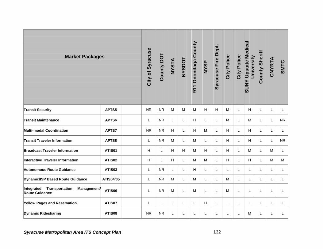
Market Packages
City
of S
yrac
use
Cou
nty
DO
T
NYS
TA
NYS
DO
T
911
Ono
ndag
a C
ount
y
NYS
P
Syra
cuse
Fire
Dep
t.
City
Pol
ice
City
Pol
ice
SUN
Y U
psta
te M
edic
al
Uni
vers
ity
Cou
nty
Sher
iff
CN
YRTA
SMTC
Transit Security APTS5 NR NR M M M H H M L H L L L
Transit Maintenance APTS6 L NR L L H L L M L M L L NR
Multi-modal Coordination APTS7 NR NR H L H M L H L H L L L
Transit Traveler Information APTS8 L NR M L M L L H L H L L NR
Broadcast Traveler Information ATIS01 H L H H M H L H L M L M L
Interactive Traveler Information ATIS02 H L H L M M L H L H L M M
Autonomous Route Guidance ATIS03 L NR L L H L L L L L L L L
Dynamic/ISP Based Route Guidance ATIS04/05 L NR M L M L L M L L L L L
Integrated Transportation Management/Route Guidance ATIS06 L NR M L M L L M L L L L L
Yellow Pages and Reservation ATIS07 L L L L L H L L L L L L L
Dynamic Ridesharing ATIS08 NR NR L L L L L L L M L L L
Syracuse Metropolitan Area ITS Concept Plan 132

Market Packages
City
of S
yrac
use
Cou
nty
DO
T
NYS
TA
NYS
DO
T
911
Ono
ndag
a C
ount
y
NYS
P
Syra
cuse
Fire
Dep
t.
City
Pol
ice
City
Pol
ice
SUN
Y U
psta
te M
edic
al
Uni
vers
ity
Cou
nty
Sher
iff
CN
YRTA
SMTC
In Vehicle Signing ATIS9 NR L L L L L L L L L L M
Intersection Safety Warning AVSS05 NR M L NR L H M H L M L
Automated Highway System AVSS11
NR NR M NR L L H L L L NR
Fleet Administration CVO01 modified H M L L L H L L L L L H H
Freight Administration CVO02 L NR L L L H L L L L L L L
Electronic Clearance CVO03 M L L L L H L L L L L L L
CV Administrative Processes CVO04 M NR L L M L L L L L L NR
International Border Electronic Clearance CVO05 L NR L L L L L H L L L L NR
Weigh-In-Motion CVO06 M L L L N/A H L L L L L L L
Roadside CVO Safety CVO07 L NR L L H L L L L L L L
On-board CVO Safety CVO08 L NR L L H L L L L L L L
Syracuse Metropolitan Area ITS Concept Plan 133

Market Packages
City
of S
yrac
use
Cou
nty
DO
T
NYS
TA
NYS
DO
T
911
Ono
ndag
a C
ount
y
NYS
P
Syra
cuse
Fire
Dep
t.
City
Pol
ice
City
Pol
ice
SUN
Y U
psta
te M
edic
al
Uni
vers
ity
Cou
nty
Sher
iff
CN
YRTA
SMTC
CVO Fleet Maintenance CVO09 L L L L L L L L L L L L
HAZMAT Management CVO10 L L H M H H L H M L L L L
Emergency Response EM1 H L H H H H M H H H L L L
Emergency Routing EM2 H M H M H H M H H H L M L
Mayday Support EM3 L L H L H L M H M H L L L
ITS Data Mart AD1 M M M L H L H M M H H H
ITS Data Warehouse AD2 M M M M H L H M H H M M
ITS Virtual Data Warehouse AD3 M L M H H L M L H H L L
Syracuse Metropolitan Area ITS Concept Plan 134

5.7 Summary of the Market Packages Ratings
The compilation of results from several meetings provided a clear insight into what the regional
needs are. Overall results emphasized the need for better inter-agency coordination among the
regional stakeholders in order to perform their roles at a broader level as well to improve their
own operating efficiencies. This effort demonstrated that agencies recognized the need for the
increased use of technology to effectively manage the transportation system, and to provide
high-quality service to transportation system “customers.”
Workshops and interviews indicated a lack of coordination among the major role players of this
architecture effort. Issues brought forward by the agencies were often prioritized by own needs
and seldom were found to contribute to the region as a whole. Policy roadblocks, along with a
lack of a regional vision, were often the obstacles in achieving transportation goals, even though
in many cases required infrastructure to meet these goals is already in place. Agencies
participating in this architecture effort must make cooperation a priority. Adoption of policies
that favor the regional integration and coordination will support the framework of future
transportation operations in the region.
Freeway Management agencies in the region such as the NYSDOT and the NYSTA,
emphasized their need for traffic management systems on their road network. The
discrepancies found in the earlier versions of the survey were solved when the agencies met to
discuss their needs. Advanced Traveler Information and Emergency Management were two
areas of common need. Sharing of real time/ near real time traffic images between the City of
Syracuse and the NYSDOT was identified as a top priority. Integration of all nearby regional
freeway traffic management centers was also seen as important. Market Packages
The CNYRTA has opted for most of the APTS packages. Among the selections made, Transit
Vehicle Tracking (apts1) was already identified as a mandatory market package since the
agency has realized the benefits of vehicle tracking for its operational enhancements. Also
traffic signal prioritization was important, given the significance increasing transit ridership as a
means to combat traffic congestion in the study area.
Syracuse Metropolitan Area ITS Concept Plan 135

As expected, Emergency Management Agencies in the region, including New York State Police,
Syracuse City Police, Onondaga County Sheriff, City and County Fire Departments along with
the E-911 Center officials rated all of the Emergency Market Packages, except for Mayday
Support as High, reiterating the need for enhancement of existing operations and coordination
of effort. Most of these agencies stressed the need for exchange of traffic images from the City
of Syracuse and the NYSDOT to help improve the response times. The E-911 Center is
stepping up its operations and is moving in directions that favor the involvement of advanced
technologies such as Mayday Support for drivers through partnerships with private industry
(General Motors OnStar).
The City and County’s choices were very similar. Once again, the exchange of traffic images
was of importance for both agencies, especially during special events. The University, located
in the heart of the study area, generates a large volume of traffic during special events such as
sporting events and concerts. Exchange of information, including current traffic conditions,
parking situations, etc. during such events becomes mission-critical coordination and is
essential to manage the high influx in traffic volumes. Also favored is the tracking of
maintenance vehicles, which will be addressed through a separate market package during the
second phase of this study (development of ITS Architecture). Currently this issue is addressed
through the Fleet Administration Market package categorized under Commercial Vehicle
Operations (cvo01).
SMTC has emphasized their need for data archiving.
5.8 Next Steps
Task 5.5 of this chapter has identified the agency priorities based on the Market Packages. In
the subsequent tasks of the project, the Syracuse Metropolitan Area ITS architecture will be
developed so that, as a minimum, the architecture supports at least the fundamental, high and
medium priority Market Packages. The final ITS Implementation Plan, to be developed in a
later stage of the project, will identify the deployable ITS projects to meet the agencies’ needs in
order to achieve the vision and goals defined in this technical memorandum.
Syracuse Metropolitan Area ITS Concept Plan 136

6. PERFORMANCE CRITERIA
Performance criteria are meant to measure the effectiveness of the intelligent transportation
systems to be deployed. This section presents the recommended performance criteria, and the
applicability of these performance criteria to the project goals and ITS Market Packages. Three
potential benefits can be realized through the use of performance criteria to evaluate ITS
strategies: the results can be used in making better decisions concerning the selection and
prioritization of ITS strategies yet to be implemented; the data can be used to improve the
accuracy and responsiveness of models and analytical techniques that are used to conduct ITS
planning, and; the results can be used to refine and improve current operations.
The performance criteria are generally quantitative, and useful in gauging the “before” and
“after” effects of alternative proposals. Data measured by performance criteria are expected to
be easy to collect and store, and the results are relevant to the goals of the project. The
performance criteria identified in this report are meant for use in the future to evaluate the
results that are achieved by implementing ITS Market Packages and relevant ITS projects in the
Syracuse Metropolitan Area.
Subtask 1 of this step identifies and describes the performance criteria recommended for this
project. Since the performance criteria discussed in this report measure the ability of project
actions to satisfy the goals of the study, these performance criteria are discussed with respect
to their relevance to each of the project goals. Subtask 1 also presents the recommended
performance criteria for both traffic and transit. Subtask 2 describes the applicability of the
selected performance criteria to the ITS Market Packages, and subtask 3 reviews the
relationship of the recommended performance criteria and the related data needs. The
conclusion is presented in subtask 4.
6.1.1 Recommended Performance Criteria
The recommended performance criteria are quantitative in nature, so that they can be
calculated based on numeric data. This reduces the need for subjective reasoning. Qualitative
investigations could be used when appropriate. A further reason for selecting these criteria is
their ability to measure the effectiveness of ITS Market Packages in meeting project goals. As
with all transportation improvements, it is important to account for other improvements that have
Syracuse Metropolitan Area ITS Concept Plan 137

been made. This is especially important when evaluating ITS. Therefore, care should be taken
to account for benefits received from ITS and non-ITS improvements.
The recommended performance criteria are divided into two sections: those that are most
relevant to roadways and those that are most relevant to transit.
The roadway criteria are:
• Average travel speed
• Travel time reliability
• Throughput
• Vehicle occupancy
• Delay
• Congestion
• Accident rate
• Incident related delay
The transit criteria are:
• Throughput (frequency/capacity)
• On-time performance
• Transit/ridership
• Fare operating ratio
• Average travel time
• Number of crime incidents
• Incident related delay
• Public perception
• Bus route/services
Two performance criteria are applicable to both roadways and transit:
• Effective use of traveler information
• Operations and maintenance costs
Syracuse Metropolitan Area ITS Concept Plan 138

6.1.2 Recommended Roadway Performance Criteria
This subchapter summarizes characteristics of the final recommended performance criteria for
roadways, including the measurement of the performance criteria, the means to obtain
data/information for measuring the criteria and the data/information requirements. Table 19
summarizes the information presented.
Average travel speed Average travel speed is measured in miles per hour and is obtainable by field observation. It
can be measured using floating car runs, by license plate matching, or by computing travel time
using traffic volumes and roadway capacities. Average travel speed at a fixed point on a
roadway can be measured by the network surveillance market package. The travel speed of
tagged vehicles along a roadway link can be measured by the probe surveillance market
package.
Average travel speed also indicates congestion, with congestion and delay occurring when
average travel speeds fall below satisfactory levels. Average travel speed also indicates ease
of movement for roadway users. Chapter 11 of the Highway Capacity Manual defines arterial
level of service based upon average travel speed.
Travel time reliability Travel time reliability is expressed as the percentage of times that a trip is made within the
standard travel time for that trip. Travel times can be measured using field measurements or
traffic/transportation planning models. ITS can measure travel time reliability through network
surveillance or probe surveillance.
This performance criterion measures the reliability of travel time for people and goods to move
from one location to another. It assumes that measurement of the percentage of instances
when travel time from point to point in the designated network of facilities is within some datum
or standard. A low percentage, which indicates that travel times are often higher than the
standard, indicates congestion and delay. This provides a good measure of ease of movement
for roadway users. Improvements to roadway traveling conditions should be clearly reflected by
improved travel time reliability.
Syracuse Metropolitan Area ITS Concept Plan 139

Table 19 - Characteristics of Recommended Roadway Performance Criteria Performance
Criteria
Units of
Measurement Data Requirements
Potential Data
Sources
Average
travel speed
Miles per hour
(mph)
Previous, current, and future
measurements of average travel
speed
Field
measurement; ITS
network and probe
surveillance
Travel time
reliability
Travel time,
measured in hours
and minutes;
reliability measured
in the percentage of
times that a trip is
made within the
standard travel time
for that trip
Manually, use floating car runs
over specified facilities, or other
techniques; with models, extract
travel times from data for
specified origin-destination
pairs; standard travel time can
be estimated from averaging
manual data or from model
Can be measured
manually or with
models; ITS
network and probe
surveillance
Throughput Vehicle flow per
hour
Previous, current, and future
measurements of throughput by
vehicles per hour
Measured with
models; ITS
network and probe
surveillance
Average
vehicle
occupancy
Average number of
occupants per
private vehicle
Manually obtained
measurement, using roadside
observations, of previous,
current, and future average
vehicle occupancy
Field
measurement
Delay
Minutes or hours of
delay; delay can
also be measured
by queue length at
entrance/exit ramps;
ton hours (freight)
Direct measurement of previous,
current, and future delay;
alternatively, delay can be
estimated from traffic counts
combined with travel time
measurements
Field
measurement for
delay (by time
period) and queue
length (by number
of vehicles); ITS
network and probe
surveillance
Syracuse Metropolitan Area ITS Concept Plan 140

Performance
Criteria
Units of
Measurement Data Requirements
Potential Data
Sources
Congestion
Six levels of service:
LOS A (best
operating condition)
to LOS F (worst
operating condition),
travel time
Previous, current, and future
LOS analyses; requirements
include traffic volumes, vehicle
classifications, and roadway
geometry
LOS analyses
according to the
Highway Capacity
Manual
Accident rate
Accidents per
million vehicle miles;
fatalities per million
vehicle miles;
accidents per
year(pedestrians/bic
yclists)
Traffic accident data including
accident location, type, time of
day, weather conditions, vehicle
classification, and contributing
factors; usually measured for
the most recent consecutive
three-year period for which data
is available
Police
Department,
Department of
Motor Vehicles
Incident
related delay
Incident response
time and incident
clearance time
measured in hours
and minutes
Previous, current, and future
measurements of incident
response time and incident
clearance time
Field
measurement; ITS
network and probe
surveillance
Syracuse Metropolitan Area ITS Concept Plan 141

Throughput Throughput is expressed as the flow of traffic per hour. This performance criterion can be
measured manually or with models. ITS data can be collected to measure throughput using
network surveillance.
Throughput measures the efficiency of travel by showing how effective a transportation facility is
in moving vehicles. It is also possible to determine person throughput by using data gathered
for vehicle throughput and vehicle occupancy. By multiplying throughput by occupancy, the
number of persons per hour traveling on a facility is obtained.
Throughput is one possible measure of congestion, since it reflects how many vehicles the
system is moving per unit of time. It also reflects regional mobility. If a roadway facility is well
managed, throughput is high.
Average vehicle occupancy Average vehicle occupancy - a count of all persons in automobiles including the driver and
passenger - indicates the number of travelers per vehicle in non-transit modes. It is usually
measured by roadside observation.
Average vehicle occupancy is a useful performance criterion for environmental assessments
because it influences air quality and can, therefore, are used to demonstrate efficiency. Lower
average vehicle occupancies generally equate to more traffic.
Delay Delay is stated in terms of minutes or hours of delay. It can be measured using manually
obtained data or it can be computed from traffic counts combined with travel time
measurements. Floating car runs or license plate matching can be used to determine travel
times, which can be combined with traffic counts to estimate delay. Alternatively, delay can be
measured by queue length at entrance/exit ramps. ITS data can be collected to measure delay
using network or probe surveillance.
Delay is a vehicle-oriented measurement of roadway performance that reflects time
losses/savings to people due to recurring congestion. It is measured in minutes or hours of
delay (ton hours of delay for freight) experienced by system users. It provides a sound measure
Syracuse Metropolitan Area ITS Concept Plan 142

of congestion on roadway links or systems, although it does not give any insight as to the
cause. Delay measurements also provide information about restricted flow and travel at sub-
optimal speeds. The delays at signalized intersections are based on average stopped delay per
vehicle and can be estimated by various transportation software tools.
Congestion Level Of Service (LOS) is a qualitative measure describing traffic conditions in terms of factors
such as speed, travel time, maneuverability, and safety. Density, expressed in unit of
passenger car per mile per lane (pc/mi/ln), is the parameter used to define levels of service of
basic freeway sections. For example, Chapter 3 of the Highway Capacity Manual defines six
expressway levels of service from LOS A to LOS F where LOS A represents the best operating
condition and LOS F the worst operating condition.
LOS designations indicate the amount of congestion and delay that a driver experiences along
roadways. Delay occurs when traffic volumes exceed the roadway capacity. AASHTO (the
American Association of State Highway Transportation Officials) suggests roadways should be
designed to at least LOS C, but LOS D is acceptable in urban areas. Roadway sections or
ramps where the LOS falls into E or F ranges operate at unacceptable conditions.
Accident Rate Accident analyses are used to identify and evaluate high accident locations, assess contributing
factors, and suggest mitigation measures. The process can include the determination of
accident frequency, accident rate, and accident cost.
Average accident rates, expressed in terms of accidents or fatalities per million vehicle miles
traveled, are developed from this data and compared to statewide averages for similar facilities.
High average accident rates may reflect the influence of nonstandard roadway features, a high
degree of use, and frequent roadway congestion. Accidents and fatalities involving pedestrians
and bicyclists will be considered in addition to accidents and fatalities involving only vehicles.
Incident related delay Incident delay is measured in terms of incident response time and incident clearance time
expressed in hours and minutes. ITS data can be collected to measure incident delay using
roadside network surveillance, probe surveillance, or incident management Market Packages.
Syracuse Metropolitan Area ITS Concept Plan 143

Toll plaza throughput Delay at toll plazas is measured by length of queue in minutes from field observations. ITS data
can be collected to measure congestion and delay using network or probe surveillance.
Roadway capacity decreases sharply at toll plazas, resulting in congestion and delay. Queues
often form where traffic flow is unstable.
Operations/maintenance costs This performance criterion is expressed in terms of the operation and maintenance costs (in
dollars) per passenger mile of travel. The costs incurred are available from transportation
agencies. This performance criterion provides a measure of the efficiency of an agency in
providing basic services.
6.1.3 Recommended Transit Performance Criteria
This subchapter summarizes the characteristics of the final recommended performance criteria
for transit, including the measurement of the performance criteria, the means to obtain
data/information for measuring the criteria, and the data/information requirements. Table 19
summarizes the information presented.
Throughput (frequency/capacity) Throughput measures the efficiency of travel by showing how effectively transportation facility
capacity is moving people and freight. It is measured in number of transit passengers per hour
and number of transit vehicles per hour. The data required could be collected using manual
counts. Alternatively, ITS data can be collected to measure throughput using transit vehicle
tracking and transit passenger and fare management Market Packages and freight tracking.
ITS technology can be utilized to increase throughput.
This performance criterion reveals traveler options and the degree to which transit modes are
used. Throughput also gives a direct measurement of travelers using alternatives to
automobiles.
On-Time Performance On-time performance is measured by the percentage of transit that meets scheduled departure
and arrival times. ITS data can be collected to measure on-time performance using transit
Syracuse Metropolitan Area ITS Concept Plan 144

vehicle tracking information. Weather conditions, incidents, accidents, congestion, operator
error, mechanical failure, and/or combinations of these factors can delay transit operations. On-
time performance gives an indication of overall transit system efficiency.
Ridership Passenger ridership is measured in the number of riders per year. Alternatively, passenger
ridership can be measured as a percentage of all travelers using transit modes. ITS data can
be collected to measure ridership using transit passenger and fare management. Ridership
presents a quantifiable performance criterion that indicates the ability of transit to attract riders.
Improvements to transit system operation may be reflected in increased ridership over time.
Revenue Transit agency revenue is measured by an increase in fare operating ratio (i.e., the ratio of fare
collected to operating costs). Increased revenue can be the result of changes in subsidy levels,
as well as improved system efficiency, which can be accomplished by incorporating new
technology.
Effective use of traveler information Improvements in real-time information dissemination can be measured by the percentage of
passengers who use real-time information. This performance criterion can also be measured by
a count of the number of times passengers access real-time information. It can also quantify
how the public used the data to determine changes in route, time and mode. This performance
criterion can also quantify the availability of information to transit service providers for possible
use in day-to-day operations adjustments. This information gives an indication of the extent to
which infrastructure is in place for real-time information and the extent to which passengers are
able to use it. This performance criterion is an accurate way to gauge the impact of real-time
traveler information dissemination because passengers will not bother to access the information
if they do not believe that it is up to date or useful. They must also be aware that the
information exists.
Syracuse Metropolitan Area ITS Concept Plan 145

Table 20 - Characteristics of Recommended Transit Performance Criteria Performance
Criteria Units of Measurement Data Requirements
Potential Data
Sources
Throughput
Transit passengers per
hour
transit vehicles per hour
Previous, current, and
future measures of
transit vehicles
throughput
Field observations or
surveys; ITS network
surveillance and
passenger loading
On-time
performance
Percentage of transit that
meets scheduled
departure and arrival
times
Previous, current, and
future scheduled and
actual transit arrival and
departure times
Field observations;
ITS transit vehicle
tracking
Transit/ferry
ridership
Passenger ridership
measured in number of
riders per year, or
percentage of all
travelers using transit
modes
Previous, current, and
future passenger
ridership figures
Field observations,
surveys, models, toll
counts; ITS
passenger loading
Fare operating
ratio
Transit system fare
operating ratio
Previous, current, and
future fare operating
figures
Operator accounting
figures
Effective use of
traveler
information
Percentage of transit
passengers that use real-
time information
Previous, current, and
future numbers of
passengers
using/accessing real-
time information
Operators; user
surveys
Average travel
time
Travel time measured in
hours and minutes
Previous, current, and
future measures of
multi-modal passenger
travel times
Field observation or
regional
transportation
models; ITS transit
vehicle tracking
Operations/
maintenance
costs
Cost of operations and
maintenance per
passenger mile
Previous, current, and
future operations and
maintenance costs
Operators; ITS
transit maintenance
Syracuse Metropolitan Area ITS Concept Plan 146

Number of
crime incidents
Number of incidents per
passenger mile
Previous, current, and
future numbers of crime
incidents
Police Department
Incident related
delay
Delay measured in hours
and minutes per
passenger mile
Previous, current, and
future amounts of
incident delay
Operators; ITS
transit vehicle
tracking
Customer
satisfaction
rating
Passenger approval
rating
Previous, current, and
future approval ratings
from passenger surveys
Operators
Average travel time The most effective method to measure average travel time for trips is from door to door, which is
complicated because it may involve more than one mode of travel. Alternatively, regional
transportation models can estimate travel times for trips that use more than one mode of travel.
ITS data can be collected to measure average travel time on a link of the trip using transit
vehicle tracking information.
Less travel time for trips involving transit means less congestion and better service. It evaluates
ease of movement of travelers by all modes. Because this performance criterion measures all
forms of transit, it gives insight into alternative modal opportunities.
Operations/maintenance costs This performance criterion is expressed in terms of the operation and maintenance costs (in
dollars) per passenger mile of travel. The costs incurred are available from transit agencies.
This performance criterion provides a measure of the efficiency of agency operations.
Number of crime incidents The number of crime incidents provides a performance criterion that measures passenger
security. The number and nature of reported crime incidents are available from the Syracuse
City Police Department.
Incident related delay Incident delay is measured in terms of hours and minutes per passenger mile of travel. It
provides a measure for gauging delay due to incidents such as atypical congestion, mechanical
failure, adverse weather conditions, and passenger disturbances, among others. Data
Syracuse Metropolitan Area ITS Concept Plan 147

concerning delay is available from the agencies themselves. Alternatively, delay measurements
can be obtained manually by transit system observation. ITS data can be collected to measure
incident delay using transit vehicle tracking information.
Customer satisfaction rating Approval ratings give an indication of passenger satisfaction with transit systems. They are
available from passenger surveys conducted by the operators themselves.
6.1.4 Recommended Performance Criteria & ITS Market Packages
Recommended performance criteria are intended to evaluate future ITS projects. By
associating performance criteria with Market Packages the most effective performance criteria
for evaluating a specific ITS project can be identified.
In this section, the recommended performance criteria are discussed with respect to the ITS
Market Packages discussed in the previous chapter. The Market Packages are arranged
according to groups:
• ATMS: Advanced Transportation Management Systems,
• APTS: Advanced Public Transportation Systems,
• ATIS: Advanced Traveler Information Systems,
• AVSS: Automated Vehicle Safety Systems,
• CVO: Commercial Vehicle Operations, and
• EM: Emergency Management.
• AD: Archived Data Management
Table 18 summarizes the recommended roadway and transit performance criteria as sources
for evaluating ITS Market Packages. The transit performance criteria detail how each of the
Market Packages can be measured for bus operations. The Market Packages are listed in the
rows, and the columns list the recommended performance criteria. A recommended
performance criterion that can be used to evaluate that particular market package can be
developed to address specific issues. In some cases, more than one performance criterion may
be useful to evaluate a market package.
Syracuse Metropolitan Area ITS Concept Plan 148

The following three Market Packages are not rated, as these elements are required prior to
other Market Packages being deployed:
• ATMS01: Network Surveillance
• ATMS02: Probe Surveillance (Applicable only to NYSTA)
• APTS01: Transit Vehicle Tracking
In addition, a few Market Packages are not appropriate for evaluation performance criteria.
Transportation Forecast and Demand Management (ATMS09) is an evaluation element and ITS
Data Mart (ad01), ITS Data Warehouse (ad02) and ITS Virtual Data Warehouse (ad03) are the
packages solely aimed at data gathering, analysis and dissemination for planning purposes of
any individual agency or between several agencies.
6.1.5 Recommended Performance Criteria and Data Needs
This section discusses the recommended performance criteria in terms of current and projected
data collection needs. Table 21 is intended to be used as an aid to the data collection efforts by
various agencies involved in deploying ITS in the City of Syracuse.
Syracuse Metropolitan Area ITS Concept Plan 149

Table 21 - Recommended Performance Criteria Data Requirements
Mode Performance Criteria Data Requirements
Average travel speed Average travel speed
Travel time reliability Floating car runs; origin-destination pairs;
standard travel time from manual data or from
model; probe data
Throughput Throughput by vehicles per hour
Average vehicle occupancy Average vehicle occupancy
Delay Delay
Congestion LOS analyses, which require traffic volumes,
vehicle classifications, and roadway geometry
Accident rate Traffic accident data including accident location,
type, time of day, weather conditions, vehicle
classification, and contributing factors
Incident related delay Incident response time and incident clearance
time
Toll plaza throughput Delay at toll plazas
Effective use of traveler
information
Number of drivers using/accessing real-time
information; public’s use of information
Roadways
Operations/maintenance costs Operations and maintenance costs
Throughput (frequency/capacity) Persons throughput,
On-time performance Scheduled and actual bus arrival and departure
times
Transit ridership Bus ridership
Fare operating ratio Revenue
Effective use of traveler
information
Number of transit passengers using/accessing
real-time information; publics' use of information.
Average travel time Average bus passenger travel times
Operations/ maintenance costs Bus operations and maintenance costs
Number of crime incidents Number of crime incidents on buses and at bus
stations and bus stops
Transit –
Bus
Incident related delay Bus incident delay
Syracuse Metropolitan Area ITS Concept Plan 150

Performance criteria discussed in this technical memorandum are meant to evaluate the
benefits of ITS projects quantitatively after they are deployed. This section focused on the
project goals to select performance criteria. The characteristics, including data requirements,
have been reviewed for each of the recommended performance criteria. The memorandum has
presented a relationship of the selected performance criteria to the ITS Market Packages so
that an evaluation of ITS projects can be made in compliance with the National ITS Architecture
guidelines
Syracuse Metropolitan Area ITS Concept Plan 151

7 Funding
The institutional framework and division of responsibilities within each state also affect funding
for management and operations. For example, in each state the agency responsible for
interstate highway management and operations also has budget authority to fund those
activities. The activities and the funding source are integrated. . In many states, however, the
responsibility for incident management activities and the funding sources for those activities are
not integrated. While a state agency may be broadly responsible for incident management on
its interstates, entities such as private towing companies, law enforcement, fire departments
and emergency medical services providers are all critical to effective incident management, and,
all have their own sources of funding.
This does not mean that a state will not fund ongoing operations, and improvements to those
operations, related to incident response. Indeed, one of the key functions of the Syracuse
Metropolitan Area ITS Architecture is incident management. However, the blurring of
boundaries as described above can make funding decisions related to incident management
more difficult.
One example of an unclear boundary is funding for sharing data and video images between
public safety and traffic management agencies. Emergency response to incidents can be
improved using data and video available from traffic management agencies. Traditionally,
highway funds have not been used to fund improvements to emergency response. However,
because improved data provided to emergency response agencies translates to improved
incident management, a region may find it appropriate to apply highway funds to this type of
project.
The Syracuse Metropolitan Area ITS Architecture does not specifically identify funding sources
to support proposed ITS deployments. However, one of the objectives of the plan is to begin a
dialogue on new approaches to funding that may not have been considered in the past. For
example, the New York State Thruway Authority and state agencies such as the NYSDOT might
form partnerships to share wireless and wireline resources.
Syracuse Metropolitan Area ITS Concept Plan 152

7.1 Capital Funding for ITS
Given the diffuse nature of transportation operations and decision making, where does the
burden for financing ITS projects fall? Across the country, regionally-integrated ITS is largely
being funded by Federal Highway program funds including Surface Transportation Program
(STP) funds, special Federal Operational Tests and Model Deployment Initiatives, and the
Congestion Mitigation and Air Quality (CMAQ) program.. State DOT and MPO projects are also
eligible to compete for the use of these funds. In the Syracuse metropolitan area, the CMAQ
program can be tapped to fund the congestion mitigation projects that also benefit the region
through reducing emissions. FTA funds transit ITS projects through their standard grant
programs. One example of a state making maximum use of Federal sources is Kentucky, which
will use only Federal grant money in 2002 to fund ITS.
The Federal Highway Administration is currently funded via the Transportation Equity Act for the
21st Century (TEA –21). Under TEA-21, a separate “line item” for ITS, was created, in addition
to STP and CMAQ monies. Within TEA-21’s ITS line item, specific projects are “earmarked” for
Federal support. Money is also made available to the states for projects of their choosing.
A portion of the ITS budget was set aside to fund projects that focus on integrating multi-modal
ITS components in a variety of settings, including large regional areas or metropolitan areas.
These funds are allocated, or earmarked, in congressional transportation budget committees.
An additional Federal funding source for ITS projects that integrate emergency responders and
transportation agencies is available through the Department of Justice (DOJ). The DOJ has
indicated that they are prepared to be a funding partner in projects that integrate emergency
responders with ITS. No specific funding amounts or limits have been identified by DOJ for
these projects.
In New York State, a mix of Federal, state, and local funds have been used for ITS programs
such as TRANSCOM, centralized traffic signal systems, AVL and weather information systems.
7.2 Operations and Maintenance Funding for ITS
Federal highway and transit funds may also be used for operations and operational
improvements of ITS, subject to certain restrictions. USDOT policy stipulates that long-term, on-
Syracuse Metropolitan Area ITS Concept Plan 153

going operations and operational improvements of ITS shall not be federally funded. However,
this situation may change in the near future as the importance of operations continues to be
highlighted at the Federal level. However, nearly all ITS operations and operational
improvements are funded by the State and local agencies using State and local dollars.
7.3 Private Sector Funding
Across the US, including New York State, the private sector and public sector have partnered to
deliver ITS. Two key areas have been of interest to the private sector: traveler information and
communications infrastructure provision. However, changes in technology, costs, and other
market factors have recently stimulated private sector interest in other ITS opportunities,
including providing traveler security services. The key for the public sector is to remain open to
private sector partnership opportunities as they arise in the future.
Both capital and operations/maintenance funds for ITS must compete with other needs for
scarce funding. The best way to acquire and retain project funding is to clearly demonstrate
benefits deriving from the investment. Key steps to accomplish this include:
• Ensure that performance is continuously monitored to ensure that benefits are derived.
• Develop means to reduce capital costs to all ITS projects
• Develop means to keep operations costs low.
In summary, a variety of funding sources are available for planning, deployment, and on-going
operations of ITS. The Federal sector is a strong source of funds for project deployment and
startup. However, the private sector, in partnership with state agencies, is increasingly playing
a role in funding projects and this presents unique opportunities for the ITS owner/operator.
Creative thinking in securing funding sources, and careful documentation of benefits to retain
funding, are keys to successful financial management of ITS
Syracuse Metropolitan Area ITS Concept Plan 154

Syracuse Metropolitan Area (Onondaga County)
Intelligent Transportation Systems Strategic Plan
Draft Technical Memorandum # 2 “Regional Architecture”
Prepared for
New York State Department of Transportation
Syracuse Metropolitan Transportation Council
August 2002
Syracuse Regional ITS Architecture i

Table of Contents
1. INTRODUCTION.................................................................................................................................. 1 1.1 PROJECT GOALS................................................................................................................. 1 1.2 PROJECT OBJECTIVES......................................................................................................... 1 1.3 PROJECT AREA AND JURISDICTIONS .................................................................................... 2 1.4 FORMAT OF THIS REPORT.................................................................................................... 4
2. BACKGROUND ................................................................................................................................... 5 2.1 ARCHITECTURE DEFINITION................................................................................................. 5 2.2 STAKEHOLDERS & ELEMENTS........................................................................................... 9 2.3 FINAL ARCHITECTURE RULE AND CONFORMITY .................................................................. 10 2.4 ROLE OF SMA ARCHITECTURE WORKING GROUP .............................................................. 11
3. DEVELOPMENT OF ARCHITECTURE......................................................................................... 13 3.1 IDENTIFICATIONS OF SUBSYSTEMS..................................................................................... 13 3.2 IDENTIFICATION OF MARKET PACKAGES............................................................................. 21 3.3 IDENTIFICATION OF INTERCONNECTS.................................................................................. 21 3.4 IDENTIFICATION OF ARCHITECTURE FLOWS........................................................................ 22
4. SYRACUSE METROPOLITAN AREA (SMA) ITS ARCHITECTURE ...................................... 24 4.1 ANALYSIS AND RECOMMENDATIONS................................................................................... 24 4.2 USE OF ARCHITECTURE..................................................................................................... 31
5. STANDARDS TO CONSIDER ........................................................................................................ 33 5.1 CENTER-TO-CENTER STANDARDS ..................................................................................... 33 5.2 CENTER-TO-FIELD STANDARDS ......................................................................................... 35
APPENDIX A DEFINITION OF SUBSYSTEMS/TERMINATORS............................................... 38
APPENDIX B LIST OF MARKET PACKAGE................................................................................. 52
APPENDIX C INTERCONNECT DIAGRAMS ............................................................................... 59
APPENDIX D DEFINITION OF ARCHITECTURE FLOW DEFINITIONS................................. 98
APPENDIX E ARCHITECTURE FLOWS ....................................................................................... 111
APPENDIX F ARCHITECTURE FLOW DIAGRAMS................................................................... 164
Syracuse Regional ITS Architecture

1. Introduction At present, all state and some local members of the Syracuse Metropolitan Area (SMA) are
utilizing ITS. The intent of these systems is to provide better information and services to the
traveling public and to provide operations and management of special events, congestion, and
incident response. Most of the work is proceeding independently and, to date, there are limited
capabilities for sharing available information electronically across jurisdictions in the Syracuse
Metropolitan Area
1.1 PROJECT GOALS
The goal of this project is to examine regional ITS application interface alternatives and provide
specific actions that could facilitate electronic exchange on National ITS Architecture data
elements among Syracuse Metropolitan Area member ITS applications. To that end, an ITS
architecture that is in conformance with the United States Department of Transportation’s
National ITS Architecture has been developed to advance the status of electronic exchange of
regional ITS information in this area. This Report documents the processes and provides for a
Syracuse Metropolitan Area ITS Architecture as developed by PB Farradyne
1.2 PROJECT OBJECTIVES
Project objectives include the development of a regional architecture, examination of regional
ITS application interface, and the development concepts.
• ITS Regional Architecture – The regional architecture defines interconnects and data
flows required to facilitate operations and management issues in the Syracuse
Metropolitan Area
• Examination of regional ITS application interface alternatives - National ITS Architecture
provides a framework of standards and approaches for electronic information exchange.
The standards requirements of the National Architecture will provide a starting point in
defining the standards to be used in the Syracuse Metropolitan Area Regional
Architecture. As the architecture is defined, the standards based electronic information
Syracuse Regional ITS Architecture 1

exchange will be applied to ensure that all participants are aware of the targeted
framework for planning, defining and integrating their individual applications.
1.3 PROJECT AREA AND JURISDICTIONS
As shown in Figure 1, the regional architecture focus has been on larger agencies with known
ITS programs and on-going initiatives. The project area focus is the SMA region. Participating
jurisdictions involved in the development of the regional architecture include:
• City of Syracuse
• Onondaga County
• New York State
Syracuse Regional ITS Architecture 2

Figure 1 Onondaga County
Syracuse Regional ITS Architecture 3

1.4 FORMAT OF THIS REPORT
Following this introductory section, the document is comprised of four additional sections.
Section 2 – Background, defines “architecture” and associated terminology, discusses the
regional operations and stakeholders. The National ITS Architecture is also addressed. Section
3 – Development of Architectures, discusses the procedure of how to build the ITS Architecture.
Section 4 – Introduction SMA ITS Architecture discusses the analysis and recommendations of
SMA Regional Architecture. Section 5 – Standards to Consider addresses the fundamental to
the establishment of nationally compatible and interoperable ITS deployments. A conceptual
architecture for the Syracuse metropolitan area, and associated implementation considerations,
are also presented in this final section.
Syracuse Regional ITS Architecture 4

2. Background ITS Architecture definition and associated terminology, Architecture Rule and Conformity is
discussed in this section.
2.1 ARCHITECTURE DEFINITION
In the context of ITS, an “architecture” describes what a system does and, from a high-level
perspective, how it does it. It provides the overall framework for system design and
deployment; identifying the functions and operations to be performed, the basic subsystems and
elements that make up the system and what functions each performs, and the flows of
information between these components. In essence, an ITS architecture defines how system
elements interact and work together to achieve system goals. From a regional perspective, an
ITS architecture is concerned with what types of information are exchanged between
transportation agencies and their respective transportation management systems and centers,
how the center-to-center connections are accomplished, and the additional functionality this
integrated information provides to users (e.g., travelers, system operators, transportation
managers, information service providers).
National ITS Architecture - The National ITS Architecture provides a common framework for
planning, defining, and integrating intelligent transportation systems. That framework consists of
the following:
Systems/Subsystems – Subsystems describe parts of the physical world and include
traffic management centers, vehicles, roadside field equipment, and other physical
property. The National ITS architecture defines 21 subsystems that correspond to four
larger classes: Centers, Vehicles, Roadside and Travelers. Figure 2, below shows how
the subsystems are grouped and connected in the National ITS Architecture.
Syracuse Regional ITS Architecture 5

Figure 2 National ITS Architecture - Physical Architecture
For example, City of Syracuse DPW, when described in the terms in the National ITS
Architecture, consists of six subsystems:
Traffic Management. Syracuse DPW processes data to manage traffic on the
road network system.
Information Service Provider. The National ITS Architecture describes this
subsystem as providing traveler information and alerts via telephone, Internet
and other means.
Archived Data Management. Syracuse DPW stores traffic volume, speed and
occupancy data, as well as some data on incidents.
Emergency Management
Maintenance and Construction Management.
Parking Management.
Interconnects – Interconnects are communication links between subsystems, which
enable data flows between the subsystems. As shown in Figure 2, there are four types
Syracuse Regional ITS Architecture 6

of communications interconnections used between subsystems; wire line, wide area
wireless, dedicated short range, and vehicle-to-vehicle. These are the most typical
media used for the communications links between the subsystems shown in the National
ITS Architecture. However, these links can be modified to reflect actual conditions in a
particular region. For example, some of the communications from the field devices
(roadway subsystem) to the Syracuse DPW (traffic management subsystem) may be
accomplished wirelessly or via wire line media such as fiber optic cable.
The National ITS Architecture is not a system design nor is it a design concept. it does define
the framework around which multiple design approaches can be developed, each one
specifically tailored to meet the individual needs of the user.
Within each subsystem, the architecture defines the functions (e.g., gather traffic information, or
a traveler requests for transit route information) provided, depicts all of the communications
necessary to transfer information and data among transportation entities, traveler information
and emergency service providers, and other service providers such as towing and recovery and
identifies the information flows between the physical subsystems that contribute to
accomplishment of the function. The information flows are defined as architecture flows:
Architecture Flows – Architecture flows (often referred to as data flows) detail the type
of information that is communicated between subsystems. For instance, traffic image is
an architecture flow that may occur between the Roadway Subsystem and the Traffic
Management Subsystem. An interconnection between subsystems may be comprised
of one or more architecture flows.
The architecture defines these flows in terms of the connections between the equipment
required to provide the service and the subsystem that collects and/or processes the data. This
set of equipment and data flows are called equipment packages. Within each subsystem,
several equipment packages may be needed. The National ITS Architecture defines market
packages as typical groups of equipment packages used to accomplish particular groups of
functions.
Market Packages - Market packages consist of physical equipment needed to deliver a
given transportation service and the data flows that connect them with other important
external systems. In other words, they identify the pieces of the physical architecture
required to implement a particular transportation service. Market packages are
Syracuse Regional ITS Architecture 7

alternative groupings of ITS subsystems that support diverse ITS implementations.
Market packages address specific sets of users, service levels, regional needs, and
incremental deployment scenarios. A market package provides an accessible,
deployment-oriented perspective to the national ITS architecture. Each package is
tailored to address, separately or in combination, real world transportation problems and
needs.
Equipment Packages – Equipment packages was used in the National ITS Architecture
development effort to group like functions (P-specs) of a particular subsystem together
into an "implementable" package of hardware and software capabilities.
Each subsystem can have architecture flows directed to/from it to accomplish the functions
required. The sum of those flows is called an interface:
Interface – An interface is a description of the connection to a subsystem defining the
architecture flows to and from the subsystem. The architecture interface specifications
determine the nature of the communications links needed between subsystems, which
gives the technical community the data they need to develop meaningful communication
standards for these interconnections/interfaces.
Standards - Standards are documented agreements containing technical specifications
or other precise criteria to be used consistently as rules, guidelines, or definitions of
characteristics for the interchange of data. A broad array of ITS standards are currently
under development that will specifically define the interfaces identified in the National
ITS Architecture. Although no standards have been officially adopted by the USDOT to
date, it is believed that standards will be adopted in the future. Once adopted, federally
funded ITS projects will be required to use standards. Standards are identified in the
SMA Regional ITS Architecture to prepare the region for their future adoption by
USDOT. Some standards are reasonably mature, and should be considered for
application to ITS projects today. Others are only beginning development, and should
not be considered for use today. The Regional ITS Plan describes the standards that
should be considered by implementers in the SMA region for use today.
The SMA Regional ITS Architecture was developed within the framework of the National ITS
Architecture, as described above. The SMA Regional ITS Architecture tailors the National ITS
Syracuse Regional ITS Architecture 8

Architecture to meet the SMA region’s needs and plans for subsystems, data flows and
interfaces.
2.2 STAKEHOLDERS & ELEMENTS
Table 1 summarizes and provides a brief description of the stakeholders represented in the
Syracuse Metropolitan Area ITS Architecture.
Table 1 Syracuse Metropolitan Area ITS Architecture Stakeholder Syracuse Metropolitan Area ITS Architecture
Stakeholder Syracuse Metropolitan Area ITS Architecture
Stakeholder Description Syracuse Metropolitan Transportation Council (SMTC) Regional Transportation Planning Agency-- Local MPO
district
Onondaga County 911 Emergency Communications (ECD) County Emergency Dispatch Center
Central New York Regional Transportation Authority (CNYRTA) Regional Transit Agency
New York State Police State Police Authority responsible for law enforcement along the state freeway corridors.
Onondaga County Dept. of Transportation County agency responsible for transportation operations in the study area
Onondaga County Sheriff County Sheriff Enforcement
City of Syracuse Dept. of Public Works City agency responsible for design, development and implementation of public welfare projects. This constitutes the field devices such as parking meters, Cameras, Detectors, etc.
City of Syracuse Police Department City of Syracuse Law enforcement agency.
Onondaga County Emergency Management Division (EMD) County Emergency Management Agency that operates only during declared emergencies.
NYSDOT Region 3 Operations Center State DOT's Central Command
Traveler PC/Info. Appliance General population's electronic data used for information access
Financial Institutions Regional toll collection and administration (parking fee management, etc)
City of Syracuse Fire Department Local Fire Department
Local Transit Vehicles CENTRO transit vehicles in the study area
Local Media Newspapers, Radio and Television Stations
Pedestrian Public pedestrian/bicyclist
City of Syracuse Fire Vehicles Local Fire Service - response vehicles
City of Syracuse Police Vehicles Local Police Response Vehicles
NYSDOT Region 3 Field Equipment Field Equipment to monitor maintenance and operating conditions. Includes Scales and Inspection Facilities.
NYSTA Traffic Operations Center Traffic Management Division
NYSTA Field Equipment Field Data Collection sensors and other equipment such as scales and weigh-in-motion.
Syracuse Regional ITS Architecture 9

NYSTA Maintenance and Supervisory Vehicles Vehicles providing supervision and maintenance .. ITS and Non-ITS functions such as snow removal.
NYSTA Statewide Operations Center Troop T Dispatch This statewide operations center element dispatches all emergency services for the Thruway (exclusively for NYSTA) including Troop of the NY State Police.
NYSDOT Region 3 Maintenance and Supervisory Vehicles State DOT vehicles responding to maintenance and supervisory missions. Both ITS and Non-ITS activities are included.
EZPASS TAG EZ Pass Tags used for Automatic Toll Collection.
City of Syracuse Maintenance Vehicles Snow Lows and Other supervisory and maintenance vehicles
Onondaga County Maintenance Vehicles Snow Plows and Other maintenance/supervisory vehicles owned by the county.
Metropolitan Transportation Communication Network (METCON)
This will be the regional server for all the local agencies (including NYSDOT R3 and NYSTA Division Office) to exchange their information.
City of Syracuse Field Equipment Field Equipment such as Traffic Cameras, Detectors, Traffic Signals, etc.
Onondaga County DOT Field Equipment County Field Equipment includes traffic control devices such as traffic signals, detectors, roadway sensors, VMS, HAR, etc..
NYSTA State Police Troop T Vehicles NYSTA police force exclusively operated on thruway right of ways.
Syracuse Regional Emergency Network (SyREN) A regional Emergency Communication network that collects and distributes emergency related information.
NYSDOT Region 3 NYSDOT Region 3 Non-Operational Functions - Planning, Design, Traffic Safety.
Other Fire Vehicles (excluding the city fire vehicles) This element includes all fire Vehicles located outside the city limits.
Onondaga County Sheriff (Police) Vehicles County Police vehicle
New York State Police (Troop D) Vehicles NY State Police vehicles that are operated on the State Highway Networks. This entity EXCLUDES the exclusive operations on Thruway facilities by Troop T.
Other EMS Dispatch Ambulance Dispatch Services
Other EMS Vehicles Ambulance vehicles...
2.3 FINAL ARCHITECTURE RULE AND CONFORMITY
On January 8, 2001, the FWHA rule and FTA policy on ITS Architecture and Standards were
published to implement section 5206(e) of the Transportation Equity Act for the 21st Century
(TEA-21). The final rule/policy requires that:
• Regions currently implementing ITS projects must have a regional ITS architecture in
place in four years.
• ITS projects funded by the Highway Trust Fund and the Mass Transit Account must
conform to a regional ITS architecture.
Syracuse Regional ITS Architecture 10

• Major ITS projects should move forward based on a project level architecture that clearly
reflects consistency with the National ITS architecture. A major ITS Project is any ITS
project that impacts regional integration or national interoperability.
• Projects must use USDOT adopted ITS standards as appropriate. To date, the USDOT
has not adopted any ITS standards, and a formal rulemaking process will precede any
USDOT ITS standard adoption. The proposed rule does not require replacement of
existing systems or equipment. Applicable ITS standards would be used as new features
and system upgrades are planned with the use of the National ITS Architecture.
The final rule on the ITS Architecture and Standards requires the development of a local
implementation of the National ITS Architecture referred to as a regional ITS Architecture. The
regional ITS architecture should be tailored to meet local needs, meaning that it does not need
to address the entire National ITS Architecture.
The regional ITS architecture shall contain a description of the region; identification of the
participating agencies and other stakeholders; the roles and responsibilities of the participating
agencies and other stakeholders; any agreements (existing or new) needed for operations,
including at a minimum those affecting ITS project interoperability; system functional
requirements; interface requirements and information exchanges with planned and existing
systems; identification of applicable standards; and the sequence of projects necessary for
implementation. Any changes made in a project design that impacts the regional ITS
architecture shall be identified and the appropriate revisions made and agreed to in the regional
ITS architecture.
Any region that is currently implementing ITS projects shall have a regional ITS architecture by
April 8, 2005. In this context, a region is a geographic area that is based on local needs for
sharing information and coordinating operational strategies among multiple projects. A region
can be specified at a metropolitan, statewide, multi-state, or corridor level. Within a metropolitan
area, the metropolitan planning area should be the minimum area that is considered when
establishing the boundaries of a region for purposes of developing a regional ITS architecture.
2.4 ROLE OF SMA ARCHITECTURE WORKING GROUP
Syracuse Regional ITS Architecture 11

SMA Architecture Working Group is comprised of representatives from NYDOT Region 3,
NYSDOT Main Office and FHWA in addition to the study team. The Steering Committee (SC) is
comprised of representatives of all key agencies that are responsible for the implementation of
ITS in the Syracuse Metropolitan area. The committee advises on architecture issues. As such,
the committee has been tasked with overseeing the development of the Syracuse Metropolitan
Architecture.
The committee provided critical guidance and direction in the development of the regional
architecture, and reviewed and approved deliverables and content that went into the
development of the architecture. Several meetings were held with the committee between 2001
and July 2002. Key issues discussed and agreed upon at these meetings include:
• Turbo Architecture, a software package that supports development of regional and
project ITS architectures using the National ITS Architecture as a starting point, was
used in developing the Syracuse Metropolitan Area ITS Architecture.
• Interviews were re-instituted as identified in the original work plan and conducted with
targeted agencies / stakeholder groups to obtain additional information, priorities, and
input for use in validating the regional architecture
• The regional architecture will be a “living document” requiring on-going update and
maintenance. Furthermore, a sequence of projects required for implementation and a
process whereby changes made in a project’s design that impacts the regional
architecture must be identified by January 8, 2005 in order to achieve full conformity with
the Final Architecture Rule.
• Reviewed and commented upon proposed subsystems, market packages, interconnects
and data flows in the regional architecture
• The regional architecture will reflect current and planned architecture flows defined by
stakeholders
Syracuse Regional ITS Architecture 12

3. Development of Architecture The Syracuse Metropolitan Area ITS Architecture was developed using the following process:
• A number of reports and documents were reviewed to identify existing and planned ITS
for the purpose of identifying ITS subsystems
• ITS Market Packages that support the subsystems were identified
• Subsystems and market packages were programmed into the Turbo Architecture
software package to develop a Strawman Architecture. The Strawman Architecture
represents an initial draft of the regional architecture and identifies interconnects and
architecture flows required to facilitate the subsystem processes among stakeholders.
• The Strawman Architecture was reviewed, revised and validated by reaching out to
targeted stakeholders and working closely with the Syracuse Metropolitan Area ITS
Architecture teams.
3.1 IDENTIFICATIONS OF SUBSYSTEMS
In the context of the National ITS Architecture, the physical architecture provides stakeholders
with a physical representation via a high-level structure (though not a detailed design) of
important ITS interfaces and major system components.
Syracuse Regional ITS Architecture 13

Figure 3 Principal Elements in the Physical Architecture
As shown in Figure 3, the principal elements in the physical architecture are the 21 subsystems
and architecture flows that connect these subsystems, as well as 30 external terminators, into
an overall structure. The 16 subsystems contained in the Syracuse Metropolitan Area ITS
Architecture are highlighted for reference.
Table 2 assigns these 16 subsystems and 30 terminators to each of the Syracuse Metropolitan
Area ITS Architecture stakeholders. Definitions of the 16 subsystems and 30 terminators are
set forth in Appendix A.
Syracuse Regional ITS Architecture 14

Table 2 Syracuse Metropolitan ITS Architecture Physical Entity – Stakeholder Traceability Subsystem/Terminator Stakeholder
Archived Data Administrator NYSDOT Region 3 City of Syracuse Dept. of Public Works City of Syracuse Police Department Central New York Regional Transportation Authority (CNYRTA) Syracuse Metropolitan Transportation Council (SMTC) NYSDOT Region 3 Operations Center NYSDOT Region 3 NYSTA Traffic Operations Center Onondaga County Sheriff Onondaga County Dept. of Transportation
Archived Data Management Subsystem
Metropolitan Transportation Communication Network (METCON) Central New York Regional Transportation Authority (CNYRTA) Onondaga County 911 Emergency Communications (ECD) Syracuse Metropolitan Transportation Council (SMTC) NYSDOT Region 3
Archived Data User Systems
NYSTA Traffic Operations Center City of Syracuse Fire Department City of Syracuse Dept. of Public Works City of Syracuse Police Department Onondaga County 911 Emergency Communications (ECD) NYSDOT Region 3 Operations Center New York State Police NYSTA Statewide Operations Center Troop T Dispatch NYSTA Traffic Operations Center Onondaga County Dept. of Transportation Onondaga County Emergency Management Division (EMD)
Emergency Management
Onondaga County Sheriff
Syracuse Regional ITS Architecture 15

Other EMS Dispatch Syracuse Regional Emergency Network (SyREN)
Metropolitan Transportation Communication Network (METCON) City of Syracuse Police Department Onondaga County 911 Emergency Communications (ECD) New York State Police
Emergency Personnel
Onondaga County Sheriff Onondaga County 911 Emergency Communications (ECD)
Emergency System Operator
New York State Police City of Syracuse Police Department Onondaga County 911 Emergency Communications (ECD)
Emergency Telecommunications System
Syracuse Regional Emergency Network (SyREN) City of Syracuse Fire Vehicles City of Syracuse Police Vehicles Other Fire Vehicles (excluding the city fire vehicles) New York State Police (Troop D) Vehicles New York State Police NYSTA State Police Troop T Vehicles Onondaga County Sheriff (Police) Vehicles
Emergency Vehicle Subsystem
Other EMS Vehicles Emissions Management Metropolitan Transportation Communication Network (METCON) City of Syracuse Police Department City of Syracuse Fire Department New York State Police NYSTA Statewide Operations Center Troop T Dispatch Onondaga County Sheriff
Enforcement Agency
Syracuse Regional ITS Architecture 16

Financial Institutions Financial Institutions
Government Reporting Systems Syracuse Metropolitan Transportation Council (SMTC)
City of Syracuse Dept. of Public Works Syracuse Metropolitan Transportation Council (SMTC) NYSDOT Region 3 Operations Center NYSTA Traffic Operations Center Onondaga County Dept. of Transportation
Information Service Provider
Metropolitan Transportation Communication Network (METCON) NYSDOT Region 3 Maintenance and Supervisory Vehicles NYSTA Maintenance and Supervisory Vehicles
Location Data Source
Onondaga County Maintenance Vehicles City of Syracuse Dept. of Public Works NYSDOT Region 3 Operations Center NYSTA Traffic Operations Center Onondaga County Dept. of Transportation
Maintenance and Construction Management
Metropolitan Transportation Communication Network (METCON) NYSDOT Region 3 Maintenance and Supervisory Vehicles City of Syracuse Maintenance Vehicles NYSTA Maintenance and Supervisory Vehicles
Maintenance and Construction Vehicle
Onondaga County Maintenance Vehicles Map Update Provider Syracuse Metropolitan Transportation Council (SMTC) Media Local Media Multimodal Crossings Syracuse Metropolitan Transportation Council (SMTC)
Syracuse Regional ITS Architecture 17

Multimodal Transportation Service Provider Onondaga County Dept. of Transportation City of Syracuse Police Department City of Syracuse Dept. of Public Works Central New York Regional Transportation Authority (CNYRTA) Syracuse Metropolitan Transportation Council (SMTC) NYSDOT Region 3 Operations Center NYSDOT Region 3 Onondaga County Dept. of Transportation Onondaga County Sheriff
Other Archives
Metropolitan Transportation Communication Network (METCON) City of Syracuse Dept. of Public Works City of Syracuse Fire Department City of Syracuse Police Department Onondaga County 911 Emergency Communications (ECD) NYSDOT Region 3 Operations Center New York State Police NYSTA Statewide Operations Center Troop T Dispatch Onondaga County Emergency Management Division (EMD) Onondaga County Dept. of Transportation Onondaga County Sheriff Other EMS Dispatch Syracuse Regional Emergency Network (SyREN)
Other EM
Metropolitan Transportation Communication Network (METCON) City of Syracuse Dept. of Public Works Syracuse Metropolitan Transportation Council (SMTC) NYSDOT Region 3 Operations Center Onondaga County Dept. of Transportation
Other ISP
Metropolitan Transportation Communication Network (METCON)
Syracuse Regional ITS Architecture 18

Other Parking Metropolitan Transportation Communication Network (METCON) City of Syracuse Dept. of Public Works NYSDOT Region 3 Operations Center Onondaga County Dept. of Transportation
Other TM
Metropolitan Transportation Communication Network (METCON) Central New York Regional Transportation Authority (CNYRTA)
Other TRM
Metropolitan Transportation Communication Network (METCON) Other Vehicle EZPASS TAG City of Syracuse Dept. of Public Works
Parking Management
Metropolitan Transportation Communication Network (METCON) Payment Instrument NYSTA Field Equipment Pedestrians Pedestrian
Personal Information Access Traveler PC/Info. Appliance City of Syracuse Field Equipment NYSDOT Region 3 Field Equipment NYSTA Field Equipment Onondaga County DOT Field Equipment
Remote Traveler Support
Traveler PC/Info. Appliance Roadway Environment NYSTA Field Equipment City of Syracuse Field Equipment NYSDOT Region 3 Field Equipment NYSTA Field Equipment
Roadway Subsystem
Onondaga County DOT Field Equipment
Syracuse Regional ITS Architecture 19

NYSTA Traffic Operations Center
Toll Administration
Metropolitan Transportation Communication Network (METCON) Toll Administrator NYSTA Traffic Operations Center Toll Collection NYSTA Field Equipment City of Syracuse Dept. of Public Works NYSDOT Region 3 Operations Center NYSTA Traffic Operations Center Onondaga County Dept. of Transportation
Traffic Management
Metropolitan Transportation Communication Network (METCON) Traffic Operations Personnel NYSDOT Region 3 Operations Center Transit Maintenance Personnel Central New York Regional Transportation Authority (CNYRTA) Central New York Regional Transportation Authority (CNYRTA)
Transit Management
Metropolitan Transportation Communication Network (METCON) Transit System Operators Central New York Regional Transportation Authority (CNYRTA) Transit User Pedestrian Transit Vehicle Subsystem Local Transit Vehicles Traveler Pedestrian Vehicle EZPASS TAG Weather Service NYSDOT Region 3 Operations Center
Syracuse Regional ITS Architecture 20

3.2 IDENTIFICATION OF MARKET PACKAGES
Market Packages provide an accessible, deployment oriented perspective to the National ITS
Architecture. They are tailored to fit, separately or in combination, real world transportation
problems and needs. Market packages collect together one or more subsystem processes that
must work together to deliver a given transportation service and the architecture flows that
connect them and other important external systems. In short, market packages identify the
pieces of the physical architecture that are required to implement subsystems.
33 of the 63 market packages set forth in the National ITS Architecture have been included in
the Syracuse Metropolitan Area ITS Architecture. (The remaining 30 market packages support
and facilitate the other seven subsystems not included in the regional architecture). Appendix C
traces each of the 33 market packages to the 16 subsystems/30 terminators and Syracuse
Metropolitan Area ITS stakeholders market packages have been further broken out to reflect
their existing or planned nature. Please refer Technical Memo # 1 for the Definitions of the 33
market packages.
3.3 IDENTIFICATION OF INTERCONNECTS
In the context of the National ITS Architecture, interconnects represent communication transfers between stakeholders required to implement one or more subsystem processes. To that end,
the Turbo Architecture software package is an ideal tool to quickly identify the various
combinations of interconnects between the 16 subsystems and 38 stakeholders in the Syracuse
Metropolitan Area ITS Architecture as it automatically identifies the desired interconnects based
upon the programmed subsystems and market packages.
The software, however, also automatically assumes many things. For example, the Syracuse
Metropolitan Area ITS Architecture contains 5 stakeholders that support the traffic management
subsystem and as such, the Turbo Architecture assumes 16 interconnects (each stakeholder is
assumed to be connected to the other 4 stakeholders). In reality, however, an interconnect
between the City of Syracuse, NYSDOT Region 3 and the NYSTA is not required by either
stakeholder since METCON , introduced in Syracuse Metropolitan Area ITS Architecture,
functions like the information center to collect and distribute the information with each of the
participated stakeholders directly. As such, the interconnects have been customized to reflect
the realities of the region.
Syracuse Regional ITS Architecture 21

Appendix C summarizes Syracuse Metropolitan Area ITS Architecture interconnects for each of
the 38 stakeholders. The Appendix also notes which of the 16 subsystems/30 terminators are
facilitated by the interconnects.
3.4 IDENTIFICATION OF ARCHITECTURE FLOWS
In the context of the National ITS Architecture, architecture flows represent information that is
exchanged between subsystems and terminators in the physical architecture. The architecture
flows and their communication requirements define the interfaces which form the basis for much
of the ongoing standards work in the ITS program. More importantly, identification of the
Syracuse Metropolitan Area ITS Architecture flows is an essential element to successfully
fulfilling the last two objectives of this project -- examination of regional ITS application
interfaces alternatives and the development of a proof of concept.
Figure 4 Regional Traffic Control Market Package
The Regional Traffic Control market package is mapped in Figure 4. The figure shows the
levant portions of the National ITS Architecture for this market package, including relevant re
Syracuse Regional ITS Architecture 22

a
Regional Traffic Control), system terminat
rket package (signal
con l
for traf
to facil
archite
Manag
177 of
maintenance) in the National ITS Architecture are contained in the Syracuse Metropolitan Area
ITS
not inc re, or they do not reflect the realities of the region).
Definitions of the 177 architecture flows are also set forth in Appendix D. Architecture flows and
diagram for each stakeholders are set forth in Appendix E.
rchitecture subsystems (Traffic Management and Roadway), equipment packages (TMC
ors (Other Traffic Management Centers) and
architecture flows that are the most important to the operation of the ma
tro data, traffic control information, etc.). The figure clearly shows that the architecture flows
fic control coordination and traffic information coordination architecture flows are required
itate regional traffic control between two traffic management centers. As such, these two
cture flows are included in the regional architecture as they support the Traffic
ement Subsystem function that many stakeholders require.
the 331 architecture flows (including 22 defined flows to represent the construction and
Architecture. (The remaining 154 architecture flows support and facilitate the subsystems
luded in the regional architectu
Syracuse Regional ITS Architecture 23

4. Syracuse Metropolitan Area (SMA) ITS Architecture The Syracuse Metropolitan Area ITS Architecture is presented as follows:
• A printout of all existing and planned interconnects between all 38 stakeholders is
included on the next page in the report. Existing interconnects assume fiber optic cable
or advanced wireless communications media, and exclude the ad hoc use of the
telephone, two-way radio, e-mail, facsimile and pagers. Planned interconnects represent
potential interconnects between stakeholders that would support the electronic
exchange of information. Furthermore, planned interconnects do not imply that
resources and funding have been allocated to deploy the interconnects.
• In Appendix C, diagrams illustrating existing and planned interconnects for each of the
38 stakeholders are provided.
4.1 ANALYSIS AND RECOMMENDATIONS
In the context of ITS, an “architecture” describes what a system does and, from a high-level
perspective, how it does it. It provides the overall framework for system design and
deployment; identifying the functions and operations to be performed, the basic subsystems and
elements that make up the system and what functions each performs, and the flows of
information between these components. In essence, an ITS architecture defines how system
elements interact and work together to achieve system goals. From a regional perspective, an
ITS architecture is concerned with what types of information are exchanged between
transportation related agencies and their respective transportation management systems and
centers, how the center-to-center connections are accomplished, and the additional functionality
this integrated information provides to users (e.g., travelers, system operators, transportation
managers, information service providers).
The importance of developing and subsequently deploying a regional ITS architecture cannot
be overemphasized. The real-time sharing of information between transportation agencies and
emergency management agencies and their respective systems promotes interagency
coordination and enables an area-wide view of the transportation network. Such synergy
between multiple systems is absolutely necessary to achieve the vision of an “efficient, effective,
and seamless transportation network throughout the Syracuse metropolitan region. In fact, the
Syracuse Regional ITS Architecture 24

Syracu
definition of the word “synergy” aptly describes the goal of an integrated regional
architecture—from
discrete agencies such that the total effect is greater than the sum of the individual effects.
se Regional ITS Architecture 25
ITS
the Greek word “synergos” (working together), it refers to the interaction of

se Regional ITS Architecture 26
CNYRTACentral New York Regionalsportation Authority (CNYRTA)Tran
Financial InstitutionsFiniancial Institutions
LoLo
cal Mediacal Media
CNYRTALocal Transit Vehicles
Regional TranspMetropolit
Communication
ortation D .an Transp
Networ
ata Exchan..ortation
k (METCON)
TravelerTraveler PC/Info. Appliance
City of Syracusef Syracuse Dept. of Public WorksCity o
City of SyracuseCity of Syracuse Field Equipment
City of SyracuseCity of Syracuse Maintenance Vehicles
City of Syracuseacuse Police DepartmentCity of Syr
City of SyracuseCity of Syracuse Fire Vehicles
Inter-Agency GroupEZPASS TAG
TravelerPedestrian
CityCity of Syrac
of Syracususe Fire De
epartment
Regional Emergency Data Exchange ...Syracuse Regional Emergency
Network (SyREN)
NY State DOTNYSDOT Region 3 Field Equipment
Onondaga CountyOnondaga County DOT Field
Equipment
City of SCity of Syracuse
yracuse Police Vehicles
NYSTANYSTA Field Equipment
NY State DOTNYSDOT Region 3 Operations Center
NYSTASTA Traffic Operations CenterNY
OnonOnondag
Tra
daga Couna County Dnsportatio
tyept. of
n
NY State PoliceNew York State Police
NY State DOTNYSDOT Region 3
NYSDOT Region 3 Maintenance andSupervisory Vehicles
NYSTANYSTA Maintenance and Supervisory
Vehicles
NYSTANYSTA Statewide Operations Center
Troop T Dispatch
E-911 CenterOnondaga County 911 Emergency
Communications (ECD)
Onondaga CountyOnondaga County EmergencyManagement Division (EMD)
Onondaga CountyOnondaga County Maintenance
Vehicles
Onondaga CountyOnondaga County Sheriff
Other Emergency Service ProvidersOther EMS Dispatch
MPO - Planning agencySyracuse Metropolitan Transportation
Council (SMTC)
NY State PoliceNew York State Police (Troop D)
Vehicles
Other Emergency Service ProvidersOther EMS Vehicles
Non-City Fire AgenciesOther Fire Vehicles (excluding the city
fire vehicles)
NYSTANYSTA State Police Troop T Vehicles
Onondaga Countyga County Sheriff (Police)
VehiclesOnonda
ExistingPlanned
Syracu

Assumptions Made for Study Purposes
For simplifying the complexities involved in the development of the Regional Architecture some
safe assumptions were made. The following are a few of the assumptions that are considered
vital for the project.
1. Voice & Data Communication media such as telephone, fax and pagers are excluded
from the architecture. This means only electronic communication handled through a
AN) and/or a local area network (LAN) are included
this architecture.
hitecture. If needed for your reference, please refer to
the statewide ITS Architecture located on the NYSDOT website.
orks pointed to the versatility
offered by the Nat’l architecture that presented two different options to resolve the complexity in
presenting these Regional Data Exchange Network(s) in SMA Regional Architecture. Option 1
was to consider that as a “Center” that will someday be facilitating the data exchange amongst
the regional players. Option 2 was to assume this Network as a “System” that will be inherent
and virtually present under the communication layers of National ITS Architecture.
Solutions
computer on a wide area network (W
in
2. Some of the statewide databases and informational networks represented in the
Statewide Architecture such as NY State DMV Accident Reporting System are not
included in this architecture as they were already addressed in detail in the New York
Statewide ITS Architecture developed by NYSDOT and NYSTA. Also excluded in this
architecture is the Commercial Vehicle Operation (CVO) issue, since it has been already
addressed in the statewide ITS Arc
Development Process
The solutions to handle the provision of a regional network in the Architecture development
process were explored. Holding the above-mentioned assumptions along the lines of developing
a Regional ITS Architecture, the study team identified a potential solution to address the
regional data exchange needs. The solution can be simply described as two independent
regional networks, connected to each other handling two different types of data, i.e. Emergency
Data (SYREN) and Transportation Related Data (METCON), to achieve a cost-effective and
efficient information exchange among the regional stakeholder agencies.
Continued discussions on how to handle the inclusion of such netw
Syracuse Regional ITS Architecture 27

In a meeting convened in NYC on April 11-12, the two options were presented to the select
group of Steering Committee members from NYSDOT and FHWA to obtain their consensus in
selecting one. Option 1 was unanimously selected as it provided a centralized center (network)
that collects and dissipates Transportation related information between regional agencies. This
is preferred because it provides fewer interconnects eliminating the complexity of establishing a
comparatively expensive network that crisscrossed the study area connecting individual
agencies to a multitude of other agencies as recommended by Option 2.
Birth of METCON and SYREN Networks
SYREN
Further discussions on th lized networks revealed
“sensitivity” of certain Emergency/Enforcement related data exchanged among the Regional
service providers (State Police, County Sheriff, etc) that are not apt for a network
e establishment of two such a centra
emergency
which contains other non-enforcement agencies. It was recommended that the “sensitive”
emergency data exchange between emergency service provider be handled through SYracuse
Regional Emergency Network (SYREN).
Theoretically, SYREN will be an integrated network of emergency information that is also
connected to all emergency Computer Aided Dispatch systems and ultimately to all emergency
vehicles mobile data terminals and will facilitate the exchange of emergency data among
agencies. Examples of non-transportation related emergency data are; verification of criminal
records, license data, fire incidents in city/county etc, while transportation related emergency
data exchanged through SYREN would include transportation incident management/response
data that directly impact the regional transportation operation. Summarizing the functions of
SYREN, as shown in Figure 5, it will be a network that enables all the regional emergency
service providers, located in the centers such as 911 Center or police dispatch central stations
and field vehicles such as police cars, to exchange electronic data pertaining to emergency
incidents that are of transportation and non-transportation nature.
Syracuse Regional ITS Architecture 28

Figure 5 Function Summary of SYREN
METCON
Conceptually similar to that of SYREN, MEtropolitan Transportation COmmunication Network
(METCON) will integrate all the regional transportation agencies, including the emergency
service providers, and help exchange the transportation related data (including incident
ge basic operation information such as each
agency’s construction and manually inserted incident information, and will later be expanded to
developed between the two networks (SYREN &
METCON) to share the needed information. For example, a transportation incident related
in to SYREN will either be manual or automated. Once the incident is verified,
e information will automatically be transmitted to METCON via the data interface and from
there to all other agencies (transportation service providers and others).
At all the Emergency Service Provider centers, there will be two separate workstations for
METCON and SYREN where the dispatchers will be able to verify the transportation related
incidents reported on one network by using the other workstation. For example, an accident on
the highway reported from a cellular call on the scene through SYREN can be verified and
management data). The METCON interface at the agency user will be a simple workstation that
provides access to regional transportation related information. During the initial stages,
METCON will be functionally designed to exchan
include exchange of real-time traffic data such as video images, traffic conditions (detector
data), etc. Figure 6 shows a schematic of METCOM.
Once operational, a data interface will be
cellular 911 call will be received at the 911 Center with the approximate location. The entry of
such information
th
Syracuse Regional ITS Architecture 29

magnified by monitoring the video/detector data exchanged through METCON. Thus the
reported incident can be confirmed and appropriate response can be initiated from all the
needed agencies in the region.
Figure 6 METCON Schematic
METCON workstations will not be available to the field vehicles connected through the SYREN
network. Thus the needed information exchanged through METCON will be transmitted to field
personnel/vehicles through the SYREN network.
In contrast to SYREN, since the nature of data exchanged though METCON is usually “non-
sensitive”, entities such as local media can be linked to METCON to gain access to various
information exchanged through this network such as live video feeds from traffic cameras in the
adways. region or traffic conditions on the ro
Provided below in Figure 7 are the various stakeholder agencies and their grouping under these
two networks.
Syracuse Regional ITS Architecture 30

Figure 7 Various Stakeholder Agencies in the Networks
4.2 USE OF ARCHITECTURE
Architecture is a term used by systems engineers to describe and set forth planned
interconnects between diverse stakeholders and their computerized systems. Interconnects are
defined by the data that flows between the systems. In addition, standards required to ensure
that each computerized system can understand and communicate data in a uniform fashion are
also included in an ITS architecture.
ITS architectures are important when ITS elements/systems are implemented in an incremental
fashion by multiple lead agencies. Computer systems are very difficult to modify once they have
been implemented. Extraction of data from a system that is not designed for that purpose can
be very costly. It is often less costly to replace an entire system than it is to reconfigure it for
Syracuse Regional ITS Architecture 31

specific data extraction. designed up front to
accommodate future connections to other computer systems.
regional
w across
.
• Stakeholders can refine, prioritize, or re-prioritize their ITS program goals, objectives,
lan
ement ITS regionally
• Identify existing, planned, or new architecture flows required to support specific projects
An architecture allows systems to be
The Syracuse Metropolitan Area ITS Architecture is simply a plan that describes how
stakeholders can connect their computerized systems, and what types of data will flo
those connections to facilitate functions such as traffic management, transit management, etc
The architecture can be used by stakeholders as follows:
• It allows stakeholders to review and understand what other regional stakeholders have
implemented and have planned.
and projects as needed.
• The regional architecture provides a guideline and framework for stakeholders who p
to impl
and/or subsystems
Syracuse Regional ITS Architecture 32

5. Standards to Consider
efined standards are fundamental to the establishment of nationally compatible and
f consistent, non-
national levels. Open standards will further
enefit the consumer by enhancing competition for the range of products necessary to
specific products will reduce production
rds because they assure a wide
o. They are
ategorized into two types of standards in SMA ITS architecture: center-to-center standard and
ented in
TO
D
interoperable ITS deployments. Standards will enable deployment o
interfering, reliable systems on local, regional and
b
implement the ITS user services. Larger markets for
costs through economy of scale. Producers benefit from standa
market over which the product can be sold.
Standard is the bridge for information sharing and inter-agencies incorporation als
c
center-to-field standard. This section summarizes the standards need to be implem
SMA region.
5.1 CENTER-TO-CENTER STANDARDS
NTCIP - Application Profile for File Transfer Protocol (FTP) - AASH
rsApplication: ARTIMIS interface with all other cente
hitecture (CORBA) –
NTCIP - Applications Profile for Common Object Request Broker Arc
AASHTO
Application: ARTIMIS interface with other centers
HTO
NTCIP - Applications Profile for Data Exchange ASN.1 (DATEX) – AAS
pplication: ARTIMIS interface with other centersA
NTCIP - Base Standard: Octet Encoding Rules (OER) – AASHTO
Application: ARTIMIS interface with other centers
NTCIP - Data Collection & Monitoring Devices – AASHTO
Application: ARTIMIS interface with other centers
Syracuse Regional ITS Architecture 33

NTCIP - Global Object Definitions – AASHTO
Application: ARTIMIS interface with other centers
rofile - AASHTO
NTCIP - Internet (TCP/IP and UDP/IP) Transport P
pplication: ARTIMIS interface with other centersA
O
NTCIP - Subnetwork Profile for Ethernet – AASHT
pplication: ARTIMIS interface with other centers via EthernetA
Message Sets (IMMS) for use by EMCs - IEEE
Standard for Common Incident Management
pplication: ARTIMIS interface with Regional Emergency Management Centers A
nt Data Dictionary (TMDD) - ITEStandard for Functional Level Traffic Manageme
pplication: ARTIMIS interface with other centers A
Channel (DARC) System – EIA/CEA
Data Radio
Application: ARTIMIS interface with News Media
Subcarrier Traffic Information Channel (STIC) System – EIA/CEA
Application: ARTIMIS interface with News Media
Message Set for External TMC Communication (MS/ETMCC) – ITE
Application: ARTIMIS interface with other centers
TCIP - Common Public Transportation (CPT) Business Area Standard – ITE
sit Dispatch CenterApplication: ARTIMIS interface with Regional Tran
TCIP - Control Center (CC) Business Area Standard – ITE
Application: ARTIMIS interface with Regional Transit Dispatch Center
TCIP - Incident Management (IM) Business Area Standard – ITE
Application: ARTIMIS interface with Regional Emergency Management Center
rea Standard - ITE
TCIP - Spatial Representation (SP) Business A
Syracuse Regional ITS Architecture 34

Application: ARTIMIS interface with Regional Transit Dispatch Center
Advanced Traveler Information System (ATIS) Data Dictionary – SAE
Application: ARTIMIS interface with other centers
Advanced Traveler Information System (ATIS) Message Set – SAE
Application: ARTIMIS interface with other centers
On-Board Land Vehicle Mayday Reporting Interface – SAE
Application: Local 911 Dispatch to ARTIMIS
5.2 CENTER-TO-FIELD STANDARDS
TCIP - Application Profile for Simple Transportation Management Framework (STMF) - N
AASHTO
Application: ARTIMIS interface with field devices
NTCIP - Application Profile for Trivial File Transfer Protocol – AASHTO
Application: ARTIMIS interface with filed devices
NTCIP - Base Standard: Octet Encoding Rules (OER) – AASHTO
Application: ARTIMIS interface with field devices
NTCIP - Class B Profile – AASHTO
Application: ARTIMIS interface with field devices
NTCIP - Data Collection & Monitoring Devices – AASHTO
Application: ARTIMIS interface with field devices
NTCIP - Data Dictionary for Closed Circuit Television (CCTV) – AASHTO
Application: ARTIMIS interface with roadside video equipment
NTCIP - Global Object Definitions – AASHTO
Syracuse Regional ITS Architecture 35

Application: ARTIMIS interface with field devices
NTCIP - Internet (TCP/IP and UDP/IP) Transport Profile - AASHTO
Application: ARTIMIS interface with field devices
NTCIP - Object Definitions for Actuated Traffic Signal Controller Units
sApplication: ARTIMIS interface with field controller
NTCIP - Object Definitions for Dynamic Message Signs – AASHTO
Application: ARTIMIS interface with dynamic message signs
TCIP - Object Definitions for Environmental Sensor Stations & Roadside Weather Information N
System – AASHTO
pplication: ARTIMIS interface with field weather data collection systemsA
NTCIP - Object Definitions for Video Switches – AASHTO
pplication: ARTIMIS interface with video systemsA
NTCIP - Point to Multi-Point Protocol Using RS-232 Subnetwork Profile – AASHTO
pplication: ARTIMIS interface with field devicesA
TCIP - Ramp Meter Controller Objects – AASHTO
N
pplication: ARTIMIS interface with ramp meter devicesA
TCIP - Simple Transportation Management Framework (STMF) - AASHTO
N
pplication: ARTIMIS interface with field devices A
TCIP - Simple Transportation Management Protocol (STMP) - AASHTO
N
pplication: ARTIMIS interface with field devices A
TCIP - Subnetwork Profile for Ethernet – AASHTO
N
Application: ARTIMIS interface with field devices via Ethernet
NTCIP - Subnetwork Profile for Point-to-Point Protocol using RS 232 – AASHTO
Syracuse Regional ITS Architecture 36

Application: ARTIMIS interface with field devices
on System Sensor Objects – AASHTO
NTCIP - Transportati
Application: ARTIMIS interface with field devices
Standard Specification for DSRC - Data Link Layer – ASTM
Application: ARTIMIS interface with field devices
Standard Specification for DSRC - Physical Layer 902-928 MHz – ASTM
Application: ARTIMIS interface with field devices
Syracuse Regional ITS Architecture 37

APPENDIX A DEFINITION OF SUBSYSTEMS/TERMINATORS
Syracuse Regional ITS Architecture 38

Syracuse Regional ITS Architecture 39
APPENDIX A
Entity Name Entity Description ADMS Archived Data The Archived Data Management Subsystem collects, archives, manages, and distributes data Management generated from ITS sources for use in transportation administration, policy evaluation, safety, Subsystem planning, performance monitoring, program assessment, operations, and research applications. The data received is formatted, tagged with attributes that define the data source, conditions under which it was collected, data transformations, and other information (i.e. meta data) necessary to interpret the data. The subsystem can fuse ITS generated data with data from non-ITS sources and other archives to generate information products utilizing data from multiple functional areas, modes, and jurisdictions. The subsystem prepares data products that can serve as inputs to Federal, State, and local data reporting systems. This subsystem may be implemented in many different ways. It may reside within an operational center and provide focused access to a particular agency's data archives. Alternatively, it may operate as a distinct center that collects data from multiple agencies and sources and provides a general data warehouse service for a region.
EM Emergency The Emergency Management Subsystem operates in various emergency centers supporting public Management safety including police and fire stations, search and rescue special detachments, and HAZMAT response teams. This subsystem interfaces with other Emergency Management Subsystems to support coordinated emergency response involving multiple agencies. The subsystem creates, stores, and utilizes emergency response plans to facilitate coordinated response. The subsystem tracks and manages emergency vehicle fleets using automated vehicle location technology and two way communications with the vehicle fleet. Real-time traffic information received from the other center subsystems is used to further aide the emergency dispatcher in selecting the emergency vehicle(s) and routes that will provide the most timely response. Interface with the Traffic Management Subsystem allows strategic coordination in tailoring traffic control to support en-route emergency vehicles. Interface with the Transit Management Subsystem allows coordinated use of transit vehicles to facilitate response to major emergencies.

Syracuse Regional ITS Architecture 40
Entity Name Entity Description EVS Emergency Vehicle This subsystem resides in an emergency vehicle and provides the sensory, processing, storage, Subsystem and communications functions necessary to support safe and efficient emergency response. The Emergency Vehicle Subsystem includes two-way communications to support coordinated response to emergencies in accordance with an associated Emergency Management Subsystem. Emergency vehicles are equipped with automated vehicle location capability for monitoring by vehicle tracking and fleet management functions in the Emergency Management Subsystem. Using these capabilities, the appropriate emergency vehicle to respond to each emergency is determined. Route guidance capabilities within the vehicle enable safe and efficient routing to the emergency. In addition, the emergency vehicle may be equipped to support signal preemption through communications with the roadside subsystem. ISP Information Service This subsystem collects, processes, stores, and disseminates transportation information to system Provider operators and the traveling public. The subsystem can play several different roles in an integrated ITS. In one role, the ISP provides a general data warehousing function, collecting information from transportation system operators and redistributing this information to other system operators in the region and other ISPs. In this information redistribution role, the ISP provides a bridge between the various transportation systems that produce the information and the other ISPs and their subscribers that use the information. The second role of an ISP is focused on delivery of traveler information to subscribers and the public at large. Information provided includes basic advisories, real time traffic condition and transit schedule information, yellow pages information, ridematching information, and parking information. The subsystem also provides the capability to provide specific directions to travelers by receiving origin and destination requests from travelers, generating route plans, and returning the calculated plans to the users. In addition to general route planning for travelers, the ISP also supports specialized route planning for vehicle fleets. In this third role, the ISP function may be dedicated to, or even embedded within, the dispatch system. Reservation services are also provided in advanced implementations. The information is provided to the traveler through the Personal Information Access Subsystem, Remote Traveler Support Subsystem, and various Vehicle Subsystems through available communications links. Both basic one-way (broadcast) and personalized two-way information provision is supported. The subsystem provides the capability for an informational infrastructure to connect providers and consumers, and gather that market information needed to assist in the planning of service improvements and in maintenance of operations.

Syracuse Regional ITS Architecture 41
Entity Name Entity Description MCMS Maintenance and This entity provides overall maintenance and resource monitoring and allocation functions within the Construction statewide architecture. Management MCVS Maintenance and This entity represents the maintenance vehicles that are dispatched for scheduled and unscheduled Construction Vehicle maintenance of the highway systems (Both ITS and Non-ITS infrastructure) PIAS Personal Information This subsystem provides the capability for travelers to receive formatted traffic advisories from their Access homes, place of work, major trip generation sites, personal portable devices, and over multiple types of electronic media. These capabilities shall also provide basic routing information and allow users to select those transportation modes that allow them to avoid congestion, or more advanced capabilities to allow users to specify those transportation parameters that are unique to their individual needs and receive travel information. This subsystem shall provide capabilities to receive route planning from the infrastructure at fixed locations such as in their homes, their place of work, and at mobile locations such as from personal portable devices and in the vehicle or perform the route planning process at a mobile information access location. This subsystem shall also provide the capability to initiate a distress signal and cancel a prior issued manual request for help.
PMS Parking The Parking Management Subsystem provides electronic monitoring and management of parking Management facilities. It supports a DSRC communications link to the Vehicle Subsystem that allows electronic collection of parking fees. It also includes the instrumentation, signs, and other infrastructure that monitors parking lot usage and provides local information about parking availability and other general parking information. This portion of the subsystem functionality must be located in the parking facility where it can monitor, classify, and share information with customers and their vehicles. The subsystem also interfaces with the financial infrastructure and broadly disseminates parking information to other operational centers in the region. Note that the latter functionality may be located in a back office, remote from the parking facility.

Syracuse Regional ITS Architecture 42
Entity Name Entity Description RS Roadway Subsystem This subsystem includes the equipment distributed on and along the roadway which monitors and controls traffic. Equipment includes highway advisory radios, dynamic message signs, cellular call boxes, CCTV cameras and video image processing systems for incident detection and verification, vehicle detectors, traffic signals, grade crossing warning systems, and freeway ramp metering systems. This subsystem also provides the capability for emissions and environmental condition monitoring including weather sensors, pavement icing sensors, fog etc. HOV lane management and reversible lane management functions are also available. In advanced implementations, this subsystem supports automated vehicle safety systems by safely controlling access to and egress from an Automated Highway System through monitoring of, and communications with, AHS vehicles. Intersection collision avoidance functions are provided by determining the probability of a collision in the intersection and sending appropriate warnings and/or control actions to the approaching vehicles.
RTS Remote Traveler This subsystem provides access to traveler information at transit stations, transit stops, other fixed Support sites along travel routes, and at major trip generation locations such as special event centers, hotels, office complexes, amusement parks, and theaters. Traveler information access points include kiosks and informational displays supporting varied levels of interaction and information access. At transit stops, simple displays providing schedule information and imminent arrival signals can be provided. This basic information may be extended to include multi-modal information including traffic conditions and transit schedules along with yellow pages information to support mode and route selection at major trip generation sites. Personalized route planning and route guidance information can also be provided based on criteria supplied by the traveler. In addition to traveler information provision, this subsystem also supports public safety monitoring using CCTV cameras or other surveillance equipment and emergency notification within these public areas. Fare card maintenance, and other features which enhance traveler convenience may also be provided at the discretion of the deploying agency.

Syracuse Regional ITS Architecture 43
Entity Name Entity Description TAS Toll Administration The Toll Administration Subsystem provides general payment administration capabilities and supports the electronic transfer of authenticated funds from the customer to the transportation system operator. This subsystem supports traveler enrollment and collection of both pre-payment and post-payment transportation fees in coordination with the existing, and evolving financial infrastructure supporting electronic payment transactions. The system may establish and administer escrow accounts depending on the clearinghouse scheme and the type of payments involved. This subsystem posts a transaction to the customer account and generates a bill (for post-payment accounts), debits an escrow account, or interfaces to the financial infrastructure to debit a customer designated account. It supports communications with the Toll Collection Subsystem to support fee collection operations. The subsystem also sets and administers the pricing structures and includes the capability to implement road pricing policies in coordination with the Traffic Management Subsystem. The electronic financial transactions in which this subsystem is an intermediary between the customer and the financial infrastructure shall be cryptographically protected and authenticated to preserve privacy and ensure authenticity and auditability.
TCS Toll Collection The Toll Collection Subsystem provides the capability for vehicle operators to pay tolls without stopping their vehicles using locally determined pricing structures and including the capability to implement various variable road pricing policies. Each transaction is accompanied by feedback to the customer which indicates the general status of the customer account. A record of the transactions is provided to the Toll Administration subsystem for reconciliation and so that the customer can periodically receive a detailed record of the transactions.

Syracuse Regional ITS Architecture 44
Entity Name Entity Description TMS Traffic Management The Traffic Management Subsystem operates within a traffic management center or other fixed location. This subsystem communicates with the Roadway Subsystem to monitor and manage traffic flow. Incidents are detected and verified and incident information is provided to the
emergency Management Subsystem, travelers (through Roadway Subsystem Highway Advisory Radio and Dynamic Message Signs), and to third party providers. The subsystem supports HOV lane management and coordination, road pricing, and other demand management policies that can
alleviate congestion and influence mode selection. The subsystem monitors and manages maintenance work and disseminates maintenance work schedules and road closures. The subsystem also manages reversible lane facilities, and processes probe vehicle information. The subsystem communicates with other Traffic Management Subsystems to coordinate traffic information and control strategies in neighboring jurisdictions. It also coordinates with rail operations to support safer and more efficient highway traffic management at highway-rail intersections. Finally, the Traffic Management Subsystem provides the capabilities to exercise control over those devices utilized for AHS traffic and vehicle control.
TRMS Transit Management The transit management subsystem manages transit vehicle fleets and coordinates with other modes and transportation services. It provides operations, maintenance, customer information, planning and management functions for the transit property. It spans distinct central dispatch and garage management systems and supports the spectrum of fixed route, flexible route, and paratransit services. The subsystem's interfaces allow for communication between transit departments and with other operating entities such as emergency response services and traffic management systems. This subsystem receives special event and real-time incident data from the traffic management subsystem. It provides current transit operations data to other center subsystems. The Transit Management Subsystem collects and stores accurate ridership levels and implements corresponding fare structures. It collects operational and maintenance data from transit vehicles, manages vehicle service histories, and assigns drivers and maintenance personnel to vehicles and routes. The Transit Management Subsystem also provides the capability for automated planning and scheduling of public transit operations. It furnishes travelers with real-time travel information, continuously updated schedules, schedule adherence information, transfer options, and transit routes and fares. In addition, the monitoring of key transit locations with both video and audio systems is provided with automatic alerting of operators and police of potential incidents including support for traveler activated alarms.

Syracuse Regional ITS Architecture 45
Entity Name Entity Description TRVS Transit Vehicle This subsystem resides in a transit vehicle and provides the sensory, processing, storage, and Subsystem communications functions necessary to support safe and efficient movement of passengers. The Transit Vehicle Subsystem collects accurate ridership levels and supports electronic fare collection. An optional traffic signal prioritization function communicates with the roadside subsystem to improve on-schedule performance. Automated vehicle location functions enhance the information available to the Transit Management Subsystem enabling more efficient operations. On-board sensors support transit vehicle maintenance. The Transit Vehicle Subsystem also furnishes travelers with real-time travel information, continuously updated schedules, transfer options, routes, and fares. VS Vehicle This subsystem resides in an automobile and provides the sensory, processing, storage, and communications functions necessary to support efficient, safe, and convenient travel by personal automobile. Information services provide the driver with current travel conditions and the availability of services along the route and at the destination. Both one-way and two-way communications options support a spectrum of information services from low-cost broadcast services to advanced, pay for use personalized information services. Route guidance capabilities assist in formulation of an optimal route and step by step guidance along the travel route. Advanced sensors, processors, enhanced driver interfaces, and actuators complement the driver information services so that, in addition to making informed mode and route selections, the driver travels these routes in a safer and more consistent manner. Initial collision avoidance functions provide “vigilant co-pilot” driver warning capabilities. More advanced functions assume limited control of the vehicle to maintain safe headway. Ultimately, this subsystem supports completely automated vehicle operation through advanced communications with other vehicles in the vicinity and in coordination with supporting infrastructure subsystems. Pre-crash safety systems are deployed and emergency notification messages are issued when unavoidable collisions do occur.
X02 Multimodal This terminator provides the interface through which Transportation Service Providers can exchange Transportation data with ITS. They are the operators of non-roadway transportation systems (e.g. airlines, ferry Service Provider services, passenger carrying heavy rail) . This two-way interface enables coordination for efficient movement of people across multiple transportation modes. It also enables the traveler to efficiently plan itineraries which include segments using modes not directly included in the ITS User Services.

Syracuse Regional ITS Architecture 46
Entity Name Entity Description X13 Emergency This terminator represents the telecommunications systems that connect a caller with a Public Telecommunications Safety Answering Point (PSAP). These systems transparently support priority wireline and wireless System caller access to the PSAP through 9-1-1 and other access mechanisms like 7 digit local access numbers, and motorist aid call boxes. The calls are routed to the appropriate PSAP, based on caller location when this information is available. When available, the caller’s location and call-back number are also provided to the PSAP by this interface. X14 Emergency System This terminator represents the human entity that monitors all ITS emergency requests, (including Operator those from the E911 Operator) and sets up pre-defined responses to be executed by an emergency management system. The operator may also override predefined responses where it is observed that they are not achieving the desired result. This terminator includes dispatchers who manage an emergency fleet (police, fire, ambulance, HAZMAT, etc.) or higher order emergency managers who provide response coordination during emergencies. X15 Emergency This terminator represents personnel that are responsible for police, fire, emergency medical Personnel services, towing, and other special response team (e.g., hazardous material clean-up) activities at an incident site. These personnel are associated with the Emergency Vehicle Subsystem during dispatch to the incident site, but often work independently of the Emergency Vehicle Subsystem while providing their incident response services. Emergency personnel may include an Officer in Charge (OIC) and a crew. When managing an incident following standard Incident Command System practices, the on-site emergency personnel form an organizational structure under the auspices of an Incident Commander. X21 Financial Institution This terminator represents the organization that handles all electronic fund transfer requests to enable the transfer of funds from the user of the service to the provider of the service. The functions and activities of financial clearinghouses are subsumed by this entity. X23 Map Update Provider This terminator represents a third-party developer and provider of digitized map databases used to support ITS services. It supports the provision of the databases that are required exclusively for route guidance (navigable_map) as well as those that are used exclusively for display by operators and at traveler information points, e.g. kiosks (display_map).

Syracuse Regional ITS Architecture 47
Entity Name Entity Description X26 Location Data This terminator represents an external entity which provides accurate position information. External Source systems which use GPS, terrestrial trilateration, or driver inputs are potential examples. This terminator contains sensors such as radio position receivers (e.g. GPS) and/or dead reckoning sensors (e.g. odometer, differential odometer, magnetic compass, gyro, etc.). This external implies that some additional functionality associated with developing an absolute position is outside the system and will not be directly modeled by the logical or physical architecture representations of the system. X27 Media This terminator represents the information systems that provide traffic reports, travel conditions, and other transportation-related news services to the traveling public through radio, TV, and other media. Traffic and travel advisory information that are collected by ITS are provided to this terminator. It is also a source for traffic flow information, incident and special event information, and other events which may have implications for the transportation system. X29 Multimodal This terminator represents the control equipment that interfaces to a non-road based transportation Crossings system at an interference crossing with the roadway. The majority of these crossings are railroad grade crossings that are more specifically addressed by the "Wayside Equipment" terminator. This terminator addresses similar interface requirements, but for other specialized intersections like draw bridges at rivers and canals. Like highway-rail intersections, these other multimodal crossings carry traffic that may take priority over the road traffic at the intersection. The data provided will in its basic form be a simple "stop road traffic" indication. However more complex data flows may be provided that give the time at which right-of-way will be required and the duration of that right-of-way requirement.

Syracuse Regional ITS Architecture 48
Entity Name Entity Description X30 Other EM Representing other Emergency Management centers, systems or subsystems, this terminator provides a source and destination for ITS data flows between various communications centers operated by public safety agencies as well as centers operated by other allied agencies and private companies that participate in coordinated management of highway-related incidents. The interface represented by this terminator enables emergency management activities to be coordinated across jurisdictional boundaries and between functional areas. In the Physical Architecture this terminator is a reciprocal Emergency Management Subsystem (EM) implying the requirements for general networks connecting many allied agencies. The interface between this terminator and the EM supports coordination of incident management information between many different centers providing Public Safety Answering Point (both public or private sector implementations), Public Safety Dispatch, Emergency Operations, and other functions that participate in the detection, verification, response, and clearance of highway incidents. This terminator also supports interface to other allied agencies like utility companies that also participate in the coordinated response to selected highway-related incidents.
X31 Other ISP Representing other distinct Information Service Providers, this terminator is intended to provide a source and destination for ITS data flows between peer information and service provider functions. It enables cooperative information sharing between providers as conditions warrant. In the Physical Architecture this terminator is a reciprocal Information Service Provider (ISP) Subsystem.
X33 Other TRM Representing another Transit Management center, system or subsystem, this terminator is intended to provide a source and destination for ITS data flows between peer (e.g. inter-regional) transit management functions. It enables traffic management activities to be coordinated across geographic boundaries or different jurisdictional areas. In the Physical Architecture this terminator represents a reciprocal Transit Management Subsystem (TRMS). X34 Other Vehicle This terminator represents a vehicle (of any 4 vehicle types) that is neighboring the Basic Vehicle, where the Basic Vehicle is equipped to support vehicle-to-vehicle communication and coordination. These features are associated with advanced vehicle safety User Service implementations. These high-end vehicle control services may involve vehicles coordinating their activities.

Syracuse Regional ITS Architecture 49
Entity Name Entity Description X35 Other TM Representing another Traffic Management center, system or subsystem, this terminator is intended to provide a source and destination for ITS data flows between peer (e.g. inter-regional) traffic management functions. It enables traffic management activities to be coordinated across different jurisdictional areas. In the Physical Architecture this terminator is a reciprocal Traffic Management Subsystem (TMS). X38 Pedestrians This terminator provides input (e.g. a request for right of way at an intersection) from a specialized from of the Traveler, who is not using any type of vehicle (including bicycles) as a form of transport. Pedestrians may comprise those on foot and those in wheelchairs. X41 Roadway This terminator represents the physical conditions surrounding the roadway itself. These may Environment include emissions, fog, ice, snow, rain, etc. which will influence the way in which a vehicle can be safely operated on the roadway. X44 Toll Administrator The Toll Administrator is the human entity that manages the back office payment administration systems for a electronic toll system. This terminator monitors the systems that support the electronic transfer of authenticated funds from the customer to the system operator. The terminator monitors customer enrollment and supports the establishment of escrow accounts depending on the clearinghouse scheme and the type of payments involved. The terminator also establishes and administers the pricing structures and policies. X46 Traffic Operations This terminator represents the human entity that directly interfaces with vehicle traffic operations. Personnel These personnel interact with traffic control systems, traffic surveillance systems, incident management systems, work zone management systems, and travel demand management systems to accomplish ITS services. They provide operator data and command inputs to direct systems' operations to varying degrees depending on the type of system and the deployment scenario. All functionality associated with these services that might be automated in the course of ITS deployment is modeled as internal to the architecture. X49 Transit System This terminator represents the human entities that are responsible for all aspects of the Transit Operators subsystem operation including planning and management. They actively monitor, control, and modify the transit fleet routes and schedules on a day to day basis. The modifications will be to take account of abnormal situations such as vehicle breakdown, vehicle delay, etc. These personnel may also be responsible for demand responsive transit operation and for managing emergency situations within the transit network.

Syracuse Regional ITS Architecture 50
Entity Name Entity Description X50 Transit User This terminator represents the human entities using Public Transit vehicles. They may be in the act of embarking or debarking the vehicles and are thus sensed for the purpose of determining passenger loading and fares, or on the vehicles and able to request and receive information. X53 Transit Maintenance The terminator represents the human entity that is actively responsible for monitoring, controlling, Personnel and planning the schedules for the maintenance of transit fleets. X56 Traveler This terminator represents any individual (human) who uses transportation services. At the time that data is passed to or from the terminator the individual is neither a driver, pedestrian, or transit user. This means that the data provided is that for pre-trip planning or multi-modal personal guidance and includes their requests for assistance in an emergency. Subsequent to receipt of pre-trip information, a Traveler may become a vehicle driver, passenger, transit user, or pedestrian. X58 Weather Service This terminator provides weather, hydrologic, and climate information and warnings of hazardous weather including thunderstorms, flooding, hurricanes, tornadoes, winter weather, tsunamis, and climate events. It provides current and forecast weather data that is collected and derived by the National Weather Service, private sector providers, and various research organizations. The interface provides formatted weather data products suitable for on-line processing and integration with other ITS data products as well as Doppler radar images, satellite images, severe storm warnings, and other products that are formatted for presentation to various ITS users. X61 Payment Instrument This terminator represents the entity that enables the actual transfer of funds from the user of a service to the provider of the service. This terminator can be as abstract as an account number in the Logical Architecture, or as real as the electronic tag in the Physical architecture. X62 Enforcement Agency This terminator represents an external entity which receives reports of violations detected by various ITS facilities, e.g. individual vehicle emissions, toll violations, CVO violations, etc. X68 Other Archives This terminator represents distributed archived data systems or centers whose data can be
accessed and shared with a local archive. The interface between the Other Archives Terminator and the Archived Data Management Subsystem allows data from multiple archives to be accessed on demand or imported and consolidated into a single repository.
X69 Archived Data User This terminator represents the systems users employ to access archived data. The general Systems interface provided from this terminator allows a broad range of users (e.g. planners, researchers, analysts, operators) and their systems (e.g. databases, models, analytical tools, user interface devices) to acquire data and analyses results from the archive.

Syracuse Regional ITS Architecture 51
Entity Name Entity Description X70 Archived Data This terminator represents the human operator who provides overall data management, Administrator administration, and monitoring duties for the ITS data archive. Unlike the manager of the operational databases, the archive data administrator's role is focused on the archive and covers areas such as establishing user authentication controls, monitoring data quality, and initiating data import requests. X72 Government This terminator represents the system and associated personnel that prepare the inputs to support Reporting Systems the various local, state, and federal government transportation data reporting requirements (e.g. Highway Performance Monitoring System, Fatal Analysis Reporting System) using data collected by ITS systems. This terminator represents a system interface that would provide access to the archived data that is relevant to these reports. In most cases, this terminator would manually combine data collected from the ITS archives with data from non ITS sources to assemble and submit the required information. X73 Other Parking Representing another parking facility, system or subsystem, this terminator provides a source and destination for information that may be exchanged between peer parking systems. This terminator enables parking management activities to be coordinated between different parking operators or systems in a region. In the Physical Architecture this terminator is a reciprocal Parking Management Subsystem.

Appen ix B List of arket Package Name arket Package
Autonomous Route uidance
ATIS3
d Market Package M M System Involved
G
. Appliance roadcast Traveler
Information TIS1
l )
racuse Dept. of Public Works
tation
ion 3 Operations Center
County Dept. of ransportation
emand Response ransit Operations
PTS3
)
lectronic Toll Collection
TMS10
rations Center mergency Response M1
Public Works tment
Fire Vehicles partment
State Police (Troop D)
Police Troop T Vehicles
Traveler PC/InfoB A
Central New York RegionaTransportation Authority (CNYRTACity of Sy
Local Media Metropolitan Transpor
Communication Network (METCON) NYSDOT Reg
NYSTA Traffic Operations Center OnondagaT
Traveler PC/Info. Appliance DT
A
Central New York Regional Transportation Authority (CNYRTA
Local Transit Vehicles E A
City of Syracuse Dept. of Public Works EZPASS TAG Financial Institutions
NYSTA Traffic OpeE E
City of Syracuse Dept. of City of Syracuse Fire Depar
City of Syracuse City of Syracuse Police De City of Syracuse Police Vehicles
New York New York State Police
Vehicles NYSDOT Region 3 Operations Center
NYSTA State
Syracuse Regional ITS Architecture 52

NYSTA Statewide Operations Center Troop T Dispatch
YSTA Traffic Operations Center
f
nondaga County Emergency
ity
cy Network
mergency Routing M2
acuse Fire Department ity of Syracuse Fire Vehicles
City of Syracuse Police Department
rations Center
ions Center
911 Emergency
ty Sheriff (Police)
xcluding the city
N Onondaga County 911 Emergency
Communications (ECD) Onondaga County Dept. o
Transportation O
Management Division (EMD) Onondaga County Sheriff Onondaga County Sheriff (Police)
Vehicles Other EMS Dispatch Other EMS Vehicles Other Fire Vehicles (excluding the c
fire vehicles) Syracuse Regional Emergen
(SyREN) E E City of Syracuse Dept. of Public Works
City of Syr
C
City of Syracuse Police Vehicles New York State Police New York State Police (Troop D)
Vehicles NYSDOT Region 3 Ope NYSTA State Police Troop T Vehicles NYSTA Statewide Operat
Troop T Dispatch Onondaga CountyCommunications (ECD)
Onondaga County Dept. of Transportation
Onondaga County Sheriff Onondaga CounVehicles Other EMS Dispatch
Other EMS Vehicles Other Fire Vehicles (e
fire vehicles)
Syracuse Regional ITS Architecture 53

Freeway Control
Syracuse Regional Emergency Network (SyREN)
ATMS04
enter AZMAT Management VO10
blic Works City of Syracuse Fire Department
rtment
c Operations Center
cy Network
cident Management TMS08
ks epartment
ter
tions Center
enter ergency
nondaga County Sheriff Other EMS Dispatch
cy Network
NYSDOT Region 3 Field Equipment NYSDOT Region 3 Operations Center
NYSTA Field Equipment NYSTA Traffic Operations C
H C ity of Syracuse Dept. of Pu
C
City of Syracuse Police DepaNew York State Police
NYSDOT Region 3 Operations Center NYSTA Traffi Onondaga County 911 Emergency
Communications (ECD) Onondaga County Dept. of Transportation
nondaga County Sheriff O Syracuse Regional Emergen
(SyREN) InSystem
A
City of Syracuse Dept. o D
f Public Wor City of Syracuse Fire City of Syracuse Police Department
Local Media New York State Police
NYSDOT Region 3 Operations Cen NYSTA Field Equipment
NYSTA Statewide OperaTroop T Dispatch NYSTA Traffic Operations C
Onondaga County 911 Emommunications (ECD) C
Onondaga County Dept. of Transportation
Onondaga County Emergency Management Division (EMD)
O
Syracuse Regional Emergen(SyREN)
Syracuse Regional ITS Architecture 54

Integrated Transportation
te
TIS6
rks
tion
teractive Traveler Information
TIS2
nal y (CNYRTA)
r
S Data Mart D1 rk Regional
ity of Syracuse Dept. of Public Works City of Syracuse Police Department
YSDOT Region 3 Operations Center
nondaga County Sheriff house AD2
Syracuse Metropolitan Transportation
S Virtual Data D3
etropolitan Transportation
Management/Rouuidance G
A
City of Syracuse Dept. of Public Wo
NYSDOT Region 3 Operations Center Onondaga County Dept. of Transporta
Traveler PC/Info. Appliance In A
Central New York Regioransportation AuthoritT
City of Syracuse Dept. of Public Works Local Media NYSDOT Region 3 Operations Cente Onondaga County Dept. of
Transportation Traveler PC/Info. Appliance IT A
Central New YoTransportation Authority (CNYRTA)
C
New York State Police NYSDOT Region 3 N NYSTA Statewide Operations Center
h Troop T Dispatc NYSTA Traffic Operations Center Onondaga County 911 Emergency
Communications (ECD) Onondaga County Dept. of
Transportation ITS Data Ware
O
Metropolitan Transportation ommunication Network (METCON) C
Council (SMTC)
ITWarehouse
A
MCommunication Network (METCON)
Syracuse Regional ITS Architecture 55

Syracuse Metropolitan Transportation Council (SMTC)
Mayday Support M3
twork
Multi-modal oordination
APTS7
etwork Surveillance TMS01
uipment YSDOT Region 3 Operations Center
NYSTA Field Equipment
nondaga County DOT Field Equipmentarking Facility anagement
TMS16
s
robe Surveillance TMS02 Dept. of Public Works
YSDOT Region 3 Field Equipment NYSDOT Region 3 Operations Center
Railroad Operations ATMS15
City of Syracuse Dept. of Public Works egional Parking anagement
TMS19
se Dept. of Public Works
egional Traffic Control TMS07
E Onondaga County 911 Emergency
Communications (ECD) Syracuse Regional Emergency Ne
(SyREN)
C C
Transportation Authority (CNYRTA) entral New York Regional
Local Transit Vehicles N A
orks City of Syracuse Dept. of Public Wment City of Syracuse Field Equip
NYSDOT Region 3 Field Eq
N
NYSTA Traffic Operations Center Onondaga County Dept. of
Transportation OPM
A
City of Syracuse Dept. of Public Work Financial Institutions P A
City of Syracuse EZPASS TAG
N
NYSTA Field Equipment Onondaga County Dept. of
Transportation
Coordination RM
A
City of Syracu Onondaga County Dept. of
Transportation R A
Syracuse Regional ITS Architecture 56

City of Syracuse Dept. of Public Works City of Syracuse Field Equipment
t ns Center
uipment
nondaga County Dept. of Transportation
EquipmentRoad Weather
formation System ATMS18
ity of Syracuse Dept. of Public Works ns Center
t. of
ransportation
rade Crossing ATMS13
ks t. of
ransportation urface Street Control TMS03
ks quipment
ations Center
nondaga County Dept. of Transportation
EquipmentTraffic Forecast and
emand Management ATMS09
lic Works r
nondaga County Dept. of
Traffic Information issemination
ATMS06
City of Syracuse Dept. of Public Works City of Syracuse Field Equipment Local Media
Metropolitan Transportation Communication Network (METCON)
NYSDOT Region 3 Field Equipment
NYSDOT Region 3 Field Equipmen NYSDOT Region 3 Operatio
NYSTA Field Eq NYSTA Traffic Operations Center O
Onondaga County DOT Field
In C NYSDOT Region 3 Operatio
NYSTA Traffic Operations Center Onondaga County Dep
TStandard Railroad G
City of Syracuse Dept. of Public Wor Onondaga County Dep
TS A
City of Syracuse Dept. of Public Wor City of Syracuse Field E NYSDOT Region 3 Field Equipment
NYSDOT Region 3 Oper O
Onondaga County DOT Field
D City of Syracuse Dept. of Pub
NYSDOT Region 3 Operations Cente O
Transportation
D
Syracuse Regional ITS Architecture 57

s Center NYSTA Traffic Operations Center Onondaga County Dept. of
Transportation Onondaga County DOT Field EquipmentTransit Fixed-Route Operations
APTS2
Central New York Regional Transportation Authority (CNYRTA)
Local Transit Vehicles Transit Maintenance APTS6 Central New York Regional
Transportation Authority (CNYRTA) Local Transit Vehicles Transit Passenger and Fare Management
APTS4
Central New York Regional Transportation Authority (CNYRTA)
Local Transit Vehicles Transit Security APTS5 Central New York Regional
Transportation Authority (CNYRTA) Local Transit Vehicles Onondaga County 911 Emergency
Communications (ECD) Transit Traveler Information
APTS8
Central New York Regional Transportation Authority (CNYRTA)
Local Transit Vehicles Metropolitan Transportation
Communication Network (METCON) Transit Vehicle Tracking APTS1 Central New York Regional
Transportation Authority (CNYRTA) Local Transit Vehicles
NYSDOT Region 3 Operation NYSTA Field Equipment
Syracuse Regional ITS Architecture 58

Appendix C Interconnect Diagrams
Syracuse Regional ITS Architecture 59

CNYRTACentral New York Regional
Transportation Authority (CNYRTA)
Financial InstitutionsFinancial Institutions
Local MediaLocal Media
CNYRTALocal Transit Vehicles
Regional Transportation Data ExchangeMetropolitan Transportation
Communication Network (METCON)
TravelerTraveler PC/Info. Appliance
ExistingPlanned

City of SyracuseCity of Syracuse Dept. of Public Works
City of SyracuseCity of Syracuse Field Equipment
City of SyracuseCity of Syracuse Maintenance Vehicles
City of SyracuseCity of Syracuse Police Department
Financial InstitutionsFinancial Institutions
Local MediaLocal Media
Regional Transportation Data ExchangeMetropolitan Transportation
Communication Network (METCON)
TravelerTraveler PC/Info. Appliance
ExistingPlanned

City of SyracuseCity of Syracuse Dept. of Public Works
City of SyracuseCity of Syracuse Field Equipment
City of SyracuseCity of Syracuse Fire Vehicles
Inter-Agency GroupEZPASS TAG
TravelerPedestrian
ExistingPlanned

City of SyracuseCity of Syracuse Fire Department
City of SyracuseCity of Syracuse Fire Vehicles
Regional Transportation Data ExchangeMetropolitan Transportation
Communication Network (METCON)
Regional Emergency Data ExchangeSyracuse Regional Emergency
Network (SyREN)
ExistingPlanned

City of SyracuseCity of Syracuse Field Equipment
City of SyracuseCity of Syracuse Fire Vehicles
City of SyracuseCity of Syracuse Fire Department
NY State DOTNYSDOT Region 3 Field Equipment
Onondaga CountyOnondaga County DOT Field
Equipment
Regional Emergency Data Exchange ...Syracuse Regional Emergency
Network (SyREN)
ExistingPlanned

City of SyracuseCity of Syracuse Dept. of Public Works
City of SyracuseCity of Syracuse Maintenance Vehicles
ExistingPlanned

City of SyracuseCity of Syracuse Dept. of Public Works
City of SyracuseCity of Syracuse Police Department
City of SyracuseCity of Syracuse Police Vehicles
Regional Transportation Data ExchangeMetropolitan Transportation
Communication Network (METCON)
Regional Emergency Data Exchange ...Syracuse Regional Emergency
Network (SyREN)
ExistingPlanned

City of SyracuseCity of Syracuse Police Department
City of SyracuseCity of Syracuse Police Vehicles
Regional Emergency Data ExchangeSyracuse Regional Emergency
Network (SyREN)
ExistingPlanned

City of SyracuseCity of Syracuse Field Equipment
Inter-Agency GroupEZPASS TAG
NY State DOTNYSDOT Region 3 Field Equipment
NYSTANYSTA Field Equipment
ExistingPlanned

CNYRTACentral New York Regional
Transportation Authority (CNYRTA)
Financial InstitutionsFinancial Institutions
City of SyracuseCity of Syracuse Dept. of Public Works
NYSTANYSTA Traffic Operations Center
ExistingPlanned

CNYRTACentral New York Regional
Transportation Authority (CNYRTA)
Local MediaLocal Media
City of SyracuseCity of Syracuse Dept. of Public Works
Regional Transportation Data ExchangeMetropolitan Transportation
Communication Network (METCON)
NY State DOTNYSDOT Region 3 Operations Center
NYSTANYSTA Traffic Operations Center
Onondaga CountyOnondaga County Dept. of
Transportation
ExistingPlanned

CNYRTACentral New York Regional
Transportation Authority (CNYRTA)
CNYRTALocal Transit Vehicles
NY State DOTNYSDOT Region 3 Field Equipment
Onondaga CountyOnondaga County DOT Field
Equipment
ExistingPlanned

CNYRTACentral New York Regional
Transportation Authority (CNYRTA)
Regional Transportation Data ExchangeMetropolitan Transportation
Communication Network (METCON)
City of SyracuseCity of Syracuse Dept. of Public Works
City of SyracuseCity of Syracuse Fire Department
City of SyracuseCity of Syracuse Police Department
Local MediaLocal Media
NY State PoliceNew York State Police
NY State DOTNYSDOT Region 3
NY State DOTNYSDOT Region 3 Operations Center
NYSTANYSTA Statewide Operations Center
Troop T Dispatch
NYSTANYSTA Traffic Operations Center
E-911 CenterOnondaga County 911 Emergency
Communications (ECD)
Onondaga CountyOnondaga County Dept. of
Transportation
Onondaga CountyOnondaga County EmergencyManagement Division (EMD)
Onondaga CountyOnondaga County Sheriff
Other Emergency Service ProvidersOther EMS Dispatch
MPO - Planning agencySyracuse Metropolitan Transportation
Council (SMTC)
Regional Emergency Data Exchange ...Syracuse Regional Emergency
Network (SyREN)
TravelerTraveler PC/Info. Appliance
ExistingPlanned

Regional Transportation Data ExchangeMetropolitan Transportation
Communication Network (METCON)
NY State PoliceNew York State Police
NY State PoliceNew York State Police (Troop D)
Vehicles
NY State DOTNYSDOT Region 3 Operations Center
Regional Emergency Data Exchange ...Syracuse Regional Emergency
Network (SyREN)
ExistingPlanned

NY State PoliceNew York State Police
NY State PoliceNew York State Police (Troop D)
Vehicles
Regional Emergency Data Exchange ...Syracuse Regional Emergency
Network (SyREN)
ExistingPlanned

Regional Transportation Data ExchangeMetropolitan Transportation
Communication Network (METCON)
NY State DOTNYSDOT Region 3
NY State DOTNYSDOT Region 3 Operations Center
ExistingPlanned

City of SyracuseCity of Syracuse Fire Vehicles
NY State DOTNYSDOT Region 3 Field Equipment
Inter-Agency GroupEZPASS TAG
CNYRTALocal Transit Vehicles
NY State DOTNYSDOT Region 3 Operations Center
Other Emergency Service ProvidersOther EMS Vehicles
Non-City Fire AgenciesOther Fire Vehicles (excluding the city
fire vehicles)
TravelerPedestrian
ExistingPlanned

NYSDOT Region 3 Maintenance andSupervisory Vehicles
NY State DOTNYSDOT Region 3 Operations Center
ExistingPlanned

Local MediaLocal Media
NY State DOTNYSDOT Region 3 Operations Center
Regional Transportation Data ExchangeMetropolitan Transportation
Communication Network (METCON)
NY State PoliceNew York State Police
NY State DOTNYSDOT Region 3
NY State DOTNYSDOT Region 3 Field Equipment
NYSDOT Region 3 Maintenance andSupervisory Vehicles
TravelerTraveler PC/Info. Appliance
ExistingPlanned

Inter-Agency GroupEZPASS TAG
NYSTANYSTA Field Equipment
NYSTANYSTA Traffic Operations Center
ExistingPlanned

NYSTANYSTA Maintenance and Supervisory
Vehicles
NYSTANYSTA Traffic Operations Center
ExistingPlanned

NYSTANYSTA State Police Troop T Vehicles
NYSTANYSTA Statewide Operations Center
Troop T Dispatch
Regional Emergency Data Exchange ...Syracuse Regional Emergency
Network (SyREN)
ExistingPlanned

Regional Transportation Data ExchangeMetropolitan Transportation
Communication Network (METCON)
NYSTANYSTA Statewide Operations Center
Troop T Dispatch
NYSTANYSTA State Police Troop T Vehicles
NYSTANYSTA Traffic Operations Center
Regional Emergency Data Exchange ...Syracuse Regional Emergency
Network (SyREN)
ExistingPlanned

Financial InstitutionsFinancial Institutions
NYSTANYSTA Traffic Operations Center
Local MediaLocal Media
Regional Transportation Data Exchan...Metropolitan Transportation
Communication Network (METCON)
NYSTANYSTA Field Equipment
NYSTANYSTA Maintenance and Supervisory
Vehicles
NYSTANYSTA Statewide Operations Center
Troop T Dispatch
TravelerTraveler PC/Info. Appliance
ExistingPlanned

Regional Transportation Data ExchangeMetropolitan Transportation
Communication Network (METCON)
E-911 CenterOnondaga County 911 Emergency
Communications (ECD)
Regional Emergency Data ExchangeSyracuse Regional Emergency
Network (SyREN)
ExistingPlanned

Local MediaLocal Media
Onondaga CountyOnondaga County Dept. of
Transportation
Regional Transportation Data ExchangeMetropolitan Transportation
Communication Network (METCON)
Onondaga CountyOnondaga County DOT Field
Equipment
Onondaga CountyOnondaga County Maintenance
Vehicles
Onondaga CountyOnondaga County Sheriff
TravelerTraveler PC/Info. Appliance
ExistingPlanned

City of SyracuseCity of Syracuse Fire Vehicles
Onondaga CountyOnondaga County DOT Field
Equipment
CNYRTALocal Transit Vehicles
Onondaga CountyOnondaga County Dept. of
Transportation
Other Emergency Service ProvidersOther EMS Vehicles
Non-City Fire AgenciesOther Fire Vehicles (excluding the city
fire vehicles)
TravelerPedestrian
ExistingPlanned

Regional Transportation Data ExchangeMetropolitan Transportation
Communication Network (METCON)
Onondaga CountyOnondaga County EmergencyManagement Division (EMD)
Regional Emergency Data ExchangeSyracuse Regional Emergency
Network (SyREN)
ExistingPlanned

Onondaga CountyOnondaga County Dept. of
Transportation
Onondaga CountyOnondaga County Maintenance
Vehicles
ExistingPlanned

Regional Transportation Data ExchangeMetropolitan Transportation
Communication Network (METCON)
Onondaga CountyOnondaga County Sheriff
Onondaga CountyOnondaga County Dept. of
Transportation
Onondaga CountyOnondaga County Sheriff (Police)
Vehicles
Regional Emergency Data Exchange ...Syracuse Regional Emergency
Network (SyREN)
ExistingPlanned

Onondaga CountyOnondaga County Sheriff
Onondaga CountyOnondaga County Sheriff (Police)
Vehicles
Regional Emergency Data Exchange ...Syracuse Regional Emergency
Network (SyREN)
ExistingPlanned

Regional Transportation Data ExchangeMetropolitan Transportation
Communication Network (METCON)
Other Emergency Service ProvidersOther EMS Dispatch
Other Emergency Service ProvidersOther EMS Vehicles
Non-City Fire AgenciesOther Fire Vehicles (excluding the city
fire vehicles)
Regional Emergency Data Exchange ...Syracuse Regional Emergency
Network (SyREN)
ExistingPlanned

NY State DOTNYSDOT Region 3 Field Equipment
Other Emergency Service ProvidersOther EMS Vehicles
Onondaga CountyOnondaga County DOT Field
Equipment
Other Emergency Service ProvidersOther EMS Dispatch
Regional Emergency Data ExchangeSyracuse Regional Emergency
Network (SyREN)
ExistingPlanned

NY State DOTNYSDOT Region 3 Field Equipment
Non-City Fire AgenciesOther Fire Vehicles (excluding the city
fire vehicles)
Onondaga CountyOnondaga County DOT Field
Equipment
Other Emergency Service ProvidersOther EMS Dispatch
Regional Emergency Data ExchangeSyracuse Regional Emergency
Network (SyREN)
ExistingPlanned

City of SyracuseCity of Syracuse Field Equipment
TravelerPedestrian
NY State DOTNYSDOT Region 3 Field Equipment
Onondaga CountyOnondaga County DOT Field
Equipment
ExistingPlanned

Regional Transportation Data ExchangeMetropolitan Transportation
Communication Network (METCON)
MPO - Planning agencySyracuse Metropolitan Transportation
Council (SMTC)
ExistingPlanned

City of SyracuseCity of Syracuse Fire Department
Regional Emergency Data ExchangeSyracuse Regional Emergency
Network (SyREN)
City of SyracuseCity of Syracuse Fire Vehicles
City of SyracuseCity of Syracuse Police Department
City of SyracuseCity of Syracuse Police Vehicles
Regional Transportation Data ExchangeMetropolitan Transportation
Communication Network (METCON)
NY State PoliceNew York State Police
NY State PoliceNew York State Police (Troop D)
Vehicles
NYSTANYSTA State Police Troop T Vehicles
NYSTANYSTA Statewide Operations Center
Troop T Dispatch
E-911 CenterOnondaga County 911 Emergency
Communications (ECD)
Onondaga CountyOnondaga County EmergencyManagement Division (EMD)
Onondaga CountyOnondaga County Sheriff
Onondaga CountyOnondaga County Sheriff (Police)
Vehicles
Other Emergency Service ProvidersOther EMS Dispatch
Other Emergency Service ProvidersOther EMS Vehicles
Non-City Fire AgenciesOther Fire Vehicles (excluding the city
fire vehicles)
ExistingPlanned

CNYRTACentral New York Regional
Transportation Authority (CNYRTA)
TravelerTraveler PC/Info. Appliance
City of SyracuseCity of Syracuse Dept. of Public Works
Regional Transportation Data ExchangeMetropolitan Transportation
Communication Network (METCON)
NY State DOTNYSDOT Region 3 Operations Center
NYSTANYSTA Traffic Operations Center
Onondaga CountyOnondaga County Dept. of
Transportation
ExistingPlanned

Appendix D Definition of Architecture Flow Definitions
uest that initiates data mining, analytical processing, aggregation or ta.
the user and t requirements, if any.
l processing, aggregation or summarizatio
ata, and other information exchanged between archives to
port the management of an ITS archive including database reports on ort and collection process, at require direct action by the
for access to new data sources).
request that tended to initiate
a specific request intended to initiate a one-time
s, missing, or suspicious data or vided appears valid. If an error has been detected, the offending
r archived data products (i.e. data, meta data, or data catalogs).
archive analysis requests A user reqsummarization, report formulation, or other advanced processing and analysis of archived daThe request also includes information that is used to identify and authenticate support electronic paymen
archive analysis results Processed information products, supporting meta data, and any associated transaction information resulting from data mining, analytica n, report formulation, or other on-line processing and analysis of archived data. archive coordination Catalog data, meta data, published dsupport data synchronization and satisfy user data requests.
archive management data Information used to sup the condition and quality of the archived data, status of the imp reports that monitor archive usage, and any special requests th administrator (e.g., requests
archive management requests Commands, requests, and queries that support the administration and management of an ITS data archive. archive request confirmation Confirmation that an archive request has been received and processed with information on the disposition of the request archive requests A request to a data source for information on available data (i.e. "catalog") or a defines the data to be archived. The request can be a general subscription in a continuous or regular data stream or response from the recipient. archive status Notification that data provided to an archive contains erroneouverification that the data prodata and the nature of the potential problem are identified. archived data product requests A user-specified request foThe request also includes information that is used to identify and authenticate the user and support electronic payment requirements, if any.
Syracuse Regional ITS Architecture 98

archived data products Raw or processed data, meta data, data catalogs and other data products provided to a user system upon request. The response may also include any associated transaction information.
n.
mation. rchive data
of ctivity status. Content may include a catalog of
nformation to be archived, and associated meta data that
Request for pedestrian crossing.
asset usage based on infrastructure design, surveys,
ns, and camera images that can be used to locate and
ansit plan nsive transit schedules and deployment.
n and command to emergency personnel.
provide additional details regarding irements.
entified incidents and provides a record of ponse. Content may include a catalog of available information,
ta data that describes the archived
bad tag listio List of invalid transit user tags which may have previously failed a fare payment transact
broadcast information General broadcast information that contains link travel times, incidents, advisories, transit services and a myriad of other traveler infor
construction and maintenance a Information describing road construction and maintenance activities identifying the type activity, the location of the activity, and the a available information, the actual i describes the archived information. crossing call
crossing permission Signal to pedestrians indicating permission to cross roadway. current asset restrictions Restrictions levied on transportationtests, or analyses. This includes standard facility design height, width, and weight restrictions, special restrictions such as spring weight restrictions, and temporary facility restrictions that are imposed during maintenance and construction. current network conditions Current traffic information, road conditioverify reported incidents, and plan and implement an appropriate response. demand responsive tr Plan regarding overall demand respo
demand responsive transit request Request for paratransit support. dispatch information Dispatch informatio
emergency acknowledge Acknowledge request for emergency assistance and actions and verification requ
emergency archive data Logged incident information that characterizes the idthe corresponding incident resthe actual information to be archived, and associated meinformation. emergency dispatch requests
icle dispatch instructions including incident location and available information Emergency veh concerning the incident.
Syracuse Regional ITS Architecture 99

emergency dispatch response
or personal device. Sufficient information is provided so that the recipient can
e
n and requests from emergency personnel in the field for
gy in effect at one or more way segments. For example, this flow can request all signals to
hicle
ffic control response mergency
orts that is collected by the media through a variety of mechanisms
information including the operational status of the fare collection
ation and transaction data used to manage transit fare processing on the
Request for additional emergency dispatch information (e.g., a suggested route) and provisionof en-route status. emergency notification An emergency request for assistance originated by a traveler using an in-vehicle, public access, determine the location of the emergency as a minimum. Additional information identifying the requestor and requesting device and the nature and severity of the emergency may also b provided (and required) by some systems. emergency operations request Emergency operator inputs supporting call taking, dispatch, and other operations and communications center operator functions. emergency operations status Emergency operations data supporting a range of emergency operating positions including call taker, dispatch, and various other operations and communications center operator positions.
emergency personnel inputs Current incident status informatio information and/or resources. emergency traffic control request Special request to preempt the current traffic control stratesignalized intersections or highred-flash, request a progression of traffic control preemptions along an emergency veroute, or request another special traffic control plan. emergency tra Status of the special traffic signal control strategy implemented in response to the e traffic control request. emergency vehicle tracking data The current location and operating status of the emergency vehicle. equipment maintenance status Current status of field equipment maintenance actions. external rep Traffic and incident information (e.g., radio station call-in programs, air surveillance). fare and payment status Current fare collection equipment and financial payment transaction data. fare and price information Current transit, parking, and toll fee schedule information. fare management information Transit fare inform transit vehicle.
Syracuse Regional ITS Architecture 100

fault reports Reports from field equipment (sens operational status.
ors, signals, signs, controllers, etc.) which indicate current
freeway operations. status
, ontrol equipment associated with freeway
t evacuation
er information that enables emergency personnel in the field to implement an
ation to emergency personnel in the field that supports local tactical .
request
supporting incident detection and verification.
e and nature of incident.
cident information prepared for public dissemination through
clearing time, severity. The request can be a subscription
additional information, and general information on incident response status.
n
field equipment status Identification of field equipment requiring repair and known information about the associated faults. freeway control data Control commands and operating parameters for ramp meters, dynamic message signs, mainline metering/lane controls and other systems associated with
freeway control Current operational status and operating parameters for ramp meters, dynamic message signs mainline metering/lane controls and other c operations. incident command information Information that supports local management of an incident. It includes resource de loymenp status, hazardous material information, traffic, road, and weather conditions, advice, and otheffective, safe incident response. incident command information presentation Presentation of inform decision-making within an incident command system structure
incident command Request for resources, commands for relay to other allied response agencies, and other requests that reflect local command of an evolving incident response. incident data Data and imagery from the roadside
incident information Notification of existence of incident and expected severity, location, tim
incident information for media Report of current desensitized in the media. incident information request Request for incident information, that initiates as-needed information updates as well as a one-time request for information. incident notification The notification of an incident including its nature, severity, and location. incident notification response Interactive acknowledgement and verification of the incident information received, requests for
incident report Report of an identified incident including incident location, type, severity and other informatio
Syracuse Regional ITS Architecture 101

necessary to initiate an appropriate incident response. incident response coordination Incident response procedures, resource coordination, and current incident response status that are shared between allied response agencies to support a coordinated response to incidents.
ies.
incident statusthat more completely characterizes the inci nt and
culverts, signs, and other roadway infrastructure as
y
is obstructed and supporting in rmation.
proachin vehicles, etc.
s a any
le.
(e.g., oversize vehicles) or groups of vehicles may require changes in traffic control strategy.
road construction and maintenance activities identifying the type of activity, the work performed, and work zone information including work zone configuration and
intrusions and vehicle speeds) information.. For construction activities, ilt
ble. Content may include a catalog of available information, the actual n.
formation
This flow also coordinates a positive hand off of responsibility for all or part of an incident response between agenc
incident response status Status of the current incident response including traffic management strategies implemented at the site (e.g., closures, diversions, traffic signal control overrides).
Information gathered at the incident site de provides current incident response status. infrastructure conditions data Current condition of pavement, bridges, measured by on-board sensors or read from infrastructure-based sensors. The data ma include raw data or images (e.g., photo logs) that indicate the current status of the infrastructure. intersection blockage notification Notification that a highway-rail intersection fo
intersection status Status of intersection congestion, ap g
ISP coordination Coordination and exchange of transportation information between centers. This flow allow broad range of transportation information collected by one ISP to be redistributed to mother ISPs and their clients. local signal preemption request Direct control signal or message to a signalized intersection that results in preemption of the current control plan and grants right-of-way to the requesting vehic
local signal priority request Request from a vehicle to a signalized intersection for priority at that intersection. logged special vehicle route Anticipated route information for special vehicles (e.g., governer's motorcade) that
maint and constr archive data Information describing
safety (e.g., a record ofthis information also includes a description of the completed infrastructure, including as-buplans as applica information to be archived, and associated meta data that describes the archived informatio
maint and constr dispatch in Information used to dispatch maintenance and construction vehicles, equipment, and crews.
Syracuse Regional ITS Architecture 102

This information includes routing information, traffic information, road restrictions, incident tion, decision support information, maintenance schedule
status d construction status including work data, operator status, crew status,
be used in the diversion of any
nd construction vehicle. The information includes engine temperature, mileage, belt wear, and any warnings or alarms concerning the operational
cle location data
vehicle. operational data
operational state of the maintenance equipment (e.g., blade up/down, spreader pattern), vehicle safety status, and other measures associated with the operation of a maintenance,
hicle. Operational data may include basic operational more precise record of the work performed (e.g.,
recise locations and application ontrol
and control data that supports remote control of on-board maintenance and
ork plans dules and activities including anticipated
, alternate routes, anticipated delays, closure
information, environmental informa data, dispatch instructions, personnel assignments, and corrective actions. maint and constr dispatch Current maintenance an and equipment status. maint and constr resource request Request for road maintenance and construction resources that cantraffic (cones, portable signs), clearance of a road hazard, repair of ancillary damage, or other incident response.
maint and constr resource response Current status of maintenance and construction resources including availability and deployment status. maint and constr vehicle conditions
ostics information that is collected, filtered, and selectively reported by a
Vehicle diagn maintenance a tire wear, brake wear, condition of the vehicle and ancillary equipment. maint and constr vehi - The current location and related status (e.g., direction and speed) of the maintenance/construction
maint and constr vehicle Data that describes the maintenance and construction activity performed by the vehicle. Operational data includes materials usage (amount stored and current application rate),
construction, or other special purpose vestatus of the vehicle equipment or a application of crack sealant with p
maint and constr vehicle system c Configure construction vehicle systems and field equipment that is remotely controlled by the vehicle. For example, the data can be used to adjust material application rates and spread patterns. maint and constr w Future construction and maintenance work sche closures with anticipated impact to the roadway times, and durations. map update reques Request for a map update which could include a new underlying map or map layer updates.
t
map updates Map update which could include a new underlying static or real-time map or map layer(s) update. media information request
Syracuse Regional ITS Architecture 103

Request from the media for current transportation information. other data source archive data
. A wide range of ITS and non-ITS data and associated
nd monitor trends in parking demand, pricing, and operational actions. l information to be archived, .
equest
ns raffic
cy, fares, and availability. The request can be a subscription
tion confirmation
arking lot.
r which in most cases can be related
personal transit informationormation for a particular fixed route, flexible route, or
ds used to remotely operate another center's sensors or surveillance
rmation o
Data extracted from other data sourcesmeta data may be provided. parking archive data Data used to analyze a Content may include a catalog of available information, the actua and associated meta data that describes the archived information
parking availabilitynd cost information.
Current parking lot occupancy, parking availability, a
parking demand management r Request to change the demand for parking facility use through pricing or other mechanisms. parking demand management response Response to parking demand management change requests indicating level of compliance with request. parking information General parking information and current parking availability. parking instructio Information that allows local parking facilities to be managed to support regional t management objectives. parking lot data request Request for parking lot occupanthat initiates as-needed information updates as well as a one-time request for information.
parking lot reserva Confirmation for parking lot reservation. parking reservations request Reservation request for p
payment Payment of some kind (e.g., toll, parking, fare) by traveleto a credit account. payment request Request for payment from financial institution. General and personalized transit inf paratransit system. remote surveillance control The control comman equipment so that roadside surveillance assets can be shared by more than one agency. request fare and price info Requests for current fare and price information from a service provider that can be used t
Syracuse Regional ITS Architecture 104

augment the traffic manager's overall view of current transportation network status.
dal
request for traffic informationifies the region/route of interest, the desired effective
e request for information.
formation including credit identity, stored value card cash, etc.
on and current transit status.
gement center resource deployment identifying the resources available
urces to implement special traffic control measures, erify an incident, etc.
ne control equipment. ork conditions
ion, d network status. Either raw data, processed data, or some combination of both
information
oute usage and associated travel data from clients for planning and analysis.
request for bad tag list Request for list of bad vehicle tag IDs. request for information on violators
t for law enforcement information on vehicles and drivers suspected of violations. Reques
request for payment Request to deduct cost of service from user's payment account. request for right-of-way Forwarded request from signal prioritization, signal preemption, pedestrian call, multi-mo crossing activation, or other source for right-of-way.
Request for traffic information that spec time period, and other parameters that allow preparation of a tailored response. The request can be a subscription that initiates as-needed information updates as well as a one-tim
request for vehicle measures Request for vehicle performance and maintenance data collected by onboard sensors. request tag data Request for tag in
request transit information Request for transit service informati
resource deployment status Status of traffic mana and their current deployment status. resource request A request for traffic management resoassist in clean up, v
reversible lane status Current reversible lane status including traffic sensor and surveillance data and the operational status and mode of the reversible la
road netw Current and forecasted traffic information, road and weather conditions, incident informat and other roa may be provided by this architecture flow. road network probe Aggregated route usage, travel times, environmental conditions, and other aggregated data collected from probe vehicles. road network use Aggregated r
road weather information Road conditions and weather information that are made available by road maintenance
Syracuse Regional ITS Architecture 105

operations to other transportation system operators. roadside archive data A broad set of data derived from roadside sensors that includes current traffic conditions,
her data that can be directly collected by roadside environmental conditions, and any ot sensors. This data also indicates the status of the sensors and reports of any identified sensor
nfigure, and control roadside systems that provide driver . This flow
essage content and delivery attributes, local message store maintenance ed
ation system status
s
selected routes Routes selected based on route request criteria. sensor and surveillance control Information used to configure and control sensor and surveillance systems at the roadside. signal control data Information used to configure and control traffic signal systems. signal control status Status of surface street signal controls. suggested route Suggested route for a dispatched emergency vehicle that may reflect current network conditions and the additional routing options available to en-route emergency vehicles that are not available to the general public. tag data Unique tag ID and related vehicle information for the purposes of payment for services. tag update Update data held in tag which can be read at another screening. traffic archive data Information describing the use and vehicle composition on transportation facilities and the traffic control strategies employed. Content may include a catalog of available information, the actual information to be archived, and associated meta data that describes the archived information. traffic control coordination Information transfers that enable remote monitoring and control of traffic management devices.
faults. roadway information system data Information used to initialize, co information (e.g., dynamic message signs, highway advisory radio, beacon systems)can provide m requests, control mode commands, status queries, and all other commands and associat
ystems. parameters that support remote management of these s
roadway inform Current operating status of dynamic message signs, highway advisory radios, beacon systems,
that provides dynamic information to the driver. or other configurable field equipment
roadway maintenance status statu Summary of maintenance fleet operations affecting the road network. This includes the
chedule and current status). of winter maintenance (snow plow s
Syracuse Regional ITS Architecture 106

This flow is intended to allow cooperative access to, and control of, field equipment during r
s integrated ion.
ticular route.
ed or disabled).
c flow and density measures).
ble for surveillance monitoring by the operator or for
ng data. Either raw data, processed data, or some combination of both may be
incidents and special events and during day-to-day operations. This flow also allows 24-houystem centers to monitor and control assets of other centers during off-hours, allows s
redundancies and fail-over capabilities to be established, and otherwise enable traffic control strategies in a reg
traffic control priority request Request for signal priority at one or more intersections along a par
traffic control priority status Status of signal priority request functions at the roadside (e.g. enabl
traffic flow Raw and/or processed traffic detector information which allows derivation of traffi variables (e.g., speed, volume
traffic images High fidelity, real-time traffic images suita use in machine vision applications. traffic information Current and forecasted traffic information, road and weather conditions, incident information, and prici provided by this architecture flow.
Syracuse Regional ITS Architecture 107

traffic information coordination Traffic information exchanged between TMC’s. Normally would include incidents, congestion data, traffic data, signal timing plans, and real-time signal control information.
ts, maintenance activities and other traffic-related for public dissemination through the media.
nd forecaste traffic information and incident information.
schedule adherence.
ith
for public dissemination through the media. quest
ation updates as well as a one-time
nformation. onfirmation
schedule adherence.
stem operations information indicating current transit routes, the level of
ating current transportation network performance. formation
tion, fare schedules, and general transit service information.
traffic information for media Report of current traffic conditions, inciden information prepared
traffic in Current a
formation for transit d
transaction status Response to transaction request. Normally dealing with a request for payment. transit and fare schedules Specific transit and fare schedule information including
transit demand management request to change the demand for transit facility use through pricing or other mechanisms. Request
transit demand management response Response to transit demand management change requests indicating level of compliance wrequest. transit incident information Information on transit incidents that impact transit services for public dissemination.
transit incidents for media Report of an incident impacting transit operations for public dissemination through the media. transit information for media Report of transit schedule deviations
transit information re Request for transit operations information including schedule and fare information. The request can be a subscription that initiates as-needed informrequest for information. transit information user request Request for special transit routing, real-time schedule information, and availability i
transit request c Confirmation of a request for transit information or service. transit schedule information Current and projected transit
transit system data Current transit sy service on each route, and the progress of individual vehicles along their routes for use in forecasting demand and estim
transit traveler in Transit information prepared to support transit users and other travelers. It contains transit schedules, real-time arrival informa
Syracuse Regional ITS Architecture 108

transit traveler request ansit information, or request
ansit services.
transit user through either an on-board or fixed location traveler information
tation.
ns
the transit vehicle pertaining to availability and/or passenger count.
ageog of
information.
many other travel-related data updates and confirmations.
l information, make a reservation, or request any other traveler service. traveler interface updates Visual or audio information (e.g., routes, messages, guidance) to the traveler. traveler profile Information about a traveler including equipment capabilities, personal preferences and recurring trip characteristics. traveler request Request by a traveler to summon assistance, request information, make a reservation, or initiate any other traveler service.
Request by a Transit traveler to summon assistance, request trany other tr
transit user fare status Status of fare transaction for transit user. transit user inputs Requests from station. transit user outputs Information for traveler from either an on-board or fixed location traveler information s
transit vehicle conditio Operating conditions of transit vehicle (e.g., mileage). transit vehicle location data Current transit vehicle location and related operational conditions data provided by a transit vehicle. transit vehicle passenger and use data Data collected on board
transit vehicle schedule performance Estimated times of arrival and anticipated schedule deviations reported by a transit vehicle.
traveler archive data , Data associated with traveler information services including service requests, facility us
veler payment transaction data. Content may include a catal rideshare, routing, and tra available information, the actual information to be archived, and associated meta data that describes the archived
traveler information Traveler information comprised of traffic status, advisories, incidents, payment information and
traveler information for media
s, or General traveler information regarding incidents, unusual traffic conditions, transit issue other advisory information that has been desensitized and provided to the media. traveler inputs Request by a traveler to summon assistance, request trave
Syracuse Regional ITS Architecture 109

Syracu
se Regional ITS Architecture 110
trip confirmation Acknowledgement by the driver/traveler of acceptance of a route. trip plan
A sequence of links and special instructions comrising of a trip plan indicating efficient routes for na ting the link o oo ondition id preemption and prioritization plans. trip request Request by a driver/traveler for special routing. vehicle probe data Vehicle probe data indicatin ty, rou tity, link time an ca
vehicle signage data In-vehicle signage data generated by the roadway infrastructure indicating either road
m fore eratu re
arning status and warning devices. This flow documents system
and activities. This information influences work plan schedules so that they minimize and the overall transportation system.
zone activities affecting the road network
roadway, expected time(s) and duration of impact, anticipated delays, alternate routes, and suggested speed limits. This information may be augmented with images that provide a visual indication of current work zone status and traffic impacts.
viga s. N rmally c rdinated with traffic c s, other inc ents,
g id
cu
enti
rre
te
the
seg
r da
me
ta
nt i
(e.g
den
., t
d lo
ssu
tion
, win
.
d s
peed,
conditions, street names, or special information which will be useful for a vehicle passing a specific point on the roadway.
violation notification Notification to enforcement agency of violation or regulations.
weather information Accu wind direction, humidity, precipitation, visibility, light conditions, etc.).
work zone w Status of a work zone safety monitoring activations and includes additional supporting information (e.g., an image) that allows verification of the alarm.
work plan feedback Comments and suggested changes to proposed construction and maintenance work schedules impact to other system operations
work zone information Summary of maintenance and construction work including the nature of the maintenance or construction activity, location, impact to the
ed ulated cast and nt wea emp re, pre

Appendix E Architectource estination
ure Flows S D Flow Name Status Central New York Regional Transportation Authority (CNYRTA)
Financial Institutions ayment request lanned
edia Local Transit Vehicles ledge are management information lanned request for vehicle measures Planned n er information Planned etropolitan Transportation
Communication Network (METCON)
archive requests Planned ve transit plan
t s
Local Media p
P
transit incidents for m Planned transit information for media Planned
bad tag list Planned emergency acknow Planned
f P
transit schedule informatio transit travel
Planned
M
archive status Planned demand responsi Planned
traffic control priority reques Planned transit and fare schedule Planned transit demand management
response Planned
Syracuse Regional ITS Architecture 111

information Traveler PC/Info. Appliance
transit incident Planned transit request confirmation Planned transit system data
Planned
personal transit information Planned City of Syracuse Dept. of Public Works
ity of Syracuse Field Equipment
ta ion system data
l e
maint and constr dispatch information
Planned
icle system
City of Syracuse Police Department
response
incident information request Planned
C
freeway control da oadway informat
Existing Existing r
sensor and surveillance contro Existing signal control data
Existing
City of Syracuse MaintenancVehicles
maint and constr control
veh Planned
archive coordination Planned archive requests Planned archive status Planned current network conditions Planned emergency archive data Planned emergency traffic control Planned
Syracuse Regional ITS Architecture 112

resource response
tors
Financial Institutions ocal Media or media ormation for media Planned etropolitan Transportation
Communication Network (METCON)
archive requests Planned ictions s tus
incident report incident response coordination
Planned Planned
maint and constr Planned
request for information on viola Planned
resource deployment status Planned violation notification
Planned
payment request Existing L
f incident information Planned traffic information for media
traveler inf Planned
M
archive coordination Planned
archive status Planned current asset restr Planned current network condition Planned fare and price information Planned field equipment sta Planned incident information Planned incident information request Planned incident report Planned incident response status Planned
Syracuse Regional ITS Architecture 113

otification
te data ource request
maint and constr resource response Planned
maint and constr work plans Planned ve data gement
e information
ffic information ions information tion status
rdination work plan feedback Planned
intersection blockage n Planned
ISP coordination Planned logged special vehicle rou
hive Planned
maint and constr arc d constr res
Planned maint an Planned
parking archi Planned parking availability
nd mana Planned
parking demaresponse
Planned
parking information Planned parking lot reservation confirmation Planned
request fare and pric Planned
request for tra resource request
Planned Planned
road network condit Planned oad network probe road network use
r
Planned Planned
road weather informa roadway maintenance
Planned
Planned traffic information traffic information coo
Planned Planned
Syracuse Regional ITS Architecture 114

ork zone information lanned
Traveler PC/Info. Appliance
w P broadcast information
nowledge Planned
emergency ack Planned traveler information Planned trip plan Planned
City of Syracuse Field Equipment
City of Syracuse Dept. of Public Works
s ata oadway information system status xisting
affic images xisting vehicle probe data Planned intersection status Planned vehicle signage data Planned
fault reports Existing freeway control statu Existing incident data Existing request for right-of-way Existing roadside archive d Planned
r E
signal control status Existing traffic flow Existing
tr E
EZPASS TAG
request tag data Planned
Pedestrian crossing permission Existing
City of Syracuse Fire Department
Syracuse Regional ITS Architecture 115

ity of Syracuse Fire Vehicles incident response coordination Planned uggested route lanned Metropolitan Transportation
ommunication Network (METCON)
mergency traffic control request lanned
emote surveillance control lanned resource request Planned yracuse Regional Emergency
etwork (SyREN)
incident notification response Planned
C emergency dispatch requests
nd information Planned
incident comma Planned incident report Planned
s P
C
e P
incident information incident response status
Planned Planned
r P
SN
incident report Planned City of Syracuse Fire Vehicles
City of Syracuse Field Equipment
local signal preemption request Existing
Syracuse Fire Department
incident command request Planned
City of emergency dispatch response Planned emergency vehicle tracking data Planned
Syracuse Regional ITS Architecture 116

signal preemption request Planned
NYSDOT Region 3 Field Equipment
ocal signal preemption request lanned
n request
yracuse Regional Emergency etwork (SyREN)
acking data
equest
incident report incident response coordination
Planned Planned
incident status local
Planned
l P
Onondaga County DOT Field Equipment
local signal preemptio Planned
SN
emergency dispatch response Planned emergency vehicle tr Planned
incident command request Planned incident status
emption r Planned
local signal pre Planned
City of Syracuse Maintenance Vehicles
City of Syracuse Dept. of Public Works
ditions data dispatch status
infrastructure con Planned maint and constr Planned
Syracuse Regional ITS Architecture 117

itions
on
ional
ng status
maint and constr vehicle cond Planned
maint and constr vedata
hicle locati Planned
maint and constr vehicle operatdata
Planned
work zone warni Planned City of Syracuse Police Department
City of Syracuse Dept. of Public Works
control request
on oordination
maint and constr resource request Planned
City of Syracuse Police Vehicles
emergency dispatch requests Planned
archive coordination archive requests
Planned Planned
emergency archive data Planned
emergency traffic Planned
incident informati incident report
Planned Planned
incident response c incident response status
Planned Planned
incident status Planned local signal preemption request Planned
resource request
Planned archive requests Planned
archive status Planned
Syracuse Regional ITS Architecture 118

t Planned ion etropolitan Transportation
ommunication Network (METCON)
ncident information lanned incident response status Planned yracuse Regional Emergency
Network (SyREN)
incident notification response Planned ncident response coordination lanned
emergency personnel inputs incident command information
Planned Planned
incident notification incident repor
Planned
incident response coordinat Planned suggested route Planned
MC
archive requests archive status
Planned Planned
i P
resource request Planned S
archive requests Planned archive status Planned incident notification Planned
i PCity of Syracuse Police Vehicles
ity of Syracuse Police Department
cy archive data
mergency dispatch response lanned
C
dispatch information Planned emergen Planned
e P
Syracuse Regional ITS Architecture 119

mergency vehicle tracking data lanned
incident command information Planned
request incident notification response Planned ncident response coordination lanned incident status Planned tion request
yracuse Regional Emergency
emergency dispatch response Planned tracking data
ncident command request lanned incident status Planned local signal preemption request Planned
e P
presentation ncident command
i Planned
incident report Planned i P
local signal preemp Planned
SNetwork (SyREN)
emergency vehicle Planned
i P
EZPASS TAG Syracuse Field Equipment
request for payment Existing tag data Existing
City of
vehicle probe data Planned NYSTA Field Equipment
Financial Institutions
Syracuse Regional ITS Architecture 120

ns Center
s NYSTA Traffic Operations Center
transaction status Existing
Central New York Regional Transportation Authority (CNYRTA)
transaction status
Planned City of Syracuse Dept. of Public
Works
transaction status
Existing NYSDOT Region 3 Operatio
transaction statu Existing transaction status
Existing
Onondaga County Dept. of Transportation
Local Media entral New York Regional
ransportation Authority (CNYRTA)
t City of Syracuse Dept. of Public
Works
st
Metropolitan Transportation Communication Network (METCON)
CT
media information reques
Planned
external reports medi
Planned a information reque
Planned
external reports media information request
Planned Planned
Syracuse Regional ITS Architecture 121

YSDOT Region 3 Operations Center
external reports Planned media information request Planned NYSTA Traffic Operations Center xternal reports lanned media information request Planned Onondaga County Dept. of
ransportation
media information request Planned
N
e P
T external reports Planned
Local Transit Vehicles entral New York Regional
ransportation Authority (CNYRTA)
t status list hicle passenger and use Planned
le
ent
quest nondaga County DOT Field
Equipment
CT
emergency notification Planned fare and paymen Planned request for bad tag Planned transit traveler request Planned transit vehicle conditions Planned transit vehicle location data
transit ve Planned
data transit vehicle schedu
performance Planned
NYSDOT Region 3 Field Equipm
local signal priority re Planned O
Syracuse Regional ITS Architecture 122

local signal priority request Planned Metropolitan Transportation Communication Network (METCON)
Central New York Regional ransportation Authority (CNYRTA)
ce status
City of Syracuse Dept. of Public
Works
T
current asset restrictions Planned demand responsive transit request Planned
maint and constr archive data Planned maint and constr work plans request transit information
Planned Planned
road weather information roadway
Planned maintenan selected routes
Planned Planned
traffic archive data Planned traffic control priority status Planned
traffic information for transit Planned transit demand management
request Planned
transit information request Planned traveler archive data Planned work zone information Planned
archive coordination Planned archive requests Planned
current asset restrictions Planned
Syracuse Regional ITS Architecture 123

s ncident information request lanned
sponse
t
nformation
request for traffic information Planned s oad network probe information lanned road network use Planned s
current network conditions ation
Planned fare and price inform
u Planned
field equipment stat Planned incident information Planned
i P incident report Planned logged special vehicle route Planned maint and constr archive data maint and constr resource request
Planned Planned
maint and constr resource re Planned
maint and constr work plans Planned parking demand managemen
request Planned
parking instructions Planned parking lot data request
request Planned
parking reservations Planned request fare and price i Planned
resource deployment statu road network conditions
Planned Planned
r P
road weather information Planned roadway maintenance statu Planned traffic archive data Planned traffic information Planned
Syracuse Regional ITS Architecture 124

ity of Syracuse Fire Department ontrol response
uest rce response
s ity of Syracuse Maintenance
ehicles
ity of Syracuse Police Department
quest
traffic information coordination Planned traveler archive data work plan feedback
Planned Planned
work zone information Planned C
current asset restrictions Planned current network conditions Planned emergency traffic c Planned
incident information Planned incident information req maint and constr resou
Planned Planned
maint and constr work plans esource deployment status
Planned Planned
r
road weather information Planned roadway maintenance statu Planned violation notification work zone information
Planned Planned
CV
maint and constr dispatch information
Planned
C
current asset restrictions Planned current network conditions Planned incident information incident information
Planned Planned re
Syracuse Regional ITS Architecture 125

aint and constr archive data lanned onse
tion
roadway maintenance status Planned iolation notification lanned work zone information Planned ocal Media for media dia ew York State Police ons ntrol response
tion onse
road weather information Planned e information Planned
m P maint and constr resource resp Planned
maint and constr work plans status
Planned resource deployment oad weather informa
Planned Planned
r
traffic archive data traveler archive data
Planned Planned
v P
L traffic information Planned traveler information for me Planned
N current asset restrictions Planned current network conditi Planned emergency traffic co Planned
incident informa Planned incident information request Planned maint and constr resource resp Planned
maint and constr work plans Planned resource deployment status Planned
roadway maintenance status Planned violation notification
work zon Planned
Syracuse Regional ITS Architecture 126

YSDOT Region 3 data traveler archive data Planned YSDOT Region 3 Maintenance and
Supervisory Vehicles
YSDOT Region 3 Operations Center
tions s uest
incident report Planned e ata aint and constr resource request lanned
response
N maint and constr archive Planned traffic archive data Planned traffic information coordination Planned
N
maint and constr dispatcinformation
h Planned
N
archive coordination archive requests
Planned Planned
current asset restric Planned current network conditions Planned fare and price inform
uation Planned
field equipment stat incident information
Planned Planned
incident information req Planned
logged special vehicle rout maint and constr archive d
Planned Planned
m P
maint and constr resource Planned
maint and constr work plans parking demand management
Planned Planned
request
Syracuse Regional ITS Architecture 127

ation
on rmation tus work zone information Planned YSTA Maintenance and Supervisory
Vehicles
YSTA Statewide Operations Center roop T Dispatch
nse
parking instructions Planned parking lot data request parking reservations request
Planned Planned
request fare and price inform Planned
request for traffic informati Planned resource deployment status
ons Planned
road network conditi Planned road network probe info oad network use
Planned Planned r
road weather information sta
Planned roadway maintenance Planned traffic archive data Planned traffic information Planned traffic information coordination traveler archive data
Planned Planned
work plan feedback Planned
N
maint and constr dispatcinformation
h Planned
NT
current asset restrictions Planned current network conditions
ntrol respo Planned
emergency traffic co Planned
incident information Planned
Syracuse Regional ITS Architecture 128

ncident information request lanned maint and constr resource response Planned
ns Planned roadway maintenance status Planned violation notification Planned work zone information YSTA Traffic Operations Center current asset restrictions Planned field equipment status Planned logged special vehicle route maint and constr archive data Planned maint and constr resource request Planned
aint and constr resource response lanned
maint and constr work plans Planned request for traffic information Planned road network probe information Planned road network use n Planned roadway maintenance status Planned traffic information coordination ack Planned work zone information
i P
maint and constr work pla Planned resource deployment status Planned road weather information
Planned N
Planned
m P
Planned road network conditions
Planned road weather informatio
Planned work plan feedb
Planned
Syracuse Regional ITS Architecture 129

nondaga County 911 Emergency Communications (ECD)
current asset restrictions Planned current network conditions emergency traffic control response
incident information Planned incident information request ponse
maint and constr work plans Planned Planned nondaga County Dept. of
ransportation
archive coordination tions Planned tion Planned incident information ncident information request incident report Planned logged special vehicle route Planned ta Planned
O
Planned Planned
Planned Planned maint and constr resource res
resource deployment status
Planned road weather information roadway maintenance status
Planned Planned
work zone information
OT
Planned Planned archive requests
ic current asset restr current network conditions
Planned
Planned fare and price informa field equipment status
Planned Planned i
maint and constr archive da
Syracuse Regional ITS Architecture 130

Planned
maint and constr resource response Planned
maint and constr work plans parking demand management
request Planned
parking instructions
ce information Planned
Planned resource deployment status Planned
road network conditions Planned ation Planned Planned road weather information Planned roadway maintenance status traffic information coordination Planned Planned nondaga County Emergency
Management Division (EMD)
current network conditions
maint and constr resource request
Planned
Planned parking lot data request parking reservations request
Planned Planned
request fare and pri
request for traffic information
road network probe inform road network use
Planned
Planned traffic archive data traffic information Planned
Planned traveler archive data work plan feedback work zone information Planned
O
current asset restrictions Planned Planned
Syracuse Regional ITS Architecture 131

emergency traffic control response
incident information Planned equest Planned urce response Planned
lanned us Planned Planned roadway maintenance status
traffic archive data traveler archive data Planned work zone information Planned nondaga County Maintenance
Vehicles
Planned
nondaga County Sheriff
incident information Planned incident information request Planned Planned ponse Planned
Planned
incident information ro
maint and constr res
maint and constr work plans P resource deployment stat road weather information
Planned Planned
O
maint and constr dispatch information
O current asset restrictions current network conditions
Planned
Planned Planned emergency traffic control response
maint and constr archive data maint and constr resource res
maint and constr work plans resource deployment status
Planned Planned
Syracuse Regional ITS Architecture 132

traffic archive data traveler archive data violation notification Planned Other EMS Dispatch current asset restrictions Planned current network conditions Planned emergency traffic control response
incident information Planned incident information request maint and constr resource response
maint and constr work plans Planned resource deployment status Planned us Planned Planned yracuse Metropolitan Transportation
Council (SMTC)
current asset restrictions ISP coordination d constr archive data
maint and constr work plans lanned map update request lanned
request fare and price information Planned
road weather information roadway maintenance status
Planned Planned Planned Planned
work zone information
Planned
Planned
Planned Planned
road weather information Planned roadway maintenance stat work zone information
S
Planned Planned Planned maint anP
P
Syracuse Regional ITS Architecture 133

Planned Planned traffic information ta work zone information lanned Regional Emergency
Network (SyREN)
current asset restrictions Planned current network conditions control response
incident information Planned equest Planned resource response
maint and constr work plans Planned resource deployment status Planned tion Planned nance status Planned work zone information raveler PC/Info. Appliance broadcast information Planned trip plan Planned
road weather information roadway maintenance status traffic archive data Planned
Planned traveler archive da Planned
SyracuseP
Planned Planned emergency traffic
incident information r maint and constr Planned
road weather informa roadway mainte
Planned T
traveler information Planned
New York State Police Metropolitan Transportation
ommunication Network (METCON)
C
Syracuse Regional ITS Architecture 134

st
ew York State Police (Troop D)
ehicles
atch requests sonnel inputs incident command information Planned
uggested route lanned erations Center
affic control request Planned
ncident response status lanned incident status Planned
maint and constr resource request Planned
st yracuse Regional Emergency
Network (SyREN)
emergency traffic control reque Planned
incident information incident response status
Planned Planned
resource request Planned NV
emergency disp emergency per
Planned Planned
NYSDOT Region 3 Ops P
archive coordination archive requests
Planned Planned
emergency archive data emergency tr
Planned
incident information Planned incident report incident response coordination
Planned Planned
i P
local signal preemption request Planned
resource reque Planned S
Syracuse Regional ITS Architecture 135

mergency dispatch response lanned mergency operations request lanned
emergency vehicle tracking data Planned
d request tion response ncident status lanned
e P
e P
incident comman Planned incident notifica Planned incident report Planned
i PNew York State Police (Troop D) Vehicles
ew York State Police ch response icle tracking data
Syracuse Regional Emergency
ponse king data
request
N dispatch information Planned emergency dispat Planned emergency veh Planned
incident command information presentation
Planned
incident command request Planned incident status Planned local signal preemption request Planned
Network (SyREN)
emergency dispatch res emergency vehicle trac
Planned Planned
incident command Planned incident status Planned
local signal preemption request Planned
Syracuse Regional ITS Architecture 136

NYSDOT Region 3
Communication Network (METCON)
nation YSDOT Region 3 Operations Center
ests Planned Planned ement requests lanned t requests
ve data ntrol
traffic information coordination Planned
Metropolitan Transportation
archive requests Planned archive status
di Planned
Planned traffic information coor N
archive analysis requ archive coordination archive manag
Planned Planned archive requests
archive status
P archived data produc Planned
other data source archi Planned sensor and surveillance co traffic control coordination
Planned Planned
NYSDOT Region 3 Field Equipment
ZPASS TAG request tag data Planned vehicle signage data Planned
City of Syracuse Fire Vehicles emergency notification Planned
E intersection status Planned
Syracuse Regional ITS Architecture 137

NYSDOT Region 3 Operations Center
incident data Existing
equest for right-of-way xisting ata oadway information system status xisting
affic images vehicle probe data Planned Pedestrian crossing permission tatus Planned puts
fault reports reeway control status
Existing Existing
f
r E roadside archive d Planned
r E
signal control status traffic flow
Existing Existing Existing
tr
Existing transit user fare s transit user out Planned traveler interface updates Planned
NYSDOT Region 3 Maintenance and Supervisory Vehicles
YSDOT Region 3 Operations Center
status
tion
N
infrastructure conditions data Planned maint and constr dispatch Planned
maint and constr vehicle conditions Planned
maint and constr vehicle locadata
Planned
Syracuse Regional ITS Architecture 138

tional
maint and constr vehicle operadata
Planned
work zone warning status Planned NYSDOT Region 3 Operations Center
inancial Institutions ocal Media or media etropolitan Transportation
Communication Network (METCON)
archive coordination Planned mation Planned atus otification
e route
F payment request Existing
L incident information for media traffic information for media
Planned Planned
traveler information f Planned M
archive requests Planned archive status Planned current asset restrictions Planned current network conditions Planned fare and price infor Planned field equipment status incident information
n request Planned
incident informatio Planned incident report Planned incident response st Planned intersection blockage n Planned
ISP coordination hicl
Planned logged special ve Planned
Syracuse Regional ITS Architecture 139

tr archive data equest
ation
ation n rmation tatus
ew York State Police
maint and cons Planned maint and constr resource r Planned
maint and constr resource response Planned
maint and constr work plans data
Planned parking archive Planned parking availability Planned parking demand management
response Planned
parking information parking lot reservation confirmation
Planned Planned
request fare and price inform Planned
equest for traffic inform resource request
r
Planned Planned
road network conditions Planned road network probe informatio road network use
Planned Planned
road weather info Planned roadway maintenance s Planned traffic information traffic information coordination
Planned Planned
work plan feedback Planned work zone information Planned
N
n archive coordinatio Planned archive requests Planned
Syracuse Regional ITS Architecture 140

itions emergency archive data Planned emergency traffic control response Planned
incident information request Planned oordination aint and constr resource response lanned
request for information on violators
notification Planned s t data equest confirmation
rchive requests lanned rchive status lanned ucts on and maintenance
emergency archive data Planned hive data oadside archive data lanned data traffic information coordination Planned
archive status urrent network cond
Planned Planned
c
incident report Planned incident response c Planned
m P
Planned
resource deployment status violation
Planned
NYSDOT Region 3 archive analysis result Planned archive coordination Planned archive managemen Planned
archive r Planned a P
a P archived data prod Planned
constructiarchive data
Planned
other data source arc Planned r P
traffic archive Planned
Syracuse Regional ITS Architecture 141

e data YSDOT Region 3 Field Equipment
l data n system data
sensor and surveillance control Existing ignal control data xisting YSDOT Region 3 Maintenance and
upervisory Vehicles
maint and constr dispatch information
Planned
control
Traveler PC/Info. Appliance ip plan lanned
traveler archiv Planned N
freeway contro Existing roadway informatio Existing
s ENS
maint and constr vehicle system Planned
broadcast information emergency acknowledge
Planned Planned
traveler information Planned tr P
NYSTA Field Equipment intersection status Planned tag update Existing vehicle signage data Planned YSTA Traffic Operations Center freeway control status Existing
EZPASS TAG
payment Existing request tag data Planned
N fault reports Existing
Syracuse Regional ITS Architecture 142

incident data Existing roadside archive data Planned vehicle probe data Planned
traffic flow Existing traffic images Existing
NYSTA Maintenance and Supervisory Vehicles
NYSTA Traffic Operations Center infrastructure conditions data Planned aint and constr dispatch status lanned
maint and constr vehicle conditions Planned
maint and constr vehicle location data
Planned
al
tatus
m P
maint and constr vehicle operationdata
Planned
work zone warning s Planned NYSTA State Police Troop T Vehicles
a
ncident command request lanned local signal preemption request Planned
NYSTA Statewide Operations Center Troop T Dispatch
emergency dispatch response Planned emergency vehicle tracking dat Planned
i P incident status Planned
Syracuse Regional ITS Architecture 143

Syracuse Regional Emergency Network (SyREN)
data
d request incident status Planned t Planned
emergency dispatch response Planned emergency vehicle tracking Planned
ncident commani Planned
local signal preemption reques
NYSTA Statewide Operations Center Troop T Dispatch
rtation
mergency traffic control request Planned
resource request Planned
ests NYSTA Traffic Operations Center
Metropolitan TranspoCommunication Network (METCON)
e
incident information Planned incident response status Planned
NYSTA State Police Troop T Vehicles
emergency dispatch requ Planned incident command information Planned suggested route Planned emergency archive data emergency traffic control request
Planned Planned
incident information Planned
Syracuse Regional ITS Architecture 144

yracuse Regional Emergency
Network (SyREN)
dination
incident report Planned incident response coordination Planned incident response status Planned remote surveillance control Planned resource request
Planned
S
incident notification response Planned incident report ncident response coor
Planned Planned i
NYSTA Traffic Operations Center
Financial Institutions ayment request xisting r media Planned media Metropolitan Transportation
Communication Network (METCON)
ive data Planned
response
Local Media p E
incident information fo
traffic information for Planned traveler information for media
Planned
current asset restrictions tus
Planned field equipment sta
Planned Planned maint and constr arch
maint and constr resource request
maint and constr resource Planned
maint and constr work plans Planned
Syracuse Regional ITS Architecture 145

oad network conditions lanned road network probe information Planned rmation enance status traffic information coordination Planned NYSDOT Region 3 Maintenance and
Supervisory Vehicles
em
NYSTA Field Equipment nce status
roadway information system status Existing
ensor and surveillance control xisting signal control data Existing signal control status Existing YSTA Maintenance and Supervisory
Vehicles
patch
maint and constr vehicle system control
Planned
r P
road weather info Planned roadway maint Planned traffic control coordination Planned traffic information Planned
work plan feedback Planned work zone information Planned
maint and constr vehicle systcontrol
Planned
equipment maintena Planned freeway control data Existing incident information roadway information system data
Existing Existing
s E
N
maint and constr disinformation
Existing
Syracuse Regional ITS Architecture 146

enter
se Planned
incident information Planned incident information request lanned Traveler PC/Info. Appliance broadcast information Planned traveler information Planned Planned
NYSTA Statewide Operations CTroop T Dispatch
archive requests Planned archive status
conditions Planned
current network Planned emergency traffic control respon
P incident report incident response coordination
Planned Planned
resource deployment status Planned violation notification weather information
Planned Planned
trip plan Onondaga County 911 Emergency Communications (ECD)
etropolitan Transportation Communication Network (METCON)
ntrol request
M
emergency traffic co Planned
incident information Planned incident response status
Planned Planned resource request
Syracuse Regional ITS Architecture 147

Syracuse Regional Emergency Network (SyREN)
n
incident notificatio Planned incident notification response Planned incident report
Planned
incident response coordination Planned Onondaga County Dept. of Transportation
Financial Institutions Local Media or media ormation for media Planned etropolitan Transportation
Communication Network (METCON)
archive requests Planned ictions s tus
payment request Existing
f Planned incident information traffic information for media
traveler inf
Planned
M
archive coordination
Planned
archive status Planned current asset restr Planned current network condition Planned fare and price information
Planned
field equipment sta Planned incident information Planned incident information request Planned incident report Planned incident response status Planned
Syracuse Regional ITS Architecture 148

otification
ISP coordination Planned route maint and constr resource request Planned
nse
maint and constr work plans Planned
arking information lanned n confirmation
price information
n
on work plan feedback Planned
intersection blockage n Planned
logged special vehicle Planned maint and constr archive data
Planned
maint and constr resource respo Planned
parking archive data parking availability
Planned Planned
parking demand management response
Planned
p P parking lot reservatio Planned
request fare and Planned
request for traffic informa
tio Planned resource request road network conditions
Planned Planned
road network probe informatise
Planned road network u Planned road weather information Planned roadway maintenance status traffic information
Planned Planned
traffic information coordination
Planned
Syracuse Regional ITS Architecture 149

n
m data
nd surveillance control signal control data Existing
nce
nstr dispatch
le system
Onondaga County Sheriff
itions hive data ntrol response
equest incident response coordination Planned maint and constr resource response Planned
request for information on violators Planned
ent status
work zone informatio
Planned Onondaga County DOT Field
Equipment
freeway control data syste Existing
roadway information Existing
sensor a Existing
Onondaga County MaintenaVehicles
maint and coinformation
Planned
maint and cocontrol
nstr vehic Planned
archive coordination Planned
archive requests Planned archive status
work cond Planned
current net emergency
Planned Planned arc
emergency traffic co Planned
ncident information r incident report
i
PlannedPlanned
resource deploym Planned
Syracuse Regional ITS Architecture 150

ation Planned Traveler PC/Info. Appliance
dge
violation notific broadcast information Planned
emergency acknowle Planned traveler information Planned trip plan Planned
Onondaga County DOT Field Equipment
incident data Existing
equest for right-of-way xisting roadside archive data Planned atus
signal control status Existing traffic flow traffic images Existing Pedestrian crossing permission Existing
Onondaga County Dept. of Transportation
fault reports reeway control status
Existing Existing
f
r E
roadway information system st Existing
Existing
vehicle probe data Planned
Onondaga County Emergency Management Division (EMD)
Metropolitan Transportation Communication Network (METCON)
archive requests Planned
Syracuse Regional ITS Architecture 151

ncy
ordination
archive status Planned emergency traffic control request Planned
incident information Planned incident response status Planned remote surveillance control Planned resource request Planned
Syracuse Regional EmergeNetwork (SyREN)
incident report co
Planned incident response Planned
Onondaga County Maintenance Vehicles
Onondaga County Dept. of Transportation
ons data maint and constr dispatch status
conditions
data
data
g status
infrastructure c
onditi
Planned Planned
maint and constr vehicle Planned
maint and constr vehicle location Planned
maint and constr vehicle operational Planned
work zone warnin Planned Onondaga County Sheriff Metropo tan Transportation
ommunication Network (METCON)
liC
archive requests Planned
Syracuse Regional ITS Architecture 152

control request
n status Onondaga County Dept. of
Transportation
st
ncident report lanned incident response coordination Planned
ncident response status lanned
nondaga County Sheriff (Police)
Vehicles
ncident command information lanned
archive status emergency traffic
Planned Planned
incident informatiose
Planned Planned incident respon
remote surveillance control Planned resource request
Planned
archive coordination s
Planned Planned archive request
emergency archive data fic control reque
Planned Planned emergency traf
incident information Planned
i P
i P incident status Planned local signal preemption request Planned
maint and constr resource request Planned
resource request Planned O
emergency dispatch requests emergency personnel inputs
Planned Planned
i P
Syracuse Regional ITS Architecture 153

yracuse Regional Emergency
Network (SyREN)
ncident command request lanned incident notification response Planned incident report Planned incident status Planned on request
suggested route Planned S
archive requests Planned archive status Planned emergency dispatch response emergency vehicle tracking data
Planned Planned
i P
incident response coordination
Planned
local signal preempti Planned
Onondaga County Sheriff (Police) Vehicles
eriff e tracking data
incident command information
Planned
mption request
yracuse Regional Emergency etwork (SyREN)
Onondaga County Sh dispatch information Planned emergency dispatch response Planned emergency vehicl Planned
presentation
incident command request Planned incident status ocal signal pree
Planned Planned l
SN
Syracuse Regional ITS Architecture 154

emergency dispatch response mergency vehicle tracking data
incident command request Planned local signal preemption request Planned
Planned Planned e
incident status
Planned
Other EMS Dispatch etropolitan Transportation
Communication Network (METCON)
st
Other EMS Vehicles mergency dispatch requests lanned incident command information Planned suggested route Planned ther Fire Vehicles (excluding the city
fire vehicles)
ts nd information Syracuse Regional Emergency
etwork (SyREN)
incident notification response Planned incident report Planned
M
emergency traffic control reque Planned
incident information Planned incident response status
ance control Planned
remote surveill Planned resource request
Planned
e P
O
emergency dispatch reques Planned incident comma Planned suggested route Planned
N
Syracuse Regional ITS Architecture 155

ncident response coordination lanned i POther EMS Vehicles NYSDOT Region 3 Field Equipment
ocal signal preemption request lanned
nondaga County DOT Field Equipment
ocal signal preemption request lanned
ther EMS Dispatch data
ocal signal preemption request lanned
yracuse Regional Emergency Network (SyREN)
emergency dispatch response Planned data
Planned incident status Planned local signal preemption request lanned
l P
O
l P
O emergency dispatch response Planned emergency vehicle tracking Planned
incident command request incident status
Planned Planned
l P
S
emergency vehicle tracking Planned
incident command request
P
Other Fire Vehicles (excluding the city fire vehicles)
Syracuse Regional ITS Architecture 156

local signal preemption request Planned
nondaga County DOT Field Equipment
local signal preemption request Planned
ther EMS Dispatch emergency dispatch response Planned
emergency vehicle tracking data Planned
incident command request Planned incident status Planned local signal preemption request Planned
yracuse Regional Emergency etwork (SyREN)
emergency dispatch response hicle tracking data
incident command request Planned st
NYSDOT Region 3 Field Equipment
O
O
SN
Planned Planned emergency ve
Planned incident status
local signal preemption reque Planned
Pedestrian ity of Syracuse Field Equipment
crossing call
C
Existing
Syracuse Regional ITS Architecture 157

YSDOT Region 3 Field Equipment
crossing call Existing inputs nondaga County DOT Field
quipment
crossing call Existing
N
transit user
Planned traveler inputs Planned
OE
Syracuse Metropolitan Transportation Council (SMTC)
etropolitan Transportation ommunication Network (METCON)
archive requests Planned fault reports Planned
freeway control status Planned Planned Planned
Planned Planned map updates Planned request for right-of-way Planned request for traffic information Planned reversible lane status
road network use
MC
Planned Planned archive status
fare and price information
incident data intersection blockage notification
ISP coordinati n o logged special vehicle route
Planned Planned
Syracuse Regional ITS Architecture 158

oadway information system status lanned
signal control status Planned traffic flow Planned traffic images Planned Planned
r P
vehicle probe data Syracuse Regional Emergency Network (SyREN)
epartment incident notification Planned incident report ity of Syracuse Fire Vehicles atch requests Planned nt
incident notification response incident report incident response coordination Planned ity of Syracuse Police Vehicles Planned d information Planned uggested route Planned
City of Syracuse Fire D
Planned Planned incident response coordination
C emergency disp
Planned
incident command information suggested route
Planned
City of Syracuse Police Departme
emergency archive data incident notification
Planned Planned Planned Planned
C emergency dispatch requests
incident comman s
Syracuse Regional ITS Architecture 159

Metropolitan Transportation Communication Network (METCON)
emergency traffic control request Planned
incident information Planned incident response status Planned remote surveillance control Planned Planned ew York State Police Planned emergency operations status lanned incident command information Planned tion Planned suggested route Planned ew York State Police (Troop D)
ehicles
Planned Planned NYSTA State Police Troop T Vehicles
emergency dispatch requests Planned incident command information suggested route YSTA Statewide Operations Center
Troop T Dispatch
resource request
N
emergency dispatch requests
P
incident notifica incident report incident response coordination
Planned Planned
NV
emergency dispatch incident command information
requests
suggested route
Planned
Planned Planned
N
Syracuse Regional ITS Architecture 160

incident response coordination 1 Emergency
D)
tions status incident notification response Planned nondaga County Emergency
anagement Division (EMD)
incident report Planned ncident response coordination Planned Onondaga County Sheriff emergency archive data Planned emergency dispatch requests incident command information lanned incident notification Planned Planned incident response coordination suggested route nondaga County Sheriff (Police)
emergency dispatch requests Planned incident command information Planned suggested route ther EMS Dispatch
incident notification incident report
Planned Planned Planned
Onondaga County 91Communications (EC
emergency opera incident notification
Planned Planned
incident report
Planned Planned incident response coordination
OM
i
Planned P
incident report Planned Planned
OVehicles
Planned O
Syracuse Regional ITS Architecture 161

incident notification incident report incident response coordination Planned ther EMS Vehicles tch requests Planned d information Planned ute Planned city
Planned d information Planned Planned
Planned Planned
O emergency dispa
incident comman suggested ro
Other Fire Vehicles (excluding the fire vehicles)
emergency dispatch requests incident comman
oute suggested r
Traveler PC/Info. Appliance
entral New York Regional ransportation Authority (CNYRTA)
n user request City of Syracuse Dept. of Public Works
traveler profile Planned traveler request Planned trip confirmation Planned trip request Planned Metropolitan Transportation
Communication Network (METCON)
traveler profile Planned traveler request Planned trip confirmation Planned
CT
transit informatio
Planned
Syracuse Regional ITS Architecture 162

Syracu
se Regional ITS Architecture 163
trip request Planned NYSDOT Region 3 Operations Center
traveler profile Planned traveler request Planned trip confirmation Planned trip request Planned NYSTA Traffic Operations Center traveler profile Planned traveler request Planned trip confirmation Planned trip request Planned Onondaga County Dept. of Transportation
traveler profile Planned traveler request Planned trip confirmation Planned trip request Planned

Syracuse Regional ITS Architecture 164
APPENDIX F Architecture Flow Diagrams
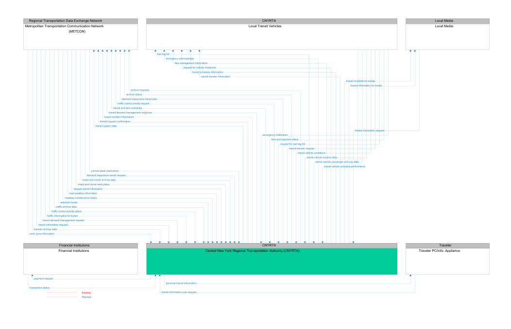
CNYRTACentral New York Regional Transportation Authority (CNYRTA)
CNYRTALocal Transit Vehicles
Financial InstitutionsFinancial Institutions
Local MediaLocal Media
Regional Transportation Data Exchange NetworkMetropolitan Transportation Communication Network
(METCON)
TravelerTraveler PC/Info. Appliance
bad tag list
emergency acknowledge
fare management information
request for vehicle measures
transit schedule information
transit traveler information
payment request
transit incidents for media
transit information for media
archive requests
archive status
demand responsive transit plan
traffic control priority request
transit and fare schedules
transit demand management response
transit incident information
transit request confirmation
transit system data
personal transit information
transaction status
media information request
emergency notification
fare and payment status
request for bad tag list
transit traveler request
transit vehicle conditions
transit vehicle location data
transit vehicle passenger and use data
transit vehicle schedule performance
current asset restrictions
demand responsive transit request
maint and constr archive data
maint and constr work plans
request transit information
road weather information
roadway maintenance status
selected routes
traffic archive data
traffic control priority status
traffic information for transit
transit demand management request
transit information request
traveler archive data
work zone information
transit information user requestExisting
Planned

City of SyracuseCity of Syracuse Dept. of Public Works
City of SyracuseCity of Syracuse Field Equipment
City of SyracuseCity of Syracuse Maintenance Vehicles
City of SyracuseCity of Syracuse Police Department
Financial InstitutionsFinancial Institutions
Local MediaLocal Media
Regional Transportation Data Exchange NetworkMetropolitan Transportation Communication Network (METCON)
TravelerTraveler PC/Info. Appliance
freeway control data
roadway information system data
sensor and surveillance control
signal control data
maint and constr dispatch information
maint and constr vehicle system control
archive coordination
archive requests
archive status
current network conditions
emergency archive data
emergency traffic control response
incident information request
incident report
incident response coordination
maint and constr resource response
request for information on violators
resource deployment status
violation notification
payment request
incident information for media
traffic information for media
traveler information for media
archive coordination
archive requests
archive status
current asset restrictions
current network conditions
fare and price information
field equipment status
incident information
incident information request
incident report
incident response status
intersection blockage notification
ISP coordination
logged special vehicle route
maint and constr archive data
maint and constr resource request
maint and constr resource response
maint and constr work plans
parking archive data
parking availability
parking demand management response
parking information
parking lot reservation confirmation
request fare and price information
request for traffic information
resource request
road network conditions
road network probe information
road network use
road weather information
roadway maintenance status
traffic information
traffic information coordination
work plan feedback
work zone information
broadcast information
emergency acknowledge
traveler information
trip plan
fault reports
freeway control status
incident data
request for right-of-way
roadside archive data
roadway information system status
signal control status
traffic flow
traffic images
vehicle probe data
infrastructure conditions data
maint and constr dispatch status
maint and constr vehicle conditions
maint and constr vehicle location data
maint and constr vehicle operational data
work zone warning status
archive coordination
archive requests
emergency archive data
emergency traffic control request
incident information
incident report
incident response coordination
incident response status
incident status
local signal preemption request
maint and constr resource request
resource request
transaction status
external reports
media information request
archive coordination
archive requests
current asset restrictions
current network conditions
fare and price information
field equipment status
incident information
incident information request
incident report
logged special vehicle route
maint and constr archive data
maint and constr resource request
maint and constr resource response
maint and constr work plans
parking demand management request
parking instructions
parking lot data request
parking reservations request
request fare and price information
request for traffic information
resource deployment status
road network conditions
road network probe information
road network use
road weather information
roadway maintenance status
traffic archive data
traffic information
traffic information coordination
traveler archive data
work plan feedback
work zone information
traveler profile
traveler request
trip confirmation
trip request
Existing
Planned

City of SyracuseCity of Syracuse Dept. of Public Works
City of SyracuseCity of Syracuse Field Equipment
Inter-Agency GroupEZPASS TAG
TravelerPedestrian
City of SyracuseCity of Syracuse Fire Vehicles
freeway control dataroadway information system data
sensor and surveillance controlsignal control data
fault reportsfreeway control status
incident datarequest for right-of-way
roadside archive dataroadway information system status
signal control statustraffic flow
traffic imagesvehicle probe data
intersection statusrequest tag data
vehicle signage datacrossing permission
local signal preemption request
vehicle probe datacrossing call
ExistingPlanned

City of SyracuseCity of Syracuse Fire Department
City of SyracuseCity of Syracuse Fire Vehicles
Regional Emergency Data ExchangeSyracuse Regional Emergency
Network (SyREN)
Regional Transportation Data ExchangeMetropolitan Transportation
Communication Network (METCON)
emergency dispatch requestsincident command information
incident reportincident response coordination
suggested routeincident notification response
incident reportemergency traffic control request
incident informationincident response status
remote surveillance controlresource request
emergency dispatch responseemergency vehicle tracking data
incident command requestincident report
incident response coordinationincident status
local signal preemption requestcurrent asset restrictions
current network conditionsemergency traffic control response
incident informationincident information request
maint and constr resource responsemaint and constr work plans
resource deployment statusroad weather information
roadway maintenance statusviolation notification
work zone informationincident notification
incident reportincident response coordination
ExistingPlanned

City of SyracuseCity of Syracuse Fire Department
City of SyracuseCity of Syracuse Fire Vehicles
City of SyracuseCity of Syracuse Field Equipment
NY State DOTNYSDOT Region 3 Field Equipment
Onondaga CountyOnondaga County DOT Field
Equipment
Regional Emergency Data Exchange NetworkSyracuse Regional Emergency Network (SyREN)
emergency dispatch requestsincident command information
incident reportincident response coordination
suggested route
local signal preemption request
emergency dispatch responseemergency vehicle tracking data
incident command requestincident report
incident response coordinationincident status
local signal preemption requestlocal signal preemption request
local signal preemption request
emergency dispatch responseemergency vehicle tracking data
incident command requestincident status
local signal preemption requestemergency notification
emergency dispatch requestsincident command information
suggested route
ExistingPlanned

City of SyracuseCity of Syracuse Dept. of Public Works
City of SyracuseCity of Syracuse Maintenance Vehicles
Regional Transportation Data ExchangeMetropolitan Transportation
Communication Network (METCON)
maint and constr dispatch informationmaint and constr vehicle system control
infrastructure conditions datamaint and constr dispatch status
maint and constr vehicle conditionsmaint and constr vehicle location data
maint and constr vehicle operational datawork zone warning status
maint and constr dispatch information
ExistingPlanned

City of SyracuseCity of Syracuse Dept. of Public Works
City of SyracuseCity of Syracuse Police Department
City of SyracuseCity of Syracuse Police Vehicles
Regional Emergency Data Exchange NetworkSyracuse Regional Emergency Network (SyREN)
Regional Transportation Data ExchangeMetropolitan Transportation
Communication Network (METCON)
archive coordinationarchive requests
archive statuscurrent network conditions
emergency archive dataemergency traffic control response
incident information requestincident report
incident response coordinationmaint and constr resource response
request for information on violatorsresource deployment status
violation notificationarchive coordination
archive requestsemergency archive data
emergency traffic control requestincident information
incident reportincident response coordination
incident response statusincident status
local signal preemption requestmaint and constr resource request
resource requestarchive requests
archive statusemergency dispatch requests
emergency personnel inputsincident command information
incident notificationincident report
incident response coordinationsuggested route
archive requestsarchive status
incident notificationincident notification response
incident response coordination
archive requestsarchive status
incident informationincident response status
resource requestdispatch information
emergency archive dataemergency dispatch response
emergency vehicle tracking dataincident command information presentation
incident command requestincident notification response
incident reportincident response coordination
incident statuslocal signal preemption request
current asset restrictionscurrent network conditions
incident informationincident information request
maint and constr archive datamaint and constr resource response
maint and constr work plansresource deployment status
road weather informationroadway maintenance status
traffic archive datatraveler archive data
violation notificationwork zone information
emergency archive dataincident notification
incident notification responseincident report
incident response coordination
ExistingPlanned

City of SyracuseCity of Syracuse Police Department
City of SyracuseCity of Syracuse Police Vehicles
Regional Emergency Data Exchange NetworkSyracuse Regional Emergency Network (SyREN)
archive requestsarchive status
emergency dispatch requestsemergency personnel inputs
incident command informationincident notification
incident reportincident response coordination
suggested routedispatch information
emergency archive dataemergency dispatch response
emergency vehicle tracking dataincident command information presentation
incident command requestincident notification response
incident reportincident response coordination
incident statuslocal signal preemption request
emergency dispatch responseemergency vehicle tracking data
incident command requestincident status
local signal preemption requestemergency dispatch requests
incident command informationsuggested route
ExistingPlanned

City of SyracuseCity of Syracuse Field Equipment
Inter-Agency GroupEZPASS TAG
NYSTANYSTA Field Equipment
NY State DOTNYSDOT Region 3 Field Equipment
intersection statusrequest tag data
vehicle signage datavehicle probe data
request for paymenttag data
intersection statusrequest tag data
vehicle signage dataintersection status
paymentrequest tag data
tag updatevehicle signage data
ExistingPlanned

CNYRTACentral New York Regional
Transportation Authority (CNYRTA)
Financial InstitutionsFinancial Institutions
City of SyracuseCity of Syracuse Dept. of Public Works
NY State DOTNYSDOT Region 3 Operations Center
NYSTANYSTA Traffic Operations Center
Onondaga CountyOnondaga County Dept. of
Transportation
payment requestpayment request
transaction statustransaction status
transaction status
transaction statustransaction status
payment request
payment requestpayment request
ExistingPlanned

CNYRTACentral New York Regional
Transportation Authority (CNYRTA)
Local MediaLocal Media
City of SyracuseCity of Syracuse Dept. of Public Works
NY State DOTNYSDOT Region 3 Operations Center
NYSTANYSTA Traffic Operations Center
Onondaga CountyOnondaga County Dept. of
Transportation
Regional Transportation Data ExchangeMetropolitan Transportation
Communication Network (METCON)
transit incidents for mediatransit information for media
incident information for mediatraffic information for media
traveler information for mediaexternal reports
media information request
media information request
external reportsmedia information request
external reportsmedia information request
external reportsmedia information request
external reportsmedia information request
traffic information for mediatraveler information for media
incident information for mediatraffic information for media
traveler information for mediaincident information for media
traffic information for mediatraveler information for media
incident information for mediatraffic information for media
traveler information for media
ExistingPlanned

CNYRTACentral New York Regional
Transportation Authority (CNYRTA)
CNYRTALocal Transit Vehicles
NY State DOTNYSDOT Region 3 Field Equipment
Onondaga CountyOnondaga County DOT Field
Equipment
bad tag listemergency acknowledge
fare management informationrequest for vehicle measures
transit schedule informationtransit traveler information
emergency notificationfare and payment status
request for bad tag listtransit traveler request
transit vehicle conditionstransit vehicle location data
transit vehicle passenger and use datatransit vehicle schedule performance
local signal priority requestlocal signal priority request
ExistingPlanned

CNYRTACentral New York Regional Transportation Authority (CNYRTA)
Regional Transportation Data Exchange NetworkMetropolitan Transportation Communication Network (METCON)
City of SyracuseCity of Syracuse Dept. of Public Works
City of SyracuseCity of Syracuse Fire Department
City of SyracuseCity of Syracuse Police Department
Local MediaLocal Media NYSDOT Region 3 Maintenance and
Supervisory Vehicles
City of SyracuseCity of Syracuse Maintenance Vehicles
E-911 CenterOnondaga County 911 Emergency
Communications (ECD)
MPO - Planning agencySyracuse Metropolitan Transportation Council (SMTC)
NY State DOTNYSDOT Region 3
NY State DOTNYSDOT Region 3 Operations Center
NY State PoliceNew York State Police
NYSTANYSTA Maintenance and Supervisory Vehicles
NYSTANYSTA Statewide Operations Center Troop T Dispatch
NYSTANYSTA Traff ic Operations Center
Onondaga CountyOnondaga County Dept. of Transportation
Onondaga CountyOnondaga County Emergency Management Division (EMD)
Onondaga CountyOnondaga County Maintenance Vehicles
Onondaga CountyOnondaga County Sheriff
Other Emergency Service ProvidersOther EMS Dispatch
Regional Emergency Data Exchange Net...Syracuse Regional Emergency Network
(SyREN)
TravelerTraveler PC/Info. Appliance
archive requestsarchive status
demand responsive transit plantraff ic control priority request
transit and fare schedulestransit demand management response
transit incident informationtransit request confirmation
transit system data
archive coordinationarchive requests
archive statuscurrent asset restrictions
current network conditionsfare and price information
field equipment statusincident information
incident information requestincident report
incident response statusintersection blockage notif ication
ISP coordinationlogged special vehicle route
maint and constr archive datamaint and constr resource request
maint and constr resource responsemaint and constr work plans
parking archive dataparking availability
parking demand management responseparking information
parking lot reservation confirmationrequest fare and price information
request for traff ic informationresource request
road network conditionsroad network probe information
road network useroad weather information
roadway maintenance statustraff ic information
traff ic information coordinationwork plan feedback
work zone informationemergency traff ic control request
incident informationincident response status
remote surveillance controlresource request
archive requestsarchive status
incident informationincident response status
resource request
external reportsmedia information request
maint and constr dispatch information
archive coordinationarchive requests
current asset restrictionscurrent network conditions
fare and price informationfield equipment status
incident informationincident information request
incident reportlogged special vehicle route
maint and constr archive datamaint and constr resource request
maint and constr resource responsemaint and constr work plans
parking demand management requestparking instructions
parking lot data requestparking reservations request
request fare and price informationrequest for traff ic information
resource deployment statusroad network conditions
road network probe informationroad network use
road weather informationroadway maintenance status
traff ic archive datatraff ic information
traff ic information coordinationtraveler archive data
work plan feedbackwork zone information
current asset restrictions
current network conditionsemergency traff ic control response
incident informationincident information request
maint and constr resource responsemaint and constr work plans
resource deployment statusroad weather information
roadway maintenance statusviolation notif ication
work zone information
maint and constr dispatch information
current asset restrictionscurrent network conditions
incident informationincident information request
maint and constr archive datamaint and constr resource response
maint and constr work plansresource deployment status
road weather informationroadway maintenance status
traff ic archive datatraveler archive data
violation notif icationwork zone information
current asset restrictionsdemand responsive transit request
maint and constr archive datamaint and constr work plans
request transit informationroad weather information
roadway maintenance statusselected routes
traff ic archive datatraff ic control priority status
traff ic information for transittransit demand management request
transit information requesttraveler archive data
work zone information
current asset restrictionscurrent network conditions
emergency traff ic control responseincident information
incident information requestmaint and constr resource response
maint and constr work plansresource deployment status
road weather informationroadway maintenance status
work zone information
traff ic information for mediatraveler information for media
current asset restrictionsISP coordination
maint and constr archive datamaint and constr work plans
map update requestrequest fare and price information
road weather informationroadway maintenance status
traff ic archive datatraff ic information
traveler archive datawork zone information
maint and constr archive datatraff ic archive data
traff ic information coordinationtraveler archive data
archive coordinationarchive requests
current asset restrictionscurrent network conditions
fare and price informationfield equipment status
incident informationincident information request
incident reportlogged special vehicle route
maint and constr archive datamaint and constr resource request
maint and constr resource responsemaint and constr work plans
parking demand management requestparking instructions
parking lot data requestparking reservations request
request fare and price informationrequest for traff ic information
resource deployment statusroad network conditions
road network probe informationroad network use
road weather informationroadway maintenance status
traff ic archive datatraff ic information
traff ic information coordinationtraveler archive data
work plan feedbackwork zone information
current asset restrictionscurrent network conditions
emergency traff ic control responseincident information
incident information requestmaint and constr resource response
maint and constr work plansresource deployment status
road weather informationroadway maintenance status
violation notif icationwork zone information
maint and constr dispatch information
current asset restrictionscurrent network conditions
emergency traff ic control responseincident information
incident information requestmaint and constr resource response
maint and constr work plansresource deployment status
road weather informationroadway maintenance status
violation notif icationwork zone information
current asset restrictionsfield equipment status
logged special vehicle routemaint and constr archive data
maint and constr resource requestmaint and constr resource response
maint and constr work plansrequest for traff ic information
road network conditionsroad network probe information
road network useroad weather information
roadway maintenance statustraff ic information coordination
work plan feedbackwork zone information
archive coordinationarchive requests
current asset restrictionscurrent network conditions
fare and price informationfield equipment status
incident informationincident information request
incident reportlogged special vehicle route
maint and constr archive datamaint and constr resource request
maint and constr resource responsemaint and constr work plans
parking demand management requestparking instructions
parking lot data requestparking reservations request
request fare and price informationrequest for traff ic information
resource deployment statusroad network conditions
road network probe informationroad network use
road weather informationroadway maintenance status
traff ic archive datatraff ic information
traff ic information coordinationtraveler archive data
work plan feedbackwork zone information
current asset restrictionscurrent network conditions
emergency traff ic control responseincident information
incident information requestmaint and constr resource response
maint and constr work plansresource deployment status
road weather informationroadway maintenance status
traff ic archive datatraveler archive data
work zone informationmaint and constr dispatch information
current asset restrictionscurrent network conditions
emergency traff ic control responseincident information
incident information requestmaint and constr archive data
maint and constr resource responsemaint and constr work plans
resource deployment statusroad weather information
roadway maintenance statustraff ic archive data
traveler archive dataviolation notif ication
work zone information
current asset restrictionscurrent network conditions
emergency traff ic control responseincident information
incident information requestmaint and constr resource response
maint and constr work plansresource deployment status
road weather informationroadway maintenance status
work zone informationcurrent asset restrictions
current network conditionsemergency traff ic control response
incident informationincident information request
maint and constr resource responsemaint and constr work plans
resource deployment statusroad weather information
roadway maintenance statuswork zone information
broadcast informationtraveler information
trip plan
emergency traff ic control requestincident information
incident response statusresource request
archive requestsarchive status
traff ic information coordination
archive coordinationarchive requests
archive statuscurrent asset restrictions
current network conditionsfare and price information
field equipment statusincident information
incident information requestincident report
incident response statusintersection blockage notif ication
ISP coordinationlogged special vehicle route
maint and constr archive datamaint and constr resource request
maint and constr resource responsemaint and constr work plans
parking archive dataparking availability
parking demand management responseparking information
parking lot reservation confirmationrequest fare and price information
request for traff ic informationresource request
road network conditionsroad network probe information
road network useroad weather information
roadway maintenance statustraff ic information
traff ic information coordinationwork plan feedback
work zone informationemergency traff ic control request
incident informationincident response status
resource request
current asset restrictionsfield equipment status
maint and constr archive datamaint and constr resource request
maint and constr resource responsemaint and constr work plans
road network conditionsroad network probe information
road weather informationroadway maintenance status
traff ic control coordinationtraff ic information
traff ic information coordinationwork plan feedback
work zone information
emergency traff ic control requestincident information
incident response statusresource request
archive coordinationarchive requests
archive statuscurrent asset restrictions
current network conditionsfare and price information
field equipment statusincident information
incident information requestincident report
incident response statusintersection blockage notif ication
ISP coordinationlogged special vehicle route
maint and constr archive datamaint and constr resource request
maint and constr resource responsemaint and constr work plans
parking archive dataparking availability
parking demand management responseparking information
parking lot reservation confirmationrequest fare and price information
request for traff ic informationresource request
road network conditionsroad network probe information
road network useroad weather information
roadway maintenance statustraff ic information
traff ic information coordinationwork plan feedback
work zone information
archive requestsarchive status
emergency traff ic control requestincident information
incident response statusremote surveillance control
resource requestarchive requests
archive statusemergency traff ic control request
incident informationincident response status
remote surveillance controlresource request
emergency traff ic control requestincident information
incident response statusremote surveillance control
resource request
archive requestsarchive status
fare and price informationfault reports
freeway control statusincident data
intersection blockage notif icationISP coordination
logged special vehicle routemap updates
request for right-of-wayrequest for traff ic information
reversible lane statusroad network use
roadway information system statussignal control status
traff ic f lowtraff ic images
vehicle probe data
emergency traff ic control requestincident information
incident response statusremote surveillance control
resource request
traveler profiletraveler request
trip confirmationtrip request
ExistingPlanned

Regional Transportation Data Exchange NetworkMetropolitan Transportation Communication Network (METCON)
NY State PoliceNew York State Police
NY State DOTNYSDOT Region 3 Operations Center
NY State PoliceNew York State Police (Troop D) Vehicles
Regional Emergency Data ExchangeSyracuse Regional Emergency
Network (SyREN)
current asset restrictionscurrent network conditions
emergency traffic control responseincident information
incident information requestmaint and constr resource response
maint and constr work plansresource deployment status
road weather informationroadway maintenance status
violation notificationwork zone information
archive coordinationarchive requests
emergency archive dataemergency traffic control request
incident informationincident report
incident response coordinationincident response status
incident statuslocal signal preemption request
maint and constr resource requestresource request
emergency dispatch requestsemergency personnel inputs
incident command informationsuggested route
emergency dispatch responseemergency operations request
emergency vehicle tracking dataincident command request
incident notification responseincident report
incident statusemergency traffic control request
incident informationincident response status
resource request
dispatch informationemergency dispatch response
emergency vehicle tracking dataincident command information presentation
incident command requestincident status
local signal preemption request
archive coordinationarchive requests
archive statuscurrent network conditions
emergency archive dataemergency traffic control response
incident information requestincident report
incident response coordinationmaint and constr resource response
request for information on violatorsresource deployment status
violation notificationemergency dispatch requests
emergency operations statusincident command information
incident notificationincident report
incident response coordinationsuggested route
ExistingPlanned

NY State PoliceNew York State Police
NY State PoliceNew York State Police (Troop D) Vehicles
Regional Emergency Data Exchange NetworkSyracuse Regional Emergency Network (SyREN)
emergency dispatch requestsemergency personnel inputs
incident command informationsuggested route
dispatch informationemergency dispatch response
emergency vehicle tracking dataincident command information presentation
incident command requestincident status
local signal preemption requestemergency dispatch response
emergency vehicle tracking dataincident command request
incident statuslocal signal preemption request
emergency dispatch requestsincident command information
suggested route
ExistingPlanned

Regional Transportation Data Exchange NetworkMetropolitan Transportation Communication Network (METCON)
NY State DOTNYSDOT Region 3
NY State DOTNYSDOT Region 3 Operations Center
maint and constr archive datatraffic archive data
traffic information coordinationtraveler archive data
archive analysis requestsarchive coordination
archive management requestsarchive requests
archive statusarchived data product requests
other data source archive datasensor and surveillance control
traffic control coordinationtraffic information coordination
archive requestsarchive status
traffic information coordinationarchive analysis results
archive coordinationarchive management data
archive request confirmationarchive requests
archive statusarchived data products
construction and maintenance archive dataemergency archive data
other data source archive dataroadside archive data
traffic archive datatraffic information coordination
traveler archive data
ExistingPlanned

City of SyracuseCity of Syracuse Fire Vehicles
NY State DOTNYSDOT Region 3 Field Equipment
CNYRTALocal Transit Vehicles
Inter-Agency GroupEZPASS TAG
NY State DOTNYSDOT Region 3 Operations Center
TravelerPedestrian
Other Emergency Service ProvidersOther EMS Vehicles
Non-City Fire AgenciesOther Fire Vehicles (excluding the city fire vehicles)
local signal preemption requestlocal signal priority request
emergency notification
intersection statusrequest tag data
vehicle signage datafault reports
freeway control statusincident data
request for right-of-wayroadside archive data
roadway information system statussignal control status
traffic flowtraffic images
vehicle probe datacrossing permission
transit user fare statustransit user outputs
traveler interface updatesfreeway control data
roadway information system datasensor and surveillance control
signal control data
local signal preemption requestlocal signal preemption request
crossing calltransit user inputs
traveler inputs
ExistingPlanned

Regional Transportation Data ExchangeMetropolitan Transportation
Communication Network (METCON)
NYSDOT Region 3 Maintenance andSupervisory Vehicles
NY State DOTNYSDOT Region 3 Operations Center
NYSTANYSTA Traffic Operations Center
maint and constr dispatch informationinfrastructure conditions data
maint and constr dispatch statusmaint and constr vehicle conditions
maint and constr vehicle location datamaint and constr vehicle operational data
work zone warning statusmaint and constr dispatch information
maint and constr vehicle system controlmaint and constr vehicle system control
ExistingPlanned

Financial InstitutionsFinancial Institutions
NY State DOTNYSDOT Region 3 Operations Center
Local MediaLocal Media
Regional Transportation Data Exchange NetworkMetropolitan Transportation Communication Network (METCON)
NY State PoliceNew York State Police
NY State DOTNYSDOT Region 3
NY State DOTNYSDOT Region 3 Field Equipment NYSDOT Region 3 Maintenance and Supervisory
Vehicles
TravelerTraveler PC/Info. Appliance
transaction status
external reports
media information request
archive coordination
archive requests
current asset restrictions
current network conditions
fare and price information
field equipment status
incident information
incident information request
incident report
logged special vehicle route
maint and constr archive data
maint and constr resource request
maint and constr resource response
maint and constr work plans
parking demand management request
parking instructions
parking lot data request
parking reservations request
request fare and price information
request for traffic information
resource deployment status
road network conditions
road network probe information
road network use
road weather information
roadway maintenance status
traffic archive data
traffic information
traffic information coordination
traveler archive data
work plan feedback
work zone information
archive coordination
archive requests
emergency archive data
emergency traffic control request
incident information
incident report
incident response coordination
incident response status
incident status
local signal preemption request
maint and constr resource request
resource request
archive analysis requests
archive coordination
archive management requests
archive requests
archive status
archived data product requests
other data source archive data
sensor and surveillance control
traffic control coordination
traffic information coordination
fault reports
freeway control status
incident data
request for right-of-way
roadside archive data
roadway information system status
signal control status
traffic flow
traffic images
vehicle probe data
infrastructure conditions data
maint and constr dispatch status
maint and constr vehicle conditions
maint and constr vehicle location data
maint and constr vehicle operational data
work zone warning status
maint and constr dispatch information
maint and constr vehicle system control
payment request
incident information for media
traffic information for media
traveler information for media
archive analysis results
archive coordination
archive management data
archive request confirmation
archive requests
archive status
archived data products
construction and maintenance archive data
emergency archive data
other data source archive data
roadside archive data
traffic archive data
traffic information coordination
traveler archive data
freeway control data
roadway information system data
sensor and surveillance control
signal control data
archive coordination
archive requests
archive status
current network conditions
emergency archive data
emergency traffic control response
incident information request
incident report
incident response coordination
maint and constr resource response
request for information on violators
resource deployment status
violation notification
archive coordination
archive requests
archive status
current asset restrictions
current network conditions
fare and price information
field equipment status
incident information
incident information request
incident report
incident response status
intersection blockage notification
ISP coordination
logged special vehicle route
maint and constr archive data
maint and constr resource request
maint and constr resource response
maint and constr work plans
parking archive data
parking availability
parking demand management response
parking information
parking lot reservation confirmation
request fare and price information
request for traffic information
resource request
road network conditions
road network probe information
road network use
road weather information
roadway maintenance status
traffic information
traffic information coordination
work plan feedback
work zone information
broadcast information
emergency acknowledge
traveler information
trip plan
traveler profile
traveler request
trip confirmation
trip request
ExistingPlanned

Inter-Agency GroupEZPASS TAG
NYSTANYSTA Field Equipment
NYSTANYSTA Traffic Operations Center
request for paymenttag data
intersection statuspayment
request tag datatag update
vehicle signage datafault reports
freeway control statusincident data
roadside archive datatraffic flow
traffic imagesvehicle probe data
equipment maintenance statusfreeway control data
incident informationroadway information system data
roadway information system statussensor and surveillance control
signal control datasignal control status
ExistingPlanned

Regional Transportation Data ExchangeMetropolitan Transportation
Communication Network (METCON)
NYSTANYSTA Maintenance and Supervisory
Vehicles
NYSTANYSTA Traffic Operations Center
maint and constr dispatch informationinfrastructure conditions data
maint and constr dispatch statusmaint and constr vehicle conditions
maint and constr vehicle location datamaint and constr vehicle operational data
work zone warning statusmaint and constr dispatch information
maint and constr vehicle system control
ExistingPlanned

NYSTANYSTA State Police Troop T Vehicles
NYSTANYSTA Statewide Operations Center
Troop T Dispatch
Regional Emergency Data Exchange NetworkSyracuse Regional Emergency Network (SyREN)
emergency dispatch responseemergency vehicle tracking data
incident command requestincident status
local signal preemption requestemergency dispatch response
emergency vehicle tracking dataincident command request
incident statuslocal signal preemption request
emergency dispatch requestsincident command information
suggested routeemergency dispatch requests
incident command informationsuggested route
ExistingPlanned

Regional Transportation Data Exchange NetworkMetropolitan Transportation Communication Network (METCON)
NYSTANYSTA Statewide Operations Center Troop T Dispatch
NYSTANYSTA State Police Troop T Vehicles
NYSTANYSTA Traffic Operations Center
Regional Emergency Data Exchange NetSyracuse Regional Emergency Network
(SyREN)
current asset restrictionscurrent network conditions
emergency traffic control responseincident information
incident information requestmaint and constr resource response
maint and constr work plansresource deployment status
road weather informationroadway maintenance status
violation notificationwork zone information
emergency dispatch responseemergency vehicle tracking data
incident command requestincident status
local signal preemption requestemergency dispatch requests
incident command informationsuggested route
emergency archive dataemergency traffic control request
incident informationincident report
incident response coordinationincident response status
remote surveillance controlresource request
incident notification responseincident report
incident response coordination
emergency traffic control requestincident information
incident response statusresource request
archive requestsarchive status
current network conditionsemergency traffic control response
incident informationincident information request
incident reportincident response coordination
resource deployment statusviolation notification
weather information
incident notificationincident report
incident response coordination
ExistingPlanned

Financial InstitutionsFinancial Institutions
NYSTANYSTA Traffic Operations Center
Local MediaLocal Media
Regional Transportation Data Exchange NetworkMetropolitan Transportation Communication Network (METCON)
NYSTANYSTA Field Equipment
NYSTANYSTA Maintenance and Supervisory Vehicles
NYSTANYSTA Statewide Operations Center Troop T Dispatch
NYSDOT Region 3 Maintenance andSupervisory Vehicles
TravelerTraveler PC/Info. Appliance
transaction statusexternal reports
media information request
current asset restrictionsfield equipment status
logged special vehicle routemaint and constr archive data
maint and constr resource requestmaint and constr resource response
maint and constr work plansrequest for traffic information
road network conditionsroad network probe information
road network useroad weather information
roadway maintenance statustraffic information coordination
work plan feedbackwork zone information
fault reportsfreeway control status
incident dataroadside archive data
traffic flowtraffic images
vehicle probe data
infrastructure conditions datamaint and constr dispatch status
maint and constr vehicle conditionsmaint and constr vehicle location data
maint and constr vehicle operational datawork zone warning status
emergency archive dataemergency traffic control request
incident informationincident report
incident response coordinationincident response status
remote surveillance controlresource request
maint and constr vehicle system controlpayment request
incident information for mediatraffic information for media
traveler information for media
equipment maintenance statusfreeway control data
incident informationroadway information system data
roadway information system statussensor and surveillance control
signal control datasignal control status
maint and constr dispatch informationmaint and constr vehicle system control
archive requestsarchive status
current network conditionsemergency traffic control response
incident informationincident information request
incident reportincident response coordination
resource deployment statusviolation notification
weather informationcurrent asset restrictions
field equipment statusmaint and constr archive data
maint and constr resource requestmaint and constr resource response
maint and constr work plansroad network conditions
road network probe informationroad weather information
roadway maintenance statustraffic control coordination
traffic informationtraffic information coordination
work plan feedbackwork zone information
broadcast informationtraveler information
trip plantraveler profile
traveler requesttrip confirmation
trip request
ExistingPlanned

Regional Transportation Data ExchangeMetropolitan Transportation
Communication Network (METCON)
E-911 CenterOnondaga County 911 Emergency
Communications (ECD)
Regional Emergency Data ExchangeSyracuse Regional Emergency
Network (SyREN)
ExistingPlanned

Financial InstitutionsFinancial Institutions
Onondaga CountyOnondaga County Dept. of Transportation
Local MediaLocal Media
Regional Transportation Data Exchange NetworkMetropolitan Transportation Communication Network (METCON)
Onondaga CountyOnondaga County DOT Field
Equipment
Onondaga CountyOnondaga County Maintenance Vehicles
Onondaga CountyOnondaga County Sheriff
TravelerTraveler PC/Info. Appliance
transaction status
external reports
media information request
archive coordination
archive requests
current asset restrictions
current network conditions
fare and price information
field equipment status
incident information
incident information request
incident report
logged special vehicle route
maint and constr archive data
maint and constr resource request
maint and constr resource response
maint and constr work plans
parking demand management request
parking instructions
parking lot data request
parking reservations request
request fare and price information
request for traffic information
resource deployment status
road network conditions
road network probe information
road network use
road weather information
roadway maintenance status
traffic archive data
traffic information
traffic information coordination
traveler archive data
work plan feedback
work zone information
payment request
incident information for media
traffic information for media
traveler information for media
freeway control data
roadway information system data
sensor and surveillance control
signal control data
maint and constr dispatch information
maint and constr vehicle system control
archive coordination
archive requests
archive status
current network conditions
emergency archive data
emergency traffic control response
incident information request
incident report
incident response coordination
maint and constr resource response
request for information on violators
resource deployment status
violation notification
archive coordination
archive requests
archive status
current asset restrictions
current network conditions
fare and price information
field equipment status
incident information
incident information request
incident report
incident response status
intersection blockage notification
ISP coordination
logged special vehicle route
maint and constr archive data
maint and constr resource request
maint and constr resource response
maint and constr work plans
parking archive data
parking availability
parking demand management response
parking information
parking lot reservation confirmation
request fare and price information
request for traffic information
resource request
road network conditions
road network probe information
road network use
road weather information
roadway maintenance status
traffic information
traffic information coordination
work plan feedback
work zone information
broadcast information
emergency acknowledge
traveler information
trip plan
fault reports
freeway control status
incident data
request for right-of-way
roadside archive data
roadway information system status
signal control status
traffic flow
traffic images
vehicle probe data
infrastructure conditions data
maint and constr dispatch status
maint and constr vehicle conditions
maint and constr vehicle location data
maint and constr vehicle operational data
work zone warning status
archive coordination
archive requests
emergency archive data
emergency traffic control request
incident information
incident report
incident response coordination
incident response status
incident status
local signal preemption request
maint and constr resource request
resource request
traveler profile
traveler request
trip confirmation
trip request
Existing
Planned

City of SyracuseCity of Syracuse Fire Vehicles
Onondaga CountyOnondaga County DOT Field Equipment
CNYRTALocal Transit Vehicles
Onondaga CountyOnondaga County Dept. of
Transportation
TravelerPedestrian
Other Emergency Service ProvidersOther EMS Vehicles
Non-City Fire AgenciesOther Fire Vehicles (excluding the city
fire vehicles)
local signal preemption request
local signal priority request
freeway control dataroadway information system data
sensor and surveillance controlsignal control data
fault reportsfreeway control status
incident datarequest for right-of-way
roadside archive dataroadway information system status
signal control statustraffic flow
traffic imagesvehicle probe data
crossing permission
local signal preemption requestlocal signal preemption request
crossing call
ExistingPlanned

Regional Transportation Data Exchange Network
Metropolitan Transportation CommunicationNetwork (METCON)
Onondaga CountyOnondaga County Emergency Management Division (EMD)
Regional Emergency Data Exchange NetworkSyracuse Regional Emergency Network (SyREN)
current asset restrictionscurrent network conditions
emergency traffic control responseincident information
incident information requestmaint and constr resource response
maint and constr work plansresource deployment status
road weather informationroadway maintenance status
traffic archive datatraveler archive data
work zone informationincident report
incident response coordinationarchive requests
archive statusemergency traffic control request
incident informationincident response status
remote surveillance controlresource request
incident reportincident response coordination
ExistingPlanned

Regional Transportation Data ExchangeMetropolitan Transportation
Communication Network (METCON)
Onondaga CountyOnondaga County Maintenance
Vehicles
Onondaga CountyOnondaga County Dept. of
Transportation
maint and constr dispatch informationmaint and constr dispatch information
maint and constr vehicle system controlinfrastructure conditions data
maint and constr dispatch statusmaint and constr vehicle conditions
maint and constr vehicle location datamaint and constr vehicle operational data
work zone warning status
ExistingPlanned

Regional Transportation Data Exchange NetworkMetropolitan Transportation Communication Network (METCON)
Onondaga CountyOnondaga County Sheriff
Onondaga CountyOnondaga County Dept. of Transportation
Onondaga CountyOnondaga County Sheriff (Police) Vehicles
Regional Emergency Data ExchangeSyracuse Regional Emergency
Network (SyREN)
current asset restrictionscurrent network conditions
emergency traffic control responseincident information
incident information requestmaint and constr archive data
maint and constr resource responsemaint and constr work plans
resource deployment statusroad weather information
roadway maintenance statustraffic archive data
traveler archive dataviolation notification
work zone informationarchive coordination
archive requestsarchive status
current network conditionsemergency archive data
emergency traffic control responseincident information request
incident reportincident response coordination
maint and constr resource responserequest for information on violators
resource deployment statusviolation notification
archive coordinationarchive requests
emergency archive dataemergency traffic control request
incident informationincident report
incident response coordinationincident response status
incident statuslocal signal preemption request
maint and constr resource requestresource request
emergency dispatch requestsemergency personnel inputs
incident command informationsuggested route
archive requestsarchive status
emergency dispatch responseemergency vehicle tracking data
incident command requestincident notification response
incident reportincident response coordination
incident statuslocal signal preemption request
archive requestsarchive status
emergency traffic control requestincident information
incident response statusremote surveillance control
resource request
dispatch informationemergency dispatch response
emergency vehicle tracking dataincident command information presentation
incident command requestincident status
local signal preemption request
emergency archive dataemergency dispatch requests
incident command informationincident notification
incident reportincident response coordination
suggested route
ExistingPlanned

Onondaga CountyOnondaga County Sheriff
Onondaga CountyOnondaga County Sheriff (Police) Vehicles
Regional Emergency Data Exchange NetworkSyracuse Regional Emergency Network (SyREN)
emergency dispatch requestsemergency personnel inputs
incident command informationsuggested route
dispatch informationemergency dispatch response
emergency vehicle tracking dataincident command information presentation
incident command requestincident status
local signal preemption requestemergency dispatch response
emergency vehicle tracking dataincident command request
incident statuslocal signal preemption request
emergency dispatch requestsincident command information
suggested route
ExistingPlanned

Regional Transportation Data ExchangeMetropolitan Transportation
Communication Network (METCON)
Other Emergency Service ProvidersOther EMS Dispatch
Non-City Fire AgenciesOther Fire Vehicles (excluding the city fire vehicles)
Other Emergency Service ProvidersOther EMS Vehicles
Regional Emergency Data ExchangeSyracuse Regional Emergency
Network (SyREN)
current asset restrictionscurrent network conditions
emergency traffic control responseincident information
incident information requestmaint and constr resource response
maint and constr work plansresource deployment status
road weather informationroadway maintenance status
work zone informationemergency dispatch requests
incident command informationsuggested route
emergency dispatch requestsincident command information
suggested route
incident notification responseincident report
incident response coordination
emergency traffic control requestincident information
incident response statusremote surveillance control
resource requestemergency dispatch response
emergency vehicle tracking dataincident command request
incident statuslocal signal preemption request
emergency dispatch responseemergency vehicle tracking data
incident command requestincident status
local signal preemption request
incident notificationincident report
incident response coordination
ExistingPlanned

Other Emergency Service ProvidersOther EMS Dispatch
Other Emergency Service ProvidersOther EMS Vehicles
NY State DOTNYSDOT Region 3 Field Equipment
Onondaga CountyOnondaga County DOT Field
Equipment
Regional Emergency Data Exchange NetworkSyracuse Regional Emergency Network (SyREN)
emergency dispatch requestsincident command information
suggested routelocal signal preemption request
local signal preemption request
emergency dispatch responseemergency vehicle tracking data
incident command requestincident status
local signal preemption requestemergency dispatch response
emergency vehicle tracking dataincident command request
incident statuslocal signal preemption request
emergency dispatch requestsincident command information
suggested route
ExistingPlanned

Other Emergency Service ProvidersOther EMS Dispatch
Non-City Fire AgenciesOther Fire Vehicles (excluding the city fire vehicles)
NY State DOTNYSDOT Region 3 Field Equipment
Onondaga CountyOnondaga County DOT Field
Equipment
Regional Emergency Data Exchange NetworkSyracuse Regional Emergency Network (SyREN)
emergency dispatch requestsincident command information
suggested routelocal signal preemption request
local signal preemption request
emergency dispatch responseemergency vehicle tracking data
incident command requestincident status
local signal preemption requestemergency dispatch response
emergency vehicle tracking dataincident command request
incident statuslocal signal preemption request
emergency dispatch requestsincident command information
suggested route
ExistingPlanned

City of SyracuseCity of Syracuse Field Equipment
TravelerPedestrian
NY State DOTNYSDOT Region 3 Field Equipment
Onondaga CountyOnondaga County DOT Field
Equipment
crossing permissioncrossing permission
transit user fare statustransit user outputs
traveler interface updatescrossing permission
crossing callcrossing call
transit user inputstraveler inputs
crossing call
ExistingPlanned

Regional Transportation Data Exchange NetworkMetropolitan Transportation Communication Network (METCON)
MPO - Planning agencySyracuse Metropolitan Transportation Council (SMTC)
current asset restrictionsISP coordination
maint and constr archive datamaint and constr work plans
map update requestrequest fare and price information
road weather informationroadway maintenance status
traffic archive datatraffic information
traveler archive datawork zone information
archive requestsarchive status
fare and price informationfault reports
freeway control statusincident data
intersection blockage notificationISP coordination
logged special vehicle routemap updates
request for right-of-wayrequest for traffic information
reversible lane statusroad network use
roadway information system statussignal control status
traffic flowtraffic images
vehicle probe data
ExistingPlanned

City of SyracuseCity of Syracuse Fire Department
Regional Emergency Data Exchange NetworkSyracuse Regional Emergency Network (SyREN)
City of SyracuseCity of Syracuse Fire Vehicles
City of SyracuseCity of Syracuse Police Department
City of SyracuseCity of Syracuse Police Vehicles
Regional Transportation Data Exchange NetworkMetropolitan Transportation Communication Network (METCON)
NY State PoliceNew York State Police
NY State PoliceNew York State Police (Troop D)
Vehicles
NYSTANYSTA State Police Troop T Vehicles
NYSTANYSTA Statewide Operations Center
Troop T Dispatch
E-911 CenterOnondaga County 911 Emergency
Communications (ECD)
Onondaga CountyOnondaga County EmergencyManagement Division (EMD)
Onondaga CountyOnondaga County Sheriff
Onondaga CountyOnondaga County Sheriff (Police)
Vehicles
Other Emergency Service ProvidersOther EMS Dispatch
Other Emergency Service ProvidersOther EMS Vehicles
Non-City Fire AgenciesOther Fire Vehicles (excluding the city
fire vehicles)
incident notification response
incident report
emergency dispatch response
emergency vehicle tracking dataincident command request
incident status
local signal preemption request
archive requestsarchive status
incident notification
incident notification response
incident response coordinationemergency dispatch response
emergency vehicle tracking data
incident command requestincident status
local signal preemption request
current asset restrictions
current network conditions
emergency traffic control responseincident information
incident information requestmaint and constr resource response
maint and constr work plans
resource deployment statusroad weather information
roadway maintenance statuswork zone information
emergency dispatch response
emergency operations requestemergency vehicle tracking data
incident command request
incident notification responseincident report
incident status
emergency dispatch responseemergency vehicle tracking data
incident command requestincident status
local signal preemption request
emergency dispatch response
emergency vehicle tracking dataincident command request
incident status
local signal preemption requestincident notification response
incident reportincident response coordination
incident notificationincident notification response
incident reportincident response coordination
incident report
incident response coordination
archive requestsarchive status
emergency dispatch response
emergency vehicle tracking dataincident command request
incident notification responseincident report
incident response coordinationincident status
local signal preemption request
emergency dispatch response
emergency vehicle tracking dataincident command request
incident status
local signal preemption requestincident notification response
incident reportincident response coordination
emergency dispatch response
emergency vehicle tracking data
incident command request
incident status
local signal preemption request
emergency dispatch response
emergency vehicle tracking data
incident command requestincident status
local signal preemption request
incident notification
incident reportincident response coordination
emergency dispatch requestsincident command information
suggested route
emergency archive data
incident notificationincident notification response
incident reportincident response coordination
emergency dispatch requests
incident command informationsuggested route
emergency operations statusincident notification
incident notification responseincident report
incident response coordination
emergency dispatch requestsincident command information
suggested route
emergency dispatch requestsemergency operations status
incident command informationincident notification
incident reportincident response coordination
suggested route
emergency dispatch requestsincident command information
suggested route
emergency dispatch requestsincident command information
suggested route
incident notification
incident reportincident response coordination
incident report
incident response coordination
emergency archive dataemergency dispatch requests
incident command informationincident notification
incident report
incident response coordinationsuggested route
emergency dispatch requests
incident command informationsuggested route
incident notification
incident reportincident response coordination
emergency dispatch requestsincident command information
suggested route
emergency traffic control request
incident information
incident response statusremote surveillance control
resource request
ExistingPlanned

CNYRTACentral New York Regional
Transportation Authority (CNYRTA)
TravelerTraveler PC/Info. Appliance
City of SyracuseCity of Syracuse Dept. of Public Works
Regional Transportation Data ExchangeMetropolitan Transportation
Communication Network (METCON)
NY State DOTNYSDOT Region 3 Operations Center
NYSTANYSTA Traffic Operations Center
Onondaga CountyOnondaga County Dept. of
Transportation
personal transit information
broadcast informationemergency acknowledge
traveler informationtrip plan
broadcast informationtraveler information
trip plan
broadcast informationemergency acknowledge
traveler informationtrip plan
broadcast informationtraveler information
trip plan
broadcast informationemergency acknowledge
traveler informationtrip plan
traveler profiletraveler request
trip confirmationtrip request
transit information user request
traveler profiletraveler request
trip confirmationtrip request
traveler profiletraveler request
trip confirmationtrip request
traveler profiletraveler request
trip confirmationtrip request
traveler profiletraveler request
trip confirmationtrip request
ExistingPlanned

Technical Memorandum #3
ITS Implementation Plan
Submitted to: New York State
Department of Transportation March 2003
Submitted by: PB Farradyne
New York, New York
ITS Implementat ion Plan

TABLE OF CONTENTS
1. INTRODUCTION................................................................................................... 1 2. METHODOLOGY.................................................................................................. 4
2.1 Project Definition .......................................................................................... 4 2.2 Implementation Time Frame ........................................................................ 4 2.3 Cost.............................................................................................................. 5 2.4 Synergy Among Projects.............................................................................. 6 2.5 Benefit .......................................................................................................... 6
3. RECOMMENDED ITS PROJECTS .................................................................... 10 3.1 ITS Implementation By Agency .................................................................. 10 3.2 New York State Department Of Transportation (NYSDOT) ....................... 13 3.3 City OF Syracuse Department of public works........................................... 38 3.4 Onondaga County Department of Transportation ...................................... 53 3.5 New York State Thruway Authority (NYSTA) ............................................. 61 3.6 Central New York Regional Transportation authority (CNYRTa) ............... 72 3.7 Emergency service Providers..................................................................... 77 3.8 Inter-Agency Projects ................................................................................. 80
4. OPERATIONS AND MAINTENANCE................................................................. 83
ITS Implementat ion Plan

List of Tables
Table 1 Benefits Summary
Table 2 Recommended ITS Projects for New York State Department of Transportation
Table 3 NYSDOT Traffic Operations and Maintenance Cost Estimate
Table 4 New York State Project Cost Calculations
Table 5 Recommended ITS Projects for City of Syracuse Department of Public Work
Table 6 City of Syracuse Traffic Operation Center Operation and Maintenance Cost Estimate
Table 7 City of Syracuse Cost Calculations
Table 8 Recommended ITS Projects for County of Onondaga Department of Transportation
Table 9 Onondaga County Traffic Management Center Operation and Maintenance Cost
Table 10 County of Onondaga Project Cost Calculations
Table 11 Recommended ITS Projects for New York State Thruway
Table 12 Traffic Management Center Operation and Maintenance Cost Estimate
Table 13 NYSTA Project Cost Calculations
Table 14 Recommended ITS Projects for CENTRO
Table 15 CENTRO Traffic Management Center Operation and Maintenance Cost Estimate
Table 16 CENTRO Projects Cost Calculations
Table 17 Operations and Maintenance Issues and Recommendations
ITS Implementat ion Plan

Table of Figures
Figure 1 NYSDOT-02 ITS Early Action Project
Figure 2 NYSDOT-09 ITS Regional Freeway Management System, Phase II
Figure 3 NYSDOT-18 NYSDOT Regional Fiber Optic Communication Network
Figure 4 NYSDOT-32 NYSDOT Regional Fiber Optic Communication Network
Figure 5 NYSDOT-24 ITS Device Deployment
Figure 6 NYSDOT-27 SR 92 Recommended Field Equipment Locations
Figure 7 NYSDOT-28 SR 31 Recommended Field Equipment Locations
Figure 8 NYSDOT-29 SR 5 Recommended Field Equipment Locations
Figure 9 NYSDOT-30 SR 173 Recommended Field Equipment Locations
Figure 10 NYSDOT-21 Network Performance Monitoring Probe Detectors
Figure 11 NYSDOT-9 Centralized Closed Loop System Project
Figure 12 DPW-01 Alternative Communication Network Architecture
Figure 13 DPW-04 CCTV Surveillance Expansion at 15 Locations
Figure 14 DPW-02 Intersection Upgrade along Geddes & Genesee Streets
Figure 15 DPW-06 Upgrade of 16 Intersections and 3 CCTV Project
Figure 16 DPW-13 Signal Control System Expansion Project at 9 Congested Intersections
Figure 17 DPW-14 Signal Control System Expansion Project at 18 Congested Intersections
Figure 18 DPW-19 Signal Control System Expansion Project at 11 Congested Intersections
Figure 19 DPW-10 Adaptive Signal Control System Pilot Project
Figure 20 DPW-17 Adaptive Signal Control System Project at 20 Congested Intersections
Figure 21 DOT-03 Centralize Monitoring of Existing Closed Loop Traffic Signal Systems
Figure 22 DOT-05 Signal System Phase 1 (Rte 57), Upgrade at 17 Congested Intersections
Figure 23 DOT-06 Signal System Phase 2 (S. Bay Rd. & West and East Taft Rd.)
Figure 24 DOT-08 Signal System Phase 3 (Buckley, Morgan, Henry Clay, Wetzchaul
Figure 25 NYSTA-02 ITS Implementation System, Phase 1
Figure 26 NYSTA-04 ITS Implementation System, Phase 2
Figure 27 NYSTA-05 ITS Implementation System, Phase 3
Figure 28 NYSTA-07 ITS Implementation System, Phase 4
Figure 29 NYSTA-08 ITS Implementation System, Phase 5
ITS Implementat ion Plan

1. INTRODUCTION
The New York State Department of Transportation has retained PB Farradyne (PB) to develop a
Strategic Plan for the Deployment of Intelligent Transportation Systems (ITS) in the Syracuse,
N.Y. Metropolitan Area. This Technical Memorandum is the third and final Technical
Memorandum (one of a series of reports) produced by the PB Team. These three Technical
Memoranda, prefaced by an Executive Report, will constitute the Final Strategic Plan. This
memorandum presents an overall ITS implementation plan, including individual projects to be
deployed over a period of time.
The first technical memorandum documented the established goals, assessed operational
deficiencies, analyzed the existing conditions of transportations facilities, prioritized facilities for
potential ITS deployment and prioritized the ITS Market Packages needs of each involved
agency and the region.
Projects were identified based on information gathered throughout the course of this study. The
critical information came from interactions with agencies during many interviews and meetings.
An Existing Conditions report highlighted the major critical locations (congestion, safety, etc.) for
the deployment of ITS. An Inventory of Existing ITS Elements established the baselines for
deployment and integration. The rating and priority settings for all ITS Market Packages were
used to identify ITS needs, as well as the deployment time frames.
The second technical memorandum documented the processes and examined regional ITS
application interface alternatives and provided specific actions that could facilitate electronic
exchange of National ITS Architecture data elements among Syracuse Metropolitan Area
members. To that end, an ITS architecture that is in conformance with the United States
Department of Transportation’s National ITS Architecture has been developed to advance the
status of electronic exchange of regional ITS information in this area.
The defined regional architecture as well as available technologies dictated the need for a
regional information communication network as well as a regional centralized database. The
locations of operations centers, and their ability to host co-located activities, also determined the
magnitude of communications infrastructure and the need for remote functionalities. Ultimately,
all recommendations were made with a view to achieve the region’s established transportation
goals and objectives.
ITS Implementat ion Plan 1

The ITS projects are recommended for specific agencies in Onondaga County. There are four
categories of recommended projects, based on the urgency with which they are needed:
• “Early Action” projects are critical to the operations of the region’s transportation
infrastructure, and they are recommended for immediate deployment.
• “Short-Term” projects are intended to serve immediate transportation needs, and they
are recommended for deployment in the next five years.
• “Mid-Term” projects will build on the short-term projects and provide enhanced
functionality and coverage. They are recommended for deployment in a six to ten year
horizon.
• Finally, the “Long-Term” projects are intended to expand on the short- and mid-terms
projects to complete the comprehensive ITS deployment in the region, and they are
recommended for deployment in an eleven to twenty year horizon.
Each project identified in this document is defined with the required components/ technologies
to be deployed, approximate locations and cost of deployments and the cost of operations and
maintenance.
The primary focus of this document is to provide recommendations to the New York State
Department of Transportation, City of Syracuse Department of Public Works, Onondaga County
Department of Transportation, Central New York Regional Transportation Authority, New York
State Thruway Authority and ultimately to the Syracuse Metropolitan Transportation Council
(SMTC). However, ITS deployments will normally require cooperation among other agencies
that are involved (most notably, emergency responders), directly or indirectly, in the operations
and maintenance of the overall transportation system. Therefore, all ITS projects are identified
with the goal of maximizing the emergency service providers’ performance and functionalities.
The primary emergency service providers involved in this project are: City of Syracuse Police
and Fire Departments, New York State Police, Onondaga County Sheriff, and Onondaga
County Department of Emergency Communication 911 (DEC). The emergency service
providers’ responsibilities extend beyond and above the transportation management function.
Any recommended future technology enhancements must be evaluated and procured with the
overall needs of such agencies in mind. In such cases as the NYSP Troop D, any and all
ITS Implementat ion Plan 2

recommendations must be in compliance with the State Police Statewide Architecture and
policies. In addition, seamless integration with neighboring jurisdictions should be developed
and maintained. Accordingly, this project will focus on providing a general description, and
recommending the general direction of projects, rather than, on details.
Some projects will require deployment efforts by more than one agency. As an example, the
implementation of the NYSDOT Regional Operations Center will require the combined
deployment efforts of both NYSDOT Region 3 and New York State Police. Where applicable,
interagency projects are identified with the names of the involved agencies noted so that the
primary agency can initiate a dialogue with the other involved agency to facilitate an appropriate
course of action to implement the project.
For instance, some major arterials and/or intersections in the City’s area are under the
jurisdiction of the Onondaga County Department of Transportation and New York State
Department of Transportation. ITS projects for these intersections are identified as interagency
deployments to be undertaken in close cooperation between the agencies. Similarly, ITS
projects for the roadways owned by the New York State Thruway Authority or New York State
Department of Transportation in the vicinity of interchanges will require cooperation among
these agencies.
The remaining sections of this report are as follows. Chapter 2 explains the methodology used
in the preparation of this ITS implementation plan. Chapter 3 presents the ITS projects
recommended for deployment by the agencies. In Chapter 4, the operations and maintenance
(O&M) aspects of ITS are discussed. The recommendations are summarized based on the
premise that “operations and maintenance” covers the activities required for a system to
function properly. The discussion on operations and maintenance of ITS provided in this
document is intended to be guidance on how the O&M will evolve as the agencies expand their
ITS deployments.
Overall, this document is intended to serve as a road map for the ITS deployment program for
the Onondaga County area and in particular the Syracuse Metropolitan Area.
ITS Implementat ion Plan 3

2. METHODOLOGY
Intelligent Transportation Systems (ITS) technologies are recommended for deployment in the
Onondaga County Area through a series of individual projects. Each recommended project is
identified with the project location, technology components or options, quantities, costs,
implementation time frame and generalized benefits.
2.1 PROJECT DEFINITION
Projects have been defined by grouping ITS subsystems and communications to deliver one or
more Market Packages on a portion of the transportation network. The metropolitan area is
considered to be comprised of several transportation networks each related to an agency or
geographic location.
While this Technical Memorandum defines these projects as stand-alone efforts, in many cases
it will be more cost effective to implement ITS as a component of a larger construction project
(e.g., installation of conduit under a roadway as part of a resurfacing job). Therefore, it is
recommended that as part of any new construction or rehabilitation of an existing facility, project
planners examine this Implementation Plan to ascertain which ITS components could be
implemented.
During project planning, design and deployment, it is likely that the agencies will modify the
central and/or field elements, the geographic areas of coverage, the phasing, or other aspects
of the projects defined in this document. These modifications will result from the implementers’
more detailed focus, coordination with the rest of an agency’s construction program as well as
those of other agencies, the need to address local conditions not considered in this study and
availability of funding sources.
2.2 IMPLEMENTATION TIME FRAME
Four implementation time frames are used for the recommended projects:
• Early Action projects are recommended for immediate deployments.
• Short-Term projects are recommended for implementation in one through five years. These
projects are intended to serve the agencies’ highest priorities and immediate needs.
ITS Implementat ion Plan 4

• Mid-Term projects are recommended for implementation between six and ten years in the
future. These projects will build on the short-term projects to provide enhanced functionality
and expanded geographic coverage.
• Long-Term projects are recommended for implementation between 11 and 20 years in the
future. These projects are intended to complete the comprehensive ITS deployments in the
region.
2.3 COST
Several sources were utilized to estimate unit costs for the recommended deployments. The
sources included, but were not limited to, the ITS Planning Handbook, the National ITS
Architecture Cost Analysis document, contacts with consultants and vendors, review of
documentation on ITS planning projects, and discussions with various experts in various
technology domains. Local conditions (e.g., availability of electrical and communications
services at an intersection) were not considered. To account for such uncertainties, a range of
costs (+/- 25%) is presented at the end of each table in Chapter 3.
With regard to project costs, for each project there are three categories of costs:
• Hardware, field equipment and construction/installation cost
• Engineering and inspection (E&I) cost - Engineering and inspection costs are estimated
to be twenty-two percent (22%) of the component costs, based on assumptions of ten
percent (10%) for design, ten percent (10%) for construction inspection, and two percent
(2%) for construction engineering.
• Annual operations and maintenance (O&M) costs – This cost is estimated to be
approximately ten percent (10%) of the deployed component cost.
The former two categories together comprise the total capital cost. The cost summaries are
prepared providing a range (+/- 25%) of costs to account for uncertainties within the estimates
for factors including rapid changes and innovations in technologies. The text refers to the
midpoint of this range, unless otherwise noted.
ITS Implementat ion Plan 5

2.4 SYNERGY AMONG PROJECTS
The overall vision of this study is a “seamless” ITS for the region, in which the various
deployments will work together to meet ITS goals and objectives. Achieving this vision requires
an understanding of the relationships among existing, planned and recommended ITS projects.
Several types of relationships between projects are identified. One dependency involves a
project being a prerequisite for others (e.g., roadway traveler information projects are dependent
on the deployment of surveillance systems capable of supplying real-time traffic status
information.) These relationships are identified in the “Prerequisite Projects” column in the
Chapter 3 tables. A second type of synergy is found when multiple agencies deploy ITS
projects that utilize similar technologies. As an example, NYSDOT, City of Syracuse DPW and
Onondaga County DOT have projects recommended for deploying the Automatic Vehicle
Location system. These types of projects are identified in the “Related Projects of Other
Agencies” column in the tables in Chapter 3. Such projects may benefit from economies of
scale associated with a joint procurement or adoption of a standard accepted by multiple
agencies.
2.5 BENEFIT
High costs and other constraints limit the traditional means of increasing capacity, such as
construction of new facilities on the transportation network. More efficient use of the existing
network, enabled through ITS deployment, provides an attractive alternative. The ITS projects
that are defined in this document will benefit the local economy by helping to alleviate
congestion and its financial drain, and by improving mobility. The measures employed by these
projects include improved traveler information to inform travelers about current conditions and
alternative routes and modes, as well as improved incident management to minimize non-
recurring delay.
In addition to congestion relief, ITS projects recommended in this Implementation Plan are
expected to produce benefits in several areas related to safety, productivity, efficiency, and
environmental impact. Unfortunately, it is often difficult to quantify the degree to which
individual ITS projects will produce these benefits. Agencies within the geographic scope of the
Syracuse Metropolitan Area are in fact grappling with a classic capital budgeting scenario called
“capital rationing”. That is – how do we select and prioritize investment opportunities, in an
environment of limited resources, such that “return” is maximized? An organization’s definition
ITS Implementat ion Plan 6

of “return” itself will help determine which methodologies are used to select and prioritize
investments.
Since quantitative benefits assessment results are therefore limited the approach taken is to list
the types of benefits that can be expected from a recommended project based on the results of
similar projects around the nation.
Most ITS projects can be grouped into the USDOT-defined ITS “building blocks” of:
• Traffic Signal Control Systems
• Freeway Management Systems
• Transit Management Systems
• Incident Management Systems
• Electronic Fare Payment Systems
• Electronic Toll Collection
• Multi-modal Traveler Information Systems
A summary of the benefits experienced for each of these groups is presented in Table 1. The
letters (A through G) in the “item” column in this table is referenced in the Chapter 3 tables to
designate the types of benefits expected from a specific recommended project.
ITS Implementat ion Plan 7

TABLE 1 BENEFITS SUMMARY
Item Type of System Benefits Summary • Decrease travel time 20% to 48% • Increase travel speed 16% to 62% • Increase freeway capacity 17% to 25% • Decrease accident rate 15% to 50% • Decrease fuel used in congestion 41% • Decrease CO emissions 122,000 tons annually (Detroit)• Decrease HC emissions 1,400 tons annually (Detroit)
A Freeway Management Systems (e.g., network surveillance, ramp metering)
• Decrease NOx emissions 1,200 tons annually (Detroit) • Decrease travel time 8% to 15% • Increase travel speed 14% to 22% • Decrease vehicle stops 0% to 35% • Decrease delay 17% to 37% • Decrease fuel consumption 6% to 12% • Decrease CO emissions 5% to 13%
B Traffic Signal Systems
• Decrease HC emissions 4% to 10% • Incident Clearance Time Decrease 8 min for stalls,
decrease wrecker response time 5 - 7 minutes • Decrease travel time 10% to 42%
C Incident Management Programs (e.g., service patrols)
• Decrease fatalities 10% in urban areas
• Decrease travel time 8% to 20% for equipped vehicles • Decrease delay up to 1,900 vehicle hours per incident • Decrease fuel consumption 6% to 12% • Decrease VOC emissions 25% from affected vehicles • Decrease HC emissions 33% from affected vehicles
D Multi-modal traveler Information Systems (e.g., roadway VMS, kiosks, telephone information systems)
• Decrease NOx emissions 1.5% from affected vehicles
• Decrease travel time 15% to 18% • Increase service reliability 12% to 23% in on-time
performance • Decrease incident response time to as little as one
minute
Transit Management Systems – Automatic Vehicle Location System
• 45% annual return on investment • ITS increases safety, comfort and convenience for
passengers, and thus increases attractiveness of transit to customers
• ITS improves transit efficiency and thus helps to reduce operating costs
• ITS assists transit operations managers and vehicle operators by automating many labor-intensive duties
E
Other Transit ITS
• ITS promotes an intermodal transportation system that helps motorists transition between vehicles and transit
ITS Implementat ion Plan 8

F Electronic Toll Collection Systems
• Decrease operating expenses up to 90% • Increase capacity 250% • Decrease fuel consumption 6% to 12% • Decrease CO emissions 72% per affected mile • Decrease HC emissions 83% per affected mile • Decrease NOx emissions 45% per affected mile • High patron popularity: up to 90% usage where
available • Increase fare collection 3% to 30%
G Electronic Fare Payment
• Decrease data collection costs $1.5 million to $5 million
Sources: Intelligent Transportation Infrastructure Benefits: Expected and Experienced, USDOT, Jan. 1996 ITS Deployment Guidelines for Transit Systems – Executive Edition, USDOT, April 1997
ITS Implementat ion Plan 9

3. RECOMMENDED ITS PROJECTS
3.1 ITS IMPLEMENTATION BY AGENCY
In the context of this Implementation Plan, specific ITS projects are viewed as building
blocks of the proposed regional architecture with full integration needs in mind. An
integrated system deployed incrementally is the goal of ITS planning, and is consistent
with FHWA’s vision, as promulgated in the National ITS Architecture effort.
The projects in this chapter are identified by agency and assigned a unique project
number. The agencies for which specific ITS projects are recommended include:
• New York State Department Of Transportation Region 3 (NYSDOT)
• New York State Thruway Authority (NYSTA)
• Central New York Regional Transportation Authority (CNYRTA)
• City of Syracuse Department of Public Work. (City DPW)
• Onondaga County Department of Transportation (Onondaga DOT)
This study did not evaluate the specific ITS implementation needs for emergency service
providers in the Syracuse Metropolitan Region, but their association, where appropriate,
is noted with regard to the ITS projects recommended for the metropolitan area. As an
example, NYSP directly benefits from the recommended NYSDOT Freeway
Management System projects and as such the concept of co-locations will assure such
benefits to both agencies. Instead, a general section is presented at the end of this
chapter where overall technology needs are highlighted and general recommendations
are made.
The following format is followed to discuss each agency’s recommended projects.
• The general descriptions of projects for each agency are categorized based on
functionalities. Under each functional group, various related projects are listed
along with the assigned project numbers as well as the appropriate deployment
time frames.
ITS Implementat ion Plan 10

• A detailed table of all recommended projects broken down by: recommended
time frame for deployment, National Architecture relationship, associated
components and/or technologies, pre-requisite projects, locations, estimated
capital and O&M costs and associated benefits is presented for each agency.
• A detailed cost breakdown table is provided for each agency that includes the
cost of: network/communication, central software and hardware, field
equipment, interface, capital and operations and maintenance.
• Each agency is also provided with an operations and maintenance cost table
broken down for the various deployment terms (Short-Term, mid-term and
Long-Term).
• Finally, various figures are provided for each agency representing projects with
the approximate ITS equipment locations.
The ITS planning cost estimates and the realistic programmed funds cannot be easily
compared. While the exact components of the ITS projects are defined as part of this
study, the details of the programmed projects were not reviewed as part of this study.
Thus, the programmed costs may include items - such as right of way - that are not “ITS”
and therefore are not part of the ITS planning cost estimate.
With regard to the projects related to traveler information, it is emphasized that the
modes of providing traveler information have been changing and expanding rapidly. The
factors that are likely to have a profound impact in providing traveler information include:
• Advancements in wireless telephone technology,
• Commercial Information Service Provider (ISP) initiatives to provide customized
traveler information,
• The approved Federal initiative to reserve a range of frequencies to be used for
transportation related Digital Short Range Communications (DSRC).
• USDOT initiative to dedicate a three-digit number (511), similar to 911 being
used for police emergencies, that the travelers can dial to receive up-to-date
traveler information,
ITS Implementat ion Plan 11

• Initiatives being undertaken by the vehicle manufacturers to equip the vehicles
with tracking technologies such as Global Positioning System (GPS) and to
provide the drivers with up-to-date traffic information on demand (for example,
GM’s OnStar System), and
• In a few years from now, when the infrastructure in the area is equipped with ITS,
the role of a localized traveler information center is likely to be more focused on
developing advanced interfaces with operations centers. The interface will also
allow the Traveler Information Service Providers to provide appropriate regional
traffic/transportation information via ITS devices (e.g. VMS signs) controlled by
the agencies.
After implementation of the Regional Information Sharing network in the metropolitan
area, the interagency TMC-to-TMC communications between agencies systems and
operations centers would most likely occur through this network in the near future. If any
direct electronic link between two agencies is needed, the involved agencies would
establish such a link through a mutual agreement.
ITS Implementat ion Plan 12

3.2 NEW YORK STATE DEPARTMENT OF TRANSPORTATION (NYSDOT)
The proposed NYSDOT deployment has been broken out into individual projects, which,
seen in their entirety, form a broadly functional and integrated regional ITS. Our
proposed approach is to develop this overall ITS infrastructure incrementally, through
these individual projects. The general descriptions of projects defined for NYSDOT
Region 3 are listed below and categorized by various functions.
Syracuse Metropolitan Communications Network (METCON) – During the course of
this project and as a result of agency interviews, meetings and discussions, the lack of
transportation information sharing among agencies became obvious. The following
benefits of sharing transportation information were identified by all agencies:
• Since construction, lane closures or any other kinds of incidents will end up
diverting some traffic to others’ facilities, prior knowledge of such events is
essential in preparation to accommodate additional traffic.
• The knowledge of weather conditions will assist agencies in better management
of their facilities.
• Once roadways become equipped with ITS elements, real time status of
transportation facilities will be beneficial to all agencies.
• Most agencies would like to access video images of cameras that will directly
effect their operation.
• The automated process of archiving transportation data can benefit all agencies.
The regional database can help all, in particular, the operations of SMTC.
• Ultimately, the end users (travelers) need to be informed of the transportation
conditions in the region. Implementation of an information sharing network
amongst agencies can provide the foundation for development of regional ATIS,
perhaps in the form of a regional 511 system supported by internet access, and
with pager and text messaging capability. Ultimately, such a system could
integrate with, provide information to and draw information from, a New York
statewide 511 system.
ITS Implementat ion Plan 13

• The study recommends the development of a Syracuse Metropolitan Regional
Information Sharing Communication Network, in essence, an information
exchange network. This network will be built in four phases.
Phase 1 – NYSDOT-01 -This phase is recommended as an early action project. The
system will cover the entire Region 3 area. It will be a web-browser based system. The
servers will be hosted at NYSDOT Main Office. There will be a map and user interfaces.
Information such as construction, incidents, etc., will be inserted manually and shared by
all agencies that have access to the web site. The server would use a Commercial off-
the-shelf Software (COTS) database to share information; this avoids the costs for new
software development. This database could be accessed by all operators with the
appropriate rights. This software would provide real-time status of incidents to assist
operators with decision making. The efficiency of such system could be extended by
encouraging all drivers to report incidents, disablements, weather and all events to which
the police might not necessarily respond. By keeping all the Syracuse regional data on
one web accessible database the operational hours of individual TMCs can be reduced,
assuming any TMC that closes at night could transfer control over devices in their area
to another location.
Phase 2 – NYSDOT-16 – In this phase, Short-Term, the system becomes more
automated by creating real time data interfaces to some external systems (in particular
the I-84, I-690, I-481 system). This will enable the METCON system to receive real time
information such as volume, speed, travel time, and incidents directly from other
systems. Also, in this phase, the system will be ready to provide real time information to
other systems (e.g., NYSDOT statewide system).
Phase 3 – NYSDOT-19 - This phase is recommended as a mid-term project and will
follow up the second phase. In this phase of deployment, in addition to integrating with
additional systems (e.g., NYSTA FMS, NYSDOT Weather information, City of Syracuse
System, etc.) and collecting more real time information, agencies will be able to share
video images of each others’ cameras.
Traveler Information System – 511 Calls - Implementation of the information sharing
network amongst agencies (METCON) is a prerequisite for the recommended NYSDOT-
08 project to provide the foundation for development of the regional ATIS in the form of a
ITS Implementat ion Plan 14

regional 511 system supported by internet access, and with pager and text messaging
capability. Ultimately, such a system will integrate with, provide information to and draw
information from, a New York statewide 511 system.
Communication Network – a robust communication network is a vital part of any ITS
project, as it in large part defines the speed and volume of data that can be transmitted.
The full deployment of a communication network is time consuming and very expensive.
The immediate needs must be implemented within the context of overall needs. There
are various alternatives to procure the communication infrastructure, such as:
o Leased lines
o Build Wireless network and lease T1 lines from the towers
o Build full wireless network
o Build conduits and pull fiber along the State ROW
o Build a combination of wireless and wireline network
o Use the existing available conduit infrastructure in the region and build
more conduits to extend the coverage area and pull fibers.
The study recommends building a wireless communication network as an early
action/Short-Term project (NYSDOT-02) for placement of ITS on I-81, and to expand its
coverage by adding wireless hubs as additional ITS elements are deployed under the
NYSDOT-10 project.
Figure 1 shows the approximate locations of proposed field equipment for the
recommended early action project NYSDOT-02 that includes wireless base stations as
well as CCTV locations.
ITS Implementat ion Plan 15

FIGURE 1
ITS Implementat ion Plan 16

The approximate field equipment locations for the recommended NYSDOT-10 project
are shown in Figure 2. This project will include placement of two additional wireless
base stations as well as inclusion of additional cameras, DMS and HAR.
ITS Implementat ion Plan 17

FIGURE 2
ITS Implementat ion Plan 18

In mid and Long-Term periods, the study recommends building a fiber optic network
(NYSDOT-18 and NYSDOT-32 projects) and use the wireless network as the backup.
Figure 3 shows the first phase of the recommended Regional Fiber Optic Network
deployment project where the emphasis will be on placing conduits and fibers along the
I-81, I-481 and I-690 loop.
ITS Implementat ion Plan 19

FIGURE 3
ITS Implementat ion Plan 20

This fiber network will further be expanded in Long-Term under the NYSDOT-32 project
as shown in Figure 4.
ITS Implementat ion Plan
FIGURE 4
21

Transportation Management Center (TMC) – various alternatives for the location of a
NYSDOT TMC were discussed and evaluated. The co-location of NYSDOT and NYSP
Troop D is recommended at the State Police facility in the City of Syracuse Airport area.
The study recommends, as an early action project (NYSDOT-03), expanding the existing
State Police facility to accommodate the needs. As part of this project, TMC design is
recommended to evaluate functional needs and design accordingly.
ITS Field Equipment – based on the metropolitan area needs, the study recommends
focusing primarily on placement of ITS on the loop of I-81, I-481 and I-690 with
consideration to serve the State Fair Grounds and future developments in the Lakefront
Area. NYSTA will complement this with the placement of ITS on I-90 within the
Metropolitan area. This coverage area will provide multiple alternative routes in the
event of incidents. The recommendation will focus on the early action placement of
Cameras mainly on I-81 as part of the NYSDOT-02 project shown in Figure 1.
NYSDOT-10 recommended Short-Term project will complement the early action project
by placing additional ITS devices along the I-81, I-690 and I-481at critical locations as
shown in Figure 2. Finally, NYSDOT-24 recommended mid-term project that includes
deployment of ITS devices at the remaining locations along the I-81, I-690 and I-480 for
a comprehensive freeway management system as shown in Figure 5.
ITS Implementat ion Plan 22

FIGURE 5
ITS Implementat ion Plan 23

Four ITS field equipment installation projects are recommended for Long-Term
deployment. Figure 6 shows the recommended field equipment locations along
the SR 92 (NYSDOT-27).
ITS Implementat ion Plan 24

FIGURE 6
The recommended ITS field equipment locations along the SR 31 are shown in Figure 7
as part of the NYSDOT-28 project.
ITS Implementat ion Plan 25

FIGURE 7
ITS Implementat ion Plan 26

The recommended NYSDOT-29 project will place ITS field equipment along the SR 5.
Figure 8 shows the approximate locations of the field equipment.
ITS Implementat ion Plan 27

FIGURE 8
ITS Implementat ion Plan 28

FIGURE 9
ITS Implementat ion Plan 29

NYSDOT-30 project recommends ITS deployment on SR 173 as shown in Figure 9.
Finally, NYSDOT-21 project recommends placement of probe surveillance technology at
six locations along I-81, I-481 and, I-690 as shown in Figure 10 to provide travel time
along various links. NYSTA will implement the same probe surveillance technology
along the I-90. Both agencies will be able to monitor flow of traffic and travel time from
and to each other facilities to assist them in better managing the operations.
ITS Implementat ion Plan 30

FIGURE 10
ITS Implementat ion Plan 31

In terms of ITS devices at each selected location a cluster of devices could be installed.
For example, these could include: a pole mounted camera, one or two speed detectors,
a wireless modem (or telephone if available). The intent here is to detect the slowdown
of traffic. Then, use the camera to view the local situation and the modem to transmit
still frame images over the wireless or phone connection back to the traffic management
center. As the system grows, and perhaps additional budget and fiber optic
communication is available in later years, then higher quality video can be used. If
applicable, the weather station may also be included.
ITS Freeway Management System (Central Software) – An open architecture freeway
management software is recommended to integrate operations and maintenance of
various ITS technologies. The importance of an open architecture cannot be overstated.
Use of interoperability standards like the National Transportation Communications for
ITS Protocol (NTCIP) and Traffic Management Data Dictionary (TMDD) make possible
use of hardware and equipment from multiple vendors, and data exchange with other
systems. This is desirable not only for the increased flexibility and functionality, but also
because architecting a system in this fashion is essential in order to garner Federal
funds for deployment and operations. It is also recommended to design the system for
integration with the Regional Information Sharing network.
In the past, NYSDOT has acquired the statewide license for the MIST Freeway
Management System and has adopted its use within both the Region 1 and Region 4. It
will be beneficial to migrate the same system for use in Region 3.
NYSDOT-02 project will implement both the hardware and software at the TMC for most
components of the freeway management system. The remaining component will be
installed as part of the NYSDOT-10 project.
Expansion and Integration of Weather Monitoring System - Under the existing
statewide plan, NYSDOT will fund an additional 36 Road Weather Information System
(RWIS) within Onondaga County (NYSDOT-5). NYSDOT-6 project is recommended to
upgrade the system software and NYSDOT-7 recommends integration of the weather
information with the NYSDOT Freeway Management System. All three projects are
recommended for deployment in the next five years (Short-Term).
ITS Implementat ion Plan 32

Incident Management Plan – Currently, there is no incident management plan in the
region. The study recommends as a Short-Term NYSDOT-12 project, the creation of an
incident management group that includes all emergency service providers and
transportation facility operators that will be responsible for the development of a regional
incident management plan. The plan will be comprehensive, multi-agency and multi-
modal.
ITS Systematic Performance Monitoring – In compliance with the FHWA
requirements, the study recommends planning for various ITS systematic performance
monitoring projects (NYSDOT-11) in order to magnify the quantitative and qualitative
benefits of ITS deployments.
Signalized Intersection Upgrade – The majority of the traffic controllers at existing
signalized intersections are in need of replacement. The existing state policy will require
replacement of the existing controllers with the 2070 controllers. The study recommends
a two-phase upgrade of all controllers. NYSDOT-17 project recommends Short-Term
controller upgrades for 110 intersections. The same amount of controller upgrades are
also recommended under the NYSDOT-23 project during the mid-term deployment.
In addition, various critical corridors are recommended for system upgrade. The study
recommends as part of the NYSDOT-15 and NYSDOT-20 expansion of the signal
systems where two new closed-loop systems will be deployed per year for the next ten
years.
The study also recommends the NYSDOT-09 Short-Term project to replace the current
closed-loop systems with a centralized system to be located at the new Region 3/NYSP
TMC. Figure 11 shows the schematic diagram of the proposed centralized signal
system architecture.
ITS Implementat ion Plan 33

LOCALSERVICE PROVIDER
NETWORK
NYSDOT-09: CENTRALIZED CLOSE LOOP SYSTEM PROJECT
TR
AF
FIC
SIG
NA
L
CLOSE LOOPSUBSYSTEM 1: MASTER
CONTROLLERT
RA
FF
IC S
IGN
AL
CLOSE LOOPSUBSYSTEM 22:
MASTER CONTROLLER
EX
IST
ING
CO
NN
EC
TIO
N L
INK
EX
IST
ING
CO
NN
EC
TIO
N L
INK
UNIVERSITYNYSDOT CENTRAL TMC
NYSDOT CENTRAL TMC,ALBANY
NYSDOT REGIONALTMC, STATE POLICE
56 K
B/S
FR
AM
E R
EL
AY
SE
RV
ICE
FIGURE 11
Automatic Vehicle Locations – CNYRTA is the only agency in process of deploying
the AVL system. CNYRTA’s system has expansion capabilities to include other
agencies. It is recommended to expand the CNYRTA’s system to provide AVL functions
to the NYSDOT, County DOT and City DPW maintenance fleet. The study recommends
two-phase deployment of AVL technology. NYSDOT-26 will include deployment of AVL
ITS Implementat ion Plan 34

technology on 30 state maintenance fleets. The NYSDOT-34 project recommends
Long-Term expansion of the AVL coverage to an additional 30 state maintenance fleets.
POST ITS Strategic Plan – It is recommended to budget for the continuation of ITS
coordination activities as well as for revisions of the ITS Strategic Plan on a regular basis
(every three to five years). This could take the form of a “Syracuse Regional ITS Policy
Committee” or another formal (or informal) body that meets periodically to discuss issues
and problems, and to plan for maintenance and continued upgrade of the region’s ITS.
Such bodies are in existence in both metropolitan areas and along interstate corridors all
around the nation, and once established are eligible for both state and Federal funding
support. NYSDOT-13 and NYSDOT-22 projects are defined to keep the ITS Strategic
Plan updated for the next ten years.
Operations and Maintenance Cost – In order to operate and maintain any ITS
equipment, it is vital to allocate budget for such cost. The cost is comprised of software
and hardware upgrades and maintenance cost, TMC staffing cost, utility and other direct
cost and the maintenance cost of field equipment and communication network.
Experience tells us that annual O&M costs for a system are approximately 10% of the
deployed cost of the system. The O&M cost are budgeted as three separate projects;
NYSDOT-14 (Short-Term cost, first five years), NYSDOT-25 (Mid-Term cost, years six
through ten) and, NYSDOT-33 (Long-Term cost).
Deployment Time Frame
Early Action Projects – The focus of early action projects is to define projects that best
serve the immediate needs of NYSDOT Region 3 in the Onondaga County Area.
NYSDOT has taken the ITS champion role in the region by initiating three early action
projects at a capital cost of approximately $2.2M. The operations and maintenance cost
for these projects are included in the Short-Term projects cost.
ITS Implementat ion Plan 35

Short-Term Projects - Recommended Short-Term projects will focus on deployments
within the next five years. A total of fourteen projects are recommended for deployment
with a total capital cost of $11M. In addition, at the end of all Short-Term deployments,
the annual O&M cost for these systems will be about $1.1M.
Mid-Term Projects - A total of nine projects were defined for deployment within the six
to ten years time frame. The capital cost of these projects will total about $16.2M with
the average annual O&M cost of $1.8M.
Long-Term Projects - The Long-Term projects are to be deployed between year eleven
and year twenty. A total of eight projects have been identified at a capital cost of $9.3M.
The annual Long-Term O&M cost for the all systems will be about $2.2M.
The total cost of the thirty-four recommended projects for the State-DOT is estimated to
be $39M in capital costs.
Table 2 lists all NYSDOT recommended projects broken down by; recommended time
frame for deployment, National Architecture relationship, associated components and/or
technologies, pre-requisite projects, locations, estimated capital and O&M costs and
associated benefits.
Table 3 shows the detailed cost breakdown table that includes the cost of;
network/communication, central software and hardware, field equipment, interface,
capital and operations and maintenance.
Finally, the O&M cost broken down for the various deployment terms (Short-Term, mid-
term and Long-Term) are listed in Table 4.
ITS Implementat ion Plan 36

Table 2 - Recommended ITS Projects for New York State Department of Transportation
Estimated Cost
Capital Annual Annual
NITSA Subsystem
NITSA Market Packages
Com
pone
nts
Eng
inee
ring
&
Insp
ectio
n (E
&I)
Tot
al
Ser
vice
&l
Ope
ratio
n
Mai
nten
ance
R
epai
red
1 NYSDOT-01 METCON - Phase 1 Early Action TMS Not Applicable Communication networking NA ? $ 500,000 $ 500,000 $ 27,600 $ 10,000 ?
ITS Regional Freeway Mnagement System, Phase I: Early Action Project, Subsystem 1: Wireless Communication Network
- Wireless Technology- Central hardware/software- Center-to-field communications
35 to 50 miles
roadway at I-81, I-690, and
I-481
ITS Regional Freeway Mnagement System, Phase I: Early Action Project, Subsystem 2: Freeway Incident and Congestion Management Central System
- DI to Regional Network- Central hardware / software - CCTV Driver
NYSDOT Regional
TMC
ITS Regional Freeway Mnagement System, Phase I: Early Action Project, Subsystem 3: Field ITS Element at I-690
1 location in I-690: Junction of I-81 with I-
690
ITS Regional Freeway Mnagement System, Phase I: Early Action Project, Subsystem 4: Field ITS Element at I-81
5 locations in I-81 junction with R-11, I-91, I-370, SR-
31 and Adams St.
ITS Regional Freeway Mnagement System, Phase I: Early Action Project, Subsystem 5: Field ITS Element at I-481
2 locations in I-481 junction
with I-81(South) and I-81 (North)
3 NYSDOT-03 NYSDOT Regional TMC Early Action TMS
En-Route Roadway Traveler Information
Dissemination (ATMS06), Network
Data Collection (ATMS01), Incident Management System
(ATMS08)
- Central hardware - Software support -State Police Building Renovation
NATMC and associated
subsystemsNot Available $ 410,000 $ 90,200 $ 500,200 $ 30,000 $ 8,200 B,C
Joint TMC at State Police Airport Facility.
4 NYSDOT-04 A Portable HAR (NYSDOT) Short Term TMS
En-Route Roadway Traveler Information
Dissemination (ATMS06)
- HAR NA NA 0 $ 49,000 $ - $ 49,000 $ 2,400 $ 980 B,C
Mobile Unit Ordering/ No design work required
5 NYSDOT-05 RWIS Location Expansion Short Term TMS Surface Street Control (ATMS03)
RWIS NYSDOT-02
36 RWIS station in the
Onondaga County
Cost will supported by
NYSDOT Central Office
$ - $ - $ - $ 58,800 $ 26,850 B,COperation and Maintenance Cost will be supported by the Regional Office
6 NYSDOT-06 RWIS Software Upgrade Short Term TMS Surface Street Control (ATMS03)
RWIS Central System Forecasting Package?
NYSDOT-01
NYSDOT Regional IT
Office90 $ - $ - $ - $ - $ 1,800 B,C
NOTES
$ 19,600
Rel
ated
Pro
ject
s of
oth
er
agen
cies
(if a
ny)
Ben
efits
(r
efer
to T
able
1)
Comments
BC
Currently Programmed Funds, if any
(X $1,000)Item
No.
Proj
ect N
o.
Proj
ect N
ame
Tim
e Fr
ame
Components / Technologies
Prer
equi
site
Pro
ject
s
National ITS Architecture (NITSA) Relationship
Location
2 NYSDOT-02 Early Action EMS, TMS
Incident Management System
(ATMS08), Traffic Surveillance (ATMS
)
NA 0
CCTV Interfaces hardware / software
$ 980,000 $ 215,600 $ 1,195,600 $ 78,000

Table 2 - Recommended ITS Projects for New York State Department of Transportation
Estimated Cost
Capital Annual Annual
NITSA Subsystem
NITSA Market Packages
Com
pone
nts
Eng
inee
ring
&
Insp
ectio
n (E
&I)
Tot
al
Ser
vice
&l
Ope
ratio
n
Mai
nten
ance
R
epai
red
NOTES
Rel
ated
Pro
ject
s of
oth
er
agen
cies
(if a
ny)
Ben
efits
(r
efer
to T
able
1)
Comments
Currently Programmed Funds, if any
(X $1,000)Item
No.
Proj
ect N
o.
Proj
ect N
ame
Tim
e Fr
ame
Components / Technologies
Prer
equi
site
Pro
ject
s
National ITS Architecture (NITSA) Relationship
Location
7 NYSDOT-07Integrate RWIS Central
system to NYSDOT Regional TMC
Short Term TMSSurface Street
Control (ATMS03)
- - Central hardware / software- Center-to-Center communications
NYSDOT-02
NYSDOT Regional
TMC0 $ 85,000 $ 85,000 $ 1,200 $ 1,700 B,C
Upgrade by the manufacture, No design required
The focus here is to import a flat file for RWIS to the MIST system at TMC
8 NYSDOT-08 511 Travel Information System
Short Term TMS
En-Route Roadway Traveler Information
Dissemination (ATMS06)
Central Hardware andSoftware, a T1 line formulti phone channels
NYSDOT-01, 02, 03
NYSDOT Regional
TMC0 $ 370,000 $ 370,000 $ 10,800 $ 2,400 B,C
9 NYSDOT-09Central monitoring of the state closed loop systems Short Term TMS Not Applicable
- Central hardware/software- Center-to-field communications
NYSDOT-02
14 closed loop systems 0 $ 144,000 $ - $ 144,000 $ 24,000 $ 2,880 B,C
There are 20 closed loop. They need to be redirected to Region 3 TMC along with servers and communication plus software.
ITS Regional Freeway Mnagement System, Phase II: ITS Improvement in Ring Belts (I-81. I-481, and I-690), Subsystem 1: WirelessCommunication Network Expansion
- Wireless Technology- - Center-to-field communications
10 to 15 miles
roadway under 1 new wireless zone
One new wireless zone is consider for this project.
ITS Regional Freeway Mnagement System, Phase II: ITS Improvement in Ring Belts (I-81. I-481, and I-690), Subsystem 2: Freeway Incident and Congestion Management Central System Expansion
- DI to Regional Network- Central hardware / software expansion - Detector Station Driver - VMS Driver - HAR Interface
NYSDOT Regional
TMC
This should be complementary part of NYSDOT-07. e early action. The software and hardware should be integrated with the I-81, I690 and I481 plus the communication cost and this might be the wireless with two towers.
ITS Regional Freeway Mnagement System, Phase II: ITS Improvement in Ring Belts (I-81. I-481, and I-690), Subsystem 3: Field ITS Element at I-690
I-690 FROM I-481 to I-695 (I
90)
ITS Regional Freeway Mnagement System, Phase II: ITS Improvement in Ring Belts (I-81. I-481, and I-690), Subsystem 4: Field ITS Element at I-81
I-81 FROM I-481(South) to I-481 (North)
ITS Regional Freeway Mnagement System, Phase II: ITS Improvement in Ring Belts (I-81. I-481, and I-690), Subsystem 5: Field ITS Element at I-481
I-481 FROM I-81(South) to I-
81 (North)
11 NYSDOT-11ITS Systematic
Performance Monitoring Project
Short Term Not Applicable
Network Data Collection (ATMS01)
NAITS operated Projects in the Region
0 $ 130,000 $ - $ 130,000 $ - $ - B,C
BCEMS, TMS
Incident Management System
(ATMS08), Traffic Surveillance (ATMS
)
NYSDOT-02
0 $ 1,855,100
- CCTV- Detector Station - VMS HAR Interfaces hardware / software
$ 408,122 $ 2,263,222 $ 15,600 $ 37,102 10 NYSDOT-10 Short Term

Table 2 - Recommended ITS Projects for New York State Department of Transportation
Estimated Cost
Capital Annual Annual
NITSA Subsystem
NITSA Market Packages
Com
pone
nts
Eng
inee
ring
&
Insp
ectio
n (E
&I)
Tot
al
Ser
vice
&l
Ope
ratio
n
Mai
nten
ance
R
epai
red
NOTES
Rel
ated
Pro
ject
s of
oth
er
agen
cies
(if a
ny)
Ben
efits
(r
efer
to T
able
1)
Comments
Currently Programmed Funds, if any
(X $1,000)Item
No.
Proj
ect N
o.
Proj
ect N
ame
Tim
e Fr
ame
Components / Technologies
Prer
equi
site
Pro
ject
s
National ITS Architecture (NITSA) Relationship
Location
12 NYSDOT-12 Incident Management Plan Short Term TMS, EM
Incident Management System
(ATMS08), Traffic Surveillance (ATMS
)
Plan development and system programming
NA $ 100,000 $ 100,000 $ - $ - B,C
13 NYSDOT-13 Post ITS Strategic Coordination
Short Term Not Applicable
Network Data Collection (ATMS01)
coordination meeting NA $ 150,000 $ 150,000 $ - $ - B,C
14 NYSDOT-14 TMC O&M -- Short Term Short Term TMS Not Applicable
- Central hardware maintenance - Software support - Operations & maintenance staff
NYSDOT-02
NYSDOT-09
Regional TMC and associated
subsystems
0 $ - $ - $ - $ 379,500 $ 189,500
15 NYSDOT-15 Expansion of Close Loop systems. Phase I
Short Term TMS Surface Street Control (ATMS03)
- Traffic signal controllers- Loop detectors- Central hardware / software- Center-to-field communications
NYSDOT-08
Implementation or
Expansion of Close Loop System,2
System per year
1 $ 3,605,000 $ 793,100 $ 4,398,100 $ 21,600 $ 72,100 B,C
mid term, I-81 and 690. Long term add the 481.
16 NYSDOT-16METCON Expansion Phase
2 Short term TMS Not Applicable Communication networking
NYSDOT-01, 02, 03 ? $ 250,000 $ 250,000 $ 3,000 $ 5,000 ?
17 NYSDOT-17Conversion of Traffic
Controller to 2070 controller Phase I
Short Term TMSSurface Street
Control (ATMS03)
- Traffic signal controllers- Loop detectors- Central hardware / software
Conversion of 110
Intersections 0 $ 2,539,000 $ 558,580 $ 3,097,580 $ - $ 50,780 B,C
18 NYSDOT-18NYSDOT Regional Fiber Optic Communucation
NetworkMid Term TMS Preperation for ITS
- Fiber optic cable- Communications equipment
NA
Selected Roadways,
30 Miles network
0 $ 4,565,000 $ 1,004,300 $ 5,569,300 $ 1,920 $ 91,300 B,C
19 NYSDOT-19METCON Expansion Phase 3 (Video Sharing and Metro
Agency Data Interfaces)Mid Term TMS Not Applicable Communication
networkingNYSDOT-
160 $ 400,000 $ - $ 400,000 $ 13,800 $ 8,000 B,C
20 NYSDOT-20 Expansion of Close Loop systems. Phase II
Mid Term TMS Surface Street Control (ATMS03)
- Traffic signal controllers- Loop detectors- Central hardware / software- Center-to-field communications
NYSDOT-08, 14
Implementation or
Expansion of Close Loop System,2
System per year
0 $ 3,611,000 $ 794,420 $ 4,405,420 $ 21,600 $ 72,220
21 NYSDOT-21 Network Performance Monitoring-Probe Detector
Mid Term TMS, EM Surface Street Control (ATMS03)
Probe Detectors NYSDOT-02
6 locations 0 $ 508,000 $ 111,760 $ 619,760 $ 8,880 $ 10,160
22 NYSDOT-22 ITS Strategic Plan Review and update
Mid Term Not Applicable
Network Data Collection (ATMS01)
Plan Updating and adjustment
NA $ 150,000 $ - $ 150,000 $ - $ - B,C
23 NYSDOT-23Conversion of Traffic
Controller to 2070 controller Phase II
Mid Term TMSSurface Street
Control (ATMS03)
- Traffic signal controllers- Loop detectors- Central hardware / software
Conversion of 110
Intersections 0 $ 2,464,000 $ 542,080 $ 3,006,080 $ - $ 49,280 B,C

Table 2 - Recommended ITS Projects for New York State Department of Transportation
Estimated Cost
Capital Annual Annual
NITSA Subsystem
NITSA Market Packages
Com
pone
nts
Eng
inee
ring
&
Insp
ectio
n (E
&I)
Tot
al
Ser
vice
&l
Ope
ratio
n
Mai
nten
ance
R
epai
red
NOTES
Rel
ated
Pro
ject
s of
oth
er
agen
cies
(if a
ny)
Ben
efits
(r
efer
to T
able
1)
Comments
Currently Programmed Funds, if any
(X $1,000)Item
No.
Proj
ect N
o.
Proj
ect N
ame
Tim
e Fr
ame
Components / Technologies
Prer
equi
site
Pro
ject
s
National ITS Architecture (NITSA) Relationship
Location
24 NYSDOT-24
ITS Regional Freeway Mnagement System, Phase III: ITS Improvement in Ring
Belts (I-81. I-481, and I-690)
Mid Term TMS, EM
Incident Management System
(ATMS08), Traffic Surveillance (ATMS
)
- CCTV- Detector Station -VMS HAR Central hardware / software
NYSDOT-09
Syracuse Ring Belts (I-81. I-481, and
I-690)
0 $ 1,180,500 $ 259,710 $ 1,440,210 $ 13,440 $ 23,320 B,C
25 NYSDOT-25 TMC O&M -- Mid Term Mid Term TMS Not Applicable
- Central hardware maintenance - Software support - Operations & maintenance staff
NYSDOT-09
Regional TMC and associated
subsystems
0 $ - $ - $ - $ 580,500 $ 346,500
26 NYSDOT-26 Vehicle Fleet Administration (AVL Project) Phase I
Mid Term TMSFleet Administration
(CVO1)
- GPS AVL- Central hardware / software- Wide area mobile communications
30 State Vehicles 0 $ 560,000 $ 123,200 $ 683,200 $ 2,700 $ 11,200
27 NYSDOT-27Freeway Incident and
Congestion Management System at SR-92
Long Term ? TMS, EM
Incident Management System
(ATMS08), Traffic Surveillance (ATMS
)
- CCTV- Detector Station -VMS HAR Central hardware / software
NYSDOT-09 SR-92 0 $ 634,000 $ 139,480 $ 773,480 $ 4,800 $ 12,740 B,C
NYSDOT to determine whether it should be midterm or long term.
28 NYSDOT-28Freeway Incident and
Congestion Management System at SR-31
Long Term ? TMS, EM
Incident Management System
(ATMS08), Traffic Surveillance (ATMS
)
- GIS map- Central hardware / software
NYSDOT-09
SR-370, SR-31 $ 716,400 $ 157,608 $ 874,008 $ 4,800 $ 14,328 B,C
29 NYSDOT-29Freeway Incident and
Congestion Management System at SR-5
Long Term ? TMS, EM
Incident Management System
(ATMS08), Traffic Surveillance (ATMS
)
- GIS map- Central hardware / software
NYSDOT-09 SR-5 0 $ 422,000 $ 92,840 $ 514,840 $ 4,800 $ 8,440
30 NYSDOT-30Freeway Incident and
Congestion Management System at SR-173
Long Term TMS, EM
Incident Management System
(ATMS08), Traffic Surveillance (ATMS
)
- CCTV- Detector Station -VMS HAR Central hardware / software
NYSDOT-09 SR-173 0 $ 560,800 $ 123,376 $ 684,176 $ 4,800 $ 11,216 B,C
31 NYSDOT-31
Interactive Kiosks (coordinate with Regional
Architecture Center Design Project)
Long Term ISP Interactive Traveler Information (ATIS02)
- Kiosks (processor and monitor / user interface)
10 locations $ 322,000 $ 70,840 $ 392,840 $ 10,800 $ 6,440
Long Term
32 NYSDOT-32NYSDOT Regional Fiber Optic Communucation
Network Phase 2 Long Term Not
ApplicableNot Applicable
ITS componets - none. (see Project 2 for the ITS Portion)
NYSDOT-15
The State Regional Roadway
0 $ 4,610,000 $ 1,014,200 $ 5,624,200 $ 1,920 $ 92,200
33 NYSDOT-33 TMC O&M -- Long Term Long Term TMS Not Applicable
- Central hardware maintenance - Software support - Operations & maintenance staff
NYSDOT-09
Regional TMC and associated
subsystems
0 $ - $ - $ - $ 768,000 $ 436,000
34 NYSDOT-34 Vehicle Fleet Administration (AVL Project) Phase II
Long Term TMS Fleet Administration (CVO1)
- GPS AVL- Central hardware / software- Wide area mobile communications
30 State Vehicles
1 $ 360,000 $ 79,200 $ 439,200 $ - $ 7,200
Subtotal for Early Action Projects 3 Projects Mid Range 1,890,000 305,800 2,195,800 135,600 37,800 1 Component costs include hardware,firmware software integration andNYS Department of Transportation

Table 2 - Recommended ITS Projects for New York State Department of Transportation
Estimated Cost
Capital Annual Annual
NITSA Subsystem
NITSA Market Packages
Com
pone
nts
Eng
inee
ring
&
Insp
ectio
n (E
&I)
Tot
al
Ser
vice
&l
Ope
ratio
n
Mai
nten
ance
R
epai
red
NOTES
Rel
ated
Pro
ject
s of
oth
er
agen
cies
(if a
ny)
Ben
efits
(r
efer
to T
able
1)
Comments
Currently Programmed Funds, if any
(X $1,000)Item
No.
Proj
ect N
o.
Proj
ect N
ame
Tim
e Fr
ame
Components / Technologies
Prer
equi
site
Pro
ject
s
National ITS Architecture (NITSA) Relationship
Location
High-end 2,362,500 382,250$ 2,744,750$ 169,500$ 47,250$
Low-end 1,417,500 229,350$ 1,646,850$ 101,700$ 28,350$
Subtotal for all Short Term Projects 14 Projects Mid Range9,277,100 1,759,802 11,036,902 652,500 428,892
High-end11,596,375 2,199,753$ 13,796,128$ 815,625$ 536,115$
Low-end6,957,825 1,319,852$ 8,277,677$ 489,375$ 321,669$
Subtotal for all Mid Term Projects 9 Projects Mid Range 13,438,500 2,835,470 16,273,970 915,840 851,372High-end 16,798,125 3,544,338$ 20,342,463$ 1,144,800$ 1,064,215$ Low-end 10,078,875 2,126,603$ 12,205,478$ 686,880$ 638,529$
Subtotal for all Long Term Projects 8 Projects Mid Range 7,625,200 1,677,544 9,302,744 1,135,260 1,093,436High-end 9,531,500 2,096,930$ 11,628,430$ 1,419,075$ 1,366,795$ Low-end 5,718,900 1,258,158$ 6,977,058$ 851,445$ 820,077$
Grand Total 34 Projects Mid Range 32,230,800$ 6,578,616$ 38,809,416$ High-end 40,288,500 8,223,270$ 48,511,770$ Low-end 24,173,100 4,933,962$ 29,107,062$
firmware, software, integration, and communications costs as specified in the New York State Cost Estimate Sheet.
1 E&I costs include preliminary through final engineering, inspection, and other (e.g., construction engineering) costs; estimated at 22 percent of component costs
Summary
NYS Department of Transportation
NYS Department of Transportation
NYS Department of Transportation

Table 3 NYSDOT Traffic Operation Center Operation and Maintenance Cost Estimate
115
NYSDOT-24
Central TMC Operation & Maintenance,
Phase I
Short Term 1 1 2 1 1000 1 1 1,000$ 10,000$ 10,000$ 379,500$ 1,897,500$ 189,500$ 947,500$
116
NYSDOT-25
Central TMC Operation & Maintenance,
Phase II
Mid Term 1 2 4 1 1500 1 3 2,000$ 20,000$ 10,000$ 580,500$ 2,902,500$ 346,500$ 1,732,500$
117
NYSDOT-26
Central TMC Operation & Maintenance,
Phase III
Long Term 1 2 6 2 1500 1 4 3,000$ 30,000$ 10,000$ 768,000$ 3,840,000$ 436,000$ 2,180,000$
Operation Maintenance
Ope
ratio
n C
ost
(Yea
rly)
Ope
ratio
n C
ost
(5 Y
ears
)
TMC
Sup
ervi
sor
Syst
em E
ngin
eer
Ope
rato
r
Tech
nici
an
Util
ities
Supe
rvis
or
Mai
nten
ance
Cos
t
Mai
nten
ance
Cos
t
(5 Y
ears
)
Tech
nici
an
Tran
spor
tatio
n
Equi
pmen
t
Mis
cella
neou
s
Item
No.
Proj
ect N
o.
Proj
ect N
ame
Tim
e Fr
ame

Table 4 New York State Project Cost Calculations
Component
Uni
t Cos
t (k)
Qua
ntity
Component
Uni
t Cos
t (k)
Qua
ntity
Component
Uni
t Cos
t (k)
Qua
ntity
Component
Uni
t Cos
t (k)
Qua
ntity
Com
. Ser
vice
Low
Spe
ed (D
S0)
Com
. Ser
vice
H
igh
Spee
d (T
1)
Pow
er S
ervi
ce
Rep
aire
Sup
port
1 NYSDOT-01 METCON - Phase 1
Lamp Sum Price for Central
Hardware and Software
500 1 0 2 500 833$ 500,000$ 27,600$ 10,000$
ITS Regional Freeway Mnagement System, Phase I:
Early Action Project, Subsystem 1: Wireless
Communication Network
Wireless Network 60 3LAN upgrade and expand with video and data servers
50 1
Wireless network
interfaces and construction
cost.
20 4 0 0 0 6 400 517$ 310,000$ 69,600$ 6,200$
ITS Regional Freeway Mnagement System, Phase I:
Early Action Project, Subsystem 2: Freeway Incident and Congestion Management
Central System
Central Hardware and Software 250 1
Physical Hardware for
Data Interfaces50 1 ITS Drivers 50 0 0 0 100 500$ 300,000$ 1,200$ 6,000$
ITS Regional Freeway Mnagement System, Phase I:
Early Action Project, Subsystem 3: Field ITS
Element at I-690
Video Switching 50 1 Data Interface 5 2
1 0
Traffic Detector CCTV VMS HAR
32.4 35
253.4 34.5
0 1 0 0
0 0 200 150$ 90,000$ 2,400$ 1,800$
ITS Regional Freeway Mnagement System, Phase I:
Early Action Project, Subsystem 4: Field ITS
Element at I-81
Data Interface 5 2
5 0
Traffic Detector CCTV VMS HAR
32.4 35
253.4 34.5
0 5 0 1
0 0 240 333$ 200,000$ 2,880$ 4,000$
ITS Regional Freeway Mnagement System, Phase I:
Early Action Project, Subsystem 5: Field ITS
Element at I-481
Data Interface 5 2
2 0
Traffic Detector CCTV VMS HAR
32.4 35
253.4 34.5
0 2 0 0
0 0 160 133$ 80,000$ 1,920$ 1,600$
3 NYSDOT-03 NYSDOT Regional TMC
Building Expansion,
Operation Room250 1
Central Hardware (LAN & Radio Interface) and
Furniture
150 1 network interfaces 5 2 2 2 500 683$ 410,000$ 30,000$ 8,200$
4 NYSDOT-04
A Portable HAR (NYSDOT)
Wireless Interface 2 2 HAR 45 1 1 100 82$ 49,000$ 2,400$ 980$
5 NYSDOT-05 RWIS Location Expansion
Hardware (computer and
com. Interfaces) 30 1 2 35 RWIS 35.5 35 35 0 1400 2,238$ -$ 58,800$ 26,850$
6 NYSDOT-06 RWIS Software Upgrade
Upgrade Computer Servers
and Software Modules.
80 1
Modified the Com. Interface
with new update equipment
10 1 0 0 0 0 0 150$ -$ -$ 1,800$
7 NYSDOT-07
Integrate RWIS Central system to NYSDOT Regional TMC Central Hardware 75 1 Data Interface 5 2 1 0 0 142$ 85,000$ 1,200$ 1,700$ Note: Cost of Optional Forecasting Module is not considered in the estimates
Note: Cost of power and com. Services will be same as existing system.
Low speed data will be Cellular Phone Service.
Annual Maintenance Repair Cost
NOTESProject
Construction Cost Estimate
Proj
ect S
eria
l No.
Proj
ect N
o.
Project Name
Network Construction and Study
Operation Maintenabnce Services Repair Estimate
Annual Operation
Service Cost
Central Software/Hardware Interface ITS Field Construction
2 NYSDOT-02 $ 78,000
State of New York Department of Transportation
$ 19,600 $ 980,000
Building should include furniture, HVAC, lighting, raised floor, building a garage to TMC, etc. Hardware should include three computers, LAN, wiring, etc to prepare for accepting a FMS or Signal system, etc. The building should also include State Police needs for Radio and a remote CAD from 911 Center. Also, a remote NYSDOT radio
needs to be accommodated.
Note: (1) the cost for implementation of this project will supported by NYSDOT CentralOffice. (2) The unit price of RWIS was $20,00, which is increase to $30,000 in this
estimate. (3) Com. Links are leased service connections in this estimate. It is anticipate some stations can connect to wireless network, project NDSDOT-02, 09
.(4) 35 RWIS are pre-specified for Onondaga County, therefore total Number of RWIS in the study area may will be less than 35.

Table 4 New York State Project Cost Calculations
Component
Uni
t Cos
t (k)
Qua
ntity
Component
Uni
t Cos
t (k)
Qua
ntity
Component
Uni
t Cos
t (k)
Qua
ntity
Component
Uni
t Cos
t (k)
Qua
ntity
Com
. Ser
vice
Low
Spe
ed (D
S0)
Com
. Ser
vice
H
igh
Spee
d (T
1)
Pow
er S
ervi
ce
Rep
aire
Sup
port
Annual Maintenance Repair Cost
NOTESProject
Construction Cost Estimate
Proj
ect S
eria
l No.
Proj
ect N
o.
Project Name
Network Construction and Study
Operation Maintenabnce Services Repair Estimate
Annual Operation
Service Cost
Central Software/Hardware Interface ITS Field Construction
8 NYSDOT-08 511 Travel Information System TMC LAN
Expansion 50 1
Central Automated
System (Hardware,
Software ) Lump Sum
300 1 Voice/Data Interface 20 1 1 200$ 370,000$ 10,800$ 2,400$
9 NYSDOT-09
Central monitoring of the state closed loop systems
Central Monitoring System (software
and hardware)100 1 2 22 0 0 20 0 240$ 144,000$ 24,000$ 2,880$
ITS Regional Freeway Mnagement System, Phase II: ITS Improvement in Ring Belts
(I-81. I-481, and I-690), Subsystem 1: Wireless
Communication Network Expansion
Wireless Network expansion zone 60 2
Wireless network
interfaces and construction
cost.
20 6 0 0 0 0 600 400$ 240,000$ 7,200$ 4,800$
ITS Regional Freeway Mnagement System, Phase II: ITS Improvement in Ring Belts
(I-81. I-481, and I-690), Subsystem 2: Freeway Incident and Congestion Management
Central System Expansion
Central Hardware and Software
expansion75 1
Physical Hardware for
Data Interfaces expansion
20 1 ITS Drivers 50 0 0 0 100 158$ 95,000$ 1,200$ 1,900$
ITS Regional Freeway Mnagement System, Phase II: ITS Improvement in Ring Belts
(I-81. I-481, and I-690), Subsystem 3: Field ITS
Element at I-690
Data Interface 5 2
4 6
Traffic Detector CCTV VMS HAR
32.4 35
253.4 34.5
6 4 0 0
0 0 200 611$ 366,400$ 2,400$ 7,328$
ITS Regional Freeway Mnagement System, Phase II: ITS Improvement in Ring Belts
(I-81. I-481, and I-690), Subsystem 4: Field ITS
Element at I-81
Data Interface 5 2
2 10
Traffic Detector CCTV VMS HAR
32.4 35
253.4 34.5
7 2 2 1
0 0 240 1,446$ 867,300$ 2,880$ 17,346$
ITS Regional Freeway Mnagement System, Phase II: ITS Improvement in Ring Belts
(I-81. I-481, and I-690), Subsystem 5: Field ITS
Element at I-481
Data Interface 5 2
2 6
Traffic Detector CCTV VMS HAR
32.4 35
253.4 34.5
6 2 0 0
0 0 160 477$ 286,400$ 1,920$ 5,728$
11 NYSDOT-11
ITS Systematic Performance Monitoring Project
Performance study 60 1 recording 20 1 Data Collection 50 1 0 -$ 130,000$ -$ -$
12 NYSDOT-12 Incident Management Plan Planning Study 100 1 0 -$ 100,000$ -$ -$
13 NYSDOT-13
Post ITS Strategic Coordination
Coordination efforts 150 1 0 -$ 150,000$ -$ -$
14 NYSDOT-14 TMC O&M -- Short Term -$ 379,500$ 189,500$
Note: Cost Estimate for Operation and Maintenance are presented to O&M Cost Estimate Table
10 NYSDOT-10 $ 1,855,100 $ 15,600 $ 37,102
Note: (1) The operation and Maintenance cost of Close loop system is not include in this estimate. (2) Com. Links are leased service connections in this estimate. It is
anticipate some close loop systems can connect to wireless network, project NDSDOT-02, 09

Table 4 New York State Project Cost Calculations
Component
Uni
t Cos
t (k)
Qua
ntity
Component
Uni
t Cos
t (k)
Qua
ntity
Component
Uni
t Cos
t (k)
Qua
ntity
Component
Uni
t Cos
t (k)
Qua
ntity
Com
. Ser
vice
Low
Spe
ed (D
S0)
Com
. Ser
vice
H
igh
Spee
d (T
1)
Pow
er S
ervi
ce
Rep
aire
Sup
port
Annual Maintenance Repair Cost
NOTESProject
Construction Cost Estimate
Proj
ect S
eria
l No.
Proj
ect N
o.
Project Name
Network Construction and Study
Operation Maintenabnce Services Repair Estimate
Annual Operation
Service Cost
Central Software/Hardware Interface ITS Field Construction
15 NYSDOT-15
Expansion of Close Loop systems. Phase I
Interconnection: Assumed 5
intersections will be in an 2 mile
arterial. Duct Cable
212 10
Central Monitoring System (software
and hardware required
upgrading and system
integration)
50 1Data Interface
and construction
2 50 Traffic Signal Upgrading 26.7 50 6 0 1200 6,008$ 3,605,000$ 21,600$ 72,100$
16 NYSDOT-16 METCON Expansion Phase 2
Lamp Sum Price for System Expansion
250 1 0 0 250 417$ 250,000$ 3,000$ 5,000$
17 NYSDOT-17
Conversion of Traffic Controller to 2070 controller Phase I
Interconnection: Assumed 110 intersections
controller will be converted to
2070 controller.
Central Monitoring System (software
and hardware required
upgrading and system
integration)
75 1 Traffic controller Upgrading 22.4 110 0 0 0 4,232$ 2,539,000$ -$ 50,780$
18 NYSDOT-18
NYSDOT Regional Fiber Optic Communucation Network
F/ O Duct F/O Cable 212 20
Network Management and
Switch/Mux40 5
Optical Interface for connection
of 15 Element to the network
3 15Com. Hub
Cabinet and power service
20 4 0 0 160 7,608$ 4,565,000$ 1,920$ 91,300$
19 NYSDOT-19
METCON Expansion Phase 3 (Video Sharing and Metro Agency Data Interfaces)
Lamp Sum Price for System Expansion
200 1
Agencies Interface
Hardware and Communication
Interfaces
50 4 1 250 667$ 400,000$ 13,800$ 8,000$
20 NYSDOT-20
Expansion of Close Loop systems. Phase II
Interconnection: Assumed 5
intersections will be in an 1 mile
arterial. Duct Cable
212 10
Central Monitoring System (software
and hardware required
upgrading and system
integration)
50 1Data Interface
and construction
11 10 Traffic Signal Upgrading 26.7 50 6 0 1200 6,018$ 3,611,000$ 21,600$ 72,220$
21 NYSDOT-21
Network Performance Monitoring-Probe Detector
central Hardware and Software 100 1 2 9
Probe station on the existing
infrastructure65 6 5 240 847$ 508,000$ 8,880$ 10,160$
22 NYSDOT-22
ITS Strategic Plan Review and update Planning Study 150 1 0 0 0 0 0 0 0 0 0 -$ 150,000$ -$ -$
23 NYSDOT-23
Conversion of Traffic Controller to 2070 controller Phase II
Interconnection: Assumed 110 intersections
controller will be converted to
2070 controller.
Traffic controller Upgrading 22.4 110 0 0 0 4,107$ 2,464,000$ -$ 49,280$
24 NYSDOT-24
ITS Regional Freeway Mnagement System, Phase III: ITS Improvement in Ring Belts
(I-81. I-481, and I-690)
Central Hardware and Software
Integration50 1 Data Interface 5
2 6
13
Traffic Detector CCTV VMS HAR
ITS Device Driver
32.4 35
253.4 34.5
10 6 2 1 0
0 0 1120 1,943$ 1,180,500$ 13,440$ 23,320$
Note: (1) In this phase rest of the existing 179 controller, 110, will converted to 2070 controller. (2) The close loop systems will use the same communication links for
connection to center as the existing systembut it is anticipate some close loop systems can connect to wireless network, project NYSDOT-2, 9 or fiber optic network
NYSDOT-16. (3) The conversion project include changing the controller to 2070, repairing the detector loops and system programming and setting. Changing the traffic
signal and other traffic furniture are not considered in this project estimate.
Note: (1)The interconnection system will assumed to be an average of 1 mile with Fiber Optic cable for each close loop system. (2) Com. Links are leased service
connections in this estimate. It is anticipate some close loop systems can connect to wireless network, NYSDOT 02, 9 or Fiber Optic Network NYSDOT-16
Note: 6 Prob stations are assumed in this cost estimate
Note: (1)The interconnection system will assumed to be an average of 1 mile with F/Ocable for each close loop system. (2) Com. Links to Center are leased service
connections in this estimate. It is anticipate some close loop systems can connect to wireless network, project NDSDOT-2, 9 (3) 2 close loop system with average 10
intersection at each year will be added to the network, total of 50 intersection on 5 years.
Note: (1) In this phase almost half of the existing 179 controller, 110, will converted to 2070 controller. (2) The central software of close loop system will be modified in this phase. The close loop systems will use the same communication links for connection
to center as the existing systembut it is anticipate some close loop systems can connect to wireless network, project NDSDOT-2, 9 (3) The conversion project include changing the controller to 2070, repairing the detector loops and system programmingand setting. Changing the traffic signal and other traffic furniture are not considered in
this project estimate.
Note: (1) The fiber Optic Network will be furnished in the network in total length of 20 miles with 4 Com. Hubs. (2) Portion of duct system may be available as part of other
project such as NUSDOT-13 or other non ITS project. (3) This project will be permanent communication system for NYSDOT-02, 9.

Table 4 New York State Project Cost Calculations
Component
Uni
t Cos
t (k)
Qua
ntity
Component
Uni
t Cos
t (k)
Qua
ntity
Component
Uni
t Cos
t (k)
Qua
ntity
Component
Uni
t Cos
t (k)
Qua
ntity
Com
. Ser
vice
Low
Spe
ed (D
S0)
Com
. Ser
vice
H
igh
Spee
d (T
1)
Pow
er S
ervi
ce
Rep
aire
Sup
port
Annual Maintenance Repair Cost
NOTESProject
Construction Cost Estimate
Proj
ect S
eria
l No.
Proj
ect N
o.
Project Name
Network Construction and Study
Operation Maintenabnce Services Repair Estimate
Annual Operation
Service Cost
Central Software/Hardware Interface ITS Field Construction
25 NYSDOT-25 TMC O&M -- Mid Term 580,500$ 346,500$
26 NYSDOT-26
Vehicle Fleet Administration (AVL Project) Phase I
One Radio Expanded Twoer 60 1
Dispatching System AVL
Application Software/ Hardware
150 1 Interface to CYNTRO 50 1 Vehicle Equipment 10 30 0 0.25 0 933.3333 560,000$ 2,700$ 11,200$
27 NYSDOT-27
Freeway Incident and Congestion Management
System at SR-92
Central Hardware and Software
Integration50 1 Data Interface 5
2 4 6
Traffic Detector CCTV VMS HAR
ITS Device Driver
32.4 35
253.4 34.5
5 4 1 0
400 1,062$ 634,000$ 4,800$ 12,740$
28 NYSDOT-28
Freeway Incident and Congestion Management
System at SR-31Wireless Network 60 3
Central Hardware and Software
Integration50 1 Data Interface 5
2 7 6
Traffic Detector CCTV VMS HAR
ITS Device Driver
32.4 35
253.4 34.5
6 7 0 0
400 1,194$ 716,400$ 4,800$ 14,328$
29 NYSDOT-29
Freeway Incident and Congestion Management
System at SR-5
Central Hardware and Software 50 1 Data Interface 5
2 5 5
Traffic Detector CCTV VMS HAR
32.4 35
253.4 34.5
5 5 0 0
400 703$ 422,000$ 4,800$ 8,440$
30 NYSDOT-30
Freeway Incident and Congestion Management
System at SR-173
Central Hardware and Software Data Interface 5
2 8 7
Traffic Detector CCTV VMS HAR
32.4 35
253.4 34.5
7 8 0 0
400 935$ 560,800$ 4,800$ 11,216$
31 NYSDOT-31
Interactive Kiosks (coordinate with Regional Architecture
Center Design Project)
Central Hardware and Software 100 1 Data Interface 2 11 Kiosks 20 10 5 400 537$ 322,000$ 10,800$ 6,440$
32 NYSDOT-32
NYSDOT Regional Fiber Optic Communucation Network
Phase 2
F/ O Duct F/O Cable 212 20
Network Management and
Switch/Mux40 5
Optical Interface for connection
of 30 Element to the network
3 30Com. Hub
Cabinet and power service
20 4 0 0 160 7,683$ 4,610,000$ 1,920$ 92,200$
33 NYSDOT-33 TMC O&M -- Long Term -$ 768,000$ 436,000$
34 NYSDOT-34
Vehicle Fleet Administration (AVL Project) Phase II
Centro AVL System
Enhancement50 1
AVL or other Applications Modules with
Access Modules
100 0Data Interface
Expansion/ modification
5 2 Vehicle Equipment 10 30 0 0 0 600 360,000$ -$ 7,200$
Note: (1) The fiber Optic Network will be furnished in the network in total length of 20 miles with 4 Com. Hubs. (2) Portion of duct system may be available as part of other
project such as NUSDOT-12 , 14 or other non ITS projects.
Note: Cost Estimate for Operation and Maintenance are presented to O&M Cost Estimate Table
Note: Cost Estimate for Operation and Maintenance are presented to O&M Cost Estimate Table
Note: A quarter of T1 or Frame relay link will be considered between the State Regional TMC and Centro Operation Center for Sharing the Data.

3.3 CITY OF SYRACUSE DEPARTMENT OF PUBLIC WORKS
The general description of projects defined for the City of Syracuse Department of Public
Works are listed below and categorized by various functions.
Communication Upgrade - The existing traffic signal interconnect project is in need of
an upgrade. The existing communications architecture should properly be redesigned to
increase the available capacity, enhance performance and efficiency, as well as
accommodate future expandability. The existing interconnect system has all multi-mode
point-to-point fiber with T1 technology.
City DPW-01 project is recommended to perform a communication study in the near
future (Short-Term) and to evaluate various alternatives and design the communication
network for the entire City Information Technology needs. As the result, more advanced
communication technologies such as SONET or Giga-bite Optical Ethernet will be
recommended for deployment. Figure 12 shows one recommended communication
network architecture alternative for deployment.
ITS Implementat ion Plan 38

FIGURE 12
City DPW-03 Short-Term project is recommended to build the approved communication
design and to upgrade the network to the recommended communication technology and
replace some fiber to single-mode.
Signal Management System - The existing Traffic Signal System (MIST®) is currently
operating under the OS2 operating system which is no longer being supported by
Microsoft. City DPW-05 project is recommended to upgrade the software to the latest
available operating system environment.
TMC Co-Location - As the communication system will be upgraded and the
interconnect project will be expanded as well as more cameras and other ITS projects
are added to the system, the existing TMC needs to be upgraded or relocated. In
addition, the City of Syracuse Police Department can benefit from ITS information for
ITS Implementat ion Plan 39

provision of more efficient management of transportation and incidents. City DPW-12
recommends a mid-term co-location of the TMC for both the City DPW and City Police at
the City Police facility. The cost of relocation is minimal since both facilities are located
on the path of interconnect fiber. This recommendation will minimize cost and maximize
efficiency by reducing any duplication cost of two separate centers as well as the cost of
staffing both locations. Also, due to the nature of City Police business, the operations
center will be operating 24/7 at no additional staffing cost to the City DPW.
CCTV – City DPW-04 project is recommended to install fifteen cameras at critical
locations along the existing Interconnect fiber path. Figure 13 shows the proposed
fifteen camera locations.
ITS Implementat ion Plan 40

FIGURE 13
Expansion of Signal System Coverage - The recommended signal system expansion
project considers the following two separate categories of intersections.
• The first category of intersections are those that are in the vicinity of the
interconnect system and they are part of a corridor that traffic flow is in need of
improvement and integration. These corridors are grouped under various
projects that include upgrading of controllers at all intersections as well as
integrating/extending the fiber communication to the Interconnect system and
placement of cameras at critical locations. A total of five corridor-based projects
are recommended that include the addition of forty intersections to the
ITS Implementat ion Plan 41

Interconnect system in the Short-Term and thirty-eight more intersections in the
mid-term period.
City DPW-02 project will upgrade twenty-four intersections along Geddes and
Genesee streets as shown in Figure 14 in Short-Term period.
FIGURE 14
Also, for the Short-Term deployment time frame, the City DPW-06 project
recommends deployment of sixteen additional intersections as shown in Figure
15.
ITS Implementat ion Plan 42

FIGURE 15
ITS Implementat ion Plan 43

City DPW-13 project is recommended for mid-term deployment at nine
congested intersections as shown in Figure 16.
FIGURE 16
ITS Implementat ion Plan 44

Figure 17 shows the location of eighteen additional intersections recommended
for mid-term deployment as part of the City DPW-14 project.
FIGURE 17
ITS Implementat ion Plan 45

The City DPW-19 project recommends Mid-Term deployment at eleven
intersections as shown in Figure 18. Additionally, 66 intersections will be
upgraded and integrated into the system as part of the recommended City DPW-
20 project for mid-term deployment. Finally, the remaining seventy-three
intersections will be scheduled for Long-Term deployment as part of the
recommended City DPW-21 project.
FIGURE 18
• The second category of projects includes intersections that are part of one or
more critical corridors where traffic flow is unpredictable and fluctuates. For such
ITS Implementat ion Plan 46

corridors, an adaptive signal system is recommended where detectors on the
roadway determine the magnitude of traffic fluctuations and signal timing and
patterns are calculated accordingly on each cycle basis. The study recommends
two adaptive signal system projects. The City DPW-10 project recommends
Short-Term deployment of adaptive signal system at ten intersections as shown
in Figure 19.
ITS Implementat ion Plan 47

FIGURE 19
ITS Implementat ion Plan 48

The second recommended adaptive signal system project, City DPW-17, is
recommended for mid-term deployment at twenty intersections as shown in Figure
20.
FIGURE 20
ITS Implementat ion Plan 49

Variable Message Signs – The study recommends the Short-Term procurement of four
portable Dynamic Message Signs, City DPW-08 project, for use in various locations
during construction activities, incidents and special events.
Pedestrian Safety – The pilot project City DPW-11 is recommended for Short-Term
deployment at nine high-accident intersections and school locations to test the feasibility
of installing pedestrian safety technologies.
Automatic Vehicle Location – CNYRTA is the only agency in the process of deploying
the AVL system. CNYRTA’s system has expansion capabilities to include other
agencies. It is recommended to expand the CNYRTA’s system to provide AVL functions
to the City DPW maintenance fleet. The study recommends the City DPW-07 pilot
project to deploy AVL on ten maintenance fleets in the Short-Term and City DPW-15 to
expand the coverage to fifteen additional fleets in the mid-term period.
Parking Management - The study recommends two Long-Term pilot projects to
evaluate the application of technologies to better manage parking facilities and
operations. The first project, City DPW-22, builds a Geo-based parking lot and garage
locations and capacity database and the second project, City DPW-23, provides off-
street parking management and information system.
Internal & External Information Sharing Network – The study recommends using the
Regional Information Sharing network (NYSDOT sponsored project) to share
construction, accidents and special events information with other internal as well as
external agencies.
Operations and Maintenance Cost – In order to maintain and operate any ITS
equipment, it is vital to allocate budget for such cost. The cost is comprised of: software
and hardware upgrade and maintenance cost; TMC staffing cost; utility and other direct
cost; and the maintenance cost of field equipment.
Experience tells us that annual O&M costs for a system are approximately 10% of the
deployed cost of the system. The O&M cost are budgeted as three separate projects;
City DPW-09 (Short-Term cost, first five years), City DPW-18 (Mid-Term cost, years six
through ten) and, City DPW-24 (Long-Term cost).
ITS Implementat ion Plan 50

Deployment Time Frame
Short-Term Projects - Recommended Short-Term projects will focus on deployments
within the next five years. A total of eleven projects are recommended for deployment
with a total capital cost of about $8.7M. In addition, at the end of all deployments, the
annual O&M cost of will be about $658k.
Mid-Term Projects - A total of nine projects were defined for deployment within the six
to ten years time frame. The capital cost of these projects will total at about $6.9M with
the annual cost of $1.1M to operate and maintain all systems.
Long-Term Projects - The Long-Term projects are to be deployed between year eleven
and year twenty. A total of four projects have been identified at a capital cost of $10.2M
with the annual cost of $1.5M to operate and maintain all systems.
Overall Projects - The total cost of the twenty-four recommended projects for the City of
Syracuse DPW is estimated to be $ 26M.
Table 5 lists all City DPW recommended projects broken down by; recommended time
frame for deployment, National Architecture relationship, associated components and/or
technologies, pre-requisite projects, locations, estimated capital and O&M costs and
associated benefits.
Table 6 shows the detailed cost breakdown table that includes the cost of;
network/communication, central software and hardware, field equipment, interface,
capital and operations and maintenance.
Finally, the O&M cost broken down for the various deployment terms (Short-Term, mid-
term and Long-Term) are listed in Table 7.
ITS Implementat ion Plan 51

Table 5 - Recommended ITS Projects for City of Syracuse Department of Public Work
Estimated Cost (X $1,000)Capital Ann.
NITSA Subsystem
NITSA Market Packages
Com
pone
nts
Engi
neer
ing
& In
spec
tion
(E&
I)
Tota
l
Serv
ice
&l
Ope
ratio
n
Mai
nten
ance
R
epai
red
1 Syracuse DPW-01
The Citywide Traffic Signal Communication Network Design
Short Term TMC Not Applicable
Evaluate and design of the city communication infrastructures including Fiber Optic Network, Digital communication Systems
Syracuse DPW 3
Expansion of Communication system to coverage the new
ITS locations (CCTV and Intersections).
0 $ 200,000 0 0 $ - $ - B,C
Expansion of the traffic signal communication network to cover the remained city with 4 new communication zones.
2 Syracuse DPW-02
Traffic Signal System Phase 1, Traffic signals Cameras and Interconnect Expansion at Geddes St. @ West Genesee St.
Short Term TMS
Surface Street Control
(ATMS03), Network
Surveillance (ATMS01),
Incident Management
System (ATMS08)
Traffic Signs , , Communication Links, CCTV
none
24 Intersection: Genesee @ Levonworth, Van Renselaer, Geddes, Liberty, Statefair, Erie, Fayette, Emerson, Milton, Willis, Avery Geddes @ Kirpatrik / spencer, I690 WB off ramp, Belden, Park, Richmond, Erie, Fayette, Otisco, Gifford, Seymour, Shonnard/Grand, Delaware Grand @ Delaware and 5 CCTV Locations are Genesy junctions with (1) Avery, (2) Erie, (3) Geddes and Geddes junctions with (4) Fayete and (5) Shonnard.
2,860,000 $ 2,860,000 0 2,860,000 $ 11,520 $ 57,200 B,C
25 Intersections, 5 CCTV and F/O Interconnections are recommend to be added to Traffic Signal System. This project is on the TIP project for the year 2004/2005
3 Syracuse DPW-03
Modification of Traffic Signal Communication Network
Short Term TMC Not Applicablecommunication Backbone, Fiber Optic Devices
none City Existing Traffic Signal, Interconnect 0 $ 546,200 120,164 666,364 $ 240 $ 910 B,C
Modification of existing fiber optic network to reach more capacity and distribution. The existing fiber optic component will be modified and network backbone will be implied. Three new communication hubs and three new fiber optic single mode cable are considered for this project.
Currently Programmed Funds, if any
(X $1,000)Item
No.
Proj
ect N
o.
Proj
ect N
ame
Tim
e Fr
ame
Components / Technologies
Prer
equi
site
Pr
ojec
ts
National ITS Architecture (NITSA) Relationship
Location NOTES
Rel
ated
Pro
ject
s of
oth
er a
genc
ies
(if a
ny)
Ben
efits
(ref
er to
Ta
ble
1)
Comments

Table 5 - Recommended ITS Projects for City of Syracuse Department of Public Work
Estimated Cost (X $1,000)Capital Ann.
NITSA Subsystem
NITSA Market Packages
Com
pone
nts
Engi
neer
ing
& In
spec
tion
(E&
I)
Tota
l
Serv
ice
&l
Ope
ratio
n
Mai
nten
ance
R
epai
red
Currently Programmed Funds, if any
(X $1,000)Item
No.
Proj
ect N
o.
Proj
ect N
ame
Tim
e Fr
ame
Components / Technologies
Prer
equi
site
Pr
ojec
ts
National ITS Architecture (NITSA) Relationship
Location NOTES
Rel
ated
Pro
ject
s of
oth
er a
genc
ies
(if a
ny)
Ben
efits
(ref
er to
Ta
ble
1)
Comments
4 Syracuse DPW-04
CCTV Surveillance Expansion at 15 Locations
Short Term TMSNetwork
Surveillance (ATMS01)
CCTV, Central Hardware/Software, Center-to-Field Communications
Syracuse DPW 01 and 05
15 locations: 1- Clinton & W Genesee, 2- James & N Salina, 3- E Fayette & Warren, 4- Franklin & W Fayette, 5- State & Erie, 6- James & State, 7- Euclid & Comstock, 8- Franklin & Genesee, 9- State & Jefferson, 10- State & Butternut, 11- Adams & Comstock, 12- Harrison & Salina, 13- Butternut & Franklin, 14- Erie & Walnut and 15- Jefferson & Clinton
0 $ 1,235,000 271,700 1,506,700 $ 7,200 $ 14,380 B,C Estimated capital cost of $ 35,000 for each site.
5 Syracuse DPW-05
Existing Traffic Signal System Upgrade
short term TMSSurface Street
Control (ATMS03)
- Central hardware / software- Center-to-field communications
none TMC 0 $ 155,000 0 155,000 $ - $ 3,100 B,C Upgrade MIST Central System.
Early Action
6 Syracuse DPW-06
Traffic Signal System phase 2, Upgrade 16 intersections and 3 CCTV Cameras
Short Term TMSSurface Street
Control (ATMS03)
- Traffic signal controllers- Loop detectors- Central hardware / software- Center-to-field communications
Syracuse DPW 01 and 05
16 intersections: Salina @ 1- Ash, 2- Division, 3- Catawba, 4- Isabella, 5- Danforth, 6- Court, 7- Bear, 8- Wolf, 9- Hiawatha / I81 Park @ 10- Wolf, 11- Hiawatha, Hiawatha @ 12- Tex Simone, 13- Grant, Butternut @ 14-lodi, Wolf @ 15- Tex Simone, 16- Grant. AND Three CCTV locations, which are, Salina junctions with Butternut, Kirpatrick and Wolf
0 $ 1,728,300 380,226 2,108,526 $ 7,680 $ 34,566 B,C
Upgrade 16 controlled intersections to the central control system.(see St., North Salina and Lodi St.
7 Syracuse DPW-07
Vehicle Fleet Administration Pilot Project (with Sanitation Dept.)
Short Term TMSFleet
Administration (CVO1)
- GPS AVL- Central hardware / software- Wide area mobile communications
Syracuse DPW 01 and 05
snow removal vehicles 0 $ 220,000 48,400 268,400 $ - $ 4,400
8 Syracuse DPW-08
Primary Arterial VMS Deployment Short Term TMS
En-Route Roadway Traveler
Information Dissemination
(ATMS06)
- VMS- Central hardware/software- Center-to-field communications
4 Portable VMS 0 $ 320,000 70,400 390,400 $ 1,920 $ 14,504 B,C

Table 5 - Recommended ITS Projects for City of Syracuse Department of Public Work
Estimated Cost (X $1,000)Capital Ann.
NITSA Subsystem
NITSA Market Packages
Com
pone
nts
Engi
neer
ing
& In
spec
tion
(E&
I)
Tota
l
Serv
ice
&l
Ope
ratio
n
Mai
nten
ance
R
epai
red
Currently Programmed Funds, if any
(X $1,000)Item
No.
Proj
ect N
o.
Proj
ect N
ame
Tim
e Fr
ame
Components / Technologies
Prer
equi
site
Pr
ojec
ts
National ITS Architecture (NITSA) Relationship
Location NOTES
Rel
ated
Pro
ject
s of
oth
er a
genc
ies
(if a
ny)
Ben
efits
(ref
er to
Ta
ble
1)
Comments
9 Syracuse DPW-09
TMC Operation and Maintenance Phase I, Short Term
Short Term TMS Not Applicable
- Central hardware maintenance - Software support - Operations & maintenance staff
TMC and associated subsystems ? $ - 0 0 $ 274,500 $ 189,500 B,C
Estimated annual TMC cost to operate and maintain short, mid, and long term projects. It is assumed that the Syracuse TMC will be small sized when completed (when short, mid, and long term projects are implemented). Estimated O&M costs for other projects are in addition to these funds.
10 Syracuse DPW-10
Traffic Signal System Phase 3, Adaptive Signal Control System Pilot Project
Short Term TMSSurface Street
Control (ATMS03)
- Traffic signal controllers- Loop detectors- Central hardware / software
10 intersections at: 1- James & Oswego2- James & Warren3- Warren & Water4- Warren & Erie5- James & Genesee & Salina6- Genesee & Clinton7- Genesee & Franklin8- Genesee & Wallace9- Genesee & West (NYSDOT)10- Genesee & Plum
0 $ 387,000 85,140 472,140 $ 4,800 $ 7,740 A Pilot project on adaptive signal control
11 Syracuse DPW-11
Pedestrian Safety Systems Project Short Term TMS
Intersection / Grade
Crossing / Pedestrian /
Bicyclist Safety Warning
(AVSS05)
- Pedestrian sensors- Warning signals- Misc.
Syracuse DPW-03,
05
9 high accident intersections and school locations. Pedestrian Safety project locations · Almond & Adams NYSDOT· Almond & Harrison NYSDOT· Adams & CD(Sara Lougan)· Adams & Eliz Blackwell· Harrison & Harrison pl · Butternut & State· Butternut & Salina· State & Salina· Salina & Laurel
0 $ 205,000 45,100 250,100 $ 16,800 $ 7,000

Table 5 - Recommended ITS Projects for City of Syracuse Department of Public Work
Estimated Cost (X $1,000)Capital Ann.
NITSA Subsystem
NITSA Market Packages
Com
pone
nts
Engi
neer
ing
& In
spec
tion
(E&
I)
Tota
l
Serv
ice
&l
Ope
ratio
n
Mai
nten
ance
R
epai
red
Currently Programmed Funds, if any
(X $1,000)Item
No.
Proj
ect N
o.
Proj
ect N
ame
Tim
e Fr
ame
Components / Technologies
Prer
equi
site
Pr
ojec
ts
National ITS Architecture (NITSA) Relationship
Location NOTES
Rel
ated
Pro
ject
s of
oth
er a
genc
ies
(if a
ny)
Ben
efits
(ref
er to
Ta
ble
1)
Comments
12 Syracuse DPW-12
City Traffic Management Center Relocation to PSB.
Mid Term TMS
Regional Transportation
Control (ATMS07), Multi-modal Coordination
(APTS7), Integrated
Transportation Management
(ATIS 6), Probe
Surveillance (ATMS 02),
- Central hardware / software - Reruting the head-end communication cables,
none TMC 0 $ 210,000 46,200 256,200 $ 2,400 $ 4,200 B,C
13 Syracuse DPW-13
Traffic Signal System Phase 4, Signal Control System Expansion Project at 9 Congested Intersections
Mid Term TMSSurface Street
Control (ATMS03)
- Traffic signal controllers- Loop detectors- Central hardware / software- Center-to-field communications
Syracuse DPW-01,
03
1)'GRANT & JAMES & SHOTWELL, James and 2) 'HICKOK 3) MARLBOROUGH, 4) NORTH, LILLIAN 5) COLLINGWOOD 6) MIDLER 7) HOMECROFT, 8)LAMSON, 9)PLYMOUTH
0 $ 972,300 213,906 1,186,206 $ 4,320 $ 19,446 map not correct
14 Syracuse DPW-14
Traffic Signal System Phase 5, Signal Control System Expansion Project at 18 Congested Intersections
Mid- Term TMSSurface Street
Control (ATMS03)
- Traffic signal controllers- Loop detectors CCTV system- Central hardware / software- Center-to-field communications -F/O Network
Syracuse DPW-01,
03
1) SALINA & TAYLOR, 2) BURT & CORTLAND & SALINA, 3) RAYNOR & SALINA, 4) CASTLE & SALINA, 5) KENNEDY & SALINA, 6) COLVIN & SALINA, 7) BRIGHTON & SALINA, 8) NEWELL & SALINA, 9) CALTHROP & SALINA, 10) MATSON & SALINA, 11) BALLANTYNE & SALINA & WALWRATH, 12) DAWES & SALINA, 13) CASTLE & STATE, 14) KENNEDY & STATE, 15) COLVIN & STATE, 16) CASTLE & CORTLAND, 17) ASTLE & OAKWOOD, 18)CORTLAND & TALLMAN
0 $ 1,450,600 319,132 1,769,732 $ 9,600 $ 29,012 B,CUpgrade an additional 40 intersections to the central control system.
15 Syracuse DPW-15
Snow Removal Vehicle Location System (interagency with Sanitation Dept.)
Mid Term TMSFleet
Administration (CVO1)
- GPS AVL- Central hardware / software- Wide area mobile communications
Syracuse DPW-07 snow removal vehicles 0 $ 230,000 50,600 280,600 $ 7,200 $ 4,600 B,C Deploy GPS AVL on 10
snow removal vehicles.
AVL on how many ? What type of vehicle? Short term vs. midterm? Stand alone or use Centro?

Table 5 - Recommended ITS Projects for City of Syracuse Department of Public Work
Estimated Cost (X $1,000)Capital Ann.
NITSA Subsystem
NITSA Market Packages
Com
pone
nts
Engi
neer
ing
& In
spec
tion
(E&
I)
Tota
l
Serv
ice
&l
Ope
ratio
n
Mai
nten
ance
R
epai
red
Currently Programmed Funds, if any
(X $1,000)Item
No.
Proj
ect N
o.
Proj
ect N
ame
Tim
e Fr
ame
Components / Technologies
Prer
equi
site
Pr
ojec
ts
National ITS Architecture (NITSA) Relationship
Location NOTES
Rel
ated
Pro
ject
s of
oth
er a
genc
ies
(if a
ny)
Ben
efits
(ref
er to
Ta
ble
1)
Comments
16 Syracuse DPW-16
Enhance Syracuse WWW Site
Mid Term ISP
Interactive Traveler
Information (ATIS02)
- Central hardware / software- ISP-to-TMS communications
none TMC 0 $ 100,000 22,000 122,000 $ - $ 2,000
Provide real-time transportation information and video footage on the WWW site.
17 Syracuse DPW-17
Traffic Signal System Phase 6, Adaptive Signal Control System Expansion Project at 20 Congested Intersections
Mid Term TMSSurface Street
Control (ATMS03)
- Traffic signal controllers- Loop detectors- Central hardware / software- Center-to-field communications
Syracuse DPW-01,
03, 10
20 intersections at: 1- Erie & Almond2- Water & Almond3- Washington & Almond4- Fayette & Almond5- Genessee & Almond6- I 81 off ramp @ Harrison & Almond (NYSDOT)7- Harrison & Almond (NYSDOT)8- Adams & almond (NYSDOT)9- Harrison & Irving10- Harrison & CD(Sara Lougan)11- Adams & CD(Sara Lougan)12- Adams & Irving 13- Adams & McBride (NYSDOT)14- Adams & Townsend (NYSDOT)15- Adams & State (NYSDOT)16- Adams & Montgomery (NYSDOT)17- Adams & Harrison pl (NYSDOT)18- Adams & Warren (NYSDOT)19- Adams & Salina (NYSDOT)20- Adams & Clinton (NYSDOT)
0 $ 624,000 137,280 761,280 $ 9,600 $ 12,480
18 Syracuse DPW-18
TMC Operation and Maintenance Phase II, Mid Term
Mid Term TMS Not Applicable
- Central hardware maintenance - Software support - Operations & maintenance staff
none TMC and associated subsystems 0 $ - 0 0 $ 445,500 $ 279,000 B,C
Estimated annual TMC cost to operate and maintain mid term projects. It is assumed that the Syracuse TMC will be small sized when completed (when short, mid, and long term projects are implemented). Estimated O&M costs for other projects are in addition to these funds.
Maintenance cost allocated in each construction project

Table 5 - Recommended ITS Projects for City of Syracuse Department of Public Work
Estimated Cost (X $1,000)Capital Ann.
NITSA Subsystem
NITSA Market Packages
Com
pone
nts
Engi
neer
ing
& In
spec
tion
(E&
I)
Tota
l
Serv
ice
&l
Ope
ratio
n
Mai
nten
ance
R
epai
red
Currently Programmed Funds, if any
(X $1,000)Item
No.
Proj
ect N
o.
Proj
ect N
ame
Tim
e Fr
ame
Components / Technologies
Prer
equi
site
Pr
ojec
ts
National ITS Architecture (NITSA) Relationship
Location NOTES
Rel
ated
Pro
ject
s of
oth
er a
genc
ies
(if a
ny)
Ben
efits
(ref
er to
Ta
ble
1)
Comments
19 Syracuse DPW-19
Traffic Signal System Phase 7, Signal Control System Expansion Project at 11 Congested Intersections
Mid Term TMSSurface Street
Control (ATMS03)
- Traffic signal controllers- Loop detectors- Central hardware / software- Center-to-field communications
Syracuse DPW-01,
03
11 intersections at: Court St Corridor:Court @Lodi, Park, North SpringLillian 1st NorthCollingwood GrantMidler 7th North / HoodHomecroft LomaPlymouth Wadsworth Also Caddilac @ Wadsworth & Lemoyne @ Wadsworth
0 $ - 0 0 $ 5,280 $ 22,874
20 Syracuse DPW-20
Traffic Signal System Phase 8, Signal Control System Expansion Project at 66 intersections
Mid Term TMSSurface Street
Control (ATMS03)
- Traffic signal controllers- Loop detectors- Central hardware / software- Center-to-field communications
Syracuse DPW-01,
03
List is attached
0 $ 2,026,200 445,764 2,471,964 $ 31,680 $ 40,524
21 Syracuse DPW-21
Traffic Signal System Phase 9, Signal Control System Expansion Project at 73 Intersections with Communication Interconnect
Long Term TMSSurface Street
Control (ATMS03)
- Traffic signal controllers- Loop detectors- Central hardware / software- Center-to-field communications
Syracuse DPW-13,14
73 intersections as specified by DPW 0 $ 6,174,100 1,358,302 7,532,402 $ 35,040 $ 123,482 B,C
Upgrade an additional 73 intersections to the central control system.
22 Syracuse DPW-22
Geo-based Parking Lot/Garage Location and Capacity Database
Long Term TMS, ParkingParking
Management (ATMS13)
- GIS map- Central hardware / software
TMC (In coordination with the city Parking Authority) 0 $ 150,000 33,000 183,000 $ - $ 3,000 B,C
Pilot Project to provide parking information on public and private facilities via the Internet. Project also involves a feasibility study for parking guidance. Cost is reduced if combined with project Syracuse DPW-14.
23 Syracuse DPW-23
Off-street Parking Management and Information System
long Term TMS, Parking
En-route Roadway Traveler
Information Dissemination
(ATMS06), Parking
Management (ATMS13)
- Debit / credit card readers- Vehicle detectors- VMS- Central hardware / software- Center-to-field communications
Syracuse DPW-21
Major off-street parking lots/garages, Major
Intersections0 $ 1,994,000 438,680 2,432,680 $ 2,400 $ 39,880
Will utilize communications network being installed as part of ATMS projects. An advanced parkometer, 40 parking dynamic sign and central hardware and software are the project items.

Table 5 - Recommended ITS Projects for City of Syracuse Department of Public Work
Estimated Cost (X $1,000)Capital Ann.
NITSA Subsystem
NITSA Market Packages
Com
pone
nts
Engi
neer
ing
& In
spec
tion
(E&
I)
Tota
l
Serv
ice
&l
Ope
ratio
n
Mai
nten
ance
R
epai
red
Currently Programmed Funds, if any
(X $1,000)Item
No.
Proj
ect N
o.
Proj
ect N
ame
Tim
e Fr
ame
Components / Technologies
Prer
equi
site
Pr
ojec
ts
National ITS Architecture (NITSA) Relationship
Location NOTES
Rel
ated
Pro
ject
s of
oth
er a
genc
ies
(if a
ny)
Ben
efits
(ref
er to
Ta
ble
1)
Comments
24 Syracuse DPW-24
TMC Operation and Maintenance Phase III, Long Term
Long Term TMS Not Applicable
- Central hardware maintenance - Software support - Operations & maintenance staff
none TMC and associated subsystems 0 $ - 0 0 $ 505,500 $ 368,500 B,C
Estimated annual TMC cost to operate and maintain short, mid, and long term projects. It is assumed that the Syracuse TMC will be small sized when completed (when short, mid, and long term projects are implemented). Estimated O&M costs for other projects are in addition to these funds.
Maintenance cost allocated in each construction project
Subtotal for all Short Term Projects 11 projects Mid Range7,856,500 1,021,130 8,677,630 324,660 333,300
High-end 9,820,625 1,276,413 10,847,038 405,825 416,625Low-end 5,892,375 765,848 6,508,223 243,495 249,975
Subtotal for all Mid Term Projects 9 projects Mid Range5,613,100 1,234,882 6,847,982 565,740 557,936
High-end 7,016,375 1,543,603 8,559,978 707,175 697,420Low-end 4,209,825 926,162 5,135,987 424,305 418,452
Subtotal for all Long Term Projects 4 projects Mid Range8,318,100 1,829,982 10,148,082 663,180 813,798
High-end 10,397,625 2,287,478 12,685,103 828,975 1,017,248Low-end 6,238,575 1,372,487 7,611,062 497,385 610,349
Grand Total 24 projects Mid Range 21,787,700 4,085,994 25,673,694High-end 27,234,625 5,107,493 32,092,118Low-end 16,340,775 3,064,496 19,255,271
Syracuse Department of Public Work
Syracuse Department of Public Work
Summary
Syracuse Department of Public Work
2 E&I costs include preliminary through final engineering, inspection, and other (e.g., construction engineering) costs; estimated at 22 percent of component costs

Table 6 City of Syracuse Traffic Operation Center Operation and Maintenance Cost Estimate
10Syracuse DPW-10
TMC Operation and Maintenance Phase I, Short
TermShort Term 0 1 2 1 1000 1 1 1,000$ 10,000$ 10,000$ 274,500$ 1,372,500$ 189,500$ 947,500$
18Syracuse DPW-18
TMC Operation and Maintenance Phase II, Mid
TermMid Term 1 1 3 1 1500 1 2 2,000$ 20,000$ 10,000$ 445,500$ 2,227,500$ 279,000$ 1,395,000$
24Syracuse DPW-24
TMC Operation and Maintenance Phase III, Long
TermLong Term 1 1 4 1 1500 1 3 3,000$ 30,000$ 10,000$ 505,500$ 2,527,500$ 368,500$ 1,842,500$
Mai
nten
ance
Cos
t
Mai
nten
ance
Cos
t
(5 Y
ears
)
TMC
Man
ager
Syst
em T
raffi
c,
Engi
neer
Ope
rato
r
Tech
nici
an
Util
itite
s
Supe
rvis
or
Tech
nici
an
Tran
spor
tatio
n
Operation Maintenance
Ope
ratio
n C
ost
(Yea
rly)
Ope
ratio
n C
ost
(5 Y
ears
)
Equi
pmen
t
Mis
cella
neou
s
Item
No.
Proj
ect N
o.
Proj
ect N
ame
Tim
e Fr
ame

Table 7 City of Syracuse Cost Calculations
Component
Uni
t Cos
t (k)
Qua
ntity
Component
Uni
t Cos
t (k)
Qua
ntity
Component
Uni
t Cos
t (k)
Qua
ntity
Component
Uni
t Cos
t (k)
Qua
ntity
Com
. Ser
vice
Low
Spe
ed
(DS0
)
Com
. Ser
vice
Hig
h Sp
eed
(T1)
Pow
er S
ervi
ce
Rep
aire
Sup
port
1 Syracuse DPW-01
The Citywide Traffic Signal Communication
Network Design
Communication network Study for developing the city traffic signal communication master plan. The plan will include the fiber optic network expansion phasing, communicattion backbone and infrastructures expansion.
200 1
200,000$ -$ -$
Note: (1) Expansion of fiber optic/infrastructures network to city area as part of different raffic signal expansion phasing. Hub locations are considered in this estimate.(2) develop the communication system expansion plan.
2 Syracuse DPW-02
Traffic Signal System Phase 1, Traffic signals
Cameras and Interconnect Expansion at Geddes St. @ West
Genesee St.
24 0 0 960 4766.67
2,860,000$ 11,520$ 57,200$
Tip project schedule for 2003-2004
3 Syracuse DPW-03
Modification of Traffic Signal Communication
Network
Install new SM fiber on the existing duct for the new Hubs
42 3 Operation Room Modification
75 1 Backbone Equipment and central communication equipments
30 100
6 1
CCTV Display Modules Upgrade and expand
64 1 0 0 240 910.333
546,200$ 2,880$ 10,924$
4 Syracuse DPW-04
CCTV Surveillance Expansion at 15
Locations
fiber optic interconnection (20 miles)
42 3 Switching Expansion
50 1 Video Interface
3 15 CCTV Field Equipment
33.6 15 0 0 600 1198.33
1,235,000$ 7,200$ 14,380$
5 Syracuse DPW-05
Existing Traffic Signal System Upgrade
Modified Hardware 10 3 MIST Upgrad modification of the database
110 1 Upgrading the Communication Interfaces
15 1 0 0 0 0 0 258.333
155,000$ -$ 3,100$
6 Syracuse DPW-06
Traffic Signal System phase 2, Upgrade 16 intersections and 3
CCTV Cameras
fiber optic interconnection (5 miles)
212 5 Central Integration
60 1 Data Interface 3 16 Traffic Signal Upgrading 28.7
33.716 3
0 0 640 2880.5
1,728,300$ 7,680$ 34,566$
7 Syracuse DPW-07
Vehicle Fleet Administration Pilot
Project (with Sanitation Dept.)
AVL or other Applications Modules with Access Modules
100 1 Data Interface 2 10 Vehicle Equipment 10 10 0 0 0 366.667
220,000$ -$ 4,400$
8 Syracuse DPW-08
Primary Arterial VMS Deployment
Central application system
60 1 Data Interface 2 5 VMS Driver
50 50
4 1
0 0 160 1208.67
320,000$ 1,920$ 14,504$
Noe: (1) 4 VMS, 2 lines Matrix , are assumed in this cost estimate. (2) The proposed VMS will be connect to the traffic signal communication network. (3) 1 new device driver for the sign are considered in this estimate.
9 Syracuse DPW-09
TMC Operation and Maintenance Phase I,
Short Term 0 274,500$ 189,500$ Note: See Operation and Maintenance sheet for details of these Estimates.
Interface ITS Field Construction
NOTESYearly
Maintenance Repair Cost
Proj
ect N
o.Project Name
City of Syracuse Department of Public Work
Project Construction Cost Estimate
Yearly Operation
Service Cost
Network Construction and study Central Software/Hardware
Proj
ect S
eria
l No.
Operation Maintenabnce Services Repair Estimate

Table 7 City of Syracuse Cost Calculations
Component
Uni
t Cos
t (k)
Qua
ntity
Component
Uni
t Cos
t (k)
Qua
ntity
Component
Uni
t Cos
t (k)
Qua
ntity
Component
Uni
t Cos
t (k)
Qua
ntity
Com
. Ser
vice
Low
Spe
ed
(DS0
)
Com
. Ser
vice
Hig
h Sp
eed
(T1)
Pow
er S
ervi
ce
Rep
aire
Sup
port
Interface ITS Field Construction
NOTESYearly
Maintenance Repair Cost
Proj
ect N
o.Project Name
Project Construction Cost Estimate
Yearly Operation
Service Cost
Network Construction and study Central Software/Hardware
Proj
ect S
eria
l No.
Operation Maintenabnce Services Repair Estimate
10 Syracuse DPW-10
Traffic Signal System Phase 3, Adaptive Signal
Control System Pilot Project
Central application system
100 1 Traffic Signal Modification
28.7 10 0 0 400 645
387,000$ 4,800$ 7,740$
Note: (1) total of 10 Intersections are considered in this estimate. (2) The proposed intersection will be modified with new controller, processing module, system loop detectors and System Seting. (3) It is assumed that intersection traffic signals and cabling will not be changeed. (4) The intersections are using the existing Communication network for connection to the network.
11 Syracuse DPW-11
Pedestrian Safety Systems Project
Ped. Detector Warning Sign
25 20
5 4
10 0 400 583.333
205,000$ 16,800$ 7,000$
Note: 20 intersection , equiped with Ped Sensors and 10 School crossing equipped with the Warning Signal, are assumed in this cost estimate.
12 Syracuse DPW-12
City Traffic Management Center Relocation to PSB.
Colocation Operation Room Furnishing
100 1 Communication reruting to new operation center.
100 1 network interfaces
5 2 0 0 200 350
210,000$ 2,400$ 4,200$
13 Syracuse DPW-13
Traffic Signal System Phase 4, Signal Control
System Expansion Project at 9 Congested
Intersections
Install new SM fiber on the existing duct for the new Hubs
212 3 Central Integration
60 1 Traffic Signal or Video Optical Interfaces
2 9 Hub Nodes 28.7 9 0 0 360 1620.5
972,300$ 4,320$ 19,446$
14 Syracuse DPW-14
Traffic Signal System Phase 5, Signal Control
System Expansion Project at 18 Congested
Intersections
fiber optic interconnection (4 miles)
212 4 Central Integration
60 1 Data Interface 2 13 Traffic Signal Upgrading
28.7 18 0 0 800 2417.67
1,450,600$ 9,600$ 29,012$
Note: the proposed signal systems will connecte to the existing communication networlk.
15 Syracuse DPW-15
Snow Removal Vehicle Location System (interagency with Sanitation Dept.)
AVL or other Applications Modules with Access Modules
50 1 Data Interface 2 15 Vehicle Equipment 10 15 0 0 600 383.333
230,000$ 7,200$ 4,600$
16 Syracuse DPW-16
Enhance Syracuse WWW Site
Web System Modification
100 1 0 166.667100,000$ -$ 2,000$
17 Syracuse DPW-17
Traffic Signal System Phase 6, Adaptive Signal
Control System Expansion Project at 20 Congested Intersections
Upgrade the Central Module
50 1 Traffic Signal Modification
28.7 20 0 0 800 1040
624,000$ 9,600$ 12,480$
Note: (1) total of 10 Intersections are considered in this estimate. (2) The proposed intersection will be modified with new controller, processing module, system loop detectors and System Seting. (3) It is assumed that intersection traffic signals and cabling will not be changeed. (4) The intersections are using the existing Communication network for connection to the network.
18 Syracuse DPW-18
TMC Operation and Maintenance Phase II,
Mid Term -$ 445,500$ 279,000$ Note: See Operation and Maintenance sheet for details of these Estimates.

Table 7 City of Syracuse Cost Calculations
Component
Uni
t Cos
t (k)
Qua
ntity
Component
Uni
t Cos
t (k)
Qua
ntity
Component
Uni
t Cos
t (k)
Qua
ntity
Component
Uni
t Cos
t (k)
Qua
ntity
Com
. Ser
vice
Low
Spe
ed
(DS0
)
Com
. Ser
vice
Hig
h Sp
eed
(T1)
Pow
er S
ervi
ce
Rep
aire
Sup
port
Interface ITS Field Construction
NOTESYearly
Maintenance Repair Cost
Proj
ect N
o.Project Name
Project Construction Cost Estimate
Yearly Operation
Service Cost
Network Construction and study Central Software/Hardware
Proj
ect S
eria
l No.
Operation Maintenabnce Services Repair Estimate
19 Syracuse DPW-19
Traffic Signal System Phase 7, Signal Control
System Expansion Project at 11 Congested
Intersections
Install new SM fiber on the existing duct for the new Hubs
212 3 upgrade the communication equipment
20 8 Traffic Signal or Video Optical Interfaces
2 16 Hub Nodes 28.7 11 0 0 440 1906.17
1,143,700$ 5,280$ 22,874$
20 Syracuse DPW-20
Traffic Signal System Phase 8, Signal Control
System Expansion Project at 66 intersections
Traffic Signal or Video Optical Interfaces
2 66 Hub Nodes 28.7 66 0 0 2640 3377
2,026,200$ 31,680$ 40,524$
Note: the proposed signal systems will connected to the existing communication network.
21 Syracuse DPW-21
Traffic Signal System Phase 9, Signal Control
System Expansion Project at 73
Intersections with Communication
Interconnect
fiber optic interconnection (73/4 miles)
212 18 Central Integration
60 1 Data Interface 2 75 Traffic Signal Upgrading
28.7 73 0 0 2920 10290.2
6,174,100$ 35,040$ 123,482$
22 Syracuse DPW-22
Geo-based Parking Lot/Garage Location and
Capacity Database
Upgrading equipment
150 1 0 0 0 0 0 250
150,000$ -$ 3,000$
23 Syracuse DPW-23
Off-street Parking Management and
Information System
Central application system
150 1 Data Interface 2 60 Traffic Detector Ticket Machine VMS
28.7 25 40
20 30 10
0 0 200 3323.33
1,994,000$ 2,400$ 39,880$
Note: total of 60 Field devices are considered in this estimate. The field devices are using the existing Communication network for connection to the network.
24 Syracuse DPW-24
TMC Operation and Maintenance Phase III,
Long Term
0 0 0 0
-$ 505,500$ 368,500$ Note: See Operation and Maintenance sheet for details of these Estimates.

3.4 ONONDAGA COUNTY DEPARTMENT OF TRANSPORTATION
The general description of projects defined for the Onondaga County Department of
Transportation are listed below and categorized by various functions.
Traffic Management Center – The County DOT-01 project is recommended to
establish a TMC at the existing maintenance facility in the next five years and provide
remote functionalities at the Civic Center and 911 Center to operate and maintain the
ITS field equipment and system hardware and software.
Communications Network – Currently, there is a six-mile fiber network along Route 57.
As additional closed loop signal systems are brought on board, it becomes essential to
provide a communications network among intersections and with the TMC at the
maintenance facility. Also, as more cameras will be deployed, the need for a County-
owned communication media becomes more evident. Due to large spacing of
intersections and coverage area, it becomes very expensive to build a County owned
fiber optic network. The study recommends staged deployment of a wireless network.
As additional closed loop signal systems are deployed, the study recommends
installation of two or more wireless hubs for transmission of data and video among
intersections and to the TMC. The recommended signal system expansion projects will
also include deployment of a wireless hub network (County DOT-05, through County
DOT-08). Finally, the County DOT-16 mid-term project is recommended to integrate and
the deployed wireless communications network with the missing fiber optic cables or
wireless links/zones and integrate all systems into the TMC at the maintenance facility.
Signal System Expansions - The Route 57 closed loop signal system project (County
DOT-05) is the only ongoing ITS construction project in the county. This project will
upgrade fourteen intersections field equipment including controllers and will connect
them using fiber optic cables. The County DOT-03 project is recommended to install a
centralized signal system software, as shown in Figure 21, at the maintenance facility to
remotely manage the operations of all signals under this project, with the expansion
capability to extend to other recommended closed loop systems. In addition, three
additional closed loop signal systems as indicated below are recommended for the
short-term deployment.
ITS Implementat ion Plan 53

FIGURE 21
ITS Implementat ion Plan 54

County DOT-06, Taft and South Bay Roads – this recommended Short-Term project will
upgrade the equipment at seventeen intersections on both Taft Rd. and South Bay Rd.
The approximate location of the project is shown in Figure 22. This project will include
the deployment of three cameras and a connection through the County owned wireless
network.
FIGURE 22
ITS Implementat ion Plan 55

County DOT-07, Morgan and Glay Roads - The second recommended closed loop
signal system project will include eleven intersections on Morgan and Glay roads. The
approximate location of the project area is shown in Figure 3-23. This project will
include installation of three cameras and deployment of two additional wireless hubs.
FIGURE 23
ITS Implementat ion Plan 56

County DOT-08, Electronics Pkway, Henry Clay Blvd., Hopkins Rd., Buckley Rd.,
Seventh North St. – The third recommended closed loop signal system project will
include the installation of the system along twenty intersections. The approximate
location of the project area is shown in Figure 24. This project will include the
installation of two cameras and expansion of the wireless network hubs to accommodate
communications needs.
FIGURE 24
The existing signal controllers at most intersections are becoming obsolete. Two
additional projects are recommended to upgrade the intersection controllers at a total of
60 intersections. The County DOT-09 will upgrade 30 controllers in Short-Term period
and the remaining thirty intersections will be upgraded in mid-term period under the
recommended County DOT-13 project.
ITS Implementat ion Plan 57

Finally, a project is recommended to upgrade, integrate and coordinate inter-
jurisdictional systems. At the current time, agencies believe, due to the large spacing of
the intersections, such a project will not be needed. This project will be reevaluated later
as agencies deploy more ITS equipment.
Portable Dynamic Message Signs (DMS) - The recommended County DOT-04 project
will procure two portable dynamic signs for procurement in Short-Term period to
disseminate proper construction, incidents and special events information to travelers.
Automatic Vehicle Location – The AVL technology is highly recommended for
deployment on the County DOT fleet and snow vehicles. It is also recommended to
enter into an agreement with the CNYRTA to expand their system to provide AVL
functions to the County DOT. The recommended Short-Term County DOT-10 project
will include the installation of AVL in 50 County-owned fleet vehicles. Two other projects
are defined for mid-term deployment. County DOT-17 project will expand the AVL
coverage on ten snow removal fleet vehicles and the County DOT-18 project will add
another thirty County owned fleet vehicles to the AVL system.
Operations and Maintenance Cost – In order to maintain and operate any ITS
equipment, it is vital to allocate budget for such cost. The cost is comprised of: software
and hardware upgrades and maintenance cost; TMC staffing cost; utility and other direct
cost; and the maintenance cost of field equipment.
Experience tells us that annual O&M costs for a system are approximately 10% of the
deployed cost of the system. The O&M cost are budgeted as three separate projects;
County DOT-02 (Short-Term cost, first five years), County DOT-12 (Mid-Term cost,
years six through ten) and, County DOT-21 (Long-Term cost).
Bridge and Pavement Monitoring systems – in the Long-Term, two pilot projects are
defined to install bridge structure remote monitoring systems at five critical bridges
(County DOT-19) and deploy five pavement monitoring systems at critical locations
(County DOT-20).
Deployment Time Frame
Short-Term Projects - Recommended Short-Term projects will focus on deployments
within the next five years. A total of ten projects are recommended for deployment with a
ITS Implementat ion Plan 58

total capital cost of about $5.6M. In addition, at the end of all deployments, the annual
O&M cost is estimated at $533K.
Mid-Term Projects - A total of eight projects were defined for deployment within the six
to ten year time frame. The capital cost of these projects will total at about $3.5M. At
the end of all deployments, it will cost $850K annually to operate and maintain all
systems.
Long-Term Projects - The Long-Term projects are to be deployed between years
eleven and twenty. A total of three projects have been identified at a capital cost of
$972K. The Long-Term O&M annual cost is estimated at $1.1M.
Overall Projects - The total cost of the 21 recommended projects for Onondaga County
Department of Transportation is estimated to be $10M in capital costs.
Table 8 lists all County DOT recommended projects broken down by: recommended
time frame for deployment, National Architecture relationship, associated components
and/or technologies, pre-requisite projects, locations, estimated capital and O&M costs
and associated benefits.
Table 9 shows the detailed cost breakdown table that includes the cost of;
network/communication, central software and hardware, field equipment, interface,
capital and operations and maintenance.
Finally, the O&M cost broken down for the various deployment terms (Short-Term, mid-
term and Long-Term) are listed in Table 10.
ITS Implementat ion Plan 59

Table 8 - Recommended ITS Projects for County of Onondaga Department of Transportation
Estimated Cost
Capital Annual Annual
NITSA Subsystem
NITSA Market Packages
Com
pone
nts
Eng
inee
ring
& In
spec
tion
(E&
I)
Tot
al
Ser
vice
Ope
ratio
n
Mai
nten
ance
R
epai
red
1 Onondaga DOT-01
County Traffic Management
Center, Onondaga TMC
Short Term TMS
En-Route Roadway Traveler
Information Dissemination
(ATMS06), Network Data
Collection (ATMS01),
Incident Management
System (ATMS08)
- Central hardware maintenance - Software support - Operations & maintenance staff
none
TMC at the maintenance facility with
remote at the Civic Center
and 911 Center.
Not Available $ 173,000 38,060 211,060 $ 15,602 $ 3,460 B,C
2 Onondaga DOT-02
TMC Operation and Maintenance
Phase I Short Term
Short Term TMS Not Applicable
- Central hardware maintenance - Software support - Operations & maintenance staff
Onondaga DOT-01
County TMC and associated
subsystems0 $ - 0 0 $ 147,000 $ 189,500 B,C
3 Onondaga DOT-03
Centralize monitoring of
Existing Closed Loop Traffic Signal
Systems
Short Term TMS Surface Street Control (ATMS03)
- Central hardware / software- Center-to-field communications
Onondaga DOT-01 TMC $ - $ 202,000 44,440 246,440 $ 20,402 $ 4,040 B,C
4 Onondaga DOT-04 Portable VMS Short Term TMS Surface Street
Control (ATMS03)
- Central hardware / software- Center-to-field communications - VMS Sign
Onondaga DOT-02
2 portable VMS
5 Onondaga DOT-05
Signal System Expansion Phase
1Short Term TMS
Surface Street Control
(ATMS03), Network
Surveillance (ATMS01),
Incident Management
System (ATMS08)
Closed loop, 14 intersection, interconeect, conduit and fiber, about 6 miles, Peek 3000 and system included
Route 57 $ 2,500,000 ???
Maintenance Cost
6 Onondaga DOT-06
Signal System Expansion Phase
2Short Term TMS
Surface Street Control
(ATMS03), Network
Surveillance (ATMS01),
Incident Management
System (ATMS08)
17 Traffic Signals , 3 CCTV and wireless network,
none
(South Bay Rd.and West and East Taft
Rd)
Not Available $ 947,300 208,406 1,155,706 $ 24,360 $ 17,146 B,C
NOTES
Rel
ated
Pro
ject
s of
ot
her a
genc
ies
(if
any)
Ben
efits
(ref
er to
Ta
ble
1)
Comments
Currently Programmed Funds, if any
(X $1,000)Item
No.
Proj
ect N
o.
Proj
ect N
ame
Tim
e Fr
ame
Components / Technologies
Prer
equi
site
Pro
ject
s
National ITS Architecture (NITSA) Relationship
Location

Table 8 - Recommended ITS Projects for County of Onondaga Department of Transportation
Estimated Cost
Capital Annual Annual
NITSA Subsystem
NITSA Market Packages
Com
pone
nts
Eng
inee
ring
& In
spec
tion
(E&
I)
Tot
al
Ser
vice
Ope
ratio
n
Mai
nten
ance
R
epai
red
NOTES
Rel
ated
Pro
ject
s of
ot
her a
genc
ies
(if
any)
Ben
efits
(ref
er to
Ta
ble
1)
Comments
Currently Programmed Funds, if any
(X $1,000)Item
No.
Proj
ect N
o.
Proj
ect N
ame
Tim
e Fr
ame
Components / Technologies
Prer
equi
site
Pro
ject
s
National ITS Architecture (NITSA) Relationship
Location
7 Onondaga DOT-07
Signal System Expansion Phase
3Short Term TMS
Surface Street Control
(ATMS03), Network
Surveillance (ATMS01),
Incident Management
System (ATMS08)
11traffic signals, 3 CCTV and wireless network
none
Buckley, Morgan, Henry Clay, Wetzel and Soule
Not Available $ 740,300 162,866 903,166 $ 21,000 $ 13,006 B,C
8 Onondaga DOT-08
Signal System Expansion Phase
4Short Term TMS
Surface Street Control
(ATMS03), Network
Surveillance (ATMS01),
Incident Management
System (ATMS08)
20 traffic signals, 2 CCTVs and wireless network
none
Electronics Pkway, Henry
Clay Blvd., Hopkins Rd., Buckley Rd.,
Seventh North St.
Not Available $ 1,007,200 221,584 1,228,784 $ 25,800 $ 18,344 B,C
9 Onondaga DOT-09
Conversion of Old Traffic Controller
Phase IShort Term TMS Surface Street
Control (ATMS03)
- Traffic signal controllers- Loop detectors- Central hardware / software
Conversion of 30
Intersections 0 $ 759,000 166,980 925,980 $ - $ 15,180 B,C
10 Onondaga DOT-10
Vehicle Fleet Administration (AVL Project) Phase I
Short Term TMSFleet
Administration (CVO1)
- GPS AVL- Central hardware / software- Wide area mobile communications
Onondaga DOT-01
50 County Vehicles 0 $ 760,000 167,200 927,200 $ 2,700 $ 15,200 B,C
11 Onondaga DOT-11
Integration Traffic Signal System Upgrade - the State Signals Coordination
control (Interagency
Common mode Control)
Mid Term TMS Surface Street Control (ATMS03)
- Traffic signal controllers- Loop detectors- Central hardware / software- Center-to-field communications
Onondaga DOT-01,
Onondaga DOT-10
Automated Coordination Control for
other agencies Signals in the
County
$ - $ 210,000 46,200 256,200 $ 10,800 $ 4,200 B,C
12 Onondaga DOT-12
TMC Operation and Maintenance Phase II Mid Term
Mid term TMS Not Applicable
- Central hardware maintenance - Software support - Operations & maintenance staff
Onondaga DOT-01
County TMC and associated
subsystems0 $ - 0 0 $ 318,000 $ 279,000 B,C check the overhead in the cost
table

Table 8 - Recommended ITS Projects for County of Onondaga Department of Transportation
Estimated Cost
Capital Annual Annual
NITSA Subsystem
NITSA Market Packages
Com
pone
nts
Eng
inee
ring
& In
spec
tion
(E&
I)
Tot
al
Ser
vice
Ope
ratio
n
Mai
nten
ance
R
epai
red
NOTES
Rel
ated
Pro
ject
s of
ot
her a
genc
ies
(if
any)
Ben
efits
(ref
er to
Ta
ble
1)
Comments
Currently Programmed Funds, if any
(X $1,000)Item
No.
Proj
ect N
o.
Proj
ect N
ame
Tim
e Fr
ame
Components / Technologies
Prer
equi
site
Pro
ject
s
National ITS Architecture (NITSA) Relationship
Location
13 Onondaga DOT-13
Conversion of Old Traffic Controller
Phase IIMid Term TMS Surface Street
Control (ATMS03)
- Traffic signal controllers- Loop detectors- Central hardware / software
Conversion of 30
Intersections 0 $ 759,000 166,980 925,980 $ - $ - B,C
14 Onondaga DOT-14
Onondaga County WWW Site
Enhancement (Traveler
Information expansion module)
Mid Term ISP
Interactive Traveler
Information (ATIS02)
- Central hardware / software none TMC $ - $ 95,000 20,900 115,900 $ - $ - B,C
15 Onondaga DOT-15
Onondaga County Travel Advisory -
Create an Interface with the
region ISP networks
Mid Term ISP
Broadcast Traveler
Information (ATIS01)
- Central hardware / software- ISP-to-ISP communications
none TMC $ - $ 80,000 17,600 97,600 $ - $ -
16 Onondaga DOT-16
County Traffic Signal
Communication Network
enhancement
Mid- Term Not Applicable Not Applicable
Duct System Expansion, Fiber optic cable Distribution, Communications equipment
Onondaga DOT-01,
04, 05, 06, 07, 08, 09, 10, 20, 21,
22, 23
Countywide Area 0 $ 1,116,000 245,520 1,361,520 $ 3,360 $ 22,320 B,C
Pending the fiber option, this might be removed if signal projects go with radio in place of fiber
17 Onondaga DOT-17
Snow Removal Vehicle Fleet Administration
Pilot Project Phase 2
Mid Term TMSFleet
Administration (CVO1)
- GPS AVL- Central hardware / software- Wide area mobile communications
Onondaga DOT-01, 12
snow removal vehicles $ - $ 220,000 48,400 268,400 $ 4,800 $ 4,400 B,C Deploy GPS AVL on 10 snow
removal vehicles.
18 Onondaga DOT-18
Vehicle Fleet Administration (AVL Project) Phase 3
Mid Term TMSFleet
Administration (CVO1)
- GPS AVL- Central hardware / software- Wide area mobile communications
Onondaga DOT-01
30 County Vehicles 0 $ 360,000 79,200 439,200 $ - $ 7,200 B,C
19 Onondaga DOT-19
Bridge Structure Remote Monitoring
& Maintenance System
Long Term TMS Weather Sensing (ATMS11A)
- Weather sensors- Strain gauges- Central hardware / software- Center-to-field communications
5 locations $ - $ 414,100 91,102 505,202 $ 8,400 $ 8,282

Table 8 - Recommended ITS Projects for County of Onondaga Department of Transportation
Estimated Cost
Capital Annual Annual
NITSA Subsystem
NITSA Market Packages
Com
pone
nts
Eng
inee
ring
& In
spec
tion
(E&
I)
Tot
al
Ser
vice
Ope
ratio
n
Mai
nten
ance
R
epai
red
NOTES
Rel
ated
Pro
ject
s of
ot
her a
genc
ies
(if
any)
Ben
efits
(ref
er to
Ta
ble
1)
Comments
Currently Programmed Funds, if any
(X $1,000)Item
No.
Proj
ect N
o.
Proj
ect N
ame
Tim
e Fr
ame
Components / Technologies
Prer
equi
site
Pro
ject
s
National ITS Architecture (NITSA) Relationship
Location
20 Onondaga DOT-20
Pavement Monitoring at
Critical LocationsLong Term TMS Weather Sensing
(ATMS11A)
- Weather sensors- Strain gauges- Central hardware / software- Center-to-field communications
Onondaga DOT-01 5 locations $ - $ 382,500 84,150 466,650 $ 8,400 $ 4,882 B,C
Feasibility analysis and pilot demonstration project to support preventative maintenance of the infrastructure.
21 Onondaga DOT-21
TMC Operation and Maintenance
Phase III Long Term
Long Term TMS Not Applicable
- Central hardware maintenance - Software support - Operations & maintenance staff
Onondaga DOT-01
County TMC and associated
subsystems0 $ - 0 0 $ 445,500 $ 368,500 B,C
Estimated annual TMC cost to operate and maintain short, mid, and long term projects. It is assumed that the County TMC will be small sized when completed (when short, mid, and long term projects are implemented). Estimated O&M costs for other projects are in addition to these funds.
Subtotal for all Short Term Projects 10 projects Mid Range4,588,800 1,009,536 5,598,336 256,865 275,876
High-end 5,736,000 1,261,920 6,997,920 321,081 344,845Low-end 3,441,600 757,152 4,198,752 192,649 206,907
Subtotal for all Mid Term Projects 8 projects Mid Range2,840,000 624,800 3,464,800 446,825 403,496
High-end 3,550,000 781,000 4,331,000 558,531 504,370Low-end 2,130,000 468,600 2,598,600 335,119 302,622
Subtotal for all Long Term Projects 3 projects Mid Range796,600 175,252 971,852 591,125 506,160
High-end 995,750 219,065 1,214,815 738,906 632,700Low-end 597,450 131,439 728,889 443,344 379,620
21 projects Mid Range 8,225,400 1,809,588 10,034,988 1,294,814 1,185,532High-end 10,281,750 2,261,985 12,543,735 1,618,518 1,481,915Low-end 6,169,050 1,357,191 7,526,241 971,111 889,149
Grand Total
Component costs include hardware, firmware, software, integration, and communications costs
E&I costs include preliminary through final engineering, inspection, and other (e.g., construction engineering) costs; estimated at 22 percent of component costs
Annual O&M costs of field equipment; estimated at 10 percent of component costs
Onondaga County Department of Transportation
Onondaga County Department of Transportation
Onondaga County Department of Transportation
Summary

Table 9 Onondaga County Traffic Management Center Operation and Maintenance Cost Estimate
2 Onondaga DOT-02 TMC Operation and Maintenance Phase I Short Term Short Term 0 1 1 0 1,000$ 1 1 1,000$ 10,000$ 10,000$ 147,000$ 735,000$ 189,500$ 947,500$
12 Onondaga DOT-12 TMC Operation and Maintenance Phase II Mid Term Mid Term 1 1 2 0 1,500$ 1 2 2,000$ 20,000$ 10,000$ 318,000$ 1,590,000$ 279,000$ 1,395,000$
21 Onondaga DOT-21 TMC Operation and Maintenance Phase III Long Term Long Term 1 1 3 1 1,500$ 1 3 3,000$ 30,000$ 10,000$ 445,500$ 2,227,500$ 368,500$ 1,842,500$
Maintenance Cost (Yearly)
Maintenance Cost (5 Years)
TMC
Sup
ervi
sor
Syst
em E
ngin
eer
Ope
rato
r
Tech
nici
an
Util
ities
Supe
rvis
or
Tech
nici
an
Tran
spor
tatio
n
Operation Maintenance
Operation Cost (Yearly)
Operation Cost (5 Years)
Equi
pmen
t
Mis
cella
neou
s
Item
No.
Proj
ect N
o.
Project Name
Tim
e Fr
ame

Table 10 County of Onondaga Project Cost Calculations
Component
Uni
t Cos
t (k)
Qua
ntity Component
Uni
t Cos
t (k)
Qua
ntity Component
Uni
t Cos
t (k)
Qua
ntity Component
Uni
t Cos
t (k)
Qua
ntity
Com
. Ser
vice
Lo
w S
peed
(D
S0)
Com
. Ser
vice
H
igh
Spee
d (T
1)
Pow
er S
ervi
ce
Rep
aire
Su
ppor
t
1 Onondaga DOT-01
County Traffic Management Center,
Onondaga TMCOperation Room 60 1
Central Hardware and
Software75 1 network
interfaces 2 4
Remote Access for the Civic
Center and 911 Center.
15 2 4 1 0$ 288.333 173,000$ 15,602$ 3,460$
Note: Two Half T1 line is considered in this estimate for Remotesites.
These link will be able for data and viodeo sharing.
2 Onondaga DOT-02
TMC Operation and Maintenance Phase I
Short Term0 -$ 147,000$ 189,500$
Note: Cost Estimate for Operation and Maintenance are presented to
O&M Cost Estimate Table
3 Onondaga DOT-03
Centralize monitoring of Existing Closed Loop Traffic Signal
Systems
leased service connection 5 17
Central Monitoring
System100 1
Mastercontroller Data
Interfaces1 17 17 0$ 336.667 202,000$ 20,402$ 4,040$
4 Onondaga DOT-04 Portable VMS
VMS sign control
hardware and Software
50 1 Data Interface 1 2 Portable VMS 50 2 2 80$ 253.333 152,000$ 3,360$ 3,040$
5 Onondaga DOT-05
Signal System Expansion Phase 1 0 -$ -$ -$ Existing $ 2.5M FOUND.
6 Onondaga DOT-06
Signal System Expansion Phase 2
Construct the wireless
Communication Interconnect
(TAFT and South Bay) of the roadway (2
wireless zone)
60 2
Central Hardware and Software for CCTV and Close loop
system
50 30
1 2 Data Interface 4 20 Traffic Signal
CCTV System30.5 39.6
17 3 0 1.5 680$ 1,429$ 947,300$ 24,360$ 17,146$
Fiber or no? should we keep the cost at $50k or $15k? We can use the
radio for comm.
7 Onondaga DOT-07
Signal System Expansion Phase 3
Construct wireless
Communication Interconnect (Morgan and
Glay Rd.)of the roadway
60 2
Central Hardware and Software for CCTV and Close loop
system
50 30
0 2 Data Interface 4 14 Traffic Signal
CCTV System30.5 39.6
11 3 0 1.5 400$ 1,084$ 740,300$ 21,000$ 13,006$
8 Onondaga DOT-08
Signal System Expansion Phase 4
Construct the wireless
Communication Interconnect (7th St., Buckley and Electronics) of the roadway
60 2
Central Hardware and Software for CCTV and Close loop
system
50 30
0 2 Data Interface 4 22 Traffic Signal
CCTV System30.5 39.6
20 2 0 1.5 800$ 1,529$ 1,007,200$ 25,800$ 18,344$
Onondaga County Department of Transportation
Interface ITS Field ConstructionPr
ojec
t Ser
ial N
o. Annual Maintenance Repair Cost
Proj
ect N
o. NOTES
Operation Maintenabnce Services Repair Estimate
Project Construction Cost Estimate
Annual Operation Service Cost
Project Name
Network Construction and study
Central Software/Hardware

Table 10 County of Onondaga Project Cost Calculations
Component
Uni
t Cos
t (k)
Qua
ntity Component
Uni
t Cos
t (k)
Qua
ntity Component
Uni
t Cos
t (k)
Qua
ntity Component
Uni
t Cos
t (k)
Qua
ntity
Com
. Ser
vice
Lo
w S
peed
(D
S0)
Com
. Ser
vice
H
igh
Spee
d (T
1)
Pow
er S
ervi
ce
Rep
aire
Su
ppor
t
Interface ITS Field ConstructionPr
ojec
t Ser
ial N
o. Annual Maintenance Repair Cost
Proj
ect N
o. NOTES
Operation Maintenabnce Services Repair Estimate
Project Construction Cost Estimate
Annual Operation Service Cost
Project Name
Network Construction and study
Central Software/Hardware
9 Onondaga DOT-09
Conversion of Old Traffic Controller
Phase I
Interconnection: Assumed 30 intersections
controller will be converted to
NEW controller.
Central Monitoring
System (software and
hardware required
upgrading and system
integration)
75 1 Traffic controller Upgrading 22.8 30 0 0 0 1265 759,000$ -$ 15,180$
Note: (1) In this phase 30 of the existing old controller will converted
to new controller. (2) The central software of close loop system will be
modified in this phase. The close loop systems will use the same
communication links for connection to center as the existing system. (3)
The conversion project include changing the controller to new
controller , repairing the detector loops and system programming and setting. Changing the traffic signal and other traffic furniture are not
considered in this project estimate.
10 Onondaga DOT-10
Vehicle Fleet Administration (AVL
Project) Phase I
One Radio Expanded Twoer 60 1
Dispatching System
AVL Application Software/ Hardware
150 1 Interface to CYNTRO 50 1 Vehicle Equipment 10 50 0 0.25 0 1266.67 760,000$ 2,700$ 15,200$
Note: A quarter of T1 or Frame relay link will be considered between the County TMC and Centro Operation
Center for Sharing the Data.
11 Onondaga DOT-11
Integration Traffic Signal System
Upgrade - the State Signals Coordination control (Interagency
Common mode Control)
Central Interface 200 1 Data Interface 2 5 0 1 -$ 350$ 210,000$ 10,800$ 4,200$
12 Onondaga DOT-12
TMC Operation and Maintenance Phase II
Mid Term0 1 -$ -$ -$ 318,000$ 279,000$
Note: Cost Estimate for Operation and Maintenance are presented to
O&M Cost Estimate Table

Table 10 County of Onondaga Project Cost Calculations
Component
Uni
t Cos
t (k)
Qua
ntity Component
Uni
t Cos
t (k)
Qua
ntity Component
Uni
t Cos
t (k)
Qua
ntity Component
Uni
t Cos
t (k)
Qua
ntity
Com
. Ser
vice
Lo
w S
peed
(D
S0)
Com
. Ser
vice
H
igh
Spee
d (T
1)
Pow
er S
ervi
ce
Rep
aire
Su
ppor
t
Interface ITS Field ConstructionPr
ojec
t Ser
ial N
o. Annual Maintenance Repair Cost
Proj
ect N
o. NOTES
Operation Maintenabnce Services Repair Estimate
Project Construction Cost Estimate
Annual Operation Service Cost
Project Name
Network Construction and study
Central Software/Hardware
13 Onondaga DOT-13
Conversion of Old Traffic Controller
Phase II
Interconnection: Assumed 30 intersections
controller will be converted to
NEW controller.
Central Monitoring
System (software and
hardware required
upgrading and system
integration)
75 1 Traffic controller Upgrading 22.8 30 0 0 0 1,265$ 759,000$ -$ -$
Note: (1) In this phase 30 of the existing old controller will converted
to new controller. (2) The central software of close loop system will be
modified in this phase. The close loop systems will use the same
communication links for connection to center as the existing system. (3)
The conversion project include changing the controller to new
controller , repairing the detector loops and system programming and setting. Changing the traffic signal and other traffic furniture are not
considered in this project estimate.
14 Onondaga DOT-14
Onondaga County WWW Site
Enhancement (Traveler Information expansion module)
Web System 90 1 Data Interface 5 1 1 40 158$ 95,000$ -$ -$
15 Onondaga DOT-15
Onondaga County Travel Advisory -
Create an Interface with the region ISP
networks
Central application
system75 1 Data Interface 5 1 0 1 40 133$ 80,000$ -$ -$
16 Onondaga DOT-16
County Traffic Signal Communication
Network enhancement
Modified the Communication
network with Missing fiber
optic (3 miles) or wireless link 4
zones
212 60
3 4
Com. Network Management
System100 1 Backbone
Equipment 20 7 280 1,860$ 1,116,000$ 3,360$ 22,320$
Rrplace the leased service with fiber links to TMS. The fiber links will be interconnection fiber between the
traffic subsystem to TMC.
17 Onondaga DOT-17
Snow Removal Vehicle Fleet Administration Pilot Project Phase 2
AVL or other Applications Modules with
Access Modules
100 1 Data Interface 2 10 Vehicle Equipment 10 10 400 367$ 220,000$ 4,800$ 4,400$
18 Onondaga DOT-18
Vehicle Fleet Administration (AVL
Project) Phase 3
Centro AVL System
Enhancement50 1
AVL or other Applications Modules with
Access Modules
100 0 Data Interface 5 2 Vehicle Equipment 10 30 0 0 0 600 360,000$ -$ 7,200$
19 Onondaga DOT-19
Bridge Structure Remote Monitoring & Maintenance System
Central Interface 50 1 Data Interface 2 10
Traffic Detector RWIS
Pavment Sensor
32.4 34.6 29.5
1x5 1x1 1x5
5 0 200$ 690$ 414,100$ 8,400$ 8,282$

Table 10 County of Onondaga Project Cost Calculations
Component
Uni
t Cos
t (k)
Qua
ntity Component
Uni
t Cos
t (k)
Qua
ntity Component
Uni
t Cos
t (k)
Qua
ntity Component
Uni
t Cos
t (k)
Qua
ntity
Com
. Ser
vice
Lo
w S
peed
(D
S0)
Com
. Ser
vice
H
igh
Spee
d (T
1)
Pow
er S
ervi
ce
Rep
aire
Su
ppor
t
Interface ITS Field ConstructionPr
ojec
t Ser
ial N
o. Annual Maintenance Repair Cost
Proj
ect N
o. NOTES
Operation Maintenabnce Services Repair Estimate
Project Construction Cost Estimate
Annual Operation Service Cost
Project Name
Network Construction and study
Central Software/Hardware
20 Onondaga DOT-20
Pavement Monitoring at Critical Locations
Central Interface 50 1 Data Interface 2 6 RWIS
Pavment Sensor34.6 29.6
1 5 5 0 200$ 407$ 382,500$ 8,400$ 4,882$
21 Onondaga DOT-21
TMC Operation and Maintenance Phase III
Long Term445,500$ 368,500$

3.5 NEW YORK STATE THRUWAY AUTHORITY (NYSTA)
The Thruway Authority is currently in the process of deploying additional ITS field
equipment devices as well as procuring a statewide freeway management system to
manage all ITS devices from the Statewide Operations Center in Albany with remote
command and control functionalities from regional offices, including the Syracuse office.
These projects will have overlap points with the Syracuse metropolitan roadway network,
but they are statewide projects and as such they are not listed here.
Regional TMC - NYSTA-01, Regional TMC – This is a statewide initiative and will not be
included in this study. This project will provide the software and hardware to command
and control ITS field equipment from a centralized TMC as well as remote offices. This
project will furnish all the needed software and hardware at the Syracuse Regional
Office TMC.
ITS Field Equipment - Majority of the recommended projects for the Authority are
related to the deployment of ITS field equipment. The recommended ITS field
equipment deployment projects are listed below based on the recommended
deployment time frame.
ITS Implementat ion Plan 61

NYSTA-02, Phase 1 ITS Deployment – This early action project recommends the
deployment of two cameras at Exit 34A and three cameras at Exit 36. In addition the
installation of two Dynamic Message Signs is recommended at MP 292.10 and MP
274.43. The recommended ITS field equipment locations are shown in Figure 25. Since
the cost of CCTV deployments are funded by the statewide ITS implementation, this cost
is not included in the cost calculation.
ITS Implementat ion Plan 62

FIGURE 25
NYSTA-03, Conversion of Off Line Traffic Stations to On Line Stations – This project is
also recommended for early action deployment and it will include equipment upgrade at
35 detector stations, central monitoring system and connections to the fiber network.
ITS Implementat ion Plan 63

NYSTA-04, Phase 2 ITS Deployment – This project recommends Short-Term
deployment of four cameras at Exits 35, 37, 38 and 39. In addition, two Dynamic
Message Signs are recommended at mile points 281.7 and 285.2. One Highway
Advisory Radio is also recommended for deployment. Figure 26 shows the
approximate location of the recommended ITS field devices.
FIGURE 26
ITS Implementat ion Plan 64

NYSTA-05, Phase 3 ITS Deployment – A pavement sensor implementation project is
recommended for Short-Term deployment. This project is composed of one RWIS
station and ten pavement sensors stations. Figure 27 shows the approximate location of
field devices.
ITS Implementat ion Plan 65

FIGURE 27
NYSTA-07, Phase 4, Dynamic Network Monitoring System Deployment – this mid-term
project is recommended to deploy probe surveillance technology (TRANSMIT) at seven
locations to provide travel time and incident management functionalities. The
approximate deployment locations are shown in Figure 28.
ITS Implementat ion Plan 66

FIGURE 28
NYSTA-08, Phase 5 ITS Deployment – In mid-term deployment phase, three additional
cameras and two more DMS’s will be installed to provide full coverage for the entire
ITS Implementat ion Plan 67

length of Thruway within the metropolitan area. The approximate locations of field
equipment are shown in Figure 29.
FIGURE 29
NYSTA-10, Phase 6 ITS Deployment – This project is recommended for Long-Term
deployment. It includes installation of detector stations at fifteen additional locations.
ITS Implementat ion Plan 68

Operations and Maintenance Cost – In order to maintain and operate any ITS
equipment, it is vital to allocate budget for such cost. The cost is comprised of: software
and hardware upgrade and maintenance cost, TMC staffing cost, utility and other direct
cost, and the maintenance cost of field equipment.
Experience tells us that annual O&M costs for a system are approximately 10% of the
deployed cost of the system. The O&M cost are budgeted as three separate projects;
NYSTA-06 (Short-Term cost, first five years), NYSTA-09 (Mid-Term cost, years six
through ten) and, NYSTA-11 (Long-Term cost).
Deployment Time Frame
Early Action Projects – The focus of early action projects is to define projects that best
serve the immediate needs of NYSTA in the Onondaga County Area. Three projects are
recommended for immediate deployment for an approximate capital cost of $1.6M. The
operations and maintenance cost for these projects are included in the Short-Term
projects cost.
Short-Term Projects - Recommended Short-Term projects will focus on deployments
within the next five years. A total of three projects are recommended for deployment with
a total capital cost of $1.35M. In addition, at the end of all Short-Term deployments, the
annual cost of operations and maintenance for these systems will be about $308K.
Mid-Term Projects - A total of three projects were defined for deployment within the six
to ten years time frame. The capital cost of these projects will total at about $1.9annual
O&M cost of $630K.
Long-Term Projects - The Long-Term projects are to be deployed between year eleven
and year twenty. A total of two projects have been identified at a capital cost of $790K
and an annual O&M cost of $663K.
Table 11 lists all NYSTA recommended projects broken down by; recommended time
frame for deployment, National Architecture relationship, associated components and/or
technologies, pre-requisite projects, locations, estimated capital and O&M costs and
associated benefits.
ITS Implementat ion Plan 69

Table 12 shows the detailed cost breakdown table that includes the cost of;
network/communication, central software and hardware, field equipment, interface,
capital and operations and maintenance.
Finally, the O&M cost broken down for the various deployment terms (Short-Term, mid-
term and Long-Term) are listed in Table 13.
ITS Implementat ion Plan 70

Table 11 Recommended ITS Projects for New York State Thruway
Estimated Cost
Capital Annual Annual
NITSA Subsystem
NITSA Market Packages
Com
pone
nts
Eng
inee
ring
&
Insp
ectio
n (E
&I)
Tot
al
Ser
vice
&
Ope
ratio
n
Mai
nten
ance
R
epai
red
1 NYSTA-01
Early Action Project, Regional TMC, Enhance
Remote Access/Control
Capability
Early Action TMS
En-Route Roadway Traveler
Information Dissemination
(ATMS06), Network Data
Collection (ATMS01),
Incident Management
System (ATMS08)
- Center (Albany TMC) to Center (Regional Office) Communication system Central hardware Upgrading- Software support - VMS System - Redundant Regional TMC
none
Ney York Thruway Regional
Office
Available fromCentral
Office $ - 0 0 $ - $ - B,C
The existing remot capability for the regional office will be upgrade to provide more capability for monitoring and control of video and data in the regional office. Also the network architechture will be modified that regional office can be a redundant TOC for the regional Thruway Sections.
2 NYSTA-02
Early Action Project, ITS
Implementation System Phase 1
Early Action TMS
En-Route Roadway Traveler
Information Dissemination
(ATMS06), Network Data
Collection (ATMS01),
Incident Management
System (ATMS08)
- CCTV System - VMS System -Central hardware Upgrading- Software support -Communication Access (Center-to-Field)
none
5 CCTV Cameras at Exit 34A (2 units) and Exit 36 (3
units) and 2 VMS at: MP 292.10 and MP 274.43
Cost of the CCTV will
founded by the state wide ITS Implementation, which is not
in this cost estimate
$ 576,000 126,720 702,720 $ 1,920 $ 11,520 B,C
5 Cameras will be added to the existing Thruway Surveillance system. These camera will monitor in the Albany Thruway Traffic Operation Center. Remote capability will be added for regional office.
3 NYSTA-03
Early Action Project,
Conversion of Off Line Traffic
Station to On Line Station
Early Action TMSSurface Street
Control (ATMS03)
- Central hardware / software- Communication Access (Center-to-Field)
none TMC ? $ 730,000 160,600 890,600 $ 16,800 $ 14,600 B,C
1) The number of statation in the regional section is less than 35. Therefore the cost estimate should be verified based on the new quantity. 2) This project may found by central office
4 NYSTA-04ITS
Implementation System Phase 2
Short Term TMS
En-Route Roadway Traveler
Information Dissemination
(ATMS06), Network Data
Collection (ATMS01),
Incident Management
System (ATMS08)
- CCTV System - VMS System -Central hardware Upgrading- Software support -Communication Access (Center-to-Field)
none
4 cctv Cameras at: Exit 35, 37, 38 and 39
DMS at: MP 281.7, 285.2,
Also one HAR.
Not Available $ 804,000 176,880 980,880 $ 2,880 $ 16,080 B,C
5 NYSTA-05
ITS Implementation
System Phase 3, Pavement Sensore
Implementation
Short Term TMS
Surface Street Control
(ATMS03), Network
Surveillance (ATMS01),
Incident Management
System (ATMS08)
- Communication Access (Center-to-Field)- RWIS system
none
One RWIS station and
10 Pavement
station collocated at existing Detector Station
Cabinets
Not Available $ 303,000 66,660 369,660 $ 480 $ 6,060 B,C
Weather condition is not necessary to monitor in a short distance (less than 20 miles) in a general road network. But the pavement temperature condition may varied in a shorter range. In addition the cost of the pavement sensor will be less than a full RWIS station.
Components / Technologies
Prer
equi
site
Pro
ject
s
Item
No.
Proj
ect N
o.
Proj
ect N
ame
Tim
e Fr
ame
NOTES
Rel
ated
Pro
ject
s of
ot
her a
genc
ies
(if a
ny)
National ITS Architecture (NITSA) Relationship
Location
Currently Programmed Funds, if any
(X $1,000)
Comments
Ben
efits
(ref
er to
Tab
le
1)

Table 11 Recommended ITS Projects for New York State Thruway
Estimated Cost
Capital Annual Annual
NITSA Subsystem
NITSA Market Packages
Com
pone
nts
Eng
inee
ring
&
Insp
ectio
n (E
&I)
Tot
al
Ser
vice
&
Ope
ratio
n
Mai
nten
ance
R
epai
red
Components / Technologies
Prer
equi
site
Pro
ject
s
Item
No.
Proj
ect N
o.
Proj
ect N
ame
Tim
e Fr
ame
NOTES
Rel
ated
Pro
ject
s of
ot
her a
genc
ies
(if a
ny)
National ITS Architecture (NITSA) Relationship
Location
Currently Programmed Funds, if any
(X $1,000)
Comments
Ben
efits
(ref
er to
Tab
le
1)
6 NYSTA-06
Regional TMC Operation and Maintenance Phase I, Short Term
Short Term TMS Not Applicable
- Central hardware maintenance - Software support - Operations & maintenance staff
TMC and associated subsystems
? $ - 0 0 $ 138,600 $ 99,500 B,C
Estimated annual TMC cost to operate and maintain short, mid, and long term projects. It is assumed that the Regional TMC will be small sized when completed (when short, mid, and long term projects are implemented). Estimated O&M costs for other projects are in addition to these funds.
7 NYSTA-07Dynamic Network
Monitoring System, Phase 4
Mid Term TMS
Surface Street Control
(ATMS03), Network
Surveillance (ATMS01),
Incident Management
System (ATMS08)
Probe Station noneLocal
Regional Network
Not Available $ 755,000 166,100 921,100 $ 2,400 $ 15,100 B,C Two-way electronic data and information exchange interface
8 NYSTA-08ITS
Implementation System Phase 5,
Mid Term TMS
Surface Street Control
(ATMS03), Incident
Management System
(ATMS08)
- CCTV System - VMS System -Central hardware Upgrading- Software support -Communication Access (Center-to-Field)
none
Full Coverage of
CCTV surveillance, 3 Cameras and 2 more
VMS
Not Available $ 776,000 170,720 946,720 $ 2,880 $ 15,520 B,C
9 NYSTA-09
Regional TMC Operation and Maintenance Phase 2, Mid Term
Mid Term TMS Not Applicable
- Central hardware maintenance - Software support - Operations & maintenance staff
TMC and associated subsystems
? $ - 0 0 $ 313,500 $ 211,500 B,C
Estimated annual TMC cost to operate and maintain short, mid, and long term projects. It is assumed that the Regional TMC will be small sized when completed (when short, mid, and long term projects are implemented). Estimated O&M costs for other projects are in addition to these funds.
10 NYSTA-10ITS
Implementation System Phase 6,
Long Term TMS
Surface Street Control
(ATMS03), Incident
Management System
(ATMS08)
-Central hardware Upgrading- Software support -Modified Detector Station
none
Modiffied Detector Station
System at 15 locations
Not Available $ 645,000 141,900 786,900 $ 7,200 $ 12,900 B,C The existing Detector station will be modified with new traffic sensor and Data logger equipment. The construction cost will be focus to new equipment.

Table 11 Recommended ITS Projects for New York State Thruway
Estimated Cost
Capital Annual Annual
NITSA Subsystem
NITSA Market Packages
Com
pone
nts
Eng
inee
ring
&
Insp
ectio
n (E
&I)
Tot
al
Ser
vice
&
Ope
ratio
n
Mai
nten
ance
R
epai
red
Components / Technologies
Prer
equi
site
Pro
ject
s
Item
No.
Proj
ect N
o.
Proj
ect N
ame
Tim
e Fr
ame
NOTES
Rel
ated
Pro
ject
s of
ot
her a
genc
ies
(if a
ny)
National ITS Architecture (NITSA) Relationship
Location
Currently Programmed Funds, if any
(X $1,000)
Comments
Ben
efits
(ref
er to
Tab
le
1)
11 NYSTA-11
Regional TMC Operation and Maintenance Phase 3, Long Term
Long Term TMS Not Applicable
- Central hardware maintenance - Software support - Operations & maintenance staff
TMC and associated subsystems
? $ - 0 0 $ 313,500 $ 223,500 B,C
Estimated annual TMC cost to operate and maintain short, mid, and long term projects. It is assumed that the Regional TMC will be small sized when completed (when short, mid, and long term projects are implemented). Estimated O&M costs for other projects are in addition to these funds.
Subtotal for all Early Action Projects 3 projects Mid Range1,306,000 287,320 1,593,320 18,720 26,120
High-end 1,632,500 359,150 1,991,650 23,400 32,650
Low-end 979,500 215,490 1,194,990 14,040 19,590
Subtotal for all Short Term Projects 3 projects Mid Range1,107,000 243,540 1,350,540 160,680 147,760
High-end 1,383,750 304,425 1,688,175 200,850 184,700Low-end 830,250 182,655 1,012,905 120,510 110,820
Subtotal for all Mid Term Projects 3 projects Mid Range1,531,000 336,820 1,867,820 340,860 290,380
High-end 1,913,750 421,025 2,334,775 426,075 362,975Low-end 1,148,250 252,615 1,400,865 255,645 217,785
Subtotal for all Long Term Projects 2 projects Mid Range645,000 141,900 786,900 348,060 315,280
High-end 806,250 177,375 983,625 435,075 394,100Low-end 483,750 106,425 590,175 261,045 236,460
11 projects Mid Range 3,283,000 722,260 4,005,260High-end 4,103,750 902,825 5,006,575Low-end 2,462,250 541,695 3,003,945
Summary
New York State Thruway Authority
Component costs include hardware, firmware, software, integration, and communications costs
New York State Thruway Authority
E&I costs include preliminary through final engineering, inspection, and other (e.g., construction engineering) costs; estimated at 22 percent of component costs
New York State Thruway Authority
Grand Total
New York State Thruway Authority

Table 12 Traffic Management Center Operation and Maintenance Cost Estimate
6 NYSTA-06Regional TMC Operation and Maintenance Phase I, Short Term Short Term 0 1 1 0 300$ 0 1 1,000$ 10,000$ 10,000$ 138,600$ 693,000$ 99,500$ 497,500$
9 NYSTA-09Regional TMC Operation and Maintenance Phase 2, Mid Term Mid Term 1 1 1 1 500$ 1 1 2,000$ 20,000$ 10,000$ 313,500$ 1,567,500$ 211,500$ 1,057,500$
11 NYSTA-11Regional TMC Operation and Maintenance Phase 3, Long Term Long Term 1 1 1 1 500$ 1 1 3,000$ 20,000$ 10,000$ 313,500$ 1,567,500$ 223,500$ 1,117,500$
Item
No.
Proj
ect N
o.
Project Name
Tim
e Fr
ame
Operation Maintenance
Operation Cost (Yearly)
Operation Cost (5 Years)
Equi
pmen
t
Mis
cella
neou
s
Maintenance Cost (Yearly)
Maintenance Cost (5 Years)
TMC
Sup
ervi
sor
Syst
em E
ngin
eer
Ope
rato
r
Tech
nici
an
Util
ities
Supe
rvis
or
Tech
nici
an
Tran
spor
tatio
n

Table 13 NYSTA Project Cost Calculations
Component
Uni
t Cos
t (k)
Qua
ntity
Component
Uni
t Cos
t (k)
Qua
ntity
Component
Uni
t Cos
t (k)
Qua
ntity
Component
Uni
t Cos
t (k)
Qua
ntity
Com
. Ser
vice
Lo
w S
peed
(D
S0)
Com
. Ser
vice
H
igh
Spee
d (T
1)
Pow
er S
ervi
ce
Rep
aire
Su
ppor
t
1 NYSTA-01
Early Action Project, Regional TMC, Enhance Remote Access/Control
Capability
Apgrade Network Access between Regional office to
Albany TOC
75 1
Central Hardware and
Software (Redundanty
Support)
100 1Remote Network
Interfaces8 1 0 0 0 305 183,000$ -$ 3,660$
2 NYSTA-02Early Action Project, ITS Implementation System
Phase 1
Access to Fiber Optic Network 10 2
Regional Hardware and
Software50 1 CCTV
Data/Audio 5 3
0 2
CCTV VMS RWIS HAR
35 250 35 25
0 2 0 0
0 0 160 960 576,000$ 1,920$ 11,520$
3 NYSTA-03
Early Action Project, Conversion of Off Line
Traffic Station to On Line Station
Access to Fiber Optic Network 10 35
Central Monitoring
System100 1 Data 3 35
Upgrading the Detector Station
5 35 0 0 1400 1216.67 730,000$ 16,800$ 14,600$
4 NYSTA-04 ITS Implementation System Phase 2
Access to Fiber Optic Network 10 6
Regional Hardware and
Software50 1 CCTV
Data 5 3
4 3
CCTV VMS RWIS HAR
35 250 35 25
4 2 0 1
0 0 240 1340 804,000$ 2,880$ 16,080$
5 NYSTA-05
ITS Implementation System Phase 3,
Pavement Sensore Implementation
Access to Fiber Optic Network 10 1
Central Hardware and
Software75 1 network
interfaces 3 11RWIS
Pavement Sensors
35 15
1 10 0 0 40 505 303,000$ 480$ 6,060$
6 NYSTA-06Regional TMC Operation
and Maintenance Phase I, Short Term
-$ 138,600$ 99,500$
7 NYSTA-07Dynamic Network
Monitoring System, Phase 4
Access to Fiber Optic Network 10 7
Central Hardware and
Software250 1 Data 3 5
Transmit Prob Station(on
existing infrastructures)
60 7 0 200 1258.33 755,000$ 2,400$ 15,100$
8 NYSTA-08 ITS Implementation System Phase 5,
Access to Fiber Optic Network 10 6
Regional Hardware and
Software50 1 CCTV
Data/Audio 5 3
4 2
CCTV VMS RWIS HAR
35 250 35 25
4 2 0 0
0 0 240 1293.33 776,000$ 2,880$ 15,520$
Project Construction Cost Estimate
Annual Operation
Service Cost
Annual Maintenance Repair Cost
Proj
ect S
eria
l No.
Proj
ect N
o.
Project Name NOTES
New York State Thruway
Network Construction and study
Central Software/Hardware
Interface ITS Field Construction
Operation Maintenance Services Repair Estimate
1) It is assumed the Regional Office at 290 Elwood Davis Road
Liverpool, NY 13088-0308, is connected to the Thruway
Communication Network via dedicated (Fiber optic) link.
2) the Redundancy function will be addressed in the design of new ITS
elements. This function may not accessable for existing ITS
elements in the regional sections.

Table 13 NYSTA Project Cost Calculations
New York State Thruway
9 NYSTA-09Regional TMC Operation and Maintenance Phase
2, Mid Term-$ 313,500$ 211,500$
10 NYSTA-10 ITS Implementation System Phase 6,
Central Hardware and
Software150 1 network
interfaces 3 15
Advanced Detector Station
Equipment
15 30 0 0 600 1075 645,000$ 7,200$ 12,900$
11 NYSTA-11Regional TMC Operation and Maintenance Phase
3, Long Term-$ 313,500$ 223,500$

3.6 CENTRAL NEW YORK REGIONAL TRANSPORTATION AUTHORITY (CNYRTA)
The Authority is currently in the final stages of deploying an automatic vehicle location
and control system on their entire fleet as part of the CNYRTA-03 project. This includes
the radio system needed for communications.
Transit Itinerary System – The study recommends Short-Term procurement of two
transit itinerary systems. The recommended CNYRTA-01 project will provide automated
transit itinerary information to the Authority and its operators. The second project,
CNYRTA-02, will be a web-based transit itinerary planning system for the public use.
Radio System Upgrade – The existing radio system is not capable of transmitting
video. As the recommended ITS projects are deployed, the need for additional
bandwidth, additional base stations and more advanced technologies is obvious. The
study recommends a Short-Term radio system upgrade project (CNYRTA-04).
Automatic Passenger counter – The existing ongoing project will equip 29 buses with
the automatic passenger counters. The study recommends installation of additional
passenger counters on buses in three phases. The CNYRTA-06 will install the
automatic passenger counters on thirty buses in the next five years. The recommended
mid –term CNYRTA-16 project will install the counters on seventy-seven more buses.
Finally, the CNYRTA-25 Long-Term recommended project will equip the remaining
seventy buses with the counters.
Station bus request – The Short-Term CNYRTA-07 is recommended to allow
passengers in the bus station to send a bus request signal to the dispatching center. The
dispatcher can then inform the appropriate bus driver to stop at the requested station.
Automated Fare Collection Machine – The Transit Development Study recommended
twelve transit transfer stations. Currently there are six transfer locations in place. The
other six locations will be built in the next six to ten years (Mid-Term). Currently there
are two fare collection machines in place. The study recommends the CNYRTA-08
project to deploy four more automated fare collection machines in the next five years.
The CNYRTA-20 project will install the remaining six machines in the Mid-Term as the
stations are built.
ITS Implementat ion Plan 72

Passenger Information Display at the Stations – Currently there are two transfer
stations that are in an enclosed area. The four remaining existing stations and additional
six transfer stations will be placed in future in enclosed spaces. The study recommends
Short-Term deployment of two passenger information displays in the existing two
enclosed stations (CNYRTA-09). The recommended CNYRTA-18 project will install
Information Displays at four additional stations. The remaining six stations will be
equipped with Information Display as part of the Long-Term CENRO-26 project.
On-Board Traveler Information System - The study recommends deployment of LED
variable message signs and enunciators onboard buses to provide passengers with
more information. The study recommends upgrading fifty buses in the Short-Term
(CNYRTA-10), 100 buses in the Mid-Term (CNYRTA-17) and the remaining fifty-six
buses in Long-Term periods (CNYRTA-24).
Interactive Kiosks - Currently there is money in the TIP allocated for the deployment of
two kiosks in the next five years, CNYRTA-11. The study recommends deployment of
four additional kiosks in the Mid-Term, CNYRTA-22 and six more in the Long-Term
periods at major public attractions and venues, CNYRTA-31.
Transit Vehicle Surveillance System – The study recommends deployment of
cameras on board buses, with low-frame transmission capabilities to the operations
center as well as onboard recording ability. The study recommends deployment of this
technology on fifty buses in the next five years, CNYRTA-12. CNYRTA-14 will upgrade
additional 100 buses to this technology and the remaining fifty-six buses will be
upgraded in Long-Term period as part of the CNYRTA-32 project.
TMC Expansion and Upgrade – The deployment of recommended projects and
technologies will require expansion and upgrade of the existing TMC in the Mid-Term
period. The recommended CNYRTA-13 project will expand the existing space to
accommodate ongoing and planned ITS projects.
Automatic Vehicle Location and Control (AVLC) System, Expansion Phase – The
study recommends deploying the same AVL technology currently being installed on the
Authority’s fleet, and on any and all new fleet vehicles as they are purchased. The
CNYRTA-15 assumes purchase of an additional 100 buses and installation of AVLC on
all buses.
ITS Implementat ion Plan 73

Bus Driver Navigator System – The study recommends mid-term deployment of a
static on-board navigator system with route guidance on ten buses, as a pilot project,
(CNYRTA-21). The CNYRTA-29 project is recommended for Long-Term deployment of
the navigator system on fifty additional buses.
Automated Vehicle Collision Avoidance System - The CNYRTA-23 pilot project is
recommended for Mid-Term deployment of the automated collision avoidance system on
ten buses (on-board detectors and processors to notify the driver of potential collision
hazards and to take preemptive actions as needed). The CNYRTA-30 project will
deploy the technology on additional fifty buses in the Long-Term.
Expansion and Upgrading of Existing CAD System – The CNYRTA-27 is
recommended for Long-Term deployment to expand and upgrade the existing Computer
Aided Dispatching system with the latest available technology.
Operations and Maintenance Cost – In order to maintain and operate any ITS
equipment, it is vital to allocated budget for such cost. The cost is comprised of:
software and hardware upgrade and maintenance cost; TMC staffing cost; utility and
other direct cost; and the maintenance cost of field equipment.
Experience tells us that annual O&M costs for a system are approximately 10% of the
deployed cost of the system. The O&M cost are budgeted as three separate projects;
CNYRTA-05 (Short-Term cost, first five years), CETNR-19 (Mid-Term cost, years six
through ten) and, CNYRTA-28 (Long-Term cost).
ITS Implementat ion Plan 74

Deployment Time Frame
Short-Term Projects - Recommended Short-Term projects will focus on deployments
within the next five years. A total of twelve projects are recommended for deployment
with a total capital cost of $5.4M. In addition, the annual O&M cost of operating the
systems is estimated at $700K.
Mid-Term Projects - A total of eleven projects were defined for deployment within the
six to ten years time frame. The capital cost of these projects will total at about $7.7M.
The annual O&M cost once all systems are deployed at this period is estimated at 1.2M.
Long-Term Projects - The Long-Term projects are to be deployed between year eleven
and year twenty. A total of nine projects have been identified at a capital cost of $5M.
The annual O&M cost once all systems are deployed and operational is estimated at
$1.4M.
Table 14 lists all CNYRTA recommended projects broken down by; recommended time
frame for deployment, National Architecture relationship, associated components and/or
technologies, pre-requisite projects, locations, estimated capital and O&M costs and
associated benefits.
Table 15 shows the detailed cost breakdown table that includes the cost of;
network/communication, central software and hardware, field equipment, interface,
capital and operations and maintenance.
Finally, the O&M cost broken down for the various deployment terms (Short-Term, mid-
term and Long-Term) are listed in Table 16.
ITS Implementat ion Plan 75

Table 14 Recommended ITS Projects for CENTRO
Estimated Cost Capital Annual Annual
NITSA Subsystem
NITSA Market Packages
Com
pone
nts
Eng
inee
ring
&
Insp
ectio
n (E
&I)
Tot
al
Ser
vice
&l
Ope
ratio
n
Mai
nten
ance
R
epai
red
1 CENTRO-01
Automated Transit Itineary Agency based
Short Term CSR-TRIP Planing $ 200,000 44,000 244,000 $ - $ 4,000
2 CENTRO-02
Web based itinerary planning
Short Term Web Based $ 200,000 44,000 244,000 $ - $ 4,000
3 CENTRO-03
Automatic Vehicle
Location and Control (AVLC) System
Short TermTransit Vehicle
Tracking (APTS01)
available $4,800,000 $ - 0 0 $ 21,600 $ 96,000 B,C
This is the cost estimate of repaire support, which
is estimated %2 of construction cost.
4 CENTRO-04
Radio System Upgrade Short Term $ 1,068,000 234,960 1,302,960 $ - $ 21,360
5 CENTRO-05
Network Operation
Center Operation & Maintenance, Phase I, Short
Term
Short Term TMS Not Applicable
- Central hardware maintenance
- Software support - Operations &
maintenance staff
NOC and associated subsystems
? $ - 0 0 $ 318,600 $ 167,000 B,C
Estimated annual NOC cost to operate and
maintain short, mid, and long term projects. It is
assumed that the Regional NOC will be
small sized when completed (when short,
mid, and long term projects are
implemented). Estimated O&M costs for
other projects are in addition to these funds.
6 CENTRO-06
Automatic Passenger Counters,
Phase I, Short Term
Short Term
Transit Passenger and
Fare Management
(APTS04)
- Automatic Passenger
Counter Unit using infrared beam
none TMC ? $ 500,000 110,000 610,000 $ - $ 10,000 B,C30 buses will be
equipped in the short term
29 now, 30 more for short term and the rest mid and long term.
7 CENTRO-07
Station Bus Request Short Term
Interactive Traveler
Information (ATIS02),
Bus Request System- Server
- Center-to-field(station)
Communications -Center to Bus
Not Available $ 450,000 99,000 549,000 $ - $ 9,000 B,C
Passenger in the Bus station can send the the bus request signal to the dispatching center. The
driver from the center will inform to stop at the requested station.
NOTES
Rel
ated
Pro
ject
s of
ot
her a
genc
ies
(if
any)
Prer
equi
site
Pro
ject
s
Location
Currently Programmed Funds, if any
(X $1,000)
Comments
Ben
efits
(ref
er to
Ta
ble
1)
National ITS Architecture (NITSA) Relationship
Components / Technologies
Item
No.
Proj
ect N
o.
Proj
ect N
ame
Tim
e Fr
ame

Table 14 Recommended ITS Projects for CENTRO
Estimated Cost Capital Annual Annual
NITSA Subsystem
NITSA Market Packages
Com
pone
nts
Eng
inee
ring
&
Insp
ectio
n (E
&I)
Tot
al
Ser
vice
&l
Ope
ratio
n
Mai
nten
ance
R
epai
red
NOTES
Rel
ated
Pro
ject
s of
ot
her a
genc
ies
(if
any)
Prer
equi
site
Pro
ject
s
Location
Currently Programmed Funds, if any
(X $1,000)
Comments
Ben
efits
(ref
er to
Ta
ble
1)
National ITS Architecture (NITSA) Relationship
Components / Technologies
Item
No.
Proj
ect N
o.
Proj
ect N
ame
Tim
e Fr
ame
8 CENTRO-08
Automated Fare Collection
Machine, Phase I, Short
Term
Short Term
Transit Passenger and
Fare Management
? $ 262,000 57,640 319,640 $ 4,800 $ 5,240 B,C
4 TICKET MEDIA MACHINES ASSUMED
TO BE ADDED IN SHORT TERM.
cash, debit cards (10 trips ticket and monthly passes).Transit
development study recommended 12 transit
transfer stations. Currently there are 6 transfer locations in place. The other 6 location will be built in mid term. Curently we have 2 transit media machine and we need to add 4 more short term
and 6 more mid term.
9 CENTRO-09
Display Monitor
System Phase I, Short Term
Short Term
En-route Customer
Information Dissemination
(APTS08)
- Monitors- Server
- Center-to-field Communications
none Not Available $ 206,000 45,320 251,320 $ 2,400 $ 4,120 B,C
2 stations will equippewd with passanger
information display in short term.
12 transfer stations would like to be secured in a closed wall
spaces. right now, there are two of them that are in enclosed
area.
10 CENTRO-10
On-Board Traveler
Information System Phase I, Short Term
Short Term
En-route Customer
Information Dissemination
(APTS08)
- LED VMS- External Speakers
- Annunciator/On-board Computer
- Recording Station- Center-to-field Communications
none Not Available $ 800,000 176,000 976,000 $ - $ 16,000 B,C 50 short term, 100 mid term and the rest long term.
11 CENTRO-11
Interactive Kiosks Phase I Short Term
Interactive Traveler
Information (ATIS02)
- Kiosks- Server
- Center-to-field Communications
available $ - 0 0 $ 2,400 $ - B,C 2 LOCATIONS
Currently there is money in the TIP for 2. Mid term Kiosk in
every transfer location. 2 short term, 4 midterm, 6 long term.
Add 6 long term at major attraction places.
12 CENTRO-12
Transit Vehicle Surveillance
System Phase I, Short Term
Short Term Transit Security (APTS05)
- Video Cameras- Video Cassette
Player- Television
none $ 700,000 154,000 854,000 $ - $ 14,000
50 buses will be equipped with nsmision
ym.stescamera, recorder and low fram transmission.
50 buses for short term and 100 buses for mid term rest will be
long term.
13 CENTRO-13
Expansion/ Enhance TMC Mid Term TMS
Upgrade Hardware,
Software, Increase workstations,
none ? $ 420,000 92,400 512,400 $ 21,600 $ 8,400 B,C
14 CENTRO-14
Transit Vehicle Surveillance
System Phase II, Mid Term
Mid Term Transit Security (APTS05)
- Video Cameras- Video Cassette
Player- Television
none $ 750,000 165,000 915,000 $ - $ 15,000
100 buses will be equipped with nsmision
ym.stescamera, recorder and low fram transmission.
50 buses for short term and 100 buses for mid term rest will be
long term.

Table 14 Recommended ITS Projects for CENTRO
Estimated Cost Capital Annual Annual
NITSA Subsystem
NITSA Market Packages
Com
pone
nts
Eng
inee
ring
&
Insp
ectio
n (E
&I)
Tot
al
Ser
vice
&l
Ope
ratio
n
Mai
nten
ance
R
epai
red
NOTES
Rel
ated
Pro
ject
s of
ot
her a
genc
ies
(if
any)
Prer
equi
site
Pro
ject
s
Location
Currently Programmed Funds, if any
(X $1,000)
Comments
Ben
efits
(ref
er to
Ta
ble
1)
National ITS Architecture (NITSA) Relationship
Components / Technologies
Item
No.
Proj
ect N
o.
Proj
ect N
ame
Tim
e Fr
ame
15 CENTRO-15
Automatic Vehicle
Location and Control (AVLC) System,
Expansion Phase
Mid TermTransit Vehicle
Tracking (APTS01)
none $ 750,000 165,000 915,000 $ - $ 15,000 B,C
DESTINY study recommends for 100 additional buses.
Another optionn is BRT (bus rapid transit) Buses on exclusive
right of way.
16 CENTRO-16
Automatic Passenger Counters
Phase II, Mid Term
Mid Term
Transit Passenger and
Fare Management
(APTS04)
- Automatic Passenger
Counter Unit using infrared beam
? $ 1,205,000 265,100 1,470,100 $ - $ 24,100 B,C 77 buses will be equipped
17 CENTRO-17
On-Board Traveler
Information System Phase II, Mid Term
Mid Term
En-route Customer
Information Dissemination
(APTS08)
- LED VMS and Speakers- Server
- Center-to-field Communications
(CDPD)
? $ 1,550,000 341,000 1,891,000 $ - $ 31,000 B,C equipped 100 buses to on board VMS.
18 CENTRO-18
Display Monitor
System Phase II, Mid Term
Mid Term
En-route Customer
Information Dissemination
(APTS08)
- Monitors- Server
- Center-to-field Communications
? $ 262,000 57,640 319,640 $ 4,800 $ 5,240 B,C4 stations will equippewd
with passanger information display.
19 CENTRO-19
Network Operation
Center Operation & Maintenance, Phase II, Mid
Term
Mid Term TMS Not Applicable
- Central hardware maintenance
- Software support - Operations &
maintenance staff
NOC and associated subsystems
? $ - 0 0 $ 493,500 $ 279,000 B,C
Estimated annual NOC cost to operate and
maintain short, mid, and long term projects. It is
assumed that the Regional NOC will be
small sized when completed (when short,
mid, and long term projects are
implemented). Estimated O&M costs for
other projects are in addition to these funds.
20 CENTRO-20
Automated Fare Collection
Machine, Phase II, Mid
Term
Mid Term
Transit Passenger and
Fare Management
(APTS04)
? $ 368,000 80,960 448,960 $ 7,200 $ 7,360 B,C
6 TICKET MEDIA MACHINES ASSUMED
TO BE ADDED IN SHORT TERM.
cash, debit cards (10 trips ticket and monthly passes).Transit
development study recommended 12 transit
transfer stations. Currently there are 6 transfer locations in place. The other 6 location will be built in mid term. Curently we have 2 transit media machine and we need to add 4 more short term
and 6 more mid term.

Table 14 Recommended ITS Projects for CENTRO
Estimated Cost Capital Annual Annual
NITSA Subsystem
NITSA Market Packages
Com
pone
nts
Eng
inee
ring
&
Insp
ectio
n (E
&I)
Tot
al
Ser
vice
&l
Ope
ratio
n
Mai
nten
ance
R
epai
red
NOTES
Rel
ated
Pro
ject
s of
ot
her a
genc
ies
(if
any)
Prer
equi
site
Pro
ject
s
Location
Currently Programmed Funds, if any
(X $1,000)
Comments
Ben
efits
(ref
er to
Ta
ble
1)
National ITS Architecture (NITSA) Relationship
Components / Technologies
Item
No.
Proj
ect N
o.
Proj
ect N
ame
Tim
e Fr
ame
21 CENTRO-21
Bus Driver Navigator
System Phase I, Pilot Project
Mid Term Autonomous Route Guidance
On board navigator system,
Autonomous Route Guidance
? $ 200,000 44,000 244,000 $ - $ 4,000 B,C
This pilot phase will develop a static
navigator system for 10 Buses
22 CENTRO-22
Interactive Kiosks Phase
IIMid Term
Interactive Traveler
Information (ATIS02)
- Kiosks- Server
- Center-to-field Communications
$ 400,000 88,000 488,000 $ - $ 8,000 B,C 4 LOCATIONS
Currently there is money in the TIP for 2. Mid term Kiosk in
every transfer location. 2 short term, 4 midterm, 6 long term.
Add 6 long term at major attraction places.
23 CENTRO-23
Automated Vehicle Collision
Avoidance System Phase I, Pilot Project
Mid Term AVCA
On Vehicle Detector system,
On Vehicle Processor Unit
? $ 400,000 88,000 488,000 $ - $ 8,000 B,CThis pilot phase will
develop an AVCAS for 10 Buses
24 CENTRO-24
On-Board Traveler
Information System Phase III, Long Term
Long Term
En-route Customer
Information Dissemination
(APTS08)
- LED VMS and Speakers- Server
- Center-to-field Communications
(CDPD)
? $ 890,000 195,800 1,085,800 $ - $ 17,800 B,C equipped 56 Buses to on board VMS.
25 CENTRO-25
Automatic Passenger Counters
Phase III, Long Term
Long Term
Transit Passenger and
Fare Management
(APTS04)
- Automatic Passenger
Counter Unit using infrared beam
TMC and associated subsystems
? $ 540,000 118,800 658,800 $ - $ 10,800 B,C 70 BUSES WILL BE EQUIPPED
26 CENTRO-26
Display Monitor
System Phase III, Long Term
Long Term
En-route Customer
Information Dissemination
(APTS08)
- Monitors- Server
- Center-to-field Communications
? $ 418,000 91,960 509,960 $ 7,200 $ 8,360 B,C6 stations will equipped
with passanger information display.
27 CENTRO-27
Expansion and Upgrading of Existing CAD
System
Long TermTransit Fixed-
Route Operations
$ 150,000 33,000 183,000 $ - $ 3,000

Table 14 Recommended ITS Projects for CENTRO
Estimated Cost Capital Annual Annual
NITSA Subsystem
NITSA Market Packages
Com
pone
nts
Eng
inee
ring
&
Insp
ectio
n (E
&I)
Tot
al
Ser
vice
&l
Ope
ratio
n
Mai
nten
ance
R
epai
red
NOTES
Rel
ated
Pro
ject
s of
ot
her a
genc
ies
(if
any)
Prer
equi
site
Pro
ject
s
Location
Currently Programmed Funds, if any
(X $1,000)
Comments
Ben
efits
(ref
er to
Ta
ble
1)
National ITS Architecture (NITSA) Relationship
Components / Technologies
Item
No.
Proj
ect N
o.
Proj
ect N
ame
Tim
e Fr
ame
28 CENTRO-28
Network Operation
Center Operation & Maintenance,
Phase III, Long Term
Long Term TMS Not Applicable
- Central hardware maintenance
- Software support - Operations &
maintenance staff
NOC and associated subsystems
? $ - 0 0 $ 613,500 $ 358,500 B,C
Estimated annual NOC cost to operate and
maintain short, mid, and long term projects. It is
assumed that the Regional NOC will be
small sized when completed (when short,
mid, and long term projects are
implemented). Estimated O&M costs for
other projects are in addition to these funds.
29 CENTRO-29
Bus Driver Navigator
System Phase II, Expansion
Project
Long Term Navigator System
On board navigator system ? $ 700,000 154,000 854,000 $ - $ 14,000 B,C
This phase will develop a static navigator system
for 50 buses
30 CENTRO-30
Automated Vehicle Collision
Avoidance System Phase II, Expansion
Long Term AVCS
On Vehicle Detector system,
On Vehicle Processor Unit
? $ 1,100,000 242,000 1,342,000 $ - $ 22,000 B,CThis pilot phase will
develop an AVCAS for 50 buses
31 CENTRO-31
Interactive Kiosks Phase
IIILong Term
Interactive Traveler
Information (ATIS02)
- Kiosks- Server
- Center-to-field Communications
$ - 0 0 $ - $ - B,C 12 LOCATIONS
Currently there is money in the TIP for 2. Mid term Kiosk in
every transfer location. 2 short term, 4 midterm, 6 long term.
Add 6 long term at major attraction places.
32 CENTRO-32
Transit Vehicle Surveillance
System Phase III, Long Term
Long Term Transit Security (APTS05)
- Video Cameras- Video Cassette
Player- Television
none $ 330,000 72,600 402,600 $ - $ 6,600
56 buses will be equipped with nsmision
ym.stescamera, recorder and low frame transmission.
50 buses for short term and 100 buses for mid term rest will be
long term.
12 projects Mid Range 4,386,000 964,920 5,350,920 349,800 350,720High-end 5,482,500 1,206,150 6,688,650 437,250 438,400Low-end 3,289,500 723,690 4,013,190 262,350 263,040
11 projects Mid Range 6,305,000 1,387,100 7,692,100 558,300 588,820High-end 7,881,250 1,733,875 9,615,125 697,875 736,025Low-end 4,728,750 1,040,325 5,769,075 418,725 441,615
9 projects Mid Range 4,128,000 908,160 5,036,160 685,500 750,880High-end 5,160,000 1,135,200 6,295,200 856,875 938,600Low-end 3,096,000 681,120 3,777,120 514,125 563,160
32 projects Mid Range 14,819,000 3,260,180 18,079,180High-end 18,523,750 4,075,225 22,598,975Low-end 11,114,250 2,445,135 13,559,385
1 Component costs include hardware, firmware, software, integration, and communications costs
2 E&I costs include preliminary through final engineering, inspection, and other (e.g., construction engineering) costs; estimated at 22 percent of
component costs
Summary
CENTRO
CENTRO
CENTRO
Subtotal for all Short Term Projects
Subtotal for all Long Term Projects
Grand Total
Subtotal for all Mid Term Projects

Table 15 CENTRO Traffic Management Center Operation and Maintenance Cost Estimate
9 CENTRO-05 Network Operation Center Operation & Maintenance, Phase I, Short Term Short Term 0 1 4 0 300$ 0 2 1,000$ 10,000$ 10,000$ 318,600$ 1,593,000$ 167,000$ 835,000$
12 CENTRO-19 Network Operation Center Operation & Maintenance, Phase II, Mid Term Mid Term 1 1 4 1 500$ 1 2 2,000$ 20,000$ 10,000$ 493,500$ 2,467,500$ 279,000$ 1,395,000$
32 CENTRO-28 Network Operation Center Operation & Maintenance, Phase III, Long Term Long Term 1 1 6 1 500$ 1 3 3,000$ 20,000$ 10,000$ 613,500$ 3,067,500$ 358,500$ 1,792,500$
Maintenance Cost (Yearly)
Maintenance Cost (5 Years)
TMC
Sup
ervi
sor
Syst
em
Engi
neer
Ope
rato
r
Tech
nici
an
Util
ities
Supe
rvis
or
Tech
nici
an
Tran
spor
tatio
n
Operation Maintenance
Operation Cost (Yearly)
Operation Cost (5 Years)
Equi
pmen
t
Mis
cella
neou
s
Item
No.
Proj
ect N
o.
Project Name
Tim
e Fr
ame

Table 16 CENTRO Projects Cost Calculations
Com
pone
nt
Uni
t Cos
t (k)
Qua
ntity
Com
pone
nt
Uni
t Cos
t (k)
Qua
ntity
Com
pone
nt
Uni
t Cos
t (k)
Qua
ntity
Com
pone
nt
Uni
t Cos
t (k)
Qua
ntity
Com
. Ser
vice
Lo
w S
peed
(D
S0)
Com
. Ser
vice
Hig
h Sp
eed
(T
1)
Pow
er S
ervi
ce
Rep
aire
Su
ppor
t
1 CENTRO-01
Automated Transit Itineary Agency based
Central Software Modules/ Hardware
200 1 333$ 200,000$ -$ 4,000$
2 CENTRO-02
Web based itinerary planning
Central Software Modules/ Hardware
200 1 333$ 200,000$ -$ 4,000$
3 CENTRO-03
Automatic Vehicle Location and Control
(AVLC) System2 8,000$ -$ 21,600$ 96,000$
4 CENTRO-04
Radio System Upgrade
Adding Two new Base stations (use
existing or new Towers)
75 2 Upgrade Equipment 150 1 Upgrade
Equipment 50 3Mobile Data
Unit Upgrade for 50 Buses
3 206 1,780$ 1,068,000$ -$ 21,360$
5 CENTRO-05
Network Operation Center Operation &
Maintenance, Phase I, Short Term
-$ 318,600$ 167,000$
6 CENTRO-06
Automatic Passenger Counters, Phase I,
Short Term
Database and Software preparation
50 1 Bus conter Equipment 15 30 833$ 500,000$ -$ 10,000$
7 CENTRO-07 Station Bus Request
System Hardware
and Software150 1
Data Radio Interface for 50 Bus Stop
Stations
3 50 Bus Request Unit 3 50 750$ 450,000$ -$ 9,000$
8 CENTRO-08
Automated Fare Collection Machine, Phase I, Short Term
Database and Software preparation
50 1 Data Interface 3 4 Ticket Media
Machines 50 4 4 437$ 262,000$ 4,800$ 5,240$
9 CENTRO-09
Display Monitor System Phase I, Short
Term
System Hardware
and Software100 1 Data
Interface 3 2Station
Monitoring Package
50 2 2 343$ 206,000$ 2,400$ 4,120$
10 CENTRO-10
On-Board Traveler Information System Phase I, Short Term
System Hardware
and Software50 1 Bus Display
Equipment 15 50 1,333$ 800,000$ -$ 16,000$
Annual Operation
Service Cost
Annual Maintenance Repair Cost
Proj
ect S
eria
l No.
Proj
ect N
o.
Project Name NOTES
CENTRO
Network Construction and Study
Central Software/Hardware Interface ITS Field Construction Operation Maintenabnce
Services Repair EstimateProject
Construction Cost Estimate

Table 16 CENTRO Projects Cost Calculations
CENTRO
11 CENTRO-11
Interactive Kiosks Phase I
System Hardware
and Software150 0 Data
Interface 3 0 KISKS Stations 20 0 2 -$ -$ 2,400$ -$
12 CENTRO-12
Transit Vehicle Surveillance System Phase I, Short Term
System Hardware
and Software200 1 Bus Camera
Equipment 10 50 1,167$ 700,000$ -$ 14,000$
13 CENTRO-13
Expansion/ Enhance TMC
Upgrade Operation Room 150 1
Upgrade System
Hardware and Software
150 1
Upgrade Communicat
ion Interfases to
the Base Stations
20 6 2 700$ 420,000$ 21,600$ 8,400$
14 CENTRO-14
Transit Vehicle Surveillance System Phase II, Mid Term
System Hardware
and Software Expansion
50 1
Bus Camera Equipment (equipment unit cost will
be %30 lower than shoert term
period)
7 100 1,250$ 750,000$ -$ 15,000$
15 CENTRO-15
Automatic Vehicle Location and Control
(AVLC) System, Expansion Phase
System Hardware
and Software Expansion/U
pgrading
150 1 Rmote Terminal Unit 6 100 1250 750,000$ -$ 15,000$
16 CENTRO-16
Automatic Passenger Counters Phase II,
Mid Term
Database and Software preparation
50 1 Bus conter Equipment 15 77 2,008$ 1,205,000$ -$ 24,100$
17 CENTRO-17
On-Board Traveler Information System Phase II, Mid Term
System Hardware
and Software Expansion
50 1 Bus Display Equipment 15 100 2,583$ 1,550,000$ -$ 31,000$
18 CENTRO-18
Display Monitor System Phase II, Mid
Term
System Hardware
and Software50 1 Data
Interface 3 4Station
Monitoring Package
50 4 4 437$ 262,000$ 4,800$ 5,240$
19 CENTRO-19
Network Operation Center Operation & Maintenance, Phase
II, Mid Term
-$ 493,500$ 279,000$
If the CENTRO-08 will be implemented the communication
leased service can be served for this project and the operation cost should
be adjusted.
Currently there is money in the TIP for 2 short term.

Table 16 CENTRO Projects Cost Calculations
CENTRO
20 CENTRO-20
Automated Fare Collection Machine, Phase II, Mid Term
Database and Software preparation
50 1 Data Interface 3 6 Ticket Media
Machines 50 6 6 613$ 368,000$ 7,200$ 7,360$
21 CENTRO-21
Bus Driver Navigator System Phase I, Pilot
Project
CENTRO Static Guidance System
Deployment100 1
Bus Navigator
Unit10 10 333$ 200,000$ -$ 4,000$
22 CENTRO-22
Interactive Kiosks Phase II
System Hardware
and Software50 1 Data
Interface 3 4 KIOSK Stations 20 4 4 237$ 142,000$ 4,800$ 2,840$
23 CENTRO-23
Automated Vehicle Collision Avoidance
System Phase I, Pilot Project
CENTRO Automated Vehicle
Collision Avoidance System
Deployment
200 1
Bus, On vehicle
Equipment (Sensors, Control devices)
20 10 667$ 400,000$ -$ 8,000$
24 CENTRO-24
On-Board Traveler Information System
Phase III, Long Term
System Hardware
and Software Expansion
50 1 Bus Display Equipment 15 56 1,483$ 890,000$ -$ 17,800$
25 CENTRO-25
Automatic Passenger Counters Phase III,
Long Term
Database and Software preparation
50 1 Bus conter Equipment 7 70 900$ 540,000$ -$ 10,800$
26 CENTRO-26
Display Monitor System Phase III,
Long Term
System Hardware
and Software Upgrading
100 1 Data Interface 3 6
Station Monitoring Package
50 6 6 697$ 418,000$ 7,200$ 8,360$
If the CENTRO-20 will be implemented the communication
leased service can be served for this project and the operation cost should
be adjusted.

Table 16 CENTRO Projects Cost Calculations
CENTRO
27 CENTRO-27
Expansion and Upgrading of Existing
CAD System
Central Hardware
and Software Upgrading
150 1 250$ 150,000$ -$ 3,000$
28 CENTRO-28
Network Operation Center Operation & Maintenance, Phase
III, Long Term
-$ 613,500$ 358,500$
29 CENTRO-29
Bus Driver Navigator System Phase II, Expansion Project
CENTRO Dynamic Guidance System
Deployment100 1
Central Hardware
and Software 100 1
Bus Navigator
Unit10 50 1,167$ 700,000$ -$ 14,000$
30 CENTRO-30
Automated Vehicle Collision Avoidance
System Phase II, Expansion Project
CENTRO Automated Vehicle
Collision Avoidance System
Expansion
100 1
Bus, On vehicle
Equipment (Sensors, Control devices)
20 50 1,833$ 1,100,000$ -$ 22,000$
31 CENTRO-31
Interactive Kiosks Phase III
System Hardware
and Software50 1 Data
Interface 3 12 KIOSK Stations 20 12 12 543$ 326,000$ 14,400$ 6,520$
32 CENTRO-32
Transit Vehicle Surveillance System Phase III, Long Term
System Hardware
and Software Expansion
50 1
Bus Camera Equipment (equipment unit cost will
be %30 lower than shoert term
period)
5 56 550$ 330,000$ -$ 6,600$

3.7 EMERGENCY SERVICE PROVIDERS
Emergency service providers play a vital role in responding to transportation incidents.
As such, any technology related equipment that can improve their performance is
strongly recommended.
Currently, the 911 Center will receive all 911 calls and will dispatch all emergency
service providers in the area. The 911 Center Computer Aided Dispatch system along
with the radio communications network and in vehicle display unit has proven to
efficiently work and benefit the region. The 911 Center is in process of deploying the
E911 technology and will soon upgrade their CAD system as well as install an automatic
vehicle location system.
Since the functions that emergency service providers perform are beyond and above the
transportation management services, any recommended technology deployment or
upgrade has to consider the overall impact and needs.
The detailed analysis of emergency service providers overall needs are not part of this
study and any recommended project has to be comprehensive. Therefore, this section
of the report will recommend general ITS improvement needs in the region without being
specific.
Operations Center – As technology is implemented, the need for an operations center
become more obvious. Whether dealing with the existing radio system and
communication network, or upgrading these technologies and procuring Computer Aided
Dispatch system (CAD) along with Automatic Vehicle Locations (AVL) technologies and
having remote capabilities to monitor cameras on the roadways and managing ITS
equipment, an operations center is needed.
This study recommends prior to any design of an operations center a study of Short-
Term and Mid-Term functional needs.
This study also recommends, to the extent possible, co-location of emergency service
providers along with their counterpart transportation agencies. In particular, a co-
ITS Implementat ion Plan 77

location of NYSDOT and NYSP as well as City of Syracuse DPW and City Police are
strongly recommended.
Communications Network – As various agencies undertake wireless or wireline
communications initiatives, others communication needs, overall share of resources and
integration must be considered.
311 Non-Emergency Call Center – Since many of the 911 calls are not emergency
calls, the FCC has allocated the 311 number for the purpose of reporting non-
emergency calls. As the region will determine whether a centralized 311 Center is
needed or more integrated agency based centers are better, the integration of such
centers with the 911 Center must be considered.
Accident Reporting System – It is recommended to upgrade the current state of
accident reporting system and procure additional technologies to automate the process.
ITS Information/ Video Sharing – ITS is most commonly used to assist in detection
and management of incidents. Such information is beneficial to emergency service
providers. The concept of Regional Information sharing will assure such coordination
and communication of information. As the system evolves and is updated, ITS
information will be shared among agencies, and ultimately, videos will be available on
the web for others usage.
There are some cases where agencies need to share data and/or multiple videos and
share command and control of field equipment (e.g., Syracuse Police and City DPW). In
such cases, if co-location is not possible, direct communication links with agreed remote
functionalities are recommended.
Signal Preemption – The study recommends extension of the existing signal
preemption arrangements to ambulances, in addition to the Fire department. This
concept needs to be re-evaluated with facility owners.
Portable VMS Speed Enforcement Trailers – It is recommended to procure additional
Speed Enforcement Trailers to assist emergency service providers in calming traffic in
particular in residential area and construction zones.
ITS Implementat ion Plan 78

Automatic Vehicle Location – Since the 911 Center is dispatching all emergency
service providers in the Onondaga County area, knowing the approximate locations of all
emergency vehicles is essential to support the “closest car” concept. The 911 Center is
planning to procure a county wide AVL system and equip all emergency fleet vehicles
with the AVL technology and to integrate with their existing E911 and CAD initiatives.
Due to security issues as well the volume of emergency fleet vehicles in the county, this
concept of integration is highly desirable. Therefore, it is initially recommended to
deploy a centralized AVL system at the 911 Center and provide agencies with a remote
functionality to monitor the location of their fleet.
The 911 Center coverage area is within Onondaga County. The NYSDOT Troop D
coverage area extends to four other counties. This recommendation will be further
enhanced once the NYSP statewide plans and policies are better known. In the future, if
any agencies will require installing an agency-based AVL system, integration with the
911 Center must be considered.
Computer Aided Dispatch – The 911 Center is in the process of upgrading their
existing CAD system. It is recommended to provide emergency service providers with
real-time remote functionalities of the status of 911 calls as well as the locations and
status of their fleet vehicles. Also, the ability for agencies to communicate to their fleets
via the CAD remote terminal for non-emergency needs is recommended. The 911
Center coverage is within Onondaga County. The NYSDOT Troop D coverage area
extends to four other counties. This recommendation will be further enhanced once the
NYSP statewide plans and policies are better known. In the future, if any agencies will
require installing agency based CAD system, the integration with 911 Center must be
considered.
Syracuse Regional Emergency Network (SYREN) - The existing emergency
communication network is composed of the 911 Center CAD and radio systems. The
911 Center future upgrade plans include; an upgrade of the existing CAD system,
inclusion of a GIS-based map for the county, geo-based location of all 911 cellular calls
and, AVL system for all emergency fleets. As recommended in the Regional
Architecture Report, the integration of all information along with provisions for additional
remote functionalities to all emergency service providers is strongly recommended.
Operations and Maintenance - In order to maintain and operate any ITS equipment, it
is vital to allocate a budget for such cost. The cost is comprised of: software and
ITS Implementat ion Plan 79

hardware upgrade and maintenance cost, Operations Center staffing cost, utility and
other direct cost, and the maintenance cost of field equipment.
3.8 INTER-AGENCY PROJECTS
The ITS National Architecture attempts to promote the integration and sharing of
resources among agencies. This goal forms the basis for the recommendations made,
and ITS projects defined, in this study.
The first and most important step in achieving integration and sharing of information is to
build an electronic communications network among the involved agencies, through
which regional construction activities, incidents and special events can be shared across
agency and geographic boundaries. The Regional Information Sharing Network, known
to some as the METCON (METropolitan Communications Network), has been defined
as the first early action project, upon which to build all future integration and information
sharing needs. We recommend using ITS standards such as NTCIP for future ease of
integration and to ensure compliance with the National Architecture. By using the
approved ITS standards, all current and future local systems can translate their data into
the same format via various data interfaces for integration using the METCON system.
Even though this is considered an interagency project, NYSDOT has assumed the
Champion role, has acquired the needed funds and will lead this effort on behalf of the
region.
The architecture of the METCON system should provide for future integration with ITS,
as well as dissemination of real-time information among agencies. As such, the next
phase of the METCON project will provide integration with the I-81 Freeway
Management System, to collect real time traffic conditions along the I-81 corridor. This
integration will take place via a Data Interface (DI) and will provide real-time traffic
conditions on the State facilities to other agencies. Upon further expansion of the
NYSDOT Region 3 freeway coverage (e.g., I-690, I-480, etc.) the DI will automatically
share additional traffic conditions with all agencies.
We also recommend that NYSTA, City of Syracuse and Onondaga County provide
similar DIs from their existing and future systems to the METCON, for the benefit of all
other agencies.
ITS Implementat ion Plan 80

The expansion of the NYSDOT Weather Monitoring System will provide the region with a
wealth of weather information. The study recommends integration and sharing of this
information via the METCON system.
METCON will be a multi-modal, multi-agency system. Information from the CNYRTA will
be integrated into this system. We also recommend integrating METCON and a future
transit trips itinerary system to provide travelers with a single point of access to the
regional information.
The study also recommends deployment of the Syracuse Regional Emergency Network
(SYREN) under the 911 Center authority. This network will upgrade the existing network
and will provide additional functionalities, such as the E911 system, upgraded GIS, AVL,
etc. A direct data interface is recommended between SYREN and METCON to assure
timely and real-time sharing of information.
The National Architecture emphasizes, to the extent possible, sharing of agencies
resources, as well as data and information. NYSDOT is about to deploy ITS along the I-
81 Freeway within the Syracuse Metropolitan area. There will be a minimum of eight
cameras at the major interchanges within the City of Syracuse. The City of Syracuse
can benefit from video feeds from these cameras to enhance its operations. Both, the
NYSP and City of Syracuse Police can use this real-time video feed to better manage
traffic conditions and incidents along the roadways. The 911 Center can take advantage
of real time information to more efficiently dispatch needed resources to an incident.
The study recommends future expansion of the METCON system to provide interagency
video sharing ability across all facilities.
The development of a regional 511 system is another recommended interagency project
that will take advantage of the METCON system to provide travelers with unified
seamless transportation information.
We also recommend sharing the CENTRO’s AVL infrastructure with the City of
Syracuse, Onondaga County and NYSDOT agencies to provide AVL capabilities to each
agency’s’ fleet.
CNYRTA has on its Transportation Improvement Plan funds to deploy two kiosks. We
recommend using this opportunity to integrate the kiosks with METCON and provide
multi-agency, multi-modal information to users.
ITS Implementat ion Plan 81

Each agency can either develop or enhance their website to provide transportation
information. We recommend using the METCON database for a regional transportation
website to provide comprehensive information to the travelers.
The study recommends co-location of Transportation Management Centers to the extent
possible to assure proper and needed integration of information and resources as well
as minimize the cost of remote connections/integrations within agencies.
NYSDOT, the City of Syracuse DPW and the Onondaga County DOT do not believe
there is a need for coordination of signal systems among the agencies. The study
recommends further discussion on this issue. In particular, there are NYSDOT signals
at the bottom of off-ramps from major interchanges that need to be integrated with the
existing City signal system.
The study recommends, as a short-term project, the creation of an incident management
group that includes all emergency service providers and transportation facility operators,
to be responsible for the development of a regional incident management plan. The plan
will be comprehensive, multi-agency focused, and multi-modal.
The study recommends continuing ITS coordination activities, as well as revising the ITS
Strategic Plan on a regularly basis (every three to five years). This could take the form of
a “Syracuse Regional ITS Policy Committee” or other formal (or informal) body that
meets periodically to discuss issues and problems, and to plan for maintenance and
continued upgrade of the region’s ITS.
ITS Implementat ion Plan 82

4. OPERATIONS AND MAINTENANCE
The projects described in Chapter 3 include individual agency initiatives as well as
coordinated activities between two or more of the agencies. Effectively operating and
maintaining systems that share information may require institutional arrangements be
put in place to enable the agencies to coordinate their initiatives over the plan period.
Further, it is essential that agencies view O&M as an integral part of the entire project
lifecycle. Accordingly, agencies must include O&M in initial project planning, budgeting,
staffing and resource allocation.
This Chapter presents general operations and maintenance issues that impact the
Metropolitan Agencies and the regional ITS O&M including devices and services. The
recommendations are summarized in Table 17.
Approaches to O&M
There are three approaches that can be followed to provide O&M support for ITS
systems -- in-house, outsourcing, and facilities management. Each has its own distinct
benefits and risks associated with them.
In-House Support From an operations perspective, using all agency staff is ideal because managers and
team leaders have a single personnel management system to deal with and team
cohesiveness is easier to establish and maintain. But given today's trends of downsizing
and doing more with less, many agencies around the country have a difficult time in
finding, training, and keeping the required talented staff to operate and maintain their
ITS.
ITS Implementat ion Plan 83

In-House Benefits Risks
Establish a high-tech career track within the State government.
Share staff with other departments with similar needs.
Sense of ownership and understanding of the system.
Recruiting, retention, and staffing technology positions is difficult in this region, with private firms offering high salaries to personnel with similar qualifications
Traditionally difficult to control costs and maintain quality standards, for the reasons cited above
Competing priorities within the State government make it difficult over the Long-Term to maintain the commitment
Outsourcing
Staffing from within an agency has many advantages; however, in an era of downsizing
government, state and local agencies are, for the most part, facing diminishing budgets
year after year. This leads to pressures to cut staffs and freeze existing vacancies even
in those cases where outside non-general fund budget sources are available. Unfilled
vacancies in an ITS supporting role will usually result in significantly reduced system
effectiveness.
Outsourcing can often by-pass these problems. Staffing through outsourcing does not
result in a "higher body count". The budgetary item for outsourcing is often treated by
the agency administration like a line item for the electricity to run the TMC and field
equipment, with none of the negative perceptions involved in the financing of new staff
positions. It is also easier for a private firm to fill vacancies with appropriately skilled
personnel as well as fire poorly performing employees.
ITS Implementat ion Plan 84

Outsourcing Benefits Risks
Clear separation between agency and contractor responsibilities
Agency can decide what tasks it wishes for the contractor to perform, and which it wishes to perform with its own forces
Little flexibility to get services outside the specific scope without extensive administration and additional cost
Little incentive for the contractor to exceed performance standards or accomplishment criteria
Facilities Management
The third option is for agencies to engage a facilities management contractor in a public-
private venture for the purposes of providing ITS O&M. While facilities management
shares some characteristics with contracting out, it also provides a level of flexibility and
incentives for both parties that a service contract does not. Facilities management, or
facilities outsourcing, involves use of private-sector staff to perform traditional
government services, working on a broad mission basis, and targeting the standard of
mission accomplishment. Although facilities management is a new concept in traffic
management, it is a tried and true method for providing service in other high-technology
environments, including computer facilities, law enforcement dispatching systems and
telecommunications systems.
Facilities Management Benefits Risks
Keep up with technical realities
Keep up with business realities
Provides common goals and the same incentive to succeed for all parties involved
All public/private ventures are risks if incentives are not carefully crafted.
Control and liability concerns.
ITS Implementat ion Plan 85

It is important to realize that there exists no one O&M model that fits all agencies.
Regardless of the option chosen there is one consideration that is important to maintain,
a commitment to the long-term sustenance of the system. No matter which method of
O&M is utilized, the primary goal is to protect the value of the initial systems investment.
Importance of Preventive Maintenance
While most, if not all, public agencies provide response maintenance, few provide
preventative maintenance on a regular, routine scheduled basis. Preventative
maintenance, or routine maintenance, is defined as a set of checks and procedures to
be performed at regularly scheduled intervals for the upkeep of equipment. Preventative
maintenance is intended to ensure reliable mechanical and electrical functioning and
operation of equipment, thereby reducing equipment failures, response maintenance,
road user costs, and liability exposure. The emphasis on preventative maintenance is
taking proactive steps to repair or replace defective equipment, thus ensuring that
problems are not left until failure occurs.
Lack of staffing and funds are often cited as the primary reasons why preventative
maintenance is not carried out. Furthermore, most ITS field devices are comprised of
solid-state components that have become much more reliable in quality in over the past
five years. As such, most agencies simply replace these components when they fail.
Nonetheless, we strongly recommend that agencies within purview of the Syracuse ITS
Strategic Plan making a preventive maintenance program an element of their overall
O&M program.
TABLE 17 OPERATIONS AND MAINTENANCE ISSUES & RECOMMENDATIONS
ISSUES RECOMMENDATION(S) Geographic coverage
The priority impact/reporting area for the ITS is bounded by Onondaga County area and in particular, the Syracuse Metropolitan area. All agencies with operations in this geographic area are expected to cooperate and coordinate with the project stockholders with regard to sharing of information on incidents, management of incidents, and scheduled construction.
Equipment compatibility
ITS equipment specifications should be NTCIP or TCIP compliant. Compatibility does not require that agencies install identical equipment. Major devices recommended for compatibility: VMS, CCTV, Detectors,
ITS Implementat ion Plan 86

Field monitors, AVL/CAD/GPS, GIS, Kiosks, probe surveillance, signal controllers.
VMS Messaging
Common message formats are recommended but message standardization is out of scope of the project. Standardization is difficult because of different sign manufacturers and specifications for each agency. Message uniformity among intersecting/connecting agencies is important to avoid giving drivers conflicting messages. Guidelines should be developed regarding placement of future devices at strategic locations.
Hardware compatibility
Central office equipment should allow for remote system operations, and center-to-center connection sharing as defined in NTCIP Center To Center protocol.
Software compatibility
There should be an open architecture for each agency; an agency ITS systems should be able to communicate with each other and/or interact. GIS compatibility for information transfer is recommended.
Traffic mgt. resources
Signs, markings, etc. should be MUTCD compliant.
Contract or in-house management and maintenance of ITS
Maintenance begins with “maintenance friendly” design. System specifications should be in a “state of common usage”. Efforts should be made to deploy equipment that can be maintained, only. Preventive maintenance is essential. Agencies should not anticipate high tech maintenance expertise to be found in-house. The agencies should develop in-house expertise for basic maintenance. System-wide, sole source maintenance contracts are not advisable; Contractors should have fixed geographic and well-defined equipment assignments. Response time should be defined based on importance of equipment. Specifications (quality control, maintenance standards, response time, etc.) must be the same whether using in-house or contract maintenance. Operations and planning must be coordinated.
Lifecycle Costing
Lifecycle costing must be included for all projects. Maintenance of technology is different than mechanical or even highway maintenance. The term “operations” covers all activities required for a system to function properly. O&M costs range from 6-10% of the system’s present worth. Systems procurement must be based on functionality and maintainability. Systems may become obsolete before major maintenance is required. However, systems should be procured with the intent to upgrade wherever possible. When equipment is ultimately determined to be obsolete for its intended purpose, other uses should be identified.
Information Dissemination Policies
There should be free and open exchange between/among agencies. Further, dissemination of details to the public should be based on the originator’s request. Knowledge of other agency’s facilities/services is essential.
ISSUES RECOMMENDATION(S)
ITS Implementat ion Plan 87
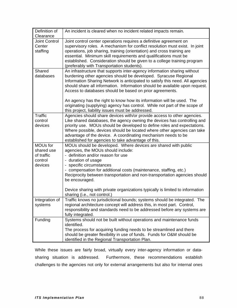
Definition of Clearance
An incident is cleared when no incident related impacts remain.
Joint Control Center staffing
Joint control center operations requires a definitive agreement on supervisory roles. A mechanism for conflict resolution must exist. In joint operations, job sharing, training (orientation) and cross training are essential. Minimum skill requirements and qualifications must be established. Consideration should be given to a college training program (preferably with Transportation students).
Shared databases
An infrastructure that supports inter-agency information sharing without burdening other agencies should be developed. Syracuse Regional Information Sharing Network is anticipated to satisfy this need. All agencies should share all information. Information should be available upon request. Access to databases should be based on prior agreements. An agency has the right to know how its information will be used. The originating (supplying) agency has control. While not part of the scope of this project, liability issues must be addressed.
Traffic control devices
Agencies should share devices with/or provide access to other agencies. Like shared databases, the agency owning the devices has controlling and priority use. MOUs should be developed to define roles and expectations. Where possible, devices should be located where other agencies can take advantage of the device. A coordinating mechanism needs to be established for agencies to take advantage of this.
MOUs for shared use of traffic control devices
MOUs should be developed. Where devices are shared with public agencies, the MOUs should include: - definition and/or reason for use - duration of usage - specific circumstances - compensation for additional costs (maintenance, staffing, etc.) Reciprocity between transportation and non-transportation agencies should be encouraged. Device sharing with private organizations typically is limited to information sharing (i.e., not control.)
Integration of systems
Traffic knows no jurisdictional bounds; systems should be integrated. The regional architecture concept will address this, in most part. Control, responsibility and standards need to be addressed before any systems are fully integrated.
Funding Systems should not be built without operations and maintenance funds identified. The process for acquiring funding needs to be streamlined and there should be greater flexibility in use of funds. Funds for O&M should be identified in the Regional Transportation Plan.
While these issues are fairly broad, virtually every inter-agency information or data-
sharing situation is addressed. Furthermore, these recommendations establish
challenges to the agencies not only for external arrangements but also for internal ones
ITS Implementat ion Plan 88

such as between the City Public Work, Police, Fire, and other departments within the
City of Syracuse.
ITS Implementat ion Plan 89