Synorogenic evolution of large-scale drainage patterns
55
Santa Clara University Scholar Commons Environmental Studies and Sciences College of Arts & Sciences 9-2009 Synorogenic evolution of large-scale drainage paerns: Isotope paleohydrology of sequential Laramide basins Steven J. Davis Hari T. Mix Santa Clara University, [email protected] Beina A. Wiegand Alan R. Carroll C. Page Chamberlain Follow this and additional works at: hp://scholarcommons.scu.edu/ess Part of the Environmental Studies Commons Reproduced by permission of the American Journal of Science. DOI 10.2475/07.2009.02 is Article is brought to you for free and open access by the College of Arts & Sciences at Scholar Commons. It has been accepted for inclusion in Environmental Studies and Sciences by an authorized administrator of Scholar Commons. For more information, please contact [email protected]. Recommended Citation Davis, S.J., Mix, H.T., Wiegand, B.A., Carroll, A.R. and Chamberlain, C.P. (2009). Synorogenic evolution of large-scale drainage paerns: Isotope paleohydrology of sequential Laramide basins. American Journal of Science, v. 309, p. 549-602.
-
Upload
khangminh22 -
Category
Documents
-
view
5 -
download
0
Transcript of Synorogenic evolution of large-scale drainage patterns

Santa Clara UniversityScholar Commons
Environmental Studies and Sciences College of Arts & Sciences
9-2009
Synorogenic evolution of large-scale drainagepatterns: Isotope paleohydrology of sequentialLaramide basinsSteven J. Davis
Hari T. MixSanta Clara University, [email protected]
Bettina A. Wiegand
Alan R. Carroll
C. Page Chamberlain
Follow this and additional works at: http://scholarcommons.scu.edu/ess
Part of the Environmental Studies Commons
Reproduced by permission of the American Journal of Science.DOI 10.2475/07.2009.02
This Article is brought to you for free and open access by the College of Arts & Sciences at Scholar Commons. It has been accepted for inclusion inEnvironmental Studies and Sciences by an authorized administrator of Scholar Commons. For more information, please contact [email protected].
Recommended CitationDavis, S.J., Mix, H.T., Wiegand, B.A., Carroll, A.R. and Chamberlain, C.P. (2009). Synorogenic evolution of large-scale drainagepatterns: Isotope paleohydrology of sequential Laramide basins. American Journal of Science, v. 309, p. 549-602.

SYNOROGENIC EVOLUTION OF LARGE-SCALE DRAINAGEPATTERNS: ISOTOPE PALEOHYDROLOGY OF SEQUENTIAL
LARAMIDE BASINSSTEVEN J. DAVIS*†, HARI T. MIX**, BETTINA A. WIEGAND***,
ALAN R. CARROLL§, and C. PAGE CHAMBERLAIN**
ABSTRACT. In the past decade, we and others have compiled an extensive dataset ofO, C and Sr isotope stratigraphies from sedimentary basins throughout the PaleogeneNorth American Cordillera. In this study, we present new results from the Piceance CreekBasin of northwest Colorado, which record the evolving hydrology of the Eocene GreenRiver Lake system. We then place the new data in the context of the broader Cordillerandataset and summarize implications for understanding the synorogenic evolution oflarge-scale drainage patterns. The combined data reflect (1) a period of throughgoingforeland rivers heading in the Sevier fold-and-thrust belt and flowing east, (2) ponding offreshwater lakes in the foredeep as Laramide uplifts blocked drainage, (3) hydrologicclosure that led to both intensive evaporation in the terminal sink of the Piceance CreekBasin and integration of catchments over length-scales >1000 km, (4) infilling of basinaccommodation by southward migrating magmatism in distal catchments, leading to thefreshening and demise of intraforeland lakes that also stepped south over time.
Key words: Isotope ratios, North American Cordillera, Green River Lakes, Sevierfold-and-thrust belt, paleoaltimetry, limnogeology
introductionSynorogenic sediments preserved in intermontane and foreland basins have long
been appreciated as valuable archives of orogen and basin development, recording thecomplex linkage among tectonics, climate and landscape evolution. As such, clastic basinfill has been exploited by many studies using tools of sedimentary petrology and prov-enance, paleocurrent analysis, and kinematic histories (for example, Dickinson andothers, 1986, 1988; Lawton, 1986; DeCelles, 1988; DeCelles and others, 1995; Smith andothers, 2008a). In the past decade, numerous isotopic studies have also demonstrated thepotential of authigenic sediments in reconstructing surface elevation and climate (forexample, Koch and others, 1995; Chamberlain and Poage, 2000; Garzione and others,2000; Fricke, 2003; Graham and others, 2005; Kent-Corson and others, 2006).
Unfortunately, very few isotopic studies have assembled large, regional datasetscapable of distinguishing local and regional signals in the geologic past, and evenfewer have considered the effect of large-scale drainage reorganization on their results(Davis and others, 2008). Here we add data to the most spatially and temporally densedataset in existence, totaling more than 3000 isotopic analyses in multiple isotopesystems on samples collected from 12 basins spanning !1400 km along strike of theTertiary North American Cordillera (table 1). Using this dataset, we summarizemounting isotopic evidence for the regional evolution of drainage patterns in both thehinterland and foreland of the orogen. Despite important changes in global climateduring the Paleogene, we further conclude these regional changes in basin hydrologywere driven by tectonic processes.
* Department of Global Ecology, Carnegie Institution of Washington, Stanford, California 94305, USA** Environmental Earth System Science, Stanford University, Stanford, California 94305, USA;
[email protected]; [email protected]*** Geological and Environmental Sciences, Stanford University, Stanford, California 94305,
USA; [email protected]§ Department of Geology and Geophysics, University of Wisconsin, Madison, Wisconsin 53706, USA;
[email protected]† Corresponding author: [email protected]
[American Journal of Science, Vol. 309, September, 2009, P. 549–602, DOI 10.2475/07.2009.02]
549
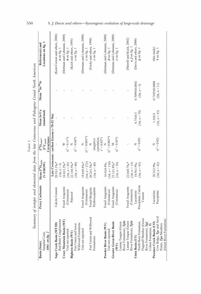
Tab
le1
Sum
mar
yof
isoto
pic
and
elem
enta
lda
tafro
mth
ela
teCr
etace
ous
and
Paleo
gene
Cent
alN
orth
Am
eric
anB
asin
(Sta
te)
Sam
pled
Uni
ts
Abb
r. o
n fi
g. 2
Pro
xy C
arbo
nate
M
ean
! !18O
calc
ite
(V-S
MO
W)
!18O
calc
ite-
!13C
calc
ite
Cov
aria
nce
Mea
n Sr
/Ca
(mm
ol/m
ol)
Mea
n 87
Sr/86
SrR
efer
ence
(s) a
ndL
ocat
ions
on
fig.
1
Lat
e C
reta
ceou
s - e
arlie
st E
ocen
e (~
70-5
2 M
a)Sa
ge C
reek
Bas
in (M
T/I
D)
Red
But
te C
ongl
omer
ate
Cal
cite
Cem
ent
20.5
±1.1
‰*
(1",
n =
5)
- -
- (K
ent-
Cor
son
and
othe
rs, 2
006)
a on
fig.
1
Cra
zy M
ount
ain
Bas
in (M
T)
Uni
t not
repo
rted
Foss
il A
rago
nite
(U
nion
acea
) 16
.6±1
.2‰
* (1
", n
= 4
5)
W
(r2 =
0.1
1*)
- -
(Det
tman
and
Loh
man
n, 2
000)
b on
fig.
1
Big
horn
Bas
in (W
Y)
Fort
Uni
on a
nd lo
wer
W
illw
ood
Form
atio
ns
Pale
osol
22
.1±0
.5‰
* (1
", n
= 9
0)
N
(r2 =
0.0
4*)
- -
(Koc
h an
d ot
hers
, 199
5)
c on
fig.
1
Uni
t not
repo
rted
Fo
ssil
Ara
goni
te
(Uni
onac
ea)
19.6
±0.8
‰*
(1",
n =
272
) N
(r
2 < 0
.001
*)
- -
(Det
tman
and
Loh
man
n, 2
000)
c on
fig.
1
Fort
Uni
on a
nd W
illw
ood
Form
atio
ns
Foss
il B
ioge
nic
Hyd
roxy
apat
ite
20.2
±1.3
‰*
(1",
n =
49)
N
(n
egat
ive
corr
elat
ion,
r2 =
0.0
2*)
- -
(Fri
cke
and
othe
rs, 1
998)
c
on fi
g. 1
Pow
der
Riv
er B
asin
(WY
) U
nit n
ot re
port
edFo
ssil
Ara
goni
te
(Uni
onac
ea)
16.6
±4.4
‰
(1",
n =
110
) N
(r
2 < 0
.001
*)
- -
(Det
tman
and
Loh
man
n, 2
000)
d
on fi
g. 1
G
reat
er G
reen
Riv
er B
asin
(W
Y)
Lum
an T
ongu
e (G
reen
R
iver
For
mat
ion)
, Tgl
u
Foss
il A
rago
nite
(U
nion
acea
) 23
.1±1
.8‰
* (1
", n
= 5
9)
M
(r2 =
0.4
5*)
- -
(Det
tman
and
Loh
man
n, 2
000)
e
on fi
g. 1
Lum
an T
ongu
e (G
reen
R
iver
For
mat
ion)
, Tgl
uFo
ssil
Ara
goni
te
(Uni
onac
ea)
22.6
±0.7
‰*
(1",
n =
13)
-
- -
(Mor
rill
and
Koc
h, 2
002)
e,
f on
fig.
1
Uin
ta B
asin
(UT
) N
orth
Hor
n Fo
rmat
ion,
Fl
agst
aff M
embe
r (G
reen
R
iver
For
mat
ion)
, Tgf
, C
olto
n Fo
rmat
ion,
Tc
Lac
ustr
ine
Prec
ipita
te, C
alci
te
Cem
ent
18.9
±1.9
‰
(1",
n =
93)
N
(r
2 = 0
.05)
0.
75±0
.5
(1",
n =
79)
0.
7099
±0.0
002
(2",
n =
3)
(Dav
is a
nd o
ther
s, 2
008)
g
on fi
g. 1
Pic
eanc
e C
reek
Bas
in (C
O)
Cow
Rid
ge, T
gc a
nd A
nvil
Poin
ts, T
ga M
embe
rs
(Gre
en R
iver
For
mat
ion)
Lac
ustr
ine
Prec
ipita
te
20.3
±3.9
‰
(1",
n =
42)
N
(r
2 = 0
.02)
1.
3±0.
8 (1
", n
= 3
3)
0.71
05±0
.000
8 (2
", n
= 1
1)
(thi
s st
udy)
1
on fi
g. 1
550 S. J. Davis and others—Synorogenic evolution of large-scale drainage
Tab
le1
(con
tinue
d)B
asin
(Sta
te)
Sam
pled
Uni
ts
Abb
r. o
n fi
g. 2
Pro
xy C
arbo
nate
M
ean
! !18O
calc
ite
(V-S
MO
W)
!18O
calc
ite-
!13C
calc
ite
Cov
aria
nce
Mea
n Sr
/Ca
(mm
ol/m
ol)
Mea
n 87
Sr/86
SrR
efer
ence
(s) a
ndL
ocat
ions
on
fig.
1
Lat
e C
reta
ceou
s - e
arlie
st E
ocen
e (~
70-5
2 M
a)A
xhan
dle
Bas
in (U
T)
Nor
th H
orn
and
Flag
staf
f Fo
rmat
ions
Lac
ustr
ine
Prec
ipita
te,
Pale
osol
20.7
±2.3
‰
(1",
n =
68)
N
(r
2 < 0
.001
) -
- (C
ham
berl
ain,
unp
ublis
hed)
h
on fi
g. 1
Nor
th H
orn
Form
atio
n Pa
leos
ol
22.0
±1.2
‰
(1",
n =
262
) N
(r
2 = 0
.03)
-
- (B
owen
and
Bow
en, 2
008)
h
on fi
g. 1
F
lags
taff
Bas
in (U
T)
Flag
staf
f For
mat
ion,
Tf
Lac
ustr
ine
Prec
ipita
te (
mic
rite
) 21
.7±0
.9‰
(1
", n
= 4
8)
W
(r2 =
0.1
1)
- -
(Bow
en a
nd o
ther
s, 2
008)
i o
n fi
g. 1
Fl
agst
aff F
orm
atio
n, T
fL
acus
trin
ePr
ecip
itate
-
-<0
.1*
(1",
n =
38)
0.
7100
±0.0
003
(2",
n =
38)
(G
ierl
owsk
i-K
orde
sch
and
othe
rs, 2
008)
i o
n fi
g. 1
Fl
agst
aff F
orm
atio
n, T
fL
acus
trin
ePr
ecip
itate
22
.6±2
.8‰
(1
", n
= 1
15)
M
(r2 =
0.3
6*)
- -
(Web
er, 1
964)
i o
n fi
g. 1
E
arly
Eoc
ene
(~52
-48.
6 M
a)Sa
ge C
reek
Bas
in (M
T/I
D)
Low
er S
age
Cre
ek
Form
atio
n
Pale
osol
23
.2±1
.8‰
* (1
", n
= 9
) W
(r
2 = 0
.26*
) -
- (K
ent-
Cor
son
and
othe
rs,
2006
) a
on fi
g. 1
G
reat
er G
reen
Riv
er B
asin
(W
Y)
Tip
ton
Mem
ber (
Gre
en
Riv
er F
orm
atio
n), T
gt
Foss
il A
rago
nite
(U
nion
acea
) 25
.0‰
(1
", n
= 3
) -
- -
(Mor
rill
and
Koc
h, 2
002)
j o
n fi
g. 1
Wilk
ins
Peak
, Tgw
and
lo
wer
Lan
ey, T
gl M
embe
rs
(Gre
en R
iver
For
mat
ion)
Lac
ustr
ine
Prec
ipita
te
28.3
±0.7
‰
(1"
and
n no
t re
port
ed)
- -
- (N
orri
s an
d ot
hers
, 199
6)
k on
fig.
1
†Lan
ey M
embe
r (G
reen
R
iver
For
mat
ion)
, Tgl
Foss
il A
rago
nite
(U
nion
acea
) 23
.3±1
.9‰
(1
", n
= 1
4)
- -
- (M
orri
ll an
d K
och,
200
2)
l on
fig.
1
†Lan
ey M
embe
r (G
reen
R
iver
For
mat
ion)
, Tgl
L
acus
trin
e Pr
ecip
itate
-
--
0.71
25±0
.000
6 (2
", n
= 2
2)
(Rho
des
and
othe
rs, 2
002)
m
on
fig.
1
Low
er L
aCle
de B
ed, -
l-,
Wilk
ins
Peak
Mem
ber
(Gre
en R
iver
For
mat
ion)
, T
gw
Lac
ustr
ine
Prec
ipita
te
27.0
±1.9
‰
(1",
n =
122
) -
-0.
7123
±0.0
004
(2",
n n
ot
repo
rted
)
(Car
roll
and
othe
rs, 2
008)
m
on
fig.
1
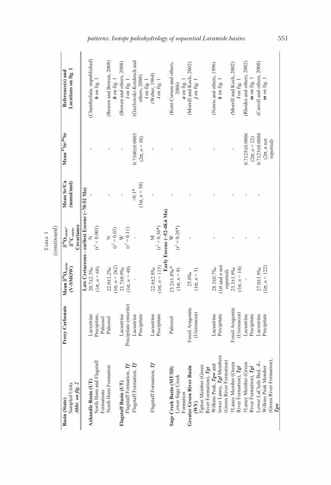
551patterns: Isotope paleohydrology of sequential Laramide basins
Tab
le1
(con
tinue
d)B
asin
(Sta
te)
Sam
pled
Uni
ts
Abb
r. o
n fi
g. 2
Pro
xy C
arbo
nate
M
ean
! !18O
calc
ite
(V-S
MO
W)
!18O
calc
ite-
!13C
calc
ite
Cov
aria
nce
Mea
n Sr
/Ca
(mm
ol/m
ol)
Mea
n 87
Sr/86
SrR
efer
ence
(s) a
ndL
ocat
ions
on
fig.
1
Ear
ly E
ocen
e (~
52-4
8.6
Ma
Uin
ta B
asin
(UT
) L
ower
Mai
n B
ody
(Gre
en
Riv
er F
orm
atio
n), T
gmb
Lac
ustr
ine
Prec
ipita
te
24.9
±3.5
‰
(1",
n =
47)
S
(r2 =
0.6
1)
1.4±
0.5
(1",
n =
22)
0.
7116
±0.0
010
(2",
n =
7)
(Dav
is a
nd o
ther
s, 2
008;
Dav
is
and
othe
rs, 2
009)
n
on fi
g. 1
P
icea
nce
Cre
ek B
asin
(CO
) G
arde
n G
ulch
, Tgg
, D
ougl
as C
reek
, Tgd
, and
L
ower
Par
achu
te C
reek
, T
gp, M
embe
rs (G
reen
R
iver
For
mat
ion)
Lac
ustr
ine
Prec
ipita
te
27.9
±3.9
‰
(1",
n =
54)
S
(r2 =
0.6
1)
2.7±
0.8
(1",
n =
50)
0.
7113
±0.0
005
(2",
n =
9)
(thi
s st
udy)
2,
3on
fig.
1
Fla
gsta
ff B
asin
(UT
) L
ower
Gre
en R
iver
Fo
rmat
ion,
Tg
Lac
ustr
ine
Prec
ipita
te
26.7
±2.0
‰
(1",
n =
9)
S (r
2 = 0
.65)
2.
8±0.
1 (1
", n
= 3
) -
(Dav
is a
nd o
ther
s, 2
009)
o
on fi
g. 1
Ear
ly M
iddl
e E
ocen
e (4
8.6-
46 M
a)Sa
ge C
reek
Bas
in (M
T/I
D)
Upp
er S
age
Cre
ek
Form
atio
n
Pale
osol
12
.7±0
.5‰
* (1
", n
= 1
0)
N
(r2 =
0.0
2*)
- -
(Ken
t-C
orso
n an
d ot
hers
, 20
06)
a on
fig.
1
Gre
ater
Gre
en R
iver
Bas
in
(WY
) U
pper
LaC
lede
Bed
, (G
reen
R
iver
For
mat
ion)
, -l-
Lac
ustr
ine
Prec
ipita
te
22.0
±2.5
‰
(1",
n =
72)
-
-0.
7116
±0.0
003
(2",
n =
not
re
port
ed)
(Car
roll
and
othe
rs, 2
008)
m
on
fig.
1
Uin
ta B
asin
(UT
) U
pper
Mai
n B
ody
(Gre
en
Riv
er F
orm
atio
n), T
gmb
Lac
ustr
ine
Prec
ipita
te
26.7
±1.1
‰
(1",
n =
14)
M
(r
2 = 0
.33)
2.
4±0.
3 (1
", n
= 8
) 0.
7114
±0.0
024
(2",
n =
2)
(Dav
is a
nd o
ther
s, 2
008;
Dav
is
and
othe
rs, 2
009)
n
on fi
g. 1
P
icea
nce
Cre
ek B
asin
(CO
) U
pper
Par
achu
te C
reek
M
embe
r (G
reen
Riv
er
Form
atio
n), T
gp, U
inta
Fo
rmat
ion,
Tu,
Ton
gues
of
Gre
en R
iver
For
mat
ion
Lac
ustr
ine
Prec
ipita
te
22.3
±4.4
‰
(1",
n =
103
) S
(r2 =
0.6
1)
2.7±
0.5
(1",
n =
20)
0.
7098
±0.0
024
(2",
n =
10)
(t
his
stud
y)
3on
fig.
1
Fla
gsta
ff B
asin
(UT
) U
pper
Gre
en R
iver
Fo
rmat
ion,
Tg
Lac
ustr
ine
Prec
ipita
te
27.4
±2.5
‰
(1",
n =
19)
N
(r2 =
0.0
9)
1.8±
0.7
(1",
n =
6)
- (D
avis
and
oth
ers,
200
9)
o on
fig.
1
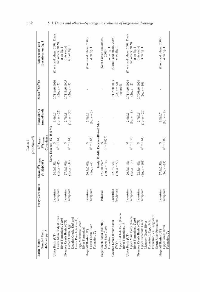
552 S. J. Davis and others—Synorogenic evolution of large-scale drainage

Tab
le1
(con
tinue
d)B
asin
(Sta
te)
Sam
pled
Uni
ts
Abb
r. o
n fi
g. 2
Pro
xy C
arbo
nate
M
ean
! !18O
calc
ite
(V-S
MO
W)
!18O
calc
ite-
!13C
calc
ite
Cov
aria
nce
Mea
n Sr
/Ca
(mm
ol/m
ol)
Mea
n 87
Sr/86
SrR
efer
ence
(s) a
ndL
ocat
ions
on
fig.
1
Lat
e M
iddl
e E
ocen
e (~
46-3
7.2
Ma)
Sage
Cre
ek B
asin
(MT
/ID
) D
ell,
Spri
ng H
ollo
w, a
nd
Ant
elop
e L
akes
For
mat
ions
Cal
cite
Cem
ent,
Pale
osol
, Lac
ustr
ine
Prec
ipita
te
13.6
±1.6
‰*
(1",
n =
57)
N
(n
egat
ive
corr
elat
ion,
r2 =
0.1
2*)
- -
(Ken
t-C
orso
n an
d ot
hers
, 20
06)
a on
fig.
1
Elk
o B
asin
(NV
) U
pper
Elk
o Fo
rmat
ion
Lac
ustr
ine
Prec
ipita
te
22.4
±2.5
‰
(1",
n =
19)
M
(r
2 = 0
.47)
2.
9±3.
6 (1
", n
= 1
2)
- (H
orto
n an
d ot
hers
, 200
4)
p on
fig.
1
Ibap
ah B
asin
(NV
/UT
) W
hite
Sag
e Fo
rmat
ion
Lac
ustr
ine
Prec
ipita
te
19.8
±2.2
‰
(1",
n =
21)
W
(r
2 = 0
.20)
-
- (D
avis
, unp
ublis
hed)
q
on fi
g. 1
U
inta
Bas
in (U
T)
Salin
e Fa
cies
, Tgs
, Sa
ndst
one
and
Lim
esto
ne
Faci
es, T
gsl (
Gre
en R
iver
Fo
rmat
ion)
Lac
ustr
ine
Prec
ipita
te
27.0
±3.1
‰
(1",
n =
61)
M
(r
2 = 0
.45)
2.
9±0.
9 (1
", n
= 2
8)
0.71
00±0
.000
6 (2
", n
= 1
3)
(Dav
is a
nd o
ther
s, 2
008;
Dav
is
and
othe
rs, 2
009)
r
on fi
g. 1
Fla
gsta
ff B
asin
(UT
) C
razy
Hol
low
, Tcr
, and
B
ald
Kno
ll Fo
rmat
ions
Cal
cite
Cem
ent
17.0
±2.6
‰
(1",
n =
29)
N
(r2 =
0.0
6)
0.5±
0.1
(1",
n =
4)
- (D
avis
and
oth
ers,
200
9)
s on
fig.
1
Cla
ron
Bas
in (U
T)
Cla
ron
Form
atio
nL
acus
trin
e Pr
ecip
itate
20
.3±2
.2‰
(1
", n
=32
) N
(r
2 = 0
.07)
-
- (D
avis
and
oth
ers,
200
9)
t on
fig.
1
Gal
iste
o B
asin
(NM
) G
alis
teo
Form
atio
nL
acus
trin
e Pr
ecip
itate
, Cal
cite
C
emen
t
21.9
±1.2
‰
(1",
n =
36)
N
(r2 <
0.0
01)
- -
(Dav
is, u
npub
lishe
d)
u on
fig.
1
Lat
e E
ocen
e –
Ear
ly O
ligoc
ene
(37.
2-28
.4 M
a)Sa
ge C
reek
Bas
in (M
T/I
D)
Upp
er A
ntel
ope
Lak
es a
nd
Coo
k R
anch
For
mat
ions
Cal
cite
Cem
ent,
Pale
osol
14
.3±0
.9‰
* (1
", n
= 2
7)
N
(neg
ativ
e co
rrel
atio
n,
r2 = 0
.26*
)
- -
(Ken
t-C
orso
n an
d ot
hers
, 20
06)
a on
fig.
1
Elk
o B
asin
(NV
) In
dian
Wel
ls F
orm
atio
nL
acus
trin
e Pr
ecip
itate
13
.9±1
.5‰
(1
", n
= 3
) -
0.5±
0.5
(1",
n =
2)
- (H
orto
n an
d ot
hers
, 200
4)
p on
fig.
1
Uin
ta B
asin
(UT
) D
uche
sne
Riv
er F
orm
atio
n,
Tdr
Cal
cite
Cem
ent
17.7
±3.5
‰
(1",
n =
40)
N
(r
2 = 0
.09)
0.
4±0.
2 (1
", n
= 7
) -
(Dav
is a
nd o
ther
s, 2
009)
v
on fi
g. 1
553patterns: Isotope paleohydrology of sequential Laramide basins

Tab
le1
(con
tinue
d)B
asin
(Sta
te)
Sam
pled
Uni
ts
Abb
r. o
n fi
g. 2
Pro
xy C
arbo
nate
M
ean
! !18O
calc
ite
(V-S
MO
W)
!18O
calc
ite-
!13C
calc
ite
Cov
aria
nce
Mea
n Sr
/Ca
(mm
ol/m
ol)
Mea
n 87
Sr/86
SrR
efer
ence
(s) a
ndL
ocat
ions
on
fig.
1
Lat
e E
ocen
e –
Ear
ly O
ligoc
ene
(37.
2-28
.4 M
a)F
lags
taff
Bas
in (U
T)
Dip
ping
Vat
For
mat
ion
Cal
cite
Cem
ent
15.4
±0.4
‰
(1",
n =
11)
N
(r2 =
0.0
1)
0.4±
0.02
(1
", n
= 3
) -
(Dav
is a
nd o
ther
s, 2
009)
s
on fi
g. 1
C
laro
n B
asin
(UT
) B
rian
Hea
d Fo
rmat
ion
Lac
ustr
ine
Prec
ipita
te, C
alci
te
Cem
ent
14.8
±1.4
‰
(1",
n =
34)
N
(neg
ativ
e co
rrel
atio
n,
r2 = 0
.10)
0.3±
0.1
(1",
n =
9)
- (D
avis
and
oth
ers,
200
9)
w o
n fi
g. 1
Gal
iste
o B
asin
(NM
) E
spin
aso
Form
atio
nC
alci
te C
emen
t 21
.8±0
.9‰
(1
", n
=16
) W
(r
2 = 0
.27)
-
- (D
avis
, unp
ublis
hed)
u
on fi
g. 1
*Cal
cula
ted
base
don
publ
ishe
dda
ta.
†Not
eth
atth
eLu
man
Ton
gue
ofth
eG
reen
Riv
erFo
rmat
ion
inth
eG
reat
erG
reen
Riv
erB
asin
span
sam
ajor
hydr
olog
icsh
ift(s
ee,C
arro
llan
dot
hers
,200
8),a
ndth
epr
ecis
est
ratig
raph
iclo
catio
nof
thes
esa
mpl
esis
not
repo
rted
.Cov
aria
nce
repo
rted
asN
(non
e),W
(wea
k),M
(mod
erat
e),o
rS
(str
ong)
,eva
luat
edby
Pear
son
prod
uct-m
omen
tcoe
ffici
ent.
Das
hesi
ndic
ate
anal
yses
notp
erfo
rmed
orda
tano
trep
orte
d.
554 S. J. Davis and others—Synorogenic evolution of large-scale drainage
Samples of lacustrine carbonate are particularly useful isotopic proxies of paleoen-vironment because of the continuity of lake deposits and their sensitivity to climaticand tectonic processes (Carroll and Bohacs, 1999; Bohacs and others, 2000). Weanalyzed lacustrine carbonate samples from the Piceance Creek Basin of northwestColorado (fig. 1) for oxygen, carbon, and strontium isotope composition, as well ascalcium and strontium concentrations.
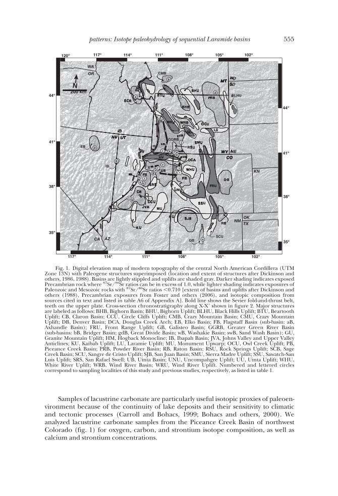
Fig. 1. Digital elevation map of modern topography of the central North American Cordillera (UTMZone 13N) with Paleogene structures superimposed (location and extent of structures after Dickinson andothers, 1986, 1988). Basins are lightly stippled and uplifts are shaded gray. Darker shading indicates exposedPrecambrian rock where 87Sr/86Sr ratios can be in excess of 1.0, while lighter shading indicates exposures ofPaleozoic and Mesozoic rocks with 87Sr/86Sr ratios "0.710 [extent of basins and uplifts after Dickinson andothers (1988), Precambrian exposures from Foster and others (2006), and isotopic composition fromsources cited in text and listed in table A6 of Appendix A]. Bold line shows the Sevier fold-and-thrust belt,teeth on the upper plate. Cross-section chronostratigraphy along X-X# shown in figure 2. Major structuresare labeled as follows: BHB, Bighorn Basin; BHU, Bighorn Uplift; BLHU, Black Hills Uplift; BTU, BeartoothUplift; CB, Claron Basin; CCU, Circle Cliffs Uplift; CMB, Crazy Mountain Basin; CMU, Crazy MountainUplift; DB, Denver Basin; DCA, Douglas Creek Arch; EB, Elko Basin; FB, Flagstaff Basin (sub-basin: aB,Axhandle Basin); FRU, Front Range Uplift; GB, Galisteo Basin; GGRB, Greater Green River Basin(sub-basins: bB, Bridger Basin; gdB, Great Divide Basin; wB, Washakie Basin; swB, Sand Wash Basin); GU,Granite Mountain Uplift; HM, Hogback Monocline; IB, Ibapah Basin; JVA, Johns Valley and Upper ValleyAnticlines; KU, Kaibab Uplift; LU, Laramie Uplift; MU, Monument Upwarp; OCU, Owl Creek Uplift; PB,Piceance Creek Basin; PRB, Powder River Basin; RB, Raton Basin; RSU, Rock Springs Uplift; SCB, SageCreek Basin; SCU, Sangre de Cristo Uplift; SJB, San Juan Basin; SMU, Sierra Madre Uplift; SSU, Sawatch-SanLuis Uplift; SRS, San Rafael Swell; UB, Uinta Basin; UNU, Uncompahgre Uplift; UU, Uinta Uplift; WHU,White River Uplift; WRB, Wind River Basin; WRU, Wind River Uplift. Numbered and lettered circlescorrespond to sampling localities of this study and previous studies, respectively, as listed in table 1.
555patterns: Isotope paleohydrology of sequential Laramide basins

geologic setting and stratigraphyEvidence of each phase in the development of Cordilleran drainage patterns is
preserved by lacustrine units in the intraforeland Piceance Creek Basin of northwestColorado (fig. 1). Four Laramide uplifts bound the Piceance Creek Basin: the WhiteRiver Uplift to the northeast, the Uinta Uplift to the northwest, the UncompahgreUplift to the southwest, and the Sawatch Uplift to the southeast (fig. 1). Units sampledfor isotopic analyses belong to two formations:
Green River FormationLacustrine deposits in the Piceance Creek Basin are part of the carbonate-rich
Green River Formation (Hayden, 1869; Bradley, 1931). Though the lake in thePiceance Creek Basin has often been referred to as Lake Uinta by earlier workersacknowledging its merger with the lake in the Uinta Basin during a lake highstand at48.6 Ma (Smith and others, 2008a), it is herein distinguished as the Piceance lake.Lacustrine deposition first expanded across the Piceance Creek Basin in the EarlyEocene as recorded by the shallow lacustrine, paludal, and fluvial beds of the CowRidge Member (Tgc, fig. 2) which occur in the basin center isolated between fluvialredbeds of the main body and an overlying tongue of the DeBeque (Wasatch)Formation (Td, fig. 2, Donnell, 1969; Johnson, 1984; Kihm, ms, 1984). At !52 Ma, thefreshwater Piceance lake returned and expanded widely, evidenced by the fossiliferousLong Point bed (lp, fig. 2, denoted by cross symbols at !100m in fig. 3) (Johnson,1984). This Long Point transgression marks the base of three roughly time-equivalentfacies: The Anvil Points and Douglas Creek Members (Tga and Tgd, respectively, fig. 2)are arenaceous, nearshore lake facies deposited along the eastern and western basinmargins, respectively. The Garden Gulch Member (Tgg, fig. 2) is made up of argilla-ceous, profundal deposits in the basin center (Hail, 1992). Overlying these oldermembers in the Piceance Creek Basin are marl, oil shale (kerogen-rich marl), andevaporite deposits belonging to the Parachute Creek Member (Tgp, fig. 2), whichincludes the well-known Mahogany Zone (m, fig. 2) of rich oil shale deposited duringthe lake highstand at 48.6 Ma (Brobst and Tucker, 1973; Smith and others, 2008a).
Uinta FormationIn the Middle Eocene, at !48 Ma, sandy, volcaniclastic sediments assigned to the
Uinta Formation (Tu, fig. 2) prograded south into the Piceance Creek Basin (Surdamand Stanley, 1980; Smith and others, 2008a). Strata of the Uinta Formation inter-tongue with the Parachute Creek Member of the Green River Formation over severalhundred meters (Hail, 1987). Although the tongues of the Uinta Formation have notbeen named, a number of the regressing lacustrine marls are useful stratigraphicmarkers that have been formally named tongues of the Green River Formation, givingthem status as formation members (Duncan and others, 1974; O’Sullivan, 1975; Hail,1977). Named tongues sampled in this study include (from oldest to youngest) theYellow Creek, Dry Fork, Black Sulphur, Coughs Creek, and Stewart Gulch Tongues. By!47 Ma, the encroaching Uinta Formation overwhelmed the lake, and fluvial depositsof the Uinta Formation completely filled the basin shortly thereafter.
isotopic approaches to basin evolutionIn order to characterize the paleohydrology of the Piceance Creek Basin, we
assembled O isotopic profiles of exposed lacustrine sediments of Paleogene age. Cisotopes and Sr/Ca ratios of carbonate were then used to evaluate the role ofevaporation on the O isotope record. Evaporative effects can be assessed by the degreeof covariance of $13C-$18O values and Sr/Ca ratios in carbonate samples. If evapora-tion is relatively high $13C and $18O values will covary because hydrologically closedlakes have long residence times allowing preferential outgassing of 12C-rich CO2
556 S. J. Davis and others—Synorogenic evolution of large-scale drainage
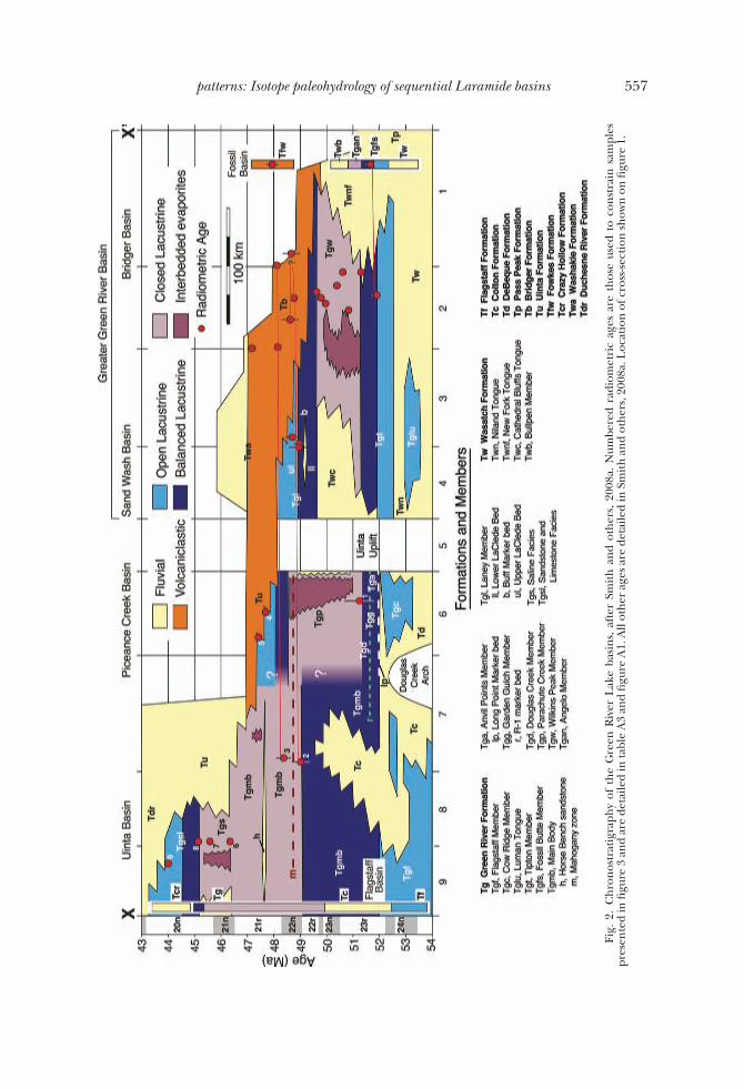
Fig.
2.C
hron
ostr
atig
raph
yof
the
Gre
enR
iver
Lake
basi
ns,
afte
rSm
ithan
dot
hers
,20
08a.
Num
bere
dra
diom
etri
cag
esar
eth
ose
used
toco
nstr
ain
sam
ples
pres
ente
din
figur
e3
and
are
deta
iled
inta
ble
A3
and
figur
eA
1.A
llot
her
ages
are
deta
iled
inSm
ithan
dot
hers
,200
8a.L
ocat
ion
ofcr
oss-s
ectio
nsh
own
onfig
ure
1.
557patterns: Isotope paleohydrology of sequential Laramide basins

Fig.
3.(A
)Pa
nelA
show
siso
topi
can
del
emen
tald
ata
from
the
Pice
ance
Cre
ekB
asin
pres
ente
din
this
stud
y.
558 S. J. Davis and others—Synorogenic evolution of large-scale drainage

Fig.
3.(B
)Pa
nelB
show
ssim
ilar
data
from
the
Uin
taB
asin
pres
ente
din
Dav
isan
dot
hers
(200
8)an
dD
avis
and
othe
rs(2
009)
.
559patterns: Isotope paleohydrology of sequential Laramide basins

accompanied by evaporative enrichment of 18O (Talbot and Kelts, 1990). Sr/Ca ratioswill also be high in evaporative lakes as the partitioning of Sr between host water andauthigenic carbonate is proportional to the ratio of Sr2% to Ca2% in the water (Mullerand others, 1972). In hydrologically closed lakes, Sr2% is not flushed from the lake, andas Ca2% is taken up by precipitating CaCO3, Sr2% is progressively concentrated andincorporated into authigenic carbonates (Eugster and Kelts, 1983). Carbon isotopescan also be used to assess the role of diagenesis on the O isotope composition ofcarbonates. Late stage diagenesis often results in relatively low O isotope values(Morrill and Koch, 2002) as a result of equilibration of carbonate with meteoric watersat high temperatures. Conversely, $13C values of early diagenetic carbonates may beaffected by bacterially mediated redox reactions, while $18O values of such diageneticphases continue to record the isotopic composition of sediment pore waters (Talbotand Kelts, 1990), resulting in non-covariance of C and O isotopes in lacustrinesediments (Talbot, 1990; Talbot and Kelts, 1990).
We used Sr isotopes of authigenic carbonate to determine whether the sourceof the water supplied to these lakes has changed over time. The ratio of 87Sr/86Sr inlacustrine carbonates has been recognized as a valuable method for reconstructinglake paleohydrology (Rhodes and others, 2002; Hart and others, 2004; Davis andothers, 2008; Gierlowski-Kordesch and others, 2008). Mass-dependent fraction-ation of 87Sr/86Sr ratios is insignificant and corrected for during analysis, meaningthat authigenic minerals record the Sr isotope composition of lake water at thetime of their precipitation. The 87Sr/86Sr ratio of waters is controlled by contactwith rocks in the drainage area, and especially more soluble carbonate rocks(Palmer and Edmond, 1992; Jacobsen and Blum, 2000). In the Paleogene Cordil-lera, basement uplifts in many cases exposed Precambrian crystalline rocks withhigh 87Sr/86Sr ratios (commonly &1.0) which were in turn flanked by Paleozoicand Mesozoic carbonates and siliclastics with much lower 87Sr/86Sr ratios (!0.710,see fig. 1). Such heterogeneities in the Sr isotope ratios of lithologies present in thedrainage basin are homogenized in lake water so that when carbonate precipitates,its Sr isotope composition reflects the weighted average of isotopically distinctinflows to the lake.
Although differential weathering of minerals can cause the concentration ofradiogenic strontium in solid weathering products (for example, clays), researchindicates that this effect is generally quite small, and that the isotopic composition andabundance of source rocks effectively control the 87Sr/86Sr ratio of strontium insolution (Brass, 1975). Furthermore, it has been demonstrated that the 87Sr/86Sr ratiosof soil carbonate (also a product of weathering reactions) are similar to stratigraphi-cally equivalent fish and mollusk fossils (which reflect surface water) (Quade andothers, 1997).
Finally, in order to better characterize the maximum depositional age of lacustrinedeposits and also examine the potential of detrital zircon data as an indicator ofprovenance, we also sampled tuffaceous lake beds where they occurred.
materials and methods
Sample CollectionWe collected authigenic carbonate samples from 11 stratigraphic sections of
Paleogene lacustrine facies in 3 localities of the Piceance Creek Basin (fig. 1 andtables A1 and A2) and analyzed their O and C isotope composition (n'186), Srisotope composition (n'30) and Sr/Ca ratios (n'114). Samples were predomi-nantly limestone, although carbonate was variably argillaceous (that is, marls or“oil-shales”) and, less commonly, arenaceous. Isotopic analyses were performedonly on micritic samples with no evidence of recrystallization. Where present, we
560 S. J. Davis and others—Synorogenic evolution of large-scale drainage
also collected tuffaceous arenites for U-Pb geochronologic analyses of zircon.Detailed information and key references of each sampled section are included inAppendix A (fig. A1 and tables A1, A3 and A4).
U-Pb Geochronologic Analyses of ZirconU-Pb geochronological analyses of 7 tuffaceous samples from the Piceance Creek
Basin as well as 2 samples from the Uinta Basin (details in Appendix A) were carriedout using both the Stanford/U.S. Geological Survey (USGS) Sensitive High-ResolutionIon Microprobe (SHRIMP-RG) and a laser ablation multicollector inductively coupledplasma mass spectrometer (LA-MC-ICPMS) at the University of Arizona.
For ion microprobe analyses, zircon separates were mounted in epoxy, polished,imaged by cathodoluminescence on a JEOL 5600LLV scanning electron microscope,and gold coated. Analytical spots 25 to 30 (m in diameter on the zircon grains weresputtered using an !10 nA primary beam of 16O2
) ions. After rastering the spot for 90 sto remove surficial contaminants, the secondary ion beam was repeatedly scanned for90Zr2
16O, 204Pb, 206Pb, 207Pb, 238U, 232Th16O and 238U16O. Zircon standard R33 (419Ma from monzodiorite, Braintree Complex, Vermont) was used as a concentrationstandard. Concentration measurements were corrected and reduced using SQUIDsoftware (Version 1.02; Ludwig, 2001).
Samples failing to yield a coherent age group were assumed detrital, and werefurther analyzed by LA-MC-ICPMS using methods described by Gehrels and others(2008). Gold coat was quantitatively removed from microprobe zircon mounts byimmersion in a saturated solution of potassium iodide (KI) for an hour at 80 to 90 °C.Mounts were then placed in an LA-MC-ICMP and ablated with a New Wave DUV193Excimer laser (operating at a wavelength of 193 nm) using a spot diameter of 25 or 35(m, depending on zircon grain size. Entrained in helium gas, ablated material wascarried into the plasma source of a Micromass Isoprobe where U, Th, and Pb isotopeswere measured simultaneously. All measurements were made in static mode, usingFaraday detectors for 238U, 232Th, 208)206Pb, and an ion-counting channel for 204Pb.Each analysis consisted of one 12 s integration on peaks with the laser off (forbackgrounds), twelve 1 s integrations with the laser firing, and a 30 s delay to purge theprevious sample and prepare for the next analysis. A Sri Lanka zircon standard(563.5 * 3.2 Ma, 2+) was used as a concentration standard (Gehrels, unpublisheddata).
Isotopic and Elemental Analyses of CarbonateSr, C and O isotope values of the carbonate samples were measured in the mass
spectrometry laboratories at Stanford University. For Sr isotope analysis, Sr wasextracted from bulk carbonate samples using 1M acetic acid (CH3COOH) to ensurethat potentially existing silicate minerals were not dissolved. The solution was centri-fuged, transferred into clean Teflon vials, and evaporated. The evaporate was thentreated with concentrated HNO3 to oxidize traces of organic material and facilitatere-dissolution of the sample with 2.5N HCl. Aliquots of each sample were loaded ontocation exchange columns using Biorad AG50x8 (200-400 mesh) resin, and eluted with2.5N HCl. All reagents were distilled. Purified Sr fractions were measured on aFinnigan MAT262 Thermal Ionization Mass Spectrometer using Ta single filamentsand 0.25N H3PO4. Ratios of 88Sr, 87Sr, 86Sr, and 84Sr were scanned at least 80 times persample. 87Sr/86Sr ratios were corrected for instrumental fractionation using thenatural 88Sr/86Sr ratio of 8.375209. Routine standard measurements yield a 87Sr/86Srratio of 0.71033 * 0.00001 (2+: n ' 64) for the NBS-987 Sr standard. The analyticalprecision is 0.003 percent or less. Blanks were less than 0.5 ng Sr.
561patterns: Isotope paleohydrology of sequential Laramide basins

O and C isotope analyses of carbonate were determined using the phosphoric aciddigestion method of McCrea (1950) coupled on-line with a gas ratio mass spectrom-eter. Using this method, between 300 to 500 (g of sample material was drilled fromeach sample, sealed in reaction vials, flushed with helium and reacted with pure H3PO4at 72°C. Evolved CO2 in the vial headspace was then sampled using a FinniganGasBench II, connected to a Finnigan MAT DeltaPlus XL mass spectrometer. Replicateanalyses of NBS-19 (limestone) and laboratory standards yielded a precision * 0.2permil or better for both $18O and $13C.
Sr/Ca ratios of carbonate were measured using an inductively coupled plasma-atomic emission spectrometer (ICP-AES) at Stanford University. Samples were firstdigested in concentrated HNO3, diluted with Mega-Pure water and filtered. Totaldissolved Ca2% and Sr2% were measured at wavelengths 317.9 and 407 nm, respectively(for example, de Villiers and others, 2002). Replicate analyses of prepared blanks andstandard solutions of varying known concentrations indicated detection limits for Ca2%
and Sr2% of 6 and 0.1 (g L)1, respectively, and precision better than 15 (g L)1 forCa2% and 1 (g L)1 for Sr2% (that is, better than 0.1 mmol/mol for Sr/Ca ratios).
resultsAnalyses of carbonate from the Piceance Creek Basin show first order trends that
are here presented as three stratigraphic/temporal intervals (table 1).
U-Pb Geochronological AnalysesOf the 7 Piceance samples analyzed, 2 from Tongues of the Green River Forma-
tion yielded coherent age groups that we interpret as maximum depositional ages(numbered 8 and 9 in figs. 2 and 3A; data and diagrams in Appendix A). The other 5Piceance samples and 2 additional samples from the Uinta Basin contained zircons ofvariable ages that do not help to constrain depositional age, but which are useful asindicators of provenance (fig. 4). Such detrital samples from older units (DeBequeFormation and Anvil Points in the Piceance Basin and Flagstaff Member and ColtonFormation in the Uinta Basin) contain few zircons older than 800 Ma. Samples fromyounger units (Garden Gulch Member, Kimball Mountain Tuff Bed, and CoughsCreek Tongue in the Piceance Basin) increasingly contain Grenville- (1315)1000 Ma)and Paleoproterozoic-age (1615)1800 Ma) grains.
Prior to !52 MaSamples deposited between the formation of the Piceance lake (fig. 2, Tgc) and
!52 Ma (fig. 2, including parts or all of Tga, Tgd, and Tgg) give a mean $18Ocalcite valueof 20.3 permil (fig. 3A), a mean Sr/Ca ratio of 1.3 mmol/mol (figs. 3A and 5), and amean 87Sr/86Sr ratio of 0.7105 (fig. 3A, 2+ ' 0.0008, n ' 11). $18Ocalcite and $13Ccalcitedo not covary in samples from this period (r2 ' 0.02, fig. 6, panels Tgc and Tga). Hereas well as in all other units, samples from similar stratigraphic intervals yield similar Srisotope ratios irrespective of mineralogy, texture, O isotope composition and Sr/Caratio.
Between !52 and 48.6 MaBeginning at !52 Ma (as constrained by radiometric age of the overlying Yellow
Tuff, #1 in figs. 2 and 3), the mean $18Ocalcite value of samples increased by !7.6 permilfrom 20.3 permil to 27.9 permil (fig. 3A). During the same interval, the mean Sr/Caratio increases to 2.7 mmol/mol (figs. 3A and 5), and $18Ocalcite-$13Ccalcite values indeposited units display strong covariance (r2 ' 0.61, fig. 6, panels Tgd, Tgg, Tgp).Coincident with these shifts, 87Sr/86Sr ratios increase steadily to a maximum of 0.7119(fig. 3A, mean ' 0.7113, 1+ ' 0.0005, n ' 9).
562 S. J. Davis and others—Synorogenic evolution of large-scale drainage

Fig. 4. Probability distributions of zircon U-Pb ages in detrital samples from the Uinta and Piceance Creek and Basins.
563patterns:Isotopepaleohydrology
ofsequentialLaramidebasins
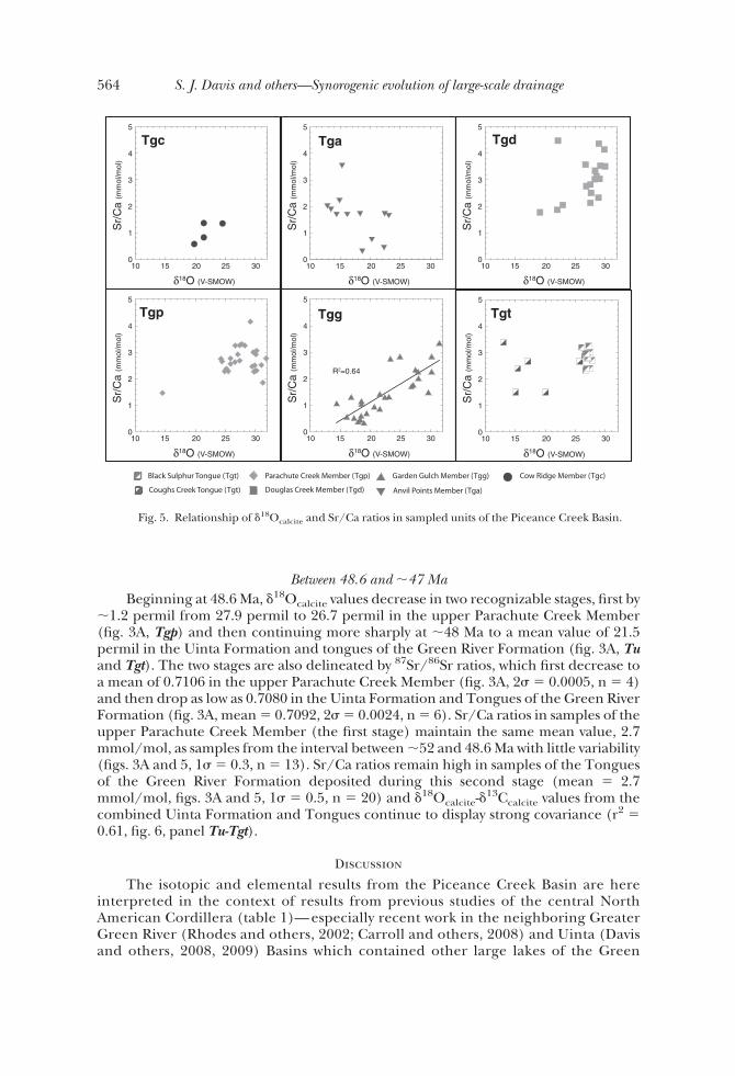
Between 48.6 and !47 MaBeginning at 48.6 Ma, $18Ocalcite values decrease in two recognizable stages, first by
!1.2 permil from 27.9 permil to 26.7 permil in the upper Parachute Creek Member(fig. 3A, Tgp) and then continuing more sharply at !48 Ma to a mean value of 21.5permil in the Uinta Formation and tongues of the Green River Formation (fig. 3A, Tuand Tgt). The two stages are also delineated by 87Sr/86Sr ratios, which first decrease toa mean of 0.7106 in the upper Parachute Creek Member (fig. 3A, 2+ ' 0.0005, n ' 4)and then drop as low as 0.7080 in the Uinta Formation and Tongues of the Green RiverFormation (fig. 3A, mean ' 0.7092, 2+ ' 0.0024, n ' 6). Sr/Ca ratios in samples of theupper Parachute Creek Member (the first stage) maintain the same mean value, 2.7mmol/mol, as samples from the interval between !52 and 48.6 Ma with little variability(figs. 3A and 5, 1+ ' 0.3, n ' 13). Sr/Ca ratios remain high in samples of the Tonguesof the Green River Formation deposited during this second stage (mean ' 2.7mmol/mol, figs. 3A and 5, 1+ ' 0.5, n ' 20) and $18Ocalcite-$13Ccalcite values from thecombined Uinta Formation and Tongues continue to display strong covariance (r2 '0.61, fig. 6, panel Tu-Tgt).
Discussion
The isotopic and elemental results from the Piceance Creek Basin are hereinterpreted in the context of results from previous studies of the central NorthAmerican Cordillera (table 1)— especially recent work in the neighboring GreaterGreen River (Rhodes and others, 2002; Carroll and others, 2008) and Uinta (Davisand others, 2008, 2009) Basins which contained other large lakes of the Green
Tgp Tgg Tgt
Tgc Tga Tgd
0
1
2
3
4
5
10 15 20 25 30
Sr/
Ca
(mm
ol/m
ol)
!18O (V-SMOW)
0
1
2
3
4
5
10 15 20 25 30
Sr/
Ca
(mm
ol/m
ol)
!18O (V-SMOW)
0
1
2
3
4
5
10 15 20 25 30
Sr/
Ca
(mm
ol/m
ol)
!18O (V-SMOW)
0
1
2
3
4
5
10 15 20 25 30
Sr/
Ca
(mm
ol/m
ol)
!18O (V-SMOW)
0
1
2
3
4
5
10 15 20 25 30
Sr/
Ca
(mm
ol/m
ol)
!18O (V-SMOW)
0
1
2
3
4
5
10 15 20 25 30
Sr/
Ca
(mm
ol/m
ol)
!18O (V-SMOW)
R2=0.64
Fig. 5. Relationship of $18Ocalcite and Sr/Ca ratios in sampled units of the Piceance Creek Basin.
564 S. J. Davis and others—Synorogenic evolution of large-scale drainage

River lake system during the Paleogene (figs. 1 and 2). Where relevant, interpreta-tions also reference Pleistocene Lake Bonneville and the modern Great Salt Lakeof Utah, whose location, hydrology and catchment geology closely resemble theGreen River lakes, which preceded them. The new results thereby add to a growingconsensus that topographic growth during the Laramide Orogeny caused large-scale integration of Cordilleran drainage patterns that in turn dictated the hydro-logic regime of intraforeland lake basins. Following is a summary of the new andpublished isotopic and elemental results in support of this interpretation, pre-sented chronologically.
Sevier-Laramide Transition (Late Cretaceous-earliest Eocene)Between the Campanian and earliest Eocene, coeval with the onset of Laramide-
style deformation in the foreland, the highstanding Sevier fold-and-thrust beltdrained east into a broad, low-relief foreland (fig. 7, panel 53 Ma; for example,Lawton, 1986; Goldstrand, 1994; Janecke and others, 2000; DeCelles, 2004; Gier-lowski-Kordesch and others, 2008). Within the foreland, shallow lakes and riversdrained northeast from Utah and Colorado and southeast from Montana andIdaho to an outlet in the northeast Greater Green River Basin (Wyoming) thatdebouched eastward into the ancestral Great Plains (see for example, Hansen,1965, 1985; Steidtmann, 1969; Dorr Jr. and others, 1977; Stanley and Collinson,1979; Moncure and Surdam, 1980; Cole, 1985; Sklenar and Anderson, 1985;Roehler, 1993).
Isotopic and elemental data support a hydrologically open foreland receivingwater from catchments in the fold-and-thrust belt. First, mean $18Ocalcite values ofbasinal proxies formed during this period are !20 permil (table 1, for example
Fig. 6. Isotopic covariance of $18Ocalcite-$13Ccalcite in sampled units of the Piceance Creek Basin.$18Ocalcite is plotted relative to the PeeDee Belemnite standard (V-PDB).
565patterns: Isotope paleohydrology of sequential Laramide basins

Fig. 7. Inferred development of foreland lakes and Cordilleran drainage patterns at four key timesduring the Paleogene (refer to fig. 1 for names of major structures and basins). Schematized cross-sections atbottom of each panel show the hydrology and isotopic compositions of the Greater Green River Basin(GGRB), Piceance Creek Basin (PCB) and Uinta Basin (UB), as separated by sills of the Uinta Uplift (UU)and the Douglas Creek Arch (DCA). Abbreviations of units deposited in each basin are shown in figure 2.Paleoflows are dashed where flow of surface waters was periodic, and are numbered according to thesupporting references listed in Appendix A, table A5.
566 S. J. Davis and others—Synorogenic evolution of large-scale drainage

“non-evaporitic” lakes of Drummond and others, 1993), with a minimum of 16.6permil in the Crazy Mountain and Powder River Basins in the northern Cordillera(Dettman and Lohmann, 2000) and maxima of 22.1 permil in the Bighorn Basin(Koch and others, 1995), 22.6 permil in the Flagstaff Formation of central Utah(Weber, 1964), and 23.1 permil in the Luman Tongue in the Greater Green RiverBasin (Bridger subbasin) (Dettman and Lohmann, 2000). Such values are consis-tent with $18O values of freshwater marls from Pleistocene Lake Bonneville (Provo-and Bonneville-age samples reported in Oviatt and others, 1994; Nelson andothers, 2005) and imply Eocene surface waters between )4 permil and )8 permil(compare, Fricke, 2003). Second, $18Ocalcite and $13Ccalcite values from thesesamples generally do not covary (table 1 and fig. 6). Moderate covariance insamples of the Flagstaff Formation and Luman Tongue (Weber, 1964; Dettman andLohmann, 2000; see table 1) suggests the early Lakes Gosiute and Flagstaff,respectively, may have been hydrologically closed at intervals, helping to explainslightly higher $18Ocalcite values of those samples. Third, where Sr/Ca ratios ofthese samples have been measured, they are relatively low (table 1): mean valuesrange from 1.3 * 0.8 mmol/mol in the Piceance Creek Basin (this study, fig. 3),0.75 * 0.47 mmol/mol in the Uinta Basin (Davis and others, 2008) and "0.1mmol/mol in the Flagstaff Basin (Gierlowski-Kordesch and others, 2008). Lastly,the 87Sr/86Sr ratios observed during this time in the Flagstaff, Uinta and PiceanceCreek Basins (figs. 2 and 7, Tf, Tgf and Tgc, respectively) are consistently !0.710(table 1), suggesting catchments draining Paleozoic and Mesozoic carbonates thenexposed in the fold-and-thrust belt to the west (Davis and others, 2008; Gierlowski-Kordesch and others, 2008). Modern rivers draining these rocks also have 87Sr/86Srratios !0.710 and tend to have a disproportionately strong influence on theisotopic composition of the lakes they flow into due to their high [Sr] (Hart andothers, 2004; Bright, 2009).
Hydrologic Closure of the Green River Lake System (Early Eocene)At !52 Ma, the central Laramide foredeep became hydrologically closed, as
recorded by the system of lakes which occupied the Greater Green River, PiceanceCreek, and Uinta Basins (the Green River lake system). At lowstands, the PiceanceCreek Basin was the final evaporating (that is, terminal) basin in the system, receivingperiodic inflows from both the Greater Green River and Uinta Basins (fig. 7, panel 51Ma). When prompted by climatic changes or increased inflows from upstream basins,the expanded Piceance lake coalesced with Lake Uinta overtop the Douglas CreekArch (stratigraphy indicates lakes interconnected as early as the R-1 marker bed,Bartov and others, 2007; Smith and others, 2008a). Thus, the final evaporating basin ofthe closed lake system incorporated both the Uinta and Piceance Creek Basins whenthe lakes merged at highstands (for example, Kelts, 1988).
Isotopic and elemental results suggest changing foreland hydrology at thistime. Mean $18Ocalcite values of samples from the Green River lakes increase in eachbasin by 5 to 8 permil, shifting to values " 25 permil (table 1), with maxima of 28.3permil in the Wilkins Peak (Tgw) and lower Laney (Tgl) Members of the GreaterGreen River Basin (Norris and others, 1996; Carroll and others, 2008) and 27.9permil in the Garden Gulch (Tgg), Douglas Creek (Tgd) and lower ParachuteCreek (Tgp) Members of the Piceance Creek Basin (this study). Explanation ofthese high values by hydrologic closure and evaporative enrichment is supported bystrong covariance of $18Ocalcite-$13Ccalcite values (table 1 and fig. 6) and elevatedSr/Ca ratios (table 1, figs. 3 and 6). Modern carbonates from the analogous, closedGreat Salt Lake display very similar $18Ocalcite values (!26)28‰) which alsocovary with $13Ccalcite (Spencer and others, 1984). The mean $18Ocalcite value and
567patterns: Isotope paleohydrology of sequential Laramide basins
Sr/Ca ratio of Uinta Basin samples are somewhat lower than the other lake basins,24.9 permil and 1.4 mmol/mol, respectively, reflecting only episodic connectionswith the intensely evaporative Piceance lake.
Despite high values from Greater Green River Basin samples, Sr isotope ratiosindicate periodic outflows from that basin south to the terminal Piceance Creekand Uinta Basins. The mean 87Sr/86Sr ratio of Greater Green River Basin (Washakiesubbasin) samples at this time is &0.7120 (Rhodes and others, 2002; Carroll andothers, 2008), evidence of catchments draining radiogenic rocks in adjacent,craton-cored uplifts (for example, the Wind River Uplift). Because groundwaterfluxes have in some cases been observed to have a very strong effect on the87Sr/86Sr ratio of modern river and lake waters in Utah (Jones and Faure, 1972;Hart and others, 2004; Bright, 2009), it is likely that springs flowing into theGreater Green River Basin were also a significant flux of radiogenic Sr given thegreater duration water-rock contact and elevated temperatures at depth. Impor-tantly, though, rocks in the subsurface rocks of foreland basin systems are generallyno different than those exposed in surface.
Beginning !52 Ma, samples from the Uinta (Davis and others, 2008) andPiceance Creek (this study) Basins increase from !0.7100 to 0.7116 and 0.7113,respectively. Lack of radiogenic rocks in the uplifts adjacent to and south of thesebasins indicates the integration of catchments in the northern Cordillera (Davis andothers, 2008), and suggests hydrologic closure throughout at least 500 km of the northcentral foreland.
Integration of Axial Drainage and the Mahogany Highstand (early Middle Eocene)At !49 Ma, the Greater Green River Basin captured drainages flowing through
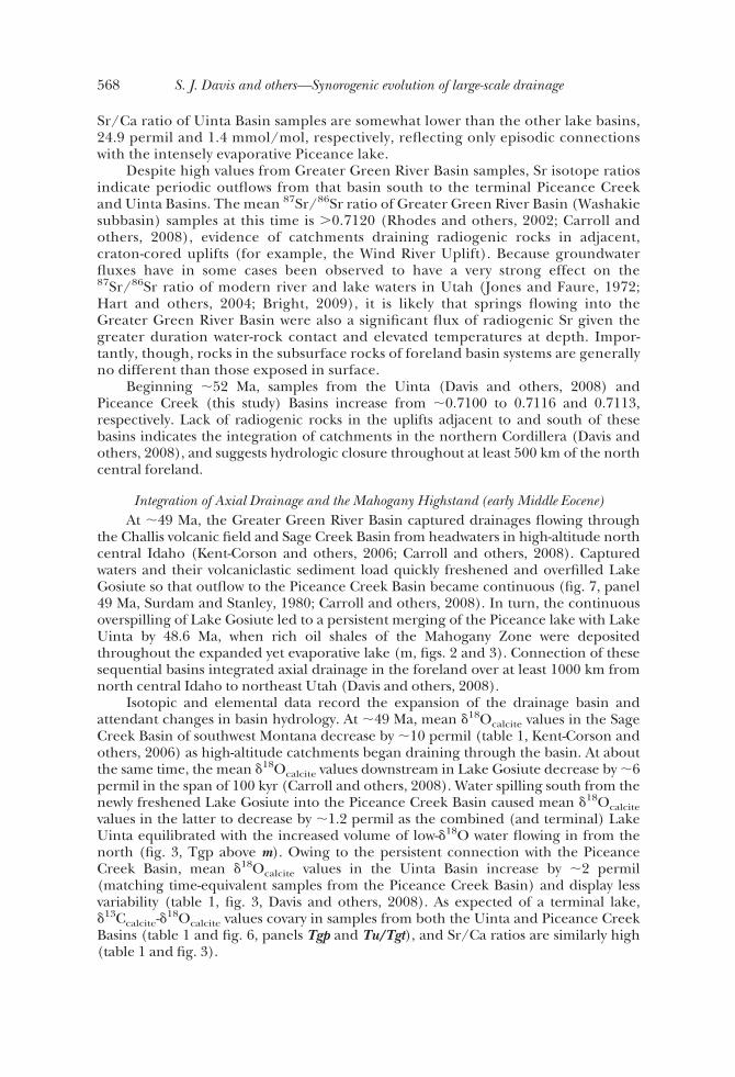
the Challis volcanic field and Sage Creek Basin from headwaters in high-altitude northcentral Idaho (Kent-Corson and others, 2006; Carroll and others, 2008). Capturedwaters and their volcaniclastic sediment load quickly freshened and overfilled LakeGosiute so that outflow to the Piceance Creek Basin became continuous (fig. 7, panel49 Ma, Surdam and Stanley, 1980; Carroll and others, 2008). In turn, the continuousoverspilling of Lake Gosiute led to a persistent merging of the Piceance lake with LakeUinta by 48.6 Ma, when rich oil shales of the Mahogany Zone were depositedthroughout the expanded yet evaporative lake (m, figs. 2 and 3). Connection of thesesequential basins integrated axial drainage in the foreland over at least 1000 km fromnorth central Idaho to northeast Utah (Davis and others, 2008).
Isotopic and elemental data record the expansion of the drainage basin andattendant changes in basin hydrology. At !49 Ma, mean $18Ocalcite values in the SageCreek Basin of southwest Montana decrease by !10 permil (table 1, Kent-Corson andothers, 2006) as high-altitude catchments began draining through the basin. At aboutthe same time, the mean $18Ocalcite values downstream in Lake Gosiute decrease by !6permil in the span of 100 kyr (Carroll and others, 2008). Water spilling south from thenewly freshened Lake Gosiute into the Piceance Creek Basin caused mean $18Ocalcitevalues in the latter to decrease by !1.2 permil as the combined (and terminal) LakeUinta equilibrated with the increased volume of low-$18O water flowing in from thenorth (fig. 3, Tgp above m). Owing to the persistent connection with the PiceanceCreek Basin, mean $18Ocalcite values in the Uinta Basin increase by !2 permil(matching time-equivalent samples from the Piceance Creek Basin) and display lessvariability (table 1, fig. 3, Davis and others, 2008). As expected of a terminal lake,$13Ccalcite-$18Ocalcite values covary in samples from both the Uinta and Piceance CreekBasins (table 1 and fig. 6, panels Tgp and Tu/Tgt), and Sr/Ca ratios are similarly high(table 1 and fig. 3).
568 S. J. Davis and others—Synorogenic evolution of large-scale drainage
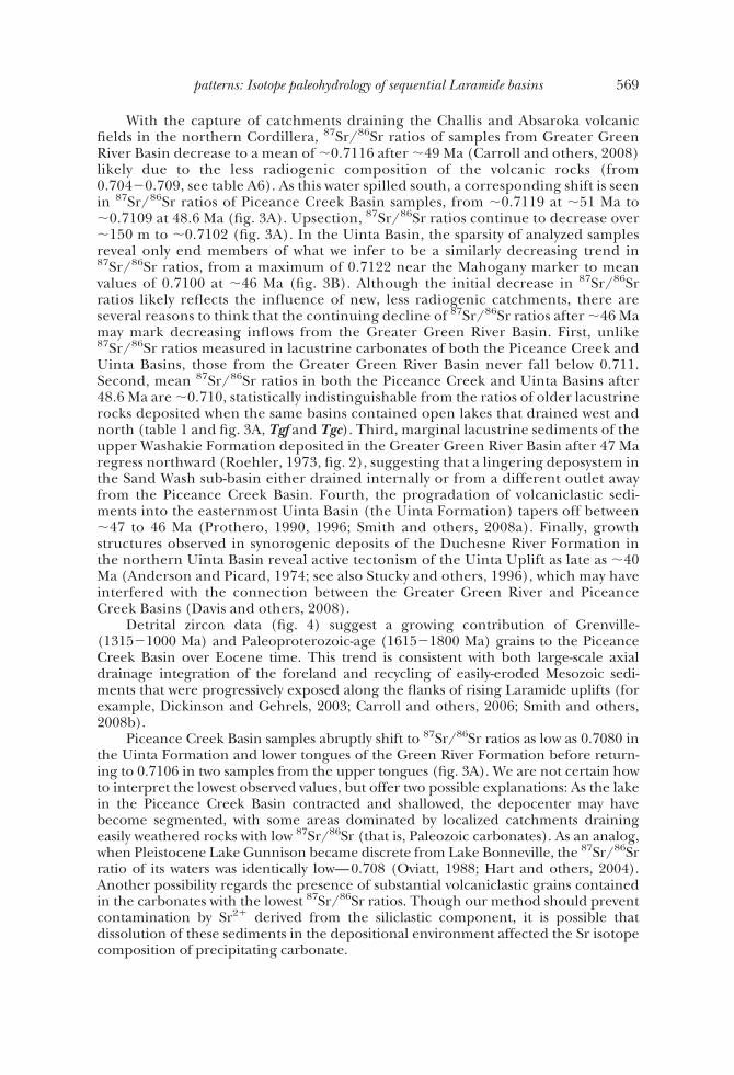
With the capture of catchments draining the Challis and Absaroka volcanicfields in the northern Cordillera, 87Sr/86Sr ratios of samples from Greater GreenRiver Basin decrease to a mean of !0.7116 after !49 Ma (Carroll and others, 2008)likely due to the less radiogenic composition of the volcanic rocks (from0.704)0.709, see table A6). As this water spilled south, a corresponding shift is seenin 87Sr/86Sr ratios of Piceance Creek Basin samples, from !0.7119 at !51 Ma to!0.7109 at 48.6 Ma (fig. 3A). Upsection, 87Sr/86Sr ratios continue to decrease over!150 m to !0.7102 (fig. 3A). In the Uinta Basin, the sparsity of analyzed samplesreveal only end members of what we infer to be a similarly decreasing trend in87Sr/86Sr ratios, from a maximum of 0.7122 near the Mahogany marker to meanvalues of 0.7100 at !46 Ma (fig. 3B). Although the initial decrease in 87Sr/86Srratios likely reflects the influence of new, less radiogenic catchments, there areseveral reasons to think that the continuing decline of 87Sr/86Sr ratios after !46 Mamay mark decreasing inflows from the Greater Green River Basin. First, unlike87Sr/86Sr ratios measured in lacustrine carbonates of both the Piceance Creek andUinta Basins, those from the Greater Green River Basin never fall below 0.711.Second, mean 87Sr/86Sr ratios in both the Piceance Creek and Uinta Basins after48.6 Ma are !0.710, statistically indistinguishable from the ratios of older lacustrinerocks deposited when the same basins contained open lakes that drained west andnorth (table 1 and fig. 3A, Tgf and Tgc). Third, marginal lacustrine sediments of theupper Washakie Formation deposited in the Greater Green River Basin after 47 Maregress northward (Roehler, 1973, fig. 2), suggesting that a lingering deposystem inthe Sand Wash sub-basin either drained internally or from a different outlet awayfrom the Piceance Creek Basin. Fourth, the progradation of volcaniclastic sedi-ments into the easternmost Uinta Basin (the Uinta Formation) tapers off between!47 to 46 Ma (Prothero, 1990, 1996; Smith and others, 2008a). Finally, growthstructures observed in synorogenic deposits of the Duchesne River Formation inthe northern Uinta Basin reveal active tectonism of the Uinta Uplift as late as !40Ma (Anderson and Picard, 1974; see also Stucky and others, 1996), which may haveinterfered with the connection between the Greater Green River and PiceanceCreek Basins (Davis and others, 2008).
Detrital zircon data (fig. 4) suggest a growing contribution of Grenville-(1315)1000 Ma) and Paleoproterozoic-age (1615)1800 Ma) grains to the PiceanceCreek Basin over Eocene time. This trend is consistent with both large-scale axialdrainage integration of the foreland and recycling of easily-eroded Mesozoic sedi-ments that were progressively exposed along the flanks of rising Laramide uplifts (forexample, Dickinson and Gehrels, 2003; Carroll and others, 2006; Smith and others,2008b).
Piceance Creek Basin samples abruptly shift to 87Sr/86Sr ratios as low as 0.7080 inthe Uinta Formation and lower tongues of the Green River Formation before return-ing to 0.7106 in two samples from the upper tongues (fig. 3A). We are not certain howto interpret the lowest observed values, but offer two possible explanations: As the lakein the Piceance Creek Basin contracted and shallowed, the depocenter may havebecome segmented, with some areas dominated by localized catchments drainingeasily weathered rocks with low 87Sr/86Sr (that is, Paleozoic carbonates). As an analog,when Pleistocene Lake Gunnison became discrete from Lake Bonneville, the 87Sr/86Srratio of its waters was identically low—0.708 (Oviatt, 1988; Hart and others, 2004).Another possibility regards the presence of substantial volcaniclastic grains containedin the carbonates with the lowest 87Sr/86Sr ratios. Though our method should preventcontamination by Sr2% derived from the siliclastic component, it is possible thatdissolution of these sediments in the depositional environment affected the Sr isotopecomposition of precipitating carbonate.
569patterns: Isotope paleohydrology of sequential Laramide basins

Demise of the Green River Lakes (early and late Middle Eocene)Lacustrine deposition in the Greater Green River Basin ended !48 Ma,
overwhelmed by volcaniclastic alluvium that thereafter prograded southward intothe Piceance Creek Basin (fig. 2, Surdam and Stanley, 1980; Smith and others,2008a). The Piceance lake responded just as Lake Gosiute had before, fresheningand increasingly passing water west into the Uinta Basin, which may have in turnperiodically overspilled south into the Flagstaff Basin (fig. 2, Surdam and Stanley,1980; Smith and others, 2008a; Davis and others, 2009). By !47 Ma, accommoda-tion in both the Greater Green River and Piceance Creek Basins was depleted(Franczyk and others, 1992; Hail, 1992).
Although large-scale integration of axial drainage was probably disrupted byLate Laramide topographic growth of the Uinta Uplift, evaporative lakes in theUinta and Flagstaff Basins persisted as terminal sinks within the foreland until !45and !43 Ma, respectively (Smith and others, 2008a; Davis and others, 2009). It hasbeen suggested that the later demise of these lakes nonetheless conforms to thepattern of evolving Cordilleran drainage, driven by the expansion of distal catch-ments in tectonically and magmatically active areas of the hinterland (Davis andothers, 2009). Although lacustrine deposition ended in the smaller Flagstaff Basinat !45 Ma, presumably for lack of accommodation, Lake Uinta freshened andinfilled between !45 and 43.1 Ma, coeval with the southward migration ofhinterland magmatism into northeastern Nevada, where paleorivers flowed east tothe Uinta Basin (that is, Copper Basin and Tuscarora volcanics, Christensen andYeats, 1992; Henry, 2008).
Isotopic and elemental data record the changes in basin hydrology as the GreenRiver lakes disappeared. Between !49 and !48 Ma, samples from the vanishing LakeGosiute (table 1, ul) give a mean $18Ocalcite value of 22.0 permil (fig. 7, panel 49 Ma).Between !48 and !47 Ma, as volcaniclastic sediment filled accommodation in thePiceance Creek Basin and its lake freshened, mean $18Ocalcite values decrease again by!5.1 permil to a similar mean of 22.2 permil (table 1, figs. 3A and 7, panel 47 Ma, Tuand Tgt). The cessation of distal inflows from the northern Cordilleran catchments toLake Uinta between !47 and 46 Ma caused an increase in mean $18Ocalcite values andSr/Ca ratios to 28.8 permil (1+ ' 1.1, n ' 35) and 3.3 mmol/mol (1+ ' 0.7, n ' 15),respectively (figs. 2, 3B, and 7, Tgmb/Tgs). To the south, mean $18Ocalcite values inFlagstaff Basin sediments also increase slightly, perhaps reflecting the influence ofLake Uinta (table 1, Upper Tg).
The end of lacustrine deposition in the Flagstaff Basin at !45 Ma is obscured by abrief period of erosion that seems to have removed isotopic evidence of the lake’s finalfreshening (Davis and others, 2009). Uinta Basin samples do record the final stage ofLake Uinta between !44 and 43.1 Ma (fig. 3B, Tgsl), showing a !6 permil decrease in$18Ocalcite values to !20 permil and a 3 mmol/mol decrease in Sr/Ca ratios to 1.1mmol/mol (Davis and others, 2009). 87Sr/86Sr ratios from Uinta Basin samples holdsteady at !0.710 during this time, a ratio consistent with inflows from hinterlandcatchments to the west (Davis and others, 2008; Gierlowski-Kordesch and others,2008).
Magmatism Sweeps South (late Middle Eocene-Late Eocene)Restoring Neogene extension of the Basin and Range, the hinterland of
northeastern Nevada and northwestern Utah was situated roughly 100 to 200 kmwest of the Uinta Basin. Though exact basin geometries are difficult to reconstructin light of subsequent extension and erosion, sizeable lakes were also present inthat area during Eocene time, preserved as deposits of the Elko, White Sageand Sheep Pass Formations (Winfrey, 1960; Fouch, 1979; Wingate, 1983; Good,
570 S. J. Davis and others—Synorogenic evolution of large-scale drainage

1987; Dubiel and others, 1996). Some studies have used these lacustrine rocks todocument a phase of Eocene and Oligocene extension that immediately precedesthe migration of magmatism through the region (Axen and others, 1993; Potterand others, 1995).
Isotopic data from these lakes is also important to the interpretation ofCordilleran drainage patterns. Mean $18Ocalcite values in the late Middle Eoceneupper Elko and White Sage Formations are 22.4 permil and 19.8 permil, respec-tively (table 1). A !8.5 permil decrease in mean $18Ocalcite values between !45 and37 Ma in the Elko Basin (table 1) has been interpreted as surface uplift related tothe coeval magmatism in the region (Horton and others, 2004). As noted above,ash-filled paleovalleys in the Elko area indicate eastward paleoflow (Henry, 2008),such that the expansion and uplift of local catchments in the late Middle Eocenewould likely have influenced the hydrology and isotopic composition of Lake Uintain the subjacent foreland (Davis and others, 2009).
The lake in the Claron Basin of southwest Utah, shallower and fresher than LakeUinta in the late Middle Eocene, also records a decrease in mean $18Ocalcite values by5.5 permil between !40 and 35 Ma (table 1), again interpreted as the effect of coevaluplift and drainage reorganization in northern Arizona (Elston and Young, 1991;Flowers and others, 2008; Davis and others, 2009). Interestingly, fluvial-lacustrinedeposits to the east in the Galisteo Basin of central New Mexico remain more or lessconstant over the same period (table 1), suggesting differential uplift of the southeast-ern Colorado Plateau.
Localized Depocenters (Late Eocene-Early Oligocene)By the post-Laramide Late Eocene, few large lakes remained anywhere in the
Cordillera. Accommodation was primarily created through slow subsidence (compare,McMillan and others, 2006) while volcanism in the central and southern Cordillera(compare, Tintic, Marysvale, San Juan, Datil and Espinaso centers; see Lipman andothers, 1972; Ingersoll and others, 1990) generated prodigious volcaniclastic sedi-ments. As a result, depocenters were localized and fluvial (for example, the Brian HeadFormation of the Claron Basin, the Bald Knoll and Dipping Vat Formations of theFlagstaff Basin, the Espinaso Formation of the Galisteo Basin). Outside of thesedepocenters, erosion dominated large regions of the Cordillera (for example, Epis andChapin, 1975; Dickinson, 2004).
Isotopic and elemental data from this period are consistent with throughgoingrivers draining highstanding adjacent topography as well as the cooler and more aridclimate prevailing in the Oligocene (for example, Wolfe, 1994; Zachos and others,2001; Sheldon and Retallack, 2004). Mean $18Ocalcite values in sampled basins of Utah,Nevada and Montana are generally low (14)15‰, table 1), resembling unevaporated,meteoric water possibly incorporating snowmelt (for example, Norris and others,1996; Dettman and Lohmann, 2000). Mean values of samples from the Galisteo andUinta Basins are 21.8 and 17.7 permil, respectively (table 1). Lack of evaporation isfurther indicated by $18Ocalcite-$13Ccalcite values that do not covary in any of the basins(except weakly in the Galisteo Basin) and mean Sr/Ca ratios that are everywhere "0.5(table 1).
conclusions
Isotopic and elemental composition of lacustrine carbonate samples from thePiceance Creek Basin of northwest Colorado record dramatic changes in basinhydrology during the Early and Middle Eocene. Interpreted alongside a largedataset of isotopic stratigraphies from sedimentary basins throughout the Paleo-gene Cordillera, the new data reflect the evolution of orogen-scale drainage
571patterns: Isotope paleohydrology of sequential Laramide basins

patterns. Although changes in global and regional climate during the Paleogeneundoubtedly influenced the Cordilleran paleoenvironment, the hydrology ofneighboring basins in some cases trended in opposite directions, defying explana-tion by changes in climate alone. Instead, the data suggest changes in Cordilleranhydrology were tectonically forced, as accommodation was first created and thendissected and filled by processes of downwarping, uplift, and magmatism.
1. During the transition from thin-skinned Sevier-style thrusting to thick-skinnedLaramide-style deformation during the Late Cretaceous and Paleocene, largeriver systems flowed east from the highstanding hinterland through the fore-land and out to the ancestral Great Plains. Isotopic and elemental datasubstantiate this hydrologic regime with relatively low values (!20‰), mini-mal evidence of evaporation, and 87Sr/86Sr ratios in the central foreland(Utah) consistent with inflows of hinterland provenance.
2. By the earliest Eocene, downwarping of the foredeep and block uplifts furthereast impounded a system of large (&10,000 km2) freshwater lakes in the centralforeland (the Green River Lakes of Wyoming, Utah and Colorado). $18Ocalcitevalues in these early lakes remain low, and lack of an evaporative signalsupports their open hydrology. 87Sr/86Sr ratios continue to reflect hinterlandcatchments to the west.
3. At !52 Ma, the hydrology of foreland lakes became closed and waters thathad formerly exited the Cordillera to the east were diverted axially to theterminal Piceance Creek Basin. $18Ocalcite values in the Green River Lakesrise to 25 permil or higher at this time and covary with $13Ccalcite, and Sr/Caratios also increase, all indicating internal drainage and attendant evapora-tion. A marked increase in the 87Sr/86Sr ratio of Piceance Creek and UintaBasin lacustrine carbonate reflects the integration of foreland drainage.
4. Beginning !49 Ma, magmatism in the northern Cordillera (that is, theChallis and Absaroka volcanic fields) led to the capture of drainagesheading in north-central Idaho by Lake Gosiute. The influx of water andsediment freshened and infilled the lake basin, and affected the down-stream Piceance Creek and Uinta Basins in sequence. Late Laramide rise ofthe Uinta Uplift interrupted axial drainage in the foreland between 47 to 46Ma. $18Ocalcite values in the Sage Creek and Greater Green River Basinsrecord the drainage capture event as a 10 and 6 permil decrease, respec-tively, at !49 Ma. $18Ocalcite values in the Piceance Creek and Uinta Basins,joined by a Lake Uinta highstand, also record the event. 87Sr/86Sr ratios ineach of the Green River Lakes decrease with the integration of catchmentsdraining Tertiary volcanics. 87Sr/86Sr ratios in the Piceance Creek andUinta Basins decline further as inflows from the Greater Green River Basincease.
5. Filled in by volcaniclastics, sedimentation in the Piceance Creek Basinended at !47 Ma. Yet the southward sweep of magmatism through theCordillera had a similar effect on adjacent intraforeland basins: lakes in theFlagstaff and Uinta Basins freshened and infilled at !45 and 43 Ma,respectively, coeval with magmatism in their catchments to the west innorthern Nevada (that is, the Copper Basin and Tuscarora volcanics).$18Ocalcite values decrease in each of the Elko, Flagstaff and Uinta Basinsduring this time by 7 to 10 permil. Between !40 and 37 Ma, drainagepatterns in northern Arizona reverse, perhaps related to episodes of upliftand/or magmatism to the south in central Arizona and south-central NewMexico, and $18Ocalcite values in the downstream Claron Basin of southernUtah also decrease by 5.5 permil.
572 S. J. Davis and others—Synorogenic evolution of large-scale drainage
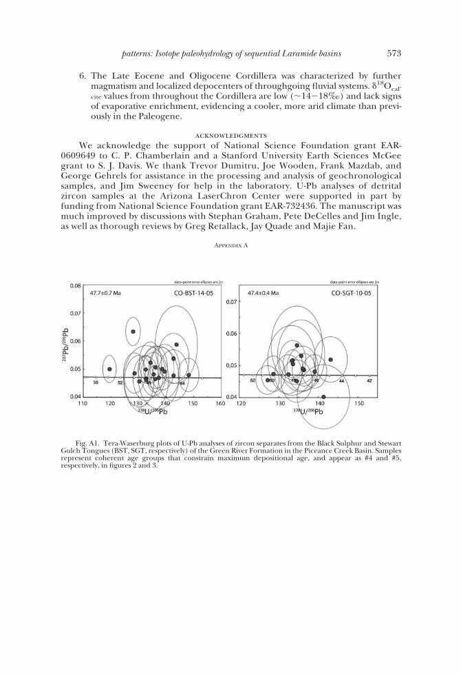
6. The Late Eocene and Oligocene Cordillera was characterized by furthermagmatism and localized depocenters of throughgoing fluvial systems. $18Ocal-
cite values from throughout the Cordillera are low (!14)18‰) and lack signsof evaporative enrichment, evidencing a cooler, more arid climate than previ-ously in the Paleogene.
acknowledgmentsWe acknowledge the support of National Science Foundation grant EAR-
0609649 to C. P. Chamberlain and a Stanford University Earth Sciences McGeegrant to S. J. Davis. We thank Trevor Dumitru, Joe Wooden, Frank Mazdab, andGeorge Gehrels for assistance in the processing and analysis of geochronologicalsamples, and Jim Sweeney for help in the laboratory. U-Pb analyses of detritalzircon samples at the Arizona LaserChron Center were supported in part byfunding from National Science Foundation grant EAR-732436. The manuscript wasmuch improved by discussions with Stephan Graham, Pete DeCelles and Jim Ingle,as well as thorough reviews by Greg Retallack, Jay Quade and Majie Fan.
Appendix A
Fig. A1. Tera-Waserburg plots of U-Pb analyses of zircon separates from the Black Sulphur and StewartGulch Tongues (BST, SGT, respectively) of the Green River Formation in the Piceance Creek Basin. Samplesrepresent coherent age groups that constrain maximum depositional age, and appear as #4 and #5,respectively, in figures 2 and 3.
573patterns: Isotope paleohydrology of sequential Laramide basins

Table A1
Details and key references of sampled exposures in the Piceance CreekUnit Location Name GPS Coordinates Reference(s)
Uinta Formation Piceance Creek 39°41.935' N 108°0.128' W Brobst and Tucker, 1973
Green River FormationJackrabbit Marl
Jackrabbit Ridge Type section(between U.S. 13 and Stewart
Gulch): 39°41.935' N 108°0.128' W
O'Sullivan, 1987
Stewart Gulch Tongue Middle Fork of Stewart Gulch
Type section: 39°43.884' N 108°10.065' W
Hail, 1977
Coughs Creek Tongue West side of Cow Creek
Type section: 39°42.634' N 107°59.887' W
O'Sullivan, 1975
Black Sulphur Tongue Black Sulphur Creek Type section: 39°51.279 N 108°22.375' W
Duncan and others, 1974
Dry Fork Tongue Near confluence of the main stem and the Dry
Fork of Piceance Creek
Type section: 40°00.481 N 108°14.385' W
Duncan and others, 1974
Yellow Creek Tongue East side of Yellow Creek
Type section: 40°5.119 N 108°20.082' W
Duncan and others, 1974
Parachute Creek Member Piceance Creek Complete section: 39°41.935' N 108°0.128' W
Brobst and Tucker, 1973
Garden Gulch Member West side ofYellow Creek
Type section: 40°9.652 N 108°23.706' W
Hail, 1990
Douglas Creek Member Douglas Pass Principal reference section: 39°36.209' N 108°46.847' W
Johnson, 1984
Long Point Bed / Kimball Mountain Tuff Bed
Type section of Long Point Bed:39°26.338 N 108°0.294' W
Johnson, 1984
Anvil Points Member Type section of Long Point Bed:39°26.338 N 108°0.294' W
Johnson, 1984
Cow Ridge Member Cow Ridge Type section: 39°23.641 N 108°22.388 W
Johnson, 1984
574 S. J. Davis and others—Synorogenic evolution of large-scale drainage

Table A2
Isotopic and elemental compositions of samplesUnit / Sample Number !!18Ocalcite
(V-SMOW)!13Ccalcite
(V-PDB)Sr/Ca
(mmol/mol)
87Sr/86Sri Stratigraphic Position (m)
Uinta Formation / Tongues of the Green River Formation
CO-YCT-06-13 18.09 1.14 621.0CO-YCT-06-14 18.76 2.31 623.0CO-YCT-06-15 22.88 3.95 625.0CO-YCT-06-02 22.14 3.19 627.5CO-YCT-06-03 22.44 2.62 631.6CO-YCT-06-04 23.88 3.26 632.5CO-YCT-06-05 24.09 3.98 635.0CO-YCT-06-06 21.72 3.15 635.4CO-YCT-06-07 20.83 2.07 635.8CO-YCT-06-08 21.73 2.67 637.5CO-YCT-06-09 19.06 1.90 0.70918 637.9CO-YCT-06-10 22.10 2.92 638.7CO-YCT-06-11 18.74 1.37 641.7CO-YCT-06-12 16.33 -1.44 643.7CO-DFT-06-02 20.50 2.95 645.0CO-DFT-06-03 18.51 1.69 647.0CO-DFT-06-04 20.29 3.07 650.0CO-DFT-06-05 16.44 2.88 654.4CO-DFT-06-07 16.60 7.51 658.0CO-DFT-06-11 17.09 4.85 661.5CO-DFT-06-12 24.24 3.63 664.0CO-DFT-06-13 23.16 3.45 665.1CO-DFT-06-14 22.20 3.26 665.8CO-DFT-06-15 22.71 3.63 666.2CO-DFT-06-16 22.08 4.16 666.6CO-DFT-06-17 25.90 4.01 667.3CO-DFT-06-18 18.96 3.57 668.0CO-DFT-06-21 17.74 1.72 0.70803 671.3CO-BST-06-05 17.14 -5.21 2.65 690.0CO-BST-06-06 15.03 -1.00 1.49 692.9CO-BST-06-07 13.05 -5.21 3.37 692.9CO-BST-06-08 15.36 -4.24 2.39 693.7CO-BST-06-10 25.74 6.15 2.66 695.1CO-BST-06-11 26.62 6.29 2.91 695.5CO-BST-06-12 15.92 -13.26 696.5CO-BST-06-13 18.85 1.56 0.70802 696.9CO-BST-06-15 16.73 -8.23 698.0CO-BST-06-16 20.01 3.46 1.49 698.8CO-BST-06-17 17.64 0.10 699.1CO-BST-06-18 13.74 -2.15 703.1CO-CCT-06-02 18.80 5.76 3.52 736.8CO-CCT-06-04 27.47 8.39 2.39 740.0CO-CCT-06-05 27.48 8.79 3.00 741.2CO-CCT-06-06 26.68 7.66 2.30 743.7CO-CCT-06-07 26.52 8.04 2.83 745.7CO-CCT-06-08 27.76 8.58 2.70 748.7CO-CCT-06-09 27.19 8.23 3.23 752.7CO-CCT-06-10 26.82 8.54 2.37 754.7CO-CCT-06-12 27.01 8.19 2.77 759.7CO-CCT-06-13 24.06 5.60 761.2CO-CCT-06-14 27.08 8.58 2.79 763.2CO-CCT-06-16 26.68 9.04 2.96 0.71083 766.8
575patterns: Isotope paleohydrology of sequential Laramide basins

Table A2
(continued)Unit / Sample Number !!18Ocalcite
(V-SMOW)!13Ccalcite
(V-PDB)Sr/Ca
(mmol/mol)
87Sr/86Sri Stratigraphic Position (m)
Uinta Formation / Tongues of the Green River Formation
CO-CCT-06-17 25.96 9.07 3.18 772.2CO-CCT-06-18 26.91 8.87 2.95 776.2CO-SGT-06-01 21.47 0.68 798.0CO-SGT-06-03 24.28 4.71 0.71039 800.0CO-SGT-06-04 23.47 3.76 803.0CO-SGT-06-05 22.03 1.59 804.1CO-SGT-06-06 20.86 0.38 805.1CO-SGT-06-07 21.68 0.78 806.6CO-SGT-06-08 21.62 1.48 807.6CO-SGT-06-09 22.23 1.10 808.6CO-SGT-06-11 19.99 1.41 812.2CO-SGT-06-14 26.98 6.45 813.2CO-SGT-06-15 16.58 -0.73 815.2CO-SGT-06-16 22.18 0.96 817.2CO-SGT-06-17 16.75 0.25 818.2CO-SGT-06-20 26.34 7.75 800.0CO-UF-06-01 27.53 8.88 566.4CO-UF-06-02 24.61 6.53 568.4CO-UF-06-04 26.82 7.67 0.71030 571.9CO-UF-06-05 23.59 5.57 572.4CO-UF-06-06 20.31 3.79 575.4CO-UF-06-07 23.12 3.69 580.4CO-UF-06-08 23.42 4.86 585.4CO-UF-06-11 15.91 1.61 0.70854 599.4CO-UF-06-12 19.82 3.40 603.4CO-UF-06-13 20.36 4.27 605.4CO-UF-06-14 19.23 -0.92 609.4
Green River FormationGarden Gulch Member
CO-GRGG-06-105 31.12 12.92 2.26 51.7 CO-GRGG-06-104 32.40 12.44 3.35 51.7 CO-GRGG-06-103 31.14 10.20 2.83 51.7 CO-GRGG-06-01 19.31 -10.81 0.33 87.4 CO-GRGG-06-02 18.33 -10.32 0.38 106.5 CO-GRGG-06-03 23.03 -1.84 1.30 0.71018 106.6 CO-GRGG-06-04 16.35 -11.69 0.56 122.5 CO-GRGG-06-05 17.62 -8.81 0.52 136.9 CO-GRGG-06-06 18.74 -8.08 0.44 138.5 CO-GRGG-06-07 18.84 -4.36 0.60 0.71044 144.9 CO-GRGG-06-09 18.93 -1.55 1.15 153.6 CO-GRGG-06-10 14.65 -18.91 1.07 161.6 CO-GRGG-06-12 18.94 -8.73 1.04 177.6 CO-GRGG-06-13 17.08 -15.07 1.31 0.71046 184.0 CO-GRGG-06-15 19.82 -5.66 0.70 196.0 CO-GRGG-06-16 22.10 -1.70 1.42 201.5 CO-GRGG-06-17 21.10 -2.99 0.95 0.71038 203.1 CO-GRGG-06-20 22.12 -0.66 0.86 211.9 CO-GRGG-06-21 30.50 3.04 1.49 219.9 CO-GRGG-06-22 28.16 3.05 223.1 CO-GRGG-06-23 28.80 3.63 2.02 0.71106 231.1 CO-GRGG-06-24 23.70 0.91 1.32 239.1 CO-GRGG-06-25 27.56 4.92 1.71 243.1 CO-GRGG-06-26 28.31 3.80 2.34 249.4 CO-GRGG-06-27 27.86 3.89 1.76 0.71103 252.6
576 S. J. Davis and others—Synorogenic evolution of large-scale drainage

Table A2
(continued)Unit / Sample Number !!18Ocalcite
(V-SMOW)!13Ccalcite
(V-PDB)Sr/Ca
(mmol/mol)
87Sr/86Sri Stratigraphic Position (m)
Green River FormationGarden Gulch Member
CO-GRGG-06-28 28.71 2.49 2.27 262.2 CO-GRGG-06-31 25.58 2.93 2.83 281.4
Green River FormationParachute Creek Member
CO-GRPC-06-01 32.06 12.59 3.56 211.9 CO-GRPC-06-101 14.58 -1.86 1.46 212.17 CO-GRPC-06-02 30.00 9.80 2.29 0.71144 245.7 CO-GRPC-06-03 31.41 14.37 265.9 CO-GRPC-06-05 32.29 15.00 1.53 271.3 CO-GRPC-06-04 30.15 12.07 2.30 0.71188 271.3 CO-GRPC-06-06 31.32 14.34 1.85 274.7 CO-GRPC-06-07 31.03 9.61 2.52 280.1 CO-GRPC-06-08 31.82 10.93 2.76 282.8 CO-GRPC-06-10 32.23 9.62 3.04 307.1 CO-GRPC-06-11 33.02 12.82 2.42 307.2 CO-GRPC-06-12 29.87 6.81 2.50 315.3 CO-GRPC-06-13 29.78 8.26 2.26 0.71179 318.1 CO-GRPC-06-14 29.67 7.57 333.4 CO-GRPC-06-15 29.54 7.33 2.46 340.2 CO-GRPC-06-17 29.22 4.53 4.15 0.71179 380.7 CO-GRPC-06-204 25.89 1.44 2.76 396.8 CO-GRPC-06-201 26.70 4.20 3.25 406.8 CO-GRPC-06-18 27.77 8.52 3.30 0.71105 432.2 CO-GRPC-06-19 29.71 10.24 3.00 448.7 CO-GRPC-06-21 30.05 10.09 2.92 449.5 CO-GRPC-06-20 25.49 5.63 2.28 0.71072 451.4 CO-GRPC-06-24 30.24 6.99 3.06 471.1 CO-GRPC-06-25 28.27 6.32 3.25 0.71091 489.2 CO-GRPC-06-27 25.19 6.21 2.38 513.0 CO-GRPC-06-29 26.57 7.09 2.62 523.8 CO-GRPC-06-30 24.54 5.88 2.66 529.2 CO-GRPC-06-31 25.95 5.94 2.56 534.6 CO-GRPC-06-32 27.15 7.10 2.92 540.0 CO-GRPC-06-33 27.43 7.17 2.68 0.71064 545.4 CO-GRPC-06-34 27.39 8.05 3.27 550.8 CO-GRPC-06-35 24.32 6.01 2.75 556.2
Green River FormationDouglas Creek Member
CO-GRDC-06-29 31.47 4.28 4.20 102.8 CO-GRDC-06-28 22.89 -1.85 2.06 106.8 CO-GRDC-06-27 22.04 -3.34 1.88 119.7 CO-GRDC-06-25 19.10 -2.82 1.78 0.71055 180.4 CO-GRDC-06-22 22.13 -0.94 4.49 203.6
CO-GRDC-06-21B 29.79 2.93 4.16 224.3 CO-GRDC-06-21A 29.88 2.19 3.51 237.2 CO-GRDC-06-19 257.9 CO-GRDC-06-18 26.84 -0.17 2.77 0.71133 273.4 CO-GRDC-06-15 28.86 2.43 4.38 286.3 CO-GRDC-06-14 29.09 3.21 3.54 294.0 CO-GRDC-06-13 27.52 1.65 2.84 299.2 CO-GRDC-06-12 27.58 1.63 2.52 306.9 CO-GRDC-06-11 28.81 2.54 2.34 309.5 CO-GRDC-06-08 28.99 2.48 3.04 319.8 CO-GRDC-06-09 28.54 2.30 3.14 330.2 CO-GRDC-06-07 27.51 3.40 2.14 345.7 CO-GRDC-06-06 28.25 3.94 3.03 353.4
577patterns: Isotope paleohydrology of sequential Laramide basins
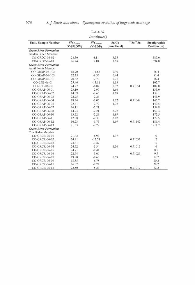
Table A2
(continued)Unit / Sample Number !!18Ocalcite
(V-SMOW)!13Ccalcite
(V-PDB)Sr/Ca
(mmol/mol)
87Sr/86Sri Stratigraphic Position (m)
Green River FormationGarden Gulch Member
CO-GRDC-06-02 28.30 4.11 3.35 387.0 CO-GRDC-06-01 26.74 5.18 3.58 394.8
Green River FormationAnvil Points Member
CO-GRAP-06-102 18.70 -11.63 0.30 76.4 CO-GRAP-06-103 22.35 -8.36 0.44 81.4 CO-GRAP-06-101 20.32 -2.79 0.75 86.4
CO-LPB-06-01 25.46 -13.11 1.13 102.7 CO-LPB-06-02 24.27 -8.02 0.92 0.71051 102.8
CO-GRAP-06-01 23.10 -2.90 1.66 133.0 CO-GRAP-06-02 14.39 -2.65 1.69 138.1 CO-GRAP-06-03 22.95 -2.26 141.9 CO-GRAP-06-04 18.34 -1.05 1.72 0.71049 145.7 CO-GRAP-06-05 22.41 -2.79 1.72 149.5 CO-GRAP-06-07 16.11 -2.21 154.8 CO-GRAP-06-08 14.93 -2.21 2.22 157.3 CO-GRAP-06-10 13.52 -2.29 1.89 172.5 CO-GRAP-06-11 12.88 -2.38 2.02 177.5 CO-GRAP-06-12 16.23 -1.75 1.69 0.71142 186.4 CO-GRAP-06-13 21.33 -2.27 211.7
Green River FormationCow Ridge Member
CO-GRCR-06-01 21.42 -6.93 1.37 0 CO-GRCR-06-02 24.91 -12.74 0.71033 2 CO-GRCR-06-03 23.81 -7.47 5 CO-GRCR-06-04 24.52 -3.34 1.36 0.71015 6 CO-GRCR-06-05 24.71 -1.44 8.5 CO-GRCR-06-06 22.64 -3.60 0.71026 9.7 CO-GRCR-06-07 19.80 -8.60 0.59 12.7 CO-GRCR-06-09 18.35 -6.78 20.2 CO-GRCR-06-11 26.02 -9.72 28.2 CO-GRCR-06-12 22.50 -5.23 0.71017 32.2
578 S. J. Davis and others—Synorogenic evolution of large-scale drainage

Table A3
Age constraints of sampled units in the Piceance Creek BasinUnit Reported Age Method Details Reference(s)
Green River FormationTongues
Stewart Gulch Tongue
47.4±0.3 Ma U-Pb Zircon (SHRIMP-RG)
(#5 in figs. 2 and 3) this study
Black Sulphur Tongue
47.7±0.7 Ma U-Pb Zircon (SHRIMP-RG)
(#4 in figs. 2 and 3) this study
Parachute Creek MemberWavy Tuff 48.37 ± 0.23 Ma 40Ar-39Ar (~50 m above Mahogany
Marker in Uinta Basin)N 39°50#59.3##
W 110°15#17.5##(#3 in figs. 2 and 3)
Smith and others, 2008
Curly Tuff 49.02 ± 0.30 Ma 40Ar-39Ar (~25 m below Mahogany Marker in Uinta Basin)
N 39°50#33.8##W 110°15#3.1##
(#2 in figs. 2 and 3)
Smith and others, 2008
Yellow Tuff 51.24 ± 0.52 Ma 40Ar-39Ar (1.5 - 6 m above base of Parachute Creek
Member)N 40°1#1.9##
W 108°6#53.2##(#1 in fig. 2 and 3)
Pipiringos and Johnson, 1975;
Smith and others, 2008
579patterns: Isotope paleohydrology of sequential Laramide basins

Tab
leA
4
Geo
chro
nolo
gica
lan
alys
esof
U-P
bin
zirc
ons
usin
gLA
-ICPM
S
Is
otop
e R
atio
s
App
aren
t Age
s (M
a)
Ana
lysi
s U
(p
pm)
206 P
b 20
4 Pb
U
Th
206 P
b*
207 P
b*
± (%)
207 P
b*
235 U
* ± (%
)
206 P
b*
238 U
± (%
) E
rr.
corr
206 P
b*
238 U
* ±
(Ma)
207 P
b*
235 U
±
(Ma)
206 P
b*
207 P
b*
± (M
a)
Bes
t age
(M
a)
± (M
a)
CC
T-1
4 12
6 36
3 1.
9 24
.610
8 15
.4
0.05
51
15.6
0.
0098
2.
7 0.
17
63.1
1.
7 54
.5
8.3
-310
.6
396.
6 63
.1
1.7
CC
T-6
1 13
9 82
8 1.
0 26
.451
7 22
.0
0.06
11
22.3
0.
0117
4.
0 0.
18
75.2
3.
0 60
.2
13.1
-4
98.9
59
1.1
75.2
3.
0 C
CT
-48
144
1029
0.
8 28
.325
4 30
.0
0.06
07
30.0
0.
0125
1.
0 0.
03
79.8
0.
8 59
.8
17.4
-6
84.7
84
5.4
79.8
0.
8 C
CT
-63
526
3297
1.
7 21
.941
4 6.
4 0.
0891
8.
1 0.
0142
5.
0 0.
61
90.8
4.
5 86
.7
6.7
-24.
7 15
4.7
90.8
4.
5 C
CT
-12
384
3576
0.
9 22
.018
7 6.
3 0.
0949
6.
6 0.
0151
2.
1 0.
32
96.9
2.
0 92
.0
5.8
-33.
3 15
2.3
96.9
2.
0 C
CT
-9
166
573
0.9
17.9
376
22.7
0.
1524
22
.8
0.01
98
1.8
0.08
12
6.5
2.3
144.
0 30
.6
442.
4 51
1.4
126.
5 2.
3 C
CT
-23
647
5217
1.
9 20
.663
5 4.
5 0.
1562
5.
4 0.
0234
2.
9 0.
54
149.
2 4.
3 14
7.4
7.4
118.
6 10
6.6
149.
2 4.
3 C
CT
-67
1014
50
82
0.7
19.9
757
3.1
0.17
26
7.4
0.02
50
6.7
0.91
15
9.2
10.6
16
1.7
11.0
19
7.8
71.6
15
9.2
10.6
C
CT
-43
143
2814
1.
4 21
.740
3 7.
1 0.
1597
8.
5 0.
0252
4.
5 0.
54
160.
3 7.
2 15
0.4
11.8
-2
.5
172.
4 16
0.3
7.2
CC
T-6
0 75
3 69
51
1.7
20.5
173
2.4
0.18
72
3.3
0.02
79
2.3
0.68
17
7.1
3.9
174.
2 5.
3 13
5.3
56.7
17
7.1
3.9
CC
T-6
5 67
6 63
63
3.9
17.5
413
4.1
0.22
93
9.0
0.02
92
8.0
0.89
18
5.4
14.6
20
9.7
17.0
49
1.8
90.3
18
5.4
14.6
C
CT
-64
2098
53
82
2.0
17.7
074
3.3
0.25
28
3.6
0.03
25
1.3
0.37
20
6.0
2.6
228.
9 7.
3 47
1.0
73.2
20
6.0
2.6
CC
T-1
3 18
8 68
79
0.9
17.1
949
2.3
0.71
87
2.6
0.08
96
1.2
0.45
55
3.3
6.3
549.
9 11
.1
535.
6 51
.2
553.
3 6.
3 C
CT
-40
215
1082
7 2.
0 16
.921
9 3.
0 0.
7930
4.
3 0.
0973
3.
0 0.
71
598.
7 17
.4
592.
8 19
.1
570.
6 64
.9
598.
7 17
.4
CC
T-5
6 45
20
10
2.2
15.5
953
3.0
0.88
99
5.5
0.10
07
4.6
0.83
61
8.3
26.9
64
6.3
26.2
74
5.6
64.1
61
8.3
26.9
C
CT
-10
1319
46
515
4.1
13.6
686
1.4
1.42
11
2.8
0.14
09
2.5
0.88
84
9.6
19.7
89
7.8
16.9
10
18.4
27
.5
849.
6 19
.7
CC
T-5
7 13
1 19
857
1.8
13.6
759
2.0
1.78
30
4.1
0.17
68
3.6
0.88
10
49.7
35
.1
1039
.3
26.8
10
17.3
40
.0
1017
.3
40.0
C
CT
-44
26
1947
1.
2 13
.350
5 4.
2 1.
8799
6.
3 0.
1820
4.
7 0.
75
1078
.0
46.8
10
74.0
41
.8
1065
.9
84.1
10
65.9
84
.1
CC
T-2
1 67
9 31
521
3.5
13.1
248
1.8
1.95
77
2.1
0.18
63
1.0
0.48
11
01.6
10
.1
1101
.1
13.9
11
00.1
36
.2
1100
.1
36.2
C
CT
-34
109
1003
2 1.
8 12
.968
6 2.
2 2.
0523
6.
5 0.
1930
6.
1 0.
94
1137
.8
63.9
11
33.1
44
.5
1124
.0
44.2
11
24.0
44
.2
CC
T-3
0 31
8 32
058
3.1
12.9
148
1.4
1.84
50
2.2
0.17
28
1.6
0.75
10
27.6
15
.4
1061
.7
14.2
11
32.3
28
.3
1132
.3
28.3
C
CT
-58
143
9435
1.
7 12
.759
1 1.
9 2.
1337
2.
6 0.
1974
1.
8 0.
68
1161
.6
18.8
11
59.8
18
.1
1156
.4
38.3
11
56.4
38
.3
CC
T-5
2 49
33
45
1.8
12.6
721
2.7
2.27
14
4.4
0.20
88
3.5
0.79
12
22.2
38
.9
1203
.4
31.2
11
69.9
54
.0
1169
.9
54.0
C
CT
-46
368
5720
4 3.
2 12
.517
0 3.
0 2.
1261
4.
6 0.
1930
3.
5 0.
76
1137
.7
36.3
11
57.3
31
.6
1194
.3
58.4
11
94.3
58
.4
CC
T-2
2 14
9 14
835
2.6
11.5
600
1.4
2.38
74
2.9
0.20
02
2.5
0.88
11
76.2
27
.0
1238
.8
20.4
13
49.5
26
.1
1349
.5
26.1
C
CT
-8
140
1291
5 1.
1 11
.274
7 2.
0 2.
8725
6.
4 0.
2349
6.
1 0.
95
1360
.1
74.2
13
74.7
48
.0
1397
.6
38.0
13
97.6
38
.0
CC
T-1
7 92
74
10
2.5
11.2
213
1.5
2.95
92
3.3
0.24
08
2.9
0.89
13
91.0
36
.8
1397
.2
25.0
14
06.6
28
.2
1406
.6
28.2
C
CT
-35
604
2721
0 0.
9 11
.210
1 1.
7 2.
9833
3.
0 0.
2426
2.
5 0.
82
1400
.0
31.1
14
03.4
23
.0
1408
.6
33.3
14
08.6
33
.3
CC
T-2
8 63
0 42
981
4.9
11.1
597
1.5
2.78
57
1.9
0.22
55
1.2
0.62
13
10.7
14
.2
1351
.7
14.4
14
17.2
28
.7
1417
.2
28.7
C
CT
-32
213
4698
9 1.
6 10
.333
4 1.
6 3.
6514
2.
8 0.
2737
2.
4 0.
83
1559
.3
32.5
15
60.8
22
.7
1562
.8
30.0
15
62.8
30
.0
CC
T-1
9 14
5 14
139
1.1
10.2
660
1.1
3.68
52
1.5
0.27
44
1.0
0.67
15
63.0
13
.9
1568
.2
11.9
15
75.1
20
.7
1575
.1
20.7
C
CT
-20
2316
15
0312
8.
9 9.
8561
1.
8 3.
3920
4.
2 0.
2425
3.
8 0.
90
1399
.5
47.6
15
02.5
32
.8
1651
.0
33.4
16
51.0
33
.4
CC
T-5
3 21
5 23
760
3.6
9.83
56
2.9
3.04
76
5.5
0.21
74
4.7
0.85
12
68.1
53
.6
1419
.6
41.9
16
54.8
53
.2
1654
.8
53.2
580 S. J. Davis and others—Synorogenic evolution of large-scale drainage

Tab
leA
4
(con
tinue
d)Is
otop
eR
atio
sA
ppar
ent A
ges
(Ma)
Ana
lysi
sU
(ppm
)
206 P
b20
4 Pb
U Th
206 P
b*20
7 Pb*
± (%)
207 P
b*23
5 U*
± (%)
206 P
b*23
8 U± (%
)E
rr.
corr
206 P
b*23
8 U*
±(M
a)
207 P
b*23
5 U±
(Ma)
206 P
b*20
7 Pb*
±(M
a)B
est a
ge(M
a)±
(Ma)
CC
T-3
822
315
435
1.1
9.79
124.
84.
2637
6.5
0.30
284.
40.
6817
05.1
66.5
1686
.453
.816
63.2
88.7
1663
.288
.7C
CT
-68
8311
496
1.5
9.76
491.
74.
1330
3.9
0.29
273.
50.
9016
55.1
51.7
1660
.932
.216
68.2
32.0
1668
.232
.0C
CT
-36
1564
1510
51.
59.
7171
2.1
3.10
843.
80.
2191
3.2
0.83
1276
.936
.714
34.8
29.4
1677
.339
.616
77.3
39.6
CC
T-4
240
0325
680
4.3
9.67
971.
91.
3579
8.3
0.09
538.
10.
9758
7.0
45.2
871.
048
.516
84.4
35.3
1684
.435
.3C
CT
-163
522
155
12.1
9.67
171.
03.
6551
1.5
0.25
641.
20.
7514
71.3
15.1
1561
.612
.316
85.9
18.8
1685
.918
.8C
CT
-31
1057
1842
454.
09.
6094
3.2
4.43
163.
40.
3089
1.1
0.33
1735
.116
.917
18.3
28.1
1697
.859
.216
97.8
59.2
CC
T-7
1857
7863
021
.09.
5167
2.2
4.26
412.
90.
2943
1.9
0.66
1663
.128
.316
86.5
24.0
1715
.740
.117
15.7
40.1
CC
T-3
710
894
410.
99.
5065
2.3
4.48
706.
50.
3094
6.1
0.94
1737
.693
.517
28.6
54.4
1717
.641
.417
17.6
41.4
CC
T-4
194
3090
01.
69.
4103
3.2
4.69
794.
00.
3206
2.4
0.60
1792
.837
.617
66.9
33.7
1736
.359
.317
36.3
59.3
CC
T-2
496
611
2869
6.1
9.37
591.
84.
5530
4.1
0.30
963.
70.
9017
38.8
55.9
1740
.734
.017
43.0
32.8
1743
.032
.8C
CT
-54
862
8547
91.
39.
3563
2.3
3.42
2810
.10.
2323
9.9
0.97
1346
.411
9.9
1509
.679
.717
46.9
41.2
1746
.941
.2C
CT
-62
252
1409
42.
19.
3117
3.6
4.19
313.
90.
2832
1.5
0.39
1607
.421
.216
72.7
31.7
1755
.665
.417
55.6
65.4
CC
T-5
012
199
631.
29.
2871
1.9
4.42
782.
30.
2982
1.3
0.57
1682
.619
.517
17.5
19.2
1760
.434
.917
60.4
34.9
CC
T-4
933
642
135
2.8
9.28
121.
44.
6186
2.2
0.31
091.
70.
7817
45.1
26.3
1752
.618
.417
61.6
25.1
1761
.625
.1C
CT
-45
578
6433
82.
29.
2308
1.5
4.72
713.
30.
3165
2.9
0.89
1772
.544
.917
72.1
27.4
1771
.627
.417
71.6
27.4
CC
T-6
588
5187
32.
59.
2151
1.5
4.11
222.
20.
2748
1.6
0.73
1565
.322
.416
56.7
18.0
1774
.727
.417
74.7
27.4
CC
T-5
916
5914
5578
3.1
8.84
432.
55.
2050
5.0
0.33
394.
30.
8718
57.1
69.9
1853
.442
.618
49.3
45.2
1849
.345
.2C
CT
-66
523
4759
50.
78.
6494
1.2
5.42
251.
60.
3402
1.0
0.63
1887
.416
.418
88.4
13.7
1889
.522
.318
89.5
22.3
CC
T-3
685
4040
74.
88.
1200
7.6
5.29
418.
40.
3118
3.5
0.41
1749
.552
.918
67.9
71.5
2002
.413
5.4
2002
.413
5.4
CC
T-5
135
4281
33.
58.
0114
1.7
6.37
862.
40.
3706
1.7
0.69
2032
.328
.820
29.3
20.9
2026
.330
.520
26.3
30.5
CO
22-3
594
945
572.
119
.678
04.
70.
0690
5.2
0.00
992.
10.
4063
.21.
367
.83.
423
2.6
109.
163
.21.
3C
O22
-20
194
1287
1.4
19.3
923
12.8
0.09
4213
.50.
0132
4.2
0.31
84.8
3.5
91.4
11.8
266.
229
5.1
84.8
3.5
CO
22-4
610
513
291.
321
.764
615
.60.
0880
15.9
0.01
393.
50.
2288
.93.
085
.613
.1-5
.237
7.4
88.9
3.0
CO
22-1
347
341
432.
318
.847
77.
10.
1032
7.4
0.01
412.
00.
2790
.31.
899
.77.
033
1.2
161.
190
.31.
8C
O22
-16
213
2196
2.0
18.2
755
5.1
0.10
995.
50.
0146
2.0
0.36
93.2
1.8
105.
85.
540
0.7
114.
393
.21.
8C
O22
-48
1239
4740
3.7
20.5
607
3.6
0.09
894.
10.
0147
2.0
0.48
94.4
1.8
95.7
3.8
130.
385
.094
.41.
8C
CT
-19
145
1413
91.
110
.266
01.
13.
6852
1.5
0.27
441.
00.
6715
63.0
13.9
1568
.211
.915
75.1
20.7
1575
.120
.7C
O22
-61
533
3852
1.4
20.9
751
5.5
0.09
755.
90.
0148
2.0
0.34
95.0
1.9
94.5
5.3
83.2
131.
295
.01.
9C
O22
-68
933
4611
2.0
19.9
378
2.3
0.10
773.
20.
0156
2.3
0.71
99.6
2.3
103.
93.
220
2.2
52.3
99.6
2.3
CO
22-6
981
028
321.
419
.897
93.
30.
1588
5.1
0.02
293.
90.
7614
6.1
5.6
149.
67.
120
6.9
76.5
146.
15.
6C
O22
-64
960
2853
1.7
19.8
539
3.9
0.15
954.
30.
0230
1.7
0.41
146.
42.
515
0.2
6.0
212.
090
.614
6.4
2.5
CO
22-2
668
4845
1.6
20.7
826
3.5
0.15
684.
60.
0236
2.9
0.64
150.
64.
314
7.9
6.3
105.
083
.115
0.6
4.3
CO
22-7
047
526
251.
717
.726
66.
40.
1838
7.0
0.02
363.
00.
4215
0.6
4.4
171.
311
.146
8.6
141.
015
0.6
4.4
CO
22-5
297
4737
1.1
21.2
089
4.5
0.15
734.
80.
0242
1.7
0.35
154.
12.
514
8.4
6.7
56.8
107.
915
4.1
2.5
581patterns: Isotope paleohydrology of sequential Laramide basins
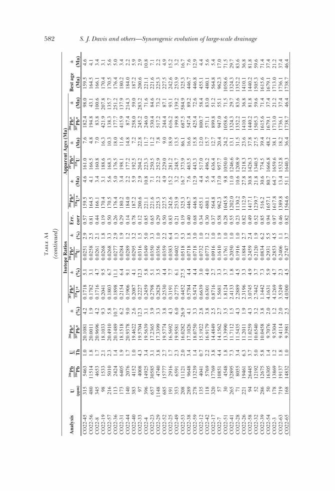
Tab
leA
4
(con
tinue
d)Is
otop
eR
atio
sA
ppar
ent A
ges
(Ma)
Ana
lysi
sU
(ppm
)
206 P
b20
4 Pb
U Th
206 P
b*20
7 Pb*
± (%)
207 P
b*23
5 U*
± (%)
206 P
b*23
8 U± (%
)E
rr.
corr
206 P
b*23
8 U*
±(M
a)
207 P
b*23
5 U±
(Ma)
206 P
b*20
7 Pb*
±(M
a)B
est a
ge(M
a)±
(Ma)
CO
22-4
531
554
631.
020
.108
14.
20.
1718
5.1
0.02
512.
90.
5715
9.5
4.6
161.
07.
618
2.4
98.0
159.
54.
6C
O22
-56
480
1151
41.
820
.001
11.
90.
1782
3.1
0.02
582.
50.
8116
4.5
4.1
166.
54.
819
4.8
43.1
164.
54.
1C
O22
-834
546
531.
720
.969
64.
20.
1716
4.7
0.02
612.
10.
4416
6.1
3.4
160.
87.
083
.810
0.6
166.
13.
4C
O22
-19
9815
332.
118
.103
39.
30.
2041
9.5
0.02
681.
80.
1917
0.4
3.1
188.
616
.342
1.9
207.
817
0.4
3.1
CO
22-5
721
650
102.
320
.491
05.
80.
1803
6.7
0.02
683.
30.
5017
0.5
5.6
168.
310
.313
8.3
135.
717
0.5
5.6
CO
22-3
611
324
241.
420
.148
910
.70.
1898
11.1
0.02
772.
90.
2617
6.4
5.0
176.
518
.017
7.7
251.
217
6.4
5.0
CO
22-3
117
364
051.
918
.151
86.
20.
2154
6.4
0.02
841.
90.
2918
0.2
3.4
198.
111
.641
5.9
137.
918
0.2
3.4
CO
22-4
414
020
761.
720
.937
89.
00.
1906
9.1
0.02
891.
20.
1418
4.0
2.2
177.
214
.887
.421
4.3
184.
02.
2C
O22
-40
383
4152
1.0
19.4
622
2.6
0.20
874.
10.
0295
3.2
0.78
187.
25.
919
2.5
7.2
258.
059
.018
7.2
5.9
CO
22-3
397
4008
4.3
19.5
704
12.3
0.22
2712
.30.
0316
1.5
0.12
200.
62.
920
4.2
22.8
245.
228
3.2
200.
62.
9C
O22
-439
614
925
3.4
19.5
639
3.1
0.24
595.
80.
0349
5.0
0.85
221.
110
.822
3.3
11.7
246.
071
.622
1.1
10.8
CO
22-2
365
730
585
3.1
17.2
365
3.9
0.27
985.
10.
0350
3.3
0.65
221.
67.
125
0.5
11.2
530.
484
.622
1.6
7.1
CO
22-2
911
4847
403.
817
.339
93.
30.
2828
3.5
0.03
561.
00.
2922
5.3
2.2
252.
97.
851
7.2
73.2
225.
32.
2C
O22
-52
685
1577
72.
719
.577
43.
80.
2530
4.4
0.03
592.
20.
5022
7.5
4.9
229.
09.
024
4.4
87.1
227.
54.
9C
O22
-25
191
2916
1.7
16.5
692
4.3
0.31
917.
70.
0383
6.4
0.83
242.
615
.228
1.2
18.9
616.
293
.124
2.6
15.2
CO
22-4
935
365
912.
319
.958
16.
00.
2775
6.1
0.04
021.
30.
2125
3.9
3.2
248.
713
.519
9.8
139.
225
3.9
3.2
CO
22-5
320
811
121
2.0
16.0
282
26.9
0.44
5227
.50.
0518
5.3
0.19
325.
316
.737
3.9
86.1
687.
558
4.9
325.
316
.7C
O22
-38
289
9648
3.4
17.1
026
4.1
0.57
844.
40.
0718
1.8
0.40
446.
77.
646
3.5
16.6
547.
489
.244
6.7
7.6
CO
22-5
927
813
239
1.4
18.0
750
3.3
0.54
744.
40.
0718
3.0
0.68
446.
812
.944
3.3
15.8
425.
472
.644
6.8
12.9
CO
22-1
213
540
410.
715
.192
22.
80.
6639
3.0
0.07
321.
00.
3445
5.1
4.4
517.
012
.080
0.7
58.4
455.
14.
4C
O22
-42
118
5769
2.2
16.9
179
3.8
0.63
014.
00.
0773
1.2
0.30
480.
15.
649
6.2
15.7
571.
183
.048
0.1
5.6
CO
22-1
732
017
769
3.8
14.4
849
2.5
0.87
162.
70.
0916
1.0
0.37
564.
85.
463
6.4
12.7
899.
851
.256
4.8
5.4
CO
22-7
5710
851
4.4
14.1
562
2.7
1.56
813.
30.
1610
1.9
0.58
962.
317
.095
7.7
20.4
947.
055
.196
2.3
17.0
CO
22-5
130
4548
1.8
13.3
990
3.5
1.81
243.
70.
1761
1.0
0.28
1045
.89.
810
50.0
24.2
1058
.671
.510
58.6
71.5
CO
22-4
126
532
895
7.3
11.7
112
1.5
2.41
331.
80.
2050
1.0
0.55
1202
.011
.012
46.6
13.1
1324
.329
.713
24.3
29.7
CO
22-2
871
8055
3.4
11.5
435
4.3
2.28
894.
50.
1916
1.0
0.23
1130
.210
.612
08.9
31.5
1352
.283
.613
52.2
83.6
CO
22-2
622
119
461
6.3
11.2
011
1.9
2.31
963.
30.
1884
2.7
0.82
1112
.927
.812
18.3
23.6
1410
.136
.814
10.1
36.8
CO
22-5
894
2644
53.
711
.025
94.
33.
0745
4.9
0.24
592.
40.
4914
17.1
30.8
1426
.337
.814
40.2
81.8
1440
.281
.8C
O22
-32
5212
192
5.0
10.6
540
3.2
2.74
423.
70.
2120
1.9
0.52
1239
.721
.813
40.5
27.5
1505
.359
.615
05.3
59.6
CO
22-3
928
612
675
5.8
10.0
458
3.8
1.14
427.
30.
0834
6.2
0.85
516.
230
.677
4.5
39.4
1615
.671
.416
15.6
71.4
CO
22-5
450
1630
51.
49.
7076
2.0
4.16
315.
90.
2931
5.5
0.94
1657
.180
.716
66.8
48.2
1679
.137
.416
79.1
37.4
CO
22-3
178
1386
91.
29.
5304
1.2
4.12
694.
70.
2853
4.5
0.97
1617
.864
.716
59.6
38.1
1713
.021
.217
13.0
21.2
CO
22-6
371
919
137
1.8
9.41
142.
03.
5249
2.3
0.24
061.
10.
4613
89.8
13.4
1532
.818
.217
36.1
37.4
1736
.137
.4C
O22
-65
168
1483
21.
09.
3981
2.5
4.03
004.
50.
2747
3.7
0.82
1564
.651
.116
40.3
36.4
1738
.746
.417
38.7
46.4
582 S. J. Davis and others—Synorogenic evolution of large-scale drainage

Tab
leA
4
(con
tinue
d)Is
otop
eR
atio
sA
ppar
ent A
ges
(Ma)
Ana
lysi
sU
(ppm
)
206 P
b20
4 Pb
U Th
206 P
b*20
7 Pb*
± (%)
207 P
b*23
5 U*
± (%)
206 P
b*23
8 U± (%
)E
rr.
corr
206 P
b*23
8 U*
±(M
a)
207 P
b*23
5 U±
(Ma)
206 P
b*20
7 Pb*
±(M
a)B
est a
ge(M
a)±
(Ma)
CO
22-6
719
226
874
1.7
9.36
862.
24.
0615
2.7
0.27
601.
60.
5815
71.0
22.3
1646
.622
.417
44.5
40.9
1744
.540
.9C
O22
-50
9136
681
1.0
9.28
291.
94.
5039
2.6
0.30
321.
80.
6917
07.3
26.4
1731
.721
.317
61.3
34.2
1761
.334
.2C
O22
-66
444
3617
41.
99.
0473
1.7
4.36
282.
00.
2863
1.1
0.54
1622
.915
.517
05.3
16.6
1808
.130
.918
08.1
30.9
CO
22-1
836
147
022
1.5
8.87
091.
84.
0560
2.5
0.26
101.
70.
7014
94.7
23.1
1645
.520
.218
43.8
32.0
1843
.832
.0C
O22
-34
4952
293.
78.
4372
1.5
5.04
652.
40.
3088
1.8
0.77
1734
.827
.518
27.2
19.9
1934
.126
.919
34.1
26.9
CO
22-1
536
221
129
2.7
8.30
363.
34.
9940
4.1
0.30
082.
40.
5816
95.1
35.6
1818
.334
.819
62.6
59.6
1962
.659
.6C
O22
-43
116
1623
03.
38.
2346
2.2
5.75
883.
20.
3439
2.3
0.72
1905
.637
.919
40.2
27.7
1977
.539
.719
77.5
39.7
CO
22-2
416
429
157
2.5
8.08
772.
75.
2933
4.0
0.31
053.
00.
7417
43.1
45.8
1867
.834
.520
09.5
47.9
2009
.547
.9C
O22
-22
9728
377
2.1
8.06
512.
05.
1094
2.6
0.29
891.
60.
6116
85.7
23.3
1837
.721
.720
14.4
35.8
2014
.435
.8C
O22
-27
134
3876
02.
28.
0027
2.5
5.31
992.
90.
3088
1.5
0.51
1734
.722
.218
72.1
24.6
2028
.243
.920
28.2
43.9
CO
22-1
429
824
030
7.0
7.63
921.
25.
7296
5.9
0.31
745.
70.
9817
77.3
88.9
1935
.950
.621
10.1
21.6
2110
.121
.6C
O22
-11
8511
067
4.9
7.55
183.
56.
0244
5.9
0.33
004.
70.
8018
38.2
75.8
1979
.451
.421
30.3
61.3
2130
.361
.3C
O22
-37
4313
257
2.7
4.89
093.
314
.789
75.
30.
5246
4.2
0.79
2718
.893
.228
01.8
50.7
2862
.153
.428
62.1
53.4
GR
AP-
8915
075
61.
025
.753
820
.30.
0508
20.5
0.00
953.
30.
1660
.82.
050
.310
.1-4
28.2
536.
060
.82.
0G
RA
P-7
139
575
1.1
24.4
766
14.5
0.05
6214
.50.
0100
1.0
0.07
64.0
0.6
55.5
7.9
-296
.637
1.9
64.0
0.6
GR
AP-
7928
619
891.
924
.240
414
.80.
0796
15.2
0.01
403.
10.
2189
.62.
877
.811
.3-2
71.9
378.
789
.62.
8G
RA
P-85
334
2334
1.3
23.9
805
13.8
0.06
7513
.80.
0117
1.4
0.10
75.3
1.0
66.4
8.9
-244
.634
9.2
75.3
1.0
GR
AP-
7327
221
361.
322
.796
814
.00.
0589
14.2
0.00
972.
50.
1762
.51.
558
.18.
0-1
18.2
346.
062
.51.
5G
RA
P-15
286
2274
1.7
22.7
807
8.8
0.07
288.
90.
0120
1.0
0.11
77.1
0.8
71.4
6.1
-116
.521
7.6
77.1
0.8
GR
AP-
1114
512
151.
522
.024
68.
30.
1495
8.5
0.02
391.
90.
2215
2.2
2.8
141.
511
.3-3
3.9
202.
315
2.2
2.8
GR
AP-
3213
126
102.
321
.807
38.
30.
1568
9.6
0.02
484.
80.
5015
7.9
7.5
147.
913
.2-9
.920
1.4
157.
97.
5G
RA
P-75
8212
210.
721
.567
06.
60.
1668
7.5
0.02
613.
70.
4916
6.0
6.0
156.
610
.916
.715
7.9
166.
06.
0G
RA
P-6
575
2165
1.8
21.5
040
4.5
0.09
324.
90.
0145
2.0
0.40
93.1
1.8
90.5
4.3
23.7
108.
193
.11.
8G
RA
P-23
1473
5760
0.7
21.2
702
2.6
0.06
333.
20.
0098
1.8
0.58
62.7
1.1
62.4
1.9
49.9
61.6
62.7
1.1
GR
AP-
3586
951
452.
020
.886
29.
20.
0778
10.1
0.01
184.
10.
4075
.53.
076
.17.
493
.221
8.3
75.5
3.0
GR
AP-
5056
597
711.
820
.542
74.
10.
1719
5.6
0.02
563.
80.
6816
3.0
6.1
161.
08.
313
2.4
95.7
163.
06.
1G
RA
P-34
246
6273
2.3
18.2
019
2.2
0.51
113.
40.
0675
2.6
0.76
420.
910
.541
9.2
11.6
409.
748
.842
0.9
10.5
GR
AP-
6928
912
726
6.4
17.9
784
4.5
0.60
224.
70.
0785
1.4
0.29
487.
36.
547
8.7
18.1
437.
310
0.9
487.
36.
5G
RA
P-78
242
8874
1.6
17.2
540
3.3
0.64
456.
20.
0807
5.3
0.85
500.
025
.450
5.1
24.7
528.
172
.350
0.0
25.4
GR
AP-
5898
5607
1.4
16.9
589
3.2
0.76
747.
50.
0944
6.8
0.90
581.
437
.857
8.3
33.2
565.
870
.558
1.4
37.8
GR
AP-
6424
167
322.
516
.741
82.
10.
7960
3.5
0.09
662.
90.
8059
4.7
16.2
594.
616
.059
3.8
45.9
594.
716
.2G
RA
P-87
7515
632.
516
.252
710
.60.
3228
12.9
0.03
817.
40.
5724
0.8
17.5
284.
132
.065
7.7
227.
124
0.8
17.5
GR
AP-
6126
656
221.
716
.233
83.
50.
7795
4.4
0.09
182.
70.
6256
6.0
14.8
585.
219
.666
0.2
74.4
566.
014
.8G
RA
P-8
172
2655
0.9
15.7
428
2.4
1.00
222.
60.
1144
1.0
0.39
698.
46.
670
5.0
13.1
725.
750
.369
8.4
6.6
583patterns: Isotope paleohydrology of sequential Laramide basins
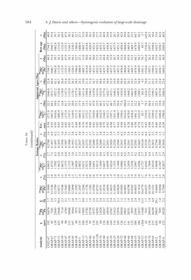
Tab
leA
4
(con
tinue
d)Is
otop
eR
atio
sA
ppar
ent A
ges
(Ma)
Ana
lysi
sU
(ppm
)
206 P
b20
4 Pb
U Th
206 P
b*20
7 Pb*
± (%)
207 P
b*23
5 U*
± (%)
206 P
b*23
8 U± (%
)E
rr.
corr
206 P
b*23
8 U*
±(M
a)
207 P
b*23
5 U±
(Ma)
206 P
b*20
7 Pb*
±(M
a)B
est a
ge(M
a)±
(Ma)
CO
22-6
719
226
874
1.7
9.36
862.
24.
0615
2.7
0.27
601.
60.
5815
71.0
22.3
1646
.622
.417
44.5
40.9
1744
.540
.9G
RA
P-67
8272
812.
813
.518
62.
81.
8733
7.5
0.18
376.
90.
9310
87.0
69.2
1071
.749
.410
40.7
55.8
1040
.755
.8G
RA
P-71
139
2368
53.
513
.370
92.
01.
7502
6.5
0.16
976.
20.
9510
10.6
58.0
1027
.242
.110
62.8
39.7
1062
.839
.7G
RA
P-51
435
3364
830
.413
.027
11.
91.
9632
6.0
0.18
555.
70.
9510
96.9
57.9
1103
.040
.711
15.0
38.1
1115
.038
.1G
RA
P-59
9971
102.
312
.910
83.
52.
0672
3.9
0.19
361.
60.
4211
40.7
16.8
1138
.026
.411
32.9
69.9
1132
.969
.9G
RA
P-47
9067
892.
112
.764
52.
42.
1575
8.0
0.19
977.
60.
9511
73.9
81.7
1167
.555
.411
55.5
47.9
1155
.547
.9G
RA
P-56
213
1846
81.
312
.696
81.
92.
1152
3.6
0.19
483.
10.
8511
47.2
32.3
1153
.825
.011
66.1
38.1
1166
.138
.1G
RA
P-45
167
9564
2.6
12.2
899
2.5
2.19
073.
80.
1953
2.8
0.75
1149
.929
.811
78.1
26.3
1230
.349
.112
30.3
49.1
GR
AP-
3849
7875
1.9
11.3
392
2.7
2.88
285.
10.
2371
4.3
0.84
1371
.553
.213
77.4
38.5
1386
.652
.713
86.6
52.7
GR
AP-
513
559
151.
711
.254
71.
42.
9852
3.3
0.24
373.
00.
9014
05.8
37.9
1403
.925
.214
00.9
27.1
1400
.927
.1G
RA
P-13
188
1509
50.
811
.226
81.
63.
0151
2.5
0.24
551.
90.
7614
15.2
24.1
1411
.419
.014
05.7
31.0
1405
.731
.0G
RA
P-17
134
1378
21.
111
.173
62.
62.
9272
2.8
0.23
721.
10.
3813
72.2
13.3
1389
.021
.414
14.8
50.0
1414
.850
.0G
RA
P-80
9522
758
1.9
11.1
382
2.0
2.94
884.
20.
2382
3.7
0.88
1377
.445
.313
94.5
31.6
1420
.938
.314
20.9
38.3
GR
AP-
4111
814
757
2.6
11.0
760
2.6
3.04
514.
50.
2446
3.7
0.82
1410
.647
.014
19.0
34.7
1431
.650
.014
31.6
50.0
GR
AP-
13b
195
1429
22.
511
.072
31.
43.
0315
2.5
0.24
342.
10.
8214
04.6
25.9
1415
.619
.114
32.2
27.5
1432
.227
.5G
RA
P-76
6411
028
2.4
11.0
531
1.8
3.10
504.
00.
2489
3.6
0.90
1432
.946
.314
33.9
30.8
1435
.533
.414
35.5
33.4
GR
AP-
9015
618
267
2.2
11.0
518
2.6
2.88
374.
30.
2311
3.4
0.79
1340
.541
.313
77.6
32.4
1435
.749
.814
35.7
49.8
GR
AP-
8110
616
014
2.5
11.0
454
1.6
3.05
994.
00.
2451
3.7
0.92
1413
.347
.214
22.7
30.9
1436
.829
.814
36.8
29.8
GR
AP-
3916
933
567
2.4
11.0
435
1.9
3.02
164.
30.
2420
3.9
0.90
1397
.148
.714
13.1
32.9
1437
.235
.914
37.2
35.9
GR
AP-
2511
621
612
2.5
11.0
393
1.4
3.15
512.
20.
2526
1.7
0.77
1451
.922
.014
46.2
16.9
1437
.926
.714
37.9
26.7
GR
AP-
2616
932
976
2.3
10.9
624
2.0
3.14
982.
60.
2504
1.6
0.62
1440
.720
.814
45.0
20.0
1451
.238
.814
51.2
38.8
GR
AP-
7212
620
424
1.2
10.9
303
2.3
3.04
666.
60.
2415
6.2
0.94
1394
.677
.614
19.4
50.4
1456
.842
.814
56.8
42.8
GR
AP-
4417
119
821
1.2
10.8
891
2.1
3.10
758.
20.
2454
7.9
0.97
1414
.810
0.6
1434
.562
.914
64.0
39.0
1464
.039
.0G
RA
P-66
141
2855
11.
610
.879
82.
43.
2458
3.4
0.25
612.
40.
7014
70.0
31.2
1468
.226
.214
65.6
45.8
1465
.645
.8G
RA
P-88
122
5055
2.9
10.8
565
1.9
3.21
982.
50.
2535
1.6
0.66
1456
.621
.414
61.9
19.3
1469
.735
.514
69.7
35.5
GR
AP-
5538
825
461
2.4
10.8
035
3.4
3.29
674.
20.
2583
2.4
0.58
1481
.232
.214
80.3
32.6
1478
.964
.714
78.9
64.7
GR
AP-
6310
012
615
1.6
10.7
414
3.0
3.42
064.
40.
2665
3.3
0.74
1522
.944
.515
09.1
34.8
1489
.956
.314
89.9
56.3
GR
AP-
2712
8411
640
13.5
10.6
779
3.7
0.17
275.
70.
0134
4.3
0.75
85.7
3.7
161.
88.
515
01.1
70.7
85.7
3.7
GR
AP-
5362
7431
1.7
10.6
255
7.6
3.03
439.
90.
2338
6.4
0.65
1354
.678
.314
16.3
76.0
1510
.414
3.6
1510
.414
3.6
GR
AP-
7013
629
019
1.4
10.1
456
1.4
3.70
946.
40.
2729
6.3
0.98
1555
.786
.815
73.4
51.5
1597
.126
.315
97.1
26.3
GR
AP-
6521
536
258
4.9
10.1
321
2.1
3.83
103.
10.
2815
2.3
0.75
1599
.033
.115
99.3
25.2
1599
.638
.615
99.6
38.6
GR
AP-
265
639
015
29.1
9.84
681.
83.
8698
2.4
0.27
641.
60.
6615
73.0
22.3
1607
.419
.516
52.7
33.6
1652
.733
.6G
RA
P-10
8874
951.
09.
8260
2.3
4.19
472.
70.
2989
1.5
0.54
1686
.022
.016
73.0
22.4
1656
.742
.616
56.7
42.6
GR
AP-
415
210
320
2.2
9.75
842.
64.
2637
2.9
0.30
181.
10.
3917
00.0
16.6
1686
.423
.616
69.4
48.9
1669
.448
.9
584 S. J. Davis and others—Synorogenic evolution of large-scale drainage
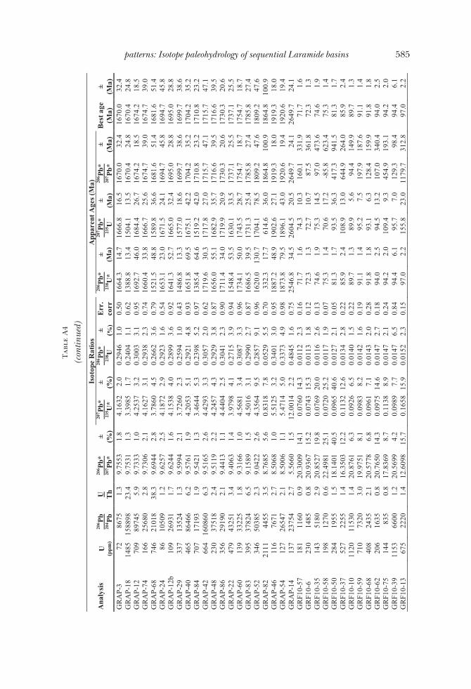
Tab
leA
4
(con
tinue
d)Is
otop
eR
atio
sA
ppar
ent A
ges
(Ma)
Ana
lysi
sU
(ppm
)
206 P
b20
4 Pb
U Th
206 P
b*20
7 Pb*
± (%)
207 P
b*23
5 U*
± (%)
206 P
b*23
8 U± (%
)E
rr.
corr
206 P
b*23
8 U*
±(M
a)
207 P
b*23
5 U±
(Ma)
206 P
b*20
7 Pb*
±(M
a)B
est a
ge(M
a)±
(Ma)
GR
AP-
372
8675
1.3
9.75
531.
84.
1632
2.0
0.29
461.
00.
5016
64.3
14.7
1666
.816
.516
70.0
32.4
1670
.032
.4G
RA
P-18
1485
1588
9823
.49.
7531
1.3
3.39
851.
70.
2404
1.1
0.62
1388
.813
.415
04.1
13.5
1670
.424
.816
70.4
24.8
GR
AP-
1270
989
745
5.9
9.73
331.
04.
2537
3.2
0.30
033.
10.
9516
92.7
46.0
1684
.426
.716
74.2
18.5
1674
.218
.5G
RA
P-74
166
2568
02.
89.
7306
2.1
4.16
273.
10.
2938
2.3
0.74
1660
.433
.816
66.7
25.6
1674
.739
.016
74.7
39.0
GR
AP-
6874
621
018
38.3
9.69
442.
83.
7860
4.5
0.26
623.
60.
7915
21.5
48.8
1589
.836
.616
81.6
51.4
1681
.651
.4G
RA
P-24
8610
509
1.2
9.62
572.
54.
1872
2.9
0.29
231.
60.
5416
53.1
23.0
1671
.524
.116
94.7
45.8
1694
.745
.8G
RA
P-12
b10
926
931
1.7
9.62
441.
64.
1538
4.0
0.28
993.
60.
9216
41.3
52.7
1665
.032
.416
95.0
28.8
1695
.028
.8G
RA
P-29
337
1352
41.
39.
5994
2.1
3.72
602.
30.
2594
1.0
0.43
1486
.813
.315
77.0
18.6
1699
.738
.616
99.7
38.6
GR
AP-
4046
586
466
6.2
9.57
611.
94.
2053
5.1
0.29
214.
80.
9316
51.8
69.5
1675
.142
.217
04.2
35.2
1704
.235
.2G
RA
P-84
707
1719
31.
99.
5421
1.3
3.46
445.
30.
2398
5.2
0.97
1385
.464
.615
19.2
42.0
1710
.823
.217
10.8
23.2
GR
AP-
4266
416
0860
6.3
9.51
652.
64.
4293
3.3
0.30
572.
00.
6217
19.6
30.3
1717
.827
.017
15.7
47.1
1715
.747
.1G
RA
P-48
230
3751
82.
49.
5119
2.2
4.24
574.
30.
2929
3.8
0.87
1656
.055
.116
82.9
35.7
1716
.639
.517
16.6
39.5
GR
AP-
8635
629
190
2.1
9.44
131.
14.
4404
2.5
0.30
412.
30.
9017
11.4
34.0
1719
.920
.917
30.3
20.6
1730
.320
.6G
RA
P-22
479
4325
13.
49.
4063
1.4
3.97
984.
10.
2715
3.9
0.94
1548
.453
.516
30.1
33.5
1737
.125
.517
37.1
25.5
GR
AP-
6013
933
225
1.8
9.31
661.
04.
5681
3.4
0.30
873.
30.
9617
34.1
50.0
1743
.528
.717
54.7
18.7
1754
.718
.7G
RA
P-83
395
3782
46.
59.
1589
1.5
4.50
163.
10.
2990
2.7
0.87
1686
.539
.517
31.3
25.4
1785
.827
.417
85.8
27.4
GR
AP-
5234
650
385
2.3
9.04
222.
64.
3564
9.5
0.28
579.
10.
9616
20.0
130.
717
04.1
78.5
1809
.247
.618
09.2
47.6
GR
AP-
8221
1144
553.
58.
7685
5.6
0.83
187.
80.
0529
5.5
0.70
332.
317
.761
4.6
36.0
1864
.810
0.9
1864
.810
0.9
GR
AP-
4611
676
712.
78.
5068
1.0
5.51
253.
20.
3401
3.0
0.95
1887
.248
.919
02.6
27.1
1919
.318
.019
19.3
18.0
GR
AP-
5412
726
547
2.1
8.50
061.
15.
4714
5.0
0.33
734.
90.
9818
73.8
79.5
1896
.143
.019
20.6
19.4
1920
.619
.4G
RA
P-14
137
2375
42.
75.
5660
1.5
12.0
014
2.2
0.48
451.
60.
7525
46.8
34.5
2604
.520
.526
49.7
24.1
2649
.724
.1G
RF1
0-57
181
1160
0.9
20.3
009
14.1
0.07
6014
.30.
0112
2.3
0.16
71.7
1.6
74.3
10.3
160.
133
1.9
71.7
1.6
GR
F10-
623
014
850.
820
.936
715
.20.
0743
15.3
0.01
131.
80.
1272
.31.
372
.710
.787
.536
1.8
72.3
1.3
GR
F10-
3514
351
802.
920
.852
719
.80.
0769
20.0
0.01
162.
60.
1374
.61.
975
.314
.597
.047
3.6
74.6
1.9
GR
F10-
5819
812
700.
622
.498
125
.10.
0720
25.2
0.01
171.
90.
0775
.31.
470
.617
.2-8
5.8
623.
475
.31.
4G
RF1
0-50
284
1955
1.5
18.1
401
40.5
0.09
6540
.60.
0127
2.1
0.05
81.3
1.7
93.5
36.3
417.
394
1.5
81.3
1.7
GR
F10-
3752
722
551.
416
.350
312
.20.
1132
12.6
0.01
342.
80.
2285
.92.
410
8.9
13.0
644.
926
4.0
85.9
2.4
GR
F10-
1011
2011
530
1.4
20.8
761
6.3
0.09
266.
50.
0140
1.5
0.22
89.7
1.3
89.9
5.6
94.4
149.
989
.71.
3G
RF1
0-59
710
7320
3.0
19.9
751
8.1
0.09
838.
20.
0142
1.6
0.19
91.1
1.4
95.2
7.5
197.
918
7.6
91.1
1.4
GR
F10-
6840
824
352.
120
.577
86.
80.
0961
7.1
0.01
432.
00.
2891
.81.
893
.16.
312
8.4
159.
991
.81.
8G
RF1
0-62
206
1635
0.8
20.7
650
14.3
0.09
7514
.60.
0147
2.7
0.18
94.0
2.5
94.5
13.2
107.
034
0.4
94.0
2.5
GR
F10-
7514
483
50.
817
.836
98.
70.
1138
8.9
0.01
472.
10.
2494
.22.
010
9.4
9.3
454.
919
3.1
94.2
2.0
GR
F10-
3911
5366
001.
220
.569
94.
20.
0989
7.7
0.01
476.
50.
8494
.46.
195
.77.
012
9.3
98.4
94.4
6.1
GR
F10-
1367
522
201.
412
.609
815
.70.
1658
15.9
0.01
522.
30.
1597
.02.
215
5.8
23.0
1179
.731
2.8
97.0
2.2
585patterns: Isotope paleohydrology of sequential Laramide basins

Tab
leA
4
(con
tinue
d)Is
otop
eR
atio
sA
ppar
ent A
ges
(Ma)
Ana
lysi
sU
(ppm
)
206 P
b20
4 Pb
U Th
206 P
b*20
7 Pb*
± (%)
207 P
b*23
5 U*
± (%)
206 P
b*23
8 U± (%
)E
rr.
corr
206 P
b*23
8 U*
±(M
a)
207 P
b*23
5 U±
(Ma)
206 P
b*20
7 Pb*
±(M
a)B
est a
ge(M
a)±
(Ma)
GR
F10-
5611
112
751.
921
.575
822
.40.
1004
22.5
0.01
572.
50.
1110
0.5
2.5
97.1
20.9
15.7
544.
110
0.5
2.5
GR
F10-
1259
968
151.
620
.537
75.
60.
1132
6.2
0.01
692.
50.
4110
7.8
2.7
108.
96.
413
3.0
132.
110
7.8
2.7
GR
F10-
510
7442
402.
118
.484
024
.80.
1323
25.0
0.01
773.
00.
1211
3.3
3.4
126.
129
.637
5.2
565.
911
3.3
3.4
GR
F10-
821
638
200.
620
.757
011
.60.
1519
11.7
0.02
291.
80.
1514
5.7
2.6
143.
615
.710
7.9
275.
014
5.7
2.6
GR
F10-
714
921
402.
019
.400
96.
50.
1643
6.6
0.02
311.
40.
2114
7.3
2.1
154.
49.
526
5.2
148.
414
7.3
2.1
GR
F10-
1844
1016
50.
623
.830
529
.80.
1368
30.2
0.02
364.
70.
1515
0.7
7.0
130.
236
.9-2
28.8
766.
315
0.7
7.0
GR
F10-
4275
1170
0.6
22.2
674
28.0
0.14
8028
.10.
0239
1.0
0.04
152.
31.
514
0.1
36.8
-60.
669
5.7
152.
31.
5G
RF1
0-23
5810
830
1.7
25.8
109
46.4
0.12
7746
.40.
0239
1.4
0.03
152.
32.
012
2.0
53.4
-434
.112
77.2
152.
32.
0G
RF1
0-45
279
3440
0.8
20.4
446
7.7
0.16
648.
70.
0247
4.1
0.47
157.
16.
415
6.3
12.6
143.
617
9.9
157.
16.
4G
RF1
0-53
560
7555
2.1
20.2
046
3.9
0.17
094.
50.
0250
2.2
0.49
159.
53.
416
0.2
6.6
171.
390
.515
9.5
3.4
GR
F10-
6546
351
801.
420
.168
93.
70.
1719
4.0
0.02
511.
50.
3616
0.1
2.3
161.
05.
917
5.4
86.7
160.
12.
3G
RF1
0-26
369
4940
0.8
20.4
112
8.4
0.17
138.
60.
0254
1.9
0.22
161.
53.
016
0.6
12.8
147.
519
7.1
161.
53.
0G
RF1
0-38
299
5890
1.7
20.7
562
7.6
0.16
948.
30.
0255
3.3
0.40
162.
45.
215
8.9
12.2
108.
017
9.5
162.
45.
2G
RF1
0-28
1724
2956
00.
619
.871
02.
00.
1778
2.4
0.02
561.
40.
5716
3.1
2.2
166.
23.
721
0.0
46.4
163.
12.
2G
RF1
0-74
713
5740
0.6
19.7
858
3.1
0.17
915.
50.
0257
4.5
0.83
163.
67.
316
7.3
8.4
219.
970
.716
3.6
7.3
GR
F10-
2594
617
285
1.2
20.1
881
2.6
0.17
583.
30.
0257
2.1
0.62
163.
93.
316
4.5
5.1
173.
261
.316
3.9
3.3
GR
F10-
7377
186
501.
520
.229
82.
50.
1755
2.6
0.02
581.
00.
3816
3.9
1.6
164.
24.
016
8.4
57.3
163.
91.
6G
RF1
0-34
7612
201.
123
.621
134
.10.
1508
34.1
0.02
581.
00.
0316
4.4
1.6
142.
645
.4-2
06.6
877.
916
4.4
1.6
GR
F10-
2029
243
550.
519
.614
33.
80.
1835
3.9
0.02
611.
00.
2516
6.1
1.6
171.
16.
224
0.1
87.9
166.
11.
6G
RF1
0-51
1199
1537
01.
318
.160
820
.30.
2013
20.4
0.02
652.
70.
1316
8.7
4.4
186.
234
.841
4.8
457.
016
8.7
4.4
GR
F10-
3250
570
451.
020
.071
44.
70.
1832
5.2
0.02
672.
00.
3916
9.7
3.4
170.
98.
118
6.7
110.
616
9.7
3.4
GR
F10-
6178
068
600.
820
.323
63.
60.
1816
3.7
0.02
681.
00.
2717
0.3
1.7
169.
45.
815
7.5
83.2
170.
31.
7G
RF1
0-71
539
7410
1.0
19.9
011
4.7
0.18
674.
80.
0269
1.0
0.21
171.
41.
717
3.8
7.6
206.
510
8.1
171.
41.
7G
RF1
0-33
265
3605
1.9
20.1
079
7.7
0.18
488.
20.
0270
2.7
0.33
171.
54.
517
2.2
13.0
182.
518
0.6
171.
54.
5G
RF1
0-49
382
6810
2.0
19.8
900
2.1
0.18
784.
10.
0271
3.6
0.86
172.
36.
117
4.8
6.6
207.
848
.617
2.3
6.1
GR
F10-
5220
141
901.
920
.205
86.
50.
1861
6.9
0.02
732.
10.
3117
3.5
3.7
173.
311
.017
1.1
153.
017
3.5
3.7
GR
F10-
6625
931
902.
119
.716
94.
80.
1909
5.8
0.02
733.
30.
5717
3.6
5.7
177.
49.
522
8.0
110.
517
3.6
5.7
GR
F10-
141
658
951.
520
.237
84.
00.
1862
4.1
0.02
731.
00.
2417
3.8
1.7
173.
46.
516
7.4
92.8
173.
81.
7G
RF1
0-27
283
5270
1.9
20.3
134
6.1
0.18
766.
30.
0276
1.7
0.27
175.
82.
917
4.6
10.2
158.
714
2.9
175.
82.
9G
RF1
0-48
338
5045
2.2
20.0
674
7.9
0.19
128.
10.
0278
1.7
0.21
176.
92.
917
7.7
13.2
187.
118
4.3
176.
92.
9G
RF1
0-43
229
2135
0.8
19.3
696
5.2
0.19
935.
50.
0280
1.5
0.28
178.
02.
718
4.5
9.2
268.
912
0.2
178.
02.
7G
RF1
0-31
651
1352
52.
819
.930
23.
60.
2232
4.5
0.03
232.
70.
6020
4.7
5.4
204.
58.
320
3.1
83.0
204.
75.
4G
RF1
0-3
624
1282
01.
519
.777
13.
70.
2393
3.8
0.03
431.
00.
2621
7.6
2.1
217.
87.
522
1.0
85.7
217.
62.
1G
RF1
0-60
167
3190
1.4
19.2
887
4.7
0.25
455.
00.
0356
1.8
0.36
225.
54.
023
0.2
10.3
278.
510
7.2
225.
54.
0
586 S. J. Davis and others—Synorogenic evolution of large-scale drainage
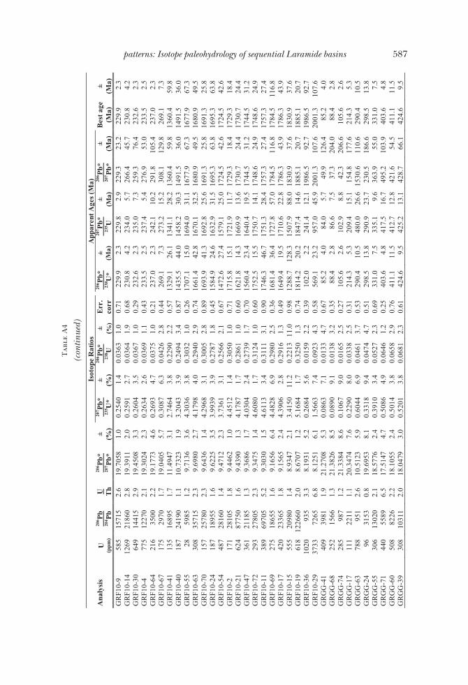
Tab
leA
4
(con
tinue
d)Is
otop
eR
atio
sA
ppar
ent A
ges
(Ma)
Ana
lysi
sU
(ppm
)
206 P
b20
4 Pb
U Th
206 P
b*20
7 Pb*
± (%)
207 P
b*23
5 U*
± (%)
206 P
b*23
8 U± (%
)E
rr.
corr
206 P
b*23
8 U*
±(M
a)
207 P
b*23
5 U±
(Ma)
206 P
b*20
7 Pb*
±(M
a)B
est a
ge(M
a)±
(Ma)
GR
F10-
958
515
715
2.6
19.7
058
1.0
0.25
401.
40.
0363
1.0
0.71
229.
92.
322
9.8
2.9
229.
323
.222
9.9
2.3
GR
F10-
1412
6921
860
2.8
19.3
911
2.0
0.25
912.
70.
0364
1.9
0.68
230.
84.
223
4.0
5.7
266.
445
.723
0.8
4.2
GR
F10-
3064
914
415
2.9
19.4
508
3.3
0.26
043.
50.
0367
1.0
0.29
232.
62.
323
5.0
7.3
259.
376
.423
2.6
2.3
GR
F10-
477
512
270
2.1
19.3
024
2.3
0.26
342.
60.
0369
1.1
0.43
233.
52.
523
7.4
5.4
276.
953
.023
3.5
2.5
GR
F10-
6421
635
002.
219
.177
34.
60.
2693
4.7
0.03
751.
00.
2123
7.0
2.3
242.
110
.229
1.8
105.
423
7.0
2.3
GR
F10-
6717
529
701.
719
.040
55.
70.
3087
6.3
0.04
262.
80.
4426
9.1
7.3
273.
215
.230
8.1
129.
826
9.1
7.3
GR
F10-
4113
516
895
1.7
11.4
947
3.1
2.74
643.
80.
2290
2.2
0.57
1329
.126
.113
41.1
28.2
1360
.459
.813
60.4
59.8
GR
F10-
4018
724
190
1.1
10.7
323
1.9
3.20
433.
90.
2494
3.4
0.87
1435
.544
.014
58.2
30.3
1491
.536
.014
91.5
36.0
GR
F10-
5528
5985
1.2
9.71
363.
64.
3036
3.8
0.30
321.
00.
2617
07.1
15.0
1694
.031
.116
77.9
67.3
1677
.967
.3G
RF1
0-63
308
3571
52.
39.
6980
2.7
4.17
984.
00.
2940
2.9
0.74
1661
.442
.816
70.1
32.5
1680
.949
.516
80.9
49.5
GR
F10-
7015
725
780
2.3
9.64
361.
44.
2968
3.1
0.30
052.
80.
8916
93.9
41.3
1692
.825
.616
91.3
25.8
1691
.325
.8G
RF1
0-24
187
1895
51.
69.
6225
3.5
3.99
393.
90.
2787
1.8
0.45
1584
.924
.616
32.9
31.5
1695
.363
.816
95.3
63.8
GR
F10-
5448
728
160
1.4
9.47
122.
33.
7361
3.1
0.25
662.
10.
6714
72.6
27.4
1579
.125
.017
24.5
42.6
1724
.542
.6G
RF1
0-2
171
2810
51.
89.
4462
1.0
4.45
121.
40.
3050
1.0
0.71
1715
.815
.117
21.9
11.7
1729
.318
.417
29.3
18.4
GR
F10-
2162
487
750
1.6
9.43
901.
34.
1787
1.7
0.28
611.
00.
6016
21.8
14.3
1669
.913
.617
30.7
24.4
1730
.724
.4G
RF1
0-47
361
2118
51.
39.
3686
1.7
4.03
042.
40.
2739
1.7
0.70
1560
.423
.416
40.4
19.5
1744
.531
.217
44.5
31.2
GR
F10-
7229
327
805
2.3
9.34
751.
44.
6080
1.7
0.31
241.
00.
6017
52.5
15.5
1750
.714
.117
48.6
24.9
1748
.624
.9G
RF1
0-11
389
6970
55.
29.
3030
1.5
4.61
133.
40.
3111
3.1
0.90
1746
.346
.717
51.3
28.4
1757
.327
.417
57.3
27.4
GR
F10-
6927
518
655
1.6
9.16
566.
44.
4828
6.9
0.29
802.
50.
3616
81.4
36.4
1727
.857
.017
84.5
116.
817
84.5
116.
8G
RF1
0-17
420
2336
51.
89.
1565
2.4
4.39
062.
80.
2916
1.3
0.49
1649
.419
.517
10.6
22.8
1786
.343
.917
86.3
43.9
GR
F10-
1555
520
980
1.4
8.93
472.
13.
4150
11.2
0.22
1311
.00.
9812
88.7
128.
315
07.9
88.0
1830
.937
.618
30.9
37.6
GR
F10-
1961
812
2660
2.0
8.67
071.
25.
1684
1.7
0.32
501.
30.
7418
14.2
20.2
1847
.414
.618
85.1
20.7
1885
.120
.7G
RF1
0-36
1020
935
3.3
8.19
315.
20.
2684
5.6
0.01
592.
20.
3910
2.0
2.2
241.
412
.119
86.5
92.7
1986
.592
.7G
RF1
0-29
3733
7265
6.8
8.12
516.
11.
5663
7.4
0.09
234.
30.
5856
9.1
23.2
957.
045
.920
01.3
107.
620
01.3
107.
6G
RG
G-4
140
939
811.
921
.270
85.
30.
0863
7.1
0.01
334.
70.
6785
.24.
084
.05.
749
.912
6.4
85.2
4.0
GR
GG
-68
252
1566
1.3
21.3
826
8.5
0.08
909.
10.
0138
3.2
0.35
88.4
2.8
86.6
7.5
37.3
204.
088
.42.
8G
RG
G-7
428
598
71.
221
.338
48.
60.
1067
9.0
0.01
652.
50.
2710
5.6
2.6
102.
98.
842
.320
6.6
105.
62.
6G
RG
G-1
711
122
111.
120
.347
47.
60.
2290
8.0
0.03
382.
50.
3121
4.3
5.3
209.
415
.115
4.8
177.
621
4.3
5.3
GR
GG
-63
788
951
2.6
10.5
123
5.9
0.60
446.
90.
0461
3.7
0.53
290.
410
.548
0.0
26.6
1530
.611
0.6
290.
410
.5G
RG
G-2
496
3153
0.8
19.6
953
8.1
0.33
189.
40.
0474
4.7
0.51
298.
513
.829
0.9
23.7
230.
518
6.6
298.
513
.8G
RG
G-5
530
613
020
2.1
18.5
776
2.4
0.39
103.
40.
0527
2.3
0.69
331.
07.
533
5.1
9.6
363.
955
.033
1.0
7.5
GR
GG
-71
440
5589
6.5
17.5
147
4.7
0.50
864.
90.
0646
1.2
0.25
403.
64.
841
7.5
16.7
495.
210
3.9
403.
64.
8G
RG
G-6
050
882
262.
218
.105
52.
40.
5014
3.8
0.06
582.
90.
7641
1.1
11.5
412.
712
.842
1.6
54.5
411.
111
.5G
RG
G-3
930
810
311
2.0
18.0
479
3.0
0.52
013.
80.
0681
2.3
0.61
424.
69.
542
5.2
13.1
428.
766
.142
4.6
9.5
587patterns: Isotope paleohydrology of sequential Laramide basins

Tab
leA
4
(con
tinue
d)Is
otop
eR
atio
sA
ppar
ent A
ges
(Ma)
Ana
lysi
sU
(ppm
)
206 P
b20
4 Pb
U Th
206 P
b*20
7 Pb*
± (%)
207 P
b*23
5 U*
± (%)
206 P
b*23
8 U± (%
)E
rr.
corr
206 P
b*23
8 U*
±(M
a)
207 P
b*23
5 U±
(Ma)
206 P
b*20
7 Pb*
±(M
a)B
est a
ge(M
a)±
(Ma)
GR
GG
-28
228
9330
1.5
18.0
013
3.6
0.54
627.
50.
0713
6.6
0.88
444.
028
.344
2.5
26.9
434.
579
.944
4.0
28.3
GR
GG
-45
260
1441
21.
817
.433
54.
60.
5653
4.7
0.07
151.
30.
2844
5.0
5.7
455.
017
.450
5.4
100.
344
5.0
5.7
GR
GG
-59
7726
341.
318
.365
95.
40.
5586
6.0
0.07
442.
50.
4246
2.7
11.3
450.
621
.838
9.6
122.
146
2.7
11.3
GR
GG
-12
578
5493
0.9
15.2
200
3.1
0.76
755.
10.
0847
4.0
0.79
524.
320
.357
8.4
22.5
796.
966
.052
4.3
20.3
GR
GG
-46
422
1346
71.
417
.237
11.
40.
6968
2.7
0.08
712.
30.
8553
8.4
11.7
536.
911
.153
0.3
31.0
538.
411
.7G
RG
G-5
014
611
286
1.9
16.4
485
2.3
0.82
853.
60.
0988
2.8
0.78
607.
616
.161
2.8
16.4
632.
048
.560
7.6
16.1
GR
GG
-35
5942
271.
715
.158
23.
41.
1291
6.3
0.12
415.
30.
8475
4.3
37.4
767.
333
.880
5.4
71.9
754.
337
.4G
RG
G-6
223
119
008
1.8
13.8
944
1.4
1.55
101.
90.
1563
1.3
0.68
936.
111
.595
0.9
12.0
985.
129
.193
6.1
11.5
GR
GG
-33
129
1842
62.
313
.996
72.
71.
6189
4.6
0.16
433.
70.
8198
0.9
33.8
977.
628
.997
0.2
55.5
970.
255
.5G
RG
G-4
418
772
992.
913
.807
23.
21.
7112
3.4
0.17
141.
30.
3810
19.6
12.3
1012
.722
.199
7.9
64.9
997.
964
.9G
RG
G-5
642
565
265
3.1
13.4
149
2.6
1.78
013.
80.
1732
2.8
0.73
1029
.726
.310
38.2
24.7
1056
.252
.410
56.2
52.4
GR
GG
-412
110
089
1.0
13.3
623
1.7
1.69
342.
00.
1641
1.0
0.50
979.
69.
110
06.0
12.9
1064
.135
.210
64.1
35.2
GR
GG
-51
6448
062.
213
.239
54.
21.
6857
4.5
0.16
191.
60.
3696
7.1
14.7
1003
.128
.710
82.7
84.1
1082
.784
.1G
RG
G-2
278
6795
0.9
13.1
342
1.3
1.76
504.
80.
1681
4.6
0.96
1001
.843
.010
32.7
31.1
1098
.725
.410
98.7
25.4
GR
GG
-839
527
315
1.7
13.0
523
3.0
1.91
644.
00.
1814
2.6
0.65
1074
.725
.610
86.8
26.7
1111
.260
.711
11.2
60.7
GR
GG
-65
7191
652.
112
.873
51.
51.
9495
3.5
0.18
203.
20.
9110
78.0
31.4
1098
.323
.411
38.7
29.2
1138
.729
.2G
RG
G-4
274
7494
1.5
12.6
829
2.2
2.15
022.
90.
1978
1.9
0.65
1163
.420
.111
65.1
20.1
1168
.343
.611
68.3
43.6
GR
GG
-30
8311
544
3.0
12.6
808
2.7
2.18
653.
50.
2011
2.3
0.64
1181
.224
.311
76.7
24.6
1168
.653
.811
68.6
53.8
GR
GG
-25
9016
599
3.2
12.6
671
2.8
2.09
638.
80.
1926
8.3
0.95
1135
.486
.811
47.6
60.6
1170
.756
.111
70.7
56.1
GR
GG
-53
204
1262
41.
312
.598
51.
82.
1964
3.5
0.20
073.
00.
8611
79.0
32.6
1179
.924
.511
81.5
35.0
1181
.535
.0G
RG
G-3
409
4034
13.
412
.460
82.
22.
1577
3.7
0.19
503.
00.
8111
48.4
31.7
1167
.525
.912
03.2
43.4
1203
.243
.4G
RG
G-2
134
2013
91.
812
.415
71.
82.
1480
2.9
0.19
342.
30.
7811
39.9
24.0
1164
.420
.412
10.3
36.2
1210
.336
.2G
RG
G-4
944
928
572
1.6
12.2
498
2.3
2.39
222.
90.
2125
1.7
0.60
1242
.319
.712
40.3
20.7
1236
.745
.112
36.7
45.1
GR
GG
-57
345
4422
3.5
11.9
465
6.4
1.89
006.
60.
1638
1.3
0.19
977.
611
.310
77.6
43.6
1285
.712
5.5
1285
.712
5.5
GR
GG
-27
100
2001
02.
010
.979
51.
93.
0234
4.9
0.24
084.
50.
9213
90.6
56.5
1413
.537
.414
48.2
36.3
1448
.236
.3G
RG
G-1
411
019
383
2.3
10.9
292
2.5
3.13
557.
40.
2485
6.9
0.94
1430
.988
.914
41.4
56.8
1457
.047
.914
57.0
47.9
GR
GG
-34
8810
584
1.8
10.8
607
2.5
3.24
924.
50.
2559
3.8
0.84
1469
.049
.514
69.0
35.0
1468
.946
.914
68.9
46.9
GR
GG
-724
816
125
3.6
10.8
072
1.6
2.90
9810
.10.
2281
10.0
0.99
1324
.411
9.6
1384
.576
.614
78.3
30.7
1478
.330
.7G
RG
G-6
420
627
960
2.5
10.5
711
1.7
3.37
812.
10.
2590
1.2
0.59
1484
.716
.314
99.3
16.4
1520
.131
.915
20.1
31.9
GR
GG
-66
7113
491
0.8
10.4
123
1.2
3.49
763.
70.
2641
3.4
0.94
1510
.946
.315
26.7
28.9
1548
.523
.115
48.5
23.1
GR
GG
-38
126
1403
41.
410
.233
32.
33.
6532
3.1
0.27
112.
10.
6715
46.6
28.2
1561
.224
.515
81.1
42.7
1581
.142
.7G
RG
G-1
932
247
727
1.1
10.0
232
1.7
3.70
573.
40.
2694
2.9
0.86
1537
.739
.515
72.6
26.9
1619
.731
.816
19.7
31.8
GR
GG
-37
5713
467
1.8
9.91
351.
74.
0181
3.2
0.28
892.
80.
8516
36.0
39.7
1637
.926
.216
40.2
31.2
1640
.231
.2G
RG
G-2
117
424
798
1.3
9.90
811.
83.
8206
5.0
0.27
454.
70.
9315
63.8
64.8
1597
.140
.216
41.2
33.0
1641
.233
.0
588 S. J. Davis and others—Synorogenic evolution of large-scale drainage

Tab
leA
4
(con
tinue
d)Is
otop
eR
atio
sA
ppar
ent A
ges
(Ma)
Ana
lysi
sU
(ppm
)
206 P
b20
4 Pb
U Th
206 P
b*20
7 Pb*
± (%)
207 P
b*23
5 U*
± (%)
206 P
b*23
8 U± (%
)E
rr.
corr
206 P
b*23
8 U*
±(M
a)
207 P
b*23
5 U±
(Ma)
206 P
b*20
7 Pb*
±(M
a)B
est a
ge(M
a)±
(Ma)
GR
GG
-11
518
9298
54.
49.
8621
1.3
3.83
702.
80.
2744
2.5
0.89
1563
.335
.316
00.5
23.0
1649
.923
.916
49.9
23.9
GR
GG
-20
213
1333
81.
69.
8177
3.0
3.42
655.
10.
2440
4.1
0.80
1407
.451
.315
10.5
39.9
1658
.256
.316
58.2
56.3
GR
GG
-61
402
1809
31.
49.
8059
2.5
4.09
004.
50.
2909
3.7
0.83
1645
.954
.016
52.3
36.5
1660
.445
.816
60.4
45.8
GR
GG
-40
151
2210
11.
29.
7841
3.1
4.11
544.
50.
2920
3.2
0.72
1651
.746
.616
57.4
36.4
1664
.657
.416
64.6
57.4
GR
GG
-52
209
2792
41.
29.
7557
2.3
4.09
643.
10.
2898
2.1
0.68
1640
.730
.716
53.6
25.5
1669
.942
.516
69.9
42.5
GR
GG
-73
154
2160
32.
09.
6436
1.4
3.88
912.
10.
2720
1.6
0.77
1551
.022
.516
11.4
17.1
1691
.325
.116
91.3
25.1
GR
GG
-910
513
998
2.9
9.63
241.
84.
1468
3.3
0.28
972.
80.
8516
40.0
40.1
1663
.626
.816
93.4
32.3
1693
.432
.3G
RG
G-7
226
031
695
1.0
9.59
931.
13.
9674
2.6
0.27
622.
40.
9115
72.3
33.5
1627
.621
.416
99.8
20.1
1699
.820
.1G
RG
G-3
119
515
795
1.2
9.58
493.
14.
3333
3.8
0.30
122.
20.
5816
97.4
33.1
1699
.731
.717
02.5
57.9
1702
.557
.9G
RG
G-1
621
756
580
3.8
9.41
293.
24.
3936
6.5
0.29
995.
70.
8716
91.0
84.6
1711
.153
.917
35.8
58.0
1735
.858
.0G
RG
G-1
356
6348
2.2
9.32
381.
84.
4660
4.5
0.30
204.
10.
9217
01.2
61.5
1724
.737
.217
53.2
32.7
1753
.232
.7G
RG
G-4
712
119
257
3.5
9.07
971.
64.
7590
3.8
0.31
343.
40.
9017
57.4
52.3
1777
.731
.518
01.6
29.1
1801
.629
.1G
RG
G-1
892
941
310
4.4
9.06
001.
84.
8189
2.1
0.31
661.
00.
4817
73.3
15.5
1788
.217
.618
05.6
33.5
1805
.633
.5G
RG
G-3
281
435
667
4.0
8.91
892.
44.
6212
2.9
0.29
891.
70.
5816
86.0
24.9
1753
.124
.118
34.1
42.6
1834
.142
.6G
RG
G-6
190
2468
43.
58.
8531
1.6
4.96
224.
80.
3186
4.5
0.94
1783
.070
.718
12.9
40.8
1847
.529
.718
47.5
29.7
GR
GG
-26
7610
413
1.7
8.73
271.
85.
0927
2.8
0.32
252.
20.
7818
02.2
34.4
1834
.923
.818
72.2
31.6
1872
.231
.6G
RG
G-7
040
710
1160
8.7
7.77
782.
06.
4135
3.5
0.36
182.
90.
8119
90.6
49.0
2034
.130
.920
78.5
35.9
2078
.535
.9G
RG
G-7
549
488
322.
47.
0408
6.2
7.29
709.
10.
3726
6.6
0.73
2041
.711
5.5
2148
.481
.322
52.1
108.
022
52.1
108.
0G
RG
G-3
644
1759
50.
95.
3900
2.4
12.8
389
4.5
0.50
193.
80.
8526
21.9
81.4
2667
.942
.027
02.9
39.0
2702
.939
.0G
RG
G-4
368
1969
20.
65.
1901
2.4
14.1
597
3.0
0.53
301.
80.
6127
54.1
41.2
2760
.528
.827
65.1
39.6
2765
.139
.6G
RG
G-1
099
3989
11.
35.
0591
2.0
14.2
333
3.8
0.52
233.
20.
8527
08.7
70.8
2765
.435
.928
07.0
32.9
2807
.032
.9K
MT
B-2
223
619
051.
219
.586
03.
20.
3402
3.4
0.04
831.
10.
3230
4.2
3.2
297.
38.
624
3.4
73.2
304.
23.
2K
MT
B-6
423
2312
115
20.6
11.7
060
5.2
0.78
229.
40.
0664
7.8
0.83
414.
531
.458
6.7
41.9
1325
.210
0.6
414.
531
.4K
MT
B-7
239
035
001.
118
.267
02.
00.
5265
2.3
0.06
981.
20.
5343
4.7
5.2
429.
58.
140
1.7
44.0
434.
75.
2K
MT
B-5
385
087
951.
816
.672
21.
70.
6967
2.9
0.08
422.
30.
8152
1.4
11.6
536.
811
.960
2.8
36.5
521.
411
.6K
MT
B-3
750
059
202.
316
.881
91.
80.
7905
3.3
0.09
682.
80.
8559
5.6
16.1
591.
514
.957
5.7
38.2
595.
616
.1K
MT
B-1
228
740
904.
313
.627
61.
51.
5521
1.8
0.15
341.
00.
5592
0.0
8.6
951.
311
.310
24.5
30.9
1024
.530
.9K
MT
B-6
848
2415
1.0
13.3
299
2.9
1.95
353.
40.
1889
1.7
0.49
1115
.216
.910
99.6
22.5
1069
.058
.610
69.0
58.6
KM
TB
-31
106
3295
1.3
13.0
260
2.1
2.00
092.
70.
1890
1.7
0.62
1116
.116
.911
15.8
18.2
1115
.242
.211
15.2
42.2
KM
TB
-47
353
1492
01.
812
.743
72.
22.
1497
2.6
0.19
871.
40.
5411
68.3
15.2
1165
.018
.211
58.8
43.6
1158
.843
.6K
MT
B-3
861
1995
2.9
12.1
226
3.4
2.45
843.
60.
2161
1.0
0.28
1261
.511
.512
59.9
25.8
1257
.267
.012
57.2
67.0
KM
TB
-66
158
1723
01.
211
.535
03.
22.
7399
3.7
0.22
921.
70.
4713
30.4
20.6
1339
.427
.313
53.7
62.6
1353
.762
.6K
MT
B-4
255
2410
1.3
11.4
189
2.2
2.95
482.
50.
2447
1.0
0.41
1411
.112
.713
96.1
18.6
1373
.143
.113
73.1
43.1
KM
TB
-69
138
5165
1.5
11.3
376
2.4
2.89
143.
10.
2378
2.0
0.63
1375
.024
.513
79.7
23.6
1386
.946
.613
86.9
46.6
589patterns: Isotope paleohydrology of sequential Laramide basins

Table A4
(continued)Isotope Ratios Apparent Ages (Ma)
Analysis U(ppm)
206Pb204Pb
UTh
206Pb*207Pb*
±(%)
207Pb*235U*
±(%)
206Pb*238U
±(%)
Err.corr
206Pb*238U*
±(Ma)
207Pb*235U
±(Ma)
206Pb*207Pb*
±(Ma)
Best age(Ma)
±(Ma)
KMTB-58 106 21605 1.2 11.2625 1.3 2.8587 1.9 0.2335 1.4 0.74 1352.9 16.8 1371.1 14.0 1399.6 24.0 1399.6 24.0KMTB-29 105 5910 2.0 11.2007 1.7 3.0498 2.6 0.2478 2.0 0.76 1426.9 25.5 1420.2 20.1 1410.2 32.9 1410.2 32.9KMTB-70 431 11390 1.6 11.1670 2.4 3.0639 2.6 0.2481 1.0 0.39 1428.9 12.8 1423.7 19.9 1415.9 45.8 1415.9 45.8KMTB-11 178 3670 2.2 11.1545 3.8 3.1010 3.9 0.2509 1.0 0.25 1443.0 12.9 1432.9 30.2 1418.1 72.7 1418.1 72.7KMTB-50 119 5100 1.8 11.1473 2.2 2.7207 3.7 0.2200 3.0 0.80 1281.7 34.6 1334.1 27.6 1419.3 42.4 1419.3 42.4KMTB-30 94 6450 1.8 11.1253 2.4 3.0244 2.6 0.2440 1.0 0.39 1407.6 12.6 1413.8 19.6 1423.1 45.3 1423.1 45.3KMTB-46 158 9535 1.7 11.1250 1.1 3.0249 2.0 0.2441 1.7 0.84 1407.8 21.4 1413.9 15.3 1423.1 20.7 1423.1 20.7KMTB-77 204 7520 1.7 11.1135 1.7 3.1081 2.0 0.2505 1.0 0.51 1441.2 12.9 1434.7 15.1 1425.1 32.2 1425.1 32.2KMTB-44 631 19245 1.7 11.1121 2.0 2.3885 4.7 0.1925 4.2 0.91 1134.9 44.1 1239.2 33.5 1425.3 38.0 1425.3 38.0KMTB-45 257 8635 1.0 11.1083 2.4 3.0255 3.5 0.2438 2.5 0.72 1406.2 32.0 1414.1 26.8 1426.0 46.6 1426.0 46.6KMTB-65 109 3400 2.2 11.1009 2.9 3.1870 3.3 0.2566 1.6 0.48 1472.4 21.2 1454.0 25.8 1427.3 55.7 1427.3 55.7KMTB-27 282 9725 1.9 11.0838 2.7 3.1068 3.5 0.2497 2.3 0.64 1437.2 29.1 1434.4 27.2 1430.2 52.2 1430.2 52.2KMTB-7 50 3005 1.4 11.0650 4.3 3.0452 4.8 0.2444 2.1 0.45 1409.4 27.0 1419.0 36.5 1433.5 81.6 1433.5 81.6KMTB-34 594 27325 5.1 11.0227 1.7 2.7011 2.0 0.2159 1.0 0.50 1260.4 11.4 1328.8 14.9 1440.8 33.2 1440.8 33.2KMTB-80 92 3125 1.6 11.0056 3.0 3.0421 4.0 0.2428 2.7 0.66 1401.3 33.8 1418.2 30.9 1443.7 57.7 1443.7 57.7KMTB-49 440 16140 0.9 10.9549 1.0 3.2176 2.2 0.2556 2.0 0.89 1467.5 26.2 1461.4 17.4 1452.5 19.4 1452.5 19.4KMTB-39 163 6155 1.2 10.9292 3.7 3.1244 4.1 0.2477 1.6 0.38 1426.4 20.0 1438.7 31.2 1457.0 71.3 1457.0 71.3KMTB-10 328 6020 1.4 10.9254 3.3 2.2378 6.5 0.1773 5.7 0.86 1052.3 54.9 1193.0 45.9 1457.6 62.6 1457.6 62.6KMTB-61 115 4490 1.7 10.9245 2.8 3.1379 3.0 0.2486 1.2 0.38 1431.4 14.8 1442.0 23.1 1457.8 52.8 1457.8 52.8KMTB-32 434 19415 1.2 10.9213 1.1 3.1326 2.2 0.2481 1.9 0.85 1428.8 23.7 1440.7 16.7 1458.3 21.5 1458.3 21.5KMTB-2 185 6245 3.6 10.9110 1.7 3.2753 2.1 0.2592 1.4 0.64 1485.7 18.0 1475.2 16.7 1460.1 31.4 1460.1 31.4KMTB-17 94 11935 1.3 10.9103 1.2 3.1846 2.3 0.2520 2.0 0.86 1448.8 25.4 1453.4 17.6 1460.3 21.9 1460.3 21.9KMTB-55 150 10705 1.2 10.9049 1.8 3.0474 2.3 0.2410 1.4 0.61 1392.0 17.8 1419.6 17.7 1461.2 34.6 1461.2 34.6KMTB-74 279 9625 2.0 10.8802 1.9 3.1383 2.2 0.2476 1.1 0.52 1426.3 14.6 1442.1 17.0 1465.5 35.9 1465.5 35.9KMTB-19 679 56700 7.7 10.1193 2.3 3.7156 2.5 0.2727 1.0 0.40 1554.5 13.8 1574.7 20.1 1602.0 43.1 1602.0 43.1KMTB-8 57 1665 1.6 10.0431 3.1 3.7193 4.4 0.2709 3.1 0.70 1545.4 42.6 1575.5 35.3 1616.1 58.4 1616.1 58.4KMTB-82 283 11140 2.2 10.0336 2.0 3.0276 4.8 0.2203 4.4 0.91 1283.6 50.9 1414.6 36.7 1617.8 37.5 1617.8 37.5KMTB-67 121 5800 1.0 10.0159 3.3 3.7003 3.4 0.2688 1.0 0.29 1534.7 13.7 1571.4 27.3 1621.1 60.6 1621.1 60.6KMTB-57 57 2130 1.6 9.9678 2.6 3.7833 2.8 0.2735 1.0 0.36 1558.6 13.8 1589.2 22.5 1630.1 48.6 1630.1 48.6KMTB-6 304 10255 4.3 9.8127 1.8 4.0931 2.0 0.2913 1.0 0.50 1648.0 14.5 1652.9 16.5 1659.2 32.4 1659.2 32.4KMTB-73 203 22780 4.5 9.7774 1.3 3.9883 2.1 0.2828 1.7 0.79 1605.6 24.0 1631.8 17.3 1665.8 23.9 1665.8 23.9KMTB-48 93 7415 3.8 9.7260 1.2 4.2332 3.1 0.2986 2.9 0.92 1684.4 42.2 1680.5 25.5 1675.6 22.6 1675.6 22.6KMTB-79 88 5805 2.1 9.6820 2.1 4.2146 2.4 0.2960 1.0 0.42 1671.2 14.7 1676.9 19.4 1683.9 39.6 1683.9 39.6KMTB-20 97 5160 2.9 9.6800 2.0 4.0450 2.7 0.2840 1.8 0.67 1611.4 25.4 1643.3 21.7 1684.3 36.7 1684.3 36.7
590S.J.D
avisandothers—
Synorogenicevolutionoflarge-scaledrainage
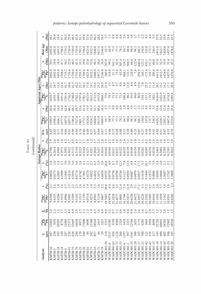
Tab
leA
4
(con
tinue
d)Is
otop
eR
atio
sA
ppar
ent A
ges
(Ma)
Ana
lysi
sU
(ppm
)
206 P
b20
4 Pb
U Th
206 P
b*20
7 Pb*
± (%)
207 P
b*23
5 U*
± (%)
206 P
b*23
8 U± (%
)E
rr.
corr
206 P
b*23
8 U*
±(M
a)
207 P
b*23
5 U±
(Ma)
206 P
b*20
7 Pb*
±(M
a)B
est a
ge(M
a)±
(Ma)
KM
TB
-16
547
2586
52.
49.
6398
2.1
4.00
242.
80.
2798
1.9
0.67
1590
.526
.616
34.7
23.1
1692
.039
.116
92.0
39.1
KM
TB
-523
070
702.
29.
6355
1.6
4.02
733.
00.
2814
2.6
0.85
1598
.636
.416
39.7
24.7
1692
.829
.916
92.8
29.9
KM
TB
-28
183
2029
51.
59.
6296
1.0
4.28
031.
40.
2989
1.0
0.71
1686
.114
.816
89.6
11.6
1693
.918
.416
93.9
18.4
KM
TB
-24
150
8770
3.7
9.55
322.
64.
2909
2.7
0.29
731.
00.
3616
77.9
14.8
1691
.622
.617
08.6
47.1
1708
.647
.1K
MT
B-4
287
1240
53.
39.
4986
2.7
4.34
455.
00.
2993
4.2
0.84
1687
.862
.817
01.8
41.7
1719
.250
.517
19.2
50.5
KM
TB
-81
230
1237
54.
59.
3943
1.3
4.42
103.
00.
3012
2.7
0.91
1697
.340
.117
16.3
24.6
1739
.422
.917
39.4
22.9
KM
TB
-35
428
3269
54.
99.
3380
2.2
4.59
545.
00.
3112
4.5
0.90
1746
.868
.217
48.4
41.5
1750
.440
.517
50.4
40.5
KM
TB
-76
296
1465
02.
99.
3103
2.3
4.67
145.
00.
3154
4.5
0.89
1767
.469
.717
62.1
42.2
1755
.941
.417
55.9
41.4
KM
TB
-23
170
8975
2.7
9.12
151.
84.
8742
2.8
0.32
252.
10.
7618
01.7
33.6
1797
.823
.717
93.3
33.3
1793
.333
.3K
MT
B-2
624
417
090
1.3
9.11
501.
64.
7861
3.1
0.31
642.
70.
8617
72.1
41.4
1782
.526
.117
94.6
29.0
1794
.629
.0K
MT
B-6
294
9690
1.2
8.97
141.
95.
0274
2.1
0.32
711.
00.
4818
24.4
15.9
1823
.917
.818
23.4
33.6
1823
.433
.6K
MT
B-5
124
213
340
1.9
8.92
751.
95.
0832
2.3
0.32
911.
20.
5118
34.2
18.5
1833
.319
.118
32.3
35.0
1832
.335
.0K
MT
B-6
385
728
910
6.3
8.85
035.
34.
4032
6.5
0.28
263.
70.
5716
04.6
52.3
1712
.953
.618
48.0
96.3
1848
.096
.3K
MT
B-7
144
2435
1.8
8.51
541.
65.
5971
2.9
0.34
572.
50.
8419
13.9
40.6
1915
.625
.219
17.5
28.6
1917
.528
.6K
MT
B-5
929
1825
0.9
7.48
072.
26.
6654
3.0
0.36
162.
00.
6719
89.9
34.4
2068
.126
.521
46.8
38.9
2146
.838
.9W
AD
C40
1-58
110
5355
0.9
18.7
683
30.6
0.07
5230
.80.
0102
3.5
0.11
65.7
2.3
73.6
21.9
340.
870
7.9
65.7
2.3
WA
DC
401-
432
1512
585
5.2
18.9
574
4.4
0.07
594.
90.
0104
2.3
0.46
66.9
1.5
74.3
3.5
318.
099
.266
.91.
5W
AD
C40
1-63
656
3330
0.7
22.1
824
6.6
0.07
506.
70.
0121
1.0
0.15
77.3
0.8
73.4
4.7
-51.
316
1.1
77.3
0.8
WA
DC
401-
7111
2882
002.
221
.057
73.
50.
0790
3.6
0.01
211.
00.
2877
.30.
877
.22.
773
.882
.977
.30.
8W
AD
C40
1-53
260
2320
0.8
22.4
805
12.4
0.07
4812
.50.
0122
1.0
0.08
78.2
0.8
73.3
8.8
-83.
930
5.4
78.2
0.8
WA
DC
401-
611
9734
101.
816
.174
47.
40.
1127
7.8
0.01
322.
40.
3184
.72.
010
8.4
8.0
668.
115
9.2
84.7
2.0
WA
DC
401-
159
722
250.
820
.541
512
.90.
0929
13.9
0.01
385.
20.
3888
.64.
690
.212
.013
2.5
304.
588
.64.
6W
AD
C40
1-31
1541
1253
00.
920
.615
82.
90.
0987
4.8
0.01
483.
90.
8094
.53.
695
.64.
412
4.0
68.6
94.5
3.6
WA
DC
401-
2838
826
352.
421
.647
25.
10.
0979
5.4
0.01
541.
80.
3398
.31.
794
.84.
97.
812
2.4
98.3
1.7
WA
DC
401-
1118
511
752.
624
.456
717
.10.
0937
17.2
0.01
661.
20.
0710
6.2
1.3
90.9
15.0
-294
.544
0.4
106.
21.
3W
AD
C40
1-21
700
6285
1.6
20.4
228
5.3
0.16
385.
50.
0243
1.5
0.27
154.
62.
215
4.1
7.8
146.
112
3.3
154.
62.
2W
AD
C40
1-42
121
1045
0.7
23.3
292
17.2
0.14
4618
.30.
0245
6.2
0.34
155.
89.
513
7.1
23.5
-175
.443
2.1
155.
89.
5W
AD
C40
1-41
316
5920
2.0
20.3
485
6.5
0.18
727.
00.
0276
2.8
0.39
175.
74.
817
4.3
11.2
154.
715
1.2
175.
74.
8W
AD
C40
1-15
317
8690
5.7
18.4
416
3.6
0.40
063.
90.
0536
1.6
0.41
336.
55.
334
2.1
11.4
380.
480
.833
6.5
5.3
WA
DC
401-
1819
525
720
1.2
11.1
910
2.0
3.03
683.
40.
2465
2.8
0.82
1420
.335
.614
16.9
26.1
1411
.837
.914
11.8
37.9
WA
DC
401-
1449
960
955
1.3
11.1
859
1.7
3.06
062.
00.
2483
1.0
0.51
1429
.713
.014
22.9
15.1
1412
.732
.514
12.7
32.5
WA
DC
401-
4349
238
705
2.0
11.1
162
1.9
2.96
872.
10.
2393
1.0
0.47
1383
.312
.413
99.7
16.2
1424
.635
.914
24.6
35.9
WA
DC
401-
2910
612
945
1.5
10.9
291
1.9
3.27
422.
20.
2595
1.2
0.53
1487
.415
.414
74.9
17.1
1457
.035
.414
57.0
35.4
WA
DC
401-
3814
518
530
1.5
10.8
200
2.3
3.38
003.
70.
2652
2.9
0.78
1516
.638
.814
99.8
28.8
1476
.043
.514
76.0
43.5
591patterns: Isotope paleohydrology of sequential Laramide basins
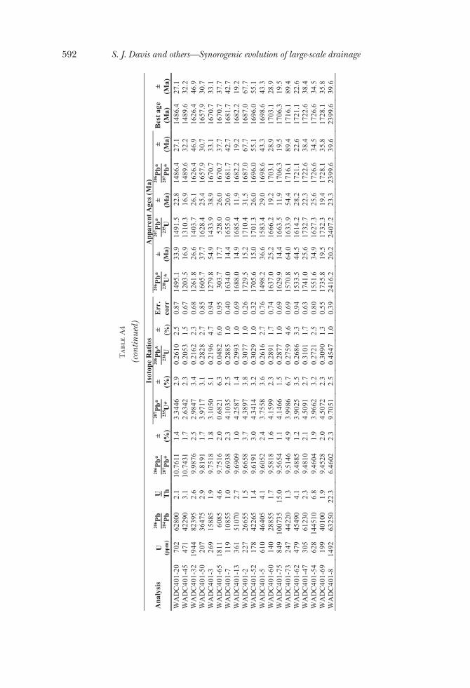
Tab
leA
4
(con
tinue
d)Is
otop
eR
atio
sA
ppar
ent A
ges
(Ma)
Ana
lysi
sU
(ppm
)
206 P
b20
4 Pb
U Th
206 P
b*20
7 Pb*
± (%)
207 P
b*23
5 U*
± (%)
206 P
b*23
8 U± (%
)E
rr.
corr
206 P
b*23
8 U*
±(M
a)
207 P
b*23
5 U±
(Ma)
206 P
b*20
7 Pb*
±(M
a)B
est a
ge(M
a)±
(Ma)
WA
DC
401-
2070
262
800
2.1
10.7
611
1.4
3.34
462.
90.
2610
2.5
0.87
1495
.133
.914
91.5
22.8
1486
.427
.114
86.4
27.1
WA
DC
401-
4547
142
290
3.1
10.7
431
1.7
2.63
422.
30.
2053
1.5
0.67
1203
.516
.913
10.3
16.9
1489
.632
.214
89.6
32.2
WA
DC
401-
3219
4482
395
2.6
9.98
762.
52.
9847
3.4
0.21
622.
30.
6812
61.8
26.6
1403
.726
.116
26.4
46.9
1626
.446
.9W
AD
C40
1-50
207
3647
52.
99.
8191
1.7
3.97
173.
10.
2828
2.7
0.85
1605
.737
.716
28.4
25.4
1657
.930
.716
57.9
30.7
WA
DC
401-
326
915
885
1.9
9.75
181.
83.
1050
5.1
0.21
964.
70.
9412
79.8
54.9
1433
.938
.916
70.7
33.1
1670
.733
.1W
AD
C40
1-65
1811
6085
4.6
9.75
162.
00.
6821
6.3
0.04
826.
00.
9530
3.7
17.7
528.
026
.016
70.7
37.7
1670
.737
.7W
AD
C40
1-7
119
1085
51.
09.
6938
2.3
4.10
352.
50.
2885
1.0
0.40
1634
.014
.416
55.0
20.6
1681
.742
.716
81.7
42.7
WA
DC
401-
1336
151
070
2.7
9.69
091.
04.
2587
1.4
0.29
931.
00.
6916
88.0
14.9
1685
.411
.916
82.2
19.2
1682
.219
.2W
AD
C40
1-2
227
2665
51.
59.
6658
3.7
4.38
973.
80.
3077
1.0
0.26
1729
.515
.217
10.4
31.5
1687
.067
.716
87.0
67.7
WA
DC
401-
5217
842
265
1.4
9.61
913.
04.
3414
3.2
0.30
291.
00.
3217
05.6
15.0
1701
.326
.016
96.0
55.1
1696
.055
.1W
AD
C40
1-5
610
4640
54.
19.
6052
2.4
3.75
583.
60.
2616
2.7
0.76
1498
.236
.615
83.4
29.0
1698
.643
.316
98.6
43.3
WA
DC
401-
6014
028
855
1.7
9.58
181.
64.
1599
2.3
0.28
911.
70.
7416
37.0
25.2
1666
.219
.217
03.1
28.9
1703
.128
.9W
AD
C40
1-75
849
1007
3515
.09.
5654
1.1
4.14
661.
50.
2877
1.0
0.69
1629
.914
.416
63.5
11.9
1706
.319
.517
06.3
19.5
WA
DC
401-
7324
744
220
1.3
9.51
464.
93.
9986
6.7
0.27
594.
60.
6915
70.8
64.0
1633
.954
.417
16.1
89.4
1716
.189
.4W
AD
C40
1-62
479
4549
04.
19.
4885
1.2
3.90
253.
50.
2686
3.3
0.94
1533
.544
.516
14.2
28.2
1721
.122
.617
21.1
22.6
WA
DC
401-
4730
561
230
2.3
9.48
102.
14.
5091
2.7
0.31
011.
70.
6317
41.0
25.6
1732
.722
.317
22.6
38.4
1722
.638
.4W
AD
C40
1-54
628
1445
106.
89.
4604
1.9
3.96
623.
20.
2721
2.5
0.80
1551
.634
.916
27.3
25.6
1726
.634
.517
26.6
34.5
WA
DC
401-
6919
940
100
1.9
9.45
282.
04.
5072
2.3
0.30
901.
30.
5517
35.8
19.5
1732
.319
.417
28.1
35.8
1728
.135
.8W
AD
C40
1-8
1492
6325
022
.36.
4602
2.3
9.70
512.
50.
4547
1.0
0.39
2416
.220
.224
07.2
23.3
2399
.639
.623
99.6
39.6
592 S. J. Davis and others—Synorogenic evolution of large-scale drainage

Tab
leA
5
Refe
renc
esfo
rpa
leoflo
wdi
rect
ions
depi
cted
infig
ure
Lab
el in
Fig
ure
7R
efer
ence
(s)
1 –
Nor
thw
est G
GR
B(S
teid
tman
n, 1
969;
Wes
t and
Daw
son,
197
3; A
nder
son
and
Pica
rd, 1
974;
Dor
r and
oth
ers,
197
7)
2 –
Nor
thw
est W
RB
(Bau
er, 1
934;
Lov
e, 1
939;
Van
Hou
ten,
195
5; K
eefe
r, 19
57; V
an H
oute
n, 1
964;
Kee
fer,
1965
; Soi
ster
, 196
8; L
ove,
19
70; M
acG
initi
e, 1
974;
Em
ry, 1
975;
Bol
es a
nd S
urda
m, 1
979;
Kor
th, 1
982;
Stu
cky,
ms,
198
2; S
tuck
y, 1
984)
3 –
Nor
thea
st G
GR
B(S
klen
ar a
nd A
nder
son,
198
5)
4 –
Sout
hwes
t GG
RB
(Ori
el, 1
961;
Law
renc
e, 1
963;
Rub
ey a
nd o
ther
s, 1
975;
Zon
neve
ld a
nd o
ther
s, 2
003)
5 –
Sout
heas
t GG
RB
/ N
orth
ern
PCB
(Tru
dell
and
othe
rs, 1
970;
Roe
hler
, 197
3b; R
oehl
er, 1
974;
Tru
dell
and
othe
rs, 1
974;
Dun
can
and
othe
rs, 1
974;
O
'Sul
livan
, 197
4; O
'Sul
livan
, 197
5; H
ail,
1977
; Sur
dam
and
Sta
nley
, 198
0; J
ohns
on, 1
981;
Don
nell,
198
2; J
ohns
on
1984
; Hai
l, 19
87; O
'Sul
livan
, 198
7; H
ail,
1990
; Fra
nczy
k an
d ot
hers
, 199
2; H
ail,
1992
; Hai
l and
Sm
ith, 1
994)
6 –
Wes
tern
UB
(Sta
gner
, 194
1; S
tanl
ey a
nd C
ollin
son,
197
9; W
eiss
, 198
2; F
ouch
and
oth
ers,
198
3; B
ruhn
and
oth
ers,
198
6; L
awto
n,
1986
; Law
ton
and
othe
rs, 1
993;
Tal
ling
and
othe
rs, 1
995)
7 –
Eas
tern
UB
/ W
este
rn P
CB
(Dan
e, 1
954;
Cas
hion
and
Don
nell,
197
2; M
oncu
re, m
s, 1
979;
Mon
cure
and
Sur
dam
, 198
0; C
ole,
198
5)
8 –
Sout
hern
UB
(Spi
eker
, 194
6; C
ashi
on, 1
967;
Mar
cant
el, 1
968;
Fou
ch a
nd o
ther
s, 1
976;
Pet
erso
n, 1
976;
Vol
kert
, ms,
198
0; P
itman
and
ot
hers
, 198
2; Z
awis
kie
and
othe
rs, 1
982;
Sm
ith, 1
986;
Bru
hn a
nd o
ther
s, 1
986;
Dic
kins
on a
nd o
ther
s, 1
986;
Will
is,
1986
; Fou
ch a
nd o
ther
s, 1
987;
Fra
nczy
k an
d ot
hers
, 199
1; F
ranc
zyk
and
Pitm
an, 1
991;
Mor
ris
and
othe
rs, 1
991)
9 –
Sout
heas
t PC
B(D
onne
ll, 1
961;
Don
nell,
196
9; K
ihm
, 198
4)
10 –
SC
B(J
anec
ke, 1
994;
Jan
ecke
and
oth
ers,
200
0)
11 –
Nor
thw
est G
GR
B(C
ulbe
rtso
n, 1
962;
Ebe
ns, m
s, 1
963;
McG
rew
and
Sul
livan
, 197
0; K
istn
er, m
s, 1
973;
Gus
tav,
ms,
197
4; W
olfb
auer
and
Su
rdam
, 197
4; S
urda
m a
nd S
tanl
ey, 1
980)
12 –
Nor
thw
est W
RB
/ N
orth
east
GG
RB
(Ori
el, 1
961;
Ori
el, 1
962;
Roe
hler
, 196
9; R
oehl
er, 1
970;
Roe
hler
, 197
3a; R
oehl
er, 1
973b
; Bra
unag
el, 1
977;
Mau
ger,
1977
; Sta
nley
and
Sur
dam
, 197
8; S
urda
m a
nd S
tanl
ey, 1
979;
Sur
dam
and
Sta
nley
, 198
0; R
oehl
er, 1
988;
Roe
hler
, 199
0;
Stuc
ky a
nd o
ther
s, 1
996)
13 –
Sou
thea
st G
GR
B /
Nor
thw
est P
CB
/ Eas
tern
UB
(Cas
hion
and
Don
nell,
197
2; C
ashi
on a
nd D
onne
ll, 1
974;
Roe
hler
, 199
2; P
roth
ero,
199
6; B
arto
v an
d ot
hers
, 200
7;
Bar
tov
and
othe
rs, 2
008;
Sar
g an
d ot
hers
, 200
9)
14 –
Nor
ther
n U
B
(Kay
, 193
4; A
nder
son
and
Pica
rd, 1
972;
And
erso
n an
d Pi
card
, 197
4)
593patterns: Isotope paleohydrology of sequential Laramide basins

references
Anderson, D. W., and Picard, M. D., 1972, Stratigraphy of the Duchesne River Formation (Eocene-Oligocene?), Northern Uinta Basin, Northeastern Utah: Utah Geological and Mineralogical SurveyBulletin, v. 97, p. 1–23.
–––––– 1974, Evolution of synorogenic clastic deposits in the intermontane Uinta Basin of Utah in Dickinson,W. R., editor, Tectonics and Sedimentation: SEPM Special Publication, v. 22, p. 167–189.
Axen, G. J., Taylor, W. J., and Bartley, J. M., 1993, Space-time patterns and tectonic controls of Tertiarymagmatism in the Great Basin of the western United States: Geological Society of America Bulletin,v. 105, p. 56–76, doi:10.1130/0016-7606(1993)105,0056:STPATC-2.3.CO;2.
Bartov, Y., Picha, M., and Daub, J., 2007, Oil shale of the Piceance Creek and eastern Uinta Basins, 27th OilShale Symposium: Golden, Colorado, Colorado School of Mines.
Bartov, Y., Nummendal, D., and Sarg, R., 2008, The depositional system of the Green River oil shale inwestern Colorado: San Antonio, Texas, AAPG Annual Convention, Search and Discovery Article#90078.
Bauer, C. M., 1934, Wind River Basin [Wyoming]: Geological Society of America Bulletin, v. 45, p. 665–696.Bohacs, K. M., Carroll, A. R., Neal, J. E., and Mankiewicz, P. J., 2000, Lake-basin type, source potential, and
hydrocarbon character: an integrated sequence-stratigraphic-geochemical framework, in Gierlowski-Kordesch, E. H., and Kelts, K. R., editors, Lake basins through space and time: AAPG Studies in GeologyNo. 46, p. 3–34.
Boles, J. R., and Surdam, R. C., 1979, Diagenesis of volcanogenic sediments in a Tertiary saline lake; WagonBed Formation, Wyoming: American Journal of Science, v. 279, p. 832–853.
Bouchard, D. P., Kaufman, D. S., Hochberg, A., and Quade, J., 1998, Quaternary history of the ThatcherBasin, Idaho, reconstructed from the 87Sr/86Sr and amino acid composition of lacustrine fossils:implications for the diversion of the Bear River into the Bonneville Basin: Palaeogeography, Palaeocli-matology, Palaeoecology, v. 141, p. 95–114, doi:10.1016/S0031-0182(98)00005-4.
Bowen, G. J., and Bowen, B. B., 2008, Mechanisms of PETM global change constrained by a new record fromcentral Utah: Geology, v. 36, p. 379–382, doi: 10.1130/G24597A.1.
Bowen, G. J., Daniels, A. L., and Bowen, B. B., 2008, Paleoenvironmental isotope geochemistry andparagenesis of lacustrine and palustrine carbonates, Flagstaff Formation, central Utah, USA: Journal ofSedimentary Research, v. 78, p. 162–174.
Table A6
References for strontium isotope ratios of exposure depicted in figure 1
Location and Rock Type Reference(s)
Precambrian Cores of Laramide Uplifts
Uinta Uplift (UU) (Crittenden and Peterman, 1975; Bouchard and others, 1998; Gerner and others, 2007)
Wind River Uplift (WRU) (Frost and others, 1998)
Sierra Madre Uplift (SMU) (Divis, 1977)
Front Range Uplift (FRU) (Hedge and others, 1967)
Owl Creek Uplift (OCU) (Mueller and others, 1985)
Granite Uplift (GU) (Peterman and Hildreth, 1978)
Laramie Uplift (LU) (Zielinski and others, 1981; Patel and others, 1999)
Sawatch-San Luis Uplift (SSU) (Pearson and others, 1966; Moorbath and others, 1967)
Sangre de Cristo Uplift (SCU) (Nelson and DePaolo, 1988)
Precambrain, Paleozoic and Mesozoic Carbonates
(Paces and others, 2007; Bright, 2009)
Tertiary Volcanic Provinces (Peterman and others, 1970; Meen and Eggler, 1987; Norman and Leeman, 1989; Cunningham and others, 1998; Vogel and others, 2001)
Absaroka (Peterman and others, 1970; Meen and Eggler, 1987)
Challis (Norman and Leeman, 1989)
Keetley (Vogel and others, 2001)
Marysvale (Cunningham and others, 1998)
594 S. J. Davis and others—Synorogenic evolution of large-scale drainage

Bradley, W. H., 1931, Origin and microfossils of the oil shale of the Green River Formation of Colorado andUtah: United States Geological Survey Professional Paper, v. 168, 58 p.
Brass, G. W., 1975, The effect of weathering on the distribution of strontium isotopes in weathering profiles:Geochimica et Cosmochimica Acta, v. 39, p. 1,647–1,653, doi:10.1016/0016-7037(75)90086-1.
Braunagel, L. H., and Stanley, K. O., 1977, Origin of variegated redbeds in the Cathedral Bluffs Tongue ofthe Wasatch Formation (Eocene), Wyoming: Journal of Sedimentary Petrology, v. 47, p. 1,201–1,219.
Bright, J., 2009, Isotope and major-ion chemistry of groundwater in Bear Lake Valley, Utah and Idaho, withemphasis on the Bear River Range, in Rosenbaum, J. G., and Kaufman, D. S., editors, Paleoenviron-ments of Bear Lake, Utah and Idaho, and its catchment: Geological Society of America Special Paper150, p. 105–132.
Brobst, D. A., and Tucker, J. D., 1973, X-ray mineralogy of the Parachute Creek Member, Green RiverFormation, in the Northern Piceance Creek Basin, Colorado: United States Geological Survey Profes-sional Paper 803, p. 1–53.
Bruhn, R. L., Picard, M. D., and Isby, J. S., 1986, Tectonics and sedimentology of Uinta Arch, western UintaMountains, and Uinta Basin, in Peterson, J. A., editor, Paleotectonics and sedimentation in the RockyMountain region, United States: American Association of Petroleum Geologists Memoir, v. 41, p. 333–352.
Carroll, A. R., and Bohacs, K. M., 1999, Stratigraphic classification of ancient lakes: Balancing tectonic andclimatic controls: Geology, v. 27, p. 99–102, doi:10.1130/0091-7613(1999)027,0099:SCOALB-2.3.CO;2.
Carroll, A. R., Chetel, L. M., and Smith, M. E., 2006, Feast to famine: Sediment supply control on Laramidebasin fill: Geology, v. 34, p. 197–200, doi:10.1130/G22148.1.
Carroll, A. R., Doebbert, A. C., Booth, A. L., Chamberlain, C. P., Rhodes-Carson, M. K., Smith, M. E.,Johnson, C. M., and Beard, B. L., 2008, Capture of high altitude precipitation by a low altitude Eocenelake, western U.S.: Geology, v. 36, p. 791–794, doi: 10.1130/G24783A.1.
Cashion, W. B., 1967, Geology and fuel resources of the Green River Formation Southeastern Uinta BasinUtah and Colorado: U.S. Geological Survey Professional Paper n. 548, p. 48.
Cashion, W. B., and Donnell, J. R., 1972, Chart showing correlation of selected key units in the organic-richsequence of Green River Formation, Piceance Creek basin, Colorado, and Uinta basin, Utah: U.S.Geological Survey Oil and Gas Investigations Chart OC 65.
–––––– 1974, Revision of Nomenclature of the Upper Part of the Green River Formation, Piceance CreekBasin, Colorado, and Eastern Uinta Basin, Utah: U.S. Geological Survey Bulletin, v. 1394-G, p. 1–9.
Chamberlain, C. P., and Poage, M. A., 2000, Reconstructing the paleotopography of mountain belts from theisotopic composition of authigenic minerals: Geology, v. 28, p. 115–118, doi:10.1130/0091-7613(2000)28,115:RTPOMB-2.0.CO;2.
Christensen, R. L., and Yeats, R. L., 1992, Post-Laramide geology of the U.S. Cordilleran region, in Burchfiel,B. C., Lipman, P. W., and Zoback, M. L. C., editors, The Cordilleran Orogen: Conterminous U.S.:Geology of North America: Boulder, Colorado, Geological Society of America, v. g-3, p. 261–406.
Cole, R. D., 1985, Depositional environments of oil-shale in the Green River Formation, Douglas Creek Arch,Colorado and Utah, in Picard, M. D., editor, Geology and Energy Resources, Uinta Basin of Utah: SaltLake City, Utah Geological Association, p. 211–224.
Crittenden, M. D., Jr., and Peterman, Z. E., 1975, Provisional Rb/Sr age of the Precambrian Uinta MountainGroup, northeastern Utah: Utah Geology, v. 2, p. 75–77.
Culbertson, W. C., 1962, Laney Shale Member and Tower Sandstone Lentil of the Green River Formation,Green River Area, Wyoming: U.S. Geological Survey Professional Paper, v. 450-C, p. 54–57.
Cunningham, C. G., Unruh, D. M., Steven, T. A., Rowley, P. D., Naeser, C. W., Mehnert, H. H., Hedge, C. E.,and Ludwig, K. R., 1998, Geochemistry of Volcanic Rocks in the Marysvale Volcanic Field, West-CentralUtah: U.S. Geological Survey Bulletin, v. 2158, p. 223–231.
Dane, C. H., 1954, Stratigraphic and facies relationships of upper part of Green River Formation and lowerpart of the Uinta Formation in Duchesne, Uintah, and Wasatch counties: Bulletin of the AmericanAssociation of Petroleum Geologists, v. 38, p. 405–425.
Davis, S. J., Wiegand, B. A., Carroll, A. R., and Chamberlain, C. P., 2008, The Effect of DrainageReorganization on Paleoaltimetry Studies: An Example from the Paleogene Laramide Foreland: Earthand Planetary Science Letters, v. 275, p. 258–268, doi:10.1016/j.epsl.2008.08.009.
Davis, S. J., Mulch, A., Carroll, A. R., Horton, T. W., and Chamberlain, C. P., 2009, Paleogene landscapeevolution of the central North American Cordillera: Developing topography and hydrology in theLaramide foreland: Geological Society of America Bulletin, v. 121, p. 100–116, doi: 10.1130/B26308.1.
de Villiers, S., Greaves, M., and Elderfield, H., 2002, An intensity ratio calibration method for the accuratedetermination of Mg/Ca and Sr/Ca of marine carbonates by ICP-AES: Geochemistry GeophysicsGeosystems, v. 3, paper number 2001GC000169, 10.1029/2001GC000169.
DeCelles, P. G., 1988, Lithologic provenance modeling applied to the Late Cretaceous synorogenic EchoCanyon Conglomerate, Utah: A case of multiple source areas: Geology, v. 16, p. 1,039–1,043, doi:10.1130/0091-7613(1988)016,1039:LPMATT-2.3.CO;2.
–––––– 2004, Late Jurassic to Eocene Evolution of the Cordilleran Thrust Belt and Foreland Basin System,Western U.S.A.: American Journal of Science, v. 304, p. 105–168, doi:10.2475/ajs.304.2.105.
DeCelles, P. G., Lawton, T. F., and Mitra, G., 1995, Thrust timing, growth of structural culminations, andsynorogenic sedimentation in the type Sevier orogenic belt, western United States: Geology, v. 23,p. 699–702, doi:10.1130/0091-7613(1995)023,0699:TTGOSC-2.3.CO;2.
Dettman, D. L., and Lohmann, K. C., 2000, Oxygen isotope evidence for high-altitude snow in the LaramideRocky Mountains of North America during the Late Cretaceous and Paleogene: Geology, v. 28,p. 243–246, doi:10.1130/0091-7613(2000)28,243:OIEFHS-2.0.CO;2.
Dickinson, W. R., 2004, Evolution of the North American Cordillera: Annual Review of Earth and PlanetarySciences, v. 32, p. 13–45, doi:10.1146/annurev.earth.32.101802.120257.
595patterns: Isotope paleohydrology of sequential Laramide basins

Dickinson, W. R., and Gehrels, G. E., 2003, U-Pb ages of detrital zircons from Permian and Jurassic eoliansandstones of the Colorado Plateau, USA: paleogeographic implications: Sedimentary Geology, v. 163,p. 29–66, doi:10.1016/S0037-0738(03)00158-1.
Dickinson, W. R., Lawton, T. F., and Inman, K. F., 1986, Sandstone detrital modes, central Utah forelandregion: stratigraphic record of Cretaceous-Paleogene tectonic evolution: Journal of SedimentaryPetrology, v. 56, p. 276–293.
Dickinson, W. R., Klute, M. A., Hayes, M. J., Janecke, S. U., Lundin, E. R., McKittrick, M. A., and Olivares,M. D., 1988, Paleogeographic and paleotectonic setting of Laramide sedimentary basins in the centralRocky Mountain region: Geological Society of America Bulletin, v. 100, p. 1,023–1,039, doi:10.1130/0016-7606(1988)100,1023:PAPSOL-2.3.CO;2.
Divis, A. F., 1977, Isotopic studies on a Precambrain geochronologic boundary, Sierra Madre Mountains,Wyoming: Geological Society of America Bulletin, v. 88, p. 96–100.
Donnell, J. R., 1961, Tripartition of the Wasatch Formation near De Beque in northwestern Colorado: U.S.Geological Survey Professional Paper, v. 424-B, p. 147–148.
–––––– 1969, Paleocene and Lower Eocene Units in the Southern Part of the Piceance Creek Basin Coloradoin Contributions to Stratigraphy: U.S. Geological Survey Bulletin, v. 1274-M, p. M1–M18.
–––––– 1982, Tongues of the Green River and Uinta Formations in the Piceance Creek Basin, in Gary, J. H.,editor, Fifteenth Oil Shale Symposium Proceedings: Golden, Colorado, Colorado School of MinesPress, p. 29–37.
Dorr, J. A., Jr., Spearing, D. R., and Steidtmann, J. R., 1977, Deformation and deposition between a forelanduplift and an impinging thrust belt: Hoback Basin, Wyoming: Geological Society of America SpecialPaper, v. 177, 82 p.
Drummond, C. N., Wilinson, B. H., Lohmann, K. C., and Smith, G. R., 1993, Effect of regional topographyand hydrology on the lacustrine isotopic record of Miocene paleoclimate in the Rocky Mountains:Palaeogeography, Palaeoclimatology, Palaeoecology, v. 101, p. 67–79, doi:10.1016/0031-0182(93)90152-9.
Dubiel, R. F., Potter, C. J., Good, S. C., and Snee, L. W., 1996, Reconstructing an Eocene extensional basin:the White Sage Formation, eastern Great Basin, in Beratan, K. K., editor, Reconstructing the history ofBasin and Range extension using sedimentology and stratrigraphy: Geological Society of AmericaSpecial Paper, v. 303, p. 1–14.
Duncan, D. C., Hail, W. J., Jr., O’Sullivan, R. B., and Pipiringos, G. N., 1974, Four Newly Named Tongues ofEocene Green River Formation, Northern Piceance Creek Basin, Colorado in Contributions toStratigraphy: U.S. Geological Survey Bulletin, v. 1394-F, p. FF–F13.
Ebens, R. J., ms, 1963, Petrography of the Eocene Tower Sandstone lenses at Green River, SweetwaterCounty, Wyoming: Laramie, University of Wyoming, Masters Thesis, p. 46.
Elston, D. P., and Young, R. A., 1991, Cretaceous-Eocene (Laramide) landscape development and Oligocene-Pliocene drainage reorganization of Transition Zone and Colorado Plateau, Arizona: Journal ofGeophysical Research, v. 96(B7), p. 12,389–12,406, doi:10.1029/90JB01978.
Emry, R. J., 1975, Revised Tertiary stratigraphy and paleontology of the western Beaver Divide, FremontCounty, Wyoming: Smithsonian Contributions to Paleobiology, v. 25, p. 20.
Epis, R. C., and Chapin, C. E., 1975, Geomorphic and tectonic implications of the post-Laramide, lateEocene erosion surface in the Southern Rocky Mountains, in Curtis, B. F., editor, Cenozoic history ofthe Southern Rocky Mountains: Geological Society of America Memoir, v. 144, p. 45–74.
Eugster, H. P., and Kelts, K., 1983, Lacustrine chemical sediments, in Goudie, A. S., and Pye, K., editors,Chemical sediments and geomorphology: precipitates and residua in the near-surface environment:San Francisco, Academic Press, p. 321–368.
Flowers, R. M., Wernicke, B. P., and Farley, K. A., 2008, Unroofing, incision, and uplift history of thesouthwestern Colorado Plateau from apatite (U-Th)/He thermochronometry: Geological Society ofAmerica Bulletin, v. 120, p. 571–587, doi:10.1130/B26231.1.
Foster, D. A., Mueller, P. A., Mogk, D. W., Wooden, J. L., and Vogl, J. J., 2006, Proterozoic evolution of thewestern margin of the Wyoming craton: implications for the tectonic and magmatic evolution of thenorthern Rocky Mountains: Canadian Journal of Earth Sciences, v. 43, p. 1,601–1,619, doi:10.1139/E06-052.
Fouch, T. D., 1979, Character and paleogeographic distribution of Upper Cretaceous (?) and Paleogenenonmarine sedimentary rocks in east-central Nevada, in Armentrout, J. M., Cole, M. R., and TerBest, H.,editors, Cenozoic paleogeography of the western United States, Pacific Coast Paleogeography Sympo-sium 3: Pacific Section, Society of Economic Paleontologists and Mineralogists, p. 97–111.
Fouch, T. D., Cashion, W. B., Ryder, R. T., and Campbell, J. A., 1976, Field guide to lacustrine and relatednonmarine depositional environments in Tertiary rocks, Uinta basin, Utah, in Epis, R. C., and Weimer,R. J., editors, Studies in Colorado field geology: Colorado School of Mines, Professional ContributionsNo. 8, p. 358–385.
Fouch, T. D., Lawton, T. F., Nichols, D. J., Cashion, W. B., and Cobban, W. A., 1983, Patterns and timing ofsynorogenic sedimentation in Upper Cretaceous rocks of central and northeast Utah, in Reynolds,M. W., and Dolly, E. D., editors, Mesozoic paleogeography of the west-central United States: RockyMountain Paleogeography Symposium 2, SEPM, p. 305–328.
Fouch, T. D., Hanley, J. H., Forester, R. M., Keighin, C. W., Pitman, J. K., and Nichols, D. J., 1987, Chartshowing lithology, mineralogy, and paleontology of the nonmarine North Horn Formation andFlagstaff Member of the Green River Formation, Price Canyon, central Utah: A principal referencesection: U.S. Geological Survey Miscellaneous Investigations Series Map, I-1797-A, 8 p., 1 sheet.
Franczyk, K. J., and Pitman, J. K., 1991, Latest Cretaceous Nonmarine depositional systems in the WasatchPlateau area: Reflections of foreland to intermontane basin transition, in Chidsey, T. C., editor, Geologyof east-central Utah: Salt Lake City, Utah, Utah Geological Association Publication 19, p. 77–93.
596 S. J. Davis and others—Synorogenic evolution of large-scale drainage
Franczyk, K. J., Hanley, J. H., Pitman, J. K., and Nichols, D. J., 1991, Paleocene depositional systems in thewestern Roan Cliffs, Utah, in Chidsey, T. C., editor, Geology of east-central Utah: Utah GeologicalAssociation Publication 19, p. 111–127.
Franczyk, K. J., Fouch, T. D., Johnson, R. C., Molenaar, C. M., and Cobban, W. A., 1992, Cretaceous andTertiary paleogeographic reconstructions for the Uinta-Piceance Basin study area, Colorado and Utah:U.S. Geological Survey Bulletin, v. 1787-Q, p. 1–37.
Fricke, H. C., 2003, Investigation of early Eocene water-vapor transport and paleoelevation using oxygenisotope data from geographically widespread mammal remains: Geological Society of America Bulletin,v. 115, p. 1088–1096, doi:10.1130/B25249.1.
Fricke, H. C., Clyde, W. C., O’Neil, J. R., and Gingerich, P. D., 1998, Evidence for rapid climate change inNorth America during the latest Paleocene thermal maximum: oxygen isotope compositions ofbiogenic phosphate from the Bighorn Basin (Wyoming): Earth and Planetary Science Letters, v. 160,p. 193–208, doi:10.1016/S0012-821X(98)00088-0.
Frost, C. D., Frost, B. R., Chamberlain, K. R., and Hulsebosch, T. P., 1998, The Late Archean history of theWyoming province as recorded by granitic magmatism in the Wind River Range, Wyoming: Precam-brian Research, v. 89, p. 145–173, doi:10.1016/S0301-9268(97)00082-X.
Garzione, C. N., Dettman, D. L., Quade, J., DeCelles, P. G., and Butler, R. F., 2000, High times on the TibetanPlateau: Paleoelevation of the Thakkola graben, Nepal: Geology, v. 28, p. 339–342, doi:10.1130/0091-7613(2000)28,339:HTOTTP-2.0.CO;2.
Gehrels, G. E., Valencia, V., and Ruiz, J., 2008, Enhanced precision, accuracy, efficiency, and spatialresolution of U-Pb ages by laser ablation-multicollector- inductively coupled plasma-mass spectrometry:Geochemistry Geophysics Geosystems, v. 9, p. Q03017, doi:10.1029/2007GC001805.
Gerner, S. J., Spangler, L. E., Kimball, B. A., and Naftz, D. L., 2007, Characterization of dissolved solids inwater resources of agricultural lands near Manila, Utah, 2004–05: U.S. Geological Survey, ScientificInvestigations Report 2006-5211, p. 45.
Gierlowski-Kordesch, E. H., Jacobson, A. D., Blum, J. D., and Valero-Garces, B. L., 2008, Watershedreconstruction of a Paleocene-Eocene lake basin using Sr isotopes in carbonate rocks: GeologicalSociety of America Bulletin, v. 120, p. 85–95, doi:10.1130/B26070.1.
Goldstrand, P. M., 1994, Tectonic development of Upper Cretaceous to Eocene strata of southwestern Utah:Geological Society of America Bulletin, v. 106, p. 145–154, doi:10.1130/0016-7606(1994)106,0145:TDOUCT-2.3.CO;2.
Good, S. C., 1987, Mollusc-based interpretations of lacustrine paleoenvironments of the Sheep PassFormation (Latest Cretaceous to Eocene) of east central Nevada: PALOIS, v. 2, p. 467–478.
Graham, S. A., Chamberlain, C. P., Yue, Y., Ritts, B. D., Hanson, A. D., Horton, T. W., Waldbauer, J. R., Poage,M. A., and Feng, X., 2005, Stable isotope records of Cenozoic climate and topography, Tibetan Plateauand Tarim Basin: American Journal of Science, v. 305, p. 101–118, doi:10.2475/ajs.305.2.101.
Gustav, S. H., ms, 1974, The sedimentology and paleogeography of the Bridger Formation, (Eocene) ofsouthwestern Wyoming: Boston, University of Massachusetts, p. 82.
Hail, W. J., Jr., 1977, Stewart Gulch Tongue—A New Tongue of the Eocene Green River Formation, PiceanceCreek Basin, Colorado, in Contributions to Stratigraphy: U.S. Geological Survey Bulletin, v. 1422-E,p. 1–8.
–––––– 1987, Chart showing intertongued units of the Eocene Green River and Uinta Formations, Northwest-ern Piceance Creek Basin, Northwestern Colorado: U.S. Geological Survey, Miscellaneous Investiga-tions Series, Map I-1797-B.
–––––– 1990, Geology of the Lower Yellow Creek Area, Northwestern Colorado: U.S. Geological SurveyBulletin, v. 1787-O, p. 1–45.
–––––– 1992, Geology of the Central Roan Plateau Area, Northwestern Colorado: U.S. Geological SurveyBulletin, v. 1787-R, p. 1–26.
Hail, W. J., Jr., and Smith, M. C., 1994, Geologic map of the northern part of the Piceance Creek basin,northwestern Colorado: U.S. Geological Survey, Miscellaneous Investigations Series, map-I-2400.
Hansen, W. R., 1965, Geology of the Flaming Gorge area, Utah-Colorado-Wyoming: U.S. Geological SurveyProfessional Paper, v. 400-B, p. 260–261.
–––––– 1985, Drainage development of the Green River Basin in southwestern Wyoming and its bearing onfish biogeography, neotectonics, and paleoclimates: Mountain Geologist, v. 22, p. 192–204.
Hart, W. S., Quade, J., Madsen, D. B., Kaufman, D. S., and Oviatt, C. G., 2004, The 87Sr/86Sr ratios oflacustrine carbonates and lake-level history of the Bonneville paleolake system: Geological Society ofAmerica Bulletin, v. 116, p. 1,107–1,119, doi: 10.1130/B25330.1.
Hayden, F. V., 1869, Preliminary field report of the United States Geological Survey of Colorado and NewMexico: U.S. Geological Survey of the Territories, v. Third Annual Report, 155 p.
Hedge, C. E., Peterman, Z. E., and Braddock, W. A., 1967, Age of the major Precambrian regionalmetamorphism in the northern Front Range, Colorado: Geological Society of America Bulletin, v. 78,p. 551–558, doi: 10.1130/0016-7606(1967)78[551:AOTMPR]2.0.CO;2.
Henry, C. D., 2008, Ash-flow tuffs and paleovalleys in northeastern Nevada: Implications for Eocenepaleogeography and extension in the Sevier hinterland, northern Great Basin: Geosphere, v. 4, p. 1–35,doi:10.1130/GES00122.1/.
Horton, T. W., Sjostrom, D. J., Abruzzese, M. J., Poage, M. A., Waldbauer, J. R., Hren, M., Wooden, J., andChamberlain, C. P., 2004, Spatial and temporal variation of Cenozoic surface elevation in the GreatBasin and Sierra Nevada: American Journal of Science, v. 304, p. 862–888, doi:10.2475/ajs.304.10.862.
Ingersoll, R. V., Cavazza, W., Baldridge, W. S., and Shafiqullah, M., 1990, Cenozoic sedimentation andpaleotectonics of north-central New Mexico: Implications for initiation and evolution of the Rio Granderift: Geological Society of America Bulletin, v. 102, p. 1,280 –1,296, doi:10.1130/0016-7606(1990)102,1280:CSAPON-2.3.CO;2.
597patterns: Isotope paleohydrology of sequential Laramide basins
Jacobsen, A. D., and Blum, J. D., 2000, Ca/Sr and 87Sr/86Sr geochemistry of disseminated calcite inHimalayan silicate rocks from Nanga Parbat: Influence on river-water chemistry: Geology, v. 28,p. 463–466, doi:10.1130/0091-7613(2000)28,463:SASGOD-2.0.CO;2.
Janecke, S. U., 1994, Sedimentation and paleogeography of an Eocene to Oligocene rift zone, Idaho andMontana: Geological Society of America Bulletin, v. 106, p. 1,083–1,095, doi: 10.1130/0016-7606(1994)106,1083:SAPOAE-2.3.CO;2.
Janecke, S. U., VanDenburg, C. J., Blankenau, J. J., and M’Gonigle, J. W., 2000, Long-distance longitudinaltransport of gravel across the Cordilleran thrust belt of Montana and Idaho: Geology, v. 28, p. 439–442,doi:10.1130/0091-7613(2000)28,439:LLTOGA-2.0.CO;2.
Johnson, R. C., 1981, Stratigraphic evidence for a deep Eocene Lake Uinta, Piceance Creek Basin, Colorado:Geology, v. 9, p. 55–62, doi: 10.1130/0091-7613(1981)9,55:SEFADE-2.0.CO;2.
–––––– 1984, New Names for Units in the Lower Part of the Green River Formation, Piceance Creek Basin,Colorado: U.S. Geological Survey Bulletin, v. 1529-I, p. 1–20.
Jones, L. M., and Faure, G., 1972, Strontium isotope geochemistry of Great Salt Lake, Utah: GeologicalSociety of America Bulletin, v. 83, p. 1,875–1,880, doi:10.1130/0016-7606(1972)83[1875:SIGOGS]2.0.CO;2.
Kay, J. L., 1934, The Tertiary formations of the Uinta Basin, Utah: Annals of the Carnegie Museum, v. 23,p. 357–371.
Keefer, W. R., 1957, Geology of the Du Noir area Fremont County Wyoming: U.S. Geological SurveyProfessional Paper, v. 294-E, p. 155–221.
–––––– 1965, Stratigraphy and geologic history of the uppermost Cretaceous, Paleocene, and Lower Eocenerocks in the Wind River Basin, Wyoming: U.S. Geological Survey Professional Paper, v. 495-A, p. 77.
Kelts, K., 1988, Environments of deposition of lacustrine petroleum source rocks: an introduction, in Fleet,A. J., Kelts, K., and Talbot, M. R., editors, Lacustrine Petroleum Source Rocks: London, GeologicalSociety Special Publication, v. 40, p. 3–26.
Kent-Corson, M. L., Sherman, L. S., Mulch, A., and Chamberlain, C. P., 2006, Cenozoic topographic andclimatic response to changing tectonic boundary conditions in Western North America: Earth andPlanetary Science Letters, v. 252, p. 453–466, doi:10.1016/j.epsl.2006.09.049.
Kihm, A. J., ms, 1984, Early Eocene Mammalian Faunas of the Piceance Creek Basin Northwestern Colorado:Boulder, Colorado, University of Colorado at Boulder, Ph. D. thesis, p. 390.
Kistner, F. B., ms, 1973, Stratigraphy of the Bridger Formation in the Big Island-Blue Rim area, SweetwaterCounty, Wyoming: Laramie, University of Wyoming, Master’s thesis, p. 174.
Koch, P. L., Zachos, J. C., and Dettman, D. L., 1995, Stable isotope stratigraphy and paleoclimatology of thePaleogene Bighorn Basin (Wyoming, USA): Palaeogeography, Palaeoclimatology, Palaeoecology, v. 115,p. 61–89, doi:10.1016/0031-0182(94)00107-J.
Korth, W. W., 1982, Revision of the Wind River faunas, early Eocene of central Wyoming. Part 2. Geologicsetting: Annals of the Carnegie Museum, v. 51, p. 57–78.
Lawrence, J. C., 1963, Origin of the Wasatch Formation, Cumberland Gap area, Wyoming: University ofWyoming Contributions to Geology (Rocky Mountain Geology), v. 2, p. 151–158.
Lawton, T. F., 1986, Fluvial systems of the Upper Cretaceous Mesaverde Group and Paleocene North HornFormation, central Utah: A record of transition from thin-skinned to thick-skinned deformation in theforeland region, in Peterson, J. A., editor, Paleotectonics and Sedimentation in the Rocky MountainRegion, United States: American Association of Petroleum Geologists Memoir, v. 41, p. 423–442.
Lawton, T. F., Talling, P. J., Hobbs, R. S., Trexler, J. H., Jr., Weiss, M. P., and Burbank, D. W., 1993, Structureand Stratigraphy of Upper Cretaceous and Paleocene Strata (North Horn Formation), Eastern SanPitch Mountains, Utah—Sedimentation at the Front of the Sevier Orogenic Belt, in Evolution ofSedimentary Basins; Uinta and Piceance basins: U.S. Geological Survey Bulletin B 1787-II, p. 1–36.
Lipman, P. W., Prostka, H. J., and Christensen, R. L., 1972, Cenozoic volcansim and plate tectonic evolutionof the western United States. I. Early and Middle Cenozoic: Philosophical Transactions of the RoyalSociety of London, Series A, Mathematical and Physical Sciences, v. 271, p. 217–248.
Love, J. D., 1939, Geology along the southern margin of the Absaroka Range, Wyoming: Geological Societyof America Special Paper, v. 20, 134 p.
–––––– 1970, Cenozoic geology of the Granite Mountains area, central Wyoming: U.S. Geological SurveyProfessional Paper, v. 495-C, p. 154.
Ludwig, K. R., 2001, SQUID 1.02; a users manual: Berkeley, California, Berkeley Geochronology CenterSpecial Publication n. 2.
MacGinitie, H. D., 1974, An early middle Eocene flora from the Yellowstone-Absaroka Volcanic Province,northwestern Wind River Basin, Wyoming: Berkeley, California, University of California Publications inGeological Sciences, v. 108, 103 p.
Marcantel, E. L., and Weiss, M. P., 1968, Colton Formation (Eocene: Fluviatile) and associated lacustrinebeds, Gunnison Plateau, central Utah: The Ohio Journal of Science, v. 68, p. 40–49.
Mauger, R. L., 1977, K-Ar ages of biotites from tuffs in Eocene rocks of the Green River, Washakie, and Uintabasins, Utah, Wyoming, and Colorado: University of Wyoming Contributions to Geology (RockyMountain Geology), v. 15, p. 17–41.
McCrea, J. M., 1950, On the isotopic chemistry of carbonates and a paleotemperature scale: The Journal ofChemical Physics, v. 18, p. 849–857, doi:10.1063/1.1747785.
McGrew, P. O., and Sullivan, R., 1970, The stratigraphy and paleontology of Bridger A: University ofWyoming, Contributions to Geology, v. 9, p. 66–85.
McMillan, M. E., Heller, P. L., and Wing, S. L., 2006, History and causes of post-Laramide relief in the RockyMountain orogenic plateau: Geological Society of America Bulletin, v. 118, p. 393–405, doi:10.1130/B25712.1.
598 S. J. Davis and others—Synorogenic evolution of large-scale drainage
Meen, J. K., and Eggler, D. H., 1987, Petrology and geochemistry of the Cretaceous Independence volcanicsuite, Absaroka Mountains, Montana: Clues to the composition of the Archean sub-Montana mantle:Geological Society of America Bulletin, v. 98, p. 238–247, doi: 10.1130/0016-7606(1987)98,238:PAGOTC-2.0.CO;2.
Moncure, G. K., ms, 1979, Depositional environment of the Green River Formation in the vicinity of theDouglas Creek Arch, Colorado and Utah: Laramie, University of Wyoming, Master’s thesis, p. 55.
Moncure, G., and Surdam, R. C., 1980, Depositional environment of the Green River Formation in thevicinity of the Douglas Creek Arch, Colorado and Utah: University of Wyoming Contributions toGeology, v. 19, p. 9–24.
Moorbath, S., Hurley, P. M., and Fairbairn, H. W., 1967, Evidence for the origin and age of some mineralizedLaramide intrusives in the southwestern United States from strontium isotope and rubidium-strontiummeasurements: Economic Geology, v. 62, p. 228–236, doi: 10.2113/gsecongeo.62.2.228.
Morrill, C., and Koch, P. L., 2002, Elevation or alteration? Evaluation of isotopic constraints on paleoalti-tudes surrounding the Eocene Green River Basin: Geology, v. 30, p. 151–154, doi:10.1130/0091-7613(2002)030,0151:EOAEOI-2.0.CO;2.
Morris, T. H., Richmond, D. R., and Marino, J. E., 1991, The Paleocene/Eocene Colton Formation: AFluvial-dominated lacustrine deltaic system, Roan Cliffs, Utah, in Chidsey, T. C., Jr., editor, Geology ofeast-central Utah: Utah Geological Association Publication, v. 19, p. 129–139.
Mueller, P. A., Peterman, Z. E., and Granath, J. W., 1985, A bimodal Archean volcanic series, Owl CreekMountains, Wyoming: Journal of Geology, v. 93, p. 701–712.
Muller, G., Irion, G., and Forstner, U., 1972, Formation and diagenesis of inorganic Ca-Mg carbonates in thelacustrine environment: Naturwissenchaften, v. 59, p. 158–164, doi:10.1007/BF00637354.
Nelson, B. K., and DePaolo, D. J., 1988, Comparison of isotopic and petrographic provenance indicators insediments from Tertiary continental basins of New Mexico: Journal of Sedimentary Petrology (Journalof Sedimentary Research), v. 58, p. 348–357.
Nelson, S. T., Wood, M. J., Mayo, A. L., Tingey, D. G., and Eggett, D., 2005, Shoreline tufa and tufaglomeratefrom Pleistocene Lake Bonneville, Utah, USA: stable isotopic and mineralogical records of lakeconditions, processes, and climate: Journal of Quaternary Science, v. 20, p. 3–19, doi:10.1002/jqs.889.
Norris, R. D., Jones, L. S., Corfield, R. M., and Cartlidge, J. E., 1996, Skiing in the Eocene Uinta Mountains?Isotopic evidence in the Green River Formation for snow melt and large mountains: Geology, v. 24,p. 403–406, doi:10.1130/0091-7613(1996)024,0403:SITEUM-2.3.CO;2.
Norman, M. D., and Leeman, W. P., 1989, Geochemical evolution of Cenozoic-Cretaceous magmatism andits relation to tectonic setting, southwestern Idaho, U.S.A.: Earth and Planetary Science Letters, v. 94,p. 78–96, doi:10.1016/0012-821X(89)90085-X.
O’Sullivan, R. B., 1974, Chart showing correlation of selected restored stratigraphic diagram units of theEocene Uinta and Green River Formations, east-central Piceance Creek Basin, northwestern Colorado:U.S. Geological Survey Oil and Gas Investigations Chart, Report # 67, p. 1.
–––––– 1975, Coughs Creek Tongue—A New Tongue of the Eocene green River Formation, Piceance CreekBasin, Colorado: U.S. Geological Survey Bulletin, v. 1395-G, p. G1–G7.
–––––– 1987, Chart showing the correlation of selected parts of the Eocene Uinta and Green RiverFormations, southeastern Piceance Creek Basin, Colorado: U.S. Geological Survey Miscellaneous FieldStudies Map, MF-1986.
Oriel, S. S., 1961, Tongues of the Wasatch and Green River Formations, Fort Hill area, Wyoming: U.S.Geological Survey Professional Paper, v. 424-B, p. B151–B152.
–––––– 1962, Main body of the Wasatch Formation near La Barge, Wyoming: American Association ofPetroleum Geologists Bulletin, v. 46, p. 2,161–2,173.
Oviatt, C. G., 1988, Late Pleistocene and Holocene lake fluctuations in the Sevier Lake Basin, Utah, USA:Journal of Paleolimnology, v. 1, p. 9–21, doi:10.1007/BF00202190.
Oviatt, C. G., Habiger, G. D., and Hay, J. E., 1994, Variation in the composition of Lake Bonneville marl: apotential key to lake-level fluctuations and paleoclimate: Journal of Paleolimnology, v. 11, p. 19–30,doi:10.1007/BF00683268.
Paces, J. B., Peterman, Z. E., Futa, K., Oliver, T. A., and Marshall, B. D., 2007, Strontium isotopic compositionof Paleozoic carbonate rocks in the Nevada Test Site vicinity, Clark, Lincoln, and Nye Counties, Nevada,and Inyo County, California: U.S. Department of Interior, U.S. Geological Survey, Data Series 280.
Palmer, M. R., and Edmond, J. M., 1992, Controls over the strontium isotope composition of river water:Geochimica et Cosmochimica Acta, v. 56, p. 2,099–2,111, doi:10.1016/0016-7037(92)90332-D.
Patel, S. C., Frost, C. D., and Frost, B. R., 1999, Contrasting responses of Rb-Sr systematics to regional andcontact metamorphism, Laramie Mountains, Wyoming, USA: Journal of Metamorphic Geology, v. 17,p. 259–269, doi: 10.1046/j.1525-1314.1999.00411.x.
Pearson, R. C., Hedge, C. E., Thomas, H. H., and Stern, T. W., 1966, Geochronology of the St. Kevin Graniteand neighboring Precambrian rocks, northern Sawatch Range, Colorado: Geological Society ofAmerica Bulletin, v. 77, p. 1,109–1,120.
Peterman, Z. E., and Hildreth, R. A., 1978, Reconnaissance geology and geochronology of the Precambrianof the Granite Mountains, Wyoming: U.S. Geological Survey Professional Paper 1055, p. 22.
Peterman, Z. E., Doe, B. R., and Prostka, H. J., 1970, Lead and Strontium Isotopes in Rocks of the AbsarokaVolcanic Field, Wyoming: Contributions to Mineralogy and Petrology, v. 27, p. 121–130, doi:10.1007/BF00371979.
Peterson, A. R., 1976, Paleoenvironments of the Colton Formation, Colton, Utah: Brigham Young UniversityGeology Studies, v. 23, p. 7–35.
Pipiringos, G. N., and Johnson, R. C., 1975, Preliminary geologic map of the Buckskin Point Quadrangle, RioBlanco County, Colorado: U.S. Geological Survey Miscellaneous Field Studies Map 651.
599patterns: Isotope paleohydrology of sequential Laramide basins
Pitman, J. K., Fouch, T. D., and Goldhaber, M. B., 1982, Depositional setting and diagenetic evolution ofsome Tertiary unconventional reservoir rocks, Uinta Basin, Utah: American Association of PetroleumGeologists Bulletin, v. 66, p. 1,581–1,596.
Potter, C. J., Dubiel, R. F., Snee, L. W., and Good, S. C., 1995, Eocene extension of early Eocene lacustrinestrata in a complexly deformed Sevier-Laramide hinterland, northwest Utah and northeast Nevada:Geology, v. 23, p. 181–184, doi:10.1130/0091-7613(1995)023,0181:EEOEEL-2.3.CO;2.
Prothero, D. R., 1990, Magnetostratigraphy and 40Ar/39Ar dating of the Middle Eocene Uinta Formation,Uinta Basin, Utah: GSA Abstracts with Programs.
–––––– 1996, Magnetic stratigraphy and biostratigraphy of the Middle Eocene Uinta Formation, Uinta Basin,Utah, in Prothero, D. R., and Emry, R. J., editors, The Terrestrial Eocene-Oligocene Transition in NorthAmerica: Cambridge, Cambridge University Press, p. 3–24.
Quade, J., Roe, L., DeCelles, P. G., and Ojha, T. P., 1997, The Late Neogene 87Sr/86Sr record of lowlandHimalayan rivers: Science, v. 276, p. 1,828–1,831.
Rhodes, M. K., Carroll, A. R., Pietras, J. T., Beard, B. L., and Johnson, C. M., 2002, Strontium isotope recordof paleohydrology and continental weathering, Eocene Green River Formation, Wyoming: Geology,v. 30, p. 167–170, doi:10.1130/0091-7613(2002)030,0167:SIROPA-2.0.CO;2.
Roehler, H. W., 1969, Stratigraphy and oil-shale deposits of Eocene rocks in the Washakie Basin, Wyoming,in Barlow, J. A., editor, Symposium on Tertiary Rocks of Wyoming: Casper, Wyoming, WyomingGeological Association Field Conference Guidebook, n. 21, p. 197–206.
–––––– 1970, Non-opaque heavy minerals from sandstone of Eocene age in the Washakie Basin, Wyoming:U.S. Geological Survey Professional Paper, v. 700-D, p. D181–D187.
–––––– 1973a, Stratigraphic divisions and geologic history of the Laney member of the Green RiverFormation in the Washakie Basin in southwestern Wyoming: U.S. Geological Survey Bulletin, v. 1372-E,p. 28.
–––––– 1973b, Stratigraphy of the Washakie Formation in the Washakie Basin, Wyoming: U.S. GeologicalSurvey Bulletin, v. 1369, p. 40.
–––––– 1974, Depositional environments of rocks in the Piceance Creek basin, Colorado, in Murray, D. K.,editor, Energy Resources of the Piceance Creek Basin, Colorado: Denver, Colorado, Rocky MountainAssociation of Geologists, p. 57–64.
–––––– 1988, Geology of the Cottonwood Creek Delta in the Eocene Tipton Tongue of the Green RiverFormation, southeast Washakie Basin, Wyoming, in Roehler, H. W., Hanley, J. H., and Honey, J. G.,editors, Geology and paleoecology of the Cottonwood Creek delta in the Eocene Tipton Tongue of theGreen River Formation and a mammalian fauna from the Eocene Cathedral Bluffs Tongue of theWasatch Formation, Southeast Washakie Basin, Wyoming: U.S. Geological Survey Bulletin, v. 1669-A–C,p. 14.
–––––– 1990, Sedimentology of freshwater lacustrine shorelines in the Eocene Scheggs Bed of the TiptonTongue of the Green River Formation, Sand Wash Basin, northwest Colorado: U.S. Geological SurveyBulletin, v. 1911, 12 p.
–––––– 1992, Correlation, composition, areal distribution and thickness of Eocene stratigraphic units,Greater Green River Basin, Wyoming, Utah and Colorado: U.S. Geological Survey Professional Paper,v. 1506-E, p. 1–49.
–––––– 1993, Eocene climates, depositional environments, and geography, greater Green River basin,Wyoming, Utah, and Colorado: U.S. Geological Survey Professional Paper, v. 1506-F, p. 74 p.
Rubey, W. W., Oriel, S. S., and Tracey, J. I., Jr., 1975, Geology of the Sage and Kemmerer 15-minutequadrangles, Lincoln County, Wyoming: U.S. Geological Survey Professional Paper, v. 855, 18 p.
Sarg, R., Bartov, Y., Carroll, A. R., and Lowenstein, T. K., 2009, The stratigraphy and depositional systems ofthe Green River oil shale in the Piceance Creek and Greater Green River basins, Colorado andWyoming, AAPG Annual Convention and Exhibition, Denver, Colorado, June 7–10, 2009: Search andDiscovery: Denver, Colorado, American Association of Petroleum Geologists Search and DiscoveryArticle #90090.
Sheldon, N. D., and Retallack, G. J., 2004, Regional paleoprecipitation records from the Late Eocene andOligocene of North America: The Journal of Geology, v. 112, p. 487–494, doi:10.1086/421076.
Sklenar, S. E., and Anderson, D. W., 1985, Origin and early evolution of an Eocene lake system within theWashakie Basin of southwestern Wyoming, in Flores, R. M., and Kaplan, S. S., editors, Cenozoicpaleogeography of the west central United States: Denver, Colorado, Society of Economic Paleontolo-gists and Mineralogists, p. 231–245.
Smith, J. D., 1986, Depositional environments of the Tertiary Colton and basal Green River Formations inEmma Park, Utah: Brigham Young University Geology Studies, v. 33, p. 135–174.
Smith, M. E., Carroll, A. R., and Singer, B. S., 2008a, Synoptic reconstruction of a major ancient lake system:Eocene Green River Formation, western United States: Geological Society of America Bulletin, v. 120,p. 54–84, doi:10.1130/B26073.1.
Smith, M. E., Carroll, A. R., and Mueller, E. R., 2008b, Elevated weathering rates in the Rocky Mountainsduring the Early Eocene Climatic Optimum: Nature Geoscience, v. 1, p. 370–374, doi:10.1038/ngeo205.
Soister, P. E., 1968, Stratigraphy of the Wind River Formation in south-central Wind River Basin, Wyoming:U.S. Geological Survey Professional Paper, v. 594-A, 50 p.
Spencer, R. J., Baedecker, M. J., Eugster, H. P., Forester, R. M., Goldhaber, M. B., Jones, B. F., Kelts, K.,Mckenzie, J., Madsen, D. B., Rettig, S. L., Rubin, M., and Bowser, C. J., 1984, Great Salt Lake, andprecursors, Utah: the last 30,000 years: Contributions to Mineralogy and Petrology, v. 86, p. 321–334,doi:10.1007/BF01187137.
Spieker, E. M., 1946, Late Mesozoic and early Cenozoic history of central Utah: U.S. Geological SurveyProfessional Paper, v. 205-D, p. 117–161.
600 S. J. Davis and others—Synorogenic evolution of large-scale drainage

Stagner, W. L., 1941, The paleogeography of the eastern part of the Uinta Basin during Uinta B (Eocene)time: Annals of Carnegie Museum, v. 28, p. 273–308.
Stanley, K. O., and Collinson, J. W., 1979, Depositional history of Paleocene-lower Eocene FlagstaffLimestone and Coeval Rocks, Central Utah: American Association of Petroleum Geologists Bulletin,v. 63, p. 311–323.
Stanley, K. O., and Surdam, R. C., 1978, Sedimentation on the front of Eocene Gilbert-type deltas, WashakieBasin, Wyoming: Journal of Sedimentary Petrology, v. 48, p. 557–573.
Steidtmann, J. R., 1969, Stratigraphy of the Eocene Pass Peak Formation, central-western Wyoming, inBarlow, J. A., editor, Symposium on Tertiary rocks of Wyoming: Casper, Wyoming Geological Associa-tion, 21st Annual Field Conference Guidebook, p. 55–63.
Stucky, R. K., ms, 1982, Mammalian fauna and biostratigraphy of the upper part of the Wind River Formation(early to middle Eocene), Natrona County, Wyoming, and the Wasatchian-Bridgerian Boundary:Boulder, University of Colorado, Ph. D. thesis, p. 285.
–––––– 1984, Revision of the Wind River faunas, early Eocene of central Wyoming. Part 5. Geology andbiostratigraphy of the upper part of the Wind River Formation, northeastern Wind River Basin: Annalsof Carnegie Museum, v. 53, p. 231–294.
Stucky, R. K., Prothero, D. R., Lohr, W. G., and Snyder, J. R., 1996, Magnetic stratigraphy, sedimentology,and mammalian faunas of the early Uintan Washakie Formation, Sand Wash Basin, NorthwesternColorado, in Prothero, D. R., and Emry, R. J., editors, The Terrestrial Eocene-Oligocene Transition inNorth America: Cambridge, Cambridge University Press, p. 40–51.
Surdam, R. C., and Stanley, K. O., 1979, Lacustrine sedimentation during the culminating phase of EoceneLake Gosiute, Wyoming (Green River Formation): Geological Socieity of American Bulletin, v. 90,p. 93–110.
–––––– 1980, Effects of changes in drainage-basin boundaries on sedimentation in Eocene Lakes Gosiute andUinta of Wyoming, Utah, and Colorado: Geology, v. 8, p. 135–139, doi:10.1130/0091-7613(1980)8,135:EOCIDB-2.0.CO;2.
Talbot, M. R., 1990, A review of the paleohydrological interpretation of carbon and oxygen isotopic ratios inprimary lacustrine carbonates: Chemical Geology: Isotope Geoscience Section, v. 80, p. 261–279.
Talbot, M. R., and Kelts, K., 1990, Paleolimnological signatures from carbon and oxygen isotopic ratios incarbonates from organic carbon-rich lacustrine sediments, in Katz, B., editor, Lacustrine Basin Explora-tion: Case Studies and Modern Analogs: American Association of Petroleum Geologists Memoir, v. 50,p. 99–112.
Talling, P. J., Lawton, T. F., Burbank, D. W., and Hobbs, R. S., 1995, Evolution of latest Cretaceous-Eocenenonmarine deposystems in the Axhandle piggyback basin of central Utah: Geological Society ofAmerica Bulletin, v. 107, p. 297–315.
Trudell, L. G., Beard, T. N., and Smith, J. W., 1970, Green River Formation lithology and oil-shalecorrelations in the Piceance Creek Basin, Colorado: U.S. Bureau of Mines Report of Investigations,v. 7357, 226 p.
–––––– 1974, Stratigraphic framework of Green River Formation oil shales in the Piceance Creek Basin,Colorado, in Murray, D. K., editor, Guidebook to the Energy Resources of the Piceance Creek Basin,Colorado: Denver, Colorado, Rocky Mountain Association of Geologists, 25th Annual Field Confer-ence, p. 65–69.
Van Houten, F. B., 1955, Volcanic-rich middle and upper Eocene sedimentary rocks northwest of Rattle-snake Hills, central Wyoming: U.S. Geological Survey Professional Paper, v. 274-A., 14 p.
–––––– 1964, Tertiary geology of the Beaver Rim area, Fremont and Natrona counties, Wyoming: U.S.Geological Survey Bulletin, v. 1164, 99 p.
Vogel, T. A., Cambray, F. W., and Constenius, K. N., 2001, Origin and emplacement of igneous rocks in thecentral Wasatch Mountains, Utah: Rocky Mountain Geology, v. 36, p. 119, doi: 10.2113/gsrocky.36.2.119.
Volkert, D. G., ms, 1980, Stratigraphy and petrology of the Colton Formation (Eocene), Gunnison Plateau,central Utah: DeKalb, Illinois, Northern Illinois University, Master’s thesis, p. 132.
Weber, J. N., 1964, Carbon-oxygen isotopic composition of Flagstaff carbonate rocks and its bearing on thehistory of Paleocene-Eocene Lake Flagstaff of central Utah: Geochimica et Cosmochimica Acta, v. 28,p. 1,219–1,242, doi:10.1016/0016-7037(64)90125-5.
Weiss, M. P., 1982, Relation of the Crazy Hollow Formation to the Green River Formation, Central Utah,Overthrust Belt of Utah: Utah Geological Association Publication 10, p. 285–289.
West, R. M., and Dawson, M. R., 1973, Fossil mammals from the upper part of the Cathedral Bluffs Tongue ofthe Wasatch Formation (Early Bridgerian), northern Green River Basin, Wyoming: University ofWyoming Contributions to Geology, v. 12, p. 33–41.
Willis, G. C., 1986, Geologic Map of the Salina Quadrangle, Sevier County, Utah: Utah Geological andMineral Survey Map, M-83, 20 p. 1 sheet, scale 1:24,000.
Winfrey, W. M., 1960, Stratigraphy, correlation, and oil potential of the Sheep Pass Formation, east-centralNevada, in Boettcher, J. W., and Sloan, W. W., editors, Guidebook to the Geology of east central Nevada:Intermountain Association of Petroleum Geologists, 11th annual Field Conference, Guidebook, p. 126–133.
Wingate, F. H., 1983, Palynology and age of the Elko Formation (Eocene) near Elko, Nevada: Palynology,v. 7, p. 93–132.
Wolfbauer, C. A., and Surdam, R. C., 1974, Origin of nonmarine dolomite in Eocene Lake Gosiute, GreenRiver Basin, Wyoming: GSA Bulletin, v. 85, p. 1,733–1,740, doi: 10.1130/0016-7606(1974)85,1733:OONDIE-2.0.CO;2.
Wolfe, J. A., 1994, Tertiary climatic changes at middle latitudes of western North America: Palaeogeography,Palaeoclimatology, Palaeoecology, v. 108, p. 195–205, doi:10.1016/0031-0182(94)90233-X.
601patterns: Isotope paleohydrology of sequential Laramide basins

Zachos, J., Pagani, M., Sloan, L., Thomas, E., and Billups, K., 2001, Trends, rhythms, and aberrations inglobal climate 65 Ma to Present: Science, v. 292, p. 686–693, doi:10.1126/science.1059412.
Zawiskie, J., Chapman, D., and Alley, R., 1982, Depositional history of the Paleocene-Eocene ColtonFormation, north-central Utah, in Nielson, D. L., editor, Overthrust Belt of Utah: Utah GeologicalAssociation Publication 10, p. 273–284.
Zielinski, R. A., Peterman, Z. E., Stuckless, J. S., Rosholt, J. N., and Nkomo, I. T., 1981, The chemical andisotopic record of rock-water interaction in the Sherman Granite, Wyoming and Colorado: Contribu-tions to Mineralogy and Petrology, v. 78, p. 209–219, doi:10.1007/BF00398915.
Zonneveld, J.-P., Bartels, W. S., and Clyde, W. C., 2003, Stratal architecture of an Early Eocene fluvial-lacustrine depositional system, Little Muddy Creek area, southwestern Green River Basin, Wyoming, inRaynolds, R. G., and Flores, R. M., editors, Cenozoic Systems of the Rocky Mountain Region: Denver,Rocky Mountain Section, RMS-SEPM (Society for Sedimentary Geology) Special Publication, p. 253–288.
602 S. J. Davis and others602