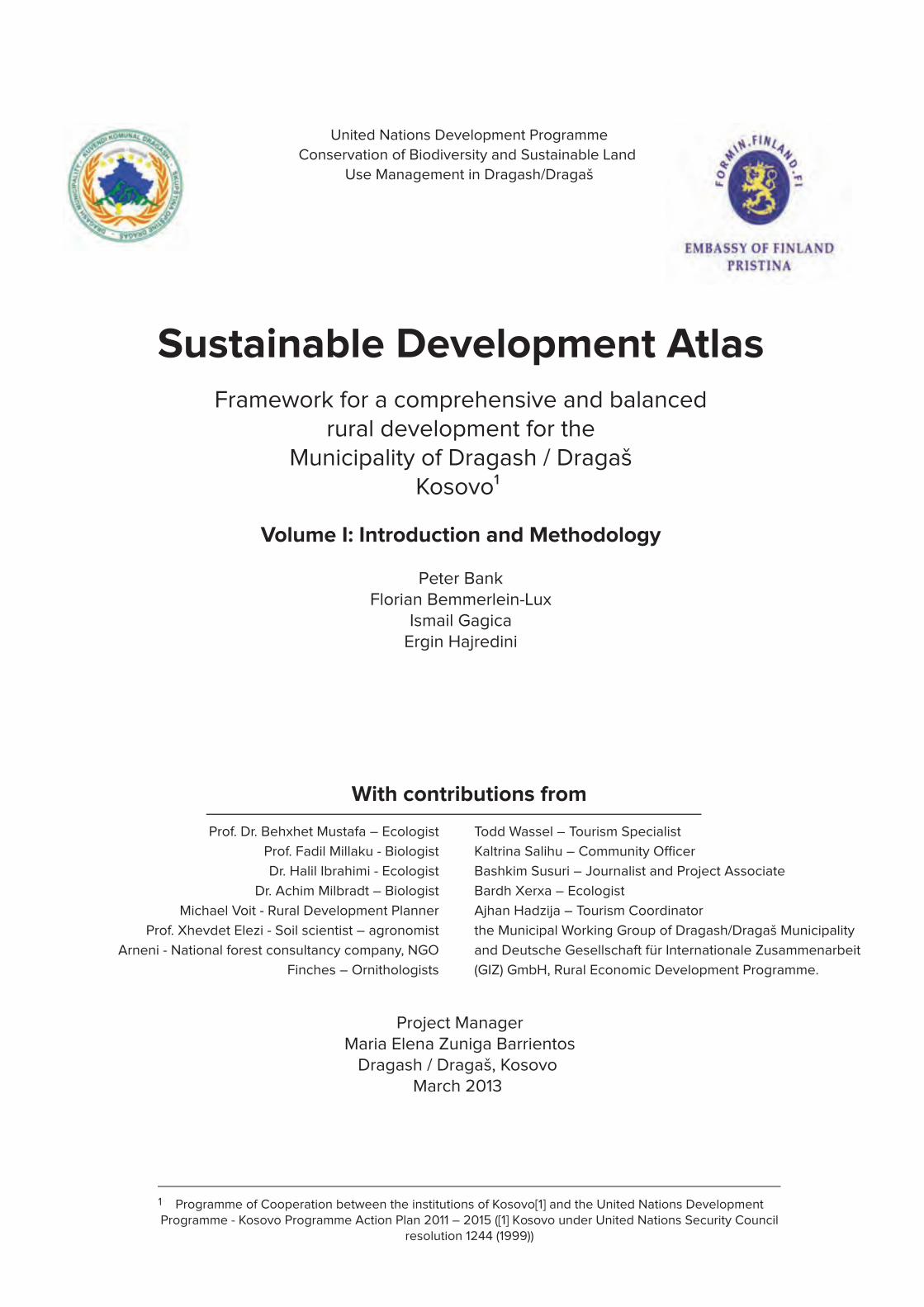
Sustainable Development Atlas
249
Prof. Dr. Behxhet Mustafa – Ecologist Prof. Fadil Millaku - Biologist Dr. Halil Ibrahimi - Ecologist Dr. Achim Milbradt – Biologist Michael Voit - Rural Development Planner Prof. Xhevdet Elezi - Soil scientist – agronomist Arneni - National forest consultancy company, NGO Finches – Ornithologists Todd Wassel – Tourism Specialist Bashkim Susuri – Journalist and Project Associate Bardh Xerxa – Ecologist Ajhan Hadzija – Tourism Coordinator the Municipal Working Group of Dragash/Dragaš Municipality and Deutsche Gesellschaft für Internationale Zusammenarbeit (GIZ) GmbH, Rural Economic Development Programme. Project Manager Maria Elena Zuniga Barrientos Dragash / Dragaš, Kosovo March 2013 Sustainable Development Atlas Framework for a comprehensive and balanced rural development for the Municipality of Dragash / Dragaš Kosovo¹ Volume I: Introduction and Methodology Peter Bank Florian Bemmerlein-Lux Ismail Gagica Ergin Hajredini Programme of Cooperation between the institutions of Kosovo[1] and the United Nations Development Programme - Kosovo Programme Action Plan 2011 – 2015 ([1] Kosovo under United Nations Security Council resolution 1244 (1999)) 1 United Nations Development Programme Conservation of Biodiversity and Sustainable Land Use Management in Dragash/Dragaš With contributions from
-
Upload
khangminh22 -
Category
Documents
-
view
2 -
download
0
Transcript of Sustainable Development Atlas
1
United Nations Development Programme Sustainable Development Atlas for Dragash / Dragaš – Kosovo
Prof. Dr. Behxhet Mustafa – Ecologist
Prof. Fadil Millaku - Biologist
Dr. Halil Ibrahimi - Ecologist
Dr. Achim Milbradt – Biologist
Michael Voit - Rural Development Planner
Prof. Xhevdet Elezi - Soil scientist – agronomist
Arneni - National forest consultancy company, NGO
Finches – Ornithologists
Todd Wassel – Tourism Specialist
Bashkim Susuri – Journalist and Project Associate
Bardh Xerxa – Ecologist
Ajhan Hadzija – Tourism Coordinator
the Municipal Working Group of Dragash/Dragaš Municipality
and Deutsche Gesellschaft für Internationale Zusammenarbeit
(GIZ) GmbH, Rural Economic Development Programme.
Project ManagerMaria Elena Zuniga Barrientos
Dragash / Dragaš, Kosovo March 2013
Sustainable Development AtlasFramework for a comprehensive and balanced
rural development for theMunicipality of Dragash / Dragaš
Kosovo¹
Volume I: Introduction and Methodology
Peter BankFlorian Bemmerlein-Lux
Ismail GagicaErgin Hajredini
Programme of Cooperation between the institutions of Kosovo[1] and the United Nations Development Programme - Kosovo Programme Action Plan 2011 – 2015 ([1] Kosovo under United Nations Security Council
resolution 1244 (1999))
1
United Nations Development Programme
Conservation of Biodiversity and Sustainable Land
Use Management in Dragash/Dragaš
With contributions from
2
United Nations Development Programme Sustainable Development Atlas for Dragash / Dragaš – Kosovo
Table of content volume I: “Introduction and Methodology”
Acronyms ........................................................................................................................................................................................................................9
1. Guiding words.................................................................................................................................................................................................. 10
2. Introduction ...................................................................................................................................................................................................... 10
3. Concept and methodology .......................................................................................................................................................................... 13
3.1. Concept ............................................................................................................................................................................................................. 13
3.2. Step 1 and 2 - Resource base and assessment ...................................................................................................................................... 15
3.3. Step 3 - Spatial development objectives .................................................................................................................................................. 17
3.4. Step 4 – Integration of the spatial development objectives................................................................................................................ 17
3.5. The zoning concept ....................................................................................................................................................................................... 17
3.6. Summary ........................................................................................................................................................................................................... 21
4. The municipality of Dragash/Dragaš ......................................................................................................................................................... 21
5. Maps of the Sustainable Development Atlas 1 : 30 000 .....................................................................................................................22
6. Glossary ............................................................................................................................................................................................................ 23
7. Literature .......................................................................................................................................................................................................... 24
List of Tables volume I: “Introduction and Methodology”
Table 5 1: List of SDA Maps ..............................................................................................................................................................................22-23
List of Figures volume I: “Introduction and Methodology”
Figure 2-1: Relationship between the MDP, related Strategic Environmental Assessment and the guidance
provided by the Sustainable Development Atlas .............................................................................................................................................. 12
Figure 3-1: Approach of the Sustainability Atlas ................................................................................................................................................. 14
Figure 3-2: Spatial Development Objectives: from SDA Resource Assessment to SDA Guidance...................................................... 16
Figure 3-3: Decision tree for the key resource ‘Forest’ .................................................................................................................................... 18
Figure 3-4: Fragment of SDA Guidance Map for the key resource “Forest” .............................................................................................. 19
Figure 3-5: Fragment of Spatial Resistance Map ............................................................................................................................................. 20
Figure 3-6: Fragment of Functional Structure Map ........................................................................................................................................... 21

3
United Nations Development Programme Sustainable Development Atlas for Dragash / Dragaš – Kosovo
Volume II: Baseline
Table of content volume II
1. Baseline Maps
1.1. Overview of the Municipality of Dragash / Dragaš
1.2. Population and infrastructure
1.3. Geology and mineral resources
1.4. Soil
1.5. Climate
1.6. Water resources
1.7. Real land use
1.8. Biosphere resources - vegetation
1.9. Biosphere resources - fauna
2. Annex to Volume II Baseline Maps
2.1. Water supply in the villages of Dragash / Dragaš Municipality
2.2. Data sources water resources Dragash / Dragaš Municipality
2.3. Plant communities of Dragash / Dragaš listed in Annex I of EU-Habitat-Directive
2.4. List of most important and endangered plant species of the Dragash / Dragaš Municipality
2.5. Bird species of Dragash / Dragaš listed on the Annexes of EU Bird Directive
2.6. Butterflies species observed in Dragash / Dragaš with endangered or vulnerable IUCN-Status or listed in Annexes II or IV of the EU Habitat Directive
2.7. Amphibian and reptile species observed in the Dragash / Dragaš Municipality
List of Tables volume II
Table 1-1: List of baseline maps
Table 1-1: Population and territory of the villages of Dragash / Dragaš Municipality
Table 1-2: Average seasonal temperature in Dragash / Dragaš
Table 1-3: Precipitation and average temperature during Vegetation Period
Table 1-4: Yearly rainfall in m³ per watershed
Table 1-5: Area for water resources regeneration per watershed
Table 1-6: Water courses per watershed
Table 1-7: Average monthly flow rates of major rivers
Table 1-8: Land Use types in Dragash / Dragaš Municipality in ha and %
Table 12-1: Water supply in the villages of Dragash / Dragaš Municipality
Table 12-2: Data sources water resources
Table 12-3: Plant communities of Dragash / Dragaš listed in Annex I of EU-Habitat-Directive
Table 12-4: List of most important and endangered plant species
Table 12-5: Bird species of Dragash / Dragaš listed on the Annexes of EU Bird Directive
Table 12-6: Butterflies species observed in Dragash / Dragaš with endangered or vulnerable IUCN-Status or listed in Annexes II or IV of the EU Habitat Directive
Table 12-7: Amphibian and reptile species observed in Dragash / Dragaš with endangered or vulnerable IUCN-Status or listed in Annexes II or IV of the EU Habitat Directive
List of Figures volume II
Figure 1-1: Altitude classes in the territory of Dragash / Dragaš Municipality
Figure 1-2: Slope classes in Dragash / Dragaš Municipality
Figure 1-3: Altitude Profile of the territory of Dragash / Dragaš Municipality
Figure 1-4: Slope profile of the territory of Dragash / Dragaš Municipality
Figure 1-5: Overview of the Municipality of Dragash / Dragaš (B1)
Figure 1-6: Distribution of businesses in the Municipality of Dragash / Dragaš
Figure 1-7: Population (B2)

4
United Nations Development Programme Sustainable Development Atlas for Dragash / Dragaš – Kosovo
Figure 1-8: Classes of rocks in Dragash / Dragaš
Figure 1-9: Geology and mineral resources (B3)
Figure 1-10: Soil classes in Dragash / Dragaš
Figure 1-11: Soil (B4)
Figure 1-12: Climate diagram for Dragash / Dragaš
Figure 1-13: Climate (B5)
Figure 1-14: Watersheds in Dragash / Dragaš Municipality
Figure 1-15: Flow rates of major rivers in Dragash / Dragaš Municipality
Figure 1-16: Water resources in Dragash / Dragaš Municipality (B6)
Figure 1-17: Comparison of land uses in the sub-basins of Dragash / Dragaš Municipality
Figure 1-17: Comparison of land uses in the sub-basins of Dragash / Dragaš Municipality
Figure 1-18: Consolidated land uses in Dragash / Dragaš Municipality (B7.2)
Figure 1-19: Real land use in Dragash / Dragaš Municipality (B7.1)
Figure 1-20: Biosphere resources – vegetation (B8)
Figure 1-21: Biosphere resources - fauna (B9)
Volume III:
Table of content volume III
1. Assessment maps
1.1. Assessment of biodiversity (A1)
1.1.1. Assessment of vegetation and flora (A1.1)
1.1.2. Assessment of biodiversity - fauna
1.2. Extension of Sharr/Šar National Park (A2)
1.3. Assessment of water resources
1.3.1. Water regeneration, threats and quality (A3.1)
1.3.2. Water supply and threats (A3.2)
1.4. Assessment of natural hazards (A4)
1.4.1. Erosion risk (A4.1)
1.4.1. Avalanche risk (A4.2)
1.4.2. Landslide, rockfall and flood-prone areas risk (A4.3)
1.5. Assessment of forest and agriculture (A5)
1.5.1. Conditions of forests (A5.1)
1.5.2. Forest functions (A5.2)
1.5.3. Productive capacity of soils (A5.3)
1.5.4. Livestock and suitability for crops (A5.4)
1.6. Assessment of solid waste (A6)
1.7. Assessment of cultural heritage and tourist potential (A7)
1.8. Assessment of health, medical services, and civil protection (A8)
1.9. Assessment of education (A9)
1.10. Assessment of economy, infrastructure, and energy (A10)
1.10.1. Roads and transportation (A10.1)
1.10.2. Energy (A10.2)
1.10.3. Businesses (A10.3)
2. Annex
2.1. Assessment for water quality
2.2. Model for erosion risk
2.3. Model for avalanche risk analysis
2.4. Model for landslide risk
2.5. Assessment criteria for the forest functions

5
United Nations Development Programme Sustainable Development Atlas for Dragash / Dragaš – Kosovo
2.6. Suitability of soils and recommendations for agricultural use
2.7. Electricity consumption spread
List of Tables volume III
Table 1-1: List assessment maps
Table 1-2: Area and percentage of habitat types mapped, which are protected according to EU Flora-Fauna-Habitat Directive
Table 1-3: Area and percentage of vegetation types / land uses with high potential for plant biodiversity
Table 1-4: Numbers of important plant species
Table 1-5: Numbers of animal species recorded within the Municipality during the studies 2011/12
Table 1-6: Important areas for water regeneration
Table 1-7: Non compliance of water quality in reservoirs
Table 1-8: Roads exposed to landslide and rock fall risk
Table 1-9: Incomes from forest harvesting in both sectors public/private
Table 1-10: Job opportunity on thinning and cleaning
Table 1-11: Classification of forest functions
Table 1-12: Amount of collected waste in 2008 (tons)
Table 1-13: Valuation matrix for cultural heritage
Table 1-14: Main cultural heritage sites in Dragash/Dragaš Municipality
Table 1-15: Staffing pattern and deficits for medical services
Table 1-16: Catchment for medical services
Table 1-17: Function of urbanised areas in terms of the “centre” concept according to their existing infrastructure and their development needs (function of the settlement)
Table 1-18: Road projects proposed and assessed
Table 1-19: Number of registered businesses and employees by village, Dragash/Dragaš
Table 2-1: Water quality based on family biotic index values
Table 2-2: The physical habitat assessment explanation table
Table 2-3: Water assessment per investigated points
Table 2-4: Results of the Water Quality in the reservoirs of the 35 villages of Dragash municipality
Table 2-5: Results of the Chemical Water Quality analysis
Table 2-6: Pedologic types of soil in the Municipality of Dragash/Dragaš based on the classes of prolificacy and groups of suitability for plant production
Table 2-7: Classes of suitability and the level of utilization for determined cultures, based on the cultivation manner and the level of machinery
Table 2-8: Max/min energy consumption for 2010 in Dragash/Dragaš municipality
List of Figures volume III
Figure 1-1: Vegetation and flora (A1.1)
Figure 1-2: Fauna (A1.2)
Figure 1-3: National Park “Sharri” border according to the Draft Law (Republic of Kosovo 2012)
Figure 1-4: Area inside and outside the planned National Park “Sharri” in Dragash / Dragaš Municipality
Figure 1-5: Ownership structure inside and outside the planned National Park “Sharri” in Dragash / Dragaš Municipality
Figure 1-6: Ownership structure within Sharr/Šar National Park in Dragash / Dragaš Municipality (A2.1)
Figure 1-7: Topographic map – Sharr/Šar National Park in Dragash / Dragaš Municipality (A2.2)
Figure 1-8: Assessment of water resources - regeneration, threats, and quality (A3.1)
Figure 1-9: Assessment of water supply (A3.2)
Figure 1-10: Soil erosion risk in the different altitude classes
Figure 1-11: Soil erosion risk within the cadastral zones of Dragash / Dragaš Municipality
Figure 1-12: Assessment of erosion risk (A4.1)
Figure 1-13: Avalanche risk areas within the Municipality
Figure 1-14: Avalanche risk areas within 300m distance from settlements

6
United Nations Development Programme Sustainable Development Atlas for Dragash / Dragaš – Kosovo
Figure 1-15: Assessment of avalanche risk (A4.2)
Figure 1-16: Assessment of landslide and flood-prone areas risk (A4.3)
Figure 1-17: Property situation in Dragash / Dragaš forests (in ha)
Figure 1-18: Age classes in Dragash / Dragaš forests (in ha)
Figure 1-19: Specific management requirements in Dragash / Dragaš forests (in ha)
Figure 1-20: Assessment of the conditions of forests (A5.1)
Figure 1-21: Forest area dedicated to the various forest functions (in ha)
Figure 1-22: Assessment of the forest functions (A5.2)
Figure 1-23: Suitability of soils (in ha)
Figure 1-24: Assessment of productive capacity of soils (A5.3)
Figure 1-25: Assessment of livestock and suitability for crops (A5.4)
Figure 1-26: Assessment of solid waste (A6)
Figure 1-27: Assessment of cultural heritage and tourist potential (A7)
Figure 1-28: Assessment of health, medical services, and civil protection (A8)
Figure 1-29: Assessment of education (A9)
Figure 1-30: Settlement functions
Figure 1-31: Assessment of roads and transportation (A10.1)
Figure 1-32: Assessment of energy (A10.2)
Figure 1-33: Registered businesses in Dragash/Dragaš by sector
Figure 1-34: Assessment of businesses (A10.3)
Figure 2-1: Correlation between steepness and avalanche risk
Volume IV:
Table of content volume IV
1. Guidance Maps
1.1. Objectives and principles for sustainable municipal development
1.2. Guiding development principles for Dragash / Dragaš
1.3. Consequences for the Municipal Development Plan (MDP)
1.4. Nature conservation (G1.1)
1.5. Zoning of Sharr/Šar National Park in Dragash / Dragaš (G1.2)
1.6. Forest (G2.1)
1.7. Agriculture (G2.2)
1.8. Water / Sanitation (G3)
1.9. Settlements (G4)
1.10. Roads and traffic (G5)
1.11. Education (G6)
1.12. Health (G7)
1.13. Tourism (G8)
2. Integrated Development Guidance
2.1. Spatial resistance against growth and development of settlements (IG1)
2.2. Functional structure (IG2)
3. Annex
3.1. CORINE land use types
3.2. Remarks for preferential habitats (a)
3.3. Remarks for non-preferential habitats (b)
3.4. Protection categories of the Law

7
United Nations Development Programme Sustainable Development Atlas for Dragash / Dragaš – Kosovo
List of Tables volume IV
Table 1-1: List of Guidance Maps
Table 1-2: % and size of the different guidance areas of nature conservation
Table 1-3: % and size of the different guidance areas of nature rehabilitation and development
Table 1-4: Decision criteria for the guidance of nature conservation
Table 1-5: % and size of the different guidance areas for forest
Table 1-6: Percentage and size of the different guidance areas for agriculture
Table 1-7: Relevant road projects and their evaluation
List of Figures volume IV
Figure 1-1: Guidance for nature conservation (G1.1)
Figure 1-2: Decision criteria for the zoning of Sharr/Šar National Park (G1.2)
Figure 1-3: Decision criteria for the guidance of forest development
Figure 1-4: Guidance for forest (G2.1)
Figure 1-5: Decision criteria for the guidance of agricultural development
Figure 1-6: Guidance for agriculture (G2.2)
Figure 1-7: Decision criteria for the guidance of water and sanitation
Figure 1-8: Guidance for water and sanitation (G3)
Figure 1-9: Guidance for settlements (G4)
Figure 1-10: Guidance for Roads and traffic (G5)
Figure 1-11: Guidance for education (G6)
Figure 1-12: Guidance for health (G7)
Figure 1-13: Guidance for tourism (G8)
Figure 2-1: Decision criteria for overall spatial resistance
Figure 2-2: Guidance for the spatial resistance against growth of settlements (IG1)
Figure 2-3: Decision criteria for functional structure
Figure 2-4: Guidance for the functional structure (IG2)
Volume V:
Table of content volume V
1. Data for Volume II: Baseline
1.1. Data stored in Excel-files
1.2. Map B2: Population and Infrastructure
1.3. Map B3: Geology
1.4. Map B4: Soils
1.5. Map B5: Climate
1.6. Map B7: Land Use
1.7. Map B8: Biodiversity Flora and Vegetation
1.7.1. Species Lists of Sample Points
1.7.2. Overall List of Plant Species (alphabetical order)
1.7.3. List of Plant Communities
1.8. Map B9: Biodiversity Fauna
1.8.1. Mammals known in Dragash/Dragaš
1.8.2. List of Vertebrates (except Birds) observed Dragash/Dragaš
1.8.3. Birds known in Dragash/Dragaš
1.8.4. Butterflies known in Dragash/Dragaš
2. Data for Volume III: Assessment
2.1. Excerpts from “Forest Stewardship Standard for the Republic of Kosovo
3. Annexes

8
United Nations Development Programme Sustainable Development Atlas for Dragash / Dragaš – Kosovo
3.1. List of Laws, Rules, Regulations
3.2. Habitat Types
3.3. Water Quality Assessment
List of Tables volume V
Table 1-1: List of Excel Files relevant for Base Maps
Table 1-2: Map B1: Population Data
Table 1-3: Map B1: Number of Households
Table 1-4: Map B3: Classes of Rocks
Table 1-5: Map B4: Classes of Soils
Table 1-6: Map B5: Climate Data for Dragash/Dragaš
Table 1-7: CORINE Land Use Codes
Table 1-8: Plant Samples AM01 - AM15 Dr. A. Milbradt
Table 1-9: Plant Samples AM16 – AM30 Dr. A. Milbradt
Table 1-10: Plant Samples AM31 – AM44 Dr. A. Milbradt
Table 1-11: Plant Samples AM46 – AM60 Dr. A. Milbradt
Table 1-12: Plant Samples AM61 – AM75 Dr. A. Milbradt
Table 1-13: Plant Samples AM76 – AM90 Dr. A. Milbradt
Table 1-14: Plant Samples BX01 – BX15 Prof. Dr. M. Behxhet
Table 1-15: Plant Samples BX16 – BX30 Prof. Dr. M. Behxhet
Table 1-16: Plant Samples BX31 – BX45 Prof. Dr. M. Behxhet
Table 1-17: Plant Samples BX46 – BX60 Prof. Dr. M. Behxhet
Table 1-18: Plant Samples BX61 – BX75 Prof. Dr. M. Behxhet
Table 1-19: Plant Samples BX76 – BX90 Prof. Dr. M. Behxhet
Table 1-20: Plant Samples BX91 – BX100 Prof. Dr. M. Behxhet
Table 1-21: Plant Samples FM01 – FM16 Prof. Dr. F. Millaku
Table 1-22: Plant Samples FM17 – FM32 Prof. Dr. F. Millaku
Table 1-23: Overall List of Plant Species
Table 1-24: List of Plant Communities
Table 1-25: List of Mammals known in Dragash/Dragaš
Table 1-26: List of Vertebrates (except Birds) observed in Dragash/Dragaš
Table 1-27: List of Birds observed in Dragash/Dragaš
Table 1-28: List of Butterflies observed in Dragash/Dragaš

9
United Nations Development Programme Sustainable Development Atlas for Dragash / Dragaš – Kosovo
BOD Biological Oxygen Demand
CBD Biodiversity Convention International Treaty signed in 1992
CORINE Coordination of Information on the Environment
CITES Convention on International Trade in Endangered Species of Wild Fauna and Flora.
CLC CORINE Land Cover
DEP Department of Environment Protection
EC European Commission
ECNC European Centre for Nature Conservation
ECT Energy Community Treaty
EIA Environmental Impact Assessment
EPAP European Partnership Action Plan
ESK Energy Strategy for Kosovo 2009 - 2018
EU European Union
FFH-Directive EU-Flora-Fauna-Habitat Directive (Council Directive 1996/105/EC)
FMSN Faculty of Mathematic and Nature Sciences
FSC Forestry Stewardship Council (Council Standards for Administration of Forest)
GDP General Domestic Production
GIS Geographic Information System
GMO Genetically Modifying Organisms
HC Hydro-central plant
HMIK Hydrometeorological Institute of Kosovo
HCV High Conservation Value Forests - Forests managed under Forestry Stewardship Council standards
IUCN International Union for Conservation of Nature
KEAP Kosovo Environmental Action Plan
KEK Kosovo Energy Corporation
KEPA Kosovo Agency for Environment Protection
KFA Kosovo Forest Agency
KINP Kosovo Institute for Nature Protection
kW Kilowatt
MAFRD Ministry of Agriculture, Forestry and Rural Development
MDP Municipal Development Plan
MEF Ministry of Economy and Finance
MEM Ministry of Energy and Mining
MESP Ministry of Environment and Spatial Planning
MEST Ministry of Education, Science and Technology
MTI Ministry of Trade and Industry
MTPT Ministry of Transport and Post Telecommunication
NGO Non Governmental Organization
NPA Nature Protected Area
PSFM Project for Sustainable Forest Management
SAPB Strategy and Action Plan for Biodiversity
SD Sustainable Development
SDA Sustainable Development Atlas
SEA Strategic Environmental Assessment
SHPP Small Hydropower Plant
SoE Socially Owned Enterprise (formerly Sharr Prodhimi/Šarproizvod) Socially-Owned enterprises were created by the Law on Enterprises and the Law on Associated Labour of Yugoslavia. The Kosovo Trust Agency has the authority to administer all socially-owned enterprises that were registered in Kosovo as of 31st December 1988 and any subse-quent date. The Agency has the mandate to privatise such enterprises through specific procedures.
USAID US Agency for International Development
WB World Bank
WFD Water Framework Directive 2000/60/EC
Acronyms

10
United Nations Development Programme Sustainable Development Atlas for Dragash / Dragaš – Kosovo
1. Guiding words
2. Introduction
Land use has a spatial impact. It takes place at a certain location, utilises the properties of this location and influences the properties of this as well as surrounding locations. Depending on the type of land use, this influence may have a significant and long-lasting effect. Often, (for example, in the case of erosion) these adverse effects render this type of land use impossible and it may mean that this certain location loses its usability for many other types of land use too.Development measures have a spatial component too: investments take place at specific locations. The suitability of the location has a great influence on the costs of the development measure. There is also a great influence on the costs generated through negative effects of choosing an unsuitable location for the development measure. Future generations often have to pay the price for development errors.As both suitable land resources and money are usually scarce commodities, and as safeguarding resources for future generations is one of the key aspects of sustainable development, taking spatial aspects into consideration is necessary.The atlas has been prepared for policy-makers, planners and decision makers in Kosovo, more specifically in the municipal-ity of Dragash/Dragaš. It summarises the scientific knowledge of relevant influencing factors that have a tangible impact on the sustainability of development in the plan-ning area. To make it a useful tool, it provides objec-tives for an economically effective, socially fair and environmentally compatible devel-opment that will not only raise the living conditions of present generations but also preserve and ensure development oppor-tunities for future generations. More spe-cifically, the atlas analyses the existing development status, identifies further de-velopment potentials, shows development objectives and identifies suitable develop-ment tools. This is carried out for clearly delineated areas or locations (“zones”). Therefore, the results are published as a sustainable
Dragash/Dragaš is a mountainous area covering 433.7 square kilometres, located in the southern region of Kosovo - Prizren, characterised today by its high level of poverty, migra-tion and great landscape beauty amongst many other elements.The first development challenge is providing the Municipality with adequate instruments to promote development based on conservation of biodiversity, adequate land use management and an enabling development conditions for its communities. Within this framework the Municipal Development Plan will fill an important institutional gap, and will provide a frame-work for the development of related development strategies, namely economic development, the integration of waste / water & energy strategies, and the definition of protected areas.One ultimate goal / target of the project is to achieve protection
development-guiding atlas. The results should not be used as strict instructions of what to do and where to do it. Rather they indicate development prob-lems but also development potentials, and appropriate directions for sustainable de-velopment. The authors of these guidelines are scien-tists. As such they are well aware of their role in society and aware that policy-formulation is the domain of the political level. As scientists they offer the best available knowledge that may support pol-icy formulation, planning and decision making on a sound, rational and ultimately sustainable platform. The final choice - what a society is heading towards - is a political choice and must be decided by politicians and by concerned citizens. Scientists can simply provide the necessary information and expertise to help make such choices. Thus planning and co-ordination is a good starting point. Before any project, or before a measure is implemented, the govern-ment first has to set priorities about where action is most required. It must co-ordinate the many necessary measures with a view of maximising the overall benefit and co-ordinating their mutual support. And the government must do this at the best-suited locations and with consideration of the specific conditions of the site. This is al-ways a site-specific task because money is spent at specific sites or locations. This atlas provides the necessary informa-tion for sustainable planning and decision-making. It shows sustainability its place.
Maria Elena Zuniga Barrientos – Conservation of Biodiversity and Sustain-able Land Use Management in Dragash-Project ManagerSalim Jenuzi – Mayor of the Municipality of Dragash
of the Sharr/Šar Mountain that lies within the territory of Dragash/Dragaš. A large area currently under mandate by the Kosovo Privatization Agency (around 22,000 ha) will potentially be protected under the Sharr/Šar National Park Law. In order to increase the Sharr/Šar National Park into Dra-gash/Dragaš’s territory, a feasibility study needs to be undertaken. This feasibility study re-quires expert input and specific studies, some of which relate to biodiversity, water resources, forests, social and economic sectors, geology and geomorphology, cultural background, and an analysis of the state of the environment. All together these studies will inform decisions on protection categories.

11
United Nations Development Programme Sustainable Development Atlas for Dragash / Dragaš – Kosovo
Development has a spatial dimension
“Where best to do what?” - Key question in the development of the Municipality
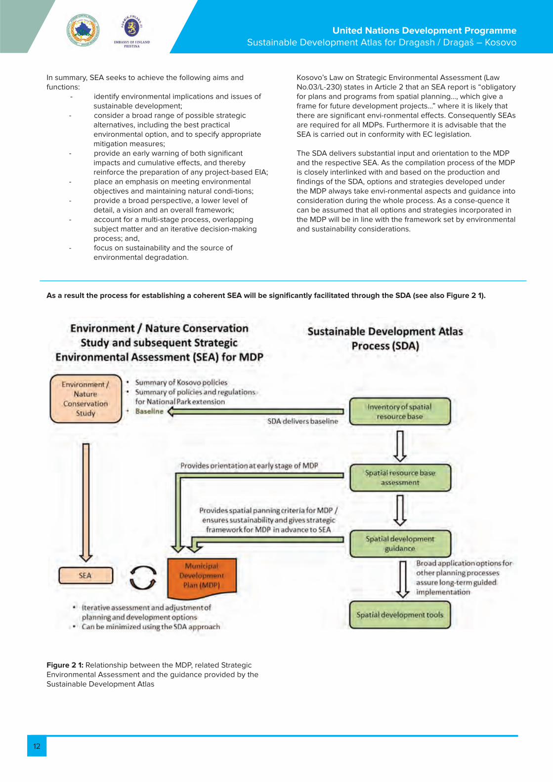
The SD-Atlas – the basis for a Strategic Environmental Assessment
Based on the fact that the spatial dimension is a crucial aspect when planning sustainable development, the Sustainable Development Atlas (SDA) procedure is introduced. Its proper-ties include practicality, transparency, and arbitration between the conflicting interests of economy and ecology. The method employs GIS-technology to produce rapid support for the sustainable management of resources.The rationale behind this approach is that development has a spatial dimension and that any development measure creates costs, not only through its implementation but also if negative effects require repair, e.g. if the measure was carried out at an unsuitable location. In order to minimise costs and negative effects, and to ensure sustainability, it is necessary to identify the most suitable locations for development measures.The approach divides the multi-faceted and complex task of rural sustainable development into a number of “key fields” of development, including biosphere, cultivation, water, health etc.Geospatial assessment data is collected for each of these key fields. Assessment includes the land resources as well as its suitability for and sensitivities towards the various types of land
The SD Atlas concept has proved to be a rapid though concise and transparent method to produce guidance for sustainable development. It comprises the assessment of all important resources, their evaluation according to criteria of sustainable development, the definition of development guidance and the proposal of suitable management tools in order to follow the guidance and reach the sustainable development objectives. Integration of the various guid-ance maps mediates conflicting objectives and results in an integrated development zone map. The general development structure of the planning area is proposed by the map for development centres and corridors.The atlas summarises the scientific knowledge of the relevant influencing factors that have a tangible impact on the sustainability of development in the planning region. To render it a useful tool, it provides objectives for an economically effective, socially fair and environmen-tally compatible development that
The Strategic Environmental Assessment (SEA) is a continuous and adaptive process pro-viding a structured approach to integrating environmental considerations into decision-making processes, at the municipal, sub-regional or regional planning level.The SEA is a formal process that systematically assesses the environmental effects of de-velopment policies, plans, programmes and other proposed strategic plans. SEA is effectively a proactive approach to integrating environmental
use.Using techniques of geographical information system, those geospatial assessment zones are run through a hierarchical system of decisions and thereby transformed into guidance zones. Those guidance zones are either zones which – with regards to the key field - need protection, zones which need rehabilitation or zones which have potential for development.In a further step the guidance zones of the various key fields need to be harmonised, as con-flicts may occur between them. The sustainable atlas is comprised of baseline maps – the B-maps (geomorphology, land potential, etc.), maps for assessment – the A maps, and guidance zones for the key fields – the G-maps, including integrated guidance. It provides the necessary information for sustainable planning and decision-making.
will not only raise the living standards of present genera-tions but also preserve and ensure development opportunities for future generations. More specifically, the atlas analyses the existing development status, identifies further development potentials, shows development objectives and identifies suitable development tools. The key question in the development of the municipality is therefore not “What to do?” but rather “Where best to do what?” (i.e. what are the optimal locations and sites for urban ex-pansion, where do schools need upgrading, where are the sensitive ecosystems located that require protection, where should ecological agricultural management be supported? etc).This atlas addresses the spatial dimension of sustainable development and provides answers to the most pressing development issues.
considerations into more strategic levels of decision-making, which are consistent with principles outlined in Agenda 21. In so doing, it is intended to help prevent environmental damage caused by policies and plans. An SEA requires a broader and less detailed assessment, of course, in comparison to a project Environmental Impact Assessment (EIA). Consequently, it takes place at an earlier stage of plan preparation and decision-making.
12
United Nations Development Programme Sustainable Development Atlas for Dragash / Dragaš – Kosovo
In summary, SEA seeks to achieve the following aims and functions: - identify environmental implications and issues of sustainable development; - consider a broad range of possible strategic alternatives, including the best practical environmental option, and to specify appropriate mitigation measures; - provide an early warning of both significant impacts and cumulative effects, and thereby reinforce the preparation of any project-based EIA; - place an emphasis on meeting environmental objectives and maintaining natural condi-tions; - provide a broad perspective, a lower level of detail, a vision and an overall framework; - account for a multi-stage process, overlapping subject matter and an iterative decision-making process; and, - focus on sustainability and the source of environmental degradation.
Kosovo’s Law on Strategic Environmental Assessment (Law No.03/L-230) states in Article 2 that an SEA report is “obligatory for plans and programs from spatial planning…, which give a frame for future development projects…” where it is likely that there are significant envi-ronmental effects. Consequently SEAs are required for all MDPs. Furthermore it is advisable that the SEA is carried out in conformity with EC legislation.
The SDA delivers substantial input and orientation to the MDP and the respective SEA. As the compilation process of the MDP is closely interlinked with and based on the production and findings of the SDA, options and strategies developed under the MDP always take envi-ronmental aspects and guidance into consideration during the whole process. As a conse-quence it can be assumed that all options and strategies incorporated in the MDP will be in line with the framework set by environmental and sustainability considerations.
As a result the process for establishing a coherent SEA will be significantly facilitated through the SDA (see also Figure 2 1).
Figure 2 1: Relationship between the MDP, related Strategic Environmental Assessment and the guidance provided by the Sustainable Development Atlas

13
United Nations Development Programme Sustainable Development Atlas for Dragash / Dragaš – Kosovo
3. Concept and methodology
3.1. Concept ²
The concept design is based on the information needs of policy-makers, planners and deci-sion makers involved. 1. They first need information on the present status of the resource base. 2. Based on the main features of such resource status evaluation, they can formulate and co-ordinate spatial development objectives. 3. To finally implement such development objectives they need to identify appropriate tools and demonstrate the most suitable location. Consequently, the concept comprises four steps:Step 1: Compilation of basic information like topography, terrain model, land-use, geology, climate, natural resources, biodiversity and population/infrastructure.Step 2: Spatial resource base assessment in the various sectors and fields of sustainable development. Such assessments provide information including: - What are the present conditions of a resource? - What problems and constraints exist and at which sites or locations are they most pressing? - How sensitive are resources against adverse impacts or when they are utilised? - What are the development opportunities still available and where? Step 3: Spatial development guidance as to which actions could lead most efficiently and most appropriately to increased sustainability. Such objectives provide information such as: - Which issues must be addressed and solved as soon as possible and where? - In which sectors and where are problems, deficits,
and over-exploitation? - Which resources must be rehabilitated and at which sites? - Which resources need protection and where? - What are the most suitable sites for further development? - How best to solve development conflicts? - How best to coordinate between the various sectors and demands of development?
Thus the spatial development objectives do not only provide guidance for individual sectors but also indicate how to coordinate interaction between them.
Step 4: Spatial development integrated guidance and tools summarises the different fields in order to give clear and integrated guidance for the spatial planning of the region of focus to implement measures which lead to increased sustainability. It can include sites where the application of certain tools will lead to the best results. Such tools may include programmes and plans (for example water management plans, agricultural development plans, ecological compensation schemes or reforestation programmes and legal settings and guidelines).Figure 1 indicates the connection between spatial resource base assessment, spatial devel-opment objectives, and implementation of those objectives through spatial development tools.
² Based on: Bemmerlein-Lux F.A. et al.

14
United Nations Development Programme Sustainable Development Atlas for Dragash / Dragaš – Kosovo
Figure 3-1: Approach of the Sustainability Atlas
Sustainable Development Atlas - approach and concept
Key eld resource assessment
Sensi vity Func on Quality Quan ty
Combina on of those factors allows iden ca on of
Spatial development guidance
Rehabilita on zones
Development zones Protec on zones
Key eld integra on and development con ict management
Coordinated and integrated development at best suitable zones and sites
Spa al development tools
Sustainable spatial development with appropriate tools:
∞ Integrated development plans ∞ Sector plans and programmes ∞ Rehabilita on programs, plans and projects ∞ Protec on zone management programs ∞ Speci c projects and measures

15
United Nations Development Programme Sustainable Development Atlas for Dragash / Dragaš – Kosovo
3.2. Step 1 and 2 - Resource base and assessment
According to the most relevant development problems and priorities, we apply assessment to four SDA dimensions, namely the natural, the human, the economic and the institutional re-
sources. We further subdivide those SDA dimensions into SDA key fields, on which base the assessment is being carried out.
SDA Dimension Natural resources Economic resources Human resources Institutional resources
SDA Key Field Ecosystems
Water
Soil
Economic struc-ture
Agriculture (food and cash crop, animal husbandry)
Forest
Tourism
Energy
Infrastructure
Health
Education
Administration
Environmental management
Assessment considers four factors of influence:
• The availability or quantity of the resource base – how much or little, how easy or difficult to access?• The quality of the resource base – how good or bad?• The functions or services that the resource has for society, nature or the economy - how much is needed, what for, and where? • The sensitivity or vulnerability of a resource against stress, impacts or inadequate utili-sation, which may negatively affect its functions, quantity, quality, availability: how sensi-tive or how robust?
For each resource, extent and spatial (geographical) distribution/location of these four factors are considered and evaluated. Only where any of the four factors is highly relevant for devel-opment are such sites or areas finally designated as zones. This evaluation of planning and management relevance is the basis to formulate appropriate sustainable development objec-tives. In short, this first step provides the relevant information for each SDA key field, highlighting the problems and showing development opportunities and their location of relevance.

16
United Nations Development Programme Sustainable Development Atlas for Dragash / Dragaš – Kosovo
Figura 3-2: Objektivat e zhvillimit hapësinor:nga vlerësimi i AZHQ për resurse në Udhëzues AZHQ
Quality:
Function: Important
Quantity:
Sensitivity: High
Resource Needs Protection
Quality: Good
Function:
Quantity: Sufficient
Sensitivity:
Resource Use and Appropriate Management
Sensitivity:
Quantity:
Quality: Poor/Bad
Function: Important Resource Needs Rehabilitation
of overriding importance
Resource Characteristics Sustainable Development Guidance

17
United Nations Development Programme Sustainable Development Atlas for Dragash / Dragaš – Kosovo
3.3. Step 3 - Spatial development objectives
3.4. Step 4 – Integration of the spatial development objectives
3.5. The zoning concept
The most appropriate development objective depends on combinations of these four factors in a given situation and at a specific site. Generally, there are three different sustainable de-velopment objectives:1. Resources with important functions but presently of poor/bad quality (polluted, de-graded, insufficient etc.) are in need of rehabilitation/upgrading/enhancement. This may be the case for eroded lands, polluted waters, bad road connections, or poorly equipped schools. The development thrust is to restore the resource so that it optimally serves so-ciety, nature and/or the economy.2. Resources that are highly sensitive and of high importance for nature or society need protection. This must be done with the view to ensure their availability for present and future generations;3. Resources abundantly available and which have good quality should be developed for sustainable utilisation. Overuse must be avoided, sensitivity threshold must not be exceeded and the use must be for the best benefit of the society. Sustainable utilisation also includes the coordination of conflicts. Such
Taking into consideration the results from step 3, efficient recommendations are defined through step 4. Integrating the spatial development objectives of the different development fields needs decisions as to priorities. Among these priorities are overarching national or re-gional planning ambitions and/or strategies, development goals of the municipality and political decisions by the responsible administrations and communities. However, technical restrictions play an important role. Two examples can explain this point: 1) Erosion-prone areas are
The presentation of results in this atlas is based on a zoning concept, an approach that has been developed for land use management purposes. It refers to the subdivision of a planning area into discrete sub-areas of a certain function (“zones”). Typical zones are protection zones (for example natural reserves or water protection zones) or development zones (for example zones for urban expansion or industrial development, or reforestation zones). The purpose of zoning is to regulate land use in a zone in such a way that the function of the zone is ensured. Land use regulations normally include: • provisions that certain uses must take place (for example to plant trees in areas zoned as forest lands),• permits for certain uses that may take place (a road may be
conflicts may arise if different demands for a single resource are in conflict which each other. In such case, a rational and fair compromise needs to be found. It is obvious that assessment and development guidelines require evaluation; they require judgemental or normative statements in terms of good or bad, relevant or less relevant and the like. For any resource a sufficient quantity, a good quality, an important function, or cer-tain sensitivity must be defined. This is accomplished through comparison with benchmarks, quantitative development objectives, standards etc. For each of the SDA key fields an evaluation approach has been developed in the form of a decision tree. These evaluation procedures reflect the underlying SD policies and objectives, national, regional and/or mu-nicipal targets as well as scientific knowledge.
not suitable for erosion-favouring land uses, even if there is political will for these land uses to occur; 2) Soils with excellent properties for agriculture are also excellent for forests, but the agricultural sector may be given priority. The integrated maps are an important part of the Strategic Environmental Assessment that guides the Municipal Development Plan as they suggest the Spatial Resistance of different zones and support the setting of priorities for a sustainable development.
constructed in areas zoned as forest lands); and • prohibition of other uses not allowed to take place (industrial development is normally not allowed in areas zoned as forest lands).
The delineation of the zone boundaries may be based on administrative boundaries, on spatial natural features (for example watersheds), or on a combination of both. For example the reforestation potential may be defined by a specific climatic regime and certain soil properties within an administrative unit, for example a province or a municipality. To become effective, land use regulations should be enforced irrespective of land ownership.

18
United Nations Development Programme Sustainable Development Atlas for Dragash / Dragaš – Kosovo
Figure 3-3: Decision tree for the key resource ‘Forest’
(*) – only considering Habitat Directive-Annex 1 stands without coppice forestExplanation - CORINE 1 Artificial surface3.1 Forests3.2.4 Transitional woodland/shrub3.2.5 Transitional woodland/shrub
The atlas results are presented as a series of thematic zone maps:
B-Maps for Step 1 (compiling baseline data): All required basic information is put on thematic maps. This basic topographic and thematic information is used for the resource assessment in Step 2. A-Maps for Step 2 (resource assessment): Zones of development deficits and potentials, including problem zones (pollution, degrada-tion), resource potential zones or zones with highly sensitive resources. These are summa-rised as resource assessment zones. They are mapped individually for each SDA key field.G-Maps for Step 3 (development objectives: Zones indicating the most appropriate development objectives. Logically structured and transparent decision criteria are used to conclude the development objectives. (Figure 3 3 gives one example of a “decision tree” to derive the different zones). The development objectives zones comprise of: - Rehabilitation zones: indicating areas in need of immediate improvement / uplifting / enhancement. This might be the case because its present status hinders the development process. In these zones
rehabilitation is the overriding development issue. - Protection zones: indicating areas, which require preservation or protection in order to ensure its function for present and future generations. In these zones protection is the overriding development issue and other uses in such zones must be harmonised with this objective. It is important note that “protection” is not meant in a legal sense, but as a planning category. - Development zones: indicating areas which have the potential for appropriate sustainable development. Following a careful balance between possible conflicts of the requirements of the various SDA key fields, the best kind of development is identified.
Forested areas below 2070m & forest shape Dragash & CORINE (3.1, 3.2.4, 3.2.5)
NO Yes
High geo-risk and not forested
Ava Yes
NO
Afforestation or technical
protection (depending on
soil and technical
feasibility)
Agriculture and livestock guidance (All except: CORINE 3.1, 3.2.4, 3.2.5, 1)
Protect No forest
management
Develop Rehabilitate Develop adapted
management plans
Protected Management
(acc. to FSC principles)
Coppice Forest
NO Yes
Habitat Annex 1 forest
NO Yes
Forest biodiversity*), water & geo-risk function
NO Yes
Ecotone tree-line (>1900m)
NO Yes
Develop Maintaining the
functions (acc. to FSC principles)

19
United Nations Development Programme Sustainable Development Atlas for Dragash / Dragaš – Kosovo
Figure 3-5: Fragment of Spatial Resistance Map
Figure 3-4: Fragment of SDA Guidance Map for the key resource “Forest”
IG-Maps for Step 4 (Integrated Guidance Maps)
After balancing conflict these results are integrated into Integrated Guidance Maps. The latter include: a) overall Spatial Resistance, defined by very high, high, middle and low spatial resis-tance. Resistance indicates the sum of slope, severity of natural hazards, biodiversity, special land uses, forest functions, prolificacy of soils, and natural protection areas (National Park). The higher the resistance the more conflicts of land uses exist and have to be taken into account in planning issues for infrastructure, settlement and other productive uses. and b) the Functional Structure in the form of development centres and corridors. Development corridors in connection with development centres are major tools to ensure the well-structured and concentrated development of a planning region in a balanced way. It avoids urban sprawl and takes advantage of agglomeration effects.Development centres are the centres where urban development
(industrial and commer-cial development; social and administrative infrastructure) should concentrate. They pro-vide services to the surrounding rural areas and villages including administrative services, market facilities, health, and educational social and cultural services. They therefore should be within easy reach of their rural surroundings. Development centres have a distinct hierarchy from national and provincial centres to district centres and finally the ru-ral development centres.
Development centres are connected by development corridors. Future development and investments into infrastructure should concentrate along those corridors. Green belts and zones assure the environmental integration of settlements with a function for local recrea-tion, local climatic buffer zones and ecologically relevant corridors for maintaining and protecting biodiversity.

20
United Nations Development Programme Sustainable Development Atlas for Dragash / Dragaš – Kosovo
Figure 3-5: Fragment of Spatial Resistance Map
Figure 3-6: Fragment of Functional Structure Map

21
United Nations Development Programme Sustainable Development Atlas for Dragash / Dragaš – Kosovo
3.6. Summary
The SD Atlas results are a series of thematic zone maps, including:Base Maps: For orientation and reference the atlas additionally contains important base maps providing information on lands, geology, climate etc.• Assessment Maps display zones of problems (pollution, degradation), resource potential zones, or zones of highly sensitive resources. We summarise them as resource assessment zones.• Guidance Maps display zones which indicate the most appropriate development objectives such as protection, rehabilitation, and development. We summarise them as
guidance zones. • Integrated Guidance Maps: It is very likely that superimposing the various Guidance Maps will unveil areas where the different zones give conflicting guidance. The Spatial Resistance Map provides information for the MDP regarding in which zones conflicts between different land uses are to be expected. The Spatial Structure Map suggests a well-structured municipal development, considering the potentials and restrictions of the Municipality.
4. The municipality of Dragash/DragašDragash/Dragaš is the southernmost municipality in Kosovo, sharing borders with the neighbouring countries of FYR Macedonia to the east and south, and Albania to the west. The municipality’s coordinates are 41 50’ 58” - 42 09’ 03” in northern latitude and 20 35’ 39” - 20 48’ 26” in longitude. To its north, Dragash/Dragaš is bordered by Prizren municipality which is the centre of the South Kosovo region. Dragash/Dragaš town is 37km from Prizren town.The municipality covers an area of 433,7km³ , approximately 4% of the entire territory of Kos-ovo and is eighth largest of Kosovo’s thirty municipalities. Dragash/Dragaš municipality com-prises 35 settlements with the small town of Dragash/Dragaš as the municipal centre. The municipality is edged by the high Sharr/Šar Mountains on its southern and eastern sides, stretching into FYR Macedonia and Albania. This mountain range extends northeast-southwest for approximately 70km in length and 30km in width, with a total surface area of about 1600km². 900km² (56.25%) of this area lies in FYR Macedonia, with 690 km² (43.12%) in Kosovo and 10 km² (0.63%) in Albania. A special characteristic of Dragash/Dragaš are the extended areas of pastureland that has made the area suitable for livestock farming, agricul-ture and agricultural products.The Sharr/Šar range in Kosovo is divided into three regions comprising the Ljubo-ten/Brezovica winter sports and tourism area, the central Prizren zone, and the Dra-gash/Dragaš section comprising Gora/Gorë and Opojë/Opolje. 18.5% of this mountain range is over 2000m above sea level. The highest mountain of the entire Sharr/Šar area is Mount Korab (2764m), while the highest summit is Titov Vrv at 2747m. In Dragash/Dragaš the most important peaks are: Koritnik in the northwest on the border with Albania (2262m), Kodra e Karanikolles/Karanikolin Vrh in the northeast (2409m), Maje/Vrh in the east (2493m), Kryet e Kagit/Kaćina Glava north of Brod (2207m), Vraca e Madhe/Velika Vraca in the southeast (2536m, highest peak) and Kesula e Priftit/Popova Šapka in the southwest (2075m).Topographically Dragash/Dragaš can be divided into its main river sub-basins: with the Restelica/Restelicë river, the Pllava river (in the Opojë/Opolje region, including the eastern
parts of the Sharr/Šar Mountain area in Dragash/Dragaš), and the Lepenc (in the southern part of the municipality). A fourth system lies around Brezne/Brezna, where the area drains via an underground karst structure to the Prizren area. Two of these main water courses belong to the large Drini i Bardhe/Beli Drim (White Drin) river basin draining through Albania and into the Adriatic Sea: the Pllava River with its tributaries in the north, and the Restelica River which flows into the Pllava River. The third main water course – the Lepenc River Basin - lies in the south and drains mostly through FYR Macedonia into the Aegean Sea. However, the territory is more frequently identified as comprising the two areas of Opojë/Opolje in the north and Gora/Gorë in the south. The hilly and mountainous geography has influenced the development of small, concentrated, rural village settlements along the three main valleys, but is also the cause of the municipality’s isolation and current infrastruc-tural and other problems. According to the slope profile, 55% of the territory is classed as steep or very steep, and respectively provides limited or no access for machines. This limits opportunities for agriculture as well as for the extension of roads and settlements. The altitude of the municipality varies between 750 and 2550 m above sea level, with the average lying at 1620 m. The largest proportion - 40.3% of the territory – is classified as high montane, with an altitude between 1450 m and 2050 m. The mountain range in the north of municipality reaches altitudes of between 1100 m and 2200 m. 30.4% of the area lies at the montane region (1050 – 1350 m above sea level), with 20.3% of the total area being signifi-cantly higher and ranging in altitude from 2050 to 2550 m, the level at which trees do not grow (timberline). Only 6% of the territory is sub-montane (2600 ha at altitude 750 – 1050 m above sea level), located in the north around the Pllava valley, and the lower parts of the Brod and Restelica River valleys. This indicates that the municipality is generally of high altitude and mountainous especially when compared to the average altitude for the whole of Kosovo of 800 m above sea level. The neighbouring municipality of Prizren is at an average altitude of 400 – 500 m above sea level.
³ Dragash/Dragaš territory after adjustment of borders in 2012.

22
United Nations Development Programme Sustainable Development Atlas for Dragash / Dragaš – Kosovo
5. Maps of the Sustainable Development Atlas 1:30 000B Baseline maps
Overview of the municipality of Dragash / Dragaš
• B1.1 Overview of the municipality
• B1.2 Topographic map of the municipality
Population and settlements
Geology and mineral resources
Soil
Climate
Water Resources
Real land-use
• B7.1 Real land-use
• B7.2 Special land-uses
Biosphere resources – vegetation
Biosphere resources – fauna
A Assessment maps
Assessment of biodiversity
• A1.1 Assessment of biodiversity – vegetation and flora
• A1.2 Assessment of biodiversity - fauna
Proposed extension of Sharr/Šar National Park
• A2.1 Sharr/Šar National Park - ownership structure
• A2.2 Sharr/Šar National Park - topographic map
Assessment of water resources - regeneration, threats, and quality
Assessment of natural hazards
• A4.1 Assessment of natural hazards - erosion risk
• A4.2 Assessment of natural hazards - avalanche risk
• A4.3 Assessment of natural hazards - landslide risk and flood-prone areas
Assessment of agriculture and forest
• A5.1 Assessment of forest and agriculture - condition of forest
• A5.2 Assessment of agriculture and forest - forest functions
• A5.3 Assessment of agriculture and forest - productive capacity of soils
• A5.4 Assessment of agriculture and forest - livestock and suitability for crops
Assessment of solid waste
Assessment of cultural heritage and tourist potential
Assessment of health, medical services, and civil protection
Assessment of education
Assessment of economy, infrastructure, and energy
• A10.1 Assessment of economy, infrastructure, and energy – roads and transportation
• A10.2 Assessment of economy, infrastructure, and energy – energy
• A10.3 Assessment of economy, infrastructure, and energy – businesses

23
United Nations Development Programme Sustainable Development Atlas for Dragash / Dragaš – Kosovo
5. Maps of the Sustainable Development Atlas 1:30 000
G Guidance maps
Guidance maps referring to natural resources – preconditions for the MDP
G1-1 Nature conservation
G1-2 Zoning of Sharr/Šar National Park
G2-1 Forest
G2-2 Agriculture
G3 Water and sanitation
Guidance maps part of the MDP – integral part of the MDP
G4 Settlements
G5 Roads and traffic
G6 Education
G7 Health
G8 Tourism
IG Integrated guidance maps
IG1 Spatial resistance
IG2 Functional structure
Table 5 1: List of SDA Maps
6. Glossary
Biodiversity
CORINE Land Cover Project (CLC)
Development zones
NATURA 2000
Habitat Directive (and Annex of)
Ecological corridor
Protection zones
Rehabilitation zones
SPA
SAC
Variety of living organisms that includes diversity within species and between different species, genetic diversity, and ecosystem diversity.
CORINE stands for “Coordination of Information on the Environ-ment” - CLC. It is a pan-European pro-ject to provide comparable data set of land cover for Europe.
Zones of coordinated development: identification of development and best use after careful balancing between demands from and possible conflicts between the various sectors and key fields.
Network of important ecological areas of European Union founded with Habitat Directive (1992) and Bird Directive(1979)
An abbreviated expression for the EU-Flora-Fauna-Habitat Direc-tive (Council Directive 1996/105/EC) (also called FFH directive)
Ecological component or connection of some components which allow free movement of organisms from one site to another and constitute part of the ecological network.
Zones where the SD key fields (resources) are in need of preser-vation or protection in order to ensure their availability and function for present and future generations. In these zones protection is the over-riding development issue and other uses in such zones must be harmonised with this objective.
Zones where SD key fields (resources) are in need of immediate improvement / uplifting / enhance-ment. This might be the case be-cause their present status disturbs the development process. In those zones rehabilitation is the overriding development issue.
Special Protected Area (declared area in accordance with EU Di-rective for wild birds, the most suitable territories in number and size for the conservation of species listed in Annex I and for regularly occur-ring migratory species)
Special Area of Conservation (a site of community importance de-clared through legal administrative measures and/or contract act where measures of necessary conservation are implemented, in order to maintain or restore nature habitat conservation and/or population of the species for which the area has been declared to have favourable status. ).

24
United Nations Development Programme Sustainable Development Atlas for Dragash / Dragaš – Kosovo
7. LiteraturaMaster Plani për Bujqësi për Kosovë 2007 – 2013, www.ampkosovo.com/ - 4k Shoqata Shqiptare për Zhvillim të Qëndrueshëm të Energjisë dhe Mjedisit (AAEESD) (2006): Studimi i para-besueshmërisë për identifikimin nëse burimet e ujit mund të kanë përdorim nëpërmjet hidro-centraleve të vogla në Kosovë– DanidaAntonijevic, D., M. Radivojevic (Editors) (1995): Šarr Mountain Župas, Gora, Opolje dhe Sredska. Vollumi II – Karakteristikat antropologjike-gjeografike-etnologjike, demografike, sociologjike dhe kulturore. Instituti Gjeografik i Akademisë Serbe të Shkencave dhe Arteve “Jovan Cvijić “, BeogradArneni, N.SH.T (2011): Raporti Final për Zonat Inventore të Pyjeve dhe ato Jo-Pyllore në Komunën e Dragashit, Raporti i UNDP-së, 14 faqe dhe shtojcat – Raporti i Dr. J. Milbradt për Zonat Inventore Pyjore dhe Jo-Pyllore në Komunën e Dragashit. Raporti i Projektit të UNDP-së.Bank P., F. Bemmerlein-Lux, E. Hajredini (2011): Metodologjia për Përcaktimin e Kufirit NP. Letra Punuese e UNDP-së; 5pBemmerlein-Lux F. A., Ch. Dreiser, G. Werner (2008): Tregimi i Vendit të Qëndrueshmërisë – Atllasi për Udhëzimin e Zhvillimit të vet të Qëndrueshmërisë për Distriktin Kinez. Revista për Regjistrat e Zhvillimit Hapësinoro-Ekonomik (SDR) Vëll.15 Në.3, fq 13-19Drini, B. (2009): Dragash/Dragaš Studimi Themelor – Drafti i Raportit Përfundimtar (UNDP)Komuna e Dragashit (2010): Plani lokal i veprimit mbi biodiversitetin në komunën e Dragashit 2011-2015, 16 ppECNC, REC (2010): Plani Lokal i Veprimit mbi Biodiversitetin në Komunën e Dragashit – Komuna e Dragashit, KosovëElektroprojekt Consulting Engineers, Zagreb, (2009): Rishikimi i HPP Zhur Studimi i besueshmërisë përfshirë përgatitjet e ndikimit preliminary mjedisor dhe vlerësimi preliminary shoqërorElezi Xhevdet (2011): Klasifikimi i cilësive tokësore në zonat bujqësore të Dragashit – harta e përshtatshmërisë për bujqësi. Raporti i UNDP-së 14 fq dhe shtojcatEsat Hoxha, M. Behxhet (2004a): Biodiversiteti dhe Zonat e Mbrojtura. Wus Austria Esat Hoxha; M. Behxhet (2004b): Ekologjia e Bimëve: Universiteti i Prishtinës, KosovëEU (1985): CORINE land cover – Koordinimi i informatave mbi mjedisin (Gazeta Zyrtare L 176, 6.7.1985) http://www.eea.europa.eu/publications/COR0EU (2003): Udhëzimi 92/43/EEC Traktati i Hyrjes - SHTOJCA I: Llojet e Banimeve Natyrale në Interesa të Komunitetit, Mbrojtja e të cilave kërkon Përcaktimin e Zonave të Veçanta të MbrojtjesEU (2007): Udhëzimi i banimeve – Udhëzimi i Këshillit 92/43/EEC i datës 21 maj 1992 mbi mbrojtjen e habitateve natyrore dhe faunës e florës së egër – Verzioni i konsoliduar 2007 (http://ec.europa.eu/environment/nature/legislation/habitatsdirective/index_en.htm)EU (2009): Udhëzimi i datës 30 nëntor 2009 mbi mbrojtjen e zogjëve të egër (2009/147/EC)EU (2010): Udhëzimi mbi Habitatet neni17 raporti – Përmirësimi i JETËS për përmirësimin e statusit të mbrojtjes së specieve dhe habitateve EULUP (2011): Prezentimi nga R. Palmer dhe N. Nordin: Ndjeshmëria nga erozioni i dheut dhe modelet e rreziqeve. Projekti “Mbështetja e mëtutjeshme për përdorimin e tokës “ (EULUP) (gjithashtu shiqo http://www.eulup-ks.org/, modelin: http://www.eulup-ks.org/index.php?option=com_content&vieë=article&id=51%3Apresentations&catid=42%3Aspatial-planning-and-environment&Itemid=70&lang=en) – qasja gusht 2012.
Komisioni Europian (DG ENV B2) (2008a): MENAXHIMI i Habitateve Natura 2000 - * Specie e pasura Nardus në tokat e
barit 6230. Raporti teknik 2008 14/24 - Udhëzimi 92/43/EEC mbi mbrojtjen e habitateve natyrale dhe florës e faunës së egërKomisioni Europian (DG ENV B2) (2008b): MENAXHIMI i Habitateve Natura 2000 – Tokat e barit gëlqerore të Alpine dhe nën-alpine 6170. Raporti Teknik 2008 11/24 - Udhëzimi 92/43/EEC mbi mbrojtjen e habitateve natyrale dhe florës e faunës së egër FAO (1984): Llojet e Përdorimit të Tokës FAO (1990): Udhëzimet për Përshkrimet e Tokave, FAO (2004): Pjesëmarrja në mënyrat e përdorimit të tokave në nivel komunal në Bosne dhe Hercegovinë, llojet e Përdorimit të Tokave (LUT).FBRrZH, (2006): Studim besueshmërie për thermelimin e Parkut Kombëtar nga ana Maqedonisë në Malin SharrFINCHES (NGO) (2011):Lista e specieve të zogjëve dhe lokacioni i zogjëve në komunën e Dragashit. Raporti i UNDP, 6 faqe dhe shtojcatFSC (2010): Standardet e Kujdestarisë Pyjore për Republikën e Kosovës. Versioni 3.0 – Draft i aprovimit: Prishtinë, shtator 2010Hajriz M. (2009): Opojë. Prishtinë, 188 faqeHeath M. F., M. J. Endrus (2000): Zonat e rëndësishme të zogjëve në Europë, Vëllimi 2: Mbrojtja e jetës së Zogjëve në Europën Jugore , Seria Nr. 8Ibrahimi H. (2011a): Fauna Primare e Fluturave në Komunën e Dragashit. Raporti i UNDP, 8 faqe dhe shtojcatIbrahimi H. (2011b): Vlerësimi i Kualitetit të Ujit nëpër Degët e Shpejta dhe Lumenjve në Komunën e Dragashit. Raporti i UNDP-së, 39 faqe dhe shtojcatIbrahimi H. (2012a): Vlerësimi i Kualitetit të Ujit nëpër Degët e Shpejta dhe Lumenjve në Komunën e Dragashit. Raporti i UNDP-së, 39 faqe dhe shtojcatKomisioni i Pavarur për Miniera dhe Minerale (2006a): Harta Gjeologjike e Kosovës, Këshilli Qeverisës Prishtinë, KosovëInstituti për Mbrojtjen e Natyrës së Kosovës (2003): Biodiversiteti i Sharrit, Komuna e DragashitInstituti për Mbrojtjen e Natyrës së Kosovës, MMPH (2005): Vlerat e Trashëgimisë Natyrore të Kosovës.Instituti Për Planifikim Hapësinor, MMPH (2006): Analiza e Planifikimit Hapësinor në Dragash.Instituti Për Planifikim Hapësinor, MMPH (2008): Gjendja e Raporti Mjedisor, 2006-2007 KosovëInstituti Për Planifikim Hapësinor, MMPH (2009): Drafti i Planifikimit Hapësinor, Parku Kombëtar “Mali i Sharrit”. PrishtinëInstituti për Mbrojtjen e Natyrës MMPH (2006): Biodiversiteti i Komunës së Dragashit, KosovëKEK (2012): Të dhënat nga KEK-u Distribucioni Rajonal në Prizren 2012, të dhënat janë verifikuar dhe plotësuar me informata të më shumëta nga zyra e KEK-ut në DragashAgjencia Kosovare për Mbrojtjen e Mjedisit AKMM (2006): Biodiversiteti i territorit të Komunës së Sharrit; shkurtAgjencia Kosovare për Mbrojtjen e Mjedisit AKMM (2008): Raporti mbi Gjendjen e Mjedisit, 2006-2007Agjencia Kosovare për Mbrojtjen e Mjedisit AKMM (2008): Raporti mbi Gjendjen e Natyrës, 2006-2007Agjencia Kosovare për Mbrojtjen e Mjedisit AKMM (2010): Raporti mbi Gjendjen e Natyrës 2007-2009Instituti Hidrometeorologjik i Kosovës (2012): Analizat e Ujërave të Zeza në komunën e Dragashit. Raporti i UNDP-së në gjuhën shqipe, 20 f. (Instituti Hidrometeorologjik I Kosvoes)Instituti i Kosovës për Mbrojtjen e Natyrës (shkurt 2007): Biodiversiteti i Dragashit (Biodiversiteti i Komunës së Dragashit/Instituti i Kosovës për Mbrojtjen e Natyrës)Kuvendi i Kosovës (2004): Ligji për Mbrojtjen e NatyrësLazarević, R. (1994): Zhupat e Maleve të Sharrit, Gora, Opoja dhe Sredska, Vëllimi I – Cilësitë e Mjedisit Natyror, Insitituti i

25
United Nations Development Programme Sustainable Development Atlas for Dragash / Dragaš – Kosovo
Gjeografisë, Akademia Serbe e Shkencave dhe Arteve “Jovan Cvijić”, Beograd. Forma e Hartës V. Antanacković, V. Tatić, Z. Krivošej faqe 241-241.MBPZhR-APK (2009): Plani për menaxhim të pyjeve, Njësia Menaxhuese Koritnik, përpiluar nga Zgjidhja për Resurset Natyrore (Libri 1, 101 f; Libri 2, 185 f), (Ministria e Bujqësis, Pylltarisë dhe Zhvillimit Rural dhe Agjencia Pyjore e Kosovës: dokumenti zyrtar për menaxhim të pyjeve)MBPZhR-APK (2010a): Plani për menaxhim të pyjeve , Njësia menaxhuese Bredhiku, përpiluar nga Zgjidhja për Resurset Natyrore (Libri 1, 94 f; Libri 2, 194 f), (Ministria e Bujqësis, Pylltarisë dhe Zhvillimit Rural dhe Agjencia Pyjore e Kosovës: dokumenti zyrtar për menaxhim të pyjeve)MBPZhR-APK (2010b): Plani për menaxhim të pyjeve , Njësia menaxhuese Opoja, përpiluar nga Zgjidhja për Resurset Natyrore (Libri 1, 125 f; Libri 2, 249 f), (Ministria e Bujqësis, Pylltarisë dhe Zhvillimit Rural dhe Agjencia Pyjore e Kosovës: dokumenti zyrtar për menaxhim të pyjeve)MMPH/UNMIK (2006): Plani Hapësinor i DragashitMilbradt, J. (2011): Të rejat kryesore të ekspertëve tonë për biodiversitetin dhe zonimit të parkut të propozuar kombëtar Dragash. “Arneni.P – consulting“, Raporti UNDP, 4 pp dhe shtojcat.Millaku F. (2010): Inventori bimëve mjekësore dhe aromatike dhe manaferrave të egra në Kosovë. SAD Kosovë Millaku F., F. Rexhepi, Q. Pajazitaj, E. Krasniqi, Xh. Malaj (2011): II. Kontribuim i rëndësishëm me (203 specie bimore) në inventorin e bimëve për parkun kombëtar “Mali Sharr”. Raporti prelimnar për Listën e kuqe të specieve në KosovëMinistria e Mjedisit dhe Planifikimit Hapësinor (2006): Plani Kosovar i Veprimit për Mjedisin 2006-2010, PrishtinëMuhedin Nushi & Fatmir Selimi (SHKURT 2009): Vlerësimi i Konkurrentësisë së Zinxhirit të Ushqimit nga Blegtoria në KOSOVË. Analizat e Zgjerimit të Rrjetit të Politikave Bujqësore - Kordinator: Siemen van Berkum (LEI)Komuna e Dragashit , Art Gold UNDP (2010): Udhëzues Komunal i Dragashit për Bashkëpunim Ndërkombëtar 2011-2013Mustafa B. (1998): Karakteristikat themelore të Florës dhe vegjetacionit në Kosovës dhe rreziqet e Zhdukjes. Revista Shqiptare për Shkencat Natyrore dhe Teknike, Akademia e Shkencave dhe Arteve e Shqipërisë, TiranëMustafa B. (2011): Profili Ekologjik i Specieve Bimore / Shoqatat dhe hartat Shpërndarëse për Komunitetet e Bimëve Specifike dhe Llojet e Habitateve në Interes të Komunës së Dragashit, Raporti i Projektit të UNDP-së, 23 fq dhe shtojcat.Mustafa B. (2012): Statusi i Mbrojtjes së Biodiversitetit në Republikën e Kosovës me përqëndrim në qendrat e biodiversiteteve. J. Environ. Biologjia 33 307-310Mustafa B., Esat. H. (2004): Biodiversiteti dhe Zonat e Mbrojtura. WUS-Austria-Universiteti i PrishtinësMustafa B., H. Ibrahimi (2009): Vlerësimi i kushteve të Biodiversitetit në Komunën e Dragashit dhe Rekomandimet për Mbrojtjen Ligjore– Raporti i UNDP-së, dhjetor 48 fq.Mustafa B., K. Georgev, A. Hajdari, E.Hajredini (2009): Menaxhimi i Qëndrueshmëm i Pyjeve në Bashkësinë Europiane - EuropeAid/122672/D/SER/KOS Kontrata: CRIS 2008/162-109 - Identifikimi Preliminar i Vendeve Natyrore në Kosovë Natura 2000 - (Vendet kryesore të Biodiversitetit). 103fq.Nëntor (2006): Analiza hapësinore, Komuna e Dragashit (Spatial Planning Analysis of Dragash)Harta Pedologjike e Kosovës (1974)Pierre Galland, Tomasz Pezold, Ljudmila Dimtrova (2010): Vlerësimi i kushteve të biodiversitetit në komunën e Dragashit dhe rekomandimet për mbrojtjen ligjore: IUCN Beograd (Vlerësimi i situatës së biodiversitetit në Komunën e Dragashit dhe rekomandime për mbrojtje ligjore)Pireci M. (2010 dhe 2012): Raporti për Vlerësim të Energjisë të Komunës së Dragashit, mars Rregullore për masat e verfikimit të lërueshmërisë së veçantë
të vlefshme (P1) dhe lërueshmërisë së vlefshme (P2) të tokës bujqësore (2010): Ministria e Bujqësisë, Peshkimit dhe Zhvillimit Rural, Republika e Kroacisë.Republika e Kosovës – Departmenti i Mbrojtjes së Mjedisit (2010): Strategjia dhe Plani i Veprimit për Biodiversitet 2011 – 2020. Ministria e Mjedisit dhe Planifikimit Hapësinor, Republika e Kosovës, 70 fq përfshirtë shtojcatRepublika e Kosovës (2006):Ligji mbi Tokën Bujqësore Nr. 02/L-26 Republika e Kosovës (2008): Ligji Nr. 03/L-040 mbi Vetë-Qeverisjen LokaleRepublika e Kosovës (2010): Ligji mbi amendamentet në Ligjin Nr. 2003/3 mbi Pyjet e Kosovës (mars 2010): Viti V / Nr. 67/29 Gazeta Zyrtare e Republikës së Kosovës / PrishtinëRepublika e Kosovës (2010):Ligji mbi Mbrojtjen e Natyrës Nr.03/L–233Republika e Kosovës (2011): Ligji mbi Arsimin Para-Universitar Nr.04/L–032Republika e Kosovës (2012): Ligji draft mbi Parkun Kombëtar “Sharri”. Kuvendi i Republikës së Kosovës, 18 fqRexhepi F. (1994): Vegjetacioni i Kosovës. Fakulteti i Shkencave Natyrore në Prishtinë, KosovëRexhepi F. (2003): Bimët Mjekësore. USAIDRugova, Ibrahimi H., et al (2008): “Rëndësia e hulumtimit të makrosistemeve në Kosovë dhe monitorimi biologjik i ekosistemeve ujore në Kosovë”, Tryezë shkencore – Akademia e Shkencavedhe e Arteve e Kosovës. ,Buletini i AkademisëStrauss A. and Pezold, T. (compilers) (2009): All Along the Watchtowers: Udhëzues terreni për Rrypin e Gjelbërt në Europën Jug-Lindore. Beograd, Serbia: IUCN Programi, Zyra për Europë Jug-Lindore. viii + 78 fq.Tush Markaj (2010): Vlerësimi i sektorit ujor në komunën e Dragashit - Raport (Raport: Vlerësimi i sektorit të ujit në Komunën e Dragashit/Tush Markaj, Mars, 2010)UNDP (2010): Udhëzimet për Komunën e Dragashit për Bashkëpunimin e Decentralizuar, 2011-2012 UNDP (2011): Pyetësori për fshatra – mbledhja e brendshme e të dhënaveUNDP (2012a): Pasuritë e Trashëgueshme Kulurore në Dragash. Raporti nga Crystal Whitaker, gusht 2012 – 72 fq.UNDP (2012b): Projekti i Dragashit: Raport mbi kualitetin e ujit të pijshëm në 35 fshatra dhe në komunën e Dragashit – analiza e të dhënave e bërë nga Instituti Kombëtar për Shëndet Publik i Kosovës UNEP Vienë ISCC (2006): Përforcimi i Menaxhimit të Biodiversitetit Ndër-kufitar në Europën Jug-LindoreUNEP Vienë ISCC (2009): Studimi i fizibilitetit në krijimin e zonës së mbrojtur ndër-kufitare në Malin e Sharrit – Korab – Deshat, 62 fqUSAID Kosovo (2003): Vlerësimi i Biodiversitetit në Kosovë. ARD-BIOFOR IQC Konsorciumi Kosovë – Raporti Final i dorëzuar tek Agjencia e Kombeve të Bashkuara për Zhvillim Ndërkombëtar, 29 fq dhe shtojcatVisar Morina (2010): Konfliketet mbi pronësinë e tokave që ose janë duke ndodhur ose do të mbyllen në të ardhmen e afërt në Dragash;Vlaire Hajaj (2011): Raporti i Zhvillimit Njerëzor Wassel, T. (2011): Malet e Dragashit, Kosovë: Udhërrfyes për Shëtitje dhe Turizëm në Natyrë. UNDP – 100 fq (Versionet në Anglisht, Shqip dhe Serbisht)
26
United Nations Development Programme Sustainable Development Atlas for Dragash / Dragaš – Kosovo
Volume II: Baseline
Peter BankFlorian Bemmerlein-Lux
Ismail GagicaErgin Hajredini
Prof. Dr. Behxhet Mustafa – Ecologist
Prof. Fadil Millaku - Biologist
Dr. Halil Ibrahimi - Ecologist
Dr. Achim Milbradt – Biologist
Michael Voit - Rural Development Planner
Prof. Xhevdet Elezi - Soil scientist – agronomist
Arneni - National forest consultancy company, NGO
Finches – Ornithologists
Todd Wassel – Tourism Specialist
Bashkim Susuri – Journalist and Project Associate
Bardh Xerxa – Ecologist
Ajhan Hadzija – Tourism Coordinator
the Municipal Working Group of Dragash/Dragaš Municipality
and Deutsche Gesellschaft für Internationale Zusammenarbeit
(GIZ) GmbH, Rural Economic Development Programme.
Project ManagerMaria Elena Zuniga Barrientos
Dragash / Dragaš, Kosovo March 2013
With contributions from
United Nations Development Programme
Conservation of Biodiversity and Sustainable Land
Use Management in Dragash/Dragaš

27
United Nations Development Programme Sustainable Development Atlas for Dragash / Dragaš – Kosovo
Table of content
1. Baseline Maps ............................................................................................................................................................................................ 30
1.1. Overview of the Municipality of Dragash / Dragaš ............................................................................................................................ 30
1.2. Population and infrastructure .................................................................................................................................................................. 33
1.3. Geology and mineral resources ............................................................................................................................................................. 35
1.4. Soil ................................................................................................................................................................................................................. 36
1.5. Climate .......................................................................................................................................................................................................... 37
1.6. Water resources ......................................................................................................................................................................................... 38
1.7. Real land use .............................................................................................................................................................................................. 42
1.8. Biosphere resources - vegetation ......................................................................................................................................................... 44
1.9. Biosphere resources - fauna ................................................................................................................................................................... 45
2. Annex to Volume II Baseline Maps ....................................................................................................................................................... 47
2.1. Water supply in the villages of Dragash / Dragaš Municipality ...................................................................................................... 47
2.2. Data sources water resources Dragash / Dragaš Municipality ..................................................................................................... 48
2.3. Plant communities of Dragash / Dragaš listed in Annex I of EU-Habitat-Directive.................................................................... 49
2.4. List of most important and endangered plant species of the Dragash / Dragaš Municipality ............................................... 52
2.5. Bird species of Dragash / Dragaš listed on the Annexes of EU Bird Directive .......................................................................... 53
2.6. Butterflies species observed in Dragash / Dragaš with endangered or vulnerable IUCN-Status or listed
in Annexes II or IV of the EU Habitat Directive .................................................................................................................................... 54
2.7. Amphibian and reptile species observed in the Dragash / Dragaš Municipality ....................................................................... 55

28
United Nations Development Programme Sustainable Development Atlas for Dragash / Dragaš – Kosovo
List of Tables
Table 1 1: List of baseline maps ............................................................................................................................................................................................. 34
Table 1 2: Average seasonal temperature in Dragash / Dragaš .................................................................................................................................. 37
Table 1 3: Precipitation and average temperature during Vegetation Period .......................................................................................................... 37
Table 1 4: Yearly rainfall in m³ per watershed ................................................................................................................................................................... 38
Table 1 5: Area for water resources regeneration per watershed .............................................................................................................................. 39
Table 1 6: Water courses per watershed ............................................................................................................................................................................ 40
Table 1 7: Average monthly flow rates of major rivers..................................................................................................................................................... 41
Table 1 8: Land Use types in Dragash / Dragaš Municipality in ha and % ................................................................................................................. 42
Table 12 1: Water supply in the villages of Dragash / Dragaš Municipality................................................................................................................. 48
Table 12 2: Data sources water resources ........................................................................................................................................................................ 48
Table 12 3: Plant communities of Dragash / Dragaš listed in Annex I of EU-Habitat-Directive ............................................................................ 51
Table 12 4: List of most important and endangered plant species .............................................................................................................................. 52
Table 12 5: Bird species of Dragash / Dragaš listed on the Annexes of EU Bird Directive ................................................................................... 53
Table 12 6: Butterflies species observed in Dragash / Dragaš with endangered or vulnerable IUCN-Status or listed in
Annexes II or IV of the EU Habitat Directive ..................................................................................................................................................................... 54
Table 12 7: Amphibian and reptile species observed in Dragash / Dragaš with endangered or vulnerable IUCN-Status
or listed in Annexes II or IV of the EU Habitat Directive ................................................................................................................................................ 55

29
United Nations Development Programme Sustainable Development Atlas for Dragash / Dragaš – Kosovo
List of Figures
Figure 1 1: Altitude classes in the territory of Dragash / Dragaš Municipality........................................................................................................ 30
Figure 1 2: Slope classes in Dragash / Dragaš Municipality ..................................................................................................................................... 31
Figure 1 3: Altitude Profile of the territory of Dragash / Dragaš Municipality ....................................................................................................... 32
Figure 1 4: Slope profile of the territory of Dragash / Dragaš Municipality ........................................................................................................... 32
Figure 1 6: Distribution of businesses in the Municipality of Dragash / Dragaš .................................................................................................. 34
Figure 1 8: Classes of rocks in Dragash / Dragaš ....................................................................................................................................................... 35
Figure 1 10: Soil classes in Dragash / Dragaš ............................................................................................................................................................... 36
Figure 1 12: Climate diagram for Dragash / Dragaš ..................................................................................................................................................... 37
Figure 1 14: Watersheds in Dragash / Dragaš Municipality ....................................................................................................................................... 39
Figure 1 15: Flow rates of major rivers in Dragash / Dragaš Municipality .............................................................................................................. 40
Figure 1 17: Comparison of land uses in the sub-basins of Dragash / Dragaš Municipality .............................................................................. 43
Figure 1 18: Consolidated land uses in Dragash / Dragaš Municipality (B7.2) ...................................................................................................... 43

30
United Nations Development Programme Sustainable Development Atlas for Dragash / Dragaš – Kosovo
1. Baseline Maps
1.1. Overview of the Municipality of Dragash / Dragaš
Contents:
• Topography• Settlements and their administrative boundaries • Road connections• Main watercourses
The main messages:
Dragash / Dragaš Municipality is a rather isolated and wild area at the southern tip of Kosovo with borders to Albania in the west and FYR Macedonia in the east, and a total territory of 433,7 km² ¹. The Municipality is char-acterised by the high chains of the Sharr/Šar Mountains preventing easy access to the Municipality. The average altitude of the Municipality’s territory is around 1.620m above sea level. Prizren region, at the foot of the Sharr/Šar Mountains, is at an altitude between 400 and 500m. The mountain range in the north of the Municipality of Dragash / Dragaš reaches altitudes between 1.100 and 2.200m. The most important peaks are Koritink in the NW (2262m), Kodra e Karanikolles/Karanikolin Vrh in the NE (2409m), Maje/Vrh in the E (2493m) Kryet e Kagit/Kaćina Glava north of Brod (2207m), Vraca e Madhe/ Velika Vraca in the SE (2536m, highest peak) and Kesula e Priftit. Popova Šapka in the SW (2075m). The lowest point of the Municipality is south of Mount Koritnik, at 731m, where the Pllava River drains to Albania. Most settlements in Dragash / Dragaš Municipality are located in sub-montane region between 1.000 and 1.500m above sea level.The altitude profile of the Municipality shows that only 6% of its territory is below 1.000m (2.600ha), and located in the north of the territory in the valley of the Pllava river and its tributaries (bright green areas in the map); approximately 26% (13.100ha) belongs to the montane region, again situated around Pllava valley and the lower parts of the valleys of the Brod and Restelica Rivers (light green areas in the map); approximately 43% (18.700ha) is in the high montane region and features major parts of the Gora/Gorë region (yellow areas in the map); finally approximately 21% (8.800ha) is in the sub-alpine and alpine region above the timberline along the border to FYR Macedonia and around Mount Koritnik (brown areas in the map.
Figure 1 1: Altitude classes in the territory of Dragash / Dragaš Municipality
¹ After adjustment of National borders in 2012
Figure Error! No text of specified style in document.-1: Altitude classes in the territory of Dragash / Dragaš Municipality

31
United Nations Development Programme Sustainable Development Atlas for Dragash / Dragaš – Kosovo
The slope profile of the Municipality shows that almost 55% of the territory is steep or very steep (brown and yellow areas in the map); almost flat and easy to cultivate areas account for approximately 9% and are mostly located in the northern part of the Municipality in Opojë/Opolje region (dark green areas in the map). Smaller flat areas can be found in the higher mountain areas in the centre and the south. Slight and medium sloped areas account for approximately 36% and are closely related to the flat areas (light green areas in the map).
There are only two roads entering the Municipality from Prizren: one paved road climbing the hill from Zhur/Žur entering close to Brezne / Brezna and a dirt road entering close to Zaplluxhe / Zaplužje. There is only one dirt road from Restelica / Restelicë to the border of Albania and FYR Macedonia in the south and several footpaths to Albania and FYR Macedonia through subalpine and alpine terrain.
The main water courses are:• River Pllava with its tributaries in the north, Restelica River (later flowing into Pllave River) both belonging to the Drini I Bardhe/Beli Drim River Basin and draining to Albania;The Lepenc River Basin in the south with the Black River draining to Albania and partly to FYR Macedonia.
Figure 1 2: Slope classes in Dragash / Dragaš Municipality
Figure Error! No text of specified style in document.-1: Slope classes in Dragash / Dragaš Municipality

32
United Nations Development Programme Sustainable Development Atlas for Dragash / Dragaš – Kosovo
Figure 1 3: Altitude Profile of the territory of Dragash / Dragaš Municipality
Figure 1 4: Slope profile of the territory of Dragash / Dragaš Municipality


33
United Nations Development Programme Sustainable Development Atlas for Dragash / Dragaš – Kosovo
Relevance of the information for other assessments:Selected spatial information will be used for all assessment and guidance maps.
Data sources, material and reliability:Topographic Map 1959DTM: Cadastral Agency of Kosovo, 20m Grid; small areas near the borders substituted through digitization of isolines from the Topographic MapAerial Photos: 2009
Roads, settlements and rivers were digitised using the aerial photos and GPS data (selected points of water courses, forest roads)
Further suggestions for monitoring and/or improvement of data:Replace the substituted areas of DTM with official data when available.
1.2. Population and infrastructure
Contents:
• Population size• Number of Households• Economic Activities• Road Infrastructure
The main messages:
The Municipality of Dragash / Dragaš consists of 36 villages with a total territory of 433,7 km² ² . Table 1 1 shows the development of the population in the villages between 1921 and 2011. The
total population of Dragash / Dragaš Municipality grew by almost 300% within this period; between 1961 and 2011 the population almost doubled. Until 1981, the population of almost all of the villages grew constantly. Since 1981 the growth has been unequally distributed across the municipality. Map B1 (Figure 1 7) shows growth of population in Opojë/Opolje Region and Restelica / Restelicë between 1981 and 2011 and decline in the central belt of the municipality. Development in Dragash/Dragaš itself is almost the same comparing the data from 1981 and last census data from 2011 by Kosovo statistical agency
Village 1921 1948 1953 1961 1971 1981 1991 2011
Bačka / Baçkë 167 222 249 259 311 381 215 52 375
Bellobrad / Belobrad 232 415 345 385 568 808 998 948 435
Blaç / Bljać 360 474 503 594 797 1.123 1.415 1,455 967
Brezne / Brezna 590 908 871 946 1.410 1.971 2.465 1,990 912
Brod / Brod 1.863 2.248 2.229 1.604 1.485 1.685 1.741 1,544 4.822
Bresanë / 844 1.219 1.229 1.353 1.861 2.498 2.999 2,839 1.434
Brodosavce
Brrut / Brut 450 596 584 575 798 1.097 1.319 1,164 843
Buçe / Buće 269 398 400 437 574 766 913 645 458
Buzez / Buzez 74 102 102 127 191 240 366 320 128
Dikance / Dikanc 162 318 320 349 392 282 257 124 605
Dragash / Dragaš 172 408 480 612 694 1.114 1.532 1,098 360
Globočica / Glloboçicë 391 648 683 757 813 1.002 968 960 2.340
Kapre / Kapra 154 214 255 265 354 496 582 452 319
Kosavë / Kosavce 300 488 486 525 720 912 1.033 905 652
Krstec / Kërstec 299 465 440 475 562 798 837 420 1.305
Kruševo / Krushevë 126 281 319 377 513 645 738 857 1.894
Kuk / Kukovce 433 640 655 669 985 1.335 1.619 1,658 664
Kuklibeg / Kukljibeg 234 408 383 409 516 658 916 852 827
Kukuljane / Kukulanë 361 543 551 482 605 777 621 235 965
Leštane / Leshtan 537 493 513 658 758 679 783 504
Ljubovište / 211 344 352 384 541 690 799 773 838
Lubovishtë
Mlike / Mlikë 260 461 428 428 455 506 335 92 945
Orčuša / Orçushë 415 370 396 431 427 221 60 442
Pllavë / Plava 462 449 493 690 972 1.125 1,000 677
Pllajnik / Plajnik 322 321 365 485 549 576 405 634
Radeša / Radeshë 440 753 794 837 884 1.279 1.226 1,224 1.532
Rapča / Rapçë 622 889 877 885 1.125 1.647 1.781 853 2.059
Population (Data from Kosovo Statistical Agency, Census 2011) Estimate Munici-pality Territory in ha
2 After adjustment of National borders in 2012

34
United Nations Development Programme Sustainable Development Atlas for Dragash / Dragaš – Kosovo
Restelica / Restelicë 745 1.393 1.471 1.772 2.576 3.476 4.274 4,698 8.483
Rrenc / Renc 127 188 177 202 292 473 685 581 350
Shajne / Šajnovce 440 626 639 705 921 1.253 1.415 1,069 957
Vranište / Vranisht 755 771 815 884 926 731 352 778
Xërxe / Zrze 90 215 202 205 269 335 373 236 353
Zaplluxhe / Zaplužje 470 667 663 666 967 1.275 1.504 1,273 1.314
Zgatar / Zgatar 435 435 401 415 640 818 985 885 426
Zlipotok / Zlipotok 486 488 532 568 625 619 610 2.712
Zym / Zjum 139 197 167 215 315 457 573 585 272
Municipality 11.460 20.140 20.147 21.028 26.850 35.054 39.435 33.997 43.581
Early results of the 2011 census were published in early autumn 2012 for the Municipality as a whole, while for village wise were available beginning of January 2013:• No. of population: 33,997• Ethnic background: 20,287 Albanian, 4,100 Bosniak, 8,957 Gorani• Pupils in upper secondary school: male 1,038, female 591• Status as being employed: 4,159 male, 302 female• Age over 75: 3.5% (Kosovo average: 2,2%)• No. of dwellings: 7,137; amongst which 1,043 in seasonal use, 2,813 vacantData on individual villages was given beginning of January 2013 These data are integrated in the village data-base established under the SDA.All of the villages in the central belt are very small with a population below 1.000 inhabitants, except the village of Brod. Medium sized villages with a population between 1.000 and 3.500 are concentrated in the growing part of Opojë/Opolje Region in the north. Only onevillage have a population of more than 3.500 inhabitants, Restelica / Restelicë. Based on the data available from last census 2011, the average number of heads per household ranges from 3 in Mlike / Mlikë and Dikance / Dikanc to 11 in Kuklibeg / Kukljibeg (for detailed information please refer to volume 5 “SDA for Dragash – Data”).Similar to population, businesses are distributed unequally (Figure 1 6). The business and economic centre is Dragash / Dragaš town, with more than 200 registered businesses out of 850 in the Municipality, covering most of the sectors present. Bresanë / Brodosavce and Restelica / Restelicë are the two business sub-centres with 8995 registered businesses respectively, mainly representing trade (shops), transportation, and catering businesses. In all other villages less than 50 businesses are registered. In two belts of small villages, one from Buçe / Buće to Pllajnik / Plajnik, and the second from Krstec / Kërstec to Zlipotok / Zlipotok less than 10 businesses are registered per village. Most of the villages are equipped with bars / restaurants / kiosks and some grocery shops. The biggest employers with more than 10 employees are located in Dragash / Dragaš (4 companies), with one each in Pllavë / Plava and Buzez / Buzez (for detailed information please refer to volume 5 “SDA for Dragash – Data”).Relevance of the information for other assessments:The population data is the basis of further planning of the Municipal Development Plan and used for all person-dependent calculations (such as supply needs, education, municipal services etc.).Data sources, material and reliability:• Data on population and households provided by UN Habitat (village data from Statistical Agency of Kosovo for the period of 1921 to 1981, )• Kosovo statistical agency, census 2011
Figure 1 6: Distribution of businesses in the Municipality of Dragash / Dragaš
• Data collected during the village survey executed by UNDP (spring 2011): this data is a subjective estimation according to key persons in the villages and differ significantly from the estimates for 2008 and 2010. They will be used to cross-check the official data from the 2011 census. • Business register of the Municipality. 160 out of 856 (almost 20%) of the businesses could not be identified during the field work. They either no longer exist or are not very active. The business register would require an update.
Table 1 1: Population and territory of the villages of Dragash / Dragaš Municipality
Figure Error! No text of specified style in document.-1: Distribution of businesses in the Municipality of Dragash / Dragaš


35
United Nations Development Programme Sustainable Development Atlas for Dragash / Dragaš – Kosovo
Figure 1 8: Classes of rocks in Dragash / Dragaš
1.3. Geology and mineral resources
Contents of the map:
Geological Map of Dragash/Dragaš Municipality with mineral resources – extracted from the “GEOLOGICAL MAP OF KOSOVO” 1:200,000
The main messages:The Municipality of Dragash / Dragaš is part of the Sharr/Šar Mountains forming the border between Kosovo and FYR Macedonia. The Sharr/Šar Mountains were formed in the same geological phase as the Alps and the Dinarides. Half of the territory of Dragash / Dragaš Municipality is formed from various types of metamorphic rocks (Figure 1 8 and Figure 1 9). Two areas are dominated by various types of limestone which have undergone metamorphic processes. These areas are the Mount Koritnik and parts of the mountains around Brod / Brod and Restelica / Restelicë. Intrusions of Magmatites are mainly found in the central part of Dragash / Dragaš Municipality between Krstec / Kërstec, Dragash / Dragaš, Pllajnik / Plajnik, Brod / Brod, Zlipotok / Zlipotok and Kruševo / Krushevë. Larger areas of sandstone can be found in the far southwest of the mountains (Kesula e Priftit/ Popova Šapka), while smaller areas are scattered across the area. Approximately 20% of the municipality is formed from quaternary sediments of fluviatile or glacial origin. Major areas are in the north between Brezne / Brezna and Bresanë / Brodosavce, around Dragash / Dragaš, and along the valleys in the high mountains in the south of the municipality.
Within the borders of the Municipality the Geological Map shows 8 sites of mineral deposits:• 3 deposits of iron ore can be found around Zlipotok / Zlipotok• 1 deposit with copper and mercury is located near Mlike / Mlikë• 1 deposit with copper, lead and tin is located near Dikance / Dikanc• 1 deposit with copper, lead, tin, molybdenum, wolfram and arsenic near Bačka / Backë• 2 areas for quarries near Restelica / Restelicë and Ljubovište / Lubovishtë, both located in Paraschists.Caves can be found in the limestone areas.
Relevance of the information for other assessments:
The geologic information is used for the assessment of the biodiversity potential and for the assessment of mining activities.
Data sources, material and reliability:
Independent Commission for Mines and Minerals / Komisioni i Pavarur për Miniera dhe Minerale - Nezavisna Komisija za Rudnike i Minerale 2006Geology / Lithology: Based on Osnovna Geološko Karta SFRJ 1:100,000 – Geološki Institut, Beograd (1970-1984).Reference system: Ellipsoid: Bessel 1841, Datum: MGI AustriaTopography: Vector data based on Topographical maps of former Yugoslavia 1:50,000 - edition 4-NIMA, series M709 - Copyright 1998 by the United States Government. No copyright claimed under title 17 U.S.C.Magnetic Declination: 3.3° EMap projection: Transverse Mercator
References
Geološka Karta Sr Srbije, 1 : 200,000 Beograd 1968, Zavod za Geološka i Geofizička Istraživanja, Languages: Serbo-Croatian and French).Geological Map of Yugoslavia, 1 : 500,000 (printed 1971, 6 map sheets).Geološko-Tektonska Karta Sap Kosovo, 1 : 100,000, Zagreb 1974, Geozavod Zagreb, Language: Serbo-Croatian.Osnovna Geološka Karta Sfrj, 1 : 100,000, Beograd/Titograd/Skopje1970-1984, Geozavod Beograd/Geološki Institut Beograd, Zavod za geološka istraživanja SR Crna Gora, Geološki zavod Skopje, Language: Serbo-Croatian).Geološki Atlas Srbije (Geological Atlas of Serbia), 1 : 2,000,000, published by Ministry for Mining and Energetics Republic of Serbia and Geomagnetics Institute, ed. DIMITRIJEVIĆ M. D. et al., Beograd, 1994-2004, 16 map sheets themesKosovo: Land of Opportunity for European Mining and Energy; Mining Journal Special Publication, London, 2005The Compilation of the Geoscientific Maps of Kosovo – Geological Map 1 : 100,000 – Description of the Map Compilation – Beak Consultants GmbH, Prishtinë, March 2006, 175 p.
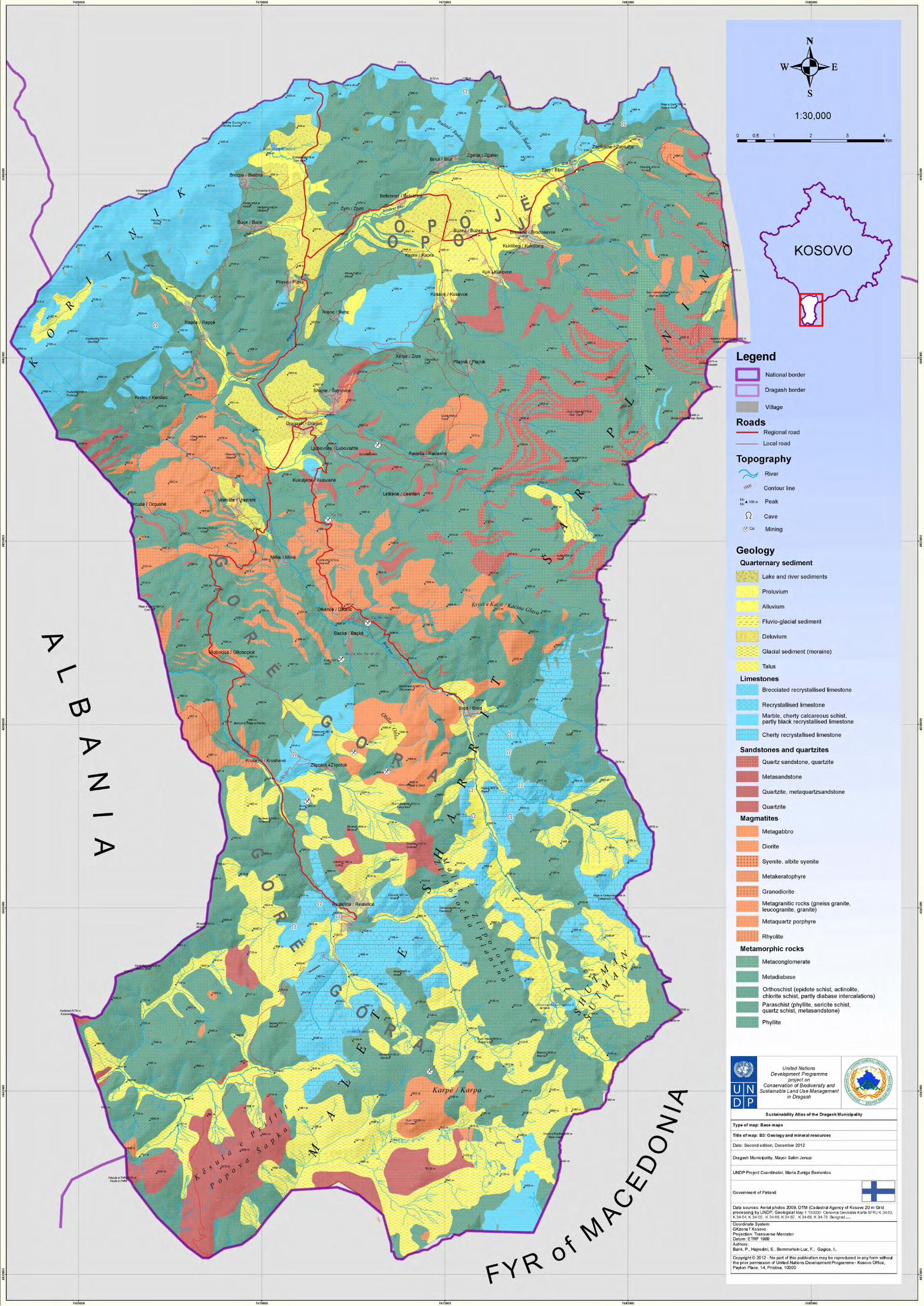

36
United Nations Development Programme Sustainable Development Atlas for Dragash / Dragaš – Kosovo
1.4. Soil
Contents of the map:
Soil map of Dragash / Dragaš Municipality – extracted from the “SOIL MAP OF KOSOVO” (1974/2006) - 1:200,000
The main messages:
“The presented soil map is a comprehensive overview presentation of the soils in Kosovo based on the available soil map sheets at a scale 1:50,000 from 1974. The soil classification used for the map corresponds to the common regional soil classification. The distinction of the soils is partly based on the internationally known soil types (e.g. regosol, rendzina, gley) according to the systematic from FAO-UNESCO; partly based on the granulometric soil species (e.g. sandy soil, loamy soil, clayey soil); and partly on the soil substrata and the stage of soil development (e.g. degree of weathering of ferrous minerals: brownisation). As a result, different classifications like “regosol on flysch”, “brownised deluvium” or “shallow brown soil on schists” are represented on the map side by side. Nevertheless, the classification applied on the map is very useful, since the map shows the most important soil characteristics. Based on the presented information, the user is able to derive possibilities for different specific land use, environmental aspects, necessary soil conservation, pedogenesis and other pedologic facts” (Independent Commission for Mines and Minerals 2006b).The great variety of soils Dragash / Dragaš can be summarised to 8 classes (Figure 1 10):• Bare rocks with hardly any development of soil cover approximately 1% of the surface, particularly in the steep, high mountains in the south;• Young, sparsely developed Lithosols on all types of rocks are prevalent in steep areas along valleys and mountains and cover approximately 9% of the territory;
Figure 1 10: Soil classes in Dragash / Dragaš
• The next stage of soil development is represented by Rankers on acidic or neutral rocks and Rendzinas on limestone. These soils are usually only superficially developed and cover around 70% of Dragash / Dragaš – Rankers on the mountains along the eastern and southern border, and Rendzinas on the Mount Koritnik Massif in the north.• Brown Soils, characteristic in approximately13% of the area are
deeper developed and can be found along a belt from Brezne / Brezna and Brrut / Brut in the north to Kruševo / Krushevë in the south.• Flood Plain Soils cover 7% of the municipality and can be found along the Pllava valley in the north, in the lower parts of the valley of the Brod River, and in parts of the valley of the Restelica River around Restelica / Restelicë.• Gleys and organic soils are of minor importance, covering less than 1% in total. These types can be found in the area around Shutman, and Lake Brezne.
Relevance of the information for other assessments:
The soil information is used for the assessment of soil bonity (together with local expert knowledge) and for the erosion risk model used in the assessment map for natural hazards.
Data sources, material and reliability:
Independent Commission for Mines and Minerals / Komisioni i Pavarur për Miniera dhe Minerale - Nezavisna Komisija za Rudnike i Minerale 2006Pedology: Digitised and compiled from: Pedološke Karta Socijalisticke Autonomne Pokrajine - Kosovo - 1 : 50,000, Beograd 1974, Institut za vodoprivredu “Jaroslav Ćerni”Topography: Vector data based on Topographical maps of former Yugoslavia 1:50,000 - edition 4-NIMA, series M709 - Copyright 1998 by the United States Government. No copyright claimed under title 17 U.S.C. Map projection: Transverse Mercator Reference system: Ellipsoid: Bessel 1841, Datum: MGI AustriaReliability:The soil types are very broad and can only give a first impression for the more detailed work necessary for the assessment of soil bonity and biodiversity.
Further suggestions for monitoring and/or improvement of data:
Especially for the areas for agricultural use, detailed soil maps may be required.
References
Pawićević, N., Grujić, L., Ljubomir, M., Petar, K. And Gradimik, V.: Pedološke Karta Socijalističke Autonomne Pokrajine Kosovo – S.R. Srbija, scale: 1:50,000, Institut za vodoprivredu “Jaroslav Černi“, Beograd, 1974.IUSS Working Group WRB 2006: World reference base for soil resources. 2nd edition. World Soil Resources Reports No. 103. FAO, Rome, 2006
IUSS Ëorking Group ËRB 2006: Ëorld reference base for soil resources. 2nd edition. Ëorld Soil Resources Reports No. 103. FAO, Rome, 2006
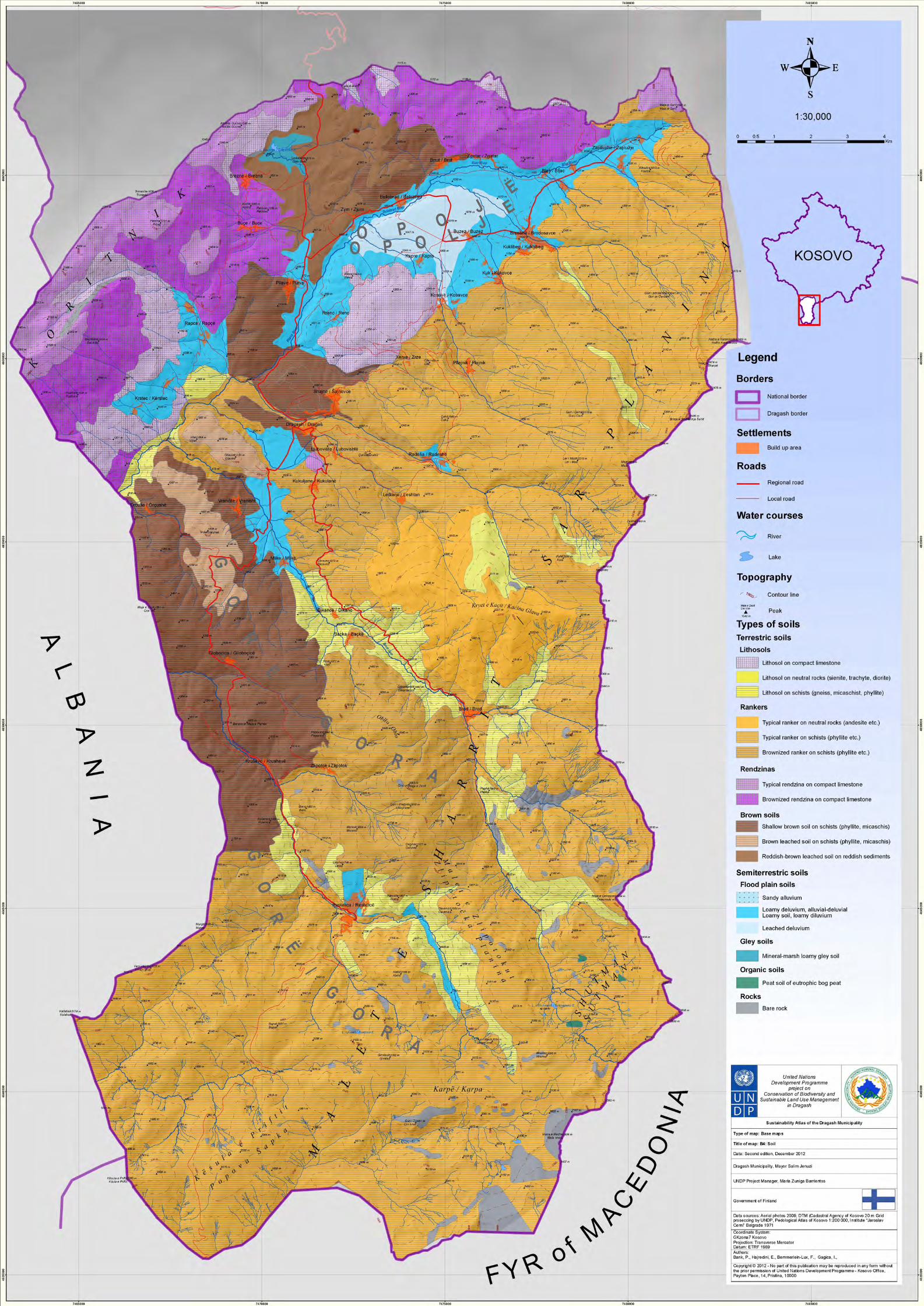

37
United Nations Development Programme Sustainable Development Atlas for Dragash / Dragaš – Kosovo
1.5. Climate
Contents of the map:
• Rainfall pattern based on a regional Model• Average temperatures – modelled based on the average temperature in Sharr/Šar Dragash/Dragaš
Relevance of the information for other assessments:
The climate data is used for the assessment of agriculture and forest activities and plays a role as one factor in the assessment of the erosion risk model.
The main messages:
The Municipality has a subalpine climate with an average yearly temperature of 8,6° Celsius for Dragash / Dragaš. The rainfall peak is in July, with subordinate peaks in September and November. The driest months are January to March and August. Approximately 50% of rainfall occurs during the vegetation period.
Data sources, material and reliability:
Climate data for Dragash/Dragaš Prof.Dr.Sci. Sylë Tahirsylaj MMPH-IHMK, Prishtina (2011) - There is only one weather station in the municipality in Dragash / Dragaš. From 2008 onward no further data was collected.For the temperature gradient it was assumed that for each 100m the gradient is 0,6 °C. The calculations for the temperature isolines used the average yearly temperature.
Figure 1-12: Climate diagram for Dragash / Dragaš
Table 1-2: Average seasonal temperature in Dragash / Dragaš
Table 1-3: Precipitation and average temperature during Vegetation Period
Average temperature in
Winter Spring Summer Autumn Vegetation period
Dragash ºC - 0,4 7,9 18,1 10,2 15,0
Precipitation and average Temp. during the vegetation period
April to September October to March Annual
mm % Temp. °C mm % Temp. °C mm % Temp. °C
Sharr Dragash 413 51,1 15,0 394 48,9 3,3 807 100 8.3


38
United Nations Development Programme Sustainable Development Atlas for Dragash / Dragaš – Kosovo
1.6. Water resources
Contents of the map:
Natural Resources• Watersheds and important sub-watersheds• Rivers, creeks, lakes and springs• Wetlands and forests
Water Supply• Current water supply installations (extraction of surface water, springs used for village supply, water reser-voirs, treatment facilities, pipe system)• Type of water supply in the villages (central supply by utility – self-organised supply, source of water used)• Planned water supply system (reservoirs, treatment facility, pipes)
Waste Water Management• Waste Water Treatment Plant and sewage system under construction near Kapre / Kapra• Locations of uncontrolled discharge of untreated waste water to rivers and creeks (from UNDP Water Survey, 2011)
Hydropower• Planned hydropower project Zhur/Žur (Water transfer system from the south to the reservoirs, two reservoirs, transfer to Zhur/Žur powerhouse)• No data representing the planned small hydropower plants (SHPP) at Brod and Restelica River could be made available through the competent authorities.
The main messages:
Natural ResourcesDue to the high average annual rainfall of 1.130mm/m², Dragash / Dragaš Municipality is a region of Kosovo with abundant water resources.• The northern part of the municipal territory belongs to the basin of the White Drin draining to the Adriatic Sea (36.556ha = 84% of the territory), comprising the sub-basins of Restelica River, Brod River, Sotke River, Plava River and Prizren River. The part of Dragash / Dragaš territory draining to the Prizren River features a geological peculiarity: there is no surface water flow to Prizren River. The water leaves near Lake Brezna through a sinkhole and an underground carstic connection, resurfacing near Poslisht village in the vicinity of Prizren at a place called “Gurra”.• The most south-western part of the municipal territory belongs to the Basin of Black Drin River also draining to the Adriatic Sea (6.532ha = 15% of the territory).• Two small areas in the south-east of the territory drain via the Vardar River to the Aegean Sea (494ha = 1% of the territory).
Table 1 4 gives an overview on surface and annual rainfall received by the watersheds.
Watershed Sub-Watershed Surface in ha Annual Rainfall in m³
White Drin Brod River 8.789 103.272.513
Plava River 17.573 191.584.988
Prizren River 2.435 24.161.538
Restelica River 7.155 82.376.960
Sotke River 603 6.075.304
White Drin Total 36.556 407.471.303
Black Drin Black Stone Riveri 3.757 46.087.272
Sherupa River 2.775 31.887.218
Black Drin Total 6.532 77.974.490
Vardar Rrasangult River 160 2.137.545
Silent Waters River 333 4.491.258
Vardar Total 494 6.628.803
Overall in Dragash / Dragaš Municipality 43.581 492.074.596
Table 1-4: Yearly rainfall in m³ per watershed

39
United Nations Development Programme Sustainable Development Atlas for Dragash / Dragaš – Kosovo
Ecosystems providing for the regeneration of water resources and therefore buffering fast discharge of heavy rainfalls or snow melt (i.e. all types of forests and wetlands) are unequally distributed to the basins and sub-basins of the municipality. Table 1 5 gives an overview on the situation:
The southern sub-basins located in Gora/Gorë region feature significantly less water regenerative areas than the northern basins; all below 20% of the surface of the respective sub-basin. This is particularly caused by the lower forest cover, but partly balanced by the high abundance of wetlands in the higher mountain areas. Both facts advocate for efficient protection of these ecosystem types in Gora/Gorë region.
In the northern sub-basins the comparatively high covers of forests and coppice forests account for the higher proportion of water regenerative areas. Most prominent are the large forest areas at Mount Koritnik and in Sotke River sub-basin.
In total, the share of water regeneration areas in Dragash / Dragaš Municipality accounts for slightly above 20%.
Information on groundwater resources as an important element of the water regime is not available. A rough assessment of potential ground water occurrence in Dragash / Dragaš Municipality will be provided in Vol. 3 Assessment of the Sustainable Development Atlas.
Figure 1-14: Watersheds in Dragash / Dragaš Municipality
Table 1-5: Area for water resources regeneration per watershed
Area for water resources regeneration in ha
Basin / Sub-Basin Forests Coppice Forests Wetlands Total in % of total Total Surface in
Surface ha
White Drin 4.300 3.295 998 8.593 24% 36.556
Brod River 553 712 389 1.655 19% 8.789
Plava River 2.237 1.982 283 4.502 26% 17.573
Prizren River 491 431 15 936 38% 2.435
Restelica River 564 135 311 1.011 14% 7.155
Sotke River 455 35 0 490 81% 603
Black Drin 1 831 832 13% 6.532
Black Stone River 1 463 464 12% 3.757
Sherupa River 0 368 368 13% 2.775
Vardar 0 60 60 12% 494
Rrasangult River 0 9 9 6% 160
Silent Waters River
0 50 50 15% 333
Total Dragash / Dragaš Municipal-ity
4.301 3.295 1.889 9.485 22% 43.581
Figure Error! No text of specified style in document.-1: Watersheds in Dragash / Dragaš Municipality

40
United Nations Development Programme Sustainable Development Atlas for Dragash / Dragaš – Kosovo
Table 1 6 gives an overview of the density of water courses in the sub-basins in Dragash / Dragaš Municipality. The average density for the municipality is 2,1km of water courses per km² of surface area, with 0,4km of large permanent water courses and 1,7km of smaller, often temporary water courses. The highest overall density (4,3km/km²) is to be found in the in
Figure 1 15 and Table 1 7 which follow show the average monthly flow rates of major rivers in Dragash / Dragaš Municipality during the period from 1954-1985. The points of measurement are not
the sub-basins of Silent Waters River. Due to its location in the high montane and alpine zone, more than 80% of water courses in this sub-basin are small or temporary.The lowest water course densities are to be found in the north of Dragash / Dragaš Municipality, in the Pllava River and Prizren River sub-basins, respectively with only 1,6 and 1,05 km/km².
known, but it can be assumed these are located close to the outlet of River Brod, and close to the border with Albania in the case of the Rivers Pllava and Restelica.
Gjatësia e rrjedhave ujore në km
small Total surface small or Density of Water Courses in km/km²
Basin / Sub-Basin or temporary large Total in ha temporary large Total
White Drin 536,4 155,2 691,6 36.556 36.556 1,5 1,9
Brod River 209,6 45,6 255,2 8.789 8.789 2,4 2,9
Plava River 195,5 78,4 274,0 17.573 17.573 1,1 1,6
Prizren River 24,5 1,2 25,6 2.435 2.435 1,0 1,1
Restelica River 97,9 27,9 125,7 7.155 7.155 1,4 1,8
Sotke River 8,9 2,2 11,1 603 603 1,5 1,8
Black Drin 185,2 14,5 199,7 6.532 6.532 2,8 3,1
Black Stone River 113,6 0,0 113,6 3.757 3.757 3,0 3,0
Sherupa River 71,7 14,5 86,1 2.775 2.775 2,6 3,1
Vardar 14,5 2,8 17,3 494 494 2,9 3,5
Rrasangult River 2,8 0,0 2,8 160 160 1,7 1,7
Silent Waters River 11,7 2,8 14,5 333 333 3,5 4,3
Total Dragash / Dragaš Municipality
736,1 172,5 908,6 43.581 43.581 1,7 2,1
Table 1-6: Water courses per watershed
Figure 1-15: Flow rates of major rivers in Dragash / Dragaš Municipality
Figure Error! No text of specified style in document.-1: Shkalla e rrjedhave të lumenjve kryesorë në komunën e Dragashit

41
United Nations Development Programme Sustainable Development Atlas for Dragash / Dragaš – Kosovo
High flow season is dependent on snow melt and starts first in the Pllava River sub-basin, lasting from February to June; high flow season in the tributaries of the River Brod and Restelica starts only in April due to the higher altitude of the catchments, with a maximum in May for all three rivers. The end of the high flow season in June coincides with the monthly precipitation maximum. Later in the year, low rainfall influences minimum flow rates in August. Higher rainfall rates from September to December induce higher flow rates.
Water supply
Only two settlements in Dragash / Dragaš Municipality are currently supplied by a central water supply system operated by the local supplier Hidroregjoni Jugor - Dragash / Dragaš town, with an estimated population of 3.000 (2010), and Pllavë / Plava, with an estimated population of 1.400 (2010). In both cases surface water is used for supply.All other settlements are supplied by their own systems depending either on springs or surface water. The lowest supply rate can be found in Brezne / Brezna, Mlike / Mlikë, and Rapča / Rapçë with only 20% of inhabitants being supplied. In Vranište / Vranisht only 30% are supplied, in Zgatar / Zgatar 50%, and in Brrut / Brut, Kapre / Kapra, Krstec / Kërstec, Restelica / Restelicë, and Rrenc / Renc 80%. All other villages reach a supply rate of 100%. The quality of drinking water is not supervised.A total of 161 natural springs are used for supplying the villages with drinking water; the collected water is stored intermediately in a total of 92 reservoirs located in the villages. Besides Dragash / Dragaš, the settlements of Bresanë / Brodosavce and Zgatar / Zgatar are at least partly supplied with river water extracted from the water courses upstream the villages. In case of Zgatar / Zgatar this supply comes from the Blac River (Blaç / Bljacka reka); in Bresanë / Brodosavce it is from the Shehi i Madh creek (Reka e Shehit të Vogël / Reka e Šehit t Mad).In the future, the municipality and Hidroregjoni Jugor plan to expand the central supply to the 16 villages listed in Table 2 1 in Annex Baseline Maps 2.1. Water will be abstracted from the Radesha River upstream of the village of Radeša / Radeshë, treated in a facility and distributed via a system of pipes and storage reservoirs to the villages. Further details of water supply are analysed and discussed in the Water Master Plan for Dragash / Dragaš Municipality.Waste water managementWaste Water Management is almost absent in Dragash / Dragaš Municipality which is leading to some severe impacts in several of the water courses. Details of these impacts will be discussed in Volume 3 Assessment of the SDA.Currently a waste water treatment plant is being constructed at Kapre River, downstream from the village of Kapre/Kapra. The villages of Kuk / Kukovce, Kosavë / Kosavce, and Kapre / Kapra will be connected to this facility. It will serve three out of 27 villages, with a total of 4.253 (2010) inhabitants or approximately 10% of the population of the municipality. The waste water treatment plant will prevent the pollution load coming from these villages reaching Accumulation 1 (Bellobrad River) of the Zhur/Žur Hydropower Scheme, and will help to keep water quality there at an acceptable level.
During field surveys on water resources undertaken by UNDP in spring 2011, several uncontrolled discharge points of waste water to the rivers of Dragash / Dragaš could be identified. Some of these are caused by companies releasing untreated waste water into the surface water bodies. These locations are marked in the water resources map.No other concrete plans to tackle the waste water problem in the municipality are known to UNDP.
Hydropower
The ample water resources of Dragash / Dragaš provide a huge potential for the generation of hydro power. One small hydropower plant (SHPP) is located on the River Brod. Two schemes are currently underway to exploit the local hydropower potential:• The Zhur/Žur Hydropower Scheme: This is a peaking hydropower scheme with a total installed capacity of 305MW. The two plants will be located outside Dragash / Dragaš Municipality near the village of Zhur/Žur. Via a system of tunnels and canals, water will be transferred from the Black Stone River sub-basin and from the Restelica and Brod Rivers to a small, first reservoir in the River Pllava Valley, and from there to a bigger, second reservoir close to the village of Brezne / Brezna. The water will be led down to the two power plants via a tunnel with an altitude difference of 683,5m to 643m. Water flows of the rivers Caljane, Restelica, Brod and Pllave will be affected, as well as the carstic water flow from near Lake Brezna to “Gurra”. The Legal Decision for the construction of Zhur/Žur Hydropower Plant was taken by the Kosovo Assembly on July 24th, 2009.• Along the Brod and Restelica Rivers the construction of six SHPPs is planned by an international consortium. Neither the exact location of outtakes and intakes nor exact data on the planned amount of abstraction have been available during compilation of the Sustainable Development Atlas. Based on the data available, a preliminary, short environmental assessment of the planned SHPP has been delivered by UNDP.
Relevance of the information for other assessments:
Water resources and their management are a major factor for local sustainable development and will be used for assessment and discussion of development options for the municipality.
Data sources, material and reliability:
IIbrahimi, Halil: Rapid Water Quality Assessment in Streams and Rivers of Dragash/Dragaš Municipality, UNDP Contract No. 2011-IC-025, Pristina, 2011HIDROPLAN Pristina: Plan for Water Supply of several Villages in Dragash / Dragaš Municipality, PristinaMinistry of Environment and Spatial Planning: Kosovo Environmental Action Plan 2006-2010, Pristina, 2006Ministry of Environment and Spatial Planning – Kosovo Environmental Protection Agency: The State of Water in Kosovo, Pristina, 2010Ministry of Environment and Spatial Planning: Revising and updating the Kosovo Environmental Strategy (KES) and National
Table 1-7: Average monthly flow rates of major rivers
River Jan Feb Mar Apr May June July Aug Sept Oct Nov Dec Aver
Plava 4,82 5,83 6,86 9,63 14,4 8,04 3,04 1,43 1,74 2,52 5,62 4,95 5,74
Brod 1,73 1,78 2,21 3,97 6,48 3,71 1,52 0,86 0,86 1,16 1,86 1,57 2,31
Restelica 1,44 1,39 1,87 3,39 4,73 2,59 1,44 1,02 1,01 1,01 1,65 1,54 1,92
Colour code: Blue = month of maximum flow; Green = months with flow above average; Orange = months with flow below average; Red = month with minimum flow rate.
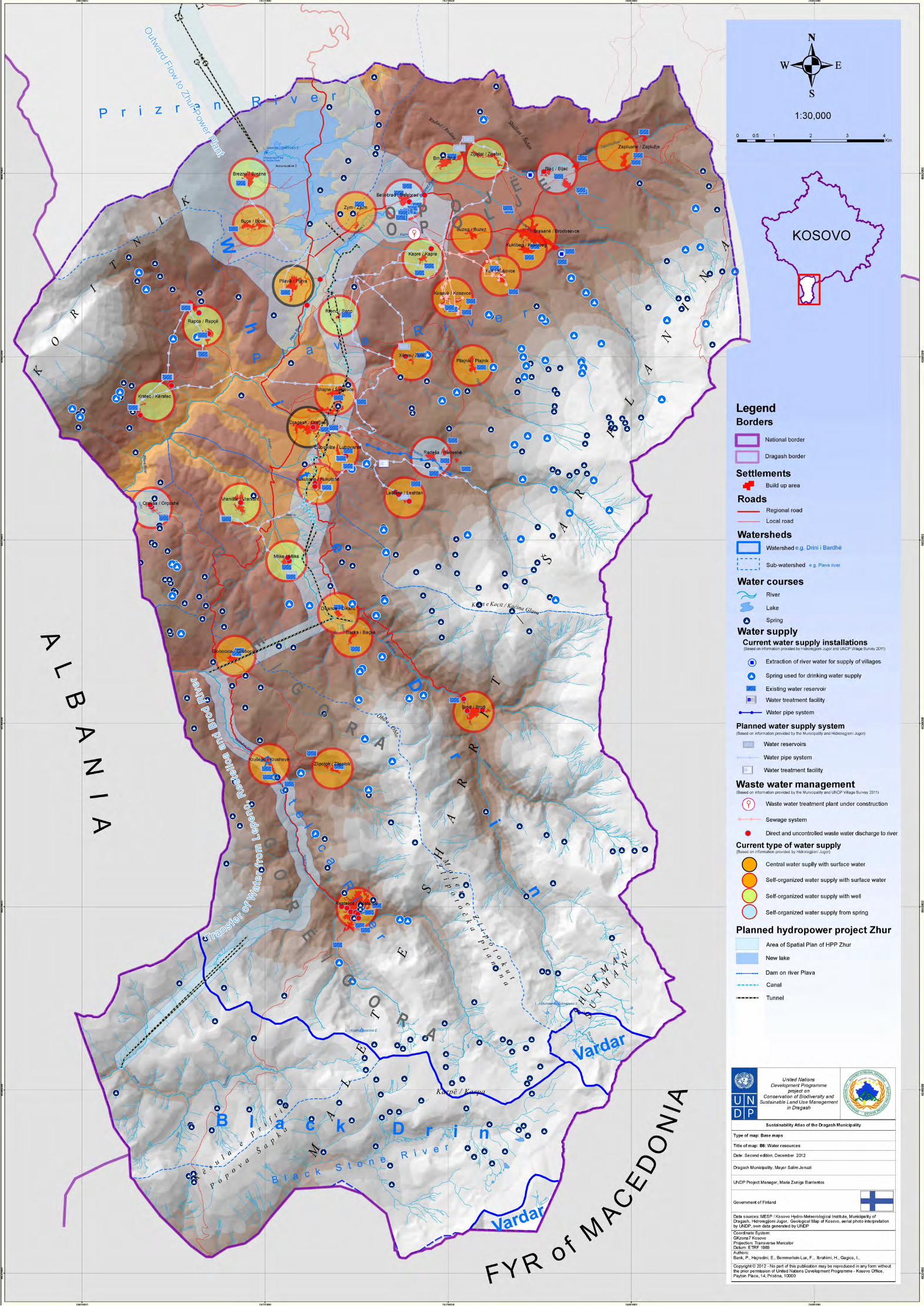

42
United Nations Development Programme Sustainable Development Atlas for Dragash / Dragaš – Kosovo
Environmental Action Plan (NEAP) 2011-2013, Pristina, 2011Official Gazette Republic of Kosova: Decision GSH 03/2009 on Zhur Hydropower PlantUNDP Dragash/Dragaš: Water Master Plan, GPS data, 2012See also in Annex Baseline Maps 2.2.
Further suggestions for monitoring and/or improvement of data:
• Repeat water sampling during low flow season in 2012 (July / August) and check uncontrolled discharge of waste water
• Keep contact with Municipality and Hidroregionji Jugor and regularly update water supply system and plan-ning• Amend information displayed with data from Water Master Plan• Keep track of planning for utilisation of hydropower and regularly update data• To include the mapping of waste water discharges that is being done by the team
1.7. Real land use
Contents of the map:
Interpretation of the latest aerial photos of the municipality (2009) based on the land use types defined under the pan-European CORINE Land Use Cover project. The CLC types have been amended with some specific types relevant for Dragash / Dragaš Municipality.
The main messages:
The territory of Dragash / Dragaš Municipality is characterised by natural grass- and shrubland interspersed by rocky or sparsely vegetated areas and wetlands, and forests. These main types of land uses account for over 60% of the municipality’s surface. 39% of the land is used for agricultural purposes. Due to the high altitude, grasslands dominate over tillage and permanent cultures (30% versus 9%).Only 1% of the surface is covered by settlements or infrastructures (see also Table 1 8).
Sub-Basin Settle-ments
Agri-cultural areas
Pastures & meadows
Forests Natural grass & shrubland
sparsely vegetated areas
bare rocks Wetlands Water bod-ies
Total in ha
Brod River 40 146 2.792 1.265 2.946 930 281 389 0% 8.789
0% 2% 32% 14% 34% 11% 3% 4%
Pllava River 361 2.620 4.985 4.219 3.806 1.199 102 283 0% 17.573
2% 15% 28% 24% 22% 7% 1% 2% 3
Prizren River 56 640 364 921 366 70 0 15 0% 2.435
2% 26% 15% 38% 15% 3% 0% 1%
Restelica River 67 385 2.728 699 2.206 562 196 311 0% 7.155
1% 5% 38% 10% 31% 8% 3% 4%
Sotke River 3 77 490 32 1 0% 603
1% 0% 13% 81% 5% 0% 0% 0%
Black Stone River
2 990 1 1.832 279 190 463 0% 3.757
0% 0% 26% 0% 49% 7% 5% 12%
Sherupa River 6 1.068 1.107 216 11 368 0% 2.775
0% 0% 38% 0% 40% 8% 0% 13%
Rrasangult River 81 59 11 9 0% 160
0% 0% 0% 0% 50% 37% 7% 6%
Silent Waters River
216 57 10 50 0% 333
0% 0% 0% 0% 65% 17% 3% 15% 3
Dragash/ Dragaš Munici-pality
527 3.798 13.003 7.596 12.591 3.373 800 1.889 0% 43.581
1% 9% 30% 17% 29% 8% 2% 4%
Table 1-8: Land Use types in Dragash / Dragaš Municipality in ha and %

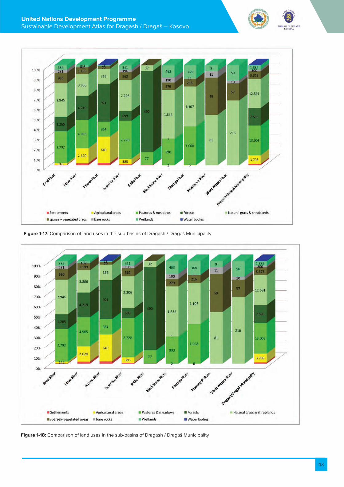
43
United Nations Development Programme Sustainable Development Atlas for Dragash / Dragaš – Kosovo
Figure 1-17: Comparison of land uses in the sub-basins of Dragash / Dragaš Municipality
Figure 1-18: Comparison of land uses in the sub-basins of Dragash / Dragaš Municipality
Figure Error! No text of specified style in document.-1: Comparison of land uses in the sub-basins of Dragash / Dragaš Municipality
Figure Error! No text of specified style in document.-1: Comparison of land uses in the sub-basins of Dragash / Dragaš Municipality


44
United Nations Development Programme Sustainable Development Atlas for Dragash / Dragaš – Kosovo
Agricultural areas with arable land, permanent crops and complex land uses composed of annual and permanent crops with hedges are concentrated in the Opojë/Opolje Region. The sub-basins of the Pllava and Prizren Rivers account for 86% of these land use types, although only covering 46% of the Municipality. In the Gora/Gorë Region major areas can be found around Globočica / Glloboçicë, Kruševo / Krushevë and Restelica / Restelicë. Pastures and meadows are to be found mainly in a belt east of the villages at the foot of the higher mountains below 1.600m altitude within the sub-basins of Pllava, Brod and Restelica Rivers (see also Figure 1 19 and Figure 1 20).The forests of Dragash/Dragaš account for 17% of the territory and are concentrated outside the Sharr/Šar Mountains. Major stock can be found along the Pllava, Restelica and Brod Rivers and in the area of Mount Koritnik with a high share of coppice forests (see also Table 1 5). The higher Sharr/Šar Mountains are almost bare of forests.The Sharr/Šar Mountains are characterised by natural and semi-natural grass- and shrubland, associated with wetlands along the water courses and in depressions, sparsely vegetated and rocky areas. These land use types account for 43% of the municipal territory.
Relevance of the information for other assessments:
The actual land use will be used for the assessment of agriculture, forest and nature protection and forms the basic information about environmental characterisation in the municipality.
Data sources, material and reliability:
Most of the classification was undertaken through a combination of automatic interpretation and reworking by manual interpretation with some ground truthing exercises.List of land use types is provided in the annex of Volume 4, Guidance for Development
Further suggestions for monitoring and/or improvement of data:
Correction according to field checks
1.8. Biosphere resources - vegetation
Contents of the map:
• Areas and points where a vegetation mapping was undertaken by UNDP experts in 2011 (partly field map-ping, partly desktop analysis); a total of 37 plant associations have been identified.• Points of inventories of plants (from 2011)• Assumed timber line (2050 m)• Main types of land uses as background
The main messages:
General situationThe extended range of altitudes between 730 and 2.650 m above sea level, the huge variety of bedrocks and soils, and influences from Mediterranean and Continental climates support a significant diversity of plant species and communities in the Municipality of Dragash / Dragaš. The Sharr/Šar Mountains are assumed to provide habitats for about 2000 vascular plant species. The overview research for the Dragash/Dragaš mountains located approximately 650 plant species. It is important to note that only some points were analysed and total plant lists were not recorded. that only some points and there not total plant lists were recorded. Without human influence most of the areas below the timberline should be covered by forest. Through centuries of deforestation, grazing and frequent burning of trees and shrubs, the forest has vanished almost completely in the eastern and southern part of the municipality at altitudes above 1.700 m (Sharr/Šar Mountains). The timber line is at about 2000 – 2100 m and best visible at Mount Koritnik in the northwest of the municipality. It can be assumed that above the timber line one can find conditions closest to nature in the municipality. These are areas covered by natural rock, alpine grass- and shrub-lands with natural wetlands such as peat-bogs and fens in depressions, containing a wide variety of typical and often important plant communities and species.Forests in Dragash / Dragaš are a mixture of coniferous forests dominated by pines or firs, and broadleaved forests with
beeches, oaks, birches, and hornbeams or a mixture of both. Approximately 40% of the forests in the municipality are more or less managed as coppice forests. Along the water courses, narrow strips of riparian forests dominated by alders are mostly abundant. The forests of Dragash / Dragaš host a wide variety of plant communities and species of importance. In particular, coppice forests are home to a great number of plant and animal species.Pastures and meadows replacing natural forests are often managed extensively and are home to a considerable variety of plant species.Arable lands and areas with a complex cultivation mix of tillage, permanent cultures, pastures, and often hedges were not in the focus of the field work undertaken. In particular, the areas with a high diversity of structures (Land use type: ‘Complex Cultivation with or without Hedges and Trees’, see Figure 1 20) are of high importance to local fauna.
Plant communitiesDuring field and desk top work a total of 37 plant communities were identified in the focal areas (see Mustafa B., 2011) and Table 2 3 in Annex Baseline Maps 2.3). A complete list and description can be found in Vol. 5 Data of the Sustainable Development Atlas. The table below presents plant communities which were identified in the field and could be aligned with the provisions of Annex I of the EU Flora-Fauna-Habitat Directive, and are therefore of particular relevance for biodiversity issues (description taken partly from Mustafa B., 2011).
Species
During field work conducted by UNDP experts and a group of national scientists (Prof. Dr. F. Millaku et al.) elaborating a Red List for Kosovo, 650 species of plants could be located in territory of the municipality. A preliminary set of 37 species has been considered as the most important and endangered in the municipality by Mustafa B. (2011). This list is given in Table 2 4 in Annex Baseline Maps 2.4:


45
United Nations Development Programme Sustainable Development Atlas for Dragash / Dragaš – Kosovo
1.9. Biosphere resources - fauna
Contents of the map:
• Distribution of large mammals• Important bird areas• Hot spots of butterflies• Aquatic insects and some other observed animals • Rivers, creeks and wetlands
The main messages:
General SituationDue to the high diversity of land uses and landscape structures, the territory of Dragash / Dragaš Municipality provides for a high diversity of habitats for numerous groups and species of animals. Besides the open grass-lands, areas of high forests, coppice forests, all types of wetlands and rocky and gravel areas are of high im-portance.There are no systematic scientific studies available on the fauna of Dragash / Dragaš. However, data from NGOs, village residents, scattered information from literature and observations made by UNDP experts provide a good basis for an overview of the local fauna.
Mammals:• Brown Bears (Ursus arctos): One of the highlights of the Sharr/Šar Mountains. Bears breed in forest sites (like the forest east of Bresanë/Brodosavce and Blaç/Blać, in Mount Koritnik or in the Hellenic Beech/fir forest between Restelica/Restelicë and Kruševo/Krushevë). They cross the border in the re-motest parts in the southeast and in the continuation of the Sharr/Šar National Park in the northeast. Bears are rarely observed in the high mountain grasslands and in the centre of the Opojë/Opolje region. • Lynx (Lynx lynx): The lynx has a similar distribution pattern to the bear in the forested areas and forest borders at higher elevations, and in the borders with Albania.• Wolves (Canis lupus): found all across the municipal territory• Chamois (Rupicapra rupicapra): found in higher level ranges and rocky outcrops, and in the scree of subalpine and alpine
Relevance of the information for other assessments:The information from this map is input for suggesting appropriate land management measures. Predominant factors of influence are the climatic factors of rainfall, temperature and humidity and the soil properties. Further-more it provides good orientation for the demarcation and zonation of the National Park.For considerations of sustainability, this map shows the ecological potential of the Municipality and takes up the challenges formulated by the Municipality of Dragash/Dragaš to collect adequate data about its biodiversity to achieve a more complete list of habitats and species (Dragash/Dragaš Municipality (2010).
Data sources, material and reliability:• Vegetation map in Lazarević, R. (1994): The vegetation types in use (associations) do not accord with the newest phytosociological norms. The precision of the map does not match the precision required for the Sustainable Development Atlas. Therefore this vegetation map is not included in Map B8.
areas• Roe Deer (Capreolus capreolus): more or less found across the territory at lower altitudes (comple-mentary with Chamois) • Wild Pigs (Sus scrofa): share the same area as Roe Deer - closer to agricultural areas
Birds: NGO Finches provided data on Birds for the years 2004 to 2010, relating to 11 locations in the municipality. A total of 153 bird species have been observed during this period. The individual locations count between 27 and 85 different species. Approximately one third of these species are listed in the various Annexes of the EU Birds Directive (see Table 2 5 in Annex Baseline Maps 2.5). The findings show a high diversity of bird species in the municipality. The areas observed represent the different types of landscapes and habitats present in the municipality.Fluturat: 40 species of butterflies have been observed so far in high mountain pastures and coppice forests. A pronounced diversity in high mountain pastures and in coppice forests is to notable, out of which 30 species are named either in Annexes II or IV of EU Habitat Directive, or are assessed as “endangered” or “vulnerable” by IUCN (see Table 2 6 in Annex Baseline Maps 2.6). 40 species of butterflies have been observed so far in high mountain pastures and coppice forests. A pronounced diversity in high mountain pastures and in coppice forests is to notable, out of which 30 species are named either in Annexes II or IV of EU Habitat Directive, or are assessed as “endangered” or “vulnerable” by IUCN (see Table 2 6 in Annex Baseline Maps 2.6). Besides very commonly found species, three very rare species could be identified in the rivers of Dragash / Dragaš:• Limnephilus petri found in the Brod River is and endemic species of the Balkan Peninsula being pre-sent only in Kosovo (and within Kosovo only in upper reaches of the Brod River) and in Bulgaria.
• Vegetation units and species displayed as point information: results from field work undertaken by UNDP national and international experts. The field work was focused on areas above the timber line and on areas covered by forest (see also: Mustafa B. 2011, Milbradt 2011). • Vegetation units displayed as area information results from desk top analysis undertaken by UNDP national experts.• Preliminary results of field work of the Kosovo Red List Project undertaken by a group of national scientists; final report will be available in May 2012 (Millaku et al. 2011).
Further suggestions for monitoring and/or improvement of data:For an environmental protection concept of the whole municipality, and especially for a management plan for the National Park, a detailed vegetation map meeting international standards is required (scale 1:25.000); this should also include a description of the plant communities including formative and important species. A detailed floristic inventory is required.

46
United Nations Development Programme Sustainable Development Atlas for Dragash / Dragaš – Kosovo
• Genus Trianodes found in Brezna Lake is the first and the only record of this genus in Kosovo so far. • A single female specimen of genus Notidobia was found in a small streamlet on the upper side of the waste dump in Buzez/Buzez village. This specimen belongs most probably to the group of Balkan en-demic species (Notidobia melanoptera, Notidobia bizensis or Notidobia nogradorum).These relatively few and scarce results of adult aquatic insects in Dragash / Dragaš municipality reveal the very rich and specific fauna of this area. There is a need to collect data on this group of insects more extensively in order to correlate with management and conservation issues.
Amphibians and reptiles 5 amphibian (all Annex IV species) and 6 reptile species (5 Annex IV species) have been located. Since there is no systematic inventory for the area, these numbers are only random information. Considerable recordings can be expected from systematic investigation (see Table 2 7 in Annex Baseline Maps 2.7).
Relevance of the information for other assessments:The information from this map is input for suggesting appropriate land management measures. Furthermore it provides a good orientation for demarcation and zonation of the National Park.
For sustainability considerations this map shows the ecological potential of the Municipality
Data sources, material and reliability:Village questionnaire (UNDP 2011)Project studies (Ibrahimi, 2011, FINCHES 2011, Mustafa B. 2011, Milbradt 2011 and Bemmerlein-Lux pers. com.)See Annex for list of species in Vol. 5 of the Sustainable Development Atlas.Reliability:The distribution data was collected in the field and through surveys among local people and hunters. This data is in principal reliable – but for concrete management plans there is a lack of quantitative data.
Further suggestions for monitoring and/or improvement of data:Although highly relevant for nature protection, amphibians and reptiles are not systematically inventoried. More systematic studies also for aquatic insects, butterflies, birds, and mammals are necessary for the management plan of the National Park and conservation strategies of biodiversity hotspots outside of the park area.

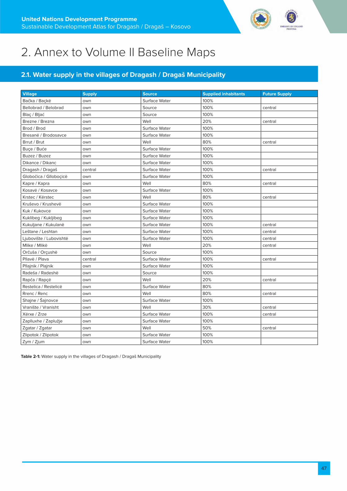
47
United Nations Development Programme Sustainable Development Atlas for Dragash / Dragaš – Kosovo
2. Annex to Volume II Baseline Maps
2.1. Water supply in the villages of Dragash / Dragaš Municipality
Village Supply Source Supplied inhabitants Future Supply
Bačka / Baçkë own Surface Water 100%
Bellobrad / Belobrad own Source 100% central
Blaç / Bljać own Source 100%
Brezne / Brezna own Well 20% central
Brod / Brod own Surface Water 100%
Bresanë / Brodosavce own Surface Water 100%
Brrut / Brut own Well 80% central
Buçe / Buće own Surface Water 100%
Buzez / Buzez own Surface Water 100%
Dikance / Dikanc own Surface Water 100%
Dragash / Dragaš central Surface Water 100% central
Globočica / Glloboçicë own Surface Water 100%
Kapre / Kapra own Well 80% central
Kosavë / Kosavce own Surface Water 100%
Krstec / Kërstec own Well 80% central
Kruševo / Krushevë own Surface Water 100%
Kuk / Kukovce own Surface Water 100%
Kuklibeg / Kukljibeg own Surface Water 100%
Kukuljane / Kukulanë own Surface Water 100% central
Leštane / Leshtan own Surface Water 100% central
Ljubovište / Lubovishtë own Surface Water 100% central
Mlike / Mlikë own Well 20% central
Orčuša / Orçushë own Source 100%
Pllavë / Plava central Surface Water 100% central
Pllajnik / Plajnik own Surface Water 100%
Radeša / Radeshë own Source 100%
Rapča / Rapçë own Well 20% central
Restelica / Restelicë own Surface Water 80%
Rrenc / Renc own Well 80% central
Shajne / Šajnovce own Surface Water 100%
Vranište / Vranisht own Well 30% central
Xërxe / Zrze own Surface Water 100% central
Zaplluxhe / Zaplužje own Surface Water 100%
Zgatar / Zgatar own Well 50% central
Zlipotok / Zlipotok own Surface Water 100%
Zym / Zjum own Surface Water 100%
Table 2-1: Water supply in the villages of Dragash / Dragaš Municipality

48
United Nations Development Programme Sustainable Development Atlas for Dragash / Dragaš – Kosovo
2.2. Data sources water resources Dragash / Dragaš Municipality
Table 2-2: Data sources water resources
Information on map Origin / Source Reliability
Natural Resources
Watersheds and important sub-watersheds Digitised by UNDP from DTM Best data available
Rivers, creeks, lakes and springs According to reliability of DTM which is suf-ficiently matching with the Topographic Maps (1:25.000)
Best data availableAccording to reliability of DTM which is suf-ficiently matching with the Topographic Maps (1:25.000)
Wetlands Digitised by UNDP from aerial photos and topo-graphic maps;Springs from aerial photos, topographic maps and village survey
Best data available;Locations derived from village survey should be checked during field work
Wetlands Digitised by UNDP from aerial photos Best data available
Water Supply
Current water supply installations Water reservoirs, treatment facility and pipes: Hidroregionji Jugor; reservoirs partly by UNDP experts (Field work)Surface water extraction, drink-ing water wells: UNDP Village Survey 2011Drinking water extraction from rivers or springs: UNDP Water Master Plan field work, 2012
Best data available;Locations derived from village survey should be checked during field work.
Type of water supply in the villages Hidroregionji Jugor Best data available;
Planned water supply system Hidroregionji Jugor; Municipality Best data available;
Waste Water Management
Waste Water Treatment Plant and sewage sys-tem
Municipality Best data available;
Locations of uncontrolled discharge of untreated waste water to rivers and creeks
from UNDP Water Survey, 2011 Locations should be cross-checked and revised during second phase of field work in 2012;
Hydropower
Planned hydropower project Zhur/Žur Institute of Spatial Planning According to official plan
Planned small hydropower plants (SHPP) on Brod and Restelica Rivers

49
United Nations Development Programme Sustainable Development Atlas for Dragash / Dragaš – Kosovo
2.3. Plant communities of Dragash / Dragaš listed in Annex I of EU-Habitat-Directive
Plant community (scientific name) Description Habitat-Directive Annex I Type
Wetland vegetation
Caricetum – different varieties Caricetum nigrae, Caricetum rostratae salicetosum, Carice-tum rostratae-vesicariae: Peat-forming communities devel-oped at the surface of oligotrophic to mesotrophic waters, with characteristics intermediate between soligenous and ombrogenous types.
7140 Transition mires and quaking bogs
Carici-narthecietum scardici Wetlands mostly or largely occupied by peat- or tufa-pro-ducing small sedge and brown moss communities devel-oped on soils permanently waterlogged, with a soligenous or topogenous base-rich, often calcareous water supply, and with the water table at, or slightly above or below, the substratum.
7230 Alkaline fens
Carici-narthecietum scardiciEutrophic vegetation
Senecio-Rumicetum alpini Nitrophilous tall herb communities at places in the montane to alpine areas where cattle is resting
Not in Annex I
Shrub vegetation
Arctostaphylo-Juniperetum nanae Alpine zone above the last zone of forest. Characteristic species of association are Juniperus nana, Vaccinium uligi-nosum, Thymus albanus, Nigritella nigra etc.
4060 Alpine and Boreal heaths
Vaccinio-Empetretum hermaphroditi High mountain dwarf bilberry heaths Vaccinium-dominated dwarf heaths of the sub-alpine belt of southern mountains. With Vaccinium myrtillus, Vaccinium uliginosum s.l. Vac-cinium vitis-idaea and, locally, Empetrum nigrum. They are rich in grassland species and often take the appearance of alpine grassland with dwarf shrubs.
4060 Alpine and Boreal heaths - High mountain dwarf bilberry heaths
Vaccinion with V. gaultherioides Dwarf heaths dominated by Empetrum hermaphroditum, Vaccinium uliginosum, with Arctostaphylos alpina, Vaccini-um myrtillus, Vaccinium vitis-idaea and lycopodes
4060 Alpine and Boreal heaths - High mountain Empetrum-Vaccini-um heaths
Corylletum avellanae Species diversity is greater than in the Central European beech woods and the Aremonio-Fagion constitutes an impor-tant centre of species diversity
91K0 Illyrian Fagus sylvatica forests (Aremonio-Fagion)
Alpine lawns and rock vegetation
Drypetum spinosae The association lies at an altitude over 2000m. Developed in rocky places. This association is poor in species. Most important species Drypis spinosa, Linaria alpina, Festuca picta etc.
8140 Eastern Mediterranean screes
Saxifrageto-Potentilletum apenninae The association lies in the Sharr/Šar Mountains and Korit-nik in limestone rocks. Components of this association are tertiary and relict species. Prominent species are Potentilla speciosa, Potentilla apennina, Saxifraga scardica, Aubrietia gracilis, Minuartia graminifolia
6110* Rupicolous calcareous or basophilic grasslands of the Alysso-Sedion albi
Saxifrageto-Rumicetum nivalis Wind edge naked-rush swardsMeso-xerophile, relatively closed and unsculptured swards of Kobresia myosuroides (Elyna myosuroides) forming on deep, fine soils of protruding ridges and edges exposed to strong winds in the alpine and nival levels
6170 Alpine and subalpine calcare-ous grasslands
Juncetum trifidi Boreo-alpine formations of the higher summits of moun-tains, with Juncus trifidus, Carex bigelowii, mosses, and li-chens. Also included are associated snowbed communities.
6150 Siliceous alpine and boreal grasslands
Natural grasslands
Different variants the Nardion Deltoideo-Nardetum, Nardion, (Lino-)Nardetum strictae:Nardus stricta is edificator of the association. Either Hygro-philous perennial tall herb communities of montane to alpine levels of the Betulo-Adenostyletea class or Closed, dry or mesophil, perennial Nardus grasslands occupying siliceous soils in Atlantic or sub-Atlantic or boreal lowland, hill and montane regions. Vegetation highly varied, but the variation is characterised by continuity.
6230* Species-rich Nardus grass-lands, on siliceous substrates in montane and sub-montane areas

50
United Nations Development Programme Sustainable Development Atlas for Dragash / Dragaš – Kosovo
Armerio-Festucetum variae Above Pinetum heldreichii typicum 6170 Alpine and subalpine calcareous grass-lands
Carici-Seslerietum latifoliae Calciphilous stepped and garland grasslands 6170 Alpine and subalpine calcareous grass-lands
Diantho-scardici-Festucetum Xerothermophile, open, sculptured, stepped or garland grasslands
6170 Alpine and subalpine calcareous grass-lands
Extensive pastures
Gentiano-Dryadetum octopetalae Calciphilous stepped and garland grasslands in the highest peaks of Mount Koritnik. Charac-teristic species are Dryas octopetala, Gentiana verna, Carex leavis, Helianthemum canum. Other important species are Thymus albanus, Edrianthus graminifolius, Scabiosa columbaria, Gentiana kochiana etc.
6170 Alpine and subalpine calcareous grass-lands
Helianthemo-Globularietum bellidifoliae and Wind edge naked-rush swards - Meso-xerophile, relatively closed and unsculptured swards of Kobresia myosuroides (Elyna myosuroides) form-ing on deep, fine soils of protruding ridges and edges exposed to strong winds in the alpine and nival levels
6170 Alpine and subalpine calcareous grass-lands
Edraiantho-Elynetum Species-rich hay meadows on lightly to moder-ately fertilised soils of the plain to sub-montane levels, belonging to the Arrhenatherion and the Brachypodio-Centaureion nemoralis alliances. These extensive grasslands are rich in flowers and are not cut before the grasses flower and then only one or two times per year.
6510 Lowland hay meadows (Alopecurus prat-ensis, Sanguisorba officinalis)
Gladiolo-Sanguisorbetum officinalae Dry, frequently open grasslands on more or less calciferous sand
6120* Xeric sand calcareous grasslands
Coniferous forest
Abietum borisii-regis Endemic to the Balkans and in Kosovo is found only in the Sharr/Šar Mountains (in Restelica/Restelicë), lies at an altitude of 1500-1580m. In the eastern exposition. High endemism, char-acterised by the presence of Abies borisii-regis, Doronicum caucasicum, Galium laconicum, Lathyrus venetus, Helleborus cyclophyllus.
9270 Hellenic beech forests with Abies borisii-regis
Abietum albae koritniensis Forests of Abies alba or of Abies alba mixed with Fagus sylvatica, Picea abies, Pinus sylvestris or Pinus nigra within the geographical range of Fagion moesiacum forests.
91BA Moesian silver fir forests
Pinetum heldrechii typicum White-barked pine forests: Local treeline forma-tions of Pinus heldreichii restricted to the south-ern Balkans, northern Greece and southern Italy, usually open and with undergrowth formed by stripped grasslands on dry, often stony or rocky soils.
95A0 High oro-Mediterranean pine forests
Mixed forest
Fago-Pinetum heldrechii White-barked pine forests: Local treeline forma-tions of Pinus heldreichii restricted to the southern Balkans, northern Greece and southern Italy, usual-ly open and with undergrowth formed by stripped grasslands on dry, often stony or rocky soils.
95A0 High oro-Mediterranean pine forests
Riparian forest
Alnetum glutinosae Typical for river valleys in terrain which is often flooded and has high humidity. On the tree layer dominates Alnus glutinosa and in shrubs layer are found Euonymus europea, Prunus padus, Viburnum opulus. Herbaceous species are Viola sylvestris, Euphorbia palustris, Teucrium chamaedrys, etc.
91E0 Alluvial forests with Alnus glutinosa and Fraxinus excelsior (Alno-Pandion, Alnion inca-nae, Salicion albae)

51
United Nations Development Programme Sustainable Development Atlas for Dragash / Dragaš – Kosovo
Birch forest
Betuletum verrucosae koritniensis Fagus sylvatica forests. Species diversity is greater than in the Central European beech woods and the Aremonio-Fagion constitutes an important centre of species diversity.
91K0 Illyrian Fagus sylvatica forests (Aremonio-Fagion)
Oak forest
Lembotropo-Quercetum cerrisQuercetum trojanae dukagjini
Developed in Koritnik in an altitude from 300-900m.Geological composition is limestone and pedological cover is red. This association is un-der the influence of Mediterranean climate that comes from the river valleys of the Drini i Bardh/Beli Drim. Very much influenced by human fac-tor, so in a significant area instead of Quercus trojana species is developed Carpinus orientalis and Crataegus monogyna. Species characteris-tic of the association are Quercus trojana duk-agjini, Pyrus amygdaliformis, Ruta graveolens, Acanthus balcanicus etc.
Locally defined9250 Quercus trojana woods
Beech forest
Fagetum moesiaca montanum Fagus sylvatica or Fagus moesiaca forests. Fagus sylvatica is accompanied, at the higher altitudes and latitudes, by Abies alba and Pi-cea abies. The forests have, even in the south of their range, a pronounced medio-European character, marked by the frequency of species such as Acer pseudoplatanus, Quercus petraea, Fragaria vesca, & Oxalis acetosella.
91W0 Moesian beech forests
Colurno-Ostryetum carpinifolia Fagus sylvatica forests with species diversity greater than in the Central European beech woods and the Aremonio-Fagion constitutes an important centre of species diversity.
91K0 Illyrian Fagus sylvatica forests (Aremonio-Fagion)
Hornbeam forest
Dioscoreo-Carpinetum orientalis Moesian white oak woods, Thermophilous, sub-Mediterranean Quercus pubescens and Quercus virgiliana woods.
91AA *Eastern white oak woods
Table 2-3: Plant communities of Dragash / Dragaš listed in Annex I of EU-Habitat-Directive
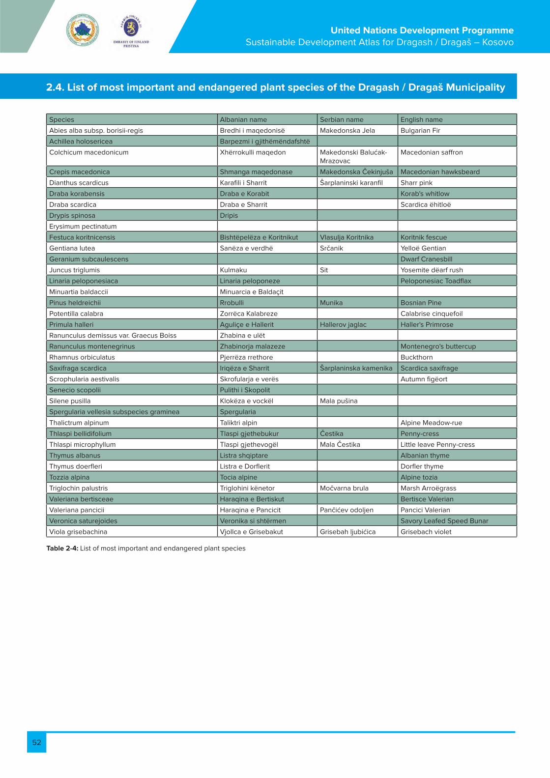
52
United Nations Development Programme Sustainable Development Atlas for Dragash / Dragaš – Kosovo
2.4. List of most important and endangered plant species of the Dragash / Dragaš Municipality
Species Albanian name Serbian name English name
Abies alba subsp. borisii-regis Bredhi i maqedonisë Makedonska Jela Bulgarian Fir
Achillea holosericea Barpezmi i gjithëmëndafshtë
Colchicum macedonicum Xhërrokulli maqedon Makedonski Balućak-Mrazovac
Macedonian saffron
Crepis macedonica Shmanga maqedonase Makedonska Čekinjuša Macedonian hawksbeard
Dianthus scardicus Karafili i Sharrit Šarplaninski karanfil Sharr pink
Draba korabensis Draba e Korabit Korab's whitlow
Draba scardica Draba e Sharrit Scardica ëhitloë
Drypis spinosa Dripis
Erysimum pectinatum
Festuca koritnicensis Bishtëpelëza e Koritnikut Vlasulja Koritnika Koritnik fescue
Gentiana lutea Sanëza e verdhë Srčanik Yelloë Gentian
Geranium subcaulescens Dwarf Cranesbill
Juncus triglumis Kulmaku Sit Yosemite dëarf rush
Linaria peloponesiaca Linaria peloponeze Peloponesiac Toadflax
Minuartia baldaccii Minuarcia e Baldaçit
Pinus heldreichii Rrobulli Munika Bosnian Pine
Potentilla calabra Zorrëca Kalabreze Calabrise cinquefoil
Primula halleri Aguliçe e Hallerit Hallerov jaglac Haller's Primrose
Ranunculus demissus var. Graecus Boiss Zhabina e ulët
Ranunculus montenegrinus Zhabinorja malazeze Montenegro's buttercup
Rhamnus orbiculatus Pjerrëza rrethore Buckthorn
Saxifraga scardica Iriqëza e Sharrit Šarplaninska kamenika Scardica saxifrage
Scrophularia aestivalis Skrofularja e verës Autumn figëort
Senecio scopolii Pulithi i Skopolit
Silene pusilla Klokëza e vockël Mala pušina
Spergularia vellesia subspecies graminea Spergularia
Thalictrum alpinum Taliktri alpin Alpine Meadow-rue
Thlaspi bellidifolium Tlaspi gjethebukur Čestika Penny-cress
Thlaspi microphyllum Tlaspi gjethevogël Mala Čestika Little leave Penny-cress
Thymus albanus Listra shqiptare Albanian thyme
Thymus doerfleri Listra e Dorflerit Dorfler thyme
Tozzia alpina Tocia alpine Alpine tozia
Triglochin palustris Triglohini kënetor Močvarna brula Marsh Arroëgrass
Valeriana bertisceae Haraqina e Bertiskut Bertisce Valerian
Valeriana pancicii Haraqina e Pancicit Pančićev odoljen Pancici Valerian
Veronica saturejoides Veronika si shtërmen Savory Leafed Speed Bunar
Viola grisebachina Vjollca e Grisebakut Grisebah ljubićica Grisebach violet
Table 2-4: List of most important and endangered plant species

53
United Nations Development Programme Sustainable Development Atlas for Dragash / Dragaš – Kosovo
2.5. Bird species of Dragash / Dragaš listed on the Annexes of EU Bird Directive
Species (ordered according to families) Species (ordered according to families)
Accipitriformes – Raptorial Birds Gruiformes – Flufftails and Crakes
Accipiter brevipes Crex crex
Accipiter gentiles Rallus aquaticus
Aquila chrysaetos Passeriformes - Passerines
Aquila heliaca Anthus campestris
Circus cyaneus Corvus corone cornix
Anseriformes - Waterfowls Corvus frugilegus
Anas platyrhynchos Corvus monedula
Caprimugliformes - Nightbirds Ficedula albicollis
Caprimulgus europaeus Ficedula parva
Charadriiformes – Waders and Gulls Ficedula semitorqua
Tringa totanus Lanius collurio
Ciconiiformes – Storklike Birds Lanius minor
Nycticorax nycticorax Lullula arborea
Columbiformes – Doves and Pigeons Luscinia svecica
Columba livia Melanocorypha calandra
Columba oenas Parus ater
Columba palumbus Pica pica
Sreptopelia decaocto Pyrrhocorax pyrrhocorax
Streptopelia turtur Pyrrhula pyrrhula
Falconiformes - Falcons Sylvia nisoria
Falco columbarius Troglodytes troglodytes
Falco naumanni Turdus merula
Falco peregrinus Turdus philomelos
Galliformes - Gamefowl Turdus pilaris
Bonasa bonasia Turdus viscivorus
Coturnix coturnix Piciformes - Woodpeckers
Perdix perdix Dendrocopos leucotos
Tetrao tetrix Dendrocopos major
Galliformes Dryocapus martious
Alectoris graeca Strigiformes - Owls
Asio flammeus
Bubo bubo
Table 2-5: Bird species of Dragash / Dragaš listed on the Annexes of EU Bird Directive
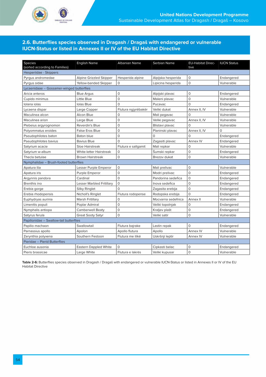
54
United Nations Development Programme Sustainable Development Atlas for Dragash / Dragaš – Kosovo
2.6. Butterflies species observed in Dragash / Dragaš with endangered or vulnerable IUCN-Status or listed in Annexes II or IV of the EU Habitat Directive
Species (sorted according to Families)
English Name Albanian Name Serbian Name EU-Habitat Direc-tive
IUCN Status
Hesperiidae - Skippers
Pyrgus andromedae Alpine Grizzled Skipper Hesperida alpine Alpijska hesperida 0 Endangered
Pyrgus sidae Yellow-banded Skipper 0 Lipicina hesperida 0 Vulnerable
Lycaenidaae – Gossamer-winged butterflies
Aricia anteros Blue Argus 0 Alpijski plavac 0 Endangered
Cupido minimus Little Blue 0 Maleni plavac 0 Vulnerable
Iolana iolas Iolas Blue 0 Pucavac 0 Endangered
Lycaena dispar Large Copper Flutura ngjyrëbakër Veliki dukat Annex II, IV Vulnerable
Maculinea alcon Alcon Blue 0 Mali pegavac 0 Vulnerable
Maculinea arion Large Blue 0 Veliki pegavac Annex II, IV Vulnerable
Plebeius argyrognomon Reverdin's Blue 0 Blistavi plavac 0 Vulnerable
Polyommatus eroides False Eros Blue 0 Planinski plavac Annex II, IV 0
Pseudophilotes baton Baton blue 0 0 0 Endangered
Pseudophilotes bavius Bavius Blue 0 Zagasiti plavac Annex IV Endangered
Satyrium acacie Sloe Hairstreak Flutura e sallgamit Mali repkar 0 Vulnerable
Satyrium w-album White-letter Hairstreak 0 Šumski repkar 0 Endangered
Thecla betulae Brown Hairstreak 0 Brezov dukat 0 Vulnerable
Nymphalidae – Brush-footed butterflies
Apatura ilia Lesser Purple Emperor 0 Mali prelivac 0 Vulnerable
Apatura iris Purple Emperor 0 Modri prelivac 0 Endangered
Argynnis pandora Cardinal 0 Pandorina sedefica 0 Endangered
Brenthis ino Lesser Marbled Fritillary 0 Inova sedefica 0 Endangered
Erebia gorge Silky Ringlet 0 Zagasita erebija 0 Endangered
Erebia rhodopensis Nicholl's Ringlet Flutura rodopense Rodopska erebija 0 Endangered
Euphydryas aurinia Marsh Fritillary 0 Mocvarna sedefnica Annex II Vulnerable
Limenitis populi Poplar Admiral 0 Veliki topolnjak 0 Endangered
Nymphalis antiopa Camberwell Beaty 0 Kraljev plašt 0 Endangered
Satyrus ferula Great Sooty Satyr 0 Veliki satir 0 Vulnerable
Papilionidae – Swallow-tail butterflies
Papilio machaon Swallowtail Flutura bajrake Lastin repak 0 Endangered
Parnassius apollo Apolon Apollo flutura Apollo Annex IV Vulnerable
Zerynthia polyxena Southern Festoon Flutura me ilikë Uskršnji leptir Annex IV Vulnerable
Pieridae – Pierid Butterflies
Euchloe ausonia Eastern Dappled White 0 Cipkasti belac 0 Endangered
Pieris brassicae Large White Flutura e lakrës Veliki kupusar 0 Vulnerable
Table 2-6: Butterflies species observed in Dragash / Dragaš with endangered or vulnerable IUCN-Status or listed in Annexes II or IV of the EU Habitat Directive
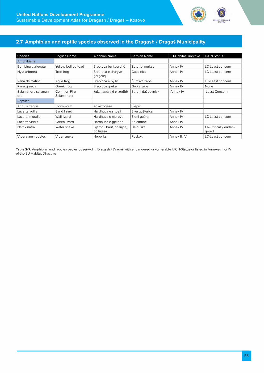
55
United Nations Development Programme Sustainable Development Atlas for Dragash / Dragaš – Kosovo
Table 2-7: Amphibian and reptile species observed in Dragash / Dragaš with endangered or vulnerable IUCN-Status or listed in Annexes II or IV of the EU Habitat Directive
Species English Name Albanian Name Serbian Name EU-Habitat Directive IUCN Status
Amphibians
Bombina variegata Yellow-bellied toad Bretkoca barkverdhë Žutotrbi mukac Annex IV LC-Least concern
Hyla arborea Tree frog Bretkoca e drunjve-gargaliqi
Gatalinka Annex IV LC-Least concern
Rana dalmatina Agile frog Bretkoca e pyllit Šumska žaba Annex IV LC-Least concern
Rana graeca Greek frog Bretkoca greke Grcka žaba Annex IV None
Salamandra salaman-dra
Common Fire Salamander
Salamandri zi e verdhë Šareni daždevnjak Annex IV Least Concern
Reptiles
Anguis fragilis Slow-worm Kokëzogëza Slepić
Lacerta agilis Sand lizard Hardhuca e shpejt Siva gušterica Annex IV
Lacerta muralis Wall lizard Hardhuca e mureve Zidni gušter Annex IV LC-Least concern
Lacerta viridis Green lizard Hardhuca e gjelbër Zelembac Annex IV
Natrix natrix Water snake Gjarpri i barit, bollujca, bollujësa
Belouška Annex IV CR-Critically endan-gered
Vipera ammodytes Viper snake Neperka Poskok Annex II, IV LC-Least concern
2.7. Amphibian and reptile species observed in the Dragash / Dragaš Municipality

56
United Nations Development Programme Sustainable Development Atlas for Dragash / Dragaš – Kosovo
Volume III: Assessment
Peter BankFlorian Bemmerlein-Lux
Ismail GagicaErgin Hajredini
Prof. Dr. Behxhet Mustafa – Ecologist
Prof. Fadil Millaku - Biologist
Dr. Halil Ibrahimi - Ecologist
Dr. Achim Milbradt – Biologist
Michael Voit - Rural Development Planner
Prof. Xhevdet Elezi - Soil scientist – agronomist
Arneni - National forest consultancy company, NGO
Finches – Ornithologists
Todd Wassel – Tourism Specialist
Bashkim Susuri – Journalist and Project Associate
Bardh Xerxa – Ecologist
Ajhan Hadzija – Tourism Coordinator
the Municipal Working Group of Dragash/Dragaš Municipality
and Deutsche Gesellschaft für Internationale Zusammenarbeit
(GIZ) GmbH, Rural Economic Development Programme.
Project ManagerMaria Elena Zuniga Barrientos
Dragash / Dragaš, Kosovo March 2013
With contributions from
United Nations Development Programme
Conservation of Biodiversity and Sustainable Land
Use Management in Dragash/Dragaš
57
United Nations Development Programme Sustainable Development Atlas for Dragash / Dragaš – Kosovo
Table of content
1. Assessment maps ............................................................................................................................................................................ 581.1. Assessment of biodiversity (A1) .................................................................................................................................................... 591.1.1. Assessment of vegetation and flora (A1.1) .................................................................................................................................. 591.1.2. Assessment of biodiversity - fauna .............................................................................................................................................. 601.2. Sharr/Šar National Park (A2) .......................................................................................................................................................... 621.3. Assessment of water resources .................................................................................................................................................. 641.3.1. Water regeneration, threats and quality (A3.1) .......................................................................................................................... 641.3.2. Water supply and threats (A3.2)..................................................................................................................................................... 651.4. Assessment of natural hazards (A4) ............................................................................................................................................ 661.4.1. Erosion risk (A4.1) .............................................................................................................................................................................. 661.4.1. Avalanche risk (A4.2) ....................................................................................................................................................................... 661.4.2. Landslide, rockfall and flood-prone areas risk (A4.3) .............................................................................................................. 691.5. Assessment of forest and agriculture (A5) ................................................................................................................................ 701.5.1. Conditions of forests (A5.1) ............................................................................................................................................................ 701.5.2. Forest functions (A5.2) .................................................................................................................................................................... 711.5.3. Productive capacity of soils (A5.3) ............................................................................................................................................... 721.5.4. Livestock and suitability for crops (A5.4) .................................................................................................................................... 731.6. Assessment of solid waste (A6) .................................................................................................................................................... 731.7. Assessment of cultural heritage and tourist potential (A7) .................................................................................................... 751.8. Assessment of health, medical services, and civil protection (A8) ...................................................................................... 761.9. Assessment of education (A9) ...................................................................................................................................................... 781.10. Assessment of economy, infrastructure, and energy (A10) ................................................................................................... 791.10.1. Roads and transportation (A10.1) ................................................................................................................................................... 811.10.2. Energy (A10.2) .................................................................................................................................................................................... 831.10.3. Businesses (A10.3) ............................................................................................................................................................................ 842. Annex ................................................................................................................................................................................................... 862.1. Assessment for water quality ........................................................................................................................................................ 862.2. Model for erosion risk ..................................................................................................................................................................... 912.3. Model for avalanche risk analysis ................................................................................................................................................ 942.4. Model for landslide risk ................................................................................................................................................................... 952.5. Assessment criteria for the forest functions............................................................................................................................... 962.6. Suitability of soils and recommendations for agricultural use .............................................................................................. 972.7. Electricity consumption spread .................................................................................................................................................... 101

58
United Nations Development Programme Sustainable Development Atlas for Dragash / Dragaš – Kosovo
The maps of step 2 show the results of an assessment process for the key fields. They depict the zones with resource potential or those with highly sensitive resources. Specifically, they are concerned with the following questions:- What are the present conditions of the resources? - What problems and constraints exist and at which sites or locations are they most pressing?
- How sensitive are the resources against adverse impacts or when they are utilised?- What are the development opportunities still available and where?The mapped challenges, potentials and development problems are the input for the next steps, the guidance maps and the strategic basis for the Municipal Development Plan.
A1 Assessment of biodiversity
A1.1 Assessment of biodiversity – vegetation and flora
A1.2 Assessment of biodiversity - fauna
A2 Extension of Sharr/Šar Mountain National Park
A2.1 Extension of Sharr/Šar Mountain National Park - ownership structure
A2.2 Extension of Sharr/Šar Mountain National Park - topographic map
A3 Assessment of water resources - regeneration, threats, and quality
A4 Assessment of natural hazards
A4.1 Assessment of natural hazards - erosion risk
A4.2 Assessment of natural hazards - avalanche risk
A4.3 Assessment of natural hazards - landslide risk and flood-prone areas
A5 Assessment of agriculture and forest
A5.1 Assessment of forest and agriculture - condition of forest
A5.2 Assessment of agriculture and forest - forest functions
A5.3 Assessment of agriculture and forest - productive capacity of soils
A5.4 Assessment of agriculture and forest - livestock and suitability for crops
A6 Assessment of solid waste
A7 Assessment of cultural heritage and tourist potential
A8 Assessment of health, medical services, and civil protection
A9 Assessment of education
A10 Assessment of economy, infrastructure, and energy
A10.1 Assessment of economy, infrastructure, and energy – roads and transportation
A10.2 Assessment of economy, infrastructure, and energy – energy
A10.3 Assessment of economy, infrastructure, and energy – businesses
Table 1 1: List of assessment maps
1. Assessment maps
59
United Nations Development Programme Sustainable Development Atlas for Dragash / Dragaš – Kosovo
Contents of the map:
Ecologically important habitats and plant species (as background the land use is used). In detail: • The mapped vegetation that is mentioned in Annex 1 of the European Habitat (see volume II of the SDA, section 2.8, Table 12: Plant Communities of Dragash / Dragaš listed in Annex I of EU-Habitat-Directive (EU 2007)• Specific area with high potential for plant biodiversity (coppice forest, other old forests with natural regenera-tion, sparsely vegetated areas and high mountain rocks and wetlands)• Habitat points with an evaluation of the observed plants with their protection categories according to recent studies in Dragash/Dragaš and in terms of international settings. Points of species include those that are: o In one of the EU annexeso IUCN categorieso In some Kosovo text with protection categoryo Endemic (Kosovo, Balkan, SE Europe)
The main messages:
The map highlights the existing status (rareness) of mainly forests, rangelands, and wetlands. It allows the definition of potential protected areas requiring protection in order to preserve their ecological functions and services according to the Law of Nature Protection (i.e. strict nature reserve, special areas – SPAs and SAC, nature monuments and protected landscapes) and the zoning of the National Park as part of the National Park Management Plan.The pattern of the map clearly shows that most of the outstanding ecological areas are within the proposed extension of the Sharr/Šar Mountain National Park. It confirms the findings of (and adds considerable detail to) the Preliminary identification of Natura 2000 Sites in Kosovo (Mustafa et al. 2009).The coppice forests and extensive pastures and dry grasslands also have a very high value for biodiversity. However, these vegetation types are dependent on (traditional) land use management. The vegetation and floristic resources are part of the information for an overall conservation strategy and will be combined with the faunistic assessment and ecological functions of forests to provide overall guidance for nature conservation. The definition of different kinds of protected areas according to the Law of Nature Protection and the zoning of the Sharr/Šar Mountain National Park and can be based on this assessment.
1.1. Assessment of biodiversity (A1)
1.1.1. Assessment of vegetation and flora (A1.1)
Table 1 2: Area and percentage of habitat types mapped, which are protected according to EU Flora-Fauna-Habitat Directive
Habitat types protected acc. to EU Flora-Fauna-Habitat Directive
Vegetation Annex I Annex I* (Priority habitats) Total in ha
Forests 2.933,9 397,1 3.331,1
In % of the Municipality 6,7% 0,9% 7,6%
Grasslands 1.483,8 13,9 1.497,7
In % of the Municipality 3,4% 0,0% 3,4%
Pastures 24,7 611,3 636,0
In % of the Municipality 0,1% 1,4% 1,5%
Rocky areas 597,7 9,1 606,9
In % of the Municipality 1,4% 0,0% 1,4%
Shrub and/or herbaceous vegeta-tion
107,5 107,5
In % of the Municipality 0,2% 0,0% 0,2%
Wetland, Water Bodies 66,5 66,5
In % of the Municipality 0,2% 0,0% 0,2%
Total area mapped 5.214,1 1.031,4 6.245,6
In % of the Municipality 12,0% 2,4% 14,3%


60
United Nations Development Programme Sustainable Development Atlas for Dragash / Dragaš – Kosovo
Table 1 3: Area and percentage of vegetation types / land uses with high potential for plant biodiversity
Specific areas with high potential for plant biodiversity
Surface outside habitat types listed in Annex I EU Flora-Fauna-Habitat Directive (in ha)
In % of Dragash / Dragaš Territory
Forests with natural regeneration 1.023,4 2,3%
Coppice forests and shrubland 4.785,2 11,0%
Semi-natural open vegetation 17.071,2 39,2%
Characterised by rocks and gravel 694,6 1,6%
Total area with high potential 23.574,5 54,1%
Reference list No. of plant species found in Dragash/Dragaš territory listed
IUCN Red List (categories near threatened or vulnerable) 2
EU Flora-Fauna-Habitat Directive – Annex II 4
EU Flora-Fauna-Habitat Directive – Annex V 2
Recommended for upcoming Kosovo Red List 119
Total no. of plant species identified during field work 438
Table 1 4: Numbers of important plant species
Data sources, material and reliability:
Mustafa B. 2011 dhe 2012, Arneni 2011, Millaku F. et al. 2011, Mustafa B. dhe H. Ibrahimi 2009, Pierre Galland et al. 2010, EU 2007, Mustafa B. et al. 2009
Further suggestions for monitoring and/or improvement of data:
Restrictions:
The systematic investigation covered only some parts of the Municipality with a focus on the subalpine and alpine region.
The spatial information about vegetation types (Rexhepi 1994) was lost during the conflict. Despite of the need for scientific investigation of the whole Municipality, the findings are sufficient to underline the extraordinary biodiversity of this part of the Sharr/Šar mountain chain.
For an environmental protection concept of the whole municipality, especially for a management plan for the National Park, a detailed and complete vegetation map (scale 1:25.000) would contribute additional relevant details of populations and their distribution.
Contents of the map:
The map considers the distribution of animals with an evaluation of their protection categories (endemism, rareness) according to recent studies in Dragash/Dragaš and in terms of international settings.• Bear, Lynx and chamois habitats and relevant ecological corridors • Birds, aquatic insects, butterflies • Other species (no systematic inventories)• Areas with a structural diversity relevant for a high faunistic biodiversity such as extensive grassland in the subalpine and alpine level for butterflies and other insects, areas for highly specialised species like scree and rock formations, and high structural diversity like multi layered forests and/or open land with hedges, single trees and terraces.
The main messages:
About 94% of the municipality provides habitats for mammals, birds and butterflies according to the European Habitat Directive (including the Birds Directive – EU 2007 and 2009). Apart from the alpine habitats for Chamois, the subalpine, high mountain forests, and the ecotone of the forest-grassland transition are ecological corridors for lynx, bear, and wolf connecting the mountain ranges of the Sharr/Šar Mountain National Park with the mountains of FYR Macedonia and Albania. It confirms the findings of (and adds considerable detail to) the preliminary identification of Natura 2000 Sites in Kosovo (Mustafa et al. 2009). The faunistic resources are part of the information that forms the basis of the proposal to extend the National Park and the future definition of different kinds of protected areas and species according to the Law of Nature Protection (strict nature reserve, special areas – SPAs and SAC, nature monuments and protected landscapes). Ecological corridors play an important role in allowing free movement of species from one site to another and constitute part of the existing ecological network.
1.1.2. Assessment of biodiversity - fauna
61
United Nations Development Programme Sustainable Development Atlas for Dragash / Dragaš – Kosovo
Data sources, material and reliability:
Mustafa B. and H. Ibrahimi 2009, Pierre Galland et al.2010, FINCHES (NGO) 2011, Ibrahimi H. 2011a, Ibrahimi H. 2011b, EU 2007 and 2009, Strauss, A. and Pezold, T. (compilers) (2009), Mustafa B. et al. 2009
Further suggestions for monitoring and/or improvement of data:
Restrictions:
The faunistic data is incomplete because no systematic inventories exist. While acceptable data exists for large
mammals according to village surveys and information from the National Park Directorate (and from NGO Finches for birds), hardly any locatable information (nor species’ lists) exist for reptiles, amphibians, small mammals, fish and insects. It is expected that the area contains considerable potential for the discovery of further endangered species
Reference list Big mammals Birds Reptiles Amphibians Butterflies Aquatic inverte-brates
IUCN Red List (categories near threatened or vulner-able)
4 2 ¹ 26
EU Flora-Fauna-Habitat Directive – Annex II
4 2 4
EU Flora-Fauna-Habitat Directive – Annex IV
1 4 5 3
EU Birds Directive (An-nex I)
33
Rareness in Kosovo (Rare, threatened or endan-gered)
1 30² 12 23 3³
Protected by Kosovo Laws
2
Total no. of species identi-fied 2011/12
5 154 8 5 44 6
Table 1 5: Number of animal species recorded within the Municipality during the studies 2011/12
¹ Critically endangered ² rare ³ Very rare species, 2 of them most probably new for Kosovo


62
United Nations Development Programme Sustainable Development Atlas for Dragash / Dragaš – Kosovo
Contents of the map:
• Ownership structure • Topographic map of Dragash/Dragaš Municipality with the border of the Sharr/Šar National Park
The main messages:
The Sharr/Šar National Park in Dragash/Dragaš covers 24.206 ha (55,5% of the Municipality’s territory). Outside of the park will be 19.375 ha (44,5%). There is no arable land within the park (see Figure 1 4). • 20.917 ha of the National Park are high mountain and alpine areas (higher than 1.650 m) and by nature only suitable for extensive grazing, forest and non-wood product collection and tourism. • 2.671 ha are between 1.350 and 1.650 m of altitude suitable for
Data sources, material and reliability:
Criteria for definition of the National Park Boarders (Bank et al. 2011):The core area was identified according to its natural and landscape values and features, in addition to cadastral and property information and the latest aerial photos. In order to establish a clear and unambiguous border, determination has been undertaken at a scale of 1:5.000 applying the following criteria:(1) Core area of the National Park is formed by the SoE owned land (Sharr Prodhimi/Šarproizvod) and connected public forest
extensive pasture management and • 563 ha below 1.350 m are near watercourses, forest or land that is not suitable for agriculture. • For 59 ha information on altitude is not available.All possible uses and restrictions inside the park and its buffer zone have to be defined in a separate manage-ment plan. The law on the National Park “Sharri”, is declared on December 2012 by Assembly of the Republic of Kosovo). The border is used in all assessment maps to provide the spatial information for assessing the influence of the National Park.The ownership structure of the park is 82,8% (= 20.033 ha) former Socially Owned Enterprise (SoE) owned land, 11,5% (=2.794 ha) public land, 3,5% (=841ha) private land, and for 2,2% (=539 ha) of the parks territory are no cadastral data available
areas / public land. These areas also have high biodiversity and nature protection value.(2) Additional areas are included in the National Park when one or more of the following pre-conditions are fulfilled:a) Known or probable hot-spots of biodiversity or high natural and landscape values outside the areas mentioned under (1)b) Private properties surrounded by areas under (1) are included.
Further suggestions for monitoring and/or improvement of data:
Restrictions:
1.2. Sharr/Šar National Park (A2)
Figure 1 3: Sharr/Šar Mountain National Park border (Republic of Kosovo 2012)

63
United Nations Development Programme Sustainable Development Atlas for Dragash / Dragaš – Kosovo
Figure 1 4: Area inside and outside the planned Sharr/Šar Mountain National Park in Dragash / Dragaš Municipality
Figure 1 5: Ownership structure inside and outside Sharr/Šar Mountain National Park in Dragash / Dragaš Municipality


64
United Nations Development Programme Sustainable Development Atlas for Dragash / Dragaš – Kosovo
Contents of the map:
The status of water resources, their quality and threats • Watershed and sub-watershed boundaries, rivers and creeks, lakes• Areas relevant for protection, regeneration and storage of water resources (wetlands, forests, buffer zones)• Quality of surface water (biological quality, water analysis (BOD) Kosovo Institute of Health 2012) • Rivers/rivulets with insignificant or no water flow in dry years• Threats to quality and quantity of water resources
The main messages:
This map contains those features of the municipality’s surface water resources that are relevant for sustainable development. “Ecologically important areas” related to wetlands/open water cover 1.892 ha (4,3%) of the Dragash/Dragaš area. According to Article 55 of the Law of Nature Conservation the protection of wetlands is stated as:1. The wetlands including waters, in the meaning of this Law represents the nature values and for this they should be conserved in a natural or in a near nature state. 2. For the case of wetlands protection, including waters which are not regulated by this Law, shall apply the provisions of special acts. 3. Any natural lake and pond, nearby the embankments larger than 0, 01 ha, natural and artificial marsh measuring more than 0,25 ha, spring and ravines in riparian of two (2) meters, in the meaning of this Law represent the ecologically important area.The map includes areas that are geologically suitable for regeneration and storage of water resources, all forests as well as all surface waters with a buffer of 20 m (see Table 1 6). The planned subalpine and alpine region of the National Park are especially important for clean water supply.
Water quality:
Two exemplary field surveys using a biological indicator system - one conducted during the wet season and one during the dry season - showed that 36% of the 45 sampled sites had fair to very poor quality and 64% excellent to good quality in the wet season. The BOD measurements from the Kosovo Hydro-meteorological Institute 2012 confirm the integrated water quality assessment (see Ibrahimi 2011b and 2012 and UNDP, 2012b) (see Table 2 3).• Opojë/Opolje region: Pollution by sewage is significant. River strips downstream from settlements are generally polluted by organic load from those settlements. The most severe pollution can be observed in the Pllava River downstream from the village of Zaplluxhe/Zaplužje up to the last sample point downstream of Rrenc/Renc. The Waste Water Treatment Plant currently under construction downstream from Kosavë/Kosavce village will only reduce additional incoming load to the Pllava River from Kapre
River. This might positively affect the water quality of the Pllava River downstream of Zym/Zjum village. • Brezna/Brezne does not have a direct water-carrying body. The water drains into Lake Brezna and from there drains through the karst to the Prizren River basin. • Gora/Gorë Region: The Restelica River is also significantly polluted. However, self-purification results in good water quality from Kruševo/Krushevë downstream. The Brod River has very good to good quality. • During field surveys on water resources undertaken by UNDP in spring 2011, uncontrolled discharge points of waste water to the rivers were mapped. Some of these belong to companies releasing untreated waste water to the surface water bodies. These locations are marked.• Most of the river stretches from the settlements and downstream are polluted by solid waste. Rehabilitation is required for heavily polluted river stretches. Rehabilitation is only sustainable if mechanisms are developed to prevent any further pollution. • In corridors with high soil erosion potential along rivers there is a threat of pollutants (agrochemicals) and nutrients draining to the rivers. Buffer zones with undisturbed vegetation and erosion control should be in-stalled. • Septic tanks, more small effluent treatment plants and managed sewer systems are the requirements for reducing pollution. This refers not only to private households but especially to small industry (REMATEX wool factory in Dragash/Dragaš town, MEKKA meat factory in Pllavë/Plava and all car repair, car wash sites and petrol stations).
Data sources, material and reliability:
• Locations of water quality assessments for biological and chemical parameters: Table 2 3, Table 2 4 and Table 2 5, in Annex 2.1 • Ibrahimi, 2011b and 2012 • Field survey of springs and water sources • UNDP, 2012b• Kosovo Hydro-meteorological Institute, 2012
Further suggestions for monitoring and/or improvement of data:
Since the competent authorities have not provided any spatial data (and environmental impact assessments) of the planned small hydropower projects, this planning data is not included. Any divergence of water may reduce the legally required biologically minimum flow in the dry seasons. This data, as well as average water flow / month, should be added to the information base.
1.3. Assessment of water resources
1.3.1. Water regeneration, threats and quality (A3.1)
Area in ha In % of Dragash/Dragaš Municipality
Rocks with potential for ground water 11.482 ha 26,5%
Wetlands 1.889 ha 4,4%
Forests with water regulation function 2.200 ha 5,1%
Table 1 6: Important areas for water regeneration
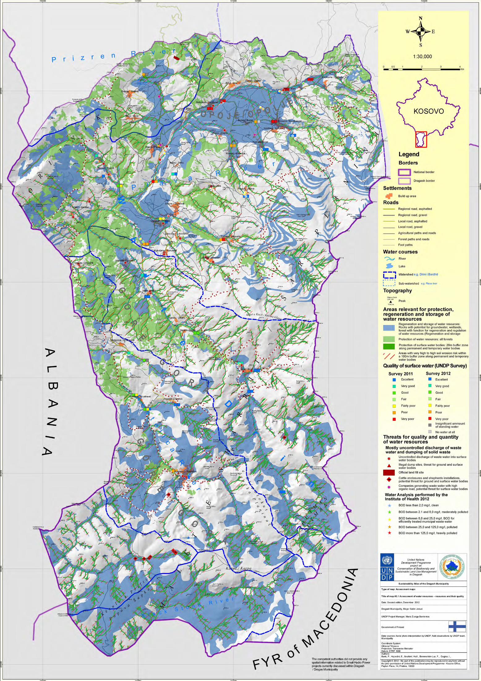

65
United Nations Development Programme Sustainable Development Atlas for Dragash / Dragaš – Kosovo
Contents of the map:
Highlighting quality of water supply and threats • Current and planned water supply installations (extraction points, reservoirs, springs)• Sensitive zones for water supply (such as abstraction points and their buffer zones)• Threats of quality of water supply (compliance with standards)• Waste water management
The main messages:
There is one water treatment facility in the Municipality (in Dragash / Dragaš town). A new facility is planned (also for Dragash / Dragaš town).
Waste water installations:14 (39%) of Dragash/Dragaš municipality’s villages have a sewage system, 14 are not connected to a sewer system and 8 are only partially connected. 31 of the villages (86%), irrespective of whether they have full, partial or no sewage connection, report problems (UNDP 2012: Field survey).The villages that are not connected are: Bellobrad/Belobrad, Blaç/Bljać, Bresanë/Brodosavce, Brezne/Brezna, Brod/Brod, Buçe/Buće, Buzez/Buzez, Dikance/Dikanc, Dragash/Dragaš, Globočica/Glloboçicë, Ljubo-vište/Lubovishtë, Mlike/Mlikë, Orčuša/Orçushë, and Xërxe/Zrze. The number of households without sewage connection is therefore 2476, around 39% of the municipality population (13,084 persons). The villages that are partially connected are: Brrut/Brut, Kosavë/Kosavce, Krstec/Kërstec, Kuk/Kukovce, Ku-kuljane/Kukulanë, Pllajnik/Plajnik, Pllavë/Plava and Rapča/Rapçë. This affects around 20% of the municipal population (6640 inhabitants; 1251 households). Waste Water Management is almost absent in Dragash/Dragaš Municipality. Domestic waste water is discharged to surface water or groundwater without treatment (see map/
For drinking water supply: • Abstraction points for drinking water (160 identified for the Water Master Plan) need at least a buffer zone of 300 m that prevents direct pollution and disturbance of the sources. • 3 extraction points of river water for drinking water supply in the Opojë/Opolje Region need special attention for protection against pollutants in their catchment areas.• The drinking water is stored in reservoirs. The quality of these reservoirs was examined during a field survey (UNDP, 2012b). 18 out of 66 reservoirs are not compliant with microbiological and/or chemical standards in Kosovo (see Table 1 7 and Table 2 4).
Figure 1 8 for mapped discharge points). The main pollutants of concern include organic and inorganic pollutants, nitrogen and phosphorus compounds, heavy metals and pathogenic bacteria and viruses. Organic pollutants include organic solvents, cleaners and degreasers and other toxic organics. Currently a waste water treatment plant is being constructed at Kapre River, downstream from the village of Kapre/Kapra. The villages of Kuk/Kukovce, Kosavë/Kosavce, Buzez/Buzez and Kapre/Kapra will be connected to this facility, which will serve four out of 27 villages, with a total of 3335 (2011) inhabitants or approximately 10% of the population of the municipality.
Data sources, material and reliability:
• Locations of water quality assessments for biological and chemical parameters: Table 2 3, Table 2 4 and Table 2 5, in Annex 2.1 • UNDP 2012: Field survey of springs and water sources • UNDP, 2012b• Kosovo Hydro-meteorological Institute, 2012
Further suggestions for monitoring and/or improvement of data:
Water monitoring throughout Kosovo is poor and there is no proper hydrological data. The data for specific pollutants with pollutant concentrations and discharge information is not available.
1.3.2. Water supply and threats (A3.2)
Village Non compliance
Bellobrad / Belobrad 3 of 12 are non-compliant with Kosovo standards
Dragash / Dragaš 1 nga 1
Kosavë / Kosavce 3 nga 4
Kuklibeg / Kukljibeg 1 nga 1
Kukuljane / Kukulanë 1 nga 1
Leštane / Leshtan 1 nga 1
Zlipotok / Zlipotok 1 nga 3
Table 1 7: Non-compliance of water quality in reservoirs
⁴ Data from Village Survey Results, based on official population estimates from 2008.

66
United Nations Development Programme Sustainable Development Atlas for Dragash / Dragaš – Kosovo
Contents of the map:
The map depicts the erosion risks based on the sensitivity of soils. Included are potentially unstable soils along roads (using the width of the road). The zones of soil erosion risk are a function of:- soil types and texture, - precipitation,- slope properties, - current land use management, and - vegetation cover.
The main messages:
The map allows identification of zones in need of soil stabilisation measures and appropriate land manage-ment/land use forms. Taking erosion risk into consideration is especially relevant for agriculture and pasture management and for any construction activity. The assessment should have consequences for the prevention measures of road repair and construction, and for the planning of reforestation activities. The main agricultural areas of Opojë/Opolje exhibit only low to medium risk of erosion. However, careful man-agement of intensive pastures and arable fields is required. This includes the maintenance/preventing destruction of terraces and hedges in land used for agriculture. Soil erosion risk is equally low in the high elevated grasslands of the Sharr/Šar Mountains which are characterised by slight slopes. The main areas of very high soil erosion risk are located along the steep slopes of the valleys of the Sharr/Šar Mountains and at Mount Koritnik.Figure 1 10 shows that soil erosion risk does not depend significantly on the altitude of the terrain. However, in the arable areas below 1.300m above sea level high and very high soil
erosion risk is slightly lower than in the more elevated areas. Figure 1 11 shows, that within the cadastral zones of Bačka / Baçkë, Brod / Brod, Krstec / Kërstec, Orčuša / Orçushë, Radeša / Radeshë, and Rapča / Rapçë soil erosion risk is highest with a total share of very high and high risk areas in more than 60% of the cadastral zone; the average for the municipality is 53,4% of very high and high risk areas. On the other hand over 70% of the cadastral zones of Bellobrad / Belobrad, Buzez / Buzez, Dragash / Dragaš, Kapre / Kapra, Pllavë / Plava, and Zym / Zjum only exhibit moderate or low soil erosion risk.The villages of Restelica / Restelicë, Pllavë / Plava, Blaç / Bljać, Brrut / Brut, Globočica / Glloboçicë, and Radeša / Radeshë are prone to soil erosion in their close vicinities. This fact should be considered during further spatial development of these settlements.
Data sources, material and reliability:
The model is outlined in the “Model for erosion risk“” (Annex 2.2) (EULUP 2011)
Further suggestions for monitoring and/or improvement of data:
The quality of the risk analysis is highly dependent on the reliability of the input data. In particular, the soil map available is of limited reliability due to its small scale. Analysis could be significantly improved using more detailed soil data.
1.4. Assessment of natural hazards (A4)
1.4.1. Erosion risk (A4.1)
Figure 1 10: Soil erosion risk in the different altitude classes


67
United Nations Development Programme Sustainable Development Atlas for Dragash / Dragaš – Kosovo
Contents of the map:
The map depicts the avalanche risk based on a model using:- Steepness- Wind direction in combination with ridges and depressions- Exposition- Length of the slope and diversity of landforms - Vegetation, particularly forest / non forest
The main messages:
Avalanche risk is highest in the mountain areas and needs to be taken into consideration if winter sport installations are planned. Nevertheless the following points for the settlement area and roads are important and should be considered seriously:- Restelica/Restelicë is the settlement with the highest and most extended avalanche risk in Dragash/Dragaš- Most of the other villages are only at medium risk for wet snow avalanches. Only in Blaç/Blać are there smaller areas with high risk. Other villages with high risk zones are at least partly protected by forest.- Roads from Globočica/Glloboçicë – Restelica/Restelicë and Dikanc/Dikance – Bačka/Baçkë – Brod and the connection roads between Kosavë/Kosavce, Xërxe/Zrze, and Pllajnik/Plajnik are at risk. The forests along these roads need very careful protection (see also forest function assessment in Figure 1 22: Assessment of the forest functions (A5.2)) and/or reforestation. - Existing avalanche protection forest should be protected, well-managed, and expanded.- The MDP should foresee for afforestation in medium and high risk areas around the villages where soil conditions allow for planting forest trees.- For short term protection or in areas where afforestation is not possible, technical protection measures are advisable.- Control of intentional and unintentional burning of bushland, heathland, and Juniperus communities (community initiatives and control).- The MDP should assign village expansion only to areas which
are not affected by avalanche risk.Figure 1 13 shows the amount of avalanche risk within the territory of the municipality:- A total of 1.185ha shows an increased high risk of avalanches due to NW to NE-exposition and slopes steeper than 30 degrees; out of these, 801 ha are not protected by forest.- An additional 1.774ha show a high risk of avalanches, out of which 1.344ha are not protected by forest.- 4.223ha show an increased potential risk due to NW to NE-exposition and slopes between 20 and 30 degrees, of which 3.004ha are not protected by forest.- 6.867ha show a potential risk; of this, 5.333ha are not protected by forest.Figure 1 14 gives an overview on the situation in direct vicinity (300m radius) of the settlements:- A total of 185ha shows a high risk or an increased high risk, of which 141ha are not protected by forest.- A total of 855ha shows potential risk, of which 647ha are not protected by forest.
Data sources, material and reliability:
The model is outlined in “Model for avalanche risk analysis” (Annex 2.3), http://www.powderguide.com/de/mountain-knowledge/basics/article/mountain-knowledge/The model applied only identifies the regions where avalanches can be triggered. The areas where avalanches can pass or hit are not identified by the model.
Further suggestions for monitoring and/or improvement of data:
In case of Restelica/Restelicë detailed analysis has been executed by an Austrian team. Similar analysis should be executed for other high risk areas (villages and important roads).
1.4.1. Avalanche risk (A4.2)
Figure 1 11: Soil erosion risk within the cadastral zones of Dragash / Dragaš Municipality


68
United Nations Development Programme Sustainable Development Atlas for Dragash / Dragaš – Kosovo
Figure 1 13: Avalanche risk areas within the Municipality
Figure 1 14: Avalanche risk areas within 300m distance from settlements


69
United Nations Development Programme Sustainable Development Atlas for Dragash / Dragaš – Kosovo
Contents of the map:
The map depicts the landslide, rockfall and flood prone area risks based on models using:• Slope• Quaternary sediments• Sparsely vegetated areas / rock• Rock type• Sparsely vegetated areas - Flood prone areas – according to communication with villages- Fire prone areas – according to communication with villages
Data sources, material and reliability:
The model is outlined in “Model for landslide risk” (Annex 2.3)The model applied only identifies the regions where landslides or rockfall can originate. The areas where landslides or rockfall can pass or hit are not identified by the model.
The main messages:
Landslide and rockfall risks occur mostly in the higher mountain areas, in the unpopulated subalpine and alpine areas, and can be relevant for hikers and shepherds. Nevertheless there are high risks close to roads and settlements in Blaç/Blać, around Restelica/Restelicë and between Dikanc/Dikance and Brod.Table 1 8 shows the length of local and regional roads prone to landslides or rockfall.Flood prone areas are not very pronounced in the municipality and flooding is rare. Fire prone areas are not based on a systematic inventory and are incomplete. Bushland and badly managed forests and pine plantations are prone to fire, especially in the hot and dry climatic situations during the summer. The risk of self-incineration is low, but the habit of burning harvested fields and high mountain heathland poses a serious problem.
Further suggestions for monitoring and/or improvement of data:
A systematic inventory of fires is required, since the available data is very incomplete and based on information from local village residents.A systematic inventory of road segments exposed to rock fall is required, since GIS-based analysis does not sufficiently reflect the risk.
1.4.2. Landslide, rockfall and flood-prone areas risk (A4.3)
Crossing bare rock areas Crossing sparsely vege-tated areas
Crossing torrent beds prone to landslide
Volumi potencial vjetor i vjelur / m3
Local roads 235m 7.595m 96m 5 358
Regional roads 47m 2.480m 51m 4 879
Table 1 8: Roads exposed to landslide and rock fall risk


70
United Nations Development Programme Sustainable Development Atlas for Dragash / Dragaš – Kosovo
Contents of the map:
The map shows the age structure of the public and private forests and gives basic information about the man-agement classes, including areas with a high density of degraded forests
The main messages:
Hundreds of years of pasture has left about 17,1 % remaining of the original forested area of Dragash/Dragaš Municipality (8.124 ha), mainly in the North Western part of the area. 5.199 ha of all the forests are public (64 %) including the outstanding old Bosnian Pine forest in Koritnik, which is over 70 years old. Of this forest on Koritnik mountain, 1.160 ha are part of the planned National Park and one of the biodiversity highlights in the Municipality. The private forest (2.925 ha) is mainly coppice forest (2.814 ha) and an important source of firewood for the community. The total area of coppice forest is 4.048 ha.Plantations cover 211 ha (approximately 3 % of the total forest area) in only a small areas north of Dra-gash/Dragaš.The 2.462 ha of forests on thin soils need special care in forest
management in order to prevent erosion and maintain their water retention capacities. 18 ha of forest are degraded due to illegal harvesting, forest fires or other unspecified reasons.The mixed forests, forests over 70 years old, and the alpine forest-grassland transition at the treeline are habitats for Bear and Lynx and form part of their regional ecological corridors.
Data sources, material and reliability:
Arneni, N.SH.T (2011), MAFRD-KFA (2009, 2010a and b)
Further suggestions for monitoring and/or improvement of data:
The soil – forest relation, especially the thin soils, should be verified with filed investigations. Potential sites for priority reforestation should be derived from the risk assessment maps (Figure 1 12, Figure 1 15 and Figure 1 16)
1.5. Assessment of forest and agriculture (A5)
1.5.1. Conditions of forests (A5.1)
Management unit Harvesting Incomes in Euro Expenses of harvesting and extraction
Net annual Income in Euros Potential Volume annually harvested/ m 3
Koritniku II 229 858 83 067 146 791 5 358
Opoja 184 685 55 085 129 600 4 879
Bredhiku 260 717 80 553 126 164 7 104
Sum 675 260 218 705 402 555 17 341
Private Forest 92 925 35 407.74 57 517.3 4425.97
Total 768 185 254 112.74 514 072.3 21 766.97
Table 1 9: Income from forest harvesting in both public/private sectors
Table 1 10: Job opportunities in thinning and cleaning
Municipalities Area for thinning Norms (man days)Harvesting/Extraction/Transport
Total working man-days
Dragash/Dragaš 2 000 ha 606 400 200 1 206
Figure 1 17: Property situation in Dragash / Dragaš forests (in ha)
Figure 1 18: Age classes in Dragash / Dragaš forests (in ha)
Figure 1 19: Specific management requirements in Dragash / Dragaš forests (in ha)


71
United Nations Development Programme Sustainable Development Atlas for Dragash / Dragaš – Kosovo
Municipalities Area for thinning Norms (man days)Harvesting/Extraction/Transport
Total working man-days
Contents of the maps:
The forest functions covering:• Wood production (firewood, valuable timber, collection of non-wood products)• Protection function (soil erosion, avalanches, rockfall and landslides)• Biodiversity • Water regulation and water supply
The main messages:
The forest functions are tools to identify and better address specific roles and values of forests in order to maintain or enhance their effectiveness and capacity. The forest functions are comparable with the principle of High Conservation Value Forests (HCV) under FSC.Of the 8.124 ha of forest, only 230 ha have no dedicated function (3%) (refer to Figure 1 21)Forest management practices have to consider not only the productive functions, but also the protection, biodi-versity, and
water regulation functions. The information is used for the guidance for forest development and spatial resistance, including natural risk prevention, which is relevant for settlement and traffic planning and for the National Park Management Plan.
Data sources, material and reliability:
The criteria for assessment are listed in Annex 2.3; Forest functions are set into relation to the HCV types in Table 1 11.Arneni, N.SH.T (2011), MAFRD-KFA (2009, 2010a and b)
Further suggestions for monitoring and/or improvement of data:
The data for public forest is of a high quality (see Arneni, N.SH.T, 2011, MAFRD-KFA, 2009, 2010a and b) and allows a reliable assessment of the functions. The areas with a biodiversity function may increase if more intense research finds further floristic and faunistic specialities.
1.5.2. Forest functions (A5.2)
Table 1 11: Classification of forest functions
Figure 1 21: Forest area dedicated to the various forest functions (in ha)
Function Ecosystem service / Specification Example Related HCV Type
Wood production That portion of gross production extractable as raw material
Production of lumber, or fuel / fire wood
HCV 5 (fire wood)
Production of non-wood products That portion of gross primary pro-duction extractable as raw materials or primary products.
Production of fish, game, crops, nuts, fruits by hunting, gathering, subsistence farming or fishing
HCV 5
Erosion control and sediment reten-tion
Retention of soil within an ecosys-tem
Prevention of loss of soil by wind, runoff, or other removal processes, storage of silt in lakes and wetlands
HCV4
Hazard protection Protection against avalanches, land-slides and rock fall
Forest on slopes of 20 degrees and more provide good protection against avalanches
HCV4, HCV5
Biodiversity Habitats for globally, regionally and locally important plant and animal species, species-rich habitats (or habitat complexes)
Nurseries, habitat for migratory species, regional habitats for locally harvested species, or over winter-ing grounds.
HCV1, HCV2, HCV3
Water regulation and water supply Regulation of hydrological flows, Storage and retention of water
Provision of water for human consumption in good quality and quantity
HCV4
Cultural (not assessed in SDA) Providing opportunities for non-commercial uses.
Aesthetic, artistic, educational, spir-itual and scientific activities.
HCV6


72
United Nations Development Programme Sustainable Development Atlas for Dragash / Dragaš – Kosovo
Contents:
Suitability of soils according to:• Prolificacy II2 – III1 (best) to VII1 - VIII2 (major restrictions)• Intensive pasture• Extensive pasture
The main messages:
From 8 classes of prolificacy there is no class I, but class II, class III, class V, class VI, class VII, and class VIII (Elezi 2011 and “Suitability of soils and recommendations for agricultural use” Annex 2.6). • Suitability with minor restriction: Prolificacy classes II and III. All the planned agricultural cultures can be cultivated in these soils, with little or high potential of mechanisation. • Suitability with more expressed restrictions: Prolificacy class V (class IV is absent). All the planned agricultural cultures
Data sources, material and reliability:
Municipality of Dragash/Dragaš-Agriculture Department, 2011, Elezi 2011,
can be cultivated in these soils, but only little possibility of mechanisation.• Suitability with many restrictions: Prolificacy class VI. Although these lands have extensive restrictions, they are traditionally used for production of cattle food (hay) and/or as extensive pastures. • Suitability with extensive restrictions: Prolificacy classes VII and VIII. No cultivation is feasible and they are usually used as green grazing pastures.Generally the crop productivity in the territory of the municipality is very extensive in almost all types/classes of soil. This is due to the limited fertility (productive capacity) and topography which puts considerable restrictions on agricultural productivity/mechanisation. Additionally there is a low level of investment, low level of machinery, and non-market orientation (production mainly for the local needs).
Further suggestions for monitoring and/or improvement of data:
The sites with fertiliser and pesticide application are only rudimentary (incomplete community-based information).
1.5.3. Productive capacity of soils (A5.3)
Figure 1 23: Suitability of soils (in ha)
According to the Municipality of Dragash/Dragaš-Agriculture De-partment (2011) the following agricultural land use is documented:
Arable field Meadows Pastures Mountain pas-tures
Total
3.596,79 5.196,20 26.042,00 6.424,76 41.259,75
9% 13% 62% 16% 100%


73
United Nations Development Programme Sustainable Development Atlas for Dragash / Dragaš – Kosovo
Contents:
The map highlights the areas• suitable for crops (below 1300 m and less than 30º slope in 4 categories) • suitable for pastures (below 1600 m - 3 categories)• suitable for extensive pasture above 1600 m• for each village: ha of arable land, ha of heterogeneous arable land, ha of pastures and ha of natural grassland (above 2.000 m altitude)• for each village: the number of cows/livestock units, number of sheep/livestock units
The main messages:
The areas suitable for agriculture are all below 1300 m, with a vegetation period of longer than 5 months. The main cultivatable crops are corn, potatoes/seed potatoes, summer and winter cereals and berries/fruit trees. In annex 2.6, “Table 2 7: Classes of suitability and the level of utilisation for determined cultures, based on the cultivation manner and the level of machinery”, more details about recommended crops are listed.Between 1300 m and 1600 m the vegetation period of 5 months allows only for intensive and extensive pastures. Grassland higher than 1600 m is generally only suitable for
Contents of the map:
Assessment of solid waste includes for each village:• Waste collection: Number of inhabitants, annual waste collected, inclusion in the UNDP-supported waste collection system, and the accessibility in winter• Uncontrolled waste dumping: Number of illegal dump sites and an estimated quantity in tonnes, number of dumpsites removed in 2012• Active recycling business
The main messages:
Solid waste is one of the major concerns in the municipality. Non-professional waste disposal creates a series of problems: threats to hygiene; release of toxins through leaching of burning waste polluting air and water; harm to animals feeding on residuals and plastics/poisoned substances;, increased risk of fire ignition caused by broken glass, unattractive landscape. The assessment reflects the deficits as well as the efforts and challenges in the waste sector.About 97 illegal dumpsites (an estimated 1.065 t of garbage) have been identified, frequently along the roads and on river banks. The identification of construction waste disposal sites was not systematically undertaken, but adds to the problem of land pollution.
extensive grazing in the late spring and summer months. Above 2.000 m the grasslands are natural.The agricultural/livestock structure for each village is shown with a list indicating for 2001 the available agricultural area, number of livestock (also in livestock units where 1 sheep is calculated as 0,15 livestock units) (Dragash/Dragaš-Agriculture Department, 2011). Overall there are 74 farms with sheep and 74 active shepherds. 110 farms with more than 5 cows produce milk for the market. The following livestock numbers are documented:
For the grazing of the subalpine and alpine areas (Nardion grasslands and calcareous grasslands) the EU recommends a carrying capacity of 1.3 - 4.0 sheep (1.2 to 0,6 livestock units) for a 100-day grazing period (European Commission 2008a and b). The actual number of cattle and sheep indicates that (overall) the numbers do not surpass the carrying capacity of the grasslands. However, no exact data for the used grazing grounds are available for the SDA because the herds/flocks use not only the pastures of their own village but also graze in villages outside of Dragash/Dragaš.
Data sources, material and reliability:
Municipality of Dragash/Dragaš-Agriculture Department, 2011, Elezi 2011, European Commission 2008a and b
The waste collection system started to work in 2012. 22 villages were included in this system, and the rest will follow in 2013. However, accessibility is not assured in the winter months for 10 of the villages. One official dumpsite northwest of Bellobrad/Belobrad is functioning. Recycling of plastics, paper and iron has started in Globočica/Glloboçicë and Kosavë/Kosavce. 12 of the dumpsites were cleaned during activities in 2012.
Data sources, material and reliability:
Own research, information from the waste disposal company (“Ekregjioni”), interviews and workshops with representatives of the Municipality and villages. The figures of waste quantity and illegal dump sites are not exhaustive.
Further suggestions for monitoring and/or improvement of data:
Further completion of the locations and quantities of solid waste and construction waste to support the aim of the “Local plan of action on biodiversity in Dragash/Dragaš municipality 2011-2015” (Dragash/Dragaš Municipality 2010 – Aim 6 Prevention of land pollution)
1.5.4. Livestock and suitability for crops (A5.4)
1.6. Assessment of solid waste (A6)
Cattle Sheep Goat Horse Total
6.450 (39,3%) 9.506 (57,92%) 34 (0,21%) 423 (2,58%) 16.413,00

74
United Nations Development Programme Sustainable Development Atlas for Dragash / Dragaš – Kosovo
Waste collection is carried out door-to-door and from bin containers, which are distributed at certain points in the villages. Waste transportation does not undergo any preliminary treatment, so the collected volume is emptied straight to landfill.
Village Tons/year
1. Dragash/Dragaš town 341
2. Blaç/Bljać 44
3. Bellobrad/Belobrad 266
4. Kapre/Kapra 91
5. Zym/Zjum 138
6. Zaplluxhe/Zaplužje 301
7. Buzez 73
8. Bresanë/Brodosavce 672
9. Kuk/Kukovce 293
10. Kuklibeg 168
11. Kosavë/Kosavce 182
12. Brrut/Brut 184
13. Pllavë/Plava 236
14. Shajne/Šajnovce 233
15. Rrenc/Renc 172
16. Zgatar 163
17. Brezne/Brezna 400
19. Buçe/Buće 172
20. Rapça/Rapçë 263
21. Ljubovište/Lubovishtë 194
22. Restelica/Restelicë 820
TOTAL 5406
Table 1 12: Amount of collected waste in 2008 (tons)


75
United Nations Development Programme Sustainable Development Atlas for Dragash / Dragaš – Kosovo
Contents of the map:
Existing and potential tourist attractions • Cultural heritage (archaeological and architectural sites, and cultural landscapes)• Natural sites (such as caverns, springs, waterfalls etc.)• Tourism infrastructure (such as hotels, restaurants, bus stops and post offices)• Hiking and mountain biking trails and camping facilities
The main messages:
The map shows relevant information on tourism which is required for the integrated development of a sustainable tourism concept. With the hiking trail concept (Wassel 2011) a first step has been made to support tourism development (mountain bike trails, hiking trails and camping). Apart from the hiking possibilities, three focal areas for potential tourism development based on existing infra-structure are indicated: one as a corridor from Brod to Restelica / Restelicë, one in the upper mountains of Zaplluxhe / Zaplužje (planned skiing area) and the Blaç/Belobrad River area from Zaplluxhe / Zaplužje to Brezne / Brezna.A recent inventory of cultural heritage across Kosovo (Ministry of Culture, Youth and Sports, see UNDP (2012c)). includes a list of 12 sites, monuments and artefacts that are currently under temporary national protection, including the three monuments that had been formerly protected under Yugoslav law (Table 1 14). According to an evaluation scheme (see Table 1 13) four villages are classified with very high, seven with high and 19 with medium cultural heritage value. Dragash/Dragaš currently has limited facilities to support visitors, despite its local potential as an area for skiing and outdoor
activities. With only 3 hotels (one of them in Zaplluxhe/Zaplužje is not functional at the moment) and informal bed & breakfast possibilities, there is a significant deficit for tourist development. Winter sport facilities are marginally available only in Brod (Arxhena Hotel and Ski lift). Regular public transport services are limited to the connection from Prizren to Dragash/Dragaš and Zapllux-he/Zaplužje, and do not include the main centres and entrance points of the Sharr/Šar Mountain National Park in Dragash/Dragaš.
Data sources, material and reliability:
Wassel (2011): Hiking and Nature Tourism GuideUNDP (2012c): Cultural and Heritage Assets in Dragash/Dragaš Municipality. UNDP (2011): Dragash/Dragaš Project: Village questionnaire and Visioning Workshop for the Municipal Devel-opment Plan September 2011
Further suggestions for monitoring and/or improvement of data:
The list of available restaurants and other, smaller locations with available food as well as the hotels/bed and breakfast availability is incomplete. Interesting scenic roads and exceptional viewpoints have to be mapped during the elaboration of a tourist strategy and improved offer of the Municipality and the improvement of the facilities of the “Sharri National Park”.
1.7. Assessment of cultural heritage and tourist potential (A7)
Table 1 13: Valuation matrix for cultural heritage
Tabela1-14: Zonat kryesore të trashëgimisë kulturore në komunën e Dragashit
nu
mb
er
of
pro
tect
ed
a
sse
ts
Number of heritage objects
1 2 3 4
0 medium medium high very high
1 high high very high very high
2 X very high very high very high
Village Type of heritage Name
National protection
Brrut / Brut Archaeological Brrut-hisar
Zlipotok / Zlipotok Archaeological Hisarisht
Bresanë / Brodosavce Architectural Mosque of Kuklibeut
Temporary national protection
Shajne / Šajnovce Architectural Mill
Kapre / Kapra Architectural Kapre Mosque
Zlipotok / Zlipotok Architectural Site of former Mosque
Kapre / Kapra Architectural Sallatash
Bellobrad / Belobrad Architectural Water/fulling mill
Buzez / Buzez Architectural Namazxhah
Dragash / Dragaš Architectural Turbe
Mlike / Mlikë Architectural Mosque
Restelica / Restelicë Architectural Tomb of Selim Deda (turbe)


76
United Nations Development Programme Sustainable Development Atlas for Dragash / Dragaš – Kosovo
Contents of the map:
For each village data has been compiled for the installation for healthcare facilities, ambulance centres 5 , pharmacies and ambulance services, and the catchment areas for the medical facilities.An assessment table for each village shows (in green) if the available staff is in compliance with national standards, or (in red) if it is below the national standard. (see table on the left). The services provided in 2011, as well as the inhabitants served, are also indicated.
The main messages:
This structure of the health service distribution remains a weakness. Dragash/Dragaš municipality has one Main Centre for Family Medicine (in Dragash/Dragaš town, providing 24 hour assistance), five Centres for Family Medicine and eight Health Clinics.The national criteria to establish and staff a Centre of Family Medicine or a Health Clinic are as follows:- 1 Health Clinic per 6000 inhabitants (QKMF) - 1 Family Medical Centre per 10.000 inhabitants (QMF) - 1 Main Medical Centre per 100.000 inhabitants (AMF) - 1 Doctor and 2 nurses per 2000 inhabitantsOverall it can be stated: The number of nurses (matrons and nurses combined - 36) exceeds the minimum requirements per number of the population in Dragash/Dragaš, but for number of doctors, dentists, gynaecologists, or midwives staffing does not meet the minimum standard. In Restelica/Restelicë, with a population of 4.698, there is no Family Medical Centre (QMF) available, so inhabitants have to travel to Kruševo/Krushevë. Due to budget constraints not all of the villages have a health centre. Nevertheless a zoning exercise has been carried out to verify provision of services (see Table 1 16).
Data sources, material and reliability:
Dragash/Dragaš, Director of Health, May 2012
1.8. Assessment of health, medical services, and civil protection (A8)
Field Number of employees in Dragash/Dragaš
National staff requirement: 1 per number inhabitants
Minimum staff requirement for Dragash/Dragaš (population 34000)
Doctor (1 ear, nose& throat doctor; 9 without specialisation)
14 2000 17
Matron 5 (combined with figure for nurses)
Nurse 31 1000 34
Paediatrician 1
Gynaecologist 0 10.000 3
Midwife 0 5000 7
Radiologist 1
Dental technician 4 5000 7
Laboratory technician 6
Pharmacist 4
TOTAL 66
Table 1 15: Staffing pattern and deficits for medical services
5Ambulance centre is used in correlation to the Albanian word 'ambulant' describing a building that provides basic healthcare

77
United Nations Development Programme Sustainable Development Atlas for Dragash / Dragaš – Kosovo
Village Type of health centre Catchment villages
Dragash / Dragaš Main Medical Centre Shajne / Šajnovce
Rrenc / Renc
Xërxe / Zrze
Pllajnik / Plajnik
Ljubovište / Lubovishtë
Kukuljane / Kukulanë
Vranište/Vranisht Ambulance Centre 6 Mlike / Mlikë
Orčuša / Orçushë
Radešha/Radeshë Ambulance Centre Leštane / Leshtan
Bresanë/Brodosavce Family Medical Centre Kuklibeg / Kukljibeg
Kuk/Kukovce Ambulance Centre -
Kosavë/Kosavce Ambulance Centre Buzez / Buzez
Blaç/Bljać Ambulance Centre Zaplluxhe / Zaplužje
Zgatar / Zgatar
Bellobrad/Belobrad Family Medical Centre Kapre / Kapra
Brrut / Brut
Zym / Zjum
Llopushnik/Lopušnik (Brezne) Family Medical Centre Buçe / Buće
Brezne / Brezna
Pllavë / Plava
Rapča/Rapçë Family Medical Centre Krstec / Kërstec
Brod Ambulance Centre Dikance / Dikanc
Bačka / Baçkë
Kruševo/Krushevë Family Medical Centre Zlipotok / Zlipotok
Globočica/Glloboçicë Ambulance Centre -
Restelica/Restelicë Ambulance Centre -
Table 1 16: Catchment for medical services
6 Ambulance centre is used in correlation to the Albanian word ‘ambulant’ describing a building that provides basic healthcare


78
United Nations Development Programme Sustainable Development Atlas for Dragash / Dragaš – Kosovo
Contents of the map:
For reach village, the number of pupils (male and female), their age classes for the Kosovo System (K) and Serbian System (S), teachers, classrooms and size are included in an assessment table (see left figure as example). For each village the table shows green if the national standards are met accurately; in red if it is below or above the standard; and in yellow if the number is critical. Category of schools according to the Municipality is “Central School (1-(8)9 class)”, “Satellite School (1-(4)5 class)” and “High School (secondary school)”.Coherence: The urban settlements were classified according to their functions in the municipality - centre settlement, sub-centre village, village and remote village (please refer to Figure 1 30). A “Centre” should have every category of school, a “sub-centre” at least a central school, and ”villages” and “remote villages” should have at least a satellite school.
The main messages:
Number of schools in Dragash/Dragaš municipality: 39 - 27 are funded by Kosovo institutions, 9 are funded by Serbian institutions, and 3 receive partial funding from both Kosovo and Serbia.Coherence: Only in Brezne/Brezna and Mlike/ Mlikë is there a mismatch between the category of school and the spatial function of the village. Staff working in the field of education: Almost 500, employed by the municipality. Teacher/students ratio: National requirements indicate a minimum of 10 and maximum of 35 students per teacher. There are 7 villages with a higher student to teacher ratio (over 20). 2 villages in Opojë/Opolje have a very low student to teacher ratio of less than 10 pupils (Xërxe/Zrze and Zym/Zjum) and 10 of the Gora/Gorë villages (Bačka/Baçkë, Krstec/Kërstec, Kruševo/Krushevë, Kukuljane/Kukulanë, Leštan/Leshtane, Ljubovište/Lubovishtë, Radešha/Radeshë, Rapča/Rapçë, Restelica/Restelicë, Vranište/Vranisht). 70% of villages (8 out of 12) with low ratios are in territories that are experiencing a net decrease in population that is not reflected a reduction in staff numbers. 2 villages are stable in their populations yet have a low student / teacher ratio.Floor space: National standards require 2.5m² floor area per pupil. All the schools in Dragash/Dragaš exceed this requirement.Status of building: 8 of the schools (in the villages of Bačka/Baçkë, Bellobrad/Belobrad, Dikance/Dikanc, Orčuša /Orçushë, Mlike/Mlikë, Xërxe/Zrze and Vranište/Vranisht) were judged as having poor conditions in UNDP field surveys (building structure (walls, floors, windows, doors) and of the furniture (desks, chairs, blackboards).Number of classrooms per age group (if there are 0 to 0,5 classroom per age group a deficit can be stated; a small deficit if there are 0,6 – 0,9 classrooms; and no deficit if there is more than 1 classroom per age group.
Data sources, material and reliability:
Republic of Kosovo (2008): Law Nr. 03/L-040 on Local Self-Government, Republic of Kosovo (2011): Law on Pre-University Education No.04/L–032, personal information Director of Education 2012.
1.9. Assessment of education (A9)
Serbian system from 1-4 or 8, Albanian system 1-5 or 97


79
United Nations Development Programme Sustainable Development Atlas for Dragash / Dragaš – Kosovo
The settlement functions reflected are based on two inputs:
1. The classification according to their resident population, and 2. Their existing and potential function for the municipality.(See Table 1 17)
Classification according to their resident population:The four primary centres are Dragash/Dragaš, Brezne/Brezna, Restelica/Restelicë and Bresanë/Brodosavce. They contain a high number of amenities, between 53 and 71 shops. The twelve secondary settlements with populations between 1000 and 3500 are Bellobrad/Belobrad, Blaç/Bljać, Brod/Brod, Brrut/Brut, Buçe/Buće, Kosavë/Kosavce, Kuk/Kukovce, Kuklibeg/Kukljibeg, Pllajnik/Pllajnik, Shajne/Šajnovce, Zaplluxhe/Zaplužje,
and Zgatar/Zgatar. They are characterised by a number of small to medium sized businesses, with villages containing between 4 and 30 enterprises. Twenty are tertiary centres, with a population of less than 1000 inhabitants. Many of these villages are undergoing population declines, with the village appearing ‘abandoned’ for most of the year. There are significant problems with communication networks and infrastructure, especially in solid waste management. Six of these villages are also classified as ‘Remote Villages’, with declining population and remote locations that makes access more difficult.
Figure 1 30: Settlement functions
1.10. Assessment of economy, infrastructure, and energy (A10)

80
United Nations Development Programme Sustainable Development Atlas for Dragash / Dragaš – Kosovo
Classification according to the existing and potential function “Centre Concept”:
Table 1 17: Function of urbanised areas in terms of the “centre” concept according to their existing infrastructure and their devel-opment needs (function of the settlement)
Name of settlement Classification according to size Functional classification (centre concept)
Area
Dragash / Dragaš Secondary settlement Centre MIX
Bellobrad / Belobrad Secondary settlement Sub-centre OPOJA
Blaç / Bljać Secondary settlement Sub-centre OPOJA
Brezne / Brezna Primary centre Sub-centre OPOJA
Brod / Brod Secondary settlement Sub-centre GORA
Bresanë / Brodosavce Primary centre Sub-centre OPOJA
Rapča / Rapçë Secondary settlement Sub-centre GORA
Restelica / Restelicë Primary centre Sub-centre GORA
Brrut / Brut Secondary settlement Village OPOJA
Buçe / Buće Tertiary centre Village OPOJA
Buzez / Buzez Tertiary centre Village OPOJA
Globočica / Glloboçicë Secondary settlement Village GORA
Kapre / Kapra Tertiary centre Village OPOJA
Kosavë / Kosavce Secondary settlement Village OPOJA
Krstec / Kërstec Tertiary centre Village GORA
Kruševo / Krushevë Secondary settlement Village GORA
Kuk / Kukovce Secondary settlement Village OPOJA
Kuklibeg / Kukljibeg Secondary settlement Village OPOJA
Kukuljane / Kukulanë Tertiary centre Village GORA
Ljubovište / Lubovishtë Tertiary centre Village GORA
Mlike / Mlikë Tertiary centre Village GORA
Pllavë / Plava Secondary settlement Village OPOJA
Pllajnik / Plajnik Tertiary centre Village OPOJA
Radešha / Radeshë Tertiary centre Village GORA
Rrenc / Renc Tertiary centre Village OPOJA
Shajne / Šajnovce Secondary settlement Village OPOJA
Vranište / Vranisht Tertiary centre Village GORA
Zaplluxhe / Zaplužje Secondary settlement Village OPOJA
Zgatar / Zgatar Secondary settlement Village OPOJA
Zym / Zjum Tertiary centre Village OPOJA
Bačka / Baçkë Remote village Remote village GORA
Dikance / Dikanc Remote village Remote village GORA
Leštane / Leshtane Remote village Remote village GORA
Orčuša / Orçushë Remote village Remote village GORA
Xërxe / Zrze Remote village Remote village OPOJA
Zlipotok / Zlipotok Remote village Remote village GORA

81
United Nations Development Programme Sustainable Development Atlas for Dragash / Dragaš – Kosovo
Contents of the map:
Existing transport network• Regional and local roads (and road cover) • Agricultural and forest roads• Major foot-pathsBottlenecks in existing road network (narrow village routes)Proposed (municipal) road construction / improvement projects • SDA assessment for suitability of realisation (recommended, recommended for feasibility and cost assessment, not recommended)Border stations to Albania and FYR MacedoniaPublic transportation• Bus lines and private pickups (with area of reach)
The main messages:Roads:The natural restrictions to path connections across the mountains have always been a reason for Dra-gash/Dragaš’s remoteness.There are about 570km of roads and trails within Dragash/Dragaš municipality, of which approximately half (278km) are accessible to ordinary vehicles. These vary greatly in quality.
Currently only Orčuša/Orçushë and Pllajnik/Plajnik have no access by a paved road. Some roads between villages and within the villages themselves are often still unpaved. Dragash/Dragaš municipality is connected to the rest of Kosovo by one paved road, which is directly connected to the new highway between Albania and Prishtinë/Priština, and one gravel road close to Zaplluxhe/Zaplužje. A gravel road from Restelica/Restelicë leads to the borders in the south, connecting Dragash/Dragaš to the Gorna Reka region in FYR Macedonia at the Lukovo Pole mountain pass (1500m). Other footpaths and agricultural trails stretch across informal border crossings into FYR Macedonia and Albania.Table 1 18 list the road projects shown in map A10.1 including important details and results of preliminary assessment.
1.10.1. Roads and transportation (A10.1)
Table 1-18: Road projects proposed and assessed

82
United Nations Development Programme Sustainable Development Atlas for Dragash / Dragaš – Kosovo
Public/private transport: The majority of transport occurs with cars (including shared ‘taxis’). Between 8 and 13 of the villages have no private transportation service offered in the village. There are 7 private bus companies running bus lines. In the more mountainous villages private vehicles are the main mode of transport. There is no bus from Prizren to the Gora/Gorë region or from Opojë/Opolje to Gora/Gorë. Transportation to some Gora/Gorë villages is provided only for students during the academic year.
Transborder connections:
• Kruševo/Krushevë has a functioning gravel road to Albania, but the border is closed to vehicles; • Orčuša/Orçushë lacks only several hundred metres of road to connect to Albania• A road through the Mavrovo National Park in FYR Macedonia links into the southern territory of Resteli-ca/Restelicë, only accessible by jeep in the snow free period. • From Zaplluxhë/Zaplužje, two roads connect to Zupa valley of and an old road/trail toward Tetovo in FYR Macedonia is partly upgraded, but still only practicable by jeep and in the snow free season.
Albania: As of early 2012 there have been three newly constructed border stations on the Albanian side: west of Orčuša/Orçushë (only to a footpath on the Kosovo side), northwest of Globočica/Glloboçicë (small pedestrian border station), and northwest of Kruševo/Krushevë (vehicle border station). FYR Macedonia: There are only two cross-border connections 1) south of Restelica/Restelicë to the Gorna Reka region and 2) southeast of Zaplluxhe/Zaplužje to FYR Macedonia in at the Skarpë/Skarpa Mountain at an altitude of 2474m (without great importance).The opening of the borders and the construction of new cross-border roads is likely to create major potential for economic development in Dragash/Dragaš. However, the environmental impact is likely to be considerable in these sensitive mountain ecosystems.
Data sources, material and reliability:
UNDP Field survey, June 2012Information from the Municipality 2012 The information is reliable


83
United Nations Development Programme Sustainable Development Atlas for Dragash / Dragaš – Kosovo
Contents of the map: Electricity supply and consumption• Distribution lines and Transformers• Small Hydropower Plant (SHPP) • Energy consumption per village in 2010 (in kW, ratio of monthly energy consumption, time of maximum consumption)
The main messages:
Dragash/Dragaš municipality is supplied with energy from the Kosovo power plants A and B (located in Obiliq/Obilić municipality near Prishtinë/Priština), through a distance conductor of 35KV running from Prizren. It has 3 branches (one south, one northwest and one northeast branch). The distribution network of Dra-gash/Dragaš municipality is managed and maintained by the “Distribucioni Prizren-Dragash Working Unit”. The Dragash//Dragaš Working Unit is located near the base transmitter, and manages the following infrastructure : 1. Base transformer station in Dragash/DragašTS 35/10 KV with two energy transformers/transmitters with installing power Sn = 8 MVA + 4 MVA = 12 MVA, and with Dikanca Hydro power with Sn = 2.5 MVA. The total installing power is Sn = 14.5 MVA.2. High tension networks 10 KV with an aerial network 10 KV length L = 86 Km, with Al – Fe conductor and a ground cable network 10 KV of length L = 1 Km3. Low tension network 04 KV with an aerial network of length L = 140 Km, with conductor Al – Fe, a ground cable network 04 KV of length 0.5 Km and an aerial network with plat cable 04 KV of length L = 2.43 Km4. Transformer stations TS 10/04 KV to locations in Dragash town and villages.In total are 88 Energy transmitters with an installing power Sn = 20.02 MVA. Of these:a) TS 10/04 KV Pyramid (timber), 6 Energy transmittersb) TS 10/04 KV towers, 11 Energy transmittersc) TS 10/04 KV armour - plates, 7 Energy transmittersd) TS 10/04 KV Steel Column, 64 Energy transmitters5. 70 local transformer stations TS 10/04 KV that are property of KEK . Of these 18 are private transformer stations of TS 10/04 KV (not owned by KEK, the national electricity provider)6.Currently one small hydro power plant (Dikance/Dikanc hydropower) is being operated along Brod River close to the village of Bačka/Baçkë. This power plant is owned by the Kosovo Energy Corporation (KEK), but was concessioned to the Frigo Food company in 2009. Rehabilitation of the hydropower facilities is finished, which has replaced equipment and increased productive capacity to 2600 KW.
There appears to be significant problems with the electricity supply (31 of the 36 villages recording problems). 18 of the
villages indicate specific problems with low voltage (50% of the settlements). The national network suffers from high technical losses in outdated systems and insufficient production to meet peak demands. Shutdowns and lack of back-up capacity also contribute to the frequent power losses. Furthermore, voltage drops to less than 150 V (instead of 230V) result in extra costs for commercial and private users who have to purchase voltage stabilisers and UPS (Uninterrupted Power Supply Units) in order to operate modern electric appliances such as (digital) TV sets, computers and energy saving lamps.
Monthly electricity consumption
The ratio of the monthly electricity consumption between highest and lowest consumption is an indicator of population fluctuation. 24 villages have a maximum consumption in summer and in 10 of the villages the spread is larger than 2 (see Table 2 8). If the ratio is lower than 2 a normal spread is assumed. If the ratio is larger than 2 this indicates a significantly uneven distribution of electricity consumption. For instance, in Bačka / Baçkë (an extreme case), the consumption in summer is 72 times the consumption in winter. This means that in summer the population is larger (with families returning for holidays abroad for some months, accompanied by weddings and festivals for large crowds).
It is significant that those villages with a normal consumption spread (lower than 2) are mostly the economic sub-centres (see Figure 1 34 in the next chapter) where there is a larger amount of productive energy use.
Data sources, material and reliability:
KEK (2012) Dragash Spatial Plan, MESP/UNMIK 2006UNDP (2011): UNDP Village Survey ResultsPireci (2012): Energy Assessment Report for the Municipality of Dragash,
Further suggestions for monitoring and/or improvement of data:
6 more SHPP along the Brod and Restelica/Restelicë rivers are under approval processes. Relevant and sigificant information of the planning documents of these SHPPs were not provided by the competent authorities (including any spatial or technical information related to these projects). Hence their environmental impacts cannot be assessed.
1.10.2. Energy (A10.2)
Dragash Spatial Plan, MESP/UNMIK 2006UNDP Village Survey Results
89


84
United Nations Development Programme Sustainable Development Atlas for Dragash / Dragaš – Kosovo
Contents of the map: The map shows some of the main economic features of the municipality and classifies the settlements according to their existing role for the local economy:• Provisions with basic supply (shown by indication the lack of it)• Enterprises of specific interest • Enterprises with own power transformer• Commercial zones• Collection and production areas for non –wood forest products• Livestock sector (quantities)• Public transport
The main messages:
• The business and economic centre is Dragash/Dragaš town (with 228 businesses registered out of the municipal total of 848; see Figure 1 33 and Table 1 19). The town also has the only 2 commercial zones (one in Zym / Zjum is planned). • Bresanë/Brodosavce and Restelica/Restelicë are the two business sub-centres (88 and 95 businesses respectively). There are fewer than 50 businesses in the remaining 34 villages, with 13 villages possessing fewer than ten businesses. The Opojë/Opolje region is the most economically developed area and has frequent public transport connection, while the Gora/Gorë region has much lower density of businesses and only privately organised pick up services. The largest business sector in Dragash/Dragaš is trade and distribution. The majority of trading occurs through local shops: groceries, construction yards, warehouses and petrol stations. A very small number of other commodities are provided, selling paint, jewellery, leather, textiles and tools. Two pharmacies are located in Dragash/Dragaš town and one in Bellobrad/Belobrad. In terms of manufacturing only six businesses are registered, mostly with just one employee processing raw materials (such as wood). Its large contribution to the employment market comes from the REMATEKS textile factory in Dragash/Dragaš town, which provides 380 jobs mostly in the production of synthetic fabrics.
Livestock is by far the most active area for SMEs in Dragash/Dragaš, engaging 96 people in 30 enterprises. However, the processing of agricultural products is almost absent (with the notable exception of the Meka butchery employing 40 persons in Pllavë/Plava). Another significant part of the job market is that generated by hospitality and catering enterprises; this generally relates to cafes, bars and restaurants which exist in the majority of villages. The largest employer within the hospitality and catering sector is Dragash/Dragaš town, with 35 registered businesses, followed by Restelica/Restelicë with 23.
Data sources, material and reliability:
Municipality of Dragash / Dragaš: Directorate of Finance, Economy and Development, and Directorate of Agriculture, Tourism, Rural Development and InspectionUNDP (2011): Dragash Project: Village questionnaire; UNDP (2012d): Draft Report: LED Assessment mission report, Agostinucci, A., January 2012; UNDP (2012e): Results of SME Survey
Further suggestions for monitoring and/or improvement of data:
About 10% of the registered businesses could not be identified in a field check or did not exist. This may be because they may have shut down since registration or changed their location or organisation.The collection and production areas for non –wood forest products are not complete and require revision.The map is a first estimation of the existing economic situation in 2012.
1.10.3. Businesses (A10.3)
Figure 1-33: Registered businesses in Dragash/Dragaš by sector

85
United Nations Development Programme Sustainable Development Atlas for Dragash / Dragaš – Kosovo
Table 1-19: Number of registered businesses and employees by village, Dragash/Dragaš
VILLAGE Number of Businesses Number of Employees (excl. owner) Number of employed (incl. 1 owner)
Bačka / Baçkë 2 0 2
Bellobrad / Belobrad 26 13 39
Blaç / Bljać 20 10 30
Bresanë / Brodosavce 88 28 116
Brezne / Brezna 29 8 37
Brod / Brod 30 2 32
Brrut / Brut 18 4 22
Buçe / Buće 9 2 11
Buzez / Buzez 12 18 30
Dikance / Dikanc 2 0 2
Dragash / Dragaš 228 603 831
Globočica / Glloboçicë 22 7 29
Kapre / Kapra 6 6 12
Kosavë / Kosavce 6 0 6
Krstec / Kërstec 5 0 5
Kruševo / Krushevë 24 3 27
Kuk / Kukovce 25 17 42
Kuklibeg / Kukljibeg 9 6 15
Kukuljane / Kukulanë 8 0 8
Leštane / Leshtan 5 0 5
Ljubovište / Lubovishtë 17 1 18
Mlike / Mlikë 4 0 4
Orčuša / Orçushë 3 0 3
Pllajnik / Plajnik 4 0 4
Pllavë / Plava 25 50 75
Radeša / Radeshë 16 0 16
Rapča / Rapçë 20 4 24
Restelica / Restelicë 95 12 107
Rrenc / Renc 5 0 5
Shajne / Šajnovce 23 0 23
Vranište / Vranisht 15 3 18
Xërxe / Zrze 3 0 3
Zaplluxhe / Zaplužje 17 6 23
Zgatar / Zgatar 10 9 19
Zlipotok / Zlipotok 8 0 8
Zym / Zjum 8 4 12
TOTAL 848 816 1664


86
United Nations Development Programme Sustainable Development Atlas for Dragash / Dragaš – Kosovo
2. Annex
2.1. Assessment for water quality
Family biotic index Water quality Degree of organic pollution
0.00-3.75 Excellent Organic pollution unlikely
3.76-4.25 Very good Possible slight organic pollution
4.26-5.00 Good Some organic pollution probable
5.01-5.75 Fair Fairly substantial pollution likely
5.76-6.50 Fairly poor Substantial pollution likely
6.51-7.25 Poor Very substantial pollution likely
7.26-10.00 Very poor Severe organic pollution likely
Table 2 1: Water quality based on family biotic index values (Hilsenhoff, 1988)
Table 2 2: The physical habitat assessment explanation table
Habitat parameter Optimal Suboptimal Marginal Poor
Bottom substrate More than 60% of bottom is gravel, cobble, and boulders, Even mix of size classes
30 – 60 % of bottom is cobble or boulder. Substrate may be dominated by one size class.
10 – 30 % of substrata are large materials. Silt or sand accounts for 70 – 90 of bot-tom.
Substrate dominated by silt and sand. Gravel cobble and larger size < 10 %.
Habitat complexity A variety of types (logs, branch-es, boulder, aquatic vegetation, undercut banks) and size of material form a diverse habitat.
Structural types or size of mate-rial is less than optimum but adequate cover still provided
Habitat dominated by only one or two structural com-ponents. Amount of cower is limited.
Monotonous habitat with little diversity. Silt and sand dominate and reduce habitat diversity and complexity
Pool quality 25% of the pools are as wide as or wider than the mean stream width and are > 1 m deep.
< 5 % of the pools are >1m deep and wider than mean stream width. Majority of pools are < mean width and < 1m deep.
< 1% of the pools are > 1 m deep and wider than stream width. Pools present may be very deep or very shallow. Variety of pools or quality is fair
Majority of pools are small and shallow. Pools may be absent.
Bank stability Little evidence of past bank fail-ure and little potential for future mass wasting into channel.
Infrequent or very small slides - mostly healed over. Low future potential.
Mass wasting moderate in frequency and size. Raw spots eroded during high flows.
Frequent or large slides. Banks unstable and contributing sediment to stream.
Bank protection Over 80 % of stream banks surface are covered by vegeta-tion, boulders, bedrock, or other stable materials.
50 – 80 % of the stream-banks covered with vegetation, cob-ble, or large material.
25 – 50 % of the stream-bank is covered by vegeta-tion.
< 25 % of the stream-bank is covered by vegetation or stable materials.
Canopy Vegetation of various heights provides a mix of shad and fil-tered light to water surface.
Discontinuous vegetation pro-vides areas of shade alternating with areas of full exposure. Or filtered shade occurs < 6 h / day.
Shading is complete and dense. Or filtered shade oc-curs < 3 h / day.
Water surface is exposed to full sun nearly all day long.

87
United Nations Development Programme Sustainable Development Atlas for Dragash / Dragaš – Kosovo
Table 2 3: Water assessment per investigated points
Code Sampling site Water quality 2011 (wet season) Water quality 2012 (dry season)
D01 Zaplluxhë Excellent Excellent
D02 Zaplluxhë Excellent No water at all
D03 Zapluxhë Excellent No water at all
D06 Bresanë up Excellent Excellent
D10 Kuk Excellent Excellent
D13 Pllajnik Excellent Excellent
D15 Plavë up Excellent No water at all
D20 Brod Camp Excellent Excellent
D21 Brod Up Excellent Excellent
D22 Brod II Excellent Excellent
D25 Mlika up Excellent Excellent
D33 Restelica Up Excellent Excellent
D38 Zli Potok Up Excellent Excellent
D39 Zli Potok Down Excellent Excellent
D43 Krstec Excellent No water at all
D17 Rrenc Up Very good Excellent
D18 Rrence Very good Very good
D23 Brod Down Very good Very good
D26 Mlika Down Very good Excellent
D27 Mlika (River Brod) Very good Excellent
D28 Rapçë up Very good No water at all
D30 Radesha Up Very good Excellent
D37 Glloboçica Up Very good Fair
D41 Orçusha Up Very good No water at all
D24 Dikanca Good Good
D29 Rapçë down Good Fairly poor
D35 Krushevë Up Good Fairly poor
D36 Krushevë Down Good Fairly poor
D40 Zli Potokë Middle Good Insignificant amount of standing water
D42 Orçushë Middle Fair No water at all
D32 Dragash Fairly poor Poor
D11 Buzez Poor No water at all
D12 Brezne Poor Insignificant amount of standing water
D14 Kosavë Poor Poor
D16 Plavë (Meka factory) Poor Insignificant amount of standing water
D31 Radesha Poor Very poor
D34 Restelica Down Poor Poor
D44 Wool factory Up Poor Poor
D04 Zaplluxhë Very poor Very poor
D05 Blaç Very poor Very poor
D07 Bresanë down Very poor Very poor
D08 Bellobrad Very poor Very poor
D09 Bellobradë Very poor Very poor
D19 Rrencë (River Plava) Very poor Poor
D45 Wool factory Very poor Very poor

88
United Nations Development Programme Sustainable Development Atlas for Dragash / Dragaš – Kosovo
No. Village WWA_code Place of sampling Microbiological results compared with stand-ards
Chemical results com-pared with standards
1 Bačka / Baçkë 101 Reservoir Compliant Compliant
2 Bellobrad / Belobrad 201 Reservoir I (M.Baxha) Not compliant Not compliant
202 Reservoir II (AV.Qav) Compliant Compliant
203 Reservoir III (H.Sadik) Not compliant Compliant
204 Reservoir IV (H.Rifaj) Not compliant Not compliant
205 Reservoir V (I.Mujaj) Not compliant Not compliant
206 Reservoir VI (Baz.Kry) Not compliant Not compliant
207 Reservoir VII (Shkolla) Not compliant Not compliant
208 Reservoir VIII (A.Qav) Compliant Not compliant
209 Reservoir IX (S.Qafl) Compliant Compliant
210 Reservoir X (F.Qafle) Compliant Compliant
211 Reservoir XI (I.Riza) Compliant Not compliant
212 Reservoir XII (S.Riza) Not compliant Compliant
3 Blaç / Bljać 301 Reservoir I Compliant Compliant
302 Reservoir II Compliant Compliant
4 Brezne / Brezna 401 Reservoir Compliant Compliant
5 Brod / Brod 501 Reservoir Compliant Compliant
6 Bresanë / Brodosavce 601 Reservoir Compliant Compliant
7 Brrut / Brut 701 Reservoir Not compliant Compliant
8 Buçe / Buće 801 Reservoir Compliant Compliant
9 Buzez / Buzez 901 Reservoir Compliant Compliant
10 Dikance / Dikanc 1001 Reservoir Compliant Compliant
11 Dragash / Dragaš 1101 Not compliant Compliant
12 Globočica / Glloboçicë 1201 Reservoir "Mlacice" Compliant Compliant
1202 Reservoir "Barbulla" Compliant Compliant
13 Kapre / Kapra 1301 Reservoir Compliant Compliant
14 Kosavë / Kosavce 1401 Reservoir "Kalenderve" Compliant Compliant
1402 Reservoir "Besenve" Not compliant Compliant
1403 Reservoir "Tertineve" Not compliant Compliant
1404 Reservoir "Kolloneve" Not compliant Compliant
15 Krstec / Kërstec 1501 Reservoir Compliant Compliant
16 Kruševo / Krushevë 1601 Reservoir "Zloipokci" Compliant Compliant
1602 Reservoir "Izvori Stari" Compliant Compliant
17 Kuk / Kukovce 1701 Reservoir Compliant Compliant
18 Kuklibeg / Kukljibeg 1801 Reservoir Not compliant Compliant
19 Kukuljane / Kukulanë 1901 Reservoir Not compliant Compliant
20 Leštane / Leshtan 2001 Reservoir Not compliant Compliant
21 Ljubovište / Lubovishtë 2101 Reservoir "Bajrovski" Compliant Compliant
2102 Reservoir "Vranicec" Compliant Compliant
2103 Reservoir "Graqishte" Compliant Compliant
22 Mlike / Mlikë 2201 Reservoir "Studenac1 Compliant Compliant
2202 Reservoir "Studenac2 Compliant Compliant
23 Orčuša / Orçushë 2301 Reservoir "Bela voda" Compliant Compliant
2302 Reservoir "Stara qes-ma"
Compliant Compliant
24 Pllajnik / Plajnik 2401 Reservoir Compliant Compliant
25 Pllavë / Plava 2501 Reservoir Compliant Compliant
26 Radeša / Radeshë 2601 Reservoir Compliant Compliant
27 Rapča / Rapçë 2701 Reservoir Compliant Compliant
28 Restelica / Restelicë 2802 Reservoir "Golemi izvori"
Compliant Compliant
2803 Reservoir "feratov Kaj 1" Compliant Compliant
2804 Reservoir "Starcev k" Compliant Compliant
2805 Reservoir "Golem kam" Compliant Compliant
2801 Reservoir "Feratov Kaj 2
Compliant Compliant

89
United Nations Development Programme Sustainable Development Atlas for Dragash / Dragaš – Kosovo
29 Rrenc / Renc 2901 Reservoir Compliant Compliant
30 Shajne / Šajnovce 3001 Reservoir I Compliant Compliant
3002 Reservoir II Compliant Compliant
31 Vranište / Vranisht 3101 Reservoir "Ceshtak" Compliant Compliant
32 Xërxe / Zrze 3201 Reservoir Compliant Compliant
33 Zaplluxhe / Zaplužje 3301 Reservoir "Tumcin" Compliant Compliant
3302 Reservoir "Renak" Compliant Compliant
3303 Reservoir "Te xha-mia"
Compliant Compliant
34 Zgatar / Zgatar 3401 Reservoir Compliant Compliant
35 Zlipotok / Zlipotok 3501 Reservoir "Staro Selo"
Compliant Compliant
3502 Reservoir "Oblo" Compliant Compliant
3503 Reservoir "Tuarnik" Compliant Not compliant
36 Zym / Zjum 3601 Reservoir Compliant Compliant
Table 2-4: Results of the Water Quality in the reservoirs of the 35 villages of Dragash municipality (UNDP, 2012b)
Table 2-5: Results of the chemical water quality analysis (Kosovo Hydro-meteorological Institute 2012)
Nr. Param-eter
Norms Simbo Unit 1 2 3 4 5 6 7 8 9 10 11 12
1 Time of sampling
h 9:40 9:55 10:10 10:55 11:00 11:15 13:00 13:20 13:32 14:20 15:10 15:35
2 Water tempera-ture
8 do 12 Tu °c 15.7 16.3 16.5 17.6 18.9 17.8 16.2 16.1 15.9 17.4 18.0 17.3
3 Electric coductiity
1500 PE µS/cm 171 118 163 242 759 256 85 120 123 168 199 204
4 PH value 5.5 do 9.0
pH 0-14 7.23 7.06 7.29 7.65 6.87 7.42 7.37 6.96 6.89 7.84 7.85 7.87
5 Total sus-pened subtanes
35 do 300
MTS mg/L 14.3 18.8 8.0 2.0 12 3.1 3.3 31 23.2 <0.1 14.8 20.0
6 Chemical Oxygen Damand
25 do 250
SHKO mg/L 3.0 24.2 11.8 6.0 109 21.6 3.4 38.5 37.5 <0.1 18.2 24.8
7 Bio-chemical Oxygen Demand
125 do 700
SHBO5 mg/L 1.2 5.4 10.1 0.3 95 18 1.8 8.5 8.4 <0.1 4.0 5.4
8 Total dissolved solids
500 MTT mg/L 86 60 82 121 380 128 42 60 62 84 100 102
9 Nitrite ions
0.2 do 10
NO2 mg/L 0.396 0.221 0.315 0.06 0.468 0.391 0.04 0.581 0.048 0.028 0.039 0.080
10 Nitrate ions
30 do 50
NO3 mg/L 0.4 5.0 2.6 8.2 0.5 6.3 0.1 <0.1 <0.1 <0.1 <0.1 <0.1
11 Ammonia ions
0.2 do 10
NH4 mg/L 2.286 1.529 2.259 <0.01 2.980 1.089 <0.01 2.229 0.094 <0.01 0.318 0.431
12 Phos-phor total
1.0 do 10.0
Ptot mg/L 0.421 0.325 0.355 0.132 1.18 0.250 0.025 0.48 0.24 0.039 0.075 0.193
Dragash Plavë Plajnik Brod
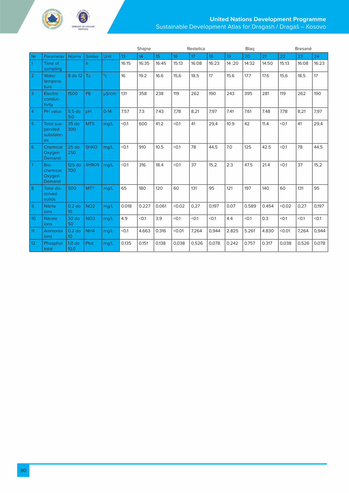
90
United Nations Development Programme Sustainable Development Atlas for Dragash / Dragaš – Kosovo
Nr Parameter Norms Simbo Unit 13 14 15 16 17 18 19 20 21 22 23 24
1 Time of sampling
h 16:15 16:35 16:45 15:13 16:08 16:23 14 :20 14:32 14:50 15:13 16:08 16:23
2 Water tempera-ture
8 do 12 Tu °c 16 19.2 16.6 15,6 18,5 17 15.6 17.7 17.6 15,6 18,5 17
3 Electric conduc-tivity
1500 PE µS/cm 131 358 238 119 262 190 243 395 281 119 262 190
4 PH value 5.5 do 9.0
pH 0-14 7.57 7.3 7.43 7,78 8,21 7,97 7.41 7.61 7.48 7,78 8,21 7,97
5 Total sus-pended substanc-es
35 do 300
MTS mg/L <0.1 600 41.2 <0.1 41 29,4 10.9 42 11.4 <0.1 41 29,4
6 Chemical Oxygen Demand
25 do 250
SHKO mg/L <0.1 910 10.5 <0.1 78 44,5 7.0 125 42.5 <0.1 78 44,5
7 Bio-chemical Oxygen Demand
125 do 700
SHBO5 mg/L <0.1 316 18.4 <0.1 37 15,2 2.3 47.5 21.4 <0.1 37 15,2
8 Total dis-solved solids
500 MTT mg/L 65 180 120 60 131 95 121 197 140 60 131 95
9 Nitrite ions
0.2 do 10
NO2 mg/L 0.018 0.227 0.061 <0.02 0,27 0,197 0.07 0.589 0.454 <0.02 0,27 0,197
10 Nitrate ions
30 do 50
NO3 mg/L 4.9 <0.1 3.9 <0.1 <0.1 <0.1 4.4 <0.1 0.3 <0.1 <0.1 <0.1
11 Ammonia ions
0.2 do 10
NH4 mg/L <0.1 4.663 0.316 <0.01 7,264 0,944 2.825 5.261 4.830 <0.01 7,264 0,944
12 Phosphor total
1.0 do 10.0
Ptot mg/L 0.135 0.151 0.138 0,038 0,526 0,078 0.242 0.757 0.317 0,038 0,526 0,078
Shajne Restelica Blaq Bresanë

91
United Nations Development Programme Sustainable Development Atlas for Dragash / Dragaš – Kosovo
Model applied soil erosion risk model The Soil Erosion Risk Model (SER) applied for the assessment of erosion risk was used in EULUP 2011. Single items have been adapted to Dragash/Dragaš’s conditions.
SER=SES*0,6+CLC*0,4
The following components are included in this model:
Soil erosion sensitivity (SES) model
SES=SC*0,85+RFC*0,15
1. Importance (weighting) of factors
Factor Importance
Soil and slope properties (SC) 0.85
Average rainfall (RFC) 0.15
2. Soil -slope relation: Soil erosion potential as dependant on soil properties and based on bear ground assumption. Calculate score for soil properties.
Soil texture Slope classes in degrees
<3 3.1 - 7.0 7.1 - 11.0 11.1 -15.0 >15
Gravel (s)
0 10 20 50 100
Clay (g) 0 20 35 60 100
Loam (i) 0 25 45 70 100
Sandy loam (pi)
5 30 50 80 100
Sand (p) 10 35 60 100 100
Relation of soil texture and soil type
2.2. Model for erosion risk
Gravel (s)
Clay (g) CL-Clay LoamSiC-Silty ClaySiCL-Silty Clay LoamC-Clay
Loam (i) Si-SiltSiL-Silt LoamL-LoamSL-Sandy LoamSCL-Sandy Clay Loam
Sandy loam (pi) SL-Sandy LoamSC-Sandy ClayLS-Loamy Sand
Sand (p) S-Sand

92
United Nations Development Programme Sustainable Development Atlas for Dragash / Dragaš – Kosovo
94 Reddish-brown leached soil on reddish sedi-ments
pi
15 Sandy alluvium p
120 Shallow brown soil on schists (phyllite, mi-caschist etc.)
i
121 Shallow brown soil on schists (phyllite, mi-caschist etc.)
i
59 Typical ranker on neutral rocks (andesite etc.) pi
61 Typical ranker on schists (phyllite etc.) pi
44 Typical rendzina on compact limestone i
LEG_NR NAME TEXTURE
27 Alluvial-deluvial loamy soil pi
150 Bare rock s
122 Brown leached soil on schists (phyllite, mi-caschist etc.)
pi
62 Brownized ranker on schists (phyllite etc.) pi
45 Brownized rendzina on compact limestone i
25 Leached deluvium pi
10 Lithosol on compact limestone i
9 Lithosol on neutral rocks (sienite, trachyte, dior-ite, andesite etc.)
i
12 Lithosol on schists (gneiss, micaschist, phyllite, agriloschists etc.)
i
17 Loamy alluvium i
23 Loamy deluvium i
33 Mineral-marsh loamy gley soil i
38 Peat soil of eutrophic bog peat g
Look-up table of soil types and texture
3. Rainfall table.
Inclusion of land use covers (Corine)
For soil erosion risk assessment, the land cover, as an indicator of an-thropogenic activity, is added. Each CLC class is assessed for its ability
to stabilise or increase erosion. Assumption is made at hypothetical
6-7 degrees slope for Kosovo conditions.
RFC Rainfall class (mm) Factor Score (RFC)
500-700 20
701-1000 60
1001-1500 80
>1500 100
100 = high risk
0 = no risk
Importance weighting (W)
Soil Erosion Sensitivity (SES) 0,6
CORINE Land Cover (CLC) 0,4
Total 1

93
United Nations Development Programme Sustainable Development Atlas for Dragash / Dragaš – Kosovo
Dragash CLC Grid Code Score for CLC
Continuous urban fabric 1.1.1. 0
Discontinuous urban fabric 1.1.2. 60
Industrial or commercial units 1.2.1. 60
Road and rail networks and associated land 1.2.2. 90
Mineral extraction sites 1.3.1. 100
Dump sites 1.3.2. 90
Illegal dump sites 1.3.3. 90
Sport and leisure facilities 1.4.2. 40
Cultural Heritage 1.5. 0
Non-irrigated arable land 2.1.1. 80
Permanently irrigated land 2.1.2. 70
Fruit trees and berry plantations 2.2.2. 40
Pastures intensive without hedges 2.3.1. 20
Pastures intensive with hedges 2.3.2. 10
Pastures extensive without shrubs 2.3.3. 10
Pastures extensive with shrubs/trees 2.3.4. 10
Annual crops associated with permanent crops
2.4.1. 50
Complex cultivation – no hedges 2.4.2. 50
Complex cultivation – with hedges/trees 2.4.5. 40
Agriculture / natural vegetation Mix 2.4.3. 30
Broad-leaved forest 3.1.1. 20
Coniferous forest 3.1.2. 20
Mixed forest 3.1.3. 20
Coniferous forest - Planted 3.1.4. 40
Woodland patches 3.1.5. 20
Natural grassland (>1700m) 3.2.1. 10
Heathland Vegetation (incl. Moors) 3.2.2. 10
Transitional woodland/shrub 3.2.4. 20
Coppice Forest 3.2.5. 40
Bare rock, scree, cliffs, rocks, and outcrops. 3.3.2. 0
Sparsely vegetated areas 3.3.3. 70
Inland marshes/waterlogged areas 4.1. 1. 10
Peatland 4.1.2. 0
Riparian woodland 4.1.3. 40
Water courses 5.1. 1. 0
Water bodies 5.1.2. 0
Springs 5.1.3. 0

94
United Nations Development Programme Sustainable Development Atlas for Dragash / Dragaš – Kosovo
There are several factors determining grade of risk for avalanches at a specific location; these are:1. Steepness2. Wind direction in combination with ridges and depressions3. Exposition4. Length of the slope and diversity of landforms 5. Vegetation, particularly Forest / non Forest
Steepness
Figure 2 1 shows the correlation between steepness of slope and avalanche risk:• Red colour indicates high risk of snow slab avalanches on slopes with more than 30 degrees• Yellow colour indicates medium risk of wet snow avalanches on slopes between 20 – 30 degrees• Green colour indicates no risk on slopes with less than 20 degrees; however these can be affected by avalanches originating from steep slopes above.Steepness of terrain in Dragash/Dragaš Municipality was derived from the Digital Terrain Model (DTM).
2.3. Model for avalanche risk analysis
Figura 2-1: Correlation between steepness and avalanche risk
Wind direction in combination with ridges and depressions
Wind is sometimes called “the architect of avalanches”. This is because wind• Accumulates masses of snow leeward of ridges or in depressions• Can build cornices at top of ridgesThese accumulations cause an increased risk of avalanches.Based on the DTM ridges can be identified.Wind data is not available for Dragash/Dragaš.
Exposition
According to statistical data, the frequency of avalanche is significantly higher on E to WNW exposed slopes. Respective analysis was undertaken on basis of the DTM.
Slope length
Uniformly steep slopes with a length of more than 50m increase the avalanche risk. Conversely, short slopes reduce risk. Avalanche risk is also reduced if the terrain has a high diversity of landforms and structures which stabilise the snow cover.
10 Source: http://www.powderguide.com/de/mountain-knowledge/basics/article/mountain-knowledge/
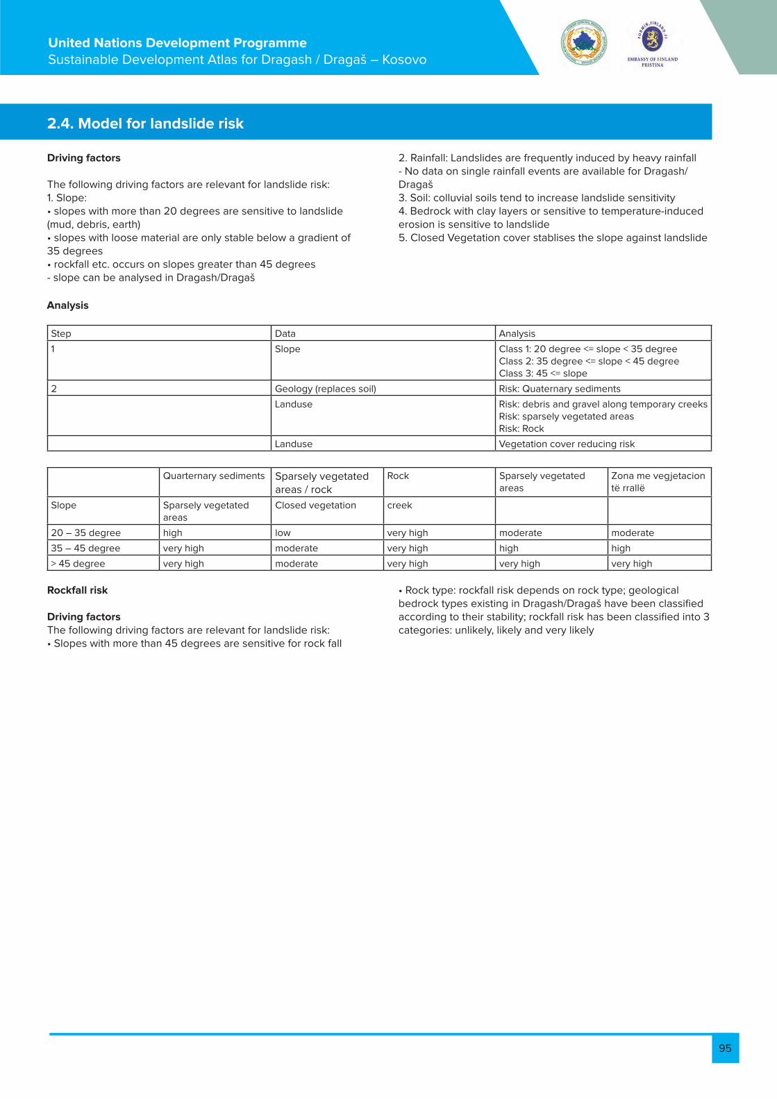
95
United Nations Development Programme Sustainable Development Atlas for Dragash / Dragaš – Kosovo
Driving factors
The following driving factors are relevant for landslide risk:1. Slope: • slopes with more than 20 degrees are sensitive to landslide (mud, debris, earth)• slopes with loose material are only stable below a gradient of 35 degrees• rockfall etc. occurs on slopes greater than 45 degrees- slope can be analysed in Dragash/Dragaš
Rockfall risk
Driving factorsThe following driving factors are relevant for landslide risk:• Slopes with more than 45 degrees are sensitive for rock fall
2.4. Model for landslide risk
2. Rainfall: Landslides are frequently induced by heavy rainfall- No data on single rainfall events are available for Dragash/Dragaš3. Soil: colluvial soils tend to increase landslide sensitivity4. Bedrock with clay layers or sensitive to temperature-induced erosion is sensitive to landslide5. Closed Vegetation cover stablises the slope against landslide
• Rock type: rockfall risk depends on rock type; geological bedrock types existing in Dragash/Dragaš have been classified according to their stability; rockfall risk has been classified into 3 categories: unlikely, likely and very likely
Step Data Analysis
1 Slope Class 1: 20 degree <= slope < 35 degreeClass 2: 35 degree <= slope < 45 degreeClass 3: 45 <= slope
2 Geology (replaces soil) Risk: Quaternary sediments
Landuse Risk: debris and gravel along temporary creeksRisk: sparsely vegetated areasRisk: Rock
Landuse Vegetation cover reducing risk
Quarternary sediments Sparsely vegetated areas / rock
Rock Sparsely vegetated areas
Zona me vegjetacion të rrallë
Slope Sparsely vegetated areas
Closed vegetation creek
20 – 35 degree high low very high moderate moderate
35 – 45 degree very high moderate very high high high
> 45 degree very high moderate very high very high very high
Analysis

96
United Nations Development Programme Sustainable Development Atlas for Dragash / Dragaš – Kosovo
2.5. Assessment criteria for the forest functions
Funksioni Specifikacioni
Wood production
Production of non wood products
Erosion control and sediment retention
Biodiverziteti
Water Regulation and Water Supply
High value wood = all forests on thick soils, and coppice forests with standsFirewood = all coppice forests including transitional woodland being classified as forest plus information of firewood collection from Village QuestionnaireInformation from Village Survey
Soil erosion risk (including transitional woodland): Score for soil properties Soil-Slope Properties > = 70Avalanche Risk (including transitional woodland): Slope >= 20 degrees Landslide risk (including transitional woodland): Quarternary sediments and slope > 20 degreesRockfall risk (including transitional woodland): Rockall risk of geology (likely or very likely) and slope > 45 degreesAll coppice forests, Vegetation units assessed as having high protection value (EU Habitat directive, endemic or rare species or ecosystems)For fauna: forest having more the 1 layer, Originating from Seedlings, and being older than 50 a
Forest management classes: Units on thick soilsGeology units classified as likely or very likely to provide for groundwater resourcesPlus Riparian wetlands (= Riparian Forests)

97
United Nations Development Programme Sustainable Development Atlas for Dragash / Dragaš – Kosovo
(Adapted from Elezi Xhevdet (2011): Classification of soil properties in agricultural areas of Dragash-suitability map for agriculture - UNDP Report) The methodology for classification of agricultural land in Dragash/Dragaš Municipality into the classes of prolificacy is based on an assessment of the following factors: soil texture, geological origin of the soil, the 7 (seven) levels of its development, as well as an assessment of the landscape and the climate (Pedological Map of Kosovo, 1974). The classification of agricultural land into classes of prolificacy in the Republic of Kosovo is regulated through the Law on Agricultural Land No. 02/L-26. Such classification, due to a lack of methodology pursuant to FAO criteria, was based on classification of lands into cadastral classes based on the Law on Cadastre. The Pedological Map of Kosovo was prepared according to the same methodology of classification/systematics of agricultural land as the one used in Croatia and Bosnia and Herzegovina. These two countries have since developed methodologies for classification into classes of prolificacy (Croatia, 2010) and land utilisation type (Bosnia and Herzegovina, 2004) based on criteria determined by FAO (Guidelines for soil description, 1990 and Land Utilization Type, 1984).
1. Map with the soil classification
Pedological classes/types of soil in the municipality of Dragash/Dragaš were classified into 8 classes of prolificacy (I-VIII). These classes were then grouped into 4 categories according to their suitability for agricultural productivity: Suitability with minor restrictions =II and III; Suitability with more expressed restrictions =V; Suitability with many restrictions VI and Suitability with extensive restrictions = VII and VIII.
2. Recommended types of agricultural use
Based on FAO methodology, on the experiences from Bosnia and Herzegovina regarding determination of land utilisation types (LUT), as well as through using the Ortophoto map to identify current land use in the municipality of Dragash/Dragaš, some basic criteria for the classification of land has been determined according to classes of suitability and the level (%) of its restriction for agricultural productivity.
2.6. Suitability of soils and recommendations for agricultural use
The basic criteria that were used for classification of land and determination of the level of its suitability for agricultural productivity are as following: • topography, respectively the level of terrain inclination (%), • characteristics/features of soil:o depth of soil profile, o physical features: content of texture elements, o characteristics of soil fertility: value of pH and the content of humus.The classes of suitability of land for these groups of agricultural cultures have been determined according to the following criteria: AR = arable land (cereals-winter and summer) SC = special crops (fruits-berries, potatoes for seed and consume) IP = intensive pasture EP = extensive pasture
The following classes of suitability have been determined as a result of classification: • Suitability with minor restrictions (10-40%): Prolificacy classes II and III. All the planned agricultural cul-tures can be cultivated in these soils, with little or high potential of mechanisation. • Suitability with more expressed restrictions (40-60%): Prolificacy class V (class IV is absent). All the planned agricultural cultures can be cultivated in these soils, but only with little possibility of mechanisation.• Suitability with many restrictions (60-80%): Prolificacy class VI. Although these lands have extensive restrictions, they are traditionally used for production of cattle food (hay) and/or as extensive pastures. • Suitability with extensive restrictions (> 80%): Prolificacy classes VII and VIII. No cultivation is feasible and they are usually used as green grassing pastures.The classification results have been presented in separate tables (Annex 2) for each culture based on the utilisation manner (intensive, extensive) and the level of machinery that may be used.
Suitability classes High level of machinery Low level of machinery
II OZ, SU, IP OZ, SU, IP
III OZ, SU, IP OZ, SU, IP
V - OZ, SU, IP
VI - OP
The following table presents the soil classes and suitability for cultures:
AR = arable land (cereals-winter and summer)SC = special crops (fruits-berries, potatoes for seed and consumption)IP = intensive pastureEP = extensive pasture
References:
FAO (1984): Land Utilization Type FAO (1990): Guidelines for soil description,
FAO (2004): Ucesce u razvoju nacina koristenja zemljista na opcinskom nivou u Bosni I Hercergovini, Tip Iskoristavanja zemljista (LUT)Pedologic Map of Kosovo (1974)Pravilnik o mjerilima za utvrdivanje osobito vrijednog obradivog (P1) I vrijednog obradivog (P2) poljop-rivrednog zamljista (2010): Ministarstvo poljoprivrede, Ribarstva I Ruralnog Razvoja, Republika Hrvatska.The Law on Agricultural Land No. 02/L-26 (2006): Assembly of Kosovo

98
United Nations Development Programme Sustainable Development Atlas for Dragash / Dragaš – Kosovo
Municipality Type of soil Prolificacy class Class based on UNDP research
Dragash Mineral-marsh clayish soil III1 Suitability with minor restrictions
Dragash Peat soil of eutrophic bog peat III1
Dragash Alluvial-diluvial loamy soil III1
Dragash Leached diluvium III1
Dragash Loamy diluvium III1
Dragash Loamy alluvium II2
Dragash Sandy alluvium III1
Dragash Brownized rendzina on compact limestone
V1 Suitability with more expressed restric-tions
Dragash Typical rendzina on compact limestone
V1
Dragash Reddish-brown leached soil on reddish sediments
VI1 Suitability with many restrictions
Dragash Brown leached soil on schists VI1
Dragash Lithosol on neutral rocks (sienit, trachyte, etc.)
VI2
Dragash Brownized ranker on schists VII2 Suitability with extensive restrictions
Dragash Typical ranker on schists VII2
Dragash Typical ranker on neutral rocks VII1
Dragash Bare rock VIII2
Dragash Shallow brown soil on schists VII1
Dragash Shallow brown soil on compact rock
VII1
Dragash Lithosol on schists VIII1
Dragash Lithosol on compact limestone VIII2
Table 2-6: Pedological types of soil in the Municipality of Dragash/Dragaš based on the classes of prolificacy and groups of suitability for plant production
Table 2-7: Classes of suitability and the level of utilisation for determined cultures, based on the culti-vation manner and the level of machinery
Agricultural crops: Winter grains - Level of machinery: High
Agricultural crops: Winter grains - Level of machinery: Low
Suitability class and utilization level (%)
Characteristics/ attributes of soil
Suitability with minor restric-tions
Suitability with more ex-pressed restrictions
Suitability with many restric-tions
Suitability with extensive restrictions
Topography, inclination (%) 90-60% 60-40% 40-20% >20%
Physical traits, texture class
0-15 15-30 35-45 >45
Depth of the profile (cm) I, PGI, MI, MGI, GI, PI, PI - - -
Soil reaction (pH) >100; 100-80; 80-60 60-30 30-20 <20
Humus content (%) 5.5-6.5; 6.5-7.0; 7.0-7.2;7.2-7.5 5.5-4.5 4.5-3.0 <3
Suitability class and utilization level (%)
Characteristics/ attributes of soil
Suitability with minor restric-tions
Suitability with more ex-pressed restrictions
Suitability with many restric-tions
Suitability with extensive restrictions
90-60% 60-40% 40-20% >20%
Topography, inclination (%) 0-15 15-30 35-45 >45
Physical traits, texture class I, PGI, MI, MGI, GI, PI, PI - - -
Depth of the profile (cm) >100; 100-80; 80-60 60-30 30-20 <20
Soil reaction (pH) 5.5-6.5; 6.5-7.0; 7.0-7.2;7.2-7.5 5.5-4.5 4.5-3.0 <3
Humus content (%) >4; 4-3 3-2 2-1 <1

99
United Nations Development Programme Sustainable Development Atlas for Dragash / Dragaš – Kosovo
Agricultural crops: Potato seeds - Level of machinery: high
Agricultural crops: Potato seeds - Level of machinery: high
Agricultural crops: Summer grains - Level of machinery: Low
Agricultural crops: Potato for consumption - Level of machinery: high
Agricultural crops: Potato for consumption - Level of machinery: low
Suitability class and utilization level (%)
Characteristics/ attributes of soil
Suitability with minor restric-tions
Suitability with more ex-pressed restrictions
Suitability with many restric-tions
Suitability with extensive restrictions
90-60% 60-40% 40-20% >20%
Topography, inclination (%) 0-15 15-30 35-45 >45
Physical traits, texture class I, PGI, MI, MGI, GI, PI, PI - - -
Depth of the profile (cm) >100; 100-80; 80-60 60-30 30-20 <20
Soil reaction (pH) 5.5-6.5; 6.5-7.0; 7.0-7.2;7.2-7.5 5.5-4.5 4.5-3.0 <3
Humus content (%) >4; 4-3 3-2 2-1 <1

100
United Nations Development Programme Sustainable Development Atlas for Dragash / Dragaš – Kosovo
Agricultural crops: Berry fruits - Level of machinery: high
Agricultural crops: Meadows and pastures - Production level: intensive
Agricultural crops: Berry fruits - Level of machinery: low
Agricultural crops: Meadows and pastures - Production level: extensive
Suitability class and utilization level (%)
Characteristics/ attributes of soil
Suitability with minor restric-tions
Suitability with more ex-pressed restrictions
Suitability with many restric-tions
Suitability with extensive restrictions
90-60% 60-40% 40-20% >20%
Topography, inclination (%) 0-15 15-30 35-45 >45
Physical traits, texture class I, PGI, MI, MGI, GI, PI, PI - - -
Depth of the profile (cm) >100; 100-80; 80-60 60-30 30-20 <20
Soil reaction (pH) 5.5-6.5; 6.5-7.0; 7.0-7.2;7.2-7.5 5.5-4.5 4.5-3.0 <3
Humus content (%) >4; 4-3 3-2 2-1 <1
Klasa e përshtatshmërisë dhe niveli i shfrytëzimit (%)
Characteristics/ attributes of soil
Suitability with minor restric-tions
Suitability with more ex-pressed restrictions
Suitability with many restric-tions
Suitability with extensive restrictions
90-60% 60-40% 40-20% >20%
Topography, inclination (%) 0-15 15-30 35-45 >45
Physical traits, texture class I, PGI, MI, MGI, GI, PI, PI - - -
Depth of the profile (cm) >100; 100-80; 80-60 60-30 30-20 <20
Soil reaction (pH) 5.5-6.5; 6.5-7.0; 7.0-7.2;7.2-7.5 5.5-4.5 4.5-3.0 <3
Humus content (%) >4; 4-3 3-2 2-1 <1
Legjenda:
Si-Silt II2, III1, III2
SiL-Silt Loam V1, V2
SiCL-Silty Clay Loam VI1, VI2
SiC-Silty Clay VII1, VII2, VIII1, VIII2
L-Loam
CL-Clay Loam
C-Clay
SL-Sandy Loam
SCL-Sandy Clay Loam
SL-Sandy Loam
SC-Sandy Clay
LS-Loamy Sand
S-Sand

101
United Nations Development Programme Sustainable Development Atlas for Dragash / Dragaš – Kosovo
2.7. Electricity consumption spread
Table 2 8: Max/min energy consumption for 2010 in Dragash/Dragaš municipality (data: based on official data form KEK 2012)
Village Ratio Sezoni me konsum maksimal Sezoni me konsum minimal
max/min consumption Season with maximum consumption Season with minimum consump-tion
Summer
Bresanë / Brodosavce 1,22 Winter Spring
Zaplluxhe / Zaplužje 1,28 Spring Spring
Rrenc / Renc 1,29 Winter Winter
Blaç / Bljać 1,31 Winter Winter
Kruševo / Krushevë 1,34 Summer Winter
Brezne / Brezna 1,34 Winter Spring
Kuklibeg / Kukljibeg 1,36 Winter Spring
Pllavë / Plava 1,40 Summer Autumn
Zgatar / Zgatar 1,40 Spring Winter
Buzez / Buzez 1,41 Summer Autumn
Dragash / Dragaš 1,43 Summer Autumn
Kapre / Kapra 1,46 Summer Spring
Restelica / Restelicë 1,46 Summer Winter
Zlipotok / Zlipotok 1,51 Summer Winter
Buçe / Buće 1,51 Summer Winter
Krstec / Kërstec 1,55 Summer Winter
Brrut / Brut 1,59 Spring Spring
Bellobrad / Belobrad 1,66 Summer Spring
Kosavë / Kosavce 1,67 Winter Spring
Globočica / Glloboçicë 1,67 Summer Spring
Pllajnik / Plajnik 1,72 Summer Winter
Brod / Brod 1,74 Summer Spring
Rapča / Rapçë 1,74 Summer Winter
Shajne / Šajnovce 1,79 Summer Winter
Xërxe / Zrze 2,03 Spring Summer
Radeša / Radeshë 2,50 Summer Winter
Ljubovište / Lubovishtë 2,66 Summer Winter
Vranište / Vranisht 3,06 Summer Spring
Kukuljane / Kukulanë 3,12 Summer Autumn
Dikance / Dikanc 5,33 Summer Winter
Leštane / Leshtan 6,42 Summer Winter
Orčuša / Orçushë 8,55 Summer Spring
Mlike / Mlikë 8,93 Summer Winter
Bačka / Baçkë 71,42 Summer Winter
Zym / Zjum No data

102
United Nations Development Programme Sustainable Development Atlas for Dragash / Dragaš – Kosovo
Volume IV: Guidance for Development
Peter BankFlorian Bemmerlein-Lux
Ismail GagicaErgin Hajredini
Prof. Dr. Behxhet Mustafa – Ecologist
Prof. Fadil Millaku - Biologist
Dr. Halil Ibrahimi - Ecologist
Dr. Achim Milbradt – Biologist
Michael Voit - Rural Development Planner
Prof. Xhevdet Elezi - Soil scientist – agronomist
Arneni - National forest consultancy company, NGO
Finches – Ornithologists
Todd Wassel – Tourism Specialist
Bashkim Susuri – Journalist and Project Associate
Bardh Xerxa – Ecologist
Ajhan Hadzija – Tourism Coordinator
the Municipal Working Group of Dragash/Dragaš Municipality
and Deutsche Gesellschaft für Internationale Zusammenarbeit
(GIZ) GmbH, Rural Economic Development Programme.
Project ManagerMaria Elena Zuniga Barrientos
Dragash / Dragaš, Kosovo March 2013
With contributions from
United Nations Development Programme
Conservation of Biodiversity and Sustainable Land
Use Management in Dragash/Dragaš

103
United Nations Development Programme Sustainable Development Atlas for Dragash / Dragaš – Kosovo
Table of Content
1. Guidance Maps .....................................................................................................................................................................................................104
1.1. Objectives and principles for sustainable municipal development .......................................................................................................104
1.2. Guiding development principles for Dragash / Dragaš ...........................................................................................................................104
1.3. Consequences for the Municipal Development Plan (MDP) ................................................................................................................. 105
1.4. Nature conservation (G1.1) .............................................................................................................................................................................. 105
1.5. Zoning of Sharr/Šar Mountain National Park (G1.2) .................................................................................................................................107
1.6. Forest (G2.1) ....................................................................................................................................................................................................... 108
1.7 Agriculture (G2.2) .................................................................................................................................................................................................110
1.8 Water / Sanitation (G3) .......................................................................................................................................................................................112
1.9 Settlements (G4) ..................................................................................................................................................................................................113
1.10. Roads and traffic (G5) .......................................................................................................................................................................................114
1.11. Education (G6) .....................................................................................................................................................................................................116
1.12. Health (G7) ..........................................................................................................................................................................................................116
1.13. Tourism (G8) ........................................................................................................................................................................................................ 117
2. Integrated Development Guidance .................................................................................................................................................................118
2.1. Spatial resistance against growth and development of settlements (IG1) ........................................................................................... 117
3. Annex ..................................................................................................................................................................................................................... 120
3.1. CORINE land use types ................................................................................................................................................................................... 120
3.2. Remarks for preferential habitats (a) ...........................................................................................................................................................123
3.3. Remarks for non-preferential habitats (b) ...................................................................................................................................................123
3.4. Protection categories of the Law .................................................................................................................................................................124
List of Tables
Table 1 1: List of Guidance Maps ...........................................................................................................................................................................104
Table 1 2: % and size of the different guidance areas of nature conservation ........................................................................................ 106
Table 1 3: % and size of the different guidance areas of nature rehabilitation and development ..................................................... 106
Table 1 4: Decision criteria for the guidance of nature conservation ..........................................................................................................107
Table 1 5: % and size of the different guidance areas for forest ................................................................................................................. 109
Table 1 6: Percentage and size of the different guidance areas for agriculture .......................................................................................110
Table 1 7: Relevant road projects and their evaluation ....................................................................................................................................115

104
United Nations Development Programme Sustainable Development Atlas for Dragash / Dragaš – Kosovo
1. Guidance MapsMaps for Step 3: Zones indicating the most appropriate development objectives; this may be expressed in terms of rehabilitation zones; protection zones; specific development
zones; conflict zones. They are summarised as development objectives zones
G Guidance maps
Guidance maps referring to natural resources – preconditions for the MDP
G1-1 Nature conservation
G1-2 Zoning of Sharr/Šar Mountain National Park
G2-1 Forest
G2-2 Agriculture
G3 Water and sanitation
Guidance maps part of the MDP – integral part of the MDP
G4 Settlements
G5 Roads and traffic
G6 Education
G7 Heath
G8 Tourism
IG Integrated guidance maps
IG1 Spatial resistance
IG2 Functional structure
Table 1-1: List of Guidance Maps
The Sustainability Atlas is the basis for guidance and a comprehensive framework for sus-tainable development of the Municipality. It has the principle objective to harmonise the various demands from society, the regional economy and the administration with the environmental and ecological spatial conditions. This is presented as a well-organised spatial development concept. The guiding development objectives of sustainable regional development of the Municipality outlined in this atlas are:1. Contribute towards balanced and fair improvement of living conditions for the population of the Municipality as a whole and for the more vulnerable sections of the population in particular;2. Protect, develop and – where necessary – rehabilitate the
a) A decentralised settlement pattern with a structure of hierarchical development centres and inter-connecting corridors for the whole Municipality will be strengthened. Future set-tlement development should be concentrated primarily in such centres. This will support the balanced development of the whole region and the creation of self-sustaining centres.b) Ecologically fragile or sensitive areas should be preserved and developed in such a manner that they are not adversely affected by any development activity: Their develop-ment should also be guided by their recreational and tourist functions to adjoining settle-ments, or for the region as a whole. This includes areas subject to natural risks, such as flooding, erosion etc, which are to be kept free from uses eventually adversely affected by such risks.c) The principle structure of the zone primarily under agricultural use (cropland and range-land) and forest zones should be preserved and developed. The functional importance of larger
1.1. Objectives and principles for sustainable municipal development
1.2. Guiding development principles for Dragash / Dragaš
natural basis for existence, in particular water, air, soil, flora and fauna, in an integrated and comprehensive manner3. Contribute towards balanced economic and social development of the whole Municipality4. Guide the development of the administration in the Municipality, in particular for the set-tlements and villages 5. Reserve necessary areas and sites for further development, including for agriculture, settlements and infrastructure, touristic resources and cultural heritage, in a balanced way6. Preserve and develop distinct parts of the Municipality that is outstanding in terms of its natural beauty and social heritage, such as unique landscapes and biodiversity
zones for water management, soil protection, for flora and fauna has to be ensured and, if necessary, rehabilitated. Their use should be in harmony with their natural func-tions and services.d) The agricultural base of the Municipality has to be ensured and developed. This refers in particular to prime agricultural lands. Predominantly agricultural areas should be devel-oped with a view to improve their economic self-sustainability. This has to be supported by improvements in rural infrastructure and by strengthening the functions of rural devel-opment centres. e) The functions of designated development centres have to be strengthened by provision of necessary services and utilities. This also includes the provision of sufficient sites re-quired for their development.f) Infrastructure has to be developed in accordance with existing and envisioned socio-economic development, and with the settlement structure. Infrastructural development needs of the surrounding municipalities are to be considered. Road

105
United Nations Development Programme Sustainable Development Atlas for Dragash / Dragaš – Kosovo
The general guiding principles and the spatial-structural development principles are material-ised and detailed in a Municipal Development Plan. The contents of the spatial dimension of the plan should include:1. The desired spatial structure by designation and delineation of:- Spatial categories, in particular:Urban / village areasPredominantly rural areasAreas with development challengesPrime agricultural areasAreas with prominent environmental or ecological functionsAreas with relevant touristic resources- Development centres and central places- Development axes and corridors
2. The intended development objectives for each of the spatial categories including pro-grammes, plans, projects and measures for their implementation:- Upgrading and rehabilitation of urban/village areas- Development and upgrading of development centres including facilities needing instal-lation in order to create fully functioning development centres
Contents of the guidance map:
Areas that are classified according to the Law of Nature Protection may be:• Strict reserve *, • Special Area of Conservation and Special Protected Areas (SAC-SPA)• Nature Monuments • Protected Landscape Zones that require rehabilitation (or a mix of development and rehabilitation)Zones that are available for further development
connections and bor-der stations to Albania and FYR Macedonia are essential to overcome Dragash / Dragaš’s “dead-end” location.g) Industrial development should take place only at suitable sites and under the necessary precautions that its operation does not adversely affect sensitive environmental resources or uses in its vicinity, and contributes towards balanced development of the Municipality.h) Sites and areas with mineral resources of regional importance have to be secured in a way that their future use is possible when required.
1.3. Consequences for the Municipal Development Plan (MDP)
1.4. Nature conservation (G1.1)
- Development of infrastructure needed to support the intended municipal development including local, regional and international roads.- Development objectives for larger open spaces including measures needed to secure and develop their natural functions such as land use regulations
3. All spatial categories, zones, plans, projects or measures of other sector authorities if of spatial importance for regional development, and in particular:- All designated protection zones such as the National Park, Sanctuaries, Wetlands, protected landscapes etc.- All designated forest areas - All erosion risk zones - All water resources and their uses- All monuments of natural, archaeological, cultural or scientific significance- All designated disposal sites for domestic or industrial wastes
The main messages:
The existing status (rarity) of forests, rangelands and wetlands is recorded to an extent that allows a first definition of areas requiring protection in order to preserve their ecological functions and services according to the Law of Nature Protection (i.e. strict nature reserve, special areas – SPAs and SAC, nature monuments and protected landscapes). In addition, the faunistic resources form part of the information which supports the extension of the National Park and the future definition of different kinds of protected areas and species according to the Law of Nature Protection. Ecological corridors play an important role to allow free movement of species from one site to another and constitute part of the existing ecological network.
i) Areas struggling with significantly lower living conditions and socio-economic prospects should be earmarked for development on a priority basis by appropriate development schemes, including creation of employment opportunities, infrastructure development and/or improving educational facilities etc.

106
United Nations Development Programme Sustainable Development Atlas for Dragash / Dragaš – Kosovo
Protection categories: The area meets the requirements of the to the Law of Nature Conservation for:
% of the Municipality and size in ha Comment Needs scientific investigation and man-agement plan before a formal declaration as protected area
Strict reserve 0,02 % 9,12 ha “strict reserve” according
Special protected area / special area of conser-vation
31,95 % 13.924,40 ha Focus of these areas is in Sharr/Šar Mountain National Park” (Zone 1 and Zone 2) and the riparian forests.
Nature Monument 3,06 % 1.332,56 ha Mainly wetlands and special objects
Protected landscape 40,10 % 17.474,48 ha Large parts of the mountainous areas with pas-tures and forests (incl. coppice forests)
Protected landscape and requirement of reha-bilitation
8,57 % 3.733,34 ha Mainly areas of coppice forests/eroded areas
Development and regeneration % of the Municipality and size in ha Comment
Rehabilitation required 0,02 % 10,17 ha
Development and rehabilitation 0,18 % 77,86 ha Mainly areas of planted forests/eroded areas
Development 15,16 % 6.607,10 ha Mainly areas of present agricultural use
Table 1-2: % and size of the different guidance areas of nature conservation
Table 1-3: % and size of the different guidance areas of nature rehabilitation and development
It is important to note that most of Dragash/Dragaš’s landscape is a result of a centuries-old land-use practices that are also the origin of a lot of the existing biodiversity and the attractive landscapes. Changing the land-use pattern interferes with biodiversity. The distribution pattern of biodiversity hotspots clearly shows that most of the outstanding ecological areas are within Sharr/Šar Mountain National Park.
Criteria used for guidance map:
The evaluated area includes all land use types (CORINE units) except settlements, industrial and business areas (unit no. 1). The decision criteria are as shown in Table 1 4. These criteria do not include faunistic data such as for chamois, bear and lynx, because their habitats are already included in the classified protected vegetation zones.
Criteria(for CORINE units see Annex 3.1)
Strict reserve #)
SAC-SPA #) Nature monumen t#)
Protected landscape #)
Rehabilitation Devel-opment
Habitat directive (HD) - Annex 1* no management and HD-Annex II & Kosovo Red Species List with 50 m buffer
HD-Annex 1* management required (a)
HD-Annex 1 no management
HD-Annex 1 management (b) and Natural grassland CORINE: 2.3.1 – 2.3.4 and 3.2.1 (above 2050 m)
Waterfall, natural springs (not developed springs), natural lake (20m buffer)
Wetlands (CORINE: 4.1.1, 4.1.2, 4.1.3) Inland marshes, peat bogs, Riparian wetland
Geological-, paleontological-, mineralogical structure (like – cave (only one available), chasm, cliff walls)
Natural water courses (20 m Buffer) includes Aquatic insect hot spot
3.3.3 Sparsely vegetated areas 3.3.2 Bare rock
Pastures Highland/Mountain/ alpine 2.3.1 - 2.3.4 and 3.2.1 above 1600 m
Moors and heathland Vegetation CORINE: 3.2.2 and transi-tional woodland/shrub CORINE: 3.2.4
Forest has a biodiversity function (more than 1 layer and natu-ral seedlings, no coppice forest)
Forest older than 35 years (incl. mixed forests)
Woodland patches CORINE: 3.1.5
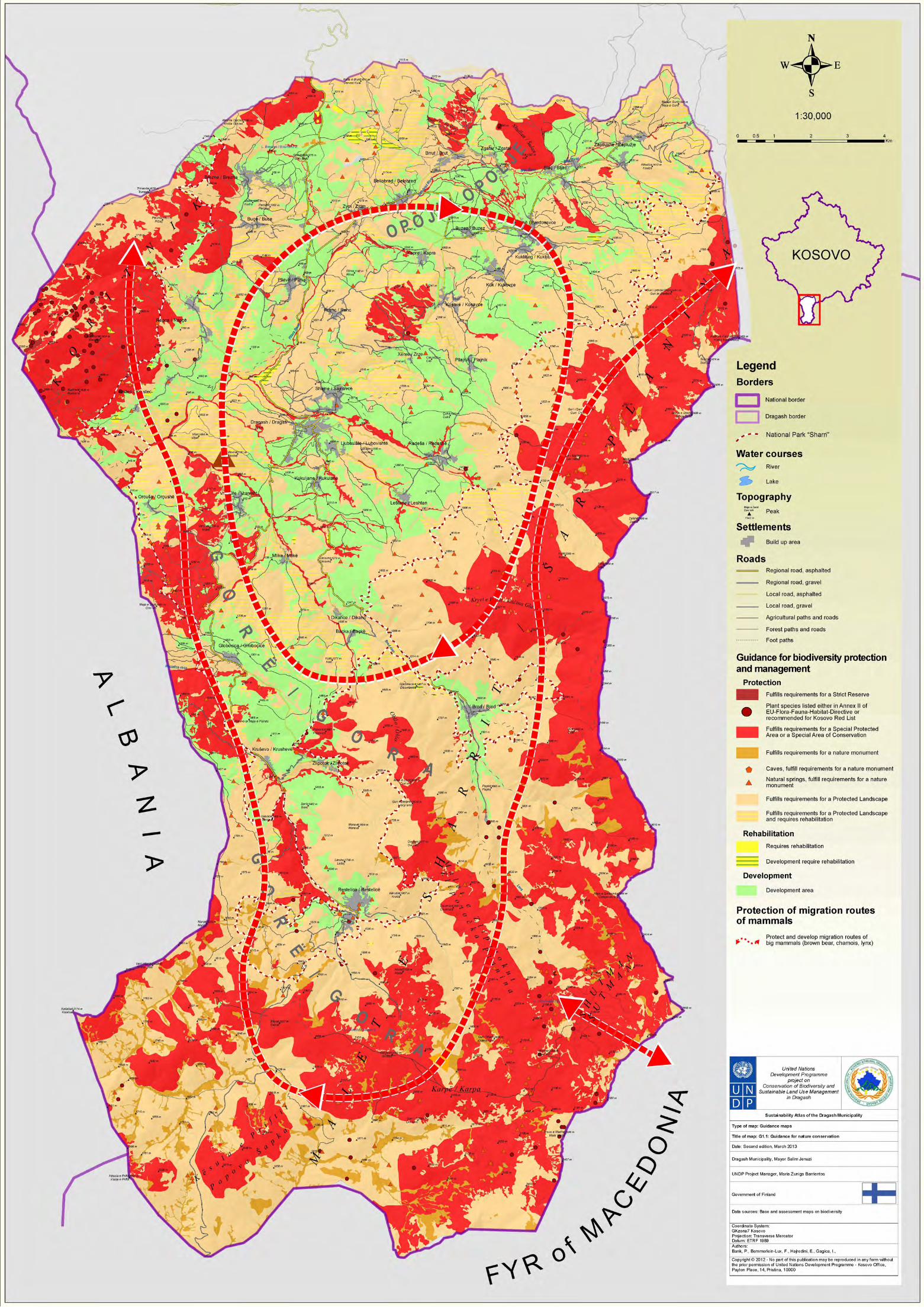

107
United Nations Development Programme Sustainable Development Atlas for Dragash / Dragaš – Kosovo
Due to the high diversity of land uses and landscape structures, the territory of Dragash / Dragaš Municipality provides for a high diversity of habitats for numerous groups and species of animal. Besides the open grasslands, high forests, coppice forests, all types of wetlands, and rocky and gravel areas are of high importance.
Data sources and material:
The following Assessment Maps provided the basic data for the Development Guidance:• A1.1 and A1.2 Assessment of biodiversity • A3 Assessment of water resources - regeneration, threats, and quality• A4.1 - A4.3 Assessment of natural hazards• A5.1 and A5.2 Assessment of forest and agriculture - condition of forest and forest functions
• A6 Assessment of solid waste• A7 Assessment of cultural heritage and tourist potentialThe findings of the preliminary identification of Natura 2000 Sites in Kosovo have been confirmed and considerable details are added (Mustafa et al. 2009).
Further suggestions for improvement of data:
There are no systematic scientific studies available on the fauna, flora and vegetation of Dragash / Dragaš. However, data from NGOs, village residents, scattered information from literature and random inspections by various national and international specialists provide a good basis for an overview on the local fauna. A lot more research is needed to obtain a more precise picture of the biodiversity of the area.
Agriculture / natural vegetation Mix, Complex cultivation – with hedges/trees, Complex cultivation – with hedges (CO-RINE: 2.4.3, 2.4.4, 2.4.5)
Coppice forest (CORINE: 3.2.5) depending on its condition –Development of adequate and professional management practices)
Mineral extraction sites, Dump sites CORINE:1.3.1, 1.3.2
Other forests (CORINE: 3.1.1, 3.1.3, 3.1.2) and Coniferous forest – Planted (CORINE: 3.1.4)
Pastures Highland/Mountain/ 2.3.1 to 2.3.4 below 1600m
Other Agricultural/pasture land (CORINE: 2.1.1, 2.1.2, 2.2.2, 2.4.1, 2.4.2)
#) = according to The Law of Nature Protection No.03/L–233
Contents of the guidance map:
• Suggestion for the Zoning of Sharr/Šar Mountain National Park – in Dragash/Dragaš Municipality • Road projects affecting the National Park
The main messages:
Zone 1: : Protected Zone – “Corezone”: Extraordinary natural characteristics and areas of habitat types which are endangered in global, European and national level with:
a) High density of rare, typical, endemic (Kosovo and Balkan) vegetation types (high density of Strict Na-ture Reserves acc. to “Article 10 - Law No.03/L –233 – of Nature Protection”)b) High density of rare and protected plants (acc. to Natura 2000 – Annexes; IUCN-Red list of threatened species; and experts assessments) c) High density of wetlands (water courses and lakes, bogs and peat-land, marshes/waterlogged areas and springs)d) Exceptional rocks, cliffs and gorgese) High importance for migratory routs for wild goats, bears and lynxf) Part of the network of protected areas/national parks in Albania and FYR MacedoniaZone 1 enjoys the character of strict protection and covers with 5.009,47 ha (20,69 %) of Sharr/Šar Mountain National Park.
1.5. Zoning of Sharr/Šar Mountain National Park (G1.2)
Zone 2: Active Management Zone - ”Traditional Use Zone”: Areas with ecosystems, landscape values and other natural values with the possibility of an active ecosystem and landscape management with:
a) Existence of wetlands (water courses and lakes, bogs and peat-land, marshes/waterlogged areas and springs)b) Areas of exceptional biological diversity or well-conserved areas of international importance and areas that significantly contribute to the conservation of biological and landscape diversity in Kosovoc) Occurrence of rare, typical, endemic (Kosovo and Balkan) vegetation d) Occurrence of rare and protected plants (acc. to Natura 2000 – Annexes; IUCN-Red list of threatened species; and experts assessments) Zone 2 enjoys the character of a “Special area of conservation” according to Art. 12 Law of Nature Protection. Permitted interventions, works and activities which sustain and improve conditions that are important for conservation of its features, and because of which it has been declared a special area, may be undertaken. Any restrictions have to be clearly specified in a management plan.Zone 2 covers an area of18.558,42 ha (76,67 %) of Sharr/Šar Mountain National Park.
¹ Based on a discussion with the National Park Directorate the 10th October, Prizren


108
United Nations Development Programme Sustainable Development Atlas for Dragash / Dragaš – Kosovo
Zona 3: Sustainable Use Zone - “Recreation Area”: is declared in the parts of the National Park territory foreseen for restricted construction of leisure, recreational, and tourism sites, and for the needs of the inhabitants of the National Park. It includes 1) proximity to settlements and more intensive, existing interaction of human activities and 2) existing installations with relevance for tourism.Restrictions should be clearly specified in a management plan. The restrictions should include prohibition to remove soil cover (for example for outdoor recreational areas) prohibition to discharge untreated waste waters directly to rivers, and prohibition to burn waste, amongst other restrictions. Existing infrastructure shall be upgraded to meet standards established in this law and management plans.It covers with 638,53 ha (2,64 %) of Sharr/Šar Mountain National ParkBuffer zone - surface area of 100 metres from the boundary of National Park serving to prevent negative ef-fects on the park.
Criteria used for guidance map:
According to its regulations, IUCN would accept up to 25% of the NP to be dedicated as Zone 3 for development (i.e. 75% has to be zones 1 or 2). Traditional land use (animal husbandry), which is essential for the sustainable management of grasslands, would not fall under this category.The suggested areas for Zone 1 to 3 are based on the following criteria:1. Zone 1 with preferential habitats according to EU habitat directive classification (see Annex 3.2) and/or high density of rare habitats and plants (according to EU habitat directive and draft Kosovo Plant Red Species list) 2. Traditional land use (grazing) areas3. Existing or planned infrastructure within the suggested border of the National Park4. Road plans as suggested in the Municipal Development Plan (see also section 1.10) are shown in the guidance map, but not considered in the Zonation Concept. These projects have
to be discussed, assessed and considered during the final formulations of the Spatial Plan and the Management Plan for the National Park.The zones are a compromise between the existing, traditional land uses of the local population and strict protection of areas that are negatively influenced by the traditional uses. A park and its management have to consider traditional land uses, especially if those land uses are constitutive of biodiversity.Economic (and touristic) development requires international road connection to Albania and FYR Macedonia, a connection between Brod and Restelica/Restelicë (scenic road), as well as a bypass for Restelica/Restelicë. These future plans are to be considered in the Management and Spatial plan of the National Park. The roads will be located as planned and the NP Management and Spatial Plan will consider these and decide on the spatial zoning category required by law for such road projects. A buffer of 10-20 m on both sides of the road are considered to be influenced by the road and its construction.
Data sources, material and reliability:
• Republic of Kosovo (December 2012): Law on the National Park “Sharri”• Republic of Kosovo (2010): The Law of Nature Protection No.03/L–233
Further suggestions for improvement of data:
In agreement with the National Park Directorate, Zone 3 should be divided in 2 subzones: (3a) with a principal permission for construction, if the objectives of construction are not against the objective of the National Park, and (3b) a no-construction zone.
Contents of the guidance map:
• Zones that should not have any forest use and should be protected forests (mainly forests with very difficult access and the ecotone at treeline and Riverine forests required for water course protection and stability)• Zones that could undertake forest management according to Forest Stewardship Council Criteria • Zones which need rehabilitation and management plans to increase productivity and simultaneously maintain and improve their ecological stewardship functions (water retention and geo-risk reduction)
1.6. Forest (G2.1)
• Zones that can be developed with special consideration of the ecological stewardship functions (water retention and geo-risk reduction)• Zones that can be developed without restriction
The main messages:
Maintain and extend the existing forest area and improve their management to increase the production and supply of firewood, particularly through more productive and more sustainable use of existing coppice forest resources.

109
United Nations Development Programme Sustainable Development Atlas for Dragash / Dragaš – Kosovo
Categories: % of forest in the municipal territory and size in ha
Comment
Forest area of the municipality % ha
Protected *) – no management 11,59 % 1.176,87 ha No management – the area should have biodi-versity and/or riverbank protection function
Protect *) - management according to Forest Stewardship Council Criteria
27,26 % 2.768,70 ha The management is economically and also ecologically required but has to follow the FSC standards of Kosovo.
Rehabilitate with management plans 18,33 % 1.861,82 ha The management plans have to be adapted to objectives that focus on conservation (especially water retention and geo-risk reduction) and wood production
Develop maintaining the forest functions 32,67 % 3.317,58 ha Any development should focus especially on the maintenance of ecological stewardship func-tions (see Assessment Map A 5.2)
Developed without restriction 10,14 % 1.029,83 ha
% of the municipal terri-tory and size in ha
Areas with high geo-risk close to settlements 1,22 % 530,48 ha In these areas afforestation should be consid-ered with priority – feasibility studies are re-quired
Areas with high geo-risk more than 500m form settlements
5,21 % 2.269,22 ha In these areas afforestation should be consid-ered – feasibility studies are required
*) The term “protected” zone does not mean that the areas are protected by law, but that they fulfil the criteria to be protected. It is a political decision and the result of a balancing of the further planning process as to which areas will be protected through the application of a formal legal process.
In the medium term, afforestation is a realistic option to increase the forest area with native broadleaved trees (conifers cannot be used for firewood with common heating techniques because of resin content),). There is a considerable potential for afforestation of suitable abandoned land with low agricultural productivity.
New forests in steeper areas would contribute to protection against avalanches, erosion and landslides.
In general, newly established forests will expand the productive resources for non-wood forest products such as mushrooms.
The risk from the burning of forests has to be taken seriously and there is a need to improve the early warning, fire control and fire fighting procedures and measures. Bad management practices of burning pasture areas and the remnants of harvests on farmland increases the risk of wild fires especially during drier periods of the year.
Decision guidelines:
The following Assessment Maps provide the basic data for the Development Guidance:
• A4.1 to A4.3 Assessment of natural hazards
• A5.1 and A5.2 Assessment of agriculture and forest- condition of forest and forest functions
(*) - only considering EU Habitat-Directive Annex 1 stands without coppice forest
Explanation - CORINE
1 Artificial surface
3.1 Forests
3.2.4 Transitional woodland/shrub
3.2.5 Transitional woodland/shrub
Figure 1-3: Decision criteria for the guidance of forest development
Table 1-5: % and size of the different guidance areas for forest
Forested areas below 2070m & forest shape Dragash & CORINE (3.1, 3.2.4, 3.2.5)
NO Yes
High geo-risk and not forested
Ava Yes
NO
Afforestation or technical protection
(depending on soil and
technical feasibility)
Develop Rehabilitate Develop adapted
management plans
Protected Management (acc. to FSC principles)
Coppice Forest
NO Yes
Habitat Annex 1 forest
NO Yes
Forest biodiversity*), water & geo-risk function
NO Yes
Ecotone tree-line (>1900m)
NO Yes
Develop Maintaining the functions (acc.
to FSC principles)
Agriculture and livestock guidance
Protect No forest
management


110
United Nations Development Programme Sustainable Development Atlas for Dragash / Dragaš – Kosovo
Contents of the guidance map:
Areas without forest, which are • suitable for agriculture, special cultures and intensive pastures – development possible (better soils and below 1300m) • suitable for intensive pasture, including hay production – development possible (between 1300 and 1600m)• suitable for extensive pasture, including hay production – development possible (between 1300 and 1600m)• suitable for extensive management of pastures – protected for pasture (above 1600m)• not fit for any pasture and pasture management (only sparse vegetation or cliffs)
The main messages:
Most of the Dragash/Dragaš’s landscape is the result of centuries’ old land-use practices that are also the origin of the existing biodiversity and the attractive landscape. Changing the
1.7. Agriculture (G2.2)
land-use pattern will interfere with biodiversity. In general (and while some exceptions may occur due to specific local climatic conditions), agriculture is only competitive up to an altitude of 1300m. Intensive pasture and fruit trees are suitable up to 1600m; generally, areas above this are only optimal for extensive pasture when the climatic conditions are suitable (vegetation period). It is necessary to improve the performance of the agriculture and livestock systems of the Municipality, mainly in terms of employment and income for the population, through the improvement and environmentally-compatible use of local resources, their organisation into value chains, and the upgrading of capacities of competitiveness whilst maintaining a sustainable environment, and social and gender equity in the long term. In order to foster the development of agricultural productivity in Dragash/Dragaš it is important to closely consider the potentials and limitations of the environmental conditions and their opportunities.
Agricultural area of the municipality % ha
Develop of agriculture below 1300m 7,24 % 3.157,15 ha These areas have normally better soils and are suitable for agriculture, special cultures and intensive pastures
Develop of pasture systems between 1300 and 1600m
37,60 % 16.384,57 ha Suitable for extensive or intensive pasture, including hay production, intensive agriculture is economically not competitive
Develop of extensive pastures management 11,88 % 5.178,76 ha Large areas above 1600m with different soil characterisations but restricted vegetation peri-od only suitable for pasture (and in some favour-able cases for hay production – summer pasture area including hay production – development possible (between 1300 and 1600m)
Protect through management of extensive pas-ture,
7,38 % 3.217,65 ha Wetlands and moor areas along highland creeks and rivulets only for extensive (and controlled) pasture
Protect area – no pasture 5,06 % 2.203,98 ha Not fit for any pasture and pasture management (only sparse vegetation or cliffs) – erosion risk through pasture
% of the municipal territory and size in ha
Areas with high geo-risk close to settlements 1,22 % 1,22 % In these areas afforestation should be consid-ered with priority – feasibility studies are re-quired
Areas with high geo-risk more than 500m form settlements
5,21 % 5,21 % In these areas afforestation should be consid-ered – feasibility studies are required
*) The term “protected” does not mean that the areas are or should be protected by law, but that they fulfil the criteria to continue with the same management to conserve their functionality.
Table 1-6: Percentage and size of the different guidance areas for agriculture
Decision guidelines:

111
United Nations Development Programme Sustainable Development Atlas for Dragash / Dragaš – Kosovo
Figure 1-5: Decision criteria for the guidance of agricultural development
Bare rock and sparsely vegetated areas (3.3)
NO Yes
Protect
No pasture
Develop (extensive
pasture Management)
Develop (Agriculture,
intensive pasture and special
cultures)
Protected Management
(extensive pasture
possible)
Soils with extensive restrictions (Prolificacy VII or VI or slope >30 degrees – soil suitability EP
NO Yes
Within a 20 m buffer of water bodies, and wetlands (incl. 3.2.2)
NO Yes
Non forested area above 1300 m
NO Yes
Non forested area above 1600 m
NO Yes
Develop (extensive or intensive pasture and hay production
possible)


112
United Nations Development Programme Sustainable Development Atlas for Dragash / Dragaš – Kosovo
Contents of the guidance map:
• Land uses and spatial protection of water resources• Drinking water reservoirs to be rehabilitated• Priorities for pollution reduction trough waste water treatment
The main messages:
The protection of water sources depends not only on prevention of pollution, which is caused mainly by untreated waste water discharge, but also on the proper management of the water sources. For the availability of good quality water in sufficient quantity that will satisfy the demand of each community (quality and yield of water sources, sanitary protection areas) it is necessary to• Protect, rehabilitate and manage the main catchment areas with respect to water resources. These are in the mountains east of Radeša / Radeshë, Bresanë / Brodosavce and Blaç / Bljać. The risk of erosion in these areas has to be controlled because extraction points for river water or from wetlands are influenced by the conditions in these catchment areas. • Protect (and, if required, manage) a buffer zone around all wells used for drinking water • Manage and rehabilitate those buffer zones along water courses that are in areas susceptible to erosion (erosion control
1.8. Water / Sanitation (G3)
measures, proper waste management, prevention of pollution)Prioritisation of villages relating to improvement of waste water management system (centralised or decentral-ised):• Highest priority:1) All villages hosting companies generating high loaded organic waste water (diary, meat factory, wool factory)2) Villages with critical pollution downstream of the village (based on UNDP Survey 2011 / 2012)3) Brezne / Brezna, which was highlighted in the waste water report from the Kosovo Health Agency 2012• All other villages have a normal priority• Villages included in the waste water system currently established in Opojë/Opolje, (Kosavë / Kosavce, Kuk / Kukovce) do not require further attentionImmediate action to reduce pollution hazards• All illegal dumpsites to be removed• All uncontrolled discharge of waste water to be stoppedActions to protect drinking water supply• Rehabilitate drinking water reservoirs that are not compliant with either micro-biological or chemical standards (Survey 2012)
Decision guidelines:
Figure 1-7: Decision criteria for the guidance of water and sanitation


113
United Nations Development Programme Sustainable Development Atlas for Dragash / Dragaš – Kosovo
Contents of the guidance map:
• Guiding settlement development• Proposed extension of regional and local road network• Suggestions for public transport• Risk reduction by afforestation• Improvement of supply, service and civil protection• Plot projects
The main messages:
Further development of settlements should take place in a well-regulated way. The spatial development of settlements is summarised as:• Public space in the centres (settlement core area in the village where there should be some public space for traditional/common gathering – this area should be designed to provide amenity values)• Public buildings and facilities • Development/construction zone for new housing construction/settlement expansion. Construction out-side this zone should not be allowed• Commercial zone (area for enterprises, trade and business. Small shops may be outside this zone, but noisy businesses (e.g. factory, garage) should be located in this zone)• Green belt (devoid of construction; preservation of environment/green space) to ensure not only friendly living conditions but also as a structural preparation and attraction for tourism.
Touristic centres: one main centre is required in Dragash/Dragaš town with 8 sub-centres located mainly at the villages bordering Sharr/Šar Mountain National Park.
Dragash/Dragaš town is the municipal centre and shall have the largest amount of space for the development of all kinds of settlement, in particular to improve its function as the commercial and social centre. The villages Shajne / Šajnovce and Ljubovište / Lubovishtë may serve as a suburb and provide residential areas near Dragash/Dragaš town. The sub-centres shall also develop commercial areas, if their geographical situation offers opportunities for this. In the Municipal Centre, sub-centres and villages, construction areas for private housing shall be provided. Their size correlates with demand, which can be determined by the development of the population and size of living space per capita. The size of
1.9. Settlements (G4)
construction zones, dedicated for a period of 10 years, should account for 10 to 30% of the existing size of the villages. Public transport system is to be improved and solutions for a regular system in the Gora/Gorë region will result in a better economic and social integration of the whole population. An important perspective is the future connection to FYR Macedonia and also to Albania: cross border public transport will integrate the region more. The improvement of the settlements and their service function also requires: • A waste collection system and the possibility for storage of solid waste in winter when transport to landfills is not possible. • Upgrading of ambulance centers , and provision of proper pharmaceutical services in sub-centres• Local firefighting (and other disaster risk management preparations)• Areas of high geo-risk have to be evaluated thoroughly and afforestation/erosion and avalanche control systems installed.
Decision guidelines:
The main purposes of this guidance are to direct the spatial development of settlements in a sustainable way, to avoid environmental pollution and natural hazards, to facilitate access to technical infrastructure and to preserve the historical structure of the villages. According to topography, soil, scenery and other criteria, different areas are more or less suitable for settlement development. Relevant information is contained within the Assessment Maps: A1.1 and A1.2 Assessment of biodiversity, A4.1 - A4.3 Assessment of natural hazards, A5.3 Assessment of forest and agriculture – productive capacity of soils and A7 Assessment of cultural heritage and tourist potentialThe “Spatial Resistance Map” (see IG1 - section 2.1) is an important tool that indicates which places are not suited for development, including construction. This means the avoidance of settlement development in areas with a high spatial resistance: slopes of more than 15%, zones with vegetation associations of high biodiversity value, agricultural land of category I-II, areas with increased risks of natural hazards, and forests which fulfil important functions. The merging of villages should be avoided, if villages are disconnected by natural elements. These areas that are to be kept devoid of construction are declared as green belts.
2Additional detailed information is given for every village and Dragash/Dragaš town in A3 maps (G4.1 – G4.35) at a scale of 1:5,000 in the MDP.3Ambulance centre is used in correlation to the Albanian word ‘ambulant’ describing a building that provides basic healthcare


114
United Nations Development Programme Sustainable Development Atlas for Dragash / Dragaš – Kosovo
Contents of the guidance map:
• Suggested improvements to the existing road network• Guidance for road construction projects• Required border stations• Public transportation• Road maintenance
The main messages:
Further improvement of the road network and of public transport is key to overcoming the geographical remote-ness of Dragash/Dragaš as a whole and of its villages. It will improve livelihood opportunities, support the local economy by offering better access to markets, and promote tourism. Improved maintenance of roads will ensure that investments will be long lasting. Road projects for improvement and for new construction are discussed in the Municipality. Additionally, there is a need of road bypasses for Restelica/Restelicë, Brrut/Brut and Zgatar. To give a comprehensible recommendation about the practicability and to prioritise the road projects, they were evaluated based on their position in the road network, their cost level, their environmental impact and their separation effects within the National Park (see below, decision guidelines).Of highest priority is the improvement of the roads from Prizren- Dragash/Dragaš and Zaplluxhe / Zaplužje -Prizren as well as the link form Kruševo/Krushevë-Albania. Of highest importance for detailed study is the international link from Restelica/Restelicë-FYR Macedonia. Each of these high priority roads will decrease the relative isolation of the Municipality and support economic and touristic development.Additionally, the improvement of public transport or support to private transport solutions is also in line with reducing Dragash/Dragaš’s isolation.A connection between Brod and Restelica/Restelicë, as well as a bypass to Restelica/Restelicë, could significantly contribute to access to peripheral areas of the National Park (scenic road) and the strengthening of the Gora/Gorë region.
Decision guidelines:
The following Assessment Maps provide the basic data for this Development Guidance:• A1.1 and A1.2 Assessment of biodiversity • A3 Assessment of water resources - regeneration, threats, and quality
1.10. Roads and traffic (G5)
• A4.1 - A4.3 Assessment of natural hazards• A10.1 Assessment of economy, infrastructure and energy – roads and transportation
The assessment of “Added Value” defines the significance of the road project for overall improvement of the existing road network. It is based on the position of the project in the existing road network, its geographical relation to existing settlements, its altitude range and the access to existing roads, especially connections abroad. The assessment uses a scale of 1 to 5, with 1 being the best.The cost of a project depends on its construction type (improvement of existing road or new construction), its configuration (road, bridge or tunnel) and its length. The assessment differentiates between very low costs (1), low, middle, high and very high costs (5).The assessment of the environmental impact of the road projects contains an analysis of the sensitivity of the environment and the level of damage that would be caused by the road construction. Areas of high environmental sensitivity are Vegetation Associations of High Importance , some Vegetation Types , Habitats of mammals protected according to the European Habitat Directive and areas for Regeneration of Water Resources . The level of damage caused by the road construction depends on the construction type (improvement of existing road or new construction) and the length of the road project. According to the actual level of planning, which has not been detailed up to now, it is not possible to estimate the environmental impact in detail. The assessment uses a five-point-scale, with 1 being the best (very low impact).The assessment of the criterion “National Park” is based on the construction type and length of the road projects within the National Park. Projects which do not affect the area of Sharr/Šar Mountain National Park are awarded the best rating (1). The assessment of the other projects examines every single project without consideration for the accumulative impact by other projects. Later in the planning process, when it has been decided which projects will be implemented a detailed assessment will be necessary which also takes into account the correlating impacts of all implemented projects together.
Further requirements:
Detailed feasibility studies and Environmental Impact Assessments of the road projects.
4 Associations listed in EU Flora-Fauna-Habitat Directive, Annex I, endemic in Kosovo or the Balkans, or glacial or tertiary Relic, or rare.5 Broad-leaved Forest, Shrub and/or herbaceous Vegetation Associations, Open Spaces with little or no Vegetation and Wetlands.6 Depending on geology and soil.

115
United Nations Development Programme Sustainable Development Atlas for Dragash / Dragaš – Kosovo
Project Name Type Length Added value
Costs Conflict National Park
Conflict Biodiver-sity
Weighted evaluation sum
Final As-sessment
Recom-mendation
Priority
B1 Prizren-Dragash
improve 11.844 1 3 1 3 9 1,8 implement high
B3 Zaplluxhe-Prizren
improve 2.524 2 2 1 3 10 2,0 high
C2 Krushevo-Albania
improve 3.226 1 2 3 3 10 2,0 high
A1 Radeshë-Leshtan
improve 449 4 2 1 1 12 2,4
A2 Ljub-REG improve 1.948 4 1 1 1 11 2,2
A4 Bypass Zgatar
improve 2.497 3 2 1 2 11 2,2
B2 Dragash-Brod
new / im-prove
3.174 2 3 2 3 12 2,4
C1 Orçushë-Albania
improve 12.420 2 2 2 3 11 2,2
Restelicë-iRJM
C3 Restelica-FYRM
improve 16.705 1 4 4 5 15 3,0 check high
A3 Gora new 6.978 2 3 3 4 14 2,8
B5 Brod-Rest-elica
new / im-prove
12.463 2 4 4 5 17 3,4
B4 Bypass Restelica
new 5.136 3 4 3 4 17 3,4
B4t Tunnel Restelica
new / im-prove
950 3 5 2 2 15 3,0
C7 Pllava-River
new 11.090 2 3 3 4 14 2,8
Table 1-7: Relevant road projects and their evaluation


116
United Nations Development Programme Sustainable Development Atlas for Dragash / Dragaš – Kosovo
Contents of the guidance map:
• Location and type of existing schools (high-, central or satellite school)• The catchment areas of the schools• Guidance for changing school offers
The main messages:
The specific settlement structure of Dragash/Dragaš with its 36 small and dispersed villages is one reason that makes it difficult to provide effective educational facilities for everybody. The assessment of the existing situation showed overcapacities in primary education in remote villages experiencing a loss of population, while capacities in the pre-primary and secondary sector are missing. • The educational system needs to be adapted to changing demands. There shall be an efficient and diversified school system in Dragash/Dragaš based upon the principle of “Education at the nearest point”. The principle of “Education at the nearest point” cannot be followed without some exceptions. Dragash/Dragaš has a low density of small settlements. Therefore an efficient spatial distribution and effective transport to school (including in winter) requires central and satellite school (including secondary and vocational education) and the reduction of overcapacities in the primary education. • The secondary level and the pre-school level of education shall be extended; however in Krstec / Kërstec, Leštane / Leshtan, Kukuljane / Kukulanë and Bačka / Baçkë (remote villages) an
Contents of the guidance map:
• Guidance for healthcare – upgrading of health centres in terms of building/infrastructure, staffing and institutional functions• Existing and required pharmacies• Catchment areas of the medical facilities for each village• Required improvement of civil protection/fire-fighters.
The main messages:
The specific settlement structure of Dragash/Dragaš with its 36 small and dispersed villages requires specific adaption of the national health standard. The healthcare units (Main Family Medical Centre in Dragash/Dragaš, Family Medical Centres in sub-centres and Health Clinics/ambulances in certain villages) are the institutional basis of the healthcare system. Family Medical Centres ought to be located in every sub-centre, because of their size and function as sub-centres.• Improvement in medical infrastructure of the Gora/Gorë region through upgrading health clinics to family medical centres in Brod / Brod and Restelica / Restelicë – with a simultaneous downgrading of the existing family centre to a health clinic in Kruševo / Krushevë. (The presence of a Family Medical Centre in Kruševo/Krushevë is illogical considering that there are 4,689 inhabitants in Restelica/Restelicë and 857 in Kruševo/Krushevë.) • Improvement of the existing family medical centres in the Opojë/Opolje region in terms of staffing and buildingThe number of specialists in Dragash/Dragaš does not reach the national standard - so even if the total number of doctors per
1.11. Education (G6)
1.12. Health (G7)
existing oversupply of teachers can be reduced. • The high schools in Dragash/Dragaš and Mlike / Mlikë should be extended by satellite high schools in Dragash/Dragaš and Brod / Brod and Restelica / Restelicë. The spatial distribution of primary and secondary schools (high school) and/or transport to school shall enable every child in the municipality easy access to school. Girls attending secondary school and continuing education shall be a normal occurrence.• Further education in a vocational school in Dragash/Dragaš town is suggested for the whole municipality, to increases the educational level and further development. Job training, especially for women and the unemployed, in the main economic development fields (agriculture, forestry, herb collection, food processing, cultural heritage and tourism) will broaden Dragash/Dragaš’s opportunities and strengthen its position in the Sharr/Šar region. Several school buildings are in bad condition and need upgrading. One important factor that prevents a rational use of existing resources is the existing parallel system. The MDP strategy therefore proposes a unification of both systems in the long-term.
Decision guidelines:
The following Assessment Map provides the basic data for the Development Guidance:• A9 Assessment of education
inhabitant is attained, an improvement in staffing is still required. The medical staff, technical equipment and physical equipment of the healthcare units should match national standards in all facilities. There have to be more specialists, especially gynaecologists/midwives, made accessible for invalids and pregnant women. Improvements in patient transport equipment is necessary within the Municipality as well as to Prizren, where specialist therapies are available. Even if the national standard is reached, and the ambulance service is im-proved, a great distance still remains between remote villages and medical centres/health clinics. To cover this distance there are doctors who work part-time in several villages. A mobile medical service, equipped with a doctor and a nurse, as well as basic facilities, is necessary to visit immobile patients and remote villages. Basic equipment and installations for fire-fighting is needed in Restelica / Restelicë, Brod / Brod, Bresanë / Brodosavce, Brezne / Brezna, Bellobrad / Belobrad, Blaç / Bljać.
Decision guidelines:
The following Assessment Map provides the basic data for the Development Guidance:• A8 Assessment of health, medical services and civil protection


117
United Nations Development Programme Sustainable Development Atlas for Dragash / Dragaš – Kosovo
Contents of the guidance map:
• Tourism development - tourist development focal areas • Cultural heritage• Hiking trails• Public transport • Sharr/Šar Mountain National Park and suggested zoning The main messages:
Dragash/Dragaš is starting from zero in terms of tourism planning and policy, has limited infrastructure, and a lack of brand awareness not only internationally, but also within Kosovo itself. “Place-based authenticity” is an essential component of tourism planning. The National Park should also be seen as a significant actor in the tourism sector in the area and, due to the profile of the park, specifically in nature-based tourism. It is also necessary to coordinate activities with park officials and according to National Park zoning rules and the management strategy. Compared to both the domestic and regional tourism market, Dragash/Dragaš’s 3 main unique aspects are:1. Natural Beauty (mountains, biodiversity)2. Culture and Heritage (Gora/Gorë and Opojë/Opolje culture, way of life)3. Hospitality and cuisine (locally produced food; village hospitality)
1.13. Tourism (G8)
Based on these factors it is recommended that Dragash/Dragaš focus its tourism strategy and development on the link between nature and rural culture:• Installation of touristic centres: one Main Centre is needed in Dragash/Dragaš town and 8 sub centres are mainly at the villages bordering the Sharr/Šar Mountain National Park• A touristic corridor from Brod / Brod to Restelica / Restelicë (hiking, cross country skiing, scenic viewing, eating/drinking)• A “South Gate to the National Park” with accommodation, eating, cross country skiing, viewing and the connection to FYR Macedonia• Ski resort in Zaplluxhe / Zaplužje • A “North Gate to the National Park” in the Opojë/Opolje region with focus on biking, hiking, recreation
Decision guidelines:
The following Assessment Maps provide the basic data for the Development Guidance:• A1.1 and A1.2 Assessment of biodiversity • A3 Assessment of water resources - regeneration, threats, and quality• A6 Assessment of solid waste• A7 Assessment of cultural heritage and tourist potential • A10.1 Assessment of economy, infrastructure and energy – roads and transportation


118
United Nations Development Programme Sustainable Development Atlas for Dragash / Dragaš – Kosovo
2. Integrated Development Guidance Maps for Step 4 are the consolidated development guidance. They integrate major findings of the guidance maps and are the strategic basis for the Municipal Development Plan (MDP).
Contents of the guidance map:
• Areas with very high, high, medium and low spatial resistance
The main messages:
36,77 % of the municipality has very high spatial resistance. These areas are the mountains, sub-alpine and alpine regions with high risk of avalanches, rock falls, landslides, high importance for biodiversity. A large part of Sharr/Šar Mountain National Park has areas with very high resistance.46,66 % of the municipality has high spatial resistance. These areas are characterised by steep slopes, risk of soil erosion, significant ecosystem services of forest areas, and agricultural land with high prolificacy of soils. Major parts of Sharr/Šar Mountain National Park are areas with high resistance.3,75 % of the municipality has medium spatial resistance. These areas are characterised by medium steep slopes, moderate risk of soil erosion, and agricultural land with medium prolificacy of soils. Most of the area with medium spatial resistance is in the
2.1. Spatial resistance against growth and development of settlements (IG1)
Opojë/Opolje region.
12,88 % of the municipality has low spatial resistance with large areas in the Opojë/Opolje and some in the Gora/Gorë region, and is the preferential area for any development of settlements. This assures lower environmental risk.
Decision guidelines:
The following Assessment Maps provide the basic data for the Development Guidance:• A1.1 and A1.2 Assessment of biodiversity • A3 Assessment of water resources - regeneration, threats, and quality• A6 Assessment of solid waste• A7 Assessment of cultural heritage and tourist potential • A10.1 Assessment of economy, infrastructure and energy – roads and transportation

119
United Nations Development Programme Sustainable Development Atlas for Dragash / Dragaš – Kosovo
Figure 2-1: Decision criteria for overall spatial resistance
Very high spatial resistance
Vegetation units of high importance - Source: Map A1.1
NO
Yes Avalanche risk medium to high
Source: Map A4.2
NO
Yes
Rock fall risk likely to very likely - Source: Map A4.3
NO
Yes Landslide risk high to very high -
Source: Map A4.3
NO
Yes
Soil erosion risk very high Source: Map A4.1
NO
Yes
Avalanche protection function of forest - Source: Map A4.1
NO
Yes
National Park Source: Map A2.1
NO
Yes
Landslide risk moderate Source: Map A4.3
NO
Yes
Soil erosion risk high Source: Map A4.1
NO
Yes Other functions of forest
Source: Map A4.1
NO
Yes
Flood buffer zones 15m to rivers and creeks
NO
Yes Agricultural land categories I and II -
Source: Map A5.3
NO
Yes
Slope 20% or higher Source: DTM
NO
Yes Agricultural land categories III and IV
Source: Map A5.3
NO
Yes Slope 15% - 20%
Source: DTM
NO
Yes
High spatial resistance Medium spatial resistance
Low spatial resistance


120
United Nations Development Programme Sustainable Development Atlas for Dragash / Dragaš – Kosovo
3. Annex
Note: Numbers are the official CORINE numbers, any additional unit was given the next free number in the CORINE system (new additions of the UNDP project).
3.1. CORINE land use types
Settlements and artificial surfaces
Urban fabric
1.1.1 Continuous urban fabric Most of the land is covered by. Buildings, roads and artificially surfaced area cover almost all the ground. Non-linear areas of vegetation and bare soil are exceptional.
1.1.2. Discontinuous urban fabric Most of the land is covered by structures. Build-ings, roads and artificially surfaced areas associ-ated with vegetated areas and bare soil, which occupy discontinuous but significant surfaces.
1.2. Industrial, commercial and transport
1.2.1. Industrial or commercial units Artificially surfaced areas (with concrete, asphalt, tamacadam, or stabilised, e.g. beaten earth) devoid of vegetation, occupy most of the area in question, which also contains buildings and/or vegetated areas.
1.2.2. Road and rail networks and associated land Motorways, railways, including associated in-stallations (stations, platforms, embankments). Minimum width to include: 100m.
1.3. Mine, dump and construction sites
1.3.1. Mineral extraction sites Areas with open-pit extraction of industrial minerals (sandpits, quarries) or other minerals (opencast mines). Includes flooded gravel pits, except for river-bed extraction.
1.3.2. Dump sites Landfill or mine dump sites, industrial or public.
1.4. Artificial, non-agricultural vegetated areas
1.4.2. Sport and leisure facilities Camping grounds, sports grounds, leisure parks, golf courses, racecourses, etc. Includes formal parks not surrounded by urban zones
1.5 Cultural Heritage Single buildings/complexes of cultural impor-tance (Mosques, Churches, cemeteries, monu-ments, castles etc.)Mark exceptional “View Points” (landscape) with symbol (incl. direction of view) ▲
2. Agricultural areas
2.1. Arable land - Cultivated areas regularly ploughed and generally under a rotation sys-tem.
2.1.1. Non-irrigated arable land Cereals, legumes, fodder crops, root crops and fallow land. Includes flower and tree (nurseries) cultivation and vegetables, whether open field, under plastic or glass (includes market garden-ing). Includes aromatic, medicinal and culinary plants. Excludes permanent pastures
2.1.2. Permanently irrigated land Crops irrigated permanently and periodically, using a permanent infrastructure (irrigation chan-nels, drainage network). Most of these crops could not be cultivated without an artificial water supply. Does not include sporadically irrigated land
2.2. Permanent crops - Crops not under rotation system - which provides repeated harvests and occupy the land for a long period before it is ploughed and replanted: mainly plantations of woody crops. Excludes pastures, grazing lands and forests

121
United Nations Development Programme Sustainable Development Atlas for Dragash / Dragaš – Kosovo
2.2.2. Fruit trees and berry plantations Parcels planted with fruit trees or shrubs: single or mixed fruit species, fruit trees associated with permanently grassed surfaces. Includes chest-nut and walnut groves
2.3. Pastures
2.3.1. Pastures intensive without trees and shrubs Dense, predominantly graminoid grass cover, of floral composition, mainly used for grazing and harvesting, often manured - hedges <10%
2.3.2. Pastures intensive with trees and shrubs Dense, predominantly graminoid grass cover, of floral composition, mainly used for grazing and harvesting, often manured - areas with hedges (>10%)(countryside with small pastures and many hedges)
2.3.3 Pastures extensive without trees and shrubs Predominantly graminoid grass cover, exten-sive grazing, no harvest and fertilisation, <10% woody species
2.3.4 Pastures extensive with trees and shrubs Predominantly graminoid grass cover, exten-sive grazing, no harvest and fertilisation, >10% woody species (esp. Juniper)
2.4. Heterogeneous agricultural areas
2.4.1. Annual crops associated with permanent crops Non-permanent crops (arable lands or pasture) associated with permanent crops on the same parcel
2.4.2. Complex cultivation – no hedges Juxtaposition of small parcels of diverse annual crops, pasture and/or permanent crops, hedges (< 10% cover)
2.4.3. Agriculture / natural vegetation Mix Land principally occupied by agriculture, with significant areas of natural vegetation Areas principally occupied by agriculture, interspersed with significant natural areas
2.4.4 Complex cultivation – with hedges/trees Juxtaposition of small parcels of diverse annual crops, pasture and/or permanent crops with hedges (> 10% cover)
2.4.5. Complex cultivation – with hedges Juxtaposition of small parcels of diverse annual crops, pasture and/or permanent crops with hedges (> 10% cover)
3. Forests and (semi)-natural areas
3.1. Forests - Assumed tree level is 1700m
3.1.1. Broad-leaved forest Vegetation formation composed principally of trees, including shrub and bush understory, where broad-leaved species predominate
3.1.2. Coniferous forest Vegetation formation composed principally of trees, including shrub and bush understory, where coniferous species predominate
3.1.3. Mixed forest Vegetation formation composed principally of trees, including shrub and bush understory, where broad-leaved and coniferous species co-dominate
3.1.4. Coniferous forest - Planted
3.1.5 Woodland patches Small patches of forest in open land, limited size so that non forest climate inside
3.2. Shrub and/or herbaceous vegetation associa-tions
3.2.1. Natural grassland (>2000m) Normally grassland above tree line (1700) - Low productivity grassland. Often situated in areas of rough uneven ground. Frequently includes rocky areas, briars, and heathland
3.2.2. Heathland Vegetation (incl. Moors) Heathland (and Moors) vegetation with low and closed cover, dominated by bushes, shrubs and herbaceous plants (heath, briars, broom, gorse, laburnum, etc.)
3.2.4 Transitional woodland/shrub Bushy or herbaceous vegetation with scattered trees. Can represent either woodland degrada-tion or forest regeneration/colonisation
Includes old pastoral land with more than 70% of bushes/trees (often Juni-pers)
3.2.5. Coppice Forest Different types (incl. coppice-with-standards)
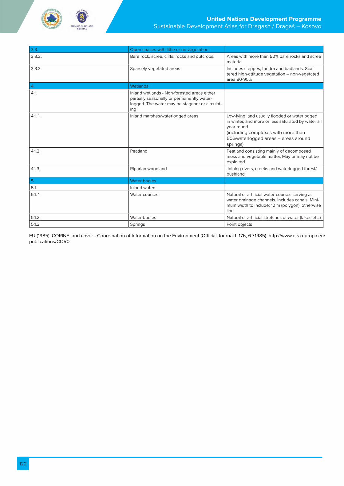
122
United Nations Development Programme Sustainable Development Atlas for Dragash / Dragaš – Kosovo
3.3. Open spaces with little or no vegetation
3.3.2. Bare rock, scree, cliffs, rocks and outcrops. Areas with more than 50% bare rocks and scree material
3.3.3. Sparsely vegetated areas Includes steppes, tundra and badlands. Scat-tered high-attitude vegetation – non-vegetated area 80-95%
4. Wetlands
4.1. Inland wetlands - Non-forested areas either partially seasonally or permanently water-logged. The water may be stagnant or circulat-ing
4.1. 1. Inland marshes/waterlogged areas Low-lying land usually flooded or waterlogged in winter, and more or less saturated by water all year round
(including complexes with more than 50%waterlogged areas – areas around springs)
4.1.2. Peatland Peatland consisting mainly of decomposed moss and vegetable matter. May or may not be exploited
4.1.3. Riparian woodland Joining rivers, creeks and waterlogged forest/bushland
5. Water bodies
5.1. Inland waters
5.1. 1. Water courses Natural or artificial water-courses serving as water drainage channels. Includes canals. Mini-mum width to include: 10 m (polygon), otherwise line
5.1.2. Water bodies Natural or artificial stretches of water (lakes etc.)
5.1.3. Springs Point objects
EU (1985): CORINE land cover - Coordination of Information on the Environment (Official Journal L 176, 6.7.1985). http://www.eea.europa.eu/publications/COR0

123
United Nations Development Programme Sustainable Development Atlas for Dragash / Dragaš – Kosovo
3.2. Remarks for preferential habitats (a)
3.3. Remarks for non-preferential habitats (b)
Preferential Habitats
(EU 2007) (a) – Management required for sustenance Restrictions/conditions for management
6230 * Species-rich Nardus grasslands, on siliceous substrates in mountain areas (and sub-mountain areas, in Continental Europe)
Controlled, extensive pasture required
6120 * Xeric sand calcareous grasslands Controlled, extensive pasture required
91E0* Alluvial forests with Alnus glutinosa and Fraxinus excelsior (Alno-Padion, Alnion incanae, Salicion albae)
Professional management – forest management and maintenance of the waterside required
6210 * important orchid sites of semi-natural dry grasslands and scrubland facies on calcareous substrates (Festuco-Brometalia)
Controlled, extensive pasture required
6110 * Rupicolous calcareous or basophilic grasslands of the Alysso-Sedion albi
Controlled, extensive pasture possible
91AA *Eastern white oak woods FSC based forest management possible
4070 * Bushes with Pinus mugo and Rhododen-dron hirsutum (Mugo-Rhododendretum hirsuti)
Controlled collection of non.-forest products can be allowed
9180 * Tilio-Acerion forests of slopes, screes and ravines
FSC based forest management possible
Non-preferential habitats (EU 2007) (b) – Management required for sustenance Kufizimet/ kushtet për menaxhim
No wildfires/ fire control Restrictions/conditions for management Mund të lejohet grumbullim i kontrolluar i produkteve jo pyjore
5130 Juniperus communis formations on heaths or calcareous grasslands
Controlled, extensive pasture required Controlled collection of non.-forest products can be allowed
6150 Siliceous alpine and boreal grasslands Controlled, extensive pasture required Controlled collection of non.-forest products can be allowed
6210 Semi-natural dry grasslands and scrubland facies on calcareous substrates (Festuco-Bro-metalia) ( * important orchid sites)
Controlled, extensive pasture required
62D0 Oro-Moesian acidophilous grasslands Controlled, extensive pasture required
6510 Lowland hay meadows (Alopecurus praten-sis, Sanguisorba officinalis)
Pasture / harvesting required
6520 Mountain hay meadows Pasture / harvesting required
4060 Alpine and Boreal heaths Controlled, extensive pasture possible
Controlled collection of non.-forest products can be allowed
Mund të lejohet grumbullim i kontrolluar i produkteve jo pyjore
5110 Stable xerothermophilous formations with Buxus sempervirens on rock slopes (Berberidion p.p.)
Controlled collection of non.-forest products can be allowed
6170 Alpine and subalpine calcareous grass-lands
Controlled, extensive pasture possible
Extensive pasture possible Është e mundur kullosa e gjerë
6430 Hydrophilous tall herb fringe communities of plains and of the montane to alpine levels
Controlled collection of non.-forest products can be allowed
7140 Transition mires and quaking bogs
7230 Alkaline fens
8210 Calcareous rocky slopes with chasmophyt-ic vegetation
8230 Siliceous rock with pioneer vegetation of the Sedo-Scleranthion or of the Sedo albi-Vero-nicion dillenii
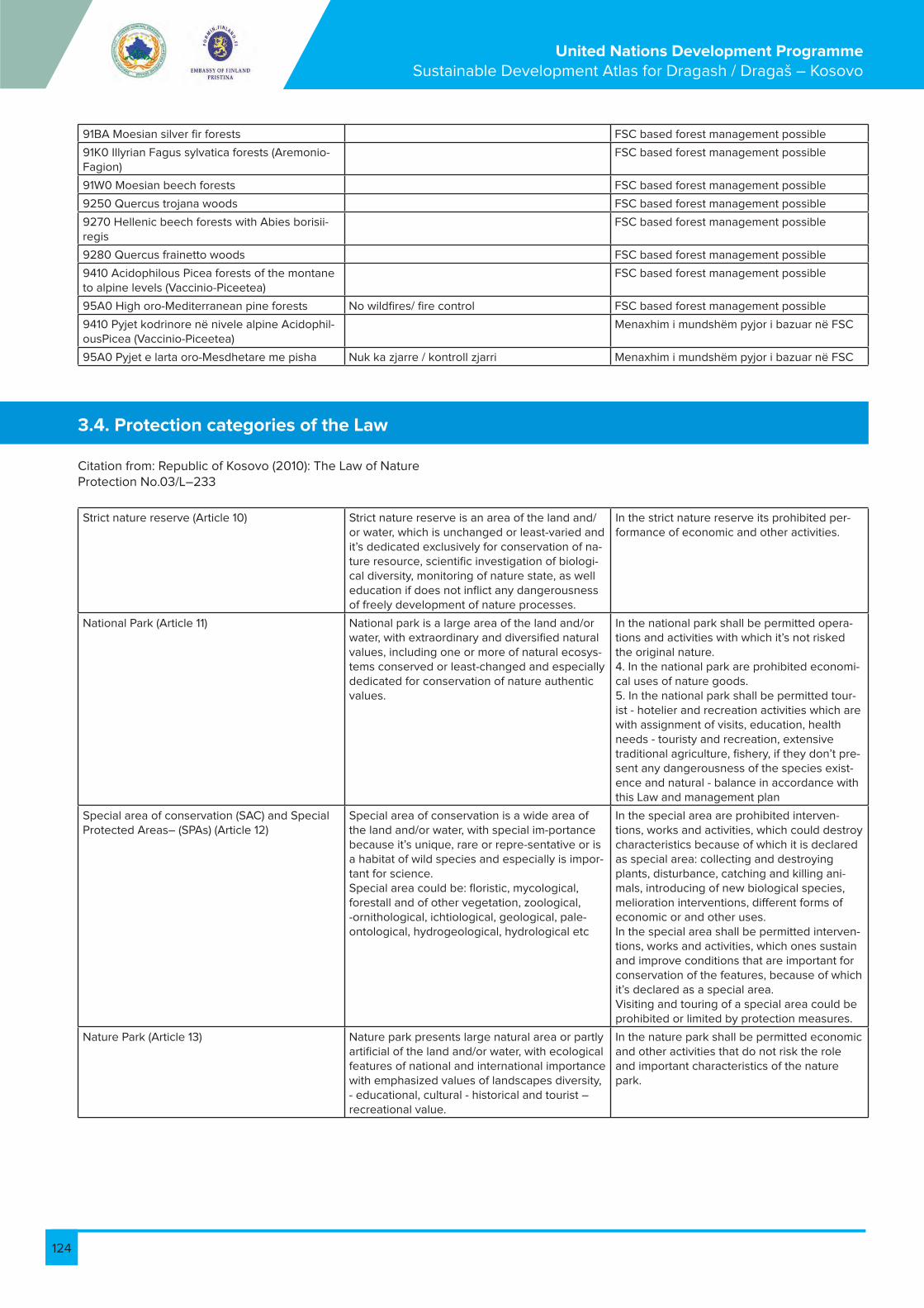
124
United Nations Development Programme Sustainable Development Atlas for Dragash / Dragaš – Kosovo
91BA Moesian silver fir forests FSC based forest management possible
91K0 Illyrian Fagus sylvatica forests (Aremonio-Fagion)
FSC based forest management possible
91W0 Moesian beech forests FSC based forest management possible
9250 Quercus trojana woods FSC based forest management possible
9270 Hellenic beech forests with Abies borisii-regis
FSC based forest management possible
9280 Quercus frainetto woods FSC based forest management possible
9410 Acidophilous Picea forests of the montane to alpine levels (Vaccinio-Piceetea)
FSC based forest management possible
95A0 High oro-Mediterranean pine forests No wildfires/ fire control FSC based forest management possible
9410 Pyjet kodrinore në nivele alpine Acidophil-ousPicea (Vaccinio-Piceetea)
Menaxhim i mundshëm pyjor i bazuar në FSC
95A0 Pyjet e larta oro-Mesdhetare me pisha Nuk ka zjarre / kontroll zjarri Menaxhim i mundshëm pyjor i bazuar në FSC
Citation from: Republic of Kosovo (2010): The Law of Nature Protection No.03/L–233
3.4. Protection categories of the Law
Strict nature reserve (Article 10) Strict nature reserve is an area of the land and/or water, which is unchanged or least-varied and it’s dedicated exclusively for conservation of na-ture resource, scientific investigation of biologi-cal diversity, monitoring of nature state, as well education if does not inflict any dangerousness of freely development of nature processes.
In the strict nature reserve its prohibited per-formance of economic and other activities.
National Park (Article 11) National park is a large area of the land and/or water, with extraordinary and diversified natural values, including one or more of natural ecosys-tems conserved or least-changed and especially dedicated for conservation of nature authentic values.
In the national park shall be permitted opera-tions and activities with which it’s not risked the original nature.4. In the national park are prohibited economi-cal uses of nature goods.5. In the national park shall be permitted tour-ist - hotelier and recreation activities which are with assignment of visits, education, health needs - touristy and recreation, extensive traditional agriculture, fishery, if they don’t pre-sent any dangerousness of the species exist-ence and natural - balance in accordance with this Law and management plan
Special area of conservation (SAC) and Special Protected Areas– (SPAs) (Article 12)
Special area of conservation is a wide area of the land and/or water, with special im-portance because it’s unique, rare or repre-sentative or is a habitat of wild species and especially is impor-tant for science.Special area could be: floristic, mycological, forestall and of other vegetation, zoological, -ornithological, ichtiological, geological, pale-ontological, hydrogeological, hydrological etc
In the special area are prohibited interven-tions, works and activities, which could destroy characteristics because of which it is declared as special area: collecting and destroying plants, disturbance, catching and killing ani-mals, introducing of new biological species, melioration interventions, different forms of economic or and other uses.In the special area shall be permitted interven-tions, works and activities, which ones sustain and improve conditions that are important for conservation of the features, because of which it’s declared as a special area.Visiting and touring of a special area could be prohibited or limited by protection measures.
Nature Park (Article 13) Nature park presents large natural area or partly artificial of the land and/or water, with ecological features of national and international importance with emphasized values of landscapes diversity, - educational, cultural - historical and tourist – recreational value.
In the nature park shall be permitted economic and other activities that do not risk the role and important characteristics of the nature park.

125
United Nations Development Programme Sustainable Development Atlas for Dragash / Dragaš – Kosovo
Nature monument (Article 14) A nature monument is the individual unchanged segment or a group of segments of living or non-living nature distinguished by ecological, scientific, aesthetic or educational value.Nature monument may be: geological - pale-ontological, mineralogical, hydrologic, geologic structure, sediment, geomorphologic - cave, chasm, cliff walls, hydrologic – water sources, water flow, waterfall, lake, botanic - rare exem-plars or important for vegetative world of one locality, small botanic or zoological locality, important for its scientific values.
In the nature monument or in his locality which is component part of protected area, shall not be permitted activities that endanger charac-teristics and its values.
Protected landscape (Article 15) Protected landscape is natural or factitious nature area with high landscape and biological diversity values, or cultural - historical, or land-scape with unique conservation characteristics for certain region that is dedicated for relaxing and recreation.
In the protected landscape are forbidden inter-ventions and activities that destroy characteris-tics for which ones it is declared protected.

126
United Nations Development Programme Sustainable Development Atlas for Dragash / Dragaš – Kosovo
Volume V: Data
Peter BankFlorian Bemmerlein-Lux
Ismail GagicaErgin Hajredini
Prof. Dr. Behxhet Mustafa – Ecologist
Prof. Fadil Millaku - Biologist
Dr. Halil Ibrahimi - Ecologist
Dr. Achim Milbradt – Biologist
Michael Voit - Rural Development Planner
Prof. Xhevdet Elezi - Soil scientist – agronomist
Arneni - National forest consultancy company, NGO
Finches – Ornithologists
Todd Wassel – Tourism Specialist
Bashkim Susuri – Journalist and Project Associate
Bardh Xerxa – Ecologist
Ajhan Hadzija – Tourism Coordinator
the Municipal Working Group of Dragash/Dragaš Municipality
and Deutsche Gesellschaft für Internationale Zusammenarbeit
(GIZ) GmbH, Rural Economic Development Programme.
Project ManagerMaria Elena Zuniga Barrientos
Dragash / Dragaš, Kosovo March 2013
With contributions from
United Nations Development Programme
Conservation of Biodiversity and Sustainable Land
Use Management in Dragash/Dragaš

127
United Nations Development Programme Sustainable Development Atlas for Dragash / Dragaš – Kosovo
Table of Content
1. Data for Volume II: Baseline .................................................................................................................................................................................................... 122
1.1. Data stored in Excel-files ....................................................................................................................................................................................................... 128
1.2. Map B2: Population and Infrastructure ............................................................................................................................................................................. 129
1.3.Map B3: Geology ...................................................................................................................................................................................................................... 131
1.4. Map B4: Soils ............................................................................................................................................................................................................................ 131
1.5. Map B5: Climate ...................................................................................................................................................................................................................... 131
1.6. Map B7: Land Use .................................................................................................................................................................................................................. 132
1.7. Map B8: Biodiversity Flora and Vegetation ...................................................................................................................................................................... 134
1.7.1. Species Lists of Sample Points .......................................................................................................................................................................................... 134
1.7.2. Overall List of Plant Species (alphabetical order) ......................................................................................................................................................... 161
1.7.3. List of Plant Communities .................................................................................................................................................................................................. 179
1.8. Map B9: Biodiversity Fauna .................................................................................................................................................................................................. 181
1.8.1 Mammals known in Dragash/Dragaš ................................................................................................................................................................................ 181
1.8.2. List of Vertebrates (except Birds) observed Dragash/Dragaš .................................................................................................................................. 181
1.8.3. Birds known in Dragash/Dragaš ..................................................................................................................................................................................... 183
1.8.4. Butterflies known in Dragash/Dragaš ............................................................................................................................................................................ 192
2. Data for Volume III: Assessment ........................................................................................................................................................................................... 194
2.1 Excerpts from “Forest Stewardship Standard for the Republic of Kosovo ............................................................................................................... 194
3. Annexes ......................................................................................................................................................................................................................................200
3.1. List of Laws, Rules, Regulations .........................................................................................................................................................................................200
3.2. Habitat Types .........................................................................................................................................................................................................................201
3.3. Water Quality Assessment .................................................................................................................................................................................................205
List of Tables
Table 1 1: List of Excel Files relevant for Base Maps ............................................................................................................................................................. 128
Table 1 2: Map B1: Population Data ........................................................................................................................................................................................... 129
Table 1 3: Map B1: Number of Households ............................................................................................................................................................................. 130
Table 1 4: Map B3: Classes of Rocks ......................................................................................................................................................................................... 131
Table 1 5: Map B4: Classes of Soils ............................................................................................................................................................................................ 131
Table 1 6: Map B5: Climate Data for Dragash.......................................................................................................................................................................... 131
Table 1 7: CORINE Land Use Codes ......................................................................................................................................................................................... 133
Table 1 8: Plant Samples AM01 - AM15 Dr. A. Milbradt ......................................................................................................................................................... 135
Table 1 9: Plant Samples AM16 – AM30 Dr. A. Milbradt ........................................................................................................................................................137
Table 1 10: Plant Samples AM31 – AM44 Dr. A. Milbradt ..................................................................................................................................................... 139
Table 1 11: Plant Samples AM46 – AM60 Dr. A. Milbradt ..................................................................................................................................................... 140
Table 1 12: Plant Samples AM61 – AM75 Dr. A. Milbradt...................................................................................................................................................... 142
Table 1 13: Plant Samples AM76 – AM90 Dr. A. Milbradt .................................................................................................................................................... 144
Table 1 14: Plant Samples BX01 – BX15 Prof. Dr. M. Behxhet ............................................................................................................................................. 145
Table 1 15: Plant Samples BX16 – BX30 Prof. Dr. M. Behxhet ............................................................................................................................................ 146
Table 1 16: Plant Samples BX31 – BX45 Prof. Dr. M. Behxhet .............................................................................................................................................147
Table 1 17: Plant Samples BX46 – BX60 Prof. Dr. M. Behxhet ............................................................................................................................................147
Table 1 18: Plant Samples BX61 – BX75 Prof. Dr. M. Behxhet............................................................................................................................................. 148
Table 1 19: Plant Samples BX76 – BX90 Prof. Dr. M. Behxhet ........................................................................................................................................... 149
Table 1 20: Plant Samples BX91 – BX100 Prof. Dr. M. Behxhet ......................................................................................................................................... 149
Table 1 21: Plant Samples FM01 – FM16 Prof. Dr. F. Millaku ................................................................................................................................................ 154
Table 1 22: Plant Samples FM17 – FM32 Prof. Dr. F. Millaku ............................................................................................................................................... 160
Table 1 23: Overall List of Plant Species .................................................................................................................................................................................. 179
Table 1 24: List of Plant Communities ....................................................................................................................................................................................... 180
Table 1 25: List of Mammals known in Dragash/Dragaš) ...................................................................................................................................................... 181

128
United Nations Development Programme Sustainable Development Atlas for Dragash / Dragaš – Kosovo
1. Data for Volume II: Baseline
1.1. Data stored in Excel-files
Map Excel Files Content
B1: Overview of the Municipality of Dragash 01 Topography_Dragash.xlsc Data and Figures for SDA, additional figures for selected villages
B2: Population and Infrastructure Dragash_Village_DB.xls Collection of all information related to villages (GIS Database)
B3: Geology and Minerals 03 Geology_Dragash.xlsc Data and Figures for SDA
B4: Soils 04 Soils_Dragash.xlsc Data and Figures for SDA
B5: Climate 05 Climate_Dragash.xlsc Data and Figures for SDA
B6: Water Resources 06 Water_Resources_Dragash.xlsc Data and Figures for SDA
Analysis 06 Water_Resources_Dragash.xlsc GIS output for production of figures and tables for SDA
Dragash_Water_DB.xls Collection of all information related to Water Resources (GIS Database)
WSS_DB.xls Collection of all information related to Water Supply and Sanitation (GIS Database)
B7: Land Use 07 Land_Use_Dragash.xlsc Data and Figures for SDA
Analysis 07 Land_Use_Dragash.xlsc GIS output for production of figures and tables for SDA
Corine_LUT.xls List of relevant Corine types and details for building of GIS Legends
Landusebalance.xlsc Balances of land use related to various topics, e.g. river basins, villages, National Park
B8: Biodiversity – Flora and Vegetation Biodiversity_List.xls Collection of all information related to Biodiver-sity issues (GIS Database)
B9: Biodiversity - Fauna Biodiversity_List.xls Collection of all information related to Biodiver-sity issues (GIS Database)
Table 1-1: List of Excel Files relevant for Base Maps

129
United Nations Development Programme Sustainable Development Atlas for Dragash / Dragaš – Kosovo
1.2. Map B2: Population and Infrastructure
Data are stored in the file Dragash_Village_DB.xls
ID Village 1921¹ 1948 1953 1961 1971 1981 1991 2011 2010² 2022³ Klasifi-kacija⁴
Trend since 1981
1 Bačka / Baçkë 167 222 249 259 311 381 215 52 54 <1.000 DECR
2 Bellobrad / Belo-brad
232 415 345 385 568 808 998 948 1.100 2.171 <1.000 INCR
3 Blaç / Bljać 360 474 503 594 797 1.123 1.415 1,455 2.623 1.000 - 3.5000
INCR
4 Brezne / Brezna 590 908 871 946 1.410 1.971 2.465 1,990 2.300 5.005 1.000 - 3.5000
STABLE
5 Brod / Brod 1.863 2.248 2.229 1.604 1.485 1.685 1.741 1,544 1.464 1.000 - 3.5000
STABLE
6 Bresanë / Brodos-avce
844 1.219 1.229 1.353 1.861 2.498 2.999 2,839 5.490 1.000 - 3.5000
INCR
7 Brrut / Brut 450 596 584 575 798 1.097 1.319 1,164 1.200 2.196 1.000 - 3.5000
STABLE
8 Buçe / Buće 269 398 400 437 574 766 913 645 1.226 <1.000 DECR
9 Buzez / Buzez 74 102 102 127 191 240 366 320 463 <1.000 INCR
10 Dikance / Dikanc 162 318 320 349 392 282 257 124 162 <1.000 DECR
11 Dragash / Dragaš 172 408 480 612 694 1.114 1.532 1,098 3.000 2.310 1.000 - 3.5000
STABLE
12 Globočica / Gllo-boçicë
391 648 683 757 813 1.002 968 960 768 <1.000 STABLE
13 Kapre / Kapra 154 214 255 265 354 496 582 452 800 613 <1.000 STABLE
14 Kosavë / Kosavce 300 488 486 525 720 912 1.033 905 1.464 <1.000 STABLE
15 Krstec / Kërstec 299 465 440 475 562 798 837 420 950 332 <1.000 DECR
16 Kruševo / Krushevë 126 281 319 377 513 645 738 857 762 <1.000 INCR
17 Kuk / Kukovce 433 640 655 669 985 1.335 1.619 1,658 3.111 1.000 - 3.5000
INCR
18 Kuklibeg / Kukljibeg 234 408 383 409 516 658 916 852 1.342 <1.000 INCR
19 Kukuljane / Kuku-lanë
361 543 551 482 605 777 621 235 1.200 353 <1.000 DECR
20 Leštane / Leshtan 537 493 513 658 758 679 783 1.100 240 <1.000 STABLE
21 Ljubovište / Lubov-ishtë
211 344 352 384 541 690 799 773 1.200 439 <1.000 INCR
22 Mlike / Mlikë 260 461 428 428 455 506 335 92 1.200 139 <1.000 DECR
23 Orčuša / Orçushë 415 370 396 431 427 221 60 69 <1.000 DECR
24 Pllavë / Plava 462 449 493 690 972 1.125 1,000 1.400 512 1.000 - 3.5000
STABLE
25 Pllajnik / Plajnik 322 321 365 485 549 576 405 1.464 <1.000 DECR
26 Radeša / Radeshë 440 753 794 837 884 1.279 1.226 1,224 1.162 1.000 - 3.5000
STABLE
27 Rapča / Rapçë 622 889 877 885 1.125 1.647 1.781 853 2.200 1.053 <1.000 DECR
28 Restelica / Restelicë 745 1.393 1.471 1.772 2.576 3.476 4.274 4,698 5.124 1.000 - 3.5000
INCR
29 Rrenc / Renc 127 188 177 202 292 473 685 581 900 854 <1.000 INCR
30 Shajne / Šajnovce 440 626 639 705 921 1.253 1.415 1,069 2.379 1.000 - 3.5000
DECR
31 Vranište / Vranisht 755 771 815 884 926 731 352 2.000 362 <1.000 DECR
32 Xërxe / Zrze 90 215 202 205 269 335 373 236 600 305 <1.000 DECR
33 Zaplluxhe / Zaplužje 470 667 663 666 967 1.275 1.504 1,273 2.745 1.000 - 3.5000
STABLE
34 Zgatar / Zgatar 435 435 401 415 640 818 985 885 1.150 1.708 <1.000 STABLE
35 Zlipotok / Zlipotok 486 488 532 568 625 619 610 393 <1.000 STABLE
36 Zym / Zjum 139 197 167 215 315 457 573 585 585 <1.000 INCR
Dragash / Dragaš
Municipality11.460 20.140 20.147 21.028 26.850 35.054 39.435 33.997 51.442 CONST
Table 1-2: Map B1: Population Data

130
United Nations Development Programme Sustainable Development Atlas for Dragash / Dragaš – Kosovo
ID Village 1921⁵ 1948 1953 1961 1971 1981 1991 2011
1 Bačka / Baçkë 36 46 45 52 51 63 35 17
2 Bellobrad / Belobrad 40 54 50 45 50 87 106 161
3 Blaç / Bljać 54 68 67 71 93 110 154 218
4 Brezne / Brezna 108 132 145 155 175 219 289 345
5 Brod / Brod 335 397 418 326 288 287 316 382
6 Bresanë / Brodosavce 158 174 182 195 205 244 322 414
7 Brrut / Brut 70 85 84 75 86 99 143 167
8 Buçe / Buće 38 64 64 74 82 92 119 108
9 Buzez / Buzez 11 13 13 16 22 22 37 57
10 Dikance / Dikanc 40 61 63 67 66 56 47 43
11 Dragash / Dragaš 35 83 119 143 153 224 385 236
12 Globočica / Glloboçicë 90 125 127 133 146 159 163 227
13 Kapre / Kapra 19 25 28 26 36 57 63 69
14 Kosavë / Kosavce 42 85 83 84 97 122 136 130
15 Krstec / Kërstec 65 52 59 61 66 84 111 127
16 Kruševo / Krushevë 28 47 46 58 84 104 120 159
17 Kuk / Kukovce 63 73 83 79 97 131 195 233
18 Kuklibeg / Kukljibeg 37 55 56 48 58 71 101 77
19 Kukuljane / Kukulanë 67 94 94 85 97 120 98 135
20 Leštane / Leshtan 90 95 95 110 121 111 181
21 Ljubovište / Lubovishtë 44 54 60 60 76 107 118 182
22 Mlike / Mlikë 54 74 85 91 99 103 70 46
23 Orčuša / Orçushë 75 76 81 80 69 38 20
24 Pllavë / Plava 70 72 67 85 98 125 156
25 Pllajnik / Plajnik 32 45 44 43 50 52 61 51
26 Radeša / Radeshë 67 105 116 117 143 181 185 253
27 Rapča / Rapçë 120 141 149 156 189 253 292 252
28 Restelica / Restelicë 173 257 268 289 396 502 701 788
29 Rrenc / Renc 22 26 25 23 29 40 73 93
30 Shajne / Šajnovce 74 100 99 93 100 146 159 198
31 Vranište / Vranisht 127 138 142 161 168 133 93
32 Xërxe / Zrze 17 21 30 29 31 42 45 37
33 Zaplluxhe / Zaplužje 76 84 86 82 97 123 175 197
34 Zgatar / Zgatar 42 57 56 65 72 76 100 139
35 Zlipotok / Zlipotok 95 93 84 106 105 109 132
36 Zym / Zjum 24 30 27 32 35 43 58 92
Dragash / Dragaš 3184 3345 3342 3811 4580 5493 6215
Municipality
Table 1-3: Map B1: Number of Households
5 1921 – 2011: source: UN Habitat Database, data from Kosovo Statistical Agency, 2011 Census
¹ 1921 – 2011: source: UN Habitat Database, data from Kosovo Statistical Agency, 2011 Census ² 2010: source: Water Supply Plan from Municipality and Hidroplan Pristina ³ 2022: Projection from UNDP Population Projections, 2012 (to be reviewed) ⁴ Based on population data from census 2011

131
United Nations Development Programme Sustainable Development Atlas for Dragash / Dragaš – Kosovo
1.3. Map B3: Geology
1.4. Map B4: Soils
1.5. Map B5: Climate
Table 1 4: Map B3: Classes of Rocks
Table 1 5: Map B4: Classes of Soils
Table 1 6: Map B5: Climate Data for Dragash/Dragaš)
Average precipitation in mm 1950-2008 / Temperature 1960-1984
Classes of Rocks Area in ha
Magmatites 3.522
Metamorphic Rocks 21.856
Sandstones and Quartzites 2.765
Limestones 6.598
Quartenary Sediments 8.806
Total 43.546
Soil Class Area in ha
Bare Rocks 663
Lithosols 4.110
Rankers 27.514
Rendzinas 3.878
Brown Soils 5.756
Flood Plain Soils 3.010
Gleys 77
Organic Soils 14
Total 45.022
J F M A M J J A S O N D an-nualy
precipi-tation in mm
46 50 43 75 78 101 54 43 82 77 83 75 807
tempera-ture in Degrees C
1,4 -0,3 2,9 7,3 12,0 15,5 17,8 18,2 14,1 9,0 4,4 0,6 8,6
6 Source of Data: Osnovna Geološko Karta SFRJ 1:100,000 – Geološki Institut, Beograd (1970-1984) 7 Source of Data: Pedološke Karta Socijalisticke Autonomne Pokrajine - Kosovo - 1 : 50,000, Beograd 1974, Insti-tut za vodoprivredu “Jaroslav Ćerni” ⁸ Source of Data: Prof.Dr.Sci. Sylë Tahirsylaj MMPH-IHMK, Prishtina (2011)

132
United Nations Development Programme Sustainable Development Atlas for Dragash / Dragaš – Kosovo
Note: Numbers are the official CORINE numbers, any additional unit has the next free number in the Corine system and is marked Dragash – new additions
1.6. Map B7: Land Use
1 Settlements and artificial surfaces
1.1 Urban fabric
1.1.1 Continuous urban fabric Most of the land is covered by. Buildings, roads and artificially surfaced area cover almost all the ground. Non-linear areas of vegetation and bare soil are exceptional.
1.1.2. Discontinuous urban fabric Most of the land is covered by structures. Buildings, roads and artificially surfaced areas associated with vegetated areas and bare soil, which occupy discontinuous but significant surfaces.
1.2. Industrial, commercial and transport
1.2.1. Industrial or commercial units Artificially surfaced areas (with concrete, asphalt, tamacadam, or stabilised, e.g. beaten earth) devoid of vegetation, occupy most of the area in question, which also contains buildings and/or vegetated areas.
1.2.2. Road and rail networks and associated land Motorways, railways, including associated installations (stations, platforms, embankments). Minimum width to include: 100m.
1.3. Mine, dump and construction sites
1.3.1. Mineral extraction sites Areas with open-pit extraction of industrial minerals (sandpits, quarries) or other minerals (opencast mines). Includes flooded gravel pits, except for river-bed extraction.
1.3.2. Dump sites Landfill or mine dump sites, industrial or public.
1.4. Artificial, non-agricultural vegetated areas
1.4.2. Sport and leisure facilities Camping grounds, sports grounds, leisure parks, golf courses, racecourses, etc. Includes formal parks not surrounded by urban zones
1.5 Cultural Heritage Single buildings/complexes of cultural importance (Mosques, Churches, cemeteries, monuments, castles etc.)Mark exceptional “View Points” (landscape) with symbol (incl. direction of view) ▲
2. Agricultural areas
2.1 Arable land - Cultivated areas regularly ploughed and generally under a rotation system.
2.1.1. Non-irrigated arable land Cereals, legumes, fodder crops, root crops and fallow land. Includes flower and tree (nurseries) cultivation and vegetables, whether open field, under plastic or glass (includes market gardening). Includes aromatic, medicinal and culinary plants. Excludes permanent pastures
2.1.2. Permanently irrigated land Crops irrigated permanently and periodically, using a permanent infrastructure (irrigation channels, drainage network). Most of these crops could not be cultivated without an artificial water supply. Does not include sporadically irrigated land
2.2. Permanent crops - Crops not under rotation system - which provides repeated harvests and occupy the land for a long period before it is ploughed and replanted: mainly plantations of woody crops. Excludes pastures, grazing lands and forests
2.2.2. Fruit trees and berry plantations Parcels planted with fruit trees or shrubs: single or mixed fruit species, fruit trees associated with permanently grassed surfac-es. Includes chestnut and walnut groves
2.3. Pastures
2.3.1. Pastures intensive without trees and shrubs Dense, predominantly graminoid grass cover, of floral composi-tion, mainly used for grazing and harvesting, often manured - hedges <10%
2.3.2. Pastures intensive with trees and shrubs Dense, predominantly graminoid grass cover, of floral compo-sition, mainly used for grazing and harvesting, often manured - areas with hedges (>10%)(countryside with small pastures and many hedges)
2.3.3 Pastures extensive without trees and shrubs Predominantly graminoid grass cover, extensive grazing, no har-vest and fertilisation, <10% woody species
2.3.4 Pastures extensive with trees and shrubs Predominantly graminoid grass cover, extensive grazing, no har-vest and fertilisation, >10% woody species (esp. Juniper)
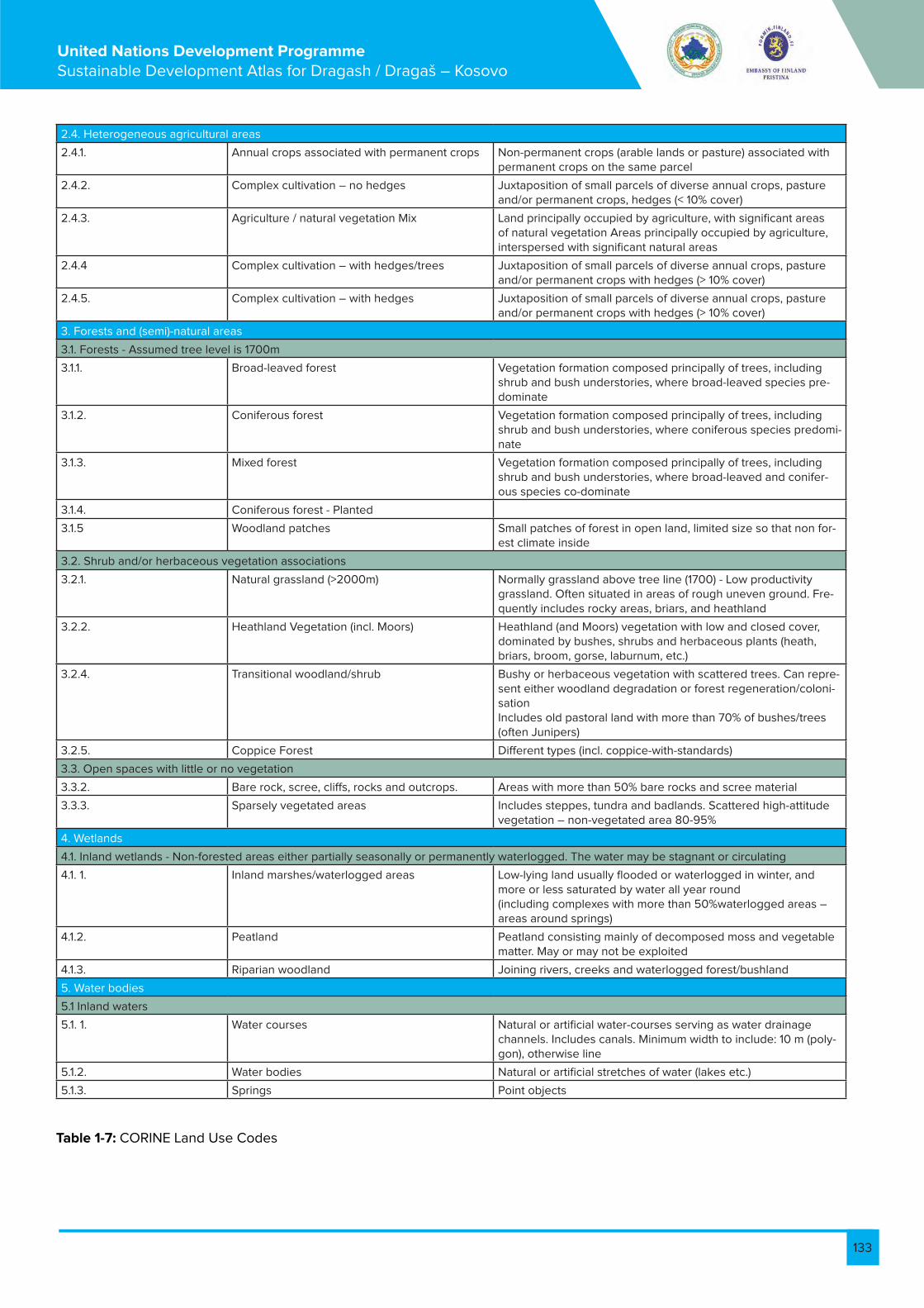
133
United Nations Development Programme Sustainable Development Atlas for Dragash / Dragaš – Kosovo
2.4. Heterogeneous agricultural areas
2.4.1. Annual crops associated with permanent crops Non-permanent crops (arable lands or pasture) associated with permanent crops on the same parcel
2.4.2. Complex cultivation – no hedges Juxtaposition of small parcels of diverse annual crops, pasture and/or permanent crops, hedges (< 10% cover)
2.4.3. Agriculture / natural vegetation Mix Land principally occupied by agriculture, with significant areas of natural vegetation Areas principally occupied by agriculture, interspersed with significant natural areas
2.4.4 Complex cultivation – with hedges/trees Juxtaposition of small parcels of diverse annual crops, pasture and/or permanent crops with hedges (> 10% cover)
2.4.5. Complex cultivation – with hedges Juxtaposition of small parcels of diverse annual crops, pasture and/or permanent crops with hedges (> 10% cover)
3. Forests and (semi)-natural areas
3.1. Forests - Assumed tree level is 1700m
3.1.1. Broad-leaved forest Vegetation formation composed principally of trees, including shrub and bush understories, where broad-leaved species pre-dominate
3.1.2. Coniferous forest Vegetation formation composed principally of trees, including shrub and bush understories, where coniferous species predomi-nate
3.1.3. Mixed forest Vegetation formation composed principally of trees, including shrub and bush understories, where broad-leaved and conifer-ous species co-dominate
3.1.4. Coniferous forest - Planted
3.1.5 Woodland patches Small patches of forest in open land, limited size so that non for-est climate inside
3.2. Shrub and/or herbaceous vegetation associations
3.2.1. Natural grassland (>2000m) Normally grassland above tree line (1700) - Low productivity grassland. Often situated in areas of rough uneven ground. Fre-quently includes rocky areas, briars, and heathland
3.2.2. Heathland Vegetation (incl. Moors) Heathland (and Moors) vegetation with low and closed cover, dominated by bushes, shrubs and herbaceous plants (heath, briars, broom, gorse, laburnum, etc.)
3.2.4. Transitional woodland/shrub Bushy or herbaceous vegetation with scattered trees. Can repre-sent either woodland degradation or forest regeneration/coloni-sationIncludes old pastoral land with more than 70% of bushes/trees (often Junipers)
3.2.5. Coppice Forest Different types (incl. coppice-with-standards)
3.3. Open spaces with little or no vegetation
3.3.2. Bare rock, scree, cliffs, rocks and outcrops. Areas with more than 50% bare rocks and scree material
3.3.3. Sparsely vegetated areas Includes steppes, tundra and badlands. Scattered high-attitude vegetation – non-vegetated area 80-95%
4. Wetlands
4.1. Inland wetlands - Non-forested areas either partially seasonally or permanently waterlogged. The water may be stagnant or circulating
4.1. 1. Inland marshes/waterlogged areas Low-lying land usually flooded or waterlogged in winter, and more or less saturated by water all year round(including complexes with more than 50%waterlogged areas – areas around springs)
4.1.2. Peatland Peatland consisting mainly of decomposed moss and vegetable matter. May or may not be exploited
4.1.3. Riparian woodland Joining rivers, creeks and waterlogged forest/bushland
5. Water bodies
5.1 Inland waters
5.1. 1. Water courses Natural or artificial water-courses serving as water drainage channels. Includes canals. Minimum width to include: 10 m (poly-gon), otherwise line
5.1.2. Water bodies Natural or artificial stretches of water (lakes etc.)
5.1.3. Springs Point objects
Table 1-7: CORINE Land Use Codes

134
United Nations Development Programme Sustainable Development Atlas for Dragash / Dragaš – Kosovo
1.7. Map B8: Biodiversity Flora and Vegetation
1.7.1. Species Lists of Sample Points
Species AM01 AM02 AM03 AM04 AM05 AM06 AM07 AM08 AM09 AM10 AM11 AM12 AM13 AM14 AM15
Acer pseudo-platanus
X X
Anthox-anthum odoratum
X X X X
Carduus acan-thoides
X X X X
Cheno-podium bonus-henricus
X X X X
Cirsium palustre
X X X X X X
Cyno-surus cristatus
X X X X
Daphne mezere-um
X X
Des-champsia caespi-tosa
X X X X
Epilobium dodonaei
X X X X
Epilobium hirsutum
X X X X
Gentiana asclepia-dea
X X X
Hera-cleum sphondy-lium agg.
X X X
Juniperus nana
X X
Linum ca-tharticum
X X X
Lonicera spec.
X X X
Luzula cf albida
X X
Mentha longifolia
X X X X
Nardus stricta
X X X X X X X X
Orchi-daceae
X X X
Parnassia palustris
X X X
Polysti-chum lonchitis
X X X X
Rhamnus fallax
X X X

135
United Nations Development Programme Sustainable Development Atlas for Dragash / Dragaš – Kosovo
Rosa agrestis
X X X
Rosa canina agg.
X X X
Rosa cf montana
X X X
Rosa cor-ymbifera
X X X
Rosa glauca
X X X
Rubus idaeus
X X X
Rumex scutatus
X X
Salix caprea
X X X
Sambu-cus rac-emosa
X X X
Satureja acinos
X X X X
Selaginel-la selagi-noides
X X X
Stellaria graminea
X X
Trifolium spadi-ceum
X X X X
Urtica dioica
X X X X
Vac-cinium gaultheri-oides
X X X X X X
Vaccini-um myr-tilloides
X X
Veratrum album
X X
Total No of Spe-cies per Sample
16 20 20 14 14 14 14 6 6 1 1 1 1 2 2
Table 1-8: Plant Samples AM01 - AM15 Dr. A. Milbradt

136
United Nations Development Programme Sustainable Development Atlas for Dragash / Dragaš – Kosovo
Species AM16 AM17 AM18 AM19 AM20 AM21 AM22 AM23 AM24 AM25 AM26 AM27 AM28 AM29 AM30
Acer heldre-ichii
X
Achillea millefolium
X
Aconitum napellus
X
Agrimonia eupatoria
X
Amelanchier ovalis
X X X
Anthoxan-thum odora-tum
X X
Anthyllis vulneraria
X
Asperula cf glauca
X
Avenella flexuosa
X
Bellis peren-nis
X
Betula pen-dula
X
Briza media X
Calamintha clinopodium
X
Campanula cf rotundi-folia
X
Carex flava X X
Carex ros-trata
X X X
Carlina acanthifolia
X
Cirsium arvense
X
Cirsium erio-phorum
X
Cirsium palustre
X
Comarum palustre
X
Corylus avel-lana
X X
Cotoneaster integerrimus
X
Cotoneaster tomentosus
X
Crataegus monogyna
X
Daucus carota
X X
Deschamp-sia caespi-tosa
X X X
Dianthus spec.
X
Dryopteris filix-mas
X
Eriophorum latifolium
X X X
Fumana procumbens
X

137
United Nations Development Programme Sustainable Development Atlas for Dragash / Dragaš – Kosovo
Table 1-9: Plant Samples AM16 – AM30 Dr. A. Milbradt
Galium verum 2 X
Genista sagit-talis
X X X
Gentiana spec.
X
Geum monta-num
X X
Helleborus cf odorus
X
Hieracium pilosella
X X
Hypericum maculatum
X
Jasione spec. X
Juncus articu-latus
X X
Juncus spec. X
Juniperus communis
X
Juniperus nana
X
Lembotropis nigricans
X
Lemna minor X
Linum cathar-ticum
X
Luzula cf albida
X X
Mentha longi-folia
X
Nardus stricta X
Prunus spi-nosa
X X
Pyrus pyraster
X
Rosa agrestis X X
Rosa canina agg.
X
Rosa cf mollis X
Rosa cf mon-tana
X
Rosa cf villosa X
Rosa cor-ymbifera
X
Rosa dumeto-rum
X
Rosa glauca X
Rosa micran-tha
X X
Rosa mollis X X X
Rosa subcol-lina
X
Rosa vosagi-aca
X
Rubus idaeus X
Rumex alpi-nus
X X
Salix fragilis X
Scirpus syl-vaticus
X

138
United Nations Development Programme Sustainable Development Atlas for Dragash / Dragaš – Kosovo
Species AM31 AM32 AM33 AM34 AM35 AM36 AM37 AM38 AM39 AM40 AM41 AM42 AM43 AM44
Abies alba subsp. borisii-regis
X
Achillea millefolium
X X X
Agrimonia eupatoria
X X X
Anthoxan-thum odora-tum
X X
Asperula cf glauca
X X X
Betula pen-dula
X X X X
Briza media X X
Carex flava X X
Carex ros-trata
X X X
Carex vesi-caria
X X
Carlina acanthifolia
X X X
Carpinus betulus
X
Cerinthe minor
X
Comarum palustre
X
Corylus avellana
X X X
Crataegus monogyna
X X X
Cynosurus cristatus
X X
Daucus carota
X X X
Deschamp-sia caespi-tosa
X X
Echium vul-gare
X
Eriophorum latifolium
X X X
Eryngium amethysti-num
X
Fagus syl-vatica
X

139
United Nations Development Programme Sustainable Development Atlas for Dragash / Dragaš – Kosovo
Filipendula ulma-ria
X X
Fumana procum-bens
X X X
Galium verum 2 X X
Genista spec. X
Helleborus cf odorus
X X X
Hieracium pilo-sella
X X X
Juniperus com-munis
X X X X
Lathyrus praten-sis
X X
Lemna minor X
Linaria vulgaris X
Linum catharti-cum
X X
Medicago falcata X
Nardus stricta X X X
Orchis cf mascula X
Parnassia palus-tris
X X
Poa trivialis 2 2
Potentilla erecta X X
Prunus spinosa X X X
Pteridium aquili-num
X
Rosa agrestis X X X
Rosa canina agg. X
Rosa mollis X X X X X
Rosa pendulina X
Rosa subcanina X
Sanguisorba of-ficinalis
X X
Sorbus aria X
Sorbus cf graeca X
Triglochin palus-tris
X
Urtica dioica X X X
Verbena offici-nalis
X X X
Viburnum lantana X
Viola cf hirta X X X
Total No of Spe-cies per Sample
20 19 24 1 17 18 4 2 4 2 4 1 1 2
Tabela : Plant Samples AM31 – AM44 Dr. A. Milbradt
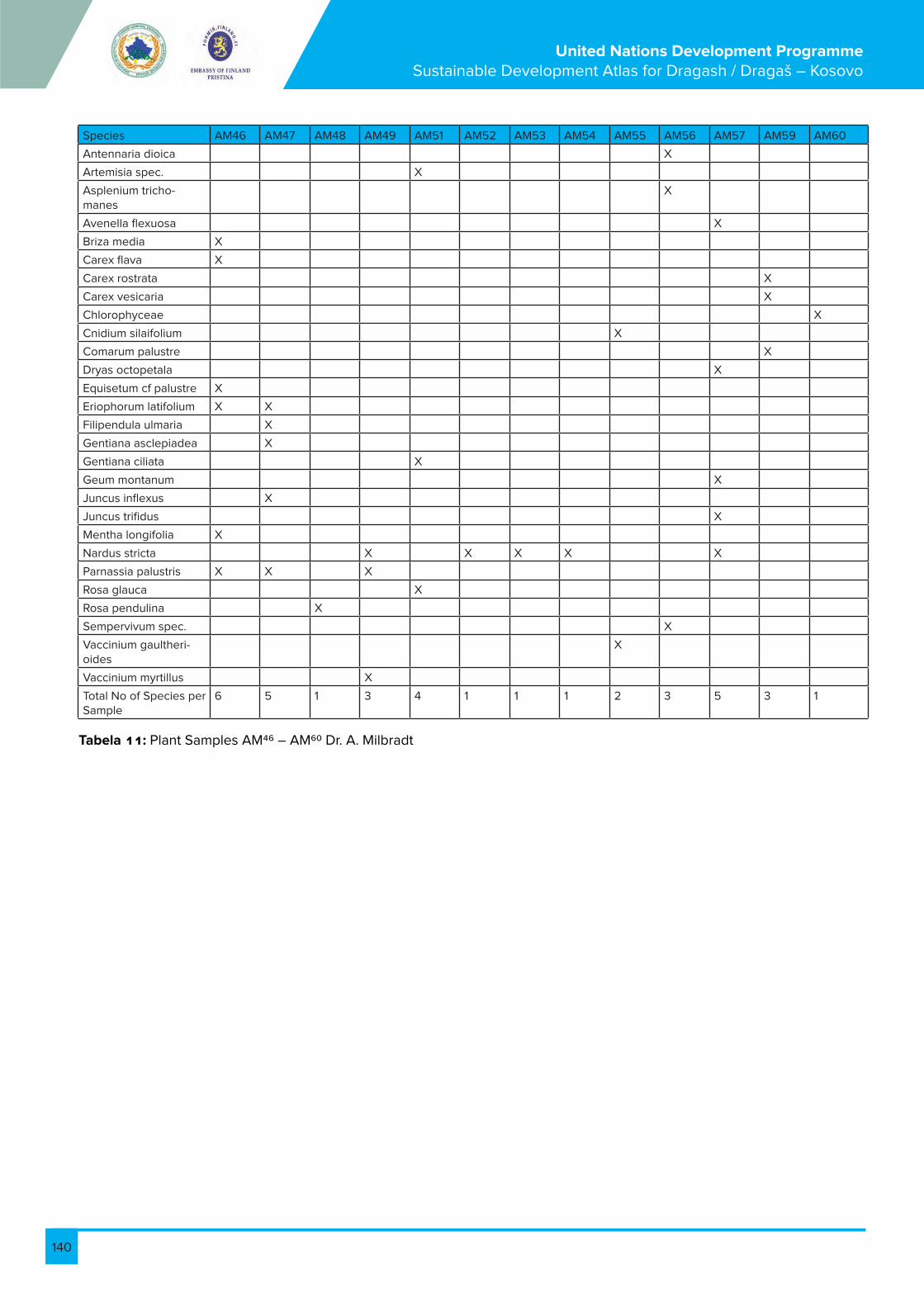
140
United Nations Development Programme Sustainable Development Atlas for Dragash / Dragaš – Kosovo
Tabela : Plant Samples AM46 – AM60 Dr. A. Milbradt
Species AM46 AM47 AM48 AM49 AM51 AM52 AM53 AM54 AM55 AM56 AM57 AM59 AM60
Antennaria dioica X
Artemisia spec. X
Asplenium tricho-manes
X
Avenella flexuosa X
Briza media X
Carex flava X
Carex rostrata X
Carex vesicaria X
Chlorophyceae X
Cnidium silaifolium X
Comarum palustre X
Dryas octopetala X
Equisetum cf palustre X
Eriophorum latifolium X X
Filipendula ulmaria X
Gentiana asclepiadea X
Gentiana ciliata X
Geum montanum X
Juncus inflexus X
Juncus trifidus X
Mentha longifolia X
Nardus stricta X X X X X
Parnassia palustris X X X
Rosa glauca X
Rosa pendulina X
Sempervivum spec. X
Vaccinium gaultheri-oides
X
Vaccinium myrtillus X
Total No of Species per Sample
6 5 1 3 4 1 1 1 2 3 5 3 1

141
United Nations Development Programme Sustainable Development Atlas for Dragash / Dragaš – Kosovo
Species AM61 AM62 AM63 AM64 AM65 AM66 AM67 AM68 AM69 AM70 AM71 AM72 AM73 AM74 AM75
Alchemilla spec
X
Anthyllis vul-neraria
X X X
Arceuthobium oxycedri
X
Arctostaphy-los uva-ursi
X X X X X
Astragalus spec
X
Campanula persicifolia
X
Carex cf caryophyllea
X
Carex nigra X
Centaurea triumfettii
X X
Cirsium can-delabrum
X
Coronilla sp. X
Coronilla varia
X
Corylus avel-lana
X
Dryas octo-petala
X X X X X X
Drypis spi-nosa
X
Empetrum nigrum
X
Epilobium an-gustifolium
X
Eriophorum latifolium
X
Eupatorium cannabinum
X
Fagus syl-vatica
X
Gentiana as-clepiadea
X
Juniperus communis
X
Juniperus nana
X
Juniperus oxycedrus
X
Lilium albani-cum
X
Lilium cf chal-cedonicum
X
Mycelis mu-ralis
X
Ostrya carpin-ifolia
X
Parnassia palustris
X X
Pinguicula balcanica
X
Pinus peuce X X X X X X
Polystichum lonchitis
X

142
United Nations Development Programme Sustainable Development Atlas for Dragash / Dragaš – Kosovo
Pteridium aquilinum
X X
Quercus cer-ris
X
Ranunculus thora
X X X X X
Rosa arvensis X
Rosa pen-dulina
X
Rubus coryli-folii
X
Salix cf re-pens
X
Salix spec. X X X
Saxifraga spec
X X X
Sedum spec X X X
Selaginella selaginoides
X
Senecio fuchsii
X
Thymus vul-garis
X
Trifolium spa-diceum
X
Urtica dioica X
Vaccinium gaultheri-oides
X X
Vaccinium myrtillus
X
Total No of Species per Sample
3 2 3 6 12 2 8 7 8 8 7 5 4 3 1
Tabela : Plant Samples AM61 – AM75 Dr. A. Milbradt

143
United Nations Development Programme Sustainable Development Atlas for Dragash / Dragaš – Kosovo
Species AM76 AM77 AM78 AM79 AM80 AM81 AM82 AM83 AM84 AM85 AM86 AM87 AM88 AM89 AM90
Alchemilla spec
X
Alnus gluti-nosa
X
Asplenium septentrion-ale
X
Astrantia major
X
Avenella flexuosa
X
Briza media X
Caltha palustris
X
Campanula glomerata
X
Carex hirta X
Carex ros-trata
X
Cirsium palustre
X
Crepis cf paludosa
X
Cynosurus cristatus
X X
Deschamp-sia caespi-tosa
X
Dryopteris filix-mas
X X
Epilobium hirsutum
X
Eriophorum latifolium
X X
Eupatorium cannabi-num
X
Euphorbia cyparissias
X
Fagus syl-vatica
X
Filipendula ulmaria
X X
Fragaria vesca
X
Galium odoratum
X
Galium palustre
X
Geum mon-tanum
X
Holcus lanatus
X
Hypericum maculatum
X
Juncus ef-fusus
X
Juncus trifidus
X
Luzula cf albida
X
Mentha longifolia
X
Myosotis cf palustris
X X

144
United Nations Development Programme Sustainable Development Atlas for Dragash / Dragaš – Kosovo
Nardus stricta
X X
Parnassia palustris
X
Plantago holosteum
X
Polypodium vulgare
X
Polystichum lonchitis
X
Potentilla erecta
X
Prenanthes purpurea
X
Prunella vulgaris
X
Pulicaria cf dysenterica
X
Rosa cor-ymbifera
X
Rosa mollis X
Rosa pen-dulina
X X
Salix spec. X
Sambucus ebulus
X
Sanguisor-ba offici-nalis
X
Schoeno-plectus lacustris
X
Scirpus sylvaticus
X
Sempervi-vum spec.
X
Silene vul-garis
X
Solanum nigrum agg.
X
Thalictrum cf aquilegi-folium
X
Vaccinium gaultheri-oides
X X
Vaccinium myrtillus
X X X
Total No of Species per Sample
1 1 1 1 14 8 3 15 7 3 4 4 1 1 1
Tabela -13: Plant Samples AM76 – AM90 Dr. A. Milbradt

145
United Nations Development Programme Sustainable Development Atlas for Dragash / Dragaš – Kosovo
Species BX01 BX02 BX03 BX04 BX05 BX06 BX07 BX08 BX09 BX10 BX11 BX12 BX13 BX14 BX15
Achil-lea atrata
X
Achil-lea holos-ericea
X
Arabis bry-oides
X
Dryas octo-petala
X X
Gen-tiana lutea
X
Genti-anella bulga-rica
X
Linaria pelopo-nesiaca
X X X
Narthe-cium scardi-cum
X
Poten-tilla spe-ciosa
X
Rham-nus orbicu-latus
X
Saxi-fraga scard-ica
X X X X
Viola grise-bachi-na
X X
Table 1 14: Plant Samples BX01 – BX15 Prof. Dr. M. Behxhet

146
United Nations Development Programme Sustainable Development Atlas for Dragash / Dragaš – Kosovo
Species BX16 BX17 BX18 BX19 BX20 BX21 BX22 BX23 BX24 BX25 BX26 BX27 BX28 BX29 BX30
Achillea chryso-coma
X
Achillea holoseri-cea
X
Bupleurum karglii
X
Draba ko-rabensis
X
Drypis spinosa
X X
Gentiana lutea
X
Hieracium waldsteinii
X
Linaria pelopone-siaca
X
Pinus hel-dreichii
X
Potentilla monteneg-rina
X
Rhamnus orbiculatus
X
Saxifraga scardica
X
Spergularia vellesia subspecies graminea
X
Thymus balcanus
X
Valeriana bertisceae
X
Valeriana pancicii
X
Veronica sature-joides
X
Total No of Species per Sample
1 1 1 1 1 1 1 1 1 4 1 1 1 1 1
Table 1-15: Plant Samples BX16 – BX30 Prof. Dr. M. Behxhet

147
United Nations Development Programme Sustainable Development Atlas for Dragash / Dragaš – Kosovo
Species BX31 BX32 BX33 BX34 BX35 BX36 BX37 BX38 BX39 BX40 BX41 BX42 BX43 BX44 BX45
Achillea canescens
X
Dianthus integer
X
Draba scardica
X
Erysimum pectinatum
X
Festuca koritnicen-sis
X X
Linaria pelopone-siaca
X
Minuartia baldaccii
X
Pinus hel-dreichii
X X
Rhamnus orbiculatus
X
Senecio scopolii
X
Thlaspi bellidifo-lium
X
Thlaspi microphyl-lum
X
Valeriana pancicii
X
Table 1-16: Plant Samples BX31 – BX45 Prof. Dr. M. Behxhet
Species BX46 BX47 BX48 BX49 BX50 BX51 BX52 BX53 BX54 BX55 BX56 BX57 BX58 BX59 BX60
Abies alba subsp. borisii-regis
X
Achillea holoseri-cea
X
Dioscorea balcanica
X
Drypis spinosa
X
Hieracium waldsteinii
X
Pinus hel-dreichii
X X X
Rhamnus orbicula-tus
X
Scrophu-laria aesti-valis
X
Senecio scopolii
X X X
Veronica sature-joides
X X
Table 1-17: Plant Samples BX46 – BX60 Prof. Dr. M. Behxhet

148
United Nations Development Programme Sustainable Development Atlas for Dragash / Dragaš – Kosovo
Species BX61 BX62 BX63 BX64 BX65 BX66 BX67 BX68 BX69 BX70 BX71 BX72 BX73 BX74 BX75
Achillea koraben-sis
X
Crepis macedon-ica
X
Crocus scardicus
X
Dioscorea balcanica
X
Geranium subcaule-scens
X
Laserpiti-um zernyi
X
Lilium al-banicum
X
Lilium martagon
X
Potentilla calabra
X
Silene lerchen-feldiana
X
Silene parnassi-ca subsp. parnas-sica
X
Silene pusilla ssp candavica
X
Silene sendtneri
X
Silene waldsteinii
X
Triglochin palustris
X X X
Vaccinium vitis-idea
X
Table 1-18: Plant Samples BX61 – BX75 Prof. Dr. M. Behxhet

149
United Nations Development Programme Sustainable Development Atlas for Dragash / Dragaš – Kosovo
Species BX76 BX77 BX78 BX79 BX80 BX81 BX82 BX83 BX84 BX85 BX86 BX87 BX88 BX89 BX90
Colchicum macedonicum
X
Crocus scardi-cus
X X
Dianthus scardicus
X
Dryas octo-petala
X
Narthecium scardicum
X
Primula halleri X
Ranunculus demissus var. Graecus Boiss
X
Ranunculus montenegri-nus
X
Silene pusilla X
Thymus al-banus
X
Thymus doer-fleri
X
Tozzia alpina X
Tozzia alpina subsp. car-patica
X X
Table 1-19: Plant Samples BX76 – BX90 Prof. Dr. M. Behxhet
Species BX100 BX91 BX92 BX93 BX94 BX95 BX96 BX97 BX98 BX99
Dianthus scardicus
X
Dryas octo-petala
X
Drypis spi-nosa
X X
Gentiana lutea
X X
Ranunculus montene-grinus
X
Thalictrum alpinum
X
Tozzia al-pina
X X
Table 1-20: Plant Samples BX91 – BX100 Prof. Dr. M. Behxhet

150
United Nations Development Programme Sustainable Development Atlas for Dragash / Dragaš – Kosovo
Species FM01 FM02 FM03 FM04 FM05 FM06 FM07 FM08 FM09 FM10 FM11 FM12 FM13 FM14 FM15 FM16
Abies alba subsp. borisii-regis
X
Acer pseudo-platanus
X
Achillea chry-socoma
X X X X
Achillea mille-folium
X
Adenostyles alliariae
X
Alchemilla hybrida
X
Althaea mos-chata
X
Anthemis montana
X X
Armeria alpina X X X X X
Armeria cane-scens
X
Artemisia lobelia
X
Asperula do-erfleri
X
Asplenium trichomanes
X
Barbarea bal-cana
X
Bellis perennis X
Botrychium lunaria
X X
Briza media X
Calamintha acinos
X
Calamintha grandiflora
X
Calamintha nepeta
X
Campanula albanica
X X
Campanula alpina
X X
Campanula foliosa
X X
Campanula rapunculus
X
Carex laevis X
Carpinus betulus
X
Centaurea triumfettii
X
Cerastium alpinum
X
Cerastium dinaricum
X
Cerastium grandiflorum
X 2
Cerinthe minor
X
Ceterach of-ficinarum
X
Chenopodium bonus-henri-cus
X

151
United Nations Development Programme Sustainable Development Atlas for Dragash / Dragaš – Kosovo
Cicerbita pan-cicii
X
Cirsium ap-pendiculatum
X X
Cirsium orpha-nidis
X
Clematis vi-talba
X
Coronilla sp X
Coronilla vagi-nalis
X
Corylus avel-lana
X
Crepis bal-daci subsp. albanica
X X
Dactylis glom-erata
X
Daphne cneo-rum
X X X
Dentaria bul-bifera
X
Deschampsia flexuosa
X
Dianthus del-toides
X 2
Dianthus inte-ger
X
Dianthus su-perbus
X X
Dryas octo-petala
X
Edreianthus graminifolia
X X
Empetrum nigrum
X X
Erigeron alpi-nus
X
Eriophorum angustifolium
X
Erophila verna X
Euphorbia amygdaloides
X
Euphrasia rostkoviana
X 2
Fagus syl-vatica subsp. moesiaca
X X
Festuca korit-nicensis
X
Festuca pan-iculata
X X
Festuca prat-ensis
X
Gentiana lutea X X X
Gentiana punctata
X X
Gentianella bulgarica
X X X 2
Gentianella bulgarica var. albanica
X
Geranium sub-caulescens
X X X X 2 X
Geum monta-num
X

152
United Nations Development Programme Sustainable Development Atlas for Dragash / Dragaš – Kosovo
Geum rivale X
Geum urba-num
X
Helianthemum alpestre
X X
Helianthemum canum
X X X
Hieracium gymnocepha-lum
X
Hieracium pilosella
X 2
Hieracium sp X
Hieracium wettsteini
X
Hypericum perforatum
X
Jovibarba heuffelii
X X 2
Juncus trifidus X
Juniperus communis
X
Juniperus nana
2 X X
Kobresia myo-suroides (Vill.) Fiori
X
Lamium gale-obdolon
X X 2
Leucanthe-mum vulgare
X 2
Lilium albani-cum
X X X X X X
Lilium marta-gon
X
Lonicera xy-losteum
X
Lotus cornicu-latus
X
Luzula forsteri X X
Melampyrum pratense
X
Melica uniflora X
Mentha longi-folia
X
Minuartia bal-daccii
X
Minuartia verna
X X
Myosotis alp-estris
X X
Myosotis syl-vatica
X
Nardus stricta X
Nigritella nigra X X
Parnassia palustris
X
Pedicularis brachyodonta
X X
Pedicularis verticillata
X X

153
United Nations Development Programme Sustainable Development Atlas for Dragash / Dragaš – Kosovo
Phleum alp-estre
X
Pinus heldre-ichii
X
Pirola secunda X
Plantago media
X
Poa alpina X
Poa violaceae X
Polygonum alpinum
X
Polypodium vulgare
X
Potentilla are-naria
X
Potentilla calabra
X X X
Potentilla crantzii
X
Potentilla do-erfleri
X X X
Potentilla recta
X
Prenanthes purpurea
X
Primula halleri X
Primula veris X X X
Pulsatilla nar-cissiflora
X
Ranunculus oreophillus
X
Ranunculus psilostachys
X
Ranunculus thora
X
Rosa pen-dulina
X X
Rumex alpinus X
Salix caprea X
Salix reticulata X
Sanguisorba officinalis
X
Saussurea alpina
X
Saxifraga mar-ginata
X
Saxifraga pan-iculata
X X
Saxifraga scardica
X
Saxifraga sempervivum
X
Saxifraga tridactylides
X
Scabiosa leu-cophylla
X
Scrophularia bosniaca
X
Sedum acre X
Sempervivum macedonicum
X X
Senecio bos-niaca
X
Senecio car-pathicus
X

154
United Nations Development Programme Sustainable Development Atlas for Dragash / Dragaš – Kosovo
Senecio gla-berrima
X X
Senecio rup-estris
X X
Silene lerch-enfeldiana
X
Solidago vir-gaurea
X
Sorbus aucu-paria
X
Stachys alpina X X X X X X
Stachys recta X
Telekia spe-ciosa
X
Teucrium chamaedrys
X
Thlaspi bellidi-folium
X
Thymus al-banus
X
Thymus doer-fleri
X
Thymus sp X
Trifolium alp-estre
X X
Trifolium badium
X X X
Trifolium vele-novskyi
X X
Urtica dioica X
Veratrum album
X X
Verbascum sp. X
Veronica bec-cabunga
X
Viola aetolica X X
Viola gracilis X
Viola orphan-idis
X
Total No of Species per Sample
26 14 18 29 15 13 17 12 8 20 9 7 16 14 7 23
Tabela 2-1: Plant Samples FM01 – FM16 Prof. Dr. F. Millaku

155
United Nations Development Programme Sustainable Development Atlas for Dragash / Dragaš – Kosovo
Species FM17 FM18 FM19 FM20 FM21 FM22 FM23 FM24 FM25 FM26 FM27 FM28 FM29 FM30 FM31 FM32
Achillea atrata X
Achillea chry-socoma
X
Achillea lingu-lata
X
Achillea mille-folium
X X
Aconitum napellus
X X
Aconitum vulparia
X
Ajuga pyrami-dalis
X
Alchemilla hybrida
X
Allium ursi-num
X
Androsace villosa
X
Anemone nemorosa
X
Anemone ra-nunculoides
X
Angelica arch-angelica
X
Antennaria dioica
X
Anthyllis aurea
X X
Anthyllis vul-neraria
X X
Arabis alpina X X
Arctostaphy-los uva-ursi
X X
Armeria al-pina
X
Armeria cane-scens
X
Asperula aristata
X
Asperula do-erfleri
X
Asphodelus albus
X
Aster alpinus X X
Atropa bella-donna
X
Aubretia cro-atica
X
Barbarea balcana
X
Barbarea bracteosa
X
Betula pen-dula
X
Bruckenthalia spiculifolia
X X
Bunium alpi-num
X
Bupleurum veronense
X
Calamagrostis varia
X

156
United Nations Development Programme Sustainable Development Atlas for Dragash / Dragaš – Kosovo
Caltha palus-tris
X
Campanula alpina
X
Campanula foliosa
X
Campanula persicifolia
X
Campanula scheuchzeri
X
Carduus acanthoides
X
Carex atrata X
Carex caryo-phyllea
X X
Carex laevis X
Carlina acau-lis
X X X
Centaurea montana
X
Centaurea nervosa
X X X
Centaurea splendens
X
Cerastium alpinum
X
Cerastium decalvans
X
Cirsium ap-pendiculatum
X X
Crocus scardi-cus
X X X X
Crocus ve-luchensis
X X
Daphne mez-ereum
X
Dianthus integer
X
Dianthus su-perbus
X X
Dianthus syl-vestris
X X
Digitalis gran-diflora
X
Dryas octo-petala
X
Empetrum nigrum
X
Epilobium an-gustifolium
X
Eriophorum latifolium
X
Fragaria vesca
X
Fumana procumbens
X
Galium con-strictum
X
Galium verum X
Gentiana as-clepiadea
X X
Gentiana dinarica
X
Gentiana lutea
X

157
United Nations Development Programme Sustainable Development Atlas for Dragash / Dragaš – Kosovo
Gentiana punctata
X
Gentiana verna
X
Geranium robertianum
X
Geranium subcaules-cens
X
Geum coc-cineum
X X
Geum monta-num
X
Geum rivale X
Gladiolus palustris
X
Globularia cordifolia
X
Helianthe-mum canum
X
Hieracium vil-losum
X
Homogyne alpina
X
Huperzia selago
X
Hypericum alpinum
X X
Hypericum perforatum
X X
Hypericum richeri
X X
Jasione or-biculata
X
Jovibarba heuffelii
X X
Juncus trifidus X X
Juniperus communis
X X
Juniperus nana
X
Leucanthe-mum vulgare
X X
Lilium albani-cum
X
Linum capi-tatum
X
Matricaria caucasica
X
Medicago prostrate
X
Meum atha-manticum
X
Minuartia baldaccii
X X
Minuartia verna
X
Myosotis syl-vatica
X
Narthecium scardicum
X
Onobrychis scardica
X
Ononis spi-nosa
X

158
United Nations Development Programme Sustainable Development Atlas for Dragash / Dragaš – Kosovo
Oxytropis hal-leri
X
Parnassia palustris
X
Petasites albus
X
Pimpinella alpina
X
Pimpinella saxifraga
X
Pinguicula balcanica
X
Plantago atrata
X
Polygonum alpinum
X X
Polygonum bistorta
X
Polygonum viviparum
X X
Potentilla alba X
Potentilla apenina
X
Potentilla argentea
X
Potentilla aurea
X X
Potentilla caulescens
X
Potentilla crantzii
X
Potentilla speciosa
X
Potentilla ternata
X
Primula elatior X X
Primula veris X X X
Ptilotrichum rupestre
X
Ranunculus crenatus
X
Ranunculus thora
X
Rhamnus frangula
X
Rosa canina X
Rubus cae-sius
X
Rubus idaeus X X
Salix caprea X
Salix reticu-lata
X
Satureja mon-tana
X
Saxifraga aizoides
X X
Saxifraga pan-iculata
X X
Saxifraga rotundifolia
X
Saxifraga scardica
X X
Saxifraga sempervivum
X

159
United Nations Development Programme Sustainable Development Atlas for Dragash / Dragaš – Kosovo
Saxifraga trichocalycina
X
Scabiosa columbaria
X
Scleranthus annuus
X
Sedum acre X
Sempervivum macedonicum
X X
Senecio bos-niaca
X
Senecio car-pathicus
X X
Senecio fuchsii
X
Senecio sub-alpinus
X
Sesleria nitida X
Sorbus aria X
Stachys alo-pecurus
X
Stachys alpina X
Teucrium chamaedrys
X X
Teucrium montanum
X
Thlaspi bel-lidifolium
X
Thlaspi micro-phyllum
X
Thymus al-banus
X
Thymus doer-fleri
X
Thymus sp X
Thymus vul-garis
X
Trifolium badium
X
Trifolium vele-novskyi
X
Trifolium wettsteinii
X
Tussilago farfara
X X
Urtica dioica X
Vaccinium myrtillus
X X X
Vaccinium uliginosum
X
Valeriana pancicii
X

160
United Nations Development Programme Sustainable Development Atlas for Dragash / Dragaš – Kosovo
Veratrum album
X X
Verbascum thapsus
X
Veronica aphylla
X
Veronica sat-urejoides
X
Viola aetolica X
Viola orpha-nidis
X X
Viola sylves-tris
X
Viscum album X
Total No of Species per Sample
16 15 15 4 8 14 5 2 14 9 49 16 38 10 4 1
Table 1-12: Plant Samples FM17 – FM32 Prof. Dr. F. Millaku

161
United Nations Development Programme Sustainable Development Atlas for Dragash / Dragaš – Kosovo
1.7.2. Overall List of Plant Species (alphabetical order)
Species Family Albanian name Serbian name English name
Distribution in Kosovo
Endemism Rareness (incl. Local Red Lists)
Habitat Directive
Bern IUCN lista e kuqe e bimëve
Abies alba Pinaceae Bredhi i bardhë
Silver Fir Dragash LC-Least concern
Abies alba subsp. borisii-regis
Pinaceae Bredhi i maqe-donisë
Makedonska Jela
Bulgarian Fir
Sharr Mountain (Restelica)
Tertiary relic
Suggested Kosovo's Red Plant List
Abies bal-samea
Pinaceae Bredhi balsam Balsam Fir Dragash LC-Least concern
Acer hel-dreichii
Sapindace-ae
Panja malore Planinski Javor Heldreich's Maple
Dragash Balkan en-demic
Suggested Kosovo's Red Plant List
Acer pseu-do-platanus
Sapindace-ae
Panja e malit Javor mlečak Sycamore maple
Dragash
Achillea ageratifolia
Asteraceae Sweet Yarow
Dragash
Achillea alexandri-regis
Asteraceae Barpezmi i mbretit Alek-sandër
Hajdučica Kralja Aleksan-dra
King's Alexander Yarrow
Sharr Mountains (Oshlak)
Kosovo endemic
Achillea atrata
Asteraceae Barpezmi Black yar-row
Koritnik
Achillea canescens
Asteraceae Barpezmi i bardhë
Koritnik Balkan en-demic
Suggested Kosovo's Red Plant List
Achillea chrysocoma
Asteraceae Barpezmi bal-ukeartë
Golden Yar-row
Koritnik Balkan en-demic
Suggested Kosovo's Red Plant List
Achillea crithmifolia
Asteraceae Dragash
Achillea ho-losericea
Asteraceae Barpezmi i gjithëmëndaf-shtë
Dragash, Koritnik
Balkan en-demic
Suggested Kosovo's Red Plant List
Achillea korabensis
Asteraceae Barpezmi i Korabit
Korab yar-roa
Dragash (Brod)
Achillea ho-losericea
Asteraceae Barpezmi i gjithëmëndaf-shtë
Dragaš, Koritnik
Balkan en-demski
Predložena Kosovska Crvena Lista Bilja
Achillea korabensis
Asteraceae Barpezmi i Korabit
Korab yarroa
Dragaš (Brod)
Achillea lingulata
Asterace-ae
Barpezmi gjuhëzore
Dragash
Achillea millefolium
Asterace-ae
Barpezmi mijëfletësh
Stolisnik-haj-ducka trava
Yarrow Dragash
Achillea tenuifolia
Asterace-ae
Dragash
Aconitum divergens
Ranuncu-laceae
Dragash
Aconitum napellus
Ranuncu-laceae
Akoniti Monks-hood
Dragash No infor-mation
Aconitum vulparia
Ranuncula-caeae
Akoniti i dhel-prës
Wolfsbane Dragash
Adeno-styles alliariae
Asterace-ae
Bar hudhra Dragash
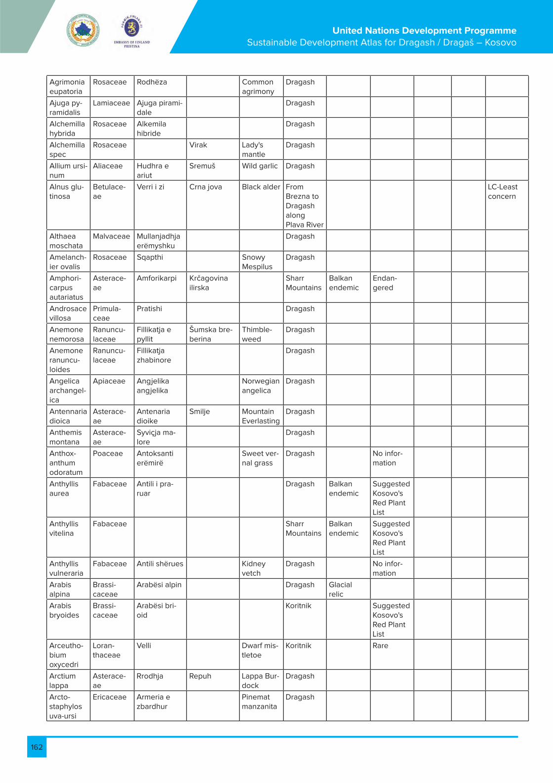
162
United Nations Development Programme Sustainable Development Atlas for Dragash / Dragaš – Kosovo
Agrimonia eupatoria
Rosaceae Rodhëza Common agrimony
Dragash
Ajuga py-ramidalis
Lamiaceae Ajuga pirami-dale
Dragash
Alchemilla hybrida
Rosaceae Alkemila hibride
Dragash
Alchemilla spec
Rosaceae Virak Lady's mantle
Dragash
Allium ursi-num
Aliaceae Hudhra e ariut
Sremuš Wild garlic Dragash
Alnus glu-tinosa
Betulace-ae
Verri i zi Crna jova Black alder From Brezna to Dragash along Plava River
LC-Least concern
Althaea moschata
Malvaceae Mullanjadhja erëmyshku
Dragash
Amelanch-ier ovalis
Rosaceae Sqapthi Snowy Mespilus
Dragash
Amphori-carpus autariatus
Asterace-ae
Amforikarpi Krčagovina ilirska
Sharr Mountains
Balkan endemic
Endan-gered
Androsace villosa
Primula-ceae
Pratishi Dragash
Anemone nemorosa
Ranuncu-laceae
Fillikatja e pyllit
Šumska bre-berina
Thimble-weed
Dragash
Anemone ranuncu-loides
Ranuncu-laceae
Fillikatja zhabinore
Dragash
Angelica archangel-ica
Apiaceae Angjelika angjelika
Norwegian angelica
Dragash
Antennaria dioica
Asterace-ae
Antenaria dioike
Smilje Mountain Everlasting
Dragash
Anthemis montana
Asterace-ae
Syviçja ma-lore
Dragash
Anthox-anthum odoratum
Poaceae Antoksanti erëmirë
Sweet ver-nal grass
Dragash No infor-mation
Anthyllis aurea
Fabaceae Antili i pra-ruar
Dragash Balkan endemic
Suggested Kosovo's Red Plant List
Anthyllis vitelina
Fabaceae Sharr Mountains
Balkan endemic
Suggested Kosovo's Red Plant List
Anthyllis vulneraria
Fabaceae Antili shërues Kidney vetch
Dragash No infor-mation
Arabis alpina
Brassi-caceae
Arabësi alpin Dragash Glacial relic
Arabis bryoides
Brassi-caceae
Arabësi bri-oid
Koritnik Suggested Kosovo's Red Plant List
Arceutho-bium oxycedri
Loran-thaceae
Velli Dwarf mis-tletoe
Koritnik Rare
Arctium lappa
Asterace-ae
Rrodhja Repuh Lappa Bur-dock
Dragash
Arcto-staphylos uva-ursi
Ericaceae Armeria e zbardhur
Pinemat manzanita
Dragash
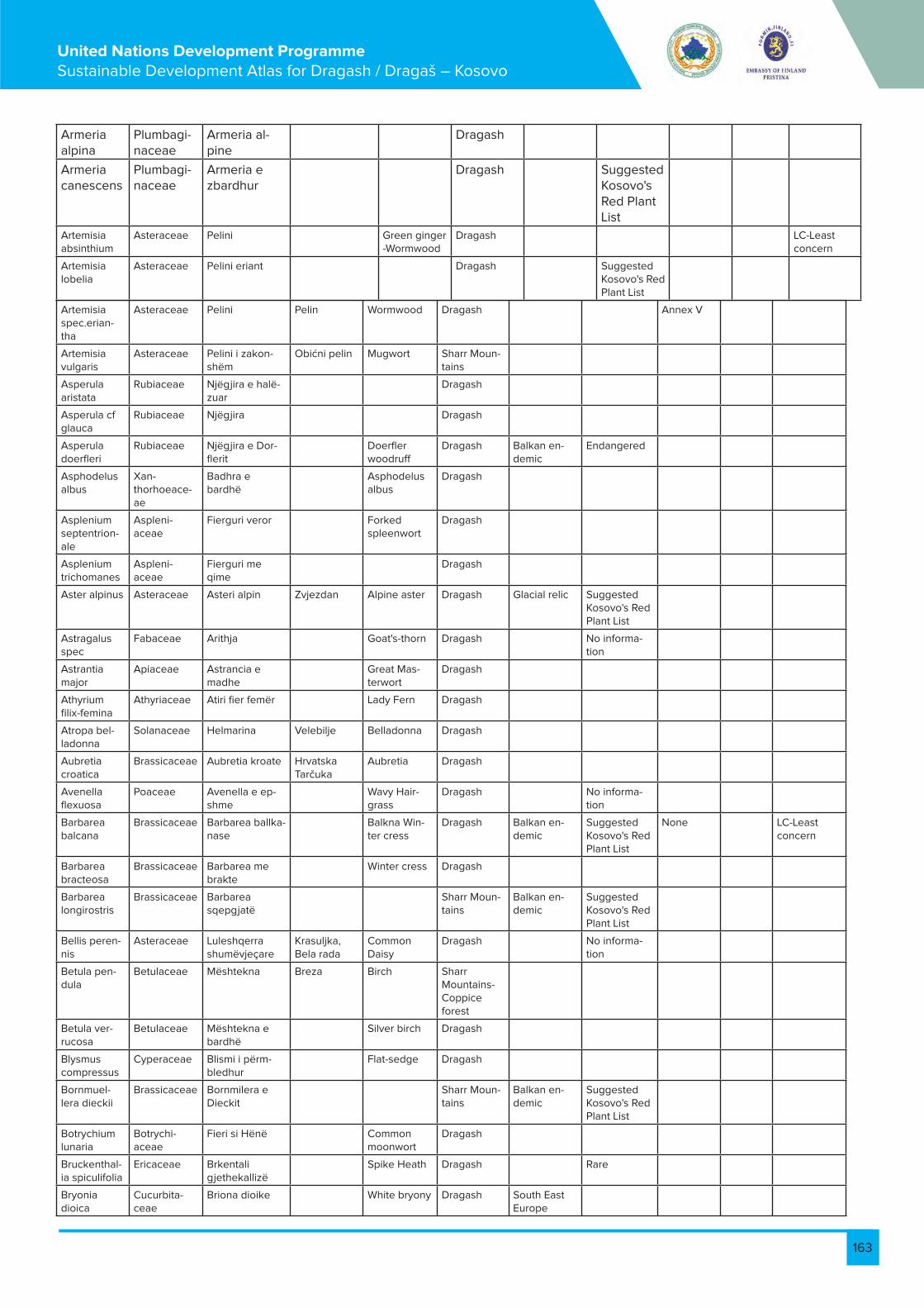
163
United Nations Development Programme Sustainable Development Atlas for Dragash / Dragaš – Kosovo
Armeria alpina
Plumbagi-naceae
Armeria al-pine
Dragash
Armeria canescens
Plumbagi-naceae
Armeria e zbardhur
Dragash Suggested Kosovo's Red Plant List
Artemisia absinthium
Asteraceae Pelini Green ginger -Wormwood
Dragash LC-Least concern
Artemisia lobelia
Asteraceae Pelini eriant Dragash Suggested Kosovo's Red Plant List
Artemisia spec.erian-tha
Asteraceae Pelini Pelin Wormwood Dragash Annex V
Artemisia vulgaris
Asteraceae Pelini i zakon-shëm
Obićni pelin Mugwort Sharr Moun-tains
Asperula aristata
Rubiaceae Njëgjira e halë-zuar
Dragash
Asperula cf glauca
Rubiaceae Njëgjira Dragash
Asperula doerfleri
Rubiaceae Njëgjira e Dor-flerit
Doerfler woodruff
Dragash Balkan en-demic
Endangered
Asphodelus albus
Xan-thorhoeace-ae
Badhra e bardhë
Asphodelus albus
Dragash
Asplenium septentrion-ale
Aspleni-aceae
Fierguri veror Forked spleenwort
Dragash
Asplenium trichomanes
Aspleni-aceae
Fierguri me qime
Dragash
Aster alpinus Asteraceae Asteri alpin Zvjezdan Alpine aster Dragash Glacial relic Suggested Kosovo's Red Plant List
Astragalus spec
Fabaceae Arithja Goat's-thorn Dragash No informa-tion
Astrantia major
Apiaceae Astrancia e madhe
Great Mas-terwort
Dragash
Athyrium filix-femina
Athyriaceae Atiri fier femër Lady Fern Dragash
Atropa bel-ladonna
Solanaceae Helmarina Velebilje Belladonna Dragash
Aubretia croatica
Brassicaceae Aubretia kroate Hrvatska Tarčuka
Aubretia Dragash
Avenella flexuosa
Poaceae Avenella e ep-shme
Wavy Hair-grass
Dragash No informa-tion
Barbarea balcana
Brassicaceae Barbarea ballka-nase
Balkna Win-ter cress
Dragash Balkan en-demic
Suggested Kosovo's Red Plant List
None LC-Least concern
Barbarea bracteosa
Brassicaceae Barbarea me brakte
Winter cress Dragash
Barbarea longirostris
Brassicaceae Barbarea sqepgjatë
Sharr Moun-tains
Balkan en-demic
Suggested Kosovo's Red Plant List
Bellis peren-nis
Asteraceae Luleshqerra shumëvjeçare
Krasuljka, Bela rada
Common Daisy
Dragash No informa-tion
Betula pen-dula
Betulaceae Mështekna Breza Birch Sharr Mountains-Coppice forest
Betula ver-rucosa
Betulaceae Mështekna e bardhë
Silver birch Dragash
Blysmus compressus
Cyperaceae Blismi i përm-bledhur
Flat-sedge Dragash
Bornmuel-lera dieckii
Brassicaceae Bornmilera e Dieckit
Sharr Moun-tains
Balkan en-demic
Suggested Kosovo's Red Plant List
Botrychium lunaria
Botrychi-aceae
Fieri si Hënë Common moonwort
Dragash
Bruckenthal-ia spiculifolia
Ericaceae Brkentali gjethekallizë
Spike Heath Dragash Rare
Bryonia dioica
Cucurbita-ceae
Briona dioike White bryony Dragash South East Europe
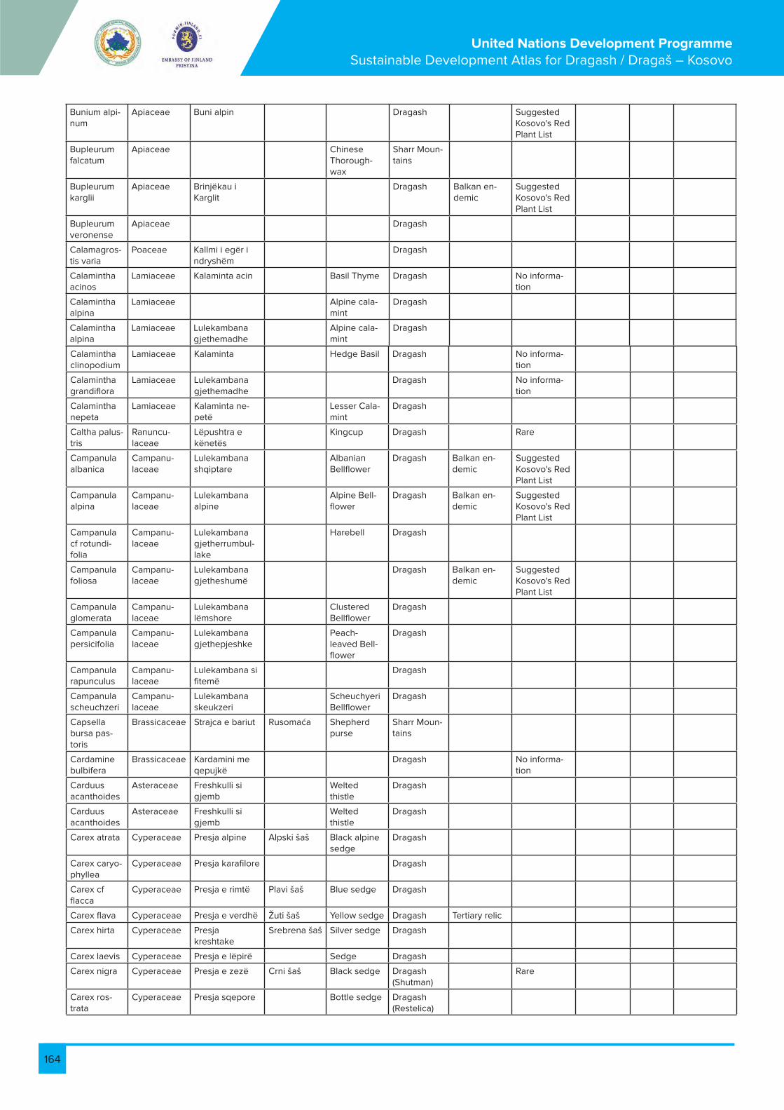
164
United Nations Development Programme Sustainable Development Atlas for Dragash / Dragaš – Kosovo
Bunium alpi-num
Apiaceae Buni alpin Dragash Suggested Kosovo's Red Plant List
Bupleurum falcatum
Apiaceae Chinese Thorough-wax
Sharr Moun-tains
Bupleurum karglii
Apiaceae Brinjëkau i Karglit
Dragash Balkan en-demic
Suggested Kosovo's Red Plant List
Bupleurum veronense
Apiaceae Dragash
Calamagros-tis varia
Poaceae Kallmi i egër i ndryshëm
Dragash
Calamintha acinos
Lamiaceae Kalaminta acin Basil Thyme Dragash No informa-tion
Calamintha alpina
Lamiaceae Alpine cala-mint
Dragash
Calamintha alpina
Lamiaceae Lulekambana gjethemadhe
Alpine cala-mint
Dragash
Calamintha clinopodium
Lamiaceae Kalaminta Hedge Basil Dragash No informa-tion
Calamintha grandiflora
Lamiaceae Lulekambana gjethemadhe
Dragash No informa-tion
Calamintha nepeta
Lamiaceae Kalaminta ne-petë
Lesser Cala-mint
Dragash
Caltha palus-tris
Ranuncu-laceae
Lëpushtra e kënetës
Kingcup Dragash Rare
Campanula albanica
Campanu-laceae
Lulekambana shqiptare
Albanian Bellflower
Dragash Balkan en-demic
Suggested Kosovo's Red Plant List
Campanula alpina
Campanu-laceae
Lulekambana alpine
Alpine Bell-flower
Dragash Balkan en-demic
Suggested Kosovo's Red Plant List
Campanula cf rotundi-folia
Campanu-laceae
Lulekambana gjetherrumbul-lake
Harebell Dragash
Campanula foliosa
Campanu-laceae
Lulekambana gjetheshumë
Dragash Balkan en-demic
Suggested Kosovo's Red Plant List
Campanula glomerata
Campanu-laceae
Lulekambana lëmshore
Clustered Bellflower
Dragash
Campanula persicifolia
Campanu-laceae
Lulekambana gjethepjeshke
Peach-leaved Bell-flower
Dragash
Campanula rapunculus
Campanu-laceae
Lulekambana si fitemë
Dragash
Campanula scheuchzeri
Campanu-laceae
Lulekambana skeukzeri
Scheuchyeri Bellflower
Dragash
Capsella bursa pas-toris
Brassicaceae Strajca e bariut Rusomaća Shepherd purse
Sharr Moun-tains
Cardamine bulbifera
Brassicaceae Kardamini me qepujkë
Dragash No informa-tion
Carduus acanthoides
Asteraceae Freshkulli si gjemb
Welted thistle
Dragash
Carduus acanthoides
Asteraceae Freshkulli si gjemb
Welted thistle
Dragash
Carex atrata Cyperaceae Presja alpine Alpski šaš Black alpine sedge
Dragash
Carex caryo-phyllea
Cyperaceae Presja karafilore Dragash
Carex cf flacca
Cyperaceae Presja e rimtë Plavi šaš Blue sedge Dragash
Carex flava Cyperaceae Presja e verdhë Žuti šaš Yellow sedge Dragash Tertiary relic
Carex hirta Cyperaceae Presja kreshtake
Srebrena šaš Silver sedge Dragash
Carex laevis Cyperaceae Presja e lëpirë Sedge Dragash
Carex nigra Cyperaceae Presja e zezë Crni šaš Black sedge Dragash (Shutman)
Rare
Carex ros-trata
Cyperaceae Presja sqepore Bottle sedge Dragash (Restelica)
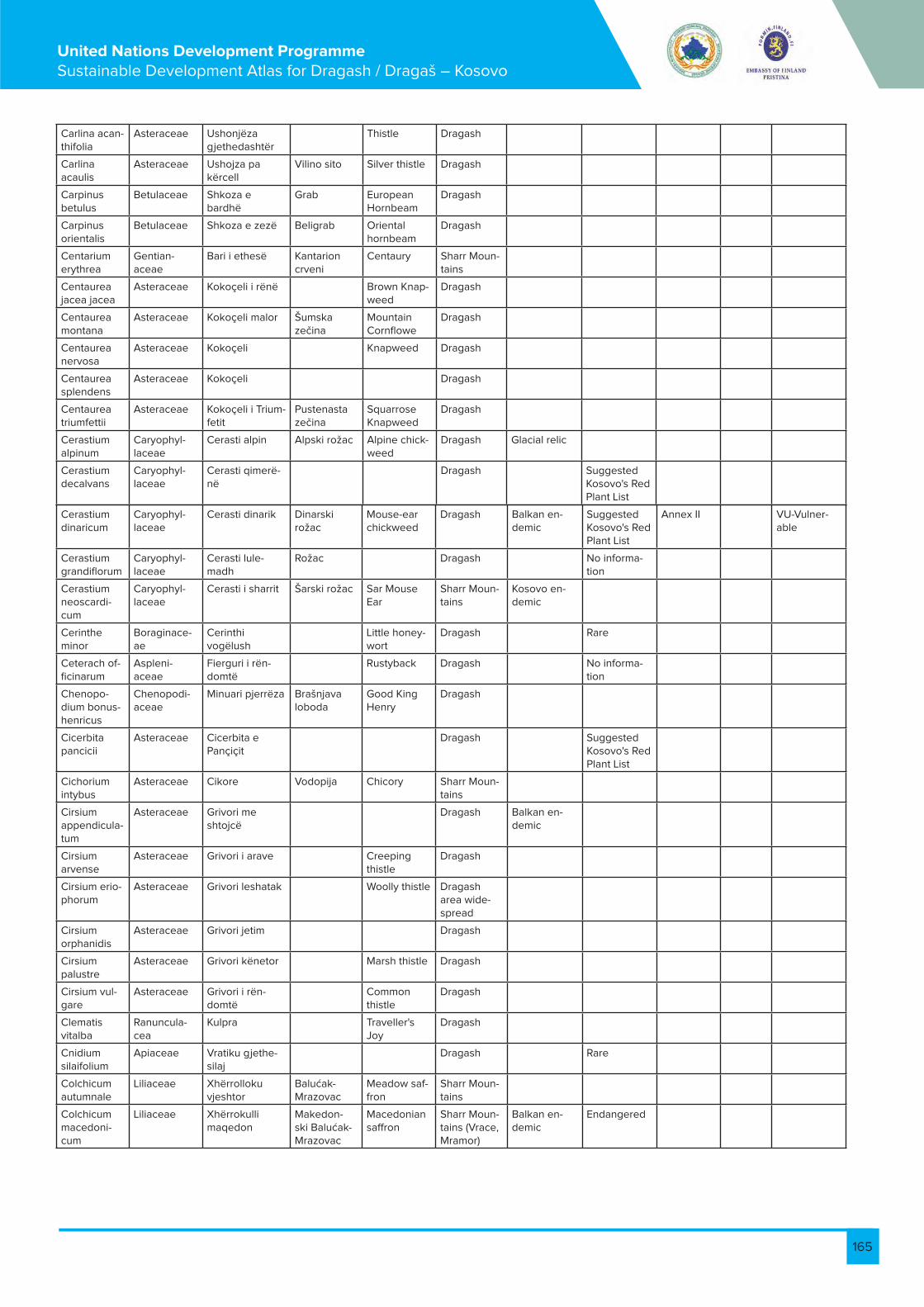
165
United Nations Development Programme Sustainable Development Atlas for Dragash / Dragaš – Kosovo
Carlina acan-thifolia
Asteraceae Ushonjëza gjethedashtër
Thistle Dragash
Carlina acaulis
Asteraceae Ushojza pa kërcell
Vilino sito Silver thistle Dragash
Carpinus betulus
Betulaceae Shkoza e bardhë
Grab European Hornbeam
Dragash
Carpinus orientalis
Betulaceae Shkoza e zezë Beligrab Oriental hornbeam
Dragash
Centarium erythrea
Gentian-aceae
Bari i ethesë Kantarion crveni
Centaury Sharr Moun-tains
Centaurea jacea jacea
Asteraceae Kokoçeli i rënë Brown Knap-weed
Dragash
Centaurea montana
Asteraceae Kokoçeli malor Šumska zečina
Mountain Cornflowe
Dragash
Centaurea nervosa
Asteraceae Kokoçeli Knapweed Dragash
Centaurea splendens
Asteraceae Kokoçeli Dragash
Centaurea triumfettii
Asteraceae Kokoçeli i Trium-fetit
Pustenasta zečina
Squarrose Knapweed
Dragash
Cerastium alpinum
Caryophyl-laceae
Cerasti alpin Alpski rožac Alpine chick-weed
Dragash Glacial relic
Cerastium decalvans
Caryophyl-laceae
Cerasti qimerë-në
Dragash Suggested Kosovo's Red Plant List
Cerastium dinaricum
Caryophyl-laceae
Cerasti dinarik Dinarski rožac
Mouse-ear chickweed
Dragash Balkan en-demic
Suggested Kosovo's Red Plant List
Annex II VU-Vulner-able
Cerastium grandiflorum
Caryophyl-laceae
Cerasti lule-madh
Rožac Dragash No informa-tion
Cerastium neoscardi-cum
Caryophyl-laceae
Cerasti i sharrit Šarski rožac Sar Mouse Ear
Sharr Moun-tains
Kosovo en-demic
Cerinthe minor
Boraginace-ae
Cerinthi vogëlush
Little honey-wort
Dragash Rare
Ceterach of-ficinarum
Aspleni-aceae
Fierguri i rën-domtë
Rustyback Dragash No informa-tion
Chenopo-dium bonus-henricus
Chenopodi-aceae
Minuari pjerrëza Brašnjava loboda
Good King Henry
Dragash
Cicerbita pancicii
Asteraceae Cicerbita e Pançiçit
Dragash Suggested Kosovo's Red Plant List
Cichorium intybus
Asteraceae Cikore Vodopija Chicory Sharr Moun-tains
Cirsium appendicula-tum
Asteraceae Grivori me shtojcë
Dragash Balkan en-demic
Cirsium arvense
Asteraceae Grivori i arave Creeping thistle
Dragash
Cirsium erio-phorum
Asteraceae Grivori leshatak Woolly thistle Dragash area wide-spread
Cirsium orphanidis
Asteraceae Grivori jetim Dragash
Cirsium palustre
Asteraceae Grivori kënetor Marsh thistle Dragash
Cirsium vul-gare
Asteraceae Grivori i rën-domtë
Common thistle
Dragash
Clematis vitalba
Ranuncula-cea
Kulpra Traveller's Joy
Dragash
Cnidium silaifolium
Apiaceae Vratiku gjethe-silaj
Dragash Rare
Colchicum autumnale
Liliaceae Xhërrolloku vjeshtor
Balućak-Mrazovac
Meadow saf-fron
Sharr Moun-tains
Colchicum macedoni-cum
Liliaceae Xhërrokulli maqedon
Makedon-ski Balućak-Mrazovac
Macedonian saffron
Sharr Moun-tains (Vrace, Mramor)
Balkan en-demic
Endangered

166
United Nations Development Programme Sustainable Development Atlas for Dragash / Dragaš – Kosovo
Comarum palustre
Rosaceae Komari i kën-etave
Swamp cinquefoil
Dragash
Cornus mas Cornaceae Thana Dren European Cornel
Sharr Moun-tains
Cornus san-guinea
Cornaceae Thanukla Common Dogwood
Dragash
Coronilla Fabaceae Milëza Coronilla spider
Dragash No informa-tion
Coronilla sp Fabaceae Milëza Dragash
Coronilla vaginalis
Fabaceae Milëza me myll Dragash Suggested Kosovo's Red Plant List
Coronilla varia
Fabaceae Milëza e ndry-shme
Crown Vetch Dragash No informa-tion
Corylus avel-lana
Betulaceae Lajthia Lešnik Common Hazel
Dragash LC-Least concern
Cotoneaster integerrimus
Rosaceae Borbulli i pad-hëmbëz
Common Cotoneaste
Dragash Rare
Cotoneaster tomentosus
Rosaceae Borbulli Hairy Coto-neaster
Dragash (Xerxe)
Rare
Crataegus monogyna
Rosaceae Murrizi njëbërthamësh
Bjeli glog Hawthorn Dragash ar-ea-woodland patches
Crepis bal-daci subsp. albanica
Asteraceae Shmanga shqip-tare
Baldaci Čekinjuša
Baldaci hawksbeard
Dragash Balkan en-demic
Suggested Kosovo's Red Plant List
Crepis cf paludosa
Asteraceae Shmanga e moçaleve
Čekinjuša mocvare
Marsh hawksbeard
Dragash
Crepis mac-edonica
Asteraceae Shmanga maqe-donase
Makedonska Čekinjuša
Macedonian hawksbeard
Sharr (Brod, Lugina e Levrekes, Gradski ka-men)
Balkan en-demic
Suggested Kosovo's Red Plant List
Crocus scardicus
Iridaceae Krokusi i Sharrit Šarplaninski šafran
Scardus crocus
Dragash (Sutman)
Kosovo en-demic
Suggested Kosovo's Red Plant List
Crocus ve-luchensis
Iridaceae Krokusi i Velu-kentit
Dragash
Cynosurus cristatus
Poaceae Bishtqeni kreshtak
Crested Dog's-tail
Dragash No informa-tion
Dactylis glomerata
Poaceae Telishi Cock's-foot Dragash No informa-tion
Daphne cneorum
Thymelae-aceae
Xerxelja kneore Jeremičak crveni
Red Daphne Dragash Suggested Kosovo's Red Plant List
Daphne mezereum
Thymelae-aceae
Jargavan/xerx-elja e malit
Obični likovac February Daphne
Dragash
Datura stra-monium
Solanaceae Devil's trum-pet
Dragash
Daucus carota
Apiaceae Karrota Mrkva Wild carrot Dragash
Deschamp-sia caespi-tosa
Poaceae Deshampsia tufore
Travnjačka busika
Tussock grass Dragash No informa-tion
Deschamp-sia flexuosa
Poaceae Deshampsia e epshme
Wavy Hair-grass
Dragash
Dianthus deltoides
Caryophyl-laceae
Karafili deltoid Maiden Pink Dragash No informa-tion
Dianthus integer
Caryophyl-laceae
Karafili shkëmbinjësh
Cjeloviti karanfil
Whole Pink Dragash Balkan en-demic
Suggested Kosovo's Red Plant List
Dianthus scardicus
Caryophyl-laceae
Karafili i Sharrit Šarplaninski karanfil
Sharr pink Sharr Moun-tains
Balkan en-demic
Suggested Kosovo's Red Plant List
Dianthus spec.
Caryophyl-laceae
Karafil Pink Dragash
Dianthus superbus
Caryophyl-laceae
Karafili vjollcë Ibrišim karan-fil
Purple Pink Dragash Suggested Kosovo's Red Plant List
Dianthus sylvestris
Caryophyl-laceae
Karafili pyjor Šumski karan-fil
Mountain Pink
Sharr Moun-tains
Digitalis ambigua
Scrophulari-aceae
Yellow Fox-glove
Dragash

167
United Nations Development Programme Sustainable Development Atlas for Dragash / Dragaš – Kosovo
Digitalis grandiflora
Plantagi-naceae
Karafili lulemadh Big-flowered Foxglove
Dragash
Digitalis lanata
Plantagi-naceae
Luletogëza leshatake
Besniće Wolly fox-glove
Sharr Moun-tains
Balkan en-demic
Dioscorea balcanica
Dioscoreace-ae
Dioskorea ball-kanase
Balcan Di-oscore
Koritnik Balkan en-demic
Suggested Kosovo's Red Plant List
Draba kora-bensis
Brassicaceae Draba e Korabit Korab's whit-low
Dragash, Koritnik
Balkan en-demic
Suggested Kosovo's Red Plant List
Draba scardica
Brassicaceae Draba e Sharrit Scardica whitlow
Dragash, Koritnik
Balkan en-demic
Suggested Kosovo's Red Plant List
Dryas octo-petala
Rosaceae Driada tetë-palash
Osmerolatični drijas
White dryas Sharr Moun-tains
Glacial relic Rare
Dryopteris filix-mas
Aspidiaceae Fier mashkull Šumski paprat Male fern Dragash
Drypis spi-nosa
Caryophyl-laceae
Dripis Sharr moun-tains
Balkan en-demic
Echium vul-gare
Boraginace-ae
Ushqerëza e rëndomtë
Viper's Bu-gloss
Dragash
Edreianthus graminifolia
Campanu-laceae
Edrianti gjethe-bari
Bellflower Dragash No informa-tion
Eleocharis acicularis
Cyperaceae Needle spikerush
Dragash
Empetrum nigrum
Empetraceae Empetri i zi Black crow-berry
Dragash Rare
Epilobium angustifo-lium
Onagraceae Epilobi gjethen-gushtë
Fireweed, wil-lowherb
Dragash
Epilobium dodonaei
Onagraceae Epilobi i Dodo-nës
Marsh Wil-lowherb
Dragash Rare
Epilobium hirsutum
Onagraceae Epilobi qime-ashpër
Hairy willow-herb
Dragash
Equisetum arvense
Equisataceae Rrushqyqja e epshme
Rastavić Common Horsetail
Dragash
Erigeron alpinus
Asteraceae Erigeroni alpin Alpine Flea-bane
Dragash
Eriophorum angustifo-lium
Cyperaceae Eriofori gheth-engushtë
Common Cot-tongrass
Dragash No informa-tion
Eriophorum latifolium
Cyperaceae Eriofori gheth-egjerë
Širokolisnka suhoperka
Cotton Grass Dragash
Erophila verna
Brassicaceae Erofila pranver-ore
Dragash
Eryngium amethysti-num
Apiaceae Gjembardhi Amethyst Sea Holly
Dragash (Zlipotok)
Erysimum pectinatum
Brassicaceae Dragash, Koritnik
Balkan en-demic
Suggested Kosovo's Red Plant List
Euonymus europaea
Celastraceae Fshikakuqi Ev-ropian
European spindle
Sharr Moun-tains
Eupatorium cannabinum
Asteraceae Eupatori kërpor Hemp-agri-mony
Dragash
Euphorbia amygda-loides
Euphorbi-aceae
Qumështorja si bajame
Mlećika šumska
Wood spurge Dragash
Euphorbia cyparissias
Euphorbi-aceae
Qumështorja si selvi
Mlećika obićna
Cypress Spurge
Dragash
Euphorbia myrsinites
Euphorbi-aceae
Qumështorja mërsinë
Creeping Spurge
Dragash, Koritnik
Rare
Euphrasia rostkoviana
Oroban-chaceae
Eufrazia e Rost-kovit
Eyebright Dragash No informa-tion
Fagus syl-vatica
Fagaceae Ahu Evropska bukva
Beech Dragash No informa-tion
Fagus syl-vatica subsp. moesiaca
Fagaceae Ahu Mejziska bukva
Beech Dragash No informa-tion
Festuca ko-ritnicensis
Poaceae Bishtëpelëza e Koritnikut
Vlasulja Korit-nika
Koritnik fes-cue
Dragash, Koritnik
Balkan en-demic
Suggested Kosovo's Red Plant List

168
United Nations Development Programme Sustainable Development Atlas for Dragash / Dragaš – Kosovo
Festuca ovina agg.
Poaceae Bishtëpelëza delesh
Vlasulja ovce Sheep fes-cue
Dragash No informa-tion
Festuca pan-iculata
Poaceae Bishtëpelëza e melthuar
Metličasta vlasulja
Golden fes-cue
Dragash
Festuca prat-ensis
Poaceae Bishtëpelëza e livadheve
Vlasulja livade Meadow fescue
Dragash No informa-tion
Filipendula ulmaria
Rosaceae Shtalbës i egër Meadow-sweet
Dragash
Fragaria vesca
Rosaceae Luleshtrydhe Divlja Jagoda Wild straw-berries
Dragash
Fraxinus ornus
Oleaceae Frashëri Crni jasen Ash Dragash
Fumana procumbens
Cistaceae Fumana e përkulur
Fumana Dragash
Galium con-strictum
Rubiaceae Ngjitësja e ngushtë
Bedstraw Dragash
Galium odo-ratum
Rubiaceae Ngjitësja erëmirë
Sweet wood-ruff
Dragash
Galium palustre
Rubiaceae Ngjitësja e kënetës
Marshbed-straw
Dragash
Galium verum
Rubiaceae Ngjitësja e vërtetë
Ivanjsko cveće
Yellow bed-straw
Dragash
Genista sag-ittalis
Fabaceae Gjineshtra shigjetake
Winged broom
Dragash No informa-tion
Genista spec.
Fabaceae Gjineshtra Broom Dragash No informa-tion
Gentiana asclepiadea
Gentian-aceae
Gentiana e Asklepit
Asklepov lincura
Willow Gen-tian
Dragash No informa-tion
Gentiana ciliata
Gentian-aceae
Gentiana qer-pikore
Fringed gen-tian
Dragash No informa-tion
Gentiana cruciata
Gentian-aceae
Gentiana e kryqëzuar
Cross gen-tian
Dragash No informa-tion
Gentiana dinarica
Gentian-aceae
Gentiana di-narike
Dinarska sirištara
Dinaric Gen-tian
Dragash Suggested Kosovo's Red Plant List
Gentiana lutea
Gentianacea Sanëza e ver-dhë
Srčanik Yellow Gen-tian
Dragash, Koritnik
Suggested Kosovo's Red Plant List
Annex V
Gentiana punctata
Gentianacea Gentiana pika pika
Spotted Gen-tian
Dragash Suggested Kosovo's Red Plant List
Gentiana utriculosa
Gentian-aceae
Gentiana si kacekth
Sharr Moun-tains
Gentiana verna
Gentian-aceae
Gentiani pran-veror
Spring Gen-tian
Dragash
Gentianella bulgarica
Gentian-aceae
Gencianëza bullgare
Dwarf bulgar-ian gentian
Dragash Balkan en-demic
Suggested Kosovo's Red Plant List
Gentianella bulgarica var. albanica
Gentian-aceae
Gentianca bull-garike
Dwarf bulgar-ian gentian
Dragash Balkan en-demic
Suggested Kosovo's Red Plant List
Geranium macrorrhi-zum
Geraniaceae Kamaroshja rrënjëmadhe
Bigroot cranesbill
Sharr Moun-tains
Geranium reflexum
Geraniaceae Kamaroshja e përthyer
Cranesbill Sharr Mou-nains
Suggested Kosovo's Red Plant List
Geranium robertianum
Geraniaceae Kamaroshja e Robertit
Herb Robert Dragash
Geranium subcaules-cens
Geraniaceae Dwarf Cranesbill
Sharr Moun-tain (Guri i Zi, Vraca)
Balkan en-demic
Suggested Kosovo's Red Plant List
Geum bulga-ricum
Rosaceae Mëlaka bullgare Bulgarian Avens
Sharr Moun-tains
Balkan en-demic
Suggested Kosovo's Red Plant List
Annex I strictly protected
LC-Least concern
Geum coc-cineum
Rosaceae Mëlaka e kuqe Scarlet Avens
Dragash

169
United Nations Development Programme Sustainable Development Atlas for Dragash / Dragaš – Kosovo
Geum mon-tanum
Rosaceae Mëlaka malore Alpine Avens Dragash
Geum mon-tanum
Rosaceae Mëlaka malore Alpine Avens Dragash No informa-tion
Geum reptans
Rosaceae Mëlaka e qytetit Zećja stopa Creeping Avens
Dragash
Geum rivale Rosaceae Gladiola këne-tore
Močvarna gladiola
Water Avens Dragash Ballkan en-demik
Geum urba-num
Rosaceae Turëza gjethezemër
Wood Avens Dragash No informa-tion
Gladiolus palustris
Iridaceae Marsh gladi-olus
Dragash Annex II DD-Data Deficient
Globularia cordifolia
Globulari-aceae
Heliantemi alpin Leather Leaf Powder Puff
Dragash No informa-tion
Gymnocarpi-um cf
Polypodi-aceae
Heliantemi thinjak
Dragash No informa-tion
Helian-themum alpestre
Asteraceae Heliantemi thinjak
Alpine Rock rose
Dragash
Helianthe-mum canum
Asteraceae Shpendra Hoary rock-rose
Dragash
Helianthe-mum canum
Asteraceae Hoary rock-rose
Dragash
Helleborus cf odorus
Ranuncu-laceae
Këmashna kokëlakuriqe
Hellebore sweet
Malet e Sharrit
Heracleum sphondylium agg.
Apiaceae Këmashna ma pak lesh
Common Hogweed
Dragash
Hieracium gymnoceph-alum
Asteraceae Këmashna e Sharrit
Dragash Suggested Kosovo’s Red Plant List
Hieracium pilosella
Asteraceae Këmashna Mouse-ear Hawkweed
Dragash
Hieracium scardicolum
Asteraceae Këmashna leshtore
Sarr hawk-weed
Dragash
Hieracium sp
Asteraceae Këmashnae Valdshtajnit
Hawkweed Sharr Moun-tain (Guri i Zi, Vraca)
Kosovë en-demik
Hieracium villosum
Asteraceae Këmashna e Vetshtajnit
Shaggy haw-keed
Dragash
Hieracium waldsteinii
Asteraceae Belisha lesha-take
Waldstein hawkweed
Dragash Suggested Kosovo’s Red Plant Listt
Hieracium wettsteini
Asteraceae Homogjini alpin Koritnik
Holcus lana-tus
Poaceae Velvet Grass Dragash No informa-tion
Homogyne alpina
Asteraceae Alpine colts-foot
Dragash
Hypericum alpinum
Hypericace-ae
Koko Alpine St John's wort
Malet e Sharrit
Hypericum maculatum
Hypericace-ae
Lule balsami Kantaria Imperforate St John's-wort
Dragash No informa-tion
Hypericum perforatum
Hypericace-ae
Lulja e balsamit e Rikerit
St John's wort
Dragash
Hypericum perforatum
Hypericace-ae
Jasioni rethor St.Johns wort Dragash
Hypericum richeri
Hypericace-ae
Jasioni Malet e Sharrit
Jasione orbiculata
Campanu-laceae
Dragash
Jasione spec.
Campanu-laceae
Kulmaku i nyj-tuar
Sheep's-bit Dragash Annex II Annex I strictly protected
Jovibarba heuffelii
Crassulace-ae
Kulmaku i përhapur
Hen and chicks
Dragash
Juncus articulatus
Juncaceae Kulmaku infleks Jointleaf Rush
Dragash No informa-tion

170
United Nations Development Programme Sustainable Development Atlas for Dragash / Dragaš – Kosovo
Juncus ef-fusus
Juncaceae Kulmaku i çarë tresh
Soft Rush Dragash No informa-tion
LC-Least concern
Juncus inflexus
Juncaceae Kulmaku Sit Hard rush Dragash No informa-tion
LC-Least concern
Juncus trifi-dus
Juncaceae Dëllinja e zezë Smreka, Kleka Highland rush
Dragash No informa-tion
Juncus trig-lumis
Juncaceae Dëllinja e rrëgjuar
Kleka Yosemite dwarf rush
Dragash Suggested Kosovo’s Red Plant List
Juniperus communis
Cupres-saceae
Dëllinja e kuqe Juniper Sharr Moun-tains
LC-Least concern
Juniperus nana
Cupres-saceae
Small juniper Dragash
Juniperus oxycedrus
Cupres-saceae
Hithëbutëza Galeobdolon
Pryckly Juni-per
Dragash LC-Least concern
Kobresia myosuroides (Vill.) Fiori
Cyperaceae Lazerpici Dragash
Lamium galeobdolon
Lamiaceae Vingjra e liva-dhit
Yellow arch-angel
Dragash
Laserpitium zernyi
Apiaceae Lembotropi ziosh
Bastard Lovage
Dragash
Lathyrus pratensis
Fabaceae Lemna vogëlushe
Meadow vetchling
Dragash (Brod)
No informa-tion
Lembotropis nigricans
Fabaceae Lulebardha e rëndomtë
Dragash
Lemna minor Lemnaceae Zambaku sh-qiptar
Common Duckweed
Dragash No informa-tion
LC-Least concern
Leucanthe-mum vulgare
Asteraceae Zambaku i Kalkedonisë
Oxeye daisy Dragash
Lilium al-banicum
Liliaceae Zambaku mar-tagon
šumski ljiljan Albanian lily Dragash Suggested Kosovo’s Red Plant List
Lilium cf chalcedoni-cum
Liliaceae Linaria alpina Chalcedo-nian Lily
Koritnik, Restelicë
Balkan en-demic
Lilium marta-gon
Liliaceae Linaria pelopon-eze
Turk's cap lily Koritnik Balkan en-demic
Linaria alpina
Plantagina-cea
Liri kaptinor Alpine toad-flax
Restelicë Suggested Kosovo’s Red Plant List
Linaria pelo-ponesiaca
Scrophylari-aceae
Liri dlirues Peloponesiac Toadflax
Sharr Moun-tains
Threatened
Linum capi-tatum
Linaceae Lulja e majit drufortë
Dragash, Koritnik
Balkan en-demic
Linum ca-tharticum
Linaceae Thuapula Zvezdan Fairy Flax Dragash
Lonicera xylosteum
Caprifoli-aceae
Luzula Fly honey-suckle
Dragash widespread
No informa-tion
Lotus cor-niculatus
Fabaceae Luzula e Forst-erit
Bird's-foot Trefoil
Dragash No informa-tion
Luzula cf albida
Juncaceae Molla e egër Divlja jabuka Wood rush Dragash No informa-tion
Luzula for-steri
Juncaceae Mëllaga e egër Divlji sljez Sourthern woodrush
Dragash No informa-tion
Malus syl-vestris
Rosaceae Wild apple Dragash
Malva syl-vestris
Rosaceae Kamomili Kamomil Mallow Dragash Suggested Kosovo’s Red Plant List
Matricaria caucasica
Asteraceae Kamomili lëkundës
Dragash Suggested Kosovo’s Red Plant List
Matricaria chammo-milla
Asteraceae Jonxha kosore German chamomile
Dragash
Matricaria recutita
Asteraceae Jonxha e shtrirë German chamomile
Sharr Moun-tains
Medicago falcata
Fabaceae Jonxha Lucerka Yellow-flow-ered alfalfa.
Dragash No informa-tion
Medicago prostrate
Fabaceae Grurëziu i livad-heve
Dragash
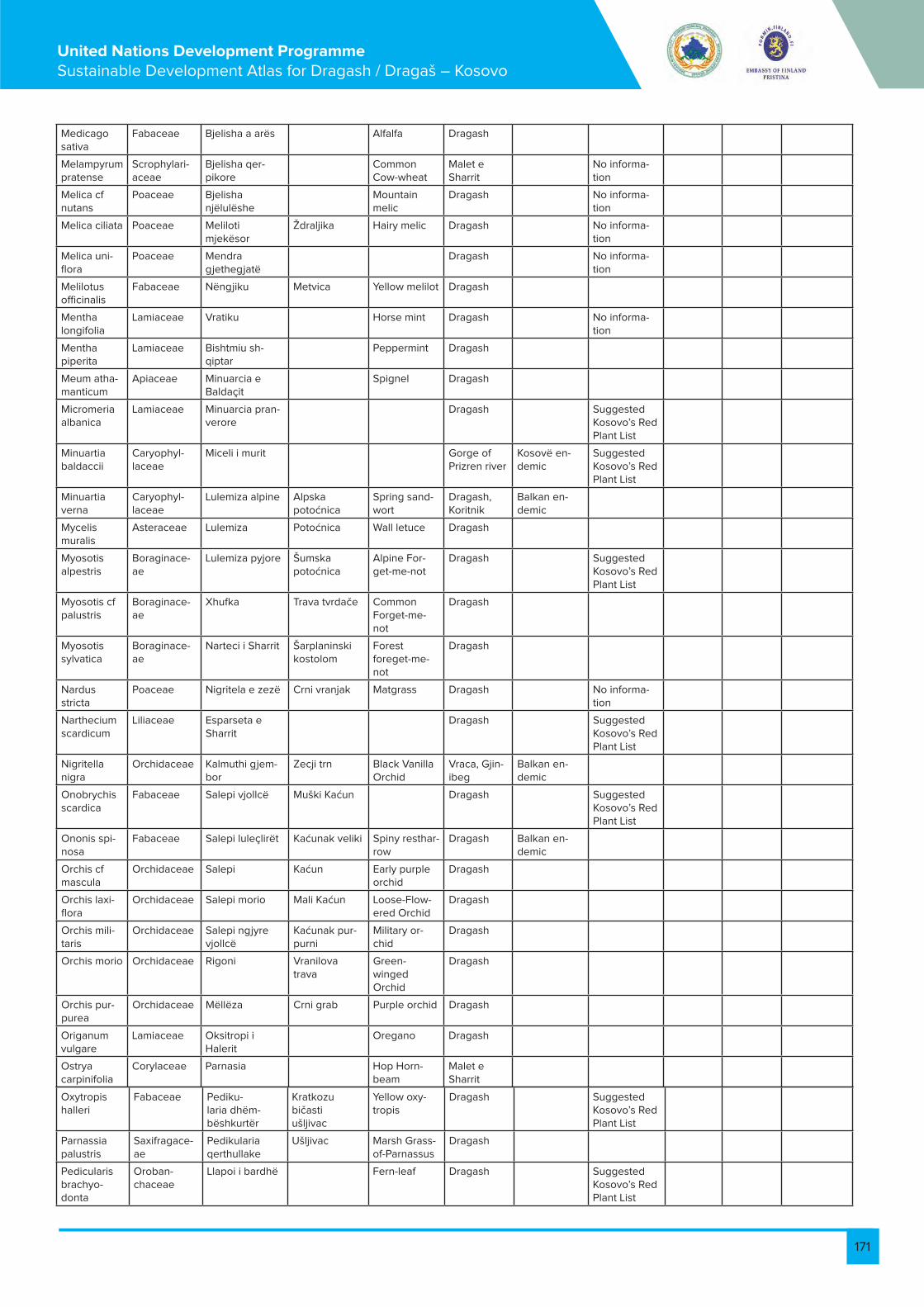
171
United Nations Development Programme Sustainable Development Atlas for Dragash / Dragaš – Kosovo
Medicago sativa
Fabaceae Bjelisha a arës Alfalfa Dragash
Melampyrum pratense
Scrophylari-aceae
Bjelisha qer-pikore
Common Cow-wheat
Malet e Sharrit
No informa-tion
Melica cf nutans
Poaceae Bjelisha njëlulëshe
Mountain melic
Dragash No informa-tion
Melica ciliata Poaceae Meliloti mjekësor
Ždraljika Hairy melic Dragash No informa-tion
Melica uni-flora
Poaceae Mendra gjethegjatë
Dragash No informa-tion
Melilotus officinalis
Fabaceae Nëngjiku Metvica Yellow melilot Dragash
Mentha longifolia
Lamiaceae Vratiku Horse mint Dragash No informa-tion
Mentha piperita
Lamiaceae Bishtmiu sh-qiptar
Peppermint Dragash
Meum atha-manticum
Apiaceae Minuarcia e Baldaçit
Spignel Dragash
Micromeria albanica
Lamiaceae Minuarcia pran-verore
Dragash Suggested Kosovo’s Red Plant List
Minuartia baldaccii
Caryophyl-laceae
Miceli i murit Gorge of Prizren river
Kosovë en-demic
Suggested Kosovo’s Red Plant List
Minuartia verna
Caryophyl-laceae
Lulemiza alpine Alpska potoćnica
Spring sand-wort
Dragash, Koritnik
Balkan en-demic
Mycelis muralis
Asteraceae Lulemiza Potoćnica Wall letuce Dragash
Myosotis alpestris
Boraginace-ae
Lulemiza pyjore Šumska potoćnica
Alpine For-get-me-not
Dragash Suggested Kosovo’s Red Plant List
Myosotis cf palustris
Boraginace-ae
Xhufka Trava tvrdače Common Forget-me-not
Dragash
Myosotis sylvatica
Boraginace-ae
Narteci i Sharrit Šarplaninski kostolom
Forest foreget-me-not
Dragash
Nardus stricta
Poaceae Nigritela e zezë Crni vranjak Matgrass Dragash No informa-tion
Narthecium scardicum
Liliaceae Esparseta e Sharrit
Dragash Suggested Kosovo’s Red Plant List
Nigritella nigra
Orchidaceae Kalmuthi gjem-bor
Zecji trn Black Vanilla Orchid
Vraca, Gjin-ibeg
Balkan en-demic
Onobrychis scardica
Fabaceae Salepi vjollcë Muški Kaćun Dragash Suggested Kosovo’s Red Plant List
Ononis spi-nosa
Fabaceae Salepi luleçlirët Kaćunak veliki Spiny resthar-row
Dragash Balkan en-demic
Orchis cf mascula
Orchidaceae Salepi Kaćun Early purple orchid
Dragash
Orchis laxi-flora
Orchidaceae Salepi morio Mali Kaćun Loose-Flow-ered Orchid
Dragash
Orchis mili-taris
Orchidaceae Salepi ngjyre vjollcë
Kaćunak pur-purni
Military or-chid
Dragash
Orchis morio Orchidaceae Rigoni Vranilova trava
Green-winged Orchid
Dragash
Orchis pur-purea
Orchidaceae Mëllëza Crni grab Purple orchid Dragash
Origanum vulgare
Lamiaceae Oksitropi i Halerit
Oregano Dragash
Ostrya carpinifolia
Corylaceae Parnasia Hop Horn-beam
Malet e Sharrit
Oxytropis halleri
Fabaceae Pediku-laria dhëm-bëshkurtër
Kratkozubičasti ušljivac
Yellow oxy-tropis
Dragash Suggested Kosovo’s Red Plant List
Parnassia palustris
Saxifragace-ae
Pedikularia qerthullake
Ušljivac Marsh Grass-of-Parnassus
Dragash
Pedicularis brachyo-donta
Oroban-chaceae
Llapoi i bardhë Fern-leaf Dragash Suggested Kosovo’s Red Plant List

172
United Nations Development Programme Sustainable Development Atlas for Dragash / Dragaš – Kosovo
Pedicularis verticillata
Oroban-chaceae
Llapoi hibrid Whorled lousewort
Dragash
Petasites albus
Asteraceae Fleumi Planinski lisićji rep
White But-terbur
Dragash
Petasites hybridus
Asteraceae Pimpinela alpine
Common But-terbur
Dragash
Phleum alp-estre
Poaceae Pimpinela iriqëz Alpine Cat-stail
Malet e Sharrit
No informa-tion
Pimpinella alpina
Apiaceae Pinguikula ball-kanase
Alpine burnet Dragash
Pimpinella saxifraga
Apiaceae Rrobulli Munika Burnet Saxi-frage
Dragash
Pinguicula balcanica
Lentibulari-aceae
Dredhaku Bor krivulj Butterworts Dragash Suggested Kosovo’s Red Plant List
Pinus heldre-ichii
Pinaceae Pisha e zeze Crni bor Bosnian Pine Dragash Balkan en-demic
Suggested Kosovo’s Red Plant List
Pinus mugo Pinaceae Arneni Molika Mountain pine
Dragash Koritnik
Balkan en-demic
E rrallë
Pinus nigra Pinaceae Pirola dytësore European Black Pine
Dragash
Pinus peuce Pinaceae Gjethe i nxirrë Macedonian Pine
Dragash Suggested Kosovo’s Red Plant List
NT-Near threatened
Pirola se-cunda
Ericaceae Gjethe ranor One-sided Pyrola
Sharr Moun-tains
Balkan en-demic
S’ka infor-mata
Plantago atrata
Plantagi-naceae
Gjethe hes-htore
Bokvica muška Dragash
Plantago holosteum
Plantagi-naceae
Gjethe e ndërmjemë
Plantain Dragash E rrallë
Plantago lanceolata
Plantagi-naceae
Flokësa alpine Dragash (Zlipotok)
Ribwort plantain
Plantagi-naceae
Flokësa e rën-domtë
Alpska vlasnjaća
Sharr Moun-tains
No informa-tion
Plantago media
Poaceae Flokësa purp-ere
Vlasnjaća Hoary plan-tain
Dragash No informa-tion
Poa alpina Poaceae Nejca alpine Ružićasta vlasnjaća
Alpine Mead-ow-grass
Dragash No informa-tion
Poa trivialis Poaceae Nejca dylëfyt-she
Rough blue-grass
Dragash
Poa viol-aceae
Polygonacea Purple mead-ow-grass
Dragash Suggested Kosovo’s Red Plant List
Polygonum alpinum
Polygonacea Fieri i murit i rëndomtë
Alpine knot-weed
Dragash
Polygonum bistorta
Polygonace-ae
Polistiku hes-htak
Common Bistort
Dragash
Polygonum viviparum
Polypodi-aceae
Plepi Alpine bistort Dragash No informa-tion
Polypodium vulgare
Aspidiaceae Zorrëca e bardhë
Common polypody
Dragash Rare
Polystichum lonchitis
Salicaceae Zorrëca e Ap-enineve
Northern holly fern
Dragash
Populus tremula
Rosaceae Common Aspen
Dragash
Potentilla alba
Rosaceae Zorrëca e argjentë
White Cinquefoil
Dragash
Potentilla apenina
Rosaceae Zorrëca e pra-ruar
Apenine cinquefoils
Dragash No informa-tion
Potentilla arenaria
Rosaceae Zorrëca Kala-breze
Dragash
Potentilla argentea
Rosaceae Hoary Cinquefoil
Dragash Suggested Kosovo’s Red Plant List
Potentilla aurea
Rosaceae Zorrëca e Krantzit
Dragash Suggested Kosovo’s Red Plant List
Potentilla calabra
Rosaceae Zorrëca e Dor-flerit
Calabrise cinquefoil
Sharr Moun-tains
Balkan en-demic
Potentilla caulescens
Rosaceae Zorrëca e ngritur
Dragash

173
United Nations Development Programme Sustainable Development Atlas for Dragash / Dragaš – Kosovo
Potentilla crantzii
Rosaceae Zorrëca malazeze
Alpine Cinquefoil
Dragash Suggested Kosovo’s Red Plant List
Potentilla doerfleri
Rosaceae Zorrëca e drejt Doerfler Cin-queifols
Malet e Sharrit
Kosovo en-demic
Potentilla erecta
Rosaceae Zorrëca e bukur
Common Tormentil
Dragash Suggested Kosovo’s Red Plant List
Potentilla montenegrina
Rosaceae Montenegro Cinquefoils
Dragash Balkan en-demic
No informa-tion
Potentilla recta
Rosaceae Prebnanti purpur
Rough-fruited Cinquefoil
Dragash Suggested Kosovo’s Red Plant List
Potentilla speciosa
Rosaceae Aguliçe Elatior Dragash Balkan en-demic
Potentilla ternata
Asteraceae Aguliçe e Hal-lerit
Cinqueifoil Dragash
Prenanthes purpurea
Primulaceae Aguliçe e vogël Hallerov jaglac Granite pink Dragash
Primula elatior
Primulaceae Aguliçe Mali jaglac Dragash Suggested Kosovo’s Red Plant List
Primula hal-leri
Primulaceae Aguliçe e vërtetë
Haller's Prim-rose
Malet e Sharrit (Shutman, Vraca)
Primula minima
Primulaceae Prunella e rën-domtë
Jaglac Little prim-rose
Malet e Sharrit
Tertiary relic
Primula of-ficinalis
Primulaceae Kulumbria Cowslip Malet e Sharrit
No informa-tion
Primula veris Lamiaceae Fier shqiponja Crni trn Cowslip Dragash No information
Prunella vulgaris
Rosaceae Ptilotriku Heart-of-the-earth
Dragash
Prunus spi-nosa
Dennstaedti-aceae
Plenëra dizan-terike
Blackthorn Dragash
Pteridium aquilinum
Brassicaceae Common bracken
Malet e Sharrit
Suggested Kosovo’s Red Plant List
Ptilotrichum rupestre
Asteraceae Dardhukëla Dragash Tertiary relic
Pulicaria cf dysenterica
Ranuncu-laceae
Qarri Common Fleabane
Dragash No informa-tion
Pulsatilla nar-cissiflora
Rosaceae Shpardhi Cer Dragash
Pyrus pyraster
Fagaceae Dushku malor Sladun European Wild Pear
Dragash No informa-tion
Quercus cerris
Fagaceae Dushku trojan i dukagjinit
Šumski Hrast Turkey Oak Dragash
Quercus frainetto
Fagaceae Ramonda e Mbretëreshës Natali
Dukađinski hrast
Italian oak Dragash
Quercus montana
Fagaceae Ramonda e serbisë
Ramonda Kraljice Na-talije
Montain oak Dragash Suggested Kosovo’s Red Plant List
Quercus trojana
Gesneriacea Zhabina ura-ura Srbska ra-monda
Trojana oak Koritnik Tertiary relic Rare
Ramonda nathaliae
Gesneriacea Zhabina e ulët Ramonda of Queen Nataly
Malet e Sharrit
Balkan en-demic
Rare
Ramonda serbica
Ranuncu-laceae
Zhabinorja e pakrahas-ueshme
Serbian phoe-nix flower
Malet e Sharrit
Balkan en-demic
Suggested Kosovo’s Red Plant List
Annex IV Annex I strictly protected
Ranunculus crenatus
Ranuncu-laceae
Zhabinorja malazeze
Crenate But-tercup
Dragash E rrallë
Ranunculus demissus var. Graecus Boiss
Ranuncu-laceae
Zhabina male-dashëse
Malet e Sharrit (Vraca e vogel)
Suggested Kosovo’s Red Plant List
Ranunculus incompara-bilis
Ranuncula-caeae
Malet e Sharrit
Balkan en-demic
Ranunculus montenegri-nus
Ranuncula-caeae
Zhabina tora Montenegro's buttercup
Malet e Sharrit (Ru-doke)
South East Europe
No informa-tion

174
United Nations Development Programme Sustainable Development Atlas for Dragash / Dragaš – Kosovo
Ranunculus oreophillus
Ranuncula-caeae
Pjerrëza Dragash No informa-tion
Ranunculus psilostachys
Ranuncu-laceae
Pjerrëza zogëlore
Boterbloem Dragash No informa-tion
Ranunculus thora
Rhamnaceae Pjerrëza rre-thore
Frangula Thora but-tercup
Dragash Suggested Kosovo's Red Plant List
Rhamnus fallax
Rhamnaceae Rododendroni i ndryshkur
Buckthorn Dragash (Brod Gorge)
Rhamnus frangula
Rhamnaceae Sallgëmi Rđasti rodo-dendron
Alder Buck-thorn
Dragash
Rhamnus orbiculatus
Ericaceae Trëndafili fush-arak
Bagrem Buckthorn Koritnik Balkan en-demic
Endangered
Rhododen-dron ferrug-ineum
Fabaceae Trëndafili i arës Ruža Rusty-leaved alpenrose
Sharr Mountains Balkan en-demic
Suggested Kosovo's Red Plant List
Robinia pseudoaca-cia
Rosaceae Trëndafili i egër Ruža Black Locust Sharr Mountains
Rosa agres-tis
Rosaceae Trëndafili i malit Šipurak Small-leaved Sweet-briar
Dragash Rare
Rosa arven-sis
Rosaceae Trëndafili leshe-tak
Šumska Ruža Field rose Dragash Rare
Rosa canina agg.
Rosaceae Trëndafili Jabukova Ruža
Dog rose Dragash
Rosa cf mon-tana
Rosaceae Trëndafili i rimtë Ruža Mountain rose
Dragash Rare
Rosa cf vil-losa
Rosaceae Trëndafili lulevogël
Ruža Apple rose Dragash
Rosa dumen-torum
Rosaceae Trëndafili but-losh
Ruža Corymb rose Dragash
Rosa glauca Rosaceae Trëndafili varës Ruža Redleaf rose Dragash
Rosa micran-tha
Rosaceae Trëndafili Alpska Ruža Smallleaf rose Dragash
Rosa mollis Rosaceae Trëndafili Ruža Soft Downy-rose
Dragash
Rosa pen-dulina
Rosaceae Trëndafili vosa-giak
Ruža Alpine rose Dragash Rare
Rosa sub-canina
Rosaceae Mjedra e kaltër Ruža Dragash
Rosa subcol-lina
Rosaceae Dragash Rare
Rosa vosagi-aca
Rosaceae Vogesen- Rose
Dragash
Rubus cae-sius
Rosaceae Mjedra Obićna kapina European dewberry
Dragash
Dragaš Rosaceae Mjedra e shkëmbit
Malina Dragash
Rubus coryli-folii
Rosaceae Lëpjeta Kupina ka-menjarka
Dragash
Rubus fructi-cosus
Rosaceae Lëpjeta alpine Mala kiselica Blackberry Dragash
Rubus idaeus
Polygonace-ae
Lëpjeta thar-tushë
Planinsko zelje
Wild Rasp-berry
Dragash
Rubus saxa-tilis
Polygonacea Shelgu i bardhë Kiselica Stone Bram-ble
Dragash No informa-tion
Rumex ace-tosella
Polygonace-ae
Shelgu i egër Bela Vrba Sheep's sor-rel
Dragash No informa-tion
Rumex alpi-nus
Salicaceae Shelgu zvar-ranik
Alpine Dock Dragash
Rumex scutatus
Betulaceae Buckler sorrel Dragash
Salix alba Salicaceae Shelgu White willow Dragash Rare
Salix caprea Salicaceae Shelgu i thyeshëm
Goat Willow Dragash
Salix cf re-pens
Salicaceae Shelgu i rrjetë-zuar
Creeping wil-low
Dragash
Salix cinerea Salicaceae Shelgu Gray willow Dragash

175
United Nations Development Programme Sustainable Development Atlas for Dragash / Dragaš – Kosovo
Salix elea-gnos
Salicaceae Sherbela Rosemary willow
Dragash Suggested Kosovo’s Red Plant List
Salix fragilis Salicaceae Qingla Kadulja Crack Willow Dragash Relik glacial
Salix reticu-lata
Lamiaceae Shtogu i zi Zova Netted willow Dragash
Salix spec. Caprifoli-aceae
Shtogu i kuq Bazga Willow Gen-tian
Sharr Mountains
Salvia offici-nalis
Caprifoli-aceae
Lulekomishti i vogël
Crvena zova Common sage
Dragash
Sambucus ebulus
Caprifoli-aceae
Lulekomishti mjekësor
Mala krvara Elderberry Sharr Mountains Ballkan endemik
Sambucus nigra
Rosaceae Trumza Ljekovita krvara
Black Elder Dragash
Sambucus racemosa
Rosaceae Shtërmeni Red Elder-berry
Dragash
Sanguisorba minor
Lamiaceae Sausarea alpine Salad burnet Dragash No informa-tion
Sanguisorba officinalis
Lamiaceae Iriqëza si thonjëz
Great Burnet Dragash Suggested Kosovo’s Red Plant List
Satureja acinos
Lamiaceae Iriqëza brioide Savorie Dragash Suggested Kosovo’s Red Plant List
Satureja montana
Lamiaceae Iriqëza e Grise-bakut
Winter savory Dragash (Vraca) Relik glacial
Saussurea alpina
Saxifragace-ae
Iriqëza anëtore Common Saw-wort
Dragash
Saxifraga aizoides
Saxifragace-ae
Iriqëza melthore Yellow Saxi-frage
Dragash Relik glacial
Saxifraga bryoides
Saxifragace-ae
Iriqëza gjether-rumbullake
Briod saxi-frage
Dragash Ballkan endemik
Saxifraga grisebachii
Saxifragace-ae
Iriqëza e Sharrit Grisebach saxifrage
Dragash
Saxifraga marginata
Saxifragace-ae
Iriqëza për-herëblertë
Šarplaninska kamenika
Dragash
Saxifraga paniculata
Saxifragace-ae
Iriqëza White Moun-tain saxifrage
Dragash Threatened
Saxifraga rotundifolia
Saxifragace-ae
Iriqëza e Tajgetit Kamenika Dragash, Koritnik Kosovë endemik
Suggested Kosovo's Red Plant List
Saxifraga scardica
Saxifragace-ae
Scardica saxi-frage
Dragash Ballkan endemik
Saxifraga sempervi-vum
Saxifragace-ae
Iriqëza tregishtëshe
Liveforever saxifrage
Dragash Suggested Kosovo's Red Plant List
Saxifraga spec
Saxifragace-ae
Barzgjebi pël-lumbor
Saxifrage Dragash Ballkan endemik
Saxifraga taygetea
Saxifragace-ae
Barzgjebes ura-ura
Tayget saxi-frage
Dragash
Saxifraga trichocaly-cina
Dipsacaceae Bari i zgjebës Dragash
Saxifraga tridactylides
Dipsacaceae Kryekuqi Dragash
Scabiosa columbaria
Dipsacaceae Shqirra pyjore Gorge of Prizren river
Ballkan endemik
No informa-tion
Scabiosa crenata
Cyperaceae Dragash
Scabiosa leucophylla
Cyperaceae Skrofularja e verës
Dragash
Schoeno-plectus lacustris
Caryophyl-laceae
Sarushta bosh-njake
Bulrush Dragash
Scirpus syl-vaticus
Scrophylari-aceae
Rrushqyqja e athët
Wood Club-rush
Dragash
Scleranthus annuus
Scrophylari-aceae
Rrushqyqja e epshme
German knot-weed
Dragash, Koritnik Ballkan endemik
Suggested Kosovo's Red Plant List

176
United Nations Development Programme Sustainable Development Atlas for Dragash / Dragaš – Kosovo
Scrophularia aestivalis
Crassulace-ae
Rrushqyqja Autumn fig-wort
Dragash
Scrophularia bosniaca
Crassulace-ae
Selaginela si selginela
Bosnian fig-wort
Dragash Rare
Sedum acre Crassulace-ae
Burgulli maqe-don
Sharr Mountains (Luboten)
Balkan en-demic
Sedum flex-uosum
Selaginel-laceae
Burgulli Dragash
Sedum spec Crassulace-ae
Pulithi i Bosnës Stonecrops Dragash Glacial relic Suggested Kosovo’s Red Plant List
Selaginella selaginoides
Crassulace-ae
Pulithi karpatik Club spike-moss
Dragash Balkan en-demic
Sempervi-vum mac-edonicum
Asteraceae Pulithi Dragash
Sempervi-vum spec.
Asteraceae Pulithi Houseleeks Dragash
Senecio bosniaca
Asteraceae Pulithi Dragash
Senecio car-pathicus
Asteraceae Pulithi i Skopolit Dragash Suggested Kosovo’s Red Plant List
Senecio fuchsii
Asteraceae Pulithi aubalpin Dragash No informa-tion
Senecio glaberrima
Asteraceae Pulithi i Wag-nerit
Dragash
Senecio rupestris
Asteraceae Pirrëgjakësja pranverore
Dragash, Koritnik Suggested Kosovo’s Red Plant List
Senecio scopolii
Asteraceae Pirrëgjakësja Dragash Endangered
Senecio subalpinus
Poaceae Sideriti malor Sharr Mountains Balkan en-demic
Senecio wagneri
Poaceae Sideri i i Sharrit Dragash, Koritnik
Sesleria autumnalis
Lamiaceae Klokëza Autumn moor grass
Dragash
Sesleria nitida
Lamiaceae Klokëza Gray Moor Grass
Sharr Mountains
Sideritis montana
Caryophyl-laceae
Klokëza parna-siake
Shepherd's tea
Sharr Mountains Balkan en-demic
Suggested Kosovo’s Red Plant List
Sideritis scardica
Caryophyl-laceae
Klokëza e vockël
Scardicum Mountain tea
Guri i zi Tertiary relic Suggested Kosovo’s Red Plant List
Silene lerch-enfeldiana
Caryophyl-laceae
Klokëza e vock-ël kandavike
Mala pušina Brod Suggested Kosovo’s Red Plant List
Silene multi-caulis
Caryophyl-laceae
Klokëza e Sendtnerit
Mala pušina candavica
Brod Lista e kuqe e bimëve e Kosovës
Silene parnassica subsp. par-nassica
Caryophyl-laceae
Klokëza e rën-domtë
Sharr Mountains (Brod, Dushkaj)
Suggested Kosovo’s Red Plant List
Silene pusilla Caryophyl-laceae
Klokëza e Vald-shtajnit
Pušina Dragash Suggested Kosovo’s Red Plant List
Silene pusilla ssp candavi-ca
Caryophyl-laceae
Patatja/idhnak-thi i zi
Valdstajn pušina
Guri i zi
Silene sendt-neri
Caryophyl-laceae
Pratishi Catchfly Sendtneri
Dragash

177
United Nations Development Programme Sustainable Development Atlas for Dragash / Dragaš – Kosovo
Silene vul-garis
Solanaceae Solidago shufërartë
Bladder Cam-pion
Restelicë Tertiary relic
Silene wald-steinii
Primulaceae Vodhviçe Catchfly Waldsteine
Dragash
Solanum nigrum agg.
Asteraceae Vodha e egër Mukinja European Black Night-shade
Sharr Mountains Tertiary relic
Soldanella dimoniei
Rosaceae Vodha greke Jarebika Dragash
Solidago virgaurea
Rosaceae Spergularia Pusina European goldenrod
Dragash
Sorbus aria Rosaceae Sarusha si pun-gacë
Common Whitebeam
Dragash Rare
Sorbus aucu-paria
Caryophyl-laceae
Sarusha alpine European mountain ash
Dragash Rare
Sorbus cf graeca
Lamiaceae Sarusha e drejtë Pannonian Mountain Ash
Dragash, Koritnik Balkan en-demic
Spergu-laria vellesia subspecies graminea
Lamiaceae Sarusha e Shar-rit
Dragash Lista e kuqe e bimëve e Kosovës
Stachys alo-pecurus
Lamiaceae Karajpeli Dragash
Stachys alpina
Lamiaceae Luleshurdha Limestone Woundwort
Dragash
Stachys recta
Asteraceae Tisi Maslačak Sharr Mountains
Stachys scardica
Asteraceae Telekia Tisa Sharr Wound-wort
Dragash
Tanacetum vulgare
Pinaceae Arrësi dush-këvogël
Telekia Common tansy
Sharr Mountains Threatened
Taraxacum officinale
Asteraceae Arrësi malor Vrednik Dandelion Dragash Tertiary relic
Taxus bac-cata
Lamiaceae Taliktri alpin Trava iva European Yew
Dragash Balkan en-demic
Telekia spe-ciosa
Lamiaceae Taliktri ujor Telekia Dragash No informa-tion
Teucrium chamaedrys
Ranuncu-laceae
Common germander
Dragash Suggested Kosovo’s Red Plant List
Teucrium montanum
Ranuncu-laceae
Armira e Pirine-jeve
Mountain Germander
Sharr Mountains (Dzinibeg , Ru-doka)
Kosovo endemic
Thalictrum alpinum
Ranuncu-laceae
Tlaspi gjethe-bukur
Alpine Mead-ow-rue
Dragash
Thalictrum cf aquilegifo-lium
Santalaceae Tlaspi gjethevogël
Čestika Greater Meadow Rue
Dragash
Thalictrum minus
Brassicaceae Tuja perendi-more
Mala Čestika Meadow rue Dragash Suggested Kosovo’s Red Plant List
Thesium cf pyrenaicum
Brassicaceae Listra shqiptare Pyrenean Bastard-toad-flax
Dragash, Koritnik Balkan en-demic
Suggested Kosovo’s Red Plant List
Thlaspi bel-lidifolium
Cupres-saceae
Krasta ballka-nase
Penny-cress Dragash, Koritnik Balkan en-demic
LC-Least concern
Thlaspi mi-crophyllum
Lamiaceae Listra e Dorflerit Little leave Penny-cress
Dragash Suggested Kosovo’s Red Plant List
Thuja oc-cidentalis
Lamiaceae Listra e Rohlenes
Northern Whitecedar
Dragash, Koritnik Balkan en-demic
Suggested Kosovo’s Red Plant List
Thymus albanus
Lamiaceae Krasta Albanian thyme
Dragash Suggested Kosovo’s Red Plant List
Thymus bal-canus
Lamiaceae Listra e zakon-shme
Majćina dušica
Balkan thyme Dragash, Koritnik Kosovo endemic
Rare threat-ened

178
United Nations Development Programme Sustainable Development Atlas for Dragash / Dragaš – Kosovo
Thymus doerfleri
Lamiaceae Krasta e zakon-shme
Dorfler thyme Sharr Mountains Kosovo endemic
Thymus rochlenae
Lamiaceae Biliri gjethëvogël
Čubra Dragash
Thymus ser-pyllum
Lamiaceae Tocia alpine Lipa Wild Thyme Dragash No informa-tion
Thymus sp Malvaceae Tocia karpatike Thyme Dragash
Thymus vulgaris
Scrophylari-aceae
Tërfili i malit Mother of thyme
Dragash Suggested Kosovo's Red Plant List
Tilia cordata Oroban-chaceae
Tërfili i murrmë Sumska de-telina
Lime, Linden Dragash Suggested Kosovo's Red Plant List
Tozzia alpina Fabaceae Tërfili i kaftë Podbel Alpine tozia Gjinibeg No informa-tion
Tozzia alpina subsp. car-patica
Fabaceae Tërfili i Vele-novksit
Kafena de-telina
Alpine tozzia Dragash Annex II
Trifolium alpestre
Fabaceae Tërfili i Vetshta-jnit
Velenovski detelina
Mountain clover
Dragash No informa-tion
Trifolium badium
Fabaceae Triglohini këne-tor
Vetstajn de-telina
Badium clo-ver
Dragash Suggested Kosovo's Red Plant List
Trifolium spadiceum
Fabaceae Thundër mushka
Močvarna brula
Brown clover Dragash Balkan en-demic
Suggested Kosovo's Red Plant List
Trifolium velenovskyi
Juncagi-naceae
Hithra Konjski lopuh Velenovsky clover
Dragash Balkan en-demic
Suggested Kosovo's Red Plant List
Trifolium wettsteinii
Asteraceae Boronica Kopriva Wetstein clover
Dragash (Brod, Ludasa, L. Kuca)
Triglochin palustris
Urticaceae Boronica e zakonshme
Borovnica Marsh Arrow-grass
Dragash
Tussilago farfara
Ericaceae Boronica e zezë Borovnica Coltsfoot Dragash
Urtica dioica Ericaceae Boronica e ligatinave
Crna borovni-ca
Common nettle
Dragash
Vaccinium gaultheri-oides
Ericaceae Rrush-Mjedër Moćvarna borovnica
Northern Bilberry
Dragash
Vaccinium myrtilloides
Ericaceae Haraqina e Bertiskut
Brusnica Common bilberry
Dragash
Vaccinium myrtillus
Ericaceae Haraqina mjekësore
Wild bilberry Dragash
Vaccinium uliginosum
Valerian-aceae
Haraqina e Pancicit
Valerijan Bog bilberry Restelicë Suggested Kosovo’s Red Plant List
Vaccinium vitis-idea
Valerian-aceae
Shtara Pančićev odoljen
Cowberry Dragash, Koritnik Kosovë endemik
Valeriana bertisceae
Valerian-aceae
Shtara e zezë Bela Ćemerika
Bertisce Va-lerian
Dragash Suggested Kosovo’s Red Plant List
Valeriana officinalis
Melanthi-aceae
Bari i peshkut i Sharrit
Crna Ćemerika
Valerian Dragash, Koritnik Balkan en-demic
Valeriana pancicii
Melanthi-aceae
Bari i peshkut Pancici Vale-rian
Dragash
Veratrum album
Scrophulari-aceae
Bari i peshkut tapsus
White helle-bore
Dragash Threatened
Veratrum nigrum
Scrophulari-aceae
Veronika pagjethe
Lopuh Black False Hellebore
Dragash Kosovo endemic
Verbascum scardicolum
Scrophulari-aceae
Veronika beka-bungë
Scardicum mullein
Dragash
Verbascum sp.
Scrophylari-aceae
Veronika beka-bungë
Mullein Dragash
Verbascum thapsus
Scrophylari-aceae
Veronika si shtërmen
Common mul-lein
Dragash Glacial relic
Veronica aphylla
Scrophylari-aceae
Butina e butë Dragash
Veronica beccabunga
Scrophylari-aceae
Udika European speedwell
Dragash Suggested Kosovo’s Red Plant List
Veronica of-ficinalis
Caprifoli-aceae
Manushaqja e Etolisë
Common Speedwell
Dragash, Koritnik Balkan en-demic
Rare

179
United Nations Development Programme Sustainable Development Atlas for Dragash / Dragaš – Kosovo
Veronica saturejoides
Caprifoli-aceae
Vjollca kreshtake
Etolska ljubićica
Savory Leafed Speedwell
Dragash
Viburnum lantana
Violaceae Manushaqja e hajthme
Wayfaring Tree
Dragash Suggested Kosovo's Red Plant List
Viburnum opulus
Violaceae Vjollca e Grise-bakut
Guelder Rose Dragash
Viola ae-tolica
Violaceae Manushaqja e Orfanidhit
Grisebah ljubićica
Etolic violet Dragash Suggested Kosovo's Red Plant List
Viola cf hirta Violaceae Manushaqja e argjendë
Hairy violet Dragash, Koritnik Kosovo endemic
Suggested Kosovo's Red Plant List
Viola gracilis Violaceae Manushaqe trengjyrëshe
Šumska ljubićica
Gracious violet
Dragash Balkan en-demic
Suggested Kosovo's Red Plant List
Viola grise-bachina
Violaceae Veshtulla Divlja maćuhica
Grisebach violet
Dragash
Viola orpha-nidis
Violaceae Violaceae Imela Sharr Mountains
Viola sylves-tris
Santalaceae Santalaceae Dragash Balkan en-demic
Viola tricolor Violaceae Manushaqe trengjyrëshe
Divlja maćuhica
Wild pansy Dragash
Viscum album
Santalaceae Veshtulla Imela Common Mistletoe
Dragaš
1.7.3. List of Plant Communities
Plant Community Geobotanical distribution Rareness EU Habitat Directive
Wetland Vegetation
Caricetum rostratae salicetosum
Caricetum rostratae-vesicariae
Caricetum nigrae Rare
Carici-Narthecietum scardici Tertiary relic
Vaccinion with V.gaultherioides Annex I
Eutrophic Vegetation
Senecio-Rumicetum alpini
Shrubland
Arctostaphylo-Juniperetum nanae Annex I
Vaccinio-Empetretum hermaphroditi Rare
Coryletum avellanae Euroasia
Alpine lawns and rock vegetation
Juncetum trifidi
Drypetum spinosae Balkan endemic Rare Annex I
Saxifrageto-Potentilletum apenninae
Tertiary relic Annex I
Saxifrageto-Rumicetum nivalis
Natural graslands
Carici-Seslerietum latifoliae
Deltoideo-Nardetum
Nardetum strictae Euroasia Annex I
Diantho-scardici-Festucetum
Amerio-Festucetum variae Europe
Extensive pastures
Xerobromion Annex I
Echinario-Convovuletum althaeoides
Mediterranean
Edraiantho-Elynetum Mediterranean
Gentiano-Dryadetum octopetalae Annex I
Gladiolo-Sanguisorbetum officinalae
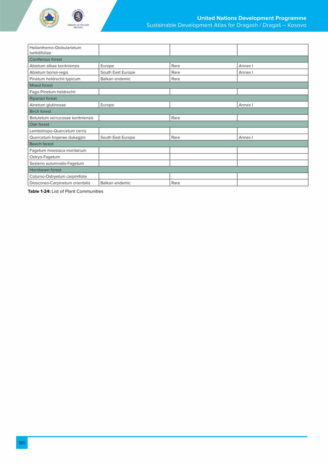
180
United Nations Development Programme Sustainable Development Atlas for Dragash / Dragaš – Kosovo
Helianthemo-Globularietum bellidifoliae
Coniferous forest
Abietum albae koritniensis Europe Rare Annex I
Abietum borisii-regis South East Europe Rare Annex I
Pinetum heldrechii typicum Balkan endemic Rare
Mixed forest
Fago-Pinetum heldrechii
Riparian forest
Alnetum glutinosae Europe Annex I
Birch forest
Betuletum verrucosae koritniensis Rare
Oak forest
Lembotropo-Quercetum cerris
Quercetum trojanae dukagjini South East Europe Rare Annex I
Beech forest
Fagetum moesiaca montanum
Ostryo-Fagetum
Seslerio autumnalis-Fagetum
Hornbeam forest
Colurno-Ostryetum carpinifolia
Dioscoreo-Carpinetum orientalis Balkan endemic Rare
Table 1-24: List of Plant Communities

181
United Nations Development Programme Sustainable Development Atlas for Dragash / Dragaš – Kosovo
1.8. Map B9: Biodiversity Fauna
1.8.1. Mammals known in Dragash/Dragaš
1.8.2. List of Vertebrates (except Birds) observed Dragash/Dragaš
Species Albanian name Serbian name English name Status in Kosovo
Lynx lynx Rrëqebulli Ris Lynx Rare threatened
Ursus arctos Ariu i murmë Medved Brown bear Protected by law
Capreolus capreolus Kaprolli Srna Roe deer Protected by Hunting law
Rupicapra rupicapra Dhia e egër Divokoza Chamois Protected by Hunting law
Spe-cies
Alb Name
Serb Name Engl. Name
Habitat Direc-tive
IUCN Red List
Status in Kosovo
Amphibia
Bom-bina varie-gata
Bret-koca barkver-dhë
Žutotrbi mukac
Yellow-bellied toad
Annex IV
LC-Least concern
Retka X X X X
Hyla arbo-rea
Bret-koca e drunjve-gargaliqi
Gatalinka Tree frog Annex IV
LC-Least concern
0 X X X
Rana dal-mati-na
Bret-koca e pyllit
Šumska žaba
Agile frog Annex IV
LC-Least concern
0 X X X
Rana grae-ca
Bret-koca greke
Grcka žaba
Greek frog
Annex IV
None 0 X X X
Sala-man-dra sala-man-dra
Sala-mandri zi e verdhë
Šareni daždevnjak
Fire sala-mander
0 0 0 X X X
Mam-malia
Lynx lynx
Rrëqe-bulli
Ris Lynx Annex II
MU-Malo ugrožene
Retka u pretnji
X
Sciri-us vul-garis
Ketri Veverica Red squir-rel
0 MU-Malo ugrožene
0 X
Ursus arctos
Ariu i murmë
Medved Brown bear
Annex II
MU-Malo ugrožene
Zakonom zaštičena
X X X X X
Rep-tilia
An-guis fragi-lis
Kokë-zogëza
Slepić Slow-worm
0 0 0 X
Lac-erta mura-lis
Hard-huca e mureve
Zidni gušter
Wall lizard Annex IV
LC-Least concern
0 X X X X
Table 1 -25: List of Mammals known in Dragash/Dragaš)

182
United Nations Development Programme Sustainable Development Atlas for Dragash / Dragaš – Kosovo
Lac-erta viridis
Hard-huca e gjelbër
Zelembac Green lizard
Annex IV
0 0 X X X
Natrix natrix
Gjarpri i barit, bollujca, bollu-jësa
Belouška Water snake
Annex IV
Critically endan-gered
0 X X X
Tes-tudo her-manni
Breshka e pyllit
Šumska kornjaca
Hemann's tortoise
Annex II, IV
NT-Near threat-ened
0 X X X
Vi-pera am-mo-dytes
Neperka Poskok Viper snake
Annex II, IV
LC-Least concern
0 X X X
Vi-pera spec.
Nepërka Zmija poskok
Vipera snake
0 0 0 X
Table 1-26: List of Vertebrates (except Birds) observed in Dragash/Dragaš)

183
United Nations Development Programme Sustainable Development Atlas for Dragash / Dragaš – Kosovo
1.8.3. Birds known in Dragash/Dragaš
Species Alb Name Serb Name Engl. Name
Bird IUCN Status na Ko-sovu
Ac-cipiter brevi-pes
Gjeraqina kemb-shkurter
Krat-koprsti kobac
Levant Sparrow-hawk
An-nex I
0 0 X X X X X X X X X X X
Ac-cipiter gen-tiles
Gjeraqina Jastreb Goshawk An-nex I
0 0 X X X X X X X X X X
Ac-cipiter nisus
Gjeraqina e shkurtes
Kobac Sparrow-hawk
0 0 0 X X X
Acro-cepha-lus arun-dina-ceus
Qafkëlori i madh i moqalit
Veliki trstenjak
Great Reed Warbler
0 0 0 X X X X
Acro-cepha-lus palus-tris
Qafkëlori i moqalit
Trstenjak mlakar
Marsh Warbler
0 0 0 X
Acro-cepha-lus scir-pace-us
Qafkëlori i kallamit
Trstenjak crvrkutić
Reed Warbler
0 0 0 X X X
Ae-githa-los cauda-tus
Trishtili bishtgjatë
Dugorepa Senica
Long -tailed tit
0 0 0 X X
Alau-da arven-sis
Lauresha Poljska ševa
Skylark 0 0 0 X X X
Al-cedo atthis
Bilbili i ujit Vodomar King-fisher
0 LC-Least concern
0 X
Alec-toris graeca
0 Kamen-jarka
Rock patridge
Annex II
LC-Least concern
0 X
Anas platy-rhyn-chos
Rosë e egër
Gluvara Mallard Annex II, III
0 0 X
An-thus camp-estris
Pipiti i kuqër-remë
Stepska trepteljka
Tawny Pipit
An-nex I
0 0 X X
AM
02
AM
10
AM
21
AM
50
AM
60
L2-H
ajd
učk
a
česm
a
L1-B
rezn
a
L3-D
ika
nce
L3-D
ika
nce
L4-K
ori
tnik
L5-B
rod
L6-Š
utm
an
L7-R
est
elic
a
L8-L
imth
L9-P
lajn
ik
L10
-Ra
de
ša
L11-
Bro
do
savc
e

184
United Nations Development Programme Sustainable Development Atlas for Dragash / Dragaš – Kosovo
Anthus praten-sis
Pipiti i livadhit Livadska trepteljka
Meadow Pipit
0 0 0 X X
Anthus spino-letta
Pipiti i ujit Planinska trepteljka
Water Pipit
0 0 0 X X
Anthus trivialis
Pipiti i lisit Šumska trepteljka
Tree Pipit
0 0 0 X X
Apus apus
Dejka Crna čiopa
Swift 0 0 Rare X
Aquila chrysae-tos
Shqiponja e artë
Suri Orao Golden Eagle
An-nex I
LC-Least concern
Rare X X X X X
Aquila heliaca
Shqiponja per-andorake
Krstaš Imperial Eagle
An-nex I
VU-Vul-nerable
Rare X X X X
Ardea cinerea
Çapka e përhim Siva čaplja
Grey Heron
0 0 0 X
Asio flam-meus
Huti vesh shkurtër
Ritska sova
Short-eared Owl
An-nex I
0 0 X
Asio otus
Huti vesh gjatë Utina Long-eared owl
0 0 0 X X
Athene noctua
Huti i vogël Kukuma-vka
Little Owl 0 0 0 X X
Bonasa bonasia
Pula me çafkë Leštarka Hazel Grouse
Annex I, II
0 0 X
Bubo bubo
Huti shqiponjë Buljina Eagle Owl
An-nex I
LC-Least concern
0 X
Buteo buteo
Huta Mišar Common Buzzard
0 LC-Least concern
0 X X
Buteo rufinus
Huta bisht bardh
Riđi mišar Long-legged Buzzard
0 0 Rare X X
Calan-drella brachy-dactyla
Lauresha këmb-shkurtër
Mala ševa Short-toed Lark
0 0 0 X
Caprim-ulgus euro-paeus
Cingërrimi i natës
Leganj Nightjar An-nex I
0 Rare X X
Cardu-elis can-nabina
Kërpngrënësi Konopl-jarka
Linnet 0 0 Rare X X X X
Cardue-lis cardu-elis
Gardalina Češljugar Gold-finch
0 0 0 X X X X X X X X X X X
Car-duelis chloris
Verduni Zelen-tarka
Green-finch
0 0 0 X X X X X X X X X X
Car-duelis spinus
Cerla dimërake Čižak Siskin 0 0 0 X X X
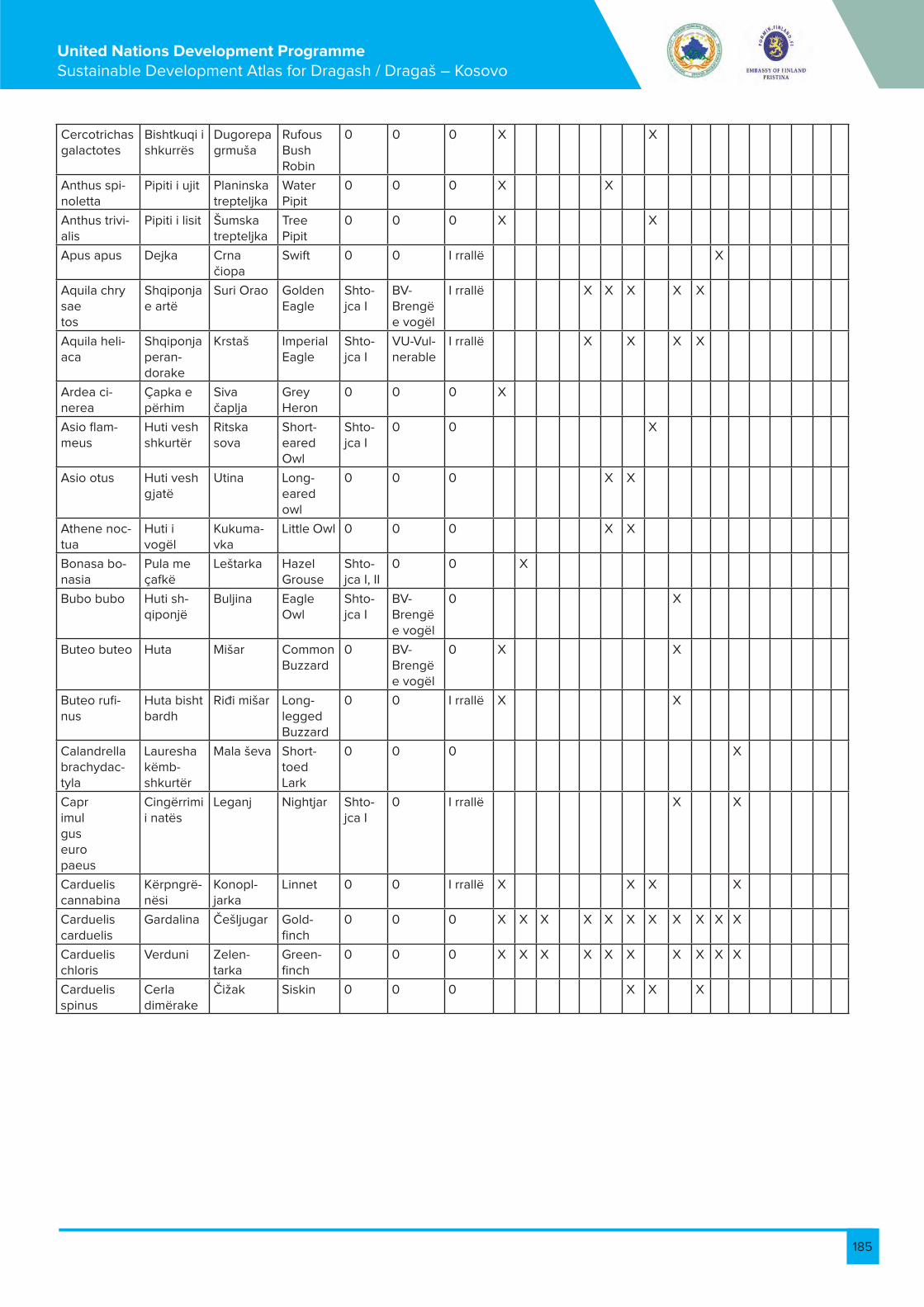
185
United Nations Development Programme Sustainable Development Atlas for Dragash / Dragaš – Kosovo
Cercotrichas galactotes
Bishtkuqi i shkurrës
Dugorepa grmuša
Rufous Bush Robin
0 0 0 X X
Anthus spi-noletta
Pipiti i ujit Planinska trepteljka
Water Pipit
0 0 0 X X
Anthus trivi-alis
Pipiti i lisit Šumska trepteljka
Tree Pipit
0 0 0 X X
Apus apus Dejka Crna čiopa
Swift 0 0 I rrallë X
Aquila chrysaetos
Shqiponja e artë
Suri Orao Golden Eagle
Shto-jca I
BV-Brengë e vogël
I rrallë X X X X X
Aquila heli-aca
Shqiponja peran-dorake
Krstaš Imperial Eagle
Shto-jca I
VU-Vul-nerable
I rrallë X X X X
Ardea ci-nerea
Çapka e përhim
Siva čaplja
Grey Heron
0 0 0 X
Asio flam-meus
Huti vesh shkurtër
Ritska sova
Short-eared Owl
Shto-jca I
0 0 X
Asio otus Huti vesh gjatë
Utina Long-eared owl
0 0 0 X X
Athene noc-tua
Huti i vogël
Kukuma-vka
Little Owl 0 0 0 X X
Bonasa bo-nasia
Pula me çafkë
Leštarka Hazel Grouse
Shto-jca I, II
0 0 X
Bubo bubo Huti sh-qiponjë
Buljina Eagle Owl
Shto-jca I
BV-Brengë e vogël
0 X
Buteo buteo Huta Mišar Common Buzzard
0 BV-Brengë e vogël
0 X X
Buteo rufi-nus
Huta bisht bardh
Riđi mišar Long-legged Buzzard
0 0 I rrallë X X
Calandrella brachydac-tyla
Lauresha këmb-shkurtër
Mala ševa Short-toed Lark
0 0 0 X
Caprimulgus europaeus
Cingërrimi i natës
Leganj Nightjar Shto-jca I
0 I rrallë X X
Carduelis cannabina
Kërpngrë-nësi
Konopl-jarka
Linnet 0 0 I rrallë X X X X
Carduelis carduelis
Gardalina Češljugar Gold-finch
0 0 0 X X X X X X X X X X X
Carduelis chloris
Verduni Zelen-tarka
Green-finch
0 0 0 X X X X X X X X X X
Carduelis spinus
Cerla dimërake
Čižak Siskin 0 0 0 X X X

186
United Nations Development Programme Sustainable Development Atlas for Dragash / Dragaš – Kosovo
Cercotri-chas ga-lactotes
Bishtkuqi i shkurrës
Dugorepa grmuša
Rufous Bush Robin
0 0 0 X X
Certhia brachy-dactyla
Rrotullues gisht-shkurtër
Dugoklju-ni puzić
Short-toed Treecreper
0 0 0 X X X
Certhia familiaris
Piku rrot-ullues
Krat-kokljuni puzić
Treecreeper 0 0 0 X X 2
Cinclus cinclus
Zhytësi Vodenkos Dipper 0 0 Rare X X X X
Circus cyaneus
Shqipja e fushes
Poljska eja
Hen Harrier An-nex I
0 0 X X X
Cocco-thraustes cocco-thraustes
Sqep-trashi
Batokljun Hawfinch 0 0 Rare X X X
Columba livia
Kumria e shkëmbit
Divlji golub
Rock Dove Annex II
0 0 X X
Columba oenas
Kumri e shtyllës
Golub dupljaš
Stock Dove Annex II
0 0 X X
Columba palumbus
Pëllumbi i pyllit
Golub grivnaš
Wood Pigeon Annex I, II, III
0 0 X X
Corvus corax
Korbi i zi Gavran Raven 0 0 0 X X X X X X X X X X X
Corvus corone cornix
Korbi Vrana Crow Annex II
0 0 X X X X X X X X X X X
Corvus frugilegus
Korbi sqepbard-hë
Gačac Rook Annex II
0 0 X
Corvus monedula
Gala Čavka Jackdaw Annex II
0 0 X X X X X X X X X X
Coturnix coturnix
Shkurtë Prepelica Quail Annex II
0 Rare X X
Crex crex Mbreti i shkurtës
Prdavac Corncrake An-nex I
LC-Least con-cern
Rare X X
Cuculus canorus
Qyqja Obična kukavica
Cuckoo 0 0 0 X X X X X X X X X
Delichon urbica
Babili shtëpiak
Gradska lasta
House Martin 0 0 0 X X X X X X X X X X X
Dendro-copos leucotos
Qukapiku shpinë bardhë
Planinski detlić
White Backed Woodpecker
An-nex I
0 0 X X X
Dendro-copos major
Qukapiku pika pika
Veliki detlić
Great Spotted-Woodpecker
An-nex I
0 0 X X X
Dendro-copos minor
Quka-piku pika laserik
Mali detlić Lesser Spotted Woodpecker
0 0 0 X X X
Dryoca-pus mar-tious
Qukapiku i zi
Crna žuna Black Wood-pecker
Annex II
0 Rare X X X
Emberiza cia
Cerla e malit
Strnadica kamen-jarka
Rock Bunting 0 0 Rare X X
Emberiza cirlus
Cerla gush-ëgjelbër
Crnogrla strdanica
Cirl Bunting 0 0 0 3 X X
Emberiza citrinella
Cerla ver-dhashe
Strnadica žutovoljka
Yellowhammer 0 0 0 X X X

187
United Nations Development Programme Sustainable Development Atlas for Dragash / Dragaš – Kosovo
Eremoph-ila alpes-tris
Lauresha e brigjeve
Planin-ska ušata ševa
Horned Lark 0 0 0 X X
Erithacus rubecula
Gush-ëkuqi
Crvendač Robin 0 0 0 2 X X X X X X X X
Falco colum-barius
Skifteri i vogël
Mali soko Merlin An-nex I
LC-Least con-cern
0 X X X X X X X X X X X
Falco naumanni
Skifteri kthetra verdh
Belonokta vetruška
Lesser Kestrel An-nex I
VU-Vulner-able
0 X X 2
Falco per-egrinus
Fajkoi kra-hethat
Sivi soko Peregrin Fal-con
An-nex I
LC-Least con-cern
0 X X X
Falco tin-nunculus
Skifteri kthetra zi
Vetruška Common kes-trel
0 LC-Least con-cern
0 X X X X X X X X X X X
Ficedula albicollis
Mizaka-pësi qafëbard-hë
Belovrata muharica
Collared fly-catcher
An-nex I
0 0 X X X
Ficedula hypoleu-ca
Mizaka-pësi i zi
Crnovrata muharica
Pied flycatcher 0 0 0 X X
Ficedula parva
Mizaka-pësi gjin-jkuqë
Mala mu-harica
Red breasted flycatcher
An-nex I
0 0 X X
Ficedula semi-torqua
Mizakapë-si krahëvi-zuar
Muharica Semi-collard flycatcher
An-nex I
0 0 X X X
Fringilla coelebs
Zboraksi Zeba Chafinch 0 0 0 X X X X X X X X X X X
Fringilla montfrin-gilla
Zboraksi i malit
Severna zeba
Brambling 0 0 0 X X X
Galerida cristata
Lauresha me napkë
Ćubasta ševa
Crested Lark 0 0 0 X X
Galinula chloropus
Pulëza e ujit
Barska kokica
Moorhen 0 0 Rare X
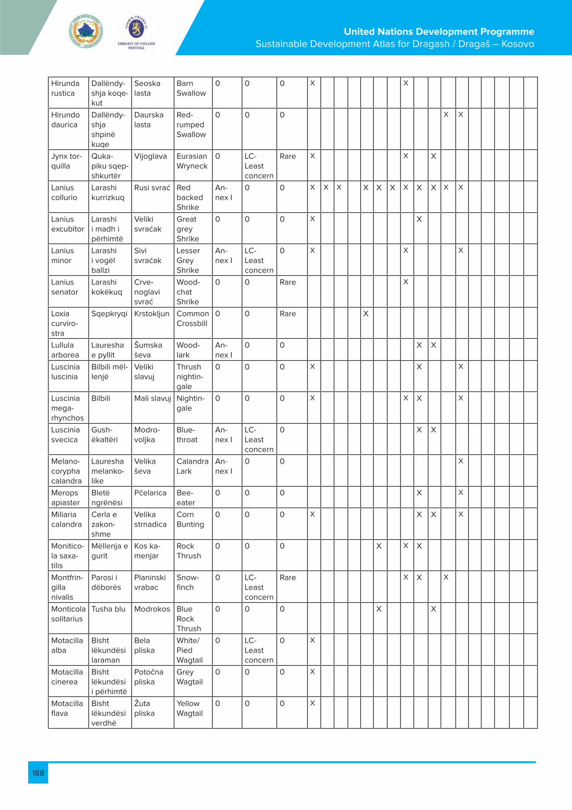
188
United Nations Development Programme Sustainable Development Atlas for Dragash / Dragaš – Kosovo
Hirunda rustica
Dallëndy-shja koqe-kut
Seoska lasta
Barn Swallow
0 0 0 X X
Hirundo daurica
Dallëndy-shja shpinë kuqe
Daurska lasta
Red-rumped Swallow
0 0 0 X X
Jynx tor-quilla
Quka-piku sqep-shkurtër
Vijoglava Eurasian Wryneck
0 LC-Least concern
Rare X X X
Lanius collurio
Larashi kurrizkuq
Rusi svrać Red backed Shrike
An-nex I
0 0 X X X X X X X X X X X
Lanius excubitor
Larashi i madh i përhimtë
Veliki svraćak
Great grey Shrike
0 0 0 X X
Lanius minor
Larashi i vogël ballzi
Sivi svraćak
Lesser Grey Shrike
An-nex I
LC-Least concern
0 X X X
Lanius senator
Larashi kokëkuq
Crve-noglavi svrać
Wood-chat Shrike
0 0 Rare X
Loxia curviro-stra
Sqepkryqi Krstokljun Common Crossbill
0 0 Rare X
Lullula arborea
Lauresha e pyllit
Šumska ševa
Wood-lark
An-nex I
0 0 X X
Luscinia luscinia
Bilbili mël-lenjë
Veliki slavuj
Thrush nightin-gale
0 0 0 X X X
Luscinia mega-rhynchos
Bilbili Mali slavuj Nightin-gale
0 0 0 X X X X
Luscinia svecica
Gush-ëkaltëri
Modro-voljka
Blue-throat
An-nex I
LC-Least concern
0 X X
Melano-corypha calandra
Lauresha melanko-like
Velika ševa
Calandra Lark
An-nex I
0 0 X
Merops apiaster
Bletë ngrënësi
Pčelarica Bee-eater
0 0 0 X X
Miliaria calandra
Cerla e zakon-shme
Velika strnadica
Corn Bunting
0 0 0 X X X X
Monitico-la saxa-tilis
Mëllenja e gurit
Kos ka-menjar
Rock Thrush
0 0 0 X X X
Montfrin-gilla nivalis
Parosi i dëborës
Planinski vrabac
Snow-finch
0 LC-Least concern
Rare X X X
Monticola solitarius
Tusha blu Modrokos Blue Rock Thrush
0 0 0 X X
Motacilla alba
Bisht lëkundësi laraman
Bela pliska
White/Pied Wagtail
0 LC-Least concern
0 X
Motacilla cinerea
Bisht lëkundësi i përhimtë
Potočna pliska
Grey Wagtail
0 0 0 X
Motacilla flava
Bisht lëkundësi verdhë
Žuta pliska
Yellow Wagtail
0 0 0 X

189
United Nations Development Programme Sustainable Development Atlas for Dragash / Dragaš – Kosovo
Muscica-pa striata
Mizaka-pësi i përhimtë
Siva mu-harica
Spotted flucatch-er
0 0 0 X X X
Nucifraga Boçëthye-si
0 Nut-cracker
0 0 Rare X X
Nucifraga caryocat-actes
Grifsha Lešnjikara Jay 0 0 0 X X X X X X X X X X X
Nyctico-rax nycti-corax
Çapka natës
Gak Night Heron
An-nex I
LC-Least concern
Rare X
Oenanthe hispanica
Murgëza vesh zi
Sre-dozemna beloguza
Blackeard Wheatear
0 0 0 X
Oenanthe oenanthe
Murgëz Obićna beloguza
Wheatear 0 LC-Least concern
0 X X X
Orioulus orioulus
Bengu Vuga Golden Oriol
0 0 0 X X X
Otus scops
Huti i fushës
Ćuk Scops Owl
0 0 0 X
Panurus biarmicus
Trish-tili me mustaqe
Brkata senica
Bearded reedling tit
0 0 0 X X
Parus ater
Trishtili i zi Jelova senica
Coal tit An-nex I
0 0 X X X X X X X X X X
Parus caeruleus
Trishtili i kaltër
Plava senica
Blue tit 0 0 0 X X X X X X X X X
Parus cristatus
Trishtili me çafkë
Ćubasta senica
Crested tit
0 0 0 X X
Parus lugubris
Trishtili i madh i murmë
Senica šljivarka
Sombre tit
0 0 0 X X
Parus major
Trishtili i madh
Velika senica
Great tit 0 0 0 X X X X X X X X X X X
Parus monta-nus
Trishtili i maleve ( shelgut )
Planin-ska siva senica
Willow Tit
0 0 0 X X
Parus palustris
Trishtili i vogël i murmë
Močvarna senica
Marsh tit 0 0 0 2
Passer domesti-cus
Harabeli i shtëpisë
Vrabac pokućar
Passer domesti-cus
0 0 0 X X X X X X X X X X
Passer monta-nus
Harabeli i maleve
Polski vrabac
Tree Sparrow
0 0 0 X X X X X X X X X X
Perdix perdix
Thëllëza e fushës
Jarebica Grey Partridge
Annex II, III
LC-Least concern
Rare X X

190
United Nations Development Programme Sustainable Development Atlas for Dragash / Dragaš – Kosovo
Phasianus colchicus
Fazan Fazan Pheasant 0 0 Rare X X
Philoscopus collybita
Çikë Obićni zviždak
Chiff-chaff
0 0 0 X X X
Philoscopus sibilatrix
Qafkëlori i zabelit
Šumski zviždak
Wood Warbler
0 0 0 X X X
Philoscopus trochilus
Qafkëlori i shelgut
Brezov zviždak
Willow Warbler
0 0 0 X X
Phoenicurus ochrorus
Gjokskuq i zi
Crna cr-venrepka
Black redstart
0 0 0 X X
Phoenicurus phoenicurus
Gjoks kuqi
Obićna cr-venrepka
Redstart 0 0 0 X
Pica pica Laraska bishtgjatë
Svraka Magpie Annex II
0 0 X X X X X X X X X X X
Picus viridis Qukapiku i gjelbër
Zelena žuna
Green Wood-pecker
0 LC-Least concern
0 X X
Prunella col-laris
Harabeli i Alpeve
Planinski popič
Alpine Accentor
0 0 0 X X
Prunella modularis
Harabeli-Dunok
Obični popić
Dunnock 0 0 0 X
Pyrrhocorax graculus
Sterqoka e malit
Žutokljuna galica
Alpine Cough
0 0 0 X X
Pyrrhocorax pyrrhocorax
Sterqoka sqepkuqe
Crve-nokljuna galica
Chough An-nex I
0 0 X
Pyrrhula pyrrhula
Kuqalashi çafkëzi
Zimovka Bullfinch An-nex I
LC-Least concern
0 X X
Rallus aquaticus
Gjeli i ujit Barski petlovan
Water Rail
Annex II
0 Rare X
Regulus ignicapillus
Kurorë zjarri
Vatroglavi kraljić
Firecrest 0 0 0 X X X X
Regulus regulus
Mbretëthi Kraljić Gold-crest
0 0 0 X X X
Riparia riparia
Babili i rërës
Bregunica Sand Martin
0 0 0 X X
Saxicola rubetra
Gjineshtra ulëruese
Obićna travarka
Whin-chat
0 0 0 X
Saxicola torquata
Llafazani i gurit
Crnoglava travarka
Stone-chat
0 0 0 X X
Serinus serinus
Zog bari sqep-shkurtë
Žutarica Serin 0 0 0 X X X
Sitta euro-paea
Zvarritësi i zakon-shëm
Brgljez Nuthach 0 0 Rare X X X
Sitta neu-mayer
Zvarritësi i shkrepave
Brgljez lonćar
Rock nuthatch
0 0 Rare X X X
Sreptopelia decaocto
Kumri me qafore
Gugutka Collard Dove
Annex II
0 0 X X X X
Streptopelia turtur
Tur-tullesha
Grlica Turtle Dove
Annex II
0 0 X X X
Strix aluco Huti i kuqrremtë
Šumska sova
Tawny Owl
0 0 0 X
Sturnus vulgaris
Cerloi i zi pikalosh
Čvorak Starling 0 0 0 X X X

191
United Nations Development Programme Sustainable Development Atlas for Dragash / Dragaš – Kosovo
Sylvia atri-capilla
Rradak ziu Crnokapa grmuša
Black cap
0 0 0 X X X X X X X X X X X
Sylvia borin Qafkëlori i kopshtit
Siva grmuša
Garden Warbler
0 0 0 X X X
Sylvia com-munis
Gushëbar-dhi
Obična grmuša
White-throat
0 0 0 X
Sylvia cur-ruca
Gushëbar-dhi i vogël
Grmuša čavrljanke
Lesser White-throat
0 0 0 X X
Sylvia niso-ria
Qafkëlori i mbylltë
Pirgasta grmuša
Barred Warbler
An-nex I
0 0 X X
Sylvia orten-sis
Qafkëlori i orfeut
Velika grmuša
Orphean Warbler
0 0 0 X X X
Tachybaptus ruficollis
Kredhara-ku i vogël
Mali gnju-rac
Little Grebe
0 0 0 X
Tetrao tetrix Pule e egër
Ruševac Black Grouse
Annex I, III
0 Rare X X
Tichodroma muraria
Zvarritësi krahëkuq
Puzgavac Wall-creeper
0 LC-Least concern
Rare X X X X
Tringa tota-nus
Qurylyku sqepkuq
Crvenon-ogi sprud-nik
Common Red-shank
Annex II
0 Rare X
Troglodytes troglodytes
Trumcaku Carić Wren An-nex I
LC-Least concern
0 X X X
Turdus merula
Mëllënja Obićni kos
Black-bird
Annex II
0 0 X X X X X X X X X X X
Turdus philomelos
Mëllenja këngëtare
Drozd pevać
Song Thrush
Annex II
0 0 X X X X X X X X X X X
Turdus pi-laris
Turtulla Drozd borovnjak
Fieldfare Annex II
0 0 X
Turdus torquatus
Mëllënja qafore
Kos ogrlićar
Ring Ouzel
0 0 Rare X X X
Turdus vis-civorus
0 Drozd imelaš
Mistle Thrush
Annex II
0 0 X X X X X X X X X X
Tyto alba Huti koqe-kut
Kukuvija Barn Owl 0 LC-Least concern
0 X
Upupa epops Papëza Pupavac Hoopoe 0 LC-Least concern
Rare X X
Total No of Species per Sample
85 32 26 1 33 49 33 54 73 49 40 72 1 2 1 1 1
Table 1-27: List of Birds observed in Dragash/Dragaš)

192
United Nations Development Programme Sustainable Development Atlas for Dragash / Dragaš – Kosovo
1.8.4. Butterflies known in Dragash/Dragaš
Species Alb Name Serb Name Engl. Name
Habitat Direc-tive
IIUCN Red List
Status in Ko-sovo
B1 B2 B3 B4 B5 B6 B7 B8
Apatura ilia 0 Mali preli-vac
Lesser Purple Em-peror
0 VU-Vul-nerable
0 X
Apatura iris 0 Modri preli-vac
Purple Em-peror
0 EN-En-dangered
0 X
Argynnis pandora 0 Pandorina sedefica
Cardinal 0 EN-En-dangered
0 X
Aricia anteros 0 Alpijski plavac
Blue Argus
0 EN-En-dangered
0 X X X
Brenthis ino 0 Inova se-defica
Lesser Marbled Fritillary
0 EN-En-dangered
0 X
Brintesia circe 0 Šumski vratar
Great Banded Grayling
0 0 0 X
Cupido minimus 0 Maleni pla-vac
Little Blue
0 VU-Vul-nerable
0 X X X
Erebia gorge 0 Zagasita erebija
Silky Ringlet
0 EN-En-dangered
0 X X
Erebia ottomana Flutura oto-mane
Turska er-ebija
Otto-man Brassy Ringlet
0 0 0 X X
Erebia rhodopensis Flutura ro-dopense
Rodopska erebija
Nicholl's Ringlet
0 EN-En-dangered
0 X
Euchloe ausonia 0 Cipkasti belac
Eastern Dap-pled White
0 EN-En-dangered
0 X
Euphydryas aurinia 0 Mocvarna sedefnica
Marsh Fritillary
Annex II VU-Vul-nerable
0 X
Herse convolvuli 0 0 Convol-vulus Hawk-moth
0 0 0 X
Iolana iolas 0 Pucavac Iolas Blue
0 EN-En-dangered
0 X
Limenitis populi 0 Veliki topol-njak
Poplar Admiral
0 EN-En-dangered
0 X X
Lycaena dispar Flutura ngjyrëbakër
Veliki dukat Large Copper
Annex II, IV VU-Vul-nerable
0 X
Macroglossum stel-latarum
0 0 Hum-ming-bird Hawk-moth
0 0 0 X
Macrothylacia rubi 0 0 Fox moth
0 0 0 X
Maculinea alcon 0 Mali pega-vac
Alcon Blue
0 VU-Vul-nerable
0 X
Maculinea arion 0 Veliki pegavac
Large Blue
Annex II, IV
VU-Vul-nerable
0 X
Nymphalis antiopa 0 Kraljev plašt
Cam-berwell Beaty
0 EN-Endan-gered
0 X X

193
United Nations Development Programme Sustainable Development Atlas for Dragash / Dragaš – Kosovo
Papilio machaon Flutura bajrake Lastin repak
Swal-lowtail
0 EN-Endan-gered
0 X X
Apollo flutura Apollo Apolon Annex IV
VU-Vul-nerable
0 X
Parnassius apollo 0 0 0 0 0 0 X
Parnassius mnemos-yne
0 0 Buff-tip 0 0 0 X X
Phalera bucephala Flutura e lakrës Veliki ku-pusar
Large White
0 VU-Vul-nerable
0 X
Pieris brassicae 0 Blistavi plavac
Rever-din's Blue
0 VU-Vul-nerable
0 X X
Plebeius argyrogno-mon
0 Plan-inski plavac
False Eros Blue
Annex II, IV
0 Rare X
Polyommatus eroides
0 0 Baton blue
0 EN-Endan-gered
0 X
Pseudophilotes baton
0 Za-gasiti plavac
Bavius Blue
Annex IV
EN-Endan-gered
0 X
Pseudophilotes bavius
Hesperida alpine
Alpijska hes-perida
Alpine Griz-zled Skipper
0 EN-Endan-gered
0 X
Pyrgus andromedae 0 Lipicina hes-perida
Yellow-banded Skipper
0 VU-Vul-nerable
0 X
Pyrgus sidae Flutura e sall-gamit
Mali repkar
Sloe Hair-streak
0 VU-Vul-nerable
0 X
Satyrium acacie 0 Šumski repkar
White-letter Hair-streak
0 EN-Endan-gered
0 X
Satyrium w-album 0 Veliki satir
Great Sooty Satyr
0 VU-Vul-nerable
0 X X
Satyrus ferula 0 Sre-brna hes-perida
Persian Skipper
0 0 Rare X
Spialia phlomidis 0 Brezov dukat
Brown Hair-streak
0 VU-Vul-nerable
0 X
Thecla betulae Flutura e bo-ronicës
Borovnicar
Cran-berry Blue
0 0 Rare X X
Vacciniina optilete Flutura provok-uese
Admiral Red Admiral
0 0 0 X
Vanessa atalanta Flutura me ilikë Uskršnji leptir
South-ern Fes-toon
Annex IV
VU-Vul-nerable
0 X
Zerynthia polyxena 5 1 10 13 16 6 1 1
Tabela 28: Lista e fluturave të vërejtura në Dragash

194
United Nations Development Programme Sustainable Development Atlas for Dragash / Dragaš – Kosovo
2. Data for Volume III: Assessment
Definition of High Conservation Value Forest (HCVF) in Kosovo and additional explanation of Principle 9:
Every forest has some environmental and social value. The values it contains may include rare species, recreational sites or resources harvested by local residents. Where these values are considered to be of outstanding significance or critical importance, the forest can be defined as a High Conservation Value Forest (HCVF).
Although the Forest Stewardship Council provides the generic definition of HCVs, it is not easy to in-terpret this global definition in different forest types, locations and in different social circumstances and therefore, each country defines their own types of forests having some exceptional values that need special protection.
The HCV concept was originally developed by the Forest Stewardship Council (FSC) to help define forest areas of outstanding and critical importance - High Conservation Value Forests (HCVF). HCVF guidelines appeared in 1999 in Principle 9 of the FSC’s Principles and Criteria of Forest Stewardship, which form the basis for all FSC forest management standards and certification. Under Principle 9, forest managers are required to identify any High Conservation Values that occur within their individual forest management units, to manage them in order to maintain or enhance the values identified, and to monitor the success of this management.
The key to using the HCV approach is the identification of the High Conservation Values (HCVsj, which cover the range of conservation priorities shared by a wide range of stakeholder groups, and include social values as well as ecological values. It is these values that are important and need to be protected. A High Conservation Value area is simply the area where these values are found, or, more precisely, the area that needs to be appropriately managed in order to maintain or enhance the identified values. Identifying the areas where these values occur is therefore the essential first step in developing appropriate management for them.
Based on the definition originally developed by the Forest Stewardship Council for certification of forest ecosystems, there six main types of HCV areas:
• HCV1. Areas containing globally, regionally or nationally significant concentrations of biodiversity values (e.g. endemism, endangered species, refugia);
• HCV2. Globally, regionally or nationally significant large landscape-level areas where viable populations of most if not all naturally occurring species exist in natural patterns of distribution and abundance;
• HCV3. Areas that are in or contain rare, threatened or endangered ecosystems;
• HCV4. Areas that provide basic ecosystem services in critical situations (e.g. watershed pro-tection, erosion control);
• HCVS. Areas fundamental to meeting basic needs of local communities (e.g. subsistence, health).
• HCV6. Areas critical to local communities’ traditional cultural identity (areas of cultural, ecolog-ical, economic or religious significance identified in cooperation with such local communities);
2.1. Excerpts from “Forest Stewardship Standard for the Republic of Kosovo
The HCV process usually comprises three key steps:
• Identification of the HCVs based on an analysis of existing information and the collection of additional information where necessary to fill gaps.
• Management of the HCV area in order to maintain or enhance the identified values; Identifying an HCV area and its management regime involves:
• Establishment of an appropriate monitoring regime to ensure that the management prac-tices are effective in their aim of maintaining or enhancing the HCVs.
The assessment process should be knowledge-based, using all relevant scientific data and local knowledge. It must ensure that relevant stakeholders are consulted and their views or the information they provide is incorporated into the process and it should be open and transparent including peer reviews of findings and public reporting of outcomes.
The usual way of undertaking these tasks is to develop the set of national criteria in document called HCVF Toolkit. This document is used a basis for actual identification and other steps in HCVF process.
It is usually a lengthy process and, unfortunately, the project scope does not allow the time and exper-tise needed for all the steps necessary for this process. Therefore, SDG recommends that in further development HCV forests this initial definitions and methodology should be consulted. SDG for Kosovo will support any future initiative to assess HCVF and will promote this idea with different stakeholders.
FSC Principle 6: Environmental Impact
Forest management shall conserve biological diversity and its associated values, water resources, soils, and unique and fragile ecosystems and landscapes, and, by so doing, maintain the ecological functions and the integrity of the forest.
C6.1 Assessment of environmental impacts shall be completed -- appropriate to the scale, in-tensity of forest management and the uniqueness of the affected resources -- and adequately integrated into management systems. Assessments shall include landscape level considera-tions as well as the impacts of on-site processing facilities. Environmental impacts shall be assessed prior to commencement of site-disturbing operations.
Indicator 6.1.1
The forest manager shall complete environmental impact assessment of its management activities appropriate to the scale of operations and with regards to landscape, fragility of eco¬systems.
Verifiers:
1. Assessment of environmental impacts
2. Forest management plan
SDG Notes:
SLlMF (small or low intensity managed forest): The forest manager shall complete overall environmental impact assessment of its management activities once in a five year period.
Indicator 6.1.2

195
United Nations Development Programme Sustainable Development Atlas for Dragash / Dragaš – Kosovo
The enterprise shall complete and document an assessment of the environmental impacts of any pro-cessing facilities within the FMU under assessment
Verifiers:
1. Assessment of environmental impacts of on-site facilities
2. Forest management plan
SDG Notes:
SLlMF: The forest manager shall complete overall environmental impact assessment of its management activities once in a five year period.
Indicator 6.1.3
The forest manager shall complete environmental impact assessment prior to commencement of site-disturbing operations.
Verifiers:
1. Discussion with the forest manager
2. Internal instructions
3. Written evidence (environmental impact assessment, tendering documentation)
SDG Notes:
SLlMF: Forest manager shall ensure that any forest operation is compared to the overall environmental impact assessment from 6.1.1.
Indicator 6.1.4
The results of the environmental impact assessment, also at a landscape level, shall be incorporated into management plans and tendering documentation before conducting the operations.
Verifiers:
1. Discussion with the forest manager
2. Internal instructions
3. Written evidence (environmental impact assessment, tendering documentation)
SDG Notes:
SLlMF: Forest manager shall ensure that any forest operation is compared to the overall environmental impact assessment from 6.1.1.
Treguesi 6.2.1
Menaxheri i pyjeve do të ketë lista dhe harta të përditësuara lidhur me praninë e specieve të rralla, të kërcënuara dhe të rrezikuara dhe habitateve të tyre në zonën e menaxhimit.
Mjetet e verifikimit:
1. Bisedimet me menaxherin e pyllit
2. Konsultimet me ekspertët e bilogjisë
3. Dëshmitë me shkrim (inventaret, hartat, studimet shkencore)
4. Vizitat në terren
SDG shënim:
PMIVU: Manaxheri i pyllit duhet të ketë njohuri të përgjithshme mbi speciet e rralla, të kërcënuara dhe të rrezikuara duke përdorur ekspertizën dhe informacionet më të mira në dispozicion.
C6.2 Safeguards shall exist which protect rare, threatened and endangered species and their habitats (e.g., nesting and feeding areas). Conservation zones and protection areas shall be established, appropriate to the scale and intensity of forest management and the uniqueness of the affected resources. Inappropriate hunting, fishing, trapping and collecting shall be
con-trolled.
Indicator 6.2.1
The forest manager shall have up to date list and maps on the presence of rare, threatened and en-dangered species and their habitats in the area of the management.
Verifiers:
1. Discussion with the forest manager
2. Consultation with biology experts
3. Written evidence (inventories, maps, scientific studies)
4. Field visit
SDG Notes:
SLlMF: Forest manager should have overall knowledge on rare, threatened and endangered species using the best available expertise and information.
Indicator 6.2.2
The management plans and other relevant policies and procedures of the organisation shall clearly identify actions that are taken to maintain or enhance the presence of rare, threatened or endangered species within area of management
Verifiers:
1. Discussion with the forest manager
2. Forest management plan, game management plan
3. Field visit
4. Protection programmes
SDG Notes
SLlMF: No guard service necessary
Indicator 6.2.3
Areas of special regional importance for biodiversity are identified on maps, and protected from harvesting and other site disturbance.
Verifiers:
1. Maps
2. Consultation with local biologists
3. Field visit
Indicator 6.2.4
At least 10% of the forest area is designated as a conservation zone, identified on maps, and managed with biodiversity as a major objective. At least 5% of the area of the FMU under assessment shall be managed so as to retain it as or restore it to the condition of natural forest appropriate to the locale of the FMU. This area shall be included in the identified conservation zone
Verifiers:
1. Maps
2. Field visit
SDG Notes:
SLlMF: Not applicable
Indicator 6.2.5
The forest manager shall prevent and monitor unauthorised hunting or gathering of non-timber forest products in accordance with the legal regulations.
Verifiers:
1. Discussion with the forest manager
2. Written evidence (documented procedure, official books of

196
United Nations Development Programme Sustainable Development Atlas for Dragash / Dragaš – Kosovo
forest guards, contacts with police, other data on unauthorised activities)
C6.3 Ecological functions and values shall be maintained intact, enhanced, or restored, includ-ing:
a) Forest regeneration and succession.
b) Genetic, species, and ecosystem diversity.
c) Natural cycles that affect the productivity of the forest ecosystem.
Indicator 6.3.1
The forest manager shall apply a forest management and silviculture system that is based on natural composition of tree species to encourage and take advantage of natural regeneration.
Verifiers:
1. Discussion with the forest manager
2. Forest management plan
3. Records on forest regeneration
4. Field visit
Indicator 6.3.2
Old, non-commercial trees; trees with special ecological value; standing dead trees; and dead fallen wood shall be systematically retained within the area of the FMU.
Verifiers:
1. Discussion with the forest manager
2. Written evidence (forest management plan, policies)
3. 3.Field visit
Indicator 6.3.3
Small scale sites of high ecological value (e.g. nesting sites, small wetlands, ponds, small open areas, etc) shall be systematically retained and protected (e.g. through appropriate buffer zones) throughout the production area of the FMU.
Verifiers:
1. Discussion with the forest manager
2. Forest management plans,
3. Field visit
C6.4 Representative samples of existing ecosystems within the landscape shall be protected in their natural state and recorded on maps, appropriate to the scale and intensity of operations and the uniqueness of the affected resources.
Indicator 6.4.1
The FMU shall have been surveyed to identify any areas representative of ecosystems in their natural state, and all such areas shall be identified on maps.
Verifiers:
1. Forest management plans and maps
2. Field visit
Indicator 6.4.2
The conservation zones designated by the forest enterprise (see Criterion 6.2) shall include repre-sentative areas of any examples of ecosystems in their natural state as identified in 6.4.1.
Verifiers:
1. Forest management plans and maps
2. Field visit
Indicator 6.4.3
Management prescriptions shall be specified in the enterprise’s forest management plan and other documents in order to protect the representative examples of ecosystems within conservation zones in their natural state and in the long term
Verifiers:
1. Forest management plans and maps
2. Field visit
Indicator 6.4.4
Reference sites of the representative ecosystems within conservation zones, shall be identified and clearly marked on maps, and are monitored at least once a decade to identify and evaluate long term changes. The enterprise analyses and utilizes the results of the monitoring to evaluate management of the conservation zones.
Verifiers:
1. Forest management plans and maps
2. Field visit
3. Monitoring results
C6.5 Written guidelines shall be prepared and implemented to: control erosion; minimize forest damage during harvesting, road construction, and all other mechanical disturbances; and pro-tect water resources.
Indicator 6.5.1
The organisation shall have written guidelines sufficient to: control erosion; minimise forest damage during harvesting, road construction, and other mechanic disturbances; Protect water resources both within and outside the FMU.
Verifiers:
1. Discussion with the forest manager
2. Discussion with private contractors
3. Written guidelines
Indicator 6.5.2
The guidelines shall include, at a minimum, specific provisions to prevent erosion by identifying areas which are susceptible to erosion
Verifiers:
1. Discussion with the forest manager
2. Written guidelines
Indicator 6.5.3
Forest manager shall use forest machinery, technology and operations that minimize adverse impact on the soil, water and standing trees
Verifiers:
1. Discussion with the forest manager
2. Written evidence (tendering documentation)
3. Field visit
Indicator 6.5.4
The forest manager shall build, maintain and use the forest transportation infrastructure to avoid erosion and disturbance to natural drainage patterns.
Verifiers:
1. Discussion with the forest manager

197
United Nations Development Programme Sustainable Development Atlas for Dragash / Dragaš – Kosovo
2. Written evidence (forest management plan, written guidelines, road construction plans, maps)
3. Field visit
Indicator 6.5.5
The guidelines shall include, at a minimum specific provisions to protect water courses by specifying wetland, water source and streamside protection zones
Verifiers:
1. Discussion with the forest manager
2. Written evidence (forest management plan, written guidelines, maps)
3. Discussion with other stakeholders
4. Field visit
C6.6 Management systems shall promote the development and adoption of environmentally friendly non-chemical methods of pest management and strive to avoid the use of chemical pesticides. World Health Organization Type 1A and 1B and chlorinated hydrocarbon pesticides; pesticides that are persistent, toxic or whose derivatives remain biologically active and accumulate in the food chain beyond their intended use; as well as any pesticides banned by international agreement, shall be prohibited. If chemicals are used, proper equipment and training shall be provided to minimize health and environmental risks.
Indicator 6.6.1
The forest manager shall control pests, diseases and weeds primarily by using silvicultural measures and mechanical or other non-chemical methods. Chemical agents can be employed only when there are no alternative methods or the efficiency of non-chemical methods is low.
Verifiers:
1. Discussion with the forest manager
2. Guidelines for pest, disease and weed control
3. Written evidence (Reports on pests and diseases, marking data on trees to be cut for sanitary reasons, sanitary felling carried out)
4. Field visit
Indicator 6.6.2
If pesticides are used, the organisation shall make sure that it is not included into up-to-date copy of FSC’s list of ‘highly hazardous’ pesticides and on the list of World Health Organization (pesticides Type 1A and 1B).
Verifiers:
1. Discussion with the forest manager
2. Written evidence (records, reports)
3. Field visit
Indicator 6.6.3
There shall be no storage or use of any pesticide included on FSC’s list of ‘highly hazardous’ pesticides within the FMU, unless the enterprise is subject to a current FSC pesticide derogation for the pesticide concerned.
Verifiers:
1. Discussion with the forest manager
2. Written evidence (records, reports)
3. Field visit
Indicator 6.6.4
If pesticides are used, all staff and contractors involved with their use shall have up to date training in handling, application and storage procedures, and all workers shall have been provided with and use proper safety equipment.
Verifiers:
1. Written evidence (certificates of equipment, training programme, records on actions taken)
2. Discussion with the employees
3. Field visit
C6.7 Chemicals, containers, liquid and solid non-organic wastes including fuel and oil shall be disposed of in an environmentally appropriate manner at off-site locations.
Indicator 6.7.1
The forest manager shall ensure that non-organic waste, containers, garbage, chemicals and other polluting substances are not disposed of in the forest or on forest land.
Verifiers:
1. Discussion with the forest manager
2. Written instructions
3. Field visit
Indicator 6.7.2
There shall be a documented procedure, supported by appropriate training and materials, for controlling and cleaning up chemicals, fuel and oil in the case of accidental spillage.
Verifiers:
1. Discussion with the forest manager Written evidence (records on removals)
2. Field visit
3. Contracts with private contractors
C6.8 Use of biological control agents shall be documented, minimized, monitored and strictly controlled in accordance with national laws and internationally accepted scientific protocols. Use of genetically modified organisms shall be prohibited.
Indicator 6.8.1
The forest manager shall avoid the employment of biological control agents. If biological control agents are used, the organisation shall demonstrate that such use is in strict compliance with national laws and internationally accepted scientific protocols and the impacts of such use shall be closely monitored
Verifiers:
1. Discussion with the forest manager 2.Written procedures and instructions 3. Field visit
Indicator 6.8.2
The forest manager shall not use genetically modified organisms.
Verifiers:
1. Discussion with the forest manager
2. Written procedures and instructions
C6.9 The use of exotic species shall be carefully controlled and actively monitored to avoid adverse ecological impacts.
Indicator 6.9.1
The forest manager shall avoid introducing exotic species (plants and animals) to forest ecosystems,
Verifiers:

198
United Nations Development Programme Sustainable Development Atlas for Dragash / Dragaš – Kosovo
1. Discussion with the forest manager
2. Records on seedling/planting material used
3. Field visit
Indicator 6.9.2
If (s)he introduces exotic species (plants and animals) to forest ecosystems, the forest manager shall comply with the following indicators for the use of exotic species
Verifiers:
1. See indicators 6.9.3, 6.9.4, 6.9.5 and 6.9.6
Indicator 6.9.3
Exotic species shall not be newly introduced into the FMU or onto new sites within the FMU unless there is convincing evidence available that the species will not become invasive or have other adverse ecological impacts at the local level.
Verifiers:
1. Scientific studies
2. Discussion with the forest manager
Indicator 6.9.4
Prior to introduction of exotic species, the forest manager shall undertake the environmental impact assessment to ensure that introduced species will not become invasive species in Kosovo forests.
Verifiers:
1. Environmental impact assessment
Indicator 6.9.5
The forest manager shall carefully control and monitor already introduced exotic species to avoid neg-ative environmental impacts. If negative impacts occur, forest manager shall take measures to minimise the negative impact.
Verifiers:
1. Monitoring results
2. Records on monitoring results and elimination activities carried out
3. Field visit
Indicator 6.9.6
In all cases, if an exotic species is newly introduced within the FMU, the enterprise shall document and implement regular monitoring within and outside the FMU to identify any evidence of invasiveness or other adverse ecological impacts.
Verifiers:
1. Written instructions and procedures
C6.10 Forest conversion to plantations or non-forest land uses shall not occur, except in cir-cumstances where conversion:
a) entails a very limited portion of the forest management unit; and
b) does not occur on high conservation value forest areas; and
c) will enable clear, substantial, additional, secure, long term conservation benefits across the forest management unit.
Indicator 6.10.1
The organisation shall clearly identify any parts of the FMU that are scheduled for conversion from natural or semi-natural forest to plantation or non-forest use.
Verifiers:
1. Official public interest decision
Indicator 6.10.2
The forest manager is allowed to convert forests to plantations only if the area entails a very limited portion of the forest management unit and enables long term conservation benefits across the forest management unit (e.g. regeneration of degrade forest stands)
Verifiers:
1. Discussion with the forest manager
2. Written evidence (forest management plan, conversion plans, maps)
3. Field visit
Indicator 6.10.3
The forest manager is not allowed to convert high conservation value forests to plantations or non-forest land
Verifiers:
1. Discussion with the forest manager
2. Field visit
FSC Principle 9: Maintenance of high conservation value forests
Management activities in high conservation value forests shall maintain or enhance the attributes, which define such forests. Decisions regarding high conservation value forests shall always be considered in the context of a precautionary approach.
C9.1 Assessment to determine the presence of the attributes consistent with High Conservation Value Forests will be completed, appropriate to scale and intensity of forest management.
Indicator 9.1.1
The forest manager shall, identify and map forests and forest land with attributes of High Conservation Value Forests (HCVF).
These forest have the following attributes:
• HCV1. Areas containing globally, regionally or nationally significant concentrations of biodiversity values (e.g. endemism, endangered species, refugia) .
• HCV2. Globally, regionally or nationally significant large landscape-level areas where viable populations of most if not all naturally occurring species exist in natural patterns of distribution and abundance.
• HCV3. Areas that are in or contain rare, threatened or endangered ecosystems.
• HCV4. Areas that provide basic ecosystem services in critical situations (e.g. watershed pro-tection, erosion control).
• HCVS. Areas fundamental to meeting basic needs of local communities (e.g. subsistence, health).
• HCV6. Areas critical to local communities’ traditional cultural identity (areas of cultural, ecolog-ical, economic or religious significance identified in cooperation with such local communities).
Verifiers:
1. Discussion with the forest manager
2. Written evidence (maps, identification data)
3. Consultation with stakeholders
4. Field visit
C9.2 The consultative portion of the certification process must

199
United Nations Development Programme Sustainable Development Atlas for Dragash / Dragaš – Kosovo
place emphasis on the identified conservation attributes, and options for the maintenance thereof.
Indicator 9.2.1
The forest manager shall consult stakeholders during the identification of HCVFs and on the decision on the appropriate management of HCVF. Results from the consultative process shall be documented. Verifiers: 1. Discussion with the forest manager 2. Consultation with stakeholders 3. Written evidence C9.3 The management plan shall include and implement specific measures that ensure the maintenance and/or enhancement of the applicable conservation attributes consistent with the precautionary approach. These measures shall be specifically included in the publicly available management plan summary.
Indicator 9.3.1.
The forest manager shall develop appropriate management measures for HCVF, which respect the precautionary approach and ensure maintenance and/or enhancement of the applicable conservation attributes. These measures shall be a part of the forest management plan. Verifiers:
1. Discussion with the forest manager 2. Written evidence (the list of management measures in HCVF) 3. The forest management plan 4. Field visit Indicator 9.3.2. The forest manager incorporates management measures for HCVF into the summary of the forest management plan that is publicly available. Verifiers: 1. Summary of the forest management plan C9.4 Annual monitoring shall be conducted to assess the effectiveness of the measures em-ployed to maintain or enhance the applicable conservation attributes.
Indicator 9.4.1.
The forest manager shall have and implement an annual monitoring programme including assessment of effectiveness of the measures employed in HCVF. Verifiers: 1. Discussion with the forest manager 2. The monitoring programme and assessment of the management measures in HCVF 3. Field visit

200
United Nations Development Programme Sustainable Development Atlas for Dragash / Dragaš – Kosovo
3. Annexes
3.1. List of Laws, Rules, Regulations
Subject/Area Title No
01 Agriculture and rural development The Law on Agriculture and Rural Development 2009/03-L-98
01 Agriculture and rural development Law on Agriculture Land 2005/02/L-26
01 Agriculture and rural development Law on Animal Welfare 2005/02-L10
01 Agriculture and rural development Law on Apiculture 2007/02/L-111
01 Agriculture and rural development Law on Fishery and Aquaculture 2006/02-L85
01 Agriculture and rural development Law on Food 03/L-016
01 Agriculture and rural development Law on Hunting 2005/02/L-53
01 Agriculture and rural development Law on Pesticides 2003/20
01 Agriculture and rural development The Law on Plant Protection 2006/02-L95
01 Agriculture and Rural development Law on Farmers Cooperatives
01 Agriculture and Rural development Law on Livestock
01 Agriculture and Rural development Law on Organic Farming
02 Environment, Nature Protection, Heritage Law on Chemicals 02/L-116
02 Environment, Nature Protection, Heritage Law on Cultural Heritage 02/L88
02 Environment, Nature Protection, Heritage The Law on Environmental Protection 2009/ 03/L-025
02 Environment, Nature Protection, Heritage The Law on Nature Conservation 2005/02-L18
02 Environment, Nature Protection, Heritage The Law on Nature Protection 2010/03-L-233
02 Environment, Nature Protection, Heritage Law on National Park “Mountain Sharri” 28 March 1986
02 Environment, Nature Protection, Heritage Draft Law Sharr National Park 290411ENG
03 Forest The Law on Kosovo Forest 2003/003
04 Infrastructure and Services The Law on Energy 2010/03-L-184
04 Infrastructure and Services Draft Law on Energy Efficiency 2010/03/206
04 Infrastructure and Services Law on Tourism and touristic services 2010/03/L-168
04 Infrastructure and Services The waste Law 2005/02-L30
04 Infrastructure and Services The Law on Waters 2004/24
04 Infrastructure and Services Law on Mines and Minerals
05 SMEs Law on Support to SMEs
07 Spatial Planning Law on Environmental strategic assessment 03/L-015
07 Spatial Planning The Law on Environ. Impact Assessment 2010/03-L-214
07 Spatial Planning The Law on Spatial Planning 2003/14
Air protection Law on Air Protection from Pollution 2010/L-160
Source: Official website of Kosovo’s Assembly http://www.assembly-kosova.org/

201
United Nations Development Programme Sustainable Development Atlas for Dragash / Dragaš – Kosovo
3.2. Habitat Types
3. FRESHWATER HABITATS
31. Standing water
3110 Oligotrophic waters containing very few minerals of sandy plains (Littorelletalia uniflorae)
3130 Oligotrophic to mesotrophic standing waters with vegetation of the Littorelletea uniflorae and/or of the Isoeto-Nanojuncetea
3140 Hard oligo-mesotrophic waters with benthic vegetation of Chara spp.
3150 Natural eutrophic lakes with Magnopota mionor Hydrocharition– type vegetation
3160 Natural dystrophic lakes and ponds
3170 * Mediterranean temporary ponds
3180 * Turloughs
3190 Lakes of gypsum karst
31A0 * Transylvanian hot-spring lotus beds
32. Running water - sections of water courses with natural or semi-natural dy-namics (minor, average and major beds) where the water quality shows no significant deterioration
3220 Alpine rivers and the herbaceous vegetation along their banks
3230 Alpine rivers and their ligneous vegetation with Myricaria germanica
3240 Alpine rivers and their ligneous vegetation with Salix elaeagnos
3250 Constantly flowing Mediterranean rivers with Glaucium flavum
3260 Water courses of plain to montane levels with the Ranunculion fluitantis and Callitricho-Batrachion vegetation
3270 Rivers with muddy banks with Chenopodion rubric p.p. and Bidentionp. p. vegeta-tion
3280 Constantly flowing Mediterranean rivers with Paspalo-Agrostidion species and hanging curtains of Salix and Populus alba
3290 Intermittently flowing Mediterranean rivers of the Paspalo-Agrostidion
4. TEMPERATE HEATH AND SCRUB
4020 * Temperate Atlantic wet heaths with Erica ciliaris and Erica tetralix
4030 European dry heaths
4040 * Dry Atlantic coastal heaths with Erica vagans
4060 Alpine and Boreal heaths
4070 * Bushes with Pinus mugo and Rhododendron hirsutum (Mugo-Rhododendretum hirsuti)
4080 Sub-Arctic Salix spp. Scrub
4090 Endemic oro-Mediterranean heaths with gorse
40A0 * Subcontinentalperi-Pannonic scrub
5. SCLEROPHYLLOUS SCRUB (MATORRAL)
51. Sub-Mediterranean and temperate scrub
5110 Stable xerothermophilous formations with Buxus sempervirens on rock slopes (Berberidion p.p.)
5120 Mountain Cytisus purgans formations
5130 Juniperus communis formations on heaths or calcareous grasslands
5140 * Cistus palhinhae formations on maritime wet heaths
6. NATURAL AND SEMI-NATURAL GRASSLAND FORMATIONS
61. Natural grasslands
6110 * Rupicolous calcareous or basophilic grasslands of the Alysso-Sedionalbi

202
United Nations Development Programme Sustainable Development Atlas for Dragash / Dragaš – Kosovo
6120 * Xeric sand calcareous grasslands
6130 Calaminarian grasslands of the Violetalia calaminariae
6150 Siliceous alpine and boreal grasslands
6170 Alpine and subalpine calcareous grasslands
62. Semi-natural dry grasslands and scrubland facies
6210 Semi-natural dry grasslands and scrubland facies on calcareous substrates (Festuco-Brometalia) (* important orchid sites)
6220 * Pseudo-steppe with grasses and annuals of the Thero-Brachypodietea
6230 * Species-rich Nardus grasslands, on siliceous substrates in mountain areas (and sub-mountain areas in Continental Europe)
6240 * Sub-Pannonic steppic grasslands
62A0 Eastern sub-Mediterranean dry grasslands (Scorzoneratalia villosae)
63. Sclerophillous grazed forests (dehesas)
6310 Dehesas with evergreen Quercus spp.
64. Semi-natural tall-herb humid meadows
6410 Molinia meadows on calcareous, peaty or clayey-silt-laden soils (Molinion caeru-leae)
6420 Mediterranean tall humid grasslands of the Molinio-Holoschoenion
6430 Hydrophilous tall herb fringe communities of plains and of the montane to alpine levels
6440 Alluvial meadows of river valleys of the Cnidiondubii
6460 Peat grasslands of Troodos
65. Mesophile grasslands
6510 Lowland hay meadows (Alopecurus pratensis, Sanguisorba officinalis)
6520 Mountain hay meadows
6530 * Fennoscandian wooded meadows
7. RAISED BOGS AND MIRES AND FENS
71. Sphagnum acid bogs
7110 * Active raised bogs
7120 Degraded raised bogs still capable of natural regeneration
7130 Blanket bogs (* if active bog)
7140 Transition mires and quaking bogs
7150 Depressions on peat substrates of the Rhynchosporion
72. Calcareous fens
7210 * Calcareous fens with Cladium mariscus and species of the Caricionda vallianae
7220 * Petrifying springs with tufa formation (Cratoneurion)
7230 Alkaline fens
7240 * Alpine pioneer formations of the Caricion bicoloris-atrofuscae
8. ROCKY HABITATS AND CAVES
81. Scree
8110 Siliceous scree of the mountain to snow levels (Androsacetalia alpinae and Galeopsietalia ladani)
8120 Calcareous and calc-shist screes of the mountain to alpine levels (Thlaspiete a rotundifolii)
8140 Eastern Mediterranen screes – (Drypetum spinosa in Dragash)
8150 Medio-European upland siliceous screes
8160 * Medio-European calcareous scree of hill and mountain levels
82. Rocky slopes with chasmophytic vegetation

203
United Nations Development Programme Sustainable Development Atlas for Dragash / Dragaš – Kosovo
8210 Calcareous rocky slopes with chasmophytic vegetation (in Dragas Saxifrageto-Potentilletum apennina)
8220 Siliceous rocky slopes with chasmophytic vegetation
8230 Siliceous rock with pioneer vegetation of the Sedo-Scleranthion or of the Sedoal-bi-Veronicion dillenii
8240 * Limestone pavements
83. Other rocky habitats
8310 Caves not open to the public
8320 Fields of lava and natural excavations
9. FORESTS
(Sub)natural woodland vegetation comprising native species forming forests of tall trees, with typical undergrowth, and meeting the following criteria: rare or residual, and/or hosting species of Community interest
90. Forests of Boreal Europe
9020 * Fennoscandian hemiboreal natural old broad-leaved deciduous forests (Quer-cus, Tilia, Acer, Fraxinus or Ulmus) rich in epiphytes
9030 * Natural forests of primary succession stages of land upheaval coast
9050 Fennoscandian herb-rich forests with Picea abies
9060 Coniferous forests on, or connected to, glacio-fluvial eskers
9070 Fennoscandian wooded pastures
9080 * Fennoscandian deciduous swamp woods
91. Forests of Temperate Europe
9110 Luzulo-Fagetum beech forests (Kosovo not in Dragash)
9120 Atlantic acidophilous beech forests with Ilex and sometimes also Taxus in the shrub layer (Quercion robori-petraeae or Ilici-Fagenion)
9130 Asperulo-Fagetum beech forests
9140 Medio-European subalpine beech woods with Acer and Rumex arifolius
9150 Medio-European limestone beech forests of the Cephalanthero-Fagion
9160 Sub-Atlantic and medio-European oak or oak-hornbeam forests of the Carpinion betuli
9170 Galio-Carpinetum oak-hornbeam forests
9180 * Tilio-Acerion forests of slopes, screes and ravines
9190 Old acidophilous oak woods with Quercus robur on sandy plains
91B0 Thermophilous Fraxinus angustifolia woods
91C0 * Caledonian forest
91D0 * Bog woodland
91E0 * Alluvial forests with Alnus glutinosa and Fraxinus excelsior (Alno-Padion, Alnion incanae, Salicionalbae) (Alnetum glutinosae in Dragash/Dragaš)
91F0 Riparian mixed forests of Quercus robur, Ulmus laevis and Ulmus minor, Fraxinus excelsior or Fraxinus angustifolia, along the great rivers (Ulmenion minoris)
91G0 * Pannonic woods with Quercus petraea and Carpinus betulus
91H0 * Pannonian woods with Quercus pubescens
91I0 * Euro-Siberian steppic woods with Quercus spp.
91K0 Illyrian Fagus sylvatica forests (Aremonio-Fagion)
91L0 Illyrian oak-hornbeam forests (Erythronio-carpinion)
91M0 Pannonian-Balkanic turkey oak -sessile oak forests
91N0 * Pannonic inland sand dune thicket (Junipero-Populetum albae)
91P0 Holy Cross fir forest (Abietetum polonicum)
91Q0 Western Carpathian calcicolous Pinus sylvestris forests
91R0 Dinaric dolomite Scots pine forests (Genisto januensis-Pinetum)

204
United Nations Development Programme Sustainable Development Atlas for Dragash / Dragaš – Kosovo
91U0 Sarmatic steppe pine forest
91V0 Dacian Beech forests (Symphyto-Fagion)
91W0 Moesian beech forests (Fagus sylvatica and Fagus moesiaca)
91Y0 Dacian oak & hornbeam forests (Carpinus betulus)
91AA *Eastern white oak woods (Quercion frainetto)
91BA Moesian silver fir forests (Fagion moesiaca)
92. Mediterranean deciduous forests
9210 * Apennine beech forests with Taxus and Ilex
9220 * Apennine beech forests with Abies alba and beech forests with Abies nebrodensis
9250 Quercus trojana woods
9260 Castanea sativa woods (in Kosovo not in Dragash/Dragaš)
9270 Hellenic beech forests with Abies borisii-regis
9290 Cupressus forests (Acero-Cupression)
92A0 Salix alba and Populus alba galleries
92B0 Riparian formations on intermittent Mediterranean water courses with Rhododen-dron ponticum, Salix and others
92C0 Platanus orientalis and Liquidambar orientalis woods (Platanion orientalis)
92D0 Southern riparian galleries and thickets (Nerio-Tamaricetea and Securinegion tinctoriae)
93. Mediterranean sclerophyllous forests
9340 Quercus ilex and Quercus rotundifolia forests
9350 Quercus macrolepis forests
9390 * Scrub and low forest vegetation with Quercus alnifolia
93A0 Woodlands with Quercus infectoria (Anagyro foetidae-Quercetum infectoriae)
94. Temperate mountainous coniferous forests
9410 Acidophilous Picea forests of the mountain to alpine levels (Vaccinio-Piceetea)
9420 Alpine Larix decidua and/or Pinus cembra forests
9430 Subalpine and montane Pinus uncinata forests (* if on gypsum or limestone)
95. Mediterranean and Macaronesian mountainous coniferous forests
9520 Abies pinsapo forests
9530 * (Sub-) Mediterranean pine forests with endemic black pines (with Abies borisii regis)
9540 Mediterranean pine forests with endemic Mesogean pines
9560 * Endemic forests with Juniperus spp.
9570 * Tetraclinis articulata forests
9580 * Mediterranean Taxus baccata woods
9590 * Cedrus brevifolia forests (Cedrosetum brevifoliae)
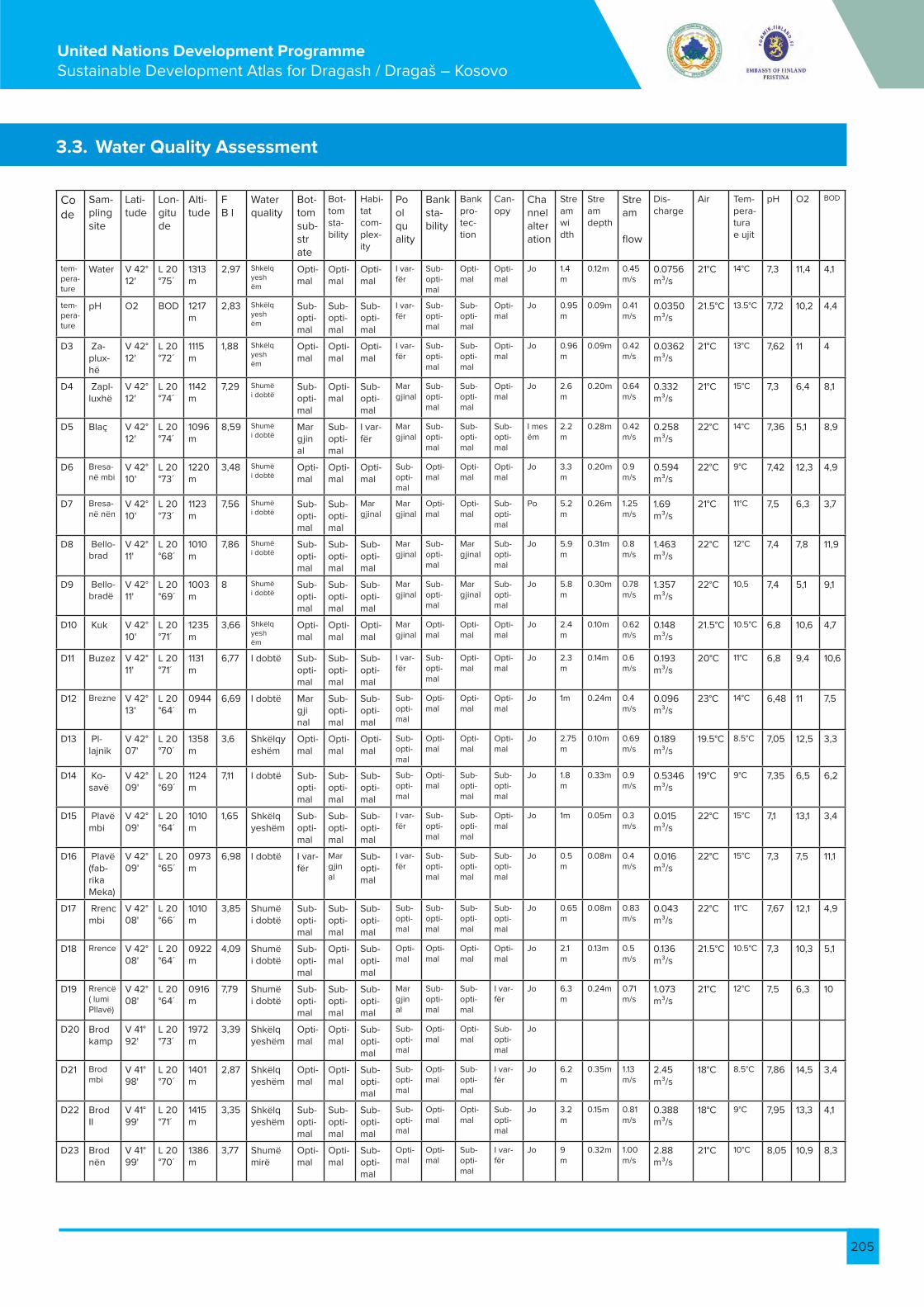
205
United Nations Development Programme Sustainable Development Atlas for Dragash / Dragaš – Kosovo
3.3. Water Quality Assessment
Code
Sam-pling site
Lati-tude
Lon-gitude
Alti-tude
F B I
Water quality
Bot-tom sub-strate
Bot-tom sta-bility
Habi-tat com-plex-ity
Pool quality
Bank sta-bility
Bank pro-tec-tion
Can-opy
Channel alteration
Stream width
Stream depth
Stream flow
Dis-charge
Air Tem-pera-tura e ujit
pH O2 BOD
tem-pera-ture
Water V 42° 12'
L 20 °75´
1313 m
2,97 Shkëlqyeshëm
Opti-mal
Opti-mal
Opti-mal
I var-fër
Sub-opti-mal
Opti-mal
Opti-mal
Jo 1.4m
0.12m 0.45m/s
0.0756 m³/s
21°C 14°C 7,3 11,4 4,1
tem-pera-ture
pH O2 BOD 1217 m
2,83 Shkëlqyeshëm
Sub-opti-mal
Sub-opti-mal
Sub-opti-mal
I var-fër
Sub-opti-mal
Sub-opti-mal
Opti-mal
Jo 0.95m
0.09m 0.41m/s
0.0350 m³/s
21.5°C 13.5°C 7,72 10,2 4,4
D3 Za-plux-hë
V 42° 12'
L 20 °72´
1115 m
1,88 Shkëlqyeshëm
Opti-mal
Opti-mal
Opti-mal
I var-fër
Sub-opti-mal
Sub-opti-mal
Opti-mal
Jo 0.96m
0.09m 0.42m/s
0.0362 m³/s
21°C 13°C 7,62 11 4
D4 Zapl-luxhë
V 42° 12'
L 20 °74´
1142 m
7,29 Shumëi dobtë
Sub-opti-mal
Opti-mal
Sub-opti-mal
Margjinal
Sub-opti-mal
Sub-opti-mal
Opti-mal
Jo 2.6m
0.20m 0.64m/s
0.332 m³/s
21°C 15°C 7,3 6,4 8,1
D5 Blaç V 42° 12'
L 20 °74´
1096 m
8,59 Shumë i dobtë
Margjinal
Sub-opti-mal
I var-fër
Margjinal
Sub-opti-mal
Sub-opti-mal
Sub-opti-mal
I mesëm
2.2m
0.28m 0.42m/s
0.258 m³/s
22°C 14°C 7,36 5,1 8,9
D6 Bresa-në mbi
V 42° 10'
L 20 °73´
1220 m
3,48 Shumë i dobtë
Opti-mal
Opti-mal
Opti-mal
Sub-opti-mal
Opti-mal
Opti-mal
Opti-mal
Jo 3.3m
0.20m 0.9m/s
0.594 m³/s
22°C 9°C 7,42 12,3 4,9
D7 Bresa-në nën
V 42° 10'
L 20 °73´
1123 m
7,56 Shumë i dobtë
Sub-opti-mal
Sub-opti-mal
Margjinal
Margjinal
Opti-mal
Opti-mal
Sub-opti-mal
Po 5.2m
0.26m 1.25m/s
1.69 m³/s
21°C 11°C 7,5 6,3 3,7
D8 Bello-brad
V 42° 11'
L 20 °68´
1010 m
7,86 Shumë i dobtë
Sub-opti-mal
Sub-opti-mal
Sub-opti-mal
Margjinal
Sub-opti-mal
Margjinal
Sub-opti-mal
Jo 5.9m
0.31m 0.8m/s
1.463 m³/s
22°C 12°C 7,4 7,8 11,9
D9 Bello-bradë
V 42° 11'
L 20 °69´
1003 m
8 Shumë i dobtë
Sub-opti-mal
Sub-opti-mal
Sub-opti-mal
Margjinal
Sub-opti-mal
Margjinal
Sub-opti-mal
Jo 5.8m
0.30m 0.78m/s
1.357 m³/s
22°C 10,5 7,4 5,1 9,1
D10 Kuk V 42° 10'
L 20 °71´
1235 m
3,66 Shkëlqyeshëm
Opti-mal
Opti-mal
Opti-mal
Margjinal
Opti-mal
Opti-mal
Opti-mal
Jo 2.4m
0.10m 0.62m/s
0.148 m³/s
21.5°C 10.5°C 6,8 10,6 4,7
D11 Buzez V 42° 11'
L 20 °71´
1131 m
6,77 I dobtë Sub-opti-mal
Sub-opti-mal
Sub-opti-mal
I var-fër
Sub-opti-mal
Opti-mal
Opti-mal
Jo 2.3m
0.14m 0.6m/s
0.193 m³/s
20°C 11°C 6,8 9,4 10,6
D12 Brezne V 42° 13'
L 20 °64´
0944 m
6,69 I dobtë Margjinal
Sub-opti-mal
Sub-opti-mal
Sub-opti-mal
Opti-mal
Opti-mal
Opti-mal
Jo 1m 0.24m 0.4m/s
0.096 m³/s
23°C 14°C 6,48 11 7,5
D13 Pl-lajnik
V 42° 07'
L 20 °70´
1358 m
3,6 Shkëlqyeshëm
Opti-mal
Opti-mal
Opti-mal
Sub-opti-mal
Opti-mal
Opti-mal
Opti-mal
Jo 2.75m
0.10m 0.69m/s
0.189 m³/s
19.5°C 8.5°C 7,05 12,5 3,3
D14 Ko-savë
V 42° 09'
L 20 °69´
1124 m
7,11 I dobtë Sub-opti-mal
Sub-opti-mal
Sub-opti-mal
Sub-opti-mal
Opti-mal
Sub-opti-mal
Sub-opti-mal
Jo 1.8m
0.33m 0.9m/s
0.5346 m³/s
19°C 9°C 7,35 6,5 6,2
D15 Plavë mbi
V 42° 09'
L 20 °64´
1010 m
1,65 Shkëlqyeshëm
Sub-opti-mal
Sub-opti-mal
Sub-opti-mal
I var-fër
Sub-opti-mal
Sub-opti-mal
Opti-mal
Jo 1m 0.05m 0.3m/s
0.015 m³/s
22°C 15°C 7,1 13,1 3,4
D16 Plavë (fab-rika Meka)
V 42° 09'
L 20 °65´
0973 m
6,98 I dobtë I var-fër
Margjinal
Sub-opti-mal
I var-fër
Sub-opti-mal
Sub-opti-mal
Sub-opti-mal
Jo 0.5m
0.08m 0.4m/s
0.016 m³/s
22°C 15°C 7,3 7,5 11,1
D17 Rrenc mbi
V 42° 08'
L 20 °66´
1010 m
3,85 Shumëi dobtë
Sub-opti-mal
Sub-opti-mal
Sub-opti-mal
Sub-opti-mal
Sub-opti-mal
Sub-opti-mal
Sub-opti-mal
Jo 0.65m
0.08m 0.83 m/s
0.043 m³/s
22°C 11°C 7,67 12,1 4,9
D18 Rrence V 42° 08'
L 20 °64´
0922 m
4,09 Shumëi dobtë
Sub-opti-mal
Opti-mal
Sub-opti-mal
Opti-mal
Opti-mal
Opti-mal
Opti-mal
Jo 2.1m
0.13m 0.5m/s
0.136 m³/s
21.5°C 10.5°C 7,3 10,3 5,1
D19 Rrencë ( lumi Pllavë)
V 42° 08'
L 20 °64´
0916 m
7,79 Shumëi dobtë
Sub-opti-mal
Sub-opti-mal
Sub-opti-mal
Margjinal
Sub-opti-mal
Sub-opti-mal
I var-fër
Jo 6.3m
0.24m 0.71 m/s
1.073 m³/s
21°C 12°C 7,5 6,3 10
D20 Brod kamp
V 41° 92'
L 20 °73´
1972 m
3,39 Shkëlqyeshëm
Opti-mal
Opti-mal
Sub-opti-mal
Sub-opti-mal
Opti-mal
Opti-mal
Sub-opti-mal
Jo
D21 Brod mbi
V 41° 98'
L 20 °70´
1401 m
2,87 Shkëlqyeshëm
Opti-mal
Opti-mal
Sub-opti-mal
Sub-opti-mal
Opti-mal
Sub-opti-mal
I var-fër
Jo 6.2m
0.35m 1.13 m/s
2.45 m³/s
18°C 8.5°C 7,86 14,5 3,4
D22 Brod II
V 41° 99'
L 20 °71´
1415 m
3,35 Shkëlqyeshëm
Sub-opti-mal
Sub-opti-mal
Sub-opti-mal
Sub-opti-mal
Opti-mal
Opti-mal
Sub-opti-mal
Jo 3.2m
0.15m 0.81 m/s
0.388 m³/s
18°C 9°C 7,95 13,3 4,1
D23 Brod nën
V 41° 99'
L 20 °70´
1386 m
3,77 Shumëmirë
Opti-mal
Opti-mal
Sub-opti-mal
Opti-mal
Opti-mal
Sub-opti-mal
I var-fër
Jo 9m
0.32m 1.00 m/s
2.88 m³/s
21°C 10°C 8,05 10,9 8,3

206
United Nations Development Programme Sustainable Development Atlas for Dragash / Dragaš – Kosovo
D24 Di-kanca
V 42° 01'
L 20 °67´
1137 m
4,59 I dobtë Opti-mal
Opti-mal
Opti-mal
Opti-mal
Opti-mal
Opti-mal
Sub-opti-mal
Jo 8m
0.40m 1.25 m/s
4 m³/s 21°C 10.5°C 7,75 10,3 8,9
D25 Mlika mbi
V 42° 02'
L 20 °64´
0977 m
3,52 Shkëlqyeshëm
Opti-mal
Opti-mal
Sub-opti-mal
Sub-opti-mal
Opti-mal
Opti-mal
Sub-opti-mal
Jo 1.2m
0.09m 0.47m/s
0.050 m³/s
19°C 12°C 7,5 12,4 5
D26 Mlika nën
V 42° 03'
L 20 °64´
0941 m
3,91 Shumë mirë
Sub-opti-mal
Sub-opti-mal
Sub-opti-mal
Margjinal
Opti-mal
Opti-mal
Sub-opti-mal
Jo 1.4m 0.08m 0.48 m/s
0.053 m³/s
19°C 11°C 7,58 10,8 5,3
D27 Mlika (lumi Brod)
V 42° 03'
L 20 °64´
0940 m
3,96 Shumë mirë
Sub-opti-mal
Sub-opti-mal
Sub-opti-mal
Sub-opti-mal
Opti-mal
Opti-mal
Opti-mal
Jo 7m 0.27m 0.83 m/s
1.568 m³/s
19.5°C 10,5 7,6 10,2 7,1
D28 Rapçë mbi
V 42° 09'
L 20 °61´
1040 m
3,83 Shumë mirë
Opti-mal
Opti-mal
Sub-opti-mal
Margjinal
Opti-mal
Opti-mal
Sub-opti-mal
Jo 2.5m
0.20m 0.8m/s
0.4 m³/s
19°C 10°C 7,5 10,9 4,1
D29 Rapçë nën
V 42° 07'
L 20 °62´
0910 m
4,95 I dobtë Sub-opti-mal
Sub-opti-mal
Sub-opti-mal
Sub-opti-mal
Sub-opti-mal
Opti-mal
Margjinal
Jo 1.7m 0.10m 0.58m/s
0.0986 m³/s
19°C 11°C 7,6 8,5 4,6
D30 Rade-sha mbi
V 42° 06'
L 20 °65´
1207 m
3,8 Shumë mirë
Opti-mal
Opti-mal
Sub-opti-mal
Margjinal
Opti-mal
Sub-opti-mal
Sub-opti-mal
Jo 4.1m 0.27m 0.79 m/s
0.874 m³/s
21°C 8.5°C 7,1 14,2 3,8
D31 Rade-sha
V 42° 05'
L 20 °69´
1265 m
6,93 I dobtë Opti-mal
Opti-mal
Sub-opti-mal
Margjinal
Opti-mal
Sub-opti-mal
Sub-opti-mal
Jo 4,2 0.275m
0.8 m/s
0.924 m³/s
21°C 9°C 7,06 10,3 10,3
D32 Dra-gash
V 42° 06'
L 20 °65´
1012 m
5,86 Mjaft i dobtë
Sub-opti-mal
Sub-opti-mal
Sub-opti-mal
Sub-opti-mal
Opti-mal
Opti-mal
Opti-mal
Jo 3m 0.30m 0.89m/s
0.801 m³/s
22.5°C 12°C 6,9 10,1 5,2
D33 Res-telica mbi
V 42° 03'
L 20 °64´
1417 m
2,47 Shkëlqyeshëm
Opti-mal
Opti-mal
Sub-opti-mal
Sub-opti-mal
Opti-mal
Opti-mal
Opti-mal
Jo 6,9 0.23m 0.8 m/s
1.269 m3/s
17°C 8°C 7,89 13,7 3,1
D34 Res-telica nën
V 42° 03'
L 20 °64´
1212 m
6,63 I dobtë Opti-mal
Opti-mal
Sub-opti-mal
Sub-opti-mal
Opti-mal
Opti-mal
Sub-opti-mal
Jo 8,2 0.36m 1.12 m/s
3.306 m³/s
18°C 9°C 8 6,8 9,9
D35 Kru-shevë mbi
V 41° 97'
L 20 °64´
1216 m
4,77 Mirë Sub-opti-mal
Sub-opti-mal
Sub-opti-mal
Sub-opti-mal
Opti-mal
Opti-mal
Sub-opti-mal
Jo 8m 0.50m 1 m/s 4 m³/s 19°C 11°C 8,26 11,2 8,1
D36 Kru-shevë nën
V 41° 98'
L 20 °63´
1150 m
4,76 Mirë Sub-opti-mal
Sub-opti-mal
Sub-opti-mal
Sub-opti-mal
Opti-mal
Opti-mal
Sub-opti-mal
Jo 7,3 0.50m 0.94 m/s
3.431 m³/s
19°C 11.5°C 7,84 9,4 7,3
D37 Gllo-boçi-ca mbi
V 42° 00'
L 20 °63´
1237 m
4,06 Shumë mirë
Margjinal
Sub-opti-mal
Sub-opti-mal
Sub-opti-mal
Opti-mal
Opti-mal
Sub-opti-mal
Jo 3m 0.10m 0.8 m/s
0.24 m³/s
20.5°C 12°C 7,68 9,1 7,4
D38 Zli Potok mbi
V 41° 97'
L 20 °66´
1348 m
3,53 Shkëlqyeshëm
Sub-opti-mal
Sub-opti-mal
Margjinal
Sub-opti-mal
Opti-mal
Opti-mal
Margjinal
Jo 1.5m 0.13m 0.66 m/s
0.128 m³/s
20.5°C 14°C 7,85 11,8 5,9
D39 Zli Potok nën
V 41° 97'
L 20 °64´
1296 m
3,54 Shkëlqyeshëm
Opti-mal
Opti-mal
Sub-opti-mal
Sub-opti-mal
Opti-mal
Opti-mal
Sub-opti-mal
Jo 2m 0.15m 0.64 m/s
0.192 m³/s
19°C 12°C 8,26 10,1 4,2
D40 Zli Po-tokë mes
V 41° 99'
L 20 °64´
1367 m
4,27 Mirë Sub-opti-mal
Opti-mal
Opti-mal
Sub-opti-mal
Sub-opti-mal
Sub-opti-mal
I var-fër
Jo 1m 0.25m 0.5 m/s
0.125 m³/s
20°C 15°C 6,96 11,3 6
D41 Or-çusha mbi
V 42° 03'
L 20 °61´
1107 m
3,99 Shumë mirë
Opti-mal
Opti-mal
Opti-mal
Margjinal
Opti-mal
Opti-mal
Margjinal
Jo 0.65m
0.08m 0.4 m/s
0.0208 m³/s
21°C 13°C 7,55 13,1 9
D42 Or-çushë mes
V 42° 03'
L 20 °61´
0968 m
5,31 Jo i keq Sub-opti-mal
Sub-opti-mal
Sub-opti-mal
Margjinal
Opti-mal
Opti-mal
Sub-opti-mal
Jo 1m 0.07m 0.8 m/s
0.056 m³/s
21°C 14°C 7,46 10,2 9,3
D43 Krstec
V 42° 08'
L 20 °61´
0955 m
3,04 Shkëlqyeshëm
Opti-mal
Opti-mal
Sub-opti-mal
Sub-opti-mal
Opti-mal
Opti-mal
Sub-opti-mal
Jo 0.7m 0.09m 0.7 m/s
0.0041 m³/s
19°C 14°C 7,5 13,6 8,6
D44 Fab-rika e leshit mbi
V 42° 05'
L 20 °64´
0999 m
6,58 I dobtë Sub-opti-mal
Sub-opti-mal
Margjinal
Sub-opti-mal
Sub-opti-mal
Sub-opti-mal
Sub-opti-mal
Jo 2.75m
0.15m 0.71 m/s
0.292 m³/s
22°C 15°C 7 6,2 12,1
D45 Fab-rika e leshit
V 42° 05'
L 20 °64´
0997 m
7,45 Shumë i dobtë
Sub-opti-mal
Sub-opti-mal
Margjinal
Sub-opti-mal
Sub-opti-mal
Sub-opti-mal
Sub-opti-mal
Jo 2.75m
0.15m 0.71 m/s
0.292 m³/s
22°C 15°C 5,2 5,1 14,9
D44 Wool fac-tory Up
N 42° 05'
E 20 °64´
0999 m
6,58 Poor Sub-opti-mal
Sub-opti-mal
Mar-ginal
Sub-opti-mal
Sub-opti-mal
Sub-opti-mal
Sub-opti-mal
No 2.75m
0.15m
0.71 m/s
0.292 m³/s
22°C 15°C 7 6,2 12,1
D45 Wool fac-tory
N 42° 05'
E 20 °64´
0997 m
7,45 Very poor
Sub-opti-mal
Sub-opti-mal
Mar-ginal
Sub-opti-mal
Sub-opti-mal
Sub-opti-mal
Sub-opti-mal
No 2.75m
0.15m
0.71 m/s
0.292 m³/s
22°C 15°C 5,2 5,1 14,9
D45 Fab-rika vune
N 42° 05'
E 20 °64´
0997 m
7,45 Veoma slab
Sub-opti-mal-na
Sub-opti-mal-na
Mar-gin-alna
Sub-opti-mal-ni
Sub-opti-malni
Sub-opti-malni
Sub-opti-malni
Nema
2.75m
0.15m
0.71 m/s
0.292 m³/s
22°C
15°C
5,2 5,1 14,9

207
United Nations Development Programme Sustainable Development Atlas for Dragash / Dragaš – Kosovo

208
United Nations Development Programme Sustainable Development Atlas for Dragash / Dragaš – Kosovo