Surface Coal Mining in Alaska
368
Surface Coal Mining in Alaska - An Investigation of the Surface Mining Control and Reclamation Act of 1977 in Relation to Alaskan Conditions A Report Prepared by the Committee on Alaskan Coal Mining and Reclamation Board on Mineral and Energy Resources Commission on Natural Resources National Research Council National Academy of Sciences NATIONAL ACADEMY PRESS Washington, D.C. 1980
-
Upload
khangminh22 -
Category
Documents
-
view
0 -
download
0
Transcript of Surface Coal Mining in Alaska

Surface Coal Mining in Alaska
- An Investigation of the Surface Mining Control and Reclamation Act of 1977 in Relation to Alaskan Conditions
A Report Prepared by the Committee on Alaskan Coal Mining and Reclamation Board on Mineral and Energy Resources Commission on Natural Resources National Research Council National Academy of Sciences
NATIONAL ACADEMY PRESS Washington, D.C. 1980

NOTICE: The project that is the subject of this report was approved by the Governing Board of the National Research Council, whose members are drawn from the Councils of the National Academy of Sciences, the National Academy of Engineering, and the Institute of Medicine. The members of the Committee responsible far the report were chosen for their special eompetences and with regard for appropriate balance.
This report has been reviewed by a group other than the authors according to procedures approved by a Report Review Committee consisting of members of the National Academy of Sciences, the National Academy of Engineering, and the Institute of Medicine.
The National Research Council was established by the National Academy of Sciences in 1916 to associate the broad community of science and technology with the Academy's purposes of furthering knowledge and of advising the federal government. The Council operates in accordance with general policies determined by the Academy under the authority of its Congressional charter of 1863, which establishes the Academy as a private, non-profit, self-governing membership corporation. The Council has become the principal operating agency of both the National Academy of Sciences and the National Academy of Engineering in the conduct of their services to the government, the public, and the scientific and engineering communities. It is aministored jointly by both academies and the Institute of Medicine, The National Academy of Engineering and the Institute of Medicine were established in 1964 and 1970, respectively, under the charter of the National Academy of Sciences.
The study was supported by the U.S. Department of the Interior, Office of Surface Mining.
Available in limited supply from
Board on Mineral and Energy Resources Commission on Natural Resources National Research Council 2101 Constitution Avenue, N.W. Washington, D.C. 20418
Printed in the United States of America

. . -
COMMISSION ON NATURAL RESOURCES
Robert M. White, Chairman, University Corporation for Atmospheric Research
Timothy Atkeson, Steptoe & Johnson Stanley I. Auerbach, Oak Ridge National Laboratory Norman A. Copeland, E.I. du Pont de Nemours and Co., retired George K. Davis, University of Florida, retired Edward D. Goldberg, Sctipps Institution of Oceanography Charles J. Mankin, Oklahoma Geological Survey Chester 0. McCorkle, Jr., Oniversity of California Norton Nelson, New York University Medical Center Daniel A. Okun, University of North Carolina David Pimentel, Cornell University John E. Tifton, Pennsylvania State University Alvin M. Weinberg, Oak Ridge Associated Universities E. Bright Wilson, ex officio, Harvard University
Wallace D. Bowman, ~xecut&e Director
iii

BOARD ON MINERAL AND ENERGY RESOURCES
Charles J. Mankin, Chairman, Oklahoma Geological Survey John E. Tilton, Vice Chairman, Pennsylvania State University Philip H. Abelson, Science William C. Ackermnn, University of Illinois Paul B. Barton, U.S. Geological Survey Earl H. Beistline, University of Alaska James Boyd, Consultant Howard R. Gould, EXXON Production Research Company George R. Hill, University of Utah Hans H. Landsberg, Resources for the Future, Inc. Vincent E. McKelvey, U.S. Geological Survey Harry Perry, Resources for the Future, Inc. Joe 8. Rosenbaum, Consultant
Robert S. Long, Executive Secretary George White, Associate Executive Secretary

COMMXmE ON ALASKAN COAL MINING AND RECLAMATION
Earl H. Beistline, Chairman, University of Alaska, airb banks Clayton G. Ball, Evanston, Illinois Jerry Brown, U.S. Army Cold Regions Research & Engineering Laboratory Perry R. Hagenstein, Consultant Charles F. Herbert, Consultant Celia Hunter, Fairbanks, Alaska Arthur H. Lachenbruch, U.S. Geological Survey William S. Lauqhlin, University of Connecticut Harold E. Malde, U.S. Geological Survey Jay Dee McKendrick, University of Alaska, Palmer A. Thomas Ovenshine, U.S. Geological Survey Francis J. Pettijohn, The Johns Hapkin6 University Glenn J. Phillips, Golder Associates George W. Rogers, University of Alaska, Juneau Ross G. Schaff, State Geologist, Alaska Lidia L. Selkregg, University of Alaska, Anchorage
Editorial Subcommittee
Francis J. Pettijohn, Chairman, The Johns EbDpkins Uniwwsitry Earl H. Beistline, university of Alaska Perry R. Hagenstein, Consultant Harold E. Malde, U.S. Geological Survey Glenn J. Phillips, Golder Associates Lidia L. Selkcegg, University of Alaska
Staff
George White, Senior Staff Officer Richard G. Ray, Staff Officer and Special Contributor Erika H. Ridgway, Staff Associate Charlotte A. Gott, Secretary Lavon D. Norris, Secretary
Consultants
Alfred F. Jahns, Esq., Board of Surface Mining and Reclamation Appeals Robert Lamke, U.S. Geological Survey Robert B. Weeden, University of Alaska, Fairbanks

CONTENTS
LIST OF FIGURES
LIST OF TABLES
PREFAC E
SUMMARY OF FINDINGS AND RECOMMENDATIONS
Chapter 1 f NTRODUCTI ON
1.1 Purposes of the Act and Objectives of the Study 1.2 Organization and Content of the Report 1.3 Alaskan Environments 1.4 Historical Development of Mining in Alaska
1.4.1 Environmental Perspective 1.4.2 Socioeconomic Perspective
Chapter 2 COAL RESOURCES, MINING, AND DEVELOPMENT IN ALASKA
2.1 History of Coal Mining and Development in Alaska 2.2 Geographic and Geologic Setting of Alaska's Coal
Deposits
2.2.1 Arctic Region (North Slope Basin) 2.2.2 Interior Region (Nenana Basin) 2.2.3 Southcentral ~egion (Cook Inlet Basin) 2.2.4 Other Alaskan Coal Deposits
2.3 Comparison of Alaskan with Other U.S. Coal 2.4 Potential for Coal Development
2.4.1 Arctic Region (North Slope Basin) 2.4.2 Interior Region (Nenana Basin) 2.4.3 Southcentral Region (Cook Inlet Basin)
Chapter 3 THE RELATIONSHIP OF ALASKA'S ENVIRONMENTAL, SOCIOECONOMIC, AND REGULATORY CONDITIONS TO POTENTIAL COAL DEVELOPMENT
3.1 Environmental Conditions and Coal Development
x i x
3.1.1 Climate
3.1.1.1 Arctic Region 3.1.1.2 Interior Region 3.1.1.3 Southcentral Region 3.1.1.4 Common Problems Related to Climate
3.1.2 Permafrost
3.1.2.1 Classification and Characteristics 3.1.2.2 Distribution 3.1.2.3 Engineering Considerations
3.1.2.3.1 Excavation 3.1.2.3.2 Slope Stability 3.1.2.3.3 Land Restorability
3.1.3 Vegetation
3.1.3.1 Distribution 3.1.3.2 Classification 3,1.3.3 Character of Native Vegetation 3.1.3.4 Soils 3.1.3.5 Revegetation
3.1.4 Hydrology
3 .1,4.1 Surface Water 3.1.4.2 Ground Water 3.1i4.3 Water Quality 3.1.4.4 Hydrology of Major Coal-Bearing
Reg ions
3.1.4.4.1 Arctic Region 3.1,4,4.2 Interior Region 3.1.4.4.3 Southcentral Region
3.1.4.5 Water Problems of Special Importance with Respect to PL 95-87
3.1.4.5.1 Basic Data 3.1.4.5.2 Water Quality 3.1.4.5.3 Sedimentation Ponds
3.1.5 Geologic Hazards
3.1.5.1 Earthquakes 3.1.5.2 Floods 3.1.5.3 Volcanic Activity
3.1.6 Wildlife
3.1.6.1 Characteristics of Alaskan Wildlife
v i i i

3.1.6.1.1 Southcentral Region 3.1.6.1.2 Interior Region 3.1.6.1.3 Arctic Region
3.1.6.2 Wildlife Harvests
3.1.6.2.1 Southcentral Region 3.1.6.2.2 Interior Region 3.1.6.2.3 Arctic Region
3.1.6.3 Effects of Coal.Mining on Wildlife
3.1.6.3.1 On-Site Effects 3.1.6.3.2 Off-Site Effects 3.1.6.3.3 Effects of Patterns of
Wildlife Utilization
3.1.6.4 Wildlife Considerations in Decision-Making
3.2 Socioeconomic Conditions and ~ b a l Development
3.2.1 Population and Population Density 3.2.2 Native Economies and Subsistence Harvest
3.2.2.1 Native Economies 3.2.2.2 Subsistence Harvest
3.2.3 Transportation and Access
3.2.3.1 Development of Alaska's Transportation Syetem
3.2.3.2 Transportation of Coal
3.2.4 Land Use
3.2.4.1 Farm Land 3.2.4.2 Forest and Rangelands 3.2.4.3 Wilderness
3.2.5 Social Impact of Surface Mining
3.2.5.1 Arctic Region 3.2.5.2 Interior Region 3.2.5.3 Southcentral Region
3.3 Institutional and Regulatory Environment
3.3.1 Land Status
3.3.2 Leasing and Land-Use Regulation on State and Federal Lands
3.3.3 Local Government Controls 3.3.4 General Environmental Regulations 3.3.5 Treaty Obligations 3.3.6 Discussion
Chapter 4 BACKGROUND AND CRITERIA FOR EVALUATING THE SUITABILITY OF THE SURFACE MINING CONTROL AND RECLAMATION ACT (PL 95-87) FOR CONDITIONS IN ALASKA
4.1 Objectives of PL 95-87 4.2 Considerations in Controlling the Impacts of Coal
Mining
4.2.1 Deciding What Degree of Control is Needed 4.2.2 Matching the Level of Decision-Making to the
Problems 4.2.3 M e t h o d s of Controlling Impacts of Coal Mining
4.3 Criteria for Evaluating PL 95-87 for Alaska
Chapter 5 SUITABILITY OF THE SURFACE MINING CONTROL AND RECLAMATION ACT (PL 95-87 ) FOR CONDITIONS IN ALASKA
5.1 Significance of Conditions in Alaska for valuating the Act 's Suitability for Alaska
5.1.1 Special Qualities of Some Conditions in Alaska
5.1.2 Elements of the Act Not Specially ~ffected by Conditions in Alaska
5.2 Assumptions of the Act and heir Validity for Alaska
5.2.1 Need fox a National Program
5.2.1.1 Synopsis of Relevant Provisions of PL 95-87
5.2.1.2 Discussion
5.2.2 Focus on Developed Land
5.2.2.1 Synopsis of Relevant Provisions of PL 95-87
5.2.2.2 Discussion
5.2.2.2.1 Significance of Undeveloped Land in Alaska
5.2.2.2.2 Land Use in Alaska 5.2.2.2.3 Land Ownership and
Jurisdiction in Alaska 5.2.2.2.4 Land-Use Planning as a
Basis for Decisions on Surface Coal Mining in Alaska
5.2.3 Dependence of Permits on ~eclaimbilit~
5.2.3.1 Synopsis of Provisions of PL 95-87 5.2.3.2 Discussion
5.2.3.2.1 Meaning of Reclamation as Implied by the Act
5.2.3.2.2 Validity of ~eclaimability as a Condition for Mining
5.2.3.2.3 Feasibility of Reclamation in the Southcentral Region
5.2.3.2.4 Uncertainty of Objectives for Reclamation in Areas of Permafrost
5.2.4 Emphasis Limited to Affected Land
5.2.4.1 Synopsis of Relevant Provisions of PL 95-87
5.2.4.2 Discussion
5.2.4.2.1 Impacts from Access to Undeveloped Land
5.2.4.2.2 Impacts on Communities
5.2.5 Biological and Social Impacts to Be Controlled by Regulating Physical Effects of Mining
5.2.5.1 Synopsis of Provisions of PL 95-87 Ftelated to Fish and Wildlife
5.2.5.1.1 Discussion
5.2.5.2 Synopsis of Provisions of PL 95-87 Related to Social Conditions

5.2.6 Mining Effects Thought to Be Temporary 205
5.2.6.1 Synopsis of Relevant Provisions of PL 95-87
5.2.6.2 Discussion
Results of Mining and Reclamation Assumed to Be Predictable
5.2.7.1 Synopsis of Relevant Provisions of PL 95-87
5.2.7.2 Discussion
5.2.7.2.1 Unpredictability of Mining and Reclamation Results in Alaska
5.2.7.2.2 Surface Mining in Permafrost Terrain
5.2.7.2.3 Protection of Water Supplies
5.2.7.2.4 Earthquakes and Floods
Environmental Problems to Be Mitigated by Following Prescribed Practices
5.2.8.1 Synopsis of Relevant Provisions of PL 95-87 215
5.2.8.2 Discussion 2 19
5.2.8.2.1 Unsuitability of Prescribed Practices for Alaska 219
5.2.8.2.2 Performance Standards of the Act from the Perspective of Alaskan Conditions 220
SELECTED BIBLIOGRAPHY 237
Appendix A Sequential Analysis of the Surface Mining Control and Reclamation Act (PL 95-87) Provisions as They Pertain to Alaskan Conditions 245
Title I Section 101 Findings 246
Title V Section 507 Application Requirements 247 Section 508 RecLamtion Plan Requirements 254 Section 509 Performance Bonds 259 Section 510 Permit Approval or Denial 260

Section 511 Revision of Permits Section 512 Coal Exploration and Permits Section 515 Environmental Protection
Performance Standards Section 516 Surface Effects of Underground
Coal Mining Operations Section 522 Designating Areas Unruitabla
for Surface Coal Mining
Appendix B Environmental Law
I Federal Environmental Law Applicable to Coal Mining Activity in Alaska
A Water Related Provisions B Clean Air Act C Solid Waste Management D Coal Management
I1 Alaska Environmental Protection Laws Relevant to Coal Resource Development Activities
A Introduction B Agency Responsibilities
1. Department of Environmental Conservation
a) Introduction b) Water Pollution Control c) Air Pollution Control d ) Solid Waste Management e ) Oil and Hazardous Substance Pollution
Control £ 1 Environmental Procedures Coordination
2. Department of ~atural Resources
a) Introduction b) Land Use Permits c) Lease Provisions
3. Department of Fish and Game
C Conclusion
111 Local Government Controls
A General Background B Specific Local Government Controls that Might
Affect Surface Mining
xiii

1. Planning, Platt ing, and Zoning 2 . Air Pol lut ion Control 3 . Coastal Zone Management
Attachment: Cri ter ia of Federal Land Unsui tabi l i ty for A l l or Certain Types of Surface Coal Mining Activity
GLOSSARY
FIGURES
1.1 Shaded r e l i e f map showing t h e t h r e e major r e g i o n s of mainland Alaska
2 .1 Histogram showing c o a l r e s o u r c e s i n major c o a l b a s i n s of Alaska ll
2 . 2 Sketch map showing l o c a t i o n of p r i n c i p a l c o a l d e p o s i t s i n Alaska 1 7
2 .3 Outcrops o f Cretaceous c o a l a l o n g t h e Kukpowruk River , wes te rn p a r t o f t h e North S lope c o a l b a s i n 18
2.4 Sketch map shswing e x t e n t of Healy Creek and L i g n i t e Creek coal f i e l d s and l o c a t i o n of c u r r e n t mining o p e r a t i o n s 2 0
2 . 5 Gently dipping c o a l beds near head o f L i g n i t e Creek 2 2
2 . 6 Sketch map showing l o c a t i o n o f c o a l f i e l d s i n the Cook I n l e t basin
2 . 7 Outcrop of c o a l bed i n t h e Beluga c o a l field area
3 . 1 Mean daily minimum tempera tu re d i s t r i b u t i o n , January ( d e g r e e s F a h r e n h e i t )
3 . 2 Mean d a i l y maximum tempera tu re d i s t r i b u t i o n , January (degrees Fahrenheit)
3.3 Mean daily minimum tempera tu re d i s t r i b u t i o n , Ju ly ( d e g r e e s ~ a h r e n h e i t )
3 .4 Mean d a i l y maximum tempera tu re d i s t r i b u t i o n , J u l y (degrees F a h r e n h e i t )
3.5 C h a r t s showing hours of s u n l i g h t and t w i l i g h t f o r d i f f e r e n t l a t i t u d e s and months o f t h e y e a r
3.6 Mean annua l p r e c i p i t a t i o n d i s t r i b u t i o n , i n i n c h e s
3.7 Snowfal l d i s t r i b u t i o n , i n i n c h e s
3.8 Thawed l a k e sediments f lowing around blade of b u l l d o z e r . I c e - r i c h permaf ros t exposed d u r i n g c o n s t r u c t i o n of Richardsdi~ Highway n e a r Paxon.

General f e a t u r e s o f pe rmaf ros t t e r r a i n
I c e wedges i n muck s i l t b l u f f s a l o n g t h e Kololik River , n o r t h e r n Alaska
D i s t r i b u t i o n of p e r m a f r o s t and g l a c i e r s i n Alaska
Map showing d i s t r i b u t i o n o f tundra i n Alaska
V i e w of denuded area a t Prudhoe Bay, Alaska, e x p e r i m e n t a l l y r e v e g e t a t e d w i t h Tundra b l u e g r a s s . Growth shown a t end o f second season .
V i e w o f denuded a r e a a t Prudhoe Bay, Alaska , e x p e r i m e n t a l l y r e v e g e t a t e d w i t h Tundra b l u e g r a s s . Growth shown a t end o f f i f t h season .
Average annua l runof f i n cubic f e e t p e r second p e r s q u a r e m i l e
Index map showing l o c a t i o n o f gag ing s t a t i o n s p r o v i d i n g d a t a f o r Table 3.3 o f t h i s r e p o r t
Genera l i zed a v a i l a b i l i t y of ground w a t e r i n Alaska
Summer normal c o n c e n t r a t i o n o f suspended sed iment i n Alaskan streams
Monthly c o n t r i b u t i o n t o t o t a l annua l s t reamflow i n the A r c t i c Region
Monthly c o n t r i b u t i o n to t o t a l annua l s t reamflow i n the I n t e r i o r Region
Monthly c o n t r i b u t i o n t o t o t a l annua l s t reamflow i n t h e S o u t h c e n t r a l Region
Map showing d i s t r i b u t i o n o f c a r i b o u range land and c a l v i n g grounds i n Alaska
Map showing d i s t r i b u t i o n of existing r o a d s i n Alaska
Map showing d i s t r i b u t i o n of c u l t i v a b l e s o i l s i n Alaska
Map showing boundar ies o f r e g i o n a l c o r p o r a t i o n s e s t a b l i s h e d under ANCSA and estimated combined r e g i o n a l and v i l l a g e c o r p o r a t i o n entitlements ( i n m i l l i o n s of a c r e s )
xv i

SUMMARY TABLE
2.1 Geologic c h a r a c t e r i s t i c s of Alaskan coal deposits
2.2 Alaska coal production and value from 1880 through 1977
2 . 3 Chronology o f events i n coal development and production i n Alaska. 1786-1977
2 . 4 Comparison of Alskan coal with coal of the conterminous United S t a t e s
3.1 Environmental condit ions of coal-bearing regions of Alaska
3.2 Comparative temperature and p r e c i p i t a t i o n data for coal a reas o f Alaska and the conterminous United S t a t e s
3 . 3 Approximate mean suspended sediment loads and concentrat ions f o r various discharges of representa t ive streams i n o r near p o t e n t i a l coal-mining areas i n Alaska
3.4 Large mamals, b i r d s , and f i s h i n o r adjacent t o coal f i e l d s of the North Slope
3.5 Large mammals, b i r d s , and fish i n o r adjacent t o the Point Hope coal f i e l d
3.6 L a r g e marmnals, b i rds , and fish i n the Nenana Basin coal f i e l d s
3 . 7 Large mammals, b i r d s , and f i s h i n the Eagle- Circ le coal f i e l d
3 . 8 Large mamals, birds , and f i s h i n the Broad Pass coal field
3.9 Large mammals, b i r d s , and f i s h i n or adjacent t o the Beluga and Yentna coal f i e l d s
3.10 Large m a n l m a l s , b i r d s , and f i s h i n the Matanuska coal f i e l d

I. ballus W L L I L L L L L t i r
fo l lowing sys tems o r c a t e g o r i e s : N a t i o n a l Park System; N a t i o n a l W i l d l i f e Refuge System; Na t iona l System of Trails; N a t i o n a l Wilderness P r e s e r v a t i o n System; Na t iona l Wild and Scen ic R i v e r s System; Na t iona l Recrea t ion Areas; l a n d s a c q u i r e d w i t h money d e r i v e d from t h e Land and Water Conservat ion Fund; Na t iona l F o r e s t s ; and F e d e r a l l a n d s w i t h i n i n c o r p o r a t e d c i t i e s , t o k n s , and v i l l a g e s .
(b) Lands recommended for i n c l u s i o n i n any of t h e above systems o r c a t e g o r i e s i n a l e g i s l a t i v e p r o p o s a l by t h e Admin is t ra t ion .
(c) Lands r e q u i r e d by stat- ute t o b e s t u d i e d f o r i n c l u - s i o n i n t h e above systems o r c a t e g o r i e s .
I. \a) L ~ L I U S W I L I I L L ~ ~ V ~ L L U I L ~ L
F o f e s t s where underground coa l mining w i l l n o t i n t e r f e r e with p r o t e c t e d s u r f a c e r e s o u r c e s .
(b) Lands w i t h i n N a t i o n a l F o r e s t s west of t h e 1 0 0 t h Meridian* for mining a c t i v i t y i n compliance w i t h the Multiple-Use S u s t a i n e d Y i e l d Act of 1960, the F e d e r a l Coal Leas ing Amendments A c t of 1976, and t h e S u r f a c e Mining C o n t r o l and Reclamation A c t o f 1977.
* No s u r f a c e c o a l mining may o c c u r w i t h i n t h e C u s t e r N a t i o n a l F o r e s t .
1. la) Lanas SUDJ ecr KO Valld e x i s t i n g r i g h t s .
(b) Lands on which s u r f a c e c o a l mining o p e r a t i o n s were b e i n g conducted on August 3, 1977.
( c ) Lands w i t h i n s t u d y a r e a s where s u b s t a n t i a l l e g a l and f i n a n c i a l commitments towards minirig were made p r i o r t o January 4 , 1977.
(d l Lands which i n c l u d e o p e r a t i o n s f o r which a permi t h a s been i s s u e d .

PREFACE
The Nation today is faced with a serious energy problem. Domestic production of petroleum has been declining in recent years, while our dependence on foreign oil has been increasing. We continue to be vulnerable to interruptions in the supply of foreign oil similar to that which occurred in 1973. In addition to nuclear power, our principal alternative to oil, at least for the near term, is coal. The energy that might be obtained from coal is more than an order of magnitude greater than can be obtained from oil. The need to develop domestic coal resources is obvious, and there is little doubt that coal will play an increasingly important role in our energy future.
Alaska's coal resources, underlying about 12 percent of the land, are large, perhaps equal to those of the rest of the United States. Only a small part of Alaska's coal is recoverable with present technology, and even less can be produced at a profit today. The mining and transporting of Alaskan coal will present major technical and economic problems, chiefly because of the remoteness of the coal areas, the hostile climate, and the unique characteristics of the Alaskan environment. Development of the coal resources will require the construction of access roads, railroads, docking and loading structures, and other facilities. Mining and construction activities will substantially alter the terrain, because mining by its very nature disrupts the environment. Many of these disruptions will be sh~rt-lived, but some may be permanent.
Coal resources in Alaska could make an important contribution to replacing petroleum needs. Even if alternate sources of energy are sufficiently developed over the long term to meet heating and electricity-generating needs, coal will continue to be needed as a reducing agent for iron ores, as a raw material in the petrochemical industries, and for other nonfuel purposes. Alaskan coal, however, should be exploited in an environmentally acceptable way. This report discusses the circumstances under which coal mining in Alaska can meet the environmental objectives of the Surface Mining Control and Reclamation Act (PL 95-87).
xix
SUMMARY OF FINDINGS AND RECOMMENDATIONS
The Committee on Alaskan Coal Mining and Reclamation, in response to a mandate in Section 708 of the Surface ~ining Control and Reclamation Act of 1977, studied "surface coal mining conditions in the State of Alaska, in order to determine which, if any, of the provisions of the Act should be modified with respect to surface coal mining operations in Alaska." Our discussion of surface coal mining refers to both surface mining and the surface effects of underground mining.
We examined not only the provisions of the ~ c t themselves but also the Act as a whole. Is it comprehensive? Are the assumptions on which it is based valid for Alaskan conditions? From our analysis emerged a number of recommendations, which, along with their supporting rationale, are presented in Chapter 5 . The provision-by-provision analysis of the Act itself is presented in Appendix A.
We took a broad view of our task and studied not only the impact of mining at the site of operations but also the effects that extend beyond the mine itself, including effects on social institutions, the economy, the physical well-being of people, and the use of land. Xn short, we looked at the natural environment--physical and biological--and at the socioeconomic and regulatory environment. We considered Alaskan conditions primarily from the perspective of a potential increase in coal development, not of mining limited to meeting local needs for energy.
We summarize here, first,.our main findings about Alaskan conditions, both natural and socioeconomic; we then present our principal recommendations. Each finding and recommendation is followed by a cross-reference to one or more sections of the report that discuss the particular topic in more detail. The relationship of elements of the recommendations to particular Alaskan conditions and to specific provisions of the A c t are outlined in a table at the end of the summary. Additional findings and suggestions are contained within the report.
FINDINGS RELATED TO ALASKAN COAL
(1) Alaska's major coal basins contain a vast amount of coal--perhaps as much coal as is currently inferred for the rest of the United States. The total coal resource may range from 1.9 to 5.0

trillion tons. Two hundred million tons are classified as reserves based upon actual drilling or field studies; the rest of the resource is classified as hypothetical and speculative. Moreover, some of it lies beneath the waters of Cook Inlet and under the Chukchi Sea, and some is at depths below the surface where it is not at present minable. Clearly, better data are needed to estimate Alaska's coal resources and reserves more closely. (Chapter 2)
( 2 ) Although much of the coal will ultimately be extracted by undersround mining, large quantities are strippable and could be mined and shipped using today's technology, especially in the Southcentral Region. (Section 2 . 4 . 3 )
( 3 ) Most of Alaska's coal resembles that of the western States--subbituminous grade, low in sulfur, and present in nearly horizontal seams. Locally, some coal is of'higher grade and lies in steeply tilted seams. (Section 2.3, Section 2.4)
FINDINGS RELATED TO PHYSICAL AND BIGLOGICAL ENVIRONMENTS OF ALASKA
There are some elements of Alaska's natural environment (climate, permafrost, tundra, hydrology, and wildlife) that are unique or substantially different from those of the conterminous United States and that create special problems for coal mining and reclamation. In some areas, geologic hazards, notably earthquakes, may also create unusual problems. In addition, the geographical diversity of the S t a t e and the deficiency of the scientific data base are factors that require consideration if coal is to be developed in accordance with the objectives of PL 95-87. For many parts of Alaska, mining and reclamation will face problems not envisioned by the authors of the Surface Mining Control and Reclanakion Act of 1977.
(1) The climate of much o f Alaska is unusually severe and significantly affects other environmental as well as socioeconomic -- conditions. It is essential that mining and reclamation operations, - such as stripping of overburden, excavation of coal, grading of - spoils, control of water pollution, and revegetation, be carried out - with special cognizance of climatic conditions, particularly the cold winter temperatures and short summer growing season. The most severe - climatic effects are found at the high latitudes (north of the Arctic Circle), where continuous permafrost and its unusual hydrologic conditions prevail and where the growing season is limited to a few weeks. The low winter temperatures and long periods of darkness may lower the morale of employees. Maintenance and repair of equipment can be impeded by the unpredictability of supply schedules. (Section 3.1.1)
(2) Permafrost is the most unusual condition in Alaska, continuous in the Arctic and discontinuous in much of the Interior Region. Where the mean annual temperature is below O°C (32OF), the -
xxi

ground becomes perennially frozen, in some places to great depths. Freezing completely alters the normal hydrologic regime; ground water in the usual sense does not exist. Some frozen ground, when thawed, loses strength and slumps or flows, resulting in failure of foundations, bridges, roads, and the like. Some practices required by the A c t could initiate thawing and cause unwanted subsidence, instability, and other undesirable results. Permafrost terrain dictates mining and reclamation techniques that are different from those envisaged in the Act. (Section 3.1.2.3, Section 5.2.8.2.2)
( 3 ) Tundra is dominant in the Arctic, but is qenerally present in all permafrost areas of the State and in nonpermafrost areas at high elevations. The plant cover consists largely of grasses, sedges, mosses, lichens, shrubs, and herbs. The soils are low in nutrients. Moreover, most native plants are poor seed or spore producers and reproduce largely by vegetative means. Natural revegetation with native species takes place slowly and may require decades to develop complete vegetation equilibrium, For some vegetation (e.g., lichens) it may take 50 to 100 years for full recovery. Vegetation damaged decades ago by tracked vehicles has recovered but vehicle tracks are still visible in many areas. (Section 3.1.3)
( 4 ) Earthquakes and floods are potential hazards in the coal fields of the Sauthcentral Region of Alaska. Unlike the coal-mining --
regions of the rest of the United States, with the possible exception of coal fields in the State of Washington, the Southcentral Region is seismically active. Seismic risks would have to be considered in placement of spoil piles, design of embankments, and the like. Such risks are probably of little direct consequence for reclamation, however, and the provisions of the Act are adequate in this regard. (Section 3.1.5)
(5) The wildlife of Alaska has unusual and diverse significance. It is of special concern to Alaskans because of its wide use in subsistence, commercialt and recreational activities; it is of national interest because the unique environments provide unusual opportunities for research into natural biotic systems. Migratory behavior is common; consequently local impacts on the wildlife could have far-reaching effects. Also, certain areas that are vulnerable to human disturbance, such as wetlands, seacliffs, and other essential habitats, are biologically important to a number of species. ~lthough effects of surface mining on wildlife in Alaska are still necessarily speculative, a number of on-site and off-site effects can be anticipated, together with changes in the ways in which the wildlife resource might be used. (Section 3.1.6)
(6) Alaska has great qeoqraphical diversity. Any consideration of coal mining and reclamation in relation to the appropriateness of PL 95-87 for Alaska must keep regional differences in mind. Alaska's three major coal basins--one in the Arctic, one in the Interior, and one in the Southcentral Region of Alaska--have their own environmental
xxi i

profiles, different in climate, topography, vegetation, wildlife, and culture. The North Slope coal basin is unique, with its continuous permdfrost, tundra, caribou, Eskimo culture, and virtual absence of surface transportation. The Nenana coal basin of the Interior Region has discontinuous permafrost and areas of tundra, boreal forest, and related wildlife, but it has surface transport facilities in or near the coal fields, and is relatively close to established urban areas. The Cook Inlet coal basin of the Southcentral Region generally lacks permafrost, has access to ice-free ports, a relatively well developed transportation network, and a mild climate by Alaskan standards, similar to that of the Pacific Northwest. (Section 1.3)
( 7 ) We find the scientific data base for much of Alaska, particularly the permafrost areas, inadequate to comply with the permitting requirements of the Act and inadequate for a predictive understanding of the response of Alaska's complex natural environments to mining and reclamation. ~lthough maps of Alaska at scales of 1:250,000 and 1:63,360 are adequate for most purposes, there is a lack -
of coverage at scales of 1:25,000 or larger, which are the scales stipulated by the A c t for plotting geologic, hydrologic* and other data for application requirements. There is also .a lack of adequate hydrologic and climatic data about conditions in many coal-bearing areas. Such data are required before mining permits can be issued under the A c t . Hydrologic and climatic data require a significant number of observations over a considerable span of time to be meaningful. For most coal areas, and especially those on the North Slope, we lack the scientific data base to prescribe optimum practices for achieving reclamation objectives even if such objectives were known. (Section 3.1.2.3, Section, 3.1.3.5, Section 3.1.4.5, Section 5.2.7)
FINDINGS RELATED TO MINING AND RECLAMATION TECHNOLOGIES
Before proceeding with wur study, we found it relevant to ask whether or not the experience and technologies are available fox coping with the special conditions that prevail in Alaska. That i s r given the reclamation requirements of the A c t , are technologies known that can achieve them? The Committee's findings are summarized below.
(1) Alaska has limited experience in surface coal mininq and reclamation. Even though coal has been mined for more than 100 years--some by underground methods, some in open pits--experience in large-scale mining under Alaskan conditions is limited. There is at present only one coal mine in the State--near Healy--and it would be risky to generalize from this operation to other parts of the State where physical and biological environments are significantly different from those at Healy. [Section 2.2, Section 5.2.7.2.1)
( 2 ) There is no surface coal mining in the North Slope coal basin, which contains the largest coal resources of the State. The
xxiii

only caal mining in this area has been for local village use, It has been done on a small scale by underground methods. There has been virtually no experience with surface coal mining elsewhere in the world that provides information relevant to Arctic Alaska. (Section 3.1.2.3)
( 3 ) Mininq and reclamation experience to date has been mainly at Healy in the Nenana coal basin in the Interior Region-of Alaska; reclamation experience elsewhere is sparse. Operations at Healy demonstrate that surface mining, grading of spoils, and revegetation in areas of discontinuous permafrost are controllable, although the long-term success of reclamation is yet to be determined. (Section 5.2.3.2)
( 4 ) Limited coal-mining operations in the Southcentral Region show that natural revegetation of disturbed areas takes place slowly. Areas disturbed several decades ago in the Matanuska coal field are now revegetated, but areas whece mining took place in the 1960s are still relptively barren. In. the Beluga area, spoils from a test.pit excavated in 1971 are now being reveqetated. These and other observations suggest that revegetation is feasible in areas of Southcentral Alaska with similar conditions. (Section.5.2.3.2)
( 5 ) There is limited experience in revegetation of disturbed tundra. Most experience to date has been related to development of oilfields and the pipeline. This experience spans only a little more than a decade, and we do not ye,t know whether the results of revegetation are self-perpetuating. Nonetheless, given favorable conditions and judicious use of fertilizer, seeding with mixtures of native grasses and intraduced species has succeeded in producing vegetative cover on disturbed aites. (Section 3.1.3.5, Section 5.2.3.2.4$
( 6 ) Infarmation m the effect of resource development on Arctic wildlife is limited and inconclusiva. Experience elsewhere has shown that man's occupancy of the land, with attendant changes in land use -
and vegetative cover, has had serious effects on same species, all but Led to extinction of some ( e . g . , buffalo), and led to large increases in the populations of others (e.g., white-tailed deer). Predictions of what would happen if coal were to be mined on the North Slope are very speculative at best. The record of what actually happened in the case of the Prudhoe Bay oilfield, pipeline, and haul road is too brief to draw any conclusions with assurance about long-term effects.
FINDINGS RELATED TQ SOCIOECONOMIC ENVIRONMENTS OF ALASKA
Coal mining has an impact on the socioeconomic environment as well as the natural environment. The Surface Mining Control and Reclamation Act contains provisions to promote the safety and
xxiv

well-being of not only the indigeneous wildlife but also the human population and to prevent conflict between mining and established land use. We find that socioeconomic conditions in Alaska differ from those elsewhere in the following significant ways.
(1) Alaska has a unique Native economy. Alaska has a significant Native minority that is involved in subsistence hunting and fishing activities, Although less dependent on subsistence activities than in the past, many Native Alaskans still depend to a considerable extent on the wildlife harvest. This dependence is far greater than that of any Native culture in the conterminous united States. At the same time, it should be noted that the Alaskan Natives, by virtue of the Alaskan Native Claims Settlement Act, have become corporate land owners and thus may become involved in the mining of coal. (Section 3.2.2.1, Section 3.3.1)
( 2 ) Alaska has the lowest population density of any State. Significant coal-bearing areas are virtoally uninhabited. The Surface Mining Control and Reclamation Act was designed primarily for mining where the land is inhabited and has been previously developed for some specific use. It is necessary, therefore, to examine those provisions of the Act designed to protect the indigenous population and ask whether they are necessary or appropriate to, or should be modified for, Alaska. (Section 3.2.1)
( 3 ) Most of Alaska lacks a surface transportation network. The existing transportation system will have to be expanded for new coal mining in many areas. Such a system would not only have its own impact on the environment but it would open up undeveloped areas to settlement and exploitation. (Section 3.2.3)
(4) There has been no prior land use in large areas of Alaska. Unlike the conterminous United States, Alaska has vast areas of land that are unused by humans except indirectly as a support base for wildlife and the subsistence harvest of the Natives. Many provisions of the Act, such as those designed to protect prime farmland, pertain to conditions that are not found in Alaska. On the other hand, the Act is not designed to deal with mineral development in pristine areas. (Section 3.2.43
(5) Status of the land in Alaska is in flux. Under the Alaska Statehood A c t and the Alaska Native Claims Settlement Act, some lands under Federal ownership are being transferred to the State and to the Native Corporations, and those retained by the Federal government are being reclassified for various uses. Leasing for coal mining on Federal lands is being held in abeyance until some stability in land status is achieved. (Section 3.3, Appendix B)
(6) There is lack of understanding and agreement on what constitutes an appropriate postmining land use. until such agreemen$ is reached, it will not be possible to identify objectives for final
xxv

postmining configurations of the physical, biological, or socioeconomic environments, and this leaves reclamation objectives uncertain also. As a result, one can now specify only one reclamation objective: return of the mining site to its premining use or character, This level of reclamation could indeed be appropriate for many areas in Alaska. With identified objectives for land use, however, plans for different postmining uses could be made. But the problem is probably not a lack of planning--even statewide planning--but perhaps too many plans and a lack of coordination among them. Coordinating State planning with Federal laws, borough and village requirements, and local land-use planning, as indicated in PL 95-87, is needed for orderly coal development. (Section 3-3-41 Section 5.2.2)
FINDINGS RELATED TO THE REGULATORY ENVIRONMENT IN ALASKA
As in other States, implementation of PL 95-87 in Alaska adds a range of regulations to an existing framework of regulations affecting some aspects of coal mining. In particular, environmental quality regulations, procedures for leasing coal on Federal and State lands, and lgws or treaties concerning wildlife have an impact on coal mining. We believe the following findings are of particular importance:
(1) Much of the area in which coal deposits are found is in State or Federal ownership, under which permits for exploration and leases for development of coal typically include requirements aimed at controllins environmental disruptions. These requirements complement, rather than substitute for, the requirements of PL 95-87. (Section 3.3.1, Section 3.3.2)
( 2 ) Designation by Congress of some Federal land as national parks, national wildlife refuges, national wild and scenic rivers, and wilderness areae will bar coal mining in large areas of Alaska. On other Federal lands, land-use planning now under way should help in developing guidelines to control mining under Federal. leases and under PL 95-87. (Section 3.3.1, Section 3.3.2)
( 3 ) Alaska has comprehensive environmental protection legislation, but most of the State's regulations for implementins this leqislation are not yet detailed, largely because the circumstances of development do not warrant it. As coal-mining activity increases in the State, more detailed regulatory standards can be expected. (Section 3.3.4)
RECOMMENDATIONS
The Congress, in calling for this study, recognized that modifications of the Act may be appropriate for Alaskan conditions and implied that both mining and reclamation standards for Alaska are

still to be determined. This report discusses issues to be considered during planning for commercial coal mining on a larger scale than is now practiced in Alaska. Because of limited mining and reclamation experience in Alaska, it is premature to suggest exact modifications of the Act. Nevertheless, we point out how appropriate mining and reclamation standards could be determined for areas in which unique environmental and socioeconomic conditions prevail. we also suggest where the standards of the Act could be met, based on similarities between Alaskan conditions and conditions in coal-mining areas in the conterminous United States.
Because of Alaska's enormous potential for coal'development, some decisions will inevitably involve a wide range of interests and concerns--Federal, State, local, and Native. Decisions about mining in Alaska will involve long-term commitments of land use, and trade-offs will have to be made. In Alaska, as elsewhere, such decisions involve finding a balance among the benefits of mining, its direct and external environmental and social costs, and the degree to which these costs are borne by the mining companies themselves. These matters in Alaska appear to vary between regions of the State and with respect to conditions in other States. Thus, to the degree that we are able to distinguish such differences, we give below our principal recommendations, listing them in no particular order of priority.
(1) Feasible standards for mining and reclamation in Alaska are still largely to be defined but can be expected to vary from region to
~ -
region. For Southcentral Alaska, we believe that the performance standards of the Act can be achieved, but we recommend that regulatory procedures focus initially on innovative and effective methods for meeting the Act's environmental objectives instead of strictly following the Act's prescribed practices. In the Nenana basin, we recommend that the standards be determined from results that can be achieved using the best available technology for dealinq with discontinuous permafrost and other special conditions that characterize this region. For the North Slope, the mininq and reclamation emphasis, apart from mining coal for local use, should be to obtain data on the basis of which the response of permafrost terrain to mining and reclamation practices can be evaluated and on the basis of which the unavoidable consequences of surface mininq can be understood. (Section 5.2.7.2.1)
( 2 ) The conditions in the Southcentral Reqion (Cook Inlet coal basin) are similar enough to those in some of the conterminous United States to warrant initial regulation of surface coal mining under provisions of the Act, and we recommend that this be done. Results of actual operations, however, may show that certain mining and reclamation standards now in the Act need modification for this region. (Section 5.2.3.2.2)
( 3 ) To the best of our knowledge, large-scale surface coal mining and reclamation have not yet been attempted anywhere in the world under Arctic conditions, i.e., widespread permafrost and tundra. Only
limited experience from oilfield and pipeline development is available to guide revegetation of tundra and to predict the effects of industrial development on the indigenous wildlife. If an operator were granted a variance to mine coal on a commercial scale for a limited time on the North Slope, much could be learned about the effects of mining on the environment and about reclamation technologies. However, we recommend a qo-slow policy for mining on the North Slope. Such a plicy would involve initial small-scale operations for testinq and developing techniques for mininq and reclamation so that standards feasible for commercial mining on a large scale, usinq the best available technology, can be determined, Such small-scale operations are not likely to be profitable, and government subsidy or partnership or a government corporation may be needed. In addition, we recommend that appropriate variances be made for small-scale coal mines whose output is needed for heating villaqes and towns on the North Slope. (Section 4.2.3, Section 5.2.7.2.1)
( 4 ) The coal-mining operation at Healy shows that obvious problems of surface mining and reclamation in the Nenana basin are controllable by practices now being used, but more experience and demonstrations of other technologies are needed before mining and reclamation standards can be accurately defined for Interior Alaska as a whole. Although operations in this region are more feasible than on the North Slope, discontinuous permafrost and other special conbit ions here make mining and reclamation more difficult than in Southcentral Alaska. We recommend, therefore, that Federal and State performance standards suitable for the Nenana basin be developed in accord with the general objectives of the Act, based initially on mininq and reclamation results achieved at Healy. Conditions elsewhere.in Interior Alaska may differ significantly from those at Healy,.and performance standards for Healy may need to be modified for other areas, as experience dictates. (Section 5.2.3.2.2, Section 5.2.7.2.1)
(5) The extent of past and current mining in Alaska is too limited to be used as a basis for predicting the effects of new mining on wildlife, especially on the North Slope, and the impacts of the trans-Alaska Pipeline are not sufficiently like those of mining to provide firm guidelines for wildlife protection, Species that are valuable for Native subsistence and for their biological importance should be protected from any adverse effects of mininq. We recommend that estimates of the potential effects of surface coal mininq on wildlife be made so that (a) mininq can be permitted in a planninq framework that protects areas designated as critical habitats and (b) procedures can be identified to mitigate on-site and off-site effects. (Section 3.1.6, Section 5.2.5.1.1)
(6) Given the remoteness of coal fields in Alaska and the unusual environmental conditions in parts of the State, we recommend that regulatory procedures desiqned to protect populated areas from the hazards and nuisances of blasting and to meet the air quality requirements of the Act (for example controlling fugitive dust from

surface disturbance) exercise no more than the level of control appropriate to local or regional conditions. (Section 5.2.5.2.1)
(7) We recommend that effects of coal development in Alaska on Native subsistence economies be assessed to determine how adverse effects can be mitigated and to comprehend how desires of Alaskan Natives can best be reconciled with planninq for development of the State's coal resources. (Section 5.2.5.2.1)
( 8 ) The mixture of Federal, State, and private interests in Alaska, including those of the Native regional corporations and villages, combined with the lack of transportation and the undeveloped character of most of the Land, make it imperative that interests in all natural resources of Alaska be reconciled to avoid conflicts. recommend, therefore, that the Federal Government establish an authority to reconcile, coordinate, and implement policies and plans for coal development in Alaska, drawing from the broadest possible range of areas of interest to ensure the weighing of public goals. (Chapter 4, Section 5.2.2.4)
( 9 ) We recommend that areas in Alaska be identified as "prime coal lands" (lands underlain by coal that can be readily mined by surface methods). The designation of prime coal lands would identify areas of significant resource potential and would provide basic information for weighing the mineral value of these lands against the actual or expected value of other current or anticipated uses. Because the status of much of the land in Alaska is yet to be determined, and because of the potential importance of Alaska's coal resources, not only to the State but to the at ion, prime coal lands should be identified so that land classifications, which might preclude mining, are not made without a full knowledge of the resource value. (Section 5.2.2.2.4)
xxi x

m r y ~ . b l a . Envimmmntd m d S o c i o a c o n d c subjec ts and a l a t e d Reconmendations Per ta in ing t o tbe Su i t ab i l i t y of the Surface Mining Control and Reclamation A c t (PL 95-87) t o Alaska
Subject Pert inent Section % Section of of the A c t -port
Cooperation With a National Program
mquiremants for Alaska d g h t d i f f e r 503Ia1, 504!a), 5.2 -1 .2 from those of a na t ional progrm. 708
The A c t should be modified f o r Alaskan conditions.
comprehensive planning f o r f ntegrated 505, 521 ( 6 ) 5.2.1.2 Tfie A c t a s m d f f i e d should be an development of a l l resources may ba 5.2.2.2.4 important element i n any overa l l
timaly . program t h a t i nwlvea management of coal development.
Several r e spons ib i l i t i e s f o r ma1 developaent on Federal lands a r e reserved t o the Secretary.
nLninq and &clamation i n Southcentral Alaska
5.2 -1.2 Actions on Federal and non-Federal lands general ly should be mutually cons i s t en t with the Sta te program, but some matters may c a l l f o r Federal pol icy .
clamti ti on appears t o be f ea s ib l e 102 Ic) , 507 (61, 5.2.3.2.2 underprovisionsoftheAct,although 508(a ) ,510 (b ) I2 ) 5 .2 .3 .2 .3 not ye t demonstrated. 511 (a) (21, 515, 5.2.7.2.1
516, 519, 522 5.2.8.2.1
Because the degrme of reclamation t h a t may be possible is still t o be determineb, explorat ion by conventional lnethoda may cause l a s t i ng damage.
Express reclamation objec t ives o f t h e Act i n i t i a l l y a s results t o be achieved by t ry ing various promising procedures i n a f l ex ib l e and innovative manner, and monitor o p e r a t i m s to obta in information about r e s u l t s of v q i o u s p rac t i ce s .
For coa l exploration, t r a v e l when the t e r r a i n is frozen o r snow-covered, using low-pressure-tire vehicles. Move approximately p a r a l l e l to contours o r , where possible, along frozen stream beds. Construct access roads only where eventual surface mining is l ike ly . Corapletely plug dr i l l holes with cement o r drill cut t ings as necessary to prevent contamination of ground water.
Grading and backf i l l ing requi remnts presumably could be met but may not be benef ic ia l i n sane places, depending on plans for p s M n i n g land w e .
Engineering experience suggests t h a t disposal requirements f o r s o l i d wastes could be met, including proper disposal of potent ia l ly toxic o r acid-forming sub8tMoaa.
Protection of water supplies during mining would requi re a knowledge of the hydrologic balance s imi lar t o t h a t required by the Act, but information about ex i s t i ng hydrologic conditions i s meager, and workable procedures to pro tec t water supplies a r e not ye t demonstrated.
Requirements f o r control of pollut ion of surface water and ground water probably could be met, t o t he extent that these provisions a r e workable i n the Paci f ic Northwest. However, discharge of sediment to ce r t a in g l a c i a l streams might be r e l a t i w l y in s ign i f i can t a t some times of the year, and sedimentation ponds might have l imited effect iveness because of icing.
Make grading and backfilling requirements cons is ten t with land-use plans.
~ p p l y the performance standards of the A c t f o r s o l i d wastes.
Provisions of the A c t would be e f f ec t ive i n pro tec t ing water suppl ies , but control prac t ices should recognize the strongly seasonal character of runoff , t h e e f f e c t of frozen ground a t shallow depth, and other hydrologic var iables pecul ia r t o Alaskan c l imat ic condit ions.
A regulatory approach i n i t i a l l y should encourage dewrnstrations of innovative prac t ices t h a t s a t i s f y the purposes of the A c t . Innovative methods f o r cont ro l of v a t e r impacts a l so could be encouraged through t h e stimulus of providing economic in- cent ives f o r prcqress i n achieving cont ro l , to the degree t h a t e f f l uen t s and seepage from individual mines could be monitored.
subjec t Per t inent Section Section of of the A c t Report
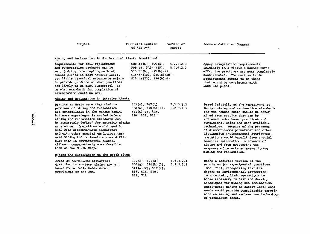
Hining and %clamation in Southcentral Alaska (continued]
~ e q u i r e m t s f o r s o i l replacement 508(a) (51, 509(a) , 5.2.3.2.3 and revegetat ion p r o h h l y can ba 5 0 9 ( b ) , 5 1 5 ( b ) ( 5 ) , 5.2.8.2.2 met, judging from rapid growth of 515(b) (61, 515(b) (71, annual p lants i n most natura l s o i l s , 515 (b) (191, 515 (b) (201, but little prac t i ca l experience exists 515 (b) (22) , 516 (b) (6 ) to provide guidance on what prac t ices a r e l i k e l y to be moat successful , o r on what standards f o r completion of reveqetation could be met.
nining and Weclamation i n In t e r io r Alaska
~ e s u l t s a t Healy show t h a t obvious 102 (c) , 507 (6) 5.2.3.2.2 problem of mining and reclamation 508(a) , 510lb) (21, 5 .2 .7 .2 .1 are cont ro l lab le i n the Nenma basin, 511 [a) (2), 515, but more experience is needed bafore 516, 519, 522 mining and reclamation standards can be accurately defined for I n t e r i o r Alaska as a &ole. Operatias would need t o deal with discontinuous permafrost and with o ther spec i a l cmdi t i ons t h a t make mining and reclamation more d i f f i - c u l t than i n Southcentral Alaska, although ccmparativrly more feas ib le than cn the North Slope.
Mining and @clamation on the North S l o p
Areas of continuous permafrost 10Z(c), 507(d), 5.2.3.2.4 disturbed by surface mining a re not SOBla), 510(b] (21, 5.2.7.2.1 known to be reclaimable under 511 (a) (2 1 , 512 ( a ) , provisions of the Act. 515, 516, 519,
522, 711
Apply revegetation requirements i n i t i a l l y i n a f l ex ib l e lsanner u n t i l e f f e c t i v e prac t ices a r e more camplet%ly demonstrated. The most suitable requirements appear to be those t h a t would be cons is ten t with land-use plans.
Based i n i t i a l l y on the experience a t Healy, mining and reclamation standards f o r the Nenana basin should be de ter - mined from results that can be achieved under known prac t i ce s and condit ions, using the best ava i l ab l e technology. Because of t h e presence o f discontinuous permafrost and other d i s t i n c t i v e environmental a t t r i b u t e s , operat ions kfollld benef i t from spec i a l base l ine information i n advance of mining and from monitoring the response of permafrost a reas during mining and reclamation.
Under a modified version of the prwis i cm f o r experimental p r ac t i ce s ISec. 7111, recognizing t h a t the degree of environmental protect ion is uncertain. limit operatiems to those necessary to test and develop techniques f o r mining and reclamation. Small-scale mining to supply l o c a l coal needs could provide considerable experi- ence on m i n i n g and reclamation technology of pemaf mst areas.
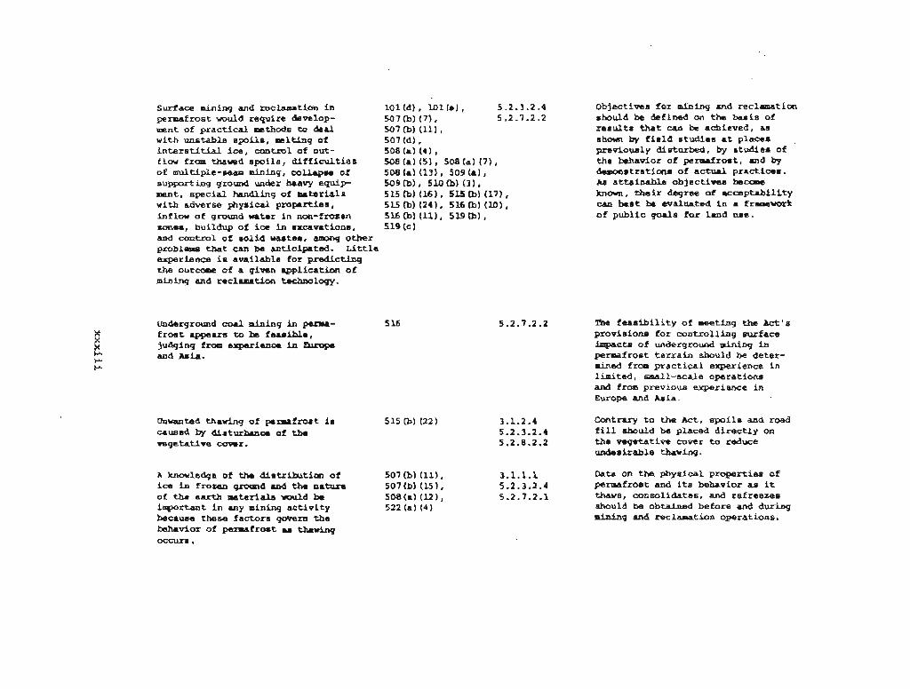
Surf ace mining and reclamation i n lOl(d) , lO l ( e ) , 5.2.3.2.4 permafrost would require develop- 507 (b) (71, 5.2 -7.2.2 ment of p rac t i ca l methods to deal 507 (b) i l l ) , with unstable spoi l s , melting of 507 (6) , i n t e r s t i t i a l ice , control of out- 508(a) (41, f lowfrolsthavedspoi ls ,dif f fcult ies 508(&) (5 ) ,508 (a ) t7 ) , of multiple-seam mining, collapse of 508Ia) (131, 509ta1, supporting ground under heavy equip- 509(b), Slob) (31, ment, spec ia l handling of materiala 515 (b) (16) , 515 (b) (17) , with adverse physical propertiem, 515 (b) (241, 516 (b) (10) , inflow of ground water i n non-frozen 516 (b) (11), 519 (b) , zones, buildup of i c e i n excavations, 5 19 (C ) and cont ro l of -l id waotes, among other problem that can be unticipated. L i t t l e experience is available for predic t ing the outcome of a given applicat ion of mining and reclamation technology.
Objectives f o r mining and reclamation should be &fined on the basis of r e s u l t s t h a t can be achieved, a s shown by f i e l d s tud ie s a t places previously disturbed, by s tudies of the behavior of permafrost, and by demonstratima o f ac tua l pract ices. As at ta inable objec t ives become known, t h e i r degree of accep tab i l i t y can k s t be evaluated i n a framawork of public goals f o r land use.
Underground coa l mining in perma- f r o s t appears to ba feas ib le , judging from experience in mpe and Asia.
Unwantad thawing of parmafmat is caused by disturbance of t h e vegetative COMC.
A knowledge of the dis t r ibut ion of i c e i n frozen ground and t h e nature of the ea r th materials would be important i n any mining a c t i v i t y because these factor6 govern the behavior of pernrafrost u thawing
5.2.7.2.2 The f e a s i b i l i t y of meeting t h e kt 's provisions f o r cont ro l l ing surface impact8 o f underground mining i n permafrost t e r r a i n should be deter- mined from p r a c t i c a l experience in l imited, small-scale operat ions and f r o m previous experience i n Europe and Asia.
3.1.2.4 Contrary t o t h e Act, s p o i l s and road 5.2.3.2.4 f i l l should be placed d i r e c t l y on 5.2.8.2.2 the vegetat ive cover t o reduce
undesirable thawing.
3.1.1.1 Data on the physical proper t ies of 5.2.3.2.4 permafrost and i t s behavior a s it 5.2.7.2.1 thaws, consolidates, and ref reezes
should be obtained before and during mining and reclamation operations.

Pertinent Saction of the Act
ldininq and RBclarvticn an the North Slope (continued)
Under natural conditions, the a c t i w 515 (b) (31, layer above the pennafmst thawa 701 (2 1 seasonally only t o a shallow depth, insulated as it i s by a surface organic mat. Natural thawing on the NDrth Slope has formsd many shallow basins called thaw lakes, and the f l a t coastal terrain is ~napicuously poorly drained and waterlogged.
The success of reclamation in perma- f ros t terrain cannot be adequately measured by the progress made i n controlling ra te r pollution, as described in the Act , because other aspects of reclamation (desired topography, self-regenerating vegeta- tion, wildlife habitat, and so on) nvry not be achieved.
Arctic stxeamii of naaglacial origin are notably clear, but runoff caused by the thawing of ice-rich permafrost associaad with surface Pining muld mt. additicnal thawing along the outflar channel, together w i t h an increased load of s e d i m t . Sedirnentaticm panda u e d for temporary control of mdment pollution aright cause further thadngr their failure could result i n serious pollution of at-.
3.1.1 To th dagrae that the exirt ing 5.2.3.2.4 distribution of surface vWer i n 5.2.8.2.2 permafrost areas represcntr thermal
m d hydrological equi l ibr im, mining ac t iv i t i es should be designed to miniraiee disruption of the t h e m 1 regimen.
Direct measurements of pertinent thermal properties, soil rovement, and other factors related to s tab i l i ty should be made as a basis for judging the degree of reestabl ishent of permafrost.
Ccntrol of sediment pollution caused by mining i n permafrost terrain appears to require procedures that would establish a new the& equilibrium for the mined landscape. Practical methods to establish theraal equilibrilrm i n reasonable tie ahould be. inV45stigatsd.

Subject Per t inent Section of t h e A c t
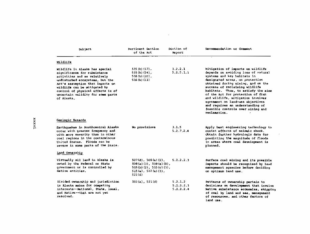
w i ld l i f e
w i ld l i f e i n hlaska has special 515 (b) (17) , s igni f icance f o r subsisrnnce 515 (b) [24) , a c t i v i t i e s and as r e l a t i ve ly 5 16 (b) (10 1 , undisturbed eoos ystems , but the 516 (b) (11) ~ c t ' s assumption t h a t impacts on w i l d l i f e can ba nitiga-d by coaltrol of physical e f f ec t s is of uncertain va l id i t y for some parts of Alaska.
Geologic Hazards
Earthquakes in Sauthcentral Alaska occur with grea ter frequency and with more sever i ty than i n o ther coal regions i n t h e conteminous United States. Floods can be severe i n some p a r t s of the Sta te .
Land Ounershf~
Vir tua l ly a l l land i n Alaska is owned by the Federal or State government o r is controlled by Mative e n t i ties.
Divided ownerahip and jur i sd ic t ion i n Alaska makes for campeting interests--National , Stata , l o c a l , and Native--that are not yet resolwd.
No provisions
%ction of Recommendation or Ooleaent Repo*
3.2.2.1 b l i t i ga t im of inq?acts on wi ld l i f e 5.2.5.1.1 depends on avoiding loss of natura l
systems and key habitats i n designated a r eas , on protection obtained during mining. and on the success of reclaiming wi ld l i f e hab i t a t s . 'Ihus, to s a t i s f y t h e aims of t h e kt f o r pro tec t ion of f i s h and w i l d l i f e , mit igat ion involves agreement on land-use objec t ives and requires an understanding of f ea s ib l e con t ro l s over mining and reclamation.
&ply b e s t engineering technology t o resist e f f e c t s of seismic shock. Ofstain f u r t h e r hydrologic data f o r predic t ing the magnitude of floods i n a r eas vhere coal developent is planned.
Surface coal mining and its possible impacts should be recognized by land management agencies before deciding on optimum land use.
Pa t te rns of ownership per ta in to decis ions an developwnt that i nmlve Native subsistence economies, shipping of coa l by land and sea, management of r e sou rms , and other factors of land use.

Land Use
Considarations of coal mining i n Alaska pertain to e f f ec t s of developing previously undeveloped land.
Alaska consists mostly of wi ld l i fe areas t ha t are valued f o r subsistence, a s biological refuges, f o r recreat ion, and as unspoiled space *
Desires for land use a r i s e from 522 (a) , 522 (b) , 5.2.1.2 public goals t ha t involve the 522 (c) 5.2.2.2.4 i n t e r e s t s of people from a w i d e area.
m e k t ' s concept of surface coal 102(e) , 508(a) (71, 5.2.6.1 mining a s a temporary land uae i s 508(a) (101, 515 (b) (16) of doubtful app l i cab i l i t y t o 515(b) (201, 515(b) (231, Alaska because new land uses t h a t 516Ib1 (10). 516(d), become permanent a r e introduced by 519 (b) , 519 (c)
mining, and or ig ina l conditions c a o t necessari ly be restored.
Designating lands as open o r closed 522 (a) (1) 5.2.2.2.4 t o surface coal mining depends on land-use planning.
As recognized by the A c t , land-use ZOl(c) ( 8 ) . 5.2.2.2.4 plans a r e based on information about 507(b)
the land, and decisions on proposed 507 (b) (12)* 507 (b) (I5 ) * mining sites involve a de t a i l ed 500 (a1 (12 1 , 517 Ib) (11 , a s s e s s ~ n t of such information. 517lb) (21, 517(f l .
522 (b) (41, 705 Ib) I2)
Coordinated plans and pol ic ies f o r developrent, including coal develop- ment, would be timely and advantageous.
A policy i a needed t o e s t ab l i sh fu tu re uses of Alaska's undeveloped land.
public goals for land use i n Rlaska should be a bas i s f o r s e t t i n g objec t ives f o r mining and reclamation.
The need t o make lmg-term al laca t icms i n land-use p r i o r i t i e s supports the d e w t h a t r a t i ona l c o d dcvalopmant i n Alaska requiras goals f o r land use.
Agreement on land-use goals through coordinated plans f o r coal regions i n Alaska could avoid possible fu tu re p i t f a l l s of choices made on a site-by- s i t e bas is .
'Ihe planning process should provide general information f o r designating land use, a s w e l l as spec i f i c data f o r assess ing proposed mines.

Subject Per t inent Sectian S e c t i w of Fb?cclrmendation o r m n t of the A c t -Port
Land Use (continued)
~ a ~ i & r a t i a r of optians f o r resourca 102 (f , 522 (a) 14) 5 -2 0 2 - 2 4 4 &-lopent involves nlrmerous fac tors 522 (a) (51, 522 (b) , besides an asses-nt of mining 601(a) , 601(b), proposals. 701 I201
Decisions about mining involve an understanding of postmining needs and how these can be achieved i f mining i s done.
Access and T r a n s p r t a t i m
mads i n t o Alaska's mdevsloped areas No provisions are not necessari ly viewad a s an unqualified hleesing, and a decision t o build such a road f o r coal developent requires an under- s tanding of its mwy uses and consequences. Land-use cont ro ls could minimize impacts on land along t r anspor t a t im c o r r i h r s . Transportation routes c ross rn provisions jur i sd ic t ional boundaries and a re paid fo r by each of the responsible governmental bodies.
Exist ing transportat ion routes favor No p r w i s i m s development of the Matanuaka, Nenana, and Jarv is Creek areas. Proximity to shipping favors the Southcentral mgian and p a r t s of the Horth Slope a s places f o r future developaent.
hnagement of resources can be canaidered i n the l i g h t a f s e t t l e - ment pa t t e rns , economic farces , employment opportunit ies, need f o r renevable resources, and other s o c i o e c o n d c fac tors , i n addit ion to t h e need for minerals.
The management author i ty must analyze the many fac tors per ta in ing t o fu tu re land-use needs. Control of mining and reclamation is one elenrent i n s a t i s fy ing these needs.
Decisions on t ranspor ta t ion f o r deve lopen t of Alaska coal should be ma& by coordinating land-use plans.
Such pa t t e rns of jur i sd ic t ion ind i ca t e t h e need f o r coordinated pl-ing.
A decision t o develop any coal f i e l d i n Alaska should be compatible with other land-use goals.

Construction and maintenance of roada i n Maska involve d i f f i c u l t engineering problems for which standards used i n the conterminous Mitad States a r e generally inappropriate o r i n su f f i c i en t , although informal standards i n use address spec i f i c a n d i t i o n s encountered i n various regions of the State.
Native Subsistence Econanies
subsistence on wi ld l i f e resources from the land and sea continues to be a dasired uay of l i f e f o r many r u r a l Natives, par t icu lar ly on the North Slope, although they a r e making increasing use of money. Thus, coal develop- ment i n Alaska involves f inding ways t o acc~l~modate Native i n t e r e s t s . In t h i s matter , the Natives themselves may have mixed v i e w , i n t h a t valuad cu l tu ra l t r ad i t i ons rompate w i t h des i res t o explo i t resourcas onned by Native Corporatians.
Other Social Conditions
Major coal development i n Alaska can be expected to be associated with adverse symptoms of growth ( the boom-toam syndr-) i n various degrees, depending an the location of the mining.
No provisions
Formal standards f o r roads su i t ab l e f o r Alaskan conditions should hz es tabl i shed by law.
An aaaessment of e f f e c t s of coal development on Native socioeconolDic condit ions would be des i rable t o determine how such e f f e c t s could be mitigated and how des i r e s of Alaskan Natives could bes t be accommodated i n planning for development of Alaska's coal resources.
Substantial coal development i n Alaska should be accampanied by forming i n s t i t u t i o n a l s t r u c t u r e s t o reduce soc i a l s t r e s s on comnunities and people. 'he needed public funds should come primari ly, o r e n t i r e l y . from coal production. Social e f f e c t s of d e v a l o p n t should be mmitored.
sub j a c t Per t inent Section Section of Recommendation o r [hmmrent of the Act &port
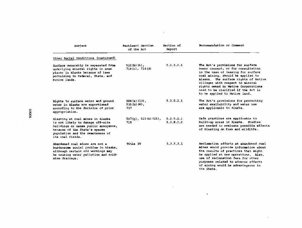
Other W i a l m d i t i o n s (continued)
Surface ownership is separated fmm underlying mineral r i g h t s i n some places in Alaska because of laws pertaining t o Fadera.1, S t a t e , and Native lands.
Rights to surface water and ground water i n Alaska a r e apportioned according to t h e doctr ine of p r i o r appropriation.
Blasting a t coal mines in Alaska i s not l i k e l y to damage of f -s i te buildings o r cause public annoyance, because of the Sta t e ' s sparse population and the remoteness of its coal f i e ld s .
Abandoned coal mines a r e not a burdensome soc i a l problem i n Alaska, although ce r t a in old workings may be causing water pol lu t ion and acid- mine drainage.
T i t l e IV
The A c t ' s provisions f o r sur face owner consent, o r for consul ta t ion i n t h e case of leas ing f o r surface coal mining, should be applied t o Alaska. 'Ihe surface r i g h t s of Native v i l l ages u i t h respect t o minera; r i g h t s m e d by Native B r p r a t i a n s need t o be c l a r i f i e d i f the Act is t o be applied t o Native land.
The Act's provisions for protec t ing water a v a i l a b i l i t y and water use a r e applicable t o Alaska.
Safe prac t ices a r e applicable t o built-up areas i n Alaska. Studies are needed t o evaluate poss ib le e f f e c t s of b l a s t i ng on f i s h and wi ld l i f e .
Reclamation e f f o r t s a t abandoned coal mines would provide information about t h e r e s u l t s of prac t fces t h a t might be applied a t new operations. Also, use of reclamation fees for other purposes r e l a t ed to adverse e f f e c t s of mining would be advantageous t o the Sta te .

C W T E R 1
INTRODUCTION
Section 708 of the Surface Mining Control and Reclamation Act of 1977, Public Law 95-87 (PL 95-87), directed the Secretary of the Interior to contract "with the National Academy of Sciences-National Academy of Engineering for an in-depth study of surface coal mining conditions in the State of Alaska in order to determine which, if any, of the provisions of the Act should be modified with respect to surface coal mining operations in Alaska." The Academy's Board on Mineral and Energy Resources subsequently established a Committee on Alaskan Coal Mining and Reclamation to be responsible for this study.
The Committee believes that Congress anticipated the need to amend some provisions of the Act in accord with special conditions in Alaska. Certain environmental characteristics of Alaska--in particular, the widespread permafrost and Ar,ctic tundra--are not encountered in coal-mining areas in the conterminous 48 States, and were not contemplated as unique features of mining and reclamation when the Act was written. Surface mining of coal in perennially frozen tundra areas has been limited, and the optimum technology for dealing with mining and reclamation problems in such areas is not known .
In addition, some conditions in Alaska could interact with coal mining in ways not addressed by the Act, and the Committee believes that such matters deserve comment in considering how the Act might be modified. For example, the effects of mining on wildlife as related to Native subsistence economies and social structures are not addressed in the Act. Different kinds of land ownership (Federal, State, and private--including Native and non-Native) and jurisdictional entanglements, except in a few areas, will need to be resolved if coal mining is to be carried out on a broader scale in Alaska. In short, we believe that there is a compelling need to examine specific provisions of the Act with respect to surface coal mining and reclamation in Alaska, and to examine other factors relevant to Alaska which are not embraced by the Act's provisions.
1.1 PURPOSES OF THE ACT AND OBJECTIVES OF THE STUDY
The major purposes of the Act, as described in Sec. 102, are to make surface coal mining compatible with society and the environment;

to reclaim surface-mined areas as contemporaneously as possible with coal-mining operations; to strike a balance among environmental protection, agricultural productivity, and the need for coal; and to provide the data necessary for effective and reasonable regulation of surface mining operations. The objective of the study is to suggest modifications of the Act appropriate to Alaskan conditions. However, we are unable to specify exactly how the Act should be modified because coal-mining experience in Alaska is so limited. Nonetheless, on the basis of our analysis of environmental, socioeconomic, and regulatory conditions in Alaska and the degree to which they resemble or differ from those of the conterminous United States, we discuss how appropriate mining and reclamation standards could be determined for those Alaskan areas with unique environmental and socioeconomic conditions. We also discuss where standards of the Act could be attained for Alaskan areas in which conditions are similar ' to those in certain coal-mining areas of the conterminous united States.
The Committee visited several areas of the State to observe conditions bearing on mining and reclamation and to discuss related problems with local citizens. In February 1979 we visited Alaska's only operating coal mine, the Usibelli mine at Healy, to observe winter mining operations at subfreezing temperatures and to discuss with the mine operator such topics as coal mining in permafrost terrain, the environmental impact of surface coal mining, reclamation practices and technology, and the effects of existing Federal regulations on 'surface coal mining in the Healy area. In July 1979 we visited the Beluga coal field in the Southcentral Region and learned about the mining plans from a potential mine operator. Part of the Committee then flew over the tundra-covered coal areas of the Arctic and landed at Barrow where they discussed socioeconomic effects of mining with representatives of Native corporations. Other members of the Committee visited the Matanuska coal field north of Anchorage where coal mining had been carried out as late as 1968. Finally, information was obtained about the environmental and socioeconomic impacts of exploration, construction, and reclamation related to the North Slope oil fields, pipeline, and ancillary activities.
The study focuses on the relationships of coal mining to environmental, socioeconomic, and regulatory conditions in Alaska. An assessment of these relationships provides the basis for recommending additional steps that should be taken if coal mining is to be carried out within the environmental and other objectives of PL 95-87 and for considering alternative legislation or other actions concerning coal mining and reclamation in Alaska. We focus on conditions that need to be considered in anticipation of a potential increase in coal development, not on the present small production or mining to meet local energy needs. The concepts of adjusting government control to varying levels of development are, howeverr discussed in Section 4.2.1.
1.2 ORGANIZATION AND CONTENT OF THE REPORT
The report begins with a summary that presents the essential. findings and recommendations of the Committee. Chapter 1 provides

background information on the objectives of the study and the procedures used to carry it out; an overview of unique or unusual environmental conditions in the major coal-bearing regions of Alaska; and a brief history of mining in Alaska, from both an environmental and a socioeconomic perspective. Chapter 2 describes the geography and geology of the coal-bearing regions of the State. Chapter 3 discusses the environmental, socioeconomic^ and regulatory conditions that have a special bearing on coal mining and reclamation in Alaska. As a matter of convenience, these conditions and some relationships among them are described under separate headings. Combinations of conditions, and especially fluctuations of conditions between summer and winter, may have a far greater impact on coal development in Alaska than any one environmental factor by itself. This discussion, together with an understanding of conditions that are similar or dissimilar to those in the conterminous United States, provides the basis for analysis of the Act's suitability for Alaska and for suggestions with respect to alternative approaches to control surface mining and reclamation in the State. Chapter 4 discusses criteria for evaluating the Act. Chapter 5 analyzes the suitability of the Act for mining and reclamation conditions in Alaska and suggests alternative procedures for dealing with these conditions. The text is followed by an annotated bibliography of selected references on Alaska.
Appendix A analyzes the provisions of the Act for their applicability to Alaska and suggests where the Act may need to be modified for Alaskan conditions. Appendix B discusses Federal, State, and local law for control of the environmental and general health and safety impacts of coal mining in Alaska. The information was obtained from a comprehensive review of the pertinent laws and from interviews conducted primarily in Alaska with persons concerned with the administration of these laws.
Following the appendices is a Glossary, which includes, in addition to technical terms, a description of commonly referenced legislative acts and regulatory bodies.
1.3 ALASKAN ENVIRONMENTS
Alaska's land size is about one-fifth that of the conterminous United States and exhibits a wide variety of natural conditions that bear profoundly on coal mining and reclamation. These conditions are, in many respects, markedly different from those of the conterminous United States. Some of these conditions, resulting primarily from the extreme northern latitudes, are unique to Alaska. Others are more severe or more prevalent than in other States. Permafrost, or perennially frozen ground, underlies perhaps as much as three-quarters of the State (Ferrians and others 1969), and its effects on human activities are profound. Tundra vegetation occupies vastt treeless regions of the State, most notably on the North Slope, where enormous resources of coal are found (Sanders 1975). In many parts of Alaska the weather is extremely cold for long periods; the summer season in most areas is very short.

Hydrologic conditions also contrast greatly with those of other States. Ground-water flow, especially in permafrost areas, is negligible (Williams 1970). Major streams, fed by heavily silt-laden meltwater from glaciers, contain sediment-load concentrations far greater than effluent discharge limits permitted under Federal regulations for coal-mining operations. And, unlike coal-bearing regions of the conterminous United States, some of the Alaskan areas containing important coal deposits ( e . g . , the Beluga area) are subject to frequent earthquakes .
With respect to major coal deposits, Alaska can be divided into three principal regions separated from each other by a major mountain range (see Figure 1.1). They are: (1) the Arctic Region (with vast coal resources, continuous permafrost, tundra vegetation, long periods of severe cold and limited daylight in winter, and limited water supplies), ( 2 ) the Interior Region, which lies between the Brooks and Alaska ranges (with modest coal resources, discontinuous permafrost, tundra and boreal forest vegetation, severe winter weather, summer and winter extremes in temperature, and limited ground-water supplies), and ( 3 ) the Southcentral Region, south of the Alaska Range (with large coal resources, almost no permafrost, tundra and boreal forest vegetation, generally ample ground-water supplies, moderately cold winters and warm summers, and some areas subject to seismic risk).
In addition to the natural physical characteristics, socioeconomic conditions also help set Alaska apart from other States. Important among these are the subsistence aspects of the economy of many Native Alaskans. Any increase in coal-mining operations might adversely affect caribou and other forms of wildlife that are essential to the subsistence economy of some Natives, particularly the Natives in the Arctic Region.
The limited surface transportation systems, the interest of some in restricting overland access to undeveloped areas, and the difficulty of building new roads in permafrost areas are other obstacles that must be considered when contemplating coal development in most parts of Alaska. (For some areas, e.g., around Healy, transportation requirements will not be a significant obstacle to coal development because rail facilities already exist.) Finally, divisions in land ownership among Federal, State, private Native Corporations, and other private parties must be taken into account in certain areas where coal deposits are found. The construction of roads for coal-mining operations might also open up new land areas for other purposes, such as recreational activities. Thus, trade-offs may be necessary with respect to other possible land uses, even though land disturbance at a mine site itself might be short-lived. The wide variety of socioeconomic and environmental conditions that would affect coal mining and reclamation in Alaska clearly signals a need to weigh all the environmental, socioeconomic, and regulatory factors in contemplating what form of control is appropriate for surface coal mining in the State.


1.4 HISTORICAL DEVELOPMENT OF MINING IN ALASKA
1.4.1 ~nvironmental Perspective
Mining has played a major role in Alaska's economy since about the turn of the century when the lure of gold, spurred on by the great
Canadian Klondike gold rush of 1898, brought an influx of prospectors, '
miners, and others to Alaska and triggered a major upsurge in Alaskan mining. Most early mining was confined to small gold-placer operations, but the scale of mining operations grew significantly in succeeding years. Mechanical earth-moving equipment greatly increased the volume of gold-bearing sands and gravels that could be mined. Beginning in the late 19209, the use of large dredges further expanded the scale of gold-mining operations and greatly increased the financial return from mining, thus providing further stimulus to the economy of the State. With the advent of World War 11, however, major gold-mining operations ceased.
Prior to the war, coal was used to fuel the steam locomotives of the Alaska Railroad, to generate electricity to operate gold dredges in the Fairbanks area and to provide residential and industrial heating in Anchorage and Fairbanks. The loss of coal markets from converting steam to diesel locomotives and the shutting down of the dredges was offset by increased demand for coal for military installations, both in the Fairbanks and the Anchorage areas. Most of that coal came from the Matanuska and Healy Creek fields. The Matanuska field was closed in 1968 when natural gas became available from the Kenai gas fields. Coal mining continued at Healy, though, because of continued demand for coal for heating and for generating electricity for local communities, mostly in the Fairbanks-Healy area. Coal production at the Usibelli mine at Healy has been about 700,000 tons per year since the early 1 9 7 0 ~ ~ but the acquisition of a new and larger dragline may allow production to increase to as much as 1.2 million tons per year.
Although placer operations for gold greatly influenced early mining in the State, other types of mining operations (including hardrock gold mining) have made notable contributions to Alaska's economy. Other large operations included Kennecott's rich copper mine near McCarthy, the Treadwell gold mines at Douglas, and the Alaska-Juneau gold mine at Juneau. The Kennecott mine operated between 1911 and 1938, the Treadwell mines were in production from about 1888 to 1917, and the Alaska-Juneau mine operated until World War 11. Smaller mines have produced copper, mercury, platinum, antimony, lead, silver, and other metals. Within the past several years there has been renewed interest in mining, and the production of metals, especially gold, has begun to increase once more.
In addition to the direct economic benefits of mining, there have been significant indirect benefits. At the Alaska-Juneau gold mine, for example, waste rock from the mine was used for the landfill on which part of Juneau is built. The dumping of thawed, coarse dredge tailings on top of fine materials in the Fairbanks and Nome areas resulted in stable ground that makes preferred sites for houses and other buildings.
In the past, mining was a way of life in many communities in Alaska and early mining practices simply followed the customs of the times. The negative effects of those practices were not of special concern. Placer mining, for example, contributed increased sediment loads to many streams. Gold-dredging operations in particular resulted in the hydraulic removal of large quantities of muck and other debris that was flushed into surrounding streams. More recent concern with the impacts of mining on the environment has resulted in attempts to control stream pollution and other effects of mining operations. For example, regulatory measures are being pursued to reduce the adverse impact of placer operations on natural hydrologic systems (see Appendix B, footnotes 12 to 17). Additional sediment loading from mining is not likely to be a serious problem in streams already laden with silt from the melting of glaciers; nor is sediment from mining likely to have severe consequences on water quality. However, sediment loading could adversely affect some aquatic life in streams that are normally clear.
Coal mining thus far has been carried out on a relatively small scale in Alaska, but it has nonetheless left its mark on the Matanuska coal field in the form of abandoned pits from surface mining and piles of waste from both surface and underground mining.
The possibility that mining will have negative effects on the environment evokes justified concern. Because of today's renewed interest in Alaskan mining--much of which is likely to be on a larger scale than in the past--and because of increasing concerns for man's surroundings, coupled with legislation for controlling the quality of those surroundings, there will be increased efforts to avoid or minimize the negative impacts of coal mining. In Alaska these efforts will be complicated by the need to mine coal in an environmentally acceptable manner under difficult conditions not found in the conterminous United States. Public Law 95-87 is only one of several legislative acts that place constraints on coal mining and related activities. Section 708 of the Act recognizes that Alaska has unusual environmental conditions that justify a special evaluation of PL 95-87 to determine its applicability to Alaska.
1.4.2 Socioeconomic Perspective
Between 1867, when Alaska was purchased from Russia, and 1900, mining was a small but increasing factor in the economy of the Territory. Many prospectors and miners were attracted to Alaska, and shortly after the turn of -.he century, mining became established as an essential element in the territorial economy. Mining was responsible for the establishment of transportation routes: indeed, Alaska's present road and railroad system reflects the influence of early mining, which dictated the location of various segments of the State's transportation system. A primitive road system sprang up early in the 1900s, and in 1923 the Alaska Railroad was completed between Seward and Fairbanks. Earlier, the railroad had reached the Matanuska coal field (1916) and the Healy Creek field in the Nenana area (1919). In

1911 the Copper River and Northwestern Railroad was constructed to transport copper ore from the Kennecott mine near McCarthy to the port of Cordova. As other areas were prospected and new mines came into operation, additional roads were built. Then communities sprang up near the mines, which provided employment and generated needs for public services. Much of the financial base for the Territory came from mining. Juneau owes its origin to the discovery of gold at that site in 1880, and the subsequently developed Alaska-Juneau mine on the mainland and the nearby Treadwell mine on Douglas Island contributed greatly to the growth of the city. Nome, Fairbanks, and Valdez, along with many smaller communities, also owe their existence to gold mines that opened shortly after the turn of the century, A major copper find and subsequent development of the Kennecott mine near McCarthy around 1900 was responsible for opening up an entirely new area in the Copper River Basin in eastern Alaska. Later, as interest in the Matanuska coal field developed, a spur of the Alaska Railroad was \
built through Palmer to haul coal from the Matanuska field. More recently, the building of the Trans-Alaska pipeline System spurred the construction of a motor vehicle service road from Livengood (50 miles northwest of Fairbanks) to Prudhoe Bay.
The development of mining, the construction of overland transportation routes, the increased use of airplanes, and the installation of improved communication systems have had a substantial impact on Native economies and cultures. The economy of the Aleuts, Eskimos, and Indians was originally a subsistence economy. Except for a few Russian and other fur traders, few white men came into contact with the Native inhabitants until the late 1800s. The subsequent influx of prospectors and miners and the development of a transportation network within some parts of the State have gradually altered these Native economies. Subsistence economies have slowly been diluted by the cash economy, but many Natives still maintain their traditional way of life and do not wish to see it substantially altered. Some see mining activities as particularly threatening to their preferred way of life, and their views must be considered in planning any mining operation that might affect them. As a result of the Alaska Native Claims Settlement Act (ANCSA), private Native Corporations will own 44 million acres of land in Alaska. Thus, they will have considerable influence on land use and mineral development within the State, since the land owned by Natives is managed for profit through Native corporations (regional and village). Any proposals to modify PL 95-87, or to create alternative control mechanisms for mining and reclamation, must give careful attention to the strong relationships between the Native cultures and the environment.
REFERENCES
Ferrians, O.J., Jr., Kachadoorian, R., and Greene, G.W., 1969, Permafrost and related engineering problems in Alaska. U.S. Geological Survey Professional Paper 678, 37 p. - Sanders, R.B., 1975, Coal resources of Alaska, Rao, P.D., and Wolff, E. N., eds., Focus on Alaska's coal '75, Proceedings of the conference held at the University of Alaska, Fairbanks, October 15-17, 1975. University of Alaska, School of Mineral Industry, MIRL Report No. 37, p. 21-32.
U.S. Geological Survey, 1972, Potential natural vegetation of Alaska. U.S. national atlas sheet no. 58. Prepared by A.W. KIichler, University of Kansas, 1966.
Williams, J.R., 1970, Ground water in permafrost regions of Alaska. U . S . Geological Survey Professional Paper 696, 83 p.

CHAPTER 2
COAL RESOUK!ES, MINING, AND DEVELOPMENT IN ALASKA
Alaska has an extraordinary amount of coal (see Figure 2.1). The State's total identified and hypothetical coal resources range from perhaps 1.9 to 5.0 trillion short tons and may be as large ae those in the conterminous 48 States, which Averitt (1975) estimated to be about 3,703 billion tons. Even allowing for great uncertainty in the estimates, it is cleat that Alaska's coal resources are very large and will become more important as other sources of fossil fuels in the United States are depleted. But because of varied geologic characteristics of the coal deposits (see Table 2.1) and the differing environmental conditions of the coal-bearing areas, not all of these resources can be mined with present technology. Much of the coal is deeply buried or lies beneath the waters of Cook Inlet or the Chukchi Sea. This chapter briefly discusses the history of coal mining in Alaska, the geographic and geologic setting of the coal deposits, and the potential for coal development.
2.1 HISTORY OF COAL MINING AND DEVELOPMENT IN ALASKA
Although the first coal mine in Alaska was opened in 1855 (Rao and Wolff 1975), coal production in the State before the early 1900s was on such a small scale that imports were needed to meet Alaskan needs. Prior to the construction of the Alaska Railroad only a few tens of thousands of tons of coal had been mined. The Alaska Railroad, started in 1914, reached the Matanuska coal field near Palmer in 1916 and the Healy Creek coal field about 200 miles north of Anchorage in 1919. The railroad provided both a market and transportation for increased coal development. Production continued to grow and reached more than half a million tons per year shortly after World War I1 as a result of demands from the military market. Military needs for coal decreased during the late 1 9 6 0 ~ ~ but the demand for coal to generate electricity (primarily for the Fairbanks area) has kept production around 700,000 tons per year since 1971. Table 2.2 shows the production figures and dollar values for Alaskan coal from 1880 through 1977. Table 2.3 is a list of significant events in the history of Alaskan coal mining between 1786 and 1977. Further information on Alaskan coal and coal mining can be found in the references listed at the end of this chapter.
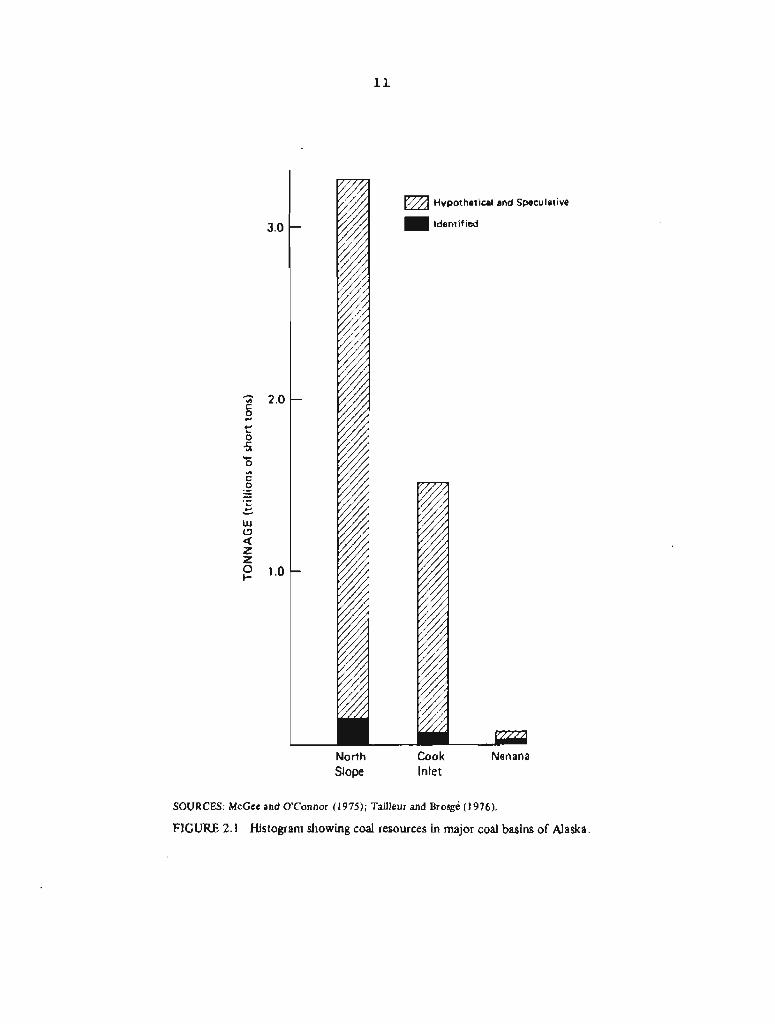
North Slope
Hypothetical and Speculative
ldentif ied
Cook Nenana Inlet
SOURCES: McCee and O'Connor (1975); Tailleur and ~rosge (1976).
FIGURE 2.1 Histogram showing coal resources in major coal basins of Alaska.

TABLE 2.1 Geologic Characteristics of Alaskan Coal Deposits .- .. .
*NOTE: lncludes coal occurrences at Nulato, Rampart, etc. Nothing is known about the extent or resources
SOURCE: Compiled from information provided by R. G. Schaff, Alaska Department of Natural Resources,
RANK OF COAL
Subbitumhous
Bituminous
Bituminous
Subbituminous
Subbituminous to bituminous
Lignite
Subbituminous to lignite
Anthracite to subbituminous .
Lignite to ~ubbiturninous
semianthracite Bituminous to
Bituminous and subbituminous
1
REGION
2 b U
C
bl
&I F
E
2 u d k z w U X + 3
%
GEOLOGIC STRUCTURE
Flat lying
Broad folds
Highly deformed
Moderately dipping fault blocks and gentle folds
- Open folds
Narrow graben
Flat-lying to gentle broad folds, minor faulting
Complexly folded and faulted
Redominantly flat lying
Extremely deformed
Moderately folded and faulted
BASIN
f
B z 5
0
3 0
,
$ "
0
AGE OF STRAT A
Mainly Cretaceousi minor Tertiary
Mislsippian
Tertiary (Oligocene-Miocene)
Tertiary
Tertiary
Tertiary
Late Cretaceous and Tertiary
FlELD
Arctic coastal plain fields:
Meade River Colville River,
etc.
~obthi l ls fields
Point Hope
Healy Creek Lignite M k Jarvis Creek Wood River Tatlanika Teklanika
EagleCircle
Broad Pass
Yentna
Beluga
9 - .a V) -
Matanuska
Kenai
Kenai offshore
Bering River
Chignik ,
ilerendeen Bay
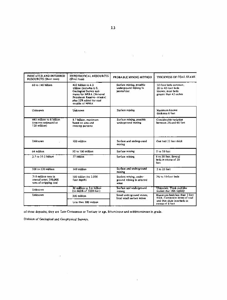
of these deposits; they are Late Cretaceous o r Tertiary in age, b i tuminous and subbi tuminous in grade.
Division of Geological and Geophysical Surveys.
INDICATED AND INFERRED RESOURCES (Short tons)
60 to 146 billion
Unknown
440 million to 6 billion (reserves estimated at 120 million)
Unknown
64 million
2.7 to 10.2 billion
108 to 130 million
318 million tons in coastal areas; 200,000 tons of stripping coal
Unknown
Unknown
METHOD
Surface mining, possible underground mining in permafrost
Surface mining
Surface mining, possible underground mining
Surface and underground mining
Surface mining
Surface mining
Surface and underground mining
Surface mining, under- ground mining in selected areas
Surface and underground mining
Small underground mines; local small surface mines
HYPOTHETICAL RESOURCES (Short tons)
402 billion to 4.0 trillion (includes U.S. Geological Survey esti- mates for NPRA [National Petroleum Reserve-Alaska] plus 22% added for coal outside of NPRA.
unknown
8.7 billion, maximum based on area and outcrop patterns
100 million
50 to 100 million
27 billion
149 million
100 billion (to 2,000 foot depth)
36 million to 3.6 billion (to depth of 3000 feet)
300 million
Less than 300 million
. OF COAL SEAMS
lO+foot beds common; 20 to 40-foot beds known; most beds greater than 42 inches
Maximum known thickness 6 feet
Considerable variation between 2% and 60 feet
One bed 22 feet thick
5 to 10 feet
6 to 50 feet. Several beds in encess of 20 feet
2 to 23 feet
2 % to 10-foot beds
Unknown. Thick pod-hie masses that thin rapidly Numerous beds less than 2 feet thick. Composite zones of coal excess and thin of shale 8 feet interbeds in
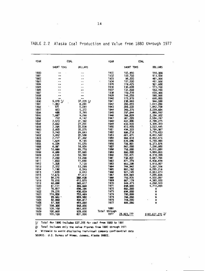
TABLE 2 . 2 Alaska Coal Product ion and Value f rom 1880 through 1977
YEAR
1880 1881 1882 1883 1884 1885 1886 1887 1888 1889 1890 1891 1892 1893 1894 1895 1896 1897 1898 1899 1900 1901 1902 1903 1904 1905 1906 1907 1908 1909 1910 1911 1912 1913 1914 1915 1916 1917 1918 1919 1920 1921 1922 1923 1924 1925 1926 1927 1928 1929 1930
COAL YEAR COAL
WLLARS SHORT TONS DOLLARS SHORT TONS
1880 Total through
1977
lJ Total f o r 1890 Includrs $37,205 f o r coal f r ~ m 1880 to 1891
Total Includes only the value f igures frm 1880 through 1971 U Wlthhtld to avoid d+scloslng fndividual cornpany confidential data
SOURCE: U.S. Bumau o f M i n s . Juneau. Alaska 99802.
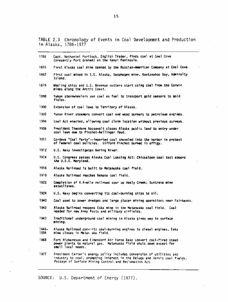
TABLE 2.3 Chronology o f Events i n Coal Development and Production i n Alaska, 1786-1977
1786 Capt. Nathaniel Port lock, English Trader, f inds coal a t Coal Cove (present ly Por t Graham) on the Kenai Peninsula.
1855 F i r s t Alaska coal mine opened by the Russian-American Canpany a t Coal Cove.
1862 F i r s t coal mined i n S.E. Alaska, Sepphagen mine, Kootznahoo Bay. Admiralty Island.
1879 Whaling ships and U.S. Revenue cut ters s t a r t using coal from the Comin mines along the A rc t i c Coast.
1898 Yukon sternwheelers use coal as fue l t o t ransport gold seekers to gold f ie lds.
1900 Extension o f coal lans t o T e r r i t o r y o f Alaska.
1902 Yukon River steaners convert coal and m o d burners to petroleum engines.
1904 Coal Act enacted, a1 lowing coal c la im locat ion without previous surveys.
1906 President Theodore Roosevelt closes Alaska pub l ic land t o ent ry under coal lans due to Pinchot-Ball inger feud.
1911 Cordova "Coal PartyN--imported coal shoveled i n t o the harbor i n pro tes t of Federal coal po l ic ies . Gi f ford Pinchot burned i n effi.gy.
1912 U.S. NavyinvestigatesBeringRiver.
1914 U.S. Congrcss passes Alaska Coal Leasing Act: Chickaloon coal t e s t aboard the U.S.S. h r y l a n d .
1916 Alaska Railroad i s b u i l t t o Matanuska coal f ie ld .
1919 Alaska Raf l road reaches Nenana coal f i e ld .
1922 Completion o f 4.4-mile ra i l r oad spur up Her ly ~ r e e k ; ' ~ u n t r a n a mine establ i ~ h c d .
1924 U.S. Navy begins convert ing i t s coal-burning ships t o o i l .
1940 Coal used t o power dredges and la rge placer mining operations near Fairbanks.
1942 Alaska Railroad reopens Eska mine i n the Matanuska coal f i e l d . Coal needed f o r new Amy Posts and military a i r f i e l d s .
1943 Trad i t iona l underground coal mining i n Alaska gives way t o surface mining.
1946- Alaska Railroad conv-rts coal -burning engines t o diesel engines, Eska 1954 mine closes i n Matar,. ska f ie ld .
1968 For t Richardson and E l r n d o r f A i r Force Base convert coal- f i red steam power plants t o natural gas. Matanuska f i e l d shuts down except f o r small loca l needs.
1977 President Carter 's energy pol i c y includes conversion of u t i l i t i e s and industry t o coal, prompting i n te res t i n the Beluga and Jarv is coal f i e l t s . Passage o f Surface Mining Control and Reclamation Act .
SOURCE: U.S. Department of Energy (1977) .
2 . 2 GEWRAPHIC AND GEOLOGIC SETTING OF ALASKA'S COAL DEPOSITS
The mainland of Alaska can be divided into t.hree major geographic regions--the Arctic, the Interior, and the Southcentral (see Figure 1.1). Each region has a major coal basin, several lesser basins, and many scattered coal occurrences. (Definitions of "coal basin, " "coal field," and "coal occurrence" are given in the Glossary.) The major basins contain several coal fields more or less separated from one another, although in some cases the boundaries are arbitrary. The topographic, biotic, climatic, and sncioeconomic character of each of the major regions is in many ways markedly different. These differences will have to be taken into account during the mining of coal in each region. Although coal occurs in scatter@ and mostly small deposits outside the major basins in Alaska, the main problems of mining and reclamation discussed in this report relate to the North Slope, the Nenana, and the Cook Inlet basins (see Figure 2.2).
2.2.1 Arctic Region (North Slope Basin)
Alaska's principal coal-bearing deposits are in the North Slope basin, north of the Brooks Range and between the ~tkillik and lower Colville Rivers on the east and Cape Lisburne on the west (see Figure 2 . 2 ) . The southern part of this area of approximately 58,000 square miles is a broad upland of rolling hills; the northern part is the nearly flat Arctic coastal plain. Deeply buried coal is also present farther west under the Chukchi Sea.
The North Slope coal basin (see Table 2.1) is filled with rocks of Cretaceous age, mainly alternating layers of sandstone and shale that are folded into east-west trending anticlines and synclines in the foothills (see Figure 2.3) near the Brooks Range but are only gently warped or nearly flat lying farther north. A t least 60 percent of the North Slope's numerous coal beds, generally described as lenticular, are more than 3 1/2 feet thick. Ten-foot beds are common, and 20- to 40-foot beds are known. In some places coal forms 10 percent of the whole stratigraphic section, much mare than the 1 or 2 percent common in the Appalachian coal fields, for example. The coal underlying the Arctic coastal plain is a low-sulfur subbituminous coal with a heat value of 9,800 Btu. Closer to the Brooks Range the coal becomes bituminous with a heat value of 11,OOO Btu and an average sulfur content of 0.6 percent. Some of this coal is of coking quality (Rao and Wolf f 1975) .
Exploratory drilling for oil east of the lower Colville River also has revealed coal in rocks of Cretaceous age as well as extensive areas of lignite-bearing rocks of Tertiary age. Low-volatile bituminous coal (about 14,000 Btu) occurs in highly deformed rocks of Mississippian age near Point Hope on the western coast (see Table 2 . 1 This coal is distinct from and unassociated with the major


SOURCE: lrvin L. Tailleur, 1977, U.S. Geological Survey.
FIGURE 2.3 Outcrops of Cretaceous coal along the Kukpowruk River, western part of the North Slope coal basin.

Cretaceous coal resources of the North Slope basin. The extent and distribution of this older (Mississippian) coal is largely unknown.
The coal resources of the North Slope are poorly known. Barnes (1967) estimated that there are 120 billion tons in beds under less than 3,000 feet of overburden, including 12,292 million tons of bituminous coal in beds more than 1 4 inches thick; the balance was believed to be subbituminous coal in beds 2 1/2 feet or more thick. With more data, Tailleur and ~ r o s g 6 (1976) have estimated that North Slope resources amount to at least 200 billion tons and possibly as much as 3.35 trillion tons. These more recent estimates include coal deposits in some 10,000 square miles offshore beneath the Chukchi Sea and in an additional 10,000 square miles east of the Itkillik River, areas not included in Barnes's estimates.
The difficulty of access, the general absence of human settlements and transport facilities, and the harsh environment of the North Slope will make coal mining there, particularly surface mining, difficult. Surface mining could have a severe environmental impact on the region's vegetation and permafrost, and perhaps on the wildlife. Optimum methods of controlling environmental impacts of surface-disrupting operations in Arctic areas, however, are not yet known: it may ultimately turn out that underground mining will be the most effective way to develop North Slope coal while achieving the public goal of environmental protection.
2.2 - 2 Interior Region (Nenana Basin)
The Nenana basin, the smallest of Alaska's three major coal basins, is located in the Interior Region between the Brooks and Alaska Ranges (see Figure 2.2). It is centered in an area about 200 miles north of Anchorage and about 60 miles south of Fairbanks. Alaska's only operating mine is in the Nenana basin near Healy (see Figure 2.4).
The coal-bearing strata in the basin crop out in a discontinuous belt about 80 miles long that runs parallel to the Alaska Range and is from 1 to 30 miles wide (see Wahrhaftig and others 1969). Coal-bearing* rocks are exposed over about 1,000 square miles, but some coal-bearing strata are probably concealed by Pleistocene and Holocene deposits. Coal is also reported to occur along the Teklanika River about 150 miles west of Healy where some 200 feet of coal are exposed, and thus the size of the Nenana basin may be many times greater than that suggested by the area of outcrops. The rocks of the basin are mainly weakly indurated te restrial sandstones and siltstones, interbedded with coal. The strata have been folded and faulted into a series of smaller basins between which the coal-bearing sequence either has been eroded away or has been covered to a considerable depth by younger Tertiary or Quaternary deposits. Coal-bearing zones include a number of subbituminous coal beds ranging in thickness from a few inches to 60 feet or more. Fossil leaves and pollen indicate that the coal-bearing rocks range in age from late Oligocene to late Miocene.

Usibelli Mine old Run Pass Pit Poker Flats Pit
\ 0 6 10 I
MILES
SOURCE: ~ d a ~ t e d from Wahrhaftig and others (1969).
FIGURE 2.4 Sketch map showing extent of Healy Creek and lignite Creek coal fields and location of current mining operations.

Of t h e s e v e r a l c o a l f i e l d s wi th in t h e Nenana bas in , t h e two of p a r t i c u l a r importance are t h e Healy Creek and ignite Creek f i e l d s . Mast of the coal produced i n t h e Nenana bas in thus f a r has come from t h e Suntrana mine and t h e o r i g i n a l U s i b e l l i mine i n t h e Healy Creek f i e l d . Early mining was by underground methods bu t la ter mining has been by s u r f a c e methods. L i t t l e or no s t r i p p i n g coal is l e f t i n t h e Healy C r e e k coal f i e l d . The U s i b e l l i mine is now producing coal from gen t ly dipping beds of t h e L i g n i t e Creek f i e ld , where s u r f a c e methods a r e used ( see Figure 2.4).
Both t h e Healy Creek and L ign i t e Creek f i e l d s are i n east-west s y n c l i n a l s t r u c t u r e s with g e n t l y t o moderately dipping beds on t h e south (see Figure 2.5) and s t e e p l y dipping beds on t h e nor th (Wahrhaftig 1973, Wahrhaftig and o t h e r s 1951). The Healy Creek f i e l d is c u t o f f on t h e nor th by a nea r -ve r t i ca l f a u l t a long which t h e coal-bearing beds on t h e nor th s i d e have been d isp laced upward by s e v e r a l thousand f e e t . Coal o f t h e Healy Creek f i e l d is subb i t~minous , with an average ash content of 10 percent , moisture con ten t of 25 percent , and s u l f u r conten t of 0.20 percent . The average Btu content is 8,200. Some of t h e coal c u r r e n t l y being mined i n t h e L ign i t e Creek f i e l d has a Btu content of 9,000.
The t o t a l c o a l resources of t h e Nenana bas in a r e uncer ta in because of a l ack o f d a t a west of Healy. About 3.5 b i l l i o n tons of c o a l are proved, an equal amount can be i n f e r r e d from geo log ica l cons ide ra t ions , and t h e r e may be as much a s an a d d i t i o n a l 8.7 b i l l i o n tons , o r about 15 b i l l i o n tons i n a l l (U.S. Department of Energy 1977).
2.2.3 Southcent ra l Region (Cook I n l e t Basin)
The Cook I n l e t c o a l bas in , i n t h e Southcent ra l Region, is a l a r g e bas in of va r i ed geography and complex geology. I t encompasses coal-bearing s t r a t a t h a t surround t h e i n l e t on t h e northwest, no r th , and no r theas t , unde r l i e t h e waters of t he i n l e t , and a r e exposed on t h e Kenai Peninsula t o t h e sou theas t ( see Figures 2.2 and 2.6). The Cook I n l e t basin extends no r th t o Broad Pass and i n a no r theas t e r ly d i r e c t i o n i n t o t h e b t a n u s k a Valley. Much of t h e bas in is covered by t h e waters of Cook I n l e t and Knik Arm and by t h e ex tens ive alluvium of t h e Sus i tna River. A s a r e s u l t , t h e exposed p a r t s of t h e coal-beating s t r a t a a r e separa ted from one another and a r e u sua l ly r e f e r r e d t o a s s epa ra t e c o a l f i e l d s , although geologica l ly they a r e a l l i n f a c t p a r t o f a s i n g l e basin. The c o a l f i e l d s include (1) t h e Beluga f i e l d , o f t e n grouped with t h e Yentna c o a l f i e l d a s t h e Sus i tna f i e l d , (2 ) t h e Kenai f i e l d on t h e Kenai Peninsula , (3) t h e Matanuska f i e l d , and ( 4 ) t h e Broad Pass f i e l d (see Table 2 . 1 ) . The coal-bearing a r e a o f f s h o r e from t h e Kenai Peninsula is sometimes considered a s epa ra t e f i e l d , although it a c t u a l l y connects t h e Kenai f i e l d with t h e Beluga f i e l d on t h e o the r s i d e o f t h e i n l e t .
The Cook I n l e t bas in , a grabenl ike s t r u c t u r e o r trough, is a T e r t i a r y basin about 320 miles long and up t o 80 miles wide. Its t o t a l coal-bearing a rea is about 12,000 square miles , bu t its exac t s i z e is d i f f i c u l t t o determine because n o t a l l of the coal-bearing
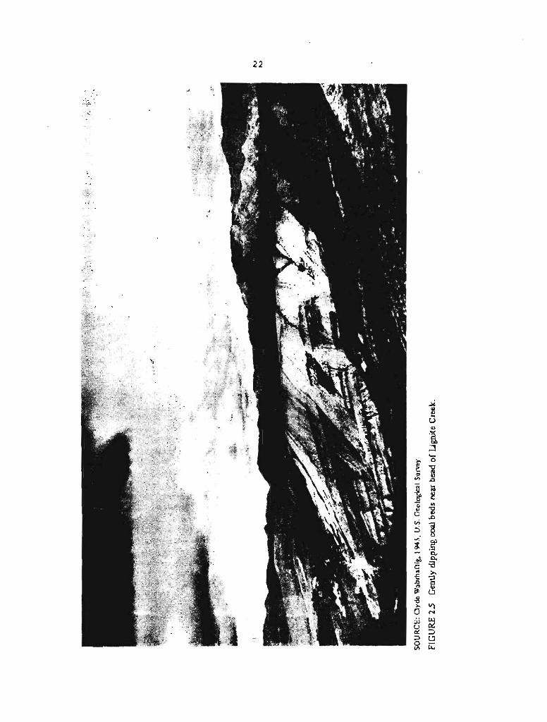
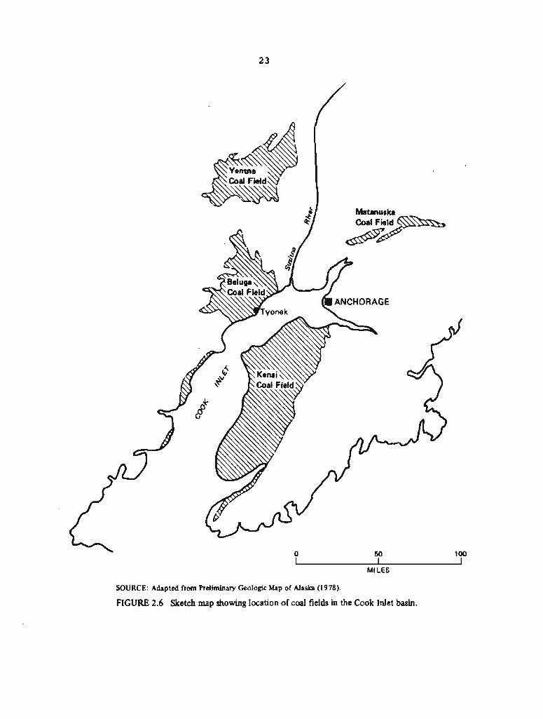
MILES
SOURCE: Adapted from Preliminary Geologic Map of Alaska (1978).
FIGURE 2.6 Sketch map showing location of coal fields in the Cook Inlet basin,

rocks are exposed. The coal in this basin varies in rank and thickness, and ranges in age from Paleocene to Miocene. The coal-bearing strata, like those of the Nenana basin, are nonmarine and probably accumulated originally in alluvial and swamp environments.
In the Kenai field, which contains the site of the first coal mine in Alaska, some 30 coal beds ranging from 2 1/2 to 10 feet thick are expbsed near the shore in a sequence of nonmarine sandstones, siltstones, and claystones. The coal-bearing group is at least 5,000 feet thick. The strata for the most part are essentially flat lying, with dips of 10 degrees or less. Some faulting is preaent. The coal is subbituminous, has a Btu content of 6,000-8,000, and is low in sulfur but high in moisture, ~espite the proximity of the coal to the sea, the flat-lying geologic structure, and other favorable factors, the Renai field has not been mined in recent times because the coal beds are too thin far commercial development (U.S. Department of Energy 1977).
The Beluga coal field on the northwest side of Cook Inlet contains subbituminous coal beds that are a few inches to more than 50 feet thick (U.S. Department of Energy 1977). The Btu content is about 9,000, A near-horizontal bed of subbituminous coal 30 to 50 feet thick has been traced for more than 7 miles along the middle course of the Chuitna River. Another bed about 50 feet thick has been found near the Cappe Glacier (see Figure 2.7), and other equally promising occurrences are known to exist elsewhere in the Beluga field. Drilli-ng has shown that several hundred million tons of coal are close enough to the surface for surface mining,
The size of the Kenai offshore coal field has been determined largely by extensive drilling for oil and natural gas in Cook Inlet. Some 2,896 square miles offshore have been proved to be coal-bearing and may contain a s much as 100 billion tons of lignite and subbituminous coal. There may be as much as 1.4 trillion tons in all, a truly formidable amount, in the offshore areas (U.S. Department of Energy 1977).
The Matanuska coal field in the Matanuska Valley just east of Palmer is an offshoot of the Cook Inlet deposits. Most of the coal found in the valley is bituminous, but some is anthracite. The coal-bearing strata are complexly folded and faulted, making mining difficult and expensive. Coal mining began at the Matanuska site in 1914 but was discontinued in 1968. The total resources of the field are relatively small, probably no more than 250 to 275 million tons (U.S. Department of Energy 1977).
It is quite clear that the Cook Inlet basin contains significant coal resources that may amount to almost 1.5 trillion tons. The basin's proximity to the more populated parts of Alaska, especially Anchorage, could make its coal attractive for local use, and its tidewater location means that coal could be shipped by sea relatively easily. However, the availability and low cost of both oil and natural gas from the Cook Inlet fields have made coal mining there commercially unattractive to date for Alaskan markets.

SOURCE: Richard G. Ray, 1979, National Academy of Sciences.
FIGURE 2.7 Outcrop of coal bed in the Beluga coal field area.

2.2.4 Other Alaskan Coal Deposits
Outcroppings of coal are found in numerous other Alaskan locations outside the North Slope, Nenana, and Cook Inlet basins. Most of these deposits are small and have attracted little interest to date. Coal has been found in several places on the Seward Peninsula and at Point Hope on the northwestern coast, but its character and extent are r a r g e l ~ unknown. Tertiary coal with hypothetical resources of 100 million tons is present in the Yukon River area between Circle and Eagle in the eastern part of the Interior Region. Coal is also exposed along the Yukon near Rampart and Nulato, but no estimate of quantity is available.
In southwestern Alaska there are small coal fields at Unga Island, Herendeen Bay, and Chignik. Unga Island has lignite of Tertiary age, whereas the coal at Herendeen Bay and Chignik is bituminous and subbituminous coal of late Cretaceous age with some lignite of Tertiary. Of these three the Herendeen Bay field is the largest.
The Bering River field, which lies some 200 miles east of Anchorage, covers an area of about 80 square miles. Its coal ranges from bituminous to semianthracite and is in highly folded and faulted strata. The total coal resource is poorly known, but it may be ae much as 3 to 3.6 billion tons (U.S. Department of Energy 1977).
2.3 COMPARX SON OF ALASKAN COAL WITH OTHER U. S COAL
The characteristics of Alaskan coal differ from those of coal of the eastern and midwestern states, most notably in having a higher moisture content, a lower heat value, and a lower sulfur content (see Table 2.4). There is relatively little high-rank coal (anthracite) in Alaska; most is bituminous to subbituminous. Most Alaskan coal i~ similar to coal found in the Northern Great Plains and Rocky Mountain coal provinces; the heat value is modest but sulfur content is low. Alaskan coal is largely Cretaceous or Tertiary in age, not Carboniferous as are coal deposits of the eastern and midwestern States. Alaskan coal, at least that which is likely to be exploited in the near future, tends to occur, like western coal, in somewhat thicker beds than those of the midwest and eastern basins of the conterminous United States. Furthermore, the coal in some parts of Alaska forms a larger part of the stratigraphic section than eastern coal does.
2.4 POTENTIAL FOR COAL DEVELOPMENT
Growing demands for energy coupled with escalating costs for oil and natural gas may make Alaskan coal an important source of energy for both the State itself and the Nation as a whole. New coal mining in parts of Alaska, however, particularly on the North Slope, would require the construction of extensive transportation facilities (Section 3.2.3.21. Most new mining operations will probably utilize

TABLE 2 .4 Comparison of A1 askan Coal w i t h Coal o f the Conterminous United States
Alaaka** Pemrylvania App.1.chi.n Interior Northern Great Rocky Mountain (9 n u p l u ) Antbracite Regioa Region Province Plains Province Province
(38 maqleu) (158 saqlb.) (90 aepplea) (40 eamples) (86 samples)
h i s t u r e 24.1 1.4 2.8 7 . 2 24.5 12.9
Volatile matter 34.9 6 .5 U.6 32.2 31.7 36.0
Pfxed carbon 30.2 79.5 54.6 40.0 35.4 4 2 . 0
Ae h 10.7 12.6 11.0 12.6 8 . 3 9 . 1
Sulfur .2 .8 2.3 3.9 1 . 2 .6
Btu 8,080 12,780 12,890 11,580 8,400 10,400
Mote: Comparison of a r i thnet tc mans, i n percent. ** Alaskan analysts l imi ted to Healy Creek, Chignik, and Herendeen Bay coal samples. Cretaceous-Tertj ary coal o f sanewhat htgher heat val w (9.000-10.000 Btu) know f r o m several other areas. Coal i n a few areas has a Btu content as high as 14,000 (Sanders 1975).
SOURCE: Compiled f tom data i n U.S. Geological Survey Open-! i l e Report 76-468 (Swanson and others 1975).

surface mining techniques and will be on a large scale in order to meet the high costs of mining, transportation, and reclamation. However, the prospects for small-scale mining at many scattered lo~ations~ some of them outside the principal basins, are also good, Because a ton of medium-grade coal (9,300 Btu/pound) is the energy equivalent of approximately three barrels of fuel oil, the increasing cost and uncertainty of petroleum supplies will stimulate the exploration and mining of certain coal deposits to supply local markets. Some of these deposits may be mined intermittently, perhaps only a few weeks a year or even every 2 or 3 years. The North Slope Borough plans to develop local coal resources for its villages and is presently seeking a permit to mine coal for the village of Atkasook on the Meade River. About 300 tons of coal would be mined each year. Similar small operations are expected to come into existence elsewhere in the State.
2.4 -1 Arctic Region (North Slope Basin)
Because of their vast size, the coal resources of the North Slope can be expected to attract substantial interest, The nearly flat-lying bed^ of the coastal plain are likely to be of particular interest because they may be especially amenable to surface mining. At present, however, there is no transportation system in the Arctic Region that is suitable for coal development. Mining on a scale large enough to justify the high cost of an adequate transportation system could have severe environmental effects whose mitigation would be uncertain because large-scale surface coal mining and reclamation operations have not been carried out in the Arcticr and optimum mining and reclamation practices are yet to be developed. Excavating, transporting, grading, and storing materials all present problems that need to be resolved; it will also be necessary to control thawing of the ground and to dispose of the excess water resulting from thawing. Despite the Arctic Region's vast resourcesr it seems likely that coal development is many years, if not decades, in the future. Underground coal mining in permafrost terrain may face fewer problems than surface mining, but, even so, any substantial underground operation would seem to be many years away, Small mines, however, might well serve local community needs and, if suitably designed and monitored, could also provide useful information on how to improve mining and reclamation practices.
2.4.2 Inter kor Region (Nenana Basin)
The Nenana basin in the Interior Region is the site of the only mine in Alaska (Usibelli mine near Healy) that is presently producing a substantial amount of coal. Mining has been conducted there for a long time and demonstrates that it is possible to mine for coal -successfuLly in an area of climatic extremes and discontinuous permfrost. Various reclamation practices have also been developed

and demonstrated at the Usibelli mine. A transportation link--the Alaska Railroad--already exists for moving the coal from mine to market. Although the Nenana basin's total coal resources are modest, further development of its coal fields may become more attractive in the future, probably following mining and reclamation practices of the Usibelli mine.
2.4.3 Southcentral Region (Cook Inlet s as in)
Some of the coal deposits in the Southcentral Region have considerable potential for development. Most are in areas where permafrost is sporadic or nonexistent. Thus, coal mining would be less difficult than in the Interior or Arctic Regions.
Beluga is perhaps the most attractive of the C m k Inlet fields because of the size of its total resources, the thickness of its coal seams, and the geologic simplicity of the near-surface coal-bearing strata that could be mined by surface methods. Reclamation appears to be feasible under climatic conditions of the Cook Inlet region. However, a transportation link would have to be provided from the mine site, probably to a docking facility on the northwest side of Cook Inlet. A joint venture between the Cook Inlet Region, Inc. (a Native Corporation) and Placer Arnex, Inc., has been proposed to build a $1.6 billion facility for converting coal to methanol. The methanol would be moved by pipeline to tanker.
The prospects for production from the ~ e n a i coal field arc limited, despite its proximity to water transportation and the existence of roads in the area. Coal is present only in thin seams, and recovery would be costly.
The Matanuska coal field is favorably located with respect to rail and road links, and no major construction of transportation facilities would be required to resume operations. The field's resources, however, are limited (see Table 2.1). Puture mining at the Matanuska field would probably be by underground methods.
Much of the coal beneath the water of Cook Inlet lies at depths of 5,000 to 10,000 feet and cannot be mined by ordinary methods. These coal deposits are very large, but are likely to remain untouched until there is a significant breakthrough in underground gasification or situ combustion technology. -

REFERENCES
Alaska ~epartment of Natural Resources, 1977, Energy resource map of Alaska. Prepared by Division of Geological and Geophysical Surveys.
Averitt, P., 1975, Coal resources of the United States, January 1, 1974. U.S. Geological Survey Bulletin 1412, 131 p.
Barnes, F.F., 1967, Coal resources in Alaska. U.S. Geological Survey Bulletin 1242-B, 36 p.
McGee, D.L., and O'Connor, K.M., 1975, Cook Inlet Basin subsurface coal reserve study. Alaska Department of Natural Resources, Division of Geological and Geophysical Survey, Open-File Report 74.
M e e t D.L., and O'Connox, K.M., 1976, Mineral resources of Alaska and the impact of federal land policies on their availability--Coal. Alaska Department of Natural Resources, Division of Geological and Geophysical Surveys Open-Pile Report 51.
Rao, P.D., and Wolff, E.N., eds., 1975, Focus on Alaska's coal '75, Proceedings of the conference held at the University of Alaska, Fairbanks, October 13-17, 1975. University of Alaska, School of Mineral Industry, MIRG Report No. 37, 281 p.
Swanson, V.E., Medlin, J.H., Hatch, J.R., Coleman, S . L . , Wood, G-Ha, Jr., Woodruff, S.D., and Hildebrand, R.T., 1976, Collection, chemical analysis, and evaluation of coal samples in 1975. U.S. Geological Survey Open-File Report 76-468, Denver, Colo., U.S. Geological Survey, 502 p..
Tailleur, I., and ~rosgi, W.P., 1976, Need to revise and test estimates of northern Alaska coal resources, The United States Geological Survey in Alaska: Accomplishments in 1975. U.S. Geological Survey Circular 733.
U . S . Department of Energy, 1977, Coal resources inventory, ch. 3 Alaska regional energy resources planning project--Phase 1. Prepared by Department of Commerce and Economic Development, Alaska Division of Energy and Power Development, under contract no. EY 76 C-06-2435. Washington, D.C., U.S. Department of Energy, v. 2, 435 p.
U .So Geological Survey, 1978, Preliminary geologic map of Alaska. Prepared in cooperation with Alaska Department of Natural Resources, Division of Geological and Geophysical Surveys.
Wahrhaftig, C., 1973, Coal reserves of the Healy Creek and Lignite Creek coal basins, Nenana coal field, Alaska. U.S. Geological Survey Open-File Rqport 568, Washington, D.C., U.S. Geological Survey.
Wahrhaftig, C., Hickox, C.A., and Freedman, J., 1951, Coal deposits of Healy and Lignite Creeks, Nenana coal field, Alaska. U.S. Geological Survey Bulletin 963-E, p. 141-165.
Wahrhaftig, C., Wolfe, J.A., Leopold, E.B., and Lanphere, M.A., 1969, The coal-bearing group of the Nenana coal field, Alaska, U.S. Geological Survey Bulletin 1274-D, p. Dl-30.

CHAPTER 3
THE RELATIONSHIP OF ALASKA'S ENVIRONMENTAL, SOCIOECONOMIC, AND REGULATORY CONDITIONS TO POTENTIAL COAL DEVELOPMENT
Alaska exhibits a number of environmental, socioeconomic, and regulatory conditions that are unique or substantially different from those of the conterminous United States and which could affect coal development in a profound way. These conditions may require modification of the provisions of the Surface ~ining Control and Reclamation Act of 1977 if future coal mining in Alaska is to be accomplished within the objectives of the Act.
Environmental conditions and features of special importance to Alaskan coal development include (1) cold climate, particularly north of the Alaska Range, (2) perennially frozen groundr or permafrost, which underlies much of the State, (3) vegetation of the tundra regions, ( 4 ) hydrologic regime, especially in permafrost areas, ( 5 ) geologic hazards that are more prevalent in coal-bearing areas of Alaska than in coal-bearing areas of the conterminous United States, and ( 6 ) wildlife habitats for species either uncommon or absent in other States.
Soeioeconomic conditions that may have an important bearing on coal development in Alaska are (1) makeup and distribution of the population, (2) effects of mining and reclamation on Native cultures and economies, (3) transportation and access to coal fields, and ( 4 ) land use.
Institutional and regulatory conditions also affect coal development. A number of these conditions in Alaska, such as land ownership, are notably different in some respects from conditions in other parts of the country.
3.1 ENVIRONMENTAL CONDITIONS AND COAL DEVELOPMENT
The relationships of Alaska's environmental conditions to coal development and reclamatim differ in various parts of the State, but in general they correlate with the characteristics of the major physiographic regions--the Arctic, the Interior, and the Southcentral regions (see Table 3.1). These characteristics in turn relate primarily to the climate, which affects all other environmental parameters except for certain geologic hazards. In some areas the environmental conditions could have a severe impact on coal mining,
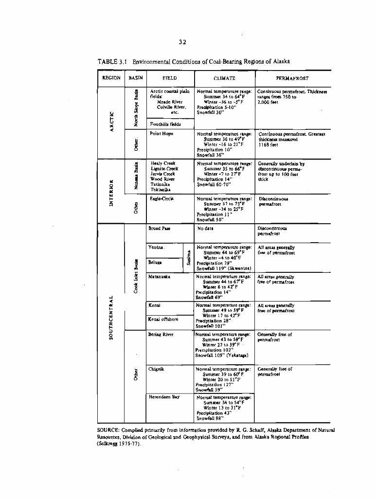
32
TABLE 3.1 Environmental Conditions of Coal-Bearing Regions of Alaska
SOURCE: Compiled primarily fmm information provided by R. G. Schaff, Alaska Department of Natural Resources, Division of Geological and Geophysicd Surveys, and from Alaska Regional Profiles (Selbgg 1975-77).
REGION
Y b U w 4
a P PC W H E:
r
4
PC h z w u I 3
%
BASIN
.g & g z t z ..
FIELD
Arctic coastal plaln fields:
Meade River ColviUe River,
etc.
Foothills &Ids
Point Hope
- CLIMATE
Normal temperature range: Summer 34 to 64'F Winter -36 to -5' F
Precipitation 5-10'' Snowfdl30"
N o m J temperature range: Summer 36 to 49'F Winter -16 to 21°F
Precipitation 10" Snowfd 36"
Healy Creek
PERMAFROST
Continuous permafrost. Thickness ranges from 750 to 2,000 feet
Continuous permafrost. Greatest thickness measured 1168 feet
Normal temperature range: Summer 35 to 66OF Winter -7 to 27'F
Precipitation 14" Snowfall 60-70"
Normal temperatun range: Summer 37 to 73'F Winter -24 to 2S°F
Precipitation 11" Snowfall 50"
No data
Norma temperature rnnp: Summer 44 to 69°F Whter -4 to (OF
Precipitation 29" Snowfall 1 19" (Skwentna)
Normal temperature range: Summer 4 4 to 6 T F Wlnter 6 to 42OF
Precipitation 14" Snowfd 69"
N m a l temperature range: Summer 49 to 59OF Winter 17 to 42OF
p,ci*btion 28- ~ n o w f ~ t l 1 0 1 ~
Normal ternpetaturn mp: Summer 43 to 5E°F Winter 22 to 39'F
Prec~p~tation 102" Snowfall 109" (Yaltataga)
Normal temperature range: Summer 39 to 6VF Winter 20 to S l 0 F
Precipitation 127" Snowfd 59"
Normal temperature range: Summer 34 to 54'F Winter 13 to 31'F
Precipitation 43" Snowfall 9 8
#
B 0
.a A
- 3 $
- 8 0
Generally underlain by discontinuous pm- frost up to 100 feet thick
Discontinuous permafrost
Discontinuous pennafrost
AU mu generally free of permafrost
All areas generafly f e of permfrost
AU m a s generally free of permafrost
G e n d y free of permafrost
Generally free of permafrost
Lignite Creek
Wood River 'Tathika Teklnnika
EagLeCircle
Broad Pass
Yentna
Beluga ' 3
Matanuaka
Kenai
Kenai offshore
Bering Riier
Chignik
Herendeen Bay
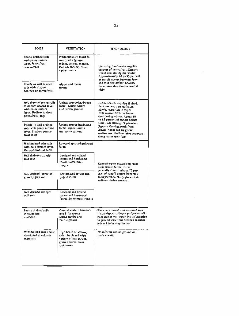
SOILS
Poorly drained soil$ with peaty surface layer. Permafrost near surface
Poorly to weU drained soils with shallow bedrock or permafrost
Well drained brown soils to poorly drained soils with peaty surface layer. Shallow to deep permafrost table
Poorly to well drained soils with peaty surface hyer. Shallow perma- frost table
Well drained thin soils with dark surface layer. Deep permafrost table
Well drained strongly acid soils
Well drained loamy or gravelly gray soils
". Well drained strongly acid soils
Poorly drained soils in water-laid materials
Well drained sandy soils developed in volcanic materials.
VEGETATION
Predominantly moist to wet tundra (grasses, sedges, lichens, mosses,
low shrubs). some alpme tundra
Alpine and moist tundra
Upland spruce-hardwood forest; alpine tundra and barren pound
Upland spruce-hardwood forest; alpine tundra and barren ground
Lowland spruce-hardwood forest
Lowland and upland spruce and hardwood forest. Some moist tundra
Bottomland spruce and poplar forest
Lowland and upland spruce and hardwood forest. Some moist tundra
Coastal western hemlock and Sitka spruce: alpine tundra and bsrren ground
High brush of willow,
HYDROLOGY 1
Limited ground-water supplies because of permafrost. Streams freeze over during the winter. Approximately 90 to 95 percent of runoff occurs between June and mid-September. Shallow thaw lakes abundant in coastal plain
Ground-water supplies limited. Best reservoirs are unfrozen alluvial materials in major river valleys. Streams freeze over during winter. About 80 to 85 percent of runoff occurs from June through September. Streams north from Alaska Range fed by glacial meltwaters. S h d o w lakes common along major river flats
Ground-water available in most areas where permafrost is generally absent. About 75 per- cent of runoff occurs from May to September. Many glacier-fed, sediment-laden streams.
Glaciers extensive and surround area of coal deposits. Heavy surface runoff from glacier meltwater. No information on ground water but bedrock supplies believed to be very limited.
I No information on ground or alder, birch and wide surface water variety of low shrubs, grasses, herbs, ferns ' and mosses
&

just as coal development could have a strong effect on the environment. These relationships are discussed below.
3.1.1 Climate
The Alaskan landmass lies generally between 60° and 70' north latitude and is characterized by Arctic to subarctic climatic conditions. Winter temperatures are very low (see Figures 3.1 and 3.2 and Table 3.1) and are commonly accompanied by seasonally high winds, resulting in severe wind-chill factors. Summer temperatures are generally cool (see Figures 3.3 and 3.4). There are also large seasonal variations in the amount of daylight, and at the northernmost latitudes there are winter days when the sun remains below the horizon and summer days when the sun does not set (see Figure 3.5). Precipitation is low throughout much of the State (see Figure 3.6). However, some areas of the Alaska Peninsula, the Prince William Sound region, the Wrangell Mountains, and the panhandle of southeastern Alaska have very high amounts of precipitation. Most of the precipitation falls as rain, but snowfall can be very heavy and may total several hundred inches in places (see Figure 3.7).
Because there are significant differences in climate across the State (see Table 3.11, various coal fields are subject to different climatic conditions that bear on coal development and reclamation. The major coal resources lie near 70° north latitude (Arctic Region--North Slope coal basin), near 64O north latitude (Interior Region--Nenana coal basin), and 61° north latitude (Southcentral Region--Cook Inlet coal basin). A11 major coal fields in the conterminous United States lie below 4g0 north latitude in the temperate climatic zone. Climatic conditions for much of Alaska are significantly different from those in the conterminous United States (see Table 3.2) and some standard mining and reclamation practices m y not be appropriate for Alaskan operations (Section 3.1.2).
3.1.1.1 Arctic Region
The Arctic Region has prolonged periods of low temperatures and high winds. The average monthly temperature is below freezing for about 8 months of the year. Minimum temperatures of -51°C (-60°F) may be reached during this period and on some occasions may go as low as -56OC (-70°F), but temperatures are more commonly between -21' and -32OC (-6O and -25OF) (Selkregg 1975-77). Accompanying the intensely cold winter temperatures of the Arctic Region are limited periods of daylight (see Figure 3.5). For more than 3 months of the year there are less than 8 hours of light (actually twilight); for nearly 2 months of that period the sun does not rise. Although snowfall in the Arctic Region is comparatively slight--only about 30 inches (see Pigure 3.7)--once snow is on the ground it persists until spring. The total annual precipitation is very low, generally averaging about 5 inches (see Figure 3.6) .
FIGURE 3.1 Mean daily minimum temperatwe distribution, January (degrees Fahrenheit).
SOURCE: Compiled by the Arctic Environmental Information and Data Center, Anchorage, Alaska, for A1 RoFdes (Selkregg 1975-1977). FIGURE 3.2 Mean daily maximum temperature distribution, January (degrees Fahrenheit).
aska Regional
FIGURE 3.3 Mean daily minimum temperature distribution, July (degrees Fahrenheit).
SOURCE: Compiled by the Arctic Environmental Information and Data Center, Anchorage, Alaska, for Alaska Regional Profdes (Selkregg 1975-1977). FIGURE 3.4 Mean daily maximum temperature distribution, July (degrees Fahrenheit).

SOURCE: Adapted from National Weather Senice and U.S. Geological Survey.
FIGURE 3.6 Mean annual precipitation distribution, in inches.


Summer temperature8 i n t h e Arctic Region range between -lo and 10°C (30° and 50°F), though temperatures a s high a s 27'C (80°F) sometimes occur, From May to J u l y t h e d a i l y per iods o f l i g h t average 20 hours. The growing season spans a per iod ranging from 9 t o 11 w e e k s .
3.1.1.2 I n t e r i o r Region
The I n t e r i o r Region of Alaska is one o f climatic extremes, with summer temperatures t h a t range as high a s 38OC (lOO°F) and winter temperatures t h a t f a l l on occasion to -62'C (-80°F) (Selkregg 1975-77). Winter temperatures gene ra l l y range between -29' and -4OC (-20' and 25'F). The average annual snowfal l is between 50 and 70 inches (see Figure 3.7). For about 7 months o f t h e year the average monthly temperature is below f reez ing . AS i n o t h e r f a r nor thern l a t i t u d e s t h e r e a r e s i g n i f i c a n t periods o f diminished l i g h t , a s much as 2 months wi th less than 8 hours o f d a y l i g h t (see Figure 3.5). P r e c i p i t a t i o n is l o w , averaging 10 to 15 inches, bu t ground cover o f snow u s u a l l y p e r s i s t s throughout t h e winter season.
Despi te its extremes t h e gene ra l c l ima te of t h e I n t e r i o r Region is less r igorous than t h a t o f t h e Arc t ic . Summer temperatures between 3' and 21°C (38O and 70°F) a r e common, with per iods of extended l i g h t i n t h e Nenana area averaging about 1 8 hours per day during Mayr June, and Ju ly . The growing season spans about 10 t o 15 weeks .
3.1.1.3 Southcent ra l Region
The Southcent ra l Region o f Alaska l i es south of t h e Alaska Range and en joys a climate t h a t is notably milder than t h a t of t h e I n t e r i o r or t h e Arctic (see Table 3.1). Winter temperatures gene ra l l y range from -17' to 5OC (0° to 40°F) bu t may drop a s l o w a s -56'C (-70°F) i n t h e e a s t e r n p a r t s of t h e reg ion (Selkregg 1975-77). P r e c i p i t a t i o n is moderate (see Figure 3.6). Winter snow accumulation ranges from 70 t o 100 inches per season (see Figure 3.71. The average monthly temperature is below f r eez ing f o r about 5 months of t h e year .
Summer temperatures a r e u sua l ly between 7 O and 18OC (45O and 65OF), b u t they may climb as high as 32OC (90°F) (Selkregg 1975-77). Long pe r iods of day l igh t , which average about 16 hours between May and J u l y , a r e t y p i c a l o f t h e region. The growing season extends over a 10- to 16-week per iod.
3 1 . 1 4 Common Problems Related to Climate
A l l coal-bearing reg ions i n Alaska a r e s u b j e c t to high win te r winds t h a t can r e s u l t i n s eve re wind-chill f a c t o r s , which cause g r e a t persona l discomfort and a f f e c t t h e e f f i c i e n c y of outdoor opera t ions . I n win te r , high winds remove p r o t e c t i v e snow cover from exposed su r f aces , causing r e t a r d a t i o n of vege ta t ion growth. I n a r e a s of deep

snow accumulation the growing season may be shortened, also affecting vegetation adversely.
High winds also can pick up dust from disturbed areas as well as from natural river bars and outwash plains. Standard dust-control procedures that rely on heavy use of water are not suitable for operations at the extremely low temperatures that prevail in Alaska. In remote areas, however, increased amounts of dust from disturbance of the ground may not pose significant health or nuisance problems, although dust may affect the growth of vegetation (Everett 1980). In I
a study of the effects of dust along the Yukon River-Prudhoe Bay haul road, Webber and others (1978) conclude that both beneficial and deletetious impacts on plant growth are possible. Dust on plant leaves may affect photosynthesis and limit growth, but it may also enhance early snowmelt and thus provide a longer period for-vegetation growth. Dust may also carry essential nutrients for plant growth. Observations show that the leaf size of several plants in the vicinity of the road is enhanced, but that the vitality of mosses is lowered (Webber and others 1978). The effects of dust on Arctic wildlife are not known,
Dust, which forms when ice in fine-grained materials sublimes, may cause a problem where mining is in permafrost. Any dust that accumulates on the snow surface would accelerate snowmelt and result in the increased flow of surface water. Coal dust would be especially conducive to rapid snowmelt. The increased flow of surface water might hamper mine operations, although it is possible that early melting of snow in working areas could be beneficial.
Although mining equipment designed to operate in low temperatures does exist, extensive cold can cause increased breakage of metal and plastic, leading to maintenance delays and causing changes in operational schedules. However, military operations, winter oil exploration in the 1950s, and construction of the trans-Alaska pipeline in the 1970s demonstrated that year-round major-equipment operations in the Arctic Region are feasible, although such activities can be greatly impeded under extreme winter conditions. Surface mining operations have been conducted during the winter in the Healy area of the Interior Region for many years.
Maintaining a stable work force to mine coal in Alaska during long per iods of darkness or semidarkness, extensive isolation, and excessive cold will be a problem, especially in the Arctic. High pay, employee rotation, company housing, and a multitude of fringe benefits did not prevent a high rate of turnover during construction of the trans-Alaska pipeline. The Usibelli mine near Healy has not experienced this problem, however.
Because of Alaska's harsh climate, the planning of both winter and summer mining operations and adherence to operational schedules must be more rigorous than it is in the conterminous United States. In the reclamation of many disturbed areas the optimum time for seeding may be limited to only a few days, although some seeds remain viable for more than a year, and delayed but succesrsful germination can take place from seeding of Arctic soils in late fall or late winter.

3.1.2 Permafrost
Permafrost is undoubtedly the most unusual and the most intractable of Alaska's environmental conditions. It is of particular concern in mining and reclamation because of the profound changes that sometimes take place in the physical behavior of earth materials as a result of thawing, which is accelerated by mining operations and related disturbances of the thermal regime. Ice-cemented materials, particularly the fine-grained materials that are normally unconsolidated sediments, can lose much or most of their strength when thawed, especially where the permafrost is ice-rich and where large quantities of water are thus a constituent of thawed sediments. The large amounts of water make these thawed materials unstable and difficult to handle (see Figure 3.8), and as a result excavated slopes may be prone to slumping and flow. Coarse-grained fiaterials, in contrast, retain a certain degree of stability even when thawed, because excess water can more readily drain.
The refreezing of materials thawed and stockpiled during surface-mining operations could pose reclamation problems where it is necessary to rehandle the materials as backfill or as surface Cover for ground being prepared for revegetation. In addition, the interstitial ice in permafrost material acts as a barrier to the movement of surface water into the ground-water system, thus limiting the water-storage capacity of the ground-water system (Section 3.1.4.4). The quality of ground water may also be affected by the freezing process, which causes residual waters to become briny. Furthermore, permafrost and deep seasonal frost affect the kinds of vegetation that ate present.
Because of its far-reaching impacts, permafrost is probably the single most important environmental characteristic that must be considered in assessing whether any provisions of the Surface Mining Control and Reclamation Act of 1977 need to be modified to meet the objectives of the A c t for Alaska. The properties of permafrost and the related frozen-ground processes that require special attention with respect to surface coal-mining and engineering practices are discussed below.
3.1.2.1 Classification and Characteristics
Permafrost consists of earth materials that remain frozen for at least 2 years and extend from near the surface to depths ranging from a few feet to as much as 2 thousand feet in some locales. Soil and rock material that thaws during the summer is known as the "active layer." The general features of permafrost are shown in Figure 3.9. Permafrost that extends over wide geographic areas is classified as "continuous." Where frozen areas are interrupted by unfrozen materials the permafrost is classed as "discontinuous" (Lachenbruch 1968)
The manifestations of permafrost in natural and disturbed terrains depend almost exclusively on the behavior of water within the ground

SOURCE: Photograph by Troy L. Pewd, U.S. Geological Survey. Published as Figure 24 in Ferrians and others (1969).
FIGURE 3.8 Thawed lake sediments flowing around blade of bulldozer. Ice-rich permafrost exposed during construction of Richardson Highway near Paxon.

SOURCE: Modified from Ferrians and others (1969).
FIGURE 3.9 General features of permafrost terrain.

and on its sur face . For permafrost a r e a s t h e behavior of water is o f s p e c i a l s ign i f i cance t o provis ions of t he A c t r e l a t i n g t o hydrology (5 507 (b) (111, ' S 508 (a ) (131, S 510 (b) ( 3 ) , S 515 (b) (8) 8 S 515 (b) (10) r S 516 (b) (9 . The most important d i f f e r e n c e between the behavior of f rozen and unfrozen sediments r e s u l t s from t h e f a c t t h a t water g e n e r a l l y has cons iderable s t r e n g t h when it i s frozen ( i c e ) b u t l a c k s s t r e n g t h i n its l i q u i d s tate. I n f ami l i a r unfrozen sediments, t h e g r a i n s of sediment are i n c o n t a c t and t h e amount of water gene ra l ly cannot exceed t h e volume of t h e voids between t h e g ra ins . This c ircumstance does n o t apply t o permafrost, which is completely s t a b l e even when it con ta ins l a r g e masses of i ce . However, l a r g e masses of excess ice ( t h a t volume which a f t e r melting cannot f i t i n t he s o i l vo ids) cause permafrost t o be a major engineering problem, because they c o n t r o l t h e behavior of permafrost upon thawing (Washburn 1979, Pe r r i ans and o t h e r s 1969). Where excess i c e is p resen t its volume may range widely from somewhat g r e a t e r than the pore volume of t h e same m a t e r i a l s when thawed to more than 90 percent of t h e ground when ice l enses , wedges, and o the r masses of ice a r e present .
When permafrost thaws, t h e mineral g r a i n s tend t o settle, and water is squeezed o u t of t h e sediments. whi le t h i s s e t t l i n g is i n progress , t h e g r a i n s a r e no t i n f r i c t i o n a l con tac t , and t h e e n t i r e mixture of water and sediments tends to behave a s a dense f l u i d with v i r t u a l l y no load-carrying capac i ty . Whether t h e l i q u i d s t a t e p e r s i s t s long enough t o have s i g n i f i c a n t mechanical e f f e c t s on the thawed ma te r i a l s depends on how rap id ly t h e excess water is re l eased . I f t h e m a t e r i a l is r i c h i n c l a y , its permeabil i ty may be s o low t h a t water is re l eased very s lowly, and t h e ma te r i a l may remain i n a semif lu id s t a t e f o r years . Under such condi t ions , t h e thawed ma te r i a l w i l l tend t o "seek a l e v e l n and flow an very g e n t l e s lopes . I n coarse-grained ma te r i a l with a high permeabil i ty t h e water generated by thawing of excess i c e may escape r ead i ly , a l lowing t h e g r a i n s t o maintain f r i c t i o n a l contac t . The sediment w i l l then r e t a i n s i g n i f i c a n t s t r e n g t h , and such ma te r i a l may be s t a b l e on apprec i ab le s lopes .
Excess ice can form i n a number of ways. For example, when f ine-gra ined or s i l t y soil freezes, water is commonly drawn to the f r eez ing plane from elsewhere i n t h e s o i l mat r ix t o form l a y e r s of ice ranging i n th ickness from a f r a c t i o n of an inch t o s e v e r a l inches. Th i s fo rces the soil t o expand t o aecornmodate t h e ice incorporated i n t o t h e frozen horizon and r e s u l t s i n heaving of t h e ground.
Ice a l s o f i l l s ground cracks t h a t develop during winter a s a r e s u l t of con t r ac t ion caused by r ap id decreases i n temperature. Each sp r ing t h e c racks f i l l with water, which f r eezes and prevents t h e cracks from completely c los ing . Because t h e c racks recur i n t h e same p lace year a f t e r year t h e ice wedges grow i n s i z e , f r equen t ly reaching widths of 5 to 10 feet a t t h e t o p and taper ing t o a t h i n edge a t depths of 30 f e e t o r more (see Figure 3.10). The con t r ac t ion c racks commonly occur i n a polygonal p a t t e r n , w i t h polygons t y p i c a l l y 30 to 300 f e e t across . A s ice wedges i n these cracks grow, they commonly push t h e soi l i n t o mounds or r idges t h a t accent t h e polygonal ground p a t t e r n t h a t is a conspicuous f e a t u r e of t h e ~ r c t i c landscape. Beaded

SOURCE: Robert M. Chapman, 1949, U.S. Geological Survey.
FIGURE 3.10 Ice wedges in muck silt bluffs along the Kokolik River, northern Alaska.

drainage, which develops as the ice wedges melt out, is also commonly associated with patterned ground (Lachenbruch 1966).
The thermal regimes of natural and disturbed ground surfaces in permfrost areas can be characterized approximately by (1) the mean annual surface temperature and (2) the range of surface temperatures between summer end winter. The distance to the bottom of the permafrost is controlled primarily by the mean annual surface temperature and the geothermal gradient of the underlying materials. The distance from the ground surface to the top of the permafrost zone (i9e-t the depth of summer thawing) is more sensitive to seasonal range in surface temperatures. If the average surface temperature is below O°C (32OF), the depth of winter freezing will generally exceed the depth of summer thawing, and a layer of permafrost will form. During the last century the average annual surface temperature has increased by as much as lo to 3OC in much of Alaska (Gold and Lachenbruch 1973). Consequently, present-day permafrost temperatures and depths in many areas, particularly in the discontinuous permafrost -zone, are generally the relics of an earlier and colder climate. Permafrost in the discontinuous zone is more susceptible to any disturbance of the surface than permafrost in the continuous zone because it has a warmer temperature and is more easily thawed. Given the present climate, much of the permafrost in the subarctic regions of Alaska will not re-form after it thaws. Hence, the restoration of disturbed terrain to its natural condition in such regions would not be possible.
The depth of summer thawing depends largely on how rapidly the seasonal range of temprature diminishes with depth. The temperature range underneath the wet organic mat of many tundra areas is relatively slight between summer and winter, whereas substantial seasonal variations persist to greater depths in drier mineral soils. The insulating effect of the organic mat moderates the warming temperatures during the summer, allowing permafrost to remain close to the surface. Several characteristics of the organic mat help to reduce the seasonal variation, the most important being the large amount of water it can retain. The amount of heat absorbed by ice when it melts is enough to raise the temperature of an equal volume of dry rock by 150°C. Thus, beneath saturated organic mats the active layer is typically only about 1 foot thick, but beneath drier mineral soils it may be 5 or even 10 times as great; in saturated mineral soils the active layer is of intermediate thickness. Modification of drainage in an area can change the moisture content and depth of the active layer and thereby disrupt the permafrost.
The thickness of the active layer normally remains relatively constant, and the permafrost beneath it remains strong and immobile. If, however, the organic mat is removed--for example, by surface-mining operations--or is compressed by placing gravel on it, summer temperatures will increase in the uppermost part of the Permafrost zone and the material will thaw. Although ice-rich permafrost may have been stable for thousands of years, if it contains excess ice it will be weakened by thawing and may be mobilized by gravity, even on very gentle slopes, thereby exposing the material
beneath it to degradation. In flat terrain the thawed soil may remain in place, a depression or lake may form, and a new active layer develop to protect the underlying permafrost.
Where surface disruption increases the thickness of the active layer above permafrost containing massive ice (e.g., ice wedges Or lenses), the effects of thawing can be severe. The ice and frozen sediment are converted into water and mud, which flows downslope leaving no solids behind to insulate the underlying ice. In the absence of surface insulation the underlying permafrost progressively degrades, creating large depressions that eventually stabilize after being buried by slumping of adjacent thawed material. Running water from the thawing sediments can collect substantial amounts of heat from solar radiation, thereby causing additional permafrost degradation along its drainage path. If this water enters seasonal contraction cracks in ice wedges, it may establish subsurface drainage pathways or caverns. In flat terrain the water thawed from massive ice can collect in the resulting depression. Such ponds can collect solar radiation that may cause them to enlarge by thawing their ice-rich banks and bottoms. Under such conditions, ponds may coalesce to form "thaw lakes" (Britton 1958, Anderson and Huesey 1963, Sellmann and others 1975). Features resulting from the melting of ground ice are referred to as "thermkarsf." Thermokarst is a condition that could be initiated by surface mining activities at some sites, particularly on the North Slope.
3.1.2.2 Distribution
In North America, except for certain limited areas at high altitudes in the temperate regions, perennially frozen ground is generally confined to the high latitudes. within the united States it is, for all practical purposes, unique to Alaska. Permafrost is widely distributed in Alaska, underlying about 75 percent of the State. In general, continuous permafrost characterizes the Arctic Region (the area north of the Arctic Circle), whereas discontinuous permafrost is a feature of most of the Interior Region and parts of the Southcentral Region (see Figure 3.11). The thickest permafrost occurs in the continuous permafrost zone of the Arctic Region, where ground perennially frozen to a depth of as much as 2,000 feet i s known to occur (Gold and Lachenbruch 1973). The permafrost becomes thinner in the southern part of Alaska's Interior Region; zones of 100 to 200 feet are common, although zones up to 400 feet thick occur in some areas. Permafrost in the Southcentral Region occurs in discontinuous patches a few tens of feet thick.
Most of Alaska's coal fields are found within permafrost areas (compare Figures 3.11 and 2.2). In the Arctic, where the largest coal resources occur, the permafrost extends to depths far below the reach of surface mining and probably below that of underground mining as well. But surface mining in the Interior Region could extend below the base of the permafrost zone in some areas. Deep seasonal frost# 10 feet or more, can occur without permafrost throughout the ~nterior


Region. Coal fields in the Southcentral Ftegion are likely to contain isolated bodies of permafrost.
3.1.2.3 Engineering Considerations
There has been very little surface mining of coal in Alaska except in the Healy Creek, Lignite Creek, and Matanuska coal fields- Thus, any attempt to determine the relationships between coal mining and environmental conditions must to a large degree be speculative. Nonetheless, Alaskan experience in mining and in road, pipeline, and other heavy construction activities does give some idea of the kinds of problems that might be encountered in the future during large-scale surface mining of coal. The principal problems are those related to permafrost.
Although Alaskan experience in surface mining of coal in permafrost is essentially limited to operations in discontinuous permafrost at Healy, the considerable body of information on the engineering characteristics of frozen ground provides a basis for assessing the impacts of mining on the permafrost environment and for judging the potential for restoration of the land (Ferrians and others 1969).
Of critical importance are the volume of ice in the permafrost materials, the form in which ice occurs, and the character of the host materials. The removal of overburden and the ensuing disturbance of the thermal regime could initiate or accelerate summertime melting and produce unstable and difficult-to-handle materials. where loess and other fine-grained overburden materials with large amounts of ice are present, thawing could create a liquid mud that is subject to movement even on very gentle slopes.' Even on level areas the mud might not be traversable. The thawing of interburden material during mining, especially the clays commonly associated with coal beds, also would result in unstable spoil materials that would be subject to movement. Where the water content of thawed spoils is high, compaction is unlikely to be a practical way of making them stable (PL 95-87, S 515(b) (31 , S 515 (b) (111, S 515 (b) (22) (A)), and it may be necessary to use dikes to contain them.
Coarse-grained materials can be more readily handled than fine-grained ones, particularly if the ice content is small. Less water will be released in thawing, and any water that does result will migrate readily out of the sediments.
3.1.2.3.1 Excavation. Excavating surface materials in permafrost regions poses special problems because of the strength of these materials when frozen and their weakness when thawed. Interstitial ice provides a strong cementing bond and either this bond must be broken or mineral grains fractured in the excavation process. Because of the strength imparted to materials by interstitial ice, attention focuses on the breakdown of the ice. This may be accomplished by mechanical means, whereby some of the cementing ice is ruptured along fracture planes, or by thermal means, whereby the cementing ice is

melted. According to Phukan and Andersland (1978), there are a number of ways in which frozen ground can be excavated; a description of such techniques is required by the ~ c t (S 505(b) ( 7 ) , S 5084a) ( 5 ) ) . These include breaking frozen soil and rock into manageable small chunks by blasting or by using rippers attached to tractors or other heavy equipment, or by prethawing frozen materials, and then excavating by standard mining practices. The most effective way to excavate frozen materials depends on such factors as the type of material being moved and the ice content, but in general blasting and ripping methods have been found effective.
Blasting is not without its problems, however. Lang (1966) and Garg (1974), discussing open-pit mining of iron ore in the discontinuous permafrost of the Knob Lake and Schefferville areas of ea&tern Canada, note the difficulty of obtaining optimum fragmentation of frozen materials, Improper blasting results in blocks of material too large to be handled by shovel, and as a consequence further breaking by secondary blastingt mechanical breakage (dropball methods), or natural thawing is required. Garg (1974) states that the efficiency of blasting is controlled not only by the total ice content but also by the type and distribution of ice. Because ice absorbs a large part of the blasting energyt a knowledge of ice content and distribution is needed for proper blasting design. Other problems related to blasting are the generation of heat during drilling, the melting of ice, and potential caving of drill holest especially where the ice temperature is close to O°C (32'F).
Thawing before excavating presents special problems. Whether water or steam jetting, solar heating, or other methods are used, the thawing process is very time consuming. In addition, thawing may produce a very soft or liquid mud if the materials being thawed are fine-grained and ice-rich. This mud is difficult to handle, and shovels, trucks, and other equipment may become bogged down in it. For surface coal-mining operations, prethawing methods will probably not be practical for fine-grained materials because of the handling problems. Prethawing methods might be useful, however, where overburden materials are coarse gravels, which may be relatively stable when they thaw and could be readily stripped away by draglines or other standard equipment. Hydraulic removal and flushing of thawed overburden into nearby streams are no longer allowed because of the water-pollution effects, although hydraulic methods could be employed with proper settling ponds and reuse of water.
f f a sufficient amount of overburden can be stripped during the summer months, the actual mining of coal could probably continue throughout the winter [as is now done at the Usibelli mine near Healy), although winter operations under subf~eeaing conditions would be more difficult and probably more expensive. A principal problem for any surface coal mining in permafrost would be removing, ~tockpiling, and replacing spoils and mine wastes under provisions of the A c t (S 515 (b) ( 3 ) , S 515 (b) (11) , 515 (b) (22)). The likelihood that f ine-grained, ice-rich materials will flow or *runw when they thaw has already been mentioned. If the overburden is a thaw-stable gravel or bedrock, however, standard mining and stockpiling techniques

can be used, and minimal problems of slope instability or movement of stockpiled materials can be anticipated. Ice-rich interburden materials tend to be "weakn layers within coal-bearing formations, and their exposure to thawing temperatures would require special attention to prevent slope failure.
Although frozen materials are commonly excavated in the summer, excavation in the fall or early winter may be preferable because the freezing of the act ive layer provides additional support for the heavy machinery used. Summer excavation is not without its problems. There may be differential settlement or collapse of the ground as ice melts and water runs off, interfering with the movement of trucks and other equipmerrt. Furthermore, pits excavated in the summer may fill rapidly with water, whereas those excavated in the winter would probably remain open for several months. Where dry permafrost is present, no unusual excavation problems are encountered.
With respect to winter operations, Phukan and ~ndersland (1978, p. 357) note that "Handling excavated materials may be troubleeome if the materials contain moisture which can freeze to any surface it touches, such as power-shovel buckets, loading hoppers, conveyor belts, and railroad-car bodies. . . . Such problems can be eliminated by drying the materials to lower moisture content and heating the surfaces with which the materials may come in contact." ~ r y i n g the materials is expensive, however, and may add to dust problems. Garg (1974) reports t h e refreezing of crushed material in the processing of own-pit iron ores in-eastern Canada. Larger chunks of material had a such greater tendency to refreeze (producing "bridging' effects") in crusher feed hoppers .
These problems would be especially acute in areas of continuous permafrost, The severity of the problems cannot be predicted, however, in the absence of any surface coal-mining expexienct in Arctic areas. Some of these problems would also be encountered in areas of discontinuous permafrost, but there would be other problems resulting from the variable occurrence of ground water and interstitial ice or ice masses. Excavation in nonfrozen zones, for example, might be followed by strong inflows of ground water that might induce uncontrollable thawing of adjacent permafrost zones or frozen layers. Garg (1974) states that open pits in iron ores of eastern Canada's discontinuous permafrost acted as sumps for surface and near-surface runoff and resulted in further thawing of permafrost at the pit floor and in aggravation of operating conditions. The presence of nonfrozen areas, on the other hand, might be an advantage in selecting sites for the disposal of spoil material because no undesired thawing of underlying materials could take place. The fact that permafrost is unlikely to re-form in some discontinuous permafrost areas would undoubtedly lessen the problems of backfilling, regrading, and reshaping the land surface, though deep seasonal freezing of materials stored over the winter would cause some difficulty in rehandling those materials.
3.1.2.3.2 Slope stability. Slope stability is an important consideration in the excavation of frozen materials and the

restoration of surface-mined areas. Slope behavior will depend to a significant extent on the materials that underlie the slopes and on the amount and.configuration of ice that they contain. Fine-grained, ice-rich materials would generally be the most difficult to control, and coarse-grained, ice-poor materials the easiest. Special attention would have to be given to methods for backfilling, grading, and stabilization in perennially frozen areas, as required by the Act *
(S 5d8 (a) (s ) , s 51s (b) (31, s 51s (b) (ll), s 515 (b) (22) 1. Most slopes fail because the shear-strength of the slope material
is exceeded. Generally, the lower the shear-strength the sooner the slope will fail, and the smaller will be the angle at which the slope becomes 'stable. Frozen materials have a high shear-s treng th , but when they thaw they lose much of that strength. Any condition that' promotes thawing of permafrost may ultimately result'in slope failure.
The vegetation and organic mat help to reduce thawing and resulting slope failure in permafrost regions. Any disturbance of the insulating properties of this cover will promote thawing and increase the likelihood of slope failure especially where it results in the "
exposure of ice-r ich permafrost in excavations. A wide range of slope surfaces must be dealt with during surface +
mining. The slope of the ground to be stripped may be very gentle, but the cuts made in the overburden, interburden, and coal may be relatively steep. Slopes reconstructed in mined-out areas necessarily ' would be relatively gentle. The removal of vegetation and soil from the land surface in areas of continuous permafrost would accelerate 4
the thaw rate of ice-rich materials and invite the development of unstable slopes, even in low-relief te~rain, because of the large volumes of water admixed with these materials.
Of greater iyrtance would be the problem of storing surface. materials. Because fine-grained and ice-rich materials will flow readily on thawing, they may require containment prior to reuse in regrading the landscape. Special attention would be required in placement of spoils so as to protect offsite areas £tom any mass movement of spoil materials, as required by the Act ( S 515(b) (22) (A)). ft would probably be desirable to depart from the requirement specified by PL 95-87 ( S 515 (b) (22) (B)) by placing excess spoil material directly on the vegetation cwer to inhibit thawing of the underlying permafrost. w
Once surface mining has begun, additional slope stability problems will develop as frozen overburden, interburden, and coal are exposed to thawing conditions. I f the mine-pit cuts are steep, the slopes may be especially susceptible to failure. Cuts in frozen but ice-poor soils or bedrock will cau8e minimum difficulty if they are designed so that the slope angle is compatible with the strength of the materials when thawed. Cuts made in fine-grained ice-rich permafrost would cause the most serious slope stability problems because these materials tend to liquefy and flow upon thawing. Spoil materials may be hard to store so that they remain stable, and multiple-seam mining (which requires rehandling of spoils and lengthy exposure of overburden and interburden) could be especially difficult, if not precluded. Selective segregation and placement of some spoils may be
found to be necessary, depending on local properties of frozen materials .
Temporary stabilization of pit slopes and spoil piles during stripping may be necessary at some mines. However, because of the difficulty of establishing new plant growth, revegetation is not likely to be practical for short-term stabilization of slopes, that is, during the period of active mining at a site. Long-term stabilization, on the other hand, will be essential for reclamation and will involve various forms of revegetation.
3.1.2.3.3 Land restorability. Practices for grading disturbed land in coal-bearing areas of Alaska can be expected to differ according to local permafrost conditions. In areas where no permafrost occurs, the problems of land restoration will probably be similar to those in the conterminous United States, and standard engineering practices for regrading and rebuilding the land surface will be applicable. Where nonfrozen and permafrost materials are juxtaposed in the discontinuous permafrost zone, a combination of problems will exist. Some of these will be problems directly and specifically related to either 'the nonfrozen or permafrost characteristics of the area, whereas others will arise from the interaction between frozen and nonfrozen zones. Thawing in the frozen zones would probably result in an outflow of water through the nonfrozen materials. For some areas in the discontinuous permafrost zone permafrost will not redevelop under the present climatic regime once the terrain is restored and stabilized following mining. Deep seasonal frost, however, is likely to occur throughout the zone.
Restoration in areas of continuous permafrost would face the special problems associated with thaw behavior under climatic conditions where permafrost may be redeveloped, as explained below. 'Ruo principal difficulties might be anticipated. The first would be the limited availability of materials for backfilling excavated areas and for restoring the terrain to its approximate original contour, as required by the Act ( S 515 (b) (3) ) . The second would be the difficulty of reconstructing and maintaining surface slopes that resembled those of adjacent or nearby areas not disturbed by mining (S 701(2)), Because many of the coal seams likely to be mined in Alaska ate thick--15 to 20 feet or more--a considerable void might have to be filled to restore the original land surface, depending on the stripping ratio. Waste materials from the mining operations might not be sufficient to backfill mined areas completely because of volume loss resulting from the melting of ice. Depending on the amount of ice in the originally frozen overburden and interburden materials, this loss could be substantial enough to make restoration of the original land surface impossible.
It might be difficult to reconstruct surface slopes even where sufficient backfill was available, because the backfill would be thawed material without the strength of frozen materials. These backfill materials might be stable only on slopes with very low angles. Artificial containment of materials might be a useful practice during early steps in land restoration where relatively

gentle slopes were involved. Where mining was carried out in Steep-slope areas (slopes greater than 2 0 ° ) 1 it might be exceedingly difficult to cover highwalls and return the site to its approximate original contour, as required by the Act (5 515(d)(2)). The practice of covering highwalls may even be difficult on slopes less steep than 20 degrees but for which factors of soil, climate, and other characteristics recognized by the Act (5 515(d)(4)) may call for the application of steep-slope reclamation standards,
Although permafrost ultimately will redevelop in disturbed areas in the continuous permafrost zone, the upper few feet will remain active; that is, the surface layer will thaw in the summer and freeze in the winter. The surface can be expected to attain some degree of natural stability only when vegetation has become reestablished and forms an insulating cover. Revegetation will thus be a singularly essential ingredient for long-term restoration of the terrain.
3.1.3 Vegetation
Alaska's flora ranges from the tundra of the Arctic Region to the spruce forests of the panhandle. However, most of Alaska's coal resources, including a small part of those in the Cook Inlet area, are in tundra areas, and thus the tundra warrants particular attention with respect to the potential environmental impacts of coal mining. Accordingly, the following discussion focuses on tundra, primarily in the Arctic Region, and how it might be affected by coal mining.
Except for the use of tundra vegetation by reindeer herds that were introduced in the late 1800~1 the tundra ecosystem of Alaska until recently was primarily of scientific interest to the non-Natives, and little consideration was given to its importance in providing range forage for wildlife or in preventing or minimizing landscape degradation where permafrost exists. Exploratory work in Naval Petroleum Reserve NO. 4 during the 19408 and 1950s resulted in significant disturbance of vegetation in some areas as a result of fires, compaction of the vegetation mat by heavy vehicles, and bulldozing of the vegetation cover and soil layer. Thawing of permafrost was promoted and resulted in ground subsidence and the formation of thermokarst. However, a vegetation cover was eventually reestablished in some locations (Lawson and others 1978).
The discovery of the Prudhoe Bay oil field in the late 1960s also resulted in extensive activity by man and machines, and this generated intense concern about damage to the tundra. As a result, guidelines have been established for controlling off-road vehicular traffic on the tundra on Federal and State-owned lands. Regulations pertaining to Federal lands have been developed by the U.S. Department of the Interior (1974). For State-owned lands the provisions of Alaskan Administrative Code, Title 11, Chapter 96, Section 10 et seq. apply (Alaskan Administrative Code 1973). Off-,road vehicular traffic on the tundra of State-owned *special use lands" (lands having special scenic, historic, archeological, scientific, biological8 recreational, or other special resource values) is carefully controlled to protect
the vegetation from any disturbance that would lessen its insulating effects on the underlying permafrost. Preventing unnecessary harm to the land by avoiding or minimizing the thawing of permafrost is a primary concern for the Arctic and parts of the Interior Region. As a consequence, off-road travel during the summer is generally precluded, with few exceptions, such as the possible use in drier areas of vehicles that exert relatively low ground-pressure--4 psi or less--on the vegetation. (The use of air-cushion vehicles and others that exert relatively low ground pressure on the tundra vegetation is described by Rickard and Brown (19741, Abele and Brown (1976), and Sterrett (1976)). For winter travel, State regulations are less restrictive than for summer travel because of the smaller potential for disturbance of the tundra (Brown and Grave 1979).
According to research in Canada (Haag and Bliss 1974) and Alaska (McKendrick and Mitchell 1978a), simply killing vascular plants does not result in the thawing of permafrost and development of thermokarst, a finding which suggests that the naturally-occurring dead organic layer; with its large content of water, is the critical insulating material on tundra soils. Thus, although vehicular disturbance of the tundra may initiate thawing of permafrost under some circumstances, the most extensive thawing will take place where the vegetation is completely removed.
3.1.3.1 Distribution
Tundra is widespread in Alaska, covering perhaps one-third to one-half of the State ,see Figure 3.12). It dominates the Arctic Region north of the Brooks Range, the site of Alaska's most extensive coal resources. It also covers parts of the Nenana coal basin and is present in some of the Cook Inlet coal fields.
Although there are a limited number of plant species, there are diverse vegetation types (Britton 1957) and a wide variety of plant associations, depending on soil, moisture, and other site conditions. Yet, in a general way, tundra plant associations can be correlated with the broad physical features of the landscape. The plants characteristic of wet tundra are generally found in the poorly drained coastal plain of the Arctic Region, whereas plants characteristic of moist tundra are generally found in the better-drained foothills area. Alpine tundra is present at high elevations in the Brooks Range. Along stream courses and steep south-facing slopes shrub growth occurs.
Substantial areas of tundra also occur south of the Brooks Range, where the summer climate is warmer and the growing season longer than in the Arctic. Plants of the wet and moist tundra here grow more profusely than those in the Arctic Ftegion and shrubs are more Prominent throughout. Alpine tundra is found at high elevations in the Alaska Range.

SOURCE: Adapted from U.S.
FIGURE 3.12 Map showing distribution of tundra in Alaska.
3.1.3.2 Classification
Tundra can be classified either on the basis of physical conditions of the terrain or on the basis of plant associations. The physical characteristics of the terrain are particularly important to mining and land restoration practices; the vegetation characteristics are of prime importance to the final stage of land reclamation, that is, revegetation.
Tundra areas are classified on the basis of the physical characteristics of the terrain as wet, moist, and alpine (Joint Federal-State Land Use Planning Commission for Alaska 1973). Wet tundra is found in poorly drained lowland areas in which creeping forms of sedges and cottongrass dominate the vegetation. Moist tundra characterizes the foothills regions. There, cottongrass tussocks are common, although a wide variety of other vegetation, including mosses, various heaths, dwarf birch, and willow, is also found. ~lpine tundra covers much of the dry, rocky areas of the high mountains and is characterized by low mat-forming plants, such as heather, avens, lichens, and mosses. ~lthough a given plant species may dominate one particular tundra environment, it commonly occurs in other tundra environments as well. Thus, lichens and mosses, found in large numbers in the alpine tundra areas, also occur in significant numbers in wet and moist Arctic tundra areas.
Viereck and Dyrness (1980) divide tundra into five major vegetation categories (sedge-grass, herbaceous, tussock, shrub, and mat and cushion) on the basis of the outward appearance of the vegetation. These major categories are further divided into 40 community types on the basis of the relative numbers of species of plants in an area.
3.1.3.3 Character of Native Vegetation
Tundra vegetation is composed largely of sedges, cottongrasses, and grasses, and to a lesser extent of mosses, lichens, and dwarf shrubs. Most tundra species are long-living perennials that are adapted to vegetative reproduction. They are generally poor seed producers (Tieszen 1978). The number of species, particularly in the Arctic Region, is low in comparison with the number on landscapes to the south.
Sedges, cottongrasses, and grasses dominate the vascular plants of the Arctic tundra, especially on the coastal plain. Most only grow to a few inches in height although in some areas they may be as much as 25 to 30 inches tall; most of their biomass is below ground. Their method of propagating, primarily by vegetative means, is significant because seeds ate generally considered essential for colonizing new areas. Because they reproduce primarily by vegetative means, grasses, sedges, and mosses of the tundra are slow to reinvade barren areas.
Cottongrasses and sedges are divided into both rhizomatous (creeping) and tussock species. The hummocky appearance of the tussock tundra, common to many well-drained sites, is due to large
clumps of cottongrass. Near the Arctic coast the cottongrass tussock growth yields to a more level, turflike vegetation that is dominated by creeping forms of cottongrasses, sedges, and grasses. Tussock-forming members of these groups, although poor seed producers, seem to tend more toward seed reproduction than the creeping forms.
Grasses also have creeping and tufted representatives. The tufted species are relatively more productive of seeds than the creeping species and are among the first to invade disturbed areas.
Mosses are also important components of the tundra, in some places exceeding the higher plants in both number of species and biomass (Rastorfer 1978). Biomass production is usually lowest in dry sites and highest in moderately wet to wet sites. Where moisture, nutrients, and microclimatic conditions are favorable, mosses reproduce quite readily. In experimental plots near Prudhoe Bay, McKendrick and Mitchell (1978b) found that the moss cover could be S U C C ~ S S ~ U ~ ~ ~ restored if phosphorus fertilizer was added to the soil.
Lichens are found in all tundra environments, and in some areas they comprise as much as 30 percent of the vegetation biomass (William8 and others 1978). Lichens are unusual in that they can survive long periods of dryness, up to several years (WiAliams and others 1978). The ability to remain dormant for long periods allows these plants to survive in harsh environments where other tundra plants could not exist. New lichens develop from spores or through vegetative processes. Moisture for their growth is taken primarily from the gtprobphere.
Arctic tundra soils in Alaska are poorly developed, and except in limited areas do not have the well-defined horizons that characterize soils in the conterminous United States. According to Tedrow (19771, soils in the foothills of the Arctic Region are generally silty, whereas those of the coastal plain are likely to be sandy. Parent materials range from normal bedrock to wind-blown or water-transported materials. well-developed soils on bedrock are often thin, but frost-shattered bedrock may be as much as 3 feet deep in soma places. In a few areas well-drained "ArcCic brown soilsm with distinct soil horizons have developed (Tedrow 1977). These soils range from 1 to 2 feet in depth. Soils developed on either river sands and gravels or wind-blown loess may be considerably deeper than residual soils developed on bedrock.
Although a wide range of soils exists in Alaska (USDA 19751, certain characteristics are typical of soil in the tundra environment. Tundra soils have developed under the dominating influence of low temperatures and high moisture cbnditions, and soil-forming processes that are common to areas of less severe climates have been restricted. The rate of chemical and biological action is low, and the depth to which soil-forming processes are active is restricted by permafrost. Decomposition of plant litter is slow, and there is usually a spongy mat of dead organic matter.
Rieger (1974) has divided Arctic soils into two broad groups, namely, (1) those that are poorly drained and usually water saturated, and (2 ) those that are well drained. Poorly drained soils dominate the Arctic landscape, occupying as much as 85 to 90 percent of the region. Permafrost limits the downward percolation of water, and thus the soils remain wet during almost all of the summer thaw period. This wetness favors anaerobic conditions in which iron is reduced to the ferrous state to produce a gray or gray-blue soil known as gley. As described by Rieger, the typical soil profile is an organic mat overlying the gray or gray-blue mineral soil. There are generally no clearly defined horizons of accumulating mineral elements in poorly drained Arctic soils (Rieger 1974). Limited areas of well-drained, coarse-grained soils are found on some steep slopes, on elevated parts of flood plains, and in other areas where drainage is facilitated (Rieger 1974). Because moisture is able to migrate through these soils, oxidizing conditions prevail, and mineral and organic materials are redistributed into distinct horizons, (For additional information on tundra soils, see Brown 1967, Everett 1975, Everett and parkinson 1977, Kellogg and Nygard 1951, Rieger and others 1979, Tedrow and others 1958, and Tedrow 1977).
In general, tundra soils are of limited fertility. Nitrates and phosphates, especially, are deficient. The pH level is typically between 4 and 5, although local parent materials may modify that. At Prudhoe Bay, for example, soil acidity ranges from neutral to alkaline as a result of calcareous outwash and eolian deposition (McKendrick and Mitchell 1978b, Walker and Webber 1979). Peat in some areas is also alkaline. Tundra soils in many areas south of the Brooks Range are also poorly developed and of limited fertility. However, the warmer summer climatic conditions of the Interior and Southcentral regions favor better soil development than in the Arctic, at least in well-drained sites.
3.1.3.5 Revegetation
Revegetation is an essential step in reclaiming areas disturbed by surface mining, as required by the Act (S 515 (b) (19) , S 515 (b) (20) , S 516(b) ( 6 ) ) . In Alaska this is largely a problem of reestablishing the tundra plant cover, because most of the coal fields are in tundra areas. Unfortunately, there is relatively little experience, especially in the Arctic, other than that obtained in connection with the trans-Alaska pipeline, from which technical expertise or knowledge of plant materials suitable for revegetation can be drawn, Historically, scientific work on tundra vegetation has been confined mostly to short-term studies aimed at a fundamental understanding of tundra plant processes. According to Bliss (1979), even though there was little research on revegetation technology for Arctic areas until a decade ago, the results of various studies, including the uniformity of results using native wild and northern agronomic species, show that considerable success in stabilizing soil can be achieved under Arctic conditions. However, most of the revegetation studies to date have

been concerned with species performance is local areas. As a basis for revegetation planning, it would be helpful to have data on the versatility of plant species for growth performance (tolerance to different habitats) under differing conditions that exist over broad areas, particularly along a transect where the ground has been disturbed. Data on native species might be especially useful because these species are generally thought to be the ones most likely to ~ u r v i v e
Xt is important to note that the differences between the Arctic and Subarctic regions have a significant bearing on revegetation. The Arctic Region has a shortex growing season, less precipitation, and soil5 with lwwcr nutrient states than the subarctic. These condikions favor Plants that reproduce primarily by vegetative means (poor seed producers) and make natural revegetation of Arctic areas a slow process- It takes many years for revegetation to take place under natural conditions in aome disturbed areas. Lawson and others (1978) describe natural revegetation in the Fish Creek area of northern Alaska and point out the importance of site-specific conditions to vegetation recovery rates. Depending on whether the original vegetation @over was canpletely or only partly removed, on whether ground ice wan coaa~on or of limited extent, and on whether a site was relatively wet or dry, Lawaon and others predict that it will take at least 10 ylerats for a temporary semiequilibrium to develop (well-structured community dominated by plants different than the surrwnding tundra), and several tens of years for a complete vegetation equilibrium to develop. Webber and Ives (1978 ) observed that in eonre areas the recovery from damage that did not disrupt the vegetation cover was complete in 5 to 10 years, but Hok (1971) reported no tevegetation in thermokarst areas after 20 years. For lichen regeneration of burned-over and grazed tundra areas, Palmer (1945) projected a period of 25 to 50 years for full recovery of short-growth forms of lichens and as much as 100 years for tall-grwth for-.
There are also differences within any one broad region that are important to revegetation. Thus a greater number of plant species ate found in the foothills of the North Slope than on the Coastal plain, and this, together with a somewhat warmer and longer growing season would favor revegetation efforts of the foothills areas.
A particularly aaute problem in rsvegetating disturbed tundra areas is the low fertility of the soil, a factor that greatly re~tricts plant growth (Mitchell 1976, Ulrich and Gersper 1978, McKendrick and Mitchell 1978b3. In studies at Prudhoe Bay, ~cKendrick and Mitchell (1978b) found that phosphorus is critically limited in the soil but when added to experimental plots of Tundra bluegrass, revegetation is accelerated (see Figures 3.13 and 3.14). Both nitrogen and phosphorus are especially needed in the Meade River area south of Barrow to increase the natural plant cover on sandy river bluffs. Phosphorus is the most limiting element for seedling establishment at Barrow, although a need for nitrogen becomes evident once plants are established. Ulrich and Geroper (1978) note that for
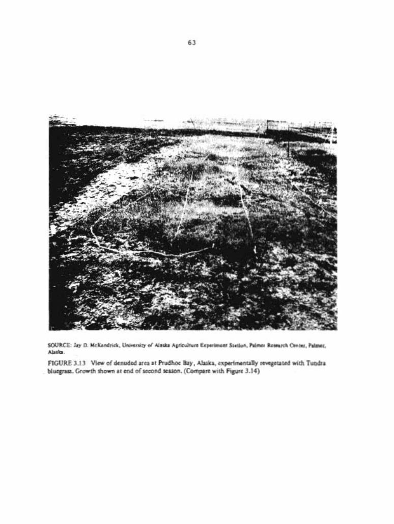
SOURCE: Jay D. McKendrick, University of Alaska Agriculture Experiment Station, Palmer Research Center, Palmer, Alaska.
FIGURE 3.1 3 View of denuded area at Prudhoe Bay, Alaska, experimentally revegetated with Tundra bluegrass. Growth shown at end of second season. (Compare with Figure 3.14)
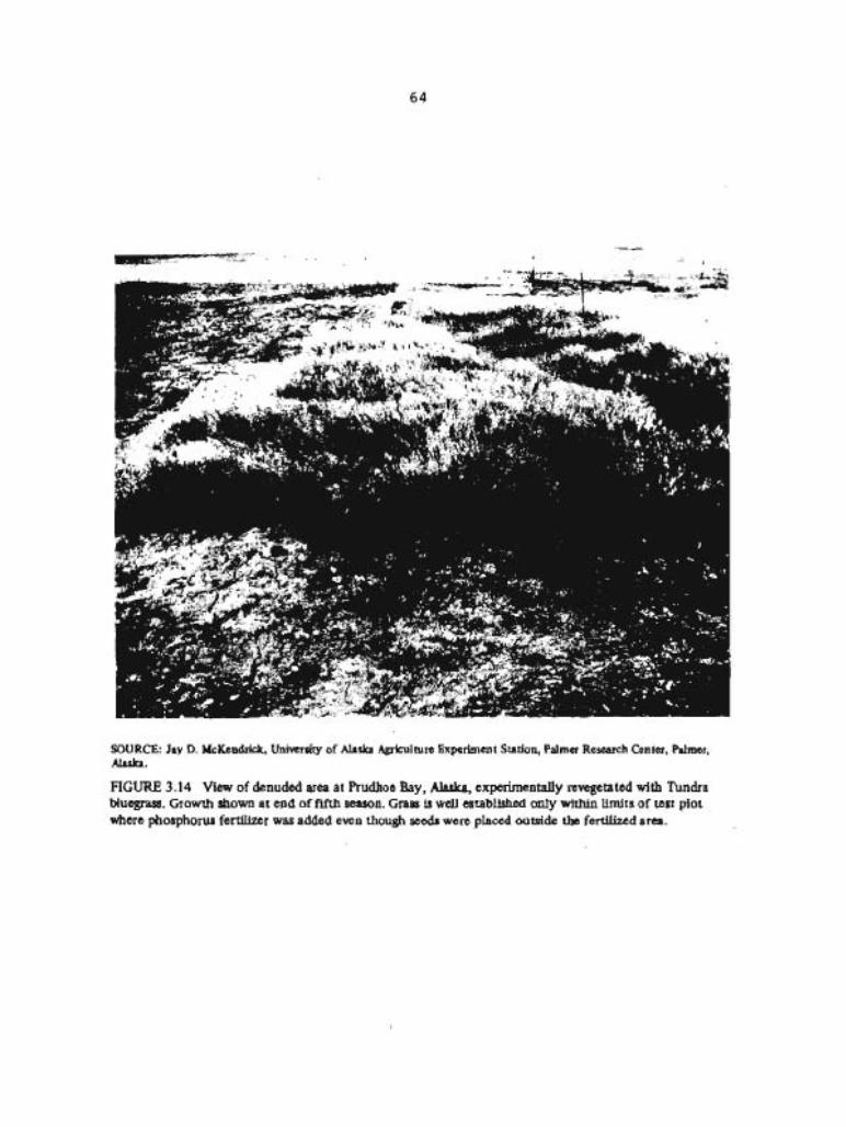
SOURCE: Jay D. McKeodrick, University of Alaska Agriculture Experiment Station, Palmer Research Center, Palmer, Alaska.
FIGURE 3.14 View of denuded area at Prudhoe Bay, Alaska, experimentally revegetated with Tundra bluegras. Growth shown at end of fifth season. Grass is well established only within limits of test plot where pho~phorw fertilizer was added even though seeds w e n placed outside the fertilized area.
some plant species and locations there is a deficiency of potassium, sulfur, calcium, magnesium, and iron.
Regardless of the species selected for revegetation, it is generally agreed that seeding is required to speed the recolonization of large barren areas in the tundra. The availability of a suitable supply of seeds, however, is no guarantee that vegetation can be successfully reestablished. The natural conditions that affect seed germination and plant establishment must also be favorable. Unless optimum conditions exist, several years may go by before seedlings are successfully established. Billings (1974) notes that (1) the temperature must be sufficiently warm (20° to 30°C) for germination to take place, and (2 ) germination must occur early enough in the growing season so that adequate root establishment and plant growth can develop before the onset of seasonal weather conditions in which temperatures remain below freezing. Preezeup comes very early some years, and the timing of planting can be critical. Billings further states that ". . . seedlings must not be exposed to drought in the latter half of the summer before toot systems have penetrated to a reliable water supply" (1974, p. 418). He also notes that "The more [climaticallyl severe the tundra environment, the fewer are the years in which all these conditions are met and in which there is a good chance of seedling survival" (1974, p. 418).
Not all tundra has an inherently slow rate of natural revegetation, however. Tundra sites in northwestern Alaska that have been heavily trampled, such as in reindeer and musk ox corrals, have been reinvaded rapidly by native and introduced plants when seeds are present, according to unpublished observations by personnel at the Alaska Agricultural Experiment Station. ~ative sedge (carex biqelowii) and introduced grasses and clovers produced nearly a 100 Percent ground cover in a single season in the musk ox corrals. Prior to revegetation the corral areas were totally devoid of plants. The corral conditions, however, probably differ from those in areas where surface mining and reclamtion might be carried out on the North Slope. A thin surface layer of soil is present (though somewhat mixed with underlying materials as a result of trampling) , the site is heavily manured by the oxen, and quantities of plant seeds are present in the hay fed to the animals. Furthermore, native sedge is a good seed producer and is a natural colonizer in this region. This same sedge species occurs in much of the moist tundra of the North Slope, but it has not been studied for its usefulness in revegetation of tundra. Willow, alder, grasses, and a variety of herbs have invaded roadsides and excavation clearings near Unalakleet, and similar natural revegetation has been noted on the Seward Peninsula.
In research on revegetation of tundra areas on Rmchitka Island, Mitchell (1976) found that native plants produced an insufficient seed crop for revegetation experiments, but plant materials native to the mainland of Alaska, especially certain grasses, grew quite well on some parts of the island. Mitchell also observed, however, that because of the nutrient-deficient soils, fertilization was essential for the development of good stands of grasses in the first year. His

research demonstrated that plant cover could be established under the severe climatic conditions of the island,
Two species of grasses, Poa glauca and Arctagxostis latifolia (Komarkova and Webber 1978, Swanson 1979), have been observed in increasing qbundance on disturbed tundra sites. These two grasses are geographically distributed beyond the Arctic, and strains found in the boreal region and on the Arctic fringe have proved to be good seed producers under commercial farming conditions in the Matanuaka Valley. They are presently being used successfully by the oil industry in revegetation projects in Arctic Alaska and would seem to have considerabla promise for revegetating areas disturbed by surface coal mining.
According to Mitchell (1979), P. glauca (Tundra bluegrass) is particularly recommended as a component of seed mixes for revegetation in the Arctic Region. A. latifolia (Alyeaka polargrass) is also useful for revegetation of Arctic areas and for moist to moderately wet sites south of the Brooks Range. Because of a tolerance to a wide range of conditions, sourdough bluejoint reedgrass (Calamagrostis canadensis) can be used for revegetation throughout mainland laska. Its seedling vigor, like that of Alyeska polargrass, however, is low (Mitchell 1979).
In the Healy area a successful program of revegetating reclaimed areas has been carried out since 1971. At the Usibelli mine, sandstones and shales above and below the coal, and which break down readily, are used as seedbed material to which appropriate nutrients, mainly phosphorus, potassium, and nitrogen, are added. Specially seleated grasaes and legumes are usad for revegetation. The species used, although not native to the area, grow rapidly and, according to Conwell (1977) , grasses planted in May can be cut for hay in August. Self-sustaining growth is establi~hed within 3 years of initial seeding. Fertilizers added during this growth period are no longer required after the vegetation becomes aelf-sustaining. Native species have not yet reinvaded the area.
Alaska has about one-third of the Nation's water resources, but detailed hydrologic information for the State is mostly lacking. Nonetheless, for most parts of Alaska, the general behavior of streams is known, and broad generalizations about the quality and quantity of water can be made (Balding 1976, U.S. Geological Survey 1978). The following information on the Alaskan hydrologic regime provides a backdrop for analyzing the appropriate provisions of PL 95-87.
3.1.4.1 Surface Water
The general distribution of streamflow within Alaska is shown in Figure 3.15. The mean annual runoff generally increases from less than 0.5 cfsm (cubic feet per second per square mile) along the Arctic

SOURCE: U.S. Department of the Interior (1978a).
FIGURE 3.1 5 Average annual runoff in cubic feet per second per square mile. (To convert to inches, multiply by 13.6.)
SOURCE: Robert D. Lamke, U.S. Geological Survey, Anchorage, Alaska (Written communication 1979).
FIGURE 3.16 Index map showing location of gaging stations providing data for Table 3.3 of this report.

Ocean in the north, to 1 cfsm in the Interior , to 12 cfsm along the Gulf of Alaska, and to 30 cfsm in southeastern Alaska (to convert runoff in cfsm to inches, multiply by 13.6). The mean annual runoff varies with the average annual precipitation (see Figure 3.6). Table 3.3 shows the discharges of representative streams in or near potential coal-mining areas; locations of gaging stations providing these data are shown in Figure 3.16.
Because of the extremely low winter temperaturespin the interior and northern parts of Alaska, overland runoff into the streams ceases and some streams, especially the smaller ones, freeze completely for part of the year. The seasonal flow variation is greatest in these areas. On the North Slope 90 to 95 percent of the runoff occurs from June to mid-September. In the interior 80 to 85 percent of the runoff occurs during the 5-month period, May through September, when open-water conditions exist on the rivers. To the south, along the Gulf of Alaska, there is less seasonal variation in streamflow, but about 75 percent of the runoff comes during May through September.
variations in flow during open-water periods are a function of topography and the seasonal fluctuations of precipitation and temperature. For example, in low-elevation coastal areas near Cook Inlet or the Gulf of Alaska, rains in September and October may produce flow volumes comparable to the flows from anowmelt during May and June. In low-lying areas of the North Slope and at higher elevations throughout the State, most of the flow occurs as a result of snow- and ice-melt during the spring breakup. Minimum flows generally occur prior to breakup. Streamflow is also significantly affected by meltwater from glaciers; glacial meltwater flow is largest in June, July, and August, when the temperatures are highest.
Snowmelt peaks and floods from ice jams usually occur shortly after ice breakup in the spring. Floods caused by rain usually occur in August or September. However, some runoff peaks are caused by a combination of melting of snow or glacial ice and precipitation. In some areas of the State, floods can also be the result of sudden outbursts of water from glacier-dammed lakes (Post and Mayo 1971). These floods generally occur in the spring or summer but may occasionally take place in the winter. They are not common, however, and it i a unlikely that they would affect actual mining of coal, although any flooding of stream valleys, whatever the cause, could damage bridges and roads essential to coal development.
Another type of flooding common to Alaska is caused by the formation of excessive ice in stream channels, This ice formation (called aufeis or simply icing) frequently spreads beyond channel banks; any runoff from snowmelt or rain then floods out over the ice surface or alongside the ice.
Glaciers, which cover about 4 percent of Alaska, occur predominantly in the coastal mountains along the Gulf of Alaska and in the Alaska Range (see Figure 3.11). They are an important part of the hydrologic regime because of the vast amount of water stored as ice, some of which is periodically released as meltwater. This meltwater affects both the quantity and quality of the surface runoff of large numbers of streams. It augments the streamflow of many streams and
TABLE 3.3 Approximate Mean Suspended Sediment Loads and Concentrat ions f o r Var ious Discharges o f Representat ive Streams i n or near P o t e n t i a l Coal-Mining Areas i n Alaska
DlCK CREEK NEAR COROOVA ( I ) ~
Latitude: 60°20'32* tong i tude: 144°18'10'L Drainage area: 7.95 ml Average discharge: 127 ft3/ sec.
PePlod o f record: 1971-78 Glaciers: OX o f area Meanelevation: 890 ft.
Small coastal stream Hunber o f saaples: 28 Sediment curve fa l r l y we1 1
def ined a t lower djscharges.
Percent o f time . I 5 10 25 50 75 90 Discharge ( f t 3 l rec.) 800 460 310 170 71 78 8 Load (tons/day) 1 OW 301r 1W 2.5 0.35 0.05 -- Concentrations (mg/l) 5W 24f 12+ 5.4 1.8 1 .O - -
NIN#CHlK RIVER AT ICINILCHIK ( z ) ~
Latitude: 60*02'56" Lonsi tude: 1 51°39'48" Dralnage area: 131 m i 2 Average discharge: 105 ft3/ sec.
Period o f record: 1964-78 Glaciers: OX o f area Hean elevation: 670 f t .
Percent o f tl 'F 1 5 10 25 Discharge ( f t Isec.) 500 300 190 110 Load ( tons/day 1 14W 35 12 9 Concentration { n g / l ) ?W 43 23 W
HATAWSKA RIVER AT P&?ER (315'
Lat i tude: 61°36'34* Period o f record: 1952-73 Lonqt tude: 149*04'16" Glaciers: 12% o f area Drainage area: 2,070 m i 2 Mean elevat ion: 4,000 ft. Average discharge: 3,857 f t3/sec.
Small lowland stream NuRber o f samples: 300+ 01 Sedfmnt curve wel l def tned UI
but scat te rs consfderably.
Large g l a c i a l stream Number o f samples: 287 Sediment curve poor ly defined
a t lower discharges.
Percent of time 1 5 10 25 50 75 90 Discharge ( f t 3 / sec. ) 18,000 14,000 12,oWl 6,1QO 1,200 590 470 Load (tons/day 1 300.O[K)* 150.000 100,000 30.000 1,300* 40* -- Concentration (mg/ I ) 6.000t 4,000 3,000 . 1.806 400' 25* --
5' NHumber I n parenthesis corresponds w i t h l oca t i on shown I n Figure 3.16.
= od - = ' S . C =gs b; N " 0 " 82%- ! 2 a - r * 2 VI -. - u m c m $uz *>zz ..I* 'C ln* .. w u
w o o O!kEE g z z g z s z z , m - z E 5 , S ~ r m w L W ~ E ~ O L W w - 0 0 JAne a o d u
h m h ..
g z ; :
m u l l l h L D 1 1
b - 8
O O O N m m -
E8Em *

TABLE 3 .3 Continued
t a t j t ude : 63'12'32" Longitude: 148 14'49" Dralnage area: 36.2 m i 2 Average discharge: 42.2 f t3/sec.
Percent of tfne 1 Discharge ( f t 3 f sec. ) 390 Load ( tons/day) 300. Concentra t ton (mg/l) 3W
Period o f record: 1965-75 Glaciers: OX of area Mean elevation: 3,100 ft.
b a l l m u n i a l n stream hber of samples: 16 Sed lmnt curve fa1 r l y we1 l
defined, b u t pofnts scat ter .
L a t l tuhe: 63*50L43" Long i tude : 1 48"56' 37" Drainage area: 1,910 ml Average discharge: 3,515 f t3/sec.
Percent o f time 1 Discharge ( f t 3 / sec. ) 17,000 Load ( tonsf day) rn,000* Concentra t l o n (mg/l ) 6,-
NEW RIVER NEAR t i E A l Y ( 8 1 1
Perlod of record: 1950 -78 Glaciers: 4% o f area b a n elevatfon: 3,500 ft.
Large g l a c l a l muntaln stream. HuAber o f samples: 60 Sedlnent curve not def ined
below 2,500 f t3/s. Consid- -4 erable scat te r o f data . P
La t i tude: 64'44 '28" Longitude: 155*29'2Zn Drainage area: 259,000 la+* Average discharge: 166,900 f t3/sec.
Percent o f ti '$ 1 Discharge ( f t /SeC.) ~00,000 Load { tons/day) 2,000,000* Concentration (mq/l) 1,lW
Wlaorv RIVER AT RUBY ( 9 ) '
Period o f record: 1956-78 Gladers : 1% of area Hean elevation: 2,640 ft.
Large r i v e r HuAlber of sanples: 25 Sedinent curve f a l r l y we1 1
deflned except a t mid-range
Number i n parenthesis corresponds ~ 4 t h l aca t lon shDrm In Figure 3.16.
TABLE 3 . 3 Continued
MAKE RIVER NEAR WE ( l0 )d
L a t l tude: 64'33'51" Longttude: 156°30'26H Oralnage area: 85.7 mi Average discharge: 178 f t3/sec.
Period o f record: 1965-78 Glaciers: OX of area Mean elevation: 632 ft.
Small coastal stream Number o f samples: 21 Sedfment curve poorly defined
a t lower discharges.
Percent o f time 1 5 10 25 50 75 90 Dtscharge ( f t 3 l sec . l 1.800 770 420 190 61 26 20 Load (tons/day 1 260 50 14 2.6 0.2* -- -- Concentration (mg/l) 54 24 12 5.1 I* - - --
KUFARUK RIVER NEAR DEAWRSE (1 l )g
Lat i tude : 7P1#'54" Long$ tude: 148 57'35" Drainage area: 3,130 m i 2 Average discharge: 1,292 ft3/sec.
Perfod o f record: 1971-78 Glaclers: 0% o f area Mean elevatlon: 900 ft.
Large Arct ic Slope lowland r l v e r . Rumber of samples: 30 Sediment curve poor1 y def lned 4
and data scat ters considerably. w
Percent o f tim 1 5 10 25 50 75 90 Discharge f f t3 lsec.) 23.000 5 . W l 2.300 310 13 0.1 0.03 Load ( tons/day ) 7 ,000* 220 W I* -- -- - - Concentration (m g'l ) loo* 15 5* I* -- -- --
NOTE: SedInent values I ls ted are m a n values ; loads and concentrations f o r a glven discharge may have a iarge range o f values depending on the season. ðer samples were co l lec ted on a r l s l n g o r f a l l i n g stage, and upon the care taken I n co l l ec t i ng the sample. Discharges shown are m a n d a i l y s t r e a ~ f l o n s tha t have been equalled o r exceeded durtng the per lod o f record f o r the glven percentage of time. Sediment values 1 i s t e d are a t the indicated discharges, are f o r i l l u s t r a t i v e purposes only, and are not meant t o be used In any ana ly t i ca l procedures. They were derived from instantaneous suspended-sedlment curves by graphical procedures. The s ta t i on d a t a are shwn i n usual U.S. Geologjcal Survey order number sequence. (* = esttmate based on extension o f data o r sparse scattered data. )
c/ -/umber i n parenthesis corresponds w i th locat ton shonn I n Figure 3.16.
SOURCE: Robert D. Lamke, U.S, Geological Survey, Anchorage, Alaska, w r i t t en c m n t c a t i o n , 1979.

sustains the summer flow of others. A notable feature of many glaciers is the diurnal variation in flow rate, with high peak runoff occurring in the late afternoon on warm sunny days. Glacier meltwater is characteristically milky in appearance due to the presence of finely powdered rock called glacial flour.
Lakes cover about 1 percent of the State, and it is estimated that there are more than 3 million of them. The larger lakes were generally formed as a result of glacial scour and related processes. Many small lakes and ponds formed where glacial debris dammed up small valleys or where depressions were created in deposits of clay, sand, gravel, boulders and related materials that were left when glaciers stagpated and melted. Other lakes, common in Alaska, are thaw lakes that formed as a result of ground subsidence where melting in permfrost occurred (Walker and others 1980). Most of the many lakes along the flatter parts of the Yukon-Kuskokwim Delta, the Yukon Flats, and the North Slope were formed in this way. Thaw lakes especially dominate the northern part of the North Slope Region (the Arctic coastal plain). Same of these are fairly large, ranging up to 3000 feet across (Brown and others 1968). In the National Petroleum Reserve-Alaska, lakes are estimated to comprise as much as 40 percent of the aurface area ( U . S . Geological Survey 1979).
3.1.4.2 Ground Water
The generalized availability of ground water is shown in Figure 3.17. The largest and most readily developed ground-water supplies are in alluvial aquifers along valley floors of major rivers. Glacial sands and gravels along the Gulf of Alaska and Cook Inlet are also important sources of ground water. Older, consolidated rocks, however, have small yields in most places. Yields are also small in permafrost areas because unfrozen reservoir materials are not widespread and because water recharge and discharge of these reservoirs are limited by the impermeable character of permafrost, ,which restricts the movement of ground water. Grwnd water may occur seasonally or perennially above the permafrost, in thawed zones within the permafrost, or below the permafrost. In areas of continuous permafrost, ground water is generally available only under or near the larger lakes and streams where the permafrost table is depressed by the heat from water bodies that do not.freeze completely in the winter (Lachenbrueh and others 1962).
3.1.4.3 Water Quality
Most Alaskan streams above tidal reaches contain water with less than 200 milligrams per liter (mg/l) of total dissolved solids, mostly calcium carbonates. In general, streams draining lowlands and intermontane basins and those in areas of low precipitation have more dissolved solids than those in the mountains and in areas of high precipitation. Surface waters in Alaska have a normal pH range of 6

Availab~lity of water
SOURCE: U.S. Department of the Interior (1978a).
FIGURE 3.17 Generalized availability of ground water in Alaska.

to 8.2. (About 5 percent of waters sampled have pH values outside this range. 1 The pH range for well waters is considerably wider. Water in some laskan streams has a high organic content? high concentrations of iron, and a brown color. With few exceptione, concentrations of dissolved constituents are below the limits Set by Federal and State water-quality standards, Turbidity and iron content often exceed the existing limits.
Chemical quality of ground water varies widely within the State, and dissolved-solids concentrations as high as 64,200 mg/l have been measured. However, most samples of ground water contain less than 250 mg/l of ,dissolved solids, and the water is considered acceptable for general use. Excessive amounts of iron and manganese have been found in many shallow wells, and water from below permafrost can h a v t h i g h concentrations of magnesium sulfate or sodium chloride. Some isolated occurrences of high concentrations of arsenic and nitrogen have been reported. Temperatures of ground water range from S°C (41°F) along the Gulf of Alaska to less than 1°C (34OF) in areas underlain by permafrost along the North Slope.
The amount of suspended sediment in Alaskan rivers is related to whether or not there is runoff from glaciers in the drainage area (see Figure 3.11). Glaciers contribute large amounts of very fine material, called glacial flour, to the streams that drain them. Glacial flour is difficult to remove and impairs the utility of the water. Glacial streams draining the Alaska Range have normal summer suspended-sediment concentrations of 500 to 2,000 mg/l (see Figure 3.18) although concentrations are less for normal summr flows in most glacial streams elsewhere. It seems mlikely that surface c w l mining would add significantly to the natural md'imt lotding & lueh streams, although any contributions of aruagencted aedimernlc in excess of amounts specified in applicable laws i r prohibted by the Act (S 515 (b) (10) (B) ( i ) )
Suspended-sediment concentrations are highest during flood peaks and lowest during low-flow winter periods. The percentage of fine materials is greater for glacial streams than for nongla~ial streams. Most nonglacial streams have sediment concentrations of 1Css than 100 mg/l in summer and less than 20 mg/l in winter. Table 3.3 lists the approximate mean suspended-sediment loads and concentrations to be expected in representative streams in or near potential coal-mining areas.
Temperatures of surface water range from O°C (32OF) in the winter to summer maximums of about 15OC (5g°F) on the lowlands of the North Slope to about 20°C (6E°F) in the Yukon River Basin. Streams along the Gulf of Alaska generally have summer maximum temperatures near 15OC (59°F). Streams draining glaciers are generally cooler in summer than nonglacial streams because summer flows are augmented by meltwater from the glaciers.
3.1.4.4 Hydrology of Major Coal-Bearing Regions
3.1.4.4.1 Arctic Reqion. The most evident hydrologic feature of the coastal lowlands during the summer i s the abundance of surface

In milligrams per Illel
r r l
S W fm streams M I Q I M ~ I ~ tn th~s afea4stresms passing Mrwgh conlam 50-nl00 mglll
SUMMER NORMAL CONCENTRATION OF SVSPENOED SEDIMENT MI ALASKAN STREAMS
SOURCE: U.S. Department of the Interior (1978a).
FIGURE 3.1 8 Summer normal concentration of suspended sediment in Alaskan streams.
water in lakes, swamps, and tundra (Brown and others 1968). Surface water is plentiful because infiltration is very limited, and evapotranspiration rates are low. Most of the water ie in the thousands of small thermokarst lakes, which are essentially closed basins. Many of the lakes are shallow and freeze solid during the ' winter. Deeper lakes do not freeze to the bottom and may be a limited source of water in the winter.
Mean annual runoff generally is about 0.5 cfsm or less in the lowlands and is 1 cfsm or more at higher elevations. The duration of flow in streams draining low-elevation areas is limited. The preponderance of flow and the annual maximum peak discharge are caused by snowmelt and occur just after breakup, usually in early June. Flow rapidly decreases, and in the major rivers there generally is only a minor response to summertime precipitation. Freezeup occurs about mid-September. However, streams with headwaters at higher elevations have a delayed and prolonged snowmelt runoff, are more responsive to sumertime precipitation, and are more prone to have high-flow periods or floods resulting from precipitation. Figure 3.19 shows the general seasonal trend in streamflow for lowland streams and mountain streams.
Almost all of the streams on the North Slope have no-flow periods during the winter. The few streams that flow throughout the winter have a ground-water source such as a spring or seepage, which is generally indicated by the presence of aufeis (icings). Larger rivers generally have water in storage underneath the ice in isolated deep pols.
The suspended-sediment load in streams is low for average summer flows: concentrations are generally less than 20 mg/l for streams on the low-gradient coastal plain. Concentrations during high flows are in the 200-mg/l range. The streams that originate in the mountains seem to have sediment concentrations in the 1,000-mg/l range during peak flows but much lower concentrations during normal flows. This information is based on an extremely limited set of data.
The limited amount of streamflow data collected in the Arctic is sufficient to make generalizations about seasonal variability but is inadequate for estimating discharges at other unmeasured sites. The records available are of short duration and have been made at only a few gaging stations. The amount of water-quality data for the Arctic is also limited; a number of streams and lakes in the National Petroleum Reserve-Alaska have been sampled once or twice (National Petroleum Reserve in Alaska Task Force 1978).
The water quality of streams and lakes is good during the summer open-water periods. Concentrations of dissolved solids are generally less than 100 mg/l, though they can be higher near the coast. Organic materials can impart a brownish color to the water, making it undesirable for drinking. Analyses of water samples from scattered locations have indicated a pH of less than 6. During the winter, dissolved-solids concentrations may increase markedly because of the lack of streamflow.
Ground water in continuous permafrost regions is very limited (Williams 1970). Not only is the ground-water storage capacity small because most pore spaces in host materials are filled with ice, but
r Lowalevat ion streams
SOURCE: Robert D. Larnke. U.S. GcologEcal Survey, Anchorage. Alaska (Written communication 1979).
FIGURE 3.19 Monthly contribution to total annual stteamflow in the Arctic Region.

the restricted movement of ground water and the limited exchange between surface water and ground water impedes the recharge of those ground-water reservoirs that do exist. potential reservoirs for ground water are the thawed zones that are present above the permafrost table in large river systems, under deep lakes, and below the base of the permafrost. Except for permeable strata below the permafrost, however, these potential reservoirs are relatively small.
Very little is known about the quality of water within permafrost. At some places, water quality of thawed portions of permafrost and of the active layer above the permafrost differs little from water quality of nearby streams. But in other places, pockets of very saline water have been encountered within and beneath the permafrost.
With the onset of winter, water in the active layer becomes trapped and progressively squeezed as the freezing front advances both downward and upward through the thawed soil. There may be little or no winter storage of ground water above the permafrost table. Any water that does exist is Likely to be under considerable pressure and may escape to the surface to form large patches of ice. Beneath major streams and deep lakes, however, the permafrost table is commonly depressed, leaving a thawed zone that serves as a ground-water reservoir and provides a potential winter source of water. Water may also be obtained in the winter from large streams and deep lakes.
The most prolific source of ground water in permafrost regions may be in unfrozen materials below the permafrost. The depth to these materials, however, is commonly from several hundred feet to more than a thousand feet. Furthermore, the quality of the water may be low because of dissolved mineral matter; the water may be undrinkable.
3.1.4.4.2 Interior Reqion. Streamflow data have generally bean collected only on the large streams. Seasonal variations in streamflow for three representative streams of the Interior Region are shown in Figure 3.20. Mean annual runoff is about 1 cfsm. The runoff is greater in streams draining high elevations, particularly those streams with glaciers in the headwaters. ~ o s t of the annual flow in streams without runoff from glaciers occurs in the snowmelt period, May through July; June generally has the highest sustained flows. However, the highest sustained flows in the large streams with glaciers in the higher elevations occur later, in July or ~ugust, because of additional melt from glaciers.
Most of the peak discharges result from snowmelt. Occasionally, the peak discharge for the year is caused by precipitation, or by precipitation in combination with snowmelt; these peaks usually occur in July or August. Generally, about 90 percent of the flow occurs during the open-water, ice-free period from early May through mid-October. Low flow in all perennial streams occurs in March or April, prior to breakup. Many streams with small drainage areas and steep slopes or at high elevations have periods of no flow during the winter. Some of the smaller streams flow only during high-intensity rains or snowmelt.
SOURCE: Robert D. Lamke, U.S. Geological Survey, Anchorage, Alaska (Written communication 1979).
FIGURE 3.20 Monthly contribution to total annual streamflow in the Interior Region.
Ground water in the present mining area near Healy exists mainly in sedimentary rock formations. Yields are less than 100 gallons per minute from these formations. There are very few wells in the area, however, and ground-water data are therefore limited.
For most areas in the Interior Region the sands and gravels in major stream valleys are an important source of ground water. Ground water in storage maintains the base flows in most of the streams during low-flow periods throughout the year.
Concentrations of dissolved solids for streams in the Healy coal-mining area average about 300 mg/l, although they can be twice as large during low-flow periods. Water samples containing dissolved iron and manganese concentrations 7 or 8 times the Environmental Protection Agency's (EPA) recommended drinking-water limits have been collected. Total iron concentrations as high as 100 mg/l have been found. A limited amount of sampling for other heavy metals and minor elements shows that they are nonexistent or at generally low concentrations. The pH values are generally greater than 7. Acid mine drainage is not a problem in the Healy area, even though several small coal mines have operated in the past. The quality of the ground water is unknown because there are no known water analyses of the few wells in the area.
The suspended-sediment concentrations in the small nonglacial streams near the present mine area at Healy are only partially known, and the knowledge derived from the few analyses available is very limited. Concentrations are estimated to be less than 200 mg/l during normal summer flows. The concentrations seem to be lower in the streams draining older, well-consolidated bedrock than in the streams draining the younger, overlying sedimentary rocks and alluvium. The concentrations seem to be highest during spring breakup and following high-intensity rains. sediment concentrationp during peak flows and winter low flows have not been measured.
Sediment data were collected daily over several years at a gaging station on the Nenana River, a large river with glaciers in its headwaters. The station is upstream from the small, nonglacial, tributary streams draining the mine area near Healy. Normal suspended-sediment concentrations during the summer are about 800 mg/l, but there is a marked decrease to normal winter concentrations of 15 mg/l. Concentrations of 8,000 mg/l have been measured during high flows. The average annual suspended-sediment load passing the station is 3.6 million tons per year, based on data for 3 years during which the average volume of flow was 2.6 million acre-feet per year. The average annual yield of sediment was about 1,900 tons per square mile per year. Streamflow and sediment data for this station are in Table 3.3.
3.1.4.4.3 Southcentral Region. The runoff in this region ranges from 10 to 70 inches per year and generally increases with rising elevations. For example, yearly runoff of streams near the Beluga coal field ranges from 2 to 4 cfsm (about 25 to 55 inches) at an average elevation of about 2,000 feet. Farther north and east, in potential coal mine areas at lower elevations, mean annual runoff is

about 1 cfsm or a bit less (about 10 inches). The ice-free openrater season is from mid-April to November, and about 90 percent of the flow occurs during this period. About half of the flow during the year occurs during the snowmelt months of May, June, and July. Peak volumes occur later in the snowmelt season in those basins at higher elevations. August generally is a low-flow month, except in those streams that have glaciers in their headwaters. Streamflow usually increases in September and October because of increased precipitation; in some streams nearer the ocean, the peak discharge for the year can occur in the fall instead of during the anowmelt period. The lowest flows for the year usually occur during February and March, prior to breakup.
Data collected in the vicinity of potential coal mine areas permit adequate generalizations about streamflow. Streamflow records have been made since 1976 at a gaging station on the Chuitna River near Tyonek and in the Beluga coal field area. Another gaging station within the area has recently been installed. Figure 3.21 presents seasonal variations in streamflow of four representative types of streams in the Southcentral Region.
Ground-water data for potential mining areas are at best sparse. However, enough data have been collected at the existing stream gage on the Chuitna River in the Beluga coal field to estimate that about 30 Percent of the annual streamflow is derived from ground water. A more detailed study of ground water in the Beluga coal field began in the summer of 1979. Because the Beluga coal field and other coal-bearing areas in the Southcentral Region have limited permafrost or are permafrost-free, the effects of mining on ground-water hydrology and those of ground water on coal mining could be much greater than in most of the other coal-bearing areas in Alaska. The limited data available" however, do not permit a rigorous assessment of the probable hydrologic consequences of mining and reclamation, as required by the Act (S 507 (b) (11) , S 510 (b) (3 ) 1.
The water quality of the small streams and springs in potential coal-mining areas is good; total dissolved solids are about 50 w/l. Concentrations are 100 ag/l or slightly more in the larger streams. Samples collected at a limited number of sites for heavy metal analyses show isolated occurrences of lead, aluminum, manganese, and arsenic in concentrations exceeding the national limits recommended by the U.S= Environmental Protection Agency. Waters containing total iron concentrations of 10 mg/l have been sampled in the Beluga area. The analyses show that other metals are at low concentrations or below detection levels. The pH was greater than 6 in all of the samples. The quality of ground water in wells generally can only be inferred from samples of springflow and of streams when baseflow is dominant. More data are needed in the Cook Inlet basin to determine the effects of surface coal mining on water quality.
Sediment concentrations in the small nonglacial streams in the potential coal-mining areas have normal summer concentrations of less than 50 mg/l and normal winter concentrations of less than 10 mg/Z. Peak concentrations may approach 2,000 mg/l in these streams. The amount of information sediment concentrations in small streams of
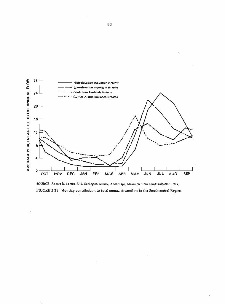
28 - - High-elevation mountam streams -- Lowalevatton mountaln streams
24 - ----- Cook Inlet lowlands streams
-.- Gulf of Alaska lowlands streams
20 -
16 -
0 I I I I I I I 1 I I I OCT NOV DEC JAN FEB MAR APR MAY JUN JUL AUG SEP
SOURCE: Robert D. Lamkc, U.S. Geological Survey, Anchorage, Alaska (Written communication 1979).
FIGURE 3.21 Monthly contribution to total annual streamflow in the Southcentral Region.

potential coal-mining areas, however, is limited1 more is known about sediment concentrations of large glacial rivers. These larger rivers have normal summer suspended-sediment concentrations of as much as 2,000 q / l t these concentrations vary with the extent of runoff from the glaciers in the drainage basin. Sediment yield for some of these larger streams has been estimated to range from 1,000 to 6,000 tons mr square mile per year. The bulk of the sediment load occurs during the summer. (See Table 3.3 for sediment loads and concentrations for representative streams.)
3.1.4.5 Water Problems of Special Importance with Respect to PL 95-87
3.1.4.5.1 Basic data. Hydrologic data are sparse for most of the potential coal-mining areas within the State. Most hydrologic data have been collected in relatively populated, accessible areas. Data for remot@ areas are mostly scattered measurements made only once or twice at a site (see Feulner and others 1971). Such informetion does not lend itself to regional evaluations, quantitative assessments, or predictions of the hydrologic effects of coal mining, as required by the Act (S 507 (b) (111, s 510 tb) ( 3 ) 1 .
Although techniques or models for regional hydrologic assessment are available, very little w t k has been done in Alaska to collect and compile the data and to develop the hydrologic relationships necessary to use them. However, surface-water data are adequate in some areas to estimate regional flow characteristics and to determine general relationships for a drainage basin. &Leo, adequate water-quality information is available to define the general inorganic chemical characteristics of most Alaskan streams. Nonetheless, little work has been done to define the basic hydrologic and physical processes controlling the occurrence, transport, or deposition of dissolved and suspended materials. Except for the few urbanized areas, ground-water data are insufficient to develop or verify methds for estimating ground-water occurrence or the quantities available.
Several problems in data collection are unique in Alaska. Data collection is expensive in much of the State because access for all. practical purposes is limited to helicopters, fixed-wing aircraft, or boats. Instruments that function reliably under Arctic conditions *
have yet to be developed for many types of data collection, and the short days and cold temperatures limit data collection in winter. Because of limits of funding and manpower availability, data collsction has been concentrated in areas where coal development appears most likely.
The amount of time needed to collect meaningful data varies. For example, daily streamflow data should be collected for at least 5 years and preferably 10 years in order to be statistically significant. However, if several years of daily streamflow data have been collected at nearby gaging stations in areas having similar physical and climatic characteristics, 2 or 3 years of discharge measurements made systematically throughout the seasons may be sufficient to define the streamflow characteristics at a specific
site. In general, for those areas where some long-term data collection has been made, the time needed to collect and interpret additional hydrologic data to be used at a specific site or for a small area will be shorter than in areas for which there are sparse or no data.
3-1-4-5.2 Water quality. The water quality of streams could be affected by surface mining in several ways (Zemanoky and others 1976) . Suspended-sediment load (and turbidity) might increase in the runoff from the mined areas, particularly during snowmelt and rainstorms, as compared to the natural conditions prior to mining. Heavy metals or other potentially toxic substances might be carried from the overburden in mine runoff, either in dissolved or suspended form. Another potential problem is acid mine drainage. A possibility also exists that, as a result of coal mining, organic concentrations might increase and dissolved oxygen concentrations might decrease downstream from the mine (Zemansky and others 1976).
The amount of sediment added to a stream by mine runoff will vary seasonally and with mining practices. The impact will be greater for uncontrolled runoff than for releases that are controlled, diminished, diverted, or stopped. The significance of this probable increase in sediment might or might not be considerable. For example, discharge of sediment-laden water from the mine area into a small stream used by anadromous (spawning) fish--usually a stream with little natural sediment load--might cause irreparable damage to a fishery. is charge of the same amount of mine runoff might have only a minor impact on a larger stream used by anadromous fish, because of dilution. There might be little damage if mine runoff enters a river that has large flows and is laden with glacial silt, although even these major rivers have seasonal low-flow periods when the naturally occurring sediment concentrations are low. It cannot be said that the discharge of additional sediment into a stream is unequivocally damaging.
Increased acidity of a stream as a result of coal mining is possible and generally occurs as a result of the oxidation of sulfide minerals. Moreover, many Alaskan soils are naturally acidic. Because most streams in Alaska have very low concentrations of total dissolved solids (and bicarbonate ions), they lack the ability to buffer large acidic discharges.
3.1.4.5.3 Sedimentation ponds. Sedimentation ponds (settling ponds) may be useful depending upon the physical and climatic characteristics of the mining site. The impacts of a sedimentation pond might be more adverse than beneficial under certain conditions. For example, the construction of a poorly designed sedimentation pond in an ice-rich permafrost area could induce thawing of the permafrost and subsidence of the land surface underneath and near the pond. This, in turn, could result in failure of the dam, release of the stored sediment behind the dam, and channel erosion downstream from the dam. In Arctic areas, erosion of the stream channel would continue until a new thermal equilibrium was established between the seasonally active layer and the underlying permafrost. The increased
depth of the active layer beneath the sedimentation pond might also result in increased downslope movement of soil. This phenomenon can occur even on low slopes in permafrost areas.
It may, on the other handl be possible to take advantage of the presence of ice-rich permafrost and permit a planned subsidence, as long as the integrity of the control structure is not compromised. Shallow lakes near mines might also be used as settling ponds.
In much of Alaska, sedimentation ponds could be used only during the summer months. On the North Slope, the runoff from and inflow into these ponds would cease soon af fer the onset of winter. In other areas of Alaska, winter temperatures are not drastic enough to sharply cut off all the runoff from mining areas and from the baseflow of ground water. Ice could readily form in mine areas, on sedimentation pond surfaces, and in discharge channels. The effectiveness of sedimentation ponds could be diminished until pond ice partially melted.
Outflow Erom sedimentation ponds can be highly turbid, depending on the trap efficiency of the Pond and on the amount of very fine sediments. Sedimentation ponds are mare efficient in removing coarse sediments than fine sediments. Removal of coarse sediments can affect stream systems; lacking its natural source of coarse materials, a stream will establish a new equilibrium by modifying its sediment load, velocity, or gradient. This could result in significant channel changes below a pond (Guy 1979).
Standard practices for constructing and maintaining sediment ponds may thus be inappropriate in Alaska. However, these ponds are a recognized method of controlling sediment discharges, The decision on whether or not to use them might result from an analysis of conditions at a site and on the effectiveness of alternative methods of sediment control. Alternatives include the prevention of erosion by revegetation, by minimizing the area exposed to erosion at any given time, and by minimizing the concentration of overland and channelized flow (Guy 1979).
3.1.5 Geologic Hazards
Earthquakes, volcanic explosions, landslides. floods, and other disruptive events are relatively common geologic phenomena, and no part of the world is completely immune to structural damage or other negative impacts Erom them. Human activities in areas where geologic hazards are common differ little from those in areas where the likelihood of a disruptive geologic event is remote, except that precautionary measures may be taken to deal with the hazards. A consideration of the geologic hazards pertaining to coal mining in Alaska is important because some coal-bearing deposits, unlike those in the conterminous United States, are in highly unstable areas where mining activities could be affected significantly by a catastrophic event. Two geologic hazards in particular--earthquakes and floods--merit attention for their potential effects on coal mining in Alaska. Volcanic eruptions and gaseous explosions, although common to
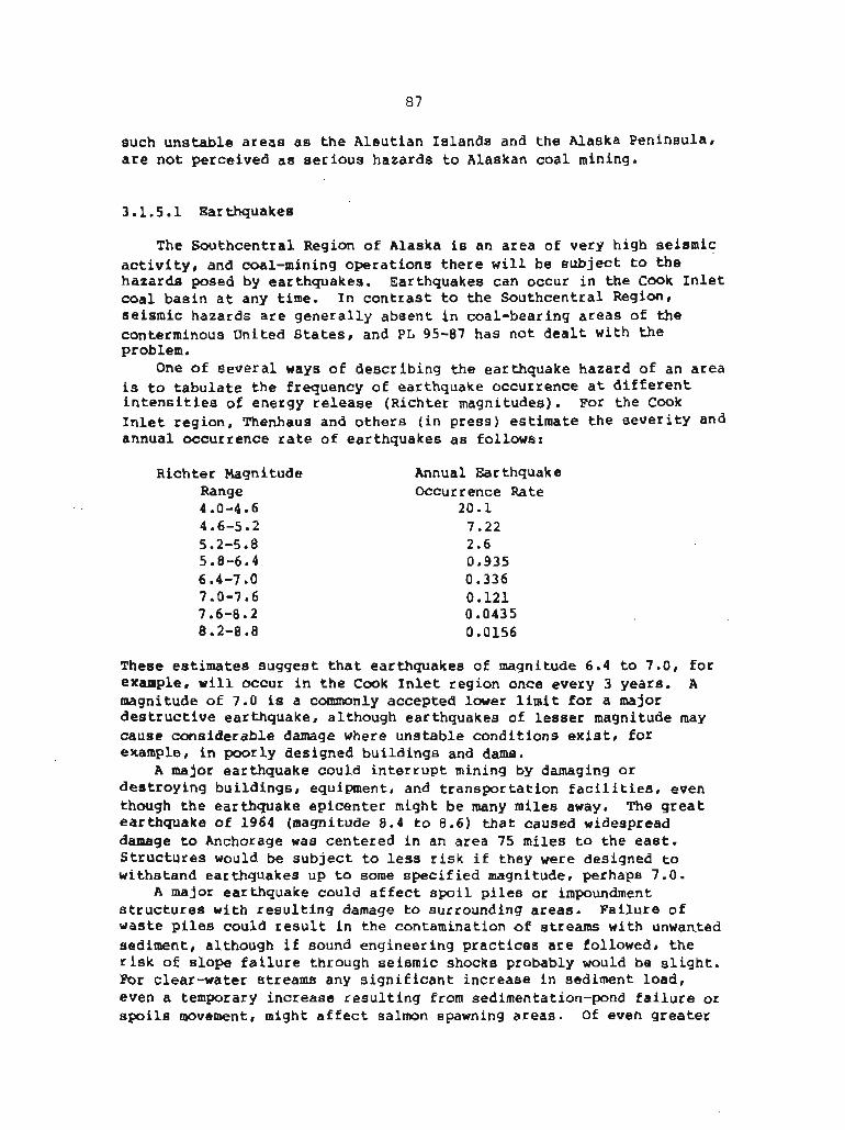
such unstable areas as the Aleutian Islands and the Alaska Peninsula, are not perceived as serious hazards to Alaskan coal mining.
3.1.5.1 Earthquakes
The Southcentral Region of Alaska is an area of very high seismic activity, and coal-mining operations there will be subject to the hazards posed by earthquakes. Earthquakes can occur in the Cook Inlet coal basin at any time. In contrast to the Southcentral Region, seismic hazards are generally absent in coal-bearing areas of the conterminous United States, and PL 95-87 has not dealt with the problem.
One of several ways of describing the earthquake hazard of an area is to tabulate the frequency of earthquake occurrence at different intensities of energy release (Richter magnitudes). For the Cook Inlet region, Thenhaus and others (in press) estimate the sevetitY and annual occurrence rate of earthquakes as follows:
Richter Magnitude Range 4 .O-4.6 4.6-5.2 5.2-5.8 5.8-6.4 6 -4-7 -0 7.0-7.6 7.6-8.2 8.2-8.8
Annual Earthquake Occurrence Rate
20.1 7.22 2.6 0.935 0.336 0.121 0.0435 0.0156
These estimates suggest that earthquakes of magnitude 6.4 to 7.0, for example, will occur in the Cook Inlet region once every 3 years. A magnitude of 7.0 is a commonly accepted lower limit for a major destructive earthquake, although earthquakes of lesser magnitude may cause considerable damage where unstable conditions exist, for example, in poorly designed buildings and dams.
A major earthquake could interrupt mining by damaging or destroying buildings, equipment* and transportation facilities* even though the earthquake epicenter might be many miles away. The great earthquake of 1964 (magnitude 8.4 to 8.6) that caused widespread damage to Anchorage was centered in an area 75 miles to the east. Structures would be subject to less risk if they were designed to withstand earthquakes up to some specified magnitude, perhaps 7.0.
A major earthquake could affect spoil piles or impoundment structures with resulting damage to surrounding areas. Failure of waste piles could result in the contamination of streams with unwanted sediment, although if sound engineering practices are followed, the risk of slope failure through seismic shocks probably would be slight. For clear-water streams any significant increase in sediment load, even a temporary increase resulting from sedimentation-pond failure or spoils movement, might affect salmon spawning areas. Of even greater
importance might be the release of noxious or hazardous materials from spoil piles and solid wastes into the surface waters, and possibly into ground-water supplies. Particulat attention needs to be given to t h e use of spoil materials in building dams and embankments for water impoundment or other purposes, as required by the Act (5 515 (b) (131, 5 516 (b) (5)) and to the stabilizing of waste piles (S 515 (b) (111, S 516 (b) (4) ) and excess spoil (O 515 (b) (22) (A) 1 .
Earthquakes can also generate tidal wavea, and because of the unusually high range of tide in Cook Inlet even under ordinary conditions, docks and other coastal structures could be seriously damaged.
Floods in Alaska can be severe because of the unusual environmental conditions in certain parts of the State. In regions where permafrost is prevalent, surface runoff occurs more quickly than in other areas because there is virtually no infiltration of water into the ground-starage system. Rainstorms on ~laaka's North Slope commonly result in high water in the snraller stream. Precipitation in the region is low, however, major storms ate idfrequent, and the large rivets are little affected by summertime precipitation. Precipitation is somewhat higher in areas south of the Brooks Range, and high water is mote frequent.
Surface runoff and the possibility of flooding are also enhanced by the melting of glaciers during the summer. Large volumes of water are released by the melting of glacial ice (see Section 3.1.4). Also associated with many of Alaska's glaciers are ice-darned lakes, which can drain suddenly and release surges of water (Post and m y o 1971) Whether the release of these waters is triggered by summer melting, earth tremors, or some other cause, the resulting floods may greatly exceed the capacity of some drainage channels.
Most of the areas of potential flooding are along certain of Alaska's major river= and are well known (see Berwick and others 1964, Childets 1970, Lamke 1972, Lamke 1979). High waters within majot river valleys would probably not affect the mining of coal because the mines would be located on higher ground away from the rivers; however, ancillary structures or facilities could be seriously affected. Bridges and roads would be especially vulnerable to flood damage.
3.1.5.3 Volcanic Activity
Volcanic eruptions constitute a hasrard only far the coal fields of the Cook Inlet basin. There are four active volcanoes in the vicinity (Coats 1950). Two, Mount Redoubt and munt Iliamna, are only 12 to 15 miles from the shore of Cook Inlet. b u n t Spurt is some 40 miles west of the Beluga coal field, and Mount Augustine is on an island well to the south. All have erupted within historic time, some very

recently. Ash from Mount Spurr has fallen on the Beluga coal field and as far away as Anchorage.
Although the impact of certain hazardous geologic events can be lessened by appropriate measures, there is little that can be done about volcanic activity. However, none of the Cook Inlet coal fields are close enough to active volcanoes to be affected by anything but the fallout of volcanic ash, and this is likely to be more of a nuisance than a hazard.
3.1.6 Wildlife
The wildlife of Alaska has unusual and diverse significance. Some aspects are particularly special to the people of Alaska; others are of broad interest and of national importance. There is deep concern within the State for the economic and cultural interactions between the human and wildlife components of Alaskan ecosystems and for any activities that might diminish the usefulness of wildlife to Alaskans. Higher proportions of the Alaskan populace engage in commercial, subsistence, and recreational uses of wildlife than in any other State. Many aspects of the fauna and the environments in which it lives are unique; Alaska's Arctic, subatcticr and marine environments have no counterpart elsewhere in the United States. Also, the fauna and ecosystems of Alaska are cbmparatively undisturbed, and hence provide unparalleled opportunities for research into the structure and function of natural biotic systems. The unique aspects of the fauna and its environments, together with unusual opportunities for research, give Alaskan wildlife a national dimension of interest. Attention is focused here on the relationships of wildlife to the economy of the people of the state--the Alaskan populace in general and to Native Alaskans in particular.
Because coal development could affect Alaskan wildlife (S 515(b)(24)), and in turn the importance of wildlife to the Alaskan economy, it is instructive to look at what animals are present in different parts of the State, the character of their habitats, their behavioral patterns, and their relationship to the economy of Alaskans. This section briefly discusses the general features of Alaskan wildlife as a whole and by region, the wildlife harvest as an element of the Alaskan economy, and the potential effects of coal development on wildlife. It also discusses factors related to wildlife that m y be important in deciding where, when, and how to mine.
3.1.6.1 Characteristics of Alaskan Wildlife
Species diversity in Alaskan faunas is low in comparison with faunas of temperate, subtropical, and tropical regions (Hustick 1970). In Alaska's terrestrial and freshwater environments biomass per unit area is also relatively low in comparison with environments in warmer climates. Marine wildlife, in contrast, is abundant in the
North P a c i f i c and Bering Sea (Gulland 1972)r r e f l e c t i n g t h e h igh primary production over Alaska 's con t inen ta l s h e l f . I n a l l of ~ l a s k a ' s environments t h e faunas are r e l a t i v e l y p r i s t i n e and e s s e n t i a l l y undi lu ted by t h e in t roduc t ion of non-Native species.
Despite t h e r e l a t i v e l y low d i v e r s i t y of spec i e s , t h e r e is a l a r g e v a r i e t y of animals, c e r t a i n spec i e s of which a r e viewed as predominantly Alaskan. These inc lude car ibou, polar bear, walrus , s e a l s , and some types of whales. Except f o r t h e polar bear , a l l o f t hese p lay a r o l e i n t h e subs i s t ence economy of many Native and non-Native Alaskans. Other animals, such aa t h e moose and some kinds of waterfowl, a r e a l s o i m w r t a n t to t h e w i l d l i f e ha rves t bu t a r e no t unique t o Alaska. S i g n i f i c a n t use a l s o is made of salmon and o the r f i s h f o r commercial, r e c r e a t i o n a l , and subs i s t ence purposes. (The v a r i e t i e s of w i l d l i f e found on land and i n waters ad jacen t t o t h e coal-bearing areas of Alaska [and some information on populations1 a r e shown on Tables 3.4 through 3.14 a t t h e end of t h e d iscuss ion on w i l d l i f e , pp. 102-112.)
A Common c h a r a c t e r i s t i c of many animals of Alaska 's t e r r e s t r i a l , mariner and fresh-water environments is their migratory behavior. The remarkable i n f l u x of b i r d s i n t o Alaska i n t h e sp r ing is we l l known; about h a l f o f a l l Alaskan b i r d species a r e h ighly migratory and many o f t h e r e s t , although remaining somewhere i n t h e S t a t e year round, have ex tens ive seasonal movements (Gabrielson and Lincoln 1959). Many marine mammals a r e migratory. The movement o f walruses , s e a l s , and whales is d i c t a t e d i n l a r g e p a r t by t h e movements of d r i f t i n g s e a i c e . Sea l s and walruses f requent t h e edge of t h e pack ice, where they can qu ick ly move i n t o o r o u t of the water. Walruses winter on t h e seasonal pack i c e i n t h e Bering Sea and t h e Arc t i c Ocean ( U . S . Fish and Wi ld l i f e Serv ice 1979) . Whales a l s o move i n response to t h e moving ice pack: some of them a l s o migrate long d i s t a n c e s t o winter ing a r e a s i n temperate waters.
Polar bears , although f r equen t ly found on sea ice, conunonly seek auk denning a r e a s on land, e s p e c i a l l y i n t h e v i c i n i t y of t h e mouth o f t h e C o l v i l l e River. Coas ta l a r e w to t h e e a s t , including t h e Prudhoe Bay o i l f i e l d a r ea , are ' used t o a l imi t ed e x t e n t " b u t land a r e a s along t h e northwestern coast (Poin t Hope t o Po in t Barrow) a r e used only r a r e ly .
Among t h e l and animals t h e car ibou a r e e s p e c i a l l y w e l l known f o r t h e i r migratory behavior, moving long d i s t ances between t h e i r summer and winter grazing a reas . Their lengthy migrat ions set them a p a r t from t h e o ther land animals of Alaska. The northern herd migrates each spr ing from winter ing a r e a s south of the Brooks Range t o ca lv ing a r e a s nor th of t he Range. Although the migrat ion rou te s are predominantly north-south, t h e r e is a l s o cons ide rab le east-west movement of t h e herd during t h e summer. The caribou herds of t h e I n t e r i o r and Southcentral reg ions a l s o migrate cons iderable d i s t ances each year. One o b j e c t of t h e summer movement is to find new forage a r e a s , bu t movement is also t o avoid t h e harassment of mosquitos and f l i e s (White and o t h e r s 1975). Mose , on t h e o ther hand, remain more o r less i n the same a r e a s throughout t h e year.
Many of Alaska's fresh-water fish are anadtomus and several fresh-water species move great distances between winter and summer habitats. Especially in the Arctic, migration is essential to find feeding grounds in the summer and to locate unfrozen pools for overwintering (U.S. Fish and Wildlife Service 1977). Most of the commercially valuable fish are also migratory and annually swim up fresh-water streams from the ocean in order to spawn.
Because migration is so common a characteristic of Alaskan wildlife, planning for resource development must be alert to the great seasonal variation in the kinds and abundance of wildlife in a given habitat, as well as the far-reaching consequences of heavy mortalities inflicted in a single location on a concentrated, migratory population. However, it should be noted that recolonization of disturbed environments, after recovery, by migratory species may be quite rapid,
Like wildlife everywhere, Alaskan species often depend heavily for a certain period of the year on only some small part of the total area they inhabit. In one sense these small parts of their habitat are no mote important to the population than any other area, inasmuch as the animal's food requirements must be met for the entire year. In another sense, however, these small areas are critical because they are either more vulnerable to natural catastrophe or human disturbance, or because they are essential to the life cycle of certain animals (nesting, calving, and denning areas). This concept of "critical habitats" has been institutionalized in statute, regulation, and management programs. Somewhat related is the belief that certain kinds of environments are more productive, biologic ally^ than others, and for that reason are critical for a number of species. Thus, wildlife managers emphasize the importance of saltmarshes, fresh-water marshes, riparian zones, floodplains, coastal beach zones, sea cliffs, and other restricted but significant habitats in making decisions on land use. and-use planning on a regional or highly local scale must be attentive to those concentrations of natural productivity.
Two general aspects of the harvests of Alaskan wildlife also are essential in the consideration of any major development program in northern environments. These are: (1) that most of the species important in eonunercial, subsistence, or recreational harvests are now being exploited at or close to maximum sustainable yield levels, and ( 2 ) that competition for a larger share of the allowed harvest, among members of one user group and between user groups, is a pervasive political as well as managerial problem. As a consequence, any economic activity which increases the total human population of Alaska is Likely to increase competition for the wildlife harvest. Equally important, any extension of the State's transportation system is likely to open up new areas to wildlife exploitation, thus changing wildlife use patterns and leading to intense political interplay among user interest groups.
3.1.6.1.1 Southcentral Reqion. The Southcentral Region has extremely diverse environments and therefore widely diverse habitats

and w i l d l i f e assemblages. Marine waters a r e muderately ta h igh ly product ive , a r e stormy, b u t ice-free. The c o a s t l i n e is extremely complex, c r e a t i n g myriad bays and sounds of varying depths- The reg ion has two l a r g e d e l t a s ( t h e Copper River d e l t a and t h e d e l t a formed by t h e Sus i tna and Matanuska r i v e r s ) , as w e l l as dozens of much smal le r d e l as, with ex tens ive t i d e f l a t and marsh h a b i t a t s . The I prominent f shery spec i e s a r e P a c i f i c salmon ( f i v e s p e c i e s ) , h a l i b u t , ~ o l l o c k s a b l e f i s h , s e v e r a l species of l a r g e c rabs , and shrimp. The oceanic mammal fauna inc ludes a r i c h assemblage of cetaceans, abundant s e a l i o n and harbor s e a l populat ions, and one major s ea o t t e r p ~ p ~ l a t i o n (Pr ince William Sound) (Alaska Department of Fish and Game 1978). The seab i rd resource is a l s o r i c h , including many surface-feeding g u l l s and shearwaters , as w e l l a s subsurface f eede r s such a s va r ious small a l c i d s , cormorants, loons, and s e v e r a l abundant s p e c i e s of d iv ing ducks (Is le ib and Kessel 1973).
The marsh and t i de l ands of t h e Southcent ra l Region a r e very important nursery a r e a s for marine Eish and s h e l l f i s h . Enormous numbers of shoreb i rds a l s o use these wetlands (and, to a l e s s e r e x t e n t , the rocky shores of t h e whole reg ion) e s p e c i a l l y dur ing migrat ion b u t also for reproduct ion, The marshes are product ive for waterfowl as w e l l , t he Copper Delta having one of the highest d e n s i t i e s of breeding waterfowl i n t he S ta t e . ~ l l members of t h e Dusky Canada goose subspecies n e s t i n the Copper River Delta area, as does t h e l a r g e s t s i n g l e group of trumpeter swans (Eing and tens ink 1971) . Wetlands i n t h e Southcent ra l Region a r e important to moose, g r i z z l y bears , black bea r s , coyotes , beaver, mink , muskrats, and o the r w i l d l i f e .
Fo res t s i n t h i s region--predominantly S i t k a spruce and hemlock along t h e coast from Seward e a s t , and white spruce and b i r ch t o t h e west and around Cook Inlet--tend t o be broken by g l a c i a l outwash, marshes, bogs , and mountain topography, c r e a t i n g a high i n t e r s p e r s i o n of h a b i t a t s . The bird fauna is l a r g e l y an ex tens ion of spec i e s t y p i c a l a E t h e P a c i f i c Northwest: there a r e few Alaskan *specialtiesm i n t h e Southcent ra l Region f o r e s t s . The mammalian fauna is a l s o t y p i c a l of bo rea l f o r e s t and c o a s t a l coni fe rous f o r e s t a r e a s to t h e e a s t and south. Except i n a f e w a r e a s where b lack- ta i led deer o r e l k have been introduced and e s t ab l i shed , t h e moose is t h e only ungulate n a t i v e to t h e f o r e s t . Moose axe very common i n some p a r t s of t h e region a s are car ibou and bears .
Use of the alpine tundra of the region is highly seasonal , wikh only a few b i r d s o r mammals i n res idence year round. I n s u m e r r p l a n t p roduc t iv i ty is moderate and forage q u a l i t y high, c r e a t i n g a vegeta t ion resource u t i l i z e d by in sec t s , insect-eat ing b i rds , a f e w herbivorous b i r d s , s e v e r a l small mammals including marmots and p ikas , and l a r g e r herbivores l i k e Dal l sheep, mountain goa t s , moose, car ibou , dee r , and (on Afognak I s l a n d ) elk.
The region has a wealth of l a c u s t r i n e and r i v e r i n e h a b i t a t s - Along mountainous coasts t h e streams a r e s h o r t and tu rbu len t , but: mostly c l e a r . Larger s t reams d ra in ing broad mountain areas o r breaking through c o a s t a l ranges from the I n t e r i o r Region tend t o be t u r b i d from silt and g l a c i a l f l o u r . Four large l a k e districts a r e i n

the region. 'Ruo are on deltas and floodplains of the Copper and Susitna rivers, one is high subalpine plateau (the Nelchina Basin), and another is a broad glacial outwash plain (Kenai Peninsula lowlands). These water habitats are essential to the region's anadromous fish and many aquatic birds and furbearing mammals-
3.1.6.1.2 Interior Region. The Interior Region is somewhat less diverse in its variety of habitats and wildlife than the Southcentral Region. It does have extensive wetland, fresh-water,'boreal forest, and tundra environments, and natural fires and permafrost add a substantial dynamism to the environments, creating ever-changing patterns of vegetation and wildlife habitats (Zasada 1976)-
The fresh-water environments of the Interior Region have low primary productivity overall, due mainly to low water temperatures, turbidity, relatively high acidity, and low oxygen levels in winter (Alexander 1972) . Resident f resh-water fish (for example, pike, whitefish, lake trout, and grayling) tend to be rather slow-growing and have comparatively low reproductive rates. However, the annual influx of salmon greatly increases the protein yield of these environments. Fresh waters and wetlands harbor a limited assemblage of boreal-adapted birds and mammals; some species are quite common. Migratory birds comprise a major portion of the bio~nass of vertebrates in these fresh-water habitats.
Wildlife densities tend to be greatest, and diversity highest in shrub and young forest communities, and lowest in mature forest (closed canopy) and spruce bog habitats (Spindler and Kessel 1980). mrse, snowshoe hares, ruffed grouse, and white-crowned sparrows typify species that are most abundant in young, open-canopied, rapidly growing vegetation; wintering caribou, red squirrels, hermit thrushes, and Townsend's warblers are typical of species most associated with mature forests. Some species (e.g., raven, wolf) are nearly ubiquitous.
Interior uplands, occurring at elevations of 2000 feet and higher, are used by nearly all bird species but only in summer. The smaller mammals are mainly year-long residents; among larger mammals some are resident (caribou, sheep, grizzly bear) and others seasonal or occasional visitors (moose, wolf).
3.1.6.1.3 Arctic Flegion. The marine areas are physically and ecologicaLly controlled by the pack ice, which moves close to or onto the shore for much of the year and which influences water temperature throughout the year. In the Chukchi and Beaufort seas, primary prduction occurs in sharp, short bursts--during spring at the lower interface of ice and water, and in summer in the upper layers of open water. Two different webs of trophic relationships originate from this primary production. One depends on detritus feeders utilizing dead phytoplankton and zooplankton (clams, worms, amphipods) and their predators such as walrus, bearded seals, and arctic cod, the other on plankton-straining feeders (euphausic shrimp), their predators, and baleen whales. The marine bird fauna is entirely seasonal, as are many of the marine mammals. Strongly ice-adapted carnivores (polar

bears, soma s e a l s , a r c t i c fox) are year-round residents t h a t m e ex tens ive ly wi th in the r e g i m e Walrus and whales a l s o are present , gene ra l ly maintaining a close associatian with t h e edge of t h e d r i f t i n g pack ice (Selkregg 1975-77). Seabi rds such as g u l l s , eiders, and o t h e r marine ducks a r e s t r o n g l y asmciated w i t h lagoon systems. Others , l i k e inurres and kittiwakeis, a r e c l i f f n e s t e r s r e s t r i c t e d to a r e l a t i v e l y few places i n the region where coa~ta l t o p g r a p h y is favor able.
The fresh-water a r e a s have extremely low y i e l d s of f i s h , b u t dur ing t h e s h o r t summer may produce huge crops of de t r i tu8- feeding and preda tory inve r t eb ra t e s , which supply t h e bulk of t h e food for large numbers of migratory birds. Wetlands doaninate as a t e r r e s t r i a l h a b i t a t of t h e tundra o f the c o a s t a l p la in . Lakes cover about 40 percent of the area . Low r o l l i n g h i l l s and mountains comprise the southern part of the ~ r c t i c Region. AS would be expected, the non-marine bird fauna has s t rong circumpolar elements, including a cons iderable number of species, r a r e elsewhere on t h e con t inen t , which a r e mainly Eurasian. Waterfowl and ehorebirds caxllgrise the majo r i ty of species and avian biomass.
Thete a r e only about 20 species of land marmals normally found i n t h e A r c t i c Region o f Alaska. Ecc;llogically, the microtines ( l e m i n g a , voles) are perhaps most irngortant i n a nusrerical and func t iona l sense. The most important manunal i n term of d i r e c t human amsumption is t h e car ibou. Found i n two d i s t i n c t herds {the Western Arctic and Porcupine herds) now numbering between 150,000-200,000 i n t o t a l , c a r i b w a r e extremely impottant suh i s t%ace resources t o Arctic people. D a l l sheep and moose i n t h e Arc t i c Region, though much less abundant than caribou, do suppor t subs i s t ence and r e c r e a t i o n a l harves ts .
3.1.6.2 Wi ld l i f e Harvests
Alaskans ha rves t w i l d l i f e for cash, food, nonfood products , and barter. Although ha rvqs t s may be ca tegor ized as corsmercialr r e c r e a t i o n a l , or subsistence for legal or managerial reasons, most Barvests are f o r a mfxture of uses. This section b r i e f l y describes t h e na tu re and magnitude o f w i l d l i f e ha rves t s i n t h e t h r e e major reg ions of the State.
3.1-6.2.1 Southcent ra l Reqion. In comparison with the I n t e r i o r and Arctic reg ions of Alaska, commercial and r e c r e a t i o n a l ha rves t s of w i l d l i f e are very important, b u t s u b a i ~ t e n c e harvests a r e r e l a t i v e l y minor. Commercial uee concent ra tes on salmon, rhellf i s h , h a l i b u t , and fur-bearing animals. Sport f i s h i n g fbr salmon, rainbow t r o u t , and g ray l ing are popular as is sport hunting far big-gam mammals such as brown bear and moose, and for c e r t a i n waterfowl. Subs is tence activities focus on salmon, and, i n many cases, are as much r e c r e a t i o n a l as food-gathering i n o r i en t a t ion . The w i l d l i f e resources of the Southcent ra l Region a r e intensively and rather thoroughly explo i t&. Few untapped populat ions exist of m y of the animal

species subject to commercial, subsistence, or recreational takes. Thus, the time-space distribution of trappers, hunters, and fishermen fairly well reflects the distribution of target species,
3-1.6.2.2 Interior Region. In this region there is little comercia1 harvest of wildlife except for furbearers and certain salmon. Subsistence harvests are widespread, utilizing salmon, other fresh-water fish, moose, caribou, and (to a lesser extent) furbearers, waterfowl, and small game. Recreational harvests occur throughout the region, concentrating on big-game species along roads and rivers, and near remote airstrips.
3.1.6.2.3 Arctic Region. Subsistence utilization of wildlife is intensive and regionwide in the Arctic (Josephson 1974) although only a few groups of Natives depend primarily on subsistence hunting as a way of life (Anderson and others 1977). For the Natives of some villages, however, the subsistence harvest is considered to be a significant element of the Native society, providing an underpinning of the social integrity of the people (International Whaling Commission 1979). (An inspection of Table 3.17 shows that ~ ~ ~ l S provide over 95 percent of the subsistence harvest on the North Slope and as seen in Table 3.18 caribou constitute over half of the total.)
Commercial salmon fishing occurs in the Kotzebue Sound area, but trapping is limited because of the scarcity of furbearers in tundra regions. Recreational hunting, mainly for Dall sheep, grizzly bear, moose, and caribou, occurs patchily in the region but is not as imprtant as it is in the Interior and Southcenttal regions of Alaska.
3.1.6.3 Effects of Coal Mining on Wildlife
The effects of coal mining on wildlife in Alaska are essentially unknown, and although there is some information on the effects of mining near Healy and from construction activities in several other areas of the State (Pamplin 1979), any assessment of impacts specifically from coal mining must be considered speculative. There has never been a large-scale coal mining operation in Alaska, and extrapolations from data on the impact of other types of activities on wildlife must be viewed with caution. Most major construction activities have not involved a study of the effects of those activities on wildlife, thus reducing severely their value as a basis for deducing impacts from surface mining.
%cause of the importance of caribou and because they are the land animals most likely to be affected by coal mining, the potential implact of coal mining needs to be examined in detail. It is, of course, risky to extrapolate from the effects of road construction, oilfield activities, and the trans-Alaska pipeline, but coal mining would also entail similar intrusions into caribou territory. The trans-Alaska pipeline project has yielded good data on short-term effects of construction activities on caribou; the long-term consequences are not yet known.

A r e c e n t i n v e s t i g a t i o n by Cameron and o t h e r s (1979) shows t h a t the Prudhoe Bay complex was avoided by car ibou, e s p e c i a l l y by cows and ca lves , and t h a t some p a r t s of t h e summer range a r e no longer being used. ~ l e i n (1979) and Roby (undated) a l s o note t h a t cows and ca lves tend to avoid t h e p ipe l ine , hau l road, and o i l - f i e l d a r eas . Bu l l s seem t o be l e s s a f f e c t e d by man's a c t i v i t i e s and according t o Roby (undated) they are even a t t r a c t e d a t times by p i p e l i n e a c t i v i t i e s , perhaps because of e a r l y snowmelt near t h e road, which uncovers e d i b l e co t tongras s flowers. Based on observa t ions i n September t h e r e does n o t seem t o be any d i s p r o p r t i o n a t e avoidance oE t h e hau l road by groups with ca lves i n a r e a s t o the south (Cameron and o t h e r s 1979). However, Anaktuvuk Pass Nat ives have stated t h a t car ibou no longer migrate along t r a d i t i o n a l l y used rou te s i n or near Anaktuvuk Pass (Hen-h and o t h e r s 1979).
Cameron and others (1979) observe t h a t because car ibou react more t o v i s u a l than t o a u r a l s t i m u l i , loud no i se s do n o t seem to alarm them. According to Klein (1973), s t u d i e s of t h e immediate r eac t ion of w i l d l i f e t o low-flying a i r c r a f t have been made, b u t l i t t l e o r no followup work has been done on the long-term consequences of d is turbance by a i r c r a f t .
I n a s tudy of t h e effect a£ 'the trans-Alaska p i p e l i n e co r r ido r on t h e l o c a l d i s t r i b u t i o n of car ibou, Cameron and Whitten ( i n p re s s ) emphasize t h a t avoidance is a r e a c t i o n to human a c t i v i t i e s i n general and n o t s p e c i f i c a l l y t o t h e p ipe l ine . This f i nd ing might be important, f o r it is reasonable t o assume t h a t coal mining would have a s i m i l a r impact on car ibou. The areas d i s tu rbed by coal mining a t any one time would be r e l a t i v e l y small, though, and t h e probable impact on car ibou is d i f f i c u l t to pred ic t .
P o t e n t i a l a r e a s of c o n f l i c t with car ibou are p r imar i ly i n t h e Arctic Region where t h e car ibou h a b i t a t encompasses a l l a r e a s of coal depos i t s . There is some ove r l ap of car ibou h a b i t a t s and a r e a s of c o a l d e p o s i t s i n t h e I n t e r i o r Region bu t v i r t u a l l y no ove r l ap i n the Southcent ra l Region (compare Figures 2.2 and 3.22).
Even though t h e a r e a d i s rup ted by s u r f a c e coal mining a t any one time is l i k e l y t o be r e l a t i v e l y small, mining's effects on t h e tundra could l i n g e r f o r some time, p a r t i c u l a r l y with r e s p e c t to revegeta t ion o f l i chens , which r e q u i r e a long time, 25 years or more, for revegeta t ion t o t ake p l ace [Palmer 1945). This is e s p e c i a l l y important to t h e car ibou because l i c h e n s a r e a main component of t h e i r winter d i e t , However, any revegeta t ion of d i s tu rbed a r e a s w i l l focus on more r ap id ly growing vegeta t ion , such a s g ra s ses and sedges. The impact of c o a l mining on g r a s s e s and sedges, which a r e favored by car ibou a s sunmrer forage, is l i k e l y to be less seve re than t h e impact on l ichens .
I t must a l s o be recognized t h a t d i r e c t e f f e c t s o f mining on w i l d l i f e w i l l be h ighly s i t e - s p e c i f i c . U n t i l a mine s i t e is known, t h e p o t e n t i a l e f f e c t s of mining cannot be assessed. In add i t i on , many d i r e c t e f f e c t s of mining on w i l d l i f e w i l l vary n o t on ly with loca t ion b u t with the mining/ transport system, including the regula tory framework under which mining is done. Given c u r r e n t knowledge of w i l d l i f e populat ions, w i l d l i f e h a b i t a t s , and the e f f e c t s of

@ Caribou Calving Areas
SOURCE: Federal-State Land Use Planning CommMon for Alaska (1977).
FIGURE 3.22 Map showing distribution of caribou rangeland and calving grounds in Alaska.
construction activities on wildlife, it is not unreasonable to assume that coal mining would have a substantial impact on wildlife in some circumstances but relatively little or none in others. The severity of the impact would depend to a considerable degree on the location of coal deposits to be mined and the effectiveness of steps taken to mitigate impacts before, during, and after mining (see Table 5.1, Chapter 5 of this report).
In general, coal mining and ancillary activities such as road construction may affect wildlife through (1) disturbance of habitats,
0
( 2 ) disruption of migration routes, (3) displacement from critical habitats (calving, denning, and nesting areas), and (4) direct kills by vehicles or other means. Such effects need to be considered especially for Alaska's Arctic Region and for parts of the Interior Regions Some effects will be directly associated with activities at the mine site; others will result from activities away from the mine site.
3*1.6.3=1 On-site effects. On-site effects of mining on wildlife ate highly site-specific. In general, however, the local effects of a carefully planned and conducted mining operation on the wildlife is likely to be small unless the site happens to be essential for a threatened ar endangered species, or the site is critically important during part of the year to a large population of a species which may have a very extensive year-round range. Such localized effects, depending on the site and nature of mining, could include destruction of fish-spawning areas, mammalian den sites, or avian nesting habitats; losses of wintering areas for resident birds and mammals; and disturbance of traditional migration routes for a wide variety of vertebrates.
A review of characteristics, habitat range, and behavioral patterns of Alaskan wildlife, particularly those spcfes now considered rare, threatened, or endangered, would alert planners to sgecific on-site problems of a proposed mining operation. If mining affects a site for several decades and reclamation is not completed for many additional years, planner$ will have to try to anticipate which species may decline to a point of special concern during a rather long span of time. Even an abundant s ~ c i e s with a wide geographic range could be harmed by localized mining. This is because of the propensity of some migratory species to concentrate in small areas at certain times of the year, perhaps for only a few days, for critical social or nutritional activities. Examples include salmon, many shorebirds, caribou, brant and geese, and certain songbirds. Disturbances of such areas may be difficult to gauge because (1) effects on the migrants are likely to be slow rather than catastrophic, and (2) other changes occurring elsewhere in the habitat of a species may make it impossible to attribute measurable population declines to any single factor. Thus, for example, even though the number of caribou foraging in the Prudhoe Bay area appears to have declined, there is no certainty that oil field and pipeline activities are entirely responsible for that decline or have affected the viability of the caribou herd.
3.1.6.3.2 Off-site effects. Off-site effects of mining on wildlife may extend over wide geographic areas. Air pollutants such as dust from construction activities and stripping operations, and sulfur oxides from mine-mouth power-generating facilities, may affect vegetation and, directly or indirectly, the wildlife (Lewis and others 1978, Newman 1980). More important, wastes generated by mining may pollute the streams of an area and be transported for long distance from the mine site. It seems likely that there could be severe impacts on fish populations. If sediment loading or toxic buildup occurs in clear-water streams, spawning fish may be killed. On the other hand, fish that can tolerate turbid waters may be little affected by increased sediment concentrations, although they may be severely affected by acid-mine drainage and by the release of other toxic materials into the streams. Without proper effluent controls it is even possible that fish populations could be completely destroyed. Impacts of coal mining could be especially severe on fresh.-water fish in the Arctic, particularly in the winter, because of limited water areas that remain unfrozen and which fish must seek in order to survive. Any pollution of these restricted waters would add to an already stressed environment--an environment in which the winter water temperature and oxygen content have decreased. Such a severe impact does not seem likely for migratory land animals because of their wider habitat range, but there is no factual basis to substantiate this view now.
Transportation systems to supply and carry products from mine sites will also affect wildlife. These systems are as variable as the mining itself, being tailored to specific mining operations. Almost any combination of existing roads, new roads, existing or new railroads, slurry pipelines, river barges, and ocean vessels might be employed. Their effects on wildlife could be small or very large. The kinds of effects could include road and railroad traffic mortalities (which, historically, have been significant with reapsct to moose in the Matanuska-Susitna-Anchorage area); losses of stream habitats through siltation downstream from road and rail crossings; stream channelization: migration barriers such as poorly constructed culverts (blocking fish passage) or railroads and pipelines (disturbing caribou and other big-game movements), death of migrating birds at transmission towers and lines; terrestrial or aquatic habitat losses from gravel removal or cut-and-fill operations; water pollution from spilled fuel and oil at construction sites and fueling facilities; in-stream effects of barge-related dredging; loss of coastal wetlands at shipping points; and disturbance of ice-inhabiting marine mammals on northern shipping lanes.
Any catalog of concerns related to surface mining in Alaska should include the effects of human population influx stimulated by coal development. Population growth stemming primarily from new jobs can be readily estimated (Kresge 1976). Geographically, the growth might typically occur (1) at the mine site or a nearby local community, (2) in major urban areas, such as Anchorage and Fairbanks, where services are provided to the development, or (3) at a regional population center such as Barrow or Kotzebue. The effects of population growth

on wildlife would include (1) small, incremental losses of habitat as new homes, stores, etc., are built, and (2) increased harvest pressures and disturbances from recreational uses of wildlife and wildland areas by the increased population. The oil-related expriences of the 1970s give ample evidence that such effects are real and important (Hinman 1974, Klem 1979).
3.1.6.3.3 Effects on patterns of wildlife utilization. Surface mining on a larse scale can be exwected to chanse the auantitiee, geographic locaiions, and kinds of uses to which wildlife is put; The numerical and geographic aspects have been mentioned already; they are tied to growth of the human population and to the changing and increased access to wildlife habitats.
Effects on the kinds of utilization are perhaps less apparent, but to a policy maker certainly no less significant. Consider, for example, changes that would take place in wildlife use if a public road were built to a surface mine in the Beluga coal field, west of the Susitna River. This area, now roadless, is utilized by upper Cook Inlet residents and visitors for rainbow trout and salmon fishing, waterfowl hunting, and moose hunting. Access is by light aircraft (using lakes and larger streams for landing) and by boat. Trophy fishing, especially, is very population; the resources of large trout are heavily used, and allocation of salmon runs between recreational and commercial fishermen is an intense public process. A road into the area would greatly intensify pressure on fish and game resource and cause management agencies to reduce bags and harvest seasons. The increased access would lengthen the season for wildlife utilizaton, too. Predictably, some persons in Anchorage who now sell fly-in trophy fishing or hunting trips would go out of business. Also, since the cost of access for recreationists would decline with road construction, nonsubsistence uses of wildlife would become more comnon. The effects of increased boating and cabin construction on trumpeter swans in the Susitna Valley already have been noted (Tim 1978), typifying the kinds of impacts nonharvest uses may have on some species.
In other regions, especially in the Arctic, surface mining could affect participation in subsistence use of wildlife, as well as the balance of subsistence and recreational uses. If there were road access from Barrow and Fairbanks into the extensive coal fields of the North Slope coal. basin, for example, the region's subsistence hunters would gain little and could lose much. Extremely high costs of vehicle purchase, maintenance, and mileage would likely prevent most current subsistence users from being able to drive the road system, Whle affording access to the countryside for nonresident recreationists and visitors.
Subsistence, commercial, and recreational uses of wildlife are cultural phenomena. Thus, any major change in opportunities for those uses, or in competition among uses, must also be viewed as a change in a cultural milieu. Subsistence uses, particularly, seem to lie close to the essence of rural Alaskan cultures. For that reason, and because opportunities for subsistence activities are limited, proposed
actions such as surface mining, which would impose substantial impacts on subsistence patterns, must be subject to especially close scrutiny.
3.1.6.4 Wildlife Considerations in Decision-Making
The lack of knowled& of the relationships of Alaska's wildlife to industrial activities limits our ability to assess rigorously the potential effects of coal mining on the fauna and its environments. Nonetheless, from what is known, it is possible to suggest a number of factors that should be incorporated into the decision-making process on whether, when, where, and how to conduct coal-mining operations. It is, for example, of importance to consider the ecological setting of the proposed mining and mining-related activities. Site-specific aspects of the environment and the local ecosystem should be given careful attention, recognizing that great differences exist within the States. Decisions should not rely on uncertain extrapolations of knowledge about wildlife from outside Alaska.
The nature of a proposed mine site and ancillary facilities with respect to wildlife habitats merits special attention in any decision to mine. For many areas this is reasonably well known, and includes such information as (1) the permanent or seasonal usage by rare, threatened, or endangered species, (2) the significance of the area to the well-being of widely distributed species, including migrants, (3 ) the importance of the site for subsistence, recreational, or commercial wildlife utilization, and (4) the sensitivity of habitats surrounding the mine site to pollution effects from expected mine wastes. The relationship of the entire complex of on-site and off-site facilities and operations are also significant to the wildlife. Severe impacts on wildlife may result from mining-related activities long distances from a mine site and also should be given attention, along with on-site conditions, when assessing ecological effects of a proposed mining operation.
A careful evaluation of potential cultural effects resulting from mining-induced changes in wildlife populations or wildlife utilization patterns should be a part of the decision-making process. It would also be important to include an assessment of the degree of permanent loss or displacement of wildlife if mined land (and land used for other mine-related purposes) is to be converted to some other use after mining. An assessment of the effects of mining and postmining changes on wildlife should be made in the context of wildlife resources of the entire region in which coal mining is to occur. This permits a judgment as to the extent of wildlife resources and resource-use gains and losses in relation to a large, related area. Both local site planning and regional planning are essential.
Because of valid but differing viewpoints it is desirable to involve wildlife users and interest groups, and wildlife scientists and managers, as well as engineers and others with principal interests in coal, in planning and decision-making. There should also be an assurance that institutions planning and regulating the coal-mining activity adequately recognize and respond to the dynamic nature of

ecologic systems and, as well, of human uses of and priorities with respect to wildlife. Lastly, for any proposed mining operation there should be an assurance that there are adequate funds to mitigate, ameliorate, or prevent losses, insofar as current knowledge permits, of wildlife resources due to mining operations or to gauge the extent to which such losses cannot be prevented or mitigated.
3.2 SOCIOECONOMIC CONDITIONS AND COAL DWELOPMENT
The composition and distribution of Alaska's population, the existence of Native cultures and local Native economies, the State's limited transportation system, and land-use questions (see Table 3.15) all have an important bearing on coal development in Alaska. Of these, however, the most significant is how the culture and economy of the Native population may be affected. This is not to imply that the potential impacts of coal development on non-Natives are unimportant. It is the Native population, however, that gives coal development in Alaska a unique dimension. The following discussion accordingly gives special attention to the Natives.
3.2.1 Population and Population Density
The population of Alaska in 1970, as determined by the census, was 302,361. It was estimated to be 416,400 in 1978. Neatly one-fifth of the population is made up of Aleuts, Eskimos, and Indians. Because Alaska has some 586,400 square miles, the population density in 1970 was 0.5 persons per square mile (see Table 3.16), a very low figure indeed. The population density of the entire United States (including Alaska) in 1970 was about 55 persons pet square mile, a density 100 times greater than that of Alaska.
In both the conterminous United States and Alaska the population is concentrated in urban areas and is very unevenly distributed in rural areas. In Alaska about half of the 1978 population lived in the State's three largest cities (Anchorage, Fairbanks, and Juneau). Thus, the actual population density of nonurban Alaska is significantly less than the average E o ~ the State.
Alaska's three major coal basins are in very sparsely settled areas. Although population data on the coal basins themselves are not available, the basins lie in census divisions for which data do exist. The North Slope coal basin is in the Barrow division, which had a population of 2,663 in 1970. The population density of this area of about 31,000 square miles was 0.04 persons per square mile. The population was--and still is--mainly concentrated in the town of Barrow and the villages of Wainwright and Anaktuvuk Pass so that in fact most of the region is uninhabited. The Nenana coal basin lies in the Yukon-Koyukuk census division, where the 1970 population density was about 0.1 persons per square mile. The Cook Inlet coal fields are mainly, but not entirely, in the Kenai-Cook Inlet census division, whose population density in 1970 was 1.1 persons per square mile.

TABLE 3.4 Large Mammals, Birds, and.F ish i n o r Adjacent t o Coal F ie lds o f the North Slope
W l a t l o n o f w l y 300,OW. they a m constantly a 8 l o d a t d 4 t h pack Ice d r e a m t . I e s l h t s o f Y l l r r r l ph t 4md Point l ay v r l v l l y harvest the largest mrkr o f seals pm prm for w b s ~ s ~ r .
Iln Ilportmt arct ic uawmger r d f-m. occurs ~rouphwt tlw area.
Occwr thrapb#t tbc a m . Ylnter I n s l t l a a m rrrtrrt 41- the middle tolrlllr R l n r a d I t s t r l b t a r l r r - up tr tm mow rpu r r t m t l r k*r o s ~ m d m tl* EFrt l l . film klrrm Ut I f t l l k a d kwkkm* film.
k y occw -t the a m . D m s l t l n wry frol I krr par 50 spulm mlles, te I krr per 100 *re dl-. lblt t l p w t r n t h b l - t a t I s l o c r t d a l m g a l l u v l ~ l w l l e y b o t t a mr r t w r s .
l h ~ sa@rtlm I s e r t l ~ t e d r t a0.000. Mlva- tlm tLmvpb tl* krllg St rb l t occurs I n l a te b y d Jme. and tl* popllat lon s u n I n tht CMcbI Sea. -fort Ssl. 4rd 18- tlw f o r l e t coost.
mt o f I t s w l v l n g a m . Rw f l r l d r l 8a c m m the winter of the C m t r r l l r c t l c Catlbou kd.
b r r tn tl* C W h l kr 4- e#nl&rcd to b r Hprnb poprlmtlm f r a Uou l a tk k r u - fort Sea. TI* ChrLcbt popuh t tm I ldsrs rpproxl- r b l y 2.m l l d l r t& ls . t ~ l t r l m l dcrmlm areas a m c r t t l ca t hr M a r bear s w l v a l a d b m s e l h l* c ~ r r m t r a t l o n occur w l U l n 30 .Has o f th c lus t l l n .
30c o f ttm krt r t e r f w l k b f t a t 1. lkrU -la. Cwlng the short a r c t k s u r r e l r a l d l l t m b l rds u y migrata t h q h the a m . stopping to f e c d a d m t on tlw vwl l pndr thrt Qt th trndra Iadscap.
An e s t l u t e d pop th t lon o f 10.000 Indlr l&ls. C w t n t r r t l o n s =cur a t lcrkpuk Lake ud r l a w Uw Colv l l le R l v e r delta.
h t l c co lm lc r 4 n gewally small. averq lng fnr kndred bl rbr a t -st. W r . c o l m l n
im Cape 1- to Cap 1Iskw-m lrppwt over 500.000 Indlvl* lr l r .
E n d a m H e s . found nestlnp rhty the c l l f f s o f the b l v l l l e Itlm dralnrgc. and a l o q thr frankI1m Mufh a m a thr u s t bmk ~ . f tl* SapvantrLloL Hnr.
Whe b l v l l l c Ilw I s tht r j o r rorr*r of cm- c m t r a t d f 1 8 h q ef for ts I n Ue arct lc. II -18 e r r r c l a l f f r k t y exlsts a the Co lv l l l e delt.. rh lch k r v e s t s m avenge o f 20.W least clsco a d 10.000 arct lc c4sw CIC1I year.
Occur thmugbit Ula f ie ld . b m s of -tat aknbnce a m along tk foothills and .omUlw of the I d s Arngr. Packs o f wolves r r a w over a dtstance o f 1.000 spurn dkr.
EMnpend spc les of reat i q w t i r r e i n t e r n o f I*t~rc trad~tPon 4 d *tstence. Est lu tcd p ~ p l l a t t o n o f 1.100 mlgntes t h m q h Lhr Berfng S m l t a d t w t h r d a l m q the coast b s u r I n the Dewfort S&. Ilfgratlon r w t e t h h -tat l ce I d s win- cldes wtth m s t p robb le arct tc I l p p i a g rats%.
Endrngemd s p d c r . T k mtltc enlstlnp r l a t l on mlgrates thrwph the Wl S t A l t to s-r a d feed ~n tlw t ~ c h t t .
to 5,000 &le t mtgrate s m s a u l l to % thukchl a d leaufort Seas. k l d k s concmtrate I n er tvr r les b feed. a& law wgrcplt lons u y be f a d a t Pt. Cay. Mlgrattoa mute colncldes wltb mt m b l r 4 ~ t k ShSppl~p tat-.
Other Yhrles
thy occaslocuily occur. F l h k . k r p b c k . k l l l w , mlde. a d ru-I.
The mst ublqul tan I c e - l n h r b l t l ~ w1 o f r r r t t c a d lu*zrc t lc blarka. fhe total rlwad SHI popr lat lm o f thc ChuLeht a d bmufort Seas caceds om l l l ) l o n . t t I s a r t l r t e d tbt 2S0.000 a n h i l s occur In a m % of Id- fast Ice alone.
S p c c l s swh as rhlkilsh. payl lag. Q I I y rurdcr. and bwbot oavr v t thr! a m .
SOURCE: Canplled by L.L. Selkregg, Untversity o f Alaska. w i t h the assistance o f Lance Trasky, Alaska Departmnt o f F i sh and Game, 1980.

TABLE 3.5 Large Mama1 s, '~ irds , and Fish T
B h a d Endangered specles o f great tnportance I n Whale t e r n o f Hatlve t rad l t l on and subsf stcncc.
Es t lm ted vpu la t lon of 1,000 nlgrates through the Berlng S t r a i t arad northward along the coast to s m r I n the Beaufort Sea. Mgrat ion route through coastal Ice leads wlncides wl th m s t probable a rc t i c shlpping routes.
Gray Endangemd specles. The en t i re exlst lng Whale population migrates through the Berlng
St ra l t to smner and feed i n tdw Chukchl Sea.
Belukha U p t o 5 , 0 0 0 w h a l e s m l g r a t e s ~ ~ n a l l y t o Whale the Chukchi and Beaufort Seas. Belukks
concentrate i n estwr les to feed, and large aggregatlom my be found a t Pt. Lay. Mjgration mute coincides wl t h m s t probable arc t lc shlpping routes.
Other Hay occasionally occur. Finback, m k , Whales k i l l e r , nfnke, and narwhal.
Rf nged The nost ublquf tous Ice-lnlr lbl t l n g seal Seal o f arc t lc and subarctic Alaska. The
to ta l ringed seal population of the Chukchi and Beaufort Seas exceeds one mil l ion. I t I s estfmated that 250,000 an im l s occur In areas o f l i d - f a s t I ce alone.
Bearded Population o f roughly 300.000, they are Seal constantly associated wlth pack i ce
movement. Residents o f L l nw r i gh t and Pofnt Lay usually harvest the largest number o f seals per person for subsistence.
Fresh- Species present throughwt the area inelude uater grayling, whlteflsh, do l ly varden, and Fish burbot. A l l specles a n u t l l l z e d f o r
danesttc use by local residents.
I n or Adjacent t o the Poin t Hope Coal F i e l d
Spotted Bertng Sea population I s estimated a t 2501000. Seal Spotted seals may k found along the en t i re
ams t o f northern Alaska during the s u w S .
Malrus The population I s esttmated a t 300,000. Hjgratlon through the Berf ng S t r a i t occurs I n l a t e May and June, and the populatfon SUA#~S i n the Chukchi Sea, Beaufort Sea, and along the Sovlet coast.
Carl bou Encanpasses a portion o f the range o f Western Arct lc Carl& herd.
CClskoxen A transplanted herd from Hunt vak Island ranges. from south o f Cape Thompson to north of Pof n t Hope. Huskoxen cannot feed I n deep snow, so they require wind swept areas ta sum1 vc.
Hoose A wintering concentratlon occurs near Point Hope on the Kukpuk Rlver.
B r f z r l y Found throughout the area; M e r , densit ies bear are low.
Wolves Occur Ulmughwt the f ie ld . Areas of greatest abundance an along the f w t h l l l s and muntains o f the Brooks Range. Packs o f wl ves nay range over a distance o f 1,000 square miles.
SMblrds Seacl i f f provlde excellent seabf rd habl tat. Over #10,000 birds nest between Cape Thorpson and Cape Llsburne.
Amdrumus A subs* stence f f shery for a n a d m u s a rc t l c Fl sh char and whlteflsh occurs a t Polnt Hope.
Ptnlc s a l m are present f n tht Kukpuk Rlver.
Waterfowl Concentrations occur a t Polnt Hope durfng spring and f a l l .
SOURCE: Compiled by L.L. Selkregg, University c f Alaska, wi th the assistance o f Lance Trasky, Alaska Departnent o f F4sh and 6;w. 1980.
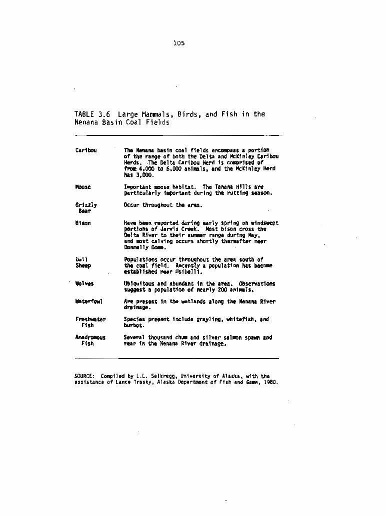
TABLE 3.6 Large Mamnals, B i r d s , and F ish i n the Nenana Basin Coal Fields
Caribou ' The WCMM basin coal f ields encolnpass a portion o f the range o f both the Delta and MeKlnley Caribou Herds. .The Delta Caribou Herd i s col~prised of fm 4,000 to 6,0110 animals, and the kKln luy Herd hrs 3,000.
k o s e Irportant more habitat. The Tanam Hi l l s arc p r t t c u l a r l y Important during the rut t ing season.
6 r i ul y Occur throughout the a m . Bcar
Bison Have been reported durIng early spring on windswept portlons o f Jarvis Creek. M s t bison cross the Delta River t o thei r s-r range during May, and mst calving occurs shortly thereafter nmr Donnelly Oorr.
Dall Populations occur throughout the area south o f shcap the coal f ield. Recently a population has beeom
tstabl lshtd near Usibell I.
blm Ubiquitous and abundant i n the a m . Obsenatlons suggest a population o f mar ly 200 m im ls .
Waterfoul A r e presmnt i n the wetlands along th k ~ n r River dralmgc.
F r e s h t a r S m i e s present includu grayling, whfteflsh, a d Fish burbat.
h d m u s Several thousand chun and s i lver salmn spawn and Flsh rear i n tha Menana River drainage.
SOURCE: Compiled by L.L. Sel kregg, University o f Alaska, with the assistance o f Lance Trasky, Alaska Department o f Fish and Gam. 1980.
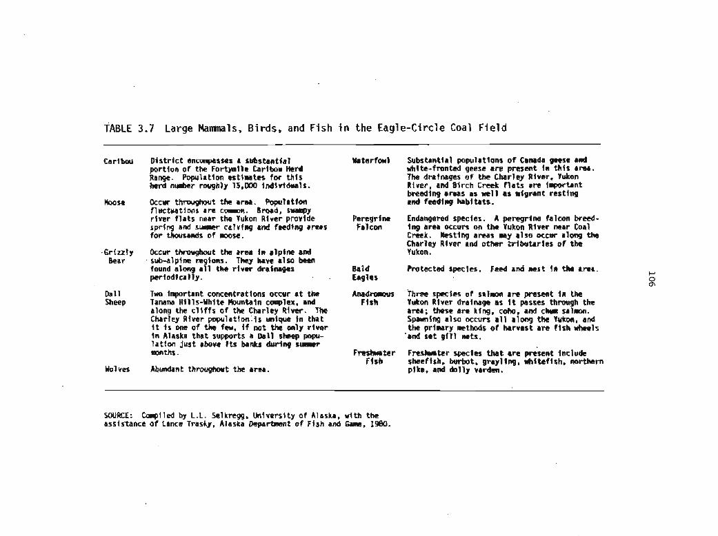
TABLE 3.7 Large Mamnals, Birds, and Fish i n the Eagle-Circle Coal Field
Carl- Dist r lc t encoApasses a substantfal portion o f the Fortpnlle Carlbou Herd Range. Populatlon estimates for th is krd number roughly 15,000 indlvlduals.
Moose Occur throughout the area. Population fluctuations are coanon. Broad, swampy r iver f la ts near the Yukon River provlde spring and s u w r calvfng and feeding areas for thousands of moose.
.Grtzzly Occur throughout the area In alpine and Bear sub-alpine regtons. They have also ken
found along a l l the rtver drainages periodically.
O a l l Two inportant concentrations occur a t the Sheep Tanana H i l l s-Whtte Hountaln complex, and
along the c l l f f s o f the Charley Rlwr. The Charley Alver population i s unique i n that f t I s one o f the feu. If not the only r lver I n Alaska that supports a Dall sheep popu- lat lon just above I t s banks during s l r r r t months.
Wolves Ablmdant throughout the area.
Y lk r fawl Substantlal populations o f Canrda geese md whlte-fmnted geese are present i n Ul ls &ma. The drainages of the Charley Iltver, Yukon Rlver, and Bfrch Creek f l a t s a re Inportant breeding amas as well as r igrant resting a d fccdlng habitats.
Peregrine Endangered species. A peregrine falcon breed- Falcon ing area occulr om the Yukon River near Coal
Creek. L s t i n g areas nay also occur along the Charley River and other Zributarles o f the Yukon.
Bald Protected specles. Feed and nest In the area, Lag1 as
Anabmmm Three spectes o f salmon are present i n the Fish Yukon River dralnagc as I t passes Ulrwgh the
area; these are king. coho. and chm salmn. Sparmfng also occurs a l l along tbe Yukon, and the primary aethods of harvest are f i sh wheels
'and set 0411 nets.
F r a s b t c r Freshwater species # s t am present include Flsh sheefish, burbot, grayling, whlteflsh, northern
plke. and dolly vardm.
SOURCE: Cmplled by L . L . Selkregg, University o f Alaska, w i t h the assis.tance of Lance Trasky, Alaska Department of Fish and Gaar, 1980.

TABLE 3.8 Large Mamnals, Birds, and F ish i n the Broad Pass Coal F i e l d
Moose
Grizzly Bear
Dal 1 Sheep
Wolves
Waterfowl
Bald Eagl es
Freshwater F ish
Common throughout the area.
May occur throughout the area.
Occupy the a lp ine regions o f the adjacent mountain range southwest o f the coal f i e ld .
May occur throughout the area.
The Broad Pass area i s a minor migrat ion route dur ing spr ing and fa1 1 .
Protected species. May occasional l y be seen.
Species present inc lude lake and rainbow t rou t , burbot, grayl ing, and whi te f ish .
SOURCE: Conpiled by L.L. Selkngg, University o f Alaska, with the assistance o f Lance Trasky. Alaska Departnrent o f Fish and Game, 1980.

TABLE 3.9 Large Mamnals, Birds, and Fish i n or Adjacent t o the Beluga and Yentna Coal Fields
Moose Aerial surveys, harvest data. and winter Waterfowl Hundreds o f thousands o f birds u t l l lze the area k i l l s a11 indlcate that the m~osa popula- fo r algratory or nesting and breedfng purposes. t ion my nrnber i n the thousands. Concen- Two major State waterfwl refuges, Susl tna tratlons o f wintering animals llay be fowrd Flats and Tradlng Bay, are located i n o r along r iver drainages, or road and r a i l adjacent to the area encompassed by the systems. Susitm f l a t s f ie ld.
B m n Occur throughut the area. bars am Tale 6eese Endangered species. fhc bmedfng gmmd Bear particularly abundant around Tyonek which establ lshes tb ls specles as a separate
V I 1 1 age and Bel uga R I ver . Suspected ent i ty from the white-fronted goose, has denning sf tes occur a t M i . Yenlo. the only recently been discovered i n upper Cook Dutch Hflls. Beluga Lake, and Ht. Susitna. In le t near the Kustatan Peninsula.
Dal l A r e present along the Alaska Range, adjacent sheep to the coal f feld, and I n the Western
Tal keetm huntaf ns . Populations for bath areas colRblned m y n&r several hundred ant ma1 s .
Wol ves Populattons appear to be 1ncreasimg. Pack sizes I n the lower Susltna Valley Increased fron an average o f 2.5 animals In 1973 to 5.2 anislals i n 1975.
Harbor Seals are p m e n t along the west shorn o f Sea 1 s Cook In le t and a mcentrst lon occurs a t
tbe mouth o f the Susitna River.
belukha Appmxlmtely 100-300 be1 u k h whales frequent Whales u p p r Cook Inlet. They are c m l y found
near the mutts of the Susitna and Beluga Rlvers during the salnon mlgratlon.
Bald k g 1 as
Peregrl ne Falcon
Anadmus Flsh
F r e s h te r Flsh
A m a l l colony ex1 sts near Ule Susltm Flats.
Protected species. Hest and fetd i n area.
Endangered species. ?lay be present, but nesting sites have not been documted.
Spawning stream dratning thrwqh the f t e ld support a l l f j ve species o f salmon. Known major spawntng areas Include portiom of the Susl tm River, Alexander Creek, Flsh Creek, Beluga River, Talachulttnr River, and Chultna Rlver. O t h e r smaller locallzed areas may occur throughout Ult regton.
Spedes that am present Include lake and ratnbar trout, steelhead, dol ly ua*dcn, grayling, klrbot, and Mi te f ish .
SOURCE: Conpiled by L.L. Selkregg, University o f Alaska, wlth the assistance o f Lance Trasky. Alaska Departmnt o f Ffsh and 6Mle. 1980.
I

TABLE 3.10 Large Mamnals, B i rds , and Fish i n the Matanuska Coal F i e l d
Brown Bear
Dall Sheep
h u n t a l n Goat
Wolves
Waterfowl
F le ld encoapllsses inportant m s e habftat. Populations l n the Hatanuska Valley and around Anchorage m y nvakr 4,000. Ibn than l0,OOO m o r e have been harvested i n the area since statehood. Y l n h r i n g con- centratlons occur near SLlp Creek. Palmer Hayflats, 8nd along the h tanuska Valley.
Occur th tougbut the arear hartver, d e n s i t t e ~ are low.
Are present along tbe Alaska Range, adjacent to the coal f le ld , and i n the Yestern Tal keetna Mountains. Populatlons f o r both areas conblned may nunber several hundred animals.
Occur on the mountains adjacent to the Rtanuska Rlver.
Populatlons appear to be increasing. Pack sizes i n the lower Sus l tm Valley Increased frola an average o f 2.5 a n l m l s I n 1973 to 5.2 animals In 1975.
Intensive use occurs a t Potter Marsh, E k l u t t ~ , and the Palmer Hayflats. Nest- i n g and m l t l n g a c t l v l t l e s =cur extensively throughout the coal f ie ld . The area encoa passes an inportant part of the trupeter swan habi tat In Alaska.
Bald Eagles
Peregrl ne Fa1 cons
A small colony o f g u l l s and terns e x i s t a t Pot ter k n h .
Protected spccies. Nests and feeds In area.
Endangered spec 1 es . Hay be present, bu t nesting areas haw not been docuwnted.
A l l f l v e species of sa lmn are present i n the ktanuska Rlver. Salmon produced I n the nitanuska Rlver contr ibute to the tom- ~ l e r d a l f ishery I n Cwk In le t . Due to I t s p r o x l d t y t o Anchorage, I ntensl ve sport f i sh lng e f f o r t occurs throughout the Mata- nuska Valley. P
0
S-les that are colnnon to t h t s area Include ia
grayling. dolly varden. burbot, rainbow trout, and whl tef lsh. They support an i q m r t a n t recreational f ishery.
SOURCE: Cofflpiled by L.L. Selkregg, Universi ty o f Alaska, w i th the assistance o f Lance Trasky, Alaska Department o f Fish and Game, 110.

'0961 'auw puo y s l j l o iuau~~eda(1 e q s q v 'LISPJI a3uel 10 a3ueas[sse ayl rlw ' e ~ s e ~ w 40 hks~aa!u(\ '66an(LaS '7.1 rCq patt-3 :XM~OS
'rpntsl LW P# * w b l l '1Wii WimI m m Jylq
'sl- OOO't
'slmb- a51 R #II se w hl mbtrlw IU
.a-+uy 4- *R Wtm wm duolpvy r( ryun wlqrdd .o~) s8aw
-IfiIa mSd hb3W W W m I m.1 s s r L n r Clbsw In uo(a* ldd (rlq
r r ~ plr * s r w rtw- w wwmm
' s l Y = 0DD.W marl- *l m l - w I- *n Jw wwt- - 1401 Y 'I*IW I-Illy brwl *R
pllllar* pm I( asI- Wa#lOlp *II ~1-34111
w m r w sb ~ W c w ~ l w r a l l 4 -41 P u w l p w m i M w m si a-41 ' s tw~ BO) m-la- r rrqn w 1 - r v W W W ~ 1. .. luonetdd op ~ # l d r r Pt8u I- *U
Plaid Leo3 !e"a>t al(2 03 aua~eFpv JO uk qskj pue 'spr!a ' s l w q ( a 6 ~ e l I I - E 3 7 ~ 1

TABLE 3 .12 Large Mammals, Birds, and F i s h i n or Adjacent t o the Bering River Coal Field
Moose
Brown Bear
Mounta I n Goat
Wolves
Harbor Seal s
Sea Otters
Whales
Area supports a population o f 96 moose. The habl tat In t h t s area f s excel lent f o r moose, and large antlered bu l l s are produced a t an ear ly age. Wlnterfng areas occur along the Bering Rlver.
Are present throughout the area. Concentra- tions occur on Martin River, Mart ln take, Shepherd Creek, Lake Tokun and S t i l lwa te r Creek. Suspected dennjng areas are located south o f Martin Lake and north o f Kushtaka Lake.
Are abundant throughout the area. t o c a l l zed concentrations occur on the north end o f the Ragged Mountains, I n the Don M i l l e r H l l l s . and on Kushtaka Ridge.
Occur throughout the area.
Are present throughout the outer port ions o f Control ler Bay. High concentration areas occur near Pt. Hey and along Okalee Channel.
U t t l I r e areas around Kanak Island, Wlngham Island, and Okalee Splt.
Several specles nay occur offshore, these Include the blue, sei, minke. f in, hunp- back (endangered), and k 1 1 I e r whales.
Porpoises Three species occur: these Include the Oall and Harbor porpoise, and the P a d f f c White- sided Dolphin.
Sea fire distr jbuted along the coast. Lions
Ma ter fowl
Trunpeter Swans
Bald Eagles
Peregrine Fa1 con
Seabl rds
Freshwater F i sh
During the peak period of migration, laon than 50,000 bfrds may be present. Total waterfowl use probably exceed 250,000 b i rds i n the sprlng and 350,000 i n the f a l l .
The Control ler Bay area supports a s tab l l l r ed swan population. An estimated 50 nestlng patrs, and a t o t a l population of over 350 swans are thought t o be present.
Protected spectes. Corrnonly nest and feed I n area.
Endangered specles. Hay be present, but nest- ing s? tes have not been docunented.
Colonies are present on m s t of the outer islands. Wlngham Is land and the Marttn Islands support 19,000 and 20,000 seabl rds respectively.
Sockeye sa lmn and coho sa lmn are the p r t n d p a l species present I n the area dralmges. Sockeye spawning occurs I n M r t l n Lake, Berlng Lake, Bering Rlver, and Hjchawak Rlver. These stocks support a regionally Inportant salmon f lshery.
Spe~les Include s t t c l h ~ d trout, whltct f~h, do1 l y varden, and cut throat trout.
SOURCE: Compiled by L.L. Selkregg, Universi ty o f Alaska, w i th the assistance of Lance Trasky, Alaska Departmnt o f Fish and Game, 1980.
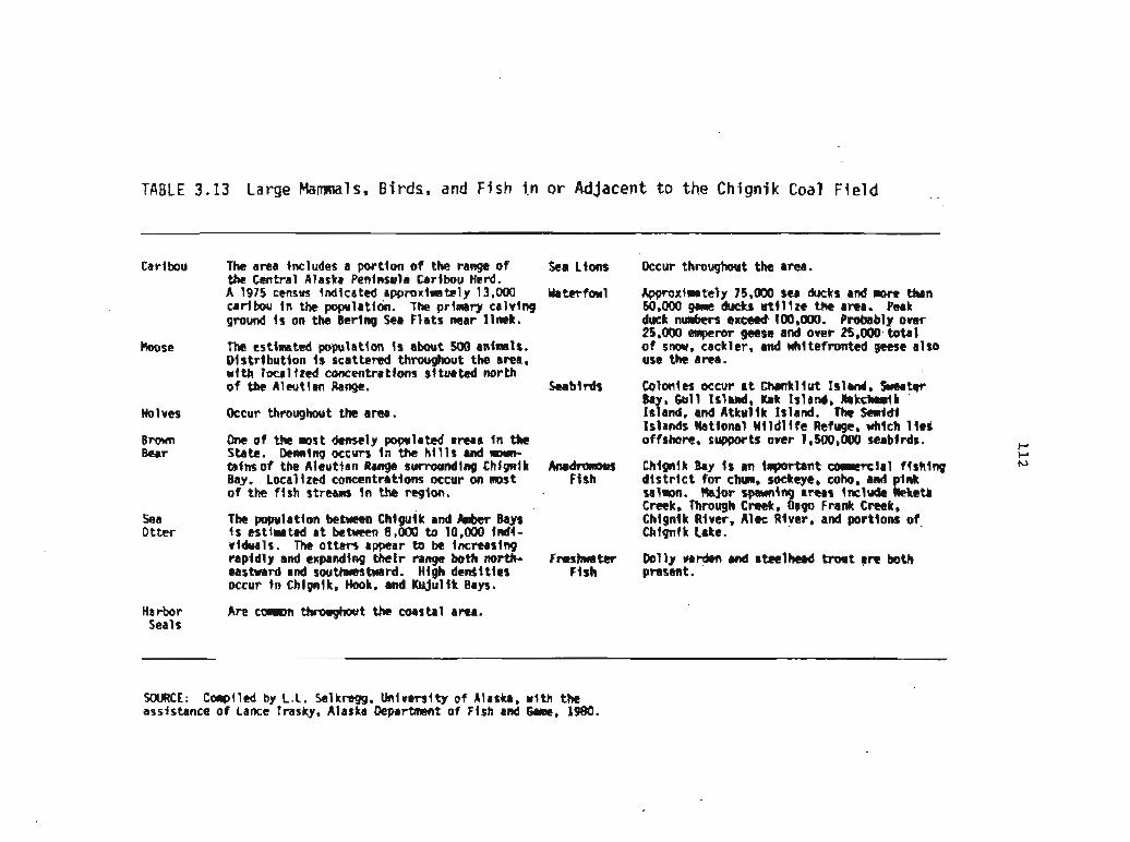
TABLE 3.13 Large Mammals, Birds, and Fish i n or Adjacent t o the Chignik Coal Field
Caribou
Moose
Idolveo
Brawn Bear
Sea 0 t t e r
Harbor Seals
The area tncludes a por t ion o f the range of Sea L f w the Central Alaska Peninsula Caribou Herd. A 1975 census indicated approxlma tely 13,000 Waterfowl caribou In the populattoir. The prlmry calving ground I s on the Bering Sea Flats near l lnek.
The estinated population I s about 5M1 anfnals. Dtstr lbut lon I s scattered throughout the a m , with loca l i red concentratlam $1 tuated north o f the Aleutlan Range. Seabirds
Ckcur thmughout th a m .
One o f the most deme'ly populated areas In the State. Dennlng occurs fn the H 11s and mn- tafns o f the Aleutian Range s u m n d l n g Chlgnlk Anadrimus Bay. tocallzed concentratim occur on most Ffsh of the f t sh stream In the region.
Tko pmpulatlon between C h l g ~ l k and Rnkr Bays f s estimated a t bebeen 8,000 to 10,000 1nd.l- vtduals. The ot ters appear to be Increasfng rapidly and expadlnp thet r range both mrth- F m l m s t c r eastward and southwestward. Htgh denSltles Ftsh occur tn Chlgnlk, Hook, and Ktrjul fk Bays.
Are camrrn throughout the coastal area.
occur thmughwt the area.
Approxtmately 75,000 Sea ducks and mrc than 50,000 garne ducks u t f l i r e tht area. Peak dwk n-rs ex- 100,OtHI. Probably o w 25.000 eqmw geese and owr 25,000 total o f snow, cackler, a d #I1 tefronted geese also use the area.
Colonles occur a t Wlsnkllut Island, -tat 8a , 6 u l l Island, Kak Island, k k c W k sfa and, and Atkul fk lslmnd. The I..;ldl Islands Mtiomal Wlldllfe Refuge, ditch 1 tas offshore. supports over 1,500,000 Seabirds. P
P Chignik Bay Is an tllrportant m r c l r l flsklng N
d l s t r l c t fo r chum, sockeye, cob, and p l d salmm. Idajor sparmlng areas Inc ludt W e t l Cmk, T)H-ough C m k , Oago Frank Creek, ChIgnIk Rtver, A1ec Rlver, and parttons of Chigntk lake.
Rlly varhen and stelhead tmt are both present.
SOURCE: Conpiled by C . L . Selkregg. Unlverslty o f Alaska. wi th the assjstance of Lance Trasky, Alaska DepartRlent of Flsh and Game, 1980.
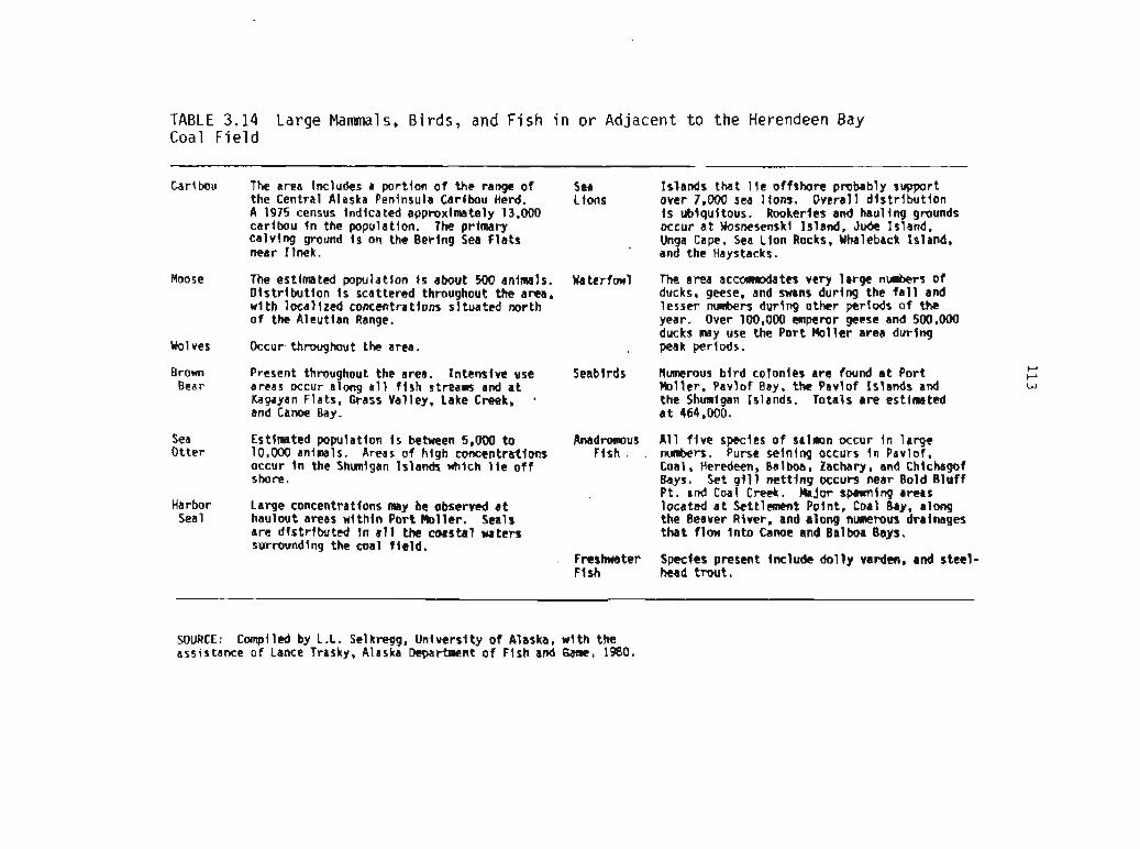
TABLE 3.14 Large Mammals, Birds, and F i s h i n or Adjacent t o the Herendeen Bay Coal F i e l d
Carl bou The area Includes a port lon o f the range o f Sea Islands that 1Ie offshore probably support the Central Alaska Peninsula Caribou Herd. Lions over 7,000 sea lfons. Overall d l s t r i b u t l o n A 1975 census Indicated approximately 13,000 I s ublqu4tous. Rookeries and haul l ng grounds caribou I n the population. The primary occur a t Wosnesenski Island, Jude Island. calv ing ground i s on the Bering Sea f l a t s Unga Cape, Sea Lion Rocks, Whaleback Island, near I lnek. ' and the Haystacks.
Moose The estimated wpula t lon i s about 500 animals. Waterfowl The area accwrmodates very large numbers of Dl s t r l bu t l on I s scattered throughout the area, ducks, geese. and swans during the f a l l and w i th loca l +zed concentrations si tuated north lesser numbers during other periods o f the o f the Aleutian Range. year. Over 100,000 emperor geese and 500,000
ducks may use the Port Ho l le r area during Wolves Occur throughout the area. , peakpertods.
Brown Present throughout the area. Intensfve use Seablrds Numerous b i r d colonles are found a t Por t k-' t-'
Bear areas occur along a l l f i s h s t ream and a t Hol ler , Pavlof Bay. the Pavlof Islands and w Kagayan Flats, Grass Valley. Lake Creek, the Shmlgan Islands. Totals are estimated and Canoe Bay. a t 464,000.
Sea Estjmated population 1s between 5.000 to Anadroarus Otter 10,000 animals. Areas o f hfgh concentrations Flsh .
occur I n the Shunigan Islands which l i e o f f shore.
Harbor Large concentratfons may be observed a t Sea 1 haulout areas w i th in Port Hol ler . Seals
are d is t r ibu ted I n a l l the coastal waters surrounding the coal f l e l d .
Fnstmater Ff sh
A11 f i v e specles o f sa'lmn occur I n large numbers. Purse seining occurs I n Pavlof. Coal, Heredeen, Balbw, Zachary, and Chfchagof Bays. Set 9111 ne t t i ng occurs near Bold Bluff Pt. and Coal Creek. Hajor spawnlng areas located a t Settlement Point, Coal Bay, along the Beaver River, and along nuRemus drainages that f low In ta Canoe and Balboa Bays.
Specfes present Include do1 ly varden, and steel - head trout .
SOURCE: Compiled by L.L. Selknqg, Unfversf ty o f Alaska. w l t h the assistance of Lance Trasky, Alaska Department o f Fish and Game, 1980.

TABLE 3 .I 5 Socioeconomic Conditions of Coal-Bearing Regions of Alaska
NATIVE ECONOMY
Heavy dependence of Natives on fh, caribou, walrus, seals, and whales for sub- istence. Some use of wild- l i fe for commercial pur- poses (walrus ivory)
Minimal subsistence hunting and fishing.
Native culture and economy , preserved in part in small
local areas, such as Tyonek rillage on Cook Inlet. Minimal subsistence hunting and fishing in Cook Inlet area.
LAND USE
Primarily a wildlife habitat. Tundra used mainly as range- land for caribou. Some moose in major river valleys. S u b dstence hunting and fuKing.
Coal development at UdbelIi mme. Rangeland for Dall sheep, bison, caribou, and moose. Occasional sport huntlng. Rural settlement.
Locat farminp in Matanuska Valley and on Kenai Peninsula. Gas and oil production. Sport hunting, f ~ i n p , and recreation. Rural settlement. Some timbering locally. Urban development (industrial and residential).
POPULATION I TRANSPORTATION
Population 2,600 to 3,000, of Area is isolated from surface ground accessand which 87 perwnt are Natives. has no internal ground transporbtion system Population concentrated largely except for a segment d Yukon River-Prudhoe Say at Barrow, Wainwright, and haul road. Air transportation between some AnaLtuvuk Pass. Most of region cmstd communities and major cities and uninhabited. Population villages in the Interior, moatly for pansengers density 0.OQlsquare mile (1970) and light haulage. Major freight by ship to coastal
localities dwing ice-free season.
Population 4,700 to 5,000 of No ground transportation system except in Fairbanks which 48 percent are Natives, and environs and l o d y in the vicinity of most of whom live in scattered Nome. Alcan hghway between Alaska and Canada small villages. P o p s tion terminates in Fairbanks. Alaska Railroad oper- density O.l/square mile (1970) ales to the south from Fairbanks and serves
Ilealy Creek coal f ~ l d . River transportation avail- able on Yukon and othe~ major rivers. Air transport between most communitics, mostly For passengers and light haulage.
Population 14 .W to 15,000 of Limited ~ o u n d transportation system mostly in which 1 percent are Natives. the vicinity of Anchorage and to the north and mwt of whom live in scattered east. Alaska Railroad central to Cook Inlet small villages. Population area and available toserve Matanuska and other density 1 . l l ~ u a r e mile (1970) cml fields. Ocean access to Anchorage and other
locations. Air transportation between Anchorage and most lo& communities.
REGION
Y I- V
e C a P
BASIN
.
g Z 5
g
FIELD
Arctic coastal plain fields:
Meade River ColvilIe River,
etc.
Mixed subsistence and cash economy among Aleuts
-
Kenai
Kenai offshore
m? 4
& 0 a ;Y
5
I
-1 u & C. 2 w U
Bering River
ChIgnik - Herendeen Bay
- 4 0
E .-
5
. 6
g
. m .
e - 24 o
v -
' Foothills fElds '
Point Hope
Healy Creek Lignite Creek Iarvis Creek Wood River Tatlanika Tektanika
Eaglecircle
Broad Pass
Local Native villages
Yentna
Beluga .- a "
Matanuska

TABLE 3.16 Comparison of Alaskan Population with t h a t o f Other States (1970 census)
Overall Popula t lon
Region Area Popul a t lon Persons per Percent (square miles) square mile Natlves
Alaska 566,400 302,361 0.5 16.5
Conterminous Unlted States
Population I n Coal -8earlng Regions P P VI
West V i rg in ia 24,181 1 ,744,000 72.5 ---- I l l i n o i s 56,400 11,114,000 199.4 ---- Montana 147,138 694.000 4.8 5
Barrow (Arctlc Region)
Yukon-Koyukuk ( Interior Region)
Kenal-Cook I n l e t { Southcen tra 1 Region)
SOURCE: U.S. Department o f Comnerce f 1978).
The extremely low population densities of the coal-bearing areas of Alaska are in strong contrast to those of the conterminous 48 states (see Table 3.16). In West Virginia the 1970 population density was 72.5 persons per square mile. In Illinois it was 199.4, and in Montana 4.8, Even in Montana the population density is much greater than in the coal-bearing areas of Alaska. In short, Alaska's coal fields present a marked contrast to the coal fields of the conterminous United States, where, as in Pennsylvania, there are large metropolitan areas within a coal basin. In Illinois there are large strip mines scarcely 35 miles from metropolitan Chicago. There is nothing similar in Alaska. Even though Anchorage is on the edge of the Cook Inlet coal basin, it is isolated from any potential surface mining by the waters of Cook Inlet and Turnagain Arm.
3.2.2 Native Economies and Subsistence Harvest
3.2.2.1 Native Economies
Native economies in Alaska have traditionally relied on the land and the sea to provide food and other necessities. Although the importance of hunting and fishing have waned over the years because of the growth of a cash economy, they continue to be an important means of livelihood in village Alaska and make the Alaskan Native economy unique. With few exceptions, however, a subsistence economy in the classic sense of complete dependency on the products of land and sea has vanished from Alaska. Nonetheless, natural resources are still of considerable importance to the villages, The high cost of commercial food products delivered to the villages means that fish, caribou, seals, walruses, and whales remain valuable because they are available. Eskimos, Aleuts, and Indians all hunt or fish for these animals with considerable expertise.
The need for cash to support subsistence activities and the acquisition of subsistence equipment--rifles, snowmobiles, outboard motors, and whaling gear--has made the subsistence economy dependent on, and therefore interrelated with, the cash economy (U.S. Geological Survey 1979). This dependence and interrelationship is exemplified by the wide use of snowmobiles, which have replaced dogs as the principal mode of travel andmtransport throughout much of the north. Indeed, this change in mode of travel has been one of the most dramatic changes with respect to Native life (U.S. Department of the Interior 1974b). Any analysis of subsistence patterns must consider how cash is distributed, since any change in the cash economy in which the Natives participate w i l l affect subsistence patterns.
The general trend among the Natives of Alaska appears to be toward greater dependence upon a cash economy. The number of people who can switch from a subsistence to a cash economy within their lifetime is unknown, however, and there clearly are many people and communities
'
that want to adapt to changing conditions on their own terms, There are also a few groups, such as the Kuuvanmiit Eskimos, that want to maintain a purely subsistence economy (Anderson and others 1977).

The transfer of ownership of Federal land to private Native corporations as a result of the Statehood Act and the Alaska Native Claims Settlement Act introduces a new element into the Native economy--the potential for profit-making enterprises through which the Natives could derive direct cash benefits from the land. The Arctic Slope Regional Corporation now owns some of Alaska's best coal land along the Chukchi Sea coast and the Kukpowruk River. How the Natives perceive the trade-offs between placing certain cultural values at risk compared to increased cash is not known.
3.2.2.2 subsistence Harvest
The subsistence harvest comes from the sea, the rivers, the lakes, and the land (see also Section 3.1.6.2). The proportions differ for each community because of the diversity in the kinds and distribution of animals, and the population, demographic composition, and the technology of the communities. The degree of dependence on the subsistence harvest likewise differ8 for different communities and regions of the State, being in general much greater for the Natives of northwestern and ~ r c t i c Alaska (including the Bering Straits Regional Corporation, the North Slope Native Corporationr and the Northwest Alaska Native Association).
For many hundreds of years, seals and fish have been the dominant components of Eskimo and Aleut subsistence. Birds, whales, and invertebrates (such as the sea urchins and octopus) have also been important. There is presumptive evidence that invertebrates are an especially important part of the Native diet in the ice-free areas and that there may be an important link between diet, bone mineralization, and length of life (Laughlin and others 1979).
A household survey conducted on the North Slope showed that almost three-quarters of the adult population had engaged in subsistence activities during the 12 months prior to the survey (Kruse 1978-79). According to the survey, the subsistence harvest provided members of an average household with 49 percent of the food they consumed in 1977. Older people with limited income were found to be particularly likely to get a substantial portion of their dietary needs from subsistence products, which are high in protein and nutritional value. A 1974 survey of all households in the Arctic Region, conducted by the Joint Federal-State Land Use Planning Commission (see Patterson 1 9 7 4 ) , also shows the extent to which subsistence activities are critically important part in the livelihood of Alaskan Natives (see Table 3.17). In another survey in the Arctic Region, the same Joint Commission (1975) revealed that the barren-ground caribou account for 52 percent of all the meat harvested, followed by the bowhead whale (29 percent) (see Table 3.18).
Subsistence activity is not limited to North Slope Natives. The inhabitants of northwestern Alaska, represented by the Northwest Alaska Native Association and the Bering Straits Regional Corporation, also value the subsistence harvest highly (see Table 3.17). According to an unpublished report of a community survey conducted in 1978 by

TABLE 3.17 Es t imates of Subsistence Harvest ( i n pounds)
Ber ing S t r a i t s Regional Corporation*
Population Berry/ Comnunl t y (1970) Manmals F ish - Fowl - Green Vep - Total
But k l and Deer4 ng K iva l ina Noatak Kotzebue Selawik Noorvik Kiana Ambler Kobuk Shungnak -.-. - Tota l Pcunds 2,892.975 1.436.049 47.017 132.184 4,508,229
Average Pounds per Person
N o r t k s t Alaska N a t i v e Association+ -
Population Berry/ C o m n i tx (1 970) Mamnal s F ish - Fowl - Green Veg - Total
Gambel 1 356 453,845 24.200 10,000 1,500 489.545 Savoonga 354 549.700 2.500 4.000 2.200 558,400 Diomede 82 525.080 2,300 3.400 725 531.505 King Is land 200 EST 99.943 21,278 4.550 9,800 135.571
Brevig Miss ion 118 47.275 9.233 1,180 4,200 61.888
Sh ismre f 249 604,980 8,250 2,982 6.655 622.867 T e l l e r 192 43,005 15,129 2.080 6.400 66,614 Wales 121 133.330 3.795 797 7.100 145.022
El im Golovin Koyuk Nome Shaktool i k S t . Michael Stebbins Unalak leet whl t e
h u n t a i n
Tota l Pounds
Average Pounds per Person
A r c t i c Slope Nat ive Corporation**
Population Berry/ Conmuni t y (1970) M a m l s Fish - Green Veg Total - Fowl - Barrow 1.905 1,734,600 61.400 7.600 - 1.803.600 Wainwright 41 7.250 550 1.200 & 419,000
Total, Pounds 2,151,850 61.950 8.800 2,222,600
Average Pounds per person
SOURCES: *Patterson (1974), * * Jo i n t Federal -S ta te Land Use Planning Commission f o r A laska (1975).

i LC, m c x -- 0
the Northwest Alaska Native Association (NANA), 66.2 percent of the people responding to the survey in the smaller villages, and 45.1 percent of those in the village of Kotzebue, still considered caribou to be their main source of meat. In the year prior to that survey, 93.8 percent of the residents of the smaller villages and 82 percent of the residents of Kotzebue reported that they shared their subsistence food with other villagers.
Along with migratory birds and caribou, the bowhead whale is essential to both the subsistence and culture of the coastal Inupiat. The continued quota on the number of whales that can be killed annually is viewed by the Natives as a serious problem (Henoch and others 1979). Whaling is a traditional part of their culture, being an important cooperative venture in obtaining food. It is reported that nearly half of the Natives on the North Slope are actively engaged in spring whaling (Kruse 1978-79). Most of them live in Point Hope or Barrow,
The trapping of foxes, wolverines, and other animals is also part of the subsistence activities of Alaska's Native population. Trap lines may cover great distances, and the use of different lines in succeeding years may draw upon large areas.
Although the harvest from subsistence hunting and fishing is of major importance to Natives of northern and northwestern Alaska, the subsistence harvest is also important throughout the State. The degree of dependence on subsistence is related, to a considerable extent, to the locations of the villages and the opportunities for participation in the cash economy of the State. Accordingly, Natives in the southern part of Alaska appear to be less dependent on subsistence than those in the northern part. There is, nonetheless, a. strong desire by most Natives to preserve traditional subsistence aspects of their culture. For the Cook Inlet region reliance on subsistence hunting and fishing is found primarily in the few old villages like Tyonek, Ninilchik, and Port Graham (Olsen and others 1979). In the central part of the State, where Native villages make up a greater proportion of the population centers, the subsistence economy becomes increaeingly important. And in the northern and northwestern parts of the State, where villages are largely Native, the subsistence economy has a dominating influence on the way of life.
3.2.3 Transportation and Access
3.2.3.1 Development of Alaska's Transportation System
The transportation system of a geographical region reflects its economic development, the requirements of its population, and the technology available to construct transportation facilities. In Alaska the transportation system is very limited (see Figure 3.23) because economic development has not yet required more extensive transportation facilities. A few years before World War I1 the Nation~l Resources Committee (1938) found that Alaska's landmass of 586,400 square miles was served by about 2,500 miles of dirt and
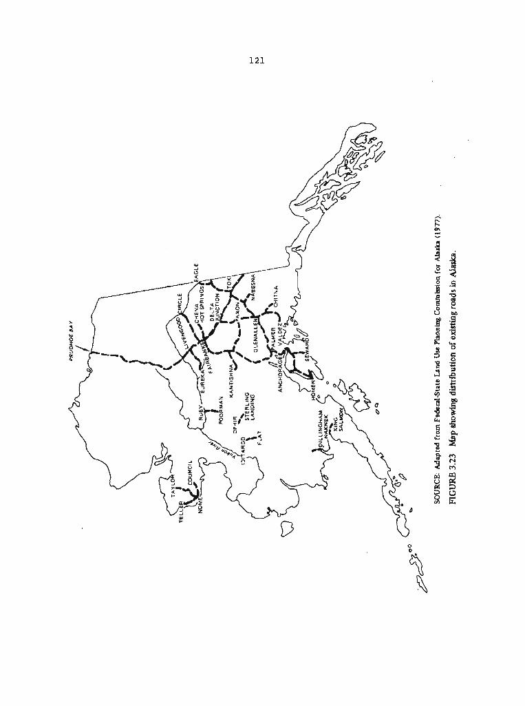

gravel roads and trails along with a few rail lines: The Alaska Railroad (operated since 1923 but never quite completed) utilized a oingle track of 470 miles between Seward and Fairbanks, the White Pass and Yukon Railroad connected the port of Skagway with Whitehorse in the Yukon Territory of Canada, and the Copper River and Northwestern Railroad, now abandoned, served Cordova and McCarthy. (The Copper River and Northwestern Railroad ceased operating in 1938.) Air and water transportation were also used, both within Alaska and between Alaska and points outside the State. After studying Alaska's geography, development, and population, the National Resources Committee recommended further development of the air, river, and coastal transportation facilities. The Committee recommended against the extension of existing road and rail systems.
In the years following the Japanese invasion of the Aleutian Islands in June 1942 and during the postwar defense buildup, the transportation system in Alaska changed considerably. By the end of the last fiscal year before statehood (June 30, 1958) , the number of miles of roads and trails had doubled, the Alaska Highway through Canada was built to provide a year-round continental land link to the conterminous 48 States, the right-of-way of the Alaska Railroad had been upgraded and its locomotives transformed from coal-burning to dieael-burning engines, new or enlarged port facilities had been created at Whittier, Seward, and Anchorage, and air transport facilities had been expanded to accommodate multi-engine craft. In the years following the achievement of statehood there was a shift in emphasis from extending the road system to upgrading existing roads (a change brought about by the standards imposed by the Federal highway assistance programlt other developments involved the need for roads that could be used for defense purposes, and the preference of the growing urban population for private automobiles. By June 30, 1973, the entire road system had been brought substantially up to Federal standards, but total mileage was only 4,000 miles, approximately what it had been 15 years earlier. Since then, the total road mileage in Alaska has more than doubled. Including the 810 miles of the Prudhoe Bay access road, the present road system has about 9,800 miles, of which 2,500 are paved. Except for the Prudhoe Bay road and new linke to the Alaska Highway, however, there has been very little change in the reach of the road system since 1937. Much of the increase is accounted for by the construction of multi-lane highways.
The Alaska Marine Highway System provides scheduled service to 25 coastal communities along 2,500 miles of Alaska's coastline and has connecting routes to Prince Rupert (British Columbia) and Seattle, A11 of Alaska's communities with populations exceeding 2,500 are served daily by scheduled airline service (Englemen and Tuck 1978).
In 1960 a Congressionally authorized study recommended against major tail or road development in Alaska prior to resource exploration. Short roads from specific development sites to tidewater areas were found to be more appropriate than extensive integrated road systems (Battelle 1960). Studies dealing exclusively with single modes of transportation have been made since then, but the most recent comprehensive studies (made under the auspices of the Federal-State
Land Use Planning Copmission for Alaska) have returned to these 1960 findings (see also Engineering Computer Opteconomics, Inc. 1977, Englemen and Tuck 1978, Tuck 1979).
3.2.3.2 Transportation of Coal
The Alaska Railroad served the Matanuska coal field from 1916 to 1968 and has served the Healy area from 1919 to the present. With relatively minor modifications and additions, this rail system could carry coal to a seaport for shipment to other areas if economic factors were favorable. The development of coal in the Beluga coal field in the Cook Inlet area would require minimal development of road and port facilities. The economics of exporting coal from the Nenana and Cook Inlet basins are dealt with by Englemen and ~ u c k (1978)~ who find that the generation of electricity in gas-fired generating plants and alternative sources of steam and metallurgical coal elsewhere in the Pacific basin, rather than transportation, are the key factors that limit further development of Alaskan coal. Because transportation links already exist, transportation costs would not be a significant factor in determining the economic feasibility of coal development in the Nenana and Cook Inlet basins.
An appropriate transportation infrastructure for the coal deposits of the North Slope, however, would have to be developed from scratch. Tuck (1979) uses a transportation network model to analyze the transportation costs that would arise from the development of mineral and coal resources in the western Brooks Range and northwest Arctic Alaska. The transportation starting points (nodes) used in the model are the Cape Lisburne coal field, the Red Dog deposit in the western '
Brooks Range, and the Omar River and Reed River sites on the south flank of the Brooks Range (the last three "depositsn are the hypothetical deposits of Jansons and Bottge 1977). The market destinations used in the model are Seattle and Japan. (Export of Alaskan coal to foreign countries is a matter of policy that is not considered in this report.) Four transportation systems are considered for connecting locations of mineral or coal deposits to Alaska port sites: (1) a railroad connecting Cape Lisburne with the other nodes and then connecting to the existing railroad at Nenana and thence to tidewater at Whittier; (2) a set of rail or road links connecting nodes with a port at Golovin Bay: (3). a set of rail or road links connecting the nodes with a port at Kivalina; and (4) a highway ,link from Reed River to the Prudhoe Bay haul road, then south to Fairbanks, connected by rail to the port at Whittier. Ocean-going ships would carry the coal. and mineral materials from Alaskan ports to market destinations.
Fifteen scenarios are used to evaluate these alternative systems, with variations that include different combinations of public and private construction and operation, different assumed tonnages, costs, combinations of transportation modes, and other factors, For coal and hardrock minerals, as well as for coal only, the study shows that a rail or road system able to deliver the commodities to a port at

Kivalina would be the most cost-efficient system and hence the most likely to be used. The study also finds that transportation distances on land should be minimized, echoing the conclusion of the broader Battelle report of 1960.
Usable port sites are limited, however. A study of 29 potential sites for a mrine transport system capable of moving energy resources from Alaska to external markets was made in 1977 (Engineer Computer Opteconomics, Inc. 1977). Four of the sites are in Ice Zone I (north of ~ering Strait) and 11 are in Ice Zone 11 (between unimak Pass and Bering Strait). Of the four within Ice Zone I, Kivalina is ranked first as suitable for bulk ore carriers, followed by point Lay and Point Hope. Kotzebue is deemed unsuitable for any form of transport. The required freight rates for these carriers and ports , however, are approximately four times the rates calculated for Nome and Golovin in Ice Zone 11. The Tuck analysis, in contrast to the 1977 study, includes the cost of on-land access from coal deposit to port.
In a still earlier study 'of the transportation systems that would be needed to move North Slope coal to external markets, Clark (1973) concluded that a new rail system connected to the Alaska Railroad at Fairbanks would not be economically feasible if the coal operations had to pay for all of the construction and operating costa. The study found that a rail system might be economically viable, however, if it were constructed by the State and Federal Governments and the operating costs were shared by other users. Clark noted that transporting coal to Fairbanks by truck would be prohibitively expensive under any circurnstancea. The most reasonable and potentially viable alternatives for transporting northern Alaskan coals, the study held, would be short rail lines, belt conveyors, or slurry pipelines to a coastal facility fot transshipment by sea. However, ship lanes to coastal cornunities in northwestern and northern Alaska are only open for two or three months of the year when the pack ice has moved offshore.
3.2.4 Land Use
The land in Alaska is largely unused by man, but does support a significant wildlife resource that is very important to the Native economy. AS shown in Table 3.19, land use in Alaska differs greatly from that of the United States as a whole (as does land use in Montana, for example). The Alaskan figures in Table 3.19 are, as pointed out in the footnote, misleading. The figure for farmland is for potential farmland; actual farmland is only 70,000 acres, or less than 0.02 Percent of the total land area of the State. The category termed "rangeland" is unforested grassland (mainly tundra) not currently used for domestic livestock. It provides range forage for wildlife, primarily caribou. Man's greatest use of the land is probably for timber, but even this use is small, In short, most of Alaska is wilderness, and there has been virtually no prior use of the land except as rangeland for wildlife.
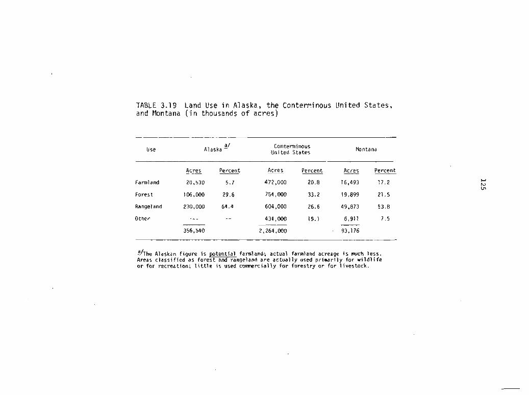
TABLE 3.19 Land Use i n Alaska, the Contewinous United States, and Montana ( i n thousands o f acres)
Use a/
A1 aska - Conterminous United States Montana
Acres Percent Acres Percent Acres Percent
Farmland 20,530 5.7 472,000 20.8 16,493 17 .2
Forest 106.000 29.6 754,000 33.2 19,899 21.5
Rangel and 230,000 64.4 604,000 26.6 49,873 53.8
Other --- -- 434,000 19.1 6,911 7.5
356,540 2,264,000 - 93,176
Chhe Alaskan f igure is potent ia l farmland; actual farmland acreage i s much less. Areas c lass i f ied as fo res t and rangeland are ac tua l ly used pr imdr i l y for w i l d l i f e o r f o r recreation; 1i t t l e i s used comnercially f o r forestry o r f o r l ivestock.

The expansion of coal mining in Alaska will take place in a context of existing and alternative uses of the land. Large areas of Alaska will remain undeveloped in the foreseeable future because they have been set aside as national parka, national monuments, wilderness areas, wildlife refuges, or have been given some other limited use designation by Federal law. Still other areas will remain undeveloped because the State has designated them as parks or rerrerves.
A large part of the remaining undeveloped land will not be developed in this century and probably well into the next because it is economically submarginal for agriculture , forestry, or live~tock grazing, or for more intensive land uses. Some of the undeveloped land, however, could be farmed; the Soil Conservation Service has identified 16,698,000 acres as "good" and 3,832,000 acres as "fair" for cropland agriculture, based on physical characteristics (Rieger and others 1979). Another 106 million acres are forested, but most of this is classed as noncomercial by the U.S. Forest Service because of its low productivity. Much of the rest of the State--some 230 million acres--is classed as rangeland, but this includes vast areas of tundra, wetlands, and lands not otherwise classified that now support almost no domestic livestock other than reindeer.
The designation of land in Alaska as prime farmland under the criteria of the act (S 701(20)) or as unsuitable for coal mining according to a planning process established by the Act ($ 522) has a somewhat different connotation than in the conterminous United States because most of Alaska's land is undeveloped and can reasonably be expected to remain that way. Three categories of land in Alaska deserve particular attention here: farmland, forest and rangeland, and wilderness. Xn addition, use of the land for subsistence purposes must be evaluated, especially land in the Arctic.
3.2.4.1 Farmland
According to the Alaska Crop and Livestock Reporting Service (1978), there were 70,000 acres of cropland being farmed in Alaska in 1977. For social, economic, and political reasons (Burton 1974), the use of this land for agricultural purposes has been declining for several years. Some of this land is in areas of potential coal mining. A comparison of the areas containing coal deposits with agricultural areas shows that the major possibilities for conflict between these two uses are in the Susitna Valley and on the western Kenai Peninsula (compare Figures 2.2 and 3.24). The total area of potential conflict is small, however, Most of the land with a Potential for farming is in lowland areas near major streams of the Interior Region where conditions are unfavorable for surface mining.
3.2.4.2 Forest and Rangelands
Most of Alaska is classified as either forest land or rangeland" even though little of it is used for timber or domestic livestock.


While the terms "forest landn and "rangeland* commonly connote comercia1 use of such lands, this is not the case in Alaska because of the land's low productivity and its distance from commercial markets. With the exception of forests in the southeastern panhandle, there has been almost no timber harvesting in Alaskan forests. Land for grazing by animals other than those in the wild has been largely limited to reindeer on the Seward Peninsula and sheep on some of the Aleutian Islands. The forest and rangelands of Alaska have been used primarily by wildlife or by people seeking recreation. There has been little active management of these lands. Even wildfire protection and suppression, forest and rangeland management practices used in moat of the country, have been largely absent in Alaska.
3.2.4.3 Wilderness
Much, perhaps most, of Alaska is wilderness in the sense in which this term is commonly used, that is, as an area undisturbed by human activity. Parts of the wilderness within Alaska's Federal lands are likely to be designated as statutory wilderness and to be included in the National Wilderness Areas Preservation System. Once areas have been designated as statutory wilderness and incorporated in the system by Congress, mining for coal and other minerals is precluded. Most of the areas being proposed for such wilderness designation do not contain coal resources, and restricting their use would have little direct effect on potential coal mining. However, access to mining districts may be precluded by wilderness designations of intervening tracts.
Much of the conflict over mining operations in wilderness areas is emotional and cannot be resolved rationally. Regardless of how one defines wilderness, there can be no doubt that there are certain natural settings which, by their very appearance, stir our innermost feelings. These places should be preserved, wherever possible.
3.2.5 Social Impact of Surface Mining
3.2.5.1 Arctic Region
The social impact of surface mining would be most severe in the Arctic, where the predominantly Native population (see Table 3.16) would be both directly and indirectly affected. Some of the social impacts would be beneficial, but others might be very damaging.
Wildlife is the single most important element in the subsistence economy of the Natives; it is the foundation on which the Native culture rests. It is also perhaps the most sensitive to the disrupting influences of coal development. Although the Native people of the region participate in the cash economy, they still remain strongly oriented to their traditional subsistence economies. The lives of many are patterned by the migrations of fish, caribou, and marille mammals. A potential conflict exists between maintenance of
the Native life-style and coal development because part of the North Slope coal basin coincides with, or is adjacent to, the resource bas@ area of Native groups. Any activity that would affect wildlife there might in turn affect the subsistence harvest of the Natives. wildlife is an essential food of the Natives, and hunting and its associated activities involve complex shared problems and communal relations that unify families, the community, and the entire region. (The impacts of coal development on wildlife are discussed in detail in Section 3.1.6.3.)
A beneficial effect of coal development would be the increased opportunity for employment, which would provide many Natives with a cash income. Many Natives now depend on petroleum products for heat and on outboard motors and snowmobiles for fishing and hunting. These cost money, as do the amenities of non-Native life-styles (e.g., radios). A household survey conducted by the North Slope Borough showed that the Natives there engaged in subsistence activities an average of 3.9 months per year and worked for wages an average of 5.1 months per year.
Major coal development in the Arctic Region would require the construction of an appropriate transportation system, Aside from the potential effects of road construction on wildlife (Sectian 3.1.6.3), new roads into remote areas would probably bring in big-game hunters and sport fishermen. Beneficial effects--for example, opportunities for Natives to work as guides--could result. The risk, however, is that the wildlife might be overexploited and the resource base of the Natives reduced. An influx of sportsmen into newly accessible areas might also bring a greater danger of tundra and timber fires, although more roads might facilitate fire control. Clearly, there are trade-offs to be made if coal is to be developed in the Arctic Region.
3.2.5.2 Interior Region
The social impacts of mining in the Interior Region are likely to be very different from those in the Arctic Region. Transportation facilities already exist adjacent to the Interior Region coal fields, and new coal development would not require the construction of extensive additional transportation facilities. Furthermore, subsistence hunting is not of the importance that it is in the Arctic Reg ion.
The greatest social consequences in the Interior Region might actually result from coal mining in the Arctic Region. It is possible that major mining activity in the remote areas of the Arctic Region would result in a transient work force employed on a shift basis there, but making their principal homes in Fairbanks and other communities in the Interior Region. The social impacts would then range from a demand for more municipal services to the bolstering of the local economy.
3.2.5.3 Southcentral Region
Coal mining in the Southcentral Region would have social impacte quite unlike those in the Arctic Region and somewhat different from those in the Interior Region. The principal impacts would probably occur in Anchorage, where much of the work force might be based. The "boom-townn syndrome and problems that accompany it could be very real for Anchor age.
The Native population i s very small, and coal development would probably have little impact on Native economies or cultures. The Natives most likely to be affected would be those in Tyonek, a village near the Beluga coal field on the western shore of Cook Inlet. It is expected that a proposed coal-conversion plarit for methanol production at Beluga would result in a substantial financial benefit to the Tyonek village. Although these villagers were affected earlier by oil-field development in Cook Inlet and now own such things as radios, television sets, and automobiles, they still value hunting and fishing to provide part of their subsistence needs. Yet coal developnent would increase the opportunities for employment, and some Natives would no doubt take advantage of them. The result would be a further dilution of the Native economy by the cash economy.
3.3 IN8TITUTIONAL AND REGUMTORY ENVIRONMENT
95-87 is only one of the many laws and sets of regulations at the Federal, State, and local level that guide and control surface coal mining. The impact of these laws and the regulations that arise from them vary, depending on such factors as the ownership of land and the particular jurisdiction or environment within which mining takes place. In Alaska, these Eactors differ in some respects from those in other parts of the country.
The purpose of this section is to describe the institutional and regulatory environment in Alaska as it pertains to surface coal mining and reclamation. The description is necesaarily brief, but Appendix I3 presents a more complete description of Federal, State, and local environmental and land-use regulations.
Land ownership has been an important factor in decisions on the kind and extent of control over mining in Alaska. Land ownership in Alaska differe markedly from that in other States (see Table 3.20):
Practically all (more than 99 percent) of the State was federally owned until the 1970s;
The Federal grant of land to the State when it achieved statehood in 1958 was much larger (some 104 million acres, or nearly 30 Percent of the total area of the State) than that made to other States, although the process of selecting lands and conducting Surveys together with the settlement of Native claims has extended the time period for the actual transfer of land to the State;
The Alaska Native Claims Settlement ~ c t (ANCSA) of 1972 gave Native villages and regional corporations control over 44 million acres of land in several major blocks;
TABLE 3.20 Land Status i n Alaska, the Conterminous United States, and Montana ( i n thousands o f acres)
Status
- -- -
l / Alaska - United s t a t e d J (excluding Alaska)
Acres Percent Acres Percent Acres Percent
Federal 218,400 59.4 544,600 28.6 23,600 25.3
S t a t e 104,500 28.4 29,500 1.6 5 ,39G1 5.8 CI w
4/ P
N a t i v e (p r iva te ) 43,700 11.9 12.300 0.6 5,239- 5.6
Nvn-Native ( p r i v a t e ) 1.100 0.3 1,315,900 69.2 58,944 63.3
'I'otai 36 7.700 1,902,300 93,176
SOURCES: L/ Alaska-Department o f Natural Resources, w r i t t e n comnunication, 1980. 2/ Adapted from U.S. Department o f Agricul ture (1980). - 3/ Montana Department o f S ta te Land, personal communication, 1980. -
Includes only the fol lowing major categories: F ish and Game Department, State Highway Department, and Grant Lands f o r Schools and Colleges.
4/ U . 5 . Department o f the I n t e r i o r , Bureau o f Indian A f f a i r s (1978b). . -

Major transfers of land from the State to private ownership are expected in the foreseeable future.
Because the State concentrated on selecting land areas with a potential for economic development, most new coal mining in the immediate future will take place on State-owned lands. Since Native selections under ANCSA were based, to some extent, on the same premise, most of the other new coal mining will take place on Native-owned lands. There may also be some leasing of Federal lands for coal mining. Thus, controls on coal mining exerted through State, Native, or Federal ownership must be viewed as an important part of the existing regulatory framework,
In the sections that follow, the current status of land ownership in Alaska is described, the regulatory provisions for coal leasing and land use on State and Federal lands are discussed in terms of their impact on coal mining, and there is a brief discussion of the general environmental and land-use laws and regulations that affect coal mining. More detailed information pertaining to these last two sections is contained in Appendix B.
3.3.1 Land Status
Alaska is now in the midst of an enormous realignment of property rights brought about largely by the settlement of Native claims under ANCSA and the transfer to State ownership of Federal lands granted by the Statehood Act. Major decisions are also being made on the establishment of national parks, wildlife refuges, forests, wild and scenic rivers, and wilderness areas on the lands that will remain in Federal ownership. The scope of these decisions will affect the development of Alaska's resources for decades and perhaps for centuries .
When the allocations of land required by the Alaska Native Claims Settlement A c t and the Statehood Act are completed, approximately 59 percent (218 million acres) of Alaska's land will be in Federal ownership, 28 percent (104 million acres) in State ownership, 12 Percent (44 million acres) will be privately owned by Alaska Natives, and 0.3 percent (1 million acres) will be owned by non-Native private interests (U.S. Office of Technology Assessment 1979).
The 44 million acres of Native-owned lands were selected in response to various interests and priorities, and ranged from the retention of the traditional subsistence way of life to mineral development by profit-making corporations for the benefit of Native stockholders. As provided by ANCSA, the surface estate of 22 million acres will be owned by about 200 Native village corporations; the subsurface estate to these 22 million acres, and the fee simple title to an additional 18 million acres, will be owned by 12 regional Native corporations (see Figure 3 .25 ) , Although the regional corporations hold the subsurface rights, mineral exploration within the boundaries of any Native village can occur only with the consent of the village corporation. Coordination among these private owners is necessary to ensure that all interests are recognized.
SOURCE: U.S. Office of Technology Assessment (1979).
FIGURE 3.25 Map showing boundaries of regional corporations established under ANCSA and estimated combined regional and village corporation entidements (in millions bf acres).
The ANCSA grant of mineral rights to the profit-making regional corporations together with the establishment of an Alaska ~ative Fund dependent on the development of mineral resources (U.S. Office of Technology Assessment 19791, have resulted in increased interest in mineral development within both the Native and non-Native populations of the State. At the same time, many Natives are concerned with preserving land and waters to support their traditional subsistence and cultural patterns of life.
The grant of land to the State a l ~ o included both surface and subsurface rights. The selection of the 104 million acres granted to the State is not complete and is not likely to be completed for a number of years.
Although a portion of the State lands is being, and will continue to be, made available for private ownership, private owners will obtain only the surface rights. Under the State constitution, subsurface rights to those lands will remain with the State. Thus, the State will retain control over the pace and character of mineral development on much of the coal-bearing land in Alaska.
After the State completes its land selection, about 100 million acres of land remaining in Federal ownership will be in national parks and wilderness areas established by Congress where mining will not be permitted. Of the remainder, only the federally owned land in the National Petroleum Reserve (which covers about 23 million acres) on the North Slope has substantial known coal reserves. The coal deposits under Cook Inlet and under the Chukchi Sea to the 3-mile limit are owned by the State. However, development of these deposits is far in the future,
There are special features in Alaska which bear upon cooperation between Federal and State governments. Federal and State land ownership is far more extensive in Alaska than it is in other States, and privately held land is in fewer and larger parcels. State ownership includes the tidelands along ~laska's 47,300 miles of coastline and the subsurface of all navigable waters. In many regions in Alaska the lowlands and river valleys are owned predominantly by the State and by Native corporations, with the Federal Government owning the mountaintope and other adjoining lands. Since bodies of water, lowlands, and tidal areas are all elements of larger ecosystems, coordination of land use is necessary to the proper management of whole ecosystems.
Many species of wildlife in Alaska are migratory, knowing no ownership boundaries. Because of the Arctic and subarctic nature of much of the State, upland grazing mammals must cover many acres to sustain life. Migratory birds will continue to move from State-owned river valleys to fedellally owned lands in existing and proposed wildlife refuges. Thus, even where national parks or refuges comprise large amounts of land, it will be difficult to keep wildlife habitats within specific boundaries.
3.3.2 Leasing and Land-Use Regulation on State and Federal ~ a n d s
Coal-bearing lands owned by the Federal and State governments axe leased under laws that give those governments the authority to stipulate the actions that must be taken by the operator to ameliorate the undesirable consequences of mining. In addition, both Federal and State officials can prevent the leasing of specific areas. Both Federal and State leasing practices must now be consistent with the ~ K O V ~ S ~ O ~ S of PL 95-87. There is nothing, however, to keep them from being more stringent, especially where particularly competitive values are important. Both the Federal and State leasing laws provide administrators with reasonably broad authority to establish discretionary controls.
An important aspect of coal leasing on Federal and State lands is to relate the issuance of leases and decisions on controls to other expected uses of the land. On Federal lands, those lands that are part of the following systems or categories are not available for coal mining or exploration: National Park System, National Wildlife ~efuge System, National System of Trails, National Wilderness Preservation System, National Wild and Scenic Rivers System, National Recreation Areas, and Federal lands within incorporated cities, towns, and villages. Beyond exclusion of these categories of Federal lands from coal mining, Federal agencies are required to develop land-use plans for Federal lands that can be leased for mining. The Federal Land Policy and Management Act of 1976 requires the preparation of land-use Plans by 1984 for lands administered by the u.S. Department of the Interior's Bureau of Land Management. For national forest lands, which are almost entirely in southeastern Alaska, the Forest Service is required to prepare land-use plans under the Forest and Rangeland Renewable Resources planning Act of 1974. These land-use plans are required before leasing for coal can take place. They will contain information that can be used to decide where and how mining should occur and conditions that will be imposed, but some leasing and licensing will occur prior to completion of these plans.
In addition, environmental analyses are required prior to leasing on Federal coal lands. A regional environmental analysis is made first as a basis for selecting and scheduling tracts for competitive leasing. This is followed by environmental analyses for particular tracts proposed for leasing before leases are issued and mining can proceed.
In a similar fashion, the State is planning for the use of State lands and for the transfer into private ownership of some portion of these lands. The Alaska Department of Natural Resources is responsible both for planning the conservation and development of resources on State lands and for leasing the right to develop those resources. Most of the department's efforts so far have been directed a t planning for the selection of lands to be transferred to the State, but the framework for planning their future development is in place.
Control over the environmental impacts of coal mining in Alaska throuph Federal or State leasing practices has not been strong. There have been relatively few leases, and the factual basis for
establishing controls (especially with respect to other land uses) is 1 imi ted ,
3.3.3 Local Government Controls
AS noted in Appendix B, the powers of local government in Alaska differ somewhat from those of local governments in the conterminous United States. There are two major practical differences. One is the authority of Alaskan boroughs to zone land in vast areas that ate sparsely populated. The other is the ability of Native villages and regional corporations to affect development decisions in their areas.
An important example of the way in which local governments exercise control over land-use and development decisions is provided by the Alaska Coastal Management Act of 1977. The implementation of this Act has significant implications for coal development on the North Slope and in Southcentral Alaska. The Alaska Coastal Management Program approved by the Federal Government in August 1979
establishes new coastal policies, rules, responsibilities, obligations and relationships, but relies primarily on existinq state and local authorities and controls for implementation. . . . The Act also requires that coastal programs be developed within a specific period by local government-units or districts in organized areas, and in unorganized areas when these areas are faced with large scale resource development. It also sets up relationships between the districts and State agencies, and provides basic objectives and policies for coastal management. I Emphasis added. 1
The Kenai Borough and the Mat-Su (Matanuska-Susitna) Borough are in the process of preparing coastal zone plans. The implementation o f these plans will affect the development of port facilities for the Beluga coal field and require the participation of the village of Tyonek in the development of mining regulations affecting the village environment.
The Beluga coal field is located in both the Kenai Borough and the Mat-Su Borough. Some of the land has been transferred by the State to the Cook Inlet Region, Tnc. (CIRI). The closest community is Tyonek, a traditional "IRA" (Indian Reorganization Act) village administered by the Tyonek Village Council but also regulated by the Kenai Borough, the Native regional profit corporation (that is, C I R I ) , and the Tyonek Village Native Corporation. All will be involved in any future development of the Beluga coal field.
The North Slope Borough has made intensive efforts to prepare a coastal management program for the mid-Beaufort area. The borough has a sophisticated planning staff that has formulated regulations regarding the preservation of wildlife, the conservation of water resources, and the location of access routes. The planning staff has also cet standards for land use and reclamation. The coastal zone management boundaries extend as far south as the Brooks Range, and the
borough has succeeded in developing regulations for scheduling offshore leases in the Beaufort Sea. This advocacy for local controls and self-determination will continue, and, unless Federal, State, and local interests are coordinated and reconciled, will delay resource development in the Arctic Region.
3.3.4 General Environmental Regulations
All of the environmental laws and regulations that apply to the conterminous United States also affect Alaska, although, as detailed in Appendix B, some are applied differently in Alaska. These include the Federal Water Pollution Control Act, the Clean Air Act, and the Resource Conservation and Recovery Act. The State of Alaska has parallel regulatory provisions that also include control of oil and hazardous substance pollution and coordination of environmental procedures.
As noted in Appendix B, some Federal laws are applied differently in Alaska than in other States primarily because of special environmental or physical conditions. The lack of extensive coal mining in the State has resulted in only limited application of the Federal Water Pollution Control Act and the Clean Air Act. On the other hand, provisions of both Acts are applied to placer mines.
3.3.5 Treaty Obligations
Alaska and the seas surrounding it are subject to several international treaties that deal with marine dumping, with the ownership and use of the territorial sea and contiguous zone, and with fishing, whaling, and wildlife preservation. While these treaties are designed to preserve and enhance the marine and land environments, they are not unique to Alaska and most of them do not appear to impose specific conditions that would be violated by the development of land resources or by the development of marine transportation.
Two treaties, however, are unique to Alaska because they pertain only to Arctic environments and do have a possible relationship to activities on land. The Interim Convention between the United States, Canada, Japan, and the USSR on Conservation of North Pacific Fur Seals (TIAS 3948; extended, TIAS No. 6774) entered into by the United States in February 1957 calls for actions to conserve and increase the fur seal population. Any activity in a marine or land area used by fur seals would probably be subject to the provisions and intent of this treaty.
In addition, the Agreement on the Conservation of Polar Bears ( T I A S No. 8409), entered into by the United States in November 1976, specifically provides in Article I1 that
[elach Contracting Party shall take appropriate action to protect the ecosystems of which polar bears are a part, with special attention to habitat components such as denning and feeding

sites and migration patterns, and shall manage polar bear ~o~ulations in accordance with sound conservation practices based on the best available scientific data.
This treaty could preclude coal development in any area used by polar bears. Furthermore, a proposed treaty with Canada involving the Porcupine caribou herd could affect coal mining in east-central Alaska (Carter 1980) .
3.3.6 Discussion
Even before enactment of PL 95-87, the combination of land ownership patterns and degree of land and economic development in Alaska made coordination among agencies and between levels of government necessary. The Federal Field Committee for Development Planning in Alaska, which existed from 1964 to 1970, was charged with planning and coordinating Federal activities in the State. Its effectiveness depended on its ability to get Federal funds directed at solving important problems.
The Joint Federal-State Land Use Planning Commission was created by ANCSA to resolve the issues raised by the selection of land by ~ative organizations and by the State. Its role was limited to marshaling information, and its effectiveness was limited by a lack of control over planning decisions. Nevertheless, it did make a contribution to the process of planning for the future of the State.
PL 95-87 adds another set of regulations to an already substantial framework for controlling the impacts that arise from developing coal resources. In view of the complex land ownership and land management patterns in Alaska, there should be an effective mechanism for coordinating Federal, State, and local regulations. As indicated in Section 3.2.3 of this report, however, decisions on coal mining depend on decisions concerning transportation, access, development of governmental structuresr and a host of related factors, but coordinating mechanisms such as the Federal Field Committee or the Joint Federal-State Land Use Planning Commission no longer exist.
Whatever else is done to improve the regulatory framework for coal mining in Alaska, the importance of local government must be recognized. The established regional goverrtments in Alaska are the boroughs or unified municipalities with their planning commissionsr assemblies, and mayors. In the unorganized borough, the State legislature or its delegates are the planning authorities. Coastal zone planning commissions and the Alaska Native regional corporations, even though private corporations, have great political power, especially in the Arctic Region.
It will also be necessary to involve major landowners and land management agencies. Efforts to make decisions in the public interest regarding land use in Alaska can be frustrated by the large size of private Alaskan land ownerships and by the importance of potential trapsportation corridors that would cross both public and private ownership boundaries.
Effective implementation of PL 95-87 in Alaska will require careful integration of that law with the rest of the regulatory framework that will affect coal mining and with the whole process of making choices for the State's future.

REFERENCES
Abele, G., and Brown, J., 1976, Arctic transportation: Operational and environmental evaluation of an air cushion vehicle in northern Alaska. American Society of Mechanical Engineers, ASME Paper No. 76-Pet-41, Journal of Pressure Vessel Technology, V. 991 no. 1, P o
176-182. Alaska Crop and Livestock Reporting Service, 1978, Alaskan
agricultural statistics. Palmer, Alaska, Alaska Crop and Livestock Reporting Service
Alaska Department of Fish and Game, 1973, Marine mammal status reports. Juneau, unpublished report.
Alaska Department of Fish and Game, 1978, Marine and coastal habitat management-assessment of the potential effects of outer continental shelf oil development on marine fish and wildlife resources of the Northern Gulf of Alaska and recommendations for tract nominations for future lease sales. Juneau, June 1978.
Alaska Department of Natural Resources, 1977, Energy resource map of Alaska. Prepared by Division of Geological and Geophysical Surveys.
Alexander, V., 1972, Phytoplankton primary productivity as an indicator of biological status in Alaskan freshwater environments, in Alaska fisheries policy. Fairbanks, university of Alaska, - Institute of Social, Economic, and Government Research, p. 131-136.
Anderson, D.D., Bane, R., Nelson, R.K., Anderson, W.W., and Sheldon, N., 1977, Kuuvanmiit subsistence: Traditional Eskimo life in the latter twentieth century. Washington, D.C., U.S. Department of the Interior, National Park Service, 775 p.
Anderson, G.S., and Hussey, K.M., 1963, Some preliminary investigations of thermokarst development on the North Slope, Alaska. Iowa Academy of Sciences Proceedings v. 70, p. 306-320.
Balding, G.O., 1976, Water availability, quality and use in Alaska. U.S. Geological Survey Open-File Report 76-513, 236 p.
Battelle Memorial Institute, 1960, An integrated transportation system to encourage economic development of northwest North America. Columbus, Ohio, Battelle Memorial Institute.
Berwick, V.K., Childers, J.M., and, Kerintzel, M.A., 1964, Magn~tude and frequency of floods in Alaska south of the Yukon River. U.S. Geological Survey Circular 493, 15 p.
Billings, W.D., 1974, Arctic and alpine vegetation; plant adaptations to cold summer climates, Ives, J.D., and Barry, R.G., eds., Arctic and alpine environments. London, England, Methuen, p- 403-444.
Bliss, L.C., 1979, Vegetation and revegetation within permafrost terrain, in Proceedings of the Third International Conference on

Permafrost. Ottawa, Canada, National Research Council of Canada, p. 31-50.
Britton, M.E., 1957, Vegetation of the arctic tundra, & 18th Annual Biology Colloquium, CorvallisI Oregon, pa 26-61.
Britton, M.E., 1958, A tundra landscape. Research Reviews, January 1958. Washington, D.C., Department of the Navy, Office of Naval Research.
Brown, J., 1967, Tundra soils formed over ice wedges, northern Alaska. Soil Science Society of America, Proceedings, v. 31, P * 686-691.
Brown, J., and Grave, N.A., 1979, Physical and thermal disturbance and protection of permafrost. Hanover, N.H., U.S. Army Corps of Engineers, Cold Regions Research and ~ngineering Laboratory Special Report 79-5.
Brown, J., Dingrnan, S.L., and Lewellen, R.I., 1968, Hydrology of a drainage basin at the Alaskan Coastal Plain. Hanover, N.H., U . S . Army Corps of Engineers, Cold Regions Research and ~ngineering Laboratory Research Report 240, 18 p.
Burton, W.E., 1974, Historical perspectives in Alaskan agriculture, & Alaska's agricultural potential. Fairbanks, Alaska: The Alaska Rural Development Council, publication no. 1, p. 1-9.
Cameron, R.D., Whitten, K.R., Smith, W.T., and Roby, D.D., 1979, Caribou distribution and group composition associated with construction of the Trans-Alaska Pipeline. Canadian Field-Naturalist, v. 93, no. 2, p. 155-162.
Cameron, R..'D. and Whitten, K.R., in press, Influence of the Trans-Alaska Pipeline corridor on the local distribution of caribou. Proceedings of the Second International Reindeer/Caribou Symposium, Reros, Norway.
Carter, L.J., 1980, Hostages in the Arctic: The Porcupine caribou. Science, v. 208, no. 4449, p, 1245.
Childers, J.M., 1970, Flood frequency in Alaska. 1970. U.S. Geological Survey Open-File Report.
Clark, P . R . , 1973, Transportation economics of coal resources of Northern Slope coal fields, Alaska. Fairbanks, University of Alaska, Mineral Industry Research Laboratory, Report 31.
Coats, R.R., 1950, Volcanic activity in the Aleutian Arc. U.S. Geological Survey Bulletin 974-8, p. 35-49.
Conwell, C.N., 1977, Land reclamation is an integral part of the only operating coal mine in Alaska. The Coal Miner, v. 2, no. 3, p. 21-30.
Engineering Computer Opteconomics Inc., 1977, An assessment of marine transportation costs related to potential port sites in Alaska. Arnold, Md. Federal-State Land Use Planning Commission for Alaska.
Englemen, P., and Tuck, B., with Kreitner, J.D., and Dooley, D.M., 1978, Transportation and development of Alaska natural resources. Anchorage, Federal-State Land Use Planning Commission for Alaska, Study No. 32, 83p.
Everett, K.R., 1975, Soil and landform associations at Prudhoe Bay, Alaska: A soils map of the tundra biome area I Brown, J. , ed. Ecological investigations of the tundra biome in the Prudhoe Bay

Region, Alaska. Fairbanks, University of Alaska, Biological Papers, Special Report NO. 2 . , p. 53-59.
Everett, K.R., 1980, Distribution and properties of dust along the northern portion of the haul road, in Brown, J., and Berg, R.L., eds., Environmerltal engineering and ecological baseline investigations along the Yukon River-Prudhoe Bay haul road. Hanover, N.H., U.S. Army Corps of Engineers, Cold Regions Research and Engineering Laboratory Report 80-19.
Everett, K.R., and Parkinson, R.J., 1977, Soil and landform associations, Prudhoe Bay area, Alaska. Arctic and Alpine Research, v. 9 , no. 1, p. 1-19.
Ferrians, O.J., Jr., Kachadoorian, R., and Greene, G.W., 1969, Permafrost and related engineering problems in Alaska. U.S. Geological Survey Professional Paper 678, 37 p.
Feulner, A.J., Childers, J.M., and Norman. V.W., 1971, Water resources of Alaska. Anchorage, U.S. Geological Survey Open-File Report, 60 p*
Gabrielson, I., and Lincoln, F.C., 1959, Birds of Alaska. Stackpole, N.Y., p. 30-32.
Garg, O., 1974, Summary of permafrost studies in the Schefferville area. Prepared for Permafrost Engineering Manual. Ottawa, National Research Council of Canada, unpublished report.
Gold, L.W., and Lachenbruch, A.H., 1973, Thermal conditions in permafrost-,-A review of North American literature, in Permafrost, Proceedings of the Second International Conference, Yakutsk, USSR, 1973, North American Contribution. washington, D.C., National. Academy of Sciences, p. 3-25.
Gulland, J., 1972, Natural factors determining potential productivity of northeast Pacific fisheries, in Alaska fisheries policy. Fairbanks, University of Alaska, Institute of Social, Economic, and Government Research, p. 117-129.
Guy, H.P., 1979, Performance and environmental effects of sedimentation ponds required for surface coal mining. Institute of Environmental Sciences Annual Meeting, Seattle, Wash., April 29-May 2, 1979, Proceedings, p. 320-435.
Haag I R.W., and Bliss, L.C., 1974, Energy budget changes following surface disturbance to upland tundra. Journal of Applied Ecology, v. 11, no. 1, p. 355-374.
Henoch, S., Stenmark, R., and Tuck, B.M., 1979, A policy for the Arctic. Anchorage, Federal-State Land use Planning Commission for Alaska, Study No. 41, 110 p.
Hinman, R., 1974, The impact of oil development on wildlife populations in northern Alaska. Paper presented at the Western Association of Game and Fish Commissioners Conference, Albuquerque, N.Mex., July 1974.
Hok, J.R., 1971, Some effects of vehicle operation on Alaskan arctic tundra. M.S. thesis (unpublished), University of Alaska, Fairbanks.
Bustich, I., 1970, On the study of the ecology of subarctic vegetation, Ecology of the subarctic regions. Paris, UNESCO.

International Whaling Commission, 1979, Report of Panel to Consider Cultural Aspects of Aboriginal Whaling in North Alaska. IWC Meeting on Aboriginal/Subsistence Whaling, Seattle, Wash. Feb. 5-9, 1979.
Isleib, M.E., and Kessel, B., 1973, Birds of the north Gulf coast-- Prince William $ound region, Alaska. Fairbanks, University of Alaska, Biology Paper No. 14.
J ~ ~ s o ~ s , U., and Bottge, R.G., 1977, Economic mining feasibility studies of selected mineral deposit types in the western Brooks Range, Alaska. U.S. Bureau of Mines Open-File Report 128-77, 96 p.
Joint Federal-State Land Use Planning Commission for Alaska, 1973, Major ecosystems of Alaska, (map with text). Anchorage.
Joint Federal-State Land Use Planning Commission for Alaska, 1975, Resources of Alaska: A regional summary. Anchorage, 621 p.
Joint Federal-State Land Use Planning Commission For Alaska, 1977, The D-2 book. Volume I--Lands of national interest in Alaska; Volume 11--Lands of national interst in Alaska, A comparative analysis (includes 11 maps). Anchorage.
Josephson, K., 1974, Use of the sea by Alaska Natives: A historical perspective. Anchorage, University of Alaska, Arctic Environmental Information and Data Center, 95 p.
Kellogg, C.E., and Nygard, I.J., 1951, Exploratory study of the principal soil groups of Alaska. Washington, D.C., U.S. Department of Agriculture USDA Monograph No. 7., 138 p.
King, J.G., and Lensink C., 1971, An evaluation of Alaskan habitat for migratory birds. Washington, D.C., U.S. Department of the Interior, Fish and Wildlife Service, 26 p.
Klein, D.R., 1973, The reaction of some northern mammals to aircraft disturbances. International conference of Game Biology (Stockholm) Proceedings, v. 11, p. 377-383.
Klein, D.R., 1979, The Alaska oil pipeline in retrospect. Toronto North American Wildlife and Natural Resources Conference Transactions, v. 44, p. 235-246. Washington, D.C., Wildlife Management Institute.
Komarkova, V., and Webber, P.J., 1978, Geobotanical mapping, vegetation disturbance and recovery, in Tundra disturbances and recovery following the 1949 exploratory drilling, Fish Creek, northern Alaska. Hanovar, N.H., U.S. Army Corps of Engineers, Cold Regions Research and Engineering Laboratory Report 78-28, p. 41-51.
Kresge, D.T., 1976, Alaska's growth to 1990: Economic modelling and policy analysis for a rapidly changing frontier region. Review of Business and Economic Conditions v. 13, no. 1, 19 p. ~airbanks, University of Alaska, Institute of Social and Economic Research.
Kruse, J., 1978-79, North Slope household survey: Subsistence and employment analy~is. Fairbanks, University of Alaska, Institute of Social and Economic Research, p. 41-51.
Lachenbruch, A.H., 1966, Contraction theory of ice-wedge polygons: A qualitative discussion, Proceedings, International Conference, on Permafrost, Lafayette, Ind., 1963, NAS/NRC publication 1287. Washington, D.C., ~ational Academy of Sciences, p. 63-71.
Lachenbruch, A.B., 1968, Permafrost, Fairbridge, R . W . , ed., The encyclopedia of geomorphology. New York, Reinhold, p. 833-839.
Lachenbruch, A.H., Brewer, M.C., Green, G.W., and Marshall, B.V., 1962, Temperatures in permafrost, Temperature--Its measurement and control in science and industry, v. 3, pt. 1. New York, Reinhold, p. 791-803.
Lamke, R.D., 1972, Floods in the summer of 1971 in southcentral Alaska. U.S. Geological Survey Open-File Report.
Lamke, R.D., 1979, Flood characteristics of Alaskan streams. U.S. Geological Survey, Water Resources Investigations 78-1291 61 pa
Lang, L.C., 1966, Blasting frozen iron ore at Knob Lake. Canadian Mining Journalr August 1966,
Laughlin, W.S., Harper, A.B . , and Thompson, D.D., 1979, New approaches to the pre- and post-contact history of Arctic peoples. American Journal of Physical Anthropology, v. 51, no. 4, p. 579-588.
Lawson, D.E., Brown, J., Everett, K.R., Johnson, A.W., Komarkova, V., Murray, B.M., Murray, D.F., and Webber, P.J., 1978, Tundra disturbances and recovery following the 1949 exploratory drilling, Fish Creek, northern Alaska. Hanover, N.H., U.S. Army Corps of Engineers, Cold Regions Research and Engineering Laboratory, Report 78-28, 81 p.
Lewis, B.G., and others, 1976, A biologist's manual for the evaluation of impacts of coal-fired power plants on fish, wildlife and their habitats. U.S. Department of the Interior, Fish and Wildlife Service FWS/OBS-7a/75, 206p.
McKendrick, J.D., and Mitchell, W.W., 1978a, Effects of burning crude oil spilled onto six habitat types in Alaska. Arctic v. 31 no. 3 , p . 227-295.
McKendrick, J.D., and Mitchell, W.W., 1978br Fertilizing and seeding oil damaged arctic tundra to effect veyetation recovery, Prudhoe Bay, Alaska. Arctic, v. 3 1 , no. 3, p. 296-304.
Mitchell, W.W., 1976, Revegetation research on Amchitka Island, a maritime tundra location in Alaska. Prepared by University of Alaska, School of Agriculture and Land Resources Managment for U.S. ERDA, Nevada Operations Office, under contract no. AT (29-2)-20/Purchase Order DB-845A with HoLmes and Narver, Inc. Report no, NVO-172.
Mitchell, W.W., 1979, Three varieties o f native Alaskan grasses for revegetation purposes. University of Alaska School of Agrculture and Land Resources Managment, Agriculture Experiment Station, Circular 32. .
National Petroleum Reserve in Alaska Task Force, 1978, National Petroleum Reserve in Alaska, physical profile. U.S. Department of the Interior, National Petroleum Reserve in Alaska, 105(c) Study Report 1. Washington, D.C., U.S. Government Printing Office, 124 p.
National Resources Committee, 1938, Alaska--Its resources and development. Washington, D.C., U.S. Government Printing Office, 213 p.
Newman, J.R., 1980, Effects of air emissions on wildlife resources. U.S. Department of the Interior, Fish and Wildlife Service Report FWS/OBS - 80/40.1, 32 p.
Northwest Alaska Native Association, 1978, Unpublished survey conducted by Northwest Alaska Native Association, Kotzebue.
Olsen, M., Cluett, C. Trimble, J. Brody, S. Howell, C. Leman L. and Svendsen, G., 1979, Beluga coal field development--social effects and management alternatives. Prepared by Battelle Pacific Northwest Laboratory for Alaska Department: of Commerce and Economic Development, Division of Energy and Power Development, and for U.S. Department of Energy, Regional Assessment Divisiont under contract no. EY 76 C-06-1830.
Palmer, L.J., 1945, The Alaska tundra and its use by reindeer. Washington, D.C., U.S. Department of the Interior, Office of Indian Affairs.
Pamplin, W.L., Jr., 1979, Construction-related impacts of the Trans-Alaska Pipeline system on terrestrial wildlife habitats. Anchorage, Alaska, Joint StatdFederal Fish and Wildlife Advisory Team, Special Report No. 24. .
Patterson, A,, 1974, Subsistence harvests in five native regions. Anchorage, Joint Federal-State Land-Use Planning Commission for Alaska
Phukan, A. I and Andersland, O . B . , 1978, Foundations far cold regions , in Andersland, O.B., and Anderson, D., eds., Geoteehnical - engineering for cold regions. New York, McGraw-Hill, p. 276-362.
Post, A * , and Mayo, L.R., 1971, Glacier dammed lakes and outburst floods in Alaska. U . S . ~eological Survey hydrologic atlas HA-455.
Rastorfer, J.R., 1978, Composition and biomass of the moss layers of the two wet-tundra-meadow communities near Barrow, Alaska, Tieszen, L.L., ed,, Vegetation and production ecology of an Alaskan arctic tundra. New York, SpringermVerlag, p. 169-183
Rickard, W.E., and Brown, J., 1974, Effects of vehicles on arctic tundra. Environmental Conservation, v. 1, no. 1, p. 55-62.
Rieger, S., 1974, Arctic soils, Ives, J,D, and Barry, R.G., eds., Arctic and alpine environments. London, England, Methuen, p. 749-769.
Rieger, S. Schoephorstex, D.B., and Furbush, C.E., 1979, Exploratory soil survey of Alaska. Washington, D.C., U.S. Department of Agriculture, Soil Conservation Service, 213 p., plus maps.
Roby, D.D., undated, Behavioral patterns of barren-ground caribou of the Central Arctic Herd adjacent to the Trans-Alaska Oil Pipeline. M.S. thesis. Fairbanks, University of Alaska, 2 0 0 ~ .
Selkregg, L. L., 1972, Environmental atlas of the greater Anchorage area Borough. Anchorage, University of Alaska, Arctic Environmental Information and Data center.
Selkregg, L.L., 1975-77, Alaska regional profiles, Prepared for Joint Federal-State Land Use Planning Commission, for Alaska and Office of the Governor. Anchorage, University of Alaska, Arctic ~nvironmental Information and Data Center, 6 v.
Sellmann, P.V., Brown, J., Lewellen, R.I., McKim, H.L., and Merry, C.J., 1975, The classification and geomorphic implications of thaw

lakes on the Arctic Coastal Plain, Alaska. Hanover, N.H., U.S. Army Corps of Engineers, Cold Regions Research and ~ngineering Laboratory Research Report 344, 21 p.
Spindler, M., and Kessel, B. in press, Avian populations and habitat use in Interior Alaska taiga. Syesis, v. 13,
Sterrett, K.F., 1976, The arctic environment and the arctic surface effect vehicle. Hanover, N.H., U.S. Army Corps of Engineers, Cold Regions Research and Engineering Laboratory, Report 76-1.
Swanson, J.C., 1979, Changes in arctic tundra habitats following caribou carrion deposition. M.S. thesis, (unpublished), Moscow, University of Idaho.
Tedrow, J.C.F., 1977, Soils of the polar landscapes. New ~runswick, N.J., Rutgsrs University Press, 638 p.
Tedrow, J.C.F., Drew, J.V., Hill, D.E., and Douglas, L.A., 1958, Major genetic soils of the Arctic Slope of Alaska. Journal of Soil Science, v. 9, no. I, p. 33-45.
Thenhaus, P.C., Ziony, J.I., Diment, W.H., Hopper, M.G., Perkins, D.M., Hanson, S.L., and Algermissen, S.T., in press, probabilistic estimates of maximum seismic horizontal ground motion in Alaska and the adjacent outer continental shelf. U.S. Geological Survey Open-File Report. (Due for release in 1980.)
Tieszen, L.L., 1978, Summary, & Tieszen, L.L., ed., Vegetation and production ecology of an Alaskan arctic tundra. New York, Springer-Verlag, p. 621-645.
Timm, D., 1978, Relationships between trumpeter swan distribution and cabins in the Susitna Basin, Alaska. Sixth Trumpeter Swan Society conference, Anchorage, Sept. 7-9, 1978. Anchorage, Alaska JXpartment of Fiah and Game,
Tuck, B., 1979, Transportation of coal and hardrock mineral concentrates from Northwest Alaska. Anchorager Federal-State Land Use Planning Commission for Alaska Study No. 45.
Ulrich, A., and Gersper, P.L., 1978, Plant nutrient limitations of tundra plant growth, Tieszen, L.L., ed., vegetation and production ecology of an Alaskan arctic tundra. New Yorkr Springer-Verlag, p. 457-481.
U.S. Department of Agriculture, 1975, Soil taxonomy/A basic system of soil classification for making and interpreting soil surveys. Washington, D.C., Soil Conservation Service, Agriculture Handbook #436 , 754 p.
U.S. Department of Agriculture, 1980, *Landownership in the United States, 1978. Washington, D.C., Agriculture Information Bulletin no. 135 , 98 p.
U.S. Department of Commerce, 1978, Statistical abstracts. Washington, D.C., U.S. Bureau of the Census.
U.S. Department o f Energy, 1977, Alaska regional energy resources planning project, phase 1 1 volume 11: Alaska's energy resources; inventory of oil, gas, hydroelectric, and uranium resources. Prepared by the Alaska Division of Energy and Power Development. Washington, D.C., U.S. Department of Energy, 216 p.
U.S. Department of the Interior, 1972, National atlasr sheet no. 58.

U.S. Department of the Interior, 1974a, Final Regulations for ORV use of the public lands (39 Fed. Reg. 13,612 (1974)).
U.S. Department of the Interior, 1974b, Socio-economic considerations, proposed Alaska national wildlife refuges, Ch. 2 Final environmental impact statement on proposed national parks, forests, wildlife refuges, and wild and scenic rivers for Alaska. Compiled from socio-economic sections of environmental impact statements on seven National Wildlife Refuges, the Iliamna National Resource Range, and Noatak National Arctic Range. Washington, D.C., U.S. Department of the Interior, Alaska Planning Group
U . S . Department of the Interior, 1978a, Water resources investigations in Alaska, 1977. U.S. Geological Survey, Free folder (W77304).
U.S. Department of the Interior, 1978b, Annual report of Indian lands, September 30, 1978. Washington, D.C., Office of Trust Responsibilities, Bureau of Indian Affairs.
U.S. Fish and Wildlife Service, 1977, Winter water availability and use conflicts as related to fish and wildlife in arctic Alaska. Washington, D.C., U.S. Fish and Wildlife Service Report No., FWS/OBS-77/06.
U . S . Fish and Wildlife Service, 1979, Administration of the ~arine Mammal Protection Act of 1972. Report of the Department of the Interior for the period April 1, 1978, to March 31, 1979. Washington, D.C., U.S. Fish and Wildlife Service.
U . S . Geological Survey, 1978, Water resources data for Alaska, Water year 1977. U.S. Geological Survey Water Data Report AK-77-1, 437 p.
U.S. Geological Survey, 1979, An environmental evaluation of potential petroleum development in the National Petroleum Reserve in Alaska. Report prepared under Section 105(b) of the Naval Petroleum Reserve Production Act of 1976.
U.S. Office of Technology Assessment, 1979, Analysis of laws governing access to Federal lands: Options for access in Alaska. Washington, D.C., U.S. Government Printing Office, 260 p.
Viereck, L.A. and Dyrness, C.T., 1980, A preliminary classification system for vegetation in Alaska. U.S. Forest Service General Technical Report PNW-106.
Walker, D.A., and Webber, P.J., 1979, Relationships of soil acidity and air temperature to the wind and vegetation at Prudhoe Bay, Alaska. Arctic, v. 32, p. 224-236.
Walker, D.A., Everett, D.A., Webb*er, P.J., and Brown, J., 1980, Geobotanical atlas of the Prudhoe Bay region, Alaska. Hanover, N.H., U.S. Army Corps of Engineers, Cold Regions Research and Engineering Laboratory Report 80-14.
Washburn, A.L., 1979, Geocryology: A survey of periglacial processes and environments. New York, Halsted Press.
Webber, P.J., and Xves, J.D., 1978, Damage and recovery of tundra vegetation. Environmental Conservation, v. no. 3, p. 171-182.
Webber, P.J., Komarkova, V., Walker, D.A., and Werbe, E., 1978, Vegetation mapping and response to disturbance along the Yukon River-Prudhoe Bay haul road, Brown, J., ed., Ecological baseline investigations along the Yukon River-Prudhoe Bay haul
road, Alaska. Hanover, N.H., U.S. Army Corps of Engineers, Cold Regions Research and Engineering Laboratory Special Report 76-13, p, 69-87.
White, R.G., Thomson, B.R., Skogland, T., Person, S.J., Rus~ell, D.C. Halleman, D.F., and Luick, J.R., 1975, Ecology of caribou at Prudhoe Bay, Alaska, Brown, J., Ec010gi~al investigations of the tundra biome in the Prudhoe Bay region, Alaska. Fairbanks, University of Alaska, Biological Papers, Spe'cial Report No. 2 . , p. 151-201.
Williams, J.R., 1970, Ground water in permafrost regions of Alaska. U.S. Geological Survey Professional Paper 696, 83 p.
Williams, M.E., Rudolph, E.D., Schofield, E.A., Prasher, D.C., 1978, The role of lichens in the structure, productivity, and mineral cycling of the wet coastal Alaska tundra, Tieszen, L.L., ed., Vegetation and production ecology a£ an Alaskan arctic tundra. New York, Spr inger-Verlag , p. 185-204.
Zasada, J.C., 1976, Ecological and silvicultural considerations: Alaska's interior forests. Journal of Forestry, v. 74, no. 6, p. 333-341.
Zemansky, G.M., Tilsworth, T., and Cook, D.J., 1976, Alaska mining and water quality. Fairbanks, University of Alaska, Institute of Water Resources Report IWR-74, 113 p.

CHAPTER 4
BACKGROUND AND CRITERIA FOR EVALUATING THE SUITABILITY OF THE SURFACE MINING CONTROL AND RECLAMATION ACT ( P L 95-87)
FOR CONDITIONS I N ALASKA
The Committee has interpreted its charge in Sec. 708 of P L 95-87 to include both a section-by-section analysis of the Act and a comparison of the Act's approach with other legislative approaches that could be used to achieve the same broad purposes in Alaska. On the basis of our analyses, we suggest that certain provisions of the Act be modified to recognize particular conditions in Alaska. Recommendations are also made for changes in the approach taken in PL 95-87 to cope more effectively with conditions in Alaska.
The purpose of this chapter is to identify the basis on which the suitability of the Act to conditions in Alaska was determined. We discuss first the approach used in PL 95-87 to control the impacts of coal mining and its apparent basis in legislative history. This is followed by a discussion of alternative approaches for controlling the impacts of coal mining. The discussion is theoretical, rather than factual, but it lays a foundation for examination of the facts pertaining to coal mining in Alaska. The final section of this chapter presents questions that should be answered in evaluating PL 95-87 as it would apply to Alaska.
The Committee's perception of the problems of surface coal mining in Alaska has been influenced to some extent by the public concern that led to passage of PL 95-87. On the other hand, we are also aware that environmental, social, economic, and jurisdictional conditions in A l a s k a will. make the mining of coal there distinctly different from coal mining in other States.
4.1 OBJECTIVES OF P L 95-87
The Surface Mining Control and Reclamation A c t was adopted after a prolonged struggle in which various factions sought to reach an accommodation from their different perspectives. The result is a statute with many elements introduced during successive sessions of the Congress (Thompson and Agnew 1977). The Act deals with a wide range of environmental problems that stem from coal mining, some of which pertain to particular regions of the country.
The law contains requirements for mining on steep slopes (5 515(d), S 515(e)) and for the removal of coal from a mountaintop (5 515(c)), these being circumstances that pertain primarily to the Appalachian region. The importance of alluvial valley floors to western ranching is also recognized (S 510 (b) ( 5 ) , S 515 (b) (10) ) D and the requirements for demonstrating the success of revegetation where the annual precipitation is less than 26 inches differ from the requirements where the amount of precipitation is greater than 26 inches (5 515(b)(20)). Special provisions apply to certain bituminous coal mines in the West ( S 527) and to anthracite coal mines in the East (S 529). The Act's requirements for reclaiming prime farmland (5 507 (b) (16), S 508 (a) ( 2 ) , 510 (d) (1) , and $ 515 (b) (7) ) chiefly affect the central region of the country.
The legislative history of the A c t shows regional and national concerns about problems of coal mining considered to be unacceptable to society. These concerns were reviewed briefly by the ~ational Academy of Sciences' Committee on Surface Mining and Reclamation (National Research Council 1979).
The eastern States were concerned about backfilling, grading, and revegetating spoil materials from surface mining; stabilizing debris on steep slopes; controlling pollution from eroded sediment and acid drainage; and reclaiming abandoned lands that had been mined before reclamation was required. The midwestern States had many of the same concerns, and t h e y were also particularly worried about the impact of surface mining on the region's farmland, which included some of the most productive farms in the country.
Concern in the West centered on plans for the rapid development of the region's extensive coal. deposits to generate electricity in power plants. There was fear that surface coal mining would conflict with farming, ranching, and other traditional patterns of land use, and that ownership of land surface rights might be affected because of Federal ownership of the underlying coal. Other fears were aroused by the difficulty of reclaiming land in arid regions and the impact of development on the social and economic structures of a sparsely populated region. The legislative debate was also notable for expressions of concern about blasting practices, the eonstructionD maintenance, and reclamation of access roads and haul roads, including rail lines; loss of water supplies; disturbances caused by exploration activities; and protection of wildlife habitats.
The goals of the Surface Mining Contro l and Reclamation Act, are expressed in t h e A c t ' s statements of findings and purposes and are further revealed by the Act's approach to the control of surface mining (National Research Council 1979).
The problems attributed to surface mining by the Act include disturbances that adversely affect commerce and public welfare (S 101(c)), a degraded quality of life in local communities ( S 101(c)), adverse effects on soil, water, and other natural resources (S 101(c)), and the deferred social and economic costs and cont-inued impairment of environmental quality imposed on nearby residents by mined land that has not been reclaimed (S 101(h)). These findings a r e the general basis for many of the Act's provisions. The
Act states that primary responsibility for regulating surface coal mining should remain with the States ( S 101(f)), but that minimum national standards are essential to ensure that competition between producers of coal in different States will not weaken a State's ability to impose its environmental standards for mining ($ 101(g)); and a cooperative effort is necessary (S lOl(k)). The Act finds that there is an urgent need to establish standards to minimize damage to the environment and to productivity of the soil and to protect public health and safety (5 101(d)), and that regulation of surface mining is appropriate and necessary to minimize adverse social, economic, and environmental effects (5 101(e)). Although the Act shows Congressional understanding of the importance of surface mining in meeting the Nation's demand for coal ( S 101(a), 5 101(b)), it finds that an expanding and economically healthy underground coal mining industry is essential to the national interest because the largest part of the Nation's coal reserves can only be extracted by underground mining methods ( S 101 (b) ) .
The Act's list of purposes explicitly identifies its central goals. The range of topics indicates the breadth of coverage provided by the Act. S 102 of the Act lists its purposes as follows: (a) to establish a nationwide program: (b) to assure that the rights of surface landowners are protected; (c) to assure that surface mining is not done where reclamation is not feasible; ( d ) to assure that surface coal mining is done so as to protect the environment; (el to assure that surface areas are reclaimed as contemporaneously with mining as possible; ( f ) to assure that the coal essential to the Nation is provided by striking a balance between protection of the environment and agricultural productivity and the need for coal; (g) to assist the States in developing and implementing a program: (h) to promote the reclamation of mined areas left without adequate reclamation prior to the Act; (i) to provide for public participation; (j) to develop data and analyses for effective and reasonable regulation of surface mining for other minerals; ( k ) to encourage full utilization of coal through the development and application of underground extraction technologies; (1) to provide for research and the training of mineral engineers and scientists in the field of mining, mineral resources, and technology, and establish research and training centers in various States; and (m) to exercise constitutional powers--that is, enforce the Act--to ensure protection of the public interest through effective control of surface coal-mining operations. These purposes are given specific meaning by the Act's many provisions.
To achieve these goals, the ~et's provisions can be described briefly as follows:
1. The Act establishes a national program for control of surface coal mining.
2. The Act regulates surface coal mining by a permit program and by establishing a system of performance standards, that is, by specifying the mining and reclamation practices to be used.
3 . The Act considers surface coal mining to be a temporary use of land, reclaimable to equal or higher use; nonreclaimable areas are not to be mined.
4. The Act sets explicit standards for environmental protection, thus implying that remedies for recognized environmental problems axe known and available.
5 . The Act provides abundant opportunity for citizen involvement and for the protection of the rights of surface land owners.
6. The Act addresses deferred costs by establishing a means to, reduce them through the reclamation of abandoned mines.
7. The Act requires maximum recovery and conservation of the mineral resource, although only for the purpose of minimizing repeated disturbances of the environment.
In summary, the Act views the environmental disturbances of coal mining as a national problem and addresses the problem in an exact and explicit manner. The Act focuses on the mined land, not on the social impacts or the effects of surface mining on biological interrelationships that may extend over long distances. Some attention is given to the management of coal resources, but the Act is primarily and almost exclusively an environmental statute. Indeed, control of the environmental effects of surface mining on land and water is assumed to be the means of controlling its biological and socioeconomic impacts, which are given only limited attention. The Act supports the premise that successful reclamation depends on planning, but the provisions that pertain to land use focus chiefly on identifying places where mined land can be reclaimed and where mining
- . would conflict with other developed uses of land. The States may assume responsibility for control of surface coal mining (except for certain matters reserved to the Secretary of the Interior), but only under an approved program that meets minimum Federal requirements. These requirements, especially in matters of environmental performance, are spelled out as detailed standards, many of them taking the form of specific practices to be followed. That is, it is assumed that the application of a suitable technology will have predictable results and that workable remedies for unwanted effects on the environment are already known.
4 . 2 CONSIDERATIONS IN CONTROLLING THE IMPACTS OF COAL MINING
The suitability of PL 95-87 as a mechanism for controlling the impacts of coal mining in Alaska depends not only on conditions in the State, but also on whether there are other means to accomplish the same purposes. Three considerations are relevant in evaluating the law as it applies to Alaska: (1) the way in which PL 95-87 or alternative approaches determine what degree of control is desirable, ( 2 ) the method through which State or local interests are represented in decisions regarding controls, and ( 3 ) the methods used to achieve the desired level of control.

4.2.1 Deciding What Degree of Control is Needed
~ecisions on the degree of control needed for surface coal mining in Alaska involve two steps. The first is to decide whether the controls should be comprehensive or should be on a case-by-case basis. Once this decision has been made and an appropriate means for implementing it has been chosen, the second step is to decide the extent, or the stringency, of control.
The degree of control depends on how the expected impacts are related to the anticipated scale of development. I f the impacts are expected to be strongly interrelated, comprehensive controls seems appropriate (Braybrooke and Lindblom 1963, Caldwell 1970). If little interrelatedness exists, however, individual controls seem likely to be most effective. Thus, spot development that causes only minor perturbations could be controlled on a case-by-case basis, but widespread development that results in major changes in existing conditions would warrant comprehensive controls.
PL 95-87 favors comprehensive controls because there are obvious, reasonably consistent, and widespread interrelationships between surface coal mining and its impact on the natural, economic, and social environments of the conterminous United States. But coal mining in Alaska in the past has been spotty and has taken place under various conditions. Existing knowledge of interrelationships, especially that of surface mining with the natural environment, cannot be readily extrapolated to all the possible conditions under which mining will take place in Alaska in the foreseeable future.
Determining the extent of control over surface mining, or the stringency of that control, requires consideration of the benefits to be derived from coal mining and the environmental, social, and other costs. For the most part, decisions based on these considerations were made by Congress in PL 95-87. The Act prohibits surface coal mining, for example, if reclamation cannot be achieved in accordance with the standards in the Act, and backfilling of high walls is required. An alternative method of making such decisions is to do so by a law or ordinance or by a planning process at the State or local level, where the relationships between surface coal mining and national, State, regional, or local characteristics can be recognized.
4.2.2 Matching the Level of Decision-Making to the Problems
Deciding which level of government is most suitable for controlling the impacts of surface coal mining is primarily a matter of determining the distribution and severity of the impacts. In order to be responsive to public desires and to differences in the impacts of mining, it is preferable to assign controls to the lowest practicable level of government. But if control is so localized that important impacts or affected people are excluded from the control process, decisions are better made at a higher level of government (Davis and Whinston 1962, Kneese 1964, National Research Council 1966) .
Impacts that are especially severe, or long-lasting, or that affect unique environmental or cultural resources, may not be adequately controlled by placing responsibility solely with local authorities. This is why responsibility for environmental controls has been shifting in recent years from local jurisdictions and State governments to the Federal Government (Davies and Davies 1975).
Effective control of the impacts of surface coal mining may require extending responsibility beyond the immediately affected district because local jurisdictions may have neither the technical ability nor the willingness to set and enforce controls. The control of impacts that persist beyond the life of a local population, as well as impacts that are dispersed among culturally or economically distinct parts of a State, irrespective of the confinement of the mining district, may require a broader perspective than that normally found in local desisions.
To an increasing degree, responsibility for decisions on environmental controls is being shared among governments at different levels. The Surface Mining Control and Reclamation Act, the Federal Water Pollution Control Act, and the Clean Air Act all assign responsibility for goals and objectives to the Federal Government, but the States are given the opportunity to devise and implement programs of their own that are consistent with these laws. Under the Coastal Zone Management Act, broad goals are determined at the Federal level while State and local governments assume responsibility for defining specific objectives. Special-purpose commissions are another way of coordinating local, State, and Federal interests.
4.2.3 Methods of Controlling Impacts of Coal Mining
The problems resulting from surface coal mining, such as those addressed in PL 95-87, generally occur because the incentives that lead a miner to develop a mine are not matched by equivalent incentives to ameliorate the effects of mining on other property owners or society at large. PL 95-87 deals with this lack of direct incentive by asserting government control over the actions of the mine owner. But society also relies on education and technical advice to encourage actions that are in keeping with societal. objectives. Public subsidies and incentives to counter those of the private marketplace, especially subsidies and incentives provided through the tax structure, are commonplace. In some cases the government even resorts to taking ownership of private property or directly participating in commerce to accomplish a public purpose.
Alternative methods like these can be used to control mineral development. They can be viewed as ways to exercise increasing leverage on private owners to meet established public standards, with governmental authority being used only to the degree needed to accomplish the desired results. In practice, a mixture of several approaches may be appropriate for a given kind of mineral development, depending on the complexity of a particular situation (Dahl and Lindblom 1953, Kneese and Schultze 1975). These approaches can be

used in a framework of regional or state-wide management of mineral development that combines land-use decisions, tax structures, financial assistance programs, procedures for the management of other natural resources, and other methods for coordinated action to achieve complex environmental, social, and economic objectives.
Choosing the most suitable means of control to achieve a particular objective depends on whether flexibility in controlling the impacts of mineral development can be tolerated, the extent to which the impacts can be predicted, and whether a technology for mitigating the impacts is available. ~ h u s , the usefulness of these methods for controlling the impacts of surface coal mining in Alaska will depend on the conditions in each area. The discussion that follows describes some of the features of each method.
Providing technical assistance is a basic method of controlling the undesirable impacts of many productive activities. It is a method widely used by the O.S. Department of Agriculture, the U.S. Bureau of Minest and other Federal agencies. Technical advice is most likely to be accepted if the mining operator can be shown how the recommended practices will reduce costs, recover more of the mineral resource, or enhance public relations. The operators also may be more willing to accept technical assistance if they know that acceptance of the recommended practices can be expected to prevent more coercive controls.
Economic incentives in the form of financial rewards or penalties may be employed to promote voluntary compliance with social goals when it is possible to permit some flexibility in the degree to which standards are met. Such incentives can include performance bonds, effluent charges, and tax credits or other allowances for controlling pollutants or achieving of other environmental goals (Mills 1978, Schultze 1977). Economic incentives are intended to promote independent efforts to control environmental problems as costs and prices change. For economic incentives to be workable, it is necessary that the costs of control bear some direct relationship to the results. In other words, it must be possible to trace the environmental results of a given expenditure to the operation that makes the expenditure, and the environmental results must be controllable, predictable, and measurable.
If a specific level of compliance is desiredt as with control of toxic materials or hazardous conditions, the flexibility inherent in economic incentives may not ensure adequate control. In this circumstancet direct regulation may be required. This was the view taken by Congress in passing PL 95-87. Two approaches to direct regulation are pertinent in the present case.
One method of direct regulation is to establish standards for ambient conditions, while another is to specify the actions that must be carried out in order to achieve those conditions (Freeman 1971, Lundqvist 1974). There is an obvious difference between the two approaches in the degree of freedom granted to the mine operator. If the operator is given the opportunity to attain certain ambient conditions in the best way he sees fit, he may find innovative and effective ways to meet the standards while keeping pace with

technological improvements. But if the operator is required to adopt, or forgo, a designated practice, his behavior is restricted, innovation is stifled, and the requirements must be updated periodically because of technical advances.
Setting standards for stipulated behavior (for example, a requirement to replace soil layers in a specified manner) is referred to as the regulation of practices. Setting standards that stipulate only ambient conditions (for example, a requirement to achieve a vegetation cover of native plants in 5 years) is referred to as regulation of the results of behavior--or simply as the regulation of results. Regulation of results is generally to be preferred over control of practices, where feasible, because it encourages the search for inventive and economical ways to meet socially desired goals. Regulation of results is also less costly to administer than regulation of practices, because the supervision required to assess compliance usually involves less monitoring and less enforcement. But if results cannot be traced to a specific operation, or cannot be closely defined and predicted, control of practices may be the only means of limiting possibly adverse effects of coal development. Control of practices may also be necessary when industrial or mining activities involve potentially severe or irreversible impacts, such as the release of toxic substances or land subsidence.
The rationale for the regulation of results is that public goals for ambient conditions can be spelled out in fairly explicit terms. If the results are not achieved, the cause can be identified and corrected. In the case of surface mining, standards might be set for various attributes of the land and its use following mining, such as appropriate landform, slope stability, degree of revegetation, and restoration of land capability. In addition, standards for ambient conditions that serve as proxies for conditions less easy to measure may be appropriate when the goals are inherently subjective. For instance, standards for water quality may be set in lieu of requirements for the control of erosion when the objective is to achieve reclaimed land that does not require continual maintenance.
The regulation of practices, on the other hand, may be desirable when measurement of ambient conditions is an imprecise method for identifying the results of a particular activity, either because individual operators cannot be held individually accountable or because of a lack of predictive models or experience with control techniques. In these circumstances, ambient effects can be controlled
. by restricting output (for example, by limiting sediment production), by prescribing a remedy (for example, requiring the installation of settling ponds), or by forbidding certain behavior (for example, prohibiting disturbance of the topsoil). This hierarchy of control imposes an increasing degree of restriction on the operator, and all of the restrictions are more coercive than compliance with ambient standards. Decisions on which practices shall be prohibited, or which shall be required, may be arbitrary in the sense that the linkage between a particular practice and its consequences cannot necessarily be demonstrated. Regulation begins with the presumption that certain activities are clearly undesirable and should be controlled. Because
an administrative agency must assume responsibility for the effectiveness of the practices it mandates (as well as mandate better practices as technology improves), government itself has a role in the pursuit of effective and economical controls.
Both the regulation of results and the regulation of practices invite attempts at evasion, and enforcement procedures are ordinarily necessary. Thus, regulation can be a comparatively costly method of control. he respective merits of economic incentives and direct regulation, including their costs, have been widely studied (Anderson and others 1977, MZler 1974).
~irect public involvement in development of resources is a way for government to accept some of the economic risks of pursuing public policy objectives, such as the development of new domestic energy supplies. Such involvement could take various forms: that of a government corporation or authority with full responsibility for coal mining and reclamation; that of a joint arrangement between a government corporation or agency and a mining company with the responsibilities for each specified in a development contract (e.g., joint responsibility for preparation of a mining and reclamation plan with the mining company responsible for mining activities and the government agency responsible for reclamation activities); or that of subsidies to the mining company based on performance of specific reclamation and research activities. These mechanisms could provide a way for government to be directly involved in activities that may have substantial but ill-defined environmental consequences that should be carefully monitored and controlled. Such public involvement in the United States in resource development has generally been limited to the development of public lands and water resources, but in recent years there have been proposal6 for Federal involvement in the development of the country's oil shale resources. Public involvement, of course, does not automatically ensure that the undesirable impacts of resource development will be eliminated. Still, such involvement may be indicated when considerable uncertainty exists about the nature, magnitude, severity, or duration of the impacts of resource development, or about the availability and effectiveness of technologies to control it. In short, public involvement may be the best means of taking a cautious, experimental approach when the consequences of resource development are unpredictable.
As an example of public involvement in surface coal mining, the State or Federal government conceivably could have a role in demonstrating the potential effects of commercial mining of coal on the North Slope. It seems clear that commercial mining, if it occurs here, will be on a large scale. While it would be necessary to determine the likely environmental effects of such operations, it may be possible to do so on a scale smaller than that needed for commercial mines. Thus, some degree of public involvement in prior demonstrations of a suitable scale might be advantageous. Factors that would be significant in determining an appropriate scale for demonstration mining include the relationship between the extent of disturbed area and the thermal regime of the permafrost, the surface and subsurface hydrological conditions, and the variability of soil

conditions and tundra vegetation. In other words, the appropriate scale for demonstration mining would be defined in terms of environmental criteria; tests of economic feasibility would have to be made separately.
4.3 CRITERIA FOR EVALUATING PL 95-87 FOR ALASKA
The preceding discussion of the considerations to be taken into account in controlling the impacts of surface coal mining provides general background for the analysis of the applieablity of PL 95-87 to conditions in Alaska. Because these conditions differ substantially in some respects from those in the conterminous United States, and because coal mining in Alaska may increase greatly in the future, the approaches of PL 35-87 to controlling surface coal mining in the conterminous United States may not be advisable under certain circumstances in Alaska. These circumstances are noted in the following chapter.
Given the foregoing discussion, it is possible to identify the criteria for evaluating PL 95-87 as it would apply to Alaska. First: Can each provision of the Act accomplish its apparent purpose? If not, what are the reasons? In most of the cases where provisions of the Act cannot satisfy this criterion, it will be because environmental, social, or economic conditions differ significantly from those known to Congress when the Act was passed. In some cases, however, it will be due to the inadequacy of the information base needed to determine the likely effects of mining or the controls that would be required to minimize those effects.
Second: Would coal mining in Alaska have important effects for which no provision of the Act provides reasonable controls? f f so, what controls would be necessary to achieve purposes that would be in concert with the Act? Examples of this might include the unusual requirements for ancillary facilities because of relatively undeveloped conditions in parts of Alaska or the impacts of coal mining on the State's marine environment.
Third: Do the processes for setting objectives and establishing controls provide for adequate consideration of the various levels of legitimate interest in coal mining and other uses of land in Alaska? This concern has to do with the special relationships between national, State, and local interests in Alaska and with the particular structure of land and resource ownership in the State. ~ifferences in the current level of development in Alaska, and in the extent of Federal, State, and Native land and resource ownership compared with that in conterminous United States, suggest a possible need for modifying the institutional approach of PL 95-87.
Fourth: Does the A c t provide the most effective and efficient means for accomplishing its purposes under Alaskan conditions? If not, which provisions should be modified, and in what way? Because of the large extent of Federal, State, and Native land ownership, as well as the present character of coal and other resource development in Alaska, there is reason to s u s ~ e c t that PL 95-87 may not be as

effective or efficient as other possible approaches to controlling the impacts of surface coal mining in Alaska.
The criteria identified above are used generally in Chapter 5 and Appendix A for examining the suitability of the provisions of PL 95-87 for coping with problems posed by coal development in Alaska. The answers to these questions are very complex and there is no single point at which any one of them is answered completely; however, we believe that addressing these questions will go a long way toward solving the problems.
REFERENCES
Anderson, F.R., Kneese, A.V., Reed, P.D., Taylor, S., and Stevenson, R.B., 1977, Environmental improvements through economic incentives. Washington, D.C., Resources for the Future (Distributed by Johns Hopkins University Press, Baltimore) 195 P.
Braybrooke, D., and Lindblom, C.E., 1963, A strategy of decision. New York, Free Press, 268 p.
Caldwell, L.K., 1970, Environment: A challenge for modern society. Published for American Museum of Natural History. Garden City, N.Y., Natural History Press, 292 p.
Dahl, R.A., and Lindblom, C.E., 1953, Politics, economics and welfare. New York, Harper and ROW, 557 p.
Davies, J.C., and Davies, B.S., 1975, The politics of pollution (2nd ed.). Indianapolis, Pegasus, 254 p.
Davis, O.A., and Whinston, A., 1962, Externalities, welfare, and the theory of games. Journal of Political ECOnOmy, v. 70, no. 3 , p. 241-262.
Freeman, A.M., 111, 1971, Review of "The politics of pollution, 1st ed.," by J. Clarence Davies and Barbara S. Davies, Indianapolis, Pegasus, 254 p . , 1970; and "Vanishing air: The Ralph Nader study group report on air pollution," by John C. Esposito, New York, Grossman, 328 p., 1970. Natural Resources Journal, v. 11, no. 21 April 1971, p. 390-393.
Kneese, A.V., 1964, The economics of regional water quality management. Washington, D.C., Resources for the Future (Distributed by Johns Hopkins University Press, Baltimore), 215 p.
Kneese, A.V., and Schultze, C.L., 1975, Pollution, prices, and public policy. Washington, D.C. Brookings Institution, 125 p.
Lundqvist, L.J., 1974, Environmental policies in Canada, Sweden, and the United States. Beverly Hills, Calif., Sage Foundation, 42 p.
Gler, Karl-Goran, 1974, Environmental economics: A theoretical inquiry. Baltimore, Johns Hopkins University Press, 267 p.
Mills, E.S., 1978, The economics of environmental quality. New York, W.W. Norton, 304 p.
National Research Council, 1966, Waste management and control. Washington, D.C., Committee on Pollution, National Academy of Sciences, 257 p.
National Research Council, 1979, Surface mining of non-coal minerals: A study of mineral mining from the perspective of the Surface Mining Control and Reclamation Act of 1977. Committee on Surface Mining and Reclamation, Board on Mineral and Energy Resourcest Commission on Natural Resources. Washington, D.C., National Academy of Sciences, 339 p.
Schultze, C.L., 1977, The public use of private interest. washington, D.C.1 Brookings Institution, 93 p.
Thompson, D., and Agnew, A.F., 1977, Surface mining: Federal regulation, issue brief number IB74074. Washington, D.C., Library of Congress, Congressional Research Service, 17 p.

CHAPTER 5
SUITABILITY OF THE SURFACE MINING CONTROL AND RECLAMATION ACT (PL 95-87) FOR CONDITIONS IN ALASKA
5.1 SIGNIFICANCE OF CONDITIONS IN ALASKA FOR EVALUATING THE ACT'S SUITABILITY FOR ALASKA
5.1.1 Special Qualities of Some Conditions in Alaska
Even a casual acquaintance with Alaska reveals conditions of terrain, jurisdiction, and human affairs that were not contemplated when the Surface Mining Control and Reclamation Act of 1977 was written--for instance, widespread permafrost, enormous tracts of undeveloped land, and subsistence activities that help to support a traditional life-style for many rural Natives. Such conditions deserve thoughtful attention when the range of potential problems presented by coal development in the State is considered. The same acquaintance, however, brings out other conditions in parts of Alaska that are more or less comparable to those Eound in other coal regions of the States. Erosion of denuded land, the commingling of Federal and State lands, and the relation of coal mining to social conditions are circumstances that pertain as much to the coal regions of Alaska as elsewhere. Control procedures specified by the Act to deal with such matters might be found to be easily adaptable to particular situations in Alaska.
Much of this chapter is concerned with special conditions in Alaska and their interactions, to the degree that they would influence decisions about coal mining and reclamation or about coal development in general. Based on findings in Chapters 2 and 3 and on details about the Act's provisions given in Appendix A, we explain how these conditions are pertinent in considering the validity of the Act's assumptions for Alaska (Section 5.2). Alaskan conditions thought to be more or less comparable to those recognized by the Act for other States are also explained. In some instances, a condition in Alaska similar to that in the conterminous United States may still call for consideration of distinctly Alaskan conditions because its effect in Alaska is modified by local circumstances. Thus, the hazard of blasting would be as much a reality near buildings in Alaska as elsewhere, but mining is unlikely to be in populated areas.
To recognize that some conditions in Alaska differ from those in the conterminous United States is not in itself a basis for concluding
that Alaska should necessarily be treated differently than other States. Each State that mines coal is in some ways different from any other State. In Alaska, however, the differences are comparatively greater because of the nature of the physical environment, jurisdictional setting, and social conditions, and the differences vary rather widely between coal regions of the State. Some of these differences are magnified because some Alaskan conditions combine in synergistic ways--impacts on wildlife are significant for subsistence econom~es, for example, and thawing of permafrost may change the hydrologic regimen more or less indefinitely. ~ l s o , the physical environment is such that mining and reclamation results are uncertain for much of Alaska. This lack of knowledge calls for experiments and inventive demonstrations to determine workable practices that might achieve effective control rather than for off-the-shelf technologies used elsewhere.
Similarly, a lack of governmental experience in managing Alaska's largely untapped resources suggests that the search for effective governmental procedures also will be a somewhat experimental process. Because Alaska is still largely a wilderness, because an infrastructure to accommodate coal development does not exist, and because all of Alaska is under Federal, State, or Native ownership, opportunities exist to a greater extent than in other States to control not only the effects of coal mining but the nature of coal development itself.
Such considerations point to the virtues of modifying the Act in a manner that recognizes the differences between regions of the State, that allows for flexibility in governmental controls, and that enlarges the scope of the Act by dealing with coal mining as one element in a framework of comprehensive planning. ~lthough this chapter is largely given to explaining the desirability of making these modifications for Alaska, we do not imply that the Act is unsuitable for other coal regions of the United States, for which it is indeed designed.
When the Act is examined provision by provision (Appendix A ) , it is seen to deal with a number of themes in a liberal manner, despite many specific requirements. The provisions of s 515 and 5 516, which specify environmental performance standards for surface and underground mining, especially abound in discretionary expressions that provide latitude for individual interpretations. Thus, one finds "reasonable likelihood" (5 515 (b) ( 2 ) ) , "best available" (S 515 (b) (6)), "size . . . adequate for its intended purposes" (S 515 (b) ( 8 ) ) , "where possible" ( S 515 (b) (22) ) , "as the regulatory authority shall determine" ( 5 515 (b) (25) ) , and other unspecific or qualifying phrases. Also, many general provisions, although specific in what they require--for example, working from a reclamation plan, limiting the size of explosions, minimizing adverse impacts on fish and wildlife, and so on--can be understood to be reasonable requirements for all mining, including operations in Alaska. In such light, most of the Act can be deemed applicable to Alaska, given the necessary modifying words to accommodate unusual conditions.

One difficulty that may arise from the Act's discretionary language, in Alaska as elsewhere, is that mines may be regulated in a highly individual manner, giving rise to uneven results. A completely random approach toward variable objectives is clearly at odds with a basic purpose of the Act, namely, to achieve some uniformity in the outcome of mining and reclamation.
Despite the difficulty of making uniform decisions, we recognize that choices of the kind permitted by the Act might need to be made frequently in Alaska, especially to deal with the unpredictability of results of mining and reclamation practices. Accordingly, Alaskan conditions are described in this chapter in a way intended to provide guidance in fitting the Act's objectives to these conditions. We do not attempt to explain how the Act might be modified in its provisions to fit Alaskan conditions, but we try to indicate matters worthy of consideration in contemplating whether new legislative language would be desirable.
A more fundamental difficulty in applying the Act's discretionary language in Alaska, or in dealing with many of its provisions for the control of environmental impacts (Title V), is that several of the Act's assumptions have questionable validity for Alaska--the requirement to permit mining only where reclamation is possible, for instance, or the requirement for describing the mining and reclamation technology to be used and the provisions for following certain specified practices. The assumptions that underlie such requirements are untested for coal mining under Alaskan conditions. Thus, we advocate in this chapter a regulatory approach that would encourage demonstrations of various techniques for mining and reclamation. Other assumptions implicit in the Act, as in the attention given to limiting the impacts to the mine site, completing reclamation in a timely manner, and mitigating biological and sacial impacts by control of physical effects, pertain to mining in areas of the conterminous United States that have already undergone some developmentr not the vast spaces of undeveloped land in Alaska. We suggest that mining in Alaska involves decisions on long-term allocations of land usel not simply a temporary commitment to mining, and we outline the diverse and interacting conditions in Alaska that seem to us to be pertinent in defining goals and making comprehensive plans for coal development.
5.1.2 Elements of the Act Not Specially Affected by Conditions in Alaska
Although special conditions justify consideration of modifying the Act's environmental provisions for Alaska, the Act is comprehensive in providing for control of surface coal mining and for the surface effects of underground mining, and its other requirements would be generally applicable to the State. Our comments on the Act's environmental provisions are given in Appendix A, and several of these provisions are discussed at some length in the remainder of this chapter. Here, we focus on highlights from the Act to point out their general applicability to Alaska.
The Office of Surface Mining (Title 11) would provide the needed liaison between Alaska and the Federal Government in implementing a State program, and it would ensure that operations on Federal lands are consistent with Alaskan goals. 1t is of interest that S 201(c) (11) authorizes the Secretary of the Interior, through the Office of Surface to recommend changes in public policy to improve surface mining and reclamation techniques directed at eliminating adverse environmental and social impacts. This report is intended to provide information about Alaska that may be useful for this purpose.
The research institutes and laboratories to be established under the Act (Titles 111 and VIII), together with the authorization for graduate fellowships related to fuels and energy (Title 1x1, obviously would benefit Alaska in its efforts to improve education and research as related to coal. Indeed, a Mining and Mineral Resources and Research Institute, as authorized by the Act, is already a part of the University of Alaska's Mineral Industry Research Laboratory at Fairbanks, being funded on a matching basis by the Federal Government and the State.
The Act's provisions for reclaiming abandoned mines (Title IV), as discussed below in Section 5.2.5.2, could be beneficial to Alaska, even though few abandoned coal mines exist. Also, reclamation of these former workings could provide useful information about the results of practices that might be applied at new operations.
Title VX establishes a procedure for designating certain Federal lands as unsuitable for noncoal mining. Although such a designation is restricted to lands of a predominantly urban or suburban character used primarily for residential purposes, or to places where a person has an interest that may be adversely affected by mining, these provisions could have local application in Alaska.
Administrative provisions of the Act (Title VII) provide a framework for many procedural matters essential to a State program. Among other items, these provisions are concerned with protecting the rights of surface landowners, users of water, and private and public property, with acquiring necessary data for management of an effective program, and with assuring opportunities for public participation. Such provisions would seem to be necessary in any State program for control of coal mining. We discuss several other parts of Title VII in the following section.
5.2 ASSUMPTIONS OF THE ACT AND THEIR VALIDITY FOR ALASKA
The analysis that follows discusses environmental, jurisdictional, and social conditions in Alaska as they relate to certain provisions of the Act, chiefly the requirements of Title V. These provisions are grouped in categories that express our understanding of several of the Act's assumptions. These assumptions do not include all those implicit in the A c t , but they underlie the Act's environmental objectives, and they provide a framework that makes the Act's objectives more understandable than does a discussion of the A c t ' s provisions one by one. Furthermore, we believe that consideration of

these assumptions raises significant issues about the suitability of the A c t for conditions in Alaska.
The Act's objectives are as valid for Alaska as for other States, but our analysis raises questions about the suitability of particular provisions aimed at these objectives, either because they do not reckon with Alaskan conditions, or with existing uncertainties, or because the provisions fall short of what are seen to be possible goals for Alaska. Some of the Act's provisions are also examined with respect to the ways in which their regulatory approach differs from procedures considered to be appropriate for Alaskan conditions, as explained in Chapter 4. In some instances, we suggest that the objectives themselves, or the assumptions, are too narrow in the light of Alaska's needs.
To a very large extent, the analysis draws on information reviewed in greater detail in Chapters 2 and 3. Certain findings from those chapters are summarized here so that our interpretation of the Act in the context of Alaska can be more comprehensive, and so that this analysis can be self-contained.
In assessing modifications of the Act for Alaska, we recognize that some environmental themes of the Act--grading, control of water pollution, revegetation, protection of wildlife, and so on--would be applied differently in the several coal regions of the State. Accordingly, we discuss modifications of the Act for the North Slope, for the Interior Region with its discontinuous permafrost terrain, and for the Southcentral Region.
The Act specifies performance standards to control surface effects of underground coal mining ( S 516), many of the requirements being the same or substantially equivalent to provisions for surface mining ( S 515). Underground operations are also subject to the various requirements specified for permit applications, provided that the distinct differences between surface and underground mining are recognized (5 516(a)). Like the Act, our comments about surface coal mining in the following discussion are intended to refer to both surface mining and to the surface effects of underground mining. Provisions of the Act that deal specifically with underground mining are identified where appropriate.
5.2.1 Need for a National Program
The Act assumes that the problems attributed to mining are uniform enough to justify a national program, but a State may adopt more stringent land-use and environmental controls.
5.2.1.1 Synopsis of Relevant Provisions of PL 95-87
Surface mining and reclamation standards are essential to ensure that competition in interstate commerce will not undermine the ability
of the States to improve and maintain adequate standards on coal mining within their borders.
A cooperative effort is necessary to p~event or mitigate adverse environmental effects of surface coal mining.
A purpose of the Act is to establish a nationwide program to protect society and the environment from the adverse effects of surface coal mining.
§ 503 (a) - 5 521(d)
Each State that wishes to assume exclusive jurisdiction over the regulation of surface coal mining and reclamation operations on non-Federal lands shall submit to the Secretary of the Interior a State program to carry out the provisions of the A c t , and the State program may incorporate additional enforcement tights or procedures.
The Secretary of the Interior shall promulgate and implement a Federal program for a State if the State fails to submit, implement, enforce, or maintain an approved State program covering surface coal mining and reclamation operations.
A State law or regulation, if not inconsistent with the ~ c t , shall not be superseded by the Act, but a State may provide for more stringent land-use and environmental controls.
The Secretary of.the Interior shall promulgate and implement a program applicable to all surface coal mining on Federal lands incorporating all requirements of the Act and the requirements of approved State programs. A State may elect to cooperate with the Secretary to regulate surface coal mining and reclamation on Federal lands, except that the Secretary shall not delegate his duty to approve mining plans on Federal lands or to designate certain Federal lands as unsuitable for surface coal mining.

5.2.1.2 Discussion
The Act establishes a nationwide program by giving States the opportunity to assume exclusive authority for control of surface coal mining and reclamation--except for certain matters reserved to the Secretary of the Interior--under approved regulations that meet the minimum requirements of the ~ c t ( $ 5 0 3 ) . I£ a State does not implement an approved program, the A c t provides the backup of a Federal program (S 504). The intent of a nationwide program is to make the costs of meeting environmental requirements approximately the same in neighboring States ( S 101(g)). Nonetheless, a State may adopt more stringent requirements ( S 505) as well as additional procedures for enforcement (S 521(d)). A State also may elect to regulate surface coal mining on Federal lands within its borders (S 5231, although the Secretary retains authority for approval of mining plans and for designating any Federal lands as unsuitable for surface coal mining. The Act does not consider offshore mining of coal.
The broad objectives of the Act in protecting society and the environment are clearly as applicable to Alaska as to other States, and in this sense the control of surface mining and reclamation in Alaska should aim to achieve the minimum standards of the national program. The Congress, however, by calling for this study, recognized that modifications of the Act may be appropriate for Alaskan conditions and implied that suitable standards for Alaska are still to be determined. Much of this chapter--indeed, this entire report--examines whether the minimum requirements of the Act are appropriate to Alaska. To the degree that any are not--because of their unsuitability for Alaskan conditions, because such conditions are contrary to a requirement, or because of uncertainty about the effects of mining and reclamation under these conditions--requirements appropriate for Alaska would differ from those of the national program.
Beyond any modification of the Act's requirements that may be desirable for Alaska's conditions lies the opportunity provided by the Act for initiatives in adopting more stringent land-use and environmental controls. A consideration of such initiatives appears to be especiaLly opportune in Alaska because of the degree of control over development of resources that is vested in the State, its boroughs, and in Native Corporations. Stringent land-use controls also would be timely because virtually all of Alaska is still undeveloped. Of course, the virtues of land-use planning in Alaska have long been recognized, and the benefits of such planning hardly need to be emphasized to those familiar with past and present planning activities. We simply mention land-use planning in the context of a State program so that less-informed readers can appreciate how jurisdictional considerations and the status of resource development point to the special relevance of land-use decisions in Alaska. For such readers, the relation of land-use planning to decisions on surface coal mining is discussed more fully in Section 5.2.2. Also, as explained there, the Act itself recognizes that successful management of surface coal mining depends on coordination with
rational land-use planning, although comprehensive planning is not a requirement of the Act.
Alaska's interest in control of its natural resources led to provisions in the Alaska Statehood Act by which the State was entitled to select 104 million acres (28 percent of the State), to own full mineral rights in lands granted under the Act, and to receive a substantial share of the proceeds derived from Federal lands and resources (Office of Technology Assessment 1979, p. 103-114). The Alaska Native Claims Settlement Act gave Alaskan Indians, Aleuts, and Eskimos the right to own 44 million acres of Federal land, amounting to 12 percent of the State (U.S. Office of Technology Assessment 1979, p. 115-1281. That Act also established profit-making Native Regional Corporations that control the mineral rights of their selected lands. The organized boroughs of the State, 11 in all, and unified municipalities exercise control over local resource development by authority conferred by the State. Land not within an organized borough is controlled by the Alaska Department of Natural Resources. Some coastal regions of Alaska are developing programs for resource management under the Coastal Zone Management Act (U.S. Office of Technology Assessment 1979, p. 198-209). In short, the amount of land and mineral resources in Alaska under State or local public control, or under quasi-public control through Native Corporations, is exceptional when compared with other States. ~ h u s , more than other States, Alaska and its constituencies can exercise direct control over future development. The provisions of the Surface Mining Control and Reclamation Act, modified as necessary for Alaskan conditions, appear to be a useful element in any such control.
Alaska is known as an undeveloped region, at least in the sense of planned development of its natural resources, and future use of its coal probably will be considered by the State in the light of goals for overall resource management. Unlike States in which most resources are already developed or managed to some degree, the undeveloped resources of Alaska could be managed under some overall procedure that considers wide regional interests and long-term objectives. At present, although certain objectives are implicit in the selection of lands under the Statehood Act, Alaska has not formally identified its goals for resource management, and the process of doing so may be prolonged, if indeed it is even attempted.
Alaska may be unsure about what combination of controls over coal development would be desirable, and the State may wish to make small adjustments to accommodate increments of development as the need becomes evident. However, if Alaska sees the need for integrated planning in developing its resources, and if a course of action can be defined, then a program that embraces more than performance standards for coal mining will be needed. The program undoubtedly would be strongly biased by local goals and needs. Such a program might be much more comprehensive than the provisions of the Act, dealing not only with how, where, when, how much, and whether to mine, but also with complex jurisdictional and socioeconomic issues and with potential needs for other natural resources.

A possible obstacle to a uniform program in Alaska, unless the Act is modified, is the authority reserved to the Secretary of the Interior for approval of mining plans on Federal lands (S 523), and the requirement that such mining be in accord with provisions of the A c t . Alaska may find that provisions di f fer ing from those of the present Act should be as applicable to Federal lands as to non-Federal lands, either because uniformly stringent provisions should prevail, or because exceptional provisions are needed to implement a statewide management program.
In general, Federal action with respect to Federal coal in Alaska should be consistent with the State program, but there may be circumstances where national prerogatives should be given preference. For instance, some Federal control might be desirable when the impacts of coal development extend beyond the jurisdiction of Alaska, when technical means for controlling impacts or for monitoring them are uncertain, or when conservation of nonrenewable resources is in the national interest (see Chapter 4). As examples, the impact of coal shipping on marine mammals, the uncertainty of reclamation practices on the North Slope, and the need to maximize recovery of coal resources could indicate the desirability of a Federal policy.
In summary, to a much greater degree than other States, Alaska has the opportunity to balance coal development with its management of other natural resources. Thus, comprehensive planning for coal development in a manner that recognizes national interests appears to be opportune and advantageous for Alaska. The Surface ~ining Control and Reclamation Act will be an important element in an overall coal management program, but it should not be the only ingredient.
5.2 .2 Focus on Developed Land
The Act's focus on the environment is limited to unwanted effects on land that is already developed or managed for some recognized use, or for which a land-use plan has been established. Land still in its natural state is given little attention.
5.2.2.L Synopsis of Relevant Ptovisions PL 95-87
s lOl(c)
Many surface mining operations result in disturbances of surface areas that burden and adversely affect commerce and the public welfare by destroying or diminishing the utility of land for commercial, industrial, residential, recreational, agricultural, and forestry purposes.

Assure that the coal supply essential to the Nation is provided, and strike a balance between protection of the environment and agricultural productivity and the Nation's need for coal.
S 507 (a) (16) - 701 (20)
For lands that may be prime farmlands, a soil survey shall be made according to standards established by the Secretary of Agriculture, including evidence of historical use for intensive agricultural purposes.
S 507 (dl - S 508 (a) (2)
The permit application shall contain a reclamation plan meeting requirements of the Act, including: existing uses; the uses preceding any mining if the land has a history of previous mining; the capability of the land prior to mining to support a variety of uses; and the productivity of the land prior to mining, including prime farm lands and yield a£ food, fiber, forage, or w a d products.
S 508 (a) ( 3 )
The reclamation plan shall include a statement of the proposed postmining land use, including a discussion of a variety of alternative uses and the relation of such uses to existing land-use policies and plans.
The reclamation plan shall include consideration given to make the operation consistent with surface owner plans and with applicable State and local land-use plans and programs.
S 5 1 5 (b) (2) - S 515 (c) (3) - 5 515 (e) (3) Restore affected land to a condition capable of supporting
premining land use or higher use, consistent with applicable land-use policies and plans.
Construct any authorized impoundments so that such impoundments will not diminish the quality or quantity of water used by adjacent or
surrounding landowners for agricultural, industrial, recreational, or domestic uses.
S 515 ( c ) - 5 515 (e)
Provides for variances in restoration of approximate original contour for mountaintop removal of a coal seam, or for surface coal mining on steep slopes, after consultation with appropriate planning agencies to assure that the proposed plan constitutes an equal or better economic or public use of the land where an industrial, commercial, agricultural, residential, or public facility (including recreational facilities) use is proposed, and to assure that the proposed plan is compatible with adjacent land uses and with existing State and local land-use plans.
The regulatory authority shall suspend underground coal mining where there is imminent danger to inhabitants of urbanized areas, Cities, towns, and communities.
522 (a) ( 3 )
An area may be designated unsuitable for certain types of surface coal mining if such operations will result in significant damage to important historic, cultural, scientific, and aesthetic values and natural systems in fragile or historic lands, or result in a substantial loss or reduction of long-range productivity of water supply or of food or fiber products in renewable resource lands, in addition to certain other criteria.
Prohibits surface coal mining (except in some specified circumstances): within boundaries of units of the National Park System, the National Wildlife Refuge System, the National System of Trails, the National Wilderness Preservation System, the Wild and Scenic Rivers System (including study rivers designated under section 5(a) of the Wild and Scenic Rivers A c t ) , and National Recreation Areas designated by Act of Congress: on Federal lands within the boundaries of any national forest; that wouLd adversely affect any publicly owned park or places included in the National Register of Historic Sites; within 100 feet of a public road; within 300 feet of an occupied dwelling, public building, school, church, community or institutional building, or public park; and within 100 feet of a cemetery.
The Secretary of the Interior, if requested by a Governor, may designate Federal land as unsuitable for non-coal mining if the area is predominantly urban or suburban or if mining would have an adverse impact on land used primarily for residential purposes.
Provides for limited departures from environmental protection standards to encourage advances in mining and reclamation practices or to allow postmining land uses for industrial, commercial, residential, or public use (including recreational facilities), subject to certain conditions .
5.2.2.2 Discussion
5.2.2.2.1 Siqnificance of undeveloped land in Alaska. The Act's repeated references to established economic uses of land, and to any existing plans for such uses, clearly recognize the potential conflicts of surface coal mining with land that has already been developed for other purposes. Many of the Act's provisions, as discussed later in this chapter, are intended to mitigate such conflicts or to make them as brief as possible. Obviously, conflicts of mining with prior development of land are not to be expected in Alaska, where virtually all the land is undeveloped. The Act recognizes undeveloped land only in its mention of important aesthetic values and natural systems under its provisions for designating lands as unsuitable for surface coal mining (S 522(a) ( 3 ) ) , but these provisions presumably are not intended to be understood as referring generally to undesignated wilderness areas widely present in Alaska. For such lands to be recognized as wilderness areas under provisions of the Act, they must be so designated on existing land-use plans. In . short, the Act's emphasis is on reducing the impacts of mining on developed land. A more valid concern for Alaska would be mitigating the Consequences of mining under pristine conditions. Thus, in evaluating plans for future development, mining might be considered as only one of several possible uses for undeveloped land. We discuss land-use planning in Section 5.2.2.2.4. First, however, we explain some aspects of land use and land ownership in Alaska. These matters are thought to be significant in any program to control coal development in Alaska. The implications of certain provisions of the Act in the light of Alaska's remoteness and sparse population are discussed in Section 5.2.5.2.
5.2.2.2.2 Land use in Alaska. Land-use priorities in much of Alaska are not clearly established, although some information on land resources is available for planning purposes, and certain uses for large areas are implicit in jurisdictional patterns (Section 3.3.1).

For instance, extensive blocks are designated as national parks, wildlife refuges, and military sites, or are reserved as a petroleum resource. Vast stretches of the State, including virtually all lands underlain by coal, are simply undesignated wilderness areas. Based on predominant vegetation, these are mostly identified in current inventories either as forest or rangeland, but neither category is now exploited commercially for those purposes. More than 20 million acres of potential farmland are also recognized (Section 3.2.4), but only 70,000 acres are farmed. A comparison of maps of coal resources with maps of land suitable for farming, however, suggests that conflicts between mining and farming could become a reality in the Susitna Valley and the western Kenai Peninsula.
The lack of designated land uses--indeed, the general lack of apparent signs of active use--could be misleadingly construed as indicating that coal mining would not conflict with established uses. Such is hardly the case. The land of Alaska is valued in many ways, even though little of it is intensively used. Alaskan land is an essential component of Native subsistence economies; it provides a biological refuge of worldwide importance; it has extraordinary recreational value; and it is an unspoiled segment of the earth's surface that can be preserved for future generations, Thus1 a policy is needed by which to establish future uses of Alaska's undeveloped land. Without such a policy, perhaps carried to the point of designating suitable uses on a map (Johnson and others 19781, conflicts of mining with land use in Alaska cannot be objectively resolved. Furthermore, without such a policy, the opportunity to make choices that may be beneficial to future generations might be missed (Clawson 1973, Krutilla 1972).
5.2.2.2.3 Land ownership and jurisdiction in Alaska. virtually all the land in Alaska is owned by the Federal or State government, or Native Corporations; less than 0.3 percent is owned by private individuals (Section 3.3.1). In the case of Native ownership, title to the land can be considered another form of private ownership, but control of these lands by Native Corporations gives them a quasi-public status. The use of Federal lands is controlled under a complex statutory framework by which some lands are closed to mining and others are left open--subject, of course, to certain permits and supervision (U.S. Office of Technology Assessment 1979). Mineral development on State land is controlled primarily under Alaska Statutes 38.04 and 38.05 (Section 4.2.2).
Land use in Alaska is also determined by boroughs and by unified municipalities. The State gives these political bodies control over local planning, zoning, and taxation.
A provision of the Alaska Statehood Act gives Alaska jurisdiction over fishing westward to the international date line, a provision that is important to Native subsistence economies (Section 3.2.2.1) and to potential shipping routes for coal.
These matters of divided ownership and jurisdiction, each proprietor having somewhat different interests in land use and manner
of development, make coordination of the various governmental interests a desirable goal (Section 4.2.2).
5.2.2.2.4 Land-use planninq as a basis for decisions on surface coal mining in Alaska.
and-use planning The Act recognizes the value of present and as recognized future land-use planning in determining the in the Act unsuitability of land for surface coal mining
(S 522 (a) ( 5 ) 1 , and the Act makes compatibility with existing land-use policies
and plans a requirement for reclamation ( S 508 (a) ( 3 ) , S 508 (a) ( 8 ) , 5 515 (b) (21, S 515 (el ( 3 ) , S 515 (e) (3)). Still, the Act is intended to be applicable in the absence of Land-use plans, and it is being SO applied in many coal regions of the conterminous United States.
The Act's provisions regarding existing land-use plans are permissive in the sense that only a consideration of comments by land-use planning agencies, if any, or of surface-owner plans is required. Final decisions on the consistency of mining and reclamation operations with applicable land-use plans rest with the regulatory authority established by the Act. In other words, local land-use planning agencies do not have veto power over permit acceptance or denial (44 Fed. Reg. 15,243-15,244, para. 7 , 1979).
Except for the factors to be applied in designating lands as unsuitable for certain types of surface coal mining ~ ( g 522 (a) (3) ) , the Act provides no guidance to the regulatory authority for determining whether a proposed postmining land use will be compatible with existing plans, or with adjacent uses where no local land-use plan is in effect- In this matter the Act appaxently defers to existing planning, zoning, and local ordinances as the basis for determining compatibility. Thus, by being silent about requirements for land-use plans, but by recognizing the need to make mining and reclamation consistent with such plans, the Act places responsibility for land-use planning on State and local governments. In this light the Act can be understood as being supportive, but not creative, in promoting land-use planning.
Opportunity Major coal mining in any of the three for coordina t i n q principal coal basins of Alaska inevitably coal development would involve Federal, State, and local i n a framework of governments, and usually would also involve land-use planning Native Corporations or village interests .
This montage of jurisdictional authority in Alaska, together with the uncoordinated
status of existing laws for controlling mining development (Section 3.31, indicates the need for a Federal governmental structure to reconcile, coordinate, and implement plans and policies for coal development, drawing from the broadest possible areas of interest to determine public goals.
Of course, much planning has already been done in Alaska. For State lands, authority and responsibility for comprehensive land-use

planning is vested in Alaska's Department of Natural Resources (see generally Alaska Statutes, S 44.37.020 and s 38.04.065). For Federal lands administered by the Department of the Interior, authority rests primarily with the Bureau of Land Management. Planning is also being done by local governments and by some regions under the Coastal Zone Management Act. Still, it is obvious that competing land-use interests in Alaska--national, State, local, and Native--continue to exist- It is also obvious that a modest degree of development at this stage could have far-reaching social, economic, and environmental effects- Thus, with respect to Alaska's enormous potential for coal development (Section 2.11, decisions that involve a wide range of interests and concerns are necessary.
Decisions about mining involve long-term land-use commitments, and trade-offs are necessary with respect to other possible uses. Such decisions are most desirably made in a framework in which the feasible uses for most areas are identified beforehand, For instance, making plans for resource development, or nondevelopment, can involve not only an assessment of mining proposals but also an understanding of settlement patterns, demographic trends, economic forces, employment opportunities, allocations of capital, educational needs, maintenance of renewable resources, and many other factors. Information about such variables is compiled, evaluated, and balanced by the planning process. Plans for land use should recognize not only the possible impacts of mining itself, but also the impacts of ancillary facilities, such as roads, railroads, and loading and storage areas, as well as the regional impacts on biological resources, social structures, and economic conditions. One purpose of such planning could be to identify land potentially suitable for coal mining. The issuance of exploration and coal mining permits and leases on Federal lands, for example, could be done under established land-use plans by a coordinated planning authority.
The Act requites each State that wishes to assume control over surface coal mining and reclamation to establish a planning process to determine which, if any, lands are unsuitable for surface coal mining (S 522: Sheridan 1978); as explained above, however, comprehensive land-use planning is not necessarily implied by this requirement. Such designation of Federal lands is reserved to the Secretary (S 523). Mineral exploration on land so designated by a State is not prohibited by the Act.
The idea that mining should be subservient to other land uses in designated areas is a notion that has gained increasing acceptance in recent years. Of course, mining is ruled out in parts of the public domain (for example, national parks, wildlife refuges, and other preserves), in cemeteries, and in many built-up areas ( S 5 2 2 ( e ) identifies several such areas), but a prohibition on mining in rural landscapes is a novel concept. The Surface Mining Control and Reclamation A c t , however, is premised on the notion that successful management of surface mining depends on the application of rational planning principles, and that surface mining must give way in some cases to competing uses of higher benefit (U.S. House of Representatives 1977a, p. 94). On the other hand, one purpose of the

Act is to assure that coal essential to the Nation is provided (S 102(e)). Thus, accurate knowledge of coal-bearing lands is needed to forestall future conflicts--for example, the designation of an area of valuable coal deposits as a national wildlife refuge, which would be excluded from surface coal mining by the Act (5 522(e)).
For surface coal mining, and indeed for any mining, a land-use plan might be based on weighing the potential mineral value against the actual or expected value of other current or anticipated uses. The difficulties come in calculating this deceptively simple equation with differing sets of values.
A mineral deposit has a finite value, given certain economic assumptions. Thus, a 10-foot bed of coal has a value of $350,000 per acre if the selling price is $20 a ton. If the deposit was offered for sale, however, it would fetch a much lower figure because of the costs of mining and reclamation.
The non-mining values, on the other hand, may not be accurately measurable. That is, the land may command a certain price on the market, but this measure of its worth may not reflect the views of the general public. The land may be publicly valuable for its cultural resources, its aesthetic qualities, its recreational uses, its role in producing renewable resources, its benefit as a buffer zone in guarding against geologic hazards, and so on (S 5 2 2 ( a ) ( 3 ) ) . These values may last indefinitely. A major function of planning is to weigh such public values, which normal markets ignore. In the case of competing coal resources, however, the planning process is complicated by the circumstances of mining, in that the restoration of some or all of these values--or even the creation of new land values by conscientious reclamation--may be feasible.
Elements of Surface coal mining, if it is to be managed a land-use plan with regard for public goals for land use, for coal mining must be preceded by agreement on what the
goals are. These goals, in fact, might reasonably include the production of coal.
Coordinated land-use plans are the means by which the goals are translated into real actions. With respect to mining, a land-use plan is the primary basis for establishing reclamation objectives, at least to the degree that the objectives concern postmining land use. An important aspect of such a plan is that it identifies coordinated land uses over wide areas, thus avoiding possible pitfalls of future choices made on a site-by-site basis.
Planning for coal development is a two-track process, which involves gathering facts about coal-bearing lands and assessing of information pertinent to decisions on specific mining proposals. For Alaska, this means that much more data on coal-bearing lands and on the control of mining and reclamation must be collected, even though considerable information for regional planning is available. The Act has several provisions that require collecting and maintaining information on hydrologic and climatic factors (S 507(b) (111, S 507 (b) (12) ) , on effects of mining and reclamation (S 201 (c) (8) ,

§ 507 (b) (151, S 508 (a) (12), S 517 (b) , 5 517 (f) , S 705 (b) (2) ) , and for land-use planning ( S 522 (a) (4) ) .
A decision to undertake coal mining may be predicated, in part, on some established public goal that has an economic basis other than the current value of the coal. For example, some coal deposits in the lower Matanuska Valley might be found to be averlain by muck deposits that could be converted to fertile farmland under a suitable mining and reclamation plan (Rieger 1974). Also, the removal of land from production of wildlife for subsistence purposes may be reasonable if another productive use can be found.
~ecisions on land use may also involve apportioning public costs and benefits. For instance, the postmining land use might require a public subsidy, either to optimize the land's productivity or to provide custodial care. Stocking a stream with fish or maintaining an impoundment are examples. In such instances a fund could be established with part of the revenues from the mining operation.
A land-use plan for the coal regions of Alaska could forestall future conflicts, either by designating certain areas as the most suitable ones for coal development, or by recognizing that other values prevail. The plan would serve the mining industry by establishing areas closed to surface mining, areas where mining is acceptable, and areas where certain restrictions on activities will be enforced. Such a plan, of course, would have to recognize the legacy of existing laws. For instance, for individuals who have obtained a right to coal leases on certain State lands in recognition of prospecting efforts (see Alaska Statutes, 5 38.05.155(c)), it would be desirable to provide for land exchanges in some cases. That is, the right to develop land found to be unsuitable for coal mining could be exchanged for the right to develop other coal-bearing land. A procedure of this sort is included in the coal management regulations administered by the Bureau of Land Management (see 43 CFR, Subparts 3435-3437, revised as of October 1, 1979).
Designation of some land in Alaska as most suitable for coal mining, or as "prime coal lands," would be in keeping with Federal policies that earlier estabished national petroleum and oil shale reserves. The purpose of these policies was to assure the future availability of needed energy resources. This could be an appropriate national. objective for certain coal lands, which would be protected against investments for uses that are not compatible with development of the coal resources.
5.2.3 Dependence of Permits on ~eclaimability
The Act states that exploration and mining of coal shall be permitted only where the land is known to be reclaimable.
5.2.3.1 Synopsis of Relevant Provisions of PL 95-87
Assure that surface mining operations are not'conducted where reclamation as required by the Act is not feasible.
Each applicant for a permit shall be required to submit a reclamation plan which shall meet the requirements of the Act.
The reclamation plan shall include the degree of detail necessary to demonstrate that reclamation required by the A c t can be accomplished.
s 508 (a) (3 )
The reclamation plan shall include a statement of the proposed postmining land use, including a discussion of a variety of alternative uses and the relation of such uses to existing land-use policies and plans.
S 508 (a) ( 5 1
The reclamation plan shall include a statement of the engineering techniques to be used and a statement of how each of the requirements set out in section 515 will be met, in addition to certain other specified plans.
Reclamation efforts shall proceed according to an estimated timetable and as contemporaneously a s practicable with mining, except for variances that may be allowed to combine surface mining with underground mining to assure maximum practical recovery of the mineral resources .
S 508 (a) (8 )
The reclamation plan shall include a statement of the consideration given to make the operation consistent with

surface-owner plans and with applicable State and local land-use plans and programs.
5 508 (a) (10) - 5 515 (b) (23) Achieve reclamation in accordance'with the Act,
considering the physical, climatic, and other characteristics of the site.
NO permit application, or revision of an existing permit, shall be approved unless the applicant'demonstrates that the reclamation required by the Act can be accomplished under the reclamation plan.
S 512 (a)
Regulations for coal exploration under a State or Federal program shall include provisions for reclamation in accordance with the performance standards of the Act for all lands disturbed.
§ 515 (b) (2 ) - S 515 ( c ) ( 3 ) - 515 (e)
Restore affected land to a condition capable of supporting premining land use or higher use, consistent with applicable land-use policies and plans.
For underground coal mining, follow the performance standards for surface coal mines, with necessary modifications as determined by the Secretary of the Interior.
Evaluation of a request for release from bond shall be made within 30 days and shall consider the degree of difficulty and the estimated cost to complete any remaining reclamation, whether pollution of surface and subsurface water is occurring and may continue to occur, and the amount of completion of backfilling, regrading, drainage control, revegetation, sediment control, return of soil productivity, and the need for future maintenance of a permanent impoundment permitted under the Act, according to specified schedules and conditions.
522 (a) (2) - S 522 (b)
The State regulatory authority or the Secretary of the Interior shall designate an area as unsuitable for all or certain types of surface coal mining if the reclamation required by the A c t is not technologically and economically feasible.
"Surface coal mining and reclamation operations" means surface mining operations and all activities necessary and incident to the reclamation of such operations.
5.2.3.2 Discussion
5-2.3.2.1 Meaning of reclamation as implied by the Act. Reclamation is not explicitly defined by the Act, although the term is used in defining surface coal mining and reclamation operations (S 701(27)). The term is also used as an undefined concept in 5 508, which gives requirements for reclamation plans, and in 5 515 and S 516, which explain environmental performance standards for surface and underground mining. The meaning of reclamation is nonetheless implicit in the Act and its legislative history.
Reclamation is linked in the Act both with complying with environmental protection standards (S 508 (a) (5), S 512 (a), § 516 (b) (lo), 516 (d) ) and with achieving an approved postmining land use for the mined land (S 508 (a) ( 3 ) , S 508 (a) (8 ) , 515 (b) (2), 5 515 ( c ) ( 3 ) , S 515 (e) 1 .
The same dual meaning is found in the legislative history. Thus,
the permit approval process [which requires a reclamation plan1 as well as the environmental protection standards . . .are premised on the goals of the legislation that land affected by surface mining be returned to a form and productivity at least equal to that of its premining condition, and that such condition will not contribute to environmental deterioration and is consistent with the surrounding landscape. Obviously, the principal performance standards (regrading to approximate original contour, avoiding reckless spoil placements, revegetation and others) have the same goal--restoration. [U.S. House of Reptesentati~e~ 1977a, p. 931
Further ,
The provisions [of 5 5081 . . . specified that a wide range of information and analysis be included in the [reclamation] plan . . . an identification of the entire areas to be mined over the life of the operation and smaller areas for individual permits; land capability prior to mining: postmining land uses, and how they are to be achieved; the mine plan including the
engineering techniques, technology to be used, and timetable of operations: and methods of protecting water resources. [U.S. House of Representatives 1977b, p. 1031
Despite the dual dependence of reclamation on environmental protection standards and on satisfactory postmining land use, the Act requires reclamation efforts to proceed according to an estimated timetable and as contemporaneously as practicable with mining (5 508 (a) (71, S 515 (b) (16)). Also, the Act's provisions for decreasing the amount of bond that guarantees completion of reclamation identify the accomplishments of reclamation efforts only in terms of meeting certain environmental protection standards ( S 519(b), 5 519(c)). These requirements of the Act indicate that reclamation pertains first to environmental protection standards, which are to be met in a timely manner even though they may not be germane to a proposed future land use. Thus, areas subject to erosion that might contaminate water supplies may have to be promptly graded and revegetated, even though a vegetated landscape is not proposed as the final postmining land use (44 Fed. Reg. 15,244-15,245, para. 13, 1979).
5.2.3.2.2 Validity of reclaimability as a condition for mininq. Reclamation, whether expressed in terms of attainable standards for environmental protection or in terms of an acceptable postmining land use, cannot be ignored in contemplating potential coal development in Alaska. As explained below, however, procedures for reclaiming permafrost areas in Alaska are uncertain. Because permafrost is present throughout the North Slope, and because it is found discontinuously in the Interior Region (Section 3.1.2), literal enforcement of the requirement to mine only under conditions where reclamation can be accomplished would prohibit surface coal mining in large parts of the State.
This is not to say that coal mining in Alaska should not be conditional on reclamation. Reclamation according to the standards of the Act, as explained below, appears to be an appropriate test for mining permits in the Southcentral Region, even though the anticipated success of reclamation in this region is still to be demonstrated. The similarities of physical conditions in the Pacific Northwest to those of the Southcentral Region suggest that mining and reclamation could be regulated under the provisions of the Act if the other effects of coal development are found to be acceptable and beneficial. Of course, the results of actual operations may show that some of the Act's reclamation standards will need modification, even for this region of Alaska.
In the rest of Alaska--that is, the regions with continuous or discontinuous permafrost--conditions for mining and reclamation can be expected to differ. These differences point to the need to consider two somewhat different approaches for identifying feasible reclamation standards, both of which would require some modification of the Act.
Operations at the Usibelli mine in the Nenana basin, an area of discontinuous permafrost in the Interior Region at Healy, demonstrate

that surface mining, grading of spoils, and revegetation of disturbed land are feasible under conditions at this site (Conwell 1977). Although it would be presumptuous to generalize from this operation to other sites in the Nenana basin, this geologic province has considerable uniformity in its geology and environmental conditions, and it appears that the obvious problems of mining and reclamation in the Nenana basin are controllable. Nonetheless, much more experience is needed before appropriate reclamation standards can be accurately defined for the Nenana basin as a whole, either for environmental performance or for feasible postmining land use. Realistic reclamation standards are even more uncertain for other coal basins in the Interior. Thus, demonstrations of mining and reclamation in accord with the general goals of the Act, using the best available technology, are needed in order to determine the results that can be achieved under known practices and conditions. Such demonstrations, based initially on results achieved at Healy, could be the basis for identifying appropriate Federal reclamation standards, but experience may show that the performance standards for Healy need to be modified for other areas of the Interior. The demonstrations could not be carried out without deferring, temporarily, the Act's requirement to make new mining conditional on known reclamation standards. For areas where permafrost is present, the time required to demonstrate acceptable reclamation standards would be long--at least a decade and perhaps longer. When suitable reclamation standards have been determined, a decision would then be needed on whether these standards are acceptable in the light of public goals. The controls that might be exercised during demonstrations of mining and reclamation are discussed in Section 5.2.7.2. The scale and number of demonstrations needed to determine reclamation standards suitable for the Interior Region would seem to be a matter for further study.
For the North Slope, demonstrations of mining and reclamation practices on a limited basis might be considered to be advantageous under S 711 of the Act, provided that the provision for equal environmental protection is modified. Such an approach to determine realistic objectives for reclamation on the North Slope is discussed in Section 5.2.7.2. Given the results of such experiments, acceptable standards for coal mining and reclamation in this region could be defined, consistent with regional objectives for management of all natural resources.
As the Act implies, reclamation is a complex matter of grading disturbed land into a stable and compatible landform, stabilizing solid wastes, controlling the effects of mining on water and air, and establishing a self-regenerating vegetative cover, in addition to other practices that limit impacts during mining operations and that are intended to achieve a desirable postmining land use. These aspects of reclamation provide a framework for the foLlowing discussion of reclamation potential in the Southcentral Region and in areas of permafrost.
Reclaimability, however, is not the only criterion for deciding whether mining should be done. Many other factors may be important and can be weighed by a planning process, as described in the
preceding section. These factors may be found to be more pertinent to mining decisions than the reclaimability of a site.
5.2.3.2.3 Feasibility of reclamation in the Southcentral Region. The following discussion deals with aspects of reclamation in the Southcentral Region, for which specif& practices prescr ibed by the Act are evaluated in Section 5.2.8. (Readers are referred to that part of the report for a synopsis of relevant provisions of the Act.) The discussion here focuses on concepts embraced by the Act and whether the results anticipated from reclamation efforts can be achieved in this region.
Backfilling The need to handle and grade overburden and grading pertains as much to surface mining in Alaska
as it does to mining in the coal regions of the conterminous United States. Surface
mining of coal is typically a sequential operation in which the overburden excavated at one place is backfilled into an adjacent pit or trench. When the backfilled material is smoothly graded, the topography of the mined land resembles the premining configuration, although it may be somewhat higher or lower, depending on the ratio of overburden to thickness of coal. Where the overburden is about four times as thick as the coal bed, the final contours can virtually match those of the original surface, because overburden typically expands about 25 percent when mined. (The expansion of overburden in areas of permafrost, however, as discussed below, is less predictable because its characteristics are strongly influenced by the variable content of ice.) Of course, to achieve the original contours, some rehandling of excavated material is ordinarily necessary, as in the filling of the final cut and the backfilling of haul roads.
Backfilling and grading of overburden could be done in the Southcentral Region to the degree that the geology and terrain resemble those of coal areas in the conterminous United States, especially the Coast Range of Oregon and Washington, which is considered to be physiographically comparable (Wahrhaftig 1965). Surface geologic processes in the Southcentral Region are not greatly different from those in western Washington and Oregon, considering the nature of rainfall, runoff, and earth materials, and it should be possible to shape reclaimed land in a manner adjusted to physical and climatic conditions. Even so, land in some parts of the Southcentral Region is poorly drained, being marked by areas of muskeg. Grading this land to a terrain unlike the initial topography might be advantageous to the extent that a suitable backfilling and grading plan might enhance southern exposures and foster mare effective drainage. A further consideration with respect to backfilling and grading is that highwalls could provide a protective habitat for Dall sheep (Conwell 1977), but leaving highwalls as cliffs probably could be justified as part of a reclamation plan only if an existing habitat of this kind would be destroyed in the course of mining. On the other hand, sheep attracted to revegetated areas without such a refuge might be vulnerable to predators.
Control of Instability of the solid wastes that result solid wastes from coal mining is primarily an
environmental problem only where mining is done in steep or mountainous terrain. In
these places, overburden from surface mines and coal mine waste from underground workings are commonly placed on steep slopes, even if only temporarily. Thus, the stability of these disposal piles muet be assured if the area downslope is to be protected. Steep slopes are found in some parts of most coal areas of the Southcentral Region, and the instability of solid wastes from coal mining could be a problem unless safe practices are followed. The practices found to be appropriate for the conterminous United States (U.S. Department of the Interior 1975), particularly in the coal areas of the Pacific Northwest, presumably would be suitable for these places in Alaska, although the hazard of seismicity should be recognized in engineering designs (Section 3.1.5.1).
The chemical composition of coal, apart from its carbon and organic constituents, is not notably different from that of other sedimentary rocks, but interbeds and underclays that may be discarded as waste commonly contain concentrations of minor elements that are Potential pollutants (Averitt 1973, ~veritt and others 1972, Kinney 1964, Warner 1973). Safe disposal of these wastes is difficult because mining operations expose them to oxidation, weathering, erosion, and leaching--all of which increase the risk of water pollution. Nonetheless, proper handling and disposal practices can effectively control pollution from these wastes (U.S. Environmental Protection Agency 1973), and such practices could be applied in the Southcentral Region if found to be necessary. (Control of acid drainage is discussed further below.)
Control of Streams choked with sediment and running in water pollution channels made sterile by acid drainage have
long been a problem in some coal-mining areas of the United States (Biesecker and George
1966, Braley 1954, U.S. Bureau of Mines 1977). Thus, it is pertinent to consider whether similar consequences can be anticipated and mitigated in the Southcentral Region.
Viewed broadly, the problems of water pollution stem from adverse amounts of suspended sediment and dissolved substances in surface water, contaminants added to ground water, and changes in the hydrologic balance that alter the regimen of surface flow. There is hardly a place on earth where suiface mining does not affect these hydrologic factors to some degree, at least during the course of mining and until the mine site is reclaimed (Herricks and Shanholtz 1974). The hydrologic effects of surface mining in Alaska are likely to be strongly influenced by regional differences. We describe in Section 3.1.4 and Section 5.2.8.2 those conditions unique to Alaska that result in peculiar hydrologic properties, but these singular conditions apply only to part of the State. Most of the Southcentral
Region, although distinctly Alaskan, is subject to hydrologic Processes that are also found in the conterminous United States.
Acid drainage from coal mines is caused mainly by the oxidation of pyrite, a sulfur-bearing mineral commonly found in coal and particularly in the immediately associated sedimentary rocks (Caruccio 1968). oxidation changes the sulfur to a soluble compound that forms sulfuric acid when dissolved. Accordingly, substantial amounts of acid can be formed when coal-bearing deposits rich in sulfur are exposed by mining, and the outflowing water may have a pH of 3 or lower (Caruccio and others 1977). The coal of Alaska, however, like that in the western States, contains comparatively little sulfur (Section 2.3) and would produce only small amounts of acid per ton of coal. Nonetheless, the possibility of acid drainage from the thawing of frozen ground and the resulting oxidation of sulfides are of some interest; the topic is discussed below.
Sediment is washed into streams whenever rainfall or snowmelt cause runoff of surface water. The volume of stream sediment from land disturbed by surface mining can be abnormally large, amounting to a ten-fold or hundred-fold increase over volumes from undisturbed areas, and the burden of dissolved material is then also sharply increased (Collier and others 1970; Gilley and others 1977). This increased loading of streams is due partly to the exposure of earth in unconsolidated form and partly to induced changes in overland flow, whereby runoff is augmented and accelerated (Curtis 1977). Also, for various local reasons, sediment can be eroded from mined land at times when receiving streams are normally more or less clear. Increases in stream sediment and in dissolved constituents can be expected in the Southcentral Region if surface mining is done, although the concentrations of sediment from mined areas might prove to be little different from the levels experienced seasonally under nonmining conditions in some places, even if uncontrolled. The streams of the Southcentral Region, as well as those of the Interior Region characteristically are heavily charged with sediment during the spring runoff, and streams fed by glaciers are especially turbid (Section 3.1.4.3). Also, rainfall in the Southcentral Region during September and October can produce as much sediment as the spring runoff. Even so, the streams have comparatively little dissolved material (Section 3.1.4.4.3) .
The usual method of controlling sediment at surface mines is to install diversion channels, interceptor ditches, and settling ponds (Hill 1976). The design of a pond, which is the ultimate place of control, is based on knowledge of the expectable quantity and frequency of discharge. That is, the water must be held long enough to precipitate much of the sediment (Kathuria and others 1976, Ward and others 19781, thus producing water clear enough to be released under the requirements of the Clean Water Act (Section 3 . 3 . 4 ) . Control of dissolved material, if needed, usually requires a water treatment facility (Metcalf & Eddy, Inc. 1979). Hydrologic data for the design of settling ponds in Alaska are meager, and for obvious reasons the use of settling ponds in southern Alaska, except perhaps on the Alaska Peninsula, would be limited to the summer months. The

earliest stage of runoff, when a pond might be most needed to control large discharges of turbid water, could occur when the pond is still filled with ice. This loss of capacity ordinarily could not be prevented, because the pond usually would be filled by winter ice, even if drained before the onset of freezing weather. The use of settling ponds in permafrost areas would involve some risk of unwanted thawing, as discussed below.
Material dissolved in surface water or leached from mined spoils is inevitably contributed to ground water by downward percolation, unless the local bedrock is impermeable (Hamilton and Wilaon 1977, Pagenkopf and others 1977). Where infiltration can take place, control procedures involve the installation of impermeable barriers and other waste management practices that isolate leachates and acid drainage from contact with ground water (Coalgate and others 1973, Gasper 1976). To the degree that these practices are effective in the Pacific Northwest, they can also be expected to be workable in the Southcentral Region.
Revege tat ion The establishment of a self-regenerating vegetative cover on disturbed areas is generally regarded as the most effective
reclamation practice (Murray 1978). Maintaining the vegetative cover typically means that the reclaimed land also must be shaped to control the pattern of runoff, which in turn influences the rate of erosion (Dollhopf and others 1977, Gregory and Walling 1973, Rogowski and others 1977). The plants that have the best chance to survive and reproduce are thought to be the native species that have demonstrated their viability under prevailing conditions of terrain and climate (Brawn 1976, Schliiter 1970), but introduced (nonnative) species can be used to ameliorate severe conditions quickly and to aid in establishing a permanent vegetative cover (Power and others 1978).
In Alaska, as elsewhere, reclamation efforts to achieve a permanent vegetative cover must deal with a considerable range of conditions, some of which must be counted among the most extreme environments on earth. Revegetating tundra areas, for example, is quite difficult (Section 5.2.3.2.4). Revegetation elsewhere in the State probably cam be accomplished, given sufficient time and effort, although favorable and adverse features will require the careful management of opposing variables.
In the Southcentral Region, long daylight hours in summer and plentiful soil moisture promote rapid growth of annual plants in natural soils--apart from barren gravel and sand--relatively soon after disturbance. Attention to timely planting is necessary to take maximum advantage of the short growing season, and site preparation ordinarily must be planned accordingly. Some nonarboreal plants of Alaska, however, reproduce vegetatively rather than from seeds and can be planted as propagules at any time when the ground is not frozen.
Despite the apparent feasibility of revegetating mined land in the Southcentral Region, practical experience in reclaiming disturbed sites in this part of Alaska is limited. ~ l s o , the revegetation of
alpine tundra in higher parts of this region would be subject to the same difficulty as revegetation of tundra elsewhere (Mitchell 1976).
5.2.3.2.4 Uncertainty of objectives for reclamation in areas of permafrost. ~ermafrost is a unique physical condition that must be faced if surface mining is to be done in most parts of Alaska. Based on the discussion of permafrost in Section 3.1.2, we describe here the characteristics that make the reclamation of permafrost terrain uncertain and that place limits on the degree of reclamation that can reasonably be expected.
Physical features Ice is a nearly universal constituent of permafrost. The ice is present as horizontal and vertical masses (lenses and wedges) or as
a filling of pore space between mineral grains. Because the ice might melt and change to water during mining operations, knowledge of its distribution in the ground is important in any mining activity. The frozen zone at the surface thaws each summer to a shallow depth. This thawed zone is known as the active layer, a name suggestive of the role of this zone as the site where surface processes, including plant growth, take place. Water in the active layer cannot drain downward because the underlying permafrost is impervious. Hence, permafrost terrain is commonly a waterlogged landscape. On the North Slope, the flat coastal terrain is dotted with innumerable shallow, water-filled basins called thaw lakes, virtually all of which freeze solid in winter. Thaw lakes form by progressive subsidence brought on by the melting of ground ice and have been a part of the Arctic landscape for thousands of years (Hopkins 1949, Black 1969, Sellmann and others 1975). In coastal areas alternate melting and freezing tends to produce pockets of briny ground water, Arctic streams and lakes are notably clear, but the lack of streamflow in winter can markedly increase the concentration of dissolved solids.
Local geology determines the behavior of ice-rich materials when they thaw. Gravel saturated with ice, for example, is relatively stable when thawed, but clays are not. Because clay is commonly interbedded with coal and is an important component of most overburden, its instability when thawed may be critical to mining and reclamation. Ice-rich deposits of wind-blown silt (loess), which are common in permafrost terrain in the Interior Region, also are unstable when thawed.
Permafrost in undisturbed areas is protected from deep thawing by a surface mat of semidecayed organic matter. On the North Slope, this mat is the growth medium for tundra vegetation. In the ~nterior Region, mixtures of tundra and forests (chiefly stunted spruce) are found . Geological The most conspicuous surface processes in processes areas of permafrost take place when the
active layer thaws in the summer (Brown and Sellmann 1973). On sloping ground--even on
very gentle slopes--this layer may creep or slide slowly downhill by

the process of mass wasting, a term that denotes earth movement in more or less coherent masses rather than movement grain-by-grain. The result is a smooth topography dominated by convex forms ( ~ 6 ~ 6 1974). Because mass wasting is a natural response to the Arctic climate, it cannot be ignored as a circumstance of mining activity. Indeed, in the event that thawing progresses to greater depth--for example, because of disturbance of the surface organic layer, or because of even deeper disturbance by surface mining--a greater amount of earth material eventually may become unstable.
Surface drainage is generally poorly developed in permafrost terrain, although some water in the active layer usually seeps out and collects in drainage channels. Some extensive tracts of permafrost, however, do not have exterior drainage. Most of the summer runoff is from snowmelt (Brown and others 1968, Church 19741, but any melting of interstitial ice below the active layer would result in additional outflow and in some loss of volume--hence, a somewhat lower terrain. Under present conditions, however, subsidence is pronounced only around thaw lakes in ice-rich ground (Anderson and Hussey 1963).
Coal in areas of permafrost has long been protected from chemical weathering because normal weathering processes are greatly reduced at low temperatures (Hill and Tedrow 1961). Weathering as a result of thawing would be an unavoidable effect of mining and could be expected to cause oxidation of sulfur-bearing minerals and, hence, formation of acid. The resulting concentration of acid in surface water almost surely would be low, but it might represent a noticeable change in water quality. Even the most acidic Alaskan streams--those that drain mineralized areas--have a pH no lower than 4 (Williams and van Everdingen 1973). In permafrost terrain, unlike other areas, water contaminated by acid or by other dissolved constituents cannot pollute ground water because downward percolation is prevented by the frozen ground (Dingman 1975). Still, some lateral migration of contaminated water might occur near the surface in summer. In any event, ground water in permafrost is typically highly mineralized, and further degradation would not necessarily be significant (Section 3.1.4).
Other unusual processes in permafrost terrain further reflect the thermal regimen. The large-scale polygons found in some areas are evidence of ground contraction under the extremely cold climate. Further, as seen at excavations in Arctic Europe and ~ s i a , ice in fine-grained deposits sublimates during the dry and cold conditions of winter, thus releasing dust that is not easily controlled. Dust that accumulates on winter snow, especially coal dust associated with surface mining, would accelerate melting of the snow cover and may increase the depth of thawing. The effects of dust on plants probably would be variable, judging from observations along the haul road for the Trans-Alaska Pipeline System (Brown 1978, p. 69-85). There, the vitality of mosses is lowered in proportion to the amount of dust, but the leaf size and yearly increments of several woody plants and herbaceous species are enhanced.
The tundra of Alaska (Section 3.1.2) is a Tundra vegetation problem for the surface mining of coal
because of the difficulty, or uncertainty, of

replacing its distinctive vegetation (Benninghoff 1974). Tundra may be uprooted or buried by mining activity or disturbed by off-road travel, as discussed in Section 3.1.3 (see also Kerfoot 1973). Here, we are concerned with reclamation efforts aimed at rehabilitatiilg tundra areas, not with practices to avoid disturbance. We are concerned, in other words, with reclamation after the land is mined.
The reclamation of tundra, like the reclamation practiced in less extreme environments, involves building a compatible terrain and growing a suitable assemblage of plants. Experience with revegetating tundra areas in permafrost terrain is limited to disturbed areas along roads and pipelines and at oil fields (Lawson and others 1978, Brown 1978, Johnson and others 1977, McKendrick and Mitchell 1978, Mitchell 1979). The methods used at these places have not been tested on land disturbed by surface mining, other than at the Usibelli mine (Section 5.2.3.2.2), and it remains to be seen which techniques may prove to be effective for mined land.
The difficulties of building a tundra landscape using materials excavated by mining pertain to the problems of storing, handling, and preparing the mined spoils, and to shaping the surface in a manner adjusted to the surface processes of permafrost regions. For much of the North Slope, such an adjustment to surface processes will require building a poorly drained surface shaped by mass wasting. Building such a landscape is clearly an untried art.
Efforts thus far show that propagation of tundra vegetation that resembles the indigenous assemblage of plants is possible, although the plants are not strictly the same in number or in kinds of species. For example, two strains of boreal grasses that can be grown in the Matanuska Valley are now being used to revegetate disturbed tundra in Arctic Alaska (Section 3.1.3.5). The difficulties in revegetating tundra result from the dominance of vegetative reproduction in Arctic plants and the slowness of that process, the virtual unavailability of native stocks for propagation and the agricultural experience needed to cultivate them, and the uncertainty of whether a self-regenerating assemblage can indeed be established. Tundra assemblages consist of mixed forms that propagate both vegetatively and from seeds. Reproduction by either means is far from fertile, and barren areas are invaded slowly (Britton 1966). Nonetheless, trials in planting mixtures of introduced species and certain native grasses, together with judicious use of fertilizer and other soil-building ingredients, have succeeded in producing a vegetative cover in areas of disturbed tundra (Section 3.1.3). If substantial coal mining is contemplated, these experiments and related agricultural research pertinent to Alaskan conditions must be actively pursued, preferably before the tundra is actually disturbed.
In the light of revegetation efforts thus far, the Act's requirements for establishing a vegetative cover of species native to the area ( 5 515(b) (19)) may be unattainable for tundra areas in the short run with present technology (see provisions summarized in Section 5.2.8.1). The A c t , however, permits the use of introduced species where necessary to achieve an approved postmining land use. This exception will require considerable experimental effort to

identify adaptable species for tundra areas. The problem of developing new plant strains that might be adapted for revegetating disturbed tundra, in the sense of hardiness and ability to grow seeds, is complicated because most tundra plants reproduce asexually. Accordingly, limited opportunities are available for genetic recombination, which is essential for producing desirable hybrids. Furthermore, the 10-year period of responsibility for successful revegetation specified by the Act (5 515 (b) (20) ) may not be sufficient for reclaiming the vegetative cover of some tundra areas to premining conditions (Section 3.1.3.5).
~ e c l a m a t i o n Apart from the difficulty of establishing a problems vegetative cover on disturbed areas,
permafrost presents a formidable challenge to reclamation efforts aimed at achieving a
stable surface that is compatible with adjoining areas. surface mining would commonly result in either an excess or a deficiency of backfill material, depending on the stripping ratio, and grading to merge with adjoining lands could not be avoided. Virtually no experience is available on how to stabilize graded slopes in areas of ice-rich permafrost, but stability is certain to come slowly in such terrain because of the flowage of graded material. Differential subsidence caused by the thawing and outflow of meltwater is also likely, and this process would aggravate instability. On the North Slope, spoil piles eventually would refreeze, thereby becoming stable, although the ultimate ahape of the piles might be hard to predict. In contrast, thawed spoils in the region of discontinuous permafrost in the Interior Region probably would not refreeze permanently because of the increase in global temperature over the last 100 years (Mackay 1975). Instead, stability ultimately would be reestablished by the process of losing interstitial meltwater.
If an excess of spoil should form an area of higher ground, runoff might form a connected arainage system, and this would lead to accelerated erosion (Walker 1973). On the other hand, where the spoil is deficient, thawing could take place at the margins of adjoining undisturbed land, thus creating man-made thaw basins that might continue to grow to some uncertain limit.
The uncontrolled erosion of permafrost areas when disturbed is primarily a consequence of the unusual hydrologic and thermal properties of frozen ground (Williams 1970, Dingman 1975). From the perspective of coal mining, a matter of fundamental importance is that local hydrologic and thermal properties probably would change greatly if surface mining was done. That is, ice in the ground would melt, and fluvial erosion might become dominant. The consequences could be destructive to the landscape, leading to further melting and erosion, and the new processes of thawing, outflow, and fluvial erosion would continue indefinitely until perennially frozen conditions were once again established.
This chain of events is easily understood by considering how streams behave in permafrost areas (Scott 1978). Under present conditions, streams on the North Slope carry about half the runoff of
streams in the central United States, largely from snowmelt but partly from summer rainfall, and their valleys are adjusted to this seasonal flow and to slow creep of the surface by mass wasting. Accordingly, erosion is exceptionally slow, and sediment loads are correspondingly small (Feulner and others 1971). Sediment concentrations are seldom more than 20 milligrams per liter in lowland areas (Section 3.1.4). If streamflow were to be increased by thawing, however, such as would be expected from surface mining in areas of ice-rich permafrost, the stream channel would erode, an expanding area along the stream would be subject to increased thawing, and still further erosion would take place (Section 3.1.2.1). This imbalanced condition would persist until thermal equilibrium with respect to runoff was established for the newly formed landscape. In short, if prevailing conditions of runoff in permafrost areas are disturbed, the natural result is accelerated fluvial erosion. The actual degree of disturbance and the length of time needed to reach a new equilibrium obviously depend on conditions at the site. These conditions and the actual response of permafrost terrain to surface mining cannot be reliably predicted. Thus, much more knowledge about the consequences of disturbing permafrost terrain is clearly needed before realistic plans can be made for surface mining.
The mining methods that might be feasible in permafrost terrain are problematical, but it is possible that surface mining would set the stage for an ice feature peculiar to the Arctic--namelyr the growth of pingos. Pingos are dome-shaped hills that form by pressure of water in porous layers during refreezing of water (French 1976, Washburn 1979). Surface mining can produce shallow depressions that may fill with water and become places for growth of pingos under freezing conditions.
5.2.4 Emphasis Limited to Affected Land
The focus of the A c t generally extends no farther than nearby offsite areas.
5 . 2 . 4 . 1 Synopsis of Relevant provisions of PL 95-87
5 507 (b) (2)
The permit application shall contain the names and addresses of owners of all adjacent surface and subsurface areas.
5 507 (b) (11) - 510 (b) (3)
The permit application, or revision of an existing permit, shall contain a determination of the probable hydrologic consequences of the mining and reclamation operations, both on and off the mine site, including sufficient data for the mine site and surrounding areas so

that an assessment can be made of the cumulative impacts of all anticipated mining in the area upon the hydrology.
The permit application shall contain a map showing among other things the boundaries of Land to be affected, the boundary lines and names of owners of all surface areas abutting the permit area, and the location of all buildings within one thousand feet of the permit area.
S 515 (b) (10) - S 516 (b) (9 )
Minimize disturbances to the prevailing hydrologic balance at the mine site and in associated offsite areas.
Refrain from surface coal mining within 500 feet of an underground mine, except as permitted by the regulatory authority.
A pre-blasting survey shall be made when requested by the resident or ormet of a structure within one-half mile of the permit area.
Protect offsite areas from damage during coal mining and reclamation operations, and do not deposit spoil material or waste outside the permit area.
5.2.4.2 Discussion
The Act's provisions for controlling impacts on nearby areas are intended to limit the effects of mining as much as possible to the mine site itself and to avoid needless disturbances of adjacent land that is used for other purposes. These aims of the Act could have local value in Alaska, depending on the location of mining operations, but they fall fat short of t w o targets that are much more relevant in contemplating future coal development in Alaska--namely, controlling associated impacts related to access and transportation, and mitigating the impacts on communities. These topics are discussed
below. Impacts on wildlife and people far from mine sites are discussed in Section 5.2.5.
5.2.4.2.1 Impacts from access to undeveloped land. Access roads to coal mines in the conterminous United States are perceived as a problem in two ways: first, the degree to which their construction or maintenance may cause damage to public or private property; and second, the nuisance that may result if such roads are not obliterated when no longer needed for coal production, or when found to be incompatible with postmining land use (U.S. House of Representatives 1977a, p- 128). These considerations are also relevant to Alaska, and the engineering aspects are discussed in Section 5.2.7. of more fundamental importance in Alaska, however, is the decision to build a road. Roads are still a rarity in Alaska. They tend to control patterns of land use, and they become permanent features once completed. Thus, for many areas, roads are not necessarily viewed as an unqualified blessing. For example, by permitting access to remote places, roads disrupt previous patterns of land use and promote the disturbance of local life-styles by unwanted intruders. For such reasons, the haul road for the Trans-Alaska Pipeline System is closed to the public.
The present reach of public roads in Alaska is very limited (Section 3 . 2 . 3 ) , not extending much farther than it did 40 years ago. Because most coal deposits in Alaska are in remote places, their development would generally require new access routes--roads or railroads, and, in some instances, airports and shipping facilities. For practically any part of Alaska, such transportation facilities would have effects far beyond the immediate area of a mine. Shipping, for instance, might have an adverse effect on marine mammals harvested for Native subsistence (Section 3.1.6.3, Section 5.2.5.2.1). Considering the effects of accessibility on land use and the ambivalent attitudes toward roads, a decision to build a road for coal development in Alaska requires an understanding of its many other uses and their consequences. Hence, transportation is yet another factor in the development of Alaska's coal that involves planning decisions. Coordinated planning is also necessary because transportation routes cross jurisdictional boundaries and are paid for by each of the responsible governmental bodies.
Based on geographical and land-use considerations, it appears that new transportation systems designed to serve coal development in Alaska--if found to be compatible with other land-use goals--should be preferably short railroads or coal-slurry pipelines that connect coal fields to shipping ports (Section 3.2.3.2). On the other hand, in terms of existing transportation, the Matanuska and Nenana fields are now served by the Alaska Railroadr and the Jarvis Creek field is adjacent to the Richardson Highway. The existence of these transportation routes might be found to be a dominant consideration in planning for future coal development.
Under the Alaska Native Claims Settlement A c t (PL 92-203) the Joint Federal-State Land Use Planning Cammission formerly had authority to recommend public easements and to review trarisportation

plans in Alaska. Its recommendations emphasized the importance of transportation planning in comprehensive regional and Statewide land-use plans, as well as the necessity for land-use controls within transportation corridors. Such controls are needed to minimize the undesirable environmental and social impacts on Lands along a .transportation corridor. There have been a number of planning studies for transportation, including some focused on mineral development (Section 3.2.3.2) , but more comprehensive analyses are needed, even if future development is to be confined to coal fields now served by transportation facilities.
In summary, because of the central role that transportation plays in use of Alaska's land, it appears that development of Alaska's coal resources will require decisions on transportation needs. Authority for such decisions could be vested in the governmental entity mentioned in Section 5.2.2.2.4. In this way, transportation requirements for coal development could be identified beforehand and could be coordinated with long-term regional goals for land use.
5.2.4.2.2 Impacts on communities. Perhaps the most profound effect of coal mining on social structures in Alaska, especially if substantial mining is done on the North Slope, would be changes in the Native subsistence economy. We discuss this topic in the next section. Here, we touch on a social problem that is more familiar in rapidly developing areas of the conterminous United States, namely, the effect of development on established communities.
The opening of new mines in sparsely populated areas is generally accompanied by a social phenomenon commonly called the boom-town syndrome (Little 1977). The symptoms include failure to provide adequate community services and impairment of the mental well-being of the people. A boom-town tries to assimilate its growing population and provide needed services (Clemente 1975, Gilmore and Duff 19751, and businesses, families, and individuals try to cope with crowding and changing life-styles that cause psychological and economic stress (Cortese and Jones 1977, Freudenberg 1979, Longbrake and Geyler 1979).
Boom-town conditions have been associated with frontier development throughout history andcan be expected to occur in Alaska. However, the social effects of major coal development in the State would differ according to the actual place of mining.
Alaska is already experiencing population growth and an increasingly urban way of life. Half the people of the State live in Anchorage, Fairbanks, and Juneau (Section 3.2.1), and even small towns like Barrow and Bethel have grown at the expense of outlying villages. If experience in building the Trans-Alaska Pipeline System is a realistic guide, workers at new coal mines are likely to choose to occupy dormitory quarters at the mine and house their families in the major cities and towns. Thus, the social impacts of mining in the Cook Inlet area, apart from the immediate impacts on Native villages, might be felt as part of the rapid growth of Anchorage (Section 3.2.5.3) . Mining at more remote places in the Southcentral Region, however, probably would require housing, community facilities, and transportation links. Similarly, the social impacts of mining in the
Interior Region might be largely limited to the area around Fairbanks. On the North Slope, in contrast, an increased population almost surely would have direct effects on indigenous towns and villages. In addition, construction and operation of new ports could greatly affect the social fabric of established Native villages--~ivalina on the Chukchi Sea and Tyonek on Cook Inlet, for example (Section 3.2.3.2).
Mining obviously requires a number of technical skills, and workers with the necessary experience ordinarily are imported; few are trained on the job. Thus, there are usually few opportunities for local labor created by mining. It would be advantageous for both industry and the local economy in Alaska if schools for vocational training in mining and reclamation could be established, especially if large-scale coal development is planned.
In establishing the Office of Surface Mining Reclamation and Enforcement, PL 95-87 specifies that no employee of the office shall have a financial interest in coal mining operations ( S 201(f)). Because all Natives of Alaska have an interest in the Native Corporations (Appendix B), some of which may become financially involved in coal mining, this provision could exclude many Natives from employment by the Office.
Given time, boom-town communities eventually overcome the problems of providing public services, and people and businesses adjust to new attitudes and to changes in the population and the economy. Alaska, however, can ill afford to hope for this gradual type of adjustment. If major coal development is planned, the wise course is to find ways at the outset to mitigate the social impacts. Institutional structures will be needed to relieve social stress on communities and people. Funding will be needed to support additional elements in the . infrastructure of communities, such as SC~OO~S, vocational training, housing, hospitals, mental health clinics, community servicesr recreation programs, and so on. A technical staff will also be needed to deal with the complex social problems that can be a part of mining development (O'Hare 1979). The needed funds could come primarily, or entirely, from part of the revenues produced by coal development--such public costs being counted as an additional cost of mining. Various methods of providing timely funds have been suggested (Gilmore and others 1976, Rapp 1976, U.S. Department of Housing and Urban Development 1976, Wilson 1976).
5.2.5 Biological and Social Impacts to Be Controlled by Regulating Physical Effects of Mining
The Act assumes that control of the physical effects of mining and reclamation at a mine site is sufficient to control interactions with the biological environment and with social conditions.
5 . 2 - 5 . 1 Synopsis of Provisions of PL 95-87 Related to Fish and Wildlife
Many surface mining operations result in disturbances of surface areas by destroying fish and wildlife habitats and by impairing natural beauty.
s 515 (b) (17) - 5 516 (b) (10)
Construct and maintain roads to control or prevent damage to fish or wildlife or their habitat.
s 515 (b) (24) - 516(b) (11)
Minimize disturbances and adverse impacts to fish and wildlife, and enhance such resources where practicable.
S 522 (e)
Prohibits surface coal mining in national parks, wildlife refuges, wilderness areas, wild and scenic rivers, recreation areas, and national trails. Surface mining is restricted, but not necessarily prohibited, in national forests and public parks.
5.2.5.1.1 Discussion. Protection of wildlife has become public policy through enactment of the Bald Eagle Act of 1940, the Fish and Wildlife Coordination Act of 1934, the Federal Endangered Species Act of 1973, and many other statutes aimed at preserving wildlife resouraes. Wildlife in Alaska has particular significance because of the role of fish, marine mammals, terrestrial animals (especially caribou), and waterfowl in subsistence activities (Section 3.1.6.2, Section 3.2.2), and because of its value to the nation as a comparatively undisturbed ecosystem. Below, we discuss the relation of fish and game to Native subsistence. Here, we deal briefly with the protection of wildlife during mining and reclamation.
The few provisions of the Act that mention fish and wildlife emphasize protection but provide no guidance on what control methods should be used or on what objectives are to be achieved. The Act specifies only that fish and wildlife are to be protected by controlling the effects of road construction (S 515(b)(17), S 516 (b) (10) ) , by minimizing disturbances of habitats (5 515 (b) ( 2 4 ) , S 516(b)(ll)), or by prohibiting or restricting mining in designated places (5 522(e)) . The assumption is that sufficient care during mining and reclamation will limit or mitigate destructive impacts. This premise is of uncertain validity for some parts of Alaska.
A more fundamental means of control, which the Act uses only in its provisions for designating lands unsuitable for surface coal mining ( S 5 2 2 ) , is to limit development activities through a permit Process designed to maintain as much of the existing ecosystems as possible. Such a process is being widely used "to avoid unnecessary degradation and loss of natural systems and key habitats in designated areas" (Jahn 1979). Thus, like transportation and other matters of land use associated with coal development, the protection of fish and wildlife is an issue that calls for comprehensive land-use planning.
Surface mining on the North Slope, for example, could initiate changes in the feeding and breeding of caribou that might have long-lasting effects, depending on the location of mining operations with respect to the migratory behavior of the herd (Cameron and Whitten 1978, Klein 1979, Morehouse and others 1977). There is a need for studies of the consequences of possible interactions with wildlife where mining is contemplated. In general, as in the example above, the effect of mining and reclamation practices in mitigating impacts on wildlife are uncertain in Alaska, to the degree that the ability of reclamation efforts to protect wildlife habitats is still to be demonstrated. Although we discuss various control procedures at the end of this section, we have no knowledge by which the effectiveness of these procedures in Alaska can be evaluated.
Alaska is distinguished by strong regional contrasts in climate. These climatic differences are reflected in the plants and animals of the different regions of the State; therefore, consideration of the biological effects of coal mining necessarily requires a knowledge of diverse terrestrial, aquatic, and marine habitats (Section 3.1.6).
The biological effects of coal mining on these habitats would differ in the kinds of plants and animals affected and in the nature and feasibility of reclamation. Surface mining would cause the largest, most immediate, and most direct biological impacts, but other aspects of coal mining might also interact pervasively with the biological environment--for instance, noise, dust, and contaminated ground water and surface water. In addition to the mined land, substantial areas could be disturbed by surface facilities, by roads (8 acres per mile for a typical two-lane highway), and by power lines (3 acres per mile). Thus, the reclamation of disturbed areas and protection of water supplies would be central factors in seeking to protect wildlife resources in places where mining is practiced.
For reasons of geography and climate, wildlife habitats in the Southcentral Region presumably could be protected by following practices found to be effective in the Pacific Northwest. Close monitoring would show whether such practices are successful. Particular attention during mining and reclamation operations might be needed to maintain existing water quality, because spawning anadromous fish are guided by trace elements in silt-laden streams, and grayling are adapted to a certain concentration of humic acid. Control of water pollution is mandated by the goal of achieving, or maintaining, fishable and swimmable streams (Spaulding and Ogden 1968, Wilber 1969, Federal Water Pollution Control Act Amendments of 1972 and Clean Water Act of 1977). Salmon and other anadromous fish can be decimated by
stream pollution, as they were in the Willamette River of Oregon before intensive efforts to control pollution were successful (Gleason 1972). An important part of the salmon catch in Alaska depends on spawning grounds in streams of the Southcentral Region. Salmon also is a dietary component in local subsistence economies (Section 3.2.2).
Tundra areas in the Southcentral Region, such as in part of the Beluga coal field, are a habitat for bears. Research is under way to identify other animals that inhabit this area, together with the vegetation important to their survival. Revegetation of these tundra areas would face uncertainties similar to those of revegetation on the North Slope, although not necessarily to the same degree (Section 3.1.3).
For the Interior Region, practical knowledge of effective restoration of wildlife habitats is largely limited to disturbed areas along the Trans-Alaska Pipeline (Johnson 1980) and along roads (Lotspeich and Helmers 1974), but a revegetated urea at the Usibelli Mine supports grasses that attract Dall sheep (Section 3.1.6.3). Conceivably, mining could create opportunities in some places to establish wetlands suitable for waterfowl, which are comparatively abundant along rivers in the Interior Region.
The potential impacts of coal mining on habitats of the North Slope, and on marine mammals and fish, are still poorly known, and the feasibility of reclamatiun and of control procedures during mining is uncertain. Herds of caribou, for example, which graze a vast area, might be little affected by a mining operation, although some observations during recent production of oil on the North Slope apparently show that even minor intrusions disturb these animals, especially cows and calves, depending on the time of year (Kavanagh 1977, Roby, undated). Flocks of migratory waterfowl on the North Slope, which typically number less than 4 birds per square mile, also are susceptible to human interference (Geist 1975).
Control procedures for mitigating biological impacts vary according to the diversity of disturbing activities brought by mining (Swanson 1979). Some procedures thought to be more or less effective in the conterminous United States are summarized in Table 5.1.
In summary, to the extent that fish and wildlife have special value to the State and the Nation because of their role in subsistence activities and their value as relatively undisturbed ecosystems, the feasibility of mitigating impacts on fish and wildlife should be heavily weighed in considering places for future coal development, and development should be managed to avoid the loss of valuable natural systems and key habitats. Experience in protecting wildlife and their habitats in Alaska's oil fields would be useful in planning for coal development. However, because practices to protect fish and wildlife in Alaska under the impact of mining are uncertain, much more information on the effects of mining would be desirable in order that the aims of the Act can be more fully realized. Factors to be considered in seeking to achieve the Act's objectives for fish and wildlife are explained in Section 3.1.6.4.

198
TABLE 5.1 Procedures t o Control B io log ica l Impacts t h a t Result from C e r t a i n Physical Effects Associated w i t h Coal Mining
Disturbing e f f e c t
Surface disturbance
Dust
Leachates and e f f luen t s
Gaseous emissions
Runoff and erosion
Human a c t i v i t y
Roads and u t i l i t y corr idors
Coll is ions v i t h vehicles
Noise
Odors
Probable impacts
Destroys vegetation: k i l l s and injurea animals; iuqmaes s t r e s s on neighboring a reas by adding the pressure Of displaced animals; chokes p lan t s and po l lu tes water by giving r i s e t o dumt and by cauring r o i l erosion,
Injures p lan t s by i n t e r f e r i n g with t r snsp i ra t lon ; harmful to game f i s h and t o e s s e n t i a l components i n t h e i r food chain. such 8s benthos and periphyton, when added t o su r face water of good qua l i ty .
In ju res p l r a t s and can be l e t h a l t o f i s h and w i l d l i f e by adding organic compouadr, ucids, a l b l i w , t r ace w t a l s , and other po l lu tan t s to water; degrades dr inking water.
Effects a r e incompletely understood, but the S A M i n d u s t r i a l fumcn a r e in ju r ious o r f a t a l to p lan t s and animal8 elscvhere, even i n t r ace amounts
fnjur iour o r f a t a l t o plant8 and onimmls i n abaorml r ~ r r u n t s ; causes changer i n r e p i w n of 8 t r e a ~ . t h a t a r e d e a t r u c t i w t o the land sur face and aquat ic h a b i t a t s ; extra- erosion re ru l tn i n profound changes i n vegetat ion and the associated nu i te of animslo . Destroys, in ju res , o r molests w i l d l i f e and p lan t s by i q a c t of off-road vehicles , i l l e g a l shooting, needless h a r m a m m t of mi rmla , frequent in t tua ion of mild placts . and mny o ther ways.
Block# migration routes o r i n t e r f e r e s v i t h movemnts of animolr: di8ruptn d a i l y behavior.
Causes in ju ry , panic. and death for u i l d i f e .
Ful l impact unknwn, but s w mimls a r e undoubtedly dr iven t o -re d i s t a n t areas where they compete f o r the l imited food. space. and s h e l t e r .
Effect unknovn, but a o w animals a r e probably driven away.
Control procedures
Minimize area occupied by surface f a c i l i t i e s . wasre dumps, and roads; schedule construct ion to avoid c o n f l i c t v i t h breeding hab i t s , migration, and other aspects of animal behavior; loca te mining s i t e s i n a reas l e a s t vulnerable to disturbance; revegetats i n a timely mPnner consis tent with public goals f o r postmining land use.
Limit land d i s tu rbmcc ; w e dust suppressors: s e l e c t construct ion mites t h a t a r e l e a s t dusty: uchedulc dunty a c t i v i t i e s t o avoid c o n f l i c t s with w i l d l i f e movemantr and with w t e o r o l o g i c a l conditions; r e w g e t a t e i n a timely manner; plant buf fe r s t r i p * of vegetat ion along a t r e a m .
Reduce po l lu t ion by t r e a t i n t e f f l u e n t s a t t h e i r Source and by l i n i t i n g aaepagm and nmoff from s o l i d wasces; d u i g n catchrcnt dam t o hold runoff from even m w u a l l y l a rge storms; bury u p r c i a l l y tox ic and hazardoun 8ubatances i n s a f e containers i n marked diaposal r i t e * ; fence. or cover, c o n t a d l u t e d a n r s *to exclude w i l d l i f e .
Control a t source by bes t ava i l ab le technology
Shape r e c o ~ c r u c t e d l andform to b8 adjusted t o norm81 p a t r e n u of drainage; w e lu r face t r e a t m a t , nedimsnt t r aps , di tches. and impoundwnts to obmrmct and c o l l e c t eroded a e d i r n t ; revegetats in n t i a l y p n n e r :
Educate people on the des t ruc t ive b io log ica l e f f e c t s of humrn behavior: r e s t r i c t access and i n t m n i t y of use; exercise pol ice p w e r s for enforcewnt of pena l t i e s .
Choose locat ions t o auoid c r i t i c a l migration routes; d i r e c t animals to protected crossings by bui lding s u i t a b l e fences.
Carry workers i n buaes; t r a i n d r ive rs about t he behavior of wild animals; regulate speed l i m i t s according to hazardous hours and seasons; i m t a l l varning nigns; clone o r r t s t r i c c roads during vulnerable periods.
Muffle aounds a t nource; m d i f y frequencies and t h e i r i n t e n s i t l e a ; provide b a r r i e r s t o ~ o u n d by plant ing screens of dense vegetation.
Control n t source by w i n g beat ava i l ab le eechflology.
SOURCE: Adapted from N a t i o n a l Academy o f Sciences (1979, Appendix 2, Table 13.4-1 ) .
5 . 2 . 5 - 2 Synopsis of Provisions of PL 95-87 Related to Social Conditions
Many surface mining operations result in disturbances of surface areas that burden and advereely affect commerce and public welfare by damaging the property of citizens, by creating hazards dangerous to life and property, and by degrading the quality of life in local comunitiea.
Unreelaimed lands impose social and economic costs on residents in nearby and adjoining areas.
A Purpose of the Act is to protect society from the adverse effects of surface coal mining.
Assure that the rights of surface landowners and other persons with a legal interest in the land or appurtenances thereto are fully protected from surface coal mining operations.
A purpose of the Act is to promote reclamation of unreclaimed lands that endanger the health or safety of the public.
Title IV
Establishes the Abandoned Mine Reclamation Pund, consisting of amounts derived from reclamation fees levied on mined coal, user charges for reclaimed land, donations, and other recovered money. Lands and water that were mined for coal, or that were affected by such mining, are eligible for reclamation under this title. Also, as much as one-fifth of the funds allocated to a State can be used to reclaim any other previous mining operations that may degrade the environment.
§ 507 ( g ) - S 515 (b) (15) - 3 719
The permit a p p l i c a t i o n s h a l l conta in a b l a s t i n g p lan , and a pre-b las t ing survey of man-made s t r u c t u r e s i n an a r e a determined by t h e r egu la to ry a u t h o r i t y s h a l l be made when requested by t h e r e s i d e n t or owner of such a s t r u c t u r e wi th in one-half m i l e of t h e permit a r ea .
The reclamation plan s h a l l include t h e s t e p s t o be taken t o comply with app l i cab le hea l th and s a f e t y s tandards .
§ 508 ( a ) (13) - S 515 (b) ( 8 ) - S 717
The reclamation p lan s h a l l desc r ibe measures t o be taken t o p r o t e c t t h e r i g h t s of p re sen t users of su r f ace and ground water , o r t o provide a l t e r n a t i v e sources o f water. A water supply s h a l l be rep laced t h a t has been contaminated, diminished, o r i n t e r rup ted by a nearby su r f ace c o a l mining opera t ion .
§ 510 (b) ( 6 ) - S 714 ( c ) - S 714 (d)
N o permit app l i ca t ion , or r ev i s ion of an e x i s t i n g permit, s h a l l be approved without w r i t t e n consent of t h e su r f ace owner. The Secre ta ry o f t h e I n t e r i o r s h a l l c o n s u l t with su r f ace owners of land underlain by Federal c o a l depos i t s before t hese d e p o s i t s a r e o f f e r e d fo r l e a s e and s h a l l , i n h i s d i s c r e t i o n b u t t o t h e maximum e x t e n t poss ib le , r e f r a i n from l eas ing such c o a l for development by methods o the r than underground mining.
When a permit a p p l i c a t i o n is approved o r disapproved o r a n o t i c e of v i o l a t i o n or a ces sa t ion order has been issued and a hearing on t h e determinat ion is requested, t h e regula tory a u t h o r i t y (or c o u r t ) may g r a n t temporary r e l i e f a s appropr ia te , pending f i n a l determinat ion, if such r e l i e f w i l l no t adverse ly a f f e c t pub l i c h e a l t h o r s a f e t y .
§ 515 (b) (17) - S 516 (b) (10)
Construct and maintain roads to c o n t r o l o r prevent damage t o pub l i c o r p r i v a t e property.
The regulatory authority shall suspend underground coal mining where there is imminent danger to inhabitants of urbanized areas, cities, towns, and comwunities.
Any person having an interest which is or may be adversely affected may petition the regulatory authority to have an area designated as unsuitable for surface coal mining or to have a designation terminated. Thereafter, any person may intervene by filing allegations supported by evidence.
Provides for departures from environmental protection standards for limited experimental mining and reclamation practices if these practices do not reduce the protection to public health and safety.
5.2.5.2.1 Discursion. The Act aims to protect society from the adverse effects of surface coal mining (5 102(a)). such operations are said to degrade the quality of life in local communities (S 101(c)), but the Act's provisions that deal with social conditions are concerned primarily with property rights and with public health and safety. Such provisions, being matters of broad public concern, are of course pertinent to Alaska. In particular, mineral rights that are owned separately from the land surface (S 510 (b) (6) , 5 714 (c) , S 714(d)) could be as much a concern in Alaska as in the conterminous United Sates, and we accordingly discuas this subject below. Many of the Act's provisions, however, spring from the effects of mining in built-up areas and would have little benefit in Alaska's sparsely populated areas--requirements for control of blasting, for example (S 507(g), S 515(b)(15)). We discuss below some aspects of blasting in the light of Alaskan conditions. Also, the Act's provisions for reclaiming abandoned mines are undoubtedly beneficial for many places in the conterminous United States (S 101 (h) , S 102 (h) , Title IV) but we explain below that little abandoned land from past mining exists in Alaska. Thus, a prwision allowing reclamation fees to be used for other purposes to mitigate unwanted effects of mining would be advantageuu~ to the State.
Most importantly for Alaska the Act provides no control for possible impacts on Native subsistence activities. Because of the significance that such impacts might have on Alaska's Natives if substantial developtent: of coal takes place, we discuss subsistence econmies first.

Native cultures, The livelihood and cultural continuity of w i l d l f fe, Alaska's Native population depends partly on and subsistence the survival of wildlife as a basis for economies subsistence (Section 3 .2 .2 ) . The impact of
coal development on Native Alaskans would be felt most strongly if mining were done on the
North Slope, where 87 percent of the people are Eskimos, virtually all of whom depend on wildlife for half their food, counting the marine harvest (Section 3.2.2.2). The impacts of coal development on the subsistence harvest in other regions might also be noticeable, although perhaps to a lesser degree (Section 3.1.6.2). Some activities related to coal development might have unexpected ramifications. For example, the shipping of coal through the Bering and Chukchi Seas might affect the harvest of marine mammals that are important to the livelihood of Eskimos and Aleuts (Section 3.1.6.3). Still, the principal effects of coal development on subsistence economies are likely to be those related to decreases in the availability of terrestrial wildlife, Dealing with these effects--except by avoiding coal development in certain districts altogether--is a matter of finding ways to balance Native interests with other interests in the State and Nation. To some extent, Native Alaskans may themselves have mixed views, in that cultural traditions related to hunting are valued, but a desire exists to earn additional income by exploiting resources owned by Native Corporations.
Of course, a total subsistence economy no longer exists in Alaska. Natives place much importance on earning and spending money. The exchange of goods for cash now dominates the economy of many villages, and this trend will undoubtedly continue, whether or not coal is developed. Other social and economic forces are also changing the cultural landscape of Alaska. Nonetheless, traditional foods are thought to be nutritionally essential, and subsistence activities provide opportunities for communal relations that bind villages and a region together. Thus, the use of wildlife for food can be expected to continue indefinitely.
In summary, the economic and cultural aspects of Native life should be recognized in contemplating future coal development in Alaska. A comprehensive review of this topic is beyond the scope of this report, but it appears that an assessment of the effects of coal development in Alaska on rural subsistence economies would be desirable to determine how adverse effects could be mitigated and how desires of Alaskan Natives can best be reconciled in planning for development of the State's coal resources.
Divided ownership Separate ownership of the surface and its of surface and underlying minerals is a condition that can subsurf ace rights result in the displacement of landowners who
do not hold title to the mineral deposits. Divided ownership of land and minerals is
partly a creation of early Federal policy under several homestead, desert land entry, and stockraising homestead laws enacted from 1909

to 1916, whereby mineral resources were reserved to the United States (U.S. Bureau of Land Management 1971, Subpart 3814). Large separate holdings of minerals--notably those granted to the railroads during the opening of the West--also have been retained by private landowners (Stone 1973). Public outcries over the leasing of Federal coal, where the surface had been acquired as a homestead, and where a timely claim to the minerals had not been established under the Mining Law of 1872 (Josephy 1973, Thompson and Agnew 1978), led to provisions of the Act (S 510(b) ( 6 ) , S 714(c), S 714(d)) requiring written consent by the surface owner before the underlying coal can be mined by surface methods, or leased for such mining (U.S. House of Representatives 1977br p. 105-106, 115). If the landowner does not grant the right to extract coal by surface mining methods, the surface-subsurface legal relationship is to be determined in accordance with State law (S 510 (b) (6 1
Some land acquired under the homestead laws in the Matanuska Valley is underlain by Federal coal. The requirement for surface-owner consent would be particularly germane to the development of State coal because surface tracts have been sold to private ownersr and, under the Statehood Act, Alaska may never sell or convey the mineral rights (PL 95-508, 5 6(i)). The State owns much of the coal in the Cook Inlet area and in the Interior Region (Denton 1975). Divided ownership of surface and subsurface rights may be expected to result under the Alaska Native Claims Settlement Act (ANCSA) by which Native villages own the surface in their immediate area, but Native Regional Corporations own the underlying minerals in nearly all instances--except when such lands are located in the National Wildlife Refuge System or are part of lands withdrawn or reserved for national defense purposes (PL 94-204, S 14(f)). The right to explore, develop, or remve subsurface minerals within a Native village is subject to the consent of the affected Village Corporation.
Water r i g h t s The Act's requirement to protect the rights of water users, or to provide alternative sources of water (S 508 (a) (13), 515 (b) (8),
S 717) supports Alaska law on rights to water, Such rights, for both surface water and ground water, are apportioned according to the doctrine of prior appropriation. Provisions of the Act with respect to the protection of water supplies are further discussed in Section 5.2.8.
Effects of Mining ~04wnonly requires some use of blasting explosives, and the resulting blasts and practices tremors can disturb nearby residents and
damage property. These effects can be magnified by atmospheric conditions at the
time of blasting and by the local geology, An extensive engineering literature is available on the optimum use of explosives, on ways to measure the resulting air blast and ground motion, and on the factors needed to predict possible structural damage (Medearis 1976, ~icholls and others 1971, Siskind and others 1976). Blaeting at many mines is

commonly limited to a fixed time of day, usually coordinated with a change in shifts, but such schedules must occasionally be modified because of atmospheric inversions or lightning. Inversions reflect the noise of blasting, and lightning can accidentally ignite explosives.
In Alaska, as elsewhere, the main concerns about blasting are likely to be its annoyance and fears of structural damage to buildings. Considering the sparse population of Alaska and the general remoteness of its coal fields, neither of these concerns is likely to be an impediment to mining. On the other hand, if blasting must be limited in intensity and in schedules because of proximity to built-up areas, practices found to be safe in the conterminous united States should be followed, consistent with Alaskan conditions.
~ e c l a m a t i o n of Unreclaimed areas disturbed by past mining abandoned mines are scattered across parts of the country
because of mines that were abandoned before reclamation laws were adopted (U.S.
Department of the Interior 1967). These abandoned lands are a social burden to the degree that they pollute air and water, reduce productivity of the land, create a public nuisance or hazard, or cause other unwanted effects (U.S. House of Representatives 1977a, p. 134-1401. Unreclaimed or inadequately reclaimed lands continue to be a problem because reclamation laws vary from place to place and do not necessarily apply to all minerals (Imhoff and others 1976, Sheridan 1977 t p. 28-30).
Abandoned coal mines in Alaska are not a burdensome problem, although sites exist that may be causing water pollution and acid-mine drainage (Elphic and Stokes 1975, p. 179). The total unreclaimed area disturbed by coal mining amounts to a few square miles (Don L. McGee, Alaska Department of Natural Resources, Anchorage, Alaska, personal comunication, April 2, 1979; U.S. Department of Agriculture 1979, Table 7). Other abandoned mines represent the remains of workings for placer gold, lode deposits, other metals, sand and gravel, and so on. Unreclaimed land fxom"these former operations amounts to 8,300 acres.
In the Southcentral Region, and to a lesser degree in the Interior Region, signs of surface disturbance eventually become obscured because of erosion and natural revegetation. Getting earth-moving equipment to such places and doing regrading and planned revegetation would eradicate whatever stability may have been achieved by natural processes and could be construed as setting back the clock on the timetable of reclamation. Without planned reclamation, however, actual stability may be problematic, and other benefits of reclamation, such as control of water contamination, removal of hazards, and the like, may never be accomplished. The reclamation of such sites, using funds provided under Title IV of the Act, would demonstrate the results of practices that might be applied at new operations.
5.2.6 Mining Effects Thought to Be Temporary
The Act assumes that any interactions of mining with the environment will be temporary, in the sense that timely reclamation will leave the land much as it was before or in an improved condition.
5.2.6.1 Synopsis of Relevant Provisions of PE 95-87
Assure that adequate procedures are undertaken to reclaim surface areas as contemporaneously as possible with the surface coal-itrining operation.
5 508 (a) (7) - 5 515 (b) (16) Reclamation efforts shall proceed according to an estimated
timetable and as contemporaneously as practicable with mining except for variances that may be allowed to combine surface mining with underground mining to assure maximum practical recovery of the mineral resources .
S 508-(a) (10) - 515 (b) (23)
Achieve reclamation in accordance with the Act, considering physical, climbtic, and other characteristics.
5 515 (b) (20)
For areas disturbed by surface coal mining, assume responsibility for successful revegetation for five years after the last year of revegetation efforts, or for 10 years where the average precipitation is 26 inches or less.
S 516 (b) (10) - S 516(dL For underground coal mining, follow the performance standards for
surface coal mines, with necessary modifications as determined by the Secretary of the Interior.
The evaluation of a request for release from bond shall be made within 30 days and shall consider the degree of difficulty and cost to complete any remaining reclamation, whether pollution of surface and

subsurface water is occurring and might continue to occur, and the amount of completion of backfilling, regrading, drainage control, revegetation, sediment control, return of soil productivity, and the need for future maintenance of a permanent impoundment permitted under the A c t , according to specified schedules and conditions.
5.2.6.2 Discussion
Where land uses are already well established, or where the optimum suitability of a parcel of land for a particular purpose has been determined, surface mining operations ordinarily are a conflicting activity. The Act resolves this conflict in the conterminous United States by applying standards intended to achieve equal or better land use at the close of mining. That is, mining is considered to be only a temporary intrusion. The premise is that surface coal mining and reclamation are quickly completed, leaving the land either as it was before or in a predetermined condition suitable for an acceptable postmining use.
It is doubtful that this premise applies fully to Alaska, even where a mine site might be thought to be more or less reclaimable. Mining in Alaska would involve commitments of land use that are likely to be virtually permanent. Supply routes, service facilities, and changes in the use of nearby areas because of mining activity are obvious examples. Also, the mine site itself is not likely to be usable in the way it was before being mined, although the new use may nonetheless be desirable. For example, dredged land at Fairbanks is sought for housing because mining has eliminated permafrost. Furthermore, the concept of mining as a temporary intrusion is clearly inappropriate to the degree that feasible reclamation objectives are still to be demonstrated (Section 5.2.3.2.2). In short, surface mining in Alaska would generally result in long-lasting changes in land use. The potential conflicts, therefore, involve long-term land-use priorities, not discords raised by temporary displacement of existing uses. Thus, the long-term changes that can be expected from coal mining in Alaska, rather than the temporary effects assumed by the Act, provide still further suppart for the view that rational coal development in Alaska requires the establishment of goals for land use.
5.2.7 Results of Mining and Reclamation Assumed to Be Predictable
The Act assumes that the results of mining and reclamation can be predicted by following a sufficiently detailed mining and reclamation plan, the plan being aimed at meeting explicit standards through the use of suitable technology.

5.2.7.1 Synopsis of Relevant Provisions of PL 95-87
The expansion of coal mining makes even more urgent the establishment of standards.
Surface mining and reclamation technology are now developed so that effective and reasonable regulation of surface coal mining is appropriate and necessary.
S 507 (b) (7 ) - S 508 (a) (5)
The permit application and the reclamation plan shall contain a description of the type and method of the coal mining and reclamation operation, the engineering techniques, and the equipment used, as well as a description of how each of the requirements set out in Section 515 will be met.
The permit application, or revision of an existing permit, shall contain a determination of the probable hydrologic consequences of the mining and reclamation operations, both on and off the mine site, with respect to the hydroLogie regime, quantity and quality of water in surface- and ground-water systems, including the dissolved and suspended solids under seasonal flow conditions, and sufficient data for assessment of the cumulative impacts of a11 anticipated mining in the area upon the hydrology of the area.
Each applicant for a permit shall be required to submit a reclamation plan which shall meet the requirements of the Act.
The permit application shall contain a blasting plan which shall outline the procedures and standards limiting the type of explosives and detonating equipment, the size, the timing, and frequency of blasts based upon the physical conditions of the site so as to prevent injury to persons, damage to public and private property outside the permit area, adverse impacts on any underground mine, and change in

the course, channel, or availability of ground or surface water outside the permit area. Explosives are to be used only by trained personnel .
The reclamation plan shall include a detailed description of how the proposed postmining land use is to be achieved.
5 508 (a) (7) - s 515 (b) (16)
Reclamation efforts shall proceed according to an estimated timetable and as contemporaneously as practicable with mining except for variances that may be allowed to combine surface mining with underground mining to assure maximum practical recovery of the mineral resources . S 508 (a) (13 )
The reclamation plan shall contain a detailed description of the measures to be taken to protect the quality and quantity of surface and ground water, both on-site and off-site.
5 509 (a) - S 509 (b)
The bond for performance shall reflect the difficulty of reclamation, giving consideration to such factors as topography, geology of the site, hydrology, and revegetation potential, and shall be for the duration of the surface coal-mining and reclamation operation, and for a period coincident with the operator's responsibility for revegetation.
s 510 (b) (5) (B) - S 701 (1) No permit application shall be approved unless the applicant
demonstrates that the proposed surface mining operation, if located West of the 100th meridian, would not materially damage the quantity or quality of water in surface or underground water systems that supply alluvial valley floors.
s 510 (d) (1) - S 701 (20)
If the area to be mined contains prime farmland, the regulatory authority, in order to issue a permit, shall find in writing that the operator has the technological capability to restore such mined area
to equivalent or higher levels of yield as nonmined, prime farmland in the surrounding area and can meet the soil reconstruction standards of the Act.
5 515 (b) (17) - S 516 (b) (10) Construct and maintain roads to control or prevent erosion,
pollution of water, damage to fish or wildlife or their habitat, or public or private property.
s 515 (b) (24) - 5 516 (b) (11) To the extent possible using the best technology currently
available, minimize disturbances and adverse impacts to fish and wildlife, and enhance such resources where practicable.
For underground coal mining, adopt measures consistent with known technology in order to prevent subsidence causing material damage, maximize mine stability, and maintain the value and reasonably foreseeable use of surface lands.
S 519 (b) - S 519 (c) The evaluation of a request for release from bond shall be made
within 30 days and shall consider the degree of difficulty and cost to complete any remaining reclamation, whether pollution of surface and subsurface water is occurring and might continue to occur, and the amount of completion of backfilling, regrading, drainage control, revegetation, sediment control, return of soil productivity, and the need for future maintenance of a permanent impoundment permitted under the Act, aocording to specified schedules and conditions.
5.2.7.2 Discussion
5.2.7.2.1 unpredictability of mining and reclamation results in Alaska. The Act's emphasis on the virtues of following a mining and reclamation plan stems from a belief that predictable results can be achieved by applying proper technology. This premise is widely supported by successful mining and reclamation in the conterminous United States when suitable technology has been effectively used. In Alaska, however, very few mining and reclamation techniques have been demonstrated. Alaska has only one operating coal mine--the U~ibelli mine at Healy--and its operation provides only limited lessons with

respect to the technology that would be effective elsewhere (Conwell 1977) (Section 5.2.3.2.2). Also, the results of reclamation at the ~sibelli mine cannot be expected to indicate the standards for . reclamation that might be reasonable for the variable environmental conditions found in Alaska. Even in the Southcentral Region, where the reclamation standards of the Act can be expected to be mast applicable (Section 5.2.3.2.2), actual demonstrations have not taken place. In short, mining and reclamation technologies for most coal regions of Alaska are not yet determined.
The ~ct's requirements for constructing roads are an example of its reliance on the existence of suitable technology. The Act requires that roads be constructed and maintained so as to control erosion or prevent damage to wildlife or property (S 515(b) (171, S 516(b) (10)). Engineering standards for the proper design of roads exist for the conterminous United States (American Association of State Highway and Traffic Officials 1978, Kaufman and Ault 1977, U.S. Forest Service 1977), but these standards are generally thought to be either inappropriate or insufficient for much of Alaska (Lotspeich and Helmers 1974). Indeed, only informal standards for public roads in Alaska are in use, although these address specific conditions encountered in various regions of the State. Difficult engineering problems in road building are caused by runoff of meltwater on frozen ground, by icing of culverts, by frost-heaving of thick organic deposits, by the softness of swampy ground, by concealed thaw basins, by the hazard of landslides, and by the unusual properties of permafrost terrain. Still, much has been learned about how to build roads for Alaska's severe environmental conditions (Northern Engineering Services Company, ~imited 1975). Ditches 5 feet or more deep below the shoulders of a road and properly designed culverts facilitate drainage. Rock armor on the shoulders, and devices that reduce the velocity of water discharge, help to control erosion. Swamps usually require a deep fill of gravel or rock, which is sometimes placed on Styrofoam or on porous plastic sheeting. Overloading the subgrade with excess fill dispels water and promotes consolidation in a year or so. Landslides are a special problem in Alaska because of rock mixed with ice and because of the instability of some kinds of rocks and glacial. clay. Roads in permafrost areas require a subgrade of gravel several feet thick to insulate frozen ground from thawing (Ferrians and others 1969). This means that an environmentally acceptable source of gravel must be found if such roads are to be built.
Despite uncertainty about the degree to which reclamation could be achieved in Alaska, and how it might be accomplished, it appears from considerations explained in Section 5.2.3.2 that the feasibility of reclamation differs between the three principal regions of the State--the Southcentral, Interior, and the North Slope Regions. These differences suggest that reasonable reclamation objectives for these regions could differ. It is not possible now to define specific approaches to mining and reclamation appropriate to these regions, but we discuss briefly below some concepts related to Alaskan conditions that could be considered during the early stages of coal development.

It seems likely that mining and reclamation techniques analogous to those found to be practical in the Pacific Northwest could be applied in the Southcentral Region in an initial effort to determine which practices are most effective and to understand what levels of ~ reclamation can be achieved. By monitoring operations under variable conditions, and by modifying individual operations from time to time,
I the workability of particular methods could be evaluated. The reclamation objectives of the Act would serve as goals to be approached in a flexible, innovative manner, and the results that can be realistically expected could thereby be defined. Hence, a regulatory procedure that initially encourages inventive approaches to the broad reclamation objectives of the Act would be desirable.
Results at the Usibelli mine give promise that certain aspects of mining and reclamation can be controlled in the Nenana basin, but operations in this region would need to deal with discontinous Permafrost and with other physical and biological conditions that are peculiar to the Interior Region. Operations in this region, if aimed at meeting the Act's general objectives for mining and reclamation, could serve as demonstrations of practices that are most effective and of results that can be expected. As in the Southcentral Region, operations in the Interior Region would apparently also require a flexible and innovative approach in determining reclamation standards. Because of the presence of discontinuous permafrost, such operations would benefit from special baseline information in advance of mining, and they would require monitoring of the response of permafrost during mining and reclamation. Special studies of biological and soil conditions before and during mining also might be appropriate.
Because of the discontinuous permafrost in the Interior Region, the distribution of frozen and nonfrozen ground could be of considerable importance in mining and reclafiation. North-facing slopes are commonly frozen, whereas ridges and south-facing slopes are not. Many areas are relatively susceptible to thawing because they are near the thaw temperature. Wind-blown silt is comrnon in the Interior Region--although variable in disttibution and thickness--and its presence in places of ice-rich permafrost could make for difficult problem of land instability. The distribution of permafrost also could be significant with respect to hydrologic conditions, as discussed below.
In summary, the Interior Region offers both difficulties and advantages for mining and reclamation. Areas of permafrost point to the need to determine properties of frozen ground and certain other environmental conditions in advance of operations and to use the mining and reclamation techniques best suited to the local presence of permafrost. On the other hand, the presence of nonfrozen areas in the Interior Region may provide opportunities for mining and reclamation that do not exist in regions of continuous permafrost,
The technical uncertainties on the North Slope are such that surface coal mining at this time can be justified only to the extent that limited operations would provide information about the feasibility of technological controls. Considerable effort might be

applied to studies of the behavior of permafrost and to demonstrations of reclamation in previously disturbed areas. Judging from the time needed for revegetation (Section 3.1.3.5, Section 5 .2 .3 .2 .41 , demonstrations of reclamation in permafrost areas on the North Slope might be expected to require a decade or longer to yield well-defined data about the results that can be achieved. O f course, the practical results of surface mining and reclamation on the North Slope eventually might have to be demonstrated by full-scale operations, but it would be premature now to speculate on how large and how numerous such operations would need to be to provide a realistic understanding of the appropriate mining and reclamation requirements for this region. If an operator with sufficient capital were granted a variance to mine coal on a commercial scale for a limited time on the North Slope, much could be learned about the effects of mining on the environment and about reclamation technologies. But demonstrations of adequate size might have unacceptably destructive impacts on the environment. Initially, the emphasis could be on determining the physical and mechanical response of various kinds of frozen materials to mining and reclamation practices, but it should be recognized that certain impacts might prove to be severe and irreversible. The purpose of such efforts would be to determine standards feasible for commercial mining in permafrost terrain, using the best available technology, and to understand the unavoidable consequences of surface coal mining on the North Slope. Such findings could then be considered in a framework of public goals for land use.
Considerable experience with respect to coal mining and reclamation on the North Slope could be gained from small-scale operations sufficient to supply coal to local villages and towns, but such mines presumably would be designed primarily to satisfy local needs rather than to serve as demonstrations. As in the Act's provision to pay the costs of certain items required for permit applications when a mine does not produce more than 100,000 tons annually ( S 507 (c ) ) , the provisions for small mines needed by villages and towns could differ from those of larger size.
The problems addressed by the ~ct's focus on mining and reclamation technology are limited to the control. of physical impacts. As explained previously, the effects of mining on social conditions in Alaska are of special concern. Thus, for all operations of substantial size, a procedure for monitoring social change would be beneficial for future planning.
In summary, the surface mining and reclamation technology most appropriate for Alaska is still poorly known, especially so in areas of permafrost, and demonstrations are needed to determine achievable mining and reclamation standards. Whether such standards are acceptable is a matter to be evaluated in the light of public goals. To explain some of the problems to be faced in Alaska, we discuss below mining in permafrost terrain, the protection of water supplies, and the hazards of earthquakes and floods.
5.2.7.2.2 Surface mining in permafrost terrain. Because of the physical properties and peculiar hydrology of permafrost terrain,

surface mining in such areas probably could not be done with the methods used in other States, and mining techniques would have to be modified accordingly, That is, the techniques would need to reckon with the differing properties of the ground when frozen or thawed (Section 3.1.2). The mining of frozen ground could require grading to slopes of very low gradient, because of the inherent instability of thawed spoils, and because of the possible melting of substantial volumes of ice. The handling of spoils would present many engineering problems because thawed spoils can flow on low gradients, and the water that would thereby be produced may be hard to control. Water released by the thawing of gravel and of other especially ice-rich materials could pose a particularly difficult disposal problem. 9hese characteristics of thawed materials would make the spoils hard to place in a stable manner and could influence the mining sequence. For instance, multiple-seam miningr which requires some rehandling of spoils and prolonged exposure of overburden and interburden, might be precluded by the instability of thawed spoils, and by the instability of frozen overburden or interburden as these materials also thaw. Operation of a dragline at the top of a steep cut in overburden, for example, might be endangered by thawing and collapse of the supporting ground. Permafrost terrain containing large masses of ice would be notably hazardous in this respect.
Frozen spoils from mining in the winter at the Usibelli mine require special compaction in anticipation of summer thawing, and special disposal areas for some kinds of spoils are also needed. The characteristics of the mined spoils are said to change hourly, depending on the ambient temperature (Steve W. Denton, Usibelli Coal Mine Co., fnc., personal communicationr February 26, 1979). Because the properties of frozen ground vary in relation to the earth materials and their content of ice, safe practices for making excavations and for handling spoils probably would differ from place to place. For example, when dry permafrost is present, the problems of excavation, placement of spoils, and regrading would be less difficult than where ice-rich materials are found.
Areas of discontinuous permafrost in the Interior Region may present a different range of problems for mining, mainly because of the variable occurrence of ground water and ice. Excavations in such terrain could be subject to a strong inflow of ground water that might either induce uncontrollable thawing or cause the buildup of massive amounts of ice (Ferrians and others 1969, Williams 1970). Where ground water is frozen, ice in frozen ground might nonetheless make for engineering difficulties because the ice is likely to be distributed irregularly in large masses or in other unpredictable patterns.
Underground coal mining in permafrost areas would have to aeal with the potential instability of shafts and tunnels, in addition to the general problems outlined above. The difficulties in roof support would be limited to places near the portal, judging from experience in Europe and ~ s i a , and ventilation air could be supplied over a fairly broad range of temperatures without risk of thawing (Lynch and others 1976). Freezing conditions would provide an opportunity to prevent
subsidence of underground workings by backflooding abandoned shafts and tunnels.
5.2.7.2.3 Protection of water supplies. The A c t requires water supplies to be protected (S 508(a) (13), s 51O(b) (5)). Information to assess the hydrologic impact of mining, as further required by the Act (Sec. 507 (b) (111, 510 (b) ( 3 ) ) , is generally lacking for Alaska. Hence, these provisions for hydrologic assessment can now be applied only in a few areas, and then only in a general way.
Surface water and ground water are closely linked in most parts of the world. Surface water recharges underground systems, and ground water in some places discharges important amounts of water to streams, a phenomenon known as base flow. For example, ground water provides 30 percent of the discharge of the Chuitna River in the Beluga coal field (Section 3.1.4.4.3), and similar relationships undoubtedly exist in other parts of the Southcentral ~egion. The Interior Region, however, has a lesser yield of ground water, and discharge of ground Water on the North Slope is negligible, being limited to small flows along major rivers in the summer. To the extent that coal mining interrupts the balance between surface water and ground water, the availability of water supplies can be disrupted (Pennington 19751 Van VoaSt and Hedges 1975). In Alaska, such a consideration pertains mostly (though not entirely) to the Southcentral Region. The water supplies of some concern are those in streams, because very little ground water is used. These supplies are more than ample for current use except on the North Slope, where potable water is scarce during the winter.
The availability of surface water is also affected by the way in which the characteristics of the drainage basin regulate its discharge (Carson and Kirkby 1972, Gregory and Walling 1973, Leopold and Dunne 1978, Schumn 1977). Sudden discharges are quickly followed by greatly diminished flow and can cause destructive erosion of the stream channel (Galbraith 1973). Accordingly, water in sufficient quantity may not be available when needed. Changes in the drainage basin that induce rapid runoff, such as barren ground produced during surface mining, thus can adversely affect the availability of water. Accelerated runoff as a consequence of mining in Alaska probably would be especially severe because infiltration would frequently be inhibited by frozen ground at shallow depth. This condition would be particularly prevalent during the spring, when the volume of runoff is large. Abnormal runoff probably would be particularly severe in areas of disturbed ground in the Interior and North Slope Regions (Dingman 1973), but also could be expected in the Southcentral Region. Techniques for the surface treatment of mine spoils (Draskovik 1973, Hodder 1976, Meyer and Romkens 1976, U.S. Environmental Protection Agency 1973) can be effective in controlling runoff, but ultimate control depends on the restoration of drainage conditions predicated on a knowledge of surface geomorphic processes (National Research Council 1974). Such processes have been studied in Alaska (Walker 1973, Piwe 1974, Scott 1978) but are still inadequately known.

The hydrologic effects of coal development in Alaska will represent only one element in a pattern of increasing use of water, a pattern that almost surely will be characterized by greater interdependence and competition among future users. In the near future, however, except in areas of continuous permafrost where water is scarce in winter, coal mining should have little effect on the ,
availability of water. The major coal fields of the Interior and Southcentral Region are remote from other users of water, and the principal demand for water is likely to continue to be limited to a few urban areas and military bases. Nonetheless, despite the limited competition for water, much better information on hydrologic systems is needed to guide future use of Alaska's water, as required by the Act, and systematic efforts are needed to obtain this hydrologic information so that unnecessary risks can be avoided.
5.2.7.2.4 Earthquakes and floods. The geologic hazards of greatest concern to coal mining in Alaska are earthquakes and floods (Section 3.1.5). Although neither is unique to Alaska, earthquakes occur with greater frequency, and with more severity than in other coal regions (Thenhaus and others, in press), and floods can be severe (Lamke 1979). with respect to mining and reclamation operations, dealing with earthquakes and floods is primarily a matter of knowing their probable intensity , knowing where they can be expected, and knowing how their more damaging effects can be limited. For effects that may have offsite consequences, such as failure of a waste pile or overflow of an impoundment, similar considerations apply. We understand that these are matters for which much practical engineering knowledge exists which only needs to be tailored to the magnitude of the earthquakes and floods that can be expected in Alaska. Still, there are some uncertainties. Although permafrost areas in Alaska are not seismically active, it would be of interest to know the effect of ,strong earthquakes on frozen ground when deeply thawed. Also, hydrologic data on floods ace meager in most of Alaska (Section 3.1.5.2).
5-2 .8 Environmental Problems to Be Mitigated by Following Prescribed Practices
The Act specifies the elements of an acceptable mining and reclamation plan, and prescribes practices intended to achieve desired results, thus implying that remedies for recognized environmental problems are accurately known.
5.2.8.1 Synopsis of Relevant Provisions of PL 95-87
512 (a)
Regulations for coal exploration under a State or Federal program shall include provisions for reclamation in accordance with the performance standards of the Act for all lands disturbed.

5 515 (b) (3) - 515 (b) (17) - S 701 (2 )
Backfill, compact, and grade in order to restore the approximate original contour, with highwalls, spoil piles, and depressions eliminated (exceptions are allowed for thickness of coal in relation to overburden). The reclaimed area may include terraces, access roads, and water impoundments, but shall closely resemble the general surface configuration prior to mining and shall blend into and complement the surrounding drainage pattern.
Stabilize and protect all surface areas to control erosion and attendant air and water pollution.
§ 515 (b) (5) - S 515 (b) (6)
Remove, segregate, preserve, and replace topsoil, or other material shown to be more suitable to support vegetation.
5 515 (b) (7)
For prime farmland: segregate the A horizon of the natural soil (except where other soil materials have a greater productive capacity), stockpile this material separately and protect it from wind and water erosion and from acid or toxic contamination; segregate and Protect the B or C horizons in a similar manner, in order to create a final root zone comparable to that of the natural soil; replace the B or C horizons over the regraded spoil material; and redistribute the A
, horizon.
Construct any authorized impoundments to be compatible with the Small Waterfront Act (PL 83-566) so that water quality will be suitable on a permanent basis for its intended use, so that the level of water will be reasonably stable, and so that such impoundments will not diminish the quality or quantity of water used by adjacent or surrounding landowners.
Conduct any augering operation (auger mining) to maximize recoverability of mineral reserves, and seal all auger holes with an
impervious and noncombustible material in order to prevent drainage, except where the resulting impoundment of water in such auger holes may create a hazard to the environment or to public health and safety.
§ 515 (b) (10) - S 516 (b) (9)
Minimize disturbances to the hydrologic balance at the mine site and in associated offsite areas by avoiding acid or other toxic mine drainage (prevent contact with water, treat drainage, case or seal boreholes), by preventing contributions of suspended solids to streamflow or runoff, and by avoiding channel deepening or enlargement. For surface coal mining, further minimize such disturbances by constructing siltation structuresr removing temporary settling ponds after disturbed areas are revegetated and stabilized, restoring recharge capacity, and by preserving the essential hydrologic functions of alluvial valley floors in arid and semiarid areas.
s 515 (b) (11) - $ 516 (b) (4)
Stabilize mine wastes, tailings, coal processing wastes, and other wastes through construction in compacted layers, including use of incombustible and impervious materials, with the final contour compatible with natural surroundings, and revegetate the disposal site in accord with the Act. For surface disposal of wastes from underground coal mining, assure that leachate wil1,not degrade water quality below applicable Federal and State standards.
s 515 (b) (12)
Refrain from surface coal mining within 500 feet of an underground mine in order to prevent breakthroughs and to protect the health and safety of miners, except as permitted by the regulatory authority.
5 515 (b) (13) - S 515 (f) - S 516 (b) (5)-
Control use of existing and new coal-mine wastes, tailings, coal processing wastes, or other liquid or solid wastes in dams or embankments according to standards and criteria used by the Chief of Engineers.
S 515 (b) (14) - S 516 (b) (8)
Treat, bury, compact* or otherwise dispose of debris, acid-forming materials, toxic materialsr or materials constituting a fire hazard,
in a manner to prevent contamination of ground or surface water and to prevent sustained combustion.
Plan, announce, record, and limit the type of explosives and detonating equipment, and the size, the timing, and frequency of blasts, based upon the physical conditions of the site so as to prevent injury to persons, damage to public and private property outside the permit area, adverse impacts on any underground mine, and change in the course, channel, or availability of ground or surface water outside the permit area.
s 515 (b) (18) - S 516 (b) (10
Do not construct roads in or near streams.
$ 515 (b) (19) - 515 (b) (20) - 516 (b) (6)
Revegetate disturbed areas with a diverse and permanent vegetative cover of the same seasonal variety native to the area, capable of self-regeneration, and at least equal in extent of covet to the natural vegetation. For areas disturbed by surface coal mining, assume responsibility for successful revegetation for 5 years after the last year of revegetation efforts, or for 10 years where the average precipitation is 26 inches or less.
§ 515 (b) (22)
In disposing of excess spoil, organic material (of the topsoil) shall be removed immediately before placement of the spoil. Appropriate surface and internal drainage systems and diversion ditches are to be used to prevent erosion and movement of the spoil, avoiding placement of spoil on springs, natural water courses, or wet weather seeps, unless lateral drains are constructed from the wet areas to the main underdrains. Spoil placed on a slope shall be on or above a natural terrace, bench, or berm, where possible, and a buttress of rock is to be constructed where the toe rests on a downslope. The design of the spoil disposal area is to be certified by a qualified registered professional engineer in conformance with professional standards.
An undisturbed natural barrier beginning at the elevation of the lowest coal seam to be mined shall be retained in place as a barrier to slides and erosion.

5 515 (c) (4)
For mountaintop removal of a coal seam, or seams, the toe of the lowest coal seam and the associated overburden shall be retained in place as a barrier to slides and erosion, and the resulting plateau shall drain inward from the outslopes except at specified points.
Surface coal mining on slopes steeper than 20 degrees, or on lesser slopes defined by the regulatory authority, may be allowed provided that no debris, disabled equipment, spoil material, or waste is placed downslope, that backfilling is done to completely cover the highwall, and that land above the highwall is disturbed (if permitted at all) only in amount to facilitate compliance with the Act,
5 516 (b) (2) - 5 516 (b) ( 3 )
For underground coal mining, seal all openings and exploratory holes no longer needed for the mining operation, and maximize to the extent technologically and economically feasible the return of wastes to mine excavations.
Locate new openings for drift mines working acid-producing or iron-producing coal seams so as to prevent gravity discharge of water from the mine.
5.2.8,2 Discussion
5.2.8.2.1 Unsuitability of prescribed practices for Alaska. Designating prescribed practices is one way to set standards aimed at meeting environmental goals. A standard can also be defined in terms of results that will satisfy the goals if achieved. As explained in Chapter 4, there are obvious differences for the operator and the regulatory authority between following prescribed practices and achieving specified results.
The Act's performance standards rely heavily on prescribed practices, presumably because experience in the conterminous United States has demonstrated effective remedies for the control of environmental problems if certain procedures are followed. This is hardly the case in Alaska, where control techniques have scarcely been tested. Performance standards that specify particular practices would be quite inappropriate for Alaska, in the sense that their workability
and effectiveness would be uncertain. A regulatory approach based on prescribed practices almost surely would have to be revised frequently, and the burden of revision, together with responsibility for any failure of designated remedies, would fall on the regulatory authority. On the other hand, performance standards expressed in terms of results could be appropriate, although such standards might need to be modified from time to time in the light of results actually achieved. Eventually, as effective control procedures were found, proven practices could be prescribed, but specified results might still be considered more appropriate for dealing with certain Alaskan conditions in a flexible manner.
In summary, the Act's reliance on prescribed practices appears to be premature, since effective procedures to control the environmental effects of mining and reclamation in Alaska are uncertain. We explain this conclusion below by discussing several of the Act's performance standards in the light of Alaskan environmental conditions.
5.2.8.2.2 Performance standards of the Act from the perspective of Alaskan conditions.
Disturbance b y The Act controls disturbances caused by exp l o ra t i on exploration for coal under the umbrella of a c t i v i t i e s general reclamation requirements ( S 512(a)),
that is, the prescribed practices for regrading, removal of roads, revegetation,
control of water pollution, and the like. Vestiges of mineral exploration have been a nettlesome problem since the earliest days of mining, but it is axiomatic that any search for minerals requires access to the land and inevitably causes some disturbance, both to the land surface and possibly to ground water if exploratory holes are drilled to sufficient depth. The disturbing effects on land take the form of drilling sites, test pits, and access roads. The disturbances can be more or less widespread, especially where exploration is done for minerals (such as coal) that form flat-lying deposits over large areas. The problem, then, is to manage exploration in ways that minimize disturbances and to reclaim disturbed areas in an effective manner.
Because reclamation techniques have uncertain effectiveness in Alaska, exploration methods used in the conterminous United States--particularly those involving travel to drilling sites--could cause lasting damage. However, certain practices could make exploration in Alaska much less damaging. The effects of hauling a drilling rig could be minimized by doing so in the winter, when the ground is frozen. Soft-track, continuous tread vehicles and helicopters could be advantageously used, as is done in the exploration of vulnerable terrain in the conterminous united States. Travel across snow could reduce the potentially damaging effect of vehicles and equipment on vegetation (Adam and Hernandez 1977), and frozen streams often could provide access to distant places. Winter travel would be particularly advisable in permafrost areas, which are notably susceptible to lasting damage if disturbed by vehicles when

the surface thaws in the summer. Engineering experience has shown that winter conditions do not present insurmountable technical obstacles to drilling. Thus, if the opportunities offered by winter are exploited, and if a certain amount of roundabout travel is feasible and tolerable, exploration mostly could be done in Alaska without building temporary access roads. Indeed, construction of access roads for exploration may be environmentally acceptable only in the Southcentral Region, where grading and revegetation are presumed feasible, and then only across areas where eventual surface mining is likely.
The grading and revegetation of places dieturbed by exploration activities in Alaska would encounter the same problems as reclaiming mined land. In general, the difficulties would be least in the Southcentral Region. If some leveling of drill pads or some building of temporary roads is unavoidable in this region, the use of ridges for drilling sites and travel along routes parallel to contours, or at a moderate angle to contours, could reduce the amount of grading needed. Roads perpendicular to contours are hard to reclaim. Test pits in the Southcentral Region, if excavated in winter when the vegetation is dormant, could be backfilled before the onset of the growing season. On the other hand, effective reclamation practices for permafrost terrain disturbed by exploration are uncertain, especially methods that could be used in the winter when cross-country travel may be feasible.
Complete plugging of drill holes may be desirable in the Southcentral Region in order to prevent disturbance or contamination of ground water. Low-temperature cements or drill cuttings can be used for this purpose, if found to be necessary. Plugging of drill holes in permafrost areas might not be needed, however, because the holes close rapidly, and freezing conditions prevent contamination of ground water.
Backfilling The Act requires that surface-mined areas be and grading backfilled and graded so as to eliminate
spoil piles and highwalls (5 515 (b) ( 3 ) , S 515 (b) (17), S 515 (d) ) . As discussed in
Section 5.2.3.2, sufficient overburden can be expected to be available for this purpose in the Southcentral Region, but the gradability of spoils in permafrost terrain is uncertain, and instability and erosion caused by the thawing of permafrost could bring irreversible changes.
However, the availability of overburden in the Southcentral Region may not in itself assure that backfilling and grading to the approximate original contour, in a manner that complements the drainage (S 701(2)), can always be achieved, nor that this practice necessarily would be desirable. Rather, the form of the restored contours and the character of the drainage system might be defined to satisfy the postmining land use. Some coal areas in the Southcentral Region are swampy or are otherwise poorly drained, and restoring these conditions may have doubtful value in some land-use plans. Furthermore, coal beds in some parts of the region are deformed such that the topoqraphy is comparatively steep. Backfilling and grading to the original contours in such places could make the graded spoils
needlessly vulnerable to erosion. Runoff at such places can be expected to be high, at least until vegetation is reestablished, and this circumstance would be aggravated by spring melting of snow and by frozen ground at shallow depth. In short, although the backfilling and grading requirements of the Act may be appropriate for many places in the Southcentral Region, other considerations point to the advisability of more flexible requirements. In general, the most appropriate requirements for backfilling and grading would be those consistent with land-use plans.
Control of Practices for the disposal of solid wastes solid wastes are spelled out by the Act in considerable
detail. They deal with constructing waste piles (S 515 (b) (11) , 516 (b) (4 ) ) , us ing
solid wastes in dams and embankments (S 515 (b) (131, 515 (f 1 , S 516(b) (5)), providing drainage to guard against erosion and movement (S 515(b) (2211, prohibiting placement on steep slopes ( S 515(d)), providing a barrier to slides and erosion (S 515 (b) (22) , S 515 (b) (25) , S 5 1 5 ( c ) ( d ) ) , and returning wastes to underground excavations where feasible (S 516 (b) ( 2 ) , S 516 (b) (3)). These provisions are in part intended to prevent catastrophic loss of life and property, as at Buffalo Creek, West Virginia, where 118 people died in 1972 when a dam built of coal mine waste collapsed under heavy rain. These provisions also are directed at the control of leachates from solid wastes so as to protect water quality, although water pollution is primarily addressed in other requirements, as described below.
we explain elsewhere in this chapter that the stability of permafrost terrain, if disturbed, is problematical, and we accordingly endorse efforts that could provide information about feasible technical controls for managing materials excavated at coal mines. Until some findings are available, the Act's requirements for the control of solid wastes from coal mines cannot be evaluated for permafrost areas.
The Act's requirements for the control of solid wastes presumably could be applied in the Southcentral Region, as mentioned in Section 5.2.3.2. For this region the provisions for control of drainage appear to be especially pertinent. In general, based on many kinds of construction activities, we understand from conversations with several engineers that the engineering knowledge needed to comply with the Act's provisions is available--even for the disposal of solid wastes in a manner to withstand seismic shock.
Control of The Act's provisions for protecting the impacts on water availability of water are expressed only in
general terms, as discussed in the previous section, but the provisions for protecting
water quality mostly prescribe specific practices. Thus, water pollution is to be avoided by stabilizing disturbed land (S 515(b)(4)), by sealing mine openings or preventing gravity discharge of mine water (S 515 (b) (9 ) , 5 516 (b) (2) , S 516 (b) (3) , S 516(b) (12)), by treatment, burial, or compaction of acid-forming or

toxic materials (S 515 (b) (14) , 5 516 (b) (8) ) , by keeping roads out of streams (S 515 (b) (18), s 516 (b) (10) ) , and--most comprehensively--by a group of practices intended to minimize disturbances to the hydrologic balance (Sec. 515 (b) (10) , S 516 (b) (9) ) . The ~ c t ' s requirements for controlling the effects of impoundments on water quantity and quality are expressed in terms of the results to be achieved, but the impoundments themselves are to be built in a manner compatible with the specifications of the Small Watershed Act, Public Law 83-566 (S 515 (b) (8 )
The direct purpose of these provisions, of course, is to protect water supplies from possible loss or contamination by mining operations, as further required by the Clean Water Act (Appendix B). An implicit purpose, however, is that the success of reclamation efforts (surface stabilization, revegetation, and the like) is thought to be measurable by the degree of control of water pollution. Thus, the Act requires the operator to monitor surface water and ground water according to procedures established by the regulatory authority (Section 517(b)), and a request for release from a performance bond for reclamation is to be partly evaluated in terms of the cost of abating water pollution that may continue to occur (S 519(b), S 519(e)). In other words, data on water pollution are considered to serve as proxies for measuring the status o f reclamation, which is harder to define in quantitative terms. The Act thereby implies that control of water pollution and progress toward reclamation depend on a related set of practices, each supporting the other and leading simultaneously to successful completion of the mining and reclamation operation.
We explain in Section 5.2.3 that the Act's provisions for controlling water pollution could be applied in the Southcentral Region, although the effectiveness of settling ponds in some locations might be reduced by icing. The concept that the degree of water pollution is related to the success of reclamation presumably also is valid for this region, even though the effects of natural surface processes on water quality might be hard to distinguish from the impacts of mining. Comparative studies of disturbed and undisturbed areas eventually could provide the necessary data by which measurements of water quality from mined areas could be interpreted as an index of reclamation. However, the determination of disturbances to the hydrologic balance, as required by the Act, will depend on hydrologic data not now available for most parts of this region.
Despite the apparent benefit to the Southcentral Region from the Act's provisions for protecting water, an initially more flexible regulatory approach aimed at meeting ambient standards might reveal innovative practices that would also satisfy the purposes of the Act. Flexibility appears to be warranted because the actual suitability of practices prescribed by the Act has not been demonstrated under conditions in this region. Standards for control of water quality might be expressed simply in terms of the permissible output of contaminants from the mine, whether as effluents or as seepage. This is the approach adopted by the Federal Water Pollution Control Act amendments of 1972 and 1977, by the Safe Drinking Water Act of 1974,

and by the Resource Conservation and Recovery ~ c t of 1976 (see Appendix B). Economic incentives, as described in Chapter 4, might provide the stimulus for finding procedures that would meet, or exceed, output standards, to the degree that effluents and seepage from individual mines could be monitored. Inventive methods for controlling water impacts might be especially fruitful in dealing with the interactions between surface mining and glacial streams, a matter that was not contemplated when the Act was written. Some aspects of glacial streams in Alaska are summarized below, based on the more extended review in Chapter 3.
Alaska is justifiably famous for its glaciers, especially in the Alaska Range and even more so in the mountains that border the Gulf of Alaska. Several coal fields lie in areas influenced by glacial meltwater. Glacially-fed streams are present in the Bering River field and the Kenai field. Glacial meltwater also drains southward from glaciers in the Alaska Range through the Beluga field, the Susitna field, and the Broad Pass field. Some coal fields in the Nenana basin are affected by streams that drain from glaciers on the north flank of the Alaska Range.
Glacial streams carry a large load of sediment in the summer, and their discharge is also predominantly seasonal, although less so than Stream8 on the North Slope. Suspended sediment has been estimated in concentrations as high as 6,000 milligrams per liter (mg/l) for short periods in some streams in early summer, In the case of the Matanuska River, for example, this amount of sediment represents a yield of 150 tons per day per square mile for its drainage area of 2,000 miles, although this level is attained only over a period of 3 or 4 days. Still, the sediment yield of the htanuska River averages 50 tons a day per square mile for somewhat more than a month each year (see Table 3.3) .
When these sediment loads are compared with those of streams in the Northern Great Plains of Wyoming and Montana, which range from 2,000 to 15,000 mg/l on an annual basis, or with the sediment yield from strip-mined land in small basins in Kentucky, which has been measured at 1,900 tons per square mile annually (Collier and others 1970), they may not seem unusual. However, the amounts of annual runoff in southern Alaska are about 100 times the runoff in the Northern Great Plains, and the glacial streams drain areas much larger than the coal basins in the eastern United States (Busby 1966). Hence, the discharges from surface mines might be expected to be relatively insignificant in comparison with the sediment carried by the glacial streams. On the other hand, the muddy water of Alaska's glacial streams could hinder coal processing.
Control of water pollution in permafrost areas, like control of the other impacts of surface mining in such places, requires knowledge not now available. Thus, little can be said about which practices might be effective. Even so, we point out in Chapter 3 that sedimentation ponds might promote uncontrollable thawing and could be structurally unsafe if not placed on sites sufficiently protected from heat, or if spillways were not properly constructed (Bogoslovskiy and others 1966, George 1973, Rice and Simoni 1966). 1t also seems likely
that thawing associated with surface mining would allow oxidation of sulfur-bearing minerals that have long been protected from chemical change by freezing, thus possibly leading to a degree of acid drainage not previously experienced (Section 5.2.3).
As explained above, the Act assumes a link between control of water pollution and the progress of reclamation. This concept would have doubtful value in measuring the success of reclamation in permafrost areas, Direct linkages between the land surface and ground water and surface water do not exist in permafrost terrain, at least not in the sense that the reclamation of disturbed land can be quantitatively related to the hydrological balance. Of course, the thawing of permafrost areas as a consequence of surface mining would degrade the water quality of streams and lakes, but the more fundamental effect would be unpredictable changes in the land surface as a result of augmented outflow of meltwater and uncontrolled thawing (Section 5.2.3.2.4). The water quality eventually would become normal as permafrost was reestablished, but the terrain might differ greatly from the former topography. Thus, attainment of an approved discharge of sediment, or an approved volume of flow, would not necessarily indicate that reclamation had been achieved. In other words, the success of reclamation in permafrost areas probably cannot be adequately measured simply by observing the effects of reclamation practices on the quantity and quality of water.
In summary, measurement of hydrologic processes in permafrost areas cannot serve as a proxy for the progress of reclamationr as assumed by the Act. It appears that direct measurements of pertinent thermal properties, soil movement, and other factors related to land stability are needed to evaluate the degree of reestablishment of permafrost.
Replacement The Act prescribes that topsoil is to be of topsoil removed and protected fox later use in
revegetation efforts (Sec. 515 (b) (5) , S 515 (b) (6) ) . In the case of mined areas .
identified as prime farmland, the soil horizons are to be segregated and replaced in a specified manner (Sec. 515(b) ( 7 ) ) . Also, dumping of excess spoil on organic material (which is understmd to be a vegetated surface) is prohibited (S 515 (b) (22) ) .
Much has been said about the virtues of replacing topsoil as a medium for plant growth (McCormack 1976, Murray 1978, p. 115-119), and these virtues have been demonstrated at many places in the conterminous United States (Argonne National Laboratory 1979, Johnson and Van Cleve 1976). Replacement of topsoil probably would be beneficial in some parts of Alaska, but the use of topsoil for revegetating disturbed tundra on the North Slope and in some areas of the Interior Region would not necessarily be advantageous. The topsoil of tundra is typically a poorly drained, organic layer of limited fertility that is subject to drying if disturbed. Better results in growing plants might be obtained by starting with mineral soil and adding chemical nutrients as needed. This practice has been used at the Usibelli mine, for example. Moreover, a method for
storing topsoil as a step toward its eventual use in revegetation has not been developed for permafrost areas.
In addition, certain mining practices that would be advantageous for permafrost areas are contrary to the practices specified by the Act for the protection of topsoil. For example, it is desirable to place spoils from new cuts directly on the vegetative cover in order, to inhibit thawing. For the same reason, haul roads are best built directly on the vegetated surface (Ferrians and others 1969).
Revege ta t ion The Act gives a timetable for demonstrating the hands-off success of revegetation, and it specifies the density, diversity, and variety
of the vegetative cover (5 515 (b) (19), 515 (b) ( 2 0 ) , S 516 (b) (6)). We outline in Section 5.2 .3 the degree to which these requirements could be met in the Southcentral Region and in areas of permafrost. These requirements may be reasonable goals for Alaska, especially if not applied too strictly until the results of revegetation efforts are more completely demonstrated. In Alaska, as elsewhere, timely revegetation is important in controlling erosion of disturbed areas. However, like the requirements for backfilling and grading, it appears that the most suitable standards for revegetation would be those consistent with land-use plans. Also, as explained in Chapter 3 , each region in Alaska has distinctive attributes that influence the potential for successfuZ revegetation. Thus, revegetation requirements may need to be adjusted to accommodate Alaska's variable conditions. Fuxthermore, conditions in Alaska vary even within regions, and revegetation success can be expected to differ according to local characteristics. Revegetation has not been accomplished for example, in some places along the Trans-Alaska pipeline System where soil is lacking (Alaska Pipeline Office 1978).
B l a s t i n g Permissible procedures for blasting are practices specified by the Act in some detail
(S 515 (b) (15) ) , but the emphasis is on preventing damage to persons, property, or
water supplies in areas already actively used. we discuss blasting in the context of social conditions in Section 5.2.5, pointing out that the benefits of the Act's provisions would be moot in Alaska's coal fields because these are generally in remote areas. Such requirements would be appropriate in built-up areas, however.
Xn addition to the problems of blasting considered by the Act, experience in the Interior Region and on the North Slope can be expected to show whether frozen ground responds to blasting in a hazardous manner, such as by the liquifaction of fine-grained and over-saturated earth material. Blasting also may be disturbing to wildlife, but we have found no studies by which this possible problem can be evaluated.

REFERENCES
Adam, K.M., and Hernadez, W., 1977, Snow and ice roads: Ability to support traffic and effects on vegetation. Arctic, v. 30, no. 1, P. 13-27.
Alaska Pipeline Office, 1978, Criteria for determining success of restoration of disturbed sites on the Trans Alaska Pipeline System. Anchorage, Alaska Bureau of Land Management, unpublished pamphlet.
American Association of State Highway and Traffic Officials, 1978, Standard specifications for transportation materials and methods of sampling and testing (12th ed. ) . Washington, D.C., 2 v., 1,826 p.
Anderson, G.S., and Hussey, K.M., 1963, Some Preliminary investigations of thermokarrst development on the North Slope, Alaska. Iowa Academy of Science Proceedings, v. 70, p. 306-320.
Argonne National Laboratory, 1979, Land reclamation program annual report for 1978. Argonne, Ill., Argonne National Laboratory, 110 p.
Averitt, P., 1973, Coal, Brobst, D.A., and Pratt, W.P., eds., United States mineral resources. U.S. Geological Survey Professional Paper 820, p. 133-142.
Averitt, P., Breger, I.A., Gluskoter, H.J., Swanson, V.E., and Zubovic, P., 1972, Minor elements in coal--A selected bibliography, July 1972, &Geological Survey research 1972. U.S. Geologcial Survey Professional Paper 800-D, p. D169-D171.
Benninghoff, W.S.r 1974, Macrobiology and ecology in polar deserts, Smiley, T.L., and Zumberge, J.H., eds., Polar deserts and modern man. Tucson, university of Arizona Press, p. 91-97.
Biesecker, J.E., and George, J.R., 1966, Stream quality in Appalachia as related to coal-mine drainage. U.S. Geological Survey Circular 526, 27 p.
Black, R.F., 1969, Thaw depressions and thaw lakes, a review. Biuletyn Periglacjalny, v. 19, p. 131-150.
Bogoslovskiy, P.A., Veselov, V.A., Ukhov, S.B., Stotsenko, A.V., and Tsvid, A.A., 1966, Dams in permafrost regions, in Proceedings, International Conference on Permafrost, Lafayette, Ind., 1963, NAS/NRC Publication 1287. Washington, D.C., National Academy of Sciences, p. 450-455.
Braley, S.A., 1954, Acid mine drainage: 1. The problem: Mechanization, v. 18, no. I, p. 87-89.
Britton, M.E., 1966, Vegetation of the arctic tundra. Oregon State University Press, 64 p.
Brown, J., 1978, Ecological baseline investigations along the Yukon River-Prudhoe Bay haul road, Alaska. Banover, N.B., U.S. Army Corps of Engineers, Cold Regions Research and Engineering Laboratory Special Report 78-13, 131 p.
Brown, J., Dingman, S.L., and Lewellen, R.I., 1968, Hydrology of a drainage basin on the Alaskan coastal plain. Hanover, N.H., U.S. Army Corps of Engineers, Cold Regions Research and Engineering Laboratory Research Report 240, 18 p.
Brown, J., and Sellmann, P.V., 1973, Permafrost and coastal plain history of arctic Alaska, 9 Britton, M.E., ed., Alaskan arctic tundra. Arctic Institute of North America Technical Paper no. 25, p. 31-47.
Brown, R.W., 1976, Rehabilitation of alpine disturbanes: Beartooth Plateau, Montana, Zuck, R.H., and Brown, L.F., eds., Proceedings of the high altitude revegetation workshop no. 2. Fort Collins, Colorado State University, Environmental Resources Center, Information Series No. 21, p. 58-73.
Busby, W.W., 1966, Annual runoff in the conterminous United States: U.S. Geological Survey hydrologic atlas HA-212, single sheet.
Cameron, R.D., and Whitten, K.R., 1978, Third interim report of the effects of the Trans-Alaska Pipeline on caribou movements. Anchorage, Joint State/Federal Fish and Wildlife Advisory Team, Special Report 22, 27 p., app.
Carson, M.A., and Kixkby, M.J., 1972, Hillslope form and process. Cambridge, ~ngland, Cambridge university Press, 475 p.
Caruccio, F.T., 1968, An evaluation of factors affecting acid mine drainage production and the ground-water interactions in selected areas of western Pennsylvania, Second symposium on coal mine drainage research, Mellon Institute, Pittsburgh, p. 107-151.
Caruccio, F.T., Ferm, J.C., Horne, J., Geidel, G., and Baganz, B., 1977, Paleoenvironment of coal and its relation to drainage quality. U.S. Environmental Protection Agency, Interagency Energy-Environment Research and Development Series Report, EPA-600/7-77-067, 108 p.
Church, M.A., 1974, Hydrology and permafrost with reference to northern North America, & Permafrost hydrology, proceedings of workshop seminar, 1974. Ottawa, Canadian National Committee, ~nternational Hydrological Decade, p. 7-20.
Clawson, M., 1973, Historical overview of land-use planning in the United States, &McAlLister, D.M., ed., Environment: A new focus for land use planning. Washington, D.C., National Science Foundation, p. 23-56.
Clean Water Act of 1977, PL 95-217, (codified at 33 U.S.C. S S 1251 et seq. (1976 e d . , Supp. 1) 1 .
Clemente, F., 1975, What industry really means to a small town. Pennsylvania State University and U.S. Department of Agriculture, Farm Economics, April.
Coalgate, J.L., Akers, D.J., and Frum, R.W., 1973" Gob pile stabilization, reclamation, and utilization. U.S. Office of Coal Research, Research and Development Report No. 75, Interim Report No. 1, 127 p.

Collier, C.R., Pickering, R.J., and Musser, J.J., 1970, Influences of strip mining on the hydrologic environment of parts of Beaver Creek Basin, Kentucky, 1955-66. U.S. Geological Survey Professional Paper 427-C, 80 p.
Conwell, C.N., 1977, Land reclamation is an integral part of the only operating coal mine in Alaska. The Coal Miner, v. 2, no. 38 p.
. 21-30. Cortese, C.F., and Jones, B., 1977, The sociological analysis of
boom towns. Western Sociological ~eview, v. 8, no. I, p. 76-90. Curtis, W.R., 1977, Surface mining and the flood of April, 1977.
Upper Darby, Pa., U.S. Department of Agriculture, Northeastern Forest Experiment Station, Forest Service Research Note NE-248, 4 P=
Denton, P., 1975, State-owned land and the coal resources of Alaska, Rao, P.D., and Wolff, E.N., eds., Focus on Alaska's coal '75, Proceedings of the conference held at the University of Alaska, Fairbanks, October 15-17, 1975. University of Alaska, School of Mineral Industry, MIL Report No. 37, p. 59-64.
Dingman, S.L., 1973, Effects of permafrost on stream flow characteristics in the discontinuous permafrost zone of central Alaska, in Permafrost, Pfoceedings of the Second International ~onferenz, Yakutsk, U.S. S. R., 1973. Washington, D.C., National Academy of Sciences, p. 447-453.
Dingman, S.L., 1975, Hydrologic effects of frozen ground: Literature review and synthesis. Hanover, N.H., U.S. Army Corps of Engineers, Cold Regions Research and Engineering Labratory Special Report 218, 55 p.
Dollhopf, D.J., Jensen I.B., and Hodder, R . L . , 1977, Effects of surface configuration in water pollution control on semi-arid lands. Montana State University, Agricultural Experiment Station Research Report 114, 179 p.
Draskovic, D., 1973, Reclamation methods to prevent water pollution in the Mrava River watershed, Nutnik, R.J., and Davis, G., eds., Ecology and reclamation of devastated lands. New York, Gordon and Breach, v. 2, p. 361-378.
Elphic, L.G., and Stokes, R.A., 1975, Environmental considerations in coal mining, Rao, P.D., and Wolff, E.N., eds., Focus on Alaska's coal ' 75 , Proceedings of the conference held at the University of Alaska, Fairbanks, October 15-17, 1975. University of Alaska, School of Mineral Industry, MIRL Report No. 37, p. 177-181.
Federal Water Pollution Control Act Amendments of 1972, PL 92-500 (codified at 33 U.S.C. SS 1251 et seq. (1976 ed.)).
Ferrians, O.J., Jr., Kachadoorian, R., and Greene, G.W., 1969, Permafrost and related engineeting problems in Alaska. U.S. Geological Survey Professional Paper 678, 37 p.
Feulner, A.J., Childers, J.M., and Norman, V.W., 1971, Water resources of Alaska. U.S. Geological Survey Open-File Report, 60 p..
French, H.M., 1976, The periglacial environment. New York, Longman, 307 p.

Freudenberg, W.R., 1979, People in the impact zone: The human and social consequences of energy boomtown growth in*$our western Colorado communities. Ph.D. dissertation, Yale University.
Galbraith, A.F*r 1973, A water yield and channel stability analysis procedure--Kooteni National Forest. U.S. Department of Agriculture, Forest Service, Kooteni National Forest, Montana, 38 p.
Gasper, D.C., 1976, Harmful impacts of current surface mine reclamation in infertile trout streams and their future. Paper presented at Northeast ~ i s h and Wildlife Conference, Hershey, Pa., April 26-29, 1976.
Geist, V., 1975, Harassment of large mammals and birds, Calgary, Alberta, Canada, University of Calgary, unpublished report to the Berger Commission, 62 p., app.
George, W., 1973, Analysis of the proposed little Chena River earthfill retention damr Fairbanks, Alaska, & Permafrost, Proceedings of the Second International Conference, Yakutsk, U.S.S.R., 1973. Washington, D.C., National Academy of Sciences, p. 636-648.
Gilley, J.E., Gee, G.W., Bauer, A . , Willis, W.O., and Young, R.A., 1977, Runoff and erosion characteristics of surface-mined sites in western North Dakota. American Society of ~gricultural Engineers, Transactions, v. 20, no. 4 , p. 697-704.
Gilmore, J.S., and Duff, M.K., 1975, Boom town growth management: A case study of Rock Springs--Green River, Wyoming, Boulder, Colo., Westview Press, 177 p.
Gilmore, J.S., Moore, K.D., Hammond, D., and Coddington, D., 1976, Analysis of financing problems in coal and oil shale boom towns. Denver, Colo., Denver Research Institute and Bickert, Browne and Coddington Associates, Inc.
Gleason, G.W., 1972, The return of a river: The Willamette River, Oregon. Corvallis, Oreg., Oregon State University Water Resources Research Institute Report WRRI-13.
Gregory, K.J., and Walling, D.E., 1973, Drainage basin form and process. New York, John Wiley, 456 p.
Hamilton, D.A., and Wilson, J.L., 1977, A generic study of strip mining impacts on groundwater resources. Massachusetts Institute of Technology, Department of Civil Engineering, Ralph M. Parsons Laboratory for Water Resources and Hydrodynamics, Report No. 229.
Herricks, E.E., and Shanholtz, V.O., 1974, Predicting environmental impact of mine drainage on streams. American Society of Agricultural Engineers, Annual Meeting, Stillwater, Okla., June 23-26, 1974, Paper No. 74-2007, 28 p.
Will, D.E., and Tedrow, J.C.F., 1961, weathering and soil formation in the arctic environment. American Journal of Science, v. 259, p. 84-101.
Hill, R.D., 1976, Sedimentation ponds--A critical review. National Coal Association, Symposium on Coal Mine Drainage Research, 6th, Louisville, Ky., 1976, p. 190-199.
Hodder, R.L., 1976, Planting methods and equipment development, & Vorhies, K.C., ed., Reclamation of western surface mined lands. Fort Collins, Colo., Ecology Consultants, Inc., p. 69-82.

Hopkins, D.M., 1949, Thaw lakes and thaw sinks in the Imuruk Lake area, Seward Peninsula, Alaska. Journal of Geology, v. 57, no. 2 , p. 119-131.
Imhoff, E*A-, Friz, T.O., and LaFevers, J.R., 1976, A guide to State programs for reclamation of surface mined areas. U.S. Geological Survey Circular 731, 33 p.
Jahn, L.R., 1979, Summary of the symposium, and recommendations for improving mitigation in the future, in The Mitigation symposium: A national workshop on mitigating losses of fish and wildlife habitats, Colorado State University, Fort Collins, Colorado, July 16-20, 1979. Fort Collins, Colo., U. S. Department of Agriculture, Rocky Mountain Forest and Range Experiment Station, General Technical Report RM-65, p. 6-18.
Johnson, A.H., Berger, J., and McHarg, I.L., 1978, Landscape analysis for ecologically sound land use planning. Philadelphia, University of Pennsylvania, Department of Landscape Architecture and Regional Planning.
Johnson, L.A., 1980, Revegetation and restoration investigations, in Brown, J., and Berg, R.L., Eds., Environmental engineering and - ecological baseline investigations along the Yukon River-Prudhoe Bay haul road . Hanover, N.H., U.S. Army Corps of Engineers, Cold Regions Research and Engineering Laboratory, Report 80-19.
Johnson, L., Quinn, W., and Brown, J., 1977, Revegetatiorl and erosion control observations along the Trans-Alaska Pipeline, 1975 summer construction season. Hanover, N.H., U.S. Army Corps of Engineers, Cold Regions Research and Engineering Laboratory Special Report 77-8, 36 p.
Johnson, L., and Van Cleve, K., 1976, Revegetation in arctic and subarctic North America--A literature review. Hanover, N.H., U.S. Asmy Corps of Engineers, Cold Regions Research and Engineering Laboratory Report 76-15, 32 p.
Josephy, A.M., Jr., 1973, Agony of the northern plains. Audubon, v. 75, no. 4 , p. 68-104.
Kathuria, D.V., Nawrocki, M.A., and Becker, B.C., 1976, Effectiveness of surface mine sedimentation ponds. U.S. Environmental Protection Agency EPA-600/2-76-117, 100 p.
Kaufman, W.W., and Ault, J.C., 1977, Design of surface mine haulage roads manual. U.S. Bureau of Mines Information Circular 8785, 68 p.
Kavanagh, N.L., 1977, The interagency approach to environmental surveillance: A history and evaluation of the Joint State/Federal Fish and Wildlife Advisory Team. Anchorage, Joint State/Federal Fish and Wildlife Advisory Team, Special Report 12, 40 p. , app.
Kerfoot, D.E., 1973, Thermokarst features produced by man-made disturbances to the tundra terrain, in Fahey, B.D., and Thompson, R.D., eds., Research in polar and alpine geomorphology, Proceedings of Third Guelph Symposium on Geomorphology, 1973, p. 60-72.
Kinney, E.C., 1964, Extent of acid mine pollution in the United States affecting fish and wildlife. U.S. Department of the Interior, U.S. Fish and wildlife Circular 191, 27 p.
Klein, D.R., 1979, The Alaska oil pipeline in retrospect. North American wildlife and Natural Resources Conference, ~ransactions, V. 44, p. 235-246.
Krutilla, J.V., ed., 1972, Natural environment; Studies in theoretical and applied analysis. Baltimore, Johns Hopkins (
University Press, 352 p. Lamke, R.D., 1979, Flood characteristics of Alaskan streams. U . S .
Geological Survey, Water Resources Investigation 78-129, 61 p. Lawson, D.E., Brown, J e t Everett, K.R., Johnson, A . W . , ~ombrkovi,
V., Murray, B.M., Murray, D.F., and Webber, P.J., 1978, Tundra disturbances and recovery following the 1949 exploratory drilling , Fish Creek, northern Alaska. Hanover, N.H., U.S. Army Corps of Engineers, Cold Regions Research and Engineering Laboratory Report 78-28, 81 p.
Leopold, L.B., and Dunne, T., 1978, Water in environmental planning. San Francisco, W.H. Freeman, 818 p.
Little, R.L., 1977, Some social consequences of boom towns. North Dakota Law Review, v . 53, no. 3, p. 401-425.
Longbrake, D., and Geyler, J., 1979, Commercial development in small, isolated energy impacted communities. Social Science Journal, v. 16, no. 2 (April), p. 51-62.
Lotspeich, F.B., and Helmers, A.E., 1974, Environmental guidelines for development roads in the subartic. u.S. Environmental protection Agency Report, EPA-660/3-74-009, 63 p.
Lynch, D., Johansen, N.I., Lambert, C., Jr., and wolf£, E.N., 1976, Constraints on the development of coal mining in arctic Alaska based on review of Eurasian practices. Fairbanks, University of Alaska, Mineral Industry Research Laboratory, 219 p b
Mackay, J.R., 1975, The stability of permafrost and recent climatic change in the Mackenzie Valley, N.W.T. Geological Survey of Canada Paper 75-1, pt. B, p. 173-176.
McCormack, D.E., 1976, Soil reconstruction: Selecting materials for placement in surface-mine reclamation. Mining Congress Journal, v. 62, no. 9, p. 32-36.
McKendrick, J.D., and Mitchell, W.W., 1978, ~ertilizing and seeding oil damaged arctic tundra to effect revegetation recovery, Prudhoe Bay, Alaska. Arctic, v. 31, no. 3, p. 296-304.
Medearis, K., 1976, The development of rational damage criteria for low-rise structures subjected to blasting vibrations: A report of the National Crushed Stone Association, Kenneth Medearis Associates, Fort Collins, Colorado, and Valley Forge, Pennsylvania, 94 p.
Metcalf & Eddy, Inc., 1979, Wastewater engineering: Treatment, disposal, reuse (rev. by George Tchobanoglous) (2nd ed.). New York, McGraw Hill, 920 p.
Meyer, L.D., and Romkens, M.J.M., 1976, Erosion and sediment control on reshaped land. Third Federal Inter-Agency Sedimentation Conference, Denver, Colorado, March 22-25, 1976, Water Resources Council Sedimentation Committee, Spposium 2 , Erosion and sediment control, ~roceedings, p. 2-65 to 2-76.
Mitchell, W.W., 1976, Revegetation research on Amchitka Island, a maritime tundra location in Alaska. Prepared for Energy Research and Development Administration, Nevada Operations Office, by University of Alaska, School of Agricultural and Land Resources Management, Agricultural Experiment Station, Report No. NVO-172, 5 9 p.
Mitchell, W.W., 1979, Three varieties of native Alaskan grasses for revegetation purposes. University of Alaska, School of Agricultural and Land Resources Management, Agricultural Experiment Station Circular 32, 9 p.
Morehouse, T.A., Childers, R.A., and Leask, L.E., 1977, A ease study of fish and wildlife aspects of the pre-permit and construction phases of the Trans-Alaska Oil Pipeline. Fairbanks, University of Alaska, Institute of Social and Economic Research, 267 p., app.
Murray, F.X., ed., 1978, Where we agree: Report of the National Coal Policy Project. Boulder, Colo., Westview Press, v. 2, 477 p.
National Research Council, 1974, Rehabilitation potential of western coal lands: A report to the Energy Policy Project of the Ford Foundation. Cambridge, Mass., Ballinger, 198 p.
National Research Council, 1979, Mining and processing of oil shale and tar sands: A working paper prepared for the Committee on Surface Mining and Reclamation. Washington, D.C., National Academy of Sciences, 223 p.
Nicholls, H.R., Johnson, C.F., and Duvall, W . I . , 1971, Blasting vibrations and their effects on structures. U.S. Bureau of Mines Bulletin 656, 105 p.
Northern Engineering Services Company, Limited, 1975, Drainage and erosion control measures, description and proposed design principles. Calgary, Alberta, 35 p.
O'Hare, M., 1979, Collective choice, information and impact statements. Massachusetts Institute of Technology, Laboratory for Architecture and Planning.
Pagenkopf, G.K., Whitworth, C., and Van Voast, W.A., 1977, Influence of spoil material on ground water quality. Energy Communications, v. 3, no. 2, p. 107-126.
Pennington, D., 1975, Relationship of groundwater movement and strip mine reclamation. National Coal Association, Third Symposium on Surface Mining and Reclamation, Louisville, Ky., October 21-23, 1975, v. 1, p. 170-178.
~ 6 ~ 6 , T.L., 1974, Geomorphic processes in polar deserts, Smiley, T.L., and Zumberge, J.H., eds., Polar deserts and modern man. Tucson, University of Arizona Press, p. 33-52.
Power, J . F . , and others, 1978, Reclamation of coal-mined land in the northern Great Plains. Journal of Soil and Water Conservation, v. 33, no. 2, p. 69-74.
Rapp, D.A., 1976, Western boomtowns, Part I amended: A comparative analysis of State actions. Denver, Colo., Western Governors' Regional Energy Policy Office.

Rice, E.F., and Simoni, O.W., 1966, The Hess Creek Dam, in Proceedings, International Conference on Permafrost, ~afayette, Indiana, 1963, NAS/NRC publication 1287. Washington, D.C., National Academy of Sciences, p. 436-439.
Rieger, S . 1 1974, Alaska's agricultural potential. Fairbanks, University of Alaska, Cooperative ~xtension Service, Alaska Rural
Development Council. Roby, D*D*r undated, Behavioral patterns of barren-ground caribou of
the Central Arctic Herd adjacent to the Trans-Alaska Oil Pipeline. M.S. thesis, University of Alaska, Fairbanks, 200 p.
Rogowski, J.G., Pionke, H.B., and Broyan, J.G., 1977, Modeling the impact of strip mining and reclamation processes on quality and quantity of water in mined areas: A review. Journal of Environmental Quality, v. 6, no. 3, p. 237-244.
Schliiter, U., 1970, The relevance of the present potential natural vegetation for the use of living plant material to achieve site stabilization (in German). Landschaft und Stadt, v. 2, p. 32-40.
Schumrn, S.A., 1977, The Eluvial system. New York, John wiley, 338 p. Scott, K.M., 1978, Effects of permafrost on stream channel behavior
in arctic Alaska. U.S, Geological Survey Professional Paper 10681 19 p.
Sellmann, P.V., Brown, J., Lewellen, R.I., McKim, H.L., and Merry, C.J., 1975, The classification and geomorphic implications of thaw lakes on the Arctic Coastal Plain, Alaska. Hanover, N.H., U.S. Army Corps of Engineers, Cold Regions Research and Engineering Laboratory Research Report 344, 21 p.
Sheridan, D., 1977, Hard rock mining on the public land. Washington, D.C., Council on Environmental Quality, 37 p.
Sheridan, D., 1978, Designating areas unsuitable for surface coal mining: A preliminary interpretation of section 522 of public Law 95-87. Omaha, U.S. Department of the Interior, Missouri River Basin Commission, Western Coal Planning Assistance Project, 25 p.
Siskind, D.E., Stachurar V.J., and Radcliffe, K.S., 1976, Noise and vibrations in residential structures from quarry production blasting--Meaurements at six sites in Illinois. U.S. Bureau of Mines Report of Investigations 8186, 17 p.
Spaulding, W.M., Jr., and Ogden, R.D., 1968, Effects of surface mining on the fish and wildlife resources of the United States. U.S. Fish and Wildlife Service, Bureau of Sport Fisheries and Resources, Publication 58, 51 p.
Stone, A.W., 1973, Underground natural resources, 5 Montana Environmental Quality Council, second annual report, p. 24-31.
Swanson, G.A., Technical Coordinator, 1979, The Mitigation Symposium: A national workshop on mitigating losses of fish and wildlife habitats, Colorado State University, Fort Collins, Colorado, J u l y 16-20, 1979. Fort Collins, Colo., U.S. Department of Agriculture, Rocky Mountain Forest and Range Experiment Station, General Technical Report RM-65, 684 p.
Thenhaus, P.C., Ziony, J. I., Diment, W.H., Hopper, M. G., Perkins, D.M., Hanson, S.L., and Algermissen, S.T., in press, probabilistic estimates of maximum seismic horizontal ground motion in Alaska
and the adjacent outer continental shelf. U.S. Geological Survey Open-File Report. (Due for release in 1980.)
Thompson; D., and Agnew, A.F., 1978, Surface mining: Federal regulation, issue brief number 1874074. Washington, D.C., Library of Congress, Congressional Research Service, 17 p.
U . S . Bureau of Land Management, 1971, Regulations pertaining to mining claims under the General Mining Law$ of 1872. (Reprint of
' regulatiohs current as of July 15, 1971.) U.S. Bureau of Land Management Circular No. 2289, 31 p.
U.S. Bureau of Mines, 1977, Research on the hydrology and water quality of watersheds subjected to surface mining. Third semiannual technical report prepared by U.S. Department of Agriculture and Ohio Agriculture Research and Development Center, Wooster, Ohio, in cooperation with the U;S. Geological Survey, U.S. Bureau of Mines contract no. J0166055, 68 p.
U.S. Department of Agriculture, 1979, The status of land disturbed by surface mining in the United States: Basic statistics by State and county as of July 1, 1977. Soil conservation Service SCS-TP-158, 124 p.
U.S. Department of Housing and Urban Development, 1976, Rapid growth from energy projects: Ideas for State and local action: A program guide. 701 Comprehensive Planning Program in cooperation with Federal Energy Administratio?. Washington, D.C., U.S. Government . . Printing.Office, 59 p.
U.S. Department of the Interior, 1967, Surface mining and our environment. Washington, D.C., 124 p.
U.S. Department of the Interior, 1975, ~ngineering and design manual, coal refuse disposal facilities. Prepared by Mining Enforcement and Safety Administration (now U.S. Department of Labor, Mine Safety and Health Administration). Washington, D.C., U.S. Government Printing Office, 862 p.
U.S. Environmental Protection Agency, 1973, Processes, procedures, and methods to control pollution from mining activities. U.S. Environmental Protection Agency, -A-430/9-73-011, 390 p.
U.S. Forest Service, 1977, Forest Service general provisions and standard swcifieations for construction of roads and bridges. Washington, D.C., 452 p.
U.S. House of Representatives, 1977a, Surface Mining Control and Reclamation Act of 1977, Report of the Committee on Interior and Insular Affairs, House Report No. 95-218, 95th Congress, 1st Session, 199 p.
U.S. House of Representatives, 1977b, Surface Mining Control and Reclamation Act of 1977, Conference Reprt No. 95-493, 95th Congress, 1st Session, p. 95-116.
U.S. Office of Technology Assessment, 1979, Analysis of laws governing access across Federal lands: Options for access in Alaska. Washington, D.C., U.S. Government Printing Office, 260 p .
Van Voast, W.A., and Hedges, R.B., 1975, Hydrologic aspects of existing and proposed strip coal mines near Decker, southeastern Montana. Montana Bureau of Mines and Geology Bulletin 97, 31 p.

Wahrhaftig, C., 1965, Physiographic divisions of Alaska. U.S. Geological Survey Professional Paper 482, 52 p.
Walker, H.J., 1973, Morphology of the North Slope, 5 Britton, M . E . , ed., Alaskan arctic tundra. Arctic Institute of North America Technical Paper 25, p. 49-92.
Ward, A.D., Haan, C.T., and Barfield, B . J . , 1978, prediction of sediment basin performance. American Society of Agricultural Engineers, Winter hek ing , Chicago, Ill., Dec- 13-16, 1977, Paper NO. 77-2528, 36 p.
Warner, R.W., 1973, ~ c i d coal mine drainage effects on aquatic life, in Hutnik, R.J., and Davis, G., eds., Ecology and reclamation o f - devastated lands. New York, Gordon and Breach, v. I., p. 227-236.
Washburn, A.L., 1979, Cteocryology: A survey of periglaciaLprocesses and environments . New Yor k , Halsted Press .
Wilber, C.G., 1969, The biological aspects sf water pollution: Springfield, Ill., Charles C. Thomas, 296 p.
Williams, J.R., 1970, Ground water in permafrost regions of Alaska. U.S. Geological Survey Professional Paper 696, 83 p.
Williams, J.R., and van Everdingen, R.O., 1973, Groundwater investigations in permafrost regions of North America: A review, in Permafrost, Proceedings of the Second International Conference, - Yakutsk, USSR, 1973. Washington, D.C., National Academy of Sciences, p. 435-446.
Wilson, L.U., 1976, Managing a growth explosion. Third biennial report to the U.S. Congress. Washington, D.C., U . S . Governme~t Printing Office.

SELECTED BIBLIOGRAPHY
Brown, J., and Berg, R.L., eds., 1980, Environmental engineering and ecological baseline investigations along the Yukon River-Prudhoe Bay haul road. Hanover, N.H., U.S. Army Corps of Engineers, Cold Regions Research and Engineering Laboratory Report 80-19.
During the period 1975-1978 the Federal Highway Administration sponsored a series of environmental engineering investigations along the Yukon River to Prudhoe Bay Haul Road. In 1976 the Department of Energy joined these investigations with a series of ecological projects which continue to the present. Both agencies' research efforts were conducted on a cooperative basis with CRREL's in-house research program. The objectives of the research focused on (1) an evaluation of the performance of the road, (2) an assessment of changes in the environment associated with the road, ( 3 ) documentation of flora and vegetation along the 577-km transect, ( 4 ) methodologies :or revegetation and restorationr and ( 5 ) an assessment of biological parameters as indicators of environmental integrity. In support of these objectives, specific studies were undertaken that investigated the climate along the road, thaw and subsidence beneath and adjacent to the road, drainage and side slope performance, distribution and properties of road dust, vegetation distribution, vegetation disturbance and recovery, occurrence of weeds and weedy species, erosion and its control, revegetation and restoration, and construction of the fuel gas line. This report presents background information on the region, detailed results of the road thaw subsidence and dust investigations, and summaries of revegetation, fuel gas line, vegetation distribution, soil, and weed studies.
Englemen, P., and Tuck, B., with Kreitner, J.D., and Dooley, D.M., 1978, Transportation and development of Alaeka natural resources. Anchorage, Federal-State Land Use Planning Commission for Alaska, Study No. 32, 83 p.
Considers the question of future demand for transportation and the general relationships between transpoi tat ion and resource development. Contains an analysis of renewable resources, hardrock minerals, energy resources, and access to these resources, especially where (dl (2 ) lands are involved. Also

discusses the need to designate access corridors in the overall transport planning for Alaska.
Faris, J.E., and Kildreth, R.J., 1977, Considerations for development--Alaska's agricultural potential. Anchorage, Federal-State Land Use Planning Commission for Alaska, Study No. 14.
Report sers forth some objective criteria for determining "what is" and "what ought to be" with respect to agricultural potential in Alaska based on observations and on extrapolations made from those observations. Contains author's perceptions on Alaskan agriculture and food distribution systems as well as an analysis of the demands for grain and the possibilities for producing grain in Alaska.
Federal-State Land Use Planning Cununission for Alaska, 1975, Resources of Alaska--A regional summary. Anchorage, Joint Federal-State Land Use Planning Commission for Alaska, 619 p.
A compendium of information on Alaska presented on a regional basis for the Arctic, Northwest, Yukon, Southwest, Southcentral, and Southeast Regions. An introductory overview of the Alaskan environment is followed by a discussion of specific characteristics of the regions. Topics covered include: setting; community development; subsistence; antiquities; geology; soils; coastal and marine environment; hydrology; vegetation; wildlife; minerals and energy: agriculture and rangeland; forestry; reclamation and preservation opportunities; transportation, communications, and utilities; and lands. NUmerOuS maps support text discussion.
Federal-State Use Planning Commission for Alaska, 1977a. The D-2 book--Lands of national interest in Alaska. Volume I, May 1977; Volume 11, December 1977. Anchorage, Federal-State Land U s e Planning Commission for Alaska.
Volume 1 provides-a narrative'disscussion'of a policy framework for dealing with Federal lands of national interest in Alaska. This is followed by a presentation, abundantly supported by maps, of Alaska's natural values and renewable and nonrenewable resource values, a discussion of issues and options relative to proposed ( d ) ( 2 ) lands, and finally a listing of general recommendations and specific area recommendations relative to the distribution of public lands. Volume II provides a comparison of different pr0~0~als for the disposition of (d)(2) lands. Included is a series of detailed maps showing resources of importance to (dl ( 2 )
land decisions. Major resource conflicts are shown in graphic form.
Federal-State Land Use Planning Commission for Alaska, 1977b, State land policy recommendations and background papers. Anchorage, Federal-State Land Use planning Commission for Alaska, Study No. 29
Part I presents the findings and recommendations of the Federal-State Land Use Planning Commission regarding retention and disposal policy and procedure for State public lands. The findings were based on staff research; work with the Alaska Department of Natural Resources Planning and Research Section and Division of Lands and Waters; contact with municipalities and Native corporations; and a public workshop featuring people with land-use and development experience and expertise. Part If contains the abbreviated proceedings of the workshop and a representative sample of the information analyzed in the process of making these recommendations.
Ferrians, O.J., Jr., Kachadoorian, R., and Greene, G.W., 1969, Permafrost and related engineering problems in Alaska. U.S. Geological Survey Professional Paper 678, 37 p.
Defines permafrost and discusses its areal extent and thickness in Alaska. Describes related geomorphic features (polygonal ground, solifluction, thaw pits, thaw lakes, beaded drainage, and pingos). The principal~discussion is on engineering problems related to thawing of permafrost and frost heaving, especially in regard to railroads, highways, airfields, buildings, dams, power lines, pipelines, and utilidors. Well illustrated with photographs and maps.
Henoch, S., Stenmark, R., and Tuck, B.H., 1979, A policy for the Arctic, Anchorage, Federal-State Land Use Planning Commission for Alaska, Study No. 41, 110 p.
This report lays a groundwork for a general policy for the Arctic and offers specific recommendations for the guidance and implementation of such a policy. The study focuses on the national concern for protecting environmental values of the Arctic, recognizing that there are also natural resources of considerable value. Three policy objectives are singled out as vital to the study. These are (1) the preservation of major environmental resources of the Arctic, ( 2 ) the continued vitality of the culture of Arctic Natives, and (3) the orderly development of the energy and other natural resources of the Arctic. Recommendations are developed recognizing that there must be an

understanding of the interrelationships between, and impacts of the external forces acting on the Arctic and that there must be some means of integrating and coordinating decision making as it relates to the control of these forces.
Johnson, L., and Van Cleve, K., 1976, Revegetation in arctic and subarctic North America, a literature review. Hanover, N.H., U.S. Army Corps of Engineers, Cold Regions Research and Engineering Laboratory Report 76-15, 32 p.
A literature review of revegetation and the biological aspects of restoration research. The primary goal of revegetation has been erosion control, with aesthetics, minimization of thermokarst,. and production of browsing forage as other objectives. Discusses revegetation considerations (such as site conditions and nutrient regime), methods of revegetation, and species used to revegetate.
LawSon, D.E., Brown, J., Everett, K.R., Johnson, A.W., Komarkova, V. , Murray, B.M., Murray, D.F., and Webbert P.J., 1978, Tundra disturbances and recovery following the 1949 exploratory drilling, Fish Creek, Northern Alaska. Hanover, N.H., U.S. Army Corps of Engineers, Cold Regions Research and ~ngineering Laboratory Report 78-28, 81 p.
Examination of disturbances caused by drilling activities and the response and recovery of the vegetation, soils, permafrost, and surficial materials to that disturbance. The report (1) documents the environmental disturbances to and recovery from 1949 activities, (2) interprets these observations in a regional context, and (3) provides recommendations on cleanup and future research activities at Fish Creek and other tundra sites.
Lynch, D., Johansen, N . I . , Lambert, C., Jr., and Wolff, E.N., 1976, Constraints on the development of coal mining in arctic Alaska based on review of Eurasian practices. Fairbanks, University of Alaska, Mineral Industry Research Laboratory, 219 p.
Contains analysis of probable relationships between the environment and the development of Large-scale Arctic coal mining. Provides general guidelines for planning future development of Arctic Alaskan coal. Includes information obtained on Svalbard (Spitzbergen), Greenland, Alaska (Healy), and Carmacks, Yukon, Territory, and summarizes what is known about the physical constraints encountered in developing Arctic Siberian coal mines.
McGee, D.L., and Emmel, K . S . , 1979, Alaska coal resources. Anchorage, Alaska Department of Natural Resources, Division of Geological and Geophysical Surveys.
Discusses condensation of a wide range of undiscovered resource estimates into single values that can be used for comparison purposes. The coal resources are broken into three categories: (1) measured resources, (2) indicated and inferred resources, and (3) hypothetical resources, as defined by the U.S. Geological Survey and U.S. Bureau of Mines.
Rao, P.D., and Wolff, E.N., eds., 1975, Focus on ~laska's coal '75, Proceedings of the conference held at the University of Alaska, Fairbanks, October 15-17, 1975. university of Alaska, School of Mineral Industry, M I R L Report No. 37, 281 p.
Report of a conference to review Alaska's coal resources, assess problems associated with coal mining, and discuss potential uses of the coal. Individual papers presented on (1) coal resources and characterization, (2) exploration and development, (3) mining and transportation, ( 4 ) economics and utilization, ( 5 ) mining regulations and environmental conservati~n, and ( 6 ) coal-conversion processes.
Rieger, S., Schoephorster, D.B., and Furbush, C.E., 1979, Exploratory soil survey of Alaska. Washington, D.C., U.S. Department Of Agriculture, Soil Conservation Service, 213 p.
Report presents a brief review of the major geomorphic units of Alaska and an extended description of Alaskan soils and their characteristics. Distribution of soil types is shown on a series of fold-in maps. The last section of the report contains information on the suitability and limitations of soils for crop production, rangeland use by cattle, sheep, and reindeer, commercial forestry, road location, building sites, recreation, and off-road trafficability. Contains bibliography and glossary, plus 52 figures and 29 maps.
Selkregg, L.L., 1975-77, Alaska regional profiles. Prepared for the Joint Federal-State Land Use Planning Commission for Alaska and Office of the Governor. Anchorage, University of Alaska, Arctic Environmental Information and Data Center, 6 v.
A six-volume compendium of data describing natural and man-made environments of Alaska, divided by region into: the Arctic, Northwest, Yukon, Southwest, Southcentral, and Southeast. Includes discussion of (1) climate, marine environment,

topography, geology, water, soils, biotic communities, and (2) the people, government, economy, land status and use, and transportation/communication facilities. Text liberally supported with tables, figures, and maps.
Thomas, W.C., 1977, An assessment of Alaskan agricultural development. Anchorage, Joint Federal-State Land Use Planning Commission for Alaska, Study No. 13.
Addresses three questions important in considering agricultural development in Alaska: (I.) what, if any, types of agricultural enterprises have been identified as feasible in Alaska? (2) What is the potential for statewide and export markets? and (3) What would be the regional economic impact of such development?
U.S. Department of the Interior, 1978, Water resources investigations in Alaska, 1977. u.S. Geological Survey, Free folder (W77304).
Describes programs of water-resources research in Alaska. Map display of locations of hydrologic data stations and extent of hydrologic investigations. Six small maps give broad picture of variations in some of the hydrologic characteristics (e .g . , average annual runoff and availability of ground water) pertaining to Alaska's water resources. Includes bibliography on water-related topics for Alaska.
U.S. Office of Technology Assessment, 1979, Analysis of laws governing access across Federal lands--Options for access in Alaska. Washington, D.C., U.S. Government Printing Office, Report No. OTA-M-82, 260 p.
Examines the effects o f Federal laws, policies, and practices on access through Federal to non-federal lands. Contains results of an OTA analysis of issues associated with legal aspects of access policy, particularly those factors that affect hardrock mineral development, and presents a range of options dealing with access through Alaskan lands. Contains information relevant to (d) ( 2 ) lands deliberations of the Alaska Native Claims Settlement Act and the use of Alaska conservation lands for purposes of access to non-Federal mineral-bearing lands.
Wahrhaftig, C., 1965, Physiographic divisions of ~laska. U.S. Geological Survey Professional Paper 482, 52 p.
This report describes and classifies the terrain features of Alaska. The physiographic process that prevail in each of four general categories of the landscape (glaciated highlands and
mountains, glaciated lowlands, unglaciated highlands, and unglaciated lowlands) are discussed as are details of terrain features for various area. Four major physiographic divisions are described: (1) the interior plains, 92) the Rocky Mountain System, (3') the intermontane plateaus, and (4) the Pacific Mountain System. These major divisions are broken into 4 provinces that are in turn subdivided into 60 sections, reflecting the more detaled characteristics of different areas. The descriptions of individual sections include data on topography, drainage, lakes, glaciers, permafrost, and the relation of geology to physiographic development. Text material is supplemented by maps and photographs.
Williams, J.R., 1970, Ground water in permafrost regions of Alaska. U.S. Geological Survey Professional Paper 696, 83 p.
Results of an investigation to provide information for more economical and effective methods of appraising and developing ground-water resources in Alaska. Repart emphasizes occurrences of ground water in relation to permafrost. Some information on history of permafrost and on factors that influence local configuration of permafrost discussed as an aid to understanding recharge, discharge, movement, and storage of ground water in a given geologic environment. Text presents information on occurrence of ground water in (1) alluvium of river valleys, (2 ) glacial and glaciolacustrine deposits of valleys in interior Alaska, (3 ) coastal lowlands, and (4) bedrock of uplands and mountains. Also gives brief diseuasion of quality of water.


Appendix A
SEQUENTIAL ANALYSIS OF THE PROVISIONS OF THE SURFACE MINING CONTROL AND RECLAMATION ACT (PL 85-87)
AS THEY PERTAIN TO ALASKAN CONDITIONS
The Surface Mining Control and Reclamation Act provides both broad and specific elements that define the basic framework of a nationwide Program for control of surface coal mining (Section 4.11, although it is appropriate to consider modifying the Act for certain unusual or unique conditions in Alaska (Section 5.1). In this appendix, we comment on several provisions of the Act that may merit some change in accord with Alaskan conditions, usually because of circumstances of the physical or biological environment, but also in some instances because of jurisdictional or socioeconomic conditions peculiar to the State. Provisions that are given no comment are understood to deal with procedural, institutional, administrative, and other matters that are not particularly affected by Alaskan conditions. Thus, our comments are virtually limited to selected requirements for control of environmental impacts (Title V). We believe that these provisions deserve special attention in fitting the Act to conditions in Alaska.
Our approach in this appendix is to paraphrase those provisions of the Act which received our attention because of special conditions in Alaska and then to comment on the provisions one by one. This format is designed for readers already familiar with the Act. Other readers would find the specific language of the Act useful in understanding the comments in this appendix.
A comment is intended to point out circumstances in Alaska that pertain to a specific provision, but users of this appendix should be aware that many provisions of the Act are strongly interrelated. Also, some provisions are intrinsically valid, even though their underlying premise may be questionable for Alaska. For example, permit applications are required to describe the type and method of Coal mining and the engineering techniques to be used ( S 507 (b) (7) . This requirement is reasonable for control of any mining operation, but it is doubtful that mining technology can yet be defined adequately for some conditions found in Alaska. Thus, for discussion of interrelations of the Act's provisions and for an analysis of the Act's underlying assumptions, readers are referred to Chapter 5. Our comments frequently refer to sections in Chapter 3 and Chapter 5 where a subject is discussed more fully. Also, various sections of the Act are noted in a table that accompanies the Summary of Findings and

Recommendations at the beginning of this report, together with relevant references to the text.
Our sequential comments on the Act's provisions, although convenient as an orderly means of indicating factors to be considered in modifying the Act for Alaska, necessarily do not address the broader problems to be faced if coal is developed on a substantial scale in Alaska. Such problems, for exampler concern the significance of undeveloped land, commitments in land use, relations of mining to wildlife, potential changes in social conditions, and other aspects of coal development that differ from the Act's focus on site-by-site control of mining and reclamation. These broader problems of coal development in Alaska are discussed in Chapter 5.
As explained in several places in this report, mining and reclamation technology for Alaskan conditions is still poorly understood, and performance standards that can be achieved are correspondingly uncertain, poorly defined, or incompletely tested. Thus, it is premature to specify exact modifications of the Act in the sense of suggesting actual legislative language tailored to Alaskan conditions. Our comments simply point out factors to be considered in contemplating whether modifications in the Act would be desirable. Procedures by which appropriate mining and reclamation standards could be determined for Alaskan conditions, together with standards of the Act that seem to be attainable because of similarities with mining and reclamation elsewhere, are described in Chapter 5.
TITLE I, SECTION 101--FINDINGS
Surface mining and reclamation technology are now developed so that effective and reasonable regulation of surface coal-mining operations is an appropriate means to minimize adverse social, economic, and environmental effects of such mining operations.
Reclamation technology for Alaska is poorly known and control of the adverse effects of surface coal mining can be accomplished only partly by regulation. For the North Slope area in particular and for other areas of Alaska with permafrost and tundra, reclamation technology must be developed. Given present knowledge, a timetable for reclamation is uncertain (Section 5.2.3.2.2). Also uncertain ate what effects surface coal mining might have on traditional Land uses; permanent social change could result (Section 5.2.6.2). Decision- making based on long-range land-use planning prior to mining is a necessary step in controlling the adverse impacts of surface mining (Section 5.2.2.2.4).
The primary governmental responsibility . . . should rest with the States.
Discussion
The State's primary role in regulating surface mining in Alaska is undeniable (especially in light of the amount of land allotted to the State under the Alaska Statehood Act), but other jurisdictional authorities may also have great influence (Section 5.2.1.2). For example, boroughs such as the North Slope Borough which is largely populated by Native Alaskans, have the authority to control coal mining within its boundaries, and the Federal Government can control mining on the vast tracts of Federal land within the State.
A coordinated program is needed to define Federal, State, and borough interests and to determine which controls on mining and associated development would best satisfy those interests (Section 5.2.2.2.4).
TITLE V, SECTION 507--APPLICATION REQUIREMENTS
The general application requirements of Section 507 are inadequate for Alaskan conditions. The extreme remoteness and isolation of vast areas of Alaska, as well as the distinct regional differences within the State, mean that applications for mining permits in the State will have to meet certain unique requirements. The occurrence of permafrost, the problems of frozen and unfrozen ground water, and the lack of hydrologic data in many areas will further complicate the process of granting permits for mining.
The permit application fee shall be based on the actual or anticipated costs of reviewing, administering, and enforcing such a permit. The fee may be less than the actual or anticipated costs but shall not exceed them.
Discussion
Applicable as written to Alaskan conditions. However, the remoteness of certain coal areas in Alaska and the severe weather may hinder inspection and enforcement, and these factors could cause unusually high travel expenditures.
$ 507 (b) (1-5)
This portion of the Act contains a variety of requirements for information about legal ownership, corporate structure, and previous permits.
Discussion
Applicable as written to Alaskan conditions.
The permit application shall contain a copy of an advertisement showing the ownership and boundaries of a proposed mining site, to be published in a newspaper of general circulation for information to local residents.
This method of distributing information about proposed mining to potentially interested parties might be difficult in some parts of Alaska, and it should be reviewed for its suitability to Alaskan conditions. It will be necessary to require publication of the advertisement in several of Alaska's major newspapers for more than 4 consecutive weeks. In areas where newspapers are not available, other comunication media, including radio and television should be used.
Indicates information required in the permit concerning type and method of mining, equipment, starting and termination dates, maps, plans, etc.
Discussion
Applicable as written to Alaskan conditions, but see section 5.2.7.2.1. (See also 508 (a) ( 5 ) .)
The permit application shall contain the name of the watershed and the location of the stream or tributary into which surface and pit drainage will be discharged.

24 9
Discussion
Watersheds in some parts of ~laska--especially in the lowlands of the Interior Region and the low-relief terrain of the Arctic coastal plain--are not easily determined, and there will be problems in designating the location of the stream where drainage will be discharged. It would be sufficient for the purposes of the Act to indicate the location of drainage boundaries on topographic maps. The application should indicate whether any mining is proposed in areas with closed drainage. Information on watersheds would be appropriate where the application includes plans to build new access roads (Section 5.2.4.2.1).
The permit application shall contain determinations in specified detail of the probable hydrologic effects of the mining and reclamation operations, with sufficient data to provide an assessment of the cumulative impacts of the anticipated mining upn the hydrology of the entire area, particularly upon water availability; while such determinations shall not be required until appropriate information is made available for Federal or State agencies, the permit shall not be approved until such information is available and is incorporated into the application.
Discussion
Information on the hydrology of Alaska is very sparse. Indeed, hydrologic regimes of the State are essentially unknown (Section 5.2.7.2.3), and thus the capability of assessing the probable hydrologic effects of mining is severely limited. The behavior of water in permafrost terrains, especially, requires special attention, because of the effects of frozen ground on water movement (Section 3.1.2, Section 5.2.3.2.4) and hence on the hydrologic consequences of mining and reclamation. The stability of permafrost terrain may be greatly affected by thawing, especially of ice-rich permafrost, which results in the release of water and, in turn, further thawing. This thawing may lead to unwanted land subsidence (Section 5.2.8.2.2).
An understanding of the hydrologic consequences of mining in permafrost terrains and the behavior of frozen ground disturbed by mining and related activities requires data on ice content, temperature, and related parameters, which are difficult to obtain. Despite data-collection difficulties, ever,y effort should be made to obtain such baseline information (Section 5.2 .3 .2 .4 ) . If provisions of 507(b)(ll) were literally applied, a permit could not be issued for coal mining in Alaska because the probable hydrologic consequences cannot yet be determined. To acquire information on the hydrological effects of mining and reclamation, demonstration excavations might be made in permafrost areas. Hydrological effects in other places could

be evaluated by limited testing of various practices (Section 5.2.3.2.2, Section 5.2.7.2.1).
If we assume that hydrologic data are unavailable from Federal or State agencies, then the burden of data collection falls upon the coal operator. (See also 510 (b) (3) . )
The permit application shall contain, when requested, information on climatological factors, including average seasonal precipitation, average direction and velocity of prevailing winds, and ranges in seasonal temperatures.
Discuss ion
There may be problems in obtaining site-specific data on seasonal precipitation levels and prevailing winds in Alaska. Such data are usually collected only in the summer, and are thus incomplete. More importantly, an adequate time frame for collecting sufficient data to be meaningful within the intent of this provision of the Act is unknown. This provision does not indicate the need for climatic information peculiar to Alaska, such as data on the depth of surface freezing and thawing and the expected period of snowmelt. Information on extreme conditions in Alaska such as seasonally intense rainstorms and abnormal wind is also needed.
"Precipitation measurementsn are not as valid an indbx of revegetation in the Arctic as they are believed to be for other areas. Areas of climatic desert have lush wetland vegetation because of low evaporation and the perched water table created by permafrost. Almost the entire year's precipitation is available during the 3-month growing season.
§ 507 (b) (13)
The permit application shall contain accurate maps showing all types of information included on topographical maps of the United States Geological Survey on a scale of 1:24,000 or larger, including all man-made features, known archaeological sites, locations of all buildings within 1,000 feet of the permit area, and boundaries of the land to be affected plus those of adjacent holdings.
Discuss ion
The map scale called for in this provision is not available for Alaska, although unpublished manuscript maps at 1:50,000 may be available. The largest general mapping scale selected for Alaska by the U,S, Geological Survey is 1:63,360. Currently, 1:25,000 scale
maps are being prepared, but these are available for only a few locat ions.
Rules and regulations pertinent to this provision require that an archaeological assessment be made of the planned mine area. Although Alaskan natives have selected most of the historical and archeological sites near their villages as part of the Alaska Native Claims Settlement A c t , archeological assessments raise questions about such things as rights of access, the proper ownership of sites, and so on. Furthermore, the mapping of archaeological sites in isolated areas of Alaska may lead to unauthorized excavation or vandalism. Therefore, it may be necessary to keep site information proprietary.
In Alaska, there are complex land controls over State, Federal, private, and Native regional and village corporations lands as well as definite land-use designations (Section 5.2.4.2.1). Such ownership and land use should be indicated on the application map (Section 3.3.1).
§ 507 (b) (14)
The permit application shall contain cross-section maps and plans showing detailed information on a specified number of physical features existing in the areas to be affected by mining, as necessary to comply with all provisions of the Act during mining, and as anticipated to be attained during reclamation operations.
Discuss ion
The information required by the Act is needed for all sites where coal mining is planned in Alaska, but additional information will be needed for permafrost areas, especially the depth of the permafrost, the ice content of the permafrost, and its temperature and physical nature (Section 5.2.7.2.2). Furthermore, the requirement to predict the final surface configuration is unrealistic for permafrost areas given the present state of knowledge. A t present, only rough approximations are possible for setting standards in some terrains (Section 5.2.3.2.4). (See also 5 508(a) (12) .)
§ 507 (b) (15)
Requires a statement of the results of test borings or core samplings, including logs of the drill holes, analysis of chemical properties, thickness, and sulfur content of the coal, and chemical analysis of potentially toxic overburden and of the stratum -
immediately beneath the coal seam.

Discusoion
Applicable as written to Alaskan conditions. (See also comment on permafrost conditions under S 508(a)(12).)
§ 507 (b) (16)
The permit application shall include a soil survey when a reconnaissance inspection suggests the presence of prime farmlands within the permit area.
Discussion
The A c t ' s definition of prime farmland ( S (701) (20)) is based on both soil characteristics and historic use. Alaska does not have prime farmland in the same sense that the conterminous united States does (Section 5.2.2.2.2). If the future of the United States and particularly of Alaska requires agricultural development in Alaska, or if farming communities are desired, then the potential of Alaska for prime farmland must be addressed. In any ease, an assessment of land capability should be required for all applications for surface coal mining in Alaska, and a reconnaisance soil survey should be made for lands potentially usable for intensive farming (Section 3.2.4). (See also S 508 (a) (21, S 515 (b) (7).)
507 (b) (17 1
Information pertaining to the sampling of coal and soil shall be made available to persons with an interest which may be adversely affected, except that certain coal data may be kept confidential.
Discussion
This provision refers to the disclosure of certain data collected under other provisions of the Act and is applicable to Alaska.
Operations ' not exceeding 100,000 tons per year are exempted, upon written request, from the costa of determining probable hydrologic consequences ( S 507(b) (11) and the statement of the results of test borings or core samplings (5 507(b)(15)), such costs being assumed by the regulatory authority.
Discussion
This provision could impose enormous costs on the government for the purpose of determining probable hydrologic consequences at the f~i~olous request of small tonnage miners. Such data are not available for many parts of Alaska, especially for areas on the North Slope (Section 5.2.7.2.1). The idea of helping small operators in the conterminous United States meet the,reclamation requirements of the Act should be modified to reduce the number of small operations that might have+a disproportionate potential to damage certain Alaskan environmental conditions. Nonetheless, this provision must take into account the need for small coal mines by villages and towns (Section 5.2.7.2.1).
Further efforts to define a small operation (and provide financial assistance) should not be allowed to divert attention from the problem of getting better information about the North Slope. ~esponsibilities of government agencies and the operator for collecting and maintaining information needed for control of surface mining and reclamation, as provided by the Act, are especially pertinent to Alaska (Section 4.2.3, Section 5.2.2.2.4).
S 507 (d) - S 507 (el
A reclamation plan shall be submitted as part of the permit application.
The application shall be available for public inspection at an appropriate public office where the mining is proposed to occur.
Discussion
The application and the reclamation plan also should be available for inspection in the major population center for the permit area. The validity of basing permits on reclaimability is discussed in Section 5.2.3.2.2. (See also f, 508(a ) , s 510 (b) (2), !ji 511(a) (2 ) , S 512 ( a ) , S 522 (a) ( 2 ) , S 522 (b) .)
The permit application shall contain evidence that the applicant has satisfied requirements for public liability.
Discussion
Applicable as written to Alaskan conditions.

A blasting plan shall be submitted.
Discussion
Blasting in remote areas of Alaska is not likely to annoy people or damage property (Section 5.2.5.2.1) and restrictions in scheduling of blasting may not be necessary for many areas of the State. (See also S 515(b) (IS).)
TITLE V, SECTTON 508--RECLAMATION PLAN REQUImENTS
The reclamation plan shall include the degree of detail necessary to demonstrate that reclamation required by the Act can be accomplished.
Discussion
Reclamation experience in Alaska is limited and its potential for success varies with the region. Conditions in the Southcentral Region are similar to those in the conterminous United States, and this portion of the Act is applicable as written in that part of the State. Mining experience in the Interior Region (Nenana coal basin) and observation in this area indicate that reclamation can be accomplished, although experience is needed to define reclamation standards. There has been no experience with surface mining and large-scale reclamation in the Arctic Region, athough construction of the Trans-Alaska Pipeline System did involve certain reclamation activities. Because of our limited knowledge of vegetation development under Alaska's unique or unusual environmental conditions, it may not be poss ib l e to demonstrate a timetable for reclamation (Section 5.2.3.2, Section 5.2 .7 .2 ) . (See also 507(d), 510(b)(2)r 5 511 (a) (2), 5 512 (a), S 522 (a) (21, 5 522 (b) .)
The reclamation plan shall identify lands subject to surface mining over the life of the operation, and the size1 sequence, and timing of mining an subareas to be covered by the permit.

Discussion
Applicable as written to Alaska, provided that attention is given to the land affected by facilities built to provide access to the coal-mining area (Section 5.2.4.2.1).
The reclamation plan shall include a statement of existing land uses, the uses preceding any mining if the land has a history of Previous mining, the compatibility of the land prior to mining to support a variety of uses, and the productivity of the land prior to mining, including its classification as prime farmland as well as its average yield of food, fiber, forage, or wood products.
Discussion
Land in Alaska is largely unused by man in any direct way, and land use and productivity of land prior to mining have little meaning in the usual understanding of these terms in the conterminous United States. The productivity of land in Alaska is more likely to be measured in terrns of its capacity as natural wildlife habitat than by yields of food, fiber, forage, or wood products (Section 3.2.4.1). Because Alaskan land is largely unused, it should be evaluated not only in terms of its present uses but also its potential uses (Section 5.2.2.2). (See also 5 507(b)(16), 5 515(b)(7).)
S 508 (a) ( 3 )
The reclamation plan shall include a statement of the proposed postmining land use and comments about relations to existing land-use Policies and plans by the owners of the surface and by State and local governments or agencies that would have to initiate, implement, approve, or authorize the proposed use following reclamation.
Discussion
This provision is applicable, as written, to Alaska. However, the present lack of coordination between various agencies in regard to land-use planning, and the difficulties of relating present land use in a wilderness area to postmining land use, create a need for agreement on land-use goals, not simply consideration of comments (Section 5.2.2.2.4.) (See also 5 508 (a) (8) , S 515(b) ( 2 ) , S 515(c) (3) , (S 515 (el ( 3 ) - 1

5 508 ( a ) ( 4 1
The reclamation plan shall include a detailed description of how the proposed postmining land use and necessary supporting activities are to be achieved.
Discussion
Achieving a proposed postmining land use through reclamation activities will depend upon the area in which the mining is carried out. At present a reclamation plan could not necessarily assure that a given postmining land use could be achieved, especially in permafrost areas. In such areas demonstrations of reclamation are needed to define reclamation objectives that can be achieved (Section 5.2.3.2, Section 5.2.7.2). (See also S S08(a).)
The reclamation plan shall include a description of the type and method of the coal mining and reclamation operation, the engineering techniques, and the equipment to be used; a plan for control of surface-water drainage and of water accumulation; a plan for soil stabilization and appropriate revegetation: and the estimated cost per acre of reclamation.
Discussion - The provision is applicable in the Southcentral Region and in the
Interior Region (in areas without permafrost), with the exception of some considerations of hydrology (Section 5.2.3.2.2, Section 5.2.3.2.3). Mining and reclamation experience is lacking in the Arctic Region; therefore, such a plan may be difficult to design or approve (Section 5.2.3.2.4, Section 5.2.7.2.1). Comments on hydrologic factors for control of surface water are given under § 507 (b) (11) and S 510 (b) (3) (See also s 507 (b) (7 . )
The reclamation plan shall include the consideration given to maximize the utilization of the solid fuel resource so as to minimize reaffecting the land in the future.
The instability of thawed materials during mining in permafrost areas will cause problems for multi-seam mining, and recovery of the

coal may be thereby reduced as compared with other areas (Section 5.2.7.2.2). (See also s 515(b)(l).)
SOB (a) (7)
Provide a detailed estimated timetable for major reclamation steps.
Discuss ion
Because few reclamation results have been demonstrated, a detailed timetable cannot yet be specified (Section 5.2.6.2). (See also § 515 (b1 (16) .)
5 508 (a) (8)
Show that consideration has been given to surface-owner plans and to applicable State and local land-use plans.
Discussion
Factors related to this provision are discussed under S 508(a) ( 3 ) .
s 508 (a) (9)
The reclamation plan shall include the steps to be taken to comply with applicable health and safety standards.
Discussion
This provision refers to public health and safety and is applicable as written to Alaska (Section 5.2.5.2.1). The existing Federal and State regulatory framework for Alaska is reviewed in Appendix B.
5 508 (a) (10)
Show that the reclamation plan is considered to be consistent with local physical environmental and climatological conditions.
Discussion
Applicable as written to Alaskan conditions. It should be noted that some Alaskan conditions (permafrost, shortened daylight,

isolation) are vastly different from the conterminous United States, and therefore rules and regulations applicable to other areas may not be applicable to Alaska. It should also be noted that a lack of data on the physical environmental and climatological conditions may make compliance with this provision difficult (Section 5.2.3.2). (See also § 515 (b) (23) . I
5 508 (a) (11)
The land holdings by the applicant, or options, shall be indicated.
Discuss ion
Applicable as written to Alaskan conditions.
The reclamation plan shall include the results of test borings, the location of subsurface water, and chemical analyses showing the acid-forming properties of the mineral and the overburden.
Discussion
The special problems of permafrost and the hydrology of permafrost areas require that information on the physical properties and distribution of permafrost also be shown in the mining and reclamation plan (Section 5.2.3.2.4). Information specified in this requirement is also to be given under provisions of $ 507(b) (14) and 5 507(b) (15).
508 (a) (13)
The reclamation plan shall include a detailed description of the measures to be taken to protect the quality of surface and ground-water systems, the rights of present users of such water, and the quantity of surface and ground-water systems, both on- and off-site, or to provide alternative sources of water where the quantity cannot be assured.
Discussion
Information with which to assess the hydrologic impact of mining in Alaska is generally lacking (Section 5.2.7.2.3). The protection of users of water as presently afforded by the law is described in Appendix B. (See also S 515(b)(8).) Conditions in the Southcentral Region do not seem to present a problem in connection with this
provision (Section 5.2.3.2.3). In the Arctic Region, however, the presence of permafrost introduces uncertainties as to projected water quality when such permafrost is disturbed (Section 5.2.3,.2.4, Section 5-2.8.2.2). Limited mining would provide information on this matter.
In the summer, Alaska's glacier-fed streams carry loads of natural sediment that exceed the amounts of sediment allowed from coal mining by Federal regulations (Section 5.2.8.2.2). Regulation of sediment '
discharges from coal mines should take into account the fact of high amounts of natural sediment in Alaska. Comments on the requirement to determine the probable hydrologic consequences of mining and reclamation are given under 5 507 (b) (11) and S 510 (b) ( 3 ) .
Such requirements as the regulatory authority shall prescribe by regulations.
Discussion
No comment is necessary.
Information required by 508 but not on public record will be held in confidence by the regulatory authority.
Discussion
Applicable as written to Alaskan conditions.
TITLE V, SECTION 509--PERFORMANCE BONDS
s 509 (a) - S 509 (b)
The bond for performance shall reflect the difficulty of reclamation, giving consideration to revegetation potential and other factors, and shall be for the duration of the surface coal-mining and reclamation operation, and for a period coincident with the operator's responsibility for revegetation.
Discussion
This provision is applicable in the Southcentral Region in the sense that reclamation appears to be attainable (Section 5.2.3.2.2). Reclamation problems appear to be controllable in the Nenana basin of

the Interior Region, but reclamation standards for the region as a whole cannot yet be accurately defined (Section 5.2.3.2.2). On the North Slopeathe probable cost of reclamation is uncertain, and the time necessary for success is unknown. In this area other incentives and methods of funding them should be considered (Section 5.2.7.2.1).
The bond of the applicant may itself be acceptable under specified conditions, or the Secretary of the Interior may approve an alternative system that will achieve the objectives and purposes of the bonding program.
Discussion
The provision for an alternative system allows consideration of control procedures other than bonding, such as those discussed in Section 4.2.3.
Monies shall be deposited on the same terms as surety bonds and shall be security for the repayment of a negotiable certificate of deposit.
Discussion
Applicable as written to Alaskan conditions.
The amount of bond and its terms shall be adjusted as acreages are increased or decreased or where the cost of future reclamation changes.
Discussion
Applicable to those regions or areas where the cost of reclamation can be predicted. For other places, see the comments under S 509(a) and S 509 (b) .
TITLE V, SECTION 510--PERMIT A P P R W L OR DENIAL
No permit application, or revision of an existing permit, shall be approved unless the applicant demonotrates that reclamation required by the Act can be accomplished under the reclamation plan.
Discussion
Reclaimability is discussed under 508(a).
§ 510 (bl ( 3 )
No permit or revision of an existing permit shall be approved until the regulatory authority has assessed the cumulative impacts of all anticipated mining in the area upon the hydrologic balance of the area and determined that the operation has been designed to prevent material damage to the hydrologic balance outside the permit area.
Discuss ion
The probable effects of mining on the hydrologic balance are discussed under S 507 (b) (11) .
TITLE V, SECTION 511--REVISION OF PERMITS
$ 511 (a) ( 2 )
No revision of a permit shall be approved unless the applicant demonstrates that reclamation required by the Act can be accomplished under the revised reclamation plan.
D ~ S C U S S ~ O ~
Reclamability is discussed under S 508(a).
TITLE V, SECTION 512--COAL EXPLORATION AND PERMITS
S 512 (a)
Coal exploration that substantially disturbs the natural land surface shall be conducted in accordance with regulations that require, at a minimum,
(1) a notice of intent to explore, including a description of the exploration area and period of exploration;
( 2 ) reclamation of land disturbed by exploration in accordance with performance standards in S 515.
Discussion
Reclamation techniques are uncertain for the North Slope, and exploration therefore should be controlled in the light of this uncertainty (see discussion under 5 5 0 8 ( a ) ) . Certain practices, such as travel when the ground is snow covered or frozen and travel on frozen stream beds (Section 5.2.8.2.2) , would minimize the disturbance of-land during exploration.
Confidential information submitted by the applicant shall not be available for public examination,
Discussion
Applicable as written to Alaskan conditions.
A violation of S 512 makes the violator subject to the penalties described in 5 518.
Discussion
Applicable as written to Alaskan conditions.
No operator shall remove more than 250 tons of coal pursuant to an exploration permit without written approval.
Discussion
Because the Alaskan environment, with its extensive areas of permafrost and tundra, is especially susceptible to damage by exploration, the amount of coal removed without written approval should be limited to substantially less than 250 tons. Whatever limit is set, for summer transport it would be advisable to require the operator to move this material by airplane unless roads are already available, because adequate reclamation of access toads may be uncertain (Section 5,2 .8 .2 .2 ) . (See also S 512(a).)

Coal exploration on Federal lands is governed by the Federal Coal Leasing Amendments Act of 1975.
Discussion
Reclamation requirements under these amendments do not recognize Alaskan conditions. (See also S 512 (a) . )
TITLE V, SECTION 515-- ENVIRONMENTAL PROTECTION PERFORMANCE STANDARDS
(Similar provisions for surface effects of underground mining from S 516, are discussed at appropriate places within this section.)
Conduct operations so as to maximize the utilization and conservation of the fuel resource so that reaffecting the land can be minimized.
Discussion
Factors related to this provision are discussed under S 508(a) (6).
8 515 (b) (2)
Restore affected land to a condition capable of supporting premining land use or higher use, consistent with applicable land-use policies and plans.
Discussion
This requirement, along with many related provisions of the Act, is intended to restore land values where land has already been developed for other pur,oses, not the undeveloped land widely present in Alaska. If literally interpreted with respect to premining conditions, the requirement could preclude coal mining virtually everywhere in Alaska, in that restoration of wilderness is clearly not possible. On the other hand, considerations of achieving higher land use require agreement on land-use goals. Thus, rather than this requirement, a more valid concern for Alaska would be the consequences of mining under pristine conditions (Section 5.2.2.2.1).

Comments on consistency with applicable land-use plans are given under § 508(a) ( 3 ) .
§ 515 (b) ( 3 )
Backfill, compact, and grade in order to restore the approximate original contour, with highwalls, spoil piles, and depressions eliminated (exceptions are allowed for thickness of coal in relation to overburden). The reclaimed area may include terraces, access roads, and water impoundments, but shall closely resemble the general surface configuration prior to mining and shall blend into and complement the surrounding drainage pattern.
Discuss ion
Mined areas that are not backfilled and graded obviously differ from the surrounding landscape. However, backfilling and grading according to this provision may not be desirable in the Southcentral Region, depending on the site and land-use plans (Section 5.2 .8 .2 .2 ) .
Backfilling, compacting, and grading in permafrost areas to restore the approximate original contour may be impossible. Permafrost presents a formidable challenge to reclamation efforts aimed at achieving a stable surface that is compatible with adjoining areas (Section 5.2.3.2.4).
Standards for reclamation in permafrost areas should be defined from results that can be achieved, rather than in terms of specified practices that may have uncertain effects (Section 5.2.7.2.1).
In Alaska there may be situations where highwalls would resemble the original contours or be approprite under land-use plans (Section 5.2.3.2.3) .
S 515 (b) (4)
Stabilize and protect surface areas and spoil piles to control erosion and attendant air and water pollution.
Discuss ion
Large amounts of meltwater in the spring, unwanted thawing of ice-rich permafrost, and the types of soils found in Alaska may create runoff of water and yield of sediment that would make effective control of water pollution difficult (Section 5.2.8.2.2) .
The difficulty of plant growth in tundra areas of Alaska makes revegetation efforts uncertain as a means of controlling erosion, and thermal erosion of permafrost areas is likely under conditions of augmented runoff (Section 5 .2 .3 .2 .4 ) . Thus, standards for stabilizing and protecting surface areas and for preventing air and water

pollution should be based on desired results rather than specified practices (Section 5.2.8.2.1).
Remove, segregate, preserve, and replace topsoil, or other material shown to be the most suitable to support vegetation.
Discussion
Virtually all topsoil in permafrost terrain is confined to the vegetative cover. In order to prevent unwanted thawing of permafrost areas, the vegetative cover should be left in place wherever possible (Section 5.2.8.2.2). In building a road, for example, the removal of vegetation destroys its insulating capacity and causes increased thawing. Hence, it: may be advisable to build the road directly on the vegetative cover. (See also 515(b)(22).)
Stockpiling of topsoil may be difficult to the degree that ice-rich permafrost tends to flow as it thaws (Section 5.2.8.2.2).
The use of topsoil for the revegetation of disturbed areas on the North Slope may be detrimental to desired reclamation results because topsoil can be an unsuitable medium for plant growth (Section 5.2.3.2.4, Section 5.2 .8 .2 .2 ) . Thus, North Slope conditions warrant a standard based on desired results to be achieved rather than on certain designated practices (Section 5.2.8.2).
This requirement probably can be met in the Southcentral Region, although little experience exists to provide guidance on what practices are likely to be most successful (Section 5.2 ,3 .2 .3 ) .
5 515 (b) (7)
For prime farmland: segregate the A horizon of the natural soil (except where other soil materials have a greater productive capacity); stockpile this material separately and protect it from wind and water erosion and from acid or toxic contamination: segregate and protect the B or C horizons in a similar manner; replace the B or C horizons over the regraded spoil material and redistribute the A horizon.
Discuss ion
The Act 's specified practices for replacing soil in areas of prime farmland recognize conflicts of surface coal mining with land that has been developed for intensive farming. In Alaska, where virtually all the land is undeveloped, a different definition of prime farmland may be required. Twenty million acres of land in Alaska can be classified as potentially arable. The classification and need for potential

farmland (as opposed to actual farmland) can only be made by coordinated Federal, State, and borough land-use planning groups (Section 5.2.2.2.4). Without such a classification, the Act',s definition of prime farmland is inapplicable for Alaska. (See also s 507 (b) (161, 1 508 (a) (2) .)
Construct any authorized impoundments so that water quality will be suitable on a permanent basis for its intended use, so that the level of water will be reasonably stable, so that such impoundments will not diminish the quality or quantity of water used by adjacent or surrounding landowners, and so that the impoundment has the necessary stability.
Discussion
The assumption underlying this provision is that permanent impoundments may be authorized if they are compatible with the postmining land use, if they are constructed and maintained using good engineering practices, and if water used by others is not thereby diminished. Permafrost areas of Alaska would require special engineering design specifications for the location, construction, and maintenance of impoundments (Section 5.2.8.2.2). Thermal factors must be considered, the effect of bodies of water on permafrost must be evaluated, and the design of structures must cdnsider the effects of thawing and overflow. (For comment on protection of users of water, see S 508 (a) (13) .)
Seal all auger holes (from auger mining) to prevent drainage, except when prohibited. Conduct any augering operation (auger mining) to maximize recoverability of mineral reserves. Augering may be prohibited if it does not maximize utilization, recoverability, or conservation of the solid fuel resources or to protect against adverse water quality impacts.
Discussion
No augering is practiced in Alaska at present, and it does not appear that this section needs to be modified for Alaskan conditions.
5 515 (b) (10) - 516 (b) (9)
Minimize disturbances to the quality and quantity of water in surface- and ground-water systems at the mine site and in associated off-site areas by avoiding acid or other toxic mine drainage (prevent contact of toxin-producing materials with water, treat drainage, case or seal boreholes), by preventing contributions of suspended solids to stream flow and runoff, by constructing siltation structures, by removing temporary settling ponds after disturbed areas are revegetated and stabilized, and by restoring recharge capacity.
Discussion
Information with which to assess the hydrologic impact of mining in Alaska is generally lacking (Section 5.2.7.2.3), but the control of hydrologic effects of surface mining is likely to be strongly influenced by regional differences within the State (Section 5.2.8.2.2). The high natural sediment load and acid content of some streams already exceed the levels which, under the Act, would be permitted as a result of mining (Section 3.1.4.3). Thus, regulations pertaining to the amounts toxic mine drainage and suspendeq solids in surface streams might better be written in terms of natural levels of environmental loading. Large volumes of meltwater and the resultant heavy load of suspended solids may show that the design standards for siltation structures used for the conterminous States are impractical in Alaska (Appendix B) .
For areas of Alaskan muskeg, where the pH of natural waters may be as low as 4, the concept of change in quality of inflow versus outflow could be relevant in considering effluent standards (Section 5.2.8.2.2). In regions where pH is naturally low, neutralization would be actually inimical to aquatic life (Section 5.2.5.1.1).
Sediment loads in some streams are relatively high during spring runoff (Section 5.2.8.2.2). The design of siltation structures is based on a knowledge of the expected quantity and frequency of discharge, but such hydrologic data for the design of settling ponds in Alaska are meager (Section 5.2.3.2.3). Climatic conditions (ice and snow) reduce the effectiveness of siltation structures during the spring thaw (Section 5.2.3.2.2.). Comments on construction of siltation structures in permafrost areas are given in 5 515(b) (8).
To the degree that techniques for control of water impacts are uncertain, standards based on results to be achieved could be appropriate for Alaska. Eaonomic incentives might provide the stimulus to find procedures that would meet output standards (Section 5.2.8.2.2).
s 515 (b) (11) - S 516 (b) ( 4 )
Stabilize mine wastes, tailings, coal processing wastes, and other wastes through construction in compacted layers, including use of
incombustible and impervious materials, with the final contour compatible with natural surroundings, and the disposal site revegetated in accord with the Act. For surface disposal of wastes from underground coal mining, assure that leachates will not degrade water quality below applicable Federal and State standards.
Discuss ion
With the exception of permafrost areas, practices appropriate for the conterminous United States would be suitable for Alaska, although the hazard of seismicity in the Southcentral Region would have to be recognized in the engineering designs (Section 5.2.3.2.3) .
The stability of disturbed permafrost areas is problematical (Section 5.2.3.2.4.). Waste disposal in permafrost areas may require special construction techniques that may have to be developed through demonstration (Section 5.2.8.2.2). (See also S 515(b)(22).)
Refrain from surface coal mining within 500 feet of an underground mine, except as permitted by the regulatory authority.
D iscuss ion
Applicable as written to Alaskan conditions except in permafrost areas. The provision is intended to protect the health and safety of miners and to insure that underground mining is not foreclosed by nearby surface mining operations. In permafrost areas the behavior of the frozen material is uncertain when subjected to the disturbances of surface mining as well as the excavation of underground mining. The required minimum distance between such workings in Alaska should be set on a case-by-case basis as determined from knowledge of local behavior and characteristics of permafrost (Section 5.2-7.2.2)-
s 515 (b) (13) - 5 516 (b) (5)
Control use of existing and new coal mine wastes, tailings, coal processing wastes, or other liquid or solid wastes in dams or embankments according to standards and criteria used by the chief of Engineers.
Discuss ion
Appropriate engineering knowledge for this provision is thought to be available in the Southcentral Region, but suitable construction
techniques cannot now be evaluated for permafrost areas (Section 5.2 .8 .2 .2 ) . The criteria and standards used by the Chief of Engineers for Alaska and for the conterminous United States are identical. The comments under S 515(b) (11) also apply to this provision.
§ 515 (b) (14) - 516 (b) (8)
Dispose of debris, acid-forming materials, toxic materials, or 'materials constituting a fire hazard in a manner to prevent contamination of ground or surface water and to prevent sustained combustion.
Discussion
The key to preventing contamination and sustained combustion is compaction and burial of waste materials in a site not susceptible to leaching or erosion. (See also S 515 (b) (22). ) In areas of permafrost, however, compaction is difficult, if not impossible (Section 5.2 .3 .2 .4 ) . Proper disposal in areas of ice-rich permafrost requires techniques not yet fully developed. The comments under 515(b)(ll) also apply to this provision.
Plan, announce, recotd, and limit the types of explosives to prevent injury to persons, damage to public and private property outside the permit area, adverse impacts on any underground mine, and change in the course, channel, or availability of ground or surface water outside the permit area.
Discussion
Alaskan conditions may require that resident camps be provided by the mining company for the mine employees. Such company-owned camps may be within or close to the permit area, and modification of the provisions related to preblasting survey provisions and blasting restrictions may be required. Restrictions on blasting distance from public facilities in such camps should provide for variances if conditions warrant it.
Any restrictions on blasting hours must take into consideration the unusual hours of darkness and light found.in Alaska. Blasting hours could be based on time of day rather than hours of daylight, giving consideration to atmospheric inversions and lightning storms (Section 5.2.5.2.1). Possible effects of blasting on water resources are still generally uncertain. The comment on 5 507(g) also applies to this provision.

Reclamation efforts shall proceed in an environmentally sound manner and as contemporaneously as practicable with mining except for variances that may be allowed to combine surface mining with underground mining to assure maximum practical recovery of the mineral r esour ces .
Discussion
This provision is intended to ensure the completion of reclamation in a timely manner as part of the mining operation. Comments on the timetable of reclamation are given under S 5 0 8 ( a ) ( 7 ) . The provision could be applied to any region of Alaska, assuming a varying reclamation timetable based on specific site and weather conditions, (See also S 5 0 8 ( a ) (lo).) Present regulations under the Act allow for modification of the reclamation timetable. However, the extreme climatic conditions frequently found in Alaska will require a rapid review of amendments to reclamation plans. For example, an unusual freeze that results in frozen soil may require the cancelling of grading plans. A period of extremely low temperatures may bring about the structural failure of equipment and a need for a new schedule. The remoteness of Alaskan coal fields may create problems in obtaining repair parts, especially parts not normally stored in close proximity to the coal field (Section 3.1.1.4).
The frozen soils, snow Covers, and extremely low winter temperatures found in Alaska should be considered in scheduling reclamation. Winter season grading of frozen soils containing quantities of snow and ice is contrary to good engineering practice and may be detrimental to the reclamation.
The reclamation of tundra in permafrost areas presents a series of unique problems (Section 5.2.3.2.4). The technology for reestablishing portions of the vegetation complex in these areas is largely uncertain, and revegetation may take several tens of years (Section 3.1.3.5). Since large coal reserves are located in permafrost and tundra areas, demonstrati~n mining and reclamation and related agricultural research should be actively pursued (Section 5.2.3.2.4, Section 5.2.7.2.1).
5 515 (b) (17) - S 516 (b) (10)
Construct and maintain roads to control or prevent erosion, pollution of water, damage to fish or wildlife or their habitat, or public or private property.

Discussion
Rules and regulations pertaining to this provision of the Act must consider the unique toad building requirements of Alaska (Section 5-2.7.2.1). Construction practices must be modified to deal with the problems of compaction and grading in permafrost, the design of drainage structures that can withstand the conditions of the spring melt, and the effects of removing topsoil and organic material from permafrost areas. (See also comments under s 515 (b) (51, S 515 (b) (6) I and S 515 (b) (22 . I
Road networks in the conterminous United States are largely established before any mining takes place, but mining in Alaska involves consideration of new roads (Section 5.2.4.2.1). Such considerations of access to previously isolated areas, effects of improved access to Native communities, and matters of public costs require coordinated land-use planning. Comments on effects on fish and wildlife are given under S 515 (b) (24).
The construction and maintenance of roads in Alaska should be thought of not only in terms of appropriate engineering conditions in Alaska but also in terms of goals for land use (Section 5.2.4.2.1).
§ 515 (b) (18) - S 516 (b) (10) Do not construct roads in or near stream beds.
Discussion
Winter use of a stream bed as a road in Alaska may cause less damage to the terrain than travel on land. (See also S 512(1).) Efforts should be made, however, to avoid modifying the'channel flow at spr ing break-up.
Provisions for the use of "winter haul roads," i.e., temporary seasonal use of frozen rivers, should be added (Section 5.2.8.2.2.)
§ 515 (b) (19) - S 515 (b) (20) - S 516 (b) (6)
Revegetate disturbed areas with a diverse and permanent vegetative cover capable of self-regeneration and at least equal in extent of cover to the natural vegetation. For areas disturbed by surface coal mining, assume responsibil ty for successful revegetation for five years after the last year of revegetation efforts, or for 10 years where the average precipitation is 26 inches or less.
Discuss ion
Revegetation in most regions of Alaska would involve the reestablishment of tundra plant species (Section 5.2.3.2.4). The

characteristics of the tundra environment and the preference of tundra plants for vegetative reproduction make natural revegetation of large disturbed areas an exceedingly slow process. Limited experience with revegetation technologies makes it difficult to predict the degree of success with which the tundra environment can be reclaimed (Section 5-2.3.2.4)
Demonstration mining and reclamation and related agricultural research should be actively pursued, Requirements for timetables and the nature of the vegetative cover should be developed as progress is made in research and demonstrations.
Revegetation of mined land in the Southcentral Region appears to be feasible, judging from rapid growth of annual plants in natural soilst but reveqetation of alpine tundra is likely to be difficult (Section 5.2.3.2.3). Demonstrations are needed to show the.practices likely to be most successful and the timetable for completion of revegetation that can be met.
s 515 (b) (21) - $ 516 (b) (7 )
Protect off-site areas and do not deposit soil or waste outside the permit area.
Discussion
Any plan to store frozen material in permafrost areas must take into consideration the potential flowage of thawed materials on very gentle slopes, especially material rich in clay, The thawed materials could become semifluid and flow beyond the disposal area (Section 5.2o3.2.4) .
place excess spoil material in a manner to assure stability, with appropriate drainage, avoiding springs and water courses, on the most moderate slope using a buttress or barrier at the toe, and in a configuration compatible with the surrounding drainage pattern and suitable for intended uses. Remove organic material prior to spoil placement.
Discussion
Excess spoil refers to any material placed outside an excavated area. Special construction techniques, besides the practices specified by the A c t , may be necessary in areas of permafrost to assure stability of the spoil. For example, brush, trees, and other vegetation can be mixed with saturated spoils for placement on an unbroken organic mat. Also, prior removal of organic material--i.e.t

the vegetative cover--in permafrost areas may promote thawing and create land instability beneath the spoil (Section 5.2.8.2.2). (For comments on protecting the vegetative cover, see 515(b)(5) and S 515 (b) (6).
Meet other criteria as necessary to achieve the purposes of the Act, taking into consideration the physical, climatological, and other characteristics of the site.
Discussion
Factors related to this provision are discussed under S 508(a)(10).
Minimize disturbances and adverse impacts to fish and wildlife, and enhance such resources where practicable.
Discussion
There are two areas of concern of special importance to Alaskan fish and wildlife: (1) disturbance of migratory patterns by transportation systems (roads, railroads, sea routes), and (2) loss of natural systems and key habitats in certain designated areas (Section 5.2.5.1.1). Alaskan wildlife is of special importance because of its unique character, because it is comparatively undisturbed, and because of its value for subsistence activities (Section 3.1.6). The protection of wildlife depends upon: (1) knowledge of existing wildlife and its environment; (2) efforts to mitigate impacts of mining; and ( 3 ) reestablishment of habitats where land disturbance is unavoidable.
An undisturbed natural barrier beginning at the elevation of the lowest coal seam to be mined shall be retained in place as a barrier to slides and erosion.
Discussion
Applicable as written to Alaskan conditions.

Provides for variances in restoration of approximate original contour and drainage for mountaintop removal of a coal seam after certification by appropriate planning agencies of compatibility of a proposed postmining land use with existing state and local land-use plans, and after approval of the design by the regulatory authority, subject to review within 3 years.
Discussion
This provision is limited to mountaintop removal and is not known to be applicable to Alaska. Compatibility with land-use plans is discussed under 5 508 (a) (3) .
Provides for variances in restoration of approximate original contour for surface coal mining on steep slopes after certification by appropriate planning agencies of the suitability of a proposed postmining land use and by appropriate State environmental agencies that watershed control of the area would be improved, subject to review within 3 years, provided that backfilling is done to completely cover the highwall, and that spoil material is placed off the mine bench only in the amount necessary to achieve the planned postmining land use.
Discussion
Applicable as written, for Southcentral Alaska, but permafrost areas require special consideration of frozen-ground conditions. Problems of backfilling in permafrost areas are discussed under S 515(b) ( 3 ) , together with highwalls in the context of land-use plans.
Surface coal mining on slopes steeper than 20 degrees, or on lesser slopes as defined by the regulatory authority, may be allowed after consulting with appropriate land-use planning agencies, provided that no debris, disabled equipment, spoil material, or waste is placed downslope, that backfilling is done to completely cover the highwall, and that land above the highwall is disturbed (if at all) only in amount to facilitate compliance with the Act.
Discussion
Applicable as written to Alaskan conditions. Consideration of land-use plans is discussed under S 508(a) ( 3 ) .
Standards and criteria used by the Chief of Engineers will regulate the design, location, construction, operation, maintenance, enlargement, modification, removal, and abandonment of new and existing coal mine waste piles.
Discussion
Comments on control of solid wastes are given under S 515(b) (11) and 5 5 1 5 (b) ( 1 3 ) .
TITLE V, SECTION 516--SURFACE EFFECTS OF UNDERGROUND COAL MINING OPERATIONS
Provisions in S 516 that are similar to provisions in 5 515 are indicated at appropriate places in the above coments. Certain provisions of S 516 that pertain to the special conditions of underground mining are discussed below.
Prevent subsidence causing material damage to the extent technologically and economically feasible, maximize mine stability, maintain value and use of surface lands, except where the mining technology used requires planned subsidence in a predictable and controlled manner.
Discuss ion
Ensuring the stability of underground mine shafts and tunnels in permafrost is important (Section 5.2.7.2.2). In some areas potential subsidence in permafrost areas might be prevented by backflooding abandoned shafts and tunnels of underground workings.
§ 516 (b) (2) - S 516 (b) (3)
Seal all openings when no longer needed, and return mine waste to the mine when technologically and economically feasible.

Discussion
Applicable as written to Alaskan conditions,
S 516(b) (8)
Eliminate fire hazards.
Discussion
Applicable as written to Alaskan conditions,
Locate all openings in acid- or iron-producing coal seams so as to prevent gravity discharge of water from the mine.
Discussion
Applicable as written to Alaskan conditions.
Underground coal mining shall be suspended by the regulatory agency if it presents an imminent danger to inhabitants of urbanized areas, cities, towns, and communities.
Discussion
Applicable as written to Alaskan conditions.
TITLE V, SECTX'ON 522--DESIGNATING AREAS UNSUITABLE FOR SURFACE COAL MINING
To be eligible to assume regulatory authority each State shall establish a planning process enabling decisions as to which, if any, land areas of a State are unsuitable for all or certain types of surface coal mining. Such designation shall not prevent mineral exploration.

Land-use decisions, to be effective? must be made in a framework in which the feasible uses for most areas are identified beforehand (Section 5.2.2.2.4). Land-use priorities in much of Alaska are not clearly established. Vast stretches of the State are de Eacto wildlife areas, and large areas are controlled by Native corporations. A policy is needed, developed by all interested parties, on which to establish future uses of Alaska's undeveloped land. Without such action, conflicts of mining with land use in Alaska cannot be objectively resolved.
Upon petition, the State shall designate an area as unsuitable if the State determines that reclamation is not technologically and economically feasible.
Discuss ion
A decision about the technological and economic feasibility of reclamation requires basic data and experience so that a decision on reclaimability can be made. Differences in knowledge of reclamation in Alaska are addressed in our discussion of 508(a ) . Demonstrations to define reclamation objectives are discussed in 508(a) (4). Except in the Southcentral Region, such demonstrations could not be carried out without deferring temporarily, the requirement to make mining conditional on known reclamation standards (Section 5.2.3.2.2) .
Upon petition, a designation of land as unsuitable for surface mining may be made if operations will:
(A) be incompatible with existing State or local land-use plans or programs;
(B) affect fragile or historic lands, resulting in significant damage to important historic, cultural, scientific, and aesthetic values and natural systems;
(C) affect renewable resource lands? resulting in substantial loss or reduction of production of water supply or of food and fiber products, including aquifers and aquifer recharge areas; and
(D) affect natural hazard lands in which such operations could substantially endanger life and property.
Discussion
Much land-use planning has been done in Alaska, and some information is available on factors identified by this provision, but more data are needed for most coal regions of the State (Section 5 . 2 . 2 . 2 . 4 ) .
S 5 2 2 (a) ( 4 )
To assume regulatory authority, a State must demonstrate that it hast or is developing, a process that includes:
(A) a State agency responsible for surface coal mining lands review;
(B) a data base and inventory system that will permit evaluation of the capacity of different land areas to support and permit reclamation;
(C) a method for implementing land-use planning decisions: and (Dl proper notice and public participation in such designation.
Discussion
Applicable as written to Alaskan conditions, but determination of reclaimability in some areas depends also on demonstrations of mining and reclamation results (see comment under 522(a) ( 2 ) ) .
$ 522 (a) ( 5 )
Determinations of unsuitability shall be integrated with present and future land-use planning and regulation at the Federalr State, and local levels.
Discussion
Land-use planning is discussed under S 5 2 2 ( a ) ( l ) .
Shall not apply to operations being conducted on the date of enactment of this Act, or under a permit issued pursuant to this Act1 or where substantial legal and financial commitments in such operation were in existence prior to January 4 , 1977.
Discussion
Applicable as written to Alaskan conditions.
The Sec re t a ry o f t h e I n t e r i o r s h a l l review Federal lands i n accord with s tandards i n 522(a) (2) and 5 522(a) ( 3 ) to determine i f areas a r e unsu i t ab l e f o r s u r f a c e mining. The Secre ta ry may permit mining on Federal l ands p r i o r to completion of t hp review. I f t h e Secre ta ry determines t h a t an area is unsuitable, it shall be withdrawn or condit ioned t o l i m i t s u r f a c e mining on such area. I f a Federal program has been implemented i n a S t a t e pursuant t o 5 504, t h e Sec re t a ry s h a l l t ake t h e same a c t i o n with regards to nowFedera l land.
Discussion
Conments on t h e s tandards of § 522(a) (2 ) and S 522(a) (3) a r e given above. The s t a t u s o f t h i s provis ion with r e s p e c t t o lands s e l e c t e d by Natives under t h e Alaskan Native Claims Set t lement Act (ANCSA) is n o t i d e n t i f i e d i n PL 95-87, b u t ANCSA presumably has p r i o r i t y over lands i n t h e pub l i c domain.
A Person with an adverse ly a f f e c t e d i n t e r e s t may p e t i t i o n t o have an a r e a designated as unsu i t ab l e or to have such a des igna t ion terminated. Within 10 months a f t e r a p e t i t i o n is f i l e d a pub l i c hearing will be held. Within 60 days a f t e r t h e hearing a w r i t t e n d e c i s i o n w i l l be issued.
Discussion
C r i t e r i a for determining u n s u i t a b i l i t y for s u r f a c e c o a l mining under t h e specified t ime tab le i n most p a r t s of Alaska a r e unce r t a in because of a lack of mining and reclamation experience. (See a l s o d iscuss ion under 5 522 (a) (2) .)
P r i o r t o des igna t ing an a r e a a s unsui tab le f o r mining, the regula tory agency s h a l l prepare a s tatement on:
( i ) t h e p o t e n t i a i c o a l reserves of t h e a rea ; (ii) t h e demand f o r c o a l resources; ( i i i) t h e impact of such des igna t ion on t h e environment, t he
economy, and t h e supply of coal.

280
Discussion
Applicable as written to Alaskan conditions, but information on these factors is not now generally adequately known. (See also S 522 (a) (2 ) and S 522 (a) (3) . )
A f t e r the enactment of the Actr and subject to valid existing rights, no new surface coal mining operations shall be permitted.
(1) on certain Federal lands (National Park System, .etc.): (2) on Federal lands in national forests unless the Secretary
of the Interior finds no other values which may be incompatible;
( 3 ) that adversely affect public parks or places in the National Register of Historic Sites unless approved by those with jurisdiction;
(4) ( 5 ) within certain distances from public roads, occupied dwellings, public building~~ etc.
Discussion
Applicable as written to Alaskan conditions.
APPENDIX I3 ENVIRONMENTAL LAW
This appendix discusses provisions of federal, state, and local environmental and land use law that pertain to Alaska and that may be useful considerations in determining what modifications ace called for in accordance with section 708 of the Surface Mining Control and Reclamation Act. The survey of these laws proceeds from federal through state to local,
Appendix I3 was prepared by Alfred F. Jahns, Kathryn A. Lynn, and Will A. Irwin; Melvin J. Mirkin contributed advice during its preparation. Mr. Jahns and Ms. Lynn are attorney-advisors to the Department of the Interior Board of Surface Mining and Reclamation Appeals; Mr. Irwin and Mr. Mirkin are members of the Board.

I. Federal Environmental Law Applicable to Coal Mining Activity in Alaska
A . Water-Related provisions
Section 404 of the Federal Water Pollution Control A c t (FWPCA)
authorizes the U.S. Army to issue a permit for the discharge of dredged or fill material into the waters of the United States at a specified disposal site' unless the site is located in an area that the U.S. Environmental Protection Agency has determined to be unacceptable for this purpose.' For purposes of the section 404 permit requirement, "waters of the U . S . " include the territorial seass and virtually all navigable coastal and inland surface waters4 and their adjacent wetland^.^ In Alaska the ~istrict Corps of Engineers has provisionally included large areas of "wet tundran on the North Slope within the definition of wetlands, pending the outcome of a study to determine which kinds of tundra should be classified as wetland^.^ Section 10 of the Rivers and Harbors Act of 1899 requires a similar permit from the U.S. Army Corps of Engineers for any obstruction or alteration of a navigable water.'
Section 402 of the FWPCA authorizes the P A to issue a permit for the discharge of any pollutant from a point source into a navigable water.' Although Region X of EPA (Seattle) has issued approximately 190 National Pollution Discharge Elimination System (NPDES) permits to placer mines in Alaskag it has not issued any to the State's one major surface coal mine. Were that or any future coal mine in Alaska determined to have a point source requiring a permittlo it is possible that the effluent limitations imposed could vary from those in other states, as has occurred for certain other kinds of dischargers .'
Section 208 of the FWPCA provides for areawide waste treatment management plans to control water quality problems generated by pint and nonpoint sources.'' A 208 plan is to include a process for identifying mine-related sources of pollution and a set of means (including land use requirements) for controlling these sources.13 Alaska's 208 planning effort with respect to mining has been focused on placer mines." A report on this subject recommends mining practices which will reduce the nonpoint sources of pollution for mining,15 but suggests that areawide waste management might be facilitated by including such best management practices1 in the effluent guideline regulations which are the basis for conditions in permits issued for point sources." Both the best management practices section of the report and its suggestion for combining them with regulation of point sources seem to be appropriate to consider in connection with surface coal mining in Alaska.
B, Clean Air Act
Section 107 of the Clean Air Act assigns to each state
primary responsibility for assuring air quality within the entire geographic area comprising such state by submitting an implementation plan for such State which will specify the manner in which national primary and secondary ambient air quality standards will be achieved and maintained in each air quality control region in such State."
The national primary and secondary air quality standardslg applicable to surface mining are those for particulate matter." Surface mining may generate fugitive dust (a form of particulate), for example from the action of wind throughout an operation or from the effects of traffic over mine haul roads.21 The State of Alaska has recently submitted a state implementation plan (SIP) to EPA but it does not specify how fugitive dust emissions from existing or potential surface coal mines would be controlled for compliance with air quality standards .2 '
Three sets of amendments to the Clean Air Actr added in 1977, could potentially limit the development of surface mining in Alaska. One amendment provides for prevention of significant deterioration of air quality and establishes limits on increases in particulate matter concentrations; the limits vary depending on the classification of the area involved." Most of Alaska is classified as Clasa 11, although some national parks and national wilderness areas are Class I." Class I areas are also protected from impairment of vi~ibility.'~ Finally, in any so-called non-attainment areas, i.e., areas where any ambient air quality standard is already being exceededrZ6 no new development which would generate air pollution may occur without some offsetting reduction in the pollutant in~olved.~'
C. Solid Waste Management
If any wastes generated by surface coal mines are deemed "hazardous," under regulations to be promulgated by EPA in accordance with section 3001 of the Resource Conservation and Recovery ~ c t , ~ ' then mine operators will. have to comply with regulations that . establish standards governing record keeping, labeling practices, use of containers, reporting, and the use of a manifest system for handling of hazardous waste^.'^ If mine operators either (1) transport or (2) treat, store, or dispose of hazardous wastes they will have to comply with standards governing these activitiess0 and obtain a permit for the activities listed in (2).

D. Coal Management
The Coal Management regulations administered by the Bureau of Land Management (BLM) constitute a framework for regulation of the location and conditions of coal exploration and mining on federal lands.31 Among the goals of these regulations is the protection of resources of public value from adverse effects that could occur as a result of coal exploration and mining activities conducted on federal land.32
Under BLM's regulations coal exploration and mining is precluded on federal lands within the following categories and systems: the National Park System; the ~atianal wildlife Refuge System; the National Wilderness Preservation System; the National System of Trails; the National Wild and Scenic Rivers System (and rivers under study for inclusion in this system); the Naval Petroleum Reserves; the National Petroleum Reserve in Alaska; oil shale reserve areas; National Recreation Areas; tidelands or submerged coastal lands within the Continental Shelf adjacent or littoral to any part of land within the jurisdiction of the United States; incorporated cities, towns, and villages; and lands acquired by the United States for the development of mineral deposits, by foreclosure or otherwise for resale, or reported as surplus property pursuant to the Surplus Property Act of 1944 .' Further restrictions on the location of coal exploration and mining may be imposed by BLM on the baeis of land use planning or environmental impact analysis, as is discussed below.
Exploration for federally-owned coal is controlled by BLM through a licensing pr~cedure.'~ Before it issues an exploration license, ELM must assess the potential effects of the proposed exploration activity on the natural and socioeconomic environments in which it would o~cur.'~ An exploration license may not be issued if the proposed activity would result in substantial disturbance to the natural land surface or improvements thereon," or would be likely to jeopardize the continued existence of a threatened or endangered species of fauna or flora." If the proposed exploration might affect lands listed in or eligible for inclusion in the National Register of Historic Places, the Advisory Council on Historic Preservation must be provided a meaningful opportunity to comment before an exploration license may be issued.'
Coal mining activity on federal lands is regulated by BLM primarily through leasing procedures.s9 Lands to be leased pursuant to the competitive procedure or on application must be included in a land use plan .' Lands to be leased pursuant to the noncompetitive (preference right) procedure also must be included in a land use plan, unless a plan including the subject land may not be completed prior to December 1, 1984, and the anticipated delay would cause the lease applicant to suffer substantial hardship." An integral component of BLM's land use planning process for coal lands is the application of criteria of unsuitability for all or certain methods of coal mining.'2 These criteria are summarized in the attachment to this appendix.
Limitations on the location of all or certain types of coal mining activity may also be imposed by BLM on the basis of its analysis of

environmental circumstances not addressed in these unsuitability criteria. BLM must perform a regional environmental analysis in conjunction with the selecting, ranking, and scheduling of land tracts for leasing under the competitive procedure, and an environmental impact statement based on this analysis must be prepared by BLM in accordance with the National Environmental Policy ~ct.'~ Also, BLM is required to analyze the environment in areas in which coal mining is proposed pursuant to either a lease on application or a noncompetitive lease.'*
In addition to its responsibility for controlling the occurrence of coal exploration and mining activity on federal lands" in accordance with the considerations outlined above, BLM is charged with conditioning exploration and mining activity which it does authorize on performance terms designed to protect affected natural and socioeconomic environment^.'^ Such terms may complement the performance standards administered by the Office of Surface Mining Reclamation and Enforcement, in accordance with 30 CFR Chapter VII, Subchapter D, and those administered by the Geological Survey, in accordance with 30 CFR Part 211.'
11. Alaska Environmental Protection Laws Relevant to Coal Resource Development Activities
A. Introduction
Authority to control the environmental impact of coal mining and related activity is, at the state level, distributed among several executive agencies. Those having significant responsibilities in this regard are: the Alaska Department of Natural Resources (which has primary responsibility for management of the state's mineral resources); the Alaska Department of Fish and Game (which has primary responsibility for management of the state's fish and game resources); and the Alaska Department of Environmental Conservation (which has oversight responsibility for conserving, improving, and protecting the state's natural resources, and controlling water, land, and air pollution). Among these, the Department of Environmental Conservation stands alone in not having a development-oriented mission. Coincidentally, it is that agency which operates under the most explicit environmental protection mandate,
The following material provides an overview of the administrative responsibilities of these agencies related to environmental consequences from coal resource development. Each of the agencies is discussed separately.

286
B. Agency Responsibilities
1. Department of Environmental Conservation
a. Introduction
The Alaska Department of Environmental Conservation (ADEC) has been constituted to regulate activities that might otherwise produce adverse effects on the state's land, air, and water resources, and thus diminish the health, safety, or other welfare of its citizenry." The predominate focus of ADEC's programs has been on maintaining or promoting beneficial qualities in air and water resources; disturbances of land are regulated largely in relation to their effect on these media. Those programs with apparent implications for coal mining activities are discussed below.46
b. Water Pollution Control
ADEC's jurisdictional charge, with reference to water, is to "prevent and abate the pollution of the waters of the ~tate."'~ To effectuate this, ADEC has devised a water use classification scheme, based on protected use designations, and has promulgated water quality criteria corresponding to the various classification^.^^
The approach taken by ADEC to the task of classifying the state's waters has been to designate all but several urban waterways as capable of sustaining any protected use.5' A person may petition ADEC to reclassify particular waters in the state to include or exclude a protected use." In such proceedings, however, the petitioner bears the burden of showing that an included protected use is not being made, or that an excluded protected use is being made, of the subject
Enforcement of the water quality criteria is accomplished by ADEC through a wastewater disposal permitting process." The provisions for this authority do not include specific effluent limitations, as do the regulations of the U.S. Environmental Protection Agency for point-source dis~harges;~' however, ADM: is authorized to adopt an NPDES permit as a state permitfS6 in which case national effluent limitations may be enforced by ADEC.''
ADEC's jurisdiction to prevent and abate the pollution of waters of the state is not restricted to the regulation of point discharge sour~es,~' as is the coverage of the NPDES permit program. Nonetheless, the agency appears to be awaiting approval of its 208 plan before exercising authority over nonpoint sources of water p~llution.~
c. Air Pollution Control
ADEC is authorized to prevent, abate, and control air pollution within the state." The agency's most recent air quality control
regulations became effective on May 4, 1979.61 Under these regulations a permit may be required for the construction, modification, or operation of coal preparation plants62 and, apart from this permit requirement, emissions from such facilities must Comply with standards for visibility and particulate matterOb3
Although coal mines, per se, are not sources of air pollution subject to ADEC's permit requirement, coal mining activities may be affected by application of the ambient air quality standards for particulate matter.6r ADEC's new regulations provide for the prevention of significant deterioration in designated air regionsi6' thus, the ambient standard applicable to a particular activity corresponds to the classification of the area in which it occurs.66 Also, the new regulations mandate that reasonable precautions must be taken to prevent particulate matter from becoming airborne as a result
, of industrial a~tivity.~ Certain municipalities may establish local air quality control
programs; however, these must provide for air quality control at least as stringent as that afforded under the state program." ADEC is empowered to review the adequacy of local programs and, under certain conditions, to preempt local authority.69
d. Solid Waste Management
ADEC has promulgated regulations governing the disposal of solid waste materials. For the most part these are directed at the handling of materials other than those that are likely to be associated with a coal mining ~peration.~' Nonetheless, the term "solid waste" has been defined by ADEC to include overburden and wastes from mining activity," and certain of the agency's disposal provisions appear to place restrictions on the handling of these materials and to require at least some reclamation of mine excavation^.^^ Local and regional authorities may adopt solid waste management regulations the same as or more stringent than those of A D E C . ~ ~
e. Oil and Hazardous Substance Pollution Control
Among ADEC's regulations governing the use of oil and other hazardous substances7* is the requirement that a permit be obtained prior to any discharging of "oil, asphalt, bitumen or a residuary product of petroleum onto the lands of the state."75 This has potential relevance to coal mining activity in the context of dust control practice^.^' Also noteworthy in this regard is a statutory provision for strict liability for damages resulting from the release of any hazardous substance in or upon the waters or the surface or subsurface lands of the The legislature has defined the term "hazardous substance" to include oil."
f. Environmental Procedures Coordination
In addition to its administrative role in the environmental protection programs described above, ADEC has authority to coordinate the issuance of other agency permits for use of the state's natural I
resources. This authority is granted by the Environmental Procedures Coordination ~ct.''
Under this legislation a master application may be submitted to ADEC for the issuance of all permits or other documents necessary before a proposed project may be ~ndertaken.~~ ADEC is to forward this application to appropriate agencies, which must respond within 15 days of their receipt thereof by indicating any requirements pertinent to the project." This information is to be presented to the applicant along with individual permit application material^.'^ The applicant is to submit responses to ADFC for referral to interested agencies .@
When a public hearing is held concerning a proposed project, interested agencies usually must arrive at their final decisions within 90 days of the hearing.84 If no public hearing has been held, final agency decisions usually must be rendered within 90 days of the last published notice of the project.a5 Review procedures may be modified by ADEC to comply with federal procedural requirements relating to permit systems administered by the state."
Before a final permit may be issued by ADEC, the applicant must demonstrate that it has ownership or control of any land or water necessary for the undertakinga' and that the project will be in compliance with any zoning ordinances or associated comprehensive plans administered by local governrnent~.~~ In certifying the fact of' such compliance, a local government may impose stipulations £Or performance consistent with its zoning ordinances or comprehensive plan.
An agency may not subsequently require an applicant to obtain a permit if the agency has chosen not to participate in the procedure outlined above, unless its decision was based on incomplete or otherwise misleading info~mation,~ This limitation, however, apparently does not relieve an applicant from having to comply with the statutes or regulations underlying the permit programs of a nonparticipating agency.
2. Department of Natural Resources
a. Introduction
The Alaska Department of Natural Resources (ADNR) has principal r,esponsibility for the conservation and development of the state's natural resources (excluding fish and game in their natural state)." This agency's authority extends to determinations of where and in what manner coal. mining may take place on lands owned by the state. General control over the occurrence of coal mining activity on state-owned land may be exercised by ADNR under its land

use planning, classification, and zoning powers.9 In addition, ADNR may place restrictions on particular coal exploration and mining activities under permitting and leasing authority discussed below.
b. Land Use Permits
As an aid in controlling the use of the state's natural resources, ADNR requires that permits be obtained before certain activities are undertaken on state-owned land. Existing permit categories potentially applicable to coal exploration and mining activities are: special land use; ' ' coal prospecting ;g r igh t-of -way or ea~ement:~' conditional use:9' state park noncompatible use;s' miscellaneous land use:" and water rights.loO ADNR has published regulations specifying terms and conditions under which permits are to be issued only for several of these categories. Those pertinent to miscellaneous land use are discussed below.
ADNR seeks to minimize the adverse Consequences of mineral exploration activities to the environment and general public through restrictions on such activities imposed under its miscellaneous land use permit program.' O 1 A miscellaneous land use permit (MLUP) must be obtained before the undertaking of any exploration activity involving the use of equipment, other than certain categoties of light equipment, on multiple use lands owned by the state.'02
An MLUP may be granted for a term not to exceed one yearlo' and is subject, at a minimum, to general stipulations regarding the conduct of exploration activitie~.'~' To these may be added such conditions as are deemed necessary, and the permittee may be required to'furnish a personal or corporate surety bond to secure compliance with the terms of the permit.lo5
c . Lease Provisions
In addition to requiring permits for various uses of state-owned land, including those associated with coal exploration or mining activities, ADNR may condition its lease agreement with a coal resource developer on performance requirements in the general public interest.lo6 This has been the practice of the agency in its lease agreements with Usibelli Coal Mine, Ine.
Prior to the initiation of development work on a coal property owned by the state, a mining plan must be submitted to the State Geologist of the Division of Geological Survey for his approval.lo7 This approval may be conditioned on stipulations regarding the conduct of development work under the plan. Following are the stipulations concerning environmental. protection which conditioned ADNR's approval of the latest mining plan submitted by Usibelli Coal Mine, Inc:
1. Lessee shall be required to comply with reclamation proposals outlined in subject mining plan,
2 . Care shall be exercised to prevent erosion and minimize disturbance of drainage systems.
3. Other than in the immediate mining area, care will be used to prevent unnecessary scarring or removal of vegetative cover.
4. All survey monuments, witness corners, reference monuments, mining claim posts and bearing trees shall be protected against destruction, obliteration or damage. Any damaged or obliterated markers shall be re-established in accordance with the accepted survey practice of the Division.
5 . Every reasonable effort shall be made to prevent, control, or suppress any fire in the operating area. Uncontrolled fires shall be immediately reported.
6. The area will be left in a clean and natural condition. All waste will be disposed of at an approved landfill.
7. Runoff water from the mining area into surface waters of State [must] be controlled so as to meet State water quality regulations. Special measures may be required to control runoff from ice rich overburden.
8. The Department would like to have a representative observe the status of revegetation on an annual basis.
9 . Access road crossings of streams must be designed to provide for adequate fish passage.
10. A completion report shall be submitted within 15 days of completion of operation^.'^^
Similar stipulations were included in the lease agreement between ADNR and Usibelli Coal Mine, Inc., executed in 1972.'09
If a lessee fails to comply with the provisions of a lease, or with the statutes and regulations in force on the date of the execution of the lease, the agreement may be terminated.'1° Prior to the initiation of court proceedings for termination, the lessee must be given written notice of noncompliance and must be afforded 30 days within which to correct the condj.tions of non~ompliance.~~'
3. Department of Fish and Game
The mission of the Alaska Department of Fish and Game (ADF&G) is to "manage, protect, maintain, and extend the fish, game and aquatic
plant resources of the state."l12 Thus, ADFhG is concerned with possible adverse impacts of coal mining and related activities on the habitats of these resources.
An important responsibility of the agency, having implications for coal resource development activity, is that of recommending to the state legislature areas of the state which should be set aside as reserves, sanctuaries, refuges, or critical habitat areas for fish and game .' ' When the legislature places an area into one of these categories, ADF&G assumes primary responsibility for protecting its natural attributes for the support of fish and wildlife po~ulations.~~' Access to such areas is controlled by ADF&G through the issuance of permits,"
Another important element of ADFLG'S management responsibilities is its participation with other state agencies in their resource management decision processes."6 For example, any proposed use or obstruction of the waters of the state must be approved by ADF&G.~ l 7 Also, the agency is to be consulted by the Department of Natural Resources with regard to land use planning,llQnd is to participate in the implementation of the Alaska Coastal Zone Management ~ c t ."
Under a proposal that was submitted by ADFLG to the Department of Environmental Conservation in July 1979, ADFrG would conduct a study to identify specific water quality problems associated with coal mining activities.' The findings of the agency would be used as a basis for developing "best management practicen criteria to be applied through the state's section 208 program under the Federal Water Pollution Control ~ c t .'
C . Conclus ion Existing environmental protection legislation in Alaska is
sufficiently comprehensive to provide for administrative regulation of the environmental impacts of coal exploration and development activities that are the subject of federal regulation. However, the regulatory framework that has developed under legislative authority in Alaska is still in its infancy. Existing regulations are composed primarily of general prescriptions, in contrast to the detailed performance standards contained in federal regulations--as might be expected in a jurisdiction in which coal development activity is not currently heavy. Even apart from the implementation of federal surface coal mining standards, the development of a more detailed state regulatory program could be expected in response to increases in coal development activity in Alaska.

111. Local Government Controls
A. General Background
Local government powers in Alaska vary in several significant respects from those in many older states. The drafters of Alaska's Constitution, drawing upon the experience of the rest of the nation, devised a scheme apparently intended to give broad power to local
Article X, section 1 of the Constitution states that its purpose is
to provide for maximum local self-government with a minimum of local government units, and to prevent duplication of tax-levying jurisdictions. A liberal construction shall be given to the powers of local government units.
Article X provides the general framework for borough and city organization that is more particularly defined in Title 29 of the Alaska Code. Both boroughs and cities are divided into home rule and general law jurisdictions. A home rule borough or city is a first class borough or city that has adopted a charter'23 and, under Article XI section 11, can "exercise all legislative powers not prohibited by law or by ~harter."'~' General law local government units include f i rs t - , second-, and third-class boroughs and first- and second-class cities.12' These jurisdictions can exercise only those powers conferred by 1egi~lation.l~~ Boroughs and cities are created principally as the result of public desire to assume local self-government .
Those areas of the state not included in an organized borough are grouped into an unorganized borough over which the state legislature exercises local government powers.128 Service districts may be created within organized boroughs or the unorganized borough to facilitate the delivery of special services.'29
The powers.of general law boroughs and cities are not essentially different from the powers of local government units in the rest of the United States. Regardless of what authority may be delegated to these jurisdictions, they are still exercising that authority in lieu of state control as are local governments elsewhere.
The powers of home rule jurisdictions, however, are less clearly defined. The perception of the extent of home rule powers thus becomes as important as their actual extent. It appears that the drafters of the Constitution intended home rule boroughs and cities to have much greater autonomy than do other local government units in Alaska and home rule jurisdictions in other states."' The Alaska Supreme Court has affirmed the breadtb of the constitutional provision granting "all legislative power" to home rule entities:
It would be incongruous to recognize the constitutional provision stating that a home rule city "may exercise all legislative powers not prohibited by law or by chartestwand then to say that the

power of a home rule city is measured by a legislative act. [Footnote omitted.]"'
The court has also held, however, that there are limitations on that power :
[Tlo say that home rule powers are intended to be broadly applied in Alaska is not to say that they are intended to be pre-eminent * * *, The test we derive from Alaska's constitutional provisions is one of prohibition, rather than traditional tests such as statewide versus local concern. A municipal ordinance is not necessarily invalid in Alaska because it is inconsistent or in conflict with a state statute. The question rests on whether the exercise of authority has been prohibited to municipalities, The prohibition must be either by express terms or by implication such as where the statute and ordinance are so substantially irreconcilable that one cannot be given its substantive effect if the other is to be accorded the weight of law.Is2
This test is more analogous to tests used to determine federal-state relationships than to those used for state-local questions in states other than Alaska. Its effect is to make home rule jurisdictions considerably more independent of the state government than is usual in other s ta tea.
B. Specific Local Government Controls That Might Affect Surface Mining
The extent of the specific powers given to general law boroughs and cities depends upon the class to which the particular jurisdiction belongs. Most of these powers are not unique to Alaska and concern issues unrelated to the regulation of surface mining, such as the Power to sue and be sued,"' to provide and control recreation facilities,' ' and to regulate day care facilities.' These powers will not be addressed.
Local government powers unique in some respect to Alaska that might impact on surface mining are planning and zoning, air pollution control, and coastal zone management. Each of these powers is discussed below.
1. Planning, Platting, and Zoning
While the power to plan and zone is not unique to Alaska's local governments, the potential application of this power is different in Alaska. All borouqhs have the power to conduct land use planning and zoning within their b0~ndaries.l~~ First-class boroughs and home rule and first-class cities located outside borouqhs are required to provide for planning and zoning, while second-class cities outside boroughs may assume this authority."'

Each jurisdiction is required by statute to establish a planning cornrnissi~n.'~~ One of the commission's functions is to prepare and recommend to the borough assembly "a comprehensive plan consisting of maps and related texts for the systematic development of the borough. '" A comprehensive plan is to be a
compilation of policy statements, goals, standards, and maps for guiding the physical, social, and economic development, both private and public, of the borough.140
The assembly is to adopt a comprehensive plan based on the commission's rec~mmendations.'~' Zoning regulations are to be adopted to conform with and implement the comprehensive plan.lb2
Although several of the boroughs have general zoning ordinances, it does not appear that any have adopted more comprehensive land use controls. Several cities have adopted zoning ordinances independent of areawide borough zoning. The state legislature has not exercised its zoning and planning authority in the unorganized
2. Air Pollution Control
The Alaska air pollution control statute,144 passed in response to the federal Clean Air ~ c t , " ~ appears unique in its provision that local governments may establish and administer their own air pollution control programs. These programs "may establish the same or more stringent regulations, but not less stringent regulations as the applicable regulations specified in" the state air quality control regulation^.^"^ Thus, a local government may establish its own air pollution control program and administer it, subject to the minimum state standards, which are based on federal mandates. To date, only Anchorage and Fairbanks have adopted such programs.
3. Coastal Zone Management
In 1972, Congress passed the Coastal Zone Management ~ct."' This Act is intended to facilitate the development of coastal zone programs by the states through the provision of funds for the development, implementation, and administration of those programs.'48 Established under the Act are several standards that the states must meet before they can receive maximum funding for a ~rograrn."~ It is contemplated that local governments may administer the program."
Alaska enacted the Alaska Coastal Management Act in 1977.15' Under this legislation the Alaska Coastal Policy Council was established to oversee and coordinate the development and administration of coastal plans within the the management of the program has been left to local coastal resource distri~ts.'~~ The legislature authorized the development of coastal resource service areas in the unorganized borough.'54
A district coastal management program must
be based upon a municipality's existing comprehensive plan or a new comprehensive resource use plan or comprehensive statement of needs, policies, objectives and standards governing the use of resources within the coastal area of the district. The program shall be consistent with the guidelines and standards adopted by the council.'
These guidelines are quite broad.lS6 They require an inventory and analysis of cultural, archaeological, and environmental resources located in the coastal zone, of existing land and water uses, and of existing land ownership and management re~ponsibilities.'~' The analysis is to include a discussion of the sensitivity of these resources to expected or anticipated changes in the coastal area."'
Once a district coastal management program is approved, " [ul ses and activities conducted by state agencies in the coastal area must be consistent with the applicable district program" and with any additional standards established for state agencies."* In particular, state activities with respect to "[mlining and mineral processing in the coastal area must be regulated, designed, and conducted so as,to be compatible with the standards contained in [the regulations], adjacent uses and activities, statewide and national needs, and district prograrns."160 Under federal law, federal agency actions in an area covered by a coastal zone plan must be, to the maximum extent practicable, consistent with approved state management programs .'
If a coastal resource district whose plan is approved exercises planning and zoning authority, it is to implement its own coastal management program.16* Otherwise, the program is to be implemented by the appropriate state agencies. '
When development is proposed for a coastal area not covered by a coastal zone plan, local residents are to be afforded an opportunity to develop a plan, ' ' If this opportunity is not acted on, the Department of Community and Regional Affairs will prepare a plan,lG5
Under the federal Coastal Zone Management Act an effort has been made to prevent local interests from superseding larger state, regional, or national interests through the requirement that state programs provide
for a method of assuring that local land and water use regulations within the coastal zone do not unreasonably restrict or exclude land and water uses of regional benefit,1s6
and for
adequate consideration of the national interest involved in planning for, and in the siting of, facilities (including energy facilities in, or which significantly affect, such state's coastal

zone) which are necessary to meet requirements which are other than local in nature.16'
In order to accomplish these mandates, Alaska requires special consideration of "uses of state concern," which are defined to include those land and water uses which would significantly affect the long-term public interest. These uses, subject to council definition of their extent, include:
(A) uses of national interest, including the use of resources for ' the siting of ports and major facilities which contribute to meeting national energy needs, construction and maintenance of navigational facilities and systems, resource development of Federal land, and national defense and related security.facilities that are dependent upon coastal locations; (B) uses of more than local concern, including those land and water uses which confer significant environmental, social, cultural, or economic benefits or burdens beyond a single coastal resource district: [and] (C) the siting of major energy facilities or large-scale industrial or commercial development activities which are dependent on a coastal location and which, because of their magnitude or the magnitude of their effect on the economy of the state or the surrounding area, axe reasonably likely to present issues of more than local significance; * *
On the basis of this definition it may be anticipated that restrictions placed on coal mining and related activities by local governments in coastal areas will have to be consistent with perceived regional, state-wide, and national interests to receive approval at state and federal levels. Thus the power of local governments to plan and zone in coastal areas may be seen to be subject to significant, practical constraints.
NOTES - 1 33 U.S.C. S 1344(a) (Supp. I 1977). There must be notice and an
opportunity for a public hearing on each proposed permit. ~2 A defined area could be determined unacceptable because the
discharge of dredge or fill materials would have adverse effects on municipal water supplies, shellfish beds, and fishery areas (including breeding areas), wildlife, or recreational areas. Such a determination must be preceded by notice and/or opportunity for a public hearing and must be accompanied by the publication of written reasons. 33 U.S.C. s 1344 (c) (Supp. I 1977).
3 Section 103 of the Marine Protection, Research and Sanctuaries Act of 1972 requires a permit from the U.S. Army Corps of ~ngineers for dumping of dredged material at an approved ocean dump site. 3 3 U.S.C. S 1413 (1976). - See 33 CFR 324. Section 102 requires a permit from EPA for ocean dumping of other material. 33 U.S.C. S 1412 (1976).
4 33 CFR 323.2. The ultimate administrative authority to determine the scope of the term rests with the Administrator of EPA.
5 "Wetlandsw are defined as
"areas that are inundated or saturated by surface or ground water at a frequency and duration sufficient to support, and that under normal circumstances do support, a prevalence of vegetation typically adapted for life in saturated soil conditions. Wetlands generally include swamps, marshes, bogs and similar areas.w 33 CFR 323.2(c).
6 Special Public Notice issued January 12, 1979, by George R. Robertson, District Engineer, Alaska District, Corps of Engineers, U-S. Army. The study includes an investigation of whether wetlands should perhaps be redefined in terms of soil or vegetation characteristics.
7 The permit requirement covers construction of any structure in or over any navigable water of the United States, the excavation from or depositing of material in such waters, or the accomplishment of any other work affecting the course, location, condition, or capacity of such waters. 33 U.S.C. 5 403 (1976). Section 9 of the Act requires a permit for a dam or a dike in a navigable water. 33 u.S.C. S 401 (1976).
8 33 U.S.C. S 1342 (a) (1976 and Supp. I 1977) . Section 402 (b) authorizes a state to assume responsibility for issuing such permits if EPA determines the state has met the prerequisites for doing so. 33 U.S.C. S 1342(b) (1976 and Supp. I 1977). Alaska, however, has not yet enacted legislation to provide the state with
' the authority necessary to administer the National Pollution Discharge Elimination System (NPDES) permit program.
9 Alaska Department of Environmental Conservation, Placer ~ininq and Water Quality, November 1979, Alaska Water Quality Management Planning Program, on-Point Source Study Series, p. 72.
10 Only discrete conveyances of discharges are deemed to be "point sources" that are subject to section 402 permit requirements. "Non-point" sources of pollution are regulated under section 208 of the FWPCA, as discussed in the text at nn. 12 and 13, infra. A mine may be both a point source and a nonpoint source. For example, sluice boxes, reserve sumps, sedimentation ponds, and other wastewater handling devices within a mine require an WDES permit. U.S. v. Earth Sciences, Inc., 599 ~ . 2 d 368, 374 (10th Cir. 1979).
11 See, e.q., 40 FR 4582 (Jan. 30, 1975) (which amends several subparts of 40 CFR Part 408 pertaining to canned and preserved seafood processing point sources in Alaska): 44 FR 52207 (Sept. 7, 1979) (which exempts several Native Alaskan villages from the requirement of applying, under section 301(h), for modifications of the secondary treatment requirements of the A c t ) , EPA plans to examine alternative methods for meeting the wastewater treatment needs of these villages.

Effluent limitation guidelines for the Coal Mining Point Source Category are found in 40 CFR Part 434. These represent the degree of effluent reduction considered to be attainable by application of the best practicable control technology currently available in accordance with 33 U.S.C. S 1314(b) (1976 and Suppa I 1977). A guideline may be adjusted for application to a particular facility when it is demonstrated that the factors considered in the development of the guideline differ fundamentally from those pertinent to the facility. 33 U.S.C. S 1288 (1976 and Supp. I 1977). 33 U.S.C. S 1288 (b), ( g ) (1976 and Supp. I 1977). See n. 9, supra. - Id chapter 2. See also U.S. Environmental Protection Agency, ,- ~rocedures and ~ethods to Control Pollution from Mining Activities, (EPA-430/9-73-Oil), and National Wildlife Federation, Settinq the Course for Clean Water, pp. 51-54. A "best management practice" (BMP) is "a practice or combination of practices that is determined by a [designated 208 planning agency] after problem assessment, examination of alternative practices, and appropriate public participation to be the most effective, practicable (including technological, economic and institutional considerations) means of preventing or reducing the amount of pollution generated by nonpoint sources to a level compatible with water quality goals." 40 CFR 130.2(q). "According to their original definition, BMP's [best management practices] are practices applying to non-point sources of water pollution. Whether some activities represent point or non-point sources is a matter or disagreement. Sluice boxes are clearly point sources. The same can be said for effluent from settling ponds. On the other hand, hydraulic stripping of overburden has been categorized as a non-point source of water pollution.
"As they are developed the BMPts should be used as guidelines for field recommendations, and could later be incorporated into effluent guideline regulations by reference for use in permit conditions. BMPts could deal with non-point problems which could occur during the operations or perhaps not for some time after its [ sic1 termination.
"A permit issued for an operation with a point source discharge could also incorporate erosion and sediment control, either by site-specific management practices or BMP's in a more general form. The information required for development and implementation of a mining plan would be required. A t present there is no provision in NPDES for requiring such extensive information.
"In either of the foregoing cases it would appear simpler to include any non-point controls into the existing point source Program rather than to establish a separate set of procedures for BMPts." Alaska Department of Environmental Conservation, supra, n. 9 , pp. 90-91. 42 U.S.C. s 7407 (a) (Supp. I 1977).
19 Primary and secondary air quality standards are defined in section 109 (b):
*(1) National primary ambient air quality standards, prescribed under subsection (a) of this section shall be ambient air quality standards the attainment and maintenance of which in the judgment of the Administrator, based on such criteria and allowing an adequate margin of safety, are requisite to protect the public health. Such primary standards may be revised in the same manner as promulgated.
" ( 2 ) Any national secondary ambient air quality standard prescribed under subsection (a) of this section shall specify a level of air quality the attainment and maintenance of which in the judgment of the Administrator, based on such criteria, is requisite to protect the public welfare from any known oc anticipated adverse effects associated with the presence of such air pollutant in the ambient air. Such secondary standards may be revised in the same manner as promulgated." 42 U.S.C. S 7409(b) (Supp. I 1977).
20 These are set forth in 40 CFR Part 50: "S 50.6 National primary ambient air quality standards for
particulate matter. "The national primary ambient air quality standards for
particulate matter measured by the reference method described in Appendix B to this part, or by an equivalent method, are:
*(a) 75 micrograms per cubic meter--annual geometric mean. l(b) 260 micrograms per cubic meter--maximum 24-hour
concentration not to be exceeded more than once per year. lS50.7 National secondary ambient air quality standards for
' particulate matter. "The national secondary ambient air quality standards for
particulate matter, measured by the reference method described in Appendix B to this part, or by an equivalent method, are:
"(a) 60 micrograms per cubic meter--annual geometric mean, as a guide to be used in assessing implementation plans to achieve the 24-hour standard.
"(b) 150 micrograms per cubic meter--maximum 24-hour concentration not to be exceeded more than once per year."
21 See qenerally PEDCO Environmental Inc., Evaluation of Fuqitive Dust Emissions From Mining (June 1976).
2 2 Alaska law provides for a system of permits for major sources of air pollution, but, as is discussed in the section on state law below, surface coal mining operations apparently would not be subject to this form of control.
23 42 U . S . C . $5 7470-7479 (SUPP. I 1977). 24 - See 42 U.S.C. S 7472 (Supp. I 1977). 25 42 U.S.C. g 7491 (Supp. I 1977). 26 42 U.S.C. 5 7501 (2) (Supp. I 1977). 27 42 U.S.C. 55 7501-7508 (Supp. I 1977). The only current
non-attainment areas in Alaska--Anchorage, Fairbanks, and North Pole urban areas--involve carbon monoxide, not particulate matter. EPA extended the period for public comment on proposed
rules implementing the non-attainment and prevention of significant deterioration provisions. 45 FR 6802 (Jan. 30, 1980). 42 U.S.C. 5 6921 (1976). 4 2 U - S - C . 5 6922 (1976). 42 U.S.C. 6924 (1976). The regulations are set forth in 43 CFR Group 3400. Authority for the regulations derive from the legislative acts: the Mineral Leasing Act of 1920, 30 U.S.C. sf, 181-287 (1976); the Mineral Leasing Act for Acquired Lands of 1947, 30 U.S.C. S S 351-359 (1976) ; the Multiple Mineral Development Act of 1954, 30 U.S.C. SS 521-531 (1976); the National Environmental Policy Act of 1969, 42 U.S.C. SS 4321-4361 (1976); the Federal Land Policy and Management Act of 1976, 43 U.S.C. S S 1701-1782 (1976); the Federal Coal Leasing Amendments Act of 1975, 90 Stat. 1083-1092; the-Department of Energy Organization Act of 1977, 42 U.S.C. SS 7101-7352 (Supp. I 1977); the Surface Mining Control and Reclamation Act of 1977, 30 U.S.C. S S 1201-1328 (Supp. I 1977); and the Act of October 30, 1978, 92 Stat. 2073-2075. 43 CFR 3400.0-3(a). See 43 CFR 3400 .O-4 (a ) . - See 43 CFR 3400.2 (lands subject to leasing); 43 CFR 3410.1-1 - (lands subject to exploration licensing). These restrictions on coal resource development are not indicated in the regulations to pertain to coal mining pursuant to a license. Compare 43 CFR Subpart 3440 (licenses to mine) with 43 CFR 3400.2 (lands subject to leasing). Note, however, that the statutory bases for the restrictions appear to cover mining pursuant to a license. a, e.q., Mineral Leasing Act of 1920r 30 U.S.C. S 181 (1976); Surface Mining Control and Reclamation ~ c t of 1977, 30 U.S.C. 5 1272 ( e ) (1) (Supp. I 1977). 43 CFR 3410.0-1. 43 CFR 3410.2-2. This assessment is to be coordinated with review of the exploration plan by the Geological Survey in accordance with 30 CFR Part 211. 43 CFR 3410.2-6. The term "substantial disturbance" means "any disturbance which would cause significant and lasting degradation to the land or injury to improvements, or any disturbance other than that necessary to determine the nature of the overlying strata and the depth, thickness, shape, grade, quality or hydrologic conditions of the coal deposit." Id. 43 CFR 3410.2-4. If the presence of any threatened or endangered species or its habitat is suspected or knownr BL.M must consult with the Fish and Wildlife Service in accordance with 50 CFR Part 402. See 43 CFR 3410.2-3. - A licensing procedure may be used by BLM under the limited circumstances of nonprofit mining of small areas to facilitate direct, household consumption of coal. 43 CFR Subpart 3440. Land use planning and environmental analysis need not be performed by BLM prior to its issuance of a license to mine coal.; however, the issuance of a permit by a regulatory authority acting pursuant to the Surface Mining Control and Reclamation Act of 1977 may be a

prerequisite to BW's issuance of a coal mining license. 43 CFR 3440 -1-6. 43 CFR 3420.1-5 (a) (regarding competitive leasing); 43 CFR 3425.2 (regarding leasing on application). 43 CFR 3430.3-1 (b) . These criteria are based, for the most part, on the provisions of section 522 (a), (b), and (e) of the Surface Mining Control and Reclamation Act of 1977, 30 U.S.C. 1272 ( a ) , (b), (el (Supp. I 1977) 43 CFR 3461.0-3 (b) . 43 CFR 3420.4-5. Note that no part of Alaska has yet been identified as a coal production region having major federal coal interests. 3 44 FR 65196-97 (November 9, 1979). until such identification occurs, BLM will not initiate competitive leaving in the state. See id., see qenerally 43 CFR Subpart 3420. 43 CFR 3425.3 (regarding leasing on application); 43 CFR 3430.3-2 (regarding noncompetitve leasing) . Such analyses may indicate to BLM the need for environmental impact statements. See 43 CFR Subpart 3465. - See 43 CFR 3465.2. - Alaska Stat. S 46.03.010-020. ADEC does not administer any programs or regulations explicitly directed at coal mining activities. Alaska Stat. 46.03.050. The term "pollutionn is defined as "the contamination or altering of waters, land or subsurface land of the state in a manner which creates a nuisance or makes waters unclean, or noxious, or impure or unfit so that they are actually or potentially harmful or detrimental or injurious to public health, safety or welfare, to domestic, commercial, industrial or recreational use, or to livestock, wild animals, birds, fish or other aquatic life." Alaska Stat. S 46.03.900 (15). For a more comprehensive analysis of ADEC's water quality control authority and programs, see Alaska Mineral Development Institute, Paper 11 (Rocky Mt. Min. L. Fdn., 1978). 18 AAC 70.020 (and accompanying notes). These criteria are for the following water supply properties: (1) fecal colifotm bacteria; (2) dissolved gas; (3) pH level; ( 4 ) turbidity; (5) temperature; (6) dissolved inorganic substances; (7) sediment; (8) toxic and other deleterious organic and inorganic substances; (9 ) color; (10) petroleum hydrocarbons, oils and grease; (11) radioactivity; (12) total residue chlorine; and (13) residues (including floating solids, debris , sludge, foam, and scum) , They are the basis for limiting alterations of the waters of the state that may result from uses by man.
The criteria for toxic and other deleterious organic and inorganic substances include by reference those published by the EPA in Quality Criteria for Water (July 1976). Since its publication of this reference source, U.S. EPA has published lists of conventional and toxic pollutants pursuant to 33 U.S.C. S S 1314 ( a ) (4) and 1317 (a) (1) (Supp. T 1977). 44 FR 44501-03 ( ~ u l y 30, 1979) (to be codified in 40 CFR 401.15-401.16). Also, the agency has proposed water quality criteria corresponding to the

identified toxic pollutants as a basis for enforceable national standards. 44 FR 15926 (Mar. 15, 1979) ; 44 FR 43660 (July 25, 1979) ; 44 FR 56628 ( O c t . 1, 1979). 18 AAC 70.050. 18 AAC 70.055. This is accomplished through a record rulemaking proceeding. Certain waters are precluded from reclassification. 18 ARC 70.055(k). These are: (1) waters within areas administered under the National Wilderness Preservation System; (2) waters within state and national parks, national preserves and monuments, national recreation areas, and national wildlife refugees; (3) wild and scenic rivers established under 16 U.S.C. S S 1271-1287 (1976): ( 4 ) marine sanctuaries established under 16 U.S.C. SS 1401-1434 (1976): (5) estuarine sanctuaries established under 16 U.S.C. S S 1221-1226 (1976); (6) waters within critical habitat areas established under Alaska Stat. $ L6.03.25L(l) or Alaska Stat. S 16.20.010 - 16.20.260: and (7) waters within Land Use Designation (EUD) 1 or I1 areas established by the U.S. Forest Service. Id. 18 AAC 70.055 (a) (51, (i). A D X ' S provision for reclassification based on non-use may be incompatible with EPA regulations which indicate that states may relax existing water quality standards as applied to particular waters only if those standards are unattainable. See 40 CFR 130.17 (c) (3) (source of %on-degradation" policy); letter from Robert S. Burd, Director, Water Division, Region X, EPA, to Jonathon Scribner, ADEC Water Programs Division Director (July 25, 1978). Alaska Stat. $5 46.03.100-110; 18 AAC 72. See discussion of the Federal Water Pollution Control A c t , text at n. 2. Alaska Stat. S 46.03.110 ( e ) . 18 AAC 70.086. Alaska Stat. S § 46.03.100(a), 46.03.710; 18 AAC 72.010. Text at nn. 2-3. ADEC did not address coal mining in the "208 plan" submitted to the EPA. Alaska Department of Environmental Conservation, Alaska Water Quality Management Plan for Non-Point Pollution Sources (November 1979). The agency did, however, address the water pollution problems associated with access roads in its timber harvest study. Id. at 18; Alaska Department of Environmental Conservation, Forest Harvest and Water Quality (November 1979). The best management practices identified by A D K and the Alaska Department of Natural Resources in this context appear suitable as a starting point for regulations concerning coal mine access roads. Alaska Stat. S 46.03.140. 18 AAC 50.110 provides: "No person may permit any emission which is injurious to human health or welfare animal or plant life or property, or which would unreasonably interfere with the enjoyment of life or property." See also Alaska Stat. 46.03.020(10)(A), 46.03.140, 46.03.710. The agency also recently submitted a state implementation plan (SIP) to the EPA, under which it would assume primary responsibility for assuring air quality in Alaska in accordance
with 42 U.S.C. S 7407 (Supp. I 1977). As of this writing the SIP had not yet been approved. 18 AAC 50.300 (a) . 18 AAC 50.050(a)(4)(concerning visible emissions); 18 AAC 50.050(b)(l)(concerning particulate matter emissions from existing sources) ; 18 AAC 50.050 (c) ( 3 ) , (4) (concerning particulate matter emissions from new sources). Variances from applicable emission control standards are authorized by the legislature if ADEC finds that (1) the emissions occurring or proposed to occur do not endanger human health or safetyr and (2) compliance with an applicable standard would produce severe hardship without benefits to the public. Alaska Stat. 46.03.170. Fugitive dust, a form of particulate matter (see 18 AAC 50.630(18)), may be generated by excavation, road building and use, and blasting activities associated with coal mining. See 18 ACC 50.020 (b) . - Three classes of air regions are designated in the regulations. All of Alaska have been classified as a Class I1 area except Mt. McKinley National Park and the Bering Seal, Sirneonof, and ~uxedni National Wildlife Refuges, which have been designated Class I. 18 AAC 50.021(b). The regulations contain provisions for reclassification of the Class I1 area. 18 AAC 58.600. 18 AAC 50.040(e). Alaska's regulations do not specify what may be considered "reasonable precautions.' Examples of what the EPA considers to be such are set forth in 40 CFR 51, Appendix B, 2.2. Alaska Stat. 46.03.210; 18 AAC 50.010. Alaska Stat. s 46.03.220. Unless a mine excavation may be considered to be a "solid waste disposal facility," it would appear that ADEC's permit requirements do not pertain to mining operations. See 18 AAC 60.020. 18 AAC 60.130 (15). ADEC's requirements for the disposal of solid waste on land include the following:
"(3) solid waste shall be deposited in a manner to prevent waste materials, leachate or eroded soil particles from entering the waters af the state;
* * * * * * '(5) surface water drainage from areas outside a landfill
shall not be allowed to flow over or through a landfill; * * * * * * "(12) within one month after termination of a landfill, or a
major pottion thereof, the area shall be covered with at least two feet of compacted earth material, graded and finished to allow surface water to run off without erosion; areas completed during winter operation may recieve final cover the following spring; * * *." 18 AAC 60.050 (3), (5) , and (12). 18 AAC 60.010 (b) . These regulations are set forth at 18 RAC 75.010-75.900. 18 AAC 75.010.

Among the "reasonable precautions" suggested by the EPA to prevent particulate matter from becoming airborne is the use of oil on dirt roads and materials stockpiles. 40 CFR Part 51, Appendix B, 2.2. Alaska Stat. s 46.03.822. Alaska Stat. S 46.03.826(3) ( 8 ) . Alaska Stat. 5 s 46.03.010-46.35.210. Alaska Stat. S 46.35.030(a). As of this writing, ADEC had neither established a master application nor published regulations governing this review process (although information centers had been established in Juneau and Anchorage pursuant to Alaska Stat. S 46.35.160). In this regard, however, note that on June 5 , 1979, Governor Hammond issued Administrative Order NO. 55, which places in the Division of Policy Development and Planning (DPDP) responsibility for coordinating major project review analysis. This process is to be coordinated with procedures set forth in the Environmental Procedures Coordination Act. Under review is a proposal for an administrative order which would establish a clearinghouse function in DPDP to facilitate agency coordination in areas of overlapping jurisdiction. Alaska Stat. S 46.35.030 (b) , (c), ( e ) . Alaska Stat. S 46.35.030(f). Id. - Alaska Stat. S S 46.35.060, 46.35.070(a), 46.35.100. Alaska Stat. SS 46.35.070(b), 46.35.100. Alaska Stat. S 46.35.170 (b) . Alaska Stat. S 46.35.040. The zoning and planning powers of Alaska's local governments are discussed, infra, at p. 24. Alaska Stat. 5 46.35.130. Alaska Stat. S 46.35.130(a). Alaska Stat. S S 46.35.030 ( d ) , 46.35.080. Alaska Stat. S 46.35.140. Alaska Stat. S 44.37.020. See Alaska Stat. 38.04.005-38.04.910 (Policy for Use and - Classification of State Land Surface); Alaska Stat. S 38.05.037 (Zoning). Note that ADNR's zoning powers may be exercised only in areas outside first, second, or third class boroughs where there is no municipality with zoning powers (except that in a third class borough covered by the coastal management program ADNR may exercise zoning power if the municipality has not done so). Alaska Stat. 38.05.037. A special land use permit may be required prior to the placing of any improvement or equipment on state-owned land. The issuance of this permit is subject to such terms and conditons as the Director of the Division of Forest, Land, and Water Management deems to be "in the best interests of Alaska." Department of Commerce and Economic Development and Department of ~nvironmental Conse~vati~nr Directory of Permits, "Special Land Use Pe~mit" (June 1979), at DNR-25 (hereinafter cited as Directory of Permits); see Alaska Stat. S 38.05.330; 11 AAC 58.210.

95 Any person proposing to prospect for coal on state land must first obtain a permit from the Division o f Mineral and Energy Management. Directory of Permits, at DNR-34; see Alaska Stat. SS 38.05.035 (a) ( 4 ) , 38.05.150 (c) : 11 AAC 84.115.
96 A right-of-way or easement permit is required for the construction of a road, trail, ditch, pipeline, drill site, log storage site, telephone line or similar use or improvement on state land. Such permits are issued by the Director of the Division of Forest, Land, and Water Management. Directory of Permits, at DNR-23; see Alaska Stat. S 38.05.330; 11 AAC 58.200.
97 A conditional use permit or variance must be granted prior to the undertaking of any activities that may be incompatible with state zoning requirements. Directory of Permits, at DNR-16; 11 AAC 53.090-53.100.
98 Anyone intending to conduct activities which would require the use of land or waters, including easements, within the boundaries of a state park must secure a permit from the Director of the ~ivision of Parks before commencing the activities. Directory of Permits, at DNR-48; see Alaska Stat. $ 41.20.040; 11 AAC 18.010. A permit may be issued if the ecology of the park will not be irreparably damaged or imperiled: the park is protected from air pollution; public use values are maintained and protected; the public safety, health, and welfare is not damaged or imperiled; and the proposed activities are not in conflict with funding purposes or the original dedication of the park. Id.
99 %text at n. 16, and accompanying notes, for d i s c u s s i o n of this permit requirement.
100 Before any water of the state may be appropriated to private use, a water rights permit must be obtained form the Director of the Division of Forest, Land, and Water Management. Directory of Permi,ts, at DNR-31; see Alaska Stat. §S 46.15.030-46.15.185; 11 AAC 93.040. The term "water" is defined to mean "all water of the state, surface and subsurface, occurring in a natural state, except mineral and medicinal water." Alaska Stat. S 46.15.260(5).
On December 29, 1979, new water management regulations became effective i n Alaska. These are published in Chapter 93 of the Akaska Administrative Code. The regulations covet existing rights, appropriation of water, dam safety and construction, temporary water use, preferred water use, enforcement, and appeals from administrative determinations.
Permits to appropriate water in Alaska are issued subject to conditions deemed necessary to protect the public interest, * including fish and wildlife habitat and water quality. 11 AAC 93.120 (bl . The enforcement authority of ADNR under the new regulations includes that of issuing cessation orders to persons found to be "causing, engaging in, or maintaining a condition or activity that involves the use of a water resource and that presents an imminent or present danger to health, safety or welfare of the people of the state, or with the exception of changes in water quality, to the resource itself." 11 AAC 93.280.
The opportunity of Alaska to control uses of the water resources of the state is limited by the reserved water rights of the federal government. Under the Winters doctrine (from the Supreme Court's decision in Winters v. united States, 207 U.S. 564 (1908)) reserved water rights to unappropriated water may be implied to promote the purposes of federal land withdrawals from the public domain. United States v. District Court for Eagle County, 401 U.S. 520 (1971); =generally Alaska Department of Natural Resources (Water Management Section), Federal Lands in Alaska and Their Reserved Water Riqhts: Discussions, Policies, and a Partial Inventory (Open File Reference Report 79-1)41979) . Under the McCarran Amendment, 43 U.S.C. §666(a1(1976), the United States may be joined as a defendeant in suits conducted in state court for the adjudication of water rights where it appears that the United States is the owner of or is in the process of acquiring water rights by appropriation under state law.
101 - See 11 AAC 96.010-96.150. 102 11 AAC 96.010; 11 AAC 96.130. ADNR's miscellaneous land use
permit requirement does not pertain to activities to be conducted on state-owned land which has been reserved from multiple use management. 11 AAC 96.130. It does pertain, without regard to the type of equipment to be used, to activities to be conducted an lands which have been designated as "special use lands" because of their scenic, historic, archaeological, scientific, biological, recreational, or other special resource values. 11 AAC 96.010(2).
103 11 AAC 96.040. The permit may be extended for any number of consecutive periods, each period not to exceed one year.
104 Id. The general stipulations are se t forth in 11 AAC 96.140: "(1) Activities employing wheeled or tracked vehicles shall
be conducted in such a manner as to minimize surface damage. n ( 2 ) Existing roads and trails shall be used whenever
possible. Trail widths shall be kept to the minimum necessary. Trail surface may be cleared of timber, stumps, and snags. Due care shall be used to avoid excessive scarring or removal of ground vegetative cover.
"(33 All activities shall be conducted in a manner that will minimize disturbance of drainage systems, changing the charxtet, polluting, or silting of streams, lakes, ponds, water holes, seeps, and marshes, or disturbance of fish and wildlife resources. Cuts, fills, and other activities causing any of the above disturbances, if not repaired immediately, are subject to %uch corrective action as may be required by the director.
" ( 4 ) The director may prohibit the disturbance of vegetation within M O feet of any waters located in specially designated areas as prescribed in sec. 10(2) of this chapter except at designated stream crossings.
" ( 5 ) The director maykprohibit the use of explosives within one-fourth mile of designated fishery waters as prescribed in sec. 10 (23 of this chapter.

' ( 6 ) Trails and campsites shall be kept clean. All garbage and foreign debris shall be eliminated by removal, burning, or burial, unless otherwise authorized.
"(7) All survey monuments, witness corners, reference monuments, mining claim posts, and bearing trees shall be protected against destruction, obliteration, or damage. Any damaged or obliterated markers shall be re-established in accordance with accepted survey practice of the division.
" ( 8 ) Every reasonable effort shall be made to prevent, control, or supress [sic] any fire in the operating area. Uncontrolled fires shall be immediately reported.
" ( 9 ) Holes, pits, and excavations shall be filled, plugged, or repaired to the satisfaction of the director. Holes, pits, ana excavatlon~ necessary to verify discovery on prospecting sites, mining claims, and mining leasehold locations may be left open but shall be maintained as required by the director.
"(10) No person may engage in mineral exploratory activity on land, the surface of which has been granted or leased by the State of Alaska, or on land for which the state has received the reserved interest of the United States until good faith attempts have been made to agree with the surface owner or lessee on settlement for damages which may be caused by such activity. If agreement cannot be reached, or Lease [sic] or surface owner cannot be found within a reasonable time, operations may be commenced on the land only with specific approval of the director, and after making adequate provision for full payment of any damages which the owner may suffer.
"(11) Entry on all lands under mineral permit, lease, or claim, by other than the holder of the permit, lease, or claim, or his authorized representative, shall be made in a manner which will prevent unneccessary or unreasonable interference with the rights of the permittee, lessee, or claimant."
105 11 AAC 96.060. 106 See Alaska Stat. S 38.05.035 ( a ) (4). ADNR is in the process of
composing new lease regulations to include, inter alia, more comprehensive performance guidelines for environmental and public protect ion.
107 11 AAC 46.010. 108 Letter from Ethel H. Nelson, Land Management Officer, to Dan
Renshaw, UsibelLi Coal Mine, Inc., dated January 12, 1978. 109 - See letter from F. J. Keenan, Director of the Division of Lands,
to Usibelli Coal Mine, Inc., dated November 6, 1972; Attachment # a , Lease NO, ADR 056505.
110 11 AAC 84.160. 111 Id. 112 Alaska Stat. S 16.05.020 ( 2 ) ; see also Alaska Stat. S 44.39.020.
The Constitution of Alaska contains the mandate that "fish, forests, wildlife, grasslands and all other replenishable resources belonging to the State shall be utilized, developed and maintained on the sustained yield principle, subject to
preferences among beneficial uses." (Emphasis supplied.) Alas. Const., art. 8, s 4.
113 Alaska Stat. 5 s 16.05.251(1), 16.05.255(1), s 16.20.270. 114 See generally Alaska Stat. S S 16.05.251, 16.05.255,
16.20.240-16.20.260. 115 9 Directory of Permits at DF&G-36 (State Game Sanctuary Permit),
DF&G-40 (Critical Habitat Area Permit), DF&G-43 (State Game Refuge Permit); Alaska Department of Fish and Game (Habitat Protection Section, Office of Projects Review), S t a t e Game Refuges, Critical Habitat Areas, and Game Sanctuaries (January 1979). The agency has not yet published regulatory guidelines specifying the terms under which these permits will be issued.
116 The agency is also authorized to assist the U.S. Fish and Wildlife Service in the enforcement of federal laws and regulations pertaining to fish and game. Alaska Stat. S 16.05.050(1).
117 The regulations of the Alaska Department of Natural Resources provide :
"(c) In the event that the use authorized under [a right-of-way or easement] permit is a hydraulic project, or uses any equipment that will use, divert, obstruct, pollute or change the natural flow or bed of any river, lake or stream or that will utilize any of the waters of the state or materials from any river, lake or stream bea, the applicant shall. notify the Commissioner of the Department of Fish and Game and shall obtain his approval prior to the commencement of operations. "
11 AAC 58.130. See senerally Alaska Stat. s 38.05.020. ADFLG'S approval is similarly required prior to the issuance of a permit to appropriate water (see Alaska Stat. S S 46.15.040(c), 46.15.070(d), 46.15,080(3)) or to discharge wastewater (see Alaska Stat. § 46.03.110(c)). For a comprehensive analysis of Alaska's Water Use Act (including discussion of the role of ADF&G in its administration), see H. Curran and L. wight, Analysis of ~laska's Water Use A c t (February 1979) (published by the Institute of Water Resources, University of Alaska, Fairbanks, Alaska).
118 11 AAC 55.030(a); see also Alaska Stat. S 38.04.065(8). 119 Alaska Stat. S 44.19.891(b). 120 See document: Study Area #I, Water Quality Manaqement and Coal
Mining (funding proposal from ADF&G to AD=) . 121 g. No action had been taken by ADEC in response to the proposal
at the time of this writing. 122 See Gerald L. Sharp, Home Rule in Alaska: A Clash Between the
Constitution and the Court, 3 UCLA Alaska L.R. 1 (1973). 123 Alaska Stat. S 29.08.010. 124 See also id. 125 Alaska Stat. S 29.08.030. 126 Alaska Stat. S 29.08.020. 127 Alaska Stat. $S 29.18.010-29.18.030. 128 Alaska Stat. B S 29.03.010-29.03.020.
129 Alaska Stat. 29.63.090. 130 - See Sharp, supra, n.122 131 - Lien v. City of Ketchikan, 383 P.2d 721, 723 (1963). 32 Jefferson v. State, 527 P.2d 37, 43 (1974).
- 3 3 For a complete list of these general powers, see Alaska Stat. 5 29.48.010.
134 For a complete list of municipal facilities and services, see Alaska S t a t . $ 29.48.030.
135 For a complete list of these regulatory powers, see Alaska Stat. $
29.48.035. 136 Alaska Stat. S 29.33.070. 137 Alaska Stat. $j 29.43.040. 138 Alaska Stat. S 29.33.080. 139 Alaska S t a t . S 29.33.080 (b) (1) . 140 Alaska Stat. 5 29.33.085(a). 141 Alaska Stat. § 29.33.085(b). 142 Alaska Stat. 29.33.090 (a). 143 See Department of Commerce and Economic Development and Department
of Environmental Conservation, Directory of Permits, "Local Permitting," June 1979.
144 Alaska Stat. S S 46.03.140-46.03.230. 145 See 42 U.S.C. $ 5 1857(3), 1857a(a) (1976). The federal Clean Air
Act is discussed, supra, at pages 4-5. 146 18 AAC 5O.OLO; - see Alaska Stat. S 46.03.210. State air quality
control law is discussed, supra, at pages 11-12. 147 16 U.S.C. S S 1451-1464 (1976). 148 16 U.S.C. S s 1454, 1455 (1976). 149 16 U.S.C. 1455 (1976). 150 16 U.S.C. S 1455 (f) (1976) . 151 Alaska Stat. 5 s 46.40.010-46.40.210. 152 Alaska Stat. SS 44.19.891-44.19.894. To date only four coastal
plans have been submitted for s t a t e approval. The 1980 state legislature approved the submissions of the municipality of Anchorage, the Haines Borough, and the Annette Islands Reserve; these plans were forwarded to the U.S. Department of Commerce for review and approval. A plan submitted by the North Slope Borough has been withdrawn for further local consideration.
153 Alaska Stat. 5 S 46.40.010, 46.40.030. 154 Alaska Stat. SS 46.40.110-46.40.180. 155 Alaska Stat. 5 46.40.030. This coordination is a theme of the
federal statute. See 16 U.S.C. S 1451 ( h ) (1976). 156 See 6 AAC Chapter 85. 157 6 AAC 85.050-85.060. 158 6 AAC 85.060. 159 6 AAC 80.010(b). 160 6 AAC 80 .I10 (a). 161 16 U.S.C. 5 1456 ( c ) (1976) . 162 Alaska Stat. 5 46.40.090 (b) . 163 Alaska Stat. S 46.40.090(a). 164 xlaska Stat. 5 46.40.160. 165 Alaska Stat. S 46.40.170.

166 16 U.S.C. S 1455 ( e ) ( 2 ) (1976). 167 16 U.S.C. 1455 (c) ( 8 ) ( 1 9 7 6 ) . 168 Alaska Stat. S 46.40.210 ( 6 ) .

Attachment: C r i t e r i a of F e d e r a l Land U n s u i t a b i l i t y for A l l o r Cer ta in Types of Sur face Coal Mining A c t i v i t y
CRITERION OF UNSUITABILITY EXCEPTIONS
1. ( a ) Lands w i t h i n the fo l lowing sys tems o r c a t e g o r i e s : Na t iona l Park System; N a t i o n a l W i l d l i f e Refuge System; Na t iona l System of T r a i l s ; Na t iona l Wilderness P r e s e r v a t i o n System; Na t iona l Wild and Scen ic Rivers System; N a t i o n a l Recrea t ion Areas; l a n d s a c q u i r e d w i t h money d e r i v e d from t h e Land and Water Conservat ion Fund; Na t iona l F o r e s t s ; and Federal l a n d s w i t h i n i n c o r p o r a t e d c i t i e s , tokms, and v i l l a g e s .
( 1 Lands recommended f o r i n c l u s i o n i n any of the above sys tems o r c a t e g o r i e s i n a l e g i s l a t i v e p r o p o s a l by t h e Admin is t ra t ion .
( c ) Lands requf red by s t a t - u t e t o be s t u d i e d f o r i n c l u - s i o n in t h e above systems o r c a t e g o r i e s .
1. (a) Lands w i t h i n N a t i o n a l F o t e s t s where underground c o a l mining w i l l hot i n t e r f e r e w i t h p r o t e c t e d s u r f a c e r e s o u r c e s .
(b) Lands w i t h i n N a t i o n a l F o r e s t s wes t o f t h e 1 0 0 t h Meridian* f o r mining a c t i v i t y i n compliance w i t h the Multiple-Use S u s t a i n e d Y i e l d A c t of 1960, t h e F e d e r a l Coal Leasing Amendments A c t of 1976, and the Surface Mining C o n t r o l and Reclamation A c t of 1977.
* N o s u r f a c e c o a l mining may o c c u r w i t h i n t h e C u s t e r N a t i o n a l F o r e s t .
EXEMPTIONS
1. (a) Lands subject t o v a l i d e x i s t i n g r i g h t s .
(b) Lands on which s u r f a c e c o a l mining o p e r a t i o n s were b e i n g conducted on August 3, 1977. . ~
(c) Lands w i t h i n s t u d y a r e a s where s u b s t a n t i a l ' l e g a l and f i n a n c i a l commitments towards mining were made prior t o January 4 , 1977. ?.J -
P
(d l Lands which i n c l u d e o p e r a t i o n s for which a p e r m i t h a s been i s s u e d .
CRITERION OF U N S U I T B I L I T Y EXCEPTIONS EXEhPTf CTNS
2, Lands t h a t a r e within rights-of-way o r easements o r within surface l eases f o r pub- l i c purposes o r a g r i c u l t u r a l crop production.
3. Lands a f fec ted by sec- t i o n 522(e)(4) and (5) of the Surface Mining Conteal and Reclamation Act of 1977, including lands within 100 f e e t of t h e outside line of t h e right-of-way of a pub- l ic road, o r within 100 feet of a cemetary, o r within 300 f e e t of any public build- ing, school, church, comuni t y , i n s t i t u t i o n a l building o r p u b l i c park, or within 300 feet of an occupied dwelling.
2. (a) Lands where coal mining 2. (a) M d s with respect to could be conducted that would which substant ia l legal add not i n t e r f e r e with t h e purpose f i n a n c i a l kamitments tobards of t h e right-of-way o r mining were made pr ior t o easement. Jaduary 4, 1977.
(b) Lands where Coal mining (b) Lands on which sufface would occur within an unused coal mining operations bere right-of-way o r easement. being conducted on August 3,
1977. ( c ) Lands with respect to
which the p a r t i e s involved i n ( c ) Lands ditch include t h e right-of-way o r easement operations f&t which a permit agree in wr i t ing t o coal has been issued. mining .
(d) Lands where i t would be impract ica l t o exclude doal mining f torn t he akea of a right-of-way or easement, sub& j e c t t o appropriate s t i p u l a t i o n s .
3. (a) Lands used for mine 3. (a) Landh subject t o val id access roads o r haulage roads existing rights. t h a t j o i n the right-of-way for a publ ic road. (b) Lands an vthich surface
coal mihing operations were (b) Lands with respect t o being conducted on August 3,
which t h e Of f i ce of Surface 1977. Mining has issued a pel'mit to have a public road r e l o t a t e d .
( c ) Lands where the owners of a f fec ted buildings agree, i n wri t ing , t o coal mining within 300 f e e t thereof.
4. Lands d e s i g n a t e d as wi l - de rness s t u d y a r e a s w h i l e under review by t h e Adminis- tration and t h e Congress f o r p o s s i b l e w i l d e r n e s s des igna- t i o n , u n l e s s mining i s au thor - i z e d under the Wilderness Act and t h e F e d e r a l Land Po l icy and Management Act o f 1976.
5. Lands d e s i g n a t e d p u r s u a n t 5. Lands w i t h r e s p e c t t o t o v i s u a l r e s o u r c e management which it i s determined t h a t a n a l y s i s as Class I, b u t not c o a l mining would n o t c u r r e n t l y on t h e N a t i o n a l a d v e r s e l y a f f e c t the s c e n i c R e g i s t e r o f N a t u r a l Landmarks. quality.
6. Lands under pe rmi t by t h e 6. (a) Lands where coal s u r f a c e management agency f o r mining c o u l d b e conducted in s c i e n t i f i c s t u d i e s i n v o l v i n g such a way as t o n o t food o r f i b e r p r o d u c t i o n , na t - j e o p a r d i z e t h e s t u d y , u r a l r e s o u r c e s , o r technology demonst r a t i o n o r exper iment . demons t ra t ions and exper iments . (b) Lands wi th r e s p e c t t o
which t h e p r i n c i p a l s c i e n t i f i c u s e r o r agency g i v e s w r i t t e n a p p r o v a l for c o a l mining.
4. ( a ) Lands f o r which 3Uf is t h e s u r f a c e management agency, when s u b j e c t t o v a l i d e x i s t i n g r i g h t s .
(b) Lands i n d e s i g n a t e d w i l d e r n e s s areas i n N a t i o n a l F o r e s t s , when s u b j e c t to v a l i d e x i s t i n g r i g h t s .
5. ( a ) Lands w i t h r e s p e c t t o which s u b s t a n t i a l l e g a l and f i n a n c i a l commitments towards mining were made p r i o r t o January 4 , 1977.
(b) Lands on which s u r f a c e coal mining o p e r a t i o n s were be ing conducted on August 3, 1977.
( c ) Lands which i n c l u d e o p e r a t i o n s f o r which a permi t has been i s s u e d .
6 . (a) Lands with r e s p e c t t o which s u b s t a n t i a l legal and f i n a n c i a l commitments towards mining were made p r i o r t o January 4, 1977.
(b) Lands on which surface c o a l mining o p e r a t ions were be ing conducted on August 3, 1977.
(c) Lands which i n c l u d e o p e r a t i o n s for which a p e r m i t has been issued.

CRITERION OF UNSUITABILITY EXCEPTIONS EXEMPTIONS
7. Lands which a r e included i n o r e l i g i b l e f o r i nc lus ion i n t h e National Reg i s t e r of H i s to r i c P laces , and a suit- ab le bu f fe r zone around such lands.
7. Lands f o r which it is determined by t h e su r f ace man- agement agency, a f t er consul- t a t i o n wi th t h e Advisory Council on H i s t o r i c P re se rva t ion and t h e S t a t e H i s t o r i c Preserva t ion Off ice , t h a t c o a l mining would n o t r e s u l t i n s i g n i f i c a n t adverse impact.
8. Lands designated as nat - 8. (a) Lands determined by t h e u r a l a reas o r as National Nat- s u r f a c e management agency, u r a l Landmarks. wi th t h e concurrence of t h e
s ta te , t o be of only r eg iona l o r l o c a l s i g n i f i c a n c e .
(b) Lands on which c o a l mining would r e s u l t i n no s i g n i f i c a n t adverse impact.
(c) Lands on which c o a l mining under appropr ia te s t i p u l a t i o n s would enhance infohnat ion recovery.
7. (a) Lands s u b j e c t t o v a l i d e x i s t i n g r i g h t s .
(b) Lands on which s u r f a c e c o a l mining operations were being conducted on August 3, 1977.
(c ) Lands c o n s t i t u t i n g a bu f fe r zone or e l i g i b l e f o r i nc lus ion i n t h e National Reg- ister of H i s t o r i c P laces wi th r e spec t t o which s u b s t a n t i a l f i n a n c i a l and l e g a l c o d t - ments towards mining were made p r i o r t o January 4 , 1977.
(d) Lands c o n s t i t u t i n g a b u f f e r zone o r e l i g i b l e f o r
W i nc lus ion I n t h e National I-
& Regis te r of EEstor ic P l aces which inc lude ope ra t i o n s f o r which a permit has been is sued.
8. (a) Lands with r e s p e c t t o which s u b s t a n t i a l l e g a l and f i n a n c i a l c o d t m e n t s towards mining were made p r i o r t o January 4 , 1977.
(b) Lands on which s u r f a c e c o a l mining ope ra t i ons were being conducted on August 3, 1977.
(c ) Lands which inc lude opera t ions f o r which a permit has been issued.

9. Lands designated a s c r i t i c a l habitat for threat- ened or endangered plant and animal species and habi ta t for threatened o r endangered species determined by the Fish and Wildlife Service and the surface management agency, on the basis of s c i e n t i f i c docu- mentation, t o be of essen t ia l value for the protection of the species.
10. Lands providing habi ta t determined t o be c r i t i c a l o r essen t ia l for plant or animal species l i s t e d as endangered under s t a t e law.
11. Lands on which an act ive bald or golden eagle nest i s located and the buffer zone around the nest determined by the surface management agency, a f t e r consultation with the Fish and Wildlife Service, t o be necessary for protection of the nest and prey species.
9. Lands with respect t o which a determination has been made by the surface management agency, a f t e r consultation w i t h the Fish and Wildlife Service, tha t coal mining would not be l i ke ly t o jeopardize the continued exfstence of the endangered species o r i ts habitat .
10. Lands w i t h respect to which i t i s determined by the surface management agency, a f t e r consultation w i t h the s t a t e , tha t the specf es would not be adversely affected by coal mining.
(c) Lands which include operations for which a permit has been issued.
11. (a) Lands on which coal mining may be conditioned t o avoid disturbance of eagles during breeding seasons.
(b) Lands on which a nest is located tha t , a s determined by the surface management agency and the Fish and Wildlife Service, could be moved.
10. (a) Lands w i t h respect t o which substant ia l l ega l and f inancial commitments towards mining were made prior t o January 4, 1977.
W Y
Ln (b) Lands on which surface
coal mining operat ions were being conducted on August 3, 1 9 7 7 .

CRITERION OF UNSUITABILITY EXCEPTIONS EXEMPTIONS
12. Lands used by bald o r golden eag le s f o r roos t ing o r concent ra t ion during migrat ion and winter ing .
13. Lands on which a fa lcon (excluding a kestrel) n e s t i s loca t ed and t h e bu f fe r zone around t h e nest determined by t h e su r f ace management agency, a f t e r consu l t a t i on with t h e F i sh and Wi ld l i f e Service, t o be necessary for p r o t e c t i o n of the n e s t and prey species.
14. Lands which provide high p r i o r i t y h a b i t a t f o r migratory b i rd spec ies determined j o i n t l y by t h e su r f ace manage- ment agency and t h e Fish and Wildlife Service t o be of h igh Federal i n t e r e s t on a r eg iona l o r n a t i o n a l bas i s .
15.. Lands which are de ter - mined j o i n t l y by t h e s u r f a c e nmnagement agency and t h e s t a t e to be e s s e n t i a l h a b i t a t f o r f i s h and w i l d l i f e spec i e s of high i n t e r e s t t o t h e s t a t e .
12, Lands wi th r e s p e c t t o which t h e s u r f a c e management agency determines t h a t coa l minfng would not adverse ly a f f e c t eag les .
13. Lands w i t h r e s p e c t t o which t h e s u r f a c e management agency determines t h a t coal mining would not adverse ly a f f e c t f a l cons .
14. Lands wi th r e spec t t o which i t is determined by the s u r f a c e management agency, a f t e r c o n s u l t a t i o n wi th the Fish and W i l d l i f e Serv ice , t h a t coa l mining would no t adverse ly a£ f e c t the migratory b i r d h a b i t a t dur ing per iods of use by t h e b i r d s p e c i e s of i n t e r e s t . 15. Lands with r e s p e c t to which i t is determined by t h e s u r f a c e management agency, a f t e r c o n s u l t a t i o n w i t h t h e state, tha t c o a l mining would not have a s i g n i f i c a n t long-term impact on t h e spec i e s t o be p ro t ec t ed .
15. ( a ) Latlds with r e spec t t o which s u b s t a n t i a l l e g a l and f i n a n c i a l commitments towards mining were made prior t o January 4 , 1977.
(b) Lands on which s u r f a c e c o a l mining opera t ions w e r e be ing conducted on August 3, 1977.
( c ) Lands which inc lude opera t fons f o r which a permit has been issued.
16 . Lands in riverfne, coastal , o r floodplane areas (wi th a 100-year recurrence interval) .
17 . Lands which have been committed by the surface man- agement agency to use as muni- c i p a l watersheds.
18. Lands which include National Resource Waters, a s ident i f ied by states i n their water qual i ty management plans, and a buf fe r zone 1/4 mile from the outer edge of the f a r banks of such waters.
16. Lands with respect t o which it is determined by the surface management authority, a f t e r consultation with t he Geological Survey, tha t coal mining could be conducted without substant ia l th rea t of l o s s t o people o r property.
17. (a) Lands with respect t o which i t is determined by the surface management agency, on the basis of s tudies , t ha t coal mining would not adversely a f fec t the watershed t o any s ignif icant degree.
(b) Lands with respect t o which the responsible loca l governmental un i t agrees, i n writing, t o coal mining.
18. Land that cons t i tu tes all o r par t of the buffer zone, when it i s determined by the surface management agency tha t such land is not necessary t o protect the National Resource Waters.
17 . (a) Lands with respect t o which substant ia l legal and f inancial commitments towards mining were made p r i o r t o January 4 , 1977.
(b) Lands on which surface coal mining operations were being conducted on August 3, 1977.
(c) Lands which include operations for which a permit has been issued.
18. (a) Lands with respect to which substant ia l l ega l and f inancial connnitments towards mfning were made pr ior t o January 4, 1977.
(b) Lands on which surface coal mining operations were being conducted on August 3, 1977.
(c) Lands which include operations for which e permit has been issued.
CRITERION OF UNSUITABILITY
19. Lands which c o n s t i t u t e a l l u v i a l va l l ey f l o o r s , a s i d e n t i f i e d by t h e surface man- agement agency a f t e r consulta- t ion w i t h t h e state i n which they a r e located, where coa l mining would i n t e r r u p t , dis- continue, o r preclude farming.
EXCEPTIONS EXEMPTIONS
19. (a) Lands on which are loca ted su r face c o a l mining opera t ions which produced coa l i n coamnercial q u a n t f t i e s fn t h e year precedfng August 3, 1977.
(b) Lands on which a r e located su r face c o a l mining opera t ions f o r which a permit w a s obtained p r i o r t o August 3, 1977.
20. Lands t o which is appli- . 20. (a) Lands with re spec t to cable a c r i t e r i o n of unsuit- which a c r i t e r i o n is adopted a b i l i t y proposed by a state by t h e Secretary less than and adopted through rulemaking 6 months p r i o r t o t h e publica- by t h e Secretary of t h e In te r io r . t i o n of t h e d r a f t land use
plan o r ana lys t s p e r t i n e n t t o those lands.
(b) Lands with respect t o which t h e surface management au thor i ty determines, a£ ter consul ta t ion with the s t a t e , t h a t coa l mining would not adversely a f f e c t t h e va lue t o be protec ted by app l i ca t ion of t h e c r i t e r i o n .
20. (a) Lands with respect t o which s u b s t a n t i a l l e g a l and f i n a n c i a l commitments towards mining were made p r i o r t o January 4 , 1977.
W C1
(b) Lands on which su r face Cr:
coal tnining opera t ions were being conducted on August 3, 1977.
(c) Lands which inc lude opera t ions for which a permit has been issued.
Explanatory Notes: (1) As used i n the table, the term "coal mining" m a n s "all o r c e r t a i n methods of coa l mining."
(2) Federal lands t h a t would be mined by underground methods a r e no t t o be assessed as unsuitable i f t h e r e would be no su r face impacts from mining i n a protec ted area. See 4 3 CFR 3461.2.

GLOSSARY
Abandoned lands : Surface-mined a r e a s where s p o i l p i l e s , water p o l l u t i o n , and o t h e r ev idence of p a s t mining d i s t u r b a n c e s s t i l l remain, b u t where t h e r e is no longer l e g a l r e c o u r s e through which l a n d rec lamat ion by t h e o r i g i n a l o p e r a t o r can be enforced. A l s o r e f e r r e d t o a s orphan l ands .
Acid mine dra inage: Mine w a t e r s t h a t have become acid as a r e s u l t of o x i d a t i o n o f minera l m a t e r i a l s , commonly p y r i t e and o t h e r s u l f i d e s , and t h a t d r a i n o r flow from a r e a s affected by mining. Acid d r a i n a g e may a l s o r e s u l t from t h e p e r c o l a t i o n of water th rough mine waste p i l e s c o n t a i n i n g s u l f i d e s and o t h e r minera l m a t t e r .
A c t i v e l a y e r : The l a y e r o f e a r t h m a t e r i a l s o v e r l y i n g permaf ros t and t h a t is s u b j e c t t o annua l thawing and f r e e z i n g . Thickness of this l a y e r ranges from a few i n c h e s i n p a r t s o f t h e ~ r c t i c to s e v e r a l f e e t i n t h e I n t e r i o r Region o f Alaska.
Alaska Nat ive claims S e t t l e m e n t A c t (ANCSAL: Passed i n 1972, t h e A c t a b o l i s h e s a l l Na t ives ' c l a i m s to l a n d s and hun t inq and f i s h i n g r i g h t s based upon o r i g i n a l t i t l e o r use. I n compensationr A ~ S A gave Alaskan I n d i a n s , A l e u t s , and Eskimos $962.5 m i l l i o n and t h e right to select 4 4 m i l l i o n a c r e s of Federa l l a n d s i n t h e S t a t e . S e c t i o n 17 ( d ) ( 2 ) of t h e Act d i r e c t e d the S e c r e t a r y of t h e f n t e r i o r to withdraw u p t o 80 m i l l i o n a c r e s o f l a n d f o r p o s s i b l e i n c l u s i o n i n t h e n a t i o n a l park , f o r e s t , w i l d l i f e re fuge , and wild and s c e n i c r i v e r s systems.
Alaska Sta tehood Act: The Alaska S ta tehood A c t of 1958 provided f o r t h e s e l e c t i o n o f Federa l l a n d s by t h e S t a t e and g r a n t i n g of such l a n d s to t h e S t a t e . The Act a u t h o r i z e d t h e State t o select 103,550,000 a c r e s w i t h i n a 25-year pe r iod . It a l s o confirmed p r e v i o u s g r a n t s t o t h e T e r r i t o r y o f Alaska, and ex tens ion o f t h e Submerged Land A c t o f 1953 gave Alaska t i t l e t o a b o u t 40 m i l l i o n
, a c r e s o f submerged l a n d s under t h e t e r r i t o r i a l s e a s and i n l a n d nav igab le waters .
Alp ine tundra: (See Tundra) . Anadromous f i s h : F i sh t h a t migra te from ocean w a t e r s up fresh-water
s t r earns f o r spawning. Aquifer : A layer of permeable rock or sand and g r a v e l , g e n e r a l l y
conf ined above and below by impervious m a t e r i a l s , and through which water can flow. Aqui fe r s a r e commonly t h e source o f ground water t h a t is a v a i l a b l e through wells d r i l l e d i n t o t h e permeable m a t e r i a l s .

A r c t i c : The r e g i o n g e n e r a l l y w i t h i n t h e A r c t i c C i r c l e . I n Alaska t h e A r c t i c is commonly equa ted w i t h t h e North S lope , t h e r e g i o n n o r t h o f t h e c r e s t of t h e Brooks Range. C l i m a t i c a l l y t h e Arctic i n c l u d e s t h o s e r e g i o n s where t h e mean tempera tu re o f t h e c o l d e s t month is below O°C (32OF) and t h a t of t h e warmest month below 10°C (50°F). The term is a l s o used i n a broad s e n s e t o mean the g e n e r a l c h a r a c t e r i s t i c s o f t h e r e g i o n , n o t o n l y t h o s e o f c l i m a t e , b u t a l s o v e g e t a t i o n , animal l i f e , hydrology, ground c o n d i t i o n s , and r e l a t e d f e a t u r e s .
Asexual r eproduc t ion : Reproduction wi thou t t h e union o f male and female germ cells. Common i n many s p e c i e s o f p l a n t s , i n c l u d i n g many of t h o s e found i n t h e A r c t i c Region. New p l a n t s commonly deve lop d i r e c t l y from stems, shoots, o r r o o t s .
Aufe i s : A s h e e t o f ice formed i n c o l d r e g i o n s where water from frozen-over s t r e a m s o r ground water under h y d r o s t a t i c p r e s s u r e h a s been f o r c e d to t h e s u r f a c e where i t floods o u t and f r e e z e s . S u c c e s s i v e f l o o d i n g s may r e s u l t i n m u l t i p l e s h e e t s o f ice w i t h i n any one i c e mass.
B a c k f i l l : Any m a t e r i a l s used to f i l l open p i t s , s t o p e s , or o t h e r void s p a c e s developed d u r i n g t h e c o u r s e o f mining o r c o n s t r u c t i o n a c t i v i t i e s . Commonly was te rock from underground mining or overburden s t r i p p e d from t h e s u r f a c e i n open-pi t mining o p e r a t i o n s .
Base flow: The s u s t a i n e d flow o f water i n r i v e r s and s t reams r e s u l t i n g p r i m a r i l y from ground-water seepage i n t o t h e water c o u r s e s .
Beaded s t ream: A f e a t u r e o f pe rmaf ros t a r e a s i n which p o o l s o f w a t e r , commonly up t o 30 feet across, r e s u l t i n g from t h e m e l t i n g of ice wedges, a r e connected by short, v e g e t a t e d d r a i n a g e channe l s . I n a e r i a l view, t h e p a t t e r n resembles beads on a s t r i n g .
Biomass: The t o t a l mass o r amount o f l i v i n g organisms, e s p e c i a l l y p l a n t s , i n a g iven area o r space. Commonly r e f e r e n c e d by weigh t o r volume.
Borough: An areawide u n i t o f l o c a l government whose boundar ies conform g e n e r a l l y to t h e n a t u r a l geography. Three c l a s s e s o f boroughs e x i s t . F i r s t and second-class boroughs have t h e power oE land-use p lann ing , p l a t t i n g , and zoning, t a x assessment and c o l l e c t i o n , and educa t ion . Th i rd c l a s s boroughs e x e r c i s e t h e power o f educa t ion a s w e l l as t a x assessment and c o l l e c t i o n .
C lean Water A c t : (See F e d e r a l Water P o l l u t i o n C o n t r o l A c t , as amended) .
C o a l seam: For purposes o f t h i s r e p o r t a l a y e r o r bed of c o a l u s u a l l y o f s i g n i f i c a n t t h i c k n e s s , 2 1/2 f e e t OK more.
Coal bas in : A major s t r u c t u r a l b a s i n c o n t a i n i n g one or more c o a l f i e l d s . May be s e v e r a l thousand square miles i n e x t e n t ( e . g . , t h e - North Slope b a s i n ) . The g e o l o g i c s t r u c t u r e may be f a i r l y simple o r may be complicated by i n t r a b a s i n f o l d i n g and f a u l t i n g o f coal-bear ing s t r a t a .
C o a l f i e l d : A g e o l o g i c u n i t of known b u t l i m i t e d geograph ic e x t e n t , u n d e r l a i n by coa l -bear ing s t r a t a . May encompass a n a r e a of a few t e n s to s e v e r a l hundred s q u a r e mi les .

Coal occurrence: A coal bed whose location has been reported but about which little or no information on thickness, grade, extent, tonnage, or other characteristics is known.
Conterminous United States: A geographic term used to refer to the 48 contiguous states. Also often referred to as the "lower 4 8 " from the viewpoint of Alaska.
Cook Inlet Region, Inc. (CIRI): One of the 12 Native regional profit-making corporations formed to implement the Alaska Native Claims Settlement Act.
Disturbance: Any deviation from normal physical and biological conditions of the environment. The cause may be natural and the disturbance manifested by landslides, excessive erosion, or similar pheonmena, or the cause may be man-made and the disturbance evidenced by mine pits, disruption of tundra vegetation by tracked vehicles, spoil piles, and related conditions.
Ecosystem: A system or community of living plants and animals and their relation to each other as well as to the physical and chemical characteristics of the environment.
Environmental impact: Any change in the normal physical, biological, social, or economic makeup of the environment or its inhabitants brought on as a result of man's activities, If the impacts generate unwanted or undesirable conditions, such as mine waste piles, water pollution, or job loss, they are said to be negative. f f the impacts result in desirable consequences, such as the creation of jobs, recreational environments, or favorable ground conditions for construction or agriculture, they are said to be positive.
Environmental impact statement: A written statement of the impacts of proposed major Federal actions that significantly affect the quality of the human environment. Required of all Federal agencies under Section 102(2) (C) of the National Environmental Policy Act of 1969. The term is also applied to similar statements required under State and local law.
Excess ice: In permafrost terrain, that volume of ice which, after melting, cannot fit into the soil voids. Commonly manifested as lenses, wedges, ox other large masses of ice.
Exploration: Development of information on mineralized areas by examination and mapping of surface outcrops, geophysical surveys, core drilling and analysis of material recovered, trenching, and, in some instances, mining for large bulk samples, Programs are usually in stages, each successive stage depending on the results obtained from the previous one.
Federal Land Policy and Manaqement Act (1976): Section 603 of the Ac.t requires that all public lands managed by the Bureau of Land Management be inventoried and studied for their wilderness potential by 1991. Under this provision some of the remaining public lands in Alaska may be added to the National Wilderness Preservation System. Wilderness review of Alaska's public lands will be deferred until after completion of the Native land conveyances and Congressional consideration of national interest
land proposals called for in Section 17 ( d ) ( 2 1 of the Alaska Native Claims Settlement Act.
Federal Water Pollution Control Act, as amended (1972): This ~ c t established a complex program to clean up the Nation's waterways. It sought to place individualized technological requirements on all polluters in order to eliminate t h e discharge of pollutants into the navigable waters by 1985 (33 U.S.C. s 1251(a) (I.)), and to provide for the protection and propagation of fish, shellfish, and wildlife, as well as for the protection of recreational values by July 1, 1983 (33 U.S.C. S 1251(a)(2)). The U . S . Environmental Protection Agency and U.S. Army Corps of Engineers are responsible for enforcing and implementing the Act. State cooperation and planning is also an essential component of the total effort. Because many of the water quality deadlines had not been met in 1977, Congress passed the Clean Water A c t r which significantly amended the Federal Water Pollution Control Act. The amended law places increased importance on the control of toxic effluents.
Forest land: Land on which the native vegetation (either the existing or the potential natural vegetation) is forest.
Geothermal gradient: The rate at which temperature increases with depth in the earth. It depends on the rate of heat Loss from the earth and on the thermal characteristics of the materials in which the measurement is made. In permafrost zones the geothermal gradient is of importance in estimating the thickness of the perennially frozen ground and interpreting past climatic history.
Glacial flour: Finely ground rock material formed when rocks frozen into the basal ice of a glacier abrade the underlying bedrock. This pulverizing action produces particles of silt and clay size that impart a milky appearance to the water of glacier-fed streams.
Ground ice: In permafrost regions, any ice within the yround. The ice may be present in minute crystals ana form cementing material for sands, gravels, and related materials; or it may occur as separate lenses, layers, or wedges that may be several inches thick and several feet long.
Habitat: The natural environment in which a plant grows or in which an animal lives. The term is commonly used in a geographic sense as well as a biological sense,
Hiqhwall: In surface coal mining, the face of the exposed overburden and coal in an open cut or pit. The highwall side of the pit is moved back progressively as mining proceeds and additional strips of coal are uncovered. The term is also used for the face made for entry to underground mines.
Hydrology: The study of all aspects of continental water from the time of precipitation to the return of water to the atmosphere or to the oceans. The study involves the distribution, circulation, and properties of water, including ice. This latter element is an important part of the hydrologic regime of Alaska.
Hydrologic balancz: The normal relationships between quality and quantity of inflow, outflow, and storage of water in aquifer, crainage basin, soil zone, lake, or other hydrologic unit.
Ice wedqe: A wedge-shaped mass of ice, commonly foliated, formed in permafrost terrains. The wedge is usually vertical or nearly so, having its greatest width near the surface and tapering downward. May be a few inches to several feet wide at the top and 30 feet or more deep. Formed where fissures develop in the permafrost as a result of winter thermal contraction, leaving open spaces that fill with water in the spring.
Icing: (See Aufeis) Impact: (See Environmental impact) Infrastructure: The basic installations and facilities that support
the existence and growth of a community, county, State, or other area of human habitation. Especially included are roads, railroads, and other transportation facilities, communication systems, power plants, schools, and related public service facilities.
Interburden: The waste material separating one coal bed of minable thickness from the next coal bed of minable thickness, Generally consists of shales, clays, sandstones, and similar rock materials, but may include stringers of coal too thin to be economically recovered. Also called parting material.
Joint Federal-State Land Use Plannins Commission for Alaska: A commission established by the Alaska Native Claims Settlement Act (ANCSA) to undertake a process of land-use planning, to assemble information, and to advise both Federal and Alaska state governments and others on land settlements and issues under ANCSA. The Commission, which existed from 1972 to 1979, was composed of five members representing the United States, and five members representing the State of Alaska. It was co-chaired by an appointee of the President of the United States and an appointee of the Governor of Alaska.
Mass wasting: A geologic process by which the landscape is worn away by the downslope movement of soil and rock materials in response to gravitational forces. Downhill movement may be very slow, as in solifluction lobes, or it may be rapid, as in landslides. The process is dominant or common in Arctic regions, where water-saturated soils occur over frozen ground.
Muck: A general term for saturated fine-grained soils having a high - percentage of well-decomposed organic matter. Also used in reference to the overburden covering the frozen, gold-bearing gravels of interior Alaska and as a general term for waste rock in underground mining.
Mudflow: A mass of fine-grained materials that flows in response to gravity, Water may make up 50 percent or more of the content of the mudflow and may be instrumental in triggering the actual movement of materials. In permafrost areas, the increasing amount of water resulting from thawing can readily result in the flow oE surface materials.
Native: An Alaskan who is by blood relation one-fourth degree or more Aleut, Eskimo, or Indian, or any combination of the three. This includes a person whose adoptive parents may not be Natives, as well as a person who is recognized as a Native by the Native
village of which he claims to be a member or whose father or mother is or has been a member. such a person is qualified for enrollment in a Native Regional Corporation under the Alaskan Native Claims Settlement Act.
Native Corporation: The Alaska Native claims settlement Act requires the organization under Alaska corporation law of a profit-making Native Regional Corporation for each region. The Act further requires the organization of a Village Corpotation for each village recognized by the Act. ~lthough the option of incorporation as non-profit-making corporations existed, all villages chose to incorporate as profit-making corporations.
North Slope: That area of Arctic Alaska north of the crest of the Brooks Range. Usually understood to include the foothills area and the Arctic coastal plain.
Overburden: The consolidated or unconsoildated material that overlies a coal deposit. Typically consists of shales, sandstones, clays, and other rock materials, including beds or stringers of coal too thin to be recovered economically.
Particulate: Any extremely small particle of matter that may become airborne as a result of mining (blowing dust particles), utilization (particle emission from coal-fired power plants), or other mechanism. The quantity of particulate material may reach levels sufficiently high to pollute the air. The terin is sometimes used in reference to particles in water but the normal association is with air.
Permafrost: Also called perennially frozen ground. Any soil, surficial, or bedrock material in which a temperature of O°C (32OF) or lower has been maintained for a period of at least 2 years. The definition is based solely on temperature. Ice is commonly present, but is need not be. Any moisture-free materials or materials with salty water are also classed as permafrost if temperatures of O°C (32'F) or less are maintained. - Continuous permafrost zone: Region in which the landscape is underlain continuously by frozen ground, with the exception of deep lakes and major river channels. Discountinous permafrost zone: Region in which the landscape is - underlain by perennially frozen and unfrozen ground masses.
Permafrost table: The upper boundary of permafrost. It may be very shallow (e.g., ten inches below the surface) or it may be fairly deep (e.g., several feet depending on local climatic conditions and amount of moisture in the ground).
Pingo: An ice-cored mound or hill of soil formed when ground water under hydrostatic pressure freezes. Pingos may be as much as 200 feet high and as much as 2000 feet in diameter.
Pollution: Any contamination of water, air, soil, or other medium generally affecting the quality of life. Pollution may be the result of natural causes (e.g., high sediment loads in streams f ed by glacial meltwater) or the product of man's activities (e.g., dumping of effluents into watercourses).

Polyqon: A general manifestation of freezing action in which the ground is divided into areas that are dominantly polygonal in shape. Polygons are commonly separated from each other by ice wedges that extend downward for several feet. Polygons may be as much as 30 to 300 feet across and extend over large areas of the Arctic.
Rangeland: Land on which the existing native vegetation (or the potential vegetation) is predominantly grasses, grasslike plants, £orbs, or shrubs suitable for grazing or browsing. Includes lands revegetated naturally or artificially to provide a forage cover that is managed like native vegetation. ~angelands include natural grasslands, savannas, shrublands, most deserts, tundra, alpine communities, coastal marshes, and wet meadows.
Reclamation: The process of returning land disturbed by mining and related activities to a condition capable of supp~rting uses equal or superior to those before mining, construction, or other activities were undertaken, and of preventing or mitigating certain effects on the environment during the life of an operation.
Reveqetation: The process of initiating and promoting the growth of new vegetation in disturbed areas. Normally, native species are reintroduced to the disturbed areas, but under some circumstances non-native species may be more useful in the initial stages of r evegetatioc.
Restoration: The rebuilding or reshaping of the topography in areas - disturbed by mining so as to reestablish the original conditions of the site. Complete restoration is rarely, if ever, possible.
Runoffs Water drainage from the land into surface streams. May come directly into streams from rains or snowmelt and resulting overland flow, or indirectly from ground-water via seepage into stream channels.
Sedimentation ponds: Artificial structures designed to prevent downstream pollution by trapping and removing sediment from waters that drain from surface mining operations. Also called settling ponds.
Seismic risk: Potential damage that may result from an earthquake. The probabilities of damage from earthquakes of differing severity have been determined in a general way for most areas of the United States and have been plotted on "seismic risk" maps.
Site-specific: Refers to those environmental, socioecdnomic, and jurisdictional conditions in a specific, local area that may affect a proposed activity such as the development of a mine pit or construction of a power plant.
Shear-strength: The internal resistance of a body of material to shear stress. Of particular importance to the stability of slopes in permafrost areas where shear-strength of materials is decreased when thawing takes place.
Skin flow: The rapid, downhill movement of a thin layer of sail material and vegetation sliding as a generally coherent mass over frozen ground or other materials, such as clays, where a lubricating interface exists.

Slope stability: The tendency for material in a given slope to remain intact or to migrate under specified conditions of water content, grain s i ze , and other physical factors. Slope materials remain stable unless the internal shear-strength of those materials is exceeded by gravitational forces, in which case slumping, sliding, or flowing result. In permafrost area$ the internal shear-strength of materials is notably decreased when thawing takes place, and slope stability can be a problem,
Solifluction: The slow, downslope flow of water-saturated masses of soil and other earth materials under the influence of gravity. Commonly occurs in regions of cold climate where frozen ground hinders the downward movement of water. Such water may come from snowmelt, rain, or from the thawing of frozen ground.
Spoil: Waste material removed in surface mining of coal. Includes subsoil material, shales, sandstones, clays, and other rock materials as well as stringers of coal too thin to be mined economically. These materials originally occur above the coal (overburden) or between minable coal seams (interburden or parting material) .
Spring breaku~: That time of spring when river ice breaks apart and begins to move downstream as temperatures rise and riverflow increases. Also refers to snownmelt on the land--the melting of the winter snow cover.
Standard: A basic level of quantity, quality, content, value, or other attribute established as a level or limit against which man's performance in a specified activity can be measured, For example, in surface coal mining, a standard of water quality may be set so as to preclude discharge of a noxious element beyond specified tolerances into nearby streams.
Subarctic: That area in Alaska generally south of the regional tree line and including the central and southern parts of the State (Interior and Southcentral Regions). Also the climate which characterizes those areas.
Subsistence economy: An economy in which inhabitants essentially live off the natural products of the land, rivers, or sea, and in which barter plays an issent i a l tole.
Surface mininq: Any mining operation in which the coal, metallic ore, or other valuable materials are recovered in an open-pit type of operation where one or more types of earth-moving equipment, some of which are very large, remove overburden to expose the desired materials. The type of equipment used depends on terrain configuration and depths to which mining is to be carried out. The term strip mininq is applied to operations where waste materials are removed from the underlying coal along successive parallel mine cuts or strips of ground.
Surface water: Generally used in the context of fresh water in lakes, ponds, streams, and rivers. Technically includes ice. In a broad sense, it means all water on the earth's surface whether on land or in the oceans,
Talik: An area of unfrozen ground within permafrost or in the area between the top of the permafrost and the base of the winter frozen part of the active layer.
Thaw lake: A body of water that initially collects in a depression formed when permafrost thaws and ground subsidence occurs. Additional thawing around the margin or at the lake bottom results in further growth of the lake.
Thermal erosion: Thawing and removal of frozen sediment and ice by flowing water.
Thermokarst: A landscape feature of permafrost areas marked by an uneven land surface in which differential subsidence as a result of thawing of ice masses has left a series of closed depressions and intervening mounds of surface materials.
Topsoil: The upper horizon (the A horizon) in the soil profile; generally the most fertile soil. The thickness of this fertile zone is substantial in many areas, but in Alaska, particularly in permafrost areas, it is commonly very thin and nutrient-deficient.
Tundra: A generally treeless plain, common to permafrost areas of the Arctic where environmental conditions preclude the development of trees. The term is often used to connote the prevailing type of vegetation. Tundra is also used in a broad sense to signify the climatic environment of tundra regions. Wet tundra: Poorly drained, flat, low-lying terrain that features rhizomatous (creeping) sedges and grasses, as well as some lichens and mosses. Moist tundra: Better-drained ground in foothill areas, covered by tussock or bunch-type grasses and sedges, together with lesser cover of mosses and lichens. Alpine tundra: Vegetation at high elevations where soils are thin or where barren rock surfaces prevail, and lichens and mosses are the principal plant components.
Tussocks: A dense mass of grasses or sedges that form conspicuous, low hummocks in the tundra and muskeg.
Underclay: Layer of clay immediately underlying a coal bed. Underground minine: Any mining operation where coal, metallic ore, or
other valuable materials are extracted and removed through vertical or inclined shafts, adits into the hillside, horizontal passageways, or some combination of these openings, Methods of underground mining vary widely according to the geologic structure, depth and thickness of material to be recovered, type of rock enclosing the material to be mined, scale of mining operations, and related factors.
Unsuitable lands: A term used in The Surface Mining Control and Reclamation Act of 1977 to indicate areas designated for uses other than surface coal mining, based on certain criteria that are evaluated by an orderly and objective process. The only mandatory basis for such a designation is a finding that reclamation of an area is not technologically and economically feasible under the provisions of the A c t .
vascular plants: Plants composed of leaves, stems, and roots, which have special conducting cells (vessels) that convey water and nutrients to various parts of the plant.
Vegetative reproduction: (See Asexual reproduction) Waste: (See Spoil)
Water quality: The chemical, physical, and biological nature of water in terms of some established standard.
Wetlands: Areas that are inundated or saturated by surface or ground water at a frequency and duration sufficient to supprt a predominance of vegetation typically adapted for life ,in saturated soil conditions. Wetlands generally include swamps, marshes, bogs, and similar areas.
Wilderness area: Area set aside by government decree and restricted in use in order to protect and preserve the natural environment for scientific, recreational, or other similar purposes.
Wildlife: Collectively, the wild animala and birds that inhabit a given geographic area.
Wildlife habitat: (See H m .