Supplementary Memo No. 2 to Report No. DSE-18-49
51
H:\PLANNING\D09 OPA's\D09-199 City of Orillia Waterfront Redevelopment\9. Council (Public Meeting & Supplementary Memo)\Supplementary Memo for Jan 21 2019 Council\Supplementary Memo No 2 to DSE-18-49.docx CITY OF ORILLIA TO: Council – January 21, 2019 FROM: Development Services and Engineering Department DATE: January 15, 2019 REPORT NO: Supplementary Memo No. 2 to Report No. DSE-18-49 SUBJECT: Proposed Amendments to the City’s Official Plan, and Zoning By-law 2014-44 Waterfront Redevelopment Area File Nos. D09-199 & D14-877 A Statutory Public Meeting was held on November 26, 2018 with respect to City-initiated applications for Official Plan Amendment (File No. D09-199) and Zoning By-law Amendment (File No. D14-877) related to the proposed Waterfront Redevelopment Lands. Approximately 50 members of the public were in attendance at the Public Meeting and fifteen people addressed Council and provided comments. Members of the public that spoke during the Public Meeting presented comments both in support of and against various aspects of the proposed amendments. At the direction of Council a second statutory Public Meeting was held on December 21, 2018. Approximately 100 members of the public attended and there were 23 oral submissions to Council. The concerns voiced through the submissions were largely the same as those expressed during the November 26, 2018 public meeting and related primarily to the height and massing of buildings at the waterfront, loss of waterfront parking and loss of parkland. Supplementary Memo to Report DSE-18-49 dated December 3, 2018 contained an analysis regarding these points of objection. Additional written comments were submitted following the second public meeting. These comments are included in Schedule “A” to this memo. A further analysis of how the proposed Official Plan Amendment and Zoning By-law Amendment conform to and are consistent with the Provincial Policy Statement, the Growth Plan for the Greater Golden Horseshoe and the City’s Official Plan is included as Schedule “B” to this memo. At the conclusion of the Public Planning Meeting held on December 21, 2018, Council adopted the following recommendation: “THAT, further to the Supplementary Memo to Report No. DSE-18-49 dated December 3, 2018 from the Development Services and Engineering Department, the Draft Official Plan Amendment and Zoning By-law Amendment for Application Numbers D09-199 and D14-877 (Waterfront Redevelopment Area) be presented to Council for its consideration at the next available meeting;
-
Upload
khangminh22 -
Category
Documents
-
view
0 -
download
0
Transcript of Supplementary Memo No. 2 to Report No. DSE-18-49

H:\PLANNING\D09 OPA's\D09-199 City of Orillia Waterfront Redevelopment\9. Council (Public Meeting & Supplementary Memo)\Supplementary Memo for Jan 21 2019 Council\Supplementary Memo No 2 to DSE-18-49.docx
CITY OF ORILLIA
TO: Council – January 21, 2019
FROM: Development Services and Engineering Department
DATE: January 15, 2019
REPORT NO: Supplementary Memo No. 2 to Report No. DSE-18-49
SUBJECT: Proposed Amendments to the City’s Official Plan, and Zoning By-law 2014-44 Waterfront Redevelopment Area
File Nos. D09-199 & D14-877 A Statutory Public Meeting was held on November 26, 2018 with respect to City-initiated applications for Official Plan Amendment (File No. D09-199) and Zoning By-law Amendment (File No. D14-877) related to the proposed Waterfront Redevelopment Lands. Approximately 50 members of the public were in attendance at the Public Meeting and fifteen people addressed Council and provided comments. Members of the public that spoke during the Public Meeting presented comments both in support of and against various aspects of the proposed amendments. At the direction of Council a second statutory Public Meeting was held on December 21, 2018. Approximately 100 members of the public attended and there were 23 oral submissions to Council. The concerns voiced through the submissions were largely the same as those expressed during the November 26, 2018 public meeting and related primarily to the height and massing of buildings at the waterfront, loss of waterfront parking and loss of parkland. Supplementary Memo to Report DSE-18-49 dated December 3, 2018 contained an analysis regarding these points of objection. Additional written comments were submitted following the second public meeting. These comments are included in Schedule “A” to this memo. A further analysis of how the proposed Official Plan Amendment and Zoning By-law Amendment conform to and are consistent with the Provincial Policy Statement, the Growth Plan for the Greater Golden Horseshoe and the City’s Official Plan is included as Schedule “B” to this memo. At the conclusion of the Public Planning Meeting held on December 21, 2018, Council adopted the following recommendation: “THAT, further to the Supplementary Memo to Report No. DSE-18-49 dated
December 3, 2018 from the Development Services and Engineering Department, the Draft Official Plan Amendment and Zoning By-law Amendment for Application Numbers D09-199 and D14-877 (Waterfront Redevelopment Area) be presented to Council for its consideration at the next available meeting;

2
H:\PLANNING\D09 OPA's\D09-199 City of Orillia Waterfront Redevelopment\9. Council (Public Meeting & Supplementary Memo)\Supplementary Memo for Jan 21 2019 Council\Supplementary Memo No 2 to DSE-18-49.docx
AND THAT staff be directed to modify the Official Plan with respect to the
Waterfront Redevelopment lands from a maximum of ten storeys, where proposed abutting Front Street North, to eight storeys”.
As a result of this motion, Staff have modified the proposed Official Plan Amendment for the Waterfront Redevelopment Area (Schedule “C”). No amendments to the proposed Zoning By-law Amendment (Schedule “D”) were directed by Council. Further to the Public Meeting of Council held Friday December 21, 2018, staff hereby recommends that Council approve Official Plan Amendment File No. D09-199, as amended, and Zoning By-law Amendment Application No. D14-877 (Waterfront Redevelopment Lands) in accordance with the Draft Official Plan Amendment and Draft Zoning By-law Amendment attached hereto. Schedules Schedule “A” - Public Comments received following the December 21, 2018 Public
Meeting Schedule “B” - Planning Policy Analysis Schedule “C” - Proposed Official Plan Amendment Schedule “D” - Proposed Zoning By-law Amendment
Prepared by & Key Contact: Susan Votour, CPT, ACST
Planning Coordinator/Secretary-Treasurer Approved by: Ian Sugden, MCIP, RPP Director of Development Services and Engineering
Schedule “A” - Comments Received Subsequent to Public Meeting December 21, 2018
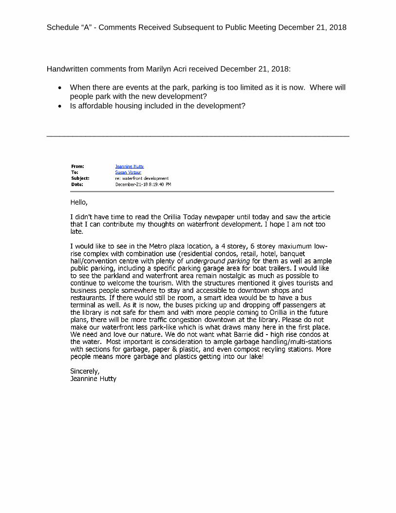
Handwritten comments from Marilyn Acri received December 21, 2018:
• When there are events at the park, parking is too limited as it is now. Where will people park with the new development?
• Is affordable housing included in the development? ______________________________________________________________________

Schedule “A” - Comments Received Subsequent to Public Meeting December 21, 2018
Schedule “A” - Comments Received Subsequent to Public Meeting December 21, 2018
Schedule “A” - Comments Received Subsequent to Public Meeting December 21, 2018

Schedule “A” - Comments Received Subsequent to Public Meeting December 21, 2018

Schedule “B” - Review of Applicable Planning Policies
The Provincial Policy Statement (PPS) 2014 The Provincial Policy Statement 2014 (PPS) came into effect on April 30, 2014 and applies to all planning decisions made on or after that date. The PPS provides policy direction on matters of provincial interest and establishes the policy foundation for regulating the development and use of land in Ontario. All planning decisions “shall be consistent with” the PPS [PPS 4.2]. The PPS focuses on three key areas: building strong healthy communities, wise use and management of resources, and protecting public health and safety. The objectives of the PPS are to promote strong, livable, healthy and resilient communities, protecting the environment and public health and safety, and facilitating economic growth. These objectives are achieved through the efficient use of land, resources, infrastructure and public service facilities; sound environmental and ecological management; protection and enhancement of natural heritage and cultural heritage resources; promotion of energy efficiency and minimizing impacts on climate change; and, protecting public health and safety. As a “settlement area”, municipalities such as Orillia are directed by the PPS to promote standards of development that enable “intensification, redevelopment and compact form” [PPS 1.1.3.4]. Such “settlement areas” are directed to be the focus of growth and development with land use patterns within these areas that: “efficiently use land and resources; are appropriate for, and efficiently use, the infrastructure and public service facilities which are planned or available, and avoid the need for their unjustified and/or uneconomical expansion; minimize negative impacts to air quality and climate change, and promote energy efficiency; support active participation; and are transit and freight supportive”. [PPS 1.1.3.2] The PPS directs planning authorities to “identify appropriate locations and promote opportunities for intensification and redevelopment” [PPS 1.1.3.3). This Provincial direction is reflected through the City’s Official Plan. Comprehensive, integrated and long-term planning is achieved though Official Plans as they identify and incorporate Provincial direction and set out appropriate land use designations and policies. The PPS encourages growth within “settlement areas” through intensification and redevelopment which make efficient use of land and resources and optimizes existing public infrastructure and facilities. The proposed amendment is consistent with the applicable provisions of the PPS through the development and intensified use of existing, unutilized or underutilized sites that offers full municipal services; accessibility to parks, trails and public transit; and furthers the PPS directive of increased residential intensification within the Settlement Area.

The amendment proposes to utilize existing infrastructure and expand residential and commercial opportunities within the City on lands that were otherwise underutilized. The PPS encourages opportunities to increase densities and introduce different forms of housing. Therefore, the proposal is in keeping with the direction of the Province, by introducing a new form of housing and density to the area, while maintaining and enhancing the character of the area. Growth Plan for the Greater Golden Horseshoe, 2017 The 2017 Growth Plan for the Greater Golden Horseshoe builds upon the Provincial Policy Statement (PPS) by establishing a land use planning framework for the Greater Golden Horseshoe (GGH) that supports the achievement of complete communities, a thriving economy, a clean and healthy environment, and social equity. Since the introduction of the Growth Plan in 2006, the GGH has seen a shift to more compact development patterns, a greater variety of housing options, more mixed use development in growth areas and greater integration of transit and land use planning. The Growth Plan 2017 builds on the progress of the initial Growth Plan with respect to building complete communities that are compact, transit-supportive and make effective use of investments in infrastructure and public service facilities by providing enhanced policy directions. By taking a long term planning perspective, the Growth Plan directs municipalities to manage growth by creating complete communities; prioritizing intensification; capitalizing on new economic and employment opportunities; supporting a range and mix of housing options; improving the integration of land use planning with planning and investment in infrastructure and public service facilities; protection of natural heritage features, hydrologic and landform systems; support and protection of prime agricultural areas; conservation of cultural heritage resources; and the integration of climate change considerations. Identified as a Primary Settlement Area, the City of Orillia is expected to meet intensification targets within the delineated built-up area. The Growth Plan establishes targets for growth and development, including direction that a significant portion of new growth be directed to existing built-up areas where infrastructure and public services exist and can accommodate population and employment growth. In order to further these objectives, municipalities must look towards the redevelopment of existing sites at higher densities than currently exists. This may occur through infill development or by the expansion or conversion of existing buildings. The land subject to the proposed amendment have municipal servicing available and are located within the City’s existing built-up area. The applications conform to the Growth Plan’s definitions of intensification and re-development, which are to be encouraged and promoted, especially within the City’s existing built-up area. The proposed amendment conforms to the Growth Plan for the Greater Golden Horseshoe, 2017, as amended.

Lake Simcoe Protection Plan (2009) The subject lands fall outside of the Lake Simcoe watershed and therefore the subject applications are not subject to the Plan. Official Plan of the City of Orillia (2013) The Official Plan was approved, with modifications, by the Ministry of Municipal Affairs and Housing on March 17, 2011, and subsequently by the OMB on August 23, 2013. Section 1.2 of the City’s Official Plan outlines the “Vision” for the City. The vision speaks to a vibrant downtown with an excellent trails and parks network with waterfront access. The proposed amendment will expand the City’s downtown and strengthen the connection between the City’s downtown and its waterfront which is a principle component of the City’s vision. The proposed amendment also places a strong emphasis on high quality urban design to ensure the proposed development will be compatible with the character of the surrounding area. Section 2 of the City’s Official Plan contains “Principles” intended to guide the City in the achievement of the vision set out in the Official Plan. The following is an analysis of how both the proposed Area Specific Policy for the Waterfront Redevelopment Area and the proposed site-specific zoning conform to the Principles of the Official Plan: PRINCIPLE 1 - Manage Growth in a Responsible and Efficient Manner Section 2.2 c) states that “Planning for new development will be carried out in a manner that makes efficient use of existing infrastructure, vacant and underutilized lands and buildings as well as planned municipal services.” The properties included in the Waterfront Redevelopment Area are generally vacant and underutilized. Infrastructure to service the proposed redevelopment is in place. Section 2.2 f) states that “All new development shall be designed to improve the character of the existing community without causing undue, adverse impacts on adjacent properties.” The proposed Area Specific Policy 4.2.9 for the Waterfront Redevelopment Area contains specific design policies intended to implement this Principle. Buildings within the Waterfront Redevelopment Area are required to be in character with the surrounding Downtown Area and are encouraged to be clad with stone, brick and/or decorative concrete. The angular plane and landscaped buffering requirements help to ensure that there will be no adverse impacts on adjacent properties. Section 2.2 g) states that “Development achieved through intensification, particularly within the Downtown Area, shall foster a pedestrian environment which promotes social interaction and easy access to community amenities.” The proposed Area Specific Policy for the Waterfront Redevelopment Area supports this Principle by requiring a

compact form of development. Residents within this area will have easy pedestrian access to Couchiching and Centennial Parks as well as to the Port and to the downtown. The civic square, required under the Area Specific Policy, at the northwest corner of Mississaga Street East and Centennial Drive will provide a gathering space which promotes social interaction. PRINCIPLE 2 - Promote a Complete Community that Supports a Healthy, Safe and Diverse Population Section 2.3 a) indicates that this complete community should “include places to meet and build social connections”. This Principle is incorporated into the Waterfront Redevelopment Area policies through the requirement for the civic square and through the proximity to the waterfront parkland and trail system. PRINCIPLE 3 - Ensure the Sustainability and Integrity of the Environment Section 2.4 e) indicates, in part, that “Greening elements, including street trees and other landscaping features will be a priority, particularly in the Downtown Area and adjacent to the waterfront.” The proposed Area Specific Policy for the Waterfront Redevelopment Area contains specific direction regarding street trees. The Zoning By-law Amendment requires appropriate landscaped buffering. The proposed Design Policies for Buildings for the Waterfront Redevelopment Area contain the following policies which conform to Principle 3:
“xiii) in the design of built form, incorporate principles of sustainable development, energy and resource efficiency;
xiv) be designed to prevent the adjacent land uses from experiencing
extensive losses of sunlight; xv) be encouraged to include energy efficient building design
components including passive solar energy gain, increased insulation, Energy Star appliances, alternative energy systems, and conformity with LEED certification; and,
xvi) be encouraged to incorporate a ‘green-roof’ into the design of all new buildings.”
PRINCIPLE 4 - Promote a Strong and Diverse Employment Base Section 2.5 c) states that “The tourism potential of the waterfront, Downtown Area and Adjacent residential neighbourhoods will be enhanced by promoting and encouraging waterfront-related facilities and development.” The concept of the Waterfront Redevelopment Area is strongly supportive of this principle.

Section 2.5 d) iii) indicates that the City “shall promote long term economic prosperity through economic development and competitiveness by … iii) promoting the development of brownfield sites”. The subject property is the site of various historic industrial uses and therefore clearly constitutes a “brownfield site”, which is defined in the Official Plan as “Undeveloped or previously developed properties that may be contaminated. They are usually, but not exclusively, former industrial or commercial properties that may be underutilized, derelict or vacant.”

Schedule “A-1”
AMENDMENT NUMBER 9
to the
OFFICIAL PLAN
for the
CITY OF ORILLIA
(OPA #9)

2
AMENDMENT NUMBER 9 TO THE
OFFICIAL PLAN FOR THE
CORPORATION OF THE CITY OF ORILLIA
The attached explanatory text and schedule, constituting Amendment Number 9 to the Official Plan of the City of Orillia, was prepared and adopted by the Council of the Corporation of the City of Orillia by By-law 2018-97 under the provisions of Sections 17 and 22 of the Planning Act, R.S.O. 1990 c.P. 13, as amended. ________________________________ MAYOR ________________________________ CAO/CITY CLERK
3
AMENDMENT NUMBER 9 TO THE OFFICIAL PLAN
FOR THE CITY OF ORILLIA
THE CONSTITUTIONAL STATEMENT The following Amendment to the Official Plan for the City of Orillia consists of three parts: PART A – THE PREAMBLE Consists of the purpose, location and basis for the Amendment and does not constitute part of the actual Amendment. PART B – THE AMENDMENT Sets out the actual Amendment Number 9 to the City of Orillia Official Plan, including the specific policies to be amended and changes to the Schedules. PART C – THE APPENDICES Consists of the background information and planning considerations associated with this Amendment. This section does not constitute part of the actual amendment.

4
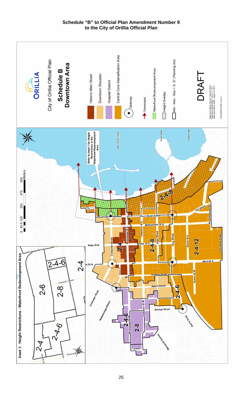
PART A – THE PREAMBLE 1.0 PURPOSE OF AMENDMENT The purpose of this Official Plan Amendment is to re-designate the subject lands from the “Environment/Open Space - Parkland and Major Open Space” designation to the “Downtown Area - Central Core Intensification Area” designation and to include the subject lands in a new Area Specific Policy 4.2.9. 2.0 LOCATION OF AMENDMENT The parcel affected by the amendment is comprised of all City-owned land between Tecumseth Street and Mississaga Street East, bound by the future realignment of Centennial Drive to the east and Front Street North to the west. 3.0 BASIS OF AMENDMENT The basis of the amendment is a Council direction to staff to pre-designate the lands in order to facilitate the transformation and redevelopment of the lands for a range of residential and commercial uses. PART B – THE AMENDMENT 1.0 DETAILS OF THE AMENDMENT The Official Plan for the City of Orillia is hereby amended as follows:
1. Schedule ‘A’ - Land Use is hereby amended by changing the designation of the lands shown on Schedule “A” to this Amendment from “The Environment/Open Space - Parkland and Major Open Space” designation to the “Downtown Area” designation.
2. Schedule ‘B’ - Downtown Area is hereby amended by designating the
lands shown on Schedule “A” to this Amendment to the “Central Core Intensification Area” designation.
3. Schedule ‘B’ - Downtown Area is hereby amended by:
a. applying the “Height Overlay” to the Waterfront Redevelopment
Area; b. by delineating the perimeter of the Waterfront Redevelopment Area
and by adding an Inset 1 identifying the minimum and maximum height in storeys within the Waterfront Redevelopment Area; and
c. by relocating the Gateway from the intersection of Neywash Street and Laclie Street to the future intersection of Coldwater Street and Front Street North.
5
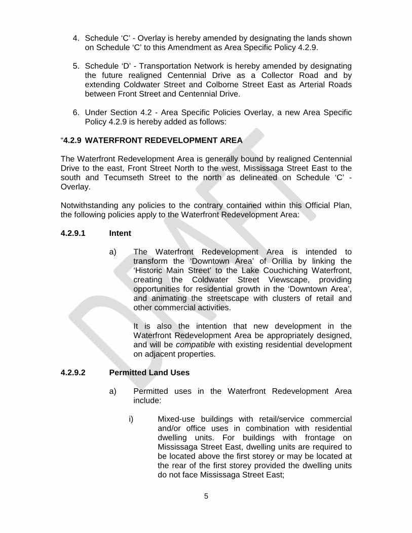
4. Schedule ‘C’ - Overlay is hereby amended by designating the lands shown on Schedule ‘C’ to this Amendment as Area Specific Policy 4.2.9.
5. Schedule ‘D’ - Transportation Network is hereby amended by designating the future realigned Centennial Drive as a Collector Road and by extending Coldwater Street and Colborne Street East as Arterial Roads between Front Street and Centennial Drive.
6. Under Section 4.2 - Area Specific Policies Overlay, a new Area Specific
Policy 4.2.9 is hereby added as follows: “4.2.9 WATERFRONT REDEVELOPMENT AREA The Waterfront Redevelopment Area is generally bound by realigned Centennial Drive to the east, Front Street North to the west, Mississaga Street East to the south and Tecumseth Street to the north as delineated on Schedule ‘C’ - Overlay. Notwithstanding any policies to the contrary contained within this Official Plan, the following policies apply to the Waterfront Redevelopment Area: 4.2.9.1 Intent
a) The Waterfront Redevelopment Area is intended to transform the ‘Downtown Area’ of Orillia by linking the ‘Historic Main Street’ to the Lake Couchiching Waterfront, creating the Coldwater Street Viewscape, providing opportunities for residential growth in the ‘Downtown Area’, and animating the streetscape with clusters of retail and other commercial activities.
It is also the intention that new development in the Waterfront Redevelopment Area be appropriately designed, and will be compatible with existing residential development on adjacent properties.
4.2.9.2 Permitted Land Uses
a) Permitted uses in the Waterfront Redevelopment Area include:
i) Mixed-use buildings with retail/service commercial
and/or office uses in combination with residential dwelling units. For buildings with frontage on Mississaga Street East, dwelling units are required to be located above the first storey or may be located at the rear of the first storey provided the dwelling units do not face Mississaga Street East;

6
ii) Multiple-unit buildings, all forms of townhouses
(including, but not limited to, link, stacked and back-to-back) and apartments buildings;
iii) Live-Work Units;
iv) Secondary Dwelling Units;
v) Commercial uses including retail stores, offices,
restaurants, personal services, service commercial and tourist accommodations;
vi) Office, research and data processing facilities;
vii) Home Occupations;
viii) Communal Housing;
ix) Child Care Facilities;
x) Institutional uses;
xi) Cultural, recreational and entertainment uses;
xii) Conference centres;
xiii) Parking facilities at-grade and/or in structure;
xiv) Parks, civic open space, and community gardens;
xv) Public Uses and public and private utilities;
b) High activity uses that animate the streetscape, like retail and
restaurants, are encouraged at-grade, with uses such as offices and residential on second floors and above.
4.2.9.3 Prohibited Land Uses
a) The following land uses are prohibited on the Waterfront Redevelopment Area:
i) Drive-through facilities of any kind;
ii) New single-detached, semi-detached and duplex
dwelling units; and,

7
iii) Automotive-oriented uses of any kind (sales, service, gas stations).
4.2.9.4 Development Policies 4.2.9.4.1 General
a) Within the Waterfront Redevelopment Area, building heights are identified on Schedule ‘B’. The minimum building height shall be two (2) storeys or equivalent. The maximum building heights, in storeys, are delineated on Schedule “B” generally in accordance with the Orillia Port Area Public Realm Plan. No height bonusing under Section 37 of the Planning Act shall be considered within the Waterfront Redevelopment Area.
b) In addition to the height policies within the Waterfront
Redevelopment Area, lands adjacent to the Lake Couchiching Waterfront have been identified with a Height Overlay on Schedule ‘B’ - Downtown Area. The intent of this Height Overlay is to ensure that all buildings proposed to be located, in whole or in part, adjacent to Lake Couchiching, shall be stepped back above the third storey along the exterior building faces that provide views to the Lake, and shall be subject to further angular plane requirements as set out in the policies of this Plan.
c) All new buildings on sites that are within the Height Overlay
on Schedule 'B', and that have an overview of public parkland, Centennial Drive, or the civic square at the northwest corner of the intersection of Mississaga Street West and Centennial Drive and have views to Lake Couchiching will present a front facade to the Lake and will display architectural design excellence. These buildings will also be stepped back from the Lake-side property line through the implementation of the angular plane provisions as follows:
i) the City will identify, through the development review
process, sites that are within the Height Overlay identified on Schedule 'B' and have a property line that faces Lake Couchiching, where an angular plane shall be implemented to establish an appropriate built form facing the Lake; and
ii) where the City has identified such a site, they shall
establish an angular plane from the appropriate Lake-fronting property line in the implementing Zoning By-

8
law. The angular plane of between 45 to 60 degrees shall be established at a point 7.5 metres directly above the Lake-fronting property line.
d) Buildings shall be designed in a manner which contributes to
an active street environment and, where possible, provide an active use at-grade in order to promote pedestrian activity and provide public interaction opportunities. Any outdoor activity spaces shall be well buffered from adjacent residential development and new residential development adjacent to any outdoor commercial space is required to be well buffered from the abutting commercial activity to provide residents with privacy and to mitigate the impact of noise;
e) Development within the Waterfront Redevelopment Area
shall ensure that enhanced connections to the City’s waterfront parks and trails are included in all development proposals. New development shall consider improved and interactive pedestrian features adjacent to roads that lead to the waterfront and enhanced landscaping along routes to the water’s edge.
f) All development within the Waterfront Redevelopment Area
shall be compatible with residential development on adjacent properties and shall be carried out in conformity with the ‘Design Policies for the Waterfront Redevelopment Area’, and the other applicable policies of this Plan.
4.2.9.4.2 Multiple-Unit Buildings and Townhouses
a) Multiple-unit buildings may include triplexes, fourplexes and other similar buildings that include multiple dwelling units.
b) All multiple-unit building or townhouse developments within
the Waterfront Redevelopment Area shall be compatible with residential development on adjacent properties.
c) All multiple-unit building or townhouse developments within
the Waterfront Redevelopment Area shall be subject to Site Plan Control and may be subject to a Zoning By-law Amendment.
4.2.9.4.3 Apartment Buildings and Communal Housing
a) All apartment building and communal housing developments within the Waterfront Redevelopment Area shall be compatible with the residential development on adjacent properties.

9
b) All apartment building and communal housing developments
within the Waterfront Redevelopment Area shall be subject to Site Plan Control and may be subject to a Zoning By-law Amendment.
4.2.9.4.4 Live-Work Units
a) Live-work units include the potential to integrate small-scale commercial, office or retail uses at-grade, in combination with a residential unit.
b) Live-work units may be located anywhere within the
Waterfront Redevelopment Area. Live-work units shall be subject to Site Plan Control and may be subject to a Zoning By-law Amendment.
c) Live-work units shall provide parking and, where feasible,
provide amenity areas and buffering with planting and/or fencing from adjacent residential dwellings.
d) Adequate parking and drop-off/pick-up facilities shall be
provided.
e) Parking should not be located in the front yard of any building.
4.2.9.5 Design Policies for the Waterfront Redevelopment Area The following design policies shall apply within the Waterfront Redevelopment Area. 4.2.9.5.1 Intent
a) The fundamental intent of these design policies is to create a
built environment which provides:
i. visual diversity, interest and beauty;
ii. a well-defined public realm, including an interconnected open space network;
iii. sensitive integration of new development with existing
development through the promotion of compatible development adjacent to existing residential development;

10
iv. a full range of commercial and community services in proximity to housing to promote walking and to help reduce automobile trips;
v. a pedestrian-oriented, transit supportive and cyclist-
oriented development pattern where priority is given to the pedestrian, cyclist and motorist, in said order;
vi. attractive and distinctive development with strong visual
and physical connections to the waterfront; and vii. a road network which recognizes and preserves the
historic character of the ‘Downtown Area’ and adjacent neighbourhoods.
b) All development shall be compatible with the ‘Downtown
Area’ architectural styles, building materials and scale. Development which results in extensive loss of sunlight to adjacent properties shall be discouraged.
c) Large, blank façades along the face of a road and/or facing
Lake Couchiching shall be avoided. Enhanced building elevations with special architectural massing or detail on special priority lots which are located in prominent public view shall be provided. Priority lots include corner lots, terminating vista lots, lots adjacent to the civic square at the northwest corner of the intersection of Mississaga Street East and Centennial Drive, and lots that have views of the Lake Couchiching shoreline.
d) Ground floors of all buildings shall be designed with windows
and doors opening onto roads and/or the civic square at the northwest corner of the intersection of Mississaga Street East and Centennial Drive to provide "eyes on the street".
e) For the purpose of enhancing the pedestrian scale of
buildings and providing safe, well-shaded resting places for pedestrians, architectural features such as awnings, canopies, and building cantilevers/overhangs should be incorporated into the design of the building.
f) Primary access to buildings shall, where feasible, be
oriented to the road and provide direct access for pedestrians, particularly along Coldwater Street, Mississaga Street East, Centennial Drive, and Front Street North.
4.2.9.5.2 Design Policies for Roads
11
a) Reconstruction and construction of new municipal roads
within the Waterfront Redevelopment Area shall adhere to the Design Policies for Roads in the ‘Downtown Area’ as set out in Section 3.2.8.3 of this Plan.
b) In addition to Policy 4.2.9.5.2 a) and the designation on Schedule ‘D’ of Centennial Drive as a Collector Road, Centennial Drive will be designed as a Collector Road but it is intended to function as a Local Road, in effect serving as a Minor Collector Road. The planned objective of Centennial Drive is not to rapidly move large volumes of traffic from one area of the City to another. Instead, Centennial Drive will be designed to accommodate multi-modal transportation with a specific focus on pedestrian and active transportation movement with a sidewalk on one side of the street and a multi-use trail on the other side in accordance with Policy 6.1.8.2 of this Plan.
b) Private Roads which provide access to units within a
condominium development shall have a minimum right-of-way of 9.0 metres with a minimum road surface width of 6.0 metres and the provision of a sidewalk (with a minimum width of 1.5 metres) on at least one side of the Private Road with the remainder of the right-of-way for a landscaped utility corridor.
4.2.9.5.3 Design Policies for Greening
c) Trees
i) Trees are an important part of the character and a
legacy of Orillia that should be both planned for and protected for future generations to enjoy.
ii) In general, all proposed street trees should be planted
in continuous tree trenches to ensure access to adequate soil volumes. Tree trenches should be irrigated and drained, where possible.
iii) A variety of tree species should be used throughout
the Waterfront Redevelopment Area to avoid the creation of a monoculture. Preference shall be given to the use of native tree species that are suitable to the planting environment.
iv) Tree planting is required as a component of any
development within the Waterfront Redevelopment

12
Area and shall be required to adhere to the City’s Tree Canopy and Native Vegetation policy or successor.
d) Parkland/Open Space
i) It is the intention of the City to promote opportunities
for additional public open space features and to improve upon existing open space links between the ‘Downtown Area’ and the Lake Couchiching Waterfront, with particular emphasis on the creation of a new civic square at the northwest corner of the intersection of Mississaga Street East and Centennial Drive.
ii) The Waterfront Redevelopment Area should focus on
connectivity between roads, trails, and parks to result in safe, inviting and interactive spaces. A high standard of hard and soft landscaping shall be required and shall be maintained in a healthy condition.
iii) The existing adjacent waterfront parks are the primary
green open space feature that sets the stage for the level of quality to be emulated throughout the Waterfront Redevelopment Area. Wherever possible, through the development process, the waterfront parks and trails systems are to be enhanced through additional parkland dedication, high quality landscape design, and where buildings are adjacent, high quality urban architecture.
iv) The development of the Waterfront Redevelopment
Area shall incorporate a civic square at the northwest corner of the intersection of Mississaga Street East and Centennial Drive.
v) All development on the Waterfront Redevelopment
Area shall be subject to the parkland dedication requirements of the Planning Act unless otherwise waived by City Council.
vi) For clarity, the Urban Square policies of this Plan
shall not apply to the Waterfront Redevelopment Area.
c) Gateways
13
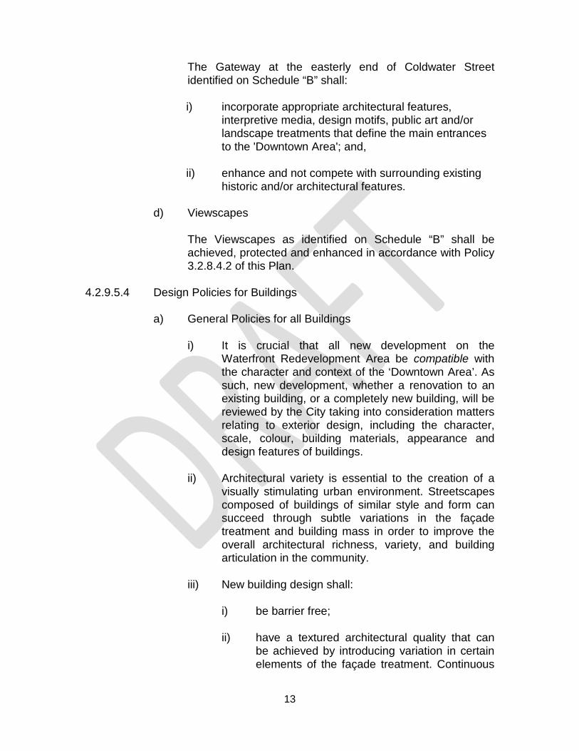
The Gateway at the easterly end of Coldwater Street identified on Schedule “B” shall:
i) incorporate appropriate architectural features,
interpretive media, design motifs, public art and/or landscape treatments that define the main entrances to the 'Downtown Area'; and,
ii) enhance and not compete with surrounding existing
historic and/or architectural features.
d) Viewscapes
The Viewscapes as identified on Schedule “B” shall be achieved, protected and enhanced in accordance with Policy 3.2.8.4.2 of this Plan.
4.2.9.5.4 Design Policies for Buildings
a) General Policies for all Buildings
i) It is crucial that all new development on the
Waterfront Redevelopment Area be compatible with the character and context of the ‘Downtown Area’. As such, new development, whether a renovation to an existing building, or a completely new building, will be reviewed by the City taking into consideration matters relating to exterior design, including the character, scale, colour, building materials, appearance and design features of buildings.
ii) Architectural variety is essential to the creation of a
visually stimulating urban environment. Streetscapes composed of buildings of similar style and form can succeed through subtle variations in the façade treatment and building mass in order to improve the overall architectural richness, variety, and building articulation in the community.
iii) New building design shall:
i) be barrier free; ii) have a textured architectural quality that can
be achieved by introducing variation in certain elements of the façade treatment. Continuous

14
roads of monotonous and repetitive façades shall be avoided;
iii) create a street space that is scaled to the
pedestrian and is organized to present an appropriate façade to all adjacent public roads and the civic square located at the northwest corner of the intersection of Mississaga Street East and Centennial Drive to provide interest and comfort at ground level for pedestrians. Primary pedestrian entrances shall provide direct and universal access to the public sidewalk;
iv) have a dynamic façade that is articulated with
three-dimensional elements, such as balconies, bay windows and porches, cornices, window trim, entrances, canopies and the articulation of the building mass;
v) employ architectural details and/or a step-back
at the upper storeys that is established in the implementing Zoning By-law;
vi) include pedestrian weather and sun protection
systems including awnings, canopies, colonnades, or front porches along the sidewalk edge of important pedestrian roads; at entrances to buildings; and adjacent to the civic square located at the northwest corner of the intersection of Mississaga Street East and Centennial Drive;
vii) incorporate patios (including roof-top patios),
where feasible, to provide outdoor amenity space for residents and/or patrons. These outdoor amenity spaces shall be well buffered from adjacent residential development. Also, new residential development adjacent to any outdoor commercial space is required to be well buffered from the abutting commercial activity to provide residents with privacy and to mitigate the impact of noise;
viii) have any visible mechanical equipment and
waste receptacles appropriately screened and located in a manner that has a minimal

15
physical and visual impact on public sidewalks and accessible open spaces;
ix) where feasible, have all transformers and other
above ground utilities located within the building, or on private property located away, and/or screened, from public view. All new electrical installations, including street lighting, are required to be underground;
x) have decorative details and façade articulation
that respects or is consistent with architectural elements of neighbouring buildings with historic features;
xi) avoid the use of vinyl siding, aluminum or sheet
metals, and/or mirrored or tinted glass. The use of stone, brick and decorative concrete shall be encouraged.
xii) have sign bands, storefront windows, canopies
and awnings that respect building scale and complement existing signage examples on neighbouring buildings;
xiii) in the design of built form, incorporate
principles of sustainable development, energy and resource efficiency;
xiv) be designed to prevent the adjacent land uses
from experiencing extensive losses of sunlight; xv) be encouraged to include energy efficient
building design components including passive solar energy gain, increased insulation, Energy Star appliances, alternative energy systems, and conformity with LEED certification; and,
xvi) be encouraged to incorporate a ‘green-roof’
into the design of all new buildings.
b) Corner Sites
Corner development sites are good locations for landmark buildings as they have better visibility, light and view opportunities. For the purposes of this policy, corner sites are also buildings abutting the civic square at the northwest corner of the intersection of
16
Mississaga Street East and Centennial Drive and buildings at the intersection of public and/or private roads. As such, corner sites will be addressed in the following manner:
i) define the intersection at which the building is located by architecturally articulating its presence at each corner;
ii) include prominent visual and vertical architectural
features such as a wrap-around porch, bay window, turret feature or a clock tower, and/or an additional storey, greater than abutting buildings on non-corner sites;
iii) a corner building should have primary, articulated
façades towards both roads; and, iv) a corner building should have the highest level of
architectural detailing and a distinct architectural appearance.
c) Multiple-Unit Buildings and Townhouses
In addition to the design policies for all buildings within the Waterfront Redevelopment Area, the following additional policies shall apply to multiple unit buildings and townhouse developments within the Waterfront Redevelopment Area:
i) the siting, massing, and façade design of multiple unit buildings and townhouses shall be coordinated on a block-by-block basis;
ii) the elevation of the townhouse block shall be
articulated in a manner that provides variation between units, and reinforces common characteristics that visually unites the block;
iii) variety in the design of roofs is required to break up
the massing of townhouse blocks; iv) garages should be accessed from a rear lane. Where
they are not, garages are expected to be paired to allow for more substantial front yard green space. Garages shall not protrude beyond the main front wall or porch of the townhouse;
17
v) side and rear elevations visible from public areas shall have upgraded facade treatments;
vi) buildings sited at the end of a view corridor, such as
at a “T” intersection, elbow roads, traffic circles and on prime corner lots should be designed with significant architectural elements; and,
vii) each townhouse unit shall have access to their rear
yard via the garage and/or a rear lane and/or a communal walkway/easement.
d) Apartment Buildings and Communal Housing
In addition to the design policies for all buildings within the Waterfront Redevelopment Area, the following additional policies shall apply to apartment building and communal housing developments within the Waterfront Redevelopment Area:
i) apartment and communal housing buildings should be oriented to front on to the road, with a minimum setback;
ii) permanent parking, loading and service areas shall
be located in side or rear yards and set back from the front facade of the building;
iii) a visitor drop-off area should be located at the front of
the building;
iv) the siting, massing, and façade design of apartment and communal housing buildings shall be coordinated on a block-by-block basis;
v) the exterior of the apartment and communal housing
block shall be articulated in a manner that provides variation between buildings, and reinforces common characteristics that visually unites the block;
vi) variety in the design of roofs is required to break up
the massing of apartment and communal housing blocks;
vii) side and rear elevations visible from public areas shall
have upgraded facade treatments;

18
viii) buildings sited at the end of a view corridor, such as at a “T” intersection, elbow roads, traffic circles and on prime corner lots should be designed with significant architectural elements; and,
ix) rooftop mechanical equipment and waste receptacles
shall be screened from view with materials that are complementary to the building or through architectural features.
4.2.9.5.5 Design Policies for the Location of Buildings on a Lot
a) The implementing Zoning By-law shall consider the regulation of lot frontage and lot coverage as a way to ensure compatible development and a consistent built form within the Waterfront Redevelopment Area.
b) A relatively consistent building edge is important to provide
spatial definition and containment to the road for buildings within the Waterfront Redevelopment Area. The front and exterior side walls of buildings should be located within a defined zone on the lot, referred to as “Build-Within Zones”. The implementing Zoning By-law may set both a minimum and maximum setback. It is understood that in some circumstances these “Build-Within Zones” may not be achievable on all sides. The City shall use its discretion in the application on the street wall concept on development blocks that have street frontage on more than two sides. The priority focus of the “Build-Within Zones” will be the streetscape along Mississaga Street East, Coldwater Street, Front Street North, and Centennial Drive.
c) In order to ensure development compatibility within and
adjacent to the 'Downtown Area', the City shall establish appropriate interior side and rear yard setbacks for the Waterfront Redevelopment Area in the implementing Zoning By-law.
d) It is an objective of the City to ensure a comfortable
pedestrian environment, and part of that comfort is weather protection. As a result, it is important to promote the provision of building elements that provide shade and/or shelter from the elements of weather such as rain and snow through permissions for encroachments into the pedestrian realm. In addition, it is an objective of the City to promote street activity/animation. Street cafes and outdoor seating
19
for restaurants should also be considered. The City will encourage the following:
i) awnings or canopies may be permitted to encroach
into the public pedestrian realm subject to approval from the City;
ii) outdoor cafes and seating for restaurants may be
permitted to encroach into the public pedestrian realm subject to approval from the City;
iii) semi-permanent structures over the sidewalk,
including entry features, arcades and perpendicular signage and/or lighting fixtures attached to the building may be permitted to encroach into the public pedestrian realm subject to approval from the City;
iv) permanent structural components of the building
(colonnades and balconies) are not permitted to encroach into the defined public pedestrian realm; and,
v) the amount of any permitted encroachment, whether
temporary or permanent, shall be established by the City on a site-by-site basis, and in consideration of the following criteria:
- the encroachment enhances pedestrian
comfort by providing shade and/or protection from the elements of weather such as rain and snow;
- the encroachment does not impede pedestrian
and/or vehicular access, movement or safety, or impede any public maintenance activities; and,
- the encroachment does not impede sight lines
to important views and vistas. 4.2.9.5.6 Design Policies for Parking and Loading
a) In order to reinforce roads as primary public spaces, the locations of parking, driveways and service entrances and loading areas need to be carefully considered and coordinated with the locations for pedestrian entrances.

20
As such, parking facilities, service access points, loading areas and any visible waste receptacles and/or mechanical equipment are to be located in a manner that have a minimum physical impact on sidewalks and accessible open spaces. Shared driveways and/or service courts at the side and rear of buildings are encouraged to provide for these functions:
i) surface parking, loading areas and servicing facilities
shall not be permitted in front of any buildings, with the exception of dwelling units with individual driveways, within the Waterfront Redevelopment Area. Surface parking and/or servicing facilities may be permitted in an interior side yard and are permitted within the rear yard;
ii) surface parking, loading areas and servicing facilities,
where permitted, shall be appropriately screened from view from the road. Where surface parking must be provided, the visual impact of large surface lots shall be mitigated by a combination of setbacks and landscaping including: pavement treatments, low walls or decorative fencing, landscaping, trees and lighting throughout parking lots and along the edges;
iii) parking is encouraged to be provided in structures,
either above, or where possible, below grade. Where a parking structure is above grade, permitted commercial uses shall be provided within the façade at-grade and the façade shall include appropriate architectural articulation;
iv) access to parking and servicing areas should occur
off side roads or service lanes and to the side or rear of buildings, where possible;
v) the City shall encourage shared access driveways
and, preferably, shared rear lane access for all development within the Waterfront Redevelopment Area.
vi) sustainable design will be encouraged and may
include: permeable paving surfaces, on-site stormwater management technologies, alternative energy systems (such as solar-powered lighting), and alternative-fuel vehicles and car-sharing services;

21
vii) where feasible, installation of infrastructure to support the use of alternative fueled vehicles, including charging stations for electric vehicles, is encouraged in the design of parking areas;
viii) to ensure safety and promote their priority over
vehicular traffic, pedestrian pathways on a development site shall be provided through the parking facility, including freestanding parking lots, and shall connect directly to public roads/sidewalks and building entrances. These pathways shall be identified and delineated with decorative paving materials and where possible landscape planting and/or tree rows that differentiate them from the driving surfaces. Pedestrian walkways should be made continuous across driving aisles as well as across driveway entrances at the road. The use of soft landscaping is also encouraged along major pedestrian routes, along with features such as outdoor furniture and pedestrian-scale lighting;
ix) parking lots shall be lit with pedestrian-scale lighting.
Light standards shall be low and spaced at appropriate intervals to avoid the “stadium lighting” effect;
x) when surface parking is located at the road edge,
deciduous trees and low shrubs (less than 1.0 metre high) shall be provided along the street line to provide a landscaped buffer;
xi) landscaping features shall be used to divide large
surface parking areas. Parking areas shall be divided into small-defined sections with curbs and landscaping features. Landscaped islands shall be placed at the ends of all parking aisles;
xii) connectivity between freestanding parking lots and
the main street is required through the establishment of public pedestrian linkages via side lot laneways;
xiii) parking garages shall have façade treatment to reflect
the character of the neighbourhood; xiv) in addition to the minimum parking space
requirements, parking facilities for bicycles shall be provided;

22
xv) where feasible, common laneways serving parking at the rear of commercial buildings shall be provided. Interconnected systems of rear laneways and drive aisles across adjoining properties shall be encouraged;
xvi) access points shall be reduced and consolidated to
optimize the use of driveways; and,
xvii) servicing and loading areas shall be oriented to the rear of commercial buildings. On-street loading will be discouraged.
4.2.9.5.7 Design Polices for Lighting
Lighting is an essential consideration to ensure safe pedestrian and transportation movement. The following guidelines shall apply to the Waterfront Redevelopment Area:
a) exterior lighting shall be designed to promote
pedestrian comfort, safety and provide high quality ambiance;
b) only Dark Skies friendly lighting will be permitted. In
addition, accent lighting is encouraged where it can emphasize built form and landscape elements;
c) only LED lighting or equivalent energy efficient
technology will be permitted; and,
d) pedestrian scale lighting shall be provided adjacent to roads, walkways, pedestrian routes and within parks, courtyards, and the civic square at the northwest corner of the intersection of Mississaga Street East and Centennial Drive.
4.2.9.6 Implementation
a) Site Plan Approval - Any development or redevelopment of a site, including enlargements or replacements of existing facilities, with an existing executed Site Plan Agreement, shall be subject to Site Plan Control. Enlargements of existing facilities of a site without an executed Site Plan Agreement that would involve an expansion of the floor area by more than 15 percent of the existing Gross Floor Area shall be subject to Site Plan Control in accordance with the

23
City of Orillia Site Plan Control By-law. Where Site Plan Control is required, no building permit may be issued by the City without first reviewing the development application in the context of all the principles and regulations identified within this Plan. The City shall utilize the Site Plan Approval process to the maximum extent permissible by the Planning Act. Specifically, the City may consider matters related to exterior design, including, and without limitation to the character, scale, materials, colour, appearance and design features of buildings for all development in the Waterfront Redevelopment Area.
b) Community Improvement Plan - The Waterfront
Redevelopment Area is identified as being within a Community Improvement Project Area and is subject to the policies set out in Section 7.4 of this Plan.
2.0 IMPLEMENTATION
Upon approval of this Amendment, Council will consider an implementing Zoning By-law Amendment.
3.0 INTERPRETATION
The provisions of the Official Plan as amended from time to time regarding the interpretation of that Plan, shall apply to this Amendment.
4.0 APPLICATION
The amendment applies to the parcel of land shown on the attached Schedules ‘A’, ‘B’ and ‘C’.
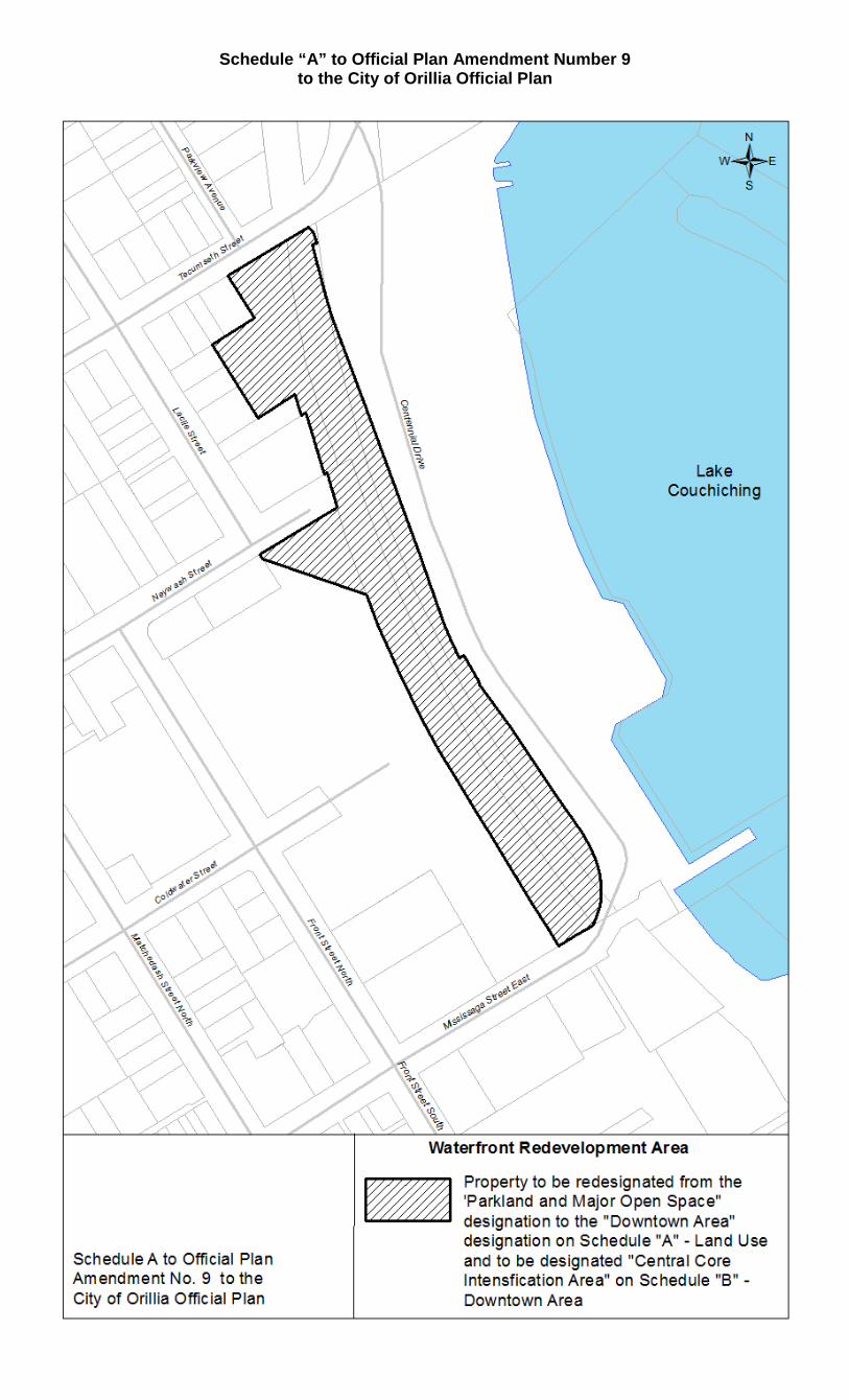
Schedule “A” to Official Plan Amendment Number 9 to the City of Orillia Official Plan
25
Schedule “B” to Official Plan Amendment Number 9 to the City of Orillia Official Plan

26
Schedule “C” to Official Plan Amendment Number 9 to the City of Orillia Official Plan

27
Schedule “D” to Official Plan Amendment Number 9 to the City of Orillia Official Plan
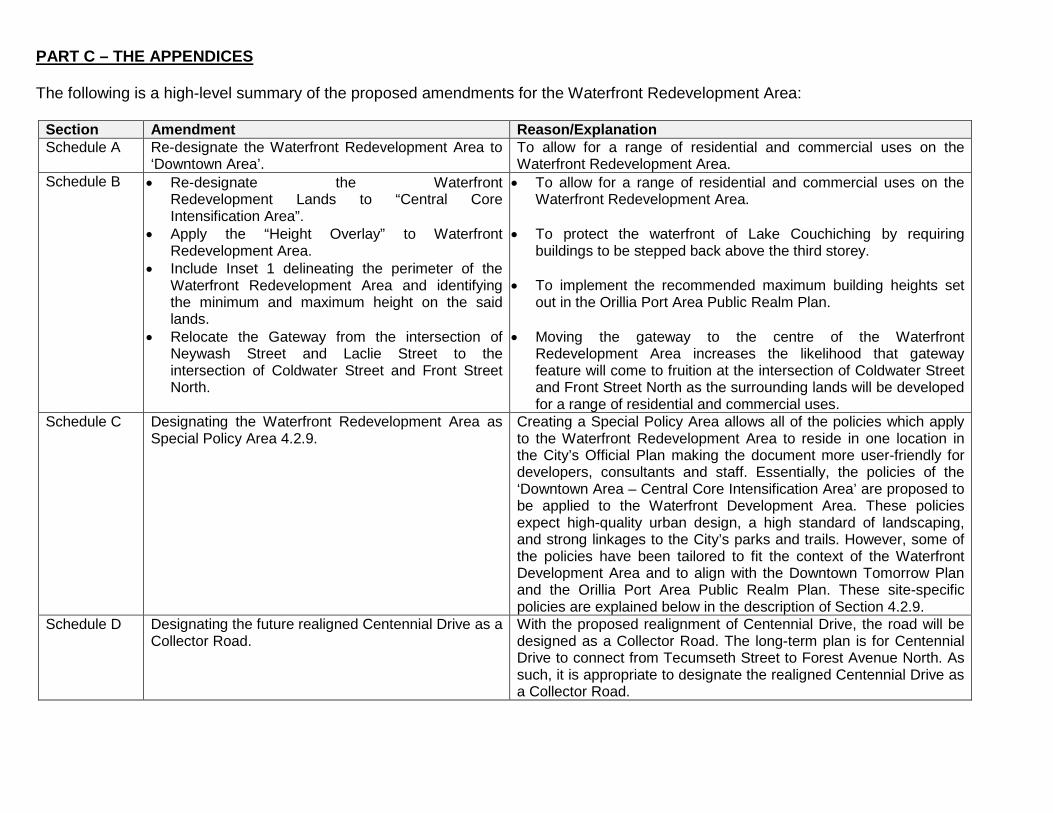
PART C – THE APPENDICES The following is a high-level summary of the proposed amendments for the Waterfront Redevelopment Area:
Section Amendment Reason/Explanation Schedule A Re-designate the Waterfront Redevelopment Area to
‘Downtown Area’. To allow for a range of residential and commercial uses on the Waterfront Redevelopment Area.
Schedule B • Re-designate the Waterfront Redevelopment Lands to “Central Core Intensification Area”.
• Apply the “Height Overlay” to Waterfront Redevelopment Area.
• Include Inset 1 delineating the perimeter of the Waterfront Redevelopment Area and identifying the minimum and maximum height on the said lands.
• Relocate the Gateway from the intersection of Neywash Street and Laclie Street to the intersection of Coldwater Street and Front Street North.
• To allow for a range of residential and commercial uses on the Waterfront Redevelopment Area.
• To protect the waterfront of Lake Couchiching by requiring
buildings to be stepped back above the third storey.
• To implement the recommended maximum building heights set out in the Orillia Port Area Public Realm Plan.
• Moving the gateway to the centre of the Waterfront
Redevelopment Area increases the likelihood that gateway feature will come to fruition at the intersection of Coldwater Street and Front Street North as the surrounding lands will be developed for a range of residential and commercial uses.
Schedule C Designating the Waterfront Redevelopment Area as Special Policy Area 4.2.9.
Creating a Special Policy Area allows all of the policies which apply to the Waterfront Redevelopment Area to reside in one location in the City’s Official Plan making the document more user-friendly for developers, consultants and staff. Essentially, the policies of the ‘Downtown Area – Central Core Intensification Area’ are proposed to be applied to the Waterfront Development Area. These policies expect high-quality urban design, a high standard of landscaping, and strong linkages to the City’s parks and trails. However, some of the policies have been tailored to fit the context of the Waterfront Development Area and to align with the Downtown Tomorrow Plan and the Orillia Port Area Public Realm Plan. These site-specific policies are explained below in the description of Section 4.2.9.
Schedule D Designating the future realigned Centennial Drive as a Collector Road.
With the proposed realignment of Centennial Drive, the road will be designed as a Collector Road. The long-term plan is for Centennial Drive to connect from Tecumseth Street to Forest Avenue North. As such, it is appropriate to designate the realigned Centennial Drive as a Collector Road.

29
Section Amendment Reason/Explanation Section 4.2.9 • The proposed site-specific policies for the
Waterfront Redevelopment Area provide a list of permitted and prohibited uses, general development policies, and design policies.
• Generally, the policies in this new Section 4.2.9 were taken from other sections of the existing Official Plan from the ‘Downtown Area’ and ‘Central Core Intensification Area’ policies with the exception of a few new items specific policies including: o Restricting residential on the ground floor
facing Mississaga Street East.
o Implementing the maximum building heights contained in the Orillia Port Area Public Realm Plan.
o Removing the requirement to provide many
urban squares throughout the development. Instead, require the incorporation of a civic square at the northwest corner of the intersection of Mississaga Street East and Centennial Drive.
o Restricting the use of vinyl siding, aluminum or
sheet metals, and/or mirrored or tinted glass as recommended in the Downtown Tomorrow Plan.
o Modifying the “build-within” policies to apply to
buildings with frontage on Mississaga Street East, Coldwater Street, and Centennial Drive.
• The policies essentially extend the ‘Central Core Intensification Area’ policies to the entire Waterfront Redevelopment Area to allow for a range of commercial and residential uses. As such, Single Detached Dwellings and Semi-Detached Dwellings have not been included as permitted use to be consistent with the approach taken in the rest of the ‘Central Core Intensification Area’.
• To keep a consistent streetscape and to animate the streetscape, it is recommended that ground floor residential facing Mississaga Street East not be permitted in buildings with frontage on Mississaga Street East This is consistent with the policies of the ‘Historic Main Street’ designation in the existing Official Plan.
• Significant consultation and time went into the crafting of the
Orillia Port Area Public Realm Plan. This document established a vision for the Waterfront Redevelopment Area, particularly with respect to maximum building heights. As such, it is recommended that these maximum building heights be permitted while extending the Height Overlay to adequately protect the Lake Couchiching vista.
• The Downtown Tomorrow Plan included a vision for a civic public
square at the intersection of Mississaga Street East and Centennial Drive. To assist with the implementation of this vision, it is recommended that the urban square policies not apply to the Waterfront Redevelopment Area. Rather that the site-specific policies be tailored for the construction and integration of a civic square at this key intersection.
• The Downtown Tomorrow Plan (DTP) also included a vision for
the most appropriate types of building materials in the ‘Downtown Area’. As such, the DTP recommended that the use of vinyl siding, aluminum or sheet metals, and/or mirrored or tinted glass be prohibited.

30
Section Amendment Reason/Explanation o Designating Centennial Drive as a Collector
Road but including a site-specific policy that describes that the realigned Centennial Drive will be intended to function as a Local Road with an emphasis on non-motorized travel.
o Encouraging roof-top and outdoor patios to help animate the City’s Downtown and Waterfront while adequately buffering abutting residents from adverse impacts, especially with respect to noise.
• The “build-within” policies can be a constraint to development when implemented in the Zoning By-law, particularly in the Waterfront Redevelopment Area where parcels of land are expected to be bound on several sides by municipal and private roads. It is recommended that this policy framework be ‘softened’ to allow for greater design flexibility to lessen potential barriers to development while providing a consistent streetscape along the three key public roads within the Waterfront Redevelopment Area: Mississaga Street East, Coldwater Street, Front Street North, and Centennial Drive.
• Although Centennial Drive will be designated as a Collector Road
on Schedule ‘D’ and be designed as a Collector Road, it is also important to include a site-specific policy about Centennial Drive to explain that the intent of this road is not to move large volumes of traffic from one area of the City to another. Instead, the focus will be on providing means of safe, non-vehicular travel within the road allowance.
• Outdoor amenity areas for commercial businesses are
encouraged while at the same time requiring careful design to ensure that existing and future residents will be protected from nuisances, particularly noise.
• In summation, the intent of the Waterfront Redevelopment Land
policies is to be implementing the vision contained in the City’s Downtown Tomorrow Plan and the Orillia Port Area Public Realm Plan.

BY-LAW NUMBER 2019-xx OF THE CITY OF ORILLIA
AMENDMENT NUMBER xx TO BY-LAW NUMBER 2014-44, THE ZONING BY-LAW FOR THE CITY OF ORILLIA (WATERFRONT REDEVELOPMENT AREA)
WHEREAS the Council of the Corporation of the City of Orillia may pass
by-laws pursuant to Sections 24(2) and 34 of the Planning Act, R.S.O. 1990, as
amended;
AND WHEREAS the Council of the Corporation of the City of Orillia has
directed that all City-owned land between Tecumseth Street and Mississaga Street East
bound by the future realignment of Centennial Drive to the east and Front Street North to
the west be pre-zoned to permit a range of commercial and residential uses intended to
facilitate development and transform the City’s Downtown;
AND WHEREAS Section 24(2) of the Planning Act, R.S.O. 1990 as
amended, permits Council to pass a By-law that does not conform with the Official Plan
provided that the By-law will conform with the Official Plan once an Official Plan
Amendment comes into effect;
NOW THEREFORE THE COUNCIL OF THE CORPORATION OF THE
CITY OF ORILLIA HEREBY ENACTS AS FOLLOWS:
1. THAT the following amendments shall be made to Zoning By-law 2014-44,
as amended.
2. THAT the following definition is added to Section 4 “Definitions” in
alphabetical order, with all other definitions being renumbered accordingly:
Dwelling, Back-to-Back Townhouse means a Townhouse Dwelling in which Dwelling Units are attached by a common rear and side wall above grade and whereby each Dwelling Unit faces away from each other and each Dwelling Unit has an independent entrance from the outside accessed through the front elevation or exterior side elevation of the Dwelling Unit.
Equivalent means, with respect to the Height of a Building, a Building which has fewer storeys than the required Minimum number of storeys but which achieves the Minimum Required Building Height.
3. THAT Map Number 14 of Schedule “A” is amended by rezoning the lands
identified on Schedule “A-1” attached from the “Open Space One” (OS1) Zone to the
“Residential Four - Intensification Area Exception Twelve (Holding One)” (R4-12i(H1))
Zone.
4. THAT Section 7.5 “Residential Zone Exceptions” is amended by adding
the following Zone Exception to Table 7.6 “Residential Four (R4) Zone Exceptions”:
Column 1 Column 2 Exception Number Exception
R4 EXCEPTIONS R4-12i (H1)
Permitted Uses: Permitted Residential Uses:
• Back-to-Back Townhouse Dwelling • Four-Unit Dwelling • Home Occupation • Multiple Dwelling • Public Use • Stacked Townhouse Dwelling • Three-Unit Dwelling • Townhouse Dwelling
Permitted Non-Residential Uses:
• Parking Lot • Live-Work Unit
Zone Provisions:
• Footnote (3) to Table 7.2 shall apply only to properties that Abut Coldwater Street.
• Notwithstanding Footnote (6) to Table 7.2, outdoor amenity areas are not Required for any form of Townhouse.
• Building Height (min) - 2 Storeys (6.0 m) or Equivalent • Building Height (max) - 4 Storeys (12.5 m) or Equivalent
The following specific Zone Requirements apply to Townhouse Dwellings: For Back-to-Back Townhouse Dwellings:
• Lot Area (min) - 85.0 m2 per unit (does not apply to a Secondary Dwelling Unit)
• Lot Frontage (min) - 6.0 m per interior unit, 7.2 m for end unit (does not apply to a Secondary Dwelling Unit)
For Stacked Townhouse Dwellings
• Lot Area (min) - 120.0 m2 per unit (does not apply to a Secondary Dwelling Unit)
• Lot Frontage (min) - 6.0 m per interior unit, 7.2 m for end unit (does not apply to a Secondary Dwelling Unit)
For Back-to-Back and Stacked Townhouse Dwellings:
• Lot Coverage (max) - 80% per Lot • Front Yard (min) - 3.0 m for Main Building, 6.0 m for Attached
Garage • Interior Side Yard - Interior Unit (min) - 0.0 m • Interior Side Yard - End Unit (min) - 1.2 m or 2.4 m between
Buildings where no property line exists • Exterior Side Yard (min) - 2.0 m • Rear Yard (min) - 0.0 m • Landscaped Open Space (min) - 10% per Lot • Maximum Driveway Width - 50% of Lot Frontage
For all other forms of Townhouse Dwelling:
• Interior Side Yard (min) - 1.2 m (0.0 m between shared Main Wall or Foundation of units that are Attached)
• Rear Yard (min) - 6.0 m • Landscaped Open Space (min) -15.0%
Notwithstanding the foregoing, the following Zone Provisions apply to Buildings fronting onto Centennial Drive:
• Front Yard (min) - 0.0 m • Landscaped Open Space (min) - 0.0%
The provisions of the Waterfront Redevelopment Area Overlay Zone shall apply.
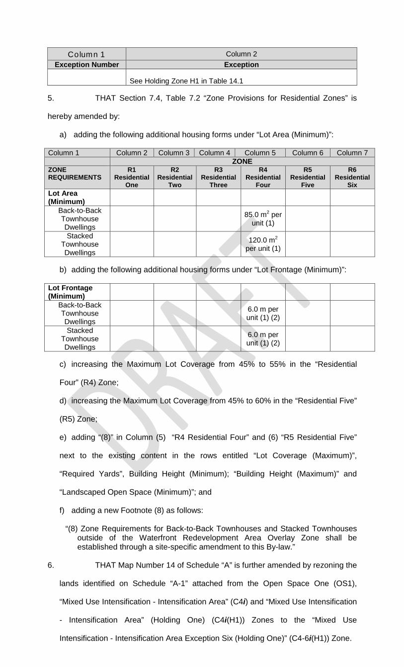
Column 1 Column 2 Exception Number Exception
See Holding Zone H1 in Table 14.1
5. THAT Section 7.4, Table 7.2 “Zone Provisions for Residential Zones” is
hereby amended by:
a) adding the following additional housing forms under “Lot Area (Minimum)”:
Column 1 Column 2 Column 3 Column 4 Column 5 Column 6 Column 7 ZONE ZONE REQUIREMENTS
R1 Residential
One
R2 Residential
Two
R3 Residential
Three
R4 Residential
Four
R5 Residential
Five
R6 Residential
Six Lot Area (Minimum)
Back-to-Back Townhouse Dwellings
85.0 m2 per unit (1)
Stacked Townhouse Dwellings
120.0 m2
per unit (1)
b) adding the following additional housing forms under “Lot Frontage (Minimum)”:
Lot Frontage (Minimum)
Back-to-Back Townhouse Dwellings
6.0 m per unit (1) (2)
Stacked Townhouse Dwellings
6.0 m per unit (1) (2)
c) increasing the Maximum Lot Coverage from 45% to 55% in the “Residential
Four” (R4) Zone;
d) increasing the Maximum Lot Coverage from 45% to 60% in the “Residential Five”
(R5) Zone;
e) adding “(8)” in Column (5) “R4 Residential Four” and (6) “R5 Residential Five”
next to the existing content in the rows entitled “Lot Coverage (Maximum)”,
“Required Yards”, Building Height (Minimum); “Building Height (Maximum)” and
“Landscaped Open Space (Minimum)”; and
f) adding a new Footnote (8) as follows:
“(8) Zone Requirements for Back-to-Back Townhouses and Stacked Townhouses outside of the Waterfront Redevelopment Area Overlay Zone shall be established through a site-specific amendment to this By-law.”
6. THAT Map Number 14 of Schedule “A” is further amended by rezoning the
lands identified on Schedule “A-1” attached from the Open Space One (OS1),
“Mixed Use Intensification - Intensification Area” (C4i) and “Mixed Use Intensification
- Intensification Area” (Holding One) (C4i(H1)) Zones to the “Mixed Use
Intensification - Intensification Area Exception Six (Holding One)” (C4-6i(H1)) Zone.
7. THAT Footnote (4)(ii) to Table 9.2 is amended to read as follows:
“ii) With the exception of properties in the Main Street Commercial (C1) Zone and in the Waterfront Redevelopment Area Overlay Zone as identified on Schedule ‘C’, Urban Squares are Required as part of a Development on sites greater than 0.2 hectares in size located within the Downtown Area Overlay Zones as shown on Schedule ‘C’.
8. THAT Section 9.5 “Commercial Zone Exceptions” is amended by adding
the following Zone Exception to Table 9.6 “Mixed Use Intensification (C4) Zone
Exceptions”:
Column 1 Column 2 Exception Number Exception
C4 EXCEPTIONS
C4-6i
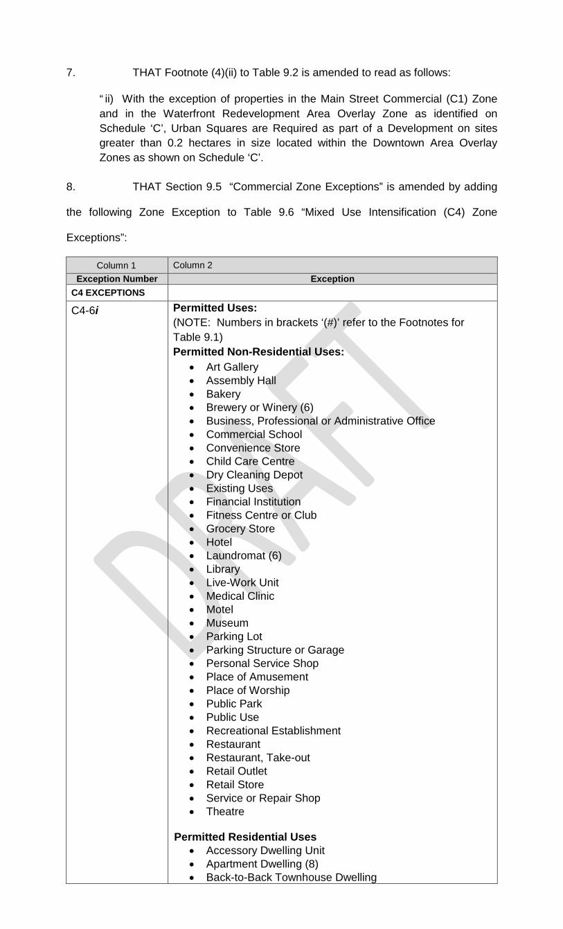
Permitted Uses: (NOTE: Numbers in brackets ‘(#)’ refer to the Footnotes for Table 9.1) Permitted Non-Residential Uses:
• Art Gallery • Assembly Hall • Bakery • Brewery or Winery (6) • Business, Professional or Administrative Office • Commercial School • Convenience Store • Child Care Centre • Dry Cleaning Depot • Existing Uses • Financial Institution • Fitness Centre or Club • Grocery Store • Hotel • Laundromat (6) • Library • Live-Work Unit • Medical Clinic • Motel • Museum • Parking Lot • Parking Structure or Garage • Personal Service Shop • Place of Amusement • Place of Worship • Public Park • Public Use • Recreational Establishment • Restaurant • Restaurant, Take-out • Retail Outlet • Retail Store • Service or Repair Shop • Theatre
Permitted Residential Uses
• Accessory Dwelling Unit • Apartment Dwelling (8) • Back-to-Back Townhouse Dwelling

Column 1 Column 2 Exception Number Exception
• Four Unit Dwelling (9) • Multiple Dwelling (9) • Stacked Townhouse Dwelling • Three Unit Dwelling (9) • Townhouse Dwelling (10)
Zone Provisions:
• Building Height (min) - 2 Storeys (6.0 m) or Equivalent • Building Height (max) - 6 Storeys (18.0 m) or Equivalent • Townhouse Dwellings, including Back-to-Back, Stacked
and all other styles, are permitted in accordance with the Zone Requirements of the R4-12i Zone in Table 7.6.
• Setback (min) to any building adjacent to the civic square at the northwest corner of Mississaga Street East and Centennial Drive - 0 m
• Footnote (3) to Table 7.2 shall apply only to properties that Abut Coldwater Street
• Footnote (6) to Table 7.2 shall not apply Notwithstanding any provisions to the contrary, the following Zone Provisions apply: For Buildings where the C4 Zone provisions apply:
• Lot Coverage (max) – 60% For Buildings where the R5 Zone provisions apply:
• Interior Side Yard (min) - 3.0 m • Rear Yard (min) - 6.0 m • Landscaped Open Space (min) - 15.0%
For Buildings where the R4 Zone provisions apply:
• Interior Side Yard (min) - 1.2 m • Rear Yard (min) - 6.0 m • Landscaped Open Space (min) - 15.0%
For Buildings where the R3 Zone provisions apply:
• Interior Side Yard (min) - 1.2 m Notwithstanding the foregoing, the following provisions apply to Buildings fronting on Mississaga Street East and Centennial Drive: For Buildings with Frontage on Mississaga Street East
• the C1 Zone provisions in Table 9.2 apply • Footnote (3) shall be amended to read “Accessory
Dwelling Units may be permitted at Grade in Buildings on Mississaga Street provided the Dwelling Units at Grade face away from Mississaga Street. An entrance door to an Accessory Dwelling Unit may be permitted to face Mississaga Street.”
For Buildings fronting onto Centennial Drive:
• Front Yard (min) - 0.0 m • Landscaped Open Space (min) - 0.0%
The provisions of the Waterfront Redevelopment Area Overlay Zone shall apply. See Holding Zone H1 in Table 14.1

9. THAT Section 14.1.1 “List of Holding Zones”, Table 14.1 is amended by
adding By-law 2018-98 to Column 4 in the row entitled “H1”.
10. THAT Schedule ‘C’ - Overlays is replaced with a new Schedule ‘C’
attached as Schedule A-2 to this By-law.
11. THAT a new Section 15.7 “Waterfront Redevelopment Area Overlay” is
added following Section 15.6, as follows:
“15.7 WATERFRONT REDEVELOPMENT AREA OVERLAY Schedule ‘C’ delineates the boundary of the Waterfront Redevelopment Area Overlay Zone. All lands within the Waterfront Redevelopment Area Overlay Zone are subject to the following provisions in addition to the specific provisions as set out in Sections 7 and 9 to this By-law. 15.7.1 Angular Plane Notwithstanding Section 5.2 and footnote (5) to Table 7.2, all properties within the Waterfront Redevelopment Area Overlay Zone are subject to the following Angular Plane requirements:
a) A 45 degree Angular Plane shall be established with its vertex 7.5 m directly above the Abutting property line and its initial and terminal sides extending toward the Building for all Development within the Waterfront Redevelopment Area Overlay Zone on building walls that provide views to Lake Couchiching and property lines Abutting a Public Road allowance.
15.7.2 Landscaping Requirements Notwithstanding Section 5.12, the minimum Landscaping Requirements for properties in the Waterfront Redevelopment Overlay Zone shall be as follows:
a) Except in a case where two or more Mixed-Use Buildings abut one another, all other new commercial Uses shall be Required to provide a minimum 2.0 m Landscaped Screening Strip and a minimum 2.0 m Landscaped Buffer Area along any Lot Line Abutting a Residential Use; and
b) New First Storey Residential Uses shall be Required to provide a minimum 2.0 m
Landscaped Screening Strip and a minimum 2.0 m Landscaped Buffer Area along any Lot Line Abutting a commercial Use.
For the Waterfront Development Area, the term “Mixed-Use Building” means a commercial Building with commercial Uses located on the First Storey with Residential, commercial, and/or institutional Uses located above or below the First Storey.”
12. THAT Schedules “A-1” and “A-2” attached form part of this By-law.
13. THAT this By-law shall take effect as of the date that By-law 2019-XX for
Official Plan Amendment No. 9 comes into effect, subject to the provisions of the
Planning Act, R.S.O. 1990, Chap. P.13 as amended.

BY-LAW read a first, second and third time and finally passed this 21st
day of January, A. D. 2019.
________________________________ MAYOR ________________________________ CAO/CITY CLERK

SCHEDULE A-2 TO BY-LAW 2019-XX