Memo - City of Santa Rosa
292
Memo To: Amy Nicholson, Senior Planner City of Santa Rosa From: Stantec Consulting Services Inc. File: 3575 Mendocino Avenue Project Date: December 7, 2020 Reference: 3575 Mendocino Avenue Project – Errata Memorandum Stantec Consulting Services Inc. (Stantec) has prepared this Errata Memorandum (memo) to document revisions to the September 28, 2020 Sustainable Communities Environmental Assessment (SCEA) prepared for the proposed 3575 Mendocino Avenue Project (Project) under the California Environmental Quality Act (CEQA). PUBLIC REVIEW PROCESS On September 28, 2020, the City of Santa Rosa (City) circulated a Notice of Availability of the SCEA for a 30- day review and comment period by the public, and the responsible and reviewing agencies. The public review period ended on October 27, 2020. Following the completion of the public comment period, additional and continued outreach to interested parties and resource agencies took place, which resulted in minor editorial revisions to the language in the SCEA to clarify Biological and Cultural Resources mitigation measures. As such, the following memo has been prepared to document and clarify those changes. The SCEA is available for review at the City’s Planning Division, located at 100 Santa Rosa Avenue, Santa Rosa, California 95404, and online at the following URL: https://srcity.org/425/Plans-Studies-EIRs DECISION AND EXPLANATION REGARDING RECIRCULATION OF THE DRAFT CEQA DOCUMENT CEQA Guidelines Section 15088.5 states that new information added to a CEQA document is not significant unless the CEQA document is changed in a way that deprives the public of a meaningful opportunity to comment upon a substantial adverse effect of the project or a feasible way to mitigate or avoid such an effect (including a feasible project alternative) that the project’s proponents have declined to implement. “Significant new information” requiring recirculation includes, for example, a disclosure showing that: 1. A new significant environmental impact would result from the project or from a new mitigation measure proposed to be implemented. 2. A substantial increase in the severity of an environmental impact would result unless mitigation measures are adopted that reduce the impact to a level of insignificance. 3. A feasible project alternative or mitigation measure considerably different from others previously analyzed would clearly lessen the significant environmental impacts of the project, but the project proponents decline to adopt it. 4. The CEQA document was so fundamentally and basically inadequate and conclusory in nature that meaningful public review and comment were precluded. A complete summary of changes made to the SCEA subsequent to the public review period has been prepared and is included herein. While an exhaustive list of changes is not included here, the following provides an explanation of relevant changes to the environmental impacts analysis and the mitigation measures provided in the SCEA.
-
Upload
khangminh22 -
Category
Documents
-
view
0 -
download
0
Transcript of Memo - City of Santa Rosa

Memo
To: Amy Nicholson, Senior Planner City of Santa Rosa
From: Stantec Consulting Services Inc.
File: 3575 Mendocino Avenue Project Date: December 7, 2020
Reference: 3575 Mendocino Avenue Project – Errata Memorandum
Stantec Consulting Services Inc. (Stantec) has prepared this Errata Memorandum (memo) to document
revisions to the September 28, 2020 Sustainable Communities Environmental Assessment (SCEA) prepared
for the proposed 3575 Mendocino Avenue Project (Project) under the California Environmental Quality Act
(CEQA).
PUBLIC REVIEW PROCESS
On September 28, 2020, the City of Santa Rosa (City) circulated a Notice of Availability of the SCEA for a 30-
day review and comment period by the public, and the responsible and reviewing agencies. The public review
period ended on October 27, 2020. Following the completion of the public comment period, additional and
continued outreach to interested parties and resource agencies took place, which resulted in minor editorial
revisions to the language in the SCEA to clarify Biological and Cultural Resources mitigation measures. As
such, the following memo has been prepared to document and clarify those changes.
The SCEA is available for review at the City’s Planning Division, located at 100 Santa Rosa Avenue, Santa
Rosa, California 95404, and online at the following URL: https://srcity.org/425/Plans-Studies-EIRs
DECISION AND EXPLANATION REGARDING RECIRCULATION OF THE DRAFT CEQA DOCUMENT
CEQA Guidelines Section 15088.5 states that new information added to a CEQA document is not significant unless the CEQA document is changed in a way that deprives the public of a meaningful opportunity to comment upon a substantial adverse effect of the project or a feasible way to mitigate or avoid such an effect (including a feasible project alternative) that the project’s proponents have declined to implement. “Significant new information” requiring recirculation includes, for example, a disclosure showing that:
1. A new significant environmental impact would result from the project or from a new mitigation
measure proposed to be implemented.
2. A substantial increase in the severity of an environmental impact would result unless mitigation
measures are adopted that reduce the impact to a level of insignificance.
3. A feasible project alternative or mitigation measure considerably different from others previously
analyzed would clearly lessen the significant environmental impacts of the project, but the project
proponents decline to adopt it.
4. The CEQA document was so fundamentally and basically inadequate and conclusory in nature that
meaningful public review and comment were precluded.
A complete summary of changes made to the SCEA subsequent to the public review period has been
prepared and is included herein. While an exhaustive list of changes is not included here, the following
provides an explanation of relevant changes to the environmental impacts analysis and the mitigation
measures provided in the SCEA.

December 7, 2020
Amy Nicholson, Senior Planner City of Santa Rosa
Page 2 of 4
Reference: 3575 Mendocino Avenue Project – Errata Memorandum
ERRATA
The following revisions are minor modifications and clarifications to the SCEA and do not change the
significance of any of the environmental issue conclusions within the document. The revisions are listed by
resource. All additions to the text are shown underlined (underlined) and all deletions from the text are shown
in strikethrough (strikethrough).
Biological Resources
During preparation of the Project’s Conditions of Approval for the November 12, 2020 Planning Commission
hearing, it was noted that Mitigation Measure BIO-3: Sensitive Aquatic Habitat could be better worded to
provide explicit clarity of temporary versus permanent impacts to Russell Creek.
MM BIO-3 Sensitive Aquatic Habitat. Following the completion of construction, temporary and
permanent impacts to the perennial stream (Russell Creek) shall be restored to return the
impacted area to preconstruction conditions, including grading and revegetation using a
local native seed mix. Permanent impacts to the perennial stream and emergent wetland
shall be mitigated at a 1:1 (impact:mitigation) ratio through the purchase of wetland
mitigation credits at a local mitigation bank approved by North Coast RWQCB.
The revisions shown above apply to Impact BIO-2 and Impact BIO-3, discussed on pages 4-43 and 4-44 of
the SCEA, respectively.
Cultural Resources
No comments pertaining to cultural resources were received during the public review period. However,
following the Project’s Planning Commission hearing on November 12, 2020, the Federated Indians of Graton
Rancheria (Tribe) expressed preference that applicable mitigation measures be modified to reflect the request
for increased coordination with the Tribe as part of the CEQA process. The revisions to Mitigation Measure
CUL-2: Cultural Resources Monitoring are shown below and apply to Impact CUL-2, discussed on pages 4-50
to 4-52 of the SCEA. Additionally, Mitigation Measure CUL-3: Archeological Resources, Cultural Resources
Monitoring, and Tribal Cultural Resources has been added to the analysis discussed in Impact CUL-2 to
further reflect the Project’s coordination with the Tribe.
MM CUL-2: Cultural Resources Monitoring. Prior to any ground disturbing activities for the proposed project, a qualified archaeologist shall prepare a Cultural Resources Monitoring Plan for review by and in consultation with the affiliated tribe, and approval by the City. The Plan shall identify the type of archaeological material that could potentially be found within the project area and procedures to follow should any material be encountered during ground disturbing activities. The Plan should provide procedures and guidelines for in-field assessment of the significance of any archaeological material identified during monitoring. All ground disturbance taking place during the initial project grubbing and grading phases shall be monitored by an archaeologist or and a tribal monitor from an the appropriately affiliated tribe in order to check for the inadvertent discovery exposure of archaeological materials. The archaeologist must meet the Secretary of Interior’s Professional Qualification Standards for archaeology. The archaeologist or and tribal monitor shall be empowered to halt construction activities at the location of a discovery to review possible archaeological material and to protect the resource while the materials

December 7, 2020
Amy Nicholson, Senior Planner City of Santa Rosa
Page 3 of 4
Reference: 3575 Mendocino Avenue Project – Errata Memorandum
are being assessed. Monitoring shall continue until, in the archaeologist’s judgment, in consultation with the tribal monitor, additional archaeological resources are not likely to be encountered. If no archaeological resources are discovered during construction, the archaeologist shall prepare a report to document negative findings after construction is complete. If an archaeological deposit is encountered during initial project grubbing or grading activities, all work within 25 60 feet of the discovery shall be redirected cease until the archaeologist or and tribal monitor can assess the find, consult with agencies and appropriately affiliated tribe(s) as appropriate, and make recommendations for the treatment of the discovery. Upon completion of the assessment, the archaeologist shall prepare a report to document the methods and results of the assessment. The final report shall be reviewed by and in consultation with the affiliated tribe, and submitted to the project applicant, City, and the Northwest Information Center.
MM CUL-3: Archeological Resources, Cultural Resources Monitoring, and Tribal Cultural
Resources. The Project applicant and lead agency shall engage in consultation and
coordination with interested local California Native American Tribes in implementing
Mitigation Measures CUL-1, CUL-2, and TRIB-1.
Tribal Cultural Resources
No comments were received pertaining to tribal cultural resources during the public review period. However,
following the Project’s Planning Commission hearing on November 12, 2020, the Tribe expressed preference
that applicable mitigation measures be modified to reflect the request for increased coordination with the Tribe
as part of the CEQA process. As discussed in Impact TRIB-1 on pages 4-184 and 4-185 of the SCEA, the
Project would implement Mitigation Measure CUL-2: Cultural Resources Monitoring to reduce potential
impacts related to the inadvertent discovery of unknown tribal cultural resources to a less than significant
level. Therefore, the revisions made to Mitigation Measure CUL-2: Cultural Resources Monitoring, shown
above, would apply to the analysis presented in Impact TRIB-1. Mitigation Measure CUL-3: Archeological
Resources, Cultural Resources Monitoring, and Tribal Cultural Resources would also apply to the analysis
presented in Impact TRIB-1 to further require the Project’s coordination with the Tribe as it pertains to the
inadvertent discovery of unknown tribal cultural resources.
Minor General Revisions
Minor revisions were made to the SCEA. This includes the addition of Mitigation Measure CUL-3
(Archeological Resources, Cultural Resources Monitoring, and Tribal Cultural Resources) to Table 1.13-1,
Summary of Impacts and Mitigation Measures, discussed on page 1-15 of the SCEA. Additionally, the
analysis presented in Impact MFS-2 on pages 4-203 and 4-204 of the SCEA, was updated to include
reference to Mitigation Measure CUL-3 to reflect the Project’s coordination with the Tribe related to the
potential discovery of unknown cultural and tribal cultural resources.
CONCLUSION
Modifications to the SCEA for inclusion in the FINAL CEQA document do not constitute “significant new
information” as defined in Section 15088.5 of the State CEQA Guidelines. The modifications as discussed
above and provided in the SCEA do not show: (1) new significant environmental impacts from the Project or
from new mitigation measures; (2) a substantial increase in the severity of environmental impacts; (3) feasible
Project alternatives or mitigation measures considerably different from others previously analyzed that would

December 7, 2020
Amy Nicholson, Senior Planner City of Santa Rosa
Page 4 of 4
Reference: 3575 Mendocino Avenue Project – Errata Memorandum
clearly lessen the significant environmental impacts of the Project, but which the Project proponents decline to
adopt; or (4) that the SCEA was so fundamentally and basically inadequate and conclusory in nature that
meaningful public review and comment were precluded. As such, recirculation of the SCEA is not needed and
would not deprive the public of a meaningful opportunity to comment on substantial adverse effects or
feasible mitigation measures or alternatives. The described revisions in the FINAL CEQA document therefore
do not require recirculation.
Sincerely,
Trevor Macenski, Senior Principal
Cell: (916) 508-4170
Email: [email protected]
Anna Radonich, Senior Planner
Cell: (925) 285-6541
Email: [email protected]

3575 Mendocino Avenue Project Sustainable Communities Environmental Assessment
Lead Agency: City of Santa Rosa
100 Santa Rosa Avenue, Room 3
Santa Rosa, California 95404
Technical Assistance: Stantec Consulting Services Inc.
1340 Treat Boulevard, Suite 300
Walnut Creek, California 94597
.
September 28, 2020


3575 Mendocino Avenue Project SCEA Table of Contents
i
Table of Contents
SUSTAINABLE COMMUNITIES ENVIRONMENTAL ASSESSMENT .............................................. XIII 1.0 INTRODUCTION ............................................................................................................ 1-1
1.1 PROJECT TITLE ................................................................................................ 1-1
1.2 LEAD AGENCY .................................................................................................. 1-1
1.3 LEAD AGENCY CONTACT................................................................................ 1-1
1.4 PROJECT APPLICANT ...................................................................................... 1-1
1.5 PURPOSE .......................................................................................................... 1-1
1.6 PROJECT LOCATION ....................................................................................... 1-2
1.7 SITE HISTORY .................................................................................................. 1-9
1.8 EXISTING SETTING AND SURROUNDING LAND USES ................................ 1-9
1.9 LAND USE DESIGNATIONS AND ZONING ...................................................... 1-9
1.9.1 Existing General Plan and Zoning .......................................................... 1-9
1.9.2 Proposed General Plan and Zoning ..................................................... 1-10
1.10 STATUTORY BACKGROUND ......................................................................... 1-11
1.11 CEQA AND PUBLIC AGENCY REVIEW ......................................................... 1-12
1.12 DOCUMENT ORGANIZATION ........................................................................ 1-12
1.13 SUMMARY OF IMPACTS AND MITIGATION MEASURES ............................ 1-13
2.0 PROJECT DESCRIPTION ............................................................................................. 2-1
2.1 PROJECT OBJECTIVES AND REQUIRED PROJECT APPROVALS .............. 2-1
2.1.1 Objectives ............................................................................................... 2-1
2.1.2 Approvals and Entitlements .................................................................... 2-2
2.2 PROJECT CHARACTERISTICS ........................................................................ 2-2
2.2.1 Affordable Housing Component .............................................................. 2-5
2.2.2 Market Rate Housing Component .......................................................... 2-5
2.2.3 City of Santa Rosa Inclusionary Housing Ordinance .............................. 2-6
2.2.4 Employment and Future Residents Estimate ....................................... 2-15
2.2.5 Landscaping ......................................................................................... 2-15
2.2.6 Open Space Areas ............................................................................... 2-16
2.2.7 Vehicular Access .................................................................................. 2-16
2.2.8 Parking ................................................................................................. 2-23
2.2.9 Aesthetics and Design .......................................................................... 2-23
2.2.10 Lighting and Security .......................................................................... 2-24
2.2.11 Alternative Transportation ................................................................... 2-24
2.2.12 Sustainability ....................................................................................... 2-25
2.2.13 Utilities ................................................................................................ 2-26

3575 Mendocino Avenue Project Table of Contents SCEA
ii
2.3 PROJECT CONSTRUCTION ........................................................................... 2-29
2.3.1 Schedule ............................................................................................... 2-29
2.3.2 Construction Equipment, Access, and Staging Areas .......................... 2-30
2.3.3 Construction Activities .......................................................................... 2-31
3.0 SCEA CONSISTENCY AND TRANSIT PRIORITY PROJECT CRITERIA ................... 3-1
3.1 SENATE BILL 375 .............................................................................................. 3-1
3.2 TRANSIT PRIORITY PROJECT CRITERIA ....................................................... 3-1
3.3 PREVIOUS RELEVANT ENVIRONMENTAL ANALYSIS .................................. 3-3
3.4 SENATE BILL 743 .............................................................................................. 3-4
4.0 ENVIRONMENTAL CHECKLIST AND ENVIRONMENTAL EVALUATION ................. 4-1
4.1 AGRICULTURAL AND FORESTRY RESOURCES ........................................... 4-3
4.1.1 Environmental Setting ............................................................................. 4-3
4.1.2 Previous Environmental Analysis ........................................................... 4-4
4.1.3 Project-Specific Analysis ........................................................................ 4-4
4.2 AIR QUALITY ..................................................................................................... 4-7
4.2.1 Environmental Setting ............................................................................. 4-7
4.2.2 Previous Environmental Analysis ......................................................... 4-14
4.2.3 Project-Specific Analysis ...................................................................... 4-17
4.3 BIOLOGICAL RESOURCES ............................................................................ 4-31
4.3.1 Environmental Setting ........................................................................... 4-31
4.3.2 Previous Environmental Analysis ......................................................... 4-36
4.3.3 Project-Specific Analysis ...................................................................... 4-40
4.4 CULTURAL RESOURCES ............................................................................... 4-47
4.4.1 Environmental Setting ........................................................................... 4-47
4.4.2 Previous Environmental Analysis ......................................................... 4-48
4.4.3 Project-Specific Analysis ...................................................................... 4-50
4.5 ENERGY .......................................................................................................... 4-53
4.5.1 Environmental Setting ........................................................................... 4-53
4.5.2 Previous Environmental Analysis ......................................................... 4-53
4.5.3 Project-Specific Analysis ...................................................................... 4-54
4.6 GEOLOGY AND SOILS ................................................................................... 4-59
4.6.1 Environmental Setting ........................................................................... 4-59
4.6.2 Previous Environmental Analysis ......................................................... 4-61
4.6.3 Project-Specific Analysis ...................................................................... 4-63
4.7 GREENHOUSE GASES................................................................................... 4-71
4.7.1 Environmental Setting ........................................................................... 4-71

3575 Mendocino Avenue Project SCEA Table of Contents
iii
4.7.2 Previous Environmental Analysis ......................................................... 4-75
4.7.3 Project-Specific Analysis ...................................................................... 4-76
4.8 HAZARDS AND HAZARDOUS MATERIALS ................................................... 4-89
4.8.1 Environmental Setting ........................................................................... 4-89
4.8.2 Previous Environmental Analysis ......................................................... 4-91
4.8.3 Project-Specific Analysis ...................................................................... 4-93
4.9 HYDROLOGY AND WATER QUALITY ............................................................ 4-99
4.9.1 Environmental Setting ........................................................................... 4-99
4.9.2 Previous Environmental Analysis ....................................................... 4-100
4.9.3 Project-Specific Analysis .................................................................... 4-102
4.10 LAND USE AND PLANNING.......................................................................... 4-109
4.10.1 Environmental Setting ....................................................................... 4-109
4.10.2 Previous Environmental Analysis...................................................... 4-110
4.10.3 Project-Specific Analysis .................................................................. 4-110
4.11 MINERAL RESOURCES ................................................................................ 4-119
4.11.1 Environmental Setting ....................................................................... 4-119
4.11.2 Previous Environmental Analysis...................................................... 4-119
4.11.3 Project-Specific Analysis .................................................................. 4-119
4.12 NOISE ............................................................................................................ 4-121
4.12.1 Environmental Setting ....................................................................... 4-121
4.12.2 Previous Environmental Analysis...................................................... 4-130
4.12.3 Project-Specific Analysis .................................................................. 4-135
4.13 POPULATION AND HOUSING ...................................................................... 4-149
4.13.1 Environmental Setting ....................................................................... 4-149
4.13.2 Previous Environmental Analysis...................................................... 4-149
4.13.3 Project-Specific Analysis .................................................................. 4-150
4.14 PUBLIC SERVICES ....................................................................................... 4-153
4.14.1 Environmental Setting ....................................................................... 4-153
4.14.2 Previous Environmental Analysis...................................................... 4-155
4.14.3 Project-Specific Analysis .................................................................. 4-156
4.15 RECREATION ................................................................................................ 4-161
4.15.1 Environmental Setting ....................................................................... 4-161
4.15.2 Previous Environmental Analysis...................................................... 4-161
4.15.3 Project-Specific Analysis .................................................................. 4-163
4.16 TRANSPORTATION ...................................................................................... 4-165
4.16.1 Environmental Setting ....................................................................... 4-165

3575 Mendocino Avenue Project Table of Contents SCEA
iv
4.16.2 Previous Environmental Analysis...................................................... 4-168
4.16.3 Project-Specific Analysis .................................................................. 4-170
4.17 TRIBAL CULTURAL RESOURCES ............................................................... 4-181
4.17.1 Environmental Setting ....................................................................... 4-181
4.17.2 Previous Environmental Analysis...................................................... 4-182
4.17.3 Project-Specific Analysis .................................................................. 4-184
4.18 UTILITIES AND SERVICE SYSTEMS ........................................................... 4-187
4.18.1 Environmental Setting ....................................................................... 4-187
4.18.2 Previous Environmental Analysis...................................................... 4-190
4.18.3 Project-Specific Analysis .................................................................. 4-191
4.19 WILDFIRE ...................................................................................................... 4-197
4.19.1 Environmental Setting ....................................................................... 4-197
4.19.2 Previous Environmental Analysis...................................................... 4-198
4.19.3 Project-Specific Analysis .................................................................. 4-199
4.20 MANDATORY FINDINGS OF SIGNIFICANCE .............................................. 4-203
5.0 REFERENCES ............................................................................................................... 5-1
6.0 LIST OF PREPARERS .................................................................................................. 6-1
LIST OF TABLES
Table 1.13-1 Summary of Impacts and Mitigation Measures ................................................... 1-15 Table 2.2-1: Proposed Project Components .............................................................................. 2-2 Table 2.2-2: Affordable Housing Component ............................................................................. 2-5 Table 2.2-3: Market Rate Housing Unit Types ........................................................................... 2-6 Table 2.2-4: Estimated Population for the Proposed Project ................................................... 2-15 Table 2.2-5: Water Demand ..................................................................................................... 2-27 Table 2.2-6: Wastewater Generated ........................................................................................ 2-28 Table 2.3-1: Construction Schedule ......................................................................................... 2-29 Table 2.3-2: Proposed Construction Equipment ...................................................................... 2-30 Table 4.2-1: California and National Ambient Air Quality Standards ......................................... 4-9 Table 4.2-2: Sonoma County Area Designations for State and National Ambient Air
Quality ....................................................................................................................... 4-11 Table 4.2-3: 2017 BAAQMD Proposed Project-Level Air Quality CEQA Thresholds of
Significance ............................................................................................................... 4-12 Table 4.2-4: Average Daily Construction Emissions ................................................................ 4-18 Table 4.2-5: Annual Operational Emissions ............................................................................. 4-19 Table 4.2-6: Daily Operational Emissions ................................................................................ 4-19 Table 4.2-7: Summary of Each Scenario Analyzed ................................................................. 4-24 Table 4.2-8: Project Unmitigated Offsite Receptor Health Risk Impact Summary ................... 4-24 Table 4.2-9: Project Unmitigated Onsite Receptor Health Risk Impact Summary ................... 4-25 Table 4.2-10: Project Mitigated Offsite Receptor Health Risk Impact Summary ...................... 4-25 Table 4.2-11: Project Mitigated Onsite Receptor Health Risk Impact Summary ...................... 4-26 Table 4.5-1: Project Construction Energy Consumption .......................................................... 4-55 Table 4.5-2: Project Annual Operations Transportation Fuel Consumption ............................ 4-55

3575 Mendocino Avenue Project SCEA Table of Contents
v
Table 4.5-3: Project Annual Operations Electricity and Natural Gas Consumption ................. 4-56 Table 4.5-4: Project Annual Propane Fuel Consumption ......................................................... 4-57 Table 4.7-1: Construction GHG Emissions .............................................................................. 4-77 Table 4.7-2: Annual GHG Emissions for the Proposed Project ............................................... 4-78 Table 4.7-3: Consistency with SB 32 2017 Scoping Plan Update ........................................... 4-79 Table 4.7-4: Project Consistency with City’s Climate Action New Development Checklist ...... 4-82 Table 4.10-1: Applicable Plan and Policy Consistency Analysis ........................................... 4-111 Table 4.12-1: Guideline Vibration Annoyance Potential Criteria ............................................ 4-123 Table 4.12-2: Guideline Vibration Damage Potential Criteria ................................................ 4-123 Table 4.12-3: Vibration Source Levels for Construction Equipment ...................................... 4-124 Table 4.12-4: Projected 2020 Peak Hour Traffic Counts ....................................................... 4-125 Table 4.12-5: Modeled Ambient Noise Levels at Select Receptors ....................................... 4-129 Table 4.12-6: Peak Hour Traffic Counts with Proposed Project ............................................ 4-135 Table 4.12-7: Modeled Noise Levels at Select Receptors with Proposed Project ................. 4-136 Table 4.12-8: Modeled Noise Levels at Project Buildings ...................................................... 4-139 Table 4.12-9: Summary of FHWA Roadway Construction Noise Model ................................ 4-141 Table 4.12-10: Construction Phases Equipment and Distance to Closest Receptor ............. 4-142 Table 4.12-11: Calculated Noise Level From Each Construction Phase/Stage ..................... 4-144 Table 4.12-12: Vibration Source Levels for Construction Equipment .................................... 4-146 Table 4.16-1: Bicycle Facility Summary ................................................................................. 4-167 Table 4.16-2: Transit Routes ................................................................................................. 4-167 Table 4.18-1: Landfill Facility Detail ....................................................................................... 4-189
LIST OF FIGURES Figure 1.0-1: Regional Location ................................................................................................. 1-3 Figure 1.0-2: Project Site ........................................................................................................... 1-5 Figure 1.0-3: High Quality Transit Corridor within 0.5-mile of the Project Site ........................... 1-7 Figure 2.0-1: Project Site Plan ................................................................................................... 2-3 Figure 2.0-2: View of Affordable Housing Component from Mendocino Avenue ....................... 2-7 Figure 2.0-3: View of Affordable Housing Component from New Public Street ......................... 2-9 Figure 2.0-4: View of Market Rate Component from Mendocino Avenue ................................ 2-11 Figure 2.0-5: View of Market Rate Component from Shared Open Space .............................. 2-13 Figure 2.0-6: Open Space Areas and Landscaping – Affordable Housing Component ........... 2-17 Figure 2.0-7: Open Space Areas and Landscaping – Market Rate Housing Component ....... 2-19 Figure 2.0-8: Fire Department Access ..................................................................................... 2-21 Figure 4.12-1: Modeled Ambient Traffic Noise Levels without Project .................................. 4-127 Figure 4.12-2: Land Use Compatibility Standards ................................................................. 4-131 Figure 4.12-3: Modeled Traffic Noise Levels with the Proposed Project ............................... 4-137 Figure 4.16-1: City of Santa Rosa's Residential VMT: Pre-Screened Map ............................ 4-175 LIST OF APPENDICES Appendix A: Arborist Report and Tree Inventory Report Appendix B: Santa Rosa Water Department Water Supply Letter Appendix C: Domestic Water Use and Sanitary Sewer Generation Calculations Appendix D: Air Quality and Greenhouse Gas Modeling Appendix E: Biological Resources Technical Report Appendix F: Delineation of Potential Waters of the U.S. and State Appendix G: Section 106 Inventory and Evaluation Report (Confidential Appendix) Appendix H: Construction and Operation Energy Calculations Appendix I: Geotechnical Study Report Appendix J: Phase I Environmental Site Assessment

3575 Mendocino Avenue Project Table of Contents SCEA
vi
Appendix K: Roadway Construction Noise Modeling Appendix L: 3575 Mendocino Avenue Transportation Impact Analysis Appendix M: Fire and Police Will Serve Response Letters

3575 Mendocino Avenue Project SCEA Abbreviations and Acronyms
vii
Abbreviations and Acronyms
μg/m3 micrograms per cubic meter
AB Assembly Bill
ABAG Association of Bay Area Governments
ac acre
ADA Americans with Disabilities Act
AFY acre-feet per year
AIA Airport Influence Area
APN Assessor’s Parcel Number
AP Zone Act Alquist-Priolo Special Studies Zone Act of 1972
AQP air quality plan
ASHRAE American Society of Heating, Refrigeration, and Air-Conditioning Engineers
BAAQMD Bay Area Air Quality Management District
BCDC Bay Area Conservation District
bgs below ground surface
BMP best management practice
CAAQS California Ambient Air Quality Standards
CAL FIRE California Department of Forestry and Fire Protection
CA-MUTCD California Manual on Uniform Traffic Control Devices
CalOES California Office of Emergency Services
CalEEMod California Emissions Estimator Model
CalEPA California Environmental Protection Agency
CALGreen California Green Building Standards
CalRecycle California Department of Resources Recycling and Recovery
Caltrans California Department of Transportation
CAP Climate Action Plan

3575 Mendocino Avenue Project Abbreviations and Acronyms SCEA
viii
CARB California Air Resources Board
CBC California Building Code
CCAP Community-wide Climate Action Plan
CCC California Coastal Commission
CCR California Code of Regulations
CC&Rs Covenants, Conditions and Restrictions
CDFW California Department of Fish and Wildlife
CDMG California Department of Mines and Geology
CEQA California Environmental Quality Act
CESA California Endangered Species Act
CH4 Methane
City City of Santa Rosa
CNDDB California Natural Diversity Database
CNEL community noise equivalent level
CNPS California Native Plant Society
CO carbon monoxide
CO2 carbon dioxide
CO2e carbon dioxide equivalent
CRMP Cultural Resources Monitoring Plan
CWPP Community Wildfire Protection Plan
CY cubic yard
dB decibel
dB(A) A-weighted sound level
DOC California Department of Conservation
DPM diesel particulate matter
DTSC Department of Toxic Substances Control
du dwelling units

3575 Mendocino Avenue Project SCEA Abbreviations and Acronyms
ix
du/ac dwelling units per acre
DWR California Department of Water Resources
EIR Environmental Impact Report
ERPP Emergency Response and Preparedness Plan
ESA Environmental Site Assessment
EV electric vehicle
°F degrees Fahrenheit
Farmland Prime Farmland, Unique Farmland, or Farmland of Statewide Importance
FCAA Federal Clean Air Act
FEMA Federal Emergency Management Agency
FESA Federal Endangered Species Act
firescape fire-resistant landscaping
FMMP Farmland Mapping and Monitoring Program
FRA Federal Responsibility Areas
FTA Federal Transit Administration
GHG greenhouse gas
gpd gallons per day
gsf gross square feet
HAWK High-intensity Activated crossWalK
HVAC heating, ventilation, and air conditioning
HCP Habitat Conservation Plan
HEPA high efficiency particulate air
HFC Hydrofluorocarbon
HFHSZ high fire hazard severity zone
HRA Health Risk Assessment
in/sec inches/second
ITE Institute of Transportation Engineers

3575 Mendocino Avenue Project Abbreviations and Acronyms SCEA
x
lbs pounds
lbs/day pounds per day
Ldn day-night sound level
Leq equivalent sound level
Lmax maximum sound level
Lmin minimum sound level
LOS level of service
LRA Local Responsibility Area
mg/m3 milligrams per cubic meter
mgd million gallons per day
MERV minimum efficiency reporting value
MMTCO2e million metric tons of carbon dioxide equivalent
mph miles per hour
MRZ Mineral Resource Zone
MTCO2e metric tons of carbon dioxide equivalent per year
MTCO2e/SP/yr metric tons of carbon dioxide equivalent per service population per year
MTC Metropolitan Transportation Commission
N2O Nitrous Oxide
NCCP Natural Community Conservation Plan
NO2 nitrogen dioxide
NOA naturally-occurring asbestos
NOx Nitrogen oxides
NPDES National Pollution Discharge Elimination System
OPR Office of Planning and Research
PCB polychlorinated biphenyl
PDA Priority Development Area
PFC perfluorinated chemical

3575 Mendocino Avenue Project SCEA Abbreviations and Acronyms
xi
PG&E Pacific Gas and Electric Company
Plan Bay Area Plan Bay Area 2040
PM particulate matter
PM2.5 particulate matter 2.5 microns in diameter or less
PM10 particulate matter 10 microns in diameter or less
ppb part per billion
ppm part per million
PPV peak particle velocity
PRC Public Resources Code
RAMP Regional Advance Mitigation Planning
RC Resilient City
RCNM Roadway Construction Noise Model
RHNA Regional Housing Needs Assessment
ROG reactive organic gases
RR Rural Residential
RTP Regional Transportation Plan
RWQCB Regional Water Quality Control Board
SB Senate Bill
SCEA Sustainable Communities Environmental Assessment
SCS Sustainable Communities Strategy
SFBAAB San Francisco Bay Area Air Basin
SFPUC San Francisco Public Utilities Commission
SLCP short-lived climate pollutant
SIP State Implementation Plan
SO2 Sulfur dioxide
SMART Sonoma-Marin Area Rail Transit
SRA State Responsibility Area

3575 Mendocino Avenue Project Abbreviations and Acronyms SCEA
xii
SRFD City of Santa Rosa Fire Department
SRPD City of Santa Rosa Police Department
SUSMP Standard Urban Stormwater Mitigation Plan
SWPPP Stormwater Pollution Prevention Plan
SWRCB State Water Resources Control Board
TAC toxic air contaminant
TCR Tribal Cultural Resource
tpy tons per year
Highway 101 U.S. Highway 101
USCB U.S. Census Bureau
USACE U.S. Army Corps of Engineers
USEPA U.S. Environmental Protection Agency
USFWS United States Fish and Wildlife Service
USGS United States Geological Survey
UWMP Urban Water Management Plan
VHFHSZ very high fire hazard severity zone
VMT vehicle miles traveled
WHRS California Wildlife Habitat Relationship System
WSA Water Supply Assessment
WUI wildlife urban interface
ZEV zero-emissions vehicle

3575 Mendocino Avenue Project
SCEA Sustainable Communities Environmental Assessment
xi
SUSTAINABLE COMMUNITIES ENVIRONMENTAL ASSESSMENT
This Sustainable Communities Environmental Assessment (SCEA) has been prepared pursuant to Section 21155.2
of the Public Resources Code (PRC).
Project Title: 3575 Mendocino Avenue Project
Project Description: The 3575 Mendocino Avenue Project (proposed project) involves the redevelopment of an
approximately 13.3-acre infill site into a compact, sustainable, transit-oriented, master planned transit village
community with up to 532 high-density multi-family housing units consisting of 162 units affordable for low and very
low senior households and up to 370 market rate housing units. The senior affordable housing component would
include construction of three separate four-story buildings totaling 136,185 gross square feet (gsf) on 2.5 acres of the
project site. The market rate housing component would include the construction of approximately eight separate
three- or four-story buildings totaling 510,531 gsf on 9 acres of the project site. The proposed project would also
include 1-acre of shared open space and the construction of a new public street (0.8 acre), on- and off-site utility
infrastructure, parking (including surface, covered, and an aboveground garage), driveways, frontage improvements,
landscaping, and a new stormwater outfall into the adjacent, off-site Russell Creek.
Project Location: The project site is located at 3575 Mendocino Avenue within the City of Santa Rosa (City), in
Sonoma County. The project site is bordered by Mendocino Avenue, Russell Creek, Kaiser Permanente Santa Rosa
Medical Center, US Highway 101, and the Mendocino Overcrossing. The site is centrally located on Mendocino
Avenue, a major arterial that connects the project site with downtown Santa Rosa to the south and greater Sonoma
County to the north.
Lead Agency Contact:
Amy Nicholson, Senior Planner
City of Santa Rosa, Planning Division
Phone: (707) 543-3258
Email: [email protected]
Required Findings: The City has determined that: 1) the proposed project is consistent with the general use
designations, density, building intensity, and applicable policies specified for the project area in the Plan Bay Area
2040 Regional Transportation Plan (RTP)/Sustainable Communities Strategy (SCS) prepared by the Metropolitan
Transportation Commission (MTC) and Association of Bay Area Governments (ABAG) for the San Francisco Bay
Area Region; 2) the proposed project qualifies as a transit priority project pursuant to PRC Section 21155(b); 3) the
proposed project is a residential or mixed-use project as defined by PRC Section 21159.28(d); 4) all potentially
significant or significant effects required to be identified and analyzed pursuant to the California Environmental
Quality Act (CEQA) have been identified and analyzed in an initial study; and 5) the proposed project, as mitigated,
either avoids or mitigates to a level of insignificance all potentially significant or significant effects of the proposed
project required to be analyzed pursuant to CEQA. The attached Environmental Checklist has been prepared by the
City in support of this SCEA. Further information including the project file and supporting reports and studies may be
reviewed at the City’s Planning Division.
Mitigation Measures: Pursuant to Section 21155.2 of the PRC, this SCEA: 1) incorporates all feasible mitigation
measures, performance standards, or criteria set forth in the prior applicable environmental impact reports (EIR),
including the Plan Bay Area EIR (Plan Bay Area 2017a) and the City of Santa Rosa General Plan EIR, and adopted
in findings made pursuant to Section 21081; and 2) contains measures that either avoid or mitigate to a level of

3575 Mendocino Avenue Project
Sustainable Communities Environmental Assessment SCEA
xii
insignificance all potentially significant or significant effects of the proposed project require to be identified in this
SCEA.
By: _________________________________ Date: _______________________________
Amy Nicholson, Senior Planner
9/24/20

3575 Mendocino Avenue Project SCEA Introduction
1-1
1.0 INTRODUCTION BRJE Communities, LLC (Applicant), is proposing the 3575 Mendocino Avenue Project (proposed project) in the City of Santa Rosa (City). The proposed project involves the redevelopment of an approximately 13.3-acre infill site into a compact, sustainable, transit-oriented, master planned transit village community with up to 532 high-density multi-family housing units consisting of 162 units affordable for low and very low senior households and up to 370 market rate housing units. The senior affordable housing component would include construction of three separate four-story buildings totaling 136,185 gross square feet (gsf) on 2.5 acres of the project site. The market rate housing component would include the construction of approximately eight separate three- or four-story buildings totaling 510,531 gsf on 9 acres of the project site. The proposed project would also include 1-acre of shared open space and the construction of a new public street (0.8 acre), on- and off-site utility infrastructure, parking (including surface, covered, and an aboveground garage), driveways, frontage improvements, landscaping, and a new stormwater outfall into the adjacent, off-site Russell Creek.
1.1 PROJECT TITLE
3575 Mendocino Avenue Project
1.2 LEAD AGENCY
City of Santa Rosa 100 Santa Rosa Avenue Santa Rosa, California 95404
1.3 LEAD AGENCY CONTACT
Amy Nicholson, Senior Planner Phone: (707) 543-3258 Email: [email protected]
1.4 PROJECT APPLICANT
BRJE Communities, LLC 790 Sonoma Avenue Santa Rosa, California 95402
1.5 PURPOSE
The purpose of a Sustainable Communities Environmental Assessment (SCEA) is to evaluate the environmental effects of the proposed project in accordance with the California Environmental Quality Act (CEQA). In addition, this SCEA evaluates the proposed project’s consistency with the Metropolitan Transportation Commission (MTC)/Association of Bay Area Governments (ABAG) Plan Bay Area 2040 Regional Transportation Plan (RTP)/ Sustainable Communities Strategy (SCS) for the San Francisco Bay Area Region and incorporates feasible mitigation measures, performance standards, and criteria from prior applicable environmental impact reports (EIR) into the proposed project.

3575 Mendocino Avenue Project Introduction SCEA
1-2
A SCEA is a form of CEQA documentation established by Senate Bill (SB) 375 to provide streamlined environmental review for certain “transit priority projects.” Transit priority projects are residential or mixed-use residential projects that provide a minimum net density of 20 dwelling units per acre and are located within 0.5 mile of a major transit stop or high-quality transit corridor (Public Resources Code [PRC] Section 21155[b]).
A SCEA is comparable to an Initial Study/Mitigated Negative Declaration (MND) since the lead agency must find that all potentially significant impacts of a project have been identified, adequately analyzed, and mitigated to levels of insignificance. However, unlike a MND, a SCEA need not consider the cumulative effects of the project that have been adequately addressed and mitigated in prior EIRs; growth-inducing impacts are not required to be referenced, described, or addressed; and project-specific or cumulative impacts from cars and light duty truck trips on global climate change or the regional transportation network need not be referenced, described, or discussed.
1.6 PROJECT LOCATION
The approximately 13.3-acre project site is located at 3575 Mendocino Avenue in the City of Santa Rosa, Sonoma County (Figure 1.0-1). The project site primarily consists of a single parcel identified as Assessor’s Parcel Number (APN) 173-030-001, but the proposed stormwater outfall would be located within Russell Creek, which is located offsite on the adjacent parcel identified as APN 173-030-002 (Figure 1.0-2). The proposed stormwater outfall disturbance area is anticipated to be approximately 400 square feet (0.009 acre) and is factored into the approximately 13.3-acre project site. The project site is within the Mendocino Avenue/Santa Rosa Avenue Corridor Priority Development Area (PDA) and located approximately 0.2 mile (0.38 mile walking distance) from the Bicentennial Way Transit Facility (Figure 1.0-3). The Bicentennial Way Transit Facility is a major transit stop located in front of Kaiser Permanente Santa Rosa Medical Center on Bicentennial Way, a high-quality transit corridor that is served by Santa Rosa CityBus Routes 1 and 10. Route 1 is two-way with no one-way loops and operates every 15 minutes, Monday through Friday. Route 1 connects the project site to the Santa Rosa Junior College, Kaiser Permanente Santa Rosa Medical Center, and Coddingtown Mall Transit Hub, all of which are located within approximately 1 mile of the project site. Route 10 intersects with Route 1 and runs along the project site’s frontage on Mendocino Avenue. There are six bus stops in the vicinity of the project site; one near the project’s proposed site entrance on the west side of Mendocino Avenue, one on the east side of Mendocino Avenue near the proposed project site’s frontage, one on the west side of Mendocino Avenue in front of Kaiser Permanente Santa Rosa Medical Center, one on the east side of Mendocino Avenue across from Kaiser Permanente Santa Rosa Medical Center, one on the north side of Bicentennial Way in front of Kaiser Permanente Santa Rosa Medical Center (Bicentennial Way Transit Facility), and one on the south side of Bicentennial Way across from Kaiser Permanente Santa Rosa Medical Center (Figure 1.0-3).

Project Site
V:\1
85
7\A
ctive\1
85
704
99
3_3
57
5M
end
ocin
oA
ve\0
3_
data
\gis
_ca
d\g
is\m
xd
\IS
MN
D\F
ig1
.0-1
_R
egio
na
l_L
ocation
.mxd
Re
vis
ed:
202
0-0
7-2
1 B
y:
KA
EJO
HN
SO
N
1.0-1
City of Santa Rosa3575 Mendocino Avenue Project
Santa Rosa, CA
Regional Location
Disclaimer: This document has been prepared based on information provided by others as cited in the Notes section. Stantec has not verified the accuracy and/or completeness of this information and shall not be responsible for any
errors or omissions which may be incorporated herein as a result. Stantec assumes no responsibility for data supplied in electronic format, and the recipient accepts full responsibility for verifying the accuracy and completeness of the
data.
Notes1. Coordinate System: NAD 1983 StatePlane
California II FIPS 0402 Feet
Figure No.
Title
Project Location
Client/Project
(At original document size of 8.5x11)1:6,750,000
($$¯Legend
Project Site
City of Santa Rosa
0 2 4
Miles

3575 Mendocino Avenue Project Introduction SCEA
1-4
This page left intentionally blank.

!.
!.
_̂!.
!.
!.
!.
!.
Kaiser Permanente Santa Rosa Medical Center
Russell Creek
Bicentennial Way
Mendocino Ave
Fountaingrove Pkwy
US Hwy 101
BicentennialWay TransitFacility
V:\1
85
7\A
ctive\1
85
704
99
3_3
57
5M
end
ocin
oA
ve\0
3_
data
\gis
_ca
d\g
is\m
xd
\IS
MN
D\F
ig1
.0-2
_P
roje
ct_
Site
.mxd
Revis
ed
: 20
20
-09-2
2 B
y: K
AE
JO
HN
SO
N
1.0-2
City of Santa Rosa3575 Mendocino Avenue Project
Santa Rosa, CA
Project Site
Disclaimer: This document has been prepared based on information provided by others as cited in the Notes section. Stantec has not verified the accuracy and/or completeness of this information and shall not be responsible for any
errors or omissions which may be incorporated herein as a result. Stantec assumes no responsibility for data supplied in electronic format, and the recipient accepts full responsibility for verifying the accuracy and completeness of the
data.
Figure No.
Title
Project Location
Client/Project
(At original document size of 8.5x11)1:6,000
($$¯Legend
_̂ Bicentennial Way TransitFacility (Major Transit Stop)
!.Existing Santa Rosa CityBus/Sonoma County Transit Bus
Stop
!.Proposed Relocated BusStop
High Quality Transit Corridor
Project Site
Proposed Stormwater OutfallDisturbance Area
Mendocino Avenue/ SantaRosa Avenue Priority
Development Area
0 300 600
Feet
Note:This aerial basemap does not represent the baseline condition of the project site because a current version was not readily available at the time of preparation of this environmental document. As of July 2020, all structures have been removed and the project site is vacant.

3575 Mendocino Avenue Project Introduction SCEA
1-6
This page left intentionally blank.

!.
_̂
!.
!.
!.
!.
!.
!.
!.
!.
!.
!.
!.
!.
!.
!.
!.
!.
!. !.
!.
!.
!.
!.
!.
!.
!.
!.
!.
!.
!.
Round Barn Blvd
Bicentennial Way
Piner Rd
Rang
e Ave
Mendocino Ave
Fountaingrove Pkwy
US Hwy 101
BicentennialWay TransitFacility
V:\1
85
7\A
ctive\1
85
704
99
3_3
57
5M
end
ocin
oA
ve\0
3_
data
\gis
_ca
d\g
is\m
xd
\IS
MN
D\F
ig1
.0-3
_H
igh
-Qu
ality
_Tra
nsit_C
orr
ido
r.m
xd
R
evis
ed
: 2
020
-09
-24 B
y:
KA
EJO
HN
SO
N
1.0-3
City of Santa Rosa3575 Mendocino Avenue Project
Santa Rosa, CA
Disclaimer: This document has been prepared based on information provided by others as cited in the Notes section. Stantec has not verified the accuracy and/or completeness of this information and shall not be responsible for any
errors or omissions which may be incorporated herein as a result. Stantec assumes no responsibility for data supplied in electronic format, and the recipient accepts full responsibility for verifying the accuracy and completeness of the
data.
Figure No.
TitleHigh-Quality Transit Corridor within 0.5-mile of the Project Site
Project Location
Client/Project
(At original document size of 8.5x11)1:12,021
($$¯Legend
_̂ Bicentennial Way Transit Facility (Major TransitStop)
!.Existing Santa Rosa CityBus/Sonoma CountyTransit Bus Stop
!. Proposed Relocated Bus Stop
Santa Rosa CityBus (Bicentennial Way is aHigh Quality Transit Corridor)
Route 1
Route 10
Project Site
0.5-mile Buffer
0 500 1,000
Feet
This aerial basemap does not represent the baseline condition of the project site because a current version was not readily available at the time of preparation of this environmental document.As of July 2020, all structures have been removed and the project site is vacant.
Note:

3575 Mendocino Avenue Project Introduction SCEA
1-8
This page left intentionally blank.

3575 Mendocino Avenue Project SCEA Introduction
1-9
1.7 SITE HISTORY
Historically, the project site was undeveloped land situated within agricultural land uses outside the City’s jurisdiction. In the mid-1950s, the project site was annexed into the City as part of the North Santa Rosa Annexation, and the Journey’s End Mobile Home Park was constructed on the project site. The Journey’s End Mobile Home Park occupied the project site for more than 50 years and was developed with gravel pads for 161 mobile homes, a clubhouse, pool, game room, laundry room, RV storage, car wash, and dog run. However, in October 2017 most of the mobile home park was destroyed by the 2017 Central Lake-Napa-Unit Complex Tubbs Wildfire (Tubbs Wildfire); only a few mobile homes were left remaining. The Tubbs Wildfire burned 36,807 acres, destroyed or damaged 5,636 homes, and at the time of preparation of this SCEA is ranked as the second most destructive California wildfire.
Today, all structures have been removed from the project site and only limited fire-damaged vegetation, primarily along the frontage of Mendocino Avenue, remains. In January 2020, the Santa Rosa City Council approved the Journey’s End Mobile Home Park Relocation Impact Report and adopted a resolution to close the mobile home park.
1.8 EXISTING SETTING AND SURROUNDING LAND USES
The project site is an irregularly shaped parcel. As discussed, the project site was previously developed for mobile home park use and was occupied by the Journey’s End Mobile Home Park until it was destroyed in October 2017 by the Tubbs Wildfire; only a few mobile homes were left remaining. Since then, the mobile home park has been formally closed, all structures have been removed, and the property is vacant. The property primarily extends over generally flat terrain that gently slopes to the southwest. The project site is generally comprised of areas of paved asphalt; dirt and gravel; and limited, fire damaged vegetation. PG&E provides gas and electric utilities to the project site, and sewer service is provided by the City. Water was provided to the mobile home park by two private onsite wells and an above-ground water distribution system; however, the proposed project would connect to the City’s water system. The project site is surrounded by urban development and is located in close proximity to services and major employers, including healthcare and medical services, retail, restaurant, and market/grocery. Land uses surrounding the project site include commercial and office uses to the east, Russell Creek and the Kaiser Permanente Santa Rosa Medical Center to the south, US Highway 101 (Highway 101) and commercial uses to the west, and the Mendocino/ Highway 101 Overcrossing to the north.
1.9 LAND USE DESIGNATIONS AND ZONING
1.9.1 Existing General Plan and Zoning
Existing General Plan Land Use Designation
The City’s General Plan designates the project site as Mobile Homes, which is defined as follows:
Residential mobile home development of two or more mobile home units, with densities ranging from 4.0 to 18.0 units per gross acre. Mobile homes are the only allowed housing type.
The City’s General Plan also identifies the project site within the Mendocino Avenue/Santa Rosa Avenue Corridor PDA. This PDA is intended to include new development with increased densities around Mendocino Avenue and Santa Rosa Avenue to support the use of bus transit (City of Santa Rosa 2009b).

3575 Mendocino Avenue Project Introduction SCEA
1-10
Existing Zoning District
The City’s Zoning Ordinance designates the project site as Rural Residential (RR-40) with Resilient City (RC) combining district. The Rural Residential zoning district allows multi-family units pursuant to approval of a Minor Conditional Use Permit pursuant to Section 20-22.040 of the City’s Zoning Code and consistent with the allowable density established by the General Plan. The -RC combining district seeks to facilitate reconstruction and resilience of areas impacted by the Tubbs and Nuns Wildfires in October 2017. Parcels located within fire-affected areas are zoned -RC.
1.9.2 Proposed General Plan and Zoning
The current land use designation only allows mobile homes. The proposed project includes a General Plan Amendment and Rezone to develop higher density housing near a transit facility, which the City’s Planning Department defines as “a place providing access to transit services, including, but not limited to, bus stops, bus stations, interchanges on a highway used by one or more transit providers, train stations, shuttle terminals, and bus rapid transit stops.” While the land use designation would change following approval of the proposed project, it would continue to provide for residential uses, similar to the existing use, and the historical residential use of the project site would be maintained.
Proposed General Plan Land Use Designation
The proposed project requests a General Plan Amendment for the project site to Transit Village Medium (TVM), which would allow up to 532 units of high-density multi-family residential at a density of 40 dwelling units per acre. The TVM designation is defined as follows:
This classification is intended to accommodate mixed-use development within approximately one-half mile of a transit facility. Development should transition from less intense uses at the outlying edges to higher intensity uses near the transit facility. Residential uses are required, and ground floor neighborhood serving retail and live-work uses are encouraged. Housing densities range from 25.0 to 40.0 units per gross acre.
The project site is located within the Mendocino Avenue/Santa Rosa Avenue Corridor PDA, which is intended to include new development that would support the use of bus transit. Therefore, this proposed land use designation would be consistent with the Mendocino Avenue/Santa Rosa Avenue Corridor PDA.
Proposed Zoning District
The proposed project seeks to rezone the project site to Transit Village Residential (TV-R) with Resilient City (-RC) combining district and an additional rezoning of approximately 2.5 acres to Senior Housing (SH) combining district to allow the affordable senior housing component. The TV-R zoning district allows Multi-family residential use by right. The -RC combining district seeks to facilitate reconstruction and resilience of areas impacted by the Tubbs and Nuns Wildfires in October 2017. Parcels located within fire-affected areas are zoned -RC. The -SH combining district establishes a clear set of requirements in accordance with federal and state fair housing laws and is applicable to the affordable senior housing component that seeks automobile and bicycle parking allowances based on the City’s senior housing parking requirements.

3575 Mendocino Avenue Project SCEA Introduction
1-11
1.10 STATUTORY BACKGROUND
The Sustainable Communities and Climate Protection Act of 2008 amended CEQA to add Chapter 4.2, Implementation of the Sustainable Communities Strategy (PRC Section 21155), which provides a CEQA exemption for sustainable community projects and CEQA streamlining for transit priority projects.
One such streamlining provision is the SCEA, the provisions of which are primarily specified in PRC Section 21155.2. Section 21155.2(a) states: “if a transit priority project incorporates all relevant and applicable feasible mitigation measures, performance standards, or criteria set forth in the prior applicable EIRs and adopted findings made pursuant to PRC Section 21081, then it shall be eligible for a SCEA.” The specific substantive and procedural requirements for the approval of a SCEA include the following:
1. An initial study shall be prepared for a SCEA to identify all significant impacts or potentially significant impacts of the transit priority project, except for the following:
a. Growth-inducing impacts, and
b. Project-specific or cumulative impacts from cars and light trucks on global climate change or the regional transportation network.
2. The initial study shall identify any cumulative impacts that have been adequately addressed and mitigated in a prior applicable certified EIR. Where the lead agency determines the impact has been adequately addressed and mitigated, the impact shall not be cumulatively considerable.
3. The SCEA shall contain mitigation measures that either avoid or mitigate to a level of insignificance all potentially significant or significant effects of the project required to be identified in the initial study.
4. The SCEA may be approved by the lead agency after the lead agency’s legislative body conducts a public hearing, reviews comments received, and finds the following:
a. All potentially significant or significant effects required to be identified in the initial study have been identified and analyzed, and
b. With respect to each significant effect on the environment required to be identified in the initial study, either of the following apply:
i. Changes or alterations have been required in or incorporated into the project that avoid or mitigate the significant effects to a level of insignificance.
ii. Those changes or alterations are within the responsibility and jurisdiction of another public agency and have been, or can and should be, adopted by that other agency.
5. The lead agency’s decision to review and approve a transit priority project with a SCEA shall be reviewed under the substantial evidence standard.
For a detailed analysis of the proposed project’s compliance with the SCEA statutory requirements, see Section 3.0, SCEA Criteria and Transit Priority Project Consistency.

3575 Mendocino Avenue Project Introduction SCEA
1-12
1.11 CEQA AND PUBLIC AGENCY REVIEW
CEQA requires that project proponents disclose significant impacts to the environment from proposed development projects. The intent of CEQA is to foster good planning and to consider environmental issues during the planning process. The City is the Lead Agency under CEQA for the preparation of this SCEA. The CEQA Guidelines (Section 21067) define the Lead Agency as, “the public agency which has the principal responsibility for carrying out or approving a project which may have a significant effect upon the environment.” Approval of the proposed project is considered a public agency discretionary action, and therefore, the proposed project is subject to compliance with CEQA. The City has directed the preparation of a SCEA to comply with CEQA.
Stantec Consulting Services Inc. has prepared this document at the direction of the City. The purpose of this document is to disclose to decision-makers and to the public the potential environmental consequences of implementing the proposed project . The public, City residents, and other local and state resource agencies will be given the opportunity to review and comment on this document during a 30-day public review period. Comments received during the review period will be considered by the City prior to certification of this SCEA and project approval.
The public review period will commence on September 28, 2020 and end on October 27, 2020, pursuant to CEQA Guidelines Section 15105. If you wish to send written comments (including via email), they must be received by 5:00 p.m. on October 27, 2020. Written comments should be addressed to the following:
Amy Nicholson, Senior Planner City of Santa Rosa, Planning Division Phone: (707) 543-3258 Email: [email protected]
This SCEA and supporting documents are available at the Planning Division, 100 Santa Rosa Avenue, Santa Rosa, California 95404, and online at the following URL: https://srcity.org/425/Plans-Studies-EIRs
1.12 DOCUMENT ORGANIZATION
This SCEA is organized as follows:
Section 1.0 Introduction. This section provides introductory information about the proposed project and background information regarding SB 375 and the SCEA process and streamlining provisions.
Section 2.0: Project Description. This section describes the purpose of and need for the proposed project, identifies project objectives, and provides a detailed description of the proposed project.
Section 3.0: SCEA Criteria and Transit Priority Project Consistency. This section includes a discussion of the proposed project’s consistency with the transit priority project criteria listed above and demonstrates that the proposed project satisfies all necessary criteria for approval of a SCEA as set forth in PRC Sections 21155 and 21155.2.
Section 4.0: Environmental Checklist and Environmental Evaluation. This section presents an analysis of a range of environmental issues identified in the CEQA Appendix G Environmental Checklist and determines if the proposed project would result in no impact, a less than significant impact, a less than significant impact with mitigation incorporated, or a potentially significant impact for each topic. If impacts are determined to be potentially

3575 Mendocino Avenue Project SCEA Introduction
1-13
significant after incorporation of applicable mitigation measures, an EIR would be required. However, for this proposed project, mitigation measures have been incorporated where needed that would reduce all potentially significant impacts to a less than significant level.
Section 5.0: References. This section lists the reference materials used in preparation of this SCEA.
Section 6.0: List of Preparers. This section identifies report preparers.
1.13 SUMMARY OF IMPACTS AND MITIGATION MEASURES
Table 1.13-1 summarizes the potential environmental effects of the proposed project, the recommended mitigation measures, if applicable, and the level of significance after mitigation. As shown in Table 1.13-1, development of the proposed project with mitigation measures would not result in any significant and unavoidable impacts. CEQA requires public agencies to establish a Mitigation Monitoring and Reporting Program (MMRP) for the purpose of ensuring compliance with those mitigation measures adopted as conditions of approval in order to mitigate or avoid significant environmental impacts identified in a CEQA document. A MMRP, incorporating the mitigation measures set forth in this document, would be adopted at the time of adoption of the SCEA.

3575 Mendocino Avenue Project Introduction SCEA
1-14
This page left intentionally blank.

3575 Mendocino Avenue Project SCEA Introduction
1-15
Table 1.13-1 Summary of Impacts and Mitigation Measures
Environmental Impact Finding Mitigation Measure 4.2 Air Quality
AIR-3: Expose sensitive receptors to substantial pollutant concentrations? LTS/M
• Mitigation Measure AIR-1 (Tier 4 Final Engine Requirements) • Mitigation Measure AIR-2 (PBA EIR MM 2.2-5(a): Sensitive Receptors
Exposure to TACs and PM2.5 Concentrations in Transit Priority Areas)
4.3 Biological Resources BIO-1: Have a substantial adverse effect, either directly or through habitat modifications, on any species in local or regional plans, policies, or regulations, or regulated by the California Department of Fish and Wildlife or U.S. Fish and Wildlife Service?
LTS/M • Mitigation Measure BIO-1 (Avoid Disturbance of Nesting Birds)
BIO-2: Have a substantial adverse effect on any riparian habitat or other sensitive natural community identified in local or regional plans, policies, and regulations or by the California Department of Fish or U.S. Fish and Wildlife Service?
LTS/M • Mitigation Measure BIO-2 (PBA EIR MM 2.9-2: Riparian Habitat,
Federally Protected Wetlands, or Other Sensitive Natural Communities) • Mitigation Measure BIO-3 (Sensitive Aquatic Habitat)
BIO-3: Have a substantial adverse effect on state or federally protected wetlands (including, but not limited to, marsh, vernal pool, coastal, etc.) through direct removal, filling, hydrological interruption, or other means?
LTS/M • Mitigation Measure BIO-2 (PBA EIR MM 2.9-2: Riparian Habitat,
Federally Protected Wetlands, or Other Sensitive Natural Communities) • Mitigation Measure BIO-3 (Sensitive Aquatic Habitat)
4.4 Cultural Resources
CUL-2: Cause a substantial adverse change in the significance of an archaeological resource pursuant to Section 15064.5? LTS/M
• Mitigation Measure CUL-1 (PBA EIR MM 2.11-2: Archaeological Resources)
• Mitigation Measure CUL-2 (Cultural Resources Monitoring)
4.6 Geology and Soils GEO-1: Directly or indirectly cause substantial adverse effects, including the risk of loss, injury, or death involving:
i. Rupture of a known earthquake fault, as delineated on the most recent Alquist-Priolo Earthquake Fault Zoning Map issued by the State Geologist for the area or based on other substantial evidence of a known fault? Refer to Division of Mines and Geology Special Publication 42. ii. Strong seismic ground shaking?
LTS/M • Mitigation Measure GEO-1 (Implement Geotechnical Design Recommendations)
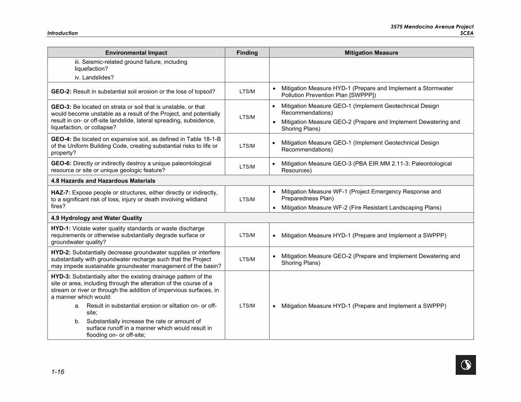
3575 Mendocino Avenue Project Introduction SCEA
1-16
Environmental Impact Finding Mitigation Measure iii. Seismic-related ground failure, including liquefaction? iv. Landslides?
GEO-2: Result in substantial soil erosion or the loss of topsoil? LTS/M • Mitigation Measure HYD-1 (Prepare and Implement a Stormwater Pollution Prevention Plan [SWPPP])
GEO-3: Be located on strata or soil that is unstable, or that would become unstable as a result of the Project, and potentially result in on- or off-site landslide, lateral spreading, subsidence, liquefaction, or collapse?
LTS/M
• Mitigation Measure GEO-1 (Implement Geotechnical Design Recommendations)
• Mitigation Measure GEO-2 (Prepare and Implement Dewatering and Shoring Plans)
GEO-4: Be located on expansive soil, as defined in Table 18-1-B of the Uniform Building Code, creating substantial risks to life or property?
LTS/M • Mitigation Measure GEO-1 (Implement Geotechnical Design Recommendations)
GEO-6: Directly or indirectly destroy a unique paleontological resource or site or unique geologic feature? LTS/M • Mitigation Measure GEO-3 (PBA EIR MM 2.11-3: Paleontological
Resources)
4.8 Hazards and Hazardous Materials
HAZ-7: Expose people or structures, either directly or indirectly, to a significant risk of loss, injury or death involving wildland fires?
LTS/M • Mitigation Measure WF-1 (Project Emergency Response and
Preparedness Plan) • Mitigation Measure WF-2 (Fire Resistant Landscaping Plans)
4.9 Hydrology and Water Quality HYD-1: Violate water quality standards or waste discharge requirements or otherwise substantially degrade surface or groundwater quality?
LTS/M • Mitigation Measure HYD-1 (Prepare and Implement a SWPPP)
HYD-2: Substantially decrease groundwater supplies or interfere substantially with groundwater recharge such that the Project may impede sustainable groundwater management of the basin?
LTS/M • Mitigation Measure GEO-2 (Prepare and Implement Dewatering and Shoring Plans)
HYD-3: Substantially alter the existing drainage pattern of the site or area, including through the alteration of the course of a stream or river or through the addition of impervious surfaces, in a manner which would:
a. Result in substantial erosion or siltation on- or off-site;
b. Substantially increase the rate or amount of surface runoff in a manner which would result in flooding on- or off-site;
LTS/M • Mitigation Measure HYD-1 (Prepare and Implement a SWPPP)

3575 Mendocino Avenue Project SCEA Introduction
1-17
Environmental Impact Finding Mitigation Measure c. Create or contribute runoff water which would
exceed the capacity of existing or planned stormwater drainage systems or provide substantial additional sources of polluted runoff; or
d. Impeded or redirect flood flows.
HYD-5: Conflict with or obstruct implementation of a water quality control plan or sustainable groundwater management plan?
LTS/M • Mitigation Measure HYD-1 (Prepare and Implement a SWPPP) • Mitigation Measure GEO-2 (Prepare and Implement Dewatering and
Shoring Plans)
4.12 Noise
NOI-1: Generation of a substantial temporary or permanent increase in ambient noise levels in the vicinity of the project in excess of standards established in the local general plan or noise ordinance, or applicable standards or other agencies?
LTS/M
• Mitigation Measure NOI-1 (Interior/Exterior Noise Levels) • Mitigation Measure NOI-2 (PBA EIR MM 2.6-2: Increased Noise from
Traffic and Transit) • Mitigation Measure NOI-3 (PBA EIR MM 2.6-5: Ambient Noise) • Mitigation Measure NOI-4 (PBA EIR MM 2.6-1[a]: Construction Noise
Levels and Groundborne Vibration) • Mitigation Measure NOI-5 (Construction Activity)
4.17 Tribal Cultural Resources
TRIB-1: Would the project cause a substantial adverse change in the significance of a tribal cultural resource, defined in Public Resources Code section 21074 as either a site, feature, place, cultural landscape that is geographically defined in terms of the size, or object with cultural value to the California Native American tribe and that is:
i. listed or eligible for listing in the California Register of Historical Resources, or in a local register of historical resources as defined in Public Resources Code section 5020.1(k).
ii. A resource determined by the lead agency, in its discretion and supported by substantial evidence, to be significant pursuant to criteria set forth in subdivision (c) of Public Resources Code Section 5024.1. In applying the criteria set forth in subdivision (c) of Public Resource Code Section 5024.1, the lead agency shall consider the significance of the resource to a California Native American tribe.
LTS/M
• Mitigation Measure CUL-1 (PBA EIR MM 2.11-2: Archaeological Resources)
• Mitigation Measure CUL-2 (Cultural Resources Monitoring) • Mitigation Measure TRIB-1 (PBA EIR MM 2.11-5: Tribal Cultural
Resources)

3575 Mendocino Avenue Project Introduction SCEA
1-18
Environmental Impact Finding Mitigation Measure 4.19 Wildfire Impact WF-2: Due to slope, prevailing winds, and other factors, exacerbate wildfire risks, and thereby expose project occupants to pollutant concentrations from a wildfire or the uncontrolled spread of a wildfire?
LTS/M • Mitigation Measure WF-1 (Project Emergency Response and Preparedness Plan)
Impact WF-3: Require the installation or maintenance of associated infrastructure (such as roads, fuel breaks, emergency water sources, power lines or other utilities) that may exacerbate fire risk or that may result in temporary or ongoing impacts to the environment?
LTS/M • Mitigation Measure WF-2 (Fire Resistant Landscaping Plans)
Key: NI = No Impact LTS = Less Than Significant Impact LTS/M = Less Than Significant Impact with Mitigation

3575 Mendocino Avenue Project SCEA Project Description
2-1
2.0 PROJECT DESCRIPTION The approximately 13.3-acre project site is located at 3575 Mendocino Avenue in the City of Santa Rosa, Sonoma County. The project site primarily consists of a single parcel identified as APN 173-030-001, but the proposed stormwater outfall would be located within Russell Creek, which is located offsite on the adjacent parcel identified as APN 173-030-002. The proposed stormwater outfall disturbance area is anticipated to be approximately 400 square feet (0.009 acres) and is factored into the approximately 13.3-acre project site. The proposed project would redevelop the approximately 13.3-acre former mobile home park site into a transit village with up to 532 high-density multi-family housing units. The proposed transit village would be developed as two separate components consisting of senior affordable housing on 2.5 acres and market rate housing on 9 acres of the project site. The senior housing component would total approximately 136,185 gsf and include 162 units affordable for low and very low senior households. The market rate housing component would total approximately 510,531 gsf and include up to 370 market rate housing units. The proposed project would also include approximately 1-acre of shared open space and the construction of a new public street (0.8-acre), on- and offsite utility infrastructure, parking (including surface, covered, and an aboveground garage), driveways, frontage improvements, landscaping, and a new stormwater outfall into the adjacent, offsite Russell Creek.
2.1 PROJECT OBJECTIVES AND REQUIRED PROJECT APPROVALS
2.1.1 Objectives
The proposed project includes the following objectives:
• Transform an approximately 13.3-acre infill site severely damaged by the 2017 Tubbs Wildfire into a vibrant, compact, high-density, mixed income and inter-generational transit village.
• Develop a high-density residential transit village, consisting of an affordable housing component and a market rate housing component, located in one of the City’s PDAs and within 0.5 mile of one of the City’s high quality transit corridor, the Bicentennial Way Transit Corridor.
• Decrease vehicle miles travelled by siting high-density housing near public transportation thereby reducing greenhouse gas (GHG) emissions.
• Create opportunities for jobs/housing balance, GHG reduction, and transportation efficiencies by locating housing within a two-mile radius of six of the County’s major employers.
• Provide a range of residential uses including a variety of units by size, type, and affordability to serve a cross-section of needs and income levels.
• Offer affordable housing opportunities to former Journey’s End Mobile Home Park qualifying residents displaced by the Tubbs Wildfire.
• Increase the City’s post-fire housing stock to help address the loss of approximately 3,000 homes as a result of the 2017 wildfires and help achieve the City’s Regional Housing Need Allocation.
• Transform the Mendocino Avenue/Fountaingrove Parkway intersection and Mendocino Avenue into a more attractive and pedestrian-friendly corridor.

3575 Mendocino Avenue Project Project Description SCEA
2-2
2.1.2 Approvals and Entitlements
This SCEA would be used by the City as the Lead Agency to evaluate the potential environmental impacts of the proposed project. Anticipated approvals/actions may include, but are not limited to, the following:
• Adoption of the SCEA: City of Santa Rosa • General Plan Amendment: City of Santa Rosa • Rezoning: City of Santa Rosa • Phased Tentative Map: City of Santa Rosa • Parking Reduction: City of Santa Rosa • Request for Allotments: City of Santa Rosa • Director-level Design Review (City Code Section 20-28.100[G]): City of Santa Rosa • Sign Permit: City of Santa Rosa • National Pollutant Discharge Elimination System Permit: North Coast Regional Water Quality Control Board
(RWQCB) • Stormwater Easement: Sonoma Water • Clean Water Act Section 404 Permit: U.S. Army Corps of Engineers (USACE) • Clean Water Act Section 401 Water Quality Certification: RWQCB • Section 1600 Lake and Streambed Alternative Agreement: California Department of Fish and Wildlife (CDFW)
Other ministerial approvals, such as building-related permits and City encroachment permits, are also anticipated. Additionally, the proposed project would be subject to the City Code including the Zoning Ordinance, Building Code, and Fire Code.
2.2 PROJECT CHARACTERISTICS
The proposed project would be a master planned transit village community with up to 532 units of high-density housing, resulting in a maximum density of 40 dwelling units per acre, on the approximately 13.3-acre project site. The proposed housing would be developed as two separate components consisting of 162 senior affordable housing units on approximately 2.5 acres and up to 370 market rate housing units on approximately 9 acres. Subdivision of the project site would be accomplished through a phased tentative map that would create separate legal parcels for the affordable housing component, market rate housing component, and shared open space. Development of the affordable and market rate housing components on separate parcels would allow each component to be ground-leased separately and also allow for separate phasing of construction and financing. Table 2.2-1 summarizes the proposed project components. The project site plan is shown in Figure 2.0-1.
Table 2.2-1: Proposed Project Components
Project Component Area (acres) Maximum Number of Units Affordable Housing 2.5 162
Market Rate Housing 9 370
Shared Open Space 1.0 —
Public Street 0.80 —
Total 13.3 532

V:\1
85
7\A
ctive\1
85
704
99
3_3
57
5M
end
ocin
oA
ve\0
3_
data
\gis
_ca
d\g
is\m
xd
\IS
MN
D\F
ig2
.0-1
_P
roje
ct_
Site
_P
lan
.mxd
Re
vis
ed:
202
0-0
7-2
1 B
y:
KA
EJO
HN
SO
N
2.0-1
City of Santa Rosa3575 Mendocino Avenue Project
Santa Rosa, CA
Project Site Plan
Figure No.
Title
Project Location
Client/Project
BUILDING 1
BUILDING 2 BUILDING 3
BUILDING 4A
BUILDING 4B.1
BUILDING 4B.2
BUILDING 4B.3
BUILDING 4B.4
BUILDING 4C.1
BUILDING 4C.2
BUILDING 4C.3
CENTRAL PARK
PUBLICSTREET
MENDO
CINO AVENUE
HIG
HW
AY 1
01
MENDOCINO O/C
FOUNTAINGROVE PKWY.
RUSSELL CREEK
BUS STOPRELOCATED
PRIVATE DRIVEWAY
PRIVATE DRIVEWAY
PRIV
ATE
DR
IVEW
AYPR
IVAT
E D
RIV
EWAY
PRIV
ATE
DR
IVEW
AY
PRIVATE DRIVEWAY
0' 25' 50' 100'
|3575 MENDOCINO AVENUESANTA ROSA, CA |
A1.1ILLUSTRATIVE SITE PLAN & ZONING SUMMARY
09/23/20 | BRJE COMMUNITIES, LLC
ILLUSTRATIVE SITE PLAN STATISTICS
Buildings 1, 2, 3
Building 4ABuildings 4B (1-4)Buildings 4C (1-3)
No. of Floors Unit Count Parking Spaces
Parking Ratio
MARKET RATE MULTI-FAMILY HOUSING
AFFORDABLE SENIOR HOUSING
TOTAL
TOTAL UNITS PROVIDED: 532 unitsDENSITY PROVIDED: 40 du/ac
ILLUSTRATIVE SITE PLAN SUMMARY
4 162 114 0.70
4 200 330 1.653 104 172 1.653 66 103 1.56
370 605 1.64
TOTAL 162 114 0.70
(MAX. ALLOWED PER ZONING: 532 units)(MAX. ALLOWED PER ZONING: 40 du/ac)
- CONCEPT STUDY
TV-R ZONING SUMMARY (MAXIMUM HOLDING CAPACITY)
SITE AREA: 13.3 acresTV-R DENSITY: 25-40 du/acTV-R HEIGHT: 4 StoriesTOTAL NO. OF UNITS AT 40 du/ac: 532 units
AFFORDABLE SENIOR HOUSING: 162 units ALLOWABLEMARKET-RATE MULTI-FAMILY HOUSING: 370 units ALLOWABLE
No. of Floors Unit Count Parking Spaces
Parking Ratio
MARKET RATE HOUSING BUILDING AREAS & UNIT MIX
AFFORDABLE SENIOR HOUSING BUILDING AREAS & UNIT MIX
BUILDING 1
BUILDING 2 BUILDING 3
BUILDING 4A
BUILDING 4B.1
BUILDING 4B.2
BUILDING 4B.3
BUILDING 4B.4
BUILDING 4C.1
BUILDING 4C.2
BUILDING 4C.3
CENTRAL PARK
PUBLICSTREET
MENDO
CINO AVENUE
HIG
HW
AY 1
01MENDOCINO O/C
FOUNTAINGROVE PKWY.
RUSSELL CREEK
BUS STOPRELOCATED
PRIVATE DRIVEWAY
PRIVATE DRIVEWAY
PRIV
ATE
DR
IVEW
AYPR
IVAT
E D
RIV
EWAY
PRIV
ATE
DR
IVEW
AY
PRIVATE DRIVEWAY
0' 25' 50' 100'
|3575 MENDOCINO AVENUESANTA ROSA, CA |
A1.1ILLUSTRATIVE SITE PLAN & ZONING SUMMARY
05/04/20 | BRJE COMMUNITIES, LLC
ILLUSTRATIVE SITE PLAN STATISTICS
Buildings 1, 2, 3
Building 4A
Buildings 4B (1-4)
Buildings 4C (1-3)
No. of Floors Unit Count Parking Spaces
Parking Ratio
MARKET RATE MULTI-FAMILY HOUSING
AFFORDABLE SENIOR HOUSING
TOTAL
TOTAL UNITS PROVIDED: 532 unitsDENSITY PROVIDED: 40 du/ac
ILLUSTRATIVE SITE PLAN SUMMARY
3 & 4 162 114 0.70
4 180 280 1.55
3 118 174 1.48
3 72 82 1.14
370 536 1.40
TOTAL 162 114 0.70
(MAX. ALLOWED PER ZONING: 532 units)(MAX. ALLOWED PER ZONING: 40 du/ac)
- CONCEPT STUDY
TV-R ZONING SUMMARY (MAXIMUM HOLDING CAPACITY)
SITE AREA: 13.3 acresTV-R DENSITY: 25-40 du/acTV-R HEIGHT: 4 Stories
TOTAL NO. OF UNITS AT 40 du/ac: 532 units
AFFORDABLE SENIOR HOUSING: 162 units ALLOWABLEMARKET-RATE MULTI-FAMILY HOUSING: 370 units ALLOWABLE
No. of Floors Unit Count Parking Spaces
Parking Ratio
Source: Van Meter Williams Pollack, September 2020

3575 Mendocino Avenue Project Project Description SCEA
2-4
This page left intentionally blank.

3575 Mendocino Avenue Project SCEA Project Description
2-5
2.2.1 Affordable Housing Component
The proposed project would provide 162 senior affordable housing units, to be located on three parcels totaling approximately 2.5-acres, in the southeast corner of the project site (Figure 2.0-1). The affordable units would have frontage on Mendocino Avenue and the new public street and would be adjacent to Russell Creek. Conceptual renderings of the affordable housing component are provided in Figures 2.0-2 and 2.0-3.
The affordable housing component would consist of three residential buildings, totaling approximately 136,185 gsf. The buildings would be predominately four stories in height with two- and three-story elements incorporated at the building corners and entries to reduce the perceived scale and highlight the building entries. Each building would have associated private open space programmed for outdoor recreation opportunities. Building 1 would have a formal forecourt for waiting outside for pick-up and drop-off at the covered entry as well as a courtyard facing the new public street. The courtyards and private open space would be interconnected by walkways.
The proposed 162 units would be comprised of 158 one-bedroom/one-bath units and 4 two-bedroom/one-bath units (including two manager’s units). Table 2.2-2 shows the number of affordable units and associated square footages for each building. The units would range in size from approximately 530 to 800 square feet. The affordable housing would also include onsite amenities, such as multi-purpose activity common rooms, a health and wellness room, media room, laundry rooms, bicycle rooms, manager’s offices, reception areas with alternative transportation real-time data kiosks or monitors, and community gardens. The affordable housing component is anticipated to be GreenPoint rated.
Table 2.2-2: Affordable Housing Component
Building Number of Units Gross Square Feet Building 1 94 79,685
Building 2 38 29,800
Building 3 30 26,700
Total 162 136,185
The units would be affordable to seniors, age 55 and older, with household incomes between approximately 30 to 60 percent of the Sonoma County area median income. The Applicant anticipates pursuing project-based vouchers for the affordable housing component to provide even deeper levels of affordability. When the new affordable units are completed, qualifying (e.g. by age, income, etc.) residents of the former Journey’s End Mobile Home Park would be given first priority as tenants in the new affordable housing units. Onsite management would be provided 24 hours per day, 7 days per week by two dedicated onsite staff. Professional facilities repair and maintenance staff as well as tenant services staff would also support the affordable housing.
2.2.2 Market Rate Housing Component
The market rate housing would be located on approximately 9 acres north of the affordable housing component and the proposed shared open space (Figure 2.0-1). The market rate housing would have frontage on Mendocino Avenue and abut the Mendocino Overcrossing to the north and Highway 101 to the west. Conceptual renderings of the market rate housing component are provided in Figures 2.0-4 and 2.0-5.

3575 Mendocino Avenue Project Project Description SCEA
2-6
The market rate component would consist of up to 510,531 gsf and include up to 370 units in conformance with the allowed density of the TVM land use designation and development standards of the TV-R zoning district. The proposed buildings would be three and four stories tall. Table 2.2-3 shows the number of units and associated square footages for each building. As shown in Table 2.2-3, Building 4a would also include an above ground parking garage comprised of four levels and approximately 72,000 gsf. The market rate housing units would consist of 18 studios, 111 one-bedroom units, 185 two-bedroom units, and 56 three-bedroom units. The units would range in size from approximately 500 to 1,300 square feet. The market rate component would include a natural gas fireplace in each of the 370 units, as well as one in each of the eight building lobbies.
Table 2.2-3: Market Rate Housing Unit Types
Building Number of Units Gross Square Feet Building 4A 200 212,156
Building 4A Parking Garage — 72,000
Building 4B(1) 39 54,188
Building 4B(2) 39 54,188
Building 4B(3) 15 19,125
Building 4B(4) 11 15,250
Building 4C(1) 33 41,811
Building 4C(2) 18 22,688
Building 4C(3) 15 19,125
Total 370 510,531 (with parking garage)
The market rate housing component would be GreenPoint-rated. Onsite management would be provided 24 hours per day, 7 days per week by dedicated onsite staff. Professional facilities repair and maintenance staff, as well as tenant services staff, would support the market rate housing.
2.2.3 City of Santa Rosa Inclusionary Housing Ordinance
Pursuant to the City’s Inclusionary Housing Ordinance (Section 21-02.050 of the City Code), all for-rent residential housing projects are required to pay a housing impact fee, or to construct at least 8 percent of the total number of new dwelling units as affordable to low income households or at least 5 percent as affordable to very-low income households. The proposed combined project would be required to provide at least 43 units as affordable to low income households or at least 27 units as affordable to very low include households. However, the project proposes to exceed the requirements of the City’s Inclusionary Housing Ordinance by constructing 162 units, or 30 percent of the total number of new dwelling units onsite, as affordable to low and very low-income senior households.

V:\1
85
7\A
ctive\1
85
704
99
3_3
57
5M
end
ocin
oA
ve\0
3_
data
\gis
_ca
d\g
is\m
xd
\IS
MN
D\F
ig2
.0-2
_S
enio
r_A
ffo
rda
ble
_V
iew
.mxd
R
evis
ed
: 2
02
0-0
7-2
1 B
y:
KA
EJO
HN
SO
N
2.0-2
City of Santa Rosa3575 Mendocino Avenue Project
Santa Rosa, CA
Figure No.
TitleView of Affordable Housing Component from Mendocino Avenue
Project Location
Client/Project
|3575 MENDOCINO AVE AFFORDABLE SENIOR HOUSINGSANTA ROSA, CA |
A0.1RENDERED VIEW AT BLDG. 3 - MENDOCINO AVE
09/23/20 | BRJE COMMUNITIES, LLC
Source: Van Meter Williams Pollack, September 2020

3575 Mendocino Avenue Project Project Description SCEA
2-8
This page left intentionally blank.

V:\1
85
7\A
ctive\1
85
704
99
3_3
57
5M
end
ocin
oA
ve\0
3_
data
\gis
_ca
d\g
is\m
xd
\IS
MN
D\F
ig2
.0-3
_S
enio
r_A
ffo
rda
ble
_V
iew
.mxd
R
evis
ed
: 2
02
0-0
7-2
1 B
y:
KA
EJO
HN
SO
N
2.0-3
City of Santa Rosa3575 Mendocino Avenue Project
Santa Rosa, CA
Figure No.
TitleView of Affordable Housing Component from New Public Street
Project Location
Client/Project
|3575 MENDOCINO AVE AFFORDABLE SENIOR HOUSINGSANTA ROSA, CA |
A0.2RENDERED VIEW AT ROUNDABOUT DRIVE
09/23/20 | BRJE COMMUNITIES, LLC
Source: Van Meter Williams Pollack, September 2020

3575 Mendocino Avenue Project Project Description SCEA
2-10
This page left intentionally blank.

V:\1
85
7\A
ctive\1
85
704
99
3_3
57
5M
end
ocin
oA
ve\0
3_
data
\gis
_ca
d\g
is\m
xd
\IS
MN
D\F
ig2
.0-4
_M
ark
et_
Rate
_V
iew
.mxd
Re
vis
ed:
202
0-0
7-2
1 B
y: K
AE
JO
HN
SO
N
2.0-4
City of Santa Rosa3575 Mendocino Avenue Project
Santa Rosa, CA
View of Market Rate Component from Mendocino Avenue
Figure No.
Title
Project Location
Client/Project
|3575 MENDOCINO AVENUESANTA ROSA, CA |
A0.3RENDERED VIEW - SCULPTURAL PARK & SECONDARY COMMUNITY ENTRANCE
09/23/20 | BRJE COMMUNITIES, LLC
Source: Van Meter Williams Pollack, September 2020

3575 Mendocino Avenue Project Project Description SCEA
2-12
This page left intentionally blank.

V:\1
85
7\A
ctive\1
85
704
99
3_3
57
5M
end
ocin
oA
ve\0
3_
data
\gis
_ca
d\g
is\m
xd
\IS
MN
D\F
ig2
.0-5
_M
ark
et_
Rate
_V
iew
.mxd
Re
vis
ed:
202
0-0
7-2
1 B
y: K
AE
JO
HN
SO
N
2.0-5
City of Santa Rosa3575 Mendocino Avenue Project
Santa Rosa, CA
View of Market Rate Component from Shared Open Space
Figure No.
Title
Project Location
Client/Project
|3575 MENDOCINO AVENUESANTA ROSA, CA |
A0.4RENDERED VIEW - LOOKING SOUTHWEST FROM CENTRAL PARK
09/23/20 | BRJE COMMUNITIES, LLC
Source: Van Meter Williams Pollack, September 2020

3575 Mendocino Avenue Project Project Description SCEA
2-14
This page left intentionally blank.

3575 Mendocino Avenue Project SCEA Project Description
2-15
2.2.4 Employment and Future Residents Estimate
The project site, which previously contained the Journey’s End Mobile Home Park, is currently vacant. The General Plan estimates an average of 2.69 persons per household in 2020 (City of Santa Rosa 2009a) resulting in a projected population for the proposed project of 1,431 residents. However, the senior affordable component would include a combination of one-bedroom and two-bedroom units and the market rate housing component would include a mix of studio, one-bedroom, two-bedroom, and three-bedroom units. Therefore, for purposes of this analysis and to represent a conservative analysis the estimated number of residents for the proposed project was based on the proposed unit mix. As shown in Table 2.2-4, the number of occupants per unit would range from 1.9 to 3.25 occupants resulting in 1,383 residents at the project site, if fully occupied. The 1,383 residents generated by the proposed project would be within the projected population estimated by the City’s General Plan and is applied throughout this analysis.
In addition, it is anticipated that up to 17 staff would work at the project site. The 17 staff members are anticipated to be a part of the local labor force and would support the affordable housing and market rate housing components, including facilities repair and maintenance management as well as tenant services.
Table 2.2-4: Estimated Population for the Proposed Project
Unit Type Number of Units Occupants per Unit Population Senior Housing Component One-Bedroom 158 1.9 300
Two-Bedroom 4 2.25 9
Subtotal 309 Market Rate Housing Component Studio 18 2.25 41
One-Bedroom 111 2.25 250
Two or more Bedroom 241 3.25 783
Subtotal 1,074
Staff -- -- -- 17
Subtotal 17 Proposed Project Total 1,400
2.2.5 Landscaping
According to the Final Arborist Report prepared for the proposed project on September 14, 2020, a few dead and dying trees are still standing on the project site, as well as some unburned trees that are protected under Chapter 17-24 of the City’s Code (Appendix A, Duckles 2020). Chapter 17-24 of the City’s Code seeks to protect certain trees, referred to as heritage trees, which are an essential part of the City’s natural heritage. Section 17-24.020 of the City Code defines heritage trees by both species and size (diameter/circumference) and protected trees as “any tree, including a heritage tree, designated to be preserved on an approved development plan or as a condition of approval of a tentative map, a tentative parcel map, or other development approval issued by the City.” Based on the Final Arborist Report prepared for the proposed project, there are 53 trees on the project site, including 6 heritage trees. Of

3575 Mendocino Avenue Project Project Description SCEA
2-16
the six heritage trees on the project site, five heritage trees are planned for removal as part of the proposed project. A few Chinese pistache street trees and a coast redwood tree would be retained. The developer would either replace the heritage trees or pay an in-lieu fee as required by Section 17-24.050 of the City’s Code. The private streets would have planters, street trees, and low water use plantings (Figures 2.0-6 and 2.0-7). As shown on Figure 2.0-7, a large landscape area that includes berms with sculptural retaining walls planted with specimen oaks would be located along Mendocino Avenue, north of the proposed project’s northern driveway. Fire resistant landscaping and landscape design and Low Impact Design features would be incorporated into the proposed project and parking lot trees would be provided for shading and to provide additional greenery. The proposed landscaping would consist of mainly low water use plants to meet the City’s Water Efficient Landscape Ordinance.
2.2.6 Open Space Areas
The proposed project would include approximately 1-acre of shared open space that would serve as a central gathering place for the community (Figure 2.0-7). The shared open space would include both active and passive recreational opportunities including a central lawn, green landscaped areas, sport court, exercise equipment, children’s play area, and picnic area with shade trees. The affordable housing component would also include 0.46-acre of private open space for the senior residents per the City’s Design Guidelines (Figure 2.0-6). The private open space would consist of a series of walking paths and courtyards, covered patio spaces, raised communal garden beds, seat walls, and lawn space for exercise and activities. The market rate component would also include 0.34-acre of private open space per the City’s Design Guidelines. The proposed project’s residential uses would orient around and connect to the shared open space areas via public sidewalks, walking paths, and bicycle routes.
2.2.7 Vehicular Access
Primary site access would be via a new public street on Mendocino Avenue that would align with the driveway of the large office complex located across the street. In addition to the main project access, the project site would have two additional access points along Mendocino Avenue, at the north and south ends of the project site. These access points would meet the City’s requirements for fire apparatus access as well as emergency ingress and egress from the project site. These additional access points would be right-in and right-out only to reduce the potential for traffic conflicts along Mendocino Avenue. Private driveways would provide access to the residential units and shared open space and would be designed similar to private streets with sidewalks, street trees, pedestrian lighting, and crosswalks at intersections. As shown on Figure 2.0-8, the proposed public street and private driveways would be 26 feet wide to allow emergency vehicles to access the project site.

V:\1
85
7\A
ctive\1
85
704
99
3_3
57
5M
end
ocin
oA
ve\0
3_
data
\gis
_ca
d\g
is\m
xd
\IS
MN
D\F
ig2
.0-5
_O
pe
n_
Spa
ce
.mxd
Re
vis
ed:
202
0-0
7-2
1 B
y: K
AE
JO
HN
SO
N
2.0-6
City of Santa Rosa3575 Mendocino Avenue Project
Santa Rosa, CA
Figure No.
TitleOpen Space Areas and Landscaping - Affordable Housing Component
Project Location
Client/Project
0' 4' 8' 16'
|3575 MENDOCINO AVE AFFORDABLE SENIOR HOUSINGSANTA ROSA, CA |
L1.2LANDSCAPE ENLARGEMENT
09/23/20 | BRJE COMMUNITIES, LLC
BUILDING 1
BUILDING 2 BUILDING 3
BUILDING 4A
BUILDING 4B.1
BUILDING 4B.2
BUILDING 4B.3
BUILDING 4B.4
BUILDING 4C.1
BUILDING 4C.2
BUILDING 4C.3
CENTRALPARK
PUBLICSTREET
MENDO
CINOAVENUE
HIG
HW
AY10
1MENDOCINO O/C
FOUNTAINGROVE PKWY.
RUSSELL CREEK
BUS STOPRELOCATED
PRIVATE DRIVEWAY
PRIVATE DRIVEWAY
PRIV
ATE
DR
IVEW
AYPR
IVAT
E D
RIV
EWAY
PRIV
ATE
DR
IVEW
AY
PRIVATE DRIVEWAY
0' 25' 50' 100'
|3575 MENDOCINO AVENUESANTA ROSA, CA |
A1.1ILLUSTRATIVE SITE PLAN & ZONING SUMMARY
05/04/20 | BRJE COMMUNITIES, LLC
ILLUSTRATIVE SITE PLAN STATISTICS
Buildings 1, 2, 3
Building 4A
Buildings 4B (1-4)
Buildings 4C (1-3)
No. of Floors Unit Count Parking Spaces
Parking Ratio
MARKET RATE MULTI-FAMILY HOUSING
AFFORDABLE SENIOR HOUSING
TOTAL
TOTAL UNITS PROVIDED: 532 unitsDENSITY PROVIDED: 40 du/ac
ILLUSTRATIVE SITE PLAN SUMMARY
3 & 4 162 114 0.70
4 180 280 1.55
3 118 174 1.48
3 72 82 1.14
370 536 1.40
TOTAL 162 114 0.70
(MAX. ALLOWED PER ZONING: 532 units)(MAX. ALLOWED PER ZONING: 40 du/ac)
- CONCEPT STUDY
TV-R ZONING SUMMARY (MAXIMUM HOLDING CAPACITY)
SITE AREA: 13.3 acresTV-R DENSITY: 25-40 du/acTV-R HEIGHT: 4 Stories
TOTAL NO. OF UNITS AT 40 du/ac: 532 units
AFFORDABLE SENIOR HOUSING: 162 units ALLOWABLEMARKET-RATE MULTI-FAMILY HOUSING: 370 units ALLOWABLE
No. of Floors Unit Count Parking Spaces
Parking Ratio
Source: Van Meter Williams Pollack, September 2020

3575 Mendocino Avenue Project Project Description SCEA
2-18
This page left intentionally blank.

V:\1
85
7\A
ctive\1
85
704
99
3_3
57
5M
end
ocin
oA
ve\0
3_
data
\gis
_ca
d\g
is\m
xd
\IS
MN
D\F
ig2
.0-5
_O
pe
n_
Spa
ce
.mxd
Re
vis
ed:
202
0-0
7-2
1 B
y: K
AE
JO
HN
SO
N
City of Santa Rosa3575 Mendocino Avenue Project
Santa Rosa, CA
Figure No. 2.0-7TitleOpen Space Areas and Landscaping - Market Rate Housing Component
Project Location
Client/Project
BUILDING 1
BUILDING 2 BUILDING 3
BUILDING 4A
BUILDING 4B.1
BUILDING 4B.2
BUILDING 4B.3
BUILDING 4B.4
BUILDING 4C.1
BUILDING 4C.2
BUILDING 4C.3
CENTRALPARK
PUBLICSTREET
MENDO
CINOAVENUE
HIG
HW
AY10
1MENDOCINO O/C
FOUNTAINGROVE PKWY.
RUSSELL CREEK
BUS STOPRELOCATED
PRIVATE DRIVEWAY
PRIVATE DRIVEWAY
PRIV
ATE
DR
IVEW
AYPR
IVAT
E D
RIV
EWAY
PRIV
ATE
DR
IVEW
AY
PRIVATE DRIVEWAY
0' 25' 50' 100'
|3575 MENDOCINO AVENUESANTA ROSA, CA |
A1.1ILLUSTRATIVE SITE PLAN & ZONING SUMMARY
05/04/20 | BRJE COMMUNITIES, LLC
ILLUSTRATIVE SITE PLAN STATISTICS
Buildings 1, 2, 3
Building 4A
Buildings 4B (1-4)
Buildings 4C (1-3)
No. of Floors Unit Count Parking Spaces
Parking Ratio
MARKET RATE MULTI-FAMILY HOUSING
AFFORDABLE SENIOR HOUSING
TOTAL
TOTAL UNITS PROVIDED: 532 unitsDENSITY PROVIDED: 40 du/ac
ILLUSTRATIVE SITE PLAN SUMMARY
3 & 4 162 114 0.70
4 180 280 1.55
3 118 174 1.48
3 72 82 1.14
370 536 1.40
TOTAL 162 114 0.70
(MAX. ALLOWED PER ZONING: 532 units)(MAX. ALLOWED PER ZONING: 40 du/ac)
- CONCEPT STUDY
TV-R ZONING SUMMARY (MAXIMUM HOLDING CAPACITY)
SITE AREA: 13.3 acresTV-R DENSITY: 25-40 du/acTV-R HEIGHT: 4 Stories
TOTAL NO. OF UNITS AT 40 du/ac: 532 units
AFFORDABLE SENIOR HOUSING: 162 units ALLOWABLEMARKET-RATE MULTI-FAMILY HOUSING: 370 units ALLOWABLE
No. of Floors Unit Count Parking Spaces
Parking Ratio
Source: Van Meter Williams Pollack, September 2020
0' 15' 30' 60'
|3575 MENDOCINO AVENUESANTA ROSA, CA |
L1.2PARK AND STREETSCAPE ENLARGEMENT
09/23/20 | BRJE COMMUNITIES, LLC

3575 Mendocino Avenue Project Project Description SCEA
2-20
This page left intentionally blank.

V:\1
85
7\A
ctive\1
85
704
99
3_3
57
5M
end
ocin
oA
ve\0
3_
data
\gis
_ca
d\g
is\m
xd
\IS
MN
D\F
ig2
.0-7
_F
ire
_D
ep
art
men
t_A
cce
ss.m
xd
R
evis
ed
: 20
20
-07-2
1 B
y: K
AE
JO
HN
SO
N
City of Santa Rosa3575 Mendocino Avenue Project
Santa Rosa, CA
Fire Department Access
Figure No. 2.0-8Title
Project Location
Client/Project
SS
SS
SSSSSS
ELECELEC
10" W
10" W
10" W
CENTRAL PARK
PUBLIC STREET
BUILDING 2 BUILDING 3
MENDO
CINO AVE.
BUILDING 4B.1
BUILDING 4B.2
BUILDING 4B.3
BUILDING 4B.4
ALLEY
BUILDING 4A
ALLEY
ALLEY
PARKING GARAGE243 SPACES
BUILDING 4C.1
BUILDING 4C.2
BUILDING 4C.3
MENDOCINO O/C
HIG
HW
AY 1
01 FOUNTAINGROVE PKWY.
RUSSELL CREEK
TYPE VTYPE VBUILDING 1
TYPE V
TYPE V
TYPE V
TYPE V
TYPE V
TYPE V
TYPE V
TYPE V
TYPE V
TYPE 1A
150'
CLR
.
26'-0
"
30'-0"
26'-0"
26'-0
"
PRIVATE DRIVE/ FIRE ACCESS
PRIV
ATE
DR
IVE/
FIR
E AC
CES
SPR
IVAT
E D
RIV
E/ F
IRE
ACC
ESS
PRIVATE DRIVE/ FIRE ACCESS
PRIVATE DRIVE/ FIRE ACCESS
PRIVATE DRIVE/ FIRE ACCESS
PRIV
ATE
DR
IVE/
FIR
E AC
CES
S
PRIV
ATE
DR
IVE/
FIR
E AC
CES
S
PRIVATE DRIVE/ FIRE ACCESS
150'
150'15
0'
24'-0"
21'-9 1/2"
15'-0
"
CLR
.
26'-0
"
150'
150'
150'
150'
20'-0"
TYP.R 20' - 0"
R 20' - 0"
R 40' - 0"
L
PAR
KIN
G U
ND
ER C
ARPO
RTS
PAR
KIN
G U
ND
ER C
ARPO
RTS
PARKING UNDER CARPORTS
PARKING UNDER CARPORTS
150'
51'-7
1/4
"
25'-1
0 3/
8"
28'-0
"
PARKING UNDER CARPORTS
150'
SIGNALIZEDINTERSECTION
CLR.
26'-0"
CLR
.
26'-0
"
L LL
4 STORIES
3 STORIES
2 STORIES
1 STORY
PROPOSED FIRE HYDRANT
PROPOSED STAIRSWITH ROOF ACCESS
MAX. 150' DISTANCE FROM26' CLR. FIRE ACCESS DRIVE
26' CLEAR FIRE ACCESS DRIVE
PROPOSED BUILDINGENTRY TO MAIN LOBBY
ALL BUILDINGS ARE TVPE V - NFPA 13 SPRINKLERED
L
0' 25' 50' 100'
|3575 MENDOCINO AVENUESANTA ROSA, CA |
A1.2FIRE DEPARTMENT ACCESS DIAGRAM
09/23/20 | BRJE COMMUNITIES, LLC
LEGEND
10"W
10"W
10"W
ELEC
CENTRAL PARK
PUBLIC STREET
BUILDING 2 BUILDING 3
MENDO
CINOAVE.
BUILDING4B.1
BUILDING4B.2
BUILDING4B.3
BUILDING4B.4
ALLEY
BUILDING 4A
ALLEY
ALLEY
PARKING GARAGE180 SPACES
BUILDING4C.1
BUILDING4C.2
BUILDING4C.3
MENDOCINO O/C
HIG
HW
AY10
1 FOUNTAINGROVE PKWY.
RUSSELL CREEK
TYPE VTYPE VBUILDING 1
TYPE V
TYPE V
TYPE V
TYPE V
TYPE V
TYPE V
TYPE V
TYPE V
TYPE V
TYPE 1A
150'
CLR
.
26'-0
"
30'-0"
26'-0"
26'-0
"
PRIVATE DRIVE/ FIRE ACCESS
PRIV
ATE
DR
IVE/
FIR
E AC
CES
SPR
IVAT
E D
RIV
E/FI
RE
ACC
ESS
PRIVATE DRIVE/ FIRE ACCESS
PRIVATE DRIVE/ FIRE ACCESS
PRIVATE DRIVE/ FIRE ACCESS
PRIV
ATE
DR
IVE/
FIR
EAC
CES
S
PRIV
ATE
DR
IVE/
FIR
EAC
CES
S
PRIVATE DRIVE/ FIRE ACCESS
150'
150'
150'
24'-0"
21'-9 1/2"
15'-0
"
CLR.
26'-0
"
150'
150'
150'
150'
20'-0"
TYP.R
20' - 0"
R20' - 0"
R 40' - 0"
L
L
LPAR
KIN
GU
ND
ERC
ARPO
RTS
PAR
KIN
GU
ND
ERC
ARPO
RTS
PARKING UNDER CARPORTS
PARKING UNDER CARPORTS
150'
51'-7
1/4"
25'-1
03/
8"
28'-0
"
PARKING UNDER CARPORTS
L
150'
SIGNALIZEDINTERSECTION
SIGNALIZEDINTERSECTION
30'-0
"
CLR.
26'-0"
CLR
.
26'-0
"
33'-0"
4 STORIES
3 STORIES
2 STORIES
1 STORY
PROPOSED FIRE HYDRANT
PROPOSED STAIRSWITH ROOF ACCESS
MAX. 150' DISTANCE FROM26' CLR. FIRE ACCESS DRIVE
26' CLEAR FIRE ACCESS DRIVE
PROPOSED BUILDING ENTRY TO MAIN LOBBY
ALL BUILDINGS ARE TVPE V - NFPA 13 SPRINKLERED
L
0' 25' 50' 100'
|3575 MENDOCINO AVENUESANTA ROSA, CA |
A1.2FIRE DEPARTMENT ACCESS DIAGRAM
05/04/20 | BRJE COMMUNITIES, LLC
LEGENDLegend
BUILDING 1
BUILDING 2 BUILDING 3
BUILDING 4A
BUILDING 4B.1
BUILDING 4B.2
BUILDING 4B.3
BUILDING 4B.4
BUILDING 4C.1
BUILDING 4C.2
BUILDING 4C.3
CENTRALPARK
PUBLICSTREET
MENDO
CINOAVENUE
HIG
HW
AY10
1MENDOCINO O/C
FOUNTAINGROVE PKWY.
RUSSELL CREEK
BUS STOPRELOCATED
PRIVATE DRIVEWAY
PRIVATE DRIVEWAY
PRIV
ATE
DR
IVEW
AYPR
IVAT
E D
RIV
EWAY
PRIV
ATE
DR
IVEW
AY
PRIVATE DRIVEWAY
0' 25' 50' 100'
|3575 MENDOCINO AVENUESANTA ROSA, CA |
A1.1ILLUSTRATIVE SITE PLAN & ZONING SUMMARY
05/04/20 | BRJE COMMUNITIES, LLC
ILLUSTRATIVE SITE PLAN STATISTICS
Buildings 1, 2, 3
Building 4A
Buildings 4B (1-4)
Buildings 4C (1-3)
No. of Floors Unit Count Parking Spaces
Parking Ratio
MARKET RATE MULTI-FAMILY HOUSING
AFFORDABLE SENIOR HOUSING
TOTAL
TOTAL UNITS PROVIDED: 532 unitsDENSITY PROVIDED: 40 du/ac
ILLUSTRATIVE SITE PLAN SUMMARY
3 & 4 162 114 0.70
4 180 280 1.55
3 118 174 1.48
3 72 82 1.14
370 536 1.40
TOTAL 162 114 0.70
(MAX. ALLOWED PER ZONING: 532 units)(MAX. ALLOWED PER ZONING: 40 du/ac)
- CONCEPT STUDY
TV-R ZONING SUMMARY (MAXIMUM HOLDING CAPACITY)
SITE AREA: 13.3 acresTV-R DENSITY: 25-40 du/acTV-R HEIGHT: 4 Stories
TOTAL NO. OF UNITS AT 40 du/ac: 532 units
AFFORDABLE SENIOR HOUSING: 162 units ALLOWABLEMARKET-RATE MULTI-FAMILY HOUSING: 370 units ALLOWABLE
No. of Floors Unit Count Parking Spaces
Parking Ratio
Source: Van Meter Williams Pollack, September 2020
4 Stories
3 Stories
2 Stories
1 Stories
26’ Clear Fire Access Drive
Max 150’ Distance from 26’ Clr. Fire Access Drive
Proposed Fire Hydrant
Proposed Stairs with Roof Access
Proposed Building Entry to Main Lobby
All Buildings are Type V - NFPA 13 Sprinklered

3575 Mendocino Avenue Project Project Description SCEA
2-22
This page left intentionally blank.

3575 Mendocino Avenue Project SCEA Project Description
2-23
2.2.8 Parking
Pursuant to Section 20-36.040 of the City Code, the proposed project is required to provide one parking space per unit for senior affordable housing. Multi-family apartment buildings are required to provide 1.5 parking spaces per unit for one-bedroom apartments and 2.5 spaces per unit for two-bedroom apartments. Based on these rates, the proposed project would be required to provide 958 parking spaces per the City Code. However, Section 20-36-050 (C) of the Zoning Code indicates that the City has the discretion to apply a reduction in parking requirements, of up to 25 percent. The proposed project is in close proximity to transit, including CityBus Routes 1 and 10 and Sonoma County Transit Routes 44, 48, 54, 60, and 62, providing service throughout Santa Rosa and Sonoma County, including every 15 minutes throughout the day on CityBus Route 1 and every 30 minutes throughout the day on CityBus Route 10. Therefore, the proposed project is seeking a parking reduction pursuant to Section 20-36-050 (C) of the Zoning Code and would provide 114 spaces for the senior affordable component and 605 spaces for the market rate component, totaling 719 parking spaces.
The proposed project would include approximately 158,500 square feet of parking and a total of 719 vehicle parking spaces. The affordable housing component would include approximately 19,000 square feet of surface parking with 114 spaces. As required by the City Code, 12 parking spaces located along the southern boundary of the affordable housing site would be wired with electric vehicle (EV) charging stations. The 12 spaces would include one van accessible and one standard accessible future EV-ready spaces. The affordable housing component would also include 60 bicycle parking spaces in secure indoor bicycle rooms with additional bicycle parking provided at the entries to the affordable buildings.
Approximately 605 parking spaces would be provided for the market rate component. Parking for the market rate component would be provided in various parking configurations, including surface, covered, and an aboveground garage. The surface parking would be approximately 34,000 square feet with 205 spaces and the covered parking would be approximately 52,500 square feet with 271 spaces. The proposed aboveground parking garage would be four levels and approximately 72,000 gsf with 243 spaces. The market rate housing component would be wired to accommodate 53 EV charging stations as required by the City Code. The market rate housing component would provide 100 bicycle parking spaces in secure indoor bicycle rooms located within the buildings and at the building entries, as required by the City Code.
2.2.9 Aesthetics and Design
The project site has been designed around the approximately 1-acre shared open space. The adjoining residential uses would orient around and connect to the shared open space via public sidewalks and bicycle routes. The affordable housing component would be located directly across from the shared open space in the southeast corner of the project site where it is most proximate to services available on Mendocino Avenue. The market rate housing component would also be oriented toward the shared open space and would encompass the remainder of the project site. The proposed buildings would range from three to four stories tall in accordance with the maximum height requirements for the TV-R zoning district (City Code Section 20-22.050). The larger buildings, including the proposed parking garage, would be located closer to the southern property line where their scale and massing would be more compatible with the adjacent 20+ acre, five-story Kaiser Permanente Santa Rosa Medical Center. The proposed buildings would reduce in size and scale as they move closer to Mendocino Avenue.
The affordable housing buildings would largely consist of earth toned stucco and would be articulated with a material change on the top story to board siding, along with a change in color, to provide visual interest at the top of the buildings. The entry plazas would be accented by a wooden arcade. Large windows would be provided in double

3575 Mendocino Avenue Project Project Description SCEA
2-24
height lobbies. The entrance lobby façades and window details throughout the buildings would be reinforced with similar color accents. The windows would have a combination of metal and treated wood stained sunshades. The parapet flat roofs would hide mechanical equipment and provide the maximum roof space for solar panels. The building exterior materials would be fire resistant and exposed wood would be fire treated. The flat roof would minimize the ability for fire to access the interior of the building.
The market rate buildings would share a number of design principles with the affordable housing component. The buildings would have similar articulation, a variety of materials and would orient their entries toward the shared open space, street, and internal driveways. The market rate buildings would undergo design review and approval at a later date.
2.2.10 Lighting and Security
Mendocino Avenue provides overhead lighting along the project site’s frontage. Low-level lighting would be installed and expanded as part of the proposed project in the courtyard, open space areas, and street/driveways. All project lighting would comply with the City’s Outdoor Lighting Ordinance (Section 20-30.080 of the Zoning Code), which requires the maximum height of outdoor lighting for multi-family residential units to be 14 feet, the use of energy efficient lighting fixtures, and all light fixtures to be shielded and directed downward to avoid light trespass and minimize the potential for glare or spillover onto adjacent properties and the public right-of-way. Lighting would be used from dusk to dawn for security purposes during operations. Project lighting, including lit building numbers, would conform to the National Electric Safety Code requirements and all applicable City outdoor lighting requirements, including those specified in the Plan Bay Area EIR.
2.2.11 Alternative Transportation
The project site is served by several local and regional public transportation services including Santa Rosa CityBus, Sonoma-Marin Area Rail Transit (SMART), Sonoma County Transit, and Paratransit as described below.
Santa Rosa CityBus
Santa Rosa CityBus provides frequent transit service to and from the project site offering a fast connection to the Transit Mall and the Coddingtown Transit Hub via Route 10. Route 10 intersects with Route 1 and runs along the project site’s frontage on Mendocino Avenue and has six bus stops in the vicinity of the project site; one near the project’s proposed site entrance on the west side of Mendocino Avenue, one on the east side of Mendocino Avenue near the proposed project site’s frontage, one on the west side of Mendocino Avenue in front of Kaiser Permanente Santa Rosa Medical Center, one on the east side of Mendocino Avenue across from Kaiser Permanente Santa Rosa Medical Center, one on the north side of Bicentennial Way in front of Kaiser Permanente Santa Rosa Medical Center (Bicentennial Way Transit Facility), and one on the south side of Bicentennial Way across from Kaiser Permanente Santa Rosa Medical Center. The proposed project would relocate the existing Route 10 bus stop on the west side of Mendocino Avenue, approximately 130 feet south, and provide a new turn-out for buses to onboard or offload riders out of the way of vehicles and bicycles. The relocated bus stop would provide real-time transit arrival and departure monitors for riders.
The project site is approximately 0.2 mile (0.38 mile walking distance) from the Bicentennial Way Transit Facility, which is served by CityBus Route 1. Route 1 connects to the Santa Rosa Junior College, Kaiser Permanente Santa Rosa Medical Center, Coddingtown Mall Transit Hub, and downtown Santa Rosa. The route is completely two-way with no one-way loops and operates every 15 minutes, Monday through Friday. CityBus recently completed Phase I

3575 Mendocino Avenue Project SCEA Project Description
2-25
priority improvements to its transit system in 2017 and has proposed several Phase II route improvements to be completed in 2025 that would increase frequency on Routes 1 and 10.
Sonoma Marin Area Rail Transit
The Santa Rosa CityBus provides connections from the project site to SMART via the Santa Rosa North SMART station and the Downtown Santa Rosa SMART Station. From these stations, riders can use SMART to connect to greater Sonoma County and the greater Bay Area via SMART’s 45 miles of rail corridor, including 12 stations, which extends from the Sonoma County Airport to Larkspur.
Sonoma County Transit
Sonoma County Transit’s Route 60 provides regional connectivity to greater Sonoma County from the project site. Route 60 runs along Mendocino Avenue with two bus stops in the vicinity of the project site that connect the project site to Windsor, Healdsburg, and Cloverdale to the north. The project site is also located less than 0.2 miles from Route 57 on Bicentennial Way which connects riders to the County Center and Santa Rosa Junior College.
Paratransit
Americans with Disabilities Act (ADA) Paratransit transportation service, provided by the City, County, and Golden Gate Paratransit Services, is available at the project site 7 days a week to those who are unable (temporarily or permanently) to independently use Santa Rosa CityBus due to a disability or health related condition. This service is provided within 0.75 mile of existing CityBus routes, including Routes 1 and 10.
Bicycle & Pedestrian Facilities
The project site has direct access to existing Class I and II bicycle lanes that connect the site south to downtown Santa Rosa and north to greater Sonoma County, via Mendocino Avenue, as well as east to regional open space at Nagasawa Park. Ample pedestrian facilities exist in the vicinity of the project site including a comprehensive network of continuous sidewalks, crosswalks, pedestrian signals, curb ramps, curb extensions, and various streetscape amenities such as lighting, benches, etc. Sidewalks exist along both the east and west sides of Mendocino Avenue. The four-legged stop-controlled intersection of Mendocino Avenue and Fountaingrove Parkway, north of the project site, has marked crosswalks and curb ramps on two approaches. The four-legged stop-controlled intersection of Bicentennial Way and Mendocino Avenue, south of the project site, has marked crosswalks and curb ramps on four approaches. Additionally, Mendocino Avenue provides overhead lighting along the project site’s frontage and down the Bicentennial Way corridor to the Transit Facility.
2.2.12 Sustainability
The proposed project would incorporate a variety of operational sustainability features that would reduce its demand for resources, use of non-toxic materials, and generation of solid waste, including but not limited to, the following:
• The proposed project’s transit access would lower vehicle miles traveled (VMT) and also provide for GHG reductions.
• The roof would be designed for maximizing solar energy production through solar panels or solar thermal production, and consistent with applicable building energy efficiency standards.
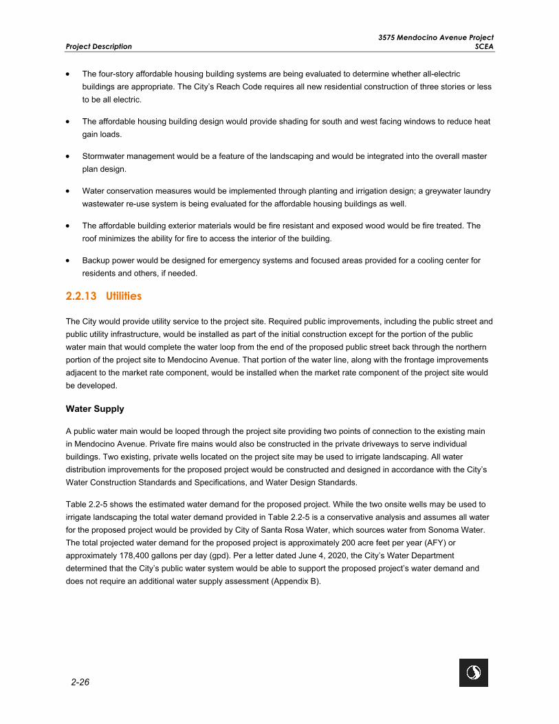
3575 Mendocino Avenue Project Project Description SCEA
2-26
• The four-story affordable housing building systems are being evaluated to determine whether all-electric buildings are appropriate. The City’s Reach Code requires all new residential construction of three stories or less to be all electric.
• The affordable housing building design would provide shading for south and west facing windows to reduce heat gain loads.
• Stormwater management would be a feature of the landscaping and would be integrated into the overall master plan design.
• Water conservation measures would be implemented through planting and irrigation design; a greywater laundry wastewater re-use system is being evaluated for the affordable housing buildings as well.
• The affordable building exterior materials would be fire resistant and exposed wood would be fire treated. The roof minimizes the ability for fire to access the interior of the building.
• Backup power would be designed for emergency systems and focused areas provided for a cooling center for residents and others, if needed.
2.2.13 Utilities
The City would provide utility service to the project site. Required public improvements, including the public street and public utility infrastructure, would be installed as part of the initial construction except for the portion of the public water main that would complete the water loop from the end of the proposed public street back through the northern portion of the project site to Mendocino Avenue. That portion of the water line, along with the frontage improvements adjacent to the market rate component, would be installed when the market rate component of the project site would be developed.
Water Supply
A public water main would be looped through the project site providing two points of connection to the existing main in Mendocino Avenue. Private fire mains would also be constructed in the private driveways to serve individual buildings. Two existing, private wells located on the project site may be used to irrigate landscaping. All water distribution improvements for the proposed project would be constructed and designed in accordance with the City’s Water Construction Standards and Specifications, and Water Design Standards.
Table 2.2-5 shows the estimated water demand for the proposed project. While the two onsite wells may be used to irrigate landscaping the total water demand provided in Table 2.2-5 is a conservative analysis and assumes all water for the proposed project would be provided by City of Santa Rosa Water, which sources water from Sonoma Water. The total projected water demand for the proposed project is approximately 200 acre feet per year (AFY) or approximately 178,400 gallons per day (gpd). Per a letter dated June 4, 2020, the City’s Water Department determined that the City’s public water system would be able to support the proposed project’s water demand and does not require an additional water supply assessment (Appendix B).

3575 Mendocino Avenue Project SCEA Project Description
2-27
Table 2.2-5: Water Demand
Project Component
Land Use Approximate Area
(gsf) Number of
Units Unit Type Number of Units
Occupants per Unit1
Water Demand (GPCD)
Water Use
(AFY)
Affordable Housing
Multi-Family Residential 136,185 162
1 Bedroom 158 1.9 125 42
2 Bedroom 4 2.25 125 2
Subtotal 44
Market Rate Housing
Multi-Family Residential 510,531 370
Studio 18 2.25 125 6
1 Bedroom 111 2.25 125 35
2 or more Bedroom 241 3.25 125 110
Subtotal 151 Open Space & Landscaping
Open Space & Landscaping 161,9432 — — — — — 5
Subtotal 5 Proposed Project Total 200 Sources: 1City of Santa Rosa Design Guidelines, Sewer Contribution According to Zoning and Use 2BKF Engineers 2020a (Appendix C), Quadriga 2020 (Appendix C) Notes: 1Includes the total area of landscaping and open space to be irrigated within the proposed project. Key: GPCD = Gallons Per Capita per Day AFY = Acre-Feet per Year; 1 AFY = 892 GPD
Wastewater
The project site is currently served by an 8-inch sewer main line located along the southern boundary of the project site that eventually leads to the Laguna Wastewater Treatment Plant (WTP). The proposed project would construct a public sanitary sewer line that would connect to the existing 8-inch public sanitary sewer main line located along the southern boundary of the project site as well as private sanitary sewer lines that would be 6 to 8 inches in diameter. All sewer distribution improvements would be constructed and designed in accordance with the City’s Sewer Construction Standards and Specifications, and Sewer Design Standards.
Table 2.2-6 shows the proposed wastewater generated by the proposed project is approximately 172,838 gallons per day (gpd). According to calculations provided in Appendix C, there would be sufficient wastewater capacity to serve the proposed project.

3575 Mendocino Avenue Project Project Description SCEA
2-28
Table 2.2-6: Wastewater Generated
Project Component
Land Use Approximate Area
(gsf) Number of Units Unit Type Number
of Units Occupants per Unit1
Sewer Generation
(GPCD)
Total Sewer Generation
(GPD)
Affordable Housing
Multi-Family Residential 136,185 162
1 Bedroom 158 1.9 125 37,525
2 Bedroom 4 2.25 125 1,125
Subtotal 38,650
Market Rate Housing
Multi-Family Residential 510,531 370
Studio 18 2.25 125 5,063
1 Bedroom 111 2.25 125 31,219
2 or more Bedroom 241 3.25 125 97,906
Subtotal 134,188
Open Space & Landscaping
Open Space &
Landscaping
161,9432 — — — — — —
Proposed Project Total 172,838 Sources: 1City of Santa Rosa Design Guidelines, Sewer Contribution According to Zoning and Use 2BKF Engineers 2020b (Appendix C) Notes: 1Includes the total area of landscaping and open space to be irrigated within the proposed project. Key: GPCD = Gallons Per Capita per Day GPD = Gallons Per Day
Stormwater
The proposed project would construct a new 24-inch stormwater line and private stormwater lines to serve the proposed buildings. The 24-inch public stormwater line would be located on the southwest corner of the project site and constructed with an outfall into Russell Creek, which is located offsite on the adjacent parcel identified as APN 173-030-002. The proposed stormwater outfall disturbance area is estimated to be approximately 400 square feet (0.009 acres). The new outfall and stormwater drainage facilities would be designed in accordance with the requirements of Sonoma Water’s Flood Management Design Manual and would provide sufficient stormwater capacity to serve the proposed project. As required by the City’s Standard Urban Stormwater Mitigation Plan (SUSMP), the proposed project would also implement post-construction BMPs and low-impact development measures consisting of vegetated swales, bioretention areas, and permeable pavement. These areas would provide approximately 158,000 square feet of pervious surface on the project site and would retain and treat stormwater prior to entering the stormwater system.
Electricity
PG&E would provide electricity and natural gas services to the project site. The proposed project would connect to existing underground electric and natural gas lines on the project site and/or in Mendocino Avenue. The proposed project would include energy conservation features with a goal to exceed the state’s current Title 24 requirements by

3575 Mendocino Avenue Project SCEA Project Description
2-29
meeting current Tier 2 Energy Efficiency standards. Section 4.5, Energy, contains detailed information on the proposed project’s energy usage.
In addition, the proposed project would install seven backup generators. Backup generators would be installed in buildings 1, 2, and 3 of the affordable housing component and in buildings 4A and garage, 4B(1), and 4C(1) of the market rate housing component. The backup generators are anticipated to be 230-300 kilowatts and would be used to provide electricity and cooling for residents during an emergency, if needed.
2.3 PROJECT CONSTRUCTION
The affordable housing component is currently anticipated to be developed in three phases; each phase would be on individual parcels for financing purposes. The market rate component would be developed in two or more phases, the exact number of which would be determined at a later date; each phase would be on individual parcels for financing purposes. Upon approval of the proposed project, the affordable housing component, and the market rate component, each with its associated sequencing, would proceed on individual schedules. However, for analysis purposes, the proposed project is assumed to be built concurrently with each component (both the affordable housing and market rate housing as well as the shared open space) proceeding at the same time.
2.3.1 Schedule
The proposed project would require a series of construction activities that would occur for both the affordable housing component and the market rate component. Table 2.3-1 shows the anticipated construction schedule, for both the affordable housing and market rate components as well as the shared open space, based on the assumption that they would be built concurrently, that all phases of both components would begin at the same time in 2021 and would be completed by early 2023 (22 months of construction are anticipated). However, construction may extend up to 24 additional months due to market conditions. A 22-month construction schedule is a conservative assumption that concentrates potential impacts over a more concentrated time period, rather than spreading construction activities out over four years. It is anticipated that ancillary improvements would occur concurrently with the construction of the facilities.
Table 2.3-1: Construction Schedule
Task Start Date End Date Demolition and Site Preparation June 1, 2021 July 31, 2021
Grading August 1, 2021 August 15, 2021
Building Construction August 16, 2021 December 31, 2022
Archi tectural Coating November 1, 2022 December 17, 2022
Paving January 3, 2023 March 11, 2023
Typically, project demolition, construction, and grading activities would be consistent with the City’s Code and the proposed project would be conditioned to limit construction hours to between 7 AM and 7 PM, Monday through Friday, and between 9 AM and 5 PM on Saturday. Project construction and grading activities would not occur on Sundays or federal holidays; limited nighttime work may need to occur in the public right of way. The construction worksite would be operated in accordance with applicable public health standards, including those required in response to the Coronavirus (COVID-19).

3575 Mendocino Avenue Project Project Description SCEA
2-30
Depending on the construction phase, the number of temporary construction workers would range from approximately 22 to 160 workers per day with an average of approximately 91 workers per day. It is anticipated that the construction workforce would be available from nearby areas.
2.3.2 Construction Equipment, Access, and Staging Areas
Construction workers would access the project site from Mendocino Avenue. Materials would typically be stored onsite, generally in the future parking lot areas. Demolition, grading, and construction work is generally anticipated to occur within the project site; however, work may extend as far as the east side of Mendocino Avenue to connect utility lines and other necessary improvements. Construction materials and equipment would be delivered using trucks during the daytime hours (between 7 AM and 7 PM).
Construction equipment anticipated onsite is listed in Table 2.3-2. No pile driving is proposed. Additional construction equipment for the improvements is accounted for in each task as shown in Table 2.3-2.
Table 2.3-2: Proposed Construction Equipment
Component Name Equipment Type
Affordable-Demolition and Site Preparation
Concrete/Industrial Saws
Rubber Tired Dozers
Tractors/Loaders/Backhoes
Graders
Scrapers
Tractors/Loaders/Backhoes
Affordable -Grading
Graders
Rubber Tired Dozers
Tractors/Loaders/Backhoes
Affordable -Building Construction
Cranes
Forklifts
Generator Sets
Tractors/Loaders/Backhoes
Welders
Affordable -Architectural Coating Air Compressors
Affordable -Paving
Cement and Mortar Mixers
Pavers
Paving Equipment
Rollers
Tractors/Loaders/Backhoes

3575 Mendocino Avenue Project SCEA Project Description
2-31
Component Name Equipment Type
Market Rate-Demolition and Site Preparation
Concrete/Industrial Saws
Excavators
Rubber Tired Dozers
Rubber Tired Dozers
Tractors/Loaders/Backhoes
Market Rate-Grading
Excavators
Graders
Rubber Tired Dozers
Tractors/Loaders/Backhoes
Market Rate-Building Construction
Cranes
Forklifts
Generator Sets
Tractors/Loaders/Backhoes
Welders
Market Rate-Architectural Coating Air Compressors
Market Rate-Paving
Pavers
Paving Equipment
Rollers
2.3.3 Construction Activities
Construction activities associated with the proposed project would require demolition, grading, utility connections, building construction, construction of the new public street and frontage improvements (e.g., new curb, gutter, sidewalk, and driveway construction), and landscaping on the project site.
Construction of the proposed project, including construction of the stormwater outfall, would involve approximately 50,000 cubic yards (CY) of earth movement of which approximately 40,000 CY of soil would be import fill, as deemed appropriate by the geotechnical engineer. The maximum depth of cut and fill onsite would range from 2 to 4 feet. Trees, roots, vegetation, organic surficial soil, and existing paved driveways would be removed from structural areas unless specified in the final design plans by the City. The proposed project would disturb approximately 13.3 acres and result in approximately 420,000 square feet of impervious surface upon buildout. During excavation activities, groundwater may be encountered, and temporary construction dewatering may be necessary. All temporary construction dewatering would be in accordance with a Waste Discharge Requirement permit from the North Coast RWQCB.

3575 Mendocino Avenue Project Project Description SCEA
2-32
This page left intentionally blank.

3575 Mendocino Avenue Project SCEA SCEA Consistency and Transit Priority Project Criteria
3-1
3.0 SCEA CONSISTENCY AND TRANSIT PRIORITY PROJECT CRITERIA
3.1 SENATE BILL 375
The State of California adopted SB 375, also known as the Sustainable Communities and Climate Protection Act of 2008, which outlines growth strategies that better integrate regional land use and transportation planning and that help meet the State of California’s GHG emissions reduction mandates. SB 375 requires the state’s 18 metropolitan planning organizations to incorporate a SCS into their RTPs to achieve their respective region’s GHG emission reduction targets set by the California Air Resources Board (CARB). Correspondingly, SB 375 provides various CEQA streamlining provisions for projects that are consistent with an adopted applicable SCS and meet certain objective criteria; one such CEQA streamlining tool is the SCEA.
MTC/ABAG are the joint metropolitan planning organizations for the San Francisco Bay Area region, including Sonoma County. On July 26, 2017, MTC/ABAG jointly adopted its second RTP/SCS known as Plan Bay Area 2040 (Plan Bay Area), which serves as an update to the 2013 Plan Bay Area RTP/SCS.
For the San Francisco Bay Area region, CARB has set GHG emissions reduction targets at a 7 percent reduction in per-capita emissions from cars and light-duty trucks by 2020, and a 15 percent reduction by 2035 relative to 2005 levels. The Plan Bay Area outlines strategies to meet or exceed the targets set by CARB. By Executive Order, approved June 25, 2018, CARB officially determined that the Plan Bay Area would, if implemented, meet CARB’s 2020 and 2035 GHG emission reduction targets (CARB 2017a).
3.2 TRANSIT PRIORITY PROJECT CRITERIA
PRC Section 21155 sets forth the requirements for a project to qualify as a transit priority project. To qualify, a project must meet the following:
1. Be consistent with the general use designation, density, building intensity, and applicable policies specified for the project area in a SCS (see California PRC Section 21155[a]); and
2. Be a qualified “transit priority project” (as defined in California PRC Section 21155[b]).
The following information demonstrates that the proposed project is a qualified transit priority project pursuant to the requirements of PRC Sections 21155(a) and 21155(b), and therefore, is eligible for certain CEQA streamlining benefits by way of preparing a SCEA for purposes of compliance with CEQA.
1. The project must be consistent with the general land use designation, density, building intensity, and applicable policies specified for the project area in either a SCS or alternative planning strategy.
The project site is within the Mendocino Avenue/Santa Rosa Avenue Corridor PDA in the adopted Plan Bay Area, which is the SCS for the Bay Area as required by SB 375 (MTC/ABAG 2017). PDAs are areas where new development will support the needs of residents and workers in a pedestrian friendly environment served by transit. Local jurisdictions, including the City, define the character of their PDAs according to existing conditions and future expectations as regional centers, mixed-use corridors, city centers, suburban centers, and/or transit town centers. The Mendocino Avenue/Santa Rosa Avenue Corridor PDA is identified as a mixed-use corridor PDA by the Plan Bay Area. The updated Housing Element (adopted in 2015) of the City’s General Plan,

3575 Mendocino Avenue Project SCEA Consistency and Transit Priority Project Criteria SCEA
3-2
identifies the Mendocino Avenue/Santa Rosa Avenue PDA as a transportation corridor for new development with increased densities that will support use of bus transit. It is expected that the Mendocino Avenue/Santa Rosa Avenue Corridor PDA would add approximately 2,510 housing units and 6,850 jobs by 2040 (MTC/ABAG 2017).
The proposed project involves the development of a compact, pedestrian friendly, transit-oriented, sustainable, master planned high-density residential transit village community along Mendocino Avenue, and therefore would be consistent with the Mendocino Avenue/Santa Rosa Avenue mixed-use corridor designation under Plan Bay Area. Furthermore, the proposed project would be within the growth forecast assumptions for the Mendocino Avenue/Santa Rosa Avenue Corridor PDA as it would provide up to 532 multi-family housing units and 17 new jobs. The policies of the Plan Bay Area RTP/SCS are embedded in the metrics and growth forecast assumptions; therefore, projects consistent with the growth forecast assumptions of the Plan Bay Area are consistent with these policies. As such, the proposed project is consistent with the general land use designation, density, building intensity, and policies of the Plan Bay Area.
2. The project must contain at least 50 percent residential use, based on total building square footage and, if the project contains between 26 percent and 50 percent non-residential uses, a floor area ratio of not less than 0.75;
The proposed project involves the development of a transit village containing 100 percent residential use that consists of approximately 136,185 gsf of senior affordable housing and approximately 510,531 gsf of market rate housing. The proposed project does not include the development of non-residential uses. Therefore, the proposed project would be consistent with this criterion.
3. The project must provide a minimum net density of at least 20 units per acre; and
The proposed residential density of the project is 40 dwelling units per acre (du/ac) (532 dwelling units ÷ 13.3 acres). As such, the proposed project would be consistent with this criterion.
4. The project must be located within one-half mile of a major transit stop or high-quality transit corridor included in a regional transportation plan.
PRC Section 21155(b) defines a “high-quality transit corridor” as a corridor with fixed route bus service with service intervals no longer than 15 minutes during peak commute hours.
PRC Section 21064.3 defines a “major transit stop” as “a site containing an existing rail transit station, a ferry terminal served by either a bus or rail transit service, or the intersection of two or more major bus routes with a frequency of service interval of 15 minutes or less during the morning and afternoon peak commute periods.” PRC Section 21155(b) states that a “major transit stop” is defined in PRC Section 21064.3, except that, for purposes of Section 21155(b), it also includes major transit stops that are included in the applicable regional transportation plan. PRC Section 21099 defines a “transit priority area” as an area within 0.5 mile of a major transit stop that is “existing or planned, if the planned stop is scheduled to be completed within the planning horizon included in a Transportation Improvement Program adopted pursuant to Section 450.216 or 450.322 of Title 23 of the Code of Federal Regulations.”
The project site is located along Mendocino Avenue approximately 0.2 mile (0.38 mile waking distance) from Bicentennial Way and the Bicentennial Way Transit Facility. Bicentennial Way is a high-quality transit corridor that is served by Santa Rosa CityBus Route 1, which arrives every 15 minutes, Monday through Friday. The Bicentennial Way Transit Facility is a major transit stop that is intersected by Santa Rosa CityBus Routes 1 and

3575 Mendocino Avenue Project SCEA SCEA Consistency and Transit Priority Project Criteria
3-3
10. Route 1 connects the project site to the Santa Rosa Junior College, Kaiser Permanente Santa Rosa Medical Center, and Coddingtown Mall Transit Hub, all of which are located within approximately 1 mile of the project site. Route 10 runs along Mendocino Avenue and Bicentennial Way and connects to Coddingtown Mall Transit Hub and downtown Santa Rosa. This route is part of the Santa Rosa Avenue/Mendocino Avenue/Bicentennial Way/Range Avenue high-frequency transit corridor identified in the Sonoma County Comprehensive Transportation Plan (SCTA 2016). The proposed project would be consistent with this criterion.
3.3 PREVIOUS RELEVANT ENVIRONMENTAL ANALYSIS
PRC Sections 21151.2(a) and 21159.28(a) require that a transit priority project incorporate all feasible mitigation measures, performance standards, or criteria from prior applicable EIRs, which for the proposed project would include the City’s General Plan EIR and the Plan Bay Area Program EIR.
City of Santa Rosa General Plan EIR
In June 2009, the City certified a Program EIR for the Santa Rosa General Plan 2035. The EIR provides a general review of the environmental effects of infill and/or redevelopment of the City based on proposed land use designations in the General Plan. The EIR includes policies and implementation programs from the General Plan that would mitigate potential effects and identifies any additional necessary mitigation measures to minimize significant impacts to the environment. Based on review of the General Plan EIR, none of the additional mitigation measures identified would directly apply to the proposed project. However, the proposed project would be subject to all relevant policies through the City’s development review process. Therefore, General Plan policies applicable to the proposed project have been incorporated into the respective resource sections in Section 4.0, Environmental Checklist and Environmental Evaluation.
In 2012, the City prepared a Supplemental Program EIR for the Santa Rosa General Plan Amendment and Climate Action Plan (CAP). The Supplemental Program EIR evaluated potential impacts related to aesthetics, air quality, and greenhouse gases and climate change adaptation. The Supplemental Program EIR determined that the General Plan Amendment and CAP did not alter the assumptions regarding the location of development within the City. The Supplemental Program EIR determined that implementation of the CAP would reduce GHG emissions in Santa Rosa by ensuring that new development incorporates specific project features. None of the additional mitigation measures identified by the Supplemental Program EIR would directly apply to the proposed project. Section 3.7, Greenhouse Gas, includes all policies of the CAP that would apply to the proposed project.
In addition, in 2014, the City prepared an Addendum to the General Plan EIR for the Housing Element Update. The Addendum determined that the proposed Housing Element would not require major revisions to the adopted General Plan or its associated EIR because there are no new significant environmental effects or substantial increases in the severity of significant effects beyond those previously identified as part of the City’s environmental review process. No additional mitigation measures or policies were identified.
Plan Bay Area EIR
In July 2017, MTC/ABAG certified a program EIR for the Plan Bay Area. The Plan Bay Area serves as an informational document to inform decision-makers and the public of the potential environmental consequences of approving the Plan Bay Area. The Plan Bay Area EIR includes mitigation measures designed to help avoid or minimize significant environmental impacts. It is the intent of MTC/ABAG that lead agencies and others use the information contained within the Plan Bay Area EIR to “tier” subsequent environmental documentation of projects in the region.

3575 Mendocino Avenue Project SCEA Consistency and Transit Priority Project Criteria SCEA
3-4
The MMRP for the Plan Bay Area EIR does not include project-level mitigation measures that are required to be incorporated into a project. However, the Plan Bay Area EIR MMRP does provide a list of mitigation measures that MTC/ABAG determined a lead agency can and should consider, as applicable and feasible, where the lead agency has concluded that a project has the potential to result in significant effects.
As such, this SCEA incorporates relevant mitigation measures previously identified by the Plan Bay Area EIR, where applicable. If incorporation of an applicable Plan Bay Area mitigation measure is not sufficient to reduce an identified, project-specific impact, then a project-specific mitigation measure is presented in the analysis and would be implemented to ensure less than significant impacts. The applicable mitigation measures previously identified by the Plan Bay Area EIR are incorporated in the respective resource sections in Section 4.0, Environmental Checklist and Environmental Evaluation.
3.4 SENATE BILL 743
Pursuant to SB 743, effective January 1, 2014, “Aesthetic and parking impacts of a residential, mixed-use residential, or employment center project on an infill site within a transit priority area shall not be considered significant impacts on the environment.” Accordingly, aesthetics and parking are no longer to be considered in determining if a project has the potential to result in significant environmental effects if it meets all of the following three criteria:
• The project is in a transit priority area (an area within one-half mile of a major transit stop); • The project is on an infill site; and • The project is residential, mixed‐use residential, or an employment center.
Further provisions of SB 743 provide that this legislation “does not affect, change, or modify the authority of a lead agency to consider aesthetic impacts pursuant to local design review ordinances or other discretionary powers provided by other laws or policies (PRC Section 21099[d][2][A]), and that aesthetic impacts do not include impacts on historical or cultural resources (Section 21099[d][2][B]).
The proposed project meets each of the above three criteria for the following reasons:
• It is located within a PDA and within 0.2 mile (0.38 mile walking distance) of Bicentennial Way Transit Facility, a major transit stop.
• It is located on an infill site that was previously developed as a mobile home park. • It is a residential project with affordable and market rate housing.
Therefore, this SCEA does not consider aesthetics and the adequacy of parking in determining the significance of project impacts under CEQA. However, the public and decision-makers may be interested in information pertaining to the aesthetic character and parking of the proposed project and may desire that such information be provided as part of the environmental review process. Therefore, some of the information that would have otherwise been provided in an aesthetics section (such as the project design and building elevations) or transportation section is included in Section 2.0, Project Description. However, this information is provided solely for informational purposes and is not used to determine the significance of the environmental impacts of the proposed project, pursuant to CEQA.

3575 Mendocino Avenue Project SCEA Environmental Checklist and Environmental Evaluation
4-1
4.0 ENVIRONMENTAL CHECKLIST AND ENVIRONMENTAL EVALUATION
The environmental resources checked below would be potentially affected by this proposed project, involving at least one impact that would require mitigation to reduce the impact from “Potentially Significant” to “Less Than Significant” as indicated by the checklist on the following pages.
Agriculture and Forestry Resources Air Quality Biological Resources
Cultural Resources Energy Geology and Soils
Greenhouse Gases Hazards and Hazardous Materials Hydrology and Water Quality
Land Use and Planning Mineral Resources Noise
Population and Housing Public Services Recreation
Transportation Tribal Cultural Resources Utilities and Service Systems
Wildfire Mandatory Findings of Significance
Evaluation of Environmental Impacts
This section presents the environmental checklist form presented in Appendix G of the CEQA Guidelines. The checklist form is used to describe the impacts of the proposed project. A discussion follows each environmental issue identified in the checklist. Included in each discussion are project-specific mitigation measures recommended as appropriate as part of the proposed project.
For this checklist, the following designations are used:
Significant and Unavoidable: An impact that could be significant, and for which mitigation has not been identified. If any significant and unavoidable impacts are identified after applicable mitigation measures have been applied, an EIR must be prepared. A SCEA cannot be used in the case of a project for which this conclusion is reached in any impact category.
Less Than Significant With Mitigation Incorporated: This designation applies where applicable and feasible mitigation measures previously identified in prior applicable EIRs or in the Plan Bay Area EIR have reduced an effect from “Potentially Significant Impact” to a “Less Than Significant Impact” and pursuant to Section 21155.2 of the PRC, those measures are incorporated into the SCEA.
This designation would also apply where the incorporation of new project-specific mitigation measures not previously identified in prior applicable EIRs or in the Plan Bay Area EIR has reduced an effect from “Potentially Significant Impact” to a “Less Than Significant Impact.”
Less Than Significant Impact: Any impact that would not be considered significant under CEQA, relative to existing standards.
No Impact: The proposed project would not have any impact.

3575 Mendocino Avenue Project
Environmental Checklist and Environmental Evaluation SCEA
4-2
Determination
On the basis of this initial evaluation:
☐ I find that the proposed project COULD NOT have a significant effect on the environment, and a NEGATIVE
DECLARATION will be prepared.
☐ I find that although the proposed project could have a significant effect on the environment, there will not be a
significant effect in this case because revisions in the project have been made by or agreed to by the Applicant.
A MITIGATED NEGATIVE DECLARATION will be prepared.
☐ I find that the proposed project MAY have a significant effect on the environment, and an ENVIRONMENTAL
IMPACT REPORT is required.
☐ I find that the proposed project MAY have a “potentially significant impact” or “potentially significant unless
mitigated” on the environment, but at least one effect 1) has been adequately analyzed in an earlier document
pursuant to applicable legal standards, and 2) has been addressed by mitigation measures based on the earlier
analysis as described on attached sheets. An ENVIRONMENTAL IMPACT REPORT is required, but it must
analyze only the effects that remain to be addressed.
☐ I find that although the proposed project could have a significant effect on the environment, because all
potentially significant effects (a) have been analyzed adequately in an earlier EIR pursuant to applicable
standards, and (b) have been avoided or mitigated pursuant to that earlier EIR, including revisions or mitigation
measures that are imposed upon the proposed project, nothing further is required.
☒ I find that the proposed project is a qualified “transit priority project” that satisfies the requirements of Sections
21155 and 21155.2 of the Public Resources Code (PRC), and/or a qualified “residential or mixed use residential
project” that satisfies the requirements of Section 21159.28(d) of the PRC, and although the proposed project
could have a potentially significant effect on the environment, there will not be a significant effect in this case,
because this Sustainable Communities Environmental Assessment (SCEA) Initial Study identifies measures that
either avoid or mitigate to a level of insignificance all potentially significant or significant effects of the proposed
project.
Signature Date
9/24/20

3575 Mendocino Avenue Project SCEA Environmental Checklist and Environmental Evaluation
4-3
4.1 AGRICULTURAL AND FORESTRY RESOURCES
Would the Project: Potentially Significant
Impact
Less Than Significant With
Mitigation Incorporated
Less Than Significant
Impact No Impact
a) Convert Prime Farmland, Unique Farmland, or Farmland of Statewide Importance (Farmland), as shown on the maps prepared pursuant to the Farmland Mapping and Monitoring Program of the California Resources Agency, to non-agricultural use?
b) Conflict with existing zoning for agricultural use or a Williamson Act contract?
c) Conflict with existing zoning for, or cause rezoning of, forestland (as defined in Public Resources Code section 12220(g)), timberland (as defined by Public Resources Code section 4526), or timberland zoned Timberland Production (as defined by Government Code section 51104(g))?
d) Result in the loss of forestland or conversion of forestland to non-forest use?
e) Involve other changes in the existing environment which, due to their location or nature, could result in conversion of Farmland to non-agricultural use or conversion of forestland to non-forest use?
4.1.1 Environmental Setting
The project site is in the City’s urban growth boundary and was previously developed as a mobile home park prior to the 2017 Tubbs Wildfire. In general, the surrounding area is urbanized and has been developed with various mixed urban uses for more than 50 years (DOC 2016). The California Department of Conservation, Farmland Mapping and Monitoring Program (FMMP) classifies agricultural land according to soil quality and irrigation status. According to the California Department of Conservation's FMMP, there are approximately 15,981 acres of agricultural lands within the Santa Rosa Planning Area that are largely concentrated along the western edge of the City outside of the urban growth boundary. This acreage is further broken down into 9,657 acres of Farmland of Local Importance, 3,121 acres of Prime Farmland, and 3,203 acres of Farmland of Statewide Importance. According to the City’s General Plan, there are no lands within the City’s urban growth boundary that are zoned for agriculture, forest land, or timberland production (City of Santa Rosa 2009a). Additionally, there are no lands within the City’s urban growth boundary that are contracted under the Williamson Act or within a Farmland Security Zone (City of Santa Rosa 2009a). The California Department of Conservation’s FMMP classifies the project site and adjoining lands as “Urban and Built-up Land,” and therefore do not contain Prime Farmland, Unique Farmland, or Farmland of Statewide Importance (DOC 2016).

3575 Mendocino Avenue Project Environmental Checklist and Environmental Evaluation SCEA
4-4
4.1.2 Previous Environmental Analysis
City of Santa Rosa General Plan EIR Summary
Chapter L of the General Plan EIR discusses impacts related to agriculture. Agricultural lands are primarily located along the western edge of Santa Rosa, outside of the City’s urban growth boundary (City of Santa Rosa 2009a). Development anticipated under the General Plan would be contained within the City’s urban growth boundary; therefore, the General Plan EIR determined that new development would not result in the loss of Prime Farmland, Unique Farmland or Farmland of Statewide Importance, and impacts would be less than significant. No mitigation measures were identified.
The following General Plan policies are applicable to the proposed project:
Policy OSC-C-3: Preserve and enhance agriculture within the Planning Area as a component of the economy and as a part of Santa Rosa’s environmental quality.
Policy GM-A-1: Contain urban development in the Santa Rosa area within the city’s Urban Growth Boundary.
Plan Bay Area EIR Summary
The Plan Bay Area EIR determined that land use and transportation projects have the potential to convert agricultural and open space lands to urban uses. Conversion could be substantial within a county or local municipality depending on the location. However, the project site is a redevelopment site and there are no agricultural resources within or adjacent to the project site. Therefore, there are no mitigation measures from the Plan Bay Area EIR that would apply to the proposed project.
4.1.3 Project-Specific Analysis
Impact AG-1 Convert Prime Farmland, Unique Farmland, or Farmland of Statewide Importance (Farmland), as shown on the maps prepared pursuant to the Farmland Mapping and Monitoring Program of the California Resources Agency, to non-agricultural use?
Impact Analysis The project site is located within the City’s urban growth boundary and was previously developed as a mobile home park. According to the FMMP database, the project site and adjoining lands are classified as “Urban and Built-up Land” and do not contain agricultural resources (DOC 2016). Under the General Plan, land located within the urban growth boundary designated as “Urban and Built-up Land” was anticipated to be used for non-agricultural uses. Therefore, the proposed project would not result in the conversion of Prime Farmland, Unique Farmland, or Farmland of Statewide Importance to non-agricultural uses. No impact would occur.
Level of Significance Before Mitigation No Impact.
Mitigation Measures No mitigation is necessary.
Level of Significance After Mitigation No Impact.

3575 Mendocino Avenue Project SCEA Environmental Checklist and Environmental Evaluation
4-5
Impact AG-2 Conflict with Existing Zoning for Agricultural Use or a Williamson Act Contract?
Impact Analysis The project site is within the City’s urban growth boundary. According to the General Plan, there are no lands within the City’s urban growth boundary zoned for agriculture uses or enrolled in a Williamson Act contract (City of Santa Rosa 2009a). The project site is currently zoned RR-40-RC. The RR-40-RC zoning district is primarily intended to accommodate residential neighborhoods, but agricultural uses are allowed with a use permit. However, the project site and the surrounding areas have previously been developed with urban uses for more than 50 years and do not contain agricultural uses. As such, the proposed project would not conflict with existing zoning for agricultural use or with a Williamson Act Contract. No impact would occur.
Level of Significance Before Mitigation No Impact.
Mitigation Measures No mitigation is necessary.
Level of Significance After Mitigation No Impact.
Impact AG-3 Conflict with existing zoning for, or cause rezoning of, forestland (as defined in Public Resources Code section 12220(g)), timberland (as defined by Public Resources Code section 4526), or timberland zoned Timberland Production (as defined by Government Code section 51104(g))?
Impact Analysis Under PRC Section 12220(g), “Forest land” is land that can support 10-percent native tree cover of any species, including hardwoods, under natural conditions, and that allows for management of one or more forest resources, including timber, aesthetics, fish and wildlife, biodiversity, water quality, recreation, and other public benefits. The project site does not meet the definition of forest land pursuant to Section 12220(g) of the PRC and according to data obtained by the United States Department of Agriculture (USDA), Forest Service, the project site does not contain land classified as forest land.
Additionally, the existing zoning for the project site is RR-40-RC. The RR-40-RC zoning district is primarily intended to accommodate residential neighborhoods, but agricultural uses are allowed with a use permit. However, the project site has been previously developed with urban uses for more than 50 years and does not contain agricultural uses.
As such, the project site does not contain any forestry resources, timberland resource zones, or active timberland production, and does not meet the definition of “forest land” as defined by PRC Section 12220(g). The proposed project would have no impact on forestland, timberland, timberland zoned Timberland Production or forestry resources.
Level of Significance Before Mitigation No Impact.
Mitigation Measures No mitigation is necessary.

3575 Mendocino Avenue Project Environmental Checklist and Environmental Evaluation SCEA
4-6
Level of Significance After Mitigation No Impact.
Impact AG-4 Result in the Loss of Forestland or Conversion of Forestland to Non-Forest Use?
Impact Analysis The General Plan does not identify any forestry resources, timberland resource zones, or active timberland production within or adjacent to the project site, and the project site does not meet the definition of “forest land” as defined by PRC Section 12220(g). As such, the proposed project would not result in the loss of forestland or convert forestland to non-forest use. No impact would occur.
Level of Significance Before Mitigation No Impact.
Mitigation Measures No mitigation is necessary.
Level of Significance After Mitigation No Impact.
Impact AG-5 Involve other changes in the existing environment which, due to their location or nature, could result in conversion of Farmland to non-agricultural use or conversion of forestland to non-forest use?
Impact Analysis The project site is located within the City’s urban growth boundary and identified as “Urban and Built-up Land” by the FMMP database. The project site was previously developed as a mobile home park, does not contain agricultural resources (DOC 2016) and is surrounded by land designated as General Commercial on the General Plan Land Use map. Neither the project site nor any of the lands surrounding the project site are under a Williamson Act Contract. Land uses surrounding the project site include commercial and office uses to the east, Russell Creek and the Kaiser Permanente Santa Rosa Medical Center to the south, Highway 101 and commercial uses to the west, and the Mendocino/ Highway 101 Overcrossing to the north, consistent with the City’s General Plan. As such, the proposed project would not provide an impetus for the conversion of farmland in the vicinity. Therefore, the proposed project would have no impacts on conversion of other farmlands. In the absence of forestland on the project site or surrounding properties, the proposed project would not encourage the loss or conversion of forested land to other uses. Therefore, the proposed project would have no impacts associated with the conversion of forestlands. The project site does not contain agricultural resources, forestland, or timberland resources. As such, the proposed project would not involve other changes that would result in the conversion of farmland to a non-agricultural use or the conversion of forestland to a non-forest use. No impact would occur.
Level of Significance Before Mitigation No Impact.
Mitigation Measures No mitigation is necessary.
Level of Significance After Mitigation No Impact.

3575 Mendocino Avenue Project SCEA Environmental Checklist and Environmental Evaluation
4-7
4.2 AIR QUALITY
Would the Project: Potentially Significant
Impact
Less Than Significant With
Mitigation Incorporated
Less Than Significant
Impact No Impact
a) Conflict with or obstruct implementation of the applicable air quality plan?
b) Result in a cumulatively considerable net increase of any criteria pollutant for which the Project region is non-attainment under an applicable Federal or State ambient air quality standard?
c) Expose Sensitive Receptors to substantial pollutant concentrations?
d) Result in other emissions (such as those leading to odors) adversely affecting a substantial number of people?
4.2.1 Environmental Setting
The City of Santa Rosa is in Sonoma County, which is within the boundaries of the San Francisco Bay Area Air Basin (SFBAAB) and is under the jurisdiction of the Bay Area Air Quality Management District (BAAQMD) and the CARB. The Federal Clean Air Act (FCAA) establishes the framework for modern air pollution control. The FCAA, enacted in 1970 and amended in 1990, directs the U.S. Environmental Protection Agency (USEPA) to establish ambient air quality standards. These standards are divided into primary and secondary standards. The former are set to protect human health and the latter are set to protect environmental values such as plant and animal life.
Toxic Air Contaminants
Toxic air contaminants (TAC) are air contaminants not included in the California Ambient Air Quality Standards (CAAQS) but are considered hazardous to human health. TACs are defined by CARB as those pollutants that “may cause or contribute to an increase in deaths or in serious illness, or which may pose a present or potential hazard to human health.”
Generally, the health effects associated with TACs are assessed locally rather than regionally. TACs can cause long-term health effects such as cancer, birth defects, neurological damage, asthma, bronchitis, or genetic damage. TACs can also cause short-term acute effects such as eye watering, respiratory irritation, running nose, throat pain, and headaches. For evaluation purposes, TACs are separated into carcinogens and non-carcinogens. Carcinogens are assumed to have no safe threshold below which health impacts would not occur, and the cancer risk is expressed as excess cancer cases per one million exposed individuals (typically over a lifetime of exposure).
Diesel Particulate Matter
Diesel particulate matter (DPM) is a TAC and is part of a complex mixture that makes up diesel exhaust. Diesel exhaust is composed of two phases: gas and particle. The gas phase is composed of many of the urban hazardous air pollutants, such as acetaldehyde, acrolein, benzene, 1,3-butadiene, formaldehyde, and PAHs. The particle phase also has many different types of particles that can be classified by size or composition. The size of diesel particulates that are of greatest health concern are those that are in the categories of fine and ultra-fine particles. The composition

3575 Mendocino Avenue Project Environmental Checklist and Environmental Evaluation SCEA
4-8
of these fine and ultra-fine particles may be composed of elemental carbon with absorbed compounds such as organic compounds, sulfate, nitrate, metals, and other trace elements. Diesel exhaust is emitted from a broad range of diesel engines, such as the on-road diesel engines of trucks, buses, and cars, and off-road diesel engines that include locomotives, marine vessels, and heavy-duty equipment (CARB 2019a).
Asbestos
Asbestos is a fibrous mineral that both naturally occurs in ultramafic rock (a rock type commonly found in California) and is used as a processed component of building materials. Because asbestos has been proven to cause a number of disabling and fatal diseases, such as asbestosis and lung cancer, it is strictly regulated either based on its natural widespread occurrence or in its use as a building material. In the initial Asbestos National Emission Standards for Hazardous Air Pollutants rule promulgated in 1973, a distinction was made between building materials that would readily release asbestos fibers when damaged or disturbed (friable) and those materials that were unlikely to result in significant fiber release (non-friable). The USEPA has since determined that, when severely damaged, otherwise non-friable materials can release significant amounts of asbestos fibers. Asbestos has been banned from many building materials under the Toxic Substances Control Act, FCAA, and the Consumer Product Safety Act. Naturally occurring asbestos (NOA) is known to occur in many parts of California and is commonly associated with ultramafic or serpentinite rock. According to the U.S. Geological Survey (USGS) Geologic Map, the proposed project is not located in an area known to contain ultramafic or serpentinite rock (USGS 2011).
Sensitive Receptors
Some land uses are considered more sensitive to air pollution than others due to the types of population groups or activities involved. Heightened sensitivity may be caused by health problems, proximity to the emissions source, or duration of exposure to air pollutants. Children, pregnant women, the elderly, and those with existing health problems are especially vulnerable to the effects of air pollution. Accordingly, land uses that are typically considered to be sensitive receptors include residences, schools, childcare centers, playgrounds, retirement homes, convalescent homes, hospitals, and medical clinics. Existing sensitive receptors in the vicinity of the project site include residential and worker receptors within 1,000 feet of the project site. As discussed in Section 4.10, Land Use, the project site is adjacent to a number of uses, some of which are considered to be sensitive in accordance with BAAQMD guidance. Existing sensitive receptors within 1,000 feet of the project site include single family residential homes located on Lake Park Circle, Loretta Way and west of Loretta Way, and north of Russell Avenue, and Kaiser Permanente Santa Rosa Medical Center located south of the project site beyond Russell Creek. While the Kaiser Permanente Santa Rosa Medical Center is a sensitive receptor included in the project’s Health Risk Assessment, Kaiser Permanente Santa Rosa Medical Center is also equipped with State regulated air filtration systems that limit the exposure to particulates generated during construction. In contrast, the residences located on Lake Park Circle, Loretta Way and west of Loretta Way, and north of Russell Avenue, are geographically further away from the project site, but are assumed to not have such filtering technology and are therefore considered more susceptible to fugitive dust and emissions than the adjacent Kaiser Permanente Santa Rosa Medical Center. As such, in an abundance of caution, the Kaiser Permanente Santa Rose Medical Center is referred to as a worker receptor, as workers at the Kaiser Permanente Santa Rosa Medical Center would have the highest likelihood of exposure and the residential use located at Lake Park Circle, Loretta Way and west of Loretta Way, and north of Russell Avenue are identified to be true sensitive receptors.

3575 Mendocino Avenue Project SCEA Environmental Checklist and Environmental Evaluation
4-9
Air Quality Standards
According to CARB, “Federal clean air laws require areas with unhealthy levels of ozone, inhalable particulate matter, carbon monoxide, nitrogen dioxide, and sulfur dioxide to develop plans, known as State Implementation Plans (SIP). A SIP is prepared by each state describing existing air quality conditions and measures that will be followed to attain and maintain federal standards. The 1990 amendments to FCAA set deadlines for attainment based on the severity of an area's air pollution problem” (CARB 2019b).
The SIP for the State of California is administered by the CARB, which has overall responsibility for statewide air quality maintenance and air pollution prevention. California’s SIP incorporates individual federal attainment plans for each regional air district. SIPs are prepared by the regional air district and sent to CARB to be approved and incorporated into the California SIP. Federal attainment plans include the technical foundation for understanding air quality (e.g., emission inventories and air quality monitoring), control measures and strategies, and enforcement mechanisms.
The CARB also administers CAAQS for the air pollutants designated in the California Clean Air Act. The 10 state air pollutants are the six federal standards listed above as well as visibility-reducing particulates, hydrogen sulfide, sulfates, and vinyl chloride. The federal ambient air quality standards and CAAQS are summarized in Table 4.2-1.
Table 4.2-1: California and National Ambient Air Quality Standards
Pollutant Averaging
Time California Standards1 National Standards2
Concentration Primary3 Secondary4
Ozone5 1 Hour 0.09 ppm (180 μg/m3) —
Same as Primary Standard 8 Hour 0.070 ppm (137 μg/m3) 0.070 ppm
(137 μg/m3)
Respirable Particulate Matter6
24 Hour 50 μg/m3 150 μg/m3 Same as Primary Standard Annual
Arithmetic Mean 20 μg/m3 —
Fine Particulate Matter6
24 Hour — 35 μg/m3 Same as Primary Standard Annual
Arithmetic Mean 12 μg/m3 12 μg/m3
Carbon Monoxide
1 Hour 20 ppm (23 mg/m3) 35 ppm (40 mg/m3) —
8 Hour 9.0 ppm (10 mg/m3) 9 ppm (10 mg/m3) —
8 Hour (Lake Tahoe) 6 ppm (7 mg/m3) — —
Nitrogen Dioxide 1 Hour 0.18 ppm (339 μg/m3) 100 ppb
(188 μg/m3) —
Annual Arithmetic Mean
0.030 ppm (57 μg/m3) 0.053 ppm (100 μg/m3)
Same as Primary Standard
Sulfur Dioxide7
1 Hour 0.25 ppm (655 μg/m3) 75 ppb (196 μg/m3) —
3 Hour — — 0.5 ppm (1300 μg/m3)
24 Hour 0.04 ppm (105 μg/m3) 0.14 ppm (for certain areas)
—

3575 Mendocino Avenue Project Environmental Checklist and Environmental Evaluation SCEA
4-10
Pollutant Averaging
Time California Standards1 National Standards2
Concentration Primary3 Secondary4 Annual Arithmetic Mean
— 0.030 ppm (for certain areas)
—
Lead8, 9
30-Day Average 1.5 μg/m3 — —
Calendar Quarter — 1.5 μg/m3 Same as Primary Standard Rolling 3-Month
Average — 0.15 μg/m3
Visibility-Reducing Particles10 8 Hour See Footnote 1
No National Standards Sulfates 24 Hour 25 μg/m3
Hydrogen Sulfide 1 Hour 0.03 ppm (42 μg/m3)
Vinyl Chloride8 24 Hour 0.01 ppm (26 μg/m3) Source: CARB 2019a Notes:
1California standards for ozone, carbon monoxide (except 8-hour Lake Tahoe), sulfur dioxide (1 and 24 hour), nitrogen dioxide, and particulate matter (PM10, PM2.5, and visibility reducing particles), are values that are not to be exceeded. All others are not to be equaled or exceeded. California ambient air quality standards are listed in the Table of Standards in Section 70200 of Title 17 of the California Code of Regulations.
2National standards (other than ozone, particulate matter, and those based on annual arithmetic mean) are not to be exceeded more than once a year. The ozone standard is attained when the fourth highest 8-hour concentration measured at each site in a year, averaged over three years, is equal to or less than the standard. For PM10, the 24 hour standard is attained when the expected number of days per calendar year with a 24-hour average concentration above 150 µg/m3 is equal to or less than one. For PM2.5, the 24 hour standard is attained when 98 percent of the daily concentrations, averaged over three years, are equal to or less than the standard.
3National Primary Standards: The levels of air quality necessary, with an adequate margin of safety to protect the public health. 4National Secondary Standards: The levels of air quality necessary to protect the public welfare from any known or anticipated
adverse effects of a pollutant. 5On October 1, 2015, the national 8-hour ozone primary and secondary standards were lowered from 0.075 to 0.070 ppm. 6On December 14, 2012, the national annual PM2.5 primary standard was lowered from 15 μg/m3 to 12.0 μg/m3. The existing
national 24-hour PM2.5 standards (primary and secondary) were retained at 35 μg/m3, as was the annual secondary standard of 15 μg/m3. The existing 24-hour PM10 standards (primary and secondary) of 150 μg/m3 also were retained. The form of the annual primary and secondary standards is the annual mean, averaged over 3 years.
7On June 2, 2010, a new 1-hour SO2 standard was established, and the existing 24-hour and annual primary standards were revoked. To attain the 1-hour national standard, the 3-year average of the annual 99th percentile of the 1-hour daily maximum concentrations at each site must not exceed 75 ppb. The 1971 SO2 national standards (24-hour and annual) remain in effect until one year after an area is designated for the 2010 standard, except that in areas designated nonattainment for the 1971 standards, the 1971 standards remain in effect until implementation plans to attain or maintain the 2010 standards are approved.
8The CARB has identified lead and vinyl chloride as 'toxic air contaminants' with no threshold level of exposure for adverse health effects determined. These actions allow for the implementation of control measures at levels below the ambient concentrations specified for these pollutants.
9The national standard for lead was revised on October 15, 2008 to a rolling 3-month average. The 1978 lead standard (1.5 μg/m3 as a quarterly average) remains in effect until one year after an area is designated for the 2008 standard, except that in areas designated nonattainment for the 1978 standard, the 1978 standard remains in effect until implementation plans to attain or maintain the 2008 standard are approved.
10In 1989, the CARB converted both the general statewide 10-mile visibility standard and the Lake Tahoe 30-mile visibility standard to instrumental equivalents, which are "extinction of 0.23 per kilometer" and "extinction of 0.07 per kilometer" for the statewide and Lake Tahoe Air Basin standards, respectively. Key: μg/m3 = micrograms per cubic meter ppm = parts per million CARB = California Air Resources Board SO2 = sulfur dioxide mg/m3 = milligrams per cubic meter ppb = parts per billion PM2.5 = particulate matter 2.5 microns in diameter or less
PM10 = particulate matter 10 microns in diameter or less
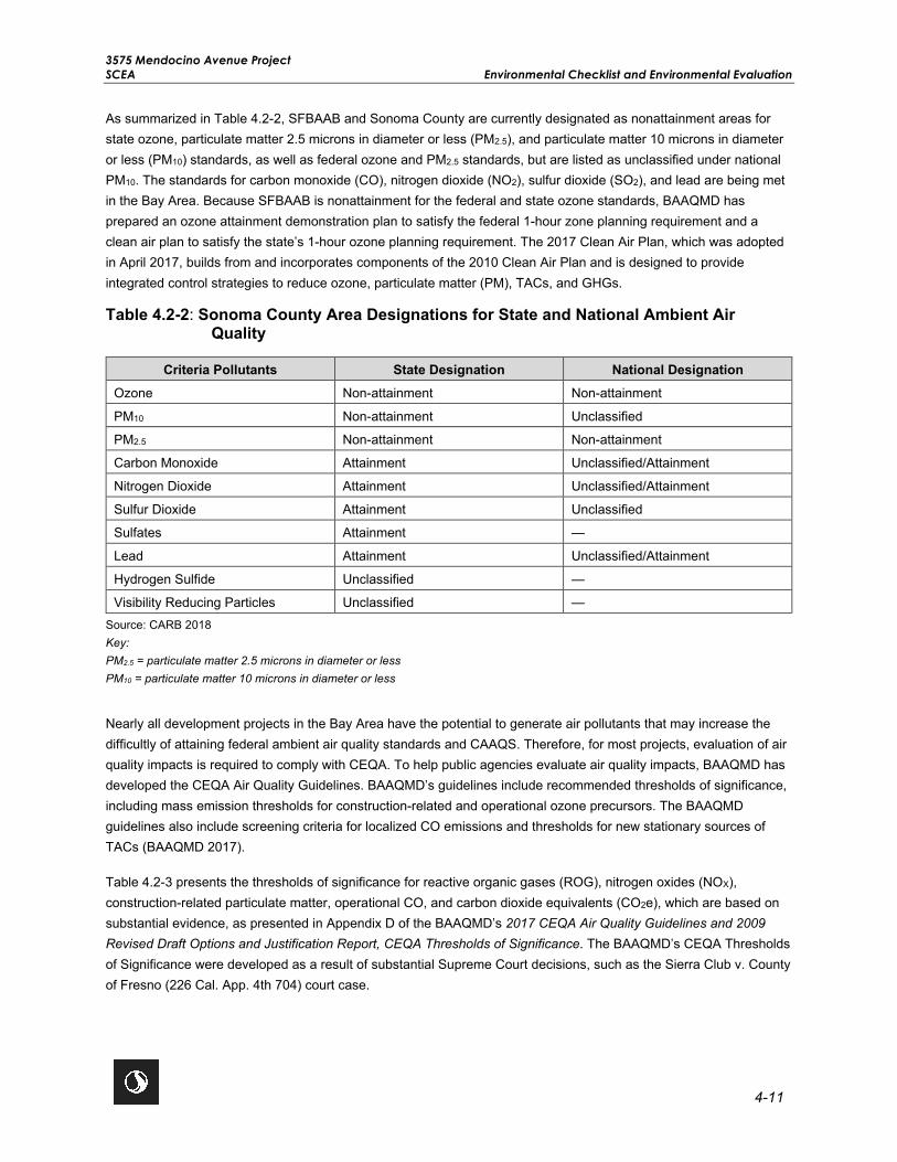
3575 Mendocino Avenue Project SCEA Environmental Checklist and Environmental Evaluation
4-11
As summarized in Table 4.2-2, SFBAAB and Sonoma County are currently designated as nonattainment areas for state ozone, particulate matter 2.5 microns in diameter or less (PM2.5), and particulate matter 10 microns in diameter or less (PM10) standards, as well as federal ozone and PM2.5 standards, but are listed as unclassified under national PM10. The standards for carbon monoxide (CO), nitrogen dioxide (NO2), sulfur dioxide (SO2), and lead are being met in the Bay Area. Because SFBAAB is nonattainment for the federal and state ozone standards, BAAQMD has prepared an ozone attainment demonstration plan to satisfy the federal 1-hour zone planning requirement and a clean air plan to satisfy the state’s 1-hour ozone planning requirement. The 2017 Clean Air Plan, which was adopted in April 2017, builds from and incorporates components of the 2010 Clean Air Plan and is designed to provide integrated control strategies to reduce ozone, particulate matter (PM), TACs, and GHGs.
Table 4.2-2: Sonoma County Area Designations for State and National Ambient Air Quality
Criteria Pollutants State Designation National Designation Ozone Non-attainment Non-attainment
PM10 Non-attainment Unclassified
PM2.5 Non-attainment Non-attainment
Carbon Monoxide Attainment Unclassified/Attainment
Nitrogen Dioxide Attainment Unclassified/Attainment
Sulfur Dioxide Attainment Unclassified
Sulfates Attainment —
Lead Attainment Unclassified/Attainment
Hydrogen Sulfide Unclassified —
Visibility Reducing Particles Unclassified — Source: CARB 2018 Key: PM2.5 = particulate matter 2.5 microns in diameter or less PM10 = particulate matter 10 microns in diameter or less
Nearly all development projects in the Bay Area have the potential to generate air pollutants that may increase the difficultly of attaining federal ambient air quality standards and CAAQS. Therefore, for most projects, evaluation of air quality impacts is required to comply with CEQA. To help public agencies evaluate air quality impacts, BAAQMD has developed the CEQA Air Quality Guidelines. BAAQMD’s guidelines include recommended thresholds of significance, including mass emission thresholds for construction-related and operational ozone precursors. The BAAQMD guidelines also include screening criteria for localized CO emissions and thresholds for new stationary sources of TACs (BAAQMD 2017).
Table 4.2-3 presents the thresholds of significance for reactive organic gases (ROG), nitrogen oxides (NOX), construction-related particulate matter, operational CO, and carbon dioxide equivalents (CO2e), which are based on substantial evidence, as presented in Appendix D of the BAAQMD’s 2017 CEQA Air Quality Guidelines and 2009 Revised Draft Options and Justification Report, CEQA Thresholds of Significance. The BAAQMD’s CEQA Thresholds of Significance were developed as a result of substantial Supreme Court decisions, such as the Sierra Club v. County of Fresno (226 Cal. App. 4th 704) court case.

3575 Mendocino Avenue Project Environmental Checklist and Environmental Evaluation SCEA
4-12
Table 4.2-3: 2017 BAAQMD Proposed Project-Level Air Quality CEQA Thresholds of Significance
Criteria Pollutants Construction-Related Operational-Related Criteria Air Pollutants and
Precursors (regional) Average Daily
Emissions (lbs/day) Average Daily
Emissions (lbs/day) Maximum Annual Emissions (tpy)
ROG 54 54 10
NOx 54 54 10
PM10 (exhaust) 82 82 15
PM2.5 (exhaust) 54 54 10
PM10/PM2.5 (fugitive dust) Best Management Practices None
Local CO None 9.0 ppm (8-hour average), 20.0 ppm (1-hour average)
GHGs (projects other than stationary sources) None
Compliance with Qualified GHG Reduction Strategy
OR 1,100 MTCO2e/yr
OR 4.6 MTCO2e/SP/yr (residents + employees)
Source: BAAQMD 2017 Key: CO = carbon monoxide GHG = greenhouse gas lbs/day= pounds per day MTCO2e/yr= metric tons of carbon dioxide equivalent per year MTCO2e/SP/yr= metric tons of carbon dioxide equivalent per service population per year NOX = nitrogen oxide PM2.5 = particulate matter 2.5 microns in diameter or less PM10 = particulate matter 10 microns in diameter or less ppm = parts per million ROG = reactive organic gas tpy= tons per year
In its June 2009 Thresholds of Significance Justification Report, CEQA Thresholds of Significance, BAAQMD provides evidence to support the development and applicability of its thresholds of significance for project-generated emissions of criteria pollutants and precursors, which may be used at the discretion of a lead agency overseeing the environmental review of projects located within the SFBAAB. As stated in the BAAQMD Justification Report, the “formulation of a standard of significance requires the lead agency to make a policy judgement about where the line should be drawn to distinguish adverse impacts it considers significant from those that are not deemed significant. This judgment must; however, be based on scientific information and other factual data to the extent possible” (BAAQMD 2009). Notably, CEQA-related air quality thresholds of significance are tied to achieving or maintaining attainment designation with the national air quality standards and state air quality standards, which are scientifically substantiated, numerical concentrations of criteria air pollutants considered to be protective of human health.
BAAQMD has established rules and regulations to attain and maintain federal air quality standards and CAAQS. The rules and regulations that apply to this proposed project include but are not limited to the following (BAAQMD 2019):

3575 Mendocino Avenue Project SCEA Environmental Checklist and Environmental Evaluation
4-13
Regulation 2, Rule 2
New Source Review. This rule requires any new stationary source resulting in an increase of any criteria pollutant to be evaluated for adherence to best available control technology. For compression internal combustion engines, best available control technology requires that the generator be fired on “California Diesel Fuel” (fuel oil with a sulfur content less than 0.05 percent by weight and less than 20 percent by volume of aromatic hydrocarbons). All stationary internal combustion engines larger than 50 horsepower must obtain a Permit to Operate. If the engine is diesel-fueled, then it must also comply with the District-administered Statewide Air Toxics Control Measure for Stationary Diesel Engines.
Regulation 2, Rule 5
New Source Review of TACs. This rule applies to preconstruction review of new and modified stationary sources of TACs, contains project health risk limits, and requires Toxics Best Available Control Technology.
Regulation 8, Rule 3
Architectural Coatings. This rule governs the manufacture, distribution, and sale of architectural coatings and limits the ROG content in paints and paint solvents. Although this rule does not directly apply to the proposed project, it does dictate the ROG content of paint available for use during the construction.
Regulation 8, Rule 15
Emulsified and Liquid Asphalts. Although this rule does not directly apply to the proposed project, it does dictate the ROG content of asphalt available for use during the construction by regulating the sale and use of asphalt and limiting the ROG content in asphalt.
Formaldehyde
The Composite Wood Products Regulation (17 CCR 93120 et seq.) is a CARB regulation that reduces public exposure to formaldehyde through the establishment of strict emission performance standards on particleboard, medium density fiberboard and hardwood plywood (collectively known as composite wood products). The regulation, adopted in 2007, established two phases of emissions standards: an initial Phase I, and later, a more stringent Phase 2 that requires all finished goods, such as flooring, destined for sale or use in California to be made using compliant composite wood products. As of January 2014, only Phase 2 products are legal for sale in California.
On December 12, 2016, the USEPA published in the Federal Register a final rule to reduce exposure to formaldehyde emissions from certain wood products produced domestically or imported into the United States. The USEPA worked with CARB to help ensure the final national rule was consistent with California’s requirements for similar composite wood products.
CALGREEN (CCR Title 24, Part 11) includes mandatory and voluntary measures for building materials, including formaldehyde emissions limits consistent with CARB’s Composite Wood Products Regulation. (See CALGREEN Section 5.504.5 in the mandatory requirements for residential development).
3575 Mendocino Avenue Project Environmental Checklist and Environmental Evaluation SCEA
4-14
4.2.2 Previous Environmental Analysis
City of Santa Rosa General Plan EIR Summary
Chapter D of the General Plan EIR evaluated the potential impacts of future development on ambient air quality and the potential for exposure of people, including sensitive receptors, to unhealthy pollutant concentrations. The General Plan EIR identified significant and unavoidable impacts with respect to new development conflicting with the Bay Area Ozone Plan (City of Santa Rosa 2009). Although impacts would be significant and unavoidable, policies were developed to reduce vehicle miles traveled and associated air quality pollutants through land use plans and alternative modes of transportation. The General Plan EIR also includes mitigation measures to ensure all other potential impacts would be reduced to less than significant levels.
The following General Plan policies would be applicable to the proposed project:
Policy LUL-A-1: As part of plan implementation—including development review, capital improvements programming, and preparation of detailed area plans—foster close land use/transportation relationships to promote use of alternative transportation modes and discourage travel by automobile.
Policy UD-G-2: Locate higher density residential uses adjacent to transit facilities, shopping, and employment centers, and link these areas with bicycle and pedestrian paths.
Policy T-A-6: Expand non-motorized and bus infrastructure throughout the city such that greater amenities exist for cyclists, pedestrians, and transit users in order to promote a healthy, sustainable city and further reduce GHG emissions.
Policy T-H-5: Encourage ridership on public transit systems through marketing and promotional efforts.
Policy OSC-J-1: Review all new construction projects and require dust abatement actions as contained in the CEQA Handbook of the Bay Area Air Quality Management District.
Plan Bay Area EIR Summary
The following summarizes the potential air quality impacts discussed in Chapter 2.2 of the Plan Bay Area EIR and includes the complete text of mitigation measures previously identified by the Plan Bay Area EIR that are applicable to the proposed project.
Impact 2.2-1: Applicable Air Quality Plan. The Plan Bay Area EIR analyzed the potential impact related to conflicting with or obstructing implementation of an applicable air quality plan, which includes the BAAQMD 2017 Clean Air Plan and determined there would be a less than significant impact. No mitigation measures were identified.
Impact 2.2-2: Net Increase in Construction-Related Emissions. The Plan Bay Area EIR analyzed the potential impact related to substantial increase in construction-related emissions and determined with implementation of Plan Bay Area EIR Mitigation Measure 2.2-2, the impact would be less than significant. Projects using CEQA streamlining provisions of SB 375 must apply Plan Bay Area EIR Mitigation Measure 2.2-2 to address site-specific conditions when screening levels are exceeded. The proposed project falls under the jurisdiction of BAAQMD and is subject to BAAQMD screening levels. The BAAQMD’s CEQA guidelines assist lead agencies in evaluating impacts of projects and plans in the SFBAAB. The proposed project would be subject to these guidelines including BAAQMD’s significance thresholds for construction exhaust emissions and best management practices for controlling fugitive dust emissions. (Refer to Impact AIR-1, Impact AIR-2, and Impact AIR-3 in Section 4.2.3, Project-Specific Analysis).
3575 Mendocino Avenue Project SCEA Environmental Checklist and Environmental Evaluation
4-15
Impact 2.2-3: Net Increase in Emissions of Criteria Pollutants. The Plan Bay Area EIR analyzed the potential impacts related to a net increase in emissions of criteria pollutants compared to existing conditions. The Plan Bay Area EIR determined that implementation of the proposed Plan could result in a net decrease in ROG, NOx, and CO emissions; however, it could also result in a net increase of PM emissions. The Plan would result in a net increase of criteria pollutants from mobile and area-sources compared to existing conditions. The Plan Bay Area EIR identified Mitigation Measures 2.2-3(a) through 2.2-3(d), including funding and planning priorities, to reduce PM emissions from mobile and area-sources. The MTC/ABAG cannot require local implementing agencies to adopt some or all of Mitigation Measures 2.2-3(a) through 2.2-3(d); therefore, for the program-level review, this impact was determined to be significant and unavoidable. Although the proposed project would result in an increase of criteria pollutants, these mitigation measures are not applicable to the proposed project, and project-specific mitigation has been included in the impact analysis (Refer to Impact AIR-1, Impact AIR-2, and Impact AIR-3 in Section 4.2.3, Project-Specific Analysis). The proposed project falls under the jurisdiction of BAAQMD. The BAAQMD’s CEQA guidelines assist lead agencies in evaluating impacts of projects and plans in the SFBAAB. The proposed project would be subject to these guidelines including BAAQMD’s significance thresholds for construction and operational criteria pollutant emissions.
Impact 2.2-4: Cumulative Net Increase in Emissions of Criteria Pollutants. The Plan Bay Area EIR analyzed the localized net increase in TACs or PM2.5 concentrations at sensitive receptors and determined that the impact would be less than significant. No mitigation measures were identified.
Impact 2.2-5: Sensitive Receptors Exposure to TACs and PM2.5 Concentrations in Transit Priority Areas. The Plan Bay Area EIR analyzed the localized net increase in TACs or PM2.5 concentrations in transit priority areas that would result in a cancer risk level greater than 100 in a million and determined that, with the implementation of Plan Bay Area Mitigation Measure 2.2-5(a), an individual project impact would be less than significant. According to Figure 2.2-4 in the Plan Bay Area EIR, the proposed project is located within a TAC risk area. Therefore, with implementation of Plan Bay Area EIR Mitigation Measure 2.2-5(a), the impact would be less than significant (Refer to Impact AIR-3 in Section 4.2.3, Project-Specific Analysis).
PBA EIR MM 2.2-5(a): Sensitive Receptors Exposure to TACs and PM2.5 Concentrations in Transit Priority Areas. When locating sensitive receptors in TAC risk areas, implementing agencies and/or project sponsors shall implement measures, where feasible and necessary based on project- and site-specific considerations that include, but are not limited to the following:
• Install, operate and maintain in good working order a central heating, ventilation and air conditioning (HVAC) system or other air intake system in the building, or in each individual unit, that meets or exceeds a minimum efficiency reporting value (MERV) of 13 (MERV-16 for projects located in the West Oakland Specific Plan area) or higher. The HVAC system shall include the following features: Installation of a high efficiency filter and/or carbon filter to filter particulates and other chemical matter from entering the building. Either high efficiency particulate air (HEPA) filters or American Society of Heating, Refrigeration, and Air-Conditioning Engineers (ASHRAE) certified 85% supply filters shall be used.
• Maintain, repair and/or replace HVAC system on an ongoing and as needed basis or shall prepare an operation and maintenance manual for the HVAC system and the filter. The manual shall include the operating instructions and the maintenance and replacement schedule. This manual shall be included in the Covenants, Conditions and Restrictions (CC&Rs) for residential projects and/or distributed to the building maintenance staff. In addition, the applicant shall prepare a
3575 Mendocino Avenue Project Environmental Checklist and Environmental Evaluation SCEA
4-16
separate homeowners manual. The manual shall contain the operating instructions and the maintenance and replacement schedule for the HVAC system and the filters.
• Install passive electrostatic filtering systems with low air velocities (i.e., less than 1 mph).
• Individual and common exterior open space and outdoor activity areas proposed as part of individual projects shall be located as far away as possible within the project site boundary, face away from major freeways, and shall be shielded from the source (i.e., the roadway) of air pollution by buildings or otherwise buffered to further reduce air pollution for project occupants.
• Locate air intakes and design windows to reduce PM exposure (e.g., windows nearest to the roadway do not open).
• If sensitive receptors are located near a distribution center, residents shall not be located immediately adjacent to a loading dock or where trucks concentrate to deliver goods.
• Sensitive receptors within buildings shall be located in areas upwind of major roadway traffic to reduce exposure to reduce cancer risk levels and exposure to PM2.5.
• Planting trees and/or vegetation between sensitive receptors and pollution source. Trees that are best suited to trapping PM shall be planted, including one or more of the following species: Pine (Pinus nigra var. maritima), Cypress (X Cupressocyparis leylandii), Hybrid popular (Populus deltoids X trichocarpa), California pepper tree (Schinus molle) and Redwoods (Sequoia sempervirens).
• Loading docks shall be required to include electric hookups for visiting trucks.
• Idling of heavy-duty diesel trucks at these locations shall be prohibited or limited to no more than 2 minutes.
• If within the project site, existing and new diesel generators shall meet ARB’s Tier 4 emission standards.
• Emissions from diesel trucks shall be reduced through establishing truck routes to avoid residential neighborhoods or other land uses serving sensitive populations, such as hospitals, schools, and child care centers. A truck route program, along with truck calming, parking and delivery restrictions, shall be implemented to direct traffic activity at non-permitted sources and large construction projects.
Impact 2.2-6: Increase of TACs and/or PM2.5 Emissions in Disproportionally Impacted Communities. Implementation of the Plan Bay Area could result in changes in TAC and/or PM2.5 exposure levels that would disproportionally impact minority and low-income communities. These impacts would vary across counties. The Plan Bay Area EIR identified Mitigation Measures 2.2-6(a) through 2.2-6(d); however, with these mitigation measures the impact would remain significant and unavoidable. Mitigation Measures 2.2-6(a) through 2.2-6(c) are plan-level specific and are not applicable to the proposed project. Mitigation Measure 2.2-6(d) requires implementation of Mitigation Measure 2.2-5(a), and with implementation of Mitigation Measure 2.2-5(a), the impact would be less than significant (Refer to Impact AIR-3 in Section 4.2.3, Project-Specific Analysis).

3575 Mendocino Avenue Project SCEA Environmental Checklist and Environmental Evaluation
4-17
Impact 2.2-7: Substantial Odors. As discussed in the Plan Bay Area EIR, objectionable odors associated with construction of the proposed Plan would be regulated through BAAQMD regulations or would otherwise be temporary and subject to local zoning ordinances as well as local air district permitting processes. Therefore, the Plan Bay Area EIR determined that impacts would be less than significant. No mitigation measures were identified.
4.2.3 Project-Specific Analysis
As of August 5, 2013, the BAAQMD requires the use of the California Emissions Estimator Model (CalEEMod) for CEQA-related air quality and GHG analyses. To assess potential air quality and GHG emissions generated from the proposed project, CalEEMod Version 2016.3.2 was used to estimate emissions from the project’s construction activities and predicted future operational parameters (Appendix D). GHG emissions are further evaluated in Section 4.7, Greenhouse Gases. Emissions were generated based on the following assumptions/project details:
• Proposed Project Components
o Market Rate Housing would include up to 370 dwelling units and 605 parking spaces
o Affordable Housing would include 162 dwelling units and 114 parking spaces
o 1-acre of shared open space
o Total of 378 natural gas fireplaces
• Construction would begin second quarter 2021 on both the market rate housing and affordable housing components as well as the shared open space and would be completed by first quarter 2023. Once constructed, the proposed project would be conservatively estimated to generate approximately 2,600 daily trips.
• The project would include up to seven propane-fueled emergency generators.
• Solar thermal or photovoltaic panels would be included as a project design feature. The amount of onsite renewable energy is unknown; therefore, no reductions for onsite renewable energy were quantified. In addition, electricity estimates are only relevant to indirect GHG emissions.
• The proposed project would be required to comply with existing regulations. For instance, compliance with BAAQMD Regulation 6, Rule 3, Wood-burning Devices, would be required by existing regulations.
Impact AIR-1 Conflict with or obstruct implementation of the applicable air quality plan?
Impact Analysis The BAAQMD’s 2017 Clean Air Plan is the regional air quality plan (AQP) for SFBAAB and it identifies strategies to bring regional emissions into compliance with federal and state air quality standards. The BAAQMD’s Guidance provides two criteria for determining if a plan-level project is consistent with the current AQP control measures. However, the BAAQMD does not provide a threshold of significance for project-level consistency analysis. Therefore, the following criteria will be used for determining a project’s consistency with the AQP.
• Criterion 1: Does the project support the primary goals of the AQP? • Criterion 2: Does the project include applicable control measures from the AQP? • Criterion 3: Does the project disrupt or hinder implementation of any AQP control measures?

3575 Mendocino Avenue Project Environmental Checklist and Environmental Evaluation SCEA
4-18
Criterion 1
The primary goals of the 2017 Clean Air Plan, the current AQP, are as follows:
• Attain air quality standards. • Reduce population exposure to unhealthy air and protect public health in the Bay Area. • Reduce GHG emissions and protect the climate.
The proposed project supports the primary goals of the AQP by providing a high-density residential, pedestrian-oriented, compact development within an existing urbanized community, adjacent to alternative transit infrastructure, jobs, housing, and community services. The proposed project would encourage the use of alternative modes of transportation by being located near public transit facilities, relocating and improving the existing bus stop on Mendocino Avenue, providing additional pedestrian amenities on the Mendocino Avenue corridor, providing bicycle facilities, and providing real-time kiosks or monitors for transit schedules. This would reduce single occupancy vehicle trips and associated criteria pollutant and GHG emissions, as well as reduce population exposure to unhealthy air.
Additionally, the proposed project’s air quality modeling indicates that all emissions of criteria pollutants would be below the BAAQMD 2017 significance thresholds as shown in Tables 4.2-4, 4.2-5, and 4.2-6; thus, the proposed project would facilitate achievement of the primary goals of the AQP. Overall, the proposed project would be consistent with the primary goals of the 2017 Clean Air Plan.
Table 4.2-4: Average Daily Construction Emissions
Parameter Average Daily Emissions (lbs/day)
ROG NOX PM10 (Exhaust) PM2.5 (Exhaust)
Construction Year 1 5.54 47.81 1.96 1.84
Construction Year 2 35.52 34.46 1.51 1.42
BAAQMD Thresholds1 54 54 82 54
Exceeds Threshold? No No No No
Source: Stantec 2020a (Appendix D) Notes: 1BAAQMD 2017 2Calculations use rounded totals. Key: lbs = pounds NOX = oxides of nitrogen PM10 = particulate matter 10 microns in diameter PM2.5 = particulate matter 2.5 microns in diameter ROG = reactive organic gases

3575 Mendocino Avenue Project SCEA Environmental Checklist and Environmental Evaluation
4-19
Table 4.2-5: Annual Operational Emissions
Emissions Source Annual Emissions (tons per year)
ROG NOX PM10 PM2.5
Area 2.80 0.13 0.03 0.03
Energy 0.02 0.21 0.02 0.02
Mobile 0.59 2.61 2.25 0.62
Emergency Generators 0.09 6.75 0.03 0.03
Total 3.50 9.69 2.32 0.69
BAAQMD Thresholds1 10 10 15 10
Exceeds Thresholds? No No No No
Source: Stantec 2020a (Appendix D) Notes: 1BAAQMD 2017 Key: NOX = oxides of nitrogen PM10 = particulate matter 10 microns in diameter PM2.5 = particulate matter 2.5 microns in diameter ROG = reactive organic gases
Table 4.2-6: Daily Operational Emissions
Emissions Source Average Daily Emissions (lbs/day)
ROG NOX PM10 PM2.5
Area 15.32 0.70 0.16 0.16
Energy 0.14 1.16 0.09 0.09
Mobile 3.23 14.29 12.30 3.38
Emergency Generators 0.50 36.96 0.16 0.16
Total 19.17 53.11 12.71 3.79
BAAQMD Thresholds 54 54 82 54
Exceeds Thresholds? No No No No
Source: Stantec 2020a (Appendix D) Key: NOX = oxides of nitrogen PM10 = particulate matter 10 microns in diameter PM2.5 = particulate matter 2.5 microns in diameter ROG = reactive organic gases

3575 Mendocino Avenue Project Environmental Checklist and Environmental Evaluation SCEA
4-20
Criterion 2
The 2017 Clean Air Plan contains 85 control measures aimed at reducing air pollution in the Bay Area. Along with the traditional stationary, area, mobile source, and transportation control measures, the 2017 Clean Air Plan contains a number of new control measures designed to protect the climate and promote high-density, compact development to reduce vehicle emissions and exposure to pollutants from stationary and mobile sources. The City’s Community-wide Climate Action Plan (CCAP) also includes strategies for reducing mobile source GHG emissions such as increasing jobs and housing density, and including affordable housing near transit centers. These strategies would also reduce mobile source criteria pollutant emissions. The CCAP includes a New Development Checklist to ensure that new development projects comply with the CCAP. The City also passed an all-electric Reach Code in November 2019. The Reach Code would require all new residential construction of three stories or less to be all electric. This would reduce emissions from the combustion of fossil fuels, mainly natural gas, in new developments. The proposed project would be subject to the CCAP, the Reach Code, and the 2017 Clean Air Plan.
The project site is served by several local and regional public transportation services including Santa Rosa CityBus, Sonoma County Transit, SMART, and Paratransit. The proposed project would develop a high-density residential transit village, consisting of an affordable housing component and a market rate housing component, located in one of the City’s PDAs and within 0.2 mile (0.38 mile walking distance) of the City’s highest quality transit corridor, the Bicentennial Way Transit Corridor served by CityBus Route 1 and Route 57. There are also four bus stops located on Mendocino Avenue proximate to the project site that provide services for Santa Rosa CityBus Route 10 and Sonoma County Transit’s Route 60. The Santa Rosa CityBus provides connections from the project site to SMART via the Santa Rosa North SMART Station and the Downtown Santa Rosa SMART Station. From these stations, riders can use SMART to connect to greater Sonoma County and the greater Bay Area via SMART’s 45 miles of rail corridor, including 12 stations, which extends from the Sonoma County Airport to Larkspur. The Americans with Disabilities Act (ADA) Paratransit transportation service, provided by the City, County, and Golden Gate Paratransit Services, is available at the project site seven days a week to those who are unable (temporarily or permanently) to independently use Santa Rosa CityBus due to a disability or health related condition. This service is provided within 0.75 mile of existing CityBus routes, including both Routes 1 and 10.
Locating high-density housing near easily accessible public transportation would encourage use of public transit and would reduce single-occupancy vehicle trips, overall vehicle miles traveled and associated criteria pollutant and GHG emissions from mobile sources. To support use of alternative modes of transportation, the proposed project would include relocating and improving the existing bus stop on Mendocino Avenue, providing additional pedestrian amenities on the Mendocino Avenue corridor, providing bicycle facilities, and providing real-time kiosks or monitors for transit schedules.
Relative to the energy and climate measures contained in the 2017 Clean Air Plan, the proposed project would be required to conform to the energy efficiency requirements of the California Building Standards Code, also known as Title 24. The Building Efficiency Standards were adopted, in part, to meet an Executive Order in the Green Building Initiative to improve the energy efficiency of residential buildings through aggressive standards. Title 24 has been recently updated, including certain revisions to the energy usage components of the CALGreen Code. The Title 24 standards are updated on an approximately 3-year cycle to allow consideration and possible incorporation of new energy efficient technologies and methods. Energy-efficient buildings require less electricity; therefore, increased energy efficiency reduces fossil fuel consumption and decreases GHG emissions. The 2019 Standards are 7 percent more efficient than 2016 Standards for residential construction. The proposed project would be required to comply with the current version of the CALGreen Code. Additionally, the market rate housing and affordable housing would be GreenPoint rated.

3575 Mendocino Avenue Project SCEA Environmental Checklist and Environmental Evaluation
4-21
In summary, the proposed project would be consistent with control measures outlined in the 2017 Clean Air Plan through project design features.
Criterion 3
The proposed project would not preclude extension of a transit line or bike path, propose excessive parking beyond parking requirements, or otherwise create an impediment or disruption to implementation of any AQP control measures. The proposed project would be consistent with parking policies in the 2017 Clean Air Plan and the City’s CCAP by proposing a parking reduction to encourage project residents and visitors to use public transit. Additionally, the project site would include perimeter paths which would encourage residents and visitors to access public transit adjacent to the site, thereby increasing ridership on public transit.
Therefore, the proposed project would not conflict with or obstruct implementation of the applicable AQP; impacts would be less than significant.
Level of Significance Before Mitigation Less Than Significant Impact.
Mitigation Measures No mitigation is necessary.
Level of Significance After Mitigation Less Than Significant Impact.
Impact AIR-2 Result in a cumulatively considerable net increase of any criteria pollutant for which the Project region is non-attainment under an applicable Federal or State ambient air quality standard?
Impact Analysis A cumulative impact analysis considers a project over time in conjunction with other past, present, and reasonably foreseeable future projects whose impacts might compound those of the project being assessed. Air pollution is largely a cumulative impact. The nonattainment status of regional pollutants, including ozone and PM, is a result of past and present development, and thus, cumulative impacts related to these pollutants could be considered cumulatively significant. Future attainment of standards is a function of successful implementation of BAAQMD attainment plans. Consequently, the BAAQMD’s approach to cumulative thresholds of significance is relevant to whether a project’s individual emissions would result in a cumulatively considerable contribution to the Bay Area’s existing cumulative impacts related to air quality conditions. According to the BAAQMD CEQA Guidelines, if a project’s emissions would be less than BAAQMD thresholds, the project would not be expected to result in a cumulatively considerable contribution to a significant cumulative impact. However, exceedance of the project-level thresholds would not necessarily constitute a significant cumulative impact.
As discussed in Impact AIR-1, the proposed project’s construction and operational emissions would be less than the 2017 recommended BAAQMD thresholds. In addition, the proposed project would be required to comply with all applicable BAAQMD rules and regulations. Therefore, the project’s individual emissions would not be expected to result in a cumulatively considerable contribution to a significant cumulative impact, and impacts would be less than significant.
Level of Significance Before Mitigation Less Than Significant Impact.

3575 Mendocino Avenue Project Environmental Checklist and Environmental Evaluation SCEA
4-22
Mitigation Measures No mitigation is necessary.
Level of Significance After Mitigation Less Than Significant Impact.
Impact AIR-3 Expose sensitive receptors to substantial pollutant concentrations?
Impact Analysis This discussion addresses whether the proposed project would expose sensitive receptors to construction-generated fugitive dust (PM10), naturally occurring asbestos (NOA), construction-generated DPM, operational related TACs, or operational CO hotspots. According to BAAQMD, some land uses are considered more sensitive to air pollution than others due to the types of population groups or activities involved. Heightened sensitivity may be caused by health problems, proximity to the emissions source, or duration of exposure to air pollutants. Children, pregnant women, the elderly, and those with existing health problems are especially vulnerable to the effects of air pollution. Accordingly, land uses that are typically considered to be sensitive receptors include residences, schools, childcare centers, playgrounds, retirement homes, convalescent homes, hospitals, and medical clinics. As discussed in Section 4.10, Land Use, the project site is adjacent to a number of uses, some of which are considered to be sensitive in accordance with BAAQMD guidance. Existing sensitive receptors within 1,000 feet of the project site include single family residential homes located on Lake Park Circle, Loretta Way and west of Loretta Way, and north of Russell Avenue, and Kaiser Permanente Santa Rosa Medical Center located south of the project site beyond Russell Creek. While the Kaiser Permanente Santa Rosa Medical Center is a sensitive receptor included in the proposed project’s Health Risk Assessment, Kaiser Permanente Santa Rosa Medical Center is also equipped with State regulated air filtration systems that limit the exposure to particulates generated during construction. In contrast, the residences located on Lake Park Circle, Loretta Way and west of Loretta Way, and north of Russell Avenue are geographically further away from the project site, but are assumed to not have such filtering technology and are therefore considered more susceptible to fugitive dust and emissions than the adjacent Kaiser Permanente Santa Rosa Medical Center. As such, in an abundance of caution, the Kaiser Permanente Santa Rose Medical Center is referred to as a worker receptor, as workers at the Kaiser Permanente Santa Rosa Medical Center would have the highest likelihood of exposure and the residential use located at Lake Park Circle, Loretta Way and west of Loretta Way, and north of Russell Avenue are identified to be true sensitive receptors. Once construction is complete, onsite residential receptors could be exposed to TACs from sources in the vicinity of the proposed project. The proposed project’s HRA evaluated health risks for both offsite and onsite receptors.
Fugitive Dust PM10
Fugitive dust (PM10) would be generated from site grading and other earth-moving activities. Most of this fugitive dust would remain localized and would be deposited near the project site. Consistent with BAAQMD’s 2017 CEQA Guidelines, fugitive dust emissions during construction would be controlled by implementing the BAAQMD’s required best management practices, therefore, impacts would be less than significant.
Naturally Occurring Asbestos
Construction in areas of rock formations that contain NOA could release asbestos to the air and pose a health hazard. BAAQMD enforces CARB’s air toxic control measures at sites that contain ultramafic rock. The air toxic control measures for construction, grading, quarrying and surface mining operations were signed into state law on July 22, 2002, and became effective in SFBAAB in November 2002. The purpose of this regulation is to reduce public

3575 Mendocino Avenue Project SCEA Environmental Checklist and Environmental Evaluation
4-23
exposure to NOA. A review of the map with areas more likely to have rock formations containing NOA in California indicates that there is no NOA in the immediate project area (USGS 2011).
Additionally, Section 4.8 Hazards and Materials, determined that, following the 2017 Tubbs Wildfire, the USEPA removed all wastes with asbestos containing materials (ACM) from the project site (USEPA 2018). Additionally, the USACE collected and tested soil samples from the project site and determined the project site meets the USEPA Regional Screening Levels and the CalEPA Human Health Screening Levels and is suitable for redevelopment with residential uses (USACE 2018). Therefore, it can be reasonably concluded that the proposed project would not expose sensitive receptors to NOA or ACMs. Impacts would be less than significant.
Health Risk Assessment
An HRA was prepared for the proposed project to assess potential criteria pollutant and health impacts that would result from construction and operations of the proposed project, consistent with guidelines and methodologies from BAAQMD, CARB, OEHHA, and USEPA (Appendix D). The HRA evaluated the estimated excess lifetime cancer risk and non-cancer effects of chronic (long-term) and acute (short-term) TAC exposures. Non-cancer effects were evaluated using the Hazard Index (HI) approach consistent with OEHHA guidance. The HRA also evaluated annual concentrations of PM2.5 at sensitive receptor locations.
Health risks were estimated for sensitive receptors located within 1,000 feet of the project site, including Kaiser Permanente Santa Rosa Medical Center and the residential use located at Lake Park Circle, Loretta Way and west of Loretta Way, and north of Russell Avenue. A sensitive receptor is defined by the BAAQMD as, “Facilities or land uses that include members of the population that are particularly sensitive to the effects of air pollutants, such as children, the elderly, and people with illnesses. Examples include schools, hospitals, and residential areas.”
The HRA-evaluated two scenarios:1) impacts to offsite receptors from TACs and PM2.5 emissions and 2) impacts to onsite receptors from TACs and PM2.5. Details of the HRA modeling are included in Appendix D.
Scenario 1 would include DPM emissions from construction activities and TAC emissions from emergency generator operations impacting existing offsite receptors. During construction, DPM emissions would be generated by offroad equipment operating onsite and heavy-duty trucks traveling on local roadways near the project. Construction DPM emissions were based on the construction schedule and equipment information in Appendix D. Once construction is complete, the project would include seven propane-fueled emergency generators onsite. The emergency generators would generate TAC emissions from combustion of propane. Consistent with BAAQMD guidelines, the emergency generators would not exceed 100 hours of annual operation for maintenance and testing activities. Annual PM2.5 concentrations from these sources were also evaluated for this scenario.
Scenario 2 would include DPM and TAC emissions from mobile sources traveling along Highway 101 and TAC emissions from emergency generator operations impacting the project’s onsite residents. The HRA evaluated the impacts of DPM from heavy-duty vehicles and total organic gases (TOG) emissions from gasoline vehicles. Gasoline exhaust and evaporative TOG emissions were speciated into TACs based on CARB speciation profiles. Traffic data for the segment nearest the project site were obtained from Caltrans’ Performance Measurement System. As discussed previously in Scenario 1, the project would include seven propane-fueled emergency generators during operations. The emergency generators would emit TACs from the combustion of propane based on 100 hours of annual operation for maintenance and testing activities. Annual PM2.5 concentrations from these sources were also evaluated for this scenario.

3575 Mendocino Avenue Project Environmental Checklist and Environmental Evaluation SCEA
4-24
According to the BAAQMD, a project would result in a significant impact if it would individually expose sensitive receptors to TACs resulting in an increased cancer risk greater than 10.0 in one million, an increased non-cancer risk of greater than 1.0 on the hazard index (chronic or acute), or an annual average ambient PM2.5 increase greater than 0.3 micrograms per cubic meter (μg/m3).
To estimate the potential cancer risk associated with construction and operational TACs, a dispersion model was used to translate an emission rate from the source location to concentrations at the receptor locations of interest. The impacts were analyzed for the scenarios in Table 4.2-7.
Table 4.2-7: Summary of Each Scenario Analyzed
Scenario Description of Scenario
Scenario 1: Offsite Receptors Offsite residential and worker receptors would be exposed to DPM and PM2.5 emissions during construction activities. Upon completion of construction, operations would result in TAC emissions from propane-fueled emergency generators. This scenario evaluates the combined cancer risk by summing cancer risk from construction and operations.
Scenario 2: Onsite Receptors Once construction is complete, the proposed project would introduce new onsite residential receptors during project operations. These receptors would be exposed to TACs from Highway 101 and the project’s propane-fueled emergency generators.
Source: Stantec 2020a (Appendix D)
Table 4.2-8 and Table 4.2-9 present the unmitigated summaries of the proposed project’s cancer risk, chronic and acute hazards, and PM2.5 concentration impacts. As shown in Table 4.2-8 and 4.2-9, both scenarios would exceed a health risk threshold, therefore, mitigation is required. With implementation of mitigation, the proposed project’s health risk impacts would be reduced to levels below BAAQMD thresholds as shown in Tables 4.2-10 and 4.2-11.
Table 4.2-8: Project Unmitigated Offsite Receptor Health Risk Impact Summary
Receptor Type Cancer Risk
(risk per million)
Chronic Non-Cancer Hazard
Index
Acute Non-Cancer Hazard
Index
Annual PM2.5 Concentration
(μg/m3)
Residential 10.80 0.01 0.11 0.04
Worker 5.68 0.06 0.16 0.27
BAAQMD Thresholds 10.0 1.0 1.0 0.30
Exceeds Threshold? Yes No No No
Source: Stantec 2020a (Appendix D) Key: µg/m3 = micrograms per cubic meter BAAQMD = Bay Area Air Quality Management District PM2.5 = particulate matter 2.5 microns or less in diameter
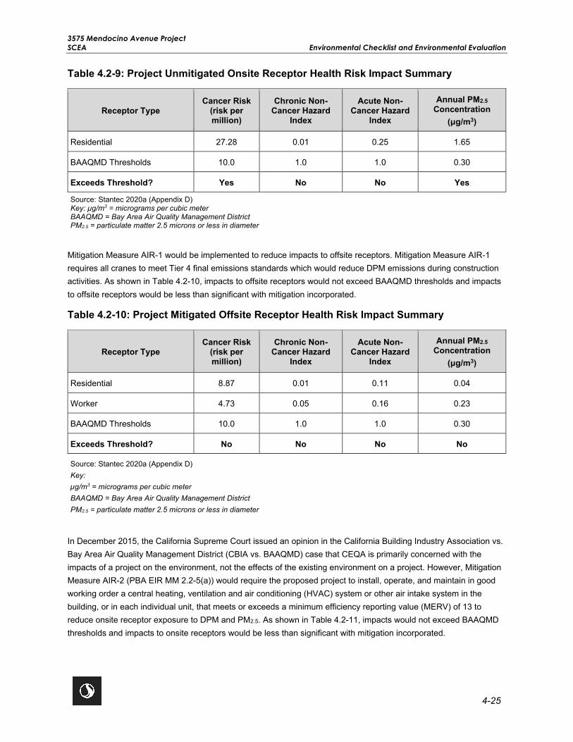
3575 Mendocino Avenue Project SCEA Environmental Checklist and Environmental Evaluation
4-25
Table 4.2-9: Project Unmitigated Onsite Receptor Health Risk Impact Summary
Receptor Type Cancer Risk
(risk per million)
Chronic Non-Cancer Hazard
Index
Acute Non-Cancer Hazard
Index
Annual PM2.5 Concentration
(μg/m3)
Residential 27.28 0.01 0.25 1.65
BAAQMD Thresholds 10.0 1.0 1.0 0.30
Exceeds Threshold? Yes No No Yes
Source: Stantec 2020a (Appendix D) Key: µg/m3 = micrograms per cubic meter BAAQMD = Bay Area Air Quality Management District PM2.5 = particulate matter 2.5 microns or less in diameter
Mitigation Measure AIR-1 would be implemented to reduce impacts to offsite receptors. Mitigation Measure AIR-1 requires all cranes to meet Tier 4 final emissions standards which would reduce DPM emissions during construction activities. As shown in Table 4.2-10, impacts to offsite receptors would not exceed BAAQMD thresholds and impacts to offsite receptors would be less than significant with mitigation incorporated.
Table 4.2-10: Project Mitigated Offsite Receptor Health Risk Impact Summary
Receptor Type Cancer Risk
(risk per million)
Chronic Non-Cancer Hazard
Index
Acute Non-Cancer Hazard
Index
Annual PM2.5 Concentration
(μg/m3)
Residential 8.87 0.01 0.11 0.04
Worker 4.73 0.05 0.16 0.23
BAAQMD Thresholds 10.0 1.0 1.0 0.30
Exceeds Threshold? No No No No
Source: Stantec 2020a (Appendix D) Key: µg/m3 = micrograms per cubic meter BAAQMD = Bay Area Air Quality Management District PM2.5 = particulate matter 2.5 microns or less in diameter
In December 2015, the California Supreme Court issued an opinion in the California Building Industry Association vs. Bay Area Air Quality Management District (CBIA vs. BAAQMD) case that CEQA is primarily concerned with the impacts of a project on the environment, not the effects of the existing environment on a project. However, Mitigation Measure AIR-2 (PBA EIR MM 2.2-5(a)) would require the proposed project to install, operate, and maintain in good working order a central heating, ventilation and air conditioning (HVAC) system or other air intake system in the building, or in each individual unit, that meets or exceeds a minimum efficiency reporting value (MERV) of 13 to reduce onsite receptor exposure to DPM and PM2.5. As shown in Table 4.2-11, impacts would not exceed BAAQMD thresholds and impacts to onsite receptors would be less than significant with mitigation incorporated.

3575 Mendocino Avenue Project Environmental Checklist and Environmental Evaluation SCEA
4-26
Table 4.2-11: Project Mitigated Onsite Receptor Health Risk Impact Summary
Receptor Type Cancer Risk
(risk per million)
Chronic Non-Cancer Hazard
Index
Acute Non-Cancer Hazard
Index
Annual PM2.5 Concentration
(μg/m3)
Residential 3.17 0.01 0.25 0.25
BAAQMD Thresholds 10.0 1.0 1.0 0.30
Exceeds Threshold? No No No No
Source: Stantec 2020a (Appendix D) Key: µg/m3 = micrograms per cubic meter BAAQMD = Bay Area Air Quality Management District PM2.5 = particulate matter 2.5 microns or less in diameter
Localized CO Emissions
Localized concentrations of CO are related to the levels of traffic and congestion along streets and at intersections. Implementation of the proposed project would increase traffic volumes on streets near the project site; therefore, the proposed project would be expected to increase local CO concentrations. Concentrations of CO approaching the ambient air quality standards are only expected where background levels, traffic volumes, and congestion levels are high. The BAAQMD’s preliminary screening methodology for localized CO emissions provides a conservative indication of whether project-generated vehicle trips would result in the generation of CO emissions that contribute to an exceedance of the applicable threshold of significance. According to the BAAQMD CEQA Guidelines, the proposed project would result in a less than significant impact to localized CO concentrations if the following screening criteria are met:
• The project is consistent with an applicable congestion management program established by the county congestion management agency for designated roads or highways, a RTP, and local congestion management agency plans.
• The project traffic would not increase traffic volumes at affected intersections to more than 44,000 vehicles per hour.
• The project traffic would not increase traffic volumes at affected intersections to more than 24,000 vehicles per hour where vertical and/or horizontal mixing is substantially limited (e.g., tunnel, parking garage, bridge underpass, natural or urban street canyon, below-grade roadway).
According to the Traffic Impact Analysis prepared for the proposed project by W-Trans, the proposed project would not generate traffic that would result in deterioration of an intersection from acceptable Level of Service (LOS) (LOS A through D) to LOS E or F under existing plus project conditions (Appendix L). The Traffic Impact Analysis also determined in the Existing Plus Project scenario that the proposed project would not increase traffic volumes at affected intersections to more than 44,000 vehicles per hour. The proposed project would not affect roadways in areas where vertical and/or horizontal mixing is substantially limited, and based on the Traffic Impact Analysis (Appendix L), the proposed project would not increase traffic volumes to more than 24,000 vehicles per hour in an area where vertical and/or horizontal mixing is substantially limited. Therefore, in accordance with BAAQMD’s second

3575 Mendocino Avenue Project SCEA Environmental Checklist and Environmental Evaluation
4-27
tier screening criteria, the proposed project would not result in the generation of localized CO emissions in excess of the applicable threshold of significance and impacts would be less than significant.
As discussed above, the proposed project would not cause or be exposed to substantial pollutant concentrations, including localized CO or TAC emissions, such as DPM and NOA, that would result in significant health risks. With implementation of Mitigation Measure AIR-1 and Mitigation Measure AIR-2 (PBA EIR MM 2.2-5(a)), the proposed project would not expose sensitive receptors to substantial pollutant concentrations and impacts would be less than significant with mitigation incorporated.
Level of Significance Before Mitigation Potentially Significant Impact.
Mitigation Measures Mitigation Measure AIR-1 (Tier 4 Final Engine Requirements) and Mitigation Measure AIR-2 (PBA EIR MM 2.2-5(a): Sensitive Receptors Exposure to TACs and PM2.5 Concentrations in Transit Priority Areas) are required.
MM AIR-1: Tier 4 Final Engine Requirements: All cranes used during project construction activities shall be required to meet Tier 4 final emissions standards. Prior to the issuance of any demolition, grading, or building permits a note shall be added to the project plans requiring all cranes used for project construction activities to meet Tier 4 final emissions standards. The construction contractor shall maintain records documenting efforts to comply with this requirement and shall submit records of compliance to the City prior to issuance of certificate of occupancy for each building.
Mitigation Measure AIR-2 (PBA EIR MM 2.9-1[a]): Sensitive Receptors Exposure to TACs and PM2.5
Concentrations in Transit Priority Areas. The following measures from PBA EIR MM 2.9-1(a): Sensitive Receptors Exposure to TACs and PM2.5 Concentrations in Transit Priority Areas are relevant to this proposed project:
When locating sensitive receptors in TAC risk areas, implementing agencies and/or project sponsors shall implement measures, where feasible and necessary based on project- and site-specific considerations that include, but are not limited to the following:
• Install, operate, and maintain in good working order a central heating, ventilation, and air conditioning (HVAC) system or other air intake system in the building, or in each individual unit, that meets or exceeds a minimum efficiency reporting value (MERV) of 13 or higher. The HVAC system shall include the following features: Installation of a high efficiency filter and/or carbon filter to filter particulates and other chemical matter from entering the building. Either high efficiency particulate air (HEPA) filters or American Society of Heating, Refrigeration, and Air-Conditioning Engineers (ASHRAE) certified 85% supply filters shall be used.
• Maintain, repair and/or replace HVAC system on an ongoing and as needed basis or shall prepare an operation and maintenance manual for the HVAC system and the filter. The manual shall include the operating instructions and the maintenance and replacement schedule. This manual shall be included in the Covenants, Conditions and Restrictions (CC&R) for residential projects and/or distributed to the building maintenance staff. In addition, the applicant shall prepare a separate homeowners manual. The manual shall contain the operating instructions and the maintenance and replacement schedule for the HVAC system and the filters.
• Install passive electrostatic filtering systems with low air velocities (i.e., less than 1 mph).

3575 Mendocino Avenue Project Environmental Checklist and Environmental Evaluation SCEA
4-28
• Individual and common exterior open space and outdoor activity areas proposed as part of individual projects shall be located as far away as possible within the project site boundary, face away from major freeways, and shall be shielded from the source (i.e., the roadway) of air pollution by buildings or otherwise buffered to further reduce air pollution for project occupants.
• Locate air intakes and design windows to reduce PM exposure (e.g., windows nearest to the roadway do not open).
• Sensitive receptors within buildings shall be located in areas upwind of major roadway traffic to reduce exposure to reduce cancer risk levels and exposure to PM2.5.
• Planting trees and/or vegetation between sensitive receptors and pollution source. Trees that are best suited to trapping PM shall be planted, including one or more of the following species: Pine (Pinus nigra var. maritima), Cypress (X Cupressocyparis leylandii), Hybrid popular (Populus deltoids X trichocarpa), California pepper tree (Schinus molle) and Redwoods (Sequoia sempervirens).
• Idling of heavy-duty diesel trucks at these locations shall be prohibited or limited to no more than 2 minutes.
• Emissions from diesel trucks shall be reduced through establishing truck routes to avoid residential neighborhoods or other land uses serving sensitive populations, such as hospitals, schools, and childcare centers. A truck route program, along with truck calming, parking, and delivery restrictions, shall be implemented to direct traffic activity at non-permitted sources and large construction projects.
Level of Significance After Mitigation Less Than Significant Impact With Mitigation.
Impact AIR-4 Result in other emissions (such as those leading to odors) adversely affecting a substantial number of people?
Impact Analysis Odors are generally regarded as an annoyance rather than a health hazard. Due to the subjective nature of odor impacts, the number of variables that can influence the potential for an odor impact, and the variety of odor sources, quantitative methodologies to determine the presence of a significant odor impact do not exist. According to the CARB’s Handbook, some of the most common sources of odor complaints received by local air districts are sewage treatment plants, landfills, recycling facilities, waste transfer stations, petroleum refineries, biomass operations, autobody shops, coating operations, fiberglass manufacturing, foundries, rendering plants, and livestock operations. The project site is not located near any such land uses, and the proposed project would not introduce any such land uses.
Residential land uses are not typically associated with the creation of substantial objectionable odors. Diesel fumes from construction equipment are often found to be objectionable; however, construction is temporary, and associated diesel emissions would be regulated under federal, state, and local regulations, including compliance with all applicable BAAQMD rules and regulations, which would help to control construction-related odorous emissions. Therefore, construction of the proposed project would not be expected to create objectionable odors affecting a substantial number of people.

3575 Mendocino Avenue Project SCEA Environmental Checklist and Environmental Evaluation
4-29
For the aforementioned reasons, construction and operation of the proposed project would not create objectionable odors, nor would the project site be affected by any existing sources of substantial objectionable odors, and therefore a less than significant impact related to objectionable odors would result.
Level of Significance Before Mitigation Less Than Significant Impact.
Mitigation Measures No mitigation is necessary.
Level of Significance After Mitigation Less Than Significant Impact.

3575 Mendocino Avenue Project Environmental Checklist and Environmental Evaluation SCEA
4-30
This page left intentionally blank.

3575 Mendocino Avenue Project SCEA Environmental Checklist and Environmental Evaluation
4-31
4.3 BIOLOGICAL RESOURCES
Would the Project: Potentially Significant
Impact
Less Than Significant With
Mitigation Incorporated
Less Than Significant
Impact No Impact
a) Have a substantial adverse effect, either directly or through habitat modifications, on any species identified as a candidate, sensitive, or special status species in local or regional plans, policies, or regulations, or regulated by the California Department of Fish and Wildlife or U.S. Fish and Wildlife Service?
b) Have a substantial adverse effect on any riparian habitat or other sensitive natural community identified in local or regional plans, policies, and regulations, or by the California Department of Fish and Wildlife or U.S. Fish and Wildlife Service?
c) Have a substantial adverse effect on federally protected wetlands as defined by Section 404 of the Clean Water Act (including, but not limited to, marsh, vernal pool, coastal, etc.) through direct removal, filling, hydrological interruption, or other means?
d) Interfere substantially with the movement of any native resident or migratory fish or wildlife species or with established native resident or migratory wildlife corridors, or impede the use of native wildlife nursery sites?
e) Conflict with any local policies or ordinances protecting biological resources, such as a tree preservation policy or ordinance?
f) Conflict with the provisions of an adopted habitat conservation plan, natural community conservation plan, or other approved local, regional, or state habitat conservation plan?
4.3.1 Environmental Setting
The project site is located on an infill site on a parcel previously developed as a mobile home park. In October 2017, a majority of the mobile home park was destroyed by the Tubbs Wildfire. On June 3, 2020, biological resources were evaluated within and around the project site, including an approximately 30-acre survey area (consisting of a 200-foot buffer and the approximately 13.3-acre project site). The topography of the survey area is generally flat, with the survey area gradually sloping east to west. At the southern end of the survey area, the land slopes down where Russell Creek flows adjacent to the project site. The survey area is located at elevations between 141 and 149 feet above mean sea level. Regionally, the survey area has a Mediterranean climate characterized by hot, dry summers and moderate winters, with average temperatures ranging seasonally from 57.3 to 82.5 degrees Fahrenheit (°F). Historical data used to describe the climate was collected at Santa Rosa, California (Western Regional Climate

3575 Mendocino Avenue Project Environmental Checklist and Environmental Evaluation SCEA
4-32
Center 2020). The station is located approximately 2.8 miles southeast of the survey area. Precipitation in the survey area occurs as rain. Average annual rainfall is 30.13 inches and occurs primarily from December through February. The growing season (i.e., 50 percent probability of air temperature 28ºF or higher) in the survey area is around 310 days (Western Regional Climate Center 2020).
Background Research
For the purpose of this evaluation, “special-status” plant species include plants that are: 1) listed as threatened or endangered under the California Endangered Species Act (CESA) and/or Federal Endangered Species Act (FESA); 2) proposed for federal listing as threatened or endangered; 3) State or federal candidate species; 4) designated as rare by the CDFW; or 5) California Rare Plant Rank (CRPR) 1A, 1B, 2A or 2B species. Special-status animal species include species that are: 1) listed as threatened or endangered under the CESA and/or FESA; 2) proposed for federal listing as threatened or endangered; 3) State and/or federal candidate species; or 4) identified by the CDFW as species of special concern or fully protected species.
Sensitive natural communities are those communities that are highly limited in distribution, and may or may not contain rare, threatened, or endangered species. The California Natural Diversity Database (CNDDB) ranks natural communities according to their rarity and endangerment in California. Habitats are considered “sensitive” if they are identified on the CDFW List of Vegetation Alliances and Associations as being highly imperiled or classified by CDFW in the CNDDB as natural communities of special concern—Ranks S1 to S3.
The potential for special-status species to occur within the survey area was classified under one of six categories as described below. Only those special-status species with an occurrence potential of “Moderate” or greater are evaluated in detail as the species most likely to occur.
• Present: The species is known to be present or has been recently observed in the survey area.
• High: The species has been observed and documented within five miles of the survey area within the last five years and suitable habitat for the species is present.
• Moderate: The proposed project is located within the range of the species, there are documented occurrences within five miles of the survey area, and/or suitable habitat for the species exists in the survey area.
• Low: The proposed project is located within the range of the species, and low-quality (e.g., disturbed, agricultural) habitat is present.
• Absent: The proposed project is located outside of the species range and/or potential habitat to support the species is not present in the survey area.
• Not Present: Potential habitat for the species is present in the survey area; however, the species has been determined to be absent from the survey area given the results of focused/protocol-level survey(s).
Information about habitat types and special-status species that could occur in the survey area was obtained from the following sources:
• CDFW CNDDB plant and animal records (CDFW 2020a) (Appendix E);
• California Native Plant Society (CNPS) Online Inventory of Rare and Endangered Plants (CNPS 2020) (Appendix E);

3575 Mendocino Avenue Project SCEA Environmental Checklist and Environmental Evaluation
4-33
• Calflora (2020);
• USFWS list of endangered and threatened species that may occur in the survey area (USFWS 2020a) (Appendix E); and
• USFWS Designated Critical Habitat within the survey area (USFWS 2020a).
The survey area is within the Santa Rosa U.S. Geological Survey (USGS) 7.5-minute quadrangle. A CNDDB and CNPS database search for special-status species included the USGS 7.5-minute quadrangles within a 5-mile radius of the project site. In this case, the Santa Rosa, Healdsburg, Sebastopol, and Mark West Springs topographic quadrangles were queried. A 5-mile radius quadrangle search was conducted based on habitat types and migration distances for potential special-status species that could occur within the survey area. The USFWS database of endangered species was also utilized to query all federally endangered, threatened, candidate, and proposed animal and plant species, as well as designated critical habitat with known occurrences in this and adjacent quadrangles. Calflora and CNPS’ Online Inventory databases were used to obtain more information on the habitat requirements of rare plants.
Other information sources consulted to determine which special-status species could potentially occur in the survey area included:
• USGS California 7.5-minute topographic quadrangles for Santa Rosa, Healdsburg, Sebastopol, and Mark West Springs;
• Aerial photographs of the survey area and surrounding vicinity (Google Earth 2020);
• USFWS National Wetlands Inventory (USFWS 2020b);
• Special Animals List (CDFW 2020b);
• State and Federally Listed Endangered and Threatened Animals of California (CDFW 2020c);
• State and Federally Listed Endangered, Threatened and Rare Plants of California (CDFW 2020d);
• Special Vascular Plants, Bryophytes, and Lichens List (CDFW 2020e);
• California Wildlife Habitat Relationships System (WHRS) (CDFW 2014); and
• Other pertinent databases and literature, including the Jepson Manual: Vascular Plants of California, Second Edition (Baldwin et. al. 2012).
Based on this background research, a list of special-status species that have the potential to occur or are known to occur in the survey area and vicinity was developed. The list has been refined based on a reconnaissance-level biological field survey to determine the potential for those species to occur in the survey area.
Reconnaissance Survey
A biological survey for special-status species and sensitive natural communities was conducted by Stantec Biologists Jared Elia and Scott Elder on June 3, 2020. The biological survey was performed by walking meandering transects throughout the entire survey area to characterize habitats, identify aquatic resources that may be subject to regulatory agency jurisdiction (e.g., USACE, RWQCB, and CDFW), assess potential for special-status species to

3575 Mendocino Avenue Project Environmental Checklist and Environmental Evaluation SCEA
4-34
occur, and to record observed species. To better focus the field survey efforts on those plant and animal special-status species that may occur in the survey area, a target list of potentially occurring species was developed during the literature and database review process. Plant taxonomy for the botanical survey was determined using the Jepson Manual (Baldwin et al. 2012).
Habitat Communities
Vegetation types in the survey area were classified based on descriptions provided in A Guide to Wildlife Habitats of California (Mayer and Laudenslayer 1988), as well as the California Natural Community List (CDFW 2019f), which is adapted from the technical approach and vegetation alliance classification system described in A Manual of California Vegetation (Sawyer et al. 2009). The vegetation communities present in the survey area are primarily barren and ruderal with urban development. Aquatic vegetation communities within the survey area consisted of fresh emergent wetland and perennial stream (Appendix F). Descriptions of the vegetation communities within the survey area are provided below.
Upland Habitat Types
Barren and Ruderal
Barren and ruderal habitat occur within a majority of the survey area. The project site was a previous mobile home park that was destroyed in 2017 by the Tubbs Wildfire. The site consists of existing residential streets and vegetated lots where mobile homes previously existed. Vegetation within previous mobile home lots consists of barren patches including primarily opportunistic non-native and invasive ruderal forb species, such as wild oats (Avena fatua), bristly ox-tongue (Helminthotheca echioides), prickly lettuce (Latuca serrioloa), annual sweetclover (Melilotus indicus), rabbitsfoot grass (Polypogon monspeliensis) and Jersey cudweed (Pseudognaphalium leteoalbum).
Urban/Developed
This land use type does not describe any specific vegetation type under Sawyer et al. (2009) but encompasses land that has been anthropogenically modified with structures and facilities, including roads and buildings. Ornamental plantings and ruderal vegetation may be present within and/or on the margins of developed areas. A small portion of the survey area extends into the commercial development along the southern and eastern extents and is considered urban/developed.
Aquatic Habitats
Fresh Emergent Wetland
One fresh emergent wetland occurs within the project site, located within the southeastern portion of the project site. The fresh emergent wetland is approximately 0.019 acres and located between existing paved roadways and appears to receive roadside runoff during precipitation events. Dominant hydrophytic herbaceous vegetation includes tall faltsedge (Cyperus eragrostis), Hyssop loosestrife (Lythrum hyssopifolia), and common spike rush (Eleocharis macrostachya). Hydrology indicators were observed in the form of Soil Cracks and hydric soils observed were Depleted Dark Surfaces (Appendix F).
This fresh emergent wetland is a potential waters of the State (WOTS) (wetland) and would be permanently impacted during project activities. Project impacts to this wetland are associated with new development and site grading.

3575 Mendocino Avenue Project SCEA Environmental Checklist and Environmental Evaluation
4-35
Perennial Stream
One perennial stream was observed just south of the project site. This feature is also referred to as Russell Creek and appears to convey water year-round and is a tributary to Santa Rosa Creek. This feature receives enough water during the rainy season to develop a bed, bank, and channel and exhibit an ordinary highwater mark. The section of stream within the survey area is approximately 0.192 acres (1,045 linear feet) and has been altered as it flows between the project site and a commercial development. Vegetation along the stream within the survey area consisted of herbs and forbs in the understory with trees in the overstory. Russell Creek lacks a defined riparian habitat due to the alteration of the creek channel and heavy presence of non-native, upland species. Some species observed along the creek bank are riparian species, but these species are sparse and lack the cover necessary to create a riparian corridor. Trees observed include primarily coast live oak (Quercus agrifolia), with a couple arroyo willows (Salix angustifolia). Understory vegetation consisted of velvet grass (Holcus lanatus), harding grass (Phalaris aquatica), wild radish (Raphanus sativus), curly dock (Rumex crispus), field hedge parsley (Torilis arvensis), spring vetch (Vicia sativa), common rush (Juncus effuses), English ivy (Hedera helix), Himalayan blackberry (Rubus armeniacus), and sweet fennel (Foeniculum vulgare).
Although 0.192 acres of potential waters of the U.S. (Russell Creek) occur within the survey area, only 0.009 acre (400 square feet) would be temporarily impacted and less than 0.001 acre (2 square feet) would be permanently impacted through the installation of the stormwater outfall. Project impacts to Russell Creek are associated with temporary access and installation of a new stormwater outfall (24-inch pipe) into Russell Creek.
Special-Status Species
Plants
Regionally occurring special-status plant species were identified based on a review of pertinent literature, the USFWS species list, CNDDB, and CNPS database records, and the reconnaissance-level biological field survey results. CNDDB special-status plant species occurrences were reviewed within 5 miles of the survey area. For each species, habitat requirements were assessed and compared to the habitats in the survey area and immediate vicinity to determine if potential habitat occurs in the survey area. Based on database records 47 special-status plants were evaluated for their potential to occur within the survey area. As described in the Biological Resources Technical Report (Appendix E), none of these species were determined to be present or have a high or moderate potential to occur.
Wildlife
Regionally occurring special-status animal species were identified based on a review of pertinent literature, the USFWS species list, CNDDB database records, a query of the California WHRS (CDFW 2014), and the reconnaissance-level biological field survey results. CNDDB special-status animal species occurrences were reviewed within 5 miles of the survey area. For each species, habitat requirements were assessed and compared to the habitats in the survey area and immediate vicinity to determine the species’ potential to occur in or near the survey area. The literature and database review identified 21 special-status wildlife species with suitable habitat or known to occur in or near the survey area. As described in the Biological Resources Technical Report (Appendix E), none of these species were determined to be present or have a high or moderate potential to occur.
Critical Habitat
No designated critical habitat is present in the survey area.

3575 Mendocino Avenue Project Environmental Checklist and Environmental Evaluation SCEA
4-36
A more detailed description of the existing setting is provided in the project’s Biological Resources Technical Report, included as Appendix E (Stantec 2020b).
4.3.2 Previous Environmental Analysis
City of Santa Rosa General Plan EIR Summary
Chapter F of the General Plan EIR discusses impacts on biological resources. According to the General Plan EIR, implementation of General Plan policies and Citywide Creek Master Plan policies would reduce potential impacts to wetlands, riparian habitat, or wildlife corridors to a less than significant level. The General Plan EIR also determined that the General Plan would not conflict with the Santa Rosa Plain Conservation Strategy with implementation of mitigation.
The following General Plan policies would be applicable to the proposed project:
Policy OSC-A-2: Collaborate with other agencies and private development to link non-access open spaces, where such linking would benefit the protection of special environments and life systems such as wetlands, plant communities, and wildlife habitats and corridors.
Policy OSC-B-3: Require that new subdivisions, multifamily, and non-residential development abutting creek corridors are appropriately designed and oriented with respect to the creek.
Policy OSC-D-1: Utilize existing regulations and procedures, including Subdivision Guidelines, Zoning, Design Review, and environmental law, to conserve wetlands and rare plants. Comply with the federal policy of no net loss of wetlands using mitigation measures such as:
• Avoidance of sensitive habitat,
• Clustered development,
• Transfer of development rights, and/or
• Compensatory mitigation, such as restoration or creation.
Policy OSC-D-2: Protect high quality wetlands and vernal pools from development or other activities as determined by the Vernal Pool Ecosystem Preservation Plan.
Policy OSC-D-5: Consult with North Coast Regional Water Quality Control Board staff as part of the CEQA process for proposed developments to help them identify wetland and vernal pool habitat that has candidacy for restoration/protection based on actual and potential beneficial uses and determine appropriate locations for mitigation banking.
Policy OSC-D-6: Preserve waterways by informing residents of the environmental effects of dumping yard waste into creeks, or other wastes, such as motor oil, into storm drains that empty into creeks.
Policy OSC-D-7: Rehabilitate existing channelized waterways, as feasible, to remove concrete linings and allow for a connection with the stream channel and the natural water table. Avoid creating additional channelized waterways, unless no other alternative is available to protect human health, safety, and welfare.

3575 Mendocino Avenue Project SCEA Environmental Checklist and Environmental Evaluation
4-37
Policy OSC-D-8: Restore channelized waterways to a more natural condition which allows for more natural hydraulic functioning, including development of meanders, pools, riffles, and other stream features. Restoration should also allow for growth of riparian vegetation which effectively stabilizes banks, screens pollutants from runoff entering the channel, enhances fisheries, and provides other opportunities for natural habitat restoration.
Policy OSC-D-9: Ensure that construction adjacent to creek channels is sensitive to the natural environment. Ensure that natural topography and vegetation is preserved along the creek, and that construction activities do not disrupt or pollute the waterway.
Policy OSC-D-11: New development along channelized waterways should allow for an ecological buffer zone between the waterway and development. This buffer zone should also provide opportunities for multi-use trails and recreation.
Policy OSC-D-12: New development should maintain an adequate setback from channelized waterways to recognize the 100-year flood elevation and allow for stream corridor restoration. Setbacks identified in the Zoning Code should serve as minimum setbacks. Larger setbacks are encouraged in accordance with Restoration Concept Plans to meet restoration and enhancement goals.
Policy OSC-E-1: Preserve trees and other vegetation, including wildflowers, both as individual specimens and as parts of larger plant communities.
Policy OSC-E-2: Preserve and regenerate native oak trees.
Plan Bay Area EIR Summary
The following summarizes the potential impacts on biological resources discussed in Chapter 2.9 of the Plan Bay Area EIR and includes the complete text of mitigation measures previously identified by the Plan Bay Area EIR that are applicable to the proposed project.
Impact 2.9-1a: Special-Status Species. The Plan Bay Area EIR analyzed the potential impacts related to species identified as candidate, sensitive, or special-status in local or regional plans, policies, or regulations, or by CDFW or USFWS, and determined with implementation of Plan Bay Area EIR Mitigation Measure 2.9-1(a), the impact would be less than significant. Mitigation Measure 2.9-1(a) does not apply to the proposed project because there is no potential habitat within the project site for special-status plant species with occurrences within a 5-mile radius, no special-status species have a moderate or high potential to occur within the survey area, and the survey area does not provide suitable nesting habitat for special-status birds or raptors. Trees and shrubs within the survey area could provide suitable nesting habitat for other migratory birds protected under the Migratory Bird Treaty Act or California Fish and Game Code; as such, project specific mitigation has been identified to further avoid disturbance of migratory birds. (Refer to Impact BIO-1 in Section 4.3.3, Project-Specific Analysis).
Impact 2.9-1b: Designated Critical Habitat. The Plan Bay Area EIR analyzed the potential impacts related to designated critical habitat for federally listed plant and wildlife species and determined with implementation of Mitigation Measure 2.9-1(b), the impact would be less than significant. Mitigation Measure 2.9-1(b) is not applicable to the proposed project because there is no critical habitat in the project area. (Refer to Impact BIO-2 in Section 4.3.3, Project-Specific Analysis.)
Impact 2.9-2: Riparian Habitat, Federally Protected Wetlands, or Other Sensitive Natural Communities. As discussed in the Plan Bay Area EIR, projects would have the potential to affect jurisdictional waters and other

3575 Mendocino Avenue Project Environmental Checklist and Environmental Evaluation SCEA
4-38
sensitive habitats, resulting in a potentially significant impact. The Plan Bay Area EIR identifies Mitigation Measure 2.9-2 to reduce impacts to jurisdictional waters to a less than significant level. In addition, based on the site conditions observed during the June 3, 2020 field survey and confirmation from applicable permitting agencies, project specific mitigation has been identified to further reduce temporary and permanent impacts to the onsite wetland feature and the offsite adjacent perennial stream. (Refer to Impacts BIO-2 and BIO-3 in Section 4.3.3, Project-Specific Analysis).
PBA EIR MM 2.9-2: Riparian Habitat, Federally Protected Wetlands, or Other Sensitive Natural Communities. Implementing agencies and/or project sponsors shall implement measures, where feasible and necessary based on project- and site-specific considerations that include, but are not limited to:
Mitigation measures that shall be considered by implementing agencies and/or project sponsors based on project-and site-specific considerations include, but are not limited to:
• Implementing agencies shall require project sponsors to prepare biological resource assessments for specific projects proposed in areas containing, or likely to contain, jurisdictional waters and/or other sensitive or special-status communities. These assessments shall be conducted by qualified professionals in accordance with agency guidelines and standards.
• In keeping with the “no net loss” policy for wetlands and other waters, project designs shall be configured, whenever possible, to avoid wetlands and other waters and avoid disturbances to wetlands and riparian corridors to preserve both the habitat and the overall ecological functions of these areas. Projects shall minimize ground disturbances and transportation project footprints near such areas to the extent practicable.
• Where avoidance of jurisdictional waters is not feasible, project sponsors shall minimize fill and the use of in-water construction methods, and place fill only with express permit approval from the appropriate resources agencies (e.g., USACE, RWQCB, CDFW, Bay Area Conservation District [BCDC], and California Coastal Commission [CCC]) and in accordance with applicable existing regulations, such as the Clean Water Act or local stream protection ordinances.
• Project sponsors shall arrange for compensatory mitigation in the form of mitigation bank credits, onsite or offsite enhancement of existing waters or wetland creation in accordance with applicable existing regulations and subject to approval by the USACE, RWQCB, CDFW, BCDC, and CCC. If compensatory mitigation is required by the implementing agency, the project sponsor shall develop a restoration and monitoring plan that describes how compensatory mitigation will be achieved, implemented, maintained, and monitored. At a minimum, the restoration and monitoring plan shall include clear goals and objectives, success criteria, specifics on restoration/creation/enhancement (plant palette, soils, irrigation, etc.), specific monitoring periods and reporting guidelines, and a maintenance plan. The following minimum performance standards (or other standards as required by the permitting agencies) shall apply to any wetland compensatory mitigation:
o Compensation shall be provided at a minimum 1:1 ratio for restoration and preservation but shall in all cases be consistent with mitigation ratios set forth in locally applicable plans (e.g., general plans, HCP/NCCPs, etc.), or in project-specific permitting documentation. Compensatory mitigation may be a combination of onsite restoration/creation/enhancement or offsite restoration, preservation, and/or enhancement. Compensatory mitigation may be achieved in advance of impacts through the purchase or creation of mitigation credits or the

3575 Mendocino Avenue Project SCEA Environmental Checklist and Environmental Evaluation
4-39
implementation of mitigation projects through RAMP, as deemed appropriate by the permitting agencies.
o In general, any compensatory mitigation shall be monitored for a minimum of five years and will be considered successful when at least 75 percent cover (or other percent cover considered appropriate for the vegetation type) of installed vegetation has become successfully established.
• In accordance with CDFW guidelines and other instruments protective of sensitive or special- status natural communities, project sponsors shall avoid and minimize impacts on sensitive natural communities when designing and permitting projects. Where applicable, projects shall conform to the provisions of special area management or restoration plans, such as the Suisun Marsh Protection Plan or the East Contra Costa County HCP, which outline specific measures to protect sensitive vegetation communities.
• If any portion of a special-status natural community is permanently removed or temporarily disturbed, the project sponsor shall compensate for the loss. If such mitigation is required by the implementing agency, the project sponsor shall develop a restoration and monitoring plan that describes how compensatory mitigation will be achieved, implemented, maintained, and monitored. At a minimum, the restoration and monitoring plan shall include clear goals and objectives, success criteria, specifics on restoration/creation/ enhancement (plant palette, soils, irrigation, etc.), specific monitoring periods and reporting guidelines, and a maintenance plan. The following minimum performance standards (or other standards as required by the permitting agencies) shall apply to any compensatory mitigation for special-status natural communities:
o Compensation shall be provided at a minimum 1:1 ratio for restoration and preservation but shall in all cases be consistent with mitigation ratios set forth in locally applicable plans (e.g., general plans, HCP/NCCPs, etc.) or in project-specific permitting documentation. Compensatory mitigation may be a combination of onsite restoration/creation/enhancement or offsite restoration, preservation, and/or enhancement. Compensatory mitigation may be achieved in advance of impacts through the purchase or creation of mitigation credits or the implementation of mitigation projects through RAMP, as deemed appropriate by the permitting agencies.
o In general, any compensatory mitigation shall be monitored for a minimum of five years and will be considered successful when at least 75 percent cover (or other percent cover considered appropriate for the vegetation type) of installed vegetation has become successfully established.
• Compliance with existing local regulations and policies, including applicable HCP/NCCPs. that exceed or reasonably replace any of the above measures protective of jurisdictional wetlands or special-status natural communities.
Impact 2.9-3: Movement of Native Resident or Migratory Fish or Wildlife Species, Wildlife Corridors, and Nursery Sites. The Plan Bay Area EIR analyzed the potential impacts related to substantially interfering with the movement of any native resident or migratory fish or wildlife species, or with established native resident or migratory wildlife corridor, or impeding the use of native wildlife nursery sites, and determined with implementation of Mitigation Measure 2.9-3, the impact would be less than significant. Mitigation Measure 2.9-3 is not applicable to the proposed

3575 Mendocino Avenue Project Environmental Checklist and Environmental Evaluation SCEA
4-40
project because there are no wildlife corridors in the survey area (Refer to Impact BIO-4 in Section 4.3.3, Project-Specific Analysis).
Impact 2.9-4: Local Conservation Policies, Ordinances, and Plans. As discussed in the Plan Bay Area EIR, development projects would be required to follow city and county development requirements, including compliance with local policies, ordinances, and applicable permitting procedures related to protection of biological resources. Additionally, consistency with an adopted HCP or other conservation plan is a legal requirement; and, the design, approval, and permitting of future development and transportation projects within an area covered by an HCP or other conservation plan are intended and expected to comply with that requirement. Therefore, the Plan Bay Area EIR determined that the potential for approved development projects to conflict with local policies or ordinances protecting biological resources would be less than significant and no mitigation measures were identified.
Impact 2.9-5: Special-Status Species and Sensitive Natural Communities. As discussed in the Plan Bay Area EIR, implementation of the Plan Bay Area could have the potential to substantially reduce the habitat of a fish or wildlife species; cause a fish or wildlife population to drop below self-sustaining levels; threaten to eliminate a plant or animal community; or substantially reduce the number or restrict the range of an endangered, rare, or threatened species. To the extent that an individual project adopts and implements all feasible mitigation measures identified in the Plan Bay Area EIR, the impact to special-status species and sensitive natural communities would be less than significant with mitigation. The proposed project would require implementation of Mitigation Measures BIO-1 and 2.9-2 to reduce potential impacts to special-status species and sensitive natural communities to less than significant.
4.3.3 Project-Specific Analysis
Impact BIO-1 Have a substantial adverse effect, either directly or through habitat modifications, on any species identified as a candidate, sensitive, or special status species in local or regional plans, policies, or regulations, or by the California Department of Fish and Wildlife or U.S. Fish and Wildlife Service?
Impact Analysis Special-Status Plant Species
There is no potential habitat within the survey area for special-status plant species with occurrences within a 5-mile radius. The project site was a previous mobile home park that was destroyed in 2017 by the Tubbs Wildfire, and now has a barren and ruderal dominant habitat community. Non-native and invasive plant species occur throughout the project site in patches between paved roadways. A small portion of the survey area is considered urban/developed and extends into the commercial development along the southern and eastern extents. Based on the lack of suitable habitat, the survey area does not provide potential habitat for special-status plant species to occur, and there would be no impacts to special-status plants.
Special-Status Wildlife Species
Although there are CNDDB occurrence records within 5 miles of the survey area for special-status animal species (CDFW 2020a), the survey area does not provide suitable habitat (i.e., grassland, woodland) for potential special-status animal species to occur. Only the western pond turtle (Emys marmorata) and California red-legged frog (Rana draytonii) have a low potential to occur in the survey area and the survey area only provides marginal habitat for these two special-status species. No special-status species have a moderate or high potential to occur within the survey area.

3575 Mendocino Avenue Project SCEA Environmental Checklist and Environmental Evaluation
4-41
The nearest CNDDB occurrence for western pond turtle is approximately 0.5-mile north of the survey area. There are no CNDDB occurrences for California red-legged frog within 5 miles of the survey area; the survey area is within the range of this species and Russell Creek provides marginal aquatic habitat and could be used as dispersal habitat by this species. Only a small area of Russell Creek would be temporarily impacted for construction of the stormwater outfall and the creek provides only marginal aquatic habitat; therefore, no significant impacts would occur to these species during project activities.
Migratory Nesting Birds
The survey area does not provide suitable nesting habitat for special-status birds or raptors; however, trees and shrubs within the survey area could provide suitable nesting habitat for other migratory birds protected under the Migratory Bird Treaty Act or California Fish and Game Code. The proposed project anticipates the removal of trees from the project site. Construction activities, including removal of trees during the typical nesting season (February 1 through August 31) could have a significant impact on nesting migratory birds.
Avoidance and minimization measures should be incorporated into the proposed project to avoid direct and indirect effects to special-status species and their habitat. Construction activities that occur during the nesting bird season may cause direct effects (e.g., tree removal and vegetation clearing) and indirect effects (e.g., noise and vibration) to nesting birds causing adults to abandon active nests, resulting in nest failure and reduced reproductive success. Mitigation Measure BIO-1 requires preconstruction nesting bird surveys during the nesting bird season to document all nests on the project site and implementation of protective buffers around documented nests during construction to minimize disturbance to nesting birds. Based on the lack of suitable nesting habitat in the survey area, there is low potential for special-status species to occur, and with the implementation of Mitigation Measure BIO-1, impacts to migratory nesting bird species would be less than significant.
Level of Significance Before Mitigation Potentially Significant Impact.
Mitigation Measures Mitigation Measure BIO-1 (Avoid Disturbance of Nesting Birds) is required.
MM BIO-1 Avoid Disturbance of Nesting Birds. Vegetation removal and initial ground disturbance activities should be initiated during the non-nesting season for migratory birds from September 1 to January 31. If work cannot be initiated during this period, a nesting bird survey should be performed by a qualified biologist for species protected by the Migratory Bird Treaty Act and California Fish and Game Code within a 250-foot radius of proposed construction activities for passerines, no more than 2 weeks prior to the start of construction activities. If active nests are found, a no-disturbance buffer should be placed around the nest until young have fledged or the nest is determined to be no longer active by the biologist. The size of the buffer shall be determined by the biologist based on species and proximity to activities and may be reduced at the discretion of the biologist. Active nests shall be monitored periodically to determine time of fledging.
Level of Significance After Mitigation Less Than Significant Impact With Mitigation.

3575 Mendocino Avenue Project Environmental Checklist and Environmental Evaluation SCEA
4-42
Impact BIO-2 Have a substantial adverse effect on any riparian habitat or other sensitive natural community identified in local or regional plans, policies, and regulations or by the California Department of Fish and Wildlife or U.S. Fish and Wildlife Service?
Impact Analysis The survey area does not contain any sensitive natural communities as classified by the CDFW or designated critical habitat by USFWS; however, aquatic habitats subject to CDFW jurisdiction under Section 1600 of the California Fish and Game Code occur within the survey area, including a perennial stream (Russell Creek) located adjacent to the southern project boundary. There is sparse riparian habitat associated with Russell Creek and the creek has a defined bed and bank which has been channelized. A stormwater outfall would be constructed into Russell Creek that would result in approximately 0.009 acre (400 square feet) of temporary impacts and less than 0.001 acre (2 square feet) of permanent impacts to the creek. These temporary and permanent impacts would not have a substantial adverse effect on any riparian habitat or sensitive natural community. The proposed project would implement avoidance and minimization measures to reduce inadvertent impacts to the creek. With implementation of Mitigation Measure BIO-2 (PBA EIR MM 2.9-2) which requires coordination and permit approval from the appropriate resources agencies (CDFW) that would require mitigation to off-set impacts to jurisdictional features, impacts are anticipated to be less than significant. Following the completion of construction, temporary and permanent impacts to Russell Creek would be restored to return the area to preconstruction conditions, including grading and revegetation using a local native seed mix as identified in Mitigation Measure BIO-3. With implementation of Mitigation Measure BIO-2 (PBA EIR MM 2.9) and Mitigation Measure BIO-3, impacts to riparian habitat or other sensitive natural communities would be less than significant.
Level of Significance Before Mitigation Potentially Significant Impact.
Mitigation Measures Mitigation Measure BIO-2 (PBA EIR MM 2.9-2: Riparian Habitat, Federally Protected Wetlands, or Other Sensitive Natural Communities) and Mitigation Measure BIO-3 (Sensitive Aquatic Habitat) are required.
Mitigation Measure BIO-2 (PBA EIR MM 2.9-2: Riparian Habitat, Federally Protected Wetlands, or Other Sensitive Natural Communities). The following measures from PBA EIR MM 2.9-2: Riparian Habitat, Federally Protected Wetlands, or Other Sensitive Natural Communities are relevant to this proposed project:
Implementing agencies and/or project sponsors shall implement measures, where feasible and necessary based on project- and site-specific considerations that include, but are not limited to:
• Where avoidance of jurisdictional waters is not feasible, project sponsors shall minimize fill and the use of in-water construction methods, and place fill only with express permit approval from the appropriate resource agencies (e.g., USACE, RWQCB, CDFW, Bay Area Conservation District [BCDC], and California Coastal Commission [CCC]) and in accordance with applicable existing regulations, such as the Clean Water Act or local stream protection ordinances.
• Project sponsors shall arrange for compensatory mitigation in the form of mitigation bank credits, on-site or off-site enhancement of existing waters or wetland creation in accordance with applicable existing regulations and subject to approval by the USACE, RWQCB, CDFW, BCDC, and CCC. The following minimum performance standards (or other standards as required by the permitting agencies) shall apply to any wetland compensatory mitigation:

3575 Mendocino Avenue Project SCEA Environmental Checklist and Environmental Evaluation
4-43
o Compensation shall be provided at a minimum 1:1 ratio for restoration and preservation but shall in all cases be consistent with mitigation ratios set forth in locally applicable plans (e.g., general plans, HCP/NCCPs, etc.), or in project-specific permitting documentation. Compensatory mitigation may be a combination of onsite restoration/creation/enhancement or offsite restoration, preservation, and/or enhancement. Compensatory mitigation may be achieved in advance of impacts through the purchase or creation of mitigation credits or the implementation of mitigation projects through Regional Advance Mitigation Planning (RAMP), as deemed appropriate by the permitting agencies.
• In accordance with CDFW guidelines and other instruments protective of sensitive or special- status natural communities, project sponsors shall avoid and minimize impacts on sensitive natural communities when designing and permitting projects. Where applicable, projects shall conform to the provisions of special area management or restoration plans, such as the Suisun Marsh Protection Plan or the East Contra Costa County HCP, which outline specific measures to protect sensitive vegetation communities.
• Compliance with existing local regulations and policies, including applicable HCP/NCCPs that exceed or reasonably replace any of the above measures protective of jurisdictional wetlands or special-status natural communities.
MM BIO-3 Sensitive Aquatic Habitat. Following the completion of construction, temporary and permanent impacts to the perennial stream (Russell Creek) shall be restored to return the impacted area to preconstruction conditions, including grading and revegetation using a local native seed mix. Permanent impacts to the emergent wetland shall be mitigated at a 1:1 (impact:mitigation) ratio through the purchase of wetland mitigation credits at a local mitigation bank approved by North Coast RWQCB.
Level of Significance After Mitigation Less Than Significant Impact With Mitigation.
Impact BIO-3 Have a substantial adverse effect on state or federally protected wetlands (including, but not limited to, marsh, vernal pool, coastal, etc.) through direct removal, filling, hydrological interruption, or other means?
Impact Analysis Aquatic habitats identified within the survey area include a fresh emergent wetland. This feature could be considered potential waters of the U.S. and waters of the State, subject to the USACE and RWQCB jurisdiction under Sections 404 and 401 of the Clean Water Act. Permanent impacts to the wetland feature include 0.019 acre that would occur from new development and site grading.
The proposed project would implement avoidance and minimization measures to reduce impacts to potential waters of the U.S and waters of the State through implementation of Mitigation Measure BIO-2 (PBA EIR MM 2.9-2) and Mitigation Measure BIO-3. Mitigation Measure BIO-2 (PBA EIR MM 2.9-2) requires coordination and permit approval from the appropriate resource agencies (e.g., USACE and RWQCB) and in accordance with applicable existing regulations, such as the Clean Water Act or “no net loss” policy for wetlands, which would require mitigation to off-set impacts to potential waters of the U.S. and waters of the State. Permanent impacts to the wetland feature would be mitigated at a 1:1 (impact:mitigation) ratio through the purchase of wetland conservation credits at a local mitigation bank as identified in Mitigation Measure BIO-3. With implementation of Mitigation Measure BIO-2 (PBA EIR MM 2.9-

3575 Mendocino Avenue Project Environmental Checklist and Environmental Evaluation SCEA
4-44
2) and Mitigation Measure BIO-3, the impacts to potential waters of the U.S. and waters of the State would be less than significant.
Level of Significance Before Mitigation Potentially Significant Impact.
Mitigation Measures Mitigation Measure BIO-2(PBA EIR MM 2.9-2: Riparian Habitat, Federally Protected Wetlands, or Other Sensitive Natural Communities) and Mitigation Measure BIO-3 (Sensitive Aquatic Habitat) are required.
Level of Significance After Mitigation Less Than Significant Impact With Mitigation.
Impact BIO-4 Interfere substantially with the movement of any native resident or migratory fish or wildlife species or with established native resident or migratory wildlife corridors, or impede the use of wildlife nursery sites?
Impact Analysis Russell Creek is considered marginal habitat for California red-legged frog and Western pond turtle because it only provides foraging and dispersal habitat for these species but does not provide breeding or suitable upland habitat in the adjacent vicinity. The potential for special-status species to occur within Russel Creek is low and only a small area (400 square feet) of Russell Creek would be temporarily impacted; therefore, no impacts on the movement of any native resident, migratory, or wildlife species are anticipated.
Level of Significance Before Mitigation No Impact.
Mitigation Measures No mitigation is necessary.
Level of Significance After Mitigation No Impact.
Impact BIO-5 Conflict with any local policies or ordinances protecting biological resources, such as a tree preservation policy or ordinance?
Impact Analysis The proposed project would not conflict with any local policies or ordinances protecting biological resources, including tree preservation policies or ordinances. Chapter 17-24 of the City’s Code regulates the alteration, removal, and relocation of trees within the City and protects certain trees that are an essential part of the City’s natural heritage. As discussed in Section 2.2.5, Landscaping, based on the Final Arborist Report prepared for the proposed project, there are 53 trees on the project site, including 6 heritage trees. Of the six heritage trees on the project site, five heritage trees are planned for removal as part of the proposed project. A few Chinese pistache street trees and a coast redwood tree would be retained. Removal of the heritage trees would be mitigated by either replacing the heritage trees or paying an in-lieu fee as required by Section 17-24.050 of the City’s Code. Therefore, the proposed project would comply with the City Code and the project would result in a less than significant impact.
Level of Significance Before Mitigation Less Than Significant Impact.
3575 Mendocino Avenue Project SCEA Environmental Checklist and Environmental Evaluation
4-45
Mitigation Measures No mitigation is necessary.
Level of Significance After Mitigation Less Than Significant Impact.
Impact BIO-6 Conflict with the provisions of an adopted Habitat Conservation Plan, Natural Community Conservation Plan, or other approved local, regional, or state habitat conservation plan?
Impact Analysis The survey area is within the Santa Rosa Plain Conservation Service Action (USFWS 2017) which was established to help protect federally listed species that occur within the Santa Rosa Plain. Within the Santa Rosa Plain Conservation Area, the survey area is designated as “Already Developed or Permitted.” As such, there would be no impact with respect to any conflict with provisions of an adopted HCP, NCCP, or other approved local, regional, or State HCP.
Level of Significance Before Mitigation No Impact.
Mitigation Measures No mitigation is necessary.
Level of Significance After Mitigation No Impact.

3575 Mendocino Avenue Project Environmental Checklist and Environmental Evaluation SCEA
4-46
This page left intentionally blank.
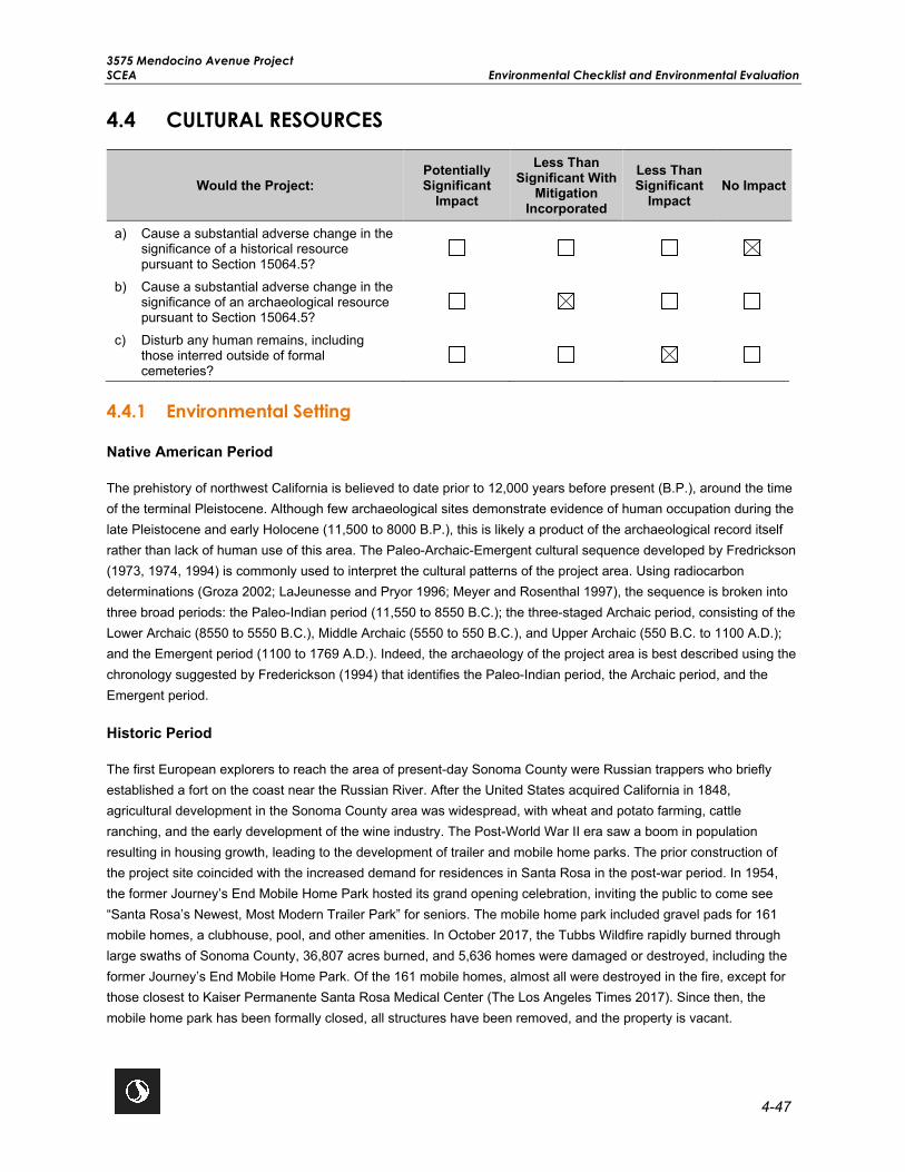
3575 Mendocino Avenue Project SCEA Environmental Checklist and Environmental Evaluation
4-47
4.4 CULTURAL RESOURCES
Would the Project: Potentially Significant
Impact
Less Than Significant With
Mitigation Incorporated
Less Than Significant
Impact No Impact
a) Cause a substantial adverse change in the significance of a historical resource pursuant to Section 15064.5?
b) Cause a substantial adverse change in the significance of an archaeological resource pursuant to Section 15064.5?
c) Disturb any human remains, including those interred outside of formal cemeteries?
4.4.1 Environmental Setting
Native American Period
The prehistory of northwest California is believed to date prior to 12,000 years before present (B.P.), around the time of the terminal Pleistocene. Although few archaeological sites demonstrate evidence of human occupation during the late Pleistocene and early Holocene (11,500 to 8000 B.P.), this is likely a product of the archaeological record itself rather than lack of human use of this area. The Paleo-Archaic-Emergent cultural sequence developed by Fredrickson (1973, 1974, 1994) is commonly used to interpret the cultural patterns of the project area. Using radiocarbon determinations (Groza 2002; LaJeunesse and Pryor 1996; Meyer and Rosenthal 1997), the sequence is broken into three broad periods: the Paleo-Indian period (11,550 to 8550 B.C.); the three-staged Archaic period, consisting of the Lower Archaic (8550 to 5550 B.C.), Middle Archaic (5550 to 550 B.C.), and Upper Archaic (550 B.C. to 1100 A.D.); and the Emergent period (1100 to 1769 A.D.). Indeed, the archaeology of the project area is best described using the chronology suggested by Frederickson (1994) that identifies the Paleo-Indian period, the Archaic period, and the Emergent period.
Historic Period
The first European explorers to reach the area of present-day Sonoma County were Russian trappers who briefly established a fort on the coast near the Russian River. After the United States acquired California in 1848, agricultural development in the Sonoma County area was widespread, with wheat and potato farming, cattle ranching, and the early development of the wine industry. The Post-World War II era saw a boom in population resulting in housing growth, leading to the development of trailer and mobile home parks. The prior construction of the project site coincided with the increased demand for residences in Santa Rosa in the post-war period. In 1954, the former Journey’s End Mobile Home Park hosted its grand opening celebration, inviting the public to come see “Santa Rosa’s Newest, Most Modern Trailer Park” for seniors. The mobile home park included gravel pads for 161 mobile homes, a clubhouse, pool, and other amenities. In October 2017, the Tubbs Wildfire rapidly burned through large swaths of Sonoma County, 36,807 acres burned, and 5,636 homes were damaged or destroyed, including the former Journey’s End Mobile Home Park. Of the 161 mobile homes, almost all were destroyed in the fire, except for those closest to Kaiser Permanente Santa Rosa Medical Center (The Los Angeles Times 2017). Since then, the mobile home park has been formally closed, all structures have been removed, and the property is vacant.

3575 Mendocino Avenue Project Environmental Checklist and Environmental Evaluation SCEA
4-48
Historical Resources
In Santa Rosa, there are 15 properties listed on the National Register of Historic Places, and there are several hundred listed on the California Register of Historical Resources. There are 22 other properties identified as historic landmarks within the City of Santa Rosa. No national, state, or local historical resources were identified in the project area. As part of this effort, the former Journey’s End Mobile Home Park was inventoried and evaluated and recommended ineligible for the National Register of Historic Places and California Register of Historical Resources, and as a historical resource for the purposes of CEQA. The former Journeys End Mobile Home Park is recommended ineligible under all criteria for lack of significance. The property did not play an important role in Santa Rosa’s post-war housing nor was it an important example of a mobile home park. Further, research did not indicate any important associations with individuals.
Archaeological Resources
The record search conducted at the Northwest Information Center identified seven resources located within 0.25 mile of the project site, the closest of which is located 130 feet east of the project site.
4.4.2 Previous Environmental Analysis
City of Santa Rosa General Plan EIR Summary
Chapter J of the General Plan EIR discusses potential impacts on prehistoric and historic resources. According to the General Plan EIR, new development has the potential to disrupt undiscovered archeological resources and unrecorded historic resources during proposed project construction. However, compliance with the policies contained in the General Plan would reduce impacts on archeological and historic resources to a less than significant level.
The following General Plan policies are applicable to the proposed project:
Policy HP-A-1: Review proposed developments and work in conjunction with Sonoma State University’s Northwest Information Center to determine whether project areas contain known archaeological resources, either prehistoric and/or historic-era, or have the potential to contain such resources.
Policy HP-A-2: Require that project areas found to potentially contain significant archaeological resources be examined by a qualified consulting archaeologist for recommendations concerning protection and preservation.
Policy HP-A-3: If cultural resources are encountered during development, work should be halted to avoid altering the materials and their context until a qualified consulting archaeologist and Native American representative (if appropriate) has evaluated the situation, recorded the identified cultural resources, and determined suitable mitigation measures.
Policy HP-A-4: Consult with local Native American tribes to identify, evaluate, and appropriately address cultural resources and tribal sacred sites through the development review process.
Policy HP-A-5: Ensure that Native American human remains are treated with sensitivity and dignity and assure compliance with the provisions of California Health and Safety Code Section 7050.5 and California Public Resources Code Section 5097.98.

3575 Mendocino Avenue Project SCEA Environmental Checklist and Environmental Evaluation
4-49
Plan Bay Area EIR Summary
The following summarizes the potential impacts to cultural resources discussed in Chapter 2.11 of the Plan Bay Area EIR and includes the complete text of mitigation measures previously identified by the Plan Bay Area EIR that are applicable to the proposed project.
Impact 2.11-1: Historical Resources. The Plan Bay Area EIR analyzed the potential impacts related to a substantial adverse change in the significance of a historical resource as defined in Section 15064.5 and determined, with the implementation of the Plan Bay Area EIR Mitigation Measure 2.11-1, the impact would be less than significant with mitigation. A historic resources evaluation was conducted for the proposed project, which resulted in a finding of no impact. Therefore, Plan Bay Area EIR Mitigation Measure 2.11-1 is not applicable to the proposed project (Refer to Impact CUL-1 in Section 4.4.3, Project-Specific Analysis).
Impact 2.11-2: Archaeological Resources. The Plan Bay Area EIR analyzed the potential impacts related to a substantial adverse change in the significance of a unique archaeological resource as defined in Section 15064.5 and determined with the implementation of Mitigation Measure 2.11-2 the impact would be less than significant. (Refer to Impact CUL-2 in Section 4.4.3, Project-Specific Analysis).
PBA EIR MM 2.11-2: Archaeological Resources. Implementing agencies and/or project sponsors shall implement the following measures where feasible and necessary based on project- and site-specific considerations that include, but are not limited to:
• Before construction activities, project sponsors shall retain a qualified archaeologist to conduct a record search at the appropriate Information Center to determine whether the project area has been previously surveyed and whether resources were identified. When recommended by the Information Center, project sponsors shall retain a qualified archaeologist to conduct archaeological surveys before construction activities. Project sponsors shall follow recommendations identified in the survey, which may include activities such as subsurface testing, designing, and implementing a Worker Environmental Awareness Program, construction monitoring by a qualified archaeologist, avoidance of sites, or preservation in place.
• In the event that evidence of any prehistoric or historic-era subsurface archaeological features or deposits are discovered during construction-related earth-moving activities (e.g., ceramic shard, trash scatters, lithic scatters), all ground-disturbing activity in the area of the discovery shall be halted until a qualified archaeologist can assess the significance of the find. If the find is a prehistoric archeological site, the appropriate Native American group shall be notified. If the archaeologist determines that the find does not meet the CRHR standards of significance for cultural resources, construction may proceed. If the archaeologist determines that further information is needed to evaluate significance, a data recovery plan shall be prepared. If the find is determined to be significant by the qualified archaeologist (i.e., because the find is determined to constitute either an historical resource or a unique archaeological resource), the archaeologist shall work with the project applicant to avoid disturbance to the resources, and if complete avoidance is not feasible in light of project design, economics, logistics, and other factors, follow accepted professional standards in recording any find including submittal of the standard DPR Primary Record forms (Form DPR 523) and location information to the appropriate California Historical Resources Information System office for the project area.
• Project sponsors shall comply with existing local regulations and policies that exceed or reasonably replace any of the above measures that protect archaeological resources.

3575 Mendocino Avenue Project Environmental Checklist and Environmental Evaluation SCEA
4-50
Impact 2.11-4: Disturb Human Remains. The Plan Bay Area EIR analyzed the potential impacts related to the disturbance of human remains, including those interred outside of formal cemeteries, and determined impacts would be less than significant as projects are required to comply with California Health and Safety Code Sections 7050.5 and 7052 and PRC Section 5097. Compliance with these state regulations provide an opportunity to avoid or minimize the disturbance of human remains, and appropriately treat any remains that are discovered. Therefore, impacts to human remains would be less than significant, and no mitigation measures were identified.
4.4.3 Project-Specific Analysis
Impact CUL-1 Cause a substantial adverse change in the significance of a historical resource pursuant to Section 15064.5?
Impact Analysis The project site was previously occupied by the former Journey’s End Mobile Home Park; however, it was destroyed in October 2017 by the Tubbs Wildfire. Field documentation of the project site was conducted by a qualified architectural historian who documented buildings and structures 45 years or older within the project area. Based on the results of the field documentation, the former Journey’s End Mobile Home Park was recommended ineligible for the National Register of Historic Places, California Register of Historical Resources, and as a historical resource under CEQA. The former Journeys End Mobile Home Park is recommended ineligible under all criteria for lack of significance. The property did not play an important role in Santa Rosa’s post-war housing nor was it an important example of a mobile home park. Further, research did not indicate any important associations with individuals. No national, state, or local historical resources were identified in the project area. Therefore, the proposed project is not anticipated to have an impact on any known or potential historical resources.
Level of Significance Before Mitigation No Impact.
Mitigation Measures No mitigation is necessary.
Level of Significance After Mitigation No Impact.
Impact CUL-2 Cause a substantial adverse change in the significance of an archaeological resource pursuant to Section 15064.5?
Impact Analysis Based on a database review of recorded archaeological resources, there are no known archaeological resources within the project site. Further, the project site and surrounding area have been heavily developed, and it is unlikely that buried archaeological resources are present. However, there is a slight potential for archaeological sensitivity in the general area. As such, a Cultural Resources Monitoring Plan (CRMP) and implementation of archaeological monitoring will be applied. Although. unlikely, if archaeological resources are encountered during construction, adherence to the aforementioned requirements would be required to ensure that potentially significant archaeological resources pursuant to Section 15064.5 are treated appropriately. Thus, Mitigation Measure CUL-1 (PBA EIR MM 2.11-2) and Mitigation Measure CUL-2 would be required and would ensure that any potential impacts associated with damage to buried archaeological resources would remain less than significant.

3575 Mendocino Avenue Project SCEA Environmental Checklist and Environmental Evaluation
4-51
Level of Significance Before Mitigation Potentially Significant Impact.
Mitigation Measures Mitigation Measure CUL-1 (PBA EIR MM 2.11-2: Archaeological Resources) and Mitigation Measure CUL-2 are required.
Mitigation Measure CUL-1 (PBA EIR MM 2.11-2: Archaeological Resources). The following measures from PBA EIR MM 2.11-2: Archaeological Resources are relevant to this proposed project:
Implementing agencies and/or project sponsors shall implement the following measures where feasible and necessary based on project- and site-specific considerations that include, but are not limited to:
• In the event that evidence of any prehistoric or historic-era subsurface archaeological features or deposits are discovered during construction-related earth-moving activities (e.g., ceramic shard, trash scatters, lithic scatters), all ground-disturbing activity in the area of the discovery shall be halted until a qualified archaeologist can assess the significance of the find. If the find is a prehistoric archeological site, the appropriate Native American group shall be notified. If the archaeologist determines that the find does not meet the CRHR standards of significance for cultural resources, construction may proceed. If the archaeologist determines that further information is needed to evaluate significance, a data recovery plan shall be prepared. If the find is determined to be significant by the qualified archaeologist (i.e., because the find is determined to constitute either an historical resource or a unique archaeological resource), the archaeologist shall work with the project applicant to avoid disturbance to the resources, and if complete avoidance is not feasible in light of project design, economics, logistics, and other factors, follow accepted professional standards in recording any find including submittal of the standard DPR Primary Record forms (Form DPR 523) and location information to the appropriate California Historical Resources Information System office for the project area.
• Project sponsors shall comply with existing local regulations and policies that exceed or reasonably replace any of the above measures that protect archaeological resources.
MM CUL-2 Cultural Resources Monitoring. Prior to any ground disturbing activities for the proposed project, a qualified archaeologist shall prepare a Cultural Resources Monitoring Plan for review and approval by the City. The Plan shall identify the type of archaeological material that could potentially be found within the project area and procedures to follow should any material be encountered during ground disturbing activities. The Plan should provide procedures and guidelines for in-field assessment of the significance of any archaeological material identified during monitoring. All ground disturbance taking place during the initial project grubbing and grading phases shall be monitored by an archaeologist or a tribal monitor from an appropriately affiliated tribe in order to check for the inadvertent exposure of archaeological materials. The archaeologist must meet the Secretary of Interior’s Professional Qualification Standards for archaeology. The archaeologist or tribal monitor shall be empowered to halt construction activities at the location of a discovery to review possible archaeological material and to protect the resource while the materials are being assessed. Monitoring shall continue until, in the archaeologist’s judgment, in consultation with any tribal monitor, additional archaeological resources are not likely to be encountered. If no archaeological resources are discovered during construction, the archaeologist shall prepare a report to document negative findings after construction is complete. If an archaeological deposit is

3575 Mendocino Avenue Project Environmental Checklist and Environmental Evaluation SCEA
4-52
encountered during initial project grubbing or grading activities, all work within 25 feet of the discovery shall be redirected until the archaeologist or tribal monitor can assess the find, consult with agencies and appropriately affiliated tribe(s) as appropriate, and make recommendations for the treatment of the discovery. Upon completion of the assessment, the archaeologist shall prepare a report to document the methods and results of the assessment. The final report shall be submitted to the project applicant, City, and the Northwest Information Center.
Level of Significance After Mitigation Less Than Significant Impact With Mitigation.
Impact CUL-3 Disturb any human remains, including those interred outside of formal cemeteries?
Impact Analysis The project site is highly disturbed and has had extensive previous ground-disturbing activities associated with the development of the prior mobile home park as well as the clean-up efforts that occurred following the October 2017 Tubbs Wildfire. If human remains did exist within the project site, they likely would have been discovered during previous ground-disturbing activities; however, the proposed project would include additional ground-disturbing activities during construction. Therefore, in the very unlikely event that previously undiscovered human remains are discovered onsite during construction, the proposed project would be required to comply with California Health and Safety Code Sections 7050.5 and 7052 and PRC Section 5097. Sections 7052 and 7050.5 of the Health and Safety Code state that the disturbance of Native American cemeteries is a felony, and that construction or excavation be stopped in the vicinity of discovered human remains until the County coroner can determine whether the remains are those of a Native American. If discovered remains are found to be Native American, the coroner must contact the California Native Heritage Commission. Additionally, compliance with Section 15064.5 of the CEQA Guidelines would set forth procedures in the event of an unexpected discovery of Native American human remains on non-federal land. Therefore, with adherence to standard state and federal regulations, potential impacts related to disturbance of human remains would be less than significant.
Level of Significance Before Mitigation Less Than Significant Impact.
Mitigation Measures No mitigation is necessary.
Level of Significance After Mitigation Less Than Significant Impact.

3575 Mendocino Avenue Project SCEA Environmental Checklist and Environmental Evaluation
4-53
4.5 ENERGY
Would the Project: Potentially Significant
Impact
Less Than Significant With
Mitigation Incorporated
Less Than Significant
Impact No Impact
a) Result in potentially significant environmental impacts due to wasteful, inefficient, or unnecessary consumption of energy resources, during project construction or operation?
b) Conflict with or obstruct a state or local plan for renewable energy or energy efficiency?
4.5.1 Environmental Setting
Natural gas and electricity are currently provided to the project site by PG&E. A number of regulations exist associated with reducing energy usage, one of the most prevalent being Parts 6 and 11 of the CBC (CCR, Title 24). Part 6, the 2019 Building Energy Efficiency Standards, focuses on several key areas to improve the energy efficiency of newly constructed buildings and additions and alterations to existing buildings, and includes requirements that will enable both demand reductions and future solar electric and thermal system installations. The 2019 Building Energy Efficiency Standards also include updates to the energy efficiency divisions of Part 11, the 2019 CALGreen Code. A set of prerequisites has been established for both the residential and nonresidential standards, which include efficiency measures that should be installed in any building project striving to meet advanced levels of energy efficiency. The California Energy Commission estimates that implementation of the 2019 Building Energy Efficiency Standards may reduce statewide annual electricity consumption by approximately 53 percent more than under the 2016 standards and may reduce greenhouse gas emissions by 70,000 metric tons over three years (California Energy Commission 2019).
In addition, the City has adopted two climate action plans. Its CCAP identifies how the City and the broader community could reduce GHG emissions and includes emissions forecasts, reduction targets, and reduction strategies. The Municipal Climate Action Plan (MCAP) evaluates strategies for reducing emissions among the City’s municipal facilities and operations including wastewater treatment, water distribution systems, buildings, public lighting, and vehicle fleets. The City also passed a Reach Code in November 2019. The Reach Code requires all new residential construction of three stories or less to be all electric. This would reduce emissions from the combustion of fossil fuels, mainly natural gas, in new developments.
4.5.2 Previous Environmental Analysis
City of Santa Rosa General Plan EIR Summary
Chapter O of the General Plan EIR discusses impacts related to energy. Energy use under the General Plan would be moderated by applicable state regulations, and therefore would ensure that energy use will not be wasteful, inefficient, or unnecessary. The General Plan EIR also determined that implementation of its energy conservation policies would reduce energy consumption and emphasize efficient use of energy sources, indicating implementation of the General Plan would have a less than significant impact on energy use. The General Plan EIR concluded that energy impacts were less than significant, and no mitigation measures were required.

3575 Mendocino Avenue Project Environmental Checklist and Environmental Evaluation SCEA
4-54
The following General Plan policies would be applicable to the proposed project:
Policy H-G-1: Maximize energy efficiency in residential areas. Utilize the following techniques: implement the Santa Rosa – Build It Green (SR-BIG) program; fund energy conservation through the Housing Authority’s rehabilitation loans; promote home improvement strategies for energy efficiency; and consider a program which would require energy efficiency improvements when a residential structure undergoes transfer of title or major renovation.
Policy H-G-2: Promote energy efficiency through site planning and building design by assisting residential developers in identifying energy conservation and efficiency measures appropriate to the Santa Rosa area.
Policy H-G-6: Continue to fund energy conservation through the Housing Authority’s rehabilitation loans and develop programs to assist low income households and rental properties in meeting weatherization and energy conservation needs.
Policy H-G-8: Increase local energy awareness.
Plan Bay Area EIR Summary
Chapter 2.4 of the Plan Bay Area EIR discusses potential impacts related to energy consumption. Implementation of the Plan Bay Area would result in the densification of land use, increased energy efficiency from residential land uses, and a net reduction in the consumption of automotive fuel. Additionally, future land use projects would be required to comply with the Title 24 Standards Building Code and incorporate feasible measures to reduce wasteful, inefficient, or unnecessary consumption of energy during construction or operation, and would increase reliance on renewable energy sources. Therefore, the Plan Bay Area EIR determined that impacts related to energy consumption would be less than significant, and no mitigation measures were identified.
4.5.3 Project-Specific Analysis
Impact EN-1 Result in potentially significant environmental impact due to wasteful, inefficient, or unnecessary consumption of energy resources, during Project construction or operation?
Impact Analysis Construction
The proposed project is anticipated to have a construction duration of approximately 22 months beginning in second quarter 2021 with completion by first quarter 2023. Project construction would consume energy in the form of transportation fuels, specifically gasoline and diesel fuels. Diesel fuel would be consumed by off-road equipment, as well as vendor and haul trucks traveling to and from the project site. Gasoline would be consumed by worker vehicles traveling to and from the project site. Table 4.5-1 provides estimates of the proposed project’s construction fuel consumption. These estimates were derived from the same assumptions used in the construction air quality analysis for the proposed project.

3575 Mendocino Avenue Project SCEA Environmental Checklist and Environmental Evaluation
4-55
Table 4.5-1: Project Construction Energy Consumption
Source Fuel Consumption (gallons)
Diesel Gasoline Offroad Equipment 143,579 —
Haul Trucks 17,007 —
Vendor Trucks 25,610 —
Workers — 81,116
Total Fuel Consumption 186,196 81,116 Average Annual Fuel Consumption 104,879 45,691 2018 Fuel Data for Sonoma County1 45,833,333 192,000,000
Percentage of County 0.229 0.024 Source: Stantec 2020a (Appendix H) Notes: 1Diesel is adjusted to account for retail (48 percent) and non-retail (52 percent) diesel sales, CEC 2020.
As shown in Table 4.5-1, construction activities associated with the proposed project would be estimated to consume 186,196 gallons of diesel and 81,116 gallons of gasoline. As shown in Table 4.5-1, the proposed project would consume a fraction of a percent of the available transportation fuel supplies and would not represent a substantial amount of the available energy supplies. The proposed project would also comply with the state’s anti-idling regulation which would result in a more efficient use of diesel fuel consumption. There are no unusual project characteristics that would necessitate the use of construction equipment that would be less energy-efficient than at comparable construction sites in other parts of the state. Therefore, it is expected that construction fuel consumption associated with the proposed project would not be any more inefficient, wasteful, or unnecessary than at other construction sites in the region, and impacts would be less than significant.
Long-Term Operations Operation of the proposed project would consume energy in the form of transportation fuels from mobile trips, natural gas for building heating and cooking, electricity, and propane consumption for emergency generators. Tables 4.5-2, Table 4.5-3, and 4.5-4 provide an estimate of the annual energy consumption for the proposed project. These estimates were derived using the same assumptions used in the operational air quality and GHG analyses for the proposed project.
Table 4.5-2: Project Annual Operations Transportation Fuel Consumption
Source Annual Fuel Consumption (gallons) Diesel Gasoline
Mobile 45,175 217,154
2018 Fuel Data for Sonoma County1 45,833,333 192,000,000
Percentage of County 0.099 0.113 Source: Stantec 2020a (Appendix H) Notes: 1Diesel is adjusted to account for retail (48 percent) and non-retail (52 percent) diesel sales, CEC 2020.

3575 Mendocino Avenue Project Environmental Checklist and Environmental Evaluation SCEA
4-56
As shown in Table 4.5-2, annual vehicular fuel consumption is estimated to be 217,154 gallons of gasoline and 45,175 gallons of diesel. In terms of land use planning decisions, the proposed project would constitute development within an established community and would not be opening up a new geographical area for development such that it would draw mostly new trips or substantially lengthen existing trips. Given the proposed project’s urban infill nature and transit-oriented design, the proposed project would be well positioned to accommodate existing population and reduce VMT. Lastly the proposed project would be a high-density residential development located in close proximity to public transit and would provide onsite amenities for bicycles and real-time data kiosks for transit schedules. These characteristics would encourage the use of alternative modes of transportation and reduce single occupancy vehicle trips and overall project consumption of transportation fuels. For these reasons, it would be expected that vehicular fuel consumption associated with the proposed project would not be any more inefficient, wasteful, or unnecessary than for any other similar land use activities in the region.
As shown in Table 4.5-3, the proposed project’s electricity and natural gas consumption would represent a fraction of a percent of the available energy supplies. Buildings and infrastructure constructed as part of the proposed project would comply with the versions of CCR Titles 20 and 24, including CALGreen, applicable at the time that building permits are issued. In addition, the City’s General Plan includes policies and programs that seek to reduce energy consumption.
Table 4.5-3: Project Annual Operations Electricity and Natural Gas Consumption
Source Electricity Natural Gas
(GWh/year) (MMscf/year) Project Operations 2.65 4.48
2018 PG&E Supply1 48,832 881,729
Percentage of Supply 0.005 0.001 Source: Stantec 2020a (Appendix H) 1PG&E 2019 Corporate Responsibility and Sustainability Report Key: GWh=gigawatt-hour MMscf=million standard cubic feet
It would be expected that building energy consumption associated with the proposed project would not be any more inefficient, wasteful, or unnecessary than for any other similar buildings in the region. Current state regulatory requirements for new building construction contained in 2019 CALGreen and Title 24 would increase energy efficiency and reduce energy demand in comparison to existing residential structures, and therefore would reduce actual environmental effects associated with energy use from the proposed project. Additionally, the market rate housing and affordable housing would be GreenPoint rated.
The proposed project’s emergency generators would consume propane fuel. Fuel consumption was based on seven generators operating for 100 hours each annually. As shown in Table 4.5-4, the project’s propane consumption would represent a fraction of a percent of the hydrocarbon gas liquids consumed by California in 2018.

3575 Mendocino Avenue Project SCEA Environmental Checklist and Environmental Evaluation
4-57
Table 4.5-4: Project Annual Propane Fuel Consumption
Source Trillion Btu
Project Operations 0.006
2018 California Consumption1 58.4
Percentage of State Consumption 0.010 Source: Stantec 2020, Appendix H Notes: 1United States Energy Information Administration 2https://www.eia.gov/state/print.php?sid=CA Key: Btu=British thermal unit
Overall, the proposed project’s construction and operational energy consumption would not be wasteful, inefficient, or unnecessary, and would not result in significant environmental impacts. Therefore, impacts associated with the proposed project would be less than significant.
Level of Significance Before Mitigation Less Than Significant Impact.
Mitigation Measures No mitigation is necessary.
Level of Significance After Mitigation Less Than Significant Impact.
Impact EN-2 Conflict with or obstruct a state or local plan for renewable energy or energy efficiency?
Impact Analysis The City’s General Plan and Plan Bay Area include energy goals and policies to reduce the reliance on nonrenewable energy sources in existing and new residential, commercial, industrial, and public structures. The City’s two climate actions plans also include strategies focused on green building, renewable energy, transportation and land use, education, and waste management.
The proposed project would not conflict with the energy objectives of the General Plan, Plan Bay Area, nor the strategies in the City’s climate action plans. The project site was previously developed as the former Journey’s End Mobile Home Park and the proposed project would constitute development within an established community and would not open up a new geographical area for development such that it would draw mostly new trips, or substantially lengthen existing trips. The proposed project would encourage the use of alternative modes of transportation rather than single occupancy vehicle trips by being located in close proximity to nearby public transit, as well as provide onsite bicycle amenities and real-time transportation kiosks with public transit schedules. The proposed project would not impede the City’s bicycle and pedestrian network, rather the project’s residential uses would orient around and connect to the existing bicycle and pedestrian network via public sidewalks, walking paths, and bicycle routes. The proposed project would also provide bicycle parking in accordance with the City’s Municipal Code.

3575 Mendocino Avenue Project Environmental Checklist and Environmental Evaluation SCEA
4-58
The proposed project would comply with the versions of CCR Titles 20 and 24, including CALGreen, applicable at the time that building permits are issued and are in accordance with all applicable City measures. Additionally, the market rate housing and affordable housing would be GreenPoint rated.
Overall, the proposed project would not conflict with or obstruct a state or local plan for renewable energy or energy efficiency and impacts would be less than significant.
Level of Significance Before Mitigation Less Than Significant Impact.
Mitigation Measures No mitigation is necessary.
Level of Significance After Mitigation Less Than Significant Impact.

3575 Mendocino Avenue Project SCEA Environmental Checklist and Environmental Evaluation
4-59
4.6 GEOLOGY AND SOILS
Would the Project: Potentially Significant
Impact
Less Than Significant With
Mitigation Incorporated
Less Than Significant
Impact No Impact
a) Directly or indirectly cause potential substantial adverse effects, including the risk of loss, injury, or death, involving:
i) Rupture of a known earthquake fault, as delineated on the most recent Alquist-Priolo Earthquake Fault Zoning Map issued by the State Geologist for the area or based on other substantial evidence of a known fault? Refer to Division of Mines and Geology Special Publication 42.
ii) Strong seismic ground shaking?
iii) Seismic-related ground failure, including liquefaction?
iv) Landslides?
b) Result in substantial soil erosion or the loss of topsoil?
c) Be located on a geologic unit or soil that is unstable, or that would become unstable as a result of the Project, and potentially result in on- or offsite landslide, lateral spreading, subsidence, liquefaction, or collapse?
d) Be located on expansive soil, as defined in Table 18-1-B of the Uniform Building Code (1994), creating substantial direct or indirect risks to life or property?
e) Have soils incapable of adequately supporting the use of septic tanks or alternative wastewater disposal systems where sewers are not available for the disposal of wastewater?
f) Directly or indirectly destroy a unique paleontological resource or site or unique geological feature?
4.6.1 Environmental Setting
The following background setting information focuses on the existing topography of the project site, the underlying bedrock and site seismicity, as well as the general conditions and expansiveness of the onsite soils. A Geotechnical Study Report dated December 20, 2019 (Updated September 2, 2020), was prepared for the project site by RGH Consultants (Appendix I, RGH Consultants 2019).
The City is located in the California Coast Range geomorphic province of California, a relatively geologically complex and seismically active region on the western margin of the North American plate. The Coast Range is made up of mountain ranges and valleys that trend northwest, subparallel to the San Andreas Fault. The Coast Range is

3575 Mendocino Avenue Project Environmental Checklist and Environmental Evaluation SCEA
4-60
composed of thick Mesozoic and Cenozoic sedimentary strata that dip beneath the alluvium of the Great Valley to the east. To the west is the Pacific Ocean; the coastline is uplifted, terraced, and wave-cut. The northern and southern ranges are separated by a depression containing the San Francisco Bay. West of the San Andreas Fault is the Salinian Block, a granitic core extending from the southern extremity of the Coast Ranges to the north of the Farallon Islands.
The Alquist-Priolo Special Studies Zone Act of December 1972 (AP Zone Act) regulates development near active faults to mitigate the hazard of surface fault rupture. The AP Zone Act requires that the State Geologist (Chief of the California Department of Mines and Geology [CDMG]) delineate “special study zones” along known active faults in California. Cities and counties affected by these zones must regulate certain development projects within these zones. The AP Zone Act prohibits the development of structures for human occupancy across the faults displaced during the last 11,000 years. “Potentially” active faults are those that show evidence of surface displacement during the last 1.6 million years. A fault may be presumed to be inactive based on satisfactory geologic evidence; however, the evidence necessary to prove inactivity is sometimes difficult to obtain and may not exist locally.
Seismic potential in the City is dominated by the nearby Rodgers Creek Fault, a complex of active faults, where moderate to strong earthquakes have been generated, and lies as close as 0.5 mile east of the project site. The faults that make up this system are typified by right-lateral, strike-slip movement. Other active earthquake faults in the region include the Maacama Fault zone, which lies roughly 7 miles north of the project site. Based on maps published by the California Geological Survey, the only Alquist-Priolo earthquake fault zone that has been mapped in the immediate vicinity of the project site is the Santa Rosa Fault zone, which occurs approximately 0.8-mile east of the project site (DOC 2020).
According to the Geotechnical Study Report, the overall probability of a fault rupture to occur at the project site is low. However, the project site is located within an area affected by strong seismic activity, and future seismic activity should be anticipated onsite. According to the General Plan EIR, the probability of a large earthquake of a magnitude of 6.7 or higher occurring in California over the next 30 years is approximately 63 percent (City of Santa Rosa 2009a). Both the Rodgers Creek Fault and the Maacama Fault have a probability of a large earthquake occurring with a 7.0 magnitude or higher, which would equate to very strong to very violent ground shaking (City of Santa Rosa 2009a). Earthquake resistance of any building is dependent upon an interaction of seismic frequency, intensity, and duration with the structure’s height, condition, and construction materials.
Soil properties can affect the construction and maintenance of roads, building foundations, and infrastructure. According to the Geotechnical Study Report, the project site is underlain by approximately 1 to 2 feet of heterogeneous fill and loose fill with varying densities, strength, compressibility, and shrink-swell characteristics. Underneath these fill materials, the project site is predominantly underlain by medium stiff to stiff clay to depths ranging from 6 to 9 feet, which have a high plasticity and very high expansion potential. Additionally, portions of the surface of the project site are blanketed by 9 to 24 inches of asphalt and aggregate base. The groundwater depth varies from 8 to 17.5 feet below ground surface (bgs) at the project site; however, for preliminary design purposes, the Geotechnical Study Report recommends assuming that groundwater may be encountered at depths as shallow as 4.4 bgs (RGH Consultants 2019).
Although the City is within a potential landslide hazard area, the project site is flat and is not located near a slope that would result in a landslide hazard (CGS 2020, RGH Consultants 2019).

3575 Mendocino Avenue Project SCEA Environmental Checklist and Environmental Evaluation
4-61
Paleontological Resources
The University of California Museum of Paleontology online database for paleontological resources does not identify any known paleontological resources within Sonoma County, or the City (UC Berkeley 2020). Additionally, the General Plan did not identify any known paleontological resources within the City. However, because paleontological resources may occur subsurface, it is possible that there are unknown paleontological resources within the City. The proposed project is located on an infill site that was previously developed as a mobile home park. The project is therefore not located in a previously undisturbed area where paleontological resources are most likely to be encountered.
4.6.2 Previous Environmental Analysis
City of Santa Rosa General Plan EIR Summary
Chapter M of the General Plan EIR discusses potential impacts on geology and soils. According to the General Plan EIR, while the project site is not, a large portion of the City is located within an Alquist-Priolo earthquake fault zone, and as a result, there is considerable risk of surface fault rupture within the City. Additionally, there is potential for soil erosion to increase during construction and the threat of expansive soils, landslides, and differential settlement also exists in the City. However, compliance with existing federal, state, and local laws, as well as policies contained in the General Plan would reduce potential impacts to less than significant levels. No mitigation measures were identified.
The following General Plan policies are applicable to the proposed project:
Goal NS-C: Prohibit development in high-risk geologic and seismic hazard areas to avoid exposure to seismic and geologic hazards.
Policy NS-C-1: Prior to development approval, require appropriate geologic studies to identify fault trace locations within active fault zones as designated by the provisions of the Alquist-Priolo Earthquake Fault Zoning Act. California registered geologists or engineers must conduct these studies and investigation methodologies must comply with guidelines set forth by the Alquist-Priolo Earthquake Fault Zoning Act. Compliance with the Act would ensure proper setback or appropriate design to minimize the potential hazards resulting from fault movement and surface displacement.
Policy NS-C-2: Require comprehensive geotechnical investigations prior to development approval, where applicable. Investigations shall include evaluation of landslide risk, liquefaction potential, settlement, seismically-induced landsliding, or weak and expansive soils. Evaluation and mitigation of seismic hazards, including ground shaking, liquefaction, and seismically-induced landslides, shall comply with guidelines set forth in the most recent version of the California Division of Mines and Geology (CDMG) Special Publication 117. The level of investigation would depend on physical site location, local or regional geologic or seismic hazards, and recommendations by a consulting engineer.
Policy NS-C-3: Restrict development from areas where people might be adversely affected by known natural or manmade geologic hazards. Hazards might include unstable slopes, liquefiable soils, expansive soils or weak poorly engineered fills, as determined by a California registered geologist or engineer.

3575 Mendocino Avenue Project Environmental Checklist and Environmental Evaluation SCEA
4-62
Plan Bay Area EIR Summary Geology and Soils
Chapter 2.7 of the Plan Bay Area EIR evaluated potential impacts related to geology and soils. The Plan Bay Area EIR determined that all impacts related to geology and soils would be less than significant, and no mitigation measures were identified because there are existing federal, state, and local regulations and oversight in place that would effectively reduce the inherent hazards associated with these conditions to an acceptable level.
Paleontological Resources
Chapter 2.11 of the Plan Bay Area EIR discusses potential impacts related to paleontological resources that may result from implementation of the Plan Bay Area. As discussed in the Plan Bay Area EIR, projects involving excavation, grading, or soil removal in previously undisturbed areas have the greatest likelihood to encounter these resources and result in a potentially significant impact. The Plan Bay Area EIR identifies Mitigation Measure 2.11-3, which would reduce impacts related to paleontological resources to a less than significant level (Refer to Impact GEO-6 in Section 4.6.3, Project-Specific Analysis).
PBA EIR MM 2.11-3: Paleontological Resources. Implementing agencies and/or project sponsors shall implement measures where feasible and necessary based on project- and site-specific considerations that include, but are not limited to:
• Before construction activities, project sponsors shall conduct a record search using an appropriate database, such as the UC Berkeley Museum of Paleontology to determine whether the project area has been previously surveyed and whether resources were identified.
• If record searches indicate that the project is located in an area likely to contain important paleontological, and/or geological resources, such as sedimentary rocks which have yielded significant terrestrial and other fossils, project sponsors shall retain a qualified paleontologist to train all construction personnel involved with earthmoving activities about the possibility of encountering fossils. The appearance and types of fossils likely to be seen during construction will be described. Construction personnel will be trained about the proper notification procedures should fossils be encountered.
• If paleontological resources are discovered during earthmoving activities, the construction crew will be directed to immediately cease work in the vicinity of the find and notify the implementing agencies and/or project sponsors. The project sponsor will retain a qualified paleontologist for identification and salvage of fossils so that construction delays can be minimized. The paleontologist will be responsible for implementing a recovery plan which could include the following:
o in the event of discovery, salvage of unearthed fossil remains, typically involving simple excavation of the exposed specimen but possibly also plaster-jacketing of large and/or fragile specimens, or more elaborate quarry excavations of richly fossiliferous deposits;
o recovery of stratigraphic and geologic data to provide a context for the recovered fossil remains, typically including description of lithologies of fossil-bearing strata, measurement and description of the overall stratigraphic section, and photographic documentation of the geologic setting;
o laboratory preparation (cleaning and repair) of collected fossil remains to a point of curation, generally involving removal of enclosing rock material, stabilization of fragile specimens (using glues and other hardeners), and repair of broken specimens;

3575 Mendocino Avenue Project SCEA Environmental Checklist and Environmental Evaluation
4-63
o cataloging and identification of prepared fossil remains, typically involving scientific identification of specimens, inventory of specimens, assignment of catalog numbers, and entry of data into an inventory database;
o transferal, for storage, of cataloged fossil remains to an appropriate repository, with consent of property owner;
o preparation of a final report summarizing the field and laboratory methods used, the stratigraphic units inspected, the types of fossils recovered, and the significance of the curated collection; and
o project sponsors shall comply with existing local regulations and policies that exceed or reasonably replace any of the above measures that protect paleontological or geologic resources.
4.6.3 Project-Specific Analysis
Impact GEO-1 Directly or indirectly cause potential substantial adverse effects, including the risk of loss, injury, or death, involving:
i) Rupture of a known earthquake fault, as delineated on the most recent Alquist Priolo Earthquake Fault Zoning Map issued by the State Geologist for the area or based on other substantial evidence of a known fault? Refer to Division of Mines and Geology Special Publication 42.
ii) Strong seismic ground shaking?
iii) Seismic-related ground failure, including liquefaction?
iv) Landslides?
Impact Analysis i) Fault Rupture
Ground rupture is the visible breaking and displacement of the earth’s surface along the trace of a fault during an earthquake. The project site is not located in a designated Alquist-Priolo earthquake fault zone, and there are no potentially active faults mapped within the project site. The only Alquist-Priolo earthquake fault zone that has been mapped in the immediate vicinity of the project site is the Santa Rosa Fault zone, which occurs approximately 0.8-mile east of the project site (DOC 2020). The closest active faults to the project site include the Rodgers Creek Fault and the Maacama Fault, which are approximately 0.5 mile and 7 miles from the project site, respectively (DOC 2020). Therefore, no active faults with potential for surface fault rupture are known to pass directly beneath the project site, and as such the potential for damage to structures at the project site is low. Thus, the proposed project would not exacerbate existing conditions by bringing people or structures into areas potentially susceptible to substantial effects, including fault rupture, that could result in substantial damage to proposed structures or infrastructure, or expose people to substantial risk of injury. Impacts associated with surface rupture from a known earthquake fault would be less than significant.
ii) Ground Shaking
The project site is in a seismically active region, and earthquake-related ground shaking is expected to occur during the design life of the proposed project. Construction of the proposed project would be required to conform to the latest edition of the CBC, which includes engineering standards appropriate to withstand anticipated ground

3575 Mendocino Avenue Project Environmental Checklist and Environmental Evaluation SCEA
4-64
accelerations at the project site. Conformance with the earthquake design parameters of the CBC would be subject to City review as part of the building permit process. Additionally, the proposed project would conform with all recommendations included in the Geotechnical Study Report, as required by Mitigation Measure GEO-1. Soils underlying the project site have varying densities, strengths, and compressibility due to the previous use of the site as a mobile home park (RGH Consultants 2019). Mitigation Measure GEO-1 would require uniform support for the proposed structures within the project site. By placement of fills, stabilization of the onsite soils, and placement of adequate foundations and retaining walls, the new structures within the project site would be adequately supported. Therefore, with implementation of Mitigation Measure GEO-1 and compliance with the CBC requirements, impacts related to ground shaking would be less than significant.
iii) Ground Failure, including Liquefaction
According to the Geotechnical Study Report, the project site is susceptible to liquefaction and could be at risk for ground failure due to liquefaction or lateral spreading (RGH Consultants 2019). Ground failure due to liquefaction or lateral spreading could compromise the structural stability of the buildings if they are not designed to accommodate liquefaction or lateral spreading. As described above, the proposed project would be required to comply with the CBC specifications and implement Mitigation Measure GEO-1, which requires the proposed project to incorporate the recommendations from the Geotechnical Study Report related to stabilizing the underlying soils at the project site. Therefore, with the implementation of Mitigation Measure GEO-1 and compliance with the CBC requirements, onsite soils would be adequately stabilized prior to the construction of structures, and potential impacts would be less than significant.
iv) Landslides
The project site is generally flat with elevations ranging from 129 to 146 above mean sea level. According to the Landslide Map Index prepared and managed by the California Department of Conservation – California Geological Survey, the project site, and City as a whole, is located in a landslide hazard area (California Geologic Service 2020). However, the project site itself is generally flat, and is not located near a slope that could result in a landslide. No impact would occur.
Level of Significance Before Mitigation Potentially Significant Impact.
Mitigation Measures Mitigation Measure GEO-1 (Implement Geotechnical Design Recommendations) is required.
MM GEO-1: Implement Geotechnical Design Recommendations. Prior to issuance of grading permits, all design specifications and recommendations contained within the Geotechnical Study Report dated December 20, 2019 (Updated September 2, 2020) shall be incorporated into relevant project plans and specifications. The project site plans shall be submitted to the City and reviewed as part of the building permit review process.
Level of Significance After Mitigation Less Than Significant Impact With Mitigation.

3575 Mendocino Avenue Project SCEA Environmental Checklist and Environmental Evaluation
4-65
Impact GEO-2 Result in substantial soil erosion or the loss of topsoil?
Impact Analysis The project site was previously developed as a mobile home park and has therefore experienced substantial soil compaction. During construction of the proposed project, substantial soil erosion or loss of topsoil could undermine the proposed structures and minor excavation slopes if not stabilized. The proposed project requires approximately 50,000 CY of earth movement on the project site including approximately 40,000 CY of imported soil, as deemed appropriate by the geotechnical engineer. The maximum depth of cut and fill onsite would range from 2 to 4 feet. Trees, roots, vegetation, and organic surficial soil would be removed from structural areas unless specified otherwise. It is anticipated that approximately 13.3-acres, the entire project site, would be affected by grading operations.
However, compliance with existing regulatory requirements, such as the implementation of grading erosion control measures specified in the CBC and Chapter 19-64.010 of the City Code, also known as the City’s Grading and Erosion Control Ordinance, would reduce impacts from erosion and the loss of topsoil. Examples of these control measures are BMPs such as hydroseeding or short-term biodegradable erosion control blankets, vegetated swales, silt fences, or other forms of protection at stormwater inlets; post-construction inspection of drainage structures for accumulated sediment; and post-construction clearing of debris and sediment from these structures. Chapter 19-64.010 of the City Code contains rules and regulations that control site clearing, vegetation disturbances, excavations, soil storage, and other activities that can cause sediments and other pollutants to enter the stormwater system. The Santa Rosa Grading and Erosion Control Ordinance and Chapter 18, Building and Construction, of the City’s Building and Safety Code also includes permit requirements, as well as procedures for the administration and enforcement of permits to appropriately control these development-related activities.
In addition, the proposed project would disturb more than 1 acre and be required to comply with the NPDES permitting program and implement a Stormwater Pollution Prevention Plan (SWPPP). The SWPPP would identify BMPs to control the discharge of sediment and other pollutants during construction. As discussed in Section 4.9, Hydrology and Water Quality, the proposed project would implement a SWPPP and associated BMPs as part of Mitigation Measure HYD-1 (see Section, 4.9.3, Project-Specific Analysis) to reduce potential erosion impacts. Therefore, the proposed project would not result in substantial soil erosion or loss of topsoil, and impacts would be less than significant with implementation of Mitigation Measure HYD1.
Level of Significance Before Mitigation Potentially Significant Impact.
Mitigation Measures Mitigation Measure HYD-1 (Prepare and Implement a SWPPP) is required.
Level of Significance After Mitigation Less Than Significant Impact With Mitigation.
Impact GEO-3 Be located on strata or soil that is unstable, or that would become unstable as a result of the Project, and potentially result in on- or offsite landslide, lateral spreading, subsidence, liquefaction, or collapse?
Impact Analysis According to the Geotechnical Study Report, most of the project site is underlain by 1 to 2 feet of heterogeneous fill and loose fill with varying densities, strength, compressibility, and shrink-swell characteristics due to the previous use of the site as a mobile home park (RGH Consultants 2019). Underneath these fill materials, the project site is

3575 Mendocino Avenue Project Environmental Checklist and Environmental Evaluation SCEA
4-66
predominantly underlain by medium stiff to stiff clay to depths ranging from 6 to 9 feet, which have a high plasticity and very high expansion potential. Additionally, portions of the project site are blanketed by 9 to 24 inches of asphalt and aggregate base. As such, the surface material and underlying soils have varying strengths and could experience varying levels of instability depending on the location within the project site. According to the Geotechnical Study Report, the project site could be subject to liquefiable soil layers of variable thickness between about 10 and 40 feet. The shallow depth of groundwater could further add to the potential for structural instability on the project site. Excavations are estimated to reach 4 feet, and although the Geotechnical Study Report determined groundwater depth varies from 8 to 17.5 feet below ground surface (bgs) at the project site, for preliminary design purposes, the Study recommends assuming that groundwater may be encountered at depths as shallow as 4.4 bgs (RGH Consultants 2019). As such, there is a possibility of encountering groundwater during construction activities that include excavation to 4.4 feet bgs or deeper, such as excavations for the proposed parking structure.
The proposed project would comply with the latest edition of the CBC and would incorporate the recommendations identified in the Geotechnical Study Report as Mitigation Measure GEO-1 to ensure the stability of foundations and reduce potential for differential settlement. In the event construction activities, such as excavation and trenching, encounter shallow groundwater, temporary dewatering would be required. All dewatering activities would be required to comply with the North Coast RWQCB construction dewatering permit requirements and either obtain a NPDES permit, or a waiver (exemption) from the North Coast RWQCB. According to the Geotechnical Study Report, the dewatering system could consist of a perforated plastic pipe (in a grid array) embedded in free draining rock. The system should discharge to a sump area that is pumped continuously during construction (RGH Consultants 2019). Ultimately, the project contractor would determine the design, operation, and maintenance of the temporary dewatering system. As required by Mitigation Measure GEO-2, the project contractor would prepare a dewatering plan outlining the selected temporary dewatering system for the proposed project. The dewatering plan would detail the location of dewatering activities, equipment, and discharge point in accordance with the requirements of the North Coast RWQCB. The dewatering plan would be submitted to the City for review and approval. In the event that shoring methods are implemented for any excavations, the project contractor would be required to prepare shoring plans in accordance with the California Division of Occupational Safety and Health regulations and the City’s Public Works Department engineering standards and specifications. The shoring plans would be submitted to the City for approval. As such, impacts related to unstable soils would be less than significant with implementation of Mitigation Measure GEO-1 and Mitigation Measure GEO-2.
Level of Significance Before Mitigation Potentially Significant Impact.
Mitigation Measures Mitigation Measure GEO-1 (Implement Geotechnical Design Recommendations) and Mitigation Measure GEO-2 (Prepare and Implement Dewatering and Shoring Plans) are required.
MM GEO-2: Prepare and Implement Dewatering and Shoring Plans. If excavation to 4.4 feet bgs or deeper is required for the project, a dewatering plan shall be submitted to the City for approval prior to the issuance of a grading permit. At a minimum, the dewatering plan shall detail dewatering methods, location of dewatering activities, equipment, groundwater sampling, disposal, and discharge point in accordance with the requirements of the North Coast RWQCB. In the event shoring methods are implemented for any excavations, shoring plans shall be submitted to the City for approval prior to the issuance of a grading permit. All shoring plans shall be prepared in accordance with the California Division of Occupational Safety and Health regulations and the City of Santa Rosa Public Works Department engineering standards and specifications.

3575 Mendocino Avenue Project SCEA Environmental Checklist and Environmental Evaluation
4-67
Level of Significance After Mitigation Less Than Significant Impact With Mitigation.
Impact GEO-4 Be located on expansive soil, as defined in Table 18-1-B of the Uniform Building Code (1994), creating substantial direct or indirect risks to life or property?
Impact Analysis The majority of the project site contains highly expansive soils that could be subject to shrinking and swelling as moisture is lost and gained throughout the year. This shrinking and swelling can cause cracks in foundations, slabs, and pavement if not properly managed. The proposed project would comply with the latest edition of the CBC and incorporate soil and structure stabilization recommendations as required by Mitigation Measure GEO-1, which includes the design recommendations of the Geotechnical Study Report completed for the proposed project. Specifically, the Geotechnical Study Report recommendations include properly compacted selected fill materials to place over the expansive soils and installing foundation blankets to support structures and reduce the potential for expanding soils (RGH Consultants 2019). Upon implementation of these recommendations, all proposed structures would be placed above ground and would not be located on expansive soils once constructed. Therefore, impacts related to expansive soils would be less than significant with Mitigation Measure GEO-1 incorporated.
Level of Significance Before Mitigation Potentially Significant Impact.
Mitigation Measures Mitigation Measure GEO-1 (Implement Geotechnical Design Recommendations) is required.
Level of Significance After Mitigation Less Than Significant Impact With Mitigation.
Impact GEO-5 Have soils incapable of adequately supporting the use of septic tanks or alternative wastewater disposal systems where sewers are not available for the disposal of wastewater?
Impact Analysis The proposed project would include a connection to the existing City sewer line and does not propose to use septic tanks or alternative wastewater disposal systems. Therefore, the proposed project would have no impact regarding the capability of soil to adequately support the use of septic tanks or alternative wastewater disposal systems.
Level of Significance Before Mitigation No Impact.
Mitigation Measures No mitigation is necessary.
Level of Significance After Mitigation No Impact.
Impact GEO-6 Directly or indirectly destroy a unique paleontological resource or site or unique geological feature?
Impact Analysis The project site is located on an infill site on a parcel previously developed as a mobile home park. The Santa Rosa General Plan does not identify the presence of any paleontological or unique geologic features within the boundaries

3575 Mendocino Avenue Project Environmental Checklist and Environmental Evaluation SCEA
4-68
of the City’s planning area (Santa Rosa 2009a). Furthermore, the University of California Museum of Paleontology online database does not identify any known paleontological resources in the City or on the project site (UC Berkeley 2020). If paleontological resources did exist within the project site, they likely would have been disturbed by construction of the adjacent highway, roadways, and developments; therefore, this is a low probability that the proposed project would encounter paleontological resources not previously discovered. However, the proposed project would include some ground-disturbance during construction-related activities, including grading and excavations, which could directly or indirectly destroy an unknown unique paleontological or unique geologic feature. If unknown unique paleontological resources are discovered onsite during construction, protective measures would be implemented as required by Mitigation Measure GEO-3 (PBA EIR MM 2.11-3). Implementation of Mitigation Measure GEO-3 (PBA EIR MM 2.11-3) would ensure that proper treatment and documentation of all discovered paleontological or geologic resources is performed as required by PRC Section 5097 and Section 15064.5(f) of the CEQA Guidelines. As such, potential impacts to paleontological or geologic resources would be less than significant with implementation of Mitigation Measure GEO-3 (PBA EIR MM 2.11-3).
Level of Significance Before Mitigation Potentially Significant Impact.
Mitigation Measures Mitigation Measure GEO-3 (PBA EIR MM 2.11-3: Paleontological Resources) is required.
Mitigation Measure GEO-3 (PBA EIR MM 2.11-3: Paleontological Resources). The following measures from PBA EIR MM 2.11.3: Paleontological Resources are relevant to the proposed project:
Implementing agencies and/or project sponsors shall implement measures where feasible and necessary based on project- and site-specific considerations that include, but are not limited to:
• If paleontological resources are discovered during earthmoving activities, the construction crew will be directed to immediately cease work in the vicinity of the find and notify the implementing agencies and/or project sponsors. The project sponsor will retain a qualified paleontologist for identification and salvage of fossils so that construction delays can be minimized. The paleontologist will be responsible for implementing a recovery plan which could include the following:
o In the event of discovery, salvage of unearthed fossil remains, typically involving simple excavation of the exposed specimen but possibly also plaster-jacketing of large and/or fragile specimens, or more elaborate quarry excavations of richly fossiliferous deposits;
o Recovery of stratigraphic and geologic data to provide a context for the recovered fossil remains, typically including description of lithologies of fossil-bearing strata, measurement and description of the overall stratigraphic section, and photographic documentation of the geologic setting;
o Laboratory preparation (cleaning and repair) of collected fossil remains to a point of curation, generally involving removal of enclosing rock material, stabilization of fragile specimens (using glues and other hardeners), and repair of broken specimens;
o Cataloging and identification of prepared fossil remains, typically involving scientific identification of specimens, inventory of specimens, assignment of catalog numbers, and entry of data into an inventory database;

3575 Mendocino Avenue Project SCEA Environmental Checklist and Environmental Evaluation
4-69
o Transferal, for storage, of cataloged fossil remains to an appropriate repository, with consent of property owner;
o Preparation of a final report summarizing the field and laboratory methods used, the stratigraphic units inspected, the types of fossils recovered, and the significance of the curated collection; and
o Project sponsors shall comply with existing local regulations and policies that exceed or reasonably replace any of the above measures that protect paleontological or geologic resources.
Level of Significance After Mitigation Less Than Significant Impact With Mitigation.

3575 Mendocino Avenue Project Environmental Checklist and Environmental Evaluation SCEA
4-70
This page left intentionally blank.

3575 Mendocino Avenue Project SCEA Environmental Checklist and Environmental Evaluation
4-71
4.7 GREENHOUSE GASES
Would the Project: Potentially Significant
Impact
Less Than Significant With
Mitigation Incorporated
Less Than Significant
Impact No Impact
a) Generate greenhouse gas emissions, either directly or indirectly, that may have a significant impact on the environment?
b) Conflict with any applicable plan, policy or regulation of an agency adopted for the purpose of reducing the emissions of greenhouse gases?
4.7.1 Environmental Setting
Greenhouse gases and climate change are cumulative global issues. CARB and USEPA regulate GHG emissions within the State of California and the United States, respectively. While CARB has the primary regulatory responsibility within California for GHG emissions, local agencies can also adopt policies for GHG emission reduction.
Many chemical compounds in the Earth’s atmosphere act as GHGs because they absorb and emit radiation within the thermal infrared range. When radiation from the Sun reaches the Earth’s surface, some of it is reflected back into the atmosphere as infrared radiation (heat). GHGs absorb this infrared radiation and trap the heat in the atmosphere. Over time, the amount of energy from the Sun to the Earth’s surface should be approximately equal to the amount of energy radiated back into space, leaving the temperature of the Earth’s surface roughly constant. Many gases exhibit these “greenhouse” properties. Some of them occur in nature (water vapor, carbon dioxide, methane, and nitrous oxide) while others are exclusively human-made (like gases used for aerosols) (USEPA 2014).
The principal climate change gases resulting from human activity that enter and accumulate in the atmosphere are listed below:
• Carbon Dioxide (CO2): CO2 enters the atmosphere through the burning of fossil fuels (oil, natural gas, and coal), solid waste, trees and wood products, and chemical reactions (e.g., the manufacture of cement). CO2 is also removed from the atmosphere (or “sequestered”) when it is absorbed by plants as part of the biological carbon cycle.
• Methane (CH4): CH4 is emitted during the production and transport of coal, natural gas, and oil. CH4 emissions also result from livestock and agricultural practices and the decay of organic waste in municipal solid waste landfills.
• Nitrous Oxide (N2O): N2O is emitted during agricultural and industrial activities as well as during combustion of fossil fuels and solid waste.
• Fluorinated Gases: Hydrofluorocarbons (HFC), perfluorinated chemicals, and Sulfur hexafluoride are synthetic, powerful climate-change gases that are emitted from a variety of industrial processes. Fluorinated gases are often used as substitutes for ozone-depleting substances (i.e., chlorofluorocarbons, hydrochlorofluorocarbons,

3575 Mendocino Avenue Project Environmental Checklist and Environmental Evaluation SCEA
4-72
and halons). These gases are typically emitted in smaller quantities, but because they are potent climate-change gases, they are sometimes referred to as high global warming potential gases.
Emissions Inventories and Trends
California’s annual statewide GHG emission inventory is an important tool for establishing historical emission trends and tracking California's progress in reducing GHGs. In concert with data collected through various California Global Warming Solutions Act (Assembly Bill [AB] 32) programs, the GHG inventory is a critical piece in demonstrating the state's progress in achieving the statewide GHG target. The inventory provides estimates of anthropogenic GHG emissions within California, as well as emissions associated with imported electricity; natural sources are not included in the inventory. The inventory for 2017 shows that California’s GHG emissions continue to decrease. In 2017, emissions from GHG emitting activities statewide were 424 million metric tons of CO2 equivalent (MMTCO2e), 5 MMTCO2e lower than 2016 levels and 7 MMTCO2e below the 2020 GHG Limit of 431 MMTCO2e. Consistent with recent years, these reductions have occurred while California’s economy has continued to grow and generate jobs. Compared to 2016, California’s GDP grew 3.6 percent while the carbon intensity of its economy declined by 4.5 percent. The most notable highlights in the inventory include:
• For the first time since California started to track GHG emissions, in-state and total electricity generation from zero-GHG sources (for purposes of the GHG inventory, these include solar, hydro, wind, and nuclear) exceeded generation from GHG-emitting sources.
• The transportation sector remains the largest source of GHG emissions in the state, but saw a 1 percent increase in emissions in 2017, the lowest growth rate over the past 4 years.
• Emissions from all other sectors have remained relatively constant in recent years, although emissions from high global warming potential gases have continued to increase as they replace Ozone Depleting Substances banned under the 1987 Montreal Protocol.
Potential Environmental Effects
For California, climate change in the form of warming has the potential to incur and exacerbate environmental impacts, including but not limited to changes in precipitation and runoff patterns, increased agricultural demand for water, inundation of low-lying coastal areas by sea-level rise, and increased incidents and severity of wildfire events. Although certain environmental effects are widely accepted to be a potential hazard to certain locations, such as rising sea level for low-lying coastal areas, it is currently infeasible to predict all environmental effects of climate change on any one location.
Emissions of GHGs contributing to global climate change are attributable in large part to human activities associated with the industrial/manufacturing, utility, transportation, residential, and agricultural sectors. Therefore, the cumulative global emissions of GHGs contributing to global climate change can be attributed to every nation, region, and city, and virtually every individual on Earth. A project’s GHG emissions are at a micro-scale relative to global emissions but could result in a cumulatively considerable incremental contribution to a significant cumulative macro-scale impact.
Assembly Bill 32, California Global Warming Solutions Act (2006)
AB 32, the Global Warming Solutions Act of 2006, codified the State’s GHG emissions target by directing CARB to reduce the State’s global warming emissions to 1990 levels by 2020. AB 32 was signed and passed into law by

3575 Mendocino Avenue Project SCEA Environmental Checklist and Environmental Evaluation
4-73
Governor Schwarzenegger on September 27, 2006. Since that time, the CARB, CEC, California Public Utilities Commission (CPUC), and Building Standards Commission have all been developing regulations that will help meet the goals of AB 32 and Executive Order S-3-05.
A Scoping Plan for AB 32 was adopted by CARB in December 2008. It contains the state’s main strategies to reduce GHGs from business-as-usual emissions projected in 2020 back down to 1990 levels. Business-as-usual is the projected emissions in 2020, including increases in emissions caused by growth, without any GHG reduction measures. The Scoping Plan has a range of GHG reduction actions, including direct regulations, alternative compliance mechanisms, monetary and non-monetary incentives, voluntary actions, and market-based mechanisms such as a cap-and-trade system.
Senate Bill 375, California's Regional Transportation and Land Use Planning Efforts (2008)
California enacted legislation SB 375 to expand the efforts of AB 32 by controlling indirect GHG emissions caused by urban sprawl. SB 375 provides incentives for local governments and applicants to implement new conscientiously planned growth patterns. This includes incentives for creating attractive, walkable, and sustainable communities, such as the proposed project, and revitalizing existing communities. The legislation also allows applicants to bypass certain environmental reviews under CEQA if they build projects consistent with the new sustainable community strategies, such as the proposed project. Development of more alternative transportation options that would reduce vehicle trips and miles traveled, along with traffic congestion, would be encouraged. SB 375 enhances CARB’s ability to reach the AB 32 goals by directing the agency in developing regional GHG emission reduction targets to be achieved from the transportation sector for 2020 and 2035. CARB works with the metropolitan planning organizations (e.g., ABAG and MTC) to align their regional transportation, housing, and land use plans to reduce VMT and demonstrate the region's ability to attain its GHG reduction targets. A similar process is used to reduce transportation emissions of ozone precursor pollutants in the Bay Area.
SB 350 Renewable Portfolio Standards
In September 2015, the California Legislature passed SB 350, which increases the state’s Renewables Portfolio Standard for content of electrical generation from the 33 percent target for 2020 to a 50 percent renewables target by 2030.
Executive Order EO-B-30-15 (2015) and SB 32 GHG Reduction Targets
In April 2015, Governor Brown signed Executive Order EO-B-30-15, which extended the goals of AB 32, setting a GHG emissions target at 40 percent of 1990 levels by 2030. On September 8, 2016, Governor Brown signed SB 32, which legislatively established the GHG reduction target of 40 percent of 1990 levels by 2030. In November 2017, CARB issued California’s 2017 Climate Change Scoping Plan. While the state is on track to exceed the AB 32 scoping plan 2020 targets, this plan is an update to reflect the enacted SB 32 reduction target.
The new Scoping Plan establishes a strategy that will reduce GHG emissions in California to meet the 2030 target:
• Implement the Cap-and-Trade program that places a firm limit on 80 percent of the state’s emissions;
• Achieve a 50-percent Renewable Portfolio Standard by 2030 (currently at about 29 percent statewide);
• Increase energy efficiency in existing buildings;
• Develop fuels with an 18-percent reduction in carbon intensity;

3575 Mendocino Avenue Project Environmental Checklist and Environmental Evaluation SCEA
4-74
• Develop more high-density, transit-oriented housing;
• Develop walkable and bikeable communities;
• Greatly increase the number of electric vehicles on the road and reduce oil demand in half;
• Increase zero-emissions transit so that 100 percent of new buses are zero emissions;
• Reduce freight-related emissions by transitioning to zero emissions where feasible and near-zero emissions with renewable fuels everywhere else; and
• Reduce “super pollutants” by reducing methane and hydrofluorocarbons or HFCs by 40 percent.
In the updated Scoping Plan, CARB recommends statewide targets of no more than 6 MTCO2e per capita (statewide) by 2030 and no more than 2 MTCO2e per capita by 2050. The statewide per capita targets account for all emissions sectors in the state, statewide population forecasts, and the statewide reductions necessary to achieve the 2030 statewide target under SB 32 and the longer-term state emissions reduction goal of 80 percent below 1990 levels by 2050.
Greenhouse Gas Significance Thresholds
BAAQMD’s current CEQA Air Quality Guidelines recommend two project-specific thresholds and one plan-level threshold. Since the proposed project does not involve the preparation of a General Plan or Specific Plan, only the project-level thresholds are discussed further. The two project-level thresholds are a bright-line threshold of 1,100 MTCO2e and a GHG efficiency threshold of 4.6 MTCO2e per service population. The bright-line numeric threshold of 1,100 MTCO2e per year is a numeric emissions level below which a project’s contribution to global climate change would be less than “cumulatively considerable.” For projects that are above this bright-line cut-off level, emissions from these projects would still be less than cumulatively significant if the project as a whole would result in an efficiency of 4.6 MTCO2e per service population or better for mixed-use projects. Both thresholds were developed based off the 1990 state inventory and reductions identified to meet AB 32 targets for the year 2020. The GHG efficiency threshold was derived from looking at the land use inventory sector and statewide population and employment projections for AB 32 targets.
Post-2020
Given the recent legislative attention and case law regarding post-2020 goals and the scientific evidence that additional GHG reductions are needed through 2050 to stabilize CO2 concentrations, the Association of Environmental Professionals’ Climate Change Committee (2016) recommended in its Beyond 2020: The Challenges of Greenhouse Gas Reduction Planning by Local Governments in California white paper that CEQA analyses for most land use development projects continue to rely on current thresholds for the immediate future, but that long-term projects should consider “post-2020 emissions consistent with ‘substantial progress’ along a post-2020 reduction trajectory toward meeting the 2050 target.” The Beyond 2020 white paper further recommends that the “significance determination… should be based on consistency with ‘substantial progress’ along a post-2020 trajectory.”
Project-Specific GHG Thresholds
As discussed above, for quantified emissions, the BAAQMD Guidelines recommend a GHG threshold of 1,100 metric tons per year or a GHG efficiency-based metric of 4.6 metric tons per year per service population. These thresholds were developed based on meeting the 2020 GHG targets set in the scoping plan that addressed AB 32. The

3575 Mendocino Avenue Project SCEA Environmental Checklist and Environmental Evaluation
4-75
proposed project would use the GHG efficiency-based metric to evaluate significance of the project’s GHG emissions. In the event that the operation of a project would occur beyond 2020, a threshold that addresses a future target is appropriate.
Although BAAQMD has not published a quantified threshold for 2030 yet, this assessment uses a “Substantial Progress” efficiency metric of 2.8 MTCO2e per year per service population based on the GHG reduction goals of EO B-30-15. The service population metric of 2.8 is calculated for 2030 based on the 1990 inventory and the projected 2030 statewide population and employment levels.
4.7.2 Previous Environmental Analysis
City of Santa Rosa General Plan EIR Summary
Chapter D of the General Plan EIR evaluated the cumulative impacts of GHGs. The General Plan EIR identified significant and unavoidable impacts with respect to conflicting with state and local goals for reducing GHG emissions (City of Santa Rosa 2009). The General Plan does not identify mitigation measures and impacts would remain significant and unavoidable at the program level. The General Plan EIR developed policies to reduce vehicle miles traveled and associated GHG emissions through land use plans and alternative modes of transportation, as well as policies for energy conservation.
The following General Plan policies would be applicable to the proposed project:
Policy LUL-A-1: As part of plan implementation—including development review, capital improvements programming, and preparation of detailed area plans—foster close land use/transportation relationships to promote use of alternative transportation modes and discourage travel by automobile.
Policy UD-G-2: Locate higher density residential uses adjacent to transit facilities, shopping, and employment centers, and link these areas with bicycle and pedestrian paths.
Policy H-C-6: Continue to provide funding for affordable housing projects, particularly if a portion of the project units are targeted to extremely low-income households.
Policy T-A-6: Expand non-motorized and bus infrastructure throughout the city such that greater amenities exist for cyclists, pedestrians, and transit users in order to promote a healthy, sustainable city and further reduce GHG emissions.
Policy T-H-5: Encourage ridership on public transit systems through marketing and promotional efforts.
Policy OSC-K-1: Promote the use of site planning, solar orientation, cool roofs, and landscaping to decrease summer cooling and winter heating needs. Encourage the use of recycled content construction materials.
Policy OSC-L-2: Participate in state and local efforts to develop appropriate policies and review procedures for the installation of photovoltaic solar and other environmentally acceptable forms of distributed generation.

3575 Mendocino Avenue Project Environmental Checklist and Environmental Evaluation SCEA
4-76
Plan Bay Area EIR Summary
The following summarizes the potential impacts related to GHGs discussed in Chapter 2.5 of the Plan Bay Area EIR that are applicable to the proposed project.
Impact 2.5-1: Net Reductions in Per Capita CO2 Emissions. The Plan Bay Area EIR determined that implementation of the Plan Bay Area’s development projects would reduce per capita passenger vehicle and light-duty truck CO2 emission by seven percent by 2020 and over 15 percent by 2035 as compared to baseline levels in accordance with SB 375, and impacts would be less than significant. No mitigation measures were identified.
Impact 2.5-2: Net Increase in Direct and Indirect GHG Emissions. The Plan Bay Area EIR determined that implementation of the Plan Bay Area would result in a net reduction in GHG emissions in 2040 when compared to existing conditions, and impacts would be less than significant. No mitigation measures were identified.
Impact 2.5-3: Conflict with Applicable Plans, Policies, or Regulations. The Plan Bay Area EIR determined that implementation of the Plan Bay Area could substantially conflict with the goal of SB 32 to reduce statewide GHG emissions to 40 percent below 1990 levels by 2030. With implementation of Mitigation Measure 2.5-3, impacts would remain significant and unavoidable. Mitigation Measure 2.5-3 is not applicable to the proposed project because it is a plan level mitigation measure regarding implementation of Climate Action Plans and other regional plans for reducing GHG emissions.
Impact 2.5-4: Conflict with Local Policies or Plans. The Plan Bay Area EIR determined that implementation of the Plan Bay Area would not substantially conflict with local climate action plans or GHG reduction plans, and impacts would be less than significant. No mitigation measures were identified.
4.7.3 Project-Specific Analysis
The GHG emissions estimates were derived using the same assumptions used in the air quality analysis (Section 4.2, Air Quality) for the proposed project.
Impact GHG-1 Generate greenhouse gas emissions, either directly or indirectly, that may have a significant impact on the environment?
Impact Analysis Thresholds
BAAQMD’s current CEQA Guidelines recommend a GHG efficiency threshold of 4.6 MTCO2e/year/service population. If a project exceeds the 4.6 MTCO2e/year/service population, the proposed project would result in a cumulatively significant impact to climate change. Notably, this threshold was developed based on meeting the 2020 GHG targets set in the scoping plan that addressed AB 32. BAAQMD is in the process of updating its CEQA guidance. It is reasonable to base a post-2020 threshold off the same methodology BAAQMD used for developing its current recommendation.
Although BAAQMD has not published a quantified threshold for 2030 yet, this assessment uses a “Substantial Progress” efficiency metric of 2.8 MT CO2e/year/service population based on the GHG reduction goals of EO B-30-15. The service population metric of 2.8 is calculated for 2030 based on the 1990 inventory and the projected 2030 statewide population and employment levels. The 2020 and 2030 thresholds were used to interpolate threshold values for 2023, the project’s first year of operation. Based on the interpolation, 2023 would have a GHG-efficiency threshold of 4.2 MTCO2e/year/service population.

3575 Mendocino Avenue Project SCEA Environmental Checklist and Environmental Evaluation
4-77
Service Population
Based on information from Section 2.0, Project Description, the affordable housing component would have an estimated population of 309 residents and the market rate housing component would have an estimated population of 1,074 residents, resulting in a total residential population of 1,383 residents. Additionally, it is anticipated that up to 17 staff would work at the project site. Therefore, the total service population would be 1,400 residents and employees. The total service population was used to determine the project’s GHG efficiency.
Project-Specific Analysis
A project-specific analysis was completed for the proposed project. The analysis evaluated both construction and operational GHG emissions.
Construction Emissions
Construction GHG emissions are generated from onsite operation of construction equipment, vendor and hauling truck trips, and worker trips. GHG emissions associated with construction for the proposed project are shown in Table 4.7-1.
Table 4.7-1: Construction GHG Emissions
Construction Year MTCO2e 2021 968.79
2022 1,395.82
2023 172.17
Total 2,536.77
As shown in Table 4.7-1, maximum annual GHG emissions are estimated to be 1,396 MTCO2e while both of the project components are under construction. Neither the City nor BAAQMD have an adopted threshold of significance for construction related GHG emissions, though BAAQMD recommends quantifying emissions and disclosing that GHG emissions would occur during construction. In order to account for construction’s GHG contributions, the proposed project’s total construction emissions amortized over the lifetime of the proposed project would be added to the proposed project’s operational GHG emissions. BAAQMD also encourages the incorporation of best management practices to reduce GHG emissions during construction, where feasible and applicable.
Operational Emissions
Long-term operational GHG emissions would result from proposed project-generated vehicular traffic, onsite combustion of natural gas, operation of any landscaping equipment, offsite generation of electrical power, the energy required to convey water to and wastewater from the project site, the emissions associated with the hauling and disposal of solid waste from the project site, and the operation of emergency generators. Table 4.7-2 shows the operational GHG results.

3575 Mendocino Avenue Project Environmental Checklist and Environmental Evaluation SCEA
4-78
Table 4.7-2: Annual GHG Emissions for the Proposed Project
Source Category MTCO2e/year Area 102
Energy 502
Mobile 2,287
Waste 123
Water 73
Emergency Generators 321
Construction1 85
Total 3,492 Project Service Population (SP) 1,400
Project Service Population Emissions (MTCO2e/year/service population) 2.5
Significance Threshold 4.2
Exceeds threshold? No Source: Stantec 2020a (Appendix D) Notes: 1Construction emissions were amortized over the lifetime of the project assumed to be 30 years. Key: MTCO2e/SP=metric tons of carbon dioxide equivalents per service population
As shown in Table 4.7-2, the proposed project’s service population emissions (2.5 MTCO2e/year/service population) would not exceed the 2023 GHG efficiency metric (4.2 MTCO2e/year/service population). The proposed project would not generate GHG emissions that would have a significant impact on the environment, therefore, impacts would be less than significant.
Level of Significance Before Mitigation Less Than Significant Impact.
Mitigation Measures No mitigation is necessary.
Level of Significance After Mitigation Less Than Significant Impact.
Impact GHG-2 Conflict with an applicable plan, policy or regulation adopted for the purpose of reducing the emissions of greenhouse gases?
Impact Analysis The primary objective of the Plan Bay Area is to achieve mandated reductions of GHG emissions and provide adequate housing for the projected 2040 regional population level pursuant to SB 375. SB 375 outlines growth strategies that better integrate regional land use and transportation planning and that help meet the State of California’s GHG emissions reduction mandates. The proposed project would be consistent with these objectives by developing a high-density residential transit village, consisting of an affordable housing component and a market rate housing component as well as open space, located in one of the City’s PDAs and 0.2 mile (0.38 mile walking

3575 Mendocino Avenue Project SCEA Environmental Checklist and Environmental Evaluation
4-79
distance) of the City’s highest quality transit corridor, the Bicentennial Way Transit Corridor. The proposed project would be located in close proximity to public transit facilities, relocate and improve the existing bus stop on Mendocino Avenue, provide additional pedestrian amenities on the Mendocino Avenue corridor, provide bicycle facilities, and provide real-time kiosks or monitors for transit schedules. These features would encourage the use of alternative modes of transportation and would reduce single occupancy vehicle trips and associated GHG emissions.
The Plan Bay Area outlines strategies to meet or exceed the targets set by CARB. By Executive Order, approved June 25, 2018, CARB officially determined that the Plan Bay Area would, if implemented, meet CARB’s 2020 and 2035 GHG emission reduction targets (CARB 2017b). The Plan Bay Area EIR found that the Plan could conflict with the goals of SB 32 unless mitigation was implemented. Mitigation for this impact includes MTC and ABAG working with the BAAQMD and local communities to develop community-specific CAPs (Mitigation Measure 2.5.3). This mitigation measure does not apply to the proposed project since the MTC/ABAG cannot require local implementing agencies to adopt the above mitigation measure; however, the City of Santa Rosa has already developed two community-specific CAPs. The CCAP identifies reduction measures for sectors at the community level. The MCAP was developed to evaluate strategies for reducing emissions among the City’s municipal facilities and operations including wastewater treatment, water distribution systems, buildings, public lighting, and vehicle fleets. The proposed project would be consistent with the strategies and policies of the CCAP.
As described in Section 4.7.1 above, in 2017, emissions from GHG emitting activities statewide were 7 MTCO2e below the 2020 GHG limit established by AB 32. With the adoption of SB 32, the State has codified a 2030 GHG emissions reduction target of 40 percent below 1990 levels. In the future, the City may prepare an updated CAP to address the 2030 emissions target and identify measures to determine consistency with SB 32. Table 4.7-3 identifies how the proposed project is consistent with SB 32 Scoping Plan measures.
Table 4.7-3: Consistency with SB 32 2017 Scoping Plan Update
Scoping Plan Measure Project Consistency
SB 350 50 Percent Renewable Mandate. Utilities subject to the legislation will be required to increase their renewable energy mix from 33 percent in 2020 to 50 percent in 2030.
Consistent: The proposed project would purchase electricity from a utility subject to the SB 350 Renewable Mandate.
SB 350 Double Building Energy Efficiency by 2030. This is equivalent to a 20 percent reduction from 2014 building energy usage compared to current projected 2030 levels
Not Applicable. This measure applies to existing buildings. The proposed new structures are required to comply with Title 24 Energy Efficiency Standards that are expected to increase in stringency until residential housing and commercial development achieves zero net energy. Additionally, the market rate housing and affordable housing would be GreenPoint rated.
Low Carbon Fuel Standard. This measure requires fuel providers to meet an 18 percent reduction in carbon content by 2030.
Consistent. Vehicles accessing the project site will use fuel containing lower carbon content as the fuel standard is implemented.

3575 Mendocino Avenue Project Environmental Checklist and Environmental Evaluation SCEA
4-80
Scoping Plan Measure Project Consistency
Mobile Source Strategy (Cleaner Technology and Fuels Scenario). Vehicle manufacturers will be required to meet existing regulations mandated by the low-emission vehicle III and Heavy-Duty Vehicle programs. The strategy includes a goal of having 4.2 million zero-emission vehicles (ZEV) on the road by 2030 and increasing numbers of ZEV trucks and buses.
Consistent. Future residents of the proposed project can be expected to purchase increasing numbers of more fuel efficient and zero emission cars and trucks each year. The 2019 CalGreen Code requires electrical service in multi-family dwellings with ten or more parking spaces to be EV charger-ready. The affordable housing component will provide 12 EV ready charging stations and the market rate housing component will provide 53 EV ready charging stations, as required by City Code.
Sustainable Freight Action Plan. The plan’s target is to improve freight system efficiency 25 percent by increasing the value of goods and services produced from the freight sector, relative to the amount of carbon that it produces by 2030. This would be achieved by deploying more than 100,000 freight vehicles and equipment capable of zero emission operation and maximize near-zero-emission freight vehicles and equipment powered by renewable energy by 2030.
Not Applicable. The measure applies to owners and operators of trucks and freight operations. Furthermore, the proposed project is a residential development where light-duty autos would represent a majority of vehicles and freight vehicles accessing the project site would be minimal.
Short-Lived Climate Pollutant (SLCP) Reduction Strategy. The strategy requires the reduction of SLCPs by 40 percent from 2013 levels by 2030 and the reduction of black carbon by 50 percent from 2013 levels by 2030.
Consistent. The proposed project would include only natural gas hearths that produce very little black carbon compared to wood burning fireplaces and heaters.
Senate Bill 375 Sustainable Communities Strategies. Requires Regional Transportation Plans to include a sustainable communities strategy for reduction of per capita vehicle miles traveled.
Consistent. The proposed project would provide housing in the region that is consistent with the growth projections in the 2040 RTP/SCS. The proposed project would be located within a transit priority area and would be subject to requirements applicable to those areas.
Post-2020 Cap-and-Trade Program. The Post 2020 Cap-and-Trade Program continues the existing program for another 10 years. The Cap-and-Trade Program applies to large industrial sources such as power plants, refineries, and cement manufacturers.
Consistent. The post-2020 Cap-and-Trade Program indirectly affects people who use the products and services produced by the regulated industrial sources when increased cost of products or services (such as electricity and fuel) are transferred to the consumers. The Cap-and-Trade Program covers the GHGs associated with electricity consumed in California, whether generated in-state or imported. Accordingly, GHGs associated with CEQA projects’ electricity usage are covered by the Cap-and-Trade Program. The Cap-and-Trade Program also covers fuel suppliers (natural gas and propane fuel providers and transportation fuel providers) to address emissions from such fuels and from combustion of other fossil fuels not directly covered at large sources in the program’s first compliance period.

3575 Mendocino Avenue Project SCEA Environmental Checklist and Environmental Evaluation
4-81
Scoping Plan Measure Project Consistency
Natural and Working Lands Action Plan. The California Air Resources Board is working in coordination with several other agencies at the federal, state, and local levels, stakeholders, and with the public, to develop measures as outlined in the Scoping Plan Update and the governor’s Executive Order B-30-15 to reduce greenhouse gas emissions and to cultivate net carbon sequestration potential for California’s natural and working land.
Not Applicable. The proposed project is a residential development and would not be considered natural or working lands.
Source: CARB 2017b
The 2017 Scoping Plan would achieve the bulk of the reductions from electric power, industrial fuel combustion, and transportation. Cap-and-trade would provide between 10 and 20 percent of the required reductions, depending on the amounts achieved by the other reduction measures. Although the Scoping Plan Update focuses on state agency actions necessary to achieve the 2030 GHG limit, CARB considers local governments essential partners in achieving California’s goals to reduce GHG emissions. The 2030 target will require an increase in the rate of emission reductions compared to what was needed to achieve the 2020 limit, and this will require action and collaboration at all levels, including local government action to complement and support state-level actions. For individual projects, the 2030 Scoping Plan Update suggests that all new land use development implement all feasible measures to reduce GHG emissions. The Scoping Plan does not define all feasible measures or attribute an amount of reductions required from new development beyond compliance with regulations. The proposed project is consistent with GHG reduction measures through energy efficiency and sustainability measures, as well as being consistent with the Plan Bay Area and the City’s two adopted CAPs, which would result in an overall net reduction in GHG emissions in 2040 when compared to existing conditions, and therefore impacts would be less than significant.
Consistency with City’s Climate Action Plan
The City’s CAP follows both the State CEQA Guidelines and BAAQMD’s guidelines by incorporating the standard elements of a Qualified GHG Reduction Strategy. Standard elements of a Qualified GHG Reduction Strategy include measures or a group of measures (including performance standards) that demonstrates with substantial evidence that, if implemented on a project-by-project basis, these measures would collectively achieve specified emissions levels. The GHG reduction measures included in the CAP demonstrate the City’s ability to reach a GHG reduction target of 25 percent below 1990 levels, by year 2020. Emissions reductions were also quantified for three other years: 2010, 2015, and 2035. Emissions reductions for 2010 demonstrated the emissions reduction progress that the City had already made by implementing measures of the CAP, while the 2015, 2020, and 2035 emissions reductions indicate the potential reductions that will be achieved by implementation of these measures over the next several years.
The BAAQMD’s identified thresholds of significance for land use development projects (i.e., the proposed project) through the year 2020 are:
• Annual emissions less than 1,100 MTCO2e/yr, or • Annual emissions of 4.6 MTCO2e /service population/yr (residents + employees), or • Compliance with a qualified GHG Reduction Strategy.
The BAAQMD has not yet updated their recommended GHG emissions thresholds to address target reductions past 2020. However, consistent with current State directives (AB 32 and AB 398), the updated target is expected to
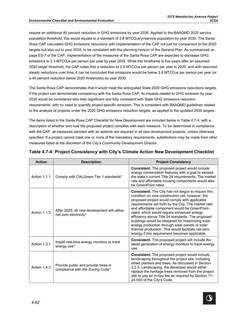
3575 Mendocino Avenue Project Environmental Checklist and Environmental Evaluation SCEA
4-82
require an additional 40 percent reduction in GHG emissions by year 2030. Applied to the BAAQMD 2020 service population threshold, this would equate to a standard of 2.8 MTCO2e/yr/service population by year 2030. The Santa Rosa CAP calculated GHG emissions reductions with implementation of the CAP not just for comparison to the 2020 targets but also out to year 2035, to be consistent with the planning horizon of the General Plan. As summarized on page ES-7 of the CAP, implementation of the measures of the Santa Rosa CAP are expected to decrease GHG emissions to 2.3 MTCO2e per person per year by year 2035. While this timeframe is five years after an assumed 2030 target threshold, the CAP notes that a reduction to 2.9 MTCO2e per person per year in 2020, and with assumed steady reductions over time, it can be concluded that emissions would be below 2.8 MTCO2e per person per year (or a 40 percent reduction below 2020 thresholds) by year 2030.
The Santa Rosa CAP demonstrates that it would meet the anticipated State 2030 GHG emissions reductions targets. If the project can demonstrate consistency with the Santa Rosa CAP, its impacts related to GHG emission by year 2030 would be considered less than significant and fully consistent with State GHG emissions reduction requirements, with no need to quantify project-specific emission. This is consistent with BAAQMD guidelines related to the analysis of projects under the 2020 GHG emissions reduction targets, as applied to the updated 2030 targets.
The items listed in the Santa Rosa CAP Checklist for New Development are included below in Table 4.7-4, with a description of whether and how the proposed project complies with each measure. To be determined in compliance with the CAP, all measures denoted with an asterisk are required in all new development projects, unless otherwise specified. If a project cannot meet one or more of the mandatory requirements, substitutions may be made from other measures listed at the discretion of the City’s Community Development Director.
Table 4.7-4: Project Consistency with City’s Climate Action New Development Checklist
Action Description Project Consistency
Action 1.1.1 Comply with CALGreen Tier 1 standards*
Consistent. The proposed project would include energy conservation features with a goal to exceed the state’s current Title 24 requirements. The market rate and affordable housing components would also be GreenPoint rated.
Action 1.1.3 After 2020, all new development will utilize net zero electricity*
Consistent. The City has not begun to require this condition on new construction yet, however, the proposed project would comply with applicable requirements set forth by the City. The market rate and affordable component would be GreenPoint-rated, which would require enhanced energy efficiency above Title 24 standards. The proposed buildings would be designed for maximizing solar energy production through solar panels or solar thermal production. This would facilitate net-zero energy if this requirement becomes applicable.
Action 1.3.1 Install real-time energy monitors to track energy use*
Consistent. The proposed project will include the latest generation of energy monitors to track energy use.
Action 1.4.3 Provide public and provide trees in compliance with the Zoning Code*
Consistent. The proposed project would include landscaping throughout the project site, including street planters and trees. As discussed in Section 2.2.5, Landscaping, the developer would either replace the heritage trees removed from the project site or pay an in-lieu fee as required by Section 17-24.050 of the City’s Code.

3575 Mendocino Avenue Project SCEA Environmental Checklist and Environmental Evaluation
4-83
Action Description Project Consistency
Action 1.5 Install new sidewalks and paving with high solar reflectivity materials
Consistent. All proposed new sidewalks, driveways and parking areas will be paved with hard materials that contain either color or other enhancements to provide enhanced reflectivity.
Action 2.1.3 Pre-wire and pre-plumb for solar thermal or PV systems
Consistent. The proposed buildings would be designed for maximizing solar energy production through solar panels or solar thermal production, and consistent with applicable building energy efficiency standards.
Action 3.1.2 Support implementation of station plans, specific plans, and corridor plans
Not Applicable. The project site is not located within a station plan, specific plan, or corridor plan. The proposed project is within the Mendocino Avenue/Santa Rosa Avenue Corridor PDA, which is identified as an area for new development with increased densities that will support use of bus transit.
Action 3.2.1
Work with new, major employers to ensure that everyday services like dry cleaning, child care, and ATMs are on-site or near the place of employment.
Not Applicable. The proposed project is a residential transit village and does not involve development of onsite commercial facilities that would house ATMs, dry cleaning services, or similar uses. However, the project site is located in close proximity to services and major employers, including healthcare and medical services, retail, restaurant, and market/grocery.
Action 3.2.2 Improve non-vehicular network to promote walking, biking
Consistent. The project site is approximately 0.2 mile (0.38 mile walking distance) from the Bicentennial Way Transit Facility, which is served by CityBus Routes 1 and Route 10. There are ample pedestrian facilities in the vicinity of the project site including a comprehensive network of continuous sidewalks, crosswalks, pedestrian signals, curb ramps, curb extensions, and various streetscape amenities such as lighting, benches, etc. Sidewalks exist along both the east and west sides of Mendocino Avenue. The four-legged stop-controlled intersection of Mendocino Avenue and Fountaingrove Parkway, north of the project site, has marked crosswalks and curb ramps on two approaches. The four-legged stop-controlled intersection of Bicentennial Way and Mendocino Avenue, south of the project site, has marked crosswalks and curb ramps on four approaches. The proposed project would also include access to Class I and II bicycle lanes that would connect the site to downtown Santa Rosa and greater Sonoma County.

3575 Mendocino Avenue Project Environmental Checklist and Environmental Evaluation SCEA
4-84
Action Description Project Consistency
Action 3.2.3 Support mixed-use, higher-density development near services
Consistent. The proposed project involves the development of a high-density residential transit village, consisting of an affordable housing component and a market rate housing component. The project site is located in close proximity to services and major employers, including healthcare and medical services, retail, restaurant, and market/grocery. The project site is also approximately 0.2 mile (0.38 mile walking distance) from the Bicentennial Way Transit Facility, which is served by CityBus Routes 1 and Route 10. These bus routes provide service to the Santa Rosa Junior College, Kaiser Permanente Santa Rosa Medical Center, Coddingtown Mall Transit Hub, and downtown Santa Rosa.
Action 3.3.1 Provide affordable housing near transit
Consistent. The proposed project includes development of 162 senior affordable housing units. The project site is located along Mendocino Avenue, a high-quality transit corridor in the City. The project site is also approximately 0.2 mile (0.38 mile walking distance) from the Bicentennial Way Transit Facility, which is served by CityBus Routes 1 and Route 10. These bus routes provide service to the Santa Rosa Junior College, Kaiser Permanente Santa Rosa Medical Center, Coddingtown Mall Transit Hub, and downtown Santa Rosa.
Action 3.5.1 Investigate mechanisms to unbundle parking from rent/property costs for new development cost
Not Applicable. The proposed project would adhere to the parking requirements of the City Code. The project site is in close proximity to transit, including CityBus Routes 1 and 10 and Sonoma County Transit Routes 44, 48, 54, 60, and 62. Therefore, the proposed project is seeking a parking reduction pursuant to Section 20-36-050 (C) of the Zoning Code and would provide 114 spaces for the senior affordable component and 605 spaces for the market rate component, totaling 719 parking spaces.
Action 3.6.1
Install calming design features such as bulb-outs, median barriers, and striped crosswalks to improve pedestrian convenience and encourage pedestrian and bicycle travel.
Consistent. The project site has been designed around the approximately 1-acre shared open space. The adjoining residential uses would orient around and connect to the shared open space via public sidewalks and bicycle routes.
Action 4.1.1 Implement the Bicycle and Pedestrian Master Plan
Consistent. The proposed project would include access to Class I and II bicycle lanes that would connect the site to downtown Santa Rosa and greater Sonoma County. Therefore, the proposed project would support the City’s Bicycle and Pedestrian Master Plan.
Action 4.1.2 Install bicycle parking consistent with regulations*
Consistent. The affordable housing component would provide 60 bicycle parking spaces in secure indoor bicycle rooms with additional bicycle parking provided at the entries to the affordable buildings. The market rate housing component would provide 100 bicycle parking spaces in secure indoor bicycle rooms located within the buildings and at the building entries, as required by the City Code.

3575 Mendocino Avenue Project SCEA Environmental Checklist and Environmental Evaluation
4-85
Action Description Project Consistency
Action 4.1.3 Provide bicycle safety training to residents, employees, and motorists
Consistent. The proposed project would include secure indoor bicycle rooms with bicycle parking. The indoor bicycle rooms would include signage with safety tips for bicyclists and motorists, such as, but not limited to those posted on the City’s Transportation and Public Works Department website: https://srcity.org/DocumentCenter/View/7897/Safety-Tips-for-Bicyclists-and-Motorists-PDF
Action 4.2.2 Provide safe spaces to wait for bus arrival
Consistent. The proposed project would relocate one of the existing Route 10 bus stops on Mendocino Avenue, approximately 130 feet south, and provide a new turn-out for buses to onboard or offload riders out of the way of vehicles and bicycles. The relocated bus stop would provide real-time transit arrival and departure monitors for riders.
Action 4.3.2 Work with large employers in Santa Rosa to provide rideshare programs
Not Applicable. The proposed project includes the development of a compact, sustainable, transit-oriented, master planned transit village community. The proposed project would promote the use of bus transit as it is approximately 0.2 mile (0.38 mile walking distance) from the Bicentennial Way Transit Facility, which is served by CityBus Routes 1 and Route 10. These bus routes provide service to the Santa Rosa Junior College, Kaiser Permanente Santa Rosa Medical Center, Coddingtown Mall Transit Hub, and downtown Santa Rosa.
Action 4.3.3
Evaluate the effectiveness and consider expanding existing programs including guaranteed ride home, employee transit pass programs, and cash for parking pass programs.
Not Applicable. The proposed project includes the development of a high-density residential transit village, consisting of an affordable housing component and a market rate housing component. Therefore, this policy does not apply to the proposed project.
Action 4.3.4
Provide recognition, awards, competitions, or other incentives related to employee commutes in regard to walking, biking, carpooling, transit, or other non-single-occupancy vehicle use.
Not Applicable. The proposed project includes the development of a high-density residential transit village, consisting of an affordable housing component and a market rate housing component. Therefore, this policy does not apply to the proposed project.
Action 4.3.5 Encourage new employers with more than 50 onsite employees to provide subsidized or free transit passes to employees*
Not Applicable. It is anticipated that up to 17 staff would work at the project site. Therefore, this policy does not apply to the proposed project.
Action 4.3.7 Identify locations for additional park-and-ride lots
Not Applicable. The project site is not designated in the General Plan as a park-and-ride lot. The proposed project would redevelop the site into a compact, sustainable, transit-oriented, master planned transit village community with up to 532 high-density multi-family housing units consisting of 162 units affordable for low and very low senior households and up to 370 market rate housing units.
Action 4.5.1 Include facilities for employees that promote telecommuting
Consistent. All residential buildings will have internet access available.

3575 Mendocino Avenue Project Environmental Checklist and Environmental Evaluation SCEA
4-86
Action Description Project Consistency
Action 5.1.2 Install electric vehicle charging equipment
Consistent. As required by the City Code, 12 parking spaces located along the southern boundary of the affordable housing site would be wired with EV charging stations. The market rate housing component would be wired to accommodate 53 EV charging stations as required by the City Code.
Action 5.2.1 Provide alternative fuels at new refueling stations*
Not Applicable. The proposed project involves the development of new residential uses and does not include onsite refueling stations.
Action 6.1.3 Increase diversion of construction waste* Consistent. The proposed project would comply with all State and local waste diversion requirements, including Chapter 9‐12 of the City Code, regarding waste collection.
Action 7.1.1 Reduce potable water use for outdoor landscaping*
Consistent. The proposed project would include low water use plantings in accordance with the City’s Water Efficient Landscape Ordinance. Private wells located on the project site may be utilized to provide water to irrigate landscaping. Additionally, water conservation measures would be implemented through planting and irrigation design.
Action 7.1.3 Use water meters which track real-time water use*
Consistent. The proposed project would connect to the City’s potable water system. The City provides the water meters and has data logging equipment that can collect real time data from City-issued water meters.
Action 7.3.2
Require new development in zones anticipated to receive future recycled water to meet on-site meter separation requirements to allow for the use of recycled water.*
Not Applicable. Dual plumbing is not proposed as there is no current plan by the City to extend recycled water to this portion of the City. Compliance with CAP Actions 7.1.1, 7.1.3 and 9.1.3 will substitute for this policy.
Action 8.1.3 Establish community gardens and urban farms throughout the city.
Not Applicable. The proposed project includes the development of affordable and market rate housing. The proposed project would provide onsite shared and private open space areas as required by the City’s Design Guidelines.
Action 9.1.2 Provide outdoor electrical outlets for charging lawn equipment
Consistent. The proposed project will have outdoor outlets where practical.
Action 9.1.3 Install low water use landscapes* Consistent. The proposed project would include low water use plantings in accordance with the City’s Water Efficient Landscape Ordinance.
Action 9.2.1 Minimize construction equipment idling time to 5 minutes or less*
Consistent. The proposed project would implement Mitigation Measure AIR-2 (PBA EIR MM 2.9-1[a]), which includes specific measures to reduce idling during construction activities.
Action 9.2.2 Maintain construction equipment per manufacturer's specs*
Consistent. The proposed project would comply with BAAQMD’s required best management practices, which includes specific measures for maintenance of construction equipment.
Action 9.2.3 Limit GHG construction equipment emissions by using electrified equipment or alternative fuels*
Consistent. The proposed project would comply with BAAQMD’s required best management practices, which would reduce GHG emissions by limiting idling and using appropriately sized equipment where practical.

3575 Mendocino Avenue Project SCEA Environmental Checklist and Environmental Evaluation
4-87
Per the policy consistency analysis above, the proposed project is consistent with all applicable measures listed in the City’s CAP Checklist for New Development. Therefore, the proposed project would not conflict with any applicable plans, policies, or regulations adopted for the purposes of reducing GHG emissions, and impacts would be less than significant.
Level of Significance Before Mitigation Less Than Significant Impact.
Mitigation Measures No mitigation is necessary.
Level of Significance After Mitigation Less Than Significant Impact.

3575 Mendocino Avenue Project Environmental Checklist and Environmental Evaluation SCEA
4-88
This page left intentionally blank.
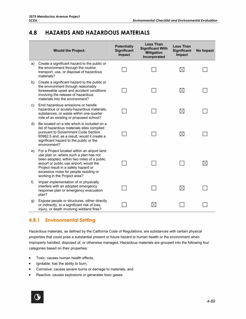
3575 Mendocino Avenue Project SCEA Environmental Checklist and Environmental Evaluation
4-89
4.8 HAZARDS AND HAZARDOUS MATERIALS
Would the Project: Potentially Significant
Impact
Less Than Significant With
Mitigation Incorporated
Less Than Significant
Impact No Impact
a) Create a significant hazard to the public or the environment through the routine transport, use, or disposal of hazardous materials?
b) Create a significant hazard to the public or the environment through reasonably foreseeable upset and accident conditions involving the release of hazardous materials into the environment?
c) Emit hazardous emissions or handle hazardous or acutely-hazardous materials, substances, or waste within one-quarter mile of an existing or proposed school?
d) Be located on a site which is included on a list of hazardous materials sites compiled pursuant to Government Code Section 65962.5 and, as a result, would it create a significant hazard to the public or the environment?
e) For a Project located within an airport land use plan or, where such a plan has not been adopted, within two miles of a public airport or public use airport, would the Project result in a safety hazard or excessive noise for people residing or working in the Project area?
f) Impair implementation of or physically interfere with an adopted emergency response plan or emergency evacuation plan?
g) Expose people or structures, either directly or indirectly, to a significant risk of loss, injury, or death involving wildland fires?
4.8.1 Environmental Setting
Hazardous materials, as defined by the California Code of Regulations, are substances with certain physical properties that could pose a substantial present or future hazard to human health or the environment when improperly handled, disposed of, or otherwise managed. Hazardous materials are grouped into the following four categories based on their properties:
• Toxic: causes human health effects, • Ignitable: has the ability to burn, • Corrosive: causes severe burns or damage to materials, and • Reactive: causes explosions or generates toxic gases.

3575 Mendocino Avenue Project Environmental Checklist and Environmental Evaluation SCEA
4-90
Hazardous waste is any hazardous material that is discarded, abandoned, or slated to be recycled. The criteria that define a material as hazardous also define a waste as hazardous. If improperly handled, hazardous materials and hazardous waste can result in public health hazards if released into the soil or groundwater or through airborne releases in vapors, fumes, or dust. Soil and groundwater having concentrations of hazardous constituents higher than specific regulatory levels must be handled and disposed of as hazardous waste when excavated or pumped from an aquifer. California Government Code, Title 22, Sections 66261.20–24 contains technical descriptions of toxic characteristics that could cause soil or groundwater to be classified as hazardous waste.
California Government Code, Section 65962.5 requires the California Environmental Protection Agency (CalEPA) to compile, maintain, and update specified lists of hazardous material release sites. CEQA (PRC Section 21092.6) requires the lead agency to consult the lists compiled pursuant to California Government Code, Section 65962.5 to determine whether the proposed project and any alternatives are identified on a federal or state listing database. The required lists of hazardous material release sites are commonly referred to as the “Cortese List” after the State Assembly member who sponsored the legislation. Since the statute was enacted more than 20 years ago, some of the provisions refer to agency activities that were conducted many years ago and are no longer being implemented, and in some cases, the information required in the Cortese List does not exist. Those requesting a copy of the Cortese List are now referred directly to the appropriate information resources contained on internet websites hosted by the boards or departments referenced in the statute, including the online EnviroStor database from the California Department of Toxic Substances Control (DTSC) and the online GeoTracker database offered by the SWRCB. These two databases include hazardous material release sites, along with other categories of sites or facilities specific to each agency’s jurisdiction. A search of the online databases in May 2020 revealed that the project site is not located on or directly adjacent to any known hazardous cleanup sites (DTSC 2020; SWRCB 2020). However, following the Tubbs Wildfire in 2017, which destroyed most of the mobile homes on the project site, asbestos containing waste materials and fire-related debris were determined to be present onsite. As a result, on January 29, 2018 the USEPA removed all asbestos containing waste materials from the project site (USEPA 2018). Additionally, the USACE removed all fire-related debris and collected soil samples from the project site on February 28, 2018 and March 27, 2018 to determine the presence of hazardous materials. Based on the lab results of the soil samples tested, the USACE determined that the project site meets the USEPA Regional Screening Levels and the CalEPA Human Health Screening Levels and is suitable for redevelopment with residential uses (USACE 2018). According to the Phase I Environmental Site Assessment completed for the project site on August 6, 2018 (Updated September 1, 2020), there is no evidence of recognized environmental conditions in connection with the project site and no additional hazardous cleanup is required for the project site (Appendix J; Harris and Lee Environmental Sciences, LLC 2018). The former mobile home park has been formally closed, all structures have been removed, and the property is vacant.
The public airport nearest to the project site is the Charles M. Schulz-Sonoma County Airport, located 4.5 miles to the northwest. There are no private airstrips located within 2 miles of the project site, and the project site is not located within any airport influence areas or airport safety zones. Additionally, there are no schools located within 0.25 mile of the project site.
Many buildings and structures within Santa Rosa are of an age where the potential exists for the presence of hazardous building materials. Older buildings can contain building materials that consist of hazardous components such as lead-based paint, asbestos, mercury, and polychlorinated biphenyls (PCB). When these buildings or structures are demolished for the purpose of renovation or new development, these hazardous building materials can become exposed. Implementation of the proposed project would include management and disposal of wastes from removal of existing infrastructure onsite which, due to their age, may contain asbestos, PCBs, or lead and lead-based paint.

3575 Mendocino Avenue Project SCEA Environmental Checklist and Environmental Evaluation
4-91
Federal and State regulations and regulations adopted by BAAQMD, DTSC, and the SWQCB, apply to the identification, management, disposal, and treatment of hazardous materials during construction activities. Federal and State regulations apply to the management, treatment and disposal of PCBs and waste soil with threshold concentrations of lead, and exposure during construction activities that may expose workers to lead (e.g., removal, surface preparation, and maintenance). Federal regulations and regulations adopted by BAAQMD apply to the management and disposal of asbestos during construction activities. Failure to comply with the regulations respecting asbestos and dust control may result in a Notice of Violation being issued by BAAQMD, civil penalties under state or federal law, and possible action by the USEPA under federal law. Federal law covers a number of different activities involving asbestos, including demolition and renovation of structures (40 Code of Federal Regulations Section 61.145). Failure to comply with Federal and State regulations may result in enforcement and civil penalties under state or federal law.
The California Department of Forestry and Fire Protection (CAL FIRE) evaluates fire hazard severity risks in the state according to areas of responsibility (i.e., federal, state, and local). According to the fire hazard severity zone map developed by CAL FIRE, the project site is within a local responsibility area (LRA) and is not located within a very high fire hazard severity zone (VHFHSZ) (CAL FIRE 2008).
The General Plan also identifies Wildland Urban Interface (WUI) zones for the City. The General Plan classifies the WUI zones as: moderate fire hazard severity zones (MFHSZ), high fire hazard severity zones (HFHSZ), VHFHSZ, and mutual threat. According to the General Plan, the project site is not located within a WUI zone (City of Santa Rosa 2009b). However, Santa Rosa has an active wildfire history and in 2017 was substantially affected by the Tubbs Wildfire. The Tubbs Wildfire consumed 36,897 acres and destroyed 6,957 structures, including the majority of the mobile homes that were previously located on the project site (City of Santa Rosa 2020a). As such, even though the project site is not located within a designated VHFHSZ or WUI zone, the area has been subject to wildfire and therefore could be subject to wildfire in the future.
In response to the 2017 Tubbs Wildfire, the City is currently in the process of developing a Community Wildfire Protection Plan (CWPP) for the City’s WUIs. This CWPP will focus on identifying and addressing local hazards and risks from wildfire and will provide a “road-map” of actions for the community to address the wildfire threat in the City.
4.8.2 Previous Environmental Analysis
City of Santa Rosa General Plan EIR Summary
Chapter N of the General Plan EIR discusses impacts related to hazardous materials, emergency response, wildfire, and aircraft hazards. The General Plan EIR identified potentially significant impacts related to hazards and hazardous materials. However, compliance with existing federal, state, and local laws and policies contained in the General Plan would reduce potential impacts to less than significant levels.
The following General Plan goals and policies are applicable to the proposed project:
Goal NS-F: Minimize dangers from hazardous materials.
Policy NS-F-1: Require remediation and cleanup, and evaluate risk prior to reuse, in identified areas where hazardous materials and petroleum products have impacted soil or groundwater.
Policy NS-F-2: Require that hazardous materials used in business and industry are transported, handled, and stored in accordance with applicable local regulations.

3575 Mendocino Avenue Project Environmental Checklist and Environmental Evaluation SCEA
4-92
Policy NS-G-1: Require proposed developments in high or medium fire hazard areas to investigate a site’s vulnerability to fire and to minimize risk accordingly.
Policy NS-G-2: Require new development in areas of high wildfire hazard to utilize fire-resistant building materials. Require the use of onsite fire suppression systems, including automatic sprinklers, smoke and/or detection systems, buffers and fuel breaks, and fire-retardant landscaping.
Policy NS-G-3: Prohibit untreated wood shake roofs in areas of high fire hazard.
Policy NS-G-4: Continue monitoring water fire-flow capabilities throughout the city and improving water availability at any locations having flows considered inadequate for fire protection.
Policy NS-G-5: Require detailed fire prevention and control measures, including community firebreaks, for development projects in high fire hazard zones.
Policy NS-G-6: Minimize single-access residential neighborhoods in development areas near open space and provide adequate access for fire and other emergency response personnel.
Plan Bay Area EIR Summary
The following section summarizes the potential impacts related to hazards and hazardous materials discussed in Chapter 2.13 of the Plan Bay Area EIR.
Impact 2.13-1: Routine Transport or Disposal of Hazardous Materials. The Plan Bay Area EIR determined that future land use and transportation projects could increase the routine transport, use, storage, and disposal of hazardous wastes in the region. However, compliance with existing federal, state, and local regulations and oversight would effectively reduce potential impacts to a less than significant level. No mitigation measures were identified.
Impact 2.13-2: Accidental Release of Hazardous Materials into the Environment. The Plan Bay Area EIR determined that future land use and transportation projects could increase the potential for unintentional upset and accident conditions. However, compliance with existing federal, state, and local regulations and oversight would effectively reduce potential impacts to a less than significant level. No mitigation measures were identified.
Impact 2.13-3: Emit or Handle Hazardous Materials Near Schools. The Plan Bay Area EIR determined that all projects shall comply with federal and state regulations that are designed to reduce the potential for the release of large quantities of hazardous materials and wastes into the environment to an acceptable level, and in particular to protect schools. As a result, impacts would be less than significant. No mitigation measures were identified.
Impact 2.13-4: Hazardous Materials List Pursuant to California Government Code, Section 65962.5. The Plan Bay Area EIR determined that the potential for encountering hazardous materials or wastes would be dependent on site-specific conditions and with implementation of Plan Bay Area Mitigation Measure 2.3-4, potential impacts could be reduced to a less than significant level. This Plan Bay Area Mitigation Measure does not apply to the proposed project because the project is not located on or directly adjacent to any hazardous material cleanup sites, pursuant to California Government Code Section 65962.5 (Refer to Impact HAZ-4 in Section 4.8.3, Project-Specific Analysis).
Impact 2.13-5 and 2.13-6: Airport Land Use Plan or Vicinity of a Private Airstrip. The Plan Bay Area EIR analyzed the potential impacts related to the safety hazards for people residing or working within 2 miles of a public airport or in the vicinity of a private airstrip. The Plan Bay Area EIR determined that compliance with existing federal,

3575 Mendocino Avenue Project SCEA Environmental Checklist and Environmental Evaluation
4-93
state, and local regulations would reduce potential impacts to a less than significant level, and no mitigation measures were identified.
Impact 2.13-7: Emergency Response or Evacuation Plan. The Plan Bay Area EIR analyzed the potential impacts related to interference with emergency response and evacuation plans and determined that the impact would be less than significant. No mitigation measures were identified.
Impact 2.13-8: Wildland Fires. The Pan Bay Area EIR analyzed the potential impacts related to wildland fires and determined that the impact would be less than significant. No mitigation measures were identified.
4.8.3 Project-Specific Analysis
Impact HAZ-1 Create a significant hazard to the public or the environment through the routine transport, use, or disposal of hazardous materials?
AND
Impact HAZ-2 Create a significant hazard to the public or the environment through reasonably foreseeable upset and accident conditions involving the release of hazardous materials into the environment?
Impact Analysis The proposed project would involve removal of existing infrastructure onsite and the construction of a transit village that would include residential units, open space, and a public street. Residential uses are not typically associated with the routine transport, use, or disposal of hazardous materials and do not present a reasonably foreseeable release of hazardous materials. Any hazardous materials associated with residential uses would primarily consist of typical household cleaning products and fertilizers. These items would be used in small quantities and in accordance with label instructions, which are based on federal and state health and safety regulations. Therefore, operation of the proposed project would not create a significant hazard to the public or the environment through the routine transport, use, or disposal of hazardous materials or through the release of hazardous materials through reasonably foreseeable upset and accident conditions.
The removal of existing infrastructure from the project site may expose hazardous building materials (e.g., asbestos, lead, or PCBs). During construction, small quantities of potentially toxic substances (e.g., petroleum and other chemicals used to operate and maintain construction equipment) would be used and transported to and from the project site as needed. Accidental releases of small quantities of hazardous materials or toxic substances could contaminate soils and degrade the quality of surface water and groundwater, resulting in a public safety hazard; however, contractors would be required to transport, store, and handle hazardous materials and toxic substances related to construction activities in a manner consistent with relevant regulations and guidelines, including California Health and Safety Codes and City ordinances. Regulatory requirements for the transport of hazardous wastes in California are specified in Title 22 of the California Code of Regulations, Division 4.5, Chapters 13 and 29. In accordance with these regulations, transport of hazardous materials must comply with the California Vehicle Code, California Highway Patrol regulations (contained in Title 13 of the California Code of Regulations); the California State Fire Marshal regulations (contained in Title 19 of the California Code of Regulations); United States Department of Transportation regulations (Title 49 of the Code of Federal Regulations); and USEPA regulations (contained in Title 40 of the Code of Federal Regulations). The use of hazardous materials is regulated by DTSC (Title 22, Division 4.5 of the California Code of Regulations). Therefore, construction of the proposed project would result in a less than

3575 Mendocino Avenue Project Environmental Checklist and Environmental Evaluation SCEA
4-94
significant impact related to the routine transport, use, disposal of, or accidental release of hazardous materials or toxic substances.
Additionally, although dewatering may be required for the proposed project (see Section 2.0, Project Description, and Section 4.6, Geology and Soils), no contaminated groundwater is expected to occur onsite. All groundwater encountered onsite during construction activities would be collected, treated, and either discharged or disposed of properly, in compliance with the North Coast RWQCB Waste Discharge Requirements permits. Therefore, there would be a less than significant impact related to contamination from dewatering activities during construction.
Level of Significance Before Mitigation Less Than Significant Impact.
Mitigation Measures No mitigation is necessary.
Level of Significance After Mitigation Less Than Significant Impact.
Impact HAZ-3 Emit hazardous emissions or handle hazardous or acutely hazardous materials, substances, or waste within one-quarter mile of an existing or proposed school?
Impact Analysis As stated in Section 4.8.1, Environmental Setting, the project site is not located within 0.25 mile of any existing or proposed schools. As a result of the Tubbs Wildfire in 2017, asbestos containing waste materials and fire-related debris were determined to be present on the project site. On January 29, 2018, the USEPA removed all asbestos containing waste materials from the project site (USEPA 2018). Additionally, the USACE removed all fire-related debris and collected soil samples from the project site on February 28, 2018 and March 27, 2018 to determine the presence of hazardous materials. Based on the lab results of the soil samples tested, the USACE determined that the project site meets the USEPA Regional Screening Levels and the CalEPA Human Health Screening Levels and is suitable for redevelopment with residential uses (USACE 2018).
The proposed project does not involve the development of a use that would emit hazardous materials, substances, or waste during operation. The use of heavy equipment and activities involving hazardous materials would be limited to the construction phase of the proposed project and confined to construction areas and within existing roadways. The use, management, and disposal of hazardous materials during construction of the proposed project would be regulated by health and safety requirements under federal, state, and local laws, including handling, storage, and disposal of the materials, as well as emergency spill response. Therefore, the proposed project would have a less than significant impact related to the emission or handling of hazardous materials within 0.25-mile of an existing or proposed school.
Level of Significance Before Mitigation Less Than Significant Impact.
Mitigation Measures No mitigation is necessary.
Level of Significance After Mitigation Less Than Significant Impact.

3575 Mendocino Avenue Project SCEA Environmental Checklist and Environmental Evaluation
4-95
Impact HAZ-4 Be located on a site which is included on a list of hazardous materials sites compiled pursuant to Government Code Section 65962.5 and, as a result, would it create a significant hazard to the public or the environment?
Impact Analysis As stated in Section 4.8.1, Environmental Setting, the project site is not located on or adjacent to any identified hazardous cleanup sites, pursuant to California Government Code, Section 65962.5 (DTSC 2020; SWRCB 2020). However, following the Tubbs Wildfire in 2017, which destroyed most of the mobile homes on the project site, asbestos containing waste materials and fire-related debris were determined to be present onsite. On January 29, 2018, the USEPA removed all asbestos containing waste materials from the project site (USEPA 2018). Additionally, the USACE removed all fire-related debris and collected soil samples from the project site on February 28, 2018 and March 27, 2018 to determine the presence of hazardous materials. Based on the lab results of the soil samples tested, the USACE determined that the project site meets the USEPA Regional Screening Levels and the CalEPA Human Health Screening Levels and is suitable for redevelopment with residential uses (USACE 2018). The former mobile home park has been formally closed, all structures have been removed, and the property is vacant. As such, the proposed project would not be located on a hazardous materials site that would create a significant hazard to the public and the environment, and impacts would be less than significant.
Level of Significance Before Mitigation Less Than Significant Impact.
Mitigation Measures No mitigation is necessary.
Level of Significance After Mitigation Less Than Significant Impact.
Impact HAZ-5 For a project located within an airport land use plan or, where such a plan has not been adopted, within two miles of a public airport or public use airport, would the project result in a safety hazard or excessive noise for people residing or working in the project area?
Impact Analysis As stated in Section 4.8.1, Environmental Setting, the project site is not located within 2 miles of a public or private airport, or with any airport influence area of an airport safety zone. The nearest public airport is the Charles M. Schulz-Sonoma County Airport, located 4.5 miles to the northwest. Therefore, the proposed project would result in no impact related to safety hazards or excessive noise for people residing or working in the project area.
Level of Significance Before Mitigation No Impact.
Mitigation Measures No mitigation is necessary.
Level of Significance After Mitigation No Impact.

3575 Mendocino Avenue Project Environmental Checklist and Environmental Evaluation SCEA
4-96
Impact HAZ-6 Impair implementation of or physically interfere with an adopted emergency response plan or emergency evacuation plan?
Impact Analysis According to the City’s Evacuation Planning Area Map for North Santa Rosa, Mendocino Avenue, Fountaingrove Parkway, Piner Road, and Highway 101 are identified as evacuation travel routes (City of Santa Rosa 2020b). The project site is located immediately adjacent to three of the evacuation travel routes identified, including Mendocino Avenue, Fountaingrove Parkway, and Highway 101. Construction activities associated with the proposed project would not result in temporary closure of any of these roadways. In accordance with City requirements, the proposed project would construct three access points on Mendocino Avenue to provide additional access for fire apparatus and to allow emergency ingress and egress to the project site. As such, the proposed project would not substantially impair an adopted emergency response plan or emergency evacuation plan, and the impact would be less than significant.
Level of Significance Before Mitigation Less Than Significant Impact.
Mitigation Measures No mitigation is necessary.
Level of Significance After Mitigation Less Than Significant Impact.
Impact HAZ-7 Expose people or structures, either directly or indirectly, to a significant risk of loss, injury, or death involving wildland fires?
Impact Analysis
The primary threat related to wildland fire is due to open grasslands abutting residential developments, the project site, however, is located in an urban area that is surrounded by existing development including buildings, roadways, and associated infrastructure. As discussed in Section 4.8.1, Environmental Setting, the project site is not located within a CAL FIRE VHFHSZ or a General Plan-designated WUI zone. However, the project site was subject to the October 2017 Tubbs Wildfire, which destroyed most of the mobile homes that previously occupied the project site. As such, even though the project site is not located within a currently designated VHFHSZ, the area has been subject to wildfire and therefore could be subject to wildfire in the future. The project site may indirectly expose people or structures to potential wildfire risk.
The proposed project involves the development of up to 532 multi-family residential units on an infill site. The proposed project would be required to comply with the California Fire Code and all applicable fire safety standards set forth by the City regarding fire protection to protect the proposed structures and future occupants from possible wildfires. The proposed project includes the placement of new fire hydrants within the project site and the construction of fire mains within the private driveways to serve individual buildings. The proposed buildings would be constructed with fire-resistant materials and exterior exposed wood would be fire treated. The new buildings would also be equipped with standard safety features such as certified alarm systems, fire extinguishers, and fire sprinklers (as required by General Plan policy NS-G-2) to alert occupants of potential wildfires. The fire sprinklers installed for the proposed project would comply with the California Building Code and the National Fire Protection Association, and the Santa Rosa Fire Department (SRFD) would review the fire sprinkler system prior to installation.

3575 Mendocino Avenue Project SCEA Environmental Checklist and Environmental Evaluation
4-97
In accordance with City requirements, the proposed project would construct three access points on Mendocino Avenue to provide additional access for fire apparatus and to allow emergency ingress and egress to the project site. The addition of such infrastructure would support the proposed project and would help reduce fire risk by providing greater access to and from the project site. All utilities would be located underground, and the proposed project would connect to the City’s water system providing an adequate and reliable water supply and water pressure to aid in suppressing potential wildfires. As discussed in Section 2.0, Project Description, the proposed project would also install up to seven backup generators. The backup generators would be used during an emergency to provide power and cooling for residents, if necessary. All of the safety features incorporated into the proposed project would comply with the California Building Code, California Fire Code, National Fire Protection Association, and the City’s General Plan policies to reduce potential risk from wildfires.
The Applicant has prepared a draft Emergency Response and Preparedness Plan (ERPP) for the proposed project to ensure that future residents are adequately prepared to evacuate and have adequate ingress and egress from the project site in the event of a future wildfire. The draft ERPP includes detailed guidelines for reasonably foreseeable emergencies and disasters that might occur in the project area, including a potential wildfire. The draft ERPP guidelines include compliance with all fire building codes and regulatory requirements of the City. The draft ERPP includes emergency contact information, responsibility for coordinating response in the event of an emergency, requirements for residents’ emergency preparedness, evacuation routes for residents, and detailed emergency and disaster procedures that would be followed in the event of an emergency. The ERPP focuses on actions that can be taken before, during, and after an emergency such that residents may be better prepared at any point during an emergency. The ERPP would be provided to all residents upon move-in, to the City including SRFD and SRPD for informational purposes, and to management staff. Implementation of the ERPP would ensure that potential damages resulting from an emergency would be prevented or minimized, where possible, and compliance with the California Fire Code building requirements and local building standards would ensure that the proposed structures on the project site would be able to resist the possibility of destruction from wildfires to the maximum extent feasible.
As discussed above, the proposed buildings would be constructed with fire-resistant materials and exterior exposed wood would be fire treated. The proposed project includes roadway frontage improvements, as well as landscaping throughout the project site. To further minimize potential impacts, the landscaping plans have been designed to include fire-resistant landscaping and landscape design (consistent with the 2018 East Bay Municipal Utility District Firescape guidelines), as required by Mitigation Measure WF-2. Such landscaping and design would widen the roadway fire breaks along the project frontage and throughout the project site to reduce wildfire risk to the project site. As such, impacts related to exposing people or structures to the risk of loss, injury, or death involving wildland fires would be less than significant with adherence to current California Fire Code building requirements and implementation of Mitigation Measure WF-1 and Mitigation Measure WF-2.
Level of Significance Before Mitigation Potentially Significant Impact.
Mitigation Measures Mitigation Measure WF-1 (Project Emergency Response and Preparedness Plan) and Mitigation Measure WF-2 (Fire Resistant Landscaping Plans) are required.
Level of Significance After Mitigation Less Than Significant Impact With Mitigation.

3575 Mendocino Avenue Project Environmental Checklist and Environmental Evaluation SCEA
4-98
This page left intentionally blank.
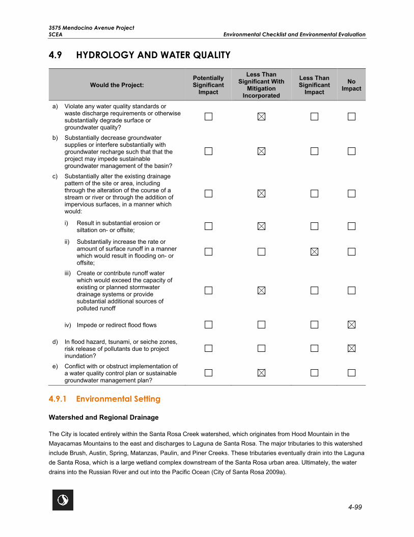
3575 Mendocino Avenue Project SCEA Environmental Checklist and Environmental Evaluation
4-99
4.9 HYDROLOGY AND WATER QUALITY
Would the Project: Potentially Significant
Impact
Less Than Significant With
Mitigation Incorporated
Less Than Significant
Impact No
Impact
a) Violate any water quality standards or waste discharge requirements or otherwise substantially degrade surface or groundwater quality?
b) Substantially decrease groundwater supplies or interfere substantially with groundwater recharge such that that the project may impede sustainable groundwater management of the basin?
c) Substantially alter the existing drainage pattern of the site or area, including through the alteration of the course of a stream or river or through the addition of impervious surfaces, in a manner which would:
i) Result in substantial erosion or siltation on- or offsite;
ii) Substantially increase the rate or amount of surface runoff in a manner which would result in flooding on- or offsite;
iii) Create or contribute runoff water which would exceed the capacity of existing or planned stormwater drainage systems or provide substantial additional sources of polluted runoff
iv) Impede or redirect flood flows
d) In flood hazard, tsunami, or seiche zones, risk release of pollutants due to project inundation?
e) Conflict with or obstruct implementation of a water quality control plan or sustainable groundwater management plan?
4.9.1 Environmental Setting
Watershed and Regional Drainage
The City is located entirely within the Santa Rosa Creek watershed, which originates from Hood Mountain in the Mayacamas Mountains to the east and discharges to Laguna de Santa Rosa. The major tributaries to this watershed include Brush, Austin, Spring, Matanzas, Paulin, and Piner Creeks. These tributaries eventually drain into the Laguna de Santa Rosa, which is a large wetland complex downstream of the Santa Rosa urban area. Ultimately, the water drains into the Russian River and out into the Pacific Ocean (City of Santa Rosa 2009a).

3575 Mendocino Avenue Project Environmental Checklist and Environmental Evaluation SCEA
4-100
Groundwater Supply
The project site and the City are underlain by alluvial deposits known as the Glen Ellen Formation and includes gravels, sands, and silts that are the principal water-bearing units in the area. The permeability of these deposits allows for adequate recharge of the aquifer from both stormwater and infiltration. The City has three sources of water supply that affect the local groundwater supply in the area: entitlements from Sonoma Water, six groundwater supply wells, and recycled water. Sonoma Water receives water from the Russian River, while the six groundwater supply wells come from the Santa Rosa Plain Subbasin. The Santa Rosa Plain Subbasin is not adjudicated nor has it been identified by the California Department of Water Resource (DWR) as overdrafted (DWR 1982). According to the City‘s 2015 Urban Water Management Plan (UWMP), the total groundwater supply in the City is 2,300 acre-feet, with no expected increases through 2040 (City of Santa Rosa 2016).
Stormwater
Municipalities are required to proactively control and regulate pollution from their municipal storm sewer systems to mitigate the potential detrimental impacts of urban runoff. Stormwater generated in Santa Rosa drains through six drainage basins to the Laguna de Santa Rosa. The largest drainage basin includes Santa Rosa Creek, which drains the northern Santa Rosa area by six major creeks and various tributaries. Four creeks (Brush, Austin, Spring, and Matanzas Creeks) primarily drain the east portion, while Paulin and Piner Creeks drain the west portion. Santa Rosa Creek also drains stormwater runoff generated downtown and in surrounding neighborhoods. The number and location of creeks in northern Santa Rosa result in adequate stormwater drainage capacity for this part of the City (City of Santa Rosa 2009b).
Stormwater is regulated by the City’s current NPDES stormwater permit (Order No. R1-2009-0050). The City’s NPDES permit regulates both stormwater and non-stormwater discharges from public and private projects into the Santa Rosa municipal stormwater system. Additionally, the General Plan outlines strategies to reduce and manage stormwater runoff within the City. The SWPPP includes a description of BMPs and low-impact development requirements to prevent the discharge of silt and sediment from point and non-point sources into receiving waters. The SWPPP aims to minimize the discharge of pollutants during construction activities within the City. The City’s SUSMP requires projects to design and implement post-development measures to reduce the potential for stormwater impacts into local drainages (City of Santa Rosa 2016).
Flooding
Flood hazard zones are identified on an official Flood Insurance Rate Map issued by the Federal Emergency Management Agency (FEMA). Flooding can be earthquake-induced or the result of intense rainfall. Areas within a 100-year floodplain have a 1 percent probability of flooding in a given year. FEMA has designated the City as an area of minimal flood hazard or “Zone X,” which means that the City has a very low potential for flooding and is not located in a 100-year of 500-year flood zone (FEMA 2008).
4.9.2 Previous Environmental Analysis
City of Santa Rosa General Plan EIR Summary
Chapter H of the General Plan EIR discusses potential impacts related to hydrology and water quality. Future development projects would conform to all regulatory requirements, and therefore would not violate any water quality standard or waste discharge requirement. Future development projects would also be required to comply with the NPDES General Permit to reduce impacts from stormwater runoff and non-point pollutants. As such, adherence to

3575 Mendocino Avenue Project SCEA Environmental Checklist and Environmental Evaluation
4-101
existing regulations and General Plan policies would ensure that impacts related to hydrology and water quality are less than significant.
The following General Plan goals and policies are applicable to the proposed project:
Goal PSF-I: Manage, maintain, and improve stormwater drainage and capacity.
Policy PSF-I-1: Require dedication, improvement, and maintenance of stormwater flow and retention areas as a condition of approval.
Policy PSF-I-2: Require developers to cover the costs of drainage facilities needed for surface runoff generated as a result of new development.
Policy PSF-I-3: Require erosion and sedimentation control measures to maintain an operational drainage system, preserve drainage capacity, and protect water quality.
Policy PSF-I-4: Require measures to maintain and improve the storm drainage system, consistent with goals of the Santa Rosa Waterways Citywide Creek Master Plan, to preserve natural conditions of waterways and minimize paving of creek channels.
Policy PSF-I-6: Require implementation of Best Management Practices to reduce drainage system discharge of non-point source pollutants originating from streets, parking lots, residential areas, businesses, industrial operations, and those open space areas involved with pesticide application.
Policy PSF-I-8: Develop and implement the SUSMP in order to reduce pollutants and runoffs flows from new development and significant redevelopment projects.
Policy OSC-B-3: Require that new subdivisions, multifamily, and non-residential development abutting creek corridors are appropriately designed with respect to the creek. Development may orient toward the creek as an amenity, but adequate setbacks shall be used to ensure riparian habitat is protected.
Policy OSC-D-6: Preserve waterways by informing residents of the environmental effects of dumping yard waste into creeks, or other wastes, such as motor oil, into storm drains that empty into creeks.
Goal ND-D: Minimize hazards associated with storm flooding.
Policy NS-D-1: Ensure flood plain protection by retaining existing open areas and creating new open areas needed to retain stormwater, recharge aquifers, and prevent flooding. Creek beds that are dry most of the year provide flood retention needed for public safety.
Policy NS-D-3: Require that new development incorporate features that are consistent with the SUSMP into site drainage plans that would reduce impermeable surface area, increase surface water infiltration, and minimize surface water runoff during storm events. Such features may include:
• Additional landscape areas; • Parking lots with bio-infiltration systems; • Permeable paving designs; and • Stormwater detention basins.

3575 Mendocino Avenue Project Environmental Checklist and Environmental Evaluation SCEA
4-102
Policy NS-D-4: Incorporate features and appropriate standards that reduce flooding hazards, as described in Policy NS-D-3 into the City’s design standards.
Policy NS-D-5: Apply design standards to new development that help reduce project runoff into local creeks, tributaries, and drainage ways.
Plan Bay Area EIR Summary
Chapter 2.8 of the Plan Bay Area EIR discusses potential impacts on water resources. The Plan Bay Area EIR determined that future land use and development projects could adversely affect water quality, groundwater recharge, and drainage patterns and expose people to a significant risk of loss, injury, or death from flooding, seiche, tsunami, or mudflows. However, compliance with existing federal, state, and local regulations would ensure impacts are less than significant. No mitigation measures were identified.
4.9.3 Project-Specific Analysis
Impact HYD-1 Violate any water quality standards or waste discharge requirements or otherwise substantially degrade surface or groundwater quality?
Impact Analysis Construction
Construction activities associated with the proposed project would require demolition of the existing infrastructure, building construction, construction of the new public street and frontage improvements (e.g., new curb, gutter, sidewalk, and driveway construction), and landscaping on the project site. Construction activities would involve grading and the permanent disturbance of approximately 13.3 acres. Construction activities have the potential to generate stormwater runoff and to discharge pollutants, such as fuel, solvents, oil, paints, and trash, into Russell Creek and the City’s stormwater system. The proposed project would comply with the NPDES General Construction Permit. The NPDES General Construction Permit includes the preparation of a SWPPP and incorporation of BMPs to control sedimentation, erosion, and hazardous materials from contacting stormwater, with the intent of keeping all products of erosion from moving offsite into receiving waters. The SWPPP and applicable BMPs have been incorporated into Mitigation Measure HYD-1 to reduce potential water quality impacts to a less than significant level. In addition, the proposed project must comply with the provisions of the City’s Grading and Erosion Control Ordinance (Section 19-64.010 of the City Code), which contains rules and regulations that control site clearing, vegetation disturbances, excavations, soil storage, and other activities that can cause sediments and other pollutants to enter the stormwater system. As such, with implementation of Mitigation Measure HYD-1 and compliance with City stormwater regulations, construction impacts to water quality would be less than significant.
Operation
The proposed project would create approximately 420,000 square feet of impervious surface. Under the City’s SUSMP, residential redevelopment projects that create 10,000 square feet or more of impervious surface are required to implement post-construction stormwater control BMPs and low-impact development measures to minimize stormwater runoff. As required by the City’s SUSMP, the proposed project would implement post-construction BMPs and low-impact development measures consisting of vegetated swales, bioretention areas, and permeable pavement. These areas would provide approximately 158,000 square feet of pervious surface on the project site and would retain and treat stormwater prior to entering the stormwater system. Treated runoff would be directly discharged from these features to the private onsite stormwater lines, which would connect to a new 24-inch

3575 Mendocino Avenue Project SCEA Environmental Checklist and Environmental Evaluation
4-103
public stormwater line located on the southwest corner of the project site. The new 24-inch public stormwater line would be constructed with an outfall into Russell Creek. The new outfall and stormwater drainage facilities would be designed in accordance with the requirements of Sonoma Water’s Flood Management Design Manual. Therefore, with compliance to applicable City regulations and implementation of the post-construction BMPs and low-impact development measures operational impacts would be less than significant.
Level of Significance Before Mitigation Potentially Significant Impact.
Mitigation Measures Mitigation Measure HYD-1 (Prepare and Implement a SWPPP) is required.
MM HYD-1 Prepare and Implement a SWPPP. Coverage shall be obtained for the project under the City of Santa Rosa’s Construction General Permit (Order No. 2009-009-DWQ, as amended by 2010-0014-DWQ and 20152-006-DWQ). Per the requirements of the California State Water Resources Control Board, a Stormwater Pollution Prevention Plan (SWPPP) shall be prepared for the project to reduce the potential for water pollution and sedimentation from proposed project activities. The SWPPP shall address site runoff, assuring that project runoff shall not affect or alter the drainage patterns on the project site. The SWPPP shall comply with the City’s Grading and Erosion Control Ordinance, as specified in Chapter 19-64.010 in the City Code, as well as the Waste Discharge Requirements of the North Coast RWQCB Permit.
Level of Significance After Mitigation Less Than Significant With Mitigation.
Impact HYD-2 Substantially decrease groundwater supplies or interfere substantially with groundwater recharge such that the project may impede sustainable groundwater management of the basin?
Impact Analysis The project site is located within the Santa Rosa Valley Groundwater Basin. The City obtains approximately 90 to 95 percent of its water supply from Sonoma Water, which in turn takes water from the Russian River. Six municipal groundwater supply wells and recycled water provides the remaining 5 to 10 percent of the City water supply when peak demand occurs (City of Santa Rosa 2020). The City does not plan to increase its long-term groundwater pumping above existing levels, and the Santa Rosa Valley Groundwater Basin is not in critical condition from overdraft (City of Santa Rosa 2016). Water was provided to the prior mobile home park by two private onsite wells and an above-ground water distribution system, which was severely damaged by the Tubbs Wildfire in October 2017. The proposed project would be served by the City’s municipal water supply system and the two private onsite wells may be used to irrigate landscaping. As the proposed project would rely on the City’s municipal water supply system, the Santa Rosa Water Department reviewed the proposed project, 2008 WSA, and the 2015 UWMP to determine if adequate water supplies could be provided to the proposed project. In a letter dated June 4, 2020, the Santa Rosa Water Department determined that the proposed project would not substantially increase water demand or affect the ability of the City’s water system to provide sufficient water supplies to the project site, and that no significant new information has become available that was not known and could not have been known at the time when the 2008 WSA and the 2015 UWMP were prepared that would impact the City’s ability to meet the water demand for the proposed project. Therefore, the proposed project would not substantially decrease groundwater supplies that may impede sustainable groundwater management of the Santa Rosa Valley Groundwater Basin.

3575 Mendocino Avenue Project Environmental Checklist and Environmental Evaluation SCEA
4-104
According to the Geotechnical Study Report, groundwater depths vary from 8 to 17.5 feet bgs at the project site; however, for preliminary design purposes the Geotechnical Study Report recommends assuming that groundwater may be encountered at depths as shallow as 4.4 bgs (RGH Consultants 2019). Project construction activities would excavate the project site up to 4 feet; therefore, groundwater may be encountered during excavation activities and temporary construction dewatering may be necessary. In the event that groundwater is encountered during construction, common practices employed to facilitate construction include either dewatering the excavation or shoring the sides of the excavation to reduce groundwater inflow.
If dewatering is used, the developer would be required to comply with the North Coast RWQCB construction dewatering permit requirements. Discharge of non-stormwater from an excavation that contains sediments or other pollutants to sanitary sewer, stormwater systems, creek beds (even if dry), or receiving waters without treatment is prohibited. Discharge of uncontaminated groundwater from dewatering is a conditionally exempted discharge by the North Coast RWQCB. Discharge of water resulting from dewatering operations would require an NPDES Permit, or a waiver (exemption) from the North Coast RWQCB, which would establish discharge limitations for specific chemicals (if they occur in the dewatering flows). The proposed project would also implement Mitigation Measure GEO-2 which would require preparation of a dewatering plan in accordance with the requirements of the RWQCB. The dewatering plan would detail the location of dewatering activities, equipment, and discharge point in accordance with the requirements of the RWQCB. The dewatering plan would be submitted to the City for review and approval prior to the start of construction. Therefore, construction of the proposed project would result in a less than significant impact to groundwater recharge with implementation of Mitigation Measure GEO-2.
The proposed project would result in approximately 420,000 square feet of new impervious surface on the project site. In addition, the proposed project would provide approximately 158,000 square feet of pervious surface consisting of vegetated swales, bioretention areas, and permeable pavement. These Low Impact Design features would reduce the amount of runoff from leaving the project site and allow for local infiltration of stormwater into the groundwater. Additionally, the proposed project would incorporate low water use plantings in accordance with the City’s Water Efficient Landscape Ordinance. Because the proposed project would incorporate these design features to direct stormwater flows and the groundwater basin is not designated in critical condition from overdraft, operation of the proposed project would not substantially impede groundwater recharge, therefore, impacts would be less than significant with mitigation.
Level of Significance Before Mitigation Potentially Significant Impact.
Mitigation Measures Mitigation Measure GEO-2 (Prepare and Implement Dewatering and Shoring Plans) is required.
Level of Significance After Mitigation Less Than Significant Impact With Mitigation.

3575 Mendocino Avenue Project SCEA Environmental Checklist and Environmental Evaluation
4-105
Impact HYD-3 Substantially alter the existing drainage pattern of the site or area, including through the alteration of the course of a stream or river through the addition of impervious surfaces, in a manner which would:
i) Result in substantial erosion or siltation on- or offsite;
ii) Substantially increase the rate or amount of surface runoff in a manner which would result in flooding on-or offsite;
iii) Create or contribute runoff water which would exceed the capacity of existing or planned stormwater drainage systems or provide substantial additional sources of polluted runoff; or
iv) Impede or redirect flood flows?
Impact Analysis i) Result in substantial erosion or siltation on- or offsite;
The project site was previously developed as a mobile home park and has therefore experienced substantial soil compaction. During project construction, ground-disturbing and earth movement activities could result in erosion-related impacts. The proposed project would implement Mitigation Measure HYD-1 and prepare a SWPPP in accordance with the NPDES General Construction Permit. The SWPPP would include BMPs, which would be implemented during construction activities to reduce the potential of erosion. As required by the SUSMP, the proposed project would also incorporate post-development measures to reduce the potential for stormwater impacts into local drainages. The proposed project would provide approximately 158,000 square feet of pervious surface consisting of vegetated swales, bioretention areas, and permeable pavement. These features would collect impervious surface runoff prior to entering the piped stormwater system and would provide treatment, retention, and/or detention at the project site to reduce the volume of stormwater runoff and erosion impacts. Therefore, with implementation of Mitigation Measure HYD-1, the proposed project would not result in substantial erosion on- or offsite and impacts would be less than significant.
ii) Substantially increase the rate or amount of surface runoff in a manner which would result in flooding on- or offsite;
The project site was previously developed as a mobile home park and currently contains approximately 462,000 square feet of impervious surface. The proposed project would create approximately 420,000 square feet of impervious surface on the project site, and therefore result in a net decrease of approximately 42,000 square feet of impervious surface (BKF Engineers 2020c). Additionally, the proposed project would provide approximately 158,000 square feet of pervious surface consisting of vegetated swales, bioretention areas, and permeable pavement. Stormwater generated at the project site would be diverted to these pervious areas to control the volume of stormwater and reduce the potential for flooding on or offsite. The proposed project would also construct new stormwater facilities, including an outfall into Russell Creek. The new outfall and stormwater drainage facilities would be designed in accordance with the requirements of Sonoma Water’s Flood Management Design Manual. Stormwater runoff and drainage from the proposed project would be similar to historic conditions on this infill site from the former mobile home park. The existing municipal stormwater system capacity has been sufficient to manage runoff from the project site with no resulting flooding on or offsite. Therefore, the proposed project would not result in on- or offsite flooding and the impact would be less than significant.

3575 Mendocino Avenue Project Environmental Checklist and Environmental Evaluation SCEA
4-106
iii) Create or contribute runoff water, which would exceed the capacity of existing or planned stormwater drainage systems or provide substantial additional sources of polluted runoff; or
As described above, construction activities would have the potential to generate stormwater runoff and to discharge pollutants, such as fuel, solvents, oil, paints, and trash, into the City’s stormwater system. In addition, the increase in impervious surface resulting from development of the proposed project would alter the type and level of pollutants in stormwater runoff from the project site. During construction activities, the proposed project would conform to the requirements of the NPDES General Construction Permit, which involves the preparation and implementation of a SWPPP. The SWPPP would specify BMPs to implement during construction to prevent, control, and reduce polluted runoff from entering the City’s stormwater system and waterways. Implementation of these BMPs would be part of Mitigation Measure HYD-1.
As required by the SUSMP, the proposed project would incorporate vegetated swales, bioretention areas, and permeable pavement to minimize the amount of stormwater generated from the project site. In addition, the new stormwater drainage facilities and outfall would be designed and constructed in accordance with the requirements of Sonoma Water’s Flood Management Design Manual. Therefore, stormwater generated by the proposed project would not exceed the capacity of existing or planned stormwater drainage systems and impacts would be less than significant with Mitigation Measure HYD-1 incorporated.
iv) Impede or redirect flood flows
FEMA has designated the City as an area of minimal flood hazard or “Zone X,” which means that there is low potential for flooding, and it is not located in a 100-year or 500-year flood zone (FEMA 2008). Therefore, the project site is not located within a FEMA flood zone and would not impede or redirect flood flows. No impact would occur.
Level of Significance Before Mitigation Potentially Significant Impact.
Mitigation Measures Mitigation Measure HYD-1 (Prepare and Implement a SWPPP) is required.
Level of Significance After Mitigation Less Than Significant Impact With Mitigation.
Impact HYD-4 In flood hazard, tsunami, or seiche zones, risk release of pollutants due to project inundation?
Impact Analysis The project site is located more than 20 miles from the Pacific Ocean, at an elevation of 129 feet amsl at its lowest point. Tsunamis typically affect coastlines and areas up to 0.25 mile inland. Due to the project site’s distance from the coast, potential impacts related to a tsunami would not occur. Additionally, the project site is not susceptible to impacts resulting from a seiche because of its distance from any enclosed bodies of water. The project site is located within FEMA Flood Zone X, and therefore is not located within a 100-year or 500-year flood zone. As such, no impact would occur related to inundation by seiche, tsunami, and flood flows.
Level of Significance Before Mitigation No Impact.
Mitigation Measures No mitigation is necessary.

3575 Mendocino Avenue Project SCEA Environmental Checklist and Environmental Evaluation
4-107
Level of Significance After Mitigation No Impact.
Impact HYD-5 Conflict with or obstruct implementation of a water quality control plan or sustainable groundwater management plan?
Impact Analysis The project is within the Santa Rosa Valley Groundwater Basin. DWR classifies this basin as a medium priority basin under the Sustainable Groundwater Act (DWR 2020). A draft Groundwater Sustainability Plan (GSP), a 20-year plan to ensure the sustainable use of groundwater within the Santa Rosa Valley Groundwater Basin, is currently undergoing community engagement and review; however, it is not likely to be formally adopted until 2022 (Santa Rosa Plain Groundwater Sustainability Agency 2020). As discussed above, the City maintains six municipal groundwater supply wells; however, of the 5 to 10 percent of water that the City directly supplies, less than 1 percent is from groundwater. The proposed project may utilize two existing private on-site wells for irrigation purposes, totaling approximately 5 AFY. The potential groundwater use would not constitute a significant source of water. Therefore, the proposed project would not conflict with or obstruct implementation of a sustainable groundwater management plan.
The proposed project is required to comply with the policies and objectives of the Water Quality Control Plan for the North Coast RWQCB. The proposed project would be required to implement Mitigation Measure HYD-1 and obtain coverage under the NPDES General Construction Permit that would require preparation of a SWPPP. The SWPPP would be implemented during construction of the proposed project and would incorporate BMPs that meet the requirements of the RWQCB’s Water Quality Control Plan to reduce potential impacts to water quality. In the event construction activities encounter shallow groundwater, the proposed project would implement Mitigation Measure GEO-2 and prepare a dewatering plan in accordance with the requirements of the North Coast RWQCB. The dewatering plan would detail the location of dewatering activities, equipment, and discharge point in accordance with the requirements of the RWQCB. The dewatering plan would be submitted to the City for review and approval prior to the start of construction. Therefore, the proposed project would not conflict with or obstruct implementation of the Water Quality Control Plan for the RWQCB, and impacts would be less than significant with implementation of Mitigation Measures HYD-1 and GEO-2.
Level of Significance Before Mitigation Potentially Significant Impact.
Mitigation Measures Mitigation Measure GEO-2 (Prepare and Implement Dewatering and Shoring Plans) and Mitigation Measure HYD-1 (Prepare and Implement a SWPPP) are required.
Level of Significance After Mitigation Less Than Significant Impact With Mitigation.

3575 Mendocino Avenue Project Environmental Checklist and Environmental Evaluation SCEA
4-108
This page left intentionally blank.

3575 Mendocino Avenue Project SCEA Environmental Checklist and Environmental Evaluation
4-109
4.10 LAND USE AND PLANNING
Would the Project: Potentially Significant
Impact
Less Than Significant With
Mitigation Incorporated
Less Than Significant
Impact No Impact
• Physically divide an established community?
• Cause a significant environmental impact due to a conflict with any land use plan, policy, or regulation adopted for the purpose of avoiding or mitigating an environmental effect?
4.10.1 Environmental Setting
The project site is an infill site that is located in close proximity to services and major employers, including healthcare and medical services, retail, restaurant, and market/grocery. The approximately 13.3-acre project site was previously developed as the former Journey’s End Mobile Home Park. The mobile home park was located on the project site for more than 50 years and was developed with gravel pads for 161 mobile homes, a clubhouse, pool, and other amenities. In October 2017, the site was severely damaged by the Tubbs Wildfire, during which most of the mobile homes and structures were destroyed. In January 2020, the Santa Rosa City Council approved the Journey’s End Mobile Home Park Relocation Impact Report and formally closed the mobile home park. Since then, all structures have been removed and the project site is vacant with only areas of paved asphalt, dirt, gravel, and limited, fire damaged vegetation remaining. Land uses surrounding the project site include commercial and office uses to the east, Russell Creek and the Kaiser Permanente Santa Rosa Medical Center to the south, Highway 101 and commercial uses to the west, and the Mendocino/Highway 101 Overcrossing to the north.
The project site is currently designated Mobile Homes by the General Plan and zoned RR-40 with the -RC combining district. The General Plan Housing Element identifies the area of the project site as within the Mendocino Avenue/Santa Rosa Avenue PDA, a transportation corridor for new development with increased densities that will support use of public transit. The proposed project requests a General Plan Amendment of the entire project site to TVM) and a rezone of the project site to TV-R, while keeping the -RC combining district and adding the SH combining district to a portion of the project site. This would allow for the development of up to 370 market rate units and 162 affordable senior housing units on the project site.
The General Plan focuses on developing a community that provides a diverse range of housing and employment opportunities and includes policies that focus on development within the urban growth boundary while also maintaining compatibility with adjacent land uses, provision of parks and open spaces, and connection between neighborhoods and activity centers. The General Plan includes multiple policies that encourage the development of affordable housing throughout the City.
In October 2016, the City Council accepted the Housing Action Plan, which includes a variety of programs aimed at addressing the City’s ongoing unmet housing needs. One program of the Housing Action Plan is to increase inclusionary housing. Inclusionary housing is a requirement that some portion/percentage of a new housing development be affordable to lower income households. The City’s Inclusionary Housing Ordinance (Section 21-02.050 of the City Code) includes the regulations for the development of housing units affordable to lower income households. According to the Inclusionary Housing Ordinance, all for-rent residential housing projects are required to

3575 Mendocino Avenue Project Environmental Checklist and Environmental Evaluation SCEA
4-110
pay a housing impact fee, or to construct at least 8 percent of the total number of new dwelling units as affordable to low income households or at least 5 percent as affordable to very-low income households. Under the City Code, the proposed project would be required to provide at least 43 units as affordable to low income households or at least 27 units as affordable to very low-income households. The proposed project exceeds the requirements of the City’s Inclusionary Housing Ordinance by constructing 30 percent, or 162 units, of the total number of new dwelling units onsite as affordable to low and very low-income senior households.
4.10.2 Previous Environmental Analysis
City of Santa Rosa General Plan EIR Summary
Chapter A of the General Plan EIR discusses potential impacts related to land use. The General Plan EIR determined that implementation of the General Plan would not physically divide an established community and would not conflict with existing local plans and Zoning Ordinances. Impacts would be less than significant with implementation of General Plan policies. Applicable land use goals and policies from the General Plan are provided in Table 4.10-1.
Plan Bay Area EIR Summary
The following summarizes the potential impacts related to land use and planning discussed in Chapter 2.3 of the Plan Bay Area EIR.
Impact 2.3-2: Physically Divide Established Community. The Plan Bay Area EIR determined that implementation of the projected land use growth would create more centralized development and would not physically divide established communities. However, transportation projects could result in potential division from placement of structures. The Plan Bay Area EIR identified Mitigation Measure 2.3-2 to reduce impacts from transportation projects to a less than significant level. The proposed project would not be characterized as a transportation project; therefore, this mitigation measure is not applicable.
Impact 2.3-3: Conflict with Applicable Land Use Plans, Policies, or Regulations. The Plan Bay Area EIR determined that future development and/or transportation projects could conflict with existing long-range plans. However, projects would be required to demonstrate consistency with relevant plans to obtain permits and otherwise meet agency requirements. Therefore, this impact is less than significant, and no mitigation measures were identified.
4.10.3 Project-Specific Analysis
Impact LU-1 Physically divide an established community?
Impact Analysis The project site is located in a fully developed and urbanized area that is surrounded by medical, commercial, and office uses located along the Mendocino Avenue corridor and near the Mendocino/Highway 101 Overcrossing. The project site was previously developed with a residential use as the former Journey’s End Mobile Home Park for more than 50 years and contained 161 mobile homes, a clubhouse, pool, and other amenities. However, most of the mobile homes and structures were destroyed in 2017 by the Tubbs Wildfire. In January 2020, the Santa Rosa City Council approved the Journey’s End Mobile Home Park Relocation Impact Report and formally closed the mobile home park. Since then, all structures have been removed and the project site is vacant. The project site is generally comprised of areas of paved asphalt, dirt, gravel, and limited, fire damaged vegetation. The proposed project would redevelop the infill site with up to 532 high-density multi-family units consisting of 162 senior affordable units and up to 370 market rate units as well as open space, replacing the residential use that existed on the project site prior to

3575 Mendocino Avenue Project SCEA Environmental Checklist and Environmental Evaluation
4-111
closure of the mobile home park. The proposed project would include a new public street, private driveways, open space, and residential buildings as well as utility and frontage improvements; however, none of these improvements would divide an existing community or preclude access to the surrounding area. Therefore, the proposed project would not physically divide an established community and no impact would occur.
Level of Significance Before Mitigation No Impact.
Mitigation Measures No mitigation is necessary.
Level of Significance After Mitigation No Impact.
Impact LU-2 Cause a significant environmental impact due to a conflict with any land use plan, policy, or regulation adopted for the purpose of avoiding or mitigating an environmental effect?
Impact Analysis The proposed project is subject to the goals and policies of the City’s General Plan and the development standards of the City’s Zoning Ordinance. Table 4.10-1 evaluates the proposed project’s consistency with applicable goals and policies from the General Plan and requirements of the City’s Zoning Ordinance.
Table 4.10-1: Applicable Plan and Policy Consistency Analysis
Policy/Goal Number
Policy/Goal Consistency Determination
Land Use and Livability Goal LUL-A Foster a compact rather than a
scattered development pattern in order to reduce travel, energy, land, and materials consumption while promoting greenhouse gas emission reductions citywide.
Consistent. The proposed project would redevelop an approximately 13.3-acre infill site that was previously developed as a mobile home park. The proposed project would redevelop the project site into a compact, sustainable, transit-oriented, master planned transit village community with up to 532 high-density multi-family housing units consisting of 162 affordable units for low and very low senior households and up to 370 market rate housing units. The project site is located within the Mendocino Avenue/Santa Rosa Avenue Corridor PDA and located 0.2 mile (0.38 mile walking distance) from Bicentennial Way and the Bicentennial Way Transit Facility. Bicentennial Way is a high-quality transit corridor that is served by CityBus Routes 1 and 10.
3575 Mendocino Avenue Project Environmental Checklist and Environmental Evaluation SCEA
4-112
Policy/Goal Number
Policy/Goal Consistency Determination
Policy LUL-E Promote livable neighborhoods by requiring compliance with green building programs to ensure that new construction meets high standards of energy efficiency and sustainable material use. Ensure that everyday shopping, park and recreation facilities, and schools are within easy walking distance of most residents.
Consistent. The proposed senior and market rate housing units would be GreenPoint rated and include energy conservation features with a goal to exceed the state’s current Title 24 requirements. As discussed in Section 2.2.12, Sustainability, the proposed project would include a variety of operational sustainability features to reduce demand for resources, use of non-toxic materials, and generation of solid waste. The project site is also located in close proximity to services and major employers, including healthcare and medical services, retail, restaurant, and market/grocery. The project site is also approximately 0.2 mile (0.38 mile walking distance) from the Bicentennial Way Transit Facility, which is served by CityBus Routes 1 and Route 10. These bus routes provide service to the Santa Rosa Junior College, Kaiser Permanente Santa Rosa Medical Center, Coddingtown Mall Transit Hub, and downtown Santa Rosa. Additionally, the proposed project would include access to Class I and II bicycle lanes that would connect the site to downtown Santa Rosa and greater Sonoma County.
Policy LUL-F Maintain a diversity of neighborhoods and varied housing stock to satisfy a wide range of needs.
Consistent. The proposed project includes a variety of housing units consisting of 162 senior affordable housing units and up to 370 market rate housing units.
Policy LUL-F-1 Do not allow development at less than the minimum density prescribed by each residential land use classification.
Consistent. The proposed project requests a General Plan Amendment for the project site to TVM. This would allow the development of up to 532 units of high-density multi-family units at a density of 40 dwelling units per acre. This is the maximum density allowed by the TVM land use designation.
Policy LUL-F-3 Maintain a balance of various housing types in each neighborhood and ensure that new development does not result in undue concentration of a single housing type in any one neighborhood. Downtown is excepted.
Consistent. The proposed project includes a variety of housing units consisting of 162 senior affordable housing units and up to 370 market rate housing units. The affordable housing component would include a combination of one-bedroom and two-bedroom units. The market rate housing component would include a mix of studio, one-bedroom, two-bedroom, and three-bedroom units.

3575 Mendocino Avenue Project SCEA Environmental Checklist and Environmental Evaluation
4-113
Policy/Goal Number
Policy/Goal Consistency Determination
Urban Design Goal UD-G Design residential neighborhoods to
be safe, human-scaled, and livable by addressing compact development, multi-modal connectivity and reducing energy use.
Consistent. The proposed project is designed as a compact, sustainable, transit-oriented, master planned transit village community. The project site is located approximately 0.2 mile (0.38 mile walking distance) from Bicentennial Way and the Bicentennial Way Transit Facility. Bicentennial Way is a high-quality transit corridor that is served by CityBus Routes 1 and 10. The Bicentennial Way Transit Facility is a major transit stop as Route 1 arrives every 15 minutes, Monday through Friday. The proposed project would be GreenPoint rated and incorporate a variety of operational sustainability features that would reduce its demand for resources, use of non-toxic materials, and generation of solid waste. (Refer to Section 2.2.12, Sustainability, for a complete list of sustainability features.)
Policy UD-G-1 Establish a defined center—such as a park, school, neighborhood shopping center, or a transit stop—at the core of large residential projects.
Consistent. The project site is approximately 13.3 acres and has been designed with a defined center consisting of a 1-acre shared common open space with active and passive recreation uses. The residential units have been designed to face inward, toward the open space with pathways and sidewalks leading to the open space, making the open space the focal point and core of the proposed project.
Policy UD-G-2 Locate higher density residential uses adjacent to transit facilities, shopping, and employment centers, and link these areas with bicycle and pedestrian paths.
Consistent. The proposed project would locate a high-density transit village project within 0.2 mile (0.38 mile walking distance) of the Bicentennial Way Transit Facility which is served by CityBus Routes 1 and 10. Route 1 is a high-quality transit corridor and provides service every 15 minutes, Monday through Friday. Routes 1 and 10 provide service to the Santa Rosa Junior College, Kaiser Permanente Santa Rosa Medical Center, Coddingtown Mall Transit Hub, and downtown Santa Rosa. Additionally, the proposed project would include access to Class I and II bicycle lanes that would connect the site to downtown Santa Rosa and greater Sonoma County. Furthermore, pedestrian pathways would surround the project site connecting it to adjacent uses including commercial, medical services, and employment centers.

3575 Mendocino Avenue Project Environmental Checklist and Environmental Evaluation SCEA
4-114
Policy/Goal Number
Policy/Goal Consistency Determination
Policy UD-G-3 Design new residential streets to be in scale with the adjacent structures and uses, and appropriate to their intended purpose. Neighborhood streets should be scaled for slow moving traffic, pedestrian and bicycle access, and children’s play.
Consistent. The proposed project would include a new public street on Mendocino Avenue that would align with the driveway of the large office complex located across the street. Two additional access points would be provided along Mendocino Avenue at the north and south ends of the project site. Private driveways throughout the project site would be designed similar to the public street, with sidewalks, street trees, and pedestrian lighting. The design and scale of all new streets and pathways would be consistent with the scale and design of the surrounding area.
Policy UD-G-4 Provide through-connections for pedestrians and bicyclists in new developments. Avoid cul-de-sac streets, unless public pedestrian/bikeways interconnect them.
Consistent. The proposed project would include multiple pedestrian pathways along the streets in the project area, through the project site, and around the shared open space. Additionally, bicycle routes would be located throughout the project site and would connect to the Class I and II facilities that lead to downtown Santa Rosa and greater Sonoma County.
Policy UD-G-8 Promote personal safety in project design, particularly in multifamily development, by locating windows and walkways to assure visual access to common areas. Locate children’s play space within view of the nearest units, and discourage designs with unutilized open space.
Consistent. As discussed in Section 2.2.9, Aesthetics and Design, the project site has been designed around the 1-acre shared open space. The adjoining residential uses would orient around and connect to the shared open space via public sidewalks and bicycle routes. The affordable housing component would be located directly across from the shared open space in the southeast corner of the project site where it is most proximate to services available on Mendocino Avenue. The market rate housing component would also be oriented toward the shared open space and would encompass the remainder of the project site. The buildings would have similar articulation, a variety of materials and would orient their entries toward the shared open space, public street, and private driveways.
Housing Goal H-A Meet the housing needs of all Santa
Rosa residents. Consistent. The project site was previously developed as a 161-unit mobile home park, which was destroyed by the 2017 Tubbs Wildfire. The proposed project would redevelop the site with up to 532 high-density multi-family units consisting of 162 senior affordable housing units and up to 370 market rate housing units.
Goal H-B Maintain and rehabilitate, as needed, the existing affordable housing supply.
Consistent. The project site was previously developed as a mobile home park, which was destroyed by the 2017 Tubbs Wildfire. The proposed project would redevelop a portion of the project site with 162 senior affordable housing units.

3575 Mendocino Avenue Project SCEA Environmental Checklist and Environmental Evaluation
4-115
Policy/Goal Number
Policy/Goal Consistency Determination
Policy H-B-2 Discourage the subdivision of mobile home parks or conversion to other uses through enforcement of the Conversion of Mobile Home Parks chapter of the City Code.
Consistent. The project site was previously developed as a very low density 161-unit mobile home park which was destroyed by the 2017 Tubbs Wildfire. In January 2020, the Santa Rosa City Council approved the Journey’s End Mobile Home Park Relocation Impact Report and adopted a resolution to close the mobile home park. The proposed project would redevelop and increase the density on the project site providing additional housing units, including 162 senior affordable housing units and up to 370 market rates housing units, in a PDA planned for increased density near public transit. Qualifying residents of the former mobile home park that were displaced by the 2017 Tubbs Wildfire would be given first priority as tenants in the new senior affordable housing component. The proposed project would maximize the project site location within a PDA by placing high density residential housing on a major arterial street, near services and public transit.
Goal H-C Expand the supply of housing available to lower-income households.
Consistent. The proposed project includes development of 162 senior affordable housing units. The 162 units would be affordable for low and very low senior households.
Policy H-C-6 Facilitate higher-density and affordable housing development in Priority Development Areas (PDA), which include sites located near the rail transit corridor and on regional/arterial streets for convenient access to bus and rail transit. Implement existing PDA specific plans—the Downtown Station Area Specific Plan and the North Santa Rosa Station Area Specific Plan—and develop new plans, such as the Roseland Specific Plan, to encourage the development of homes that have access to services and amenities.
Consistent. The project site is located within the Mendocino Avenue/Santa Rosa Avenue Corridor PDA. The proposed project involves the development of up to 532 high-density multi-family units consisting of 162 senior affordable housing units and up to 370 multi-family housing units. The project site is located approximately 0.2 mile (0.38 mile walking distance) from Bicentennial Way and the Bicentennial Way Transit Facility. Bicentennial Way is a high-quality transit corridor that is served by Santa Rosa CityBus Route 1, which arrives every 15 minutes, Monday through Friday. The Bicentennial Way Transit Facility is a major transit stop that is intersected by Santa Rosa CityBus Routes 1 and 10. Route 1 arrives every 15 minutes and connects the project site to the Santa Rosa Junior College, Kaiser Permanente Santa Rosa Medical Center, and Coddingtown Mall Transit Hub, all of which are located within approximately 1 mile of the project site. Route 10 runs along Mendocino Avenue and Bicentennial Way and connects to Coddingtown Mall Transit Hub and downtown Santa Rosa. This route is part of the Santa Rosa Avenue/Mendocino Avenue/Bicentennial Way/Range Avenue high-frequency transit corridor identified in the Sonoma County Comprehensive Transportation Plan (SCTA 2016).

3575 Mendocino Avenue Project Environmental Checklist and Environmental Evaluation SCEA
4-116
Policy/Goal Number
Policy/Goal Consistency Determination
Policy H-C-15 Encourage new affordable housing development to provide amenities for residents, such as onsite recreational facilities, children’s programs (day care or after-school care), and community meeting spaces.
Consistent. The proposed project includes the development of 162 senior affordable housing units. The proposed project would include 1-acre of shared open space that would serve as a central gathering place for the community. The shared open space would include both active and passive recreational opportunities including a central lawn, green landscaped areas, dog park, benches, sport court, exercise equipment, children’s play area, and picnic area with shade trees. Additionally, the affordable housing component would include 0.46-acre of private open space as required by applicable City requirements. The private open space would consist of a series of walking paths and courtyards, covered patio spaces, raised communal garden beds, seat walls, and lawn space for exercise and activities. The affordable housing component would also include indoor recreational facilities including multipurpose activity common rooms, health and wellness room, and media room.
Goal H-G Develop energy-efficient residential units and rehabilitate existing units to reduce energy consumption.
Consistent. The proposed project would include energy conservation features with a goal to exceed the state’s current Title 24 requirements.
Policy H-G-2 Require, as allowed by CALGreen Tier 1 standards, energy efficiency through site planning and building design by assisting residential developers in identifying energy conservation and efficiency measures appropriate to the Santa Rosa area. Utilize the following possible techniques: • Use of site daylight • Solar orientation • Cool roofs and pavement • Window design and insulation • Solar water heaters • Solar heating of swimming pools • Use of sustainable practices and
materials • Use of building materials that use
fewer resources (water, electricity) • Energy and water use reductions • Use of trees for summertime
shading Bicycle and pedestrian connections
• Mixed land uses to reduce vehicle trips
Consistent. The proposed project would include energy conservation features with a goal to exceed the state’s current Title 24 requirements. As discussed in Section 2.2.12, Sustainability, the proposed project would incorporate a variety of operational sustainability features that would reduce its demand for resources, use of non-toxic materials, and generation of solid waste including but not limited to, the following: • The proposed project’s transit access would
lower VMT and also provide for GHG reductions.
• The roof would be designed for maximizing solar energy production through solar panels or solar thermal production, consistent with applicable building energy efficiency standards.
• The affordable housing building systems are being evaluated to determine whether all-electric buildings are appropriate.
• The affordable housing building design would provide shading for south and west facing windows to reduce heat gain loads.
• Stormwater management would be a feature of the landscaping and would be integrated into the overall master plan design.
• Water conservation measures would be implemented through planting and irrigation design; a greywater laundry wastewater re-use system is being evaluated for the affordable buildings as well.

3575 Mendocino Avenue Project SCEA Environmental Checklist and Environmental Evaluation
4-117
Policy/Goal Number
Policy/Goal Consistency Determination
• The affordable building exterior materials would be fire resistant and exposed wood would be fire treated. The proposed roof design minimizes the ability for fire to access the interior of the building.
• Backup power would be designed for critical emergency systems and focused areas provided for a cooling center for residents and others, if needed.
Policy H-G-3 Promote energy efficiency in the provision and use of water in all residential developments.
Consistent. As discussed in Section 2.2.12, Sustainability, water conservation measures would be implemented through planting and irrigation design, as well as building design, in conformance with CBC requirements.
Policy H-G-4 Reduce the amount of water used, encourage the use of recycled water for landscaping where available, and require compliance with the City’s Water Efficient Landscape Ordinance.
Consistent. The proposed project would include street planters, street trees, and low water use plantings in accordance with the City’s Water Efficient Landscape Ordinance. Private wells located on the project site may be utilized to provide water to irrigate landscaping. Additionally, water conservation measures would be implemented through planting and irrigation design.
Policy H-G-5 Continue to require the use of fuel-efficient heating and cooling equipment and other appliances, in accordance with CALGreen Tier 1 standards.
Consistent. The proposed project would include energy conservation features with a goal to exceed the state’s current Title 24 requirements.
Growth Management Policy GM-A-1 Contain urban development in the
Santa Rosa area within the city’s Urban Growth Boundary.
Consistent. The proposed project is located within the City’s urban growth boundary.
Policy GM-B-4 Direct growth to areas where services and infrastructure can be provided efficiently. Do not allow any development in the approximately 453-acre area generally east of Santa Rosa Avenue and north of Todd Road (as mapped in [Figure 8-1 of the General Plan]), until 2010.
Consistent. The project site is an infill site with sufficient services and utilities as discussed in Section 4.14, Public Services, and Section 4.18, Utilities. The project site is not located within the 453-acre area east of Santa Rosa Avenue and north of Todd Road.
Per the policy consistency analysis above, the proposed project is consistent with all applicable policies of the General Plan. The project site is currently designated Mobile Homes by the General Plan and zoned RR-40 with a -RC combining district. The proposed project would involve a General Plan Amendment for the project site to TVM. The TVM General Plan land use designation would allow for up to 532 units to be built on the project site at 40 dwelling units per acre. The following discussion demonstrates the proposed project’s consistency with the City’s General Plan Amendment criteria:
• Logical and orderly growth: The proposed project would be located within the City’s urban growth boundary, within a PDA, and on a site which previously provided mobile home housing before it was destroyed by the October 2017 Tubbs Wildfire. The proposed project would locate senior affordable and market rate housing units

3575 Mendocino Avenue Project Environmental Checklist and Environmental Evaluation SCEA
4-118
near commercial development, medical facilities, and public transit services on a major arterial with adequate utility infrastructure. The proposed General Plan Amendment would implement logical growth patterns, as well as the goals of the PDA, by allowing high-density residential development within 0.2 mile (0.38 mile walking distance) of a major transit stop and a high-quality transit corridor. As designed, the proposed project would reduce potential environmental impacts to a less than significant level and would facilitate logical and orderly growth.
• Compatibility with surrounding land uses: The project site is located within a PDA and surrounded by commercial, office, and medical uses. The proposed project would redevelop the project site with open space, high density market rate housing and affordable senior housing units and would increase the density of the units onsite to allow for more housing in the area, consistent with the goals of the PDA. Redevelopment of the project site with new residential uses would be consistent with the previous residential use and the surrounding land uses.
• Consistency with goals and policies of the General Plan: As demonstrated in Table 4.10-1, the proposed project would be consistent with the applicable goals and policies of the City’s General Plan.
The proposed project is also required to be consistent with applicable portions of the City’s Zoning Ordinance. The proposed project seeks to rezone the project site to TV-R with -RC combining district and an additional rezoning of approximately 2.5 acres to -SH combining district to allow the proposed age-restricted affordable housing component. The TV-R zoning district allows multi-family residential use by right. While the zoning district would change following approval of the proposed project, it would continue to provide for residential uses and the ultimate use of the project site as a residential development would be maintained. Therefore, the proposed project would be consistent with the City’s Zoning Ordinance requirements for the TV-R zoning district.
The proposed project would also comply with the City’s Inclusionary Housing Ordinance (Section 21-02.050 of the City Code) by providing onsite affordable housing units. As discussed, the proposed project would exceed the requirements of the City’s Inclusionary Housing Ordinance by constructing 30 percent of the total number of new dwelling units (162 units) onsite as affordable to low and very low-income senior households.
In summary, the proposed project would not conflict with applicable land use goals and policies from the City’s General Plan or the requirements of the City’s Zoning Ordinance and the impact would be less than significant.
Level of Significance Before Mitigation Less Than Significant Impact.
Mitigation Measures No mitigation is necessary.
Level of Significance After Mitigation Less Than Significant Impact.

3575 Mendocino Avenue Project SCEA Environmental Checklist and Environmental Evaluation
4-119
4.11 MINERAL RESOURCES
Would the Project: Potentially Significant
Impact
Less Than Significant With
Mitigation Incorporated
Less Than Significant
Impact No Impact
a) Result in the loss of availability of a known mineral resource that would be of value to the region and the residents of the state?
b) Result in the loss of availability of a locally important mineral resource recovery site delineated on a local general plan, specific plan, or other land use plan?
4.11.1 Environmental Setting
The California Geological Survey classifies lands into Aggregate and Mineral Resource Zones (MRZ) based on guidelines adopted by the California State Mining and Geology Board, as mandated by the Surface Mining and Reclamation Act of 1977. These MRZs identify whether known or inferred significant mineral resources are present in an area. Local governments are required to incorporate identified MRZs delineated by the State into their general plans. The City’s General Plan does not identify any MRZs within the City limits. In addition, the City’s General Plan has not identified mineral resources of value, and the City has not been delineated as a locally important mineral recovery site by the DOC’s Division of Mine Reclamation (DOC 2013).
4.11.2 Previous Environmental Analysis
City of Santa Rosa General Plan EIR Summary
There are no mineral resource recovery sites identified on the General Plan Land Use Diagram. The General Plan EIR determined that impacts related to mineral resources would be less than significant and no mitigation measures were identified.
Plan Bay Area EIR Summary
The Plan Bay Area EIR determined that land use and transportation projects could result in development that would preclude the future extraction of mineral resources. However, local planning documents are required to consider MRZs when projecting land use growth and the City’s General Plan does not identify any MRZs within the City limits. In addition, most projects would occur within urban areas where extraction of mineral resources is unlikely. Accordingly, the Plan Bay Area determined that impacts related to mineral resources would be less than significant and no mitigation measures were identified.
4.11.3 Project-Specific Analysis
Impact MIN-1 Result in the loss of availability of a known mineral resource that would be of value to the region and the residents of the state?
Impact Analysis The project site is in an urbanized area and was previously developed as a mobile home park. There are no known mineral resources within the project site or on land in close proximity (City of Santa Rosa 2009a). Additionally, the

3575 Mendocino Avenue Project Environmental Checklist and Environmental Evaluation SCEA
4-120
project site has not been delineated as a quarry site or expansion area according to the Sonoma County Aggregate Resources Management Plan (Sonoma County 2010). Therefore, the proposed project would not result in the loss of availability of a known mineral resource that would be of value to the region and the residents of the State. No impact would occur.
Level of Significance Before Mitigation No Impact.
Mitigation Measures No mitigation is necessary.
Level of Significance After Mitigation No Impact.
Impact MIN-2 Result in the loss of availability of a locally important mineral resource recovery site delineated on a local general plan, specific plan, or other land use plan?
Impact Analysis The project site has not been delineated as a locally important mineral recovery site by the General Plan or EIR, or any specific plan or other land use plan (City of Santa Rosa 2009a). As a result, the proposed project would not result in the loss of availability of a locally important mineral resource recovery site. No impact would occur.
Level of Significance Before Mitigation No Impact.
Mitigation Measures No mitigation is necessary.
Level of Significance After Mitigation No Impact.

3575 Mendocino Avenue Project SCEA Environmental Checklist and Environmental Evaluation
4-121
4.12 NOISE
Would the Project: Potentially Significant
Impact
Less Than Significant with
Mitigation Incorporated
Less Than Significant
Impact No Impact
a) Generation of substantial temporary or permanent increase in ambient noise levels in the vicinity if the project in excess of standards established in the local general plan or noise ordinance, or applicable standards of other agencies?
b) Generation of excessive groundborne vibration or groundborne noise levels?
c) For a project within the vicinity of a private airstrip or airport land use plan, or where such a plan has not been adopted, within two miles of a public airport or public use airport, would the project expose people be residing or working in the project area to excessive noise levels?
4.12.1 Environmental Setting
Noise Fundamentals and Terminology
Noise is generally defined as unwanted sound that annoys or disturbs people and potentially causes an adverse psychological or physiological effect on human health. Because noise is an environmental pollutant that can interfere with human activities, evaluation of noise is necessary when considering the environmental impacts of the proposed project.
Sound is mechanical energy (vibration) transmitted by pressure waves over a medium such as air or water. Sound is characterized by various parameters that include the rate of oscillation of sound waves (frequency), the speed of propagation, and the pressure level or energy content (amplitude). In particular, the sound pressure level is the most common descriptor used to characterize the loudness of an ambient (existing) sound level. Although the decibel (dB) scale, a logarithmic scale, is used to quantify sound intensity, it does not accurately describe how sound intensity is perceived by the human ear. The perceived loudness of sound is dependent upon many factors, including sound pressure level and frequency content. The human ear is not equally sensitive to all frequencies in the entire spectrum, so noise measurements are weighted more heavily for frequencies to which humans are sensitive in a process called A-weighting, written as dB(A) and referred to as A-weighted decibels. There is a strong correlation between A-weighted sound levels and community response to noise. For this reason, the A-weighted sound level has become the standard tool of environmental noise assessment.
With respect to how humans perceive and react to changes in noise levels, a 1 dB(A) increase is imperceptible, a 3 dB(A) increase is barely perceptible, a 5 dB(A) increase is clearly noticeable, and a 10 dB(A) increase is subjectively perceived as approximately twice as loud (Egan 2007). These subjective reactions to changes in noise levels were developed on the basis of test subjects’ reactions to changes in the levels of steady-state pure tones or broadband noise and to changes in levels of a given noise source. These statistical indicators are thought to be most applicable to noise levels in the range of 50 to 70 dB(A), as this is the usual range of voice and interior noise levels. Many agencies and municipalities, including the City, have developed, or adopted noise level standards consistent with

3575 Mendocino Avenue Project Environmental Checklist and Environmental Evaluation SCEA
4-122
these and other similar studies to help prevent annoyance and to protect against the degradation of the existing noise environment.
Different types of measurements are used to characterize the time-varying nature of sound. These measurements include the equivalent sound level (Leq), the minimum and maximum sound levels (Lmin and Lmax, respectively), percentile-exceeded sound levels (such as L10, L20), the day-night sound level (Ldn), and the community noise equivalent level (CNEL). Ldn and CNEL values typically differ by less than 1 dB. As a matter of practice, Ldn and CNEL values are considered to be equivalent and are treated as such in this assessment.
For a point source, such as a stationary exhaust fan or construction equipment, sound attenuates based on geometry at a rate of 6 dB per doubling of distance. For a line source such as free-flowing traffic on a freeway, sound attenuates at a rate of 3 dB per doubling of distance (FHWA 2011a). Atmospheric conditions, including wind, temperature gradients and humidity can change how sound propagates over distance and can affect the level of sound received at a given location. The degree to which the ground surface absorbs acoustical energy also affects sound propagation. Sound that travels over an acoustically absorptive surface, such as grass, attenuates at a greater rate than sound that travels over a hard surface, such as pavement. The increased attenuation is typically in the range of 1 to 2 dB per doubling of distance for noise over a “soft” surface. Barriers such as buildings, berms, and topography that block the line of sight between a source and receiver also increase the attenuation of sound over distance (FHWA 2011b).
Because decibels are logarithmic units, sound pressure levels cannot be added or subtracted through ordinary arithmetic. On the dB scale, a doubling of sound energy corresponds to a 3 dB increase. In other words, when two identical sources are each producing sound of the same loudness, their combined sound level at a given distance would be 3 dB higher than one source under the same conditions. For example, if one source produces a sound pressure level of 70 dB(A), two identical sources would combine to produce 73 dB(A). The cumulative sound level of any number of sources can be determined using decibel addition.
Vibration Standards
Vibration is like noise in that noise involves a source, a transmission path, and a receiver. While related to noise, vibration differs in that noise is generally considered to be pressure waves transmitted through air, whereas vibration usually consists of the excitation of a structure or surface. As with noise, vibration consists of an amplitude and a frequency. A person’s perception to vibration would depend on his or her individual sensitivity to vibration, as well as the amplitude and frequency of the source and the response of the system that is vibrating.
Vibration can be measured in terms of acceleration, velocity, or displacement. A common practice is to monitor vibration measures in terms of peak particle velocity (PPV) in inches per second (in/sec). Standards pertaining to perception as well as damage to structures have been developed for vibration levels defined in terms of peak particle velocity. The City does not have specific policies pertaining to vibration levels, however, vibration levels associated with construction activities and proposed project operations are addressed as potential impacts associated with implementation of the proposed project.
Human and structural response to different vibration levels is influenced by a number of factors, including ground type, distance between source and receptor, duration, and the number of perceived vibration events. In Table 4.12-1, the general threshold at which human annoyance could occur is noted as 0.1 in/sec PPV. Table 4.12-2 indicates the threshold for damage to structures ranges from a PPV of 0.3 to 0.5 in/sec.

3575 Mendocino Avenue Project SCEA Environmental Checklist and Environmental Evaluation
4-123
Table 4.12-1: Guideline Vibration Annoyance Potential Criteria
Human Response Maximum PPV (in/sec)
Transient Sources Continuous/Frequent Sources
Barely Perceptible 0.04 0.01
Distinctly Perceptible 0.25 0.04
Strongly Perceptible 0.90 0.10
Severe 2.00 0.40
Source: Caltrans 2013 Notes: 1Transient sources create a single isolated vibration event, such as blasting or drop balls. Continuous/frequent intermittent sources include impact pile drivers, pogo-stick compactors, crack-and-seat equipment, vibratory pile drivers, and vibratory compaction equipment. Key: in/sec = inches per second PPV = peak particle velocity
Table 4.12-2: Guideline Vibration Damage Potential Criteria
Structure and Condition Maximum PPV (in/sec)
Transient Sources Continuous/Frequent Sources
Extremely fragile historic buildings, ruins, ancient monuments 0.12 0.08
Fragile buildings 0.20 0.10
Historic and some old buildings 0.50 0.25
Older residential structures 0.50 0.30
New residential structures 1.00 0.50
Modern industrial/commercial buildings 2.00 0.50
Source: Caltrans 2013, Caltrans 2004 Key: in/sec = inches per second PPV = peak particle velocity
Operation of heavy construction equipment, particularly pile driving and other impact devices such as pavement breakers, create seismic waves that radiate along the surface of the earth and downward into the earth. These surface waves can be felt as ground vibration. Vibration from the operation of this equipment can result in effects ranging from annoyance of people to damage of structures. Varying geology and distance will result in different vibration levels containing different frequencies and displacements. In all cases, vibration amplitudes will decrease with increasing distance.

3575 Mendocino Avenue Project Environmental Checklist and Environmental Evaluation SCEA
4-124
Perceptible groundborne vibration is generally limited to areas within a few hundred feet of construction activities. As seismic waves travel outward from a vibration source, they excite the particles of rock and soil through which they pass and cause them to oscillate. The actual distance that these particles move is usually only a few ten-thousandths to a few thousandths of an inch. The rate or velocity (in/sec) at which these particles move is the commonly accepted descriptor of the vibration amplitude, referred to as the PPV.
Table 4.12-3 summarizes typical vibration source levels generated by various construction equipment.
Table 4.12-3: Vibration Source Levels for Construction Equipment
Equipment PPV at 25 Feet
Vibratory roller 0.210
Large bulldozer 0.089
Loaded trucks 0.076
Small bulldozer 0.003
Source: Federal Transit Administration (FTA) 2018 Key: PPV = peak particle velocity
Vibration amplitude attenuates over distance and is a complex function of how energy is imparted into the ground and the soil conditions through which the vibration is traveling. The following equation can be used to estimate the vibration level at a given distance for typical soil conditions (FTA 2018). PPVref is the reference PPV from Table 4.12-3:
PPV = PPVref x (25/Distance)^1.5
Project Location and Sensitive Receptors
Some land uses are more tolerant of noise than others. For example, commercial or industrial activities are considered to be more tolerant of noise intrusion than are schools, hospitals, churches, and residences. Ambient noise levels can also affect the perceived desirability or livability of a development.
The project site is located in the north region of the City. The project site is bordered by Highway 101 to the west, beyond which lies a single-family residential neighborhood on Loretta Way; Mendocino/Highway 101 Overcrossing to the north; Mendocino Avenue, an Extended Stay America hotel and other commercial uses to the east; and the Kaiser Permanente Santa Rosa Medical Center, Bicentennial Way, commercial uses, and one multi-family residential complex at 633 Russell Avenue to the south.
The closest major roadway to the project site is Highway 101, which is approximately 35 feet from the west edge of the project site. There is an approximate 8 to 10-foot-tall highway traffic noise barrier which blocks the line of sight between the highway and the ground level of the project site. The Charles M. Schulz – Sonoma County Airport is approximately 4.5 miles northwest of the project site.
The closest sensitive receptor, in the context of acoustical exposure, is the Kaiser Permanente Santa Rosa Medical Center, which is south of the project site (located approximately 122 feet from the southern property line). The Extended Stay America hotel is approximately 193 feet from the eastern property line of the project site. The residential receptors on Loretta Way and Russell Avenue are not considered the closest sensitive receptors, in the

3575 Mendocino Avenue Project SCEA Environmental Checklist and Environmental Evaluation
4-125
context of acoustical exposure, because 1) they are farther away from the project site as compared to the Kaiser Permanente Santa Rosa Medical Center; 2) Highway 101 is in between the project site and the residential homes along Loretta Way, (the freeway would dominate the noise environment at those residences); and, 3) several other buildings, including the Kaiser Permanente Santa Rosa Medical Center, would shield noise from the project site to the residential homes along Russell Avenue.
Existing Ambient Noise Levels
The existing noise environment in a project area is characterized by the area’s general level of development because the level of development and ambient noise levels tend to be closely correlated. Areas that are not urbanized are typically relatively quiet, while areas that are more urbanized are noisier as a result of roadway traffic, industrial and commercial activities, and other human activities.
The City is exposed to noise generated by traffic on Highway 101 and to a lesser extent, along major arterial roads, such as Mendocino Avenue and Bicentennial Way. Traffic noise depends primarily on traffic speed (tire noise increases with speed) and the proportion of truck traffic on the road. Trucks generate engine, exhaust, and wind noise in addition to tire noise. Changes in traffic volume can also have an impact on overall noise levels. For example, it takes 25 percent more traffic volume to produce an increase of only 1 dB(A) in the ambient noise level. For roads already heavy with traffic volume, an increase in traffic numbers could even reduce noise because the heavier volumes could slow down the average speed of the vehicles. A doubling of traffic volume results in a 3 dB(A) increase in noise levels.
At the time of this report, due to the COVID-19 pandemic and the resulting shelter in place orders, traffic volumes and ambient noise levels at the project site were not reflective of typical conditions. Therefore, it was necessary to utilize an alternative methodology to assess the potential noise impacts associated with the proposed project. To estimate the ambient noise conditions at the project site and better define how noise from surrounding sources will affect the proposed project, a three-dimensional wireframe model of the key buildings and streets surrounding the project site was constructed using the SoundPLAN sound propagation computer modeling software. Also included in the model were the sound reflective qualities of the surrounding structures, the topography of the area, and shielding from the highway barrier along Highway 101.
To calculate the ambient noise levels at the project site, estimated 2020 peak AM and peak PM hour traffic volumes provided via e-mail on July 14, 2020 by W-Trans were input into the SoundPLAN model for the major arterial roads, including Mendocino Avenue, Mendocino/Highway 101 Overcrossing, and Bicentennial Way. Peak hour traffic volume levels for Highway 101 were obtained from the Caltrans Traffic Census Program (Caltrans 2018). Peak hour traffic counts used to model the ambient noise levels at the project site are shown in Table 4.12-4.
Table 4.12-4: Projected 2020 Peak Hour Traffic Counts
Road Estimated 2020 AM Peak Hour Count
Estimated 2020 PM Peak Hour Count
Highway 101 North 4,263 4,444
Highway 101 South 5,386 5,592
Bicentennial Way East 1,317 942
Bicentennial Way West 724 1,163

3575 Mendocino Avenue Project Environmental Checklist and Environmental Evaluation SCEA
4-126
Road Estimated 2020 AM Peak Hour Count
Estimated 2020 PM Peak Hour Count
Mendocino Ave North 791 1,055
Mendocino Ave South 976 977
Mendocino/ Highway 101 Overcrossing East 1,127 1,102
Mendocino/ Highway 101 Overcrossing West 878 1,174
Fountaingrove Parkway East 865 703
Fountaingrove Parkway West 985 921
A standard vehicle type breakout of 80 percent vehicles, 10 percent medium trucks, 5 percent heavy trucks, 3 percent buses, and 2 percent motorcycles was assumed for all roadways. An average daily vehicle speed of 60 mph was assumed on Highway 101 and an average daily vehicle speed of 45 mph was assumed on the local roadways. It should be noted the average daily vehicle speed on Highway 101 takes into account both times of free-flowing traffic when vehicles are traveling at or above the speed limit and times of peak hour congestion when traffic is traveling at well below the posted speech limit.
Project site information along with the peak hour traffic volumes, vehicle type breakout, and speed allows the computer program to calculate the expected sound levels across the entire project site. The estimated ambient noise levels at the project site at 5 feet above ground are shown in Figure 4.12-1.
Modeled ambient noise levels at select points around the project site are listed below in Table 4.12-5. Ambient noise levels at four receptor locations were also calculated at 26 feet above ground to account for upper-story locations situated above the highway noise barrier. All modeled receptor locations are shown via pins in Figure 4.12-1.

V:\1
85
7\A
ctive\1
85
704
99
3_3
57
5M
end
ocin
oA
ve\0
3_
data
\gis
_ca
d\g
is\m
xd
\IS
MN
D\F
ig2
.0-7
_F
ire
_D
ep
art
men
t_A
cce
ss.m
xd
R
evis
ed
: 20
20
-07-2
1 B
y: K
AE
JO
HN
SO
N
City of Santa Rosa3575 Mendocino Avenue Project
Santa Rosa, CA
Figure No. 4.12-1TitleModeled Ambient Traffic Noise Levels without Project
Project Location
Client/Project
R1
Kaiser Santa RosaMedical Center
Extended StayAmerica
R3
R4
P1,P4
P2,P5
P3,P6
R2,R5
US
101
Bicentennial Way
Mendocino A
ve
Mendocino O/C
Noise levels were modeled using SoundPLAN sound propagation computer modeling software.

3575 Mendocino Avenue Project Environmental Checklist and Environmental Evaluation SCEA
4-128
This page left intentionally blank.
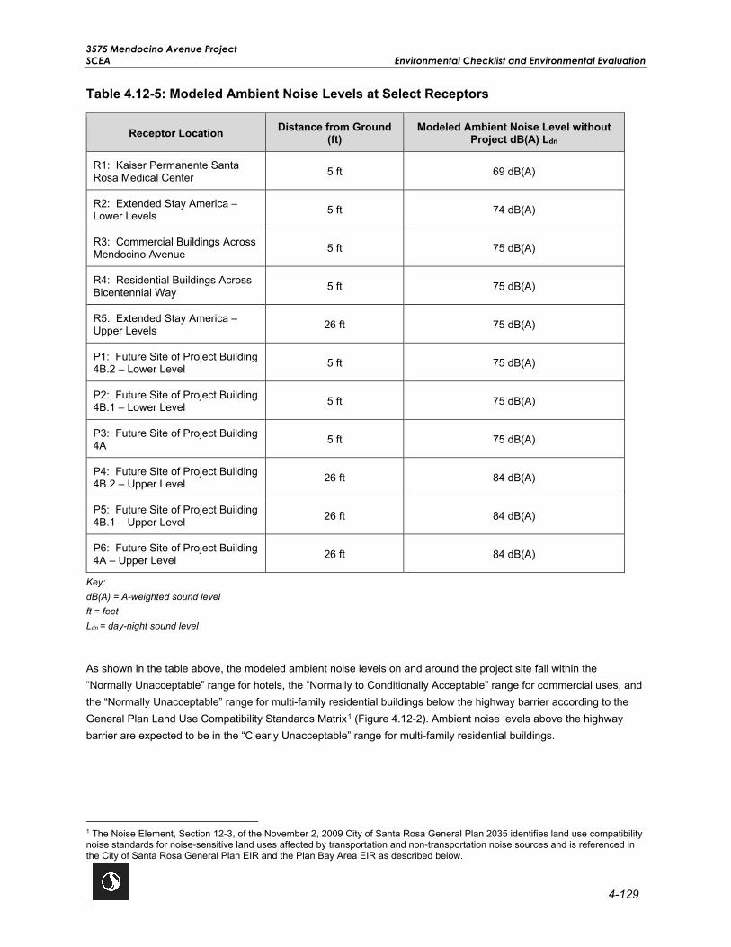
3575 Mendocino Avenue Project SCEA Environmental Checklist and Environmental Evaluation
4-129
Table 4.12-5: Modeled Ambient Noise Levels at Select Receptors
Receptor Location Distance from Ground (ft)
Modeled Ambient Noise Level without Project dB(A) Ldn
R1: Kaiser Permanente Santa Rosa Medical Center 5 ft 69 dB(A)
R2: Extended Stay America – Lower Levels 5 ft 74 dB(A)
R3: Commercial Buildings Across Mendocino Avenue 5 ft 75 dB(A)
R4: Residential Buildings Across Bicentennial Way 5 ft 75 dB(A)
R5: Extended Stay America – Upper Levels 26 ft 75 dB(A)
P1: Future Site of Project Building 4B.2 – Lower Level 5 ft 75 dB(A)
P2: Future Site of Project Building 4B.1 – Lower Level 5 ft 75 dB(A)
P3: Future Site of Project Building 4A 5 ft 75 dB(A)
P4: Future Site of Project Building 4B.2 – Upper Level 26 ft 84 dB(A)
P5: Future Site of Project Building 4B.1 – Upper Level 26 ft 84 dB(A)
P6: Future Site of Project Building 4A – Upper Level 26 ft 84 dB(A)
Key: dB(A) = A-weighted sound level ft = feet Ldn = day-night sound level
As shown in the table above, the modeled ambient noise levels on and around the project site fall within the “Normally Unacceptable” range for hotels, the “Normally to Conditionally Acceptable” range for commercial uses, and the “Normally Unacceptable” range for multi-family residential buildings below the highway barrier according to the General Plan Land Use Compatibility Standards Matrix1 (Figure 4.12-2). Ambient noise levels above the highway barrier are expected to be in the “Clearly Unacceptable” range for multi-family residential buildings.
1 The Noise Element, Section 12-3, of the November 2, 2009 City of Santa Rosa General Plan 2035 identifies land use compatibility noise standards for noise-sensitive land uses affected by transportation and non-transportation noise sources and is referenced in the City of Santa Rosa General Plan EIR and the Plan Bay Area EIR as described below.

3575 Mendocino Avenue Project Environmental Checklist and Environmental Evaluation SCEA
4-130
4.12.2 Previous Environmental Analysis
City of Santa Rosa General Plan EIR Summary
Chapter E of the General Plan EIR discusses potential impacts related to construction noise, traffic noise, airport noise, railway noise, and groundborne vibration. With the implementation of General Plan policies, all potential impacts related to noise were reduced to a less than significant level in the General Plan EIR.
The following General Plan policies apply to the proposed project:
Policy NS-B-1: Do not locate noise-sensitive uses in proximity to major noise sources, except residential is allowed near rail to promote future ridership.
Policy NS-B-2: Encourage residential developers to provide buffers other than sound walls, where practical. Allow sound walls only when projected noise levels at a site exceed land use compatibility standards in Figure 4.12-2.
Policy NS-B-3: Prevent new stationary and transportation noise sources from creating a nuisance in existing developed areas. Use a comprehensive program of noise prevention through planning and mitigation and consider noise impacts as a crucial factor in project approval.
Policy NS-B-4: Require new projects in the following categories to submit an acoustical study, prepared by a qualified acoustical consultant:
• All new projects proposed for areas with existing noise above 60 dB(A) Ldn. Mitigation shall be sufficient to reduce noise levels below 45 dB(A) Ldn in habitable rooms and 60 dB(A) Ldn in private and shared recreational facilities. Additions to existing housing units are exempt.
• All new projects that could generate noise whose impacts on other existing uses would be greater than those normally acceptable (as specified in the Land Use Compatibility Standards).
Policy NS-B-5: Pursue measures to reduce noise impacts primarily through site planning. Engineering solutions for noise mitigation, such as sound walls, are the least desirable alternative.
Policy NS-B-6: Do not permit existing uses to generate new noises exceeding normally acceptable levels unless:
• Those noises are mitigated to acceptable levels; or
• The activities are specifically exempted by the City Council on the basis of community health, safety, and welfare.
Policy NS-B-7: Allow reasonable latitude for noise generated by uses that are essential to community health, safety, and welfare. These include emergency medical helicopter and vehicle operations, and emergency vehicle sirens.
Policy NS-B-8: Adopt mitigations, including reduced speed limits, improved paving texture, and traffic controls, to reduce noise to normally acceptable levels in areas where noise standards may be exceeded (e.g., where homes front arterial roadways, and in mixed use areas).

V:\1
85
7\A
ctive\1
85
704
99
3_3
57
5M
end
ocin
oA
ve\0
3_
data
\gis
_ca
d\g
is\m
xd
\IS
MN
D\F
ig2
.0-7
_F
ire
_D
ep
art
men
t_A
cce
ss.m
xd
R
evis
ed
: 20
20
-07-2
1 B
y: K
AE
JO
HN
SO
N
City of Santa Rosa3575 Mendocino Avenue Project
Santa Rosa, CA
Figure No. 4.12-2TitleLand Use Compatibility Standards
Project Location
Client/Project
55 60 65 70 75 80
COMMUNITY NOISE EXPOSURELdn or CNEL, dB
NORMALLY ACCEPTABLESpecified land use is satisfactory, basedupon the assumption that any buildinginvolved is of normal conventionalconstruction, without any special noiseinsulation requirements.
LEGEND
NORMALLY UNACCEPTABLENew construction or development shouldgenerally be discouraged. If newconstruction or development doesproceed, a detailed analysis of the noisereduction requirements must be madeand needed noise insulation featuresincluded in the design.
CONDITIONALLY ACCEPTABLENew construction or development should beundertaken only after a detailed analysis ofthe noise reduction requirements is madeand needed noise insulation featuresincluded in the design. Conventionalconstruction, but with closed windows andfresh air supply systems or air conditioningwill normally suffice.
CLEARLY UNACCEPTABLENew construction or developmentshould generally not be undertaken.
Residential – Low-Density Single-Family, Duplex, Mobile Homes
Residential – Multi-Family, Duplex, Mobile Homes
Transient Lodging – Motels, Hotels
Schools, Libraries, Churches, Hospitals,Nursing Homes
Auditorium, Concert Halls, Amphitheaters
Industrial, Manufacturing Utilities,Agriculture
Office Buildings, Business, Commercialand Professional
Golf Courses, Riding Stables, Water Recreation, Cemeteries
Playgrounds, Neighborhood Parks
Sports Arena, Outdoor Spectator Sports
Santa Rosa General Plan . 207757Table 4.E-1
Land Use Compatibility StandardsSOURCE: ESA
Source: City of Santa Rosa 2009a

3575 Mendocino Avenue Project Environmental Checklist and Environmental Evaluation SCEA
4-132
This page left intentionally blank.

3575 Mendocino Avenue Project SCEA Environmental Checklist and Environmental Evaluation
4-133
Policy NS-B-9: Encourage developers to incorporate acoustical site planning into their projects. Recommended measures include:
• Incorporating buffers and/or landscaped earth berms;
• Orienting windows and outdoor living areas away from unacceptable noise exposure;
• Using reduced-noise pavement (rubberized-asphalt);
• Incorporating traffic calming measures, alternative intersection designs, and lower speed limits; and
• Incorporating state-of-the-art structural sound attenuation and setbacks.
Policy NS-B-14: Discourage new projects that have potential to create ambient noise levels more than 5 dB(A) Ldn above existing background, within 250 feet of sensitive receptors.
Plan Bay Area EIR Summary
The following summarizes the potential noise impacts discussed in Chapter 2.6 of the Plan Bay Area EIR and includes the complete text of mitigation measures previously identified by the Plan Bay Area EIR that are applicable to the proposed project.
Impact 2.6-1: Construction Noise Levels and Groundborne Vibration. The Plan Bay Area EIR determined future development projects have the potential to result in substantial construction noise and vibration levels such that nearby sensitive receptors could be adversely affected, and noise standards exceeded. However, impacts would be less than significant with the implementation of Mitigation Measure 2.6-1(a) (Refer to Impact NOI-1 in Section 4.12-3, Project-Specific Analysis).
PBA EIR MM 2.6-1(a): Construction Noise Levels and Groundborne Vibration. To reduce construction noise levels, implementing agencies and/or project sponsors shall:
• comply with local construction-related noise standards, including restricting construction activities to permitted hours as defined under local jurisdiction regulations (e.g., Alameda County Code restricts construction noise to between 7:00 AM and 7:00 PM on weekdays and between 8:00 AM and 5:00 PM on weekends);
• properly maintain construction equipment and outfit construction equipment with the best available noise suppression devices (e.g., mufflers, silencers, wraps);
• prohibit idling of construction equipment for extended periods of time in the vicinity of sensitive receptors;
• locate stationary equipment such as generators, compressors, rock crushers, and cement mixers a minimum of 50 feet from sensitive receptors, but further if possible;
• erect temporary construction-noise barriers around the construction site when adjacent occupied sensitive land uses are present within 75 feet;
• use noise control blankets on building structures as buildings are erected to reduce noise emission from the site; and

3575 Mendocino Avenue Project Environmental Checklist and Environmental Evaluation SCEA
4-134
• use cushion blocks to dampen impact noise from pile driving.
Impact 2.6-2: Increased Noise from Traffic and Transit. The Plan Bay Area EIR determined that some areas would result in regional average noise increases and localized traffic-related noise levels that exceed applicable thresholds and would result in a substantial permanent increase in noise. The Plan Bay Area EIR determined traffic noise impacts would be less than significant with the implementation of Mitigation Measure 2.6-2 (Refer to Impact NOI-1 in Section 4.12-3, Project-Specific Analysis):
PBA EIR MM 2.6-2: Increased Noise from Traffic and Transit. For all new development that could be located within the 70 dB(A) CNEL(Ldn) noise contour of a roadway (within 270 feet of the roadway’s centerline based on freeways with the greatest volumes in the region), a site specific noise study shall be conducted by a qualified acoustical engineer or noise specialist, to evaluate noise exposure at new receptors and recommend appropriate measures to reduce noise exposure. To reduce exposure from traffic-noise, lead agencies and/or project sponsors shall consider mitigation measures including, but not limited to those identified below:
• design adjustments to proposed roadway or transit alignments to reduce noise levels in noise sensitive areas (e.g., below-grade roadway alignments can effectively reduce noise levels in nearby areas);
• use techniques such as landscaped berms, dense plantings, reduced-noise paving materials, and traffic calming measures in the design of their transportation improvements;
• contribute to the insulation of buildings or construction of noise barriers around sensitive receptor properties adjacent to the transportation improvement;
• use land use planning measures, such as zoning, restrictions on development, site design, and buffers to ensure that future development is noise compatible with adjacent transportation facilities and land uses;
• construct roadways so that they are depressed below-grade of the existing sensitive land uses to create an effective barrier between new roadway lanes, roadways, rail lines, transit centers, park- n-ride lots, and other new noise generating facilities; and
• maximize the distance between noise-sensitive land uses and new noise-generating facilities and transportation systems.
Impact 2.6-3 and Impact 2.6-4: Rail Transit Noise and Vibration. The Plan Bay Area EIR determined future rail transit projects would result in new noise and vibration sources that could affect existing sensitive land uses. However, impacts would be less than significant with the implementation of Mitigation Measures 2.6-3(a), 2.6-3(b), 2.6-3(c), 2.6-4(a), 2.6-4(b), and 2.6-4(c). The proposed project does not involve the construction of a rail transit line, and therefore these mitigation measures are not applicable.
Impact 2.6-5: Ambient Noise. The Plan Bay Area EIR determined future development projects could expose existing or new sensitive receptors to noise levels that exceed land use compatibility thresholds, resulting in a substantial permanent increase in noise. However, this impact would be reduced to a less than significant level with the implementation of Mitigation Measure 2.6-5 (Refer to Impact NOI-1 in Section 4.12-3, Project-Specific Analysis).
PBA EIR MM 2.6-5: Ambient Noise. To reduce exposure to new and existing sensitive receptors from non-transportation noise associated with projected development, implementing agencies and/or project sponsors shall implement measures, where feasible and necessary based on project- and site-specific considerations that include, but are not limited to:

3575 Mendocino Avenue Project SCEA Environmental Checklist and Environmental Evaluation
4-135
• Local agencies approving land use projects shall require that routine testing and preventive maintenance of emergency electrical generators be conducted during the less sensitive daytime hours (per the applicable local municipal code). Electrical generators or other mechanical equipment shall be equipped with noise control (e.g., muffler) devices in accordance with manufacturers’ specifications.
• Local agencies approving land use projects shall require that external mechanical equipment, including HVAC units, associated with buildings incorporate features designed to reduce noise to below 70 dB(A) CNEL (Ldn) or the local applicable noise standard. These features may include, but are not limited to, locating equipment within equipment rooms or enclosures that incorporate noise reduction features, such as acoustical louvers, and exhaust and intake silencers. Equipment enclosures shall be oriented so that major openings (i.e., intake louvers, exhaust) are directed away from nearby noise-sensitive receptors.
Impact 2.6-6: Airport Noise Levels. The Plan Bay Area EIR analyzed the potential impacts related to increased noise exposure from aircraft or airports and determined with the implementation of Plan Bay Area Mitigation Measure 2.6-6 the impact would be less than significant. The proposed project is not located within an airport land use plan and therefore this mitigation measure is not applicable (Refer to Impact NOI-3 in Section 4.12-3, Project-Specific Analysis).
4.12.3 Project-Specific Analysis
Impact NOI-1 Generation of a substantial temporary or permanent increase in ambient noise levels in the vicinity of the project in excess of standards established in the local general plan or noise ordinance, or applicable standards of other agencies?
Impact Analysis Exterior Traffic Noise at Existing Sensitive Receptors
To describe future noise levels due to traffic added from the proposed project, the project buildings and the AM and PM peak hour traffic counts with the proposed project received via e-mail on July 14, 2020 from W-Trans, were input into the SoundPLAN model. Peak hour traffic counts used to model the noise levels at the project site with the proposed project are shown in Table 4.12-6.
Table 4.12-6: Peak Hour Traffic Counts with Proposed Project
Road Estimated 2020 AM Peak Hour Count with Project
Estimated 2020 PM Peak Hour Count with Project
Highway 101 North 4,263 4,444
Highway 101 South 5,386 5,592
Bicentennial Way East 1,328 972
Bicentennial Way West 787 1,204
Mendocino Ave North 811 1,068
Mendocino Ave South 995 1,031

3575 Mendocino Avenue Project Environmental Checklist and Environmental Evaluation SCEA
4-136
Road Estimated 2020 AM Peak Hour Count with Project
Estimated 2020 PM Peak Hour Count with Project
Mendocino/ Highway 101 Overcrossing East 1,132 1,117
Mendocino/ Highway 101 Overcrossing West 878 1,174
Fountaingrove Parkway East 870 706
Fountaingrove Parkway West 987 926
Key: dB(A) = A-weighted sound level ft = feet Ldn = day-night sound level
The same vehicle type breakout and average daily vehicle speed data in the ambient noise model was used in the model with the proposed project. The estimated noise levels at the project site at 5 feet above ground with the proposed project are shown in Figure 4.12-3.
Estimated noise levels at select receptors on the project site with the proposed project traffic volumes are listed below in Table 4.12-7. The noise level at the hotel receptor was also modeled at 26 feet above ground to account for upper-story locations which are situated above the highway noise barrier.
Table 4.12-7: Modeled Noise Levels at Select Receptors with Proposed Project
Receptor Location Distance from Ground (ft)
Modeled Noise Level with Project, dB(A) Ldn
Difference from Ambient Level,
dB(A) Ldn
R1: Kaiser Permanente Santa Rosa Medical Center
5 ft 67 dB(A) -2 dB(A)
R2: Extended Stay America – Lower Levels 5 ft 74 dB(A) 0 dB(A)
R3: Commercial Buildings Across Mendocino Avenue
5 ft 75 dB(A) 0 dB(A)
R4: Residential Buildings Across Bicentennial Way
5 ft 75 dB(A) 0 dB(A)
R5: Extended Stay America – Upper Levels 26 ft 75 dB(A) 0 dB(A)
Key: dB(A) = A-weighted sound level ft = feet Ldn = day-night sound level

V:\1
85
7\A
ctive\1
85
704
99
3_3
57
5M
end
ocin
oA
ve\0
3_
data
\gis
_ca
d\g
is\m
xd
\IS
MN
D\F
ig2
.0-7
_F
ire
_D
ep
art
men
t_A
cce
ss.m
xd
R
evis
ed
: 20
20
-07-2
1 B
y: K
AE
JO
HN
SO
N
City of Santa Rosa3575 Mendocino Avenue Project
Santa Rosa, CA
Figure No. 4.12-3TitleModeled Traffic Noise Levels with the Proposed Project
Project Location
Client/Project
R1
Kaiser Santa RosaMedical Center
Extended StayAmerica
R3
R4
R2,R5
US
101
Bicentennial Way
Mendocino A
ve
Mendocino O/C
P1,P4
P2,P5
P3,P6
Noise levels modeled using SoundPLAN sound propagation computer modeling software.

3575 Mendocino Avenue Project Environmental Checklist and Environmental Evaluation SCEA
4-138
This page left intentionally blank.

3575 Mendocino Avenue Project SCEA Environmental Checklist and Environmental Evaluation
4-139
The proposed project is expected to minimally increase traffic counts along Mendocino Avenue, Bicentennial Way, and the Mendocino/Highway 101 Overcrossing. There would be no noticeable change in traffic noise expected along these streets. Noise levels experienced by the lower levels of Kaiser Permanente Santa Rosa Medical Center and the uses located east of Mendocino Avenue are predicted to slightly decrease due to shielding provided by the proposed buildings on the project site. Therefore, the proposed project would not cause increased traffic noise levels over the baseline conditions at the neighboring sensitive receptors and impacts would be less than significant impact.
Interior Traffic Noise at New Sensitive Receptors – Residential
Policy NS-B-4 in the General Plan states interior noise levels attributable to exterior sources shall not exceed 45 dB(A) Ldn in any habitable room, including residential units. The needed sound isolation requirements of a building’s exterior façade system will be dependent on the following conditions:
• The dimension of the rooms with exterior windows; • The finishes within the rooms; • The ratio of clear glass to solid wall in the exterior wall assembly; and • The exterior solid wall construction.
Modern construction with punch windows, similar to what is shown for the proposed project, typically provides a 25 dB(A) exterior-to-interior noise level reduction with windows closed. Therefore, sensitive receptors exposed to exterior noise of 70 dB(A) Ldn or less would typically comply with the code-required interior noise level standard. Modern construction using window walls, curtainwalls, or a high ratio of exterior clear glass would provide less reduction with the windows closed. Buildings using a high amount of glass would typically comply with the code-required interior noise level standard if exposed to exterior noise levels of 67 dB(A) Ldn or less.
The modeled noise levels at the project site at 5 feet above ground with the proposed buildings and proposed project traffic volumes are shown in Figure 4.12-3. Estimated noise levels at select residential buildings within the proposed project with the project traffic volumes are listed below in Table 4.12-8. Noise levels at the residential buildings were modeled at 5 feet and 26 feet above ground to account for upper-story locations situated above the highway noise barrier.
Table 4.12-8: Modeled Noise Levels at Project Buildings
Receptor Location Distance from Ground (ft)
Modeled Noise Level with Project dB(A) Ldn
P1: Project Building 4B.2 – Lower Level 5 ft 77 dB(A)
P2: Project Building 4B.1 – Lower Level 5 ft 77 dB(A)
P3: Project Building 4A 5 ft 78 dB(A)
P4: Project Building 4B.2 – Upper Level 26 ft 86 dB(A)
P5: Project Building 4B.1 – Upper Level 26 ft 86 dB(A)
P6: Project Building 4A – Upper Level 26 ft 87 dB(A)
Key: dB(A) = A-weighted sound level ft = feet Ldn = day-night sound level

3575 Mendocino Avenue Project Environmental Checklist and Environmental Evaluation SCEA
4-140
Based on the modeled noise level contours in Figure 4.12-3 and the data listed in Table 4.12-8, noise levels on the project site range from 60-70 dB(A) Ldn on the building facades which face the shared open space to above 80 dB(A) Ldn at the upper story residential units which face Highway 101. The building facades which face Mendocino Avenue are also expected to experience noise levels between 75-80 dB(A) Ldn. The proposed project would implement Mitigation Measure NOI-1 and Mitigation Measure NOI-2 (PBA EIR MM 2.6-2) to ensure the interior noise levels inside the residential units achieve 45 dB(A) Ldn.. The implementation of these mitigation measures would require a qualified acoustical engineer or noise specialist to verify that applicable measures are incorporated into the project design to reduce noise exposure, including noise exposure from traffic noise, to levels below 45 dB(A) Ldn in habitable rooms and 60 dB(A) Ldn in private and shared recreational facilities as required by Policy NS-B-4 of the General Plan. As such, implementation of Mitigation Measure NOI-1 and Mitigation Measure NOI-2 (PBA EIR MM 2.6-2) would ensure that impacts related to traffic noise on the interior of the residential units would be less than significant.
Project Fixed-Source Noise
Typical multi-family residential building construction would commonly involve new rooftop and exterior mechanical and electrical equipment, such as condensing units, make-up air units, emergency generators, and exhaust fans. This equipment would generate noise that would radiate to neighboring properties, which could result in a potentially significant impact prior to mitigation. The noise from this equipment would be required to comply with Chapter 17-16, Noise, in the City Code; Section 1207.4 of the California Building Code; Policy NS-B-3 in the General Plan EIR; and Mitigation Measure NOI-3 (PBA EIR MM 2.6-5). Implementation of Mitigation Measure NOI-3 (PBA EIR MM 2.6-5) would ensure onsite equipment would be designed to incorporate measures such as enclosures, acoustical louvers, and attenuators, as appropriate to reduce noise levels that may affect nearby properties. With Mitigation Measure NOI-3 (PBA EIR MM 2.6-5), the impact of fixed-source noise to the neighboring properties would be less than significant.
Project Operational Noise
As part of the proposed project, an outdoor shared open space would be located in the middle of the project site and private outdoor open space would be located adjacent to the proposed residential buildings. The open space areas would contain gathering areas, gardening areas, a sports court, children’s play area, and activities. Activities within the open spaces would take place during daytime hours. The location of the open spaces would be interior to the project site which would provide enhanced acoustic conditions. The proposed project buildings around the exterior of the project site would provide shielding not only for the noise generated by the open spaces to the neighboring properties, but also from noise from Highway 101 to the open space areas. Figure 4.12-3 shows the modeled noise levels within the open space at 60-70 dB(A) Ldn, which is within the “Normally and Conditionally Acceptable” range as per the Santa Rosa General Plan Land Use Compatibility Standards matrix (Figure 4.12-2). The proposed project would implement Mitigation Measure NOI-1, which would require a qualified acoustical engineer or noise specialist to verify that applicable measures are incorporated into the project design to ensure noise levels within the private and shared open space areas are below 60 dB(A) as required by Policy NS-B-4 of the General Plan. Therefore, impacts related to noise generated from and received by the open spaces would be less than significant with mitigation incorporated.
Short-Term Construction Noise Impacts
Two types of short-term noise impacts could occur during construction of the proposed project. First, construction crew commutes and the transport of construction equipment and materials to the project site would incrementally

3575 Mendocino Avenue Project SCEA Environmental Checklist and Environmental Evaluation
4-141
increase noise levels on access roads leading to the project site. This increased traffic would be comprised of vehicles, medium trucks, and heavy trucks.
Workers would access the project site on Mendocino Avenue via Highway 101 and either Bicentennial Way and/or the Mendocino Avenue Overcrossing. Construction materials and equipment would be delivered using trucks during the daytime hours. Construction workers required for each phase of the proposed project would fluctuate between approximately 22 and 160 workers per day, with an average of approximately 91 workers per day. The construction route does not pass through any dense residential neighborhoods and avoids small residential streets. The associated short-term noise from construction vehicles along City streets, such as Mendocino Avenue, would be perceptible, however, such a noise increase would be instantaneous and short term. Therefore, the impact of construction traffic noise to the neighboring properties, including the Kaiser Permanente Santa Rosa Medical Center and nearby residential uses, would be less than significant.
The second type of short-term noise impact is related to noise generated during construction. Construction activities would include excavation activities and grading, foundation work, building construction, and paving. Each construction stage has its own mix of equipment and consequently, its own noise characteristics. These various construction operations would change the character of the noise generated at the project site and therefore, the ambient noise level as construction progresses. The loudest phases of construction typically include excavation, building construction, and grading phases as the noisiest construction equipment is earthmoving and grading equipment. Table 4.12-9 lists types of construction equipment that may be used throughout construction and the maximum and average operational noise level as measured at 122 feet from the operating equipment. The 122-foot distance represents the approximate distance between the project site and the closest noise-sensitive receptor at Kaiser Permanente Santa Rosa Medical Center.
Table 4.12-9: Summary of FHWA Roadway Construction Noise Model
Construction Equipment Source
Distance to Nearest Sensitive Receptor
Sound Level at Receptor
Lmax, dB(A) Acoustical Use Factor (%) Leq, dB(A)
Backhoe 122 ft 69.8 40 65.8
Crane 122 ft 72.8 16 64.8
Concrete Mixer Truck 122 ft 71.1 40 67.1
Concrete Saw 122 ft 81.8 20 74.8
Compressor (air) 122 ft 69.9 40 65.9
Bulldozer 122 ft 73.9 40 69.9
Excavator 122 ft 73.0 40 69.0
Front End Loader 122 ft 71.4 40 67.4
Generator Set 122 ft 72.9 50 69.9
Grader 122 ft 77.3 40 73.3
Paver 122 ft 69.5 50 66.5
Roller 122 ft 72.3 20 65.3

3575 Mendocino Avenue Project Environmental Checklist and Environmental Evaluation SCEA
4-142
Construction Equipment Source
Distance to Nearest Sensitive Receptor
Sound Level at Receptor
Lmax, dB(A) Acoustical Use Factor (%) Leq, dB(A)
Scraper 122 ft 75.8 40 71.9
Tractor 122 ft 76.3 40 72.3
Welder 122 ft 66.3 40 62.3
Source: Federal Highway Administration Roadway Construction Noise Model Version 1.1 2008 Key: dB(A) = A-weighted sound level Leq = equivalent sound level, dB(A) Lmax = maximum sound level, dB(A)Back
The construction of the proposed project would be conducted in two concurrent phases. Each phase would consist of six separate stages, and each stage would use different pieces of construction equipment. The main noise-producing equipment for each construction stage and the approximate distance to the closest noise-sensitive receptor are shown in Table 4.12-10.
Table 4.12-10: Construction Phases Equipment and Distance to Closest Receptor
Construction Phase / Stage Distance to Nearest Sensitive Receptor Planned Equipment
Phase 1 / Stage 1: Demolition 122 ft
Concrete/Industrial Saw Rubber-Tired Dozer
Tractor Front-End Loader
Backhoe
Phase 1 / Stage 2: Site Preparation 122 ft Grader Scraper Tractor
Phase 1 / Stage 3: Grading 122 ft
Grader Rubber-Tired Dozer
Tractor Backhoe
Phase 1 / Stage 4: Building Construction 122 ft
Crane Forklifts1 (2)
Generator Set Tractor
Welders (3)
Phase 1 / Stage 5: Architectural Coating 122 ft Air Compressor
Phase 1 / Stage 6: Paving 122 ft
Cement and Mortar Mixer Paver
Paving Equipment2
Rollers (2) Tractor

3575 Mendocino Avenue Project SCEA Environmental Checklist and Environmental Evaluation
4-143
Construction Phase / Stage Distance to Nearest Sensitive Receptor Planned Equipment
Phase 2 / Stage 1: Demolition 122 ft Concrete / Industrial Saw
Excavators (3) Rubber-Tired Dozers (2)
Phase 2 / Stage 2: Site Preparation 122 ft
Rubber-Tired Dozers (3) Tractors (2)
Front-End Loader Backhoe
Phase 2 / Stage 3: Grading 122 ft
Excavator Grader
Rubber-Tired Dozer Tractor
Front-End Loader Backhoe
Phase 2 / Stage 4: Building Construction 122 ft
Crane Forklifts (3)
Generator Set Tractor
Front-End Loader Backhoe Welder
Phase 2 / Stage 5: Architectural Coating 122 ft Air Compressor
Phase 2 / Stage 6: Paving 122 ft Pavers (2)
Paving Equipment (2) Rollers (2)
Notes: 1Noise from a forklift is not included in the RCNM program. Therefore, the forklift was assumed to have the same noise signature as a tractor for this analysis. 2Noise from paving equipment is not included in the RCNM program. Therefore, paving equipment was assumed to have the same noise signature as a paver for this analysis. Key: RCNM = Roadway Construction Noise Model
A worst-case condition for construction activity would assume all noise-generating equipment were operating at the same time and at the same distance away from the closest noise-sensitive receptor, Kaiser Permanente Santa Rosa Medical Center. Using this assumption, the Roadway Construction Noise Model (RCNM) program calculated the following combined Leq and Lmax noise levels from each phase and stage of construction as shown in Table 4.12-11. Appendix K shows the noise calculations and inputs that were used from the RCNM.

3575 Mendocino Avenue Project Environmental Checklist and Environmental Evaluation SCEA
4-144
Table 4.12-11: Calculated Noise Level From Each Construction Phase/Stage
Construction Phase / Stage Distance to Nearest Sensitive Receptor
Calculated Lmax, dB(A)
Calculated Leq, dB(A)
Phase 1 / Stage 1: Demolition 122 ft 83.8 78.2
Phase 1 / Stage 2: Site Preparation 122 ft 81.3 77.3
Phase 1 / Stage 3: Grading 122 ft 81.2 77.1
Phase 1 / Stage 4: Building Construction 122 ft 80.8 76.6
Phase 1 / Stage 5: Architectural Coating 122 ft 69.9 65.9
Phase 1 / Stage 6: Paving 122 ft 80.3 75.7
Phase 2 / Stage 1: Demolition 122 ft 84.2 78.7
Phase 2 / Stage 2: Site Preparation 122 ft 82.6 78.6
Phase 2 / Stage 3: Grading 122 ft 82.2 78.1
Phase 2 / Stage 4: Building Construction 122 ft 81.8 77.6
Phase 2 / Stage 5: Architectural Coating 122 ft 69.9 65.9
Phase 2 / Stage 6: Paving 122 ft 78.4 73.9
Key: dB(A) = A-weighted decibel Leq = equivalent sound level Lmax = maximum sound level
Although noise levels could range into the “clearly unacceptable” range as defined in Figure 4.12-2, increases in noise levels from construction activities would be temporary. Additionally, the proposed project would implement Mitigation Measure NOI-4 (PBA EIR MM 2.6-1[a]) to reduce construction noise levels. Implementation of Mitigation Measure NOI-4 (PBA EIR MM 2.6-1[a]) would provide substantial reduction in construction noise levels by ensuring proper equipment use and locating equipment away from sensitive land uses. In addition, Mitigation Measure NOI-5 would be required to ensure a construction site notice which includes pertinent information for the public to stay informed of project construction activities. This construction site notice would include a phone number for the public to call where violations for noise in excess of City standards could be reported. Therefore, with the implementation of Mitigation Measure NOI-4 (PBA EIR MM 2.6-1[a]) and Mitigation Measure NOI-5, any potential impact from construction noise associated with the proposed project would be less than significant.
Level of Significance Before Mitigation Potentially Significant Impact.

3575 Mendocino Avenue Project SCEA Environmental Checklist and Environmental Evaluation
4-145
Mitigation Measures
Mitigation Measure NOI-1 (Exterior/Interior Noise Levels), Mitigation Measure NOI-2 (PBA EIR MM 2.6-2: Increased Noise from Traffic and Transit), Mitigation Measure NOI-3 (PBA EIR MM 2.6-5: Ambient Noise), Mitigation Measure NOI-4 (PBA EIR MM 2.6-1[a]: Construction Noise Levels and Groundborne Vibration), and Mitigation Measure NOI-5 (Construction Activity) are required.
MM NOI-1: Interior/Exterior Noise Levels. A qualified acoustical engineer or noise specialist shall verify that applicable features are incorporated into the project design to reduce noise exposure, including noise exposure from traffic noise, to levels below 45 dB(A) Ldn in habitable rooms and 60 dB(A) Ldn in private and shared recreational facilities as required by Policy NS-B-4 of the General Plan.
Mitigation Measure NOI-2 (PBA EIR MM 2.6-2: Increased Noise from Traffic and Transit). The following measures from PBA EIR MM 2.6-2: Increased Noise from Traffic and Transit are relevant to this proposed project:
To reduce exposure from traffic-noise, lead agencies and/or project sponsors shall consider mitigation measures including, but not limited to those identified below:
• Use land use planning measures, such as zoning, restrictions on development, site design, and buffers to ensure that future development is noise compatible with adjacent transportation facilities and land uses.
• Maximize the distance between noise-sensitive land uses and new noise-generating facilities and transportation systems.
Mitigation Measure NOI-3 (PBA EIR MM 2.6-5: Ambient Noise). The following measures from PBA EIR MM 2.6-5: Ambient Noise are relevant to this proposed project:
To reduce exposure to new and existing sensitive receptors from non-transportation noise associated with projected development, implementing agencies and/or project sponsors shall implement measures, where feasible and necessary based on project- and site-specific considerations that include, but are not limited to:
• Local agencies approving land use projects shall require that external mechanical equipment, including HVAC units, associated with buildings incorporate features designed to reduce noise to below 70 dB(A) CNEL (Ldn) or the local applicable noise standard. These features may include, but are not limited to, locating equipment within equipment rooms or enclosures that incorporate noise reduction features, such as acoustical louvers, and exhaust and intake silencers. Equipment enclosures shall be oriented so that major openings (i.e., intake louvers, exhaust) are directed away from nearby noise-sensitive receptors.
Mitigation Measure NOI-4 (PBA EIR MM 2.6-1[a]: Construction Noise Levels and Groundborne Vibration). The following measures from PBA EIR MM 2.6-1[a]: Construction Noise Levels and Groundborne Vibration are relevant to this proposed project:
To reduce construction noise levels, implementing agencies and/or project sponsors shall:
• Comply with local construction-related noise standards, including restricting construction activities to permitted hours as defined under local jurisdiction regulations);

3575 Mendocino Avenue Project Environmental Checklist and Environmental Evaluation SCEA
4-146
• Properly maintain construction equipment and outfit construction equipment with the best available noise suppression devices (e.g., mufflers, silencers, wraps);
• Prohibit idling of construction equipment for extended periods of time in the vicinity of sensitive receptors; and
• Locate stationary equipment such as generators, compressors, rock crushers, and cement mixers a minimum of 50 feet from sensitive receptors, but further if possible.
MM NOI-5: Construction Activity. A construction site notice shall be posted at the project site that includes the following information: job site address, permit number, name and phone number of the contractor and owner or owner’s agent, hours of construction allowed by Code or any discretionary approval for the project site, and City telephone numbers where violations can be reported. The notice shall be approved by the City, posted and maintained at the project site prior to the start of construction and displayed in a location that is readily visible to the public.
Level of Significance After Mitigation Less Than Significant Impact With Mitigation.
Impact NOI-2 Generation of excessive groundborne vibration or groundborne noise levels?
Impact Analysis During construction of the proposed project, equipment such as cranes, excavators, graders, loaders, backhoes, and bulldozers may be used as close as 122 feet from the nearest sensitive receptor at Kaiser Permanente Santa Rosa Medical Center. As shown in Table 4.12-12, construction equipment that would be used would generate vibration levels between 0.0003 PPV and 0.019 PPV at 122 feet. All groundborne vibration levels are below the Federal Transit Administration (FTA) vibration threshold at which human annoyance could occur. Additionally, construction activities would be temporary in nature and would likely occur during normal daytime working hours. Therefore, construction vibrations are not predicted to cause damage to existing buildings or cause annoyance to sensitive receptors. The proposed project would have a less than significant impact related to vibration.
Table 4.12-12: Vibration Source Levels for Construction Equipment
Type of Equipment Peak
Particle Velocity at
25 Feet
Peak Particle
Velocity at 100 Feet
Peak Particle Velocity at 122 Feet
Threshold at which Human
Annoyance Could Occur
Potential for Proposed Project to Exceed
Threshold
Large Bulldozer 0.089 0.011 0.008 0.10 None
Loaded Trucks 0.076 0.010 0.007 0.10 None
Small Bulldozer 0.003 0.0003 0.0003 0.10 None
Vibratory Compactor/Roller
0.210 0.026 0.019 0.10 None
Source: FTA 2018 Level of Significance Before Mitigation Less Than Significant Impact.

3575 Mendocino Avenue Project SCEA Environmental Checklist and Environmental Evaluation
4-147
Mitigation Measures No mitigation is necessary.
Level of Significance After Mitigation Less Than Significant Impact.
Impact NOI-3 For a project located within the vicinity of a private airstrip or airport land use plan or, where such a plan has not been adopted, within two miles of a public airport of public use airport, would the project expose people residing or working in the project area to excessive noise levels?
Impact Analysis The project site is not located near an existing public airport or private airstrip and is not within an area covered by an existing airport land use plan. The nearest airport is the Charles M. Schulz – Sonoma County Airport which is approximately 4.5 miles northwest of the project site. According to the General Plan, the project site is located outside of the airport’s 60 dB(A) noise contour. Although aircraft-related noise could occasionally be audible at the project site, noise would be extremely minimal. Exterior and interior noise levels resulting from aircraft would be compatible with the proposed project. Therefore, no impact would occur.
Level of Significance Before Mitigation No Impact.
Mitigation Measures No mitigation is necessary.
Level of Significance After Mitigation No Impact.

3575 Mendocino Avenue Project Environmental Checklist and Environmental Evaluation SCEA
4-148
This page left intentionally blank.
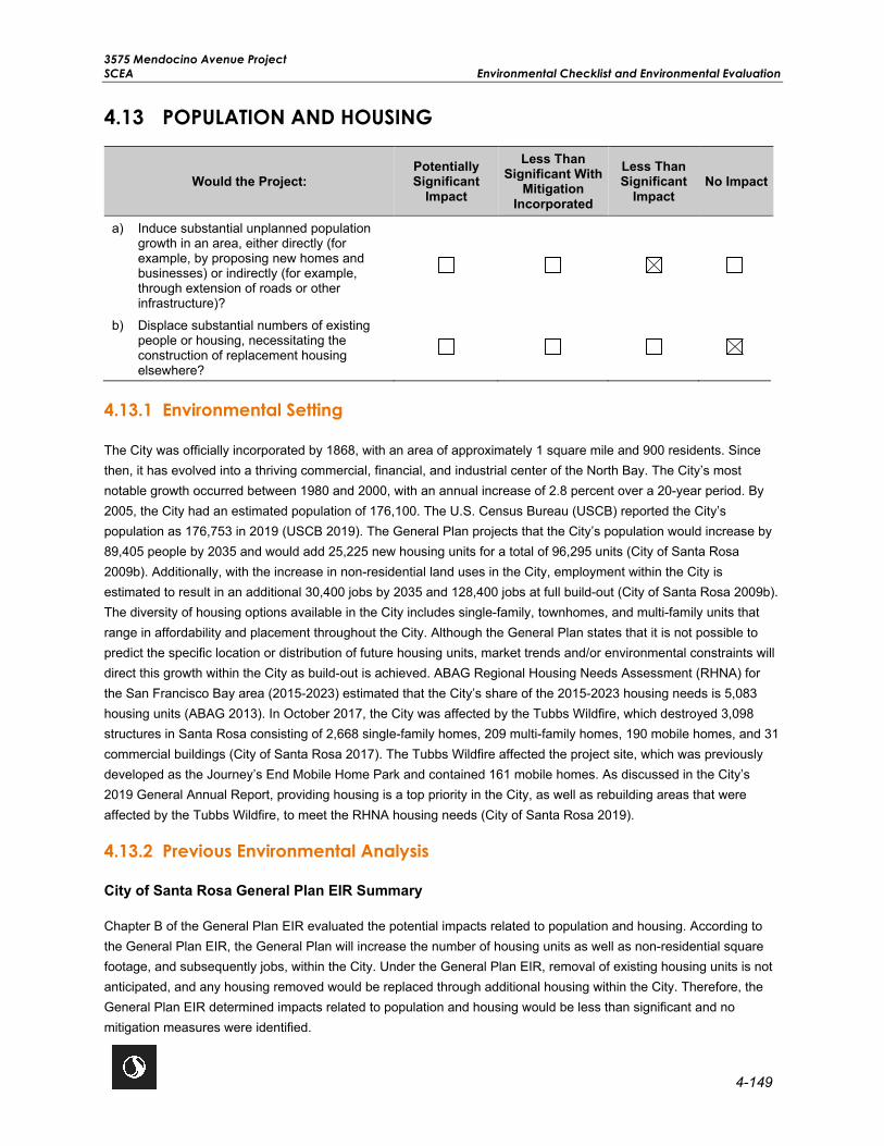
3575 Mendocino Avenue Project SCEA Environmental Checklist and Environmental Evaluation
4-149
4.13 POPULATION AND HOUSING
Would the Project: Potentially Significant
Impact
Less Than Significant With
Mitigation Incorporated
Less Than Significant
Impact No Impact
a) Induce substantial unplanned population growth in an area, either directly (for example, by proposing new homes and businesses) or indirectly (for example, through extension of roads or other infrastructure)?
b) Displace substantial numbers of existing people or housing, necessitating the construction of replacement housing elsewhere?
4.13.1 Environmental Setting
The City was officially incorporated by 1868, with an area of approximately 1 square mile and 900 residents. Since then, it has evolved into a thriving commercial, financial, and industrial center of the North Bay. The City’s most notable growth occurred between 1980 and 2000, with an annual increase of 2.8 percent over a 20-year period. By 2005, the City had an estimated population of 176,100. The U.S. Census Bureau (USCB) reported the City’s population as 176,753 in 2019 (USCB 2019). The General Plan projects that the City’s population would increase by 89,405 people by 2035 and would add 25,225 new housing units for a total of 96,295 units (City of Santa Rosa 2009b). Additionally, with the increase in non-residential land uses in the City, employment within the City is estimated to result in an additional 30,400 jobs by 2035 and 128,400 jobs at full build-out (City of Santa Rosa 2009b). The diversity of housing options available in the City includes single-family, townhomes, and multi-family units that range in affordability and placement throughout the City. Although the General Plan states that it is not possible to predict the specific location or distribution of future housing units, market trends and/or environmental constraints will direct this growth within the City as build-out is achieved. ABAG Regional Housing Needs Assessment (RHNA) for the San Francisco Bay area (2015-2023) estimated that the City’s share of the 2015-2023 housing needs is 5,083 housing units (ABAG 2013). In October 2017, the City was affected by the Tubbs Wildfire, which destroyed 3,098 structures in Santa Rosa consisting of 2,668 single-family homes, 209 multi-family homes, 190 mobile homes, and 31 commercial buildings (City of Santa Rosa 2017). The Tubbs Wildfire affected the project site, which was previously developed as the Journey’s End Mobile Home Park and contained 161 mobile homes. As discussed in the City’s 2019 General Annual Report, providing housing is a top priority in the City, as well as rebuilding areas that were affected by the Tubbs Wildfire, to meet the RHNA housing needs (City of Santa Rosa 2019).
4.13.2 Previous Environmental Analysis
City of Santa Rosa General Plan EIR Summary
Chapter B of the General Plan EIR evaluated the potential impacts related to population and housing. According to the General Plan EIR, the General Plan will increase the number of housing units as well as non-residential square footage, and subsequently jobs, within the City. Under the General Plan EIR, removal of existing housing units is not anticipated, and any housing removed would be replaced through additional housing within the City. Therefore, the General Plan EIR determined impacts related to population and housing would be less than significant and no mitigation measures were identified.

3575 Mendocino Avenue Project Environmental Checklist and Environmental Evaluation SCEA
4-150
The following General Plan goals and policies are applicable to the proposed project:
Goal H-A: Meet the housing needs of all Santa Rosa residents.
Policy H-A-2: Pursue the goal of meeting Santa Rosa’s housing needs through increased densities, when consistent with preservation of existing neighborhoods. Higher density sites are illustrated on the General Plan Land Use Diagram, which will allow the development of dwellings for 210 very low and 138 low income households annually. Development of these sites or proposals for new higher density sites must be designed in context with existing, surrounding neighborhoods. The number of affordable units permitted each year and the adequacy of higher density sites shall be reported as part of the General Plan Annual Review report.
Policy H-A-3: Promote conservation and rehabilitation of the existing housing stock and discourage intrusion of incompatible uses into residential neighborhoods which would erode the character of established neighborhoods or lead to use conflicts.
Policy H-B-2: Discourage the subdivision of mobile home parks or conversion to other uses through enforcement of the Conversion of Mobile Home Parks chapter of the City Code.
Plan Bay Area EIR Summary
The following summarizes the potential impacts related to population and housing discussed in Chapter 2.3 of the Plan Bay Area EIR.
Impact 2.3-1: Displacement of Communities. The Plan Bay Area EIR analyzed the potential impacts related to residential or business disruption or displacement of existing population and housing and determined that implementation of the Plan Bay Area may result in displacement of existing residential units, necessitating construction of replacement housing. With the implementation of Mitigation Measure 2.3-1 the impact would be less than significant. Mitigation Measure 2.3-1 is not applicable to the proposed project since residential units do not currently exist on the project site and mitigation is being implemented throughout this SCEA to reduce potential impacts to a less than significant level.
4.13.3 Project-Specific Analysis
Impact POP-1 Induce substantial unplanned population growth in an area, either directly (for example, by proposing new homes and businesses) or indirectly (for example, through extension of roads or other infrastructure)?
Impact Analysis This analysis assesses the proposed project’s potential to induce substantial population growth. There are two types of population growth: direct and indirect. Direct population growth can occur from the development of new residential units. Indirect population growth can occur from the creation of new employment opportunities or the removal of a barrier to growth (e.g., the extension of urban infrastructure to an undeveloped area). The proposed project would not significantly induce direct or indirect population growth, as explained below.
Direct Population Growth
The project site was previously developed as the Journey’s End Mobile Home Park. The mobile home park was located on the project site for more than 50 years and was developed with gravel pads for 161 mobile homes.

3575 Mendocino Avenue Project SCEA Environmental Checklist and Environmental Evaluation
4-151
However, most of the park and the mobile homes were destroyed in October 2017 by the Tubbs Wildfire. In January 2020, the Santa Rosa City Council approved the Journey’s End Mobile Home Park Relocation Impact Report and formally closed the mobile home park. Since then, all structures have been removed and the project site is vacant. The proposed project would redevelop the project site with 162 senior affordable housing units and up to 370 market rate housing units. The General Plan estimates an average of 2.69 persons per household in 2020 (City of Santa Rosa 2009a). Based on the General Plan estimate of 2.69 persons per household, the projected population of the proposed project is 1,431 residents. However, the senior affordable component would include a combination of one-bedroom and two-bedroom units and the market rate housing component would include a mix of studio, one-bedroom, two-bedroom, and three-bedroom units. For purposes of this analysis and to represent a conservative analysis, the estimated number of residents for the proposed project was based on the unit mix which would range from 1.9 to 3.25 occupants per unit and result in 1,383 residents, conservatively assuming the project site would be fully occupied. As discussed above, the General Plan buildout estimates an increase of 89,405 residents by 2035. The proposed project would generate 1,383 new residents, which would represent approximately 1.5 percent of the City’s growth anticipated by 2035. Additionally, the proposed project would be consistent with the previous residential use of the project site and would not result in a substantial increase in unplanned population growth. Due to the infill nature of the project site, the proposed project would also not create new roads or extend utilities beyond those required for the proposed project. Therefore, implementation of the proposed project would not directly induce substantial growth in the area and the impact would be less than significant.
Indirect Population Growth
The proposed project does not include any commercial space; therefore, it would not increase the number of employees or jobs associated with a commercial use. However, staff onsite would be required for the affordable housing and market rate housing including facilities repair services and maintenance and tenant services. A total of 17 staff are anticipated to work onsite at any given day during operation. It is anticipated that these 17 new staff members would come from the local work force in the area and would not require relocation of a substantial number of people to the area. Therefore, any new jobs needed to support the proposed project would reasonably be expected to be filled by the existing workforce in the City and would not indirectly induce substantial population growth. Therefore, impacts would be less than significant.
Level of Significance Before Mitigation Less Than Significant Impact.
Mitigation Measures No mitigation is necessary.
Level of Significance After Mitigation Less Than Significant Impact.
Impact POP-2 Displace substantial numbers of existing people or housing, necessitating the construction of replacement housing elsewhere?
Impact Analysis The project site was previously developed for mobile home park use and was occupied by the former Journey’s End Mobile Home Park until it was destroyed in October 2017 by the Tubbs Wildfire. In January 2020, the Santa Rosa City Council took formal action to close the mobile home park; there are no existing residential structures or residents onsite. Once the affordable housing component is completed, qualifying residents of the former Journey’s End Mobile Home Park would be given first priority as tenants. The proposed project would not result in the displacement of

3575 Mendocino Avenue Project Environmental Checklist and Environmental Evaluation SCEA
4-152
existing people or housing, which would necessitate the construction of replacement housing elsewhere. No impact would occur.
Level of Significance Before Mitigation No Impact.
Mitigation Measures No mitigation is necessary.
Level of Significance After Mitigation No Impact.

3575 Mendocino Avenue Project SCEA Environmental Checklist and Environmental Evaluation
4-153
4.14 PUBLIC SERVICES
Would the Project: Potentially Significant
Impact
Less Than Significant
With Mitigation
Incorporated
Less Than Significant
Impact No
Impact
a) Result in substantial adverse physical impacts associated with the provision of new or physically altered governmental facilities, need for new or physically altered governmental facilities, the construction of which could cause significant environmental impacts, in order to maintain acceptable service ratios, response times, or other performance objectives for any of the public services:
Fire protection?
Police protection?
Schools?
Parks?
Other public facilities?
4.14.1 Environmental Setting
Fire Protection
The City is served by the SRFD which is responsible for responding to emergency incidents within the City including protecting life, property, and the environment from fire, explosion, and hazardous material incidents. SRFD has a staff of 151 employees that serve the entire population of the City. There are 10 fire stations in the City with each fire station housing an engine company that is staffed 24 hours a day (SRFD 2020). SRFD responded to 28,666 calls for service (Appendix M, SRFD 2020). Of the 28,666 calls for service, 18,091 of these calls were emergency medical incidents. The General Plan’s fire emergency response time goal is that SRFD responds to an emergency within 5 minutes of notification by the dispatch center 90 percent of the time. This goal does not include the additional 70-second standard for the dispatch center call and emergency medical dispatching. In 2019, SRFD was not able to meet the General Plan’s response time goal (Appendix M, SRFD 2020).
The nearest fire station is Fire Station No. 3, which is located approximately 0.88-mile west of the project site at 3311 Coffey Lane. The General Plan EIR projected that with build-out, the fire station on Parker Hill Road would need to be relocated near Fountaingrove Parkway to serve future residents in the area. In response, Fire Station No. 5 was constructed in 2015 at 2201 Newgate Court; however, it was destroyed by the October 2017 Tubbs Wildfire. The City is proposing to rebuild a replacement Station No. 5 and has initiated the CEQA environmental review for the proposed rebuild of Station No. 5. Fire Station No. 5 is temporarily located at the previous Parker Hill Road site until the Newgate Court facility is rebuilt. Fire Station No. 5 is approximately 1.4 miles east of the project site at 3480 Parker Hill Road and would continue to provide fire protection service to serve the proposed project.
Police Protection
The Santa Rosa Police Department (SRPD) provides police protection services throughout the City and is headquartered at 965 Sonoma Avenue, approximately 2.6 miles southeast of the project site. The SRPD has

3575 Mendocino Avenue Project Environmental Checklist and Environmental Evaluation SCEA
4-154
approximately 254 employees and operates 24 hours per day, 365 days per year. The primary function of the SRPD is to respond to calls for service generated by 911 calls and calls received on their non-emergency lines. Calls are prioritized into three categories: Priority I, Priority II, and Priority III. In 2019, the average response time for Priority I calls was 6 minutes and 48 seconds. Priority II calls averaged 12 minutes and 33 seconds, and Priority III calls averaged 25 minutes and 38 seconds. The SRPD received 255,224 dispatch calls in 2019 and officers responded to137,690 calls for service (Appendix M, SRPD 2020).
Schools
The proposed project is located within the City of Santa Rosa High School and Elementary School Districts, collectively referred as the Santa Rosa City Schools District (SRCSD). As of 2019, SRCSD had approximately 16,000 enrolled students spread out over 24 schools including 9 elementary schools, 5 middle schools, and 1 continuation high school. Additionally, SRCSD has four independent charter schools, including a French and Spanish immersion school, a K-8 charter school for the arts, and a nationally recognized accelerated charter school (SRCSD 2019).
The nearest elementary school is Steele Lane Elementary School, located approximately 0.8-mile south of the project site. Steele Lane Elementary School currently has approximately 400 students enrolled (Public School Review 2020a). The nearest high school is Santa Rosa High School, located approximately 1.4 miles south of the project site. Santa Rosa High School currently has approximately 1,991 students enrolled (Public School Review 2020b). The SRCSD uses a blended transitional kindergarten through sixth grade student generation factor of 0.147 students per household and a blended seventh through twelfth grade student generation factor of 0.148 students per household (SRCSD 2016).
Parks
Parkland in the City consists mostly of neighborhood parks and community parks. Neighborhood parks are generally between 2 and 10 acres and are located within 0.5 mile of the residents they serve. Community parks are generally between 10 to 25 acres and serve residents throughout the City. According to the General Plan the City currently has 62 parks totaling approximately 531 acres (City of Santa Rosa 2009a); however, this data is over 10 years old and the City’s current webpage states that the City’s Recreation and Parks Department operates more than 70 parks, totaling over 700 acres (City of Santa Rosa 2020c). Additionally, there are two parks, the Spring Lake County Park (approximately 320 acres) and Annadel State Park (approximately 5,000 acres), which are located within the City’s urban growth boundaries but are not operated by the City. The nearest park is Bicentennial Park, located approximately 0.32 mile southwest of the project site across Highway 101.
The City’s General Plan Policy PSF-A-2 and the City Code establish a standard of 3.5 acres of City parkland per 1,000 residents. The General Plan EIR determined that the City would have approximately 864 acres of parks and recreational facilities at full build-out of the City in 2035, of which 700 acres are currently in operation. Based on the City’s current population of 176,753 residents (USCB 2019) and the 700 acres of parkland currently in operation, the City currently has 3.96 acres of parkland per 1,000 residents, meeting and exceeding the City’s current parkland standard. Based on the City’s expected population of 233,520 residents by 2035 at full build-out, the City would have 3.7 acres of parkland per 1,000 residents by 2035, exceeding the City’s standard of 3.5 acres per 1,000 residents at full build-out.
Other Facilities
The Sonoma County Library System operates five libraries in Santa Rosa, including the Central Library and four branch libraries. The closest library, the Northwest Regional Library, is located at 150 Coddingtown Center, approximately 1 mile south of the project site. Library amenities include computer loan (with internet), wireless

3575 Mendocino Avenue Project SCEA Environmental Checklist and Environmental Evaluation
4-155
internet, a research station with access to the library database, a copy machine, and a public printer. In 2016, Sonoma County Library prepared a Facilities Master Plan to guide facilities planning and improvements for the next 10 years. The Facilities Master Plan classified the Northwest Regional Library as a high priority library to upgrade (Sonoma County 2016).
4.14.2 Previous Environmental Analysis
City of Santa Rosa General Plan EIR Summary
Chapter I of the General Plan EIR evaluated the potential impacts of future development under the General Plan on various public services including fire, police, schools, and parks. The General Plan EIR identified potentially significant impacts on public services. However, policies contained in the General Plan would reduce these potential impacts on public services to less than significant levels. No mitigation measures were identified.
The following General Plan policies are applicable to the proposed project:
Policy PSF-E-2: Provide for the safety of Santa Rosa citizens by maintaining efficient, well trained, and adequately equipped police and fire personnel.
Policy PSF-E-4: Require implementation of fire protection measures, such as non-combustible roofing materials and fire sprinklers in areas of high fire hazard.
Policy NS-G-1: Require proposed developments in high or medium fire hazard areas to investigate a site’s vulnerability to fire and to minimize risk accordingly.
Policy NS-G-2: Require new development in areas of high wildfire hazard to utilize fire-resistant building materials. Require the use of on-site fire suppression systems, including automatic sprinklers, smoke and/or detection systems, buffers and fuel breaks, and fire-retardant landscaping.
Policy NS-G-3: Prohibit untreated wood shake roofs in areas of high fire hazard.
Policy NS-G-5: Require detailed fire prevention and control measures, including community firebreaks, for development projects in high fire hazard zones.
Policy NS-G-6: Minimize single-access residential neighborhoods in development areas near open space and provide adequate access for fire and other emergency response personnel.
Plan Bay Area EIR Summary
The following summarizes the potential impacts related to public services discussed in Chapter 2.14 of the Plan Bay Area EIR.
Impact 2.14-1. Public Services. The Plan Bay Area EIR analyzed the potential impacts related to the need for expanding facilities to maintain adequate schools and emergency, police, fire, and park and recreation services, and determined that with the implementation of PBA EIR Mitigation Measure 2.14-1, the impact would be less than significant. PBA EIR Mitigation Measure 2.14-1 requires local agencies to ensure that new development projects provide adequate public services, related infrastructure, and utilities in order to meet or satisfy levels identified in the applicable local general plan or service master plan, through compliance with existing local policies related to minimum levels of service for schools, police protection, fire protection, medical emergency services, and other

3575 Mendocino Avenue Project Environmental Checklist and Environmental Evaluation SCEA
4-156
government services (e.g., libraries, prisons, social services).Compliance may include requiring projects to either provide the additional services required to meet service levels, or pay fees toward the project’s fair share portion of the required services pursuant to adopted fee programs and State law. As a Standard Condition of Approval, the City requires new development projects to pay all current fees, including but not limited to school impact fees, park fees, traffic signal participation fees, public facilities improvement fees, special districts fees, and street light fees (where applicable) adopted by the City Council. The proposed project would be subject to this Standard Condition of Approval, and therefore PBA EIR Mitigation Measure 2.14-1 is not applicable.
Impact 2.14-2: Park Facilities. The Plan Bay Area EIR analyzed the potential impacts related to increased use of existing parks or recreational facilities and determined that the impact would be less than significant. No mitigation measures were identified.
4.14.3 Project-Specific Analysis
Impact PUB-1 Result in substantial adverse physical impacts associated with the provision of new or physically altered governmental facilities, need for new or physically altered governmental facilities, the construction of which could cause significant environmental impacts, in order to maintain acceptable service ratios, response times, or other performance objectives for any of the public services:
Fire Protection? Police Protection? Schools? Parks? Other Public Facilities?
Impact Analysis Fire Protection
The project site was previously developed as a mobile home park and is currently served by the SRFD. The nearest fire station is Fire Station No. 3, which is located approximately 0.88 mile west of the project site at 3311 Coffey Lane. Additionally, The General Plan EIR projected that with build-out, the fire station on Parker Hill Road would need to be relocated near Fountaingrove Parkway to serve future residents in the area. In response, Fire Station No. 5 was constructed in 2015 at 2201 Newgate Court; however, it was destroyed by the October 2017 Tubbs Wildfire. The City is proposing to rebuild a replacement Station No. 5 and has initiated the CEQA environmental review for the proposed rebuild of Station No. 5, which is temporarily located at the previous Parker Hill Road site until the Newgate Court facility is rebuilt. Fire Station No. 5 is approximately 1.4 miles east of the project site at 3480 Parker Hill Road and would continue to provide fire protection service to serve the proposed project. The General Plan’s fire emergency response time goal is that SRFD responds to an emergency within 5 minutes of notification by the dispatch center, 90 percent of the time. This goal does not include the additional 70-second standard for the dispatch center call and emergency medical dispatching. In 2019, SRFD was not able to meet the General Plan’s response time goal (Appendix M, SRFD 2020). The proposed project would redevelop the project site with up to 532 high-density multi-family housing units consisting of 162 senior affordable housing units and 370 market rate housing units. Development of up to 532 high-density multi-family housing units would result in 1,383 residents and 17 staff members at the project site, which could incrementally increase demand for fire protection services. In a letter dated August 17, 2020 from SRFD, it is estimated that the proposed project would result in 196 calls for service per year consisting of 3 calls for fire, 162 medical calls, 2 hazardous conditions calls, 12 service calls, and 17 false calls (Appendix M, SRFD 2020). In their response, SRFD identified that full build-out of the proposed project would potentially impact response time. Although the proposed project may increase the need for fire protection services,

3575 Mendocino Avenue Project SCEA Environmental Checklist and Environmental Evaluation
4-157
this concern does not relate to the CEQA standard of significance, which is whether implementation of the project would require the construction of a new fire station or the expansion of an existing fire station. The proposed project is not anticipated to result in the construction of a new fire station or the alteration of an existing fire station. The need for additional fire protection services is not a “significant effect on the environment” under CEQA Section 15382. As a Standard Condition of Approval, the City requires new development projects to pay all current fees, including but not limited to school impact fees, park fees, traffic signal participation fees, public facilities improvement fees, special districts fees, and street light fees (where applicable) adopted by the City Council. The proposed project would be subject to this Standard Condition of Approval, addressing the higher level of service required by the proposed project. Revenues and taxes generated from the proposed project would contribute to funding for facilities and services that SRFD has identified as being needed for future service of the proposed project resulting in a less than significant impact to fire protection services.
The proposed project would be required to comply with the California Fire Code and all applicable fire safety standards set forth by the City to protect the proposed structures and future occupants. The proposed project includes the placement of 11 new fire hydrants within the project site and the construction of fire mains within the private driveways to serve individual buildings. The new buildings would also be equipped with standard safety features such as certified alarm systems, fire extinguishers, and fire sprinklers (as required by General Plan policy NS-G-2) to better alert occupants of potential fires. The fire sprinklers installed for the proposed project would comply with the California Building Code and the National Fire Protection Association. As further discussed in Section 4.19, Wildfire, the Applicant has prepared a draft ERPP for the proposed project to ensure that future residents are adequately prepared to evacuate and have adequate ingress and egress from the project site in the event of an emergency. The proposed project would also include fire-resistant landscaping throughout the project site and along the frontage improvements. The addition of fire-resistant landscaping would widen the highway/roadway fire breaks adjacent to and throughout the project site, thereby reducing wildfire risk to the project site.
In addition, the proposed project would construct three access points to the project site on Mendocino Avenue to provide additional access for fire apparatus and allow emergency ingress and egress at the project site. The access points would be designed and constructed in accordance with City requirements. The proposed public street and private driveways would be 26 feet wide to allow emergency vehicles to access the project site. Two of the access points would be right-in and right-out only to reduce the potential for traffic conflicts along Mendocino Avenue. As a Standard Condition of Approval, the SRFD would review the project site plan to ensure that adequate emergency access is provided and would not interfere with emergency vehicles travelling in the vicinity of the project site. The City’s Standard Conditions of Approval also require a Fire Flow Analysis to ensure that proposed fire hydrants would provide adequate fire flow.
Therefore, the proposed project would comply with local requirements and applicable fire safety standards, include fire resistant landscaping, improve emergency access to the project site, and develop a project emergency preparation and evacuation plan; the impact would be less than significant.
Police Protection
The project site was previously developed as a mobile home park and is currently served by SRPD. The SRPD is located at 965 Sonoma Avenue, approximately 2.6 miles southeast of the project site. In 2018, the average response time for Priority I calls was 6 minutes and 48 seconds. Priority II calls averaged 12 minutes and 33 seconds, and Priority III calls averaged 38 minutes and 16 seconds.
The proposed project would redevelop the project site with 162 senior affordable housing units and up to 370 market rate housing units, resulting in approximately 1,383 residents and 17 staff at the project site. In a letter dated August

3575 Mendocino Avenue Project Environmental Checklist and Environmental Evaluation SCEA
4-158
11, 2020, SRPD indicated the project site is within patrol beat 2, an area that continues to rebuild from the 2017 Tubbs Wildfire. It is anticipated that the full build-out of the proposed project would increase calls for service to the project site and potentially exceed police service response time (Appendix M, SRPD 2020). Although the proposed project may increase the need for police services, this concern does not relate to the CEQA standard of significance, which is whether implementation of the project would require the construction of a new police station or the expansion of an existing police station. The proposed project is not anticipated to result in the construction of a new police station or the alteration of an existing police station. The need for additional police services is not a “significant effect on the environment” under CEQA Section 15382. As a Standard Condition of Approval, the City requires new development projects to pay all current fees, including but not limited to school impact fees, park fees, traffic signal participation fees, public facilities improvement fees, special districts fees, and street light fees (where applicable) adopted by the City Council. The proposed project would be subject to this Standard Condition of Approval, addressing the higher level of service required by the proposed project. Revenues and taxes generated from the proposed project would contribute to funding for facilities and services that have been identified by SRPD as needed for future service of the proposed project resulting in a less than significant impact to police protection services. In addition, the proposed project is not anticipated to substantially increase SRPD response times to the project site or require construction of new or physically altered police protection facilities and the impact would be less than significant.
Schools
The project site would be served by the SRCSD. The proposed project would involve the development of up to 532 multi-family units consisting of 162 senior affordable housing units and up to 370 market rate housing units. The senior affordable housing component would be restricted to 55 years or older but could have school age children associated with the site address. To represent a conservative analysis both the senior affordable housing component and market rate housing component were considered to determine the number of students the proposed project would generate. As discussed in Section 2.0, Project Description, based on the unit mix, the proposed project would result in approximately 1,383 residents. The SRCSD uses a blended student generation factor of 0.147 students per household for transitional kindergarten through sixth grade and 0.148 students per household for seventh through twelfth grade. Based on these student generation factors the proposed project could generate as many as 408 students. There are 16,000 students enrolled in the SRCSD and the addition of 408 students would increase the student population by 2.5 percent. Currently, many schools are at or near capacity. Under SB 50 and as further required by the City’s Standard Conditions of Approval, the proposed project would be required to pay school impact fees to ensure that adequate school and related facilities would be available. As such, with payment of the required school impact fee, the proposed project would not result in the need for the construction or expansion of schools and the impact would be less than significant.
Parks
Based on the City’s current population of 176,753 residents (USCB 2019) and 700 acres of operational parkland (City of Santa Rosa 2020c), the City currently has 3.96 acres of parkland per 1,000 residents, meeting and exceeding the City’s standard of 3.5 acres of parkland per 1,000 residents. The General Plan EIR determined that the City would have approximately 864 acres of parks and recreational facilities at full build-out of the City in 2035. Based on the City’s expected population of 233,520 residents by 2035 at full build-out, the City would have 3.7 acres of parkland per 1,000 residents by 2035, exceeding the City’s standard of 3.5 acres per 1,000 residents at full build-out.
The proposed project would add approximately 1,383 new residents, which have been accounted for in the City’s General Plan EIR expected population of 233,520 residents by 2035 at full-build-out. The proposed project would

3575 Mendocino Avenue Project SCEA Environmental Checklist and Environmental Evaluation
4-159
increase the City’s population to 178,136 residents. Based off of this population and the City’s existing 700 acres of operational parkland, the City would have 3.93 acres of parkland per 1,000 residents and exceed its standard of 3.5 acres of parkland per 1,000 residents.
In addition, the proposed project would include approximately 1-acre of shared open space that would serve as a gathering place for the future residents. The shared open space would include both active and passive recreational opportunities including a central lawn, green landscaped areas, sport court, exercise equipment, children’s play area, and picnic area with shade trees. In addition, the affordable housing component would include 0.46-acre of private open space and the market rate housing component would include 0.34-acre of private open space, per City requirements. The private open space would consist of a series of walking paths and courtyards, covered patio spaces, raised communal garden beds, seat walls, balconies, and/or lawn space for exercise and activities. The project’s residential uses would orient around and connect to the open space areas via public sidewalks, walking paths, and bicycle routes. Additionally, per Section 19.70.090 of the City’s Code, the developer would be required to pay park impact fees to contribute to funding of park acquisition and development of recreational facilities. Therefore, impacts on parks would be less than significant.
Other Public Facilities
The project site was previously developed as a mobile home park and would be redeveloped with 162 senior affordable housing units and up to 370 market rate housing units. The nearest public library is the Northwest Regional Library, located at 150 Coddingtown Center, approximately 1 mile south of the project site. In 2016, Sonoma County Library prepared a Facilities Master Plan to guide facilities planning and improvements for the next 10 years. The Facilities Master Plan classified the Northwest Regional Library as a high priority library to upgrade (Sonoma County 2016). As required by the City’s Standard Conditions of Approval, the developer would be required to pay all current fees, to offset impacts on library facilities. Therefore, the proposed project would not result in the construction or expansion of other public facilities and impacts would be less than significant.
Level of Significance Before Mitigation Less Than Significant Impact.
Mitigation Measures No mitigation is necessary.
Level of Significance After Mitigation Less Than Significant Impact.

3575 Mendocino Avenue Project Environmental Checklist and Environmental Evaluation SCEA
4-160
This page left intentionally blank.

3575 Mendocino Avenue Project SCEA Environmental Checklist and Environmental Evaluation
4-161
4.15 RECREATION
Would the Project: Potentially Significant
Impact
Less Than Significant With
Mitigation Incorporated
Less Than Significant
Impact No Impact
a) Would the Project increase the use of existing neighborhood and regional parks or other recreational facilities such that substantial physical deterioration of the facility would occur or be accelerated?
b) Does the Project include recreational facilities or require the construction or expansion of recreational facilities which might have an adverse physical effect on the environment?
4.15.1 Environmental Setting
Parklands in the City mostly consist of neighborhood parks and community parks. Neighborhood parks are generally between 2 and 10 acres and are located within 0.5 mile of the residents they serve, and community parks are generally between 10 to 25 acres and serve residents throughout the City. According to the General Plan, the City currently has 62 parks totaling approximately 531 acres (City of Santa Rosa 2009a); however, this data is more than 10 years old, and the City’s current webpage states that the City’s Recreation and Parks Department currently operates more than 70 parks totaling over 700 acres (City of Santa Rosa 2020c). Additionally, there are two parks Spring Lake County Park (approximately 320 acres) and Annadel State Park (approximately 5,000 acres) that are located within the City’s urban growth boundary but are not operated by the City.
The City’s General Plan Policy PSF-A-2 and the City Code establish a standard of 3.5 acres of City parkland per 1,000 residents. The General Plan EIR determined that the City would have approximately 864 acres of parks and recreational facilities at full build-out of the City in 2035, of which 700 acres are currently in operation. Based on the City’s current population of 176,753 residents (USCB 2019) and the 700 acres of parkland currently in operation, the City currently has 3.96 acres of parkland per 1,000 residents, meeting and exceeding the City’s current parkland standard. Based on the City’s expected population of 233,520 residents by 2035 at full build-out, the City would have 3.7 acres of parkland per 1,000 residents by 2035, exceeding the City’s standard of 3.5 acres per 1,000 residents.
The nearest park to the project site is Bicentennial Park, located approximately 0.32 mile southwest of the project site across Highway 101.
4.15.2 Previous Environmental Analysis
City of Santa Rosa General Plan EIR Summary
Chapter P of the General Plan EIR evaluated the potential impacts of future development on recreational resources. The General Plan EIR identified potentially significant impacts on recreation. However, the General Plan EIR determined that the City would continue to exceed the City standard of 3.5 acres of City parkland per 1,000 residents at full build-out in 2035, and implementation of General Plan policies would reduce potential impacts on recreational resources to less than significant levels.

3575 Mendocino Avenue Project Environmental Checklist and Environmental Evaluation SCEA
4-162
The following General Plan policies are applicable to the proposed project:
Policy PSF-A-2: Acquire and develop new park facilities to achieve a citywide standard of 6 acres of parkland per thousand residents:
• 3.5 acres of city park land;
• 1.4 acres of publicly accessible school recreational park land (defined as parkland that is open to the public during standard park hours when school is not in session);
• 1.1 acres of public serving open space.
Policy PSF-A-3: Develop a balanced park system throughout the city by incorporating the following parkland classification system into the 3.5 acres per thousand residents of city park land:
• Neighborhood Parks: generally more than two acres but less than ten acres; provide spaces for informal or casual play, family or small group activities such as picnics, community gardens, children’s play areas, a special feature such as a splash area, hard court or multiuse field space for fitness; and passive natural areas. The city aims to provide access to neighborhood parks within one-half mile of residential neighborhoods.
• Community Parks: generally 10 to 25 acres; provide spaces for organized sports, larger group events, several unique features, pathways and natural areas, community gardens, and recreational facilities such as community centers. The city aims to provide access to community parks within one mile of residential neighborhoods.
• Citywide Parks: generally larger than 25 acres; include special signature elements such as lakes, sports complexes, amphitheaters, lighted features, recreational facilities and buildings; large play structures, and spaces for large group activities such as citywide camps or corporate picnics.
• Special Purpose Parks and Facilities: park lands generally designated for single use such as golf courses, heritage museums, botanical gardens, and environmental interpretive experiences.
Policy PSF-A-9: When building new parks, consider expanding existing parks or consolidating proposed parks to provide larger acreage and greater range of recreation activities, while maintaining park standards.
Policy PSF A-15: Require the provision of private play space and/or recreation centers for children, families, and older adults in small lot subdivisions, multifamily developments, and gated communities, on each lot or in common open space areas as part of the development project.
Plan Bay Area EIR Summary
Chapter 2.14 of the Plan Bay Area EIR discusses potential impacts on recreational resources. As discussed in the Plan Bay Area EIR, while land use development projects could increase demand on recreational services, land use and public parks development is managed at the local level. Projects would be required to comply with local General Plans, which regulate recreational resources. Therefore, the Plan Bay Area EIR determined that impacts to recreational resources would be less than significant, and no mitigation measures were identified.

3575 Mendocino Avenue Project SCEA Environmental Checklist and Environmental Evaluation
4-163
4.15.3 Project-Specific Analysis
Impact REC-1 Increase the use of existing neighborhood and regional parks or other recreational facilities such that substantial physical deterioration of the facility would occur or be accelerated?
Impact Analysis Based on the City’s current population of 176,753 residents (USCB 2019) and 700 acres of operational parkland (City of Santa Rosa 2020), the City currently has 3.96 acres of parkland per 1,000 residents, meeting and exceeding the City’s standard of 3.5 acres of parkland per 1,000 residents. The General Plan EIR determined that the City would have approximately 864 acres of parks and recreational facilities at full build-out of the City in 2035. Based on the City’s expected population of 233,520 residents by 2035 at full build-out, the City would have 3.7 acres of parkland per 1,000 residents by 2035, exceeding the City’s standard of 3.5 acres per 1,000 residents at full build-out. The proposed project would add approximately 1,383 new residents, which have been accounted for in the City’s General Plan EIR expected population of 233,520 residents by 2035 at full-build-out. The proposed project would increase the City’s current population to 178,136 residents with the addition of 1,383 new residents. Based off of this population and the City’s existing 700 acres of operational parkland, the City would have 3.93 acres of parkland per 1,000 residents and exceed its standard of 3.5 acres of parkland per 1,000 residents.
The proposed project would provide additional parkland by constructing approximately 1-acre of shared open space that would serve as a central gathering place for project residents. The shared open space would include both active and passive recreational opportunities including a central lawn, green landscaped areas, sport court, exercise equipment, children’s play area, and picnic area with shade trees. In addition, the affordable housing component would include 0.46-acre of private open space and the market rate housing component would include 0.34-acre of private open space, per City requirements. The private open space would consist of a series of walking paths and courtyards, covered patio spaces, raised communal garden beds, seat walls, balconies and/or lawn space for exercise and activities. The project’s residential uses would orient around and connect to the open space areas via public sidewalks, walking paths, and bicycle routes. Additionally, per Section 19.70.090 of the City’s Code, the developer would be required to pay park impact fees to contribute to funding of park acquisition and development of recreational facilities. Therefore, impacts on parks would be less than significant.
Level of Significance Before Mitigation Less Than Significant Impact.
Mitigation Measures No mitigation is necessary.
Level of Significance After Mitigation Less Than Significant Impact.
Impact REC-2 Include recreational facilities or require the construction or expansion of recreational facilities that might have an adverse physical effect on the environment?
Impact Analysis The proposed project would include a 1-acre shared open space on the project site that would serve as a central gathering place for project residents. In addition, the affordable housing component would include 0.46-acre of private open space and the market rate housing component would include 0.34-acre of private open space, per City requirements. The potential environmental effects of the planning, construction, and operation of the proposed project

3575 Mendocino Avenue Project Environmental Checklist and Environmental Evaluation SCEA
4-164
as a whole, including the onsite open space, are being evaluated as part of this SCEA. The SCEA addresses the potential adverse environmental impacts that could occur as a result of implementation of the proposed project and where applicable and feasible, identifies recommended mitigation measures that would reduce impacts to acceptable levels of significance. No additional environmental effects would occur beyond those that have already been identified as part of the proposed project, and no additional mitigation is required as a result of the proposed project’s inclusion of open space on the project site. The proposed project would not involve the construction or expansion of off-site recreational facilities. Additionally, per Section 19.70.090 of the City’s Code, the developer would be required to pay park impact fees to contribute to funding of park acquisition and development of recreational facilities. Therefore, impacts associated with adverse environmental impacts of recreational facilities would be less than significant.
Level of Significance Before Mitigation Less Than Significant Impact.
Mitigation Measures No mitigation is necessary.
Level of Significance After Mitigation Less Than Significant Impact.

3575 Mendocino Avenue Project SCEA Environmental Checklist and Environmental Evaluation
4-165
4.16 TRANSPORTATION
Would the Project: Potentially Significant
Impact
Less Than Significant
With Mitigation Incorporated
Less Than Significant
Impact No
Impact
a) Conflict with a program, plan, ordinance or policy addressing the circulation system, including transit, roadway, bicycle, and pedestrian facilities?
b) Conflict or be inconsistent with CEQA Guidelines Section 15064.3, subdivision (b)?
c) Substantially increase hazards to a geometric design feature (e.g., sharp curves or dangerous intersections) or incompatible uses (e.g., farm equipment)?
d) Result in inadequate emergency access?
4.16.1 Environmental Setting
This section of the SCEA is based on the 3575 Mendocino Avenue Traffic Impact Analysis prepared for the proposed project by W-Trans, dated September 22, 2020 (Appendix L).
Study Area
The following describes the existing conditions for all of the major transportation facilities in the vicinity of the project site, including the roadway network, bicycle and pedestrian facilities, and transit service.
Existing Roadway Network
The study intersections are described below.
Hopper Avenue/Highway 101 South Ramps is a signalized tee-intersection with protected left-turn phasing on the eastbound Hopper Avenue approach. The intersection has a marked crosswalk on the west leg.
Industrial Drive-Mendocino Overcrossing/Cleveland Avenue is a signalized four-legged intersection. The northbound and southbound Cleveland Avenue approaches have protected left-turn phasing. The eastbound Industrial Drive and westbound Mendocino Avenue Overcrossing approaches are split phased with right-turn overlap phasing. The intersection has marked crosswalks on the south and west legs.
Highway 101 North Ramps/Mendocino Avenue is a signalized tee-intersection. The northbound Mendocino Avenue approach has protected left-turn phasing. The eastbound approach has a right-turn overlap phase.
Fountaingrove Parkway-Mendocino Overcrossing/Mendocino Avenue is a skewed, signalized four-legged intersection. All approaches have protected left-turn phasing, and the westbound Fountaingrove Parkway approach has a right-turn overlap phase. There is a channelized right-turn lane on the northbound and southbound approaches. There are crosswalks on the south and east legs.
Bicentennial Way/Highway 101 South Ramps is a signalized tee-intersection with protected left-turn phasing on the westbound Bicentennial Way approach. The intersection has a marked crosswalk on the east leg.

3575 Mendocino Avenue Project Environmental Checklist and Environmental Evaluation SCEA
4-166
Bicentennial Way/Ventura Avenue is a signalized four-legged intersection. The northbound approach has protected-permitted left-turn phasing. The southbound approach has permitted left-turn phasing. The eastbound and westbound approaches have protected left-turn phasing. There are marked crosswalks on all legs.
Bicentennial Way/Mendocino Avenue is a signalized four-legged intersection. All four approaches have left-turn phasing, and the southbound and eastbound approaches have right-turn overlap phases. The intersection has marked crosswalks on all legs.
Alternative Transportation Modes Existing Bicycle and Pedestrian Facilities
Pedestrian facilities include sidewalks, crosswalks, pedestrian signal phases, curb ramps, curb extensions, and various streetscape amenities such as lighting, benches, etc. In general, a network of sidewalks, crosswalks, pedestrian signals, and curb ramps provide access for pedestrians in the vicinity of the project site. Continuous sidewalk is provided on Mendocino Avenue both along the project frontage as well as north and south of the project site.
The Highway Design Manual (Caltrans 2017) classifies bikeways into four categories:
• Class I Multi-Use Path – a completely separated right-of-way for the exclusive use of bicycles and pedestrians with cross flows of motorized traffic minimized.
• Class II Bike Lane – a striped and signed lane for one-way bike travel on a street or highway.
• Class III Bike Route – signing only for shared use with motor vehicles within the same travel lane on a street or highway.
• Class IV Bikeway – also known as a separated bikeway, a Class IV Bikeway is for the exclusive use of bicycles and includes a separation between the bikeway and the motor vehicle traffic lane. The separation may include, but is not limited to, grade separation, flexible posts, inflexible physical barriers, or on-street parking.
In the project area, Class II bike lanes exist on Mendocino Avenue between Fountaingrove Parkway and Bicentennial Way, on Bicentennial Way between Range Avenue and Mendocino Avenue, and on Old Redwood Highway between Fountaingrove Parkway and Mark West Springs Road. Table 4.16-1 summarizes the existing and planned bicycle facilities in the project vicinity, as contained in the City of Santa Rosa Bicycle & Pedestrian Master Plan Update 2018.

3575 Mendocino Avenue Project SCEA Environmental Checklist and Environmental Evaluation
4-167
Table 4.16-1: Bicycle Facility Summary
Facility Class Length (miles) Begin Point End Point
Existing Bicentennial Wy II 0.50 Range Ave Mendocino Ave
Mendocino Ave II 0.40 Fountaingrove Pkwy Bicentennial Wy
Old Redwood Hwy II 1.25 Fountaingrove Pkwy Mark West Springs Rd
Planned Bicentennial Wy II 0.47 Fountaingrove Pkwy Mendocino Ave
Cleveland Ave II 0.28 Hopper Ave Industrial Dr
Cleveland Ave II 1.17 Industrial Dr Guerneville Rd
Hopper Ave II 0.49 Coffey Ln Airway Dr Source: City of Santa Rosa Bicycle & Pedestrian Master Plan Update 2018, City of Santa Rosa, 2018 Existing Transit Services
The Santa Rosa CityBus provides fixed route bus service in the City of Santa Rosa, and Sonoma County Transit (SCT) provides fixed route bus service in Sonoma County. Several routes have stops within 0.5 miles of the project site and are detailed in Table 4.16-2.
Table 4.16-2: Transit Routes
Transit Agency Route
Distance to Stop (mi)1
Service Connection Days of
Operation Time Frequency
Santa Rosa CityBus Route 1 0.382 Weekdays
Saturday Sunday
6:00 AM – 8:00 PM
6:00 AM – 8:00 PM
10:00 AM – 5:20 PM
15 min 30 min 45 min
Santa Rosa, including Coddingtown Mall Transit Hub
and Downtown Transit Mall
Route 10
Adjacent to Site Weekdays Saturday Sunday
6:00 AM – 8:00 PM
7:45 AM – 5:30 PM
9:45 AM – 4:30 PM
30 min 60 min 60 min
Santa Rosa, including Coddingtown Mall Transit Hub
and Downtown Transit Mall
Sonoma County Transit Routes 44, 48, and 54
0.38 Weekdays Weekends
5:20 AM – 10:30 PM
7:00 AM – 10:15 PM
15-75 min 1-2.5 hours
Coddingtown Mall, Santa Rosa, Rohnert Park, Sonoma State University, Cotati, Petaluma
Route 60
Adjacent to Site Weekdays Weekends
6:00 AM – 10:00 PM
7:30 AM – 10:00 PM
15-120 min 1-3 hours
Cloverdale, Healdsburg, Windsor, Santa Rosa

3575 Mendocino Avenue Project Environmental Checklist and Environmental Evaluation SCEA
4-168
Transit Agency Route
Distance to Stop (mi)1
Service Connection Days of
Operation Time Frequency
Route 62
Adjacent to Site Weekdays 7:00 AM – 6:15 PM
25-105 min Sonoma County Airport, Fulton, Santa Rosa
Notes: 1Defined as the shortest walking distance between the project site and the nearest bus stop 2This is the approximate walking distance from the project site to the bus stop and reflects the experience of transit riders needing to walk between the project site and the bus stop.
Two bicycles can be carried on most CityBus and SCT buses. Bicycle rack space is on a first come, first served basis. Additional bicycles are allowed on CityBus or SCT buses at the discretion of the driver.
Dial-a-ride, also known as paratransit, or door-to-door service, is available for those who are unable to independently use the transit system due to a physical or mental disability. Volunteer Wheels, the ADA paratransit operator for Sonoma County Transit, is designed to serve the needs of individuals with disabilities within the incorporated areas of Sonoma County, the Greater Santa Rosa Area, and between the County's nine incorporated cities.
Analysis Scenarios
Traffic conditions at the study locations were analyzed for the weekday AM and PM peak hours typically between 7:00 AM and 9:00 AM for the AM peak hours and between 4:00 PM and 6:00 PM for the PM peak hours. These periods represent the most congested traffic conditions on the surrounding street network during a typical weekday. The following scenarios were analyzed:
• Existing Conditions • Existing Plus Project Conditions • Baseline Conditions • Baseline Plus Project Conditions • Future Conditions • Future Plus Project Conditions
4.16.2 Previous Environmental Analysis
City of Santa Rosa General Plan EIR Summary
Chapter C of the General Plan EIR discusses transportation and circulation and evaluates potential impacts related to intersection operations, the transit system, bicycle and pedestrian facilities, roadway safety and emergency access and parking demand. The General Plan EIR determined impacts related to bicycle and pedestrian facilities, roadway safety and emergency access and parking demand would be less than significant with implementation of the goals and policies contained in the 2035 General Plan. The General Plan EIR determined that no mitigation was required.
Under the Final Office of Planning and Research (OPR) guidelines for implementing CEQA, VMT is the appropriate CEQA metric for evaluating a project’s transportation impacts. However, with regard to intersection operations, the General Plan EIR (2009) impact analysis evaluates increase in traffic volumes, delay, and decrease in LOS on area intersections during the peak hours. The General Plan contains no goals or policies concerning VMT. The General Plan EIR determined that implementation of the policies contained in the General Plan 2035, together with improvements to the transportation network when funding becomes available would provide for acceptable

3575 Mendocino Avenue Project SCEA Environmental Checklist and Environmental Evaluation
4-169
intersection operations and capacity on most roadways in the City. However, because it could not be assumed that additional funding sources will be available within the General Plan 2035 timeframe to mitigate capacity deficiencies on all the roadways, the General Plan EIR identified the impact of the General Plan build out as significant and unavoidable. The General Plan EIR did not identify any mitigation measures.
The following General Plan goals and policies are applicable to the proposed project:
Policy T-D-1: Maintain LOS D or better along all major corridors. Exceptions to meeting the standard include: Within downtown; Where attainment would result in significant environmental degradation; Where topography or environmental impacts makes the improvement impossible; or Where attainment would ensure loss of an area’s unique character.
The LOS is to be calculated using the average traffic demand over the highest 60-minute period.
Policy T-D-2: Monitor level of service at intersections to assure that improvements or alterations to improve corridor level of service do not cause severe impacts at any single intersection.
Policy T-C-3: Implement traffic calming techniques on streets subject to high speed and/or cut-through traffic, in order to improve neighborhood livability. Techniques include: Narrow streets; On-street parking; Chokers or diverters; Speed bumps; Rough paved crosswalks; Rumble strips; and Planted islands.
Policy T-H-3: Require new development to provide transit improvements, where a rough proportionality to demand from the project is established. Transit improvements may include:
• Direct and paved pedestrian access to transit stops; • Bus turnouts and shelters; and • Lane width to accommodate buses.
Goal T-J: Provide attractive and safe streets for pedestrians and bicyclists.
Plan Bay Area EIR Summary
The following summarizes the potential impacts related to transportation discussed in Chapter 2.1 of the Plan Bay Area EIR.
Impact 2.1-1: Commute Travel Time. The Plan Bay Area EIR analyzed the potential impacts related to per-trip travel time for commute travel and determined that the impact would be less than significant. No mitigation measures were identified.
Impact 2.1-2: Non-Commute Travel Time. The Plan Bay Area EIR analyzed the potential impacts related to per-trip travel time for non-commute travel and determined that the impact would be less than significant. No mitigation measures were identified.
Impact 2.1-3: Increase in Vehicle Miles Traveled (VMT) and LOS. The Plan Bay Area EIR analyzed the potential impacts related to a substantial increase in per capita VMT on facilities experiencing LOS F compared to existing conditions during AM peak periods, PM peak periods, or during the day as a whole, and determined with the implementation of Mitigation Measures 2.1-3-3(a) and 2.1-3-3(b) impacts would be less than significant. These mitigation measures are not applicable to the proposed project because the proposed project would not substantially increase VMT or degrade LOS.

3575 Mendocino Avenue Project Environmental Checklist and Environmental Evaluation SCEA
4-170
Impact 2.1-4: Increase in VMT. The Plan Bay Area EIR analyzed the potential impacts related to a substantial increase in per capita VMT compared to existing conditions and determined that the impact would be less than significant. No mitigation measures were identified.
Impact 2.1-5: Regional Transit. The Plan Bay Area EIR analyzed the potential impacts related to an increased percent utilization of regional transit supply resulting in an exceedance of transit capacity at AM peak hours, at PM peak hours, or for the day, and determined that the impact would be less than significant. No mitigation measures were identified.
Impact 2.1-6: Movement of Goods through the Bay Area Region. The Plan Bay Area EIR analyzed potential impacts related to the movement of goods in the Bay Area Region and determined future development would not cause significant disruption of goods movement into or through the Bay Area region, and impacts would be less than significant. No mitigation measures were identified.
Impact 2.1-7: Construction Traffic. The Plan Bay Area EIR analyzed the potential impact related to disruption from the ongoing operations of the applicable regional or local area transportation system because of construction activities. The project impact would be less than significant as it results in no construction activities on a public roadway. No mitigation measures were identified.
4.16.3 Project-Specific Analysis
Impact TRANS-1 Conflict with an applicable plan, ordinance or policy addressing the circulation system, including transit, roadway, bicycle and pedestrian facilities?
Impact Analysis Roadway Facilities
The proposed project is consistent with the roadway facilities identified in the General Plan; therefore, impacts to roadway facilities would be less than significant.
Pedestrian Facilities
Given that the project site is surrounded by public institutional, commercial, and residential land uses, it is reasonable to assume that some project residents would want to walk and/or use transit to reach their destinations. The sidewalks on Mendocino Avenue effectively connect the project site to the surrounding pedestrian network and neighboring uses. Residents would be able to access existing and proposed sidewalks to reach nearby transit stops, healthcare facilities, and retail uses. As discussed in Section 2.0, Project Description, there are a variety of pedestrian amenities, such as benches and shade trees along the project frontage on Mendocino Avenue. The proposed project would also include a shared open space to provide an onsite opportunity for recreation. Pedestrian-scale lighting is proposed to be included throughout the project site to increase pedestrian comfort at night. With these features and the general transit- and pedestrian-oriented nature of the proposed project, the proposed pedestrian facilities would be adequate.
Consideration was given to adequacy of pedestrian access across Mendocino Avenue at the new public street that would be aligned with Don Martin Road, approximately 450 feet south of Fountaingrove Parkway on Mendocino Avenue. There is currently no pedestrian access across Mendocino Avenue between Fountaingrove Parkway and Bicentennial Way, and a crossing at the new public street would provide direct access for project residents to the northbound bus stop on Mendocino Avenue and the medical offices on the east side of Mendocino Avenue. A High-intensity Activated crossWalK (HAWK) system was considered for this location due to the high traffic volumes and
3575 Mendocino Avenue Project SCEA Environmental Checklist and Environmental Evaluation
4-171
speeds on Mendocino Avenue, as well as the curb-to-curb width that a crossing pedestrian would need to traverse. It is noted that there are HAWKs in operation in the City, including on Mendocino Avenue in front of the Santa Rosa Junior College.
Use of guidance from the Federal Highway Administration’s Field Guide for Selecting Countermeasures at Uncontrolled Pedestrian Crossing Locations, July 2018, indicates that a HAWK would be recommended for this location given the geometry, volumes, and speeds along Mendocino Avenue if there is sufficient pedestrian demand. Chapter 4C of the California Manual on Uniform Traffic Control Devices (CA-MUTCD) provides guidance for the installation of HAWKs based on a chart of major road vehicle volumes plotted against pedestrian volumes crossing the major street. The CA-MUTCD chart includes different minimum threshold lines based on the curb-to-curb width that the crossing treatment would occupy, with shorter lengths requiring higher volumes. The CA-MUTCD requires a minimum of 20 pedestrians crossing the major street per hour.
With 1,767 vehicles on Mendocino Avenue during the AM peak hour and 2,032 vehicles during the PM peak hour, a HAWK would be warranted with 20 crossing pedestrians. As the crossing does not currently exist, pedestrians are discouraged from crossing at this location. However, it is not likely that the threshold of 20 pedestrians crossing in one hour would be met as most facilities are located on the west side of Mendocino Avenue, including the CityBus Routes 1 and 10 bus stops and Kaiser Permanente Santa Rosa Medical Center. For the pedestrians that may wish to cross Mendocino Avenue, a crossing is provided to the north at the intersection with Fountaingrove Parkway. Therefore, pedestrian facilities serving the project site would be adequate and impacts would be less than significant.
Bicycle Facilities
Existing bicycle lanes on Mendocino Avenue along with planned future bicycle facilities in the project vicinity would provide adequate access for bicyclists. Residents of the proposed project would be able to use the bicycle lanes on this roadway to connect to other bicycle facilities in the City.
The project site plan indicates that 100 bicycle parking spaces would be provided for the 370 market-rate units and 60 bicycle parking spaces for the 162 senior affordable units, for 160 bicycle parking spaces total. According to Chapter 20.36.040 of the City Code, multi-family dwellings are required to provide bicycle storage at the rate of one space per four units if the units do not have a private garage or private storage space; likewise, one space per eight units is required for senior housing. This translates to 93 bicycle parking spaces for the 370 market-rate units and 21 bicycle parking spaces for the senior affordable units, for 114 total required bicycle parking spaces; the 160 bicycle parking spaces indicated on the site plan exceeds the City’s requirement. Therefore, bicycle facilities and bicycle parking facilities included on the project site plan would be adequate, and impacts would be less than significant.
Transit Facilities
The project site is located within a PDA as defined in the General Plan for densifying residential development around transit corridors. Furthermore, the project site is located within 0.2 mile (0.38 mile walking distance) of a major transit stop or high-quality transit corridor on Bicentennial Way as defined by PRC Section 21155(b) and as required to qualify for the streamlining provisions of a SCEA under SB 375.
Santa Rosa CityBus provides frequent transit service to and from the project site offering a fast connection to the Transit Mall and the Coddingtown Transit Hub via Route 10. Route 10, with 30-minute weekday headways, runs along the project site’s frontage on Mendocino Avenue. There are six bus stops in the vicinity of the project site; one near the project’s proposed site entrance on the west side of Mendocino Avenue, one on the east side of Mendocino Avenue near the proposed project site’s frontage, one on the west side of Mendocino Avenue in front of Kaiser

3575 Mendocino Avenue Project Environmental Checklist and Environmental Evaluation SCEA
4-172
Permanente Santa Rosa Medical Center, one on the east side of Mendocino Avenue across from Kaiser Permanente Santa Rosa Medical Center, one on the north side of Bicentennial Way in front of Kaiser Permanente Santa Rosa Medical Center (Bicentennial Way Transit Facility), and one on the south side of Bicentennial Way across from Kaiser Permanente Santa Rosa Medical Center. The proposed project would relocate the existing Route 10 bus stop on Mendocino Avenue, approximately 130 feet south, and provide a new turn-out for buses to onboard or offload riders out of the way of vehicles and bicycles. The relocated bus stop would provide real-time transit arrival and departure monitors for riders.
The project site is also 0.2 mile (0.38 mile walking distance) from the Bicentennial Way Transit Facility, which is served by CityBus Route 1, with 15-minute weekday headways. Route 1 connects to the Santa Rosa Junior College, Kaiser Permanente Santa Rosa Medical Center, Coddingtown Mall Transit Hub, and downtown Santa Rosa. The route is completely two-way with no one-way loops and operates every 15 minutes, Monday through Friday. CityBus recently completed Phase I priority improvements to its transit system in 2017 and has proposed several Phase II route improvements to be completed in 2025 that would increase frequency on Routes 1 and 10. These stops are within a convenient walking distance of the project site and accessible via a continuous sidewalk network on Mendocino Avenue. Existing transit routes are adequate to accommodate project-generated transit trips.
Therefore, transit facilities serving the project site would be adequate and impacts would be less than significant.
Level of Significance Before Mitigation Less Than Significant Impact.
Mitigation Measures No mitigation is necessary.
Level of Significance After Mitigation Less Than Significant Impact.
Impact TRANS-2 Conflict or be inconsistent with CEQA Guidelines Section 15064.3, subdivision (b)?
Impact Analysis CEQA Guidelines Section15064.3(b) indicates that land use projects would have a significant impact if the project resulted in VMT exceeding an applicable threshold of significance. The guidelines further note that if existing models or methods are not available to estimate VMT for the project being considered, a lead agency may analyze the project’s VMT qualitatively.
The City has not yet adopted a standard of significance for evaluating VMT. However, the City is currently using and anticipates adopting the recommended guidance provided by the California Governor’s OPR Transportation Impacts (SB 743) CEQA Guidelines Update and Technical Advisory, published in December 2018, to evaluate potential VMT impacts. Guidance provided in this document with respect to assessing VMT for residential projects is that a project generating vehicle travel that is 15 or more percent below the existing citywide residential VMT per capita may indicate a less than significant transportation impact. The OPR publication, as well as CEQA Guidelines Section 15064.3(b)(1) also indicate that “generally, projects within one-half mile of either an existing major transit stop or a stop along an existing high-quality transit corridor should be presumed to cause a less than significant transportation impact.” The City has prepared draft guidelines for VMT analysis in their June 2020 document VMT Guidelines. This draft document contains much of the same guidance as in the OPR Advisory, including the less than significant presumption for projects near high-quality transit corridors and/or in areas with VMT 15 or more percent below the regional average.

3575 Mendocino Avenue Project SCEA Environmental Checklist and Environmental Evaluation
4-173
The proposed project is approximately 0.2 miles (0.38 miles walking distance) from the CityBus Route 1 stop on Bicentennial Way near Ventura Avenue, with services every 15 minutes on weekdays, and would be accessible by both walking and bicycling. This fulfills the screening criterion of being within 0.5 miles of a high-quality transit corridor.
The City’s VMT Guidelines state that “the City of Santa Rosa will be using the 2015 Sonoma County Travel Model as the forecasting method for VMT.” Using this tool, the model VMT for the traffic analysis zone which includes the project site is 8.63 VMT per capita, which is more than 15 percent less than the Sonoma County average of 15.56 VMT per capita.
Of the proposed 532 residential units, 162 would be designated affordable senior housing, representing approximately 30 percent of the total units. Designating a portion of the proposed housing as affordable is listed as a VMT reduction strategy in the City’s VMT Guidelines, and therefore this would likely further reduce the VMT of the proposed project. Furthermore, the project site is within 0.38 mile walking distance of a high-quality transit corridor and is in an area with model VMT that is more than 15 percent below the county average. It is included in the City of Santa Rosa’s Residential VMT: Pre-Screened map, March 11, 2020. A copy of this map is shown in Figure 4.16-1.
Because the project site is included in the pre-screened map and 30 percent of the proposed housing units would be designated affordable, the proposed project would have a less than significant impact on VMT.
Level of Significance Before Mitigation Less Than Significant Impact.
Mitigation Measures No mitigation is necessary.
Level of Significance After Mitigation Less Than Significant Impact.
Impact TRANS-3 Substantially increase hazards to a geometric design feature (e.g., sharp curves or dangerous intersections) or incompatible uses (e.g., farm equipment)?
Impact Analysis Geometric Design Features
The proposed project would have three access points on Mendocino Avenue. The northern driveway on Mendocino Ave would be approximately 125 feet south of the crosswalk on the south leg at Fountaingrove Parkway-Mendocino Overcrossing/Mendocino Avenue and would be limited to right-turns in and out. The center (main) entrance would be a public street providing full-access and be aligned opposite Don Martin Road, and the southern driveway, limited to right turns only, would be aligned with Sahara Street, approximately 180 feet south of Don Martin Road.

3575 Mendocino Avenue Project Environmental Checklist and Environmental Evaluation SCEA
4-174
This page left intentionally blank.
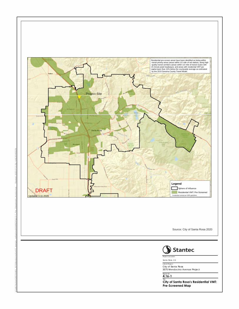
V:\1
85
7\A
ctive\1
85
704
99
3_3
57
5M
end
ocin
oA
ve\0
3_
data
\gis
_ca
d\g
is\m
xd
\IS
MN
D\F
ig2
.0-7
_F
ire
_D
ep
art
men
t_A
cce
ss.m
xd
R
evis
ed
: 20
20
-07-2
1 B
y: K
AE
JO
HN
SO
N
City of Santa Rosa3575 Mendocino Avenue Project
Santa Rosa, CA
Figure No. 4.16-1TitleCity of Santa Rosa's Residential VMT: Pre-Screened Map
Project Location
Client/Project
DRAFT
Legend
Sphere of Influence
Residential VMT: Pre-Screened
*residential exempt per OPR guidelinesUpdated 3-11-2020
Residential pre-screen areas have been identified as being within transit priority areas (areas within 1/2 mile of rail station), along high
quality transit corridors (areas within 1/2 mile of transit routes with 15 minute peak headways), and areas with residential VMT per capita lower than 15% below the countywide average as estimated
by the 2019 Sonoma County Travel Model.
Source: City of Santa Rosa 2020
Project Site

3575 Mendocino Avenue Project Environmental Checklist and Environmental Evaluation SCEA
4-176
This page left intentionally blank.

3575 Mendocino Avenue Project SCEA Environmental Checklist and Environmental Evaluation
4-177
Sight Distance
Sight distances along Mendocino Avenue at the proposed project access points were evaluated based on sight distance criteria contained in the Highway Design Manual published by Caltrans. The recommended sight distance for driveway approaches is based on stopping sight distance and uses the approach travel speed as the basis for determining the recommended sight distance. For intersections, the recommended sight distance is based on corner sight distance.
The speed limit on Mendocino Avenue is posted at 40 miles per hour (mph), resulting in a recommended minimum corner sight distance of 440 feet for intersections. Due to the relatively level terrain of the paved area combined with the straight roadway geometry, over 440 feet of sight distance was observed in each direction at the location of the new public street at the center of the project site, exceeding the recommended minimum corner sight distance.
As the northern and southern entrances are driveways and not intersections, stopping sight distance was used. At a posted speed limit of 40 mph, the recommended minimum stopping sight distance is 300 feet. Since the northern and southern driveways are limited to right-in and right-out movements, only sight distance to the north was considered for these two driveways. Sight distance to the north from the southern driveway was measured in excess of 300 feet, meeting the recommended minimum sight distance.
There would be approximately 125 feet between the south leg crosswalk at Fountaingrove Parkway-Mendocino Overcrossing/Mendocino Avenue and the northern driveway. Westbound left-turning and eastbound right-turning drivers at this intersection would be visible to a driver exiting this driveway at approximately 170 feet. A speed of 25 mph, which is the likely speed of turning drivers, would correspond to a recommended minimum sight distance of 150 feet. At least 300 feet of sight distance is available to southbound through drivers at the intersection who may be traveling at the 40 mph speed limit. Therefore, the recommended minimum sight distance is available at the northern driveway for southbound traffic approaching from each movement at Fountaingrove Parkway-Mendocino Overcrossing/Mendocino Avenue that results in a southbound departure.
Based on field observations and the proposed project’s site plan, sight distances along Mendocino Avenue at the project egresses are adequate.
Traffic Signal Warrants
A signal warrant analysis was performed to determine the potential need for a traffic signal at the new public street.
Chapter 4C of the CA-MUTCD provides guidance on when a traffic signal should be considered.
For the purposes of this study the Peak Hour Volume Warrant, which determines the need for traffic control based on the highest volume hour of the day, was used as an initial indication of traffic control needs. The use of this signal warrant is common practice for planning studies. Other warrants, which are more generally applicable to existing traffic issues, require collection of traffic volumes for the highest four or eight hours of the day, review of the collision history, and evaluation of the system surrounding the location.
Under the Peak Hour Volume Warrant the need for a traffic control signal may be indicated if an engineering study finds that the criteria in either of the following two categories are met:
1. If all three of the following conditions exist for the same one hour (any four consecutive 15-minute periods) of an average day:

3575 Mendocino Avenue Project Environmental Checklist and Environmental Evaluation SCEA
4-178
a. The total stopped time delay experienced by the traffic on one minor-street approach (one direction only) controlled by a STOP sign equals or exceeds: four vehicle-hours for a one-lane approach; or five vehicle-hours for a two-lane approach, and
b. The volume on the same minor-street approach (one direction only) equals or exceeds 100 vehicles per hour for one moving lane of traffic or 150 vehicles per hour for two moving lanes, and
c. The total entering volume serviced during the hour equals or exceeds 650 vehicles per hour for intersections with three approaches or 800 vehicles per hour for intersections with four or more approaches.
2. The plotted point representing the vehicles per hour on the major street (total of both approaches) and the corresponding vehicles per hour on the higher-volume minor-street approach (one direction only) for one hour (any four consecutive 15-minute periods) of an average day falls above the applicable curve in Figure 4C-3 for the existing combination of approach lanes.
A key component of the Peak Hour Volume Warrant is the volume of traffic entering from the minor street, or in this case the new public street. Condition A.2 requires 100 vehicles to enter from the minor street, and the figure for Condition B (Figure 4C-3) requires lower minor street volumes with higher major street volumes, but the curve has a minimum requirement of 100 minor street vehicles. The Peak Hour Volume Warrant therefore cannot be satisfied without a minimum volume of 100 vehicles entering Mendocino Avenue from the new public street, representing outbound trips.
Using the trip generation detailed in the 3575 Mendocino Avenue Traffic Impact Analysis (Appendix L), it is anticipated that the proposed project would generate 119 outbound vehicles during the AM peak hour and 83 outbound vehicles during the PM peak hour.
The PM peak hour outbound volume of 83 vehicles is insufficient to meet the Peak Hour Volume Warrant even if all outbound trips were made using the new public street. For the AM peak hour, it is not likely that 100 or more outbound trips would be made using the new public street. While all northbound trips would need to use the new public street to turn left out of the site, these trips are only expected to represent 20 percent of the total, or 24 trips. For southbound trips, drivers would have the option to use any of the three proposed access points, although it is likely that preference would be given to the southern and northern driveways due to the concentration of parking that is more directly accessed via these driveways, particularly the southern driveway which would provide the most direct route for drivers leaving the proposed parking garage traveling southbound. As this would leave too few vehicles departing the project site using the new public street to warrant installation of a traffic signal by way of the Peak Hour Volume Warrant, the warrant would remain unmet with any volume of traffic on Mendocino Avenue. For this reason, specific signal warrants for Existing, Baseline, and Future Conditions were not assessed, as it can be determined by inspection that none of these would be satisfied.
Therefore, operation of the proposed project would not substantially increase hazards due to a design feature, and impacts would be less than significant.
Compatibility of Land Uses
The project would only include residential uses. As the site is zoned for residential use in the General Plan and the previous use was residential, the development of new residential facilities would result in a less than significant impact with regard to land use compatibility.

3575 Mendocino Avenue Project SCEA Environmental Checklist and Environmental Evaluation
4-179
Level of Significance Before Mitigation Less Than Significant Impact.
Mitigation Measures No mitigation is necessary.
Level of Significance After Mitigation Less Than Significant Impact.
Impact TRANS-4 Result in inadequate emergency access?
Impact Analysis The project site plan depicts an internal circulation network that would provide emergency vehicle access throughout the project site. Two driveways and a new public street would provide emergency access to southbound Mendocino Avenue, and the public street would also provide access to northbound Mendocino Avenue. The proposed project would not impact emergency access on nearby streets. The project site would therefore have adequate emergency access and would result in a less than significant impact related to emergency access.
Level of Significance Before Mitigation Less Than Significant Impact.
Mitigation Measures No mitigation is necessary.
Level of Significance After Mitigation Less Than Significant Impact.

3575 Mendocino Avenue Project Environmental Checklist and Environmental Evaluation SCEA
4-180
This page left intentionally blank.

3575 Mendocino Avenue Project SCEA Environmental Checklist and Environmental Evaluation
4-181
4.17 TRIBAL CULTURAL RESOURCES
Would the Project: Potentially Significant
Impact
Less Than Significant With
Mitigation Incorporated
Less Than Significant
Impact No Impact
a) Would the project cause a substantial adverse change in the significance of a tribal cultural resource, defined in Public Resources Code section 21074 as either a site, feature, place, cultural landscape that is geographically defined in terms of the size, or object with cultural value to the California Native American tribe and that is:
i. listed or eligible for listing in the California Register of Historical Resources, or in a local register of historical resources as defined in Public Resources Code section 5020.1(k).
ii. A resource determined by the lead agency, in its discretion and supported by substantial evidence, to be significant pursuant to criteria set forth in subdivision (c) of Public Resources Code Section 5024.1. In applying the criteria set forth in subdivision (c) of Public Resource Code Section 5024.1, the lead agency shall consider the significance of the resource to a California Native American tribe.
4.17.1 Environmental Setting
The study area is situated in what was historically occupied by the Southern Pomo (McLendon and Oswalt 1978). Southern Pomo territory extended from about 5 miles south of Santa Rosa to 40 miles north, and from the eastern drainage of the Russian River westward to Kashaya and Central Pomo territory (McLendon and Oswalt 1978:279). Linguistically, less is known about the southern Pomo than that of other Pomo-speaking groups because of the effects of the missions and early Mexican and American settlement (Golla 2011:109). The language was first referred to as “Gallinomero” by Stephen Powers who collected vocabulary at Healdsburg in 1872, but this language was apparently only spoken in the interior, along the lower Russian River from Cloverdale to Guerneville and in the Dry Creek Valley and Santa Rosa Plain (Golla 2011:110, 111). As of the early 2000s, southern Pomo was reported to have two or three semi-speakers living in Cloverdale and Geyserville; however, Elsie Allen, the person generally considered to be the last fluent speaker of the language, died in 1990 (Golla 2011: 110).
Samuel Barrett (1908) describes old villages, uninhabited modern villages, and inhabited village sites in the project area. The nearest inhabited village to the project site at the time of Barrett’s writing is “Kolo’ko that is located about two miles east‐southeast of Healdsburg” (Barrett 1908:218). Another site identified by Barrett (1908:213-214) is Balíkletcawithat, which is located at the southern end of the Town of Sebastopol. The site’s name is derived from the Russian River division of Southern Pomo dialect for the word’s alder, tree, house, and elderberry. In 1908, the site

3575 Mendocino Avenue Project Environmental Checklist and Environmental Evaluation SCEA
4-182
consisted of a single structure that housed seven people; however, Barrett notes that it was once a heavily populated village (1908: 213-214).
Presently, the Coast Miwok and Southern Pomo form the Graton Rancheria community, a federation of the Coast Miwok and Southern Pomo groups recognized by the U.S. Congress. The Bodega Miwok traditionally lived in the area of Bodega Bay, while the Southern Pomo Sebastopol group lived just north and east of the Miwok. The Town of Sebastopol is located about 1 mile midway between the north boundary of Miwok territory and the southern edge of Southern Pomo territory (Federated Indians of Graton Rancheria 2018).
The original Graton Rancheria is in Sebastopol and is a 15.5-acre tract of land established by the federal government in the 1920s. In 1958, congress passed the California Rancheria Act that terminated California rancherias, including Graton. At that time, the land was removed from federal trust and distributed to three residents as private property. This action terminated the federal recognition of the Tribe. The Tribe regained their federal recognition status in 2000, and in 2005 the Tribe purchased approximately 254 acres of land for its reservation just outside Rohnert Park. In 2013, the Tribe opened the Graton Resort and Casino that funds programs and services for tribal citizens (Federated Indians of Graton Rancheria 2018).
On June 15, 2020, Stantec sent an email with a map depicting the project site to the Native American Heritage Commission and requesting a review of their sacred lands files for any Native American cultural resources that might be affected by the proposed project. The Native American Heritage Commission responded on the same day (June 15, 2020), stating that no known sacred sites or tribal cultural resources had been identified within the project area.
No Tribal Cultural Resources (TCR) were identified within the project area through the Assembly Bill (AB) 52 process completed by the City. The Federated Indians of Graton Rancheria stated that the Tribe has already responded to the City’s Senate Bill 18/AB 52 notification requesting further consultation and stated that project activities do have the potential to expose cultural (tribal) resources. In addition, the area was identified as sensitive for archaeological and tribal resources by the Lytton Band of Pomo Indians in an email sent to Stantec on behalf of the City on July 23, 2020. The Tribe emailed the following statement: While the Tribe has no specific information which it could provide to you for inclusion in your reports, it believes that the project land falls within traditional Pomo territory and that there is a potential for finding tribal cultural resources on the project site. The Lytton Rancheria is interested in the protection and preservation of Pomo artifacts and sites and believes that such cultural resources may be encountered during the proposed project.”
4.17.2 Previous Environmental Analysis
City of Santa Rosa General Plan EIR Summary
The General Plan EIR addressed tribal cultural resources in Chapter J. With implementation of the General Plan policies all potential impacts to tribal cultural resources were found to be less than significant.
The following General Plan policies would be applicable to the proposed project:
Policy HP-A-3: If cultural resources are encountered during development, work should be halted to avoid altering the materials and their context until a qualified consulting archaeologist and Native American representative (if appropriate) has evaluated the situation, recorded the identified cultural resources, and determined suitable mitigation measures.

3575 Mendocino Avenue Project SCEA Environmental Checklist and Environmental Evaluation
4-183
Policy HP-A-4: Consult with local Native American tribes to identify, evaluate, and appropriately address cultural resources and tribal sacred sites through the development review process.
Policy HP-A-5: Ensure that Native American human remains are treated with sensitivity and dignity and assure compliance with the provisions of California Health and Safety Code Section 7050.5 and California Public Resources Code Section 5097.98.
Plan Bay Area EIR Summary
The following summarizes the potential impacts related to tribal cultural resources discussed in Chapter 2.11 of the Plan Bay Area EIR and includes the complete text of mitigation measures previously identified by the Plan Bay Area EIR that are applicable to the proposed project.
Impact 2.11-5: Tribal Cultural Resources. The Plan Bay Area EIR analyzed the potential impact related to substantial adverse change to the significance of a TCR as defined in PRC Section 21074 and determined that with the implementation of Mitigation Measure 2.11-5, the impact would be less than significant (Refer to Impact TRIB-1 in Section 4.17.3, Project-Specific Analysis).
PBA EIR MM 2.11-5: Tribal Cultural Resources. If the implementing agency determines that a project may cause a substantial adverse change to a TCR, and measures are not otherwise identified in the consultation process required under PRC Section 21080.3.2, implementing agencies and/or project sponsors shall implement the following measures where feasible and necessary to address site-specific impacts to avoid or minimize the significant adverse impacts:
• Within 14 days of determining that a project application is complete, or to undertake a project, the lead agency must provide formal notification, in writing, to the tribes that have requested notification of proposed projects in the lead agency’s jurisdiction. If it wishes to engage in consultation on the project, the tribe must respond to the lead agency within 30 days of receipt of the formal notification. The lead agency must begin the consultation process with the tribes that have requested consultation within 30 days of receiving the request for consultation. Consultation concludes when either: 1) the parties agree to measures to mitigate or avoid a significant effect, if a significant effect exists, on a tribal cultural resource, or 2) a party, acting in good faith and after reasonable effort, concludes that mutual agreement cannot be reached.
• Public agencies shall, when feasible, avoid damaging effects to any TCR (PRC Section 21084.3 (a)). If the lead agency determines that a project may cause a substantial adverse change to a TCR, and measures are not otherwise identified in the consultation process, new provisions in the PRC describe mitigation measures that, if determined by the lead agency to be feasible, may avoid or minimize the significant adverse impacts (PRC Section 21084.3 (b)). Examples include:
(1) Avoidance and preservation of the resources in place, including, but not limited to, planning and construction to avoid the resources and protect the cultural and natural context, or planning greenspace, parks, or other open space, to incorporate the resources with culturally appropriate protection and management criteria.
(2) Treating the resource with culturally appropriate dignity taking into account the tribal cultural values and meaning of the resource, including, but not limited to, the following:
(A) Protecting the cultural character and integrity of the resource

3575 Mendocino Avenue Project Environmental Checklist and Environmental Evaluation SCEA
4-184
(B) Protecting the traditional use of the resource
(C) Protecting the confidentiality of the resource.
(3) Permanent conservation easements or other interests in real property, with culturally appropriate management criteria for the purposes of preserving or utilizing the resources or places.
(4) Protecting the resource.
4.17.3 Project-Specific Analysis
Impact TRIB-1 Cause a substantial adverse change in the significance of a tribal cultural resource, defined in Public Resources Code Section 21074 as either a site, feature, place, cultural landscape that is geographically defined in terms of the size and scope of the landscape, sacred place, or object with cultural value to California Native American tribe, and that is:
i) Listed or eligible for listing in the California Register of Historical Resources, or in a local register of historical resources as defined in Public Resources Code section 5020.1(k), or
ii) A resource determined by the lead agency, in its discretion and supported by substantial evidence, to be significant pursuant to criteria set forth in subdivision (c) of Public Resources Code Section 5024.1. In applying the criteria set forth in subdivision (c) of Public Resource Code Section 5024.1, the lead agency shall consider the significance of the resource to a California Native American tribe.
Impact Analysis No known TCRs were identified at the project site. A field survey of the project site was also conducted and did not identify any archaeological or TCRs at the project site. The survey also noted that the project site has been disturbed by grading, construction, and debris removal from the former mobile home park that was previously located on the project site. However, one tribe has stated that the area is sensitive for TCRs, though none were specifically identified, and requested monitoring of ground disturbance activities.
Subsurface construction activities associated with the proposed project could potentially damage or destroy previously undiscovered TCRs. Therefore, the proposed project would incorporate Mitigation Measure CUL-1 (PBA EIR MM 2.11-2), in which project sponsors follow recommendations identified in the survey, which may include activities such as implementing construction monitoring by a qualified archaeologist; Mitigation Measure CUL-2, which establishes a CRMP and implementation of monitoring, and Mitigation Measure TRIB-1 (PBA EIR MM 2.11-5), which requires that public agencies consult with Tribes and, when feasible, avoid damaging effects to any TCR. With implementation of these mitigation measures, potential impacts would be reduced to a less than significant level.
Level of Significance Before Mitigation Potentially Significant Impact.
Mitigation Measures Mitigation Measure CUL-1 (PBA EIR MM 2.11-2: Archaeological Resources), Mitigation Measure CUL-2 (Cultural Resources Monitoring), and Mitigation Measure TRIB-1 (PBA EIR MM 2.11-5: Tribal Cultural Resources) are required.

3575 Mendocino Avenue Project SCEA Environmental Checklist and Environmental Evaluation
4-185
Mitigation Measure TRIB-1 (PBA EIR MM 2.11-5: Tribal Cultural Resources). The following measures from PBA EIR MM 2.11-5: Tribal Cultural Resources are relevant to this proposed project:
If the implementing agency determines that a project may cause a substantial adverse change to a TCR, and measures are not otherwise identified in the consultation process required under PRC Section 21080.3.2, implementing agencies and/or project sponsors shall implement the following measures where feasible and necessary to address site-specific impacts to avoid or minimize the significant adverse impacts:
• Public agencies shall, when feasible, avoid damaging effects to any TCR (PRC Section 21084.3 (a)). If the lead agency determines that a project may cause a substantial adverse change to a TCR, and measures are not otherwise identified in the consultation process, new provisions in the PRC describe mitigation measures that, if determined by the lead agency to be feasible, may avoid or minimize the significant adverse impacts (PRC Section 21084.3 (b)). Examples include:
(1) Avoidance and preservation of the resources in place, including, but not limited to, planning and construction to avoid the resources and protect the cultural and natural context, or planning greenspace, parks, or other open space, to incorporate the resources with culturally appropriate protection and management criteria.
(2) Treating the resource with culturally appropriate dignity taking into account the tribal cultural values and meaning of the resource, including, but not limited to, the following:
(A) Protecting the cultural character and integrity of the resource
(B) Protecting the traditional use of the resource
(C) Protecting the confidentiality of the resource.
(3) Permanent conservation easements or other interests in real property, with culturally appropriate management criteria for the purposes of preserving or utilizing the resources or places.
(4) Protecting the resource.
Level of Significance After Mitigation Less Than Significant Impact With Mitigation.

3575 Mendocino Avenue Project Environmental Checklist and Environmental Evaluation SCEA
4-186
This page left intentionally blank.

3575 Mendocino Avenue Project SCEA Environmental Checklist and Environmental Evaluation
4-187
4.18 UTILITIES AND SERVICE SYSTEMS
Would the Project: Potentially Significant
Impact
Less Than Significant With
Mitigation Incorporated
Less Than Significant
Impact No Impact
a) Require or result in the relocation or construction of new or expanded water, wastewater treatment or stormwater drainage, electric power, natural gas, or telecommunications facilities, the construction or relocation of which could cause significant environmental effects?
b) Have sufficient water supplies available to serve the project and reasonably foreseeable future development during normal, dry and multiple dry years?
c) Result in a determination by the wastewater treatment provider, which serves or may serve the proposed project that it has adequate capacity to serve the project’s projected demand in addition to the provider’s existing commitments?
d) Generate solid waste in excess of state or local standards, or in excess of the capacity of local infrastructure, or otherwise impair the attainment of solid waste reduction goals?
e) Comply with federal, state, and local statutes and regulations related to solid waste?
4.18.1 Environmental Setting
The project site was previously developed as a mobile home park and was occupied by the former Journey’s End Mobile Home Park until it was destroyed in October 2017 by the Tubbs Wildfire. In January 2020, the mobile home park was formally closed, all structures have been removed, and the property is vacant. The property extends over generally flat terrain that gently slopes to the southwest. The project site is generally comprised of areas of paved asphalt; dirt and gravel; and limited, fire damaged vegetation. PG&E provides gas and electric utilities to the project site and sewer service is provided by the City. Water was provided to the mobile home park by two private onsite wells and an above-ground water distribution system which was severely damaged by the wildfire. The proposed project would continue to be served by the City’s sewer system as well as PG&E for gas and electric services and would connect to the City’s water system. The onsite wells may be used for landscape irrigation purposes.
Water Supply
The proposed project would connect to the City’s water system. The City receives approximately 90 to 95 percent of its water supply from Sonoma Water. The remaining 5 to 10 percent comes from groundwater wells and recycled water, which is largely used for non-drinking water purposes, such as landscape irrigation (City of Santa Rosa 2016). The City’s water supply from Sonoma Water is predominantly surface water, which is diverted from the Russian River via the Santa Rosa and Sonoma Aqueducts. In addition to surface water diverted from the Russian River, Sonoma Water’s surface water supply is supplemented from groundwater wells located in the Santa Rosa Plain Subbasin of

3575 Mendocino Avenue Project Environmental Checklist and Environmental Evaluation SCEA
4-188
the Santa Rosa Valley Groundwater Basin. Separate from Sonoma Water, the City has four active wells within the Santa Rosa Plain Subbasin of the Santa Rosa Valley Groundwater Basin to provide potable water supply (City of Santa Rosa 2014). The City also owns and operates the Subregional Water Reuse System, from which the City has historically used approximately 153 acre-feet or 50 million gallons per year of recycled water for urban landscape irrigation (City of Santa Rosa 2014).
The 2035 General Plan projected an additional 4,000 residential units over the 2020 General Plan and the 2035 General Plan EIR projected an associated water demand in 2035 that could be served by the available water supply (City of Santa Rosa 2009). The 2035 General Plan also includes a WSA as required by SB 610. The WSA addresses the current and planned future water demand of Sonoma Water, the projected demand for uses anticipated by the 2035 General Plan, the projected water supply of Sonoma Water, and makes a determination of the sufficiency of its water supplies for uses anticipated by the 2035 General Plan, in addition to the existing and planned future uses. Although the City’s General Plan extends to the horizon year of 2035, the WSA anticipated the projected water demand through 2028. The WSA determined that the City’s projected water supplies, consisting of existing and additional water supplies, are sufficient to meet the projected water demand associated with uses anticipated by the General Plan, in addition to current and planned future uses, through 2028 (City of Santa Rosa 2008).
The City’s 2015 Urban Water Management Plan (UWMP) (adopted June 14, 2016) addresses the water system operated by Sonoma Water and describes the water supply sources; magnitudes of historical and projected water use; and a comparison of water supply to demands during normal, single-dry, and multiple-dry years. The 2015 UWMP projected demand through 2040, based on population and employment projections in the 2035 General Plan. According to the 2015 UWMP, the total water supply (from purchased/imported water, groundwater, and recycled water sources) available from 2020 to 2040 is estimated to be 31,540 acre feet per year (AFY) (or 28,157,092 million gallons per day [mgd]) (City of Santa Rosa 2016). The 2015 UWMP projected that water supply would exceed total water demand through 2040 (City of Santa Rosa 2016).
As discussed in a letter dated June 4, 2020 from the City, the Santa Rosa Water Department reviewed the 2008 WSA and the 2015 UWMP, and determined that the proposed project would not substantially increase water demand or affect the ability of the City’s water system from providing sufficient water supplies to the proposed project, and that no significant new information has become available that was not known and could not have been known at the time when the 2008 WSA and the 2015 UWMP were prepared that would impact the City’s ability to meet the water demand for the proposed project. As such, the City determined that an additional WSA is not required for the proposed project (Appendix B).
The proposed project would be required to comply with the California Fire Code and all applicable fire safety standards set forth by the City to protect the proposed structures and future occupants. The proposed project includes the placement of 11 new fire hydrants within the project site and the construction of fire mains within the private driveways to serve individual buildings. The new buildings would also be equipped with standard safety features such as certified alarm systems, fire extinguishers, and fire sprinklers (as required by General Plan policy NS-G-2) to alert occupants of potential fires. The fire sprinklers installed for the proposed project would comply with the California Building Code and the National Fire Protection Association. The City’s Standard Conditions of Approval also require a Fire Flow Analysis to ensure that proposed fire hydrants would provide adequate fire flow.
Wastewater Treatment
Sewage generated from residential uses within the City is collected and transported to the Laguna Wastewater Treatment Plant (WTP). The Laguna WTP is managed by the City and provides wastewater treatment and disposal services for the City as well as for Rohnert Park, Cotati, Sebastopol, and South Park Sanitation District (City of Santa

3575 Mendocino Avenue Project SCEA Environmental Checklist and Environmental Evaluation
4-189
Rosa 2009a). The Laguna WTP currently has a total permitted capacity of 21.34 mgd and has an average daily dry weather flow of 17.5 mgd (City of Santa Rosa 2020d). The primary point of discharge is via Delta Pond at the confluence of Santa Rosa Creek and Laguna de Santa Rosa.
Stormwater Management
Municipalities are required to proactively control and regulate pollution from their municipal storm sewer systems to mitigate the potential detrimental impacts of urban runoff. Stormwater generated in Santa Rosa drains through six drainage basins to the Laguna de Santa Rosa. The largest drainage basin includes Santa Rosa Creek, which drains the northern Santa Rosa area via six major creeks and various tributaries. Four creeks (Brush, Austin, Spring, and Matanzas Creeks) primarily drain the east portion, while Paulin and Piner Creeks drain the west portion. Santa Rosa Creek also drains stormwater runoff generated downtown and in surrounding neighborhoods. The number and location of creeks in northern Santa Rosa result in adequate stormwater drainage capacity in the northern area (City of Santa Rosa 2009b). The City’s SUSMP requires projects to design and implement post‐development measures to reduce potential stormwater impacts to local drainages (City of Santa Rosa 2005, 2009a).
Solid Waste
Solid waste services within the City are provided by Recology Sonoma Marin. Waste collected from homes and businesses within the City is processed at the transfer station at 500 Meacham Road in Petaluma. Solid waste is then transferred to the Redwood Landfill in Marin County, Keller Canyon Landfill in Contra Costa County, or to the Potrero Hills Landfill in Solano County. The current maximum daily permitted capacities and remaining capacities for each landfill are included in Table 4.18-1.
Table 4.18-1: Landfill Facility Detail
Landfill Total Acreage Remaining Capacity
(CY) Daily Permitted Capacity
(tons per day) Redwood Landfill 222.50 26,000,000 2,300
Keller Canyon Landfill 244 63,408,410 3,500
Potrero Hills Landfill 340 13,872,000 4,330
Total 10,130 Sources: CalRecycle 2020a, 2020b, 2020c Key: CY = cubic yards
Electricity, Natural Gas, and Telecommunications
PG&E provides electric power and natural gas services to the City. Telecommunications in the City are provided by a number of providers. The General Plan found that at full buildout, capacity would not exceed the demand for electricity and natural gas. Furthermore, future development would be subject to more stringent energy efficiency standards required by Title 24.
3575 Mendocino Avenue Project Environmental Checklist and Environmental Evaluation SCEA
4-190
4.18.2 Previous Environmental Analysis
City of Santa Rosa General Plan EIR Summary
Chapter G of the General Plan EIR discusses the potential impacts on utilities and service systems. The General Plan EIR identified potentially significant impacts on utilities and service systems; however, existing local laws and policies contained in the General Plan would reduce potential impacts on utilities and service systems to less than significant levels.
The following General Plan policies are applicable to the proposed project:
Policy GM-B-4: Direct growth to areas where services and infrastructure can be provided efficiently. Do not allow any development in the approximately 453-acre area generally east of Santa Rosa Avenue and north of Todd Road (as mapped in Figure 8-1 of [the] General Plan 2035), until 2010.
Policy PSF-F-1: Utilize high quality water from the Sonoma County Water Agency aqueduct system as the primary water supply.
Policy PSF-F-2: Ensure that water supply capacity and infrastructure are in place prior to occupancy of new development.
Policy PSF-H-3: Expand recycling efforts in multifamily residential and commercial projects and continue to encourage recycling by all residents.
Plan Bay Area EIR Summary
The following summarizes the potential impacts related to public utilities and facilities discussed in Chapter 2.12 of the Plan Bay Area EIR.
Impact 2.12-1: Water Supply Entitlements and Resources. The Plan Bay Area EIR analyzed the potential impacts related to insufficient water supplies from existing entitlements and resources to serve expected development and determined that with the implementation of Mitigation Measures 2.12-1(a), 2.12-1(b), and 2.12-1(c), the impact would be less than significant. As discussed in Impacts UTIL-1 and UTIL-2, there would be sufficient water capacity to serve the proposed project. Therefore, Mitigation Measure 2.12-1(a) is not applicable (Refer to Section 4.18.3, Project-Specific Analysis). The proposed project is not considered a transportation project; therefore, Mitigation Measures 2.12-1(b) and 2.12-1(c) are not applicable.
Impact 2.12-2: Wastewater Treatment Capacity. The Plan Bay Area EIR analyzed the potential impacts related to inadequate wastewater treatment capacity to serve new development and determined that with the implementation of Plan Bay Area Mitigation Measure 2.12-2, the impact would be less than significant. As discussed in Impacts UTIL-1 and UTIL-3, there would be sufficient wastewater capacity to serve the proposed project. Therefore, Mitigation Measure 2.12-2 is not applicable (Refer to Section 4.18.3, Project-Specific Analysis).
Impact 2.12-3: Construction of New or Expanded Stormwater Drainage Facilities. The Plan Bay Area EIR analyzed the potential impacts related to construction of new or expanded stormwater facilities, which could cause significant environmental impacts, and determined that with the implementation of Mitigation Measures 2.12-3(a), 2.12-3(b), and 2.12-3(c), the impact would be less than significant. As discussed in Impact UTIL-1, the proposed project would provide adequate stormwater facilities. Therefore, Mitigation Measure 2.12-3(a) is not applicable (Refer

3575 Mendocino Avenue Project SCEA Environmental Checklist and Environmental Evaluation
4-191
to Section 4.18.3, Project-Specific Analysis). The proposed project is not considered a transportation project, and therefore Mitigation Measures 2.12-3(b) and 2.12-3(c) are not applicable.
Impact 2.12-4: Construction of New or Expanded Water and Wastewater Treatment Facilities. The Plan Bay Area EIR analyzed the potential impacts related to construction of new or expanded water and wastewater treatment facilities, which could cause significant environmental impacts, and determined that with the implementation of Mitigation Measure 2.12-4, the impacts would be less than significant. As discussed in Impacts UTIL-1 and UTIL-3, there would be adequate water and wastewater treatment facilities to accommodate the proposed project. Therefore, Mitigation Measure 2.12-4 is not applicable (Refer to Section 4.18.3, Project-Specific Analysis).
Impact 2.12-5: Insufficient Landfill Capacity. The Plan Bay Area EIR analyzed the potential impacts related to insufficient landfill capacity to serve new development while complying with applicable regulations and determined that with the implementation of Mitigation Measures 2.12-5, the impact would be less than significant. As discussed in Impact UTIL-4, there would be adequate landfill capacity for the proposed project. Therefore, Mitigation Measure 2.12-5 is not applicable (Refer to Section 4.18.3, Project-Specific Analysis).
4.18.3 Project-Specific Analysis
Impact UTIL-1 Require or result in the relocation or construction of new or expanded water, wastewater treatment or stormwater drainage, electrical power, natural gas, or telecommunications facilities, the construction or relocation of which could cause significant environmental effects?
Impact Analysis The project site was previously developed as the Journey’s End Mobile Home Park until it was destroyed in October 2017 by the Tubbs Wildfire. Since then, the mobile home park has been formally closed, all structures have been removed, and the project site is vacant. The project site extends over generally flat terrain that gently slopes to the southwest. The project site is generally comprised of areas of paved asphalt; dirt and gravel; and limited, fire damaged vegetation. PG&E provides gas and electric utilities to the project site, and sewer service is provided by the City. Water was provided to the mobile home park by two private onsite wells and an above-ground water distribution system which was severely damaged by the Tubbs Wildfire. The proposed project would continue to be served by the City’s sewer system as well as PG&E for gas and electric services and would connect to the City’s water system. Improvements required by the proposed project are discussed below. The onsite wells may be used for landscape irrigation purposes.
Water
The proposed project would connect to the City’s municipal water supply system. The total water demand for the proposed project is anticipated to be approximately 200 AFY or approximately 178,400 gpd. Based on the City’s review of the 2008 WSA for the 2035 General Plan and its 2015 UWMP, it was determined that an additional WSA is not required for the proposed project and the City’s existing water system would sufficiently supply water for the proposed project. A looped public water main would be constructed through the project site providing two points of connection to the existing water main in Mendocino Avenue. Additionally, the proposed project includes the placement of 11 new fire hydrants within the project site and the construction of fire mains within the private driveways to serve individual buildings. The proposed project would implement water conservation measures by providing water efficient landscaping as required by Title 24 and the City’s Water Efficient Landscape Ordinance. Two existing, private wells located on the project site may be used to irrigate landscaping. All water distribution improvements for the proposed project would be constructed and designed within City right of way or private

3575 Mendocino Avenue Project Environmental Checklist and Environmental Evaluation SCEA
4-192
driveways in accordance with the City’s Water Construction Standards and Specifications, and Water Design Standards. The proposed project would not result in the relocation or construction of new or expanded water facilities; therefore, impacts associated with the construction of water facilities would be less than significant.
Wastewater Treatment
The project site is currently served by an 8-inch sewer main line located along the southern boundary of the project site, which eventually leads to the Laguna WTP. The proposed project would construct a public sanitary sewer line that would connect to the existing 8-inch public sanitary sewer main line and private sanitary sewer lines that would be 6 to 8 inches in diameter. All sewer distribution improvements would be constructed and designed within City right of way or private driveways in accordance with the City’s Sewer Construction Standards and Specifications, and Sewer Design Standards.
The Laguna WTP currently has a total permitted capacity of 21.34 mgd and has an average daily dry weather flow of 17.5 mgd (City of Santa Rosa 2020d). The proposed project would generate approximately 172,838 gpd of wastewater, which would represent a less than 1 percent increase in the 17.5 mgd average dry weather flow at the Laguna WTP. Actual generation rates would likely be lower due to water conservation measures required by Title 24. The proposed project would also provide water-efficient landscaping and may include a greywater laundry wastewater re-use system. Therefore, wastewater generated by the proposed project would be accommodated by the existing capacity of the Laguna WTP. The proposed project would not result in the relocation or construction of new or expanded wastewater facilities, and impacts would be less than significant.
Stormwater Drainage
The proposed project would construct a new 24-inch public stormwater line and private stormwater lines to serve the proposed buildings. The 24-inch public stormwater line would be located at the southwest corner of the project site and constructed with an outfall into the adjacent Russell Creek. The proposed stormwater outfall disturbance area is estimated to be approximately 400 square feet (0.009 acres). Potential biological resource impacts associated with the proposed stormwater outfall disturbance area is included in Section 4.3, Biological Resources. As required by the City’s SUSMP, the proposed project would also implement post-construction BMPs and low-impact development measures consisting of vegetated swales, bioretention areas, and permeable pavement. These areas would provide approximately 158,000 square feet of pervious surface on the project site and would retain and treat stormwater prior to entering the stormwater system. The new outfall and stormwater facilities would be designed in accordance with the requirements of Sonoma Water’s Flood Management Design Manual and the City’s Public Storm Drain Standards to ensure sufficient stormwater capacity is provided for the proposed project. Therefore, impacts associated with the construction of stormwater facilities would be less than significant.
Electricity and Natural Gas
PG&E is the electric and natural gas provider in the City of Santa Rosa. Although the proposed project would demand additional electricity and natural gas, the 2035 General Plan found that buildout of the General Plan would not exceed the demand for electricity and natural gas.
The proposed project would connect to existing electric and natural gas lines on the project site and/or in Mendocino Avenue. The proposed project would include energy conservation features with a goal to exceed the State’s current Title 24 requirements. The proposed project would also install seven backup generators. Backup generators would be installed in buildings 1, 2, and 3 of the senior affordable housing component and in buildings 4A and garage, 4B(1), and 4C(1) for the market rate housing component. The backup generators are anticipated to be 230-300 kilowatts

3575 Mendocino Avenue Project SCEA Environmental Checklist and Environmental Evaluation
4-193
and would be used to provide electricity and cooling for residents during an emergency, if needed. The electric and natural gas improvements for the proposed project would occur on the project site and/or along Mendocino Avenue and in accordance with PG&E standards. As such, impacts related to the construction of electric and natural gas facilities would be less than significant.
Telecommunications
The proposed project would connect to existing telecommunication facilities located on the project site and/or along Mendocino Avenue. Any additional connections that are deemed necessary during final site design would be placed within utility easements. No expanded capacity would be required for telecommunication facilities and impacts would be less than significant.
Level of Significance Before Mitigation Less Than Significant Impact.
Mitigation Measures No mitigation is necessary.
Level of Significance After Mitigation Less Than Significant Impact.
Impact UTIL-2 Have sufficient water supplies available to serve the project and reasonably foreseeable future development during normal, dry and multiple dry years?
Impact Analysis The proposed project would connect to the City’s municipal water supply system. The 2015 UWMP projected total water demand from 2015 to 2040 based on the population and employment projections in the General Plan and determined that there would be adequate supplies to meet future water demands during normal, single-dry, and multi-dry years (City of Santa Rosa 2016). In addition, the 2008 WSA for the General Plan determined that the City’s projected water supplies, consisting of existing and additional water supplies, are sufficient to meet the projected water demand associated with uses anticipated by the General Plan.
The total water demand for the proposed project is anticipated to be approximately 200 AFY or approximately 178,400 gpd. According to the 2015 UWMP, the total water supply (from purchased/imported water, groundwater, and recycled water sources) available from 2020 to 2040 is estimated to be 31,540 AFY (or 28,157,092 mgd) (City of Santa Rosa 2016). The proposed project would represent a less than 1 percent increase in the total water supply available to the City. Furthermore, as provided in a letter dated June 4, 2020 from the City, the Santa Rosa Water Department reviewed the 2008 WSA and the 2015 UWMP, and determined that the proposed project would not substantially increase water demand or affect the ability of the City’s water system from providing sufficient water supplies to the proposed project, and that no significant new information has become available that was not known and could not have been known at the time when the 2008 WSA and the 2015 UWMP were prepared that would impact the City’s ability to meet the water demand for the proposed project. Therefore, the City determined that an additional WSA is not required for the proposed project (Appendix B). The proposed project would be served by existing and projected future water supplies during normal, single dry years, and multiple dry years, and the impact would be less than significant.
Level of Significance Before Mitigation Less Than Significant Impact.

3575 Mendocino Avenue Project Environmental Checklist and Environmental Evaluation SCEA
4-194
Mitigation Measures No mitigation is necessary.
Level of Significance After Mitigation Less Than Significant Impact.
Impact UTIL-3 Result in a determination by the wastewater treatment provider, which serves or may serve the proposed project that it has adequate capacity to serve the project’s projected demand in addition to the provider’s existing commitments?
Impact Analysis The proposed project would be served by the City’s Utilities Department, who has the primary responsibility for the operation and management of the Santa Rosa Sub Regional Water Reclamation System, which operates the Laguna WTP. The project site is currently served by an 8-inch sewer main line located along the southern boundary of the project site that eventually leads to the Laguna WTP. The proposed project would construct a public sanitary sewer to connect to the existing 8-inch public sanitary sewer main line and would construct private sanitary sewer lines that would be 6 to 8 inches in diameter. The Laguna WTP currently has a total permitted capacity of 21.34 mgd and has an average daily dry weather flow of 17.5 mgd (City of Santa Rosa 2020d). The proposed project would generate approximately 172,838 gpd of wastewater, which would represent a less than 1 percent increase in the 17.5 mgd average dry weather flow at the Laguna WTP. Actual generation rates would likely be lower due to implementation of water conservation measures required by Title 24. The proposed project would also provide water-efficient landscaping and may include a greywater laundry wastewater re-use system. Therefore, the Laguna WTP would have sufficient capacity to serve the proposed project’s estimated wastewater demand and existing commitments. Impacts related to wastewater treatment facilities would be less than significant.
Level of Significance Before Mitigation Less Than Significant Impact.
Mitigation Measures No mitigation is necessary.
Level of Significance After Mitigation Less Than Significant Impact.
Impact UTIL-4 Generate solid waste in excess of state or local standards, or in excess of the capacity of local infrastructure, or otherwise impair the attainment of solid waste reduction goals?
Impact Analysis Solid waste from the project site would be transferred to either the Redwood Landfill in Marin County, Keller Canyon Landfill in Contra Costa County, or to the Potrero Hills Landfill in Solano County. As described above, these landfills have a combined capacity to receive up to 10,130 tons of waste per day. The proposed project would generate 1,383 residents and 17 employees. Using the waste generation factor for residential use of 5.2 pounds per resident per day (CalRecycle 2019), the residential component of the proposed project would be expected to generate a total of 1,314 tons of waste per year, or 3.6 tons of waste per day. In addition to the residential component, it is anticipated that up to 17 staff would work at the project site on a given day during operation. Using the waste disposal generation estimate for employee uses of 11.9 pounds per employee per day, the employees would generate 37 tons per year, or 0.1 tons per day, as shown in Table 4.18-2.

3575 Mendocino Avenue Project SCEA Environmental Checklist and Environmental Evaluation
4-195
Table 4.18-2: Estimated Proposed Project Solid Waste Generation
Project Component Quantity (Proposed)
Generation Rate (lbs/ day)
Pounds Per Day
Tons Per Day
Tons Per Year
Residents (proposed) 1,383 5.2 7,192 3.6 1,314
Employees (proposed) 17 11.9 202 0.1 37
Total - - 7,394 3.7 1,351 Source: CalRecycle 2017 Key: lbs/day = pounds per day
Based on the California Department of Resources Recycling and Recovery (CalRecycle) usage factors, total waste generated for the proposed project is anticipated to be 1,351 tons per year or 3.7 tons per day. The combined permitted intake of the three landfills is 10,130 tons per day and project-generated waste would represent less than 1 percent of daily capacity. The actual percentage would probably be less as all employees would not likely work 365 days per year. The proposed project would also include recycling and green waste services as required by state and local objectives to reduce solid waste. Therefore, the proposed project contribution to solid waste facilities would be less than significant.
Level of Significance Before Mitigation Less Than Significant Impact.
Mitigation Measures No mitigation is necessary.
Level of Significance After Mitigation Less Than Significant Impact.
Impact UTIL-5 Comply with federal, state, and local statutes and regulations related to solid waste?
Impact Analysis Solid waste disposal services must follow federal, State, and local statutes and regulations related to the collection of solid waste. The project proposes development of residential uses, which would not involve the production and/or disposal of any acutely toxic or otherwise hazardous materials. The proposed project would comply with all State and local waste diversion requirements, including Chapter 9‐12 in the City Code, regarding waste collection. As such, impacts would be less than significant.
Level of Significance Before Mitigation Less Than Significant Impact.
Mitigation Measures No mitigation is necessary.
Level of Significance After Mitigation Less Than Significant Impact.

3575 Mendocino Avenue Project Environmental Checklist and Environmental Evaluation SCEA
4-196
This page left intentionally blank.

3575 Mendocino Avenue Project SCEA Environmental Checklist and Environmental Evaluation
4-197
4.19 WILDFIRE
Would the Project: Potentially Significant
Impact
Less Than Significant With
Mitigation Incorporated
Less Than Significant
Impact No Impact
If located in or near state responsibility areas or lands classified as very high fire hazard severity zones would the project;
a) Substantially impair an adopted emergency response plan or emergency evacuation plan?
b) Due to slope, prevailing winds, and other factors, exacerbate wildfire risks, and thereby expose project occupants to pollutant concentrations from a wildfire or the uncontrolled spread of a wildfire?
c) Require the installation or maintenance of associated infrastructure (such as roads, fuel breaks, emergency water sources, power lines, or other utilities) that may exacerbate fire risk or that may result in temporary or ongoing impacts to the environment?
d) Expose people or structures to significant risks, including downslope or downstream flooding or landslides, as a result of runoff, post-fire slope instability, or drainage changes?
4.19.1 Environmental Setting
Climate change is expected to increase the frequency and severity of wildfires in California by altering precipitation and wind patterns, changing the timing of snowmelt, and inducing longer periods of drought. In California, responsibility for wildfire prevention and suppression is shared by federal, State, and local agencies. Federal agencies are responsible for federal lands in Federal Responsibility Areas (FRA). The State of California has determined that some non-federal lands in unincorporated areas with watershed value are of statewide interest and have classified those lands as State Responsibility Areas (SRA), which are managed by CAL FIRE. All incorporated areas and other unincorporated lands not classified as either SRAs or FRAs are classified as LRAs. The project site, an infill site bordered by Mendocino Ave, Russell Creek, Kaiser Permanente Santa Rosa Medical Center, Highway 101, and the Mendocino Overcrossing, is classified as an LRA.
While all of California is subject to some degree of wildfire hazard, there are specific features that make certain areas more hazardous. CAL FIRE is required by law to map areas of significant fire hazard based on fuels, terrain, weather, and other relevant factors (PRC 4201-4204 and Government Code 51175-89). Factors that increase an area’s susceptibility to fire hazard include slope, vegetation type and condition, and atmospheric conditions. CAL FIRE has identified two types of wildland fire risk areas: 1) wildland areas that may contain substantial forest fire risks and hazards, and 2) VHFHSZs. Each fire risk area includes code requirements to reduce the potential risk of wildland fires. Under State regulations, areas within VHFHSZs must comply with specific building and vegetation management requirements intended to reduce property damage and loss of life within these areas. According to the fire hazard

3575 Mendocino Avenue Project Environmental Checklist and Environmental Evaluation SCEA
4-198
severity zone map developed by CAL FIRE, the project site is not located within a VHFHSZ or an SRA fire hazard severity zone (CAL FIRE 2008).
Additionally, the General Plan identifies WUI zones, which are defined as areas where homes are built near or among lands prone to wildland fire. According to the General Plan, WUI zones include four types of fire hazard zones: MFHSZs, HFHSZs, VHFHSZs, and mutual threat. Approximately 30 percent of the City is located in a WUI zone. The project site is not located within a WUI zone as identified in the General Plan and therefore is not designated one of the four WUI fire hazard zones (City of Santa Rosa 2009b).
However, the prior development on the project site, a mobile home park, was substantially damaged by the 2017 Tubbs Wildfire. Although the project site is not located within a designated fire zone and meteorological data collected from CARB’s Sonoma County Airport station identifies wind patterns generally from south to north in the vicinity of the project site (CARB 2020), the prevalent wind direction shifted causing the 2017 Tubbs Wildfire to move over Fountaingrove and jump Mendocino Avenue and the Mendocino/Highway 101 Overcrossing. The Tubbs Wildfire substantially affected the project site, Coffey Park, and other areas of the City. In all, it consumed 36,897 acres and destroyed 6,957 structures, including the majority of the mobile homes that were located on the project site (City of Santa Rosa 2020a). Thus, while the project site is not located within a designated VHFHSZ or WUI zone (CAL FIRE 2008; City of Santa Rosa 2009b), the project site has been subject to wildfire and therefore could be subject to wildfire in the future.
In response to the 2017 Tubbs Wildfire, the City is currently in the process of developing a CWPP for the City’s WUIs. The WUIs indicate certain conditions that exist in areas of Santa Rosa, including but not limited to, the amount, type, and distribution of vegetation; the flammability of the structures (homes, businesses, outbuildings, decks, fences, etc.) in the area, and their proximity to fire-prone vegetation and other combustible structures; weather patterns and general climate conditions; topography; hydrology; average lot size; and road construction. The CWPP will focus on identifying and addressing such conditions and local hazards that exist within the City’s WUIs by providing a “road-map” of actions for the community to address the risk of wildfire in the City.
4.19.2 Previous Environmental Analysis
City of Santa Rosa General Plan EIR Summary
The General Plan EIR did not address the issue of wildfire because it was published in 2009, prior to the adoption of the 2019 CEQA Appendix G Checklist which includes a section on wildfire. Chapter I of the General Plan EIR addresses issues related to wildland fires and determined that development near the City’s urban growth boundary would be at risk from wildland fires. However, compliance with existing federal, State, and local laws, as well as policies contained in the General Plan, would reduce potential impacts to less than significant levels. The General Plan EIR did not identify any mitigation measures.
The General Plan includes the following policies related to wildland fires. Though only Policy NS-G-4 is directly related to the proposed project, all policies related to fire hazard and wildland fires are included herein, as the project site has been affected by wildfire in the past.
Policy NS-G-1: Require proposed developments in high or medium fire hazard areas to investigate a site’s vulnerability to fire and to minimize risk accordingly.
3575 Mendocino Avenue Project SCEA Environmental Checklist and Environmental Evaluation
4-199
Policy NS-G-2: Require new development in areas of high wildfire hazard to utilize fire-resistant building materials. Require the use of onsite fire suppression systems, including automatic sprinklers, smoke and/or detection systems, buffers and fuel breaks, and fire-retardant landscaping.
Policy NS-G-3: Prohibit untreated wood shake roofs in areas of high fire hazard.
Policy NS-G-4: Continue monitoring water fire-flow capabilities throughout the city and improving water availability at any locations having flows considered inadequate for fire protection.
Policy NS-G-5: Require detailed fire prevention and control measures, including community firebreaks, for development projects in high fire hazard zones.
Policy NS-G-6: Minimize single-access residential neighborhoods in development areas near open space and provide adequate access for fire and other emergency response personnel.
Plan Bay Area EIR Summary
Although the Plan Bay Area EIR does not contain a separate section for analyzing impacts related to wildfires, Chapter 2.13 of the Plan Bay Area EIR evaluated the potential impacts related to hazards, including wildfire risk, that may result from future development. The Plan Bay Area EIR determined that impacts related to wildfire would be less than significant because there are existing State and local regulations as well as oversight in place that would effectively reduce the inherent hazard associated with development of areas with a high wildfire hazard risk to an acceptable level. No mitigation measures required.
4.19.3 Project-Specific Analysis
Impact WF-1 Substantially impair an adopted emergency response plan or emergency evacuation plan?
Impact Analysis According to the City’s Evacuation Planning Area Map for North Santa Rosa, Mendocino Avenue, Fountaingrove Parkway, Piner Road, and Highway 101 are identified as evacuation travel routes (City of Santa Rosa 2020b). The project site is located immediately adjacent and offers quick access to three of the evacuation travel routes identified, including Mendocino Avenue, Fountaingrove Parkway and Highway 101. Construction activities associated with the proposed project would not result in temporary closure of any of these roadways. In accordance with City requirements, the proposed project includes construction of three access points on Mendocino Avenue to provide additional access for fire apparatus and to allow emergency ingress and egress to the project site. As such, the proposed project is consistent with and would not substantially impair an adopted emergency response plan or emergency evacuation plan, and the impact would be less than significant.
Level of Significance Before Mitigation Less Than Significant Impact.
Mitigation Measures No mitigation is necessary.
Level of Significance After Mitigation Less Than Significant Impact.

3575 Mendocino Avenue Project Environmental Checklist and Environmental Evaluation SCEA
4-200
Impact WF-2 Due to slope, prevailing winds, and other factors, exacerbate wildfire risks, and thereby expose project occupants to pollutant concentrations from a wildfire or the uncontrolled spread of a wildfire?
Impact Analysis The project site is generally flat in nature and located in an urban area surrounded by existing development including buildings, roadways, and associated infrastructure. The prevailing wind direction in the vicinity of the project site is generally from south to north (CARB 2020). The proposed project would construct a new public street, driveways, and other infrastructure to support the proposed project. Given the characteristics of the project site, as well as the addition of infrastructure to support the proposed project, the proposed project would not exacerbate fire risk beyond what currently exists in the vicinity of the project site. Implementation of the proposed project would not result in significant risks to downslope or downstream flooding because the project site is located in a relatively flat area, and as demonstrated by the October 2017 Tubbs Wildfire, no downstream impacts occurred from the project location. The project site is, however, located in an area that could experience wildfire, as experienced in the 2017 Tubbs Wildfire. While meteorological data collected from CARB’s Sonoma County Airport station generally identifies wind patterns across the project site from south to north (CARB 2020), the 2017 Tubbs Wildfire approached the project site from the north, illustrating that wind patterns at the project site can vary and the project site could be subject to wildfire in the future.
As such, the Applicant has prepared a draft and will implement an ERPP for the proposed project to ensure that future residents are adequately prepared to evacuate and have adequate ingress and egress from the project site in the event of a future wildfire. The draft ERPP includes detailed guidelines for reasonably foreseeable emergencies and disasters that might occur in the project area, including a potential wildfire. The draft ERPP includes emergency contact information, responsibility for coordinating response in the event of an emergency, requirements for residents’ emergency preparedness, evacuation routes for residents, and detailed emergency and disaster procedures that would be followed in the event of an emergency in the project area. The draft ERPP focuses on actions that can be taken before, during, and after an emergency such that residents may be better prepared at any point during a possible emergency. The ERPP would be provided to all residents upon move-in, to the City including SRFD and SRPD for informational purposes, and to management staff. In addition to the ERPP, the proposed project would comply with all fire, building and safety codes in effect at the time of building permit submittal and with the fire safety regulatory requirements of the City. Implementation of the ERPP would ensure that risks posed by an emergency would be prevented or minimized, where possible, and compliance with the California Fire Code building requirements and local building standards would ensure that the new structures on the project site would be able to resist the possibility of destruction from wildfires to the maximum extent feasible. Therefore, with implementation of Mitigation Measure WF-1, the overall risk related to uncontrolled spread of wildfires would be less than significant.
Level of Significance Before Mitigation Potentially Significant Impact.
Mitigation Measures Mitigation Measure WF-1 (Project Emergency Response and Preparedness Plan) is required.
MM WF-1: Project Emergency Response and Preparedness Plan. An Emergency Response and Preparedness Plan shall be prepared for the project to ensure that future residents are informed and prepared to evacuate in the event of a wildfire emergency. The Plan shall include detailed guidelines for reasonably foreseeable emergencies and disasters that might occur in the project area, including a potential wildfire. The Plan shall include the following:

3575 Mendocino Avenue Project SCEA Environmental Checklist and Environmental Evaluation
4-201
1. Emergency contact information for SRFD, SRPD, and property management
2. Responsibility for coordinating response in the event of an emergency
3. Requirements for residents’ emergency preparedness
4. Identified evacuation routes for residents
5. Detailed emergency and disaster procedures
The Plan shall focus on actions that can be taken before, during, and after an emergency such that residents may be better prepared at any point during a possible emergency. The Plan shall be provided to all residents upon move-in and to management staff. The applicant shall provide a copy of the ERPP to the City, including SRFD and SRPD, for informational purposes.
Level of Significance After Mitigation Less Than Significant Impact With Mitigation.
Impact WF-3 Require the installation or maintenance of associated infrastructure (such as
roads, fuel breaks, emergency water sources, power lines or other utilities) that may exacerbate fire risk or that may result in temporary or ongoing impacts to the environment?
Impact Analysis The proposed project involves the development of up to 532 units within a multi-family residential development. The proposed project would be required to comply with all applicable building and safety codes, including the California Building Code and California Fire Code, and all applicable fire safety standards set forth by the City regarding fire protection to protect the proposed structures and future occupants from possible wildfires. The proposed project includes the placement of new fire hydrants within the project site and the construction of private fire mains in the private driveways to serve individual buildings. The new buildings would be constructed with fire-resistant materials and exterior exposed wood would be fire treated. The new buildings would also be equipped with standard safety features such as certified alarm systems, fire extinguishers, and fire sprinklers (as required by General Plan policy NS-G-2) to better alert occupants of potential wildfires. The fire sprinklers installed for the proposed project would comply with the California Building Code and the National Fire Protection Association and the SRFD would review the fire sprinkler system prior to installation.
The project site is in an urban area surrounded by existing development including buildings, roadways, and associated infrastructure. The proposed project would construct three access points to the project site on Mendocino Avenue in accordance with City requirements to provide additional access for fire apparatus and to allow emergency ingress and egress at the project site. Additionally, the proposed project would construct a new public street, driveways, and other infrastructure. The addition of such infrastructure would support the proposed project and would not exacerbate fire risk beyond what currently exists in the vicinity of the project site. All utilities would be located underground, and the proposed project would connect to the City’s water system, rather than private wells. Connecting to the City’s water system, ensures adequate water supplies exist on the project site to aid in suppressing potential fires. As discussed in Section 2.0, Project Description, the proposed project would also install seven backup generators. The backup generators would be used during an emergency to provide power and cooling for residents, if necessary. All of the safety features incorporated into the proposed project would comply with the California Building

3575 Mendocino Avenue Project Environmental Checklist and Environmental Evaluation SCEA
4-202
Code, California Fire Code, National Fire Protection Association, and the City’s General Plan policies to reduce potential risk from wildfires.
In addition to the roadway frontage improvements, the proposed project includes drought tolerant and fire-resistant landscaping (consistent with the 2018 East Bay Municipal Utility District Firescape guidelines) throughout the project site. Such landscaping and design would widen the highway/roadway fire breaks adjacent to and throughout the project site, and therefore reduce wildfire risk to the project site. Though not required by the City, the City would review the landscape plans for fire-resistant landscaping, as required in Mitigation Measure WF-2. As such, with implementation of Mitigation Measure WF-2, impacts related to the installation or maintenance of associated infrastructure that may exacerbate fire risk or that may result in temporary or ongoing impacts to the environment would be less than significant.
Level of Significance Before Mitigation Potentially Significant Impact.
Mitigation Measures Mitigation Measure WF-2 (Fire Resistant Landscaping Plans) is required.
MM WF-2: Fire Resistant Landscaping Plans. The proposed project landscaping plans shall include fire-resistant landscaping (consistent with the 2018 East Bay Municipal Utility District Firescape guidelines) and landscape design. The proposed project plans shall be submitted to the City and reviewed as part of the building permit review process.
Level of Significance After Mitigation Less Than Significant Impact With Mitigation.
Impact WF-4 Expose people or structures to significant risks, including downslope or downstream flooding or landslides, as a result of runoff, post-fire slope instability, or drainage changes?
Impact Analysis As discussed in Section 4.6, Geology and Soils, the project site and surrounding area are generally flat and there are no surrounding slopes large enough to cause a potential landslide that could reach the project site. The project site is bound by Highway 101 to the west, Mendocino/Highway 101 Overcrossing to the north, Mendocino Avenue to the east, and Russell Creek to the south, beyond which lies Kaiser Permanente Santa Rosa Medical Center, and all of which are situated at similar elevations as the project site. As such, in the event of a wildfire, there are no adjacent properties of substantial slopes that would affect the residents of the proposed project nor would the project site expose people or structures to significant risks, including downslope or downstream flooding or landslides, as a result of runoff, post-fire slope instability, or drainage changes; impacts are less than significant.
Level of Significance Before Mitigation Less Than Significant Impact.
Mitigation Measures No mitigation is necessary.
Level of Significance After Mitigation Less Than Significant Impact.
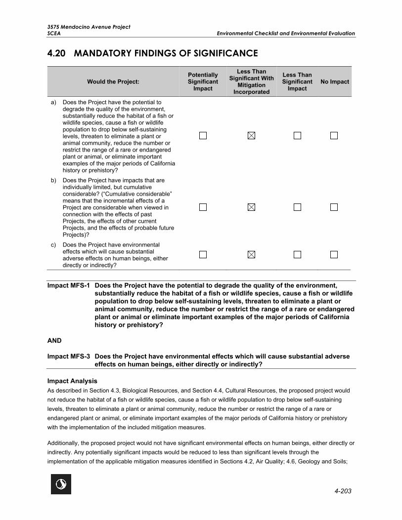
3575 Mendocino Avenue Project SCEA Environmental Checklist and Environmental Evaluation
4-203
4.20 MANDATORY FINDINGS OF SIGNIFICANCE
Would the Project: Potentially Significant
Impact
Less Than Significant With
Mitigation Incorporated
Less Than Significant
Impact No Impact
a) Does the Project have the potential to degrade the quality of the environment, substantially reduce the habitat of a fish or wildlife species, cause a fish or wildlife population to drop below self-sustaining levels, threaten to eliminate a plant or animal community, reduce the number or restrict the range of a rare or endangered plant or animal, or eliminate important examples of the major periods of California history or prehistory?
b) Does the Project have impacts that are individually limited, but cumulative considerable? (“Cumulative considerable” means that the incremental effects of a Project are considerable when viewed in connection with the effects of past Projects, the effects of other current Projects, and the effects of probable future Projects)?
c) Does the Project have environmental effects which will cause substantial adverse effects on human beings, either directly or indirectly?
Impact MFS-1 Does the Project have the potential to degrade the quality of the environment,
substantially reduce the habitat of a fish or wildlife species, cause a fish or wildlife population to drop below self-sustaining levels, threaten to eliminate a plant or animal community, reduce the number or restrict the range of a rare or endangered plant or animal or eliminate important examples of the major periods of California history or prehistory?
AND
Impact MFS-3 Does the Project have environmental effects which will cause substantial adverse effects on human beings, either directly or indirectly?
Impact Analysis As described in Section 4.3, Biological Resources, and Section 4.4, Cultural Resources, the proposed project would not reduce the habitat of a fish or wildlife species, cause a fish or wildlife population to drop below self-sustaining levels, threaten to eliminate a plant or animal community, reduce the number or restrict the range of a rare or endangered plant or animal, or eliminate important examples of the major periods of California history or prehistory with the implementation of the included mitigation measures.
Additionally, the proposed project would not have significant environmental effects on human beings, either directly or indirectly. Any potentially significant impacts would be reduced to less than significant levels through the implementation of the applicable mitigation measures identified in Sections 4.2, Air Quality; 4.6, Geology and Soils;

3575 Mendocino Avenue Project Environmental Checklist and Environmental Evaluation SCEA
4-204
4.8, Hazards and Hazardous Materials; 4.9, Hydrology and Water Quality; 4.12, Noise; 4.17, Tribal Cultural Resources; and 4.19, Wildfire. Therefore, the impact would be less than significant with mitigation.
Impact MFS-2 Does the Project have impacts that are individually limited, but cumulative considerable? (“Cumulative considerable” means that the incremental effects of a Project are considerable when viewed in connection with the effects of past Projects, the effects of other current Projects, and the effects of probable future Projects)?
Impact Analysis A cumulative impact is one that results from the combined effects of past, present, and reasonably foreseeable future projects or activities. CEQA requires the disclosure of cumulative impacts to which the proposed project would contribute, and the importance of that contribution in the context of the cumulative impact. The City of Santa Rosa 2035 General Plan EIR and 2040 Plan Bay Area EIR evaluated cumulative impacts associated with anticipated growth and development in the City as land use and zoning assumptions and in the Plan Bay Area process as PDAs. This SCEA’s project level cumulative impact analysis tiers off both the City of Santa Rosa 2035 General Plan EIR and 2040 Plan Bay Area EIR. Therefore, the only possible way the proposed project could result in a new cumulative impact would be from a new source of impact that wasn’t previously identified in either the 2035 General Plan EIR or the 2040 Plan Bay Area EIR. Because this SCEA is required to use previously identified mitigation measures from the 2035 General Plan and/or the 2040 Plan Bay Area EIRs, only those new project impacts, that resulted in the need for a new project specific mitigation measure should be considered as contributing to the cumulative context of resource impacts. Both the 2035 General Plan and the 2040 Plan Bay Area EIRs identified potentially significant impacts and prescribed mitigation to reduce them to a less than significant level. Additionally, the 2035 General Plan EIR and 2040 Plan Bay Area EIR documented significant and unavoidable cumulative impacts for air quality, greenhouse gases, energy resources, biological resources, public services, transportation, and utilities.
The 2035 General Plan EIR cumulative impacts that were significant and unavoidable include greenhouse gases, energy resources, and transportation. As discussed in this SCEA, the proposed project would result in less than significant impacts related to greenhouse gases, energy resources, and transportation. Therefore, the proposed project would not contribute to a significant cumulative impact related to these topics identified in the 2035 General Plan EIR.
The 2040 Plan Bay Area EIR cumulative impacts that were significant and unavoidable include air quality, biological resources, public services, and utilities. The proposed project would result in less than significant impacts related to public services and utilities. Therefore, the proposed project would not contribute to a significant cumulative impact related to these topics identified in the 2040 Plan Bay Area EIR. As discussed below, project specific mitigation measures were identified to reduce impacts related to air quality and biological resources to less than significant levels.
The proposed project was evaluated to determine if the incremental contribution from new impacts would contribute to a cumulative impact as identified in the 2035 General Plan and 2040 Plan Bay Area EIRs. For the proposed project, the only resources identified that would cause a need for a project specific mitigation measure, thus needing to be evaluated are the following: Air Quality, Biological Resources, Cultural Resources, Geology and Soils, Hazards and Hazardous Materials, Hydrology and Water Quality, Noise, Tribal Cultural Resources, and Wildfire.
As discussed in Section 4.2, Air Quality, there is potential for the proposed project to generate DPM emissions during construction activities. However, this impact would not be cumulatively significant as the incremental increase in emissions generated by the proposed project would be limited to the project construction phase which is limited in

3575 Mendocino Avenue Project SCEA Environmental Checklist and Environmental Evaluation
4-205
duration and is geographically isolated to the project site and adjacent parcels. As such, it would not additively contribute to any other active or reasonably foreseeable projects in the vicinity. The mitigation measure identified in the SCEA would reduce the proposed project impacts to a less than significant level and not contribute to a cumulative context.
As discussed in Section 4.3, Biological Resources, impacts on nesting birds would be limited to the construction phase which is limited in duration and is geographically isolated to the project site and adjacent parcels and reduced to a less than significant level with implementation of Mitigation Measure BIO-1. Therefore, the proposed project would not contribute to a cumulative impact. Temporary and permanent impacts on Russell Creek and the emergent wetland would be reduced to a less than significant level with Mitigation Measure BIO-3, which requires impacts to be mitigated at a 1:1 ratio through the purchase of wetland mitigation credits at a local mitigation bank approved by North Coast RWQCB. This impact is geographically isolated to the project site and adjacent areas. The purchase of wetland mitigation credits would fully mitigate permanent impacts to the emergent wetland; therefore, the proposed project would not contribute to a significant cumulative impact.
The potential discovery of unknown cultural and tribal cultural resources is site-specific. Therefore, the proposed project would not contribute to a significant cumulative impact as Mitigation Measure CUL-2 would reduce project impacts to a less than significant level. Impacts related to geology, hazards, hydrology, noise, and wildfire are also specific to the conditions of the project site, project design, and/or limited to the construction phase and are geographically isolated to the project site and adjacent parcels. Therefore, with the implementation of Mitigation Measures GEO-1, GEO-2, HYD-1, NOI-1, NOI-2, WF-1, WF-2, project impacts would be less than significant and would not contribute to a significant cumulative impact.
As all the resources and project-specific mitigation measures discussed above are geographically fixed and/or isolated to the project site, this greatly limits the project impacts ability to contribute to a larger cumulative context that could result in a significant cumulative impact. Therefore, potential impacts associated with the proposed project would not increase the severity of any of the cumulatively considerable impacts from the levels identified and analyzed in the 2035 General Plan EIR and 2040 Plan Bay Area EIR. The proposed project would result in a less than significant cumulative impact with implementation of the project-specific mitigation measures and/or applicable mitigation measures previously identified in the 2035 General Plan EIR and the 2040 Plan Bay Area EIR.

3575 Mendocino Avenue Project Environmental Checklist and Environmental Evaluation SCEA
4-206
This page left intentionally blank.

3575 Mendocino Avenue Project SCEA References
5-1
5.0 REFERENCES Multi-Section
City of Santa Rosa. 2009a. Santa Rosa General Plan 2035 Environmental Impact Report. https://srcity.org/DocumentCenter/View/3096/Draft-General-Plan-Environmental-Impact-Report-Santa-Rosa-2035-PDF. Accessed May 2020.
_____.2009b. Santa Rosa General Plan 2035. https://srcity.org/DocumentCenter/View/24327/Santa-Rosa-General-Plan-2035-PDF---July-2019. Accessed May 2020.
_____.2020. City of Santa Rosa Municipal Code. http://qcode.us/codes/santarosa/?view=desktop. Accessed May 2020.
Plan Bay Area. 2017a. Plan Bay Area 2040 Draft Environmental Impact Report. http://2040.planbayarea.org/cdn/ff/7o-LQGKXLGa8uqHTI_p4iHxhXXhKIYSVDYHeBD6j6js/1499352691/public/2017-07/PBA%202040%20DEIR_0_1.pdf. Accessed May 2020.
_____.2017b. Plan Bay Area 2040 Final Environmental Impact Report. http://2040.planbayarea.org/cdn/ff/buje2Q801oUV3Vpib-FoJ6mkOfWC9S9sgrSgJrwFBgo/1510696833/public/2017-11/Final_Plan_Bay_Area_2040.pdf. Accessed May 2020.
United States Census Bureau (USCB). 2019. Annual Estimates of the Resident Population for Incorporated Places in California: April 1, 2010 to July 1, 2019. https://www.census.gov/data/tables/time-series/demo/popest/2010s-total-cities-and-towns.html#tables. Accessed June 2020.
Section 2.0: Project Description
Please refer to the references listed under multi-section.
Section 3.0: SCEA Criteria and Transit Priority Project Consistency
California Air Resources Board (CARB). 2017. Executive Order G-18-047, CARB Acceptance of Greenhouse Gas Quantification Determination. Available https://ww3.arb.ca.gov/cc/sb375/mtc_eo_g_18_047.pdf. Accessed May 2020.
Sonoma County Transportation Authority. 2016. Sonoma County’s Comprehensive Transportation Plan. https://scta.ca.gov/wp-content/uploads/2016/09/CTP16_090616.pdf, p. 3-19. Accessed May 2020.
Section 4.1: Agricultural and Forestry Resources
California Department of Conservation (DOC). 2016. California Important Farmland Finder. https://maps.conservation.ca.gov/DLRP/CIFF/. Accessed May 2020.

3575 Mendocino Avenue Project References SCEA
5-2
Section 4.2: Air Quality
Bay Area Air Quality Management District (BAAQMD). 2009. Revised Draft Options and Justification Report, CEQA Thresholds of Significance. https://www.baaqmd.gov/~/media/files/planning-and-research/ceqa/revised-draft-ceqa-thresholds-justification-report-oct-2009.pdf?la=en. Accessed August 2020.
_____. 2017. California Environmental Quality Guidelines. http://www.baaqmd.gov/~/media/files/planning-and-research/ceqa/ceqa_guidelines_may2017-pdf.pdf?la=en. Accessed August 2020.
_____. 2019. Current Rules. http://www.baaqmd.gov/rules-and-compliance/current-rules. Accessed August 2020.
CARB. 2017a. Review of the Ambient Air Quality Standard for Ozone. http://www.arb.ca.gov/research/aaqs/ozone-rs/ozone-rs.htm. Accessed August 2020.
_____. 2018. Area Designations Maps / State and National. http://www.arb.ca.gov/desig/adm/adm.htm. Accessed August 2020.
_____. 2019a. Overview: Diesel Exhaust & Health. https://ww2.arb.ca.gov/resources/overview-diesel-exhaust-and-health. Accessed August 2020.
_____. 2019b. California State Implementation Plans. http://www.arb.ca.gov/planning/sip/sip.htm. Accessed August 2020.
City of Santa Rosa. 2009. Santa Rosa General Plan 2035 Environmental Impact Report. https://srcity.org/DocumentCenter/View/3096/Draft-General-Plan-Environmental-Impact-Report-Santa-Rosa-2035-PDF. Accessed August 2020.
USGS. 2011. Reported Historic Asbestos Mines, Historic Asbestos Prospects, and Other Occurrences of Asbestos in California. https://www.conservation.ca.gov/cgs/mineral-hazards/asbestos. Accessed August 2020.
Section 4.3: Biological Resources
Baldwin, B. G., D. H. Goldman, D. J. Keil, R. Patterson, T. J. Rosatti, and D. H. Wilken, eds. 2012. The Jepson Manual: Vascular Plants of California. 2nd edition. University of California Press. Berkeley, California.
California Department of Fish and Wildlife (CDFW). 2014. California Wildlife Habitat Relationships (CWHR), Version 9.0 (personal computer program). California Department of Fish and Wildlife, California Interagency Wildlife Task Group. https://www.wildlife.ca.gov/data/cwhr. Accessed June 2020.
_____. 2020a. Rarefind 5. California Natural Diversity Database (CNDDB). California Natural Communities List. Biogeographic Data Branch, California Department of Fish and Wildlife. https://www.wildlife.ca.gov/Data/CNDDB/Maps-and-Dat. Accessed February 2020.
_____. 2020b. Special Animals List. CDFW, CNDDB. Periodic Publication. 66 pp. Updated August 2018. https://www.wildlife.ca.gov/Data/CNDDB/Plants-and-Animals. Accessed June 2020.
_____. 2020c. State and Federally Listed Endangered and Threatened Animals of California. CDFW, Biogeographic Data Branch, CNDDB. Updated June 2020. https://www.wildlife.ca.gov/Data/CNDDB/Plants-and-Animals. Accessed June 2020.

3575 Mendocino Avenue Project SCEA References
5-3
_____. 2020d. State and Federally Listed Endangered, Threatened and Rare Plants of California. California Department of Fish and Wildlife, Biogeographic Data Branch, CNDDB. Updated October 2019. https://www.wildlife.ca.gov/Data/CNDDB/Plants-and-Animals. Accessed June 2020.
_____. 2020e. Special Vascular Plants, Bryophytes, and Lichens List. CDFW, CNDDB. Periodic Publication. 127 pp. Updated October 2019. https://www.wildlife.ca.gov/Data/CNDDB/Plants-and-Animals. Accessed June 2020.
_____. 2020f. California Natural Communities List. Biogeographic Data Branch, California Department of Fish and Wildlife. https://www.wildlife.ca.gov/Data/VegCAMP/Natural-Communities. Accessed February 2020.
Calflora. 2020. Information on wild California plants. https://www.calflora.org. Accessed June 2020.
California Native Plant Society (CNPS). 2020. Inventory of Rare And Endangered Plants (Online Edition, V8-02). Sacramento, California. http://www.rareplants.cnps.org. Accessed June 2020.
Google Earth. 2020. Map showing the Project area. Google Earth, 2020. earth.google.com/web/. Accessed June 2020.
Mayer, K.E., and W.F. Laudenslayer, Jr., eds. 1988. A Guide to Wildlife Habitats Of California. Sacramento: California Department of Forestry and Fire Protection (CAL FIRE).
Sawyer, J. O., T. Keeler-Wolf, and J. M. Evans. 2009. A Manual of California Vegetation, 2nd Edition. CNPS, Sacramento, California.
United States Fish and Wildlife Services (USFWS). 2017. Santa Rosa Plain Conservation Service Actions. USFWS Sacramento Fish and Wildlife Office. https://www.fws.gov/sacramento/es/Recovery-Planning/Santa-Rosa/. Accessed June 2020.
USFWS. 2020a. Trust Resources Report. Information for Planning and Consultation (IPaC). https://ecos.fws.gov/ipac/ Accessed June 2020.
_____. 2020b. USFWS National Wetlands Inventory (NWI). https://www.fws.gov/wetlands/. Accessed June 2020.
Western Regional Climate Center. 2020. Santa Rosa, California (047965) monthly climate summary, period of record: 06/01/1902 to 01/31/2013. https://wrcc.dri.edu/cgi-bin/cliMAIN.pl?ca7965. Accessed June 2020.
Section 4.4: Cultural Resources
Fredrickson, David A. 1973. Early Cultures of the North Coast Ranges. California. Unpublished Ph.D. dissertation, on file at the Department of Anthropology, University of California, Davis.
_____. 1974. Cultural Diversity in Early Central California: A view from the North Coast Ranges. Journal of California Anthropology 1(1)41-53. 1989. Prehistory of the Laguna: An Overview. Unpublished report on file at the Northwest Information Center, Rohnert Park, California.
_____. 1994. Spatial and Cultural Units in Central California Archaeology. In Toward a New Taxonomic Framework for Central California Archaeology, edited by J.A. Bennyhoff and D.A. Fredrickson. Contributions of the University of California Archaeological Research Facility, Berkeley, California.
Groza, R.G. 2002. An AMS Chronology for Central California Olivella Shell Beads. Master’s thesis, Department of Anthropology, California State University, San Francisco

3575 Mendocino Avenue Project References SCEA
5-4
LaJeunesse, R.M., and J.M. Pryor. 1996. Skyrocket Appendices. Report on file, Department of Anthropology, California State University, Fresno.
Meyer, Jack, and Jefferey S. Rosenthal. 1997. Archaeological and Geoarchaeological Investigations at Eight Prehistoric Sights in the Los Vaqueros Reservoir Area, Contra Costa County, California. Anthropological Studies Center, Sonoma State University, Rohnert Park, California.
____. 2007. Punctuated Culture Change in the San Francisco Bay Region. In California Prehistory: Colonization, Culture, and Complexity edited by T.L. Jones and K.A. Klar, pp. 99-124. AltaMira Press, Lanham.
The Los Angeles Times. 2017. “Tubbs Fire: Aftermath.” October 11, 2017.
Section 4.5: Energy
California Energy Commission. 2019. 2019 Building Energy Efficiency Standards. https://ww2.energy.ca.gov/2018publications/CEC-400-2018-020/CEC-400-2018-020-CMF.pdf. Accessed August 2020.
Pacific Gas & Electric. 2019. Corporate Responsibility and Sustainability Report. http://www.pgecorp.com/corp_responsibility/reports/2019/assets/PGE_CRSR_2019.pdf. Accessed August 2020.
Section 4.6: Geology and Soils
California Department of Conservation (DOC). 2020. Fault Activity Map of California. https://maps.conservation.ca.gov/cgs/DataViewer/index.html. Accessed June 2020.
California Geologic Service. 2020. CGS Information Warehouse: Landslides. https://maps.conservation.ca.gov/cgs/informationwarehouse/landslides/. Accessed June 2020.
RGH Consultants. 2019. Geotechnical Study Report dated December 20, 2019 and updated September 2, 2020. Prepared for the 3575 Mendocino Avenue Project. PDF.
UC Berkeley. 2020. Berkeley Mapper. http://berkeleymapper.berkeley.edu/index.html?ViewResults=join&configfile=https:/. Accessed June 2020.
Section 4.7: Greenhouse Gases
Association of Environmental Professionals. 2015. Beyond 2020: The Challenge of Greenhouse Gas Reduction Planning Local Governments in California. https://califaep.org/docs/AEP_White_Paper_Beyond_2020.pdf. Accessed August 2020.
California Air Resources Board (CARB). 2017b. Executive Order G-18-047, CARB Acceptance of Greenhouse Gas Quantification Determination. Available https://ww3.arb.ca.gov/cc/sb375/mtc_eo_g_18_047.pdf. Accessed August 2020.
US Environmental Protection Agency (USEPA). 2014. Climate Change Indicators in the United States. https://www.epa.gov/sites/production/files/2016-07/documents/climateindicators-full-2014.pdf. Accessed August 2020.

3575 Mendocino Avenue Project SCEA References
5-5
Section 4.8: Hazards and Hazardous Materials
CAL FIRE. 2008. Very High Fire Hazard Severity Zones in LRA- Sonoma County. https://osfm.fire.ca.gov/media/6820/fhszl_map49.pdf. Accessed May 2020.
City of Santa Rosa. 2020a. Wildland-Urban Interface and Vegetation. https://srcity.org/596/Wildland-Urban-Interface. Accessed August 2020.
____. 2020b. North Santa Rosa Major Travel Routes. https://srcity.org/DocumentCenter/View/25892%2FNorth-Santa-Rosa. Accessed August 2020.
Department of Toxic Substances Control. 2020. EnviroStor Database. https://www.envirostor.dtsc.ca.gov/public/map/?myaddress=3575+mendocino+avenue. Accessed May 2020.
Harris and Lee Environmental Sciences, LLC. 2018 (updated September 1, 2020). All Appropriate Inquiry- Phase 1 Environmental Site Assessment. 3575 Mendocino Avenue, Santa Rosa, CA 95403. PDF.
State Water Resources Control Board (SWRCB). 2019. GeoTracker Database. https://geotracker.waterboards.ca.gov/map/?CMD=runreport&myaddress=3575+mendocino+avenue+. Accessed May 2020.
Section 4.9: Hydrology and Water Quality
BKF Engineers. 2020c. Preliminary Stormwater Low Impact Development Plan for 3575 Mendocino Avenue. PDF.
City of Santa Rosa. 2016. Urban Water Management Plan. https://srcity.org/DocumentCenter/View/13875/Urban-Water---2015-Management-Plan-Without-Appendices?bidId=. Accessed June 2020.
DWR. 1982. Evaluation of Groundwater Resources, Sonoma County, Volume 2: Santa Rosa Plain. http://wdl.water.ca.gov/waterdatalibrary/docs/historic/Bulletins/Bulletin_118/Bulletin_118-4-Vol2__1975.pdf. Accessed June 2020.
_____. 2020. SGMA Basin Prioritization. https://gis.water.ca.gov/app/bp-dashboard/final/. Accessed June 2020.
Federal Emergency Management Agency (FEMA). 2008. FEMA Flood Map Service Center. https://msc.fema.gov/portal/search?AddressQuery=San%20José%2C%20CA#searchresultsanchor. Accessed June 2020.
RGH Consultants. 2020. Geotechnical Study Report December 6, 2019 and revised December 19, 2020. Prepared for the 3575 Mendocino Avenue Project. Accessed June 2020.
Santa Rosa Plain Groundwater Sustainability Agency. 2020. Groundwater Sustainability Plan. https://santarosaplaingroundwater.org/gsp/. Accessed June 2020.
US Army Corps of Engineers. 2018. USACE Structural Debris Removal. Letter.
US Environmental Protection Agency (USEPA). 2018. EPA Assessment and Removal of Asbestos Containing Material of Journey’s End Mobile Home Park, 3575 Mendocino Avenue, Santa Rosa, CA. Letter.

3575 Mendocino Avenue Project References SCEA
5-6
Section 4.10: Land Use and Planning
Please refer to the references listed under multi-section.
Section 4.11: Mineral Resources
California Department of Conservation (DOC). 2013. Aggregate Materials in the North San Francisco Bay Production-Consumption Region, Sonoma, Napa, Marin, and Southwestern Solano Counties, California. file:///C:/Users/zpope/Downloads/SR%20205%20North%20Bay%20Report_Final.pdf. Accessed June 2020.
Sonoma County. 2010. Sonoma County Aggregate Resources Management Plan. https://sonomacounty.ca.gov/PRMD/Long-Range-Plans/Aggregate-Resource-Management/Plan-Selection/. Accessed June 2020.
Section 4.12: Noise
California Department of Transportation (Caltrans). 2004. Transportation-and Construction-Induced Vibration Guidance Manual. 2004. http://www.dot.ca.gov/hq/env/noise/pub/vibrationmanFINAL.pdf. Accessed July 2020.
_____. 2013. Technical Noise Supplement to the Traffic Noise Analysis Protocol. http://www.dot.ca.gov/hq/env/noise/pub/TeNS_Sept_2013B.pdf. Accessed July 2020.
_____. 2018. Caltrans Traffic Census Program. https://dot.ca.gov/programs/traffic-operations/census. Accessed July 2020.
Egan, David M. 2007. Architectural Acoustics. J. Ross Publishing.
Federal Highway Administration (FHWA). 2011a. Analysis and Abatement Guidance. https://www.fhwa.dot.gov/environment/noise/regulations_and_guidance/analysis_and_abatement_guidance/ Accessed July 2020.
_____. 2011b. Highway Traffic Noise. http://www.fhwa.dot.gov/environment/noise/noise_barriers/design_construction/keepdown.cfm. Accessed July 2020.
Federal Transit Administration (FTA). 2018. Transit Noise and Vibration Impact Assessment. http://www.fta.dot.gov/documents/FTA_Noise_and_Vibration_Manual.pdf. Accessed July 2020.
Section 4.13: Population and Housing
Association of Bay Area Governments (ABAG). 2013. Regional housing Need Plan, San Francisco Bay Area 2015-2023. https://abag.ca.gov/sites/default/files/2015-23_rhna_plan.pdf. Accessed June 2020.
City of Santa Rosa. 2017. General Plan Annual Review 2017. https://srcity.org/DocumentCenter/View/20088/Annual-Review-2017-final. Accessed August 2020.
_____. 2019. General Plan Annual Review 2019. https://srcity.org/DocumentCenter/View/29281/2019-General-Plan-Annual-Review-Report. Accessed August 2020.

3575 Mendocino Avenue Project SCEA References
5-7
Section 4.14: Public Services
City of Santa Rosa. 2020c. City of Santa Rosa Recreation and Parks. https://srcity.org/1564/Parks. Accessed June 2020.
City of Santa Rosa Fire Department (SRFD). 2020. Santa Rosa Fire Department Will Serve Letter Response. PDF.
City of Santa Rosa Police Department (SRPD). 2020. Santa Rosa Police Department Will Serve Letter Response. PDF.
Public School Review. 2020a. Steele Lane Elementary School. https://www.publicschoolreview.com/steele-lane-elementary-school-profile. Accessed June 2020.
_____. 2020b. Santa Rosa High School. https://www.publicschoolreview.com/santa-rosa-high-school-profile. Accessed June 2020.
Santa Rosa City Schools (SRCSD). 2019. Our Story. https://drive.google.com/file/d/1c9JxYmWIJnfhHChkC3gxtpZODgw_E5rT/view. Accessed June 2020.
Section 4.15: Recreation
City of Santa Rosa. 2020c. City of Santa Rosa Recreation and Parks. https://srcity.org/1564/Parks. Accessed June 2020.
Section 4.16: Transportation
California Department of Transportation (Caltrans). 2002. Guide for the Preparation of Traffic Impact Studies.
_____. 2014. California Manual on Uniform Traffic Control Devices for Streets and Highways.
_____. 2017. Highway Design Manual, 6th Edition.
_____. 2018. 2016 Collision Data on California State Highways.
California Highway Patrol. 2014-2019. Statewide Integrated Traffic Records System (SWITRS).
City of Santa Rosa. 2018. City of Santa Rosa Bicycle & Pedestrian Master Plan Update 2018. https://srcity.org/2711/Bicycle-and-Pedestrian-Master-Plan. Accessed July 2020.
Federal Highway Administration. 2018. Field Guide for Selecting Countermeasures at Uncontrolled Pedestrian Crossing Locations. https://safety.fhwa.dot.gov/ped_bike/step/docs/pocket_version.pdf. Accessed July 2020.
Institute of Transportation Engineers (ITE). 2014. Trip Generation Handbook: An ITE Recommended Practice, 3rd Edition.
_____. 2017. Trip Generation Manual, 10th Edition.
Santa Rosa CityBus. 2020. Santa Rosa CityBus Maps and Schedules. http://srcity.org/1661/Maps-and-Schedules. Accessed July 2020.
Sonoma County Transit. 2020. Sonoma County Transit Routes and Schedules. http://sctransit.com/. Accessed July 2020.

3575 Mendocino Avenue Project References SCEA
5-8
Sonoma County Transportation Authority. 2019. Sonoma County Transportation Authority Travel Demand Model. http://sonomacountyopendata-sonomamap.opendata.arcgis.com. Accessed July 2020.
State of California. 2018. California Vehicle Code. http://leginfo.legislature.ca.gov/faces/codesTOCSelected.xhtml?tocCode=VEH&tocTitle=+Vehicle+Code+-+VEH. Accessed July 2020.
Transportation Research Board. 2012. Highway Capacity Manual 2010.
Section 4.17: Tribal Resources
Barrett, Samuel A. 1908. The Ethnogeography of the Pomo and Neighboring Indians. University of California Publications in American Archaeology and Ethnology 6(1):1-332. Berkeley.
Federated Indians of Graton Rancheria. 2018. Coast Miwok and Southern Pomo: Timeline. Website, http://www.gratonrancheria.com/timeline/.
Golla, Victor. 2007. Linguistic Prehistory. In California Prehistory: Colonization, Culture, and Complexity edited by T.L. Jones and K.A. Klar, pp. 71-82. AltaMira Press, Lanham.
McLendon, Sally and Robert L. Oswalt. 1978. Pomo: Introduction. In Handbook of the Indians of North America, Volume 8 California. Smithsonian Institution, Washington. Accessed June 2018.
Section 4.18: Utilities and Service Systems
CalRecycle. 2019. Estimated Solid Waste Generation Rates. https://www2.calrecycle.ca.gov/WasteCharacterization/General/Rates. Accessed July 2020.
_____. 2020a. SWIS Facility/Site Activity Details – Redwood Landfill (21-AA-0001). https://www2.calrecycle.ca.gov/SolidWaste/SiteActivity/Details/3054?siteID=1727. Accessed June 2020.
_____. 2020b. SWIS Facility/Site Activity Details – Keller Canyon Landfill (07-AA032). https://www2.calrecycle.ca.gov/SolidWaste/SiteActivity/Details/4407?siteID=228. Accessed June 2020.
_____. 2020c. SWIS Facility/Site Activity Details –Potrero Hills Landfill (48-AA-0075). https://www2.calrecycle.ca.gov/SolidWaste/SiteActivity/Details/1194?siteID=3591. Accessed June 2020.
City of Santa Rosa. 2014. City of Santa Rosa Water Master Plan Update. https://srcity.org/DocumentCenter/View/13829/Water---2014-Master-Plan. Accessed August 2020.
_____. 2016. Urban Water Management Plan. https://srcity.org/DocumentCenter/View/13875/Urban-Water---2015-Management-Plan-Without-Appendices?bidId=. Accessed June 2020.
_____. 2020. Water Reuse and Treatment Process. https://srcity.org/1052/Water-Reuse. Accessed July 2020.
Section 4.19: Wildfire
CAL FIRE. 2008. Very High Fire Hazard Severity Zones in LRA- Sonoma County. https://osfm.fire.ca.gov/media/6820/fhszl_map49.pdf. Accessed May 2020.
3575 Mendocino Avenue Project SCEA References
5-9
California Air Resources Board (CARB). 2020. Sonoma County Airport Station, Wind Speed and Direction 2009-2014.
City of Santa Rosa. NDa. Risk Assessment Map. https://srcity.org/DocumentCenter/View/25292/CWPP-Risk-Assessment-Map. Accessed June 2020.
_____. NDb. Wildland Urban Interface Map. https://srcity.org/DocumentCenter/View/25294/CWPP-WUI-Map. Accessed June 2020.
_____. 2020a. Wildland-Urban Interface and Vegetation. https://srcity.org/596/Wildland-Urban-Interface. Accessed August 2020.
_____. 2020b. North Santa Rosa Major Travel Routes. https://srcity.org/DocumentCenter/View/25892%2FNorth-Santa-Rosa. Accessed August 2020.

3575 Mendocino Avenue Project References SCEA
5-10
This page left intentionally blank.

3575 Mendocino Avenue Project SCEA List of Preparers
6-1
6.0 LIST OF PREPARERS Principal in Charge ............................................................................................................................... Trevor Macenski
Project Manager ...................................................................................................................................... Anna Radonich
Senior Air Quality Scientist ............................................................................................................................ Elena Nuño
Air Quality Analyst ..................................................................................................................................... Blake Barroso
Cultural Resources Lead .......................................................................................................................... Alisa Reynolds
Senior Archaeologist .................................................................................................................................. Erin Sherlock
Architectural Historian .................................................................................................................................. Garret Root
Principal Biologist ...................................................................................................................................... Michelle Tovar
Senior Biologist ................................................................................................................................................ Jared Elia
Biologist ........................................................................................................................................................ Scott Elder
Senior Environmental Noise Analyst ...................................................................................................... Tracie Ferguson
Environmental Planner ............................................................................................................................. Kaela Johnson
Technical Editor .................................................................................................................................... Khandriale Clark

3575 Mendocino Avenue Project References SCEA
6-2
This page left intentionally blank.