SUNSHINE COAST REGIONAL DISTRICT ELPHINSTONE ...
140
SUNSHINE COAST REGIONAL DISTRICT ELPHINSTONE (AREA E) ADVISORY PLANNING COMMISSION MEETING AGENDA Wednesday, May 26, 2021 at 7:00 p.m. Meeting will be Held Online via ZOOM CALL TO ORDER AGENDA 1. Adoption of the Agenda DELEGATIONS MINUTES 2. Elphinstone (Area E) APC Minutes of April 28, 2021 Pages 1 - 3 3. Egmont/Pender Harbour (Area A) APC Minutes of April 28, 2021 (Under Review) 4. Halfmoon Bay (Area B) APC Minutes of April 27, 2021 pp 4 - 6 5. Roberts Creek (Area D) APC Minutes of April 19, 2021 pp 7 - 8 6. West Howe Sound (Area F) APC Minutes of April 27, 2021 pp 9 - 10 7. Planning and Community Development Committee Minutes of April 15, 2021 pp 11 - 13 BUSINESS ARISING FROM MINUTES AND UNFINISHED BUSINESS REPORTS 8. ALC Applications 61646 (SCRD ALR00015) pp 14 - 102 9. Roberts Creek OCP Amendment Bylaw No. 641.11 And Zoning Amendment Bylaw pp 103 - 139 No. 310.182 For Subdivision of Remainder of District Lot 1312 NEW BUSINESS DIRECTORS REPORT NEXT MEETING ADJOURNMENT
-
Upload
khangminh22 -
Category
Documents
-
view
2 -
download
0
Transcript of SUNSHINE COAST REGIONAL DISTRICT ELPHINSTONE ...
SUNSHINE COAST REGIONAL DISTRICT
ELPHINSTONE (AREA E) ADVISORY PLANNING COMMISSION MEETING AGENDA
Wednesday, May 26, 2021 at 7:00 p.m.
Meeting will be Held Online via ZOOM
CALL TO ORDER
AGENDA
1. Adoption of the Agenda DELEGATIONS
MINUTES
2. Elphinstone (Area E) APC Minutes of April 28, 2021 Pages 1 - 3
3. Egmont/Pender Harbour (Area A) APC Minutes of April 28, 2021 (Under Review) 4. Halfmoon Bay (Area B) APC Minutes of April 27, 2021 pp 4 - 6 5. Roberts Creek (Area D) APC Minutes of April 19, 2021 pp 7 - 8 6. West Howe Sound (Area F) APC Minutes of April 27, 2021 pp 9 - 10 7. Planning and Community Development Committee Minutes of April 15, 2021 pp 11 - 13 BUSINESS ARISING FROM MINUTES AND UNFINISHED BUSINESS
REPORTS
8. ALC Applications 61646 (SCRD ALR00015) pp 14 - 102 9. Roberts Creek OCP Amendment Bylaw No. 641.11 And Zoning Amendment Bylaw pp 103 - 139 No. 310.182 For Subdivision of Remainder of District Lot 1312 NEW BUSINESS
DIRECTORS REPORT
NEXT MEETING
ADJOURNMENT

SUNSHINE COAST REGIONAL DISTRICT
AREA E – ELPHINSTONE ADVISORY PLANNING COMMISSION
April 28, 2021
RECOMMENDATIONS FROM THE AREA E ADVISORY PLANNING COMMISSION MEETING HELD ELECTRONICALLY VIA ZOOM
PRESENT: Chair Mary Degan
Members Rod Moorcroft Dougald Macdonald Nara Brenchley Anne Cochran Rick Horsley Karen Mahoney Urszula Dragowska Kasha Janota-Bzowska
ALSO PRESENT: Electoral Area E Director Donna McMahon (Non-Voting Board Liaison)
Alternate Director Jason Lewis Manager, Planning & Development Dave Pady Planner 1/Senior Planner Julie Clark Recording Secretary Diane Corbett
ABSENT: Members Bob Morris
CALL TO ORDER 7:08 p.m.
ELECTION OF CHAIR AND VICE CHAIR
Mary Degan was appointed Chair of the Elphinstone (Area E) Advisory Planning Commission for 2021.
Kasha Janota-Bzowska was appointed Vice Chair of the Elphinstone (Area E) Advisory Planning Commission for 2021.
AGENDA The agenda was adopted as presented.
MINUTES
Area E Minutes
The Area E APC minutes of June 24, 2020 were approved as presented.
1

Elphinstone (Area E) Advisory Planning Commission Minutes, April 28, 2021 Page 2 Minutes
The following minutes were received for information:
• Egmont/Pender Harbour (Area A) APC Minutes of June 24, July 29, September 30, November 25, 2020 & January 27, February 24, March 31, 2021
• Halfmoon Bay (Area B) APC Minutes of June 23, July 28, 2020 & January 26, 2021 • Roberts Creek (Area D) APC Minutes of June 15, 2020 & February 15, 2021 • West Howe Sound (Area F) APC Minutes of June 23, November 24, 2020 & February 23,
2021 • Planning and Community Development Committee Minutes of June 11, July 9, September
10, October 8, November 12, December 10, 2020 & January 21, February 18, March 18, 2021
REPORTS
ALC Application 60835 (SCRD ALR00013)
The APC discussed the staff report regarding ALC Application 60835 (SCRD ALR00013 for 437 Hough Road), a referral from the Agricultural Land Commission (ALC) of an application for Non-Farm Use in Area E/ Elphinstone. The application was a result of the addition of fill without prior permission from the ALC, and sought approval to retain the added fill.
SCRD Planning staff provided background information and responded to questions on the application.
Recommendation No. 1 ALC Application 60835 (SCRD ALR00013)
The Area E APC recommended that the application not be supported as presented;
AND THAT should the applicant wish to reapply, ensure there is: remediation of the soil; a study in the riparian zone to ensure there is no damage in that area; and a drainage plan that is compliant with Ministry of Transportation and Infrastructure regulations.
Planning Processes – Administrative Improvements
The APC discussed the staff report regarding Planning Processes – Administrative Improvements that was received for information. The Director provided comment as well as background and process information.
Recommendation No. 2 Planning Processes – Administrative Improvements
The Area E APC recommended that the Area E APC be consulted on all major variances as determined by Planning staff;
AND THAT this recommendation be implemented into the Planning and Procedure Bylaw No. 522
Recommendation No.3 Planning Processes – Administrative Improvements
The Area E APC recommended that the Area E APC be consulted on all subdivision applications for four or more lots in light of the existing parcel sizes within our area;
2
Elphinstone (Area E) Advisory Planning Commission Minutes, April 28, 2021 Page 3 AND THAT this recommendation be implemented into the Planning and Procedure Bylaw No. 522
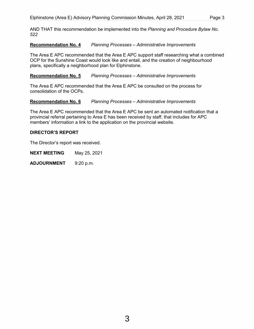
Recommendation No. 4 Planning Processes – Administrative Improvements
The Area E APC recommended that the Area E APC support staff researching what a combined OCP for the Sunshine Coast would look like and entail, and the creation of neighbourhood plans, specifically a neighborhood plan for Elphinstone.
Recommendation No. 5 Planning Processes – Administrative Improvements
The Area E APC recommended that the Area E APC be consulted on the process for consolidation of the OCPs.
Recommendation No. 6 Planning Processes – Administrative Improvements
The Area E APC recommended that the Area E APC be sent an automated notification that a provincial referral pertaining to Area E has been received by staff, that includes for APC members’ information a link to the application on the provincial website.
DIRECTOR’S REPORT
The Director’s report was received.
NEXT MEETING May 25, 2021
ADJOURNMENT 9:20 p.m.
3

SUNSHINE COAST REGIONAL DISTRICT
HALFMOON BAY (AREA B) ADVISORY PLANNING COMMISSION
APRIL 27, 2021
RECOMMENDATIONS FROM THE HALFMOON BAY (AREA B) ADVISORY PLANNING COMMISSION MEETING HELD ELECTRONICALLY VIA ZOOM PRESENT: Chair Frank Belfry Members Barbara Bolding Nicole Huska Eleanor Lenz Dieter Greiner Jim Noon Alda Grames Catherine Ondzik Kelsey Oxley ALSO PRESENT: TELUS Representatives Chad Marlatt (Guest) Doug Anastos (Guest) Recording Secretary Sandy Goldsmith REGRETS: Electoral Area D Director Lori Pratt (Non-Voting Board Liaison) Members Bruce Thorpe Eleanor Lenz CALL TO ORDER 7:10 p.m. AGENDA The agenda was adopted as presented. MINUTES
Area B Minutes
The Area B APC minutes of January 26, 2021 were adopted as presented.
Minutes
The following minutes were received for information:
• Egmont / Pender Harbour (Area A) APC Minutes of January 27, February 24 and March 31, 2021.
• Planning and Community Development Committee Minutes of January 21, February 18 and March 18, 2021.
4

Halfmoon Bay (Area B) Advisory Planning Commission Minutes – April 27, 2021 Page 2 REPORTS
TELUS Telecommunication Tower – Curran Road (BC109144) – Request for Local Government Concurrence
The following issues were noted regarding the proposed plans for the new location of the Tower at 5549 Curran Road, Halfmoon Bay:
• The possibility of future development of the property on which the tower will be located leading to the clearing of trees and increased visibility of the tower.
• The question of why the tower was going to be located on private land as opposed to Crown land.
In response to the issues above the two TELUS representatives presented the following information:
• The possibility of future development cannot be projected and having addressed the concerns put forward to TELUS in past discussions with the APC, they believed that this was an acceptable location as far away as possible with low visibility and not affecting coverage for the residents.
• This a large parcel of private property, the location of which was deemed to best serve the community.
Recommendation No. 1 TELUS Telecommunication Tower – 5549 Curran Road (BC109144) – Request for Local Government Concurrence The Area B APC supports the proposed location of the TELUS Tower on Curran Road as presented in the TELUS communication. Modification to TELUS Telecommunications Tower – Secret Cove – Request for Local Government Concurrence (BC106299-2) The following information was presented by the TELUS representatives regarding the proposed modification to the TELUS Telecommunications Tower in Secret Cove:
• The design of the tower was reduced from being a large structure to half the size to a slim line monopole structure.
• There will be very little visibility due to the tree coverage. • The size and location will solidify coverage on the highway and other areas including
for boaters.
5
Halfmoon Bay (Area B) Advisory Planning Commission Minutes – April 27, 2021 Page 3
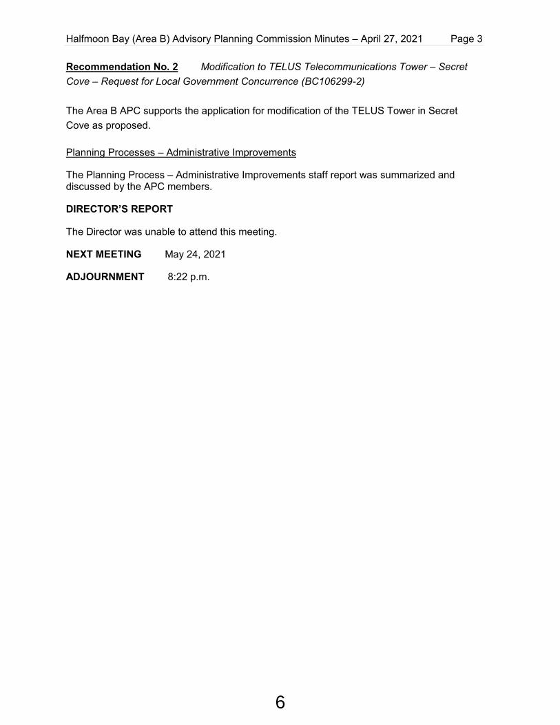
Recommendation No. 2 Modification to TELUS Telecommunications Tower – Secret Cove – Request for Local Government Concurrence (BC106299-2) The Area B APC supports the application for modification of the TELUS Tower in Secret Cove as proposed. Planning Processes – Administrative Improvements
The Planning Process – Administrative Improvements staff report was summarized and discussed by the APC members.
DIRECTOR’S REPORT
The Director was unable to attend this meeting.
NEXT MEETING May 24, 2021
ADJOURNMENT 8:22 p.m.
6

SUNSHINE COAST REGIONAL DISTRICT
ROBERTS CREEK (AREA D) ADVISORY PLANNING COMMISSION
April 19, 2021
RECOMMENDATIONS FROM THE ROBERTS CREEK (AREA D) ADVISORY PLANNING COMMISSION MEETING HELD ELECTRONICALLY VIA ZOOM
PRESENT: Chair Mike Allegretti Members Gerald Rainville Meghan Hennessy ALSO PRESENT: Electoral Area D Director Andreas Tize (Non-Voting Board Liaison) Recording Secretary Vicki Dobbyn Public 0 REGRETS: Members Alan Comfort Chris Richmond Nicola Kozakiewicz CALL TO ORDER 7:03 p.m. AGENDA The agenda was adopted as presented. MINUTES The Roberts Creek (Area D) APC Minutes of February 15, 2021 were approved as circulated. The following minutes were received for information:
• Egmont/Pender Harbour (Area A) APC Minutes of February 24 and March 31, 2021 • West Howe Sound (Area F) APC Minutes of February 23, 2021 • Planning and Community Development Committee Minutes of February 18 and March 18,
2021 REPORTS SCRD Zoning Amendment Bylaw No 310.192, 2020 (2284 Pixton Rd.) Key Points of Discussion:
• A member doesn’t agree with supporting the re-zoning because it goes against the OCP. • District Lot 1621 was originally part of Z Zone or Managed Forest Zone. The original
subdivision was bought by MacMillan Bloedel and was later transferred to Weyerhauser.
7

Roberts Creek (Area D) Advisory Planning Commission Minutes – April 19, 2021 Page 2
In the 1990s some developers bought it and the SCRD created the Z Zone. It was adjacent to ten-acre zoning. There were no roads to these properties. In the 1990s Country Residential 2 Zone was created so lots could be subdivided, and proceeds could go to creating roads. Since the Z Zone was one house per 100 acres, all subsequent subdivision had this limitation.
• Pages 13 and 14 of the Roberts Creek OCP list the goals of the OCP. Goals #4, 5, and 7 deal with the environment whereas #14 deals with housing. These goals can appear to be in opposition to each other.
• This area is supposed to have 20% forest retention but much of it is cleared. • It was noted that clearing is the first step to farming. • Members reviewed an affordable housing chart which seemed to demonstrate that, given
current building costs, the proposed dwelling would not be affordable to the average renter.
Recommendation No. 1 SCRD Zoning Amendment Bylaw No. 310.192, 2020 (2284 Pixton Rd.) The Area D APC recommended that Zoning Amendment Bylaw No. 310.192, 2020 (2284 Pixton Rd.) not be approved. DIRECTORS REPORT The Director’s Report was received. NEXT MEETING May 17, 2021 ADJOURNMENT 8:05 p.m.
8

SUNSHINE COAST REGIONAL DISTRICT
AREA F – WEST HOWE SOUND ADVISORY PLANNING COMMISSION
April 27, 2021
RECOMMENDATIONS FROM THE WEST HOWE SOUND (AREA F) ADVISORY PLANNING COMMISSION MEETING HELD ELECTRONICALLY PRESENT: Chair Susan Fitchell Members Doug MacLennan Kate-Louise Stamford Sarah Macdonald Al Hyland ALSO PRESENT: Director, Electoral Area F Mark Hiltz (Non-Voting Board Liaison) Recording Secretary Diane Corbett ABSENT: Members Alicia Lavalle Fred Gazeley CALL TO ORDER 7:06 p.m.
ELECTION OF CHAIR AND VICE CHAIR
Susan Fitchell was appointed Chair of the Area F (West Howe Sound) Advisory Planning Commission for 2021.
Doug McLelland was appointed Vice Chair of the Area F (West Howe Sound) Advisory Planning Commission for 2021.
The Commission extended thanks and best wishes to Gretchen Bozak for her service to the Area F Advisory Planning Commission (APC) and acknowledged the time and effort she has contributed to the Area F APC.
AGENDA
The agenda was adopted as presented.
MINUTES
West Howe Sound (Area F) Minutes
The West Howe Sound (Area F) APC minutes of February 23, 2021 were approved as
9

West Howe Sound (Area F) Advisory Planning Commission Minutes, April 27, 2021 Page 2 circulated.
The following minutes were received for information:
• Egmont/Pender Harbour (Area A) APC Minutes of February 24, 2021 and March 31, 2021
• Roberts Creek (Area D) APC Minutes of February 15, 2021 • Planning and Community Development Committee Minutes of February 18, 2021 and
March 18, 2021
REPORTS
Planning Processes – Administrative Improvements
The staff report regarding Planning Processes – Administrative Improvements was received for information. APC members offered questions, suggestions and feedback to the Director on the content of the report. The Director provided clarification and feedback on APC comments and gave context on items of discussion.
DIRECTOR’S REPORT
The Director’s report was received.
NEXT MEETING Tuesday, May 24, 2021
ADJOURNMENT 8:25 p.m.
10

SUNSHINE COAST REGIONAL DISTRICT PLANNING AND COMMUNITY DEVELOPMENT COMMITTEE
April 15, 2021
RECOMMENDATIONS FROM THE PLANNING AND COMMUNITY DEVELOPMENT COMMITTEE MEETING HELD ELECTRONICALLY IN ACCORDANCE WITH MINISTERIAL ORDER M192 AND TRANSMITTED VIA THE BOARDROOM AT 1975 FIELD ROAD, SECHELT, B.C.
PRESENT: Chair District of Sechelt A. Toth Directors Electoral Area A L. Lee Electoral Area B L. Pratt Electoral Area D A. Tize Electoral Area E D. McMahon Electoral Area F M. Hiltz District of Sechelt D. Siegers Town of Gibsons B. Beamish ALSO PRESENT: Chief Administrative Officer D. McKinley GM, Planning and Community Development I. Hall Manager, Planning and Development D. Pady (part) Manager, Sustainable Development R. Shay (part) Manager, Communications A. Buckley (part) Senior Planner Y. Siao (part) Recording Secretary/Administrative Assistant A. O’Brien Media 0 Public 2 (part) +/-
CALL TO ORDER 9:32 a.m.
AGENDA The amended agenda was adopted as presented. DELEGATIONS AND PETITIONS Gerry Pageau, Director, Sunshine Coast Community Solar Association presented to the Committee regarding Pacific Institute for Climate Solutions grant funding for an intern to conduct energy audits for SCRD buildings. Recommendation No. 1 Sunshine Coast Community Solar Association Delegation
The Planning and Community Development Committee recommended that the delegation materials from the Sunshine Coast Community Solar Association be received; AND THAT staff work with the Sunshine Coast Community Solar Association to explore partnership opportunities to conduct SCRD facility energy studies.
11

Planning and Community Development Committee – April 15, 2021 Page 2 of 3
REPORTS Recommendation No. 2 Planning and Community Development Department 2021 Q1
Report
The Planning and Community Development Committee recommended that the report titled Planning and Community Development Department 2021 Q1 Report be received. Recommendation No. 3 Risk Assessment for Grantham’s Community Park
The Planning and Community Development Committee recommended that staff investigate if a Municipal Insurance Association (MIA) risk control study is merited for the Grantham’s Community Park water drainage issue. Recommendation No. 4 BC Liquor and Cannabis Regulation Branch Application (# 008360) for Non-medical Cannabis Store The Planning and Community Development Committee recommended that the report titled BC Liquor and Cannabis Regulation Branch Application (# 008360) for Non-medical Cannabis Store – Infinity Chill Out Joint be received; AND THAT SCRD respond to LCRB indicating no objection to the application (#008360) for Infinity Chill Out Joint Non-medical Cannabis Store located at 8 – 1057 Roberts Creek Road, Roberts Creek. Recommendation No. 5 Frontage Waiver Application FRW00008 (Sunnyside Road)
The Planning and Community Development Committee recommended that the report titled Frontage Waiver Application FRW00008 (Sunnyside Road) be received; AND THAT the required 10% perimeter road frontage for proposed Lot 8 be waived in order to facilitate a proposed 2-lot subdivision of Lot 3 District Lot 909 Group 1 New Westminster District Plan EPP60000. Recommendation No. 6 Egmont/Pender Harbour (Area A) APC Meeting Minutes of March
31, 2021
The Planning and Community Development Committee recommended that the Egmont/Pender Harbour (Area A) Advisory Planning Commission meeting minutes of March 31, 2021 be received for information. COMMUNICATIONS
Recommendation No. 7 Correspondence from City of Victoria regarding Help Cities Lead Campaign
The Planning and Community Development Committee recommended that the correspondence from Lisa Helps, Mayor, City of Victoria, dated March 10, 2021 regarding Help Cities Lead Campaign be received for information;
AND THAT the SCRD send a letter of support for the Help Cities Lead campaign;
12

Planning and Community Development Committee – April 15, 2021 Page 3 of 3
AND FURTHER THAT the proposed response letter be provided to the April 22, 2021 Regular Board meeting for review prior to being sent.
Recommendation No. 8 Correspondence from Provincial Toponymist regarding Official Geographical Name Change in shíshálh swiya for Wilson Creek
The Planning and Community Development Committee recommended that the correspondence from Carla Jack, Provincial Toponymist, Ministry of Forests, Lands, Natural Resource Operations and Rural Development, dated March 29, 2021 regarding Official Geographical Name Change in shíshálh swiya for Wilson Creek be received for information.
Recommendation No. 9 Correspondence from Sunshine Coast Conservation Association
The Planning and Community Development Committee recommended that the correspondence from Suzanne Senger, Executive Director, Sunshine Coast Conservation Association, dated April 12, 2021 regarding Request to extend consultation period on FLNRO draft Order to establish forestry Visual Quality Objectives in the Sunshine Coast Natural Resource District;
AND THAT SCRD provide a letter of support to request an extension to the public consultation period for Ministry of Forests, Lands, Natural Resource Operations and Rural Development’s draft Order to establish forestry Visual Quality Objectives for logging in the Sunshine Coast Natural Resource District until June 30, 2021;
AND FURTHER THAT the Ministry of Forests, Lands, Natural Resource Operations and Rural Development be invited to attend as a delegation to the SCRD Board to provide more information on the draft Order to establish forestry Visual Quality Objectives, as soon as possible and prior to the proposed June 30, 2021 deadline.
ADJOURNMENT 11:02 a.m.
__________________________________________
Committee Chair
13

SUNSHINE COAST REGIONAL DISTRICT STAFF REPORT
TO: Agricultural Advisory Committee and Advisory Planning Commission – May 25 and 26, 2021
AUTHOR: Planning and Development Division
SUBJECT: ALC APPLICATION 61646 (SCRD ALR00015)
RECOMMENDATIONS
THAT the report titled ALC Application 61646 (SCRD ALR00015) be received; AND THAT the Advisory Committees provide the SCRD with a recommendation on whether to support or deny ALC application 61646, including a rationale.
BACKGROUND
SCRD has received a referral from the Agricultural Land Commission (ALC) regarding an application seeking retroactive approval for fill added without permission in Area E, Elphinstone.
The referral review process for ALC files requires the following steps:
• local government is the first agency to review the ALC application • the application is reviewed as it relates to local policy and regulation • local government has the first opportunity to decide if the application is supported or denied • if local government does not support the application, the process ends • if a resolution is forwarded to ALC, the application process proceeds to ALC review for
decision
The purpose of this report is to provide information about the fill application 61646 for SCRD advisory committee consideration and recommendation(s).
Discussion
Analysis – Application review:
The property is located at 758/754 Henry Road, within Agricultural Land Reserve. The southeast corner of the property is covered by a Development Permit Area for riparian assessment. This area has not been affected by the recent addition of fill.
14

Staff Report to Agricultural Advisory Committee and Advisory Planning Commission - May 25 and 26, 2021 Page 2 of 5
2021 May ALR00015 AAC APC Report.docx
Figure 1 – location of 758/764 Henry Rd. (Blue hatch area is a Development Permit Area for Riparian Area.)
File number: ALC 61646 (SCRD File ALC00015)
Civic Address: 758/764 Henry Road
Legal Description: LOT 2, BLOCK B VAP4573
Electoral Area: E, Elphinstone
Parcel Area: 5 acres
OCP Land Use: Agricultural A
Land Use Zone: Agriculture
Application Intent: To place fill and asphalt to facilitate “Danroth Feed and Supply”
Table 1 - Application Summary
The site plan and application documents indicate 2 areas where fill was added as outlined below:
Proposed Use Fill Material Estimated Area Covered
Estimated Volume
Quonset hut agricultural storage area
Compacted crushed rock, road mulch 375m2
150m3
Greenhouses for horticultural produce production
Road mulch, asphalt 1050m2
157m3
It is estimated that 500m3 of existing soil was piled into temporary berms on the property to facilitate the addition of fill.
15

Staff Report to Agricultural Advisory Committee and Advisory Planning Commission - May 25 and 26, 2021 Page 3 of 5
2021 May ALR00015 AAC APC Report.docx
In a broader statement of intention for the property, the “Agrologist Opinion Report: Assessment of Impact of Farm Improvements on Farm Potential” (January 2021) speaks to a proposed farm concept for the property and potential agricultural uses such as Feed and Supply sales, raising poultry, berries, tree fruits and horticultural produce. The report also refers to second Agrologist report, a (draft) Agricultural Capability / Soils Assessment (November 2020), for soils and drainage needs. The application documents and reports are included in Attachment A.
Following ALC contraventions, SCRD is in the unique position of reviewing the submitted reports to determine whether the fill and it’s corresponding proposed farm uses align with local policies land use regulations.
There are no current farm uses on the property.
Analysis: Policy Review
The Planning division has reviewed the application, the relevant policies in the Sunshine Coast Agricultural Area Plan, the Elphinstone Official Community Plan and Zoning Bylaw No. 310. A summary of relevant policies is provided below as it relates to the fill application.
Agricultural Area Plan
The Agricultural Area Plan has six strategic goals to enable agriculture on the Sunshine Coast:
1. Protect farms, improve farming opportunities and expand access to land for agriculture
2. Secure a sustainable water supply for the Sunshine Coast 3. Develop a viable Coastal food system 4. Educate and increase awareness of Coastal food and agriculture 5. Advance and promote sustainable agricultural practices 6. Prepare for an adapt to climate change.
Elphinstone Official Community Plan (OCP)
The Area E Official Community Plan includes policy which designates this land as part of Agricultural A,” lands which have been identified on the ALC’s soil capability mapping as generally having soils that are (or are improvable to) good to very good for agricultural purposes. These parcels are suitable for agricultural activities such as berry crops, other fresh market vegetable crops, some tree fruits, and most types of nursery production.”
The Area E Official Community Plan includes agricultural objectives relating to the above policy, with emphasis on growing food. A selection of objectives is pasted below relating to protection of agricultural land. For a full list of objectives please see Area E OCP, page 36:
• To preserve agricultural land by maintaining larger parcels on lands with better agricultural soils with Canada Land Inventory ratings of classes 1 to 4 with existing or improved soil conditions.
16

Staff Report to Agricultural Advisory Committee and Advisory Planning Commission - May 25 and 26, 2021 Page 4 of 5
2021 May ALR00015 AAC APC Report.docx
• To protect existing and future agricultural activities from potential conflicting non-agricultural uses within the Agricultural Land Reserve (ALR) and the Rural Residential designated lands adjacent to the ALR.
• To support the Agricultural Land Commission (ALC) in protecting agricultural lands and opportunities.
Analysis: Policy Direction
• The policy direction of the OCP and Agricultural Area Plan is to proactively protect future agricultural capability of this area, and specifically to protect larger parcels with class 1-4 soils.
• Retaining and improving soil ecology is critical to protecting existing and future agricultural activities including adapting to climate change.
o Applying the policy direction to this application, there is not sufficient information to assure that the fill added to this parcel protects or enhances future agricultural capability. The addition of asphalt is not consistent with the policy direction above.
• Further, ALC Use Regulation, s. 36. Includes asphalt in the definition of “Prohibited Fill”:
o (a) construction or demolition waste, including masonry rubble, concrete, cement, rebar, drywall and wood waste; (b) asphalt; (c) glass; (d) synthetic polymers; (e) treated wood; (f) unchipped lumber:
Other related Analysis:
• Drainage: The (draft) Agriculture Capability / Soils Assessment includes a drainage plan which to address pooling water on the property:
o The report outlines a drainage plan that captures surface water through trenching on the property and empties it to the ditch on Henry Road.
o This plan is not in compliance with MOTI drainage standards which require handling of drainage on private property or a special permission through MOTI.
o SCRD is concerned about the potential for farm runoff being directed to MOTI ditches which also connect with other properties, natural water courses and fish habitat.
• Building Permits: In addition to the ALC application, SCRD has received seven applications for building permits, 2 applications for agricultural buildings (barn, greenhouse) and 5 applications for auxiliary (not agricultural) buildings for storage.
• An integrated farm plan that demonstrates the agricultural rationale for the fill as it relates to OCP policies, specific proposed uses, existing soil types, drainage and irrigation plan, or proposed buildings in support thereof would be a benefit if reapplication is considered
• A zoning review for all proposed uses on the property was not part of the scope of this analysis. If reapplication is considered, an integrated farm plan may assist with this review at pre-application stage.
17

Staff Report to Agricultural Advisory Committee and Advisory Planning Commission - May 25 and 26, 2021 Page 5 of 5
2021 May ALR00015 AAC APC Report.docx
Summary
The Elphinstone Official Community Plan outlines that this area well is known to have high agricultural potential. Nearby farms contribute directly to the local food and farm market economy with a broad range of agricultural products.
SCRD recommends not supporting the application as presented for the following reasons:
• The application documents are not sufficient to confirm that placement of fill protects or enhances future farming capability on this parcel, (Elphinstone Official Community Plan policy objective)
• Addition of asphalt does not protect the future agricultural capability of this parcel;
• The application recommends implementation of a non-compliant drainage plan.
STRATEGIC PLAN AND RELATED POLICIES
The review of ALC applications for fill relates to the 2019-2023 SCRD strategic focus areas of climate resilience, natural asset stewardship, and intergovernmental collaboration.
CONCLUSION
SCRD received a referral from the ALC for retroactive approval of fill that was placed without permission. Policies from the Area E OCP and Sunshine Coast Agricultural Area Plan set the direction for protecting current and future farming capability on the Sunshine Coast. SCRD does not support the applications 61646 as presented for the reasons noted in the recommendations.
Attachments
Attachment A – ALC 61646 Application package: Application, Site Plan, Agricultural Capability / Soils Asessment, Agrologist Opinion Report: Assessment of Impact of Farm Improvements on Farming Potential
Reviewed by: Manager X. D. Pady Finance GM Legislative CAO Other
18
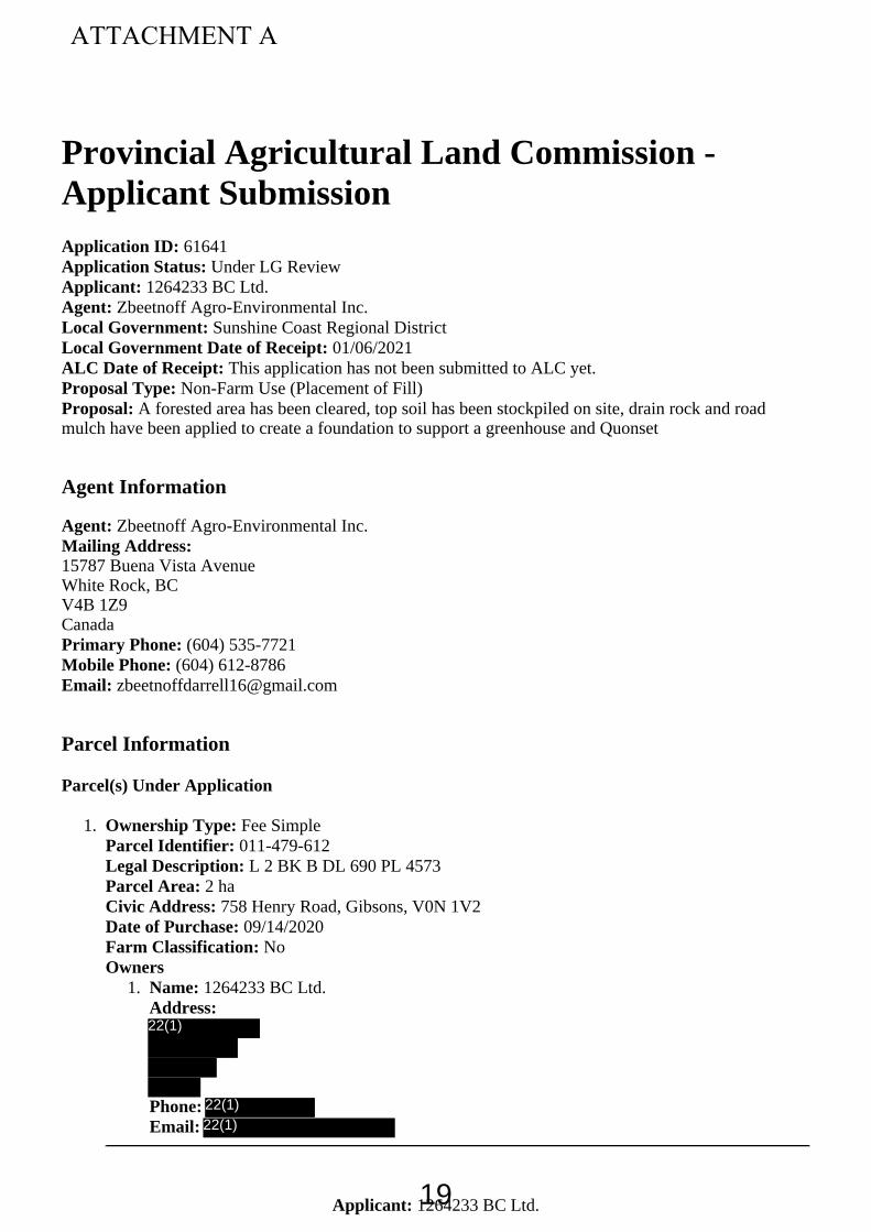
1264233 BC Ltd.Applicant:
1.
1.
Provincial Agricultural Land Commission -Applicant Submission
61641Application ID: Under LG ReviewApplication Status:
1264233 BC Ltd. Applicant: Zbeetnoff Agro-Environmental Inc. Agent:
Sunshine Coast Regional DistrictLocal Government: 01/06/2021Local Government Date of Receipt:
This application has not been submitted to ALC yet. ALC Date of Receipt: Non-Farm Use (Placement of Fill) Proposal Type:
A forested area has been cleared, top soil has been stockpiled on site, drain rock and roadProposal:mulch have been applied to create a foundation to support a greenhouse and Quonset
Agent Information
Zbeetnoff Agro-Environmental Inc. Agent: Mailing Address:
15787 Buena Vista AvenueWhite Rock, BCV4B 1Z9Canada
(604) 535-7721Primary Phone: (604) 612-8786Mobile Phone:
Parcel Information
Parcel(s) Under Application
Fee Simple Ownership Type: 011-479-612Parcel Identifier:
L 2 BK B DL 690 PL 4573Legal Description: 2 ha Parcel Area:
758 Henry Road, Gibsons, V0N 1V2Civic Address: 09/14/2020Date of Purchase:
No Farm Classification:Owners
1264233 BC Ltd. Name: Address:
Phone: Email:
ATTACHMENT A
22(1)
22(1)22(1)
19
1264233 BC Ltd.Applicant:
Current Use of Parcels Under Application
1. Quantify and describe in detail all agriculture that currently takes place on the parcel(s).This land is being improved for agriculture. To date, a few chickens and pigs are on the property. Thearea for horticultural production requires drainage and/or clearing.
2. Quantify and describe in detail all agricultural improvements made to the parcel(s).40 yd3 of rubbish, debris and junk have been removed from the property Stumps and cleared trees have been removed from a portion of the property An area comprising 375 m2 has been graveled to support a quonset and seacans. An area comprising 1,000m2 has been prepared as a base (graveled and asphalted) to receive agreenhouse structure. Cement lock blocks have been brought to the property to be used to provide a base for fencing along theperimeter of the property.
3. Quantify and describe all non-agricultural uses that currently take place on the parcel(s).Non-agricultural uses consist of pre-existing rural residential in a detached house and double widemobile home.
Adjacent Land Uses
North
Agricultural/Farm Land Use Type: SheepSpecify Activity:
East
Agricultural/Farm Land Use Type: Equine, livestock, vegetablesSpecify Activity:
South
Residential Land Use Type: Non-farm useSpecify Activity:
West
Agricultural/Farm Land Use Type: Mixed vegetable and poultry Specify Activity:
Proposal
1. Are you submitting this application as a follow-up to a Notice of Intent (NOI)?No
2. What is the purpose of the proposal? Describe any benefits to agriculture that the proposalprovides.A forested area has been cleared, top soil has been stockpiled on site, drain rock and road mulch havebeen applied to create a foundation to support a greenhouse and Quonset
20

1264233 BC Ltd.Applicant:
3. Proposal dimensions
Total fill placement area (0.01 ha is 100 m )2 0.14 ha Maximum depth of material to be placed as fill 0.4 m
Volume of material to be placed as fill 307 m3
Estimated duration of the project. 1 Months
4. Has a Professional Agrologist reviewed the project and provided a written report? If yes, pleaseattach the Professional Agrologist report in the "Upload Attachments" section.No
5. What alternative measures have you attempted before proposing to place fill?The soil and moisture conditions were deemed to be unsuitable to support structures on the property.While the owner made the improvements without ALC approval, the attached Soils Report by aProfessional Agrologist supports the owner's determination.
6. Describe the type of fill proposed to be placed.The 375 m2 Quonset area of was underlain by 25 cm of drain rock (rock crush) and 15 cm of road mulch.The 1,050 m2 asphalted area was underlain by 15 cm of road mulch.
7. Briefly describe the origin and quality of fill. Has the fill been assessed by a qualified professionalto verify its agricultural suitability? If yes, please attach the assessment report in the "UploadAttachments" section.Fill consisted of drain rock and road mulch obtained from a local gravel pit. The fill was not assessed bya QP prior to placement to verify agricultural suitability. The Soils Report indicates that the fill materialis suitable for agricultural application.
8. Describe the type of equipment to be used for the placement of fill. If applicable, describe anyprocessing to take place on the parcel(s) and the equipment to be used.The fill was trucked in, spread with an excavator, and compacted with a vibrator.
9. What steps will be taken to reduce potential negative impacts on surrounding agricultural lands?No negative impacts on surrounding lands are expected.
10. Describe all proposed reclamation measures. If a reclamation plan from a qualified professionalis available, please summarize the reclamation and attach the full plan in the "UploadAttachments" section.No dust, contouring, or weed control issues were encountered. Site drainage is an issue as the Stop Workorder discouraged the owner from completing planned drainage improvements. However, the owner istaking emergency site drainage measures in January, 2021 to protect the farm driveway from excessivewater on the property. The stockpiled topsoil will be used on other area of the property that will be usedfor fruit trees and vegetable production, once the land is cleared. The stock piles have not been seeded, todate.
Applicant Attachments
Agent Agreement-Zbeetnoff Agro-Environmental Inc.Other correspondence or file information-Zbeetnoff Statement of DisclosureSite Plan / Cross Section-61641Other correspondence or file information-Hughes-Games Statment of DisclosureProfessional Report-Soils and Land CapabiityProfessional Report-Farm Plan AssessmentProposal Sketch-61641Certificate of Title-011-479-612
21

1264233 BC Ltd.Applicant:
ALC Attachments
None.
Decisions
None.
22

Location of fill indicated by blue shading
23

758 Henry Rd., Gibsons BC, Agriculture Capability / Soils Assessment 1 | P a g e
758 Henry Road, Gibsons BC
Agriculture Capability / Soils Assessment
Prepared by:
Geoff Hughes-Games, PAg, Soil Specialist / Senior Agrologist Abbotsford, BC
Prepared For:
1264233 BC Ltd
DRAFT: November 30, 2020
22(1)
24

758 Henry Rd., Gibsons BC, Agriculture Capability / Soils Assessment 2 | P a g e
Summary
Geoff Hughes-Games was requested by to investigate and prepare an soils and agricultural capability assessment for 758 Henry Rd, Gibson BC. This report highlights the mapped soils and agricultural capability. It provides a summary of the findings of a site visit on November 18, 2020. That site visit included examination of soils, landscape and inventory of current activities on the property. It also included discussions with landowner regarding proposed or potential agricultural activities. A review of those findings is presented in relation soil and non-soil bound agricultural use, including some suggestion soil management activities related to water and nutrients. The report is intended to assistance in resolving the BC Agricultural Land Commission (ALC) enforcement actions (ALC C&E File 159198), as such there are some suggested actions provided.
Limitations: This report was prepared by Geoff Hughes-Games, PAg. I am a Professional Agrologist registered with the BC Institute of Agrologists (member #616). My areas of expertise include soil science, including classification and management as well as agriculture environmental risk assessment. I am not trained as a climatologist, biologist or land use planner and as such, any comments in this report related what maybe defined as climatology, vegetation, land use planning are restricted solely to my expertise in soil classification and management for agricultural purposes.
22(1)
25

758 Henry Rd., Gibsons BC, Agriculture Capability / Soils Assessment 3 | P a g e
Contents Summary ................................................................................................................................................... 2
Limitations: ........................................................................................................................................... 2
Subject Property ....................................................................................................................................... 5
Scope ......................................................................................................................................................... 5
Active Regulatory Items ............................................................................................................................ 5
Desktop Assessment ................................................................................................................................. 6
Soils Mapping ........................................................................................................................................ 6
Climatic Data ......................................................................................................................................... 8
Mapped Agricultural Capability ............................................................................................................ 9
Site Visit Results .................................................................................................................................. 10
Review of Soil Survey and Agricultural Capability Assessment .......................................................... 15
Review of Soil Nutrient Test Results ................................................................................................... 16
Review of Drainage ............................................................................................................................. 16
Review of Regulatory Issues ............................................................................................................... 18
Zoning and Land Use ........................................................................................................................... 19
Appendix 1 – Field Notes and Soil Pit Descriptions from Site Visit November 18, 2020 ........................ 20
Appendix 2 – Photos of Soil Pits and Adjacent Landscapes .................................................................... 22
Appendix 3 – Photos of Various Areas of Property ................................................................................ 27
Appendix 4 – Lab Results ........................................................................................................................ 30
Appendix 5 – Soil Management Handbook (excerpts) ........................................................................... 30
Appendix 6 – ALC Compliance and Enforcement Order ......................................................................... 30
Appendix 7 – Sunshine Coast Regional District Zoning Bylaw 310 (excerpts) ........................................ 30
List of Figures/Photos Figure 1 Mapped soil polygons ..................................................................................................................... 6 Figure 2 Location of various Items and structures (white line approximate property extent) .................. 12 Figure 3 Surrounding land use .................................................................................................................... 13 Figure 4 Soil Pit Locations ........................................................................................................................... 14 Figure 5 Drainage Scheme .......................................................................................................................... 18 Soil Pit 1 – West: Landscape looking east (note ponding) .......................................................................... 22 Soil Pit 1 - West: Abundant roots and water table ..................................................................................... 22 Soil Pit 2 – Center: Glacial fluvial over glacial marine (~75 cm) ................................................................. 23 Soil Pit 1: Sandy subsoil materials ............................................................................................................... 23 Soil Pit 2- Center: Gleyed/mottled glacial marine parent material ............................................................ 24
26

758 Henry Rd., Gibsons BC, Agriculture Capability / Soils Assessment 4 | P a g e
Soil Pit 2 – Center: Landscape looking southwest (recent clearing- puddled due to recent rain) ............. 24 Soil Pit 3 – East: Landscape looking northwest ........................................................................................... 25 Soil Pit 3 - East: North (water table at 65 cm)............................................................................................. 25 Soil Pit 3 – East: Coarse fragments in sandy gravelly subsoil (>100 cm) .................................................... 26 Temporary Quonset and sea cans(area w/crushed rock and road mulch) ................................................ 27 Western extent: Existing House, topsoil berm, temporary Quonset ......................................................... 27 Recently cleared area – looking west toward (piled logs and lock block storage) ..................................... 28 Asphalt pad, lock block wall – looking north west toward treed area ....................................................... 28 Soil berm on south side of asphalt pad and lock block wall – partial drainage ditch ................................. 29 Log pile ........................................................................................................................................................ 29
27

758 Henry Rd., Gibsons BC, Agriculture Capability / Soils Assessment 5 | P a g e
Subject Property
CIVIC ADDRESS: 758 & &64 Henry Road, Gibsons BC V0N 1V2 LEGAL: Lot 2, Block B, Plan VAP4573, District Lot 690 Westminster Land District PID: 011-479-612
Scope The site visit and review of available mapping resources was intended to Investigation of soil and drainage conditions at the subject property. The report was to include a desktop review of available soil, agricultural capability and landscape mapping and available historic aerial imagery. Including review of zoning and bylaws related to agricultural land use of the subject property.
The on-site investigation of existing soils on the property to be based on ALC P-10 Policy (Criteria for Agricultural Capability Assessments1). This was to include a review of areas that are “undisturbed” and areas that have been disturbed by human activity. The criteria require soil pit and auger hole descriptions as well as general landscape descriptions. The investigation was to primarily focus on soil-based agricultural activities. Soil samples were to be taken from areas that could be used for soil based agriculture for fertility analysis.
A review of the agricultural capability and soil/landscape drainage was to be completed. The report was to provide recommendation for drainage and capability improvements related to soil and non-soil based agriculture.
A review of any rationale to support improvements for non-soil based agriculture. General comments on agricultural-environmental risks on the property will be included as appropriate.
Active Regulatory Items The above noted property is the subject of enforcement action by the BC Agricultural Land Commission (ALC). ALC C&E File 159198, including a Stop Work Order issued by the ALC on October 26, 2020. Correspondence related to this file from the ALC are attached in Appendix X.
In addition, another Stop Work Order (under Bylaw 687) was issued by Sunshine Coast Regional District on November 9, 2020.
1 ALC - CRITERIA FOR AGRICULTURAL CAPABILITY ASSESSMENTS Policy P-10 October 2017 https://www.alc.gov.bc.ca/assets/alc/assets/legislation-and-regulation/policies/alc_-_policy_p-10_-_criteria_for_agricultural_capability_assessments.pdf
28

758 Henry Rd., Gibsons BC, Agriculture Capability / Soils Assessment 6 | P a g e
Desktop Assessment A desk top assessment of available soil, agricultural capability, terrain and climate and zoning information was completed for the property. The results of that assessment are summarized in the following sections.
Soils Mapping The following available soil mapping was reviewed:
• BC SIFT (British Columbia Soil Information Finder Tool)
https://www2.gov.bc.ca/gov/content/environment/air-land-water/land/soil/soil-information-finder
• Report reference from Soils of the Langley-Vancouver Map Area, BC Soil Survey Report 15,1980 (RAB Bulletin 18) Volumes 2, 3 and 6.
https://sis.agr.gc.ca/cansis/publications/surveys/bc/bc15/index.html
This mapping (Figure 1) indicated the presence of three soil series (Summer (SR), Sunshine (SS), and Heron (HN)). on the assessed parcel. These are primarily developed on glacial-fluvial deposits. A summary of the mapped soils series is provided below. Soils, (Albion (AB), Nicholson (N) and Sunshine (SS)) on the adjacent soil polygon are dominated by soils developed on glaciomarine sediments.
Figure 1 Mapped soil polygons
29

758 Henry Rd., Gibsons BC, Agriculture Capability / Soils Assessment 7 | P a g e
Table 1 Mapped Soil Series
Soil Series name (% of map polygon)
Classification Description Map Label
Summer (SR) 40%
Gleyed Ortstein Humo-Ferric Podzol
Sandy loam to fine sandy loam fluvio-glacial deposits in the topsoil are underlain by sandy subsoil layers usually changing to clayey glaciomarine sediments (~1 m depth). Subsoils are often strongly cemented often leading to root restrictions with 30 cm of surface. Extremely to strongly acid surface layers and slightly acid in the subsoil. Generally, stone free to slightly stony near the surface and stone free at depth. A variable thickness of forest litter (LFH) is present on areas with limited disturbance from logging or agriculture. Nearly level to gently undulating slopes (less than 5% slopes). Often in depressional areas and tend to be imperfectly to moderately poorly drained with water tables present in non growing season. Developed mainly under forest cover vegetation (western red cedar, western hemlock, red alder and salmonberry).
SR-SS-HN bc
Sunshine (SS) 30%
Orthic Humo-ferric Podzol
Sandy loam to sandy loam fluvio-glacial topsoil layers are underlain by sandy subsoil materials and at depth (> 1 m) texture changes to clayey glaciomarine or sandy gravelly glacial till. Strongly to very strongly acid surface layers and slightly acid in the subsoil. Generally stone free. A thin layer of forest litter (LFH) is present on areas with limited disturbance from logging or agriculture. Nearly level to gently undulating slopes (less than 5% slopes). Soils are generally well to moderately well drained with occasional perched water tables appearing during heavy rainfall events. Developed mainly under forest cover vegetation (western red cedar, western hemlock and red alder).
Heron (HR) 30%
Rego Humic Gleysol
Sandy loam or fine sandy loam fluvio-glacial topsoil layers are underlain by loamy sand or sandy subsoil materials and at depth (< 1 m) texture changes to clayey glaciomarine or glacial till. Extremely to very strongly acid surface layers and medium to strongly acid in the subsoil. Patched of cemented material maybe present in subsoil. Generally stone free. A thin layer of forest litter (LFH) is present on areas with limited disturbance from logging or agriculture. Nearly level to gently undulating slopes (less than 5% slopes). Soils are poorly drained and often found in depressional areas. Perched water tables are often at the contact between the sandy upper layers and the underlying clay. These water tables rise to the surface is heavy rainfall events. Rooting depth is often restricted by the water tables and dense subsoil. Developed mainly under forest cover vegetation (western red cedar, western hemlock, red alder, willow and black cottonwood).
Landform: Topography:
Glaciofluvial or fluvial over glaciomarine or glacial till bc = gently undulating to undulating complex slopes ranging between 0.5 and 5%
Data source: BC SIFT and Soil Survey Report 15
30

758 Henry Rd., Gibsons BC, Agriculture Capability / Soils Assessment 8 | P a g e
Climatic Data The property lies within the warm summer Mediterranean climate zone. Characterized by mild wet winters and moderate dry summers. The annual precipitation is just over 1350 mm with over 70% of this falling primarily as rain during November and March. Mean annual temperature is 10 °C with winter temperatures averaging above 4 °C and summer temperatures averaging below 22 °C. A long frost free period and high growing degree days make for favourable growing conditions. Heavy winter rains and dry summers lead to the need for water management systems that include drainage infrastructure for winter and irrigation for summer months.
Weather data is available a station at Gower Point, (ECCC) approximately 2.7 km south and ~100 m lower in elevation.
Table 2 Climate Normals
Climate Normal 1981-2010 (source: Environment Canada) STATION NAME: GIBSONS GOWER POINT CLIMATE ID: 1043152
LATITUDE 49°23'08.090” N LONGITUDE 123°32'29.000” W ELEVATION 34.0 m
Jan Feb Mar Apr May Jun Jul Aug Sep Oct Nov Dec Year
Temperature (°C)
Daily Average 4.6 5.2 7.1 9.5 12.7 15.3 17.6 17.9 15.1 10.5 6.5 4.2 10.5
Daily Maximum 6.7 7.8 10 12.9 16.1 18.7 21.1 21.4 18.6 13.1 8.7 6.3 13.5
Daily Minimum 2.5 2.6 4.1 6.1 9.2 11.9 14 14.3 11.7 7.9 4.3 2.1 7.6
Precipitation
Rainfall (mm) 178.2 118 118.2 95.7 81.5 67.2 41.4 40.5 58 140.2 214.8 170.1 1323.6
Snowfall (cm) 8.8 6.1 3.4 0.5 0 0 0 0 0 0.2 3.7 8.2 30.9
Precipitation (mm) 187 124.1 121.6 96.2 81.5 67.2 41.4 40.5 58 140.4 218.5 178.3 1354.5
Climate Normal (source: BC SIFT) Frost free period (days) 240 Degree days above 5°C (days) 2077 Summer Heat Index 60
Projected Changes in Climate Some insights as to the projected changes in climate and the impacts of those changes. The source is the data and modelling completed by the Pacific Climate Consortium. The table below summarizes the potential changes to temperature and precipitation in the Sunshine Coast Region. Overall (for the period 2010 to 2039) temperatures and growing degree days are expected to increase while and annual precipitation, winter snow fall and heating degree days will decline.
These changes in precipitation and temperature may have moderate changes to the types of crops that can be grown and the availability of water for late season irrigation. Reductions in annual precipitation will not reduce the need for a drainage system. Variability and number of extreme weather events will likely occur, and this will drive the need for more careful management of soil cover to reduce risk of erosion or nutrient run-off losses.
31

758 Henry Rd., Gibsons BC, Agriculture Capability / Soils Assessment 9 | P a g e
Table 3 Projected Climate Change Impacts
Climate Variable Season Projected Change from 1961-1990 Baseline for period 2010-2039
Median Sunshine Coast Range (10th to 90th percentile) Temperature* (°C) Annual +1.6 °C +1.2 °C to +2.0 °CPrecipitation (%) Annual -2.5% -6.4% to +0.035%
Summer -11.0% -27% to +3.5%Winter +0.98% -4.7% to +8.2%
Snowfall* (%) Annual -38% -43% to -27%Winter -32% -43% to -24%Spring -24% -47% to -19%
Growing Degree-Days* (degree days) >5 °C
Annual +376 degree days +231 to +465 degree-days
Heating Degree-Days* (degree days) >18 °C
Annual -535 degree days -721 to -432 degree-days
Frost-Free Days* (days)
Annual +33 days +23 to +37 days
Pacific Climate Consortium – projected changes in temperature and precipitation PLAN2ADAPT – 2020s (2010 to 2039) https://services.pacificclimate.org/plan2adapt/app/ * These values are derived from temperature and/or precipitation.
Agricultural Capability Table 4 provides an indication of the mapped agricultural capability ratings for the subject property. There is one capability polygon covering the property. It has three ratings which relate directly to the three mapped soil series .
Table 4 Mapped Agricultural Capability
Agriculture Capability (source: BCSIFT) Capability Class (CC) Label
Class
4:4AWD~3:4A~3:4WA
Class 4 = land has more severe limitations that require reduce the range of crops and require special management practices or inputs
Improved Class (IC) Label
Class
4:2AD~3:2AT~3:2WA
Class 2 = land has minor limitations that would require on going management practices in order to achieve good crop growth for a range of crops
Limitations (subclass): A = soil and/or climatic moisture deficiency (improvable with irrigation) W = excess soil moisture due to highwater table or seepage/runoff (improvable with drainage) T = adverse topography due to steepness or complexity of slopes (not improvable) D = degree of stoniness or low perviousness restricting rooting and cultivation (somewhat improvable with various types of management)
32

758 Henry Rd., Gibsons BC, Agriculture Capability / Soils Assessment 10 | P a g e
Site Visit Results A site visit was carried out on November 18 , 2020. Weather conditions on that day were not ideal for soil pit installation, but due to time and travel restrictions related to the currently regulatory and COVID pandemic stressors the date was chosen as the best option.
Weather on November 18th included rain (at times heavy) during the site visit, with just over 14 mm report at the nearby Gibsons Gower Point Station (ECCC Stn # 10143152). Precipitation in the preceding 5 days (~39 mm) and preceding 10 days (~88 mm) totalled over 105 mm including the day of the site visit.
This may have contributed to the overall level of excess moisture on the site. However, this moisture did provide an indication for the potential drainage issues.
Overall Site Observations The subject parcel is approximately 5 acres. Observations from historic aerial imagery (Google Earth) prior to 2020 indicated the presence of various structures including, a single family house, a mobile home, separate garage, several small sheds and a driveways to both the house and mobile home. The latter of which formed a “S” shape transecting the length of the property.
Prior to 2020, historical imagery and observations made on Nov 18, provided some indication that the land had been logged and partially cleared. Other than lawn areas adjacent to the house and mobile home had regrown to red alder and various shrubby species with some scattered Western Red Cedar, Hemlock and Big Leaf Maple.
Site conditions November 18th, 2020 As noted above the site was very wet due to recent and ongoing rainfall. Water was ponded in various locations. In particular a significant amount of water was ponded north of the existing “S” driveway and within the forested area between the grassed are surrounding the mobile home and the Quonset/house area and the west end of the property.
At the time of the site visit the following structure or items were observed. These are noted on Figure 2 Overlay of 2004 Google Earth Image).
• Single family home and separate two vehicle garage• Mobile home, attached carport and nearby pumphouse• Two driveways (one circular drive to house and one long gravel “S” driveway to mobile home• Gravelled pad near SE corner (part of existing driveway to mobile home) with two roll off bins, a
small excavator, truck, large excavator and small trailer• Two soil berms, one along south property boundary (east end) and another adjacent to lawn
area around house. Also, a small soil pile (<15 m3) across the “S” drive from the asphalt pad.• Asphalt pad (~30 m x 35 m) underlain by ~ 15 cm depth of road mulch near south east end of
parcel• Large concrete lock block wall (~3 blocks high x 16 blocks long ) separating asphalt pad from
recently cleared area to west• Road mulch pad (~15 cm depth) , underlain by coarse rock crush (~25 cm depth) near house
(~25 m x 15 m) on this pad:o A temporary Quonset structure containing equipment
33
758 Henry Rd., Gibsons BC, Agriculture Capability / Soils Assessment 11 | P a g e
o Four sea cans of various lengths, three pieces of small equipment(compressor/generators/welder units (all mobile))
• Recently cleared and leveled areas south of “S” driveway (~ 40 m x 45 m)• Small piles of logs (2 stacks), wood debris (1 pile) and rocks (3 piles) left from recent clearing• Two scattered piles of construction materials (lumber and pipe) that are to be used for
agricultural operation• Linear stockpile of large concrete lock blocks (approximately 150) along “S” driveway across
from Quonset
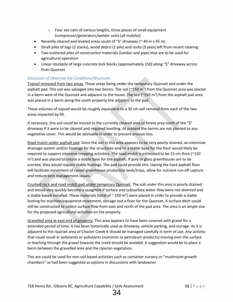
Discussion of Observed Site Conditions/Structures Topsoil removed from two areas. Those areas being under the temporary Quonset and under the asphalt pad. This soil was salvaged into two berms. The soil (~150 m3) from the Quonset area was placed in a berm west of the Quonset and adjacent to the house. The soil (~350 m3) from the asphalt pad area was placed in a berm along the south property line adjacent to the pad.
These volumes of topsoil would be roughly equivalent to a 30 cm soil removal from each of the two areas impacted by fill.
If necessary, this soil could be moved to the currently cleared area or forest area north of the “S” driveway if it were to be cleared and required levelling. At present the berms are not planted to any vegetative cover. This would be advisable in order to prevent erosion loss.
Road mulch under asphalt pad. Since the soil in this area appears to be very poorly drained, an extensive drainage system and/or footings for the structures and/or a stable base for the floor would likely be required to support intensive cropping activities. The road mulch is estimated to be 15 cm thick (~150 m3) and was placed to create a stable base for the asphalt. If poly or glass greenhouses are to be erected, they would require stable footings. The pad could provide this. Having the hard asphalt floor will facilitate movement of raised greenhouse production beds/trays, allow for nutrient run-off capture and reduce pest management issues.
Crushed rock and road mulch pad under temporary Quonset. The soil under this area is poorly drained and would very quickly become a quagmire if surface and subsurface water flow were not diverted and a stable based installed. These materials (total of ~ 150 m3) were placed in order to provide a stable footing for machine/equipment movement, storage and a floor for the Quonset. A surface ditch could still be constructed to collect surface flow from east and north of the pad area. The area is an ample size for the proposed agricultural activities on the property.
Gravelled area at east end of property. This area appears to have been covered with gravel for a extended period of time. It has been historically used as driveway, vehicle parking, and storage. As it is adjacent to the riparian area of Chaster Creek it should be managed carefully in term of use. Any activity that could result in sediments or pollutants (nutrients or petroleum products) moving over the surface or leaching through the gravel towards the creek should be avoided. A suggestion would be to place a berm between the gravelled area and the riparian vegetation.
This are could be used for non-soil based activities such as container nursery or “mushroom growth chambers” as had been suggested as options in discussions with landowner.
34
758 Henry Rd., Gibsons BC, Agriculture Capability / Soils Assessment 12 | P a g e
Lock block wall adjacent to asphalt pad. This wall has some limited potential agricultural use. It could be used as a push wall if composting or agriculture residue management were to be carried out on the asphalt pad. It could also be used to anchor the poly greenhouses or provide a headwall. It is currently acting as a separation between two potential land use areas (cropping and greenhouse).
Lock blocks, log pile and small piles of rocks along driveway. At the present time there is no agricultural use for these materials. The logs could be removed for wood fiber salvage. Some of the blocks could be used to create a partial fence or visible screen along Henry Road. As some of the rocks are native to the site and some are angular imported materials these could be blended and used as riprap at outlets of ditch/culverts to reduce erosion risk.
Stored equipment. In discussion it was noted that some of the equipment does not belong to the landowner but was in place as it had been in use as part of the site clearing, leveling and utilities (waterline) installation. Much of this equipment is mobile and easily moved off site if it is no longer required.
Recently cleared area and forest covered area. These areas will be discussed later in terms of cropping activities. They will require water and nutrient management inputs to be activity and intensively used for soil bound agriculture.
Residential dwellings and immediately adjacent land. Both the house and mobile home have grassed areas surrounding them that have historically been used for residential purposes. This includes septic fields, vehicle access/parking and some limited evidence of gardening and recreation.
Figure 2 Location of various Items and structures (white line approximate property extent)
35

758 Henry Rd., Gibsons BC, Agriculture Capability / Soils Assessment 13 | P a g e
Surrounding Land Uses The adjacent parcels have a variety of agricultural land uses. Some are soil bound, while others are non-soil bound. Greenhouse and poly hoop house structures have been constructed on at least two nearby properties. It is unclear from a roadside survey as to whether these structures have hardened floors or footings.
West (across Henry Road) – mixed farm including; poly greenhouses, vegetables, berries, pasture (sheep) and poultry
South – mixed mainly rural residential with horse paddocks and forest
East – riparian area along Chaster Creek and horse paddocks further east
North – sheep pasture and then further north a organic produce farm (soil and non-soil bound)
Figure 3 Surrounding land use
Soils Three soil pits were installed using a small backhoe. Two additional shallow observation holes where hand dug. See Figure 4 for location of soil observation points. Details of field observations for each location are indicated in Appendix 1.
Two soil pits (West and East) were installed in previously ‘undisturbed’ areas north of “S” driveway. A third pit was installed in the recently cleared area. The hand dug pits were located near the western end of the property, one in the lawn of the house and one in the forest south of the entrance driveway.
N Poly greenhouses
Gravel horse riding ring
Poly greenhouse
Gravel horse riding ring
36

758 Henry Rd., Gibsons BC, Agriculture Capability / Soils Assessment 14 | P a g e
Due to the rainfall and recent precipitation a significant amount of ponded water was present north of “S” driveway. As a result, the two pits excavated in this area filled immediately with water. The third pit south of the driveway was very wet but did not flood. (See Appendix 2 for images of the three pits.)
Soil Pit 1 - West
Pit located on small hummock (attempt to avoid ponded water) in forested area just east of area containing Quonset and sea cans. A thin forest floor lay overlaying sandy horizons with a gravel free sandy parent materials observed at approximately 100 cm. No coarse fragments noted although ‘very gritty’ sounds as pit was excavated to 130 cm depth. Free flowing shallow groundwater at about 100 cm depth. A very firm B horizon may indicate the presence of an Ornstein or cemented layer on which some of the surface water maybe ponding – however this was difficult to establish under the weather water table conditions. Limited evidence of gleyed conditions in upper 100 cm. Pit filled amounts instantaneously to with 50 cm of surface. Abundant roots in upper layers.
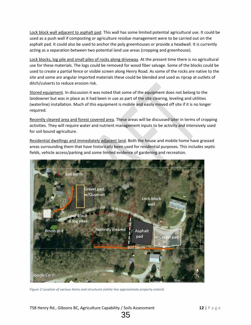
Soil Pit 2 – Center
Pit located in middle of recently cleared/levelled area. A thin Ap (mixed LFH/Ah) topsoil overlying a sandy subsoil which was then underlain by a dense clayey parent material layer at about 75 cm. Upper horizons likely glacial fluvial and lower parent material likely glaciomarine. Pit was excavated to ~105 cm – not ‘gritty’ sounds observed during excavation. C horizon showed definitive gleying and mottles. Profile was very wet with minor seepage at 20 cm (in coarser sandy layer) and at again more prominent at 75 cm at contact between sandy and clayey layers. Some surface ponding in areas impacted by recent clearing. Abundant roots in upper layers.
Figure 4 Soil Pit Locations
37

758 Henry Rd., Gibsons BC, Agriculture Capability / Soils Assessment 15 | P a g e
Soil Pit 2 – East
Pit located on small hummock (attempt to avoid ponded water) in forested area near south west corner of lawn adjacent to mobile home. A thick forest floor layer overlying sandy subsoil which was then underlain by gravelly sandy loam to gravelly sand parent material. Pit was excavated to just over 120 cm but back filled with water within minutes to about 60 cm from surface. C horizon and lower portions of B horizon showed evidence of gleying and mottling. Primary flow of water into hole appeared to come from C horizon. Abundant roots in upper layers.
Hand Pit – NW
Shovel pit dug to ~45 cm depth in lawn area. No free water observed in hole. Sandy loam topsoil (Ah) about 15 cm over sandy loam Bf horizon. Abundant fine to medium roots. No water ponded on surface.
Hand pit – SW
Shovel pit dug to ~ 45 cm depth in forest cover. No free water, No ponded water on forest floor. Moderate forest floor (LFH) layer >10 cm over Ahe (~12 cm) and Bf horizon. Abundant roots.
Review of Soil Survey and Agricultural Capability Assessment As noted above, the soil survey mapping indicated the potential presence of three soil series. From the pit observations it appears that all three soil series are present on the property. Pits West and East appear to fit the Summer (SR) soil series. The Center pit is most like the Heron (HN) soil series and the two and dug pits on the western end of the property are most like the Sunshine (SS) soil series.
The West and East pits showed some evidence of gleying and mottling below the root zone and high water table at the time of the visit – leading to the conclusion they are imperfectly to poorly drained with seasonal high water during periods of heavy rainfall. The Center pit showed stronger evidence of gleying and mottles within 50 cm of the soil surface. This would indicate longer periods of poor drainage although a water table, just seepage, was present at the time of the site visit.
Mapping indicates the subject property is primarily Class 4 due to a variety of limitations. It is improvable to primarily Class 2. Again, with a variety of limitations. The dominate limitations are indicated as excess soil moisture in the ‘off’ season and soil moisture deficit in the growing season. These limitations can generally be overcome by ‘standard’ water management activities such drainage and irrigation.
These Classes and limitations were confirmed based on presence of water table or gleying (W – limitation) in all three pits and the coarse nature of the upper layers (A – limitation) of the soil profile in all pits. The mapped topographic limitation (T) was not observed, as the entire site was level to very slightly sloping with some minor hummocks (likely old stump mounds) present in the forested areas.
Suggestions on the range of suited crops and how these three soils series can be managed is detailed in the Soil Management Handbook for the Fraser Valley. Excerpts pretraining to these soils can be found in Appendix 5. There are no well suited crops, however, there are a wide range of suited crops. Inputs such as lime, fertilizer, water management and organic matter incorporation are recommended.
38

758 Henry Rd., Gibsons BC, Agriculture Capability / Soils Assessment 16 | P a g e
Review of Soil Nutrient Test Results Grab samples of the 0 - 15 cm depth were taken from each of the three excavated pits. Lab results are found in Appendix 4 and summarized below. In general, the soils are deficient in macro nutrients (N, P. K) and below optimal for most micronutrients. Soil pH in all three locations was 5.6 or lower – indicatingvery acidic conditions typical of forested soils of the region. Organic matter contents were above 10%and up to 18%. Again, this is typical of forest floor conditions. The soils are non-saline (EC less than2dS/m). Lab test of Center pit confirmed the surface texture as sandy loam (54% sand, 34% silt 12%clay).
Table 5 Table 6 Summary of Soil Test Results
Location Pit 1 – West Pit 2 – Center Pit 3 – East pH 5.6 5.5 5.1 EC dS/m 0.06 0.1 0.1 OM % 10.9 14.8 18.3 Nitrate-Nitrogen(N) ppm <2 <2 4 Phosphorus (P) ppm <5 <5 <5 Potassium (K) ppm 27 97 56 Sulfate-Sulfur (S) ppm <1 <1 2 Calcium (Ca) ppm 102 281 308 Magnesium (Mg) ppm 13 39 30 Iron (Fe) ppm 29.2 205 67.4 Copper (Cu) ppm 0.3 0.7 0.7 Zinc (Zn) ppm <0.5 2.9 4.1 Boron (B) ppm 0.1 0.2 0.3 Manganese (Mn) ppm 1.7 59.2 6.1 Chlorine (Cl) ppm 6.3 9.1 4 Colour codes Deficient Marginal Optimum
Note: Colour codes are based on nutrient levels on lab results.
Nutrient management suggestions As these soil test results show a significant deficiency of nutrients, in order for cultivated (soil bound) cropping to occur, a soil nutrient program is required. This would include the addition of fertilizers and/or manure or compost to provide a full spectrum of macro and micro-nutrients. Cover cropping, crop rotation and mulching cropping would be recommended to improve moisture and nutrient holding capability in the topsoil. In addition, for most soil bound crops a liming program would be recommended to raise soil pH to closer to 6.5.
Review of Drainage Excess water management is clearly a concern of the property based on the level of surface ponding and high water tables. The area between the House and Mobile home on the north side of the driveway had significant ponding in many locations. Water tables were within 60 cm of surface in both soil pits
39

758 Henry Rd., Gibsons BC, Agriculture Capability / Soils Assessment 17 | P a g e
excavator in the area. Shallow groundwater appears to be flowing in shallow coarse sand or gravelly sandy layers. Surface water was flowing west along the north side of the driveway.
South of the driveway, in the recently cleared area (Center pit), there was evidence of high water table (no free water but gleying and mottles). This area is underlain by finer textured glacial marine sediments within 60 cm of the surface. Although some ponding was occurring it was likely related to puddled/compacted surface soil layers resulting from the recent clearing activity. Some water was flowing through a small culvert near the stored lock block stacks and finding is way southward to the remaining forest area.
The three areas that had been altered with application of fill were not showing any significant ponding.
• Quonset Pad:o underlain by about 20 – 30 cm broken rock and overlain with about 15 cm road mulch
gravelo no surface ponding – water visible in broken rock on margins of pad, some water
flowing across driveway• Paved pad:
o Catch basins in pad collecting water and flowing southward and discharging to partiallyconstructed ditch on south property boundary
• Gravel pad (east):o Some puddles – this is an ‘old’ parking area that has a mix of gravel and native soil that
gently slopes to south east.
Suggested Drainage System Soil bound agriculture is definitely an option if excess soil and surface water is managed. Depending on the agricultural activities that take place in the area north of the “S” driveway and the current cleared area, a system of subsurface drains (Big-O) and surface ditches are required to manage excess water in winter months.
The current land use plan suggested was for soil bound cropping in the current cleared area and possible free range poultry pasture if the forested area north of the driveway was cleared.
In order to facilitate drainage, two surface ditches should be constructed. One along the north side of the driveway. This should collect surface water and deliver it through a larger culvert under the driveway. This would then connect to a second surface ditch along the southern property boundary (partially constructed). This second ditch would collect water from the asphalt pad and the cleared area and discharge to the Henry Road municipal ditch. (see Figure 4)
If the current cleared area and/or the forested area are to be cropped to a perennial crop, other than forage grass, a drainage system of 100 mm (4”) Big-O subsurface drain lines is recommended. These should be installed at a depth of at least 70 cm, spaced at about 14 m and on a grade of between 0.2 and 1.5%
Since the eventual plan is to use the asphalt pad for greenhouses, water coming from this area should be diverted to a catchment pond in the event there are nutrients being lost via runoff from the greenhouse crops. The catchment pond could be constructed as a wetland to filter these nutrients.
40

758 Henry Rd., Gibsons BC, Agriculture Capability / Soils Assessment 18 | P a g e
As irrigation water will be required, a roof gutter collection system could also be installed to salvage some runoff water for irrigation purposes.
Figure 5 Drainage Scheme
Review of Regulatory Issues As noted, the Agricultural Land Commission (ALC) has a compliance action (ALC C&E File: 159198) on going for the property. The two item of concern for the ALC are:
1. The placement of fill or removal of soil pursuant to Section 20.3 of the Agricultural LandCommission Act (ALCA)2, and
2. Non-farm use of the land pursuant to Section 20 (1) of the ALCA.
These issues will have to be resolved directly with the ALC, however, the following suggestions may assist in resolving the issues.
2 Agricultural Land Commission Act https://www.bclaws.ca/civix/document/id/complete/statreg/02036_01
41

758 Henry Rd., Gibsons BC, Agriculture Capability / Soils Assessment 19 | P a g e
• Submission of Notice of Intent – providing details of the intended use of the land for agriculture both soil and non-soil bound agricultural activities. This should include detailed plans for greenhouses, pastured poultry, soil bound cropping and nursery/mushroom production.
• Removal of any mobile equipment (e.g., trucks, compressions, excavators, roll off bins and sea cans) not designed for immediate use in land preparation for agricultural uses.
• Removal of the majority of the linear stored pile of large concrete lock blocks along the “S” driveway. A small number could be retained for fencing or visual screening near Henry Road.
• Removal of piled logs and brush and any other debris from land clearing or preparation other than soil.
• Installation of surface drainage system (noted previously in this report) to manage excess water flowing across the property – utilizing any stored rock as riprap at culvert exits.
Zoning and Land Use The subject property falls within Electoral Area E: Elphinstone and SCRD Land Use Zone AG (Agriculture) and SCRD Subdivision district I (minimum parcel size 4 ha).
The Sunshine Coast Regional District Zoning Bylaw 3103 provides details of the allowed uses of land within the agriculture zone. It also provides details of setback requirements related to specific uses and activities. Section 1021 of the bylaw lists the Permitted Uses in the AG Zone including; agriculture, farm operation and agriculture product sales.
Section 1021.9 of the bylaw provides specific regarding setbacks. At a minimum structures must be 5 m from front and back lot lines and 1.5 m from side lot lines, however these stretch up to 15 meters for some of the specific activities proposed. Those being:
• Greenhouses using artificial light .......................... 15 m (no artificial light 5 m) • Mushroom production .......................................... 10 m • Soilless media preparation ................................... 15 m • Agricultural (waste) residue storage ..................... 10 m • Intensive confirmed livestock (poultry) housing .. 15 m
Refer to Appendix 7 for a excerpts from Section 1021 and 1021.9 of Bylaw 310. Setback requirements within the Bylaw may require adjustment of the location or design of some of the proposed activities. In addition, the riparian area along the east edge of the property requires a minimum setback of 15 m and up to 30 m for intensive agricultural activities.
3 Sunshine Coast Regional District Zoning Bylaw 310 https://www.scrd.ca/files/File/Community/Planning/Bylaws/Zoning%20Bylaw%20310%20Zones/2020-October-08%20Bylaw%20310%20Consolidation_1.pdf
42

758 Henry Rd., Gibsons BC, Agriculture Capability / Soils Assessment 20 | P a g e
Appendix 1 – Field Notes and Soil Pit Descriptions from Site Visit November 18, 2020
Depth Horizon Texture Apparent Parent material
Colour Structure Roots Coarse Fragments
CF (%)
Description
West Pit – 1 (49.410616 N, 123.539328 W) 4 - 0 LFH Forest floor abundant Stone free 2nd growth forest cover, Cedar, alder,
shrubs, ferns 0 - 5 Ah SL - LS glacial-fluvial 5YR3/5 granular many Stone free Ponded surface water around
hummock that pit was excavated in 5 - 16 Bf L - SL glacial-fluvial 5YR4/4 Fine SBK-
granular many Stone free Few small concretions
12 - ? BC ? Water table at 50 cm, slightly cemented (could not be sampled or described as under water and excavated material mixed)
>100 Cgj S - SL glacial-fluvial 7.5YR4/3 Single grain
none < 1% Gravelly sounds
Pit dug to 130 cm Filled with water instantaneously from layer at about 100 cm
Central Pit – 2 (49.410368 N, -123.53946 W) 0 – 15 Ap SL glacial-fluvial 5YR4/3 –
5YR3/4 Med. SBK breaking to granular
Many fine
Stone free Recently cleared and levelled – LFH, Ah/Ae and some B mixed)
15 - 25 Bh L glacial-fluvial 5YR2.5/2 Med - fine SBK
Few fine <1 % Ponded surface water (puddled)
25 - 50 Cg SL glacial-fluvial 7.5YR3/2 (mottles 10YR 6/3)
SBK – fine SBK
none Stone free Some seepage at 20 cm and more at 75 cm – no free water table
80 + IICg CL glacial-marine 5YR6/1 (matrix)
SBK none Stone free Pit dug to 105 cm, no gravelly sounds
43

758 Henry Rd., Gibsons BC, Agriculture Capability / Soils Assessment 21 | P a g e
Depth Horizon Texture Apparent Parent material
Colour Structure Roots Coarse Fragments
CF (%)
Description
East Pit – 3 (49.410517 N, -123.538216 W) 18 - 0 LFH Forest floor abundant Stone free 2nd growth forest cover mainly alder,
some cedar, blackberry and salmonberry
0 - 20 Ah LS-S glacial-fluvial 5YR3/2 SBK tending to slightly columnar
Many fine
Mostly stone free
<10% No ponded surface water, pit on slight rise, gravel less than 3 cm
20 - 45 Bh SL glacial-fluvial 5YR3/3 Many fine
Stone free Hole filled to less than 60 cm depth within minutes
45 – 100 (?)
Bfg LS-SL glacial-fluvial 5YR4/4 (mottles 2.5YR3/4)
some <5% Free water flowing at 100 cm level as hole excavated
100+ Cg S glacial-fluvial 5YR4/4 (mottles 2.5YR4/6)
none Visible gravel
50% Gravelly sounds at 100 cm +, CF rounded to subrounded less than 10 cm size
Hand dug – NW near house 0 - 15 Ap glacial-fluvial Abundant
fine Stones on surface
Lawn are near house, stones may have been deposited by humans
15 + Bf glacial-fluvial
Many fine
Stone free Hole dry to > 45 cm
Hand dug – SW in forest near corner of property 10 – 0 LFH abundant Stone free 2nd growth forest cedar and hemlock 0 – 12 Ahe glacial-fluvial abundant Stone free Hole dry to > 35 cm 12 + Bf glacial-fluvial Many
fine No ponded water in area
44

758 Henry Rd., Gibsons BC, Agriculture Capability / Soils Assessment 22 | P a g e
Appendix 2 – Photos of Soil Pits and Adjacent Landscapes4
4 Note black and white pole in images is divided in 10 cm increments for scale
Soil Pit 1 – West: Abundant roots and water table Soil Pit 1 – West: Landscape looking east (note ponding)
45

758 Henry Rd., Gibsons BC, Agriculture Capability / Soils Assessment 23 | P a g e
Soil Pit 1 – West: Sandy subsoil materials Soil Pit 2 – Center: Glacial fluvial over glacial marine (~75 cm)
46
758 Henry Rd., Gibsons BC, Agriculture Capability / Soils Assessment 24 | P a g e
Soil Pit 2 – Center: Landscape looking southwest (recent clearing - puddled due to recent rain)
Soil Pit 2 – Center: Gleyed/mottled glacial marine parent material
47

758 Henry Rd., Gibsons BC, Agriculture Capability / Soils Assessment 25 | P a g e
Soil Pit 3 – East: North (water table at 65 cm) Soil Pit 3 – East: Landscape looking northwest
48

758 Henry Rd., Gibsons BC, Agriculture Capability / Soils Assessment 26 | P a g e
Soil Pit 3 – East: Coarse fragments in sandy gravelly subsoil (>100 cm)
49

758 Henry Rd., Gibsons BC, Agriculture Capability / Soils Assessment 27 | P a g e
Appendix 3 – Photos of Various Areas of Property
Photo: Western extent: Existing House, topsoil berm, temporary Quonset
Photo: Temporary Quonset and sea cans(area w/crushed rock and road mulch)
50
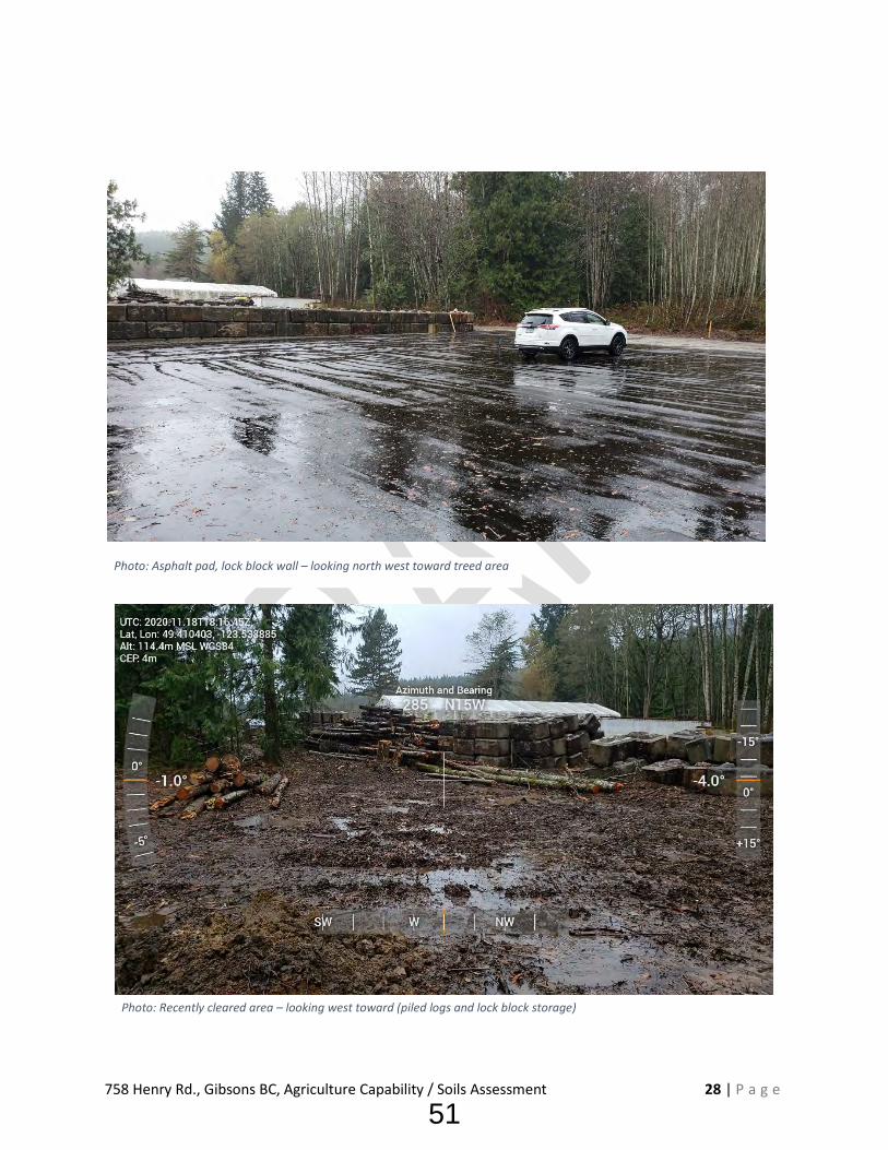
758 Henry Rd., Gibsons BC, Agriculture Capability / Soils Assessment 28 | P a g e
Photo: Asphalt pad, lock block wall – looking north west toward treed area
Photo: Recently cleared area – looking west toward (piled logs and lock block storage)
51

758 Henry Rd., Gibsons BC, Agriculture Capability / Soils Assessment 29 | P a g e
Photo: Example of Log pile
Photo: Soil berm on south side of asphalt pad and lock block wall – partial drainage ditch
52

758 Henry Rd., Gibsons BC, Agriculture Capability / Soils Assessment 30 | P a g e
Appendix 4 – Lab Results
53

Farm Soil Analysis
Element#104, 19575-55 A Ave.Surrey, British ColumbiaV3S 8P8, Canada
(604) 514-3322(604) 514-3323
[email protected]:W: www.element.com
T: +1F: +1
Bill To:
Cash AccountReport To:
34858 Sandon Place
Abbotsford, BC., Canada
V3G 1G4
112534Agreement:
2573291
1460053Lot Number:
Nov 18, 2020Date Received:
Nov 24, 2020Report Date:
Dec 18, 2020Disposal Date:
GHG #1 West
Crop not provided
Report Number:
Grower Name:
Client's Sample Id:
Field Id:
Acres:
Legal Location:
Last Crop: Arrival Condition:
N*Depth P K S** Ca Mg Fe Cu Zn B Mn Cl BiCarbP
Nutrient analysis (ppm)
<2 <5 27 <1 102 13 29.2 0.3 <0.5 0.1 1.7 6.30" - 16"
pH EC(dS/m) OM(%)
Soil QualitySample#
5.6 0.06 10.9 7296813
Excess
Optimum
Marginal
Deficient
Alkaline
Neutral
Acidic
Very Acidic
Extreme
Very High
High
Good
High
Normal
Low
Very Low
11 27 146 5
12 18 55 6
Totallbs/acre
Estimatedlbs/acre
*Nitrate-N **Sulfate-S n/a = not analysed
n/a
n/a n/a n/a
n/a
n/aTexture
Sand
Ammonium
Silt Clay
Hand Texture BS
Ca
TEC
5.4 %
4.0 %
12.7 meq/100 g
Mg 0.8 % Na <1.0 %
Na <30 ppm
K 0.6 %
CEC 230 meq/100 g
Lime 5.2 T/ac Buffer pH 5.8 Est. N Release n/a K/Mg Ratio 0.66
Growing Condition
Excellent
Average
Your Goal
Removal Rate (Seed/Total)
To be added (lbs/ac)
RECOMMENDATIONS FOR BALANCED CROP NUTRITION
Crop not provided
N P2O5 K2O S
To be added (lbs/acre)
Yield
Iron Copper Zinc Boron ManganeseMicro-nutrients
Macro-nutrients
Comments:
Element uses nutrient extraction and analytical methods specifically developed for western Canadian soils.
The modified Kelowna extractant used to analyze key nutrients in this Farm Soil Analysis report is the standard method used in soil fertilityresearch in western Canada. It is used in developing crop response curves to fertilizer in Alberta. The Element ''RECOMMENDATIONS
FOR BALANCED CROP NUTRITION'' are based on those research data. Element recommendations are accurate but should not replaceresponsible judgement.
https://www.element.com/terms/terms-and-conditionsTerms and Conditions:
Page 1 of 1
22(1)
54

Farm Soil Analysis
Element#104, 19575-55 A Ave.Surrey, British ColumbiaV3S 8P8, Canada
(604) 514-3322(604) 514-3323
[email protected]:W: www.element.com
T: +1F: +1
Bill To:
Cash AccountReport To:
34858 Sandon Place
Abbotsford, BC., Canada
V3G 1G4
112534Agreement:
2573292
1460053Lot Number:
Nov 18, 2020Date Received:
Nov 24, 2020Report Date:
Dec 18, 2020Disposal Date:
GHG #2 Center
Crop not provided
Report Number:
Grower Name:
Client's Sample Id:
Field Id:
Acres:
Legal Location:
Last Crop: Arrival Condition:
N*Depth P K S** Ca Mg Fe Cu Zn B Mn Cl BiCarbP
Nutrient analysis (ppm)
<2 <5 97 <1 281 39 205 0.7 2.9 0.2 59.2 9.10" - 16"
pH EC(dS/m) OM(%)
Soil QualitySample#
5.4 0.1 14.8 7296826
Excess
Optimum
Marginal
Deficient
Alkaline
Neutral
Acidic
Very Acidic
Extreme
Very High
High
Good
High
Normal
Low
Very Low
11 27 516 5
12 18 194 6
Totallbs/acre
Estimatedlbs/acre
*Nitrate-N **Sulfate-S n/a = not analysed
Sandy Loam
54.0 34.0 12.3
n/a
n/aTexture
Sand
Ammonium
% Silt % Clay %
Hand Texture BS
Ca
TEC
10.7 %
7.6 %
18.5 meq/100 g
Mg 1.7 % Na <0.7 %
Na <30 ppm
K 1.3 %
CEC 173 meq/100 g
Lime 8.8 T/ac Buffer pH 5.4 Est. N Release n/a K/Mg Ratio 0.77
Growing Condition
Excellent
Average
Your Goal
Removal Rate (Seed/Total)
To be added (lbs/ac)
RECOMMENDATIONS FOR BALANCED CROP NUTRITION
Crop not provided
N P2O5 K2O S
To be added (lbs/acre)
Yield
Iron Copper Zinc Boron ManganeseMicro-nutrients
Macro-nutrients
Comments:
Element uses nutrient extraction and analytical methods specifically developed for western Canadian soils.
The modified Kelowna extractant used to analyze key nutrients in this Farm Soil Analysis report is the standard method used in soil fertilityresearch in western Canada. It is used in developing crop response curves to fertilizer in Alberta. The Element ''RECOMMENDATIONS
FOR BALANCED CROP NUTRITION'' are based on those research data. Element recommendations are accurate but should not replaceresponsible judgement.
https://www.element.com/terms/terms-and-conditionsTerms and Conditions:
Page 1 of 1
22(1)
55

Farm Soil Analysis
Element#104, 19575-55 A Ave.Surrey, British ColumbiaV3S 8P8, Canada
(604) 514-3322(604) 514-3323
[email protected]:W: www.element.com
T: +1F: +1
Bill To:
Cash AccountReport To:
34858 Sandon Place
Abbotsford, BC., Canada
V3G 1G4
112534Agreement:
2573293
1460053Lot Number:
Nov 18, 2020Date Received:
Nov 23, 2020Report Date:
Dec 18, 2020Disposal Date:
GHG #3 East
Crop not provided
Report Number:
Grower Name:
Client's Sample Id:
Field Id:
Acres:
Legal Location:
Last Crop: Arrival Condition:
N*Depth P K S** Ca Mg Fe Cu Zn B Mn Cl BiCarbP
Nutrient analysis (ppm)
4 <5 56 2 308 30 67.4 0.7 4.1 0.3 6.1 40" - 16"
pH EC(dS/m) OM(%)
Soil QualitySample#
5.1 0.1 18.3 7296827
Excess
Optimum
Marginal
Deficient
Alkaline
Neutral
Acidic
Very Acidic
Extreme
Very High
High
Good
High
Normal
Low
Very Low
20 27 299 9
22 18 113 10
Totallbs/acre
Estimatedlbs/acre
*Nitrate-N **Sulfate-S n/a = not analysed
n/a
n/a n/a n/a
n/a
n/aTexture
Sand
Ammonium
Silt Clay
Hand Texture BS
Ca
TEC
12.0 %
9.6 %
16.0 meq/100 g
Mg 1.6 % Na <0.8 %
Na <30 ppm
K 0.9 %
CEC 133 meq/100 g
Lime 6.7 T/ac Buffer pH 5.6 Est. N Release n/a K/Mg Ratio 0.58
Growing Condition
Excellent
Average
Your Goal
Removal Rate (Seed/Total)
To be added (lbs/ac)
RECOMMENDATIONS FOR BALANCED CROP NUTRITION
Crop not provided
N P2O5 K2O S
To be added (lbs/acre)
Yield
Iron Copper Zinc Boron ManganeseMicro-nutrients
Macro-nutrients
Comments:
Element uses nutrient extraction and analytical methods specifically developed for western Canadian soils.
The modified Kelowna extractant used to analyze key nutrients in this Farm Soil Analysis report is the standard method used in soil fertilityresearch in western Canada. It is used in developing crop response curves to fertilizer in Alberta. The Element ''RECOMMENDATIONS
FOR BALANCED CROP NUTRITION'' are based on those research data. Element recommendations are accurate but should not replaceresponsible judgement.
https://www.element.com/terms/terms-and-conditionsTerms and Conditions:
Page 1 of 1
22(1)
56

16 SOIL MANAGEMENT HANDBOOK FOR THE LOWER FRASER VALLEY
COLUMBIA AND SUNSHINE SOIL MANAGEMENT GROUPS
General Characteristics
Two of the Soil Management Groups (Columbia and Sunshine) described in R.A.B. Bulletin 18, Volume 5, have been combined. The groups occupy 13,700 ha in the Columbia Valley and upland areas in south Langley, Surrey, Pitt Meadows, Maple Ridge, Delta, near Peardonville and near Sechelt. Soils have developed in deep, coarse-textured material with the stone content varying from few stones to very stony. Drainage is well to rapid and the soils are rapidly pervious. Water and nutrient-holding capacity is low. Topography is variable with most slopes being less than 5%. There is a small area of sloping lands with gradients up to 30%.
Soil Series: Columbia, Kennedy, Lynden, Sechelt, Sunshine
Dominant Soil Limitations: • Water and nutrient-holding capacity is
low.• The nutrient supplying ability of these
soils is low.• Some areas are excessively stony.• Slopes are very steep in some small
areas of the group.
Well Suited Crops: None
Suited Crops: Annual legumes, blue-berries, cereals, corn, nursery and christmas trees, perennial forage crops, raspberries, strawberries and tree fruits.
Management Inputs: Irrigation System: The low water-holding capacity of the soils in these groups require frequent applications of low volumes of water.
Lime and/or Fertilizer Application: Soils have a low nutrient-holding and supplying
capacity making them subject to nutrient deficiencies.
Organic Matter Incorporation: Organic matter should be added to improve water and nutrient-holding capacity.
Stone Removal: Stone removal is required for some crops on some soils.
Unsuited Crops: Cole crops, root crops and shallow rooted annual vegetables where soils are stony.
Reasons: There are sufficient stones in some soils to hamper seeding and planting and prevent proper development and mechanical harvesting of root crops.
Appendix 5 – Soil Management Handbook (excerpts)
57

SOIL MANAGEMENT HANDBOOK FOR THE LOWER FRASER VALLEY 21
HERON, MURRAYVILLE AND SUMMER SOIL MANAGEMENT GROUPS
General Characteristics
Three of the Soil Management Groups (Heron, Murrayville and Summer) described in R.A.B. Bulletin 18, Volume 5, have been combined. These groups occupy 7,000 ha in the uplands of the map area, mainly in Surrey, Langley, Matsqui and Maple Ridge. Soils have developed in coarse, stone-free material, usually between 50 and 150 cm thick, over moderately fine to fine-textured deposits. Slopes are generally less than 5%, although, there is some hilly topography. Drainage ranges from imperfect to moderately poor and a perched water table develops over the clayey material in the winter. Water and nutrient-holding capacity is low.
Soil Series: Defehr, Fellows, Heron,Livingstone, Murrayville, Summer
Dominant Soil Limitations: • These soils have a low water and
nutrient-holding capacity.• There is restricted drainage for some
crops on some soils.
Well Suited Crops: None
Suited Crops: Annual legumes, blueberries, cereals, cole crops, corn, nursery and christmas trees, perennial forage crops, root crops, shallow rooted annual vegetables and strawberries.
Management Inputs: Irrigation System: The low water-holding
capacity requires frequent applications of low volumes of water.
Lime and/or Fertilizer Application: Soils have a low nutrient-holding and supplying capacity. Split applications of mobile nutrients, such as nitrogen, is recommended.
Water Management System: For some of the poorly drained soils, a subsurface drainage system will lengthen the growing season and reduce winter injury to sensitive perennial crops. Drainage recommendations for the group includes: 18 m for Heron and Livingstone, 20 m for Murrayville and Summer and 24 m for Defehr.
Unsuited Crops: Raspberries and tree fruits are not suited to some Heron and Livingstone soils which have restricted drainage.
Reasons: Excess soil moisture in late fall, winter and early spring will result in crop injury.
58

59

22(1)
60

SUNSHINE COAST REGIONAL DISTRICT ZONING BYLAW 310
TABLE OF CONTENTS PART I TITLE .............................................................................................................. 4 PART II DEFINITIONS ................................................................................................. 4 PART III BASIC PROVISIONS ................................................................................... 18
301 Establishment of Zones and Subdivision Districts .................................................................. 18 302 Prohibition ................................................................................................................................ 19 303 Enforcement ............................................................................................................................ 19 304 Offence .................................................................................................................................... 20 305 Penalty ..................................................................................................................................... 20 306 Severability .............................................................................................................................. 20
PART IV SUBDIVISION GENERAL PROVISIONS ..................................................... 21 401 to 403 General Area Requirements .................................................................................................... 21 404 Hooked Parcels ....................................................................................................................... 22 405 Minimum Parcel Size Area Exceptions ................................................................................... 22 406 Subdivision Districts ................................................................................................................ 24
PART V GENERAL USE PROVISIONS ..................................................................... 27 501 to 502 General Use ............................................................................................................................ 27
Keeping of Poultry or Rabbits ................................................................................................. 27 Keeping of Livestock ............................................................................................................... 27 Golf Course ............................................................................................................................. 28 Auxiliary Buildings and Structures .......................................................................................... 28 Auxiliary Dwelling Units ........................................................................................................... 29 Occupancy During Construction ............................................................................................. 29 Home Occupation ................................................................................................................... 29 Bed and Breakfast................................................................................................................... 30 Dwelling Conformance ............................................................................................................ 30 Third Party Signs ..................................................................................................................... 31 Business Signs in Non-Commercial/Industrial Zones ............................................................. 31 Business Signs in Commercial and Industrial Zones .............................................................. 31 Landscaping ............................................................................................................................ 31
503 Height of Buildings and Structures .......................................................................................... 32 504 Floor Area of Buildings ............................................................................................................ 32 505 Principal Buildings and Siting of Buildings .............................................................................. 33 506 Siting Exceptions ..................................................................................................................... 33 507 Siting and Elevation of Buildings Adjacent to Waterbodies and Watercourses ...................... 33 508 Storage .................................................................................................................................... 35 509 Off Street Parking and Loading Spaces .................................................................................. 35 510 Split-Zoned Parcels ................................................................................................................. 41 511 Non-medical Cannabis Production and Retail ........................................................................ 41
PART VI RESIDENTIAL ZONES ................................................................................. 42 601 R1 Zone (Residential One) ...................................................................................................... 42 602 R1A (Residential One A) ......................................................................................................... 44 611 R2 Zone (Residential Two) ...................................................................................................... 46 612 R2A Zone (Residential Two A) ................................................................................................ 48
PART VII RESIDENTIAL MULTIPLE ZONES .............................................................. 49 701 RM1 Zone (Residential Multiple One) ..................................................................................... 49 711 RM2 Zone (Residential Multiple Two) ..................................................................................... 50 721 RM3 Zone (Residential Multiple Three) .................................................................................. 51 731 CD1 Zone (Comprehensive Development One) ..................................................................... 52 732 CD3 Zone (Comprehensive Development Three) ................................................................... 54 733 CD4 Zone (Comprehensive Development Four) ..................................................................... 55
PART VIII COMMERCIAL ZONES ................................................................................ 57 801 C6 Zone Commercial Six ........................................................................................................ 57 811 C2 Zone (Commercial Two) .................................................................................................... 58 811A C2A Zone (Commercial Two A) .............................................................................................. 59 821 C3 Zone (Commercial Three) .................................................................................................. 60
2020-October-08 Bylaw 310 Consolidation.docx 2
831 C4 Zone (Commercial Four) .................................................................................................... 62 841 C5 Zone (Commercial Five) .................................................................................................... 63 851 M1 Zone (Marine Transportation) ............................................................................................ 65
PART IX INDUSTRIAL ZONES ................................................................................... 67 901 I1 Zone (Industrial One) .......................................................................................................... 67 901A I1A Zone (Industrial One A) ..................................................................................................... 69 911 I2 Zone (Industrial Two) .......................................................................................................... 71 921 I3 Zone (Industrial Three) ....................................................................................................... 73 931 I4 Zone (Industrial Four) .......................................................................................................... 74 931A I4A Zone (Industrial Four A) ................................................................................................... 75 941 I5 Zone (Industrial Five) ......................................................................................................... 76 945 I5A Zone One (Refuse Disposal Site) ..................................................................................... 77 946 I5B Zone (Industrial Five B) ..................................................................................................... 78 951 I6 Zone (Industrial Six) ............................................................................................................ 80 961 I7 Zone (Industrial Seven) ...................................................................................................... 81 971 I8 Zone (Industrial Eight) ......................................................................................................... 82 981 I9 Zone (Independent Power Project) ..................................................................................... 83
PART X RURAL ZONES ............................................................................................ 84 1000 CR1 Zone (Country Residential One) ..................................................................................... 84 1000A CR2 Zone (Country Residential Two) ..................................................................................... 85 1001 RU1 Zone (Rural One) ............................................................................................................ 86 1001A RU1A Zone (Rural One A) ...................................................................................................... 89 1001B RU1B Zone (Rural One B) ..................................................................................................... 91 1001C RU1C Zone (Rural One C) ..................................................................................................... 93 1001D RU1D Zone (Rural One D) ...................................................................................................... 95 1011 RU2 Zone (Rural Two) ............................................................................................................ 97 1021 AG Zone (Agriculture) ........................................................................................................... 103 1022 RU4 Zone (Rural Forest) ....................................................................................................... 109 1022A RU4A Zone (Rural Forest A) ................................................................................................. 110 1022B RU4B Zone (Rural Forest B) ................................................................................................. 111 1023 RU5 Zone (Rural Watershed Protection) .............................................................................. 112 1023A RU5A Zone (Rural Forest E) ................................................................................................ 113
PART XI PARK AND ASSEMBLY ZONES ............................................................... 114 1101 PA1 Zone (Park and Assembly One) .................................................................................... 114 1102 PA2 Zone (Park and Assembly Two) .................................................................................... 116 1103 PA3 Zone (Park and Assembly Three) ................................................................................ 117 1104 CD2 Zone (Comprehensive Development Two) .................................................................. 118 1130 PA4 Zone (Outdoor Firearms Range and Assembly) .......................................................... 120
PART XII WATER ZONES ......................................................................................... 121 1200 W1 Zone (Water One) ........................................................................................................... 121 1210 W2 Zone (Water Two) ........................................................................................................... 122
PART XIII REPEAL ..................................................................................................... 123 PART XIV ADOPTION ................................................................................................. 123 METRIC CONVERSION TABLE...................................................................................... 124 SCHEDULES ................................................................................................................... 125
SCHEDULE C ............................................................................................................................................. 126 SCHEDULE CD3 ........................................................................................................................................ 127 SCHEDULE D ............................................................................................................................................. 129 SCHEDULE E ............................................................................................................................................. 130
Appendix 7 – Sunshine Coast Regional District Zoning Bylaw 310 (excerpts)
61

2020-October-08 Bylaw 310 Consolidation.docx
103
1021 AG Zone (Agriculture)
1021 Permitted Uses 1021.1 The following uses are permitted in the AG zone:
(1) agriculture; (2) farm or farm operation; (3) single family dwelling subject to section 1021.6 of this bylaw; (4) auxiliary dwelling unit subject to section 1021.6 of this bylaw; (5) agricultural product sales subject to sections 1021.7(2) and 1021.7(4) of this
bylaw; (6) animal slaughter or processing subject to section 1021.8(1) of this bylaw; (7) farm research and education subject to section 1021.7(5) of this bylaw; (8) creamery subject to sections 1021.7(4) and 1021.8(4) of this bylaw; (9) winery or cidery subject to sections 1021.7(3) and 1021.8(3) of this bylaw; (10) brewery, distillery or meadery subject to sections 1021.7(4) and 1021.8(4) of
this bylaw; (11) agritourism excluding tourist accommodations except as permitted under
section 1021.5 of this bylaw; (12) food and beverage service lounge auxiliary to a brewery, cidery, distillery,
meadery or winery subject to section 1021.7(3) of this bylaw; (13) home occupation subject to Part 502(10) of this bylaw; (14) bed and breakfast subject to Part 502(11) and section 1021.5(2) (c) of this
bylaw; (15) kennel only in Electoral Areas E and F.
Additional Permitted Uses 1021.2 On a parcel exceeding 1 hectare the additional permitted uses are:
(1) (a) one manufactured home, up to 9 metres wide, for housing:
(i) the parcel owner’s immediate family; (ii) farm workers;
or (b) a second single family dwelling, where authorized by the Agricultural
Land Commission in response to a non-farm use application.
(2) Subject to section 1021.6(1) of this bylaw, one auxiliary dwelling unit may be located within:
(a) a single family dwelling; or (b) where there is no second single family dwelling in the form of a
manufactured home on a parcel, above an existing single-storey agricultural building subject to section 502(8) of this bylaw.
(3) horse riding, training or boarding facility subject to section 1021.8(2) of this
bylaw. 2020-October-08 Bylaw 310 Consolidation.docx
104
1021.3 On a parcel equal to or exceeding 8 hectares the additional permitted use is:
(1) cannabis production facility.
Site Specific Uses
1021.4 (1) A garden supply centre is permitted on Lot 17, District Lot 682, Plan 13714.
(2) An additional dwelling to create a duplex is permitted on Lot B, Block H, District Lot 903, Plan 1866 in place of a second single family dwelling.
(3) Despite Sections 1021.2 and 1021.6 only one single family dwelling is
permitted on:
(a) Lot 12, Block E, District Lot 905, Plan EPP47776;
(b) Lot 13, Block E, District Lot 905, Plan EPP47776.
Despite section 1021.10(1) each single family dwelling on the two lots described within this section will have a ground floor area not exceeding 170 square metres and a total floor area not exceeding 280 square metres.
Temporary Uses
1021.5 (1) The AG zone is designated as a temporary use permit area for the purpose of permitting temporary agritourism campgrounds auxiliary to agriculture or a farm operation in Electoral Areas B, D and E.
(2) A campground approved under a temporary use permit under this section
shall: (a) be situated on a parcel having an area of at least 2 hectares and classified
for property tax assessment purposes as a farm; (b) not exceed 5% of the parcel area; (c) not exceed 10 campsites, except that where a bed and breakfast is
situated on the same parcel the combined number of bed and breakfast guest rooms plus campsites shall not exceed 10;
(d) be either connected to a community sewer facility or have on-site sewage disposal facilities in place that are in accordance with current regulations pursuant to the Health Act.
Number and Size of Dwellings
1021.6 (1) Subject to sections 1021.2(1) and 1021.2(2) of this bylaw no more than
three dwellings shall be located on a parcel such that there are no more than two single family dwellings and one auxiliary dwelling unit.
(2) Despite section 1021.10(1) of this bylaw, the floor area of a single family
dwelling shall not exceed 350 m².
62

2020-October-08 Bylaw 310 Consolidation.docx
105
Areas of Agricultural Buildings, Structures and Uses
1021.7 (1) The parcel coverage of all buildings and structures used as part of a park,
including biodiversity conservation, passive recreation, heritage, wildlife and scenery viewing, shall not exceed 100 m².
(2) Agricultural product sales are permitted auxiliary to a farm if:
(a) all of the farm product offered for sale is produced on the farm on which
the retail sales are taking place, or
(b) the total sales area, both indoors and outdoors, for all agricultural products does not exceed 300 m² and if at least 50% of that sales area is limited to the sale of farm products produced (i) on the same farm; or (ii) by an association, as defined by the Cooperative Association Act, to
which the owner of the farm on which the agricultural product sales take place belongs.
(3) A food and beverage service lounge auxiliary to a brewery, cidery, distillery,
meadery or winery: (a) shall neither exceed:
(i) a floor area of 100 m²; (ii) an indoor seating capacity of 30; nor (iii) an outdoor area of 50 m².
(b) may serve alcoholic beverages other than produced on the same farm, provided that the beverages are sold:
(i) as single servings for immediate consumption within an area
conforming to subsection 3(a); or (ii) in a special event area operated in accordance with a special event
endorsement issued under the Liquor Control and Licensing Regulation.
(4) A, brewery, cidery, creamery, distillery, meadery or winery may include:
(a) preparing and storing their processed products; (b) a retail sales area subject to section 1021.7(2) of this bylaw; (c) on-site tours.
(5) The parcel coverage of all buildings, structures used solely for farm education
and research shall not exceed 100 m².
2020-October-08 Bylaw 310 Consolidation.docx
106
Conditions of Use
1021.8 (1) At least 50% of animals slaughtered and farm product processed,
packaged or stored by an animal slaughter or processing facility shall be reared and produced on the same farm.
(2) A horse riding, training or boarding facility shall not contain more than 3 horse
stalls per hectare to a maximum of 40 horse stalls per parcel.
(3) A winery or cidery shall have: (a) at least 50% of the farm products used in wine or cider products produced
on the same farm, or (b) a land area more than 2 hectares, and
unless otherwise authorized by the Agricultural Land Commission, at least 50% of the total farm product for processing supplied by a British Columbia farm under a minimum three-year contract.
(4) A brewery, creamery, distillery or meadery must have at least 50% of the farm
products used in producing beer, creamery products, distilled spirits or mead produced on the same farm.
Siting
1021.9 (1) Except as otherwise provided for in this section, no building or structure shall
be sited within:
(a) 5 metres of a front or rear parcel line; (b) 1.5 metres of a side parcel line, except where the side parcel line abuts a
highway, in which case the minimum setback to side parcel line shall be 4.5 metres.
(2) Agricultural and farming activities, uses, buildings and structures shall be sited
a minimum distance from a parcel line, as follows:
63

2020-October-08 Bylaw 310 Consolidation.docx
107
use of land, building or structure
parcel line setback
abutting a highway or ALR
all other
apiary beehives 5 metres to front
1.5 metres to abutting ALR
1.5 metres
agricultural buildings, structures, or outdoor storage areas, except as otherwise specified under this section.
5 metres 5 metres
agricultural buildings, structures, or outdoor storage areas having confined livestock areas including up to 1 AU of swine.
10 metres 15 metres
agricultural buildings, structures, or outdoor storage areas having confined livestock areas including more than 1 AU of swine.
25 metres 30 metres
animal slaughter or processing i. Domestic Consumption ii. Commercial
5 metres 5 metres
5 metres
30 metres food and beverage service lounge 10 metres 15 metres greenhouse containing no artificial lighting 5 metres 5 metres
greenhouse containing artificial lighting 15 metres 15 metres
kennel, including outdoor runs 10 metres 15 metres agricultural product sales except in the form of an open air stand 5 metres 5 metres
agricultural product sales in the form of an open air stand 1.5 metres 5 metres
agritourism campground (where permitted) 25 metres 30 metres
agricultural waste storage facility 5 metres 10 metres chemical storage structure 10 metres 10 metres cannabis production facility 60 metres 60 metres mushroom growing medium preparation and storage 5 metres 10 metres
soilless medium preparation 10 metres 15 metres soilless medium storage 5 metres 7.5 metres
2020-October-08 Bylaw 310 Consolidation.docx
108
(3) Agricultural and farm activities, uses, buildings and structures shall be situated a minimum distance from the natural boundary of a watercourse or waterbody, as follows:
use, building or structure watercourse / waterbody setback
• confined livestock area containing 10 or fewer AUs
• animal slaughter or processing • agricultural waste storage facility • mushroom barn • composting or compost storage • chemical storage structure • wood waste storage
15 metres
• confined livestock area containing more than 10 AUs
• seasonal feeding areas • field storage of agricultural solid
waste
30 metres
Parcel Coverage
1021.10 Parcel coverage shall not exceed 15%, except: (1) residential buildings and structures, including those auxiliary to a residential
use, shall not exceed a parcel coverage of 10%; (2) greenhouse parcel coverage, exclusive of all other parcel coverage, shall not
exceed 50%.
64

Agrologist Opinion Report: Assessment of Impact of Farm
Improvements on Farming Potential at
758 Henry Road, Gibsons, BC
Prepared for:
1264233 BC Ltd.
Prepared by:
Darrell Zbeetnoff MSc, MA, MRNM, PAg, CAC
Zbeetnoff Agro-Environmental Inc.
15787 Buena Vista Avenue
White Rock, BC, V4B1Z9
Tel. 604.535.7721; Cell 604.612.8786
http://www.zbeetnoffagro-environmental.com
January 06, 2021
22(1)
65
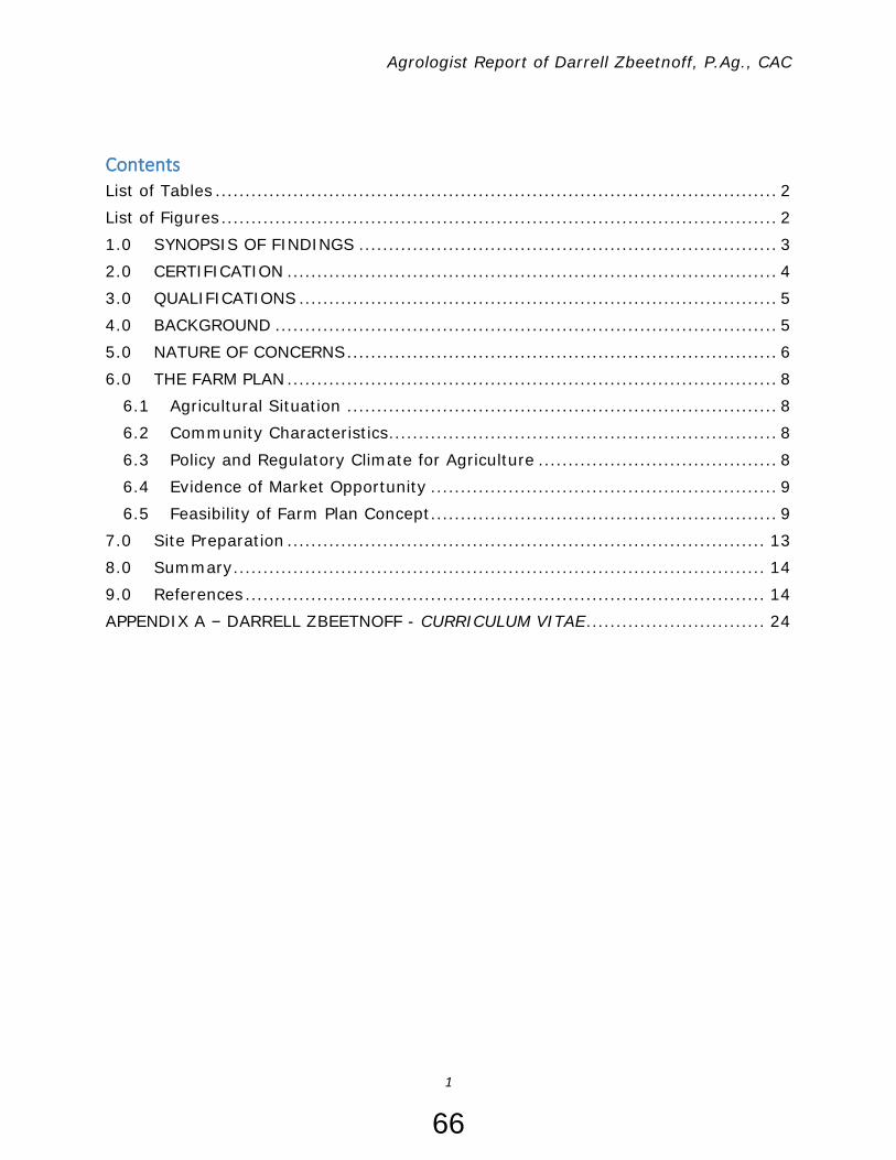
Agrologist Report of Darrell Zbeetnoff, P.Ag., CAC
1
Contents List of Tables .............................................................................................. 2
List of Figures ............................................................................................. 2
1.0 SYNOPSIS OF FINDINGS ...................................................................... 3
2.0 CERTIFICATION .................................................................................. 4
3.0 QUALIFICATIONS ................................................................................ 5
4.0 BACKGROUND .................................................................................... 5
5.0 NATURE OF CONCERNS ........................................................................ 6
6.0 THE FARM PLAN .................................................................................. 8
6.1 Agricultural Situation ........................................................................ 8
6.2 Community Characteristics ................................................................. 8
6.3 Policy and Regulatory Climate for Agriculture ........................................ 8
6.4 Evidence of Market Opportunity .......................................................... 9
6.5 Feasibility of Farm Plan Concept .......................................................... 9
7.0 Site Preparation ................................................................................ 13
8.0 Summary ......................................................................................... 14
9.0 References ....................................................................................... 14
APPENDIX A – DARRELL ZBEETNOFF - CURRICULUM VITAE .............................. 24
66

Agrologist Report of Darrell Zbeetnoff, P.Ag., CAC
2
List of Tables Table 1: Status of Farm Improvements ........................................................... 7 Table 2: Feasibility of Farm Plan ........................................................ 9 Table 3: Status of Site Preparations ............................................................. 13
List of Figures Figure 1: Farm Plan ....................................................................... 12 Figure 2: Area Cleared for Gardening -View South from “S” Driveway ................ 15 Figure 3: Rubbish and Debris Removed from Property ..................................... 16 Figure 4: Rubbish and Debris Removed from Property ..................................... 17 Figure 5: Rubbish and Debris Removed from Property ..................................... 18 Figure 6: Rubbish and Debris Removed from Property ..................................... 19 Figure 7: Asphalted Area – View East along South Property Line ....................... 20 Figure 8: Southwest Corner of the Property – View West along South Property Line .............................................................................................................. 21 Figure 9: View North along West Side of Quonset ........................................... 22 Figure 10: View North Along East Side of Quonset .......................................... 23
22(1)
22(1)
67
Agrologist Report of Darrell Zbeetnoff, P.Ag., CAC
3
1.0 SYNOPSIS OF FINDINGS
1. The fill applied to the Property can be used beneficially for agriculture uses
allowed by the ALC.
2. A covered farm structure with a hardened floor is reasonable to support
nursery production, handle farm production, store garden products, and conduct farm sales.
3. Some mobile equipment is on the Property is not required for farming and
should be moved off-site when site improvements are complete.
4. The number of sea containers needed for agricultural storage should be
verified.
5. The majority of lock blocks on site have no obvious agricultural application
and should be moved off the Property.
6. To support farm sales, a parking area will be required on the Property.
68

Agrologist Report of Darrell Zbeetnoff, P.Ag., CAC
4
2.0 CERTIFICATION I, Darrell Zbeetnoff of Zbeetnoff Agro-Environmental Inc., am the person who analyzed the acreage and yield information in this report. I am a Professional
Agrologist and a Certified Agricultural Consultant. The opinions set out in this report are mine and are within my field of expertise.
You, have asked me to represent you as Agent in dealings with the Agricultural Land Commission concerning the improvements you have undertaken
in the Agricultural Land Reserve on land described as:
758 Henry Road, Gibsons, BC, V0N1V2
Lot 2 Block B Plan VAP4573 District Lot 690 Land District 36 Manufactured Home Reg.# 69805
Roll: 08-746-00437.000 PID: 011-479-612 5 acres (2.02 ha)
Herein referred to as “the Property”.
In addition, you have asked me to provide a professional opinion on how the improvements you carried out in the summer of 2020 will support agriculture you have planned for the Property.
I am aware that I have a duty to not to be an advocate for any party. I have
prepared this report in conformity with this duty. If called on to give oral or written testimony, will give that testimony in conformity with this duty.
Signature:
Date: January 06, 2021
22(1)
69

Agrologist Report of Darrell Zbeetnoff, P.Ag., CAC
5
3.0 QUALIFICATIONS Darrell Zbeetnoff is a professional agrologist (P.Ag.) and certified agricultural consultant (CAC) with over 40 years of experience in agricultural business planning
and strategic analysis, feasibility assessments, agro-environmental impact assessments, and project analysis and evaluation. He has post-graduate training in several disciplines, holding an MA in anthropology, MNRM in land/water use
management and MSC in agricultural economics and farm management.
Mr. Zbeetnoff has provided services to many agricultural sectors ranging from greenhouses, nursery and berries to livestock, poultry, mushrooms and functional foods. He has undertaken agricultural area planning and strategies for Regional
Districts and municipalities in BC, in which resource challenges facing farmers are regularly articulated. As a Registered Environmental Farm Plan planning advisor,
Darrell has completed over 400 environmental farm plans for operators in BC. Darrell has participated in numerous programs and projects related to assessing
land use. He has led economic investigations and assessments at the farm level relating to agricultural impacts, crop damages and operational effects, and provided
expert testimony in BC. A copy of his curriculum vitae is appended to this report as Appendix A.
4.0 BACKGROUND There is no record of the Property recently being used for soil-based agriculture. As noted in the Agricultural Capability/Soils Assessment report, historical aerial imagery indicates that the Property was logged and partially cleared but has
regrown in various tree and shrub species. The Property has been used as rural residential, containing a house and garage at the front and a double-wide mobile
home with attached carport at the back. A gravel “S-shaped” driveway to the back of the Property and a gravel circular driveway to the house provided access. A graveled area at the east end of property appears to have been used for vehicle
parking and storage.
purchased the Property on September 14, 2020 and proceeded immediately to make improvements, without permissions or building permits. The improvements consist of (see Attachment A):
• Clearing of an area comprising 14,000 sq. ft. (1,300 m2) for future farming • Clearing, topsoil salvage, and deposit of road mulch under an asphalted area
comprising 7,025 sq. ft. (652 m2) • Clearing, topsoil salvage, and deposit of road mulch and crushed rock under
a Quonset comprising 2,400 sq. ft. (223 m2) • Brush cleanup and removal off-site • Removal and disposal of garbage and discarded materials scattered
throughout the site to municipal landfill.
On October 20, 2020, The Agricultural Land Commission (ALC) issued a letter to (ALC C&E File: 159198) to cease all activity on the property due to a
22(1)
22(1)
70
Agrologist Report of Darrell Zbeetnoff, P.Ag., CAC
6
failure to obtain prior written ALC permission to remove soil or place fill on agricultural land.
On October 26, 2020, the ALC met with and on October 27, 2020,
instructed him by registered letter that intended activities were considered non-farm uses and that all unauthorized fill should be removed. Action was required by November 06, 2020.
approached Zbeetnoff on October 26, 2020 to act as his Agent and make a
non-farm use application to the ALC to have his activities considered “farm use activity” and retain the imported fill for agricultural purposes. Zbeetnoff agreed to act as Agent, contacted the ALC enforcement agent and started to develop the
materials necessary to provide the ALC with information to assess position.
The determination of the scope of the materials required for the application was in part influenced by indication from the ALC that it might not be possible to amend
an application at a later date if information was found to be missing. For example, the soil investigation, while not strictly required, is considered critical to providing
the rationale for the soil fill importation given the drainage and watertable attributes of the Property.
Since November 01, 2020 the following activities have occurred:
• The non-farm use application is under way and the Agent has obtained a stay
of proceeding until the information to assess situation is prepared. • ALC has been contacted, asking about the key information they require.
• The Sunshine Coast Regional District (SCRD) has been contacted re: their perspective on activities on the Property
• A soil investigation was commissioned by and completed December
11, 2020. • farm plan has been compiled and activities on the
Property assessed in relation to that plan; completed January 06, 2021. • COVID-19 precautions have extended the time frame for completion of the
application.
5.0 NATURE OF CONCERNS Based on communication with ALC and SCRD through letters, emails and personal conversations, the key considerations with regard to actions are presented in Table 1.
22(1)
22(1)
22(1)
22(1)
22(1)
22(1) 22(1)
22(1)
22(1)
71

Agrologist Report of Darrell Zbeetnoff, P.Ag., CAC
7
Table 1: Status of Farm Improvements Issue Approval
Status Observation Allowed ALC
Concerns Situation
Approval obtained to
import fill?
Not obtained
Asphalt pad 157 m3 on
1,050 m2
320 m3 on 1,000
m2
Quality For a non-
farm purpose
Quality good For a farm
purpose
Quonset
pad 150 m3 on 375 m2
Not required
Graveled pad at SE corner
Pre-existing
None Can be used for a farm purpose
Approval for asphalt pad?
Not required
For a non-farm
purpose
For a farm purpose
Approval for
lock blocks?
Not
required
For a non-
farm purpose
For a farm
purpose
Soil berms Not required
500 m3 For a non-farm
purpose
Will be applied to the land
Presence of
lock blocks
Not
required
150 blocks
along driveway
For a non-
farm purpose
Intention is to
use as a base for perimeter fencing
48 blocks along
asphalt pad
Used to separate farm
functions
Presence of
seacans
Not
required
4 seacans
with mobile equipment
For a non-
farm purpose
Intention is to
use for storage of farm
equipment
Cleared area Not
required
1,800 m3 None For a farm
purpose
Presence of
logs, wood and rock
debris
Not
required
For a non-
farm purpose
Logs not
required Wood and
rock debris left over from clearing can
be used as riprap for
erosion control
72

Agrologist Report of Darrell Zbeetnoff, P.Ag., CAC
8
Presence of
construction materials
Not
required
Lumber and
pipe
None For a farm
purpose
Roll off bins, small excavator,
truck, large excavator,
small trailer
Not allowed Mobile non-farm equipment
Stored for a non-farm
purpose
Temporary, will be removed
when land improvements
are completed
6.0 THE FARM PLAN The Agent has had several discussions with to clarify his farm plan for
Garden & Feed Supplies Barn.
6.1 Agricultural Situation The information in this section is from the Sunshine Coast Agricultural Area Plan (SCAAP) and the 2016 Agricultural Census.
The Property is in a peri-urban area adjacent to the town of Gibsons. While
agricultural activities in the immediate area consist of a variety of small-scale horticultural (vegetables, berries) and livestock (poultry, eggs, sheep) operations selling seasonal production to the local population, much of the agricultural land is
in rural residential use and hobby farming (horses). Average farm size is 2.8 ha (6.7 ac), with 70% of the farms under 10 acres in size.
There were 91 Census farms in the Sunshine Coast Census Division in 2016. Only
12% of land in the ALR is actually used as farmland. The SCAAP has identified a goal to increase the proportion of agricultural products that can be sourced locally. Coast farmers are supplying less than 3% of the food consumed on the Coast.
Virtually all farm inputs (such as feed, seeds, and soil amendments) are imported
from the Lower Mainland.
6.2 Community Characteristics The population of the SCRD grew from 19,900 in 2003 to about 32,000 in 2019, or an average annual increase of over 3% per year in the period. This represents a significant growing market for local agricultural products.
Interest in gardening is increasing demand for agricultural inputs such as
ornamentals, propagated plants, feed and equipment. Promotion of policies to encourage new farmer entry and access underutilized land for farming is creating a magnitude of activity that is larger than the sum of its parts.
6.3 Policy and Regulatory Climate for Agriculture The Sunshine Coast Regional District (SCRD) has a sustainability plan that
advocates for increasing local food security as a means of reducing greenhouse gas
22(1)22(1)
73

Agrologist Report of Darrell Zbeetnoff, P.Ag., CAC
9
emissions. Similarly, the Town of Gibsons Strategic Plan supports development of local food market opportunities.
Gibsons’ Official Community Plan contains policies for lands designated as
agricultural that abut the Property. Land designated as Rural and Agricultural shall be used for the farming of land, plants and animals and similar activities as provided by the Agricultural Land Commission Act. This includes compatible uses
such as boarding stables, turf farms, and greenhouses.
6.4 Evidence of Market Opportunity There is an undeniable opportunity to respond to market signals that indicate:
• Unfulfilled and growing demand for fresh, locally produced food at premium
pricing • Increasing local demand for gardening and agricultural inputs as part of a
back-to-the-land revival.
6.5 Feasibility of Farm Plan Concept indicates that the following farming activities would occur on the property
(see Figure 1). The feasibility of these activities from a regulatory viewpoint has been assessed in Table 2 below.
Table 2: Feasibility of Farm Plan Farming Activity Regulatory
Requirement Assessment/Observation
Growing of horticultural produce
None Feasible Will require drainage and
irrigation improvements Growing of tree fruits and berries
None
Raising of egg layers BCEMB requirement – permitting of
unregistered farmers keeping 100 to 399 laying hens in that
produce organic, heritage breed, free-
range or free-run systems
Feasible
Raising of broilers None for flocks <200 birds BCCMB requirement –
permit required to grow up to 2000 birds for
direct marketing
Feasible
Farm structures –
general
SCRD requirement – all
buildings, structures, or outdoor storage areas must be setback from
parcel line 5 m
Feasible
22(1)
22(1)
74

Agrologist Report of Darrell Zbeetnoff, P.Ag., CAC
10
Farm structures –
poultry
SCRD requirement – no
drinking or feeding trough, no manure pile, and no enclosure,
structure or building related to the keeping of
poultry except fences under 2 m shall be located within 15 m of a
parcel line
Feasible
Farm structures -
greenhouse
SCRD requirement –
greenhouse structures with no artificial lighting
must be setback 5 m from parcel line SCRD requirement –
greenhouse structures with artificial lighting
must be setback from parcel line 15 m
Feasible
Siting a consideration if
artificially lit
Farm structures – covered product sales
ALC requirement – sales permitted if a) farm product offered is
produced on the farm and b) total sales area
does not exceed 300 m2
Feasible
Farm structures –
product sales – open air stand
SCRD requirement –
setback from parcel line 1.5 m
Feasible
Growing out of container ornamental plants
Growing out of propagated plants and indoor plants/crops
SCRD requirement – Parcel coverage cannot exceed 15% of parcel
size (3,036 m2)
SCRD requirement – greenhouse site coverage cannot exceed
50% of parcel size (10,121 m2)
Feasible Will require a covered structure for more sensitive
varieties
Covered area requires a smooth surface to facilitate movement of wheeled
equipment
Farm gate sales of imported agricultural
inputs, feed, garden supplies
ALC requirement – sales permitted if at least
50% of sales area is limited to sale of farm products produced
Feasible Will require a covered area
for sales, storage
It is noted that poultry and livestock is permitted on the Property by the SCRD.
Both poultry marketing boards have provisions for the raising of small flock egg layers or broilers.
75

Agrologist Report of Darrell Zbeetnoff, P.Ag., CAC
11
There are no restrictions on horticultural pursuits, either indoor or outdoor. Siting
would have to be considered if artificially lighting is used. Lot coverage by greenhouse structures is limited to 50%, which is about 10,000 m2 at the Property.
76

Agrologist Report of Darrell Zbeetnoff, P.Ag., CAC
12
Figure 1: Farm Plan
22(1)
22(1)
77

Agrologist Report of Darrell Zbeetnoff, P.Ag., CAC
13
7.0 Site Preparation
In order for the indicated agricultural activities to be become operational, site preparation is required. The farm site preparations and statuses are indicated in
Table 3.
Table 3: Status of Site Preparations Item Activity Requirement Rationale Status
1 Land clearing Trees and brush removal
Prepare fields for field crops
Halted by winter weather
2 Drainage improvements
Ditching and sub-surface
tiles
Excessive rainfall and high
watertable
3 Irrigation
improvements
Water supply
and distribution
Severe moisture
deficit in growing season and supply to farm structures
Once farm
structures have been installed and fields have
been established
4 Nursery structure Covered structure with
hard floor
Create an ornamental,
seedling outlet
Halted by stop work order
5 Parking Hardened area All-weather access To be
determined
6 Poultry barn Covered coop Protection and egg
collection
Halted by
winter weather
7 Hog barn Covered structure
Protection from weather
Existing
8 Rubbish and debris removal
Take off site Unsightly, Potential
contaminants
Halted by winter weather
Observations include: Land clearing of brush, trees and buried waste needs to be completed as the
first stage of bring the filed into productivity. Improvements to drainage and water supply are critical for agriculture on the
Property and need to be installed before soil-based crops can be established.
A covered structure is needed to propagate seedlings and grow out sensitive plants.
A protected area is necessary for conducting farm sales and protecting products such as seed and feed from the weather.
The contemplated customer parking area should be planned so as not to
compromise any additional farmland.
78

Agrologist Report of Darrell Zbeetnoff, P.Ag., CAC
14
8.0 Summary
There is a large market for fresh local agricultural products, services, and
inputs of the types proposed by The community is growing and the opportunity to replace imports with local
agricultural products and services is vast.
Local and regional government policies support local agricultural enterprise. The agricultural activities indicated by are feasible and permitted on
the Property. Site preparation is incomplete for the purposes of initiating farming. Structures for farming activities cannot be built on the property without
preparation of the base to support them. Imported fill activities on the Property are required to provide foundations for
the intended structures. The quality of the fill imported in 2020 is not expected to deteriorate the
productivity of the Property.
The area of the Property to which fill has been applied is smaller than the area of greenhouse site coverage allowed by the SCRD.
9.0 References
The information used to formulate this agrologist opinion report includes:
1. Hughes-Games, G. 2020. Agricultural Capability/Soils Assessment: Final Report. Prepared for December 11, 2020
2. Sunshine Coast Regional District. 2014. Agricultural Area Plan.
https://www.scrd.ca/files/File/Community/Planning/Agricultural%20Area%20Plan/2015%20Feb%2023%20Final%20Ag%20Plan.pdf
3. Statistics Canada. 2016 Agricultural Census. Farm and Farm Operator Data. https://www150.statcan.gc.ca/n1/pub/95-640-x/95-640-x2016001-eng.htm
4. Town of Gibsons. 2015. Official Community Plan. https://gibsons.ca/wp-
content/uploads/2019/01/Official-Community-Plan-Bylaw-No.-985-2015-current.pdf
5. Sunshine Coast Regional District. Zoning Bylaw. https://www.scrd.ca/files/File/Community/Planning/Bylaws/Zoning%20Bylaw%20310%20Zones/2020-October-
08%20Bylaw%20310%20Consolidation_1.pdf 6. Agricultural Land Commission. ALC Act & ALR Regulation.
https://www.alc.gov.bc.ca/alc/content/alc-act-alr-regulation 7. BC Egg Marketing Board. Small lot farms. https://bcegg.com/on-the-
farm/small-lot-farms/ 8. BC Chicken Marketing Board. Permit Program.
http://bcchicken.ca/industry/new-entrants/
22(1)
22(1)
22(1)
79
https://gibsons.ca/wp-content/uploads/2019/01/Official-Community-Plan-Bylaw-No.-985-2015-current.pdf
https://gibsons.ca/wp-content/uploads/2019/01/Official-Community-Plan-Bylaw-No.-985-2015-current.pdf

Agrologist Report of Darrell Zbeetnoff, P.Ag., CAC
15
Figure 2: Area Cleared for Gardening -View South from “S” Driveway
80

Agrologist Report of Darrell Zbeetnoff, P.Ag., CAC
16
Figure 3: Rubbish and Debris Removed from Property
81
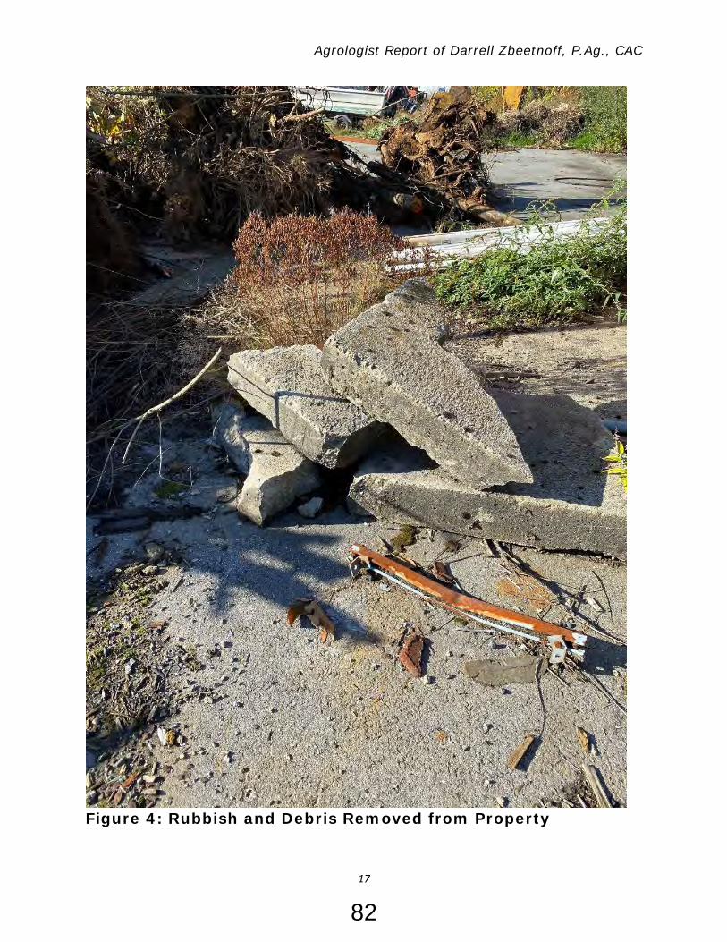
Agrologist Report of Darrell Zbeetnoff, P.Ag., CAC
17
Figure 4: Rubbish and Debris Removed from Property
82

Agrologist Report of Darrell Zbeetnoff, P.Ag., CAC
18
Figure 5: Rubbish and Debris Removed from Property
83

Agrologist Report of Darrell Zbeetnoff, P.Ag., CAC
19
Figure 6: Rubbish and Debris Removed from Property
84

Agrologist Report of Darrell Zbeetnoff, P.Ag., CAC
20
Figure 7: Asphalted Area – View East along South Property Line
85

Agrologist Report of Darrell Zbeetnoff, P.Ag., CAC
21
Figure 8: Southwest Corner of the Property – View West along South Property Line
86

Agrologist Report of Darrell Zbeetnoff, P.Ag., CAC
22
Figure 9: View North along West Side of Quonset
87

Agrologist Report of Darrell Zbeetnoff, P.Ag., CAC
23
Figure 10: View North Along East Side of Quonset
88

Agrologist Report of Darrell Zbeetnoff, P.Ag., CAC
24
APPENDIX A – DARRELL ZBEETNOFF - CURRICULUM VITAE
DARRELL M. ZBEETNOFF M.Sc. (Agricultural Economics), M.N.R.M. (Natural Resources Management), M.A.(Anthropology), P.Ag., CAC [email protected] http://www.zbeetnoffagro-environmental.com/
ACADEMIC AND PROFESSIONAL QUALIFICATIONS: 2003 Registered Environmental Farm Planner
1997 Certified Agricultural Consultant (CAC)
1990 Professional Agrologist (P.Ag.)
1990 Master of Science (Agricultural Economics and Farm Management) University of Manitoba
1979 Master of Natural Resources Management (Water Management/Native Land
Claims), University of Manitoba
1975 Master of Arts (Physical Anthropology), University of Manitoba
SUMMARY OF CONSULTING EXPERIENCE: Darrell M. Zbeetnoff, Director of Zbeetnoff Agro-Environmental Inc., White Rock, BC, V4B 1Z9, has over 30 years of agriculture industry-related experience in:
Economic assessment and evaluation Business and strategic planning Policy, program and project analysis Multiple land/water use analysis and planning Preparing and presenting findings to businesses, organizations, technical committees,
professional groups, public forum and the media
Specializations include: • Business planning for agricultural businesses, organizations and new marketing agencies • Comprehensive situation analyses and strategic planning in various agricultural sectors • Directed “best effort” appraisals of targeted markets for North American clients • Issue analysis, materials preparation and client representation in discussion, policy
development and negotiation forums • Environmental and socio-economic assessments and impact evaluations • Survey design, implementation and evaluation
89

Agrologist Report of Darrell Zbeetnoff, P.Ag., CAC
25
• Translation of research and investigation into “ready-to-use” client materials • Conducting training sessions and workshops. Mr. Zbeetnoff also has working contacts and networks with professionals in a broad
range of other specialized fields.
PROJECT LIST
Agricultural Planning Agricultural Community Readiness Assessments for BC First Nations. Sub- contract to Urban
Systems (Clients: Xaxli’p FN; Nicomen FN; Tahltan FN; Ongoing) Agricultural Opportunity Assessments for BC First Nations. (Clients: Xaxli’p FN; Sik-E-Dakh
FN) Tsawwassen First Nation Agricultural Business Planning (Client: TFN Economic Development
Corporation) Creekside Mills Recreation Agriculture Plan, Cultus Lake, BC. In Association with Timmenga &
Associates and Quadra Planning (Client: Frosst Creek Developments Ltd.) Lil’wat First Nation Agricultural Area Plan (Client: Lil’wat First Nation) Tsawwassen First Nation Agricultural Plan (Client: TFN Economic Development Corporation) Tsawwassen First Nation Agricultural Needs Assessment (Client: TFN Economic Development
Corporation) Agri-Industrial Study (Client: City of Abbotsford) Development of an Agricultural Plan for Delta. In association with Quadra Planning
Consultants Ltd., Coquitlam, BC (Client: Corporation of Delta) North Lougheed Land Use Study: Agricultural Context. Sub-contract to AECOM Canada Ltd.
(Client: District of Pitt Meadows) Development of an Agricultural Area Plan for Central Saanich. In association with Quadra
Planning Consultants Ltd., Coquitlam, BC (Client: District of Central Saanich) Development of an Agricultural Strategy for the City of Abbotsford. In association with
Serecon Management Consulting, Calgary, Alta; Quadra Planning Consultants Ltd., Coquitlam, BC; Timmenga & Associates, Vancouver, BC; and McTavish Resource & Management Consultants Ltd, Surrey, BC (Client: City of Abbotsford)
Development of an Agricultural Plan for the Pemberton Valley. In association with Quadra Planning Consultants Ltd., Coquitlam, BC and Timmenga & Associates, Vancouver, BC. (Client: Squamish-Lillooet Regional District)
Development of an Agricultural Plan for Maple Ridge. In association with Quadra Planning Consultants Ltd., Coquitlam, BC and Timmenga & Associates, Vancouver, BC. (Client: District of Maple Ridge)
Rural Oliver and Town of Oliver Agricultural Area Plan: AAP Content and Format Review. Sub-contract to Artemis Holdings Inc., Burnaby, BC. (Client: Okanagan-Similkameen Regional District)
Spallumcheen Agricultural Area Plan. In association with Quadra Planning Consultants Ltd., Coquitlam, BC. (Client: Township of Spallumcheen, BC)
Phase 1: Agricultural Options Identification and Analysis of Colony Farm Regional Park. In
90

Agrologist Report of Darrell Zbeetnoff, P.Ag., CAC
26
association with Quadra Planning Consultants Ltd., Coquitlam, BC. (Client: GVRD) Agricultural Review. In association with Quadra Planning Consultants Ltd., Coquitlam, BC,
and Timmenga & Associates, Vancouver, BC. (Client: District of Maple Ridge) Chilliwack Agricultural Sector Strategy Update. In association with Lions Gate Consulting Inc.
Vancouver, BC. (Client: Chilliwack Agricultural Commission) Deas Slough/Shato Holdings Context Study. In association with Quadra Planning Consultants
Ltd., Vancouver, BC. (Client: Corporation of Delta) Development of an Economic Strategy for Agriculture in the BC Lower Mainland. Sub-
contract to Artemis Holdings Inc., Burnaby, BC. (Client: GVRD) Preparation of an Agricultural Servicing Study in the Hazelmere Valley, Surrey, BC for
Greenhouse Development. Sub-contract to Reid Crowther & Partners Ltd., Burnaby, BC. (Client: City of Surrey, Engineering Department)
Development of a Land Management Plan for Boundary Bay Airport. In association with Quadra Planning Consultants Ltd., Coquitlam, BC. (Client: Corporation of Delta)
Development of the Surrey Agricultural Plan. (Client: City of Surrey). Preparation of Farm Plan for Assembly Land Use Application in the ALR. (Client: Private)
Sector Profiles Kent Agricultural and Agri-Industrial Overview in Relation to the Lower Fraser Valley. Sub-
contract to Urban Systems Planning Consultants (Client: District of Kent) 2012 Update of the North American Greenhouse Vegetable Industry. (Client: Farm Credit
Corporation, Regina, Saskatchewan) Vancouver Food Security Study. In association with Serecon Management Consulting Inc.,
Calgary, Alta (Client: Vancouver Food Council) 2006 Update of the North American Greenhouse Vegetable Industry. (Client: Farm Credit
Corporation, Regina, Saskatchewan) Marketing Strategy for Greenhouse Vegetables. Sub-contract to JRG Consulting Group,
Guelph, Ontario. (Client: Ontario Greenhouse Vegetable Growers) Strategic Profile of the North American Greenhouse Vegetable Industry. (Client: Farm Credit
Corporation, Regina, Saskatchewan) Strategic Profile of the BC Greenhouse Vegetable Industry. (Client: Farm Credit Corporation,
CIBC) Agricultural Profile of the BC Raspberry Sector. (Client: ARDSA, BC Raspberry Growers
Association). Economic Profile of the BC Natural Health Products Industry. (Client: BC Nutraceutical and
Functional Foods Network) Agricultural Profile of the BC Turkey Sector. (Client: ARDSA, BC Turkey Marketing Board) Agricultural Profile of the BC Chicken Sector. (Client: ARDSA, BC Chicken Marketing Board). Agricultural Profile of the BC Egg Sector. (Client: ARDSA, BC Egg Marketing Board) Agricultural Profile of the BC Broiler Hatching Egg Sector. (Client: ARDSA, BC Broiler Hatching
Egg Commission) BC Grains and Seeds Commodity and Policy Profile. (Client: ARDSA, BC Grain Producers
Association)
91

Agrologist Report of Darrell Zbeetnoff, P.Ag., CAC
27
Farm Business Management and Development Preparation of a Business Plan for Greenhouse Vegetable Marketing Agency Application.
(Client: Mastronardi Produce Inc.) Development of a Business Plan for an Organic Vegetable Greenhouse, Jamaica, WI (Client:
Private) Development of an Agricultural Business Plan for Community-Based Agricultural Initiatives.
(Client: Tsawwassen First Nation) Development of a Farm Plan concerning Small Acreage Property, Richmond, BC (Client:
Private) Agrologist Report concerning Soil and Drainage Suitability for Developing a Winery, Delta, BC
(Client Private) Preparation of A Greenhouse Strawberry Development Plan for ALR property in the ESA
Zone in Richmond, BC. (Client: Private) Preparation of a Farm Plan for Organic Vegetable Production Associated with Proposed
Assembly Land Use in the ALR. (Client: Po Lam Buddhist Association, Chilliwack, BC) Agricultural Assessment of a Farm Property in Richmond, BC. Sub-contract to McTavish
Resource & Management Consultants Ltd., Surrey, BC. (Client: Private) Preparation of Background Materials for the Landscape “Managing Marketing and Sales”
Module. Sub-contract to McTavish Resource & Management Consultants Ltd., Surrey, BC. (Client: Canadian Nursery Landscape Association)
Preparation of a Business Plan and Marketing Agency Application for a Greenhouse Vegetable Marketing Agency. In association with View West Marketing, Victoria, BC. (Client: Global Greenhouse Produce Inc., Surrey, BC)
Preparation of a Business Plan for an Egg Grading and Marketing Agency. (Client: Fresh Start Foods Corporation, Abbotsford, BC)
Advisor to New Crop Farm Development in the BC Lower Mainland. (Client: Private) Investigation of Competitive Factors Affecting the British Columbia Regulated Marketing
Sector. Sub-contract to View West Marketing, Victoria, BC (Client: British Columbia Marketing Board)
Preparation of a Business Plan for Mushroom Marketing Agency Application. (Client: All Seasons Mushroom Farms Inc.)
Preparation of a BC Broiler Business Plan (Client: BC Chicken Marketing Board, Canada-BC Farm Business Management Program)
Development of a Grain Farm Business Plan for the BC Peace River Region. (Client: ARDSA) On-Farm Management Accounting Training to Dairy, Beef and Poultry Farmers in the Lower
Mainland and Vancouver Island (Client: ARDCORP)
Farming Practices and Technology Evaluation Review of Closed Greenhouse Technology Systems. In association with Timmenga &
Associates, Vancouver, BC. (Client: BC Greenhouse Growers Association) Development of Materials for the "Biodiversity" and "Risk to Biodiversity" Chapters for the
BC Environmental Farm Planners Manual. In association with McTavish Resource & Management Consultants Ltd., Surrey, BC. (Client: BC Agriculture Environment Partnership Initiative)
92

Agrologist Report of Darrell Zbeetnoff, P.Ag., CAC
28
Development of On-Farm Microbial Food Safety Check Lists in the Field Vegetable, Berry, Tree Fruit, Mushrooms, and Vegetable Greenhouse Sectors. (Client: BC Horticultural Coalition)
Proposal Preparation for the Implementation of a Greenprint System for Potato Production in BC. (Client: Ministry of Environment, Lands and Parks)
Development of a Forage Harvesting System Computer Model. (Client: Canada-BC Farm Business Management Program)
Computer-Modeled Economic Evaluation of Conservation Tillage Systems in the BC Peace River Region. (Client: ARDSA)
Market Assessment Benchmarking Study for Organic Tomatoes. Sub-contract to Serecon Management
Consulting Inc., Calgary, Alta. (Client: Agriculture and Agri-Food Canada) Market Assessment for Organics from Greater Vancouver Regional District Utilities. In
association with Timmenga & Associates, Vancouver, BC and DH Lauriente Consultants Ltd, Surrey, BC. (Client: GVRD)
Issues Identification for the Value Chain Roundtable Process in the Canadian Horticultural Industry. Sub-contract to JRG Consulting Group, Guelph, Ontario. (Client: Agriculture and Agri-Food Canada)
Market Study on Game Birds, Waterfowl and Ratites. In association with View West Marketing Inc., Victoria, BC. (Client: Avian Research Centre, UBC)
The US Industrial Market for Potassium Nitrate. Sub-contract to DH Lauriente Consultants Inc., New Westminster, BC and San Francisco, USA. (Client: Kemira OYJ, Finland)
The US market for silica gel and colloidal silica. Sub-contract to DH Lauriente Consultants Inc., New Westminster, BC and San Francisco, USA. (Client: CMS Energy, Muskegon Heights, Michigan)
Market assessment of potential greenhouse vegetable business in Northern Alberta. Sub-contract to McTavish Resource & Management Consultants Ltd., Surrey, BC. (Client: Private Confidential)
The US Industrial Market for Emulsion Explosives. Sub-contract to DH Lauriente Consultants Inc., New Westminster, BC and San Francisco, USA. (Client: Mississippi Chemical Inc., Yazoo City, Mississippi)
Marketing Plan for Pelleted and Crumbled Composted Poultry Manure Product. In association with View West Marketing Inc., Victoria, BC and DH Lauriente Consultants Inc., New Westminster, BC. (Client: Canada Department of Environment)
Feasibility Studies Overview Report on the Tseshaht Agriculture Potential. Sub-contract to Urban Systems
Planning Consultants (Client: Tseshaht First Nation) Overview Report on the Agricultural Capability at Doig River First Nations. Sub-contract to
Urban Systems Planning Consultants (Client: Doig River First Nation) Investigation of the Business case for BCLNA Investment in Dart’s Hill Garden Park, Surrey,
BC (Client: BC Landscape Nursery Association) Evaluation of Waste Management Options for Used Mushroom Media. In association with
Timmenga & Associates, Vancouver, BC (Client: BC Ministry of Agriculture)
93

Agrologist Report of Darrell Zbeetnoff, P.Ag., CAC
29
Evaluation of Value-added Options for Mushroom Stems. In association with Timmenga and Associates, Vancouver, BC and First Ideas & Solutions, Maple Ridge, BC (Client: BC Ministry of Agriculture)
Agricultural Feasibility Assessment of ALR Land Subject to Exclusion Application for Petro-Canada Facility. Sub-contract to McTavish Resource and Management Consultants Ltd., Surrey, BC (Client: Private)
Evaluation of Options to Manage and Add Value to Fruit Waste. In association with Timmenga & Associates, Vancouver, BC (Client: Okanagan Kootenay Cherry Growers’ Association and BC Tree Fruit Growers Association)
Evaluation of Options for Alberta Layer Waste Utilization. In association with Timmenga & Associates, Vancouver, BC, and Serecon Consulting Group., Calgary, Alta (Client: Alberta Egg Producers)
Assessment of the Business Opportunity for Cold Storage Facilities in the Fraser Valley (Client: Private)
Assessment of the Feasibility of Fertilizer Supply Options to the Comox Valley, Vancouver Island. In association with Serecon Management Consulting Inc., Calgary, Alta. (Client: Comox Valley Farmers’ Institute)
Assessment of the Feasibility of a Small-scale Food Processing Facility in Hope, BC. In association with Lions Gate Consulting, Vancouver, BC (Client: Fraser Basin Council)
Assessment of the Potential for Bio-energy in the Dawson Creek Area of BC. In association with Timmenga & Associates Inc., Vancouver, BC. (Client: City of Dawson Creek)
Assessment of the Feasibility of an Organic Dairy Processing Facility, BC Lower Mainland. In Association with Timmenga & Associates, Vancouver, BC. (Client: Private)
Business Plan for New Crop Greenhouse Production. In association with Timmenga & Associates, Vancouver, B.C. (Client: Private)
Business Opportunity Evaluation of a Large-scale Vegetable Greenhouse in Alberta. Sub-contract to Serecon Management Consulting Inc., Edmonton, Alta. (Client: Alberta Agriculture, Food and Rural Development)
Evaluation of a Proposal to Build a Poultry Waste Materials Processing Plant in the Lower Fraser Valley - Due Diligence Report. In association with Timmenga & Associates, Vancouver, BC and DH Lauriente Consultants Ltd, Surrey, BC. (Client: Sustainable Poultry Farming Group)
Assessment of the Feasibility of a “FARMS-Type” Organization to Administer the Foreign Seasonal Agricultural Workers Program in BC. In association with McTavish Resource & Management Consultants Ltd. (Client: BC Blueberry Council)
Assessment of Opportunities and Potentials of the Plant Biotechnology Sector. In association with Timmenga & Associates, Vancouver, BC. (Client: Confidential)
Investigation of the Feasibility of Using Biofuels in Greenhouse Applications in the BC Fraser Valley. In association with Timmenga & Associates, Vancouver, BC. (Client: BC Greenhouse Growers Association)
Research to Support Development of an Organization to Advance and Promote British Columbia's Bioproducts Industry. In association with Timmenga & Associates, Vancouver, BC. (Client: BC Bioproducts Association)
Agri-Food Incubator Study. Sub-contract to Lions Gate Consulting, Vancouver, BC. (Client: South Fraser Community Futures Development Corporation, Chilliwack Economic Partners
94

Agrologist Report of Darrell Zbeetnoff, P.Ag., CAC
30
Corporation) Competitive Advantages of Plant Biotechnology in Western Canada. In association with
Timmenga & Associates, Vancouver, BC. (Client: Plant BioTechnologies Association) Evaluation of Options for Fraser Valley Poultry Manure Utilization. In association with
Timmenga & Associates and DH Lauriente Consultants Ltd., New Westminster, BC. (Client: BC Poultry Environmental Steering Committee)
Evaluation of the Economic Potentials of the Vaseux Lake Conservation Lands. Subcontract to Pottinger, Gaherty Environmental Consultants Ltd., Vancouver, BC (Client: Canadian Wildlife Service)
Economic Stewardship on Private Land - Economic Opportunities from Habitat Enhancements at Douglas Lake Ranch, BC. Subcontract to PGL Organix Ltd., Vancouver, BC. (Client: Canada Department of Environment)
Site-Specific Agricultural Viability Analyses. (Clients: Private) Richmond No. 5 Road Properties Agricultural Capability and Feasibility Assessment, In
Association with Powers Environmental Services, Vancouver, BC and Norwest Mine Services, Vancouver, BC. (Client: City of Richmond, No. 5 Road Back Lands Property Owners)
Agro-Environmental Analysis Registered Environmental Farm Planner delivering the BC Environmental Farm Planning
Program (Client: ARDCORP; Ongoing) Update of the EFP Drainage Management Guide. Subcontract to EDI Environmental
Dynamics Inc., Burnaby, BC (Client: BC Ministry of Agriculture) Preliminary Agricultural Site Assessment Associated with a Property Sale (Client: Sutton
Group - West Coast Realty, Vancouver) Chilqua Creek Improvement Project: Group Environmental Farm Plan, Dewdney, BC. (Client:
Chilqua Creek Group and BC Agricultural Council) Gap Analysis: Comparison of the Salmon-Safe Certification Program Standards with BC
Environmental Regulations and the Environmental Farm Planning Process (Client: Fraser Basin Council)
Assessment of the Biodiversity Guide for BC Farmers and Ranchers (Client: Ducks Unlimited, Kamloops, BC)
Assessment of Options and Challenges Related to Emergency Disposal of Large Animals in the Lower Fraser Valley of BC. In association with Agri Business Consortium, LLC, Great Bend, Kansas, and Timmenga & Associates Inc., Vancouver, BC. (Client : BC Ministry of Agriculture and Lands)
Environmental Farm Planning in the BC Landscape Nursery Sector. In association with McTavish Resource & Management Consultants Ltd., Surrey, BC. (Client: BC Landscape Nursery Association
Environmental Farm Planning in the BC Vegetable Greenhouse Sector. In association with McTavish Resource & Management Consultants Ltd., Surrey, BC. (Client: BC Greenhouse Growers Association)
Benchmark Study of Pesticide Use and Adoption of Integrated Pest Management in the Canadian Nursery Industry. (Client: Canadian Nursery Landscape Association)
Benchmark Study of Pesticide Use and Adoption of Integrated Pest Management in the BC
95

Agrologist Report of Darrell Zbeetnoff, P.Ag., CAC
31
Nursery Industry. (Client: BC Landscape Nursery Association) Wildlife Damage Survey of the BC Nursery Industry. In association with McTavish Resource &
Management Consultants Ltd., Surrey, BC. (Client: BC Landscape Nursery Association) Investigation of Investment Strategies for Addressing BC Agriculture and Wildlife Conflicts. In
association with McTavish Resource & Management Consultants Ltd., Surrey, BC. (Client: BC Agriculture - Wildlife Advisory Committee)
Durrell Creek Watershed Management Plan - Agricultural Component. Subcontract to Pottinger Gaherty Environmental Consultants Ltd., Vancouver, BC. (Client: Corporation of Saanich)
Preparation of Environmental Self-Audit Materials for BC Horticultural Producers. (Client: BC Horticultural Coalition)
Preliminary Northern Pintail Habitat Stewardship Strategy for Surrey, BC. In association with Quadra Planning Consultants Ltd., Coquitlam, BC. (Client: Canadian Wildlife Service, Delta)
Preparation of Environmental Guidelines for the BC Tree Fruit and Grape Growers. In association with Andrea Gunner, Armstrong, BC. (Client: BCFGA, OVTFA)
Preparation of Environmental Guidelines for the BC Greenhouse Growers. In association with Nahanni Horticultural Services, Nanaimo, BC. (Client: Green Plan, Western Greenhouse Growers' Coop Association, United Flower Growers' Coop Association)
Agricultural and Economic Impact Assessment Assessment and Evaluation of Agricultural Impacts related to Trans-Mountain Pipeline
Expansion Project. Under Contract to McTavish Resource and Management Consultants Ltd. (Client: Trans-Mountain Pipeline Expansion Project; Ongoing)
Economic and Ecosystems Services Assessment of DF&WT Programs (Client: Delta Farmland & Wildlife Trust)
Assessment of the Economic Impact of the Agricultural Environmental Management (AEM) Code. (Client: BC Dairy Association)
Bentley Farm, Fort St. John BC. Assessment of Site C Impacts and Discussion of Compensation Options. Sub-contract to McTavish Resource & Management Consultants Ltd. (Client: Cox Taylor Lawyers)
Economic Evaluation of Agricultural Impacts from a MetroVancouver Sewerage Project (Client: MetroVancouver Sewerage & Drainage District)
Economic Evaluation of Agricultural Impacts from the Trans-Mountain Pipeline Expansion Project. Under contract to McTavish Resource and Management Consultants, Surrey, BC. (Client: Kinder Morgan Canada; Ongoing)
Economic Assessment of Pipeline Replacement Impacts on Agricultural Properties (Client: Spectra Gas)
Agrologist Report: Agricultural and Groundwater Impact Assessment of Non-Farm Development adjacent to ALR Properties, Maple Ridge, BC (Client: Jaaf Holdings Ltd.)
Agrologist Report: Agricultural and Groundwater Impact Assessment of Non-Farm Development adjacent to ALR Properties, Maple Ridge, BC (Client: Platform Properties Ltd., Vancouver, BC)
Preparation of an Agrologist Opinion Report Pertaining to an Agricultural Subdivision Application in the Agricultural Land Reserve (Client: Private)
96
Agrologist Report of Darrell Zbeetnoff, P.Ag., CAC
32
Assessment of Agricultural Impacts from the Trans-Mountain Pipeline Expansion Project. Under contract to McTavish Resource and Management Consultants, Surrey, BC and TERA Environmental Consultants, Calgary, Alta. (Client: Kinder Morgan Canada)
Economic Evaluation of Integrity Dig Impacts on an Agricultural Operations in Chilliwack, BC (Client: Spectra Gas)
Preliminary Assessment of the Economic Benefit to Agricultural Production from a Water Detention Facility on Maber Flats. (Client: District of Central Saanich)
Preparation of Agricultural Impact Assessment Guidelines (Client: Metro Vancouver) Potential Economic Impact of the Trans-Pacific Partnership Agreement on Supply Managed
Sectors in BC (Client: Confidential) Quantification of Flood-related Losses on an Agassiz Dairy Farm. (Client: Private) Site C Green Energy Project: Agricultural Effects Assessment – Economic Component. Sub-
contract to Golder Associates, Burnaby, BC. (Client: BC Hydro) Quantification of Agricultural Crop Loss Impacts from Salmon River Flooding, Langley, BC.
(Client: Fort Langley Farmland Preservation Group) Quantification of an Onion Loss Damage Insurance Claim Due to Rainstorm Damage (Client:
Cooperators Insurance) Preliminary Economic Impact Assessment of Langley Farmland Flooding. (Client: Fortlang
Farms. Fort Langley, BC) Turkey Feed Cost Analysis. Sub-contract to Serecon Management Consulting Inc., Calgary,
Alta (Client: BC Turkey Marketing Board) Investigation of Turkey Feed Pricing in BC. In association with Serecon Management
Consulting Inc., Edmonton, Alta. (Client: BC Turkey Marketing Board) Economic Valuation of Waterfowl Damage to Forage Fields in Delta, BC and the Comox
Valley of Vancouver Island. In association with DYMAC Risk Management Consultants Ltd., Lacombe, Alberta. (Client: BC Agriculture Council)
Risk Analysis of the BC Poultry Industry. Sub-contract to Serecon Management Consulting Inc., Edmonton, Alta. (Client: BC Poultry Advisory Management Committee and Investment Agriculture Foundation)
Vancouver Island Transmission Reinforcement Project: Agricultural Impact Assessment and Evaluation. Sub-contract to Jacques Whitford, Burnaby, BC. (Client: BC Hydro)
Meadowland Peat Site Development. Agricultural Impact Report. Sub-contract to Keystone Environmental Ltd, Burnaby, BC. (Client: Anthem Group. Burnaby, BC)
South Fraser Perimeter Road Project. Agriculture Impact Assessment. Sub-contract to Summit Environmental Consultants Ltd., Vernon, BC. (Client: BC Ministry of Transportation, Gateway Project)
Evaluation of the Business Loss Associated with Wind Damage to a Nursery Greenhouse, BC Lower Mainland. (Client: Cooperators Insurance)
Evaluation of the Business Loss Associated with Wind Damage to a Vegetable Propagation Greenhouse, BC Lower Mainland. (Client: Cooperators Insurance)
Evaluation of a Brussels Sprouts Loss Claim for Insurance Purposes, BC Lower Mainland. (Client: Zurich Insurance)
Evaluation of a Field Vegetable Loss Claim for Insurance Purposes, BC Lower Mainland. (Client: Private Insurance Company)
97

Agrologist Report of Darrell Zbeetnoff, P.Ag., CAC
33
Evaluation of a Blueberry Loss Claim for Insurance Purposes, BC Lower Mainland. (Client: Zurich Insurance)
Economic Valuation of the Costs of Cover Cropping in Delta, BC. (Client: Canadian Wildlife Service)
Evaluation of a Potato Loss Claim for Insurance Purposes, BC Lower Mainland. (Client: Zurich Insurance)
Nicomekl-Serpentine Lowlands Agricultural Survey and Agricultural Evaluation of Regional Drainage and Flood Control Options. In association with Schori Consultants, Surrey, BC. (Client: City of Surrey)
Economic Evaluation of the Impact of Waterfowl Grazing on Perennial Forage Fields. (Client: Ducks Unlimited, Delta)
Expert Witness Expert Opinion Report: Assessment of Yield Impacts from The South Fraser Perimeter Road
at Chong Farms, Delta, BC (Client: BC Ministry of Attorney General Legal Service Branch) Expert Opinion Report: Assessment of Yield Impacts from The South Fraser Perimeter Road
at Cranwest Farms, Delta, BC (Client: BC Ministry of Attorney General Legal Service Branch) Expert Opinion Report on Crop Loss from Ministry of Highways Highway 15 Project on
Sangha Blueberry Farm, Surrey, BC (Client: BC Ministry of Attorney General, Legal Service Branch)
Expert Witness on Behalf of a Fraser Valley Turkey Grower before a BC Farm Industry Review Board Panel (Client: Private)
Expert Witness: Site C Green Energy Project: Agricultural Effects Assessment – Economic Component. Sub-contract to Golder Associates, Burnaby, BC. (Client: BC Hydro)
Expert witness before the BC Vegetable Marketing Commission concerning business plan for marketing agency application. (Client: Global Greenhouse Produce Inc., Delta, BC)
Issue Analysis and Expert Witness to Pricing Arbitration Proceedings. (Client: BC Chicken Marketing Board)
Expert witness in support of a Mushroom Marketing Agency Application before BC Farm Industry Review Board. (Client: All Seasons Mushroom Farms Inc.)
Program and Project Planning and Evaluation Freshet Flooding and Fraser Valley Agriculture: Evaluating Impacts and Options for Resilience
Study. Sub-contract to Northwest Hydraulic Consultants, North Vancouver, BC (Client: Fraser Valley Regional District)
Farm Flood Preparedness Planning: Delta Pilot Project. Sub-contract to Northwest Hydraulic Consultants, North Vancouver, BC (Client: Delta Farmers Institute)
Industry Needs Analysis: Production Horticulturalist Apprenticeship Program. (Client: Hort/Education BC)
Agricultural Piece Rate Study. In Association with McTavish Resource & Management Consultants Ltd., Surrey, BC. (Client: BC Ministry of Labour, Citizens’ Services and Open Government)
Development of a Strategic Plan for BC Chicken Growers. In Association with McTavish Resource & Management Consultants Ltd., Surrey, BC. (Client: BC Chicken Growers Association)
98

Agrologist Report of Darrell Zbeetnoff, P.Ag., CAC
34
Strategic planning workshop facilitation. Sub-contract to McTavish Resource & Management Consultants Ltd., Surrey, BC (Client: BC Landscape Nursery Association)
Development of a Strategic Plan for the Western Agriculture Labour Initiative (WALI). In association with Serecon Management Consulting Inc., Calgary, Alta and McTavish Resource & Management Consultants Ltd., Surrey, BC (Client: BC Agriculture Council)
Program Feasibility, Design and Marketing Services for the Arborist Apprenticeship Program. In association with nk marketing & communications, Vancouver, BC, and McTavish Resource & Management Consultants Ltd., Vancouver, BC (Client: BC Arborists Labour Market Partnership Joint Adjustment Committee)
Development of a Strategic Plan for a BC Farm Animal Care Initiative. Sub-contract to Serecon Management Consulting Inc., Calgary, Alta. (Client: BC Agriculture Council)
Distance Education Needs Assessment. In association with nk marketing & communications, Vancouver, BC. (Client: University College of the Fraser Valley, Chilliwack Campus, Department of Agriculture Technology)
Arborist Apprenticeship Training Needs Survey and Analysis. In association with nk marketing & communications, Vancouver, BC (Client: Hort Education BC)
Landscape Labour Market Recruitment and Retention Study. In association with McTavish Resource & Management Consultants Ltd., Surrey, BC and nk marketing & communications, Vancouver, BC. (Client: Hort Education BC)
BC Wildlife Predator Loss Control and Compensation Project: Evaluation Report. In association with McTavish Resource & Management Consultants Ltd., Surrey, BC. (Client: BC Agricultural Council Agriculture Environment Initiative)
Baseline Study of Landscape Nursery Labour Issues, Gaps and Research Needs in British Columbia. In association with McTavish Resource & Management Consultants Ltd., Surrey, BC (Client: Hort Education BC)
Identification and Analysis of Strategic Alliances in the Canadian Horticultural Industry. Sub-contract to JRG Consulting Group, Guelph, Ontario and SJT Solutions, Saskatoon, Saskatchewan. (Client: Canadian Horticultural Value Chain Roundtable)
Analysis of the 2004 Seasonal Agricultural Worker Program in British Columbia. In association with McTavish Resource & Management Consultants Ltd., Surrey, BC. (Client: BC Agriculture Council)
BC Wildlife Damage Compensation Pilot Projects: Evaluation Report. In association with McTavish Resource & Management Consultants Ltd., Surrey. BC. (Client: BC Agriculture Council Agriculture Environment Initiative)
Review of Canadian Turkey Marketing Agency Export Policy. Sub-contract to Serecon Management Consulting Inc., Calgary, Alta. (Client: Canadian Turkey Marketing Agency)
Review of Environmental Regulations Affecting Delivery of Federal Funding Programs in British Columbia. In association with McTavish Resource & Management Consultants Ltd., Surrey, BC. (Client: Agriculture and Agri-Food Canada: Prairie Farm Rehabilitation Administration)
Evaluation of EUREPGAP Produce Supplier Certification Options. (Client: BC Fruit Growers Association, Growing with Care Program)
Evaluation of Train the Trainer Programs, Curriculum, and Costs for COR Certification. Sub-contract to McTavish Resource & Management Consultants Ltd., Surrey, BC. (Client: BC Road
99

Agrologist Report of Darrell Zbeetnoff, P.Ag., CAC
35
Construction & Maintenance Safety Network)Assessment of the Feasibility of Developing a Post-Certification Pesticide Applicator Continuing Education Credit Program, BC. (Client: BC Horticultural Coalition)
Development of a Business Plan for Implementing an Integrated Pest Management (IPM) program in BC. (Client: BC Federation of Agriculture)
Analysis of Impacts of the GATT Tariffication Proposal and Options to Modify the Western Grain Transportation Act and Feed Freight Assistance on BC Feed Grain Users. (Client: BCMAFF, Policy and Legislation, Victoria)
Survey Design, Implementation and Analysis A Brief Synopsis of the Potassium Nitrate Market in the United States. Sub-contract to DH
Lauriente Consultants Inc., New Westminster, BC and San Francisco, USA. (Client: Reilly Industries, Indianapolis, Indiana)
A Brief Synopsis of the US Industrial Market for Ammonium Sulfate. Sub-contract to DH Lauriente Consultants Inc., New Westminster, BC and San Francisco, USA. (Client: Allied Signal Chemical, Petersburg, Virginia)
Ammonium Markets in Western North America. Sub-contract to DH Lauriente Consultants Inc., New Westminster, BC and San Francisco, USA. (Client: Pacific Ammonia Inc., Vancouver, BC)
Wood Residue Inventory Survey of the Lower Fraser Valley and East Vancouver Island. In association with PGL Organix, Vancouver, BC. (Client: Canada Department of Environment)
Competitiveness Survey of BC Hog Producers. (Client: ARDSA, BC Hog Marketing Commission)
Compilation and Analysis of Employee Survey Data. (Client: DHIS) Survey Design, Implementation and Analysis of Dryland Grain Farming Management and
Information Needs. (Client: University of Manitoba, Manitoba Dept. of Agriculture)
Client Representation and Issue Presentation Agent and Agrologist Report pertaining to non-farm use applications to the Agricultural Land
Commission (Clients: Private; Ongoing) Agrologist Reports in support of Land Use Applications to Local Governments and the BC
Agricultural Land Commission (Clients: Private; Ongoing) Agent and Agrologist Report pertaining to Migrant Worker Housing in the Agricultural Land
Reserve (Client: Private) Agent and Agrologist Report pertaining to an Agricultural Subdivision and Lot Line Re-
alignment Application, Delta (Client: Private) Agrologist Report pertaining to an Agricultural Subdivision and Lot Line Re-alignment
Application, Delta. Prepared for Spencer May, Campbell, Froh May & Rice LLP (Client: Private)
Agrologist Report pertaining to an Agricultural Subdivision and Consolidation Application, Delta. Prepared for Spencer May, Campbell, Froh May & Rice LLP (Client: Private)
Agrologist Report concerning Foreign Worker Housing, Pitt Meadows, BC (Client: Private) Expert Witness on Behalf of a Fraser Valley Turkey Grower before a BC Farm Industry Review
Board Panel (Client: Private) Negotiation of Agricultural Leases and Terms for TFN Agricultural Lands (TFN Economic
100

Agrologist Report of Darrell Zbeetnoff, P.Ag., CAC
36
Development Corporation) Preparation of a Request for Proposal related to soliciting New Agricultural Land Tenants
(TFN Economic Development Corporation) Negotiation of a Change in Agricultural Land Commission Decision on Location of Access to
an Assembly Use in the ALR (Client: Po Lam Buddhist Association, Chilliwack, BC) Negotiation of a Modification in an Agricultural Land Commission Covenant. (Client: Western
Aerial Applicators Ltd., Chilliwack, BC) Preparation and Negotiation of an Appeal Submission to the BC Farm Industry Review Board
(Client: Private) Negotiation of Farm Leases for Farmers (Client: Private) Analysis of Market Pricing of Greenhouse Peppers in Support of Legal Action. (Client: Private) Agrologist's Report in Relation to the Need for On-Farm Agricultural Worker Housing to
Support Farming Operations. (Client: Private) Submission to the BC Vegetable Marketing Commission to Support a Greenhouse Vegetable
Quota Transfer and New Quota Application, 2004. (Client: Global Greenhouse Produce Inc., Surrey, BC)
Guest Lecturer on the Agricultural Regulatory Environment. (Horticultural Production and Finance Course, Kwantlen University College, Langley, BC)
Submission to the BC Vegetable Marketing Commission to Support a Greenhouse Vegetable Quota Transfer and New Quota Application, 2003. (Client: Global Greenhouse Produce Inc., Surrey, BC)
Investigation and Presentation of Issues to the BC Marketing Board respecting the BC Chicken Marketing Board’s Revised General Orders. (Client: BC Chicken Growers’ Association)
Investigation and Presentation of Issues to the BC Chicken Marketing Board Respecting a Review of the BC Chicken Marketing Board’s Regulations. (Client: BC Chicken Growers’ Association)
Articulation and Representation of Issues Respecting the BC Chicken Industry Domestic and Export Programs. (Client: BC Chicken Growers’ Association)
Project Coordinator, BC Landscape Nursery Association Industry Development Council 2000 “Think Tank”. (Client: BC Landscape Nursery Association)
Negotiation of a Management Contract for a New Agri-Business Operation. (Client: Private) Identification and Write-Up of Agricultural Issues/Topics for Dialog Days Forums with
Government Ministries. (Client: BC Horticultural Coalition) Client Representation in Focus Group Sessions to Review the Canada-BC Crop Insurance
Program. (Client: BC Horticultural Coalition)
Report Editing and Preparation Preparation of Background Materials for the Fraser Valley Agricultural Long-term Nutrient
Planning Workshop. Sub-contract to McTavish Resource & Management Consultants Ltd., Surrey. BC. (Client: BC Agriculture Environment Partnership Committee)
Statistical Analysis and Writing of Multi-Client Reports in the Chemical Fertilizer Commodity Sectors. Various Projects. Sub-contract to DH Lauriente Consultants Inc., New Westminster, BC and San Francisco, USA. (Client: Stanford Research Institute)
101

Agrologist Report of Darrell Zbeetnoff, P.Ag., CAC
37
Forecasting and Projection Estimation of the Volume of Wood Residue to be Generated by Demolition, Land Clearing
and Construction to 2010, East Vancouver Island and Lower Fraser Valley. Sub-contract to PGL Organix Ltd., Vancouver, BC. (Client: Canada Department of Environment)
Occupation Standard, Training Manuals and Materials Development of Occupational Standard and Background Training Materials for BC Sand and
Gravel and Rock Quarry Workers. In association with Andrew Klukas & Associates, Vancouver, BC (Client: BC Aggregate Producers Association)
Development of Concrete Pumpers Training Manual, Info-Flip, and PowerPoint Training Materials (Client: BC Ready Mixed Concrete Association)
Development of an Occupational Standard and Background Training Materials for BC Concrete Pump Operators (Client: BC Ready Mixed Concrete Association)
Presentations Presentation to Vegetative Buffer Workshop Series: BC Working with Producers and Cost-
Share Programs. Abbotsford, BC. June 08, 2017 Professional Pest Management Association of BC. Pest Management in Riparian Areas: What
is a farmer to do? Feb 28, 2012
102

SUNSHINE COAST REGIONAL DISTRICT REFERRAL REPORT
TO: Roberts Creek APC and OCPC and Elphinstone APC – May 17, 2021
AUTHOR: Yuli Siao, Senior Planner
SUBJECT: ROBERTS CREEK OCP AMENDMENT BYLAW NO. 641.11 AND ZONING AMENDMENT BYLAW NO. 310.182 FOR SUBDIVISION OF REMAINDER OF DISTRICT LOT 1312
RECOMMENDATIONS
The committees review this report and make a recommendation.
BACKGROUND
An application was received to amend the Roberts Creek Official Community Plan (OCP) and rezone a 40.45-hectare parcel known as the remainder of District Lot 1312 to facilitate a future subdivision on the southern portion (14.32 ha) and donate the norther portion (26.13 ha) to the SCRD as Community Amenity Contribution in the form of a land gift.
The proposed bylaws received first reading by the Board on March 28, 2019. The application was referred to the Roberts Creek and Elphinstone Advisory Planning Commissions and the Roberts Creek OCP committee in April 2019. Preliminary public consultation was conducted by the applicant in coordination with the SCRD during November and December of 2020. Although the proposal remains largely the same, due to the time lapse, the purpose of this referral is to provide updated information and analysis of the application and obtain comments from the committees prior to presenting the bylaws to the Board for consideration of second reading.
Table 1 - Application Summary
Owner / Applicant: 1312 Lands Inc. / Jim Green
Legal Description: District Lot 1312 Group 1 New Westminster District except Plan EPP72892 and EPP77565
Electoral Area: D – Roberts Creek
Parcel Area: Total: 40.45 ha
OCP Land Use: Existing – Resource Proposed South ≈14.32 ha – Rural Proposed North ≈26.13 ha – Parks
Zoning: Existing - RU4 (Rural Forest) Proposed South ≈14.32 ha – RU1 (Rural) Proposed North ≈26.13 ha – PA1 (Park &
Assembly)
Subdivision District:
Existing - Z (minimum 100 ha) Proposed South ≈14.32 ha – F (minimum 1 ha) North ≈26.13 ha – J (minimum 25 ha)
Application Intent: To create 12 new minimum 1-ha lots on the south side of the extended Porter Road and donate an approximately 26-ha remainder of the parcel on the north side to the SCRD as a Community Amenity Contribution in the form of a land gift.
103
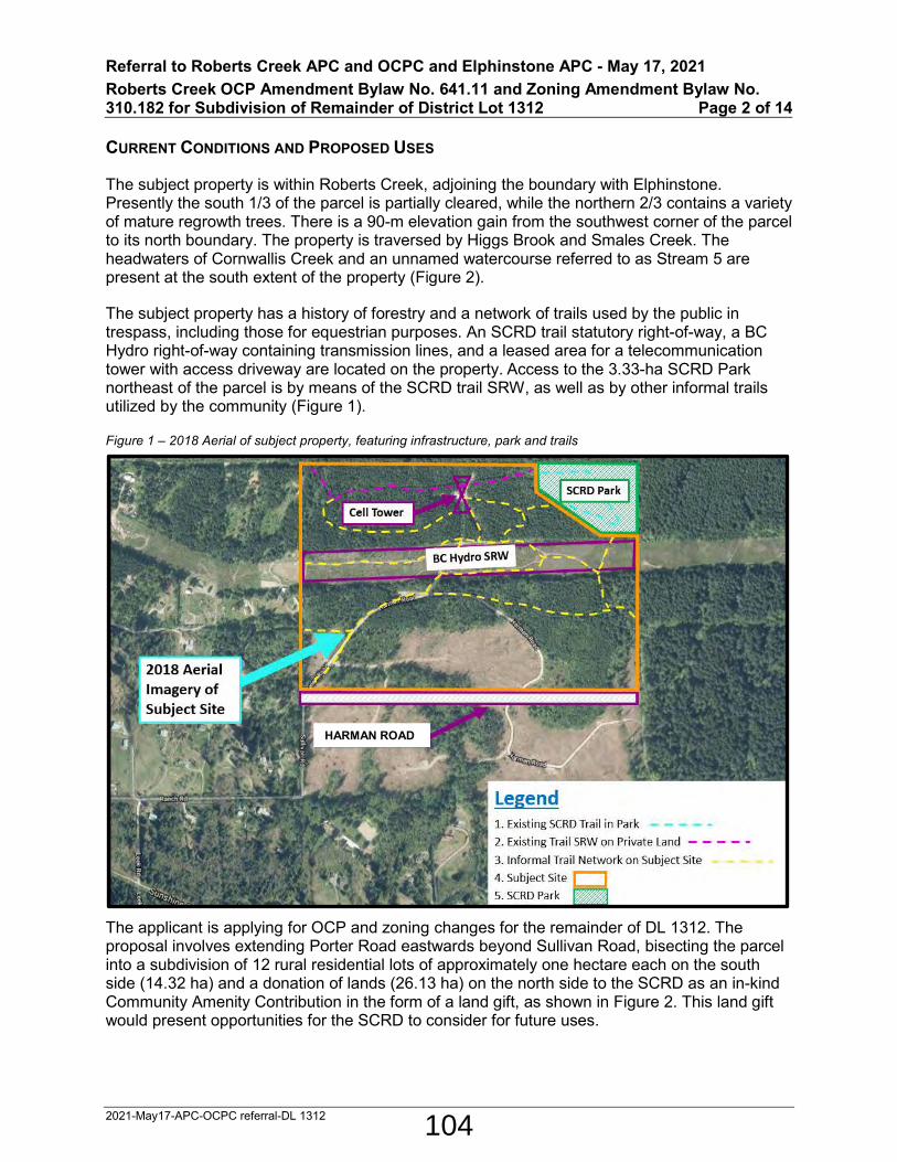
Referral to Roberts Creek APC and OCPC and Elphinstone APC - May 17, 2021 Roberts Creek OCP Amendment Bylaw No. 641.11 and Zoning Amendment Bylaw No. 310.182 for Subdivision of Remainder of District Lot 1312 Page 2 of 14
2021-May17-APC-OCPC referral-DL 1312
CURRENT CONDITIONS AND PROPOSED USES
The subject property is within Roberts Creek, adjoining the boundary with Elphinstone. Presently the south 1/3 of the parcel is partially cleared, while the northern 2/3 contains a variety of mature regrowth trees. There is a 90-m elevation gain from the southwest corner of the parcel to its north boundary. The property is traversed by Higgs Brook and Smales Creek. The headwaters of Cornwallis Creek and an unnamed watercourse referred to as Stream 5 are present at the south extent of the property (Figure 2).
The subject property has a history of forestry and a network of trails used by the public in trespass, including those for equestrian purposes. An SCRD trail statutory right-of-way, a BC Hydro right-of-way containing transmission lines, and a leased area for a telecommunication tower with access driveway are located on the property. Access to the 3.33-ha SCRD Park northeast of the parcel is by means of the SCRD trail SRW, as well as by other informal trails utilized by the community (Figure 1).
Figure 1 – 2018 Aerial of subject property, featuring infrastructure, park and trails
The applicant is applying for OCP and zoning changes for the remainder of DL 1312. The proposal involves extending Porter Road eastwards beyond Sullivan Road, bisecting the parcel into a subdivision of 12 rural residential lots of approximately one hectare each on the south side (14.32 ha) and a donation of lands (26.13 ha) on the north side to the SCRD as an in-kind Community Amenity Contribution in the form of a land gift, as shown in Figure 2. This land gift would present opportunities for the SCRD to consider for future uses.
HARMAN ROAD
104

Referral to Roberts Creek APC and OCPC and Elphinstone APC - May 17, 2021 Roberts Creek OCP Amendment Bylaw No. 641.11 and Zoning Amendment Bylaw No. 310.182 for Subdivision of Remainder of District Lot 1312 Page 3 of 14
2021-May17-APC-OCPC referral-DL 1312
Figure 2 – Draft subdivision plan, proposed land donation and existing creeks
DISCUSSION
Past Process
In 2001, Provincial legislative changes removed the Forest Land Reserve (FLR) designation that previously encumbered on the subject parcel. In response to this change, the SCRD adopted Zoning Amendment Bylaw No. 310.83, 2003 to set zoning for several former FLR parcels to RU4 and the subdivision district to Z (100 hectare minimum parcel area) in order to introduce forest management uses and to mitigate development pressures on these lands. The land use designation for these lands was set to Resource in the OCP.
This application proposes a rural residential subdivision that would be the first of its kind in the former FLR lands since the SCRD adopted wide-spread land use amendments in 2005 that set the OCP land use designation for these lands to Resource and the zoning to RU4 (Rural Forest). The intent of these land use provisions was to discourage residential uses in these areas at the time when the FLR designation for these lands was removed. Staff note that this process was an expedient measure that generalized all former FLR lands with the same land use regulations to prevent residential development without formal planning processes being conducted to examine areas that may have merit for consideration of such uses.
105

Referral to Roberts Creek APC and OCPC and Elphinstone APC - May 17, 2021 Roberts Creek OCP Amendment Bylaw No. 641.11 and Zoning Amendment Bylaw No. 310.182 for Subdivision of Remainder of District Lot 1312 Page 4 of 14
2021-May17-APC-OCPC referral-DL 1312
The proposed development has attributes distinctive from many other parcels that were formerly in the FLR. The OCP and zoning amendment application process allows for decisions regarding potential for residential development in the subject area to be weighed for individual merit on a case by case basis and to be informed by community input.
Planning Analysis
Roberts Creek Official Community Plan
The parcel is within the Resource land use designation (Figure 3), and is the southernmost parcel designated as such within the OCP. It is also one of such designated parcels closest to the Sunshine Coast Highway. Parcels to the west are designated Rural. Areas to the south are designated Agricultural and are within the Agricultural Land Reserve (ALR). Parcels to the east are within the Elphinstone OCP area, such as DL 1313 which is designated as Park and Rural Forest within the Elphinstone OCP.
Figure 3 –OCP Land Use Map (Includes Roberts Creek and Elphinstone)
The OCP establishes a 100-ha minimum parcel size for subdivisions within the Resource designation, and Section 19 states that the Resource land use designation is for land “…where the potential exists for resource activities such as the establishment, management, and harvesting of the forest cover for timber and other forest products and values, as well as
106

Referral to Roberts Creek APC and OCPC and Elphinstone APC - May 17, 2021 Roberts Creek OCP Amendment Bylaw No. 641.11 and Zoning Amendment Bylaw No. 310.182 for Subdivision of Remainder of District Lot 1312 Page 5 of 14
2021-May17-APC-OCPC referral-DL 1312
educational opportunities in holistic forestry and ecology” and residential uses are not compatible and will not be a permitted use.
While the application does not meet these OCP policies, this site is an anomaly compared to many Resource designated lands due to its location and is therefore not a clear precedent for development on such designated lands. Resource designated lands are typically located in areas that are not adjacent to existing residential development. In this case adjacent rural residential and agricultural developments exist to the west and south of the subject site and consist of approximately 1.75 to 2.0 hectare parcels.
The proposal to re-designate the southern 1/3 of the parcel to Rural Residential could be considered a connection of the existing rural residential uses from the west and south, and increase the supply of such rural acreages for residential, agricultural and home-based business uses. As indicated by the recently completed Sunshine Coast Housing Needs Assessment, there is shortage for affordable housing supply across all segments of the housing spectrum including market ownership and rental housing. The Sunshine Coast has also seen an increase in demand for acreage parcels that offer both residential and home business opportunities and are more affordable than residing in a residential zone and operating a business in a commercial or industrial zone separately.
The proposed donation of the northern 2/3 of the parcel to the SCRD could create a buffer to contain further spread of rural residential development to the north. There are many potential uses (to be further discussed later in this report) that can be considered for the land donation, such as environmental conservation, outdoor recreation and public utilities. The proposed Parks designation for this portion of the parcel would be suitable for these potential uses. These potential opportunities would be lost if otherwise the entire parcel continues its current predominant use for timber harvesting. In this regard, the proposal could help to achieve several overall goals of the OCP as outlined in Part 3, such as environmentally responsible use of land, maintaining rural atmosphere, providing parkland and recreational opportunities.
Zoning Bylaw No. 310
The subject parcel is currently zoned RU4 (Figure 4) which permits forest management, one single family dwelling, and further permits ancillary uses to forest management such as log booming, log sorting, storage and wood processing. Parcels to the north and west are zoned RU1 (Rural One). The parcels to the south are zoned AG and to the east are AG and RU5A (Rural Forest A). The proposal to rezone the southern 1/3 of the parcel to RU1 would implement the proposed OCP Rural designation and make zoning consistent with adjacent parcels to the west.
As shown in Figure 5, the subject parcel and parcels to the west and east, with the exception of DL1313, are within Subdivision District is Z (100 hectare minimum for subdivision purpose), however, adjacent parcels to the east, west and south, with the exception of DL 1313, are already of parcel sizes ranging from 1.75 to 2.0 hectares. The proposed minimum parcel size of one hectare to facilitate a subdivision on the southern 1/3 of the parcel would bring about a moderate density increase yet remain sensitive to the rural character of the area.
The proposed land donation of the northern 2/3 of the parcel is to be rezoned to PA1 (Park and Assembly). This zone would be consistent with the proposed OCP designation of Parks as discussed above, and would achieve objectives of the land donation and implement potential
107

Referral to Roberts Creek APC and OCPC and Elphinstone APC - May 17, 2021 Roberts Creek OCP Amendment Bylaw No. 641.11 and Zoning Amendment Bylaw No. 310.182 for Subdivision of Remainder of District Lot 1312 Page 6 of 14
2021-May17-APC-OCPC referral-DL 1312
uses suitable for the lands such as environmental conservation, outdoor recreation, assembly and public utilities. The Subdivision District for this portion of the parcel is to change to the J District with a minimum parcel size requirement of 25 ha which is about the same size of the land and can prevent its future subdivision.
Figure 4 – Zoning Map
Figure 5 – Subdivision District Map
108

Referral to Roberts Creek APC and OCPC and Elphinstone APC - May 17, 2021 Roberts Creek OCP Amendment Bylaw No. 641.11 and Zoning Amendment Bylaw No. 310.182 for Subdivision of Remainder of District Lot 1312 Page 7 of 14
2021-May17-APC-OCPC referral-DL 1312
Community Amenity Contribution (CAC)
The 26.13-ha northern 2/3 of the parcel is offered by the applicant to the SCRD as a Community Amenity Contribution (Figure 6). The lands are bisected by a 5.8-ha BC Hydro Statutory Right-of-Way with existing transmission lines approximately 778 m long and 75 m wide, leaving a 12.5-ha north section and a 7.8-ha south section, both forested. There is also an existing leased area for a fenced telecommunication tower and associated access driveway. Figure 6 – CAC lands
There is an existing trail network consisting of an SCRD trail statutory right-of-way (SRW, 0.5 km, green line) and other trails (4.1 km, yellow line) on these lands with connections to the SCRD park located to the northeast (Figure 7). The SRW is open for public use and forms a part of the draft route concept for Phase 2 of the regional Suncoaster Trail. The other trails are on private lands but have been used by the public in trespass. Figure 7 Trail network
extension
provincial land
cell tower
109

Referral to Roberts Creek APC and OCPC and Elphinstone APC - May 17, 2021 Roberts Creek OCP Amendment Bylaw No. 641.11 and Zoning Amendment Bylaw No. 310.182 for Subdivision of Remainder of District Lot 1312 Page 8 of 14
2021-May17-APC-OCPC referral-DL 1312
Figure 8 Trail photo
Potential Uses and Benefits of the CAC
Accepting the proposed Community Amenity Contribution lands would have ongoing implications for the SCRD and require future Board decisions to determine the uses for the lands. A plan regarding the use, development and management of these lands and a cost-benefit analysis would be required, should the SCRD accept the land donation.
One of the benefits of the land donation is that it would be accessible for vehicles, fire trucks and pedestrians through the proposed extension of Porter Road across the entire length of the current parcel. The applicant proposes to construct this road with a 20-m right of way width and similar standards as Harman Road to provide access to both the subdivision to the south and the CAC lands to the north. This road will be built to MOTI standards and maintained by MOTI. The applicant would also upgrade connected access roads (e.g. Leek Road) in the surrounding areas if required by MOTI. Pedestrian accessibility to this area would be enhanced by trail connections on both sides of the property to be constructed by the applicant (Figure 10).
The SCRD Utility Division has reviewed the CAC proposal and envisions potential benefits for public work projects on these lands, such as future groundwater exploration and water storage. Land access is typically a significant challenge in all utility capital projects and securing land ownership for future public works would present a significant long-term value.
In 2020, groundwater exploration test wells were drilled in various locations on the lower Sunshine Coast. This included one on Harman Road near the southeast extent of the proposed development. The tests indicate that there is potential to access a highly productive bedrock aquifer in this area. Bedrock groundwater exploration is inherently hit-and-miss, therefore securing access to a large parcel of land for future test wells would greatly increase the likelihood of successfully developing water supply from this location. This would contribute to
110

Referral to Roberts Creek APC and OCPC and Elphinstone APC - May 17, 2021 Roberts Creek OCP Amendment Bylaw No. 641.11 and Zoning Amendment Bylaw No. 310.182 for Subdivision of Remainder of District Lot 1312 Page 9 of 14
2021-May17-APC-OCPC referral-DL 1312
meeting SCRD’s long-term water supply targets (2050) and would enhance system resiliency through supply redundancy.
Due to the central location and elevation of the site, it could be suitable for potable water storage through construction of one or more storage reservoirs which would benefit fire protection for Electoral Areas D, E, and F. Additional storage in this area could also enhance system resiliency in the event when water supply is cut off from either surface sources (Chapman Creek) or groundwater sources (wells in Areas E and F). Additional assessments are required to determine if and when this site would be beneficial for water storage purposes.
As indicated by a qualified environmental professional in an ecological assessment of these lands, the forested areas of the lands have a wealth of wildlife, vegetation, biodiversity and natural features that are in healthy condition and worth preserving, and can form a natural buffer between the upland forests and the lower rural settlement areas (Attachment C). They also offer outdoor recreation opportunities such as camping, hiking, biking, horse riding, etc. The existing trail network on these lands, if transferred to SCRD, would legitimate their use for the public and significantly enhance connectivity and expand the trail system in and around the SCRD park nearby. These benefits would otherwise be lost if logging continues on these lands.
The existing lease for the telecommunication tower and access driveway is in place until November 2025 at which time it could be discontinued or alternatively transferred with the proposed land donation to the SCRD. While more telecommunication towers are being proposed on the Sunshine Coast, such facilities are currently insufficient. This tower is suitably located in a remote area and, if transferred to SCRD, can continue to service the community’s communication and emergency response needs while generating revenue for the SCRD.
There may be other possible uses which could be unveiled by in-depth studies of the lands and community needs. Before uses and development of these lands are determined, or alternatively if the lands are not put to any particular use in the interim, they can be held as a nature reserve for environmental conservation. As the Sunshine Coast community continues to evolve, these lands may have potential to meet future community needs.
Should the SCRD not accept this land donation, these lands could still be covenanted as a nature reserve to protect the existing eco-system, prevent further logging and serve as a buffer along the rural settlement fringe of this area. Even without acceptance of the land donation, the proposed OCP and zoning re-designations for the development on the south 1/3 of the parcel and preservation of the north 2/3 still merit consideration from a land use planning standpoint.
Development and Design Considerations
The subject lands are not served by the SCRD water system and there are no plans to extend service into the area. Water will need to be provided on each lot of the proposed subdivision. The adjacent parcels on the south side of Harman Road are served by on-site wells, all meeting and in some cases substantially exceeding minimum flow standards, indicating the potential for abundance of ground water in the surrounding areas.
Several Development Permit Areas with geo-technical and stream riparian assessment requirements are identified on these lands. A Development Permit to address these requirements will be required at the time of subdivision application.
111

Referral to Roberts Creek APC and OCPC and Elphinstone APC - May 17, 2021 Roberts Creek OCP Amendment Bylaw No. 641.11 and Zoning Amendment Bylaw No. 310.182 for Subdivision of Remainder of District Lot 1312 Page 10 of 14
2021-May17-APC-OCPC referral-DL 1312
With the properties on the south side of Harman Road being within the ALR, best practices in the Ministry of Agriculture’s Guide to Edge Planning suggest that a vegetative landscape buffer with a minimum width of 7.5 m and plant maturity height of 6 m be covenanted and planted along this entire frontage to limit conflicts with farming. It is also encouraged that new residential traffic be directed to roads not abutting farms.
To achieve these best practices along the ALR edge, the applicant has proposed a 7.5-m vegetative covenant area along the entire Harman Road frontage for the proposed subdivision. The proposed Porter Road extension would provide vehicular access to the CAC lands and the 12 lots of the subdivision, and can divert non-farm related traffic from Harman Road.
Figure 9 Illustrative lot layout and road design
In order to enhance multi-modal transportation for future and existing residents in the area, the applicant has proposed to work with the SCRD and Ministry of Transportation and Infrastructure (MOTI) to construct a gravel standard walking trail approximately 330 m in length on the unconstructed road allowance of Sullivan Road between Ranch and West Reed Roads (Figure 10). This walking trail would reduce walking distances from the west side of the subject site to public transit stop on the Sunshine Coast Highway (#90 Sechelt / Langdale Ferry Express Bus) from approximately 800 m to 400 m (10 to 5 minutes), and further link to the existing trail in the Sullivan Road allowance south of the Highway which connects to the #1 Sechelt / Langdale Bus and a beach access via Lower and Gulf Roads. Pedestrian linkage from the east side of the subject site to public transit and the beach is proposed to be provided by a statutory right-of-way trail connection to Highland Road to be constructed by the applicant and a number of existing trails.
112

Referral to Roberts Creek APC and OCPC and Elphinstone APC - May 17, 2021 Roberts Creek OCP Amendment Bylaw No. 641.11 and Zoning Amendment Bylaw No. 310.182 for Subdivision of Remainder of District Lot 1312 Page 11 of 14
2021-May17-APC-OCPC referral-DL 1312
MOTI advises that some road upgrades may be required to improve sightlines and grades at the intersection of Leek Road and Highway 101 to support the additional traffic from the subdivision development. The applicant has indicated that this requirement will be met if the development proceeds.
Recognizing the subject site adjoins forested lands, the applicant proposes to register a covenant on all lots to ensure best-practices (e.g. Fire Smart) will be carried out on future homes with regard to potential wildfire risks. Such standards typically include special cladding and roof materials that are more resistant to the spreading of fire and the removal of fuel material from the ground.
Figure 10 – Trail & transit context
Agency Referrals
As per Board direction, the application has been referred to Sḵwx̱wú7mesh Nation, Ministry of Transportation and Infrastructure (MOTI), Vancouver Coastal Health (VCH), Roberts Creek Fire Department, Agricultural Land Commission (ALC), School District 46 (SD46) and BC Hydro for comment. Comments received are as follows. The applicant indicates that the development will comply with all technical requirements and implement recommendations of all agencies.
MOTI The Ministry has no objection to the proposal in principal. The applicant is advised that some road upgrades may be required to improve sightlines and grades at the intersection of Leek Road and Highway 101 to support the additional traffic from the subdivision development. The Ministry will require an application for subdivision be
113
Referral to Roberts Creek APC and OCPC and Elphinstone APC - May 17, 2021 Roberts Creek OCP Amendment Bylaw No. 641.11 and Zoning Amendment Bylaw No. 310.182 for Subdivision of Remainder of District Lot 1312 Page 12 of 14
2021-May17-APC-OCPC referral-DL 1312
submitted before we are able to provide further details as to what road improvements may be required.
VCH VCH will provide detailed recommendations upon reception of a subdivision application referral. The subdivision will be required to meet criteria set out in the VCH Subdivision Guideline.
Roberts Creek Fire Dpt.
The subject lands are within SCRD fire protection area. The fire department has to bring water to the area in the event of fire as there are no fire hydrants.
Improving Sullivan Road condition and extending Porter Road to the east end of the proposed development area would give fire apparatus access between the residential area and the forest.
Encouraging developers to follow Fire Smart Canada guidelines on building exteriors and landscaping and the installation of residential sprinkler systems would enhance fire protection.
ALC No comments received
SD46 Interest not affected
BC Hydro 1. BC Hydro holds a right of way registered against title to the Property. Accordingly, BC Hydro must approve and execute the subdivision plan if a road dedication is occurring.
2. The property owner will require separate written approval from this office for any intended use or development on BC Hydro’s right of way area before construction takes place. Please submit any such applications to this office.
3. No building encroachment is permitted within BC Hydro’s right of way area.
4. BC Hydro requires that open spaces or parks be assigned a lot number so that Hydro's registered rights are retained for such areas.
Preliminary Public Consultation Summary
Preliminary public consultation was conducted by the applicant in coordination with SCRD staff. Among comments received, 21 residents expressed concerns or opposed to the proposal while 17 expressed support. The following is a summary of key points of the comments.
Key points of comments in support of the application:
• Past subdivision of lands south of Harman Road by the applicant has brought about improvements to drainage, surface and corners to Sullivan Road and Ranch Road. Similar improvements on adjacent roads are expected to be brought on by the proposed development.
• Harman Road is a spacious, well constructed road which has excess capacity to handle much more traffic to existing and future developments in this area.
• A riparian area assessment was undertaken to provide protection of streams on the property.
114

Referral to Roberts Creek APC and OCPC and Elphinstone APC - May 17, 2021 Roberts Creek OCP Amendment Bylaw No. 641.11 and Zoning Amendment Bylaw No. 310.182 for Subdivision of Remainder of District Lot 1312 Page 13 of 14
2021-May17-APC-OCPC referral-DL 1312
• The new lots can create opportunities for rural residential agriculture, contribute to local sustainability and housing supply.
• A generous contribution of land to the community for public work, recreation and environmental conservation.
• There appears to be abundant ground water supply in the area.
• The proposed residential properties would help to create a sense of neighbourhood in this area yet with a balance in density and sensitivity to the rural character and may bring about expansion of SCRD refuse collection service to the area.
Key points of comments opposing the application:
• There is concern about the noise, traffic, construction activities and impact on the roads, traffic safety at intersection with the Highway, fire protection, rural character, wildlife habitat, storm water runoff and water supply to be brought by the proposed development.
• The proposal is regarded as inconsistent with the OCP and a precedent for suburban sprawl.
• The proposed land donation should not be accepted as a condition for application approval.
• The proposed land donation is perceived as undesirable and a liability to the SCRD.
Timeline for Next Steps
Comments received from the preliminary public consultation and agency referral process will be incorporated into a staff report to the Planning and Community Development Committee with recommendations relating to consideration of second reading of the bylaws. If the Board gives the bylaw second reading, a public hearing will be arranged. After the public hearing the Board can decide whether to proceed with third reading and adoption of the bylaws.
STRATEGIC PLAN AND RELATED POLICIES
Consideration of this application supports the SCRD’s strategy for engagement and collaboration.
CONCLUSION
Based on the review and public consultation process completed on this application so far, this report provides a comprehensive analysis of the proposal. The application presents an opportunity to evaluate the pros and cons of the proposed development in light of the objectives and policies of the Roberts Creek OCP and in the context of the subject location and current conditions of the Sunshine Coast. Analysis of this report indicates that the development can be integrated into the rural setting without negative impacts and many technical concerns of the development can be resolved. The application also presents an opportunity to consider a land donation that may potentially have significant community benefits. Overall there is merit to further consider the application through second reading of the bylaws and a public hearing.
115

Referral to Roberts Creek APC and OCPC and Elphinstone APC - May 17, 2021 Roberts Creek OCP Amendment Bylaw No. 641.11 and Zoning Amendment Bylaw No. 310.182 for Subdivision of Remainder of District Lot 1312 Page 14 of 14
2021-May17-APC-OCPC referral-DL 1312
ATTACHMENT
Attachment A – OCP Amendment Bylaw No. 641.11
Attachment B – Zoning Amendment Bylaw No. 310.182
Attachment C – Environmental report of DL 1312
116

ATTACHMENT A
SUNSHINE COAST REGIONAL DISTRICT BYLAW NO. 641.11
A bylaw to amend Roberts Creek Official Community Plan Bylaw No. 641, 2011.
The Board of Directors of the Sunshine Coast Regional District, in open meeting assembled, enacts as follows:
PART A – CITATION
1. This bylaw may be cited as Roberts Creek Official Community Plan Amendment Bylaw No. 641.11, 2019.
PART B – AMENDMENT
2. Roberts Creek Official Community Plan Bylaw No. 641, 2011 is hereby amended as follows:
a. Map 1 and Map 6 are amended by re-designating portions of District Lot 1312 Group 1 New Westminster District except Plans EPP72892 and EPP77565 from “Resource” to “Rural” and “Parks” respectively, as depicted on Appendix ‘A’, attached to and forming part of this bylaw.
PART C – ADOPTION
READ A FIRST TIME this 28TH DAY OF MARCH , 2019
PURSUANT TO SECTION 475 OF THE LOCAL GOVERNMENT ACT CONSULTATION REQUIREMENTS CONSIDERED this #### DAY OF MONTH, YEAR
READ A SECOND TIME this #### DAY OF MONTH, YEAR
CONSIDERED IN CONJUNCTION WITH THE SUNSHINE COAST REGIONAL DISTRICT FINANCIAL PLAN AND ANY APPLICABLE WASTE MANAGEMENT PLANS PURSUANT TO THE LOCAL GOVERNMENT ACT this #### DAY OF MONTH, YEAR
PUBLIC HEARING HELD PURSUANT TO THE LOCAL GOVERNMENT ACT this #### DAY OF MONTH, YEAR
READ A THIRD TIME this #### DAY OF MONTH, YEAR
ADOPTED this #### DAY OF MONTH, YEAR
117

Roberts Creek Official Community Plan Amendment Bylaw No. 641.11, 2019 Page 2 of 3
Corporate Officer Chair
118

Roberts Creek Official Community Plan Amendment Bylaw No. 641.11, 2019 Page 3 of 3
APPENDIX A TO BYLAW NO. 641.11
119

ATTACHMENT B
SUNSHINE COAST REGIONAL DISTRICT BYLAW NO. 310.182
A bylaw to amend Sunshine Coast Regional District Zoning Bylaw No. 310, 1987
The Board of Directors of the Sunshine Coast Regional District, in open meeting assembled, enacts as follows:
PART A – CITATION
1. This bylaw may be cited as Sunshine Coast Regional District Zoning Amendment Bylaw No. 310.182, 2019.
PART B – AMENDMENT
2. Sunshine Coast Regional District Zoning Bylaw No. 310, 1987 is hereby amended as follows:
a. Rezone portions of District Lot 1312 Group 1 New Westminster District except Plans EPP72892 and EPP77565 from RU4 (Rural Forest) to RU1 (Rural Residential One) and PA1 (Park and Assembly) respectively on Schedule A, as depicted on Appendix ‘A’, attached to and forming part of this bylaw.
b. Re-designate portions of District Lot 1312 Group 1 New Westminster District except Plans EPP72892 and EPP77565 from Subdivision District Z to Subdivision District F and J respectively on Schedule B, as depicted on Appendix ‘B’, attached to and forming part of this bylaw.
PART C – ADOPTION
READ A FIRST TIME this 28TH DAY OF MARCH , 2019
READ A SECOND TIME this #### DAY OF MONTH , YEAR
PUBLIC HEARING HELD PURSUANT TO THE LOCAL GOVERNMENT ACT this #### DAY OF MONTH , YEAR
READ A THIRD TIME this #### DAY OF MONTH , YEAR
APPROVED PURSUANT TO SECTION 52 OF THE TRANSPORTATION ACT this #### DAY OF MONTH , YEAR
ADOPTED this #### DAY OF MONTH , YEAR
120

Sunshine Coast Regional District Zoning Amendment Bylaw No. 310.182 Page 2 of 4
Corporate Officer Chair
121

Sunshine Coast Regional District Zoning Amendment Bylaw No. 310.182 Page 3 of 4
APPENDIX A TO BYLAW NO. 310.182
Rezone to RU1 Rezone to PA1
parts and PA1
122

Sunshine Coast Regional District Zoning Amendment Bylaw No. 310.182 Page 4 of 4
APPENDIX B TO BYLAW NO. 310.182
Change to F
Change to J
123

DL 1312 Memo - Cam Forrester, R.P.F, Dec 09, 2020. 1
MEMO
TO: Jim Green
FROM: Cam Forrester, RPF
SUBJECT: DL 1312
DATE: April 29, 2021
CC: Yuli Siao, SCRD
Introduction
The current owners of Remainder District Lot 1312 in Roberts Creek are applying to have OCP and zoning changes to allow subdivision of 12 new 1 hectare lots on the south side of Porter Road and in turn donating the remainder parcel (26 ha) north of Porter Road to the SCRD as a Community Amenity Contribution.
With characteristic passion and forceful activism, local organized and ad hoc environmental groups have long represented opposition to industrial forestry and clear-cut practices. They have directed focus to the unique, diverse, and important biological components of the Elphinstone landscapes. The purpose of this memo is to provide a set of natural history observations throughout the 26-hectare land gift area, and to describe significant environmental features, indicators of environmental health and to offer opinions on linkages related to adjacent landscape and urban interface environmental objectives.
Figure 1. Remainder DL 1312 - general location.
CCCC
ATTACHMENT C
124

DL 1312 Memo - Cam Forrester, R.P.F, Dec 09, 2020. 2
Forest History
The 60-70-year-old forests in the northern portions of DL 1312 originate from logging and planting in the 1950s and 1960s on stands that had themselves originated from fires in the early 1900s. The forest stand composition is mainly Douglas-fir, with western redcedar, western hemlock and a scattering of planted exotics and non-native conifers. The aspect is southerly with slopes ranging from 5-40%. Soils are typically deep glacial origin with hardpan layers at 50-100cm. Several headwater streams originate in or traverse the property. (See ‘Hydrology’ below) There is a BC Hydro transmission right-of-way that runs east west in the lower third of the remainder parcel and land gift area. There is also a cell tower with road access in the northwest. DL 1312 was previously part of the iconic woodlot, Witherbee Tree Farm (Woodlot Licence #10), established by Thomas Wright, in the 1950s.
Figure 2. Forest Cover
This forest cover map from the last Witherbee Tree Farm Woodlot Development Plan presents stand age, crown cover, height, and species composition for DL 1312. The interpretation is for current stands to be mainly Douglas-fir and approximately 50-70 years old.
Mr. Wright was a prominent academic and industry forester in BC from the 1940 through to the 1970s. Bill Wright, Tom’s son, continued to operate the Tree Farm until it sold in the 2000s. Land use designations have changed over time, and forest reserve or woodlot status no longer applies to this parcel. It is now zoned as Rural 4 Rural Z, land use designation Resource, which allows one dwelling and anticipates the predominant use will be forest management and harvesting. Depending on the prerogative of future owners, that flexibility could result in clear-cut logging some or all the area. The environmental observations in this memo lend weight to the case for maintaining this young and growing forest in a land gift, which avoids the possibility of it being logged.
125

DL 1312 Memo - Cam Forrester, R.P.F, Dec 09, 2020. 3
Terrestrial ecology - Site Classification
Using the BC biogeoclimatic ecosystem classification system1 to classify the terrestrial ecology (site vegetation based on regional climate and soil moisture/nutrient regimes) of Lot 1312, the site falls within the Coastal Western Hemlock, Dry Maritime subzone (CWHdm). The CWHdm is common at low elevations regionally and throughout the lower Sunshine Coast. The CWHdm has warm, relatively dry summers and moist, mild winters with little snowfall. Growing seasons are long, and feature only minor water deficits on zonal (well drained) sites.
Figure 3. Generalized location of DL 1312 soil moisture and soil nutrient regime and site series classification using the BC Biogeoclimatic Zone Classification System for the Coastal Western Helock dry maritime subzone (CWHdm).
The site aligns with the Field Guide2 site description - “Forests on zonal sites are dominated by Douglas-fir, western redcedar and western hemlock. Major understory species include salal, red huckleberry, step moss, Oregon beaked moss, lanky moss, and flat moss. Less common species include dull Oregon grape, vine maple, bracken, and swordfern.” Classifying the site with a finer filter for topography, and the plant communities that express soil moisture and nutrient conditions, the site is dominated by the zonal site ecology with a minor matrix of slightly richer wetter sites (Figure 1). What this means is that the tree canopy is predominantly dominated by planted Douglas-fir, western red-cedar and naturally regenerated western hemlock with an understory ranging from light to heavy salal, depending on the amount of light reaching the forest floor. Areas of moss dominated understories also are common in shaded microsites. See Table 13 for a summary of indicator plants common to the site.
1 Green, R., Klinka, K A Field Guide for Site Identification and Interpretation for the Vancouver Forest Region, LMH 28, 1994.. 2 Green, R., Klinka, K., A Field Guide for Site Identification, and Interpretation for the Vancouver Forest Region, LMH 28, 1994. P. 47 3 Adapted from Green, R., Klinka, K., A Field Guide for Site Identification, and Interpretation for the Vancouver Forest Region, LMH 28, 1994. P. 49 – further inventory work required for specific plant occurrence and numbers.
126

DL 1312 Memo - Cam Forrester, R.P.F, Dec 09, 2020. 4
Table 1. General plant occurrence (Low, Medium, High) on the DL 1312 dominant site series.
Scientific name Site Series Common Name
TREE LAYER 05 01 07 THUJA PLICATA H H H WESTERN RED CEDAR TSUGA HETEROPHYLLA H H H WESTERN HEMLOCK PSEUDOTSUGA MENZIESSII H H H DOUGLAS-FIR
ACER MACROPHYLLUM L - L BIG LEAF MAPLE ALNUS RUBRA L L M RED ALDER
SHRUB LAYER
GAULTHERIA SHALLON L M M SALAL VACCINIUM PARVIFOLIUM L M M RED HUCKLEBERRY MAHONIA NERVOSA M M - DULL OREGON-GRAPE ACER CIRCINATUM M - H VINE MAPLE RUBUS SPECTABILIS - - H SALMONBERRY VACCINIUM ALASKAENSE - - L ALASKAN BLUEBERRY
HERB LAYER PTERIDIUM AQUILLINUM L L L BRACKEN POLYSTICHUM MUNITUM H L H SWORD FERN DRYOPTERIS EXPANSA L L M SPINY WOOD FERN TIARELLA TRIFOLIATA L - M THREE-LEAFED FOAMFLOWER ATHYRIUM FILIX-FEMINA L - M LADY FERN BLECHNUM SPICANT - - L DEER FERN CORNUS CANADENSIS L - - BUNCHBERRY LYSICHITUM AMERICANUM - - L SKUNK CABBAGE
MOSS LAYER HYLOCOMIUM SPLENDENS M H M STEP MOSS PLAGIOTHECIUM UNDULATUM
M H M FLAT MOSS
RYTIDIADELPHUS LOREUS L M M LANKY MOSS PLAGIOMNIUM INSIGNE L - L COASTAL LEAFY MOSS LEUCOLEPIS MENZIESII - - M PALM TREE MOSS KINDBERGIA OREGANA - - M OREGON BEAKED MOSS
KINDBERGIA PRAELONGA - - L FEATHER MOSS
127

DL 1312 Memo - Cam Forrester, R.P.F, Dec 09, 2020. 5
Canopy Gaps – diversity islands.
Although the Douglas-fir leading overstory and zonal CWHdm site is well represented regionally, there are identifiable pockets and features that add complexity and diversity to the DL 1312 site plant/animal communities. For example, the minor occurrence of richer wetter sites or root rot centres with gaps in the tree canopy and penetrating sunlight result in microsites with more prolific plant numbers, species and vigour. This includes red-alder, bitter cherry and vine maple, and a shrub understory with productive salmonberry and luxurious sword fern. These sites represent biological islands and edges of vertical complexity made up of shrub and deciduous and conifer tree foliage that in turn support increased insect activity and foraging habitat for songbirds and mammals that are favored by small openings.
During the songbird breeding season (April – mid-August), species suited to this edge habitat may nest in or adjacent to the openings, while making foraging feeding forays into the openings. It would also be common to observe perching songbirds and possibly raptors sunning themselves in the radiant warm environment. These gaps are also characterized by natural decline and mortality in shorter lived deciduous species such as red alder and bitter cherry. As the adjacent Douglas-fir stands grow in height, they create more shade in the gaps, which selects against the shade intolerant deciduous species. Dying trees are colonized by decay fungi and in turn by bark beetles and other insects. These conditions attract foraging Picidae
128
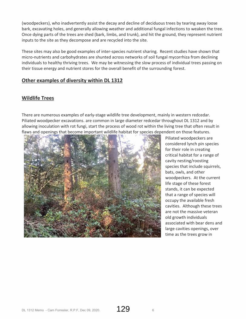
DL 1312 Memo - Cam Forrester, R.P.F, Dec 09, 2020. 6
(woodpeckers), who inadvertently assist the decay and decline of deciduous trees by tearing away loose bark, excavating holes, and generally allowing weather and additional fungal infections to weaken the tree. Once dying parts of the trees are shed (bark, limbs, and trunk), and hit the ground, they represent nutrient inputs to the site as they decompose and are recycled into the site. These sites may also be good examples of inter-species nutrient sharing. Recent studies have shown that micro-nutrients and carbohydrates are shunted across networks of soil fungal mycorrhiza from declining individuals to healthy thriving trees. We may be witnessing the slow process of individual trees passing on their tissue energy and nutrient stores for the overall benefit of the surrounding forest. Other examples of diversity within DL 1312
Wildlife Trees
There are numerous examples of early-stage wildlife tree development, mainly in western redcedar. Piliated woodpecker excavations. are common in large diameter redcedar throughout DL 1312 and by allowing inoculation with rot fungi, start the process of wood rot within the living tree that often result in flaws and openings that become important wildlife habitat for species dependent on those features.
Piliated woodpeckers are considered lynch pin species for their role in creating critical habitat for a range of cavity nesting/roosting species that include squirrels, bats, owls, and other woodpeckers. At the current life stage of these forest stands, it can be expected that a range of species will occupy the available fresh cavities. Although these trees are not the massive veteran old growth individuals associated with bear dens and large cavities openings, over time as the trees grow in
129

DL 1312 Memo - Cam Forrester, R.P.F, Dec 09, 2020. 7
height, volume and diameter, the current cavities may evolve into larger openings. So, although the stand is young, it does contain the beginnings of structures and habitat characteristic of older forests.
Another second growth wildlife tree related observation is that as understory trees are outcompeted, shaded out and die, they are being colonized by both fungi and insects such as termites or carpenter ants. The bract or conk in the photo is typically associated with older forest and old growth wildlife trees. One can also see that the bark (same tree) has been pulled back, or has sloughed away, exposing the insect gallery and rich food source for variety of foraging creatures.
130

DL 1312 Memo - Cam Forrester, R.P.F, Dec 09, 2020. 8
Trees that are grown in the open in the absence of shade and competition tend to have coarse heavy crowns and thick branches. There are several examples of this occurrence in DL 1312 mainly in well corners or exposed microsites where individual trees developed this branchy coarse growth form. These trees will have poor wood quality and would be candidates for wildlife tree retention or creation in the future.
Raptor Sightings During field observations, a medium sized very secretive hawk was observed mid-lot, assumed to be a red-tailed hawk. Scat (mutes) were observed around the base of a large branched redcedar, indicating perching, feeding, or roosting behavior. One possibility is that squirrel activity and sign is common in DL 1312 and this predator-prey relationship was what was observed. No raptor nest was observed at that location or elsewhere on the site. Other raptor sightings included numerous soaring and foraging hawks above and along the hydro powerline. It appears that some raptors are actively hunting the edge of the powerline, likely using hydro poles as perching habitat, while viewing the opening below. Wildlife trails and bear climbing marks
Several well-worn wildlife trails were observed running north-south through the site, likely used mainly by black bears. Bear sign observed included bear cub climb marks on a young alder tree. Other easily identified large mammal sign included black tailed deer tracks
Powerline Edge The powerline edge is a unique habitat for edge dwelling creatures and softens the hard lines and abrupt change from second growth forest to open low shrubbery.
131

DL 1312 Memo - Cam Forrester, R.P.F, Dec 09, 2020. 9
It appears that most of the hydro right-of-way edge has been planted later than most of the adjacent stands, likely as part of the previous Christmas tree farm through that zone. Some of the edge also contains a strip of natural red alder. The effect today is that a dense mix of conifer, deciduous, some native species, some imports, form a dense band of foliage and tree crowns that shield and conceal visibility into the forest from the powerline. The edge zones, and especially the south facing aspect was observed to be highly active with foraging songbirds, using the plantation edge as nesting and hiding cover, while feeding in the right-of way low dense shrub plant community. As insectivorous songbird numbers have plummeted throughout North America in recent decades, and especially the soaring species such as swallows and night hawks, those species that feed by ambush forays from cover have not declined as badly. So, in an era where it is important to conserve every bit of wildness and diversity, even in altered landscapes such as second growth conifer and powerline rights-of-way, in the face of catastrophic loss of biodiversity, these edge habitats are important in their own way.
.
132

DL 1312 Memo - Cam Forrester, R.P.F, Dec 09, 2020. 10
Unique plants – Orchids
Although widely distributed in Canada, the western coralroot was observed in several locations in DL 1312. Coralroot grows in heavy shade on organic soils. It is a saprophyte, lacking chlorophyl and derives its energy from organic matter. For a site that has been altered historically with fire and logging ground disturbance, it is at least one indicator of forest floor (which contains myriad micro flora and fauna species and numbers and the majority of a forest’s biodiversity) recovery that we see coralroot. The photo is a stock photo; however, coralroot was observed in several site locations in the western end of DL 1312.
Mushrooms
Much has been studied and written about the diverse and rich mycology of the Elphinstone slopes. Recent field observations in DL 1312 align with landscape level assessments. Prolific mushroom flushes are to be expected from Sept to Dec, depending on the year. Although it is an axiom that old forests support a wider range of mushroom species diversity than younger forests, DL 1312
133

DL 1312 Memo - Cam Forrester, R.P.F, Dec 09, 2020. 11
appears to support a vibrant mushroom ecology. The photo in the lower right is of a pine mushroom, observed and harvested in 2019.
Since we only see the fungal fruiting bodies in the form of mushrooms, and most of the fungal biomass extends in the forest floor, we can imagine that the upper organic soil layers are alive with a network of fungal mycelia playing their critical role in nutrient cycling and decomposition, helping to supply tree roots with water, nitrogen, phosphorus, other trace elements etc. in exchange for photosynthesized carbohydrates.
134

DL 1312 Memo - Cam Forrester, R.P.F, Dec 09, 2020. 12
Hydrology
DL 1312 is located mid-slope on the Elphinstone landscape in the Higgs, Smales, Cornwallis watersheds and is just east of the Town of Gibsons watershed reservoir polygon in DL 1313. This stream overlay shows the headwaters of Higgs Brook, Smales Creek and several other watercourses and ditch features. Further stream inventory work will reveal additional detail for ditches and hydrological connectivity in the land gift area. Additionally, the watercourses flowing through the proposed sub-division lots will be afforded streamside protection under the Riparian Areas Practices Regulation and SCRD by-laws.
Figure 4. Hydrology – stream network.
135

DL 1312 Memo - Cam Forrester, R.P.F, Dec 09, 2020. 13
The Elphinstone slopes above DL 1312 are characterized by numerous steep headwaters that merge and drain towards the Strait of Georgia. DL 1312 is hydrologically connected through seepage swales, ditches and small headwater drainage channels to Higgs and Cornwallis ss well as having Smales Creek and its steep headwaters inside the northeastern park dedication, flowing along the eastern boundary. This photo (left) is taken viewing downhill at a swale feature in the northwest portion of DL 1312. Although there is no defined channel here,
ground water concentrations and slow discharge through to distant the lower slope channels are a feature of this intact second growth area. Much has been written about storm water torrents and infrastructure damage in Roberts Creek from the many watercourses flowing through the area. DL 1312 north plays a part in moderating storm water run-off through canopy interception of rain and snow and moderated surface and ground water discharge. Aquatic Life
There are several biologically roadside ditches that have formed small pools. Unidentified amphibian tadpoles, juveniles (salamanders) and egg masses were observed in several of these pools in 2019/20. It is likely that a range of amphibians are found on site, including red-tailed frogs, possibly coastal tailed frogs in any functioning step-pool or cascade pool stream reaches. Amphibians are facing serious declines in North America, especially in urban areas. It is a positive sign that amphibians are present in DL 1312.
136

DL 1312 Memo - Cam Forrester, R.P.F, Dec 09, 2020. 14
Recreation Numerous informal and rights-of-way trails traverse DL 1312 and are actively used by cyclists, horse riders and hikers. The trails are important linkages through mid-lower Roberts Creek trails into the upper Elphinstone area such as the Suncoaster Trail and Mount Elphinstone mountain bike trails. The experience of forested trails surrounded by the unique features highlighted in this memo are preferable to an open logged environment. The clear-cutting possibility One of the possible outcomes of this rezoning process is that the area being offered as a community amenity with the unique and valued features described above, if denied, it simply defaults to the land uses allowed under the Z zone. Broadly, that zoning anticipates forest management, which could result in clear-cutting or heavy harvesting throughout 1312. At the time of writing, second growth logging is experiencing strong market activity and the current economic trends support logging stands with this timber profile.
As a tool to help visualize an extensive harvest case and what it might look like for DL1312, the following figures are an informed representation of a failed rezoning that results in a clear-cut throughout Remainder DL1312, versus a sub-divided DL1312 with housing development in the 12 new lots in the south and with an intact, notwithstanding the existing rights-of-way, 26 ha forested tract above that. The clear-cut option shows that there is the possibility of a wide swath of bare and exposed ground with potential impacts to: Local hydrology in terms of loss of cover and water retention; Reduced streambank protection Water quality and temperature in local streams; Microclimate changes with extremes dominating after the forest canopy is removed; Local amphibian and songbird populations; and Recreation values, access, and trail usage.
Figure 5. Clear-cut land use option
137

DL 1312 Memo - Cam Forrester, R.P.F, Dec 09, 2020. 15
The preservation or community amenity option shows lot development between Pixton and Porter roads but also provides a view of the positive impacts of leaving stream buffers in place, maintaining deep interior forest conditions and the existing trail network.
Figure 6. Community Amenity Option, no clear-cutting in gift area.
138

DL 1312 Memo - Cam Forrester, R.P.F, Dec 09, 2020. 16
Concluding Remarks A walk through of the second growth forests of land gift remainder Lot DL 1312 uncovers many reassuring examples of environmental health and biological diversity worth conserving:
• Wildlife trees; • Raptor foraging areas; • Amphibian breeding sites; • Avian habitat; • Unique plant species; • Forest floor/forest soils; • Mycology; • Hydrology; and, • Recreational opportunities;
The opportunity exists with the land gift to not only protect these environmental features, but to also formalize a forested buffer between the urban/rural interface of occupied land and the broader landscapes above DL 1312 with linkages to storm water management, wildlife corridors, aquifer recharge, and continuing recreation and tourism activities.
Cam Forrester, R.P.F.
# 2118
Date Signed – April 29, 2021
139