Introduction to special section: Mechanical involvement of fluids in faulting
Upload
independentCategory
view
2download
0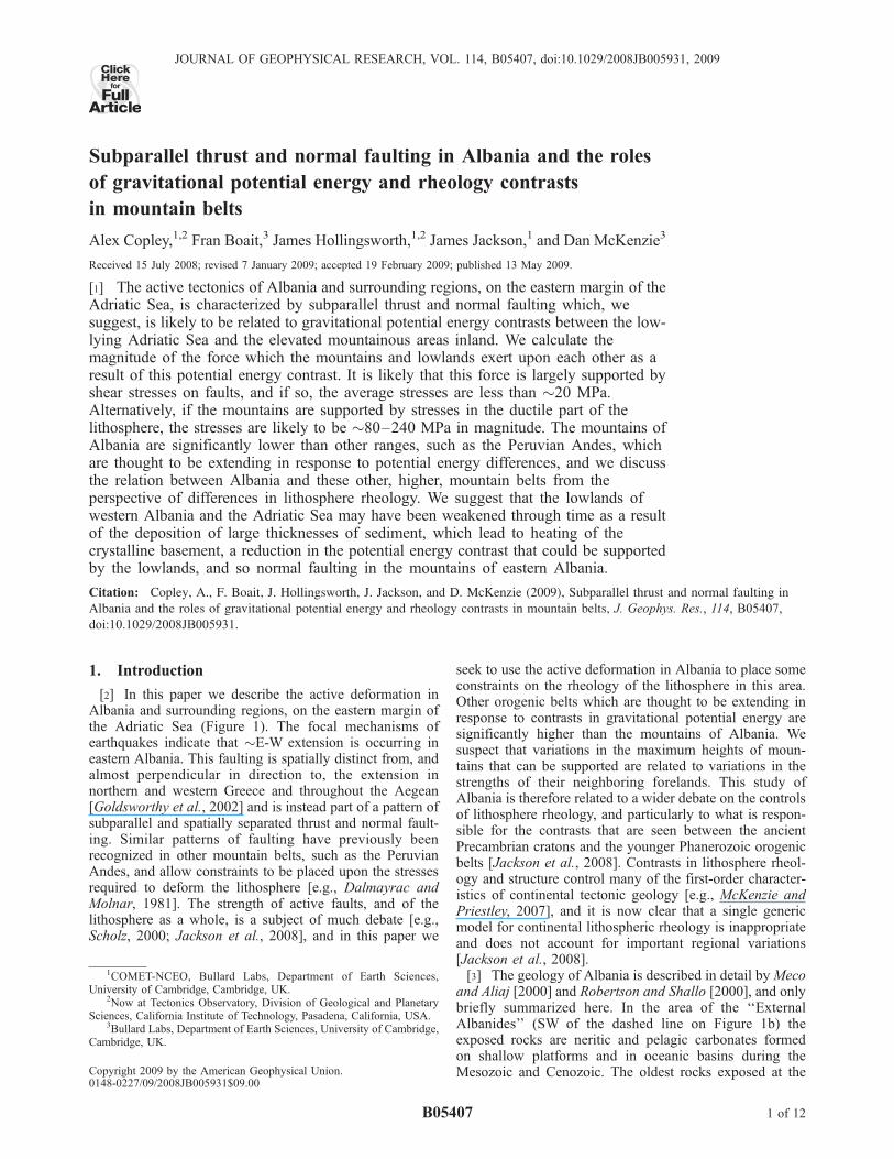
Subparallel thrust and normal faulting in Albania and the roles
of gravitational potential energy and rheology contrasts
in mountain belts
Alex Copley,1,2 Fran Boait,3 James Hollingsworth,1,2 James Jackson,1 and Dan McKenzie3
Received 15 July 2008; revised 7 January 2009; accepted 19 February 2009; published 13 May 2009.
[1] The active tectonics of Albania and surrounding regions, on the eastern margin of theAdriatic Sea, is characterized by subparallel thrust and normal faulting which, wesuggest, is likely to be related to gravitational potential energy contrasts between the low-lying Adriatic Sea and the elevated mountainous areas inland. We calculate themagnitude of the force which the mountains and lowlands exert upon each other as aresult of this potential energy contrast. It is likely that this force is largely supported byshear stresses on faults, and if so, the average stresses are less than �20 MPa.Alternatively, if the mountains are supported by stresses in the ductile part of thelithosphere, the stresses are likely to be �80–240 MPa in magnitude. The mountains ofAlbania are significantly lower than other ranges, such as the Peruvian Andes, whichare thought to be extending in response to potential energy differences, and we discussthe relation between Albania and these other, higher, mountain belts from theperspective of differences in lithosphere rheology. We suggest that the lowlands ofwestern Albania and the Adriatic Sea may have been weakened through time as a resultof the deposition of large thicknesses of sediment, which lead to heating of thecrystalline basement, a reduction in the potential energy contrast that could be supportedby the lowlands, and so normal faulting in the mountains of eastern Albania.
Citation: Copley, A., F. Boait, J. Hollingsworth, J. Jackson, and D. McKenzie (2009), Subparallel thrust and normal faulting in
Albania and the roles of gravitational potential energy and rheology contrasts in mountain belts, J. Geophys. Res., 114, B05407,
doi:10.1029/2008JB005931.
1. Introduction
[2] In this paper we describe the active deformation inAlbania and surrounding regions, on the eastern margin ofthe Adriatic Sea (Figure 1). The focal mechanisms ofearthquakes indicate that �E-W extension is occurring ineastern Albania. This faulting is spatially distinct from, andalmost perpendicular in direction to, the extension innorthern and western Greece and throughout the Aegean[Goldsworthy et al., 2002] and is instead part of a pattern ofsubparallel and spatially separated thrust and normal fault-ing. Similar patterns of faulting have previously beenrecognized in other mountain belts, such as the PeruvianAndes, and allow constraints to be placed upon the stressesrequired to deform the lithosphere [e.g., Dalmayrac andMolnar, 1981]. The strength of active faults, and of thelithosphere as a whole, is a subject of much debate [e.g.,Scholz, 2000; Jackson et al., 2008], and in this paper we
seek to use the active deformation in Albania to place someconstraints on the rheology of the lithosphere in this area.Other orogenic belts which are thought to be extending inresponse to contrasts in gravitational potential energy aresignificantly higher than the mountains of Albania. Wesuspect that variations in the maximum heights of moun-tains that can be supported are related to variations in thestrengths of their neighboring forelands. This study ofAlbania is therefore related to a wider debate on the controlsof lithosphere rheology, and particularly to what is respon-sible for the contrasts that are seen between the ancientPrecambrian cratons and the younger Phanerozoic orogenicbelts [Jackson et al., 2008]. Contrasts in lithosphere rheol-ogy and structure control many of the first-order character-istics of continental tectonic geology [e.g., McKenzie andPriestley, 2007], and it is now clear that a single genericmodel for continental lithospheric rheology is inappropriateand does not account for important regional variations[Jackson et al., 2008].[3] The geology of Albania is described in detail byMeco
and Aliaj [2000] and Robertson and Shallo [2000], and onlybriefly summarized here. In the area of the ‘‘ExternalAlbanides’’ (SW of the dashed line on Figure 1b) theexposed rocks are neritic and pelagic carbonates formedon shallow platforms and in oceanic basins during theMesozoic and Cenozoic. The oldest rocks exposed at the
JOURNAL OF GEOPHYSICAL RESEARCH, VOL. 114, B05407, doi:10.1029/2008JB005931, 2009ClickHere
for
FullArticle
1COMET-NCEO, Bullard Labs, Department of Earth Sciences,University of Cambridge, Cambridge, UK.
2Now at Tectonics Observatory, Division of Geological and PlanetarySciences, California Institute of Technology, Pasadena, California, USA.
3Bullard Labs, Department of Earth Sciences, University of Cambridge,Cambridge, UK.
Copyright 2009 by the American Geophysical Union.0148-0227/09/2008JB005931$09.00
B05407 1 of 12
surface are Permo-Triassic evaporites, which have acted as adetachment layer during recent folding and thrusting [Velajet al., 1999]. Flysch deposition and folding occurred fromthe Eocene onward, and the surface morphology is charac-terized by folds that are thought to be cored by the Permo-Triassic evaporites [Velaj et al., 1999], which are also seen tooutcrop at the surface as diapiric structures. The rocks of the‘‘Internal Albanides’’ (NE of the dashed line on Figure 1b)are generally older, and are largely composed of Jurassicophiolites and Mesozoic carbonates. These rocks arethought to have been accreted to the margin of Eurasia bythe end of the Mesozoic. The Adriatic Sea is composed ofcontinental crust and a thick (�15 km [Patacca et al.,2008]) sequence of Mesozoic and Cenozoic sedimentary
rocks; the absence of seismicity suggests it is relativelyundeforming in this southern part (Figure 1). The Adriatic isthought to have been a ‘‘promontory’’ of the African platein the Mesozoic and much of the Cenozoic [e.g., Channellet al., 1979] but now appears to be moving independently[e.g., Anderson and Jackson, 1987; Battaglia et al., 2004;D’Agostino et al., 2008]. Active shortening occurs on thrustfaults in the lowlands and coastal regions of westernAlbania and active extension, on normal faults subparallelto the thrust faults, occurs in the highlands in the east of thecountry (Figure 1). In section 2 we describe the activedeformation occurring in these regions, and then in section 3we discuss the likely cause of the spatial separation of
Figure 1. Active faulting in Albania and surrounding regions. The area of coverage of Figures 1a and1b is shown by the box in the inset of Figure 1b, which also shows the location of the seismic surveys byDragasevic and Andric [1968] as dashed lines. (a) Focal mechanisms in black and white are constrainedby P and SH body wave modeling [Baker et al., 1997; Louvari et al., 2001; this study] (see Table 1 andText S1). Those with quadrants in black (compressional) and grey (extensional) are from observations offirst-motion polarities [McKenzie, 1972; Anderson and Jackson, 1987]; those shown as dark grey andwhite are from the Harvard CMT catalogue, and pale grey and white mechanisms are the regional CMTsolutions of Pondrelli et al. [2006]. The earthquakes labeled with letters (above the focal mechanism) arediscussed in detail in the text, and those labeled with numbers have mechanisms constrained bywaveform modeling, as part of this study (Table 1). (b) The reliable depths (in km) of earthquakes whichhave been obtained by the modeling of teleseismic P and SH waveforms. The dashed black line showsthe approximate boundary between the Internal Albanides (to the northeast) and the External Albanides(to the southwest). The white box shows the area of coverage of Figure 3.
B05407 COPLEY ET AL.: PARALLEL THRUST AND NORMAL FAULTING IN ALBANIA
2 of 12
B05407
thrust and normal faulting and its implications for themechanical properties of the lithosphere.
2. Active Deformation
[4] Figure 1 shows the earthquakes which have occurredin Albania and surrounding regions during the moderninstrumental period (the oldest event shown occurred in1963). We have used waveform analysis to constrain thesource parameters of the five earthquakes labeled withnumbers in Figure 1a (Table 1), by inverting long-periodP and SH waveforms for the strike, dip, rake, seismicmoment, centroid depth, and source time function, usingthe MT5 version [Zwick et al., 1995] of the algorithm ofMcCaffrey and Abers [1988] and McCaffrey et al. [1991]. Adetailed description of the method is given by Nabelek[1984] and Taymaz et al. [1991], and the procedure is nowtoo routine to justify a full explanation here. The results ofthe waveform inversions are shown in detail in Text S1,section 1, in the auxiliary material.1 Tests of the typedescribed by Taymaz et al. [1991] show that errors in fittingthe observed and synthetic seismograms, and uncertainty inthe velocity structure, yield errors of about 4 km or less forthe centroid depths. Sections 2.1 and 2.2 will describe somedetails of the active deformation, beginning with the thrustfaulting, and following with the normal faults.
2.1. Thrust Faulting
[5] Thrust faulting occurs in the lowlands of westernAlbania and the Adriatic Sea, and is part of a continuousband which extends from the Alps southward, down theentire eastern margin of the Adriatic sea, to connect with theHellenic subduction zone south of �39�N. The earthquakesare mostly low-angle thrusting events, although someevents have occurred on steeper-dipping planes (Figure 1).The waveforms of some of the earthquakes on low-anglefault planes have been modeled, and the reliable centroiddepths are between 17 km and 26 km in central Albania,although some as shallow as 6 km have occurred along thecoasts of northern Albania and Montenegro (Figure 1b).Louvari et al. [2001] determined a centroid depth of 30 kmfor the deepest event in the area (event A on Figure 1a),although they used some narrow-band long-period seismo-grams when performing their waveform inversions, whichgenerally have poor depth resolution. Comparing observedand synthetic vertical component broadband seismogramsfor this event (Text S1, section 2) confirms that the centroiddepth was actually �26 km.[6] Three earthquakes (marked B, C, D on Figure 1a)
show relatively high-angle reverse faulting, at depths whichare probably shallow (<10 km) but not well constrained.
The focal mechanism marked B on Figure 1a represents anearthquake which occurred in 1969, for which surfacefaulting of an ambiguous nature was reported by Sulstarova[1980] and Aliaj [1982]. This earthquake occurred near anelongate mountain range which follows the surface trace oftwo closely spaced anticline axes [War Office, 1943], andthe strike of the nodal planes is the same as that of theanticline axes. The focal mechanism marked C on Figure 1aalso has relatively high-angled nodal planes, and thisearthquake occurred where an anticline of Pliocene sand-stones and marls, with the same strike as the earthquakenodal planes, emerges from the surrounding low-lyingQuaternary sediments (Figure 2), although the depth of thisearthquake is not reliably known. The geology in the areasurrounding the third high-angle reverse faulting earthquakein Albania (marked D on Figure 1a) is less clear on thegeological map, and the earthquake cannot be reliablylinked to an individual geological structure.[7] The thrusting earthquakes in western Albania and the
Adriatic Sea can therefore be subdivided into two types.The majority have occurred on low-angle fault planes, andextend to depths of up to 26 km. A smaller number ofearthquakes have occurred on higher-angle planes, andappear to be spatially correlated with anticlines visible atthe surface, suggesting that the anticlines are currentlyactive and underlain by (possibly blind) reverse faults.The geology and geomorphology of the anticlines associat-ed with these steeper reverse faults are reminiscent of thebetter known Zagros mountains of southwest Iran, wherelarge thicknesses of salt are also present [e.g., Talebian andJackson, 2004; Ramsey et al., 2008].
2.2. Normal Faulting
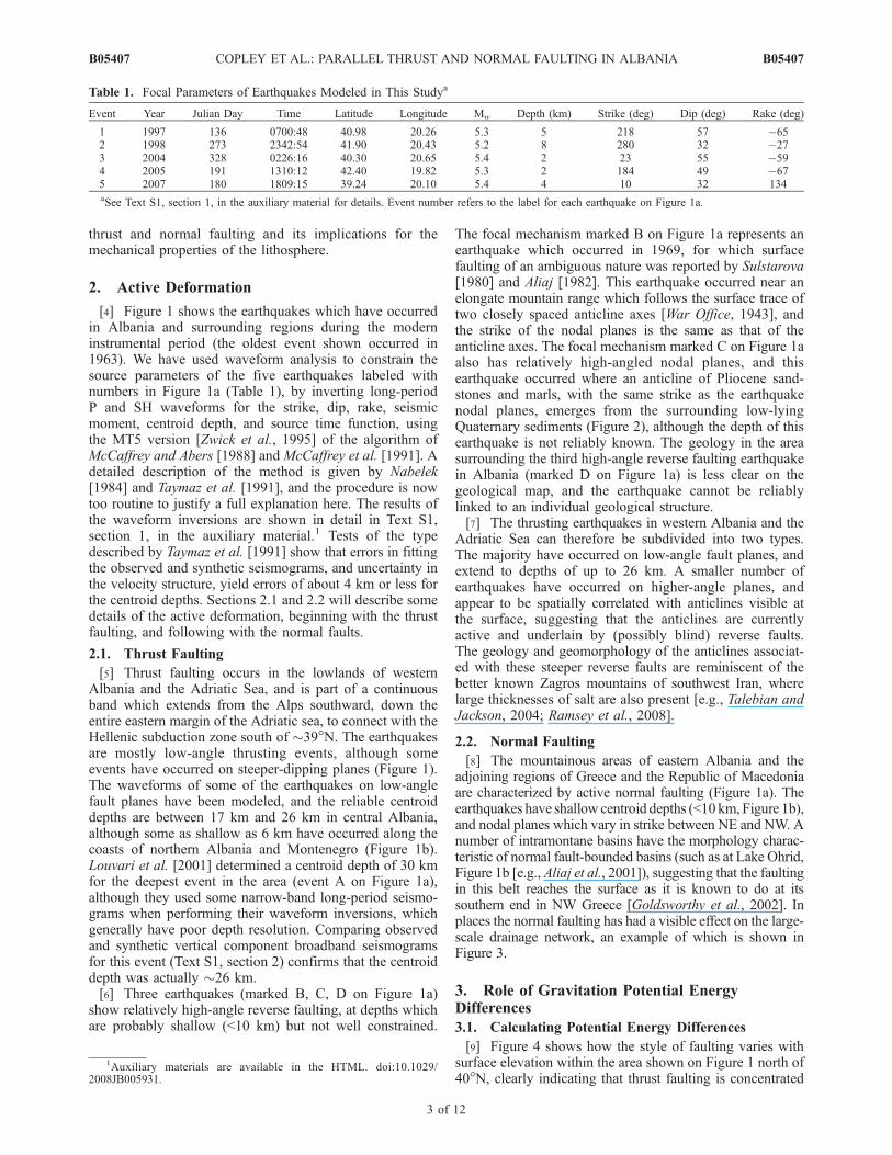
[8] The mountainous areas of eastern Albania and theadjoining regions of Greece and the Republic of Macedoniaare characterized by active normal faulting (Figure 1a). Theearthquakes have shallow centroid depths (<10 km, Figure 1b),and nodal planes which vary in strike between NE and NW. Anumber of intramontane basins have the morphology charac-teristic of normal fault-bounded basins (such as at Lake Ohrid,Figure 1b [e.g., Aliaj et al., 2001]), suggesting that the faultingin this belt reaches the surface as it is known to do at itssouthern end in NW Greece [Goldsworthy et al., 2002]. Inplaces the normal faulting has had a visible effect on the large-scale drainage network, an example of which is shown inFigure 3.
3. Role of Gravitation Potential EnergyDifferences
3.1. Calculating Potential Energy Differences
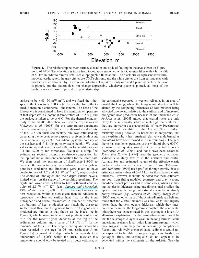
[9] Figure 4 shows how the style of faulting varies withsurface elevation within the area shown on Figure 1 north of40�N, clearly indicating that thrust faulting is concentrated
Table 1. Focal Parameters of Earthquakes Modeled in This Studya
Event Year Julian Day Time Latitude Longitude Mw Depth (km) Strike (deg) Dip (deg) Rake (deg)
1 1997 136 0700:48 40.98 20.26 5.3 5 218 57 �652 1998 273 2342:54 41.90 20.43 5.2 8 280 32 �273 2004 328 0226:16 40.30 20.65 5.4 2 23 55 �594 2005 191 1310:12 42.40 19.82 5.3 2 184 49 �675 2007 180 1809:15 39.24 20.10 5.4 4 10 32 134aSee Text S1, section 1, in the auxiliary material for details. Event number refers to the label for each earthquake on Figure 1a.
1Auxiliary materials are available in the HTML. doi:10.1029/2008JB005931.
B05407 COPLEY ET AL.: PARALLEL THRUST AND NORMAL FAULTING IN ALBANIA
3 of 12
B05407

in low-lying areas while normal faulting occurs at highelevations. A number of mechanisms have been proposed toexplain the presence of normal faulting within orogenicbelts, such as slab roll-back, gravitationally driven defor-mation around the margin of an arcuate mountain range[e.g., Copley and McKenzie, 2007], and ‘‘traction reversal’’above a rigid underthrusting and subducting layer [e.g.,Willett, 1999]. However, the absence of active subductionbeneath Albania, the linearity of the mountain range, andthe clear relation between focal mechanism style andelevation leads us to suggest that the faulting is caused bydifferences in gravitational potential energy between thelowlands and the mountains [e.g., Dalmayrac and Molnar,1981; England and Houseman, 1988]. As a mountain belt isformed, work is done against gravity when thickening thecrust, which means that mountain ranges have highergravitational potential energy than lowland areas [e.g.,Artyushkov, 1973]. In such a situation, crustal shorteningtends to concentrate in the lowlands on the margins of themountain belt, and the high mountains will have a tendencyto extend, as is seen in Albania. The difference in gravita-tional potential energy between two isostatically compen-sated lithospheric columns of unit area is equivalent to thevertical integral of the difference in vertical normal stressbetween the two areas, i.e., DGPE =
RDszz dz, where the
integral is between the surface of the mountains and thedepth of isostatic compensation, szz is the vertical normalstress (@szz/@z = rg), and Dszz refers to the difference in szzat a given depth between the two lithospheric columnsbeing considered [e.g., Molnar and Lyon-Caen, 1988].Therefore, if the surface elevation and deep structure of
the mountain belt and lowland are known, it is possible toestimate the contrast in gravitational potential energy be-tween them, and so the force which the lowlands andmountains exert upon each other as a result of the lateraldifferences in crustal thickness. For the purposes of thefollowing discussion it will be assumed that the topographyin Albania and surrounding regions can be approximated astwo-dimensional, and we will consider topography along across section oriented perpendicular to the main geologicalstructures and the nodal planes of earthquake focal mech-anisms. Thrust faulting occurs in regions where the surfaceelevation is close to sea level (Figure 4), and the meanelevation of the mountainous region of eastern Albania is�1 km. The Moho depth in the region is not well known.The surface wave analysis of Marone et al. [2003] showsMoho depths in excess of 40 km in the mountainousregions, and as low as 30 km in the Adriatic sea, althoughthe horizontal resolution of surface wave studies means thatthese values are likely to be affected by the crustal thicknessin the surrounding regions, in addition to the areas withwhich we are concerned. Northwest of the area discussedhere, Dragasevic and Andric [1968] conducted activesource seismic investigations along two profiles whichextended from the Adriatic Sea across the mountains ofthe former Yugoslavia (dashed lines on the inset inFigure 1b). The greatest depths they estimated for the Mohowere �50 km, below the mountains, and the Moho depthwas around 40 km on the coast of the Adriatic Sea. In asimilar area, van der Meijde et al. [2003] used receiverfunctions to estimate Moho depths of 41 and 47 km at twosites on the margin of the Adriatic sea. Therefore, the crustal
Figure 2. Perspective image (Landsat imagery overlain on SRTM topographic data) looking NE at thelocation of the earthquake marked C on Figure 1a. The high topography in the center of the image rises�200 m above the level of the surrounding plains. The black circle shows the location of the epicenter ofthe earthquake (Mw 4.2) determined by Pondrelli et al. [2006], which may be in error by as much as10 km. The white oval shows an area where incision is clearly visible, suggesting active uplift. The valleyindicated by the white arrow crosses the entire width of the high topography, although the central portionsare above the level of the alluvial plain surrounding the anticline and may represent an old river coursewhich has been beheaded by uplift. The watershed lies toward the NE side of the anticline, which maysuggest the underlying fault dips to the SW.
B05407 COPLEY ET AL.: PARALLEL THRUST AND NORMAL FAULTING IN ALBANIA
4 of 12
B05407
thicknesses are taken to be 40 km on the margins of theAdriatic sea and 50 km beneath the mountains of easternAlbania. Isostatic compensation is assumed to take place atthe base of the thickest crust, and the densities of the crustand mantle are taken to be 2800 and 3300 kg m�3. Thevertical normal stress can then be calculated for lithosphericcolumns beneath the mountains and the lowlands, and byintegrating over depth the difference between these stresses,the force exerted upon each other by the mountain belt andthe adjacent lowlands is calculated to be �1.2 � 1012 N perunit length along strike.
3.2. Geotherms and Rheology
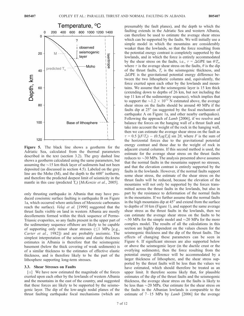
[10] Having estimated the magnitude of the force result-ing from the gravitational potential energy contrast, it isnow worth considering which part of the lithosphere islikely to be supporting these forces. Our first step will be tocalculate a geotherm for the Adriatic lithosphere. There isno evidence for recent tectonic activity, except around themargins of the Adriatic, so we have constructed a geothermby assuming that the temperature profile is in steady stateand have only considered vertical diffusion [e.g., McKenzieet al., 2005]. Lavenia [1967] measured the heat flow at the
Figure 3. Topography within the white box shown on Figure 1b (pale shades represent higherelevations). The dashed white lines show the locations of large linear topographic features which have thegeomorphological characteristics of active normal faults, with ticks on the downthrown side. The whitearrows show the locations of two valleys which cross the high topography to the west of the southernmostnormal fault. The drainage divide in these valleys is within the high topography, and so rivers flow downthem to the major valleys to the east and west, and the valleys are dry at their watersheds. The hangingwall basin of the southernmost normal fault is drained by the river flowing along the valley marked A. Itis probable that streams in the two valleys which cross the high topography flowed west before thenormal faulting began and that motion on the southernmost normal fault, and the associated subsidence inits hanging wall, caused the drainage direction to be reversed in the eastern parts of the valleys, creatingthe situation we see today (as shown in the cartoons).
B05407 COPLEY ET AL.: PARALLEL THRUST AND NORMAL FAULTING IN ALBANIA
5 of 12
B05407
surface to be �45–50 mW m�2, and we fixed the litho-spheric thickness to be 100 km (a likely value for unthick-ened, noncratonic continental lithosphere). The base of thelithosphere is constrained to have the isentropic temperatureat that depth (with a potential temperature of 1315�C), andthe surface is taken to be at 0�C. For the thermal conduc-tivity of the mantle lithosphere we used the expressions ofMcKenzie et al. [2005] for the temperature-dependentthermal conductivity of olivine. The thermal conductivityof the �15 km thick sedimentary pile was estimated bycalculating the percentage pore space at a given depth usingthe relation f = f0 exp(�z/l), where f0 is the porosity atthe surface and l is the porosity scale height. We usedvalues for f0 and l of 0.5 and 2500 m for sandstones and0.4 and 3200 m for carbonates. We used a simplifiedsedimentary section, having a sandstone composition forthe top half and a limestone composition for the lower half.We then used the expression of Budiansky [1970] tocalculate the conductivity of the solid-water mixture (wherepore-free sandstone and limestone were taken to haveconductivities of 3.7 and 3.2 W m�1 K�1, respectively).The choice of lithologies and their depth extents have alimited effect on the shape of the resulting geotherm. Thecrystalline lower crust is taken to have a thermal conduc-tivity of 2.5 W m�1 K�1 [e.g., Jaupart and Mareschal,1999; McKenzie et al., 2005]. The distribution of radiogenicheat production within the crust can then be adjusted toreproduce the observed surface heat flux for the inputlithospheric and crustal thicknesses. A number of differentdistributions of heat production can match the observedsurface heat flux, but the general forms of the geothermsproduced are similar to that shown as the black line inFigure 5, which corresponds to a heat production of 4 mWm�3 for the recent flysch deposits at the top of thesedimentary column, and a value of 1.5 mW m�3 for theremainder of the crust. The deepest earthquake which hasbeen recorded in the area (at 26 km, earthquake A onFigure 1a) occurred at a depth which corresponds to atemperature of �600�C within the crust. However, thistemperature should only be treated as a rough estimate, as
the earthquake occurred in western Albania, in an area ofcrustal thickening, where the temperature structure will bealtered by the competing influences of cold material beingadvected downward relative to the surface, and of increasedradiogenic heat production because of the thickened crust.Jackson et al. [2004] argued that crustal rocks are onlylikely to be seismically active at such high temperatures ifthey are anhydrous; a characteristic of many Precambrianlower crustal granulites. If the Adriatic Sea is indeedrelatively strong because its basement is anhydrous, thatmay explain why it has remained relatively undeformed asmountains have been formed in its surroundings. The geo-therm has mantle temperatures at the Moho of above 600�C,so mantle earthquakes would not be expected to occur[McKenzie et al., 2005], and none have been recorded.Kruse and Royden [1994] used the geometry of recentsediments to study flexure in the northern and centralAdriatic Sea and estimated values of the effective elasticthickness which varied between 10 and 15 km. D’Agostinoand McKenzie [1999] used profiles through gravity data toestimate similar values of 5–12 km for the effective elasticthickness. However, it should be noted that these estimatesare both from fitting modeled geometry and gravity alongone-dimensional profiles and in some cases, when estimat-ing the elastic thickness using one-dimensional profiles, theupper limit on the range of estimates can be relativelypoorly resolved [e.g., Jackson et al., 2008]. Maggi et al.[2000] studied other parts of the Alpine-Himalayan belt andfound that the elastic thickness was similar to, but slightlylower than, the seismogenic thickness, which they inter-preted to mean that the long-term strength of the continentallithosphere was concentrated in the seismogenic layer. Analternative explanation for the same observations could bethat the seismogenic layer is weak in the long term while theunderlying aseismic layer holds long-term strength; whichthey suggest is unlikely and unnecessarily complicated.Recent and relatively unconsolidated sediments would notbe expected to be able to support significant loads overgeological time, and earthquakes do not appear to begenerated within the sediments of the Adriatic Sea (the
Figure 4. The relationship between surface elevation and style of faulting in the area shown on Figure 1north of 40�N. The elevation is taken from topography smoothed with a Gaussian filter with a full widthof 50 km in order to remove small-scale topographic fluctuations. The black circles represent waveform-modeled earthquakes, the grey circles are CMT solutions, and the white circles are from earthquakes withmechanisms constrained by first-motion polarities. The rake of only one nodal plane of each earthquakeis plotted, but the pattern does not change appreciably whichever plane is plotted, as most of theearthquakes are close to pure dip slip or strike slip.
B05407 COPLEY ET AL.: PARALLEL THRUST AND NORMAL FAULTING IN ALBANIA
6 of 12
B05407
only thrusting earthquake in Albania that may have pro-duced coseismic surface faulting is earthquake B on Figure1a, which occurred where anticlines of Mesozoic carbonatesreach the surface). Velaj et al. [1999] suggested that thethrust faults visible on land in western Albania are mostlydecollements formed within the thick sequence of Permo-Triassic evaporites, so any faults present in the upper part ofthe sedimentary sequence offshore are likely to be capableof supporting only minor shear stresses (�1 MPa [e.g.,Carter et al., 1982]) and are probably aseismic. Thesimplest interpretation of the seismic and elastic thicknessestimates in Albania is therefore that the seismogenicbasement (below the thick covering of weak sediments) isof a similar thickness to the estimates of effective elasticthickness, and is therefore likely to be the part of thelithosphere supporting long-term stresses.
3.3. Shear Stresses on Faults
[11] We have now estimated the magnitude of the forcesexerted upon each other by the lowlands of western Albaniaand the mountains in the east of the country, and suggestedthat these forces are likely to be supported by the seismo-genic layer. The dip of the low-angle nodal planes of thethrust faulting earthquake focal mechanisms (which are
presumably the fault planes), and the depth to which thefaulting extends in the Adriatic Sea and western Albania,can therefore be used to estimate the average shear stresswhich can be supported by the faults. We will initially use asimple model in which the mountains are considerablyweaker than the lowlands, so that the force resulting fromthe potential energy contrast is completely supported by thelowlands, and in which the force is entirely accommodatedby the shear stress on the faults, i.e., t = DGPE tan q/Ts,where t is the average shear stress on the faults, q is the dipof the thrust faults, Ts is the seismogenic thickness, andDGPE is the gravitational potential energy difference be-tween the two lithospheric columns and, equivalently, theforce exerted upon each other by the lowlands and moun-tains. We assume that the seismogenic layer is 15 km thick(extending down to depths of 26 km, but not including thetop 11 km of the sedimentary sequence), which implies thatto support the �1.2 � 1012 N estimated above, the averageshear stress on the faults should be around 40 MPa if thefaults dip at 25� (as suggested by the focal mechanism ofearthquake A on Figure 1a, and other nearby earthquakes).Following the approach of Lamb [2006], if we resolve andbalance the forces on the hanging wall of a thrust fault andtake into account the weight of the rock in the hanging wall,then we can estimate the average shear stress on the fault ast = 0.5 [(F/Ts) � (0.5rgTs)] sin 2q, where F is the sum ofthe horizontal forces due to the gravitational potentialenergy contrast and those due to the weight of rock inadjacent crustal columns. If this second method is used, theestimate for the average shear stress on the thrust faultsreduces to �30 MPa. The analysis presented above assumesthat the normal faults in the mountains support no stresses,and that the elevation contrast is entirely supported by thefaults in the lowlands. However, if the normal faults supportsome shear stress, the estimate of the shear stress on thethrust faults will be reduced, because the elevation of themountains will not only be supported by the forces trans-mitted across the thrust faults in the lowlands, but also inpart by the resistance to deformation of the normal faultsin the mountains. If we further assume that the normal faultsin the high mountains dip at 45� and extend from the surfaceto depths of 10 km (Figure 1), and support the same averageshear stress as the thrust faults in the lowlands, then wecan estimate the average shear stress on the faults to be�30 MPa for the simple model and �20 MPa for the morecomplex model. The results of all the calculations in thissection are highly dependent on the values chosen for theseismogenic thickness and the dip of the thrust faults. Theeffects of changing these parameters can be seen inFigure 6. If significant stresses are also supported belowor above the seismogenic layer (in the ductile crust or theoverlying sediments), then the force resulting from thepotential energy difference will be accommodated by alarger thickness of lithosphere, and the shear stress sup-ported by the thrust faults will be less than the values wehave estimated, which should therefore be treated as anupper limit. It therefore seems likely that, for plausibleestimates of the dip of the thrust faults and the seismogenicthickness, the average shear stress on the faults is likely tobe less than �20 MPa. Our estimate for the shear stress onthe faults in the Albanian lowlands is comparable to theestimate of 7–15 MPa by Lamb [2006] for the average
Figure 5. The black line shows a geotherm for theAdriatic Sea, calculated from the thermal parametersdescribed in the text (section 3.2). The grey dashed lineshows a geotherm calculated using the same parameters, butassuming the �15 km thick layer of sediments had not beendeposited (as discussed in section 4.5). Labeled on the greyline are the Moho (M), and the depth to the 600� isotherm,and therefore the predicted deepest limit of seismicity in themantle in this case (predicted Ts) [McKenzie et al., 2005].
B05407 COPLEY ET AL.: PARALLEL THRUST AND NORMAL FAULTING IN ALBANIA
7 of 12
B05407

shear stress on most of the subduction zone thrust faults onthe margins of the Pacific Ocean, and is similar to the sizeof the stress drop commonly observed in earthquakes [e.g.,Scholz, 2002].[12] If the logic presented above is wrong, and the
mountains are supported entirely by stresses in the ductilepart of the lithosphere, below the seismogenic layer, then itis possible to estimate the deviatoric stresses which must bepresent. If the stresses are supported in an elastic layer thenthe effective elastic thickness (5–15 km) can be used toestimate that the layer must be able to support deviatoricstresses of 240–80 MPa. If the stresses supporting themountains are present because of active deformation, ratherthan long-term strength, then we cannot use the flexuralparameters to estimate the thicknesses of the layers in-volved, but the stresses estimated above can be simplyscaled to give those which must be present in a layer ofany given thickness.
4. Discussion
[13] The work presented in section 3 raises two obviouspoints for further discussion. The first is the question of howthe situation in Albania compares with other parts of theworld, such as the Andes and the Tibetan Plateau, wheregravitational potential energy differences are thought to playa major role in the active tectonics [e.g., Dalmayrac andMolnar, 1981; England and Houseman, 1988]. The secondquestion is how the topography in eastern Albania, which is
currently too high to be supported by the adjacent lowlands,was initially produced.
4.1. Support of Forces and Dips of Faults
[14] We first compare our conclusions regarding theactive tectonics of Albania with work done on othermountain belts. There are two main factors to considerwhen discussing the potential energy contrasts that can besupported by the lowlands bordering mountain belts. First,the geometry and properties of the faulting on the margin ofthe mountain belt need to be considered, and secondly theability of the lowlands to support the stresses transmittedacross these faults is also important. The force that can besupported by thrust faults on the margins of a mountainrange will depend on a number of factors. The downdipwidth of the faulting will determine the area over whichstresses are transmitted, and faulting extending deeper willbe able to support larger elevation contrasts. If the downdipwidth of the faulting is controlled by temperature [e.g.,Oleskevich et al., 1999; Wang and Suyehiro, 1999], then theconvergence velocity will play a major role in determiningthe downdip width of the faulting, as faster convergencewill advect cold material further down the fault plane [e.g.,Molnar and England, 1990], and brittle faulting will extendto deeper depths. If the faults have a ‘‘Coulomb’’ rheology,where the shear stress which can be supported depends onthe normal stress, then the deeper parts of the faults will beable to support higher stresses (per unit area of fault plane)than the shallow parts. The dip of the fault plane is
Figure 6. Graphs showing the average shear stress (in MPa) on faults required to support the forcesresulting from gravitational potential energy differences, as a function of thrust fault dip and seismogenicthickness (Ts). Black lines are calculated using the method of Lamb [2006], which takes into account theweight of rock in the hanging wall of the faults when calculating the average shear stress, and the greydashed lines are calculated using a more simple model (see text for details). (a) The stresses required tosupport the forces resulting from an isostatically compensated elevation difference of 1 km if themountains are weak. (b) The stresses required to support the same elevation difference if the faults in themountains support the same average stresses as those in the lowlands, so there is a resistance to extension(see section 3). The grey circles show a thrust fault dip of 25� and a seismogenic thickness of 15 km, asdiscussed in the text.
B05407 COPLEY ET AL.: PARALLEL THRUST AND NORMAL FAULTING IN ALBANIA
8 of 12
B05407
important, because not only will it play a role in determin-ing the thermal structure, but also for a given maximumshear stress on the faults, and assuming the lithosphereremains intact except for the faults being considered, low-angle faults can support considerably higher topographicdifferences than high-angle faults (Figure 6). However, theassumption in the previous sentence is an important one. Nomatter what the magnitude of a force that can be transmittedacross thrust faults on the margins of a mountain belt, if theresultant stresses cannot be supported by the lowlandsadjacent to the mountains, new faults will form, and themaximum potential energy contrast will be limited by theproperties of the lithosphere in the lowlands. Variations inthe geometry and rate of faulting, and in the characteristicsof the lithosphere in the lowlands, are therefore able toproduce a large range in the forces which can be supportedby the lowlands adjacent to mountain belts, even in theabsence of any variation in the strength of the faultsthemselves.
4.2. Comparison With the Peruvian Andes
[15] Dalmayrac and Molnar [1981] discussed the pres-ence of parallel thrust and normal faulting in the PeruvianAndes from the perspective of differences in gravitationalpotential energy. The most striking difference between thePeruvian Andes and the mountains of Albania is the largedifference in elevation contrast between the mountains andadjacent lowlands. In the Andes active extension occurs inareas where the elevation difference between the mountainsand the thrust faults in the lowlands is �4 km, rather thanthe �1 km observed in Albania. The lowlands east of theAndes largely consist of the Precambrian Brazilian Shield,and earthquakes have been recorded on the margins of therange, and up to 400 km to the east, extending to depths ofaround 40 km [Assumpcao and Suarez, 1988; Assumpcao,1992; Emmerson, 2007], which is approximately the depthof the Moho in the area [e.g., James and Snoke, 1994;Gilbert et al., 2006]. These earthquake are likely to repre-sent the breaking of the Brazilian shield in response to thegravitational potential energy contrast with the high Andes.The earthquakes commonly have nodal planes which dip atrelatively high angles (e.g., 45�), which is to be expected asmaximum shear stresses occur on planes at an angle of 45�to the applied force, so relatively steeply dipping faults willexperience more shear stress than low-angle faults. Thedifference in elevation contrast between Albania and theAndes may therefore be the result of a difference in load-bearing ability in the lowlands adjoining the mountain belts,with the larger seismogenic thickness east of the Andes ableto support higher mountains than the relatively thin seismo-genic layer in the Adriatic. Alternatively, if the mountainsare supported by stresses in the ductile parts of the litho-sphere, then the relatively cool, and therefore more viscous,upper mantle in areas of thick lithosphere may explain someof the difference in elevation contrast which can be sup-ported. If either of these are the case, then the differencebetween Precambrian lithosphere (which is generally thick,with an anhydrous lower crust) and Phanerozoic lithosphere[e.g., Jackson et al., 2008] appears to play a fundamentalrole in determining the heights of mountain belts which canbe created and supported.
4.3. Comparison With the Tibetan Plateau
[16] The situation in Tibet is more complex. Rather thanbeing subparallel, the normal and thrust faulting earth-quakes occur on roughly perpendicular planes. It is likelythat this is, at least in part, due to an extensional stressparallel to the margin of the mountain belt, resulting fromarc-normal gravitationally driven flow at the southernmargin of the plateau [e.g., Copley and McKenzie, 2007].The tectonics are therefore not easily discussed in relation tothe two-dimensional framework adopted in this paper.However, Bollinger et al. [2004] constructed a three-dimen-sional model to study the state of stress in the Himalaya, andused topography, geodetic information, and seismicity tosuggest that the deviatoric stress on the Main HimalayanThrust was less than 35 MPa, similar to the values weestimate for Albania. It should be noted that the Tarim Basin(to the north of the Tibetan Plateau) is thought to beunderlain by Precambrian cratonic material and that thelowlands of northern India, another Precambrian shield,display seismic activity throughout the thickness of thecrust, as in Brazil, and a similarly high mountain belt ispresent.[17] The Shillong Plateau, in northeastern India, is
thought to be a block of crust which has been uplifted onrelatively high-angle reverse faults (dip > 45�) bounding theplateau margins [Bilham and England, 2001]. This structuremay represent a place where the lithosphere has broken onhigh-angle faults in response to the stresses transmittedacross the low-angle thrust faults on the margin of theTibetan Plateau because, as discussed above, shear stresseswill be larger on relatively high-angle planes (up to a dip of45�) than on lower angled planes. The Shillong Plateau isthe only ‘‘pop-up’’ structure in northern India with hightopography (>1000 m) and a well-developed geomorpho-logical signature. However, the motion in the Bhuj earth-quake of 2001 in NW India was reverse faulting on a planedipping at �50� [Antolik and Dreger, 1986], and thedistribution of aftershocks suggests that the fault rupturedthrough most or all of the thickness of the crust [Bodin andHorton, 2004]. The faulting and geomorphology are morecomplex in the area of the Bhuj earthquake than at theShillong Plateau, and Bhuj may therefore represent a lesswell developed version of the situation seen at Shillong. Aswe suggested for the earthquakes with relatively high-anglefault planes in the Brazilian shield, Shillong and Bhuj mayrepresent areas where the crust has broken on relativelyhigh-angle planes in response to the potential energycontrast with the adjacent mountain belt. Rodgers [1987]described uplifts bordered by high-angle faults which cutthe entire crust on the margins of Paleozoic to Cenozoicmountain belts in North America, which may be examples,preserved in the geological record, of places where gravi-tational potential energy contrasts between mountains andadjacent lowlands have become large enough to break newhigh-angle faults through the entire crust. Although we havesuggested that rupture occurs on high-angle faults in thelowlands surrounding mountain belts because shear stressesare larger on planes with relatively steep dips than onshallow-dipping thrusts, it is notable that many mountainbelts (such as Tibet, the central Andes, the Tien Shan, andthe Caucasus) have low-angle thrusts on their margins, not
B05407 COPLEY ET AL.: PARALLEL THRUST AND NORMAL FAULTING IN ALBANIA
9 of 12
B05407
relatively steeply dipping reverse faults. This is likely to bebecause faulting on high-angle planes builds topographyfaster then low-angle faulting. Therefore, low-angle faultscan accumulate larger amounts of displacement before thetopography which they have produced becomes prohibi-tively large, and the associated increase in potential energyprevents further faulting from occurring. The faults on themargins of orogenic belts, which have large displacements,must therefore have relatively shallow dips.
4.4. Elevation of the Mountains of Albania
[18] An obvious question to now ask is why Albania is inactive extension, despite being such a low mountain range,when there are several mountain ranges that are consider-ably higher which are not experiencing extension? Theanswer to this may lie in the relatively small seismogenicthickness of the Albanian lowlands which, we show later,may be related to the thick sequence of recent sediments atthe surface. Alternatively, if the �25� dip suggested byearthquake focal mechanisms is representative of the dips ofthe faults on the margins of the range, they may be steeperthan those on the margins of other relatively low mountainranges, such as the Talesh, on the western margin of theSouth Caspian Sea, where earthquake focal mechanismssuggest the faults dip at less than 15� [e.g., Priestley et al.,1994; Jackson et al., 2002]. It is also possible that therelatively slow rates of convergence in Albania (<5 mm a�1
[Battaglia et al., 2004]) will result in a downdip width offaulting which is less than in other mountain belts where thedeformation is faster (as discussed above). As Figure 6shows, these effects would reduce the height of the moun-tain belt that could be supported for a given maximum shearstress on the faults (provided, in the case of the dip anddowndip width of the thrust faults, that the lithosphere in thelowlands can support the forces transmitted across thefaults, as described above). Throughout this discussion wehave assumed that mountain belts are supported by theshear stresses on faults. If potential energy contrasts aresupported elsewhere within the lithosphere, then the com-position, mineralogy, hydration state, and temperature of thedeeper parts of the lithosphere will also play a role indetermining the height of mountain belts.
4.5. Origin of Extension in Albania
[19] A simple conceptual model of mountain belt forma-tion involves the range increasing in height until thedifference in gravitational potential energy between it andthe adjacent lowlands is as large as can be supported bystresses within the lithosphere. At this limit the mountainbelt will grow perpendicular to strike, strike-slip faultingwill replace thrust faulting in the high mountains, and awide flat-topped plateau will form [e.g., England andMcKenzie, 1982]. The extension at high elevations inAlbania suggests that the simple model needs modificationin this area. England and Houseman [1988] discuss themechanisms by which a high mountain belt can becomegravitationally unstable and begin to extend and thin. Theyrequire there to be a change in the balance between thehorizontal compressive stress applied to the boundary of themountain belt and the stresses within the mountain beltwhich result from elevation contrasts, and suggested three
ways in which the balance could be altered; either thestresses supportable by the neighboring lowlands couldchange, the boundary conditions acting on the edge of themountain belt could change, or the potential energy of themountain belt could increase. Meco and Aliaj [2000]suggest that the majority of the intermontane basins ineastern Albania formed in the upper Miocene to Plioceneas a result of extensional tectonics, which places a roughestimate on the age of initiation of the normal faulting, andso the change in stress state, which is similar in timing to aphase of increased exhumation at �4–6 Ma documented byMuceku et al. [2008] in northern Albania. With the infor-mation we presently have it is not possible to suggest whythe balance of stresses in the Albanian region has beenaltered. It is possible that part of the mantle lithosphere mayhave been removed, as has been suggested for othermountain belts (e.g., Tibet [England and Houseman,1988], the Betics [Vissers et al., 1995], and the Andes[Garzione et al., 2006]), but it is equally possible thatchanges in the motions of the bounding plates [D’Agostinoet al., 2008] could have altered the stress balance, or that thelithosphere of western Albania and the Adriatic Sea couldhave become weaker. One possibility is that the lithospherebeneath the lowlands may have been weakened by thedeposition of a large thickness of sediments within and onthe margins of the Adriatic Sea. As a simple illustration ofthis point, the grey dashed line on Figure 5 shows a steadystate geotherm calculated in exactly the same way as thatshown by the black line, with the sole exception that in thismodel there is no �15 km thick layer of sediments.Temperatures in the crust are lower, and the upper part ofthe mantle is at temperatures less than 600�, and sopotentially seismogenic [McKenzie et al., 2005]. The seis-mogenic thickness would therefore be larger than in thegeotherm shown as the black line and, if the mountains aresupported by shear stresses on faults, the lowlands wouldhave been capable of supporting greater forces, and sohigher mountains. If the mountains are supported bystresses in the ductile parts of the lithosphere, then coolertemperatures in the lower crust and upper mantle wouldresult in more load-bearing ability. It is therefore possiblethat deposition of a large thickness of sediment causedtemperatures in the uppermost crystalline basement toincrease, which over time would have weakened the base-ment, and reduced the size of the topographic contrast thatcould be supported by the lowlands. The characteristictimescale for thermal diffusion can be estimated as t = l2/p2k, where l is the thickness of the layer involved, and k isthe thermal diffusivity. For a layer thickness of 40 km (thecrust and uppermost mantle), and a thermal diffusivity of10�6, the characteristic timescale is around 5 Ma. Thesedimentary sequence in western Albania and the Adriaticwas deposited throughout the Mesozoic and Tertiary and,although crude, the timescale we have estimated shows thatthe effects of thermal blanketing by sediment deposition atthe surface, and radiogenic heat production within thesediments, would have had time to affect the entire crustand the upper mantle. However, this suggested mechanismfor weakening the lowlands of western Albania and theAdriatic Sea, leading to normal faulting in the mountains of
B05407 COPLEY ET AL.: PARALLEL THRUST AND NORMAL FAULTING IN ALBANIA
10 of 12
B05407
eastern Albania, is speculative, and at present there is noinformation available which would allow us to confidentlysuggest the reason for the change in the stress balancebetween the mountains of eastern Albania and the adjacentlowlands.
5. Conclusions
[20] We have described the active deformation currentlyoccurring in Albania and surrounding areas. The subparallelthrust and normal faulting is likely to be a result ofgravitational potential energy differences between the low-lands of western Albania and the mountains in the east ofthe country. We have calculated the force which the moun-tains and lowlands exert upon each other as a result of thepotential energy contrast. If the mountains are supported byshear stresses on the faults in the area, as we believe likely,then we can estimate that the average stresses are likely tobe less than �20 MPa. If, however, the mountains aresupported by stresses in the ductile part of the lithosphere,then these stresses are likely to be on the order of 80–240 MPa. The deposition of large thicknesses of sediment inwestern Albania and the Adriatic Sea throughout the Me-sozoic and Cenozoic may have weakened the crystallinelower crust and upper mantle by increasing the temperature,and therefore reduced the potential energy contrast support-able by the lowlands, and lead to the normal faultingcurrently occurring in the mountains of eastern Albania.
[21] Acknowledgments. We thank two anonymous reviewers forcomments on the manuscript. This work was funded by a NERC grant toCOMET-NCEO (http://comet.nerc.ac.uk). Some of the figures were pro-duced using the Generic Mapping Tools [Wessel and Smith, 1995].
ReferencesAliaj, S. (1982), Basic seismotectonic features of Albania, in EarthquakeRisk Reduction in the Balkan Region, Working Group A, Seismology,Seismotectonics, Seismic Hazard and Earthquake Prediction, finalreport, pp. A27–A31, UNESCO, Paris.
Aliaj, S., G. Baldassarre, and D. Shkupi (2001), Quaternary subsidencezones in Albania: Some case studies, Bull. Eng. Geol. Environ., 59,313–318.
Anderson, H., and J. Jackson (1987), Active tectonics of the Adriaticregion, Geophys. J. R. Astron. Soc., 91, 937–983.
Antolik, M., and D. S. Dreger (1986), Rupture process of the 26 January2001 Mw 7.6 Bhuj, India, earthquake from teleseismic broadband data,Bull. Seismol. Soc. Am., 93, 1235–1248.
Artyushkov, E. V. (1973), Stresses in the lithosphere caused by crustalthickness inhomogeneities, J. Geophys. Res., 78, 7675–7708.
Assumpcao, M. (1992), The regional intraplate stress field in South Amer-ica, J. Geophys. Res., 97, 11,889–11,903.
Assumpcao, M., and G. Suarez (1988), Source mechanisms of moderate-size earthquakes and stress orientation in mid-plate South America,Geophys. J., 92, 253–267.
Baker, C., D. Hatzfeld, H. Lyon-Caen, E. Papadimitriou, and A. Rigo (1997),Earthquake mechanisms of the Adriatic Sea and western Greece: Implica-tions for the oceanic subduction-continental collision transition, Geophys.J. Int., 131, 559–594, doi:10.1111/j.1365-246X.1997.tb06600.x.
Battaglia, M., M. H. Murray, E. Serpelloni, and R. Burgmann (2004), TheAdriatic region: An independent microplate within the Africa-Eurasiacollision zone, Geophys. Res. Lett., 31, L09605, doi:10.1029/2004GL019723.
Bilham, R., and P. England (2001), Plateau ‘pop-up’ in the great 1897Assam earthquake, Nature, 410, 806–809.
Bodin, P., and S. Horton (2004), Source parameters and tectonic implica-tions of aftershocks of the Mw 7.6 Bhuj earthquake of 26 January 2001,Bull. Seismol. Soc. Am., 94, 818–827.
Bollinger, L., J. P. Avouac, R. Cattin, and M. R. Pandey (2004), Stressbuildup in the Himalaya, J. Geophys. Res., 109, B11405, doi:10.1029/2003JB002911.
Budiansky, B. (1970), Thermal and thermoelastic properties of isotropiccomposites, J. Composite Mater., 4, 286–295.
Carter, N. L., F. D. Hansen, and P. E. Senseny (1982), Stress magnitudes innatural rock salt, J. Geophys. Res., 87, 9289–9300.
Channell, J. E. T., B. D’Argenio, and F. Horvath (1979), Adria, the Africanpromontory, in Mesozoic Mediterranean palaeogeography, Earth Sci.Rev., 15, 213–292.
Copley, A., and D. McKenzie (2007), Models of crustal flow in the India-Asia collision zone, Geophys. J. Int., 169, 683–698.
D’Agostino, N., and D. McKenzie (1999), Convective support of long-wavelength topography in the Apennines (Italy), Terra Nova, 11, 234–238.
D’Agostino, N., A. Avallone, D. Cheloni, E. D’Anastasio, S. Mantenuto,and G. Selvaggi (2008), Active tectonics of the Adriatic region from GPSand earthquake slip vectors, J. Geophys. Res., 113, B12413, doi:10.1029/2008JB005860.
Dalmayrac, B., and P. Molnar (1981), Parallel thrust and normal faulting inPeru and constraints on the state of stress, Earth Planet. Sci. Lett., 55,473–481.
Dragasevic, T., and B. Andric (1968), Deep seismic sounding of the Earth’scrust in the area of the Dinarides and the Adriatic Sea, GeophysicalProspecting, 16, 54–76.
Emmerson, B. (2007), The relationship between intraplate earthquakes andtemperature, Ph.D. thesis, Cambridge Univ., Cambridge, U. K.
England, P., and G. Houseman (1988), The mechanics of the Tibetan Pla-teau, Philos. Trans. R. Soc. London, 326, 301–320.
England, P., and D. McKenzie (1982), A thin viscous sheet model forcontinental deformation, Geophys. J. R. Astron. Soc., 70, 295–321.
Garzione, C. N., P. Molnar, J. C. Libarkin, and B. J. MacFadden (2006),Rapid late Miocene rise of the Bolivian Altiplano: Evidence for removalof mantle lithosphere, Earth Planet. Sci. Lett., 241, 543–556.
Gilbert, H., S. Beck, and G. Zandt (2006), Lithospheric and upper mantlestructure of central Chile and Argentina, Geophys. J. Int., 165, 383–398.
Goldsworthy, M., J. Jackson, and J. Haines (2002), The continuity of activefault systems in Greece, Geophys. J. Int., 148, 596–618.
Jackson, J., K. Priestley, M. Allen, and M. Berberian (2002), Active tec-tonics of the South Caspian Basin, Geophys. J. Int., 148, 214–245.
Jackson, J., H. Austrheim, D. McKenzie, and K. Priestley (2004), Metast-ability, mechanical strength, and the support of mountain belts, Geology,32, 625–628.
Jackson, J., D. McKenzie, K. Priestley, and B. Emmerson (2008), Newviews on the structure and rheology of the lithosphere, J. Geol. Soc.,165, 453–465.
James, D. E., and J. A. Snoke (1994), Structure and tectonics in the regionof flat subduction beneath central Peru: Crust and uppermost mantle,J. Geophys. Res., 99, 6899–6912.
Jaupart, C., and J. C. Mareschal (1999), The thermal thickness of continen-tal roots, Lithos, 48, 93–114.
Kruse, S., and L. Royden (1994), Bending and unbending of an elasticlithosphere: The Cenozoic history of the Apennine and Dinaride foredeepbasins, Tectonics, 13, 278–302.
Lamb, S. (2006), Shear stresses on megathrusts: Implications for mountainbuilding behind subduction zones, J. Geophys. Res., 111, B07401,doi:10.1029/2005JB003916.
Lavenia, A. (1967), Heat flow measurements through bottom sediments inthe southern Adriatic Sea, Boll. Geophis. Teor. Appl., 9, 323–332.
Louvari, E., A. Kiratzi, B. Papazachos, and P. Hatzidimitriou (2001), Fault-plane solutions determined by waveform modeling confirm tectonic col-lision in the eastern Adriatic, Pure Appl. Geophys., 158, 1613–1637.
Maggi, A., J. A. Jackson, D. P. McKenzie, and K. F. Priestley (2000),Earthquake focal depths, effective elastic thickness, and the strength ofthe continental lithosphere, Geology, 28, 495–498.
Marone, F., M. van der Meijde, S. van der Lee, and D. Giardini (2003),Joint inversion of local, regional and teleseismic data for crustal thick-ness in the Eurasia-Africa plate boundary region, Geophys. J. Int., 154,499–514.
McCaffrey, R., and G. Abers (1988), Syn3: A program for inversion ofteleseismic body waveforms on microcomputers, Air Force Geophys.Lab. Tech. Rep., AFGL-TR-88-0099, Hanscomb Air Force Base, Mass.
McCaffrey, R., G. Abers, and P. Zwick (1991), Inversion of teleseismicbody waves, in Digital Seismogram Analysis and Waveform Inversion,IASPEI Software Library, vol. 3, chapter 3, Seismol. Soc. of America, ElCerrito, Calif.
McKenzie, D. (1972), Active tectonics of the Mediterranean region, Geo-phys. J. R. Astron. Soc., 30, 109–185.
McKenzie, D., and K. Priestley (2007), The influence of lithospheric thick-ness variations on continental evolution, Lithos, 102, 1–11, doi:10.1016/j.lithos.2007.05.005.
McKenzie, D., J. Jackson, and K. Priestley (2005), Thermal structure ofoceanic and continental lithosphere, Earth Planet. Sci. Lett., 233,337–349.
B05407 COPLEY ET AL.: PARALLEL THRUST AND NORMAL FAULTING IN ALBANIA
11 of 12
B05407
Meco, S., and S. Aliaj (2000), Geology of Albania, Gebruder Borntraeger,Berlin.
Molnar, P., and P. England (1990), Temperatures, heat flux, and frictionalstress near major thrust faults, J. Geophys. Res., 95, 4833–4856.
Molnar, P., and H. Lyon-Caen (1988), Some simple physical aspects ofthe support, structure, and evolution of mountain belts, in Processesin Continental Lithospheric Deformation, edited by S. P. Clark Jr.,B. C. Burchfiel, and J. Suppe, Spec. Pap. Geol. Soc. Am., 218, 179–207.
Muceku, B., P. van der Beek, M. Bernet, P. Reiners, G. Mascle, andA. Tashko (2008), Thermochronological evidence for Mio-Pliocene lateorogenic extension in the north-eastern Albanides (Albania), Terra Nova,20, 180–187, doi:10.1111/j.1365-3121.2008.00803.x.
Nabelek, J. (1984), Determination of earthquake source parameters frominversion of body waves, Ph.D. thesis, Mass. Inst. of Technol., Cambridge.
Oleskevich, D. A., R. D. Hyndman, and K. Wang (1999), The updip anddowndip limits to great subduction earthquakes: Thermal and structuralmodels of Cascadia, south Alaska, SW Japan, and Chile, J. Geophys.Res., 104, 14,965–14,991.
Patacca, E., P. Scandone, E. Di Luzio, G. P. Cavinato, and M. Parotto(2008), Structural architecture of the central Apennines: Interpretationof the CROP 11 seismic profile from the Adriatic coast to the orographicdivide, Tectonics, 27, TC3006, doi:10.1029/2005TC001917.
Pondrelli, S., S. Salimbeni, G. Ekstrom, A. Morelli, P. Gasperini, andG. Vannucci (2006), The Italian CMT dataset from 1977 to the present,Phys. Earth Planet. Inter., 159, 286–303.
Priestley, K., C. Baker, and J. Jackson (1994), Implications of earthquakefocal mechanism data for the active tectonics of the South Caspian Basinand surrounding regions, Geophys. J. Int., 118, 111–141.
Ramsey, L. A., R. T. Walker, and J. Jackson (2008), Fold evolution anddrainage development in the Zagros mountains of Fars province, SE Iran,Basin Res., 20, 23–48.
Robertson, A., and M. Shallo (2000), Mesozoic-Tertiary tectonic evolutionof Albania in its regional eastern Mediterranean context, Tectonophysics,316, 197–254.
Rodgers, J. (1987), Chains of basement uplifts within cratons marginal toorogenic belts, Am. J. Sci., 287, 661–692.
Scholz, C. H. (2000), Evidence for a strong San Andreas fault, Geology, 28,163–166.
Scholz, C. H. (2002), The Mechanics of Earthquakes and Faulting, 2nd ed.,Cambridge Univ. Press, Cambridge, U. K.
Sulstarova, E. (1980), Some characteristics of earthquake foci in Albaniaand the field of tectonic stress, Publ. Inst. Geophys. Pol. Acad. Sci., 135,79–86.
Talebian, M., and J. Jackson (2004), A reappraisal of earthquake focalmechanisms and active shortening in the Zagros mountains of Iran,Geophys. J. Int., 156, 506–526.
Taymaz, T., J. Jackson, and D. McKenzie (1991), Active tectonics of thenorth and central Aegean Sea, Geophys. J. Int., 106, 433–490.
van der Meijde, M., S. van der Lee, and D. Giardini (2003), Crustal struc-ture beneath broad-band seismic stations in the Mediterranean region,Geophys. J. Int., 152, 729–739.
Velaj, T., I. Davison, A. Serjani, and A. Alsop (1999), Thrust tectonics andthe role of evaporites in the Ionian Zone of the Albanides, AAPG Bull.,83, 1408–1425.
Vissers, R. L. M., J. P. Platt, and D. van der Wal (1995), Late orogenicextension of the Betic Cordillera and the Alboran Domain: A lithosphericview, Tectonics, 14, 786–803.
Wang, K., and K. Suyehiro (1999), How does plate coupling affect crustalstresses in northeast and southwest Japan?, Geophys. Res. Lett., 26,2307–2310.
War Office (1943), Geological map of Albania, technical report, Geogr.Sect., London.
Wessel, P., and W. H. F. Smith (1995), New version of the Generic MappingTools released, Eos Trans. AGU, 76, 329.
Willett, S. D. (1999), Rheological dependence of extension in wedgemodels of convergent orogens, Tectonophysics, 305, 419–435.
Zwick, P., R. McCaffrey, and C. Abers (1995), Mt5 program, in BibliographicReferences and BSSA Database, IASPEI Software Library, vol. 4, Seismol.Soc. of America, El Cerrito, Calif.
�����������������������F. Boait and D. McKenzie, Bullard Labs, Department of Earth Sciences,
University of Cambridge, Cambridge CB2 3EQ, UK.A. Copley and J. Hollingsworth, Tectonics Observatory, Division of
Geological and Planetary Sciences, California Institute of Technology,Pasadena, CA 91125, USA. ([email protected])J. Jackson, COMET-NCEO, Bullard Labs, Department of Earth Sciences,
University of Cambridge, Cambridge CB2 3EQ, UK.
B05407 COPLEY ET AL.: PARALLEL THRUST AND NORMAL FAULTING IN ALBANIA
12 of 12
B05407
Copyright © 2022 FDOKUMEN