Study on Optimal Broadcast Ephemeris Parameters for GEO ...
16
sensors Article Study on Optimal Broadcast Ephemeris Parameters for GEO/IGSO Navigation Satellites Jin Haeng Choi 1 , Gimin Kim 1 , Deok Won Lim 2 and Chandeok Park 1, * 1 Department of Astronomy, Yonsei University, Seoul 03722, Korea; [email protected] (J.H.C.); [email protected] (G.K.) 2 GNSS R&D Division, Korea Aerospace Research Institute, Daejeon 34133, Korea; [email protected] * Correspondence: [email protected]; Tel.: +82-2-2123-5692 Received: 6 October 2020; Accepted: 12 November 2020; Published: 16 November 2020 Abstract: This paper proposes new sets of suitable broadcast ephemeris parameters for geosynchronous (GEO) and inclined geosynchronous (IGSO) navigation satellites (NSs). Despite the increasing number of GEO and IGSO NSs, global positioning system (GPS)-type ephemeris parameters are still widely used for them. In an effort to provide higher fit accuracy, we analyze a variety of broadcast ephemeris parameters for GEO and IGSO satellites along with their orbital characteristics and propose optimal sets of parameters. Nonsingular elements and orbital plane rotation are adopted for alleviating/avoiding the singularity issues of GEO satellites. On the basis of 16 parameters of GPS LNAV, we add one to four parameters out of 28 correction ones to determine optimal sets of ephemeris parameters providing higher accuracy. All possible parameter sets are tested with the least-square curve fit for four BeiDou GEOs and six BeiDou IGSOs. Their fit accuracies are compared to determine the optimal broadcast ephemeris parameters that provide minimum fit errors. The set of optimal ephemeris parameters depends on the type of orbit. User range error (URE) accuracies of the proposed optimal ephemeris parameters ensure results within 2.4 cm for IGSO and 3.8 cm for GEO NSs. Moreover, the experimental results present common parameter sets for both IGSO and GEO for compatibility and uniformity. Compared with four conventional/well-known sets of ephemeris parameters for BeiDou, our proposed parameters can enhance accuracies of up to 34.5% in terms of URE. We also apply the proposed optimal parameter sets to one GEO and three IGSO satellites of QZSS. The effects of fitting intervals, number of parameters, total bits, and orbit types on the fit accuracy are addressed in detail. Keywords: BeiDou; broadcast ephemeris parameters; least-square curve fit; nonsingular elements 1. Introduction The navigation message, which is the final form of navigation data received by users, provides the location of navigation satellites (NSs). Users conduct navigation and positioning on the basis of the satellite location obtained from this message. As satellite locations are given in the form of ephemerides parameters for fitting, their fit performance directly influences navigation and positioning accuracy [1–3]. Hence, it is significantly important to design a set of appropriate/optimal broadcast ephemeris parameters in the navigation satellite system. There exist two types of broadcast ephemeris parameters in general: Cartesian-based and Keplerian-based models. The Cartesian-based model describes the perturbed satellite orbit with instantaneous satellite position/velocity and lunisolar acceleration in the Earth-centered Earth-fixed (ECEF) coordinate system. It effectively estimates the position and velocity of satellites without singularity. However, a numerical integrator required to compute ephemeris increases computational time/cost [4]. The Keplerian-based model, on the other hand, describes the perturbed satellite orbit with Keplerian orbital elements and harmonic coefficients. It is significantly useful to represent the short arc Sensors 2020, 20, 6544; doi:10.3390/s20226544 www.mdpi.com/journal/sensors
-
Upload
khangminh22 -
Category
Documents
-
view
0 -
download
0
Transcript of Study on Optimal Broadcast Ephemeris Parameters for GEO ...
sensors
Article
Study on Optimal Broadcast Ephemeris Parametersfor GEO/IGSO Navigation Satellites
Jin Haeng Choi 1 , Gimin Kim 1 , Deok Won Lim 2 and Chandeok Park 1,*1 Department of Astronomy, Yonsei University, Seoul 03722, Korea; [email protected] (J.H.C.);
[email protected] (G.K.)2 GNSS R&D Division, Korea Aerospace Research Institute, Daejeon 34133, Korea; [email protected]* Correspondence: [email protected]; Tel.: +82-2-2123-5692
Received: 6 October 2020; Accepted: 12 November 2020; Published: 16 November 2020
Abstract: This paper proposes new sets of suitable broadcast ephemeris parameters for geosynchronous(GEO) and inclined geosynchronous (IGSO) navigation satellites (NSs). Despite the increasing numberof GEO and IGSO NSs, global positioning system (GPS)-type ephemeris parameters are still widelyused for them. In an effort to provide higher fit accuracy, we analyze a variety of broadcast ephemerisparameters for GEO and IGSO satellites along with their orbital characteristics and propose optimal setsof parameters. Nonsingular elements and orbital plane rotation are adopted for alleviating/avoiding thesingularity issues of GEO satellites. On the basis of 16 parameters of GPS LNAV, we add one to fourparameters out of 28 correction ones to determine optimal sets of ephemeris parameters providing higheraccuracy. All possible parameter sets are tested with the least-square curve fit for four BeiDou GEOsand six BeiDou IGSOs. Their fit accuracies are compared to determine the optimal broadcast ephemerisparameters that provide minimum fit errors. The set of optimal ephemeris parameters depends on thetype of orbit. User range error (URE) accuracies of the proposed optimal ephemeris parameters ensureresults within 2.4 cm for IGSO and 3.8 cm for GEO NSs. Moreover, the experimental results presentcommon parameter sets for both IGSO and GEO for compatibility and uniformity. Compared withfour conventional/well-known sets of ephemeris parameters for BeiDou, our proposed parameters canenhance accuracies of up to 34.5% in terms of URE. We also apply the proposed optimal parameter setsto one GEO and three IGSO satellites of QZSS. The effects of fitting intervals, number of parameters,total bits, and orbit types on the fit accuracy are addressed in detail.
Keywords: BeiDou; broadcast ephemeris parameters; least-square curve fit; nonsingular elements
1. Introduction
The navigation message, which is the final form of navigation data received by users, provides thelocation of navigation satellites (NSs). Users conduct navigation and positioning on the basis ofthe satellite location obtained from this message. As satellite locations are given in the form ofephemerides parameters for fitting, their fit performance directly influences navigation and positioningaccuracy [1–3]. Hence, it is significantly important to design a set of appropriate/optimal broadcastephemeris parameters in the navigation satellite system.
There exist two types of broadcast ephemeris parameters in general: Cartesian-based andKeplerian-based models. The Cartesian-based model describes the perturbed satellite orbit withinstantaneous satellite position/velocity and lunisolar acceleration in the Earth-centered Earth-fixed(ECEF) coordinate system. It effectively estimates the position and velocity of satellites withoutsingularity. However, a numerical integrator required to compute ephemeris increases computationaltime/cost [4]. The Keplerian-based model, on the other hand, describes the perturbed satellite orbit withKeplerian orbital elements and harmonic coefficients. It is significantly useful to represent the short arc
Sensors 2020, 20, 6544; doi:10.3390/s20226544 www.mdpi.com/journal/sensors

Sensors 2020, 20, 6544 2 of 16
of the perturbed satellite movement. However, the Keplerian-based model suffers from singularities;when the inclination or the eccentricity is close to zero value, the right ascension of the ascendingnode or the argument of perigee becomes unstable to cause inaccurate prediction of orbital ephemeriseven for small perturbations [5–7]. The global positioning system (GPS)-type broadcast ephemeris,represented by the Keplerian-based model, is widely used in Galileo, BeiDou, QZSS, and IRNSS.However, the BeiDou, QZSS, and IRNSS constellations include inclined geosynchronous (IGSO) andgeosynchronous (GEO) satellites which have clearly different orbital characteristics from those of GPSsatellites [8–13]. Compared to MEO satellites of GPS, IGSO and GEO satellites have long orbital periodsand are affected more by solar radiation pressure and third-body effects. Thus, the orbital elementsand harmonic terms of GPS-type ephemeris parameters may be adjusted/improved for maximizing thefit performance for IGSO and GEO satellites. This motivates us to design a suitable set of ephemerisparameters for IGSO and GEO NSs by reflecting their orbital/constellation characteristics.
A few sets of broadcast ephemerides parameters have been presented to alleviate the singularityissues of Keplerian-type model and improve fit accuracy. Fu and Wu [14] introduced a set of optimalbroadcast ephemeris parameters for IGSO, GEO, and MEO satellites. In this optimal parameter set,the singularity caused by small inclination of GEO satellites is resolved in such a way that their orbitalreference planes rotate with a prescribed inclination angle. Xie et al. [15] designed a set of optimalbroadcast ephemeris parameters for LEO satellites. They introduced nonsingular orbital elementssuitable for LEO satellites by adding a few parameters to the GPS-type ephemeris. They presented fitaccuracy for different parameter selection in the proposed ephemeris model. Du et al. [16] presented18 elements of broadcast ephemeris parameters for GEO satellites, which is free from singularityeven in small inclination by adopting nonsingular orbital elements. Furthermore, this ephemeris canprecisely describe predominant characteristics of east–west drifts of the subsatellite point of GEOsatellites by simply adding two parameters. Xiaogang and Mingquan [17] presented a 14-elementbroadcast ephemeris model for GEO, IGSO, and MEO satellites meeting the requirements of BeiDou.As this model can avoid singularities in small inclination/eccentricity by introducing nonsingularorbital elements, its algorithm for computing satellite positions is more complicated than that for theGPS-type ephemeris model.
This study presents a new set of broadcast ephemeris parameters minimizing user range error (URE)for IGSO and GEO satellites. To mollify the singularity issues caused by low inclination/eccentricityof IGSO/GEO orbits, nonsingular elements and the rotation technique of the orbital reference planewere adopted. The variations of orbital elements of IGSO and GEO satellites were analyzed. Then,the dominant perturbation forces and orbital variations were considered in establishing optimalephemeris parameters. Feasible ephemeris parameter sets were generated by adding one to fourparameters to GPS LNAV. The least-square curve fit was performed for optimal parameter selection interms of fit accuracy and orbit type. Our proposed parameter sets for IGSO and GEO were comparedwith four representative ephemerides for fit accuracy. Consequently, the root mean square (RMS)of UREs for the proposed ephemerides achieved 1.92 cm for the 17-parameter set and 1.34 cm forthe 20-parameter set, which were, respectively, 6.27% and 34.5% lower than those of well-knownBeiDou ephemeris.
Some main contributions lie in this study. First, the core of the user algorithm for GPS-typeephemeris could remain essentially unchanged. The proposed sets of ephemeris parameters weredistinctively designed by adding a few parameters to GPS LNAV ephemeris, which led to fit accuracyenhancement. User algorithms using GPS LNAV were not necessarily reconstructed for the proposedephemeris parameter set. This idea was motivated by Xie et al. [15] and was carefully applied tothe establishment/selection of compulsory and optional parameters in the design of the optimalephemeris parameters for IGSO/GEO NSs. Second, we investigated a wide range of correction termsand orbital elements to establish the best parameter sets for IGSO/GEO satellites. The pool of additionalparameters was set up to consist of 28 parameters, including the first/second/third order of periodiccorrection terms to four orbital elements and the first/second order of linear correction terms to six

Sensors 2020, 20, 6544 3 of 16
orbital elements. Through testing these various additional parameters, the optimal ephemerides forIGSO, GEO, and their combinations were comprehensively searched. Third, unlike some previousstudies using only one specific satellite for validation, our proposed ephemeris parameters were testedvia 10 BeiDou and four QZSS satellites to ensure reliability and adaptability for IGSO/GEO satellites.In addition, the relationship between total bits of the proposed ephemeris parameters and rangeerror due to truncation (RET) was presented to investigate bit increments with parameter additions.The analysis/results can be useful in determining a reasonable set of ephemeris parameters, taking intoaccount bit allocation and RET for designing the navigation message.
The remainder of this study is organized as follows: Section 2 describes the design of the proposedbroadcast ephemeris parameter sets in detail. Section 3 shows the fit accuracy of the proposed ephemerisparameters according to parameter selections, the number of parameters, total bits, and fit interval.Comparison results with other ephemerides model are also presented. Section 4 draws a conclusion.
2. Design of Broadcast Ephemeris Parameters
This section presents the proposed ephemeris in detail. Keplerian elements have been used todescribe orbital motions around the Earth. They are mainly subject to the central gravity but are alsoaffected by perturbations such as spherical harmonics, the attraction of third bodies, atmosphericdrag, solar radiation pressure, and Earth/ocean tide. These perturbations cause secular and periodicvariations in the Keplerian elements [18]. The combination of Hamel and orthogonal basis canapproximate these continuous variations to the desired accuracy as follows:
`(t) = `L(t) + `P(t) + δ, (1)
`L(t) = ς0 + ς1t + ς2t2 + ς3t3 + · · · , (2)
`P(t) = ξ1ccos(ωt) + ξ1ssin(ωt) + ξ2ccos(2ωt) + ξ2ssin(2ωt) + · · · , (3)
where `L(t) denotes secular variation represented as the Hamel basis, `P(t) denotes periodic variationrepresented as an orthogonal basis, and δ denotes the remaining errors. The pair of (ω, t) denotesangular frequency and time. ς0, ς1, ς2, ς3, . . . and ξ1c, ξ1s, ξ2c, ξ2s, . . . are coefficients to be determinedsuch that their optimal combination should minimize errors.
2.1. Orbital Characteristics of GEO and IGSO Satellites
The IGSO/GEO satellites are predominately influenced by spherical harmonics, attraction of thirdbodies (Sun and Moon), and solar radiation pressure in addition to central gravity [19]. Keplerian orbitalelements (a, ecc, i, Ω,ω, M), which denote semimajor axis, eccentricity, inclination, right ascension of theascending node (RAAN), argument of perigee, and mean anomaly, can typically express satellite motionaround the Earth. However, Keplerian orbital elements have limitations in expressing near-circular ornear-equatorial orbit due to singularity [6]. In an effort to resolve this singularity issue for near-circularorbit, we use nonsingular elements (a, ex, ey, i, Ω,λ), where
ex = ecccos(ω), ey = eccsin(ω),λ = ω+ M. (4)
These nonsingular elements can simply be converted to Kepler elements as
ecc =√
e2x + e2
y,ω = tan−1(ey/ex), M = λ−ω. (5)
The near-equatorial orbits cause RAAN to become meaningless/unstable and, thus, dramaticvariations occur in ω and Ω [5]. In this study, this instability is alleviated by rotating the orbital
Sensors 2020, 20, 6544 4 of 16
reference plane. This technique is simply to rotate the orbital reference plane by a rotation angle (α)from the equatorial plane [14,20]. After the rotation, the satellite position vector rR can be expressed as
rR = R3(GAST) ×R1(α) ×R3(−GAST) × r, (6)
where r represents the satellite position vector in an Earth-centered inertial (ECI) coordinate systembefore the rotation, GAST represents the Greenwich apparent sidereal time at the given epoch, and R1(·)
and R3(·) are rotation matrices about the x-axis and z-axis, respectively. By tilting the orbital planes ofGEO satellites relative to the Earth, GEO can be considered as the IGSO orbit with inclination (a).
In order to assess the perturbation effects on IGSO/GEO satellites, Figure 1 presents the variationsof their orbital elements. The BeiDou and QZSS satellites were chosen to be representative exampleswith propagating the high-precision orbital elements for 1 week. This study focuses on the secularand short-periodic variations of orbital elements, since the broadcast ephemerides are typicallyvalidated for a short time period, and long-periodic variations can be absorbed into secular andshort-periodic variations.
Sensors 2020, 20, x FOR PEER REVIEW 4 of 16
where represents the satellite position vector in an Earth-centered inertial (ECI) coordinate system before the rotation, represents the Greenwich apparent sidereal time at the given epoch, and (⋅)and (⋅)are rotation matrices about the x-axis and z-axis, respectively. By tilting the orbital planes of GEO satellites relative to the Earth, GEO can be considered as the IGSO orbit with inclination ( °).
In order to assess the perturbation effects on IGSO/GEO satellites, Figure 1 presents the variations of their orbital elements. The BeiDou and QZSS satellites were chosen to be representative examples with propagating the high-precision orbital elements for 1 week. This study focuses on the secular and short-periodic variations of orbital elements, since the broadcast ephemerides are typically validated for a short time period, and long-periodic variations can be absorbed into secular and short-periodic variations.
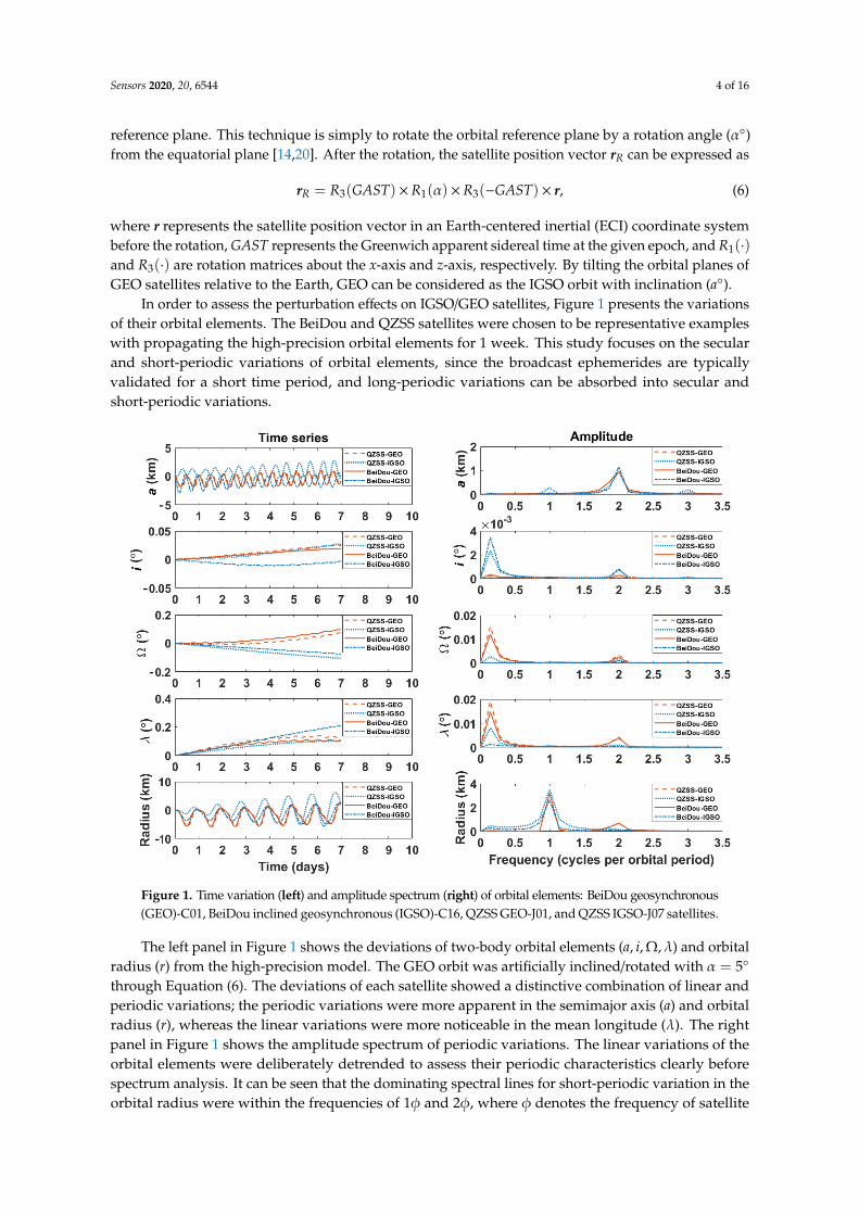
Figure 1. Time variation (left) and amplitude spectrum (right) of orbital elements: BeiDou geosynchronous (GEO)-C01, BeiDou inclined geosynchronous (IGSO)-C16, QZSS GEO-J01, and QZSS IGSO-J07 satellites.
The left panel in Figure 1 shows the deviations of two-body orbital elements ( , , , ) and orbital radius ( ) from the high-precision model. The GEO orbit was artificially inclined/rotated with = 5∘ through Equation (6). The deviations of each satellite showed a distinctive combination of linear and periodic variations; the periodic variations were more apparent in the semimajor axis ( ) and orbital radius ( ), whereas the linear variations were more noticeable in the mean longitude ( ). The right panel in Figure 1 shows the amplitude spectrum of periodic variations. The linear variations of the orbital elements were deliberately detrended to assess their periodic characteristics clearly before spectrum analysis. It can be seen that the dominating spectral lines for short-periodic variation in the orbital radius were within the frequencies of 1 and 2 , where denotes the frequency of satellite motion. The dominating spectral lines for short-periodic variation of other elements were centered in the frequencies of 2 and 3 . The short-periodic variations of orbital elements were
Figure 1. Time variation (left) and amplitude spectrum (right) of orbital elements: BeiDou geosynchronous(GEO)-C01, BeiDou inclined geosynchronous (IGSO)-C16, QZSS GEO-J01, and QZSS IGSO-J07 satellites.
The left panel in Figure 1 shows the deviations of two-body orbital elements (a, i, Ω,λ) and orbitalradius (r) from the high-precision model. The GEO orbit was artificially inclined/rotated with α = 5
through Equation (6). The deviations of each satellite showed a distinctive combination of linear andperiodic variations; the periodic variations were more apparent in the semimajor axis (a) and orbitalradius (r), whereas the linear variations were more noticeable in the mean longitude (λ). The rightpanel in Figure 1 shows the amplitude spectrum of periodic variations. The linear variations of theorbital elements were deliberately detrended to assess their periodic characteristics clearly beforespectrum analysis. It can be seen that the dominating spectral lines for short-periodic variation in theorbital radius were within the frequencies of 1φ and 2φ, where φ denotes the frequency of satellite

Sensors 2020, 20, 6544 5 of 16
motion. The dominating spectral lines for short-periodic variation of other elements were centered inthe frequencies of 2φ and 3φ. The short-periodic variations of orbital elements were mainly due tononspherical gravitational force and solar radiation pressure. Their effects were superimposed witheach other. Specifically, the short-term variations of (a, Ω,λ, r) were caused by the zonal terms of theEarth’s gravitational force and luni-solar attractions, and the short-term variations of (i) were caused bysolar radiation pressure. The detailed analysis on the periodic motion of orbital elements can be foundin the literature [19,21,22]. These analyses allowed us to design a user algorithm for reconstructingthe broadcast ephemeris by taking into account the dominant frequency and characteristics of orbitalelements for IGSO/GEO satellites.
2.2. Design of Broadcast Ephemeris Parameters
The six Keplerian elements are not enough to satisfy the accuracy requirement of navigationsatellites and, thus, additional correction terms are required to describe the linear and periodicvariations of orbital elements in general. The classical GPS LNAV ephemeris uses 16 parameters,including three linear correction terms and six periodic correction terms. For more accurate satellitepositioning, the GPS CNAV ephemeris was presented by adding the rate of semimajor axis and therate of mean motion to GPS LNAV [23].
This study aimed to design broadcast ephemeris parameters suited for IGSO/GEO satellites.Considering the compatibility and adaptability with other GNSS orbits, our proposed ephemeriswas designed on the basis of GPS LNAV ephemeris. By containing additional correction terms andnonsingular elements to GPS LNAV ephemeris, the variation of orbital elements could be moreaccurately described without singularity and without sacrificing URE performance. Table 1 shows thesix nonsingular elements and 38 additional correction terms used in this study.
Table 1. Parameters involved in the proposed algorithm. RAAN, right ascension of the ascending node.
Parameters Description
toe Ephemeris reference epoch
(a0,.a,
..a)
Semimajor axis at reference epoch and its first-order andsecond-order rates
(ex, ey) Two-dimensional components of eccentricity
(Ω0,.
Ω,..Ω)
RAAN at reference epoch, and its first-order andsecond-order rates
(i0,.i,
..i)
Inclination at reference time, and its first-order andsecond-order rates
(.u,
..u) The first-order and second-order rates of AOL
(.r,
..r) The first-order and second-order rates of orbital radius
∆n Mean motion difference from the calculated value at toe(
.n,
..n) The first-order and second-order rates of mean motionλ Mean argument of latitude
(Crc1, Crs1, Crc2, Crs2, Crc3, Crs3) Amplitude of the first, second, and third cosine and sineharmonic correction terms to the orbital radius
(Cuc1, Cus1, Cuc2, Cus2, Cuc3, Cus3) Amplitude of the first, second, and third cosine and sineharmonic correction terms to the AOL
(CΩc1, CΩs1, CΩc2, CΩs2, CΩc3, CΩs3) Amplitude of the first, second, and third cosine and sineharmonic correction terms to the RAAN
(Cic1, Cis1, Cic2, Cis2, Cic3, Cis3) Amplitude of the first, second, and third cosine and sineharmonic correction terms to the inclination
Through these parameters, the user algorithm for reconstructing the broadcast ephemeris couldcompute the satellite positions in ECEF as follows:
a(t) = (√
a0)2+
.a(t− toe) +
12
..a(t− toe)
2, (7)
Sensors 2020, 20, 6544 6 of 16
n(t) =√
µ
a3(t)+ ∆n +
.n(t− toe) +
12
..n(t− toe)
2, (8)
where toe is the reference epoch and µ denotes the gravitational parameter of the Earth. The eccentricity(ecc), mean anomaly (M0), and argument of perigee (ω0) at the reference epoch (toe) were convertedfrom the nonsingular elements as follows:
ecc =√
e2x + e2
y,ω0 = tan−1(ey/ex), M0 = λ0 −ω0. (9)
Mean anomaly (M), eccentric anomaly (E), and true anomaly (ν) could be computed as
M = M0 + n(t)(t− toe), (10)
E = M + eccsinE, (11)
ν = 2tan−1( √
1 + ecc√
1− ecctan
E2
). (12)
The periodic correction terms for the argument of latitude (u), orbital radius (r), inclination (i),and RAAN (Ω) were defined as
u(t) = u +.u(t− toe) +
12
..u(t− toe)
2 + Cus1sin(u) + Cuc1cos(u) + Cus2sin(2u)+Cuc2cos(2u) + Cus3sin(3u) + Cuc3cos(3u),
(13)
r(t) = r0 +.r(t− toe) +
12
..r(t− toe)
2 + Crs1sin(u) + Crc1cos(u) + Crs2sin(2u)+Crc2cos(2u) + Crs3sin(3u) + Crc3cos(3u),
(14)
i(t) = i0 +.i(t− toe) +
12
..i(t− toe)
2 + Cis1sin(u) + Cic1cos(u) + Cis2sin(2u)+Cic2cos(2u) + Cis3sin(3u) + Cic3cos(3u),
(15)
Ω(t) = Ω0 +.
Ω(t− toe) +12
..Ω(t− toe)
2 + CΩs1sin(u) + CΩc1cos(u)+CΩs2sin(2u)
+CΩc2cos(2u) + CΩs3sin(3u) + CΩc3cos(3u).(16)
The orbital radius (r0) and uncorrected argument of latitude (u) at the reference epoch wererespectively obtained as follows:
r0 = a(t)(1− eccE), (17)
u = ω0 + ν. (18)
Finally, the satellite position vector in the ECEF coordinate system was given by
→r ECEF = R3(−Ω(t) +ωe · (t− toe))R1(−i(t))
r(t)cosu(t)r(t)sinu(t)
0
, (19)
where ωe denotes the rotation rate of the Earth. For GEO satellites, the position vector (rR) after rotationshould be rotated back to the position vector (r) before rotation with rotation angle (−α) as follows:
r = R3(GAST) ×R1(−α) ×R3(−GAST) × rR. (20)
The above equations formed our user algorithm for generating parameter values for broadcastephemeris through least-squares curve fit. Algorithm 1 describes the step-by-step process of our useralgorithm. The computational complexity of this algorithm should be slightly higher than that of GPSLNAV algorithm.

Sensors 2020, 20, 6544 7 of 16
Algorithm 1: Procedures for Least-Square Curve Fit of Broadcast Ephemeris Parameters
01 Begin02 Set simulation period, fit interval, sample rate, and true position/velocity for SVs.
For GEO, the position vector should be rotated with rotation angle by Equation (6).
03Set initial guesses of broadcast ephemeris parameters for the least-square curve fit.Keplerian elements are converted into the nonsingular elements by Equation (4).
04 Main Simulation (User algorithm)05 For i = t0: t0 + fit interval06 Nonsingular elements are converted into Keplerian elements by Equation (5).07 The IGSO/GEO position vector at t(i) is computed through Equations (7)–(19).09 End for10 For GEO, the position vectors should be rotated back by Equation (20).
11Compute the fit accuracy of broadcast ephemerides through comparison with the trueposition at time interval.
The ephemeris parameters involved in the user algorithm were classified as compulsory andoptional ones, as shown in Table 2. The 16 compulsory parameters were similar to GPS LNAV ephemerisparameters. The 28 optional parameters were selected to precisely represent the dominant linear andperiodic variations of orbital elements. The parameter values of broadcast ephemeris were computedusing a least-squares curve fit as
Y = Y(X, t, toe) + ε, (21)
where ε represents the residual. Y denotes the vector of observation with time t, and X denotes theproposed 44 broadcast ephemeris parameters at toe. The partial derivative matrix H was as follows:
H =∂Y∂X
=
(∂Y∂√
a0· · ·
∂Y∂Cis3
). (22)
Table 2. Compulsory and optional parameters for broadcast ephemeris.
Attribute Compulsory Parameters Optional Parameter
Reference epoch toeOrbital elements (
√a, ex, ey, i, Ω,λ)
Secular-periodic correction (∆n,.i,
.Ω) (
.a,
.n,
.r,
.u,
..a,
..n,
..r,
..u,
..Ω,
..i)
Short-periodic correction (Cuc2, Cus2, Crc2,Crs2, Cic2, Cis2)
(Cuc3, Cus3, Cuc1, Cus1, Cic3, Cis3, Cic1, Cis1,Crc3, Crs3, Crs1,
Crs1,CΩc3, CΩS3, CΩc2, CΩS2, CΩc1, CΩS1)
Compared to GPS LNAV/CNAV ephemeris parameters, only three Keplerian elements (ecc,ω, M)were replaced with nonsingular elements in our proposed broadcast ephemeris parameters. With respectto the nonsingular elements, the partial derivatives of the satellite position vector in ECEF coordinateswere derived as follows:
∂rECEF∂ex
=(∂rECEF∂r
)(∂r∂ex
)= R3(ωe · (t− toe)) ·
(P · r + Q ·
.r)
∂rECEF∂ey
=(∂rECEF∂r
)(∂r∂ey
)= R3(ωe · (t− toe)) ·
(R · r + S ·
.r)
∂rECEF∂λ =
(∂rECEF∂r
)(∂r∂λ
)= R3(ωe · (t− toe)) ·
.rn ,
(23)
where the pair (r,.r) denotes the satellite position and velocity in ECI coordinates, respectively.
The coefficients (P, Q, R, and S) were given as follows:

Sensors 2020, 20, 6544 8 of 16
P = ap
[−(cosu + ex) −
rp
(sinu + ey
)(exsinu− eycosu
)]Q = ar
õp
[sinu +
aey√
1−ecc2
r(1+√
1−ecc2) + r
p
(sinu + ey
)]R = a
p
[(sinu + ey
)−
rp (cosu + ex)
(exsinu− eycosu
)]S = − ar
õp
[cosu + aex
√
1−ecc2
r(1+√
1−ecc2) + r
p (cosu + ex)
],
(24)
where p = a(1− ecc2
). The partial derivatives of other parameters could be derived from the user
algorithm [15,24,25]. Initial guesses for design variables are prerequisite in the iterative curve fit. In thisstudy, initial guesses were determined such that those for nonsingular elements were osculating orbitalelements and those for the other parameters were zero. Since computational memory is limited and theamplitudes of some parameters are negligibly small, the optimal parameter set of broadcast ephemerisshould be carefully determined. This study employed the experiment process in the literature [14,15] toconsider all possible parameter selections. The accuracy of broadcast ephemerides was determined bythe selected parameters. On the basis of 16 compulsory parameters, we selected one to four parametersfrom the optional group and then compared their fit accuracy. The terms in Equations (7)–(24) couldbe accepted or rejected according to the selected parameters. The optional group had 28 parametersconsisting of 10 linear terms and nine pairs of harmonic terms. The additional parameters were selectedwith the condition that sine and cosine harmonic terms should be selected as a pair. Table 3 summarizesthe number of possible sets of parameters. Among all possible parameter sets, the parameter setthat provided the minimum fit error was determined as the optimal broadcast ephemeris parameters.The fit performance of ephemerides was obtained in an Earth-centered inertial (ECI) coordinate systembecause the performance of curve-fitting could be affected by transformation into the ECEF frame [14].The associated results and analysis for possible parameter sets are discussed in Section 3.
Table 3. The number of possible parameter sets according to the number of additional parameters.
Case Descriptions Possible Parameter Sets
One additional parameter Linear terms 10C1 = 10
Two additional parameters Two linear termsOne pair of harmonic terms 10C2 + 9C1 = 54
Three additional parameters Three linear termsOne pair of harmonic terms plus one linear term 10C3 + 10C1× 9 = 210
Four additional parameters Four linear terms; two pairs of harmonic termsOne pair of harmonic terms plus two linear terms 10C4 9 = 651
3. Results and Analysis
This section is dedicated to analyzing the fit performance and selecting the set of optimalparameters in terms of accuracy and the number of parameters. The URE (user range error), which isuseful to measure the fit accuracy, is defined as a weighted average of the root-mean-square (RMS)errors for the three RTN components.
URE ,√
w2AR2 + w2
B,C(A2 + C2), (25)
where R , RMS(∆R), A , RMS(∆T), and C , RMS(∆N) are RMS errors of the radial, along-track,and cross-track components, respectively [26]. The pair weighted factors (wA, wB,C) depend on theorbital altitude. Referring to Montenbruck et al. [27], which addressed the proper values of weightedfactors for IGSO/GEO satellites of BeiDou, we set (wA, wB,C) = (0.99, 1/126).
3.1. Parameter Selection and Fit Accuracy
The accuracy of broadcast ephemeris is subject to orbit determination errors, propagation errors,and fit errors [28]. Only the fit error, which was evaluated by URE, was addressed in this study.

Sensors 2020, 20, 6544 9 of 16
The accuracy of least-square curve fit was analyzed in terms of fit interval and the number ofparameters. Chosen for accuracy analysis were four GEO (PRN: C01, C02, C04, C05) and six IGSO(PRN: C06, C07, C09, C10, C13, C16) satellites of BeiDou. The precise ephemerides determined fromthe pseudorange and carrier phase observables were used as true/reference values for statisticalanalysis. The simulation period was 24 h, starting at 00:00:00 GPST on the first day of the year 2019(31 December 2018, 23:59:42 UTC). The least-square curve fit was carried out with 2 and 3 h fit intervalswith a uniform sample rate of 300 s. Thus, for example, 12 fitting arcs were generated per day with a2 h fitting interval, and one arc contained 24 data points.
Tables 4 and 5 list some representative results of adding one to four parameters. Table 4 showsthe RMS of RTN component errors and the URE for PRN: C07 (or BeiDou-IGSO2). The best resultsamong the same number of parameter sets are shown in bold. Compared to the set of 16 compulsoryparameters, the second-order rates of radius (
..r) and semimajor axis (
..a) influenced the fit accuracy in
the radial and along-track but not cross-track directions. Similarly, in the case of adding two optionalparameters, the first and third orders of harmonic corrections to the argument of latitude (Cus, Cuc) andradius (Crs, Crc) affected the fit accuracy in the radial and along-track but not cross-track directions.However, the harmonic correction terms for RAAN had a significant effect on the fit accuracy ofcross-track direction in the sense that RMS errors of the cross-track direction with (CΩS3, CΩC3),(CΩS2, CΩC2), and (CΩS1, CΩC1) varied. The minimum fit errors in terms of URE were obtainedby adding (
.r,
..r). In the case of adding three and four parameters, it can be seen that the parameter
sets containing the first-order and/or second-order rates of radius and semimajor axis had higherperformance than the others. The optimal additions for 19- and 20- parameter sets were (
.a,
.r,
..r) and
(.r,
..r, Crs3, Crc3), respectively. In all the cases, the terms related to inclination and mean motion had
relatively small effects on the fit accuracy.
Table 4. Fit user range error (URE) and root-mean-square (RMS) fit errors in radial, along-track,and cross-track directions with 2 and 3 h fit intervals for IGSO satellite (BeiDou PRN: C07). The parts inbold represent the best fit URE for the same number of parameters.
Number ofParameters
AdditionalParameter
2 h Fit Interval (cm) 3 h Fit Interval (cm)
R A C URE R A C URE
16 - 0.794 6.161 2.603 0.987 1.154 7.304 3.014 1.34217 (
..r) 0.733 5.012 2.603 0.883 1.026 5.895 3.014 1.175
(..a) 0.790 5.013 2.603 0.930 1.125 5.892 3.014 1.260
18 (.r,
..r) 0.704 4.387 2.603 0.832 0.983 5.308 3.014 1.115
(Cus3, Cuc3) 0.753 4.401 2.603 0.874 1.060 5.338 3.014 1.183(CΩS2, CΩC2) 0.753 4.415 2.732 0.877 1.060 5.370 3.210 1.188(CΩS3, CΩC3) 0.752 4.402 2.432 0.869 1.059 5.339 2.773 1.177
(Crs1, Crc1) 0.765 4.389 2.603 0.883 1.069 5.309 3.014 1.190(CΩS1, CΩC1) 0.777 4.389 2.431 0.889 1.059 5.311 2.770 1.176
19 (Crs1, Crc1,.a) 0.579 4.388 2.603 0.732 0.818 5.308 3.014 0.975
(.a,
.r,
..r) 0.565 4.394 2.603 0.721 0.809 5.317 3.014 0.969
(.a,
.r,
..a) 0.607 4.392 2.603 0.753 0.857 5.315 3.014 1.008
(Cus1, Cuc1,.u) 0.633 4.393 2.603 0.774 0.841 5.319 3.014 0.995
(Cus1, Cuc1,.a) 0.626 4.396 2.603 0.769 0.861 5.321 3.014 1.012
(Cus1, Cuc1,.r) 0.594 4.387 2.603 0.743 0.817 5.308 3.014 0.975
20 (.r,
..r, Crs3, Crc3) 0.522 4.387 2.603 0.688 0.630 5.308 3.014 0.827
(.r,
..r, Cus1, Cuc1) 0.580 4.387 2.603 0.732 0.822 5.308 3.014 0.979
(..a,
..r, Crs1, Crc1) 0.598 4.384 2.603 0.746 0.825 5.302 3.014 0.981
(.a,
..r, Crs1, Crc1) 0.572 4.386 2.603 0.726 0.826 5.295 3.014 0.981
(.r,
..r, Crs1, Crc1) 0.576 4.387 2.603 0.729 0.792 5.308 3.014 0.954
(.r,
..a, Crs3, Crc3) 0.615 4.370 2.603 0.759 0.768 5.259 3.014 0.932

Sensors 2020, 20, 6544 10 of 16
Table 5. Fit URE and RMS fit errors in radial, along-track, and cross-track directions with 2 and 3 h fitintervals for GEO satellite (BeiDou PRN: C02). The parts in bold represent the best fit URE for the samenumber of parameters.
Number ofParameters
Additional Parameter2 h Fit Interval (cm) 3 h Fit Interval (cm)
R A C URE R A C URE
16 - 2.847 19.654 1.236 3.320 3.657 21.676 1.603 4.10617 (
.a) 2.595 16.580 1.235 2.965 3.396 19.657 1.598 3.793
(..a) 2.669 15.964 1.235 3.002 3.453 19.239 1.598 3.827
18 (Crs3, Crc3) 1.808 13.569 1.235 2.163 2.709 17.136 1.598 3.089(
.r,
..a) 2.130 13.500 1.235 2.430 2.999 17.010 1.598 3.337
(.a,
.r) 2.230 16.539 1.235 2.656 2.924 19.587 1.598 3.383
(..a,
..r) 2.243 15.934 1.235 2.638 2.811 19.148 1.598 3.267
(.u,
..r) 2.321 13.514 1.239 2.596 2.931 16.966 1.602 3.275
(CΩS1, CΩC1) 2.708 13.567 1.146 2.942 3.457 17.133 1.485 3.74919 (Crs3, Crc3,
..r) 1.706 13.569 1.235 2.080 2.326 17.134 1.598 2.766
(Crs3, Crc3,..a) 1.716 13.573 1.235 2.088 2.334 17.138 1.598 2.773
(Crs3, Crc3,.r) 1.719 13.569 1.235 2.091 2.326 17.134 1.598 2.766
(Crs3, Crc3,.a) 1.731 13.574 1.235 2.100 2.347 17.139 1.598 2.784
(.a,
.r,
..a) 2.117 13.502 1.235 2.419 2.747 17.029 1.598 3.117
(CΩS1, CΩC1,.r) 2.138 13.564 1.147 2.440 2.753 17.133 1.481 3.126
20 (.a,
..r, Crs3, Crc3) 1.757 13.372 1.235 2.111 3.821 16.492 1.598 4.061
(.r,
.r, Crs3, Crc3) 1.631 12.609 1.234 1.970 2.053 15.111 1.598 2.442
(.r,
..r, Crs3, Crc3) 1.707 13.569 1.235 2.081 2.318 17.134 1.598 2.760
(Cus3, Cuc3, Crs3, Crc3) 1.765 13.544 1.235 2.126 2.429 17.075 1.598 2.849(..a,
..r, Crs3, Crc3) 1.702 13.436 1.235 2.070 2.308 16.908 1.598 2.740
(Crs3, Crc3,CΩS3, CΩC3) 1.786 13.545 1.227 2.144 2.406 17.080 1.641 2.830
Table 5 lists the RMS of RTN components and the URE for PRN: C02 (or BeiDou-GEO6).Compared to the set of 16 compulsory parameters, the first-rate (
.a) and second-rate (
..a) terms of the
semimajor axis affected the fit accuracy in the radial and along-track but not cross-track directions.In the case of adding two optional parameters, unlike the fit results of IGSO in Table 4, the first-rate andsecond-rate terms of the semimajor axis and radius predominantly influenced the fit accuracy on radialand along-track directions. The optimal parameters turned out to be (Crs3, Crc3). In the cases of addingthree and four optional parameters, the minimum fit errors were achieved by adding (Crs3, Crc3,
..r) and
(.a,
.r, Crs3, Crc3), respectively. Similar to the fit results of IGSO, the fit errors in the cross-track direction
were still dependent on harmonic correction terms of RAAN, such as (CΩS1, CΩC1), (CΩS1,CΩC1,.r),
and (Crs3, Crc3,CΩS3, CΩC3). The correction terms for inclination and mean motions still had littleimpact on minimizing the URE. Tables 4 and 5 reveal the common additional parameters sets for bothIGSO and GEO to be (
..a), (CΩS1, CΩC1), (
.a,
.r,
..a), and (
.r,
..r, Crs3, Crc3). From the perspective of operating
GNSS, it should provide simplicity, uniformity, and compatibility of the user algorithm to use a soletype of broadcast ephemeris parameters. In this sense, we selected the common additional parameterswhich were not suited for either IGSO or GEO, but which were suited for both IGSO and GEO as theoptimal set of parameters. The numerical experiments and analyses showed that these parameter setswere effective and practical to minimize fit errors.
3.2. Analysis of Fit Accuracy
Figure 2 shows the relationship between URE and the number of parameters for differenttypes of orbit. It can be seen that UREs decreased clearly as the number of parameters increased.The URE of the 19-parameter set was significanlty reduced compared to that of the 16-parameter set.In particular, for GEOs and IGSO (RPN: C07), their URE reduction from 18 to 19 parameters wassteep. The improvement in the radial direction mainly caused URE reductions. This shows that theradial movements could be more accurately described by adding a few appropriate parameters inthe ephemeris. Since the URE reduction slope from 19 to 20 parameters was relatively small, it wasreasonable to choose a 19-parameter set for the optimal broadcast ephemeris.

Sensors 2020, 20, 6544 11 of 16Sensors 2020, 20, x FOR PEER REVIEW 11 of 16
(a) (b)
Figure 2. Fit URE for BeiDou IGSOs (PRN: C06, C07, and C16) and GEOs (PRN: C02, C04, and C05) vs. the number of parameters: (a) 2 h fit interval; (b) 3 h fit interval.
Figure 3 illustrates the relationship between the URE and the fit intervals. For both IGSO and GEO satellites, the increase in URE between the 5 and 6 h fit intervals was significant. A smaller number of parameters led to a steeper slope of the URE as the fit interval increased. The UREs for all parameter sets were less than 1.03 cm for IGSO and 3.00 cm for GEO with a 2 h fit interval. With a 6 h fit interval, the URE for the 17-parameter set skyrocketed from 2.7 to 12.3 cm for IGSO and from 11.5 to 18.8 cm for GEO. For the 20-parameter set, the URE was maintained at less than 2.4 cm for IGSO and less than 3.8 cm for GEO in all fit intervals.
(a) (b)
Figure 3. UREs vs. fit intervals: (a) BeiDou IGSO (PRN: C07); (b) BeiDou GEO (PRN C02).
The bit allocation to the ephemeris parameter and analysis of the range error due to truncation (RET) are worth being investigated in the practical design of navigation messages. Hence, the relationship between the total bits of the proposed ephemerides and range error of URE due to truncation is presented. The bit length could be obtained using the arithmetic relationship between scale factor and effective range. Through the variations of the scale factor value, the sensitivity
Figure 2. Fit URE for BeiDou IGSOs (PRN: C06, C07, and C16) and GEOs (PRN: C02, C04, and C05)vs. the number of parameters: (a) 2 h fit interval; (b) 3 h fit interval.
Figure 3 illustrates the relationship between the URE and the fit intervals. For both IGSO and GEOsatellites, the increase in URE between the 5 and 6 h fit intervals was significant. A smaller number ofparameters led to a steeper slope of the URE as the fit interval increased. The UREs for all parametersets were less than 1.03 cm for IGSO and 3.00 cm for GEO with a 2 h fit interval. With a 6 h fit interval,the URE for the 17-parameter set skyrocketed from 2.7 to 12.3 cm for IGSO and from 11.5 to 18.8 cm forGEO. For the 20-parameter set, the URE was maintained at less than 2.4 cm for IGSO and less than3.8 cm for GEO in all fit intervals.
Sensors 2020, 20, x FOR PEER REVIEW 11 of 16
(a) (b)
Figure 2. Fit URE for BeiDou IGSOs (PRN: C06, C07, and C16) and GEOs (PRN: C02, C04, and C05) vs. the number of parameters: (a) 2 h fit interval; (b) 3 h fit interval.
Figure 3 illustrates the relationship between the URE and the fit intervals. For both IGSO and GEO satellites, the increase in URE between the 5 and 6 h fit intervals was significant. A smaller number of parameters led to a steeper slope of the URE as the fit interval increased. The UREs for all parameter sets were less than 1.03 cm for IGSO and 3.00 cm for GEO with a 2 h fit interval. With a 6 h fit interval, the URE for the 17-parameter set skyrocketed from 2.7 to 12.3 cm for IGSO and from 11.5 to 18.8 cm for GEO. For the 20-parameter set, the URE was maintained at less than 2.4 cm for IGSO and less than 3.8 cm for GEO in all fit intervals.
(a) (b)
Figure 3. UREs vs. fit intervals: (a) BeiDou IGSO (PRN: C07); (b) BeiDou GEO (PRN C02).
The bit allocation to the ephemeris parameter and analysis of the range error due to truncation (RET) are worth being investigated in the practical design of navigation messages. Hence, the relationship between the total bits of the proposed ephemerides and range error of URE due to truncation is presented. The bit length could be obtained using the arithmetic relationship between scale factor and effective range. Through the variations of the scale factor value, the sensitivity
Figure 3. UREs vs. fit intervals: (a) BeiDou IGSO (PRN: C07); (b) BeiDou GEO (PRN C02).
The bit allocation to the ephemeris parameter and analysis of the range error due to truncation (RET)are worth being investigated in the practical design of navigation messages. Hence, the relationshipbetween the total bits of the proposed ephemerides and range error of URE due to truncation ispresented. The bit length could be obtained using the arithmetic relationship between scale factor andeffective range. Through the variations of the scale factor value, the sensitivity analysis of RET wasperformed to determine the least significant bits (LSBs) for the proposed ephemerides [2]. Figure 4

Sensors 2020, 20, 6544 12 of 16
shows the total bits for our proposed ephemerides according to RET. It indicates that their total bitswere higher than the classical BeiDou ephemeris with 371 bits [9]. As the total number of bits ofthe parameter sets decreased and reached a critical point, the RET increased exponentially. On theother hand, as the total number of bits of parameter sets increased beyond a critical point, the RETconverged gradually to a particular value. Between the 18- and 19-parameter sets, the increase in thetotal number of bits for obtaining the equivalent RET was more noticeable. Since the RET of the GPSLNAV is required to be less than 0.3 m, the LSBs of the proposed 17-, 18-, 19-, and 20-parameter setswere set such that RET was less than 0.3 m [2]. Their values were 390, 399, 441 and 472 bits, respectively.Note that the total number of bits of the 18-parameter set was lower than for GPS CNAV, i.e., 421 bitsfor 18 ephemeris parameters [29].
Sensors 2020, 20, x FOR PEER REVIEW 12 of 16
analysis of RET was performed to determine the least significant bits (LSBs) for the proposed ephemerides [2]. Figure 4 shows the total bits for our proposed ephemerides according to RET. It indicates that their total bits were higher than the classical BeiDou ephemeris with 371 bits [9]. As the total number of bits of the parameter sets decreased and reached a critical point, the RET increased exponentially. On the other hand, as the total number of bits of parameter sets increased beyond a critical point, the RET converged gradually to a particular value. Between the 18- and 19-parameter sets, the increase in the total number of bits for obtaining the equivalent RET was more noticeable. Since the RET of the GPS LNAV is required to be less than 0.3 m, the LSBs of the proposed 17-, 18-, 19-, and 20-parameter sets were set such that RET was less than 0.3 m [2]. Their values were 390, 399, 441 and 472 bits, respectively. Note that the total number of bits of the 18-parameter set was lower than for GPS CNAV, i.e., 421 bits for 18 ephemeris parameters [29].
Figure 4. Total bits vs. RET for different ephemeris parameter sets.
3.3. Comparison with Other Ephemerides
Our proposed broadcast ephemeris sets were compared with four different ones, including the conventional/well-known BeiDou ephemeris [9], GPS CNAV [23], and those proposed by Fu et al. [14]. Table 6 describes these ephemerides models in detail. A least-square curve fit was conducted with a 2 h fit interval and 300 s of sample rate for the IGSO/GEO satellites of BeiDou.
Table 6. Main differences in parameters and characteristics of competitive ephemeris models. GPS, global positioning system.
Ephemeris (No. of Parameters)
Reference Epoch
Orbital Elements
Secular Correction
Periodic Correction
BeiDou ephemeris ( ) Quasi-Kepler elements ( , , ) (Cus2, Cuc2, Crs2)
(16) (√ , , , , , ) (Crc2, Cis2, Cic2) GPS CNAV ( ) Quasi-Kepler elements ( , ) ( , , )
(Cus2, Cuc2, Crs2) (18) ( , , , , , ) (Crc2, Cis2, Cic2)
Fu et al. [14] 1 ( ) Quasi-Kepler elements ( , , )
( ΩS3, ΩC3, Crs2) (16) ( , , , , , ) (Crc2, Cus2, Cuc2)
Fu et al. [14] 2 ( ) Quasi-Kepler elements ( , , , )
( ΩS1, ΩC1, Crs2) (17) ( , , , , , ) (Crc2, Cus2, Cuc2)
Proposed set 1 ( ) Nonsingular elements ( ) ( , , )
(Cus2, Cuc2, Crs2) (17) ( , , , , , ) (Crc2, Cis2, Cic2)
Proposed set 2 ( ) Nonsingular elements ( , , )
( ΩS1, ΩC1, Cus2, Cuc2) (18) ( , , , , , ) (Crs2, Crc2, Cis2, Cic2)
Proposed set 3 ( ) Nonsingular elements ( , , ) ( , , )
(Cus2, Cuc2, Crs2) (19) ( , , , , , ) (Crc2, Cis2, Cic2)
Proposed set 4 ( ) Nonsingular elements ( , ) ( , , )
(Cus2, Cuc2, Crs3, Crc3) (20) ( , , , , , ) (Crs2, Crc2, Cis2, Cic2)
Figure 4. Total bits vs. RET for different ephemeris parameter sets.
3.3. Comparison with Other Ephemerides
Our proposed broadcast ephemeris sets were compared with four different ones, including theconventional/well-known BeiDou ephemeris [9], GPS CNAV [23], and those proposed by Fu et al. [14].Table 6 describes these ephemerides models in detail. A least-square curve fit was conducted with a2 h fit interval and 300 s of sample rate for the IGSO/GEO satellites of BeiDou.
Table 6. Main differences in parameters and characteristics of competitive ephemeris models.GPS, global positioning system.
Ephemeris(No. of Parameters)
ReferenceEpoch
OrbitalElements
SecularCorrection
PeriodicCorrection
BeiDou ephemeris(t0)
Quasi-Kepler elements (∆n,
.Ω,
.i) (Cus2, Cuc2, Crs2)
(16)(√
a, ecc, i0, Ω0,ω0, M0)
(Crc2, Cis2, Cic2)GPS CNAV
(t0)Quasi-Kepler elements
( .a,
.i)(
∆n, ∆.n, ∆
.Ω
) (Cus2, Cuc2, Crs2)(18) (∆a0, ecc, i0, Ω0,ω0, M0) (Crc2, Cis2, Cic2)
Fu et al. [14] 1(t0)
Quasi-Kepler elements ( .Ω,
.u,
.i) (CΩS3, CΩC3, Crs2)
(16)(√
a0, ecc0, i0, Ω0,ω0, M0)
(Crc2, Cus2, Cuc2)Fu et al. [14] 2
(t0)Quasi-Kepler elements ( .
Ω,.u,
.r,
.i) (CΩS1, CΩC1, Crs2)
(17)(√
a0, ecc0, i0, Ω0,ω0, M0)
(Crc2, Cus2, Cuc2)

Sensors 2020, 20, 6544 13 of 16
Table 6. Cont.
Ephemeris(No. of Parameters)
ReferenceEpoch
OrbitalElements
SecularCorrection
PeriodicCorrection
Proposed set 1(t0)
Nonsingular elements(..a)(
∆n,.
Ω,.i) (Cus2, Cuc2, Crs2)
(17)(√
a0, ex, ey, i0, Ω0,λ0)
(Crc2, Cis2, Cic2)Proposed set 2
(t0)Nonsingular elements (
∆n,.
Ω,.i) (CΩS1, CΩC1, Cus2, Cuc2)
(18)(√
a0, ex, ey, i0, Ω0,λ0)
(Crs2, Crc2, Cis2, Cic2)Proposed set 3
(t0)Nonsingular elements
( .a,
..a,
.r)(
∆n,.
Ω,.i) (Cus2, Cuc2, Crs2)
(19)(√
a0, ex, ey, i0, Ω0,λ0)
(Crc2, Cis2, Cic2)Proposed set 4
(t0)Nonsingular elements
( .r,
..r)(
∆n,.
Ω,.i) (Cus2, Cuc2, Crs3, Crc3)
(20)(√
a0, ex, ey, i0, Ω0,λ0)
(Crs2, Crc2, Cis2, Cic2)
Table 7 summarizes the fit UREs for each satellite and their RMS. Compared to the classicalBeiDou ephemeris, our proposed parameter sets 1–4 composed of 17–20 parameters showed betterURE performance for all satellites. Their RMS values of UREs were 6.27%, 7.58%, 23.8%, and 34.5%smaller than those of the classical BeiDou ephemeris; the UREs could be significantly improved byadding a few ephemeris parameters. Even when compared with other models, our proposed parametersets showed competitive fit performance. GPS CNAV and the proposed parameter set 2 had thesame number of ephemeris parameters, but the difference in the RMS value of UREs was 0.532 cm.The proposed parameter set 2 showed 21% better fit accuracy than GPS CNAV. Fu et al. [14] 2 andthe proposed parameter set 1 had an identical (17) number of parameters, but their compositionof parameters was different, as was the contribution of each parameter in describing the orbitalperturbation. The maximum and minimum UREs for Fu et al. [14] 2 were, respectively, 3.934 and0.599 cm for BeiDou satellites, while the maximum and minimum UREs for the proposed parameterset 1 were 3.271 and 0.572 cm, respectively.
Table 7. UREs and their RMS values for difference ephemeris models.
Ephemeris ModelBeiDou GEO UREs (cm) BeiDou IGSO UREs (cm) RMS
C01 C02 C04 C05 C06 C07 C09 C10 C13 C16 (cm)
BeiDou ephemeris 2.477 3.296 3.341 3.136 0.833 0.943 0.832 0.630 0.704 0.785 2.057GPS CNAV 2.373 3.138 3.991 3.835 1.204 1.683 1.127 1.933 1.682 1.029 2.433
Fu et al. [14] 1 2.328 3.100 3.287 3.068 0.884 0.922 0.751 0.637 0.679 0.828 2.009Fu et al. [14] 2 1.927 2.929 3.001 3.934 0.830 0.830 0.823 0.599 0.748 0.794 1.975Proposed set 1 2.318 3.002 3.271 2.953 0.786 0.930 0.768 0.572 0.649 0.738 1.928Proposed set 2 2.300 2.942 3.267 2.931 0.739 0.889 0.706 0.531 0.567 0.696 1.901Proposed set 3 1.881 2.419 2.616 2.372 0.727 0.753 0.710 0.499 0.586 0.687 1.566Proposed set 4 1.594 2.080 2.160 2.007 0.692 0.688 0.709 0.522 0.586 0.695 1.346
3.4. Broacast Ephemeris Fit for QZSS
Our proposed ephemeris parameter sets 1–4 were also tested with three QZSS IGSOs (PRN J01-03)and one QZSS GEO (PRN: J07). QZSS observation data were used as the true/reference values forcomparison. The period was from 31 December 2018, 23:59:42 UTC to 1 January 2019, 23:59:42 UTC.
The least-square curve fit was performed with a 2 h fit interval and 300 s of sample rate. QZSS GEOsatellite (PRN: J07) was positioned nearby 127 east (E), while BeiDou GEO satellites (PRN: C01-C05)were distributed nearby 140, 80, 110.5, 160, and 58.75 E [30,31]. Figure 5 shows the fit errors ofRTN components and UREs for our proposed ephemeris 1–4 composed of 17-20 parameters.
For IGSO satellites, our parameter sets 1–4 ensured that RMS errors of R/T/N componentswere less than 8.9/10.1/1.72 cm for J01, 3.0/5.9/5.3 cm for J02, and 3.0/7.0/4.3 cm for J03. For GEOsatellites, our parameter sets 1–4 achieved RMS errors of R/T/N components less than 0.2/7.2/0.54 cm.Unlike BeiDou, as the number of ephemeris parameters increased from 17 to 20, decreases in fit errorswere not clearly observed. The URE of conventional QZSS ephemeris (GPS LNAV) is 8.9 cm [10].Our proposed ephemeris parameter sets 1–4 achieved fit UREs of 8.9, 8.8, 8.7 and 6.9 cm, respectively.
Sensors 2020, 20, 6544 14 of 16
Sensors 2020, 20, x FOR PEER REVIEW 14 of 16
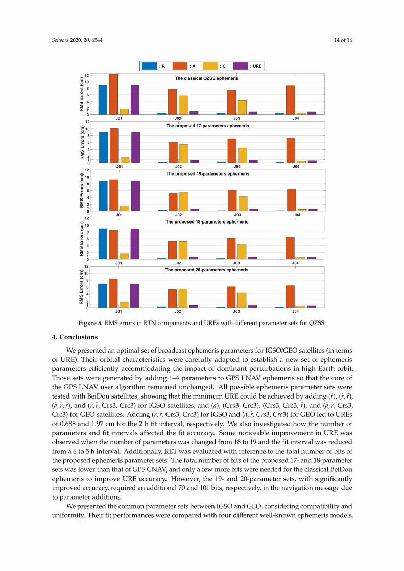
Figure 5. RMS errors in RTN components and UREs with different parameter sets for QZSS.
For IGSO satellites, our parameter sets 1–4 ensured that RMS errors of R/T/N components were less than 8.9/10.1/1.72 cm for J01, 3.0/5.9/5.3 cm for J02, and 3.0/7.0/4.3 cm for J03. For GEO satellites, our parameter sets 1–4 achieved RMS errors of R/T/N components less than 0.2/7.2/0.54 cm. Unlike BeiDou, as the number of ephemeris parameters increased from 17 to 20, decreases in fit errors were not clearly observed. The URE of conventional QZSS ephemeris (GPS LNAV) is 8.9 cm [10]. Our proposed ephemeris parameter sets 1–4 achieved fit UREs of 8.9, 8.8, 8.7 and 6.9 cm, respectively.
4. Conclusions
We presented an optimal set of broadcast ephemeris parameters for IGSO/GEO satellites (in terms of URE). Their orbital characteristics were carefully adapted to establish a new set of ephemeris parameters efficiently accommodating the impact of dominant perturbations in high Earth orbit. Those sets were generated by adding 1–4 parameters to GPS LNAV ephemeris so that the core of the GPS LNAV user algorithm remained unchanged. All possible ephemeris parameter sets were tested with BeiDou satellites, showing that the minimum URE could be achieved by adding ( ), ( , ), ( , , ), and ( , , Crs3, Crc3) for IGSO satellites, and ( ), (Crs3, Crc3), (Crs3, Crc3, ), and ( , , Crs3, Crc3) for GEO satellites. Adding ( , , Crs3, Crc3) for IGSO and ( , , Crs3, Crc3) for GEO led to UREs of 0.688 and 1.97 cm for the 2 h fit interval, respectively. We also investigated how the number of parameters and fit intervals affected the fit accuracy. Some noticeable improvement in URE was observed when the number of parameters was changed from 18 to 19 and the fit interval was reduced from a 6 to 5 h interval. Additionally, RET was evaluated with reference to the total number of bits of the proposed ephemeris parameter sets. The total number of bits of the proposed 17- and 18-parameter sets was lower than that of GPS CNAV, and only a few more bits were needed for the classical BeiDou
Figure 5. RMS errors in RTN components and UREs with different parameter sets for QZSS.
4. Conclusions
We presented an optimal set of broadcast ephemeris parameters for IGSO/GEO satellites (in termsof URE). Their orbital characteristics were carefully adapted to establish a new set of ephemerisparameters efficiently accommodating the impact of dominant perturbations in high Earth orbit.Those sets were generated by adding 1–4 parameters to GPS LNAV ephemeris so that the core ofthe GPS LNAV user algorithm remained unchanged. All possible ephemeris parameter sets weretested with BeiDou satellites, showing that the minimum URE could be achieved by adding (
..r), (
.r,
..r),
(.a,
.r,
..r), and (
.r,
..r, Crs3, Crc3) for IGSO satellites, and (
.a), (Crs3, Crc3), (Crs3, Crc3,
..r), and (
.a,
.r, Crs3,
Crc3) for GEO satellites. Adding (.r,
..r, Crs3, Crc3) for IGSO and (
.a,
.r, Crs3, Crc3) for GEO led to UREs
of 0.688 and 1.97 cm for the 2 h fit interval, respectively. We also investigated how the number ofparameters and fit intervals affected the fit accuracy. Some noticeable improvement in URE wasobserved when the number of parameters was changed from 18 to 19 and the fit interval was reducedfrom a 6 to 5 h interval. Additionally, RET was evaluated with reference to the total number of bits ofthe proposed ephemeris parameter sets. The total number of bits of the proposed 17- and 18-parametersets was lower than that of GPS CNAV, and only a few more bits were needed for the classical BeiDouephemeris to improve URE accuracy. However, the 19- and 20-parameter sets, with significantlyimproved accuracy, required an additional 70 and 101 bits, respectively, in the navigation message dueto parameter additions.
We presented the common parameter sets between IGSO and GEO, considering compatibility anduniformity. Their fit performances were compared with four different well-known ephemeris models.

Sensors 2020, 20, 6544 15 of 16
Statistical results showed that our proposed parameter sets achieved a minimum RMS of UREs of1.928 cm for the 17-parameter set and 1.346 cm for the 20-parameter set, representing roughly 6.27%and 34.5% improvements. The proposed ephemerides were also validated with four QZSS satellitesfor generality. Although empirically analyzed, our proposed ephemerides were effective in termsof fit capability of the IGSO and GEO satellites and the avoidance of singularities caused by smalleccentricity/inclination. It is natural and straightforward to extend its applicability to other GNSScomposed of IGSO/GEO satellites.
Author Contributions: J.H.C., G.K., D.W.L. and C.P. conceptualized and designed the experiments; J.H.C., G.K.,D.W.L. and C.P. performed the experiments, analyzed the data, and generated the figures; J.H.C. wrote the paper;J.H.C., G.K., D.W.L. and C.P. reviewed the paper. All authors have read and agreed to the published version ofthe manuscript.
Funding: This research was supported by a grant from the “Fundamental Research for Korea Satellite NavigationSystem and Future Air Traffic Management” of the Korea Aerospace Research Institute funded by the Koreagovernment (MSIT). This research was also supported by the Basic Science Research Program through the NationalResearch Foundation of Korea (NRF) funded by the Ministry of Education (2018R1D1A1B07045759). The firstauthor acknowledges partial support from the Graduate School of YONSEI University Research ScholarshipGrants in the years 2018 and 2020.
Conflicts of Interest: The authors declare no conflict of interest.
References
1. Montenbruck, O.; Hauschild, A.; Steigenberger, P.; Hugentobler, U.; Teunissen, P.; Nakamura, S.Initial assessment of the COMPASS/BeiDou-2 regional navigation satellite system. GPS Solut. 2012, 17,211–222. [CrossRef]
2. Wang, L.X.; Huang, Z.G.; Zhao, Y. Navigation message designing with high accuracy for NAV.Chin. J. Aeronaut. 2014, 27, 994–1001. [CrossRef]
3. Lv, Y.; Geng, T.; Zhao, Q.; Xie, X.; Zhou, R. Initial assessment of BDS-3 preliminary system signal-in-spacerange error. GPS Solut. 2020, 24, 16. [CrossRef]
4. Heng, L.; Gao, G.; Walter, T.; Enge, P. Statistical characterization of GLONASS broadcast ephemeris errors.In Proceedings of the 24th International Technical Meeting of the Satellite Division of the Institute ofNavigation (ION GNSS 2011), Portland, OR, USA, 19–23 September 2011; pp. 3109–3117.
5. Roy, A.E. Orbital Motion; John Wiley & Sons: New York, NY, USA, 1988; pp. 234–241.6. Xu, G.; Xu, J. On the singularity problem in orbital mechanics. Month. Not. Royal Astronom. Soc. 2013, 429,
1139–1148. [CrossRef]7. Cohen, C.J.; Hubbard, E.C. A Nonsingular Set of Orbital Elements. Astronom. J. 1962, 67, 10–15. [CrossRef]8. European Union 2016, Signal-In-Space Interface Control Document, OS SIS ICD, Issue 1.3, 2016. Available
online: https://www.gsc-europa.eu/sites/default/files/sites/all/files/Galileo-OS-SIS-ICD.pdf (accessed on27 August 2020).
9. BeiDou ICD. BeiDou Navigation Satellite System Signal in Space Interface Control Document Open ServiceSignal B3I (Version 1.0). 2018. Available online: http://en.beidou.gov.cn/beidoupolicy.html (accessed on24 July 2020).
10. Cabinet Office, Quasi-Zenith Satellite System Services Inc. Quasi-Zenith Satellite System InterfaceSpecification Satellite Positioning, Navigation and Timing Service (IS-QZSS-PNT-003). 2018. Available online:https://qzss.go.jp/en/technical/ps-is-qzss/ps-is-qzss.html (accessed on 24 July 2020).
11. Montenbruck, O.; Steigenberger, P.; Riley, S. IRNSS orbit determination and broadcast ephemeris assessment.Inst. Navig. Int. Tech. Meet. 2015, 2015, 185–193. [CrossRef]
12. Qin, Z.; Huang, G.; Zhang, Q.; Wang, L.; Yan, X.; Kang, Y.; Wang, X.; Xie, S. A Method to Determine BeiDouGEO/IGSO Orbital Maneuver Time Periods. Sensors 2019, 19, 2675. [CrossRef]
13. Keyvani, F.; Torabi, S.H. Design and Simulation of Regional Navigation Constellation with Optimized MeanDOP based on Hybrid GEO and IGSO Satellites. Int. J. Aviation Aeronaut. Aerospace 2019, 6, 2. [CrossRef]
14. Fu, X.; Wu, M. Optimal design of broadcast ephemeris parameters for a navigation satellite system. GPS Solut.2011, 16, 439–448. [CrossRef]

Sensors 2020, 20, 6544 16 of 16
15. Xie, X.; Geng, T.; Zhao, Q.; Liu, X.; Zhang, Q.; Liu, J. Design and validation of broadcast ephemeris for lowEarth orbit satellites. GPS Solut. 2018, 22, 54. [CrossRef]
16. Du, L.; Zhang, Z.; Zhang, J.; Liu, L.; Guo, R.; He, F. An 18-element GEO broadcast ephemeris based onnon-singular elements. GPS Solut. 2014, 19, 49–59. [CrossRef]
17. Xiaogang, X.; Mingquan, L. Broadcast Ephemeris Model of the BeiDou Navigation Satellite System. JESTR.2017, 10, 10–65. [CrossRef]
18. Der, G.J.; Danchick, R. Conversion of Osculating Orbital Elements to Mean Orbital Elements, Flight Dynamics.In Proceedings of the Flight Mechanics/Estimation Theory Symposium 1996, San Diego, CA, USA,29–31 July 1996; pp. 317–331.
19. Dong, X.; Hu, C.; Long, T.; Li, Y. Numerical Analysis of Orbital Perturbation Effects on InclinedGeosynchronous SAR. Sensors 2016, 16, 1420. [CrossRef] [PubMed]
20. Montenbruck, O.; Steigenberger, P. The BeiDou Navigation Message. In Proceedings of the IGNSS Symposium2013, Outrigger Gold Coast, Australia, 16–18 July 2013; Available online: https://elib.dlr.de/87748/ (accessed on16 November 2020).
21. Li, H. Geostationary Satellites Collocation; Springer: Berlin, Germany, 2014; pp. 99–195.22. Jiang, M.; Hu, W.; Ding, C.; Liu, G. The effects of orbital perturbation on geosynchronous synthetic aperture
radar imaging. IEEE Geosci. Remote Sens. Lett. 2015, 12, 1106–1110. [CrossRef]23. Kaplan, E.D.; Leva, J.L.; Milbert, D.; Pavloff, M.S. Global Positioning System. In Understanding GPS—Principles
and Applications, 2nd ed.; Kaplan, E.D., Hegarty, C.J., Eds.; Artech House: Boston, MA, USA, 2006; pp. 180–183.24. Xing, Z.; Wang, X. Method of calculation numerical derivative of Jacobin matrix for fitting algorithm of GPS
broadcast ephemeris parameters. GNSS World China 2012, 37, 28–31.25. Xie, X.; Zeng, D.; Long, T.; Zang, L. An improved ephemeris algorithm of Beidou GEO satellite for user.
J. Nat. Uni. Defense Technol. 2014, 1, 15.26. Ouyang, C.; Shi, J.; Shen, Y.; Li, L. Six-Year BDS-2 Broadcast Navigation Message Analysis from 2013 to 2018:
Availability, Anomaly, and SIS UREs Assessment. Sensors 2019, 19, 2767. [CrossRef]27. Montenbruck, O.; Steigenberger, P.; Hauschild, A. Broadcast versus precise ephemerides: A multi-GNSS
perspective. GPS Solut. 2015, 19, 321–333. [CrossRef]28. Oh, H.; Park, E.; Lim, H.-C.; Park, C. Orbit Determination of Korean GEO Satellite Using Single SLR Sensor.
Sensors 2018, 18, 2847. [CrossRef]29. Anghileri, M.; Paonni, M.; Fontanella, D.; Eissfeller, B. Assessing GNSS Data Message Performance A New
Approach. Inside GNSS 2013, 60–70.30. Xie, W.; Huang, G.; Cui, B.; Li, P.; Cao, Y.; Wang, H.; Chen, Z.; Shao, B. Characteristics and Performance
Evaluation of QZSS Onboard Satellite Clocks. Sensors 2019, 19, 5147. [CrossRef] [PubMed]31. Chen, H.; Huang, Y.; Chiang, K.; Yang, M.; Rau, R. The performance comparison between GPS and
BeiDou-2/compass: A perspective from Asia. J. Chin. Inst. Eng. 2009, 32, 679–689. [CrossRef]
Publisher’s Note: MDPI stays neutral with regard to jurisdictional claims in published maps and institutionalaffiliations.
© 2020 by the authors. Licensee MDPI, Basel, Switzerland. This article is an open accessarticle distributed under the terms and conditions of the Creative Commons Attribution(CC BY) license (http://creativecommons.org/licenses/by/4.0/).