
StreetPro Australia v2019.02 Product Guide - Pitney Bowes
98
pitney bowes 0 StreetPro Australia ® 2019.02 Product Guide
-
Upload
khangminh22 -
Category
Documents
-
view
3 -
download
0
Transcript of StreetPro Australia v2019.02 Product Guide - Pitney Bowes

pitney bowes 0
StreetPro Australia®
2019.02
Product Guide

s.com/au
a.com.au
tom.com
Disclaimers, Copyrights and Acknowledgements Information in this document is subject to change without notice and does not represent a commitment on the part of the vendor or itsrepresentatives. No part of this document may be reproduced or transmitted in any form or by any means, electronic or mechanical, including photocopying, without the written permission of Pitney Bowes, Asia-Pac Headquarters, Suite 1, Level 1, 68 Waterloo Road, Macquarie Park NSW 2113, Australia.
The software and data described by this document is furnished under a license agreement, and may be used or copied only in accordance with the terms of that agreement. Copies of the software and data are only permitted for backup purposes.
© 2019 Pitney Bowes Inc. All rights reserved.
Adobe Acrobat® is a registered trademark of Adobe Systems Incorporated in the United States
Other products named herein may be trademarks of their respective manufacturers and are hereby recognized. Trademarked names areused editorially, to the benefit of the trademark owner, with no intent to infringe on the trademark.
Data Sources and Output Acknowledgements Please find below relative copyright/disclaimer material for the data suppliers. You must ensure, pursuant to the End User License Agreement, that you include the information, and any associated logo, on any data output generated from this product.
StreetPro © 2019 Pitney Bowes Inc. All rights reserved. http://www.pitneybowePitney Bowes Software Inc. is the largest distributor of digital spatial dataproducts in Australia. By nurturing solid relationships with PSMA Australia, State/Territory jurisdictions and its significant customer base, Pitney Bowes Pty Ltd is able to offer cost effective digital data products that meet the current and future needs of the Australian marketplace. This quality spatial data product has been compiled from field capture surveys and with the assistance of content suppliers like those referenced below.
Transport and Topography and G-NAF® © 2019 PSMA Australia Pty http://www.psmLtd. All rights reserved.
PSMA Australia's Transport and Topography data covers the whole ofAustralia and consists of three themes: Transport,Hydrology andGreenspace. It is underpinned by a road centerline layer of over two millionkilometres of roads, together with more than 30 feature types within the Transport, Hydrology and Greenspace themes.
G-NAF® (Geocoded National Address File) is Australia's first authoritative geocoded address index for the whole country, listing all valid physical addresses in Australia. Data used to build G-NAF® comes from contributors that include the Australian Electoral Commission, Australia Post, state, territory and Australian Government mapping agencies andland registries. PSMA Australia does not warrant the accuracy or completeness of information in this publication and any person using or relying upon such information does so on the basis that PSMA Australia shall bear no responsibility or liability whatsoever for any errors, faults, defects or omissions in the information.
http://www.tom
© 2006-2019 TomTom. All rights reserved.
This material is proprietary and the subject of copyright protection,database right protection and other intellectual property rights owned by TomTom or its suppliers. The use of this material is subject to the terms of a license agreement. Any unauthorized copying or disclosure of this material will lead to criminal and civil liabilities.

.au/home
© State of Queensland (Department of Natural Resources, Mines and https://www.dnrme.qld.govEnergy (DNRME)) 2019.
The Queensland State Government Department of Natural Resources, Mines and Energy is the government department responsible for managingand regulating mining, land and water resources within Queensland. The Digital Cadastre Database (DCDB) is the spatial representation of the property boundaries in Queensland, and their related property descriptions. It is a fundamental reference layer for spatial informationsystems in Queensland. Despite Department of Natural Resources, Mines and Energy (DNRME)'s best efforts, DNRME makes no representations or warranties in relation to the Information, and, to the extent permitted by law, exclude or limit all warranties relating to correctness, accuracy,reliability, completeness or currency and all liability for any direct, indirect and consequential costs, losses, damages and expenses incurred in any way (including but not limited to that arising from negligence) in connectionwith any use of or reliance on the Information.
Feedback Pitney Bowes welcomes your comments and suggestions. For further details, refer to Data Support and Feedback.


Table of Contents
1 - Introduction 6
Product Overview 7 The StreetPro Family - Compared 7
StreetPro Navigation 7 StreetPro Classic 8 StreetPro Display 8
Product Range Summary Table 8 Conventions Used in this Guide 9
Country and State Abbreviations 9 Hyperlinks 9
2 - Getting Started 10
Installing StreetPro 11 The StreetPro Workspaces 11
Workspaces 12
3 - Layer Descriptions 13
Streets 14 Street Name Convention 15
Feature Codes and Display Characteristics - StreetPro Navigation, StreetPro Classic, and StreetPro Display 15 Labeling 20 Address Ranges 20 Vehicle Restrictions and Speed Profiles 29
Incremental Streets 31 Display Streets 32 Nodes 34 Street Intersections 36 Turn Restrictions 39 Highways and Main Roads 40 Railways and Railway Stations 45 Localities 47 Display Localities 49 Features 50
Landmarks 52 Parks, Forests and Reserves 53 Major Parks Layer 55 Landuse 56 Drainage 59 Major Rivers 63 Bridges and Crossings 64 Airports 65 Landmass and Ocean 67 Built-up Areas 70
4 - System Information 72
Metadata 73 Pitney Bowes Unique Feature Identifier (UFI) 73 micode Schema 73 StreetPro Projection / Datum 73 The StreetPro Change Log and Incremental Tables 74
A - Street Address Conventions 75
The Address Ranges and Address Points Models visually compared 76
B - Street Naming Conventions 79
List of StreetPro Street Types that are Abbreviated 81
C - Features layer (RRR_FT) miCodes and Sources 83
Features layer (RRR_FT) miCodes 84 Sources 94
Pitney Bowes 4 March 2019

StreetPro Australia 2019.02 Product Guide
D - Data Support and Feedback 96
Feedback Process 96
Pitney Bowes 5 March 2019

1
1 – IntroductionWelcome to the StreetPro Australia Product Guide. This document is intended to assist you in gaining maximum benefit from StreetPro Australia, by describing installation procedures and providing a detailed insight into the datasets and associated files that make up the product.
Pitney Bowes strives to be responsive to the evolving and growing utility of this data product within numerous and wide-ranging types of organisations. We therefore encourage any feedback and suggestions that will assist us in developing the best possible dataset for your business requirements (refer to Data Support and Feedback).
In this Chapter
Product Overview 7

StreetPro Australia 2019.02 Product Guide
Product Overview
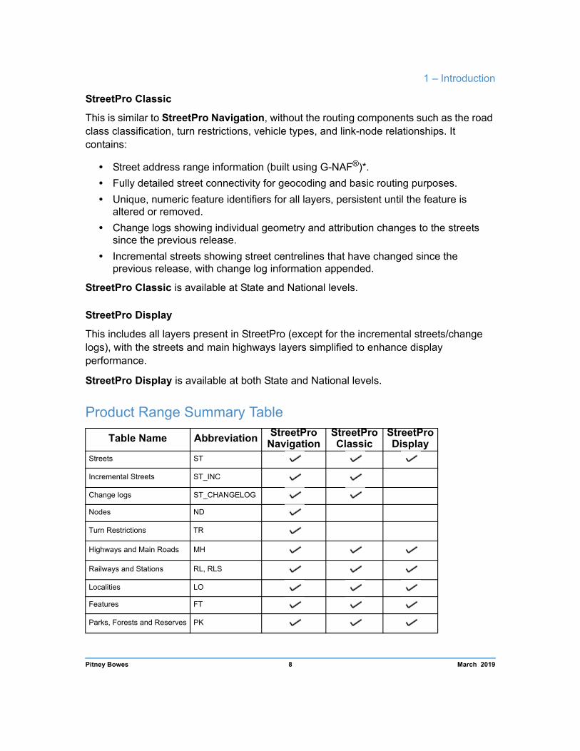
The StreetPro Family - Compared The StreetPro family consists of four related products. The sections below describe each of the products in turn, and the table overleaf (Product Range Summary Table) gives you an overall snapshot of which features are available in each of the different products.
StreetPro Navigation
This is the most comprehensive version of the product suite, offering a high performance network for routing, in-car navigation, and logistics needs, including:
• Street address range information (built using G-NAF®)*. • Fully detailed street connectivity of “routable” roads for geocoding and routing
purposes. • A nodes table with unique identifiers representing the start and end locations of
every street segment, and a valence field showing how many street segments connect to each node.
• Turn restrictions representing routing constraints (e.g. “No Right Turn”). • Road classifications based on a combination of road type and toll. • Unique, numeric feature identifiers for all layers that persist for the life of the
feature. • Change logs showing individual geometry, attribution and navigation changes to the
streets since the previous release. • Incremental streets showing street centrelines that have changed since the
previous release, with change log information appended.
StreetPro Navigation is available at both State and National levels.
StreetPro Navigation Premium contains all the content of StreetPro Navigation, plus:
• Vehicle Restriction information (Height, weight, and width limits) • TomTom's Speed Profile information
*. It should be noted that, whilst the address ranges within the StreetPro suite of products are built using G-NAF®, any geocodes generated will be by interpolation of addresses ranges and will not correspond to the precise G-NAF® geocode for the same address. Refer to Street Address Conventions.
Pitney Bowes 7 March 2019
1 – Introduction
StreetPro Classic
This is similar to StreetPro Navigation, without the routing components such as the road class classification, turn restrictions, vehicle types, and link-node relationships. It contains:
• Street address range information (built using G-NAF®)*. • Fully detailed street connectivity for geocoding and basic routing purposes. • Unique, numeric feature identifiers for all layers, persistent until the feature is
altered or removed. • Change logs showing individual geometry and attribution changes to the streets
since the previous release. • Incremental streets showing street centrelines that have changed since the
previous release, with change log information appended.
StreetPro Classic is available at State and National levels.
StreetPro Display
This includes all layers present in StreetPro (except for the incremental streets/change logs), with the streets and main highways layers simplified to enhance display performance.
StreetPro Display is available at both State and National levels.
Product Range Summary Table
Table Name Abbreviation StreetPro Navigation
StreetPro Classic
StreetPro Display
Streets ST
Incremental Streets ST_INC
Change logs ST_CHANGELOG
Nodes ND
Turn Restrictions TR
Highways and Main Roads MH
Railways and Stations RL, RLS
Localities LO
Features FT
Parks, Forests and Reserves PK
Pitney Bowes 8 March 2019

StreetPro Australia 2019.02 Product Guide
Table Name Abbreviation StreetPro Navigation
StreetPro Classic
StreetPro Display
Land Use LU
Drainage DR
Major Rivers RV
Bridges and Crossings BR
Airports AIR
Landmass and Ocean LM, OC
Built-up Areas BUA
Conventions Used in this Guide
Country and State Abbreviations
The filenames on the supplied media will depend upon the product purchased. Throughout this guide, the following conventions are used:
RRR The three-letter city, state or national abbreviation used to prefix filenames for files containing regional data.
SSS The three-letter state or national abbreviation used to prefix filenames for files containing background features.
Hyperlinks
If you are viewing this guide using Adobe Acrobat, you can click on blue underlined text to jump to related information, such as bookmarks and external websites.
Pitney Bowes 9 March 2019

2
2 – Getting StartedThis chapter provides you with instructions for installing the data, describes useful additional files in the Extras folder and explains how to open the supplied workspaces using MapInfo Professional.
In this Chapter
Installing StreetPro 11
The StreetPro Workspaces 11

StreetPro Australia 2019.02 Product Guide
Installing StreetPro StreetPro Navigation, StreetPro Classic, and StreetPro Display are supplied as compressed files and must be installed onto a hard drive before use.
Before installing the product, ensure that there is enough storage space for the data. The recommended free disk space required to install StreetPro Navigation Australia is 18 GB, and less for Classic and Display. The individual states disk space requirements are detailed during the install process.
To install standard StreetPro products, run the downloaded installer.exe file or insert the physical media into the disk drive. The setup program should start automatically and a series of prompts will guide you through the installation. Ensure that all license agreements are read and understood before installing the data.
Customized versions of StreetPro are not usually packaged in an installer. Instead, flat files are supplied in a compressed format and can be opened directly after download or from physical media.
If you intend using StreetPro data across a network, ensure that the correct licensing agreements have been made. For more information regarding these licensing agreements, contact your local Pitney Bowes office or reseller.
The StreetPro Workspaces A workspace enables you to store layer and window settings of a session within MapInfo Professional. These settings include map layer display parameters such as object style and zoom layering, layer order, object labelling, and map view.
Each set of StreetPro data contains three workspaces to provide examples of alternative display options. StreetPro workspaces are suffixed by the .WOR extension.
To open a StreetPro workspace within MapInfo Professional:
1. Either click the Open Workspace button on the Standard toolbar, or select Open from the File menu.
1. Choose Workspace (.WOR) from Files of Type.
2. Locate the workspace you wish to open.
3. Click Open.
Pitney Bowes 11 March 2019

2 – Getting Started
Workspaces
Workspace filenames Description
RRR_streetpro.wor The international workspaces presents a consistent look and feel across Pitney Bowes’ StreetPro data for over 110 countries.
RRR1.wor The first local workspace uses our legacy palette to showcase StreetPro data.
RRR2.wor The second local workspace has a similar layer list to the first, but uses a palette of greys to be better for background display.
RRR_streetpro.mws The MWS workspace is designed to allow users to load StreetPro data into Pitney Bowes’ Spectrum Spatial Platform. Contact your PB account representative for more information on Spectrum Spatial.
Pitney Bowes 12 March 2019

3
3 – Layer DescriptionsThis chapter contains an overview of the various layers included with the different flavours of StreetPro Australia.
In this Chapter
Streets 14
Incremental Streets 31
Display Streets 32
Nodes 34
Street Intersections 36
Turn Restrictions 39
Highways and Main Roads 40
Railways and Railway Stations 45
Localities 47
Display Localities 49
Landmarks 52
Parks, Forests and Reserves 53
Major Parks Layer 55
Landuse 56
Drainage 59
Major Rivers 63
Bridges and Crossings 64
Airports 65
Landmass and Ocean 67
Built-up Areas 70

StreetPro Australia 2019.02 Product Guide
Information is provided about the display characteristics, feature codes and the structure of each table in The StreetPro Workspaces. Within each layer, the features are listed in micode order.
Descriptions of the structure of each layer and the symbology (or styles) used to represent different object types are also given.
Additional information related to each of the StreetPro Australia layers is available in the Metadata statements that are included with the installation files. Metadata information describes the dataset in terms of key factors such as product content, currency and accuracy.
Streets The Streets table comprises street centerline records attributed with information including name, address range values (where available), alias name, road classification code and unique feature identifier (UFI).
The data is spatially aligned with cadastre within metropolitan areas (1:10,000) and 1:250,000 outside metropolitan areas. Additionally, it is subject to an ongoing maintenance program using GPS survey techniques and third party data sources to improve spatial accuracy and topological representation. To date, primary and secondary roads in all capital cities have been realigned using GPS field capture.
Pitney Bowes 14 March 2019

3 – Layer Descriptions
Street Name Convention Street names within the STREET, ALIAS and ALIAS2 fields are formatted in accordance with the guidelines set out in Australian Standards AS/NZS4819-2011 and AS4590-2006 (including Amendment 1).
Street types are abbreviated (for example, “ROAD” becomes “RD”) and most punctuation characters are omitted. The rationale for this standard is to reduce ambiguity when performing street searches or geocoding.
A description of the street naming conventions and standards is provided in Appendix B: Street Naming Conventions.
Feature Codes and Display Characteristics - StreetPro Navigation, StreetPro Classic, and StreetPro Display
miCode Roadtype Feature Graphic Object Details
300 Freeway
Pen(40,130,13777980) 20010000 23001 Freeway –
Roundabout
33002 Freeway – Turninglane/ramp
7300 Freeway – Bridge
20011100 9300 Freeway – Tunnel Pen(1,68,13777980)
301 Highway
Pen(40,130,7116418) 20020000
23011 Highway – Roundabout
33012 Highway – Turninglane/ramp
7301 Highway – Bridge
20021100 9301 Highway – Tunnel Pen(1,68,7116418)
Pitney Bowes 15 March 2019

StreetPro Australia 2019.02 Product Guide
20030000
302 Arterial Road
Pen(30,2,8762781)
23021 Arterial Road – Roundabout
33022 Arterial Road – Turning lane/ramp
7302 Arterial Road – Bridge
20031100 9302 Arterial Road – Tunnel Pen(1,68,8762781)
20040000
303 Sub-Arterial Road
Pen(30,130,14401683)
23031 Sub-Arterial Road – Roundabout
33032 Sub-Arterial Road – Turning lane/ramp
7303 Sub-Arterial Road – Bridge
20041100 9303 Sub-Arterial Road – Tunnel Pen(1,68,15518117)
20050000
304 Connector Road
Pen(30,130,14401683)
23041 Connector Road – Roundabout
33042 Connector Road – Turning lane/ramp
7304 Connector Road – Bridge
20051100 9304 Connector Road – Tunnel Pen(1,68,15518117)
Pitney Bowes 16 March 2019
3 – Layer Descriptions
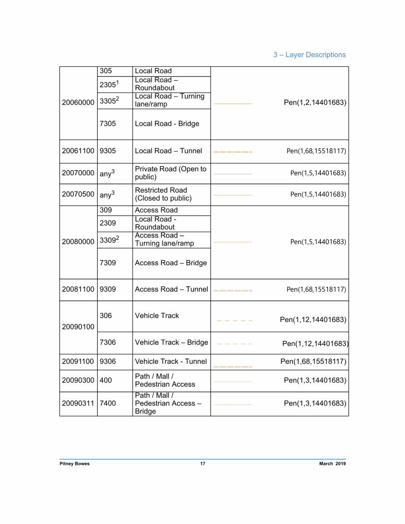
20060000
305 Local Road
Pen(1,2,14401683)
23051 Local Road – Roundabout
33052 Local Road – Turning lane/ramp
7305 Local Road - Bridge
20061100 9305 Local Road – Tunnel Pen(1,68,15518117)
20070000 any3 Private Road (Open to public) Pen(1,5,14401683)
20070500 any3 Restricted Road (Closed to public) Pen(1,5,14401683)
20080000
309 Access Road
Pen(1,5,14401683)
2309 Local Road - Roundabout
33092 Access Road – Turning lane/ramp
7309 Access Road – Bridge
20081100 9309 Access Road – Tunnel Pen(1,68,15518117)
20090100
306 Vehicle Track Pen(1,12,14401683)
7306 Vehicle Track – Bridge Pen(1,12,14401683)
20091100 9306 Vehicle Track - Tunnel Pen(1,68,15518117)
20090300 400 Path / Mall / Pedestrian Access Pen(1,3,14401683)
20090311 7400 Path / Mall / Pedestrian Access – Bridge
Pen(1,3,14401683)
Pitney Bowes 17 March 2019

StreetPro Australia 2019.02 Product Guide
20090312 9400 Path / Mall / Pedestrian Access – Tunnel
Pen(1,12,14401683)
20090500
13001
Roundabout construction line
Invisible unless selected – Pen (1,1,16777215)
13011
13021
13031
13041
13051
13061
13091
14001
20090700
5300
Proposed road Pen(1,9,12632256)
5301 5302 5303 5304 5305 5306
5309
Pitney Bowes 18 March 2019

3 – Layer Descriptions
70010110 8301 Vehicular Ferry
Pen(1,9,255) 70010120 8400 Passenger Ferry
1 The roadtype applies only to StreetPro Navigation and StreetPro Classic. 2 The roadtype applies only to StreetPro Navigation. 3 Excludes roadtypes, 1300-1400, 2300-2400, 3300-3400, 5300-5306, 8301, 8400 and 9300-
9400.These roadtypes will retain their default micodes and graphic objects.
Pitney Bowes 19 March 2019

StreetPro Australia 2019.02 Product Guide
Labeling
StreetPro street data includes a LABEL field to store street names formatted in a cartographically presentable way. Only records with valid street names have values in this field. For example, “ROAD”, “TRACK”, etc. are left blank.
Label values also include some punctuation characters, for example “O'Neil St”, “Mary St (Bruce Hwy)”, etc.
Address Ranges
Address range information is derived from G-NAF® (Geocoded National Address File) - refer to http://www.psma.com.au. The street data is subject to an ongoing maintenance program to improve completeness, currency and consistency.
To facilitate address searching and geocoding, two fields, L_STRUCT and R_STRUCT are included. They represent differing address structures for each side of the street.
An L_STRUCT or R_STRUCT value of "O” or “E” indicates the address numbers used to create the address range are odd or even respectively, and consecutive in increments of two.
An L_STRUCT or R_STRUCT value of “M” indicates the address numbers used to create the address range are mixed - that is, odd and even address numbers exist on the same side of the street. This is typical on many cul-de-sacs where address numbers on either side change in increments of one instead of two.
An L_STRUCT or R_STRUCT value of “I” indicates the address numbers used to create the address range are irregular, as opposed to odd or even which are created from consecutive address numbers. For example, the address numbers 2,4,6,8 denote an even range (2-8, “E”), while the address numbers 2,4,8,6 denote an irregular range (2-8, “I”).
If the address number structure satisfies conditions for both mixed and irregular structures, the mixed value (“M”) is the overriding value.
Whilst mixed and irregular address structures may not necessarily improve the address search or geocoding success rate, they will enable users to investigate and validate the result.
Pitney Bowes 20 March 2019

3 – Layer Descriptions
Table Structure
Streets Table Structure
In StreetPro Classic and StreetPro Navigation, the AUS_ST table contains too much data for one table. The data has been split into two tables, AUS_ST1 and AUS_ST2. The AUS_ST table is a view table that opens and joins the two tables. This creates a unified view that can be queried and joined with other tables.
In StreetPro Display, all data is in the AUS_ST table.
Field Description Type (width)
Index ed
STREET Full street name (abbreviated) Character (50) Yes
FROMLEFT1 Starting address number on the left of the street Integer No
TOLEFT1 Ending address number on the left of the street Integer No
FROMRIGHT1 Starting address number on the right of the street Integer No
TORIGHT1 Ending address number on the right of the street Integer No
L_STRUCT1
House numbering structure on the left (L) and the right (R) sides of the street. E = Even O = Odd M = Mixed
I = Irregular
Character (1) No
R_STRUCT1 Character (1) No
ROADTYPE Road classification code (See ROADTYPE Descriptions and ROADTYPE Addends for more info)
Small integer No
STREET_NAME1 First part of the street name (unabbreviated) Character (50) No
STREET_TYPE1 Street type (e.g. Road, Street, Avenue) (unabbreviated)
Character (15) No
STREET_SUFFIX1 Street suffix (e.g. East, West) (unabbreviated) Character (15) No
Pitney Bowes 21 March 2019
StreetPro Australia 2019.02 Product Guide
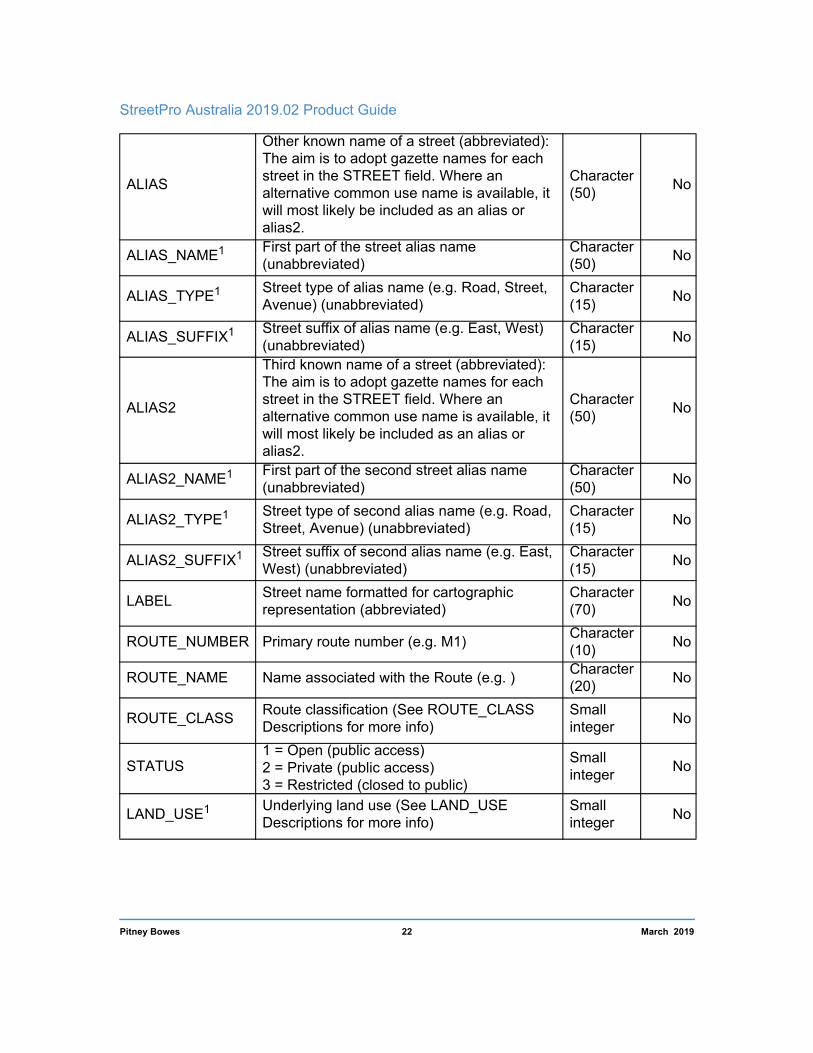
ALIAS
Other known name of a street (abbreviated): The aim is to adopt gazette names for each street in the STREET field. Where an alternative common use name is available, it will most likely be included as an alias or alias2.
Character (50) No
ALIAS_NAME1 First part of the street alias name (unabbreviated)
Character (50) No
ALIAS_TYPE1 Street type of alias name (e.g. Road, Street, Avenue) (unabbreviated)
Character (15) No
ALIAS_SUFFIX1 Street suffix of alias name (e.g. East, West) (unabbreviated)
Character (15) No
ALIAS2
Third known name of a street (abbreviated): The aim is to adopt gazette names for each street in the STREET field. Where an alternative common use name is available, it will most likely be included as an alias or alias2.
Character (50) No
ALIAS2_NAME1 First part of the second street alias name (unabbreviated)
Character (50) No
ALIAS2_TYPE1 Street type of second alias name (e.g. Road, Street, Avenue) (unabbreviated)
Character (15) No
ALIAS2_SUFFIX1 Street suffix of second alias name (e.g. East, West) (unabbreviated)
Character (15) No
LABEL Street name formatted for cartographic representation (abbreviated)
Character (70) No
ROUTE_NUMBER Primary route number (e.g. M1) Character (10) No
ROUTE_NAME Name associated with the Route (e.g. ) Character (20) No
ROUTE_CLASS Route classification (See ROUTE_CLASS Descriptions for more info)
Small integer No
STATUS 1 = Open (public access) 2 = Private (public access) 3 = Restricted (closed to public)
Small integer No
LAND_USE1 Underlying land use (See LAND_USE Descriptions for more info)
Small integer No
Pitney Bowes 22 March 2019

3 – Layer Descriptions
SURFACE_TYPE
1 = Sealed 2 = Unsealed 3 = Unknown 4 = Unimproved (not maintained) 5 = Boardwalk
Small integer No
ADDRESS_TYPE2
1 = Address range created using G-NAF 2 = Address range created using G-NAF and may include addresses from other sources including customer feedback, field capture or interpolation 3 = Address range created from customer feedback, field capture or interpolation
Small integer No
AREA_TYPE1
DU = Dense urban U = Urban RU = Rural Urban R = Rural
Character (2) No
STATE
State code: 1 = NSW 2 = VIC 3 = QLD4 = SA 5 = WA 6 = TAS 7 = NT 8 = ACT 9 = OT
Small integer No
LENGTH2 Link length in meters Decimal (10,1) No
START_NODE2 UFI value for the first point of the street segment, referencing the ND table
Decimal (15,0) No
END_NODE2 UFI value for the last point of the street segment, referencing the ND table
Decimal (15,0) No
ROAD_CLASS2 Combination of Roadtype and Toll (see ROAD_CLASS description for more info)
Character (2) No
CARRIAGE2 Carriageway type: S = Standard D = Divided
Character (1) No
SPEED2 Speed of the link in km/h Decimal (4,0) No
EXITSTART2 Valid to exit at the start of the link Logical No EXITEND2 Valid to exit at the end of the link Logical No EXITALONG2 Valid to exit along the link Logical No
Pitney Bowes 23 March 2019

StreetPro Australia 2019.02 Product Guide
ONEWAY2
Direction of travel through the street segment:1 = Travel allowed in both directions 2 = Travel allowed in positive direction only3 = Travel allowed in negative direction only
4 = Non-routable
5 = Travel allowed in one direction only, but direction is time-dependent
Small integer No
TOLL2
1 = No toll 2 = Toll in both directions of the street segment3 = Toll in positive direction of the street segment4 = Toll in negative direction of the street segment
Small integer No
VEHICLE_TYPE2 Type of vehicle permitted to travel along street
Small integer No
UFI1 New Pitney Bowes Unique Feature Identifier Decimal (15,0) No
MICODE MapInfo feature code Integer No
1 The field is available only in StreetPro Navigation and StreetPro Classic. 2 The field is available only in StreetPro Navigation.
ROADTYPE Descriptions
ROADTYPE Feature Description
300 Motorway/Freew ay
Roads which are of importance in a national sense, and/or are a major interstate throughroute, and/or are principal connector roads between capitals and/or major regions and or key towns/commercial centres/inter-transport hubs. Also exhibit separated carriageways and unhindered, regulated traffic flow though use of grade-separated crossings and entry/exit ramps(e.g. Pacific Motorway).
301 Highway
Roads which are of importance in a national sense, and/or are a major interstate throughroute, and/or are principal connector roads between capitals and/or major regions and or key towns/commercial centres/inter-transport hubs.
Pitney Bowes 24 March 2019

3 – Layer Descriptions
302 Arterial Road
Well maintained and widely used roads which are major connectors for national highways or state highways, major centres, key towns, or have major tourist importance or which main function is to form the principal avenue ofcommunication for metropolitan traffic movements.
303 Sub-Arterial Road
Acts as connector between highways and/or arterial roads, or as an alternative for arterial roads, or a principal avenue for massive traffic movements.
304 Connector Road Provides for traffic movement between sub-arterial and local roads or to distribute traffic to local street systems.
305 Local Road Provides property access. Includes serviceroads that may share the same name as higher order roads.
306 Vehicle Track Access tracks and fire trails, suitable for four-wheel-drive vehicles only.
309 Access Road
Road designed to provide access to the rear of, into or within a property but may not necessarily be part of the public road network. They generally do not have addresses. Applied to urban service lanes, driveways, and other tracks on private property.
400 Path/Mall/Pedestrian Access
A road or passage whose main purpose is toprovide non-vehicular access for pedestrians but may allow some vehicular access (eg malls). Also includes arcades, cycle tracks and foot tracks.
8301 Vehicular Ferry Public ferry used for the transportation of vehicles and pedestrians.
8400 Passenger Ferry Public ferry used for the transportation of people.
Pitney Bowes 25 March 2019

StreetPro Australia 2019.02 Product Guide
ROADTYPE Addends
ROADTYPE Feature Description
+10001 Roundabout Construction Line
Invisible line (hypothetical) found inside a roundabout and used to ensure topological connectivity for streets adjoining the roundabout.
+20001 Roundabout Curved road that together with adjoining ones represents the elliptical road segment of a roundabout.
+30002 Turning Lane / Ramp
Road joining segment used to streamline traffic flow between two roads. Turning lanes/exits are at-grade and ramps (both on and off ramps) are grade-separated.
+5000 Proposed Road
Road documented in Government or private plans that will be created in future, but currently does not physically exist.
+7000 Bridge Crossing over an obstacle which is used for pedestrian or vehicular transit.
+9000 Tunnel Crossing under an obstacle which is used for pedestrian or vehicular transit.
1 The addend is available only in StreetPro Navigation and StreetPro Classic. 2 The addend is available only in StreetPro Navigation.
ROUTE_CLASS Description
CODE NAME DESCRIPTION
0 Undetermined 1 NationalRoute Route is of National Significance 2 StateRoute Route is of State Significance 3 Tourist Route is part of a tourist route. 4 Cycleway
5 HeavyHaulage Route is identified as a Heavy Haulage route.
Pitney Bowes 26 March 2019

3 – Layer Descriptions
CODE NAME DESCRIPTION
6 AusLink Route is part of the National Road Network. 7 Motorway Route is identified as a Motorway
Status Description
Code NAME
1 Road open to public
2 Private road, open to public
3 Restricted road, closed to public. Usually emergency access only.
LANDUSE Description
(StreetPro and StreetPro Navigation only)
Code Land Use Category
0 Not classified 1 Agricultural 2 Commercial 3 Education 4 Health 5 Industrial 6 Accommodation 7 Recreation 8 Residential 9 Government 10 Transport 11 Water 12 Aged Care 13 Cemetery/Crematorium 14 Place of Worship 15 Airport 16 Reserve
Pitney Bowes 27 March 2019

StreetPro Australia 2019.02 Product Guide
ROAD_CLASS Description
(StreetPro Navigation only)
Class Description Roadtype Status Toll A Freeway (non-Toll) 300 / *300 1 1 B Freeway (Toll) 300 / *300 1 2, 3 or 4 C Highway (non-Toll) 301 / *301 1 1
CL Roundabout construction line 1300-1400 1 or 2 1, 2, 3
or 4 D Highway (Toll) 301 / *301 1 2, 3 or 4
E Private Road (open to public) Any 2 1
F Vehicle ferry 8301 1 1
G Arterial Road (non-Toll) 302 / *302 1 1
H Arterial Road (Toll) 302 / *302 1 2, 3 or 4
I Sub-Arterial Road (non-Toll) 303 / *303 1 1
J Sub-Arterial Road (Toll) 303 / *303 1 2, 3 or 4
K Connector Road (non-Toll) 304 / *304 1 1
L Connector Road (Toll) 304 / *304 1 2, 3 or 4 M Local Road (non-Toll) 305 / *305 1 1 N Local Road (Toll) 305 / *305 1 2, 3 or 4
NR
Under Construction 4300-4400 1, 2, 3 1
Proposed Road 5300-5306 1, 2, 3 1
Closed Roads 6300-6400 1, 2, 3 1
P Path / Mall / Pedestrian access 400 / *400 1, 2, 3 1
PF Pedestrian ferry 8400 1 1
PR Restricted access (closed to public) Any 3 1
R Access Road 309 / *309 1 1 T 4WD Track 306 / *306 1 1
* refers to any of the +2000, +3000, +7000 or +9000 addends on the roadtype. See the tables in the Extras folder on the StreetPro product media for the full list of micode and roadtype combinations.
Pitney Bowes 28 March 2019
3 – Layer Descriptions
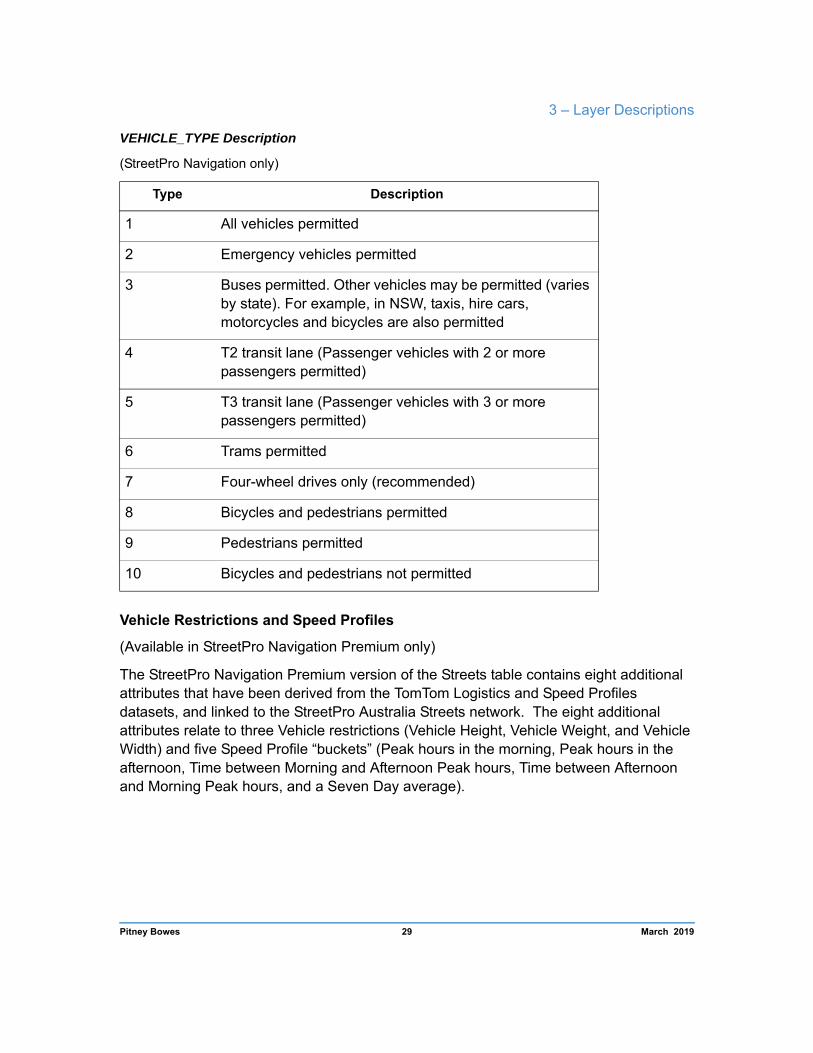
VEHICLE_TYPE Description
(StreetPro Navigation only)
Type Description
1 All vehicles permitted
2 Emergency vehicles permitted
3 Buses permitted. Other vehicles may be permitted (varies by state). For example, in NSW, taxis, hire cars, motorcycles and bicycles are also permitted
4 T2 transit lane (Passenger vehicles with 2 or more passengers permitted)
5 T3 transit lane (Passenger vehicles with 3 or more passengers permitted)
6 Trams permitted
7 Four-wheel drives only (recommended)
8 Bicycles and pedestrians permitted
9 Pedestrians permitted
10 Bicycles and pedestrians not permitted
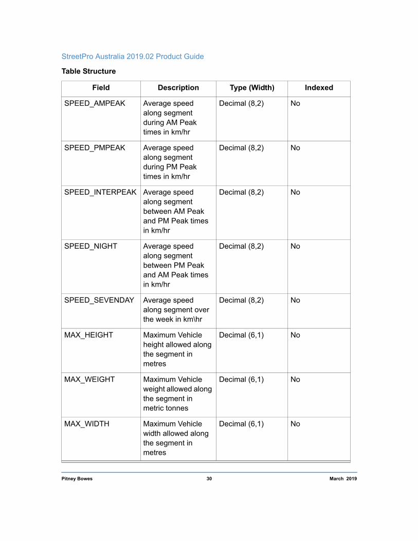
Vehicle Restrictions and Speed Profiles
(Available in StreetPro Navigation Premium only)
The StreetPro Navigation Premium version of the Streets table contains eight additional attributes that have been derived from the TomTom Logistics and Speed Profiles datasets, and linked to the StreetPro Australia Streets network. The eight additional attributes relate to three Vehicle restrictions (Vehicle Height, Vehicle Weight, and Vehicle Width) and five Speed Profile “buckets” (Peak hours in the morning, Peak hours in the afternoon, Time between Morning and Afternoon Peak hours, Time between Afternoon and Morning Peak hours, and a Seven Day average).
Pitney Bowes 29 March 2019
StreetPro Australia 2019.02 Product Guide
Table Structure
Field Description Type (Width) Indexed
SPEED_AMPEAK Average speed along segment during AM Peak times in km/hr
Decimal (8,2) No
SPEED_PMPEAK Average speed along segment during PM Peak times in km/hr
Decimal (8,2) No
SPEED_INTERPEAK Average speed along segment between AM Peak and PM Peak times in km/hr
Decimal (8,2) No
SPEED_NIGHT Average speed along segment between PM Peak and AM Peak times in km/hr
Decimal (8,2) No
SPEED_SEVENDAY Average speed along segment over the week in km\hr
Decimal (8,2) No
MAX_HEIGHT Maximum Vehicle height allowed along the segment in metres
Decimal (6,1) No
MAX_WEIGHT Maximum Vehicle weight allowed along the segment in metric tonnes
Decimal (6,1) No
MAX_WIDTH Maximum Vehicle width allowed along the segment in metres
Decimal (6,1) No
Pitney Bowes 30 March 2019

3 – Layer Descriptions
Incremental Streets Not available in StreetPro Display (RRR_ST_INC.TAB)
The Incremental streets table contains street centrelines for those segments that have changed between the previous release and the current release.
Pitney Bowes 31 March 2019

StreetPro Australia 2019.02 Product Guide
The changes are shown in an additional field, changelog_type, which shows the type of change classified according to the table below. The CHANGELOG_UFI field links this table to the CHANGELOG table.
Data Dictionary
Field Value Description
CHANGELOG_TYPE I Insert
UA Attribution Update
UG Geometry Update
UB Both Attribution and Geometry Update
D Delete
The deleted segments are colored purple to simplify visual identification. They have the geometry and attribution of the previous StreetPro release. For table structure refer to the table structure of Streets on page 14.
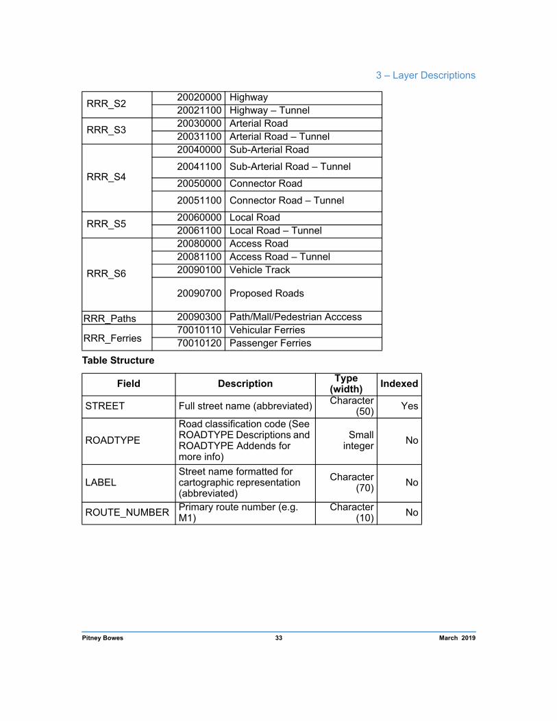
Display Streets (RRR_S1, RRR_S2, RRR_S3, RRR_S4, RRR_S5, RRR_S6)
The Display Streets tables contain Street centrelines, modified and split into six layers for efficient display in the RRR1.WOR and RRR2.WOR workspaces.
Not all states contain Freeways and Ferry routes. S1 tables are not present for ACT, NT or TAS. Ferry tables are not present for ACT or NT.
Each road with the same attributes has been chained across intersections and some attributes removed to reduce the footprint and increase display speed of these layers.
The fully attributed _ST and _MH layers are still available with the product.
The Display layers have been distributed in the following way:
DisplayTable MiCode Feature
RRR_S1 20010000 Freeway 20011100 Freeway – Tunnel
Pitney Bowes 32 March 2019
3 – Layer Descriptions
RRR_S2 20020000 Highway 20021100 Highway – Tunnel
RRR_S3 20030000 Arterial Road 20031100 Arterial Road – Tunnel
RRR_S4
20040000 Sub-Arterial Road
20041100 Sub-Arterial Road – Tunnel 20050000 Connector Road
20051100 Connector Road – Tunnel
RRR_S5 20060000 Local Road 20061100 Local Road – Tunnel
RRR_S6
20080000 Access Road 20081100 Access Road – Tunnel 20090100 Vehicle Track
20090700 Proposed Roads
RRR_Paths 20090300 Path/Mall/Pedestrian Acccess
RRR_Ferries 70010110 Vehicular Ferries 70010120 Passenger Ferries
Table Structure
Field Description Type (width) Indexed
STREET Full street name (abbreviated) Character (50) Yes
ROADTYPE
Road classification code (See ROADTYPE Descriptions and ROADTYPE Addends for more info)
Small integer No
LABEL Street name formatted for cartographic representation (abbreviated)
Character (70) No
ROUTE_NUMBER Primary route number (e.g. M1)
Character (10) No
Pitney Bowes 33 March 2019

StreetPro Australia 2019.02 Product Guide
STATE
State code: 1 = NSW 2 = VIC 3 = QLD 4 = SA 5 = WA 6 = TAS 7 = NT 8 = ACT 9 = OT
Small integer No
MICODE MapInfo feature code Integer No
Nodes Available in StreetPro Navigation only (RRR_ND.TAB)
This table consists of points showing the spatial location of all beginning and end nodes of street segments. Each point is uniquely identified by a start node and end node, and a unique set of x and y coordinates, representing longitude and latitude locations (respectively), in the relevant projection and datum.
The valence field represents the number of street segments intersecting at the location of the node (at a national level). When using state-based tables, the valence of nodes for streets that adjoin but have different state values (i.e. on the border) may appear to be too high. In these cases, the adjoining state's street table will show the additional streets that
Pitney Bowes 34 March 2019

3 – Layer Descriptions
are included in the valence count. For completeness, the nodes associated with these particular streets are duplicated in adjoining state node tables. This anomaly does not exist in the national-level nodes table.
Table Structure
Field Description Type
(width) Indexe
d
UFI Unique node identifier Decimal (15,0)
Yes
VALENCE Count of street segments intersecting at this point
Small Integer
No
XCOORD Street segment endpoint longitude coordinate
Decimal (16,8) No
Pitney Bowes 35 March 2019

StreetPro Australia 2019.02 Product Guide
Table Structure
Field Description Type
(width) Indexe
d
YCOORD Street segment endpoint latitude coordinate Decimal (16,8)
No
STATE State Code: 1 = NSW; 2 = VIC; 3 = QLD; 4 = SA; 5 = WA; 6 = TAS; 7 = NT; 8 = ACT; 9 = OT
Small Integer
No
Street Intersections Available in StreetPro Navigation only (RRR_ST_INT.TAB)
This table consists of points showing the spatial location of all intersections of street segments. Each point is uniquely identified by an intersection id, and a unique set of x and y coordinates, representing longitude and latitude locations (respectively), in the relevant projection and datum.
Pitney Bowes 36 March 2019
3 – Layer Descriptions
Table Structure
Field Description Type (width) Indexed
UFI Unique Node Identifier Decimal (15,0)
Yes
STREET1 Full street name of first intersecting street
Character (60)
No
UFI1 StreetPro Unique Feature Identifier of first intersecting street
Decimal (15,0)
No
STREET2 Full street name of second intersecting street
Character (60)
No
UFI2 StreetPro Unique Feature Identifier of second intersecting street
Decimal (15,0)
No
STREET3 Full street name of third intersecting street
Character (60)
No
UFI3 StreetPro Unique Feature Identifier of third intersecting street
Decimal (15,0)
No
STREET4 Full street name of fourth intersecting street
Character (60)
No
UFI4 StreetPro Unique Feature Identifier of fourth intersecting street
Decimal (15,0)
No
STREET5 Full street name of fifth intersecting street
Character (60)
No
UFI5 StreetPro Unique Feature Identifier of fifth intersecting street
Decimal (15,0)
No
STREET6 Full street name of sixth intersecting street
Character (60)
No
UFI6 StreetPro Unique Feature Identifier of sixth intersecting street
Decimal (15,0)
No
Pitney Bowes 37 March 2019

StreetPro Australia 2019.02 Product Guide
Field Description Type (width) Indexed
STREET7 Full street name of seventh intersecting street
Character (60)
No
UFI7 StreetPro Unique Feature Identifier of seventh intersecting street
Decimal (15,0)
No
STREET8 Full street name of eighth intersecting street
Character (60)
No
UFI8 StreetPro Unique Feature Identifier of eighth intersecting street
Decimal (15,0)
No
STATE State Code: 1 = NSW; 2 = VIC; 3 = QLD; 4 = SA; 5 = WA; 6 = TAS; 7 = NT; 8 = ACT; 9 = OT
Small Integer
No
Pitney Bowes 38 March 2019
3 – Layer Descriptions
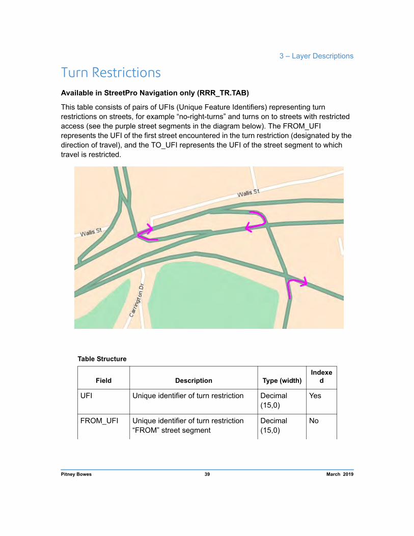
Turn Restrictions Available in StreetPro Navigation only (RRR_TR.TAB)
This table consists of pairs of UFIs (Unique Feature Identifiers) representing turn restrictions on streets, for example “no-right-turns” and turns on to streets with restricted access (see the purple street segments in the diagram below). The FROM_UFI represents the UFI of the first street encountered in the turn restriction (designated by the direction of travel), and the TO_UFI represents the UFI of the street segment to which travel is restricted.
Table Structure
Field Description Type (width) Indexe
d
UFI Unique identifier of turn restriction Decimal (15,0)
Yes
FROM_UFI Unique identifier of turn restriction “FROM” street segment
Decimal (15,0)
No
Pitney Bowes 39 March 2019

StreetPro Australia 2019.02 Product Guide
Table Structure
Field Description Type (width) Indexe
d
TO_UFI Unique identifier of turn restriction “TO” street segment
Decimal (15,0)
No
STATE State Code: 1 = NSW; 2 = VIC; 3 = QLD; 4 = SA; 5 = WA; 6 = TAS; 7 = NT; 8 = ACT; 9 = OT
Small Integer
No
Highways and Main Roads (RRR_MH.TAB)
Feature Codes and Display Characteristics
micode Type Code Feature Graphic Object Details
300 Freeway
23001 Freeway - Roundabout
Pitney Bowes 40 March 2019

3 – Layer Descriptions
Feature Codes and Display Characteristics
micode Type Code Feature Graphic Object Details
20010000 33002 Freeway - Turning lane / ramp Pen(40,130,137779
80)
7300 Freeway - Bridge
20011100 9300 Freeway -Tunnel Pen(1,68,13777980)
20020000
301 Highway
Pen(40,130,711641 8)
23011 Highway - Roundabout
33012 Highway - Turning lane / ramp
7301 Highway - Bridge
20021100 9301 Highway - Tunnel Pen(1,68,7116418)
20030000
302 Arterial Road
Pen (30, 2, 8762781)
23021 Arterial Road – Roundabout
33022 Arterial Road – Turning lane/ramp
7302 Arterial Road – Bridge
20031100 9302 Arterial Road -Tunnel
Pen (30, 68, 8762781)
303 Sub-Arterial Road
23031 Sub-Arterial Road – Roundabout
Pitney Bowes 41 March 2019

StreetPro Australia 2019.02 Product Guide
Feature Codes and Display Characteristics
micode Type Code Feature Graphic Object Details
20040000 33032 Sub-Arterial Road – Turning lane/ramp
Pen(30,2,1440168 3)
7303 Sub-Arterial Road – Bridge
20041100 9303 Sub-Arterial Road – Tunnel
Pen(1,68,14401683 )
1 The roadtype is available only in StreetPro Navigation and StreetPro Classic.
2 The roadtype is available only in StreetPro Navigation.
Table Structure
Field Description Type (width) Indexed
STREET Full street name (abbreviated) Character (50) Yes
STREET_NAME1 First part of the street name (unabbreviated)
Character (50) No
STREET_TYPE1 Street type (e.g. Road, Street, Avenue) (unabbreviated)
Character (15) No
STREET_SUFFIX1 Street suffix (e.g. East, West) (unabbreviated)
Character (15) No
ROADTYPE Road classification code Small int No
ALIAS
Other known name of a street (abbreviated): The aim is to adopt gazette names for each street in the STREET field. Where an alternative common use name is available, it will most likely be included as an alias or alias2.
Character (50) No
Pitney Bowes 42 March 2019

3 – Layer Descriptions
ALIAS_NAME1 First part of the street alias name (unabbreviated)
Character (50) No
ALIAS_TYPE1 Street type of alias name (e.g. Road, Street, Avenue) (unabbreviated)
Character (15) No
ALIAS_SUFFIX1 Street suffix of alias name (e.g. East, West) (unabbreviated)
Character (15) No
ALIAS2
Third known name of a street (abbreviated): The aim is to adopt gazette names for each street in the STREET field. Where an alternative common use name is available, it will most likely be included as an alias or alias2.
Character (50) No
Pitney Bowes 43 March 2019

StreetPro Australia 2019.02 Product Guide
Field Description Type (width) Indexed
ALIAS2_NAME1 First part of the second street alias name (unabbreviated)
Character (50) No
ALIAS2_TYPE1 Street type of second alias name (e.g. Road, Street,Avenue) (unabbreviated)
Character (15) No
ALIAS2_SUFFIX1 Street suffix of second alias name (e.g. East, West) (unabbreviated)
Character (15) No
LABEL Street name formatted for cartographic representation(abbreviated)
Character (70) No
ROUTE_NUMBER Primary route number (e.g. M1) Character (10) No
ROUTE_NAME Name associated with the Route (e.g. WESTERN MOTORWAY)
Character (20) No
STATUS 1 = Open (public access)2 = Private (public access)3 = Restricted (closed to public)
Integer No
SURFACE_TYPE2 1 = Sealed 2 = Unsealed 3 = Unknown
Small int No
VEHICLE_TYPE2 Type of vehicle permitted to travel along street Small int No
STATE
State code: 1 = NSW 2 = VIC 3 = QLD 4 = SA 5 = WA 6 = TAS 7 = NT 8 = ACT 9 = OT
Small int No
UFI1 New Pitney Bowes Unique Feature Identifier
Decimal (15,0) No
MICODE MapInfo feature code Integer No
Pitney Bowes 44 March 2019

3 – Layer Descriptions
1 The field is available only in StreetPro Navigation and StreetPro Classic.
2 The field is available only in StreetPro Navigation.
Railways and Railway Stations (RRR_RL.TAB and RRR_RLS.TAB)
The Railways and Railway Stations layers (*RL.TAB and *RLS.TAB respectively) comprise polyline objects representing the rail and light rail networks, and point objects representing stations.
Feature Codes And Display Characteristics
Micode Type Code Features Graphic Object Details
10320200 501 Railway Station Symbol (34, 8421504, 6)
10320201 504 Subway Station
40010100 500 Railway Line Pen (1, 27, 8421504)
Pitney Bowes 45 March 2019

StreetPro Australia 2019.02 Product Guide
Feature Codes And Display Characteristics
Micode Type Code Features Graphic Object Details
40010200 503 Tram/Light Rail Line Pen (1, 26, 10245975)
40010500 505 Disused Line Pen (1, 27, 8421504)
40020100 502 Underground Line/Tunnel
Pen (1, 196, 8421504)
40020200 506 Underground Light Rail/Tunnel
Pen (1, 196, 10245975)
Table Structure
Field Description Type (width) Indexed
NAME Name of Railway Line / Station Character (50)
Yes
TYPE Code used to classify the type of data in the table
Small Integer
No
LABEL Feature Label Character (50)
No
STATE State Code: 1 = NSW; 2 = VIC; 3 = QLD; 4 = SA; 5 = WA; 6 = TAS; 7 = NT; 8 = ACT; 9 = OT
Small Integer
No
UFI1 StreetPro Unique Feature Identifier Decimal (15,0)
No
MICODE MapInfo feature code Integer No
IMPORTANCE Display Importance Integer No
RANK Display Rank Integer No
Pitney Bowes 46 March 2019
3 – Layer Descriptions
Table Structure
Field Description Type (width) Indexed
CATEGORY Category Char (50) No
SUB CATEGORY
Sub Category Char (100) No
1 The field is available only in StreetPro Navigation and StreetPro Classic.
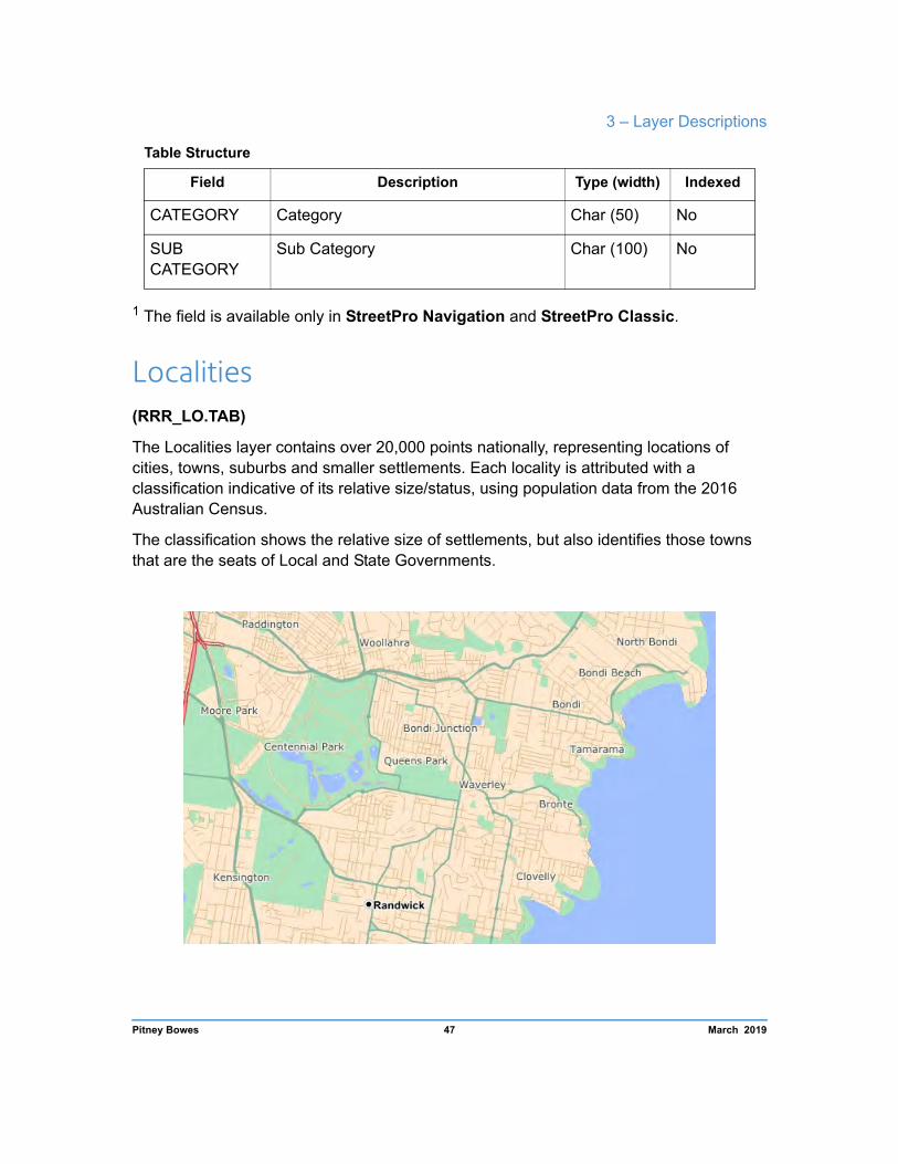
Localities (RRR_LO.TAB)
The Localities layer contains over 20,000 points nationally, representing locations of cities, towns, suburbs and smaller settlements. Each locality is attributed with a classification indicative of its relative size/status, using population data from the 2016 Australian Census.
The classification shows the relative size of settlements, but also identifies those towns that are the seats of Local and State Governments.
Pitney Bowes 47 March 2019
StreetPro Australia 2019.02 Product Guide
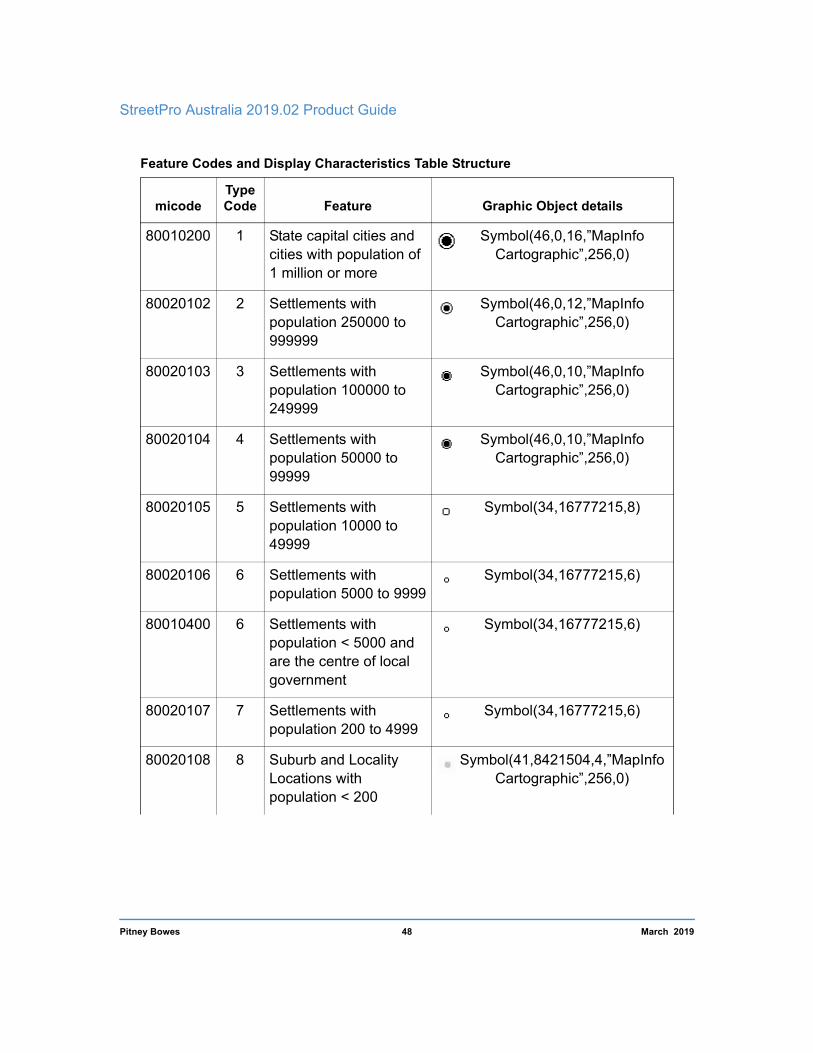
Feature Codes and Display Characteristics Table Structure
micode Type Code Feature Graphic Object details
80010200 1 State capital cities and cities with population of 1 million or more
Symbol(46,0,16,”MapInfo Cartographic”,256,0)
80020102 2 Settlements with population 250000 to 999999
Symbol(46,0,12,”MapInfo Cartographic”,256,0)
80020103 3 Settlements with population 100000 to 249999
Symbol(46,0,10,”MapInfo Cartographic”,256,0)
80020104 4 Settlements with population 50000 to 99999
Symbol(46,0,10,”MapInfo Cartographic”,256,0)
80020105 5 Settlements with population 10000 to 49999
Symbol(34,16777215,8)
80020106 6 Settlements with population 5000 to 9999
Symbol(34,16777215,6)
80010400 6 Settlements with population < 5000 and are the centre of local government
Symbol(34,16777215,6)
80020107 7 Settlements with population 200 to 4999
Symbol(34,16777215,6)
80020108 8 Suburb and Locality Locations with population < 200
Symbol(41,8421504,4,”MapInfo Cartographic”,256,0)
Pitney Bowes 48 March 2019
3 – Layer Descriptions
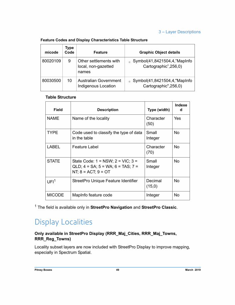
Feature Codes and Display Characteristics Table Structure
micode Type Code Feature Graphic Object details
80020109 9 Other settlements with local, non-gazetted names
Symbol(41,8421504,4,”MapInfo Cartographic”,256,0)
80030500 10 Australian Government Indigenous Location
Symbol(41,8421504,4,"MapInfo Cartographic",256,0)
Table Structure
Field Description Type (width) Indexe
d
NAME Name of the locality Character (50)
Yes
TYPE Code used to classify the type of data in the table
Small Integer
No
LABEL Feature Label Character (70)
No
STATE State Code: 1 = NSW; 2 = VIC; 3 = QLD; 4 = SA; 5 = WA; 6 = TAS; 7 = NT; 8 = ACT; 9 = OT
Small Integer
No
UFI1 StreetPro Unique Feature Identifier Decimal (15,0)
No
MICODE MapInfo feature code Integer No
1 The field is available only in StreetPro Navigation and StreetPro Classic.
Display Localities Only available in StreetPro Display (RRR_Maj_Cities, RRR_Maj_Towns, RRR_Reg_Towns)
Locality subset layers are now included with StreetPro Display to improve mapping, especially in Spectrum Spatial.
Pitney Bowes 49 March 2019
StreetPro Australia 2019.02 Product Guide
The ACT subset does not include a Maj_Towns layer or a Reg_Towns layer.
These subset layers have the same structure and attribution as the base Localities layer.
The layers contain the following Micodes:
Layer MiCode Description
RRR_Maj_Cities 80010200 State Capitals
RRR_Maj_Towns 80020102 Settlements with population 250000 to 999999
80020103 Settlements with population 100000 to 249999
80020104 Settlements with population 50000 to 99999
80020105 Settlements with population 10000 to 49999
RRR_Reg_Towns 80010400 Settlements with population < 5000 and are the centre of local government
80020106 Settlements with population 5000 to 9999
Features (RR_FT.TAB)
The Features layer contains over 173,000 point objects nationally, representing cultural or human-made landmarks. Feature categories include health, education, recreation and shopping centre locations, among others.
Pitney Bowes 50 March 2019

3 – Layer Descriptions
Symbology is unique to the feature classification and a listing of the feature types is provided in Appendix C. You should be aware that the completeness of coverage of certain feature types can vary from region to region.
Note Pitney Bowes emphasizes that the features dataset should be treated as a contextual layer and is not intended for use as an authoritative reference. Whilst efforts on updates to this layer are ongoing, Pitney Bowes cannot guarantee its accuracy and completeness.
Table Structure
Field Description Type (width) Indexed
NAME Name of the feature Character (70)
Yes
TYPE Type of feature Character (55)
No
LABEL Feature Label Character (70)
No
Pitney Bowes 51 March 2019

StreetPro Australia 2019.02 Product Guide
Table Structure
Field Description Type (width) Indexed
STATE State Code: 1 = NSW; 2 = VIC; 3 = QLD; 4 = SA; 5 = WA; 6 = TAS; 7 = NT; 8 = ACT; 9 = OT
Small Integer
No
UFI1 StreetPro Unique Feature Identifier Decimal (15,0)
No
MICODE MapInfo feature code Integer No
IMPORTANCE Display Importance Integer No
RANK Display Rank Integer No
CATEGORY Category Character (50)
No
SUB CATEGORY
Sub Category Character (100)
No
1 The field is available only in StreetPro Navigation and StreetPro Classic.
Landmarks Only available in StreetPro Display (RRR_Landmarks)
The Landmarks layer is a subset of the Features layer, containing prominent features for display at larger scales.
This subset layer has the same structure and attribution as the base Features layer.
Categories included in the Landmarks table include:
Field Description
10011000 Shopping Centre - Regional
10090100 Power station
Pitney Bowes 52 March 2019

3 – Layer Descriptions
Field Description
10110100 Tourist attraction
10110201 Museum
10110402 Beach
10120100 Stadium
10120109 Racecource
10130300 Convention Centre
10210301 University
10230010 Hospital - Private with A&E
10230110 Hospital – Public with A&E
10240100 Government administration
10240501 General Post Office
10240800 Cemetery / Crematorium
10310000 Airport
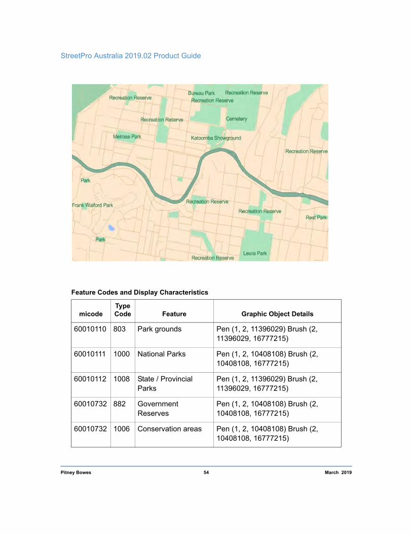
Parks, Forests and Reserves (RRR_PK.TAB)
The Parks, Forests and Reserves layer consists of polygon objects representing national parks, nature reserves, historic sites, State forests, State recreation areas, wildlife refuges, conservation parks, protected areas, wildlife reserves, urban recreation parks and other urban green spaces.
Pitney Bowes 53 March 2019
StreetPro Australia 2019.02 Product Guide
Feature Codes and Display Characteristics
micode Type Code Feature Graphic Object Details
60010110 803 Park grounds Pen (1, 2, 11396029) Brush (2, 11396029, 16777215)
60010111 1000 National Parks Pen (1, 2, 10408108) Brush (2, 10408108, 16777215)
60010112 1008 State / Provincial Parks
Pen (1, 2, 11396029) Brush (2, 11396029, 16777215)
60010732 882 Government Reserves
Pen (1, 2, 10408108) Brush (2, 10408108, 16777215)
60010732 1006 Conservation areas Pen (1, 2, 10408108) Brush (2, 10408108, 16777215)
Pitney Bowes 54 March 2019
3 – Layer Descriptions
Table Structure
Field Description Type (width) Indexe
d
NAME Name of the National Park or other site Character (50)
Yes
TYPE Code used to classify the type of data in the table
Small Integer
No
LABEL Feature label Character (70)
No
STATE State Code: 1 = NSW; 2 = VIC; 3 = QLD; 4 = SA; 5 = WA; 6 = TAS; 7 = NT; 8 = ACT; 9 = OT
Small Integer
No
UFI1 StreetPro Unique Feature Identifier Decimal (15,0)
No
MICODE MapInfo feature code Integer No
CATEGORY Park Category Char (50) No
DISPLAY_VALUE Display Value Integer No
DISPLAY_TYPE Display Type Char (2) No
1 The field is available only in StreetPro Navigation and StreetPro Classic.
Major Parks Layer Only available in StreetPro Display (RRR_Maj_Parks.TAB)
The Major Parks layer contains a subset of the Parks layer, where the regions are over 1
km2 in area. This layer is intended for broader scale mapping.
The structure and attribution is the same as in the Parks layer.
Pitney Bowes 55 March 2019
StreetPro Australia 2019.02 Product Guide
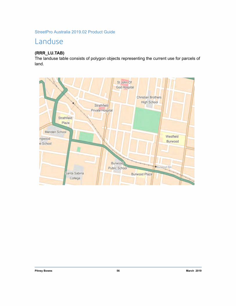
Landuse (RRR_LU.TAB) The landuse table consists of polygon objects representing the current use for parcels of land.
Pitney Bowes 56 March 2019

3 – Layer Descriptions
Land Use Categories:
Feature Code and Display Characteristics
Category Type miCode Graphic Object Details
Recreation
Recreational Area 60010300
Pen(1,2,13429701) Brush(2,13429701,1677 7215)
Zoo/Nature Reserve
60010312
Golf Course 60010313
Stadium Grounds 60010314
Lawn Bowls Club 60010315
Racecourse 60010316
Rifle Range 60010317
Soccer Field 60010318
Tennis Courts 60010319
Tourism 60010320 Pen(1,2,16770033) Brush(2,16770033,1677 7215)
Sport Facility 60010324 Pen(1,2,13429701) Brush(2,13429701,1677 7215)
Caravan Park/Camping Ground
60010325
Theatre 60010332
Pen(1,2,16770033) Brush(2,16770033,1677 7215)
Museum 60010333
Entertainment 60010334
Convention Centre 60010335
Cemetery/Cremato rium
Cemetery/Cremato rium
60010400 Pen(1,2,13624020) Brush(2,13624020,1677 7215)
Pitney Bowes 57 March 2019

StreetPro Australia 2019.02 Product Guide
Category Type miCode Graphic Object Details
Education
Technical/Busines s/ Trade College / University
60010511
Pen(1,2,14737632) Brush(2,14737632,1677 7215)
School 60010513
Child Care 60010514
Pre-School 60010515
Health Hospital 60010601
Pen(1,2,16756912) Brush(2,16756912,1677 7215)
Health Services 60010603
Commercial Retail 60010800
Pen(1,2,16777168) Brush(2,16777168,1677 7215)
Shopping Centre 60010801
Airport Airport Grounds 60010802
Pen(1,1,13424588) Brush(2,13424588,1677 7215)
Runway Grounds 60010803 Pen(1,2,8421504) Brush(2,8421504,16777 215)
Table Structure
Field Description Type(width) Indexed
NAME Name of the National Park or other site Character (50)
Yes
TYPE Specific landuse type classification Character (50)
No
CATEGORY Generic landuse type classification Character (50)
No
Pitney Bowes 58 March 2019

3 – Layer Descriptions
Table Structure
Field Description Type(width) Indexed
LABEL Feature label Character (50)
No
STATE State Code: 1 = NSW; 2 = VIC; 3 = QLD; 4 = SA; 5 = WA; 6 = TAS; 7 = NT; 8 = ACT; 9 = OT
Small Integer
No
UFI1 StreetPro Unique Feature Identifier Decimal (15,0)
No
MICODE MapInfo feature code Integer No
1 The field is available only in StreetPro Navigation and StreetPro Classic.
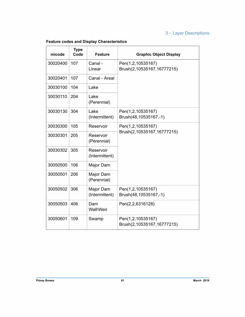
Drainage (RRR_DR.TAB)
The Drainage layer consists of polylines and polygons that represent major watercourses, and water bodies such as lakes.
Pitney Bowes 59 March 2019
StreetPro Australia 2019.02 Product Guide
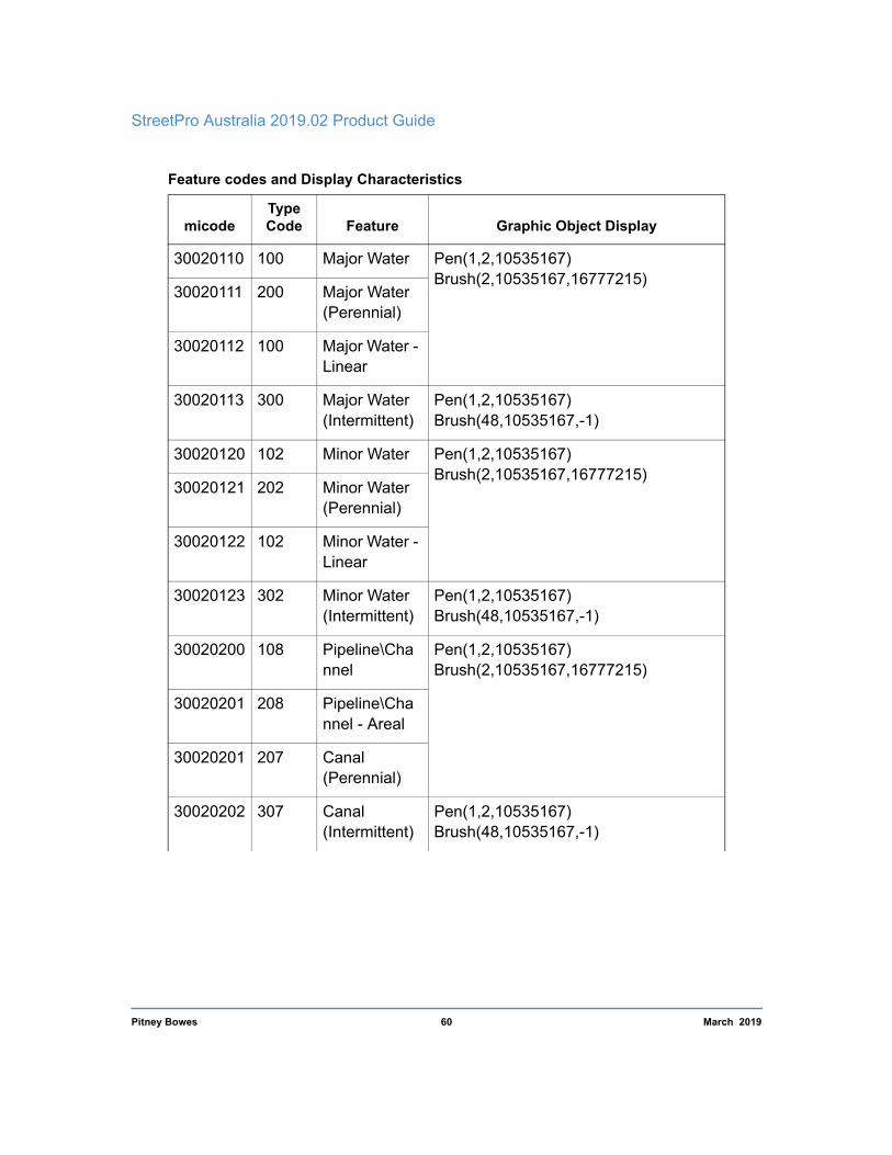
Feature codes and Display Characteristics
micode Type Code Feature Graphic Object Display
30020110 100 Major Water Pen(1,2,10535167) Brush(2,10535167,16777215)
30020111 200 Major Water (Perennial)
30020112 100 Major Water - Linear
30020113 300 Major Water (Intermittent)
Pen(1,2,10535167) Brush(48,10535167,-1)
30020120 102 Minor Water Pen(1,2,10535167) Brush(2,10535167,16777215)
30020121 202 Minor Water (Perennial)
30020122 102 Minor Water -Linear
30020123 302 Minor Water (Intermittent)
Pen(1,2,10535167) Brush(48,10535167,-1)
30020200 108 Pipeline\Cha nnel
Pen(1,2,10535167) Brush(2,10535167,16777215)
30020201 208 Pipeline\Cha nnel - Areal
30020201 207 Canal (Perennial)
30020202 307 Canal (Intermittent)
Pen(1,2,10535167) Brush(48,10535167,-1)
Pitney Bowes 60 March 2019
3 – Layer Descriptions
Feature codes and Display Characteristics
micode Type Code Feature Graphic Object Display
30020400 107 Canal - Linear
Pen(1,2,10535167) Brush(2,10535167,16777215)
30020401 107 Canal - Areal
30030100 104 Lake
30030110 204 Lake (Perennial)
30030130 304 Lake (Intermittent)
Pen(1,2,10535167) Brush(48,10535167,-1)
30030300 105 Reservoir Pen(1,2,10535167) Brush(2,10535167,16777215)
30030301 205 Reservoir (Perennial)
30030302 305 Reservoir (Intermittent)
30050500 106 Major Dam
30050501 206 Major Dam (Perennial)
30050502 306 Major Dam (Intermittent)
Pen(1,2,10535167) Brush(48,10535167,-1)
30050503 406 Dam Wall\Weir
Pen(2,2,6316128)
30050601 109 Swamp Pen(1,2,10535167) Brush(2,10535167,16777215)
Pitney Bowes 61 March 2019

StreetPro Australia 2019.02 Product Guide
Table Structure
Field Description Type(width) Indexed
NAME Name of the drainage feature Character (50)
Yes
TYPE Code used to classify the type of data in the table
Small Integer
No
LABEL Feature Label Character (50)
No
STATE State Code: 1 = NSW; 2 = VIC; 3 = QLD; 4 = SA; 5 = WA; 6 = TAS; 7 = NT; 8 = ACT; 9 = OT
Small Integer
No
UFI1 StreetPro Unique Feature Identifier Decimal (15,0)
No
MICODE MapInfo feature code Integer No
DISPLAY_TYPE Display Type Char (2) No
DISPLAY_CLASS Display Class Integer No
FEATURE_DESC Description of feature Char (50) No
1 The field is available only in StreetPro Navigation and StreetPro Classic.
Pitney Bowes 62 March 2019

3 – Layer Descriptions
Major Rivers Only available in StreetPro Display (RRR_RV.TAB)
The Major Rivers layer consists of polylines and polygons that represent major rivers and large lakes. It is a subset of the Drainage layer and is intended for broader scale viewing than is available in StreetPro Classic and StreetPro Navigation. The structure and attribution is same as in the Drainage Layer.
Feature Codes and Display Characteristics
micode Type Code Feature Graphic Object Details
30020110 100 Major river / water course
Pen (1,2,10535167) Brush (2,10535167,16777215)
30030100 204 Perennial Lake Pen (1,2,10535167) Brush (2,10535167,16777215)
30030130 304 Intermittent Lake Pen (1,2,10535167) Brush (48,10535167,-1)
30030300 105 Reservoir Pen (1,2,10535167) Brush (2,10535167,16777215)
Pitney Bowes 63 March 2019
StreetPro Australia 2019.02 Product Guide
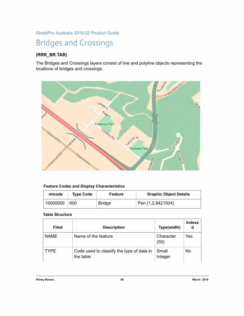
Bridges and Crossings (RRR_BR.TAB)
The Bridges and Crossings layers consist of line and polyline objects representing the locations of bridges and crossings.
Feature Codes and Display Characteristics
micode Type Code Feature Graphic Object Details
10000000 600 Bridge Pen (1,2,8421504)
Table Structure
Filed Description Type(width) Indexe
d
NAME Name of the feature Character (50)
Yes
TYPE Code used to classify the type of data in the table
Small Integer
No
Pitney Bowes 64 March 2019

3 – Layer Descriptions
Table Structure
Filed Description Type(width) Indexe
d
STATE State Code: 1 = NSW; 2 = VIC; 3 = QLD; 4 = SA; 5 = WA; 6 = TAS; 7 = NT; 8 = ACT; 9 = OT
Small Integer
No
LABEL Feature Label Character (50)
No
UFI1 StreetPro Unique Feature Identifier Decimal (15,0)
No
MICODE MapInfo feature code Integer No
1 The field is available only in StreetPro Navigation and StreetPro Classic.
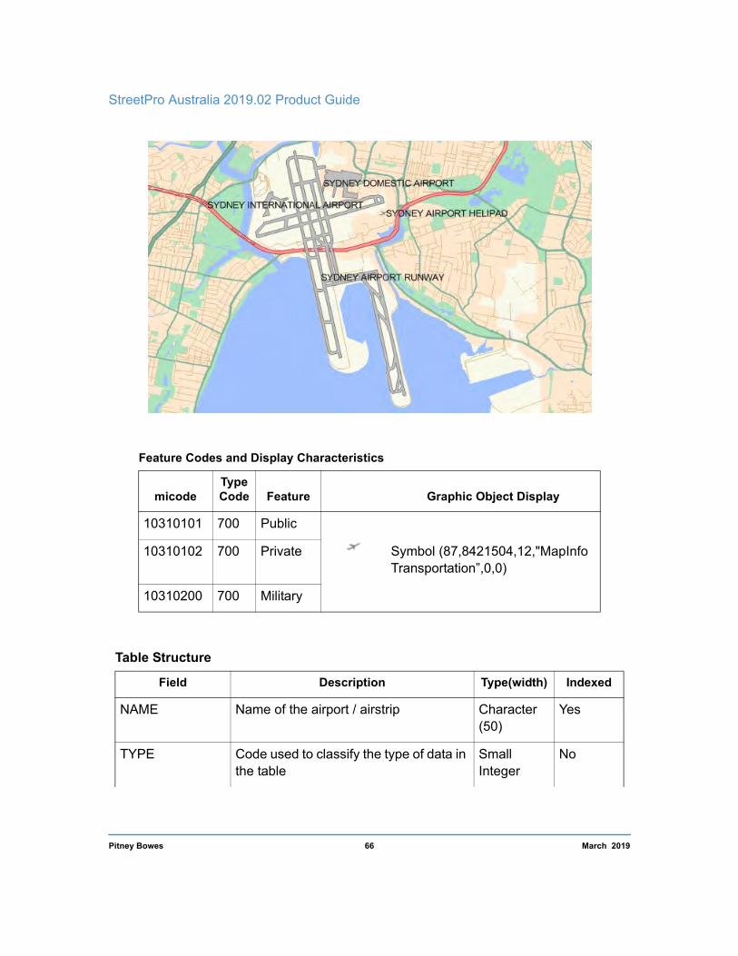
Airports (RRR_AIR.TAB)
The Airports layer contains point objects representing the location of airports and landing strips.
• Airport region objects are now included in the Land Use table. • Named airports that service the majority of major population areas are also included in
the Features layer.
Pitney Bowes 65 March 2019
StreetPro Australia 2019.02 Product Guide
Feature Codes and Display Characteristics
micode Type Code Feature Graphic Object Display
10310101 700 Public
Symbol (87,8421504,12,"MapInfo Transportation”,0,0)
10310102 700 Private
10310200 700 Military
Table Structure
Field Description Type(width) Indexed
NAME Name of the airport / airstrip Character (50)
Yes
TYPE Code used to classify the type of data in the table
Small Integer
No
Pitney Bowes 66 March 2019
3 – Layer Descriptions
Table Structure
Field Description Type(width) Indexed
STATE State Code: 1 = NSW; 2 = VIC; 3 = QLD; 4 = SA; 5 = WA; 6 = TAS; 7 = NT; 8 = ACT; 9 = OT
Small Integer
No
LABEL Feature Label Character (50)
No
UFI1 StreetPro Unique Feature Identifier Decimal (15,0)
No
MICODE MapInfo feature code Integer No
IMPORTANCE Display Importance Integer No
RANK Display Rank Integer No
CATEGORY Category Char (50) No
SUB CATEGORY Sub Category Char (100) No
1 The field is available only in StreetPro Navigation and StreetPro Classic.
Landmass and Ocean (SSS_LM.TAB and SSS_OC.TAB)
The Landmass and Ocean layers (*LM.TAB and *OC.TAB respectively) are provided primarily for display purposes only. They visually complement other layers such as Drainage and Streets. The outer boundary of objects within the Landmass layers defines the State / Territory boundary.
Note For the purpose of “simplifying” very complex map objects, the Ocean layer map polygons do not have “holes” to accommodate the island polygons from the Landmass layer. It is therefore recommended that the Ocean layer remains below the Landmass layer when viewed in a GIS / Mapping application.
Pitney Bowes 67 March 2019

StreetPro Australia 2019.02 Product Guide
Feature Codes and Display Characteristics
micode Type Code Feature Graphic Object Display
30040100 980 Ocean Pen(1,2,10535167) Brush(2,10535167,16777215)
60030100 990 Mainland Pen(1,1,6316287) Brush(2,16777168,16777215)
60030200 114 Island
Pitney Bowes 68 March 2019

3 – Layer Descriptions
Table Structure
Field Description Type(width) Indexed
NAME Name of the feature Character (50)
Yes
TYPE Code used to classify the type of data in the table
Small Integer
No
LABEL Feature Label Character (50)
No
STATE State Code: 1 = NSW; 2 = VIC; 3 = QLD; 4 = SA; 5 = WA; 6 = TAS; 7 = NT; 8 = ACT; 9 = OT
Small Integer
No
UFI1 StreetPro Unique Feature Identifier Decimal (15,0)
No
MICODE MapInfo feature code Integer No
1 The field is available only in StreetPro Navigation and StreetPro Classic.
Pitney Bowes 69 March 2019

StreetPro Australia 2019.02 Product Guide
Built-up Areas The Built-up area layer is a generalized representation of areas with a relatively high level of infrastructure. It should be emphasized that this layer is not intended for use as an authoritative dataset, but as a layer that cartographically complements other StreetPro layers.
Feature Codes and Display Characteristics
micode Type Code Feature Graphic Object Display
80020100 200 Built-up-area
Pen(1,1,0) Brush(2,16771280,16777215)
Table Structure
Field Description Type(width) Indexed
NAME General name of the area Character (50)
Yes
TYPE Code used to classify the type of data in the table
Small Integer
No
Pitney Bowes 70 March 2019

3 – Layer Descriptions
Table Structure
Field Description Type(width) Indexed
LABEL Feature Label Character (50)
No
STATE State Code: 1 = NSW; 2 = VIC; 3 = QLD; 4 = SA; 5 = WA; 6 = TAS; 7 = NT; 8 = ACT; 9 = OT
Small Integer
No
UFI1 StreetPro Unique Feature Identifier Decimal (15,0)
No
MICODE MapInfo feature code Integer No
1 The field is available only in StreetPro Navigation and StreetPro Classic.
Pitney Bowes 71 March 2019

4
4 – System InformationPitney Bowes data products come with a range of supporting information and data structures to allow you to understand and manage the content effectively, including:
In this Chapter
Metadata 73
Pitney Bowes Unique Feature Identifier (UFI) 73
micode Schema 73
StreetPro Projection / Datum 73
The StreetPro Change Log and Incremental Tables 74

StreetPro Australia 2019.02 Product Guide
Metadata Metadata conforming to the ANZLIC standard is supplied in XML file format for the StreetPro product range. These files can easily be viewed in a Web browser such as Microsoft Internet Explorer. Alternatively, XML viewers are available from third party sources that readily display the hierarchical structure of the metadata information.
Pitney Bowes Unique Feature Identifier (UFI) Pitney Bowes' Unique Feature Identifier (UFI) is designed to be a unique and persistent identifier across all Pitney Bowes data products.
The UFI values provide an ideal means of referencing specific records in the dataset and will be used as the primary key in the street change log.
micode Schema StreetPro releases to date have incorporated feature type coding that is consistent but not necessarily related to a recognized standard. Pitney Bowes, with an objective to align to recognized standards and add more “depth” and “intelligence” to its coding, has developed a coding system that is progressively being applied to its range of data products globally. The micode schema is a variation of the feature-coding schema in Defense Mapping Agency (now NGA) standard, Mapping, Charting & Geodesy Glossary of Feature and Attribute Definitions, MIL-STD-2408, April 1995. The schema has been modified to be an 8digit/3-part schema with its own definitions for the use of values within each part.
The micode schema is structured as follows:
1. All parts of the schema are to be numeric; and
2. the first part (Category) and second part (Sub-category) are to be 2-digit codes, with the 3rd part (Subfeature) a 4-digit code.
A MapInfo format micode lookup table is supplied with all versions of StreetPro.
StreetPro Projection / Datum StreetPro Australia tables are provided on the GDA94 datum and projected over a longitude / latitude coordinate system. This datum is adopted as the national standard for all spatial data. It has an advantage over previous datums used in Australia by being geo-
Pitney Bowes 73 March 2019

4 – System Information
centric. This means that the projection can be used at a global level and facilitates, for example, compatibility with positions derived from Global Positioning Systems (GPS satellites).
Pitney Bowes is currently working on an implementation plan for the new Australian datum, GDA2020. For further information, please contact your Pitney Bowes account representative.
The StreetPro Change Log and Incremental Tables The StreetPro Change Log and Incremental tables have been designed to facilitate the identification of specific changes to StreetPro street data at each release period. It is based upon a database management system that records updates, deletions and insertions of records by reference to the datasets' unique feature identifier - the UFI value. This value is persistent, that is, it remains the same for a record during edits, while new records are assigned new and unique feature identifiers.
A change log for StreetPro Australia street centerline data has the full streets table structure, indicating specifically which fields have changed.
Data Dictionary
Field Value Description
I Insertion
UA Attribute Update
CHANGELOG_TYPE UG Geometry Update
UB Update to Attributes and Geometry
D Deletion
File Structure Example for StreetPro Navigation Change Log
STREET FROMLEFT TOLEFT FROMRIGHT TORIGHT (remaining AUS_ST fields)
CHANGELOG_ UFI
CHANGELOG_ TYPE
T F F F F 1036100161541 UA
Pitney Bowes 74 March 2019

A
A – Street Address ConventionsStreetPro Navigation and StreetPro Classic provide comprehensive street addressing in the form of address ranges. The address data used to create and maintain these address ranges was principally sourced from State / Territory Governments. However, there have always been issues related to the quality, currency and reliability of this information-until the advent of G-NAF®1 (Geocoded National Address File). The associated data suppliers/contributors include:
• The mapping agencies and land registries of each of the Commonwealth, state and territory governments;
• Australia Post; • The Electoral Council of Australia and the Australian Electoral
Commission.
Two distinct addressing models are now available from Pitney Bowes: one using address ranges (StreetPro), and the other using address
points (G-NAF®). Even though the address ranges in StreetPro are built using G-NAF®, there are a number of differences between the two methods of representing the addressing information:
1.Address Ranges model - used in StreetPro
Address ranges constitute a modelled representation of street addressing, whereby addresses are stored as attributes against the street centerlines in StreetPro. This content has been designed to simplify and optimise address searching and geocoding in GIS products. For a long time, it has been the most cost effective way of accessing street address data across Australia.
1. G-NAF® is the authoritative address index for Australia. It contains the State, Suburb, Street, Number and coordinate reference or Geocode for street addresses in Australia. G-NAF® is built and maintained by PSMA Australia Limited. This process is a collaborative effort that integrates address data from a number of authoritative suppliers.

StreetPro Australia 2019.02 Product Guide
2.Address Points model - used in G-NAF®
An address point is an address with X/Y coordinates or a point object that makes explicit reference to the location of a street address. The most authoritative and comprehensive source of such address points is points derived using the centre of a land parcel (cadastre centroid) or a similar parcel-based derivation. This information is a definitive, precise representation of the address location. However, if an address point does not exist for some reason, then a find or geocode cannot be performed.
Note An address range only stores address number limits at street intersections. So, any address in between the intersections is accommodated - this makes the StreetPro model described in 1) above more flexible and forgiving than the more precise G-NAF® model described in 2). File sizes are also very different - whereas StreetPro can represent national addressing in about 18 MB, Transport and Topography and G-NAF® takes over 1 GB.
The Address Ranges and Address Points Models visually compared The positions of addresses found using address ranges are defined principally by the positions of the street centerline segments. Any address found between the extents of addresses for any particular street block is positioned proportionally along the street centerline. This means that, if there was a street segment, for example Smith St., with the address ranges 10 to 20 and 9 to 19, then the address 12 Smith St. would be positioned 2/10th along the street from 10 Smith St. Below are some images to represent this point.
Pitney Bowes 76 Product Guide

Appendix A – Street Address Conventions
Image 1: The small red dots are G-NAF® address points, with the red labels highlighting the associated addresses. The two blue dots are two addresses searched with StreetPro. You can see that, when using StreetPro data, address ranges can resolve a
location that is very similar to the G-NAF® address points but, nonetheless, the address range-derived geocode will differ from the geocodes stored in G-NAF® (although the side of street and general proximity of address is similar):
Image 2: This image shows a similar scenario. This time you will see that the location of 19 Holly St. differs considerably between G-NAF® (precise) and StreetPro (general address range-based):
Pitney Bowes 77 Product Guide

StreetPro Australia 2019.02 Product Guide
It is fair to say that address ranges are a less precise spatial representation of street addresses than address points. However, it is a much leaner way to represent addressing and to facilitate finding and geocoding. For many businesses, the actual difference in position is negligible.
Pitney Bowes 78 Product Guide

B
B – Street Naming ConventionsPitney Bowes has applied a street naming standard closely aligned to the provisions of AS/NZS4819-2011.
As a result, StreetPro street centerline names follow these conventions:
• All characters are uppercase. • Only alphanumeric characters are permitted; commas, hyphens,
and periods are not used. Exceptions are roads named with a number (e.g. NO 32 RD). The ampersand “&” character is also permitted where it has common usage (e.g. COBB & CO LANE).
• Hyphens and periods are replaced by a single space. • Streets that include two street types within the name will have both
abbreviated if the last word is a valid street suffix, otherwise only the last street type is abbreviated (e.g. HIGH STREET RD, SEA VIEW RD, QUEEN STREET MALL).
• Prefixes such as SAINT and MOUNT are abbreviated to ST and MT respectively. Other street name components such as CREEK, are not abbreviated (e.g. SANDY CREEK RD). In cases where a street suffix exists, for example on/off ramps, exits or turns offs, service roads, extensions, bridges and tunnels, the street type remains abbreviated (e.g. CALDER HWY OFF RAMP).
• All directional suffixes are abbreviated (e.g. North: N, South: S). • Street types (e.g Street, Road, Avenue) are abbreviated according
to the provisions of AS/NZS4819-2011. Street types not provided for in this standard are spelt with their full name. The exception to this is road names commencing with “THE” (e.g. THE AVENUE). Names with more than two words commencing with “THE” are abbreviated (e.g. “THE SHEEP TRL”). Single word names are not abbreviated (e.g. “ESPLANADE”).

StreetPro Australia 2019.02 Product Guide
• Roads that are unnamed, or for which the name is unknown, are named according to ROADTYPE and STATUS:
Roadtype Status Default Street/Alias Name
300 - 304 Any ROAD 305 Any LOCAL RD 306 Any TRACK 309 Any ACCESS RD 400 Any PATH Any 2 or 3 PRIVATE RD 7xxx 2 or 3 PRIVATE RD BDGE 9xxx 2 or 3 PRIVATE RD TUNNEL 306 2 or 3 PRIVATE TRK 7306 2 or 3 PRIVATE TRK BDGE 9306 2 or 3 PRIVATE TRK TUNNEL 7309 Any ACCESS RD BDGE 9309 Any ACCESS RD TUNNEL 400 2 or 3 PRIVATE PATH 7400 2 or 3 PRIVATE PATH BDGE 9400 2 or 3 PRIVATE PATH TUNNEL 4300-4305, 5300-5305, 6300-6305
Any PROPOSED RD
4306, 5306, 6306 Any PROPOSED TRK
4400, 5400, 6400 Any PROPOSED PATH
• Roundabout segments and the internal construction lines representing the intersection retain the intersecting “FROM” street names. Prior to version 2010.04, roundabout segments were named “ROUNDABOUT”.
• On/off ramps to major arterials are named ### FWY ON RAMP if travel direction is onto the freeway, or ### RD OFF RAMP if travel direction is from a Freeway onto a lower roadtype road.
Pitney Bowes 80 Product Guide
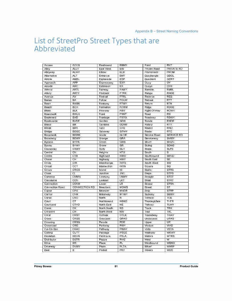
Appendix B – Street Naming Conventions
List of StreetPro Street Types that are Abbreviated
Pitney Bowes 81 Product Guide

StreetPro Australia 2019.02 Product Guide
List of StreetPro Street Suffixes that are Abbreviated
Access ACCS
Alternative ALT
Bikeway BIKEWAY
Bridge BDGE
Busway BUSWAY
Bypass BYPA
Central CN
Connection Road CONNECTION RD
Connection CONN
Crossover CROSSOVER
Deviation DEVN
East E
East west EW
Eastbound EBND
Exit EXT
Extended EXTENDED
Footbridge FOOTBRIDGE
Footway FTWY
North N
North East NE
North South NS
North West NW
Northbound NBND
Overpass OPAS
Private Road PRIVATE RD
Ramp RAMP
Right of Way ROWY
Service Road SERVICE RD
South S
South East SE
South West SW
Southbound SBND
Transitway TWAY
Underpass UPAS
Walk Way WKWY
Westbound WBND
West W
Pitney Bowes 82 Product Guide

C
C – Features layer (RRR_FT) miCodes and Sources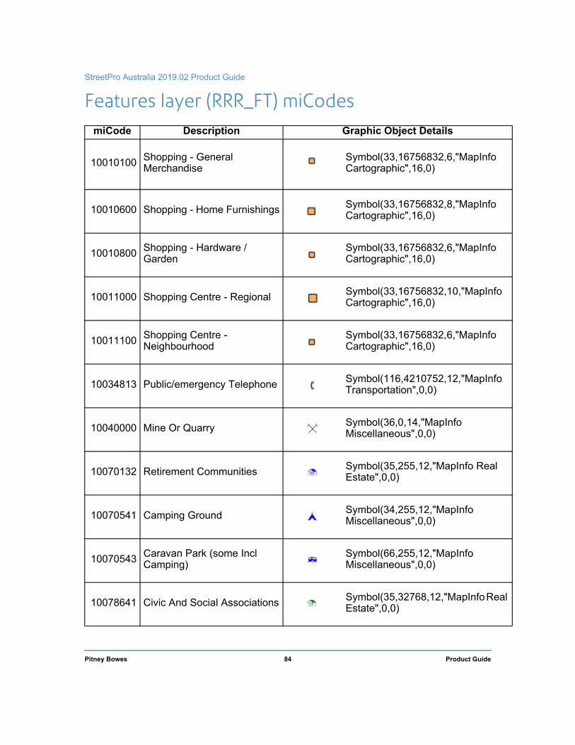
StreetPro Australia 2019.02 Product Guide
l
Features layer (RRR_FT) miCodes miCode Description Graphic Object Details
10010100 Shopping - General Merchandise
Symbol(33,16756832,6,"MapInfo Cartographic",16,0)
10010600 Shopping - Home Furnishings Symbol(33,16756832,8,"MapInfo Cartographic",16,0)
10010800 Shopping - Hardware / Garden
Symbol(33,16756832,6,"MapInfo Cartographic",16,0)
10011000 Shopping Centre - Regional Symbol(33,16756832,10,"MapInfoCartographic",16,0)
10011100 Shopping Centre - Neighbourhood
Symbol(33,16756832,6,"MapInfo Cartographic",16,0)
10034813 Public/emergency Telephone Symbol(116,4210752,12,"MapInfoTransportation",0,0)
10040000 Mine Or Quarry Symbol(36,0,14,"MapInfo Miscellaneous",0,0)
10070132 Retirement Communities Symbol(35,255,12,"MapInfo RealEstate",0,0)
10070541 Camping Ground Symbol(34,255,12,"MapInfo Miscellaneous",0,0)
10070543 Caravan Park (some Incl Camping)
Symbol(66,255,12,"MapInfo Miscellaneous",0,0)
10078641 Civic And Social Associations Symbol(35,32768,12,"MapInfo ReaEstate",0,0)
Pitney Bowes 84 Product Guide

Appendix C – Features layer (RRR_FT) miCodes and Sources
l
l
l
10090110 Power Station Symbol(37,16711680,12,"MapInfoReal Estate",0,0)
10094931 Electricity Distribution, Substation
Symbol(80,4210752,12,"MapInfo Real Estate",0,0)
10094939 Combination Utilities Symbol(80,4210752,12,"MapInfo Real Estate",0,0)
10094941 Water Supply And Treatment Symbol(41,8158332,6,"MapInfo Cartographic",0,0)
10094952 Sewerage Treatment Symbol(41,8158332,6,"MapInfo Cartographic",0,0)
10110000 Tourism Symbol(58,16750640,10,"MapInfoCartographic",16,0)
10110105 Observatory Symbol(118,8388608,12,"MapInfoTransportation",0,0)
10110201 Museum Symbol(50,32768,12,"MapInfo ReaEstate",0,0)
10971902 Art Gallery Symbol(58,16776960,10,"MapInfoCartographic",16,0)
10110300 Monument Symbol(48,32768,12,"MapInfo ReaEstate",0,0)
10110352 Lighthouse Symbol(63,32768,12,"MapInfo ReaEstate",256,0)
10110402 Beach Symbol(94,255,12,"MapInfo Cartographic",0,0)
Pitney Bowes 85 Product Guide

StreetPro Australia 2019.02 Product Guide
l
10110500 Historic Site Symbol(48,32768,12,"MapInfo ReaEstate",0,0)
10110601 Winery Symbol (58,16776960,10,"MapInfoCartographic",16,0)
10110700 Tourist Information Center Symbol(46,255,14,"MapInfo Transportation",0,0)
10110810 Public Toilet Symbol(60,0,12,"MapInfo Miscellaneous",0,0)
10111126 Quarry Symbol(36,0,14,"MapInfo Miscellaneous",0,0)
10120000 Sport Facility Symbol(60,32768,12,"MapInfoCartographic",0,0)
10120003 Horse Riding Symbol(92,8388608,14,"MapInfo Miscellaneous",0,0)
10120007 Cycling/Bmx Symbol(75,0,14,"MapInfo Transportation",256,0)
10120100 Stadium Symbol(58,32768,10,"MapInfoCartographic",256,0)
10120101 Tennis Courts Symbol(60,255,12,"MapInfo Cartographic",0,0)
10120102 Cricket Symbol(60,16711680,12,"MapInfoCartographic",0,0)
10120103 Soccer Field Symbol(60,0,12,"MapInfo Cartographic",0,0)
Pitney Bowes 86 Product Guide

Appendix C – Features layer (RRR_FT) miCodes and Sources
10120106 Hockey Symbol(60,128,12,"MapInfo Cartographic",0,0)
10120108 Golf Course Symbol(55,16711680,12,"MapInfoSymbols",0,0)
10120109 Racecourse Symbol(131,8421376,12,"MapInfoMiscellaneous",0,0)
10120110 Rifle Range Symbol(70,8388608,12,"MapInfo Miscellaneous",0,0)
10120111 Bowling Centre Symbol(60,65280,12,"MapInfoCartographic",0,0)
10120202 Athletic Stadium Symbol(60,32768,12,"MapInfoCartographic",0,0)
10120212 Basketball Symbol(60,16711935,12,"MapInfoCartographic",0,0)
10120214 Netball Symbol(60,16711935,12,"MapInfoCartographic",0,0)
10120215 Lawn Bowls Club Symbol(60,32768,12,"MapInfoCartographic",0,0)
10120300 Water Sport Symbol(60,255,12,"MapInfo Cartographic",0,0)
10120310 Swimming Centre Symbol(100,255,12,"MapInfo Miscellaneous",0,0)
10120340 Boat Ramp Symbol(105,32896,14,"MapInfo Transportation",0,0)
Pitney Bowes 87 Product Guide

StreetPro Australia 2019.02 Product Guide
10130000 Recreation / Entertainment Symbol(58,16776960,10,"MapInfoCartographic",16,0)
10130101 Cultural Centre Symbol(58,16776960,10,"MapInfoCartographic",16,0)
10130102 Community Center Symbol(58,32768,10,"MapInfoCartographic",256,0)
10130103 Community Hall Symbol(58,32768,10,"MapInfoCartographic",256,0)
10130110 Theatre Symbol(58,16776960,10,"MapInfoCartographic",16,0)
10130150 Cinema Symbol(58,16776960,10,"MapInfoCartographic",16,0)
10130211 Playground Symbol(67,20480,12,"MapInfoMiscellaneous",256,0)
10130220 Zoo / Nature Reserve Symbol(63,65280,12,"MapInfoMiscellaneous",0,0)
10130232 Amusement Arcade Symbol(133,20480,12,"MapInfo Miscellaneous",256,0)
10130250 Showgrounds/fairgrounds Symbol(133,20480,12,"MapInfo Miscellaneous",256,0)
10130280 Membership Sports And Recreation Clubs
Symbol(60,32768,12,"MapInfoCartographic",0,0)
10130282 Surf Lifesaving Club, Beach Club
Symbol(60,32768,12,"MapInfoCartographic",0,0)
Pitney Bowes 88 Product Guide

Appendix C – Features layer (RRR_FT) miCodes and Sources
l
l
l
l
10130300 Convention and/or Conference Centre
Symbol(58,16750640,10,"MapInfoCartographic",16,0)
10130533 Picnic Area Symbol(68,20480,12,"MapInfoMiscellaneous",256,0)
10210110 Child Care Symbol(38,16711935,12,"MapInfoReal Estate",0,0)
10210120 Pre-school Symbol(38,16711935,12,"MapInfoReal Estate",0,0)
10210220 Combined School - Private Symbol(38,255,12,"MapInfo RealEstate",0,0)
10210221 Primary School - Private Symbol(38,32768,12,"MapInfo ReaEstate",0,0)
10210223 High School - Private Symbol(38,65535,12,"MapInfo ReaEstate",0,0)
10210230 Combined School - Public Symbol(38,255,12,"MapInfo RealEstate",0,0)
10210231 Primary School - Public Symbol(38,32768,12,"MapInfo ReaEstate",0,0)
10210233 High School - Public Symbol(38,65535,12,"MapInfo ReaEstate",0,0)
10210300 University Symbol(78,0,12,"MapInfo Real Estate",0,0)
10210400 Technical / Business / Trade College
Symbol(38,8421504,12,"MapInfo Real Estate",0,0)
Pitney Bowes 89 Product Guide
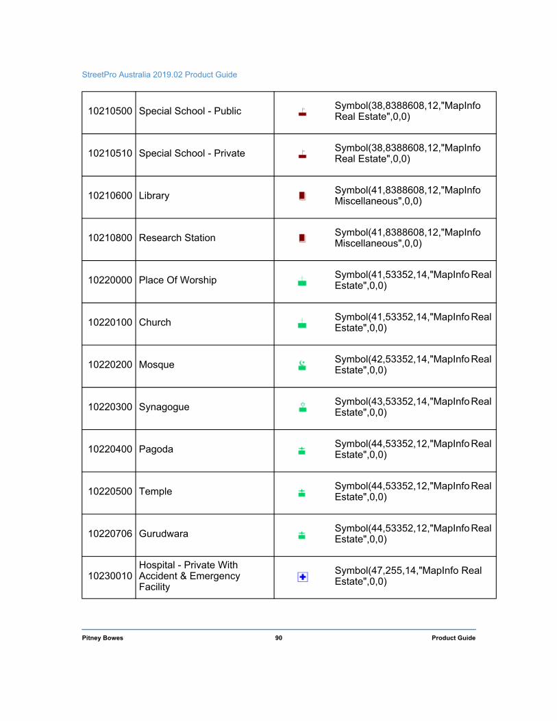
StreetPro Australia 2019.02 Product Guide
l
l
l
l
l
l
l
10210500 Special School - Public Symbol(38,8388608,12,"MapInfo Real Estate",0,0)
10210510 Special School - Private Symbol(38,8388608,12,"MapInfo Real Estate",0,0)
10210600 Library Symbol(41,8388608,12,"MapInfo Miscellaneous",0,0)
10210800 Research Station Symbol(41,8388608,12,"MapInfo Miscellaneous",0,0)
10220000 Place Of Worship Symbol(41,53352,14,"MapInfo ReaEstate",0,0)
10220100 Church Symbol(41,53352,14,"MapInfo ReaEstate",0,0)
10220200 Mosque Symbol(42,53352,14,"MapInfo ReaEstate",0,0)
10220300 Synagogue Symbol(43,53352,14,"MapInfo ReaEstate",0,0)
10220400 Pagoda Symbol(44,53352,12,"MapInfo ReaEstate",0,0)
10220500 Temple Symbol(44,53352,12,"MapInfo ReaEstate",0,0)
10220706 Gurudwara Symbol(44,53352,12,"MapInfo ReaEstate",0,0)
10230010 Hospital - Private With Accident & Emergency Facility
Symbol(47,255,14,"MapInfo RealEstate",0,0)
Pitney Bowes 90 Product Guide

Appendix C – Features layer (RRR_FT) miCodes and Sources
10230020 Hospital - Private Symbol(47,255,14,"MapInfo RealEstate",0,0)
10230110 Hospital - Public With Accident & Emergency Facility
Symbol(47,255,14,"MapInfo RealEstate",0,0)
10230120 Hospital - Public Symbol(47,255,14,"MapInfo RealEstate",0,0)
10230200 Aged Care Facility Symbol(35,255,12,"MapInfo RealEstate",0,0)
10230300 Medical Centre Symbol(47,16711935,14,"MapInfoReal Estate",0,0)
10230400 Offices And Clinics Of Dentists
Symbol(47,7368816,14,"MapInfo Real Estate",0,0)
10230500 Health Service / Day Surgery Symbol(47,16711935,14,"MapInfoReal Estate",0,0)
10230600 Ambulance Station Symbol(81,16711680,14,"MapInfoTransportation",0,0)
10230700 Veterinarian, Veterinary Hospitals
Symbol(47,8388608,14,"MapInfo Real Estate",0,0)
10238063 Psychiatric Hospitals Symbol(47,8388608,14,"MapInfo Real Estate",0,0)
10240100 Government Administration Symbol(50,8388608,12,"MapInfo Real Estate",0,0)
10240102 Courts, Courthouse Symbol(50,8388608,12,"MapInfo Real Estate",0,0)
Pitney Bowes 91 Product Guide

StreetPro Australia 2019.02 Product Guide
l
10240103 Foreign Government Representation
Symbol(117,255,12,"MapInfo Miscellaneous",0,0)
10240300 Police Station Symbol(74,255,12,"MapInfo Transportation",0,0)
10240350 Ses Unit Symbol(47,16744448,14,"MapInfoReal Estate",0,0)
10240360 Emergency Facility Symbol(50,16711680,10,"MapInfoReal Estate",0,0)
10240400 Fire Station Symbol(78,16711680,16,"MapInfoTransportation",0,0)
10240401 Neighbourhood Safer Places,Fire & Emergency Refuge
Symbol(81,8388608,12,"MapInfo Miscellaneous",0,0)
10240500 Post Office Symbol(44,255,12,"MapInfo Miscellaneous",0,0)
10240501 General Post Office Symbol(44,255,12,"MapInfo Miscellaneous",0,0)
10240600 Prison, Correctional Facility Symbol(50,8388608,12,"MapInfo Real Estate",0,0)
10240700 Defence Symbol(48,32768,12,"MapInfo ReaEstate",0,0)
10240800 Cemetery / Crematorium Symbol(67,0,12,"MapInfo Real Estate",0,0)
10240900 Waste Disposal Symbol(35,8388608,12,"MapInfo Symbols",0,0)
Pitney Bowes 92 Product Guide

Appendix C – Features layer (RRR_FT) miCodes and Sources
10310000 Airport Symbol(87,8421504,14,"MapInfo Transportation",0,0)
10310100 Airfield Symbol(87,8421504,14,"MapInfo Transportation",0,0)
10310101 Public Airport Symbol(87,8421504,14,"MapInfo Transportation",0,0)
10310200 Military Airport Symbol(87,8421504,14,"MapInfo Transportation",0,0)
10310300 Helipad Symbol(59,16736352,14,"MapInfoTransportation",0,0)
10320100 Ferry Terminal Symbol(61,255,14,"MapInfo Transportation",0,0)
10320300 Bus Depot Symbol(80,0,12,"MapInfo Transportation",0,0)
10320328 Motorist Rest Areas Symbol(68,20480,12,"MapInfoMiscellaneous",256,0)
10320345 Water Moorings And Unloading Facilities, Wharf
Symbol(105,32896,14,"MapInfo Transportation",0,0)
10330200 Automobile Parking, Open Parking Area
Symbol(41,0,6,"MapInfoCartographic",0,0)
Pitney Bowes 93 Product Guide

StreetPro Australia 2019.02 Product Guide
ent
alia
alia
18
18
ionY)
ion
Ptd
ed.
18
Y)
Y)
ted
alia Y)
alia Y)
CCY)
Sources
Source Details Copyright
ACT education ACT Government Training andEducation Directorate © ACT Governm
Aus Dept of Health
Australian Govt Department of Health © Commonwealth of Austr
Aus Dept of Social Services
Australian Govt Department of Social Services Aged Care locations
© Commonwealth of Austr
Customer feedback
Location and/or attributes provided by customer feedback
DIMASI MacroPlanDimasi Retail Locations (under licence) © MacroPlan Dimasi 20
Field capture Captured by Pitney Bowes’ streetdata collection team © Pitney Bowes 20
NSW Education NSW Department of Education © NSW Department of Educatand Communities (CC B
NT Education NT Department of Education © NT Department of Educat
PSMA Public Sector Mapping Agency Features of Interest
© 2018 PSMA Australia
Ltd. All rights reserv
Public Transport Vic Public Transport Victoria © Transport for Victoria 20
QLD Education QLD Department of Education © The State of Queensland (CC B
QLD Health QLD Department of Health © The State of Queensland (CC B
QR Queensland Rail © Queensland Rail Limi
SA education SA Department of Education © Government of South Austr(CC B
SA Health SA Department of Health © Government of South Austr(CC B
State Library Qld State Library of QLD Library locations via data.gov.au
© State Library of Queensland (B
Pitney Bowes 94 Product Guide

Appendix C – Features layer (RRR_FT) miCodes and Sources
t of ing13Y)
ia, Y)
ia, Y) ria
t ofng)
alia
alia
TAFE SA TAFE SA website
© TAFE SA, the GovernmenSouth Australia, Mining, Engineerand Transport Centre, sourced 20
(CC B
TAS Education Tasmania Department of Education
© Government of TasmanDepartment of Education (CC B
TAS Health Tasmania Department of Healthand Human Services
© Government of TasmanDepartment of Education (CC B
VIC Health VicHealth © State of Victo
VRQA Victorian Registration and Qualifications Authority
© State of Victoria (DepartmenEducation and Traini
WA education WA Department of Education © Government of Western Austr
WA health WA Department of Health © Government of Western Austr
Pitney Bowes 95 Product Guide

D
D – Data Support and FeedbackPitney Bowes continues to enhance the data support and feedback facilities available to our clients. An infrastructure has been developed to streamline the handling of customer feedback regarding data products and to ensure that appropriate responses are provided, with corrective action being taken where appropriate.
Feedback Process The process is as follows:
1. Completion of Feedback Form by Client: A printed Data Feeedback form is supplied with this product. There is also an electronic version of the same form on the product media.
You can also email comments (and associated screenshots) directly to the following email address:
2. Handling: All customers are sent confirmation of receipt of email feedback, and then subsequently notified of the type and timetable of the corrective action (where appropriate). Dependent on the type of feedback, the report may be actioned immediately or scheduled for routine maintenance action as part of the next scheduled release.
The Feedback Database keeps track of progress on each item. Follow-up action and advice are provided wherever necessary.

Appendix D: Data Support and Feedback
Electronic Feedback Form You can send us feedback on any of the data products supplied by Pitney Bowes, by completing the information below and clicking Send in the lower-right corner of the page. This generates an e-mail to which you can attach any screenshots that you feel would help illustrate your feedback.
Feedback can be in the form of correction advice, notification of changes, requests for enhancements/ features, or requests for information. All feedback is valued by the Data Production Team and contributes to product improvements and enhanced value to users.
Your feedback will be emailed directly to the AsiaPac Data Production Team at [email protected], who will review and action it as soon as is practicable.
Contact Preferences May we contact you if we have questions about your comments?
Yes No
Contact Information
Name:
Email:
Phone:
Best time to contact:
Data/Software Versions Please complete the following information (as applicable):
Name of Data Product:
Version of Data Product:
Software used to load Data:
Version of Software used:
Your Comments Enter your comments below. If you wish to report any problems, please feel free to do so but be as specific as possible, giving the relevant codes and tables. Thank you in advance.
If you reported any problems above, please indicate the severity of their impact by clicking the appropriate button:
Could not carry on working Inconvenient, but able to continue Cosmetic only, no real impact
Not applicable