Stratigraphy of Stephens Subgroup (Maitai Group) in the Countess Range — Mararoa River area,...
14
© .foull/af r.if lhl' ROJ'af Soddy r.if New Zeafand f'ofuml' 18, Number 3, 1988, pp, 271-284 Stratigraphy of Stephens Subgroup (Maitai Group) in the Countess Range - Mararoa River area, northwestern Southland, New Zealand J. C. Aitchison, *t C. A. Landis' and 1. M. Turnbull" Stephens Subgroup (upper Maitai Group) is well exposed (except for its top) for over 30 km in the Countess Range, Snowdon Peak and Bare Peak-Mararoa River areas. The sequence consists of 2750 m of sedimentary rocks 'which include volcaniclastic sandstone, conglomerate, and siltstones, conspicuous tuffs and occasional limestone lenses. The subgroup is subdivided into five formations; four of them are new. Kiwi Burn Tuffs (new) is characterised by tuff. Acheron Lakes Sandstone (new) is a thick sequence of volcaniclastic sandstones. Cerberus Formation (new) is dominated by red coloured siltstone and sandstone, Eldon Formation (new) is another sequence ofvoIcaniclastic sandstones, and Snowdon Formation is of variable lithology including volcaniclastic sandstone, conglomerate, siltstone and tuff. Fossils arc rare in the Stephens Subgroup. However, Pennophorus obovatus is found in the Retford Conglomerate Member, which has now been traced to the Mararoa River. This, along with Mellarium and radiometric ages from middle Snowdon tuff, clearly indicate an Early-Middle Triassic age for the Snowdon Formation. Basal Stephens Subgroup formations may also be of Early Triassic or even of Permian-Triassic boundary age. KC)'words: Stephens Subgroup, Alaitai Group, Kiwi Bum Tliffs (new), Acheron Lakes Sandstone (new), Cerberus Formation (new), Eldon Sandstone (new), Snowdon pormation, Pmnian, Triarsic, stratigraphy, northwest 00u[h/and. INTRODUCTION The upper part of the Maitai Group (Permian-Triassic) is well exposed in the mountains of western Southland, particularly in the Countess Range (Figs 1, 2). Here, a sequence originally mapped as Countess Formation (Grindley, 1958) and comprising more than 2750 m of volcanogenic sandstones and siltstones, with lesser tuffs and conglomerates, rests in depositional contact on the distinctive lower formations of the Maitai Group (Grindley, 1958; Waterhouse, 1964; Landis, 1980). New stratigraphic information (Aitchison, 1984), here combined with a previous study (Landis, 1974) and regional mapping (Turnbull, 1986), permits subdivision of the original Countess Formation throughout a 30 km belt extending from Countess Peak south to Mararoa River. Correlation with Stephens Formation (Maitai Group) rocks on the northwest side of the Alpine Fault in Nelson (Fig. 1) is compelling, and we propose to elevate Stephens to subgroup status, including within it all rocks of the original Countess and Stephens formations. This proposal is broadly compatible with earlier suggestions by Waterhouse (1964), Landis (1980), and Hyden et ai. (1982). Knowledge of Stephens rocks is crucial to understanding regional stIucture and stratigraphy of western Southland and northwestern Otago, relations across the Alpine Fault, and Permian-Traissic paleogeography. In addition, Waterhouse (1964, 1979a) argues that the Permian-Triassic boundary lies within this unit. * Geology Department, University of Otago, P.O. Box 56, Dunedin, New Zealand. ** Geological Survey, Department of Scientific and Industrial Research, Private Bag, Dunedin. t Department of Geology and Geophysics, University of New England, Armidale, NSW 2351, Australia.
Transcript of Stratigraphy of Stephens Subgroup (Maitai Group) in the Countess Range — Mararoa River area,...

© .foull/af r.if lhl' ROJ'af Soddy r.if New Zeafand f'ofuml' 18, Number 3, 1988, pp, 271-284
Stratigraphy of Stephens Subgroup (Maitai Group) in the Countess Range - Mararoa River area, northwestern Southland, New Zealand
J. C. Aitchison, *t C. A. Landis' and 1. M. Turnbull"
Stephens Subgroup (upper Maitai Group) is well exposed (except for its top) for over 30 km in the Countess Range, Snowdon Peak and Bare Peak-Mararoa River areas. The sequence consists of 2750 m of sedimentary rocks 'which include volcaniclastic sandstone, conglomerate, and siltstones, conspicuous tuffs and occasional limestone lenses. The subgroup is subdivided into five formations; four of them are new. Kiwi Burn Tuffs (new) is characterised by tuff. Acheron Lakes Sandstone (new) is a thick sequence of volcaniclastic sandstones. Cerberus Formation (new) is dominated by red coloured siltstone and sandstone, Eldon Formation (new) is another sequence ofvoIcaniclastic sandstones, and Snowdon Formation is of variable lithology including volcaniclastic sandstone, conglomerate, siltstone and tuff.
Fossils arc rare in the Stephens Subgroup. However, Pennophorus obovatus is found in the Retford Conglomerate Member, which has now been traced to the Mararoa River. This, along with Mellarium and radiometric ages from middle Snowdon tuff, clearly indicate an Early-Middle Triassic age for the Snowdon Formation. Basal Stephens Subgroup formations may also be of Early Triassic or even of Permian-Triassic boundary age.
KC)'words: Stephens Subgroup, Alaitai Group, Kiwi Bum Tliffs (new), Acheron Lakes Sandstone (new), Cerberus Formation (new), Eldon Sandstone (new), Snowdon pormation, Pmnian, Triarsic, stratigraphy, northwest 00u[h/and.
INTRODUCTION The upper part of the Maitai Group (Permian-Triassic) is well exposed in the mountains
of western Southland, particularly in the Countess Range (Figs 1, 2). Here, a sequence originally mapped as Countess Formation (Grindley, 1958) and comprising more than 2750 m of volcanogenic sandstones and siltstones, with lesser tuffs and conglomerates, rests in depositional contact on the distinctive lower formations of the Maitai Group (Grindley, 1958; Waterhouse, 1964; Landis, 1980).
New stratigraphic information (Aitchison, 1984), here combined with a previous study (Landis, 1974) and regional mapping (Turnbull, 1986), permits subdivision of the original Countess Formation throughout a 30 km belt extending from Countess Peak south to Mararoa River. Correlation with Stephens Formation (Maitai Group) rocks on the northwest side of the Alpine Fault in Nelson (Fig. 1) is compelling, and we propose to elevate Stephens to subgroup status, including within it all rocks of the original Countess and Stephens formations. This proposal is broadly compatible with earlier suggestions by Waterhouse (1964), Landis (1980), and Hyden et ai. (1982). Knowledge of Stephens rocks is crucial to understanding regional stIucture and stratigraphy of western Southland and northwestern Otago, relations across the Alpine Fault, and Permian-Traissic paleogeography. In addition, Waterhouse (1964, 1979a) argues that the Permian-Triassic boundary lies within this unit.
* Geology Department, University of Otago, P.O. Box 56, Dunedin, New Zealand. ** Geological Survey, Department of Scientific and Industrial Research, Private Bag, Dunedin. t Department of Geology and Geophysics, University of New England, Armidale, NSW 2351,
Australia.

272 Journal of the Royal Society of New Zealand, Volume 18, 1988
/.
CoooteS$ Rangs Bare Pk
Fig. 1-Map of the South Island, New Zealand, showing Dun Mountain-Maitai terrane and geographical localities of Stephens Subgroup and correlatives. (Ultramafic and associated ophiolitic rocks arc shown in black)
REGIONAL GEOLOGICAL FRAMEWORK Summary accounts by Coombs et al. (1976) and Suggate et al. (1978) give a regional
synthesis. Stephens rocks are included within the Dun Mountain-:rvlaitai terrane of Bishop et al. (1985). Possible relations with rocks of the Murihiku terrane and other latc PaleozoicMesozoic terranes \V,ill be discussed in detail later in another paper by Aitchison and Landis (in prep). Maitai rocks in northwest Southland lie within a north-striking regional zone where they occupy the overturned limbs and axial portion of the Key Summit Syncline (e.g. Wood, 1962, 1966). Despite near-isoclinal folding and extensive lower grade metamorphism (Landis, 1974), rocks show little evidence of internal deformation; the bedding and intra-bed sedimentary structures are reasonably well preserved.
Rocks of the Key Summit Syncline are bounded on the west (in this area) by the Countess Fault (Grindley, 1958), a component of the Hollyford Fault System (Landis, 1980 and Fig. 2). Within the study area, the Maitai Group rocks are mainly west-facing, and are cut longitudinally by the Upukerora Fault (Grindley, 1958) and other faults Crurnbull, 1986) which divide the group into two main slabs (Fig. 2). Maitai strata of the eastern slab rest in depositional contact on volcanics of the Dun Mountain Ophiolite Belt at Anneal' Creek (Fig. 2 and Waterhouse, 1964; Pillai, 1981); elsewhere, east of

~pl { LEGEND
STEPHENS SUBGROUP
fZ':2l Snowdon Formation
D Eldon Sandstone
[e7C] Cerberus FOl'matlon
§ Achoroo Sandstone
~~ KIwi Burn Tuffs
a undifferentiated
~ Walua formation
SVMBOLS
Contacts, kro., approxlmate
Faults, ----~ ....... ---Bedding, normal \
overturned " Fold axis, syncline -I-fossil locality, f7501(\
TOPOGRAPHIC REFERENCE
Stream, ~~ T~g, A
Petak, "'3677 {from NZMS 1)5141 1973 S131 1978
• N
"1..~ '''' 1000~
A ~ ~~~~l.. __ -'2kllomot"'"
N Z. SOUTH ISLAND
I map1 't / map2 map3
D
LITTLE
Fig. 2-Geological maps of the Countess Range, Snowdon Peak and Mararoa River areas, showing distribution and structure of Stephens Subgroup rocks. Middle and upper Stephens Subgroup rocks are undifferentiated on Snowdon Peak. Map grids from NZMS 1 maps S131 and S141.
:,.
~ ~.
§ ;p,
f".. I
S:? ;; &. ~
-§. ~ ~
'" '" I fp ~ ~ ~
"" " w
-I

274 Journal oj the Royal Society oj New Zealand, Volume 18, 1988
the Upukerora Valley, they arc in tectonic contact with ophiolitic melanges associated with the Livingstone Fault System (Fig. 1). Transverse faults with strike slip displacement are also recognised; these include the Winton Fault (Fig. 2), branches of the Upukerora Fault (Turnbull, 1986), and the Mararoa Fault (Landis, 1974), which forms the southern truncation of the rocks described here;
PREVIOUS WORK The first detailed mapping and stratigraphic study of the Countess Range and adjoining
areas was done by Grindley (1948, 1958). He defined the Countess Formation, regarding it as the uppermost unit of the Maitai Group, and dividing it into informal upper and lower members. Grindley also proposed a Late Permian age on the basis of a gastropod fossil collected from the upper member. Waterhouse (1960) revised an earlier identification of the upper Countess gastropod from Shansiella (Waterhouse, in Grindley, 1958) placing it in a new genus, Mellarium, of Middle Triassic age. Later, in a major study of New Zealand Permian stratigraphy and faunas, Waterhouse (1964) re-defined the Countess Formation as "restricted to the ?Permian part of Grindley's Countess Formation", and incorporated it in his Bryneira Group. Waterhouse also reported permophorid bivalves from "Triassic beds" overlying the newly re-defined Countess Formation and speculated on the possible position of the Permian-Triassic boundary.
Landis (1974), in an account of mainly Maitai rocks in the Snowdon Peak-Mararoa River region, generally accepted Waterhouse's (1964) restriction of the Countess Formation and presented further lithologic and stratigraphic descriptions of these rocks. He described and named the Snowdon Formation, equivalent to Grindley's upper member of the Countess Formation (the "Triassic" of Waterhouse 1964), and showed that it extended to the Mararoa River. It was treated as a component of the Murihiku Supergroup following Campbell and Coombs (1966). In a subsequent study, Landis (1980) placed Stephens (Countess) rocks, including Snowdon Formation, in the Maitai Group.
In a description of New Zealand Early Triassic permophorid bivalves, Waterhouse (1979a) documented Countess Range specimens of PennopllOrus obovatus from the Snowdon Formation. In the same paper, Waterhouse also proposed recognition of the Retford Conglomerate-Breccia Member as the fossiliferous basal component of the Snowdon Formation.
Discovery of a rich upper Permian fauna in Stephens rocks at Mossburn (Fig. 1) was reported by Hyden et af. (1982).
Regional mapping of the Countess Range and Snowdon Peak areas at 1 :50,000 scale was recently completed by Turnbull (1986), who used Stephens Formation for all those rocks originally described as Countess Formation by Grindley (1958), and also mapped distinctive lithologies corresponding to some of the formations introduced here.
LITHOSTRATIGRAPHY Stephens Subgroup is defined here as comprising those strata previously included within
the Stephens, Countess and Snowdon formations in Nelson and Southland. Four new formations are proposed; the Snowdon Formation is retained, and the use of the term Countess is abandoned. MappabiIity of the five constituent formations over a 40 km belt in western Southland is demonstrated (Fig. 2). Similar lithologic units are seen northwest of the Alpine Fault (Johnston, 1981, 1982a, 1982b, 1983) although further work is necessary before their mapping is extended. More than 2500 m of Stephens rocks are exposed in the Countess Range; Stephens stratigraphy is summarised in Fig. 3.
Stephens (speIIed Stevens) was introduced into Maitai terminology by Wellman (in Rigg et al., 1957), but Waterhouse (1964) was the first author to define the unit formally, designating a type section at Cape Stephens, D'Urville Island (Waterhouse 1964:24). In view of the restricted outcrop at Cape Stephens (= 1000 m of section is present), and its great distance from western Southland exposures, a southern reference section is desirable. The main ridge of the Countess Range which, although oblique to strike, exposes 2750 m of strata, is here proposed as reference section for the Stephens Subgroup.

Aitchison et al. -Stratigraphy oj Stephens Subgroup 275
ANISIAN MIO TRIASSIC
"'"""" EARLY TRIASSIC
220-231M-a. 0049183 MellatkHn ct mulch! 042/17501
CIadopN>ebis oblonga
Di«oidiurn sp. 042/17539 Desmiophytlum cI. indicUm
plant f,agments
SILTSTONE
CONGLOMERATE (RelfOrd Co"9kimerala Membef)
TUFF
MASSIVE SANOSTONE
RED $U..TSTONE
& SANDSTONE
ELDON SST.
CERBERUS FIm.
Fig. 3 - Summaty stratigraphic column of Stephens Subgroup rocks as seen in the Countess Range. Dominant lithologies are shown, and the approximate positions of faunal, floral, and geochronometric samples in adjacent areas of Stephens Subgroup outcrop (Countess Range, Snowdon Peak, Bare Peak-lvlararoa River). Possible lithostratigraphic correlation onvlossburn faunal locality (Hyden el al., 1982) is also shown.
Stephens rocks have long been included within the Ivfaitai Group (or IVlaitai Series; Grindley, 1958), and we see no reason to modify this practice. The five constituent formations bear an overall lithological similarity to, and stratigraphic continuity with, the underlying Maitai formations. The presence of numerous vitric tuff beds 'within the Stephens distinguishes it from the rest of the IVfaitai Group, which is only locally tuffaceous.
KIWI BURN TUFFS (new name)
Introduction and Definition Basal Stephens strata are characterised by conspicuous light coloured tuff beds (Fig. 4)
which rest on the underlying Waiua Formation. These constitute the Kiwi Burn Tuffs. The Kiwi Burn, a tributary of the Mararoa River, drains areas underlain by lower Stephens rocks (S141 GR035250)*. The unit is equivalent to the lower part of Unit 1 of the Countess Formation as described by Landis (1974), and to the "black mudstone with discontinuous tuff beds" mapped by Turnbull (1986). The base of the Kiwi Burn Tuffs is defined as the first tuff overlying laminated hematitic siltstones and sandstones of the Waiua Formation (S141 GR050383 in type section). The Kiwi Burn rocks rest confomably upon the Waiua Formation within the study area. In the Tapara Range! 12 km north of Countess Peak, Grindley (1958)
* Grid references are taken from the 1:63360 scale NZ:~'iIS 1 series topographical maps S131 and S141. These are used in preference to metric grid references, as 1:50,000 NZi\·lS 260 series maps will not be available for some time.

276 Journal of the Royal Society of New Zealand, Volume 18, 1988
Fig. 4-Steeply dipping tuff beds of Kiwi Burn Tuffs exposed at a reference section on the ridge leading east from Countess Peak. Photograph shO\vs vie\\' southwards from Countess Peak.
describes basal Stephens strata as resting in erosional contact upon Grcville Formation with Waiua rocks missing. At the Stephens' type locality on DIUrville Island, Waterhouse (1964) describes basal Stephens conglomerate scoured into the Waiua. Re-examination of these localities by one of us (C.A. L.) revealed widespread evidence for faulting at the Stephens-Grcville contact in the Tapara Range, whereas no unconformity could be recognised; the erosional nature of the base on D'Urvillc Island was confirmed. The type section is designated where these rocks are best exposed, which is on the ridge leading southeast from Snowdon Peak (Fig. 5). A reference section is proposed on the ridge leading east from Countess Peak to the saddle between Anneal' Creek and Upukerora River.
Lithology Kiwi Burn rocks are dominated by fine- to medium-grained, light coloured, vitric tuffs
in beds up to 1 m thick. Associated beds include fine-grained, dark coloured (but light weathering) tuff, volcaniclastic sandstone and siltstone and minor conglomerate. Small (10 em maximum dimension) concretionary blocks of calcareous sandstone and siltstone may be seen near Snowdon Peak (S131 GR057378).
Outcrops typically weather to poorly vegetated, fine grained angular screes of distinctive yellowish grey to brown colour. The tuft's characteristically appear cherty on freshly broken surfaces, and many also show distinctive metasomatic mottling (e.g. Landis, 1974, fig. 5A). Metamorphism has produced lawsonite-pumpellyite-quartz rich assemblages.
Distribution and Thickness Kiwi Burn Tuffs are exposed from the ridge north of Countess Peak south along the
east side of the Countess Range to the Upukerora River. Good exposures also occur on the eastern side of Snowdon Peak (type section). Outcrop is largely obscured by bush and screes in the Bare Peak-Mararoa River area. Thickness is 175 m at the type section, 155 m at Countess Peak and approximately 150 m at :NIararoa River.

Aitchison et al. -Stratigraphy) if Stephens Subgroup 277
Fig. 5 - Kiwi Burn Tuffs exposed on the cast face of Snowdon Peak. The type section is on the ridge sloping from the top left to bottom right of the photograph.
ACHERON LAKES SANDSTONE (new name) Introduction and Definition
The name Acheron Lakes Sandstone is introduced for thick bedded volcaniclastic sandstones overlying the Kiwi Burn Tuffs. The base is drawn at the first conspicuous volcaniclastic sandstone (S131 GR023606 in type section) overlying the highest vitric tuff or mudstone of the Kiwi Burn Tuffs, and is conformable. The formation is equivalent to the basal part of the Countess Formation as described by Grindley (1958) and Waterhouse (1964), and to the upper part of the Countess Formation Unit 1 of Landis (1974). The sandstones are named after Acheron Lakes in the Livingstone iVlountains, east of the southernmost Acheron Lakes Sandstone outcrops in the Countess Range.
The type section is on the north side of Countess Peak (D42 GR023606) along the Countess Range to the upper contact (with Cerberus Formation) at the col between Countess Peak and Peak 5700 (NZlvlS 1 Sheet S131).
Lithology Acheron Lakes Sandstone is dominated by thickly bedded (1-2 m) greenish-grey
coloured, massive, medium to coarse grained volcaniclastic sandstone. Associated lithologies include thinly bedded siltstone and fine sandstone, red and green mudstone and occasional tuff to the south of Countess Peak (S131 GR022600) and a resistant conglomerate on Snowdon Peak (S141 GR046368). Sandstones are characteristically moderately sorted, ranging in composition from vo1carenite to feldspathic volcarenite. Bedding is commonly amalgamated. The dark greenish grey colour reflects a basaltic andesite derivation and an abundance of authigenic iron-rich pumpellyite and chlorite. Detrital quartz grains are rare to absent.
Distribution and Thickness Acheron Lakes Sandstone is exposed throughout the mapped area (Figs 2, 6) forming
much of the crest of the northern Countess Range, and the upper slopes of Snowdon Peak. It is approximately 550 m thick at Countess Peak, and 630 m at Ivlararoa River. Preliminary work at Snowdon Peak indicates a thickness of approximately 680 m,
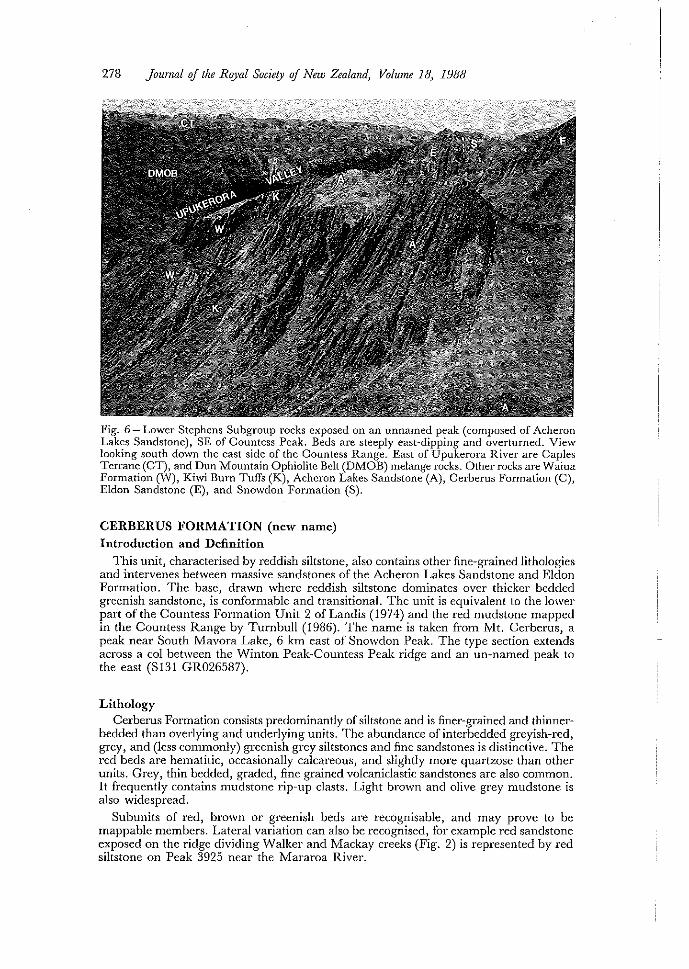
278 Journal of the Royal Society of New Zealand, Volume 18, 1988
Fig. 6 - Lower Stephens Subgroup rocks exposed on an unnamed peak (composed of Acheron Lakes Sandstone), SE of Countess Peak. Beds are steeply east-dipping and overturned. View looking south down the east side of the Countess Range. East of Upukerora River are Caples Terrane (CT), and Dun Mountain Ophiolite Belt (D:tvl0B) melange rocks. Other rocks are Waiua Formation (W), Kiwi Burn TufTs (K), Achcron Lakes Sandstone (A), Cerberus Formation (C), Eldon Sandstone (E), and Snowdon Formation (8).
CERBERUS FORMATION (new name)
Introduction and Definition
This unit, characterised by reddish siltstone, also contains other fine-grained lithologies and intervenes between massive sandstones of the Acheron Lakes Sandstone and Eldon Formation. The base, drawn where reddish siltstone dominates over thicker bedded greenish sandstone, is conformable and transitional. The unit is equivalent to the lower part of the Countess Formation Unit 2 of Landis (1974) and the red mudstone mapped in the Countess Range by Turnbull (1986). The name is taken from Mt. Cerberus, a peak near South Mavora Lake, 6 km east of Snowdon Peak. The type section extends across a col between the Winton Peak-Countess Peak ridge and an un-named peak to the east (S131 GR026587).
Lithology Cerberus Formation consists predominantly of siltstone and is finer-grained and thinner
bedded than overlying and underlying units. The abundance of interbedded greyish-red, grey, and (less commonly) greenish grey siltstones and fine sandstones is distinctive. The red beds are hematitic, occasionally calcareous, and slightly more quartzose than other units. Grey, thin bedded, graded, fine grained volcaniclastic sandstones are also common. It frequently contains mudstone rip-up clasts. Light brown and olive grey mudstone is also widespread.
Subunits of red, brown or greenish beds are recognisable, and may prove to be mappable members. Lateral variation can also be recognised, for example red sandstone exposed on the ridge dividing Walker and :Nlackay creeks (Fig. 2) is represented by red siltstone on Peak 3925 ncar the Mararoa River.
Aitchison et a!. -Stratigraphy oj Stephens Subgroup 279
Distribution and Thickness Cerberus Formation is found throughout the Countess Range, where it is commonly
exposed in cols and gullies, reflecting its finer grain size and thinner bedding. Thickness here ranges between 115-230 m. Similar lithologies on the south end of the long spur leading south from Snowdon Peak are exposed in a gently southward plunging syncline. However, further mapping is needed in the Snowdon Peak area before this correlation can be confirmed. A complete sequence is recognised to the south at Bare Peak and on the east side of Peak 3925 (Fig. 2) where a 300 m section is present.
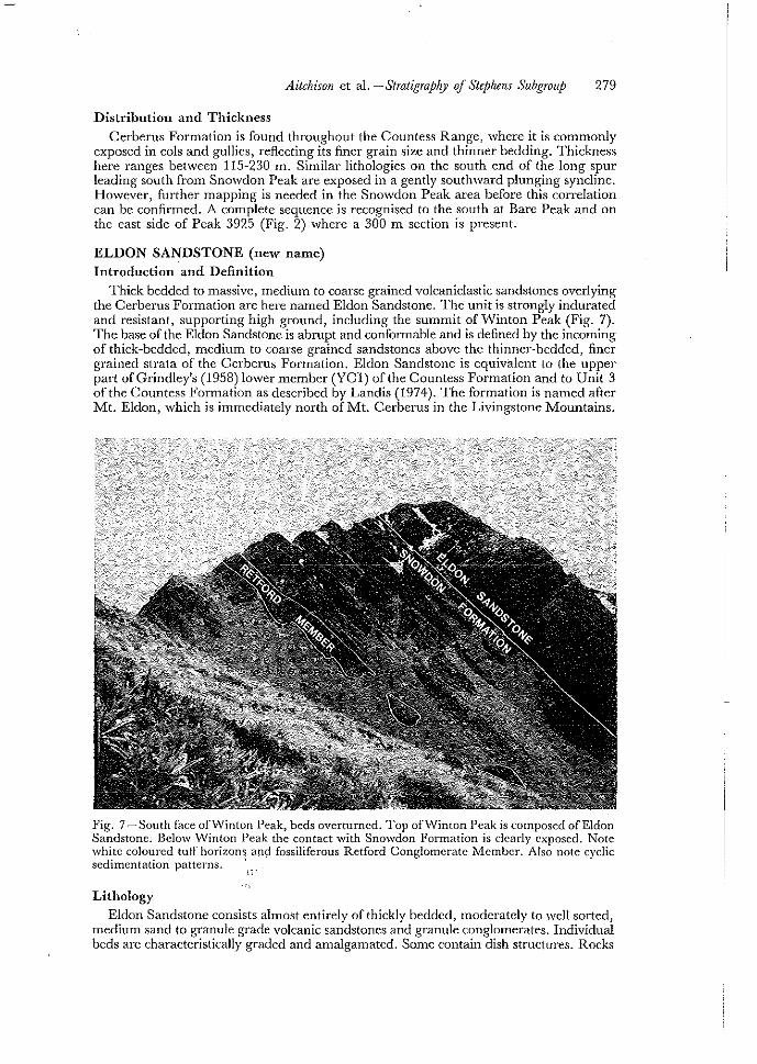
ELDON SANDSTONE (new name) Introduction and Definition
Thick bedded to massive, medium to coarse grained volcaniclastic sandstones overlying the Cerberus Formation are here named Eldon Sandstone. The unit is strongly indurated and resistant, supporting high ground, including the summit of Winton Peak (Fig. 7). The base of the Eldon Sandstone is abrupt and confOlmable and is defmed by the incoming of thick-bedded, medium to coarse grained sandstones above the thinner-bedded, finer grained strata of the Cerberus Formation. Eldon Sandstone is equivalent to the upper part of Grindley's (1958) lower member (YCl) of the Countess Formation and to Unit 3 of the Countess Formation as described by Landis (1974). The formation is named after Mt. Eldon, which is immediately north of Mt. Cerberus in the Livingstone Mountains.
Fig. 7 -South face ofvVinton Peak, beds overturned. Top onNinton Peak is composed of Eldon Sandstone. Below vVinton Peak the contact with Snmvdon Formation is clearly exposed. Note white coloured tuff horizons and fossiliferous Retford Conglomerate Member. Also note cyclic sedimentation patterns. ' "
" Lithology
Eldon Sandstone consists almost entirely of thickly bedded, moderately to well sorted, medium sand to granule grade volcanic sandstones and granule conglomerates. Individual beds are characteristically graded and amalgamated. Some contain dish structures. Rocks

280 Journa! of the ROJ'a! Society of New Zealand, Volume 18, 1988
are green or greenish-grey in colour, reflecting basic volcanic composition and the abundance ofiron-rich pumpellyite and chlorite. Pyrite and plant scraps are also present. Detrital pyroxene is conspicuous in some hand specimens.
Distribution and Thickness Eldon Sandstone forms a distinctive band extending obliquely across the Countess
Range from the divide between Walker and Mackay creeks south to the Upukerora River. It is also exposed in the Bare Peak-Mararoa River area, where it supports the summit of Peak 3925. A maximum thickness of 550 m is recorded at Peak 5600 in the Countess Range; to the north thickness reduces to 300 m while to the south at Mararoa only 150 m is exposed.
SNOWDON FORMATION
Introduction and Definition The Snowdon Formation was introduced by Landis (1974) in large part to formalise
and upgrade Grindley's (1958) upper (YC2)·member of the Countess Formation. It is characterised by a varied lithologic assemblage consisting mainly of interbedded sandstone and siltstone units in varying proportions and colours, but also includes conspicuous conglomerate and tuff. Molluscan and plant fossils are also present. Thus, the Snowdon Formation lacks a distinctive simplicity. The base was originally taken as "the lowest conspicuous tuff, conglomerate or unconformity" (Landis, 1974). We propose a revision, lowering the base slightly to a lithologic break mappable throughout the area investigated: the base of the Snowdon Formation is here defined as the fii'st appearance of fine grained, thinly bedded sandstone and siltstone (S131 GR021570 in type section) above the Eldon Sandstone. The type section is-modified to commence just beneath the summit of Winton Peak, on the south ridge, continuing in a southerly direction along the crest of the Countess Range to where the formation is truncated by the Countess Fault (Fig. 2), The top of the unit is everywhere removed by faulting.
Lithology and Subdivision Thickly bedded volcaniclastic sandstones and mudstones form the bulk of the Snowdon
Formation. These characteristically show sedimentary structures indicating turbidity current deposition. Maroon (greyish purple) siltstone and fine grained sandstone that are conspicuous near the base are well exposed on the north ridge of\l\1inton Peak. VVhite weathering (very light grey to yellowish grey) vitric tuffs rich in laumontite are also conspicuous, especially near the base of the formation. These are found as isolated thin beds and as composite beds up to 2 m thick.
Conglomerate horizons form a conspicuous though minor component. They exhibit lateral as -well as vertical grading; thus a conspicuous cobble conglomerate exposed on the west side of Peak 5600 (Fig. 2, map 1) can be traced north approximately 1 km to near Winton Peak, where it is a granule conglomerate. Another conglomerate comprises 2 m of vertically graded granule to coarse sand grade sediment rich in shells of the bivalve Permophorus ohovatus, which Waterhouse (1979a) named Retford Conglomerate-Breccia Member; we have traced this unit over 2 km from the head of ,1\1 alker Creek (S131 GR016586) to a small promontory south of Winton Peak (S131 GR025564, Fig. 7). Boulders of the same lithology were collected on the slopes of Peak 5600 (D42 GR032556) and similar rocks are also exposed in a comparable stratigraphic position near Mararoa River (S141 GR062250). Further work may show the Retford Member to be a regionally extensive unit within the basal Snowdon Formation. We note. however, that the unit is rarely a breccia and suggest a name revision to Retford Conglomerate Member. Further formal subdivision of Snowdon rocks is not attempted here, although conspicuous pale buff laumontite tuffs (Landis, 1974:241). conglomerates, and maroon argillaceous horizons all provide useful marker horizons within the dominantly sandstone-siltstone sequence.
Distribution and Thickness Snowdon Formation is exposed in a SSE-trending band along the western flank of
the Countess Range and into the Upukerora Valley. The formation is again seen at Bare

Aitchison et al. -Stratigraphy oJ Stephens Subgroup 281
Peak and continues to Little Hill (S141 GR053212). The top of the Snowdon is not exposed; the uppermost beds are in fault contact with Cenozoic sediments. Ivlore than 1200 m thickness is exposed in the Countess Range, and at least 1300 ill along the Mararoa River. Snowdon rocks have not been mapped north of the Countess Range. A thin, fault-bounded sequence of distinctive laumontitic, vitric tuffs and purple siltstones is exposed near \"'hanga~oa Head 30 km north of Nelson City (Landis, 1969). The rocks are surrounded by older Stephens rocks, but are quite distinctive in both lithology and lower degree of metamorphism, and may be Snowdon Formation correlatives.
PALEONTOLOGY Stephens Subgroup strata within the study area contain few macrofossils. Only the
Snowdon Formation has yielded substantial material, including molluscan and plant remains in some abundance as well as rarer brachiopods and echinoderm fragments. In addition, Acheron Lakes and Kiwi Burn formations have yielded some poorly preserved material. Stephens rocks near Mossburn, south of the present study area, and in the Nelson region, also have significant faunas.
Early discoveries and descriptions of J\1ellarium and PermophoTlls from the Snowdon Formation are summarised in the introduction to this paper. vVe concur with vVaterhouse (1979a) that Permophorus is abundant in the Retford Conglomerate lvlember. In addition, Permophorus is found in rocks of a similar lithology in the lower part of the Snowdon Formation north of the :Nlararoa River (D43/fD15). This locality has also yielded a rhynchonellid brachiopod, which is regarded (Dr D. A. B. JVfacfarlan, pers. comm. 1984) as probably belonging to a new genus of Early Triassic age. A similar poorly preserved rhynchonel1id is also found in Retford Member beds in the Countess Range. This locality (D42/fD65) was first reported by Hyden et al. (1982), but we note that the location cited by them (Mackay Creek) is incorrect. The specimen was collected from a small promontory (S131 GR025564) ncar the head of the stream draining southeast from vVinton Peak into the Upukerora Valley. Pennophorus and crinoid fragments were also found upon recollection of this locality, and along strike 200 m west of the summit of\"'inton Peak at D42/f106. Well preserved crinoid plates and articulated columnals, poorly preserved molluscan fragments and plant stems were reported by Landis (1974) from Peak 3925 near the Mararoa River (D43/051O), and we report further crinoid fragments and an indeterminate septate fossil nearby at D43/ffi14. Hyden et al. (1982) report crinoid columnals with atomodesmatinid prisms from D42/f7524, a locality in the southern Countess Range. A report of bryozoan and crinoid fragments, a rhynchonellid and a terebratulid (both indeterminate) from Snowdon Formation rocks on Snowdon Peak requires comment: these rocks (D42/fD77), originally mapped as Snowdon Formation (Landis, 1974) probably belong to Acheron Lakes Sandstone.
There are plant fossils in Snowdon rocks south of vVinton Peak. First reported by Grindley (1958), they were recollected by Retallack (1977), who reported (jide Hyden et al., 1982) that his collection (D42!f7539) is possibly a recollection of Grindley's original locality (D42!f7511). The flora includes Cladophlebis oblongo (Halle), Dicroidium sp. and Desmioph}'llum cf. indicum Sahni. Extremely comminuted plant fossils were also seen by Aitchison (1984) in boulders of the Eldon Sandstone (S131 GR027578), by Landis (1974) in Snowdon tulIs (S141 GR054265), and Turnbull (1986) in tuffs SSW of Snowdon Peak (S141 GR043357), but these have not been collected.
Trace fossils are also found in Snowdon rocks, particularly in the Countess Range. Most conspicuous of these is Scalarituba (e.g. at D42/fl07, south of "Vinton Peak).
Near Mossburn, 30 km to the southeast of Stephens outcrops along the lvlararoa River (Fig. 1), a rich late Permian fauna (Hyden et al., 1982) is described from a 1 m thick lens within rocks mapped by them and by Grindley (1958), as Countess (Stephens) Formation. Detailed correlation of the fossiliferous strata remains uncertain; the fossils were collected from a poorly-exposed granule-pebble conglomerate 5 m beneath a conspicuous atomodesmatinid-bearing cobble-boulder conglomerate. The latter is well exposed in the "Nlossburn Quarry", a road metal excavation on the true left bank of the Oreti River, approximately 2.5 km west of Mossburn. Hyden et al. (1982) interpret the

282 Journal oj the Royal Society oj New Zealand, Volume 18, 1988
fossiliferous strata as lying within the highest 5 m of the Countess Formation, whereas the coarser conglomerate is taken as the base of the Snowdon Formation. We have visited the Mossburn fossil locality and agree with Hyden et at. regarding correlation with the Stephens. However, neither the fossiliferous outcrop nor the overlying conglomerate can be readily correlated with specific horizons of Stephens rocks in the Mararoa RivcrCountess Range area. On the basis of stratigraphic position (the fossil'horizon is 700 m above the base of the Stephens) and general lithology, correlation with the Eldon or Acheron Lakes sandstones is equally possible. Some doubt must exist about the recognition of the basal Snowdon Formation at Mossburn by Hyden et at. (1982). Although their mapping is certainly plausible, it requires approximately 50 % reduction in thickness of Stephens Subgroup strata below the Snowdon Formation from the Mararoa River 20 km to the north. Equally possible is that the conspicuous conglomerate may be a lens (probably channelised) within pre-Snowdon Stephens rocks. As discussed in the previous section, other Stephens conglomerates show lateral as well as vertical size grading. Stephens Subgroup is interpreted as a deep water mass-flow sequence (Aitchison, 1984; Aitchison and Landis, in prep) and we emphasise that such variability, as well as discontinuity, is to be expected.
Furthermore, we have reservations regarding relations between the fossiliferous rocks at Mossburn and adjoining sediments. Although described as directly underlying the conspicuous cobble-boulder conglomerate, outcrop relations are poor and do not exclude the possibility that the fossiliferous granule-pebble conglomerate may be part of the more extensive and coarser overlying conglomerate (observations of J.C.A. and C.A.L). Alternatively, the fossiliferous rock itself may be an isolated boulder or raft at the base of the main conglomerate. As support for this latter possibilty, we cite the recent discovery (Campbell et al., 1984) of a comparably large, but different, late Permian fauna in a 4 m long debris flow boulder of coarse tuffaceous sandstone in the conglomeratic Queens Beach Member, the lowest unit exposed in the Stephens Subgroup at Stephens Island, Nelson (Fig. 1). If exposure at the Stephens Island locality was imperfect, it would have been easy to mistake the fossiliferous boulder for part of the sequence.
Fossils can also be seen in road-cuttings in volcanic sandstone, along State Highway 94 at Rocky Point 2 km northwest of Moss burn, and approximately 1200 m across strike from the locality reported by Hyden et al. (1982). These rocks were described by Coombs (1950:429) and mapped by him as undifferentiated strata of probable late Paleozoic age; they are mapped by Hyden et al. (1982), provisionally, as Snowdon Formation. Here well-preserved vertebrate remains, originally discovered by Y. Olive-Crona, I. Raine and H.]. Campbell, were collected in 1984 by two of the authors a.C.A. & C.A.L.), R. E. Fordyce and R. K. Bearlin, and are awaiting description. Unidentified plant fossils are also abundant at this locality.
AGE The age of the Stephens Subgroup is of considerable interest since it is likely that the
Permian-Triassic boundary lies somewhere within the unit (Waterhouse, 1964, 1976, 1979a; Landis, 1974). Unfortunately, age constraints remain sparse and are to some degree ambiguous. Waterhouse (1964) proposed that the system boundary lies at, or near the base of the Snowdon Formation, while Landis (1974) maintains that it is equally likely to lie somewhere within older Stephens strata.
Age of the Stephens has been reviewed recently by Hyden et at. (1982) who express some reservations about the earlier opinion of Waterhouse (1964, 1979a), that Snowdon strata are Triassic. They consider the strata which they map as basal Snowdon Formation to be Permian. This view has been tentatively supported by Campbell et al. (1984). Nevertheless, some doubt must remain regarding the Permian age of the Stephens. Furnish et al. (1976) argue that the Durvilleoceras-bearing Greville strata in Nelson-area are.ofTriassic age, a view disputed by Waterhouse (1979b). The recent'di~coveaY' df 'Dunn'lleoceras in Greville strata of the Upukerora Valley immediately east of,'.!and· dmvnsection'\from, Stephens rocks of the Countess Range (Pillai et al. manuscript) revives the!iht8rpreta~ion that the Permian-Triassic boundary might significantly undcl"lieIStephens'IStib~rbup:
Aitchison et al. - Stratigraphy <if Stephens Subgroup 283
There can be no doubt regarding the Triassic age of the Snowdon Formation. Mellan"um, a Middle Triassic gastropod, is found within the unit (Waterhouse, 1960 and Fig. 3), and Pennophorus obovatus, an Early Triassic bivalve, near the base (VVaterhouse, 1979a, and Fig. 3). Furthermore, isotope dating of pyrogenic zircons from tuffs in the middle Snowdon yields NIiddle to Late Triassic dates (D. L. Kimbrough, in Pillai et al. manuscript).
Pre-Snowdon Stephens and Waiua strata lack demonstrably in situ diagnostic fossils and could equally well be Late Permian or Early Triassic; this topic is further discussed by Pillai et ai. (manuscript).
ACKNOWLEDGMENTS Roger r..1cNaughton and James Barringer assisted J .C.A. with fieldwork,
Don \-\Teston helped produce the photographs, and a University of Otago Research Grant helped defray the cost of fieldwork for J.C.A. and C.A.L .. D. L. Kimbrough, D. A. B. MacFarlan and D. D. L. Pillai discussed and made available their unpublished work on Maitai rocks. We thank]. D. Campbell and D. S. Coombs, H.]. Campbell, and G. W. Grindley for helpful comments on the manuscript.
REFERENCES Aitchison,]. C., 1984. Stephens Subgroup (Upper Maitai Group) in the Countess Range-Mararoa River
area. Unpublished M.Sc. thesis, University of Otago.
Bishop, D. G., Bradshaw,J. D., and Landis, C. A., 1985. Provisional Terrane Map of South Island, New Zealand. In D. G. Howell (Ed.): Tectonostratigraphic terranes of the Circum-Pacific Region, pp. 515-521. Circum Pacific Council for Energy and Mineral Resources. Earth Science Series No. 1.
Campbell, H.J., Coleman, A. C., Johnston, M. R., and Landis, C. A., 1984. Geology of Stephens Island and the age of Stephens Formation. NZ. Journal oj Geology and GeophJ,sics 27: 277-289.
Campbell, J. D., and Coombs, D. S., 1966. Murihiku Supergroup (Triassic-Jurassic) of Southland and South Otago. N.Z. Journal oj Geology and Geoph;'sics 9: 393-398.
Coombs, D. S., 1950. The geology of the Northern Taringatura Hills. Transactions of the ROJ'al Society of Ar.Z. 82: 65-109.
--- Landis, C. A., Norris, R.J., Sinton,j. M., Borns, D.j., and Craw, D., 1976. The Dun Mountain ophiolite belt, New Zealand, its tectonic setting, constitution, and origin, with special reference to the southern portion. American Journal oj Science 276: 561-603.
Furnish, \·V. M., Glenister, B. F., Kummel, B., Spinosa, C., Sweet, y."., and Teichert, C., 1976. Reinterpretation of ceratitic ammonoids from the Greville Formation, New Zealand. Geological A1agazine 113: 39-4-6.
Grindley, G. y.,T., 1948. The Reconnaissance Geology oj the Eglinton and Easl Branch Valleys, western Southland. Unpublished M.Sc. thesis, University of Otago.
1958. The geology of the Eglinton Valley, Southland. NZ. Geological SurvC)') Bulletin 58.
Hyden, G., Begg, J. G., Campbell, H. J., and Campbell, J. D., 1982. Permian fossils from the Countess Formation, Mossburn, Southland. N.Z. Journal oj Geology and GeophJ,sics 25: 101-108.
johnston, M. R., 1981. Sheet 027 AC-Dun Afounlain (1st ed.). Geological map of New Zealand, 1 :50 000. V\TeIlington, Department of Scientific and Industrial Research.
---, 1982a. Sheet N27-Richmond (1st ed.). Geological map of New Zealand, 1:50 000. Wellington, Department of Scientific and Industrial Research.
---, 1982b. Sheet N28 BD-Red Hills (1st ed.). Geological map of New Zealand, 1:50 000. Wellington, Department of Scientific and Industrial Research.
---, 1983. Sheel N28 AC~A10{upiko (lst ed.). Geological map of New Zealand, 1:50 000. Wellington, Department of Scientific and Industrial Research.

284 Journal of the ROJ'al Society of New Zealand, Volume 18, 1988
Landis, C. A., 1969. Upper Permian rocks oj South Island, New Zealand-lithology, stratigraphy, structure, metamorphism, and tedonics. Unpublished Ph.D. thesis, University of Otago.
1974. Stratigraphy, lithology, structure and metamorphism of Permian, Jurassic and Tertiary rocks between the Marama River and l'vlt. Snowdon, ''''estern Southland, New Zealand. Journal aflke ROJ'al Socief)' of N.Z. 4: 229-251.
Landis, C.A., 1980, Little Ben Sandstone, ~IIaitai Group (Permian): nature and extent in the Hollyford-Eglinton region, South Island, New Zealand. N.Z. Journal of Geology and Gcoph)'Sics 23: 551-567.
PilIai, D. D, L., 1981. The Gcolog), of Annear Creek. Unpublished B.Sc. (Hons) thesis, University of Otago.
Retallack, G. J., 1977. A bioslraligraph}'jor terrestiaf Triassic rocks oj Gondwanaland. Unpublished Ph.D. thesis, University of New England, Armidale, NS'i,.V.
Rigg, T., Chittenden, K, and Hodgson, L., 1957. A survey qf soils, vegetation, and agriculture oj the cas/em hills, TYaimea Counf)l, Nelson. Ca\-vthron Institute, Nelson.
Suggate, R. P., Stevens, G. R., and Te Punga, rvr. T. (Eds.), 1978. The Geologp ojNewZealand. Government Printer, "Vellington.
Turnbull, 1. :~."r., 1986. Sheet D42 BD & part sheet D43-Snowdon. Geological lvlap of New Zealand 1:50 000. 'Nellington, New Zealand, Department ofSeientific and Industrial Research.
'-\'aterhouse, J. B., 1960. 1l1e/larium, a new Triassic pleurotomariid gastropod from Nev·,' Zealand. N.Z Joumal of Geology and Gcoph.;'sics 3: 271-283.
---, 1964. Permian stratigraphy and faunas of New Zealand. N. Z. Geological SurvC)' Bulletin 72.
---, Permian-Traissic boundary in NevI' Zealand. N.Z. Journal of Geolog), and Geophysics 19: 373-385.
1976
---, 1979a. A new species of Pcrmophorus Chavan (Bivalvia) from the Early Triassic of Nev·,' Zealand, N.Z. Joumal oj Gcology and Gcop/I),sics 22: 743-749.
---,197gb, The debated age of Durvillcoccras vVaterhouse. Geologicall\1agazillc 116: 385-392.
Wood, B. L., 1962. Shed S22- Wakalipu. Geological Map of New Zealand, 1:250 000. \'Vellington, Department of Scientific and Industrial Research.
1966. Shed S24- Invercargill. Geologicallvlap of New Zealand. 1:250 000. vVellington, Department of Scientific and Industrial Research.
Received 18 December 1986; accepted 15 Septemher 1987


![Christa HÖLLER: Grofica Lujza Erdödy – pianistica i skladateljica. [Countess Louisa Erdödy – pianist and composer.] (Lios). In: Anđelko KOŠĆAK Ed. Podno Grebengrada. Sub](https://static.fdokumen.com/doc/165x107/6345318e38eecfb33a06714b/christa-hoeller-grofica-lujza-erdoedy-pianistica-i-skladateljica-countess.jpg)