Stockton CMP Supporting Document B - City of Newcastle
148
Supporting Documentation B. Newcastle Coastal Management Program Scoping Study (CN, 2019)
-
Upload
khangminh22 -
Category
Documents
-
view
1 -
download
0
Transcript of Stockton CMP Supporting Document B - City of Newcastle

Supporting Documentation B.Newcastle Coastal Management Program Scoping Study (CN, 2019)

Newcastle Coastal Management Program Scoping Study
2019

7. Review of current coastal arrangements 81 7.1 Littoral rainforest 81 7.2 Coastal wetlands 81 7.3 Coastal vulnerability area 83 7.4 Coastal environment area 92 7.5 Coastal use area 95
8. Knowledge gap 103
9. Risk assessment 104 9.1 Risk management framework 104 9.2 Risk analysis 105 9.3 Level of risk 107 9.4 Risk assessment 108
10. Preliminary business case 138 10.1 Project name and description 138 10.2 Project definition 138 10.3 Need for coastal management program 138 10.4 Project objectives 139 10.5 Strategic Context 139 10.6 Consistency with Delivery Program and Operational Plan 140 10.7 Community views 140 10.8 Cost estimate 141 10.9 Ongoing costs 141 10.10 Governance 141 10.11 Forward program 141
11. Stakeholder and community engagement strategy 143
12. References 146
13. Appendices 148
Abbreviations
Abbreviation Full name
AEP Annual exceedance probability
CMP Coastal Management Program
CN City of Newcastle
DCP Development Control Plan
EEC Endangered Ecological Community
EPI Environmental Planning Instruments
HCCDC Hunter Central Coast Development Corporation
HWC Hunter Water Corporation
IP&R Integrated Planning and Reporting
LEP Local Environment Plan
LGA Local Government Area
LSPS Local Strategic Planning Statement
NPWS National Parks and Wildlife Service
NSW New South Wales
OEH Office of Environment and Heritage
PMF Probable maximum flood
RMS Roads and Maritime Service
SCA State Conservation Area
SLR Sea Level Rise
SEPP State Environmental Planning Policy
Document history
Draft number Date Author
1 28/2/19 M.Manning
2 26/7/19 M.Manning
3 10/12/19 M.Manning
1. Introduction 4
2. City of Newcastle coastal zone 5 2.1 City of Newcastle 5 2.2 Scoping study area 6 2.3 Port of Newcastle area 7 2.4 Newcastle coastal zone 9
3. Strategic Context 38 3.1 Legislative planning 38 3.2 Legal 40 3.3 Environment 48 3.4 Social 50 3.5 Cultural context 54 3.6 Economic 56 3.7 Previous coastal management plans 59
4. Purpose, vision and objectives 60 4.1 Purpose 60 4.2 Vision 60 4.3 Objectives 60
5. Coastal management issues 61 5.1 Management issues identification 61 5.2 Coastal hazards 61 5.3 Stormwater erosion 66 5.4 Sand drift 67 5.5 Urban stormwater discharge and water pollution 67 5.6 Climate change 69 5.7 Urban development 70 5.8 Increased community use 70 5.9 Boating 71 5.10 Port operations 71 5.11 Impacts to rock platforms 72 5.12 Invasive species 72
6. Coastal management areas 73 6.1 Littoral rainforest 73 6.2 Coastal wetlands 74 6.3 Coastal vulnerability area 77 6.4 Coastal environment area 78 6.5 Coastal use area 79
Contents

The coastline of the City of Newcastle is a study in contrasts. From the long sandy embayment of Stockton Bight north of the Hunter River to the high coastal cliffs and headlands dividing pocket beaches to the south, Newcastle’s coastline provides a dramatic setting for the expanding metropolitan area of the City of Newcastle. Iconic sites such as Nobbys headland, featuring Nobbys lighthouse at the entrance to the Hunter River, and Merewether Beach, a National Surfing Reserve, are drawcards to explore and play within Newcastle’s coastal environment for visitors and locals alike.
The City of Newcastle (CN) is located on the mid-north coast of New South Wales (NSW), approximately 170km north of Sydney. The Hunter River and associated alluvial valley provide the dominant landscape for the second largest population region within NSW (ABS, 2016). CN is the metropolitan centre of the Greater Newcastle region with highly urbanised areas focused around the Hunter River and open coast. Land reclamation has been extensive in the Hunter River lower estuary with the construction of the Port of Newcastle (Institute of Engineers Australia, 1989), which is the largest port on the east coast of Australia and the world’s leading coal export port (PoN, 2014).
The sustainable management of Newcastle’s coastline is required to ensure the intrinsic environmental, social, economic and recreational qualities of the coast are maintained and enhanced in the present and retained for the use and enjoyment of the community into the future. However, the management of the coastal zone presents various and significant challenges. These challenges include increasing development pressure and use of the coastal zone, increased impacts from urban pollution on coastal and oceanic environments and the effects of a changing climate on both beach areas and adjoining urban areas.
This scoping study forms the first stage of the Coastal Management Program (CMP) process under the NSW Coastal Management Manual (OEH, 2018) and will inform the management of CN’s coastal zone.
The purpose of the scoping study is to:
1. provide an overview of the existing knowledge of coastal processes, coastal hazards and the use of the coastal zone within the CN local government area (LGA);
2. provide the strategic context for management of the coastal zone within CN;
3. review the existing management of the coastal area; and
4. identify knowledge gaps within existing studies or management plans and identify the focus of the new CMP.
Section 2 defines the coastal zone scoping study area and provides a description of the beach areas and suburbs surrounding the Hunter River lower estuary that are the subject of the scoping study.
Section 3 outlines the strategic context for management of the coastal zone currently and into the future. Section 3 includes the legislative, planning, environmental, legal, social, cultural and economic context in which coastal management within CN is currently undertaken.
Section 4 outlines the purpose, vision and objectives for the preparation of the CMP.
Section 5 identifies the key management issues within the CN coastal area.
Section 6 identifies the four mapped coastal management areas within the scoping study area and the requirements of State Environment Planning Policy (Coastal Management ) 2018 within the coastal management areas.
Section 7 provides a review of the current coastal management actions within each of the coastal management areas within the scoping study area
Section 8 identifies knowledge gaps within existing information relating to coastal management within the CN LGA.
Section 9 includes a risk assessment in relation to coastal management issues within the CN LGA.
Section 10 includes a preliminary business case for the preparation and certification of the CMP.
Section 11 includes a community and stakeholder engagement strategy to guide the CMP through the process of preparation, evaluation and certification.
1. Introduction 2. City of Newcastle coastal zone
2.1 City of Newcastle
City of Newcastle covers a land area of 187km2 with a population of 154,498 people (2016 ABS Census, enumerated population). The LGA stretches from the coastline of the Pacific Ocean and Tasman Sea through urbanised suburbs to the western suburb of Beresfield, including the Beresfield industrial estate. A primary feature of the LGA is the Hunter River with Newcastle City Centre and the Port of Newcastle located within the lower parts of the estuary.
The LGA is bordered by the LGA’s of Port Stephens Council to the north, Maitland City Council to the north-west, Cessnock City Council to the west and Lake Macquarie City Council to the south and south-west (Figure 1).
Cit
y of
New
cast
le
4 Newcastle Coastal Management Program – Scoping Study 5

Shire Council to ensure a whole of catchment approach is undertaken. The Hunter Estuary Coastal Zone Management Plan was certified under the Coastal Protection Act 1979 on 26 April 2018. The recent completion and certification of the Hunter Estuary Coastal Zone Management Plan represents an opportunity to expediate the proposed CMP for the Hunter River estuary.
The landward extent of the scoping study area from the open coast and waterways of the Hunter River lower estuary is defined by the boundaries of the coastal environment and coastal use management areas. The mapped coastal management areas were introduced with State Environmental Planning Policy (SEPP) (Coastal Management) 2018.
The scoping study area includes the following areas:
Stockton Beach
Coastline south of the Hunter River (including parts of Newcastle City Centre, the Hill, Bar Beach, Merewether and Glenrock State Conservation Area)
Hunter River lower estuary – East of Hannell Street bridge (including parts of Maryville, Carrington, Wickham, Newcastle City Centre, the Port of Newcastle and the western side of Stockton)
Throsby Creek catchment – West of Hannell Street bridge (including parts of Maryville, Tighes Hill, Islington, Mayfield East, Mayfield, Hamilton North and Broadmeadow).
2.2 Scoping study areaThe CMP scoping study includes the coastal area shown in Figure 2. The focus of the scoping study area is the coastline and the lower part of the Hunter River estuary, including the Throsby Creek catchment within the coastal zone.
The lower part of the Hunter River estuary within the scoping study area is defined by the bridge structures at Tourle Street, Mayfield North (crossing the south arm of the Hunter River) and Kooragang/Stockton (crossing the north arm of the Hunter River). The lower part of the Hunter River estuary within the scoping study area includes the Throsby Creek catchment, which extends through the suburbs of Islington, Tighes Hill, Maryville, Carrington and Wickham. The scoping study area also comprises part of the water catchment that enters Throsby Creek, primarily constructed stormwater channels that drain urban suburbs including Mayfield, Islington, Hamilton North and Broadmeadow.
The scoping study has been restricted to the lower part of the Hunter River estuary as shown in Figure 2 to address coastal management issues associated with the urban environment around the Newcastle City Centre, surrounding suburbs and the Port of Newcastle.
Management issues associated with the remainder of the Hunter River catchment will be undertaken in a second CMP in collaboration with Port Stephens Council, Maitland City Council and Dungog
2.3 Port of Newcastle area
The Port of Newcastle is located within the Hunter River lower estuary with the mouth of the river providing entrance to Newcastle harbour.
The Port of Newcastle is located along the highly modified banks of the Hunter River and includes the following areas:
Kooragang, between the north and south arms of the Hunter River
Mayfield North on the south bank of the Hunter River south arm
Eastern and southern parts of Carrington including Dyke Point and the Basin
SEPP (Three Ports) 2013 outlines the zoning boundaries of the Port of Newcastle (Figure 3) regarding the application of development provisions within the environmental planning instrument.
Cit
y of
New
cast
le
6 Newcastle Coastal Management Program – Scoping Study 7
2. City of Newcastle coastal zone 2. City of Newcastle coastal zone

The Coastal Management Act 2016 defines the coastal zone as the area of land within defined coastal management areas. Coastal management areas are mapped in SEPP (Coastal Management) 2018 and parts of the Port of Newcastle are mapped as coastal management areas. However, sections of the Port of Newcastle are managed under a lease arrangement with the NSW Government, which took effect on 30 May 2014. The Port of Newcastle lease area is defined under SEPP (Three Ports) 2013 and is shown in Figure 4. Clause 7 of SEPP (Coastal Management) 2018 notes this SEPP, and the requirements of coastal management areas, do not apply within the lease area under SEPP (Three Ports) 2013.
While located in the CN coastal zone the Port of Newcastle lease area under SEPP (Three Ports) 2013 is excluded in the CMP as the mapped coastal management areas do not apply. However, the operation of the Port of Newcastle plays a pivotal role and function within the CN coastal zone and requires consideration in any management of the area. Therefore, Port of Newcastle will be consulted throughout the CMP process to ensure integration of the operation of the port into management of the coastal zone.
2.4 Newcastle coastal zone
The scoping study area, with the exclusion of the Port of Newcastle lease area, accounts for a land area of approximately 20.33km2 or 15.42% of the LGA area. This coastal area includes a population of 43,797 people (2016 ABS Census, enumerated population) and accounts for 28.35% of the population of the LGA.
The Newcastle coastal zone can be broadly divided into four areas:
Stockton Beach
Coastline south of the Hunter River (including parts of Newcastle City Centre, the Hill, Bar Beach, Merewether and Glenrock State Conservation Area)
Hunter River lower estuary – East of Hannell Street bridge (including parts of Maryville, Carrington, Wickham, Newcastle City Centre, the Port of Newcastle and the western and southern foreshore of Stockton)
Throsby Creek catchment – West of Hannell Street bridge (including parts of Maryville, Tighes Hill, Islington, Mayfield East, Mayfield, Hamilton North and Broadmeadow).
A description of the four coastal areas is provided below.
2.4.1 Stockton Beach
The residential suburb of Stockton is located on a peninsula at the southern end of the larger embayed section of sandy coast known as Stockton Bight. The northern breakwater of the Hunter River entrance forms the southern end of Stockton Bight which sweeps in a long northeast alignment for 32km to Birubi Point. Stockton Bight extends across the LGA boundaries of CN and Port Stephens Council with the boundary located north of the Stockton Centre at 342 Fullerton Street, Stockton. The southern 4.5km of Stockton Bight is located within the CN LGA.
2.4.1.1 Stockton Beach – northern end
The northern end of Stockton Beach within the CN LGA is a low-density mixture of land uses including a disability services facility (Stockton Centre), former defence services facility (Fort Wallace), former Hunter Water Corporation (HWC) sewerage infrastructure facility, recreation area (Corroba Park) and residential housing (See Figures 5 and 6). The northern section of Stockton Beach has a history of erosion events and in January 2018 a storm event resulted in the exposure of a former landfill at the HWC owned site at 310 Fullerton Street. The northern section of Stockton Beach is experiencing ongoing shoreline recession with the highest predicted rates of recession near the HWC owned site at 310 Fullerton Street (DHI, 2006). The rate of shoreline recession decreases further north of this area.
Cit
y of
New
cast
le
8 Newcastle Coastal Management Program – Scoping Study 9
2. City of Newcastle coastal zone 2. City of Newcastle coastal zone

Figure 6. Northern section of Stockton Beach from northern end of Mitchell Street seawall. Former North Stockton Surf Life Saving Club building on back dune area now removed. (Photograph: MManning, CN, 4/1/19).
2.4.1.2 Stockton Beach – central section
The central section of Stockton Beach is dominated by the Mitchell Street seawall, which was constructed between Pembroke Street and Stone Street in 1989. The seawall was constructed to protect residential development and infrastructure west of the beach. The central section of Stockton is primarily residential development with public recreation areas (Dalby Oval) south of the Mitchell Street seawall (See Figures 7 and 8).
Figure 8. Central section of Stockton Beach with Mitchell Street seawall in midground (Photograph: MManning, CN, 4/1/19)
Cit
y of
New
cast
le
10 Newcastle Coastal Management Program – Scoping Study 11
2. City of Newcastle coastal zone2. City of Newcastle coastal zone

2.4.1.3 Stockton Beach – southern end
The southern section of Stockton is primarily residential with community facilities along the former hind dune areas of the beach. These community facilities include the Stockton Surf Life Saving Club, Lexie’s café, Lynn Oval and the Stockton Beach Holiday Park. A dune system and vegetation were established seaward of the Stockton Beach Holiday Park in the mid-1990’s after storm events in 1994 (January and December) and 1995 (March). The northern breakwater of the Hunter River entrance is located to the south of this dune system. Little Beach is located between the northern breakwater of the Hunter River entrance and a smaller rock groyne to the south (See Figures 9, 10 and 11).
Figure 10. Southern end of Stockton Beach. Stockton Beach Holiday Park is located behind vegetated dune area. (Photograph: MManning, CN, 4/1/19)
Figure 11. Little Beach at Stockton with northern Hunter River entrance breakwater to right (Photograph: MManning, CN, 4/1/19) Newcastle Coastal Management Program – Scoping Study 13
Cit
y of
New
cast
le
12
2. City of Newcastle coastal zone

2.4.2 Coastline south of the Hunter River
The coastal zone south of the Hunter River is a series of pocket beaches separated by rocky clifflines/headlands. A description of the individual areas, including beaches and headlands from north to south, are provided below.
2.4.2.1 Nobbys Beach
Nobbys Beach extends south from Nobbys headland (Nobbys lighthouse) to Fort Scratchley headland (Signal Hill). The beach has formed adjacent to the southern breakwater at the entrance to the Hunter River. The breakwater was constructed in the mid-1800’s and connected the Fort Scratchley headland to Nobbys Island (now Nobbys headland). The construction of the breakwater has interrupted the natural sand movement from the south leading to the formation of Nobbys Beach (See Figures 12 and 13).
A dune system has formed against the breakwater over the underlying bedrock. The dune system broadens out towards Nobbys headland and the beach extends around the base of the headland outcrop. The breakwater extends approximately 500m offshore from Nobbys headland. The southern end of Nobbys Beach has no dune system with seawalls and promenades constructed at the base of Fort Scratchley headland with Nobbys Beach Surf Life Saving Club located behind the constructed seawall and promenade.
Figure 13. Nobbys Beach looking north (Photograph: MManning, CN, 12/1/19)
At the sheltered side of the breakwater Horseshoe Beach has formed within the mouth of the Hunter River. Horseshoe Beach has formed from sand deposited in southern areas of the river entrance and navigation channel (DHI, 2006). Horseshoe Beach has formed between the breakwater and a rock groyne constructed in the Hunter River.
A significant rock platform outcrop is located to the south of Nobbys Beach (Cowrie Hole) and includes the former Soldier’s Baths.
Cit
y of
New
cast
le
14 Newcastle Coastal Management Program – Scoping Study 15
2. City of Newcastle coastal zone 2. City of Newcastle coastal zone

2.4.2.2 Newcastle Beach
Newcastle Beach is a pocket beach between the coastal headlands of Fort Scratchley to the north and Strzelecki headland (including King Edward Park) to the south. Newcastle Ocean Baths and pavilion have been constructed on the rock platform at the northern end of the beach. The Canoe Pool has been constructed to the south of the Newcastle Ocean Baths on the same rock platform.
Newcastle Beach has no dune system with seawalls, pavilions, Newcastle Surf Life Saving Club and a skate park constructed along the former hind dune area of the beach. The southern end of the beach is backed by a steep cliff with the Bathers Way coastal walk located along the promenade below the cliff. (See Figures 14 and 15).
Figure 15. Newcastle Beach (Photograph: MManning, CN, 12/1/19)
Cit
y of
New
cast
le
16 Newcastle Coastal Management Program – Scoping Study 17
2. City of Newcastle coastal zone 2. City of Newcastle coastal zone

Figure 17. Northern section of Strzelecki headland including King Edward Park (Photograph: MManning, CN, 12/1/19)
Figure 18. Southern section of Strzelecki headland with Susan Gilmore Beach in foreground (Photograph: MManning, CN, 12/1/19)
2.4.2.3 Strzelecki headland
Strzelecki headland extends from the southern end of Newcastle Beach to the northern end of Bar Beach. The headland is characterised by high cliffs with a rocky platform below. King Edward Park recreation area is located on the northern part of the headland with the historic Shepherds Hill Defence Group military installations at the southern end of the park. King Edward Park contains remnant and actively managed areas of the endangered ecological community (EEC), Themeda grassland on seacliffs and coastal headlands, listed under the Biodiversity Conservation Act 2016. A rock platform is located below King Edward Park including the heritage listed Bogey Hole public baths/swimming area (see Figures 16 and 17).
The southern end of the headland includes the elevated ANZAC Memorial Walk which contains several lookouts. The elevated walkway crosses coastal heath vegetation including sections of EEC, Themeda grassland on seacliffs and coastal headlands. Fringing sand areas occur at the base of the southern end of the headland (including Susan Gilmore Beach) (Figure 18).
Newcastle Coastal Management Program – Scoping Study 19
Cit
y of
New
cast
le
18
2. City of Newcastle coastal zone

2.4.2.4 Bar Beach
Bar Beach, Dixon Park and Merewether Beaches form a single beach unit between the rocky headlands of Strzelecki headland in the north and Merewether headland in the south. Bar Beach extends from the southern end of Strzelecki headland, containing Bar Beach carparking area, to the smaller hill and cliff section near Kilgour Avenue. The northern end of Bar Beach contains buildings, including Cooks
Hill Surf Life Saving Club and kiosk, above a small seawall and promenade. The southern end of the beach contains a dune system with Bathers Way coastal walk and Memorial Drive elevated above the dune system. Empire Park and Bar Beach Bowling Club are located on the opposite side of Memorial Drive (See Figures 19 and 20).
Figure 20. Bar Beach with Strzelecki headland in the background (Photograph: MManning, CN, 12/1/19)
Cit
y of
New
cast
le
20 Newcastle Coastal Management Program – Scoping Study 21
2. City of Newcastle coastal zone2. City of Newcastle coastal zone

2.4.2.5 Dixon Park Beach
Dixon Park Beach is located between the cliff section at the end of Kilgour Avenue and the intersection of Berner Street and John Parade in the south. The beach is backed by a seawall constructed in 1976 with a dune system established on top of the seawall. The Bathers Way coastal walk continues landward of the seawall with Dixon Park Surf Life Saving Club, a car parking area and a recreation area further landward (See Figures 21 and 22).
Figure 22. Dixon Park Beach with Strzelecki headland in the background (Photograph: MManning, CN, 12/1/19)
2.4.2.6 Merewether Beach
The northern end of Merewether Beach adjoins Dixon Park Beach and is backed by a seawall with dune vegetation established. The Bathers Way coastal walk and John Parade are located behind the seawall with residential development further landward (See Figures 23 and 24).
Figure 24. Northern section of Merewether Beach with Dixon Park Beach and Bar Beach further north (Photograph: MManning, CN, 12/1/19).
Cit
y of
New
cast
le
22 Newcastle Coastal Management Program – Scoping Study 23
2. City of Newcastle coastal zone 2. City of Newcastle coastal zone

Figure 27. Northern section of Glenrock State Conservation Area (Photograph: MManning, CN, 13/1/19).
Figure 28. Glenrock Lagoon in Glenrock State Conservation Area (Photograph: MManning, CN, 13/1/19).
The central area of Merewether Beach includes constructed promenades with Merewether Surf Life Saving Club and Surf House, a commercial building, located above the promenade.
The southern end of Merewether Beach is primarily bedrock with a substantial rock platform where Merewether Ocean Baths have been constructed. The Ladies Baths area has also been constructed on the rock platform. The southern end of the beach also includes a pavilion building and various carparking areas. (See Figure 25).
Figure 25. Merewether Ocean Baths at southern end of Merewether Beach. (Photograph: MManning, CN, 19/1/19).
2.4.2.7 Glenrock State Conservation Area
South of Merewether headland is Glenrock State Conservation Area (SCA). The beach area is known as Burwood Beach and Glenrock Lagoon is the southern extent of the CN LGA (See Figures 26, 27 and 28). Glenrock SCA is primarily undeveloped except for the HWC Wastewater Treatment Plant in the northern section of the reserve. A pipeline extends from the Wastewater Treatment Plant to an offshore discharge point.
Newcastle Coastal Management Program – Scoping Study 25
Cit
y of
New
cast
le
24

Figure 30. Foreshore Park at eastern end of Newcastle City Centre (Photograph: MManning, CN, 12/1/19).
Figure 31. Newcastle City Centre foreshore at Honeysuckle development precinct at Newcastle West (Photograph: MManning, CN, 12/1/19).
2.4.3 Hunter River lower estuary – East of Hannell Street bridge
The coastal zone within the lower Hunter River estuary of the scoping study area is an urban environment consisting of a mixture of residential, commercial and industrial land uses. While the Hunter River lower estuary within the scoping study area extends from the Tourle Street bridge and Stockton bridge structures to the mouth of the Hunter River the Port of Newcastle lease area under SEPP (Three Ports) 2013 has not been included within the area as outlined in Section 2.3.
The Hunter River lower estuary – East of Hannell Street bridge is comprised of parts of the Hunter River and Throsby Creek adjoining the suburbs of Newcastle (including Newcastle East and West), Maryville, Wickham and Carrington. The area has been divided into the suburbs surrounding the river and creek and mapped within the coastal management areas under SEPP (Coastal Management) 2018.
2.4.3.1 Newcastle City Centre
Newcastle City Centre is the urban centre of CN and is located on the southern bank of the Hunter River lower estuary (Figure 29). A significant recreation area (Foreshore Park) is located in the eastern part of the city centre, near Nobbys Beach (Figure 30) while the majority of the area contains a high-density combination of commercial and residential buildings. The western part of Newcastle City Centre foreshore has undergone substantial redevelopment by the Hunter & Central Coast Development Corporation (HCCDC) as part of the Honeysuckle development project. Development within this precinct is currently continuing (Figure 31).
The banks of the Hunter River lower estuary are rock revetment along the length of the Newcastle City Centre foreshore. These coastal protection structures are in various ownership.
Newcastle Coastal Management Program – Scoping Study 27
Cit
y of
New
cast
le
26
2. City of Newcastle coastal zone

2.4.3.2 Wickham
The suburb of Wickham is located to the west and north-west of the Newcastle City Centre (Figure 32). A mix of contrasting larger industrial structures and smaller residential dwellings, Wickham is currently undergoing substantial redevelopment
and change through the Wickham Master Plan (CN, 2017). The banks of the Hunter River lower estuary along the Wickham foreshore are rock revetment and include a marina, which was developed under the Honeysuckle development project.
2.4.3.3 Maryville
The suburb of Maryville is located north of Wickham and includes large former industrial warehouses, now mainly commercial buildings, with smaller residential dwellings. Maryville has undergone some redevelopment including the Linwood precinct of
the Honeysuckle development project. The Linwood precinct includes residential housing and foreshore reserve, including a shared pathway, along the western bank of Throsby Creek (see Figure 33). The western bank of Throsby Creek is rock revetment.
Cit
y of
New
cast
le
28 Newcastle Coastal Management Program – Scoping Study 29
2. City of Newcastle coastal zone 2. City of Newcastle coastal zone

2.4.3.4 Carrington
The suburb of Carrington is located on the opposite bank of Throsby Creek to Maryville (See Figure 34). The Port of Newcastle occupies the southern and eastern sections of Carrington, including Throsby Basin and Dyke Point. The northern section of the suburb includes various industrial operations and the Port Waratah coal loader facility. The remainder of Carrington, including the section along the
eastern bank of Throsby Creek is primarily residential dwellings. The eastern banks of Throsby Creek were redeveloped in the 1990’s as part of the Honeysuckle development project and include parklands and a shared pathway. The eastern bank of Throsby Creek is mainly rock revetment apart from Crown Land reserve between Arnold Street to the north and the Carrington boat ramp to the south.
2.4.3.5 Stockton – Western and southern foreshore
The western and southern foreshore of Stockton adjoin the north arm of the Hunter River (See Figures 5, 7, 9). The banks of the Hunter River at Stockton have been modified by the construction of rock revetment river walls. The northern part of the Hunter River shoreline has been colonised by grey mangrove (Avicennia marina) with other parts of the shoreline are utilised for boating infrastructure. A public recreation area, including a cycleway spans the length of the western foreshore of Stockton (See Figure 35).
The southern foreshore of Stockton is rock revetment with a public recreation area (Griffith Park). A ferry terminal is located at the southern foreshore area (See Figure 29).
Figure 35. Western foreshore of Stockton with North arm of Hunter River on left. Stockton bridge is located in the background with the Port of Newcastle to west of Hunter River (Photograph: MManning, CN, 21/7/19).
Cit
y of
New
cast
le
30 Newcastle Coastal Management Program – Scoping Study 31
2. City of Newcastle coastal zone 2. City of Newcastle coastal zone

2.4.4 Throsby Creek catchment - West of Hannell Street bridge
The Throsby Creek catchment – West of Hannell Street bridge is a highly urbanised area consisting primarily of residential development with interspersed recreational and commercial/industrial areas (See Figure 36).
The Throsby Creek catchment within the coastal area can be divided into two distinct areas:
1. The tidal section between Maitland Road at Islington and the Hannell Street bridge at Maryville. This section of the catchment includes the suburb of Tighes Hill on the northern bank and the suburbs of Maryville and Islington on the south bank.
2. Large concrete channels that convey urban stormwater into the tidal section of Throsby Creek at Maitland Road, Islington. Two prominent channels are located in the coastal zone including:
a) Concrete channel that extends west from Maitland Road through the suburbs of Islington, Hamilton North and Broadmeadow (Styx Creek); and
b) Concrete channel that extends north/north west from Maitland Road through the suburbs of Mayfield East and Mayfield (Throsby Creek).
2.4.4.1 Islington
The suburb of Islington is located on the southern bank of the tidal section of Throsby Creek with Islington Park a prominent recreational feature (See Figure 37). The concrete stormwater channel of Styx Creek enters the tidal section of Throsby Creek from the west at Maitland Road (See Figure 38). Islington is predominantly a residential suburb west of Maitland Road, but Styx Creek flows through a commercial/industrial section of the suburb around Hubbard and Chinchen Street. The concrete stormwater channel of Throsby Creek, upstream of Maitland Road, enters the tidal section of Throsby Creek from the north-west at Islington Park (See Figure 39).
Figure 37. Throsby Creek at Islington with Islington Park playground on left midground. (Photograph: MManning, CN, 21/7/19).
Cit
y of
New
cast
le
32 Newcastle Coastal Management Program – Scoping Study 33
2. City of Newcastle coastal zone 2. City of Newcastle coastal zone

Figure 38. Styx Creek entering Throsby Creek at Maitland Road, Islington. Styx Creek is a concrete lined stormwater channel. (Photograph: MManning, CN, 21/7/19).
Figure 40. Styx Creek (stormwater channel) looking west to Broadmeadow from Chatham Road, Hamilton North. (Photograph: MManning, CN, 21/7/19).
Figure 41. Styx Creek (stormwater channel) looking east from Chatham Road, Hamilton North. Forme gasworks remediation site is to right of photograph. (Photograph: MManning, CN, 21/7/19).
2.4.4.2 Hamilton North
The coastal zone follows Styx Creek to the south -west through the suburb of Hamilton North. Styx Creek is an open concrete channel surrounded by the primarily residential suburb of Hamilton North. A prominent feature in the suburb is the former gasworks facility, currently under remediation, at 1 Chatham Road, Hamilton North (See Figures 40 and 41).
Figure 39. Throsby Creek (stormwater channel) entering tidal section of Throsby Creek near Maitland Road, Islington. (Photograph: MManning, CN, 21/7/19).
Cit
y of
New
cast
le
34 Newcastle Coastal Management Program – Scoping Study 35

2.4.4.3 Broadmeadow
The coastal zone follows Styx Creek to the south-west into the suburb of Broadmeadow. The concrete channel within the coastal zone extends through the suburb with residential properties bordering the channel. Other facilities such as Newcastle Showground (1A Curley Road, Broadmeadow) and sporting fields also border the channel.
2.4.4.4 Tighes Hill
The suburb of Tighes Hill is located on the northern bank of the tidal section of Throsby Creek. Predominantly a residential suburb, Tighes Hill also includes a commercial/industrial estate bordering Throsby Creek at the eastern end of the suburb (along Elizbeth Street and Revelation Close) (see Figure 42). An educational facility (Tighes Hill TAFE) is located at the western side of the suburb at Maitland Road.
2.4.4.5 Mayfield East
Mayfield East is located to the north-west of Tighes Hill and to the north of the concrete stormwater channel (Throsby Creek) that extends from Islington Park. Mayfield East is primarily a residential suburb.
Figure 42. Throsby Creek tidal section looking east. Tighes Hill commercial buildings at Elizbeth Street in background of photograph (Photograph: MManning, CN, 21/7/19).
2.4.4.6 Mayfield
The concrete channel (Throsby Creek) extends north-west through Mayfield passing through a residential area (see Figure 43). A commercial centre along Maitland Road is located north of the stormwater channel.
Figure 43. Throsby Creek (stormwater channel) looking east from Nile Street, Mayfield. (Photograph: MManning, CN, 21/7/19).
Cit
y of
New
cast
le
36 Newcastle Coastal Management Program – Scoping Study 37
2. City of Newcastle coastal zone 2. City of Newcastle coastal zone

3. Strategic Context
The strategic directions of the NSW State Government are outlined in the Premier’s Priorities for New South Wales. An overarching strategy for the management of the NSW coastal zone is not specifically identified within the Premier’s Priorities, but the objectives of the recently commenced Coastal Management Act 2016 identifies the coastal environment is to be appropriately managed and protected in response to various pressures such as development and climate change.
The Coastal Management Act 2016 provides the statutory framework for coastal zone management in NSW and includes the requirement for the preparation of Coastal Management Programs (CMP).
3.1 Legislative planning
While the Coastal Management Act 2016 initiates the preparation of a CMP, local councils must also consider legislative planning documents to enable a holistic management approach to the coastal zone. These planning documents are broadly completed under two separate legislative acts:
Environmental Planning and Assessment Act 1979, and
Local Government Act 1993.
3.1.1 Environmental Planning and Assessment Act 1979
Hunter Regional Plan 2036
Strategic planning under the Environmental Planning and Assessment Act 1979 provides guidance to land use planning priorities regarding environmental, economic and social matters. The Hunter Regional Plan 2036 (DPE, 2016) contains land use priorities for the region, including within the CN LGA and the coastal zone, and provides four key goals:
1. The leading regional economy in Australia;
2. A biodiversity-rich natural environment;
3. Thriving communities; and
4. Greater housing choice and jobs.
The Hunter Regional Plan 2036 (DPE, 2016) incorporates strategic directions for each key goal with actions outlined for each direction. Appendix A provides an overview of the relevant goals, directions and actions within the Hunter Regional Plan 2036 (DPE, 2016) that relate to coastal zone management within the CN LGA.
Key elements of the Hunter Regional Plan 2036 (DPE, 2016) in relation to the coastal zone study area are the identification of Newcastle City Centre as a strategic centre within the region and the nomination of the Port of Newcastle as a Global Gateway, a transport or traveller hub. The Hunter Regional Plan 2036 (DPE, 2016) aims to promote the growth of Newcastle City Centre while generating diversification and expansion of the operations of Port of Newcastle. The Hunter Regional Plan 2036 (DPE, 2016) also identifies increasing growth in tourism within the region due to local coastal attractions and highlights the need for community preparedness regarding coastal hazards and climate change impacts.
The Hunter Regional Plan 2036 (DPE, 2016) contains local government narratives and the CN LGA is projected to have a population increase of 33,000 people by 2036 with an additional 16,800 dwellings and 17,964 jobs.
Greater Newcastle Metropolitan Plan 2036
Action 1.1 of the Hunter Regional Plan 2036 (DPE, 2016) required the preparation of a Greater Newcastle Metropolitan Plan, which was completed on the 17 September 2018. The Greater Newcastle Metropolitan Plan 2036 (DPE, 2018) outlines four focused outcomes for the metropolitan area:
1. Create a workforce skilled and ready for the new economy.
2. Enhance environment, amenity and resilience for quality of life.
3. Deliver housing close to jobs and services.
4. Improve connections to jobs, services and recreation.
Each outcome has underpinning strategies and actions and Appendix B provides an overview of the relevant outcomes, strategies and actions within the Greater Newcastle Metropolitan Plan 2036 (DPE, 2018) that relate to coastal zone management within the CN LGA.
Key areas of the Greater Newcastle Metropolitan Plan 2036 (DPE, 2036) include revitalisation of the Newcastle City Centre with expanding transformation along waterfront areas, increased expansion and trading capabilities of the Port of Newcastle and improving resilience to natural hazards, such as coastal processes.
The Greater Newcastle Metropolitan Plan 2036 (DPE, 2016) introduces eleven catalyst areas or dedicated zones for increased population, housing and employment growth. The CN LGA includes seven of the catalyst areas within the Greater Newcastle Metropolitan Plan 2036 (DPE, 2018) with two (Newcastle City Centre and Newcastle Port) contained within the scoping study area. These two catalysts areas will result in an additional 8,300 jobs and 4,000 dwellings within the scoping study area and account for 23.8% of the housing growth and 46.2% of the employment growth within the CN LGA, based on the projected growth figures from the Hunter Regional Plan 2036 (DPE, 2016).
Local Planning Strategy
The Local Planning Strategy (NCC, 2015) is a complementary document to the Hunter Regional Plan 2036 (DPE, 2016) and the Greater Newcastle Metropolitan Plan 2036 (DPE, 2018). The Local Planning Strategy (NCC, 2015) provides strategic land use information and direction for future planning within the CN LGA. The strategic direction within the Local Planning Strategy (NCC, 2015) informs amendments to the Newcastle Local Environment Plan (LEP) 2012.
The Environmental Planning and Assessment Act 1979 has recently undergone significant reform and strategic plans, such as the Hunter Regional Plan 2036 (DPE, 2016) and Greater Newcastle Metropolitan Plan 2036 (DPE, 2018), are required to be supported by a Local Strategic Planning Statement (LSPS) by each local council. CN is required to have an LSPS in place by July 2020 under the new reforms. The LSPS may replace the Local Planning Strategy (NCC, 2015).
Environment Planning Instruments
Environmental Planning Instruments (EPI) are used to manage the relationship between development and the environment, reserve land for specific purposes, control specific activities and apply development standards. The principal EPI in the CN LGA is the Newcastle LEP 2012. However, site specific EPIs relating to the coastal zone within the scoping study area include:
SEPP (Three Ports) 2013 which applies to the mapped lease area (see Figure 4) within the Port of Newcastle, and
SEPP Infrastructure 2007 facilitates many infrastructure projects within the CN LGA and coastal zone including projects within Newcastle City Centre guided by the Newcastle Urban Renewal Strategy (DPE, 2014).
3.1.2 Local Government Act 1993
The Local Government Act 1993 grants local councils the power to provide goods, services, facilities and to carry out activities appropriate to the current and future needs of the local community and the wider public. The functions of local councils involve the management of the environment within the LGA, including natural hazards such as coastal processes. These functions are to be performed in a manner that is consistent with the principles of ecologically sustainable development and are outlined in Section 8 of the Local Government Act 1993.
Newcastle Community Strategic Plan 2030
Section 402 of the Local Government Act 1993 requires local councils to develop and adopt a community strategic plan that outlines the main priorities and planning for the LGA for the following ten years. The Newcastle 2030 Community Strategic Plan (NCC, 2018(a)) was adopted by Council on 26 June 2018 and includes seven strategic directions for the future of Newcastle LGA. While all seven strategic directions have relevance to coastal zone management three directions are particularly pertinent and guide CN’s coastal planning and management documents.
These three strategic directions from the Newcastle 2030 Community Strategic Plan (NCC, 2018(a)) are:
protected environment;
vibrant, safe and active public places; and
liveable built environment.
3. Strategic ContextC
ity
of N
ewca
stle
38 Newcastle Coastal Management Program – Scoping Study 39

Strategic direction: Protected environment
The protected environment strategic direction is supported by the Newcastle Environmental Management Strategy 2013 (NCC, 2013), which outlines three objectives:
1. Greater efficiency in the use of resources.
2. Our unique environment is maintained, enhanced and connected.
3. Environment and climate change risks and impacts are understood and managed.
The Newcastle Environmental Management Strategy 2013 (NCC, 2013) provides strategies to support the objectives outlined above. The Newcastle Coastal Zone Management Plan 2018 (NCC, 2018) has been recently certified by the NSW State Government under the Coastal Protection Act 1979 and provides a key planning document for management of the coastal zone in the CN LGA.
Strategic direction: Vibrant, safe and active public places
The vibrant, safe and active public places strategic direction is supported by the Parkland and Recreation Strategy (NCC, 2014) which includes four strategic directions:
1. Equitable provision and development of facilities.
2. Efficient management of facilities.
3. Partnership development.
4. Promotion of facilities and opportunities.
The Parkland and Recreation Strategy (NCC, 2014) provides an action plan to deliver each of the four strategic directions. A key planning document for the coastal zone as part of the vibrant, safe and active public places strategic direction is the Newcastle Coastal Revitalisation Strategy Master Plan (Urbis, 2010).
Strategic direction: Liveable built environment
The liveable built environment strategic direction is supported by the Local Planning Strategy (CN, 2015), which in turn informs the Newcastle LEP 2012 (see Section 3.2). Heritage management within the coastal zone is supported by the Heritage Strategy 2013-2017 (CN, 2014).
3.2 Legal
3.2.1 Legislation and policy
The key legislation and policies relevant to the development of a CMP are summarised below.
Coastal Management Act 2016
The Coastal Management Act 2016 sets out the objectives for coastal zone management in NSW. The objects of the Coastal Management Act 2016 include:
(a) to protect and enhance natural coastal processes and coastal environmental values including natural character, scenic value, biological diversity and ecosystem integrity and resilience, and
(b) to support the social and cultural values of the coastal zone and maintain public access, amenity, use and safety, and
(c) to acknowledge Aboriginal peoples’ spiritual, social, customary and economic use of the coastal zone, and
(d) to recognise the coastal zone as a vital economic zone and to support sustainable coastal economies, and
(e) to facilitate ecologically sustainable development in the coastal zone and promote sustainable land use planning decision-making, and
(f) to mitigate current and future risks from coastal hazards, taking into account the effects of climate change, and
(g) to recognise that the local and regional scale effects of coastal processes, and the inherently ambulatory and dynamic nature of the shoreline, may result in the loss of coastal land to the sea (including estuaries and other arms of the sea), and to manage coastal use and development accordingly, and
(h) to promote integrated and co-ordinated coastal planning, management and reporting, and
(i) to encourage and promote plans and strategies to improve the resilience of coastal assets to the impacts of an uncertain climate future including impacts of extreme storm events, and
(j) to ensure co-ordination of the policies and activities of government and public authorities relating to the coastal zone and to facilitate the proper integration of their management activities, and
3. Strategic Context
(k) to support public participation in coastal management and planning and greater public awareness, education and understanding of coastal processes and management actions, and
(l) to facilitate the identification of land in the coastal zone for acquisition by public or local authorities in order to promote the protection, enhancement, maintenance and restoration of the environment of the coastal zone, and
(m) to support the objects of the Marine Estate Management Act 2014.
The Coastal Management Act 2016 establishes the NSW Coastal Council, provides a framework for the NSW Coastal Management Manual (OEH, 2018) and requires local councils to prepare a CMP in accordance with the manual. The Coastal Management Act 2016 repealed the Coastal Protection Act 1979 and requires the transition from the former coastal zone management plans to a CMP.
Local Government Act 1993
Chapter 3 of the Local Government Act 1993 outlines the principles and functions of local councils. The general principles of local councils include:
(a) Councils should provide strong and effective representation, leadership, planning and decision-making.
(b) Councils should carry out functions in a way that provides the best possible value for residents and ratepayers.
(c) Councils should plan strategically, using the integrated planning and reporting framework, for the provision of effective and efficient services and regulation to meet the diverse needs of the local community.
(d) Councils should apply the integrated planning and reporting framework in carrying out their functions as to achieve desired outcomes and continuous improvements.
(e) Councils should work co-operatively with other councils and the State government to achieve desired outcomes for the local community.
(f) Councils should manage lands and other assets so that current and future local community needs can be met in an affordable way.
(g) Councils should work with others to secure appropriate services for local community needs.
(h) Councils should act fairly, ethically and without bias in the interests of the local community.
(i) Councils should be responsible employers and provide a consultative and supportive working environment for staff.
Chapter 6 of the Local Government Act 1993 outlines the classification, use and management of public land owned by councils. Plans of management are required for the use and ongoing management of community land, which is categorised into various groups including natural areas, sportsgrounds, parks, cultural significance and general community use.
Environmental Planning and Assessment Act 1979
The Environmental and Assessment Planning Act 1979 is the key legislative act for planning and land use. The Environmental Planning and Assessment Act 1979 provides a framework for developing EPIs to regulate competing land uses. Environmental planning instruments are separated into two types:
1. State Environmental Planning Policies.
2. Local Environmental Plans.
The Environmental Planning and Assessment Act 1979 provides a framework for assessment of development proposals. This framework is outlined in Part 4 of the Environmental Planning and Assessment Act 1979, including development that needs consent, development permitted without consent (including exempt development) and complying development.
Part 5 of the Environmental Planning and Assessment Act 1979 relates to infrastructure development and the activity assessment required for these projects.
3. Strategic ContextC
ity
of N
ewca
stle
40 Newcastle Coastal Management Program – Scoping Study 41

State Environmental Planning Policies
Table 1 provides a list of SEPPs that are relevant to coastal zone management in the CN LGA.
Table 1: Relevant State Environmental Planning Policies within the coastal zone.
State Environmental Planning Policy (SEPP) Aims
SEPP (Coastal Management) 2018
a) Manage development in the coastal zone and protect environmental assets.
b) Establish a framework for land use planning in the coastal zone.
c) Establish and map 4 coastal management areas.
SEPP (Exempt and Complying Development Codes) 2008
a) Provide codes for exempt and complying development.
b) Identify types of development with minimal environmental impact that do not require development consent (exempt development).
c) Identify types of complying development that may be carried out with a complying development certificate.
SEPP (Infrastructure) 2008 a) Provide efficiency through consistent planning regime for infrastructure and provision of services.
b) Provide flexibility in location of infrastructure and service facilities.
c) Efficient development, redevelopment or disposal of surplus government owned land.
d) Identify environmental assessment categories for different types of infrastructure and services.
e) Identify matters to be considered in the assessment of development adjacent to particular types of infrastructure development.
f) Provide consultation for relevant public authorities about certain development during the assessment process or prior to development commencing.
g) Provide opportunities for infrastructure to demonstrate good design outcomes.
SEPP (State and Regional Development) 2011
a) Identify State significant development.
b) Identify State significant infrastructure and critical significant infrastructure.
c) Identify regionally significant development.
SEPP (Three Ports) 2013 a) Provide a consistent planning regime for development and delivery of infrastructure at the Port of Newcastle.
b) Allow the efficient development, re-development and protection of land at Port of Newcastle for port purposes.
c) Identify certain development in lease area as exempt of complying development.
d) Specify matters to be considered in determining whether to grant consent to development adjacent to development for port purposes.
e) Identify certain development as State significant development of State significant infrastructure.
f) Ensure land around the lease area is maintained for port-related and industrial uses.
SEPP 55 – Remediation of Land
a) Provide a consistent planning approach to the remediation of contaminated land.
b) Promote the remediation of contaminated land for the purpose of reducing the risk of harm to human health or any other aspect of the environment.
SEPP (Vegetation in Non-Rural Areas) 2017
a) To protect the biodiversity values of trees and other vegetation in non-rural areas.
b) To preserve the amenity of non-rural areas of the State through the preservation of trees and other vegetation.
3. Strategic Context
Local Environmental Plan
The Newcastle LEP 2012 was gazetted in June 2012. The Newcastle LEP sets out the zones that are applied to land in the CN LGA and the objectives and permitted development within each zone.
Development that requires consent under the Newcastle LEP 2012 are generally assessed under Part 4 of the Environmental Planning and Assessment Act 1979. Development under Part 4 is generally assessed against guidance standards or requirements outlined in development control plans (DCP). CN has adopted the Newcastle DCP 2012 which contains various land use, environmental protection, risk minimisation and locality specific development provisions. Table 2 provides a list of relevant sections of the Newcastle DCP 2012 that apply to management of the coastal zone.
Table 2: Relevant sections of the Newcastle Development Control Plan
2012 that relate to management of the coastal zone.
Section of Newcastle Development Control Plan (DCP) 2012 Aims and objectives
Section 3.01 Subdivision
a) Requirements in relation to standards for subdivision design and construction.
b) Minimise adverse impacts on natural and built environment.
c) Ensure subdivision have appropriate levels of amenity, services and access.
d) Achieve efficient use of land.
Section 3.02 Single dwellings and Ancillary Development
a) Encourage development that complements and enhances the built environment and existing amenity.
b) Ensure efficient use of land for residential purposes.
c) Encourage innovation and diversification in site layout and building design.
d) Ensure dwellings are generally compatible with the scale and bulk of desired residential character.
e) Ensure new development is designed to take advantage of positive attributes of the site.
f) Retain existing landscaping where possible.
Section 3.03 Residential Development
a) Efficient use of land for residential purposes.
b) Encourage increased residential development in areas in proximity to services and transport.
c) Encourage innovation and diversification in the type and size of residential development.
d) Ensure development respects the amenity and character of surrounding development.
e) Ensure new development is compatible with the scale and desired residential character.
Section 3.09 Tourist and Visitor Accommodation
a) Encourage tourist and visitor accommodation where permissible and ensure that tourist and visitor accommodation have minimal effect on surrounding development and the environment.
Section 3.10 Commercial Uses
a) Enhance the economic viability of commercial centres.
b) Encourage commercial development that has a positive contribution to surrounding development.
c) Establish the scale, dimensions and form of development appropriate for the context of the area.
Section 3.11 Community Services
a) To maintain the streetscape, amenity and character of areas surrounding community services.
b) Ensure community services are accessible, convenient and appropriately located.
c) Encourage social connections, community participation and promote health and wellbeing.
3. Strategic ContextC
ity
of N
ewca
stle
42 Newcastle Coastal Management Program – Scoping Study 43

Table 2: Relevant sections of the Newcastle Development Control Plan
2012 that relate to management of the coastal zone.
Section of Newcastle Development Control Plan (DCP) 2012 Aims and objectives
Section 3.13 Industrial Development
a) Outline requirements for development within industrial, business development zones.
b) Promote the efficient and economic use of the city’s industrial resources ensuring that development proposed is appropriate.
c) Outline Council’s requirements for development on sites that are zoned SP1 under SEPP (Three Ports) 2013 and are located outside of the lease area.
Section 4.01 Flood Management
a) Guide the development of flood prone land, applying balanced strategies to economically, socially and environmentally manage risk to life and property.
b) Set aside appropriate areas to convey and/or store flood waters.
c) Ensure development, when considered both individually and as an instance of cumulative development trends, will not cause unreasonable adverse flooding impacts in other locations.
d) Implement the principles of the NSW Government Floodplain Development Manual to new development as applicable.
Section 4.02 Bush Fire Protection
a) Ensure the statutory requirements of the Rural Fire Service Act 1997 are considered in development assessment.
b) Ensure risks associated with bush fire are appropriately and effectively managed.
c) Ensure bush fire risk is managed in connection with the preservation of the ecological values of the site and adjoining lands.
Section 5.01 Soil Management
a) Prevent export of sediment from sites during construction.
b) Prevent litter, sediment, nutrients and soils from entering waterways.
c) Minimise potential for landslip on sloping sites.
Section 5.02 Land Contamination
a) Ensure the likelihood of land contamination is considered early in the planning and development process.
b) Ensure planning and development decisions consider available information relating to the likelihood of land contamination.
c) Ensure development of contaminated land will not result in unacceptable levels of risk to human health or the environment.
d) Ensure site investigations and remediation work are carried out in a satisfactory manner.
Section 5.03 Vegetation management
a) To identify declared vegetation under SEPP (Vegetation in Non-Rural Areas) 2017.
b) To achieve the objectives of the Newcastle Urban Forest Policy for development on private land.
c) To ensure existing vegetation on a development site and surrounding sites is considered in the design of the development.
d) To ensure that tree canopy cover is considered in the design of development.
e) To promote the retention of existing vegetation and provide opportunities for appropriate tree growth.
f) To provide guidelines for the management of trees.
Section 5.04 Aboriginal Heritage
a) Provide guidance about appropriate investigations and assessment required to determine the likely impacts of a development on Aboriginal cultural heritage.
b) Encourage a precautionary approach to Aboriginal cultural heritage that supports conservation of Aboriginal heritage and places of significance to Aboriginal people.
Section 5.05
Heritage Items
a) Provide controls based on best practice that support adaptation, alteration and modification of structures and buildings that are listed as heritage items.
b) Ensure development has a positive effect on the heritage significance of heritage items.
c) Support development activity that is commensurate with the heritage significance of heritage items.
d) Maximise the adaptive re-use of heritage items.
3. Strategic Context
Table 2: Relevant sections of the Newcastle Development Control Plan
2012 that relate to management of the coastal zone.
Section of Newcastle Development Control Plan (DCP) 2012 Aims and objectives
Section 5.06 Archaeological Management
a) Conserve the archaeological heritage of the City of Newcastle.
b) Apply world’s best practice to the management of archaeological heritage.
c) Provide an integrated statutory process for managing the archaeological sites of the City of Newcastle.
Section 6.01 Newcastle City Centre
a) Implement the Newcastle Urban renewal Strategy.
b) Integrate planning for Newcastle East, Honeysuckle and Newcastle West.
c) Provide planning and design guidelines based on the characteristic of distinct areas within the city centre.
Section 6.02 Heritage Conservation Areas
a) Provide a framework for conservation of the special qualities of heritage conservation areas.
b) To define the importance, in heritage terms, of each heritage conservation area.
c) Ensure development within each heritage conservation area is commensurate with heritage significance.
d) Ensure all development has a positive effect on the character of heritage conservation areas.
Section 6.03 Wickham
a) Standard and guidance for development as part of the Wickham Master Plan 2017.
Section 7.06 Stormwater
a) Outline CN’s requirement for stormwater management for development.
b) Adopt a whole of water cycle approach to development.
c) Ensure an appropriate quality and quantity of water enters waterways.
Crown Land Management Act 2016
The Crown Land Management Act 2016 commenced on 1 July 2018. The Crown Land Management Act 2016 provides for the administration and management of Crown Land Reserves and the proper assessment, development, use and conservation of this land.
Waterbodies such as beaches and foreshores below the mean high-water mark are designated as Crown Land and are managed by the Department of Industry – Lands and Water (Crown Lands). Other Crown Land Reserves in the CN LGA are managed by CN as the reserve trust manager.
However, the reserve trust management arrangement has been reformed with the introduction of the Crown Lands Management Act 2016 and Crown Land Reserves will be managed by local councils as Crown land managers through plans of management under the Local Government Act 1993 (see section on Local Government Act 1993 above). Plans of Management for CN as the Crown land manager are currently being prepared.
3. Strategic ContextC
ity
of N
ewca
stle
44 Newcastle Coastal Management Program – Scoping Study 45

Other legislation
Other legislative acts are applicable to management of the coastal zone and can be divided into broad themes. Relevant legislative acts within the development of a CMP are outlined in Table 3.
Table 3: Legislative acts applying to the management of the coastal zone.
Theme Legislation
Biodiversity Biodiversity Conservation Act 2016
Environment Protection and Biodiversity Conservation Act 1999 (Cwlth)
Fisheries Management Act 1994
European heritage Heritage Act 1977
Aboriginal heritage National Parks and Wildlife Act 1974
Native Title Act 1993 (Cwlth)
Aboriginal Land Rights Act 1983 (Cwlth)
Water management and pollution
Water Management Act 2000
Water Act 1912
Protection of the Environment Operations Act 1997
Marine estate Marine Estate Management Act 2014
Emergency management State Emergency and Rescue Management Act 1989
Invasive species management
Biosecurity Act 2015
Sand sourcing Offshore Minerals Act 1999
3.2.2 Newcastle coastal zone land tenure
Land within the coastal zone of the scoping study area is owned and/or managed by various government and private interests. However, land within the coastal zone along the open coastline and foreshore areas are primarily owned and managed by government departments. Figures 44 and 45 show the land management tenure within the coastal zone scoping study area.
3. Strategic Context 3. Strategic ContextC
ity
of N
ewca
stle
46 Newcastle Coastal Management Program – Scoping Study 47

3.3 Environment
The environment of the scoping study area can be divided into the four areas of the coastal zone as outlined in Section 2.4.
3.3.1 Stockton Beach
Stockton Bight is the largest Holocene coastal dune system in NSW (Thom et al, 1992) and extends for a distance of 32km north from the Hunter River to Birubi Point. Schedule 1 of the Coastal Management Act 2016 identifies coastal sediment compartments, which are not confined to single LGAs.
The coastline of Stockton Bight is in the following coastal sediment compartment:
Stockton Bight: Compartment extends from Birubi Point in the north to Nobbys headland in the south (Coast Adapt Shoreline Explorer, 2018) and includes the LGAs of Port Stephens Council and CN.
The CN LGA occupies only a small proportion of the overall extent of Stockton Bight (approximately 4.5km of the southern tip). This portion of Stockton Bight contains the coastal suburb of Stockton.
The coastal environment has been heavily modified within Stockton by historical activities and construction of infrastructure and dwellings. Dune systems remain along the coastline to the north of the former HWC sewerage treatment plant at 310 Fullerton Street, but are owned by various government departments. These dune systems mainly comprise sand scrub vegetation including Coast Banksia (Banksia integrifolia), Coast Tea-tree (Leptospermum laevigatum) and Old Man Banksia (Banksia serrata) with the shoreline predominantly consisting of Beach Spinifex (Spinifex sericeus).
South of the former HWC sewerage treatment plant the coastal vegetation community is highly modified with urban parklands and open spaces dominated by exotic grasses and planted landscape species such as Norfolk Island Pine (Araucaria heterophylla). Dune system vegetation has been re-established east of the Stockton Beach Holiday Park and at Pitt Street Reserve at the back beach area of Little Beach. The extent and condition of vegetation within CN owned and managed properties on Stockton Bight are detailed in the City of Newcastle Coasts and Estuary Vegetation Management Plan (Umwelt Pty Ltd, 2014).
3.3.2 Coastline south of the Hunter River
The CN coastline to the south of the Hunter River stretches 6.5km from Nobbys headland and the southern Hunter River breakwall to Glenrock Lagoon in the south. This stretch of coastline is characterised by sandy pocket beaches between rocky headlands and cliffs, with rock frequently exposed in the nearshore zone (BMT WBM, 2014(a)).
The coastline to the south of the Hunter River is in the following coastal sediment compartment:
Newcastle Coast: Compartment extends from Nobbys headland in the north to Norah Head in the south (Coast Adapt Shoreline Explorer, 2018) and includes the LGAs of CN, Lake Macquarie City Council and Central Coast Council.
The coastline to the south of the Hunter River is predominantly residential and contains the coastal suburbs of Newcastle, The Hill, Bar Beach and Merewether. The coastal environment has been heavily modified by historical activities and the construction of infrastructure, including coastal protection works.
Due to the coastline being controlled by outcropping headlands, rock platforms and cliffs the vegetation communities and habitat varies along the coastline extent. Table 4 provides a general overview of the extent of vegetation and habitat for the coastline south of the Hunter River. Further detail is provided in the City of Newcastle Coasts and Estuary Vegetation Management Plan (Umwelt Pty Ltd, 2014).
3. Strategic Context
Table 4: Vegetation and habitat in coastal zone south of the Hunter River.
Area Vegetation/habitat description
Nobbys headland Primarily Bitou Bush (Chrysanthemoides monilifera).
Nobbys Beach Rehabilitated dune system with Coastal Wattle (Acacia longifolia), Beach spinifex (Spinifex sericeus) and pigface (Carpobrotus glaucescens).
Fort Scratchley headland Primarily Bitou Bush (Chrysanthemoides monilifera).
Rock platform between Nobbys and Newcastle Beach
Important roosting site for shorebirds.
Newcastle Beach cliff line Vegetation dominated by Bitou Bush (Chrysanthemoides monilifera).
King Edward Park Maintained parkland but contains areas of Biodiversity Conservation Act 2016 listed EEC, Themeda grasslands on seacliffs and coastal headlands.
Strzelecki headland Large areas of Bitou Bush (Chrysanthemoides monilifera) with smaller areas of native coastal shrubland and Themeda grasslands EEC.
Shepherds Hill rock platform Habitat for invertebrates and migratory birds.
Bar Beach Rehabilitated dune system with Coastal Wattle (Acacia longifolia), Coastal Rosemary (Westringia fruticosa) and pigface (Carpobrotus glaucescens).
Kilgour cliff line (between Bar Beach and Dixon Park Beach)
Primarily Bitou Bush (Chrysanthemoides monilifera).
Dixon Park Beach Rehabilitated dune system with Coastal Rosemary (Westringia fruticosa), pigface (Carpobrotus glaucescens) and Beach Spinifex (Spinifex sericeus).
Merewether Beach Rehabilitated dune system with Coastal Wattle (Acacia longifolia), Coastal Rosemary (Westringia fruticosa) and pigface (Carpobrotus glaucescens).
Merewether Beach rock platform
Important roosting site for shorebirds.
Merewether headland Primarily Bitou Bush (Chrysanthemoides monilifera), but some native replanting undertaken.
Lloyd Street Reserve, Merewether
Rehabilitated littoral rainforest area listed under SEPP (Coastal Management) 2018.
South of Merewether Beach is Glenrock SCA which is managed by the NSW National Parks and Wildlife Service (NPWS). Glenrock SCA provides a significant area of vegetation and habitat at the southern extent of the CN LGA.
3. Strategic ContextC
ity
of N
ewca
stle
48 Newcastle Coastal Management Program – Scoping Study 49

3.3.3 Hunter River lower estuary – East of Hannell Street bridge
The two coastal sediment compartments of the CN coastline converge at the ocean entrance to the Hunter River estuary. The scoping study area includes part of the Hunter River lower estuary, around the Port of Newcastle and Throsby Creek, including the north and south arms of the Hunter River. The diverging arms of the Hunter River estuary are typical of larger NSW estuaries that have evolved through various climatic periods and sea level variations (MHL, 2003). The Hunter River estuary forms part of a mature barrier estuary with high sediment loads that have resulted in a sinuous river channel discharging directly to the ocean (MHL, 2003). However, the development of the Port of Newcastle has highly modified the Hunter River lower estuary. The modifications to the Hunter River estuary are detailed in Kooragang Wetland Rehabilitation Project: History of Changes to estuarine Wetlands of the Lower Hunter River (Williams et al, 2000). The Hunter River estuary is specified in Schedule 1 Part 2 of the Coastal Management Act 2016 and extends across the LGAs of CN, Port Stephens Council, City of Maitland and Dungog Shire Council.
Newcastle City Centre is located on the south bank of where the estuary meets the ocean. Newcastle City Centre is highly urbanised and connects with the residential/commercial suburbs of Wickham and Maryville, which occupy the western side of Throsby Creek. The residential/industrial suburb of Carrington is placed on the eastern edge of Throsby basin/creek while the Port of Newcastle, including Dyke Point, is located on the eastern side of Carrington with frontage to the Hunter River.
The banks of the south arm of the Hunter River are occupied by the Port of Newcastle, with Kooragang to the north and Mayfield North to the south, while the north arm includes the Port of Newcastle on the western bank (Walsh Island) and the residential suburb of Stockton on the east bank.
Due to the highly urbanised nature of the lower Hunter River estuary minimal vegetation remains. Exceptions are the mangrove forest within Throsby Creek at Carrington, mangrove and saltmarsh habitat along the southern edge of Kooragang (east of Tourle Street bridge) and mangrove forest on the north-western edge of Stockton. Each of these areas is identified as coastal wetland under SEPP (Coastal Management) 2018.
3.3.4 Throsby Creek catchment – West of Hannell Street bridge
The Throsby Creek catchment within the coastal zone is highly urbanised. While Throsby Creek between Maitland Road at Islington and the Hannell Street bridge at Maryville contains fringing mangroves the remainder of the catchment is a high-density mixture of residential and commercial properties. Modification of the catchment is highlighted by the concrete channelisation of Styx Creek and Throsby Creek upstream of Maitland Road at Islington.
3.4 Social
3.4.1 Population and dwellings
Existing
The population profile of CN was obtained from the 2016 census data collected by the Australian Bureau of Statistics (ABS, 2018). Additional statistical data and community profiles were obtained from id.the population experts (ID, 2018), which utilise data from the 2016 census.
To enable analysis of the coastal zone in comparison to the CN LGA the coastal zone was defined as the suburbs fringing the open coast, the Hunter River lower estuary and Throsby Creek catchment within the scoping study area.
The coastal zone suburbs included:
Stockton
Newcastle, including Newcastle East and West
The Hill
Bar Beach
Merewether
Carrington
Wickham – Maryville
Islington
Tighes Hill
Mayfield East
Mayfield
Broadmeadow – Hamilton North
3. Strategic Context
Table 5 shows the comparison of the Newcastle coastal zone to the CN LGA. The coastal zone represents 15.42% of the CN LGA land area but contains 28.35% of the LGA population. The coastal zone also contains 31.87% of the LGA total dwellings with a population density of 15.2 persons/hectare compared to an overall population density of 8.69 persons/hectare within the CN LGA.
Table 5: Existing population of Newcastle coastal zone and City of Newcastle (CN) Local Government Area
(LGA).
Area SuburbLand area (Hectares) 1 Population 2
Population density (per hectare) 3
Newcastle coastal zone Stockton 360 4179 12.32
Newcastle (Including Newcastle East and West)
594 4789 7.91
The Hill 62 1954 36.07
Bar Beach 48 1147 27.73
Merewether 622 10426 18.22
Carrington 217 1866 9.31
Maryville-Wickham 130 2457 20.19
Islington 71 1852 28.14
Tighes Hill 85 1655 21.07
Mayfield East 56 1518 28.67
Mayfield 318 9357 31.1
Broadmeadow– Hamilton North
319 2597 8.65
Newcastle coastal zone Total
2882 43797 15.2
CN LGA Total 18687 154498 8.69
Newcastle coastal zone (% of CN LGA)
15.42 28.35
1 Source: ABS 2016 census data2 Source: ABS 2016 census enumerated population data3 Source: ABS 2016 census data compiled by id.the population experts
3. Strategic ContextC
ity
of N
ewca
stle
50 Newcastle Coastal Management Program – Scoping Study 51

Projected population
The Hunter Regional Plan 2036 (DPE, 2016) projects a population increase of 33,300 people within the CN LGA by 2036 within an associated increase in 16,800 dwellings. This population and dwelling projections are based on the common planning assumptions produced by DPE (DPE, 2018). However, the common planning assumptions are limited to LGA level and do not provide population or dwelling growth within the Newcastle coastal zone.
Id. the population experts provide a forecasting model process which projects population and dwelling growth from 2018 to 2041 (ID, 2018). The scoping study has used this forecast model to analyse potential growth within the Newcastle coastal zone and CN LGA. However, the coastal area suburb boundaries differ from the boundaries of the 2016 data above.
The coastal zone included within the 2041 projection model includes:
Stockton
Newcastle City Centre, including Newcastle East and West
The Hill
Bar Beach - The Junction
Merewether - Merewether Heights
Carrington
Maryville - Wickham
Islington – Tighes Hill
Mayfield – Mayfield East
Broadmeadow – Hamilton North
Figure 46 shows the projected population growth of the Newcastle coastal zone within each coastal suburb in the projection model. The Newcastle coastal zone is projected to increase by 15895 people from 2018-2041 which represents a 32.7% increase in coastal zone population. Projected growth is highest in the Newcastle City Centre (population increase of 6,859 people or population change of 108.7%) and Maryville -Wickham (population increase of 2,422 people or population change of 85.7%). The projected population growth within the Newcastle coastal zone represents 42.51% of the overall projected population growth within the CN LGA and will result in the population of the coastal zone representing 31.92% of the LGA population in 2041.
15,000
12,000
9,000
6,000
3,000
0
Stockto
n
New
castle
City C
entre
The Hill
Ba
r Bea
ch –
The Junction
Merew
ether –
Merew
ether Heig
hts
Ca
rringto
n
Ma
ryville –
Wickha
m
Bro
ad
mea
dow
–
Ha
milto
n No
rth
Islingto
n –
Tighes H
ill
Ma
yfield –
M
ayfield
East
Figure 46: Projected population growth in Newcastle coastal zone 2018-2041. 2018 2041
Pop
ulatio
n of suburb
3. Strategic Context
Projected dwellings
The same projection methodology from Id. the population experts used for population growth was utilised to forecast potential dwelling increase in the Newcastle coastal zone.
Figure 47 shows the projected dwelling growth of the Newcastle coastal zone within each coastal suburb. The number of dwellings in the Newcastle coastal zone is projected to increase by 9,267 from 2018-2041 which represents a 41.02% increase. Projected dwelling growth is highest in the Newcastle City Centre
7,500
6,000
4,500
3,000
1,500
0
Stockto
n
New
castle
City C
entre
The Hill
Ba
r Bea
ch –
The Junction
Merew
ether –
Merew
ether Heig
hts
Ca
rringto
n
Ma
ryville –
Wickha
m
Bro
ad
mea
dow
–
Ha
milto
n No
rth
Islingto
n –
Tighes H
ill
Ma
yfield –
M
ayfield
East
Figure 47: Projected dwelling increase in Newcastle coastal zone 2018-2041. 2018 2041
Num
ber of d
welling
s
(dwelling increase of 4,467 or dwelling change of 153.4%) and Maryville-Wickham (dwelling increase of 1,430 or dwelling change of 105.3%). The three suburb groupings within the Throsby Creek catchment are all projected to increase by approximately 80% from 2018-2041. The projected dwelling growth within the Newcastle coastal zone represents 47.52% of the overall projected growth within the CN LGA and will result in the Newcastle coastal zone containing 35.9% of the dwellings within CN LGA.
3. Strategic ContextC
ity
of N
ewca
stle
52 Newcastle Coastal Management Program – Scoping Study 53

3.5 Cultural context
3.5.1 Ancestry
Analysis of ancestry for the CN LGA and coastal zone has been undertaken with data obtained from the Australian Bureau of Statistics 2016 Census.
35%
30%
25%
20%
15%
10%
5%
0%
English
Austra
lian
Irish
Scottish
Germ
an
Italia
n
Chinese
Other
Dutch
Ab
orig
inal o
r To
rres Strait Isla
nder
Figure 48: Ancestry of population of CN LGA and Newcastle coastal zone in 2016. Newcastle LGA
Coastal Zone
% of p
op
ulatio
n
No
t stated
Greek
Figure 48 shows the greatest nominated ancestries within Newcastle LGA and the Newcastle coastal zone follow a similar distribution with the top five nominated ancestries being:
English (LGA 30.6%, coastal zone 32.6%),
Australian (LGA 28.97%, coastal zone 28.25%),
Irish (LGA 10.05%, coastal zone 11.89%),
Scottish (LGA 8.7%, coastal zone 9.91%), and
German (LGA 3.15%, coastal zone 3.61%).
People of Aboriginal or Torres Strait Islander ancestry account for 2.63% of the population of Newcastle LGA and 2.495% of the coastal zone population.
3. Strategic Context
3.5.2 Aboriginal heritage
The Newcastle coastal zone is located within the traditional lands of the Worimi and Awabakal people (AIATSIS, 2018). The Newcastle coastal zone was an extremely rich resource zone and provided a variety of seasonal food resources (HLA-Envirosciences Pty Ltd, 1995). The coastal zone provided food resources such as fish and many types of shellfish including pippis, mussels and oysters, while many flora species were also valued as food sources (AMBS, 2005).
The Aboriginal Heritage Study of Newcastle Local Government Area (AMBS, 2005) confirmed the Newcastle coastal zone has a high to moderate archaeological sensitivity and significance to the Worimi and Awabakal people. A search of the Office of Environment and Heritage’s (OEH) Aboriginal Heritage Information Management System (AHIMS) on 19 October 2018 revealed 117 Aboriginal sites are recorded within or near the Newcastle coastal zone (See Appendix C).
Features of the coastal landscape and estuary form an integral part of the life of the traditional owners and were identified by name. Table 6 provides a list of Aboriginal names for different features within the coastal zone.
Table 6: Aboriginal names for features within the Newcastle coastal zone.
Aboriginal name Feature
Tahlbihn Point Entrance to the Hunter River - south
Burrabihngarn Entrance to the Hunter River - north, Pirate Point at Stockton
Muloobinbah Newcastle harbour
Coquun Hunter River
Corrumbah Bullock Island (modern day Carrington)
Source: Albrecht (2000)
Nobbys headland also holds a significant dreaming story for the Awabakal people. The headland is the home of a kangaroo who had transgressed Wallaby clan law. The kangaroo was chased to the headland, once an island, and hid. The kangaroo remains hidden in the headland and at times trembles and shakes in frustration at his confinement and the perpetual fear of being caught by the Wallaby clan (Albrecht, 2000).
Aboriginal people’s connections to the coastal area are long-standing and involve a complex interaction of spiritual links, customary obligations to care for Country and the sustainable use of resources (Sue Feary, 2015). Sea Countries of NSW: A benefits and threats analysis of Aboriginal people’s connections with the marine estate (Sue Feary, 2015) outlines historical and contemporary benefits derived from the coastal area from various Aboriginal communities in NSW. The CMP will endeavour to explore these benefits and opportunities further through consultation with local aboriginal groups through the CMP process.
There are currently no Native Title claims under the Native Title Act 1993 (Cwlth) within the scoping study area. However, within the scoping study area there are fifty-one Aboriginal land claims under the Aboriginal Land Rights Act 1983 (NSW). These Aboriginal land claims include significant portions of terrestrial Crown Land at Stockton and Carrington and aquatic areas including the seabed off Stockton Beach and the north and south arms of the Hunter River.
3. Strategic ContextC
ity
of N
ewca
stle
54 Newcastle Coastal Management Program – Scoping Study 55

Figure 49 shows the median household income within the CN LGA is $1,366/week while the coastal zone has a median household income of $1,426/week. Additional analysis of the distribution of wealth within the coastal zone has been undertaken utilising data for the individual suburbs within the coastal zone.
Figure 50 shows five of the seven suburbs within the coastal zone exceed the CN LGA average median weekly household income with Merewether ($1,841/week) and Newcastle, including Newcastle East and West, ($1,713/week) being the highest earning suburbs. Mayfield ($1,171/week), Stockton ($1,226/week), Mayfield East $1,273/week), Islington ($1,313/week), Broadmeadow-Hamilton North ($1,326/week) are below the CN LGA average with Tighes Hill ($1,354/week) and Carrington ($1,359/week) slightly below the LGA average of $1,366/week.
3.5.3 European heritage
Drawn to the abundant natural resources along the coast and estuary, including coal and timber, Newcastle was first established by Europeans as a convict settlement in 1801. The settlement was abandoned in 1802, but a second convict settlement commenced in 1804 around the mouth of the Hunter River estuary. The Newcastle City Wide Heritage Study (Suters Architects, 1997) provides a comprehensive history of Newcastle including heritage themes and identified places of heritage significance.
To determine the presence of places of historical significance within the scoping study area the current mapped coastal environment and coastal use management areas from SEPP (Coastal Management) 2018 were utilised as the landward boundary.
174 items of historical significance were identified within the scoping study area. 33 items listed on the State Heritage Register under the Heritage Act 1977 and 141 items from Schedule 5 of the Newcastle Local Environment Plan 2012 were identified in the scoping study area (Appendix D).
No areas within the scoping study area were identified on the Federal Government’s National Heritage List, but two locations (Nobbys Lighthouse and Fort Wallace, Stockton) are identified as Commonwealth Heritage Places.
3.6 Economic3.6.1 Median household income
The measurement of income provides a potential indicator of wealth within communities. Median household income data from the 2016 census (ABS, 2016) has been utilised to analyse the distribution of wealth within the CN LGA and Newcastle coastal zone.
1,500
1,400
1,300
1,200
1,100
1,000
900
800
700
Figure 49: Median weekly household
income in City of Newcastle
LGA and coastal zone 2016.
Med
ian w
eekley househo
ld inco
me ($)
Coast ZoneNewcastle LGA
2,000
1,800
1,600
1,400
1,200
1,000
800
600
400
200
0
Stockto
n
New
castle
East a
nd
West
The Hill
Ba
r Bea
ch
Merew
ether
Ca
rringto
n
Ma
ryville –
Wickha
m
Broadmeadow
–
Ham
ilton North
Tighes H
ill
Ma
yfield Ea
st
Figure 50: Median weekly household income in Newcastle coastal suburbs 2016. LGA Average
Pop
ulatio
n of suburb
Islington
Ma
yfield
3. Strategic Context
3.6.2 Housing tenure
A second indicator of potential wealth within communities is the type of housing tenure and/or ownership of dwellings. Housing tenure data was obtained from the 2016 census data (ABS, 2016).
Table 7: City of Newcastle (CN) Local Government
Area (LGA) and coastal zone housing tenure 2016.
Tenure CN LGA LGA % Coastal zone Coastal zone %
Dwelling owned 18058 26.2 4948 23.4
Dwelling mortgage 18853 27.3 5312 25.1
Dwelling rented 21254 31.2 7420 35.1
Other dwelling tenure 3886 5.6 993 4.7
Unknown tenure 6699 9.7 2475 11.7
Total dwellings 69020 21148
Table 7 shows dwellings within the Newcastle coastal zone have a smaller percentage of ownership occupation (dwelling owned) compared to the CN LGA ownership occupation of dwellings while a smaller percentage of dwellings in the coastal zone are mortgage indebted. However, the coastal zone has a higher percentage of
rented dwellings than the CN LGA average.
Broadmeadow-Hamilton North
Mayfield
Mayfield East
Tighes Hill
Islington
Maryville-Wickham
Carrington
Merewether
Bar Beach
The Hill
Newcastle East and West
Stockton
24.4%
22.6%
21.3%
26.8%
20.4%
22.1%
19.6%
29.0%
21.1%
20.9%
14.3%
30.0%
31.2%
31.2%
36.7%
33.4%
26.3%
23.5%
23.5%
26.0%
16.2%
15.8%
14.3%
25.9%
39.4%
39.5%
34.2%
32.2%
45.4%
34.0%
36.6%
28.9%
37.0%
41.8%
38.5%
25.3%
4.7%
6.4%
7.5%
7.2%
7.8%
13.5%
11.2%
11.5%
16.8%
14.7%
22.7%
11.2%
6.9%
9.1%
4.5%
8.9%
6.9%
10.1%
7.6%
Figure 51: Housing tenure within Newcastle coastal zone suburbs in 2016.
Dwelling owned Mortgage Dwelling rented Other tenure Unknown tenure
Figure 51 shows dwelling ownership is highest in Stockton (30%) and Merewether (29%). Mortgage of property is greatest in Mayfield East (36.7%), Tighes Hill (33.4%), Mayfield (31.2%) and Broadmeadow-Hamilton North (31.2%). The highest percentage of dwellings rented are in Islington (45.4%) The Hill (41.8%), Mayfield (39.4%), Broadmeadow-Hamilton North (39.4%) and Newcastle East and West (38.5%).
3. Strategic ContextC
ity
of N
ewca
stle
56 Newcastle Coastal Management Program – Scoping Study 57

3.6.3 Employment sector
The CN LGA included 73,042 employed persons in 2016. Figure 52 shows the employment sector with the highest number of employees was health care and social assistance (18.4%), education and training (10%) and retail trade (9.4%). While industry sectors such as manufacturing and mining are reliant on the coastal zone through the Port of Newcastle for export and importation, primary industries that are dependent on the coastal zone, such as fishing, account for 0.5% (670 jobs) of the CN LGA employee population. The CN LGA is primarily a medical, education and service sector and coast-dependant industries form a smaller part of the CN LGA workforce.
3.6.4 Tourism
In 2017, 3.85 million people visited the CN LGA with 67% of visitors being domestic day trips (TRA, 2018). Tourism visitation contributed $867 million to the local economy during 2017 (TRA, 2018). Visitors to the CN LGA have identified coastal areas of interest such as Nobbys Beach, Queens Wharf, Nobbys breakwall, Fort Scratchley, Nobbys lighthouse and Newcastle Beach amongst the top attractions within the LGA (TRA, 2013). Visitors also identified their highest satisfaction with Newcastle natural attractions.
An estimated 5,031 jobs are supported by tourism in the Newcastle LGA (Remplan, 2018). Statistics regarding seasonality of tourism are not currently available, but the cruise ship market is growing within the CN LGA. In 2015/16, 10 cruise ships berthed at the Port of Newcastle carrying 16,296 passengers (NCC, 2016). Events within the CN LGA, such as the V8 Supercars event, also result in varying tourism numbers throughout the year.
Health Care and Social Assistance
Education and training
Retail trade
Accommodation and food services
Construction
Public administration
Professional, scientific and technical services
Manufacturing
Other
Transport, Postal and Warehousing
Finance and Insurance
Not stated
Administration and Support Services
Wholesale Trade
Mining
Rental, Hiring and Real Estate
Arts and Recreational Services
Utility Services
Information Media and Telecommunications
Agriculture, Forestry and Fishing
Figure 52: Employment sectors in the City of Newcastle Local Government Area
0 184 6 10 12 142 8 16
Percentage of employed persons in LGA
20
3.7 Previous coastal management plans
After the construction of the Mitchell Street seawall at Stockton in 1989 by the NSW Public Works Department the management documentation for the coastline of Newcastle has consisted of the following:
Stockton Beach Remedial Action Plan Study Report (WBM Oceanics Australia,1996);
Newcastle Coastline Management Plan (Umwelt (Australia) Pty Ltd, 2003); and
Newcastle Coastal Zone Management Plan 2018 (NCC, 2018(b)).
Management of the lower Hunter River estuary is undertaken in accordance with the following documents:
Hunter Estuary Coastal Zone Management Plan (BMT WBM, 2017(a)); and
Newcastle City-wide Floodplain Risk Management Study and Plan (BMT WBM, 2012).
3. Strategic Context 3. Strategic ContextC
ity
of N
ewca
stle
58 Newcastle Coastal Management Program – Scoping Study 59

4. Purpose, vision and objectives4.1 Purpose
The purpose of the Newcastle CMP is to provide an integrated long-term strategy for the sustainable use, management and conservation of Newcastle’s coastal zone. The Newcastle CMP will aim to protect and enhance the coastal zone while balancing the diversity of needs of the community.
4.2 Vision
Our coastal environment is protected, enhanced and resilient while maintaining the recreational amenity and sense of identity the coast provides to the community. Through sustainable and integrated management, the coastal zone will provide a liveable and distinct urbanism that strengthens community connections and wellbeing. Management will be responsive and adaptable to current and future coastal hazard risks, including climate change, to ensure the continued community use and enjoyment of our unique coastal area.
4.3 Objectives
The objectives of the Newcastle CMP are to:
Protect and enhance the environmental qualities and amenity of the coastal zone;
Facilitate sustainable management and development of the coastal zone and support recreational opportunities, including involving the community in an active lifestyle;
Identify adaptable management measures to address risks from coastal hazards into the future, including in response to the effects of climate change;
Provide for equity in access to the coastal zone and facilities;
Provide vibrant and active places within the coastal zone that strengthen social connections and maintain Newcastle’s sense of identity as a coastal city;
Retain and protect cultural items and areas to continue connection to the land and identification of the city’s history;
Integration of CN’s coastal management with internal policies and procedures to enable co-ordinated operations in the coastal zone;
Integration of CN’s coastal management with other stakeholders to achieve consistent and quality management of the Newcastle coastal zone for the benefit of the community;
Enable the community to engage, learn and participate in the management of the Newcastle coastal zone; and
Identify and implement terrestrial or land-based management actions to support protection of the estuarine and marine environment.
5. Coastal management issues5.1 Management issues identification
The identification of management issues within the coastal zone can be determined by the impact a management issue poses to community benefit. Community benefit is considered as anything that contributes to the wellbeing of the community (BMT WBM, 2017). Community benefits can be separated into three categories:
1. Environmental.
2. Economic.
3. Social and cultural.
Coastal management issues and the potential impacts the management issue poses to community benefit are outlined below.
5.2 Coastal hazards
The Coastal Management Act 2016 defines coastal hazards as the following:
a) beach erosion;
b) shoreline recession;
c) coastal lake or watercourse entrance stability;
d) coastal inundation;
e) coastal cliff or slope instability;
f) tidal inundation; and
g) erosion and inundation of foreshores caused by tidal waters and the action of waves, including the interaction of those waters with catchment floodwaters.
The Newcastle Coastal Zone Hazards Study (BMT WBM, 2014(a)) has undertaken a comprehensive assessment of coastal hazards along the Newcastle coastline from the northern border of the CN LGA at Stockton to Merewether in the south. The primary coastal hazards impacting upon the CN coastal zone are summarised below.
5.2.1 Beach erosion
Beach erosion can be defined as the offshore movement of sand from the sub-aerial beach during a storm event (OEH, 2013). Storm events generate transport of sand:
Offshore, with sand eroded from the beach face and transported to the seabed to form a sand bar roughly parallel to the shoreline; and
Alongshore, either upcoast or downcoast depending on wave direction.
Erosion on the beach face may result in potential threats to areas behind the back beach, including infrastructure and other assets.
5.2.2 Shoreline recession
Shoreline recession is defined as the landward movement of the shoreline over time due to a net loss of sediment (OEH, 2013). Shoreline recession is frequently associated with a longshore sediment transport differential, where the supply of sediment into the system is less than the sediment losses from the system.
Beaches experiencing long-term shoreline recession are characterised by a prominent back beach escarpment which moves landward over time following storm events. Longshore sand losses create an overall net depletion of the active beach profile, initially in the surfzone, and subsequently redistributed across the entire active beach profile. Shoreline recession poses a risk to beach amenity and constructed assets as the beach profile moves landward.
Cit
y of
New
cast
le
60 Newcastle Coastal Management Program – Scoping Study 61

Beach erosion and shoreline recession modelling
Analysis and modelling of beach erosion and shoreline recession of the Newcastle coastline has been undertaken in multiple studies. Erosion hazard zones were mapped for the Newcastle coastline in the Newcastle Coastline Hazard Definition Study (WBM Oceanics, 1998). These erosion hazard zones were mapped on an immediate and fifty-year temporal scale.
Further erosion and shoreline recession hazard line mapping was conducted for Stockton Beach within the Stockton Beach Coastal Processes Study Stage 1 - Sediment and Transport Analysis and Description of Ongoing Processes (DHI, 2006). The beach erosion and shoreline hazard lines were modelled for the short (immediate), medium (20 years) and long-term (50 years) time periods. These beach erosion and shoreline recession hazard lines were remodelled to account for potential impacts from climate change and sea level rise in the Stockton Beach Coastal Processes Study - Addendum (DHI, 2011). The hazard lines were modelled with a sea level rise benchmark of 0.4m by 2050 and 0.9m by 2100, above the 1990 mean sea level, in accordance with the, now repealed, NSW Sea Level Rise Policy Statement (DECCW, 2009). While repealed, these adopted sea level rise benchmarks are widely accepted by competent scientific opinion.
Beach erosion and shoreline recession hazard lines were completed in the Newcastle Coastal Zone Hazards Study (BMT WBM, 2014(a)). The Newcastle Coastal Zone Hazards Study (BMT WBM, 2014(a)) adopted the previous hazard line methodology from the Stockton Beach Coastal Processes Study Stage 1 - Sediment and Transport Analysis and Description of Ongoing Processes (DHI, 2006) and Stockton Beach Coastal Processes Study - Addendum (DHI, 2011) for Stockton Beach. New modelling was undertaken to define hazard lines for the coastline south of the Hunter River. However, due to uncertainties when modelling areas that are potentially impacted by coastal hazards the Newcastle Coastal Zone Hazards Study (BMT WBM, 2014(a)) adopted risk probability areas. The areas represent different probabilities/likelihood that the coastal hazard will occur and range from almost certain to rare (See Table 8). The risk probability hazard lines were modelled across three timeframes (immediate, 2050 and 2100).
Table 8: Risk probability areas for beach erosion and shoreline recession.
Probability Description
Almost certain There is a high possibility the event will occur as there is a history of frequent occurrence.
Likely It is likely the event will occur as there is a history of casual occurrence.
Unlikely There is a low possibility that the event will occur, however, there is a history of infrequent or isolated occurrence.
Rare It is highly unlikely that the event will occur, except in extreme/ exceptional circumstances, which has not been recorded historically.
Source: BMT WBM (2014)(a) p40
5. Coastal management issues
2. Murdering Gully within Glenrock SCA. Similar to Glenrock Lagoon the entrance opens intermittently until coastal processes once gain close the entrance. Review of aerial photography in the Newcastle Coastline Hazard Definition Study (WBM Oceanics, 1998) reveals northern migration of the entrance over a relatively short distance.
3. The Hunter River entrance has been trained to provide navigational access to the Port of Newcastle. The breakwaters at the Hunter River entrance have required periodic maintenance, but the entrance has been reasonably stable (Newcastle Coastal Zone Hazards Study (BMT WBM, 2014(a)).
Community benefit impactThe impacts to community benefit from coastal entrance instability are outlined in Table 10.
Community benefit impact
The impacts to community benefit from beach erosion and shoreline recession are outlined in Table 9.
Table 9: Impacts to community benefit from
beach erosion and shoreline recession
Community benefit
Impact from beach erosion/shoreline recession
Environmental • Loss of habitat.
• Loss of species from local area.
Economic • Impact on tourism.
• Impact on coast dependant businesses eg. surf schools.
• Impact on buildings eg. structural damage etc, and cost of replacement/repair.
• Impact on property or land values.
Social and cultural
• Loss of assets, infrastructure, private property.
• Loss or disruption of services.
• Impact on beach amenity.
• Impact on recreational opportunities eg. surfing, surf lifesaving.
• Impact on access to beach.
• Loss of Aboriginal heritage items/sites.
• Impact on heritage listed items.
5.2.3 Coastal entrance instability
Coastal entrance instability refers to the tendency of entrances to estuaries and coastal lakes to migrate along the shoreline, close, reopen or form new entrances in response to wave and current action and/or freshwater flows ((OEH, 2013). The CN LGA contains three entrances to the open coast with the stability of these entrances detailed in the Newcastle Coastline Hazard Definition Study (WBM Oceanics, 1998) and Section 3.6.3 of the Newcastle Coastal Zone Hazards Study (BMT WBM, 2014(a)).
The three coastal entrances are detailed below.
1. Glenrock Lagoon within the Glenrock SCA. Glenrock Lagoon is predominantly closed as wave and longshore transport processes prevail compared to the small catchment input from Flaggy Creek. During periods of heavy rainfall, the lagoon entrance scours to allow discharge of water. The lagoon entrance may stay open for a period of time and migrate northwards until coastal processes allow for closure of the entrance. Review of aerial photography in the Newcastle Coastline Hazard Definition Study (WBM Oceanics, 1998) reveals northern migration of the entrance over a relatively short distance.
Table 10: Impacts to community benefit
from coastal entrance instability
Community benefit
Impact from coastal entrance instability
Environmental • Loss of habitat or migration of habitat. • Loss of species from local area.
Economic • Impact on operation of Port of Newcastle.
• Impact on dune or beach revegetation projects.
Social and cultural
• Impact on beach amenity. • Restriction/change to use of beach area. • Impact to access to beach or surf zone. • Loss of Aboriginal heritage items/sites. • Impact on heritage listed items.
5.2.4 Coastal inundation
Coastal inundation is the storm-related flooding of coastal lands by ocean waters due to elevated water levels (storm surge) and wave run-up (OEH, 2013). Coastal inundation is characterised by two processes:
A ‘quasi-static’ component, which includes the effects of elevated water levels due to astronomical tide, inverted barometric setup, wind setup (storm surge) and wave setup; and
A ‘dynamic’ component, which includes the effects of wave run-up and wave overtopping caused by the direct impact of waves on coastal dunes, cliffs and structures.
The Newcastle Coastal Zone Hazards Study (BMT WBM, 2014(a)) has undertaken modelling of coastal inundation for the Newcastle open coastline. The approach to calculation of coastal inundation is summarised in Table 11 and risk probability areas were defined as per Table 8.
5. Coastal management issuesC
ity
of N
ewca
stle
62 Newcastle Coastal Management Program – Scoping Study 63

Table 11: Approach for calculation of coastal inundation for Newcastle coastline.
Probability Immediate 2050 2100
Almost certain 1 in 20-year storm surge and wave set up.
As per immediate As per immediate
Likely NM1 NM1 NM1
Unlikely 1 in 100-year storm surge and wave set up AND wave run up and overtopping2.
1 in 100-year storm surge and wave set up + 0.4m SLR and change in storm surge
AND
indicative areas of potential overtopping2 including 0.4m SLR.
1 in 100-year storm surge and wave set up + 0.9m SLR and change in storm surge
AND
indicative areas of potential overtopping2 including 0.9m SLR.
Rare 1 in 100-year storm surge and wave set up + extreme climatic conditions (eg. Tropical cyclone, 1 in 1000 year east coast low).
Worse case of either:
• 1 in 100-year storm surge and wave set up + Extreme climatic conditions + 0.4m SLR and climate change conditions3,
OR
• 1 in 100-year storm surge and wave set up + 0.7m SLR and climate change impacts.
Worse case of either:
• 1 in 100-year storm surge and wave set up + Extreme climatic conditions + 0.9m SLR and climate change impact3,
OR
• 1 in 100-year storm surge and wave set up + 1.4m SLR and climate change impacts
Source: BMT WBM (2014)(a) p61
1. NM= not mapped.
2. Only applies at open coast barriers. Wave run up and overtopping are calculated using 1 in 100-year storm surge + 1 in 100-year 6 hour duration.
3. Includes increase in set up levels associated with 5% and 10% increase in storm wave heights by 2050 and 2100 respectively.
Modelling of coastal inundation of the Hunter River lower estuary, including the Throsby Creek catchment, was undertaken in the Newcastle City-wide Floodplain Risk Management Study and Plan (BMT WBM, 2012). While the assessment was conducted as a flood study the flooding mechanisms were conducted independently of one another allowing for potential flooding from coastal inundation to be analysed. The Newcastle City-wide Floodplain Risk Management Study and Plan (BMT WBM, 2012) modelled potential coastal inundation for the immediate planning horizon for a 10% AEP ocean level. The adopted frequent flood level for the Hunter River lower estuary, within Newcastle Harbour, was RL 1.35m AHD. Infrequent (1% AEP) and extreme ocean flood events (PMF) were modelled with a peak Newcastle Harbour ocean level of RL 1.4 AHD. The 1% AEP and PMF scenarios were modelled with a 0.9m allowance for sea level rise and represent future planning horizons with adjustment for potential climate change impacts.
The modelled results from the Newcastle City-wide Floodplain Risk Management Study and Plan (BMT WBM, 2012) showed low-lying areas such as Carrington and Maryville would be subject to increased coastal inundation into the future. The Strategic Position for the Management of the Low Lying Areas in Newcastle (BMT WBM, 2015) has undertaken further coastal inundation modelling of the low-lying parts of the coastal zone and included 1% and PMF scenarios for the immediate planning horizon. The Strategic Position for the Management of the Low Lying Areas in Newcastle (BMT WBM, 2015) has also undertaken more detailed modelling for future planning horizons, 2050 with 0.4m sea level rise and 2100 with 0.9m sea level rise, for 1%AEP and PMF events for the low-lying areas of the coastal zone.
5. Coastal management issues
Community benefit impact
The impacts to community benefit from coastal inundation are outlined in Table 12.
Table 12: Impacts to community
benefit from coastal inundation
Community benefit
Impact from coastal inundation
Environmental • Loss of habitat.
• Change to habitat and floristic composition.
Economic • Impact on tourism.
• Impact on coast dependant businesses eg. surf schools.
• Impact on buildings eg. structural damage, etc.
Social and cultural
• Loss of assets, infrastructure, private property.
• Impact on beach amenity.
• Loss or disruption of services.
• Impact on recreational opportunities eg. surfing, surf lifesaving.
• Impact to access to beach or surf zone.
• Loss or disturbance of Aboriginal heritage items/sites.
• Impact on heritage listed items.
5.2.5 Coastal cliff or slope instability
Assessment of cliff or slope instability geotechnical hazards along the Newcastle coastline from Nobbys headland to Glenrock SCA was undertaken in the Newcastle Coastline Hazard Definition Study (WBM Oceanics, 1998).
A further geotechnical assessment of coastal cliff and slope instability was undertaken in the Geotechnical Assessment of Newcastle Coastal Cliffs/Slopes (RCA Australia, 2013). The Geotechnical Assessment of Newcastle Coastal Cliffs/Slopes (RCA Australia, 2013) addressed specific geotechnical hazards along the coastline and undertook assessment in accordance with projected sea level rise outlined in the NSW Sea Level Rise Policy Statement (DECCW, 2009). Likely changes to current cliff/slope recession rates as a consequence of projected sea level rise were included in the Geotechnical Assessment of Newcastle Coastal Cliffs/Slopes (RCA Australia, 2013).
The Geotechnical Assessment of Newcastle Coastal Cliffs/Slopes (RCA Australia, 2013) performed a risk assessment posed by the identified geotechnical hazards for people, property, services, facilities, access, transport services and the environment. The identified hazards were ranked in order of risk and mitigation priority. Qualitative assessment of stability and suitability for development was conducted and risk mitigation and maintenance options for identified hazards provided.
Community benefit impact
The impacts to community benefit from coastal cliff or slope instability are outlined in Table 13.
Table 13: Impacts to community benefit
from coastal cliff or slope instability
Community benefit
Impact from coastal cliff or slope instability
Environmental • Loss or damage to habitat.
Economic • Impact on buildings eg. structural damage, etc.
• Impact on infrastructure.
• Decrease in land value.
Social and cultural
• Loss or damage to assets, infrastructure, private property.
• Loss or disruption of services.
• Injury or loss of life.
• Impact on aboriginal items/places of significance.
• Impact on heritage listed items.
5. Coastal management issuesC
ity
of N
ewca
stle
64 Newcastle Coastal Management Program – Scoping Study 65

5.2.6 Tidal inundation
Tidal inundation is defined as the inundation of land by tidal action under average meteorological conditions and under any combination of astronomical conditions (OEH, 2013). The Newcastle City-wide Floodplain Risk Management Study and Plan (BMT WBM, 2012) identified tidal inundation, during king tides, impacted low-lying drainage systems and suburbs around the lower Hunter River estuary. However, in addition to normal astronomical tides, low air pressure causes ocean levels to increase (inverse barometric set-up), while strong onshore winds can ‘pile-up’ water against the coast or estuary resulting in additional inundation.
The Strategic Position for the Management of the Low-Lying Areas in Newcastle: Scoping Study (BMT WBM, 2015) has modelled tidal inundation extents within the low-lying suburbs surrounding the Port of Newcastle and Throsby Creek. Modelling has been conducted under existing tidal conditions and under projected sea level rise rates in accordance with the NSW Sea Level Rise Policy Statement (DECCW, 2009). Tidal inundation extents were modelled with a projected sea level rise of 0.4m by 2050 and 0.9m by 2100.
Community benefit impact
The impacts to community benefit from tidal inundation are outlined in Table 14.
Table 14: Impacts to community
benefit from tidal inundation.
Community benefit
Impact from tidal inundation
Environmental • Loss of habitat.
• Change to habitat and floristic composition.
Economic • Impact on tourism.
• Impact on coast dependant businesses.
• Impact on buildings eg. structural damage or flooding, etc.
• Impact on infrastructure.
Social and cultural
• Loss of assets, infrastructure, private property.
• Impact on foreshore amenity such as parklands.
• Loss or disruption of services.
• Impact on recreational opportunities.
• Impact on access to waterway.
• Loss or disturbance of Aboriginal heritage items/sites.
• Impact on heritage listed items.
5.3 Stormwater erosion
The contribution of stormwater outlets to overall erosion volumes on the beach during storm events is minor compared with natural coastal processes. However, stormwater discharge onto the beach can result in impacts such as:
Localised erosion around outlets, which can result in steep, unstable eroded banks along the stormwater flow path; and
Increased access of large waves to the beach profile.
Stormwater discharge directly onto the beach can result in high velocity flows following significant rainfall events. Stormwater discharge can also have poor water quality due to runoff from urban catchments. The Newcastle Coastal Zone Hazards Study (BMT WBM, 2014(a)) identified ten stormwater discharge points directly onto the beach or into the ocean in the coastal zone.
Community benefit impact
The impacts to community benefit from stormwater erosion are outlined in Table 15.
Table 15: Impacts to community
benefit from stormwater erosion.
Community benefit
Impact from stormwater erosion
Environmental • Damage to dune systems.
Economic • Impact on coast dependant businesses eg. surf schools.
• Replacement of dune systems or upgrade to stormwater discharge outlet.
Social and cultural
• Impact on beach amenity.
• Impact on recreational opportunities.
• Impact to beach access.
• Loss or disturbance of Aboriginal heritage items/sites.
• Impact on heritage listed items.
5. Coastal management issues
5.4 Sand drift
Windborne sediment transport can result in sand drift from the beach profile to surrounding areas. All sandy beaches have a certain amount of sand drift, but sand drift can become a management issue where coastal development is being impacted by windborne sediment or significant volumes of sediment are being lost from the active beach system. Dune systems act as repositories to supply sand to the active beach during erosion periods, but if sand is lost landward through windborne transport the volume of sand available during erosion events is reduced resulting in greater potential erosion extent.
Sand drift can impact coastal development through:
Burial of infrastructure and blockage of gutters and stormwater drains;
Burial of property and private infrastructure and abrasion of buildings, vehicles etc; and
Burial of terrestrial ecosystems.
Dune vegetation performs an important role in reducing sand drift by trapping windblown sand and retaining sand within the dune system and the active beach system. Sand drift can be initiated by dune degeneration and can lead to sand blowouts, which concentrate wind velocities and accelerate sand drift. A common cause of dune degeneration is uncontrolled pedestrian and vehicle traffic.
Community benefit impact
The threats to community benefit from sand drift are outlined in Table 16.
Table 16: Impacts to community
benefit from sand drift.
Community benefit
Impact from sand drift
Environmental • Damage to dune systems.
• Loss of habitat.
Economic • Impact on buildings and infrastructure.
• Impact to private property.
Social and cultural
• Impact on beach amenity.
• Disruption to beach access arrangements.
• Exposure of Aboriginal heritage items/sites.
• Impact on heritage listed items.
5.5 Urban stormwater discharge and water pollution
A water quality monitoring program was undertaken by the Office of Environment and Heritage (OEH) from August 2014-March 2015 in the Hunter River estuary (Swanson, Potts and Scanes, 2017). The water quality monitoring program identified concentrations of ammonia, nitrates and phosphate were elevated within the estuary. Ammonia levels were highest in the South Arm of the Hunter River suggesting industry may be a primary source of ammonia. Concentrations of nitrates and phosphates increased with distance upstream suggesting agricultural land use in the upper catchment is a primary source. However, nutrients were lower than pre-2000 levels (Swanson, Potts and Scanes, 2017(b)).
The water quality monitoring program identified chlorophyll in the lower Hunter River estuary was low despite the persistently high concentrations of dissolved nutrients. Swanson, Potts and Scanes (2017) identified the low level of chlorophyll may be a result of multiple stressors within the estuary, including high concentrations of nutrients, heavy metals and turbidity.
In 2015, OEH implemented a stormwater quality monitoring program, which targeted storm runoff from industrial sites and urban areas in the lower Hunter River estuary (Swanson, Potts and Scanes, 2017(c)). High concentrations of ammonia, nitrate and phosphates were measured in stormwater discharge, particularly around Kooragang. Moderate concentrations of nitrates and ammonia were also measured in Throsby Creek.
The stormwater quality monitoring program also identified high concentrations of dissolved zinc and manganese after rainfall in the south arm of the Hunter River, around the Port of Newcastle and in Throsby Creek. High concentrations of dissolved copper were widespread in the lower estuary and may be a result of anti-fouling coatings applied to ship hulls. Moderate levels of arsenic were measured at multiple stormwater discharge sites and may be a by-product from industrial sources or leached from contaminated fill material. Polyaromatic hydrocarbons (PAH) were identified in low concentrations in Throsby Creek with vehicle use in the urban area identified as a potential source.
5. Coastal management issuesC
ity
of N
ewca
stle
66 Newcastle Coastal Management Program – Scoping Study 67

Faecal bacteria and Escherichia coli (E.coli) were sampled in the lower Hunter River estuary. Throsby Creek contained the highest number of faecal bacteria after rainfall events. This is typical of urban waterways after rainfall due to stormwater overflows in the sewerage network, broken pipes and aging infrastructure. Water samples collected from the south arm of the Hunter River also had high numbers of faecal bacteria. This may be due to discharge of sewage treatment plants. High levels of faecal bacteria were also identified in the north arm of the Hunter River.
The Beachwatch water quality program is undertaken at eight sites along the open coast of the CN LGA by Hunter Water Corporation. The Beachwatch programs monitors microbial levels (Enterococci) in ocean waters. Table 17 provides an overview of the sampling sites, bacteria analysis and sampling frequency.
Weekly star ratings for water quality are reported on the HWC and OEH websites. The Beachwatch State of the Beaches 2017-2018 – Hunter Region (OEH, 2018(b)) notes all sampling sites within the CN LGA are rated as good or very good under the Beach Suitability Grade Matrix for the 2017-2018 period. These grades have continued since the 2014-2015 period indicating microbial water quality levels at beaches in the CN LGA are relatively low and meet the requirements of the ‘Guidelines for managing risks in recreational water’ (NHMRC, 2008).
Table 17: Beachwatch water quality program within the City of Newcastle.
Beachwatch sample location Analyte Frequency of sampling
South Stockton Beach Enterococci Weekly, year round
Nobbys Beach Enterococci Weekly, year round
Newcastle Beach Enterococci Weekly, year round
Bar Beach Enterococci Weekly, year round
Merewether Beach Enterococci Weekly, year round
Glenrock State Conservation Reserve (Burwood Beach North) Enterococci Weekly, year round
Glenrock State Conservation Reserve (Burwood Beach South) Enterococci Weekly, year round
Glenrock State Conservation Reserve (Glenrock Lagoon Beach) Enterococci Weekly, year round
5. Coastal management issues
Community benefit impact
The threats to community benefit from urban stormwater discharge and water pollution are outlined in Table 18.
Table 18: Impacts to community benefit from
urban stormwater discharge and water pollution.
Community benefit
Impact from urban stormwater discharge and water pollution
Environmental • Impacts on trophic levels and habitat.
• Impacts to aquatic species eg. microplastics.
Economic • Impact on fishing industry.
• Impact on tourism, coast-dependant businesses.
Social and cultural
• Impact on recreational opportunities eg. fishing.
• Impact on swimming areas, surf areas.
• Beach amenity.
5.6 Climate change
The potential impacts of climate change within the Hunter Region have been outlined as part of the Hunter Central Coast Regional Environmental Management Strategy (HCCREMS, 2010).
Potential impacts on the coastal zone include:
coastal inundation associated with sea level rise and storm surges;
extreme rainfall, flooding and storms;
changes to fire weather conditions;
changes to average rainfall; and
changes to average and extreme temperatures.
The Newcastle Coastal Zone Hazards Study (BMWT WBM, 2014) includes modelling of potential coastal hazards along the open coast in response to projected climate change levels. However, climate change impacts are not restricted to coastal hazards alone and climate change poses a significant threat to the overall management of the coastal zone.
Table 19: Impacts to community
benefit from climate change
Community benefit
Impact from climate change
Environmental • Loss of habitat.
• Change to habitat and floristic composition.
• Loss of species.
Economic • Impact on infrastructure, industries.
• Impact on private properties.
Social and cultural
• Impact on beach amenity.
• Impacts on use of coastal zone.
• Loss of Aboriginal heritage items/sites.
• Impact on heritage listed items.
5. Coastal management issues
Community benefit impact
The threats to community benefit from climate change are outlined in Table 19.
Cit
y of
New
cast
le
68 Newcastle Coastal Management Program – Scoping Study 69

5.7 Urban development
The Newcastle coastal zone is projected to increase in population by 10,368 people in the period 2018-2041 (Figure 35) with an associated increase in 6,733 dwellings (Figure 36). The Greater Newcastle Metropolitan Plan 2036 (DPE, 2018) also projects an additional 8,300 jobs within the Newcastle coastal zone by 2036. The CN coastal zone is currently highly urbanised, but increased demand for residential and employment land will place additional pressure on the coastal zone.
Increased population growth, both within the coastal zone and the wider region, will place increased demands on the beach environment and coastal facilities for recreational and leisure purposes (see increased community use).
Community benefit impact
The impact to community benefit from urban development in the coastal zone are outlined in Table 20.
Table 20: Impacts to community benefit
from increasing urban development
Community benefit
Impact from urban development
Environmental • Water pollution from urban stormwater.
• Impact on terrestrial habitat from development including foreshore development.
Economic • Increased money spent in local economy from construction.
• Increased employment opportunities.
Social and cultural
• Change in coastal communities eg. higher density urban environment.
• Disturbance to Aboriginal heritage items.
• Increased use of European heritage items eg. Newcastle Ocean Baths.
• Redevelopment or loss of European heritage items.
5.8 Increased community use
Increased population growth, both within the coastal zone and the wider region, and increased visitation to the coastal zone eg. from tourism, has the potential to result in impacts such as overcrowding of beaches and congestion within the coastal zone. Congestion of the local road network and carparking facilities during summer months is currently evident for some beaches south of the Hunter River eg. Newcastle, Bar Beach and Merewether.
Community benefit impact
The impact to community benefit from increased community use of the coastal zone are outlined in Table 21.
Table 21: Impacts to community benefit from
increased community use of the coastal zone.
Community benefit
Impacts from increased use of the coastal zone
Environmental • Damage to habitat.
Economic • Increased money spent in local economy.
• Increased employment opportunities.
• Increased tourism.
• Parking revenue.
Social and cultural
• Overcrowding of beach areas.
• Congestion on road network/parking facilities.
• Increased use of facilities eg. ocean baths and associated amenities.
• Disturbance to Aboriginal heritage items.
• Increased use of European heritage items eg. Newcastle Ocean Baths.
5. Coastal management issues
5.9 Boating
In July 2009, 229,000 boating vessels were registered in NSW with 97% listed as recreational vessels (NSW Maritime, 2010). The Hunter Inland Region recorded the highest number of boat ownership in NSW with 53,705 vessels or 24% of the overall state boat ownership. NSW Maritime forecasted boat ownership in the Hunter Inland Region to reach 92,140, or a 58% increase, by 2026.
Specific boat ownership statistics could not be obtained for the Newcastle coastal zone but based on the forecasted boat ownership trend the recreational use of the coastal zone is likely to increase. Three public boat ramps are located within the scoping study area at:
1. Carrington: North of Cowper Street bridge. Ramp to Throsby Creek.
2. Stockton: 197 Fullerton Street. Ramp to Hunter River.
3. Stockton: 71 Clyde Street. Ramp to Hunter River.
The Newcastle Cruising Yacht Club 180 berth floating marina is in Throsby Creek at Wickham while the Commercial Fisherman’s Co-operative is located further north at 97B Hannell Street, Wickham with mooring for commercial fishing vessels.
The increasing recreational boating use of the coastal zone presents potential management issues for the coastal zone including aquatic species catch management and water pollution from vessels.
Community benefit impact
The impact to community benefit from boating activities are outlined in Table 22.
Table 22: Impacts to community benefit from
increased boating in the coastal zone.
Community benefit
Impacts from increased boating
Environmental • Water pollution (antifouling chemicals, spills, debris).
• Disturbance to wildlife.
• Reduction in fish species or aquatic organisms from increased fishing activity.
• Spread of exotic species.
Economic • Management of fish, aquatic species for commercial fishing operations.
Social and cultural
• Increased use of coastal zone by increasing number of recreational boat users.
• Congestion at boat ramps, availability of boat ramps.
5.10 Port operations
A key goal of the Hunter Regional Plan 2036 (DPE, 2016) is to be the leading regional economy in Australia. A key strategic direction for this goal is the diversification and expansion of the operation of the Port of Newcastle. The operation of the Port of Newcastle, both current and future, represents a significant economic driver for the local, NSW and Australian economy as the port handles over $15 billion in trade annually (Port of Newcastle, 2014).
The proposed expansion of the operations of the Port of Newcastle present potential management issues for the coastal zone. Potential management issues associated with the expanding operations of the port include ongoing dredging of the harbour, increased shipping numbers and intensified development of port-side land.
Community benefit impact
The impact to community benefit from coastal inundation are outlined in Table 23.
Table 23: Impacts to community benefit
from operations at Port of Newcastle.
Community benefit
Impacts from operation of Port of Newcastle
Environmental • Water pollution (antifouling chemicals, spills, sediment, debris).
• Changes to riverbed/aquatic habitat from dredging activities.
• Changes to tidal flow and pattern.
• Loss of terrestrial habitat from port development.
• Disturbance to wildlife.
• Introduction of exotic species.
Economic • Increased trade through port.
Social and cultural
• Increased employment opportunities.
• Disturbance of aboriginal heritage items.
5. Coastal management issuesC
ity
of N
ewca
stle
70 Newcastle Coastal Management Program – Scoping Study 71

5.11 Impacts to rock platforms
The Newcastle coastal zone has nine rock platforms along the southern part of the CN coastline. These platforms can be divided into three distinct areas, Nobbys; Newcastle-Susan Gilmore; Merewether-Burwood. These rock platforms provide habitat for a high diversity of plants and animals (Gladstone and Herbert, 2006). The rock platforms are also easily accessible by people and provide opportunities for recreation and education.
Community benefit impact
The impact to community benefit from rock platforms in the coastal zone are outlined in Table 24.
Table 24: Impacts to community
benefit of rock platforms.
Community benefit
Impacts to rock platforms
Environmental • Damage to habitat.
• Disturbance of wildlife.
• Change to platform habitat from climate change eg. sea level rise.
Economic • Damage to facilities currently built on rock platform.
Social and cultural
• Impacts from recreation activities eg. fishing, access to surfing areas.
• Loss of recreation area.
5.12 Invasive species
The environment of the CN coastal zone has been highly modified by urban development. However, areas of the coastal zone comprise sand scrub, spinifex and coastal heathland vegetation communities. These communities are threatened by invasive species such as Bitou Bush (Chrysanthemoides monilifera), which was first recorded in Australia in the Stockton area (NPWS, 2006).
Community benefit impact
The impact to community benefit from invasive species in the coastal area are outlined in Table 25.
Table 25: Impacts to community
benefit from invasive species
Community benefit
Impact from invasive species
Environmental • Loss of habitat.
• Change in floristic composition of habitat.
• Loss of native species.
Economic • Increased costs for maintenance of environment areas including bush regeneration activities.
Social and cultural
• Disturbance of aboriginal heritage items.
5. Coastal management issues
6. Coastal management areasSEPP (Coastal Management) 2018 defined and mapped four coastal management areas within the coastal zone. The following section identifies the four coastal management areas within the scoping study area.
6.1 Littoral rainforest
The scoping study area has one land parcel mapped as littoral rainforest under SEPP (Coastal Management) 2018. This land parcel is 5000m2 in size and is located at 66 Hickson Street, Merewether (Lot 21 DP 774388) (Figure 53). The land parcel is owned and managed by CN and bush regeneration works are being undertaken within the parcel to enhance and re-establish the floristic composition of the littoral rainforest. This is being undertaken in accordance with a vegetation management plan for the site (Coast Ecology, 2017).
The area at Hickson Street, Merewether is the first littoral rainforest mapped in the CN LGA as no previous areas were included in SEPP 26 - Littoral Rainforests. However, the littoral rainforest vegetation community is known to occur in Glenrock SCA to the south of the land parcel (NPWS, 2010).
The CMP will include this area of littoral rainforest and the boundary of the mapped area will not change as the area is surrounded by residential housing. The land area is being appropriately managed and ongoing/future management actions for the littoral rainforest will be included in the CMP.
Cit
y of
New
cast
le
72 Newcastle Coastal Management Program – Scoping Study 73

6.2 Coastal wetlands
Three areas mapped as coastal wetland under SEPP (Coastal Management) 2018 are located within the scoping study area. Clause 10 of SEPP (Coastal Management) 2018 relates to development in mapped coastal wetlands and littoral rainforest (see Section 6.1) and includes:
(1) The following may be carried out on land identified as “coastal wetlands” or “littoral rainforest” on the Coastal Wetlands and Littoral Rainforests Area Map only with development consent:
(a) the clearing of native vegetation within the meaning of Part 5A of the Local Land Services Act 2013,
(b) the harm of marine vegetation within the meaning of Division 4 of Part 7 of the Fisheries Management Act 1994,
(c) the carrying out of any of the following:
(i) earthworks (including the depositing of material on land),
(ii) constructing a levee,
(iii) draining the land,
(iv) environmental protection works,
d) any other development.
Note.
Clause 17 provides that, for the avoidance of doubt, nothing in this Part:
(a) permits the carrying out of development that is prohibited development under another environmental planning instrument, or
(b) permits the carrying out of development without development consent where another environmental planning instrument provides that the development may be carried out only with development consent.
(2) Development for which consent is required by subclause (1), other than development for the purpose of environmental protection works, is declared to be designated development for the purposes of the Act.
(3) Despite subclause (1), development for the purpose of environmental protection works on land identified as “coastal wetlands” or “littoral rainforest” on the Coastal Wetlands and Littoral Rainforests Area Map may be carried out by or on behalf of a public authority without development consent if the development is identified in:
(a) the relevant certified coastal management program, or
(b) a plan of management prepared and adopted under Division 2 of Part 2 of Chapter 6 of the Local Government Act 1993, or
(c) a plan of management approved and in force under Division 6 of Part 5 of the Crown Lands Act 1989.
(4) A consent authority must not grant consent for development referred to in subclause (1) unless the consent authority is satisfied that sufficient measures have been, or will be, taken to protect, and where possible enhance, the biophysical, hydrological and ecological integrity of the coastal wetland or littoral rainforest.
(5) Nothing in this clause requires consent for the damage or removal of a priority weed within the meaning of clause 32 of Schedule 7 to the Biosecurity Act 2015.
(6) This clause does not apply to the carrying out of development on land reserved under the National Parks and Wildlife Act 1974 if the proposed development is consistent with a plan of management prepared under that Act for the land concerned.
6. Coastal management areas
6.2.1 Throsby Creek wetland
Mangrove forest in Throsby Creek at Carrington, east of the Hannell Street bridge (Figure 54). The mangrove forest provides habitat for a flying-fox camp (DEE, 2018) including migrating or transient Grey-headed Flying-fox (Pteropus poliocephalus) and Black Flying-fox (Pteropus alecto). The Grey-headed Flying-fox is listed as vulnerable under the NSW Biodiversity Conservation Act 2016 and the federal Environment Protection and Biodiversity Conservation Act 1999 (Cwlth). The coastal wetland is also considered key fish habitat under the Fisheries Management Act 1994. The mapped coastal wetland is located on land owned by the Roads and Maritime Services (RMS). RMS will be consulted through the CMP process regarding the management of this coastal wetland.
6. Coastal management areasC
ity
of N
ewca
stle
74 Newcastle Coastal Management Program – Scoping Study 75

6.2.2 Kooragang wetland - East of Tourle Street bridge
Area on the northern bank of the south arm of the Hunter River at Kooragang, east of Tourle Street bridge (Figure 55). The mapped coastal wetland consists of the following vegetation communities (Parsons Brinckerhoff, 2014):
Coastal freshwater wetland (EEC under the Biodiversity Conservation Act 2016);
Mangrove Forest; and
Coastal saltmarsh (EEC under the Biodiversity Conservation Act 2016 and vulnerable community under the Environment Protection and Biodiversity Conservation Act 1999 (Cwlth)).
The mapped coastal wetland provides habitat for the following threatened species:
Green and Golden Bell Frog (Litoria aurea) (Endangered under the Biodiversity Conservation Act 2016 and vulnerable species under Environment Protection and Biodiversity Conservation Act 1999 (Cwlth));
Little Bentwing-Bat (Miniopterus australis) (Vulnerable species under the Biodiversity Conservation Act 2016);
Eastern False Pipistrelle (Falsistrellus tasmaniensis) (Vulnerable species under the Biodiversity Conservation Act 2016);
Southern Myotis (Myotis maropus) (Vulnerable species under the Biodiversity Conservation Act 2016); and
White-fronted Chat (Epthianura albifrons) (Vulnerable species under the Biodiversity Conservation Act 2016).
This coastal wetland is located within the lease area of SEPP (Three Ports) 2013 and under Clause 7 of SEPP (Coastal Management) 2018 the coastal management area does not apply. The area is owned by RMS and leased to the Port of Newcastle. CN will consult with both RMS and Port of Newcastle regarding the management of this coastal wetland as part of the CMP process.
6. Coastal management areas
6.2.3 Stockton sandspit and Stockton foreshore wetland
Coastal wetland at Stockton Sandspit (base of Stockton Bridge) and edge of western Stockton shoreline on north arm of Hunter River (Figure 56). The Stockton Sandspit is an artificially created landscape from the construction of Stockton Bridge, but comprises open saltmarsh and is significant habitat for threatened and migratory birds (NPWS, 2015). The Stockton Sandpit also forms part of the Hunter Estuary Wetlands Ramsar site and is protected under the Environment Protection and Biodiversity Conservation Act 1999 (Cwlth). The Stockton Sandspit is managed by the NSW NPWS under a Plan of Management (NPWS, 2015).
The remainder of the mapped coastal wetland is located on the western edge of Stockton foreshore on the North Arm of the Hunter River. This part of the coastal wetland is mainly estuarine mangrove forest and is managed by CN.
The CMP process will address potential impacts to this wetland area in consultation with NPWS, but the boundary of the coastal wetland is not proposed to be changed as part of the CMP process.
6.3 Coastal vulnerability area
Coastal vulnerability areas were not mapped with the introduction of SEPP (Coastal Management) 2018. However, Clause 12 of SEPP (Coastal Management) 2018 outlines development controls for areas mapped as coastal vulnerability areas and include:
(1) Development consent must not be granted to development on land that is within the area identified as “coastal vulnerability area” on the Coastal Vulnerability Area Map unless the consent authority is satisfied that:
(a) if the proposed development comprises the erection of a building or works—the building or works are engineered to withstand current and projected coastal hazards for the design life of the building or works, and
(b) the proposed development:
(i) is not likely to alter coastal processes to the detriment of the natural environment or other land, and
(ii) is not likely to reduce the public amenity, access to and use of any beach, foreshore, rock platform or headland adjacent to the proposed development, and
(iii) incorporates appropriate measures to manage risk to life and public safety from coastal hazards, and
(c) measures are in place to ensure that there are appropriate responses to, and management of, anticipated coastal processes and current and future coastal hazards.
6. Coastal management areasC
ity
of N
ewca
stle
76 Newcastle Coastal Management Program – Scoping Study 77

Assessment of coastal hazards for the open coastline was completed in the Newcastle Coastal Zone Hazards Study (BMWT WBM, 2014) with coastal hazard lines/areas defined for beach erosion/shoreline recession and coastal inundation. The Geotechnical Assessment of Newcastle Coastal Cliffs/Slopes (RCA Australia, 2013) also defined areas of geotechnical hazards regarding coastal cliff and slope instability.
Assessment of coastal and tidal inundation and the impacts of sea level rise for low-lying areas, including impacts on flooding, on the scoping study area was completed in the Strategic Position for the Management of the Low-Lying Areas in Newcastle Report (BMT WBM, 2015).
These reports will be used to inform the potential assessment, or additional studies required, for mapping of the coastal vulnerability area.
6.4 Coastal environment area
The coastal environment area is mapped as a defined distance of 500m landward from the edge of the ocean shoreline and around the waters of the Hunter River estuary, including the Throsby Creek catchment, within the scoping study area. The coastal environment area extends outside of the scoping study area into other parts of the CN LGA and adjoining LGAs. The coastline south of the Hunter River, from the southern end of Newcastle Beach to the southern extent of the CN LGA, is a defined distance of 250m from the edge of the ocean shoreline.
The coastal environment area also includes the marine environment seaward of the shoreline and the waterways of the Hunter River and Throsby Creek (Figure 57).
6. Coastal management areas
6.5 Coastal use area
The coastal use area is mapped as a defined distance of 250m landward from the edge of the ocean shoreline and around the waters of the Hunter River estuary within the scoping study area. The coastal use extends outside of the scoping study area. The coastline south of the Hunter River, from the southern end of Newcastle Beach to the southern extent of the CN LGA, is a defined distance of 500m from the edge of the ocean shoreline. This 500m distance also occurs from the edge of the ocean shoreline along Stockton Beach (Figure 58).
Overlap of the coastal environment and coastal use management areas occur throughout most of the scoping study area. Development controls for these two coastal management areas are hierarchical with the development controls for coastal environment area prevailing over the coastal use area.
Clause 13 of SEPP (Coastal Management) 2018 outlines development controls for the coastal environment area as:
(1) Development consent must not be granted to development on land that is within the coastal environment area unless the consent authority has considered whether the proposed development is likely to cause an adverse impact on the following:
(a) the integrity and resilience of the biophysical, hydrological (surface and groundwater) and ecological environment,
(b) coastal environmental values and natural coastal processes,
(c) the water quality of the marine estate (within the meaning of the Marine Estate Management Act 2014), in particular, the cumulative impacts of the proposed development on any of the sensitive coastal lakes identified in Schedule 1,
(d) marine vegetation, native vegetation and fauna and their habitats, undeveloped headlands and rock platforms,
(e) existing public open space and safe access to and along the foreshore, beach, headland or rock platform for members of the public, including persons with a disability,
(f) Aboriginal cultural heritage, practices and places,
(g) the use of the surf zone.
6. Coastal management areasC
ity
of N
ewca
stle
78 Newcastle Coastal Management Program – Scoping Study 79

(2) Development consent must not be granted to development on land to which this clause applies unless the consent authority is satisfied that:
(a) the development is designed, sited and will be managed to avoid an adverse impact referred to in subclause (1), or
(b) if that impact cannot be reasonably avoided—the development is designed, sited and will be managed to minimise that impact, or
(c) if that impact cannot be minimised—the development will be managed to mitigate that impact.
Clause 14 of SEPP (Coastal Management) 2018 outlines the development controls for the coastal use area as:
(1) Development consent must not be granted to development on land that is within the coastal use area unless the consent authority:
(a) has considered whether the proposed development is likely to cause an adverse impact on the following:
(i) existing, safe access to and along the foreshore, beach, headland or rock platform for members of the public, including persons with a disability,
(ii) overshadowing, wind funnelling and the loss of views from public places to foreshores,
(iii) the visual amenity and scenic qualities of the coast, including coastal headlands,
(iv) Aboriginal cultural heritage, practices and places,
(v) cultural and built environment heritage, and
(b) is satisfied that:
(i) the development is designed, sited and will be managed to avoid an adverse impact referred to in paragraph (a), or
(ii) if that impact cannot be reasonably avoided—the development is designed, sited and will be managed to minimise that impact, or
(iii) if that impact cannot be minimised—the development will be managed to mitigate that impact, and
(c) has taken into account the surrounding coastal and built environment, and the bulk, scale and size of the proposed development.
There is significant overlap of the development controls for the coastal environment and coastal use management areas. The development controls are broad and wide ranging and many controls relate to other legislative instruments referred to under the Environmental Planning and Assessment Act 1979 or development assessment is controlled by the requirements of other legislative acts or the Newcastle DCP 2012. While the development controls are hierarchical the two coastal management areas could generate confusion and CN may potentially seek alterations to rationalise the mapped areas. The requirements and mapping of the coastal environment and coastal use areas will be discussed with the appropriate State Government departments responsible for the environment planning instrument.
6. Coastal management areas
7. Review of current coastal arrangementsCoastal zone management has been undertaken since the mid-2000’s through the previously adopted Newcastle Coastline Management Plan (Umwelt, 2003). The Newcastle Coastal Zone Management Plan 2018 (NCC, 2018(b)) was certified under the Coastal Protection Act 1979 in August 2018 and evaluation of management actions from this plan are restricted due to the limited timeframe for implementation.
7.1 Littoral rainforest
The area of littoral rainforest at Hickson Street, Merewether is undergoing a bush regeneration program in accordance with a Vegetation Management Plan (Coast Ecology, 2017). The area was degraded and the re-establishment of the littoral rainforest vegetation community has been successful with the parcel being mapped in SEPP (Coastal Management) 2018.
The current management of the area has been successful and continued bush regeneration activities will be undertaken to ensure resilience of this vegetation community at the site. Due to the area being surrounded by urban development, potential management issues into the future include edge effects, control of invasive species including Bitou Bush (Chrysanthemoides monilifera), waste dumping and urban stormwater discharge through the area. The area is constrained by surrounding urban development but the primary constraint to ongoing re-establishment and management is financial resources.
Other vegetated land parcels close to the area of littoral rainforest at Merewether may contain littoral rainforest but require further investigation to establish the existing vegetation community and potential for re-establishment and/or management as littoral rainforest.
7.2 Coastal wetlands
7.2.1 Throsby creek wetland
The mangrove forest at Throsby Creek is currently managed by RMS. CN provides public access to the coastal wetland via a boardwalk through the mangrove forest which was undertaken as part of the Honeysuckle redevelopment project in the early 1990s. Study of herbivory and insect damage to the leaves of the mangrove as an indicator of mangrove health was conducted in 2015 (Swanson, Potts and Scanes, 2017(d)). Analysis of the mangrove leaves revealed considerable amounts of dead tissue and leaf health was poor. However, the mangrove forest provides substantial habitat for endemic species, including roosting habitat for threatened flying-fox species.
Management practices of the RMS within the coastal wetland are currently unknown, but CN provides public access to the wetland which requires asset management.
Management issues for this coastal wetland include:
impacts on mangrove health from water quality in Throsby Creek due to urban stormwater discharge;
impacts on mangrove health from sediment contamination and potential dredging of Throsby Creek;
impacts on mangrove health from air emissions from surrounding industries and operation of the Port of Newcastle;
inundation from sea level rise and impacts on mangrove mortality rate. Mangrove forest migration is constrained by urban development; and
inundation impacts and hydrological changes from the implementation of the Strategic Position for the Management of Low-Lying Areas of Newcastle (NCC, 2017).
Cit
y of
New
cast
le
80 Newcastle Coastal Management Program – Scoping Study 81

7.2.2 Kooragang wetland - East of Tourle Street bridge
The mangrove forest and saltmarsh community are currently owned by RMS and forms part of the lease area under SEPP (Three Ports) 2013. Study of herbivory and insect damage to the leaves of the mangroves in the coastal wetland revealed considerable amounts of dead tissue and mangrove leaves were covered in a layer of fine black particles (Swanson, Potts and Scanes, 2017(d)). Overall, the leaves of the mangroves were considered to be in poor condition. However, the area does contain listed EECs under the Biodiversity Conservation Act 2016 and Environment Protection and Biodiversity Conservation Act 1999 (Cwlth) as outlined in Section 6.2.2. Management issues and threats to the coastal wetland include:
impacts on coastal wetland from water quality in south arm of Hunter River, including urban and industrial stormwater and sewerage discharge;
impacts from sediment contamination;
impacts on mangrove health from air emissions from surrounding industries and operation of the Port of Newcastle;
inundation from sea level rise and change in vegetation communities and habitat;
lack of wetland retreat area due to surrounding development;
development and expansion of the Port of Newcastle and application of SEPP (Three Ports) 2013.
edge effects from urban development including invasive species; and
waste dumping.
7.2.3 Stockton sandspit and Stockton foreshore wetland
The area mapped as coastal wetland at the Stockton sand spit is managed as below:
area north of Stockton Bridge in the Hunter River is managed by NPWS. The area is managed through the Hunter Wetlands National Park Draft Plan of Management (NPWS, 2015) and includes active removal of mangroves to facilitate maintenance of saltmarsh areas for migratory bird habitat; and
area south of Stockton Bridge is managed by CN. The area has been rehabilitated with native vegetation and is managed through the Coasts and Estuary Vegetation Management Plan (Umwelt, 2014).
The area mapped as coastal wetland along the Stockton foreshore is primarily mangrove forest and managed by CN. The mangrove forest is in good condition and is managed through the Coasts and Estuary Vegetation Management Plan (Umwelt, 2014). Management issues for the coastal wetland include:
impacts on coastal wetland from water quality in north arm of Hunter River including urban and industrial stormwater and sewerage discharge,
impacts from sediment contamination,
impacts on mangrove health from air emissions from surrounding industries and operations of the Port of Newcastle,
inundation from sea level rise and change in vegetation communities and habitat,
invasive species, and
waste dumping.
The management of CN’s coastal wetland areas are undertaken through the Coasts and Estuary Vegetation Management Plan (Umwelt, 2014). The primary constraint to ongoing management of CN’s coastal wetland is the availability of financial resources to maintain the vegetation community.
7. Review of current coastal arrangements
7.3 Coastal vulnerability area
7.3.1 Interaction of environmental planning instruments
EPIs have the potential to change the planning pathway for development within the coastal zone, particularly on public land. Clause 8 of SEPP (Infrastructure) 2007 aims to facilitate the effective delivery of infrastructure across NSW by public authorities on public and community land. This delivery is facilitated by many infrastructure activities being considered development permitted without consent and assessed under Part 5 of the Environmental Planning and Assessment Act 1979. However, the requirements of the coastal vulnerability area under Clause 12 of SEPP (Coastal Management) 2018 are only considered for development with consent under Part 4 of the Environmental Planning and Assessment Act 1979. Therefore, most infrastructure projects, or at least those considered as development permitted without consent, will not be required to consider the requirements of the mapped coastal vulnerability area.
The relationship between SEPP (Infrastructure) 2007 and SEPP (Coastal Management) 2018 is contained within Clause 8 of SEPP (Infrastructure) 2007 below:
(1) Except as provided by subclause (2), if there is an inconsistency between this Policy and any other environmental planning instrument, whether made before or after the commencement of this Policy, this Policy prevails to the extent of the inconsistency.
Note.
Subclause (1) does not prevent a local environmental plan from making provision about development of a kind specified in Part 3 in a particular zone if the provisions of this Policy dealing with development of that kind do not apply in that zone.
(2) Except as provided by subclauses (3) and (4), if there is an inconsistency between a provision of this Policy and any of the following provisions of another environmental planning instrument, the provision of the other instrument prevails to the extent of the inconsistency:
(a) clauses 10, 11 and 19 of State Environmental Planning Policy (Coastal Management) 2018,
(b) all of the provisions of State Environmental Planning Policy (State Significant Precincts) 2005.
(3) Clause 48B of this Policy prevails over clauses 10 and 11 of State Environmental Planning Policy (Coastal Management) 2018 to the extent of any inconsistency.
(4) A provision of this Policy that permits development for the purpose of emergency works or routine maintenance works to be carried out without consent, or that provides that development for that purpose is exempt development, prevails over clauses 10 and 11 of State Environmental Planning Policy (Coastal Management) 2018 to the extent of any inconsistency, but only if any adverse effect on the land concerned is restricted to the minimum possible to allow the works to be carried out.
(5) For the avoidance of doubt, development to which subclause (3) or (4) applies is not declared designated development for the purposes of the Act.
As shown by Clause 8 of SEPP (Infrastructure) 2007 the requirements of coastal vulnerability areas under Clause 12 of SEPP (Coastal Management) 2018 are excluded and leads to the question of whether public land is required to be mapped as a coastal vulnerability area.
Development permitted without consent is required to consider factors outlined in Clause 228 of the Environmental Planning and Assessment Regulation 2000. These factors include:
(a) any environmental impact on a community,
(b) any transformation of a locality,
(c) any environmental impact on the ecosystems of the locality,
(d) any reduction of the aesthetic, recreational, scientific or other environmental quality or value of a locality,
(e) any effect on a locality, place or building having aesthetic, anthropological, archaeological, architectural, cultural, historical, scientific or social significance or other special value for present or future generations,
(f) any impact on the habitat of protected animals (within the meaning of the Biodiversity Conservation Act 2016),
(g) any endangering of any species of animal, plant or other form of life, whether living on land, in water or in the air,
(h) any long-term effects on the environment,
(i) any degradation of the quality of the environment,
(j) any risk to the safety of the environment,
7. Review of current coastal arrangementsC
ity
of N
ewca
stle
82 Newcastle Coastal Management Program – Scoping Study 83

(k) any reduction in the range of beneficial uses of the environment,
(l) any pollution of the environment,
(m) any environmental problems associated with the disposal of waste,
(n) any increased demands on resources (natural or otherwise) that are, or are likely to become, in short supply,
(o) any cumulative environmental effect with other existing or likely future activities,
(p) any impact on coastal processes and coastal hazards, including those under projected climate change conditions.
While assessment factors include impacts on coastal processes and coastal hazards this does not enact the requirements of the coastal vulnerability area. Therefore, while CN and public authorities are required to consider coastal processes based on available information as part of infrastructure projects that are considered development permitted without consent, the requirements of the coastal vulnerability are not required to be considered.
Due to time and financial implications involved in preparing a planning proposal for addition of areas to the coastal vulnerability map CN notes that public land will not be considered for addition to the coastal vulnerability areas at this stage.
7.3.2 Coastal vulnerability area methodology
Coastal vulnerability areas were not mapped with the introduction of SEPP (Coastal Management) 2018. CN has previously carried out assessment of coastal hazards for the open coastline in the Newcastle Coastal Zone Hazards Study (BMWT WBM, 2014(a)) with the methodology for assessment outlined in Section 3 of the report. To meet the management objectives of the coastal vulnerability management area, as outlined in Section 7(2) of the Coastal Management Act 2016, a risk framework was applied to CN’s open coastline area. The methodology for application of the risk framework is outlined in the Newcastle Coastal Zone Management Study ((BMWT WBM, 2014(b)).
Further assessment of coastal inundation was undertaken for areas within the Hunter River lower estuary, including the Throsby Creek catchment within the coastal zone, in the Newcastle City-wide Floodplain Risk Management Study and Plan (BMT WBM, 2012). Additional assessment of coastal inundation, including tidal inundation was undertaken in the Strategic Position for the Management of the Low-Lying Areas in Newcastle: Scoping Study (BMT WBM, 2015).
A summary of the vulnerability and potential management risk for each area of the Newcastle coastline is provided below. However, CN notes the implementation of future management strategies, which are intended to be investigated and further developed through the CMP process, may alter the risk profile for parts of the coastal zone and influence the potential inclusion of these areas on the coastal vulnerability map in the future.
7.3.2.1 Stockton Beach
Beach erosion and shoreline recession
The complex modelling of coastal processes at Stockton Beach have been investigated in the Stockton Beach Coastal Processes Study (DHI, 2006) and Stockton Beach Coastal Processes Study Addendum (DHI, 2011). The Stockton Beach Coastal Processes Study (DHI, 2006) indicated that Stockton Beach is experiencing ongoing shoreline recession due to interruption of littoral drift into the sediment compartment from the south by the construction of the Hunter River breakwaters. Modelling showed ongoing shoreline recession is expected to continue across all planning horizons (2050, 2100) without management measures being undertaken. Figures in Appendix E are from the Newcastle Coastal Zone Hazards Study (BMWT WBM, 2014(a)), but replicate the modelling from the Stockton Beach Coastal Processes Study (DHI, 2006) and Stockton Beach Coastal Processes Study Addendum (DHI, 2011) for beach erosion and shoreline recession.
Erosion events and associated shoreline recession have contributed to community infrastructure, including the former North Stockton Life Saving Club (currently operating as a childcare centre), and current Stockton Surf Life Saving Club, being at high risk of structural damage. A storm erosion event in January 2018 also resulted in exposure of a former landfill site at HWC owned land at 310 Fullerton Street.
Management of beach erosion and shoreline recession in the short-medium term have been outlined in the Newcastle Coastal Zone Management Plan 2018 (NCC, 2018(b)). Management actions include removal of the former North Stockton Life Saving Club and temporary coastal protection works for the former landfill area, which has been recently completed. While the Newcastle Coastal Zone Management Plan 2018 (NCC, 2018(b)) provides short-medium term direction for management of Stockton Beach further evaluation of long-term management measures is required to address beach erosion and shoreline recession.
7. Review of current coastal arrangements
Management of Stockton Beach prior to the certification of the Newcastle Coastal Zone Management Plan 2018 (NCC, 2018(b)) was undertaken in a reactive manner with previous works including construction of temporary sandbag walls near the Stockton Surf Life Saving Club and dune reconstruction (WBM Oceanics, 1996) and construction of a seawall seaward of the Stockton Surf Life Saving Club in 2017. Management of Stockton Beach has been challenging in response to storm erosion events and the community has expressed dissatisfaction with current beach access arrangements and state of the beach for community use (CN, 2018).
Suitable dredged material from the Hunter River has been placed off Stockton Beach by the Port of Newcastle since 2009 under a concurrence issued by OEH. The dredged material has contributed to replacement of sediment within the sediment budget for the coastal compartment. However, evaluation of the contribution of the dredged material in addressing coastal hazards on Stockton Beach has not been undertaken and results/effectiveness of the sediment placement is currently unknown.
Due to risks from beach erosion and shoreline recession the potential for Stockton Beach to be included as a coastal vulnerability area under SEPP (Coastal Management) 2018 requires further investigation.
7.3.2.2 Coastline south of the Hunter River
Nobbys Beach Beach erosion and shoreline recession
Nobbys Beach has formed from the accretion of littoral drift sediment from the south against the southern Hunter River breakwater. While long term accretion has been evident at Nobbys Beach in the past the rate of accretion has appeared to slow and is expected to stabilise in the future without sea level rise. However, with the application of sea level rise modelling predicts sediment transport to Nobbys Beach will reduce resulting in recession at the southern end of the beach by 2100. Figures in Appendix E for Nobbys Beach for beach erosion and shoreline recession are from the Newcastle Coastal Zone Hazards Study (BMWT WBM, 2014(a)).
Management of beach erosion and shoreline recession is currently managed through the Newcastle Coastal Zone Management Plan 2018 (NCC, 2018(b)) with the focus on dune restoration works in accordance with the Coasts and Estuary Vegetation Management Plan (Umwelt, 2014). The management of Horseshoe Beach is currently unknown, but the land is owned by RMS.
Coastal inundation
Nobbys Beach is backed by vertical seawalls and promenades, including the Bathers Way coastal walk, that are exposed at the southern end of the beach. The seawall at Shortland Esplanade overtops frequently at high tides at present impacting on the roadway. The frequency and volume of overtopping is expected to increase in the future with projected sea level rise (see Figures in Appendix F). The management of the seawalls and roadway is managed through an asset management framework, CN’s Asset Management Strategy 2018-2027 (CN, 2018) and service asset plans.
Cliff and slope instability
The Geotechnical Assessment of Newcastle Cliffs and Slopes (RCA, 2013) assessed the risk to property (breakwater and lighthouse) and people from geo-hazards at Nobbys Headland. Nobbys Headland is managed by the Port of Newcastle and the current management arrangements for cliff and slope instability hazards are unknown.
Assessment of inclusion in coastal vulnerability area
While Nobbys Beach is subject to coastal hazards the projected hazards are limited to public land. Therefore, a planning proposal for inclusion in the coastal vulnerability area will not be undertaken as part of the CMP at this stage as outlined in Section 7.3.1. CN may potentially consider further assessment after completion of the CMP for inclusion of Nobbys Beach in the coastal vulnerability area.
Newcastle Beach Beach erosion and shoreline recession
Historical photographs from 1974 show storm events can remove all sand from Newcastle Beach exposing underlying bedrock. Similar extents of erosion can be expected to recur in the future. Newcastle Beach is backed by seawalls along its extent and sections of the beach may comprise exposed bedrock or exposed seawalls by as early as 2050. The exposure of the bedrock and/or seawall will have potential impacts on beach amenity as the beach will have limited sand width. Figures in Appendix E for Newcastle Beach for beach erosion and shoreline recession are from the Newcastle Coastal Zone Hazards Study (BMWT WBM, 2014(a)).
7. Review of current coastal arrangementsC
ity
of N
ewca
stle
84 Newcastle Coastal Management Program – Scoping Study 85

Newcastle Beach is considered a high risk for beach erosion in the immediate planning horizon. The risk of beach erosion increases to extreme in future planning horizons (2050, 2100) as a result of sea level rise (BMWT WBM, 2014(b)). Buildings at the back beach area, such as Newcastle Surf Lifesaving Club, are considered a high immediate risk from beach erosion.
The sandy beach area of Newcastle Beach does not contain a dune system and the only maintenance activity undertaken is sand grooming for cleanliness. The seawalls and promenades are managed through CN’s Asset Management Strategy 2018-2027 (CN, 2018) and service asset plans.
Coastal inundation
The lower promenades along the entire Newcastle Beach overtop at present. Overtopping would be expected to affect the surf club and kiosk during modelled storm events. The frequency of overtopping is expected to increase in the future with sea level rise (BMWT WBM, 2014(a)).
Newcastle Baths and the adjacent rock platform, including the Canoe Pool, would be engulfed by ocean water during a severe storm in the immediate and future planning horizons (Figures in Appendix F are from the Newcastle Coastal Zone Hazards Study (BMWT WBM, 2014(a)). Shortland Esplanade to the north of the Newcastle Ocean Baths also overtops currently during storm events. Due to sea level rise, the frequency of overtopping of Newcastle Baths and Shortland Esplanade is expected to increase. Works for the Bathers Way coastal walk were completed along Shortland Esplanade as part of the Bathers Way Public Domain Plan (NCC, 2012), but consideration of coastal inundation was limited. Further investigation of management of coastal inundation within this area is required if impacts increase in the future.
Cliff and slope instability
The Geotechnical Assessment of Newcastle Cliffs and Slopes (RCA, 2013) assessed the risk to property and people from geo-hazards at Fort Scratchley headland, above Shortland Esplanade, and the cliff line at the southern end of Newcastle Beach, above the Bathers Way coastal walk. These areas are currently managed by CN through CN’s Asset Management Strategy 2018-2027 (CN, 2018) and service asset plans to reduce risk to property and life.
Assessment of inclusion in coastal vulnerability area
While Newcastle Beach is subject to storm erosion events the beach profile appears to be naturally oscillating while infrastructure at the rear of the
beach is protected by seawall structures. Newcastle Ocean Baths are constructed on a natural rock platform and are already subject to coastal inundation impacts that require management.
While Newcastle Beach is subject to coastal hazards the projected hazards are limited to public land. Therefore, a planning proposal for inclusion in the coastal vulnerability area will not be undertaken as part of the CMP at this stage as outlined in Section 7.3.1. CN may potentially consider further assessment after completion of the CMP for inclusion of Newcastle Beach in the coastal vulnerability area.
Strzelecki headland Cliff and slope instability
The Geotechnical Assessment of Newcastle Cliffs and Slopes (RCA, 2013) assessed the risk to property and people from geo-hazards at Strzelecki headland. Geotechnical hazards were identified with the cliff line above the Bogey Hole identified as a potential risk. The headland is currently managed by CN through CN’s Asset Management Strategy 2018-2027 (CN, 2018) and service asset plans to reduce risk to property and life. Management of the headland includes cliff grooming and removal of rock while ongoing monitoring is undertaken through new available technology such as drone surveying.
Assessment of inclusion in coastal vulnerability area
Geohazards at Strzelecki headland are currently managed by CN. The Bogey Hole and associated rock platform are already subject to coastal inundation impacts that require management. These coastal hazards are limited to public land and a planning proposal for inclusion in the coastal vulnerability area will not be undertaken as part of the CMP at this stage as outlined in Section 7.3.1. CN may potentially consider further assessment after completion of the CMP for inclusion of parts of Strzelecki headland in the coastal vulnerability area.
Bar Beach Beach erosion and shoreline recession
Beach erosion and shoreline recession at the southern end of Bar Beach is constrained by the coastal cliff below Ocean Street and Kilgour Avenue. The middle section of Bar Beach comprises dunal sands while the northern end is developed with a low promenade providing some protection to a group of buildings, including Cooks Hill Surf Life Saving Club, located on the back beach area.
7. Review of current coastal arrangements
Bar Beach is subject to erosion events where sand is stripped from the beach profile, as demonstrated in a 1974 storm event. These events are expected to be more frequent into the future with rising sea levels. The middle section of Bar Beach is more susceptible to erosion events as it is not backed by a coastal protection structure (See Figures in Appendix E from the Newcastle Coastal Zone Hazards Study (BMWT WBM, 2014(a)).
Bar Beach is considered a high risk in the immediate planning horizon due to potential erosion of sediment from the beach profile and loss of beach amenity. This risk profile progresses to extreme risk in the future with sea level rise (BMWT WBM, 2014(b)). Buildings at the northern end of Bar Beach are considered a high immediate risk while Bathers Way and Memorial Drive are considered a medium risk into the future from shoreline recession in the middle section of Bar Beach.
Coastal inundation
The lower promenade at the northern end of Bar Beach experiences overtopping at present and this is likely to become more frequent in the future with sea level rise (See Figures in Appendix F from the Newcastle Coastal Zone Hazards Study (BMWT WBM, 2014(a)). This is considered low risk at present, but as frequency and volume of overtopping increases in the future the level of risk increases to high.
Assessment of inclusion in coastal vulnerability area
While Bar Beach is subject to storm erosion events the beach profile appears to be naturally oscillating. Infrastructure at the northern end of the beach may be subject to beach erosion and coastal inundation while the southern end of the beach may be impacted by beach erosion. While the beach is currently stable impacts from coastal hazards may increase into the future.
Further investigation into impacts from coastal hazards on Bar Beach is required before progressing to a planning proposal for inclusion in the coastal vulnerability area under SEPP (Coastal Management) 2018. A planning proposal for inclusion in the coastal vulnerability area will not be undertaken as part of the CMP at this stage as outlined in Section 7.3.1. CN may potentially consider further assessment after completion of the CMP for inclusion of Bar Beach in the coastal vulnerability area.
Dixon Park Beach Beach erosion and shoreline recession
Beach erosion and shoreline recession at Dixon Park Beach is constrained by bedrock control and the construction of a rock seawall at the rear of the beach. Similar to Bar Beach, Dixon Park Beach is subject to storm events where complete removal of sediment from the beach profile occurs exposing bedrock and/or the rock seawall. This is likely to occur more frequently as sea levels rise and wave action occurs at a higher position on the beach. The exposure of the seawall will have potential impacts on beach amenity as the beach will have limited sand width at the base of the exposed seawall (See Figures in Appendix E from the Newcastle Coastal Zone Hazards Study (BMWT WBM, 2014(a)).
Utilising a risk framework methodology Dixon Park Beach is considered a high-risk area in the immediate planning horizon due to potential erosion of sediment from the beach profile and loss of beach amenity. This risk profile progresses to extreme risk in the future with sea level rise (BMWT WBM, 2014(b)).
Coastal inundation
The beach access at the southern end of Dixon Park Beach may experience some wave overtopping during storm events (See Figures in Appendix F from the Newcastle Coastal Zone Hazards Study (BMWT WBM, 2014(a)). However, this is considered a low risk in the immediate and future planning horizons.
Assessment of inclusion in coastal vulnerability area
While Dixon Park Beach is subject to storm erosion events the beach profile appears to be naturally oscillating while infrastructure at the rear of the beach is protected by seawall structures. The projected coastal hazards are limited to public land and a planning proposal for inclusion in the coastal vulnerability area will not be undertaken as part of the CMP at this stage as outlined in Section 7.3.1. CN may potentially consider further assessment after completion of the CMP for inclusion of Dixon Park Beach in the coastal vulnerability area.
Merewether Beach erosion and shoreline recession
Historical photographs of erosion during storm events in the 1970s provide guidance to the potential impacts from storms on Merewether Beach. The beach is virtually devoid of sand with bedrock exposed. The position of the beach profile is naturally oscillating, but similar extents of erosion to the 1970s storm event are expected to reoccur in the future.
7. Review of current coastal arrangementsC
ity
of N
ewca
stle
86 Newcastle Coastal Management Program – Scoping Study 87

Beach erosion and shoreline recession at Merewether Beach is limited by bedrock control and seawalls from Merewether Baths promenade to the corner of John Parade and Berner Street. At this location it can be expected that complete removal of sediment from the beach profile will occur more frequently as sea levels rise and wave action occurs at a higher position on the beach. Sections of the beach may be commonly exposed bedrock or rock seawall by 2050 with increasing exposure to 2100. The exposure of the seawall will have potential impacts on beach amenity as the beach will have limited sand width at the base of the exposed seawall (See Figures in Appendix E from the Newcastle Coastal Zone Hazards Study (BMWT WBM, 2014(a)).
Utilising the risk framework in the Newcastle Coastal Zone Management Study ((BMWT WBM, 2014(b)) Merewether Beach is considered a high risk area in the immediate planning horizon due to potential erosion of sediment from the beach profile and loss of beach amenity. Infrastructure at the rear of Merewether Beach is protected by existing seawall structures, which will require periodic maintenance to ensure structural integrity. The seawalls and promenades are managed through CN’s Asset Management Strategy 2018-2027 (CN, 2018) and service asset plans.
Coastal inundation
The lower promenades near Merewether Baths currently experience wave overtopping. Wave overtopping is likely to become more frequent and at greater volumes in the future with sea level rise. The back beach area behind Merewether Beach is elevated and is unlikely to be impacted by coastal inundation in the present or future (See Figures in Appendix F from the Newcastle Coastal Zone Hazards Study (BMWT WBM, 2014(a)).
Merewether Baths would be fully engulfed by ocean water during a severe storm at the present time. Wave overtopping of this structure is expected to be more frequent with sea level rise and will impact on the community’s use of this facility.
Merewether Beach is considered a low risk for coastal inundation, but Merewether Baths and the accessways to the baths along the lower promenades are considered a high risk from coastal inundation due to the high public use of these areas (BMWT WBM, 2014(b)).
Cliff and slope instability
The Geotechnical Assessment of Newcastle Cliffs and Slopes (RCA, 2013) assessed the risk to property and people from geo-hazards at Merewether headland. This headland is currently managed by CN through CN’s Asset Management Strategy 2018-2027 (CN, 2018) and service asset plans to reduce risk to property and life. However, the headland does present a potential geotechnical hazard and risk is likely to increase into the future.
Assessment of inclusion in coastal vulnerability area
While Merewether Beach is subject to storm erosion events the beach profile appears to be naturally oscillating while infrastructure at the rear of the beach is protected by seawall structures. Merewether Ocean Baths are constructed on a natural rock platform and are already subject to coastal inundation impacts that require management.
While Merewether Beach is subject to coastal hazards the projected hazards are limited to public land. Therefore, a planning proposal for inclusion in the coastal vulnerability area will not be undertaken as part of the CMP at this stage as outlined in Section 7.3.1. CN may potentially consider further assessment after completion of the CMP for inclusion of Merewether Beach in the coastal vulnerability area.
7.3.2.3 Hunter River lower estuary – East of Hannell Street bridge
Hunter River Lower estuary coastal vulnerability methodology
The Hunter River lower estuary within the scoping study area is located on the Hunter River floodplain. CN has previously undertaken a comprehensive review of potential risk from flooding within the Hunter River lower estuary in the Newcastle City-wide Floodplain Risk Management Study and Plan (BMT WBM, 2012). The Newcastle City-wide Floodplain Risk Management Study and Plan (BMT WBM, 2012) was conducted through the floodplain risk management program but identified coastal hazards (coastal and tidal inundation) as contributing to flooding risks. Additional study was conducted in the Strategic Position for the Management of the Low Lying Areas in Newcastle (BMT WBM, 2015) for coastal and tidal inundation and identified tidal inundation impacts in low-lying areas such as Wickham, Maryville, Islington, Tighes Hill and Carrington (See Appendix G and H).
7. Review of current coastal arrangements
The Newcastle City-wide Floodplain Risk Management Study and Plan (BMT WBM, 2012) modelled the impacts from the interaction of catchment and oceanic waters but overtopping of existing coastal protection structures were not included within the study. However, the Seawall Central and Western Foreshore Promenade Repair and Remediation Strategy (Patterson Britton, 2003) notes overtopping of seawalls near Queens Wharf is likely in significant events. Technical specifications for coastal protection work at Carrington (Coffey Partners, 1996) also note that structures are designed for 1 in 50 year events only.
A previous working party was formed in the early 2000’s to investigate the ownership and maintenance of the coastal protection structures within the Hunter River lower estuary. However, the working group did not progress the investigation and the current effectiveness of the coastal protection structures are not known.
A summary of the vulnerability and potential management risk for each suburb in the Hunter River lower estuary within the scoping study area is provided below. However, CN notes the implementation of future management strategies, included those outlined in the Strategic Position for the Management of Low Lying Areas of Newcastle (NCC, 2017), will be further developed through the CMP process and may alter the risk profile for parts of the coastal zone in the Lower Hunter estuary and influence the potential inclusion of areas on the coastal vulnerability map in the future.
Newcastle City Centre Coastal inundation
The Newcastle City-wide Floodplain Risk Management Study and Plan (BMT WBM, 2012) has modelled ocean flood depths (coastal inundation) for 10%AEP, 1%AEP events and PMF events (1%AEP and PMF modelling undertaken with projected 0.9m sea level rise to account for probability of event). The area subject to coastal inundation within these scenarios is Horseshoe Beach at the eastern end of the Newcastle City Centre. The majority of Newcastle City Centre is protected by riverwalls along the southern edge of the bank of the Hunter River.
The modelling undertaken in the Newcastle City-wide Floodplain Risk Management Study and Plan (BMT WBM, 2012) for coastal inundation assumed the flooding mechanism was independent of flooding mechanisms from the Hunter River and local catchment flooding. These mechanisms all contribute to flooding risks and potential inundation may be greater than the modelled outcomes.
Assessment of inclusion in coastal vulnerability area
The majority of Newcastle City Centre is protected from coastal inundation by estuary protection structures. However, the effectiveness and ongoing serviceability of these structures requires further investigation. The investigation of these structures will inform any potential inclusion of parts of Newcastle City Centre being included in a planning proposal for the costal vulnerability area. However, flooding risks will continue to be managed through development controls outlined through the Newcastle City-wide Floodplain Risk Management Study and Plan (BMT WBM, 2012) and continued investigation of flooding potential.
While Horseshoe Beach is subject to coastal inundation the projected hazard is limited to public land. Therefore, a planning proposal for inclusion in the coastal vulnerability area will not be undertaken as part of the CMP at this stage as outlined in Section 7.3.1. CN may potentially consider further assessment after completion of the CMP for inclusion of Horseshoe Beach in the coastal vulnerability area.
Wickham Coastal inundation
Given the low lying topography of the suburb there is potential for extensive coastal inundation of Wickham in the immediate planning horizon (See Appendix G). Potential impacts and extent of coastal inundation will increase with sea level rise. Coastal inundation will have potential significant impacts on public infrastructure, such as roads and stormwater, and private property including both commercial and residential properties.
Tidal inundation
The Strategic Position for the Management of the Low Lying Areas in Newcastle (BMT WBM, 2015) shows existing tidal inundation is limited to stormwater infrastructure and roadways within Wickham in the immediate timeframe. However, tidal inundation will significantly increase with sea level rise and will inundate a large part of the suburb by 2100 (See Appendix H).
Assessment of inclusion in coastal vulnerability area
Due to the risk to residential and commercial properties along with public infrastructure the potential for Wickham to be included as a coastal vulnerability area under SEPP (Coastal Management) 2018 requires further investigation. This investigation will coincide with continuing studies under the flood risk management program outlined in the Strategic Position for the Management of Low Lying Areas of Newcastle (NCC, 2017).
7. Review of current coastal arrangementsC
ity
of N
ewca
stle
88 Newcastle Coastal Management Program – Scoping Study 89

Maryville Coastal inundation
Maryville is subject to coastal inundation to a greater extent than Wickham in the immediate planning horizon (See Appendix G). Potential impacts and extent of coastal inundation will increase with sea level rise (See Appendix G). Coastal inundation will have potential significant impacts on public infrastructure and a large number of private commercial and residential properties.
Tidal inundation
The Strategic Position for the Management of the Low Lying Areas in Newcastle (BMT WBM, 2015) shows existing tidal inundation is limited to stormwater infrastructure and roadways within Maryville in the immediate timeframe. However, tidal inundation will significantly increase with sea level rise and will inundate a large part of the suburb by 2100 (See Appendix H).
Assessment of inclusion in coastal vulnerability area
Due to the potential risk to residential and commercial properties along with public infrastructure the potential for Maryville to be included as a coastal vulnerability area under SEPP (Coastal Management) 2018 requires further investigation. This investigation will coincide with continuing studies under the flood risk management program outlined in the Strategic Position for the Management of Low Lying Areas of Newcastle (NCC, 2017).
Carrington Coastal inundation
Coastal inundation is primarily limited to the stormwater and road network during a 1%AEP event, but extends throughout the majority of the suburb. Coastal inundation is more extensive during a PMF event (See Appendix G) including areas within the SEPP (Three Ports) lease area. Potential impacts increase significantly with sea level rise (See Appendix G) and engulf a large portion of the residential suburb, including parts of the SEPP (Three Ports) lease area.
Tidal inundation
The Strategic Position for the Management of the Low Lying Areas in Newcastle (BMT WBM, 2015) shows existing tidal inundation is limited to stormwater infrastructure and roadways within western part of Carrington in the immediate timeframe. However, tidal inundation will significantly increase with sea level rise and will inundate a large part of the suburb by 2100 (See Appendix H).
Assessment of inclusion in coastal vulnerability area
Due to the potential risk to residential and commercial properties along with public infrastructure the potential for Carrington to be included as a coastal vulnerability area under SEPP (Coastal Management) 2018 requires further investigation. This investigation will coincide with continuing studies under the flood risk management program outlined in the Strategic Position for the Management of Low Lying Areas of Newcastle (NCC, 2017). However, areas contained within the SEPP (Three Ports) lease area will be excluded as SEPP (Coastal Management) 2018 does not apply within this area.
Stockton – Western and southern foreshore Coastal inundation
The Newcastle City-wide Floodplain Risk Management Study and Plan (BMT WBM, 2012) has modelled ocean flood depths (coastal inundation) for 10%AEP, 1%AEP events and PMF events (1%AEP and PMF modelling undertaken with projected 0.9m sea level rise to account for probability of event). The area subject to coastal inundation within these scenarios is the south-western part of the Stockton peninsula. This area is protected by a riverwall along the bank of the Hunter River.
The modelling undertaken in the Newcastle City-wide Floodplain Risk Management Study and Plan (BMT WBM, 2012) for coastal inundation assumed the flooding mechanism was independent of flooding mechanisms from the Hunter River and local catchment flooding. These mechanisms all contribute to flooding risks and potential inundation may be greater than the modelled outcomes.
Assessment of inclusion in coastal vulnerability area
The majority of Stockton on the Hunter River estuary is protected from coastal inundation by estuary protection structures. However, the effectiveness and ongoing serviceability of these structures requires further investigation. The investigation of these structures will inform any potential inclusion of parts of Newcastle City Centre being included in a planning proposal for the coastal vulnerability area.
7. Review of current coastal arrangements
7.3.2.4 Throsby Creek catchment – West of Hannell Street bridge
Islington Coastal inundation
Islington Park is subject to a minor level of coastal inundation in the immediate planning horizon due to proximity to Throsby Creek and low lying topography (See Appendix G). However, coastal inundation is predicted to extend further then the boundaries of Islington Park and to nearby residential properties due to sea level rise.
Tidal inundation
Tidal inundation does not have significant impact on the suburb or Islington Park in the immediate planning horizon. However, tidal inundation will increase with sea level rise and will potentially impact Islington Park and surrounding residential properties (See Appendix H).
Assessment of inclusion in coastal vulnerability area
Due to the potential risk to residential properties along with a public recreation area the potential for Islington to be included as a coastal vulnerability area under SEPP (Coastal Management) 2018 requires further investigation. This investigation will coincide with continuing studies under the flood risk management program outlined in the Strategic Position for the Management of Low Lying Areas of Newcastle (NCC, 2017).
Hamilton North and Broadmeadow Coastal inundation
Coastal inundation is primarily confined to the large concrete stormwater channel (Styx Creek) that traverses Hamilton North and Broadmeadow in the immediate planning horizon. While the coastal inundation extent will increase slightly with sea level rise the impacts will be mainly confined to Styx Creek (See Appendix G).
Tidal inundation
Tidal inundation will remain confined to the Styx Creek stormwater channel during all planning horizons (See Appendix H).
Assessment of inclusion in coastal vulnerability area
While Styx Creek is subject to coastal hazards the projected hazards are limited to the concrete stormwater channel. CN will not be seeking a planning proposal for inclusion in the coastal vulnerability area as part of the CMP process.
Mayfield East and Mayfield Coastal inundation
Coastal inundation is primarily confined to the large concrete stormwater channel (Throsby Creek) that traverses Mayfield East and Mayfield in the immediate planning horizon. While the coastal inundation extent will increase slightly with sea level rise the impacts will be mainly confined to Throsby Creek (See Appendix G).
Tidal inundation
Tidal inundation will remain confined to the Throsby Creek stormwater channel during all planning horizons (See Appendix H).
Assessment of inclusion in coastal vulnerability area
While Throsby Creek is subject to coastal hazards the projected hazards are limited to the concrete stormwater channel. CN will not be seeking a planning proposal for inclusion in the coastal vulnerability area as part of the CMP process.
Tighes Hill Coastal inundation
Coastal inundation is limited to the stormwater and road network during a 1%AEP event at the industrial/commercial estate at the eastern end of the suburb. Coastal inundation is more extensive during a PMF event (See Appendix G). Potential impacts increase with sea level rise but remain limited to the commercial/industrial area in the eastern part of the suburb (See Appendix G).
Tidal inundation
Tidal inundation is limited in the immediate planning horizon (See Appendix H). However, tidal inundation will increase with sea level rise, but will remain confined to the industrial/commercial estate at the eastern end of the suburb.
Assessment of inclusion in coastal vulnerability area
Due to the potential risk to commercial/industrial properties along with public infrastructure the potential for Tighes Hill to be included as a coastal vulnerability area under SEPP (Coastal Management) 2018 requires further investigation. This investigation will coincide with continuing studies under the flood risk management program outlined in the Strategic Position for the Management of Low Lying Areas of Newcastle (NCC, 2017).
7. Review of current coastal arrangementsC
ity
of N
ewca
stle
90 Newcastle Coastal Management Program – Scoping Study 91

7.4 Coastal environment area
The coastal environment area within the scoping study area is highly urbanised. However, smaller areas of the coastal zone contain environment features that are applicable to the coastal environment area.
7.4.1 Stockton Beach
The northern end of Stockton Beach within the scoping study area includes dune systems stretching from the northern boundary of the CN LGA to Corroba Park. The dune system mainly comprises sand scrub vegetation including Coast Banksia (Banksia integrifolia), Coast Tea-tree (Leptospermum laevigatum) and Old Man Banksia (Banksia serrata). The dune system is owned by various government agencies, including Family and Community Services (Stockton Centre), Defence Housing Australia (Fort Wallace) and HWC (former sewerage treatment facility at 310 Fullerton Street). The management of these dune systems is varied between the landowners, but invasive species such as Bitou Bush (Chrysanthemoides monilifera) remain a management issue. Urban development of the area is also a management issue with additional residential development currently proposed for the Fort Wallace site. Assessment of this proposal is currently being undertaken through a rezoning application under the Environmental Planning and Assessment Act 1979.
A dune system is located seaward of Corroba Park and extends to Griffith Avenue to the south. The dune system is managed by CN in accordance with Coasts and Estuary Vegetation Management Plan (Umwelt, 2014). The dune system is maintained by a local Landcare group and has resulted in a re-established sand scrub vegetation community and high quality habitat for local species. However, beach erosion has been an ongoing management issue for this dune system with ongoing loss of habitat due to shoreline recession. Overtopping of the dune system has also occurred resulting in plant die-off in the back dune area due to saltwater intrusion on the dune system.
While Stockton Beach stretches to the south no further coastal environment features are present until the dune system seaward of Stockton Holiday Park. This dune system was re-established in the mid 1990s after storm events in 1994 and 1995. The dune system is managed by CN in accordance with the Coasts and Estuary Vegetation Management Plan (Umwelt, 2014). While well vegetated, the dune system is exposed to erosion events and impacted by unauthorised access points.
Dune vegetation has been re-established at the rear of Little Beach with additional coastal planting within Pitt Street Reserve as part of the Newcastle Coastal Revitalisation Strategy (Urbis, 2010). The dune vegetation has remained well established and requires minor maintenance by CN.
7.4.2 Coastline south of the Hunter River
Nobbys Beach
A significant dune system is located within the back beach area of Nobbys Beach. Dune vegetation restoration activity has been conducted in the dune system to establish habitat and resilience within the beach environment. Sections of the dune system are well established, but other sections near the Nobbys headland are less well vegetated and experience blow-outs and sand drift issues.
A dune system has also formed at Horseshoe Beach within the Hunter River estuary, at the back of the breakwater. The establishment of the dune system was undertaken as part of previous coastal planning for the area. The land is owned by RMS, but management of vegetation has been previously undertaken by CN. However, ongoing management of the dune system remains a management issue.
Newcastle Beach
The coastal environment area within the Newcastle Beach precinct includes one coastal feature:
1. Rock platform around Newcastle Baths between Nobbys Beach and Newcastle Beach. The area is not actively managed, but usage by the public is high. Evidence of algae (Enteromorpha intestinalis, Ulva lactuca) and cunjevoi (Pyura stolonifera) use by recreational fishers at this rock platform has been previously documented ((Gladstone and Herbert, 2006). This rock platform also provides a significant roosting site for Little Tern (Sternula albifrons) and Sooty oystercatcher (Haematopus fuliginosus) which are both listed under the Biodiversity Conservation Act 2016. Management actions for the rock platform have been included in the Newcastle Coastal Zone Management Plan 2018 (2018(b)) and may be added to the future CMP.
7. Review of current coastal arrangements
Strzelecki headland
The coastal environment area within the Strzelecki headland precinct contains seven coastal features:
1. The northern end of King Edward Park contains vegetation that is comprised mainly of exotic species, including Bitou Bush (Chrysanthemoides monilifera) and Pampas Grass (Cortaderia selloana). However, remnant patches of Kangaroo grass (Themeda australis) are in this area and comprise an EEC, Themeda grasslands on seacliffs and coastal headlands, under the Biodiversity Conservation Act 2016. While the EEC is present management is required to ensure the vegetation community remains sustainable.
2. The central section of King Edward Park, part of the headland overlooking the Bogey Hole, features regenerating coastal heathland, including coastal rosemary (Westringia fruticosa) and coast banksia (Banksia integrifolia), and Themeda grassland EEC. Exclusion of mowing of the recreational areas has aided in the management and regeneration of the EEC.
3. Rock platform near Bogey Hole. The area is not actively managed, but public use is low.
4. Southern end of King Edward Park is native coastal heathland with exotics such as Bitou Bush (Chrysanthemoides monilifera). Remnant Themeda grassland EEC is also present. Exclusion of mowing of the recreational areas has aided in the management and regeneration of the EEC.
5. Area around Shepherds Hill military installation and Strzelecki Lookout (entrance to ANZAC memorial walkway). Area is mainly native coastal heathland with the cliff edge and face dominated by Bitou Bush (Chrysanthemoides monilifera). Remnant Themeda grassland EEC is also present and managed in accordance with the Coasts and Estuary Vegetation Management Plan (Umwelt, 2014).
6. Rock platforms below Strzelecki headland. Areas are not actively managed, but public use is very low due to accessibility.
7. Area below ANZAC memorial walkway. Area is mainly native coastal heathland with remnant Themeda grassland EEC also present. The EEC is managed in accordance with the Coasts and Estuary Vegetation Management Plan (Umwelt, 2014).
Bar Beach
The coastal environment area within the Bar Beach precinct contains two coastal features:
1. Dune system at the southern end of the beach comprises spiny headed mat rush (Lomandra longifolia), coastal rosemary (Westringia fruticosa) and beach spinifiex (Spinifex sericeus). Regeneration activities have been previously undertaken as part of the Bathers Way Public Domain Plan (NCC, 2012). However, the success of vegetation activities has been varied with the dune system experiencing vegetation loss and sand blowouts from stormwater runoff and informal pedestrian access.
2. Rock platform north of Bar Beach and below Bar Beach carpark. The area is not actively managed but has previously exhibited signs of disturbance from trampling and marine species collection (Gladstone and Herbert, 2006). Signage has been erected to inform users of the site regarding potential impacts on species utilising the rock platform.
Dixon Park Beach
The coastal environment area within the Dixon Park Beach precinct contains one coastal feature:
1. Regenerating dune vegetation on seawall at the southern end of the beach. Vegetation comprises primarily pigface (Carpobrotus glaucescens) and beach spinifiex (Spinifex sericeus) with the invasive exotic pennywort (Hydrocotyle boanariensis). The southern end of the dune system is being managed through the Coasts and Estuary Vegetation Management Plan (Umwelt, 2014). The northern end of the dune system and cliff vegetation at the northern end of the beach is primarily non-native including Bitou Bush (Chrysanthemoides monilifera).
7. Review of current coastal arrangementsC
ity
of N
ewca
stle
92 Newcastle Coastal Management Program – Scoping Study 93

Merewether Beach
The coastal environment area within Merewether Beach precinct contains two coastal features:
1. Revegetated coastal heath community on seawall between Berner Street and Watkins Street. Dune includes coastal wattle (Acacia longifolia), spiny headed mat rush (Lomandra longifolia) and pigface (Carpobrotus glaucescens). The dune has been successfully revegetated and is maintained in accordance with the Coasts and Estuary Vegetation Management Plan (Umwelt, 2014) with work completed by a local landcare group. This restoration has been successful in providing habitat and dune stability.
2. Merewether rock platform at southern end of Merewether Beach. Important foraging area for Sooty oystercatchers (Haematopus fuliginosus), listed as vulnerable under the Biodiversity Conservation Act 2016. The area is not actively managed, but has previously exhibited signs of disturbance from trampling and marine species collection (Gladstone and Herbert, 2006)
Glenrock State Conservation Area
The coastal environment area within the Glenrock State Conservation Area comprises a significant area of native vegetation with twelve different vegetation communities identified (NPWS, 2010). The area is managed by NPWS under the Glenrock State Conservation Area Plan of Management (NPWS, 2010).
7.4.3 Hunter River lower estuary – East of Hannell Street bridge
The coastal environment area within the Hunter River lower estuary within the scoping study area is highly urbanised. The urban area is a high-density mixture of residential and commercial/industrial development with the Port of Newcastle a dominant feature within the Hunter River lower estuary. The operations of the Port of Newcastle, including dredging of the Hunter River, has significantly altered both the terrestrial and aquatic habitat within the Hunter Rive lower estuary. However, patches of mangrove forest, including the coastal wetland areas outlined in Section 6.2, remain on the fringes of the Hunter River lower estuary.
The Hunter River lower estuary is impacted by water pollution, from both upstream land uses and the surrounding urban environment within the scoping study area. Water quality is also impacted by
contamination from historical industrial operations such as BHP which operated along the south arm of the Hunter River. Concentrations of nutrients within the Hunter River lower estuary are relatively high, but are lower than pre-2000s levels (Swanson, Potts and Scanes, 2017(b)). While measures have been implemented through development controls and regulation, including regulation of environment pollution licences within the Port of Newcastle area under the Protection of the Environment Operations Act 1997, water pollution remains a threat to the Hunter River lower estuary. A further issue is no consistent water quality monitoring program has been implemented within the estuary to evaluate any improvement within the estuary.
7.4.4 Throsby Creek catchment – West of Hannell Street bridge
The coastal environment area within the Throsby Creek catchment is highly urbanised with primarily residential development. Throsby creek downstream of Maitland Road at Islington provides a key environmental feature of the area with mangroves fringing parts of the shoreline. However, Throsby Creek is a depositional environment and urban sediment from the upstream catchment accumulates in this part of the creek (NCC, 2004). This sediment accumulation resulted in Throsby Creek being dredged in 1992 and 1997 (BMT WBM, 2017 (c)). However, this section of Throsby Creek continues to accumulate sediment from upstream resulting in odours being emitted during low tides and impacting on the amenity of the area for residents.
Throsby Creek, including the stormwater channels of Styx Creek and Throsby Creek (Mayfield), is owned and managed by HWC. Stormwater treatment devices including trash racks, sediment traps and CDS units have been installed by HWC upstream to assist in managing sediment and water quality in the catchment. CN has undertaken bush regeneration works in the vegetated reaches of the upper Throsby Creek catchment (outside of the defined coastal zone), to reduce sediment entry into the catchment.
The Throsby Creek Catchment Agencies Plan 2019-2024 (Throsby Creek Government Agencies Committee, 2019) outlines objectives for the multi- stakeholder committee to address water quality and sediment issues within the Throsby Creek catchment. The actions from the Throsby Creek Catchment Agencies Plan 2019-2024 (Throsby Creek Government Agencies Committee, 2019) will be reviewed and considered for incorporation into the CMP.
7. Review of current coastal arrangements
7.5 Coastal use area
7.5.1 Stockton
The framework for management of public land within the coastal use area in Stockton is outlined in the Newcastle Coastal Revitalisation Strategy Masterplan (Urbis, 2010). The Newcastle Coastal Revitalisation Strategy Masterplan (Urbis, 2010) outlines planning and design concepts to encourage greater access for residents and visitors and provide a higher standard of liveability, safety and vibrancy along the coastline.
The South Stockton Reserves Public Domain Plan (Irwin Landscape Architecture et al, 2012) provides further detail regarding community amenity and access to the coastal zone. The management of public land is also supported by the existing Newcastle Coastal Zone Management Plan 2018 (NCC, 2018) and Newcastle Coastal Plan of Management 2015 (NCC, 2015).
Table 26 outlines broad coastal community facilities within the coastal use area of Stockton.
Table 26: Coastal community facilities within Stockton coastal use management area.
Coastal community asset/facility Description Current management Evaluation/community view
Beach access Twenty-six existing beach access points.
• Newcastle Coastal Zone Management Plan 2018.
• Asset Management Strategy 2018 – 2027.
• Many beach access points impacted by beach erosion.
• Low community satisfaction with beach access (CN, 2018).
Boat ramps Two ramps on Hunter River side of Stockton.
• Asset Management Strategy 2018-2027.
• CN Service Asset Plans.
• Northern boat ramp facility recently reconstructed by CN.
• Southern boat ramp facility currently being renewed by RMS.
Beach and foreshore carparks
• Small beach carpark at end of Griffith Avenue.
• Small carpark at memorial off Mitchell Street.
• Beach carpark south of Stockton Surf Lifesaving Club.
• Lexie’s café carpark.
• Little Beach carpark.
• Stockton ferry terminal carpark.
• North Stockton boat ramp carpark.
• Asset Management Strategy 2018-2027.
• CN Service Asset Plans.
• Griffith Avenue carpark impacted by beach erosion and has periods of closure for repairs.
• Stockton ferry terminal carpark can become overcrowded during weekdays.
Riverwalls, seawalls and breakwater Rare
• Riverwalls from Stockton Bridge along Hunter River to small training wall at Little Beach.
• Mitchell Street seawall.
• Northern Hunter River breakwall.
• Asset Management Strategy 2018-2027.
• CN Service Asset Plans.
• Newcastle Coastal Zone Management Plan 2018.
• Riverwalls are part of asset management program by CN.
• Mitchell Street seawall maintenance in Newcastle CZMP 2018.
• Breakwater maintenance by Port of Newcastle and management action in Newcastle CZMP 2018.
7. Review of current coastal arrangementsC
ity
of N
ewca
stle
94 Newcastle Coastal Management Program – Scoping Study 95

Coastal community asset/facility Description Current management Evaluation/community view
Promenade • Northern Hunter River breakwall.
• Management by Port of Newcastle.
• Breakwater maintenance by Port of Newcastle and management action in Newcastle CZMP 2018.
Foreshore reserves • Reserves on western and southern sides of Stockton (Ballast Grounds).
• Pitt Street Reserve
• Parkland and Recreation Strategy.
• Cycleway has been constructed along foreshore area.
• Northern end of reserve subject to tidal inundation due to riverwall construction.
Shared pathways/cycleway
• Shared pathway from Stockton Bridge to Punt Road.
• Asset Management Strategy 2018-2027.
• CN Service Asset Plans.
• Shared pathway constructed by CN
Playgrounds • Corroba Park.
• Playground east of Stockton Bowling Club.
• Pitt Street Reserve.
• Reserve near Hunter Street.
• Asset Management Strategy 2018-2027.
• CN Service Asset Plans.
• Community generally satisfied with playground areas (CN, 2018).
Surf zone • Surf zone off Stockton Beach.
Surf club • Stockton Surf Lifesaving Club.
• Asset Management Strategy 2018-2027.
• CN Service Asset Plans.
• Stockton Surf Lifesaving Club at risk from beach erosion resulting in construction of seawall in 2017.
• Building requires inspections for ongoing maintenance requirements.
Sportsgrounds • Corroba Park.
• Dalby Oval.
• Parkland and Recreation Strategy.
• Asset Management Strategy 2018-2027.
• CN Service Asset Plans.
• Dalby Oval at risk from beach erosion.
• Concern from community regarding ongoing use of Dalby Oval from sports.
Tennis courts • Stockton Tennis Club. • Parkland and Recreation Strategy
• Asset Management Strategy 2018-2027
• CN Service Asset Plans
Bowling club • Stockton Bowling Club. • Lease from Crown lands.
Childcare centre • Childcare operation in former North Stockton Surf Lifesaving Club at Barrie Crescent Reserve.
• Asset Management Strategy 2018-2027.
• Newcastle Coastal Zone Management Plan 2018.
• Building will be demolished at end of lease agreement in 2020.
7. Review of current coastal arrangements
7.5.2 Coastline south of the Hunter River
The framework for management of public land within the coastal use area for the coastline south of the Hunter River is outlined in the Newcastle Coastal Revitalisation Strategy Masterplan (Urbis, 2010). The Bathers Way Public Domain Plan (NCC, 2012) provides further detail regarding design of public facilities for coastal amenity and access arrangements. The management of public land is also supported by the existing Newcastle Coastal Zone Management Plan 2018 (NCC, 2018) and Newcastle Coastal Plan of Management 2015 (NCC, 2015). The coastal use area has been divided into beach areas.
Nobbys Beach
Table 27: Coastal community facilities at Nobbys Beach.
Coastal community asset/facility Description Current management Evaluation/community view
Beach access • Beach access via the southern end of the beach.
• Newcastle Coastal Zone Management Plan 2018.
• Asset Management Strategy 2018 – 2027.
• CN Service Asset Plans.
• Beach access maintained in good condition and rated by community has having best access in CN LGA (CN, 2018).
Beach carparks • Two carparks off Pasha Way.
• Carpark at Horseshoe Beach road.
• Carparking on Wharf Road and Shortland Esplanade.
• Bathers Way Public Domain Plan.
• Asset Management Strategy 2018 – 2027.
• CN Service Asset Plans.
• Carparks are time restricted and time limits enforced.
• Use of carparks is high and limited spaces at times.
Nobbys Headland • Headland and lighthouse. • Management by Port of Newcastle.
Surf club • Nobbys Beach Surf Lifesaving Club.
• Asset Management Strategy 2018-2027.
• CN Service Asset Plans.
• Recently upgraded by CN.
Fort Scratchley • Heritage listed former military facility.
• Asset Management Strategy 2018-2027.
• CN Service Asset Plans.
• Facility managed by Fort Scratchley Historical Society. Funding to ensure heritage item is appropriately maintained has been a management issue.
7. Review of current coastal arrangementsC
ity
of N
ewca
stle
96 Newcastle Coastal Management Program – Scoping Study 97

Newcastle Beach
Table 28: Coastal community facilities at Newcastle Beach.
Coastal community asset/facility Description Current management Evaluation/community view
Beach access • Beach access via promenade around beach.
• Newcastle Coastal Zone Management Plan 2018.
• Asset Management Strategy 2018 – 2027.
• CN Service Asset Plans.
• Beach access maintained in good condition and rated as satisfactory by community (CN, 2018).
Beach carparks • Carpark at Newcastle Ocean Baths.
• Parking on Shortland Esplanade.
• Bathers Way Public Domain Plan.
• Asset Management Strategy 2018 – 2027.
• CN Service Asset Plans.
• Carparks are time restricted and time limits enforced.
• Use of carparks is high and limited spaces at times.
Promenade • Bathers Way coastal walk from Newcastle Ocean Baths to King Edward Park.
• Bathers Way Public Domain Plan.
• Asset Management Strategy 2018 – 2027.
• CN Service Asset Plans.
• Coastal walk recently completed in area and high community use as recreation facility. Community satisfaction with facility (CN, 2018).
Newcastle Ocean Baths
• Ocean Baths swimming facility and amenities building.
• Bathers Way Public Domain Plan.
• Asset Management Strategy 2018 – 2027.
• CN Service Asset Plans.
• Community satisfaction with cleanliness of facility (CN, 2018). Upgrade to amenities required.
• Management issues with maintenance of heritage fabric of the item.
Canoe pool • Recreation/swimming area on southern end of rock platform.
• Asset Management Strategy 2018 – 2027.
• CN Service Asset Plans.
Surf club • Newcastle Surf Lifesaving Club.
• Bathers Way Public Domain Plan.
• Asset Management Strategy 2018 – 2027.
• CN Service Asset Plans.
• Surf club part of potential upgrade planning.
Recreation facility • Skate park at southern end of beach promenade
• Bathers Way Public Domain Plan
• Asset Management Strategy 2018 - 2027
• CN Service Asset Plans
• Skate park is scheduled for upgrade
7. Review of current coastal arrangements
Strzelecki headlandTable 29: Coastal community facilities at Strzelecki headland.
Coastal community asset/facility Description Current management Evaluation/community view
Access • Stairway to Bogie Hole swimming area.
• Managed by Crown Lands.
Carparking • Roadway in King Edward Park
• Carpark at southern end of King Edward Park.
• ANZAC memorial walk carpark
• Bar Beach carpark (southern end of headland).
• Bathers Way Public Domain Plan.
• Asset Management Strategy 2018 – 2027.
• CN Service Asset Plans.
• Carparks are time restricted and time limits enforced.
• Use of carparks is high and limited spaces at times.
Pathway • Bathers Way coastal walk.
• ANZAC memorial elevated walkway.
• Bathers Way Public Domain Plan.
• Asset Management Strategy 2018 – 2027.
• CN Service Asset Plans.
• High use of walkway as recreational facility ((CN, 2018).
Park • King Edward Park. • Parkland and Recreation Strategy.
• Asset Management Strategy 2018-2027.
• CN Service Asset Plans.
• Management of park as a heritage item requires further planning and investigation.
Bar BeachTable 30: Coastal community facilities at Bar Beach.
Coastal community asset/facility Description Current management Evaluation/community view
Beach access • Access via promenade at northern end of beach.
• Two stairway access points on southern end of beach.
• Newcastle Coastal Zone Management Plan 2018.
• Asset Management Strategy 2018 – 2027.
• CN Service Asset Plans.
Beach access maintained in good condition and rated by community has having second best access in CN LGA (CN, 2018).
Beach carparks • Carpark near northern end of beach.
• Street parking along Memorial Drive.
• Carpark at Kilgour Avenue.
• Bathers Way Public Domain Plan.
• Asset Management Strategy 2018 – 2027.
• CN Service Asset Plans.
• Carparks are time restricted and time limits enforced.
• Use of carparks is high and limited spaces at times.
Promenade • Promenade on northern end of beach near surf club and kiosk.
• Bathers way coastal walk from Strzelecki headland to Dixon Park Beach.
• Asset Management Strategy 2018 – 2027.
• CN Service Asset Plans. • Bathers Way Public
Domain Plan.
• High use of Bathers Way as recreational facility ((CN, 2018).
Surf club • Cooks Hill Surf Lifesaving Club.
• Asset Management Strategy 2018 – 2027.
• CN Service Asset Plans.
• Surf lifesaving club recently upgraded. Upgrade was inconsistent with coastal hazard risks.
Sportsgrounds • Empire Park. • Parkland and Recreation Strategy.
• Asset Management Strategy 2018-2027.
• CN Service Asset Plans.
Bowling club • Bar Beach bowling club. • Lease from Crown lands.
7. Review of current coastal arrangementsC
ity
of N
ewca
stle
98 Newcastle Coastal Management Program – Scoping Study 99

Dixon Park BeachTable 31: Coastal community facilities at Dixon Park Beach.
Coastal community asset/facility Description Current management Evaluation/community view
Beach access • Stair access from Dixon Park Surf Lifesaving Club.
• Two stair access points from Bathers Way coastal walk.
• Asset Management Strategy 2018-2027.
• CN Service Asset Plans. • Bathers Way Public
Domain Plan.
• Accessways recently upgraded as part of Bathers Way capital works.
Beach carparks • Carpark at Dixon park Surf Lifesaving Club.
• Carpark south of Dixon park Surf Lifesaving Club.
• Asset Management Strategy 2018-2027.
• CN Service Asset Plans.
• Substantive parking areas and congestion minimal.
Promenade • Bathers Way coastal walk from Bar Beach to Merewether Beach.
• Bathers Way Public Domain Plan.
• Asset Management Strategy 2018 – 2027.
• CN Service Asset Plans.
• High use of Bathers Way as recreational facility ((CN, 2018).
Surf club • Dixon Park Surf Lifesaving Club.
• Asset Management Strategy 2018 – 2027.
• CN Service Asset Plans.
Playgrounds • Dixon park playground • Parkland and Recreation Strategy.
• Asset Management Strategy 2018-2027.
Merewether Beach
Table 32: Coastal community facilities at Merewether Beach.
Coastal community asset/facility Description Current management Evaluation/community view
Beach access • Two stair access points from John Parade.
• Access from promenade at southern end of beach.
• Disabled access from Merewether Ocean Baths amenities building to baths.
• Bathers Way Public Domain Plan.
• Asset Management Strategy 2018 – 2027.
• CN Service Asset Plans.
• Access rated as third lowest in satisfaction from community survey (CN, 2018).
Beach carparks • Carpark at Watkins Street. • Carparking along
Henderson Parade. • Two small carparks
on access road to Merewether Ocean Baths.
• Bathers Way Public Domain Plan.
• Asset Management Strategy 2018 – 2027.
• CN Service Asset Plans.
• Carparks are time restricted and time limits enforced.
• Use of carparks is high and limited spaces at times.
Promenade • Bathers Way coastal walk from Dixon Park to Merewether Beach.
• Promenade from Merewether Surf Life Saving Club to Merewether Ocean Baths.
• Bathers Way Public Domain Plan.
• Asset Management Strategy 2018 – 2027.
• CN Service Asset Plans.
• High use of Bathers Way as recreational facility ((CN, 2018).
Merewether Ocean Baths
• Ocean Baths swimming facility and amenities building.
• Asset Management Strategy 2018 – 2027.
• CN Service Asset Plans.
• Community satisfaction with cleanliness of facility (CN, 2018).
Merewether Surf House • Restaurant and function centre.
• Lease arrangement.
7. Review of current coastal arrangements
7.5.3 Hunter River lower estuary – East of Hannell Street bridge
The coastal use management area in the Hunter River lower estuary is highly urbanised. Table 33 provides a consolidated list of community facilities within the coastal use area of the Hunter River lower estuary within the scoping study area.
Table 33: Coastal community facilities at Hunter River lower estuary.
Coastal community asset/facility Suburb Description Current management
Evaluation/ community view
Boat ramp Carrington Boat ramp north of Cowper Street bridge.
• Asset Management Strategy 2018 – 2027.
• CN Service Asset Plans.
• Patronage of boat ramp is high.
Carparks Newcastle City Centre
Horseshoe Beach carpark. • Asset Management Strategy 2018 – 2027.
• CN Service Asset Plans. • Honeysuckle carpark owned
by HCCDC.
• Patronage at carparks is high and time restricted.Foreshore Park carpark.
Queens Wharf carpark.
Honeysuckle carpark.
Carrington Boat ramp carpark. • Asset Management Strategy 2018 – 2027.
• CN Service Asset Plans.
Promenade Newcastle City Centre
• Walkway from Nobbys Beach to Wickham.
• Walkway from Nobbys Beach to Lynch’s building (292 Wharf Road) managed by CN.
• Walkway from Lynch’s building to Wickham owned and managed by HDC.
• High use of walkway as recreational facility ((CN, 2018).
Wickham, Maryville
• Walkway from Wickham to Hannell Street bridge, Maryille.
• Walkway from Wickham to Cowper Street bridge owned and managed by HDC.
• Walkway from Cowper Street bridge to Hannell Street bridge owned and managed by CN.
Carrington • Walkway along Throsby Creek foreshore.
• Asset Management Strategy 2018 – 2027.
• CN Service Asset Plans.
Foreshore reserves
Newcastle City Centre
• Foreshore Park. • Asset Management Strategy 2018 – 2027.
• CN Service Asset Plans.
• Worth Place Park. • Owned by HDC.
Carrington • Maryville Foreshore Reserve.
• Carrington Foreshore reserve.
• Asset Management Strategy 2018 – 2027.
• CN Service Asset Plans.
Wharf Newcastle City Centre
• Ferry terminal at Queens Wharf.
• Managed by RMS.
Marina Wickham • Newcastle Yacht Club. • Private marinas.
• Commercial Fisherman’s Co-operative.
• Private commercial marina.
7. Review of current coastal arrangementsC
ity
of N
ewca
stle
100 Newcastle Coastal Management Program – Scoping Study 101

7.5.4 Throsby Creek catchment – west of Hannell Street bridge
The coastal use management area in the Throsby Creek catchment is highly urbanised. Table 34 provides a consolidated list of community facilities within the coastal use area of the Throsby Creek catchment within the scoping study area.
Table 34: Coastal community facilities in Throsby Creek catchment.
Coastal community asset/facility Suburb Description Current management
Evaluation/ community view
Promenade Maryville, Islington
Cycleway from Hannell Street bridge to Maitland Road (southern bank of Throsby Creek)
• Asset Management Strategy 2018 – 2027.
• CN Service Asset Plans.
Recreation facility
Islington Islington Park including dog off lease area
• Parkland and Recreation Strategy.
• Asset Management Strategy 2018-2027.
• CN Service Asset Plans.
Park has high community use.
While management arrangements are currently in place for various facilities in the coastal use management area CN will continue to monitor any issues that may arise. Issues will be monitored, and funding apportioned through the Integrated Planning and Reporting framework under the Local Government Act 1993 and through the future CMP. Further evaluation of assets and use of areas is required through a socio-economic analysis to gain a detailed understanding of the community use of the coastal zone.
7. Review of current coastal arrangements
8. Knowledge gaps
Gaps in knowledge for each of the coastal management areas from SEPP (Coastal Management) 2018 are outlined in Table 35.
Table 35: Coastal Management Program knowledge gaps
Coastal management area Knowledge gap
Littoral rainforest Additional areas in the CN LGA that might be considered littoral rainforest and potential planning proposal for inclusion in SEPP (Coastal Management) 2018.
Coastal vulnerability area Sediment transport patterns within Stockton Bight including bathymetric survey to determine change to subaqueous profile. Sediment budget from Stockton Beach Coastal Processes Study Stage 1 - Sediment and Transport Analysis and Description of On-going Processes (DHI, 2006) is confined to small portion of Stockton Bight only.
Potential sand sourcing for sand replenishment within Stockton Bight sediment compartment.
Changes to coastal hazard lines in Stockton in response to coastal protection works constructed since previous modelling undertaken in Newcastle Coastal Zone Hazards Study (BMT WBM, 2014(a)).
Information to investigate planning proposal for inclusion of Stockton Beach and other potential locations subject to coastal hazards in coastal vulnerability area under SEPP (Coastal Management) 2018.
Current asset management and climate change adaptation of seawalls/riverwalls within the lower Hunter River estuary.
Coastal environment area Consolidated water quality data in Hunter River lower estuary to inform ongoing water quality monitoring program.
Coastal use area Socio economic analysis of the use of the coastal zone.
Cit
y of
New
cast
le
102 Newcastle Coastal Management Program – Scoping Study 103

The objectives of the Coastal Management Act 2016 and the NSW Coastal Management Manual include the application of risk-based management of coastal issues, including coastal hazards. The risk management framework for the first-pass assessment is adapted from the Australian Standard Risk Management Principles and Guidelines (AS/NZS ISO 31000: 2009) (See Figure 59).
Implement Management Strategies
9. Risk assessment9.1 Risk management framework
A risk-based management framework is a robust methodology for dealing with outcomes that are uncertain, have limited data, or for impacts with uncertain timeframes. This methodology is particularly applicable to coastal management issues, including coastal hazards, and the impacts of climate change where there is uncertainty regarding when and if impacts will occur.
Establishing the contextWhat are our objectives for Coastal Zone Management?
Risk IdentificationWhat are the built, natural and community assets at risk from coastal hazards?
Risk AnalysisWhat are the likelihood and the consequence of each coastal risk? What is the level of risk (high, medium, low)?
Risk EvaluationWhat is a tolerable level of risk? Are there controls/mitigating actions already in place?
Risk Treatment OptionsWhat management strategies can we use to reduce the level of risk to a tolerable level? What are the costs and benefits of the strategies? At what trigger level do we implement the strategies?
Communication and Consultation
Stakeholder and Community Liason
Monitoring and Review
Are we meeting our Performance Indicators?
Risk Assessment
Figure 59: Risk management framework adapted to coastal zone management (BMT WBM, 2014(b) p36).
The elements of the risk management framework are described below:
Establish the context: The Coastal Management Act 2016 and NSW Coastal Management Manual provide the objectives and context for management of coastal issues, including coastal hazards. The purpose of management of various coastal issues are outlined in Section 4.1.
Risk identification: Risk identification, including coastal hazards, has been previously outlined in the Newcastle Coastal Zone Hazards Study (BMT WBM, 2014(a)). Additional threats that impact on the coastal zone, including impacts on environmental, social and economic wellbeing, are outlined in Section 5.
Risk analysis: Involves the consideration of likelihood and consequence of the identified risks, to determine the overall level of risk.
Risk evaluation: Risk evaluation was previously completed in the Newcastle Coastal Zone Management Study (BMT WBM, 2014(b)) in consultation with CN internal stakeholders and other stakeholders.
Risk treatment: Treatment is directly related to reducing or eliminating intolerable risks. Tolerable risks can be treated through monitoring programs while management options can be designed to reduce the likelihood or risk or reduce the consequence of the risk.
Implement management strategies: the CMP will detail how recommended management options will be implemented and funded. Ongoing monitoring
9.2 Risk analysis
9.2.1 Likelihood
The Australian Standard Risk Management Principles and Guidelines (AS/NZS ISO 31000: 2009) notes risk assessment involves the consideration of causes and risk to achieving objectives of the person/organisation undertaking the assessment. In this case, the objectives of the Coastal Management Act 2016 are to be taken into account, particularly coastal environmental values.
A scale of ‘likelihood’ or probability of occurrence of threats impacting on environmental wellbeing was derived from the Australian Standard Risk Management Principles and Guidelines (AS/NZS ISO 31000: 2009) and the companion document HB 436: 2004 Risk Management Guidelines Companion. The risk likelihood for environment risks are detailed in Table 36.
9.2.2 Timeframe
The Newcastle Coastal Zone Hazards Study (BMT WBM, 2014(a)) provided risk assessment timeframes of immediate (2013), 2050 and 2100 in accordance with the previous Guidelines for Preparing Coastal Zone Management Plans (OEH, 2013). The risk assessment will maintain these planning timeframes with immediate updated to 2018. However, the NSW Coastal Management Manual requires planning to be undertaken at immediate, 20, 50, 100 years and beyond. Existing information and coastal hazard mapping are limited to the immediate, 2050, 2100 timeframes, but additional planning timeframes could be included as part of future studies.
Table 36: Risk probability and likelihood.
Probability Likelihood of impact
Almost certain Large certainty (>90%) this will occur within short-term (1-5 years) or by future planning timeframe. History of frequent occurrence of threat.
Likely Expected to occur (50-90%) this will occur within short-term (1-5 years) or by future planning timeframe. History of casual occurrence.
Possible Some clear evidence to suggest threat is possible (30-50%) within short-term (1-5 years) or by future planning timeframe. History of infrequent occurrence.
Unlikely Low possibility that threat will occur (5-30%) within short-term (1-5 years) or by future planning timeframe. History of isolated occurrence.
Rare Very low possibility that threat will occur (<5%) within short-term (1-5 years) or by future planning timeframe. History of occurrence in extreme/ exceptional circumstances only.
9. Risk assessmentC
ity
of N
ewca
stle
104 Newcastle Coastal Management Program – Scoping Study 105

9.2.3 Consequence
Environment
A consequence scale was developed for risk to environment wellbeing. To remain consistent with terminology in the Australian Standard Risk Management Principles and Guidelines (AS/NZS ISO 31000: 2009) ‘catastrophic’, ‘major’, ‘moderate’, ‘minor’ and ‘insignificant’ was adopted for the consequence scale. The consequence scale for environment risks are detailed in Table 37.
Table 37: Risk consequence scale for environmental impacts.
Consequence Consequence of impact
Catastrophic Widespread or permanent impact (eg. Habitat destruction, loss of species) or loss of environmental amenity. Irrecoverable environmental damage or permanent change to environmental processes.
Major Widespread or semi-permanent impact, severe loss of environmental amenity, continuing environmental damage or ongoing change to environmental processes.
Moderate Significant environmental damage or loss of habitat. Damage may be reversed with intensive efforts or works.
Minor Environmental damage that may be reversed or ecological processes maintained.
Insignificant Minimal short-term impact (similar to natural variations), with recovery occurring.
Economic
A consequence scale was developed for risk to economic well-being. To remain consistent with terminology in the Australian Standard Risk Management Principles and Guidelines (AS/NZS ISO 31000: 2009) ‘catastrophic’, ‘major’, ‘moderate’, ‘minor’ and ‘insignificant’ was adopted for the consequence scale. The consequence scale for economic risks are detailed in Table 38.
Table 38: Risk consequence scale for economic impacts.
Consequence Consequence of impact
Catastrophic Significant ongoing negative impacts or permanent impact on local community, damage to property, infrastructure or local economy >$5,000,000.
Major Substantial ongoing negative impacts on local community, damage to property, infrastructure or local economy >$500,000 to $5,000,000.
Moderate Ongoing negative impacts on local community, damage to property, infrastructure or local economy >$200,000 to $500,000.
Minor Minor negative or temporary impact on local community, damage to property, infrastructure or local economy > $50,000 to $200,000.
Insignificant Small negative impact on local community, damage to property, infrastructure or local economy <$50,000.
9. Risk assessment
Social and cultural
A consequence scale was developed for risk to social and cultural wellbeing. To remain consistent with terminology in the Australian Standard Risk Management Principles and Guidelines (AS/NZS ISO 31000: 2009) ‘catastrophic’, ‘major’, ‘moderate’, ‘minor’ and ‘insignificant’ was adopted for the consequence scale. The consequence scale for social and cultural risks are detailed in Table 39.
Table 39: Risk consequence scale for social and cultural impacts.
Consequence Consequence of impact
Catastrophic Significant ongoing or permanent negative impacts on local community, widespread permanent impact to community services, destruction of cultural or heritage items (non-reversible)
Major Ongoing negative impacts on local community, major disruption to community services (over 50% of community), complete disturbance or structural impacts on cultural or heritage items
Moderate Minor ongoing negative or major short-term impact on local community, disruption to community services (up to 50% of community), disturbance or moderate impacts on cultural or heritage items
Minor Minor negative or temporary (reversible) impact on local community, disruption to community services (up to 15% of community), minor disturbance or impact on cultural or heritage items
Insignificant Small negative impact on local community, minimal disruption to community services, minimal disturbance or impact on cultural or heritage items
9.3 Level of risk
Risk is defined as likelihood x consequence. A risk matrix defining the level of risk from the combinations of likelihood and consequence was developed for impacts on the environment (See Table 40).
Table 40: Risk assessment matrix.
Likelihood Consequence
Insignificant Minor Moderate Major Catastrophic
Almost certainMinimal Low Moderate High High
LikelyMinimal Low Moderate High High
PossibleMinimal Minimal Low Moderate High
UnlikelyMinimal Minimal Minimal Low Moderate
RareMinimal Minimal Minimal Minimal Low
9. Risk assessmentC
ity
of N
ewca
stle
106 Newcastle Coastal Management Program – Scoping Study 107

Overall risk
In deriving the overall risk from threats on each of the community wellbeing factors the following simple rules were applied.
Risk to benefit factor from multiple threats (columns)
All threats were considered to be of equal value.
If a threat was considered high risk to a benefit, the overall risk to the community benefit factor was rated as a high risk to that factor.
If a benefit has at least two moderate risk threats, but no threat was high risk it was rated as a moderate risk to the benefit overall.
If a benefit had at least two low or moderate risk threats and had no high risk threats or one moderate risk threat, only the overall risk to that factor was low.
A benefit that had no more than one low risk threat was rated as a minimal threat overall.
Risk to multiple benefit factors from a single threat (rows)
All benefit factors were considered to be of equal value.
If a threat posed a high risk to a single benefit, the threat was rated overall as a high risk.
If a threat posed a moderate risk to at least two benefits, but it was not a high risk to any benefit, it was rated as a moderate risk overall.
If a threat posed a low or moderate risk to at least two benefits, but it was not a high risk to any benefit or a moderate risk to one benefit only, it was rated as a low risk overall.
A threat that was no more than a low risk to one benefit was rated as a minimal threat overall.
9.4 Risk assessment
The evaluation of cumulative risks to assets in each area are detailed in Tables 41-57. The evaluation was conducted with reference to the previous risk assessment undertaken in the Newcastle Coastal Zone Management Study (BMT WBM, 2014(b)) and current assessment by CN staff.
The risk assessment was adapted from the Threat and Risk Assessment Framework for the NSW Marine Estate (MEMA, 2015) that was applied in the NSW Marine Estate threat and Risk Assessment Report (BMT WBM, 2017(b)). The risk assessment considered priority threats from the NSW Marine Estate Threat and Risk Assessment Report (BMT WBM, 2017(b)) and the coastal management issues outlined in Section 5 as part of the overall assessment.
9. Risk assessment
Table 41: Cumulative risk assessment for Stockton Beach – northern end.
Cumulative risk level from threats to asset
Environment Economic Social and cultural
Immediate (2018)
2050 2100 Immediate (2018)
2050 2100 Immediate (2018)
2050 2100
Stockton Centre (342 Fullerton St)
Low Moderate High Low Low High Low High High
Notes: While not at immediate risk beach erosion and shoreline recession will continue and pose high risk to property into future. Proposed North Stockton and Fern Bay Land Use Strategy requires development to be landward of 2100 unlikely erosion hazard line.
Fort Wallace (338 Fullerton St)
Low High High Low Low High Low High High
Notes: While not at immediate risk beach erosion and shoreline recession will continue and pose high risk to property into future. Proposed North Stockton and Fern Bay Land Use Strategy requires development to be landward of 2100 unlikely erosion hazard line.
Former Hunter Water sewerage treatment facility (310 Fullerton St)
Low Moderate High High High High Low High High
Notes: High risk to immediate planning horizon due to impact of beach erosion and shoreline recession on former landfill material remaining at the site. Proposed North Stockton and Fern Bay Land Use Strategy requires development to be landward of 2100 unlikely erosion hazard line.
Dune system between northern end of Corroba Oval and Griffith Ave
Moderate High High Low High High Moderate High High
Notes: Moderate risk from beach erosion in immediate planning horizon, but risk will increase with loss of dune system and potential increase in coastal inundation.
Corroba Park (2 Meredith St)
Minimal Minimal High Minimal High High Minimal High High
Notes: Risks minimal in immediate planning horizon due to dune system above. However, loss of dune system will result in high risk to park due to remaining landfill material.
Road network between Meredith St and Griffith Ave (Eames Ave, Meredith St, Beeston Rd, Griffiths Ave)
Minimal Minimal Minimal Minimal High High Minimal High High
Notes: Risk minimal in immediate planning horizon due to dune system above. However, loss of dune system will result in increased impacts for road infrastructure.
9.4.1 Risk assessment: Stockton Beach – Northern end
Table 41 outlines the cumulative risk assessment for coastal management issues (outlined in Section 5) for properties and assets located at the northern end of Stockton Beach. Individual risk assessments for each property or asset outlining the individual risk from each coastal management issue are in Appendix I 1.
9. Risk assessmentC
ity
of N
ewca
stle
108 Newcastle Coastal Management Program – Scoping Study 109

Table 41: Cumulative risk assessment for Stockton Beach – northern end.
Cumulative risk level from threats to asset
Environment Economic Social and cultural
Immediate (2018)
2050 2100 Immediate (2018)
2050 2100 Immediate (2018)
2050 2100
Residential dwellings between Meredith St and Griffith Ave
Minimal Minimal Minimal Minimal High High Minimal High High
Notes: Risk minimal in immediate planning horizon, but risk to properties will increase with loss of dune system above.
Barrie Street Reserve
Low High High Low High High Minimal Low High
Notes: Risk to reserve is low in immediate planning horizon as minimal infrastructure in reserve with exception of former North Stockton Surf Life Saving Club below. Risk will increase rapidly due to ongoing beach erosion and shoreline recession.
Former North Stockton Surf Life Saving Club (operating as childcare centre)
Minimal High High Low High High High High High
Notes: Risk to building is high due to beach erosion. Building will be demolished in 2020 in accordance with Newcastle Coastal Zone Management Plan 2018. If not demolished, risk will increase into future.
Road network between Griffith Avenue and Stone Street (Griffith Ave, Booth St, Stone St, Dunbar St)
Minimal Minimal High Low High High Low High High
Road network between Griffith Avenue and Stone Street (Griffith Ave, Booth St, Stone St, Dunbar St).
Residential dwellings between Griffith Ave and Stone St
Minimal Minimal Minimal Minimal Low High Minimal Moderate High
Notes: Risk minimal in immediate planning horizon, but risk to properties will increase with loss of Barrie Street Reserve to shoreline recession.
Risk overview: Stockton Beach – Northern end
The coastal management issue with the highest risk for Stockton Beach – northern end is coastal erosion and subsequent shoreline recession. While coastal erosion represents a high risk in the immediate planning horizon for properties such as the former North Stockton Surf Life Saving Club, Barrie Crescent Reserve and the former Hunter Water sewerage treatment plant (310 Fullerton Street) ongoing erosion will increase potential properties at risk into the future (See Appendix E).
Invasive plant species such as Bitou Bush (Chrysanthemoides monilifera) are rated as a moderate risk to the coastal management area in the northern properties such as the Stockton Centre (342 Fullerton Street), Fort Wallace (338 Fullerton Street) and the former Hunter Water sewerage treatment facility (310 Fullerton Street). While this is rated as a moderate risk further action can be included in the future CMP, but ongoing action can be undertaken under the Biosecurity Act 2015.
9. Risk assessment
9.4.2 Risk assessment: Stockton Beach – Central section
Table 42 outlines the cumulative risk assessment for coastal management issues (outlined in Section 5) for properties and assets located at the central section of Stockton Beach. Individual risk assessments for each property or asset outlining the individual risk from each coastal management issue are in Appendix I 2.
Table 42: Cumulative risk assessment for Stockton Beach – Central section.
Cumulative risk level from threats to asset
Environment Economic Social and cultural
Immediate (2018)
2050 2100 Immediate (2018)
2050 2100 Immediate (2018)
2050 2100
Mitchell St seawall
Low Low Low Moderate Moderate Moderate Low Low Low
Notes: Risk from coastal erosion and inundation, but main risk is maintenance cost of structure. Maintenance cost reflected in Newcastle Coastal Zone Management Plan 2018.
Dune system between Mitchell St seawall and Memorial Reserve
Moderate High High Low Moderate High Low Moderate High
Notes: High risk from beach erosion.
Mitchell St roadway between Pembroke St and Hereford St
Minimal Minimal Minimal Low High High Low High High
Notes: High risk from beach erosion and shoreline recession in future if dune system lost. Minimal and low risk rating based on assumed serviceability and effectiveness of Mitchell Street seawall.
Residential dwellings between Pembroke St and Hereford St
Minimal Minimal Minimal Minimal Low High Minimal Low High
Notes: Increasing risk to properties in future if dune system lost to beach erosion.
Memorial Reserve (21 Pitt St)
Minimal Minimal Low Minimal Low High Minimal Low High
Notes: Low risk at present, but increasing risk from beach erosion and shoreline recession.
Dalby Oval
Minimal Minimal Minimal Minimal Low High Low Moderate High
Notes: Low risk at present, but increasing risk from beach erosion and shoreline recession.
Risk overview: Stockton Beach – Central section
The central section of Stockton Beach is dominated by the Mitchell Street seawall protection structure. While affording protection for a section of Mitchell Street and adjoining residential properties the coastal protection structure has resulted in increasing risk of beach erosion at the terminal ends. This is highlighted by the moderate and increasing risk of beach erosion at the dune system between Mitchell Street seawall and Memorial Reserve. The risk of beach erosion is also shown by the high risk ratings at Memorial Reserve and Dalby Oval.
9. Risk assessmentC
ity
of N
ewca
stle
110 Newcastle Coastal Management Program – Scoping Study 111

9.4.3 Risk assessment: Stockton Beach – Southern end
Table 43 outlines the cumulative risk assessment for coastal management issues (outlined in Section 5) for properties and assets located at the southern end of Stockton Beach. Individual risk assessments for each property or asset outlining the individual risk from each coastal management issue are in Appendix I 3.
Table 43: Cumulative risk assessment for Stockton Beach – Southern end.
Cumulative risk level from threats to asset
Environment Economic Social and cultural
Immediate (2018)
2050 2100 Immediate (2018)
2050 2100 Immediate (2018)
2050 2100
Stockton Surf Life Saving Club seawall
Moderate Moderate Moderate Low Low Low Minimal Minimal Low
Notes: Main risk is from economic maintenance of seawall. May increase erosion on beachfront in future.
Stockton Surf Life Saving Club
Minimal Minimal Moderate Minimal Low Low Low Low Low
Notes: Construction of seawall has changed potential risk compared to previous reports.
Stockton Bowling Club and tennis club
Minimal Minimal Minimal Minimal Minimal Low Minimal Minimal Low
Notes: Potential risks from beach erosion, but loss of dune system at Dalby Oval will increase risk.
Surf Life Saving Club carpark
Minimal Minimal Minimal Minimal Low Low Minimal Minimal Minimal
Notes: Construction of seawall has changed potential risk compared to previous reports.
Surf Life Saving Club pavilion
Minimal Minimal Minimal Minimal Low Low Minimal Minimal Low
Notes: Construction of seawall has changed potential risk compared to previous reports.
Lexie’s café
Minimal Minimal Minimal Low Low Low Minimal Low Low
Notes: Risk from coastal inundation and overtopping. Risk in maintenance of building.
Dune system seaward of Stockton caravan park
Moderate Moderate High Low Low High Low Low High
Notes: Moderate to high risk from beach erosion, shoreline recession and overtopping of dune system.
9. Risk assessment
Table 43: Cumulative risk assessment for Stockton Beach – Southern end.
Cumulative risk level from threats to asset
Environment Economic Social and cultural
Immediate (2018)
2050 2100 Immediate (2018)
2050 2100 Immediate (2018)
2050 2100
Stockton caravan park
Minimal Low High Low Low High Minimal Moderate High
Notes: Risk will increase with loss of dune system. Potential inundation overtopping will increase.
King St roadway near breakwall
Minimal Minimal Minimal Minimal Minimal Moderate Minimal Minimal Moderate
Notes: Potential inundation overtopping will increase in future planning horizons.
Stockton breakwall
Minimal Minimal Minimal Minimal Moderate Moderate Minimal Minimal Low
Notes: Overtopping of structure. Maintenance undertaken by Port of Newcastle
Pitt St Reserve carpark near Stockton breakwall
Minimal Minimal High Low Moderate High Minimal Low High
Notes: Risk will increase with erosion of dune system below.
Little Beach dune system
Low Low High Low Low Moderate Low Moderate High
Notes: Risk from beach erosion and coastal inundation due to predicted sea level rise.
Risk overview: Stockton Beach – Southern end
Beach erosion is considered the highest risk to the southern end of Stockton Beach. The increasing risks from beach erosion is shown by the high environmental and economic risks to the dune system seaward of the Stockton Beach Holiday Park into the future. Beach erosion also contributes to the high risk for the Stockton Beach Holiday Park as loss of the dune system will increase economic costs for the caravan park. Beach erosion is also a risk for the Little Beach area with high potential for impacts on the beach and associated dune system. The increased risk of the Little Beach dune system will also result in increased risk of coastal inundation of public assets such as the Pitt Street Reserve parking area.
The risk profile is minimal or low for properties landward of the recently constructed seawall at the Stockton Surf Life Saving Club. While risk has been minimised the risk of the structure contributing to additional erosion and/or loss of beach amenity requires further investigation.
9. Risk assessmentC
ity
of N
ewca
stle
112 Newcastle Coastal Management Program – Scoping Study 113

9.4.4 Risk assessment: Nobbys Beach
Table 44 outlines the cumulative risk assessment for coastal management issues (outlined in Section 5) for properties and assets located at Nobbys Beach. Individual risk assessments for each property or asset outlining the individual risk from each coastal management issue are outlined in Appendix I 4.
Table 44: Cumulative risk assessment for Nobbys Beach.
Cumulative risk level from threats to asset
Environment Economic Social and cultural
Immediate (2018)
2050 2100 Immediate (2018)
2050 2100 Immediate (2018)
2050 2100
Hunter River southern breakwall
Minimal Minimal Minimal Minimal Moderate Moderate Minimal Low Low
Notes: Increased risk from overtopping of seawall will result in increased maintenance costs. Maintenance by Port of Newcastle.
Nobbys Beach dune system
Minimal Low Low Minimal Minimal Low Minimal Minimal Low
Notes: Minimal risk to dune system with ongoing maintenance.
Nobbys Road
Minimal Minimal Minimal Minimal Low Low Low Low Low
Notes: Increasing risk due to beach erosion and shoreline recession, but low overall.
Nobbys Beach Surf Life Saving Club and facilities (35 Nobbys Road)
Minimal Minimal Minimal Low Low Moderate Low Low Low
Notes: Increasing risk as modelled beach erosion focused around southern end of beach. Small seawall provides some protection, but cost of seawall maintenance will increase.
Shortland Esplanade and Bathers Way walkway (between Nobbys Rd and Newcastle Ocean Baths)
Minimal Minimal Minimal Minimal Low High Minimal Minimal High
Notes: Increasing risk from coastal inundation due to sea level rise. Economic risk will increase due to maintenance/retrofit of area.
Nobbys Road and Fort Drive
Minimal Minimal Minimal Minimal Low Low Low Low Low
Notes: Risk from cliff instability will increase, but currently managed through maintenance program.
Fort Scratchley (31 Nobbys Rd)
Minimal Minimal Minimal Minimal Low Low Low Low Low
Notes: Risk from cliff instability, but currently managed.
9. Risk assessment
Table 44: Cumulative risk assessment for Nobbys Beach.
Cumulative risk level from threats to asset
Environment Economic Social and cultural
Immediate (2018)
2050 2100 Immediate (2018)
2050 2100 Immediate (2018)
2050 2100
Residential dwellings (1-17 Shortland Esplanade)
Minimal Minimal Minimal Minimal Moderate Moderate Low Moderate Moderate
Notes: Increased risk from coastal inundation due to sea level rise
Residential dwellings (Fort Dr, Beach St, Murray Ave) Residential dwellings (1-17 Shortland Esplanade)
Minimal Minimal Minimal Minimal Low Low Low Low Low
Notes: Some risk from cliff instability
Rock platform between Nobbys Beach and Newcastle Ocean Baths (incl Cowrie Hole)
Low Low Low Minimal Minimal Minimal Low Low Low
Notes: Platform already has periods of coastal inundation.
Nobbys Beach
Minimal Low Moderate Low Moderate High Low Low High
Notes: Increasing risk from beach erosion and coastal inundation. High social value placed on use of beach area.
Horseshoe Beach
Minimal Low Moderate Minimal Minimal Low Low Low Low
Notes: Risk from coastal inundation due to sea level rise.
Nobbys headland and lighthouse
Minimal Minimal Minimal Minimal Low Low Moderate Moderate Moderate
Notes: Risk from cliff instability identified, but management unknown. Risk to cultural heritage.
Risk overview: Nobbys Beach
Beach erosion at Nobbys Beach and coastal inundation along Shortland Esplanade, including the Bathers Way coastal walkway, are considered the highest risks for the Nobbys Beach area. Beach erosion at Nobbys Beach is reasonably well understood through the Newcastle Coastal Zone Hazards Study (BMWT WBM, 2014(a)) and is unlikely to have significant amenity impacts in the next twenty years. Nobbys Beach is currently managed under the Newcastle Coastal Zone Management Plan 2018 (NCC, 2018) and further study is not required at this stage. Management actions from the Newcastle Coastal Zone Management Plan 2018 (NCC, 2018) may be included in the future CMP.
Coastal inundation at Shortland Esplanade is reasonably understood and managed through the Newcastle Coastal Zone Management Plan 2018 (NCC, 2018). Emergency actions for Shortland Esplanade are also detailed in the coastal erosion emergency action subplan contained with the Newcastle Coastal Zone Management Plan 2018 (NCC, 2018) and CN internal procedures.
9. Risk assessmentC
ity
of N
ewca
stle
114 Newcastle Coastal Management Program – Scoping Study 115

9.4.5 Risk assessment: Newcastle Beach
Table 45 outlines the cumulative risk assessment for coastal management issues (outlined in Section 5) for properties and assets located at Newcastle Beach. Individual risk assessments for each property or asset outlining the individual risk from each coastal management issue are in Appendix I 5.
Table 45: Cumulative risk assessment for Newcastle Beach.
Cumulative risk level from threats to asset
Environment Economic Social and cultural
Immediate (2018)
2050 2100 Immediate (2018)
2050 2100 Immediate (2018)
2050 2100
Newcastle Ocean Baths
Minimal Minimal Minimal Low Moderate High Low Moderate High
Notes: High risk of coastal inundation with predicted sea level rise. Increasing economic cost of maintaining heritage asset.
Newcastle Ocean Baths carpark
Minimal Minimal Minimal Minimal Low Low Low Low Low
Notes: Risk from coastal inundation
Newcastle Ocean Baths rock platform
Low Low Low Minimal Minimal Minimal Low Low Low
Notes: Coastal inundation will impact on habitat of roosting shorebirds into the future. Reduction of habitat due to sea level rise.
Canoe Pool
Low Low Low Minimal Minimal Minimal Low Low Low
Notes: Some risk from coastal inundation will result in loss of community asset.
Newcastle Beach
Moderate Moderate Moderate Minimal Moderate Moderate Low Moderate High
Notes: Risk from beach erosion and loss of amenity. Increasing risk due to changing climatic conditions. High social risk from loss of beach asset.
Newcastle Surf Life Saving Club Newcastle Beach
Minimal Minimal Minimal Minimal Minimal Moderate Minimal Moderate Moderate
Notes: Risk from beach erosion, but current protection from seawall. Economic risk increases into future for maintenance of seawall and building.
9. Risk assessment
Table 45: Cumulative risk assessment for Newcastle Beach.
Cumulative risk level from threats to asset
Environment Economic Social and cultural
Immediate (2018)
2050 2100 Immediate (2018)
2050 2100 Immediate (2018)
2050 2100
Bathers Way promenade (between Newcastle Ocean Baths and King Edward Park)
Minimal Minimal Minimal Minimal Low Moderate Low Low Low
Notes: Current protection by seawall.
Newcastle south skate park and amenities
Minimal Minimal Minimal Low Low Moderate Low Low Low
Notes: Current protection by seawall. Some overtopping predicted.
Shortland Esplanade (between Newcastle Ocean Baths and Watt St)
Minimal Minimal Minimal Minimal Low Low Minimal Low Moderate
Notes: Increased social risk from increasing use/overcrowding.
Slope below Shortland Esplanade
Minimal Minimal Minimal Minimal Minimal Low Minimal Minimal Low
Coastal cliff line (southern end of beach)
Minimal Minimal Minimal Low Low Moderate Low Low Low
Notes: Risk from cliff instability, but currently managed.
Risk overview: Newcastle Beach
Beach erosion at Newcastle Beach and coastal inundation of Newcastle Ocean Baths are considered the highest risks for the Newcastle Beach area. Beach erosion at Newcastle Beach is reasonably well understood through the Newcastle Coastal Zone Hazards Study (BMWT WBM, 2014(a)). Beach erosion also contributes to potential risks for assets to the rear of the beach, such as the Newcastle Surf Life Saving Club, and maintenance of the existing seawall structure will be required in the future. Newcastle Beach is currently managed under the Newcastle Coastal Zone Management Plan 2018 (NCC, 2018) and further study is not required at this stage. Management actions from the Newcastle Coastal Zone Management Plan 2018 (NCC, 2018) may be included in the future CMP.
Coastal inundation of the Newcastle Ocean Baths facility has been a management issue for a significant period and risks are reasonably understood and managed through the Newcastle Coastal Zone Management Plan 2018 (NCC, 2018). The economic risk for Newcastle Ocean Baths is associated with ongoing maintenance of the heritage listed item and management of coastal inundation impacts.
9. Risk assessmentC
ity
of N
ewca
stle
116 Newcastle Coastal Management Program – Scoping Study 117

9.4.6 Risk assessment: Strzelecki headland
Table 46 outlines the cumulative risk assessment for coastal management issues (outlined in Section 5) for properties and assets located at Strzelecki headland. Individual risk assessments for each property or asset outlining the individual risk from each coastal management issue are in Appendix I 6.
Table 46: Cumulative risk assessment for Strzelecki headland.
Cumulative risk level from threats to asset
Environment Economic Social and cultural
Immediate (2018)
2050 2100 Immediate (2018)
2050 2100 Immediate (2018)
2050 2100
King Edward Park
Low Low Low Low Low Moderate Minimal Minimal Low
Notes: Increasing risk from increased community use of park, risk to habitat/EEC.
Coastal cliff line (King Edward Park to Susan Gilmore Beach)
Minimal Minimal Minimal Minimal Minimal Low Minimal Minimal Low
Notes: Minimal use of cliff line/area below cliff line.
Rock platform below King Edward Park (including Bogie Hole)
Low Low Low Minimal Moderate Moderate Low Low Moderate
Notes: Increasing risk from maintaining access to Bogey Hole. Access may become more dangerous over time.
Rock platform below Memorial Drive
Minimal Minimal Minimal Minimal Minimal Minimal Minimal Minimal Minimal
Notes: Low use area.
ANZAC Memorial walkway
Minimal Minimal Minimal Minimal Minimal Minimal Minimal Low Low
Shepherds Hill military installation (heritage site)
Minimal Low Low Low Low Low Low Low Low
Notes: Some risk from cliff instability
9. Risk assessment
Table 46: Cumulative risk assessment for Strzelecki headland.
Cumulative risk level from threats to asset
Environment Economic Social and cultural
Immediate (2018)
2050 2100 Immediate (2018)
2050 2100 Immediate (2018)
2050 2100
Memorial walkway carpark
Minimal Minimal Minimal Minimal Minimal Minimal Minimal Low Low
Notes: Increasing social risk from increasing use of carpark area.
Residential properties at Nesca Pde and Fenton Av
Minimal Minimal Minimal Low Low Low Low Low Low
Notes: Cliff instability area, but low risk.
Memorial Drive
Minimal Minimal Minimal Minimal Minimal Minimal Low Low Low
Notes: Cliff instability area, but low risk.
Susan Gilmore Beach
Low Low Moderate Minimal Minimal Minimal Minimal Low Low
Notes: Risk from beach erosion increasing, but low level community use of beach.
Coastal heathland vegetation (including Themeda grasslands)
Minimal Low Low Low Low Low Minimal Minimal Low
Notes: Risk from increased use of area by community.
Risk overview: Strzelecki headland
No coastal management issues were rated as high for the Strzelecki headland area. Moderate risks were identified for the following parts of Strzelecki headland:
Increasing economic risk for King Edward Park due to invasive species and maintenance of the Themeda grasslands EEC. These issues are managed through the Biosecurity Act 2015, plan of management under the Local Government Act 1993 and the Newcastle Coastal Zone Management Plan 2018 (NCC, 2018). These risks are currently managed and will be included in the future CMP.
Coastal inundation of the rock platform and Bogey Hole swimming area. There is increasing risk to the public swimming area and management will need to be discussed with the Crown Lands department as the land owner.
Beach erosion at Susan Gilmore Beach. This area is managed under the Newcastle Coastal Zone Management Plan 2018 (NCC, 2018) and further study is not required at this stage. Management actions from the Newcastle Coastal Zone Management Plan 2018 (NCC, 2018) may be included in the future CMP.
9. Risk assessmentC
ity
of N
ewca
stle
118 Newcastle Coastal Management Program – Scoping Study 119

9.4.7 Risk assessment: Bar Beach
Table 47 outlines the cumulative risk assessment for coastal management issues (outlined in Section 5) for properties and assets located at Bar Beach. Individual risk assessments for each property or asset outlining the individual risk from each coastal management issue are in Appendix I 7.
Table 47: Cumulative risk assessment for Bar Beach.
Cumulative risk level from threats to asset
Environment Economic Social and cultural
Immediate (2018)
2050 2100 Immediate (2018)
2050 2100 Immediate (2018)
2050 2100
Bar Beach carpark (north end of beach)
Minimal Minimal Minimal Minimal Low Low Low Low Low
Notes: Some risk from cliff instability and increased community use of facility.
Coastal cliff line below Bar Beach carpark
Minimal Minimal Low Minimal Low Low Minimal Minimal Minimal
Notes: Cliff instability risk, but currently managed.
Rock platform between Susan Gilmore and Bar Beach
Low Low Low Minimal Minimal Minimal Low Low Low
Notes: Increasing risk from coastal inundation and habitat modification. Coastal inundation may impact community use of Susan Gilmore beach.
Bar Beach
Low Moderate Moderate Low Moderate Moderate Moderate Moderate High
Notes: Moderate risk from beach erosion and reduced amenity of beach area. Risk to beach increases over time.
Cooks Hill Surf Life Saving Club and facilities
Minimal Minimal Minimal Minimal Low High Minimal Minimal Minimal
Notes: Increased risk from beach erosion and coastal inundation/overtopping. Economic risk from maintenance of seawall and facilities.
Bathers Way viewing platform
Minimal Low Moderate Minimal Moderate Moderate Minimal Minimal Minimal
Notes: Risk from cliff instability.
9. Risk assessment
Table 47: Cumulative risk assessment for Bar Beach.
Cumulative risk level from threats to asset
Environment Economic Social and cultural
Immediate (2018)
2050 2100 Immediate (2018)
2050 2100 Immediate (2018)
2050 2100
Bar Beach kiosk and public promenade
Minimal Minimal Minimal Minimal Low High Minimal Minimal Minimal
Notes: Increased risk from beach erosion and coastal inundation/overtopping.
Bar Beach dune system (southern end of beach)
Low Moderate High Low Moderate High Minimal Low Low
Notes: Risk from beach erosion and shoreline recession. Dune restoration to be undertaken in near future.
Bathers Way coastal walk (between Memorial Dr and Kilgour Ave)
Minimal Minimal Minimal Minimal Minimal High Minimal Low High
Notes: Increased risk from beach erosion due to loss of dune system above.
Memorial Drive
Minimal Minimal Minimal Minimal Minimal High Minimal Minimal High
Notes: Increased risk from beach erosion due to loss of dune system above.
Coastal cliff line below Kilgour Ave
Minimal Minimal Minimal Low Low Moderate Low Low Moderate
Notes: Risk from cliff instability, but currently managed. Increased risk due to access to bottom of cliff by public.
Risk overview: Bar Beach
Beach erosion at Bar Beach and coastal inundation of facilities at the northern end of the beach, including Cooks Hill Surf Life Saving Club are considered the highest risks for the Bar Beach area. Beach erosion at Bar Beach is reasonably well understood through the Newcastle Coastal Zone Hazards Study (BMWT WBM, 2014(a)). Beach erosion also contributes to potential risks for assets landward of the beach, particularly assets at the southern end of the beach such as the Bathers Way coastal walk which are not protected by seawall structures, and maintenance of the existing seawall at the northern end of the beach requires maintenance. Bar Beach is currently managed under the Newcastle Coastal Zone Management Plan 2018 (NCC, 2018) and further study is not required at this stage. Management actions from the Newcastle Coastal Zone Management Plan 2018 (NCC, 2018) may be included in the future CMP.
Coastal inundation of facilities at the northern end of Bar Beach is an existing risk and risk will increase with sea level rise. The risk from coastal inundation is reasonably understood and managed through the Newcastle Coastal Zone Management Plan 2018 (NCC, 2018).
9. Risk assessmentC
ity
of N
ewca
stle
120 Newcastle Coastal Management Program – Scoping Study 121

9.4.8 Risk assessment: Dixon Park Beach
Table 48 outlines the cumulative risk assessment for coastal management issues (outlined in Section 5) for properties and assets located at Dixon Park Beach. Individual risk assessments for each property or asset outlining the individual risk from each coastal management issue are in Appendix I 8.
Table 48: Cumulative risk assessment for Dixon Park Beach.
Cumulative risk level from threats to asset
Environment Economic Social and cultural
Immediate (2018)
2050 2100 Immediate (2018)
2050 2100 Immediate (2018)
2050 2100
Dixon Park Beach
Low Moderate Moderate Low Moderate Moderate Low Low High
Notes: Moderate/high risk from beach erosion and reduced amenity of beach area.
Dixon Park dune system (between Berner St and Ocean St
Minimal Minimal Low Minimal Minimal Low Minimal Minimal Moderate
Notes: Beach erosion will increase with sea level rise. Impacts on dune system and beach access.
Bathers Way coastal walk (between Berner St and Kilgour Ave)
Minimal Minimal Minimal Minimal Low Low Minimal Low Low
Notes: Some risk from increased community use, but low risk overall.
Dixon Park carpark
Minimal Minimal Minimal Minimal Minimal Low Minimal Low Moderate
Notes: Increased risk from coastal inundation in southern end due to predicted sea level rise.
Dixon Park Beach seawall
Low Low Low Low Low Moderate Minimal Low Low
Notes: Risk from beach erosion and exposure of seawall. Seawall requires monitoring.
Risk overview: Dixon Park Beach
Beach erosion at Dixon Park is considered the highest risk for the area. Beach erosion is reasonably well understood through the Newcastle Coastal Zone Hazards Study (BMWT WBM, 2014(a)). Facilities landward of the beach are currently protected by an existing seawall, but the economic risk from maintenance of the seawall requires consideration in future planning horizons. Dixon Park Beach is currently managed under the Newcastle Coastal Zone Management Plan 2018 (NCC, 2018) and further study is not required at this stage. Management actions from the Newcastle Coastal Zone Management Plan 2018 (NCC, 2018) may be included in the future CMP.
9. Risk assessment
9.4.9 Risk assessment: Merewether Beach
Table 49 outlines the cumulative risk assessment for coastal management issues (outlined in Section 5) for properties and assets located at Beach. Individual risk assessments for each property or asset outlining the individual risk from each coastal management issue are in Appendix I 9.
Table 49: Cumulative risk assessment for Merewether Beach.
Cumulative risk level from threats to asset
Environment Economic Social and cultural
Immediate (2018)
2050 2100 Immediate (2018)
2050 2100 Immediate (2018)
2050 2100
Merewether Beach
Low Moderate Moderate Low Moderate High Low Moderate High
Notes: Social impact on loss of beach significant. Erosion and inundation likely to increase due to changing climatic conditions.
Merewether Beach seawall
Low Low Low Low Low High Minimal Low Low
Notes: Risk from beach erosion and exposure of seawall. Seawall requires monitoring.
Merewether Beach dune system (between Berner St and Watkins St)
Minimal Minimal Minimal Minimal Minimal Minimal Minimal Minimal Minimal
Notes: Risk from beach erosion and coastal inundation. Seawall below dunes.
Bathers Way coastal walk (between Berner St and Watkins St)
Minimal Minimal Minimal Minimal Low Low Minimal Low Low
Notes: Some risk from increased community use, but low risk overall.
Merewether Surf Life Saving Club (1 John Parade)
Minimal Minimal Minimal Minimal Low Low Minimal Minimal Minimal
Notes: Some risk from beach erosion but protected by seawall.
Surf House (5 Henderson Parade)
Minimal Minimal Minimal Minimal Low Low Minimal Minimal Low
Notes: Some risk from beach erosion but protected by seawall.
Henderson Parade roadway
Minimal Minimal Minimal Minimal Minimal Minimal Low Low Low
Notes: Some risk from beach erosion but protected by seawall.
Merewether Ocean Baths
Minimal Minimal Minimal Low Low High Low Low High
Notes: Increased risk from coastal inundation with predicted sea level rise. Increased cost for maintenance of heritage item.
9. Risk assessmentC
ity
of N
ewca
stle
122 Newcastle Coastal Management Program – Scoping Study 123

Table 49: Cumulative risk assessment for Merewether Beach.
Cumulative risk level from threats to asset
Environment Economic Social and cultural
Immediate (2018)
2050 2100 Immediate (2018)
2050 2100 Immediate (2018)
2050 2100
Merewether Ocean baths rock platform
Minimal Minimal Minimal Minimal Minimal Minimal Low Low Low
Notes: Potential loss of habitat from sea level rise.
Merewether Ocean Baths amenities building
Minimal Minimal Minimal Minimal Minimal Low Minimal Low Low
Notes: Some risk from coastal inundation
Merewether Ocean Baths carparking areas:
Minimal Minimal Minimal Minimal Minimal Minimal Low Low Low
Frederick Street
Minimal Minimal Minimal Minimal Minimal Minimal Minimal Low Low
Residential properties at Robinson St, Lloyd St and Hickson St
Minimal Minimal Minimal Low Moderate Moderate Low Moderate Moderate
Notes: Increased risk from cliff instability. Economic risk from loss of property etc.
Promenade between Watkins St and Merewether Ocean Baths
Minimal Minimal Minimal Low Low Low Minimal Low Low
Notes: Some risk from beach erosion and coastal inundation. Currently protected by small seawall.
Coastal cliff below Lloyd St and Hickson St
Minimal Minimal Low Low Moderate Moderate Low Moderate Moderate
Notes: Cliff instability risk likely to increase with sea level rise impacts on base of cliff.
Risk overview: Merewether Beach
Beach erosion at Merewether Beach and coastal inundation of Merewether Baths are considered the highest risks for the Merewether area. Beach erosion at Merewether Beach is reasonably well understood through the Newcastle Coastal Zone Hazards Study (BMWT WBM, 2014(a)). Facilities landward of the beach are currently protected by a variety of different types of seawall, but the economic risk from maintenance of the seawalls requires consideration in future planning horizons. Newcastle Beach is currently managed under the Newcastle Coastal Zone Management Plan 2018 (NCC, 2018) and further study is not required at this stage. Management actions from the Newcastle Coastal Zone Management Plan 2018 (NCC, 2018) may be included in the future CMP.
Coastal inundation of the Merewether Baths facility has been a management issue for a significant period of time and risk are reasonably understood and managed through the Newcastle Coastal Zone Management Plan 2018 (NCC, 2018). The economic risk for Merewether Baths is associated with ongoing maintenance of the heritage listed item and management of coastal inundation impacts.
A moderate risk in future planning horizons is cliff instability for private residential properties at Merewether headland. Cliff instability is currently managed in the Newcastle Coastal Zone Management Plan 2018 (NCC, 2018) and review of the Geotechnical Assessment of Newcastle Cliffs and Slopes (RCA, 2013) is required in the future. The review of the Geotechnical Assessment of Newcastle Cliffs and Slopes will be completed as an action for the future CMP.
9. Risk assessment
9.4.10 Risk assessment: Glenrock State Conservation Area
Table 50 outlines the cumulative risk assessment for coastal management issues (outlined in Section 5) for properties and assets located at Glenrock State Conservation Area. Individual risk assessments for each property or asset outlining individual risk from each coastal management issue are in Appendix I 10.
Table 50: Cumulative risk assessment for Glenrock State Conservation Area.
Cumulative risk level from threats to asset
Environment Economic Social and cultural
Immediate (2018)
2050 2100 Immediate (2018)
2050 2100 Immediate (2018)
2050 2100
Rock platform between Merewether Beach and Burwood Beach
Low Low Moderate Minimal Minimal Minimal Low Low Low
Notes: Potential loss of habitat due to predicted sea level rise. Coastal inundation may also impact access to platform.
Northern end of SCA (including beach and forest area)
Low Moderate Moderate Low Low Low Low Moderate Moderate
Notes: Increased risk from cliff instability and beach erosion.
Hunter Water sewerage outfall pipeline
Minimal Minimal Minimal Moderate Moderate Moderate Moderate Moderate Moderate
Notes: Economic and social impact risk from disruption of pipeline from coastal hazards.
Burwood Beach dune system
Low Low Low Minimal Minimal Minimal Minimal Minimal Minimal
Burwood beach
Low Low Moderate Minimal Minimal Minimal Low Low Low
Notes: Low risk due to low use of beach.
Glenrock lagoon
Low Low Moderate Minimal Minimal Minimal Low Low Low
Notes: Low risk from entrance instability.
Murdering Gully (riparian entrance to beach)
Minimal Low Low Minimal Minimal Minimal Minimal Low Low
Notes: Low risk from entrance instability.
Remains of Glenrock railway (Local heritage item)
Minimal Minimal Minimal Minimal Minimal Minimal Low Low Moderate
Notes: Low risk of damage to heritage listed item from beach erosion.
Risk overview: Glenrock State Conservation Area
Moderate risks to the dune system of Burwood Beach from beach erosion have been identified in the risk assessment. The natural assets of Glenrock State Conservation Area are managed by NPWS and risk management of these assets needs to be determined with the land manager. Engagement with NPWS will be undertaken as part of the CMP process. Management of HWC built assets in response to coastal hazards will be discussed with HWC during the CMP process.
9. Risk assessmentC
ity
of N
ewca
stle
124 Newcastle Coastal Management Program – Scoping Study 125

9.4.11 Risk assessment: Newcastle City Centre
Table 51 outlines the cumulative risk assessment for coastal management issues (outlined in Section 5) for properties and assets located in Newcastle City Centre. Individual risk assessments for each property or asset outlining the individual risk from each coastal management issue are in Appendix I 11.
Table 51: Cumulative risk assessment for Newcastle City Centre.
Cumulative risk level from threats to asset
Environment Economic Social and cultural
Immediate (2018)
2050 2100 Immediate (2018)
2050 2100 Immediate (2018)
2050 2100
Horseshoe Beach carpark
Minimal Minimal Minimal Low Low Low Minimal Minimal Low
Notes: Some economic risk from coastal inundation.
Horseshoe Beach riverwall/ training wall
Minimal Minimal Minimal Minimal Moderate Moderate Minimal Low Low
Notes: Increasing economic risk from coastal inundation and associated maintenance cost. Maintained by Port of Newcastle.
Stony Point rock platform (western side of Nobbys breakwater)
Low Low Moderate Minimal Minimal Minimal Minimal Low Low
Notes: Increasing environmental risk due to disturbance of shorebird roosting habitat. Disturbance from inundation and increasing use of area by community and companion animals.
Department of Defence building (40 Wharf Road, Newcastle East)
Minimal Minimal Minimal Minimal Minimal Low Minimal Minimal Low
Notes: Increasing economic risk from coastal inundation but remains low priority.
RMS buildings, boat marina
Minimal Minimal Minimal Minimal Minimal Low Minimal Minimal Low
Notes: Increasing economic risk from coastal inundation but remains low priority.
River wall (between RMS Building and Queens Wharf)
Minimal Minimal Minimal Minimal High High Minimal Low Low
Notes: Increasing economic risk due to rising sea levels and coastal inundation. Maintenance cost will continue to increase unless maintenance undertaken.
Walkway promenade (between RMS buildings and Queens Wharf)
Minimal Minimal Minimal Minimal Minimal Minimal Minimal Minimal Minimal
Notes: Risk assessment based on ongoing serviceability of river wall.
9. Risk assessment
Table 51: Cumulative risk assessment for Newcastle City Centre.
Cumulative risk level from threats to asset
Environment Economic Social and cultural
Immediate (2018)
2050 2100 Immediate (2018)
2050 2100 Immediate (2018)
2050 2100
Wharf Road, Newcastle East
Minimal Minimal Minimal Minimal Minimal Minimal Minimal Low Low
Notes: Risk assessment based on ongoing serviceability of river wall.
Queens Wharf buildings (150 Wharf Road, Newcastle)
Minimal Minimal Minimal Minimal Low High Minimal Low Moderate
Notes: Economic and social risk will be based on maintenance of river wall at wharf site. Increasing risk to buildings from coastal inundation.
Queens Wharf outdoor area (170 Wharf Road, Newcastle)
Minimal Minimal Minimal Moderate High High Low High High
Notes: Increasing risk from coastal inundation. Social risk high due to disruption to area from coastal hazard.
Queens Wharf ferry terminal
Minimal Minimal Minimal Moderate High High Low High High
Notes: Increasing risk from coastal inundation. Social risk high due to disruption to ferry service from coastal hazard.
Scratchleys building (200 Wharf Road, Newcastle)
Minimal Minimal Minimal Moderate High High Low High High
Notes: Increasing risk from coastal inundation. Impact to building and area based on serviceability of river wall.
Walkway promenade (between Queens Wharf and 292 Wharf Road)
Minimal Minimal Minimal Minimal Minimal Minimal Minimal Minimal Minimal
Notes: Risk assessment based on ongoing serviceability of river wall.
River wall (between Queens Wharf and 292 Wharf Road)
Minimal Minimal Minimal Minimal Moderate High Minimal Low Low
Notes: Increasing economic risk due to rising sea levels and coastal inundation. Maintenance cost will continue to increase unless maintenance undertaken.
River wall and promenade (9 Honeysuckle Dr, Newcastle)
Minimal Minimal Minimal Low Moderate High Minimal Moderate Moderate
Notes: Increasing economic risk due to rising sea levels and coastal inundation. Maintenance cost will continue to increase unless maintenance undertaken. Disruption to use of promenade due to coastal inundation. Area currently owned by HDC.
9. Risk assessmentC
ity
of N
ewca
stle
126 Newcastle Coastal Management Program – Scoping Study 127

Table 51: Cumulative risk assessment for Newcastle City Centre.
Cumulative risk level from threats to asset
Environment Economic Social and cultural
Immediate (2018)
2050 2100 Immediate (2018)
2050 2100 Immediate (2018)
2050 2100
Wharf (9 Honeysuckle Drive, Newcastle)
Minimal Minimal Minimal Low Moderate Moderate Minimal Minimal Low
Notes: Risk assessment based on ongoing serviceability of river wall.
Lee Wharf building (3C Honeysuckle Drive, Newcastle)
Minimal Minimal Minimal Low High High Low Low Low
Notes: Increasing risk from coastal inundation. Impact to building and area based on serviceability of river wall. Building owned by HDC.
Honeysuckle Hotel (13 Honeysuckle Drive, Newcastle)
Minimal Minimal Minimal Low High High Low Low Low
Notes: Increasing risk from coastal inundation. Impact to building and area based on serviceability of river wall.
Worth Place park (16 Worth Place, Newcastle)
Minimal Minimal Minimal Minimal Low Low Minimal Low Low
Notes: Area owned and managed by HDC.
Risk overview: Newcastle City Centre
Coastal inundation is considered the highest risk management issue for the Newcastle City Centre, particularly for property and assets located along the Hunter River including Queens Wharf. Coastal inundation has been assessed for the Newcastle City Centre through the Newcastle City-wide Floodplain Risk Management Study and Plan (BMT WBM, 2012). While risk have been highlighted for various assets the bank of the Hunter River has been modified by river wall protection structures. The economic risk for maintenance of these structures is considered high, but the responsibility and ownership of these structures is varied. Management of these structures requires further investigation prior to further studies.
9. Risk assessment
9.4.12 Risk assessment: Wickham
Table 52 outlines the cumulative risk assessment for coastal management issues (outlined in Section 5) for properties and assets located in Wickham. Individual risk assessments for each property or asset outlining the individual risk from each coastal management issue are in Appendix I 12.
Table 52: Cumulative risk assessment for Wickham.
Cumulative risk level from threats to asset
Environment Economic Social and cultural
Immediate (2018)
2050 2100 Immediate (2018)
2050 2100 Immediate (2018)
2050 2100
Park (79 Hannell St, Wickham)
Minimal Minimal Minimal Minimal Minimal Minimal Minimal Minimal Minimal
Notes: Park protected by existing river wall.
Newcastle Yacht Club marina (87B Hannell St, Wickham)
Low Low Low Low Moderate Moderate Low Low Low
Notes: Increasing economic risk due to coastal inundation. Cost of maintenance of marina berths will increase in future planning horizons.
Commercial Fisherman’s Cooperative
Low Low Low Low Moderate Moderate Low Low Low
Notes: Increasing economic risk due to coastal inundation. Cost of maintenance of marina berths will increase in future planning horizons.
River wall and walkway (between Cowper Street bridge and 50 Honeysuckle Drive)
Minimal Minimal Minimal Low Moderate High Low Low Low
Notes: Economic risk will increase due to maintenance cost for river wall.
Wickham - Commercial and residential properties
Minimal Minimal Minimal Low High High Low High High
Notes: Significant risk from both coastal and tidal inundation (See Appendix G and H). Increasing economic and social risk due to number of properties potentially impacted.
Wickham - Roads and infrastructure
Minimal Minimal Minimal Low High High Low High High
Notes: Significant risk from both coastal and tidal inundation (See Appendix G and H). Increasing economic and social risk due to infrastructure potentially impacted.
Risk overview: Wickham
Coastal and tidal inundation are considered the highest risks for the suburb of Wickham. Coastal and tidal inundation are reasonably well understood through the Strategic Position for the Management of the Low Lying Areas in Newcastle (BMT WBM, 2015) that was undertaken through the flood grants program. The results of this study have informed the Strategic Position for the Management of Low Lying Areas of Newcastle (NCC, 2017) which outlines a protection plan for the suburb from inundation. The Strategic Position for the Management of Low Lying Areas of Newcastle (NCC, 2017) outlines trigger points for additional investigations and the results of these investigations will inform the CMP process and potential future actions in the CMP.
The banks of the Hunter River lower estuary have been modified by the construction of river walls. The economic risk for maintenance of these structures is considered high, but the responsibility and ownership of these structures is varied. Management of these structures requires further investigation prior to further studies.
9. Risk assessmentC
ity
of N
ewca
stle
128 Newcastle Coastal Management Program – Scoping Study 129

Table 53: Cumulative risk assessment for Maryville.
Cumulative risk level from threats to asset
Environment Economic Social and cultural
Immediate (2018)
2050 2100 Immediate (2018)
2050 2100 Immediate (2018)
2050 2100
Hannell Street Reserve (259 Hannell St, Maryville)
Minimal Minimal Minimal Minimal Moderate Moderate Minimal Low Low
Notes: Increasing economic risk due to coastal inundation. Potential impacts to cycleway.
Riverwall - Hannell Street Reserve
Minimal Minimal Minimal Low Moderate Moderate Low Low Low
Notes: Increasing economic risk due to maintenance of river wall. Maintenance of river wall will impact Hannell Street Reserve.
Cycleway and riverwall (between Islington Park and Hannell Street bridge)
Minimal Minimal Minimal Minimal Low Low Minimal Low Low
Notes: Impacts to cycleway will be dependent on maintenance of river wall. Maintenance undertaken by HWC in recent times.
Maryville - commercial and residential properties
Minimal Minimal Minimal Low High High Low High High
Notes: Significant risk from both coastal and tidal inundation (See Appendix G and H). Increasing economic and social risk due to number of properties potentially impacted.
Maryville - roads and infrastructure
Minimal Minimal Minimal Low High High Low High High
Notes: Significant risk from both coastal and tidal inundation (See Appendix G and H). Increasing economic and social risk due to infrastructure potentially impacted.
9.4.13 Risk assessment: Maryville
Table 53 outlines the cumulative risk assessment for coastal management issues (outlined in Section 5) for properties and assets located in Maryville. Individual risk assessments for each property or asset outlining the individual risk from each coastal management issue are in Appendix I 13.
Risk overview: Maryville
Coastal and tidal inundation are considered the highest risks for the suburb of Maryville. Coastal and tidal inundation are reasonably well understood through the Strategic Position for the Management of the Low Lying Areas in Newcastle (BMT WBM, 2015) that was undertaken through the flood grants program. The results of this study have informed the Strategic Position for the Management of Low Lying Areas of Newcastle (NCC, 2017) which outlines a protection plan for the suburb from inundation. The Strategic Position for the Management of Low Lying Areas of Newcastle (NCC, 2017) outlines trigger points for additional investigations and the results of these investigations will inform the CMP process and potential future actions in the CMP.
The banks of the Hunter River lower estuary have been modified by the construction of river walls. The economic risk for maintenance of these structures is considered high, but the responsibility and ownership of these structures is varied. Management of these structures requires further investigation prior to further studies.
The highest risk within Maryville is coastal and tidal inundation of the suburb. The Strategic Position for the Management of low Lying Areas of Newcastle (NCC, 2017) outlines protection of the suburb from coastal and tidal inundation will be undertaken based on certain trigger points. Additional investigation of the trigger points is currently been undertaken and results of these investigations will inform the CMP process.
9. Risk assessment
9.4.14 Risk assessment: Carrington
Table 54 outlines the cumulative risk assessment for coastal management issues (outlined in Section 5) for properties and assets located in Carrington. Individual risk assessments for each property or asset outlining the individual risk from each coastal management issue are in Appendix I 14.
Table 54: Cumulative risk assessment for Carrington.
Cumulative risk level from threats to asset
Environment Economic Social and cultural
Immediate (2018)
2050 2100 Immediate (2018)
2050 2100 Immediate (2018)
2050 2100
Mangrove forest and boardwalk (Throsby creek)
Minimal Low Low Minimal Low Low Minimal Minimal Minimal
Notes: Increasing environment risk due to habitat modification from changing climate. Economic risk due to maintenance of boardwalk.
Carrington foreshore reserve
Minimal Minimal Minimal Minimal Minimal Low Minimal Minimal Minimal
Notes: Foreshore reserve currently protected by river wall. Most of reserve has been elevated above flooding levels.
Carrington foreshore reserve river wall
Minimal Minimal Minimal Minimal Moderate Moderate Minimal Minimal Low
Notes: Increasing economic risk due to maintenance of river wall.
Rowing club building (34 Tully Street, Carrington)
Minimal Minimal Minimal Low High High Low Moderate Moderate
Notes: Increasing risk from coastal and tidal inundation. Building does not have river wall. Building owned by Crown Lands.
Pat Jordan Oval (1 Cowper Street, Carrington)
Minimal Minimal Minimal Minimal Moderate Moderate Minimal Moderate Moderate
Notes: Increasing risk from coastal and tidal inundation.
Boat ramp (271 Hannell Street, Carrington)
Minimal Minimal Low Minimal Minimal Low Low Low Low
Carrington – commercial and residential properties
Minimal Minimal Minimal Low High High Low High High
Notes: Significant risk from both coastal and tidal inundation (See Appendix G and H). Increasing economic and social risk due to number of properties potentially impacted, including Port of Newcastle facilities.
9. Risk assessmentC
ity
of N
ewca
stle
130 Newcastle Coastal Management Program – Scoping Study 131

Table 54: Cumulative risk assessment for Carrington.
Cumulative risk level from threats to asset
Environment Economic Social and cultural
Immediate (2018)
2050 2100 Immediate (2018)
2050 2100 Immediate (2018)
2050 2100
Carrington – Roads and infrastructure
Minimal Minimal Minimal Low High High Low High High
Notes: Significant risk from both coastal and tidal inundation (See Appendix G and H). Increasing economic and social risk due to infrastructure potentially impacted, including Port of Newcastle facilities.
Throsby Creek (from Hannell Street bridge to Hunter River)
Moderate Moderate Moderate Low Moderate Moderate Low Moderate Moderate
Notes: Increasing risk from urban water pollution and increasing development. Risk to environment, amenity and community use of Throsby Creek.
Risk overview: Carrington
Coastal and tidal inundation are considered the highest risks for the suburb of Carrington. Coastal and tidal inundation are reasonably well understood through the Strategic Position for the Management of the Low Lying Areas in Newcastle (BMT WBM, 2015) that was undertaken through the flood grants program. The results of this study have informed the Strategic Position for the Management of Low Lying Areas of Newcastle (NCC, 2017) which outlines a protection plan for the suburb from inundation. The Strategic Position for the Management of Low Lying Areas of Newcastle (NCC, 2017) outlines trigger points for additional investigations and the results of these investigations will inform the CMP process and potential future actions in the CMP.
The banks of the Hunter River lower estuary have been modified by the construction of river walls. The economic risk for maintenance of these structures is considered high, but the responsibility and ownership of these structures is varied. Management of these structures requires further investigation prior to further studies.
Water pollution within Throsby creek is considered a moderate environment and social risk. While management measures have been implemented to improve water quality within the catchment a monitoring system for evaluation has not been co-ordinated. Therefore, a water quality monitoring system is required to be investigated to evaluate existing and historical trends and to allow for management actions to be appropriately assessed.
9. Risk assessment
9.4.15 Risk assessment: Stockton – Western and southern foreshore
Table 55 outlines the cumulative risk assessment for coastal management issues (outlined in Section 5) for properties and assets located along the western and southern foreshore of Stockton. Individual risk assessments for each property or asset outlining the individual risk from each coastal management issue are in Appendix I 15.
Table 55: Cumulative risk assessment for Stockton – Western and southern foreshore.
Cumulative risk level from threats to asset
Environment Economic Social and cultural
Immediate (2018)
2050 2100 Immediate (2018)
2050 2100 Immediate (2018)
2050 2100
Mangrove forest (197 Fullerton Street, Stockton)
Low Low Low Minimal Low Low Minimal Minimal Minimal
Notes: Environmental risk from water pollution from upstream catchment.
Crown reserve (197 Fullerton Street – between Stockton bridge and Hereford Street)
Minimal Minimal Minimal Minimal Minimal Minimal Minimal Minimal Minimal
Notes: Risk assessment based on river wall remaining serviceable.
Crown Reserve river wall
Minimal Minimal Minimal Low Moderate High Minimal Low Low
Notes: Facility recently upgraded by RMS.
North Stockton boat ramp and carpark
Minimal Minimal Low Low Low Low Minimal Low Low
Notes: Facility recently upgraded by RMS.
Stockton boat ramp and carpark (97 Fullerton Street, Stockton)
Minimal Minimal Low Low Low Low Minimal Low Low
Notes: Facility recently upgraded by RMS
Ballast grounds (71 Clyde Street, Stockton)
Minimal Minimal Minimal Minimal Minimal Minimal Minimal Minimal Minimal
Notes: Risk assessment based on river wall remaining serviceable.
9. Risk assessmentC
ity
of N
ewca
stle
132 Newcastle Coastal Management Program – Scoping Study 133

Table 55: Cumulative risk assessment for Stockton – Western and southern foreshore.
Cumulative risk level from threats to asset
Environment Economic Social and cultural
Immediate (2018)
2050 2100 Immediate (2018)
2050 2100 Immediate (2018)
2050 2100
Crown land building (2 Foreshores, Stockton)
Minimal Minimal Minimal Minimal Low Low Minimal Low Low
Notes: Risk assessment based on river wall remaining serviceable.
Griffith Park and carpark
Minimal Minimal Minimal Low Moderate Moderate Low Moderate Moderate
Notes: Increasing economic and social risk from coastal inundation.
Ferry terminal
Minimal Minimal Minimal Moderate High High Low High High
Notes: Increasing economic and social risk from coastal inundation. Social risk increased due to disruption to ferry service.
Risk overview: Stockton – Western and southern foreshore
Coastal inundation is considered the highest risk management issue for the Stockton foreshore, particularly property and assets located along the south-western end of the peninsula including Griffith Park. Coastal inundation has been assessed through the Newcastle City-wide Floodplain Risk Management Study and Plan (BMT WBM, 2012). While risk have been highlighted for various assets the bank of the Hunter River has been modified by river wall protection structures. The economic risk for maintenance of these structures is considered high, but the responsibility and ownership of these structures is varied. Management of these structures requires further investigation prior to further studies
It must be noted that some assets at risk are located within the lease area under SEPP (Three Ports) 2013 and are excluded from the coastal zone. The inclusion of these areas as part of the CMP requires clarification.
9. Risk assessment
9.4.16 Risk assessment: Hunter River lower estuary
Table 56 outlines the cumulative risk assessment for coastal management issues (outlined in Section 5) for the Hunter River lower estuary within the scoping study area. The individual risk assessment for the Hunter River lower estuary is in Appendix I 16.
Table 56: Cumulative risk assessment for Hunter River lower estuary.
Cumulative risk level from threats to asset
Environment Economic Social and cultural
Immediate (2018)
2050 2100 Immediate (2018)
2050 2100 Immediate (2018)
2050 2100
Hunter River
Moderate High High Low Low Low Low Moderate Moderate
Notes: High environmental risk from water pollution due to operation of surrounding industry and from upstream catchment.
Risk overview: Hunter River lower estuary
The high risk management issue for the Hunter River lower estuary is the environmental impact from urban stormwater discharge and water pollution on the estuary itself. Management issues that contribute to this risk include increasing urban development and the ongoing operations of the Port of Newcastle. The management of water pollution within the Hunter River lower estuary requires further investigation and analysis of the historical pollution impacts needs consideration, including previous water quality monitoring, prior to establishing a framework for the ongoing management of the system.
9. Risk assessmentC
ity
of N
ewca
stle
134 Newcastle Coastal Management Program – Scoping Study 135

9.4.17 Risk assessment: Throsby Creek catchment – West of Hannell Street bridge
Table 57 outlines the cumulative risk assessment for coastal management issues (outlined in Section 5) for properties and assets located in the Throsby Creek catchment – west of Hannell Street bridge. Individual risk assessments for each property or asset outlining the individual risk from each coastal management issue are in Appendix I 17.
Table 57: Cumulative risk assessment for Throsby Creek catchment – west of Hannell Street bridge.
Cumulative risk level from threats to asset
Environment Economic Social and cultural
Immediate (2018)
2050 2100 Immediate (2018)
2050 2100 Immediate (2018)
2050 2100
Islington Park (151A Maitland Road, Islington)
Minimal Minimal Minimal Low Moderate High Low Moderate Moderate
Notes: Increasing economic risk from coastal and tidal inundation. Social risk increasing due to disruption/loss of Islington Park.
Styx Creek stormwater channel
Low Low Low Low Moderate Moderate Low Low Low
Notes: Economic risk due to maintenance of stormwater channel.
Throsby Creek stormwater channel
Low Low Low Low Moderate Moderate Low Low Low
Notes: Economic risk due to maintenance of stormwater channel.
Throsby Creek (Maitland Road to Hannell Street bridge)
Moderate Moderate Moderate Low Moderate Moderate Low Moderate Moderate
Notes: Environmental risk due to water pollution and increasing urbanisation of catchment.
Islington - Residential properties
Minimal Minimal Low Minimal Moderate High Minimal Moderate High
Notes: Significant risk from both coastal and tidal inundation (See Appendix G and H). Increasing economic and social risk due to number of properties potentially impacted.
9. Risk assessment
Table 57: Cumulative risk assessment for Throsby Creek catchment – west of Hannell Street bridge.
Cumulative risk level from threats to asset
Environment Economic Social and cultural
Immediate (2018)
2050 2100 Immediate (2018)
2050 2100 Immediate (2018)
2050 2100
Commercial properties (Elizbeth Street and Revelation Close, Tighes Hill)
Minimal Minimal Minimal Low High High Low Low Moderate
Notes: Significant risk from both coastal and tidal inundation (See Appendix G and H). Increasing economic and social risk due to number of properties potentially impacted.
River wall (Northern side of Throsby Creek, Tighes Hill)
Minimal Minimal Minimal Minimal Low Low Minimal Low Low
Risk overview: Throsby Creek catchment – West of Hannell Street bridge
Coastal and tidal inundation are considered the highest risks for the Throsby Creek catchment. Coastal and tidal inundation are reasonably well understood through the Strategic Position for the Management of the Low Lying Areas in Newcastle (BMT WBM, 2015) that was undertaken through the flood grants program. This study highlighted the potential risks of coastal and tidal inundation on the recreation area at Islington Park, residential properties at Islington and the commercial/industrial estate at Elizabeth Street and revelation Close, Tighes Hill.
The results of this study have informed the Strategic Position for the Management of Low Lying Areas of Newcastle (NCC, 2017) which outlines a protection plan for the suburb from inundation. The Strategic Position for the Management of Low Lying Areas of Newcastle (NCC, 2017) outlines trigger points for additional investigations and the results of these investigations will inform the CMP process and potential future actions in the CMP.
Water pollution within Throsby Creek is considered a moderate environment and social risk. While management measures have been implemented to improve water quality within the catchment a monitoring system for evaluation has not been co-ordinated. Therefore, a water quality monitoring system is required to be investigated to evaluate existing and historical trends and to allow for management actions to be appropriately assessed.
9. Risk assessmentC
ity
of N
ewca
stle
136 Newcastle Coastal Management Program – Scoping Study 137

10. Preliminary business caseThis section includes a preliminary business case for the completion of a CMP for the scoping study area within the CN LGA outlined in Section 2.2.
10.1 Project name and description
Coastal management program for the Newcastle coastline and Hunter River lower estuary.
10.2 Project definition
The purpose of the Newcastle CMP is to provide an integrated long-term strategy for the sustainable use, management and conservation of Newcastle’s coastal area. The Newcastle CMP aims to protect and enhance the coastal area while balancing the diversity of needs of the community.
10.3 Need for coastal management program
The Newcastle coastal zone is subject to impacts from coastal hazards such as beach erosion, shoreline recession, coastal and tidal inundation and coastal cliff or slope instability. These coastal hazards pose a threat to community and private assets presently and into the future. Coastal hazards also pose a risk to the ongoing use of coastal areas and facilities by the community. These impacts are particularly highlighted in the coastal suburb of Stockton where beach erosion and shoreline recession pose a high risk to community assets and the amenity and use by the community of Stockton Beach.
The Coastal Management Act 2016 commenced on the 3 April 2018 and outlines objectives for the integrated management of the coastal zone in accordance with the principles of ecologically sustainable development for the social, cultural and economic wellbeing of the community. The Coastal Management Act 2016 requires Councils with land within the coastal zone to undertake a Coastal Management program (CMP) to set a long-term strategy for the co-ordinated management of community use and development within the coastal zone.
The CMP will build upon CN’s current coastal management practices outlined in the Newcastle Coastal Zone Management Plan 2018. However, the
management measures within the Newcastle Coastal Zone Management Plan 2018 for the coastal area of Stockton are limited to short – medium actions and do not address ongoing coastal hazards such as beach erosion and shoreline recession. Beach erosion and shoreline recession has been identified as a significant environmental, economic and social threat to the local community and further investigation and evaluation of management options to address coastal hazards is required.
Potential risks from not undertaking a CMP include:
A long-term strategy for management of coastal hazards will not be defined in CN’s planning documents and areas vulnerable to coastal hazards, particularly the coastal suburb of Stockton, will be subject to continued threat and impacts from coastal processes without management, or piece meal management.
Potential legal liability for impacts from coastal hazards. The CMP is required to be undertaken in accordance with the NSW Coastal Management Manual to ensure good faith provisions of the Local Government Act 1993 are met and allow exemption from liability in regard to coastal hazards.
Inappropriate development within the coastal zone may result in future risks or impacts.
The lack of representation or confusion regarding management of coastal hazards in development planning instruments, eg. Local Environment Plan or planning documents such as Development Control Plan, and Council internal policy/planning documentation will continue potentially resulting in poor planning outcomes.
The Newcastle Coastal Zone Management Plan 2018 ceases to have effect at the end of 31 December 2021 (Schedule 3 of the Coastal Management Act 2016) and is required to be replaced by a CMP. If a CMP is not prepared CN may be in breach of a Ministerial direction under Section 9.1 of the Environmental Planning and Assessment Act 1979.
Under Section 20 of the Coastal Management Act 2016 the Minister can direct CN to prepare a CMP. This may be issued if a CMP is not prepared by 31 December 2021. Alternatively, the Minister may prepare a CMP on the Council’s behalf if a CMP is not prepared or is unsatisfactory for certification.
Access to funding under OEH’s Coastal and Estuary Grants Program will cease after 31 December 2021. This will reduce CN’s capacity to undertake management of coastal hazards and the coastal zone.
Limit CN’s capacity to apply for future funding opportunities under other grant programs.
Frustration within the community will continue as a long-term strategy for management of coastal hazards will remain unknown. Frustration will increase as impacts from coastal hazards will continue without management.
Continuation of ad hoc, reactionary or temporary coastal protection works.
Potential opportunities for completion of the CMP include:
Continuation of management actions from the Newcastle Coastal Zone Management Plan 2018 (NCC, 2018(i)).
Funding opportunities to undertake management within the coastal zone through State Government funding streams such as the Coast and Estuary Grants Program.
Integration of coastal management actions into CN’s operational plans and practices.
Assessing risks to CN’s assets and facilities from coastal processes and intensified use of recreational facilities and areas.
Maintaining coastal environmental areas.
Maintaining and restoring cultural and built heritage areas and assets.
10.4 Project objectives
The objectives for the CMP include:
Protect and enhance the environmental qualities and amenity of the coastal area.
Facilitate sustainable management and development of the coastal area and support recreational opportunities, including the community leading an active lifestyle.
Identify adaptable management measures to address risks from coastal hazards into the future, including in response to the effects of climate change.
Provide for equity in access to the coastal area and coastal facilities.
Provide vibrant and active places within the coastal area that strengthen social connections and maintain Newcastle’s sense of identity as a coastal city.
Retain and protect cultural items and areas to continue connection to the land and identification of the history of the city’s development.
Integration of CN’s coastal policy with internal policies and procedures to enable co-ordinated management of operations in the coastal area.
Integration of CN’s coastal management with other stakeholders to achieve consistent and quality management of the Newcastle coastal area for the benefit of the community.
Enable the community to engage, learn and participate in the management of the Newcastle coastal area.
Identify and implement terrestrial or land-based management actions to support protection of the estuarine and marine environment.
10.5 Strategic Context
The management of the coastal zone at the State Government level is derived from the objectives of the Coastal Management Act 2016. While the Coastal Management Act 2016 provides the framework for the preparation of a CMP the management of the coastal zone encompasses the objectives of various other State legislative acts including:
Environmental Planning and Assessment Act 1979
Local Government Act 199
Crown lands Management Act 2016
Marine Estate Management Act 2014
Biodiversity Conservation Act 2016
Fisheries Management Act 1994
National Parks and Wildlife Act 1974
Heritage Act 1977
Water Management Act 2000
Biosecurity Act 2015
Protection of the Environment Operations Act 1997
State Emergency and Rescue Management Act 1989.
The CMP also accounts for the objectives of the Federal Government’s Environment Protection and Biodiversity Conservation Act 1999.
10. Preliminary business caseC
ity
of N
ewca
stle
138 Newcastle Coastal Management Program – Scoping Study 139

The CMP also aligns with the State Government outcomes and management actions outlined in:
Hunter Regional Plan 2036
Greater Newcastle Metropolitan Plan
Lower Hunter Regional Conservation Plan
Marine Estate Management Strategy 2018-2028.
Integrated Planning and Reporting (IP&R) provides local government a framework for establishing community priorities and to link these community needs to operational functions of CN. The Newcastle 2030 Community Strategic Plan (NCC, 2018(a)) sets the long term vision of the community with core strategic documents providing the basis for the long term vision.
Three key strategic directions from the Newcastle 2030 Community Strategic Plan (NCC, 2018(a)) the CMP will address are:
protected environment;
vibrant, safe and active public places; and
liveable built environment.
Strategic direction: Protected environment
The protected environment strategic direction is supported by the Newcastle Environmental Management Strategy 2013 (NCC, 2013), which outlines three objectives:
1. Greater efficiency in the use of resources.
2. Our unique environment is maintained, enhanced and connected.
3. Environment and climate change risks and impacts are understood and managed.
Strategic direction: Vibrant, safe and active public places
The vibrant, safe and active public places strategic direction is supported by the Parkland and Recreation Strategy (NCC, 2014) which includes four strategic directions:
1. Equitable provision and development of facilities.
2. Efficient management of facilities.
3. Partnership development.
4. Promotion of facilities and opportunities.
The Parkland and Recreation Strategy (NCC, 2014) provides an action plan to deliver each of the four strategic directions. A key planning document for the coastal zone as part of the vibrant, safe and active public places strategic direction is the Newcastle Coastal Revitalisation Strategy Master Plan (Urbis, 2010).
Strategic direction: Liveable built environment
The liveable built environment strategic direction is supported by the Local Planning Strategy (NCC, 2015), which in turn informs the Newcastle Local Environment Plan 2012 (an EPI under the Environmental Planning and Assessment Act 1979). Heritage management within the coastal zone is supported by the Heritage Strategy 2013-2017 (NCC, 2014).
10.6 Consistency with Delivery Program and Operational Plan
Integrated Planning & Reporting requires the preparation of a Delivery Program that sets out a four-year plan to achieve the objectives of the Newcastle 2030 Community Strategic Plan (NCC, 2018(a)) and supporting strategies such as the Newcastle Environmental Management Strategy 2013 (NCC, 2013). The CMP will form a sub-plan to the Newcastle Environmental Management Strategy 2013 (NCC, 2013) with its management actions included in CN’s Delivery Program (CN’s Our Budget document which contains CN’s four-year Delivery Program and annual Operational Plan).
The proposed timeline for the completion of the CMP will coincide with the midpoint of the Delivery Program (2018-2022). However, the proposed completion date will also coincide shortly after the election of a new Council. Therefore, a review of the Delivery Program may potentially be undertaken by the newly elected Council.
Based on the proposed timeline the integration of the CMP would commence with the adoption of the 2021/22 annual Operational Plan.
10.7 Community views
The Newcastle Coastal Zone Management Plan 2018 was publicly exhibited in June-July 2018. Public submissions mainly related to addressing coastal hazards, particularly at Stockton Beach, as management actions were restricted to short-medium term actions. The community seeks a long-term management option for addressing beach erosion and shoreline recession at Stockton Beach. The CMP will evaluate long-term management options for coastal hazards to address community concerns.
10. Preliminary business case
10.8 Cost estimate
CN has received Coastal and Estuary Grant Program funding for $147,500 for the preparation of the CMP. CN will provide matching funding to the preparation of the CMP as per the funding agreement with a total estimated cost through this funding being $295,000.
Complementary studies will be conducted as part of Stage 2 of the CMP and will cost approximately $50,000. This will be funded by CN with other stakeholder partners.
This will result in a total project cost for the CMP of $345,000.
10.9 Ongoing costs
The CMP will result in management actions being identified for the coastal zone. CN has included budget for management of the coastal zone within its delivery plan, but ongoing costs because of the CMP are currently unknown and will be dependent on the outcomes of additional investigations and agreed management options, primarily for Stockton Beach.
10.10 Governance
CN is the lead organisation for the development of the CMP as outlined in the Coastal Management Act 2016. CN will coordinate with other stakeholders and public authorities through the following governance framework for management of preparation of the CMP:
CN internal steering group including relevant representatives from various sections of CN involved in coastal management;
Newcastle Coastal Planning Working Group including external stakeholders and members of the public. The Newcastle Coastal Planning Working Group includes members from:
a) Port of Newcastle,
b) Roads and Maritime Services,
c) Hunter Water Corporation,
d) Office of Environment and Heritage,
e) National Parks and Wildlife Service,
f) Worimi Local Aboriginal Land Council,
g) Awabakal Local Aboriginal Land Council,
h) Department of Industry – Land and Water (Crown Lands), and
i) Local community
Other stakeholders may also be invited to attend the working group and could include Lake Macquarie City Council, Port Stephens Council, Department of Planning and Environment, Department of Primary Industries (Fisheries) and Hunter Central Coast Development Corporation.
10.11 Forward program
The forward program for the CMP is outlined in Table 58.
10. Preliminary business caseC
ity
of N
ewca
stle
140 Newcastle Coastal Management Program – Scoping Study 141

Table 58: Forward Program for completion of Coastal Management Program.
Stage Task/study needed Funding options Cost Timeframe
2 1. Study of sediment transport patterns within Stockton Bight including bathymetric survey to determine change to subaqueous profile.
2. Study to determine potential sand sourcing for sand replenishment within Stockton Bight sediment compartment.
3. Changes to coastal hazard lines in Stockton in response to coastal protection works constructed since previous modelling undertaken in Newcastle Coastal Zone Hazards Study (BMT WBM, 2014(a)). Includes probabilistic assessment of risks for Stockton coastal area.
4. Socioeconomic study into value of coastal use area.
OEH Coast and Estuary Grants Program/CN (1:1)
$150,000 March 2020
2A Complementary works through other programs
1. Investigation of additional areas in CN LGA that might be considered littoral rainforest.
2. Analysis of water quality data in lower Hunter estuary (historical trends analysis) to inform ongoing water quality monitoring program.
3. Review of current asset management and climate change adaptation of seawalls/riverwalls within the Hunter River lower estuary. To be reviewed as part of floodplain risk management program.
1. CN
2. CN/HWC/RMS/Port of Newcastle.
3. CN/OEH Floodplain management grants/HCCDC/ RMS/Port of Newcastle.
$50,000 Complete by March 2020
3 1. Identify and evaluate potential management options including
a) Feasibility (technical feasibility, effectiveness, reliability, planning and legal constraints, environmental impacts, sustainability)
b) Viability (economic considerations, cost benefit analysis, distributional analysis, potential funding models)
c) Acceptability (Community and stakeholder acceptability, equity and fairness, public benefit, community resilience)
2. Development of Business Plan for CMP implementation.
3. Undertake consultation with stakeholders regarding management options and potential actions for inclusion in CMP.
OEH Coast and Estuary Grants Program/CN (1:1).
$120,000 Complete by July 2020
4 • Prepare draft CMP document.• Undertaken consultation with stakeholders.• Finalise draft CMP.• Exhibit draft for nominated period.• Assess public exhibition and stakeholder comments.• Gain final stakeholder agreement.• Finalise CMP for adoption by Council.• Submit to State Government.
OEH Coast and Estuary Grants Program/CN (1:1)
$25,000 Complete by October 2020
5 Implement CMP, monitor and evaluate. Ongoing - -
10. Preliminary business case
11. Stakeholder and community engagement strategyEffective engagement and communication are important aspects of the CMP. Engagement of both stakeholders and members of the community will be undertaken through the stages of the CMP process in accordance with CN’s Community Engagement Policy (CN, 2018(c)).
The Community Engagement Policy (CN, 2018(c)) recognises and abides by the best practice principles developed by the International
Association for Public Participation (IAP2). IAP2 promotes the values of involving the public in the government decision making process. CN has adopted the IAP2 Public Participation Spectrum (Table 59) as a core tool to help identify and select the appropriate level of public participation, select methods of engagement, and identify how the public will be involved in the process.
Inform Consult Involve Collaborate Empower
To provide the public with balanced and objective information to assist them in understanding the problem, alternatives, opportunities and/or solutions
To obtain public feedback on analysis, alternatives and/or decisions
To work directly with the public throughout the process to ensure that public concerns and aspirations are consistently understood and considered.
To partner with the public in each aspect of the decision including the development of alternatives and the identification of the preferred solution.
To place final decision making in the hands of public.
Public p
articip
ation g
oal
We will keep you informed.
We will keep you informed, listen to and acknowledge concern and aspirations, and provide feedback on how the public input influenced the decision.
We will work with you to ensure that your concerns and aspirations are directly reflected in the alternatives developed and provide feedback on how public input influenced the decision.
We will look to you for advice and innovation in formulating solutions and incorporate your advice and recommendations into the decisions to the maximum extent possible.
We will implement what you decide.Prom
ise to the Public
Increasing impact on the decsion
Table 59: International Association for Public Participation (IAP2) spectrum.
Cit
y of
New
cast
le
142 Newcastle Coastal Management Program – Scoping Study 143

A stakeholder engagement strategy will be prepared for the CMP process with specific levels of engagement and proposed methodologies prepared for each stage of the CMP. The stakeholder engagement strategy will guide implementation of engagement activities in response to the results of the detailed studies undertaken in Stage 2 of the CMP process and the evaluation of management options undertaken in Stage 3. The stakeholder engagement strategy will outline the messaging for each stage of the CMP process and distribute communication methods in a timely and transparent manner. The stakeholder engagement strategy will undertake stakeholder mapping, which will define communities, as individuals or groups of individuals, organisations or government departments with an interest or knowledge input into the CMP process. CN will implement a variety of consultation activities, ranging from workshops, surveys, online engagement, information sessions and mechanisms for stakeholder engagement to ensure the widest possible reach throughout the CMP process.
The stakeholder engagement strategy will include the following:
Stakeholder mapping, including government (Local, State and Federal) and community stakeholders such as interested businesses, Local Aboriginal Land Councils and special interest groups.
Assigning a level of engagement on IAP2 scale for each engagement action for stakeholders.
Engagement aim of each stage and key messaging for each stage.
Evaluation methods for level of engagement with engagement reports to be undertaken at the end of each stage of the CMP process.
Aims of each stage and key messages to be delivered to stakeholders. Messaging for results of Stage 2 studies and Stage 3 evaluation of management options will be included.
Timing and identification of communication tool for each engagement activity.
If planning proposals are undertaken to amend maps in SEPP (Coastal Management) 2018 additional engagement activities, including those specified by the planning proposal process, will be undertaken with appropriate stakeholders and interest groups.
CN will raise awareness of the CMP process and encourage participation through a number of platforms, both internally within CN and to external stakeholders and the community. These platforms include:
Media activity including media releases and other communications
Iterative key messaging across Stage 2 and Stage 3 of the CMP process. Continued messaging will be undertaken during Stage 5 implementation activities of the CMP.
Use of CN website as platform for information and progress of CMP process.
Release of information at CN facilities, such as libraries, and capture of feedback including translated content.
Digital and social media for both information and engagement activities.
Use of CN community newsletter and monthly e-newsletter being utilised as key channels for broad-based communications
Advertising in local print media.
Development of Frequently Asked Questions (FAQs).
Potential use of video to create engaging and accessible messaging for distribution across digital platforms and social media.
Distributing and discussing information through CN committees
Providing regular internal updates to staff through a range of channels.
Table 60 describes the indicative engagement activities that will be undertaken during the stages of the CMP process but is not an exhaustive list of engagement activities during the CMP process.
11. Stakeholder and community engagement strategy
Table 60: Indicative engagement activities for each stage of the Coastal Management Program process.
Stage Engagement activity
1 Establishment and meetings of the Newcastle Coastal Planning Working Group.
Meetings with the Stockton Community Liaison Group.
Broad communication strategy through social and traditional media channels.
2 Continued meetings with Newcastle Coastal Planning Working Group.
Meetings with the Stockton Community Liaison Group.
Community information sessions with identified stakeholder and interest groups.
3 Continued meetings with Newcastle Coastal Planning Working Group
Meetings with the Stockton Community Liaison Group
Community information sessions with identified stakeholder and interest groups.
4 Public exhibition of CMP
Broad communication strategy through social and traditional media channels regarding adoption and certification.
5 Communication as required or key interest issues.
Ongoing monitoring and review of CN’s engagement methods and activities is recognised as an important evaluation method in our approach to community engagement for continuous improvement. Measurements of success for the CMP engagement approach include:
Did stakeholders and community have appropriate input into the CMP and its outcomes
Where adequate opportunities provided for feedback into the CMP process.
Evaluation of the CMP process will be outlined in a final engagement evaluation report after the completion of the CMP.
11. Stakeholder and community engagement strategyC
ity
of N
ewca
stle
144 Newcastle Coastal Management Program – Scoping Study 145

12. ReferencesAlbrecht, G (2000). Rediscovering the Coquun: Towards an Environmental History of the Hunter River. Address given at River Forum 2000.
Australian Bureau of Statistics (ABS) (2016). Data by Region http://stat.abs.gov.au/itt/r.jsp?databyregion#/ Retrieved 22 October 2018.
Australian Institute of Aboriginal and Torres Strait Islander Studies (AIATSIS) (2018). Map of Indigenous Australia. https://aiatsis.gov.au/explore/articles/aiatsis-map-indigenous-australia Accessed 15 November 2018.
Australian Museum Business Services (AMBS) (2005). Aboriginal Heritage Study: Newcastle Local Government Area.
BMT WBM Pty Ltd (2012). Newcastle City-wide Floodplain Risk Management Study and Plan.
BMT WBM Pty Ltd (2014)(a). Newcastle Coastal Zone Hazards Study.
BMT WBM Pty Ltd (2014)(b). Newcastle Coastal Zone Management Study.
BMT WBM Pty Ltd (2015). Strategic Position for the Management of the Low Lying Areas in Newcastle: Scoping Study.
BMT WBM Pty Ltd (2017)(a). Hunter Estuary Coastal Zone Management Plan.
BMT WBM Pty Ltd (2017)(b). New South Wales Marine Estate Threat and Risk Assessment Report. Prepared for Marine Estate Management Authority.
BMT WBM Pty Ltd (2017)(c). Throsby Creek Sediment Study.
City of Newcastle (CN) (2018)(a). Quarterly Community Survey Spring Report.
City of Newcastle (CN) (2018)(b). Asset Management Strategy 2018-2027.
City of Newcastle (CN) (2018)(c). Community Engagement Policy.
Coast Adapt Shoreline Explorer (2018). http://coastadapt.com.au/coastadapt-interactive-map. Accessed 9 October 2018.
Coast Ecology (2017). Vegetation Management Plan - Littoral Rainforest Endangered Ecological Community, Merewether. Prepared for Newcastle City Council.
Coffey Partners International Pty Ltd (1996). Throsby Creek bundwall armouring: Technical Specification.
Department of Environment, Climate Change and Water (DECCW) (2009). NSW Sea Level Rise Policy Statement.
Department of Environment and Energy (2018). Interactive Flying-fox Web Viewer. http://www.environment.gov.au/biodiversity/threatened/species/flying-fox-monitoring. Accessed 1 December 2018.
Department of Planning and Environment (DPE) (2014). Newcastle Urban Renewal Strategy.
Department of Planning and Environment (DPE) (2016). Hunter Regional Plan 2036.
Department of Planning and Environment (DPE) (2018). Greater Newcastle Metropolitan Plan 2036.
Department of Planning and Environment (DPE) (2018). Population projections http://www.planning.nsw.gov.au/Research-and-Demography/Demography/Population-Projections . Accessed 10 October 2018.
DHI Water and Environment (2006). Stockton Beach Coastal Processes Study Stage 1 - Sediment Transport Analysis and Description of Ongoing Processes.
DHI Water and Environment Pty Ltd (2011). Stockton Beach Coastal Processes Study - Addendum.
Gladstone, W and Herbert, C. (2006). Newcastle Coastal Rock Platforms Biodiversity and Management Study.
Hunter Central Coast Environmental Management Strategy (HCCREMS) (2010). Potential Impacts of Climate Change on the Hunter, Central and lower North Coast of NSW.
HLA-Envirosciences Pty Ltd (1995). Stockton Bight Environmental Study and Management Plan.
Institute of Engineers Australia (1989). Newcastle Harbour: A National Engineering Landmark.
Irwin Landscape Architecture, Hill Thalis Architecture, Traffix Transport Planners, Altus Page Kirkland (2012). South Stockton Reserves Public Domain Plan.
Manly Hydraulics Laboratory (MHL) (2003). Hunter Estuary Processes Study.
Marine Estate Management Authority (2015). Threat and Risk Assessment Framework for the NSW Marine Estate.
Newcastle City Council (2004). Newcastle Stormwater Management Plan.
Newcastle City Council (NCC) (2012). Bathers Way Public Domain Plan.
Newcastle City Council (NCC) (2013). Newcastle Environmental Management Strategy 2013.
Newcastle City Council (NCC) (2014). Heritage Management Strategy 2013-2017.
Newcastle City Council (NCC) (2015). Local Planning Strategy.
Newcastle City Council (NCC) (2017). Strategic Position for the Management of Low Lying Areas of Newcastle
Newcastle City Council (NCC) (2015). Newcastle Coastal Plan of Management.
Newcastle City Council (NCC) (2016). Destination Management Plan 2016-2019.
Newcastle City Council (NCC) (2017). Wickham Master Plan.
Newcastle City Council (NCC) (2018)(a). Newcastle 2030 Community Strategic Plan
Newcastle City Council (NCC) (2018)(b). Newcastle Coastal Zone Management Plan 2018.
National Health and Medical Research Council (NHMRC) (2008). Guidelines for managing risks in recreational waters.
National Parks and Wildlife Service (NPWS) (2010). Glenrock State Conservation Area: Plan of Management.
National Parks and Wildlife Service (NPWS) (2015). Hunter Wetlands National Park - Draft Plan of Management.
National Parks and Wildlife Service (NPWS) (2006). Bitou Bush fact Sheet.
NSW Maritime (2010). NSW Boat Ownership and Storage: Growth Forecasts to 2026.
Office of Environment and Heritage (OEH) (2013). Guidelines for preparing Coastal Zone Management Plans.
Office of Environment and Heritage (OEH) (2018)(a). NSW Coastal Management Manual.
Office of Environment and Heritage (OEH) (2018)(b). State of the beaches 2017-2018.
Parsons Brinckerhoff Australia Pty Ltd (2014). Review of Environmental Factors - Duplication of Tourle Street and Cormorant Road, Kooragang.
Patterson Britton and Partners Pty Ltd (2003). Seawalls Central and Western Foreshore Promenade Repair/Remediation Strategy.
Port of Newcastle (2014). Port of Newcastle Port Development Plan 2015-2020.
RCA Australia (2013). Geotechnical Assessment of Newcastle Coastal Cliffs/Slopes.
Sue Feary Conservation and Heritage Planning and Management (2015). Sea countries of New South Wales: a benefits and threats analysis of Aboriginal connections with the marine estate.
Suters Architects (1997). Newcastle City Wide Heritage Study.
Swanson, R.L., Potts, J.D., Scanes, P.R. (2017). Lower Hunter River Health Monitoring program : Water Quality Monitoring Program 2014-15. Office of Environment and Heritage, Sydney.
Swanson, R.L., Potts, J.D., Scanes, P.R. (2017)(b). Lower Hunter River Health Monitoring Program: Project summary report. Office of Environment and Heritage, Sydney.
Swanson, R.L., Potts, J.D., Scanes, P.R. (2017)(c). Lower Hunter River Health Monitoring Program: Stormwater Quality Monitoring Program 2015. Office of Environment and Heritage, Sydney.
Swanson, R.L., Potts, J.D., Scanes, P.R. (2017)(d). Preliminary Ecological Assessment of the lower to Mid Hunter Estuary 2015-16.
Thom, B.G., Shepherd, M., Ly,C.K., Roy, P.S., Bowman, G.M., Hesp, P.A. (1992) Coastal Geomorphology and Quaternary Geology of the Port Stephens-Myall Lakes Area. Australian National University, Canberra.
Throsby Creek Government Agencies Committee (2019). Throsby Creek Catchment Agencies Plan 2019-2024.
Umwelt (Australia) Pty Ltd (2003). Newcastle Coastline Management Plan.
Umwelt (Australia) Pty Ltd (2014). Coasts and Estuary Vegetation Management Plan.
Urbis Pty Ltd (2010). Newcastle Coastal Revitalisation Strategy Master Plan.
WBM Oceanics Australia (1996). Stockton Beach Remedial Action Plan Study Report.
WBM Oceanics Australia (1998). Newcastle Coastline Hazard Definition Study.
Williams, R.J., Watford, F.A., and Balashov, V. (2000). Kooragang Wetland Rehabilitation Project: History of Changes to Estuarine Wetlands of the Lower Hunter River. NSW Fisheries.
12. ReferencesC
ity
of N
ewca
stle
146 Newcastle Coastal Management Program – Scoping Study 147

Appendices Appendix A: Goals, directions and actions from Hunter Regional Plan 2036
in relation to coastal management in City of Newcastle Local Government Area
Goal Direction Action
1. The leading regional economy in Australia
1. Grow Greater Newcastle as Australia’s next metropolitan city.
1.1 Prepare a Greater Newcastle Metropolitan Plan.
2. Enhance connections to the Asia-Pacific through global gateways (Port of Newcastle).
2.1 Promote diversification of operations at the Port of Newcastle and enhanced connectivity to the Asia-Pacific.
2.2 Develop and review strategies and precinct plans for global gateways and surrounding lands to support their growth, diversification and sustainability.
2.3 Prepare local plans that adequately respond to air, noise and other issues relevant to the gateways and protect their ongoing operations and expansion.
3. Revitalise Newcastle City Centre.
3.1 Promote the growth and renewal of Newcastle City Centre through local strategies and controls.
3.4 Focus investment in developing infrastructure.
4. Enhance inter-regional linkages to support economic growth.
4.1 Enhance inter--regional transport connections to support economic growth.
4.4 Promote freight facilities that leverage the Port of Newcastle and its associated freight transport network.
4.5 Plan for multimodal freight facilities that support economic development of the region and respond to the location of the proposed Freight Rail Bypass.
9. Grow tourism in the region.
9.1 Enable investment in infrastructure to expand the tourism industry, including connections to tourism gateways and attractions.
9.2 Encourage tourism development in natural areas that support conservation outcomes.
2. A biodiversity-rich natural environment
14. Protect and connect natural areas.
14.1 Identify terrestrial and aquatic biodiversity values and protect areas of high environmental value to sustain the lifestyle, economic success and environmental health of the region.
14.2 Identify and strengthen biodiversity corridors as places for priority biodiversity offsets.
14.4 Protect biodiversity by maintaining and where possible, enhancing the existing protection of high environmental value areas.
14.5 Secure the long term protection of regionally significant biodiversity corridors.
15. Sustain water quality and security.
15.4 Implement catchment-based for the ongoing sustainable management and health of estuaries.
15.5 Apply the neutral or beneficial water quality objectives to land use planning in surface and groundwater drinking water catchment areas to minimise the effects of development on waterways, including watercourses, wetlands, groundwater dependant ecosystems, riparian lands, estuaries, lakes, beaches and marine waters.
Appendix AC
ity
of N
ewca
stle
148 Newcastle Coastal Management Program – Scoping Study 149

Appendix A: Goals, directions and actions from Hunter Regional Plan 2036
in relation to coastal management in City of Newcastle Local Government Area
Goal Direction Action
2. A biodiversity-rich natural environment
15. Sustain water quality and security.
15.6 Reduce the risk of introduction or spread of aquatic pests and diseases from new development that may affect fisheries and aquaculture industry practices.
15.7 Incorporate water-sensitive design into development that is likely to have an adverse impact on coastal water catchments, water quality and flows.
16. Increase resilience to hazards and climate change.
16.1 Manage the risks of climate change and improve the region’s resilience to flooding, sea level rise, bushfire, mine subsidence and land contamination.
16.2 Review and consistently update floodplain risk and coastal zone management plans, particularly where urban growth is being investigated.
16.3 Incorporate new knowledge on regional climate projections and related cumulative impacts in local plans for new urban development.
3. Thriving communities 18. Enhance access to recreational facilities and connect open spaces.
18.1 Facilitate more recreational walking ad cycling paths and expanded inter-regional and intra-regional walking and cycling links, including the NSW Coastal Cycleway.
18.2 Deliver connected biodiversity-rich corridors and open space areas for community enjoyment.
18.3 Enhance public access to natural areas, including coastal and lake foreshores.
18.4 Assist councils to develop open space and recreation strategies that identify a range of accessible open space and recreation opportunities; integrate open space, active transport and recreation networks; and improve public foreshore access.
18.5 Implement actions and invest in boating infrastructure priorities identified in regional boating plans to improve boating safety, boat storage and waterway access.
19. Identify and protect the region’s heritage.
19.1 Consult with the local Aboriginal communities to identify and protect heritage values and minimise the impact of urban growth and development, and to recognise their contribution to the character and landscape of the region.
19.2 Assist the preparation of appropriate heritage studies to inform the development of strategic plans, including regional Aboriginal cultural heritage studies.
20. Revitalise existing communities.
20.1 Accelerate urban revitalisation by directing social infrastructure where there is growth.
20.2 Undertake planning and place-making for main streets and centres.
20.3 Enhance the amenity and attractiveness of existing places.
4. Greater housing choices and jobs
21. Create a compact settlement.
21.1 Promote development that respects the landscape attributes and character of the metropolitan areas, towns and villages.
Appendix A
Appendix A: Goals, directions and actions from Hunter Regional Plan 2036
in relation to coastal management in City of Newcastle Local Government Area
Goal Direction Action
4. Greater housing choices and jobs
21. Create a compact settlement.
21.5 Promote small-scale renewal in existing urban areas, in consultation with the community and industry to ensure that this occurs in the right locations.
21.6 Provide greater housing choice by delivering housing, lot types and sizes, including small-lot housing in infill and greenfield locations.
21.7 Promote new housing opportunities in urban areas to maximise the use of existing infrastructure.
23. Grow centres and renewal corridors (Newcastle City Centre).
23.1 Concentrate growth in strategic centres, local centres and urban renewal corridors to support economic and population growth and mix of uses.
Appendix AC
ity
of N
ewca
stle
150 Newcastle Coastal Management Program – Scoping Study 151

Appendix B: Outcomes, strategies and actions from the Greater Newcastle Metropolitan Plan
2036 in relation to coastal management in the City of Newcastle Local Government Area.
Goal Direction Action
1. Create a workforce skilled and ready for the new economy
1. Reinforce the revitalisation of Newcastle city centre and expand transformation along the waterside
1.1 Hunter Development Corporation, through the Revitalising Newcastle Program, will:
• transform sites for public open space, new shops and residential opportunities and connecting the city to the waterfront; and
• activate the waterfront by improving pedestrian, cyclist and public transport safety, amenity, access and connectivity to the waterfront.
3. Increase domestic and global trade capabilities at Newcastle Port
3.1 The Department of Planning and Environment, working with the Port of Newcastle, will facilitate the diversification of activities at Newcastle Port to adapt to changing global demand for trade and tourism through the Three Ports State Environmental Planning Policy.
3.2 The Port of Newcastle will:
• work with the Hunter Development Corporation to build capacity of the Newcastle Cruise Terminal as a home port; and
• work with Transport NSW to provide public transport connections between Newcastle Port and Newcastle City Centre to service visitors and workers of the Newcastle Cruise Terminal.
2. Enhance environment, amenity and resilience for quality of life
10. Create better buildings and great places
10.1 Greater Newcastle Councils will:
• enhance the design quality of the built environment by implementing the Design objectives for NSW in local plans and developing local character statements for centres a urban renewal corridors undergoing renewal and revitalisation; and
• promote innovative approaches to the creative re-use of heritage places, ensuring good urban design preserves and renews historic buildings and places.
11. Create more great public spaces where people come together
11.1 Greater Newcastle councils with support from the Department of Planning and Environment, will:
• Provide public lookout places that maintain views to iconic buildings and vistas;
• Protect and enhance waterfront parkland areas; and
• Identify, protect and celebrate Aboriginal cultural heritage, historic heritage and maritime heritage.
12. Enhance the Blue and Green Grid and the urban tree canopy
12.1 Greater Newcastle councils with support from the Department of Planning and Environment, will:
• Improve access to open space, recreation areas and waterways so that 90% of houses are within a 10-minute walk of open space;
• Enhance Greater Newcastle’s Blue and Green Grid by implementing the Green Infrastructure Outcomes of the Greener Places policy to integrate water sensitive urban design principles in local plans; and
• Enhance nature-based tourism through protection and promotion of natural assets such as Lake Macquarie and the Hexham Wetlands.
12.2 Greater Newcastle councils will identify local blue and green corridors and continue rehabilitation of waterways.
Appendix B
Appendix B: Outcomes, strategies and actions from the Greater Newcastle Metropolitan Plan
2036 in relation to coastal management in the City of Newcastle Local Government Area.
Goal Direction Action
2. Enhance environment, amenity and resilience for quality of life
14. Improve resilience to natural hazards
14.1 Greater Newcastle councils will apply the following principles to land use planning and development assessment decisions:
• Employ risk-responsive land use controls so that new development does not occur in high risk areas;
• Ensure coastal dependant development mitigates natural hazards and incorporates resilience measures that have triple bottom line benefits;
• Prevent intensive urban development in Blue and Green Grid; and
• Ensure the planning for urban development adjoining or interfacing with the Blue and Green Grid addresses the impact of extreme events.
14.2 The Department of Planning and Environment will work with Grater Newcastle councils to plan for a changing climate by:• Ensuring major redevelopments include a natural
hazard risk assessment that incorporates climate change parameters and mitigation/adaptation measures
• Ensuring planning for road upgrades of critical linkages considers sea level rise and flooding
• Developing a methodology to incorporate evacuation considerations into strategic, precinct and site based planning.
Appendix BC
ity
of N
ewca
stle
152 Newcastle Coastal Management Program – Scoping Study 153

Appendix C: Aboriginal Heritage Information Management System search in Newcastle coastal zone.
AHIMS Web Services (AWS)Search Result Purchase Order/Reference : 1
Client Service ID : 377509
Date: 19 October 2018Mark Manning
282 King Street
Newcastle New South Wales 2300
Dear Sir or Madam:
AHIMS Web Service search for the following area at Lat, Long From : -32.9575, 151.7117 - Lat, Long To :
-32.8742, 151.8439 with a Buffer of 50 meters, conducted by Mark Manning on 19 October 2018.
Email: [email protected]
Attention: Mark Manning
The context area of your search is shown in the map below. Please note that the map does not accurately
display the exact boundaries of the search as defined in the paragraph above. The map is to be used for
general reference purposes only.
A search of the Office of the Environment and Heritage AHIMS Web Services (Aboriginal Heritage Information
Management System) has shown that:
117
0
Aboriginal sites are recorded in or near the above location.
Aboriginal places have been declared in or near the above location. *
Appendix C
Appendix D: Heritage items listed within the Newcastle coastal zone.
Suburb Item number Item name Address Significance
Stockton 694 Stockton cemetery 344 Fullerton Street Local (Schedule 5 of LEP)
532 Stockton Centre 342 Fullerton Street Local (Schedule 5 of LEP)
531 Boatrowers Hotel 130A Fullerton Street Local (Schedule 5 of LEP)
A12 Wreck of Adolphe Off breakwater Local (Schedule 5 of LEP)
536 General Washington Hotel 1 Mitchell Street Local (Schedule 5 of LEP)
538 Beach cafe 115 Mitchell Street Local (Schedule 5 of LEP)
522 Stockton Public School 10 Clyde Street Local (Schedule 5 of LEP)
535 Former St Pauls Rectory 32 Maitland Street Local (Schedule 5 of LEP)
540 John Slade Memorial Pavilion 124 Mitchell Street Local (Schedule 5 of LEP)
545 Residence 1 Queen Street Local (Schedule 5 of LEP)
A10 Prawners Slipway Fullerton Street Local (Schedule 5 of LEP)
526 St Peter in Chains Hall 1-5 Dunbar Street Local (Schedule 5 of LEP)
A15 Boat Harbour (Place) Hunter Street Local (Schedule 5 of LEP)
523 Mine Disaster Memorial Corner Clyde and Mitchell Streets
Local (Schedule 5 of LEP)
529 The Laurels (Residence) 48 Fullerton Street Local (Schedule 5 of LEP)
A13 The Ballast Ground (Place) Fullerton Street and Wharf Crescent
Local (Schedule 5 of LEP)
539 Residence 121-123 Mitchell Street Local (Schedule 5 of LEP)
541 Former Sister Brown’s Residence
139 Mitchell Street Local (Schedule 5 of LEP)
521 St Pauls Anglican Church Group
10 Clyde Street Local (Schedule 5 of LEP)
530 Former Callan Residence 118 Fullerton Street Local (Schedule 5 of LEP)
533 Stockton Fire Station 36 Hereford Street Local (Schedule 5 of LEP)
543 War memorial 226 Mitchell Street Local (Schedule 5 of LEP)
542 Ocean View Flats 179 Mitchell Street Local (Schedule 5 of LEP)
A11 Former Locomotive Ash Pit 71 Clyde Street Local (Schedule 5 of LEP)
527 St Peters in Chains Presbytery 7 Dunbar Street Local (Schedule 5 of LEP)
537 Former Savoy Picture Theatre 68 Mitchell Street Local (Schedule 5 of LEP)
534 St Giles Presbyterian Church 91 Hereford Street Local (Schedule 5 of LEP)
544 Former Police Station/Residence
1A Newcastle Street Local (Schedule 5 of LEP)
695 Gladstone Hotel 36 Mitchell Street Local (Schedule 5 of LEP)
524 Former Sister Ogden’s Hospital
29 Crown Street Local (Schedule 5 of LEP)
525 Stockton Horse Trough Douglas Street Local (Schedule 5 of LEP)
Newcastle East 492 Former Earp Gillam Bond Store
16 Telford Street State Significance
481 Nobbys Beach Pavilion 35 Nobbys Road State Significance
484 Column from original courthouse
Parnell Place Local (Schedule 5 of LEP)
Appendix DC
ity
of N
ewca
stle
154 Newcastle Coastal Management Program – Scoping Study 155

Appendix D: Heritage items listed within the Newcastle coastal zone.
Suburb Item number Item name Address Significance
Newcastle East 490 Stevenson Place Precinct (terraces)
1-55 Stevenson Place Local (Schedule 5 of LEP)
491 Former John Bull warehouse 28 Stevenson Place Local (Schedule 5 of LEP)
493 Tyrell House (façade only) 49 Telford Street Local (Schedule 5 of LEP)
A5 Coal River Precinct 32, 40, 51, 72B, 74, 76, 78, 80 Nobbys Road
State Significance
Newcastle 460 Shepherds Hill Defence Group Military Installations
41 The Terrace State Significance
381 Buchanan Terrace and footpath
20 Church Street State Significance
455 Newcastle Railway Station 110 Scott Street State Significance
401 ANZ Bank 102 Hunter Street Local (Schedule 5 of LEP)
392 Sun Building (façade only) 48-56 Hunter Street Local (Schedule 5 of LEP)
404 Municipal building 122-132 Hunter Street Local (Schedule 5 of LEP)
393 AMP building 55 Hunter Street Local (Schedule 5 of LEP)
470 Terrace 58 Watt Street State Significance
366 The Bowery 37 Bolton Street Local (Schedule 5 of LEP)
436 City Arcade and former Corporation Baths
11 Newcomen Street Local (Schedule 5 of LEP)
396 National Australia Bank 73 Hunter Street Local (Schedule 5 of LEP)
378 Buchanan Terrace and footpath
14 Church Street State Significance
454 Former railway pay office 92 Scott Street State Significance
464 St Phillips Church 48 Watt Street Local (Schedule 5 of LEP)
443 Former Nurses Home 30 Pacific Street State Significance
441 Newcomen House (residence) 51 Newcomen Street Local (Schedule 5 of LEP)
371 Former Newcastle East Public School
58 Bolton Street State Significance
437 The Newcastle Club 40 Newcomen Street State Significance
466 Terrace 52 Watt Street State Significance
374 Macquarie House 8 Church Street State Significance
383 Buchanan Terrace and footpath
24 Church Street State Significance
377 Buchanan Terrace and footpath
12 Church Street State Significance
402 CML Building 108-112 Hunter Street Local (Schedule 5 of LEP)
421 Wheeler House 8 King Street Local (Schedule 5 of LEP)
367 Court Chambers 40 Bolton Street Local (Schedule 5 of LEP)
442 Newcastle Hospital North Wing
21 Pacific Street and 2 Ocean Street
Local (Schedule 5 of LEP)
361 Commercial Building 6 Bolton Street Local (Schedule 5 of LEP)
Appendix D
Appendix D: Heritage items listed within the Newcastle coastal zone.
Suburb Item number Item name Address Significance
Newcastle A7 Convict lumber yard – stockade site
92 Scott Street State Significance
386 Buchanan Terrace and footpath
30 Church Street State Significance
375 Courthouse 9 Church Street State Significance
A6 Cathedral Park and Cemetery 93 King Street State Significance
472 Terrace 62 Watt Street State Significance
380 Buchanan Terrace and footpath
16 Church Street State Significance
468 United Service Club 55 Watt Street Local (Schedule 5 of LEP)
409 Former School of Arts 182 Hunter Street Local (Schedule 5 of LEP)
389 No 1 Lee Wharf Building A 3C Honeysuckle Drive State Significance
428 Albert Terraces 164-176 King Street and 3-5 Crown Street
Local (Schedule 5 of LEP)
411 Former Johns Building 200-212 Hunter Street Local (Schedule 5 of LEP)
417 Former Frederick Ash Building 357 Hunter Street State Significance
425 Ireland Bond Store 123 King Street Local (Schedule 5 of LEP)
410 Crown and Anchor Hotel 189 Hunter Street Local (Schedule 5 of LEP)
426 Central Hall 141 King Street Local (Schedule 5 of LEP)
412 Former Commonwealth Bank 220 Hunter Street Local (Schedule 5 of LEP)
420 Former Police Station 558 Hunter Street Local (Schedule 5 of LEP)
407 David Jones (commercial building)
169-185 Hunter Street Local (Schedule 5 of LEP)
427 Former Wool Exchange 149 King Street Local (Schedule 5 of LEP)
413 Former ANZ bank 227 Hunter Street Local (Schedule 5 of LEP)
416 Former tramway substation 342 Hunter Street Local (Schedule 5 of LEP)
479 Civic Railway Workshops Group
5 Workshop Way, 1 Wright Lane
State Significance
414 Lucky Country Hotel 237 Hunter Street Local (Schedule 5 of LEP)
415 Remains of AA Co bridge and fence
280 Hunter Street Local (Schedule 5 of LEP)
444 Former Victoria Theatre 8-10 Perkins Street State Significance
415 Remains of AA Co bridge and fence
280 Hunter Street Local (Schedule 5 of LEP)
444 Former Victoria Theatre 8-10 Perkins Street State Significance
390 No 2 Lee Wharf Building C 13 Honeysuckle Drive State Significance
423 Former Masonic Hall and former Lyrique Theatre
98 King Street Local (Schedule 5 of LEP)
429 The Moorings (residential units)
199 King Street Local (Schedule 5 of LEP)
477 Retaining walls with sandstone steps
Wolfe Street and King Street
Local (Schedule 5 of LEP)
476 Argyle House 311 Wharf Road State Significance
Appendix DC
ity
of N
ewca
stle
156 Newcastle Coastal Management Program – Scoping Study 157

Appendix D: Heritage items listed within the Newcastle coastal zone.
Suburb Item number Item name Address Significance
Newcastle West
499 Bellevue Hotel 738 Hunter Street Local (Schedule 5 of LEP)
495 Former CBC Bank 559 Hunter Street Local (Schedule 5 of LEP)
498 Theatre Royale 669 Hunter Street State Significance
497 Hunter Water Board Building 599 Hunter Street Local (Schedule 5 of LEP)
A8 Palais Royale (Government Farm archaeological site)
684 Hunter Street Local (Schedule 5 of LEP)
496 Newcastle Technical College 590-608 Hunter Street Local (Schedule 5 of LEP)
500 Bank Corner (former bank of NSW)
744 Hunter Street Local (Schedule 5 of LEP)
The Hill 590 House 6 The Terrace Local (Schedule 5 of LEP)
561 Gate and stairs 52 Church Street Local (Schedule 5 of LEP)
579 King Edward Park Group (Bogey Hole Public Baths)
1A Ordnance Street State Significance
589 Terrace (Pacific House) 4 The Terrace Local (Schedule 5 of LEP)
552 Shalamah (residence) 4 Barker Street Local (Schedule 5 of LEP)
578 Merrick House Building – Newcastle Grammar School
60 Newcomen Street Local (Schedule 5 of LEP)
580 King Edward Park group (includes public reserve, drinking fountain and rotunda)
3 Ordnance Street State Significance
588 Three storey house (Corlette’s Cottage)
2 The Terrace Local (Schedule 5 of LEP)
Bar Beach 32 Acropolis (residential units) 40 Parkway Avenue Local (Schedule 5 of LEP)
22 Shed 334A Darby Street Local (Schedule 5 of LEP)
26 Empire Park Bowling Club fence
29 Kilgour Avenue Local (Schedule 5 of LEP)
33 Brooklyn Court (residential units)
6 Tooke Street Local (Schedule 5 of LEP)
24 Cooks Hill Surf Life Saving Memorial
1 Kilgour Avenue Local (Schedule 5 of LEP)
30 Parkhurst Flats 17 Parkway Avenue Local (Schedule 5 of LEP)
25 Reid Park Tennis Clubhouse and tennis courts
1-7 Kilgour Avenue Local (Schedule 5 of LEP)
29 Residence 10 Parkway Avenue Local (Schedule 5 of LEP)
20 Kamarem Court (residential units)
289-293 Darby Street Local (Schedule 5 of LEP)
23 Empire Park 1 Kilgour Avenue Local (Schedule 5 of LEP)
27 Electrical substation 17 Light Street Local (Schedule 5 of LEP)
21 Former King Edwards Girls Home
313 Darby Street Local (Schedule 5 of LEP)
28 Cooks Hill Surf Life Saving Club
107-109 Memorial Drive Local (Schedule 5 of LEP)
31 Residential units 23 Parkway Avenue Local (Schedule 5 of LEP)
Appendix D
Appendix D: Heritage items listed within the Newcastle coastal zone.
Suburb Item number Item name Address Significance
Merewether 322 Glenrock Reserve 221 Scenic Drive Local (Schedule 5 of LEP)
297 Former Racecourse Inn 65 Frederick Street Local (Schedule 5 of LEP)
A3 Newcastle Coke Ovens 3A Ocean Street Local (Schedule 5 of LEP)
299 Beach hotel 99 Frederick street Local (Schedule 5 of LEP)
313 Blairgowrie (residence) 39 Lloyd Street Local (Schedule 5 of LEP)
303 Merewether Baths 27 Henderson Parade Local (Schedule 5 of LEP)
306 Holy Family Parish Hall 19 Janet Street (Ridge Street)
Local (Schedule 5 of LEP)
A2 Remains of smelter Smelters Beach Local (Schedule 5 of LEP)
298 Trialba (residence) 75 Frederick Street Local (Schedule 5 of LEP)
305 Brown Sisters convent 8 Janet Street Local (Schedule 5 of LEP)
A1 Remains of Glenrock Railway Merewether Beach Local (Schedule 5 of LEP)
304 The Ridge (Hillcrest Hospital) 21 Hillcrest Road State Significance
308 Brynhfryd (residence) 44 Kilgour Avenue Local (Schedule 5 of LEP)
296 Residence 1A Currey Street Local (Schedule 5 of LEP)
Wickham A20 RA Ritchie & Sons and Hudson Bros Engineering (former industrial site)
20 Greenway Street Local (Schedule 5 of LEP)
685 Wickham Public School 54 Hannell Street Local (Schedule 5 of LEP)
677 Former police lock-up 25 Albert Street Local (Schedule 5 of LEP)
686 Former Infants School 64 Hannell Street Local (Schedule 5 of LEP)
683 Wickham Railway Station Local (Schedule 5 of LEP)
690 Former School of Arts 80 Honeysuckle Drive Local (Schedule 5 of LEP)
689 The Salvation Army Men’s Hostel
116-120 Hannell Street Local (Schedule 5 of LEP)
684 Wickham Signal Box Local (Schedule 5 of LEP)
688 The Missions to seamen building
96 Hannell Street Local (Schedule 5 of LEP)
687 Albion Hotel 72 Hannell Street Local (Schedule 5 of LEP)
Carrington 74 Carrington House (residence) 130 Young Street Local (Schedule 5 of LEP)
71 Quambi (residence) 110 Young Street Local (Schedule 5 of LEP)
66 Carrington fire Station 51 Young Street Local (Schedule 5 of LEP)
59 Palms Gipps Street Local (Schedule 5 of LEP)
76 Former Glasgow Arms Hotel 140 Young Street Local (Schedule 5 of LEP)
60 Mary McKillop Home 58 Gipps Street Local (Schedule 5 of LEP)
67 Carrington Public School 88 Young Street Local (Schedule 5 of LEP)
58 Seven Seas Hotel 33 Cowper Street North Local (Schedule 5 of LEP)
73 Shop 121 Young Street Local (Schedule 5 of LEP)
Appendix DC
ity
of N
ewca
stle
158 Newcastle Coastal Management Program – Scoping Study 159

Appendix D: Heritage items listed within the Newcastle coastal zone.
Suburb Item number Item name Address Significance
Carrington 56 Connolly Park War Memorial Gate
Cnr Cowper Street North and Fitzroy Street
Local (Schedule 5 of LEP)
72 Almora (residence) 112 Young Street Local (Schedule 5 of LEP)
68 Everyone’s Theatre 92A Young Street Local (Schedule 5 of LEP)
62 Date palms Hargrave Street Local (Schedule 5 of LEP)
55 Former Carrington Club Hotel 83-85 Bourke Street Local (Schedule 5 of LEP)
70 Carrington Post Office 97 Young Street Local (Schedule 5 of LEP)
65 Mathieson Street Terraces 2-18 Mathieson Street Local (Schedule 5 of LEP)
77 Cosmopolitan Hotel 151 Young Street Local (Schedule 5 of LEP)
75 Oriental Hotel 132 Young Street Local (Schedule 5 of LEP)
57 Club Hotel 26 Cowper Street North Local (Schedule 5 of LEP)
63 Former Council Chambers 1A Hargrave Street Local (Schedule 5 of LEP)
61 St Francis Xavier Catholic Church
60 Gipps Street Local (Schedule 5 of LEP)
69 St Thomas Anglican Church 95A Young Street Local (Schedule 5 of LEP)
Appendix D
Appendix E: Modelled beach erosion and shoreline recession hazard areas
from Newcastle Coastal Zone Hazards Study (BMWT WBM, 2014(a))
Stockton (immediate planning horizon)
Appendix EC
ity
of N
ewca
stle
160 Newcastle Coastal Management Program – Scoping Study 161

Appendix E Appendix EC
ity
of N
ewca
stle
162 Newcastle Coastal Management Program – Scoping Study 163

Appendix E
Stockton (2050 planning horizon)
Appendix EC
ity
of N
ewca
stle
164 Newcastle Coastal Management Program – Scoping Study 165
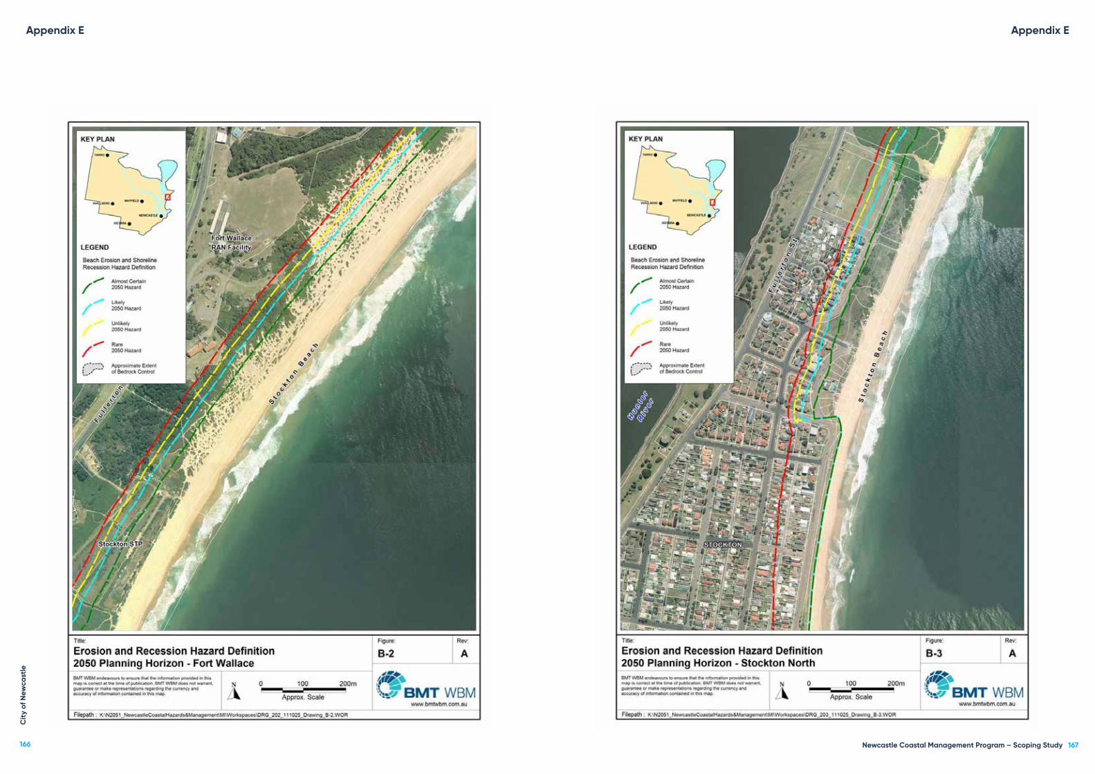
Appendix E Appendix EC
ity
of N
ewca
stle
166 Newcastle Coastal Management Program – Scoping Study 167

Appendix E
Stockton (2100 planning horizon)
Appendix EC
ity
of N
ewca
stle
168 Newcastle Coastal Management Program – Scoping Study 169

Appendix E Appendix EC
ity
of N
ewca
stle
170 Newcastle Coastal Management Program – Scoping Study 171

Appendix E
Nobbys Beach (immediate planning horizon)
Appendix EC
ity
of N
ewca
stle
172 Newcastle Coastal Management Program – Scoping Study 173

Nobbys Beach (2050 planning horizon)
Appendix E
Nobbys Beach (2100 planning horizon)
Appendix EC
ity
of N
ewca
stle
174 Newcastle Coastal Management Program – Scoping Study 175

Newcastle Beach (immediate planning horizon)
Appendix E
Newcastle Beach (2050 planning horizon)
Appendix EC
ity
of N
ewca
stle
176 Newcastle Coastal Management Program – Scoping Study 177

Newcastle Beach (2100 planning horizon)
Appendix E
Bar Beach (immediate planning horizon)
Appendix EC
ity
of N
ewca
stle
178 Newcastle Coastal Management Program – Scoping Study 179

Bar Beach (2050 planning horizon)
Appendix E
Bar Beach (2100 planning horizon)
Appendix EC
ity
of N
ewca
stle
180 Newcastle Coastal Management Program – Scoping Study 181

Dixon Park and Merewether Beach (immediate planning horizon)
Appendix E
Dixon Park and Merewether Beach (2050 planning horizon)
Appendix EC
ity
of N
ewca
stle
182 Newcastle Coastal Management Program – Scoping Study 183

Dixon Park and Merewether Beach (2100 planning horizon)
Appendix E
Appendix F: Modelled coastal inundation hazard areas from Newcastle
Coastal Zone Hazards Study (BMWT WBM, 2014(a))
Nobbys Beach (immediate planning horizon)
Appendix FC
ity
of N
ewca
stle
184 Newcastle Coastal Management Program – Scoping Study 185

Nobbys Beach (2050 planning horizon)
Appendix F
Nobbys Beach (2100 planning horizon)
Appendix FC
ity
of N
ewca
stle
186 Newcastle Coastal Management Program – Scoping Study 187

Newcastle Beach (immediate planning horizon)
Appendix F
Newcastle Beach (2050 planning horizon)
Appendix FC
ity
of N
ewca
stle
188 Newcastle Coastal Management Program – Scoping Study 189

Newcastle Beach (2100 planning horizon)
Appendix F
Strzelecki headland (immediate planning horizon)
Appendix FC
ity
of N
ewca
stle
190 Newcastle Coastal Management Program – Scoping Study 191

Strzelecki headland (2050 planning horizon)
Appendix F
Strzelecki headland (2100 planning horizon)
Appendix FC
ity
of N
ewca
stle
192 Newcastle Coastal Management Program – Scoping Study 193

Bar Beach (immediate planning horizon)
Appendix F
Bar Beach (2050 planning horizon)
Appendix FC
ity
of N
ewca
stle
194 Newcastle Coastal Management Program – Scoping Study 195

Bar Beach (2100 planning horizon)
Appendix F
Dixon Park and Merewether Beach (immediate planning horizon)
Appendix FC
ity
of N
ewca
stle
196 Newcastle Coastal Management Program – Scoping Study 197

Dixon Park and Merewether Beach (2050 planning horizon)
Appendix F
Dixon Park and Merewether Beach (2100 planning horizon)
Appendix FC
ity
of N
ewca
stle
198 Newcastle Coastal Management Program – Scoping Study 199

Appendix G: Modelled coastal inundation from Newcastle City-wide Floodplain Risk
Management Study and Plan (BMT WBM, 2012) and Strategic Position for the Management
of the Low-Lying Areas in Newcastle: Scoping Study (BMT WBM, 2015).
Appendix G Appendix GC
ity
of N
ewca
stle
200 Newcastle Coastal Management Program – Scoping Study 201

Appendix G
Strategic Position for the Management of the Low Lying Areas in Newcastle: Scoping Study
47
Climate Change Impact
K:\N20087_NCC_Low_Lying_Areas_Scoping_Study\Docs\R.N20087.001.02_Final_Report.docx
Figure 3-3 Ocean Flooding Peak Flood Depths – Existing Conditions
Appendix GC
ity
of N
ewca
stle
202 Newcastle Coastal Management Program – Scoping Study 203

Strategic Position for the Management of the Low Lying Areas in Newcastle: Scoping Study
54
Climate Change Impact
K:\N20087_NCC_Low_Lying_Areas_Scoping_Study\Docs\R.N20087.001.02_Final_Report.docx
Figure 3-7 1% AEP Ocean Flooding Inundation Extents with Sea Level Rise
Appendix G
Strategic Position for the Management of the Low Lying Areas in Newcastle: Scoping Study
55
Climate Change Impact
K:\N20087_NCC_Low_Lying_Areas_Scoping_Study\Docs\R.N20087.001.02_Final_Report.docx
Figure 3-8 PMF Ocean Flooding Extents with Sea Level Rise
Appendix GC
ity
of N
ewca
stle
204 Newcastle Coastal Management Program – Scoping Study 205

Appendix H: Modelled tidal inundation from Strategic Position for the Management
of the Low-Lying Areas in Newcastle: Scoping Study (BMT WBM, 2015).
Strategic Position for the Management of the Low Lying Areas in Newcastle: Scoping Study
53
Climate Change Impact
K:\N20087_NCC_Low_Lying_Areas_Scoping_Study\Docs\R.N20087.001.02_Final_Report.docx
Figure 3-6 King Tide Inundation Extents with Sea Level Rise
Appendix H Appendix I
Appendix I 1: Risk assessment for Stockton North
Area: Stockton NorthAsset Description: Stockton Centre (342 Fullerton Street)
Threat Environment Economic Social and cultural Overall risk level
Imm
edia
te (20
18)
2050
2100
Imm
edia
te (20
18)
2050
2100
Imm
edia
te (20
18)
2050
2100
Imm
edia
te (20
18)
2050
2100
Coastal erosion Low Moderate High Low Moderate High Low High High Low High High
Coastal inundation Minimal Minimal Low Minimal Minimal Low Minimal Minimal Low Minimal Minimal Low
Urban development Low Moderate Moderate Minimal Minimal Minimal Low Low Low Low Low Low
Invasive species Low Moderate Moderate Low Low Low Minimal Minimal Minimal Low Low Low
Overall risk level Low Moderate High Low Low High Low High High
Notes: North Stockton and Fern Bay Landuse Strategy will bring potential development into coastal erosion hazard lines after 2100. All development will be landward of unlikely 2100 line.
Area: Stockton NorthAsset Description: Fort Wallace (338 Fullerton Street)
Threat Environment Economic Social and cultural Overall risk level
Imm
edia
te (20
18)
2050
2100
Imm
edia
te (20
18)
2050
2100
Imm
edia
te (20
18)
2050
2100
Imm
edia
te (20
18)
2050
2100
Coastal erosion Moderate High High Low Moderate High Low High High Moderate High High
Coastal inundation Minimal Minimal Low Minimal Minimal Low Minimal Minimal Low Minimal Minimal Low
Urban development Low Moderate Moderate Minimal Minimal Minimal Low Low Low Low Low Low
Invasive species Low Moderate Moderate Low Low Low Minimal Minimal Minimal Low Low Low
Overall risk level Low High High Low Low High Low High High
Notes: North Stockton and Fern Bay Landuse Strategy will bring potential development into coastal erosion hazard lines after 2100. All development will be landward of unlikely 2100 line.
Cit
y of
New
cast
le
206 Newcastle Coastal Management Program – Scoping Study 207

Area: Stockton NorthAsset Description: Former Hunter Water sewerage treatment facility (330 Fullerton Street)
Threat Environment Economic Social and cultural Overall risk level
Imm
edia
te (20
18)
2050
2100
Imm
edia
te (20
18)
2050
2100
Imm
edia
te (20
18)
2050
2100
Imm
edia
te (20
18)
2050
2100
Coastal erosion Moderate Moderate High High High High Moderate High High High High High
Coastal inundation Minimal Minimal Minimal Minimal Minimal Minimal Low Low Low Minimal Minimal Minimal
Urban development Low Moderate Moderate Minimal Minimal Minimal Low Low Low Low Low Low
Invasive species Low Moderate Moderate Low Low Low Minimal Minimal Minimal Low Low Low
Water pollution Low Low Low Low Low Low Low Low Low Low Low Low
Overall risk level Low Moderate High High High High Low High High
Notes: Future assessment based on landfill material remaining at site. North Stockton and Fern Bay Landuse Strategy will be relevant to site.
Area: Stockton NorthAsset Description: Dune system between northern end of Corroba Oval and Griffith Avenue
Threat Environment Economic Social and cultural Overall risk level
Imm
edia
te (20
18)
2050
2100
Imm
edia
te (20
18)
2050
2100
Imm
edia
te (20
18)
2050
2100
Imm
edia
te (20
18)
2050
2100
Coastal erosion Moderate High High Low High High Moderate High High Moderate High High
Coastal inundation Minimal Minimal Minimal Minimal Minimal Minimal Minimal Low Low Minimal Minimal Minimal
Increased community use Moderate Moderate Moderate Moderate Moderate Moderate Moderate Moderate Moderate Moderate Moderate Moderate
Invasive species Low Low Low Low Low Low Minimal Minimal Minimal Low Low Low
Overall risk level Moderate High High Low High High Moderate High High
Notes: Inundation based on modelling from BMT WBM 2014.
Area: Stockton NorthAsset Description: Corroba Park (2 Meredith Street)
Threat Environment Economic Social and cultural Overall risk level
Imm
edia
te (20
18)
2050
2100
Imm
edia
te (20
18)
2050
2100
Imm
edia
te (20
18)
2050
2100
Imm
edia
te (20
18)
2050
2100
Coastal erosion Minimal Minimal High Minimal High High Minimal High High Minimal High High
Coastal inundation Minimal Minimal Minimal Minimal Minimal Minimal Minimal Minimal Minimal Minimal Minimal Minimal
Increased community use
Minimal Minimal Minimal Low Low Low Minimal Minimal Minimal Minimal Minimal Minimal
Overall risk level Minimal Minimal High Minimal High High Minimal High High
Notes: Environment and social risk increases dependant on exposure of former landfill area.
Area: Stockton NorthAsset Description: Road network between Meredith street and Griffith Avenue (including utilities) (Eames Avenue, Meredith Street, Beeston Road, Griffiths Avenue)
Threat Environment Economic Social and cultural Overall risk level
Imm
edia
te (20
18)
2050
2100
Imm
edia
te (20
18)
2050
2100
Imm
edia
te (20
18)
2050
2100
Imm
edia
te (20
18)
2050
2100
Coastal erosion Minimal Minimal Minimal Minimal High High Minimal High High Minimal High High
Coastal inundation Minimal Minimal Minimal Minimal Minimal Minimal Minimal Minimal Minimal Minimal Minimal Minimal
Overall risk level Minimal Minimal Minimal Minimal High High Minimal High High
Notes: Coastal inundation will increase with erosion, but erosion highlighted as issue.
Area: Stockton NorthAsset Description: Residential dwellings between Meredith Street and Griffith Avenue
Threat Environment Economic Social and cultural Overall risk level
Imm
edia
te (20
18)
2050
2100
Imm
edia
te (20
18)
2050
2100
Imm
edia
te (20
18)
2050
2100
Imm
edia
te (20
18)
2050
2100
Coastal erosion Minimal Minimal Minimal Minimal High High Minimal High High Minimal High High
Coastal inundation Minimal Minimal Minimal Minimal Minimal Minimal Minimal Minimal Minimal Minimal Minimal Minimal
Overall risk level Minimal Minimal Minimal Minimal High High Minimal High High
Notes: Coastal inundation will increase with erosion, but erosion highlighted as issue.
Cit
y of
New
cast
le
208 Newcastle Coastal Management Program – Scoping Study 209

Area: Stockton NorthAsset Description: Barrie Street Reserve)
Threat Environment Economic Social and cultural Overall risk level
Imm
edia
te (20
18)
2050
2100
Imm
edia
te (20
18)
2050
2100
Imm
edia
te (20
18)
2050
2100
Imm
edia
te (20
18)
2050
2100
Coastal erosion Moderate High High Moderate High High Low Moderate High Moderate High High
Coastal inundation Low Low Low Minimal Low Low Minimal Minimal Minimal Minimal Low Low
Overall risk level Low High High Low High High Minimal Low High
Notes: Risk from coastal erosion will increase significantly into future.
Area: Stockton NorthAsset Description: Former North Stockton Surf Life Saving Club (2 Barrie Crescent)
Threat Environment Economic Social and cultural Overall risk level
Imm
edia
te (20
18)
2050
2100
Imm
edia
te (20
18)
2050
2100
Imm
edia
te (20
18)
2050
2100
Imm
edia
te (20
18)
2050
2100
Coastal erosion Minimal High High Moderate High High High High High High High High
Coastal inundation Low Low Low Low Low Low Low Low Low Low Low Low
Overall risk level Minimal High High Low High High High High High
Notes: Building will be demolished at end of lease. Future planning horizons not applicable, but assessment included as if building remains.
Area: Stockton NorthAsset Description: Road network between Griffith Avenue and Stone Street (including utilities) (Griffith Avenue, Booth Street, Stone Street, part Dunbar Street)
Threat Environment Economic Social and cultural Overall risk level
Imm
edia
te (20
18)
2050
2100
Imm
edia
te (20
18)
2050
2100
Imm
edia
te (20
18)
2050
2100
Imm
edia
te (20
18)
2050
2100
Coastal erosion Minimal Minimal High Moderate High High Moderate High High Moderate High High
Coastal inundation Minimal Low Low Low Low Low Low Low Low Low Low Low
Overall risk level Minimal Minimal High Low High High Low High High
Notes: Immediate risks to Stone Street, southern end of Barrie Crescent (where seawall terminates).
Area: Stockton NorthAsset Description: Residential dwellings between Griffith Avenue and Stone Street
Threat Environment Economic Social and cultural Overall risk level
Imm
edia
te (20
18)
2050
2100
Imm
edia
te (20
18)
2050
2100
Imm
edia
te (20
18)
2050
2100
Imm
edia
te (20
18)
2050
2100
Coastal erosion Minimal Minimal Minimal Minimal Moderate High Minimal Moderate High Minimal Moderate High
Coastal inundation Minimal Minimal Minimal Minimal Minimal Minimal Minimal Minimal Minimal Minimal Minimal Minimal
Overall risk level Minimal Minimal Minimal Minimal Low High Minimal Moderate High
Notes: Coastal inundation will increase with erosion, but erosion highlighted as issue.
Cit
y of
New
cast
le
210 Newcastle Coastal Management Program – Scoping Study 211

Appendix I 2: Risk assessment for Stockton Beach – Central section
Area: Stockton centralAsset Description: Mitchell Street seawall
Threat Environment Economic Social and cultural Overall risk level
Imm
edia
te (20
18)
2050
2100
Imm
edia
te (20
18)
2050
2100
Imm
edia
te (20
18)
2050
2100
Imm
edia
te (20
18)
2050
2100
Coastal erosion Moderate Moderate Moderate Moderate Moderate Moderate Moderate Moderate Moderate Moderate Moderate Moderate
Coastal inundation Minimal Minimal Minimal Minimal Minimal Minimal Minimal Minimal Minimal Minimal Minimal Minimal
Increased community use
Low Low Low Low Low Low Minimal Minimal Minimal Low Low Low
Overall risk level Low Low Low Low Low Low Low Low Low
Notes: No overtopping noted. On-going cost and maintenance make seawall at moderate risk to community wellbeing. Maintenance in CZMP.
Area: Stockton centralAsset Description: Dune system between memorial Reserve and Mitchell Street seawall
Threat Environment Economic Social and cultural Overall risk level
Imm
edia
te (20
18)
2050
2100
Imm
edia
te (20
18)
2050
2100
Imm
edia
te (20
18)
2050
2100
Imm
edia
te (20
18)
2050
2100
Coastal erosion Moderate High High Moderate Moderate High Moderate Moderate High Moderate High High
Coastal inundation
Moderate Moderate High Low Moderate Moderate Low Moderate Moderate Low Moderate High
Increased community use
Minimal Minimal Minimal Low Low Low Low Low Low Low Low Low
Invasive species Minimal Minimal Minimal Low Low Low Minimal Minimal Minimal Minimal Minimal Minimal
Overall risk level Moderate High High Low Moderate High Low Moderate High
Area: Stockton centralAsset Description: Mitchell Street roadway between Pembroke Street and Hereford Street
Threat Environment Economic Social and cultural Overall risk level
Imm
edia
te (20
18)
2050
2100
Imm
edia
te (20
18)
2050
2100
Imm
edia
te (20
18)
2050
2100
Imm
edia
te (20
18)
2050
2100
Coastal erosion Minimal Minimal Minimal Moderate High High Low High High Low High High
Coastal inundation Minimal Minimal Minimal Minimal Minimal Low Minimal Minimal Minimal Minimal Minimal Minimal
Overall risk level Minimal Minimal Minimal Low High High Low High High
Notes: Erosion will continue into future planning horizons. However, impact dependant on potential management solution for beach.
Area: Stockton centralAsset Description: Residential dwellings between Pembroke Street and Hereford Street
Threat Environment Economic Social and cultural Overall risk level
Imm
edia
te (20
18)
2050
2100
Imm
edia
te (20
18)
2050
2100
Imm
edia
te (20
18)
2050
2100
Imm
edia
te (20
18)
2050
2100
Coastal erosion Minimal Minimal Minimal Minimal Moderate High Minimal Moderate High Minimal Moderate High
Coastal inundation Minimal Minimal Minimal Minimal Minimal Minimal Minimal Minimal Minimal Minimal Minimal Minimal
Overall risk level Minimal Minimal Minimal Minimal Low High Minimal Low High
Notes: Erosion will continue into future planning horizons. However, impact dependant on potential management solution for beach.
Area: Stockton centralAsset Description: Memorial Reserve (21 Pitt Street)
Threat Environment Economic Social and cultural Overall risk level
Imm
edia
te (20
18)
2050
2100
Imm
edia
te (20
18)
2050
2100
Imm
edia
te (20
18)
2050
2100
Imm
edia
te (20
18)
2050
2100
Coastal erosion Low Low Moderate Low Moderate High Low Moderate High Low Moderate High
Coastal inundation Minimal Minimal Minimal Minimal Minimal Minimal Minimal Minimal Minimal Minimal Minimal Minimal
Overall risk level Minimal Minimal Low Minimal Low High Minimal Low High
Notes: Erosion will continue into future planning horizons. However, impact dependant on potential management solution for beach.
Cit
y of
New
cast
le
212 Newcastle Coastal Management Program – Scoping Study 213

Area: Stockton centralAsset Description: Dalby Oval
Threat Environment Economic Social and cultural Overall risk level
Imm
edia
te (20
18)
2050
2100
Imm
edia
te (20
18)
2050
2100
Imm
edia
te (20
18)
2050
2100
Imm
edia
te (20
18)
2050
2100
Coastal erosion Low Low Low Low Moderate High Low Moderate High Low Moderate High
Coastal inundation Minimal Minimal Minimal Minimal Minimal Minimal Minimal Minimal Minimal Minimal Minimal Minimal
Increased community use
Minimal Minimal Minimal Low Low Moderate Moderate Moderate Moderate Low Low Moderate
Overall risk level Minimal Minimal Minimal Minimal Low High Low Moderate High
Notes: Erosion will continue into future planning horizons. However, impact dependant on potential management solution for beach.
Appendix I 3: Risk assessment for Stockton Beach – Southern end
Area: Stockton southAsset Description: Stockton Surf Life Saving Club seawall
Threat Environment Economic Social and cultural Overall risk level
Imm
edia
te (20
18)
2050
2100
Imm
edia
te (20
18)
2050
2100
Imm
edia
te (20
18)
2050
2100
Imm
edia
te (20
18)
2050
2100
Coastal erosion Low Low Moderate Low Low Low Low Low Moderate Low Low Moderate
Coastal inundation Minimal Minimal Minimal Low Low Low Minimal Minimal Minimal Minimal Minimal Minimal
Overall risk level Minimal Minimal Low Low Low Low Minimal Minimal Low
Area: Stockton southAsset Description: Stockton Surf Life Saving Club
Threat Environment Economic Social and cultural Overall risk level
Imm
edia
te (20
18)
2050
2100
Imm
edia
te (20
18)
2050
2100
Imm
edia
te (20
18)
2050
2100
Imm
edia
te (20
18)
2050
2100
Coastal erosion Minimal Minimal Minimal Minimal Low Low Low Low Low Minimal Low Low
Coastal inundation Minimal Minimal Minimal Minimal Minimal Minimal Minimal Minimal Minimal Minimal Minimal Minimal
Increased community use Minimal Minimal Minimal Low Low Low Low Moderate Moderate Low Low Low
Overall risk level Minimal Minimal Minimal Minimal Low Low Low Low Low
Notes: Construction of seawall has changed potential risk
Area: Stockton southAsset Description: Stockton Bowling Club
Threat Environment Economic Social and cultural Overall risk level
Imm
edia
te (20
18)
2050
2100
Imm
edia
te (20
18)
2050
2100
Imm
edia
te (20
18)
2050
2100
Imm
edia
te (20
18)
2050
2100
Coastal erosion Minimal Minimal Minimal Minimal Low Moderate Minimal Minimal Moderate Minimal Minimal Moderate
Coastal inundation Minimal Minimal Minimal Minimal Minimal Minimal Minimal Minimal Minimal Minimal Minimal Minimal
Overall risk level Minimal Minimal Minimal Minimal Minimal Low Minimal Minimal Low
Cit
y of
New
cast
le
214 Newcastle Coastal Management Program – Scoping Study 215

Area: Stockton southAsset Description: Stockton surf lifesaving club and pavilion carpark
Threat Environment Economic Social and cultural Overall risk level
Imm
edia
te (20
18)
2050
2100
Imm
edia
te (20
18)
2050
2100
Imm
edia
te (20
18)
2050
2100
Imm
edia
te (20
18)
2050
2100
Coastal erosion Minimal Minimal Minimal Minimal Low Low Minimal Minimal Minimal Minimal Minimal Minimal
Coastal inundation Minimal Minimal Minimal Low Low Low Low Low Low Minimal Low Low
Increased community use
Minimal Minimal Minimal Minimal Low Low Minimal Minimal Minimal Minimal Minimal Minimal
Overall risk level Minimal Minimal Minimal Minimal Low Low Minimal Minimal Minimal
Notes: Potential overtopping in future, cost from damage/maintenance.
Area: Stockton southAsset Description: Surfing pavilion
Threat Environment Economic Social and cultural Overall risk level
Imm
edia
te (20
18)
2050
2100
Imm
edia
te (20
18)
2050
2100
Imm
edia
te (20
18)
2050
2100
Imm
edia
te (20
18)
2050
2100
Coastal erosion Minimal Minimal Minimal Minimal Low Low Minimal Minimal Low Minimal Minimal Low
Coastal inundation Minimal Minimal Minimal Minimal Low Moderate Minimal Low Low Minimal Low Low
Overall risk level Minimal Minimal Minimal Minimal Low Low Minimal Minimal Low
Notes: Potential overtopping in future, cost from damage/maintenance.
Area: Stockton southAsset Description: Lexie’s Café
Threat Environment Economic Social and cultural Overall risk level
Imm
edia
te (20
18)
2050
2100
Imm
edia
te (20
18)
2050
2100
Imm
edia
te (20
18)
2050
2100
Imm
edia
te (20
18)
2050
2100
Coastal erosion Minimal Minimal Minimal Low Low Low Low Low Low Low Low Low
Coastal inundation Minimal Minimal Minimal Minimal Low Moderate Minimal Low Moderate Minimal Low Moderate
Overall risk level Minimal Minimal Minimal Low Low Low Minimal Low Low
Notes: Potential overtopping in future, cost from damage/maintenance.e.
Area: Stockton southAsset Description: Dune system seaward of Stockton Caravan Park
Threat Environment Economic Social and cultural Overall risk level
Imm
edia
te (20
18)
2050
2100
Imm
edia
te (20
18)
2050
2100
Imm
edia
te (20
18)
2050
2100
Imm
edia
te (20
18)
2050
2100
Coastal erosion Moderate Moderate High Minimal Low Moderate Low Moderate High Low Moderate High
Coastal inundation Low Low High Minimal Low High Low Low High Low Low High
Increased community use Moderate Moderate Moderate Low Moderate Moderate Low Low Low Low Moderate Moderate
Invasive species Moderate Moderate Moderate Low Low Low Low Low Low Low Low Low
Overall risk level Moderate Moderate High Low Low Moderate Low Low High
Notes: Overtopping of dune in 2100 horizon.
Cit
y of
New
cast
le
216 Newcastle Coastal Management Program – Scoping Study 217

Area: Stockton southAsset Description: Stockton caravan Park
Threat Environment Economic Social and cultural Overall risk level
Imm
edia
te (20
18)
2050
2100
Imm
edia
te (20
18)
2050
2100
Imm
edia
te (20
18)
2050
2100
Imm
edia
te (20
18)
2050
2100
Coastal erosion Low Low High Low Moderate High Low Moderate High Low Moderate High
Coastal inundation Minimal Low Moderate Minimal Low Moderate Minimal Low High Minimal Low High
Increased community use
Minimal Minimal Minimal Minimal Minimal Minimal Low Moderate Moderate Minimal Low Low
Invasive species Low Low Low Low Low Low Minimal Minimal Minimal Low Low Low
Overall risk level Minimal Low High Low Low High Minimal Moderate High
Notes: Overtopping of dune in 2100 horizon.
Area: Stockton southAsset Description: King Street roadway near Stockton breakwall
Threat Environment Economic Social and cultural Overall risk level
Imm
edia
te (20
18)
2050
2100
Imm
edia
te (20
18)
2050
2100
Imm
edia
te (20
18)
2050
2100
Imm
edia
te (20
18)
2050
2100
Coastal erosion Minimal Minimal Minimal Minimal Low Moderate Minimal Low Moderate Minimal Low Moderate
Coastal inundation Minimal Minimal Minimal Minimal Minimal Moderate Minimal Minimal Moderate Minimal Minimal Moderate
Sand drift Minimal Minimal Minimal Minimal Minimal Minimal Minimal Minimal Minimal Minimal Minimal Minimal
Overall risk level Minimal Minimal Minimal Minimal Minimal Moderate Minimal Minimal Moderate
Notes: Overtopping of dune in 2100 horizon.
Area: Stockton southAsset Description: Stockton breakwall
Threat Environment Economic Social and cultural Overall risk level
Imm
edia
te (20
18)
2050
2100
Imm
edia
te (20
18)
2050
2100
Imm
edia
te (20
18)
2050
2100
Imm
edia
te (20
18)
2050
2100
Coastal erosion Minimal Minimal Minimal Minimal Minimal Minimal Minimal Minimal Minimal Minimal Minimal Minimal
Coastal inundation Minimal Minimal Minimal Low Low Moderate Low Low Moderate Low Low Moderate
Increased community use
Minimal Minimal Minimal Minimal Minimal Minimal Minimal Minimal Minimal Minimal Minimal Minimal
Overall risk level Minimal Minimal Minimal Minimal Minimal Low Minimal Minimal Low
Area: Stockton southAsset Description: Pitt Street Reserve carpark near Stockton breakwall
Threat Environment Economic Social and cultural Overall risk level
Imm
edia
te (20
18)
2050
2100
Imm
edia
te (20
18)
2050
2100
Imm
edia
te (20
18)
2050
2100
Imm
edia
te (20
18)
2050
2100
Coastal erosion Low Low High Low Moderate High Low Moderate High Low Moderate High
Coastal inundation Minimal Minimal Low Minimal Minimal Moderate Minimal Minimal Moderate Minimal Minimal Moderate
Increased community use Minimal Minimal Minimal Low Moderate Moderate Minimal Low Low Low Low Low
Overall risk level Minimal Minimal High Low Moderate High Minimal Low High
Notes: Overtopping of dune in 2100 horizon.
Cit
y of
New
cast
le
218 Newcastle Coastal Management Program – Scoping Study 219

Area: Stockton southAsset Description: Little Beach dune system
Threat Environment Economic Social and cultural Overall risk level
Imm
edia
te (20
18)
2050
2100
Imm
edia
te (20
18)
2050
2100
Imm
edia
te (20
18)
2050
2100
Imm
edia
te (20
18)
2050
2100
Coastal erosion Moderate Moderate High Low Moderate Moderate Moderate Moderate High Moderate Moderate High
Coastal inundation Low Low Moderate Minimal Minimal Moderate Minimal Moderate Moderate Minimal Minimal Moderate
Increased community use
Low Low Low Low Low Low Low Low Low Low Low Low
Invasive species Low Low Low Low Low Low Low Low Low Low Low Low
Overall risk level Low Low High Low Low Moderate Low Moderate High
Notes: Overtopping of dune in 2100 horizon
Appendix I 4: Risk assessment for Nobbys Beach
Area: NobbysAsset Description: Newcastle southern breakwall
Threat Environment Economic Social and cultural Overall risk level
Imm
edia
te (20
18)
2050
2100
Imm
edia
te (20
18)
2050
2100
Imm
edia
te (20
18)
2050
2100
Imm
edia
te (20
18)
2050
2100
Coastal erosion Minimal Minimal Minimal Minimal Minimal Moderate Minimal Minimal Minimal Minimal Minimal Minimal
Coastal inundation Minimal Minimal Minimal Low Moderate Moderate Minimal Low Low Minimal Low Low
Coastal erosion Minimal Minimal Minimal Low Low Low Minimal Minimal Minimal Minimal Minimal Minimal
Coastal inundation Minimal Minimal Minimal Minimal Minimal Minimal Minimal Low Low Minimal Minimal Minimal
Overall risk level Minimal Minimal Minimal Minimal Low Moderate Minimal Low Low
Notes: Increasing risk from overtopping will result in increased maintenance costs. Maintenance by Port of Newcastle
Area: NobbysAsset Description: Nobbys Beach dune system
Threat Environment Economic Social and cultural Overall risk level
Imm
edia
te (20
18)
2050
2100
Imm
edia
te (20
18)
2050
2100
Imm
edia
te (20
18)
2050
2100
Imm
edia
te (20
18)
2050
2100
Coastal erosion Minimal Low Low Minimal Minimal Low Minimal Low Moderate Minimal Low Low
Coastal inundation Minimal Minimal Minimal Minimal Minimal Minimal Minimal Low Low Minimal Minimal Minimal
Sand drift Minimal Low Low Minimal Minimal Minimal Minimal Minimal Minimal Minimal Minimal Minimal
Increased community use Low Low Low Low Low Low Minimal Minimal Minimal Low Low Low
Invasive species Low Low Low Low Low Low Minimal Minimal Minimal Low Low Low
Overall risk level Minimal Low Low Minimal Minimal Low Minimal Minimal Low
Notes: Dune system has minimal risk from coastal hazards.
Cit
y of
New
cast
le
220 Newcastle Coastal Management Program – Scoping Study 221

Area: NobbysAsset Description: Nobbys Surf Life Saving Club and amenities (35 Nobbys Road)
Threat Environment Economic Social and cultural Overall risk level
Imm
edia
te (20
18)
2050
2100
Imm
edia
te (20
18)
2050
2100
Imm
edia
te (20
18)
2050
2100
Imm
edia
te (20
18)
2050
2100
Coastal erosion Minimal Minimal Minimal Low Moderate Moderate Minimal Moderate Moderate Minimal Moderate Moderate
Coastal inundation Minimal Minimal Minimal Low Low Low Low Low Low Low Low Low
Sand drift Minimal Minimal Minimal Minimal Minimal Minimal Minimal Minimal Minimal Minimal Minimal Minimal
Increased community use Minimal Minimal Minimal Low Low Moderate Low Low Low Low Low Low
Overall risk level Minimal Minimal Minimal Low Low Moderate Low Low Low
Notes: Minimal risk from coastal hazards, but maintenance of seawall in future will result in increased costs.
Area: NobbysAsset Description: Nobbys Road
Threat Environment Economic Social and cultural Overall risk level
Imm
edia
te (20
18)
2050
2100
Imm
edia
te (20
18)
2050
2100
Imm
edia
te (20
18)
2050
2100
Imm
edia
te (20
18)
2050
2100
Coastal erosion Minimal Low Low Minimal Minimal Low Minimal Low Moderate Minimal Low Low
Coastal inundation Minimal Minimal Minimal Minimal Minimal Minimal Minimal Low Low Minimal Minimal Minimal
Sand drift Minimal Low Low Minimal Minimal Minimal Minimal Minimal Minimal Minimal Minimal Minimal
Increased community use Minimal Minimal Minimal Minimal Low Low Low Low Low Minimal Low Low
Overall risk level Minimal Minimal Minimal Minimal Minimal Minimal Minimal Low Low
Notes: Minimal risk from coastal hazards, but will increase in future.
Area: NobbysAsset Description: Shortland Esplanade and Bathers Way walkway (between Nobbys Road and Newcastle Ocean Baths)
Threat Environment Economic Social and cultural Overall risk level
Imm
edia
te (20
18)
2050
2100
Imm
edia
te (20
18)
2050
2100
Imm
edia
te (20
18)
2050
2100
Imm
edia
te (20
18)
2050
2100
Coastal erosion Minimal Minimal Minimal Low Low Low Minimal Minimal Minimal Minimal Minimal Minimal
Coastal inundation Minimal Minimal Minimal Low Moderate High Low Low High Low Low High
Cliff instability Minimal Minimal Minimal Minimal Low Low Low Low Low Low Low Low
Sand drift Minimal Minimal Minimal Minimal Minimal Minimal Minimal Minimal Minimal Minimal Minimal Minimal
Increased community use Minimal Minimal Minimal Minimal Minimal Minimal Minimal Minimal Minimal Minimal Minimal Minimal
Overall risk level Minimal Minimal Minimal Minimal Low High Minimal Minimal High
Notes: Roadway overtops in storm events resulting in inundation. High economic risk into future due to maintenance/retrofit of area.
Area: NobbysAsset Description: Nobbys Road and Fort Drive
Threat Environment Economic Social and cultural Overall risk level
Imm
edia
te (20
18)
2050
2100
Imm
edia
te (20
18)
2050
2100
Imm
edia
te (20
18)
2050
2100
Imm
edia
te (20
18)
2050
2100
Cliff instability Minimal Minimal Minimal Low Moderate Moderate Low Moderate Moderate Low Moderate Moderate
Increased community use
Minimal Minimal Minimal Minimal Minimal Minimal Low Low Low Minimal Minimal Minimal
Overall risk level Minimal Minimal Minimal Minimal Low Low Low Low Low
Notes: Cliff instability will be reassessed after ten year period.
Cit
y of
New
cast
le
222 Newcastle Coastal Management Program – Scoping Study 223

Area: NobbysAsset Description: Fort Scratchley (31 Nobbys Road)
Threat Environment Economic Social and cultural Overall risk level
Imm
edia
te (20
18)
2050
2100
Imm
edia
te (20
18)
2050
2100
Imm
edia
te (20
18)
2050
2100
Imm
edia
te (20
18)
2050
2100
Cliff instability Minimal Minimal Minimal Low Moderate Moderate Low Moderate Moderate Low Moderate Moderate
Increased community use
Minimal Minimal Minimal Minimal Minimal Minimal Low Low Low Minimal Minimal Minimal
Overall risk level Minimal Minimal Minimal Minimal Low Low Low Low Low
Notes: Increasing economic risk from cliff instability. Risk managed through maintenance program.
Area: NobbysAsset Description: Shortland Esplanade residential properties (1-17 Shortland Esplanade)
Threat Environment Economic Social and cultural Overall risk level
Imm
edia
te (20
18)
2050
2100
Imm
edia
te (20
18)
2050
2100
Imm
edia
te (20
18)
2050
2100
Imm
edia
te (20
18)
2050
2100
Cliff instability Minimal Minimal Minimal Minimal Low Low Low Low Low Low Low Low
Coastal inundation Minimal Minimal Minimal Minimal Moderate Moderate Minimal Moderate Moderate Minimal Low Moderate
Overall risk level Minimal Minimal Minimal Minimal Moderate Moderate Low Moderate Moderate
Notes: Increasing risk from coastal inundation over Shortland Esplanade.
Area: NobbysAsset Description: Residential properties at Fort Drive, Beach Street and Murray Avenue
Threat Environment Economic Social and cultural Overall risk level
Imm
edia
te (20
18)
2050
2100
Imm
edia
te (20
18)
2050
2100
Imm
edia
te (20
18)
2050
2100
Imm
edia
te (20
18)
2050
2100
Cliff instability Minimal Minimal Minimal Low Low Low Low Low Low Low Low Low
Overall risk level Minimal Minimal Minimal Low Low Low Low Low Low
Notes: Cliff assessed and considered low risk. Will be reassessed in future.
Area: NobbysAsset Description: Rock platform between Nobbys Beach and Newcastle Baths (Cowrie Hole)
Threat Environment Economic Social and cultural Overall risk level
Imm
edia
te (20
18)
2050
2100
Imm
edia
te (20
18)
2050
2100
Imm
edia
te (20
18)
2050
2100
Imm
edia
te (20
18)
2050
2100
Coastal erosion Minimal Minimal Minimal Minimal Minimal Minimal Minimal Low Low Minimal Minimal Minimal
Coastal inundation Minimal Minimal Low Minimal Minimal Minimal Low Low Moderate Minimal Minimal Low
Water pollution Low Low Low Minimal Minimal Minimal Low Low Low Low Low Low
Increased community use Low Low Low Minimal Minimal Minimal Minimal Low Low Minimal Low Low
Recreational fishing Low Low Low Minimal Minimal Minimal Low Low Low Low Low Low
Overall risk level Low Low Low Minimal Minimal Minimal Low Low Low
Notes: Platform already has periods of inundation. Management risks considered low.
Cit
y of
New
cast
le
224 Newcastle Coastal Management Program – Scoping Study 225

Area: NobbysAsset Description: Nobbys Beach
Threat Environment Economic Social and cultural Overall risk level
Imm
edia
te (20
18)
2050
2100
Imm
edia
te (20
18)
2050
2100
Imm
edia
te (20
18)
2050
2100
Imm
edia
te (20
18)
2050
2100
Coastal erosion Low Low Moderate Moderate Moderate High Moderate Moderate High Moderate Moderate High
Coastal inundation Minimal Minimal Minimal Low Moderate Moderate Minimal Low Moderate Minimal Low Moderate
Stormwater erosion Minimal Minimal Minimal Minimal Minimal Minimal Minimal Minimal Minimal Minimal Minimal Minimal
Sand drift Minimal Minimal Minimal Minimal Minimal Minimal Minimal Minimal Minimal Minimal Minimal Minimal
Water pollution Low Low Low Minimal Minimal Minimal Low Low Low Low Low Low
Climate change Low Moderate Moderate Low Moderate Moderate Low Low Moderate Moderate Moderate Moderate
Increased community use Minimal Minimal Minimal Minimal Minimal Low Low Low Low Minimal Low Low
Overall risk level Minimal Low Moderate Low Moderate High Low Low High
Notes: Increasing economic risk from cliff instability. Risk managed through maintenance program.
Area: NobbysAsset Description: Horseshoe Beach
Threat Environment Economic Social and cultural Overall risk level
Imm
edia
te (20
18)
2050
2100
Imm
edia
te (20
18)
2050
2100
Imm
edia
te (20
18)
2050
2100
Imm
edia
te (20
18)
2050
2100
Coastal erosion Minimal Minimal Minimal Minimal Minimal Minimal Minimal Minimal Minimal Minimal Minimal Minimal
Coastal inundation Low Moderate Moderate Low Moderate Moderate Low Low Moderate Low Moderate Moderate
Stormwater erosion Minimal Minimal Minimal Minimal Minimal Minimal Minimal Minimal Minimal Minimal Minimal Minimal
Sand drift Minimal Minimal Minimal Minimal Minimal Minimal Minimal Minimal Minimal Minimal Minimal Minimal
Water pollution Low Low Low Minimal Minimal Minimal Low Low Low Low Low Low
Climate change Low Moderate Moderate Low Moderate Moderate Low Low Moderate Moderate Moderate Moderate
Increased community use Minimal Minimal Minimal Minimal Minimal Low Low Low Low Minimal Low Low
Overall risk level Minimal Moderate Moderate Minimal Moderate Moderate Low Low Moderate
Notes: Subject to coastal inundation due to sea level rise.
Area: NobbysAsset Description: Nobbys headland
Threat Environment Economic Social and cultural Overall risk level
Imm
edia
te (20
18)
2050
2100
Imm
edia
te (20
18)
2050
2100
Imm
edia
te (20
18)
2050
2100
Imm
edia
te (20
18)
2050
2100
Cliff instability Minimal Minimal Minimal Minimal Low Low Moderate Moderate Moderate Low Low Low
Overall risk level Minimal Minimal Minimal Minimal Low Low Moderate Moderate Moderate
Cit
y of
New
cast
le
226 Newcastle Coastal Management Program – Scoping Study 227

Appendix I 5: Risk assessment for Newcastle Beach
Area: Newcastle Asset Description: Newcastle ocean baths
Threat Environment Economic Social and cultural Overall risk level
Imm
edia
te (20
18)
2050
2100
Imm
edia
te (20
18)
2050
2100
Imm
edia
te (20
18)
2050
2100
Imm
edia
te (20
18)
2050
2100
Coastal erosion Minimal Minimal Minimal Low Moderate Moderate Low Moderate Moderate Low Moderate Moderate
Coastal inundation Minimal Minimal Minimal Moderate Moderate High Moderate Moderate High Moderate Moderate High
Water pollution Low Low Low Minimal Minimal Minimal Low Low Low Low Low Low
Increased community use Minimal Minimal Minimal Minimal Low Low Minimal Low Low Minimal Low Low
Overall risk level Minimal Minimal Minimal Low Moderate High Low Moderate High
Notes: Coastal inundation impact on heritage item will increase with sea level rise.
Area: Newcastle Asset Description: Newcastle ocean baths carpark
Threat Environment Economic Social and cultural Overall risk level
Imm
edia
te (20
18)
2050
2100
Imm
edia
te (20
18)
2050
2100
Imm
edia
te (20
18)
2050
2100
Imm
edia
te (20
18)
2050
2100
Coastal erosion Minimal Minimal Minimal Minimal Minimal Low Minimal Minimal Low Minimal Minimal Low
Coastal inundation Minimal Minimal Minimal Minimal Low Low Minimal Minimal Low Minimal Minimal Low
Cliff instability Minimal Minimal Minimal Minimal Minimal Minimal Minimal Minimal Minimal Minimal Minimal Minimal
Increased community use
Minimal Minimal Minimal Minimal Low Low Moderate Moderate Moderate Low Low Low
Overall risk level Minimal Minimal Minimal Minimal Low Low Low Low Low
Notes: Risk from coastal inundation
Area: Newcastle Asset Description: Rock platform around Newcastle Baths and canoe Pool
Threat Environment Economic Social and cultural Overall risk level
Imm
edia
te (20
18)
2050
2100
Imm
edia
te (20
18)
2050
2100
Imm
edia
te (20
18)
2050
2100
Imm
edia
te (20
18)
2050
2100
Coastal erosion Minimal Minimal Minimal Minimal Minimal Minimal Low Low Low Minimal Minimal Minimal
Coastal inundation Low Moderate Moderate Minimal Minimal Minimal Minimal Minimal Minimal Minimal Low Low
Water pollution Low Low Low Minimal Minimal Minimal Low Low Low Low Low Low
Increased community use Low Low Low Minimal Minimal Minimal Minimal Low Low Minimal Low Low
Recreational fishing Low Low Low Minimal Minimal Minimal Low Low Low Low Low Low
Overall risk level Low Low Low Minimal Minimal Minimal Low Low Low
Notes: Coastal inundation will increase environmental risk due to loss of habitat of shorebirds.
Area: Newcastle Asset Description: Canoe Pool
Threat Environment Economic Social and cultural Overall risk level
Imm
edia
te (20
18)
2050
2100
Imm
edia
te (20
18)
2050
2100
Imm
edia
te (20
18)
2050
2100
Imm
edia
te (20
18)
2050
2100
Coastal erosion Minimal Minimal Minimal Minimal Minimal Minimal Low Low Low Minimal Minimal Minimal
Coastal inundation Minimal Minimal Minimal Low Low Low Low Moderate Moderate Low Low Low
Water pollution Low Low Low Minimal Minimal Minimal Low Low Low Low Low Low
Increased community use Low Low Low Minimal Minimal Minimal Minimal Low Low Minimal Low Low
Overall risk level Low Low Low Minimal Minimal Minimal Low Low Low
Notes: Coastal inundation will affect social use of canoe pool into the future.
Cit
y of
New
cast
le
228 Newcastle Coastal Management Program – Scoping Study 229

Area: Newcastle Asset Description: Newcastle Beach
Threat Environment Economic Social and cultural Overall risk level
Imm
edia
te (20
18)
2050
2100
Imm
edia
te (20
18)
2050
2100
Imm
edia
te (20
18)
2050
2100
Imm
edia
te (20
18)
2050
2100
Coastal erosion Moderate Moderate Moderate Low Low Low Moderate Moderate High Moderate Moderate High
Coastal inundation Moderate Moderate Moderate Minimal Low Low Low Moderate Moderate Low Moderate Moderate
Cliff instability Minimal Minimal Minimal Low Moderate Moderate Low Low Low Low Low Low
Stormwater erosion Minimal Minimal Minimal Low Low Low Low Low Low Low Low Low
Sand drift Minimal Minimal Minimal Minimal Minimal Low Minimal Minimal Minimal Minimal Minimal Minimal
Water pollution Low Low Low Minimal Minimal Minimal Low Low Low Low Low Low
Climate change Low Moderate Moderate Low Moderate Moderate Low Low Moderate Moderate Moderate Moderate
Increased community use Minimal Minimal Minimal Minimal Minimal Minimal Low Low Low Minimal Minimal Low
Overall risk level Moderate Moderate Moderate Minimal Moderate Moderate Low Moderate High
Notes: Increasing risk of beach erosion and coastal inundation due to climate change. High social risk from loss of beach asset.
Area: Newcastle Asset Description: Newcastle surf lifesaving club facility
Threat Environment Economic Social and cultural Overall risk level
Imm
edia
te (20
18)
2050
2100
Imm
edia
te (20
18)
2050
2100
Imm
edia
te (20
18)
2050
2100
Imm
edia
te (20
18)
2050
2100
Coastal erosion Minimal Minimal Minimal Low Low Moderate Low Moderate Moderate Low Moderate Moderate
Coastal inundation Minimal Minimal Minimal Minimal Low Moderate Minimal Moderate Moderate Low Low Moderate
Cliff instability Minimal Minimal Minimal Minimal Minimal Low Minimal Minimal Minimal Minimal Minimal Minimal
Sand drift Minimal Minimal Minimal Minimal Minimal Minimal Minimal Minimal Low Minimal Minimal Minimal
Increased community use Minimal Minimal Minimal Minimal Minimal Minimal Minimal Minimal Minimal Minimal Minimal Minimal
Overall risk level Minimal Minimal Minimal Minimal Minimal Moderate Minimal Moderate Moderate
Notes: Increasing economic and social risk from beach erosion and coastal inundation. Economic cost of maintenance of building.
Area: Newcastle Asset Description: Bathers Way promenade (between Ocean Baths and King Edward Park)
Threat Environment Economic Social and cultural Overall risk level
Imm
edia
te (20
18)
2050
2100
Imm
edia
te (20
18)
2050
2100
Imm
edia
te (20
18)
2050
2100
Imm
edia
te (20
18)
2050
2100
Coastal erosion Minimal Minimal Minimal Low Low Moderate Low Low Low Low Low Low
Coastal inundation Minimal Minimal Minimal Minimal Minimal Moderate Minimal Minimal Low Minimal Minimal Low
Cliff instability Minimal Minimal Minimal Low Low Low Low Low Low Low Low Low
Sand drift Minimal Minimal Minimal Minimal Low Low Low Low Low Minimal Low Low
Increased community use Minimal Minimal Minimal Minimal Low Low Low Low Low Minimal Low Low
Overall risk level Minimal Minimal Minimal Minimal Low Moderate Low Low Low
Notes: Some overtopping predicted in 2100 planning horizon.
Area: Newcastle Asset Description: Newcastle south skate park and amenities
Threat Environment Economic Social and cultural Overall risk level
Imm
edia
te (20
18)
2050
2100
Imm
edia
te (20
18)
2050
2100
Imm
edia
te (20
18)
2050
2100
Imm
edia
te (20
18)
2050
2100
Coastal erosion Minimal Minimal Minimal Low Low Moderate Low Low Moderate Low Low Moderate
Coastal inundation Minimal Minimal Minimal Minimal Minimal Low Minimal Minimal Low Minimal Minimal Low
Cliff instability Minimal Minimal Minimal Low Low Low Low Low Low Low Low Low
Sand drift Minimal Minimal Minimal Minimal Low Low Low Low Low Minimal Low Low
Increased community use Minimal Minimal Minimal Low Moderate Moderate Minimal Minimal Low Minimal Minimal Low
Overall risk level Minimal Minimal Minimal Low Low Moderate Low Low Low
Notes: Some overtopping predicted in 2100 planning horizon.
Cit
y of
New
cast
le
230 Newcastle Coastal Management Program – Scoping Study 231

Area: Newcastle Asset Description: Shortland Esplanade between Newcastle Baths and Watt Street
Threat Environment Economic Social and cultural Overall risk level
Imm
edia
te (20
18)
2050
2100
Imm
edia
te (20
18)
2050
2100
Imm
edia
te (20
18)
2050
2100
Imm
edia
te (20
18)
2050
2100
Coastal erosion Minimal Minimal Minimal Low Low Moderate Low Low Moderate Low Low Moderate
Coastal inundation Minimal Minimal Minimal Minimal Minimal Low Minimal Minimal Low Minimal Minimal Low
Coastal instability Minimal Minimal Minimal Minimal Minimal Minimal Minimal Minimal Minimal Minimal Minimal Minimal
Sand drift Minimal Minimal Minimal Minimal Low Low Minimal Minimal Minimal Minimal Minimal Minimal
Increased community use Minimal Minimal Minimal Minimal Low Low Low Moderate Moderate Minimal Low Low
Overall risk level Minimal Minimal Minimal Minimal Low Low Minimal Low Moderate
Notes: Increased social risk from overcrowding, inability to access beach.
Area: Newcastle Asset Description: Slope below Shortland Esplanade
Threat Environment Economic Social and cultural Overall risk level
Imm
edia
te (20
18)
2050
2100
Imm
edia
te (20
18)
2050
2100
Imm
edia
te (20
18)
2050
2100
Imm
edia
te (20
18)
2050
2100
Coastal erosion Minimal Minimal Minimal Low Low Moderate Low Low Moderate Low Low Moderate
Coastal inundation Minimal Minimal Minimal Minimal Minimal Low Minimal Minimal Low Minimal Minimal Low
Coastal instability Minimal Minimal Minimal Minimal Minimal Minimal Minimal Minimal Minimal Minimal Minimal Minimal
Overall risk level Minimal Minimal Minimal Minimal Minimal Low Minimal Minimal Low
Notes: Some overtopping predicted in 2100 planning horizon.
Area: Newcastle Asset Description: Coastal cliffline at southern end of beach
Threat Environment Economic Social and cultural Overall risk level
Imm
edia
te (20
18)
2050
2100
Imm
edia
te (20
18)
2050
2100
Imm
edia
te (20
18)
2050
2100
Imm
edia
te (20
18)
2050
2100
Coastal erosion Minimal Minimal Minimal Low Low Moderate Low Low Moderate Low Low Moderate
Coastal inundation Minimal Minimal Minimal Minimal Minimal Low Minimal Minimal Low Minimal Minimal Low
Coastal instability Minimal Minimal Minimal Low Low Moderate Low Low Low Low Low Low
Overall risk level Minimal Minimal Minimal Low Low Moderate Low Low Low
Notes: Some overtopping predicted in 2100 planning horizon.
Cit
y of
New
cast
le
232 Newcastle Coastal Management Program – Scoping Study 233

Appendix I 6: Risk assessment for Strzelecki headland
Area: Strzelecki headlandAsset Description: King Edward Park
Threat Environment Economic Social and cultural Overall risk level
Imm
edia
te (20
18)
2050
2100
Imm
edia
te (20
18)
2050
2100
Imm
edia
te (20
18)
2050
2100
Imm
edia
te (20
18)
2050
2100
Cliff instability Minimal Minimal Minimal Low Low Low Low Low Low Low Low Low
Climate change Minimal Minimal Low Low Low Moderate Minimal Minimal Low Minimal Minimal Low
Increased community use
Low Moderate Moderate Minimal Low Moderate Minimal Minimal Low Minimal Low Moderate
Invasive species Low Low Low Low Low Moderate Minimal Minimal Low Low Low Low
Overall risk level Low Low Low Low Low Moderate Minimal Minimal Low
Notes: Increased economic risk from increased use of recreation facility. Risk from increased invasive species and associated treatment.
Area: Strzelecki headlandAsset Description: Coastal cliffline from King Edward Park to Susan Gilmore Beach
Threat Environment Economic Social and cultural Overall risk level
Imm
edia
te (20
18)
2050
2100
Imm
edia
te (20
18)
2050
2100
Imm
edia
te (20
18)
2050
2100
Imm
edia
te (20
18)
2050
2100
Cliff instability Minimal Minimal Low Minimal Minimal Low Low Low Low Minimal Minimal Low
Coastal inundation Minimal Minimal Minimal Minimal Minimal Minimal Minimal Minimal Minimal Minimal Minimal Minimal
Climate change Minimal Minimal Minimal Minimal Low Low Minimal Minimal Low Minimal Minimal Low
Invasive species Low Low Low Minimal Minimal Minimal Minimal Minimal Minimal Minimal Minimal Minimal
Overall risk level Minimal Minimal Minimal Minimal Minimal Low Minimal Minimal Low
Notes: Cliff instability a low risk and low community use of area below cliffline.
Area: Strzelecki headlandAsset Description: Rock platform below King Edward Park (incl Bogie Hole)
Threat Environment Economic Social and cultural Overall risk level
Imm
edia
te (20
18)
2050
2100
Imm
edia
te (20
18)
2050
2100
Imm
edia
te (20
18)
2050
2100
Imm
edia
te (20
18)
2050
2100
Cliff instability Minimal Minimal Low Low Moderate Moderate Minimal Low Low Minimal Low Low
Coastal erosion Minimal Minimal Minimal Minimal Minimal Minimal Minimal Minimal Minimal Minimal Minimal Minimal
Coastal inundation Low Low Moderate Low Moderate Moderate Low Low Moderate Low Low Moderate
Water pollution Low Low Low Minimal Minimal Minimal Low Low Low Low Low Low
Increased community use Low Low Low Minimal Minimal Low Low Low Moderate Low Low Low
Recreational fishing Minimal Minimal Minimal Minimal Minimal Minimal Minimal Minimal Minimal Minimal Minimal Minimal
Overall risk level Low Low Low Minimal Moderate Moderate Low Low Moderate
Notes: Increasing risk from maintaining access to Bogie Hole. Access may become more dangerous over time.
Area: Strzelecki headlandAsset Description: Rock platform below Memorial Drive
Threat Environment Economic Social and cultural Overall risk levelIm
med
iate
(2018)
2050
2100
Imm
edia
te (20
18)
2050
2100
Imm
edia
te (20
18)
2050
2100
Imm
edia
te (20
18)
2050
2100
Cliff instability Minimal Minimal Minimal Minimal Minimal Minimal Minimal Minimal Minimal Minimal Minimal Minimal
Coastal erosion Minimal Minimal Minimal Minimal Minimal Minimal Minimal Minimal Minimal Minimal Minimal Minimal
Coastal inundation Low Low Low Minimal Minimal Minimal Minimal Minimal Minimal Minimal Minimal Minimal
Water pollution Low Low Low Minimal Minimal Minimal Minimal Minimal Minimal Minimal Minimal Minimal
Increased community use Minimal Minimal Minimal Minimal Minimal Minimal Minimal Minimal Minimal Minimal Minimal Minimal
Recreational fishing Minimal Minimal Minimal Minimal Minimal Minimal Minimal Minimal Minimal Minimal Minimal Minimal
Overall risk level Minimal Minimal Minimal Minimal Minimal Minimal Minimal Minimal Minimal
Notes: Low use of platform by public. Minimal management of area.
Cit
y of
New
cast
le
234 Newcastle Coastal Management Program – Scoping Study 235

Area: Strzelecki headlandAsset Description: ANZAC Memorial walkway
Threat Environment Economic Social and cultural Overall risk level
Imm
edia
te (20
18)
2050
2100
Imm
edia
te (20
18)
2050
2100
Imm
edia
te (20
18)
2050
2100
Imm
edia
te (20
18)
2050
2100
Cliff instability Minimal Minimal Minimal Minimal Low Low Minimal Minimal Low Minimal Minimal Low
Increased community use
Minimal Minimal Minimal Minimal Minimal Minimal Low Moderate Moderate Minimal Low Low
Overall risk level Minimal Minimal Minimal Minimal Minimal Minimal Minimal Low Low
Notes: Cliff instability assessed as part of maintenance program. Potential social risk from increased use of facility.
Area: Strzelecki headlandAsset Description: Shepherds Hill Heritage site
Threat Environment Economic Social and cultural Overall risk level
Imm
edia
te (20
18)
2050
2100
Imm
edia
te (20
18)
2050
2100
Imm
edia
te (20
18)
2050
2100
Imm
edia
te (20
18)
2050
2100
Cliff instability Minimal Low Low Low Low Low Low Low Low Low Low Low
Overall risk level Minimal Low Low Low Low Low Low Low Low
Area: Strzelecki headlandAsset Description: Memorial walkway carpark
Threat Environment Economic Social and cultural Overall risk level
Imm
edia
te (20
18)
2050
2100
Imm
edia
te (20
18)
2050
2100
Imm
edia
te (20
18)
2050
2100
Imm
edia
te (20
18)
2050
2100
Cliff instability Minimal Minimal Minimal Minimal Low Low Minimal Minimal Low Minimal Minimal Low
Increased community use
Minimal Minimal Minimal Minimal Minimal Minimal Low Moderate Moderate Minimal Low Low
Overall risk level Minimal Minimal Minimal Minimal Minimal Minimal Minimal Low Low
Notes: Increasing social risk from increasing use of carpark area.
Area: Strzelecki headlandAsset Description: Residential houses on Nesca Parade and Fenton Avenue
Threat Environment Economic Social and cultural Overall risk level
Imm
edia
te (20
18)
2050
2100
Imm
edia
te (20
18)
2050
2100
Imm
edia
te (20
18)
2050
2100
Imm
edia
te (20
18)
2050
2100
Cliff instability Minimal Minimal Minimal Low Low Low Low Low Low Low Low Low
Overall risk level Minimal Minimal Minimal Low Low Low Low Low Low
Notes: Cliff instability area, but low risk
Cit
y of
New
cast
le
236 Newcastle Coastal Management Program – Scoping Study 237

Area: Strzelecki headlandAsset Description: Memorial Drive
Threat Environment Economic Social and cultural Overall risk level
Imm
edia
te (20
18)
2050
2100
Imm
edia
te (20
18)
2050
2100
Imm
edia
te (20
18)
2050
2100
Imm
edia
te (20
18)
2050
2100
Cliff instability Minimal Minimal Minimal Low Low Low Low Low Low Low Low Low
Increased community use
Minimal Minimal Minimal Minimal Minimal Minimal Low Low Low Minimal Minimal Minimal
Overall risk level Minimal Minimal Minimal Minimal Minimal Minimal Low Low Low
Notes: Cliff instability area, but low risk
Area: Strzelecki headlandAsset Description: Susan Gilmore Beach
Threat Environment Economic Social and cultural Overall risk level
Imm
edia
te (20
18)
2050
2100
Imm
edia
te (20
18)
2050
2100
Imm
edia
te (20
18)
2050
2100
Imm
edia
te (20
18)
2050
2100
Cliff instability Minimal Minimal Minimal Minimal Minimal Minimal Minimal Low Low Minimal Minimal Minimal
Coastal erosion Low Moderate Moderate Minimal Minimal Minimal Minimal Low Low Minimal Low Low
Coastal inundation Low Low Moderate Minimal Minimal Minimal Low Low Low Low Low Low
Water pollution Low Low Low Minimal Minimal Minimal Minimal Minimal Minimal Minimal Minimal Minimal
Increased community use Minimal Minimal Low Minimal Minimal Minimal Low Low Low Minimal Minimal Low
Overall risk level Low Low Moderate Minimal Minimal Minimal Minimal Low Low
Notes: Risk from coastal erosion increasing, but low level community use of beach.
Area: Strzelecki headlandAsset Description: Coastal heathland (including Themeda grasslands)
Threat Environment Economic Social and cultural Overall risk level
Imm
edia
te (20
18)
2050
2100
Imm
edia
te (20
18)
2050
2100
Imm
edia
te (20
18)
2050
2100
Imm
edia
te (20
18)
2050
2100
Cliff instability Minimal Low Low Low Low Low Low Low Low Low Low Low
Climate change Minimal Low Low Low Low Low Low Low Low Low Low Low
Increased community use
Low Low Moderate Low Low Moderate Minimal Minimal Low Low Low Moderate
Invasive species Low Low Low Low Low Low Minimal Minimal Low Low Low Low
Overall risk level Minimal Low Low Low Low Low Minimal Minimal Low
Notes: Environmental risk from increased use of the area by the community. Increased economic risk to maintain habitat quality.
Cit
y of
New
cast
le
238 Newcastle Coastal Management Program – Scoping Study 239

Appendix I 7: Risk assessment for Bar Beach
Area: Bar BeachAsset Description: Bar Beach carpark
Threat Environment Economic Social and cultural Overall risk level
Imm
edia
te (20
18)
2050
2100
Imm
edia
te (20
18)
2050
2100
Imm
edia
te (20
18)
2050
2100
Imm
edia
te (20
18)
2050
2100
Cliff instability Minimal Minimal Minimal Low Moderate Moderate Low Low Low Low Low Low
Sand drift Minimal Minimal Minimal Minimal Minimal Minimal Minimal Minimal Minimal Minimal Minimal Minimal
Increased community use
Minimal Minimal Minimal Minimal Minimal Minimal Moderate Moderate Moderate Low Low Low
Overall risk level Minimal Minimal Minimal Minimal Low Low Low Low Low
Notes: Increased economic risk from cliff instability. Increased use may by community may result in parking issues/time restrictions.
Area: Bar BeachAsset Description: Coastal cliffline below Bar Beach carpark
Threat Environment Economic Social and cultural Overall risk level
Imm
edia
te (20
18)
2050
2100
Imm
edia
te (20
18)
2050
2100
Imm
edia
te (20
18)
2050
2100
Imm
edia
te (20
18)
2050
2100
Coastal inundation Minimal Minimal Minimal Minimal Minimal Minimal Minimal Minimal Minimal Minimal Minimal Minimal
Cliff instability Minimal Low Moderate Minimal Moderate Moderate Minimal Minimal Minimal Minimal Low Moderate
Overall risk level Minimal Minimal Low Minimal Low Low Minimal Minimal Minimal
Notes: Increased future risk from cliff instability. Currently managed by CN.
Area: Bar BeachAsset Description: Rock platform between Susan Gilmore and Bar Beach
Threat Environment Economic Social and cultural Overall risk level
Imm
edia
te (20
18)
2050
2100
Imm
edia
te (20
18)
2050
2100
Imm
edia
te (20
18)
2050
2100
Imm
edia
te (20
18)
2050
2100
Coastal erosion Minimal Minimal Minimal Minimal Minimal Minimal Minimal Minimal Minimal Minimal Minimal Minimal
Coastal inundation Low Low Low Minimal Minimal Minimal Moderate Moderate Moderate Low Low Low
Cliff instability Low Low Low Minimal Minimal Minimal Minimal Low Low Low Low Low
Water pollution Minimal Minimal Minimal Minimal Minimal Minimal Minimal Minimal Minimal Minimal Minimal Minimal
Increased community use Minimal Low Low Minimal Minimal Minimal Low Low Low Minimal Low Low
Recreational fishing Low Low Low Minimal Minimal Minimal Low Low Low Low Low Low
Overall risk level Low Low Low Minimal Minimal Minimal Low Low Low
Notes: Increasing risk from coastal inundation and habitat modification. Coastal inundation may impact community use of Susan Gilmore beach.
Area: Bar BeachAsset Description: Bar Beach
Threat Environment Economic Social and cultural Overall risk level
Imm
edia
te (20
18)
2050
2100
Imm
edia
te (20
18)
2050
2100
Imm
edia
te (20
18)
2050
2100
Imm
edia
te (20
18)
2050
2100
Coastal erosion Moderate Moderate Moderate Moderate Moderate Moderate Moderate Moderate High Moderate Moderate High
Coastal inundation Minimal Minimal Low Low Low Moderate Low Low Moderate Low Low Moderate
Stormwater erosion Minimal Minimal Low Minimal Minimal Minimal Minimal Low Low Minimal Minimal Low
Sand drift Minimal Minimal Minimal Minimal Low Low Minimal Minimal Minimal Minimal Minimal Minimal
Water pollution Low Low Low Minimal Minimal Minimal Low Low Low Low Low Low
Climate change Low Moderate Moderate Low Moderate Moderate Low Low Moderate Moderate Moderate Moderate
Increased community use Low Low Low Low Low Moderate Moderate Moderate Moderate Low Moderate Moderate
Overall risk level Low Moderate Moderate Low Moderate Moderate Moderate Moderate High
Notes: Moderate risk from beach erosion and reduced amenity of beach area. Risk to beach increases over time.
Cit
y of
New
cast
le
240 Newcastle Coastal Management Program – Scoping Study 241

Area: Bar BeachAsset Description: Cooks Hill Surf Life Saving Club and facilities
Threat Environment Economic Social and cultural Overall risk level
Imm
edia
te (20
18)
2050
2100
Imm
edia
te (20
18)
2050
2100
Imm
edia
te (20
18)
2050
2100
Imm
edia
te (20
18)
2050
2100
Coastal erosion Minimal Minimal Minimal Minimal Low Moderate Minimal Low Low Minimal Low Low
Coastal inundation Minimal Minimal Minimal Minimal Moderate High Minimal Low Low Minimal Low High
Cliff instability Minimal Minimal Minimal Minimal Minimal Minimal Minimal Minimal Minimal Minimal Minimal Minimal
Sand drift Minimal Minimal Minimal Minimal Minimal Minimal Minimal Minimal Minimal Minimal Minimal Minimal
Increased community use Minimal Minimal Minimal Minimal Minimal Minimal Minimal Minimal Minimal Minimal Minimal Minimal
Overall risk level Minimal Minimal Minimal Minimal Low High Minimal Minimal Minimal
Notes: Increased risk from beach erosion and coastal inundation/overtopping. Economic risk from maintenance of seawall and facilities.
Area: Bar BeachAsset Description: Bathers Way viewing platform
Threat Environment Economic Social and cultural Overall risk level
Imm
edia
te (20
18)
2050
2100
Imm
edia
te (20
18)
2050
2100
Imm
edia
te (20
18)
2050
2100
Imm
edia
te (20
18)
2050
2100
Cliff instability Minimal Low Moderate Minimal Moderate Moderate Minimal Minimal Minimal Minimal Low Moderate
Overall risk level Minimal Low Moderate Minimal Moderate Moderate Minimal Minimal Minimal
Area: Bar BeachAsset Description: Bar Beach kiosk and public area
Threat Environment Economic Social and cultural Overall risk level
Imm
edia
te (20
18)
2050
2100
Imm
edia
te (20
18)
2050
2100
Imm
edia
te (20
18)
2050
2100
Imm
edia
te (20
18)
2050
2100
Coastal erosion Minimal Minimal Minimal Minimal Low Moderate Minimal Low Low Minimal Low Low
Coastal inundation Minimal Minimal Minimal Minimal Moderate High Minimal Low Low Minimal Low High
Cliff instability Minimal Minimal Minimal Minimal Minimal Minimal Minimal Minimal Minimal Minimal Minimal Minimal
Sand drift Minimal Minimal Minimal Low Low Low Minimal Minimal Minimal Minimal Minimal Minimal
Increased community use Minimal Minimal Minimal Minimal Minimal Minimal Minimal Minimal Minimal Minimal Minimal Minimal
Overall risk level Minimal Minimal Minimal Minimal Low High Minimal Minimal Minimal
Notes: Increased risk from beach erosion and coastal inundation/overtopping.
Area: Bar BeachAsset Description: Bar Beach dune system (southern end of beach)
Threat Environment Economic Social and cultural Overall risk level
Imm
edia
te (20
18)
2050
2100
Imm
edia
te (20
18)
2050
2100
Imm
edia
te (20
18)
2050
2100
Imm
edia
te (20
18)
2050
2100
Coastal erosion Low Moderate High Moderate Moderate High Low Low Moderate Low Moderate High
Coastal inundation Minimal Minimal Low Minimal Low Low Minimal Minimal Low Minimal Minimal Low
Sand drift Minimal Low Low Minimal Low Low Minimal Minimal Minimal Minimal Low Low
Climate change Minimal Low Moderate Minimal Minimal Low Minimal Low Low Minimal Low Low
Invasive species Low Moderate Moderate Low Moderate Moderate Minimal Low Low Low Moderate Moderate
Increased community use Low Low Moderate Low Low Low Low Low Low Low Low Low
Overall risk level Low Moderate High Low Moderate High Minimal Low Low
Notes: Increasing risk from beach erosion. Dune restoration to be undertaken in near future.
Cit
y of
New
cast
le
242 Newcastle Coastal Management Program – Scoping Study 243

Area: Bar BeachAsset Description: Bathers Way walkway
Threat Environment Economic Social and cultural Overall risk level
Imm
edia
te (20
18)
2050
2100
Imm
edia
te (20
18)
2050
2100
Imm
edia
te (20
18)
2050
2100
Imm
edia
te (20
18)
2050
2100
Coastal erosion Minimal Minimal Minimal Minimal Low High Minimal Low High Minimal Low High
Coastal inundation Minimal Minimal Minimal Minimal Minimal Low Minimal Minimal Minimal Minimal Minimal Minimal
Cliff instability Minimal Minimal Minimal Minimal Low Low Minimal Low Low Minimal Low Low
Sand drift Minimal Minimal Minimal Low Low Low Minimal Minimal Minimal Minimal Minimal Minimal
Increased community use Minimal Minimal Minimal Minimal Low Low Low Moderate Moderate Minimal Low Low
Overall risk level Minimal Minimal Minimal Minimal Low High Minimal Low High
Notes: Increased risk from beach erosion due to loss of dune system above.
Area: Bar BeachAsset Description: Memorial Drive
Threat Environment Economic Social and cultural Overall risk level
Imm
edia
te (20
18)
2050
2100
Imm
edia
te (20
18)
2050
2100
Imm
edia
te (20
18)
2050
2100
Imm
edia
te (20
18)
2050
2100
Coastal erosion Minimal Minimal Minimal Minimal Minimal High Minimal Minimal High Minimal Minimal High
Coastal inundation Minimal Minimal Minimal Minimal Minimal Minimal Minimal Minimal Minimal Minimal Minimal Minimal
Sand drift Minimal Minimal Minimal Low Low Low Minimal Minimal Minimal Minimal Minimal Minimal
Increased community use Minimal Minimal Minimal Minimal Minimal Minimal Low Low Low Minimal Minimal Minimal
Overall risk level Minimal Minimal Minimal Minimal Minimal High Minimal Minimal High
Notes: Increased risk from beach erosion due to loss of dune system above.
Area: Bar BeachAsset Description: Coastal cliffline below Kilgour Avenue
Threat Environment Economic Social and cultural Overall risk level
Imm
edia
te (20
18)
2050
2100
Imm
edia
te (20
18)
2050
2100
Imm
edia
te (20
18)
2050
2100
Imm
edia
te (20
18)
2050
2100
Coastal inundation Minimal Minimal Minimal Minimal Minimal Moderate Minimal Low Moderate Minimal Minimal Moderate
Cliff instability Minimal Minimal Minimal Low Moderate Moderate Low Moderate Moderate Low Moderate Moderate
Overall risk level Minimal Minimal Minimal Low Low Moderate Low Low Moderate
Notes: Risk from cliff instability, but currently managed. Increased risk due to access to bottom of cliff by public.
Cit
y of
New
cast
le
244 Newcastle Coastal Management Program – Scoping Study 245

Appendix I 8: Risk assessment for Dixon Park Beach
Area: Dixon ParkAsset Description: Dixon Park Beach
Threat Environment Economic Social and cultural Overall risk level
Imm
edia
te (20
18)
2050
2100
Imm
edia
te (20
18)
2050
2100
Imm
edia
te (20
18)
2050
2100
Imm
edia
te (20
18)
2050
2100
Coastal erosion Moderate Moderate Moderate Moderate Moderate Moderate Moderate Moderate High Moderate Moderate High
Coastal inundation Low Moderate Moderate Low Moderate Moderate Low Low Moderate Low Moderate Moderate
Stormwater erosion Minimal Minimal Low Minimal Minimal Minimal Minimal Low Low Minimal Minimal Low
Sand drift Minimal Minimal Minimal Minimal Minimal Minimal Minimal Minimal Minimal Minimal Minimal Minimal
Water pollution Low Low Low Minimal Minimal Minimal Low Low Low Low Low Low
Climate change Low Moderate Moderate Low Moderate Moderate Low Low Moderate Moderate Moderate Moderate
Increased community use Low Low Low Low Low Moderate Moderate Moderate Moderate Low Moderate Moderate
Overall risk level Low Moderate Moderate Low Moderate Moderate Moderate Moderate High
Notes: Increasing risk of beach erosion and coastal inundation into the future.
Area: Dixon ParkAsset Description: Dixon Park dune system (between Berner Street and Ocean Street)
Threat Environment Economic Social and cultural Overall risk level
Imm
edia
te (20
18)
2050
2100
Imm
edia
te (20
18)
2050
2100
Imm
edia
te (20
18)
2050
2100
Imm
edia
te (20
18)
2050
2100
Coastal erosion Moderate Moderate Moderate Low Moderate Moderate Low Moderate Moderate Low Moderate Moderate
Coastal inundation Minimal Minimal Minimal Minimal Minimal Low Minimal Minimal Moderate Minimal Minimal Low
Sand drift Minimal Minimal Minimal Minimal Minimal Minimal Minimal Minimal Minimal Minimal Minimal Minimal
Climate change Minimal Minimal Low Minimal Minimal Low Minimal Minimal Minimal Minimal Minimal Minimal
Invasive species Minimal Minimal Low Minimal Minimal Minimal Minimal Minimal Minimal Minimal Minimal Minimal
Increased community use Minimal Minimal Minimal Minimal Minimal Minimal Minimal Minimal Minimal Minimal Minimal Minimal
Overall risk level Minimal Minimal Low Minimal Minimal Low Minimal Minimal Moderate
Notes: Beach erosion will increase with sea level rise. Impacts on dune system and beach access.
Area: Dixon ParkAsset Description: Bathers Way walkway (between Berner Street and Kilgour Avenue)
Threat Environment Economic Social and cultural Overall risk level
Imm
edia
te (20
18)
2050
2100
Imm
edia
te (20
18)
2050
2100
Imm
edia
te (20
18)
2050
2100
Imm
edia
te (20
18)
2050
2100
Coastal erosion Minimal Minimal Minimal Minimal Minimal Minimal Minimal Minimal Minimal Minimal Minimal Minimal
Coastal inundation Minimal Minimal Minimal Minimal Minimal Minimal Minimal Minimal Minimal Minimal Minimal Minimal
Cliff instability Minimal Minimal Minimal Minimal Low Low Minimal Low Low Minimal Low Low
Sand drift Minimal Minimal Minimal Minimal Low Low Minimal Low Low Minimal Low Low
Increased community use Minimal Minimal Minimal Minimal Low Low Low Moderate Moderate Minimal Low Low
Overall risk level Minimal Minimal Minimal Minimal Low Low Minimal Low Low
Area: Dixon ParkAsset Description: Dixon Park carpark
Threat Environment Economic Social and cultural Overall risk level
Imm
edia
te (20
18)
2050
2100
Imm
edia
te (20
18)
2050
2100
Imm
edia
te (20
18)
2050
2100
Imm
edia
te (20
18)
2050
2100
Coastal erosion Minimal Minimal Minimal Minimal Low Low Minimal Minimal Low Minimal Minimal Low
Coastal inundation Minimal Minimal Minimal Minimal Minimal Moderate Minimal Minimal Moderate Minimal Minimal Moderate
Sand drift Minimal Minimal Minimal Minimal Minimal Minimal Minimal Minimal Minimal Minimal Minimal Minimal
Increased community use Minimal Minimal Minimal Minimal Minimal Minimal Low Moderate Moderate Minimal Low Low
Overall risk level Minimal Minimal Minimal Minimal Minimal Low Minimal Low Moderate
Cit
y of
New
cast
le
246 Newcastle Coastal Management Program – Scoping Study 247

Area: Dixon ParkAsset Description: Dixon Park seawall
Threat Environment Economic Social and cultural Overall risk level
Imm
edia
te (20
18)
2050
2100
Imm
edia
te (20
18)
2050
2100
Imm
edia
te (20
18)
2050
2100
Imm
edia
te (20
18)
2050
2100
Coastal erosion Moderate Moderate Moderate Moderate Moderate Moderate Low Low Low Moderate Moderate Moderate
Coastal inundation Minimal Minimal Low Minimal Low Low Minimal Low Low Minimal Low Low
Climate change Minimal Low Low Low Low Moderate Minimal Low Low Minimal Low Low
Overall risk level Low Low Low Low Low Moderate Minimal Low Low
Notes: Risk from beach erosion and exposure of seawall. Seawall requires monitoring.
Appendix I 9: Risk assessment for Merewether Beach
Area: MerewetherAsset Description: Merewether Beach
Threat Environment Economic Social and cultural Overall risk level
Imm
edia
te (20
18)
2050
2100
Imm
edia
te (20
18)
2050
2100
Imm
edia
te (20
18)
2050
2100
Imm
edia
te (20
18)
2050
2100
Coastal erosion Moderate Moderate Moderate Moderate Moderate High Moderate Moderate High Moderate Moderate High
Coastal inundation Low Moderate Moderate Low Moderate Moderate Low Low Moderate Low Moderate Moderate
Stormwater erosion Minimal Minimal Minimal Minimal Minimal Minimal Low Low Low Minimal Minimal Minimal
Sand drift Minimal Minimal Minimal Minimal Minimal Minimal Minimal Minimal Minimal Minimal Minimal Minimal
Water pollution Low Low Low Minimal Minimal Minimal Low Low Low Low Low Low
Climate change Low Moderate Moderate Low Moderate Moderate Low Low Moderate Moderate Moderate Moderate
Increased community use Low Low Low Low Low Moderate Moderate Moderate Moderate Low Moderate Moderate
Overall risk level Low Moderate Moderate Low Moderate High Low Moderate High
Notes: Social impact on loss of beach significant. Erosion and inundation likely to increase due to changing climatic conditions.
Area: MerewetherAsset Description: Merewether seawall
Threat Environment Economic Social and cultural Overall risk level
Imm
edia
te (20
18)
2050
2100
Imm
edia
te (20
18)
2050
2100
Imm
edia
te (20
18)
2050
2100
Imm
edia
te (20
18)
2050
2100
Coastal erosion Moderate Moderate Moderate Moderate Moderate High Low Low Low Moderate Moderate Moderate
Coastal inundation Minimal Minimal Low Minimal Low Low Minimal Low Low Minimal Low Low
Climate change Minimal Low Low Low Low Moderate Minimal Low Low Minimal Low Low
Overall risk level Low Low Low Low Low High Minimal Low Low
Notes: Impacts will only occur when seawall is exposed. Increased exposure associated with increased storm events. .
Cit
y of
New
cast
le
248 Newcastle Coastal Management Program – Scoping Study 249

Area: MerewetherAsset Description: Merewether Beach dune system (between Berner Street and Watkins Street)
Threat Environment Economic Social and cultural Overall risk level
Imm
edia
te (20
18)
2050
2100
Imm
edia
te (20
18)
2050
2100
Imm
edia
te (20
18)
2050
2100
Imm
edia
te (20
18)
2050
2100
Coastal erosion Moderate Moderate Moderate Moderate Moderate Moderate Low Moderate Moderate Moderate Moderate Moderate
Coastal inundation Minimal Minimal Low Minimal Low Low Minimal Low Low Minimal Low Low
Coastal inundation Minimal Minimal Minimal Minimal Minimal Minimal Minimal Minimal Minimal Minimal Minimal Minimal
Coastal inundation Minimal Minimal Low Minimal Minimal Low Minimal Minimal Minimal Minimal Minimal Minimal
Coastal inundation Minimal Minimal Low Minimal Minimal Minimal Minimal Minimal Minimal Minimal Minimal Minimal
Climate change Minimal Minimal Minimal Minimal Minimal Minimal Minimal Minimal Minimal Minimal Minimal Minimal
Overall risk level Minimal Minimal Minimal Minimal Minimal Minimal Minimal Minimal Minimal
Notes: Dune system will be impacted by increasing levels of erosion and inundation.
Area: MerewetherAsset Description: Bathers Way walkway (between Berner Street and Watkins Street)
Threat Environment Economic Social and cultural Overall risk level
Imm
edia
te (20
18)
2050
2100
Imm
edia
te (20
18)
2050
2100
Imm
edia
te (20
18)
2050
2100
Imm
edia
te (20
18)
2050
2100
Coastal erosion Minimal Minimal Minimal Minimal Low Low Minimal Minimal Minimal Minimal Minimal Minimal
Coastal inundation Minimal Minimal Minimal Minimal Minimal Minimal Minimal Minimal Minimal Minimal Minimal Minimal
Sand drift Minimal Minimal Minimal Minimal Low Low Minimal Low Low Minimal Low Low
Increased community use Minimal Minimal Minimal Minimal Low Low Low Moderate Moderate Minimal Low Low
Overall risk level Minimal Minimal Minimal Minimal Low Low Minimal Low Low
Notes: No overtopping noted
Area: MerewetherAsset Description: Merewether Surf Life Saving Club (1 John Parade)
Threat Environment Economic Social and cultural Overall risk level
Imm
edia
te (20
18)
2050
2100
Imm
edia
te (20
18)
2050
2100
Imm
edia
te (20
18)
2050
2100
Imm
edia
te (20
18)
2050
2100
Coastal erosion Minimal Minimal Minimal Minimal Low Low Minimal Minimal Minimal Minimal Minimal Minimal
Coastal inundation Minimal Minimal Minimal Minimal Minimal Minimal Minimal Minimal Minimal Minimal Minimal Minimal
Cliff instability Minimal Minimal Low Minimal Low Low Minimal Low Low Minimal Low Low
Sand drift Minimal Minimal Minimal Low Low Low Minimal Minimal Minimal Minimal Minimal Minimal
Increased community use Minimal Minimal Minimal Minimal Minimal Minimal Minimal Minimal Minimal Minimal Minimal Minimal
Overall risk level Minimal Minimal Minimal Minimal Low Low Minimal Minimal Minimal
Notes: Some risk from slope west of building
Area: MerewetherAsset Description: Surf House (5 Henderson Parade)
Threat Environment Economic Social and cultural Overall risk level
Imm
edia
te (20
18)
2050
2100
Imm
edia
te (20
18)
2050
2100
Imm
edia
te (20
18)
2050
2100
Imm
edia
te (20
18)
2050
2100
Coastal erosion Minimal Minimal Minimal Minimal Low Moderate Minimal Minimal Moderate Minimal Minimal Moderate
Coastal inundation Minimal Minimal Minimal Minimal Minimal Low Minimal Minimal Low Minimal Minimal Low
Cliff instability Minimal Minimal Low Minimal Low Low Minimal Low Low Minimal Low Low
Sand drift Minimal Minimal Minimal Low Low Low Minimal Minimal Minimal Minimal Minimal Minimal
Increased community use Minimal Minimal Minimal Minimal Minimal Minimal Low Low Low Minimal Minimal Minimal
Overall risk level Minimal Minimal Minimal Minimal Low Low Minimal Minimal Low
Cit
y of
New
cast
le
250 Newcastle Coastal Management Program – Scoping Study 251

Area: MerewetherAsset Description: Henderson Parade
Threat Environment Economic Social and cultural Overall risk level
Imm
edia
te (20
18)
2050
2100
Imm
edia
te (20
18)
2050
2100
Imm
edia
te (20
18)
2050
2100
Imm
edia
te (20
18)
2050
2100
Coastal erosion Minimal Minimal Minimal Minimal Minimal Minimal Minimal Minimal Minimal Minimal Minimal Minimal
Coastal inundation Minimal Minimal Minimal Minimal Minimal Minimal Minimal Minimal Minimal Minimal Minimal Minimal
Cliff instability Minimal Minimal Minimal Low Low Low Minimal Low Low Minimal Low Low
Sand drift Minimal Minimal Minimal Minimal Minimal Minimal Low Low Low Minimal Minimal Minimal
Increased community use Minimal Minimal Minimal Low Low Low Low Low Low Low Low Low
Overall risk level Minimal Minimal Minimal Minimal Minimal Minimal Low Low Low
Area: MerewetherAsset Description: Merewether Ocean Baths
Threat Environment Economic Social and cultural Overall risk level
Imm
edia
te (20
18)
2050
2100
Imm
edia
te (20
18)
2050
2100
Imm
edia
te (20
18)
2050
2100
Imm
edia
te (20
18)
2050
2100
Coastal erosion Minimal Minimal Minimal Low Low Moderate Low Low Moderate Low Low Moderate
Coastal inundation Minimal Minimal Minimal Low Moderate High Low Moderate High Low Moderate High
Sand drift Minimal Minimal Minimal Minimal Minimal Minimal Minimal Minimal Minimal Minimal Minimal Minimal
Sand drift Minimal Minimal Minimal Low Low Low Minimal Low Low Minimal Low Low
Increased community use Minimal Minimal Minimal Low Low Low Low Low Low Low Low Low
Overall risk level Minimal Minimal Minimal Low Low High Low Low High
Notes: Coastal inundation impact on heritage item will increase with sea level rise.
Area: MerewetherAsset Description: Merewether Ocean Baths rock platform
Threat Environment Economic Social and cultural Overall risk level
Imm
edia
te (20
18)
2050
2100
Imm
edia
te (20
18)
2050
2100
Imm
edia
te (20
18)
2050
2100
Imm
edia
te (20
18)
2050
2100
Coastal erosion Minimal Minimal Minimal Minimal Minimal Moderate Low Moderate Moderate Minimal Minimal Moderate
Coastal inundation Minimal Low Low Minimal Minimal Minimal Low Moderate Moderate Minimal Low Low
Cliff instability Minimal Minimal Minimal Minimal Minimal Minimal Minimal Minimal Minimal Minimal Minimal Minimal
Water pollution Minimal Minimal Minimal Minimal Minimal Minimal Minimal Minimal Minimal Minimal Minimal Minimal
Increased community use Low Low Low Minimal Minimal Minimal Low Low Low Low Low Low
Recreational fishing Low Low Low Minimal Minimal Minimal Low Low Low Low Low Low
Overall risk level Minimal Minimal Minimal Minimal Minimal Minimal Low Low Low
Notes: Loss of habitat will occur with sea level rise
Area: MerewetherAsset Description: Merewether Ocean Baths amenities building
Threat Environment Economic Social and cultural Overall risk level
Imm
edia
te (20
18)
2050
2100
Imm
edia
te (20
18)
2050
2100
Imm
edia
te (20
18)
2050
2100
Imm
edia
te (20
18)
2050
2100
Coastal erosion Minimal Minimal Minimal Minimal Minimal Low Minimal Minimal Low Minimal Minimal Low
Coastal inundation Minimal Minimal Minimal Low Low Moderate Minimal Moderate Moderate Minimal Low Moderate
Cliff instability Minimal Minimal Minimal Low Low Low Minimal Low Low Minimal Low Low
Sand drift Minimal Minimal Minimal Minimal Minimal Minimal Minimal Minimal Minimal Minimal Minimal Minimal
Increased community use Minimal Minimal Minimal Minimal Minimal Minimal Low Low Low Minimal Minimal Minimal
Overall risk level Minimal Minimal Minimal Minimal Minimal Low Minimal Low Low
Notes: Risk from coastal inundation.
Cit
y of
New
cast
le
252 Newcastle Coastal Management Program – Scoping Study 253

Area: MerewetherAsset Description: Merewether Ocean Baths carparks
Threat Environment Economic Social and cultural Overall risk level
Imm
edia
te (20
18)
2050
2100
Imm
edia
te (20
18)
2050
2100
Imm
edia
te (20
18)
2050
2100
Imm
edia
te (20
18)
2050
2100
Coastal erosion Minimal Minimal Minimal Minimal Minimal Minimal Minimal Minimal Minimal Minimal Minimal Minimal
Coastal inundation Minimal Minimal Minimal Minimal Minimal Minimal Minimal Minimal Minimal Minimal Minimal Minimal
Cliff instability Minimal Minimal Minimal Low Low Low Minimal Low Low Minimal Low Low
Sand drift Minimal Minimal Minimal Minimal Minimal Minimal Minimal Minimal Minimal Minimal Minimal Minimal
Increased community use Minimal Minimal Minimal Minimal Low Low Moderate Moderate Moderate Low Low Low
Overall risk level Minimal Minimal Minimal Minimal Minimal Minimal Low Low Low
Area: MerewetherAsset Description: Frederick Street
Threat Environment Economic Social and cultural Overall risk level
Imm
edia
te (20
18)
2050
2100
Imm
edia
te (20
18)
2050
2100
Imm
edia
te (20
18)
2050
2100
Imm
edia
te (20
18)
2050
2100
Cliff instability Minimal Minimal Minimal Low Low Low Minimal Low Low Minimal Low Low
Sand drift Minimal Minimal Minimal Minimal Minimal Minimal Minimal Minimal Minimal Minimal Minimal Minimal
Increased community use Minimal Minimal Minimal Minimal Minimal Minimal Low Low Low Minimal Minimal Minimal
Overall risk level Minimal Minimal Minimal Minimal Minimal Minimal Minimal Low Low
Area: MerewetherAsset Description: Residential properties at Robinson Street, Lloyd Street and Hickson Street
Threat Environment Economic Social and cultural Overall risk level
Imm
edia
te (20
18)
2050
2100
Imm
edia
te (20
18)
2050
2100
Imm
edia
te (20
18)
2050
2100
Imm
edia
te (20
18)
2050
2100
Cliff instability Minimal Minimal Minimal Low Moderate Moderate Low Moderate Moderate Low Moderate Moderate
Overall risk level Minimal Minimal Minimal Low Moderate Moderate Low Moderate Moderate
Notes: Increased risk from cliff instability. Economic risk from loss of property etc.
Area: MerewetherAsset Description: Promenade between Watkins Street and Merewether Ocean Baths
Threat Environment Economic Social and cultural Overall risk level
Imm
edia
te (20
18)
2050
2100
Imm
edia
te (20
18)
2050
2100
Imm
edia
te (20
18)
2050
2100
Imm
edia
te (20
18)
2050
2100
Coastal erosion Minimal Minimal Minimal Minimal Low Low Minimal Minimal Minimal Minimal Minimal Minimal
Coastal inundation Minimal Minimal Minimal Low Low Moderate Minimal Minimal Minimal Minimal Minimal Low
Cliff instability Minimal Minimal Low Minimal Low Low Minimal Low Low Minimal Low Low
Sand drift Minimal Minimal Minimal Low Low Low Low Low Low Low Low Low
Increased community use Minimal Minimal Minimal Low Low Low Low Low Low Low Low Low
Overall risk level Minimal Minimal Minimal Low Low Low Minimal Low Low
Notes: Seawall recently repaired.
Cit
y of
New
cast
le
254 Newcastle Coastal Management Program – Scoping Study 255

Area: MerewetherAsset Description: Coastal cliffline below Lloyd Street and Hickson Street
Threat Environment Economic Social and cultural Overall risk level
Imm
edia
te (20
18)
2050
2100
Imm
edia
te (20
18)
2050
2100
Imm
edia
te (20
18)
2050
2100
Imm
edia
te (20
18)
2050
2100
Cliff instability Low Low Moderate Low Moderate Moderate Low Moderate Moderate Low Moderate Moderate
Coastal inundation Minimal Minimal Minimal Low Moderate Moderate Low Moderate Moderate Low Moderate Moderate
Overall risk level Minimal Minimal Low Low Moderate Moderate Low Moderate Moderate
Notes: Risk will increase as sea level rise reaches cliffline base.
Appendix I 10: Risk assessment for Glenrock State Conservation Area
Area: GlenrockAsset Description: Rock platform between Merewether Beach and Burwood Beach
Threat Environment Economic Social and cultural Overall risk level
Imm
edia
te (20
18)
2050
2100
Imm
edia
te (20
18)
2050
2100
Imm
edia
te (20
18)
2050
2100
Imm
edia
te (20
18)
2050
2100
Coastal erosion Minimal Minimal Minimal Minimal Minimal Minimal Low Low Low Minimal Minimal Minimal
Coastal inundation Low Low Moderate Minimal Minimal Low Low Low Moderate Low Low Moderate
Cliff instability Low Low Low Low Low Low Minimal Minimal Low Low Low Low
Water pollution Minimal Minimal Minimal Minimal Minimal Minimal Minimal Low Low Minimal Minimal Minimal
Increased community use Low Low Low Minimal Minimal Minimal Minimal Low Low Minimal Low Low
Recreational fishing Low Low Low Minimal Minimal Minimal Low Low Low Low Low Low
Climate change Low Low Moderate Minimal Minimal Minimal Low Low Low Low Low Low
Overall risk level Low Low Moderate Minimal Minimal Minimal Low Low Low
Notes: Coastal inundation will reduce access to Glenrock SCA from Merewether due to sea level rise.
Area: GlenrockAsset Description: Northern end of Reserve (incl beach and forest area)
Threat Environment Economic Social and cultural Overall risk level
Imm
edia
te (20
18)
2050
2100
Imm
edia
te (20
18)
2050
2100
Imm
edia
te (20
18)
2050
2100
Imm
edia
te (20
18)
2050
2100
Coastal erosion Low Moderate Moderate Minimal Minimal Minimal Low Moderate Moderate Low Moderate Moderate
Coastal inundation Minimal Minimal Moderate Minimal Minimal Minimal Low Moderate Moderate Low Low Moderate
Cliff instability Low Low Low Low Low Low Minimal Minimal Low Low Low Low
Climate change Minimal Low Moderate Minimal Low Low Minimal Low Low Minimal Low Low
Increased community use Low Low Moderate Low Low Moderate Moderate Moderate Moderate Low Low Moderate
Invasive species Low Moderate Moderate Low Low Low Low Low Low Low Low Low
Overall risk level Low Moderate Moderate Low Low Low Low Moderate Moderate
Notes: Landslide risk at northern end of reserve. Assessed in RCA report (2013) but requires review every ten years.
Cit
y of
New
cast
le
256 Newcastle Coastal Management Program – Scoping Study 257

Area: GlenrockAsset Description: Hunter Water sewerage outfall
Threat Environment Economic Social and cultural Overall risk level
Imm
edia
te (20
18)
2050
2100
Imm
edia
te (20
18)
2050
2100
Imm
edia
te (20
18)
2050
2100
Imm
edia
te (20
18)
2050
2100
Coastal erosion Minimal Minimal Minimal Moderate Moderate Moderate Moderate Moderate Moderate Moderate Moderate Moderate
Coastal inundation Minimal Minimal Minimal Minimal Minimal Minimal Low Low Low Minimal Minimal Low
Overall risk level Minimal Minimal Minimal Moderate Moderate Moderate Moderate Moderate Moderate
Area: GlenrockAsset Description: Burwood Beach and dune system
Threat Environment Economic Social and cultural Overall risk level
Imm
edia
te (20
18)
2050
2100
Imm
edia
te (20
18)
2050
2100
Imm
edia
te (20
18)
2050
2100
Imm
edia
te (20
18)
2050
2100
Coastal erosion Low Low Low Minimal Minimal Minimal Low Low Moderate Low Low Low
Coastal inundation Low Low Low Minimal Minimal Minimal Minimal Low Low Minimal Low Low
Climate change Minimal Low Low Minimal Minimal Minimal Minimal Minimal Minimal Minimal Minimal Minimal
Increased community use Low Low Low Minimal Minimal Minimal Minimal Minimal Minimal Minimal Minimal Minimal
Invasive species Low Moderate Moderate Minimal Low Low Minimal Minimal Minimal Minimal Low Low
Overall risk level Low Low Low Minimal Minimal Minimal Minimal Minimal Minimal
Area: GlenrockAsset Description: Glenrock Lagoon
Threat Environment Economic Social and cultural Overall risk level
Imm
edia
te (20
18)
2050
2100
Imm
edia
te (20
18)
2050
2100
Imm
edia
te (20
18)
2050
2100
Imm
edia
te (20
18)
2050
2100
Coastal erosion Low Low Low Minimal Minimal Minimal Low Low Low Low Low Low
Coastal inundation Low Low Moderate Minimal Minimal Minimal Low Low Moderate Low Low Moderate
Coastal entrance instability
Minimal Minimal Minimal Minimal Minimal Minimal Minimal Low Low Minimal Minimal Minimal
Water pollution Moderate Moderate Moderate Minimal Minimal Minimal Low Low Low Low Low Low
Climate change Minimal Low Low Minimal Minimal Minimal Minimal Low Low Minimal Low Low
Increased community use Minimal Minimal Minimal Minimal Minimal Minimal Minimal Minimal Minimal Minimal Minimal Minimal
Overall risk level Low Low Moderate Minimal Minimal Minimal Low Low Low
Notes: Potential changes to entrance and habitat surrounding lagoon due to sea level rise (2100 horizon).
Area: GlenrockAsset Description: Murdering Gully riparian entrance to beach
Threat Environment Economic Social and cultural Overall risk levelIm
med
iate
(2018)
2050
2100
Imm
edia
te (20
18)
2050
2100
Imm
edia
te (20
18)
2050
2100
Imm
edia
te (20
18)
2050
2100
Coastal erosion Low Low Low Minimal Minimal Minimal Low Low Low Low Low Low
Coastal inundation Low Low Moderate Minimal Minimal Minimal Low Low Moderate Low Low Moderate
Coastal entrance instability
Minimal Minimal Minimal Minimal Minimal Minimal Minimal Low Low Minimal Minimal Minimal
Water pollution Minimal Minimal Minimal Minimal Minimal Minimal Minimal Minimal Minimal Minimal Minimal Minimal
Climate change Minimal Low Low Minimal Minimal Minimal Minimal Low Low Minimal Low Low
Overall risk level Minimal Low Low Minimal Minimal Minimal Minimal Low Low
Notes: Potential changes to entrance and habitat surrounding riparian area due to sea level rise (2100 horizon).
Cit
y of
New
cast
le
258 Newcastle Coastal Management Program – Scoping Study 259

Area: GlenrockAsset Description: Remains of Glenrock Railway (Local Heritage item)
Threat Environment Economic Social and cultural Overall risk level
Imm
edia
te (20
18)
2050
2100
Imm
edia
te (20
18)
2050
2100
Imm
edia
te (20
18)
2050
2100
Imm
edia
te (20
18)
2050
2100
Coastal erosion Minimal Minimal Minimal Low Low Low Low Low Moderate Low Low Low
Coastal inundation Minimal Minimal Minimal Minimal Minimal Minimal Low Low Moderate Minimal Low Low
Cliff instability Minimal Minimal Low Minimal Minimal Minimal Minimal Minimal Minimal Minimal Minimal Minimal
Increased community use Minimal Minimal Minimal Minimal Minimal Minimal Low Low Low Minimal Minimal Minimal
Overall risk level Minimal Minimal Minimal Minimal Minimal Minimal Low Low Moderate
Notes: Threat to item from coastal erosion and inundation in future.
Area: GlenrockAsset Description: Burwood Beach
Threat Environment Economic Social and cultural Overall risk level
Imm
edia
te (20
18)
2050
2100
Imm
edia
te (20
18)
2050
2100
Imm
edia
te (20
18)
2050
2100
Imm
edia
te (20
18)
2050
2100
Coastal erosion Low Low Moderate Minimal Minimal Minimal Low Low Low Low Low Low
Coastal inundation Low Low Moderate Minimal Minimal Minimal Low Low Low Low Low Low
Increased community use Low Low Low Minimal Minimal Minimal Low Low Low Low Low Low
Water pollution Minimal Minimal Minimal Minimal Minimal Minimal Minimal Minimal Minimal Minimal Minimal Minimal
Overall risk level Low Low Moderate Minimal Minimal Minimal Low Low Low
Notes: Moderate risk from beach erosion and inundation. Low usage of beach by public.
Appendix I 11: Risk assessment for Newcastle City Centre
Area: Hunter River lower estuarySuburb/Beach: Newcastle City CentreAsset Description: Horseshoe Beach carpark
Threat Environment Economic Social and cultural Overall risk level
Imm
edia
te (20
18)
2050
2100
Imm
edia
te (20
18)
2050
2100
Imm
edia
te (20
18)
2050
2100
Imm
edia
te (20
18)
2050
2100
Coastal inundation Minimal Minimal Minimal Minimal Minimal Moderate Minimal Minimal Low Minimal Minimal Low
Tidal inundation Minimal Minimal Minimal Minimal Minimal Low Minimal Minimal Low Minimal Minimal Low
Sand drift Minimal Minimal Minimal Low Low Low Minimal Minimal Minimal Minimal Minimal Minimal
Climate change Minimal Minimal Minimal Minimal Low Low Minimal Low Low Minimal Low Low
Increased community use Minimal Minimal Minimal Low Low Low Low Low Low Low Low Low
Overall risk level Minimal Minimal Minimal Low Low Low Minimal Low Low
Notes: Coastal inundation based on oceanic flooding from BMT WBM (2012). Tidal inundation based on results from BMT WBM (2015).
Area: Hunter River lower estuarySuburb/Beach: Newcastle City CentreAsset Description: Horseshoe Beach riverwall/training wall
Threat Environment Economic Social and cultural Overall risk levelIm
med
iate
(2018)
2050
2100
Imm
edia
te (20
18)
2050
2100
Imm
edia
te (20
18)
2050
2100
Imm
edia
te (20
18)
2050
2100
Coastal inundation Minimal Minimal Minimal Low Low Moderate Minimal Minimal Low Minimal Minimal Low
Tidal inundation Minimal Minimal Minimal Minimal Moderate Moderate Minimal Low Low Minimal Low Low
Climate change Minimal Minimal Minimal Minimal Moderate Moderate Minimal Low Low Minimal Low Low
Increased community use Minimal Minimal Minimal Minimal Minimal Minimal Minimal Minimal Minimal Minimal Minimal Minimal
Overall risk level Minimal Minimal Minimal Minimal Moderate Moderate Minimal Low Low
Notes: Coastal inundation based on oceanic flooding from BMT WBM (2012). Tidal inundation based on results from BMT WBM (2015).
Cit
y of
New
cast
le
260 Newcastle Coastal Management Program – Scoping Study 261

Area: Hunter River lower estuarySuburb/Beach: Newcastle City CentreAsset Description: Stony Point rock platform (western side of Nobbys breakwater)
Threat Environment Economic Social and cultural Overall risk level
Imm
edia
te (20
18)
2050
2100
Imm
edia
te (20
18)
2050
2100
Imm
edia
te (20
18)
2050
2100
Imm
edia
te (20
18)
2050
2100
Coastal inundation Low Low Moderate Minimal Minimal Low Minimal Minimal Low Minimal Minimal Low
Tidal inundation Minimal Low Moderate Minimal Minimal Minimal Minimal Minimal Low Minimal Minimal Low
Water pollution Low Low Low Minimal Minimal Minimal Minimal Minimal Minimal Minimal Minimal Minimal
Coastal entrance instability Minimal Minimal Minimal Minimal Minimal Minimal Minimal Minimal Minimal Minimal Minimal Minimal
Climate change Minimal Low Moderate Minimal Minimal Minimal Minimal Low Low Minimal Low Low
Increased community use Moderate Moderate Moderate Minimal Minimal Minimal Low Low Low Low Low Low
Overall risk level Low Low Moderate Minimal Minimal Minimal Minimal Low Low
Notes: Roosting migratory shorebirds utilise area. Disturbance from nearby use of dog off leash area at Horseshoe Beach.
Area: Hunter River lower estuarySuburb/Beach: Newcastle City CentreAsset Description: Department of Defence building (40 Wharf Road, Newcastle East)
Threat Environment Economic Social and cultural Overall risk level
Imm
edia
te (20
18)
2050
2100
Imm
edia
te (20
18)
2050
2100
Imm
edia
te (20
18)
2050
2100
Imm
edia
te (20
18)
2050
2100
Coastal inundation Minimal Minimal Minimal Minimal Minimal Low Minimal Minimal Low Minimal Minimal Low
Tidal inundation Minimal Minimal Minimal Minimal Minimal Low Minimal Minimal Low Minimal Minimal Low
Climate change Minimal Minimal Minimal Minimal Minimal Low Minimal Minimal Low Minimal Minimal Low
Overall risk level Minimal Minimal Minimal Minimal Minimal Low Minimal Minimal Low
Notes: Coastal inundation based on oceanic flooding from BMT WBM (2012). Tidal inundation based on results from BMT WBM (2015).
Area: Hunter River lower estuarySuburb/Beach: Newcastle City CentreAsset Description: RMS buildings, wharf (100 Wharf Road, Newcastle East)
Threat Environment Economic Social and cultural Overall risk level
Imm
edia
te (20
18)
2050
2100
Imm
edia
te (20
18)
2050
2100
Imm
edia
te (20
18)
2050
2100
Imm
edia
te (20
18)
2050
2100
Coastal inundation Minimal Minimal Minimal Minimal Minimal Low Minimal Minimal Low Minimal Minimal Low
Tidal inundation Minimal Minimal Minimal Minimal Minimal Low Minimal Minimal Low Minimal Minimal Low
Climate change Minimal Minimal Minimal Minimal Minimal Low Minimal Minimal Low Minimal Minimal Low
Overall risk level Minimal Minimal Minimal Minimal Minimal Low Minimal Minimal Low
Notes: Coastal inundation based on oceanic flooding BMT WBM (2012). Tidal inundation based on results BMT WBM (2015). Within Port lease area.
Area: Hunter River lower estuarySuburb/Beach: Newcastle City CentreAsset Description: River wall (between RMS building and Queens wharf)
Threat Environment Economic Social and cultural Overall risk level
Imm
edia
te (20
18)
2050
2100
Imm
edia
te (20
18)
2050
2100
Imm
edia
te (20
18)
2050
2100
Imm
edia
te (20
18)
2050
2100
Coastal inundation Minimal Minimal Minimal Low High High Minimal Moderate Moderate Minimal High High
Tidal inundation Minimal Minimal Minimal Minimal Moderate Moderate Minimal Low Low Minimal Low Low
Climate change Minimal Minimal Minimal Minimal Moderate Moderate Minimal Low Low Minimal Low Low
Climate change Minimal Minimal Minimal Minimal Minimal Minimal Minimal Minimal Minimal Minimal Minimal Minimal
Overall risk level Minimal Minimal Minimal Minimal High High Minimal Low Low
Notes: Coastal inundation based on oceanic flooding from BMT WBM (2012). Tidal inundation based on results from BMT WBM (2015).
Cit
y of
New
cast
le
262 Newcastle Coastal Management Program – Scoping Study 263

Area: Hunter River lower estuarySuburb/Beach: Newcastle City CentreAsset Description: Walkway promenade (between RMS building and Queens Wharf)
Threat Environment Economic Social and cultural Overall risk level
Imm
edia
te (20
18)
2050
2100
Imm
edia
te (20
18)
2050
2100
Imm
edia
te (20
18)
2050
2100
Imm
edia
te (20
18)
2050
2100
Coastal inundation Minimal Minimal Minimal Minimal Minimal Minimal Minimal Minimal Minimal Minimal Minimal Minimal
Climate change Minimal Minimal Minimal Minimal Minimal Minimal Minimal Minimal Minimal Minimal Minimal Minimal
Increased community use
Minimal Minimal Minimal Minimal Minimal Minimal Low Low Low Minimal Minimal Minimal
Overall risk level Minimal Minimal Minimal Minimal Minimal Minimal Minimal Minimal Minimal
Notes: Promenade unlikely to be inundated in modelling scenarios with exception of PMF event with 0.9m sea level rise.
Area: Hunter River lower estuarySuburb/Beach: Newcastle City CentreAsset Description: Wharf Road, Newcastle East
Threat Environment Economic Social and cultural Overall risk level
Imm
edia
te (20
18)
2050
2100
Imm
edia
te (20
18)
2050
2100
Imm
edia
te (20
18)
2050
2100
Imm
edia
te (20
18)
2050
2100
Coastal inundation Minimal Minimal Minimal Minimal Minimal Minimal Minimal Minimal Minimal Minimal Minimal Minimal
Climate change Minimal Minimal Minimal Minimal Minimal Minimal Minimal Minimal Minimal Minimal Minimal Minimal
Increased community use
Minimal Minimal Minimal Low Low Low Low Moderate Moderate Low Low Low
Overall risk level Minimal Minimal Minimal Minimal Minimal Minimal Minimal Low Low
Notes: Wharf road unlikely to be inundated in any modelling scenario’s.
Area: Hunter River lower estuarySuburb/Beach: Newcastle City CentreAsset Description: Queens Wharf buildings (150 Wharf Road, Newcastle)
Threat Environment Economic Social and cultural Overall risk level
Imm
edia
te (20
18)
2050
2100
Imm
edia
te (20
18)
2050
2100
Imm
edia
te (20
18)
2050
2100
Imm
edia
te (20
18)
2050
2100
Coastal inundation Minimal Minimal Minimal Minimal Low High Minimal Low Moderate Minimal Low High
Tidal inundation Minimal Minimal Minimal Minimal Minimal Minimal Minimal Minimal Minimal Minimal Minimal Minimal
Climate change Minimal Minimal Minimal Minimal Low High Minimal Low Moderate Minimal Low High
Increased community use Minimal Minimal Minimal Minimal Minimal Minimal Minimal Low Low Minimal Minimal Minimal
Overall risk level Minimal Minimal Minimal Minimal Low High Minimal Low Moderate
Notes: Impacts to building will be dependent on river wall structure at wharf site.
Area: Hunter River lower estuarySuburb/Beach: Newcastle City CentreAsset Description: Queens Wharf outdoor area (170 Wharf Road)
Threat Environment Economic Social and cultural Overall risk level
Imm
edia
te (20
18)
2050
2100
Imm
edia
te (20
18)
2050
2100
Imm
edia
te (20
18)
2050
2100
Imm
edia
te (20
18)
2050
2100
Coastal inundation Minimal Minimal Minimal Moderate High High Low High High Low High High
Tidal inundation Minimal Minimal Minimal Minimal Minimal Minimal Minimal Low Low Minimal Minimal Minimal
Climate change Minimal Minimal Minimal Moderate High High Low High High Low High High
Increased community use Minimal Minimal Minimal Minimal Minimal Minimal Minimal Moderate Moderate Minimal Low Low
Overall risk level Minimal Minimal Minimal Moderate High High Low High High
Notes: Coastal inundation an increasing risk in future planning timeframes. Outdoor area is in Port lease area.
Cit
y of
New
cast
le
264 Newcastle Coastal Management Program – Scoping Study 265

Area: Hunter River lower estuarySuburb/Beach: Newcastle City CentreAsset Description: Queens Wharf ferry terminal (170 Wharf Road)
Threat Environment Economic Social and cultural Overall risk level
Imm
edia
te (20
18)
2050
2100
Imm
edia
te (20
18)
2050
2100
Imm
edia
te (20
18)
2050
2100
Imm
edia
te (20
18)
2050
2100
Coastal inundation Minimal Minimal Minimal Moderate High High Low High High Low High High
Tidal inundation Minimal Minimal Minimal Minimal Minimal Minimal Minimal Low Low Minimal Minimal Minimal
Climate change Minimal Minimal Minimal Moderate High High Low High High Low High High
Increased community use Minimal Minimal Minimal Minimal Low Low Low Moderate Moderate Minimal Low Low
Overall risk level Minimal Minimal Minimal Moderate High High Low High High
Notes: Coastal inundation an increasing risk in future planning timeframes. Terminal is in Port lease area.
Area: Hunter River lower estuarySuburb/Beach: Newcastle City CentreAsset Description: Scratchleys building (200 Wharf Road, Newcastle)
Threat Environment Economic Social and cultural Overall risk level
Imm
edia
te (20
18)
2050
2100
Imm
edia
te (20
18)
2050
2100
Imm
edia
te (20
18)
2050
2100
Imm
edia
te (20
18)
2050
2100
Coastal inundation Minimal Minimal Minimal Moderate High High Low High High Low High High
Tidal inundation Minimal Minimal Minimal Minimal Minimal Minimal Minimal Low Low Minimal Minimal Minimal
Climate change Minimal Minimal Minimal Moderate High High Low High High Low High High
Increased community use Minimal Minimal Minimal Minimal Low Low Minimal Moderate Moderate Minimal Low Low
Overall risk level Minimal Minimal Minimal Moderate High High Low High High
Coastal inundation an increasing risk in future planning timeframes. Building is a private building.
Area: Hunter River lower estuarySuburb/Beach: Newcastle City CentreAsset Description: Walkway promenade (between Queens Wharf and 292 Wharf Road)
Threat Environment Economic Social and cultural Overall risk level
Imm
edia
te (20
18)
2050
2100
Imm
edia
te (20
18)
2050
2100
Imm
edia
te (20
18)
2050
2100
Imm
edia
te (20
18)
2050
2100
Coastal inundation Minimal Minimal Minimal Minimal Minimal Minimal Minimal Minimal Minimal Minimal Minimal Minimal
Climate change Minimal Minimal Minimal Minimal Minimal Minimal Minimal Minimal Minimal Minimal Minimal Minimal
Increased community use
Minimal Minimal Minimal Minimal Minimal Minimal Low Low Low Minimal Minimal Minimal
Overall risk level Minimal Minimal Minimal Minimal Minimal Minimal Minimal Minimal Minimal
Notes: Promenade unlikely to be inundated in modelling scenarios with exception of PMF event with 0.9m sea level rise.
Area: Hunter River lower estuarySuburb/Beach: Newcastle City CentreAsset Description: River wall (between Queens wharf and 292 Wharf Road)
Threat Environment Economic Social and cultural Overall risk level
Imm
edia
te (20
18)
2050
2100
Imm
edia
te (20
18)
2050
2100
Imm
edia
te (20
18)
2050
2100
Imm
edia
te (20
18)
2050
2100
Coastal inundation Minimal Minimal Minimal Low Moderate High Minimal Moderate Moderate Minimal Moderate High
Tidal inundation Minimal Minimal Minimal Minimal Moderate Moderate Minimal Low Low Minimal Low Low
Climate change Minimal Minimal Minimal Minimal Moderate High Minimal Low Low Minimal Low High
Port operations Minimal Minimal Minimal Minimal Minimal Minimal Minimal Minimal Minimal Minimal Minimal Minimal
Overall risk level Minimal Minimal Minimal Minimal Moderate High Minimal Low Low
Notes: Coastal inundation based on oceanic flooding from BMT WBM (2012). Tidal inundation based on results from BMT WBM (2015).
Cit
y of
New
cast
le
266 Newcastle Coastal Management Program – Scoping Study 267

Area: Hunter River lower estuarySuburb/Beach: Newcastle City CentreAsset Description: Promenade and riverwall (9 Honeysuckle Drive, Newcastle)
Threat Environment Economic Social and cultural Overall risk level
Imm
edia
te (20
18)
2050
2100
Imm
edia
te (20
18)
2050
2100
Imm
edia
te (20
18)
2050
2100
Imm
edia
te (20
18)
2050
2100
Coastal inundation Minimal Minimal Minimal Low Moderate High Minimal Moderate Moderate Minimal Moderate Moderate
Tidal inundation Minimal Minimal Minimal Minimal Minimal Minimal Minimal Minimal Minimal Minimal Minimal Minimal
Climate change Minimal Minimal Minimal Low Moderate High Minimal Moderate Moderate Minimal Moderate Moderate
Port operations Minimal Minimal Minimal Minimal Minimal Minimal Minimal Minimal Minimal Minimal Minimal Minimal
Overall risk level Minimal Minimal Minimal Low Moderate High Minimal Moderate Moderate
Notes: Coastal and tidal inundation based on modelling results from BMT WBM (2015).
Area: Hunter River lower estuarySuburb/Beach: Newcastle City CentreAsset Description: Wharf (9 Honeysuckle Drive, Newcastle)
Threat Environment Economic Social and cultural Overall risk level
Imm
edia
te (20
18)
2050
2100
Imm
edia
te (20
18)
2050
2100
Imm
edia
te (20
18)
2050
2100
Imm
edia
te (20
18)
2050
2100
Coastal inundation Minimal Minimal Minimal Low Moderate Moderate Minimal Minimal Low Minimal Low Low
Tidal inundation Minimal Minimal Minimal Minimal Low Moderate Minimal Minimal Low Minimal Minimal Low
Climate change Minimal Minimal Minimal Low Moderate Moderate Minimal Minimal Low Minimal Low Low
Boating Minimal Low Low Minimal Minimal Minimal Minimal Minimal Minimal Minimal Minimal Minimal
Overall risk level Minimal Minimal Minimal Low Moderate Moderate Minimal Minimal Low
Notes: Coastal and tidal inundation based on modelling results from BMT WBM (2015).
Area: Hunter River lower estuarySuburb/Beach: Newcastle City CentreAsset Description: Lee Wharf Building (3C Honeysuckle Drive, Newcastle)
Threat Environment Economic Social and cultural Overall risk level
Imm
edia
te (20
18)
2050
2100
Imm
edia
te (20
18)
2050
2100
Imm
edia
te (20
18)
2050
2100
Imm
edia
te (20
18)
2050
2100
Coastal inundation Minimal Minimal Minimal Low High High Low Low Low Low High High
Tidal inundation Minimal Minimal Minimal Minimal Low Low Low Low Low Minimal Low Low
Climate change Minimal Minimal Minimal Low High High Low Low Low Low High High
Increased community use Minimal Minimal Minimal Minimal Minimal Minimal Minimal Minimal Minimal Minimal Minimal Minimal
Overall risk level Minimal Minimal Minimal Low High High Low Low Low
Notes: Coastal and tidal inundation based on modelling results from BMT WBM (2015). Owned by Crown Land.
Area: Hunter River lower estuarySuburb/Beach: Newcastle City CentreAsset Description: Honeysuckle Hotel (13 Honeysuckle Drive, Newcastle)
Threat Environment Economic Social and cultural Overall risk level
Imm
edia
te (20
18)
2050
2100
Imm
edia
te (20
18)
2050
2100
Imm
edia
te (20
18)
2050
2100
Imm
edia
te (20
18)
2050
2100
Coastal inundation Minimal Minimal Minimal Low High High Low Low Low Low High High
Tidal inundation Minimal Minimal Minimal Minimal Low Low Low Low Low Minimal Low Low
Climate change Minimal Minimal Minimal Low High High Low Low Low Low High High
Increased community use Minimal Minimal Minimal Minimal Minimal Minimal Minimal Minimal Minimal Minimal Minimal Minimal
Overall risk level Minimal Minimal Minimal Low High High Low Low Low
Notes: Coastal and tidal inundation based on modelling results from BMT WBM (2015). Privately owned.
Cit
y of
New
cast
le
268 Newcastle Coastal Management Program – Scoping Study 269

Area: Hunter River lower estuarySuburb/Beach: Newcastle City CentreAsset Description: Worth Place park (16 Worth place, Newcastle)
Threat Environment Economic Social and cultural Overall risk level
Imm
edia
te (20
18)
2050
2100
Imm
edia
te (20
18)
2050
2100
Imm
edia
te (20
18)
2050
2100
Imm
edia
te (20
18)
2050
2100
Coastal inundation Minimal Minimal Minimal Minimal Low Low Minimal Low Low Minimal Low Low
Tidal inundation Minimal Minimal Minimal Minimal Minimal Minimal Minimal Minimal Minimal Minimal Minimal Minimal
Climate change Minimal Minimal Minimal Minimal Low Low Minimal Low Low Minimal Low Low
Increased community use Minimal Minimal Minimal Low Low Low Minimal Minimal Minimal Minimal Minimal Minimal
Overall risk level Minimal Minimal Minimal Minimal Low Low Minimal Low Low
Notes: Owned by HCCDC.
Appendix I 12: Risk assessment for Wickham
Area: Hunter River lower estuarySuburb/Beach: WickhamAsset Description: Park (79 Hannell Street, Wickham)
Threat Environment Economic Social and cultural Overall risk level
Imm
edia
te (20
18)
2050
2100
Imm
edia
te (20
18)
2050
2100
Imm
edia
te (20
18)
2050
2100
Imm
edia
te (20
18)
2050
2100
Coastal inundation Minimal Minimal Minimal Minimal Minimal Low Minimal Minimal Minimal Minimal Minimal Minimal
Tidal inundation Minimal Minimal Minimal Minimal Minimal Minimal Minimal Minimal Minimal Minimal Minimal Minimal
Increased community use Minimal Minimal Minimal Minimal Minimal Minimal Minimal Minimal Minimal Minimal Minimal Minimal
Overall risk level Minimal Minimal Minimal Minimal Minimal Minimal Minimal Minimal Minimal
Area: Hunter River lower estuarySuburb/Beach: WickhamAsset Description: Newcastle Yacht Club marina (87B Hannell Street, Wickham)
Threat Environment Economic Social and cultural Overall risk level
Imm
edia
te (20
18)
2050
2100
Imm
edia
te (20
18)
2050
2100
Imm
edia
te (20
18)
2050
2100
Imm
edia
te (20
18)
2050
2100
Coastal inundation Minimal Minimal Minimal Moderate Moderate Moderate Low Low Low Low Low Low
Tidal inundation Minimal Minimal Minimal Low Moderate Moderate Low Low Low Low Low Low
Water pollution Low Low Low Minimal Minimal Minimal Low Low Low Low Low Low
Boating Low Low Low Minimal Minimal Minimal Low Low Low Low Low Low
Overall risk level Low Low Low Low Moderate Moderate Low Low Low
Cit
y of
New
cast
le
270 Newcastle Coastal Management Program – Scoping Study 271

Area: Hunter River lower estuarySuburb/Beach: WickhamAsset Description: Commercial Fisherman’s Cooperative (97B Hannell Street, Wickham)
Threat Environment Economic Social and cultural Overall risk level
Imm
edia
te (20
18)
2050
2100
Imm
edia
te (20
18)
2050
2100
Imm
edia
te (20
18)
2050
2100
Imm
edia
te (20
18)
2050
2100
Coastal inundation Minimal Minimal Minimal Low Moderate Moderate Low Low Low Low Low Low
Tidal inundation Minimal Minimal Minimal Low Moderate Moderate Low Low Low Low Low Low
Water pollution Low Low Low Minimal Minimal Minimal Low Low Low Low Low Low
Boating Low Low Low Minimal Minimal Minimal Low Low Low Low Low Low
Overall risk level Low Low Low Low Moderate Moderate Low Low Low
Area: Hunter River lower estuarySuburb/Beach: WickhamAsset Description: River wall and walkway (between Cowper Street bridge and 50 Honeysuckle Drive)
Threat Environment Economic Social and cultural Overall risk level
Imm
edia
te (20
18)
2050
2100
Imm
edia
te (20
18)
2050
2100
Imm
edia
te (20
18)
2050
2100
Imm
edia
te (20
18)
2050
2100
Coastal inundation Minimal Minimal Minimal Low Moderate High Low Low Low Low Low High
Tidal inundation Minimal Minimal Minimal Low Moderate Moderate Low Low Low Low Low Low
Increased community use
Minimal Minimal Minimal Minimal Minimal Minimal Minimal Minimal Minimal Minimal Minimal Minimal
Overall risk level Minimal Minimal Minimal Low Moderate High Low Low Low
Area: Hunter River lower estuarySuburb/Beach: WickhamAsset Description: Wickham - Commercial and residential properties (See Appendix G and H)
Threat Environment Economic Social and cultural Overall risk level
Imm
edia
te (20
18)
2050
2100
Imm
edia
te (20
18)
2050
2100
Imm
edia
te (20
18)
2050
2100
Imm
edia
te (20
18)
2050
2100
Coastal inundation Minimal Minimal Minimal Low High High Low High High Low High High
Tidal inundation Minimal Minimal Minimal Low High High Low High High Low High High
Climate change Minimal Minimal Minimal Low High High Low High High Low High High
Overall risk level Minimal Minimal Minimal Low High High Low High High
Notes: Coastal and tidal inundation based on modelling results from BMT WBM (2015).
Area: Hunter River lower estuarySuburb/Beach: WickhamAsset Description: Wickham - Roadways and infrastructure (See Appendix G and H)
Threat Environment Economic Social and cultural Overall risk level
Imm
edia
te (20
18)
2050
2100
Imm
edia
te (20
18)
2050
2100
Imm
edia
te (20
18)
2050
2100
Imm
edia
te (20
18)
2050
2100
Coastal inundation Minimal Minimal Minimal Low High High Low High High Low High High
Tidal inundation Minimal Minimal Minimal Low High High Low High High Low High High
Climate change Minimal Minimal Minimal Low High High Low High High Low High High
Overall risk level Minimal Minimal Minimal Low High High Low High High
Notes: Coastal and tidal inundation based on modelling results from BMT WBM (2015).
Cit
y of
New
cast
le
272 Newcastle Coastal Management Program – Scoping Study 273

Appendix I 13: Risk assessment for Maryville
Area: Hunter River lower estuarySuburb/Beach: MaryvilleAsset Description: Hannell Street Reserve (259 Hannell Street, Maryville)
Threat Environment Economic Social and cultural Overall risk level
Imm
edia
te (20
18)
2050
2100
Imm
edia
te (20
18)
2050
2100
Imm
edia
te (20
18)
2050
2100
Imm
edia
te (20
18)
2050
2100
Coastal inundation Minimal Minimal Minimal Minimal Moderate Moderate Minimal Moderate Moderate Minimal Low Low
Tidal inundation Minimal Minimal Minimal Minimal Moderate Moderate Minimal Low Low Minimal Low Low
Increased community use Minimal Minimal Minimal Minimal Low Low Minimal Minimal Low Minimal Minimal Low
Overall risk level Minimal Minimal Minimal Minimal Moderate Moderate Minimal Low Low
Notes: Increasing economic risk due to coastal inundation. Potential impacts to cycleway.
Area: Hunter River lower estuarySuburb/Beach: MaryvilleAsset Description: Hannell Street Reserve riverwall
Threat Environment Economic Social and cultural Overall risk level
Imm
edia
te (20
18)
2050
2100
Imm
edia
te (20
18)
2050
2100
Imm
edia
te (20
18)
2050
2100
Imm
edia
te (20
18)
2050
2100
Coastal inundation Minimal Minimal Minimal Low Moderate Moderate Low Low Low Low Low Low
Tidal inundation Minimal Minimal Minimal Low Moderate Moderate Low Low Low Low Low Low
Overall risk level Minimal Minimal Minimal Low Moderate Moderate Low Low Low
Notes: Increasing economic risk due to maintenance of river wall. Maintenance of river wall will impact Hannell Street Reserve.
Area: Hunter River lower estuarySuburb/Beach: MaryvilleAsset Description: Cycleway and Riverwall (between Islington park and Hannell Street bridge)
Threat Environment Economic Social and cultural Overall risk level
Imm
edia
te (20
18)
2050
2100
Imm
edia
te (20
18)
2050
2100
Imm
edia
te (20
18)
2050
2100
Imm
edia
te (20
18)
2050
2100
Coastal inundation Minimal Minimal Minimal Minimal Moderate Moderate Minimal Moderate Moderate Minimal Moderate Moderate
Tidal inundation Minimal Minimal Minimal Minimal Minimal Low Minimal Minimal Minimal Minimal Minimal Minimal
Increased community use
Minimal Minimal Minimal Low Low Low Low Low Low Low Low Low
Overall risk level Minimal Minimal Minimal Minimal Low Low Minimal Low Low
Notes: Impacts to cycleway will be dependent on maintenance of river wall. Maintenance undertaken by HWC in recent times.
Area: Hunter River lower estuarySuburb/Beach: MaryvilleAsset Description: Maryville - Commercial and residential properties
Threat Environment Economic Social and cultural Overall risk level
Imm
edia
te (20
18)
2050
2100
Imm
edia
te (20
18)
2050
2100
Imm
edia
te (20
18)
2050
2100
Imm
edia
te (20
18)
2050
2100
Coastal inundation Minimal Minimal Minimal Low High High Low High High Low High High
Tidal inundation Minimal Minimal Minimal Low High High Low High High Low High High
Climate change Minimal Minimal Minimal Low High High Low High High Low High High
Overall risk level Minimal Minimal Minimal Low High High Low High High
Notes: Coastal and tidal inundation based on modelling results from BMT WBM (2015).
Cit
y of
New
cast
le
274 Newcastle Coastal Management Program – Scoping Study 275

Area: Hunter River lower estuarySuburb/Beach: MaryvilleAsset Description: Maryville - Roads and infrastructure
Threat Environment Economic Social and cultural Overall risk level
Imm
edia
te (20
18)
2050
2100
Imm
edia
te (20
18)
2050
2100
Imm
edia
te (20
18)
2050
2100
Imm
edia
te (20
18)
2050
2100
Coastal inundation Minimal Minimal Minimal Low High High Low High High Low High High
Tidal inundation Minimal Minimal Minimal Low High High Low High High Low High High
Climate change Minimal Minimal Minimal Low High High Low High High Low High High
Overall risk level Minimal Minimal Minimal Low High High Low High High
Notes: Coastal and tidal inundation based on modelling results from BMT WBM (2015).
Appendix I 14: Risk assessment for Carrington
Area: Hunter River lower estuarySuburb/Beach: CarringtonAsset Description: Mangrove Forest and boardwalk (Throsby Creek)
Threat Environment Economic Social and cultural Overall risk level
Imm
edia
te (20
18)
2050
2100
Imm
edia
te (20
18)
2050
2100
Imm
edia
te (20
18)
2050
2100
Imm
edia
te (20
18)
2050
2100
Coastal inundation Minimal Minimal Low Minimal Low Low Minimal Minimal Minimal Minimal Minimal Minimal
Tidal inundation Minimal Minimal Minimal Minimal Minimal Minimal Minimal Minimal Minimal Minimal Minimal Minimal
Water pollution Low Moderate Moderate Low Low Low Minimal Minimal Minimal Low Low Low
Climate change Minimal Low Low Minimal Minimal Minimal Minimal Minimal Minimal Minimal Minimal Minimal
Overall risk level Minimal Low Low Minimal Low Low Minimal Minimal Minimal
Notes: Increasing environment risk due to habitat modification from changing climate. Economic risk due to maintenance of boardwalk.
Area: Hunter River lower estuarySuburb/Beach: CarringtonAsset Description: Carrington Foreshore Reserve (Between Elizabeth Street and Howden Street)
Threat Environment Economic Social and cultural Overall risk level
Imm
edia
te (20
18)
2050
2100
Imm
edia
te (20
18)
2050
2100
Imm
edia
te (20
18)
2050
2100
Imm
edia
te (20
18)
2050
2100
Coastal inundation Minimal Minimal Minimal Minimal Low Low Minimal Low Low Minimal Low Low
Tidal inundation Minimal Minimal Minimal Minimal Minimal Low Minimal Minimal Minimal Minimal Minimal Minimal
Overall risk level Minimal Minimal Minimal Minimal Minimal Low Minimal Minimal Minimal
Notes: Foreshore reserve currently protected by river wall. Most of reserve has been elevated above flooding levels.
Cit
y of
New
cast
le
276 Newcastle Coastal Management Program – Scoping Study 277

Area: Hunter River lower estuarySuburb/Beach: CarringtonAsset Description: Rowing club building (34 Tully Street, Carrington)
Threat Environment Economic Social and cultural Overall risk level
Imm
edia
te (20
18)
2050
2100
Imm
edia
te (20
18)
2050
2100
Imm
edia
te (20
18)
2050
2100
Imm
edia
te (20
18)
2050
2100
Coastal inundation Minimal Minimal Minimal Low High High Low Moderate Moderate Low High High
Tidal inundation Minimal Minimal Minimal Low High High Low Moderate Moderate Low High High
Increased community use
Minimal Minimal Minimal Minimal Minimal Minimal Minimal Minimal Minimal Minimal Minimal Minimal
Erosion Minimal Minimal Minimal Low Moderate Moderate Low Moderate Moderate Low Moderate Moderate
Overall risk level Minimal Minimal Minimal Low High High Low Moderate Moderate
Notes: Increasing risk from coastal and tidal inundation. Building does not have river wall. Building owned by Crown Lands.
Area: Hunter River lower estuarySuburb/Beach: CarringtonAsset Description: Pat Jordan Oval (1 Cowper Street, Carrington)
Threat Environment Economic Social and cultural Overall risk level
Imm
edia
te (20
18)
2050
2100
Imm
edia
te (20
18)
2050
2100
Imm
edia
te (20
18)
2050
2100
Imm
edia
te (20
18)
2050
2100
Coastal inundation Minimal Minimal Minimal Minimal Moderate Moderate Low Moderate Moderate Minimal Moderate Moderate
Tidal inundation Minimal Minimal Minimal Minimal Moderate Moderate Minimal Moderate Moderate Minimal Moderate Moderate
Increased community use Minimal Minimal Minimal Low Low Low Minimal Minimal Low Minimal Minimal Low
Overall risk level Minimal Minimal Minimal Minimal Moderate Moderate Minimal Moderate Moderate
Notes: Increasing risk from coastal and tidal inundation.
Area: Hunter River lower estuarySuburb/Beach: CarringtonAsset Description: Boat ramp (271 Hannell Street, Carrington)
Threat Environment Economic Social and cultural Overall risk level
Imm
edia
te (20
18)
2050
2100
Imm
edia
te (20
18)
2050
2100
Imm
edia
te (20
18)
2050
2100
Imm
edia
te (20
18)
2050
2100
Coastal inundation Minimal Minimal Minimal Minimal Low Moderate Minimal Moderate Moderate Minimal Low Moderate
Tidal inundation Minimal Minimal Minimal Minimal Minimal Low Minimal Low Low Minimal Minimal Low
Increased community use
Minimal Minimal Low Minimal Minimal Low Low Low Low Minimal Minimal Low
Water pollution Minimal Low Low Minimal Minimal Low Low Low Low Minimal Low Low
Boating Minimal Minimal Minimal Minimal Low Low Minimal Minimal Low Minimal Minimal Low
Overall risk level Minimal Minimal Low Minimal Minimal Low Low Low Low
Area: Hunter River lower estuarySuburb/Beach: CarringtonAsset Description: Carrington - Commercial and residential properties
Threat Environment Economic Social and cultural Overall risk level
Imm
edia
te (20
18)
2050
2100
Imm
edia
te (20
18)
2050
2100
Imm
edia
te (20
18)
2050
2100
Imm
edia
te (20
18)
2050
2100
Coastal inundation Minimal Minimal Minimal Low High High Low High High Low High High
Tidal inundation Minimal Minimal Minimal Minimal Moderate High Minimal Low Moderate Minimal Low High
Climate change Minimal Minimal Minimal Low High High Low High High Low High High
Overall risk level Minimal Minimal Minimal Low High High Low High High
Notes: Coastal and tidal inundation based on modelling results from BMT WBM (2015).
Cit
y of
New
cast
le
278 Newcastle Coastal Management Program – Scoping Study 279

Area: Hunter River lower estuarySuburb/Beach: CarringtonAsset Description: Throsby Creek (from Hannell Street bridge to Hunter River)
Threat Environment Economic Social and cultural Overall risk level
Imm
edia
te (20
18)
2050
2100
Imm
edia
te (20
18)
2050
2100
Imm
edia
te (20
18)
2050
2100
Imm
edia
te (20
18)
2050
2100
Coastal inundation Minimal Minimal Minimal Low Moderate Moderate Low Low Low Low Low Low
Tidal inundation Minimal Minimal Minimal Minimal Minimal Minimal Low Moderate Moderate Minimal Low Low
Water pollution Moderate Moderate Moderate Moderate Moderate Moderate Moderate Moderate Moderate Moderate Moderate Moderate
Urban development Moderate Moderate Moderate Low Low Moderate Low Low Low Low Low Low
Overall risk level Moderate Moderate Moderate Low Moderate Moderate Low Moderate Moderate
Notes: Increasing risk from urban water pollution and increasing development. Risk to environment, amenity and community use of Throsby Creek.
Area: Hunter River lower estuarySuburb/Beach: CarringtonAsset Description: Carrington- Roads and infrastructure
Threat Environment Economic Social and cultural Overall risk level
Imm
edia
te (20
18)
2050
2100
Imm
edia
te (20
18)
2050
2100
Imm
edia
te (20
18)
2050
2100
Imm
edia
te (20
18)
2050
2100
Coastal inundation Minimal Minimal Minimal Low High High Low High High Low High High
Tidal inundation Minimal Minimal Minimal Minimal Moderate High Minimal Moderate High Minimal Moderate High
Climate change Minimal Minimal Minimal Low High High Low High High Low High High
Overall risk level Minimal Minimal Minimal Low High High Low High High
Notes: Coastal and tidal inundation based on modelling results from BMT WBM (2015).
Area: Hunter River lower estuarySuburb/Beach: CarringtonAsset Description: Carrington Foreshore Reserve riverwall
Threat Environment Economic Social and cultural Overall risk level
Imm
edia
te (20
18)
2050
2100
Imm
edia
te (20
18)
2050
2100
Imm
edia
te (20
18)
2050
2100
Imm
edia
te (20
18)
2050
2100
Coastal inundation Minimal Minimal Minimal Minimal Moderate Moderate Minimal Minimal Low Minimal Low Low
Tidal inundation Minimal Minimal Minimal Minimal Moderate Moderate Minimal Low Low Minimal Low Low
Overall risk level Minimal Minimal Minimal Minimal Moderate Moderate Minimal Minimal Low
Cit
y of
New
cast
le
280 Newcastle Coastal Management Program – Scoping Study 281

Appendix I 15: Risk assessment for Stockton – Western and southern foreshore
Area: Hunter River lower estuarySuburb/Beach: Stockton westAsset Description: Mangrove forest (197 Fullerton Street, Stockton)
Threat Environment Economic Social and cultural Overall risk level
Imm
edia
te (20
18)
2050
2100
Imm
edia
te (20
18)
2050
2100
Imm
edia
te (20
18)
2050
2100
Imm
edia
te (20
18)
2050
2100
Coastal inundation Minimal Minimal Low Minimal Low Low Minimal Minimal Minimal Minimal Minimal Minimal
Tidal inundation Minimal Minimal Low Minimal Low Low Minimal Minimal Minimal Minimal Minimal Minimal
Increased community use Low Low Low Minimal Minimal Minimal Minimal Minimal Minimal Minimal Minimal Minimal
Water pollution Low Low Moderate Moderate Moderate Moderate Low Low Low Low Low Low
Climate change Minimal Minimal Low Minimal Low Low Minimal Minimal Minimal Minimal Minimal Minimal
Overall risk level Low Low Low Minimal Low Low Minimal Minimal Minimal
Notes: Environmental risk from water pollution from upstream catchment.
Area: Hunter River lower estuarySuburb/Beach: Stockton westAsset Description: Crown Reserve (197 Fullerton Street, Stockton - between Stockton bridge and Hereford Street)
Threat Environment Economic Social and cultural Overall risk level
Imm
edia
te (20
18)
2050
2100
Imm
edia
te (20
18)
2050
2100
Imm
edia
te (20
18)
2050
2100
Imm
edia
te (20
18)
2050
2100
Coastal inundation Minimal Low Low Minimal Low Low Minimal Minimal Low Minimal Low Low
Tidal inundation Minimal Minimal Minimal Minimal Minimal Low Minimal Minimal Minimal Minimal Minimal Minimal
Increased community use Minimal Minimal Minimal Minimal Minimal Minimal Minimal Minimal Minimal Minimal Minimal Minimal
Overall risk level Minimal Minimal Minimal Minimal Minimal Minimal Minimal Minimal Minimal
Notes: Risk assessment based on river wall remaining serviceable.
Area: Hunter River lower estuarySuburb/Beach: Stockton westAsset Description: North Stockton boat ramp and carpark
Threat Environment Economic Social and cultural Overall risk level
Imm
edia
te (20
18)
2050
2100
Imm
edia
te (20
18)
2050
2100
Imm
edia
te (20
18)
2050
2100
Imm
edia
te (20
18)
2050
2100
Coastal inundation Minimal Minimal Minimal Low Moderate Moderate Minimal Low Low Minimal Low Low
Tidal inundation Minimal Minimal Minimal Low Low Low Minimal Low Low Minimal Low Low
Increased community use
Minimal Low Low Low Low Low Minimal Minimal Minimal Minimal Low Low
Water pollution Minimal Minimal Low Minimal Minimal Minimal Low Low Low Minimal Minimal Low
Boating Minimal Minimal Minimal Minimal Minimal Minimal Minimal Minimal Minimal Minimal Minimal Minimal
Overall risk level Minimal Minimal Low Low Low Low Minimal Low Low
Notes: Facility recently upgraded by RMS.
Area: Hunter River lower estuarySuburb/Beach: Stockton westAsset Description: Crown Reserve river wall
Threat Environment Economic Social and cultural Overall risk level
Imm
edia
te (20
18)
2050
2100
Imm
edia
te (20
18)
2050
2100
Imm
edia
te (20
18)
2050
2100
Imm
edia
te (20
18)
2050
2100
Coastal inundation Minimal Minimal Minimal Low Moderate Moderate Minimal Low Low Minimal Low Low
Tidal inundation Minimal Minimal Minimal Low Moderate High Minimal Low Low Minimal Low High
Overall risk level Minimal Minimal Minimal Low Moderate High Minimal Low Low
Cit
y of
New
cast
le
282 Newcastle Coastal Management Program – Scoping Study 283

Area: Hunter River lower estuarySuburb/Beach: Stockton westAsset Description: Stockton boat ramp and carpark
Threat Environment Economic Social and cultural Overall risk level
Imm
edia
te (20
18)
2050
2100
Imm
edia
te (20
18)
2050
2100
Imm
edia
te (20
18)
2050
2100
Imm
edia
te (20
18)
2050
2100
Coastal inundation Minimal Minimal Minimal Low Moderate Moderate Minimal Low Low Minimal Low Low
Tidal inundation Minimal Minimal Minimal Low Low Low Minimal Low Low Minimal Low Low
Increased community use
Minimal Low Low Low Low Low Minimal Minimal Minimal Minimal Low Low
Water pollution Minimal Minimal Low Minimal Minimal Minimal Low Low Low Minimal Minimal Low
Boating Minimal Minimal Minimal Minimal Minimal Minimal Minimal Minimal Minimal Minimal Minimal Minimal
Overall risk level Minimal Minimal Low Low Low Low Minimal Low Low
Notes: Facility recently upgraded by RMS.
Area: Hunter River lower estuarySuburb/Beach: Stockton westAsset Description: Ballast grounds park (71 Clyde Street, Stockton)
Threat Environment Economic Social and cultural Overall risk level
Imm
edia
te (20
18)
2050
2100
Imm
edia
te (20
18)
2050
2100
Imm
edia
te (20
18)
2050
2100
Imm
edia
te (20
18)
2050
2100
Coastal inundation Minimal Low Low Minimal Low Low Minimal Minimal Low Minimal Low Low
Tidal inundation Minimal Minimal Minimal Minimal Minimal Low Minimal Minimal Minimal Minimal Minimal Minimal
Increased community use Minimal Minimal Minimal Minimal Minimal Minimal Minimal Minimal Minimal Minimal Minimal Minimal
Overall risk level Minimal Minimal Minimal Minimal Minimal Minimal Minimal Minimal Minimal
Notes: Risk assessment based on river wall remaining serviceable.
Area: Hunter River lower estuarySuburb/Beach: Stockton westAsset Description: Crown Land building (2 Foreshores, Stockton)
Threat Environment Economic Social and cultural Overall risk level
Imm
edia
te (20
18)
2050
2100
Imm
edia
te (20
18)
2050
2100
Imm
edia
te (20
18)
2050
2100
Imm
edia
te (20
18)
2050
2100
Coastal inundation Minimal Minimal Minimal Minimal Low Moderate Minimal Low Low Minimal Low Low
Tidal inundation Minimal Minimal Minimal Minimal Low Low Minimal Low Low Minimal Low Low
Increased community use
Minimal Minimal Minimal Minimal Minimal Minimal Minimal Minimal Minimal Minimal Minimal Minimal
Overall risk level Minimal Minimal Minimal Minimal Low Low Minimal Low Low
Area: Hunter River lower estuarySuburb/Beach: Stockton westAsset Description: Griffith Park and carpark
Threat Environment Economic Social and cultural Overall risk level
Imm
edia
te (20
18)
2050
2100
Imm
edia
te (20
18)
2050
2100
Imm
edia
te (20
18)
2050
2100
Imm
edia
te (20
18)
2050
2100
Coastal inundation Minimal Minimal Minimal Low Moderate Moderate Low Moderate Moderate Low Moderate Moderate
Tidal inundation Minimal Minimal Minimal Low Moderate Moderate Low Moderate Moderate Low Moderate Moderate
Increased community use Minimal Minimal Minimal Low Low Low Low Moderate Moderate Low Moderate Moderate
Overall risk level Minimal Minimal Minimal Low Moderate Moderate Low Moderate Moderate
Cit
y of
New
cast
le
284 Newcastle Coastal Management Program – Scoping Study 285

Area: Hunter River lower estuarySuburb/Beach: Stockton westAsset Description: Ferry terminal
Threat Environment Economic Social and cultural Overall risk level
Imm
edia
te (20
18)
2050
2100
Imm
edia
te (20
18)
2050
2100
Imm
edia
te (20
18)
2050
2100
Imm
edia
te (20
18)
2050
2100
Coastal inundation Minimal Minimal Minimal Moderate High High Low High High Low High High
Tidal inundation Minimal Minimal Minimal Minimal Minimal Minimal Minimal Low Low Minimal Minimal Minimal
Climate change Minimal Minimal Minimal Moderate High High Low High High Low High High
Increased community use Minimal Minimal Minimal Minimal Low Low Low Moderate Moderate Minimal Low Low
Overall risk level Minimal Minimal Minimal Moderate High High Low High High
Notes: Coastal inundation an increasing risk in future planning timeframes. Terminal is in Port lease area.
Appendix I 16: Risk assessment for Hunter River lower estuary
Area: Hunter River lower estuarySuburb/Beach: Hunter RiverAsset Description: Hunter River
Threat Environment Economic Social and cultural Overall risk level
Imm
edia
te (20
18)
2050
2100
Imm
edia
te (20
18)
2050
2100
Imm
edia
te (20
18)
2050
2100
Imm
edia
te (20
18)
2050
2100
Coastal inundation Minimal Minimal Low Low Low Low Minimal Minimal Low Minimal Minimal Low
Tidal inundation Minimal Minimal Low Low Low Low Minimal Minimal Low Minimal Minimal Low
Climate change Minimal Minimal Low Low Low Low Minimal Minimal Low Minimal Minimal Low
Increased community use Low Low Low Minimal Minimal Minimal Low Low Low Low Low Low
Water pollution Moderate Moderate High Low Low Low Low Moderate Moderate Low Moderate High
Boating Minimal Minimal Low Minimal Minimal Minimal Low Low Low Minimal Minimal Low
Port operations Moderate High High Low Low Low Low Low Low Low High High
Urban development Moderate Moderate Moderate Low Low Low Low Moderate Moderate Low Moderate Moderate
Overall risk level Moderate High High Low Low Low Low Moderate Moderate
Cit
y of
New
cast
le
286 Newcastle Coastal Management Program – Scoping Study 287

Appendix I 17: Risk assessment for Throsby Creek catchment – West of Hannell Street bridge
Area: Hunter River lower estuarySuburb/Beach: IslingtonAsset Description: Islington Park (151A Maitland Road, Islington)
Threat Environment Economic Social and cultural Overall risk level
Imm
edia
te (20
18)
2050
2100
Imm
edia
te (20
18)
2050
2100
Imm
edia
te (20
18)
2050
2100
Imm
edia
te (20
18)
2050
2100
Coastal inundation Minimal Minimal Minimal Low Moderate High Low Moderate Moderate Low Moderate High
Tidal inundation Minimal Minimal Low Low Low Moderate Low Low Low Low Low Low
Climate change Minimal Minimal Minimal Low Moderate High Low Moderate Moderate Low Moderate High
Increased community use Minimal Minimal Minimal Minimal Minimal Minimal Minimal Minimal Minimal Minimal Minimal Minimal
Overall risk level Minimal Minimal Minimal Low Moderate High Low Moderate Moderate
Notes: Increasing risk from tidal and coastal inundation in future planning horizon due to sea level rise.
Area: Hunter River lower estuarySuburb/Beach: Islington, Hamilton North and BroadmeadowAsset Description: Styx Creek stormwater channel
Threat Environment Economic Social and cultural Overall risk level
Imm
edia
te (20
18)
2050
2100
Imm
edia
te (20
18)
2050
2100
Imm
edia
te (20
18)
2050
2100
Imm
edia
te (20
18)
2050
2100
Coastal inundation Minimal Minimal Minimal Low Moderate Moderate Minimal Minimal Minimal Minimal Low Low
Tidal inundation Minimal Minimal Minimal Low Low Moderate Minimal Minimal Minimal Minimal Minimal Low
Water pollution Low Moderate Moderate Moderate Moderate Moderate Low Moderate Moderate Low Moderate Moderate
Urban development Low Low Low Low Low Low Low Low Low Low Low Low
Overall risk level Low Low Low Low Moderate Moderate Low Low Low
Area: Hunter River lower estuarySuburb/Beach: Islington, Mayfield East and MayfieldAsset Description: Throsby Creek stormwater channel
Threat Environment Economic Social and cultural Overall risk level
Imm
edia
te (20
18)
2050
2100
Imm
edia
te (20
18)
2050
2100
Imm
edia
te (20
18)
2050
2100
Imm
edia
te (20
18)
2050
2100
Coastal inundation Minimal Minimal Minimal Low Moderate Moderate Minimal Minimal Minimal Minimal Low Low
Tidal inundation Minimal Minimal Minimal Low Low Moderate Minimal Minimal Minimal Minimal Minimal Low
Water pollution Low Moderate Moderate Moderate Moderate Moderate Low Moderate Moderate Low Moderate Moderate
Urban development Low Low Low Low Low Low Low Low Low Low Low Low
Overall risk level Low Low Low Low Moderate Moderate Low Low Low
Area: Hunter River lower estuarySuburb/Beach: IslingtonAsset Description: Throsby Creek (from Maitland Road to Hannell Street bridge)
Threat Environment Economic Social and cultural Overall risk level
Imm
edia
te (20
18)
2050
2100
Imm
edia
te (20
18)
2050
2100
Imm
edia
te (20
18)
2050
2100
Imm
edia
te (20
18)
2050
2100
Coastal inundation Minimal Minimal Minimal Low Moderate Moderate Low Low Low Low Low Low
Tidal inundation Minimal Minimal Minimal Minimal Minimal Minimal Low Moderate Moderate Minimal Low Low
Water pollution Moderate Moderate Moderate Moderate Moderate Moderate Moderate Moderate Moderate Moderate Moderate Moderate
Urban development Moderate Moderate Moderate Low Low Moderate Low Low Low Low Low Low
Overall risk level Moderate Moderate Moderate Low Moderate Moderate Low Moderate Moderate
Notes: Water pollution a current and increasing issue due to increasing urban development in catchment.
Cit
y of
New
cast
le
288 Newcastle Coastal Management Program – Scoping Study 289

Area: Hunter River lower estuarySuburb/Beach: MaryvilleAsset Description: Islington - Residential properties
Threat Environment Economic Social and cultural Overall risk level
Imm
edia
te (20
18)
2050
2100
Imm
edia
te (20
18)
2050
2100
Imm
edia
te (20
18)
2050
2100
Imm
edia
te (20
18)
2050
2100
Coastal inundation Minimal Minimal Minimal Minimal Moderate High Minimal Moderate High Minimal Moderate High
Tidal inundation Minimal Low Moderate Minimal Low Moderate Minimal Low Moderate Minimal Low Moderate
Climate change Minimal Minimal Minimal Minimal Moderate High Minimal Moderate High Minimal Moderate High
Overall risk level Minimal Minimal Low Minimal Moderate High Minimal Moderate High
Notes: Coastal and tidal inundation based on modelling results from BMT WBM (2015).
Area: Hunter River lower estuarySuburb/Beach: Tighes HillAsset Description: Commercial properties (Elizabeth Street and Revelation Close)
Threat Environment Economic Social and cultural Overall risk level
Imm
edia
te (20
18)
2050
2100
Imm
edia
te (20
18)
2050
2100
Imm
edia
te (20
18)
2050
2100
Imm
edia
te (20
18)
2050
2100
Coastal inundation Minimal Minimal Minimal Moderate High High Low Low Moderate Low High High
Tidal inundation Minimal Minimal Minimal Low Moderate High Low Low Moderate Low Low High
Urban development Minimal Minimal Minimal Minimal Minimal Minimal Minimal Minimal Minimal Minimal Minimal Minimal
Overall risk level Minimal Minimal Minimal Low High High Low Low Moderate
Area: Hunter River lower estuarySuburb/Beach: Tighes HillAsset Description: River wall (Northern side of Throsby Creek)
Threat Environment Economic Social and cultural Overall risk level
Imm
edia
te (20
18)
2050
2100
Imm
edia
te (20
18)
2050
2100
Imm
edia
te (20
18)
2050
2100
Imm
edia
te (20
18)
2050
2100
Coastal inundation Minimal Minimal Minimal Minimal Moderate Moderate Minimal Low Low Minimal Low Low
Tidal inundation Minimal Minimal Minimal Minimal Minimal Low Minimal Minimal Minimal Minimal Minimal Minimal
Overall risk level Minimal Minimal Minimal Minimal Low Low Minimal Low Low
Notes: Coastal and tidal inundation based on modelling results from BMT WBM (2015).
Cit
y of
New
cast
le
290 Newcastle Coastal Management Program – Scoping Study 291

newcastle.nsw.gov.au