SST Climatology and Analysis Inter- Comparison ... - GHRSST
20
SST Climatology and Analysis Inter- Comparison Task Team Report Helen Beggs 1 , Chunxue Yang 2 , Jorge Vazquez 3 , Prasanjit Dash 4 , Marouan Bouali 5 , Xu Li 6 and the IC Task Team 1 Bureau of Meteorology, Melbourne, Australia 2 ISMAR, Roma, Italy 3 NASA/JPL, Pasadena, USA 4 NOAA/NESDIS/STAR, College Park, MD, USA 5 IOUSP, Brazil 6 NOAA/NCEP, USA 22 nd GHRSST Science Team Meeting, On-line, 7 th – 11 th June 2021
-
Upload
khangminh22 -
Category
Documents
-
view
0 -
download
0
Transcript of SST Climatology and Analysis Inter- Comparison ... - GHRSST

SST Climatology and Analysis Inter-
Comparison Task Team Report
Helen Beggs1, Chunxue Yang
2, Jorge Vazquez
3, Prasanjit Dash
4, Marouan Bouali
5, Xu Li
6and the IC Task
Team1Bureau of Meteorology, Melbourne, Australia
2ISMAR, Roma, Italy
3NASA/JPL, Pasadena, USA
4NOAA/NESDIS/STAR, College Park, MD, USA
5IOUSP, Brazil
6NOAA/NCEP, USA
22nd
GHRSST Science Team Meeting, On-line, 7th
– 11th
June 2021
B019365
Stempel

Tasks
Task 1: Inter-comparison of SST analyses for climate studies (led by Chunxue Yang, CNR/ISMAR)
(Completed)
1.1: Peer-reviewed paper published comparing various long-term SST analyses for climate applications.
(Completed. Published April 2021 in J. Climate)
Task 2: Understand differences among the SST analysis products and find ways to improve these
products (led by Xu Li, NOAA/NCEP) (Ongoing)
Task 3: Feature inter-comparison of SST analyses (led by Jorge Vazquez, NASA/JPL) (Ongoing)

Task 1
Aims: To perform various diagnostics on a range of publicly available, global sea surface
temperature (SST) analyses, in order to provide guidance for users on the application of long-term
SST analyses for climate studies and climate applications.
• A contribution to the Independent Assessment of Essential Climate Variables (C3S_511) Project for
the Copernicus Climate Change Service (C3S) – Project closing 30 June 2021. Plans for intercomparison
activities under next phase of C3S TBD.
Progress since GHRSST-XXII:
• Switched to using Multi-Product Median (was previously Mean) SST
• NOAA/NCEI DOISSTv2.0 (1981-2015) and DOISSTv2.1 (2016-present) replaced NOAA/NCEP OISSTv2 in
study (https://www.ncdc.noaa.gov/oisst)
• CMEMS OSTIA-based Reprocessed SST Analysis (1981-2018) added to study
(https://resources.marine.copernicus.eu)
• Yang et al. (2021) Sea Surface Temperature intercomparison in the framework of the Copernicus Climate
Change Service (C3S), J. Climate (https://doi.org/10.1175/JCLI-D-20-0793.1)

Climate
Change
Global monthly mean SSTCONSIGLIO NAZIONALE DELLE RICERCHE
ISTITUTO DI SCIENZE MARINE
Global Ocean and climate dynamics
Chunxue Yang ISMAR, Roma
CONSIGLIO NAZIONALE DELLE RICERCHEISTITUTO DI SCIENZE MARINE
Global Ocean and climate dynamics
Chunxue Yang ISMAR, Roma
Yang et al. (2021) J. Climate (https://doi.org/10.1175/JCLI-D-20-0793.1)

Climate
Change
Linear trends of global SST for the period 2003-2018CONSIGLIO NAZIONALE DELLE RICERCHE
ISTITUTO DI SCIENZE MARINE
Global Ocean and climate dynamics
Chunxue Yang ISMAR, Roma
CONSIGLIO NAZIONALE DELLE RICERCHEISTITUTO DI SCIENZE MARINE
Global Ocean and climate dynamics
Chunxue Yang ISMAR, Roma

Task 2
Aims: Understand differences among the L4 products and then find out the possible ways to
improve L4 products.
Contact: [email protected] if you would like to join this task.
2.1: For 1 – 10 May 2020, for various operational SST analyses (NCEP NSST, GAMSSA, OSTIA, CMC)
compare the total number of available drifting buoy SST observations with the number that pass the pre-
processing tests before the analysis and the number that pass the tests after the analysis. (Completed.
Reported at G-XXI)
2.2: Understand the contribution of all types of in-situ SST data (drifting and moored buoys, ships, Argo
floats, etc) used in operational SST analyses. Investigate the way in-situ data are used (directly assimilated,
quality control or bias correction of satellite data, etc). (No progress since G-XXI)

Task 3.1Aim: Validate L2, L3 and L4 SST gradients in highly variable regions using SailDrone SST data
Ongoing:
• Following a similar methodology to that used for Level 4 datasets (see Jorge Vazquez' poster S1-ID-006), a new
approach was developed for Level 2 SST products
• Preliminary results compare SST gradients from Terra/Aqua MODIS and SNPP VIIRS with those derived from Saildrone
campaigns (SD1030 and SD1053) from the Atlantic to Mediterranean (October 18, 2019 to July 17, 2020). (See
Marouan Bouali's poster S3-ID-032)
• Future work will use similar approach with additional Saildrone campaigns over regions with low cloud coverage
Saildrone SD1030 Atlantic-Mediterrenean mission (Oct 18, 2019- Jul 17, 2020)
Bias Correlation RMSE
SST -0.019 0.976 0.48
∇SST -- 0.079 0.05

Task 3.2Aim: Produce an online visualisation tool for L4 SST gradients
Ongoing:
• First version of NOAA STAR SOCD's OceanView (OV) completed and public:
https://www.star.nesdis.noaa.gov/socd/ov/ (See Prasanjit Dash's poster S2-ID-041)
• OV displays the location of SST fronts derived from SOCD Geo-Polar blended Level 4 SST, according to user
specifications
• Characteristics of detected fronts such as average SST gradient magnitude and length are available and can be used to
filter the displayed fronts.
• OV also includes a profiler to see the value of SST gradients along a given front

Task 3.2

Task 3.3Aim: Develop the science to calculate SST fronts and intercompare
Ongoing:
• Currently, OceanView includes NOAA's SOCD Geo-Polar Blended L4 SST with a module that displays corresponding
SST fronts and their characteristics
• In the current version of OV, the detection of fronts is based on a Sobel filter
• Include other L4 datasets in OV (CMC, OSTIA and others) to allow visual comparison of SST fronts
• Improve the detection of SST fronts by exploring other techniques
• Continue the comparison of SST gradients from several GHRSST L4 products with each other and with those derived
from Saildrone campaigns (see Vazquez et al. 2020*)
* Vazquez-Cuervo, J.; Gomez-Valdes, J.; Bouali, M. Comparison of Satellite-Derived Sea Surface Temperature and Sea Surface Salinity Gradients Using the Saildrone California/Baja and North Atlantic Gulf Stream Deployments. Remote Sens. 2020, 12, 1839. https://doi.org/10.3390/rs12111839
Validation statistics of SST and derived gradients for several GHRSST Level 4 products using the Saildronecampaigns of Baja California (left) and the North Atlantic Gulf Stream (right)

Task 3.4Aim: Validate SST gradients/fronts with other independent but related data, e.g., sea surface
salinity gradients or altimeter derived currents
Ongoing:
• OceanView currently includes visualision of other ocean parameters such as
• Sea Surface Salinity: L3 SMAP/SMOS
• Ocean Color Chl-a: DINEOF NRT, N20/SNPP blended, CMEMS L4
• Sea Surface Height: NOAA SOCD RADS LSA
• Ocean Surface currents: NOAA SOCD RADS LSA
• The methodology to compare the properties of SST fronts with other ocean variables will evolve depending on available
literature and new ideas from the ocean community

Task 3.5Aim: Compare feature resolution of various SST analyses
Ongoing:
• Explore methodologies other than spectral analysis to define a “resolution” metric in the spatial domain
Future work:
• Test the metric on several GHRSST L4 products over a limited dataset manually/visually selected to
contain small scale ocean features (meanders, eddies, vortex...)
• Assess the ability of such a metric to determine automatically which L4 product is better at preserving the
resolution of ocean features observed at Level 2

Questions for discussion
Task 1: Under Phase 2 of C3S, how could we contribute to the further inter-comparison of SST analyses for
climate studies?
Would it be possible to compare SST gradients over the interannual time scales for the different L4 products?
Task 2: Who can commit time to contributing to T2.2: "Understand the contribution of all types of in-situ SST
data (drifting and moored buoys, ships, Argo floats, etc) used in operational SST analyses"?
Proposed new tasks:
T2.3: Impact of COVID on number of in-situ data ingested into operational L4 over past 12 months.
T2.4: Decrease in number of ship data due to TAC to BUFR format transition.
T2.5: Compare different methods for generating L4 background fields, important in data poor areas?
Task 3: Would it be possible to incorporate Saildrone into iQuam?
If interested in contributing to the IC-TT, please contact:

SST Climatology and L4 IC Task Team Members
Task Team Co-Chairs: Helen Beggs (BoM, Australia) and Chunxue Yang (ISMAR, CNR, Italy)
CNR/ISMAR (Italy): Andrea Pisano, Francesca Elisa Leonelli, Bruno Buongiorno Nardelli, Rosalia Santoleri
ENEA (Italy): Salvatore Marullo, Vincenzo De Toma, Vincenzo Artale
NASA/JPL (USA): Toshio (Mike) Chin, Jorge Vazquez
Uni. of Reading (UK): Owen Embury, Jon Mittaz, Christopher Merchant
Met Office (UK): John Kennedy, Simon Good, Chongyuan Mao
JMA (Japan): Toshiyuki Sakurai
NOAA/NESDIS/NCEI (USA): Boyin Huang, Huai-min Zhang, Chunying Liu
NOAA/NESDIS/STAR (USA): Alexander Ignatov, Eileen Maturi, Andy Harris, Prasanjit Dash
NOAA/NCEP (USA): Xu Li
IOUSP (Brazil): Marouan Bouali
CMC (Canada): Dorina Surcel Colan
WHOI (USA): Robert Schlegel

Additional Slides for Discussion

New OSTIA-based SST Reanalyses(Simon Good, Mark Worsfold, UK Met Office)
• CMEMS reprocessed SST analysis based on Met Office OSTIA configuration: provides foundation SST and uses the latest OSTIA configuration, covering 1 Oct 1981 to June 2020, updated every 6 months https://resources.marine.copernicus.eu/?option=com_csw&task=results?option=com_csw&view=details&product_id=SST_GLO_SST_L4_REP_OBSERVATIONS_010_011
• ESA SST CCI and C3S reprocessed analysis: provides SST at 20 cm depth, covering 1 Sep 1981 to Feb 2021, updated daily to be 28 days behind present https://cds.climate.copernicus.eu/cdsapp#!/dataset/satellite-sea-surface-temperature?tab=form
• Both products used reprocessed satellite observations from the ESA SST CCI project.
• See Mark Worsfold's poster S5-ID-002
Climate
Change
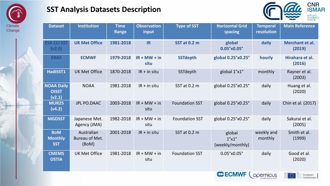
SST Analysis Datasets Description CONSIGLIO NAZIONALE DELLE RICERCHE
ISTITUTO DI SCIENZE MARINE
Global Ocean and climate dynamics
Chunxue Yang ISMAR, Roma
CONSIGLIO NAZIONALE DELLE RICERCHEISTITUTO DI SCIENZE MARINE
Global Ocean and climate dynamics
Chunxue Yang ISMAR, Roma
Dataset Institution TimeRange
Observation input
Type of SST Horizontal Grid spacing
Temporal resolution
Main Reference
ESA CCI SST (v2.0)
UK Met Office 1981-2018 IR SST at 0.2 m global0.05°x0.05°
daily Merchant et al. (2019)
ERA5 ECMWF 1979-2018 IR + MW + in situ
SSTdepth global 0.25°x0.25° hourly Hirahara et al. (2016)
HadISST1 UK Met Office 1870-2018 IR + in situ SSTdepth global 1°x1° monthly Rayner et al. (2003)
NOAA Daily OISST(v2.1)
NOAA 1981-2018 IR + in situ SST at 0.2 m global 0.25°x0.25° daily Huang et al. (2020)
MUR25(v4.2)
JPL PO.DAAC 2003-2018 IR + MW + in situ
Foundation SST global 0.25°x0.25° daily Chin et al. (2017)
MGDSST Japanese Met. Agency (JMA)
1982-2018 IR + MW + in situ
Foundation SST global 0.25°x0.25° daily Sakurai et al. (2005)
BoM Monthly
SST
Australian Bureau of Met.
(BoM)
2001-2018 IR + in situ SST at 0.2 m global
1°x1°(weekly/monthly)
weekly and monthly
Smith et al. (1999)
CMEMS OSTIA
UK Met Office 1981-2018 IR + MW + in situ
Foundation SST 0.05°x0.05° daily Good et al. (2020)
Climate
Change
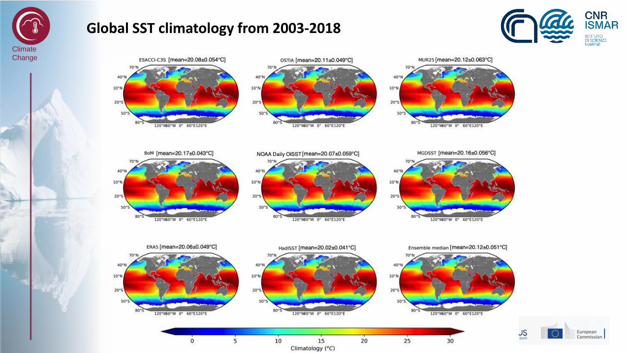
Global SST climatology from 2003-2018CONSIGLIO NAZIONALE DELLE RICERCHE
ISTITUTO DI SCIENZE MARINE
Global Ocean and climate dynamics
Chunxue Yang ISMAR, Roma
CONSIGLIO NAZIONALE DELLE RICERCHEISTITUTO DI SCIENZE MARINE
Global Ocean and climate dynamics
Chunxue Yang ISMAR, Roma

Climate
Change
CONSIGLIO NAZIONALE DELLE RICERCHEISTITUTO DI SCIENZE MARINE
Global Ocean and climate dynamics
Chunxue Yang ISMAR, Roma
CONSIGLIO NAZIONALE DELLE RICERCHEISTITUTO DI SCIENZE MARINE
Global Ocean and climate dynamics
Chunxue Yang ISMAR, Roma
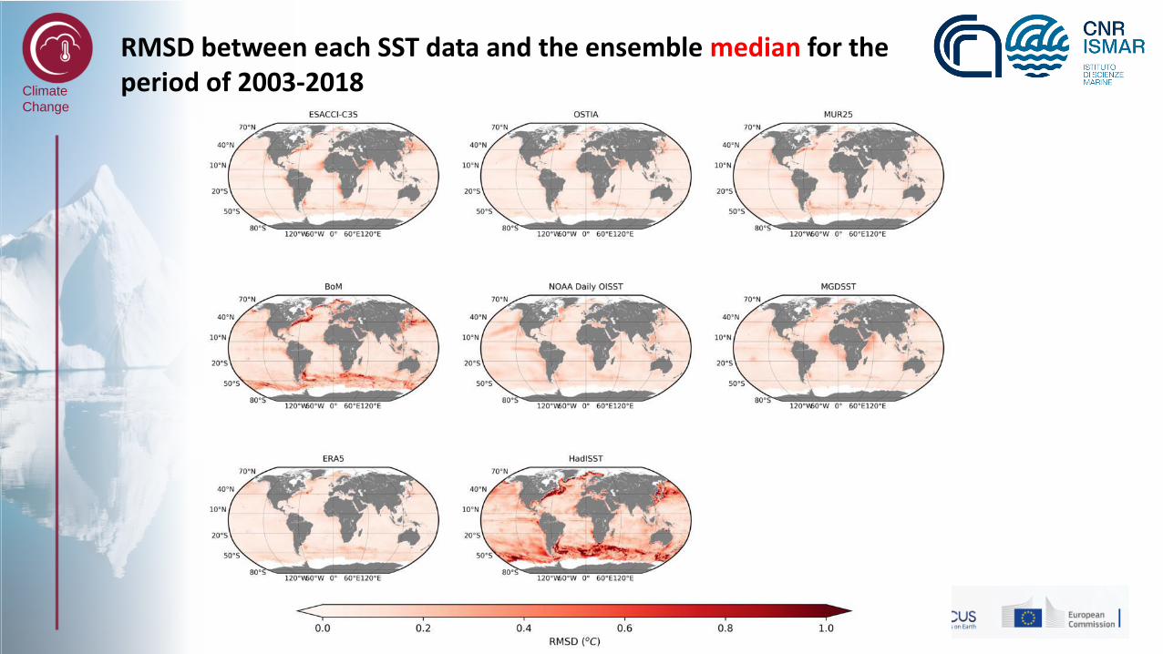
The difference between each SST data and the ensemble median for the period of 2003-2018
Climate
Change
RMSD between each SST data and the ensemble median for the period of 2003-2018
CONSIGLIO NAZIONALE DELLE RICERCHEISTITUTO DI SCIENZE MARINE
Global Ocean and climate dynamics
Chunxue Yang ISMAR, Roma
CONSIGLIO NAZIONALE DELLE RICERCHEISTITUTO DI SCIENZE MARINE
Global Ocean and climate dynamics
Chunxue Yang ISMAR, Roma