South Lee County Watershed Update Document Preparation ...
13
South Lee County Watershed Update Document Preparation Date: April 15, 2010 Page 1 of 13 South Lee County Watershed Update Document Preparation Date: April 15, 2010 South Florida Water Management District
-
Upload
khangminh22 -
Category
Documents
-
view
1 -
download
0
Transcript of South Lee County Watershed Update Document Preparation ...

South Lee County Watershed Update Document Preparation Date: April 15, 2010
Page 1 of 13
South Lee County Watershed Update
Document Preparation Date: April 15, 2010
South Florida Water Management District

South Lee County Watershed Plan Update Page 2
Statement of Work
South Lee County Watershed Plan Update
I. Introduction/Background In 1999, the South Lee County Watershed Plan (SLCWP) was developed in response to the heavy storms and localized flooding that occurred in 1992 and 1995. The plan identified a number of improvements that could help restore natural flow-ways, remove constrictions and enhance the conveyance capacities of the Estero, Imperial and Cocohatchee Rivers and the Belle Meade and Camp Keais Strand watersheds. The 1999 plan evaluated a number of scenarios using models. The models used were SHEET2D for the largely undeveloped areas east of I-75 and the SWMM model for the developed area west of I-75. In the past ten years, many of the recommended improvements have been completed by the District and Lee County, however, the recommendation to convey additional flood waters under I-75 to Halfway and Spring Creeks had not yet been implemented. In response to a permit application to widen I-75, the District and Lee County agreed to update the Halfway Creek, Spring Creek and South Branch of Estero River component of the SLCWP. Since Lee County was developing a MIKESHE/MIKE11 model for much of the same area as part of the Density Reduction Groundwater Resource (DRGR) review, Lee County and the District agreed to use MIKESHE/MIKE11 for this update. A draft SLCWP Update was completed in 2009, culminating a 14 month effort that included extensive coordination with area residents and stakeholders and incorporated regional studies including the Southwest Florida Feasibility Study and Lee County’s DRGR Hydraulic Study. Recommendations contained in the draft 2009 Update included evaluating additional water management alternatives and the incorporation of new topographic information that was unavailable during the initial development of the Update.
II. Objectives In an effort to refine the recommendations of the draft 2009 update and to incorporate the most current LIDAR topographic data available, Lee County and the District have agreed to conduct the final work that will conclude the SLCWP Update. The objective of the 2010 Update will be to refine the recommendations of the draft 2009 update to incorporate additional data and improvements made since the 1999 SLCWP for the Halfway Creek, Spring Creek and South Branch of Estero River region, and to conduct additional evaluations to improve water conveyance in the water bodies above using models developed in the draft 2009 update. This joint effort will be equally

South Lee County Watershed Plan Update Page 3
cost shared by Lee County and the District with the contracting responsibilities remaining with the District. To effectuate communication with the community, all updates and information generated through this project will be shared with interested parties through e-notifications and postings to the District’s web site. A statement of work for the 2010 Update will be circulated for stakeholder review prior to initiation by the contractor. Upon completion of this final phase of study, a draft report will be circulated for review and a public workshop will be held to obtain feedback from the community. This cooperative endeavor is intended to foster public involvement, provide transparency to the community and promote positive, scientifically based recommendations to better manage the watershed.
III. Scope of Work This SLCWP Update will evaluate potential water conveyance improvements of Halfway Creek, Spring Creek and the South Branch of the Estero River with new data that has been identified and/or gathered since the 2009 draft SLCWP Update was initiated. Particular interest is to be applied to the conveyance under I-75. The Project team and the District’s Hydrologic and Environmental Systems Modeling (HESM) department staff will evaluate the modeling strategy as well as the deliverables of the project. The responsible agencies will determine if a third party peer review of the model will be necessary at the end of the model calibration. The contractor shall be responsible for addressing and incorporating responses to peer review comments. Any modifications deemed necessary to the model as a result of the review will be made in collaboration and coordination with Lee County. A STOP/GO POINT will be included at the completion of Task 2 model update. The Contractor shall stop work following completion of Task 2. Depending on the extent of rework necessary as a result of the deliverable review, the District in consultation with Lee County may avail itself of a go, no go decision at this stage of contract to stop further work. The consultant shall meet with the project team, Lee County Staff and HESM staff three times during implementation of this project: (1) before starting the proposed tasks, (2) after the model calibration, and (3) a final meeting after the work is complete. The Stormwater Division is responsible for setting up these meetings. Additional meetings will be scheduled as necessary to address key technical and non-technical issues. The District is seeking a contractor with professional expertise for this project. The expertise shall be required in the following disciplines:

South Lee County Watershed Plan Update Page 4
Thorough understanding of hydrology and hydraulic principles. Familiarity with a variety of models used in hydrologic and hydraulic modeling. Clearly understand the impact of changes in hydrologic conditions, operational
guidelines, and regulation schedules. Hydraulic and hydrologic model development and applications Storm event modeling and flood protection modeling, and flood impact analysis Familiarity with the geology and hydrology of South Florida, especially in the
project area i.e. Lee county local conditions. Interpretation of model results
There are three major tasks proposed with this SOW: Development of a work plan, update of the model, decoupling of the MIKESHE/MIKE11 model so that the Hydraulic analysis can be completed using MIKE11 and problem identification and preferred alternative selection. The project duration is six (6) months. The detailed description of each task is described in Section IV below. The District’s Stormwater Division staff will administer the project management functions of the contract. Technical oversight, including review and approval of all deliverables of this contract shall be performed by the Project team and District’s Hydrologic and Environmental Systems Modeling staff (HESM) in cooperation with Lee County. The Project Manager is responsible for acceptance of all deliverables with technical input from HESM and Lee County.
IV. Work Breakdown Structure There are three tasks associated with this SOW: Task 1: Project Kickoff Meeting and Project Technical Work Plan
The contractor shall attend a project kickoff meeting with the project team including the project manager, HESM and Lee County technical staff. Following the kick off meeting, the Contractor shall prepare a draft Project Technical Work Plan that describes the project in detail. The Project Technical Work Plan will summarize specific project and task objectives (as understood by the Contractor following the kick off meeting) and deliverables associated with each task necessary to accomplish the stated objectives. This plan will be developed using this Statement of Work as an outline and based on the clarifications provided by the project team during the project kickoff meeting. The plan will include a model revision strategy that will describe the plan for model development, calibration, verification and validation (as defined by the ASCE Task Committee 1988). All modeling completed under this scope shall follow standards of modeling practice including but not limited to HESM Draft Model Implementation / Application Methodology and applicable ASTM 2004&2008 standards. This project technical work plan must be approved by the project manager with input from District's HESM staff, and Lee County technical staff before work can proceed. HESM’s initial meeting with contractor may run concurrently with or may follow the kickoff meeting.

South Lee County Watershed Plan Update Page 5
Deliverables for Task 1 The Technical Work Plan is due within four (4) weeks of initiation of the work order and no later than 10 days following the Kick off Meeting. District’s project manager, HESM staff and Lee County will review the Project Technical Work Plan within three weeks of receipt from the Contractor, and will send the Contractor written recommended revisions to be incorporated into the final Project Technical Work Plan. Two weeks after the reviews are submitted to the Contractor, the Contractor shall submit a revised Project Technical Work Plan to the District’s project manager for approval. Once approved by the District, the Project Technical Work Plan will become a binding article of the contract. The Contractor shall then proceed with the work identified in this contract in accordance with the Project Technical Work Plan and this Statement of Work. Task 2 Update the model Task 2.1 Model Update The contractor shall undertake work detailed in the Project Technical Work Plan necessary to incorporate the following into the existing model (as necessary to achieve project objectives):
Recent cross section data for Spring Creek acquired by the City of Bonita Springs
Data for the South Branch of the Estero River that was acquired by Lee County Incorporate new structure data and cross sections for the channels between the
San Carlos Estates weirs and Old U.S. 41 to be acquired by Lee County Incorporate Spring Creek cross sections to be acquired by Lee County incorporate the new LIDAR topographic data and rainfall data Delineate conveyance structures upstream of I-75 and any known impediments
to flow. Identify if historic flows have been diverted or restricted upstream by mines, agriculture, or other land uses to the point where historic flows are not reaching the Estero River due to disconnects in the system. No surveying will be conducted as part of this delineation. The delineation shall be accomplished by review of the new LIDAR topographic data and a one-day field visit to confirm the presence of flow blockages east of I-75 in the Estero River watershed and the relative accuracy of extracted cross-section geometry from the present model. All data shall be provided by the District to the contractor at project commencement.
Task 2.2 Model calibration/sensitivity analysis and validation
South Lee County Watershed Plan Update Page 6
In the 2009 update calibration data was collected from major surface water features within the study area. Flow and stage data are available for the Imperial River, Spring Creek, North Branch of the Estero River, and the South Branch of the Estero River from 1987 through 2006. Stage data is also available for Halfway Creek for 2007-2008 and the Kehl Canal gate on the Imperial River since 2003. The model will be calibrated for wet season events between 2006 and August 2008. A calibration strategy appropriate for the objective of the project will be formalized during the first meeting with HESM. It is expected that the calibration / validation strategy will accomplish the following.
The objective of calibration is to replicate historical conditions within the study area in order to determine a reasonable set of hydrologic and hydraulic parameter values for use in future predictive modeling for alternative evaluation. Key parameters to be varied during calibration should be identified along with reasonable ranges from past experience in the area and/or the literature. A sensitivity analysis performed as part of the calibration can help in this regard.
Model performance will be assessed in terms of goodness of fit metrics at selected stage and flow gages. The model will be considered calibrated once the goodness of fit metrics are within acceptable pre-defined ranges (e.g. more than x% of gages within +/- y) and model parameters are within reasonable ranges for the area being simulated. Acceptable ranges for goodness of fit metrics should be defined based on the intended use of the model and practical considerations. Water budgets for both the hydrologic (MIKE SHE) and hydraulic (MIKE11) portions of the model should also be inspected for reasonableness. A brief description of how structure hydraulics and operations will be handled during calibration/validation and predictive simulation should be included.
The objective of the validation is to assess the robustness of the hydrologic parameters obtained from the calibration process. In a validation run, the parameters obtained during the model calibration process are incorporated and tested for a non-overlapping period of simulation. Successful performance in the validation period increases the confidence in the model’s ability to provide meaningful hydrologic responses in predictive simulation mode.
Calibration and validation periods representative of historical flooding conditions would be chosen subject to data availability.
The modeling strategy will include calibration of decoupled model components and the integrated model adequate to establish reasonable model performance. Deliverables for Task 2 A technical report shall describe the model update, simulation algorithms and input data processing, calibration process of the model, sensitivity analyses of simulation, problems encountered during the calibration and verification process. An analytical and

South Lee County Watershed Plan Update Page 7
graphical summary of calibration results including water balance data and stage and flow comparisons at major structures shall be documented too. The model and model calibration will be reviewed before proceeding to evaluation of the alternatives. A third party/external peer review of model calibration may be needed at discretion of the District. If the third party/external peer review deems necessary, the contractor shall be responsible to address and incorporate the peer review comments. STOP/GO POINT: The Contractor shall stop work following completion of Task 2 to negotiate the timeframes and payment amounts for all remaining tasks. Said negotiations will be based on information collected in Task 2. Depending on the extent of rework necessary as a result of the deliverable review, the District in consultation with Lee County may avail itself of a go, no go decision at this stage of contract to stop further work. The Contractor is not authorized to proceed with Task 3 until directed to do so by the District in the form of an executed Work Order Revision for all remaining tasks and deliverables. The Task and Deliverable descriptions set forth below are therefore not considered final until such time as a price for such work has been negotiated and agreed to by the District and a work order revision has been executed by both parties. A draft technical report shall be submitted to the District. The District’s project manager, HESM staff and Lee County will review and request revisions within three (3) weeks of receipt of the deliverable. Five (5) copies of the final deliverable along with an electronic version, which incorporates the revisions requested by the District’s project manager, HESM staff and Lee County, are due within two (2) weeks of the District’s and Lee County comments. Task 3 Problem Identification and Preferred Alternative Selection This task will analyze three (3) alternatives as discussed below. The purpose of the alternatives will be to satisfy the following objectives:
Reduce peak flow stages in Halfway Creek to levels established in the 1999 South Lee County Watershed Plan and determine if additional culverts are needed under I-75 at Halfway Creek;
Reduce peak flows or peak flow duration during the 5, 10, 25 and 100-year design storms to the Imperial River;
Increase peak flow discharges to the Estero River without causing flooding problems in the Estero River (North and South Branches);
Increase base and flood flows in the Spring Creek watershed to allow for conveyance of runoff from east of I-75 as long as that increased flow results in overall lower peak stages in San Carlos Estates.
Task 3.1 Modeling Scenarios

South Lee County Watershed Plan Update Page 8
1. Increased flow through Halfway Creek Watershed. Components of this alternative will consist of:
a. A determination of the need for additional culverts under I-75 at Halfway Creek
b. Using a fixed weir for the Brooks Diversion gate from Halfway Creek to the South Branch Estero River should be evaluated. This has been previously evaluated in the draft 2009 SLCWP update, but this additional review should offer a verification of the results from the updated model.
c. Open an inflow and outflow connection from Halfway Creek west of Via Coconut Point to Rapallo Lake
d. Removal of exotic vegetation in Halfway Creek west of U.S. 41. The wooden walkway invert may need to be raised along with excavation of a 100-ft wide flow-way on the north side of Halfway Creek west of U.S. 41 to the existing Fountain Lakes flow-way.
e. Construction of an additional culvert or culverts for Halfway Creek under Via Villagio. Evaluate if this improvement lowers stages in Halfway Creek east of Via Villagio.
f. I-75 collection swales interconnect between Estero and Halfway Creek sub basins to simulate predevelopment sheet flow conditions by providing equalization. Over drainage east of I-75 would be eliminated through control structures set at an appropriate elevation.
2. Improve North and South Branch Estero River conveyance west of I-75.
Components of this alternative will consist of: a. Removing a portion of the Corkscrew Woodlands RV parking lot and also
investigating the high area just east of I-75 at the bridge crossing (Monte Run) at the south end of Corkscrew Village.
b. Increased conveyance through removal of exotic vegetation in the South Branch of Estero River.
c. Removal of any flow blockages in the North Branch of the Estero River. d. I-75 collection swales interconnect between Estero and Halfway Creek
sub basins to simulate predevelopment sheet flow conditions by providing equalization. Over drainage east of I-75 would be eliminated through control structures set at an appropriate elevation.
3. Increased conveyance in the Spring Creek watershed and connection of
wetlands east of I-75 to the headwaters of Spring Creek. Components of this alternative will consist of:
a. Additional culverts under I-75 near San Carlos Estates b. Replacement of the existing San Carlos Estates weirs with overflow gates
that would have a lower control elevation during major floods. c. Potential for a conveyance route through the closed golf course east of
San Carlos Estates. d. Any portion of Alternatives 1 and 2 that are beneficial to increasing
conveyance in Halfway Creek and/or the South Branch Estero River

South Lee County Watershed Plan Update Page 9
Task 3.2 Draft Report and Public Workshop The contractor shall submit a draft report of work completed in this contract for review and comment by the District and Lee County. The District and Lee County will provide written comments for revisions within three weeks of receipt of draft report. The prime contractor shall present a summary of the revised draft report’s findings at a public workshop to be coordinated by the District and Lee County. The contractor shall take note of the public comment at the workshop and provide a summary of the public comments from the workshop and any written public comments and provide the summary in the final report. Task 3.3 Final Report The contractor shall incorporate comments received from the District, Lee County and the public workshop into the final report and submit the final project report to the District and Lee County. Comments related to the model development and technical issues shall be resolved and addressed prior to the final report. Model domain shape files (if available); model source code/executable files; input and output files for the three alternative simulation runs; and all data, photos, and all other information collected for implementing the project shall be attached to the final report. Deliverables for Task 3 The contractor shall prepare and submit a draft final project report to the District and Lee County for review and comments. The draft final report shall summarize work completed under this contract. Model methodology, assumptions, limitations, set up, simulation runs, results analyses, summary of outcome including recommendations and conclusions should be documented in the draft final report. Any issues encountered shall be documented and justified.
The draft report should describe all activity performed under this work order and will include a detailed description of the findings on hydrologic-hydraulic performance of the existing water management facilities in the region. The hydraulic summary should describe the performance of existing waterways and water control systems, stage storage discharge characteristics, and water surface profiles under the 5, 10, 25 and 100 year recurrence interval peak flow conditions. The consultant shall provide tabular and graphical summaries of the runoff hydrographs. The current level of service for each major flow way shall be determined as well as recommended improvements to achieve a higher level of service should be identified. The report will include a preferred set of recommendations to improve flow for the study area. The recommendations should be prioritized. A draft report will be submitted. The District’s project manager, HESM staff and Lee County will review and request revisions within three (3) weeks of receipt of the draft report deliverable. A revised draft report will be submitted that incorporates the revisions

South Lee County Watershed Plan Update Page 10
requested by the District’s project manager, HESM staff and Lee County within two (2) weeks of comment submittal. The public workshop will then be scheduled. Public comments and any additional District or Lee County comments will be summarized and included in a draft final report. The District’s project manager, HESM staff and Lee County will review and request revisions within three (3) weeks of receipt of the draft final report deliverable. Five (5) copies of the final deliverable along with an electronic version, which incorporates the revisions requested by the District’s project manager, HESM staff and Lee County, are due within two (2) weeks of the District’s and Lee County comments.
V. Performance Evaluation The consultant’s performance for this Work Order will be evaluated at the following frequencies:
1. Interim 2. Final 3. Additional evaluations as determined by the Project Manager
A running Average Score > 3.0 is required to maintain active contract status.
South Lee County Watershed Plan Update Page 11
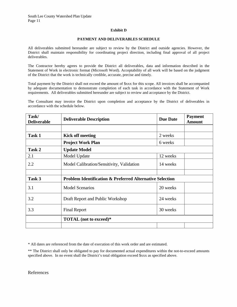
Exhibit D
PAYMENT AND DELIVERABLES SCHEDULE All deliverables submitted hereunder are subject to review by the District and outside agencies. However, the District shall maintain responsibility for coordinating project direction, including final approval of all project deliverables. The Contractor hereby agrees to provide the District all deliverables, data and information described in the Statement of Work in electronic format (Microsoft Word). Acceptability of all work will be based on the judgment of the District that the work is technically credible, accurate, precise and timely. Total payment by the District shall not exceed the amount of $xxx for this scope. All invoices shall be accompanied by adequate documentation to demonstrate completion of each task in accordance with the Statement of Work requirements. All deliverables submitted hereunder are subject to review and acceptance by the District. The Consultant may invoice the District upon completion and acceptance by the District of deliverables in accordance with the schedule below. Task/ Deliverable
Deliverable Description Due Date Payment Amount
Task 1 Kick off meeting 2 weeks
Project Work Plan 6 weeks
Task 2 Update Model 2.1 Model Update 12 weeks
2.2 Model Calibration/Sensitivity, Validation 14 weeks
Task 3 Problem Identification & Preferred Alternative Selection
3.1 Model Scenarios 20 weeks
3.2 Draft Report and Public Workshop 24 weeks
3.3 Final Report 30 weeks
TOTAL (not to exceed)*
* All dates are referenced from the date of execution of this work order and are estimated.
** The District shall only be obligated to pay for documented actual expenditures within the not-to-exceed amounts specified above. In no event shall the District’s total obligation exceed $xxx as specified above.
References

South Lee County Watershed Plan Update Page 12
Ctl + click to follow link.
Original Lee County Watershed Plan [zipped document 143.3 kb]
South Lee County Watershed Plan Update (May 2008) First Deliverable Document [2.7 Mb] South Lee County Watershed Plan Update Deliverable 1B Draft [6.3 MB]
South Lee County Watershed Plan Update (May 2008) Statement of Work [53 kb]
South Lee County Watershed Plan Update: Draft 50% Deliverable 1C [5.4MB]
Statement of Work for the South Lee County Watershed Plan Final Phase [110 KB]
Maps [4.4 MB] South Lee County Watershed Plan Powerpoint Presentation Draft Calibration [505 KB] South Lee County Watershed Plan Powerpoint Presentation Draft Problem ID [400 KB] Spring Creek Report "Draft": Cover and Table of Contents [14 KB]
Spring Creek Final Study [2MB] South Lee County Watershed Plan: Draft 90% Deliverable 1C [21.3 MB]
South Lee County Watershed EA 50% draft 3-3-2009 [6.1 MB]
South Lee County Watershed Plan Update- Draft 90% Deliverable III [7.6 MB]
Establish Target Flows & Stages to be used in the Alternatives Analysis [117 KB]
South Lee County Watershed Plan Update 100 % deliverable 1C [23.5 MB]
South Lee County Watershed Management Plan Update Structure Inventory Figure 1 Proposed_Plan_for_SLCWP_Update_Apr_22_09_final
SLCWP_Update_Draft_(90percent_deliverable)
Comments on the SLCWPU SLCWP Update Status Memo 6-5-09 Comments on Draft 90% SLCWP Final RPT 8-7-09 Final
12-01-2009 Draft SOW SLCWP Work Order

South Lee County Watershed Plan Update Page 13
Figure 1