Solapur University, Solapur List of Students (Present/Absent ...
Upload
khangminh22Category
view
0download
0
Page | 1
SOLAPUR UNIVERSITY, SOLAPUR
NAAC Accredited-2015
‘B’ Grade (CGPA 2.62)
Faculty of Science
Syllabus
B.Sc.-III GEOLOGY
Choice Based Credit System (CBCS)
Semester-V & VI
With effect from June-2018

Page | 2
Solapur University, Solapur, Faculty of Science
Choice Based Credit System (CBCS): (w.e.f. 2018-19)
Structure for B. Sc-III
Subject/ Name and Type of the
Paper
No. of Hrs/week
Total UA CA Credits
Core Course papers/ Marks
Type
Name
Practical L T P
Per
Paper
Class : B.Sc.- III Semester - V
Ability Enhancement
Course(AECC)
English Paper-III 4 100 70 30 4
Core Subject Paper IX 3 -- -- 100 70 30 3
Core Paper X 3 -- -- 100 70 30 3
Core Paper XI 3 -- -- 100 70 30 3
DSE-A Subject Paper XII 3 -- -- 100 70 30 3
DSE-B Paper XII 3 -- -- 100 70 30 3
Grand Total 16 -- -- 500 350 150 12
Class : B.Sc.- III Semester -VI
Ability Enhancement Course(AECC)
English Paper-IV 4 100 70 30 4
Core
Subject
Paper XIII 3 -- -- 100 70 30 3
Core Paper XIV 3 -- -- 100 70 30 3
Core Paper XV 3 -- -- 100 70 30 3
DSE-A
Subject
Paper XVI 3 -- -- 100 70 30 3
DSE-B Paper XVI 3 -- -- 100 70 30 3
Total
(Theory)
16 -- -- 500 350 150 12
Core& DSE Subject Practical IV -- -- 5 100 70 30 5
Core& DSE Subject Practical V -- -- 5 100 70 30 5
Core& DSE Subject Practical VI -- -- 5 100 70 30 5
Core& DSE Subject Practical VII -- -- 5 100 70 30 5
Total
(Practicals)
20 400 280 120 20
Grand Total 16 20 900 630 270 44
• Core Subjects- Chemistry/Physics/Electronics/Computer
Science/Mathematics/Statistics/Botany/Zoology/Microbiology/Geology.
• Discipline Specific Elective (DSE) Paper-The Subject will be specific as per the chosen core subjects.

Page | 3
Summary of the Structure of B.Sc.Programme as per CBCS pattern
Class Semester Marks- Credits- Marks- Credits- Total -
Theory Theory Practical Practicals credits
B.Sc.-I I 900 20 - - 20
II 900 20 400 16 36 B.Sc.-II III 600 18 - - 18
IV 700 18 600 24 42
B.Sc.-III V 500 12 - - 12
VI 500 12 400 20 32
Total 4100 100 1400 60 160
B.Sc.Programme:
• Total Marks : Theory + Practicals = 4100 +1400 =5500
• Credits : Theory + Practicals = 100 + 60 = 160
• Numbers of Papers Theory: Ability Enhancement Course(AECC) : 05
Theory: Discipline Specific Elective Paper (DSE) : 02
Theory: Core Course (CC) : 34
Total : Theory Papers :41
Practical: Core Course (CC) : 14
Abbreviations:
• L: Lectures • T: Tutorials • P: Practical • UA : University Assessment • CA : College Assessment • CC: Core Course • AEC : Ability Enhancement Course • DSE : Discipline Specific Elective Paper
Important Note:
1. Board of Studies in the respective subject may design the curriculum/syllabus of one additional
paper of the same Number (Paper –XII) as DSE Paper, so that students can opt any one of these
two papers for semester –V. Similarly, the students can opt for one DSE paper (Paper-XVI) for
Semester- VI. 2. The Credits for the practicals are changed as per the number of Hours per week. 3. For B.Sc.-I, Sem -I and II. Papers of each subject are divided as per previous pattern to give more
weightage and to reduce the stress of the students.
4. Combined passing for B. Sc.- II Practicals ( Practical – II & III) 5. Combined passing for B. Sc. -III Practicals (Practical – IV-VIII) 6. The 30 marks of College level Assessment (CA) may be distributed as 15 Marks for Internal Test
and 15 Marks for Home Assignment/seminars/Viva/industrial visit/Group discussion etc.

Page | 4
SOLAPUR UNIVERSITY, SOLAPUR
Faculty of Science
Choice Based Credit System (CBCS)
(w.e.f. June 2018)
•Title of the Course: B.Sc. Part-III
•Subject: Geology
• Objectives of the course: The students of B. Sc. III Geology are expected to develop and
demonstrate following learning outcomes:
� an understanding of concepts in Geology and geological processes.
� the ability to collect, analyze, and interpret geological data using a variety of techniques.
� the ability to address real geological problems in the field.
� the ability to read, write and speak cogently using the language of geology..
•Choice Based Credit System CBCS
With the view to ensure worldwide recognition, acceptability, horizontal as well as vertical
mobility for students completing undergraduate degree, Solapur University has implemented Choice
Based Credit System ( CBCS ) of Evaluation at Undergraduate level. Credit is a numerical value that
indicates students work load (Lectures, Lab works, Seminars, Tutorials, Field work etc.) to complete a
course unit. In most of the universities 15 contact hours constitute one credit. The contact hours are
transformed into credits. As per present norms, there are 3 contact hours per paper (subject) per week
which works out to be 45 contact hours / 3 credit points per paper (subject) per semester.
In Solapur University, for B.Sc.-III Geology, there are 5 papers in each semester out of which 4
papers choice will be given to student in DSE and Compulsory English. For B.Sc.-III Geology, there are 3
contact hours per paper (subject) per week for each paper and Compulsory English carry 4 contact
hours per week. Therefore, total contact hours per week are 16. Each paper has 45 contact hours,
which are transformed into 3 credits. Moreover, the grading system of evaluation is introduced for
B.Sc. course wherein process of Continuous Internal Evaluation is ensured. The candidate has to appear
for Internal Evaluation of 30 marks and University Evaluation for 70 marks. It is 70+30 pattern of
evaluation. It is applicable for theory and practical as well. The details regarding this evaluation system
are as under.

Page | 5
Conversion of marks into Grades:
A table for the conversion of the marks obtained by a student in each paper (out of100) to grade and
grade point is as given below:
Sr. No. Range of Marks Grade Grade Point
1 80-100 O 10
2 70-80 A+ 9
3 60-69 A 8
4 55-59 B+ 7
5 50-54 B 6
6 45-49 C+ 5
7 40-44 C 4
8 <39 FC 0( Failed in Term Exam)
9 <39 FR 0( Failed in Internal Assessment)
1. Grade Point Average at the end of the Semester (SGPA)
(G1× C1) + (G2 × C2) +……………..
SGPA=----------------------------------------------------
ΣCi
(Σ Ci= The total number of credits offered by the student during a semester)
2. Cumulative Grade Point Average (CGPA)
(G1 × C1) + (G2 × C2) +……………..
CGPA=----------------------------------------------------
Σ Ci
(Σ Ci= The total number of credits offered by the student upto and including the semester
for which CGPA is calculated.)
3. Final Grade Point Average (FGPA)
It will be calculated in the similar manner for the total number of credits offered for the
completion of the said course.
Where: Ci= Credits allocated for the ith
course.
Gi= Grade point scored in the ith
paper (subject)
4. Conversion of average grade points into grades:
SGPA/CGPA/FGPA Letter Grade
9.5 – 10 O
8.5 – 9.49 A+
7.5 – 8.49 A
6.5 – 7.49 B+
5.5 – 6.49 B
4.5 – 5.49 C+
4.0 – 4.49 C
<3.99 FC / F
FR

Page | 6
Syllabus Structure:
1. The University follows semester system.
2. An academic year shall consist of two semesters.
3. Each B.Sc. course shall consist of three years i.e. six semesters.
4. B.Sc. Part-III Geology shall consist of two semesters: Semester V and Semester VI.
In semester V and VI, there will be a total of five out of which candidate should select any one
paper from DSE (papers XII and XVI) totaling of four papers of 100 marks for each semester with
compulsory English.
The scheme of evaluation of performance of candidates shall be based on University
assessment as well as College internal assessment as given below. For B.Sc. Part-III Geology semester V
& VI the internal assessment will be based on Unit tests, Tutorials, Home assignment, Viva, Group
discussion, attitude, sincerity, attendance, student seminars etc. as given below. Practical course
examination of 100 marks for each paper shall be conducted at the end of VIth
semester. The practical
examination of 100 marks shall also consist of 70 marks for University practical assessment and field
work and 30 marks for college internal assessment.
For University practical examination both the examiners will be External and will be appointed
by the University. The internal practical assessment shall be done as per scheme given below.
6. Scheme of Evaluation:
As per the norms of the grading system of evaluation, out of 100 marks, the candidate has to
appear for college internal assessment (CA) of 30 marks and external evaluation, University Assessment
(UA) of 70 marks. The respective B.O.S. may decide the nature of college internal assessment after
referring to scheme given below or may be used as it is.

Page | 7
Semester – V
Theory: (100 marks)
University Examination (70 marks): No. of theory papers: 5 (1English + 4 Subjects)
Internal Continuous Assessment: (30 marks)
The 30 marks of College level Assessment (CA) may be distributed as 15 Marks for Internal Test and 15
Marks for Home Assignment/seminars/Viva/ Group discussion etc.
Semester –VI
Theory: (100 marks)
University Examination (70 marks): No. of theory papers: 5 (1English + 4 Subjects)
Internal Continuous Assessment: (30 marks)
The 30 marks of College level Assessment (CA) may be distributed as 15 Marks for Internal Test and 15
Marks for Home Assignment/seminars/Viva/Group discussion etc.
Practical Examination: (100 marks)
University Examination (70 marks): No. of practical course 4 (Total 280 marks = 70 x 4)
Internal Continuous Assessment: (30 marks)
Scheme of marking: 30 marks – Internal test on any four practicals (Total 120 marks = 30 x 4)
(Weightages for Lab. Journal /performance/attendance/sketching of diagrams related to syllabus.
Thus the course shall be of total 1400 marks including English.
7. Passing Standard:
The student has to secure a minimum of 4.0 grade points (Grade C) in each paper. A student
who secure less than 4.0 grade point (39% or less marks, Grade FC/FR) will be declared fail in that
paper and shall be required to reappear for respective paper. A student who failed in University
Examination (theory) and passed in internal assessment of a same paper shall be given FC Grade. Such
student will have to reappear for University Examination only. A student who fails in internal
assessment and passed in University examination (theory) shall be given FR Grade. Such student will
have to reappear for both University examination as well as internal assessment. In case of Annual
pattern/old semester pattern students/candidates from the mark scheme the candidates shall appear
for the same 70 marks of external examination and his/her performance shall be scaled to 100 marks.
8. ATKT Candidate passed in all papers except 6 (six) papers combined together of semester III and IV
of B.Sc. Part-II Geology examination and clearly passed in B.Sc. Part-I- Geology shall be permitted to
enter upon the course of Semester V of B.Sc. III Geology.
Page | 8
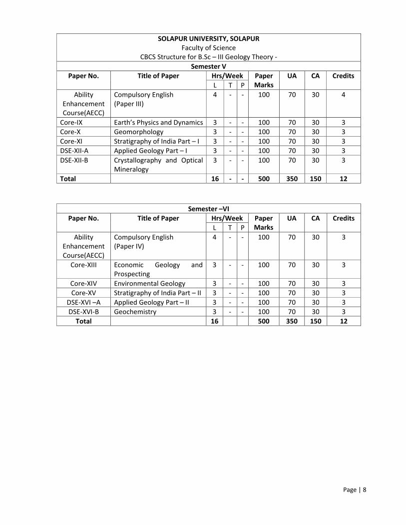
SOLAPUR UNIVERSITY, SOLAPUR
Faculty of Science
CBCS Structure for B.Sc – III Geology Theory -
Semester V
Paper No. Title of Paper Hrs/Week Paper
Marks
UA CA Credits
L T P
Ability
Enhancement
Course(AECC)
Compulsory English
(Paper III)
4 - - 100 70 30 4
Core-IX Earth’s Physics and Dynamics 3 - - 100 70 30 3
Core-X Geomorphology 3 - - 100 70 30 3
Core-XI Stratigraphy of India Part – I 3 - - 100 70 30 3
DSE-XII-A Applied Geology Part – I 3 - - 100 70 30 3
DSE-XII-B Crystallography and Optical
Mineralogy
3 - - 100 70 30 3
Total 16 - - 500 350 150 12
Semester –VI
Paper No. Title of Paper Hrs/Week Paper
Marks
UA CA Credits
L T P
Ability
Enhancement
Course(AECC)
Compulsory English
(Paper IV)
4 - - 100 70 30 3
Core-XIII Economic Geology and
Prospecting
3 - - 100 70 30 3
Core-XIV Environmental Geology 3 - - 100 70 30 3
Core-XV Stratigraphy of India Part – II 3 - - 100 70 30 3
DSE-XVI –A Applied Geology Part – II 3 - - 100 70 30 3
DSE-XVI-B Geochemistry 3 - - 100 70 30 3
Total 16 500 350 150 12

Page | 9
Abbreviations:
L: Lectures
T: Tutorials
P: Practicals
UA: University Assessment of practical course by the end Semester VI.
CA: College Assessment by Internal Continuous Examinations for theory as well as practical course.
Practicals- B .Sc. III Geology ( CBCS) Practical
No.
Paper No.
based on
Title of Paper Hrs/Week Paper
Marks
UA CA Credits
L T P
I
DSE-XII-B 1. Mineral calculations
2. Megascopic and microscopic
mineral identification
3. Crystallography
- 5 100 70 30 3
II
DSE-XII-A
Core-XIII
Core-X
Core-XI
Core-XV
1. Maps
2. Project report / field work, journal
and viva
- 5 100 70 30 3
III
DSE-XVI-A
DSE-XVI-B
A. Petrology:
1. rock identification
2. Textures and structures of rocks
B. Petrochemical calculations
- 5 100 70 30 3
IV
Core-X
Core-IX
Core-XIV
DSE-XII-B
A. Geomorphology
1. Remote Sensing and Photo
geology.
2. Optics.
- 5 100 70 30 3
Total 20 400 280 120 12

Page | 10
SEMESTER-V
CORE PAPER – IX – EARTH’S PHYSICS AND DYNAMICS
[Credits -3, Total Lectures-45]
UNIT CONTENT LECTURES
I Crustal movements: Orogenic and Epeirogenic movements 08
II Types of mountains and their origin: Volcanic, fold (Orogenic), Block and
Denudational
10
III Concept of Isostasy 04
IV Plate tectonics: Divergent and Convergent plate boundaries, Transform fault
boundary. Concept of triple junctions
Basin tectonics – Introduction to fore arc, back arc, foreland & rift basins.
Concept of hot plumes & hot spots with examples
10
10
V Brief overview of Tectonic Evolution of India 03
REFERENCES:
1. General Geology : V. Radhakrishnan;
2. Plate tectonics and Crustal evolution: Condie
3. Aspects of Tectonics: Valdiya K. S.
4. Dynamic Himalaya: Valdiya K. S.
5. The making of Inidia: Valdiya K. S.; Pub.: Society of Earth Scientists Series, Springer
6. Cratons and Fold belts of India: Ram S. Sharma
7. Physical Geology : Arthur Holmes
CORE PAPER – X – GEOMORPHOLOGY
[Credits -3, Total Lectures-45]
UNIT CONTENT LECTURES
I Introduction to geomorphology, Modern concepts of geomorphology. Relationship
between landforms with lithology, climate and tectonic forces.
12
II Cycle of Erosion: concept, meaning and landscape evolution. Rejuvenation: static
and eustatic Topographic evidences of rejuvenation, polycyclic relief.
12
III Slope: geometric properties, types and classification. 10
IV Mass Movements: Meaning, concept, classification on the basis of movement and
material. Types: Creep, Flow, slide, fall and subsidence, Factors controlling mass
movements. Prevention and mitigation
11
REFERENCES:
1. Geomorphology – Savindra Singh
2. Principles of Geomorphology – Thornbury
3. Concepts of Geomorphology: Gupta and Kale
4. Geomorphology - Bloom A. I.
5. Environmental Geology - K.S. Valdiya

Page | 11
CORE PAPER – XI –STRATIGRAPHY OF INDIA PART – I
[Credits -3, Total Lectures-45]
UNIT CONTENT LECTURES
I Principles of Stratigraphy:
1. Introduction to Stratigraphy, Definition and Scope, Principles of Stratigraphy,
Methods of Stratigraphic Correlation, Standard Stratigraphic Scale (Geological
Time Scale).
2. Stratigraphic units: Litho-Stratigraphic , Bio- Stratigraphic , Chrono-stratigraphic
units. Facies concept in Stratigraphy: Lithofacies, Biofacies and Index fossils.
10
Precambrian Stratigraphy of India:
II Physiographic / tectonic divisions of India. Definitions of tectonic elements of India:
cratons, shield, folded mountain belts, Cratons of India and associated Proterozoic
basins
03
III Detailed study of Indian cratons: Dharwar, Bastar, Singhbhum, Bundelkhand,
Aravalli with their distribution, Geographical location, classification, lithological
succession, structure and economic importance, with a broad stratigraphic
correlation.
10
IV Detailed account of Precambrian mobile belts: a) The Eastern Ghat mobile belt; b)
The Satpura mobile belt/ CITZ (Central Indian Tectonic Zone)
06
V Precambrian of extra peninsula: Tectonic subdivisions of Himalaya; Precambrians of
a) Western and Central Lesser Himalayas , b) Western and Central Tethyan
Himalayas
06
VI Proterozoic rocks of India: a) The Archaean – Proterozoic boundary.
Classification, Succession, lithology, fossils and economic importance of: a) The
Delhi Supergroup: b) Cuddapah Supergroup c) The Vindhyan Supergroup: d) The
Kaladgi Supergroup.
10
REFERENCES:
1. Fundamentals of historical geology and Stratigraphy of lndia - Ravindra Kumar.
2. Stratigraphy and Sedimentation - Krumbein and Sloss
3. Stratigraphy - Weller
4. Principles of Stratigraphy - Dunbar and Rogers
5. Geology of India Vol 1 &2. Ramkrishna-Vaidhyanathan- Geological Society of India Special
Publication
6. The Making of India: Geodynamic Evolution- by K.S. Valdiya
7. Stratigraphy of India and Burma- by M.S. Krishnan
8. Fundamentals of Historical Geology and Stratigraphy of India- by Ravindra Kumar
9. A Geological Time Scale- by Brian Harland et. al.

Page | 12
DSE –(A) PAPER – XII –APPLIED GEOLOGY PART – I
[Credits -3, Total Lectures-45]
UNIT CONTENT LECTURES
I A. Engineering geology:
1. Introduction: Significance of geology in Civil engineering, knowledge of
geomorphology, petrology, mineralogy, stratigraphy, photo geology and
structural geology as applied to Civil engineering projects
2. Engineering properties of rocks: Specific gravity, porosity, durability, strength of
rocks (Compressive, shear & tensile), elasticity of rocks. B.S. of India.
B. Geological Investigations For Civil Engineering Projects:
1. Tunnels: Terminology, geological conditions for tunnel sites, tunnel in bedded
rocks and folded rocks, influence of divisional planes, effects of faults,joints and
crushed zones. Tunnels in the vicinity of slopes. Role of groundwater in
tunnelling. Tunnels in the Deccan Traps. Names and locations of at least six very
important tunnels in India, Any one Case study
2. Dams and Reservoirs: Geological conditions for the selection of dam and
reservoir sites, terminology associated with dams. Types of dams
(Gravity,buttress, arch and earthen). Location with type of all the important
dams and hydroelectric projects in India. Any one Case study
10
13
II Hydrogeology:
1. Definitions- Hydrology, Geo-hydrology, Hydrogeology; a) Hydrologic cycle,
Sources of groundwater, b) Vertical distribution of groundwater, Origin & rock
properties affecting groundwater: texture, structure, secondary structure,
porosity, permeability, storage capacity, specific yield and transmissivity
2. Geologic formations as aquifers. Uses of groundwater
3. Types of aquifers (Confined, Unconfined, and Perched).
4. Groundwater fluctuations due to seasonal changes, stream-flow changes,
evapo-transpiration changes.
5. Springs (cold & hot), conditions for formation of springs.
6. groundwater basins
7. Groundwater recharge methods: Introduction to artificial recharge methods.
Types of recharge methods: - i) Water spreading methods (Flooding, Basin,
Ditch & furrow, Natural channel, Irrigation) ii) Recharge through Pits & Shafts,
Recharge through wells. iii) Rain water harvesting. iv) Groundwater recharge
methods in Maharashtra (bore-blast & jacket-well techniques).
8. Geophysical Techniques for groundwater Exploration: K. R. Renranuja Chori
professional Books Publish Hyderabad.
9. Foundations of Engineering Geology : Tony Walthom: Spon press.
10. Principles of Engineering Geology : Gokhale.
12
10
REFERENCES:
1) Principles of Engineering Geology : Krynine & Judd
2) Engineering Geology : Parbin Singh
3) Fundamentals of Engineering Geology: R. S. Khurami
4) Groundwater geology- Todd
5) Groundwater and tube wells - S.P.Garg
6) Groundwater - K.V. Karanth
7) Ground water: H.M. Raghunathan

Page | 13
8) Geophysical Techniques for groundwater Exploration: K.R. Rennanuja Chori Professional Book
Publish Hydrabad.
9) Foundations of Engineering Geology : Tony Walthom : Spon Press
10) Principles of Engineering Geology : Gokhale.

Page | 14
DSE – (B) PAPER – XII –CRYSTALLOGRAPHY AND OPTICAL MINERALOGY
[Credits -3, Total Lectures-45] UNIT CONTENT LECTURES
I Crystallography:
1. Process of crystallization, Definition of crystal, Crystal Elements: Faces, Edges,
Solid Angles, Forms (Open and Closed) Zones, Law of Constancy of Interfacial
Angles, Contact Goniometer , Crystallographic Axes, Axial Angles, Parameters
and Indices, Law of Rational Indices. Elements of Symmetry
15
2. Classification of crystals in to symmetry classes
Study of following Normal Symmetry Classes (12 periods)
1) Isometric System (Galena Type), 2) Hexagonal System (Beryl Type),
3) Tetragonal Type (Zircon Type) 4) Orthorhombic System (Barite Type)
5) Monoclinic System (Gypsum Type) 6) Triclinic system (Axinite Type)
15
II Mineral Optics:
a) Refractive index & methods of comparing R.I of minerals: Becke line, shadow
method & immersion method,b) Relief of minerals,c) Uniaxial & biaxial minerals,
indicatrices,d) Vibration direction & optic orientation,e) Pleochroism &
absorption,f) Accessory plates: Quartz wedge, Mica plate & Gypsum plate,g)
Compensation & Determination of interference colours,h) Sign of minerals,i) Sign
of elongation of uniaxial minerals where C axis is known.
15
REFERENCES:
1. Rutley's Elements of mineralogy - H.H. Read
2. Optical Mineralogy - Paul Kerr.
3. A Text book of mineralogy - Dana
4. An Introduction to the rock forming minerals by Deer, Howie, Zussman
5. Optical Mineralogy by Whalstrom E.E.
6. Optical Mineralogy by S.Ray and PRJ Naidu

Page | 15
SEMESTER-V
CORE PAPER –XIII – ECONOMIC GEOLOGY AND PROSPECTING
[Credits -3, Total Lectures-45]
UNIT CONTENT LECTURES
I Economic Geology:
1. Processes of formation of mineral deposits (Indian examples) and Mineral
Economics, Materials of metalliferous and non-metalliferous deposits
2. Processes of formation of mineral deposits: a) Magmatic concentration, b)
Contact metasomatism, c) Hydrothermal processes, d) Oxidation and
Supergene enrichment, and e) Residual and Mechanical Concentration
3. National mineral policy of India (1990): basic objectives and salient features (in
brief)
4. Conservation of mineral resources, concept, growth of awareness, means of
conservation and limitations Distribution of Economic mineral in India.
04
10
04
04
II Prospecting:
Prospecting: objective, stages and types;
A. Geological Prospecting:
1. Geological Criteria: Climatic, Stratigraphic, Lithological, Structural,
Geochemical, - Magmagene and - Geomorphological.
2. Physiographic Guides: Topographic expressions, Physiographic environment
of the ore deposits, physiography in relation to oxidation & environment.
3. Mineralogical Guides: Rock alteration, Target rings of mineral distribution,
Significance of accessory & gangue minerals. iv) Stratigraphic & lithologic
guides for Syngenetic & Epigenetic deposits, Fracture pattern as guides,
Contacts & folds as guides
B. Broad outline of geophysical prospecting:
Principles and applications of following geophysical methods along with their
measured parameters, operative physical properties and names of the instruments
used.
a) Electrical (S.P. & Resistivity) b) Magneticc)Gravity andd) Seismic refraction
03
08
12
REFERENCES: 1. Economic mineral deposits- Jenson and Bateman A.M.
2. India’s Mineral resources- S. Krishna swami
3. An introduction to mineral economics - Chatterjee K.K.
4. Mineral economies- R.K. Sinha and N.L. Sharma
5. Principles of Geophysical Prospecting : M.B. Ramchandran
6. Geophysical Prospecting : Dobrin
7. Mining Geology: Arogya Swami
8. Field Geophysics : Milson & Eriksen, Wiley Blackwell
9. Handbook of Mineral Exploration & Ore petrology :Techniques and Application R. Dhana Rajv-GSI

Page | 16
CORE PAPER –XIV – ENVIRONMENTAL GEOLOGY
[Credits -3, Total Lectures-45]
UNIT CONTENT LECTURES
I 1. Definition - scope, fundamental concepts in Environmental Geology.
2. Hazardous Earth Processes –Earthquake, River flooding, Sea level changes,
volcanic activity and Coastal hazards. Mining, Surface water and Groundwater
contamination
3. Geological aspects of environmental health:
4. Disaster Management: Prevention and Mitigation.
10
15
05
05
REFERENCES:
1) Environmental Geology - K.S. Valdiya
2) Environmental Geology – Keller
3) Geology in Environmental planning : by A.D. Howard
4) Mining & Environment : by Bharat B. Dhar
CORE PAPER –XV – STRATIGRAPHY OF INDIA PART – II
[Credits -3, Total Lectures-45]
UNIT CONTENT LECTURES
I Introduction to Phanerozoic Stratigraphy:
Precambrian – Cambrian boundary; Study of following Geological systems with
reference to their type area, broad lithology, fossils content: Cambrian, Ordovician,
Silurian, Devonian, Carboniferous, Permian, Triassic, Jurassic, Cretaceous & Tertiary
15
II The Paleozoic and Mesozoic Formations of Peninsular India:
A) Palaeozoic Formations of Peninsular India: a) A brief history of the Paleozoic
Formations, b) Gondwana Supergroup: 1.Geographical distribution, 2.
Stratigraphic classification- bipartile, 3.Lithology, 4. Age, 5. Palaeoclimatic
conditions, 6. Flora, 7.Fauna, 8. Igneous activity, 9. Economic importance.
B) The Mesozoic Formations of Peninsular India: a) A brief history of the Mesozoic
formations. b) Jurassic of Kachchh c) Cretaceous of Narmada Valley/Bagh beds.
15
III Cenozoic Formations of Peninsular India and Geology of Maharashtra
A. The Deccan Volcanic Province:Distribution, extent, age, structure, mode of
eruption and occurrence, Petrological characters and variations,
Lithostratigraphic classification, Infra trappeans and Intertrappean beds.
B. The Cenozoic Formations of Peninsular India: a) Tertiary of Assam b) Tertiary
formations along the West Coast. C) Laterites: Definition, Origin, Types and
distribution. D) The Geology and Stratigraphy of Maharashtra
15
REFERENCES:
1. Fundamentals of historical geology and Stratigraphy of lndia: Ravindra Kumar.
2. Geology of India Vol 1 &2.: Ramkrishna-Vaidhyanathan- G. S. I. Special Publication
3. The Making of India: Geodynamic Evolution: K.S. Valdiya
4. Stratigraphy of India and Burma: M.S. Krishnan
5. Fundamentals of Historical Geology and Stratigraphy of India: Ravindra Kumar
6. A Geological Time Scale: Brian Harland et. al.
7. Geology of Maharashtra: G.G. Deshpande, G.S.I. Special Publication

Page | 17
DSE –(A) PAPER – XVI –APPLIED GEOLOGY PART – II [Credits -3, Total Lectures-45]
UNIT CONTENT LECTURES
I A. Remote Sensing
1. Concept of remote sensing, Source of electromagnetic energy, electromagnetic
spectrum, Emissivity, Black, white & grey bodies Elements of passive Remote
sensing system (data acquisition & data analysis)
2. Types of Platforms, Types of Remote sensing Systems (Active & Passive), Types
of Sensors, Linear and multispectral scanner.
3. Energy interactions in the atmosphere (Scattering, absorption, atmospheric
windows & related sensing systems); Energy interactions with the earth
(principles of the Conservation of energy, specular & diffused reflectors),
Spectral reflectance of vegetation, soil & water; Imagery: IRS products (Main)
MSS Bands- blue, Green, Red and near I.R., FCC.
4. Photo-geology: Aerial Photography, Stereoscopic vision and Stereoscopes;
Classification of aerial photographs on the basis of Camera axis; forward and
lateral overlap, Discrepancies in aerial photographs (tip, tilt, drift, crab, gap) and
their effects.
5. Photo recognition Elements: Tone, texture, pattern, shape, size, site, shadow,
associations. Basic drainage patterns and their geological significance.
Advantages and limitations of Aerial photos
6. Photo-geological interpretations: Photo characters of Sedimentary, igneous and
metamorphic rocks. Interpretation of geologic structures (folds & faults),
Interpretation of lineaments.
03
10
03
04
II B. Geographical Information System (GIS):
1. Introduction to GIS: Definition of GIS, Evolution and components of GIS,
Geospatial Data, Geographic Coordinate System, UTM grid system, Map Scale.
2. Data Base Management and Models:Vector Model: Topology, Non topological
Vector models, Attribute Data in GIS, Attribute Data Entry, Raster Data Model:
Elements of Raster Data Model, Types of Raster Data, Raster Data Structure,
and Integration of Raster and Vector data.
05
10
III C. Field Geology:
a) Toposheets and other tools for base map preparation, b) Aims, objectives of fieldwork, c) Study of rock outcrops d) Determination of attitude of beds, Field correlation e) Recording observations in Igneous, Sedimentary and Metamorphic terrain f) Instruments used in the field and their proper utilization g) Sketching the field area, collection of selective rock/mineral samples, preparing sketches, taking photographs andh) Preparation of field report
10
REFERENCES:
1. Principles and Applications of Photogeology :- Pandey
2. Remote Sensing - Principles and interpretations - Sabins
3. Remote Sensing and Image Interpretations – Kiefer and Lilisand
4. Manual of Field Geology : Compton R.J
5. Field Geology : Lahee
6. Remote Sensing & GIS : B. Bhatta
7. An Introduction to Geographical Information Systems: Ian Heywood e.tal. 8. Field Geophysics.

Page | 18
DSE –(B) PAPER – XVI –GEOCHEMISTRY
[Credits -3, Total Lectures-45]
UNIT CONTENT LECTURES
I 1. Nature of solar system, composition of the sun; Composition of Meteorites and
their types; Cosmic abundance of the elements
2. Structure of atmosphere, composition of the atmosphere, variable constituents
of the atmosphere; Evolution of the atmosphere and composition of the
primeval atmosphere; Atmospheric additions and losses during geological time
3. Nature of the hydrosphere, composition of seawater, composition of terrestrial
waters; Gains and losses of elements in the oceanic water
05
08
06
II 1. The earth as a physico-chemical system; Crust as a separate system
Geochemical cycle
2. Formation of clay minerals, their classification, types, composition. Properties
of soils
3. Nature of chemical weathering, types- solution, hydration, Oxidation and
hydrolysis. Agents of chemical weathering, Sequence of mineral alteration
07
08
11
REFERENCES:
1. Principles of Geochemistry: Brian Mason and C.B. Moore
2. Environmental Pollution Analysis:Khopkar S.M.
3. Environmental Geology (Indian context): K.S. Valdiya
4. Introduction to Geochemistry:Krauskopf

Page | 19
Practical Syllabus B.Sc. Part – III Geology
Practical Course (400 Marks)
(Annual Pattern) (280 External + 120 Internal)
Practical– I (60 practicals)
Unit Content
I Optics and Mineralogy:
A. Optics:
i. Determination of extinction angle:
1) Hornblende 2) Augite 3) Diopside 4) Tremolite
ii. Determination of sign of elongation:
1) Sillimanite 2) Actinolite 3) Staurolite 4) Biotite 5) Tourmaline
iii. Study of interference figure of uniaxial minerals and their optic sign:
1) Quartz 2) Calcite
B. Mineralogy (Microscopic):
1) Olivine 2) Hypersthene 3) Enstatite 4) Augite 5) Diopside 6) Actinolite
7) Tremolite 8)Hornblende 9) Muscovite 10) Biotite 11) Orthoclase
12) Microcline 13) Sanidine 14)Plagioclase 15) Leucite 16) Nepheline
17) Quartz 18) Calcite 19) Tourmaline 20) Staurolite21) Garnet 22) Kyanite
23) Sillimanite 24) Andalusite 25) Sphene 26) Epidote 27) Chlorite.
C. Ores and Industrial minerals (Megascopic):
i. Ores:
1) Pyrolusite 2) Psilomelane 3) Rhodocrosite 4) Hematite 5) Magnetite
6) Pyrite 7) Ilmenite 8) Goethite 9) Chalcopyrite 10) Native-copper
11) Braunite 12)Malachite 13) Azurite 14) Galena 15) Sphalerite
16) Chromite 17) Cinnabar 18) Realgar 19)Orpiment 20) Wolframite
21) Bauxite 22) Stibnite.
ii. Industrial minerals:
1) Quartz 2) Beryl 3) Barite 4) Asbestos 5) Mica 6) Calcite7) Gypsum
8) Magnesite 9) Kaolin 10) Corundum 11) Zeolite 12) Kyanite13) Sillimanite
14) Andalusite 15) Garnet 16) Graphite 17) Zircon 18) Feldspar 19) Talc
20)Sulphur 21) Fluorite 22) Dolomite 23) Olivine.
II D. Mineral calculations:
i. Determination of type of pyroxene with the help of Hess method and diagram from a given
chemical data.
ii. Determination of type of plagioclase feldspar from a given chemical data.
III Structural map and problems:
i. Completion of Outcrops (Single inclined series) and Vertical Fault and Intrusion.
ii. Drawing of geological Section and description of geological history of the given map.
iii. Solving borehole problems by graphical and contour methods.

Page | 20
IV Crystallography:
Process of crystallization, Definition of crystal, Crystal Elements: Faces, Edges, Solid Angles,
Forms (Open and Closed) Zones, Law of Constancy of Interfacial Angles, Contact Goniometer ,
Crystallographic Axes, Axial Angles, Parameters and Indices, Law of Rational Indices. Elements
of Symmetry, Classification of crystals in to symmetry classes
Study of following Normal Symmetry Classes
1) Isometric System (Galena Type), 2) Hexagonal System (Beryl Type),
3) Tetragonal Type (Zircon Type) 4) Orthorhombic System (Barite Type)
5) Monoclinic System (Gypsum Type) 6) Triclinic system (Axinite Type)
Practical – II (60 practicals)
Unit Content
V A. Petrology - Megascopic Identification
i. Igneous rocks:
1) Granites and its varieties 2) Pegmatite 3) Obsidian 4) Pumice 5) Rhyolite 6) Diorite
7) Granodiorite 8) Andesite 9) Pitchstone 10) Syenite porphyry 11) Trachyte 12) Gabbro
13) Dolerite 14) Basalts and its varieties 15) Dunite 16) Lamprophyre 17) Felsite
18) Norite 19) Peridotite 20) Anorthosite
ii. Secondary and sedimentary rocks:
1) Laterite 2) Bauxite 3) Breccia 4) Conglomerate 5) Grit 6) Arkose, 7) Siliceous
sandstone (Arenite) 8) Ferruginous sandstone 9) Flagstone 10) Shale 11) Mudstone
12) Limestone 13) Oolitic limestone 14) Shelly limestone
iii. Metamorphic rocks:
1) Slate 2) Phyllite 3) Sericite schist 4) Chlorite schist 5) Mica schist 6) Mica garnet
Schist 7) Kyanite schist 8) Graphite schist 9) Hornblende schist 10) Actinolite schist
11) Tremolite Schist 12) Amphibolite 13) Fuschite quartzite 14) Hematite quartzite
15) Marble 16) Schorl 17) Granite gneiss 18) Garnetiferous gneiss 19) Augen gneiss
20) Hornblende gneiss 21) Charnokite
B. Petrology – Microscopic Identification
i. Igneous rock:
1) Granite 2) Dolerite 3) Gabbro 4) Basalt 5) Dunite 6) Anorthosite 7) Peridotite
8) Lamprophyre 9) Syenite 10) Trachyte 11) Diorite 12) Andesite 13) Norite
ii. Sedimentary rocks:
1) Sandstone 2) Ferruginous sandstone 3)Arkose 4) Limestone 5) Shelly limestone
6) Oolitic Limestone
iii. Metamorphic Rocks:
1) Chlorite schist 2) Mica garnet schist 3) Sillimanite schist 4) Kyanite schist
5) Charnockite 6) Quartzite 7) Amphibolite 8) Hornblende gneiss 9) Granite gneiss
10) Augen gneiss
C. Petrology – Genesis and description of the following structures and textures
a) Megascopic Identification (Textures and Structures)
i. Igneous rocks:
1) Granitic 2) Porphyritic 3) Glassy 4) Vesicular 5) Amygdaloidal 6) Flow 7) Ropy
8) Graphic 9) Columnar
ii. Sedimentary rocks :
1) Clastic 2) Lamination 3) Graded bedding 4) Cross bedding 5) Ripple marks
6) Mudcracks 7) Pisolitic 8) Oolitic

Page | 21
iii. Metamorphic rocks:
1) Slaty cleavage 2) Schistose 3) Granulose 4) Gneissose 5) Augen 6) Cataclastic
b) Microscopic Identification (Textures)
i. Igneous rocks:
1) Granitic 2) Porphyritic 3) Ophitic 4) Subophitic 5) Graphic 6) Intergranular
7) Intersertal 8) Flow 9) Reaction rim 10) Corona
ii. Sedimentary rocks:
1) Clastic 2) Oolitic
iii. Metamorphic rocks:
1) Slaty cleavage 2) Schistose 3) Granulose 4) Gneissose 5) Augen
VI Petrochemical calculations:
Petrochemical calculations from given chemical analysis of rocks.
1. Determination of CIPW Norms (Over saturated rocks) and classification,
2. Determination of Niggli values up to quartz Values and classification
3. Determination of ACF and plotting on triangular diagrams (compare with standard diagram
from Winkler)
4. Plotting of sediment logic size analysis data on histogram and frequency curves, mode and
mean, Folk and Ward's (1957) graphic measures mean, size and standard deviation.
5. Significance of this analysis be compared with standard Table given by Krumbein and Sloss
VII Geomorphology, Toposheet reading, Drainage analysis and remote Sensing:
A. Toposheet reading:
Identification and description of features from Toposheet:
1) Mesa 2) Butte 3) Ridge 4) Questa 5) Meander 6) Incised meander 7) Point bar 8) valleys
9) marking drainage basin boundary and identification of drainage patterns. Reading
longitudes, latitudes and projection system.
B. Drainage basin analysis:
Determination of 1) Stream Order (Strahler's method) 2) Stream number 3) Stream length,
4) Basin area, Derivation of a) Drainage density andb) Bifurcation ratio and their
significance
C. Remote sensing techniques:
Visual interpretation of Arial photographs and FCCs,. Analysis of digital satellite imagery
in GIS environment:
1. Identification and understanding of peripheral information printed on aerial
photographs.
2. Determination of photo coverage- Forward and lateral overlap.
3. Study of Stereoscopes - Lens and mirror,
4. Study of Orientation of Photo pair - under stereoscope.
5. Recognition of Photo elements- study of aerial photographs characteristics: Relief,
Tone, Size, Shape etc; and their significance
6. Photo scale determination with the help of Toposheet
7. Terrain features identifications:
i. Drainage - Drainage patterns, density and its significance
ii. Landforms - Mesa. Butte. Ridge and Questa
iii. Lineaments - Stream (Tonal contrast and Topographic contrast)
iv. Structures - Tectonic features
v. Lithology
8. Tracing of lineaments, lithology, landforms, structures and drainages.

Page | 22
VIII Geological excursion and field studies.
1. Geological fieldwork in selected areas as specified in paper XI and XV - Indian Stratigraphy,
for about 07 days under guidance is compulsory. The days allotted for geological excursion
can be reduced by adding one short tour (at least two days) in the nearby areas for Deccan
Trap studies and flow mapping. Short tours of 1 day or multiple may be considered
equivalent, subject to the jurisdiction of Examiners as special case.
2. Submission of field work report along with individual collection of rock specimens is
compulsory.
3. Field project: Related to geology like Well inventory and/or Resistivity survey in the nearby
area or any other field work related to geology.
4. Visit to Geological laboratories / research institutes / mines / beneficiation or processing
plants / geology based establishments.

Page | 23
Nature of practical examination for B.Sc. III-Geology Practical examination consists of total 280 marks.
The examination will be conducted on Two days, as follows:
First Day
Unit Content Marks
I
II
III
IV
Section – I: Mineral calculations:
1. Pyroxene (Hess) calculations
2. Plagioclase feldspar
Section – II: Mineral identification:
1. Megascopic
2. Microscopic
Section – III:
Crystallography
Section – IV: Maps
1. Map section
2. Outcrop completion
3. Graphical method
4. Contour problem
Section – V: Project report / field work, journal and viva
1. Project report / field work,
2. Journal and
3. Viva voce
06
06
15
15
18
10
10
10
10
20
10
10
Total 140
Second Day
Unit Content Marks
I
II
III
IV
Section – I Petrology: rock identification
1. Microscopic
2. Megascopic
Section – II Textures and structures of rocks
1. Microscopic.
2. Megascopic.
Section – III
3. Remote Sensing and Photo geology.
4. Optics.
Section – IV Petrochemical calculations:
1. Norm calculations.
2. Niggli.
3. ACF/AKF.
4. Sedimentary size analysis.
Section – V Geomorphology
1. Drainage analysis.
2. Toposheet reading.
12
14
16
14
12
12
10
10
10
10
10
10
Total 140

Page | 24
Practical Examination Pattern
1. Practical examination will be conducted annually i.e. at the end of sixth semester only.
2. It will be conducted for total 280 marks
3. Two separate days for Two Practicals (Each practical with 140 marks)
4. Time – 5 hours per practical paper / day

Page | 25
EQUIVALENCE
Paper Old CGPA Paper New CBCS
Semester-V
VII Earth’s Physics and Dynamics Core–IX Earth’s Physics and Dynamics
VIII Geomorphology Core–X Geomorphology
XII
XI
Precambrian Stratigraphy of India
and Principles of Stratigraphy and
Earth’s History
Core–XI Stratigraphy of India Part – I
X
XI
Hydrogeology and Remote Sensing
Crystallography,
DSE–XII A – Applied Geology Part – I OR
B –Crystallography and optical Mineralogy
Semester-VI
XIV Economic Geology Core–XIII Economic Geology and Prospecting
IX Environmental Geology Core–XIV Environmental Geology
XIII Phanerozoic Stratigraphy of India Core–XV Stratigraphy of India Part – II
X Hydrogeology and Remote Sensing
DSE–XVI A – Applied Geology Part – II OR
B – Geochemistry
Copyright © 2022 FDOKUMEN